Asticou's Island Domain - NPS History
419
National Park Service U.S. Department of the Interior Ethnography Program Northeast Region ASTICOU’S ISLAND DOMAIN: W ABANAKI PEOPLES AT MOUNT DESERT ISLAND 1500-2000 ACADIA NATIONAL P ARK ETHNOGRAPHIC OVERVIEW &ASSESSMENT VOLUME 1
-
Upload
khangminh22 -
Category
Documents
-
view
1 -
download
0
Transcript of Asticou's Island Domain - NPS History

National Park ServiceU.S. Department of the Interior
Ethnography ProgramNortheast Region
ASTICOU’S ISLAND DOMAIN:WABANAKI PEOPLES AT
MOUNT DESERT ISLAND 1500-2000
ACADIA NATIONAL PARK
ETHNOGRAPHIC OVERVIEW & ASSESSMENT
VOLUME 1
PrinsMcBride
AcadiaNational
Park
Acadia National ParkPO Box 177
Bar Harbor, ME 04609-0177Phone: 207-288-3338
Web: www.nps.gov/acad/
AST
ICO
U’SISL
AN
DD
OM
AIN
,VO
L.1
Asticou's Island Domain Volume 1 cover - 2nd printing 01-2008:volume 1 cover.qxp 1/24/2008 9:44 AM Page 1

The cover image is adetail of the engravingshown here in full. Theoriginal appeared in a1627 volume thatformed part of aremarkable series ofbooks illustratingEuropean voyages tovarious parts of theworld. Published bycopperplate engraversTheodore de Bry &Sons in Frankfurt am
Main, the series began in 1590 and continued for half a century.Ultimately comprised of 57 parts, collectively known as the Grands andPetits Voyages, it featured more than 500 engravings. This particularimage, made by Theodore de Bry’s grandson-in-law Mattheüs Merian(1593-1650) appeared in Grand Voyages to America, Part 13 (p.15). It isbased largely on a description of Indians hunting moose on Mount DesertIsland found in Sir Ferdinando Gorges’ 1622 Brief Relation of theDiscovery and Plantation o f New England. In this reference to moose onthe Maine coast, Gorges introduced a (briefly used) English place namefor Mount Desert Island — “a great Island upon the Coast, called by ourpeople Mount Mansell.” For the cover, we trimmed the bottom portion ofthe engraving because it depicts corn-growing, which at the time waspracticed by Native peoples in New England, but not on Mount DesertIsland or any other areas east of the Kennebec River.
Asticou's Island Domain Volume 2 cover - 2nd printing 01-2008:volume 2 cover.qxp 1/24/2008 9:55 AM Page 2

AASSTTIICCOOUU’’SS IISSLLAANNDD DDOOMMAAIINN:: Wabanaki Peoples at Mount Desert Island
1500-2000
Acadia National Park
Ethnographic Overview and Assessment
Volume 1
By Harald E. L. Prins and Bunny McBride
Prepared under cooperative agreement with The Abbe Museum, Bar Harbor, Maine
Northeast Region Ethnography Program
National Park Service Boston, Massachusetts
2nd Printing, December, 2007

▪Executive Summary▪
i
EXECUTIVE SUMMARY
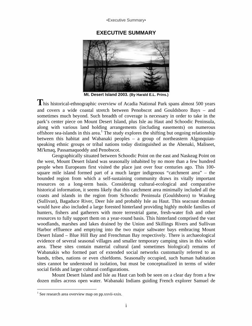
Mt. Desert Island 2003. (By Harald E.L. Prins.)
This historical-ethnographic overview of Acadia National Park spans almost 500 years and covers a wide coastal stretch between Penobscot and Gouldsboro Bays – and sometimes much beyond. Such breadth of coverage is necessary in order to take in the park’s center piece on Mount Desert Island, plus Isle au Haut and Schoodic Peninsula, along with various land holding arrangements (including easements) on numerous offshore sea-islands in this area.1 The study explores the shifting but ongoing relationship between this habitat and Wabanaki peoples – a group of northeastern Algonquian-speaking ethnic groups or tribal nations today distinguished as the Abenaki, Maliseet, Mi'kmaq, Passamaquoddy and Penobscot.
Geographically situated between Schoodic Point on the east and Naskeag Point on the west, Mount Desert Island was seasonally inhabited by no more than a few hundred people when Europeans first visited the place just over four centuries ago. This 100-square mile island formed part of a much larger indigenous “catchment area” – the bounded region from which a self-sustaining community draws its vitally important resources on a long-term basis. Considering cultural-ecological and comparative historical information, it seems likely that this catchment area minimally included all the coasts and islands in the region from Schoodic Peninsula (Gouldsboro) to Waukeg (Sullivan), Bagaduce River, Deer Isle and probably Isle au Haut. This seacoast domain would have also included a large forested hinterland providing highly mobile families of hunters, fishers and gatherers with more terrestrial game, fresh-water fish and other resources to fully support them on a year-round basis. This hinterland comprised the vast woodlands, marshes and lakes drained by the Union and Skillings Rivers and Sullivan Harbor effluence and emptying into the two major saltwater bays embracing Mount Desert Island – Blue Hill Bay and Frenchman Bay respectively. There is archaeological evidence of several seasonal villages and smaller temporary camping sites in this wider area. These sites contain material cultural (and sometimes biological) remains of Wabanakis who formed part of extended social networks customarily referred to as bands, tribes, nations or even chiefdoms. Seasonally occupied, such human habitation sites cannot be understood in isolation, but must be conceptualized in terms of wider social fields and larger cultural configurations.
Mount Desert Island and Isle au Haut can both be seen on a clear day from a few dozen miles across open water. Wabanaki Indians guiding French explorer Samuel de
1 See research area overview map on pp.xxvii-xxix.
▪Executive Summary▪
ii
Champlain to the first island in 1604 called it Pemetic, meaning “range of mountains.” Because of its high barren peaks, a prominent coastal landmark for seafarers, Champlain named it Isle des Monts Deserts. He named the other island Isle au Haut because of its height.
When Europeans first landed on the shores of Mount Desert Island, the sakom (sagamore or chieftain) of the greater Mount Desert Island area was Asticou. He is first mentioned in a 1608 English document as headman of an Indian village on what became known as the River of Mount Desert – later segmented and renamed Union River, Union Bay River and Blue Hill Bay. Five years later, his name appears in French records as the sakom who welcomed the French to his summer village on the southeastern shore of Somes Sound.
As sakom of a Wabanaki community inhabiting the Mount Desert Island area, Asticou headed a district that formed part of a political confederacy known as Mawooshen. Headed by a grandchief, Bashaba of Penobscot, this was an inter-tribal alliance of neighboring Wabanaki groups in Maine, each with their own districts and headed by their own chiefs. Mawooshen’s political boundaries were Narraguagus River in the northeast and Moussam River (at Kennebunk) in the southwest. As such, Chief Asticou and his warriors defended what we may call the “eastern door” of Mawooshen. The grandchief’s great tribal rendezvous site was traditionally located at Pentagoet (Castine), a strategically located coastal site at the mouth of the Bagaduce in eastern Penobscot Bay. From about 1615 onward, this site became the location of a major fur trade post and in later years a fortified European stronghold fought over by the French, English and occasionally even Dutch, all eager to tap into the wealth of furs, moose hides, sealskins and other goods that Wabanakis exchanged for European commodities.
Chief Asticou’s invitation led to the 1613 founding of the short-lived French settlement and Jesuit mission post Saint Sauveur at Fernald Point, opposite his seasonal village near the entrance of Somes Sound. The destruction of this mission by an English privateer from Virginia represents the first armed Anglo-French skirmish in the Gulf of Maine, followed by 150 years of competition among French, English and also Dutch colonial adventurers and entrepreneurs in search of profits and glory, as well as fishermen pursuing their hardscrabble livelihood. The newcomers brought with them not only trade goods, but also killer diseases, including smallpox, cholera and influenza. These scourges, added to the lethal combination of firewater and firearms, almost wiped Maine’s indigenous coastal peoples from the face of the earth. Within a few decades, up to 90 percent of the Wabanaki perished in this American Indian holocaust. We do not know if Chief Asticou survived the onslaught. In recognition of the Wabanaki cultural heritage that his life signified, we refer to the greater Mount Desert Island research area covered in this study as Asticou’s Island Domain.
With epidemics and warfare nearly annihilating the indigenous communities occupying the coastal territories from Mount Desert Island to Cape Cod by the early 1620s, much of this beautiful land was largely cleared for European settlement. Having lost most of their relatives and neighbors, Wabanaki survivors joined other decimated groups and restructured their social lives. Their existence was made all the more complicated because of fur trade competition and the colonial scramble for empire. As this report discusses in great detail, the Mount Desert Island region was located on the continually contested Anglo-French colonial frontier of New England and French Acadia.

▪Executive Summary▪
iii
It also fell within the fur-trade catchment area of colonial entrepreneurs who established and fought over the fortified trading post at Pentagoet (Castine). Accordingly, the complex history of Fort Pentagoet, in all its various guises and under all its different flags, forms an important part of our analysis.
The decision to include Pentagoet in our cultural historical framework is especially relevant because of its close association with Madockawando, the famous 17th-century Wabanaki chieftain. Regularly encamped near Pentagoet, Madockawando had his seasonal headquarters at Archimagam, a fortified lodge strategically situated near the portage between the head of the Bagaduce (Walker Pond) and Eggemoggin Reach. Madockawando’s people, including his own descendents, seasonally hunted, trapped and were otherwise active in the Mount Desert Island area into the 19th century. Indeed, one of his granddaughters made the island her home.
To confront the complex challenges of survival in the contested colonial borderlands, Madockawando and other indigenous leaders forged new political alliances, in particular the Wabanaki Confederacy. A successor to Mawooshen, this intertribal alliance, comprised of Algonquian-speaking ethnic groups from Maine to Newfoundland, was formed in the late 17th century to defend ancestral homelands against English aggression. A political force in this coastal region for almost 200 years, the Confederacy gave its support to the American Revolution. After that war, a newly designated border between Canada and the United States sliced right through Wabanaki homelands. Under government pressure, the Confederacy was dissolved around 1870, but all manner of interactions among the neighboring Wabanaki communities continued. This was (and is) evidenced in various ways, including frequent visits to each other’s villages and encampments, shared ceremonial activities, intermarriages and ties of friendship.
The Wabanaki’s enduring interrelationships and close ties to familiar places in a common ancestral homeland are traceable in the well-known multi-ethnic Indian encampments on Mount Desert Island from the mid-1800s through the early-1900s. The spirit of the Confederacy was rekindled on Mount Desert Island in 1970 with the founding of T.R.I.B.E. – a short-lived but significant Wabanaki educational center situated within and under the auspices of Acadia National Park. It was again evident in the Maine Indian land claims, finally settled by federal law in 1980 (1991 for the Mi’kmaq). And yet again with the 1986 establishment of the annual Bar Harbor Native American Festival, jointly sponsored by the tribes and the Abbe Museum. And once more with the formation of the Maine Indian Basketmakers Alliance in 1992.
The significance of all of this for Acadia National Park and its visitors is the fact that Mount Desert Island has been a nexus point over the centuries for Wabanaki peoples – not only part of their prehistoric and historic hunting, fishing, gathering and trading range, but a strategic location in military maneuverings during the colonial wars and American Revolution, a prime place for marketing traditional crafts (and thereby for sustaining knowledge concerning the making of these crafts) and more recently a center point in their individual and collective efforts toward cultural reclamation. Their deep and intertwined connection to the area is reflected in traditional Wabanaki legends and place names. It is also evident in the names and genealogical information of specific 19th-century Wabanaki individuals identified in this study – most of whom have descendents associated with two or more of Maine’s still existing tribal groups.

▪Executive Summary▪
iv
What this study shows, then, is the Wabanaki’s significant and enduring association with coastal Maine areas now designated as national parklands. As marked out in the following pages, that association has had to do with Wabanakis tapping into a range of natural and cultural resources in ANP areas:
Natural resources (for food, medicine and material culture purposes) Trade and military resources (colonial and American Revolution alliances) Marketing opportunities (among summer visitors especially since the mid-1800s) Cultural revitalization opportunities (in cooperation with the Abbe Museum and
Acadia National Park)
It is our hope that this study serves as a cultural resource for Wabanaki peoples whose collective ancestral ties to the Mount Desert Island region are chronicled here, as well as for Acadia National Park staff tasked with stewarding and interpreting these ancient Wabanaki lands now under federal government protection. Last but not least, we hope the information these pages carry will bring new perspectives to Acadia National Park’s myriad visitors, most of whom already know how to appreciate its natural beauty but have little or no idea about the area’s original indigenous human inhabitants who struck a cultural balance between themselves and the natural environment in ways that kept the splendor of this Edenic place intact for thousands of years.
For us, researching and writing this report provided crucial pieces in the large puzzle of Maine Indian history, which has held our attention for over a quarter century. It brought to the surface an unanticipated array of scattered and largely unpublished data directly and indirectly relevant to indigenous ties to Mount Desert Island. Applying the conceptual framework of a catchment area to the greater Mount Desert Island area made it possible to tie together both the new and the previously uncovered bits of historical and archaeological information – much of which at first glance appeared but loosely related or entirely unrelated. This approach also enabled us to reconstruct the ecosystemic dimensions of an indigenous foraging domain and track its changes in the colonial period. Also of note are the many remarkable visual images found and identified in the course of this project. Most remarkable among them is Mattheüs Merian’s 17th-century engraving of a moose hunt on Mount Desert Island. Featured in Theodore de Bry & Sons’ 1627 publication Grand Voyages to America, Part 13, it represents one of the oldest visual portrayals of North American Indian life on record. Beyond providing us with the great pleasure of such discoveries, this work has deepened our appreciation for and friendships with present-day Wabanakis.
Harald E.L. Prins & Bunny McBride, September 2007
▪Table of Contents▪
v
CONTENTS
VOLUME 1
EXECUTIVE SUMMARY . . . . . . . . i CONTENTS . . . . . . . . . . v FOREWORD by Donald Soctomah . . . . . . . xi ACKNOWLEDGMENTS . . . . . . . . xiii TIMELINE . . . . . . . . . . xv MAP: RESEARCH AREA & ACADIA NATIONAL PARK LANDS . . . xxvii CHAPTER 1 . . . . . . . . . . 1 INTRODUCTION: MOUNT DESERT ISLAND AS HISTORICAL & ANTHROPOLOGICAL PROBLEM The Original Inhabitants of Mount Desert Island Tribal Territories, Ethnic Identities and the Problem of History Mount Desert Island as Part of Indigenous Catchment Area Asticou’s Island Domain Wide-Framing, Small Historical Detail Research Methodology: Problem of Sources Conclusion CHAPTER 2 . . . . . . . . . . 15 ETHNOGRAPHIC BASELINE: WABANAKI CULTURES c.1600 Habitat: Asticou’s Island Domain
MAP: Satellite Image of Asticou’s Island Domain Personal Appearances Wabanaki Material Culture Seasonal Movements and Subsistence Strategies Seasonal Encampment Sites in Asticou’s Island Domain
MAP: Champlain, 1607 Wabanaki Place Names as Cultural Ecological Index Canoe Travel Networks in the Wabanaki Homeland Mount Desert Island as Part of Glooskap Country MAP: Wikhegan Map on Birchbark by Selmo Soctomah, c1887 Political Organization: The Land of Mawooshen
MAP: Mawooshen Confederacy CHAPTER 3 . . . . . . . . . . 39 EUROPEAN EXPLORERS ON THE WABANAKI COASTS, 1500s
Fact or Fiction? Vikings on the Maine Coast In Search of Wealth and the Northwest Passage to China Wabanakis in the Early Contact Period Wabanaki Copper Trade in the Bay of Fundy and Gulf of Maine MAP: Ethnic Distribution at Time of European Exploration Early Beginnings of the Wabanaki Fur Trade The Dangerous Middle Ground of Mi’kmaq-Abenaki Conflicts Bashaba, the Grandchief of Mawooshen Guardian of Mawooshen’s Eastern Door: Asticou of Mount Desert Island

▪Table of Contents▪
vi
CHAPTER 4 . . . . . . . . . . 63 SEAFARING TARRENTINE TRADERS AND RAIDERS
Cape Neddick 1602: Anglo-Tarrentine Encounter on Southern Maine Coast Mount Desert Island Etchemins Welcome French Traders, 1604
MAP: Detail of Champlain’s Manuscript Map of New France, 1607 Etchemins Kidnapped by English Explorers, 1605-1607 Etchemins as Involuntary Guests in England, 1605-1613 A Mi’kmaq-Abenaki Couple Guides Champlain to the Kennebec, 1605 Chief Tahánedo Returns to Mawooshen, 1606 Messamoet: Mi’kmaq Trader on Maine Coast, 1606 Tarrentine Raiders Revenging a Murder at Penobscot Bay, 1607 Skidwarres Guides English Colonists to Mawooshen, 1607 Failure of English Colonial Settlement in Mawooshen, 1607-1608 Henry Hudson Attacks Wabanakis at Central Maine Coast, 1609
CHAPTER 5 . . . . . . . . . . 91 THE DOWNFALL OF MAWOOSHEN
English Fishermen and More Kidnapping in Penobscot Bay, 1611 Bashaba Welcomes French Fur Traders at Bagaduce Renderzvous, 1611 French Jesuit Mission at Mount Desert Island, 1613 English Raiders Destroy French Mission at Mount Desert Island, 1613 A New Phase in the Tarrentine-French Alliance, 1613-1614 Tahánedo Guides Captain John Smith into Penobscot Bay, 1614 Bashaba’s Death: The Tarrentine-Mawooshen War, 1614-1616 Asticou: Last Grandchief of Mawooshen, 1615 Surviving the Great Dying at Mawooshen, 1616-1618 French Acadian Fur Traders and Tarrentine Sea Raiders from Downeast Mount Desert Island alias Mansell Island: An Abundance of Moose Chief Samoset Seeks English Allies against Tarrentine Enemies Tarrentine Sea Raiders and New England Colonists Competing Colonial Claims to Mount Desert Area English Pilgrim Traders at Penobscot Bay, 1629-1635 A French Warlord in the Gulf of Maine and his Tarrentine Allies Saint Germain Treaty (1632): French Restored to Eastern Wabanaki Coast
CHAPTER 6 . . . . . . . . . . 129 CONTESTED ISLAND IN THE SHADOW OF FORT PENTAGOET
Decline of Tarrentine Raids, 1629-1636 Iroquois Raiders and French Missionaries in Wabanakiak, 1643 French Trading Post at Fort Pentagoet, 1635-1650 Jesuit Missionaries Return Briefly to the Wabanaki Coast MAP: DeCreux’s 1660 map of Acadia Interlude, 1650-1654 Mount Desert Island as Part of Nova Scotia, 1654-1670 Mohawks Capture Kennebec Abenaki Refugees at Penobscot Bay, 1662 Chief Madockawando of Penobscot Bay and Mount Desert Island Fort Pentagoet: The French Return to the Wabanaki Coast Again, 1670-1674
MAP: Grandfontaine’s 1671 Map of Acadia Dutch Privateers at Mount Desert Island, 1674-1675 Madockawando as the Baron de St. Castin’s Father-in-Law Darkening Clouds of Total War over the Wabanaki Coast

▪Table of Contents▪
vii
CHAPTER 7 . . . . . . . . . . 161 RISE AND DEMISE OF CHIEF MADOCKAWANDO
First Anglo-Wabanaki War, 1675-1678 Madockawando and the Resurrection of Mawooshen, 1675-1676 Fighting Flares Up in Southern Maine, 1675-1676 Madockawando Forced into the Anglo-Wabanaki War, 1676 French Jesuit Perspective on the Etchemin-Abenaki Alliance, 1676-1677 Etchemin Moosehunters and English Captive at Mount Desert Island, 1676 Grandchief Madockawando Brokers Peace and Ends the War, 1677-1678 From Mawooshen to Wabanaki Confederacy, 1678-1688 Competing Colonial Claims to Penobscot and Mount Desert, 1677-1688 Penobscot Mission Village: Abenaki Refugees at Panawahpskek, 1687 Cadillac as Seigneur of Mount Desert Island and Douaquet, 1687-1689
MAP: Carte de l’Acadie, 1702. Second Anglo-Wabanaki War (“King William’s War”), 1688-1698 Ethnic Label Shifting: Abenaki and Etchemin or Canibas and Maliseet? Mount Desert Island as French-Wabanaki Raiding Rendezvous, 1692-1697 Another Brief Interbellum, 1698-1703 MAP: Native Villages and Colonial Forts, 1600s-1700s
CHAPTER 8 . . . . . . . . . . 191 HEROIC DEFENSE OF THE HOMELAND, 1703-1774
Third Anglo-Wabanaki War, 1703-1713 Assault at Blue Hill Bay Wabanaki Raids Launched from Mount Desert Island, 1703 New England Declares Total War against Wabanaki Nations St. Castin and Livingstone Travel from Mount Desert Island to Canada, 1710 Limping Through the Final War Years, 1711-1713 Treaty of Utrecht (1713): Making Peace and Dividing Wabanaki Land Fourth Anglo-Wabanaki War (Lovewell’s War or Dummer’s War), 1722-1727 Wabanaki Naval Guerilla Base at Frenchman Bay, 1723-1725 English and Wampanoag Indian Whaleboats to Mount Desert Island, 1725 Peace Negotiations Lead to Dummer’s Treaty, 1725 Struggle for Survival during Interbellum Years, 1727-1743 Madockawando’s Grandchildren in their Ancestral Domain Fifth Anglo-Wabanaki War (“King George’s War”), 1744-1749 Another Lull before Another Storm, 1750-1754 Sixth Anglo-Wabanaki War (1755-1760) White Settlers on Mount Desert Island, 1761 A Mount Desert Island Squatter’s Story about Swindling Indians Madockawando’s Heirs and the Royal Proclamation, 1763 Visiting Wabanaki Villages on the Penobscot River, 1764
CHAPTER 9 . . . . . . . . . . 231 THE AMERICAN REVOLUTION AND WABANAKI MARGINALIZATION, 1775-1840
American Revolutionary War, 1775-1783 Playing on Wabanaki Loyalty to the French to Win Their Support in the War New British Military Fort at Old Pentagoet, 1779 British Control over Maine Coast from Pemaquid to Passamaquoddy, 1779-1783 The Neptune Dynasty: Etchemin Identity Revisited

▪Table of Contents▪
viii
Penobscot Refuge at Kennebec during the Revolution, 1779-1783 Chief Orono at White Island Village Facing Mount Desert Island Madame de Grégoire as the Lady of Mount Desert Island Failed Penobscot-Massachusetts Treaty Negotiations, 1786-1788 Passamaquoddy Petition for a Land Base at Pleasant Point Pauperization and Marginalization An Indian Encampment at Blue Hill Bay Penobscot & Passamaquoddy under the Control of the State of Maine, 1820 Enduring Etchemin in Dialect as Spoken by Penobscot Salt-Water Families Salt-Water Penobscots or Etchemins: John Neptune and Molly Molasses Protecting Penobscot Salt-Water Camping Sites at Eggemoggin Reach Losing Land in the Penobscot Valley Mount Desert Indian Lore: Ambivalent Racism
CHAPTER 10 . . . . . . . . . . 267 WABANAKIS AND RUSTICATORS, 1840s-1920s
Getting to Mount Desert Island MAP: Boston & Bangor Steamship Co. Routes to Mount Desert Island 1885 The Indian Encampments on Mount Desert Island
Proximity to Resources Selling Baskets and Other Hand-Crafted Goods Canoe Services and Sales Guiding Services for Sport Hunters Events, Exhibitions & Celebrations Notable Wabanakis in the Mount Desert Island Neighborhood
Frank “Big Thunder” Loring (1827-1906) Elizabeth “Queen” Francis (1839-c1915) Lewis Mitchell (1847-1931) Joe Lola (1830-??) John Leonard Snow (1868-1937)
Act Relating to Hawkers and Peddlers, 1889 Bar Harbor Village Improvement Association The Bar Harbor Improved Order of Red Men Society
CHAPTER 11 . . . . . . . . . . 337 ANTHROPOLOGISTS AND CONSERVATIONISTS AT MOUNT DESERT ISLAND
Charles Godfrey Leland (1824-1903) Albert Samuel Gatschet (1832–1907) Fannie Hardy Eckstorm (1866-1946) John Dyneley Prince (1868-1945) Frank Gouldsmith Speck (1881-1950) Birth of Acadia National Park Birth of the Abbe Museum
CHAPTER 12 . . . . . . . . . . 347 MYTH OF THE VANISHING WABANAKIS, 1930-1960
Pageants and Parades Scattered Wabanakis in the Mt. Desert Island Neighborhood Wabanakis at Sport-Hunting Camps in the Mt. Desert Island Neighborhood Seasonal Stoop Labor in & Beyond the Mt. Desert Island Neighborhood Wabanakis at Work in Acadia National Park

▪Table of Contents▪
ix
CHAPTER 13 . . . . . . . . . . 363 WABANAKI RIGHTS & CULTURAL REVITALIZATION, 1960s-TODAY
Maine Indian Claims Settlements MAP: Wabanakis Today Wabanakis’ Ongoing Presence in the Mount Desert Island Neighborhood T.R.I.B.E., 1970-1971 Artful Activism: The Role of Wabanaki Arts in the Struggle for Cultural Survival Changes at the Abbe Museum Maine Indian Basketmakers Alliance Changes at Acadia National Park
VOLUME 2
CHAPTER 14 . . . . . . . . . . 385 WABANAKI MATERIAL CULTURE USES OF PLANTS & ANIMALS
Ceremonies Body Care & Hair Care and Adornment Clothing Tools & Utensils Traps, Weapons, Snares & Lures Transportation Shelter Containers Trade & Sale Items Wabanaki Material Culture & Economic Survival in the MDI Neighborhood: The Phillips Family, 1942-57
CHAPTER 15 . . . . . . . . . . 403 WABANAKI FOOD USES OF PLANTS & ANIMALS
Overview Seasonal Hunting & Gathering Cycle Animal Foods Mammals
Moose, Deer & Caribou Beaver Muskrat Harbor Seal Porpoise Whale
Shellfish Soft-shell Clams & Oysters Fish
Salmon Eel Sturgeon
Bird & Bird Eggs Reptiles Plant Foods Wabanaki Food Collection On and Near Mount Desert Island

▪Table of Contents▪
x
CHAPTER 16 . . . . . . . . . . 435 WABANAKI MEDICINAL USES OF PLANTS & ANIMALS
Traditional Wabanaki Approaches to Treating Illness Shamanic Treatments Herbal Treatments Impact of European Contact on Wabanaki Medicinal Practices Wabanaki Medicinal Treatments: Content & Preparation Plant-based Treatments Animal-based Treatments Compound Treatments Notable Wabanaki Herbal Doctors Wabanaki Herbal Doctors in the Mount Desert Area
CHAPTER 17 . . . . . . . . . . 453 ILLUSTRATED INVENTORY OF PLANTS USED BY WABANAKIS IN ANP AREA CHAPTER 18 . . . . . . . . . . 505 ILLUSTRATED INVENTORY OF ANIMALS USED BY WABANAKIS IN ANP AREA CHAPTER 19 . . . . . . . . . . 537 MAPS & INVENTORY OF INDIGENOUS ARCHAEOLOGICAL SITES CHAPTER 20 . . . . . . . . . . 549 MAPS & INVENTORY OF WABANAKI ENCAMPMENTS ON MDI, 1840s-1920s CHAPTER 21 . . . . . . . . . . 569 MAPS & INVENTORY OF NATIVE CANOE ROUTES TO AND ON MDI ANNOTATED REFERENCE LIST . . . . . . . 577 . . . . .

▪Foreword▪
xi
FOREWORD Maine has one of the longest and most unspoiled coastlines on the Atlantic. Glancing at this rugged and rocky coast stirs thoughts of the past and makes one wonder how people survived the geographic—and climatic—challenges of the place. But a more careful look reveals sandy coves and calm inlets where the first peoples of Maine made their homes seasonally since time immemorial. Here they survived by following nature’s rhythms. Here the lives of countless generations of people began and ended. They were the ancestors of today’s Passamaquoddy, Penobscot, Maliseet and Micmac tribes. Collectively known as Wabanaki or "People of the Dawnland," they had many things in common: lifeways that fit into this unique environment, interconnected bloodlines, legends that were told at the campfire, and songs that were sung at ceremonies.
Over the last 400 years, the social structure of Wabanaki peoples has undergone dramatic transformations. The coming of the European explorers, merchants and settlers brought wars and epidemics, which took heavy tolls among our peoples. The important part of our history is that we survived this assault and are alive today to carry on the bloodlines and traditions of our ancestors.
Yes, there is a story to tell about our lives in this region we now call Maine and the Maritimes. Until now only snapshots have been shown. The bigger story is only now emerging, coming to the fore to be preserved and told to future generations of people, both Native and non-Native.
This report is a valuable piece of work. It captures important segments of the history that have been hidden under so many layers of various stories. It will serve as a reminder of the lifeways of the Wabanaki people, which are so important to understand—about our deep connection to and religious convictions about the land, rivers and ocean of this region. Reading this study, future generations of people will learn to appreciate the type of history the Wabanaki people had, adapting to an environment of extremes—a habitat that was sometimes generous but often harsh.
When history is told from all viewpoints, as it is here, a truer understanding of humankind may evolve. Readers come to see that Native history did not start when the European explorers landed here, as many books would want you to believe. And they discover that Native people today still walk this land and still paddle the canoes on the waters of the ancestors.
People who manage other parklands around the country may learn from this report about the importance of including the story of those who first inhabited the land. The way the indigenous peoples used these now protected habitats and their resources has made the North America continent the beautiful place it is.
The Wabanaki people of Maine and the Maritimes would like to thank individuals at the National Park Service for their sincere efforts toward making this report a reality. In particular our thanks go to Chuck Smythe, Sheridan Steele, Deb Wade, Lee Terzis—and also to Rebecca Cole-Will who recently shifted her work place from the Abbe Museum to Acadia National Park. We would also like to thank the Abbe Museum staff for their cooperating role in carrying this project to completion. Unique among museums, the Abbe has always been there to help the Wabanaki people, helping to unearth, protect and showcase our history and culture.

▪Foreword▪
xii
On a personal note, I would like to thank the following people for all that they have taught and continue to teach me about the value of continued remembrance through the telling of tribal stories and our history: Dolly Apt, David Francis, Hilda Lewis, Wayne Newell, Joseph Nicholas, Madonna Soctomah and John Stevens.
As for the authors of this report, Harald Prins and Bunny McBride, we are extremely thankful for their dedication. They tracked every clue in search of the true story—in archives, libraries and in the first-hand recollections of Native peoples. They heard our stories and have brought them to life in a lasting way for present and future generations. Bunny and Harald are true friends of the Wabanaki people, and for that we say Woliwon—Thank you.
Donald Soctomah Passamaquoddy Tribe Maine Legislative Representative Tribal Historic Preservation Officer

▪Acknowledgments▪
xiii
ACKNOWLEDGMENTS
Born of interviews and research in numerous archives and libraries, this study has been aided by many people in many ways – so our thanksgiving is deep and widespread.
This project could not have happened – would not have happened – without the input of Maine’s Wabanaki communities. In fact, the seed for this work was planted by Aroostook Band of Micmacs Chief William Phillips who, after an outing to Mount Desert Island with his children, contacted Acadia National Park (ANP) headquarters to express dismay that park signage and literature essentially ignored the fact that this landscape had been part of the Wabanaki’s habitat for thousands of years. His concerns led to a meeting with ANP staff and other Wabanaki community leaders, all of whom helped launch this study and bring it to completion. We extend heartfelt appreciation to Wabanaki advisors Bernard Jerome (Mi’kmaq), Bonnie Newsom (Penobscot), Fred “Sonny” Tomah (Maliseet) and Donald Soctomah (Passamaquoddy) – for their enthusiasm and their help with networking, information gathering and useful cultural feedback. Notably, many of the photographs and a good number of newspaper quotes in this report came to us from Mr. Soctomah, a committed tribal historian with whom we had the pleasure of sharing sea outings and partnering in several interviews with tribal elders.
Special appreciation goes to Dr. Chuck Smythe of the Northeast Region National Parks Service (NPS). As Ethnography Program Manager and impassioned fellow anthropologist, Dr. Smythe advocated this project as a collaborative effort involving the region’s Native peoples. He has been the driving force in securing funds for several research efforts such as this, which reveal the deep relationship Native American peoples have to lands set aside as natural treasures for public use. We also extend our thanks to his NPS colleagues on Mt. Desert Island – Dave Manski, Chief, Division of Resource Management, for his generous spirit; Cultural Resources Program Manager Lee Terzis for her enlivening spunk; and archivist Brooke Childrey for careful guidance through the park’s archival treasure trove.
We are also grateful to long-time members of the Abbe Museum staff – archaeologists Dr. Diane Kopec (Director, just retired) and Rebecca Cole-Will (Curator, now with Acadia National Park), as well as Betts Swanton (Exhibits Director, now freelance) and Sharon Broom (Development Director, now with Friends of Acadia), plus Julia Clark (Collections Manager), who continues as a staff member there. As in previous collaborations over the years, each of them helped out in many ways – with administrative aid, photographs and other archival materials, access to computers and scanners, and more – including good meals and even better company.
In addition we wish to thank two key people at the Maine Historic Preservation Commission: Earle Shettleworth, who generously provided us with precious photographs of the 19th- and early-20th-century Bar Harbor Indian encampments; and Dr. Arthur Spiess, who put together for us the informative archaeological overview maps featured in the appendix. Another anthropologist deserving great gratitude is Dr. William Haviland, who has published widely on his extensive archaeological and ethnohistorical research on the Maya in Guatemala and Abenaki in New England, and whose family ties to the Maine coast reach back many generations. As soon as he became aware that we were doing this study, Dr. Haviland shared photographs, archaeological data and historical snippets concerning Wabanakis. On top of this, he provided crucial critical feedback – and took us out on his lobster boat more than once for the essential mariner’s view of Asticou’s
▪Acknowledgments▪
xiv
Island Domain. For that seascape perspective, we also extend thanks to Jan Willem and Juanita van de Wetering for their distinctly delightful mix of stories and salt water, as well as Bruce Jacobson, Superintendent of Boston Harbor Islands National Park Area, for his good company and ability to navigate through thick fog. For an unforgettable sea journey to Grand Manan, we thank our adventurous Passamaquoddy pilot Dale Mitchell.
Our acknowledgments would be incomplete without mentioning those who shared in interviews reminiscences of personal and familial ties to the Mount Desert Island area:
Watie & Jane Akins (Penobscot) Carole Bear Binnette (Penobscot) Larry Closson (MDI resident) Dolly Dana (Passamaquoddy) David Francis (Passamaquoddy) Susan Snow Holmes (Passamaquoddy) Donna Loring (Penobscot) John Bear Mitchell (Penobscot) Ted Norris Mitchell (Penobscot) Wayne Newell (Passamaquoddy) Mary Scully Nooninham (Mi’kmaq)
Fredda Paul (Passamaquoddy) Molly Neptune Parker (Passamaquoddy) Paul Phillips (Mi’kmaq) Donald Sanipass(Mi’kmaq) Mary Lafford Sanipass(Mi’kmaq) Caron Shay (Penobscot) Rose Mason Scribner (Penobscot) Donald Soctomah (Passamaquoddy) Ralph Stanley (Southwest Harbor resident & historian) John Stevens (Passamaquoddy)
Gratitude as well to individuals at museums and libraries who went out of their way to help us – especially James Neptune at the Penobscot Museum on Indian Island; Dolly Dana and David Francis of the Waponahki Museum & Resource Center at Pleasant Point in Perry; Richard d’Abate, William Barry and Nicholas Noyes at the Maine Historical Society in Portland; Debbie Dyer at the Bar Harbor Historical Society; Elaine Stanley and her colleagues at the Maine State Library; Art Dostie and Anthony Douin at the Maine State Archives; Nancy Howland at Bar Harbor’s Jesup Library; Robert Pyle at Northeast Harbor Library; Candy Emlen and Meredith Hutchens at Southwest Harbor Library. Thanks to Carole Binnette of the Penobscot Nation and Sheldon Goldthwaite of Bar Harbor for genealogical data that helped us link individuals in the historic record to present-day Wabanakis. And to Judy and Pete Obbard, whose home sits on the Southwest Harbor Indian encampment site, for sharing important memorabilia about the site. And to Karen Rundquist and Debbie Hedrick at Kansas State University for clerical help, always carried out with good humor. And to our printers Carolyn Arand at Art Craft Printers in Manhattan, KS, and Brian Fisher at Service Point USA in Needham, MA. Finally, very special thanks to those who so often sheltered and/or fed us: Charles Shay, Jean Archambaud Moore and Watie & Jane Akins on Indian Island, Harry & Regina Petit Frye at Indian Township, Susan & David Els in Readfield, Phyllis Austin and Anne Dellenbough in Brunswick, as well as Chief Big Thunder’s great-great-granddaughter Donna Loring, whose own Penobscot father, grandfather and great-grandfather were all born on Mount Desert Island. Harald E.L. Prins & Bunny McBride
◘ ◘ ◘ ◘

▪Timeline▪
xv
TIMELINE
∞: Ketchiniweskwe, a mysterious life force, governs Ketakamigwa (“Big Land on the Seacoast”), homeland of the Wabanakiak (“Dawnland People”) who believe themselves to be Children of Glooskap, the giant hunter-shaman. Long ago, Glooskap’s adventures helped shape the landscape of Pemetic (“Mountains at a Distance”), now named Mount Desert Island (MDI). 10,500 BP: After the Ice Age, the earliest Indian hunting bands move into Maine’s tundras in pursuit of caribou, musk ox, mammoth and other wildlife. 5,000 BP: Indian families seasonally fish and hunt sea mammals in MDI’s coastal waters and collect shellfish on mudflats. Over many generations, shells pile up at coastal camping sites, forming shellheaps. These sites also contain stone and bone tools, including harpoons, fishhooks, projectile points, awls and (later) small native copper beads and thin copper blades. 1524: Verrazzano, Italian navigator for the French Crown, sails along MDI’s coast. 1525: Gomez, Portuguese navigator for the Spanish Crown, sails along MDI’s coast. 1542: French explorer Alphonse passes MDI, enters Penobscot Bay and reports on an Indian town he calls Norumbega “with…inhabitants, who trade in furs of all sorts.” 1575: MDI forms part of an indigenous coastal exchange network between southwestern corn-growing villages and northeastern seafaring hunting bands with direct access to native copper mines at the head of the Bay of Fundy and European trade goods in the Gulf of St. Lawrence. 1580: Portuguese navigator Ferdinando guides English expedition to Norumbega. Expedition members rob 300 dried moose hides from an Indian dwelling on the Penobscot Bay coast. 1600: Inter-tribal trading and conflicts have led to the formation of Mawooshen, a political confederacy of Abenaki corn-growing villages between Kennebunk and Kennebec, and Etchemin migratory bands from the Kennebec to the Narraguagus River. MDI forms the “eastern door” of Mawooshen, whose chiefs all recognize Bashaba of Kadesquit (Bangor) as grandchief. 1602: Mi'kmaq traders sailing a small Basque sloop on the Maine coast encounter an English exploring vessel under Captain Gosnold. Speaking some French and Basque and surmising that the European strangers are lost, the Mi’kmaq headman sketches a map showing Newfoundland. 1604: Guided by two Etchemins from the Passamaquoddy Bay area, where the French establish their first short-lived settlement on St. Croix Island, Champlain explores and maps the Maine coast, renaming Pemetic Isle des Monts Déserts (“Island of Barren Mountains”). Canoe-faring hunters from MDI take Champlain to Basbaha, the Etchemin grandchief of Mawooshen who resides at Kadesquit (Bangor) and Pentagoet (Castine). 1605: Five Etchemins from Mawooshen, including Chief Tahánedo of Pemaquid, are kidnapped and taken to England to serve as guides for future exploration of the Maine coast. 1606: Nova Scotia Mi’kmaq headman Messamouet and Etchemin chief Secoudun of St. John River guide Champlain on another coastal exploration, sailing as far as Cape Cod. Near Machias, canoe-faring Etchemins tell him that Mi’kmaq (?) sea-raiders led by Chief
▪Timeline▪
xvi
Iouaniscou have killed Armouchiquois (Abenaki?) enemies and put female captives to death at MDI. 1607: Tarrentine raiders (Nova Scotia Mi’kmaq and allied Etchemin from the St. John River area) equipped with French firearms raid Abenaki enemies at Kennebec and Saco. Weeks after this attack, one of the kidnapped Etchemins returns from England, guiding colonists to the mouth of the Kennebec where a short-lived settlement known as Popham Colony is established. 1609: An Indian encampment in the Penobscot Bay area is attacked by an English-Dutch crew commanded by Hudson sailing aboard the Half Moon on an exploration journey. 1611: In late fall, Mawooshen’s grandchief Bashaba is encamped at Pentagoet, a seasonal village on the eastern shore of Penobscot Bay – along with 300 Etchemins living in 18 large dwellings and having 80 bark canoes. Here, where the Bagaduce runs into Penobscot Bay (Castine), they welcome French fur trader Biencourt and Jesuit priest Biard on a trading visit. 1613: Chief Asticou of the Etchemin band encamped at MDI, invites Father Biard to found a French Jesuit mission settlement opposite his village on the shore of Somes Sound. Within months, English raiders from Virginia attack and destroy it. 1614: Tarrentine seaborne raiders gain control of MDI and eastern Penobscot Bay. Avoiding these feared enemies, Etchemin chief Tahánedo of Pemaquid guides Captain John Smith from Monhegan Island (a summer base for English fishermen) into western Penobscot Bay and along Maine’s southern coast. The Englishman trades many furs, maps the coast to Cape Cod and later renames the entire region and beyond “New England.” An English ship captain at Monhegan captures some two dozen Indians to sell in Spain, together with a cargo of dried fish. 1615: After years of intensifying violent conflicts, the Mawooshen Confederacy receives a mortal blow when Tarrentines raid Bashaba’s village at Penobscot, killing the grandchief and many of his Etchemins. At the rendezvous of Pentagoet (Castine), French Acadian colonial entrepreneur Claude de La Tour, who is allied with the Tarrentines, establishes a fur trade post. 1616-1618: A series of devastating epidemics sweeps the coast from MDI to Cape Cod, killing thousands of Indians – about 90 percent of the coastal population. Chief Asticou, having lost his MDI domain due to earlier Tarrentine attacks, succeeds Bashaba. 1620: Sir Robert Mansell, an English partner in Sir Ferdinando Gorges’ colonization scheme for New England, claims MDI. Promoting the place as Mansell Island, Gorges’ description of local Indians hunting moose inspires a German copper engraving. Moose hides are in great demand for the manufacture of European military overcoats. 1629: English Protestant settlers at New Plymouth in southern Massachusetts Bay enter the fur trade on the Maine coast. Ousting La Tour from Pentagoet, they take over that post, calling it “Penobscote.” Wampum beads made by Long Island Natives are imported for Indian trading. 1632: In a French-English treaty, the English give up colonial claims to lands from Penobscot Bay to Cape Breton, including trading posts and fledgling European settlements. 1635: MDI and surrounding coastal territory granted to d’Aulney. As French Acadia’s new governor, he establishes himself at the Pentagoet trading post which he enlarges and fortifies.
▪Timeline▪
xvii
1654: After years of feuding among French rivals in Acadia’s profitable fur trade, an English raid against French strongholds from Penobscot Bay to the Bay of Fundy results in the French again losing Pentagoet and MDI. 1664: Iroquois war parties raid as far as Penobscot Bay, capturing Abenaki refugees from the Kennebec encamped at the Bagaduce River near Fort Pentagoet. The captives are women and children who sought protection at this English stronghold in the coastal domain of an allied Etchemin community. Their men, both Etchemin and Abenaki, are away, probably on the warpath. 1667: The French and English Crowns in Europe conclude a peace treaty, which includes English recognition of French colonial claims, including MDI and Penobscot Bay. 1670: Chief Madockawando, as leader of an Etchemin hunting community ranging in the area between the Penobscot and Frenchman Bay, including MDI, resides in a fortified lodge at Archimagam on the upper Bagaduce (Walker Pond) and becomes wealthy and powerful because the Pentagoet trading post is located in his domain. 1670: French troops formally repossess Fort Pentagoet. Among them is the young French officer Jean-Vincent d’Abbadie. This son and later heir of the Baron de St. Castin becomes a fur trader, marries two of Madockawando’s daughters and has many métis children. 1674: Dutch privateers from the Caribbean destroy Fort Pentagoet, which remains a ruin. 1675: A Wampanoag uprising on the coast of southern Massachusetts spreads to neighboring Indian communities between Pemaquid and the Hudson River, becoming known as “King Philip’s War.” A small peaceful Indian band encamped just east of MDI is kidnapped by New Hampshire fishing-boat captain, Laughton, who sells them as slaves in the Azores islands off Africa’s northwest coast. This unprovoked aggression sparks a wider conflict. 1676-1678: After King Philip’s War (the series of Anglo-Indian battles in southern New England) ends in victory for the English, the first of six Wabanaki wars against New England colonists begins in defense of ancestral lands, waters and other natural resources. Not having surrendered inherent sovereign rights to ancestral lands, the Wabanaki nations defend themselves against English expansionism and join forces in an alliance, or buduswagan, which widens over the years and is known as the Wabanaki Confederacy. 1676: Unlike Abenaki coastal communities south of Pemaquid, Etchemin hunting bands ranging from the Penobscot to the St. John River remain free from European colonial control. Strategically situated on the frontier with French allies who supply his people with weapons, ammunition and other valuable goods, Madockawando is recognized as a grandchief by neighboring tribal chiefs along the Maine coast. After a raid against English enemies in Saco Bay, one of his Etchemin followers forces a captive sailor named Thomas Cobbett to go with him to his winter hunting grounds at MDI. 1677: A Jesuit missionary notes that the migratory bands hunting and fishing in the Penobscot, Passamaquoddy and St. John River areas are all Etchemins who speak dialects of the same language. 1687: An Indian community is reported at Douaquet, at the head of Frenchman Bay. A French Jesuit missionary from Quebec journeys with a group of Abenaki converts to Indian Island in the Penobscot River. Having been forced from their ancestral villages between the Merrimac and Kennebec due to English and Iroquois aggression, they found

▪Timeline▪
xviii
the Abenaki mission village of Panawahpskek at Indian Island (Old Town). They plant corn and other crops as they did in their homelands. 1688: French authorities grant MDI and Upper Frenchman Bay (Douaquet, where an Indian village was reported), as a seigneury to military officer Cadillac. He and his wife live at Otter Creek briefly. 1688-1698: Second Anglo-Wabanaki War, also known as King William’s War. 1692: Indian warriors assemble at MDI and receive French weapons, clothing and food. They prepare to launch an attack on the new English stone fort at Pemaquid, but the raid is canceled. 1694: Indians at MDI, earlier identified by the French as “Etchemin,” are now called “Malicites” by French Acadia’s military commander. This term, borrowed from the Mi’kmaq, originally refers to a language, not a tribe, and means “funny/bad talkers.” Among other Mi’kmaq terms adopted by their French neighbors is “Canibas,” originally referring to Kennebec Indians and by extension to all others who also speak Abenaki as their mother tongue. Adopting these ethnic labels, the French commander distinguishes “three Indian nations in Acadia, the Canibas, the Malicites, and the Micmacs, each having a different language…. The Malicites begin at the river St. John, and inland as far as the Rivière du Loup, and along the sea-shore, occupying [Passamaquoddy, Machias, Mt. Desert, and Penobscot]…. At Pentagoet, among the Malicites, are many of the Canibas Indians….” The commander also refers to Chief Madockawando as “a Malicite.” 1696: After the French and their Wabanaki allies attack and demolish English Fort Pemaquid, they assemble at MDI. The warriors include famous chiefs such as Madockawando of Penobscot, Taxous of Kennebec and Nescambiouit of the Pequaket on the Upper Saco. They are pursued by colonial troops (300 Wampanoag warriors and 300 English marines), who sail in six sloops and 24 whaleboats from Boston to Monhegan Island and then on to “Mount-Desart, which is the chief place of their [French and Wabanaki Indian] departure from each other after such [raiding] actions.” 1698: With the French and English having ended their long war in Europe at the 1697 Treaty of Rijswijck, the Wabanaki conclude their own treaty with New England colonial authorities. 1703-1713: Third Anglo-Wabanaki War, also known as Queen Anne’s War, breaks out as a result of the French and English Crowns declaring war in Europe the previous year. 1703: An English privateer rapes Madockawando’s métis granddaughter Brigitte and raids the home where she lives with her French Canadian husband on Blue Hill Bay at Naskeag Point opposite MDI. Weeks later, a French warship sails to MDI with 30 French soldiers and 200 Mi’kmaq (and Huron?) warriors aboard. They raid English settlements on the Maine coast. 1704: Colonel Church of Massachusetts leads naval expedition of three heavily armed warships and 36 whaleboats with 500 English colonial militia and 100 Wampanoag Indian warriors from Cape Cod. They range the Maine coast “in search of the Enemy, to Mount Desart” and then move on to Machias and Passamaquoddy Bay. The expedition’s ships anchor at Southwest Harbor to resupply the Wampanoag and English marines. 1710: Madockawando’s métis grandson Bernard Anselm de St. Castin, a Wabanaki warchief and French military officer headquartered in the Bagaduce and MDI area, guides New York colonial officer Livingstone from Frenchman Bay, through Mt. Desert Narrows, into Blue Hill Bay and then, by way of the Penobscot, on to Quebec to inform

▪Timeline▪
xix
Canadian authorities that Acadia’s capital, Port Royal, has fallen and that the British now control Acadia. 1712: Colonel Walton of Massachusetts heads a naval expedition against Wabanakis on the Maine coast as far as Penobscot Bay and MDI. 1713: Third Anglo-Wabanaki War ends after the French and English Crowns in Europe make peace and sign the Treaty of Utrecht. The Wabanaki, who have been decimated by warfare and famine, are embittered when they learn that their French allies have sold them out to the British, who now claim sovereign rights over all Wabanaki lands from the Kennebec to Nova Scotia (with exception of Cape Breton Island). During the next few years of peace, New England fishermen frequent MDI to dry cod and other fish caught upon Gulf of Maine banks. 1722-1726: Fourth Anglo-Wabanaki War, also known as Dummer’s War, rages in reaction to English colonists expanding their activities and encroaching on Wabanaki lands. 1723. Sailing from the Kennebec to “Mount Desart Bay,” an English military commander anchors at Swan’s Island and notes “numbers of wigwams on allmost every island, & the mainland.” Continuing west, his men burn the Indian mission village and new wooden fort at Panawahpskek, Indian Island, in the Penobscot River. 1724: The English launch a surprise attack against Norridgewock, the famous Abenaki mission village on the Upper Kennebec, killing many inhabitants and burning it down. Many survivors later seek refuge among friends and relatives residing in the Penobscot valley and beyond. 1725: The English claim that Indians living “on the back of Mount Desert” (Frenchman Bay) are supplied from Annapolis by a French Acadian gentleman who married one of Madockawando’s métis granddaughters “and mostly lives thereabouts.” Two vessels with 50 of New England’s “ablest” troops are sent to kill Wabanakis engaged in seasonal hunting, fishing and gathering on the Maine coast, including at “Mount Desert Bays.” In early summer, 100 Wampanoag Indian “volunteers,” divided into two companies, range the Maine coast in whaleboats. The Massachusetts government offers them “for their encouragement…one hundred pounds for each scalp of a male Indian above twelve years old, & for other scalps & prisoners, the highest premium the law allows.” At year’s end, Wabanaki tribal leaders agree to lay down their arms and sign a peace treaty with the English, which guarantees them “the free liberty & privilege of hunting, fishing, and fowling” in ancestral lands not yet occupied by the English or sold to them. 1726: No longer at war, the Penobscot tribe is again encamped in the MDI area this winter. Maliseet (and Passamaquoddy) and Mi’kmaq chiefs also ratify their treaty with the English at Annapolis, Nova Scotia. c1735/6: Madockawando’s métis granddaughter Claire lives on MDI. It is possible that Joseph Orono, who later becomes a Penobscot chief and is connected to this coastal area, is her nephew. 1740: English survivors of a shipwreck at southwestern MDI receive support from local Indians. 1742: A trading vessel runs ashore near Gott’s Island, and Indians encamped there take possession of it.

▪Timeline▪
xx
1744-1748: Fifth Anglo-Wabanaki War, also known as King George’s War, erupts as a direct consequence of yet another conflict between the French and English Crowns in Europe. 1754: Wabanakis misinform an English trading post agent that the French are building a fort at Frenchman Bay, “on the Back of Mount Desert Hills….” 1755: Abraham Somes, pioneering English colonial squatter at MDI, (later) states that he first visited that island as a fisherman this year, “at which time the Indians were the only owners of the soil.” Indians in canoes visit his vessel while anchored at Southwest Harbor. Among them is the “Indian governor of the island” who (supposedly) sells him Greening’s Island for some rum. 1755-1760: Sixth Anglo-Wabanaki War, born of yet another conflict between the French and English Crowns in Europe. Once again, the violence has devastating consequences for Wabanaki communities trying to survive on the Anglo-French colonial frontier. 1757: New England bounty hunters, attracted by Massachusetts government offers of 300 pounds per Wabanaki scalp, range across Penobscot Bay and to MDI in search of human prey. 1759: British troops triumph over the French colonial army at Quebec, ending the last of six Anglo-Wabanaki wars. Outnumbered and outgunned, Wabanakis are powerless to effectively defend their homeland against British hegemony, formalized by the 1763 Treaty of Paris. 1762: MDI, again claimed by the British Crown, is granted to Sir Francis Bernard, the king’s governor of Massachusetts (then including Maine). Bernard falsely claims that this coastal island is not inhabited by Indians. During a visit to Southwest Harbor, he hears about Somes and three other squatter families living at the head of the long ocean inlet (now known as Somes Sound) and gives them official permission to stay at what is now Somesville. 1760s-c1850: As in previous centuries, Indian families return seasonally to MDI. Some camp near the Somes family homes to hunt, fish and sell their wares. Early 1760s: Deacon Milliken “leaves Pretty Marsh for Prospect Harbor, ‘where during the summer, two white men had been engaged in trade with the Passamaquoddy Indians.’” 1775: In a canoe on Green Lake, a northwestern tributary of the Union River near Ellsworth, a Penobscot girl is born. She grows up to be a famous doctress, known as Molly Molasses. 1775-1783: American Revolutionary War, in which Penobscot Chief Orono leads other Wabanakis in offering armed support to the rebelling colonists in their fight for independence. 1776: Four Penobscot Indians at Union River (Ellsworth) complain about English hunters from Deer Isle and Bagaduce having killed all the game in their family hunting territories. 1779: Penobscot warriors join the American war fleet in Penobscot Bay to assist in the attack against Fort George, the new British stronghold at Penobscot Bay near the old site of Ft. Pentagoet (Castine). Meanwhile, almost 50 Passamaquoddy and other Wabanaki warriors canoe from Machias Bay to MDI, where they receive news about the devastating American defeat. Except for Machias, which remains a rebel outpost, the British hold on
▪Timeline▪
xxi
to their colonial possessions from Penobscot Bay to Cape Breton. Pro-British Indian war-chief Colonel Louis Neptune from Passamaquoddy spends the war years at MDI. c1783-86: On White Island, at the eastern end of Eggemoggin Reach, a small Indian chapel serves as an assembly point for scattered Penobscot family groups during sealing, bird hunting and fishing seasons in the coastal territories from Penobscot Bay to MDI. 1785: English hunters kill two Indians at the head of Green Lake (northwest of Ellsworth), a tributary that runs into Union River, which empties in Blue Hill Bay. 1786: Officials representing the State of Massachusetts (which controls Maine until 1820) try to make a treaty with the Penobscot Indians, committing to provide the tribe annually with 350 blankets, 200 pounds of black powder and a supply of shot and musket flints. In exchange, they want the Penobscot chiefs to relinquish tribal title to a large tract of precious land in the Penobscot Valley between Bangor and Indian Island. At this “Treaty of Kenduskeag” (Bangor), Penobscots are also offered White Island and nearby Black Island (Conary) in eastern Eggemoggin Reach. Situated near Naskeag Point within eyesight of MDI, these small islands are their staging grounds for trapping, fishing, clamming and sea-mammal hunting in Blue Hill Bay and beyond. In autumn, Chief Orono and a group of fellow Penobscots canoe to White Island for winter hunting. He complains of harassment by an English settler who has not only cut down trees but also burned their wigwams and even their “house of worship.” This vandal was probably a partner of Thomas Conary who later murders a tribesman named Swunksus, encamped at Black Island, which becomes known as Conary Island. 1787: Cadillac’s granddaughter and heiress, Madame de Gregoire, has successfully petitioned Massachusetts authorities to grant her the eastern half of MDI. She settles at Hull’s Cove. 1788: Chief Orono and other Penobscot leaders welcome Massachusetts officials in their tribal council hall at Indian Island, Old Town. The visitors urge them to sign the 1786 treaty document, but the hosts refuse, claiming that the 1783 peace treaty ending the Revolutionary War “restored every forfeited right to them [and that they had a right to their lands] from the gift of God, who put them here to serve him….” In the next few years, tensions between Penobscots and settlers above the tide gradually increase. 1790: Indian hunters Newell and Peter make a “wigwam camp” by Parrett Stream near Waukeag Neck (Sorrento) at head of Frenchman Bay. 1790: In about 30 years, the number of white settlers on MDI has grown to 800, about the same number as all Penobscot as Passamaquoddy Indians combined in all of Maine. 1794: The Passamaquoddy tribe signs a treaty with Massachusetts to secure a large tract of 23,000 acres (Indian Township) and a small coastal tract at Pleasant Point where they camp seasonally and have their headquarters. Contrary to 1790 federal law, this treaty is not ratified by US Congress. Other tribal groups ranging through the woods and along the coast do not seek or receive such official recognition of status or protection of land. 1796: White settlers on eastern MDI incorporate as a town named Eden. Penobscots, having less than 100 men capable of fighting, and facing ever-growing numbers of well-armed settlers in their ancestral territories, give in to pressure and sign the controversial treaty with Massachusetts. This treaty, also contrary to federal law, is never ratified by US Congress. 1796-1811: Opposite MDI, several Indian families are encamped near Blue Hill, where they hunt fur-bearing animals and make bark bowls and reed baskets for sale. This group

▪Timeline▪
xxii
includes a Mohawk Indian doctor and an Abenaki from the Upper Kennebec, both of whom fought in the American Revolutionary war and married into the Penobscot tribe. Blue Hill’s minister, Rev. Fisher, notes that the encampment existed some years before his 1796 arrival. 1817: Passamaquoddy trappers at Prospect Harbor trading post, just east of Frenchman Bay. 1820: The District of Maine gains independence from Massachusetts and assumes the authority, responsibilities and obligations toward Penobscots and Passamaquoddies. (Until 1980 these are the only Indian groups with which the state has a formal trust relationship.) 1820: 1300 settlers on MDI. Major occupations: farming, lumbering, fishing and shipbuilding. 1824: The daughter of Sabattis (a Kennebec Abenaki who guided Benedict Arnold’s army to Quebec in 1775) travels in the Penobscot Bay area, selling baskets to settlers. 1831: Penobscot Indian leaders Lt. Governor John Neptune (one of Madockawando’s lineal descendants) and SocBasin, presenting a formal written complaint that settlers prohibited their tribe’s traditional access to White and Black Islands (near Naskeag Point) and Waukeag (Neck, at he head of Frenchman Bay?), ask that “all white people” be told to leave these islands and that Indians be left to use them for landing and fishing “as their fathers have always done.” From this year through the 19th century, settlers note that Indian families also continue to paddle their bark canoes to Swan’s Island where they seasonally reside at traditional camping sites. 1840s: Euramerican artists begin coming to MDI, ushering in the “rusticators” era. 1840s-1925: During this period settlers note that Indians camp each summer at Clark Point, Southwest Harbor. They collect sweetgrass at Bass Harbor, cut ash for basketmaking and sell baskets, moccasins and birchbark wares. The Dana family, which is of mixed Penobscot and Passamaquoddy descent, claims the area between Frenchman Bay and Union River as its ancestral hunting district. 1847: Penobscot Indians give several exhibitions of “their old customs” in Somesville. Early 1850s: Steamboat service to Southwest Harbor established by this time. 1860s: Steamboat service to Bar Harbor established. 1866: Rodick House hotel established in Bar Harbor. 1860s-1920s: Indian families are encamped in Bar Harbor, selling crafts and canoeing/hunting services to MDI locals and tourists. Encampment relocated numerous times during these years. 1870: Travel author notes that “Oldtown Indians resort [on MDI] every season to hunt deer, in connection with the otter, fox, wildcat, muskrat and mink.” 1872: 15 hotels in Bar Harbor by this year. 1881: Bar Harbor Village Improvement Association constitution adopted. 1881-83: Folklorist Charles Godfrey Leland visits Bar Harbor Indian encampment to record legends and stories. Among his informants are Passamaquoddy and Penobscot storytellers such as Lewis Mitchell of Pleasant Point and Maria Sakis, daughter of Kennebec Abenaki father and wife of Penobscot Captain Piel Sakis. 1882 & ‘84: Penobscot Frank “Big Thunder” Loring (1827-1906) and family give exhibitions in Bar Harbor, showing “the manners and customs of the Indians.” 1884: Indian encampment at foot of Holland Ave. in Bar Harbor wired for electric lights.

▪Timeline▪
xxiii
1885: Population of Indian summer encampment at Bar Harbor peaks at 250. 1889: Penobscots John Bear Mitchell (b1851) and Peal Sockose (Saukis, b1822?) go on a 4-week hunt to Mt. Desert, returning home to Indian Island with one hundred sea gulls. 1892: Measles outbreak prevents many Passamaquoddy from summering at MDI. 1892/93: Bar Harbor Village Improvement Association advises the Board of Health that the Indian encampment’s “unsanitary condition” could lead to a cholera epidemic. 1893: Penobscot tribal elder and long-term tribal representative Joseph Nicolar publishes his book, Life and Traditions of the Red Man. It relays the mythological adventures of the giant shaman-chief Glooskap who transformed the landscape of MDI and Penobscot Bay. This year, Bar Harbor authorities formally ban Indian encampments on shore property by Bridge Street. 1894: Sewage pipes installed at the Ledgelawn Indian Encampment in Bar Harbor. 1894: Nine-year-old Eleanor Roosevelt visits the Bar Harbor Indian encampment. 1896: During annual Bar Harbor sport festivities, Penobscots Joseph Loring (Lolar) and Francis Dana are disqualified from the canoe race for using canvas (rather than birchbark) canoes. 1898-99: Indians encamped on Saddleback Island, hunting gulls and making rustic furniture and other crafts. They canoe daily to Stonington to sell their handiwork. 1896-1910: Indians canoe up the Skillings River to Crabtree Neck near Hancock Point every summer to cut sweetgrass. Late 1800s-early 1900s: Wabanakis camped by Pretty Marsh, MDI, where they gather sweetgrass to make baskets for sale to locals and summer visitors. 1898-1913: Wabanakis camped at Point Field near Lighthouse Cove on Eagle Island. 1900: Passamaquoddy Mariah Lewey Stevens (mother of noted tribal leader John Stevens) born at Bar Harbor. After many childhood summers on MDI, she continues the family tradition of marketing crafts at Bar Harbor with her husband into the 1930s. 1900-1937: Passamaquoddy John Snow (1868-1937), resident at the Ledgelawn Indian encampment in 1900. By 1910, he has a small home/basketshop in Northeast Harbor, where he (with his Passamaquoddy wife and children) resides until his death, becoming a well-known local figure. 1907-82: Hattie Loring Gordius (b1892), granddaughter of noted Penobscot Frank “Big Thunder” Loring, spends 75 years working at Underwood’s cannery in Bass Harbor. 1910: Several Indian households appear as resident “renters” in Bar Harbor on streets close to the Ledgelawn Indian encampment. 1913: 300th anniversary of the landing of Jesuit fathers on MDI. Local Indians in traditional ceremonial dress participate in the celebration at Bar Harbor’s Church of the Holy Redeemer. 1916: President Woodrow Wilson signs Sieur de Monts National Monument into existence. 1918: Town of Eden officially renamed Bar Harbor. 1919: Federal government redesignates Sieur de Monts National Monument as Lafayette National Park, making it the first national park east of the Mississippi. 1920s-32: Passamaquoddy Frank Peter Lewey, a long-time Bar Harbor resident, listed in 1920 census at 123 Edgewood St. with his wife Delphine (a basketmaker) and son John. Frank works odd jobs, including as a “tender” for the masons. In 1930, they live at 21 Edgewood, along with Passamaquoddy boarder Frances Neptune, a sardine factory
▪Timeline▪
xxiv
“cutter.” Frank dies in 1932. Locals recall him canoeing all around Frenchman Bay, gathering sweetgrass to make baskets. 1920s-40s: Each summer some Passamaquoddies anchor off Hancock Point in a houseboat, then paddle ashore with a canoe load of baskets, which they sell door to door. 1920s: Bar Harbor’s Ledgelawn Indian encampment falls into disuse and for several years serves as a campground for park visitors. 1927: Abbe Museum founded on MDI to collect, preserve and interpret Wabanaki history. 1929: Schoodic Peninsula donated to Lafayette National Park, remamed Acadia National Park. 1929: At a Northeast Harbor home (most likely Mary Cabot Wheelwright’s), Passamaquoddy John Snow relays a legend in his native tongue and then translates it for an unnamed woman—probably for Wheelwright’s historian friend Fannie Eckstorm, or for Wheelwright herself. 1920s-30s: Passamaquoddy Sylvester Francis (with his wife Fannie) lives on Stage Rd. in Southwest Harbor in 1920 (and probably before that time as well), making crafts and working as a laborer. By 1930, he still lives in the area, working as a gardener for a private estate and living there with his new wife Lillian and her daughters Welphar and Lottie. 1930s: Penobscots and Passamaquoddies come to the marsh at Little Cranberry each summer to collect sweetgrass—sleeping under their canoes or in the Coast Guard post. 1935: Penobscot dancer Molly “Spotted Elk” Nelson performs at the Abbe Museum, driven there by tribal governor Howard Ranco who brings a load of baskets to sell. 1936: Passamaquoddy Phillip Sockabasin pitches a winning game when the Pleasant Point Indians baseball team plays the Bar Harbor team on MDI. 1947: A huge fire sweeps through MDI’s eastern side, burning more than 17,000 acres (11,000 within ANP bounds), 67 summer mansions and 235 permanent homes. 1948: Passamaquoddy Sylvester Gabriel invited to the Abbe Museum to make a birchbark box on site – the only pre-1970 example of a Wabanaki craft demonstration at the museum. Late 1940s-early 1950s: To document the Abbe Museum’s birchbark collection, Eva Butler and Wendell Hadlock interview Sylvester Gabriel, Sabatis Tomah and other Passamaquoddy elders and artists at the reservation. 1942-59: Several Mi’kmaq families (including the Laffords, Phillipses and Sanipasses) live in the Gouldsboro area on the east side of Frenchman Bay – cutting pulpwood and firewood, digging clams, making baskets, raking blueberries and doing road maintenance. 1950s: Passamaquoddy Wayne Newell cooks lobsters at MDI’s Jordan Pond House during summers, along with Passamaquoddy Peter Bailey and Penobscot Lena Neptune. (Newell, b1942, later serves as Director of Bilingual Education at Indian Township School.) 1950s/60s: Passamaquoddies John and Mary Vincent Soctomah have a coastal summer camp in Gouldsboro where they collect sweetgrass and make baskets and other crafts to sell. 1950s-70s: Periodically, various Wabanaki individuals go to MDI and sell baskets out of the back of their cars.

▪Timeline▪
xxv
1970: Penobscots Nick and Delia Ranco demonstrate basketmaking at the Abbe Museum. 1970-71: T.R.I.B.E. (Teaching and Research in Bicultural Education), an experimental school for Wabanaki students, established in Bar Harbor under the aegis of Acadia National Park. Situated in the short-lived Job Corps Center on the west side of Eagle Lake, T.R.I.B.E. enjoys considerable support from the townspeople but falls apart due to internal politics. 1974: Jordan Pond House at MDI displays and sells Wabanaki baskets each summer. 1979: Pride of Maine fair held at the College of the Atlantic July 13-15. This folklife festival includes “an honest tribute to Passamaquoddy skills and culture,” with storytelling, drumming, basketry, herbal medicine instruction, etc., plus traditional Mi’kmaq musicians. 1980: The Maine Indian Claims Settlement Act passes, granting the Passamaquoddy, Penobscot and Maliseet federal recognition and $81.5 million (much of it earmarked to buy trust lands). 1980-81: Passamaquoddy Donald Soctomah (b1955) works as forester at MDI. (Later, in 2001, while serving as tribal representative to the Maine state legislature, he co-sponsors bill LD291, requiring the teaching of Maine Native American history and culture in Maine’s schools. His co-sponsor is Penobscot Rep. Donna Loring (b1948), whose father, grandfather, great grandfather and great-great grandfather, Frank “Big Thunder” Loring, were all born on MDI.) 1981: Aroostook Band of Micmacs establish the Basket Bank to help band members market their wares, which also find customers in popular resorts such as MDI. 1986: Penobscot Theodore Norris Mitchell (b1919) becomes the first Wabanaki to sit on the Abbe Museum board, although several others have been tapped as informal advisors at least since 1980. Formal tribal representation on the board continues from this point forward. c1987/88: Bar Harbor Chamber of Commerce invites Mi’kmaq Richard Silliboy and Passamaquoddy Molly Neptune Parker to sell baskets at the athletic field, near the site of the old Ledgelawn Indian encampment. 1989-2007: The first of the annual Bar Harbor Native American festivals formally organized by the Abbe in cooperation with Wabanaki tribes is held at the athletic field in 1989. In 1990 it takes place on the village green and in 1991 and 1992 at Agamont Park. In 1993 it moves to College of the Atlantic, where it continues to be held. 1991: The landless Mi’kmaq band in Aroostook County, Maine, succeeds in getting a special federal law passed by US Congress that grants them federal recognition as a tribe, plus funding to purchase 5000 acres to be earmarked as reservation lands. 1993: Wabanakis belonging to Maine’s four officially recognized tribal nations establish the Maine Indian Basketmakers Alliance, which begins partnering with the Abbe Museum in coordinating the annual Native American Festival in Bar Harbor. 1990s-Today: The flow of Wabanaki onto MDI has grown to rival that of the late 1900s and pre-colonial times. In addition to Native persons living on the island year round, many others come for Abbe Museum board meetings, to advise on exhibitions, to perform, give craft demonstrations, sell work at the annual Native American Festival, gather sweetgrass and for pleasure. Today they come by car, although some who are avid canoeists may paddle to the island from their home reservations. The coming and going of Wabanaki people is year-round and a head count is all but impossible beyond official

▪Timeline▪
xxvi
recordings of the births/deaths/marriages of those who actually reside on the island. As part of Wabanaki cultural revitalization, some participate in sweat-lodge and other spiritual rituals at various locations on the island, or climb Mt. Cadillac for sunrise ceremonies. 2000: Acadia National Park begins building an ongoing collaborative relationship with Maine’s Wabanaki tribes through the park’s Cultural Resources Program – in compliance with a presidential mandate requiring national parks to work with tribes in their area.
◘ ◘ ◘ ◘
▪Overview Map▪
xxvii
Overview Map: Research Area & Acadia National Park
The map on the following two pages, spanning Maine’s coastal lands from Penobscot Bay to Gouldsboro Bay, delineates Acadia National Park lands and encompasses the core area of this study. For a contemporary view on tribal communities in Maine, see the map in Chapter 13, page 366.

▪Overview Map▪
xxviii

▪Overview Map▪
xxix

▪Overview Map▪
xxx
▪Chapter 1: Introduction▪
1
CHAPTER 1: INTRODUCTION – MOUNT DESERT ISLAND
AS HISTORICAL AND ANTHROPOLOGICAL PROBLEM
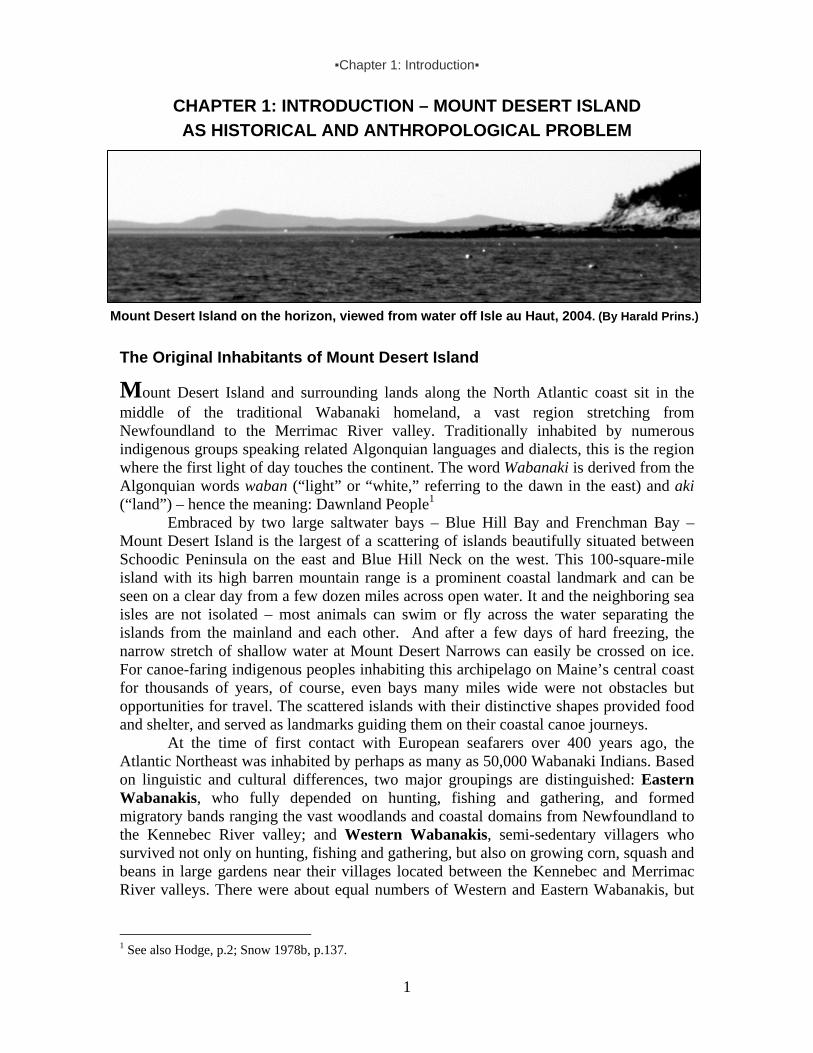
Mount Desert Island on the horizon, viewed from water off Isle au Haut, 2004. (By Harald Prins.)
The Original Inhabitants of Mount Desert Island
Mount Desert Island and surrounding lands along the North Atlantic coast sit in the middle of the traditional Wabanaki homeland, a vast region stretching from Newfoundland to the Merrimac River valley. Traditionally inhabited by numerous indigenous groups speaking related Algonquian languages and dialects, this is the region where the first light of day touches the continent. The word Wabanaki is derived from the Algonquian words waban (“light” or “white,” referring to the dawn in the east) and aki (“land”) – hence the meaning: Dawnland People1
Embraced by two large saltwater bays – Blue Hill Bay and Frenchman Bay – Mount Desert Island is the largest of a scattering of islands beautifully situated between Schoodic Peninsula on the east and Blue Hill Neck on the west. This 100-square-mile island with its high barren mountain range is a prominent coastal landmark and can be seen on a clear day from a few dozen miles across open water. It and the neighboring sea isles are not isolated – most animals can swim or fly across the water separating the islands from the mainland and each other. And after a few days of hard freezing, the narrow stretch of shallow water at Mount Desert Narrows can easily be crossed on ice. For canoe-faring indigenous peoples inhabiting this archipelago on Maine’s central coast for thousands of years, of course, even bays many miles wide were not obstacles but opportunities for travel. The scattered islands with their distinctive shapes provided food and shelter, and served as landmarks guiding them on their coastal canoe journeys.
At the time of first contact with European seafarers over 400 years ago, the Atlantic Northeast was inhabited by perhaps as many as 50,000 Wabanaki Indians. Based on linguistic and cultural differences, two major groupings are distinguished: Eastern Wabanakis, who fully depended on hunting, fishing and gathering, and formed migratory bands ranging the vast woodlands and coastal domains from Newfoundland to the Kennebec River valley; and Western Wabanakis, semi-sedentary villagers who survived not only on hunting, fishing and gathering, but also on growing corn, squash and beans in large gardens near their villages located between the Kennebec and Merrimac River valleys. There were about equal numbers of Western and Eastern Wabanakis, but
1 See also Hodge, p.2; Snow 1978b, p.137.

▪Chapter 1: Introduction▪
2
territories inhabited by the latter group were much larger and, consequently, had a much lower population density.
Wabanaki tribal communities formed part of three major groupings identified in early French documents as the Etchemin, Souriquois and Armouchiquois. Each of these groupings could be distinguished from their neighbors by distinctive cultural features, including different speech. Etchemin foragers ranged primarily through the vast woodlands between the Kennebec and St. John River valleys. Thus, Mount Desert Island is clearly situated in the center of the Etchemin coast. To their northeast were Souriquois bands—better known as Mi’kmaq from the late 1600s onwards—ranging the area to southern Newfoundland. Southwest of the Etchemin were communities collectively known as Armouchiquois, corn-growing peoples whose villages could be found in the Kennebec valley and far beyond. These Armouchiquois consisted of several different ethnic groups, including Abenakis traditionally inhabiting territories from the Kennebec to the Merrimac Rivers. As semi-sedentary corn-growing villagers, these Abenakis are here distinguished as Western Wabanakis, whereas the Etchemin and Mi’kmaq, as migratory foragers, are grouped together as Eastern Wabanakis.
Regional divisions existed within each of these large Wabanaki groupings. Among the Mi’kmaq, for instance, there were three divisions, each subdivided in several districts. Likewise, among the Etchemin there were at least two divisions, here geographically distinguished as Eastern Etchemins – closely related bands whose home territories were located east of Narraguagus River – and Western Etchemins, who originally ranged the coastal region and its forested hinterland from the Narraguagus River to the Kennebec. The Eastern Etchemins have become known as Passamaquoddy and Maliseet (or St. John River Indians). The Western Etchemins inhabiting the Penobscot River and Mount Desert Island region welcomed Abenaki refugees from the Kennebec and beyond and formed a composite tribe known as the Penobscots. Members from all these various groupings were (and remain) in contact with each other, especially those inhabiting border districts. Ethnic and territorial boundaries between the ethnic groups and their subdivisions were fluid, adaptive and dynamic, shifting in the course of centuries.2
All these Wabanaki groupings experienced catastrophic changes and extreme challenges following a demographic collapse brought on by European contact. They survived by resistance, accommodation and relocation, which led to a series of ethnic and territorial reconfigurations. The names that Europeans recorded for Wabanaki groups soon after first contact also changed. Although historical details of this renaming process are too complicated to discuss here, a set of new ethnic labels entered French colonial documents by the late 1600s, gradually replacing (and more or less corresponding to) the earlier triplet. In contrast to the French, who adopted indigenous ethnic labels primarily reflecting linguistic differences, the English identified these different Wabanaki groups according to their geographic location. Distinguishing groups by the major river or bay where they could be found, the English referred to neighbouring Western and Eastern Etchemin communities in the 1600s as “Pemaquids,” “Penobscots,” “Machias,” “Passamaquoddies” and “St. John’s Indians.”
2 This is a very complex issue detailed in Prins 1988, pp.152-91. Numerous scholars, including Bourque 1989, Eckstorm 1941, Alvin Morrison 1978, Snow 1976, Speck 1940 and Wherry 1979 have proposed various and sometimes conflicting interpretations.

▪Chapter 1: Introduction▪
3
To make an already complex image of the indigenous ethnic landscape even more difficult to interpret, epidemics and colonial warfare in the course of the 1600s brought about major shifts. Many Abenakis were forced to seek refuge in territories east of the Kennebec, finding a new home among their Western Etchemin neighbors in the Penobscot valley and even beyond. These newcomers brought their own traditional cultural practices, including some crop-cultivation, and also held on to their ancestral Abenaki language. In the course of a few generations (from the late 17th century onwards), Abenaki gradually displaced Western Etchemin (a dialect closely related to Passamaquoddy) as the predominant language in the Penobscot valley. In contrast to the Abenaki-speakers who moved into the Penobscot valley, those that settled in the St. Croix and St. John River areas found the ecological circumstances even more challenging to their tradition of cultivating corn, squash and beans. Instead, they adopted the ancestral lifeways and the language of their hosts, becoming Eastern Etchemin speakers (Maliseet-Passamaquoddy). In the course of time, several Wabanaki communities such as the Penobscot and Passamaquoddy (named for the river valley and bay that were the geographic centers of their respective social groups) emerged as composite ethnic groups, gradually forging a shared cultural repertoire, adopting a common dialect or language and developing a collective heritage over the course of several generations. Many Wabanaki families, the record shows, were always minimally bilingual.
Clearly, a problem with ethnic labels is that they do not reflect the fluid linguistic boundaries and migratory movements of transient Wabanaki groups. They also fail to indicate that Wabanaki peoples maintained cross-tribal kinship ties. Intermarriage between individuals from different ethnic groups was common, especially when population loss reduced opportunities for finding marriage partners within the community that were not too closely related. Exogamous relationships had the added advantage of binding various regional communities together and resulted in family ties between different groups. Such kinship bonds had great political advantages, as they increased opportunities for creating alliances and diminished risks of intertribal conflicts. Today, almost all Passamaquoddy have Maliseet and Penobscot relatives, and some even trace their ancestry to the Mi’kmaq. The same is true for the other Wabanaki tribal nations, all of whom enjoy ties of kinship and friendship stretching back for centuries. Indeed, even the very earliest written records mention intertribal marriages among the Wabanaki.3
Until the modern state began to enforce its bureaucratic rules of Indian status and controlled tribal membership rolls, Wabanaki communities themselves decided who belonged and who did not. Because cross-tribal intermarriage was not uncommon, and individuals or entire families could (and often did) move or break away from their own groups and join neighboring communities, even crossing traditional linguistic divides, easy labels such as “so and so is Penobscot,” or “that person is a Passamaquoddy,” hide a much more layered Wabanaki identity configuration as it historically evolved in a volatile social arena. Given this unstable field of force within which Wabanaki families struggled to survive for more than 400 years, it is obvious that easy conclusions about tribal identity and territorial boundaries are problematical.
3 Asked what percent of individuals who are members of the Penobscot Nation today have genealogical ties to one or more of the other Wabanaki groups, Penobscot genealogist Carole Binette responded, “One hundred percent.” This, she added, was no doubt true for Passamaquoddies and Maliseets, and for a considerable percentage of Mi’kmaqs (personal communication, 3 Aug. 2005).

▪Chapter 1: Introduction▪
4
Tribal Territories, Ethnic Identities and the Problem of History As noted above, indigenous inhabitants of the Mount Desert Island coastal area belonged to a group here identified as Western Etchemins. As also noted, these migratory foragers spoke a regional dialect of an ancient language an eastern variation of which is still spoken by Passamaquoddy and Maliseet of eastern Maine and New Brunswick – and is also still understood by a few Wabanaki families in the Penobscot valley.
Regional scholars and others interested in the historical identity of Mount Desert Island Indians have long puzzled over the questions: Were they Penobscots or Passamaquoddies? Did Mount Desert Island form part of Penobscot or Passamaquoddy tribal domain? Where exactly was the traditional territorial boundary between these neighboring Wabanaki groups? Different authoritative sources offer different answers. Some have placed the border at the Machias River, with Penobscot lands located west of that divide and Passamaquoddy to the east. Others have placed it at the Union River.
In 1887 Passamaquoddy tribal representative Lewis Mitchell from Pleasant Point, who spent many summers at Bar Harbor, clearly described the westernmost boundary of Passamaquoddy tribal territory at the Narraguagus River, some 15 miles east of Schoodic Peninsula, thus excluding Mount Desert Island:
The St. John Indians [Maliseet] have their own hunting grounds, as also do the Penobscots. The Passamaquoddy Indians have the boundary of their hunting grounds commence at the mouth of the Proo, or Preaux River, 30 miles this side of St. John, N.B. It follows the coast, westwards, to the mouth of the Cherryfield, or Narraguagus River, and follows it to the head of it, then [back east] to the head of the Machias River; from there to the head of the St. Croix River; from there to the head of the Proo, or Preaux River, following it, – to the coast. This includes all the islands on the south – from the mouth of the Proo, or Preaux, River [to]ward of the mouth of the Cherryfield, or Narraguagus River. This also includes all the lands, timber, and all the wild animals once belonging to the Passamaquoddy tribe of Indians.4
About two decades later, anthropologist Frank Speck of the University of
Pennsylvania began frequenting the Indian villages at Bar Harbor and Old Town. As a young scholar working at the university’s museum, he made a series of short fieldwork trips to Maine between 1907 and 1914, primarily to collect ethnographic information about Penobscot cultural traditions. Based on this research and ongoing fieldwork elsewhere, along with the reading of historical descriptions, Speck wrote several articles on the Penobscot and other Wabanakis. In 1940, he published his now classic ethnographic study, Penobscot Man: The Cultural Life of a Forest Tribe. No doubt having witnessed many Passamaquoddy frequenting the Mount Desert Island area during some of his summers in Maine, he stated that the island fell within the traditional range of the Passamaquoddy: “The Passamaquoddy hunted over and occupied country close to Penobscot Bay on the east, including Mount Desert Island, which was consequently not in Penobscot territory, the same being true of Union River just east of the Penobscot.”5
4 Mitchell 1887, p.7. 5 Speck 1940, p.9.

▪Chapter 1: Introduction▪
5
During the years of the Maine Indian land claims dispute, especially in the late 1970s, the question of traditional Penobscot and Passamaquoddy tribal territories was more than just a matter of history. It had become a hot political issue with enormous consequences for everybody living in central and northeastern Maine. When the Passamaquoddy and Penobscot tribes filed their large land claims against the State of Maine in 1972, neither tribe included Mount Desert Island in their tribal claim area. The Penobscot drew the line from Schoodic Peninsula northwestward, through Frenchman Bay to Bangor and beyond, claiming the entire Penobscot drainage area and all the territories of this line as their wrongfully taken ancestral lands. In their article “State Power and the Passamaquoddy Tribe: ‘A Gross National Hypocrisy’,” Francis J. O’Toole and Thomas N. Tureen (the lead attorney for the tribes) more or less echoed Lewis Mitchell’s 1887 description, demarcating Passamaquoddy aboriginal territories as follows: “Prior to 1794, the Passamaquoddy Indians occupied and had as their traditional hunting grounds virtually all of the land in the State of Maine between the Narraguagus [Cherryfield] and Saint Croix Rivers, in addition to other lands across the Canadian border. In this large area members of the tribes roamed freely and depended upon hunting, trapping, and fishing for their livelihood.”6
When the land claims settlement was being negotiated, archaeologist and ethnohistorian Dean Snow published his chapter “Eastern Abenaki” in the authoritative Handbook of North American Indians.7 His position was at odds not only with Mitchell’s but also with Speck’s. Rather than assigning the Mount Desert Island area to the Passamaquoddy, Snow simplified the ethnohistorical complexities and conflicting data by means of what became known as the river drainage model of tribal territoriality. Largely based on this model, he argued that the entire Penobscot River drainage area, as well as the wider Penobscot Bay between St. George’s River and Schoodic Peninsula, formed part of Penobscot Indian “tribal territory.” As indicated on the map Snow presented in his Eastern Abenaki chapter,8 this Penobscot territory historically embraced Mount Desert Island. However, in 1764, according to Snow,9 the Penobscots had ceded all of their rights to their tribal habitat down river from Bangor on, including all of Penobscot Bay and Mount Desert Island. In his words: “In 1764 the English formally assumed ownership of the lower Penobscot drainage (see fig.1). The Penobscot could no longer balance themselves between two contending powers. The treaty of 1762 was essentially a capitulation to the English.”10
More recently, long-time student of Wabanaki cultural history Nicholas Smith more or less agreed with Speck’s earlier assertion: “The Passamaquoddy are considered the eastern group of Maliseet whose hunting territories were located from New Brunswick's Bay of Fundy to Machias, Maine, and perhaps extended as far south as Bar Harbor, Maine; and west almost to Lincoln, Maine, meeting both Penobscot and Maliseet territories.”11 This formulation, however, seems to leave room for Penobscots
6 O’Toole and Tureen, p.6. 7 Snow 1978b, pp.137-47. 8 Snow 1978b, fig.1a, p.138. 9 Snow 1978b, fig.1b, p.138. 10 Snow 1978b, p.144. 11 N. Smith 1991.
▪Chapter 1: Introduction▪
6
traditionally frequenting Mount Desert Island’s western parts, including Bass Harbor and Southwest Harbor.
Clearly, there is no consensus among these various experts, with Mitchell claiming the Narraguagus River (from Cherryfield to Millbridge) as the western boundary of Passamaquoddy tribal territory, Speck extending it to beyond the Union River and including Mount Desert Island, only to be pushed back to the Schoodic Peninsula by Snow who included Mount Desert Island as historically part of Penobscot Indian tribal territory, and then Smith making a more tentative case on behalf of the Passamaquoddy.
For Wabanakis the issue of ancestral lands has always been important, not just because of political and economic factors, but also for emotional and spiritual reasons. How then to resolve this problem of conflicting interpretations and determine whether Mount Desert Island is located in Passamaquoddy or Penobscot tribal territories? Is it possible we are asking the wrong questions? Based on our research into the cultural history of Mount Desert Island, we suggest that such is the case.
Given the highly turbulent history with recurrent epidemics and many decades of bloody violence triggered by the European invasion in the 1600s, it is hardly surprising to find a highly unstable Wabanaki cultural landscape with considerable historic fluidity in ethnic identity and territoriality. More than a century ago John W. Powell (founding director of the Smithsonian Institution’s Bureau of American Ethnology) wrote that it is difficult “to indicate the proper boundary lines between individual tribes. . . . Not only is precise data wanting respecting the limits of land actually held or claimed by many tribes, but there are other tribes, which disappeared early in the history of [North America. It] will be readily understood that to determine tribal boundaries within accurately drawn lines in the vast majority of cases quite impossible.”12
Years later, University of Pennsylvania professor Frank Speck and his colleague Wendell Hadlock of the Abbe Museum in Bar Harbor put forth a similar conclusion in their cultural historical study of Maliseet Indians in the St. John River area of New Brunswick:
In drawing a map of the area controlled or claimed by groups of Indians who were in a constant state of migration, such a map can at best only indicate probable limits of tribal territories at a given time in the history of the tribe. . . . It is not surprising to find family hunting territories outside of the recognized tribal bounds, for it is well known that certain tribes send hunters at various seasons of the year to traditional hunting grounds outside of their recognized tribal territory.13
This problem is compounded when considering Mount Desert Island’s indigenous cultural history, for the island is located in what was long contested territory on the ever-shifting colonial frontier – and within this context the region’s coastal Wabanaki suffered terrible upheavals born of diseases, warfare and forced migration, all of which resulted in ethnic and territorial reconfigurations just noted. Given these circumstances, the concept of tribal territoriality becomes problematic because it fails to capture the complex colonial reality within which surviving Wabanakis were (and are) forced to operate. In
12 Powell, pp.42, 44. 13 Speck & Hadlock 1946, p.372.
▪Chapter 1: Introduction▪
7
fact, the concept of “range” more accurately describes the highly fluid social political arena within which Wabanaki individuals or groups have managed to survive.14
Another research challenge facing anyone who investigates Wabanaki cultural history is the morass of names applied to the various groups. As mentioned in the first pages of this introductory chapter, tribal group names were subject to change, and French and English historic documents often used different names to refer to the same tribal group. In 1887 Passamaquoddy Lewis Mitchell touched on this issue in his defense of native rights when serving as tribal representative to the Maine state legislature:
Now we go back to the origin of the Passamaquoddy tribe, and their claim, privileges, treaties and their hunting grounds. I see by some of the reports in this [Maine State] Legislature, that some of the writers mentioned in history claim that the Passamaquoddies are a branch from the Penobscots. That is not true…. Their language is different from that of the Penobcots…. I also saw by some of the reports that you said the Passamaquoddy tribe was not mentioned in early treaties. Now I can show you by the [1780s-90s] letters from Col. Allan which he addressed to us sometimes as the Mareschite tribe. Now the word Mareschite [Maliseet] that is the Micmac name for Passamaquoddy. Micmac Indians called us Malesisik, or Mareschite.15 All of this given, historical documents, including maps, must be read and
interpreted with caution; it is all too easy to make an erroneous conclusion about who did what, when and where.16 Nonetheless, notwithstanding their limitations and biases, these documents shed crucial light on Wabanaki cultural history on and near Mount Desert Island over the past five centuries. Mount Desert Island as Part of an Indigenous Catchment Area Traditionally depending on hunting, fishing and gathering for their survival, the region’s original Western Etchemin-speaking families were highly mobile, periodically staying at favorite locations before moving on to another place. Because their foraging mode of subsistence is almost universally associated with low population densities, it is not surprising that the indigenous population density in this Maine coastal region was relatively low. How to reconfigure the structural position of this large coastal island as a functional part of a larger indigenous cultural ecological system within which a self-sufficient tribal community once operated?
This question challenges us to tackle the basic anthropological problem of cultural ecology: What is the dynamic relationship between natural resources, technology and group size? In other words, what is the number of people that resources potentially available in a certain region can support at a given level of food-getting techniques? And more specifically, what was the carrying capacity of Mount Desert Island when it was inhabited exclusively by people employing a lithic technology and subsisting on the basis
14 Cashdan 1983, p.54; Prins 1986; Prins 1988, pp.283-93. 15 Mitchell 1887, p.3. 16 Examples of ethnonymic confusion abound, sometimes resulting in erroneous interpretations of the historical record such as Speck (1928, pp.170-71) with respect to the Wawenock and Bourque (1989, p.271 and 2001, pp.144, 157) with respect to the Canibas. See also Prins 2003.

▪Chapter 1: Introduction▪
8
of hunting, fishing and gathering? Directly related to this issue is the question pertaining to what anthropologists refer to as “density of social relations,” namely the number and intensity of interactions among members of a territorial group.17
Assuming we know the population size of a foraging community with stone-age technology and their natural habitat’s carrying capacity, we may estimate their habitat‘s geographic size.18 Depending on the natural resources available in a foraging habitat, anthropologists have found a variety of population density figures, ranging from less than 0.1 to more than 1 persons per square mile. Mount Desert Island, which is 16-miles long and 10-miles wide, measures about 100 square miles. Based on foraging population density figures, the island could support 10-100 persons, which would average to about 50 individuals on an annual basis. Considering this in light of pre-contact population density figures for Nova Scotia and the Gulf of St. Lawrence area, estimated at 25-50 persons per 100 square miles,19 and surmising that Mount Desert Island’s carrying capacity would fall within the middle of that range – just under 40 – we may conclude that the island could support a small Wabanaki band consisting of about three or four extended families on a year-round basis20.
These foraging families would have formed part of a larger Wabanaki tribal community, probably numbering about 300-500 persons, camping together periodically in temporary villages at favored locations during seasons of plenty. Based on the available natural resources, combined with archaeological and ethnohistorical evidence, it is perhaps possible to reconstruct the indigenous territorial domain within which Mount Desert Island formed an integral part. This can best be conceptualized in terms of an indigenous catchment area – the bounded region from which a self-sustaining group draws its vitally important resources on a long-term basis.
Returning to favorite locations on a regular basis, Wabanaki foraging families left their camping sites unoccupied for much of the year. Depending on the available natural resources, including firewood and food supplies, some sites periodically attracted relatively large numbers of indigenous families living together for several weeks or even a few months, whereas other locations provided subsistence and shelter for only small numbers of people for shorter periods of time. Moreover, depending on the
17 Haviland et al, p.159. 18 Using a population density figure of about 12 per 100 square km (more than 3 per square mile) for the Penobscot river drainage, archaeologist Dean Snow (1980, p.33) estimated that the Wabanaki population in that area at about 3,200 individuals at the time of the first contact with Europeans. There are several problems with this figure, including the fact that he assumes that they already engaged in crop-cultivation, which increases the carrying capacity and may result in higher population density. Another problem is that he used French population estimates for the area, erroneously assuming that they were post-epidemic, whereas in fact they were at least partially based on pre-epidemic figures. 19 Prins 1996b, pp.26-27; Nietfeld, p.393. 20 For comparative purposes, it is of interest to note that in his ethnographic research on Wabanaki Indian family hunting territories about a century ago, anthropologist Frank Speck found considerable regional variation. Such family hunting tracts in Newfoundland, he reported, “where there are thirteen family groups, average about 2,000 square miles to each, while in Cape Breton the sixteen family groups have an average of about 400 square miles a piece, and in Nova Scotia the average [family] district amounts to only 200 square miles” (Speck 1915c, pp.194-95). Although one has to read these figures with considerable caution (Prins 1988, pp.207-12), they do illustrate how much territory a group of hunting families forming a viable community requires for their year-round support.

▪Chapter 1: Introduction▪
9
environmental circumstances, some sites may have been left unoccupied for several years.
Based on the figures above, a Wabanaki community of 300 persons required a territorial base of 300-3,000 square miles, which averages out to just over 1,600 square miles. To support itself on a long-term basis during seasons of natural resource abundance and scarcity, such a community would need a large foraging domain about equal to the territorial size of Hancock County (1,588 sq. mi.).21 Given that Mount Desert Island is situated in a region traditionally inhabited by highly mobile foragers, we may assume the following: Instead of having been inhabited by about 40 people on a year-round basis, Mount Desert Island could have supported an entire tribal community of about 400 for about five weeks. Another possibility, of course, is that the entire community would have been camped together somewhere on the island for about three weeks, leaving enough natural resources for a few extended families to hunt, fish, and gather there for much of the remainder of the year.
Considering the archaeological and ethnohistorical information currently available, this reconstructed tribal foraging domain of the Western Etchemin community at the time of first contact seems plausible. It appears that the indigenous seasonal cycle included periodic movements to and from Mount Desert Island, essentially following a north-south axis – from the seacoast and offshore islands into the interior woodlands, river and lakes, and back again. As far as this axis is concerned, the structural position of Mount Desert Island is not well documented historically, but it was probably fully articulated as part of the indigenous foraging strategy prior to the upheavals of the colonial period. Indicative of seasonal rotations between the coastal archipelago and the forested hinterland, more systematic comparison of archaeological remains dispersed across many different sites will allow us to make a more fact-based reconstruction of periodic movements along the north-south axis. Asticou’s Island Domain As argued above, Mount Desert Island was probably seasonally inhabited by perhaps 400 Western Etchemin hunters, fishers and gatherers who lived there for several weeks before moving on to another good camping site on a neighboring island, peninsula or river bank. Some extended families likely stayed there much longer and may have divided the island into two or three traditional family hunting territories. Since Mount Desert Island did not have sufficient natural resources to support a sizeable tribal community of migratory foragers year-round, we have also argued that all or most of the numerous indigenous camp and village sites already identified at the island and its surrounding region were systemically related to each other as seasonal localities within a large catchment area.
If it is true that Mount Desert Island was one of several seasonally occupied locations within a much larger foraging range of perhaps 1,600 square miles, what were the territorial boundaries of that range or catchment area? Considering the maritime cultural orientation of these coastal foragers who were experts in canoe travel, this area minimally included Schoodic Peninsula and Blue Hill Neck, as well as Isle au Haut and other islands forming part of the Acadia National Park landholdings in this region. (In fact, all of these places still contain remains indicative of having been visited and
21 Hancock County now has a population of about 52,000, with a density of 32.6 persons per square mile.

▪Chapter 1: Introduction▪
10
periodically inhabited by indigenous hunters, fishers and gatherers for many generations since time immemorial.)
Given the total amount of land necessary to sustain a tribal community, this larger foraging domain also would have included a substantial hinterland providing these migratory family groups with a variety of terrestrial game, fresh-water fish and various other natural resources less available or not found on the seacoast. It is likely that it embraced the vast woodlands, marshes and lakes drained by the Union and Skillings Rivers and Sullivan Harbor effluence and emptying into the two major saltwater bays embracing Mount Desert Island – Blue Hill Bay and Frenchman Bay respectively. By way of these waterways, Western Etchemins could portage into the Machias and Penobscot drainage areas where neighboring tribal communities had their foraging domains. In this respect, we suggest that the numerous late prehistoric and early historical village and camping sites throughout this catchment area are all culturally related and may have to be considered as the legacy of one larger Western Etchemin community. As for the larger area that also embraced Mount Desert Island, we have chosen to name it “Asticou’s Island Domain” – in honor of Chief Asticou, the sakom (chief) who headed the community encamped there at the time of first contact there in the early 17th century. Wide-Framing, Small Historical Detail The argument that Mount Desert Island formed part of a much larger cultural ecological system is applicable to any other geographical location featuring in the histories of Maine’s indigenous peoples – including well-documented places of indigenous residence such as Sipayik (Pleasant Point) and Panawahpskek (Indian Island). Each of these sites must be situated in a much wider social field of action.
In addition to the periodic movements to and from Mount Desert Island along the north-south axis discussed above on page 8 and associated primarily with the seasonal subsistence cycle, there are also recurring movements along the coast, according to a northeast-southwest axis. This secondary axis must be understood within the context of inter-tribal networks of exchange and trade, political alliances and warfare, and even religion. The position of the island along the northeast-southwest axis is related to its strategic location on the coastal travel route stretching between the Bay of Fundy and Massachusetts Bay, and beyond. Whereas movements along the north-south axis are not well documented in historic records, this secondary movement was frequently observed by those who produced the written documents – Europeans on the coast.
Participation in wider cultural networks involved long-distance voyages between neighboring Wabanaki communities. Traveling in salt-water canoes, and later also in European shallops or other sailing vessels (and since the early 1800s also aboard steamships), Wabanakis acquired desired goods, including prestige items, weapons and food. Western Etchemin foragers in the Mount Desert Island area, for instance, could obtain corn from Abenaki villagers in the Kennebec valley or at Saco Bay. There is abundant archaeological and early historic evidence of indigenous networks of exchange directly tying Wabanaki traditionally inhabiting the Mount Desert Island area with indigenous groups in Nova Scotia, the St. Lawrence Valley, Massachusetts Bay and even beyond. This coastal travel route, of course, continued to be used when Wabanakis from Sipayik (Pleasant Point) at Passamaquoddy Bay or Panawahpskek (Indian Island) on the Penobscot traveled to white settlements such as Bar Harbor and Southwest Harbor on
▪Chapter 1: Introduction▪
11
Mount Desert Island, as part of a strategy of cultural adaptation targeting tourists and rusticators since the mid-1800s. Research Methodology: Problem of Sources Much of Mount Desert Island’s indigenous cultural history since the 1500s was shaped by the island’s geographic position on the Wabanaki coastal route. Without a wider framework, however, minute historical data – an incident, name or date – would have been ignored as meaningless or even dismissed as irrelevant. In that respect, our historical anthropological research project resembles the challenge forensic specialists face when trying to reconstruct what happened to whom where, how and why. Obviously, since this report focuses on a geographic fragment of this larger whole over a period of almost 500 years, we limit ourselves when possible, referencing this wider framework only when the island’s indigenous history requires more context.
Anyone seeking to reconstruct which Wabanaki groups were traditionally associated with Mount Desert Island faces problems with documentation. To put it briefly, very little information exists about American Indians directly relevant to the island’s history prior to the 1850s. And what this report details for the period after the mid-1800s comes from widely scattered fragments, which as far as we know have never before been systematically collected. More elaborately, there are several reasons for the paucity of information. First of all, until the mid-19th century the region’s Wabanaki peoples functioned primarily on the basis of oral tradition. Writing played a very marginal role in their culture before that time. This means that they themselves left almost no written records of their lives during the first 300 years of contact, and, accordingly very few specific details exist about particular individuals engaging in specific activities at identifiable locations and times. Even if Wabanakis had been literate, it is unlikely that they would have written about where they went and why just for the sake of making a statement for posterity. Most of them formed part of an intimate world in which face-to-face contact made oral communication sufficient. And even if they were not living in direct proximity, the means of getting any written messages to distant locations in Maine’s woods or islands were either absent or could not be trusted. In this respect, they are not that different from Maine’s non-Indian fishermen. For example, we are unaware of any substantial records written by Monhegan fishermen documenting their own life histories or their comings and goings from a coastal island that has a history of English presence dating back to the early 1600s. Indeed, documents about human life in general on Maine’s coastal island communities are not only few but also very stingy with descriptive detail.
Geopolitics and economics provide another reason for the dearth of early historical data concerning Wabanakis on Mount Desert Island. Unlike coastal places such as Pemaquid and Pentagoet, the Mount Desert Island neighborhood lacked colonial trading posts and military garrisons, and thereby rarely made the news. Also, because Mount Desert Island is situated in what was continually contested territory on the French and English colonial frontiers, any permanent European settlement there was quite impossible before the latter 18th century. This lesson was painfully driven home in 1613 when English raiders put an immediate end to any French dreams of a Catholic trading and mission post on this island. After that early French settlement fiasco on Somes Sound, European settlers, entrepreneurs and military strategists alike realized that on

▪Chapter 1: Introduction▪
12
Mount Desert Island even a heavily fortified trading post was prone to be attacked and leveled to the ground. The absence of permanent white settlements on Mount Desert Island prior to the 1760s meant there were no outside observers consistently on the ground who, if literate, might have felt impelled to record the activities of any Wabanakis in the area. Thus, much of whatever seasonal indigenous activity did still occur on Maine coastal islands, sea bays, marshes and river valleys, escaped if not the eye then at least the pen of outside observers.
All of these reasons, and more, help explain why so few references exist about Wabanakis actually at Mount Desert Island in the 17th and 18th centuries. Nevertheless, situated in the geographic center of this colonial theater, Mount Desert Island, Isle au Haut and Schoodic Peninsula are sometimes briefly mentioned in records – usually in passing, but with enough frequency to show that these places were regularly visited by Wabanaki families, traders or raiders. Our larger canvas gives us a more encompassing perspective on the complex historical dynamics of this coastal region and allows us to make sense of the snippets of information contained in these rare mentions
Another challenge in piecing together Mount Desert Island’s ethnohistory stems from “ethnofiction.” Many local stories about “Indians,” as told and later written down by settlers and visitors alike, are interesting as folklore but must be carefully interpreted as they may be more indicative of dominant society’s prevailing ideologies than of Wabanaki cultural realities. And it almost goes without saying that American Indians have seen their own historical traditions ignored, falsified or modified to suit the political or ideological interests of those who came after them, took their lands by force and largely erased their memory.
Traditional Wabanaki place names, legends and myths, along with oral histories, are essential sources of information for expanding, interpreting and critically reading published accounts and archival materials unearthed in this study. Interviews with elders and other knowledgeable Wabanakis from all four tribal groups revealed values, beliefs, skill sets, marriage patterns, seasonal movements, traditional medicine practices and a host of activities that deepened our understanding of sometimes bewilderingly complex information gathered through a wide array of primary documents (including photographs, census records, newspapers, maps, Indian agent reports and other government records, unpublished reminiscences and journals, etc.), as well as secondary material. In many instances, the interviews prompted us to revisit archival materials with a fresh eye and new questions. Conversely, previously conducted research impacted the interviews and helped us verify and weigh the importance of oral tellings. Notably, our archival research, combined with interviews and participant observation among present-day Wabanaki activities in “Asticou’s Island Domain” revealed a remarkable continuity of Native presence and deep association with this coastal region, as chronicled in this report. Conclusion As summarized above and detailed in the next few chapters, a lethal combination of epidemics and warfare beginning in the late 1500s triggered a complex historical process resulting in ethnic and territorial reconfigurations among Wabanakis. Originally situated within the Western Etchemin homeland, Mount Desert Island and surroundings were especially affected by the cultural shifts. At the time of first contact with Europeans – the indigenous cultural moment chosen here as our “ethnographic baseline” – Maine’s

▪Chapter 1: Introduction▪
13
coastal lands east of the Kennebec River valley were inhabited by migratory groups of Etchemin hunters, fishers and gatherers who spoke regional dialects closely related to those still spoken by many Maliseets and Passamaquoddies, and even some Penobscots. By the late 17th century, however, many Abenaki corn-planters were made homeless by New England colonists and migrated northward into the St. Lawrence valley, or eastward into traditional Etchemin territories. Relatively sparsely populated by migratory foraging bands, this area had become even more thinly inhabited due to the epidemics that decimated the region’s original inhabitants. Through intermarriage and adoption, new composite tribal communities were formed in the course of generations. When Abenaki-speaking refugees joined Eastern Etchemin communities in the Passamaquoddy Bay and St. John River areas, they adopted the lifeways and language of their host groups. In contrast, the Abenaki-speaking newcomers that settled in the Penobscot Valley outnumbered indigenous Western Etchemin and retained their ancestral language.22 But even into the early 20th century, there were traces of the Western Etchemin dialect in the Penobscot language as spoken by traditional “salt-water” families, showing a connection to Maliseet-Passamaquoddy. This was distinct from the “pure Abenaki” spoken by Penobscots belonging to traditional upriver families, which resembled the original language of Abenakis on the Kennebec.
The deep roots of Wabanaki culture in the Maine coastal region are also traceable in archaeological sites, shell-middens, petroglyphs, ancient Gluskap myths and legends, and, last but not least, some of the earliest recorded place names for rivers, islands, capes and other geographic locations. But in the lives of the thousands of indigenous individuals who have lived, loved and died on Mount Desert Island and its coastal surroundings lies the full legacy of all Wabanaki peoples. All of them share a common ancestry that goes much deeper and wider than what are now identified by tribal, ethnic or linguistic labels such as Penobscot or Passamaquoddy, Abenaki, Maliseet or Mi’kmaq. Although culturally relevant today, such convenient social labels fail to capture the vast and rich complexity of long-shared indigenous history in the Wabanaki homeland, including Mount Desert Island.
◘ ◘ ◘ ◘
22 Prins 1992, 1995; Prins and Bourque, 1987.

▪Chapter 1: Introduction▪
14

▪Chapter 2: Ethnographic Baseline: Wabanaki Cultures c1600▪
15
ETHNOGRAPHIC BASELINE: WABANAKI CULTURES c.1600
Habitat: Asticou’s Island Domain
Mount Desert Island originally formed part of a larger Wabanaki foraging domain, probably comprising the surrounding archipelago and its coastal hinterland drained by the rivers running into the saltwater bays between Schoodic Peninsula and Blue Hill Neck. Thus situated between the Penobscot and Narraguagus Rivers, this 1,600 square-mile domain would have been the traditional catchment area of a Wabanaki tribal community of about 300 to 500 canoe-faring hunters, fishers and gatherers. In this study we refer to this entire area as “Asticou’s Island Domain” – naming it after the Wabanaki chief who was headman of this region when Europeans first landed on the shores of Mount Desert Island in 1604.
Thinking of their traditional homeland as part of Ketakamigwa – “the big land on the sea coast” – these Wabanakis believed that the earth was a large island surrounded by the “great salt water.” Expressing a spiritual kinship with their natural environment, they believed that a mysterious life force known as Kciniweskwe – “great spirit” – enlivened all of nature, that ancestral spirits lived on as stars in the skyworld above and that hostile spirits appearing in reptile form inhabited a netherworld.
In the introductory chapter, we noted that the Wabanaki are made up of several neighboring tribes (also called nations or ethnic groups). We also distinguished two traditional branches, the Western and Eastern Wabanakis – the first comprised of corn-growing villagers who inhabited the Kennebec valley and further south, the second comprised of migratory foraging bands that ranged the coastal waters and vast woodlands east of the Kennebec. Considering this basic division, the people hunting, fishing and gathering food in the Mount Desert Island area were Eastern Wabanakis.
The larger Mount Desert Island area, or Asticou’s Island Domain, is an ecologically diverse coastal woodland environment, combining a saltwater archipelago with a 1,000-square-mile freshwater hinterland broken by hills, swamps, lakes and ponds, and drained by a few major rivers and numerous smaller streams. Its mosaic of tree

▪Chapter 2: Ethnographic Baseline: Wabanaki Cultures c1600▪
16
stands included ash, elm, oak, pine, hemlock, beech, oak and of course birch. Some of these trees, in particular the white pine, were enormous in dimension, measuring up to five feet in diameter and reaching more than 150 feet in height. With warm summers and long cold winters, the interior woodlands could be covered with snow for five months. Typical for this habitat is a thriving wildlife, a traditional abundance of moose, white-tailed deer and even small herds of caribou. In addition, black bear, wolves, raccoons, red foxes, lynxes, bobcats, fishers, martens, otters and skunks have long prospered here, not to mention rodents such as beavers, muskrats and porcupines. Inland waters, at least seasonally, have formed the natural environment of fish such as salmon, trout, sturgeon, bass, smelt and alewives, while marine life at the coast includes not only an abundance of lobsters, crabs and other shellfish (in particular clams and mussels), but also sea mammals such as seals, porpoises and whales. For thousands of years, multitudes of water birds (ducks, cormorants and loons) have flocked to the area, again mostly seasonally. Many birds of prey, including hawks and majestic eagles, have also shared in the region’s bounty.
The highly mobile Wabanaki families periodically camping at certain favorite sites throughout this large foraging domain, including Mount Desert Island, formed part of the ethnic group identified as Etchemins in the contact period. This indigenous name was first recorded in writing by French explorer Samuel de Champlain. Although the precise meaning of Etchemin (variously spelled) is uncertain, with some having glossed it as “Snowshoe-Hide Country Folk” – referring to the large numbers of moose and caribou in their hunting territories1 – it probably represents “a form of the word skejim [or skicin in Passamaquoddy] still in use as the equivalent of Indian.”2 As such, and conforming to an almost universal cultural practice, Etchemin is most likely an ethnocentric term they used for themselves, signifying “real people” or “truly humans.”3
Left: Etchemin coast. Right: Asticou’s Island Domain.
The Wabanaki community moving seasonally throughout Asticou’s Island Domain, including Mount Desert Island, maintained close contact with fellow Etchemin-
1 Maurault 1866, pp.5-6 2Ganong 1896, p.269 n.2. 3 See Rand 1894, p.xxxvi.
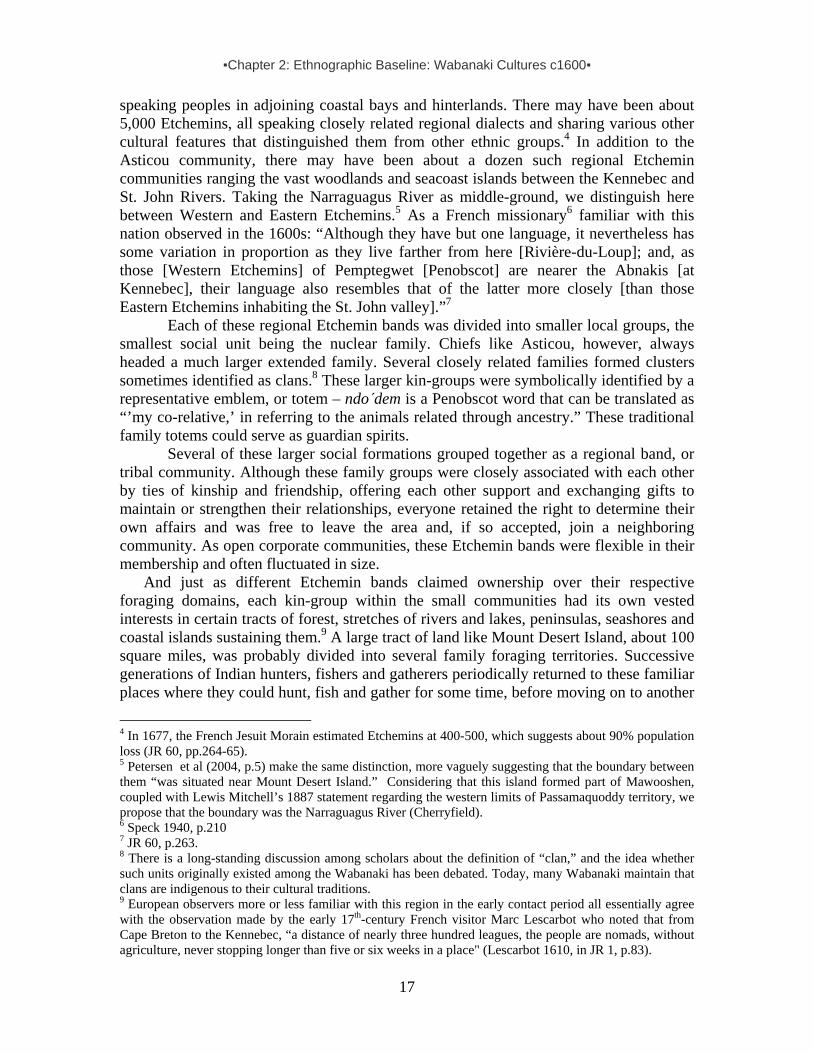
▪Chapter 2: Ethnographic Baseline: Wabanaki Cultures c1600▪
17
speaking peoples in adjoining coastal bays and hinterlands. There may have been about 5,000 Etchemins, all speaking closely related regional dialects and sharing various other cultural features that distinguished them from other ethnic groups.4 In addition to the Asticou community, there may have been about a dozen such regional Etchemin communities ranging the vast woodlands and seacoast islands between the Kennebec and St. John Rivers. Taking the Narraguagus River as middle-ground, we distinguish here between Western and Eastern Etchemins.5 As a French missionary6 familiar with this nation observed in the 1600s: “Although they have but one language, it nevertheless has some variation in proportion as they live farther from here [Rivière-du-Loup]; and, as those [Western Etchemins] of Pemptegwet [Penobscot] are nearer the Abnakis [at Kennebec], their language also resembles that of the latter more closely [than those Eastern Etchemins inhabiting the St. John valley].”7
Each of these regional Etchemin bands was divided into smaller local groups, the smallest social unit being the nuclear family. Chiefs like Asticou, however, always headed a much larger extended family. Several closely related families formed clusters sometimes identified as clans.8 These larger kin-groups were symbolically identified by a representative emblem, or totem – ndo΄dem is a Penobscot word that can be translated as “’my co-relative,’ in referring to the animals related through ancestry.” These traditional family totems could serve as guardian spirits.
Several of these larger social formations grouped together as a regional band, or tribal community. Although these family groups were closely associated with each other by ties of kinship and friendship, offering each other support and exchanging gifts to maintain or strengthen their relationships, everyone retained the right to determine their own affairs and was free to leave the area and, if so accepted, join a neighboring community. As open corporate communities, these Etchemin bands were flexible in their membership and often fluctuated in size.
And just as different Etchemin bands claimed ownership over their respective foraging domains, each kin-group within the small communities had its own vested interests in certain tracts of forest, stretches of rivers and lakes, peninsulas, seashores and coastal islands sustaining them.9 A large tract of land like Mount Desert Island, about 100 square miles, was probably divided into several family foraging territories. Successive generations of Indian hunters, fishers and gatherers periodically returned to these familiar places where they could hunt, fish and gather for some time, before moving on to another
4 In 1677, the French Jesuit Morain estimated Etchemins at 400-500, which suggests about 90% population loss (JR 60, pp.264-65). 5 Petersen et al (2004, p.5) make the same distinction, more vaguely suggesting that the boundary between them “was situated near Mount Desert Island.” Considering that this island formed part of Mawooshen, coupled with Lewis Mitchell’s 1887 statement regarding the western limits of Passamaquoddy territory, we propose that the boundary was the Narraguagus River (Cherryfield). 6 Speck 1940, p.210 7 JR 60, p.263. 8 There is a long-standing discussion among scholars about the definition of “clan,” and the idea whether such units originally existed among the Wabanaki has been debated. Today, many Wabanaki maintain that clans are indigenous to their cultural traditions. 9 European observers more or less familiar with this region in the early contact period all essentially agree with the observation made by the early 17th-century French visitor Marc Lescarbot who noted that from Cape Breton to the Kennebec, “a distance of nearly three hundred leagues, the people are nomads, without agriculture, never stopping longer than five or six weeks in a place" (Lescarbot 1610, in JR 1, p.83).

▪Chapter 2: Ethnographic Baseline: Wabanaki Cultures c1600▪
18
place to set up camp. With kinship ties, including intermarriage, between neighboring families, they would have operated in close association, and their foraging territories probably overlapped.10 Personal Appearances11 Described as “of average stature . . . handsome and well-shaped,” Etchemins living at Mount Desert Island were generally “betweene five or six foote high, straight bodied, strongly composed, smooth skinned [and] merry countenanced.” Their robust lifestyle and protein-rich diet made them a healthy people. Also, they made regular use of sweatbaths, followed by massage and “rubbing the whole body with seal oil” or other animal fat in order to “stand heat and cold better.” By greasing themselves, “their hair is not caught in the branches, but is slippery, so that rain and tempest do not injure the head, but glide it over to the feet; also that the mosquitoes . . . do not sting so much in the bare parts. . . .” Consequently, according to one early European traveler to the region, “You do not encounter a big-bellied, hunchbacked, or deformed person among them: those who are leprous, gouty, affected with gravel, or insane, are unknown to them.”
Their personal fashions, including hairstyle and ornamentation, reflected not just individual taste, but also served as cultural markers indicating social divisions based on ethnic affiliation, rank, age, gender or marital status. Decorative devices, such as headdresses, could involve colorful arrangements with bird feathers, wampum, dyed porcupine quills or moose hair. Adult Etchemin males typically tied “a knot of [their hair] upon the crown of their head, some four of five fingers long, with a leather lace, which they let hang down behind.” Sometimes, a few bird feathers were woven into these topknots. When a warrior died, his relatives “upon his head stuck many feathers,” prior to his burial. In contrast to the adult men, boys “wear theirs of full length; they tie it in tufts on the two sides with cords of leather.” Some of them had their hair “ornamented with coloured Porcupine quills.” Their corn-growing neighbors west of the Kennebec were clearly recognizable by their distinct hairstyle, as these tribesmen “shave off their hair far up on the head,” leaving it very long at the back. This remaining hair “they comb and twist behind in various ways very neatly, intertwined with feathers which they attach to the head.”
Sakoms (Wabanaki chiefs referred to as sachems or sagamores in European records) were sometimes distinguished by their own particular headgear. Their prerogative was a bird with an aggressive reputation, described as a “black hawk” (probably eastern kingbird). Viewed as a symbol of their own bravery, the dead bird’s “body dried and stretched out” was affixed to the topknot in their hair. While most Wabanaki men plucked out their scant facial hair, some chieftains distinguished themselves by growing beards.
Wabanaki women generally wore their hair long and loose. Those who were not yet married, however, “wear theirs also full length, but tie it behind with the same cords.” They beautified themselves by making “ornamental pieces of the size of a foot or eight inches square, all embroidered with Porcupine quills of all colours. It is made on a frame,
10 Writing about the Mi’kmaq and Maliseet, George F. Clarke (1970, p.169) noted: “… the two tribes were in close association, their hunting grounds often overlapped, and no doubt then [in the 17th century], as well as now, there was some intermarriage between them.” 11 Descriptive material in this section is drawn from Prins 1989, 1992, 1994, 1995, 1996a, 1996b.

▪Chapter 2: Ethnographic Baseline: Wabanaki Cultures c1600▪
19
of which the warp is threads of leather from unborn Moose, a very delicate sort; the quills of Porcupine form the woof which they pass through these threads. . . . All around they make a fringe of the same threads, which are also encircled with these Porcupine quills in a medley of colours. In this fringe they place wampum, white and violet.”
In addition to wearing wampum necklaces and bracelets, Wabanaki men as well women pierced their ears, often in several places. Special pendants “as formes of birds, beasts, and fishes, carved out of bone, shels, and stone,” hung from their ear piercings, in which they sometimes also stuck “scutts [tails?] of hares [or] long feathers.” Warriors also used paint to distinguish themselves: “When they goe to their warres, it is their custome to paint their faces with a diversitie of colours, some being all black as jet, some red, some halfe red and halfe black, some blacke and white, others spotted with diver kinds of colours, being all distinguished to their enemies, to make them more terrible to their foes.” For instance, tribesmen at Pemaquid (closely related to those at Mount Desert Island) had painted “their bodies with black; their faces, some with red, some with black, and some with blue.” Wabanakis also marked their skin with red and black tattoos. Women applied these “curious devices and flourishes” on the skin of their husbands or lovers. These designs probably represented their animal guardian spirits or family totems. The Wabanaki believed that wearing such tattoos endowed them with special spirit power.
Garments were made by the Indian women. They dressed the deer, moose or seal hides by scraping them and rubbing them with seabird oil. Next, they cut the supple leather and stitched the pieces together as robe, mantle, breechcloth, leggings or moccasins. Finally, the leather was painted or “ornamented with embroidery,” using dyed moosehair or flattened porcupine quills. In addition to making a “lace-like pattern,” or “broken chevrons,” they also “studded [their clothing] with figures of animals,” which were probably symbolic as well. Small, funnel-sized copper objects, made of thin sheets rolled into form, were also used to embellish their clothing.
During the warmer seasons, tribesmen usually donned a mantle made of smoothly dressed white moose hide or tanned deerskin, along with a soft leather breechcloth, leggings and moosehide or sealskin moccasins. Usually, the moosehide moccasins were made from old and greasy leather coats, which the women “embellish with dye & an edging of red and white Porcupine quills. . . .” Occasionally, they also wore coats made of wild goose or turkey feathers. In cold weather, however, they wore thick fur robes made of beaver, otter, raccoon or even bear skins. Wabanaki Material Culture Wabanaki families foraging in Asticou’s Island Domain tapped into nature’s ever-shifting storehouse for all their immediate supplies. With raw materials such as stone, bone, wood and leather, they fabricated most of their own tools and weapons, including wooden bows and arrows, chipped stone knives and scrapers, stone axes, bone fish hooks, long spears and wooden clubs, as well as bark baskets, basswood fiber nets, rawhide snares and traps. For example, bows were made of spruce or rock maple wood, which were then polished with oyster shells and strung with moose sinew. Arrow shafts were made of white ash or young alders fitted with eagle feathers as flight-stabilizers and tipped with bone or stone points. Tribesmen fashioned their lances from beech wood, equipping them with a sharply pointed moose bone, and crafted large cedar wooden shields for protection.

▪Chapter 2: Ethnographic Baseline: Wabanaki Cultures c1600▪
20
For winter travel, Wabanakis outfitted themselves with snowshoes made of white ash or beech and corded with thongs made of guts or hide. To transport goods over the snow and ice, they used toboggans. As soon as the rivers became ice-free in the spring, they turned to their lightweight birchbark canoes. Sometimes, these boats were made of spruce bark or even moosehide and could seat as many as ten people. Tree bark (white birch, as well as spruce) was also used to cover their lodges. In addition to bark, they also used animal skins or woven mats as cover. Well-matted inside, these wigwams were sometimes lined with “mats made of Rushes painted with several colours.”12 For added warmth, they lined their winter quarters with deerskins. Wigwam floors were usually covered with hemlock twigs or balsam fir needles, topped with mats, hides or soft seal skins. Noting the construction of a conical wigwam, one early observer reported:
Arrived at a certain place, the first thing they do is to build a fire and arrange their camp, which they have finished in an hour or two, often in half an hour. The women go to the woods and bring back some poles which are stuck into the ground in a circle around the fire, and at the top are interlaced in the form of a pyramid, so that they come together directly over the fire, for there is the chimney. Upon the poles they throw some skins, matting or bark. At the foot of the poles, under the skins, they put their baggage. All the space around the fire is strewn with leaves of the fir tree, so they will not feel the dampness of the ground; over these leaves are often thrown some mats, or sealskins as soft as velvet. . . . In summer the shape of their houses is changed; for then they are broad and long that they may have more air; then they nearly always cover them with bark, or mats made of tender reeds, finer and more delicate than ours made of straw, and so skillfully woven, that when they are hung up the water runs along their surface without penetrating them.13
Wabanakis made all kinds and sizes of birch bark containers, which were “sowed
with threads from Spruse [spruce] or white Cedar-roots, and garnished on the outside with flourisht works, and on the brims with glistering quills taken from the Porcupine, and dyed, some black, others red, the white are natural, these they make of all sizes from a dram cup to a dish containing a pottle, likewise Buckets to carry water or the like, large Boxes too of the same materials, dishes, spoons, trayes wrought very smooth and neatly out of the knots of wood, baskets, bags, and matts woven with Sparke, bark of the Line-Tree [bass wood?] and Rushes of several kinds, dyed as before, some black, blew, red, yellow, bags of Porcupine quills, woven and dyed also.”14 Seasonal Movements and Subsistence Strategies Highly skilled navigators, these canoe-faring Wabanakis ranged through their ancestral foraging domains, traveling across saltwater bays, following shore lines, and paddling up and down their rivers in pursuit of clams, fish, game, eggs, roots, nuts, berries, hides, furs, feathers, seal oil and so on. During cold winter months, they used sleds, and if the snow was deep they walked on snowshoes. 12 Josselyn 1833, pp.297-98. 13 Biard 1616, in JR3, p.77. 14 Josselyn 1833, p.307. For more on this see section on Material Culture Uses of Flora & Fauna.

▪Chapter 2: Ethnographic Baseline: Wabanaki Cultures c1600▪
21
View on upper Frenchman Bay from Mt Cadillac slope, 2004. (By Harald Prins.) In their quest for survival, Etchemin foragers in the Mount Desert Island and
Penobscot Bay area adapted themselves to the seasonal rhythms of their natural environment. French explorer Champlain met a number of them on their coast in the summer of 1604 and reported: “They come there and to the islands only for a few months in summer during the fishing and hunting season, when game is plentiful. . . . They are a people with no fixed abode, from what I have discovered and learned from themselves; for they pass the winter sometimes in one place and sometimes in another, wheresoever they perceive the hunting of wild animals is the best.”15 As correctly observed, these Etchemins migrated between seacoast and hinterland, but their movements along this north-south axis did not occur according to a semestrial rotation with summers on the coast and winters in the interior; it was more variable, following complex patterns of local environmental conditions, opportunities, needs and particular circumstances.
Etchemin hunters chased their prey, especially moose, deer and caribou, with the help of packs of dogs. Among others, bear, beaver and otter were also hunted. Moreover, especially during the summer months, they aimed at water fowl and other birds. When at the coast, they also hunted the gray seal for its soft hide, meat and oil. The oil was highly valued not only as grease for their hair and bodies, but as “a relish at all the feasts they make among themselves.” Sometimes, they also gorged themselves on stranded whales.
Adding to their diversified diet, they tapped the sweet sap of the maple tree and harvested greens (young ferns or fiddleheads, etc.), wild fruits (strawberries, etc.), nuts (chestnuts, etc.), seeds (wild rice, etc.) and edible roots and tubers (groundnuts, etc.). On the basis of such intimate knowledge of nature, some Etchemin became specialists in herbal medicine. Benefiting from the medicinal qualities inherent to certain roots, leaves or barks, they used them to make various remedies – teas, salves and poultices.
During coastal stays, “when the weather does not permit going on the hunt,” Etchemin families dug clams in the mudflats. Other shellfish were also eaten, including lobster, “some being 20 pounds in weight.” Surplus lobster caught during the summer months was stored for winter food. Indian women would “drie them to keepe for Winter, erecting scaffolds in the hot sun-shine, making fires likewise underneath them, by whose smoake the flies are expelled, till the substance remain hard and drie.” Lobster meat was also good for bait, “when they goe a fishing for Basse or Codfish.”16
Etchemins used harpoons to take seals, porpoise and sturgeon, and special three-pronged fish spears to catch salmon, trout and bass. At night, from their canoes, they lured the fish with torches of burning birchbark. This way, a man could spear up to 200 fish during one trip. In addition to using nets, hooks and lines, Etchemins caught a variety 15 Champlain, Vol. 1, pp.292-93 16 Morton 1883 pp.39, 107, 226.

▪Chapter 2: Ethnographic Baseline: Wabanaki Cultures c1600▪
22
of fish in weirs made of wooden stakes placed in a shallow stream or small tidal bay. Natives referred to the narrow sea passage, with its wide mud-flats, between Little Deer and Big Deer Isles as K’chi-siti-mokan’gan (“The Great Fish Weir”), indicating that it was known as an especially productive fish weir location. (The names Eggemoggin and Archimagam derive from this term.) At this saltwater weir, large numbers of Etchemins could gather for many days at a time because the place provided them with enough fish to feed multitudes, plus extra that could be smoked and preserved for later consumption.17 As noted by one early observer, a Wabanaki hearth “was hung round with fish, cut into shreds - they preserve their fish, their geese, and their game, in that manner without salt - they take the bones out, and cut the flesh very thin; then dry it in the smoak for their winter's provision.”18
Bar Harbor weir near the site of a late 19th-century Indian encampment, looking across to Bar Island. (1883 oil by Maitland Armstrong based on 1876-77 sketches.)
There were fish weirs at Bar Harbor in Frenchman Bay in the 19th century, and
the configuration of the bay (its long sand bar and wide mudflats) is so well suited for weir construction that it is likely Etchemins used weirs there much earlier. The following description of Mi’kmaq weirs offers interesting details that provide an idea of Etchemin weir construction in Asticou’s Island Domain:
A semicircular weir, a'bilokteg'an (net trap) is employed to catch fish close to shore. A swinging door in the center opens sufficiently with the incoming tide to allow the fish to enter, and is closed by the receding water, thus imprisoning the fish. A weir made of brush, lokaskadeg'an, of similar construction” [was still used by Mi’kmaq at the Miramichi and Richibuctou Rivers in the mid-1800s]. At low tide, fish were speared from canoes. To attract the fish into the weir, a bait of meat was put on a stake, and the stake was driven into the mud to keep it in place. . . . In constructing this weir, which was from fifty to a hundred feet in length, the first step was to drive vertical sticks, about three feet apart, into the mud. They were then interwoven by a man who stood in the water. The intertwining was done at the surface, and the branches were put down, layer by layer, until the work was completed. Usually two or three men, working together, built a weir. It belonged to those who had cooperated in its construction, and they shared equally in the catch. . . . The ice destroyed it in the winter, and it was rebuilt every spring, before the big run of the fish. A great
17 Eckstorm 1941, pp.204-205. 18 In Whitehead 1991, p.163.

▪Chapter 2: Ethnographic Baseline: Wabanaki Cultures c1600▪
23
many fish, especially trout, bass and salmon, were taken in these weirs. Essentially the same type of construction was described by Marc Lescarbot in 1606, when dolphin, sturgeon, and salmon were taken in that manner.19
In addition to spearing fish trapped behind large weirs, Etchemins in the Mount Desert Island area may have hunted small whales in coastal bays, or in deep inlets such as the fjord known as Somes Sound where they could have chased them with canoes into shallow waters for the kill:
One especiall thing is their maner of killing the Whale, which they call Powdawe; and will describe his forme; how he bloweth up the water; and that he is 12 fathoms long; and that they go in company of their King with a multitude of their boats, and strike him with a bone made in fashion of a harping iron fastened to a rope, which they make great and strong of the barke of trees, which they veare out after him; then all their boats come about him, and as he riseth above water, with their arrowes they shoot him to death; when they have killed him & dragged him to shore, they call all their chiefe lords together, & sing a song of joy: and those chiefe lords, whom they call Sagamos, divide the spoile, and give to every man a share, which pieces so distributed they hang up about their houses for provision: and when they boile them, they blow off the fat, and put to their peaze, maiz, and other pulse, which they eat.20
Finally, it should be noted that Etchemin families seasonally occupying coastal sites or offshore islands like Mount Desert did not subsist exclusively on wild foods obtained through hunting, fishing and gathering. They also supplemented their diet with cultivated crops, in particular corn, which they obtained primarily through trading with allied Abenaki villagers in the Kennebec valley and beyond.21 Without such a symbiotic relationship between foraging bands and crop-growing villagers, hostile distrust could easily make peaceful exchange very challenging. Indeed, as we will later discuss, inter-tribal trading could easily turn into raiding, sometimes with deadly consequences. Seasonal Encampment Sites in Asticou’s Island Domain Linked to each other by ties of kin- and friendship, Etchemin families assembled periodically at strategically located sites on Mount Desert Island and other off-shore islands that gave them access to great supplies of food, whether clams, fish, moose, seals or whale. As experienced travelers, they could set up camp within a few hours, placing their bark wigwams according to culturally-established patterns.
19 Wallis and Wallis 1955, pp.28-29. Lescarbot 1601, vol.3, p.236. 20 Rosier 1605, p.158. 21 Indeed, analysis of human bone isotope values for several 16th-century burials in Western Etchemin territory indicates corn in the diet of migratory foragers inhabiting the coast between the Penobscot and Frenchman Bay (Petersen et al, 2004, p.14). As argued by Prins (1992, p.57), this corn was obtained by means of trading or raiding from crop-growing Abenakis living south of them.
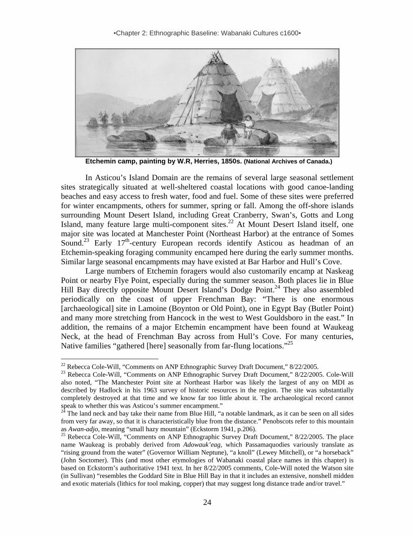
▪Chapter 2: Ethnographic Baseline: Wabanaki Cultures c1600▪
24
Etchemin camp, painting by W.R, Herries, 1850s. (National Archives of Canada.)
In Asticou’s Island Domain are the remains of several large seasonal settlement sites strategically situated at well-sheltered coastal locations with good canoe-landing beaches and easy access to fresh water, food and fuel. Some of these sites were preferred for winter encampments, others for summer, spring or fall. Among the off-shore islands surrounding Mount Desert Island, including Great Cranberry, Swan’s, Gotts and Long Island, many feature large multi-component sites.22 At Mount Desert Island itself, one major site was located at Manchester Point (Northeast Harbor) at the entrance of Somes Sound.23 Early 17th-century European records identify Asticou as headman of an Etchemin-speaking foraging community encamped here during the early summer months. Similar large seasonal encampments may have existed at Bar Harbor and Hull’s Cove.
Large numbers of Etchemin foragers would also customarily encamp at Naskeag Point or nearby Flye Point, especially during the summer season. Both places lie in Blue Hill Bay directly opposite Mount Desert Island’s Dodge Point.24 They also assembled periodically on the coast of upper Frenchman Bay: “There is one enormous [archaeological] site in Lamoine (Boynton or Old Point), one in Egypt Bay (Butler Point) and many more stretching from Hancock in the west to West Gouldsboro in the east.” In addition, the remains of a major Etchemin encampment have been found at Waukeag Neck, at the head of Frenchman Bay across from Hull’s Cove. For many centuries, Native families “gathered [here] seasonally from far-flung locations.”25 22 Rebecca Cole-Will, “Comments on ANP Ethnographic Survey Draft Document,” 8/22/2005. 23 Rebecca Cole-Will, “Comments on ANP Ethnographic Survey Draft Document,” 8/22/2005. Cole-Will also noted, “The Manchester Point site at Northeast Harbor was likely the largest of any on MDI as described by Hadlock in his 1963 survey of historic resources in the region. The site was substantially completely destroyed at that time and we know far too little about it. The archaeological record cannot speak to whether this was Asticou’s summer encampment.” 24 The land neck and bay take their name from Blue Hill, “a notable landmark, as it can be seen on all sides from very far away, so that it is characteristically blue from the distance.” Penobscots refer to this mountain as Awan-adjo, meaning “small hazy mountain” (Eckstorm 1941, p.206). 25 Rebecca Cole-Will, “Comments on ANP Ethnographic Survey Draft Document,” 8/22/2005. The place name Waukeag is probably derived from Adowauk’eag, which Passamaquodies variously translate as “rising ground from the water” (Governor William Neptune), “a knoll” (Lewey Mitchell), or “a horseback” (John Soctomer). This (and most other etymologies of Wabanaki coastal place names in this chapter) is based on Eckstorm’s authoritative 1941 text. In her 8/22/2005 comments, Cole-Will noted the Watson site (in Sullivan) “resembles the Goddard Site in Blue Hill Bay in that it includes an extensive, nonshell midden and exotic materials (lithics for tool making, copper) that may suggest long distance trade and/or travel.”

▪Chapter 2: Ethnographic Baseline: Wabanaki Cultures c1600▪
25
In addition to the summer settlement at Somes Sound, Chief Asticou is also explicitly associated with another large seasonal site identified in the early 1600s. This is the mysterious Etchemin village named Precante, situated on what early 17th-century English documents identify as the Quibiquessou River.26 Although we can only speculate about this settlement, it was probably located somewhere between Naskeag Point and Graham Lake, a long stretch of water historically called Mount Desert River (until the early 1760s) and now divided into segments called Union River, Union Bay River and Blue Hill Bay.27 According to an early 17th-century English manuscript, probably written on the basis of information provided by Etchemin captives from the Pemaquid area, who were also familiar with Mount Desert Island: “Quibiquesson [River]; on which there is one Towne, wherein dwell two Sagamos or Lords, the one called Asticou, the other Abermot. In this Towne are fiftie houses, and 150 men. The name of which Towne is Precante; this River runneth farre up into the Mayne, at the head thereof there is a Lake of great length and breadth; it is at the fall into the Sea tenne fathoms deepe, and halfe a mile over.”28
French explorer Champlain, having resided on the Wabanaki coast between 1604-1607, clearly marked what appear to be two villages on his 1607 (pictured left) and 1613 maps, situated on the upper stretch of what the French referred to as the Rivière des Monts Deserts, probably at the Union River falls at Ellsworth.29 It is quite possible that this early historic documentation correlates with information based on archaeological evidence at two Ellsworth Falls sites (Smith Farm and Wasp Island), which “do document very long-term occupation there, [from the] Archaic through Ceramic period…” 30
If Chief Asticou’s seasonal village site at Precante was located near the falls of Union River (Ellsworth), Etchemin families would have set up their bark wigwams at a 26 The name of this river is spelled Quibesquissue and Quibiquesson. The second spelling is probably based on a common misreading the u as n, so we suggest it should glossed as Quibiquessou. Assuming this is an Etchemin name, the first part may correspond to the Passamaquoddy word cuhpiye, “it falls into the water,” or kipiy-, for “falling over”. Awaiting input from a Passamaquoddy linguist, we speculate it may refer to the head of the Union Bay River at Ellsworth, where there used to be “a very considerable fall, now covered by the high Bangor Hydro Dam” (Eckstorm 1941, p.208). 27 See a.o. Maine Historic Preservation Commission archaeologist Dr. Arthur Spiess’ letter to Harald Prins, 2/12/1991. 28 The number of inhabitants was probably exaggerated for political purposes. 29 Champlain’s 1607 map, made when the Etchemin district chief Tahánedo (Dehanada) returned from England as a guide for the Popham Colony expedition to the lower Kennebec, suggests there were two neighboring villages on the Union River. This could reflect the idea that there were two headmen, Asticou on the east side of the river and Abermite on the west side, as reported in the 1608 “Egerton Manuscript,” published in Barbour 1980. 30 Rebecca Cole-Will, “Comments on ANP Ethnographic Survey Draft Document,” 8/22/2005. Regarding Ellsworth Falls, she cautions: “I do not know of any Contact Period sites, artifacts or collections that would support the idea that there were two very large early historic villages on the Union River.”

▪Chapter 2: Ethnographic Baseline: Wabanaki Cultures c1600▪
26
portage site on a major seasonal travel route between the seacoast and their hunting grounds in the forested hinterland. A gateway to the interior woodland travel route to the Penobscot valley, by way of Graham Lake and a portage, this site would have provided an abundance of fish, especially during the spring spawning period. Staying together in such larger communal encampments for a few weeks, family heads gathered to discuss issues of collective concern, solve problems, settle disputes, exchange gifts, find spouses and hold feasts. When affairs were settled and the food resources running short, they broke up their portable homes and dispersed again into smaller social units, each going their own way to another familiar location in their district.
In contrast to major Etchemin village sites such as Precante or Naskeag, where a few dozen wigwams would remain standing for several weeks, smaller encampments would consist of fewer wigwams and it would not have been unusual to find an island camping site with just one or two of these bark lodges. The only remains of these smaller encampments are the numerous, eroding shell-middens scattered on islands throughout Asticou’s Island Domain.31 Wabanaki Place Names as Cultural Ecological Index Although most Maine place names today are of English and French origin, many Wabanaki terms still exist. Indeed, the deep cultural roots of Etchemin-speaking foragers on the central Maine coast, including Mount Desert Island, are still recognizable in numerous place names, some already noted and explained. Indigenous labels show how finely attuned Etchemins were to their natural environment and reflect the accumulated experiences of generations reaching back to time immemorial. Embedded in cultural traditions, these names often contain vital elements of ecological knowledge, identifying distinctive topographic features. Thus, as Etchemins made their journeys, paddling lightweight birchbark canoes or walking swiftly in moosehide or sealskin moccasins, they were guided by the local place-names telling them where to expect swift currents, dangerous rapids, gravel bars, swamps, etc., or suggesting which fork to take or where to portage to a connecting travel route.
Such information was crucial, especially when traveling for long-distance trading or raiding, but also for regular seasonal migrations. To this day, many place-names in Maine still contain elements of Wabanaki toponyms which hint at the importance of water travel – e.g. river (sebu), island (menahan), falls (pontook), fork (nik), outlet (saco), portage (ounigan). Others refer to camping sites (keag), clam beds (asick), good fishing places (coggin), promising alewives (madames), sturgeon (kabassa) or other fish (namassak). Still others make reference to useful local resources, including chert (kineo), red paint (oulamon) and bark (maskwe).
The first recorded Etchemin term for Mount Desert Island is an example of such a geographically descriptive place name. Because this island is visible from far away in almost every direction, the region’s Etchemin-speaking inhabitants called it Pemetic, translated as a “range of mountains” or also as “mountains seen at a distance.” Likewise,
31 In their 2004 article “’Mawooshen’ Revisited: Two native American Contact Sites on the Central Maine Coast,” James B. Petersen, Malinda Blustein and James W. Bradley interpret linkages between certain regional sites in terms of their participation in a “far-reaching regional trade network” (p.6). In addition, we have applied an ethnohistorically-informed cultural ecological model which helped us reconstruct a tribal community’s catchment area – here called “Asticou’s Island Domain.”

▪Chapter 2: Ethnographic Baseline: Wabanaki Cultures c1600▪
27
the peninsula marking the eastern end of Frenchman Bay is still known as Schoodic, a word that has been variously interpreted as Mi’kmaq for “the end” (eskwodek) or as Passamaquoddy (eastern Etchemin) for “the burnt place” (scoudiac).32
Place names often refer to precious resources, noting where certain animals could be hunted, fish netted or plants harvested. For example, on Mount Desert Island itself there used to be “great piles of shells at Somes Sound, Hull’s Cove, Indian Point, and Bar Harbor, which marked spots where the Indians used to bake clams. These were then dried by smoke and kept for winter use.”33 In reference to this feature, Wabanakis spoke of Bar Harbor as Man-es-ayd’ik (“clam gathering place”) or Ah-bays’auk (“clambake place”).34 At certain points on their travel routes Wabanaki tribespeople marked messages on rock ledges that served as information centers. Traditionally, such wikhegan could be found on the ledges in Hampden Narrows, which was therefore known as Edalawikekhadimuk (“place where there are markings”). These marks probably indicated “the exact number of canoes going up and down the river.” Such markings also existed at Cape Jellison near the mouth of the Penobscot, a place the Wabanaki knew as Aguahassidek – “stepping ashore.” Joseph Nicolar, a 19th-century Wabanaki tribal leader at Panawahpskek (Indian Island) later recorded that “on their annual trip to salt water for the purpose of fishing,” his ancestors “gave names to a number of places along the bay and river.” Landing on the west bank of the river where it flows into Penobscot Bay, “they only stopped long enough to make the sign of their visit, showing which direction they were going, the number of their party and canoes, etc. On account of its being a marking place no one was ever allowed to mar or deface its outline by using it for a camping ground.” Sadly, a stone bird carved at Punch Bowl in Eggemoggin Reach no longer exists: “It was much venerated by the Indians,” wrote Eckstorm, “but the whites knocked off its head.”35
Eastern Wabanaki pictographs of Moose, Clarks Point, Machias Bay. (By Harald Prins.)
Some remarkable Native pictographs with canoes, birds, moose, humans and other images are still visible in Maine today on ledges at river banks or bays. For instance, glyphs can still be seen on coastal rocks at Machias Bay (Clarks Point). One mark at this location appears to represent a native woman with sea fowl on her head. A local Passamaquoddy hunter interpreted this symbol to mean: “[Indian woman] had
32 Eckstorm 1941, pp.209-11. 33 Hamor to Ballard, in Eckstorm 1941, p.207. 34 Eckstorm 1941, p.207. 35 It is not clear if this was actually a carved stone bird or a petroglyph hammered out in a stone ledge.
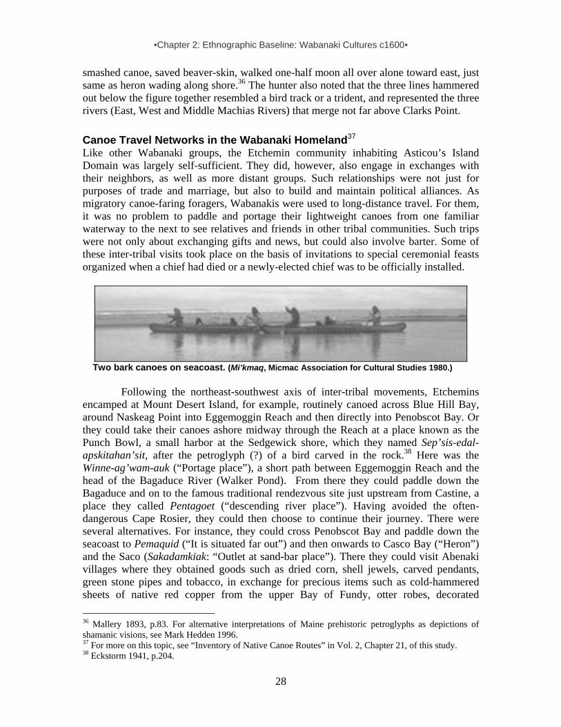
▪Chapter 2: Ethnographic Baseline: Wabanaki Cultures c1600▪
28
smashed canoe, saved beaver-skin, walked one-half moon all over alone toward east, just same as heron wading along shore.36 The hunter also noted that the three lines hammered out below the figure together resembled a bird track or a trident, and represented the three rivers (East, West and Middle Machias Rivers) that merge not far above Clarks Point. Canoe Travel Networks in the Wabanaki Homeland37 Like other Wabanaki groups, the Etchemin community inhabiting Asticou’s Island Domain was largely self-sufficient. They did, however, also engage in exchanges with their neighbors, as well as more distant groups. Such relationships were not just for purposes of trade and marriage, but also to build and maintain political alliances. As migratory canoe-faring foragers, Wabanakis were used to long-distance travel. For them, it was no problem to paddle and portage their lightweight canoes from one familiar waterway to the next to see relatives and friends in other tribal communities. Such trips were not only about exchanging gifts and news, but could also involve barter. Some of these inter-tribal visits took place on the basis of invitations to special ceremonial feasts organized when a chief had died or a newly-elected chief was to be officially installed.
Two bark canoes on seacoast. (Mi’kmaq, Micmac Association for Cultural Studies 1980.)
Following the northeast-southwest axis of inter-tribal movements, Etchemins encamped at Mount Desert Island, for example, routinely canoed across Blue Hill Bay, around Naskeag Point into Eggemoggin Reach and then directly into Penobscot Bay. Or they could take their canoes ashore midway through the Reach at a place known as the Punch Bowl, a small harbor at the Sedgewick shore, which they named Sep’sis-edal-apskitahan’sit, after the petroglyph (?) of a bird carved in the rock.38 Here was the Winne-ag’wam-auk (“Portage place”), a short path between Eggemoggin Reach and the head of the Bagaduce River (Walker Pond). From there they could paddle down the Bagaduce and on to the famous traditional rendezvous site just upstream from Castine, a place they called Pentagoet (“descending river place”). Having avoided the often-dangerous Cape Rosier, they could then choose to continue their journey. There were several alternatives. For instance, they could cross Penobscot Bay and paddle down the seacoast to Pemaquid (“It is situated far out”) and then onwards to Casco Bay (“Heron”) and the Saco (Sakadamkiak: “Outlet at sand-bar place”). There they could visit Abenaki villages where they obtained goods such as dried corn, shell jewels, carved pendants, green stone pipes and tobacco, in exchange for precious items such as cold-hammered sheets of native red copper from the upper Bay of Fundy, otter robes, decorated 36 Mallery 1893, p.83. For alternative interpretations of Maine prehistoric petroglyphs as depictions of shamanic visions, see Mark Hedden 1996. 37 For more on this topic, see “Inventory of Native Canoe Routes” in Vol. 2, Chapter 21, of this study. 38 Eckstorm 1941, p.204.

▪Chapter 2: Ethnographic Baseline: Wabanaki Cultures c1600▪
29
moosehide coats and moccasins. Alternatively, they could leave Pentagoet and paddle up the Penobscot to visit an important Etchemin village located near the entrance of the Kenduskeag River (“Eel-weir place”). From there they could reach a portage leading to the headwaters of the Sebasticook (“Passage river” [the short route]), a Kennebec River tributary, which would bring them to a portage at Taconnet (“Crossing place”), a major village of Abenaki-speaking corn-planters on the Kennebec. On their return voyage, Etchemin travelers could paddle via the Kenduskeag back to the Penobscot River, but instead of going towards the seashore they could go a few miles upstream and steer their canoes into a tributary traditionally known as Manta-was’suk (“Inlet”), and by way of a portage into a tributary of the Union River. After portaging around the great falls at what is now Ellsworth, it would be a short journey to Mount Desert Island. Indeed, the Wabanaki name for the Union River, which has long puzzled scholars, makes perfect sense: Wechkotekuk (“Exit” – literally, “Comes-out-facing”).39 This “exit” faces the eight-mile-long inlet of Union River Bay, connecting to Blue Hill Bay. And on the west shore of Blue Hill Bay, directly opposite Mount Desert Island’s Dodge Point, is the site of the Wabanaki’s strategically positioned summer village, Naskeag (“The Point”)40 Alternatively, paddling from the Union River to the coast, they could turn their canoes toward Parker Point near Blue Hill, take a short portage into Salt Pond and then another portage to the Benjamin River, paddling downstream directly to Eggemoggin Reach, and so on. Of course, there were many travel routes by way of rivers through the interior woodlands or along the seacoast that connected the families inhabiting Asticou’s Island Domain to fellow Etchemin-speaking groups inhabiting the Machias and Passamaquoddy Bay area, or the St. John valley. (For more on this, see the inventory of Native canoe routes in Volume 2, Chapter 21.) Mount Desert Island as Part of Glooskap Country
Local cultural traditions informed Wabanaki families about their ancestral lands, waters, mountains and marshes, articulating their profound spiritual and ecological relationship to wildlife, plants, trees, rocks, water, wind, sun, moon and stars. Like
most other hunting, fishing and gathering communities in the world, the Etchemin-speaking community inhabiting the Mt. Desert Island area saw the sky, land and sea, the animals and plants, visible and invisible creatures, as an organic whole. From generation to generation, they sustained themselves by thoroughly understanding their place in the environment and acting in a cycle of give-and-take with fellow creatures, plants and animals alike. This indigenous worldview is expressed in many cultural ways, including 39 Eckstorm 1941, p207. Referring to the Penobscot name for the Union River, Eckstorm (1941, pp.207-208) found this “word is very puzzling” from a topographic point of view. However, when searching for the portage route between the Union and Penobscot rivers, her own Indian place name book offers etymological clues, with the “inlet” or entrance at Easton (or Johnson) Brook and “the exit” at Ellsworth’s falls. She correctly points out that the conditions of inland river routes as paddled by today’s canoeists don’t always closely resemble those of the past, if only because of the factor of beaver dams. To facilitate canoe travel along certain important routes, Wabanakis sometimes would not harvest beavers at certain streams and thus maintain higher water levels: “In old times the [Easton] stream had some importance as a route; for a succession of beaver dams probably flowed it enough to make it navigable for canoes to a point about two miles from the route through to Union River” (Eckstorm 1941, p.20). 40 Bourque 2001, pp.54-55.

▪Chapter 2: Ethnographic Baseline: Wabanaki Cultures c1600▪
30
traditional creation stories featuring their mythological ancestor, Glooskap. Larger than life, this great magic-doing hunter lived in the Wabanaki homeland in the beginning of time itself – “when the world contained no other man, in flesh, but himself.”
Wonderful stories about Glooskap’s miraculous adventures, brave deeds, magic tricks, funny mistakes and cunning wisdom informed generation after generation of Wabanakis, instructing the young and reminding everyone about their challenges and responsibilities.41 The deep cultural roots of the Wabanaki are revealed in surviving fragments of the larger Glooskap saga. Taken together, all remaining local versions of short Glooskap stories, first penned down in the mid-1800s, can be understood as one great narrative tradition in which Wabanaki storytellers articulated a worldview shared and enjoyed in all Wabanaki communities. Through these stories, each regional group could make sense of their own place in the natural environment, and give symbolic meaning to their relationships with the land. All ancient Glooskap stories convey traditional Wabanaki ties to their ancestral territory. As Glooskap's children, the audience was reminded that they shared the natural environment with other living creatures and should recognize a natural fellowship.
Bar Island and the Porcupine Islands (& the “Queen Mary,” a giant new cruise ship) viewed from the top of Mt. Cadillac, Sept. 2004. (By Harald Prins.)
Some of the surviving stories also feature the greater Penobscot Bay area,
including Mount Desert Island. Reminding us of Glooskap’s natural signature, a grandson of the famous Penobscot hunter-shaman John Neptune ended a creation story on the formation of the sea- and landscape in this Maine coastal area with their mythological ancestor’s own words: Let this day put a mark on the place of my doings.
As the following examples illustrate, Wabanakis viewed Mount Desert Island as part of a large mythological hunting territory of their culture hero Glooskap. Memorializing this giant hunter-shaman as the first and greatest sea- and landscaping artist ever to visit Mount Desert Island, traditional Wabanaki storytellers recount an ancient legend explaining how the Penobscot River was originally formed when Glooskap killed the monster frog that had swallowed all the earth’s water. Killing the frog released the waters, which streamed down the mountainsides toward Penobscot Bay into the great sea. Glooskap then paddled along the coast in his large stone canoe and entered all the rivers emptying into the ocean: “He inspected them. Wherever there were bad falls he lessened them so they would not be too dangerous for his descendents. He cleared the carrying places.42
In the early 1880s, an elder Penobscot Indian woman encamped at Bar Harbor on Mount Desert Island told the great folklorist Charles Leland the following fragment of a
41 This name is sometimes translated as "man out of nothing," “good man,” or “the liar” (deceiver). 42 Speck 1935, p.42.

▪Chapter 2: Ethnographic Baseline: Wabanaki Cultures c1600▪
31
much larger story about Glooskap hunting in the great salt water bay between the Camden Hills and Schoodic Peninsula – an adventure that brought about some of the geographic formations in the greater Penobscot Bay area. In her words:
[Glooskap] gave names to everything. He made men and gave them life, and made the winds to make the waters move. The Turtle was his uncle; the Mink, Uk-see-meezel, his adopted son; and Monin-kwessos, the Woodchuck, his grandmother. The Beaver built a great dam, and [Glooskap] turned it away and killed the Beaver. At Moose-tchick [Moos-i-katch’ik, “the moose’s rump,” a ledge on the shore of Cape Rosier] he killed a moose; the bones may be seen at Bar Harbor turned to stone. He threw the entrails of the Moose across the [Frenchman] bay to his dogs, and they, too, may be seen there to this day, as I myself have seen them; and there, too, in the rock are the prints of his bow and arrow.43
In another traditional story, Glooskap beached his canoe on the eastern shore of Penobscot Bay and chased a moose up into the woods for a great distance:
On the beach at the point mentioned [near Castine] is a rock about twenty-five feet long, shaped like an overturned canoe. The rocks leading from it bear footprints of [Glooskap], which reappear frequently in the interior of the country according to some of the Indians who claim to have seen them. At another place farther down he killed the moose and cast its entrails across the water. There they still appear as a streak of white rock on the bottom of the bay at Cape Rosier. After cooking the moose he left his cooking pot overturned on the shore of Moosehead Lake and it is now to be seen as Kineo mountain on the eastern margin. . . . When the Indians find stones possessing natural shapes, resembling a face or a person, they sometimes keep them . . . [saying]: “It looks like [Glooskap], I guess he left his picture on it”44
Finally, we have a story recorded by Penobscot tribal governor Joseph Nicolar in
his book, The Life and Traditions of the Red Man, published in 1893, the year before his death. He was a descendant of the Wabanaki grandchief Madockawando, who lived on the Bagaduce about 350 years ago. Witnessing the disappearance of much of his tribal culture, Nicolar collected these stories from tribal elders throughout his life. He offered this detailed telling in Glooskap’s own mythic words:
One day, when we, (meaning himself and the dog,) had arrived at a place of a high mountain [Mt. Cadillac?] whose slopes run down to the water’s edge, the dog, who was asleep in the canoe. . . got up, began to breathe hard, putting his nose up in the air as if to catch the freshness of it, and . . . turned to me and said, ‘master, here in this part of the north land must needs have some meat . . . – berries and fruit are good in their season and places, but the time is coming when these will lose their season; therefore when night comes, get your bow and arrow ready, because at the breaking of day to-morrow I will go up on the high
43 Leland 1884, p.65. See also Speck 1935, p.9. 44 Speck 1935, p.7.

▪Chapter 2: Ethnographic Baseline: Wabanaki Cultures c1600▪
32
mountain we have just passed; – there is now feeding on the bark of the mountain trees, moose, whose meat is good for you and your kind and me and my kind, the virtue of which gives strength to the body and makes the heart glad to those who are fortunate enough to get it, which will always be valued highly by your people because it can be saved to keep many days, yea, many moons. On the morrow before the sun is highest I will drive one to you and when I do this, you shoot and kill. After you have killed the animal you shall immediately open his body: the belly you shall open with your stone knife and the intestines you shall…throw it in front of me, because this is my portion….
Wikhegan map on birchbark, describing a moosehunt and showing the kill site relative to the encampment. By Passamaquoddy chief Selmo Soctomah, c1887. (Dyer Library.)
When the next dawn came the man awoke from his sleep and upon looking
around for his companion found him not, he beheld that the dog’s bed was vacant; immediately he got ready his stone knife, bow and arrow, and in a little while he heard the barking of his dog on the mountain [at Mount Desert Island?]. The sound of the barking dog was going toward the water, and in another moment he saw the [moose] swiftly running among the trees and bushes and then…straightway he made for the water toward the other land [across Frenchman Bay in some accounts of this legend], and the dog also came out…, but instead of going into the water, ran on the shore, passed the [moose] and kept on this way until he reached a point nearest the other land, when he also went in [the water] and swam so fast that he reached it before the [moose] did; the dog ran along the shore in front of the animal and would not let him land, and when the man saw this he took his canoe and other things, went forth to get near the [moose] so to kill it…and with bow and arrow did slay the animal and brought the body out of the water on to the land…. He beheld his dog afar off sitting on a point of land waiting for his portion. So in a moment more he did cut the belly of the animal open…and took out the contents and did throw the intestines to his dog…and said when he was doing this, ‘Let this day put a mark

▪Chapter 2: Ethnographic Baseline: Wabanaki Cultures c1600▪
33
on the place of my doings.’ . . . He did take the fore part [for food] and left the other part for a mark [in the natural landscape], so that his [Wabanaki] people might know where he made his first hunt for the large animal. Upon doing this he took out the Oos-squon, – Liver, and laid it beside the animal’s body [a large rock of reddish color near Cape Rosier], and then called the other part Oo-kar-chi, – Hind part.45 After [this] Glooskap said, “These things needs be here to mark my works and it shall be so, and the mark shall stand as long as my people exist;” And immediately that part of the animal became stone, and the intestines also left a mark across the water from one shore to the other which was a long way. . . . All along the whole distance this mark can now be seen; according to the modern measurements and reckoning a distance of seven miles these intestines lay along the bottom of the sea which can be seen, wherever the water is shallow enough…; they lay on the ledges and on the large and small rocks the whole way. When [Glooskap] had put the forepart of the moose in his canoe and upon looking up to see the dog he saw there were three – seeing this he departed immediately toward them, but upon nearing the spot discovered that the other two [dogs] were stone resembling in form two dogs. When his mistake became known to him he marvelled much and said, “This is very strange. But man must take warning that in all his works, his plans must needs, at times be changed. I have made my plan to have my dog turn into stone and leave it there to mark the place with the other marks. But for this sudden change in my vision. . . . I shall let the two stones stand for a mark [in the bay area].” So he called his dog into the canoe and resumed his journey. When the hour came to prepare for a meal he turned his canoe up into a small river, but finding rapids so great he could not ascend further than to the foot of the rapids with the canoe, and wishing to mark the spot where he first cooked his meal after killing the large game on his returning journey [across the sea back to the north], took out some meat and carried it to the head of the falls. Not having a kettle to cook his meat and as he wished to cook the meat in [fresh] water that flowed into the place where the [moose] was killed, he selected a place near the head of the falls and dug out a place in the solid rock with his hands—a hollow place – so it held water—he then made a vessel out of birch bark with which he carried water from the river to fill the stone kettle. While [Glooskap] was absent getting the water the dog also began to dig another hole in the ledge with its paws; seeing on his return what the dog had done, caused him to enquire of the dog why he was digging the hole? The dog replied that it was not good for man and dog to eat out of the same dish. At this [Glooskap] said “There will be no need for man and dog to eat of the same dish because…you would ask for the fragments of the meal be cast before you. Let this be the rule just as you have requested.” At this the dog stopped digging and laid down waiting for the fragment from the man’s meal.
45 It appears that Nicolar’s account inadvertently confuses two toponyms and contains a minor typographic error. His Oo-kar-chi is probably Oo-lagh’esee (“the entrail”), referring to a “vein of white quartz which runs under the sea to Isleboro [Island]. Near these “entrails” is Moos.i.katch´.ik, the moose’s “hind part” or rump–a ledge on the shore of Cape Rosier. As Eckstorm (1941, p.202) explains: “The legend says that [Glooskap’s] dog was sitting on Long Island [Islesboro] when he killed the moose and as the dog’s share of the game, [he] threw him the entrail which is still seen under water as a streak of white quartz.”
▪Chapter 2: Ethnographic Baseline: Wabanaki Cultures c1600▪
34
After getting all things ready for cooking and having placed the water and meat in the same [large stone] kettle, [Glooskap] took two fragments of dead and dry wood and facing the sun rubbed the two sticks together until a blaze came, from which he made a large fire and heated stones and put them into the kettle; and the water did boil so that he was able to cook his dinner. After eating the meal the man and the dog returned to the canoe and resumed their journey, leaving the two stone kettles in the ledge as a mark where the first meal was cooked after killing the first large game. Nothing more can be said. . . . This ended the sea journey.46
Asticou is an ancient indigenous term for a kettle-shaped depression in stone
(geologically formed by water plunging continuously onto the rock). It is one of the unusual natural formations mythically attributed to Glooskap as the playful mega-landscaper. Like many other curious natural features, such rock kettles were associated with non-ordinary spirit power, or motewolon – a complex indigenous concept often too narrowly translated as “medicine.” It not only refers to spiritual power, but also to someone possessing such extraordinary power. As such, motewolon is also associated with uniquely-gifted humans manifesting exceptional qualities as successful hunters, warriors, healers and forecasters. This term is now also translated as “shaman” (but, again, too narrowly). Considering that Asticou is also the name of the Etchemin shaman-chief historically associated with the Mount Desert Island area, we glimpse here an element of the indigenous worldview as historically embedded in this almost forgotten Mount Desert Island chieftain’s name. Political Organization: The Land of Mawooshen Like most migratory foraging societies in the world, Etchemins who hunted, fished and gathered shellfish, berries and other food at Mount Desert Island and its surroundings enjoyed a fundamentally egalitarian social structure. Although each tribal community had recognized leaders, or sakoms (“sagamores”), and notwithstanding some individual status differences, their political organization was essentially based on democratic principles. Heads of larger kin-groups sharing a foraging domain participated in important political discourse concerning internal and external affairs, and decisions concerning the common weal were based largely on consensus among members. Within the tribal community, one family head would be recognized as a first among equals and acknowledged as the region’s headman or district chief. A French Jesuit missionary active in the region in the early 1600s wrote this about traditional political organization:
There is the sagamore [sakom], who is the eldest son of some powerful family, and consequently also its chief and leader. All the young people of the family are at his table and in his retinue [follow him]; it is also his duty to provide dogs for the chase, canoes for transportation, provisions and reserves for bad weather and expeditions. The young people flatter him, hunt, and serve their apprenticeship under him, not being allowed to have anything before they are married, for then only can they have a dog and a bag; that is, something of their own, and do for themselves. Nevertheless they continue to live under the
46 Nicolar, pp.51-57. “stone kettle” emphasis added.

▪Chapter 2: Ethnographic Baseline: Wabanaki Cultures c1600▪
35
authority of the sagamore, and very often in his company; as also do several others who have no relations [family], or those who of their own free will place themselves under his protection and guidance, being themselves weak and without a following. Now all that the young men capture belongs to the sagamore; but the married ones give him only a part, and if these leave him, as they often do for the sake of the chase and supplies, returning afterwards, they pay their dues and homage in skins and like gifts [as tribute].47
Wabanaki political leaders were usually chosen from a small group of successful high-ranking men belonging to families believed to possess supernatural power (motewolon). Once selected, a sakom was officially “raised” as the tribal community’s elected leader, keeping the position until he died or people lost confidence in him. After a sakom’s death, a new tribal leader was elected from among the leading family heads. Such a successor usually belonged to the same respected family and was often a younger brother, older son, cousin or nephew of the deceased headman.
The Etchemin community traditionally occupying the greater Mount Desert Island area was probably headed by a succession of elected life chiefs. Asticou held this sakom position at the time of first contact with European newcomers in the early 1600s. As already noted, the spirit power of this Mount Desert Island area chief was probably reflected in the name by which he has become known. However, if a person possessed great political as well as spiritual power, he or she could be feared. Indeed, not a stranger to this phenomenon himself, a French Jesuit who visited Chief Asticou at Mount Desert Island later wrote: “It happens sometimes that the same person is both autmoin [a shaman-sorcerer] and sagamore [sakom], and then he is greatly dreaded.”48
During much of the year, Etchemin kin-groups lived on their own, foraging in their customary areas, periodically shifting from their hunting grounds to their favorite fishing, clamming, sealing and bird-hunting sites. In the spring, however, and periodically in other seasons as well, they usually rejoined larger kin-groups, often near rapids or falls such as at Waukeag Neck or Union River (Ellsworth), where Asticou’s seasonal village of Precante may have been located. At such seasonally food-rich sites, sakoms like Asticou were able to welcome numerous families and visitors, collectively feasting on an abundance of spawning fish. During the summer months coastal sites such as Naskeag Point or Manchester Point (at the entrance of Somes Sound) provided space and opportunity for large temporary encampments – perfectly suited for a sakom like Asticou to host his customary tribal councils with family leaders in the community: “When they visit each other it is the duty of the host [sakom] to welcome and to [regale with an abundance of great food] his guests, as many days as he can. The guests making him some presents; but it is with the expectation that the host will reciprocate, when the guest comes to depart, if the guest is a sagamore, otherwise not.”49
At such coastal summer settlements, sometimes many hundreds of tribal members, friends and visitors from distant districts (and foreign envoys as well) beached their canoes and encamped together. Women set up the wigwams and were very much in charge of the campsites, cooking, storage and other important household tasks. During
47 Biard 1616, in JR 3, pp.87-89. 48 Biard 1616, in JR 3, p.91. 49 Biard 1616, in JR 3: 89.
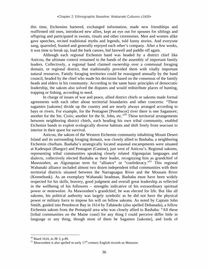
▪Chapter 2: Ethnographic Baseline: Wabanaki Cultures c1600▪
36
this time, Etchemins bartered, exchanged information, made new friendships and reaffirmed old ones, introduced new allies, kept an eye out for spouses for siblings and offspring and participated in sweats, rituals and other ceremonies. Men and women alike gave speeches, recited traditional myths and legends, told funny stories. And everyone sang, quarreled, feasted and generally enjoyed each other’s company. After a few weeks, it was time to break up, load the bark canoes, bid farewell and paddle off again.
Although each regional Etchemin band was headed by a district chief like Asticou, the ultimate control remained in the hands of the assembly of important family leaders. Collectively, a regional band claimed ownership over a communal foraging domain, or regional district, that traditionally provided them with vitally important natural resources. Family foraging territories could be reassigned annually by the band council, headed by the chief who made his decisions based on the consensus of the family heads and elders in his community. According to the same basic principles of democratic leadership, the sakom also solved the disputes and would redistribute places of hunting, trapping or fishing, according to need.
In charge of issues of war and peace, allied district chiefs or sakoms made formal agreements with each other about territorial boundaries and other concerns: “These sagamies [sakoms] divide up the country and are nearly always arranged according to bays or rivers. For example, for the Pentagoet [Penobscot] river there is one Sagamore; another for the Ste. Croix; another for the St. John, etc.”50 These territorial arrangements between neighboring district chiefs, each heading his own tribal community, enabled Etchemin bands to exploit ecologically diverse habitats and shift freely from seacoast to interior in their quest for survival. Asticou, the sakom of the Western Etchemin community inhabiting Mount Desert Island and its surrounding foraging domain, was closely allied to Bashaba, a neighboring Etchemin chieftain. Bashaba’s strategically located seasonal encampments were situated at Kadesquit (Bangor) and Pentagoet (Castine), just west of Asticou’s. Regional sakoms, representing tribal communities speaking closely related Algonquian languages and dialects, collectively elected Bashaba as their leader, recognizing him as grandchief of Mawooshen, an Algonquian term for “alliance” or “confederacy.”51 This regional Wabanaki alliance included almost two dozen independent tribal communities with their territorial districts situated between the Narraguagus River and the Mousam River (Kennebunk). As an exemplary Wabanaki headman, Bashaba must have been widely respected for his skills, bravery, good judgment and overall great leadership as reflected in the wellbeing of his followers – strengths indicative of his extraordinary spiritual power or motewolon. As Mawooshen’s grandchief, he was elected for life. But like all sakoms, his political authority was largely symbolic as he did not have the physical power or military force to impose his will on fellow sakoms. As noted by Captain John Smith, guided into Penobscot Bay in 1614 by Tahánedo (also spelled Dehanada), a fellow Etchemin sakom from the Pemaquid area who was closely allied to Bashaba: “All these [tribal communities on the Maine coast] for any thing I could perceive differ little in language or any thing, though most of them be Sagamos [sakoms], and lords of
50 Biard 1616, in JR 3, p.89. 51 Mawooshen is also spelled in early 17th-century English records as Moasson.
▪Chapter 2: Ethnographic Baseline: Wabanaki Cultures c1600▪
37
themselves; yet they hold the Bashabes of Pennobscot the chief and greatest amongst them. . . .”52
Expressed in kinship metaphor, the relationship between the allied sakoms of
Mawooshen was that of brothers, with Bashaba of Penobscot as the first among equals, honored as the oldest brother in the family.53 This political alliance between a coastal group of Western Etchemin and Abenaki sakoms encompassed nine rivers, covering a stretch of coastal territory about 120 miles wide – equal in size to a small medieval kingdom in Scotland.54 As noted by an eyewitness in the early 1600s:
52 Smith 1622, in American Colonial Tracts vol.2, no.2, p.5. 53 In other words, not unlike a traditional king in feudal Europe, he was a primus inter pares. The Jesuit Pierre Biard, who had met this Penobscot chieftain, described Bashaba (or Betsabes) correctly as the “most prominent Sagamo” of the Etchemin (JR 2, pp.49-50). 54 See also Prins 1994, pp.331-32; The Etchemin word Mawooshen obviously esembles elements in the Passamaquoddy terms mawona (“gathering together”) and maweyyik (“they assemble”). Contemporary Maliseets, speaking a modern variety of the Etchemin language as one spoken at Mount Desert Island, translate Mawooshen as “band of people walking or acting together,” which still expresses the basic idea of the Wabanaki alliance between “brother” nations.

▪Chapter 2: Ethnographic Baseline: Wabanaki Cultures c1600▪
38
It is principally in summer that they pay visits and hold their state councils [attend to political affairs]; I mean that several sagamores come together and consult among themselves about peace and war, treaties of friendship and treaties for the common good. It is only these sagamores, who have a voice in the discussion and who make the speeches, unless there be some old and renowned autmoins [shamans], who are like their priests, for they respect them very much and give them a hearing the same as to the sagamores. . . . Now in these assemblies, if there is some news of importance, as that their neighbors wish to make war upon them, or that they have killed some one, or that they must renew the alliance, etc., then messengers fly from all parts to make up the more general assembly, that they may avail themselves of all the confederates [or “allies”], which they call Ricmanen [Ni’kmanen], who are generally those of the same language. Nevertheless the confederation often extends farther than the language does, and war sometimes arises against those who have the same language. In these assemblies so general, they resolve upon peace, truce, war, or nothing at all, as often happens in the councils where there are several chiefs, without order and subordination, whence they frequently depart more confused and disunited than when they came. Their wars are nearly always between language and language, or country and country.55
After Bashaba’s death in 1615, the allied Etchemin and Abenaki sakoms of
Mawooshen elected one of their respected “brothers” as their new grandchief: Chief Asticou of the Mount Desert Island area became his successor in a time of growing turmoil. Mawooshen plunged into chaos caused by wars and epidemics triggered and brought on by the arrival of Europeans. Within a few years, this early Wabanaki alliance on the Maine coast collapsed and became a memory. The political idea survived for generations and was revived under one of Asticou’s most famous successors – Madockawando, the grandchief who expanded the alliance and thus helped create the Wabanaki Confederacy on the foundation of Mawooshen at the end of the century.
◘ ◘ ◘ ◘
55 Biard 1616 in JR3, pp.89-91.

▪Chapter 3: European Explorers on the Wabanaki Coasts▪
39
CHAPTER 3: EUROPEAN EXPLORERS ON THE WABANAKI COASTS, 1500s
Writing the cultural history of Wabanaki peoples at Mount Desert Island in the Contact Period presents a paradox of too little and too much: too little, because there is scant early historical documentation about indigenous peoples on the island itself, and too much, because the island formed part of an expansive coastal network of interrelated and interacting peoples. Its traditional indigenous inhabitants – canoe-faring hunters, fishers and gatherers – tapped into nature’s varied offerings by shifting periodically between the seacoast archipelago and its forested hinterland. Connected by ties of kinship and friend-ship, they belonged to an ethnic group historically known as the Etchemin. Organized in several self-governing migratory bands, Etchemins ranged primarily between the Kennebec and St. John Rivers.1 Although these bands shared the same culture and speech, regional differences existed. Here we distinguish between Western Etchemins (ranging from the Kennebec to the Narraguagus River) and Eastern Etchemins (from the Narraguagus to the St. John valley).2 The regional dialects spoken by Eastern Etchemins are still heard in Maliseet, Passamaquoddy and even Penobscot communities today.
The Western Etchemin band inhabiting the greater Mount Desert Island area, here identified as Asticou’s Island Domain, was connected not only with other Etchemins between the Kennebec and St. John Rivers, but extended its social networks across ethnic boundaries. Etchemins created and maintained contacts with neighboring groups, especially Mi’kmaq hunter-gatherers (or Souriquois) northeast of them, as well as corn-growing villagers from the Kennebec to Cape Cod – Abenaki, Penacook, Massachusett and even Wampanoag, collectively identified in early 17th century French records as Armouchiquois.3 Thus, if our geographic focus is too narrow, we miss the complex cultural dynamics of Etchemin social life, overlooking or misinterpreting significant events. An analysis of the historical situation of Mount Desert Island and its indigenous inhabitants demands a broadly-sketched geographic canvas. Of course, this creates a problem of scale. At what point does a local history turn into miniature world history – where to draw the line?
The problem of geographic scale is matched by one of chronology: When did the Contact Period begin and how long did it last? Did it commence with Norse adventurers a thousand years ago, or with legendary Welsh colonists in the 12th century or with the 16th-century phantom fleets of Basque, Breton or Bristol fishermen on Maine’s coasts? And did it end with the first European trading posts or with the establishment of Catholic mission posts or the fledgling French and English settlements?
1 Early 17th-century French sources agree with this description, including Marc Lescarbot who wrote: “The nations between the Rivers St. John and Kinibeki [Kennebec], a district comprising the rivers St. Croix and Norombega [Penobscot], are called Etechemins” (Lescarbot, vol. 2, p.277). 2 Petersen et al (2004, p.5) also distinguish between Eastern and Western Etchemins, suggesting that “this internal boundary was situated near Mt. Desert Island.” However, since that island formed part of Mawooshen, and, building on Lewis Mitchell’s 1887 statement regarding the western boundary of Passamaquoddy hunting territories, we consider the Narraguagus (or Cherryfield) River a better candidate. 3 French 17th-century sources concur with lumping these New England Indian corn-growers as such. Reflecting the Mi’kmaq perspective, Marc Lescarbot wrote: “The nations . . . from Kinibeki [Kennebec] to Malebarre [Cape Cod], and beyond, they are called Armouchiquois. They are treacherous and thievish, and one must be on one’s guard against them” (Lescarbot, vol. 2, p.277).
▪Chapter 3: European Explorers on the Wabanaki Coasts▪
40
We have resolved issues of scale and chronology by aiming for a narrative that captures the very complex forces affecting coastal Wabanaki communities associated with Mount Desert Island during the Contact Period. Two points are key: The island stood in a continually contested frontier zone between warring European nations; and Wabanakis, adapting themselves to the challenges of this colonial middle ground, traded, fought, suffered, negotiated and survived, but never completely surrendered their traditional sovereignty nor their ancestral rights of self-determination.
Since the popular imagination has long been entertained by legendary stories about the Norse and Welsh roaming Maine’s coast well before 17th-century Italian, Portuguese, French and English voyagers, we begin with a brief discussion on this topic. Fact or Fiction? Vikings on the Maine Coast Columbus’ 1492 cross-Atlantic voyage seeking a direct western sea route to China and resulting in Europe’s accidental discovery of the Western Hemisphere, is commonly accepted as the beginning of the Contact Period for many indigenous communities inhabiting America’s eastern seaboard territories. Especially since the 1830s, however, the idea became popular among certain artists and intellectuals in the United States that the honor of first discovery should go Norse adventurers from Iceland. Creatively involved in the ideological production of a new American national consciousness with a venerable historical tradition to match, a cultural elite in New England embraced the idea that Germanic-speaking northern Europeans – the Norse, also known as Vikings – had “discovered” the promised land nearly 500 years before southern European Catholics with names like Gomes, Fagundes and Verrazano arrived on the scene. Especially appealing to patriotic American Protestants of Anglo-Saxon or “Nordic” descent, this notion that the continent was discovered by a “bold, enterprising, warlike race [of] Northmen” with their “natural skill, experience, and power”4 was popularized by history books, magazines, newspapers, poems, novels, paintings and a host of other media. Public fascination with the Vikings First movement has lasted for almost 150 years now. It may have peaked in the 1950s and 1960s, when every bit of archaeological or historical evidence was welcome news, no matter how small or suspicious.
In 1957, two amateur archaeologists from Massachusetts found one very small bit of Norse “evidence” during their second summer of digging up a large and undisturbed prehistoric Indian settlement on Naskeag Point. Directly facing Mount Desert Island on the opposite side of Blue Hill Bay, the place became known as the Goddard Site and should have been protected by Maine authorities. Unskilled in archaeological methods, the duo kept their endeavor to themselves. What inspired them remains unclear, but they may have read a new book by Norwegian-born writer Hjalmar Holand, a creative history titled Explorations in America before Columbus. (Published in 1956, it offers a fantastic scene about a legendary Viking seafarer named Thorwald Erikson. Coasting the Maine shore near Mount Desert Island a thousand years ago, the Viking supposedly exclaimed: “Here it is beautiful! Here I will build my home!”) Digging through the soil filled with indigenous material cultural remains, the amateur archaeologists found plenty of stones and bones (including human skeletons), plus a small medieval European coin.
In the 1970s, the Maine State Museum acquired much of the material from this
4 Williamson 1872, pp.256-77.
▪Chapter 3: European Explorers on the Wabanaki Coasts▪
41
unsystematic and unsupervised excavation, including the puzzling coin. Proudly publicizing the acquisition, the museum held a press conference announcing that the coin was a Norse silver penny dating to the reign of King Olav Kyrre (1066-1093). Fantastic news, indeed – all the more so because in 1965 members of the Maine Archaeological Society had begun excavating an old burial site at Pemaquid, where “the presence of a copper and leather breastplate suggests the possibility that the wearer might have been one of the Viking adventurers who reached this continent a thousand years ago.”5 Quickly gaining celebrity status, the coin was promoted as Maine’s “most intriguing archaeological find from the Ceramic Age.”6
Fast forward to the year 2000 when it came time for a big millennial celebration of the Norse adventurers who first “discovered” the Americas. That year the Smithsonian Institution opened its blockbuster exhibit Vikings: The North Atlantic Saga, showcasing the silver penny from Naskeag Point. Explaining its significance, exhibit curator William Fitzhugh wrote: “The Norse penny . . . is currently the southern-most authentic artifact known in North America. . . . [and] will be seen by hundreds of thousands of museum [visitors].”7 A year later, Maine State Museum archaeologist Bruce Bourque, who had done so much to promote the Norse penny but never found any other Norse evidence in his many seasons of digging at the Goddard site, published Twelve Thousand Years: Maine Indian History. In the book’s preface, he describes the medieval Norwegian coin as an “incontrovertible piece of evidence that Maine Native people were aware of the Norse who visited Newfoundland and Labrador during the eleventh century. . . .” 8
For those addicted to Vikings First literature, this Norse penny simply confirmed what they already believed. Some may have read Algonquin Legends (1884), a precious collection of Wabanaki stories gathered by folklore studies pioneer Charles G. Leland. In the book’s Preface and Introduction, Leland articulated his own ideas about ancient Norse-Indian contacts and described the Wabanaki culture hero Glooskap as “the Norse god intensified. . . . by far the grandest and most Aryan-like character ever to have evolved from a savage mind.”9 Noting “points of similarity between the myths or tales of Algonquins and those of Norsemen as set forth in the Eddas, the Sagas, and popular tales of Scandinavia,”10 Leland suggested that these legends were conveyed by the Norse to Eskimos in Labrador, who passed them on to the Mi’kmaq and Passamaquoddy. In time, fragments of these ancient tales were carried to places such as Bar Harbor on Mount
5 The Courier-Gazette, Coastal Courier Edition (Rockland, Maine), Sept. 5, 1965; see also Robert L. Bradley and Helen B. Camp, The Forts of Pemaquid, Maine: An Archaeological and Historical Study. Occasional Publications in Maine Archaeology, No.10. Augusta: The Maine Historic Preservation Commission, 1994, pp.31-32. 6 Dr. Kevin Smith cautioned: “References in antique sources may be valuable, but unless they can be supported by independent data or examination of the object/feature discussed fall into the category of ‘interesting but unfortunately anecdotal’ - in other words, the basis for forming testable hypotheses for which other data will be the test but not the evidence to support or refute another hypothesis.” For further reference, Smith points to Birgitta Wallace's article "Norse hoaxes" (pp. 53-76 in "Vikings in the West," edited by Eleanor Guralnick, 1982, Chicago: Archaeological Institute of America and the Museum of Science and Industry of Chicago). 7 Quoted in the 1999 Maine State Museum newsletter Broadside 22 (2),p3; Carpenter 2003, p.15. 8 Bourque 2001, p.xviii. 9 Leland 1884, p.2. 10 Leland 1884, p.v.

▪Chapter 3: European Explorers on the Wabanaki Coasts▪
42
Desert Island where Leland collected them from Wabanakis in the late 19th century.11 Interestingly, the Viking coin found at Naskeag is dated late-11th century –
decades after the short-lived and ill-fated Norse settlement at L’Anse-aux-Meadows in northwestern Newfoundland. In terms of historic time, a better fit seems to be the British legendary story of the Welsh prince Madoc who is said to have first crossed the Atlantic in 1170, then returned to North Wales to lead a band of colonists back to North America. Although there are few Welsh enthusiasts who would still argue for the Contact Period in Maine to have started in the 12th century, this idea was popular in 19th-century New England, largely for the same reasons the Viking story was so welcomed. At the time, respected Maine amateur historians were quite taken with the idea, linking the “Wawenocks” inhabiting the coastal area between Penobscot Bay and the Kennebec to these medieval Welsh settlers and even recognizing a linkage between Prince Madoc and Chief Madockawando, the great 17th-century Wabanaki sakom at Penobscot Bay.
Having briefly examined the available evidence in light of a long-standing North American tradition of Norse invented traditions, spectacular hoaxes and fraudulent claims, anthropologist Edmund Carpenter recently challenged the legitimacy of this Norse penny as “a scientifically-retrieved” artifact and criticized the find as unacceptable from a scholarly perspective.12 Since then, renewed questions about the coin’s provenience demand that its supposed scientific status as “incontrovertible evidence” should be revised, at least for the time being, to “interesting but anecdotal.”13
In short, unless credible evidence is found in historical archives or archaeological sites, we conclude that 11th-century Norse and 12th-century Welsh on the Maine coast are figments of white America’s romantic imagination. This means that the Wabanaki in the Mount Desert Island region never saw, nor were they aware of, medieval Norse or Welsh seafarers on American shores.14 In Search of Wealth and the Northwest Passage to China Having dismissed the idea of pre-Columbian seafarers coming from Europe to the Wabanaki homeland as fiction, we do face a very complex and spottily-recorded early Contact Period. Much has been written about early contacts between Wabanakis and European seafarers sailing through the Gulf of Maine in the 16th century, but what actually occurred there is largely a matter of educated speculation and imagination. Did the Wabanakis encamped at Mount Desert Island or elsewhere on Maine’s seacoast actually see and interact with any of the handful of historically documented Italian, Portuguese and other 16th-century Europeans who sailed to their shores in caravels, barks and other vessels?
(Pictured right: 16th-century caravel.)
11 Leland 1884, pp.9-13. 12 Carpenter 2003; Prins 2003, pp.670-672. 13 See also Epstein 1980, pp.1-20; McKusick 1980, pp.675-76. 14 A thorough scholarly review of this particular Norse saga is needed. Based on the available evidence, the assertion that Maine’s indigenous peoples were “aware of the Norse who visited Newfoundland and Labrador during the eleventh century” (Bourque 2001, p.xviii) deserves serious scrutiny.

▪Chapter 3: European Explorers on the Wabanaki Coasts▪
43
What we do know is that the 1492 cross-Atlantic exploration by Genoese seafarer Christopher Columbus, sailing in the service of the Spanish Crown, sparked a series of westward sea voyages to find a shorter, safer route to China and India, avoiding Muslim-controlled territories and trade routes. Just three years after Columbus’ journey to the Caribbean, fellow Genoese seafarer Giovanni Gaboto crossed the Atlantic in search of a northwestern route to Asia. Sponsored by King Henry VII of England, this voyage was financed by English merchants from Bristol. Gaboto, alias John Cabot, landed at northern Newfoundland in the summer of 1497, not far from the short-lived Norse settlement L’Anse-aux-Meadows. Imagining he had reached the outer edge of the Chinese empire, and not encountering any Natives, the Italian navigator claimed the land for the English Crown and planted Saint George’s banner in honor of England’s guardian angel.15 A few years later, Portuguese explorer Gaspar Corte Real, sponsored by the Portuguese Crown, led a three-caravel voyage to Labrador. On his return, Cabot sailed by Newfoundland and captured about 60 “tall, well-built” indigenous individuals to be sold as slaves in Lisbon.
In 1502, dreaming of riches flowing through a new sea route from Europe to China, merchants from the southwestern English port city of Bristol hired three Portuguese navigators to bring back information about the Northwest Passage to Asia. Instead, they came home with three fur-clad Inuit (Eskimos) who were taken to the English royal court for show and tell.16 Six years later, a French Norman fishing vessel returned from a voyage to Newfoundland with a cargo of cod, plus seven Native captives (and their bark canoe), who were made to join a parade in the French Normandy port city of Rouen.17 Within the next two decades, Portuguese, Basque and French Norman fishermen sailed in 60-100-ton ships with 15-25 crew apiece to the newly-discovered cod-fish banks off Newfoundland and Cape Breton Island.18 As early as 1521, a group of Portuguese settlers made an effort to establish a settlement at Cape Breton Island to service the region’s cod-fishers. Apparently, this was not appreciated by the region’s Mi’kmaq who attacked the place. The settlers were never heard of again.19
In 1524 the French King commissioned Italian navigator Giovanni da Verrazzano to explore the unmapped North American coast from Florida to the Gulf of St. Lawrence. One of several brief landings during this journey took place between Cape Cod and Cape Sable (at Nova Scotia’s southeastern tip), perhaps in the Mount Desert and Penobscot Bay area. There, Verrazzano claimed, the local Indians were “Bad People. . . . Of rude and bad habits, so barbarous that we could converse with them only by signs. They dress in skins of bears, wolves, seals, and other animals. Their food, insofar as we have learned by going through their habitations [villages] is game, fish, and a kind of wild root.” About six months later, Portuguese navigator Estevan Gomez steered his 50-ton caravel La Anunciada around Nova Scotia’s southern cape and into the Gulf of Maine. Sailing for the Spanish King Charles V, he investigated and mapped the Atlantic Northeast coast from Cape Breton southwestward and may have come close to the Penobscot River.
A decade later (1534) the French Crown commissioned Jacques Cartier, a navigator from the French Brittany port city of Saint Malo, to explore a possible sea route
15 Morison 1971, pp.170-74. 16 Porter 1979, p.209. 17 Biggar 1911, p.xxii. 18 Biggar 1911, pp.xxi-xxii. 19 Sauer 1968, p.50.
▪Chapter 3: European Explorers on the Wabanaki Coasts▪
44
to China. Sailing to Newfoundland, he cruised through the Strait of Belle Isle where he saw indigenous peoples bartering furs with Spanish and Basque fishermen. Then, crossing the Gulf of St. Lawrence to Prince Edward Island, he encountered a Mi’kmaq man who wanted to barter some furs. Moving on, Cartier steered into Chaleur Bay and anchored at Paspebiac, where he “caught sight of two fleets of [Mi’kmaq] canoes that were crossing from one side to the other [more than 13 miles open water] which numbered in all some forty or fifty canoes. Upon one of the [canoe] fleets reaching this point, there sprang out and landed a large number of people, who set up a great clamour and made frequent signs to us to come on shore holding up to us some skins on sticks.” The next day Cartier’s party exchanged knives and iron goods for furs.20
The following year, Cartier returned to sail up the St. Lawrence River where he encountered a group of Iroquoians settled at Stadacona village near Quebec. Legendary enemies of the Wabanaki, these were the Kwedech (a name later also applied to Mohawks). They informed the French that they were at war with a nation they identified as Toudamans – believed to have been Mi’kmaq – who had massacred many of their people while they were canoeing to their fishing grounds at the mouth of the St. Lawrence, near Gaspé Peninsula.21 Evidence strongly suggests that as early as 1535 these Stadacona Iroquois competed with their Algonquian-speaking neighbors, including Mi’kmaq, to gain and maintain control over the fur trade monopoly with European seafarers in the St. Lawrence Gulf and River.22
In stark contrast to the bustling Gulf of St. Lawrence, the Gulf of Maine was still a relatively quiet backwater. Just a very few European voyagers are actually known to have cruised along the Maine coast in that period, although some claimed to have entered Penobscot Bay. In 1542 French navigator Jean Alphonse (Jehan Allefonsee) sailed into what was probably Penobscot Bay between Mount Desert Island and White Head. As he reported: “Fifteen leagues within this river there is a town called Norombega, with clever inhabitants, who trade in furs of all sorts; the town folk are dressed in furs, wearing sable. I question whether the said river enters the Hochelaga [St. Lawrence]. For more than forty leagues it is salt water, at least so the town folk say.... They worship the sun. They are tall and handsome in form. The land of Norombega lies high and is well situated.” 23
A later account, penned by the French king’s geographer André Thevet, claimed that a crew from France had traveled about 30 miles up the Penobscot and founded a small fort they called Norumbega. In his 1556 book Le Grand Insulair, Thevet stated that the Land of Norumbega was inhabited by people who “are friendly, easy to handle, and pleasant in their conversation.” In contrast, probably indicative of increasingly troubled relations with European fishermen and whalers in the Gulf of St. Lawrence, Mi’kmaq were said to be “wicked, deceitful, and cruel [people who] mask their faces . . . [with war paint of] divers colors, especially with blue and red, so to render themselves more hideous. . . . These men are big and strong and go around clothed in skins, and pluck out all the hair they have on their body except that of the head, which they draw up in a top-knot just like we tie and bound up our horses’ tails over here [in France].”24
20 Cartier 1993, pp20-21. 21 Cartier 1993, pp67-68 22 See Trigger and Prendergast 1978, p361. 23 In DeCosta 1890, p157. 24 Quoted in Hoffman 1955, p35.

▪Chapter 3: European Explorers on the Wabanaki Coasts▪
45
Long intrigued by the idea of finding the Northwest Passage to China’s wealth, prominent members of an English aristocratic lineage of seafaring military adventurers and colonial entrepreneurs in Devonshire joined the exciting effort in the 1570s. In 1576 Sir Walter Raleigh’s older half-brother Humphrey Gilbert published his famous Discourse, prompting John Davis and Martin Frobisher’s exploratory voyages north of Labrador. Two years later Queen Elizabeth of England granted Gilbert letters of patent authorizing him to explore and found colonies in America – “to discover and take possession of all remote and barbarous lands unoccupied by any Christian prince or people. . . .” In 1579-80, Gilbert [and Raleigh?] sent a small English frigate in search of “Norumbega.” Commanded by John Walker and guided by Portuguese navigator Simon Ferdinando, the expedition “did discover, a silver mine within the River of Norambega [Penobscot Bay?] on the north shore. . . . The river at the mouth being about X leagues [30 miles] broade. . . . Who also founde at the same time in an Indian house VII miles within the lande from the ryvers side above IIIc [300] drye [moose] hides, whereof the most parte of them were eighteene foote by the square. Both he and his Company sayled from the said [Penobscot Bay] Coast into Englande in XVII dayes.”25
Lacking substantial historic evidence for European fishermen or merchants already plying the Gulf of Maine and trading with the region’s Wabanaki Indians, we may assume that the 300 dried moose hides stored in the Penobscot Bay area in the early 1580s were destined for indigenous trade. Possibly, like Innu (Montagnais) moose-hunters trading with Huron corn-growers in the St. Lawrence valley,26 these Etechemin foragers were bartering the hides with their southern neighbors (likely allied Abenaki farmers inhabiting the the Kennebec or Saco valleys) in exchange for corn and other crops. Mount Desert Island and its forested and marshy hinterland was great moose-hunting country. The hides may have been a critical resource for large Abenaki, Pennacook and perhaps even Massachusetts or Wampanoag villages, with populations too numerous to provide sufficient quantities themselves.27 Also, unless the number of hides is exaggerated, this suggests that the “Indian house” was a large bark lodge probably belonging to a local Etchemin sakom like Asticou or Bashaba
Wabanakis in the Early Contact Period European newcomers became only gradually more familiar with the Wabanaki geographic, cultural and linguistic divisions. Soon after their initial explorations in the Gulf of St. Lawrence, Bay of Fundy and Maine coastal area, the French surveyed the 25 In DeCosta, pp.153-54. It is unclear whether the frigate entered Penobscot Bay, as often claimed, or the Bay of Fundy, where native copper mines were located. The presence of these mines at the entrance of Minas Basin has not been sufficiently recognized. The English must have encountered some evidence of coastal Wabanakis wearing large copper ornaments. It would not have taken them long to figure out that they had stumbled into a Wabanaki trading network and that the copper would have come from the head of the Bay of Fundy, rather than from the Penobscot River. Because there was a competitive race going on between rival European nations and individual entrepreneurs, each trying to figure out what the opponent was doing either by reading each other’s accounts or even spying on each other, we should not be surprised that the accounts are not always clear about geographic locations or what was found where – especially concerning precious metals, one of the major objectives in these explorations. This coastal native trade network of corn and copper exchanges has not yet been adequately studied or described in the relevant scholarly literature. See this chapter’s section on Wabanaki copper trade on the Maine coast. 26 As reported by Father LeJeune in 1634, in Kenton 1, pp.142-43. 27 William Haviland, personal communication 2005; see also Gramley 1977, pp.601-605.

▪Chapter 3: European Explorers on the Wabanaki Coasts▪
46
ethnic landscape and distinguished the following general groups: “The people who are at Port Royal, and in the adjacent countries extending toward Newfoundland, are called the Souriquois and have a language of their own. . . .” The people on the other side of the Bay of Fundy “are called Etechemins; and still farther away are the Armouchiquois, whose language is different from that of the Etechemins.”28 “The nations between the rivers St. John and Kinibeki, a district comprising the rivers St. Croix and Norombega, are called Etechemins; from Kinibeki to Malebarre [Cape Cod], and beyond, they are called Armouchiquois.”29 This was a term the Mi’kmaq used, lumping the Abenaki and other horticultural Algonquian villagers in New England together as “Dog People,” clearly a derogatory term expressing contempt for these foreigners with whom they were in a perpetual state of conflict in the early Contact Period.30
About the Wabanaki population, the Jesuit missionary Biard wrote in the early 1600s: “the people of these countries, which are very sparsely populated, especially those of the Soriquois and Etechemins, which are near the sea.31. . . . To the west and north, from the river St. John to the river Potoguet [Penobscot], and even to the river Rimbegui [Kennebec], live the Etheminqui [Etechemin] . . . From the Rimbegui [Kennebec] river to the fortieth parallel the whole country is in the possession of the tribe called the Armouchiquois.”32 “Beyond [“the Souriquois, inhabitants of the country of Acadia”] towards the Pentegoet or Norumbega River, the Pentagoets. . . . Beyond the Pentagoets [Penobscot], directly toward the Quinibequi [Kennebec] River, the Eteminquis [Etchemins]; then the Almochiquois [Armouchiquois], at the Chouacoet [Saco] River, scattered over a very extensive region.”33 According to Mi’kmaq estimates, “In the region of the great River [St. Lawrence], from Newfoundland to Chouacoet [Saco], there cannot be found more than nine or ten thousand people. . . . The Souriquoys, in all 3000, or 3,500, the Eteminquois [Etchemins] to Pentagoet [Penobscot], 2500. From Pentagoet to Kinibequi [Kennebec] and from Kinibequi to Chouacoet [Saco], 3000.”34
Notably, since alien pathogens introduced by European seafarers frequenting the Gulf of St. Lawrence since the early 1500s caused serious illnesses and many deaths among the Eastern Wabanaki in direct or even indirect contact with the newcomers, these population numbers are considerably lower than those prior to European contact.
28 JR 1, p.73. 29 Lescarbot [1609-1612], vol. 2, p.277 30 With respect to the nomenclature of American Indian groups in the contact and colonial period, there is considerable confusion. With respect to the Abenakis and other corn-growing villagers as far south as Massachussets, they are all lumped as “dogs.” An early English settler in Massachusetts Colony, William Wood (1634, p.82) offers an example of a local indigenous reference to dogs as a term of insult: The Spaniard they say is all one Aramouse (viz. all one as one dog) the Frenchman hath a good tongue, but a false heart: The English all one speake, all one heart; wherefore they [the Massachusetts Indians] more approve of them than of any Nation. Mi’kmaq contempt for foreigners may have been focused on their linguistic differences. Although Mi’kmaq and Abenaki both belong to the Algonquian linguistic family, their languages are not close. The following may serve as illustration: When a Mi’kmaq in Newfoundland was asked if he understood the island’s neighboring Beothuk, he responded: Oh, no; me not talkee like dem: dem talkee all same dog, ‘bow, wow, wow!’ (quoted in Upton 1977, p.149). 31 Lescarbot [1612], in JR 2, p.177 32 Biard [1612], in JR 2, p.69. 33 Relatio rerum Gestarum in Nova Francia Missione Annis 1613 & 1614 [1618], in JR 2, pp.205-207. 34 Source missing.

▪Chapter 3: European Explorers on the Wabanaki Coasts▪
47
A French visitor describing indigenous subsistence in the region from Cape Breton to the Kennebec River, inhabited by Mi’kmaqs and Etchemins, wrote: “The people are nomads, without agriculture, never stopping longer than five or six weeks in a place.”35 Another Frenchman personally familiar with the region noted “the sparseness of the population,” adding, “I have found from the Accounts of the [Indians] themselves, that in the region of the great river [St. Lawrence], from Newfoundland to Chouacoet [Saco], there cannot be found more than nine to ten thousand people.”36
With respect to their political organization, early French records offer the following description: “There is the Sagamore, who is the eldest son of some powerful family, and consequently also its chief and leader. . . . These Sagamies divide up the country and are nearly always arranged according to bays or rivers. For example, for the Pentagoet river there is one Sagamore; another for the Ste. Croix; another for the St. John, etc. When they visit each other it is the duty of the host to welcome and to banquet his guests as many days as he can, the guests making him some presents.”37 Wabanaki Copper Trade in the Bay of Fundy and Gulf of Maine Mount Desert Island, as noted earlier, is well placed on a northeast-southwest axis of inter-tribal Wabanaki coastal relations and activities, as well as at the terminal point of a north-south axis of a regional community’s foraging domain. Given its central location, this large coastal island may well have offered ideal opportunities for annual meetings where renowned chiefs such as Asticou hosted Etchemins and other visitors from faraway. For instance, traders from Passamaquoddy Bay, the St. John River, and Nova Scotia peninsula, could easily meet at a strategically-situated site such as Manchester Point in Somes Sound and exchange valuable goods with visitors from as far west as Saco Bay, and perhaps even beyond.
Copper was among the valuables neighboring communities exchanged. Beyond serving “as an important status marker among Native peoples,”38 it may well have played a key role in ceremonial gift exchanges between visiting sakoms. Surely, it also had spiritual significance. Many copper artifacts have been found in prehistoric burial sites throughout North America, including the Wabanaki homeland. In addition to copper beads, breast plates and other “ornaments,” a few copper celts (axes), plus spear and arrow points, have also been found at prehistoric indigenous sites in the Gulf of Maine.39
But, what was the Wabanakis’ source of this copper? Although some nuggets may have been found near local copper-bearing rocky outcrops or cliffs and rocks, it appears that the Wabanaki and their early ancestors in the greater Mount Desert Island and
35 Lescarbor 1619, in JR 1, p.83. 36 Biard 1616, in JR 3, pp.109-11. 37 Biard 1616, JR 3, p.37. 38 Petersen et al 2004. 39 One copper celt has been reported in the lower Androscoggin area (3 ¼” long, 2 ¼” wide, and ¼” thick) by Putnam 1894, pp.119-21, see also Willoughby 1907, p.298. A copper spear has been found at the Stanley site. Recently, Mary Anne Levine (2007b) determined that the ore of this spear point, which dates to the late Archaic period, can be traced to a copper mine at Lake Superior.
▪Chapter 3: European Explorers on the Wabanaki Coasts▪
48
Penobscot Bay area acquired some of their copper through long-distance intertribal trade networks extending from the Great Lakes to the Atlantic coast.40
While some of the earliest copper artifacts discovered on Maine’s coast appear to have been made of ore mined in the Great Lakes region, recent research by Mary Anne Levine points to the upper Bay of Fundy as the source of native copper artifacts found in later prehistoric Wabanaki burial sites associated with the Ceramic Period (also known as the Woodland Period). The evidence is based on the analysis of copper beads from Mason’s cemetery in Orland, on the lower Penobscot. Located near the large bay, about a dozen miles from Pentagoet at the Bagaduce, this is the burial site of seven individuals ancestral to the Etchemin of Penobscot Bay and Mount Desert Island – people who hunted, fished and gathered there 2000-3000 years ago.41
The provenance of native copper found at other Ceramic and Early Contact sites in the Wabanaki homeland has not yet been determined, but it is highly likely that copper ore discovered at various sites in Asticou’s Island Domain (including Mount Desert Island’s Fernald Point site, Waukeag Neck across Frenchman Bay and Naskeag Point across Blue Hill Bay) was also mined in the upper Bay of Fundy at or near Cap d’Or in Minas Basin.42 As Levine reports, “Native copper nuggets ranging in size from several ounces to 50 lbs . . . were retrieved over a 50-mile area around Cap d’Or, Nova Scotia.” In addition, there are also numerous findings of “native copper nuggets, nodules, and strings from localities in nearby New Brunswick.”43 Indeed, most of Levine’s Early Woodland samples (primarily copper beads) from New England prehistoric sites (65%) match the geological fingerprint of copper mines at Cap d’Or and neighboring copper-bearing cliffs and rocks in the upper Bay of Fundy. This suggests that these indigenous peoples procured their copper from these locations.44
Apparently, the remarkably pure copper ore originally found in the upper Bay of Fundy was cold-hammered into sheets circulated in indigenous trade networks that reached down the coast to Saco Bay – and even as far south as Massachusetts Bay and beyond.45 Archaeological evidence associated with Wampanoag (or Pokanoket) Indian communities along the southern Massachusetts (lumped with other coastal New England corn-growing villagers as Armouchiquois) indicates they were “involved in an exchange network that brought native copper down the coast from Nova Scotia. This network
40 The ore of a Late Archaic copper point excavated at the Stanley site, Monhegan Island, which is associated with ancient seal and swordfish hunters some 4500 to 5000 years ago, was recently traced to a copper mine at Michipicoten Island in northern Lake Superior, Ontario (Levine 2007b, pp.58, 61, 63). 41 This Early Ceramic Period site was excavated in 1922 by Frances Manning and Warren Moorehead of the Peabody Museum, Andover. Dated to 1150-150 BC. See also Robbins 2001, pp.58522-58523. 42 See Bourque and Cox 1981, p.13. Bourque (2001, p.99) refers to this Naskeag Point copper found at the Goddard site simply as “naturally occurring copper,” and uses the same terminology with respect to prehistoric native copper beads found at the Turner Farm site at Vinalhaven in Penobscot Bay (Bourque 2001, p.72). Instrumental neutron activation analysis of copper discovered at these prehistorc sites may determine provenance also pointing to the Upper Bay of Fundy. 43 Levine 2007b, p.577. 44 Levine 2007a, p.631; Levine 2007b, p.583. 45 “Native copper was hammered and shaped into awls and knives” (Deal 1998; Sabina 1965, pp.15, 29). In the late 1800s, Bernard Gilpin (1898, pp.241-45) reported that “from a recent deposit at Lunenburg we find copper knife blades and needles made from the native copper of the Bay of Fundy, hammered into shape.”

▪Chapter 3: European Explorers on the Wabanaki Coasts▪
49
appears to have operated during the Middle and Late Woodland periods and may have continued until the early seventeenth century.”46
On the other hand, James Petersen and his colleagues recently argued that “the Late Woodland was not apparently a time of native copper elaboration in the far Northeast.”47 Although it remains unclear if the Wabanakis and their neighbors also continued to tap into the native copper mines at the Basalt Headlands near Cape Chignectou, in the upper Bay of Fundy area in the course of the 16th century, there is no question about the fact that they were still familiar with these locations when European explorers showed up in search of wealth.48
Tribesmen other than the Mi’kmaq in whose hunting territories these native copper mines were located may have made long-distance canoe journeys to get this precious metal, either for their own use or for trade. As such, Etchemins and Abenakis (and perhaps even Pennacook tribesmen) could have made this dangerous voyage to the source of prestige wealth downeast, even during the Contact Period in the late 1500s and even early 1600s.49 Precisely when, why and how copper originating in Europe replaced native copper on the Maine coast remains to be researched. Considering the existence of productive mines in the upper Bay of Fundy, we cannot rule out that some prestige items found at 16th-century Wabanaki coastal sites were still made of native copper.50
In the 1500s and early 1600s, some of the first European explorers who encountered indigenous peoples on the New England coast, including the Gulf of Maine, noted that the Natives wore copper ornaments. For instance,
Verrazano recorded “sheets of worked copper” . . . among Natives he met in southern New England in 1524 and copper earrings among those in the Gulf of Maine. . . . Likewise, in 1603 Martin Pring recorded large “plates of Brasse a foot long, and half a foote broad before their breasts,” undoubtedly gorgets or breastplates made from European metal, likely kettles. . . . In 1606-1607 the French noted that among the “Almouchiquois” (of western Maine and farther south) the Natives: “have a fashion of wearing on their wrists, and above the
46 Bradley 1987, p 41. Commenting on “the copper earrings, bracelets, pendants, and breastplates” reported by European explorers of southeastern New England in the early 1600s, Salwen (1978, p.166) noted that this copper was probably “first obtained by Maine and Nova Scotia Indians from European fishermen and fur traders and then traveled southwards down a well-established aboriginal coastal trade route.” 47 Petersen et al, p.49. Our emphasis. While writing this section, we tried to contact Jim Petersen to discuss this fascinating issue. Because he was still in Brazil’s Amazon, a detailed phone message was left for him at the University of Vermont. Sadly, Jim never received it as he was murdered before returning to the US that summer (2005). We are sure that our discussion would have been mutually enlightening. 48 In the late 19th century, the native copper from these basalt cliffs were exploited and Cape D'or developed into a copper-mining village in 1887. Shafts were opened, houses built, a plant constructed and a railway of 35 gauge and 40 lbs. Beginning in 1897, it was mined for about a decade by the Colonial Copper Company. Only 300 miles from Boston Harbor, it was easily serviced by ships arriving at Horse Shoe Cove to be loaded with copper. After almost a decade, the mines were exhausted. The remaining copper ore was too impure and copper mining came to a close. 49 Referring to Wampanoags in Massachusetts, Bradley (1987, p.41) noted that “the Pokanoket may have been involved in an exchange network that brought native copper down the coast from Nova Scotia.” 50 Modern technology, in particular nuclear activation analysis, should enable archaeologists to determine the chemical composition of this copper, and thus its original source. We suggest that such analysis of 16th-century copper artifacts found on the Maine coast be undertaken as it will shed important new light on a still very obscure but fascinating part of North American history.

▪Chapter 3: European Explorers on the Wabanaki Coasts▪
50
ankles, plates of copper, formed like fetters, and about their haunches girdles fashioned of copper quills [beads] as long as one’s middle-finger, strung together to the length of a girdle.”51
In addition to these early descriptions of brass and copper tools and ornaments,
including pendants, beads, tubes, plates and sheets, copper artifacts have been found in several indigenous gravesites on the Maine coast, including one at Pemaquid, and another at Harpswell. James Petersen and his colleagues contend this copper did not come from native mines but came to this region in the course of the early 1500s by means of trade relations with European newcomers. Discussing evidence pointing to this early exchange, Petersen et al believe that some European copper probably entered the Gulf of Maine by the early 1500s: “Early European trade goods may have first come largely into Maine from the north, originating in the Gulf of St. Lawrence area.”52 Accordingly, Native people in the Gulf of Maine and Massachusetts Bay must have acquired their European copper from fishermen or fur traders in the Gulf of St. Lawrence or somewhere on Nova Scotia’s eastern seaboard.
Certain is that from the early 1500s onward, Spanish, Portuguese, Basque, French Breton, French Norman and English fishing and fur-trading operations in the Gulf of St. Lawrence changed the inter-tribal cultural dynamics and intensified competition for highly desirable but still very scarce foreign commodities such as copper and brass kettles, iron axes, swordblades, knives and other goods. For this reason, Narragansetts identified Europeans as Chauquaquock or “Sword-People, and Hurons called them Agnonha or “Iron People.”53
While it remains to be seen if some copper tools or ornaments found at 16th-century archaeological sites on the Wabanaki coast still can be traced to the native mines at Cap d’Or or surrounding rocky outcrops in the upper Bay of Fundy (after all, Eastern Etchemin guides had no problem directing French voyagers in the early 1600s to these copper mines), there is no question that by the late 1500s European copper had entered the Gulf of Maine.54 Interesting evidence comes from two late 16th-century gravesites not far from Mount Desert Island, namely Sandy Point and Walker Pond. James Petersen et al consider all the copper ornaments retrieved at these sites as “European nonperishable artifacts [which] seemingly derived from copper/brass kettles that had been dismantled and some further recycled prior to their use as mortuary goods.”55 The sites contained such items as iron-fitted copper kettles, iron axes and brass tubular beads, as well as glass beads.56 Sandy Point is a small promontory on the lower Penobscot River’s westbank (just above Stockton Springs). Walker Pond, located about fifteen miles southeast of Sandy Point, across the Penobscot River on the upper Bagaduce, is a freshwater source linked by a short portage to Eggemoggin Reach (later discussed in some detail in association with the mid-17th century Etchemin fort, Archimagam).57 51 Petersen et al 2004, p.4. 52 Petersen et al 2004, p.59. 53 R.Williams, p.39; Sagard 1936, p.79. 54 Copper in Maine’s Prehistoric and Early Contact Periods is a fascinating but neglected research subject. 55 Petersen et al 2004, pp.50, 41. 56 Petersen et al 2004, pp.7-14. 57 Both sites were excavated in the early 1900s, but never fully analyzed until archaeologist James Petersen et al’s 2004 article.

▪Chapter 3: European Explorers on the Wabanaki Coasts▪
51
In addition to European goods, the proto-historical sites at Sandy Point and upper Bagaduce (Walker Pond) yielded nearly 4,000 indigenous shellbeads “strung on thongs and worn as necklaces . . . or woven on belts. . . . flint knives . . . and many cylinders of brass [tubular beads] but no native copper. Two of the bodies had been wrapped in beaver and moosehides and there were traces of bear skin.”58 At the Sandy Point gravesite, a “sheet copper band, twelve and one half inches in length, . . . with serrated edges” was also retrieved. In addition, there were copper beads “manufactured from thin, uniform rolled sheet metal. . . . Generally similar sets of stitched or string copper/brass beads in different forms were widespread during the early historic Contact Period across the Northeast. Some evidence suggests that they may have also been made during the Late Woodland (Ceramic) period, but they were made from native copper then.”59
Some European tradegoods, including copper kettles, may have initially been taken from the Gulf of St. Lawrence to Tatamagouche Bay, where the goods could be taken aboard canoes and transported up the Shediac River (called the Souricoua by the
58 Moorehead 1922, cited in Petersen et al 2004, p.8. 59 Petersen et al 2004, pp.25, 26.
▪Chapter 3: European Explorers on the Wabanaki Coasts▪
52
French in the early 1600s), and then by way of a portage across the isthmus into a river running into Minas Basin. From there, these goods could be taken into the Bay of Fundy and further south into the Gulf of Maine, and even beyond. Because this “chief Indian route” was situated in traditional Mi’kmaq country, Mi’kmaq probably tried to control this important crossing.60 Indeed, Mi’kmaqs were likely the major “middlemen” initially responsible for European trade goods trickling from the Gulf of St. Lawrence into the Gulf of Maine. Because these Indians maintained peaceful relations with their neighbors on the opposite side of the Bay of Fundy, including the lower St. John, other early middlemen were probably Eastern Etchemins. These Etchemins, of course, also controlled their own access route to the Europeans, by way of a portage from the upper St. John into the lower St. Lawrence River.
Although Etchemins reached the the lower St. Lawrence River by means of a portage at the upper St. John River, they also had access by way of the upper Bay of Fundy, from where they could portage to the Shediac River (called the Souricoua by the French in the early 1600s), into Tatamagouche Bay and then to the Gulf of St. Lawrence. This “chief Indian route” was also used, and perhaps even controlled, by the Mi’kmaq.61
Given the location of their ancestral homeland, the Mi’kmaq (perhaps in alliance with Eastern Etchemins from the lower St. John) controlled the major trade route from the Gulf of St. Lawrence into the Bay of Fundy, and were the ones initially responsible for European trade goods trickling across the isthmus (at the Nova Scotia-New Brunswick provincial boundary) by way of the portage route via the Shediac River.
It is not unlikely that control over the source of native copper ore, and later the imported copper kettles and other precious European tradegoods coming from across the isthmus into the Bay of Fundy and then into the Gulf of Maine and beyond, played a role in the endemic conflict between the Mi’kmaq (Souriquois) and rivals lumped together as Armouchiquois (“Dog People”), noted by European newcomers in the early 1600s.
Indeed, when French explorer Samuel de Champlain recorded his discovery of the native copper mines at the head of the Bay of Fundy in 1604, he immediately became aware of the tension between local Mi’kmaqs (as well as their Eastern Etchemin neighbors) and their Abenaki enemies in the south. In fact, as the French soon discovered, these corn-growing warriors made long-distance expeditions in their bark canoes from as far south as the Saco Bay to the Atlantic coast of Nova Scotia peninsula (at least as far north as La Hève) and deep into the Bay of Fundy on punitive expeditions and revenge raids, as well, perhaps, in search of captives, native copper, and, not unlikely, their own direct access to European tradegoods coming in from the Gulf of St. Lawrence across the isthmus and from Basque fishermen on Nova Scotia’s Atlantic coast:
[In early August, we sailed from Tadoussac to Isle Percée] where we found Monsieur Prévert of Saint Malo [French Brittany], which came from the Myne, where he had been with much trouble, for the fear which the [Eastern Etchemins and Mi’kmaq] had to meet with their enemies, which are the Armouchicois…. Nevertheless, they be very valiant and resolute, and are planted in the best Countries of all the South Coast. And the Souricois [Mi’kmaq] do greatly feare
60 Champlain 1632, vol.6, p.233, n1. 61 Champlain 1632, vol.6, p.233, n1.
▪Chapter 3: European Explorers on the Wabanaki Coasts▪
53
them. But by the incouragement which the said Monsier de Prévert gave them, hee brought them to the said Myne, to which the [Eastern Etchemin chief Secoudon of the St. John River] guided him.62
Early Beginnings of the Wabanaki Fur Trade Failing to find the Northwest Passage, Commander Walker had his men plunder the hides and then set sail for their homeport in Southwest England. Gilbert, still committed to discovering the passage, decided to try again in 1583, this time commanding the voyage himself and having the added aims of claiming Newfoundland, as well as Norumbega and it alleged silvermine. Sailing first to Newfoundland, he took possession of this large fishing island in the name of Elizabeth, the English queen. However, his colonial ambitions came to an abrupt end, for he died at sea before reaching Penobscot Bay.
In 1583, about the time Gilbert perished, a French Norman merchant mariner from Rouen arrived in the Bay of Fundy region where “he came upon a sizable village where the houses were covered with bark. He bartered at ten or twelve places and brought home some ore said to contain silver, as well as several varieties of fur [and hides], all dressed and painted on the inside. These furs sold at Rouen for some four hundred crowns, while the trinkets that [the merchant Étienne] Bellenger had given the Indians in exchange had cost him only forty.”63
Although a Basque fishing captain named Savalette is said to have frequented the eastern seaboard of Nova Scotia since about 1565, and another French fisherman reported to have sailed into the Bay of Fundy three years later,64 a comparison of documentary records describing 16th-century European explorers, fishers, whalers, walrus hunters and fur traders in the Gulf of St. Lawrence with those relevant to the Gulf of Maine does not support the idea of unreported French, English, Basque and other European vessels on the Maine coast in the 1500s.65
Indeed, according to French explorer Samuel de Champlain, sailing on the lower Penobscot River in 1604, the region’s Western Etchemins “greatly enjoyed looking at us, for it was the first time that they had seen Christians [Europeans].”66 Moreover, there is little to support the argument that the sporadic touch-and-go European navigators who did sail along coastal Maine had any direct impact on the indigenous inhabitants, including those on Mount Desert Island. However, piece by piece the various 16th-century European exploration voyages briefly discussed above helped place the Wabanaki coast more accurately on Europe’s still crude maps of North America. They also stirred colonial imaginations – and in due time motivated kings and princes in search of glory, religious leaders seeking heathen souls to convert, merchants and investors
62 Champlain (1902), vol.2, pp.213-14, 223-24. 63 Trudel 1973, pp.57-58. 64 Trudel 1973, p.57. 65 “It is also certainly possible, if not probable,” Petersen et al (2004, p.59) suggest, “that unrecorded European traders, along with the known explorers, directly visited the Atlantic coast around the Gulf of Maine well before 1600, providing European trade goods, among other things.” However, historical records and archaeological evidence on the Maine coast do not substantiate repeatedly suggested claims about French, English or Basque fishermen in that area prior to 1600 AD. Although a few European fishing boats and merchant mariners had sailed to the Nova Scotia coast and into the Bay of Fundy since the 1560s, there were hundreds in the Gulf of St. Lawrence. 66 Champlain 1902, vol. 1, p.90, our italics.

▪Chapter 3: European Explorers on the Wabanaki Coasts▪
54
pursuing wealth, and the poor and repressed reaching for new opportunity, land and freedom.
Although there were no direct European-Wabanaki contacts of any real substance in the Gulf of Maine prior to 1600, Indians in that region nonetheless suffered from alien viruses and bacteria introduced by European fishers and whalers in the Gulf of St. Lawrence. For instance, in the late 1500s Nova Scotia Souriquois and their Etchemin neighbors on the other side of the Bay of Fundy suffered catastrophic population losses due to alien diseases (such as influenza), which spread among Wabanakis by way of inter-tribal trade routes.
It was probably not uncommon for Wabanakis to travel between the Gulf of St. Lawrence and the Bay of Fundy, crossing the Nova Scotia isthmus by way of the Shediac River and a short portage to Chignecto Bay. This was also the riverway Champlain wrote of as the Souricoa River, a travel route so significant in the Contact Period that it became associated with the ethnic name of Souriquois, used to refer to the eastern Mi’kmaq in the 17th century when they first appeared in French written records.67
There were also alternative riverine canoe-and-portage routes, including an often used one on the upper St. John River with a portage to the Rivière du Loup, from where one could descend into the lower St. Lawrence. Another route commonly taken by Wabanakis canoeing from the Gulf of St. Lawrence was by way of the Miramichi River and across a portage into a tributary of the lower St. John River, from where one could also easily reach the upper St. Croix and Penobscot Rivers. The Dangerous Middle Ground of Mi’kmaq-Abenaki Conflicts Crop-growing Iroquoian-speaking villagers used to live in the Quebec area and would paddle downriver to the mouth of of the St. Lawrence River and camp at the Gaspé Peninsula for eel-fishing and other seaside activities. Soon after the arrival of European fishermen and merchants in the Gulf of St. Lawrence, however, they were already at war against the “Toudamans” – a name commonly associated with the Mi’kmaq, but which probably included allied Eastern Etchemins. During the decades following the 1530s, the ethnic landscape in the St. Lawrence valley altered dramatically due to epidemics and to warfare between the Iroquoians and Algonquian-speaking peoples, including the Mi’kmaq and their Etchemin neighbors. When Samuel de Champlain landed at Tadoussac in 1603 on his first recorded transatlantic journey to Canada, the region had already suffered nearly three generations of disease and death. From the perspective of Etchemin warriors encamped at Tadoussac, life on the shores of the Gulf of Maine, may have seemed quiet by comparison. The inter-tribal rendezvous site Tadoussac was strategically located where the Saguenay empties into the lower St. Lawrence and bands of indigenous hunters and trappers came to barter with European seafarers. The “grand Sagamo,” or grandchief, of this Montagnais and Algonquin fur-trade center was Anadabijou. Also known to his Etchemin allies on the Maine coast, including Mount Desert Island and Penobscot Bay, this great St. Lawrence River chief was seated there “with some eighty or a hundred of his companions, at his lodge [cabanne],” hosting several other chieftains: “They had eight to ten kettles full of meats in the midst of the said lodge, and these were set some
67 Champlain 1922-36, vol.1, p.169; Souriquois is variously spelled, including Soricoi.

▪Chapter 3: European Explorers on the Wabanaki Coasts▪
55
six paces apart, and each on its own fire.... They were celebrating this triumph for a victory they had won over the Iroquois, of whom they had slain about a hundred, whose [heads] they cut off…. Three nations had taken part in the war [against the Iroquois], the Etchemins, Algonquins, and Montagnais, to the number of a thousand, and these went on the war-path against the Iroquois. . . .” 68
When Europeans began taking note of Wabanakis on the Maine coast, they were documenting encounters with people already indirectly affected by the shockwaves of European contact emanating from the Atlantic Northeast’s epicenter in the Gulf of St. Lawrence. European trade goods transported by Mi’kmaqs (called Souriquois at the time), across the Souricoua River into the upper Bay of Fundy not only impacted indigenous material culture but also affected relations between and within ethnic groups. In contrast to the corn-growing Abenaki in the Kennebec valley and further southwest, highly-mobile Eastern Etchemin foragers had their own access routes to European traders in the Gulf of St. Lawrence by way of portages from the upper St. John River into the Miramichi or lower St. Lawrence valley. These developments dramatically altered interactions in the Gulf of Maine, stirring hostilities between the Mi’kmaq and their corn-growing and copper-loving “Armouchiquois,” and challenging the Western Etchemins who found themselves caught between a rock and a hard place.
On a smaller scale – and not (yet) as vicious – than the interminable wars between Iroquoian and Algonquian groups battling each other in the St. Lawrence valley since the mid-1500s, the Gulf of Maine had its own share of fighting among rival sakoms making strategic alliances in order to survive on the frontiers of the expanding European trade.
The name “Armouchiquois” was first recorded by Champlain and his fellow Frenchmen while sailing the Gulf of St. Lawrence. They learned the name from Mi’kmaq (Souriquois) informants who spoke of these distant corn-growing neighbors on southern coasts in the Gulf of Maine. The name reflects hostile relations between the groups, for it means “dog-people,” most likely a Mi’kmaq insult for the Abenaki and other southern farmers. Not really referring to one “ethnic group,” this sweeping term lumps together a variety of different ethnic groups, including Abenakis, Pennacooks, Massachusetts and Wampanoags, all of whom based their subsistence primarily on growing crops.69 Indeed, the very first description Champlain heard from his Mi’kmaq informants about these Armouchiquois rivals was a disparaging portrayal of them as: “Savages very monstrous, for the shape that they have. For their head is little and their body short, their armes small like a bone. . . . and they seeme to be out of the course of Nature. Nevertheless, they be very valiant and resolute, and are planted in the best Countries of all the South Coast. And the [Mi’kmaq] do greatly feare them.”70
68 Champlain (1922) vol.1, p.103. 69 A Newfoundland Mi’kmaq, asked if he understood the language of the Beothuk, responded: “Oh, no; me not talkee likee dem: dem talkee all same dog, ‘bow, wow, wow!” (quoted in Upton 1977, p.149). According to a Maliseet from Woodstock, explaining why someone would call a person a “dog,”: “This they could say to a put a person down. A dog is low by the ground; it would be a lowering of the people you don’t like, your enemy. They would be, I think, like dogs do, act like dogs, like improper sex. It’s like the word ‘bitch.’” This interpretation fits with what William Wood wrote about the “Northward Indians” he refers to as “Aberginians,” who said: “The Spaniard they say is all one Aramouse (viz. all one as one dog).” (Wood 1634, pp.82, 4). 70 Champlain 1902, vol.2, pp.223-24.

▪Chapter 3: European Explorers on the Wabanaki Coasts▪
56
One likely reason the Mi’kmaq disliked and feared the Abenaki and other corn-growing groups was that they were far more numerous and unwilling to be their powerless clients. (By the late 1500s, the Mi’kmaq had already lost thousands of their own due to epidemic diseases picked up from European fishermen and merchants with whom they had bartered in the Gulf of St. Lawrence for decades).
The particular reasons for these inter-tribal hostilities are often unclear and varied from case to case, but generally they involved competing trading blocks with shifting alliances between potentially rival chieftains collectively involved in an unending cycle of trading, raiding, revenge, diplomacy and gift exchanges. As noted above, the native copper mines at Cape Chignectou are located in traditional Mi’kmaq territory. No doubt, corn, copper and captives played important roles in the conflicts, with Mi’kmaqs controlling the copper mines and Abenakis producing corn. Perhaps an Abenaki war chief in quest of wealth, glory and power, or, of course, revenge, had launched a bold strike and tried to secure his own copper supply from the native mines, or better yet, gain control over the portage route from the Bay of Fundy into the St. Lawrence.71 And, who knows, the Mi’kmaq retaliated and raided the Abenaki’s corn – and if not their corn, their wives and children. It hardly matters which party would have started what would become a repetitive cycle of revenge wars.
As noted by a Frenchman who lived near a Mi’kmaq encampment in Nova Scotia in 1606-1607: “There has always been war between these two nations [Iroquois and Algonquians in St. Lawrence valley], as there has been between the Souriquois [Mi’kmaq] and Armouchiquois [Abenaki].”72 These revenge and raiding parties up and down the Wabanaki coast were a form of low intensity warfare – brief periods of active fighting followed by times of uncertain truce. They involved corn and captive-taking, in particular women and children. According to early French sources of the day, Mi’kmaqs had female Abenaki captives (enemy warriors were usually killed), while Abenakis at the Kennebec and Saco Bay held some Mi’kmaqs and also Eastern Etchemins. Indeed, early French reports say that several Abenaki women lived in Mi’kmaq villages in Nova Scotia and some Mi’kmaq and Eastern Etchemin captives were held by the Abenaki in southern Maine. Perhaps reflecting earlier efforts to establish Mi’kmaq-Abenaki relations, some Mi’kmaq had Abenaki wives.
Because Western Etchemin bands on the Maine coast, including Mount Desert Island, had formed a strategic alliance with their corn-growing Abenaki neighbors, the endemic tension between them and the Mi’kmaq, their northeastern neighbors from across the Bay of Fundy, posed a difficult political problem. Bashaba, the Grandchief of Mawooshen The Etchemin found themselves uneasily positioned between two neighbors – the Abenaki on their southwestern borders and the Mi’kmaq on their north and east – each controlling important resources or products lacking in the homelands of the other. The Abenaki cultivated crops, especially corn, and the Mi’kmaq possessed not only a rich source of native copper, but were also close to the European ships and their tradegoods.
71 In 1605, Champlain rounded Cape Cod and stopped at Nauset Harbour, which he called Mallebarre. Here some local Wampanoag (“Armouchiquois”) stole a copper kettle from French sailors who were getting fresh water, and killed a French Breton carpenter as he tried to retrieve it. 72 Lescarbot 1610, in JR 1, p.105. Our italics.
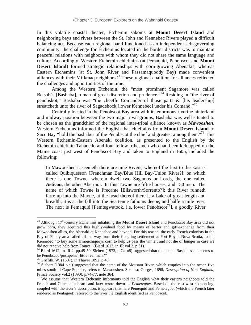
▪Chapter 3: European Explorers on the Wabanaki Coasts▪
57
In this volatile coastal theater, Etchemin sakoms at Mount Desert Island and neighboring bays and rivers between the St. John and Kennebec Rivers played a difficult balancing act. Because each regional band functioned as an independent self-governing community, the challenge for Etchemins located in the border districts was to maintain peaceful relations with neighbors with whom they did not share the same language and culture. Accordingly, Western Etchemin chieftains (at Pemaquid, Penobscot and Mount Desert Island) formed strategic relationships with corn-growing Abenakis, whereas Eastern Etchemins (at St. John River and Passamaquoddy Bay) made convenient alliances with their Mi’kmaq neighbors.73 These regional coalitions or alliances reflected the challenges and opportunities of the time.
Among the Western Etchemin, the “most prominent Sagamore was called Betsabés [Bashaba], a man of great discretion and prudence.”74 Residing in “the river of penobskot,” Bashaba was “the cheeffe Comander of those parts & [his leadership] streatcheth unto the river of Sagadehock [lower Kennebec] under his Comand.”75
Centrally located in the Penobscot Bay area with its enormous riverine hinterland and midway position between the two major rival groups, Bashaba was well situated to be chosen as the grandchief of the regional inter-tribal alliance known as Mawooshen. Western Etchemins informed the English that chieftains from Mount Desert Island to Saco Bay “hold the bashabes of the Penobscot the chief and greatest among them.”76 This Western Etchemin-Eastern Abenaki coalition, as presented to the English by the Etchemin chieftain Tahánedo and four fellow tribesmen who had been kidnapped on the Maine coast just west of Penobscot Bay and taken to England in 1605, included the following:
In Mawooshen it seemeth there are nine Rivers, whereof the first to the East is called Quibiquesson [Frenchman Bay/Blue Hill Bay-Union River?]; on which there is one Towne, wherein dwell two Sagamos or Lords, the one called Asticou, the other Abermot. In this Towne are fiftie houses, and 150 men. The name of which Towne is Precante [Ellsworth/Sorrento?]; this River runneth farre up into the Mayne, at the head thereof there is a Lake of great length and breadth; it is at the fall into the Sea tenne fathoms deepe, and halfe a mile over. The next is Pemaquid [Pemtegwatook, i.e. lower Penobscot77], a goodly River
73 Although 17th-century Etchemins inhabiting the Mount Desert Island and Penobscot Bay area did not grow corn, they acquired this highly-valued food by means of barter and gift-exchange from their Mawooshen allies, the Abenaki at Kennebec and beyond. For this reason, the early French colonists in the Bay of Fundy area sailed all the way from their fledgling settlement at Port Royal, Nova Scotia, to the Kennebec “to buy some armouchiquoys corn to help us pass the winter, and not die of hunger in case we did not receive help from France” (Biard 1612, in JR vol.2, p.31). 74 Biard 1612, in JR 2, pp.49-50. Siebert (1973, p.74, n8) suggested that the name “Bashabes . . . seems to be Penobscot /pósαpehs/ ‘little real man.’” 75 Griffith, W. (1607), in Thayer 1892, p.48. 76 Siebert (1984 p.c.) suggested that the name of the Mousam River, which empties into the ocean five miles south of Cape Popoise, refers to Mawooshen. See also Gorges, 1890, Description of New England, Prince Society vol.2 (1890), p.74-77, note 364. 77 We assume that Western Etchemin informants told the English what their eastern neighbors told the French and Champlain heard and later wrote down as Pemetegoet. Based on the east-west sequencing, coupled with the river’s description, it appears that here Pemequid and Pemetegoet (which the French later rendered as Pentagoet) referred to the river the English identified as Penobscot.

▪Chapter 3: European Explorers on the Wabanaki Coasts▪
58
and very commodious all things considered; it is ten fathoms water at the entrance, and fortie miles up there are two fathoms and a halfe [15 feet] at low water; it is halfe a mile broad, and runneth into the Land North many daies journey: where is a great Lake of 18 leagues [54 miles] long and foure [12 miles] broad. In this Lake are seven great Ilands: toward the farthest end there falleth in a River, which they call Acaconstomed, where they passe with their Boates thirtie daies journey up, and from thence they goe over Land twentie daies journey more, and then come to another River [St. Lawrence], where they have a trade with Anadabis or Anadabion [Anadabijou, the Montagnais grandchief] with whom the Frenchmen have had commerce for a long time [at Tadoussac, the inter-tribal rendezvous where the Saguenay runs into the lower St. Lawrence River, which Champlain visited in 1603]. Neere to the North of this River of Pemaquid [Penobscot] are three Townes: the first is Upsegon [Kadesquit, now Bangor], where Bashabes their chiefe Lord doth dwell. And in this Towne are sixtie houses, and 250 men, it is three daies journey within the Land. The second is Caiocame; the third Shasheekeing. These two last Townes are opposite one to the other, the River dividing them both, and they are two daies journey from the Towne of Bashabes. In Caiocame dwelleth Maiesquis, and in Shasheokeing Bowant, two Sagamos, subjects to Bashabes. Upon both sides of this River up to the very Lake, for a good distance the ground is plaine, without Trees or Bushes, but full of long Grasse, like unto a pleasant meadow, which the Inhabitants doe burne once a yeere to have fresh feed for their Deere. Beyond this Meadow are great Woods, whereof more shall be spoken hereafter. The River of Pemaquid is foure dayes journey from the mouth of Quibiquesson [Mount Desert Island waters]. . . . The River Shawakatoc [Saco] . . . is the Westermost River of the Dominions of Basshabez, and Quibiquisson the [Eastern]most.78
According to Captain John Smith, who had been guided in 1614 by Tahánedo
(variously spelled), a chieftain of a Western Etchemin band primarily ranging in the Muscongus Bay area between Pemaquid Point and the St. George River:
Mawooshen [was] extending betweene 43. and 45. fortie leagues [120 miles] in bredth, and fiftie [150 miles] in length [with] nine rivers, Quibiquesson, Pemaquid, Ramassoc, Apanawapeske, Apaumensek, Aponeg, Sagadehoc, Ashamahaga, Shawokotec. Sagadahoc is in 43. . . . This is Bashebes his dominion. The Tarentines country is in 44. 2/379. . . . Bashabes has many under-Captaines, called Sagamos.80
[From Penobscot] Southerly up the rivers and along the coast we found Mecadacut [Camden], Segocket [St. George River], Pemmaquid, Nuscongus [Muscongus], Sagadahock [lower Kennebec], Satquin, Aumughcawgen
78 “Description of Mawoosen,” 1623, in Hakluytus Posthumus or Purchas His Pilgrimes, vol.19, pp.400-406. Note that the name Asticou in this text is misprinted as Asticon. 79 Champlain vol.1, p.84. 80 Purchas 1905-1917. Preface, Sir Walter Raleigh’s Plantation, and the Northern Colony, Purchas his Pilgramage, in 8th Book (1617), p.939.
▪Chapter 3: European Explorers on the Wabanaki Coasts▪
59
[Androscoggin], and Kenabeca [Kennebec]. To those belong the countries and people of Segotago, Pauhuntanuck, Pocopassum, Taughtanakagnet, Wabigganus, Nassaque, Masherosqueck, Wawrigwick, Moshoquen, Waccogo, Pasharanack, etc. To these are allied in confederacy, the countries of Aucocisco [Casco], Accominticus [York], Passataquak [Kittery], Augawoam [Ipswich] and Naemkeck [Salem]. All these for any thing I could perceive differ little in language or any thing, though most of them be Sagamos, and lords of themselves; yet they hold the Bashabes of Pennobscot the chief and greatest amongst them. . . . Those in New-England, I take it, believe much alike as those in Virginia, of many divine powers, yet of one above the rest; …. The Pennobscots call their god, Tantum; their kings, Sagamos.81 [The] Massachusetts [who do not form part of Mawooshen] sometimes have wars with the Bashabes of Penobscot…; but now they are all friends, and have each trade with other, so far as they have society on each other’s frontiers, for they make no such voyages as from Penobscot to Cape Cod, seldom to Massachusetts. . . .82
As suggested by early 17th-century English documents based on information
provided by kidnapped Etchemins from the Pemaquid area, Bashaba’s inter-tribal alliance stretched from the Narraguagus River as the eastern boundary to the Mousam River (Kennebunkport) in the west. The name of this latter river, which runs into the Gulf of Maine just south of Cape Porpoise, may refer to Mawooshen (also spelled as Moasson). Guardian of Mawooshen’s Eastern Door: Asticou of Mount Desert Island Situated on the eastern frontier of Mawooshen, Mount Desert Island may have provided a location for a Western Etchemin rendezvous with visiting Eastern Etchemins and Mi’kmaqs from downeast. These Western Etchemin middlemen may have passed on corn and other valuables acquired from their southern neighbors in exchange for tradegoods from downeast.
As Bashaba’s allied neighbors at Mount Desert Island, Chief Asticou and his warriors were – to borrow an Iroquoian metaphor – “guardians of the eastern door” of Mawooshen. As allies of the Abenakis who provided them with corn, which they did not grow but greatly desired as food (and, perhaps, as a commodity to be exchanged with more distant foragers), Western Etchemins found themselves in a politically challenging position: Their easy access to Abenaki corn came at the expense of peaceful relations
81 Smith, J., 1898. Advertisements for the Inexperienced Planters of New England, or Anywhere or The Pathway To Experience to Erect a Plantation (1631). Interestingly, like most other English explorers, Smith refers to indigenous peoples in terms of their geographic location, not their ethnic, linguistic, or political identities. For that reason, he refers to the Bashaba and his Western Etchemin followers on the central Maine coast as “Penobscots.” 82 Smith. 1616: “A Description of New England,” in American Colonial Tracts vol.1, no.1, pp.15, 18. Etchemins under their grandchief Bashaba were known to Wampanoag Indians at Cape Cod and even Martha’s Vineyard, as Captain Harlow found out when he kidnapped about 30 tribespeople in southern Massachusetts, including Epenow who had been “upon the main” with the others when he was kidnapped and taken to Europe. Having lived at the aborted English colony at the lower Kennebec for almost a year, Harlow “understood much of his language,” and discovered that Epenow was “of acquaintance and friendship with those subject to the Bashaba, whom the captain well knew.”

▪Chapter 3: European Explorers on the Wabanaki Coasts▪
60
with the Mi’kmaq, seafarers from across the Bay of Fundy who repeatedly threatened the safety of the people of Mawooshen.
And although Western Etchemins were allied with the Abenaki at Kennebec and Saco, their Eastern Etchemin neighbors inhabiting the Passamaquoddy Bay and St. John valley did not form part of Mawooshen. Indeed, although these two major Etchemin divisions did maintain peaceful relations with each other, the same cannot be said about the Eastern Etchemins and the Abenaki of Kennebec and beyond, “in as much as the [Indians] of that place are their great enemies.”83
Probably reflecting this state of endemic conflict, along with the impact of population decimation due to diseases, the coastal stretch from Narraguagus River to Machias and beyond, all the way to Passamaquoddy Bay, appears to have been temporarily vacated in these highly unstable political times. None of the early French or English observers mentions any sakom or band for that area in the early 17th century. That is to say, this part of the coast appears to have been Mawooshen’s buffer zone with, as discussed later, a loose northeastern coalition of Mi’kmaq and Eastern Etchemin searaiders historically known as the Tarrentines.
With Western and Eastern Etchemins caught between the feuding Mi’kmaq and Abenaki (as well as more southern “Armouchiquois”), sakoms like Bashaba and Asticou walked a fine line and may have tried their best to remain neutral.84 Indeed, when Champlain first visited Bashaba near his headquarters at Kadesquit (Bangor) in 1604, he assured him and other Western Etchemin chieftains that the French wished “to reconcile them with their enemies, the Souriquois [Mi’kmaq] and Canadiens [St. Lawrence Iroquoians]…. Whereat they signified that. . . . [they] wished to live in peace with their enemies, in order that in future they might hunt the beaver more than they had ever done, and barter these beaver [furs] with us in exchange for things necessary for their usage.”85
Etchemins from Mawooshen were not only in contact with other Algonquian-speaking peoples inhabiting the northern Atlantic seaboard, but also with Montagnais and Algonquin allies in the lower St. Lawrence. For instance, they traded with them at Tadoussac, the famous inter-tribal rendezvous where the great Montagnais (Innu) chief Anadabijou (Anadabis or Anadabiou) had his headquarters. Together with these allies,
83 Champlain vol.1, p.300. 84 Depopulation of frontier territories too dangerous to inhabit was not uncommon and provided buffer zones. When Champlain crossed Lake Ontario in the summer of 1609 and journeyed upriver, he described a park landscape “very beautiful and attractive. Along the river bank it seemed as if the trees had been planted there in most places for pleasure, and also as if all these regions had once been inhabited by savages who since had been obliged to abandon them, for fear of their enemies” (Champlain 1902 vol.2, p.76). The Gaspé Peninsula was a similar “empty” buffer zone between the St. Lawrence Iroquoians and Mi’kmaq, who were actively involved in the devastating wars between these Iroquoians and their Algonquian archenemies from the mid-16th century onwards. Compare this with D.J. Campbell’s 1995 article on woodpeckers, “Detecting regular spacing in patchy environments and estimating its density using nearest-neighbour graphical analysis.” Oecologia 101 (2), pp.133-37. Offering an ecological observation about spatial competition and territorial boundaries, this Australian biologist noted that populations may “aggregate to form patches or clusters interspersed with interstices of unoccupied space for behavioural or ecological reasons. Territorial spacing in the clusters could follow [and] an analysis of spatial pattern in a sample area defined by a boundary enclosing the clusters might reveal the aggregation.” 85 Champlain vol.1, pp.295-96.
▪Chapter 3: European Explorers on the Wabanaki Coasts▪
61
Etchemins had fought their common Iroquois enemies even in the Lake Champlain area.86
With the Narraguagus River as the eastern boundary of Mawooshen, the sakom heading the border district comprising Mount Desert Island played an important role in the political affairs of the alliance. The frontier domain of Asticou, chief of this district in the early 1600s, included not only Mount Desert Island, but also its hinterland encompassing the Sullivan and Union River drainages. (Sullivan River runs into Frenchman Bay on the east side of Mount Desert Island, and Union River flows into Blue Hill Bay on the island’s west side). Asticou’s district stretched beyond the Schoodic Peninsula as far east as the Narraguagus River, and probably west of Naskeag Point to the Benjamin River, and from there inland.
As headman of Mawooshen’s eastern frontier district, Asticou was specifically associated with a seasonal village named Precante. Although its precise location remains unidentified, it could have been at Waukeag Neck near Sullivan Falls, or perhaps near Ellsworth Falls in the Union River. Champlain’s 1613 map also shows two wigwams, indicating two villages on what appears to be the Union River. Consisting of 50 wigwams [cabannes], Asticou’s village at Precante supposedly numbered 150 men.87 This would suggest that this Western Etchemin main village may have numbered about 600-750 people. Since two chiefs were mentioned, Asticou and Abermit (also spelled as Abermot), it is possible that this group was divided in two bands, each perhaps numbering about 350 people.
Chief Asticou is also associated with a Mount Desert Island summer village situated at Manchester Point near a small fresh water river along the northeast shore of Somes Sound. Although the French missionary who visited Asticou’s encampment there did not report any numbers, this village may have consisted of about 25 wigwams.
Western Etchemin chieftains like Asticou at Mount Desert Island and Bashaba at Penobscot Bay may have been whale-hunting captains.88 Although there “is little archaeological evidence for [prehistoric indigenous] whaling in the Gulf of Maine,”89 early historical records note that Wabanakis occasionally feasted on “a stranded whale.”90 It is possible that whales did not just accidentally become stranded, but were actually driven into shallow waters where they could be killed and butchered on the spot. Such an activity required skill and organization, as described to the English by Etchemins captured by Weymouth on the western side of Penobscot Bay in 1605:
One especiall thing is their maner of killing the Whale, which they [Etchemin Indians] call Powdawe91; and will describe his forme; how he bloweth up the water [spouting up to 50 ft high]; and that he is 12 fathoms [72 feet] long; and
86 Champlain (1922) vol.1, p.101. 87 Note: Based on other evidence, we should be aware that these numbers are probably inflated. Manhood began, more or less, when boys reached the age of 12 or 13 and were considered sufficiently skilled and physically ready to participate in war parties. 88 The Jesuit Biard notes that Mi’kmaq in Nova Scotia occasionally feasted on “a stranded Whale” [une Baleine échouée] (JR 2, p.185). This description could refer to the fin whale, which can be up to 70 ft long and about 45 tons heavy, or even the blue whale, which is on average 80 feet long and weighs 120 tons. 89 Cole-Will 2005. 90 See also Lescarbot 1612, in JR 2, p.185. 91 The Passamaquoddy , who still speak the eastern dialect of Etchemin, refer to the whale as putep.
▪Chapter 3: European Explorers on the Wabanaki Coasts▪
62
that they go in company of their King with a multitude of their boats, and strike him with a bone made in fashion of a harping iron [harpoon] fastened to a rope, which they make great and strong of the barke of trees, which they veare out after him; then all their boats come about him, and as he riseth above water, with their arrowes they shoot him to death; when they have killed him & dragged him to shore, they call all their chiefe lords together, & sing a song of joy: and those chiefe lords, whom they call Sagamos, divide the spoile, and give to every man a share, which pieces so distributed they hang up about their houses for provision: and when they boile them, they blow off the fat, and put to their peaze, maiz, and other pulse [obtained through barter with their Abenaki allies in the Kennebec and Saco valleys], which they eat.92
As noted earlier, the name Asticou probably means “kettle.”93 Such a name may
seem odd now, but it was traditionally not uncommon for an American Indian chief. In addition to the likelihood that Asticou’s name had spiritual associations, it no doubt also symbolized the success, wealth and obligations of a high status person. A tribal leader was expected to be able to provide food, such as whale meat and blubber (which could be many tons), not only for his family but also for allied chiefs and their bands, as well as other visitors. The number of people feasting on the food boiled in the chief’s kettles could be many dozens. Moreover, before every war party, a chieftain hosted a feast for warriors and allied chieftains. Given the nutritional and ritual significance of food, almost always boiled in kettles, it is not surprising that Wabanakis were keen to get copper kettles from European traders. Nor is it surprising that these prestige items were placed in the burials of prominent Etchemin chiefs in the eastern Penobscot Bay area – including along Eggemoggin Reach, the major traffic route between Mount Desert Island and the Penobscot Bay and River.94
As will be described in the next chapter, Asticou succeeded Bashaba as grandchief of Mawooshen after this fellow Western Etchemin chieftain was attacked and killed by Mawooshen’s Tarrentine enemies (Mi’kmaq and allied Eastern Etchemins). Western Etchemin and Abenaki chieftains heading communities from Mount Desert Island to Cape Porpoise acknowledged Asticou as leader of the confederacy during its final years.
◘ ◘ ◘ ◘
92 Rosier 1605, p.158. 93 As noted by the early 17th-century French Franciscan missionary Gabriel Sagard (1939, p.260), who mentions it as a Montagnais word. Among the Cheyenne in the 19th century, a renowned chief was named Black Kettle, and a Lakota band was named Oohenupa (“Two Boilings” or “Two Kettle”). Among the Seneca, a famous 19th century chief was named Big Kettle. Even today, among the Senecas at Cattaraugus Reservation near Buffalo, the name Kettle appears as a family name. However, Father Joseph Maurault (1866) glossed the name Asticou as “Caribou.” 94 Eggemoggin Reach is about 3 ½ nautical miles from the confluence of Penobscot and Bagaduce via the most direct portage route; 7 ¼ miles if you round Cape Rosier (William Haviland, pc 2005).

▪Chapter 4: Seafaring Tarrentine Traders and Raiders▪
63
CHAPTER 4: SEAFARING TARRENTINE TRADERS AND RAIDERS
Considering the lack of any credible evidence that European artifacts found in the Gulf of Maine area prior to the early 1600s were actually taken there by “unrecorded” French, Basque or English fishing captains or merchants, we conclude that most (if not all) of these trade goods were brought to the Mount Desert Island Etchemin and their Abenaki neighbors by intrepid Indian traders themselves. Armed with clubs, spears, bows and arrows, highly-mobile coastal tribesmen paddled their bark canoes to visit the European fishing boats on their shores and trade furs for various commodities. Accustomed to long-distance journeys, they formed part of exchange networks extending from Newfoundland to Cape Cod and stretching inland to far beyond the St. Lawrence valley.
Certainly, at least by the late 1500s, Mi'kmaq mariners traditionally inhabiting the shores of Gulf of St. Lawrence had become expert sailors of European shallops. Primarily a ship’s boat, also called skiff, and manned by a crew of four to six sailors, a typical shallop could be 20-30 feet long, 5-7 feet wide, and 2-3 feet deep, with a capacity ranging from 3-8 tons. Basque whale-hunters in the Gulf of St. Lawrence rowed and sailed these undecked boats as whaleboats. Although there were no standard forms or sizes for these wooden boats, which could be rigged with one or two masts carrying a square sail, such shallops enabled fishermen and coastal traders to transport greater freight, faster and over longer distances.1
Active in the fur-trade, these Indian mariners ranged between southern Newfoundland and the Gulf of Maine. On these long-distance journeys, they followed ancient canoe routes along Nova Scotia’s seashore, coasting around Cape Sable into the Gulf of Maine in search of furs and moosehides to barter for European commodities, including such rare and highly desirable metal trade goods as axes, knives, sword-blades and kettles. Others may have shipped furs and moosehides to the head of the Bay of Fundy, carrying packs across the isthmus to European vessels anchored at the Bay of Tatamagouche Bay in the Gulf of St. Lawrence, in return for trade goods to be bartered for more furs and hides. Beginning about 1600, shallop-sailing Mi’kmaq fur-trade entrepreneurs functioned for a number of years as middlemen between the Maine coast and European fishermen on Nova Scotia’s northeastern shores and beyond.2
In this adventure as merchant mariners, the Mikmaq were soon joined by Eastern Etchemin neighbors across the Bay of Fundy, in particular the lower St. John and Passamaqoddy Bay. Together, these northeastern Wabanaki groups became feared as Tarrentines. There has been much speculation about the ethnic identity of Tarrentines – and about the origin and meaning of this name. It has been suggested, for instance, that it was the name Basque mariners used to refer to the Mi’kmaq, meaning “annoying chatterers,” or “babblers.”3 This suggestion is intriguing, but not convincing, in part because this term does not appear in early 17th-century French records, only in English. For instance, as stated in an English Puritan source from Massachusetts Bay, these feared Indian sea-raiders “were only knowne to those of the Massachusetts by the name of
1 Baker, W.A. 1966, pp.20-25. 2 See also Eckstorm 1932, p.8; Siebert 1973; Bourque and Whitehead 1985. Note that this term has been the result and cause of much confusion in the reconstruction of 17th-century Wabanaki cultural history. 3 Siebert 1973, p.72.
▪Chapter 4: Seafaring Tarrentine Traders and Raiders▪
64
Tarratines, or eastern men.”4 Indians who formed part of the Abenaki-Western Etchemin coastal alliance under leadership of Bashaba of Penobscot, informed English explorers in the early 1600s that the countrey of Mawooshen “is bordered on the East side with a Countrey, the people whereof they call Tarrantines. . . .”5 In other words, not unlike the Mi’kmaq term “Armouchiquois,” insulting all their corn-growing southern enemies collectively as “Dog People,” the Tarrentine label was probably an indigenous term for all these despised “Eastern Indians.”
Since the Eastern Etchemin headquartered at Passamaquoddy Bay and the St. John River did not form part of Mawooshen, but were instead loosely allied with their Mi’kmaq neighbors across the Bay of Fundy, they were lumped together as Tarrentines by the people of Mawooshen and their neighbors south of Cape Porpoise. Like the Mi’kmaq, they also were in conflict with the Abenaki corn-growers inhabiting the Kennebec and Saco valleys. Illustrating this hostile relationship, Samuel de Champlain reported that his Eastern Etchemin guides from Passamaquoddy Bay in 1604 “were unwilling to come to Quinibequi [Kennebec], inasmuch as the [Indians] of that place are their great enemies.”6 Indeed, as he found out the following year, some Eastern Etchemins and Nova Scotia Mi’kmaq were held as captives in Abenaki villages in the Kennebec and Saco valleys.7 And not long afterwards, an English mariner sailing along the southern Nova Scotia coast with a Western Etchemin guide on board commented upon encountering Mi’kmaqs on the Nova Scotia coast: “We take these people to be Tarentyns and these people . . . do make wars with Sasanoa, the chief [Abenaki] commander to the westward [Kennebec and beyond] . . . and this summer they killed his son.”8 Like their Abenaki neighbors in the Mawooshen alliance, Western Etchemin warriors also frequented the Nova Scotia coast, “both as fishermen, and in passing along the shore to seek their [Mi’kmaq] enemies, that dwelt to the northward of them.”9
Because the “Tarrentine” label conveniently covers the loose and temporary coalition between Nova Scotia Mi’kmaq and Eastern Etchemin chieftains, we use this umbrella term for that inter-tribal alliance as it functioned in the first three decades of the 1600s. And since these Tarrentines – Mi’kmaq as well as Eastern Etchemins (Maliseets and Passamaquoddies) – were supplied with firearms by French fur traders from 1607 onwards, much to the alarm of their enemies and the English settlers between Cape Cod and Pemaquid, we will briefly sketch the region’s expanding trading and raiding operations in the early 1600s. Cape Neddick 1602: Anglo-Tarrentine Encounter on Southern Maine Coast We begin with a surprise encounter between an English exploration crew on the southern Maine coast and seafarers later identified in English records as Tarrentines: In 1602, a remarkable chance encounter occurred between English explorers and Indian merchant mariners just beyond Mawooshen’s southern frontier at Cape Neddick (York Beach). 4 Hubbard 1680, p.31. 5 Purchas 1625:1873; Siebert 1973. 6 Champlain vol. 1, p.300. 7 Champlain vol.1, pp.364, 365. 8 Griffin 1607, in Thayer 1892, p.44. See also Siebert 1973. 9 Gorges, cited in Wright 1965, pp.18-20. The French freed a Mi’kmaq prisoner held by the Abenaki at Saco River, who had captured him during a raid against Chief Messamouet’s band encamped at La Hève, southeastern Nova Scotia.

▪Chapter 4: Seafaring Tarrentine Traders and Raiders▪
65
Sailing from southwest England aboard The Concord, Captain Bartholomew Gosnold set out to explore “northern Virginia” (named “New England” by John Smith in 1616), including the Maine coast. Under the patronage of the Earl of Southampton (Shakespeare’s patron), Gosnold sought new fishing grounds, perhaps a site for a new colony for English settlers (after the failure at Roanoke about 20 years earlier) and, of course, the long-sought (and non-existent) “Northwest Passage” to China.
Aboard the English bark were eight sailors, plus 24 educated English gentlemen. The latter included James Rosier, Bartholomew Gilbert10 and two fellows who chronicled the journey for posterity, Gabriel Archer and John Brereton. Reaching Cape Neddick on Maine’s southern coast near York Beach, the Englishmen encountered to their great surprise a party of seafaring Wabanaki traders in a Basque sailing boat. Both Archer and Brereton recorded the event – remarkable to them, and all the more so because the Wabanaki mariners seemed neither surprised nor impressed by it. Indeed, the Indians were obviously familiar with European fishermen and merchants who had long plied the waters in the Gulf of St. Lawrence; they even spoke some French and Basque pidgin. Most scholars agree that they were Mi'kmaq – middlemen in the fur trade between the Gulf of St. Lawrence and the Gulf of Maine.11 Placentia Bay in southern Newfoundland, mentioned by the Indian “commander”12 noted in Archer’s account below, was at the time a popular harbor for Basque whalers:
From the said [Savage] rock [at Cape Neddick], came towards us a Biscay [Basque] shallop with sail and oars, having eight persons in it, whom we supposed at first to be Christians distressed. But approaching us nearer, we perceived them to be [Indians]. These coming within call, hailed us, and we answered. Then after signs of peace, and a long speech made by one of them, they cam boldly aboard us, being all naked, saving about their shoulders certain loose deer skins, and near their waistes seal skins tied fast like to Irish dimmie [coarse flannel] trousers. One that seemed to be their commander wore a waistcoat of black work, a pair of breeches, cloth stockings, shoes, hat, and band, one or two more had also a few things made by some Christians [Europeans]; these with a piece of chalk described the coast thereabouts, and could name Placentia of the Newfoundland; they spoke divers Christian [European] words, and seemed to understand much more than we, for want of language, could comprehend. These people are in color swart [dark], their hair long, uptied with a knot in the part of behind the head. They paint their bodies, which are strong and well proportioned. These much desired our longer stay, but finding ourselves short of our proposed place, we set sail westward [towards Cape Cod], leaving them and their coast.13
10 Bartholomew was Gosnold’s cousin and the second oldest son of Sir Humphrey Gilbert, who had perished at sea on his return from Newfoundland in the early 1580s; his elder brother had inherited the family estate Compton Castle from their childless uncle John Gilbert. 11 See also Bourque and Whitehead 1985, 1994. 12 This Indian leader may have been the southern Nova Scotia Mi’kmaq sakom Messamouet, an experienced mariner who had briefly lived in the French port city of Bayonne not far from Basque country in the early 1570s, having ventured there aboard a European fishing vessel. 13 in Mass. Hist. Soc. Collections 3rd Series, vol.8, pp.73-74.

▪Chapter 4: Seafaring Tarrentine Traders and Raiders▪
66
Archer’s companion Brereton offered some additional details in his account:
We came to anchor, where six Indians in a Basque shallop with mast and sail, an iron grapple [small anchor], and a kettle of copper, came boldly aboard us, one of the apparelled with a waistcoat and breeches of black serge, made after our sea-fashion, hose and shoes on his feet. All the rest (saving one that had a pair of breeches of blue cloth) were all naked. These people are of tall stature, broad and grim visage, of a black swart complexion, their eyebrows painted white; their weapons are bows and arrows. It seemed by some words and signs they made that some Basques or of Saint-Jean-de-Luz [southwestern French Basque seaport] have fished or traded in this place. . . .14
These glimpses of the Wabanaki in the early Contact Period, just 15 years before
their demographic collapse and ruination due to warfare and disease, offer a perspective on indigenous seafaring skills and the enormous distances covered in trading and raiding voyages along the Wabanaki coast, including Mount Desert Island. After this encounter, the English hoisted their sails again and continued on to Massachusetts Bay. The following summer, merchants from Bristol (a port city in southwest England involved in transatlantic enterprises since the early 1500s), sanctioned by Sir Walter Raleigh, sent Captain Martin Pring to explore the central and southern Maine coast. Pring entered Penobscot Bay and sailed via Pemaquid and Saco Bay, to Cape Neddick on Maine’s southern coast, but encountered no Wabanakis on this journey. That summer, Raleigh also sent his nephew Bartholomew Gilbert as captain of a 50-ton bark to establish a colony in Chesapeake Bay. However, Indians killed Gilbert and that expedition failed. Mount Desert Island Etchemins Welcome French Traders, 1604 In 1604, having acquired a monopoly on the region's fur trade from the French Crown,15 Pierre de Gua, Sieur de Monts (1568-1630), a French Huguenot entrepreneur from the port city of Dieppe, crossed the ocean in a ship piloted by Champlain to stake his claim. When these French colonists established themselves on Wabanaki lands, they did not request official permission from their Indian hosts, nor did they compensate them for the loss of their ancestral lands. In principle, the French Crown did not recognize aboriginal rights. The official French policy in New France was later formally articulated in a set of articles, which held that the indigenous inhabitants “neither hold nor possess any form of religion whatsoever;” and that indigenous territories are “free” and can be taken in possession by the French King “who will make himself master and lord.”16
As they sailed into the Bay of Fundy, they encountered Indian seal hunters.17 Looking for a place to establish a settlement, this French colonizing expedition continued on to Passamaquoddy Bay, guided by an Indian shallop. At the mouth of the St. Croix River, Champlain selected a small island18 where they set up for the winter. In his
14 Brereton 1602, in Wright 1965, pp137-38. 15 Lescarbot 1609-1612, vol.3, pp25-26 16 Champlain (1618), vol. 2:329-31. 17 Champlain vol.1, p246. 18 Champlain vol.1, p.246. This island is now the St. Croix International Historic Site, bi-nationally managed by the National Park Service and Parks Canada.

▪Chapter 4: Seafaring Tarrentine Traders and Raiders▪
67
journal, the navigator noted, “The [Etchemins] that live [in the Passamaquoddy Bay area] are few in number. During the winter, when the snow is deepest, they go hunting [with their dogs] for moose and other animals, on which they live for the greater part of the time. . . . When they do not go hunting, they live on a shell-fish called the clam.”19
Although Eastern Etchemins did not form part of the alliance of Mawooshen, they did speak closely related dialects of the language also spoken at Mount Desert Island and the Penobscot. As members of the same ethnic group, they maintained ties of kinship and friendship with one another. This enabled them to keep communication with each other, even in times of conflict between the rival power blocks on the Wabanaki coasts. The Eastern Etchemin headman of the Passamaquoddy Bay area was Ouagimout, who, Champlain wrote, “was on familiar terms with Bessabes [Bashaba], chief of Norumbega [Penobscot] river,”20 as well as with Mi’kmaq leaders across the Bay of Fundy. Chief Ouagimout had extensive dealings with Champlain and his men in 1604-1605 and served as a mediator between rival parties in the region. But, however sociable the Passamaquoddy Bay chief was with Western Etchemin neighbors ranging the coastal lands between the Narraguagas and Kennebec rivers, including Mount Desert Island, no such easy relations existed between him and the Kennebec Abenaki.
In September 1604, Champlain left Passamaquoddy Bay for an exploratory journey down the Maine coast, taking with him two Eastern Etchemin mariners “to serve as our guides to the places with which they were acquainted.”21 Sailing along the coast towards Penobscot Bay, he reported that “from the mouth of the [St. Croix] river to the place I reached [Penobscot Bay] . . . I saw no town or village nor any trace of there ever having been any, but only one or two empty Indian cabins. . . . From what I could judge there are few Indians in this river, which is called Pemetegoit [Pentagoet, i.e. Bagaduce].”22
En route to Penobscot Bay, Champlain passed by an island noticeable for its granite mountains, including one rising to 1,530 feet. Visible for dozens of miles and now known as Mount Cadillac, this is the highest peak on North America’s Atlantic seaboard. Although the Indian guides aboard referred to the island as Pemetic, Champlain renamed it Isle des Monts Déserts (“barren mountains island”).23 Near the island, the expedition came upon Wabanakis in two canoes and Champlain “sent our two [Eastern Etchemin guides] in a canoe to assure them of our friendship. . . .”24 These Indian hunters were probably tribesmen belonging to Chief Asticou’s community closely linked to the neighboring Western Etchemin district under Mawooshen’s grandchief, Bashaba. As guardians of the confederacy’s “eastern door,” these Western Etchemin tribesmen would have had the responsibility to alert the grandchief of approaching interlopers so that all necessary measures could be taken.
19 Champlain vol.1, p.308. 20 Champlain vol.1, pp.444-45. 21 Champlain vol.1, p.280. 22 Champlain (1922) vol.3, pp.358-59; It is assumed that this is another spelling for Pentagoet, meaning Penobscot River, but notice that Champlain’s1607 map places “Pentegoet” at the Bagaduce, whereas the Penobscot River is marked as “Norumbegue.” 23 See previous note. 24 Champlain vol.1, p.283.

▪Chapter 4: Seafaring Tarrentine Traders and Raiders▪
68
Detail of Champlain’s manuscript map of New France, 1607. It shows Monts Desert (Mount Desert), Isle haute (Isle au Haut), Norumbegue (Penobscot River), and Pentegoet (Bagaduce). Of special note are the clusters of dwellings drawn at what appears to be Bashaba’s village Kadesquit, at the confluence of the Penobscot and the Kenduskeag Rivers (now the center of Bangor), and the two clusters at the head of Union Bay, which is part of what the French referred to as “River of Mount Desert.” English documents link the latter seasonal village with Chief Asticou of the Mount Desert Island area. (Library of Congress, Geography and Map Division, Velllum Collection, #15.)
This first encounter with Mount Desert Island Indians may have taken place at Newport Cove (historically known as Stag Gove), an ideal location for beaching a fleet of bark canoes on Sand Beach and having an eastern lookout from Great Head.25 Indeed,
25 When sailing from Schoodic Point across Frenchman Bay, Cadillac would have first seen this cove, which may have also been where Father Biard landed when he was looking for a place to establish the first Jesuit mission at Mount Desert Island. Sweetser (1888, p.46), however, suggested it was Otter Cove: “In ancient times the head of the cove was occupied by beaver-dams.”

▪Chapter 4: Seafaring Tarrentine Traders and Raiders▪
69
Champlain’s guides from Passamaquoddy Bay must have been familiar with this particular location, for it may have served them and their Mi’kmaq neighbors as a traditional landing place on the island’s southeastern corner when paddling across Frenchman Bay to or from Schoodic Peninsula. The next day, wrote Champlain,
We sailed two leagues [six miles], and perceived a smoke in a cove at the foot of the mountains. We saw two canoes rowed by [Indians], which came within musket shot to observe us. I sent our two [guides] in a boat to assure them of our friendship. Their fear of us made them turn back. On the morning of the next day, they came alongside of our barque, and held converse with our [Etchemin guides]. I ordered some biscuit, tobacco, and other trifles be given them. [They] had come to hunt beaver, and to catch fish, some of which they gave us.26
View from Great Head on Sand Beach in Newport Cove. (Photo by Harald Prins, 2007.)
What these Etchemins at Mount Desert talked about with their eastern neighbors
from the Passamaquoddy Bay area aboard the French ship we can only guess. Continuing his narrative, Champlain described his encounter with Bashaba27. Although he did not refer to him as a grandchief or “king,” the description of the Etchemins ceremonially welcoming him indicates his extraordinary status as the paramount chief: “Having made friends with them, they guided us [through Eggemoggin Reach] into their river Peimtegoet [Penobscot/Bagaduce?], as they call it, where they told us lived their Capitaine [headman] named Bessabez [Bashaba], chef of that river.28 [After informing Bashaba,] They went to another little river [Passagassawakeag River?, Belfast] to inform also their chef, whose name was Cabahis. . . .”29
26 Champlain vol.1, p.284 27 The documents are unclear whether Bashaba was a personal name or a title, but it may have been both. As Gorges noted about Mawooshen, “As for their civil government, that part of the country we first seated in seemed to be monarchical, by the name and title of a Bashaba…” (Gorges 1658, in Wright 1965, p.89). 28 Champlain 1922, vol.1, p.284. What we now consider the mouth or entrance of the Pentagoet or Penobscot was probably more upstream than where early Europeans understood the river to begin. To distinguish this river from the main river Pentagoet (initially identified by Champlain and other early European explorers) as the Norumbega, the Bagaduce became later known as the Petit Pentagoet. 29 Champlain 1922, vol.1, p.294.

▪Chapter 4: Seafaring Tarrentine Traders and Raiders▪
70
Sailing into the Penobscot,30 Champlain steered his longboat about 75 miles upriver
until the head of the tide, near a seven or eight feet high waterfall, “about two hundred paces wide,” where he “found only enough water there for a canoe.”31 He viewed the fall, the old First Fall at Eddington Bend, from a bark a canoe with his Eastern Etchemin guides. Next Champlain reported his first meeting with Bashaba:
We saw neither town nor village, nor any traces that there ever had been any, but only one or two empty cabannes [wigwams] of the [Indians], which were constructed in the same manner as those of the Souriquois [Mi’kmaq], that is covered with tree bark. . . . So far as we could judge there are few [Indians] on this river, and these also are called Etechemins. They come there and to the islands only for a few months in summer during the fishing and hunting season, when game is plentiful. . . . They are a people with no fixed abode, from what I have discovered and learned from themselves; for they pass the winter sometimes in one place and sometimes in another, wheresoever they perceive the hunting of wild animals is the best.” 32
Having been informed of the French explorer journeying so far up his river,
Mawooshen’s grandchief and many warriors paddled in six bark canoes to see the bearded foreigners with their own eyes. In Champlain’s own words:
On the sixteenth of the month [September 1604], about thirty [Indians] came to us, on the assurance of those who had served us as guide. This Bessabez came also to find us [from his head village Kadesquit nearby] that same day, with six canoes. As soon as the [Indians] who were on land saw him [Bashaba] coming, they all fell to singing, dancing and jumping until he was ashore; then afterward they all sat down on the ground in a circle, according to their custom when they wish to make a speech, or have a feast. Soon after Bashaba’s arrival, chief Cabahis and his warriors from a neighboring
Etchemin encampment (probably Orland River) arrived,
…with twenty or thirty of his companions, who withdrew to one side and greatly enjoyed looking at us, for it was the first time that they had seen Christians [Europeans]. Some time afterward I went ashore with two of my companions and two of our [Indians from Passamaquoddy Bay]…. Bessabez, seeing us ashore, had us sit down, and began to smoke [tobacco] with his companions, as they usually do before making their speeches, and made us presents of venison and game. All the rest of the day and the night following, they did nothing but sing, dance and make good cheer, until the dawn.33
30 Champlain’s Etchemin guides referred to the Penobscot as “Pemetegoit,” which he conjectured to be the the legendary “Norumbegue.” (see Champlain 1902 vol.1, p.89 (Bourne edition). 31 Champlain 1902 vol.1, p.88 (Bourne edition). 32 Champlain 1922 vol.1, pp.292-93 (our italics). 33 Champlain 1902, vol.1, p.90 (Bourne edition); our italics.

▪Chapter 4: Seafaring Tarrentine Traders and Raiders▪
71
Champlain’s two Indian guides from Passamaquoddy Bay acted as interpreters,” telling Bashaba that the French “desired to settle in their country and show them how to cultivate it. . . .”34As Champlain later recounted:
I directed our [French] interpreter to tell our [Eastern Etchemin guides] that they were to make Bessabez, Cabahis, and their [Western Etchemin] companions understand . . . [that Sieur de Monts] wished to reconcile them with their enemies, the Souriquois [Mi’kmaq] and Canadiens [St. Lawrence Iroquoians]. . . . This our [Indian guides] made them understand, whereat they signified that . . . they wished to live in peace with their enemies, in order that in future they might hunt the beaver more than they had ever done before, and barter these beaver with us in exchange for things necessary for their usage.35
After this friendly exchange, Champlain’s crew bartered some “[iron] hatchets,
rosaries [strung colored-glass beads], caps, knives, and other little knick-knacks” for “a certaine number of beaver skins.”36 When all was said and done, the French explorer left the Bashaba and his Penobscot Indian community, feeling “well satisfied at having made the acquaintance of these people.”37
Guided by his Indian interpreters from the Passamaquody Bay area, Champlain then asked Chief Cabahis, “who accompanied us in our pinnace [long-boat],” about the source of the Norumbega River (Penobscot). This chieftain, whose Western Etchemin village may well have been near Verona Island at the mouth of Orland River,38 informed his French visitor that the Penobscot, by way of portages, led to the St. Croix and the St. Lawrence Rivers. Continuing his coastal exploration, Champlain steered his vessel “along the western shore” of Penobscot Bay and “passed the mountains of Beddabec39 [Mt Megunticook], where we anchored [Sherman Cove, Camden]. . . . [At Pemaquid, where the Western Etchemin village under Chief Tahánedo was located] our [guides from Passamaquoddy Bay] left us . . . because they were unwilling to come to Quinibequi [Kennebec], inasmuch the [Abenaki] of that place are their great enemies.”40
Without his Eastern Etchemin guides from the Passamaquoddy Bay area, who did not form part of Mawooshen,41 Champlain continued sailing a bit farther down the Maine coast. Then he returned to Passamaquoddy Bay, from where he steered his long-boat back to the fledgling French settlement on the island in the St. Croix River. Wintering over there, the French expedition lost about half of its men due to scurvy.
Come spring 1605, the 36-year old Sieur de Monts decided to search for a new location across the Bay of Fundy, in Mi’kmaq country. There, at the head of Annapolis 34 Champlain 1922 vol.1, pp.294-95 (our itals) – among many refs. showing absence of crops at Penobscot. 35 Champlain 1922, vol.1, pp.296, 295. 36 Champlain 1922, vol.1, p,296. 37 Champlain 1902, vol.1, p.91 (Bourne edition). 38 Eckstorm (1941, pp.189-91) suggests that Orland River may have been the Rammasoc River noted by Purchas, and possibly glossed as “below the spawning-beds.”. This location must have been must have been long favored, as here is also an ancient burial site with copper beads dated older than 2000 years. 39 Chief Tahánedo of Pemaquid later guided Captain John Smith in 1614, who refers to this same location as Mecaddacut, i.e. “big mountain place” (see also Eckstorm 1941, p.74). 40 Champlain 1922, vol.1, pp.298-299, 300. Note that this is yet another small example indicating that the Eastern Etchemins were part of the Tarrentines 41 Champlain still referred to these Abenaki as Armouchiquois, the Mi’kmaq name for these corn-growers.

▪Chapter 4: Seafaring Tarrentine Traders and Raiders▪
72
Basin, the French established a permanent settlement and named it Port Royal. That same year, Champlain noted that several of the “more than eighty” French Norman, Breton and Basque fishing boats were trading furs with Mi’kmaq on the Cape Breton coast, thereby violating de Monts’ recently acquired trading monopoly in vast the region.42 Etchemins Kidnapped by English Explorers, 1605-1607 One of the interlopers on de Monts’s exclusive fur-trade grant from the French Crown was the English sea captain George Weymouth. Sailing The Archangel for the Earl of Arundel, another hopeful aiming to locate the Northwest Passage to China, he approached the coast of Mawooshen when the French were busy building Port Royal. Having just experienced the arrival of a French long-boat peacefully sailing along their shore the previous year, Western Etchemins may have thought that a welcome opportunity for trade presented itself when Weymouth anchored at Monhegan Island in the Spring of 1605. Also on board was James Rosier, who had previously journeyed to the Maine southern coast (beyond Mawooshen) in 1602 aboard The Concord with Captain Gosnold.
As usual at this time of the year, the region’s Western Etchemin foragers were at Maine’s central seacoast for fishing, egg-gathering and bird-hunting. Given their positive experience with the French the previous autumn, they had reason to assume that Weymouth’s group intended to exchange iron hatchets and knives, copper kettles and other precious trade goods for their beaver and other furs. And so it was – at first. According to Rosier, the chronicler on board:
This day [30 May 1605], about five a clocke after noone, came three other Canoas from the maine, of which some had beene with us before; and they came aboord us, and brought us Tabacco, which we tooke with them in their pipes, which were made of earth, very strong, blacke, and short containing a great quantity: some Tabacco they gave unto our Captaine, and some to me, in very civill kind maner. We requited them with bread and peaze [peas], which they caried to their Company on shore, seeming very thankefull. After supper they returned with their Canoa to fetch us a shore to take Tabacco with them there: with whom six or seven of us went, and carted some trifles, if per adventure they had any trucke [trade], among which I carted some few biskets [biscuits], to try if they would exchange for them, seeing they so well liked to eat them. When we came at shore, they most kindly entertained us, taking us by the hands, as they had observed we did to them aboord, in token of welcome, and brought us to sit downe by their fire, where sat together thirteene of them. They filled their Tabacco pipe, which was then the short claw of a Lobster, which will hold ten of our pipes full, and we dranke [smoked] of their excellent Tabacco as much as we would with them; but we saw not any great quantity to trucke [trade] for; and it seemed they had not much left of old, for they spend a great quantity yeerely by their continuall drinking [smoking]: and they would signe unto us, that it was growen yet but a foot above ground, and would be above a yard high, with a leafe as broad as both their hands. They often would (by pointing to one part of the maine Eastward [shores of Penobscot Bay]) signe unto us, that their
42 Champlain 1922 vol.1, p.391; Champlain 1922 vol.3, pp.323, 326.

▪Chapter 4: Seafaring Tarrentine Traders and Raiders▪
73
Bashabes (that is, their King) had great plenty of Furres, and much Tabacco. When we had sufficiently taken Tabacco with them, I shewed some of our trifles for trade; but they made signe that they had there nothing to exchange; for (as I after conceived) they had beene fishing and fowling. . . .43
What did not escape the English, however, was the presence of copper among these
Maine Indians. Observing the leather dress of some Etchemin children, Rosier noted that the clothing was decorated with “little round pieces of red copper.”44 Several days later a very different encounter ensued in the coastal area between Pemaquid and the St. George River. Following a well-established European explorer’s practice aimed at quickly obtaining indigenous geographic intelligence, in this case also information that could lead to finally finding the elusive Northwest Passage to Asia, Weymouth and his English crew proceeded to take action:
The fourth of June, our men tooke Cod and Hadocke with hooks by our ship side, and Lobsters very great; which before we had not tried. About eight a clocke this day we went on shore with our boats, to fetch aboord water and wood, our Captaine leaving word with the Gunner in the shippe, by discharging a musket, to give notice if they espied any Canoa comming; which they did about ten a clocke. He therefore being carefull they should be kindly entreated, requested me to go aboord, intending with dispatch to make what haste after he possibly could. When I came to the ship, there were two Canoas, and in either of them three [Indians] of whom two were below at the fire, the other stayed in their Canoas about the ship; and because we could not entice them abord, we gaue them a Canne of pease and bread, which they carried to the shore to eat. But one of them brought backe our Canne presently and staid abord with the other two; for he being yoong, of a ready capacity, and one we most desired to bring with us into England, had received exceeding kinde usage at our hands, and was therefore much delighted in our company. When our Captaine was come, we consulted how to catch the other three at shore which we performed thus. We manned the light horseman [long, light, ship’s rowing boat] with 7 or 8 men, one standing before carried our box of Marchandise [trade goods], as we were woont when I went to traffique [trade] with them, and a platter of pease, which meat [food] they loved: but before we were landed, one of them (being too suspitiously feareful of his owne good) withdrew himselfe into the wood. The other two met us on the shore side, to receive the pease, with whom we went up the Cliffe to their fire and sate downe with them, and whiles we were discussing how to catch the third man who was gone, I opened the box, and shewed them trifles to exchange, thinking thereby to have banisht feare from the other, and drawen him to returne: but when we could not, we used little delay, but suddenly laid hands upon them. And it was as much as five or sixe of us could doe to get them into the light horseman [ship’s rowing boat]. For they were strong and so naked as our best hold was by their long haire on their heads; and we would have beene very loath to have done them any hurt, which of
43 Rosier 1605, pp. 124-25. Our emphasis. 44 Rosier 1605, p.121.

▪Chapter 4: Seafaring Tarrentine Traders and Raiders▪
74
necessity we had beene constrained to have done if we had attempted them in a multitude, which we must and would, rather than have wanted them, being a matter of great importance for the full [planned mission] of our voyage. Thus we shipped five [Indians], two Canoas, with all their bowes and arrowes. The next day we made an end of getting our wood aboord, and filled our empty caske with water. Tuesday, the 6 of June, we spent in bestowing the Canoas upon the orlop safe from hurt, because they were subject to breaking, which our Captaine was care full to prevent.45
The English captain in charge of the operations had carefully selected these five
Etchemin captives for their “ready capacity” to serve colonial entrepreneurial interests. Captain Weymouth more or less followed an established routine, as when North Carolina coastal Algonquian tribesmen Manteo and Wanchese were taken to England in 1584 and then used as guides and interpreters for the expedition to establish Sir Walter Raleigh’s short-lived English colony at Roanoke Island the following year. And even earlier (1534), Jacques Cartier had taken two young Iroquoians, Domagaya and Taignoaguy at the mouth of the St. Lawrence River, for the same purpose. Describing the careful political effort by Bashaba to get the captured Western Etchemins freed again, Rosier wrote in his journal on 8 June:
This day, about one a clocke after noone, came from the Eastward two Canoas [canoes] abord us, wherein was he that refused to stay with us for a pawne [hostage], and with him six other [Indians] which we had not seene before who had beautified themselves after their manner very gallantly, though their clothing was not differing from the former, yet they had newly painted their faces very deep, some all blacke, some red, with stripes of excellent blew over their upper lips, nose and chin. One of them ware a kinde of Coronet [crown] about his head, made very cunningly, of a substance like stiffe haire [moose hair?] coloured red, broad, and more than a handfull in depth, which we imagined to be some ensigne of his superiorities for he so much esteemed it as he would not for any thing exchange the same. Other ware the white feathered skins of some fowle [bird], round about their head, jewels in their ears, and bracelets of little white round bone, fastned together upon a leather string. These made not any shew that they had notice of the other before taken, but we understood them by their speech and signes, that they came sent from the Bashabes, and that his desire was that we would bring up our ship (which they call as their owne boats, a Quiden [canoe46]) to his house, being, as they pointed, upon the main towards the East [Penobscot Bay area], from whence they came, and that he would exchange with us for Furres and Tabacco. But because our Company was but small and now our desire was with speed to discover up the river, we let them understand, that if their Bashabes [grandchief at Penobscot] would come to us, he should be welcome but we would not remove to him. Which when they understood (receiving of us bread and fish and every of them a
45 Rosier 1605, p._ Our emphasis. 46 This Etchemin term aquiden for canoe is the same as what 20th-century Passamaquoddy spell as oqiton.

▪Chapter 4: Seafaring Tarrentine Traders and Raiders▪
abord, least they should discover the other [Indians] which we had stowed below.47
Four days later, having rounded Owl’s Head and coasted Penobscot Bay’s western
shore toward the Camden Hills area, Rosier made this journal entry on 12 June 1605:
We were no sooner come aboord our lighthorseman [rowboat], returning towards our ship, but we espied a Canoa comming from the further part of the Coast of the river Eastward, which hasted to us; wherein, with two others, was he who refused to stay for a pawne [hostage]: and his comming was very earnestly importing [proposing] to have one of our men to go lie on shore with their Bashabes (who was there on shore, as they signed) and then the next morning he [Bashaba] would come to our ship with many Furres and Tabacco. This we perceived to be only a meere device to get possession of any of our men, to ransome all those [five Etchemin captives] which we had taken, which their naturall policy [tactfulness] could not so [fore]shadow, but we did easily discover and prevent. These meanes [tactics] were by this [Indian] practised, because we had one of his kinsemen [Tahánedo], prisoner, as we judged by his most kinde usage of him being aboord us together.48
The grandchief of the Mawooshen Confederacy did not succeed in freeing
Tahánedo (or Ktàhαnəto, “great magic doer”49) and the other captives. Etchemins as Involuntary Guests in England, 1605-1613 With four other unfortunate Etchemins, Chief Tahánedo of Pemaquid was locked below deck on the Archangel. “They were all of one nation, but of several parts and several families,” the English noted later.50 The Etchemins from the Maine coast were taken to southwest England and delivered at the fort of Plymouth to Sir Ferdinando Gorges, the 40-year old military commander of this important coastal stronghold in southwest England. There, according to Rosier: “We have brought them to understand some English and we understand much of their language; so as we are able to aske them many things.”51 Involved in the Plymouth Company, Gorges, Popham and other associates were interested in distinguishing this region later identified as New England as distinct from Virginia. Accordingly, they referred to the Wabanaki on the Maine coast as Moassons, not as Virginians.
Gorges kept three of the Western Etchemins in Devonshire – Assacomet, Manido and Skidwarres. The other two – Amooret and Tahánedo52– were taken to Sir John Popham, then England's Lord Chief Justice, a rich and powerful gentleman who possessed several manorial estates in Devonshire and Somerset counties.53 Although it is
47 Rosier 1605, pp.135-36. 48 Rosier 1605, p.? 49 Siebert 1982. 50 Gorges 1658, in Wright 1965, p.17. 51 Rosier pp.131, 158. 52 These names are also spelled respectively as Sassacomoit; Manida/Maniddo/Maneddo/Maneduck; Sketwarroes/Scikaworrowse;and Nahanda/Nahanada/Dehanada/Dehamda/Dohannida/Bdahanedo. 53 See also Porter 1979, p.272; Purchas 1907.
75

▪Chapter 4: Seafaring Tarrentine Traders and Raiders▪
assumed that two of the kidnapped Etchemins were sent to Popham in London,54 it is more likely that they actually resided most of their time in England at one of his large manorial estates in Somerset or Devon, if only to secure their physical and emotional wellbeing in that beautiful countryside of southwest England.55 The same may well be true for the three Etchemins who lodged with Gorges, as this wealthy knight also possessed a country estate nearby. The hunter-gatherers from the Maine coast would have felt more at ease at these rural estates with surrounding moors, wooded valleys and freshwater streams, than in crowded cities where they would be also more exposed to the plague and many other lethal diseases.56 Although they were involuntary guests, they would have been given some freedom to hunt, fish and gather, all for the sake of creating long-term relationships. Of the five tribesmen from the Gulf of Maine, one went home in 1606 and (perhaps) two the following year. A fourth returned after nine years (and many adventures), and one probably died as a slave in Spain.57
A Mi’kmaq-Abenaki Couple Guides Champlain to the Kennebec, 1605 On 18 June 1605, less than a week after Captain Weymouth lifted anchor and sailed back across the Atlantic to southwest England’s port city of Plymouth with five unfortunate Etchemin captives aboard, the French longboat under Champlain left the Bay of Fundy for a seven-week southward exploration along the Maine coast to Cape Cod. To accompany them on this adventure, de Monts and Champlain recruited an experienced Mi’kmaq long-distance traveler named Panonias (or Panoniac) and his Abenaki wife (probably born and raised in the Kennebec valley): “We took along these [Indians] to serve as guides in the country of the Almouchiquois, in the hope of discovering and learning more exactly by their aid what kind of country it was, inasmuch she was a native thereof.”58 Panonias belonged to the band of the old and still greatly feared Mi’kmaq shaman-chief Membertou in southwest Nova Scotia. Reaching Penobscot Bay, Champlain sailed upriver, noting in his journal, “Now I will leave this discourse to return to the [Indians] who had led me to the rapids of Norumbega [Penobscot River], who went to inform Bessabes, their captain, and gave him warning of our arrival.”
In July, sailing on southward from Penobscot Bay to the Kennebec, Champlain and his crew encountered two Abenaki canoes manned by bird hunters: “We accosted these [Indians] through our own [Panonias], who went towards them with his [Abenaki] wife, and she explained to them the reason of our coming. We made friends with them and with the [Abenaki Indians] of that river who acted as our guides.”59 In the Kennebec valley and beyond lived the Abenaki, at the time bitter enemies of the Mi’kmaq (but 54 See also Vaughan 2006, pp.57, 61. 55 Popham’s manor at Wellington had a large park which he had stocked with deer. 56 As an Oxford-educated high-ranking official, Sir John Popham must have been aware of the health risks of living in London. A filthy city on the Thames River, it was crowded and swarming with rats, making it prone to outbreaks of diseases like the plague. In 1603, for instance, more than 30,000 of the 38,000 people deaths in London were due to the plague! Although the following few years were much less lethal, this plague would have made a calculating entrepreneur like Popham cautious about exposing his precious human resources to deadly diseases. 57 See for a detailed account, the chapter “Norumbega’s Reluctant Guides,” in Vaughan 2006. Conforming to entrenched ideas about Maine Indian tribal identity and territoriality which confuse scholars such as Quinn (1981) and Snow (1978), he also misidentifies these Western Etchemins as “Eastern Abenakis.” 58 Champlain 1922, vol.1, pp.311-12. 59 Champlain 1922, vol.1, pp.314-15.
76
▪Chapter 4: Seafaring Tarrentine Traders and Raiders▪
77
friends with their Western Etchemin neighbors and fellow Mawooshen allies): “Our Indian [Panonias] could understand only certain words, inasmuch as the language of the Almouchiquois, for so that nation is called, differs entirely from that of the Souriquois [Mi’kmaq] and Ertechemins [Etchemins].”60
About the coastal Indians on the lower Kennebec, Champlain wrote: “The people live like those near our settlement [the hunter-fisher-gathering groups in the Bay of Fundy area]; and they informed us that the [Indians] who cultivated Indian Corn [maize] lived far inland, and [that they] had ceased to grow it on the coasts on account of the war they used to wage with others [the corn-raiding Tarrentines] who came and seized it.”61 These Abenakis in the lower Kennebec Valley belonged to a band headed by Chief Manthoumer, who, Champlain noted, “desired an alliance with us, and through our mediation to make peace with their [Tarrentine] enemies.” To this he added that the next day he would send word to two other chiefs who were up country, “one called Marchin, and the other Sasinou, headman of the Quinibequy [Kennebec] River.”62 While there, the French also traded some furs.
From the Kennebec, Champlain sailed to Saco Bay, where he encountered coastal Abenakis residing in a heavily-palisaded village in the lower Saco valley. These villagers cultivated corn, beans and squash in large gardens. Like those living farther south, they still used stone axes, “for except a few who get them [iron axes] from the [Mi’kmaq] of the Acadian coast, with whom they are bartered for furs.”63 After coasting along New England’s shorelines as far as Cape Cod, Champlain turned his long-boat and steered back to the Saco River, where he met Abenaki Chief Marchim [“Wolf”]. The Sieur de Monts “made [Marchim] many presents . . . and in return [the chief] gave us a young [Eastern] Etechemin boy whom he had captured in war, and whom we took away with us.” Then the French returned to the Kennebec, where they “expected to find a [Abenaki chieftain] named Sasinou [lord of the Kennebec]. . . . we waited for him some time, in order to get from him a young [Eastern] Etechemin man and girl whom he held prisoners.”64 These captives held by Abenakis were, obviously, not Western Etchemins (their allies), but Eastern Etchemins captured during a long-distance raid by Abenaki canoe-faring warriors who would have crossed Penobscot Bay and passed Mount Desert Island on their journey to Passamaquoddy Bay, probably into the Bay of Fundy.
While Champlain and de Monts waited on the lower Kennebec, a chieftain named Anassou visited them, bartered some furs and told Champlain that a ship engaged in the fishery had treacherously killed five Indians.65 Obviously, he referred to the deceitful incident involving the English who had kidnapped Tahánedo, the sakom of Pemaquid, and four fellow Western Etchemins near Monhegan Island. After this adventurous coastal voyage, the head of the French colonization scheme, the Sieur de Monts, returned to France, but Champlain remained at the new French settlement of Port Royal.
60 Champlain 1922, vol.1, p.325. 61 Champlain 1922, vol.1, p.321. 62 Champlain 1922, vol.1, p.316. 63 Champlain 1922, vol.1, p.333. 64 Champlain 1922, vol., p.364. 65 Champlain 1922, vol.1, p.364.

▪Chapter 4: Seafaring Tarrentine Traders and Raiders▪
78
Chief Tahánedo Returns to Mawooshen, 1606 Eager to capitalize on the geographic information concerning Mawooshen, Sir Ferdinando Gorges and Sir John Popham sent three of their Western Etchemin guests back to the Maine coast in 1606. Serving as guides and interpreters on ships bound for the Gulf of Maine, the two who had been hosted by Gorges, namely Assacomet and Manido, were placed aboard the ship commanded by Captain Henry Challoung (Challons). He had been explicitly instructed to take the northwesterly route “as high as Cape Britton,” and “then to beat up to the southward, as the coast tended, till they were found by the natives [the Etchemin guides] they were near the place they were assigned unto. . . .” Gorges had decided on this route by way of Nova Scotia and Mount Desert Island, “contrary to the opinion of our best seamen of these times, [because] I knew many reasons persuading me thereunto, as well as for that I understood the natives themselves to be exact pilots for that coast, having been accustomed to frequent the same, both as fishermen, and in passing along the shore to seek their [Mi’kmaq] enemies, that dwelt to the northward of them.” On the Maine coast, Challoung was supposed to meet up with Captain Thomas Hanham, Sir John Popham’s thirty-year old grandson. Hanham was sailing with navigator Martin Pring of Bristol, who had been dispatched by Sir John Popham about the same time and who had given him Tahánedo as his guide.66
However, Capt. Challoung ignored Gorges’ orders and sailed by way of the Bermuda Islands where the Spanish attacked and captured his ship. Although wounded in the assault, Assacomet ultimately made it back to England and returned to Gorges’ household several years later. Manido may have died in captivity in Spain. In 1614, Assacomet was finally able to return to his Etchemin homeland when Gorges placed him aboard one of his ships, commanded by Captain Nicholas Hobson, to serve as a guide and interpreter on the central Maine coast.
Things went better for Tahánedo (and probably Amooret)67 sailing aboard Capt. Hanham’s ship. Piloted by Pring (who had already explored the Maine coast a few years earlier) with guidance from Tahánedo (who had learned to communicate in English during his year in England), Hanham successfully explored rivers and harbors on the Maine coast and also “sayled to the River of Sagadoahoc” (lower Kennebec) that summer.
Apparently having been treated well, Tahánedo was allowed to remain on the Maine coast, rejoining his Etchemin band ranging in the Pemaquid and Muscongus Bay area while his ship sailed back to England.
Pring’s manuscript map with its important geographic details, combined with his overall positive recommendation for establishing new colonies, helped Gorges and business associate Popham (the very rich and powerful Chief Justice of the King’s Bench) interest among “many of the lords and others to be petitioners to his Majesty [King James I] for his royal authority, for settling two Plantations upon the coasts of America,” namely Jamestown in southern Virginia and Saint George in the northern parts of that colonial domain claimed by the English. 68
66 Wright 1965, pp18-20. 67 Vaughan 2006, pp63-64. 68 Wright 1965, p.20.

▪Chapter 4: Seafaring Tarrentine Traders and Raiders▪
79
Messamouet: Mi’kmaq Trader on Maine Coast, 1606 Sailing down the coast of Cape Breton Island in 1606 with a company of French colonists en route to the fledgling Acadian settlement Port Royal, a young lawyer from Paris named Marc Lescarbot69 reported that on Nova Scotia’s northeast coast he saw two small sailing boats approaching his ship:
Two shallops came up, one manned with [Mi’kmaq], who had a moose painted on their sail, the other by Frenchmen from [the Breton port city of] St. Malo who were fishing off Canso Harbour [between Cape Breton and Nova Scotia]; the [Indians] showed great diligence, for they arrived first. [The Breton sailors] were in the service of the partners of M[onsieur] de Monts, and complained that the Basques, contrary to the [French] King's prohibitions, had bartered with the [region's Mi’kmaq] and carried off more than six thousand beaver pelts.70
Later that year, in September 1606, Poutrincourt ordered Champlain to again
navigate his longboat down the Maine coast, passing Mount Desert Island, crossing Penobscot Bay and continuing to Cape Cod. As guides for this trip, noted Champlain, “we took with us Secoudon and Messamouet, who came in a shallop as far as Chouacoet [Saco], where they wished to go to make an alliance with those [Abenaki] of that country by offering them sundry presents.”71 Secoudon, or Chkoudun (“Trout”) was headman of a fortified Eastern Etchemin [Maliseet] village called Ouigoudi (“campsite”) on the lower St. John River. Messamouet, a Mi’kmaq chieftain from Nova Scotia’s Atlantic coast, had lived in the southwestern French port city of Bayonne about 35 years earlier, perhaps having sailed there aboard the Basque boat of Captain Savalette who had frequented the fishing banks not far from his band’s territories since about 1565. In all likelihood, this Mi’kmaq chief spoke at least some French and probably Basque.
At the time, the Abenakis (and more southern corn-growers all lumped together by their northeastern hunter-gatherer enemies as Armouchiquois) were in a perpetual state of low intensity warfare with Mi’kmaqs and their Eastern Etchemin allies inhabiting the Passamaquoddy Bay and lower St. John River areas. Collectively, these neighboring groups were identified as Tarrentines by their enemies in Mawooshen and beyond. Every time they went on a raiding expedition against Abenakis in southern Mawooshen, their fleet of bark canoes would coast southwest by way of Mount Desert Island, and return by way of that island, too. Of course, Mawooshen’s warriors made the same roundtrip in reverse – passing by, and probably camping on, the shores of Mount Desert Island.
In Saco Bay, Abenaki chiefs Marchin and Olmechin “brought M[onsieur] de Poutrincourt a Souriquois [Mi’kmaq] prisoner, and therefore their enemy, whom they freely handed over to him. Two hours later, two Indians arrived,” Secoudon and Messamouet, the Mi’kmaq “chief . . . in the river of Port de lahave [La Hève on Nova Scotia’s southeastern coast], where this prisoner had been taken [by the Abenaki raiders from Saco]. They had much merchandise, gained by barter with the French, which they
69 Lescarbot formed part of the colonization of Port Royal, a tract of land granted by de Monts to his partner Sieur de Poutrincourt – a French nobleman who “had come to remain in the country with fifty men” (Champlain 1922 vol.1, p.383). 70 Lescarbot 1609-1612, vol 4, pp.309, 310. 71 Champlain 1922, vol.1, p.394. See also Lescarbot 1609-1612 vol.2, pp.323-24.

▪Chapter 4: Seafaring Tarrentine Traders and Raiders▪
80
came thither to sell – to wit, kettles, large, medium, and small, hatchets, knives, dresses, capes, red jackets, peas, beans, biscuits, and other such things.”72
Messamouet, the well-traveled Mi’kmaq raider and trader from southern Nova Scotia, carried out his intention to barter with these Abenaki chiefs in Saco Bay, and Poutrincourt ransomed the Mi’kmaq prisoner. Yet, he “departed much displeased because he had not been suitably repaid for what he had given them, and with the intention of making war upon them before long. . . .”73 After this encounter, it seems that Secoudon sailed farther south with the French, whereas Messamouet (probably with a crew of about six fellow Mi’kmaqs) returned to Nova Scotia in his own wooden sailing boat. Later, heading back north to the Bay of Fundy, Champlain passed Mount Desert Island and near Machias his longboat suffered damage. While the broken helm was being repaired, an Eastern Etchemin canoe approached. The Indians on board told Secoudun that a [Mi’kmaq?] chieftain named “Iouaniscou and his companions had killed some other [Armouchiquois] and carried off some [Armouchiquois] women as prisoners, and that near Mount Desert Island they had put these to death.”74 In November, sailing back into Passamaquoddy Bay after his two-month journey, Champlain dropped Secoudon off at the St. Croix. The Eastern Etchemin chief carried with him the heads of the Wampanoag (Armouchiquois) enemies he had slain at Misfortune Harbor, Cape Cod.75 Tarrentine Raiders Revenging a Murder at Penobscot Bay, 1607 In autumn 1606, about the same time Champlain returned to the Bay of Fundy, the Mi’kmaq trader Panonias who had guided him the previous summer was unexpectedly killed in the Penobscot Bay area by warriors from the Mawooshen Confederacy – “out of vengeance” because the Tarrentine seafaring chieftain “Iouaniscou and his people had killed those of Norumbega [Penobscot] and of Quinibequi [Kennebec].”76 The Eastern Etchemin chief Ouagimout of Passamaquoddy Bay asked Bashaba of Penobscot (grandchief of Mawooshen) for Panonias’ body. Ouagimout transported him, wrapped in moosehide, to a Mi’kmaq encampment near the French trading post at Port Royal. The region’s old and prestigious headman, Membertou, welcomed Ouagimout and presented ritual gifts of mourning to Panonias’ relatives. Then the murder victim was buried on an island near Cape Sable at Nova Scotia’s southern tip.77
In 1607, having already acquired and mastered small European sailing boats (shallops), Mi'kmaqs gained access to French firearms78 and also acquired iron arrowheads and sword-blades from Europeans: “Since our Frenchmen have brought sword-blades to Canada, the [Indians] make use of them both in hunting moose and in war against their enemies, and these, fastened to their long wooden shafts like demi-pikes, then are able to hurl straight and hard.”79 It appears that the Mi’kmaq’s cultural adaptability in terms of adopting new technologies enhanced their chances of survival enormously in this hotly contested Gulf of Maine arena, whether in defending themselves 72 Lescarbot 1609-1612, vol.2, pp.323-24. 73 Champlain 1922, vol.1, pp.395-96. 74 Champlain 1922, vol.1, p.436. 75 Champlain 1922, vol.1, p.436. The French original states “têtes,” wrongly translated as scalps. 76 Champlain 1922, vol.1, p.442. 77 Lescarbot 1609-1612, vol.3, pp279, 283. 78 Lescarbot 1609-1612, vol.3, pp.505-506. 79 Sagard 1636, p.155.

▪Chapter 4: Seafaring Tarrentine Traders and Raiders▪
81
against hostile neighbors such as European fishermen or competing with indigenous rivals such as the Abenaki .
That same year, de Monts lost his fur trade monopoly on the Maine coast, and the French settlement at Port Royal had to be temporarily abandoned. Prior to their departure on August 11, however, “some thirty or forty [Tarrentines] assembled at this place [Port Royal] in order to go upon the war path against the Abenakis, and to avenge the death of Panounias. . . . They all set out from this place on the twenty ninth of June to go to the war path at Chouacoet [Saco], which is the country of the Almouchiquois.”80 This raid involved Mi’kmaqs from Membertou’s band, plus Messamouet and his warriors, along with Eastern Etchemins from the St. John River under Chief Secoudon and from the Passamaquoddy Bay area under Chief Ouagimout.81 In other words, this flotilla of war canoes represented the Tarrentine alliance loathed by the people of Mawooshen.82
The day before the French left Port Royal, the Tarrentine fleet came back from their six-week raiding expedition. Describing the conflict, Lescarbot wrote,
On the tenth of August, Mabretou [Membertou] returned from the war. He told us that he had been at Chouacoet [Saco] and had killed twenty [Abenaki enemies] and that Onemechin, chef of that place, Marchin & another, had been killed [as was Sasinou, chef of the Quinibequi [Kennebec] river…. The chiefs who have now replaced Onemechin, Marchin, and Sasinou are their sons—that is to say, for Sasinou, Pememen [Abomhamen?], Abriou for Marchin, his father, and for Onemechin, Queconsicq. The two latter were wounded by the [Mi’kmaq] men of Membertou, who ambushed them under pretense of friendship, as is their custom. . . .83 Tarrentines also suffered losses in this raid against Abenakis. Among their casualties
were Eastern Etchemins, including Chief Ouagimout of Passamaquoddy Bay, who “was grievously wounded,”84 and Chief Secoudon of the lower St. John, who was killed.85 Skidwarres Guides English Colonists to Mawooshen, 1607 In early June 1607, 76-year-old Sir John Popham died at Wellington manor, his beautiful Somerset estate in southwest England.86 By then, however, the English colonial expedition to found Jamestown in the Chesapeake Bay area had already landed in Virginia. Sir John’s nephew George Popham was appointed commander of the expedition to the lower Kennebec (Sagadehock), sailing the flyboat The Gift of God. His designated guide was Skidwarres, the Etchemin who had been kept by his uncle, Sir John, for almost two years and had learned English. They sailed in tandem with a much larger ship, the
80 Champlain 1922, vol.1, p.451. 81 Lescarbot 1609-1612, vol. 3, pp.499-500. 82 Contrary to more recently established scholarly consensus, which holds that the Tarrentines were Mi’kmaq alone, we recognize that such ethnic labeling is too simplistic. In this respect, the term Tarrentines is like Mawooshen, and neither term refers to an ethnic group per se. 83 Champlain 1, p,457-58. 84 Lescabot vol.2, p.360. 85 Lescarbot vol.3,, p.504. 86 This age is based on Popham having been born in 1531, although other sources state it was in 1528. In his otherwise excellent book, Vaughan (2006, p.64) states he died in 1608, but that is an error.

▪Chapter 4: Seafaring Tarrentine Traders and Raiders▪
82
Mary and John, which carried the colonists and their equipment.87 This vessel was commanded by Raleigh Gilbert, younger brother to Bartholomew Gilbert who had been part of Captain Gosnold’s 1602 expedition to the Maine coast (and was killed a year later by Chesapeake Bay Indians). Sons of Sir Humphrey Gilbert (who had drowned returning from Newfoundland in 1583), these adventurous gentlemen were nephews of Sir Walter Raleigh, their father’s half-brother.88 Both vessels were fitted out to establish a colony at the mouth of the Kennebec River.89
The two English ships sailed from Plymouth Harbor in southwest England on May 31, crossing the Atlantic by way of the Azores and then steering north to the codfish banks off Nova Scotia. From there, they sailed towards the coast where they anchored at an island near La Hève in the district of a Mi’kmaq community headed by the famous chieftain Messsamoet. As reported by William Strachey, there “came a Spanishe [Basque] shallop to them from the shore, in her eight [Indian] men and a little [Indian] boy, who at first rowed about them and would not come aboard. . . .” The next day, “the same [Indians] returned with three women with them in another Biskey [Basque] shallop, bringing with them many beaver skyns [furs] to exchange for knyves and beades. The sagamo [chieftain] of that place they told them Messamot, seated upon a river not far off, which they called Emanett [La Hève].”90
Skidwarres was probably familiar with this coastal area, since in previous decades Western Etchemins were known to make long-distance seafaring expeditions downeast in their bark canoes. Apparently informed by this tribesman, a member of the English expe-dition made this note about Mi’kmaq encountered on the Nova Scotia coast: “We take these people to be Tarentyns and these people, as we have learned since, do make wars with Sasanoa, the chief [Abenaki] commander to the westward [Kennebec] . . . and this summer they killed his son.”91 Indeed, this was the Tarrentine raid against Abenaki villagers of southern Mawooshen. Tahánedo (who had returned the previous year), as the sakom of the Western Etchemin band at Pemaquid, was involved in this conflict.
Guided by Skidwarres, the ships sailed around Cape Sable and probably steered towards Mount Desert Island, visible from dozens of miles away at sea. For the Indian guide, this eastern frontier district of Mawooshen, defended by allied Western Etchemins under their chieftain Asticou, would have been safe and familiar terrain. Come August,
87 Purchas 1907 (19), pp.284, 288; Burrage 1907, p.54. This ship later transported many other settlers to the Massachusetts Bay area. 88 Five years earlier, in 1602, Walter Raleigh had been tried and condemned to imprisonment in the Tower, where he remained for fourteen years. After brief freedom, he was tried again and executed based on trumped up charges for high treason. 89 Coincidentally, both English settlements in the vast territories they referred to as Virginia—in honor of their “Virgin” queen, Elizabeth I—were founded the same summer French colonists at Port Royal were forced to temporarily vacate their Nova Scotia settlement in the Bay of Fundy because the Sieur de Monts’s trading monopoly was being contested by rival merchant in France. De Monts never returned, but his partner Poutrincourt did return to re-establish the French settlement at Port Royal three years later. 90 Strachey, William 1853 “Account (of the Popham Colony) by Strachey (1618?).” In Collections of the Maine Historical Society, vol. 3, pp.286-309. 91 Griffith, in Thayer 1892, p.44; see also Siebert 1973. The Tarrentine identity question has vexed scholars for centuries. Based on all available documentary evidence, it now appears obvious to us that this term does not just refer to the ancestors of Nova Scotia Mi’kmaq, but also to the Eastern Etchemins (ancestral to Maliseet and Passamaquoddy). As such, it is comparable to the term Armouchiquois, which does not just refer to the Abenaki, but also their Pennacook, Massachusett, and Wampanoag neighbors.

▪Chapter 4: Seafaring Tarrentine Traders and Raiders▪
83
they sailed across Penobscot Bay and anchored at the Georges Islands between Monhegan Island and the St. George River. This was the place where Skidwarres and his four Etchemin friends had been kidnapped by the crew of the Archangel two summers earlier. What next happened is best told in Strachey’s own words:
They weighed anchor [at St. George’s Island] thereby to ride in more safely, howsoever the wind should happen to blow, howbeit before they put from the island they found a cross set up, one of the same which Captain George Waymouth in his discovery for all after occasions left upon this island [1605]. Having sailed to the westward they brought the highland before spoken of to be north. About midnight Captain Gilbert caused his ship's boat to be manned with 14 persons and the Indian called Skidwares and rowed to the westward [across Muscongus Bay to New Harbor], from their ship to the River of Pemaquid which they found to be 4 leagues [12 miles] distant from their ship where she rode. The Indian brought them to the [Western Etchemin encampment], where they found 100 men, women, and children and their chief commander or sagamo, amongst them named [Tahánedo], who had been brought likewise into England by Captain Waymouth and returned thither by Captain Hanam [Thomas Hanham, a nephew of George Popham] setting forth for these parts [in 1606]….
At their first coming the Indians betook them to their arms, their bows and arrows, but after [Tahánedo] had talked to Skidwares and perceived that they were Englishmen, he caused them to lay aside their bows and arrows, and he himself came unto them and embraced them and made them much welcome, and after 2 hours interchangeably thus spent, they returned aboard again.
[August] 9. Being Sunday the chief [George Popham] of both the ships with the greatest part of all the company, landed on the island where the cross stood, which they called St. George's Island, and heard a sermon delivered unto them by Mr. Seymour their preacher, and so returned aboard again.
[August] 10. Captain Popham manned his shallop and Captain Gilbert his ship's boat [a pinnace, also known as a long-boat] with 50 persons in both and departed for the River of Pemaquid, carrying with them Skidwares. Being arrived in the mouth of the river there came forth [Tahánedo] with all his company of [Etchemin] Indians with their bows and arrows in their hands, they being before his dwelling houses would not willingly have all our people come on shore, being fearful of us.92 To give them satisfaction the [two English] captains with some 8 or 10 of the chiefest landed, but after a little parley [talk] together they [the Etchemins] suffered [allowed] all to come ashore using them in all kind sort after their manner. Nevertheless after one hour they all suddenly withdrew themselves into the woods, nor was Skidwares desirous to return with us any more aboard. Our people loath to offer any violence unto him by drawing him by force, suffered him to stay behind, promising to return unto them the day following, but he did not. After his departure our people embarked themselves, and rowed to the further side of the river and there remained on the shore for the night.93
92 This Pemaquid village was located at the “Nahanada site” (Bristol), named after Tahánedo. 93 Strachey 1853. For a similar account, see Griffith 1607, in Thayer 1892, pp.35-86.

▪Chapter 4: Seafaring Tarrentine Traders and Raiders▪
84
One can only imagine what Tahánedo told Skidwarres. No doubt, he informed
him about the seafaring Tarrentine warriors who had been equipped by the French at Port Royal earlier that summer and launched a punitive attack against their Abenaki allies in the Saco Bay area just a few weeks earlier. Surely, both expressed wariness about the possibility of another English kidnapping attempt. And they probably discussed mixed feelings about English plans to establish a stronghold in the heartland of their Mawooshen confederacy. That said, they may have recognized the possibility that with well-armed English neighbors, they could gain direct access to European trade goods and weapons, and perhaps even protection against Tarrentines raiding their corn-growing southern friends. At any rate, Skidwarres was all too happy to be back home and preferred to keep his distance from the newly arrived English colonists. Failure of English Colonial Settlement in Mawooshen, 1607-1608 Not wanting to leave his Western Etchemin friends and relatives at Pemaquid, and eager to hear from Tahánedo and others what had happened during his long time abroad, Skidwarres refused to return to the ship with Raleigh Gilbert. Having ample geographic information about the coastal stretch ahead, Captain Gilbert and his crew rowed back to the vessels anchored at St. George’s Island without their Indian guide. Lifting anchors and hoisting the sails, they crossed Muscongus Bay and rounded Pemaquid Point. In Sheepscot Bay, they encountered a small party of Indians (four men and one woman), seal- and bird-hunting Abenakis, on an “island all rocky and full of pine trees.” From there, they sailed on to the mouth of the Sagadehock (lower Kennebec, at Phippsburg) where they had decided to establish their new settlement. From the English point of view, it was a good choice: The river reached deep into rich moose-hunting and fur-trapping territory, and, although crop-cultivation was possible, Tarrentine raiding activities had made this coastal region too unsafe for Abenaki villagers to plant their gardens here.
Landing at the lower Kennebec’s entrance (at the time called Sagadehock), the 120 English colonists began working on their new fortified settlement on a peninsula “of a good bignes, being in a province called by the Indians Sabino [Chief Sebenoa’s district], so called of a Sagamo or chief commander under the grand Bashaba [of the Mawooshen Confederacy].”94 They named the settlement Fort St. George in honor of the English patron saint (and the colony’s president George Popham). Later that season, the larger vessel sailed back to England, leaving the Gift of God at Sagadehock.
Since the English were building their fortified settlement at the coastal center of the Mawooshen Confederacy, at the boundary between Abenakis and Etchemins, we should not be surprised that various allied chieftains of the region came to inspect the place in person. One of the chieftains was Sasanoa, an Abenaki village headman from the lower Androscoggin River whose son had been killed by Tarrentine raiders earlier that summer. Apparently, he and others hoped that the English would become their allies: As commander of the English colony, Sir George Popham was “earnestly entreated by Sassenow, Aberemet, and others the principal sagamores (as they call their great lords) to go to the Bashabas, who it seems was their king, and held a state agreeable, expecting that all strangers should have their address to him, not he [the Bashaba] to them.”95 94 Strachey 1853, p.301. 95 Gorges 1658, p.54.

▪Chapter 4: Seafaring Tarrentine Traders and Raiders▪
85
As this episode suggests, Wabanaki diplomatic protocol required that European newcomers pay proper respect to the grandchief. This gesture was all the more important because the English had not asked Bashaba’s permission for constructing this settlement on Mawooshen territory, thereby violating protocol. This may explain why Bashaba had sent his chieftains to survey the scene. In this context, the presence of Aberemet may have been of significance. Like Asticou, he was a chieftain from the Mount Desert Island area, the eastern door of the Mawooshen Confederacy. As such, Aberemet may have had an important role in the political affairs of its grand council. No doubt, this landmark development would have been discussed and evaluated by the council in terms of what to do about these intruders – befriend, ignore or attack?96:
About noon [on 5 September 1607,] there came into the entrance of the River of Sagadahoc and so unto the fort as our people were at their work 9 canoes with 40 savages in them, men, women and children, and amongst them was Nahanada [Tahánedo] and Skidwares. They came up into the fort and the president [George Popham] gave them meat [food] and drink and used them exceeding kindly. Two or three hours they remained there, and then they parted, Skidwares and another [Indian] remaining, with whom at night Captain Gilbert, James Davies and Ellis Best went over to the furthest [east] side of the river, whither all the rest had withdrawn themselves, and there [at Baypoint] remained with them all the night, and early in the morning, the [Indians] departed in their canoes for the river of Pemaquid promising Captain Gilbert to accompany him in their canoes to the River of Penobscot where the Basshaba dwells.
[Three days later,] Captain Gilbert with 22 others departed in the shallop for the River of Penobscot, taking with him divers sorts of merchandise to trade with the Basshaba, but by reason the wind held easterly being contrary, it was 3 days before they got unto the River of Pemaquid. [After yet another three days,] they came into the River of Pemaquid there to call [Tahánedo] and Skidwares to go along with them, but being arrived there, they found that they were all gone from thence unto the River of Penobscot before, wherefore they set sail for that river, and all that day as likewise.
[Over the next few days,] they sailed and searched to the eastward [Penobscot Bay], yet by no means could find the river, for which they returned, their victuals spent and the wind large and good and in 2 days arrived again at the fort, having had a sight the 15th [of September] in the morning of a blazing-star to the nor-east of them.97
Tahánedo and other allied chieftains of Mawooshen appear to have left for a
grand council meeting at Kadesquit, Bashaba’s village in the Penobscot valley (Bangor), or, more likely, at the Penobscot Bay rendezvous site of Pentagoet (Castine). Since the heavily armed English had not yet shown the courtesy of visiting Bashaba to offer him gifts as a token of respect, and had demonstrated treacherous character as kidnappers, the Mawooshen sakoms probably came to a consensus that the English could not be trusted. 96It is probable that Aberemet was the Western Etchemin chieftain named Abermite or Abermot, chief of the village of Precante on the Quibiquesson (Union River or Sullivan River), residing near Chief Asticou. 97 Strachey, p.308.

▪Chapter 4: Seafaring Tarrentine Traders and Raiders▪
86
For that reason, it appears, they pursued a relationship quite different from the Tarrentines (Mi’kmaq and Eastern Etchemins) who developed a close relationship with their new neighbors – the French. Later, the Mawooshen Indians claimed that their “god” Tanto, had “commanded them not to dwell neere, or come among the English.”98
Identified as the “admiral,” Captain Gilbert was the English colony’s fleet commander and, as such, second in command. In late September, he took a small crew and sailed in a shallop up the Kennebec River for some exploration of the interior woodlands where no Europeans had ever been before. Upriver, they arrived at an island at the head of the tide [at Cushnoc, Augusta] “and in the first of the night there called certaine [Indians] on the further side of the river unto them in broken English. . . . [and] in the morning there came a canoa unto them, and in her a sagamo [chief] and four [Indians], some of those which spoke to them the night before. . . . The sagamo called his name Sebenoa, and told us how he was lord of the river Sachadehoc.”99 Later, Gilbert and his men visited an Indian village (perhaps up Seven-Mile Brook, Vassalboro) with “neere fifty able men very strong and tall, [armed] with bowes and arrowes.”100 This may have been Chief Sebenoa’s village. Possibly, some of these Kennebec Indians had learned some “broken English” from Tahánedo or Amooret, who had returned to Mawooshen the previous year. Or, they may have picked some words up from English fishermen just beginning to come to the Maine coast.
In early October, Tahánedo and Skidwarres returned to Sagadehock to visit the English at Fort St. George:
There came a canoe unto some of the people of the fort as they were fishing on the sand, in which was Skidwares who badd them tell their president [George Popham] that Nahanada [Tahánedo], with the Basshabae's brother, and others, were on the [east] side of the river and the next daie would come and visit him.
[The following day, 4 October,] There came 2 canoas to the fort, in which were [Tahánedo] and his wife, and Skidwares, and the Basshabaes brother, and one other called Amenquin, a Sagamo [chief at Aponick, on Damariscotta River]; all whome the president feasted and entertayned with all kindness, both that day and the next, which being Sondaye, the president carried them with him to the place of publike prayers, which they were at both morning and evening, attending yt with great reverence and silence.
[Two days later, these Etchemins] departed all except Amenquin, the Sagamo, who would needes staye amongst our people a longer tyme. Upon the departure of the others, the president gave unto every one of them copper beades, or knives, which contented them not a little, as also delivered a present unto the Basshabae's brother [to be presented to the grandchief Bashaba], and another for his wife, giving him to understand, that he would come unto his court in the river of Penobscot and see him very shortly bringing many such like of his country commodityes with him.101
98 Source mislaid. 99 Strachey, p.305. 100 Source mislaid. 101 Strachey 1853, pp.81-83.

▪Chapter 4: Seafaring Tarrentine Traders and Raiders▪
87
Apparently not yet aware that the French had left Port Royal, but probably knowing that their Tarrentine enemies had been armed and supplied by these foreigners, the visiting Western Etchemins warned the English commander on the lower Kennebec to expect an attack from the French. Meanwhile, there would be no political alliance without economic benefit, in particular through trading furs in exchange for precious European commodities. And with the French gone from Port Royal, Etchemins focused on the new English fortified settlement at the mouth of the Kennebec. Bashaba even sent his own son to the English at Fort St.George to inspect the place and trade furs.102
In December 1607 it was decided to send the Popham colony’s only remaining seafaring vessel, the Gift of God, to the Azores for new supplies to keep the Sagadehock colonists at Fort St. George alive. For trade, they shipped 30 long, white pine trees. From his Maine coastal stronghold, George Popham wrote a letter to King James I on 13 December 1607, speaking of the local Indians as “Moassons” (referring to the pan-tribal confederacy Mawooshen):
My well considered opinion is, that in these regions the glory of God may be easily evidenced, the empire of your Majesty enlarged, and the welfare of Brittain [Brittanorum] speedily augmented. . . . Besides, [local Indians] positively assure me, that there is a great sea in the opposite or Western part of this Province, distant not more than seven days journey from our fort of St. George in Sagadehock,– a sea large, wide, and deep, the boundaries of which they are wholly ignorant of. This cannot be any other than the Southern [Pacific] ocean, reaching to the regions of China, which unquestionably cannot be far from these regions.103
Come winter, the colonists were taken aback by “foul weather and ice.” During
that bitter cold season, their leader George Popham died and Gilbert succeeded him as commander of the settlement. Among the English settlers were convicts (“jailhouse scum”) who had been released from prison to help stake this claim across the ocean.104 Popham himself had been “a very honest man, who got along remarkably well with the natives of the country,” according to the Jesuit missionary Pierre Biard, who visited the place three years later: “They say, however, that the Armouchiquois [Kennebec Abenaki] were afraid of such [English] neighbors, and so put the captain to death . . . by magic.” In contrast to the deceased commander, his much younger successor was less diplomatic. Under Gilbert’s command, the English “changed their tactics. They drove the [Indians] away without ceremony; they beat, maltreated and misused them outrageously and without restraint; consequently, these poor, abused people, anxious about the present” situation, decided to take action.105 This may help explain the following incident later recorded by Rev. William Hubbard of Ipswich, Massachusetts, in his 1680 book “History of the Indian War.” According to Wabanaki oral tradition, Hubbard wrote, some guileless tribal members were enticed into this English fort under pretense of trade. “Causing them
102 Strachey 1853, p.307. 103 In Coll. of the MeHS, vol.4 (1857), pp.359-60. 104 Thayer 1892, pp.205-211 105 Biard, in JR vol. 2, p.45.

▪Chapter 4: Seafaring Tarrentine Traders and Raiders▪
88
to take the drag ropes of a loaded canon, [the English] fired off the piece when the Indians were in line, and blew them to atoms.”106
The fledgling English colony on the lower Kennebec also included some carpenters and even a shipwright. They built themselves “a pretty barke of their owne,” which they named Virginia, with which they could take fish on the nearby coastal islands. When a group of them sailed from their fortified settlement at Sagadehock to go fishing, they were followed by warriors in their canoes, “and approaching with a great show of friendliness . . . [these Kennebec Abenakis] go among them, and at a given signal each one seizes his man and stabs him to death. Thus were eleven Englishmen dispatched.”107 In the spring of 1608, the Mary and John returned from southwest England with supplies, tools, and weapons for the colonists at Sagadehock. The ship also brought news for Ralegh Gilbert that his oldest and childless brother John had died at Compton Castle, leaving him heir to a substantial ancestral estate in Devonshire. This news, combined with unmotivated English settlers and a souring relationship with Indian neighbors, helped undo the colony at Kennebec. Abandoning the place after less than a year, settlers packed up and returned to England.
Although the Popham colony itself was a failure, fishermen from southwest England continued to come to islands and coastal harbors between Saco and Penobscot Bay. And although Sir John Popham had died in 1607, his partner Gorges and fellow aristocratic business associates for colonial enterprises overseas, continued their trans-Atlantic explorations and sent ships to the Maine coast in search of many more profitable colonization opportunities, abundant fish and fur treasures. Henry Hudson Attacks Wabanakis at Central Maine Coast, 1609 With the Sieur de Monts still unable to regain his trading monopoly on the northeastern Atlantic seaboard, rival French merchants outfitted ships to capitalize on his absence from the Wabanaki coasts.108 Ships from other European countries also entered the Gulf of Maine. With the French settlement at Port Royal abandoned from 1607 until 1610, other entrepreneurs tried to capitalize on the Maine Indian fur trade. Among the numerous European sailing vessels active in the region was an armed Dutch privateer from Amsterdam named “the White Lion” (de Witte Leeuw). More importantly, English fishermen had become a regular presence at Maine’s coastal islands such as Monhegan and Matinicus islands. Each late spring from 1607 onward, English settlers at Jamestown, Virginia, sent fishing boats to these islands, “which are 25 leagues [75 miles] from [Mount Desert Island], to lay in a supply of codfish for the winter.”109 In addition, there were English fishing and merchant vessels crossing the Atlantic every spring. (Pictured right is a detail from Champlain’s 1612 map of the Gulf of St. Lawrence and the codfish banks.)
106 Hubbard 1680, cited in Prins 1984, p.4. 107 Biard, in JR 2, p.47. 108 Lescarbot 1, p.22. 109 Biard 1616 in JR 3, p.275.

▪Chapter 4: Seafaring Tarrentine Traders and Raiders▪
89
Among the sailing ships entering the Gulf of Maine was the Halve Maen (“Half Moon”), an 80-ton yacht belonging to the Dutch East India Company, commanded by English navigator Henry Hudson. Having aborted efforts to explore the Northeast Passage (a sailing route north of Russia and Siberia to China), he had crossed the Atlantic, and was now searching for the Northwest Passage (an equally elusive objective). Off the southern Nova Scotia coast, the mixed Anglo-Dutch crew spotted several French (and probably Basque) fishing boats. Continuing southward into the Gulf of Maine, they came upon “two boats . . . with sixe of the [Indians], seeming glad of our coming, we gave them trifles, and they ate and dranke with us; and told us there were gold, silver, and copper mines hard by us [at the head of the Bay of Fundy]; and that the Frenchman doe trade with them; which is very likely, for one of them [perhaps chief Messamouet] spoke some words of French.”110
Probably guided by Mount Desert Island’s high mountain peaks as a long-distance beacon, the Halve Maen sailed toward the central Maine coast. En route, the ship’s foremast broke in a storm, and Hudson and his crew were trapped in dense fog. Unable to sail on, Hudson dropped anchor and dispatched his crew ashore to cut a new foremast. Although it is unclear where the ship anchored, logbook entries for mid-July 1609 noted it was in a “deep bay.” Some writers have identified the bay as Somes Sound on Mount Desert Island’s southern coast, suggesting the yacht may have anchored by present-day Southwest Harbor while the repair work was being done.111 Others have proposed that it may have been on the western shore of Penobscot Bay or St. George River.
During this delay a surprise meeting took place between a group of seafaring Wabanakis in two shallops and the European crew repairing the Halve Maen (not unlike Gosnold’s surprise encounter with Tarrentine mariners in a Basque sailing boat at Cape Neddick on Maine’s southern coast seven years earlier). As described by Robert Juet, the ship’s chronicler, when the mist finally lifted from the deep bay, they “espied two French shallops full of the country people [Indians] come into the harbour, but they offered us no wrong, seeing we stood upon our guard. They brought many beaver skinnes and other fine furres, which they would have changed for redde gowns. For the French [on the Nova Scotia coast] trade with them for red cassockes. Knives, hatchets, copper kettles, trevits, beades, and other trifles.”112 According to a contemporary French description of Eastern Wabanakis: “In Summer they often wear our capes, and in Winter our bed-blankets, which they improve with trimming and wear double. They are also quite willing to make use of our hats, shoes, caps, woolens and shirts, and our linen to clean their infants, for we trade all these commodities for their furs.”113
On 17 July, the English and Dutch sailors went ashore to trade with the crew of Indian mariners who showed them “great friendship.” Most likely, they were Tarrentines
110 Juet in Hamilton, p.21. 111 Anon., 1878. “Guide to Mount Desert” (Boston); Nellie C. Thornton, 1938. Traditions and Records: Southwest Harbor and Somesville, Mount Desert Island, Maine, pp.12-13. 112 Quoted in Hamilton, p.22. 113 Biard 1616, in JR vol.3, p.31.

▪Chapter 4: Seafaring Tarrentine Traders and Raiders▪
90
(Mi’kmaqs or, perhaps, Eastern Etchemins) returning from a long-distance trading or raiding voyage on Maine’s coast. A week later, having traded, caught large lobsters and repaired their vessel, Hudson’s men were growing suspicious of the Wabanakis (probably projecting their own intentions). According to the ship’s chronicler: “We kept a good watch for fear of being betrayed by the people, and noticed where they kept their shallops.”
The following day, an armed crew of six men went to the Indian encampment and as Juet wrote in his journal: “In the morning we manned our scute [schuit or shallop] with four muskets and six men, and took one of [the Indians’] shallops and brought it aboard. Then we manned our boat and scute with twelve men and muskets, and two stone pieces, or murderers [small cannons], and draw the [Indians] from their houses, and took the spoil of them, as they would have done us.” On the heels of this unprovoked assault, which included stealing one of the Indian shallops, Hudson’s yacht lifted anchor at dawn the next day and sailed away, fearful of an Indian reprisal.
Obviously, as this was the third violent incident between the English and the coastal Wabanaki in just a few years, an ominous writing was already on the wall.
◘ ◘ ◘ ◘

▪Chapter 5: The Downfall of Mawooshen▪
91
CHAPTER 5: THE DOWNFALL OF MAWOOSHEN
Three years after the French Crown had revoked the Sieur de Monts’s exclusive fur- trading privileges on the Wabanaki coast, including the Gulf of Maine and the Bay of Fundy (due mainly to French Breton rival merchants in Saint-Malo complaining vigorously about the high beaver fur prices), a small party of French colonists returned to their abandoned settlement at Port Royal in 1610. During their absence, growing numbers of Basques, French, Dutch and English fishermen, trading furs and hides on the side, had ventured into the Gulf of Maine every summer season.
While in France, de Monts decided to refocus his energy on the St. Lawrence River, sending Champlain to establish and command the new French colonial settlement in Quebec in 1608. That same year, he transferred his title to the residence and surrounding lands at Port Royal to Jean de Biencourt de Poutrincourt, who had accompanied him and Champlain during their stay on the Wabanaki coasts. Better known as the Sieur de Poutrincourt, this baron sailed from Dieppe in late February with 20 colonists, including farmers, craftsmen and a priest. Also on board was his eldest son Charles de Biencourt, as well as a partner Claude de Saint-Étienne de La Tour (c.1570- 1636+) and his son Charles de La Tour (1593-1666). The two younger men were not only age mates, but became close friends and formidable fur traders on the wild frontier.
Entering the Gulf of Maine a year after Hudson’s unprovoked assault against Wabanaki mariners, Poutrincourt’s ship landed “in the neighborhood of Pemptegoet [Penobscot], the place that our Geographers designate by the name Norembega; and the Sieur caused Mass to be said upon an Island which he called Ascension, because they arrived there on that day.” From there, passing Mount Desert Island, they sailed to Passamaquoddy Bay and “came to Sainte Croix [Island], the first settlement of our French upon this coast, where the Sieur had prayers offered for the dead [French] who had been buried there . . . in the [winter of 1604-1605].”
Next, this French group under Sieur de Poutrincourt encountered a spectacular Eastern Etchemin burial ceremony on the coast, probably near the mouth of the St. John, indicating that the Tarrentine-Abenaki revenge wars were ongoing:
Upon this same [Etchemin] coast, before reaching Port Royal, they saw the funeral ceremonies over a corpse of [an Indian] who had died in the land of the Etechemins [probably between Mount Desert Island and Pemaquid]. The body was resting upon a plank supported by four stakes [scaffold], and covered with skins. The next day, a great crowd of men arrived, who performed their customary dances around the corpse. One of the [elders] held a long pole, upon which were dangling three of their enemies’ heads; others carried other trophies of their victories; and thus they continued to sing and dance for two or three hours, chanting the praises of the dead. . . . Afterwards each one made him [the killed warrior] a gift of some kind, such as skins, kettles, peas, hatchets, knives, arrows, matachiaz [beads], and articles of apparel. When all these ceremonies were finished, they carried him for burial to an isolated island, far from the mainland.1
1 Lescarbot 1612, in JR vol. 2, p.135.

▪Chapter 5: The Downfall of Mawooshen▪
92
At the mouth of the St. John, Poutrincourt found a French Breton merchant from St. Malo trading furs with local Eastern Etchemin of the Bay of Fundy coast:
Here complaint was made to [Poutrincourt] by a Captain of the [Indians], that one of the [French] crew of the said [French Breton] ship had stolen away his wife and was abusing her: the Sieur informed himself about the matter and then made a prisoner of the malefactor and seized the ship. But he released the ship and the sailors, contenting himself by retaining the guilty one [the son of another partner and fellow merchant adventurer, Sieur de Pontgravé], who escaped however, in a shallop, and went off with [the Eastern Etchemins], prejudicing them against the French.2
After this incident, Poutrincourt and his men crossed the Bay of Fundy to Port Royal, the old French fur trade post and settlement they had been compelled to abandon three years earlier. The old Mi’kmaq chief and shaman Membertou, who wore a beautiful “otter robe,”3 had kept the place in good order during their long absence. In June 1610, soon after Poutrincourt’s arrival, the French Catholic priest of the expedition baptized Membertou and his extended family at Port Royal. Many members of his larger Mi’kmaq community were not present for the ceremony as “it is their custom to scatter in [family groups] when summer comes.”4 But later that year more of these Nova Scotia Mi’kmaqs were baptized at the French settlement. Others, such as the Mi’kmaq chief Cacagous [“Crow” or “Raven”], who had eight wives, had been baptized earlier in France.5 Probably, they viewed this foreign ceremony as an exotic kinship-making ritual that “not only confirmed their friendship with the French, but . . . also reinforced their trade relations and, ideally, secured armed support against enemies.”6
Through dealings with European fishermen and fur traders on their shores, the region’s Mi’kmaqs and Eastern Etchemins often knew a smattering of Basque and French. And although these Tarrentines generally maintained good relations with their new neighbors in the Bay of Fundy and greatly valued direct access to European trade goods (including weapons), their attitude towards the bearded strangers was not always positive. One Frenchman familiar with them wrote: They “are exceedingly vainglorious: they think they are better, more valiant and more ingenious than the French; and, what is difficult to believe, richer than we are. They consider themselves, I say, braver than we are, boasting that they have killed Basques and Malouins [French Bretons from St. Malo], and that they do a great deal of harm to the ships, and that no one has ever resented it, insinuating that it was from a lack of courage.”7 Moreover, they “sometimes think that the French poison them [and] complain that the merchandise is often counterfeited and adulterated, and that peas, beans, prunes, bread, and other things that are spoiled are sold to them; and that it is that which corrupts the body and gives rise to the dysentery and other diseases which always attack them in Autumn. This theory likewise is not offered without citing instances, for which they have often been upon the point of breaking with 2 Lescarbot 1610 in JR vol.1, p.67. 3 JR vol.1, p.167 4 JR vol.1, pp.77-79 5 JR vol.1, p.165. 6 Prins 1996a, pp.81-82. 7 JR vol.1, p.173.
▪Chapter 5: The Downfall of Mawooshen▪
93
us, and making war upon us.”8 French colonists faced even more serious challenges from English and fellow
French rivals. For instance, soon after Poutrincourt arrived in Nova Scotia, he received news that the French king Henri IV had been assassinated. The king’s Roman Catholic widow Marie de Medici, an intolerant and dictatorial lady from Italy, became Queen Regent. This was a disastrous development for French Protestants (Huguenots) like de Monts and his Catholic associate Poutrincourt, who had lost their royal protector in Paris.
To ensure that the situation back in France remained in good order, Poutrincourt sent his son Charles de Biencourt there in late July 1610, giving him instructions to find new provisions and reinforcements for the Port Royal colony. Guiding his son’s vessel around Cape Sable, Poutrincourt himself sailed in a shallop along Nova Scotia’s southern coast as far as La Hève, and then turned back. He had been followed by the old chief Membertou and his Mi’kmaq crew manning a shallop of their own. The Indians sailed back to their encampment near Port Royal without problems, but Poutrincourt’s shallop got caught in “a strong current” and ended up in Penobscot Bay. From there, he sailed downeast, passing Mount Desert Island and Passamaquoddy Bay back to Port Royal.9.
Back in France, Poutrincourt’s son Charles de Biencourt saw that the political situation there had changed dramatically since the queen widow had taken over the reigns in the realm. In Paris, he met with a powerful and enterprising lady, the marquise de Guercheville, who served as the Queen’s lady-in-waiting and had great influence at the French royal court. A very wealthy woman, Guercheville paid off the loans that were called by Poutrincourt's first financial backers and bought their overseas fishing and fur trade rights. In 1611, she acquired the seigneurial rights to French Acadia (minus Port Royal, which already belonged to Poutrincourt) from Sieur de Monts. A patron to the Jesuits, Guercheville stipulated that Poutrincourt should host Jesuits as missionaries in his French Acadian settlement. Accordingly, the Jesuit Fathers Pierre Biard and Enemond Massé were aboard Biencourt’s ship when he returned to Nova Scotia in early 1611. English Fishermen and More Kidnapping in Penobscot Bay, 1611 After the English abandoned Fort St. George settlement at the mouth of the Kennebec in 1608, Sir Ferdinando Gorges and his partners of the Plymouth Company continued to send fishing and trading expeditions to the Wabanaki coasts. In early 1611, two English ships sailed into the Gulf of Maine under the patronage of the Earl of Southampton. One was commanded by of Captain Harlow (or Harley), mentioned earlier, and the other by Captain Nicholas Hobson. Having been part of the aborted English colony at Kennebec (1607-1608), Harlow was familiar with the coastal Western Etchemin, including Chief Tahánedo of Pemaquid and “the Bashaba, whom the captain well knew.”10 In spite of the abhorrent behavior that contributed to the English failure to maintain their settlement on the mainland, some coastal Wabanaki hunters eager to trade with the foreigners on their shore may have been too careless, perhaps because of alcohol to which many were becoming addicted. At any rate, while anchored at Monhegan, Captain Harlow ordered his crew to seize three tribesmen (Etchemin or Abenaki) who had come aboard to trade. One managed to escape and incited his friends to revenge, so Harlow sailed southward 8 Biard 1616, in JR vol.3, pp.105-107. 9 JR 1, pp.153-155 10 Gorges, p.25.

▪Chapter 5: The Downfall of Mawooshen▪
94
and rounded Cape Cod. Reaching Martha’s Vineyard, he kidnapped three Wampanoag Indians, including Epenowe. Then, with them and the two captives from Monhegan Island securely on board, the English captain sailed back to Europe.11
Captain Harlow had a history of snatching Indians – in 1606 he “brought away” some unfortunate captives and “showed them” in London.12 It is not certain what became of his new victims from Monhegan, but one of them probably died in England.13 And among the Wampanoag seized at Martha’s Vineyard, we know that Epenowe was taken to the Isle of Wight, under the Earl of Southampton’s command. Having lived on the lower Kennebec for almost a year, Harlow “understood much of his [Algonquian] language” and discovered that Epenow was “of acquaintance and friendship with those subject to the Bashaba, whom the captain well knew.” When Sir Ferdinando Gorges heard that this Wampanoag captive was in the domain of his friend, the Earl of Southampton, he brought him to his Devonshire household, where Assacomet from the Maine coast also resided.14 Both belonged to tribes speaking related Eastern Algonquian languages.15 As Gorges later recorded:
At the time this new [Wampanoag] came unto me, I had recovered Assacumet, one of the [Mawooshen] natives I sent with Captain Chalownes in his unhappy employment [leading to Spanish captivity in 1606], with whom I lodged Epenaw, who at first hardly understood one the other’s speech; Till after a while I perceived the difference was no more than that as ours is between the norther and souther [English] people; so that I was a little eased in the use I made of my old servant [Assacumet] whom I engaged to give account of what he learned by conference between themselves, and he as faithfully performed it.16
Bashaba Welcomes French Fur Traders at Bagaduce Renderzvous, 1611 Aware that the fledgling French colony at Port Royal had not produced enough food to last the long winter, and knowing that Abenakis in southern Maine grew corn and other crops, Poutrincourt sent his son Biencourt, who “understands and speaks the native language very well,”17 to the Kennebec for food supplies. Departing in the fall of 1611, the young Frenchman and his crew took Father Biard aboard their longboat. They sailed across the Bay of Fundy, via Mount Desert Island and Isle au Haut, to the Kennebec in search of Abenaki villagers with enough corn to exchange for French commodities. Passing the abandoned English Fort St. George at the mouth of the Kennebec, they sailed upriver where they encountered Abenaki chief Meteourmite, said “to be the great enemy of the English, and whom they supposed to be an enemy of all foreigners.”18 It is possible 11 Hubbard, A General History of New England, etc., in Massachusetts Historical Society Collections, series 2, v, p.37; Drake, op. cit., edition of 1867, pp.13-14. 12 Strachey, p. However, Vaughan (2006, p.67) suggests that these captives being shown in London were probably not from the St. Lawrence River, but from New England. 13 Vaughan (2006, p.67) recently suggested that if “Monopet was also called Manawet, his subsequent fate [was that he jumped overboard at Martha’s Vineyard] in 1614 with Epenow,” but died soon thereafter. The question is then why Gorges did not try to get him into his household. 14 Lauber 1913, pp.157-58. 15 Goddard 1978, p.72. 16 Gorges 1658, p.25. 17 JR 1, p.71. 18 Biard 1612, in JR 2, p.39.

▪Chapter 5: The Downfall of Mawooshen▪
95
that he was the chief whose tribesmen had been subjected to cruel English abuse in early 1608, as noted in the previous chapter.
By this time, Wabanakis had learned to distinguish between the various European nationalities on their coasts, referring to Englishmen as “Ingrès” and all Frenchmen as “Normans” – except those of St-Malo, whom they called “Samaricois,” and Basques known as “Bascua.”19 Not confusing these Frenchmen with the English he had come to hate, and probably referring to misdeeds by the Popham colonists (whose buildings were still standing at the mouth of his river) and Captain Harlow’s more recent kidnapping, Meteourmite “was friendly towards us and knew very well that we neither killed nor beat the [Indians].”20 The Abenaki chief told Biencourt that he did not have much corn, “but he had some skins, if we were pleased to trade with him.”21
After some buying furs from Kennebec Abenakis (and perhaps some visiting Western Etchemins), who traded with the French anchored near Meteourmite’s village, Biencourt sailed from the Kennebec in early November of 1611 to challenge an English affront. Earlier that year, two English boats based at Monhegan Island (one perhaps under Capt. Harlow’s command) had seized a French Norman fishing boat near western Penobscot Bay, taking its captain prisoner.22 Due to “the outrage to which captain Platrier was subjected by these English having been committed upon this island of Emetenic [Metenic Island or, perhaps Matinicus], Monsieur de Biencourt decided to go and reconnoiter it, and to leave there some memento in assertion of his [French territorial] rights. This he did, erecting at the harbor a beautiful cross bearing the arms of France. Some of his crew advised him to burn the boats [shallops] which he found there; but as he is kind and humane he would not do it, seeing they were fishermen’s boats and not men-of-war [warships].”23
When the English returned to their summer fishing station at Monhegan Island the following spring, they no doubt interpreted Biencourt’s “memento” of the French sovereign claim to this part of the central Maine coast as something to be challenged, which they did two years later. Meanwhile, Biencourt sailed on from Metenic Island into Penobscot Bay in early November. As described by Father Biard, who was aboard the French longboat, they headed for Cape Rosier:
The Pentegoet [Penobscot] is a very beautiful river . . . and has many islands and rocks at its mouth. . . . When we had advanced three leagues [just over 10 miles] or more into the current of this river [tide was going out] we encountered another beautiful river called Chiboctous [Mi’kmaq word for “major harbor,” or “bay”], which comes from the northeast to discharge its waters into the great Pentagoet [Penobscot River]. At the confluence of these two rivers there was the finest assemblage of [Indians] that I have yet seen. There were 80 canoes and a boat [shallop], 18 wigwams [cabanes, averaging just under 17 persons each] and about 300 people.24
19 JR 1, p.163. 20 Biard 1612, in JR 2, p.75. 21 JR 2, p.43. 22 JR 2, p.31. 23 Biard, in JR 2, p.47. 24 Biard in JR 2, p.49; see also JR 3, p.225.

▪Chapter 5: The Downfall of Mawooshen▪
96
Identifying the location of this Western Etchemin rendezvous, where the Bagaduce River enters the Penobscot (north of Cape Rosier), the French Jesuit described Castine peninsula, which the French referred to as Pentagoet (and which soon became famous as the site of a fortified colonial trading post). Encamped here was Mawooshen’s grandchief Bashaba,25 first met by Champlain and Weymouth in 1605, and a few years later by Captain Edward Harlow (stationed during the fishing season at Monhegan Island).
The Castine peninsula had long been a favored seacoast camping site for Western Etchemins, as indicated by ancient shell heaps (or middens, primarily consisting of the soft clam shell) showing human occupation of this place going back at least 3,000 years.26 Because of its location at Penobscot Bay, with easy access to fresh water and abundant food and fuel, it was strategically well-situated as a rendezvous, both for the indigenous coastal exchange network described in earlier chapters, and now for the fur trade that by 1611 was coming into full swing.27 Reporting on his own first meeting with Bashaba (they met again at Mount Desert Island one-and-a-half years later), the Jesuit described the lively indigenous scene at Pentagoet (Castine):
The most prominent Sagamore was called Betsabes [Bashaba], a man of great discretion and prudence; and I confess we often see in these [Indians] natural and graceful qualities which will make anyone but a shameless person blush, when they compare them to the greater part of the French who come over here.28 . . . When they had recognized us, they showed their great joy during the evening by their usual demonstrations; dancing, singing and making speeches. And as for us, we were very glad to be in a country of safety; for among the Etechemins, as these are, and the Souriquois [Mi’kmaq], as are those of Port Royal, were no more obliged to be on our guard than among our own servants, and, thank God, we have never yet been deceived in them. [During the next two days, Etchemins came aboard Biencourt’s ship for trading.] The deck was full of people and all the interpreters were busy.29
Having traded for furs at Pentagoet [Castine], Biencourt sailed through Eggemoggin Reach and past Mount Desert Island back to Port Royal for the winter. Since he did not stop at Mount Desert for more trading, it may be that Chief Asticou and his hunters were also at the great Etchemin rendezvous, which would continue to play a major role for the next two centuries. French Jesuit Mission at Mount Desert Island, 1613 Just as much as there were complex relations of war and peace among different Algonquian groups such as the Abenaki and Mi’kmaq, there were also complex dynamics within distinctive ethnic groups, such as the Western and Eastern Etchemins. Of course, the same was true for Europeans, with the French, English and Dutch nations alternating between trading with and competing against each other. Moreover, there were sharp 25 As a powerful Wabanaki chief, Bashaba was not only his name but also his title as high-ranking sakom. 26 Faulkner and Faulkner 1987, p.11. 27 This location was Pentagoet (Castine), not Kenduskeag (Bangor),as also indicated by Biard’s description, “at the confluence of [Pentagoet] and Chiboctous”-Mi’kmaq for “great long harbor” or bay (JR 2, p.49-52). 28 Biard in JR vol.2, p.49; see also JR vol.3, p.225. 29 JR vol.2, p.51.

▪Chapter 5: The Downfall of Mawooshen▪
97
political and religious divisions within the French and English nations, both with strong Calvinist Protestant factions (Huguenots and Puritans) and extremely violent internal conflicts (religious civil wars). These antagonistic relations between and within Europeans nations also played a major role in their colonial rivalries on the Wabanaki coast, making an already complex situation all the more chaotic.
The strained relationship between Catholics and Protestants in France also created tensions with the arrival of the Jesuits at Port Royal in 1611, as many of the colonists in this religiously-tolerant settlement were Huguenots. After less than two years at Port Royal, the relationship between Father Biard and Poutrincourt’s son Biencourt had become increasingly unpleasant.
As a lady-in-waiting to the French queen, the wealthy marchioness of Guercheville was an important player at the French royal court at the time. Married to the governor of Paris, Guercheville was also an entrepreneur with commercial interests in the fur trade. Being reminded that the Queen’s deceased husband had promised to send Jesuits to Acadia with financial support, she decided to invest in a new French settlement and Jesuit mission on the Etchemin coast of Maine. According to Father Biard, the original plan was to establish this new settlement near Bashaba’s village at Kadesquit (Bangor) in the lower Penobscot valley, but expedition leaders changed their plans and resolved to establish the new settlement and Jesuit mission post at Mount Desert Island.
Although it is unclear if the Bashaba himself had been informed about French plans to settle in his domain, Etchemins had plenty of opportunity to become acquainted with the foreigners on their shores, as already described. Perhaps, having seen the English abandon their short-lived colony at the fortified settlement of St. George at Kennebec five years earlier, Mawooshen’s grandchief may have welcomed having powerful French neighbors as friends and allies, providing his people with direct access to European trade goods, including firearms, iron knives, sword blades and arrowheads, as well as copper kettles and a host of other commodities. Moreover, this could also provide his community with a measure of protection against Mi’kmaq sea-raiders.
After a long transatlantic voyage, the Jonas, a 100-ton French ship chartered and fitted out at the expense of Madame de Guercheville sailed into Port Royal’s harbor on 12 May 1613. In addition to some 18 crew members, it had about 27 new colonists on board, including carpenters, farmers and fishermen – plus two Jesuits, Father Jacques Quentin and Brother Gilbert du Thet, who “were to return to France in case the two at Port Royal [Father Biard and Father Massé] were not dead. . . .” Horses and goats were also aboard, as well a year of provisions. In short, as Father Biard put it, “they were amply provided with everything.”30 When the ship arrived at Port Royal, the Jesuits Biard and Massé and their servant were waiting. Other than these three men and two colonists, the settlement was deserted, for “Biencourt and the rest of his people were all quite far away, some here, some there.”31 The Sieur de La Saussaye, who was put in charge of the French marchioness’ colonial adventure, had instructions to carry away from Port Royal everything they could fit on board, “even the church ornaments given by the queen.” Not to let the two French settlers left alone at Port Royal starve, La Saussaye gave them “a barrel of bread and some bottles of wine” before lifting anchor and sailing away.32 One
30 Biard 1616, in JR vol.3, pp261. 31 Biard 1616, in JR vol.3, p.263. 32 Biard 1616, in JR vol.3, p.263.

▪Chapter 5: The Downfall of Mawooshen▪
98
can only imagine Biencourt’s mixed feelings when he and the other colonists returned to Port Royal. Probably pleased to see the two Jesuits gone from their quarters, they must have been livid to see so many of their belongings taken. Meanwhile, heading to the Penobscot River, the four Jesuit priests and their French Catholic companions then sailed into the Bay of Fundy. Passing Grand Manan Island and Schoodic Point, they crossed the entrance of Frenchman Bay. As Father Biard later recounted:
We recognized that we were opposite Mount desert, an Island, which the [Indians] call Pemetiq. The pilot turned to the Eastern shore of the island and there located us in a large and beautiful port [probably Newport Cove, which has an attractive sandy beach], where we made our thanksgiving to God, raising a Cross and singing to God his praises with the sacrifice of the holy Mass. We called this place and port Saint Sauveur.33
Sand beach at Newport Cove, Mount Desert Island, with Great Head in background. (Source: Acadiamagic.com.)
Now here in this Port of Saint Sauveur a great contention arose between the Sailors and our company, or us other passengers, because the charter party and contract, drawn up in France, stipulated that the Sailors should be held at anchor in a Port of Acadie, which we [Jesuits] should name to them, and should remain there for the space of three months; the sailors maintained that they had arrived at a Port of Acadie, and that therefore the said term of three months should begin to run from the time of this arrival. It was explained to them that the Port was not the one that had been designated to them by the name of Kadesquit [in the Penobscot valley], and therefore the time would not begin to be counted until they were there. The Pilot obstinately opposed to this, maintaining that a [large seafaring ship] had never gone as far as Kadesquit [up the Penobscot as far as Bangor], and that he had no intention of becoming a discoverer of new routes: there was also some mistake about the name Acadie meaning Norumbegue [Penobscot], which strengthened the dispute. . . .
During these quarrels, the [Etchemin Indians at Mount Desert Island] signaled to us with smoke. This means that we can go and find them if we need them, which we did. The Pilot incidentally remarked to these [Indians] that the Port Royal [Jesuit] Fathers were in his ship. They answered that they would like very much to see the one [patriarch] with whom they had become acquainted two
33 Biard 1616, in JR vol.3, p.265.
▪Chapter 5: The Downfall of Mawooshen▪
99
years [in late 1611] before at Pentagoet [at the entrance of the Bagaduce]. This was Father Biard, who went immediately to see them, and in asking about the route to Kadesquit, said he wished to go there to live. ‘But,’ (said they) ‘if thou wishest to stay in these regions [in Mawooshen], why dost thou not rather remain here with us, who have truly as good and beautiful a place as Kadesquit?’ And they began to sing the praises of their home [Mount Desert Island], assuring him that it was so healthy, and so agreeable, that when the [Indians] are sick in other parts, they have themselves brought to this place and here recover.
These blessings did not affect Father Biard much, for he knew that the [Indians] did not lack that with which almost everyone is abundantly provided, namely, the ability to praise their own wares. But they knew well how to use their machinations against him to carry him off. ‘For,’ (said they) ‘it is necessary that thou comest, since Asticou, our Sagamore, is sick unto death; and if thou dost not come he will die without baptism, and will not go to heaven. Thou wilt be the cause of it, for he himself wishes very much to be baptized.’ This argument . . . astonished Father Biard, and fully persuaded him to go there, especially as it was only three leagues away [about nine miles], and in all there would result no greater loss of time than one afternoon; so he got into one of their [bark] canoes with sieur de la Mote, Lieutenant, and Simon the Interpreter, and went off [paddling around Otter Point, passing Seal Harbor and entering Somes Sound].34
Obviously, Chief Asticou of the Western Etchemin band ranging in the Mount
Desert Island district also realized that French armed presence could provide strategic protection to Mawooshen’s easternmost frontier, which was most immediately exposed to Tarrentine raiders from downeast.
When we arrived at Asticou’s cabins [at Manchester Point, on the eastern shore of Somes Sound], we found him truly sick. But not unto death, for it was only a cold that troubled him; so having assured ourselves of his good condition, we had plenty of leisure to go and visit this place, so greatly boasted about and so much better for a French settlement than Kadesquit. And in truth we found that the [Indians] were not wrong in praising it so highly, for we ourselves were wonderfully astonished; and having carried the news to [the French expedition leaders], and they having come to view the place [at Fernald Point, opposite Asticou’s encampment on the west bank of the narrow fjord], all unanimously agreed that we ought to stay there and not look for anything better, especially as it seemed as if God told us to do so through the fortunate events which had happened to us. . . .35
This place [at Fernald Point] is a beautiful hill [colline, or hillock, referring to the slope of St. Sauveur Mountain], rising gently from the sea, its sides bathed by two springs; the land is cleared for twenty or twenty-five acres [‘arpes’], and in some places is covered with grass almost as high as a man. It faces the South and East, and is near the mouth of the Pentegoet [Penobscot Bay], where several broad and pleasant rivers, which abound in fish, discharge their waters; its soil is
34 Biard 1616, in JR vol. 3, pp271-72 35 Biard 1616, in JR vol.3, pp.271-72.

▪Chapter 5: The Downfall of Mawooshen▪
100
dark, rich and fertile; the Port and Harbor [Fernald Cove, Southwest Harbor] are as fine as can be seen, and are in a position favorable to command the entire coast; the Harbor especially is as safe as a [pool or fish pond]. For, besides being strengthened by the great Island of Mount desert, it is still more protected by certain small Islands [Greening, Sutton, Little and Great Cranberry Islands] which break the currents and the winds, and fortify the entrance. There is not a fleet which is not capable of sheltering, nor a ship so deep that could not approach within a cable’s length of the shore to unload. . . . Now having landed at this place and planted here the Cross, we began to work. . . .36
Offering more details on the founding of the mission settlement of St. Sauveur,
Father Biard noted: “When we first disembarked [at Mount Desert Island] and visited St. Sauveur, and pretended . . . that we thought of going elsewhere, these [good folk] wept and lamented. On the other hand, the Sagamo [Etchemin chieftain] of Kadesquit [seasonally inhabited Penobscot River village site – now Bangor], called Betsabes [Bashaba], came to persuade us, with a thousand promises, to go to his place, having heard that we had some intention of making a settlement there.”37 The grandchief of Mawooshen had his own strategic reasons for making an alliance with the powerful French newcomers, fully aware that it could not only help him strengthen his political position but also diminish the positional power of his Tarrentine rivals. Of course, the French Jesuits had made their own political calculations. With good reason, these “Black Robes” (as they came to be known) could expect that control over their own operational base in the center of the Gulf of Maine would give them direct access to Eastern and Western Etchemin communities who could be converted to Christianity, and at the same time provide their financial backers with a never-ending flow of furs to support their missionary project. Considering the possibility of conflicts with Poutrincourt’s fur trade operations, they had reason to have faith in their political connections to the French royal court where a powerful Queen Regent of France, Marie de Medici, was known to favor them over rivals like Poutrincourt.
Although the Jesuits probably had their own strategic reasons for preferring Mount Desert Island over the Penobscot, perhaps in part to keep their distance from the English base at Monhegan Island, Father Biard offered the opportunity of baptism and healing of an Etchemin child in Chief Asticou’s encampment as a spiritual sign of divine blessing.38 This “miracle” is detailed by Father Biard himself:
[Father Biard, accompanied by Sieur de la Mote and Simon the Interpreter,] had gone to visit the place called St. Sauveur [at Fernald Point], to find out whether it would be suitable for a settlement. Now coming back from this visit, and returning to the [Etchemin seasonal encampment on the eastern shore of Somes Sound], they heard two or three times cries and lamentations in the distance, and, asking the [tribesman] who guided them what this might mean, he answered that someone was dead and this was the mourning. . . . When we arrived we found all the [Indians] outside their Huts, drawn up in line like soldiers on the surrender of
36 Biard 1616, in JR vol.3, p273 37 Biard 1616, in JR vol.4, p.85. 38 Biard 1616, in JR vol.3, pp.271-72.

▪Chapter 5: The Downfall of Mawooshen▪
101
a city; in front of them walked an unhappy father holding his child, who was dying, in his arms. Now when the child happened to sob, the Father, supposing that its Life was departing, began to groan pitifully; and the whole company followed him in the same tone, for such is their custom.
[The Jesuit offered to have the child baptized and the father gave him his son:] The Father [Biard] cried that they should bring him some water immediately, which was done, and putting the child in the arms of Sieur de la Mote (who was very zealous to be its godfather), baptized him, calling him Nicolas, the name of the said Sieur [making this boy the first to be baptized in Maine]. The [Indians], expecting some great results, crowded round to see what would happen. Now Father Biard, after having recited some prayers to the effect that God might be pleased to enlighten these poor Heathen, took the baptized child from the hands of Sieur de la Mote, and gave him to his mother, who was there; and she, as Mother, immediately offered the child the breast, and he received nourishment with great eagerness. When the [Indians] saw this child thus hanging upon the mother’s breasts, if the earth had sunk beneath their feet, I do not think they could have been more astonished. . . . These good people looked upon him [the Jesuit missionary] as though he were more than man, trembling before him, and seeming to have been strongly touched by God. The child was still healthy and active a month after this, its recovery, a little while before we were taken by the English: for the mother brought him to our tents [the four royal pavilions, given by the French queen], and was seen by the greater part of our people.39
English Raiders Destroy French Mission at Mount Desert Island, 1613 The French Jesuits were eager to create some distance between their new mission at Mount Desert Island and their competing compatriots at Port Royal. However, they underestimated the even greater English intolerance towards French rivals expanding into coastal territories the English claimed and named “Virginia.” The fact that the Popham Colony at Kennebec had ended in failure just five years earlier did not stop Gorges and his wealthy business associates in England from sending fishing and fur-trading ships to the Wabanaki coast northeast as far as Penobscot Bay. As already noted, some of these English fishing boats did not come from across the Atlantic, but sailed from the newly established colony at Jamestown, Virginia. English fishermen, including from Virginia, who “are accustomed every year to come to Monhegan and the Damariscove Islands [near Pemaquid40], which are 25 leagues from our St. Sauveur [Somes Sound, Mount Desert], to lay in a supply of codfish for the winter. They were making for this place [Monhegan Island], as usual . . . [but] happened to be caught in the fogs and drizzling rains which… often spread over these lands and seas during the summer. . . .”41
With English fishing boats active from their summer base at Monhegan Island, French activities at Mount Desert Island could not have been a secret for very long. Accidentally, one of the English vessels sailed toward Mount Desert Island: “Unfortunately some [Indians] passed that way, who went to see them, supposing they 39 Biard 1616, in JR vol.4, pp.93-97. 40 Biard referred to “Peucot Islands” and elsewhere as “Pencoit Islands,” with the “English fishermen who are usually there” (Biard 1616, in JR vol.4, p23). The French sometimes spelled Pemaquid as “Pemcoit.” 41 Biard 1616, in JR vol.3, pp.275-77.

▪Chapter 5: The Downfall of Mawooshen▪
102
were French people looking for us. The English understood nothing of the [Indian] language, but from their gestures and actions they easily gathered that they were trying to make them understand that a vessel was nearby, and it was a French vessel, for they heard the word ‘Normandia,’ the name by which we were called. . . .” 42
Pretending they were friends of the French, but intending to loot the place, the English fooled the Wabanaki: “Hence one of them [probably a local Western Etchemin trading furs at Monhegan Island] remained in their ship to conduct them thither [as a guide]; this he did. . . .”43 Biard made a point of noting that none of the English knew the Indian language, but we know that some Etchemins could communicate in basic trade English. In fact, the guide may well have been Skidwarres or Tahánedo, all the more so because the latter sakom’s brother Bashaba of Penobscot was also visiting Chief Asticou’s village at Mount Desert Island at this time.44
Named Treasurer, it was an English privateer from Jamestown which came to dislodge the French from the Maine coast. How much progress had been made in constructing the settlement at Somes Sound is not clear, but we do know that the French were staying in “four of the King’s tents or pavilions,” a gift from the queen herself.45
When the French started their settlement at Mount Desert Island, they resided in four royal pavilions, large tents given to the expedition by the French queen. Both images from the Field of the Cloth of Gold, 16th century, now at Hampton Court Palace. (Source: http://www.partytentcity.com/History-Of-Tents/Party-Tent.html)
In July 1613, with “the banners of England flying, and three trumpets and two
drums making a horrible din,” the Treasurer entered Somes Sound “swifter than an arrow.” Heavily armed with “fourteen pieces of artillery [canon] and sixty musketeers, trained to serve on ships, etc., [it] came to attack us. . . . The first volley from the English vessel was terrible, the whole ship being enveloped in fire and smoke.”46 In the attack, the Jesuit brother du Thet was killed and several other Frenchmen were wounded. 42 Biard 1616, in JR vol.3, pp.275-77. 43 Biard 1616, in JR vol.3, pp275-77. 44 Biard 1616 in JR vol.3, p71. 45 Biard 1616 in JR vol.3, p261. This probably helps explain why historical archaeologists have had no success in verifying the location of this very short-lived French settlement at Fernald Point. 46 Biard 1616, in JR vol.3, pp.279-81.

▪Chapter 5: The Downfall of Mawooshen▪
103
Captain Samuel Argall, the English privateer from Virginia who commanded the sea-raid against the French Catholic mission settlement at Mount Desert Island, considered the newcomers “Outlaws and Pirates.”47 Indeed, as he saw it, the English royal charter issued to Gorges, Popham and other gentlemen-entrepreneurs of the London and Plymouth companies trying to profit from their operations made it clear that the entire Maine coast and beyond was claimed as English colonial domain. Since the French Crown declared sovereign rights based on “first discovery” over much of the same coastal territory, these overlapping claims caused disputes and repeatedly resulted in armed raids. Needless to say, as far as the region’s Wabanakis were concerned, neither English nor French colonial claims had any merit whatsoever.
Held captive by Captain Argall at their Fernald Point site for several days, Biard and the other French were visited by the region’s Etchemins: “These good [Indians], having heard about our misfortune, came and offered to do their best for us, promising to feed us during the Winter, and showing a great deal of sympathy for us. But we could hope for nothing better than they had. . . .”48 Several Etchemin chieftains offered hospitality until the Frenchmen could be picked up by a vessel returning across the ocean:
As soon as they heard about it [the attack], they came to us at night, and consoled us as best they could, offering us their canoes and their help to take us anywhere we wished to go. They also made the proposition, that if we wanted to live with them, there were three Captains [sakoms]—Betsabes, Aguigueou and Asticou, each one of whom, for his share, would take ten of our band [troupe] (since there were thirty of us left), and would take care of us until the following year, when the French ships would arrive upon the coast; and that in this way we should be able to go back to our own country without falling into the hands of the wicked Ingrès, as they call the English.49
Of the 48 Frenchmen then at Mount Desert Island, about fifteen had been away fishing in a shallop boat and luckily missed Argall’s surprise attack. The pilot of their boat, after hiding his men, “disguised himself as [an Indian] and went spying about the place,” to see what was happening with his unfortunate compatriots. The thirty who had been captured were divided into two groups as Argall went about forcing them to abandon their enterprise on the island. Half, including Father Biard, were taken aboard the English privateer, and the others, including Father Massé, were allowed to sail toward Cape Breton in a shallop.
After Father Massé’s group sailed off, they met up by chance with the shallop carrying the French sailors who had escaped capture. Guided by the pilot, the only one who really knew where to navigate, both shallops coasted from Mount Desert Island, toward Schoodic Point and onward to Grand Manan island. En route, “they had great success in catching large Lobsters . . . and the [Wabanaki] generously gave them 47 Biard 1616, in JR vol.4, p11). Regarding the location of the aborted French settlement of Saint Sauveur at Fernald Point, Rebecca Cole-Will (2005) pointed out that archaeological surveys have not resulted in the discovery of material evidence at that (or any other) location. In this respect, it should be underscored that Biard’s account refers to four large tents and details a thorough destruction of the settlement just weeks after construction began, leaving little hope for discovery of archeological features or historic artifacts. 48 Biard 1616, in JR vol.4, p17. 49 Biard 1616, in JR vol.3, p71.

▪Chapter 5: The Downfall of Mawooshen▪
104
quantities of birds and fish and all other things they had, with great exhibitions of sympathy.”50 From Grand Manan, they took the customary route around Cape Sable and sailed to Port au Mouton on Nova Scotia’s Atlantic coast, where they spotted “before them four [Indian shallops], who were returning from the trading. . . . The [Indians] told them that not far from there were two French ships [from] Saint Malo. . . .” Father Massé then returned to France. 51
Meanwhile, Captain Argall sailed back to Jamestown with Father Biard aboard as one of his captives (and probably the four large tents as well). Just a few months earlier, he had captured Virginia Indian grandchief Powhatan's daughter, Pocahontas, and taken her also to the same place. Alarmed by French colonial expansion into what the English claimed as their domain, Virginia’s Governor Thomas Dale resolved to chase all French colonists out of Acadia and ordered Argall to return to Mount Desert Island to complete the job. In October 1613, the English privateer under Argall’s command returned to Fernald Point. On board as one of the captives, Father Biard later reported that the English Virginians “burned our [French] fortifications [at Somes Sound] and tore down our Crosses, raising another to show they had taken possession of the country. . . . This Cross had carved upon it the name of the King [James I] of Britain. Also, on account of a conspiracy, they hanged one of their [own] men in the very place where, eight days before, they had torn down the first of our Crosses.”52
After more than a week at Mount Desert Island, during which the English took what they could and destroyed what remains reminded of the brief French presence at Fernald Point, Argall lifted anchor and sailed across Frenchman Bay to Passamaquoddy Bay, landing at St. Croix Island, where “they burned the [remains of the earlier French] settlement. . . .”53 Not knowing how to reach Port Royal, Captain Argall then “began to look for [an Indian guide], and by dint of much running about, lying in ambush, inquiring, and skillful maneuvering, he caught the Sagamore [Eastern Etchemin Chief Ouagimou?], a very experienced man, and well acquainted with the country; under his guidance, he reached Port Royal.”54
Argall surprised and devastated Port Royal, but the two young French noblemen, Biencourt and La Tour (along with several other men), escaped and took refuge among the region’s Mi’kmaq in southern Nova Scotia. Biencourt’s father, Poutrincourt, also survived, for he was in France when attack took place. A New Phase in the Tarrentine-French Alliance, 1613-1614 The English seaborne raids that destroyed the French Catholic settlement and Jesuit mission post at Mount Desert Island – so soon after Chief Asticou had welcomed the newcomers to establish themselves in his island domain – must have made a deeply troubling impression on the Western Etchemins of Mawooshen. For sure, they lost an opportunity to establish a strategic alliance with a well-equipped group of European 50 Biard JR 4, p.25. 51 JR vol.4, p.27. Massé remained in France for over a decade before recrossing the ocean to Canada in 1625 for missionary work with Montagnais Indians in the St. Lawrence Valley, where he stayed for many years. Later, at the Jesuit mission of Sillery near Quebec, he taught Father Dreuillete the Montagnais language. He died there in 1645. 52 JR vol.4, pp.35, 37. 53 JR vol.4, p.37. 54 JR vol.4, p.39.

▪Chapter 5: The Downfall of Mawooshen▪
105
newcomers who could have strengthened their positional power by supplying them with tradegoods, including firearms, and offering protection against Tarrentine raiders and other enemy attacks.
As far as Biencourt and both La Tours were concerned, the destruction of Port Royal was not only a devastating blow to their personal fortunes, but also challenged their very survival. Peacefully settled in a coastal domain that the French considered as part of their nation’s legitimate colonial claims overseas, they probably considered Argall’s seaborne raid in a time of peace between the French and English Crowns as illegal aggression – in fact, as piracy. Lacking the manpower and financial resources to wage a full-blown war against the English interlopers on the Wabanaki coast, Biencourt and both La Tours launched a sea guerilla against English rivals operating from their fishing and trading base at Monhegan Island, using Mi’kmaq and Eastern Etchemin allies – skilled seafaring warriors in bark canoes and shallops long feared as Tarrentines by the allied peoples of Mawooshen. Of course, as the guardian of its “eastern door,” Chief Asticou knew that Mount Desert Island was most vulnerable to their surprise attacks.
The English were very aware of this predicament. As Gorges later noted, Bashaba of Penobscot, the grandchief of Mawooshen, “had many enemies, especially those to the east and northeast, whom they called Tarentines [who] were counted a . . . warlike and hardy people. . . .”55 In fact, confronted with growing danger of Tarrentine enemies, who may have blamed Western Etchemins for having guided their English enemies in the raid against the French at Mount Desert Island, Chief Asticou and his people may have been forced to leave Mount Desert Island soon after the enemy burned the remains of the already sacked settlement of Saint Sauveur at Fernald Point and destroyed Port Royal. Tahánedo Guides Captain John Smith into Penobscot Bay, 1614 After destroying French settlements at Mount Desert Island and Port Royal in 1613, Captain Argall returned to England. Sir Ferdinando Gorges then retained Captain John Smith, who had also been very active in England’s Virginia Colony, to further explore the coastal region from Penobscot Bay to Cape Cod. More exploration was needed for cartographic purposes and possible commercial gain, including the possibility of whaling in the Gulf of Maine – potentially a good idea, considering the big whaling story Tahánedo and his Western Etchemin friends had told their hosts in England.
Anchoring at a popular English fishing base off the Maine coast at Monhegan Island in April 1614, Smith met with Chief Tahánedo whose Etchemin hunting band ranged the coast between Pemaquid and Penobscot Bay. As already noted, these Western Etchemins belonged to the pan-tribal alliance of Mawooshen headed by Tahánedo’s brother, Bashaba of Penobscot. Their enemies were Mi’kmaqs allied with Eastern Etchemin chieftains at the St. John River and Passamaquoddy Bay, a loose alliance Tahánedo and his friends referred to collectively as Tarrentines. These seaborne tribesmen still received commodities (including weapons) from French sea captains and elusive frontier fur traders like Biencourt and Charles de La Tour, who began operating as guerilla commanders from their base in southern Nova Scotia after the sack of French settlements at Mount Desert Island and Port Royal.
Captain John Smith’s chronicle of his Maine coastal exploration suggests that by 1614 these Tarrentines had gained control of Asticou’s frontier district of Mawooshen, 55Smith 1616, p.90.
▪Chapter 5: The Downfall of Mawooshen▪
106
namely the Mount Desert Island region. As Smith wrote: “The principal habitations I was at Northward, was Pennobscot, who are at war with the Terentines, their next Northerly neighbors. . . .”56 On his coastal fur-trading and mapping expedition, Chief Tahánedo of Pemaquid was invaluable as an English-speaking guide. And as Bashaba’s brother, this chief was also a vital diplomatic go-between. In Smith’s words: “The main assistance next to God . . . was my acquaintance among the [Indians], especially with Dohannida [Tahánedo], one of their greatest lords, who had lived long in England.”57
In the early summer of 1614, Smith sailed from Monhegan Island into western Penobscot Bay with Tahánedo on board. Although Smith’s English crew was well-armed, they did not explore eastern Penobscot Bay, nor Mount Desert Island. Of course, as a Western Etchemin in ancestral homeland, Chief Tahánedo knew this island very well, but Smith also knew about it since his compatriot Captain Argall of Jamestown had attacked the fledgling French settlement at Somes Sound the previous summer. Because of their close relationship with French fur traders like Biencourt and LaTour, these Tarrentines continued to have access to European supplies. Indeed, ranging in his small wooden sailing boat along the coast, Smith came to understand that east of Monhegan Island “our commodities were not esteemed, they were so near the French, who afford them better,” even after the recent sacking of Mount Desert Island and Port Royal. As Smith wrote:
The Coast is yet still [largely] unknowne and undiscovered. . . . The most Northern part I was at, was the Bay of Pennobscot. . . . But such were my occasions I was constrained to be satisfied of them I found in the bay, that the River ranne farre up into the Land, and was well inhabited with many people, but they were [away] from their habitations, either fishing among the isles or hunting the lakes and woods for deer and beavers. The Bay is full of great Ilands. . . . On the east of it are the Tarrantines, their mortal enemies, where inhabit the French, as they report that live with those people, as one nation or family. And Northwest of Pennobscot is Mecaddacut’ [‘big mountain harbor,’ Camden] at the foot of a high mountaine [Mt. Megunticook], a kind of fortress against the Tarrantines adjoining to the high mountains of Penobscot. .. . 58
The Massachusetts [Indian corn-growers] sometimes have wars with the Bashabes of Penobscot…; but now they are all friends, and have each trade with other, so far as they have society on each other’s frontiers, for they make no such voyages as from Penobscot to Cape Cod, seldom to Massachusetts. . . .59
Continuing his narrative, Smith referred to a high island in the center of
Penobscot Bay, which Champlain had named Isle au Haut a few years earlier: “The most 56 Smith 1616. 57Actually, only one year. See John Smith, "A Description of New England" (1616), in American Colonial Tracts Monthly, 1898, 2 (1), pp. 1, 29. 58 Eckstorm 1941, p.72; Siebert (1973, note 4) suggested that this Wabanaki village in Camden Harbor “was probably destroyed by the Micmacs in 1616 and never re-occupied.” He glossed this place name as Abenaki for “at a stream below a height.” 59 Smith 1616: A Description of New England, in American Colonial Tracts vol.1, no.1, pp.15, 18. Etchemins under their grandchief Bashaba were known to Wampanoag Indians at Cape Cod and even Martha’s Vineyard, as Captain Harlow found out when he kidnapped about 30 tribespeople in southern Massachusetts, including Epenow who had been “upon the main” with the others when he was taken captive and taken to Europe.

▪Chapter 5: The Downfall of Mawooshen▪
107
remarkablest isles and mountains for landmarks are these: the highest isle or Sorico in the Bay of Penobscot. . . .”60 It is not clear whether he picked up this name up from Tahánedo or from French sources. If the Etchemin chieftain was his source, it is an indigenous name that may be glossed as soolecook (or sol-i-kuk), meaning “shell place.”61 However, given the fact there are shell-middens everywhere on this part of the Maine coast, and many much larger than those at Isle au Haut, the name Sorico could also be associated with “Souriquois,” also sometimes spelled as Soricois. This 17th-century French name for Mi'kmaq refers to the portage at Souricoua or Shediac River, the major overland connecting route between the St. Lawrence Gulf and the Fundy Bay. If so, it could hint at the possibility that this island, with its mountain peak providing a great lookout all across Penobscot Bay, was used as a base for Tarrentine mariners on the central Maine coast. Indeed, Tahánedo invited Smith and his crew to stay in the region “desiring his aid and protection against the Tarratines [east] of the Penobscot area.” 62
As noted, this suggests that by 1614 Chief Asticou’s Island Domain including Mount Desert Island, already fell within the expanded home range of the Tarrentines, increasingly mortal enemies of Mawooshen’s inhabitants.63 Since these Nova Scotia Mi’kmaqs and allied Eastern Etchemins from the Bay of Fundy area were backed up by French fur traders, it appears that Claude de La Tour’s fur trade post at Pentagoet (Castine) on the northeast coast of Penobscot Bay was established in this early period.
As far as paying for the journey, Smith did well as a fur trader. Rather dismissively, he referred to his “silly encounters” with the region’s Wabanaki with whom he traded goods such as knives, Irish rugs, coarse cloth, beads, glass “and such trash.”64 In exchange, he acquired “near eleven hundred beaver skins, one hundred martins, and near as many otters” between late April and July. Assessing the prospects, he believed that “of beavers, otters, martins, black foxes, and furs of price may yearly be had six or seven thousand, and if the trade of the French were prevented, many more. . . .”65
One would expect that the English recognized the importance of maintaining good relations with the region’s coastal Indians, but some English sea captains, whether on their own initiative or not, continued the practice of kidnapping tribesmen. How widespread this practice was among the English (or other European seafarers) is not documented.66 Although kidnapping served obvious geographic and other intelligence gathering purposes, captives were also sold into slavery at plantations in the Caribbean and elsewhere. One infamous incident occurred in the summer of 1614, when Capt. Thomas Hunt returned from a fishing voyage at his base at Monhegan Island (where John Smith had also anchored that summer) with a cargo of dried and salted fish to be sold in
60 Smith 1616. 61 Although Eckstorm commented that there are no “great accumulations of shells” on this island, it should be pointed out that there “are some in Duck Harbor…, as well as some on Kimball Island. The site at the thorofare on Kimball is very large and the Knox site, on Pell Island just north of Isle au Haut has extensive [shell] middens and winter housepit features” (Cole-Will 2005). 62 W.H. Richardson, in York Deeds Vol.1 (1887), p.28. 63 Based on Smith, Dutch author de Laet (1625:780) also mentioned the Island of Sorico in Penobscot Bay, which may have been Isle au Haut. East of Penobscot Bay, de Laet wrote, “are the Tarentines, mortal enemies” of Bashaba’s allies. 64 Smith 1616, p.19. 65 Smith 1616, p.13. 66 Prins 1993; Prins and McBride 1992; Vaughan 2006.
▪Chapter 5: The Downfall of Mawooshen▪
108
the Spanish port city of Malaga. Just before leaving the American coast, his crew captured 27 tribesmen in southern Massachusetts, including Squanto. Although we do not know the fate of his comrades, this Wampanoag from Patuxet was one of the few who ultimately made it back to his ancestral homeland.67
Considering the odds of survival, it is remarkable that any captured Wabanakis made it back to the Maine coast. Earlier we told how Tahánedo and Skidwarres managed to return. Perhaps even more amazing is the homecoming of fellow tribesman Assacomet aboard Capt. Nicholas Hobson’s vessel in 1614. Having been on the Maine coast three years earlier, Hobson was again hired by Gorges who still had this Etchemin tribesman staying with him in Plymouth. Already twice captured (by the English in 1605 and by Spaniards in 1606), Assacomet was designated by Gorges as Hobson’s Indian guide and interpreter. Also on board was another Indian, probably one of two tribesmen captured at Monhegan Island, as well as Epenow, the Wampanoag kidnapped at Martha's Vineyard by Hobson’s partner Harlow three years earlier. Speaking related Algonquian languages, Assacomet and Epenow had been in Gorges’s household since 1611. As soon as Hobson’s vessel reached Martha’s Vineyard, Epenow jumped overboard, leaving Assacomet alone with the English crew. If Assacomet would have made it back to his Etchemin homeland on the central Maine coast, it is likely that he would have been killed in the Mawooshen’s defense against Tarrentine raiders or in subsequent epidemics. Bashaba’s Death: The Tarrentine-Mawooshen War, 1614-1616 The presence of rival French and English fishermen and fur traders in the Gulf of Maine triggered already volatile relations among chieftains on the Wabanaki coast and beyond. Moreover, as Gorges later complained in English Parliament, some unruly fishermen and unscrupulous merchants deceived the Wabanakis and neighboring coastal Indians in trade and “sell unto the [Indians], muskets, fowling-pieces, powder, shot, swords, arrow-heads, and other arms, wherewith the [Indians] slew many of the fishermen and are grown so able and so apt, as they become most dangerous to planters [white settlers].”68
In 1614, several months after Argall destroyed St. Sauveur and Port Royal, Poutrincourt returned to Nova Scotia to survey the damage and decided to withdraw the remaining French colonists. However, his son Biencourt, along with his friend Charles de La Tour and a few others, chose to remain and rebuild several dwellings there. Having little in the way of supplies and reinforcements, they abandoned the settled farming life Poutrincourt had envisioned for his colony and pursued the more risky but lucrative fur trade, which attracted every year several French vessels to southern Nova Scotia.”69 Unwilling to surrender their colonial claims to the English, the two young French noblemen became frontier guerilla commanders allied with the region’s Mi’kmaq and Eastern Etchemins, collectively known as Tarrentines.
Supplied by French allies, Tarrentines gained strength as shallop-sailing traders and raiders from Schoodic Point southwest to Cape Cod. To harass the English intruders
67 Squanto returned to southern Massachusetts having sailed aboard in English ship to the Maine coast in 1619. Soon after the Pilgrims settled at the site of his old home village, he “directed them how to set their corne, where to take fish, and to procure other commodities, and was also their pilot to bring them to unknowne places for their profit, and never left them till he dyed” (Bradford, p.116). 68 Gorges, p.35. 69 MacBeath 1979g.

▪Chapter 5: The Downfall of Mawooshen▪
109
on the Maine coast, Biencourt provided them with weapons to defend French colonial interests. In fact, not unlike the French pilot at Mount Desert Island who disguised himself as an Indian to spy on the English enemy in the summer of 1613, Biencourt, both La Tours and some of the other Frenchmen remaining with them may well have participated in these Tarrentine raids disguised as Eastern Wabanaki warriors. Charles de La Tour later informed French authorities “that he had trained a mixed force of Frenchmen and Indians which he had used to prevent English attempts to trade and to fish in Acadia.”70 Both young Frenchmen probably had relations with Indian women and at least one of them fathered métis children.
The Tarrentines, of course, had their own long-standing rivalries with the chieftains of Mawooshen, in particular the Abenaki. But with the English expanding their operations by attacking their French allies, they may have held Chief Asticou of Mount Desert Island and other Western Etchemin in the Mawooshen alliance accountable. At any rate, after the English attacks against the French settlements at Mount Desert Island and Port Royal in late 1613, Asticou’s island domain on the eastern frontier of Mawooshen became too dangerous an area for Western Etchemins to venture.
In 1615, an already turbulent phase in the Maine coastal fur trade war intensified when bands of Tarrentine warriors in fleets of canoes and shallops raided villages in Mawooshen, killing people and taking captives along with such valuables as corn, furs and moose hides. This was also the year when they finally attacked the grandchief of Mawooshen himself. Although we can only conjecture what triggered this particular assault on the Western Etchemin at the lower Penobscot, it was probably related to the growing competition between French and English fur traders in the Gulf of Maine.
But whether the attack was the result of an ever-escalating cycle of revenge or a consequence of the fur trade, the violent conclusion was not only tragic for Bashaba and his Western Etchemin community on the lower Penobscot, but also a crushing blow for the Mawooshen alliance. As chronicled by Sir Ferdinando Gorges, who had great vested interests in the continued wellbeing of Bashaba, his brother Tahánedo and other allied chiefs on the central Maine coast: “The war growing more and more violent between the Bashaba and the Tarentines, who (as it seemed) presumed upon the hopes that they had to be favoured of the French that were seated in Canada, their next neighbors, the Tarentines surprised the Bashaba, and slew him and all his People near about him, carrying away his Women, and such other matters as they thought of value.”71 Asticou: Last Grandchief of Mawooshen, 1615 After Bashaba’s violent death in 1615, Western Etchemin survivors regrouped and appear to have chosen Chief Asticou of Mount Desert Island as his successor. As noted with poetic exaggeration by Marc Lescarbot, who had lived at Port Royal in 1606-1607 and kept informed about events on the Wabanaki coast: “In his [Bashaba’s] place they have brought down from the back-country a chief named Asticou, a man grave, valorous, and feared, who in the twinkling of an eye will gather together a thousand Indians, as would also [the previously slain Abenaki chiefs in the confederacy] Olmechin and Marchin.”72
70 MacBeath 1979g. 71 Gorges 1658, pp. 53-54. 72Lescarbot 1609-1612 vol. 2, pp.324-25). According to Lescarbot, Bashaba was not killed by the Mi’kmaq, but by the English sometime after 1610.
▪Chapter 5: The Downfall of Mawooshen▪
110
As Mawooshen’s new grandchief, this courageous tribal leader would have been acknowledged as first among equals by some two dozen sakoms representing Western Etchemin hunting bands and Abenaki corn-growing villages from Schoodic Point to Cape Porpoise. Since Mawooshen was beginning to collapse under severe pressure, Asticou was probably the last formidable grandchief of this pan-tribal confederacy and may not have enjoyed his prominent status for long. Problematic relationships were aggravated by Wabanaki belief that a new wave of epidemics was caused by enemy sorcery. Surviving the Great Dying at Mawooshen, 1616-1618 Because the Mi’kmaq and Eastern Etchemins had been in contact with seafaring Europeans in the Gulf of St. Lawrence for many decades, they had been exposed to alien pathogens earlier and lost great numbers of their peoples due to deadly new diseases, including influenza, measles, plague, and small pox. Such devastations had not yet occurred in Mawooshen. However, on the heels of the Tarrentine war against Bashaba at Penobscot, Western Etchemins, Abenakis and their neighbors from Mount Desert Island to Cape Cod fell victim to mortal diseases. Commenting on this pandemic almost wiping out the New England’s coastal peoples between 1616 and 1619, Sir Ferdinando Gorges later reported “that the warr had consumed the Bashaba, and most of the Great Sagamores, with such men of action as followed them, and those that remained were sore afflicted with the plague, for that country was in a manner left void of inhabitants.” 73 And this “great and general plague, which so violently reigned for three years together,” he wrote, had left deserted “in a manner the greater part of that land…, without any to disturb or oppose our free and peaceable possession thereof. . . .” 74
As for Mawooshen, it seems this coastal alliance fell apart due to violent rivalries, onslaughts and epidemics: “After [Bashaba’s] death, the public business running to confusion for want of a head, the rest of his great Sagamores fell at variance among themselves, spoiled and destroyed each other’s people and provision, and famine took hold of many: which was seconded by a great and general plague, which so violently reigned for three years together, that in a manner the greater part of that land was left desert, without any to disturb or oppose our [English] free and peaceable possession thereof.”75
With less than 25 percent of the indigenous population in the coastal region from Mount Desert Island to Cape Cod surviving, the decimated Western Etchemins and Abenakis of Mawooshen, like their southern coastal neighbors, were incapable of resisting ever-growing numbers of European newcomers invading their ancestral lands. As Gorges later recounted: “The natives of the Countrie are att this tyme verie few in number though heretofore populous destroyed by a great and generall plague…, leavinge not the fortieth person liveinge since wch time they have never increased, they live nere and amonge the English but are beneficiall to them onely in the trade of Beaver whch they exchange for our Comodities. Their want of people makes them not feared by us as not beinge able to doe much mischeife [trouble].”76
73 Gorges 1658:1890, p.19. 74 Gorges 1658: 1890, pp.53-54, 19. 75 Gorges 1658: 1890, pp53-54. 76NEHGR vol.40, pp69-70).

▪Chapter 5: The Downfall of Mawooshen▪
111
Chief Asticou, however, probably survived the great Tarrentine war of 1615 and subsequent epidemics, for his name is the first in a group of six “Sagamores to the East and North-east, bearing rule among the Churchers and Tarrenteens,” mentioned by William Wood, an English settler who lived in Lynn (Mass.), from 1628 to 1632.77 Tahánedo, however, may have died in the 1615 Tarrentine assault against the Penobscot community headed by his brother Bashaba, who was also killed. It is also possible that he died in the epidemics following that war. Certain is that written records about this most remarkable Pemaquid chieftain are silent after 1614. French Acadian Fur Traders and Tarrentine Sea Raiders from Downeast In the first three decades of the 1600s, Tarrentine seafarers operated on a still open and undefined frontier. After the devastating Tarrentine raid against Bashaba and his people on the lower Penobscot in 1615, followed by the wave of deadly diseases (probably the bubonic plague combined with hepatitis78), the political confederacy of allied Western Etchemin and Abenaki chieftains on the central Maine coast was effectively eliminated. With this pandemic nearly wiping out all Indian coastal communities from Mount Desert Island to Cape Cod, leaving them decimated and demoralized, the better-armed Tarrentines briefly gained an even greater upper hand.
Although we do not know if the Tarrentines continued their raiding during the pandemic itself, they were certainly at it again in 1619. That year, they killed the powerful Massachusetts Bay sachem named Nanapashemet, who had earlier been forced to retreat from his coastal village (Lynn) to a place more inland (Medford), but even there was not safe from Tarrentine raiders.79
These Tarrentines may well have had coastal islands like Mount Desert Island and Isle au Haut as watering and resting points coming and going from their raiding operations all along the southern coast as far as Cape Cod. In their shallops they would course towards Cadillac Mountain at Mount Desert or perhaps sail directly to Isle au Haut, a place marked very prominently on many 17th century French maps. Considering the few hundred miles between southern Nova Scotia and Massachusetts Bay, it is not unlikely that they carried some of their lightweight bark canoes in their sailing shallops for these long-distance raiding operations.80
As already noted, French trading partners like Biencourt and both La Tours offered military alliance, and provided firearms and ammunition in exchange for furs and moosehides. And during this period, Charles’s father Claude de La Tour (Poutrincourt’s old lieutenant at Port Royal) set up his trading post at Pentagoet, the traditional Indian
77Wood 1634, Vocabulary. Asticou’s lineage may have continued with Madockawando, an Etchemin chieftain in the Penobscot area. Widely recognized as a leader, he frequented Pentagoet and his offspring lived at Naskeag and Mount Desert Island in the 1700 and 1800ss, suggesting a continuity of an Etechemin lineage there over some 150 years. When Abenakis later moved into the Penobscot Valley and were questioned about Madockawando selling land at St. George’s River west of Penobscot Bay, they referred to him as a “Machias” Indian—suggesting Etchemin was no longer the major tongue in the Penobscot valley but was still spoken on the Maine east coast, including by those at Machias. An Etchemin regional dialect is still spoken by Passamaquoddies and Maliseets, and is understood by some Penobscots. 78 Spiess and Spiess 1987, who note that the “plague” may have been a hepatitis virus. 79 Mourt’s Relation, p. 78. 80 Such practices were not unusual and continued later when Wabanakis transported their canoes aboard schooners, steamboats and trains.

▪Chapter 5: The Downfall of Mawooshen▪
112
rendezvous at the mouth of the Bagaduce.81 These French aristocratic adventurers not only established bonds of friendship, but also kinship with Mi’kmaq and Eastern Etchemin families. Some even formalized their marriages with Wabanaki women according to French Catholic ceremonial custom.82 Biencourt, who had been a successful fur trader in the Bay of Fundy area, spoke the native languages and had close relations with the Mi’kmaq. Just 30 years old when he died in 1623, Biencourt left as his heir in French Acadia his friend Charles de La Tour who was equally familiar with the region’s Mi’kmaq and Eastern Etchemins (Maliseet-Passamaquoddy).
Like Biencourt, Charles de La Tour knew the regional Algonquian languages and had especially close ties with the Nova Scotia Mi’kmaq. Taking charge of the remnants of the French Acadian colony, he established his fortified trading post and fort at Cape Sable on the southern tip of Nova Scotia. He called the place Fort Lomeron in honor of his agent in France. Over the next few decades, from this operational base, “he carried on a sizeable trade in furs with the Indians and farmed the land.”83 Perhaps to ensure his official status as a French seigneur in good standing with state and church authorities, he married a Mi’kmaq woman in 1626. Although the couple may have other métis children not formally acknowledged by French officials, this marriage resulted in three officially declared daughters.84 Having inherited the leadership position in Acadia from Biencourt, Charles de La Tour later explained to the French Court that he had maintained the hold France had on Acadia, training “a mixed force of Frenchmen and [Tarrentine] Indians which he had used to prevent English attempts to trade and to fish in Acadia.”85 Mount Desert Island alias Mansell Island: An Abundance of Moose In the years following the dismal failure in establishing a permanent colonial stronghold on the Maine coast at Kennebec, Sir Ferdinando and his English aristocratic business associates dispatched about 80 vessels to the Gulf of Maine. There are various brief references about “shipps” from the southwestern English port of Plymouth anchoring at Monhegan and neighboring islands during the second decade of the 1600s. They “made great store of fishe, which is farr larger then New[found]land-fishe.”86 Ships from Jamestown in Virginia also went fishing at Monhegan, and English fishing boats regularly ventured into Penobscot Bay and probably beyond to catch cod, etc.
In spite of Sir Ferdinando Gorges’ efforts through the Plymouth Company (originally chartered in 1606) to promote commercial interest in colonization and exploitation adventures in “northern Virginia” – renamed New England by John Smith in 1616 – the attention was primarily focused on the London Company’s “southern” Virginia ventures. In 1620, the Plymouth Company was reconstituted as the Council for
81 According to Siebert 1973 (n.7): “Sometime in 1614 or 1615, Claude de La Tour founded a fur trading post, Fort Pentagoet at Castine, the first permanent European settlement in New England. In 1626 [sic], La Tour was forced to surrender Pentagoet to Isaac Allerton of the Plymouth Colony.” 82 In the first few decades of French colonial settlement, there were almost no European women. Coupled with the fact that among the Wabanaki many males died in combat or hunting accidents, Native communities had a surplus of women, whereas the European colonial settlement a surplus of males. 83 MacBeath 1979g. 84 One of La Tour’s métis daughters, Jeanne, later married a French fur trader at the mouth of the St. John River, Martin d’Aprendestiguy de Martignon (1672 seigneury on lower St. John). 85 MacBeath 1979g. 86 Rolfe, letter to Sandys.
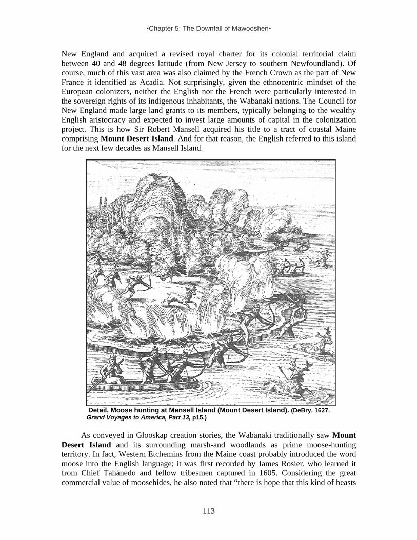
▪Chapter 5: The Downfall of Mawooshen▪
113
New England and acquired a revised royal charter for its colonial territorial claim between 40 and 48 degrees latitude (from New Jersey to southern Newfoundland). Of course, much of this vast area was also claimed by the French Crown as the part of New France it identified as Acadia. Not surprisingly, given the ethnocentric mindset of the European colonizers, neither the English nor the French were particularly interested in the sovereign rights of its indigenous inhabitants, the Wabanaki nations. The Council for New England made large land grants to its members, typically belonging to the wealthy English aristocracy and expected to invest large amounts of capital in the colonization project. This is how Sir Robert Mansell acquired his title to a tract of coastal Maine comprising Mount Desert Island. And for that reason, the English referred to this island for the next few decades as Mansell Island.
Detail, Moose hunting at Mansell Island (Mount Desert Island). (DeBry, 1627. Grand Voyages to America, Part 13, p15.)
As conveyed in Glooskap creation stories, the Wabanaki traditionally saw Mount
Desert Island and its surrounding marsh-and woodlands as prime moose-hunting territory. In fact, Western Etchemins from the Maine coast probably introduced the word moose into the English language; it was first recorded by James Rosier, who learned it from Chief Tahánedo and fellow tribesmen captured in 1605. Considering the great commercial value of moosehides, he also noted that “there is hope that this kind of beasts
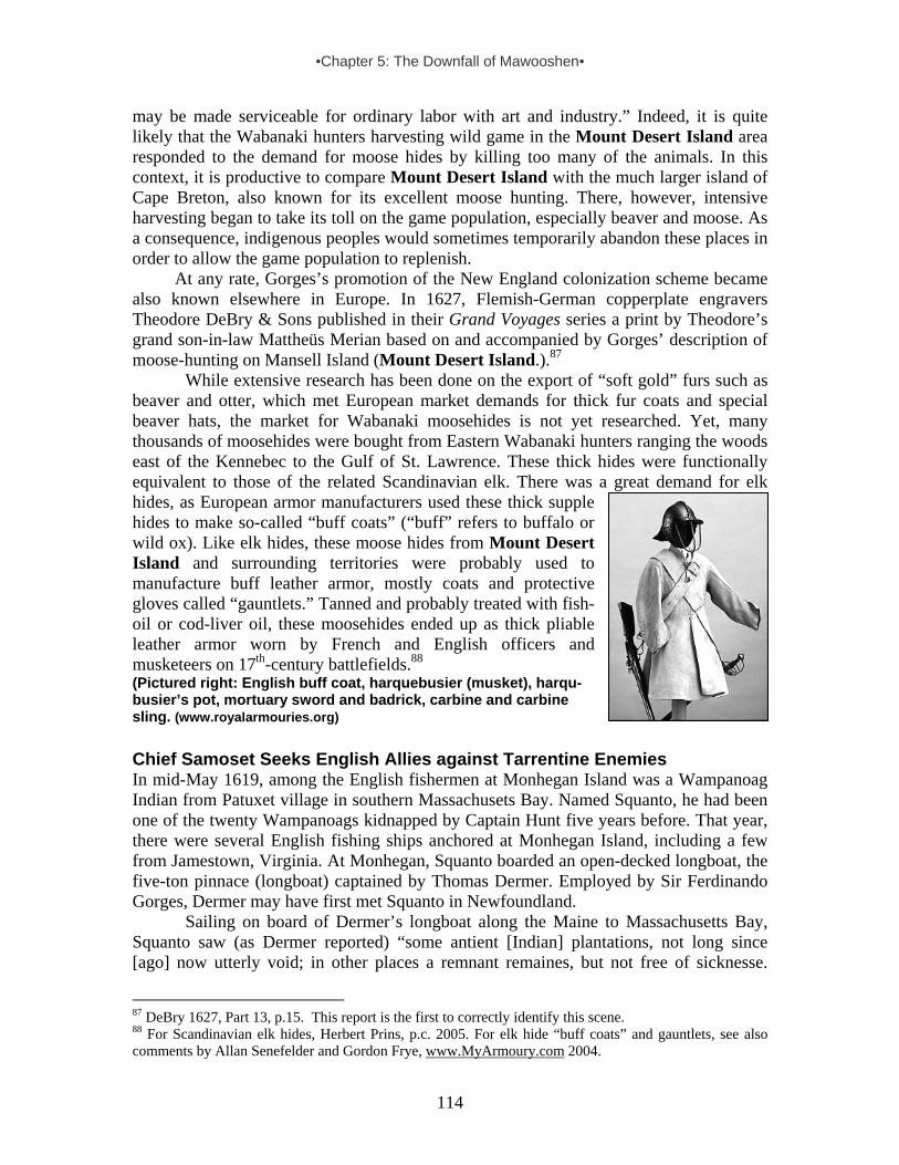
▪Chapter 5: The Downfall of Mawooshen▪
114
may be made serviceable for ordinary labor with art and industry.” Indeed, it is quite likely that the Wabanaki hunters harvesting wild game in the Mount Desert Island area responded to the demand for moose hides by killing too many of the animals. In this context, it is productive to compare Mount Desert Island with the much larger island of Cape Breton, also known for its excellent moose hunting. There, however, intensive harvesting began to take its toll on the game population, especially beaver and moose. As a consequence, indigenous peoples would sometimes temporarily abandon these places in order to allow the game population to replenish.
At any rate, Gorges’s promotion of the New England colonization scheme became also known elsewhere in Europe. In 1627, Flemish-German copperplate engravers Theodore DeBry & Sons published in their Grand Voyages series a print by Theodore’s grand son-in-law Mattheüs Merian based on and accompanied by Gorges’ description of moose-hunting on Mansell Island (Mount Desert Island.).87
While extensive research has been done on the export of “soft gold” furs such as beaver and otter, which met European market demands for thick fur coats and special beaver hats, the market for Wabanaki moosehides is not yet researched. Yet, many thousands of moosehides were bought from Eastern Wabanaki hunters ranging the woods east of the Kennebec to the Gulf of St. Lawrence. These thick hides were functionally equivalent to those of the related Scandinavian elk. There was a great demand for elk hides, as European armor manufacturers used these thick supple hides to make so-called “buff coats” (“buff” refers to buffalo or wild ox). Like elk hides, these moose hides from Mount Desert Island and surrounding territories were probably used to manufacture buff leather armor, mostly coats and protective gloves called “gauntlets.” Tanned and probably treated with fish-oil or cod-liver oil, these moosehides ended up as thick pliable leather armor worn by French and English officers and musketeers on 17th-century battlefields.88 (Pictured right: English buff coat, harquebusier (musket), harqu-busier’s pot, mortuary sword and badrick, carbine and carbine sling. (www.royalarmouries.org) Chief Samoset Seeks English Allies against Tarrentine Enemies In mid-May 1619, among the English fishermen at Monhegan Island was a Wampanoag Indian from Patuxet village in southern Massachusets Bay. Named Squanto, he had been one of the twenty Wampanoags kidnapped by Captain Hunt five years before. That year, there were several English fishing ships anchored at Monhegan Island, including a few from Jamestown, Virginia. At Monhegan, Squanto boarded an open-decked longboat, the five-ton pinnace (longboat) captained by Thomas Dermer. Employed by Sir Ferdinando Gorges, Dermer may have first met Squanto in Newfoundland.
Sailing on board of Dermer’s longboat along the Maine to Massachusetts Bay, Squanto saw (as Dermer reported) “some antient [Indian] plantations, not long since [ago] now utterly void; in other places a remnant remaines, but not free of sicknesse.
87 DeBry 1627, Part 13, p.15. This report is the first to correctly identify this scene. 88 For Scandinavian elk hides, Herbert Prins, p.c. 2005. For elk hide “buff coats” and gauntlets, see also comments by Allan Senefelder and Gordon Frye, www.MyArmoury.com 2004.

▪Chapter 5: The Downfall of Mawooshen▪
115
Their disease the Plague…” Continuing his letter, Dermer wrote, “When I arrived in my Savages native Country (finding all dead) I traveled alongst a daies journey Westward,” accompanied by Squanto. They encountered a local tribesman who was dispatched to Pokanoket, a major coastal village where the powerful chief Massasoit resided. Later, two chiefs and 50 Wampanoag warriors came to see Squanto and his English companions. After redeeming two Frenchmen, and additional coastal exploring, Dermer returned to Monhegan Island late June, finding his ship “ready to depart” for Europe. Meanwhile, Squanto “desired (in regard of our long journey) to stay with some of our Savage friends at Sawahquatooke (Sagadehock, on the lower Kennebec)…” Without Squanto, Dermer and his well-armed boat’s crew then set sail again in the pinnace, rounding Cape Cod, and landing at Martha’s Vineyard. At this island, then known as “Capaock,” Dermer “met with Epinew a Savage that had lived in England, and speakes indifferent good English…. With him I had much conference, who gave mee very good satisfaction in every thing I could demand…” From there on, Dermer sailed passed Long Island, arriving in Jamestown, Virginia, in late September.89
More than a year after Squanto’s return to his homeland, English Protestant colonists known as Pilgrims were dropped off at Cape Cod in late 1620, by the captain of a chartered English ship named the Mayflower. After a difficult winter in which many Pilgrims died, the survivors walked into the abandoned Wampanoag Indian village Patuxet in early 1621. This had been home to the tribesman Squanto, kidnapped seven years earlier, and had been abandoned due to the pandemic. Because this village was located within the bounds of royal land grant to the Council for New England, and the Pilgrim’s settling rights had been patented under the London Company, there was a problem. That same year, when the mistake (caused by the Mayflower captain’s cheating) was discovered, the Pilgrims secured the appropriate patent from the council and named their colony New Plymouth. Henceforth, living within the bounds of the Council for New England, they had Sir Ferdinando Gorges’s interest.
In mid-March 1621, the English Pilgrims received a surprise visit from a tribesman named Samoset, the first American Indian they actually met in person:
He very boldly came all alone and along the houses straight to the Randevous [rendezvous], where we intercepted him. . . ; he was a man free in speech and] of seemly carriage. [He] was starke naked, only a leather about his wast, with a fringe about a span long, or little more; he had a Bow and two Arrowes, the one headed, and the other unheaded [for bird hunting], he was a tall straight man, the haire of his head blacke, long behind, only short before, none on his face at all.90
The few small parts of Samoset’s life story we can still glimpse show us the great
geographical range of interaction between indigenous peoples from Mount Desert Island to Cape Cod, and beyond. Perhaps related to Chief Tahánedo and Skidwarres, Samoset was probably a Western Etchemin from the Pemaquid area, and would have been familiar with Penobscot Bay and Mount Desert Island, too. This would mean that
89 Dermer’s letter to Samuel Purchas, in Purchas, Samuel. 1907. Purchas his Pilgrimes (1625). Glasgow, pp.129-32.. Having wintered in Virginia, Dermer and his crew were killed by Indians in the Long Island area the following year. 90 Anon, “A Relation of Plymouth,” 1622, in Purchas, pp.330-31.

▪Chapter 5: The Downfall of Mawooshen▪
116
having survived the Tarrentine war and subsequent pandemic in his ancestral homeland, he had been staying for about eight months in southern Massachusetts. At the time, Samoset had been living at the Wampanoag village of Pokanoket, among Chief Massasoit’s people.
Samoset spoke “broken English” (like Tahánedo and Skidwarres), which he said he had learned from English fishermen at Monhegan Island. Certainly, it was good enough for the Pilgrims who had no problem communicating with him, using him afterwards as their guide in Massachusetts Bay. Indeed, as William Bradford, one of the leaders in this fledgling English Calvinist community noted, Samoset “was not of these parts, but belonged to [the] easterne parts, where some English-ships came to fish [at Monhegan Island], with whom he was acquainted. . . . Amongst whom he had gott his language. He became profitable to them in acquainting them with many things concerning ye state of ye country in ye east prts where he lived.”91
More information about Chief Samoset of Pemaquid is detailed in a 1622 Pilgrim account from New Plymouth: Samoset “knew by name the most of the Captaines, Commanders, and [ship] Masters, that usually come [to Monhegan Island]; … hee said he was not of those parts [southern Massachusetts], but of Morattiggon (Monhegan Island), and one of the Sagamores or Lords thereof, had beene eight moneths in these parts, it lying hence a daies saile with a great wind, and five dayes by Land: he discoursed of the whole Countrey, and of every Province, and of their Sagamores, and their number of men and strength.”92 Through Samoset, the Pilgrims also heard that the region’s Wampanoag who survived the “extraordinary plague” of 1617, “are ill affected towards the English by reason of one [Captain] Hunt… who deceived the people, and got them under colour of trucking [trading] with them, twentie out of this very place where we inhabite [Patuxet, now renamed New Plymouth], and seven men from the Nausites [Nausets, neighboring Wampanoag at Cape Cod], and carried them away and sold them for Slaves…”93
Quite certainly, Samoset and Squanto had met each other at Monhegan Island in the summer of 1619, and then traveled together from the central Maine coast to Wampanoag country in southern Massachusetts Bay. Because everyone in his home village at Patuxet had perished, Squanto and Samoset then were welcomed to stay for the winter months at Pokanoket.94 Probably feeling sympathy for the Pilgrims’s sorry lot, Samoset told the newcomers that Squanto “could speake better English then him selfe,”95 and went to get him, as well as Massasoit, helping to broker a long-lasting Pilgrim-Wampanoag peace treaty.
After leaving the Pilgrims at New Plymouth, Samoset may have briefly returned to Pokanoket and then traveled back home to the Pemaquid area. At the mouth of the Sheepscot River on the southern border of Western Etchemin Country, he was later mentioned by an English forester named Christopher Levett, when his ship was anchored at Cape Newagen, Boothbay, in 1623. Staying for four nights, Levett reported meeting there “Somerset [Samoset], a sagamore, one that has been found very faithful to the
91 Bradford 1912, pp.114-15. 92 Anon, “A Relation of Plymouth,” 1622, in Purchas, pp.330-31. 93 Anon, “A Relation of Plymouth,” 1622, in Purchas, pp.331-32. 94 Morton, p.245, n.2. Squanto died of an “Indean feavor” in 1622. See for additional details about his (mis)adventures, Vaughan 2006, pp.70-76. 95 Cited in Vaughan 2006, p72.
▪Chapter 5: The Downfall of Mawooshen▪
117
English, and hath saved the lives of many of our nation…”96 Chief Samoset later visited Levett’s short-lived trading post at Casco Bay, not far south from the aborted English colonial settlement at Kennebec. The sakom told the English trader that their sons “should be brothers and that there should be mouchicke legamatch (that is friendship), betwixt them.”97 No doubt, like other frontier chieftains in these troubled and chaotic times, he hoped a close relationship with his new English neighbor on the coast might protect his people from French-armed Tarrentine raiders. A few years later, an Englishman supposedly purchased a tract of land near Pemaquid from Samoset, but this early “Indian deed” is thought to be a fraudulent document.
Tarrentine Sea Raiders and New England Colonists After Samoset had returned home to Pemaquid, his Wampanoag friend Squanto advised the English Pilgrims of New Plymouth (Patuxet) in adapting to their new homeland and guided them in their regional reconnaissance. Through him they found out that their Indian neighbors at Massachusetts Bay “were much affraid of the Tarentins, a people to the eastward which used to come in harvest time and take away their corne, & many times kill their persons.”98 In 1622, Massachusetts Bay Chief Obbatinewat, who formed part of the political confederacy under Wampanoag grandchief Massasoit of Pokanoket (whose younger son was Metacomet, later known as “King Philip”), told the English “he durst not remain in any settled place, for feare of the Tarentines.”99
A year later, having sailed with Captain Robert Gorges, Sir Ferdinando’s son, to Massachusetts Bay, and exploring the southern Maine coast for potential settlement on behalf of the Council for New England, Levett wintered at Casco Bay.100 As he sailed from Piscataqua (dividing Maine from New Hampshire) to the Sheepscot River, the coast appeared desolate – void of indigenous human life due to warfare and disease. In fact, Levett did not see any tribespeople until anchoring in traditional Western Etchemin country at Cape Newagan. During his four-day stopover there “came many [Indians] with their wives and children, and some of good account amongst them. . . . They had some store of beaver coats and skins, and was going to Pemaquid to truck [trade] with one Mr. Whitherbridge, a master of a ship of Ba[rn]stable. . . . I wished them to bring all their truck to one Mr. Coke’s [fish drying] stage. Some of them did accordingly.”101
In addition to Chief Samoset (as already described), Levett reported visits by several chieftains of the region, including Sadamoyt, “the great Sagamore of the east country,” as well as Manawormet (Robin Hood’s father) and Skedraguscett (who later attacked Big Walt’s post at Richmond Island).102 These sagamores came from different regions and spoke “broken English,” sometimes even with each other, not “being able to understand one another in their [own] language.”103 This suggests that some of these tribespeople were Etchemins and others Abenakis (which makes sense, given their traditional alliance as part of Mawooshen. 96 Levett 1628, in Collections of the Massachusetts Historical Society, vol.2, p.87. 97 Levett 1628, in Coll. Mass. Hist. Soc., vol.2, p.92. The Mi’kmaq term for “a parner” is nigumaach. 98 Bradford, pp.126-30. 99 Mourt, p.126. 100 “Quack” was the Abenaki name for Casco Bay, now Portland. 101 Levett, p.87. 102 Levett, p.92. 103 Levett, p.97.
▪Chapter 5: The Downfall of Mawooshen▪
118
Unlike their Tarrentine neighbors, equipped with firearms since 1607, these tribespeople on Maine’s coast southwest of Pemaquid were still primarily armed with bows and arrows. As Levett noted, “Their weapons are bows and arrows; I never saw more than two fowling pieces [shot guns], one pistol, about four half-pikes and three cutlasses [short swords] amongst them, so that we need not to fear them very much.”104 Levett advised local tribespeople, “They should kill all the Tarrantens [Tarratines] they should see (being enemies to them) and with whom the English have no commerce.”105
In the mid-1620s, other English settlements were founded in Massachusetts Bay and clashed with the New Plymouth Pilgrim settlement. After the fall harvest in 1625, the Pilgrims sent a shallop loaded with corn up the Kennebec River and returned with a cargo of 700 pounds of beaver and other furs. That same year, Gorges and his associates in the Council for New England (formerly known as the Plymouth Company) sent Captain Wollaston to establish an Anglican settlement (at Quincy) in Massachusetts Bay. Also aboard was Thomas Morton, an Anglican soon accused by the Calvinist Pilgrims of selling firearms to the region’s Indian fur trappers. Competing Colonial Claims to Mount Desert Area In the 1620s, many English fishing ships could be found cruising the Maine coast, especially between Saco Bay and Mount Desert Island, at this time claimed and named by the English as Mansell Island. On this coastal stretch, English (and other European) fishermen frequently encountered Wabanaki hunters from different tribes and traded guns, knives, biscuits, cloth and coats, etc. in exchange for furs. In 1627, the Council for New England granted patents to the Pilgrims of New Plymouth on the Kennebec at Cushnoc. This English colonization company also granted other patents. For example, east of the Kennebec, the Council granted the 12,000 acre “Patent of Pemaquid” (including Damariscove Island with its year-round fishing station) to Robert Aldsworth and Giles Elbridge, two merchants in Bristol, Southwest England, who committed themselves to building a town on the Pemaquid River.106
Meanwhile, English Pilgrim merchants from Plymouth colony in Massachusetts Bay began trading “English hows” (garden hoes) for “Indian corn” (maize) and beans, south of Cape Cod.107 Soon, they also discovered the trade value of shell beads known as wampum, and in 1627 began importing stocks of these precious beads from Long Island for their profitable fur trade on the Kennebec, building a trading house at Cushnoc at the head of the tide (later the location of Fort Western, Augusta) the following year.108
These white and purple (“black”) shell beads were now being manufactured by Long Island Indians as tribute payments to their dominant Pequot neighbors on the Connecticut shore of Long Island Sound. The Dutch in Manhattan bought them in great volume. According to Dutch merchant Isaac de Rasieres, Long Island (NY) Indians “who are called Souwenos and Sinnecox [Shinnecock] . . . support themselves by planting maize [corn] and making sewan [wampum]. . . . The tribes are held in subjection by, and
104 Levett, pp.96-97. 105 Levett, p.93. 106 NEHGR vol.40, p.71; State Papers vol.6, p.137. 107 Bradford, p.155. 108 Cranmer, Leon E., 1990. Cushnoc: The History and Archaeology of Plymouth Colony Traders on the Kennebec. Augusta: The Maine Historic Preservation Commission. See also Prins 1986, pp.4-9.

▪Chapter 5: The Downfall of Mawooshen▪
119
are tributary to, the Pyquans [Pequot].109 They made wampum in wintertime from “cockle shells, which they find on the seashore, and they consider it as valuable as we do money here.”110 When English Protestants from Plymouth colony in southern Massachusetts Bay began trading with the Dutch Protestant colonists in the Hudson Valley (New Netherlands), they learned about the high value of wampum beads in the Indian trade. After the Dutch “told them how vendable [wampum] was at their forte Orania [Orange on the Upper Hudson River, now Albany],” Pilgrim merchants at Plymouth also entered “into the trade of Wampampeake [wampum, which] turned most to their profits.”111
Although we now possess just a few written records of seafaring Tarrentine raiders harassing the surviving remnants of once powerful Indian corn-growing villagers from Casco Bay to southern Massachusetts, these accounts are sufficient to show that the Mi’kmaq and Eastern Etchemins from the lower St. John and Passamaquoddy Bay remained a powerful coastal force in the years preceding large-scale English emigration to the New England colonies beginning in the late 1620s. In addition to Charles de La Tour supplying Tarrentine seafarers from his Cape Sable base on Nova Scotia’s southern tip, his father Claude de La Tour exchanged weapons, ammunition and other goods for furs at a trade post he had established at Pentagoet. During this time, both La Tours dominated the fur trade from Penobscot Bay to Nova Scotia. Although they lacked French military power, they defended their political and economic interests by means of their strategic alliance with the Tarrentines east of Penobscot Bay.
In 1627, when the Pilgrims obtained their patent from the Council for New England for a “fitt trading place in the river of Kenebec (which was built at Cushnoc at the head of the tide a year later), Charles de La Tour sent a message from his fortified post at Cape Sable to France that supplies and men should be sent to his father’s trading house at Pentagoet at the mouth of the Bagaduce. His request was turned over to a new French colonial trading association – Compagnie de la Nouvelle-France (also known as Compagnie des Cent-Associés). Formed in 1627 by Cardinal de Richelieu (mastermind behind the French throne who had managed to capture the French Protestant stronghold of La Rochelle on the French coast, forcing many of its unfortunate Huguenots into exile), this company had been given the exclusive right to the fur trade and to distribution of land grants (so-called seigneuries) to encourage colonial settlement of New France.112 In revenge of Richelieu’s capture of La Rochelle and the devastating blow the French government party had caused the Protestant religious cause and financial interests, Scottish merchant mariner Gervase Kirke (operating from the French Norman port city of Dieppe, a long-time base for privateering), made common cause with a rich and powerful fellow Scott, Sir William Alexander, the Earl of Stirling.
With Kirke, the Scottish earl recognized an opportunity to realize a colonization scheme based on his 1621 royal grant of Nova Scotia, or New Scotland. Together they outfitted a small fleet commanded by Kirke’s son David, an experienced sea captain. In the Spring of 1628, a mall convoy of the Earl of Stirling’s transport ships carrying Scottish colonists sailed out, protected by three well-armed swift vessels commanded by
109 In Jameson, p.103. 110 In Jameson, p.106. 111 Bradford 1647, p.281. 112 MacBeath, 1979g.

▪Chapter 5: The Downfall of Mawooshen▪
120
David and his two brothers. About the same time, the Company of New France had sent four ships back from a successful mission in France, laden with supplies for Quebec and Cape Sable. Claude de La Tour was aboard one of the ships, and not far from Newfoundland, the Kirke brothers attacked the convoy. The Scotts captured the ships and the elder La Tour, who was taken back to Europe where he managed to talk himself out of trouble and win Stirling’s favor.
With a substantial interest in the lucrative fur trade, English Pilgrims protested to Sir Ferdinando Gorges and his partners in the Council for New England about fishing captains selling alcohol and firearms to the region’s Indians and cheating these hunters out of their furs. In the late 1620s, the Pilgrim colony’s Governor William Bradford complained that “Indeans are full of peeces [shot guns] all over, both fouling peeces, muskets, pistols &c. They have also their moulds to make shotte, of all sorts, as musket bullets, pistol bullets, swane and gose shote, & of smaller sorts.”113 Tension between the neighboring English colonial settlers in Massachusetts Bay escalated quickly. In 1628, Pilgrim settlers captured Morton, accusing him of trading firearms with Indians and harboring runaway servants.
After Claude de La Tour had been captured by Sir David Kirke’s fleet in 1628, his son Charles remained in charge of the family stronghold at Cape Sable in southern Nova Scotia. After Kirke’s naval expedition against French positions in Acadia and Canada, culminating in the capture of Quebec in 1629, this fortified trading post, known as Fort Lomeron, became the sole French stronghold left in New France.114 Without the requested support and reinforcements from France, Charles de La Tour’s position on the frontier was precarious. Short of men, and curtailed from moving freely across the Gulf of Maine, he was unable to exploit or protect his father’s valuable Penobscot Bay trading post at Pentagoet. Thus, in 1629, English Pilgrim merchants from Plymouth Colony, who were already active in the highly profitable Kennebec fur-trade, seized the opportunity to make even more money and established one of their agents at Pentagoet (or “Penobscote” as they called it). With Claude de La Tour in Europe and his son Charles at his isolated outpost at Cape Sable, New England colonists were relatively free to expand their trading activities even further and stake out claims on the Wabanaki coast all the way up into the Bay of Fundy, where a colony of Scottish peasants was being settled at Port Royal.
Having taken over the trading post at northeast Penobscot Bay in 1629, the Pilgrim merchants from Plymouth colony discovered that the region’s Western Etchemins “have no corn growing,” and began shipping this food from Massachusetts to “Penobscote” at the mouth of the Bagaduce.115 They also introduced wampum from Long Island to the Penobscot Bay trade, which also encompassed Mount Desert Island.
In short, by the late 1620s the Pilgrims made corn and wampum from southern New England part of their fur-trade exchange in the Penobscot Bay area, including Mount Desert Island. The flow of wampum spread quickly to the rest of the Wabanaki coast: “[Plymouth merchants] had taken up [and] drawn down thither the greatest part of the trade, by carrying wampampeage thither, which none of the English had known the use of before.”116 Soon, merchants on the northern New England coast carried wampum,
113 Bradford, pp.287-88. 114 MacBeath, 1979g. 115 Bradford, History of Plymouth, p318. 116 Winthrop, History of New England, vol.1, pp.162-63.

▪Chapter 5: The Downfall of Mawooshen▪
121
such as “fathom of black wampum” and “rads of wampum-peak,” in addition to Virginia tobacco, bushels of corn, prunes, kettles, blankets, coats, shirts, stockings, and a strong alcoholic drink distilled from grain mash, like whiskey, known as aquavite. Often, they purchased these commodities from European fishing boat captains in exchange for furs, especially beaver, but also otter, musquash (muskrat), martin, fox and raccoon, etc. Indeed, beaver became the major means of exchange.117
Meanwhile, the Pilgrims found support in a fresh wave of English Calvinist settlers looking for a new homeland. Known as the Puritans, they formed a Massachusetts Bay colonization company and in 1629 acquired a land grant. Viewing this as an intrusion on its colonial domains, the Council for New England, headed by Ferdinando Gorges, carried out a long legal and political fight in England against this colonial charter, claiming its patent was “irregular.” Facing a host of troubles, from the wasting of large sums of money to claims and patents from various competing corporations and individuals, the Council tried but failed to successfully reorganize itself. Just before its abolition, it granted the wealthy Scottish nobleman Sir William Alexander, Earl of Stirling, a large tract of land adjoining Nova Scotia and extending from the St. Croix River to Pemaquid, and then up the Kennebec. Gorges’ own tract of land, the Province of Maine, stretched from the Kennebec to the Piscataqua River, where it adjoined New Hampshire, which had been granted to John Mason.118 In other words, as far as the wealthy aristocratic entrepreneurs in the British isles were concerned, Mount Desert Island formed part of Nova Scotia. Of course, the French had their own geopolitical dreams for the Wabanaki homeland. English Pilgrim Traders at Penobscot Bay, 1629-1635 As described above, with the French temporarily out of the way from Penobscot Bay to the St. John River (1628-1635), English Pilgrim merchants based in New Plymouth expanded their lucrative fur trade operations on the Wabanaki coast. In addition to wampum beads produced in large numbers by Shinnecock and other Long Island Indians and purchased from Dutch merchant mariners from Manhattan, the Pilgrim colonists also purchased large quantities of corn from Indian neighbors in southern New England and shipped it downeast for the Indian trade. In 1629, they expanded their fur trade operations from the Kennebec to Penobscot Bay. That year, they employed an adventurous young Englishman named Edward Astley to manage their Indian trade at Pentagoet, which they called “Penobscote.” This was the same strategic location where Claude de La Tour had established his trading house about fifteen years earlier, and where Bashaba had hosted the Western Etchemin’s traditional rendezvous.
The Pilgrim merchants supplied Astley with a variety of European trade goods, as well as wampum and corn “for the winter . . . for the Indeans of those parts [east of Kennebec] have no corn growing.” In exchange for the corn, Astley traded moose hides, beaver and other furs.119 Aware of the fact that the French and others sold the region’s Wabanaki hunters firearms, which they used more for hunting than warfare, Astley also provided them with “powder and shote” – against the rules of his English employers at
117 Provincial Papers of New Hampshire vol.1, pp.69-76. 118 State Papers vol.8, pp.200, 204. 119 Bradford, p.318.

▪Chapter 5: The Downfall of Mawooshen▪
122
Plymouth colony.120 The risk of reprisal for this was just one of Astley’s problems. His Pilgrim bosses were English Calvinist separatists who rigidly adhered to strict social mores, including sexual conduct. In their eyes, Astley’s behavior, resembling that of other young French fur traders on the Wabanaki coast (such as Charles de La Tour in Nova Scotia), was an abomination. As reported by New Plymouth’s governor William Bradford, Astley had “for some time lived among the Indeans as a savage, & wente naked amongst them and used their maners (in wch time he got their language. . . .).”121 While recognizing the usefulness of a fur trade agent in the Penobscot Bay and Mount Desert Island catchment area who actually knew how to communicate with his Wabanaki neighbors in their own language, the Pilgrims accused Astley of violating their sexual restrictions, referring to his behavior in terms of “uncleannes with Indean women.” Wary of Astley’s libertine activities, his employers at New Plymouth sent someone to watch him and keep him “in some good measure within bounds.”122
Astley’s moral guardian and watchman was a 19-year old named Thomas Willett, son of English Calvinist refugees in the Netherlands. Born in Leyden about 1610, Willet came to New England in 1629.123 Only about 20 years old at the time, Willet proved to be a reliable agent, but was less successful at controlling his freedom-loving partner. The Pilgrims then arrested Astley and sent the young adventurer back to England in 1630. Put on trial, Astley confessed to bartering gun powder and shot (not guns or alcohol) with the Indians at Penobscot Bay and surroundings, including Mount Desert Island, but argued that this took place prior to the 24 June 1630 prohibition. Nonetheless, he was found guilty and “imprisoned.”124
Soon after English fishing and fur trade merchants in Bristol relocated their operations from Monhegan Island to Pemaquid, where their agent Abraham Shurd (or Shurte) built a fortified warehouse on that strategic coastal location. From this place, established not far from the site once inhabited by Western Etchemin families headed by Tahánedo (who disappeared from the written record after 1614), Shurd provided supplies and food to English and French Acadian coastal fishermen – and also bartered with Wabanaki hunters trading furs and hides for “popular items such as English trading cloth, foodstuffs, tobacco, shot, [gun]powder, liquor and glass beads.”125 A French Warlord in the Gulf of Maine and his Tarrentine Allies Just northeast of Mount Desert Island, the colonial scramble for Wabanaki country had taken some chaotic turns after Captain Kirk’s 1628 raid of the fledgling French colonies of Acadia and Canada. As noted above, Kirk had captured Claude de La Tour, which enabled the Pilgrim merchants from New Plymouth to freely take over the Pentagoet trading post the following year. Although the elder La Tour had been captured and taken to England, his son Charles managed to remain at Cape Sable. Operating as a frontier guerilla commander and maintaining close relations with his Mi’kmaq wife’s relatives – the feared Tarrentines – Charles informed the French Crown that he “was constrained by
120 Bradford, p.327. 121 Bradford, p309. 122 Bradford, p170. 123 State Papers vol. 6, p140. 124 State Papers vol.6, p.140. 125 Bradley and Camp 1994, pp.6,252.

▪Chapter 5: The Downfall of Mawooshen▪
123
the bad treatment that we have received from Englishmen to live like the Indians and be dressed like them, hunt animals, and fish.” Accompanied by a “small band of Frenchmen with three medium-sized barks [sailing vessels],” he requested a formal commission to protect the French Acadian coast.126
Meanwhile, after being taken to England, 60-year-old Claude de La Tour had the good fortune of being introduced to a group of French compatriots associated with the English royal household of King Charles I. The king’s young wife, Queen Henriette Marie, was the daughter of Marie de Medici (who had given her royal blessing to the French Jesuit settlement scheme at Mount Desert Island) and the sister of French King Louis XIII. Somehow, La Tour impressed one of the queen’s’ (French-born) ladies-in-waiting, thereby winning a measure of royal favor. With such connections, this French Acadian entrepreneur became of interest to Sir William Alexander, the Earl of Stirling, who claimed much of French Acadia as Nova Scotia, including Mount Desert Island. Eying this territory recently conquered from the French as a place to “disburden” overpopulated Scotland, this Scottish aristocrat established a colony at the largely deserted French settlement at Port Royal. Having offered La Tour a newly-created aristocratic title as baronet of Nova Scotia, the earl counted on his help. So it was that La Tour (after marrying the lady-in-waiting) returned to Nova Scotia aboard one of Stirling’s well-armed vessels and sought to convince his son Charles to join the Scottish cause. Charles refused and his father re-boarded the Scottish ship. After a two-day siege, but having failed to take the French stronghold at Cape Sable by force, the Scots sailed on to Port Royal, leaving the younger La Tour alone. A handful of French settlers who had remained in the Bay of Fundy area were agreeable to Scottish allegiance, not entirely surprising in this era prior to the development of nationalist ideologies and identities.
But, Charles de La Tour was not left entirely alone at Cape Sable. Early in 1630, two vessels of the French colonial trading Company of New France finally arrived at his coastal stronghold in southeast Nova Scotia “with supplies and a relief party including workmen, artisans and three [Capuchin] priests. Bernard Marot, the leader of the expedition, brought with him letters from the company appointing La Tour as one of its associates and explaining that the food, arms and men had been sent to enable him to build a habitation wherever he felt it would be most useful. The workmen were soon set to the task of enlarging and strengthening the post at Cape Sable, and Fort Lomeron was apparently renamed Fort La Tour (although Champlain called it “Fort saint Louys”).127
Although Scotts were settled at Port Royal, and ever-growing numbers of New England fishermen and traders expanded their activities over the entire length of the Wabanaki coast, Charles de La Tour was rewarded with grand titles in 1631 when he was temporarily named the French king’s lieutenant-general of New France and governor of Acadia. Solidifying his position on both sides of the Bay of Fundy, Charles La Tour expanded his operations in 1631 by building a fortified trading post at the mouth of the St. John River. He appointed his lieutenant Jean-Daniel Chaline in charge of this important stronghold, naming it Fort Sainte-Marie, the “first permanent [European]
126 Our translation, in Reid, pp.29-30; see also Prins 1996, p.62. 127 Champlain 1922, vol.4, p.199, cited in MacBeath 1979g; years later, when the term Tarrentines fell in disuse, New Englanders referred to these Tarrentines, in particular Nova Scotia Mi’kmaq, as “Cape Sable Indians.”

▪Chapter 5: The Downfall of Mawooshen▪
124
establishment on the Saint John.”128 From both fortified bases, La Tour was strategically well positioned to block and push back enemy penetration. As already noted, he and a handful of fellow Frenchmen did so with the help of his Mi’kmaq and Eastern Etchemin relatives, friends, and trading partners, feared and hated in New England as Tarrentines.
That same year, in 1631, these seafaring Indian raiders from Nova Scotia and the Bay of Fundy were active south of the Merrimac River in northern Massachusetts:
The Tarrentines, to the number of one hundred, came in three canoes [two fishing shallops], and in the night assaulted the wigwams of [Massachusetts Bay] sagamore of Agawam [Ipswich], by Merrimack, and wounded [the two sons of Massachusets Bay Chief Nanapeshamet] John Sagamore, and James, and some others, (whereof some died after) and rifled a wigwam where Mr. Caddock’s men kept to catch sturgeon, took away their nets and biscuit. . . .” 129 [These Tarrentines also carried away Indian captives for ransom,] amongst whom was the wife of said James, which they sent again by the mediation of Mr. Shurd [fur trader] of Pemquid [Pemaquid], that used to trade with them, and sent word by him that they expected something in way of ransom. This sagamore [Masconomo] of Agawam [Ipswich, Massachusetts] had treacherously killed some of those Tarratines’ families, and therefore was the less pitied of the English that were informed thereof.130
In return for sending these Masssachusetts Bay Indian captives back home, the
Tarrentines demanded ransom in the form of “Fathoms of Wompampeag [six-feet long strings of wampum beads], and Skins.”131 As already noted, both wampum and beaver were valuable means of exchange on the frontier of early colonial Maine—functioning in effect as what anthropologists call “special purpose money” used not only by Wabanaki but also by English fishermen and coastal settlers in this early colonial period.
Apparently, the Tarrentines planned to carry their raid further south into Massachusetts Bay and to attack Chief Casconomo of Agawam [near Ipswich]. However, having been forewarned, these corn-growing Massachusett Indians were prepared and the assault failed:
The Terrateens or Easterly Indians had a design to cut [the very earliest English colonists at Ipswich who had settled near Agawam] when they had [only about] 30 men, old and young. . . . It was thus one Robin, a friendly Indian, came to [a young English settler living] in a little hut upon his father’s island [in Massachusetts Bay], and told him that . . . there would come four Indians, to draw him to goe downe the Hill to the waterside, to truck [trade] with them, which if he did, he and all neare him would be cut off; for there were 40 burchen canoues [bark canoes], would lie out of sight, in the brow of the Hill, full of Armed [Tarranteen] Indians for that purpose.132
128 MacBeath, 1979g. 129 Winthrop, pp.71-72. (Note: Hubbard, p.145 glossed this error later as thirty canoes!). 130 Hubbard, General History, p.145. 131 Prince 1755, p.34. 132 Cobbet 1677, in NEHG vol.7 (1853), pp.210-211.
▪Chapter 5: The Downfall of Mawooshen▪
125
And so the Tarrentines, secretly supplied and militarily backed up by La Tour’s fortified trading posts on the lower St. John River and at Cape Sable in southern Nova Scotia, continued to stir fear among Abenakis and other “Armouchiquois” as far south as Cape Cod. As reported by the English, the Indians from the Massachusetts and New Hampshire coastal region
doe feare them as their deadly enemies; for so many of them as thery meets they kill. About 2 yeares agoe [1632], our Indians being busie about their accustomed huntings, not suspecting them so neere their owne liberties, were on the suddaine surprised by them, some being slaine. . . . These Indians are the more insolent, by reason they have guns which they daily trade for with the French [La Tour], (who will sell his eyes as they say, for beavers) but these doe them more credit than service: for having guns they want powder, or if they have that, they want shot, something or other always wanting: so that they use them for little, but to salute coasting boates that come to trade, who no sooner than anchor in any harbour, but they present them with a vollie of shot, asking for sacke [dry white wine] and strong liquors, which they so much love since the English used to trade it with them, that they will scarce trade for anything else, lashing out into excessive abuse, first taught by the example of some from English who to uncloathe them of their beaver coates, clad them with the infection of swearing and drinking, which was never the fashion with them before, it being contrary to their nature to guzell downe strong drinke, or use so much as to sippe of strong waters, until our bestiall example and dishonest incitation hath brought them to it; from which I am sure sprung many evil consequens, as disorder, quarrels, wrongs, unconscionable and forcive wresting of beaver and wampompeage [wampum].133 About the same time, expanding their own lucrative fur trade operations downeast, a
wealthy Pilgrim merchant from Plymouth colony established a third small trading house and fishermen's quarters at Machias in 1632. In an effort to gain a measure of control over the coastal fur trade and the region’s Wabanaki, the Council for New England ruled about this time that “no fishermen allowed to trade with the savages, nor with the servants of the planters.”134 On the Wabanaki coast, of course, this English decree was just another piece of paper. Saint Germain Treaty (1632): French Restored to Eastern Wabanaki Coast While grandiose claims made in fabulous speeches at conference tables in European palaces, castles or merchant company headquarters were often precisely that, Wabanaki warriors, French, English, and Scott seamen battled out the empirical reality in bloody skirmishes in the wild downeast. So it was with an important 1632 peace treaty signed in France between two young royal in-laws, King Louis XIII of France and King Charles I of England. According to this agreement known as the Treaty of Saint-Germain, “All the
133 Wood 1634, 1865, pp.67-68. 134 State Papers vol.6, p.156.

▪Chapter 5: The Downfall of Mawooshen▪
126
Forts as well in L’Accadie as in Nova Francia should be restored into the Possession of the Subjects of the French King.”135
As far as the French were concerned, all English moves from Penobscot Bay to the Bay of Fundy were infringements on French colonial claims, which they maintained stretched minimally as far as Matinicus Island (as Biencourt’s action in 1611 already made clear). But New Englanders had a different view and naval skirmishes continued. On 18 September 1632, six months after the treaty was signed, “a force of Scots from Port-Royal under command of Capt. Andrew Forrester attacked the new [French Acadian] fort [Sainte-Marie at the mouth of the St.John], tore down a large cross, damaged the chapel, and plundered the supplies.”136 Rounded up as prisoners, La Tour’s lieutenant Chaline and his troops defending the fort were “taken to the vessels, as were the 1,550 pelts, the food, small arms, and powder seized. . . . Forrester sailed [his fully laden ship] to the fledgling Scottish colony at Port-Royal [not yet reclaimed by the French, despite the recent treaty] where he landed the captured goods, and then took the [French] prisoners to Pentagouet [Castine] where they were turned over to the English.”137
Finally, nine months after the treaty was signed, the French formally reclaimed Port Royal and Charles de La Tour came under command of the king’s newly-appointed lieutenant general for New France and governor of Acadia, Isaac de Razilly. In December 1632, Razilly and his men sailed into the Bay of Fundy, anchoring before the Scottish fort in Port Royal. He presented the fort’s commander Forrester the official treaty order from the French and English Crowns, entitling him to take possession. The Scottish commander “complied, and soon after he and the 41 Scottish pioneers [29 of the 70 had died of scurvy the first winter] who chose to return home were given passage in the French vessel Saint-Jean. They landed in England early in February 1633.138
Given the vagaries of the 1632 treaty, it is not surprising that frontier naval skirmishes continued for a time. The problem of course, was the unsettled question of just where the boundaries of Acadia lay. And if Nova Scotia had been the new name for French Acadia, where was its boundary with New England? At the Bay of Fundy? Or was it the St.John, St.Croix, Penobscot, St.George, or even Kennebec River? Of course, if the boundary was at Penobscot or even further south, Mount Desert Island would be considered part of Nova Scotia.
For the next three years, the Anglo-French colonial frontier on the Wabanaki coast remained lawless in terms of official jurisdiction. In this maritime frontier territory, piracy became commonplace. Indeed, in addition to the seafaring Tarrentines who paid little or no attention to Europeans assertions over their ancestral territories, there were also some renegade European sea captains who raided coastal settlements or ships for profits. Unlike Captain Argall, who operated with official permission from a recognized government, these unauthorized raiders were considered pirates. From the 1620s onward, as French and English authorities competed for control over the Gulf of Maine, its coastal fisheries and trade, they repeatedly found that it was far easier to issue proclamations and draw maps delineating claims of sovereignty than it was to actually rein in these coastal
135 In Baxter vol.4, p.234. 136 MacBeath, 1979b. 137 MacBeath, 1979b. 138 MacBeath, 1979b.

▪Chapter 5: The Downfall of Mawooshen▪
127
domains. In this uncontrolled arena, maritime entrepreneurs could enrich themselves and literally get away with murder.
During these years, Mount Desert Island, Penobscot Bay and the rest of the Maine coast became a haven for pirates such as Dixie Bull and a group of fellow English sailors “who kept about the East . . . and had taken divers [English] boats, and rifled Pemaquid, etc.”139
For Etchemin Indian families still frequenting their favorite hunting, fishing and gathering sites in the greater Mount Desert Island area, once part of their great chief Asticou’s island domain, it made little or no difference whether the people who cheated or killed them were pirates, merchants, soldiers or officers. As far as their interests were concerned, all outsiders were intruders motivated by greed.
◘ ◘ ◘ ◘
139 Winthrop, p.114.

▪Chapter 5: The Downfall of Mawooshen▪
128

▪Chapter 6: Contested Island in the Shadow of Fort Pentagoet▪
129
CHAPTER 6: CONTESTED ISLAND IN THE SHADOW OF FORT PENTAGOET
Fleet of Tarrentine and Acadian shallops. (Oil by Nelson Surrette.) Decline of the Tarrentine Raids 1629-1635
New England reports about seafaring Tarrentines raiding from the Kennebec down to Massachusetts Bay stopped after 1632. The reasons for this were multiple. As relayed in the previous chapter, Tarrentine sea-raiders did not operate independently from their French allies in the region. After the news of the Anglo-French peace treaty of Saint Germain (1632) also reached the Gulf of Maine, Acadian fur traders like Charles de La Tour stopped operating as maritime guerilla commanders interested in creating havoc for New England colonists south of Penobscot Bay. Tarrentine’s seaborne raids may have also declined because fast-rising numbers of well-armed English immigrants settling in the newly-vacated coastal territories made their long-distance expeditions far too risky.
More importantly, another devastating smallpox epidemic struck in the spring of 1633, nearly wiping out the entire remaining indigenous coastal population from Penobscot Bay to Rhode Island. Survivors of the epidemic in the region were too few in number and too impoverished to attract these long-distance seafarers from downeast. Tarrentine traders and raiders were also discouraged in that they had already faced decimation in earlier epidemics and still lacked immunity to most foreign diseases. Colonial fur-trade merchants also avoided bartering with New England’s Indians in the affected areas.1 That said, many early Protestant colonists in Massachusetts were already immune to the highly contagious and often deadly smallpox virus. Relatively free of suffering, they interpreted the fact that this epidemic ravaged Indian communities almost exclusively as a sign of God’s will – an “awful and admirable dispensation [by which] it pleased God to make room for his people of the English nation.”2
Yet, French raids against rival English fur-trade posts from the Bay of Fundy to Penobscot Bay continued. Soon after the 1632 Anglo-French peace treaty became known in the Gulf of Maine, a French longboat sailed from the Bay of Fundy past Mount Desert Island, into Eggemoggin Reach and onward to Pentagoet at the mouth of the Bagaduce. The ship’s commander was probably Charles de La Tour, enjoying his new status as 1 Winthrop, pp.146-47 2 Cited in Young, pp.386-87

▪Chapter 6: Contested Island in the Shadow of Fort Pentagoet▪
130
French Acadia’s military commander. Newly-supplied and fortified at his trading posts at Cape Sable in southern Nova Scotia and on the lower St. John River, he “rifled” the English Pilgrim trading post established at the location where his father used to barter furs with region’s Etchemin hunters and trappers. Aided by a “false Scot,” the French raiders killed two of the few Englishmen trying to defend this trading post, and “tooke all their goods to a good valew,” including “coats, rugs, blankett, biskett, &c.”3 According to Pilgrim merchants, the marauders carried off “three hundred weight of beaver and other goods.” But, lacking the manpower to hold the place, the longboat sailed off, leaving it to the Pilgrim fur-trade agent Thomas Willett, who continued his sailing jaunts between Penobscot and Massachusetts Bay, hauling wampum, corn, beaver and other trade goods.4
Determined to revenge the Scots’ 1632 attack on his fort at the St. John, Charles de la Tour again took action againt English rival merchants on the Etchemin coast in 1634. With a party of French and [Tarrentine] Indians, he captured and ransacked another poorly-defended English Pilgrim furtrade post. Together with some business associates, a wealthy merchant from Plymouth colony “had set up a trading wigwam [at Machias], and left in it five men and store of commodities. La Tour, governor of the French in those parts, making claim to the place, came to displant them, and, finding resistance, killed two of them, and carried away the other three, and the goods.”5 La Tour, then married to a Nova Scotia Mi’kmaq woman, warned New Englanders (merchants and fishermen alike) that “if they traded to the east of Pemaquid, he would make prize of them.”6 In other words, the French reclaimed Mount Desert Island and Penobscot Bay, as stipulated in the 1632 Treaty of Saint-Germain.
Meanwhile, as far as Sir Ferdinando Gorges and his fellow aristoctrat investors in the British Isles were concerned, their colonial joint venture folded when the Council for New England surrendered its royal charter in 1635, which greatly pleased English Protestant settlers in Massachusetts Bay. Iroquois Raiders and French Missionaries in Wabanakiak, 1643 The European colonial scramble for North America caused enormous upheaval for the indigenous peoples, all of whom were profoundly traumatized and decimated by repeated waves of diseases and cycles of warfare coming in the wake of the furtrade. Indeed, some Indian nations were wiped out and others were so diminished in numbers that they ceased to exist as distinctive ethnic groups. Facing major challenges, fragments of once proudly independent communities reorganized, adopting scattered individual survivors and dispersed remnants of family groups or clans. Even refugees and captives from other ethnic groups were often welcomed to add manpower. Trying to secure a future for their people, Wabanaki leaders were often forced to bury old resentments against former rivals. In this context, it is not surprising that the insulting term Armouchiquois (“Dog People”) for Abenaki Indians also gradually disappeared from the record. In addition to rebuilding relations or strengthening ties with indigenous neighbors, Wabanaki leaders also created or reinforced political alliances with French neighbors in Acadia and
3 Bradford, pp.349-51. 4 NEHGR vol.6, pp.157-64. 5 Winthrop, p.139; see also Kidder, p.34. 6 Winthrop, History of New England 1849 vol.1, p.184.
▪Chapter 6: Contested Island in the Shadow of Fort Pentagoet▪
131
Canada. French missionaries, who had learned to speak native languages and often understood local cultural customs, played a major role in this transformative process, which also affected the Wabanaki ranging the greater Mount Desert Island area – as discussed later in this chapter and others to come.
With all the intensive trapping in Wabanaki forests and streams, hunters may have started to run short of furs needed to buy commodities on the coast. However, Wabanakis on the Maine coast acquired wampum from English traders and with that they could exhange furs with Indian bands trapping deeper into the hinterland, all the way into the St. Lawrence valley. By 1637, Abenakis from the Kennebec were visiting the St. Lawrence Valley to purchase furs from Indians in Canada’s interior woodlands in exchange for wampum. On their long-distance fur-trade journeys from the New England coast, they carried with them contagious foreign viruses and bacteria, infecting all the people they came in contact with, thereby causing the spread of these horrible diseases (especially smallpox) in tribal communities not yet in direct contact with Europeans.7
The expanding fur trade not only caused the rapid spread of epidemics that wiped out large numbers of American Indians, but also introduced alcoholism as a slow form of suicide. Moreover, the cycle of inter-tribal conflicts known as “beaver wars” escalated, taking an especially violent turn when Algonquian-speaking peoples like the Wabanakis competed with Mohawks residing west of the Upper Hudson River. Deeply hated and feared, the Mohawk (a New England Algonquian name meaning “”man-eater,” or “cannibal monster”)8 were known as Meguak by Abenakis on the Kennebec and Meqiyik by Etchemins from Penobscot Bay to the St. John River, including Mount Desert Island.9 These Mohawks were closely allied with four neighboring Iroquois nations, forming a Confederacy of Five Nations they called the Houdénosaunee (“People of the Long House”).10 However, Wabanakis usually did not distinguish between the different Iroquois nations, simply lumping them all as “Mohawk.”
In the early 1640s, Mohawk war parties began to penetrate deep into the northeastern Algonquian tribal territories, even reaching Abenakis “along the seashore above the place where English were settled.”11 Fearing annihilation, and unable to depend on their English neighbors, Abenaki ambassadors from the Kennebec traveled to the French Jesuit mission village of Sillery near Quebec to meet with Algonquins and Montagnais in order “to bind our two tribes by a perfect friendship.” The French Catholic mission Indians in the St. Lawrence valley informed their Abenaki visitors that to become military allies they must also be baptized as Christians.12 However, exasperated by the English trading alcohol with Abenakis on the Maine coast, the Jesuits at Sillery had a low opinion of these Indians as “an utterly infidel nation” given to drunkenness.13
In the spring of 1643, a Mohawk war-party that had set out to raid Abenaki country the previous fall, returned from their raid along the Maine coast with 22 captives, including six Abenaki warriors who were tortured to death. This group of Mohawks had 7 JR vol.16, p.101. 8 The English name is derived from Narragansett name for these Iroquois, namely Mohowawog. The Mohawk referred to themselves as Kaniengehaga, “People of the Flint.” See also Tooker 1978, p.478. 9 Joseph Nicolar (1893, pp.127-36) spells the Penobscot name for the Mohawk as May-Quay. 10 See also Jennings 1984. 11 Talbot 1935, p.273. 12 JR vol.25, pp.117-119; see also JR vol.24, pp.59-61 13 JR vol.24, p.117.
▪Chapter 6: Contested Island in the Shadow of Fort Pentagoet▪
132
joined other Iroquois raiders “and all through the winter had spread terror throughout the Abenaki lands.”14 In the following two decades, many more violent raids, captivities, diseases, and other calamities occurred, far too many to detail here. French Trading Post at Fort Pentagoet, 1635-1650 Quarrels and skirmishes over the Wabanaki coast flared between French and English fur traders, fishermen, settlers, merchant mariners and, last but not least, government officials and military officers. It was one thing to acquire official trading rights or monopolies, but quite another to enforce them against interlopers and intruders on this unregulated and very thinly inhabited shore. This was especially true for the insecure and perpetually contested Penobscot Bay area, including Mount Desert Island.
In 1635, with Acadia’s new French Governor Isaac de Razilly at his headquarters in Nova Scotia’s small town of Port Royal, Charles de la Tour took a second seat there and moved his headquarters to his recently-restored Fort Sainte-Marie on the lower St. John. He maintained Cape Sable as a satellite trading post. According to French Acadian fur trader Nicholas Denys, who had come to Acadia with Razilly, the St. John River was “the richest source of furs in all Acadia,” where La Tour traded as many as 3,000 moose hides a year. French demand for these thick hides for the production of military overcoats and protective gloves was as great as English demand for those harvested at Mount Desert Island and surrounding terrritories in Pentagoet’s fur-trade catchment area.
Apparently, Charles de la Tour got on well with Razilly and “under their direction trade flourished and settlers were attracted to the land.”15 However, Razilly allocated the region west of the St. Croix River, including Mount Desert Island and Penobscot Bay to his lieutenant-governor, d’Aulnay. He instructed d’Aulnay to retake the English Pilgrim fur-trade post at Pentagoet, established about 20 years ago by Charles’ father, Claude de La Tour. Since 1929, English merchants of Plymouth Colony had controlled the place, and Razilly directed the younger La Tour to help d’Aulnay dislodge them. As it turned out, d’Aulnay captured the place and defended it against English counterattack without the help of Charles, who felt that this lucrative post belonged to his family.16 Thus, after six years of profitable trade with Etchemins and other Wabanakis visiting the Penobscot Bay post, the Pilgrim merchants were forced to recall their agent Willett: “A French came with commissions from the King of France. . . . And took Penobscott, a Plimouth trading house, and sent away the men which were in it, but kept their goods.”17
Having ousted the English Protestant merchants from their trading posts at Machias and Penobscot, the French regained official control over their fledgling colony of Acadia. For the next two decades, Muscongus Bay (where remnants of Chief Tahánedo’s Western Etchemin community still ranged the jagged Wabanaki coast) became the new factual New England colonial frontier.
Toward the end of 1635, Razilly died unexpectedly and his cousin Cardinal de Richelieu announced that d’Aulnay would succeed him as French Acadia’s governor. However, Charles de la Tour – based on long-established rights in the area and loyal service to the French Crown – claimed the same prerogatives as d’Aulnay. To solve the
14 Talbot 1935, pp.273-74. 15 MacBeath 1979g. 16 Baudry 1979c. 17 Winthrop, pp.200-205.

▪Chapter 6: Contested Island in the Shadow of Fort Pentagoet▪
133
conflict, Richelieu granted d’Aulnay exclusive trading privileges on “the Etchemins Coast,” including Mount Desert Island, ordering him to respect La Tour’s rights at the lower St. John.18 Nonetheless, their rivalry would intensify as the years went by.
Almost annually in the years that followed, d’Aulnay sailed to France “with pelts, fish, or masts, and brought back supplies. He borrowed funds, hired ships, and recruited men.”19 Moreover, he transformed Pentagouet into a well-fortified stronghold. While d’Aulnay was at Penobscot Bay, Claude de La Tour retreated to his son’s trading post at Cape Sable – and died there in 1636. After his death, the Company of New France (where the La Tour family could number some friends) granted the “vieux-logis” [old lodge] at Pentagouet to his son Charles.20 Already-strained relations between Charles and d’Aulney became openly hostile when both d’Aulnay and Charles de la Tour tried to get their hands on the fur trade from the St. Croix and Passamaquoddy Bay area, which was exceedingly productive. They had an arrangement in which they shared the expenses and the profits of the trade. However, there was so much friction between them that La Tour (who continued to feel entitled to the Penobscot Bay area trade in part because his father had first established it) was accused of inciting the Indians against d’Aulnay. In 1639, he even “intercepted a pinnace [longboat] sent to Pentagouet and to have held the nine men of the crew prisoner.”21
In 1640, d’Aulnay assigned Basque sea captain Bernard Marot “to reinforce the garrison at Fort Pentagouet on the Penobscot”22 – as much against the English as against his bitter rival Charles de la Tour. He had reason to boost his defenses:
In 1640 d’Aulnay . . . returning from Pentagouet with two small ships [probably one commanded by him, and the other by Marot?], came under cannon-fire from La Tour, and one of his vessels lost its mast. This rash aggression turned to La Tour’s disadvantage: Pierre Jamin, the captain of his ship, was killed; La Tour himself, as well as his lieutenant Desjardins Du Val, and the whole crew were taken prisoner. On the intervention of the Capuchins, an agreement was made whereby La Tour recovered his liberty, while the matter was reported to France. These incidents marked the start of a minor war between the king’s two lieutenants in Acadia. The struggle caused the loss of several lives, engendered a goodly number of useless proceedings and negotiations, consumed their energies and their money for five years, and left them both half ruined.23 Attacks ran in both directions: In 1640, d’Aulnay sacked Charles de la Tour’s fort at
Cape Sable. Forced to surrender the stronghold to his rival, La Tour was temporarily left with only the fortified trading post on the lower St. John River. That same year the Dutch made a number of forays on the Acadian coasts, so that d’Aulnay had to simultaneously defend his frontier stronghold at Pentagoet and assure the safety of the fledgling colony of Acadia, both under perpetual threat. The ongoing feuding included Charles de la Tour’s 1643 capture of d’Aulnay’s longboat as it sailed from Penobscot Bay (probably 18 Winthrop, pp.200-205. 19 Baudry 1979c. 20 Baudry 1979c. 21 Baudry 1979c. 22 MacBeath 1979d. 23 Baudry 1979c.
▪Chapter 6: Contested Island in the Shadow of Fort Pentagoet▪
134
through Eggemoggin Reach towards Mount Desert Island) loaded with “400 moosekins and 400 beaverskins.”24
Both French traders accrued outstanding debts.25 “To help in the support of the colony, [d’Aulnay] adopted the expedient of felling trees, organized seal hunting, and developed agriculture.”26 Also, both he and La Tour did extensive business at Pemaquid and even farther down the New England coast, dealing with their English counterparts who no doubt provided them with wampum and corn. La Tour’s efforts to oust his rival d’Aulnay from Pentagoet in 1639 and 1640 were not welcomed by the French authorities, who revoked his commissions and stripped him of his official titles. On the colonial frontier, as La Tour had learned early on, such titles could be worthless unless backed up by fur-trade wealth and guerilla manpower, both of which he still possessed.
Beginning in 1644, d’Aulnay began to “send his ships to patrol along the coasts in order to seize the fishing vessels engaged in trading in pelts and he had also seized some ten ships from the Basque country, Bordeaux, and Brittany.”27 At least once, English traders at Pemaquid and Saco assisted La Tour in his struggle against d’Aulnay, thereby keeping their immediate neighbor at Penobscot Bay from becoming too powerful. Joining 20 of La Tour’s men they attacked Fort Pentagoet at a time when the settlement “was weakly manned and in want of victuals.” Although they did not attack the fort itself, they did burn a French farmhouse near the fortress.28 Accused of treason by d’Aulnay, La Tour sought help from Protestant merchants in Boston. In 1645, d’Aulnay sailed with a strong force to Fort Sainte-Marie on the lower St.John, where La Tour’s 43-year-old (second) wife Francoise Jacquelin directed the defense in her husband’s absence. After fierce fighting killed 33 of her men and wounded many others, she surrendered. Then, with a rope around her neck, this formidable woman was forced to witness the hanging of all remaining survivors. A few weeks later, she died in captivity while her husband managed to escape to the St. Lawrence valley where he participated in French Canadian military campaigns against the Iroquois and did some trading for the next five years. Jesuit Missionaries Return Briefly to the Wabanaki Coast After the Jesuit mission at Mount Desert Island had been destroyed in 1613, the Jesuit order re-established itself in the St. Lawrence Valley. In Acadia, however, they were replaced by the Capuchins, a Franciscan order sent to New France by Cardinal de Richelieu. Capuchins first entered the region in 1630, when a few of them were posted at La Tour’s isolated stronghold at Cape Sable. When Port Royal returned to French control, they established their headquarters there, remaining until 1654, when the English sacked Port Royal for the third time. D’Aulnay, who had succeeded de Razilly as the Governor of the coasts of Acadia and the Etchemins, became a protector of the Capuchins (12 priests for all of Acadia). Although their headquarters remained at Port Royal, Capuchins were also established at Fort Pentagoet in Penobscot Bay at the invitation of d’Aulnay. There, with a house of their own and a chapel, they served French garrison troops and laborers assigned to the post, as well as French and Basque fishermen
24 Winthrop, p.217. 25 Winthrop, p.217. 26 Baudry 1979c. 27 Baudry 1979c. 28 Dean, pp.90-91.

▪Chapter 6: Contested Island in the Shadow of Fort Pentagoet▪
135
in the area. Beyond service for their fellow Catholic Europeans, these Capuchins “had long desired to see missions established among the Indians of those quarters.”29
In the mid-1640s, the Puritans in Massachusetts Bay Colony began establishing English Protestant missions, aiming to draw the scattered Indians who had survived epidemics to settle in “praying towns,” such as Natick near Boston. Meanwhile, in the summer of 1646, “two Abnaquiois [Abenaki] captains came to Monsieur the governor [in Quebec], to beg him to make arrangements for a black gown [Jesuit] to go to the Abnaquiois, to instruct them.”30 Referring to these Abenakis from the Kennebec as Canibas, a Jesuit historian later wrote: “For some time the Canibas had frequented Sillery, and some were even baptized there. . . . Deputies of the Canibas Nation went to Quebec to visit the [Jesuit] superior to solicit a missionary.”31
Jesuit missionary Gabriel Druillettes responded to the invitation, having been instructed in the “Indian language” (Mi’kmaq and/or Etchemin) of Acadia by Father Massé, the old and experienced Jesuit priest who 30 years earlier had been stationed at Port Royal and then at Mount Desert Island. With the permission of French Capuchin priests stationed at Fort Pentagoet, Father Druillettes traveled from Quebec to Norridgewock and other Abenaki villages in the Kennebec valley.32 After nine months (1646-1647) among these Abenakis, he returned to Quebec. Then, in early 1650, he journeyed back to the upper Kennebec to spend time with the Abenakis again: “As soon as the news of the Father’s return was carried to the other villages [bourgades] of the Abenaquiois, people came from all sides to invite him . . . to instruct all the country. He visited first the 12 or 13 settlements [habitations] or villages [bourgades] of those tribes [peuples] which are ranged partly along the river Kenebec . . . and partly along the coast of Acadia, which the English occupy.”33 The following year, another French missionary traveled with a handful of Indian converts in two bark canoes “to go to the shores of Acadia and, by that route, find an easier approach” to the Mi’kmaq, Etchemins (Penobscot, Passamaquoddy, Maliseet), Abenakis, Sokokis, Mahicans “and numerous other Indian nations, which are sedentary, and have villages [bourgs] of a thousand or two thousand fighting men.”34
About this time (c1650/51), various neighboring Algonquian-speaking tribal nations on New England’s northern frontier continued their own scuttling diplomacy to forge or reinforce alliances. For instance, Kennebec Abenaki chiefs made a treaty with the Penacook on the Merrimac and the Sokoki of the upper Connecticut valley, who, in turn, made an alliance with Mahicans of the upper Hudson. In these diplomatic missions, wampum necklaces and bracelets played an increasingly significant role.
However, the growing pressure of Iroquois raiders penetrating deeper into traditional Algonquian territories (combined with the mayhem created by alcohol trade due to the largely uncontrolled fur trade and fisheries, bitter factionalism within the tribal communities, and, last but not least, the steady encroachment by New England’s colonists on the eastern frontier in Maine) made it almost impossible for the French 29 Charlevoix vol.2, p.202; see also Leger 1929, p.91. 30 In Kenton, pp.454-55. 31 Charlevoix vol. 2, p.201. 32 Maine Historical Society, vol.1, p.327. See for further details, Prins and Bourque 1987, pp.137-58. 33 JR 37, p.257. 34 JR 37, p.261. (Note: Abenakis are associated with the Kennebec, Etchemins with the area from Penobscot to St. John, and Sourikois are identified with the Mi’kmaq– no mention made of the Canibas!).

▪Chapter 6: Contested Island in the Shadow of Fort Pentagoet▪
136
Jesuits to successfully carry out their missionary program. In the early 1650s, when New England merchants established a new furtrade post higher up on the Kennebec, the Jesuits gave up working with Abenakis in Maine. For the next three decades, French missionaries did not make any further efforts to convert or administer to Wabanakis of the Maine coast.
Mount Desert Island depicted in larger Penobscot Bay, with the names of the three major ethnic groups, namely Soricoi (Souriquois/Mi’kmaq) in Nova Scotia, Etecheminii (Etchemin) east of Pentagoet/Penobscot, and Abnaquioii (Abenaki) west of Kennebec. (Map by DeCreux, 1660) Interlude, 1650-1654 In 1650, upon hearing that his archrival d’Aulnay, the 46-year-old governor of Acadia, had drowned in a capsized canoe accident, La Tour immediately sailed from his exile in Quebec to France. The French Crown absolved him of his alleged crimes and restored his leadership position, appointing him governor of French Acadia. The following year, a newly-empowered La Tour returned to Acadia with new supplies and settlers. Among them was Philip Mius d’Entremont, a French Norman nobleman with military experience, who received a beautiful tract of land at Pubnico Harbor, near La Tour’s old settlement and fortified post at Cape Sable. After two years of loyal service, Mius received a grandiose title from Governor La Tour35 who named him Baron of Pobomcoup. Like La Tour, who had three daughters with his Mi’kmaq wife, the newly-made baron’s second son (Jacques), later married a Mi’kmaq woman, resulting in métis offspring, some of whom joined their mother’s relatives as Mi’kmaq.36 35 La Tour’s numerous twists and turns are too complicated to cover in full detail in this text. 36Today, several Mi’kmaq bands have members with the last name Miuse or Meuse.

▪Chapter 6: Contested Island in the Shadow of Fort Pentagoet▪
137
Of La Tour’s three métis daughters, two became nuns, and a third married Basque fur trader Martin d’Aprendesteguy, with whom she had five children. It appears that La Tour set this daughter and her husband up at the fortified trading post of Pentagoet soon after d’Aulnay’s death in 1650. When d’Aulnay died, his estate was deeply indebted to several merchants and bankers in France, including Le Borgne, who proclaimed himself seigneur of Port Royal and thus inherited d’Aulnay’s rivalry with La Tour. In 1653, confronted with Le Borgne as her relentless creditor, D’Aulnay’s widow married La Tour in Port Royal and later had several children with him. Mount Desert Island as Part of Nova Scotia, 1654-1670 Having held their fort at Pentagoet for nearly 20 years, the French lost the place again in the summer of 1654 when a squadron of three English warships and a ketch carried out a sweeping attack on small settlements, trading posts and fishing stations in French Acadia. The unprovoked raid formed part of the English Puritan warlord Sir Oliver Cromwell’s directive known as the “Western Design.” Under the pretext that the last English king, captured after a Civil War and beheaded in 1649, had been wrong to sign the 1632 Treaty of Saint-Germain surrendering Acadia (which the English had renamed “New Scotland,” or Nova Scotia) to the French, Cromwell, as England’s “Lord Protector,” had given Captain Robert Sedgewick secret orders in London to capture all the French forts in Acadia from Penobscot Bay to northern Nova Scotia.This 43-year old naval commander had emigrated from England to Massachusetts as a young Puritan and was financially invested in the New England fisheries. As the colony’s major general, he had sailed to England during the 1652-1654 war against the Dutch, which is why Cromwell had instructed Sedgewick to attack the Dutch in New Amsterdam (Manhattan) before carrying out the campaign against French Acadia. However, just before leaving the Boston harbor to carry out his orders in early July, Sedgewick received news about the treaty ending the two-year long Anglo-Dutch War. Thus, his squadron sailed directly into the Gulf of Maine, immediately heading for Fort Sainte-Marie on the lower St. John River. Struggling to defend his fortified trading post with 70 men, La Tour was forced to surrender after three days of fierce fighting. Having defeated and disarmed the Frenchmen, Sedgewick’s men then demolished the stronghold and took its commander shipboard as captive. Crossing the Bay of Fundy, the squadron sailed on to the Port Royal settlement where some 120 French troops doggedly defended the small town’s fort with its 20 cannons. However, in mid-August, after a two-week siege, Sedgewick succeeded in capturing and looting that place, too.
While Sedgwick was busy at Port Royal, La Tour’s métis daughter and her Basque husband d’Aprendendesteguy, who were running the family trading post at Pentagoet (Castine), may well have heard through Mi’kmaq relatives or Etchemin friends about the capture of Fort Sainte-Marie. With such advance warning, they probably escaped up the Bagaduce River, waiting and watching helplessly for events to unfold.
Meanwhile, having achieved his objectives in the Bay of Fundy, Sedgewick had his squadron loop back in the direction of Mount Desert Island. Probably sailing through Eggemoggin Reach, they rounded Cape Rosier and reached Pentagoet at the entrance of the Bagaduce in the first days of September. Ever since the drowning of Sieur d’Aulnay four years earlier, this place had lost much of its military significance and Sedgewick’s forces did not meet armed resistance. He described it as “a small Fort, yet
▪Chapter 6: Contested Island in the Shadow of Fort Pentagoet▪
138
very strong and [with eight larger cannons], three murtherers [small cannons], about eighteen barrels of [gun] powder, and eighteen men in garrison.”37 After plundering the place, the squadron sailed back to Boston loaded with loot and with the fort’s unfortunate owner Charles de La Tour as prisoner. Sedgewick’s son-in-law John Leverett, who had participated in the raid, was then appointed temporary military governor of conquered French Acadia.
What the Etchemin hunting groups ranging between Pemaquid and Schoodic Peninsula (and beyond) made of this new violent turn of events is not known. But given their mutually beneficial relationship with their French Acadian neighbors, and given their troubled history with the English, these Indians had little reason to applaud yet another changing of the guard at Fort Pentagoet.
With the English capture of French Acadia (which remained under English control for the next 16 years), Mount Desert Island became again part of Nova Scotia. The only place Sedgewick had not captured was La Tour’s old stronghold at Cape Sable. Although French colonial rule had temporarily ended in Acadia, the small population of mainly French, but also some Basque and Scottish peasants, fishermen, trappers and merchants, stayed on, as did the indigenous Wabanaki and a small but growing métis population.38
Because La Tour held on to his stronghold and fur-trade post at Cape Sable, from where his traditional Indian allies received their supplies, the English began to refer to these northeastern tribespeople as “Cape Sable Indians.” Like the name Tarrentine, which it replaced, this name applied primarily to Nova Scotia Mi’kmaq, but could also include Etchemins from the Bay of Fundy and Passamaquoddy Bay. Three years after Sedgewick’s raid, Colonel Thomas Temple arrived in Nova Scotia (Acadia) in 1657, appointed by Cromwell’s government to serve as governor of this newly-conquered colony. Temple built fortified strongholds for the protection of the New England fisheries, charging fees from fishing boats that came to dry their catch on Wabanaki shores. However, he divided the area with Colonel William Crowne, keeping the Nova Scotia peninsula and the Bay of Fundy region for himself and allotting his commercial partner the area from Machias to Muscongus River (just east of Pemaquid). Thus, Crowne received Mount Desert Island, as well as the fortified trading post at eastern Penobscot Bay. As already noted, Fort Pentagoet’s large fur-trade catchment area included not only much of the Penobscot River drainage area, but also the greater Mount Desert Island region.
Colonel William Crowne expanded and strengthened Fort Pentagoet while living there in the late 1650s. Based on descriptions and archaeological excavations,39 the palisaded fort measured 24.25 x 23.50 meters and was defended by four “well-flanked bastions” about five meters high. Inside the stronghold, built around a central square of 11 x 11 meters, was the stone masonry governor’s house (11.28 x 4.64 meters), two stone rooms of 8.90 x 5.90 meters each, serving as officers quarters and as barracks for soldiers and workmen, a stone magazine or store house with cellar (18.4 x 5.9 meters), a stone guard house (10.2 x 4.7 meters), and a well. Above the entrance was a wooden chapel
37 Faulkner and Faulkner 1995, p.87. 38Like some of La Tour and d’Entremont’s métis offspring among the Mi’kmaq, some of St. Castin’s métis offspring joined their mother’s relatives among the Wabanaki of Penobscot. 39 Faulkner and Faulkner 1981-84; for details, see their 1987 report, p.57.

▪Chapter 6: Contested Island in the Shadow of Fort Pentagoet▪
139
(5.7 x 2.9 meter), with a small belfry above. Outside the bastion, but within the palisade, there was also a shed and an oven. Facing Penobscot Bay and guarding the mouth of the Bagaduce, the fort was defended by a platform protected by sods, on which there were three mounted cannons, two capable of shooting eight pound cannon balls, and one cannon of three. On each side of this central platform stood two other large mounted canons, each placed on a platform and also capable of shooting eight pound heavy balls. The bastion inside the palisade was defended by three other heavy cannons as well as six dismounted smaller cannons (mortars or murderers). Just outside this stronghold was an orchard of fifty to sixty apple and other fruit trees (planted by d’Aulnay’s workers40) and a barn for livestock, including cattle.
Fort Pentagoet, 1670. (In Faulkner & Faulkner 1987, p55.)
Probably to prevent interlopers, Crowne also “built a trading house, far up the river of Penobscot, at a place called Negue” (or Negew, probably meaning “portage,” or “carrying place”), just below Veazie Falls.41 Skippers sailing a keeled boat could reach this strategically situated tradinghouse close to the site of Bashaba’s old village near the mouth of the Kenduskeag River. Traditionally known as Kadesquit (also spelled “Quebiscuit”), this was a place where English traders could receive supplies shipped in by sailing vessels, which in turn could carry out a cargo of furs and hides for export.42 40 Faulkner and Faulkner 1987, p.227. 41 Baxter vol.10, p.27. 42 Fanny H. Eckstorm (1941, p.23) argues that the English trading house at Negew or Negas was actually located at Eddington Bend, about three miles upriver from the mouth of the Kenduskeag River. However, Grandfontaine’s 1671 map and legend do not support her interpretation. This map, discovered in Paris by

▪Chapter 6: Contested Island in the Shadow of Fort Pentagoet▪
140
By means of this trading house at Negue, Crowne expected to intercept the flow of furs and hides before this wealth reached the jagged sea coast where trade was impossible to control. Crowne leased this new trading house on the Penobscot River to two English officers, Captain George Crown and Ensign Joshua Scottoe. A year later, in 1659, he was forced to transfer the lease “of Penobscot, and all the lands belonging to it,” including Mount Desert Island, back to Colonel Temple who, eager to profit from the furtrade in the trapping territories of the Etchemins, held it for the next four years.43
After almost 15 years of the Puritan Interregnum in which Cromwell ruled the British Isles with an iron fist, the English monarchy was restored in 1661, a few years after his death. Having been invited by English Parliament to return from exile in France, Prince Charles was crowned king of England, Scotland and Ireland in 1661. This “Restoration,” as it was called by royalists, was not welcomed by Protestant colonists in New England (especially the Pilgrims and Puritans in Massachusetts Bay). Moreover, this regime change opened doors to new political disputes about the legal title to the Wabanaki coast, including Mount Desert Island. With respect to the fortified trading post at Pentagoet (at Castine), and its satellite post at Negue (or Kadesquit, later called Bangor), a court case in England ruled that,
the King [Charles II] might depose of them to whom he pleased, which his Majestie was pleased to give them unto Mr. [Thomas] Elyott [an English royal court official identified as “of the Bedchamber”] and that Capt. Thomas Bredon did rent the forts of the said Elyott, and had a Commission and Pattan [patent] from his Majestie for the same, and the said Breedon did pay to Mr. Elyott this rent the some [sum] of six hundred pounds a Year.44 Thus, commissioned by King Charles II “to take possession of the forts in Nova
Scotia,” etc., Captain Breedon briefly took over from Colonel Temple.45 However, after a year of more legal wrangling, Temple’s rights were fully restored in July 1662 when the English monarch commissioned him “governor of Accady & Nova Scotia, from Mereliquish [Strait of Canso], on the east, to St. Georges & Musconcus, on the confines of New England, on the west.”46 In other words, Temple was given the right to govern over and profit from the entire Wabanaki coast from Pemaquid Point on the central Maine coast to Lunenburg on the Atlantic coast of central Nova Scotia.
Temple then hired Lieutenant Thomas Gardner to oversee his trading operation with Wabanaki hunters and trappers in the Penobscot and surrounding areas, including Mount Desert Island.47 Based at the mouth of the Bagaduce, Gardner had direct command of Fort Pentagoet and also supervised an agent managing its satellite trading house on the Penobscot River, near the confluence of the Kenduskeag (Bangor).
And what about La Tour? A true son of his father, this political trickster had managed to transform himself into a Scottish knight-baronet during his captivity in the Frank Siebert in 1982, and an already published associated legend (as recognized by Gretchen Faulkner) were published together for the first time in Faulkner and Faulkner 1987, pp.26, 34, n.126. 43 Baxter vol.10, p.79. 44 NEHGR vol.8 [1854], p.287. 45 NEHGR vol.8 [1854], p,287. 46 Shurtleff, vol.4, part 2, pp.74, 355. 47 Baxter vol.6, p.20

▪Chapter 6: Contested Island in the Shadow of Fort Pentagoet▪
141
British isles. In exchange for his freedom, Charles de La Tour surrendered his title and rights as the French king’s governor Acadia, and also agreed to give up his financial interests in various coastal trading posts, in particular the most lucrative on the lower St. John River. These concessions enabled him to quietly retire to his long-time headquarters at Cape Sable, as his father had done three decades before. And, also like his father, that is where the 73-year old adventurer took his last breath, in 1666. Mohawks Capture Kennebec Abenaki Refugees at Penobscot Bay, 1662 Meanwhile, there had been a furious war between the powerful Mohawk and the Mahicans, fur-trade rivals on the upper Hudson River’s east side. Throughout the 1650s, Mahican warriors and Sokoki allies from Squakheag (now Northfield) on the Connecticut River, as well as allied Abenaki at Kennebec, in particular Norridgewock (near Madison), had repeatedly clashed with their Iroquois enemies. After Mahicans agreed to end their resistance and made peace at Fort Orange, the Dutch stronghold on the Upper Hudson (now Albany), Mohawk warriors and their Oneida allies expanded their raiding operations into the St. Lawrence valley and northern New England, including the Upper Connecticut River.48 Accusing the Abenakis of having assisted their enemies in bloody battles in which they suffered about 100 casualties, the Mohawks planned a punitive expedition against Kennebec Indian villages, in particular Norridgewock. Expecting such an attack, the Abenaki at Kennebec sent their women and children to their long-time Western Etchemin allies of ancient Mawooshen. This is how 100 or so Abenaki women and children ended up camping on the lower Bagaduce River near the English fortified post at Pentagoet. But, as the following account makes clear, even deep in the Etchemin homeland so far away from Iroquois country, these Abenaki refugees were not safe.49
In the spring of 1662, a large Mohawk (and probably fellow Iroquois) war party of 265 warriors arrived in the Penobscot valley and visited the English trading house at Negue (Bangor). After completing some trading, they captured the agent and three other Englishmen. Then, a smaller party of 62 warriors, with their four English captives, continued to Penobscot Bay and delivered their victims on a rock in the Bagaduce river opposite Fort Pentagoet.
In his True Relation of the Maquas coming to Penobscott Ffortt, Lieutenant Gardner later recounted the mayhem that these Mohawk raiders caused at the lower Bagaduce upon discovering the Kennebec Abenaki women and children who had taken temporary refuge near the English fort. It appears that the Abenaki warriors themselves were gone, and there were no Etchemins either – probably all on the war path against the Iroquois, perhaps having missed these enemy raiders who had penetrated deep into the vast forests of Maine:
While [these Mohawks] themselves went and surprised the Indians that were under the protection of said fort [Pentagoet], and were come there to trade, which wear to the number of one hundred women and children, and having ended their business about the Indians in their surprise [attack]: they came and desired trade of us, as they had done [up the Penobscot river] at the house [just below the First Falls, or Rows Falls, at Negue or Negew]. . . . Now, although
48 Charlevoix vol.3, p.45. 49 See also Calloway 1990, pp.67-75.
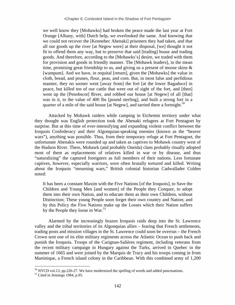
▪Chapter 6: Contested Island in the Shadow of Fort Pentagoet▪
142
we well know they [Mohawks] had broken the peace made the last year at Fort Orange [Albany, with] Dutch help, we overlooked the same. And knowing that we could not recover the [Kennebec Abenaki] prisoners they had taken, and that all our goods up the river [at Negew were] at their disposal, [we] thought it not fit to offend them any way, but to preserve that said [trading] house and trading goods. And therefore, according to the [Mohawks’s] desire, we traded with them for provision and goods in friendly manner. The [Mohawk leaders], in the mean time, promising great friendship to us, and giving us a present of moose skins & [wampum]. And we have, in requital [return], given the [Mohawks] the value in cloth, bread, and prunes, flour, peas, and corn. But, in most false and perfidious manner, they no sooner went [away from] the fort [at the lower Bagaduce] in peace, but killed ten of our cattle that were out of sight of the fort, and [then] went up the [Penobscot] River, and robbed our house [at Negew] of all [that] was in it, to the value of 400 lbs [pound sterling], and built a strong fort in a quarter of a mile of the said house [at Negew], and tarried there a fortnight.50
Attacked by Mohawk raiders while camping in Etchemin territory under what they thought was English protection took the Abenaki refugees at Fort Pentagoet by surprise. But at this time of ever-intensifying and expanding violent conflict between the Iroquois Confederacy and their Algonquian-speaking enemies (known as the “beaver wars”), anything was possible. Thus, from their temporary refuge at Fort Pentagoet, the unfortunate Abenakis were rounded up and taken as captives to Mohawk country west of the Hudson River. There, Mohawk (and probably Oneida) clans probably ritually adopted most of them as replacements of relatives killed in war or by disease, and thus “naturalizing” the captured foreigners as full members of their nations. Less fortunate captives, however, especially warriors, were often brutally tortured and killed. Writing about the Iroquois “mourning wars,” British colonial historian Cadwallader Colden noted:
It has been a constant Maxim with the Five Nations [of the Iroquois], to Save the Children and Young Men [and women] of the People they Conquer, to adopt them into their own Nation, and to educate them as their own Children, without Distinction; These young People soon forget their own country and Nation; and by this Policy the Five Nations make up the Losses which their Nation suffers by the People they loose in War.51
Alarmed by the increasingly brazen Iroquois raids deep into the St. Lawrence
valley and the tribal territories of its Algonquian allies – fearing that French settlements, trading posts and mission villages in the St. Lawrence could soon be overrun – the French Crown sent one of its elite military regiments across the Atlantic Ocean to push back and punish the Iroquois. Troops of the Carignan-Salières regiment, including veterans from the recent military campaign in Hungary against the Turks, arrived in Quebec in the summer of 1665 and were joined by the Marquis de Tracy and his troops coming in from Martinique, a French island colony in the Caribbean. With this combined army of 1,200
50 NYCD vol.13, pp.226-27. We have modernized the spelling of words and added punctuations. 51 Cited in Jennings 1984, p.95.
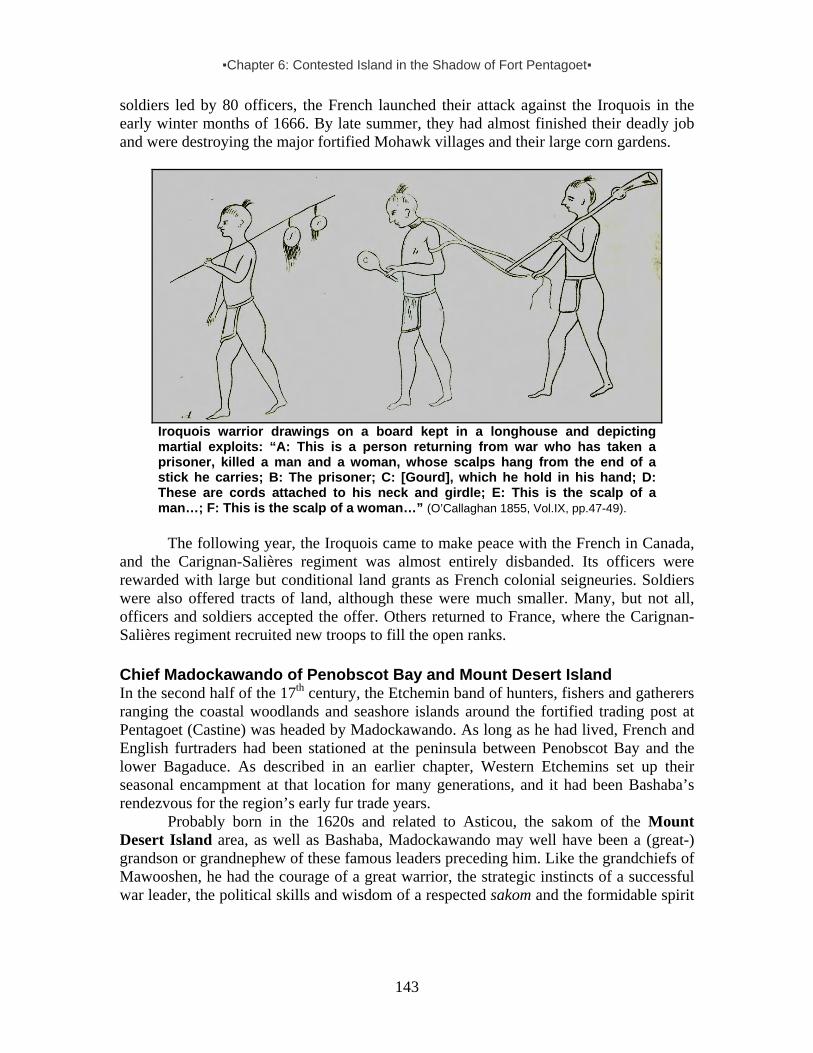
▪Chapter 6: Contested Island in the Shadow of Fort Pentagoet▪
143
soldiers led by 80 officers, the French launched their attack against the Iroquois in the early winter months of 1666. By late summer, they had almost finished their deadly job and were destroying the major fortified Mohawk villages and their large corn gardens.
Iroquois warrior drawings on a board kept in a longhouse and depicting martial exploits: “A: This is a person returning from war who has taken a prisoner, killed a man and a woman, whose scalps hang from the end of a stick he carries; B: The prisoner; C: [Gourd], which he hold in his hand; D: These are cords attached to his neck and girdle; E: This is the scalp of a man…; F: This is the scalp of a woman…” (O’Callaghan 1855, Vol.IX, pp.47-49).
The following year, the Iroquois came to make peace with the French in Canada,
and the Carignan-Salières regiment was almost entirely disbanded. Its officers were rewarded with large but conditional land grants as French colonial seigneuries. Soldiers were also offered tracts of land, although these were much smaller. Many, but not all, officers and soldiers accepted the offer. Others returned to France, where the Carignan-Salières regiment recruited new troops to fill the open ranks. Chief Madockawando of Penobscot Bay and Mount Desert Island In the second half of the 17th century, the Etchemin band of hunters, fishers and gatherers ranging the coastal woodlands and seashore islands around the fortified trading post at Pentagoet (Castine) was headed by Madockawando. As long as he had lived, French and English furtraders had been stationed at the peninsula between Penobscot Bay and the lower Bagaduce. As described in an earlier chapter, Western Etchemins set up their seasonal encampment at that location for many generations, and it had been Bashaba’s rendezvous for the region’s early fur trade years.
Probably born in the 1620s and related to Asticou, the sakom of the Mount Desert Island area, as well as Bashaba, Madockawando may well have been a (great-) grandson or grandnephew of these famous leaders preceding him. Like the grandchiefs of Mawooshen, he had the courage of a great warrior, the strategic instincts of a successful war leader, the political skills and wisdom of a respected sakom and the formidable spirit

▪Chapter 6: Contested Island in the Shadow of Fort Pentagoet▪
144
power of a great motewolon.52 Meaning “Strange Spirit Power,” Madockawando’s name first appears in existing records in the mid-1670s, when he was rising to a prominent regional leadership position. And like Bashaba and Asticou, this Western Etchemin chief maintained close ties of friendship and alliance with Abenaki neighbors in the Kennebec valley. In fact, Madockawando was an “adopted son” of Assiminasqua53, the headman of Taconnet (now Winslow). Inhabited by corn-growing Abenaki families, this fortied village was situated at the confluence between the Kennebec and Sebasticook, on the major travel route to Bashaba’s old village site at Kadesquit (Bangor). Indeed, records suggest that Madockawando’s wife may well have been a Kennebec Abenaki and that his own sister had married into an Abenaki band from that region as well.
In the mid-1600s, having been decimated by diseases and wars, the coastal Wabanakis survived in much smaller numbers. Remnants of about a dozen Western Etchemin bands and another dozen Abenaki villages joined and regrouped around strong and capable leaders whose skills and wisdom inspired great confidence in hard times. Madockawando was one of those extraordinary charismatic leaders who commanded with natural authority.
Madockawando’s large coastal domain probably stretched from Monhegan to Mount Desert Island, and minimally also included not only scores of large and small offshore islands in between, but also coastal woodlands between the lower Penobscot and Union Rivers. Here Western Etchemin families hunted seal, moose, and deer, speared eel and salmon, and trapped beaver, otter, mink and other fur-bearing animals.
The Bagaduce runs through the heartland of this vast coastal Etchemin foraging domain. At the time, this valley was described as a place “where the lands are very good and where there are plenty of oak trees and meadows which do not flood.”54 It is therefore not surprising that Madockawando would have his headquarters on this beautiful river, not far from the well-stocked trading post.
Madockawando’s hunting band and Fort Pentagoet formed a symbiotic relationship in which French or English fur traders clearly profited from attracting as many Indian hunters and trappers as possible. In return for moosehides, sealskins, beaver and other furs, they purchased a wide range of trade goods – from imported corn, peas and flour to copper or iron kettles and pots, iron axes, knives and arrowheads, sword blades for pikes, firearms, bullets, gunpowder and shot, as well as blankets, cloth, needles and beads (wampum as well as glass), and last but not least, alcohol. Since living so close to a coastal trading post also exposed them more readily to new diseases and renegade white traders, soldiers and fishermen, such easy access was always a Faustian deal.
Madockawando probably began his career as a regional Western Etchemin leader by building up wealth as a fur-trade chief, and added status as a warchief and shaman. As a sakom in his community, he was expected to be generous. It was also his task to provide protection against enemy raiders aiming to seize captives or packs of prepared furs or moosehides – their major means of exchange, or “money,” essential for securing
52 This rare combination of great qualities was also characteristic of other great 17th-century leaders like Membertou of the Mi’kmaq in Nova Scotia and Passaconaway of the Penacook in the upper Merrimac. 53 Drake 1854, p.288. This Kennebec Abenaki chieftain’s name is also spelled Essomonosko and was alternatively associated with Skowhegan, not far upriver from Taconnet. 54 Faulkner and Faulkner (1987, p.280) suggest (incorrectly, we believe) that this Indian fort was located at Byard Point on Eggemoggin Reach itself. For strategic reasons, such a location would have been a disaster.
▪Chapter 6: Contested Island in the Shadow of Fort Pentagoet▪
145
tradegoods from across the water. As befitting his status, a chieftain like Madockawando required a sizeable and comfortable place for council meetings with heads of families, receiving diplomats and other visitors, and providing shelter to relatives and guests. Such lodges could be huge. For instance, the Montagnais chief Anadabijou at Tadoussac in the lower St. Lawrence valley could host “some eighty or a hundred of his companions, at his lodge. . . . They had eight to ten kettles full of meats in the midst of said lodge, and these were set some six paces apart, and each on its own fire.”55
Madockawando and his band also possessed a large fortified lodge constructed at the head of the Bagaduce – at the eastern shore of present-day Walker Pond. Etchemins historically built such strongholds, perhaps as an adaptation to commercial fur trade and the “beaver wars.”56 One early example is Ouigoudy at the mouth of the St. John River where Eastern Etchemin chief Secoudon had his fur-trade headquarters in the early 1600s. Another one may have been at Mecaddacut in western Penobscot Bay, described as “a kind of fortress” against Tarrentine raiders during the phase of the “beaver wars” in the Gulf of Maine.57
Identified as Archimagam,58 Madockawando’s fortified lodge was strategically located by the short portage from the head of the Bagaduce River to Eggemoggin Reach.59 (See map on page 150.) This site offered ample natural resources, in particular year-round fresh water that met the needs of humans and an array of wildlife – including alewives running up the Bagaduce for freshwater spawning at the head of the river. (A dam built sometime in the 19th century transformed the river’s head and created the Walker Pond reservoir). Moreover, it allowed Madockawando’s warriors to keep a watchful eye on the French, English and other vessels sailing through Eggemoggin Reach – or the “Channel” as the French called it – when traveling between the Penobscot River and Mount Desert Island.
At certain times of year, after weeks of trapping and hunting in their various favored districts, families would return to their customary sites and set up their wigwams around this fortified lodge at Archimagam. From this location, the Etchemin families enjoyed relatively safe access to the trading post downriver at the mouth of the Bagaduce. This close proximity also explains why Madockawando and other coastal Etchemins were able to communicate in English, as historical records indicate. From an Etchemin point of view, Archimagam fort was even more strategically located than Pentagoet, which always attracted unwanted attention from seafaring rivals, be they Tarrentine or
55 Champlain 1922, vol. 1, pp.99-101. 56 During the beaver wars in the course of the 17th century, Indian forts became common in the entire northeast, and were even found among Mi’kmaq. 57 See Lescabot vol.2, pp.356-57; John Smith 1616, p.15. 58According a later French record, the name Archimagam refers to Little Deer Isle on the opposite side of the portage This 1686 Memorial on Acadia refers to “the island called Archimagau six leagues more east than Pentagoet” (“L’isle apellée Archimagau six lieűes plus Est qu Pentagoűet sont deux familles composees de six personnes”) (Baxter vol. 4, pp.428-29). Eckstorm (1941, p.204) partially copied this text, leading to an erroneous statement that Little Deer Isle was “a place desirable enough to be lightly fortified. Six Frenchmen lived there as early as 1686.” In fact, the text refers to two families, composed of six persons, at Pentagoet where St. Castin resided. 59 When the dam was constructed to create the freshwater reservoir known as Walker pond, the water levels were raised and it is possible that the actual site of Archimagam fort is now under water. We hope this report inspires archaeologists to explore this area in search of the actual Madockawando site itself. This is a tantalizing prospect, considering finds already made in the area (see also Petersen et al 2004).
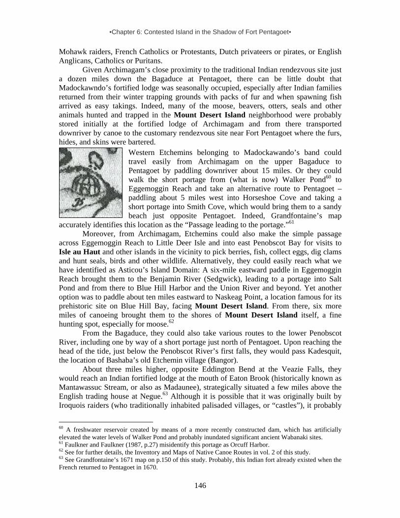
▪Chapter 6: Contested Island in the Shadow of Fort Pentagoet▪
146
Mohawk raiders, French Catholics or Protestants, Dutch privateers or pirates, or English Anglicans, Catholics or Puritans.
Given Archimagam’s close proximity to the traditional Indian rendezvous site just a dozen miles down the Bagaduce at Pentagoet, there can be little doubt that Madockawndo’s fortified lodge was seasonally occupied, especially after Indian families returned from their winter trapping grounds with packs of fur and when spawning fish arrived as easy takings. Indeed, many of the moose, beavers, otters, seals and other animals hunted and trapped in the Mount Desert Island neighborhood were probably stored initially at the fortified lodge of Archimagam and from there transported downriver by canoe to the customary rendezvous site near Fort Pentagoet where the furs, hides, and skins were bartered.
Western Etchemins belonging to Madockawando’s band could travel easily from Archimagam on the upper Bagaduce to Pentagoet by paddling downriver about 15 miles. Or they could walk the short portage from (what is now) Walker Pond60 to Eggemoggin Reach and take an alternative route to Pentagoet – paddling about 5 miles west into Horseshoe Cove and taking a short portage into Smith Cove, which would bring them to a sandy beach just opposite Pentagoet. Indeed, Grandfontaine’s map
accurately identifies this location as the “Passage leading to the portage.”61 Moreover, from Archimagam, Etchemins could also make the simple passage
across Eggemoggin Reach to Little Deer Isle and into east Penobscot Bay for visits to Isle au Haut and other islands in the vicinity to pick berries, fish, collect eggs, dig clams and hunt seals, birds and other wildlife. Alternatively, they could easily reach what we have identified as Asticou’s Island Domain: A six-mile eastward paddle in Eggemoggin Reach brought them to the Benjamin River (Sedgwick), leading to a portage into Salt Pond and from there to Blue Hill Harbor and the Union River and beyond. Yet another option was to paddle about ten miles eastward to Naskeag Point, a location famous for its prehistoric site on Blue Hill Bay, facing Mount Desert Island. From there, six more miles of canoeing brought them to the shores of Mount Desert Island itself, a fine hunting spot, especially for moose.62
From the Bagaduce, they could also take various routes to the lower Penobscot River, including one by way of a short portage just north of Pentagoet. Upon reaching the head of the tide, just below the Penobscot River’s first falls, they would pass Kadesquit, the location of Bashaba’s old Etchemin village (Bangor).
About three miles higher, opposite Eddington Bend at the Veazie Falls, they would reach an Indian fortified lodge at the mouth of Eaton Brook (historically known as Mantawassuc Stream, or also as Madaunee), strategically situated a few miles above the English trading house at Negue.63 Although it is possible that it was originally built by Iroquois raiders (who traditionally inhabited palisaded villages, or “castles”), it probably
60 A freshwater reservoir created by means of a more recently constructed dam, which has artificially elevated the water levels of Walker Pond and probably inundated significant ancient Wabanaki sites. 61 Faulkner and Faulkner (1987, p.27) misidentify this portage as Orcuff Harbor. 62 See for further details, the Inventory and Maps of Native Canoe Routes in vol. 2 of this study. 63 See Grandfontaine’s 1671 map on p.150 of this study. Probably, this Indian fort already existed when the French returned to Pentagoet in 1670.

▪Chapter 6: Contested Island in the Shadow of Fort Pentagoet▪
147
belonged to Madockawando or another Etchemin furtrade chief in the Penobscot Valley. Certainly, these lodges offered Indian hunters and trappers a protected place to store moosehides, beaver and other furs, before taking these valuable goods to the nearest trading posts. This Indian fort was situated at a strategic location at the mouth of Eaton Brook (historically known as Mantawassuc Stream), which used to be a fine canoeing route east “to within two miles of the important Union River.”64 Etchemin families traveled this route on journeys to and from Mount Desert Island and surrounding coastal areas. Of course, this route also enabled them to avoid enemies scouting the lower Penobscot River and Penobscot Bay.65 As already noted, this was a key route for Etchemins traveling back and forth between their hunting grounds on the Upper Penobscot and the Bagaduce, as well as the saltwater bays surrounding Mount Desert Island. This route was especially important when Etchemins and their allies tried to avoid enemies scouting the lower Penobscot River and Penobscot Bay.
Authors’ adaptation of detail from Jean-Baptiste Louis Franquelin’s “Carte pour servir a l’eclaircissement du Papier Terrier de la Nouvelle-France.” 1678. (NMC 17393/copy at the National Archives of Canada. Original at Bibliotheque Nationale, Paris, France S.H.Pf.125, div.1, no.1)
Emerging as a leading sakom in the greater Penobscot area during the first Anglo-Wabanaki war in early 1677, Madockawando clearly followed in the footsteps of his famous predecessors and was instrumental in reviving the old Mawooshen alliance between Western Etchemins of Penobscot and Abenakis of Kennebec and beyond, and expanding it to include Eastern Etchemins of Passamaquoddy Bay and the St. John River, as well as their old Mi’kmaq enemies.
In this respect, it is important to underscore that Wabanaki survival, inspite of sometimes rivaling relationships with neighboring groups, always depended on cultural adaptation and kinship strategies of intermarriage and the adoption of captives, in particular women and children. For this reason, Western Etchemins in the Penobscot area included individuals with relatives from other tribal communities, in particular Abenakis from the Kennebec. As already noted, Madockawando and his sister both appear to have had Kennebec Abenaki spouses, and an Abenaki chief from the strategically situated village of Taconnet had an Etchemin wife from the Upper Penobscot. These two neighboring groups were traditional allies forming part of the Mawooshen confederacy.
64 Cook, pp.48-49. 65 Cook, pp.48-49.

▪Chapter 6: Contested Island in the Shadow of Fort Pentagoet▪
148
Fort Pentagoet: The French Return to Wabanaki Coast Again, 1670-1674 In the early 1670s, Nicolas Denys, a successful French furtrader who had come to Acadia with Razilly and d’Aulnay and resided for decades at Cape Breton Island and Chaleur Bay, was completing his book Description Geographical and Historical of the Coasts of North America. In it, he noted the following about the Penobscot region:
Quantities of Bears occur, which subsist upon the acorns that are found there; their flesh is very delicate and white as that of veal. There are also a great many Moose or Elks, a few Beaver and Otter, but abundance of Hares, Partridges, Pigeons, and all kinds of land birds in the spring. In the winter there are still more of those of river and sea which occur there in great quantity, such as Wild Geese, Ducks, Teal, Eiders, Cormorants, and several other species which in summer go towards the north, and return there in winter when the rivers freeze up, something which happens very rarely [?] on the southern coast.”
. . . . In front of the entrance of the river [Penobscot Bay] there are many islands a little way off, around which the English take a great number of Mackerel as at the mouth of the river [Blue Hill Bay/Union River], where lies the Isle des Monts Deserts. . . . During the winter only they [New England fishermen] fish round these islands for Cod, which they dry by freezing. Our French go there to buy [them] in the spring, and give the English salt, wine, brandy, and other goods in exchange. . . . From the River of Pentagoet as far as that of Saint Jean [John]. . . . The first river [St.Croix] met along the coast is that of the Etechemins, which bears the name of the country between Baston [Boston, meaning New England] and Port Royal, whilst the Indians which inhabit all this extent bear also the same name.66
In the course of less than half a century the resource-rich Etchemin homeland that
included Mount Desert Island had been identified by competing colonial parties as Norumbega, Virginia, New France, Mawooshen, Acadia, New England and Nova Scotia, with additional monikers to be added in the next 100 years. All of this naming and renaming reflects a stunningly complex and confusing geopolitical situation.
In 1667, the same year the Iroquois made peace with the French in Canada, the Dutch, English and French in Europe signed the Treaty of Breda, officially ending three years of violent clashes among these colonial competitors on the Wabanaki coast. With that Anglo-Dutch treaty signed, the English retained control over New York in exchange for the Dutch keeping Suriname in South America, captured just a year earlier. That same year, King Charles II gave the just-acquired New Netherlands to his younger brother James, the Duke of York, who promptly renamed his new colonial domain New York.
The English monarch also recognized that Capt. Sedgewick’s brazen capture of French Acadia 13 years earlier (as ordered by Cromwell) had been against international law and thus agreed to return that still fledgling colony to his cousin, King Louis XIV of France.67 At the time, the province of Acadia (from Penobscot Bay to Cape Breton) was probably inhabited by no more than 500 settlers of European descent and 2,500 Wabanaki (primarily Mi’kmaq, and only about 750 Etchemins). 66 Denys 1672, pp.109, 110 67 The 1667 Treaty of Breda (a city in the southern Netherlands) also ended yet another sea war between the English and Dutch.

▪Chapter 6: Contested Island in the Shadow of Fort Pentagoet▪
149
Indicative of the geopolitical confusion, three years passed before the treaty-mandated transfer of political power in Acadia actually took place in 1670. This was due largely to stalling by Sir Thomas Temple, the former governor of “Acadia & Nova Scotia.” Residing in Boston, he held a position typical for New England’s colonial elite with financial interests in Maine’s fisheries and furtrade – claiming that Acadia embraced only the Nova Scotia peninsula, not the Etchemin coast from St. George River to the St. John. However, officials representing the English Crown acknowledged that they had “allwayes deemed [Pentagoet, or Penobscot] to belong to the French and [it] was to be handed over to the French upon the Breda treaty articles in exchange for the English colonial plantation on St. Christophers [St. Kitts]” in the Caribbean. Unhappy about the deal and demanding compensation for his financial losses (claiming he was ‘utterly ruined’), Temple held out until 1670 – long enough to make his point by demolishing all the forts in Nova Scotia and taking all the “ghunnes . . . because they were his owne: But Penobscot [Fort Pentagoet] he delivered entire, with all the gunnes, and ammunition in it; because they belonged to . . . [his business partner] William Crowne.”68
Adding to the confusion about colonial boundaries, Duke James of York claimed lordship over the old Etchemin homeland between the Kennebec and St. Croix, which he renamed Cornwell. In practice, however, he asserted control over the Pemaquid district, as bounded by the Sheepscot and St. George Rivers. He had converted to Catholicism in 1668, formally joining the orthodox faith of his French mother and his Italian grandmother, France’s queen mother Marie de Medici.69 As first cousins of King Louis XIV, Charles and James had been welcomed to France as refugees from the Puritans who controlled English politics from the mid-1640s until the restoration of the monarchy in 1660. Receiving ongoing support (financially and otherwise) from the French Crown, these royal brothers wished to avoid conflict with their French Catholic neighbors in Europe and in the colonies overseas. Accordingly, the relationships between the English at the small Pemaquid garrison and the newly-arrived French at Pentagoet were mutually tolerant and free from the sharp antagonism that characterized French relationships with their English Protestant neighbors of Massachusetts Bay colony.
In late spring 1670, the 250-ton French frigate Saint Sebastien crossed the ocean from La Rochelle to Boston Harbor in nine weeks. Heavily armed, this fast warship carried 40 French soldiers, 12 officers, a military engineer, and the new Governor of Acadia, Hector d’Andigné, Chevalier de Grandfontaine.70 Having successfully captained a military company in the Carignan-Salières regiment that defeated the Iroquois four years earlier, the 53-year old Grandfontaine was on an official mission to retake possession of Acadia. Among his officers were Lieutenant Pierre de Joybert de Soulanges et de Marson, who had served directly under his command in the 1666 military campaign. It appears that one of the French officers on board was 18-year old Jean-Vincent d’Abbadie de Saint-Castin, a fellow veteran in the former regiment who had served as an ensign (junior commissioned officer in training and his company’s standard bearer). The officers and soldiers were slated to be garrisoned at three Acadia forts: about 30 for Fort Pentagoet and 10 each for Port Royal and on the lower St. John. Grandfontaine brought
68 Cited in Hutchinson, Thomas, Collection of Papers, vol.1, p.290. 69 This queen’s lady in waiting was Madame de Guercheville, who had sponsored the ill-fated French Jesuit mission at Mount Desert Island in 1613. 70 See also Faulkner and Faulkner 1987, p.23.

▪Chapter 6: Contested Island in the Shadow of Fort Pentagoet▪
150
with him letters from King Louis XIV of France and his cousin King Charles II of England, who had made a secret mutual support arrangement at the 1670 Treaty of Dover. After Temple (who resided in Boston) had signed the official documents, the French frigate sailed off to Penobscot Bay.
Anchoring at the lower Bagaduce, Grandfontaine and his troops deboarded the French king’s frigate and arrived at Fort Pentagoet on 17 July, where Captain Richard Walker, Temple’s deputy governor and military commander of Nova Scotia/Acadia, formally handed over the stronghold and trading post, as well as the satellite trading house at Negew on the lower Penobscot.
A few weeks after Grandfontaine and his troops had settled in at Pentagoet, his lieutenant Sieur de Marson sailed on to secure the changing of the guards at Fort Jemseg on the lower St. John, the Port Royal fort on the Bay of Fundy and the French fort at Cape Sable. Near the mouth of the St. John, Marson probably met Basque furtrader Martin d’Aprendestiguy, husband of La Tour’s métis daughter Jeanne (whose mother was Mi’kmaq). The couple was settled not far from La Tour’s old trading post near the mouth of the St. John and soon formally acquired a large land grant there, named the Seigneury of Martignon. Other land grants in the St. John valley soon followed. Meanwhile, after Marson’s departure, the 18-year old St. Castin was placed in command of Pentagoet’s garrison, no doubt by then promoted to lieutenant.
Lieutenant Gardner, who had been Temple’s garrison commander at Fort Pentagoet where he had become familiar with the region’s Etchemins and other Wabanakis in the course of the previous decade, relocated to a fortified wooden trading post at Pemaquid Harbor. In 1671, Pemaquid consisted of “Gardner’s Fort” with probably no more than fifteen isolated English houses.71
Not long after his arrival at Fort Pentagoet, the Chevalier de Grandfontaine had a detailed map made of the region he commanded, with a key titled Description of the River and Country of Pentagoet and Other Surrounding Places (1671).72 Since St. Castin’s oldest daughter was born in the same year that the map was drawn, the young French officer must have started courting one of Madockawando’s daughters soon after his arrival at the Bagaduce. Considering his personal familiarity with the region’s Western Etchemins, we may conjecture that this remarkable map (pictured opposite) was probably drawn by St. Castin. As French Acadia’s new governor, Grandfontaine considered Muscongus Bay “the boundary with New England,” and thus noted that the St. George River was on French territory: “Entrance to the St. George River at the edge of French territory, where a cod fishery should be set up and a fort built to protect against the English.” As Biencourt already had asserted in 1611, he considered Matinicus Island as French, explaining that it is “where the cod fishing is done for the provisioning of Pentagoet.” And about Monhegan Island, he was uncertain whether that island actually belonged to France or England as “the matter has not at all been decided up to this point.” 71Noted on Grandfontaine’s 1671 map. See Faulkner and Faulkner 1987. pp.26-27. 72Held in the Public Archives of Canada, Ottawa, Portfolio 128 piece 30, C11D (see Faulkner and Faulkner, Appendix B, pp.279-81). This map was discovered by Frank Siebert at the Bibliothèque National, Paris, in 1982. All Grandfontaine quotes concerning the map are from the map and his Description. . . . (It is likely that key information on the Penobscot and Bagaduce areas came from Grandfontaine’s lieutenant, St. Castin, who was stationed at Pentagoet 1671-74, married into Madockawando’s family, and by 1676 had established (just upriver from Pentagoet) his own “habitation” (settlement), which became a seasonal village for Madockawando’s people.

▪Chapter 6: Contested Island in the Shadow of Fort Pentagoet▪
151
Grandfontaine’s 1671 map of Acadia. Note authors’ boxed line around Madockawando’s fort Archimagam, situated by the portage between the headwaters of the Bagaduce River (now Walker Pond) and the Punchbowl entry into Eggemoggin Reach. Fort Pentagoet is encircled.
▪Chapter 6: Contested Island in the Shadow of Fort Pentagoet▪
152
As far as Mount Desert Island and Isle au Haut were concerned, Grandfontaine mentioned nothing specific regarding human activity, Indian or European. However, he did specifically note “The safest channel [Isle au Haut Bay] for entering Isle au Haut, and the Seal Islands where one could set up a fishery if it were not ruined by the Indians.”
Grandfontaine’s map also identified the three Indian forts on the east bank of the Penobscot River, and, importantly, the fortified lodge of Archimagam on the Upper Bagaduce River, as discussed earlier in this chapter. And with respect to the English trading house on the lower Penobscot River at Kenduskeag (Bangor), the French commander noted that at the “house of Quebiscuit [Negew] which the English [trader William Crowne] started, which I have put a stop to and where I always have some men to prevent the English from coming into the river73. . . . There is good fishing for salmon, eels and sardines and all other kinds of fish. There are also some waterfalls suitable for sawmills.” Significantly, no mention was made of any gardens with Indian corn (maize), nor of any village or fortified lodge on Indian Island itself. (As will be discussed in the next chapter, this location was selected as a Jesuit mission village for corn-growing Abenaki refugees driven from their villages in the Kennebec and beyond not until 1687.)
Dutch Privateers at Mount Desert Island, 1674-1675 In autumn 1673, Jacques de Chambly sailed in a small vessel from Quebec to Penobscot Bay to take command of the French colonial frontier post of Fort Pentagoet. He arrived with Father Jean Pierron, a 42-year-old Jesuit priest who had labored among the Mohawk for six years and was now assigned to serve at this important Anglo-French stronghold.74 Like Grandfontaine, Chambly had captained a company in the disbanded Carignan-Salières regiment. St. Castin knew him well because he had served directly under him as a 14-year old ensign in the successful campaign against the Iroquois seven years earlier.
By 1673, the Dutch had been at war with both the French and English for a year. In July, a fleet of 19 warships with 600 Dutch marines recaptured Manhattan and reclaimed their former colony New Netherlands. In early 1674, the Dutch and English both agreed to end their third war and make peace at the Treaty of Westminster. However, the Dutch continued their war against the French for another four years – while the French enjoyed the secret support of the English Crown, as formalized in the 1670 Treaty of Dover.
In early summer 1674, about half year after Chambly arrived in Penobscot Bay, a Dutch privateer75 (Het Vliegend Postpaard or “Flying Post Horse”), armed with eight cannons, sailed into the harbor of Manhattan from the Caribbean island of Curaçao (the
73Grandfontaine would have information about the English trading post at Taconnet on the Kennebec, at the the mouth of the Sebasticook River. This tributary formed part of a major canoe route, by way of the Kenduskeag into the Penobscot. Quebiscuit is probably a mistranscription of Quediscuit, i.e. Kadesquit. If Crowne’s trading house had been located at Eddington Bend, as argued by Eckstorm (1941, p.23), the French guarding against English interlopers would not be able to see them canoeing into the Penobscot. 74 According to a French Acadian merchant mariner, Pentagoet’s new commander “acted with great cruelty and at his arrival, upon the advice of a Jesuit Father, undertook useless tasks and had his cannon placed outside the fort” (Brunet in Vigneras, p.108). 75 Also known as corsair, a privateer is not a pirate or buccaneer (which are unlawful warships that depend on plunder), but a privately owned and manned armed ship formally commissioned by a government of a warring state to attack and capture enemy ships. Such “prizes,” ship as well as cargo, may be sold to raise the required revenue to finance naval operations during wartime.

▪Chapter 6: Contested Island in the Shadow of Fort Pentagoet▪
153
strongest Dutch fort in the West Indies), ready to attack English merchant ships. However, news of the Dutch-English peace treaty aborted the action and the ship’s commander Jurriaen Aernoutsz and his fifty fellow mariners sailed on to do damage to the French. Stopping over in Boston, Aernoutsz picked up John Rhodes, a New England mariner familiar with the Gulf of Maine. Rhodes, piloted the Dutch privateer into Penobscot Bay. Its sudden appearance before Fort Pentagoet took the French completely off guard.
Dutch Frigates, circa 1660s.
Battered by Dutch cannon fire, a wounded Chambly and his garrison of just 23
French troops quickly surrendered. Disarmed “by the swords of the Prince of Orange,” Chambly and his men were taken captive. Among them was his lieutenant St. Castin, now about 22 years old. The Dutch privateers then dismantled the fort, taking everything of value, including its cannon and guns, aboard their ship. Leveling the fort to the ground, and torching its remains, they took the captured French officers aboard, hoisted anchor and headed downeast. No doubt, they took the familiar route to the Bay of Fundy, rounding Cape Rosier, cruising through Eggemoggin Reach toward Mount Desert Island, then sailing across Frenchman Bay and around Schoodic Point and onward toward the bay known for its enormous tides. On the final leg of the trip, they stopped at Machias to sack a French trading post just before entering the Bay of Fundy. Then, sailing 50 miles up the St. John River, they launched a surprise attack against the French stronghold of Fort Jemseg. Under command of the Sieur de Marson, this fort was defended by a small French garrison of about nine men. After some gunfire, the French commander and his troops surrendered and he was taken aboard the Dutch ship. Next, the privateer crossed the Bay of Fundy, where Port Royal’s garrison (comprised of just nine
▪Chapter 6: Contested Island in the Shadow of Fort Pentagoet▪
154
soldiers) manning the fort also surrendered. Mission accomplished, the Dutch then sailed with their French prisoners back to Boston to sell the loot. Under international law, the Dutch sea raid against France’s Acadia strongholds was a legitimate conquest. Having signed the 1674 treaty ending their two-year war with the English and requiring them to return New York (formerly New Netherlands), the Dutch considered Mount Desert Island part of “New Holland,” the name they gave to newly-conquered Etchemin coast between Penobscot Bay and the St. John River. Now that the Dutch privateers had seized and dismantled forts Pentagoet and Jemseg, but were unable to actually occupy their newly conquered coastal territory, they left some of the local French Acadian peasant families free to continue residing around these two strongholds. As reported at the time: “Sume men of the poorer soart of oure Captives the former Inhabytance whome wee gave libertye to trayd [trade] and orderd to keepe Possion for his highness [Prince William of Orange] till farther order of Sum of us Retorned theither.”76
About the time of the Dutch assaults at Pentagoet and the lower St. John, the ship of a wealthy Boston merchant named John Freak had an unexpected run-in with the Dutch privateers. Grandson of a wealthy English gentleman entrepreneur involved with the Virginia Company in the early 1600s, Freak had emigrated from Dorset, England, to Boston in 1658. Now in his early forties, he owned his own wharf and warehouses, and continued trading with French Acadians in spite of the possibility of Dutch privateers attacking his vessels during the war period – and even after the 1674 Anglo-Dutch Treaty of Westminster set the parameters for peace. His trading vessel was a large shallop or bark named the Philip, skippered by George Manning of Boston on a trading voyage downeast to the Etchemin coast. Heading out in late July 1674, Captain Manning and his crew soon crossed the colonial frontier into Penobscot Bay. Near Mount Desert Island, they encountered the Dutch privateer soon after its expedition against the French forts.
In his journal entry for 7 August, Manning claimed he chased the Dutch vessel “up into a great river” named “Adowaket”77 (a Wabanaki place name also spelled Douaket, Douakesc, or Adouake Bay), situating him at Frenchman Bay. Now, Adowaket is simply the same as what the French spelled as Douaquec or Douaquet, which is how it appears in the 1692 Memoir of Acadie.78 A small eastern bay just southeast of Waukeag Head, now named “Flanders Bay,” is probably a geographic marking point of Captain Manning’s skirmish with Dutch privateers defending “New Holland,” as later commemorated by the French when they returned to power.79
76 Peter Rodrigo, 1675, in Baxter vol.6, p.54. 77 Interested in the meaning of this word, Maine history researcher Eckstorm deduced that it refers to “the tide-falls above Mt. Desert Ferry, where every now and then, on the ebb of the tide, the great Cellar Hole’ gapes below the white sheet of the falls.” Accordingly, she concluded that Douaquet is “now known as Waukeag.” This, she wrote, is Falls Point, in Sullivan. Until her effort to situate this place, which she writes as Adowauk’-eag, “no one knew the bounds of De la Mothe-Cadillac’s grant, which old documents called Donaquet [misreading of u as n] and Douket, in great variety of spellings.” 78 Eckstorm 1941, p.210. In the 1688 list of Acadian seigneuries it appears as Douaquec, and in 1697, it is listed as Adouaquet 79 Because the French often lumped all their Dutch-speaking northern European neighbors together as Flemings (Flamands, or people from Flanders), we surmise that this was originally a French Acadian place name in commemoration of this historic event.

▪Chapter 6: Contested Island in the Shadow of Fort Pentagoet▪
155
After his successful raids on French enemy strongholds on the Wabanaki coast, Dutch privateer Aernoutsz arrived safely in Boston’s harbor, staying long enough to sell the loot and have his ship repaired and resupplied. In October 1674, he sailed back to his home base at Curaçao in the Caribbean, carrying on board his valuable captive, Pentagoet’s commander Chambly. His other major captive, Fort Jemseg’s commander Marson, was left behind in Boston. Meanwhile, the young French officer St. Castin was released to inform French Canada’s Governor, Louis de Buade, Count of Frontenac about the Dutch conquest of Acadia and get ransom money to free Chambly and Marson. Having become adapted to woodland survival in the course of his close relationship with his indigenous in-laws, and already speaking their Etchemin language (and perhaps Abenaki, as well), the young French officer made his way north to Frontenac’s Quebec headquarters. He may have traveled by way of the Penobscot, a route he must have known quite well, or perhaps on the Kennebec, taking the portage to the Chaudière River. Reaching Quebec in late September, he presented the bad news to Frontenac, who immediately sent the requested ransom payments. (For Marson it was 1000 beaver skins or the equivalent; for Chambly, perhaps double this cost.) After months in captivity, both French military commanders were released.80
Since the English and Dutch were no longer at war, Captain Aernoutsz had left behind in Boston two of his men, Peter Roderigo (“Flanderkin”) and Cornelius Anderson (“Cornelius the Dutchman”). They recruited several experienced New England mariners, including John Rhodes, who had piloted Aernoutsz’s ship for the sea-raids on French Acadia and owned a “Penobscot shallop.” They also rented a Massachusetts Bay sailing vessel named Edward and Thomas. Then, with Rhodes as navigator, they set out on a “trading voyage to the Eastward.” It is unlikely they knew that King Charles II had made a secret mutual aid arrangement with his French royal cousin Louis XIV. More importantly, they underestimated the New England merchants’ drive to make money at all cost. At any rate, although they were still at war with the French, they had reason to expect that New Englanders would respect their rights of conquest on the sea coast from the St. George River to the St. John, including Mount Desert Island – all claimed and soon to be named “New Holland.” They sailed from Massachusetts Bay, via Casco Bay, to what the French called the Etchemin Coast of Acadia, trading furs at the usual Wabanaki-European rendezvous sites of Pentagoet, Machias and other places.
Although New England lobstermen and other fishers had been allowed to sail their boats to Mount Desert Island when Grandfontaine was governor of Acadia, French colonial authorities zealously protected their lucrative trade in furs and moose hides. Now that the French military garrisons were destroyed, some wealthy New England merchants from Massachusetts Bay, New Hampshire and Maine claimed they were troubled by the “Dutch pirates” in Penobscot Bay and beyond. New England fishermen, perhaps employed by them, were also eager to scavenge the remains of the demolished French fort at Pentagoet, stealing remaining boards, iron nails, and other salvageable materials:
80 Brunet, in Vigneras, p.101. When his ransom was finally paid, Chambly returned to France and later ended up in the French West Indies (Brunet, in Vigneras, p.108).

▪Chapter 6: Contested Island in the Shadow of Fort Pentagoet▪
156
The inhabitants of Pemaquid or Quack [Cacsco Bay81], and several English fishermen came to Penobscot [Pentagoet] where [they] did not only break up the planks of our demolished fort and got out the iron work and spikes, and carried them away, but also robbed, pillaged, and plundered our poor [French Acadian] subjects which we left to keep possession for our [Dutch] Prince [of Orange] till we returned of all their provision and store, which we [had] left them for to sustain their poor families in the hard winter.82
The Dutch privateers were unable to stop English thieves from preying upon the poor French Acadian peasant folk now living without protection in the Pentagoet area,83 but they did attack and deter some interlopers anchoring “near Mt. Desert Islles” in December 1674. One of the vessels was the Boston bark or shallop the Philip, skippered by captain Manning, who was wounded during the attack, along with his mate. Surrendering, Manning promised to cooperate and was thus allowed to sail his vessel under the Dutch flag. In addition, the Dutch also captured a shallop owned by the wealthy furtrade and fisheries entrepreneur Richard Waldron of Dover, New Hampshire, and another belonging to Shapley in Kittery, southern Maine.
In the early months of 1675, the Dutch/English/French privateers who had participated in the successful raid against Fort Pentagoet and other French strongholds on the Acadian coast ran into problems with New England shipping merchants who tried to claim the area as a trading and fishing area for their own exclusive use. The privateers were accused of having seized the ships and furs of two New England traders on the Acadian coast (who, from the Dutch point of view, were interlopers in New Holland waters). In early February, Massachusetts Bay colonial authorities commissioned Captain Samuel Mosely to recover the captured vessels, conveniently but falsely claiming that the Dutch privateers were pirates. Commanding the ketch Salsbury, he sailed with almost 50 armed men toward Mount Desert Island. En route, they encountered a French vessel84 that was immediately pressed into service. Then both vessels sailed downeast, hunting the Dutch, one under the English flag and the other under the French one. In late March, all three ships sailing under the Dutch flag were captured, including the shallop skippered by Manning, who immediately turned his weapons on the Dutch and sided with the two attacking vessels. The mixed crew, including Rodrigo and Anderson, were taken to Boston as prisoners accused of engaging in “pyraticall practices.” These seamen defended themselves, however, claiming that they considered Acadia as a French colony and, accordingly, in time of war, it was their right to conquer such enemy possessions. Having been commissioned by a recognized sovereign, the Prince of Orange (about to marry the daughter of the Duke of York), they were not pirates, but had been operating as privateers (also known as corsairs), which was a crucial difference. Finally, they
81Quack was the Wabanaki name for the place at Casco Bay now called Portland. See also Faulkner and Faulkner 1987, p.66, n238. 82Plea and answer of Peter Rodrigo & Others, May 17, 1675, DSHM, vol. 6, p.54; see also Faulkner and Faulkner 1987, pp.37-38. We have adjusted the spelling and punctuation of this text for the sake of readability. 83When the Dutch privateers later returned to Pentagoet, they were welcomed by the starving peasant families, who related their miseries, telling them “that the abuises they so Receved from the English was tenn times worse, then when the Dutch first came and tooke there fforts.” 84Henri Brunet’s merchant vessel with St-Castin on board? See Faulkner and Faulkner 1987, p.29.

▪Chapter 6: Contested Island in the Shadow of Fort Pentagoet▪
157
complained that Captain Mosely had engaged them flying English, French and Dutch flags at the same time, contrary the rules of military engagement in times of war between sovereign nations. In May, the privateers stood trial in Boston. Found guilty, but not hanged, some were “banished” from the colony.
Two years later, the Dutch West India Company appointed Cornelius Steenwyck, formerly of New Amsterdam (New York City) to serve as governor of this new Dutch colonial holding. The 1678 Treaty of Nijmegen would have confirmed this title, but the territorial claim based on conquest in a declared war was not asserted.85 Madockawando as St. Castin’s Father-in-Law From his strategic location at Archimagam, Madockawando and his Etchemin warriors could keep a watchful eye on the vessels sailing through Eggemoggin Reach, the “channel” between Penobscot Bay and Mount Desert Island. The Indian families encamped not far from the French fort at the mouth of the Bagaduce developed a special relationship with St. Castin, the young French officer in charge of Pentagoet’s garrison during the four years before Dutch privateers conquered and demolished the famous old stronghold. Considering the large Mohawk war party that had captured one hundred Kennebec Abenaki women and children encamped at Fort Pentagoet in 1662, Madockawando must have been impressed by the fact that this young Frenchman was a veteran of the punitive campaign against their Mohawk enemies four years later when a French army destroyed evacuated villages, burned their corn harvest and erected crosses in ruined villages as a sign that Iroquois country had been conquered in the name of the French King.86 It seems likely that Madockawando’s daughter first met him when her family came to trade at Pentagoet in the fall of 1670. Of course, it is also possible that St. Castin made the journey up the Bagaduce and first met her at the fortified lodge at Archimagam. At any rate, following the example of Charles de la Tour at Cape Sable, she became pregnant with his child and he became the impressive chief’s son-in-law.
After journeying to Quebec to inform Frontenac about the Dutch conquest of French Acadia, St. Castin received news that his older brother had died, making him heir to his family’s baronial title and manorial estate at Escout near Pau in southern France. Instead of returning home and taking his seat in the Paliament of Navarre, the young baron agreed to be sent back to the coastal frontline where he joined his Etchemin friends and relatives, including a wife and daughter(s).
But St. Castin was not the only Frenchman on the lower Bagaduce. The Dutch privateers had allowed several Acadian peasants to remain at their hardscrabble farmstead at Pentagoet. However, they struggled to survive without the protection of the garrison troops. And after English fishermen had robbed their barns and food supplies, they faced starvation “in the hard winter.” These peasants had no choice but “to leave there wives and children, [and] to join with the Indians, and with them run in the woods, hunting for their families to keep them from starving”87 Of course, St. Castin himself was probably also spending the winter with Madockawando’s band. No doubt, these Western
85 Shea, note 1 in Charlevoix vol.3, p.188. 86 Jennings 1984, p.132. 87 Plea and Answer of Peter Rodrigo & Others, map 17, 1675, cited in Faulkner and Faulkner 1987, p.38.

▪Chapter 6: Contested Island in the Shadow of Fort Pentagoet▪
158
Etchemins would have helped these peasant families survive.88 And like the young officer, several other strong Frenchmen may have joined hunting families on their journey to their respective hunting district, including Mount Desert Island.
Ruins of Fort Pentagoet. (From Drake, 1875, p.73.)
Although Fort Pentagoet was never rebuilt as a frontier stronghold after the 1674
attack by Dutch privateers, St. Castin settled very nearby – “about a mile and a half up the Bagaduce River from Fort Pentagoet.”89 Not unlike Claude de La Tour, who had founded his simple fur-trade post at the traditional Western Etchemin rendezvous about 60 years earlier, St. Castin built a rustic house and trading shed at this new site. Somewhat safer from European warships sailing into Penobscot Bay, this strategically well-chosen place was closer to Chief Madockawando’s fortified lodge Archimagam at the head of the Bagaduce (Walker Pond). Located at Hatch Cove, which provided a safe anchoring place invisible from the seacoast, St. Castin’s site also placed him right between two very important canoe portages, one linking him to the Penobscot River, the other to Eggemoggin Reach: Just a mile southwest from his house was the quarter-mile portage from Hatch Cove to Wadsworth Cove, leading into the lower Penobscot River. And directly southeast of his home, on the other side of the Bagaduce, was the canoe landing90 for the portage route to Horseshoe Cove, running directly into Eggemoggin Reach, gateway to an array of routes to Blue Hill Bay and Mount Desert Island.
Attractively located for a coastal fur trader who enjoyed the trust and friendship of his Wabanaki friends and relatives, St. Castin’s “habitation” became the site where Madockawando and his Etchemins as well as other Wabanaki allies periodically erected their portable bark dwellings or wikuwams. Indeed, this seasonal Wabanaki village surrounding St. Castin’s house could be quite large. According to a French colonial census91 in the mid-1680s, the encampment consisted of 160 Wabanaki living in 32 cabannes (bark dwellings). Unless there was war, Madockawando and his people hunted, trapped, fished and gathered the coastal woods and islands in the greater Penobscot Bay area, including Mount Desert Island, all of which also formed part of Fort Pentagoet’s historic catchment area.
88 This situation echoes that of the Etchemin encamped at Mount Desert Island who helped their French neighbors at Saint Sauveur when they were devastated by English privateers from Virginia in 1613 and the Mi’kmaq encamped a few miles from their French neighbors at Port Royal. 89 Faulkner and Faulkner 1987, p.29. 90 Flat Landing, Smith Cove. 91 Gargas 1687, in Morse 1935, pp.139-55.

▪Chapter 6: Contested Island in the Shadow of Fort Pentagoet▪
159
Tied by marriage – and by blood (as St. Castin soon fathered more métis children)92 – Madockawando benefited from his close relationship with the adventurous French nobleman who provided him with access to precious European trade goods and military assistance. Likewise, St. Castin profited from close family ties to the great sakom, for Madockawando’s band as well other groups of hunters and trappers brought him many furs and moose hides, making him a wealthy frontier trader. They also provided help as allied warriors in the French effort to block the English from once more expanding their grip to the east side of Penobscot Bay. Becoming a legend in his own lifetime, St. Castin stirred imaginations near and far. His reputation reached to Newfoundland, where another French baron, stationed as a military officer at Fort Placentia, wrote about his colleague on the Wabanaki coast:
For the first years of his abode with the [Indians, St. Castin] behave’d himself so, as to draw an inexpressible esteem from ‘em. They made him their great chief or leader . . . and by degrees he has work’d himself into such a fortune, which any Man but he would have made such use of, as to draw out of that Country above two or three hundred thousand Crowns, which he has now in his pocket in good dry gold. But all the use he makes of it is to buy up goods for presents to his fellow [Indians], who upon their Return from Hunting, present him with Beaver-Skins to a treble [triple] value.93
Darkening Clouds of Total War over the Wabanaki Coast Because James, the Duke of York, possessed territorial interests on the Maine coast in the Pemaquid area between Kennebec and the St. George River, his older brother King Charles II was not particularly keen on seeing New England merchants capitalize on the power vacuum in the Anglo-French colonial frontier east of Penobscot Bay. Although the Dutch claimed it as New Holland, they were in no position to actually defend their title based on the right of conquest. Accordingly, “King Charles commission’d the Governour of New York [Sir Edmund Andros], to take Penobscot, and the lands belonging to it, including Mount Desert Island, under his jurisdiction. And the Governor of New Yorke did accordingly and put a garrison in the said trading house at Negue, alias Crowne’s Point [at Bangor].” After that trading post on the lower Penobscot had been secured, his brother the Duke of Yorke “begg’d Penobscot of the King.”94
Consequently, the Pemaquid area between the Kennebec and St. George River (called Devon at the time) did not fall under the jurisdiction of New England, but came under New York. Pemaquid’s peculiar political status did not change until 1686, when the Duke of York became King James II and decreed that it would be governed as part of New England. The commander of the fortified wooden trading post at Pemaquid was Lieutenant Thomas Gardner (previously stationed at Pentagoet under Colonel Temple), who was still trading with the Wabanaki Indians and French Acadians living east of him, including St. Castin.
92 His oldest child with one of Madockawando’s daughters was named Claire, believed to have been born in 1671, which suggests that St. Castin had established a close relationship with these Etchemins soon after arriving at Pentagoet the previous summer. 93 LaHontan, pp.328-29. 94 Baxter vol.10, pp.25-30.
▪Chapter 6: Contested Island in the Shadow of Fort Pentagoet▪
160
But this did not stop wealthy New England merchants like Major Richard Waldron of Dover, New Hampshire. In late 1674, one of his shallops had been captured by the Dutch privateers near Mount Desert Island. When tension between Wabanakis and New Englanders grew in the late summer of 1675, partially due to the quickly spreading Wampanoag uprising in southern Massachusetts under Chief Metacomet (alias King Philip), Abenakis from the Kennebec, Androscoggin and Saco rivers were told to hand in their weapons. Soon, New England fishermen at Monhegan Island offered bounty for Wabanaki scalps. The following year, the Etchemins also became involved in the conflict when William Waldron (probably operating under instructions of Major Richard Waldron of Dover, New Hampshire) and Captain Henry Laughton and crew captured 15 unsuspecting Indians not far from Machias, and transported them to the Azores to sell as slaves. Probably Eastern Etchemins (Passamaquoddy) or Mi’kmaq, these captives included “a Sagamore & his Squaw stollen away from the Eastward.”95 This treacherous kidnapping raid caused a “rage against the English,”96 and in late August, the two seamen were arrested and taken to prison to await trial “for Seazing & Carrying away 30 Indians where on Sagarmore & his squaw to the Eastward.” On 21 August 1676, Gardner, who knew the Indian families ranging between his trading post at Pemaquid and Mount Desert Island well, wrote that the uprising on the Wabanaki coast was due in part to “the perfidious & unjust dealing of som English as we Supose have Stollen Eight or Nine persones from the Indianes About Micheas [Machias] River & Caried them Away, the Indianes being Incenses for their lose.”97
◘ ◘ ◘ ◘
95 In Baxter vol. 23, p.1. 96 In Baxter vol. 23, p.1. 97 Baxter vol.6, pp.118-119. Some sources state that these victims, variously estimated between 14 and 32 persons, were “Cape Sables’ Indians,” who had been “sold for slaves.” (In Willis 1831, p.142).That means, these captured Wabanaki could be Mi’kmaq. At any rate, hundreds of Indians were captured and shipped from New England as slaves to be sold in Spain, West Indies, Barbados, or Bermuda: “This usage of them is worse than death,” protested the Puritan missionary John Eliot.

▪Chapter 7: The Rise and Demise of Chief Madockawando▪
161
CHAPTER 7: RISE AND DEMISE OF CHIEF MADOCKAWANDO
From the late-17th to mid-18th centuries, Wabanaki peoples were dragged into a long series of colonial wars primarily between the French and English. Because Mount Desert Island and its nearby intertribal rendezvous and fur trade post at Pentagoet (Castine) were located on the contested frontier between New England and French Acadia, both places were always in the crosshairs of competing forces.
Coming on the heels of several decades of vicious fights against their Iroquois arch enemies, the Wabanakis’ forced involvement in colonial wars on their lands lasted over a century. During this time they led a terror-crazed existence of warfare punctuated by periods of ominous peace. Beginning with what is best known in U.S. history books as King Philip’s War (1675-1676) and ending with the American Revolutionary War (1775-1783), there were seven Anglo-Wabanaki wars.
The Anglo-Wabanaki wars caused suffering beyond wounds, death and destruction. They increased the cost of the trade goods on which Wabanakis depended – or worse, made goods unavailable. They drove Wabanaki survivors to flee their home ranges and seek refuge with allies and neighbors.1 Notably, because the wars were waged primarily on the coasts, the Mount Desert Island area became unsafe territory for Wabanaki families. Interrupting their seasonal subsistence patterns, warfare made it tough or impossible for them to frequent their favorite hunting, fishing and gathering places on seacoast islands, including Mount Desert Island and Isle au Haut.
Combined with famines, foreign diseases and relentless pressure from an ever-increasing number of European settlers, the Anglo-Wabanaki wars altered the indigenous cultural landscape forever. They were part of complex historical processes that triggered specific ethnic and territorial reconfigurations, nearly annihilated Wabanaki peoples and robbed the surviving remnants of almost their entire homeland – a vast territory that had provided them with an abundance of natural resources for untold generations.
In addition to Anglo aggression, Wabanakis had to contend with greatly-feared Iroquois war parties raiding their camps – plundering their food and furs, killing and capturing their people. Facing the same combined English and Iroquois threat as their immediate French neighbors, Wabanakis found ready allies in the French. Through them, they had access to firearms, iron weapons and tools, food supplies and even military support. Likewise, the French needed Wabanaki support, for with a mere 500 Acadian colonists, they were vastly outnumbered by relentlessly-expanding New Englanders. It was not a secure alliance, for all parties operated on the basis of calculated self-interest. Difficult to summarize, it is safe to say that ordeals dragged on because decades of abuse, fear and resentment had created a tinderbox in which small incidents sparked firestorms.2
First Anglo-Wabanaki War, 1675-1678 In mid-1675 Wampanoag chief Metacomet, known as King Philip by his English neighbors, had launched a widespread Native American uprising in southern New England. It was a desperate protest against the increasingly repressive conditions Native communities faced due to thousands of foreigners settling in their homelands. The 1 See Prins 1988, 1992, 1995. 2 For a summary view of the period leading up to these wars, see Prins 1995.

▪Chapter 7: The Rise and Demise of Chief Madockawando▪
162
violence spread to the colonial frontier in every direction, encompassing the Nipmuck, Sokoki and Narragansett peoples, and reaching western Wabanaki villages from the Merrimack to the Kennebec Rivers. As total war broke out in southern New England, many Indians fled their villages south of the Piscataqua River and took refuge in Canada or moved eastward into the Androscoggin valley and beyond. The consequences of this uprising had far-reaching effects, including a revitalization and expansion of Mawooshen, and an ethnic reconfiguration of traditional Abenaki-Etchemin relationships.
William Hubbard’s map of coastal New England during King Philip’s War, 1675-1676.
Although the first Anglo-Wabanaki War in Maine was triggered by consequences of Indian uprisings in southern New England known as “King Philip’s War” (1675-1676), it played out according to its own unique historical dynamics. And while many settlements on the Maine coast were abandoned and destroyed, relatively few people died on either side of this “skulking war,” which continued for two years after the total war in southern New England had come to its devastating conclusion. Madockawando and the Resurrection of Mawooshen, 1675-1676 In July 1675, within three weeks after the first armed clashes between Wampanoag warriors and their English neighbors in southern Massachusetts, and after a few sporadic incidents on the southern Maine coast, English colonists on the lower Kennebec and Sheepscot Rivers resolved to disarm local Abenakis. The English trading post agent at Arrowsick Island on the lower Kennebec went with his men upriver to their satellite trading house located near the fortified Abenaki village Taconnet (Winslow). Positioned where the Sebasticook runs into the Kennebec, this village controlled the western entrance of the riverine route to the Penobscot. As such, Taconnet was strategically

▪Chapter 7: The Rise and Demise of Chief Madockawando▪
163
positioned as the geopolitical counterpart of Kadesquit, Bashaba’s old village at the confluence of the Kenduskeag and Penobscot.
Fearing that the fighting in Massachusetts would spread northeastward from New Hampshire into Maine, the settlers took preemptive measures, removing gun powder, shot and other commodities stored in their trading post. Hoping to disarm the region’s Abenaki, they instructed them to hand in their hunting guns, ammunition and even steel knives, warning that if they did not so so, the English would kill them as enemies. Although a dozen tribesmen did submit their firearms, primarily as a token of goodwill, they feared English hotheads who threatened to shoot down any Indians they could find. Obviously, Anglo-Abenaki relations became very strained, as both parties realized that, effectively, the English were trying to force the indigenous communities to give up sovereign status and subject themselves to colonial rule.3
Unwilling to submit and lose their independence, many Kennebec Abenakis packed their belongings, left their cornfields, canoed up the Sebasticook River, portaged to the Kenduskeag and descended to the Penobscot, again seeking refuge among Western Etchemin friends, relatives and allies.4 Not long after, these Abenaki refugees complained about “the hard dealing of the English in Kennibeck River” to Thomas Gardner, the English fur trader and commander of Fort Charles, the wooden stronghold at Pemaquid. At the time, this small English district fell under the jurisdiction of the governor of New York, Sir Edmund Andros. Having long known these tribespeople, the Pemaquid fort commander protested to Massachusetts Governor Leverett: “I do not find by anything I can discerne that the Indians east of us [at the Kennebec and Penobscot or beyond] are in the least our ennimies, [They] only fly for fear from any boats or English they see & good reason for they well know it may cost them their lives if the wild fishermen meet with them.”5
While residing as refugees among their long-time allies in the Penobscot area from late 1675 onward, the Kennebec Abenakis called for a general meeting of all Wabanakis east of the Kennebec River and “began to negotiate with the tribes farther east in order to resist any interference.”6 Revitalizing and expanding the political foundations of Mawooshen, the inter-tribal confederacy headed by grandchiefs Bashaba and Asticou more than half a century earlier, they started a process foreshadowing the emergence of a more encompassing alliance, today known as the Wabanaki Confederacy.
In contrast to their traditional Abenakis allies south of the Kennebec, who themselves were taking in refugees from across the Piscataqua and Merrimac Rivers and already had their own growing list of grievances against settlers encroaching on their lands, Madockawando and his fellow Etchemins east of Pemaquid were still comparatively at peace. Although unable to avoid occasional confrontations with fishermen drying their catch at Mount Desert Island or some other off-shore islands, they tried to keep things calm on the frontier and limit their foreign relations to the exchange of furs, hides and feathers for desirable European commodities. So, when the Anglo-Abenaki conflict flared up in the Kennebec valley, Madockawando and his
3 Hubbard vol.2, pp.98-100; Baxter vol.6, pp.91-93. 4 Baxter vol.6, pp.92-93. 5 In Baxter vol. 6, pp.92-93. 6 Baxter vol.6, pp.92-93.
▪Chapter 7: The Rise and Demise of Chief Madockawando▪
164
Etchemins at Penobscot tried to remain neutral, staying out of the killing fields as the sakom “doth pretend love to the English.”7 Fighting Flares Up in Southern Maine, 1675-1676 Meanwhile, in August 1675, New Hampshire’s militia had burned the Pennacook Indian village on the Merrimac River and destroyed their cornfields.8 A month later, “som stragling [Indian] persones from the southwards,”9 probably Pennacook refugees, were reported in the Saco Bay area. No doubt, they and other displaced tribesmen, facing hunger and keen on revenge, plundered English settlers between Saco and the Kennebec. Retaliating English settlers, vowing to “kill any Indian they met [and] at Monhigan [Monhegan Island], offered five pound for every Indian that should be brought.”10 In response, New Hampshire’s military commander at Dover, a wealthy shipping merchant with fur trade posts, authorized in mid-September [his nephew?] William Waldron and “what Company shall goe along with you . . . to kill & destroy & by all wayes and meanes to annoy the Indian enemy . . . in the eastern Parts.”11 At this time, Maine’s coastal islands from Monhegan southwestward were settled by English fishermen and farmers. In search of victims, New England bounty hunters sailed up the Maine coast and islands “for the express purpose of kidnapping any unfortunate natives.”12
Fighting flared up all across New England south of the Piscataqua River and more Indian families fled north to refugee settlements in the St. Lawrence valley or crossed into traditional Abenaki country in southern Maine. Given the already tense Anglo-Wabanaki relationships there, very little was needed to ignite this tinderbox. In September 1675, an Abenaki tribesman from Saco River informed a local English settler that “some stranger Indians from the west [across the Piscataqua River], have been at my wigwam. They have endeavored to persuade us all to raise the tomahawk against the white people. They have gone farther east [towards the Kennebec and even Penobscot], and will probably soon come back with many warriors.”13 Indeed, within days, small Indian raiding parties began plundering English settlers on the Maine coast south of Pemaquid.
Skirmishes continued for half a year. In April 1676 about 50 “Christianized Indians” recruited from the Cape Cod area sided with English colonists against Wampanoag and Nipmuck resistance fighters.14 Two months later, Capt. Benjamin Church convinced the female chief of the Wampanoag Indians east of Saconnet River in southern Massachusetts to make peace with the New Englanders. In return for the promise that they could keep their lands, these Saconnet Wampanoag also joined the English in their war against the rebelling Indians.15 New England authorities even retained Mohegan and Pequot warriors from as far south as Connecticut as auxiliaries.16
7 Baxter vol.6, pp.149-51. 8 Bodge, p.300. 9 Baxter vol.6, pp.91-93. 10 Hubbard 1865, vol.2, p.14. 11 Ayer Ms 961. 12 Hubbard 1865, vol.2, p.14. 13 Cited in Abbott 1875, p.177. 14 Drake 1867, p.229. 15 Benjamin Church 1716, cited in Leach 1958. 16 Plymouth Records vol.5, pp.80, 86, 921.

▪Chapter 7: The Rise and Demise of Chief Madockawando▪
165
In mid-August 1676, the Wampanoag chief Metacomet (“King Philip”) was killed in southern Massachusetts and the Indian uprising in New England south of the Piscataqua River died down soon after. But, that very same month, violence escalated on the Anglo-Wabanaki frontier, expanding to Penobscot Bay and even beyond Mount Desert Island.
Madockawando Forced into the Anglo-Wabanaki War, 1676 A few weeks before the last mopping up raids against Wampanoags and their allies in Massachusetts and beyond, a group of prominent Wabanaki chiefs gathered for an inter-tribal council at Taconnet, the Kennebec Abenaki village abandoned the previous year. Hosted by Chief Assiminasqua, this meeting included his adopted son, Madockawando. Over the past year, Assiminasqua and many other Kennebec Abenakis (or Canibas17) had been living as refugees in the Penobscot Valley, trying to stay out of the conflict still storming across New England from the Kennebec to the Hudson River. While Abenaki women were probably hard at work in village gardens to secure the next corn harvest, Assiminasqua and Madockawando met with Abenaki sakoms from neighboring villages in the Kennebec, Androscoggin, Saco and other river valleys, most of whom had been on the warpath against the English. The allied sakoms probably knew that the Indian uprising against New England colonists had failed south of Piscataqua River, ending in bloody defeat and loss of lands. Accordingly, they resolved to make peace with the English and invited the trading post agent from Arrowsick Island on the lower Kennebec to come to Taconnet. In the subsequent meeting, after the various sakoms offered speeches, Madockawando served as the prime negotiator, asking the English: “What are we to do for powder and shot, when our corn is consumed? What shall we do for a winter’s supply? Must we perish, or must we abandon our country, and fly to the French [in Canada] for protection?”18
Unwilling to reopen fur trade relations, the English refused to sell Abenaki hunters the ammunition they needed and the chiefs realized that the road to peace was blocked. A few weeks later, sailing beyond Mount Desert Island, English fishermen from Dover, New Hampshire, encountered a small Wabanaki band at Machias Bay. Luring the Natives to their ketch, probably with trade goods, the New Englanders seized the sakom, his wife and about a dozen others. Shipped with a cargo of dried fish to the Azores off the North African coast, the captives were sold as slaves to the Portuguese.19
This slave-raiding expedition on the Etchemin coast caused a “rage against the English.”20 Eastern Etchemins and Nova Scotia Mi’kmaqs (long-time allies earlier referred to as Tarrentines) retaliated by capturing some twenty New England fishing ketches anchored at the coast of southern Nova Scotia, and several more on the Maine
17 French Acadians in the Bay of of Fundy refererd to these Kennebec Abenaki as Canibas, which was the Mi’kmaq name for them. By extension, they referred to all Abenaki allies as Canibas, a term replacing an earlier pejorative Mi’kmaq name for these corn-growing villagers as enemy “dogs.” Not surprisingly, this shifting ethnic terminology in a shifting ethnic landscape with complex reconfigurations has caused much confusion, also among scholars. 18 Hubbard, vol.2, p.38, cited in Drake 1854, p.289. 19 Baxter vol.3, p.1. Sailing aboard a ketch, these slavers served under William Waldron, operating under instructions of his ruthless uncle (?) Major Richard Waldron, New Hampshire’s commander at Dover. Remarkably, the Machias Bay sakom and his wife made it back home the following year. 20 Willis 1831, p.142.

▪Chapter 7: The Rise and Demise of Chief Madockawando▪
166
coast.21 The English assault against innocent fellow Etchemins (or perhaps Mi’kmaqs) made it impossible for Madockawando to keep his warriors from joining Wabanaki war parties seeking revenge. Although he had been rebuffed by the English, Madockawando could take comfort in the fact that his French son-in-law, St. Castin, would supply his warriors with ammunition and other desired trade goods in the challenging months ahead.
The next month, in September 1676, Wabanaki raiding parties attacked English coastal settlements from Kennebec to Kittery. Striking back against the Wabanaki forces, the English colonial militia solicited the aid of “friendly” warriors from tribal villages seeking to hold on to their ancestral hunting lands south of Piscataqua River.22 How these tribesmen felt about being pressed into fighting Wabanakis reinforced by refugees from their own region, perhaps even their own tribes, is anybody’s guess.
One of the large-scale Wabanaki attacks was directed against English colonial settlements in Casco Bay and on the lower Kennebec. Among the leading war chiefs in this raid was Mogg Hegon [a.k.a. Mugg]. This Abenaki chieftain from the Cape Porpoise area (traditionally Mawooshen’s “western door”) hoped to clear the entire coast of English settlers.23 Fully familiar with the coastal region where the guerilla attacks took place, Mogg knew the English garrison at Blackpoint (Scarborough) was “the strongest fortification in the Eastern Towns.” Like many other coastal tribesmen, including Madockawando, this able warleader spoke English. On 12 October he led 100 warriors to the garrison and “sought a parley with Mr. Jocelyn, which lasted a long time. In the meantime all the [local English settlers] had taken the opportunity to get out of the [fortified] house and to their boats and away to the Westward towns,–Wells, Portsmouth, etc.” Surrender followed. “Mugg was highly elated with this great and easy success, [but the] garrison was not destroyed, perhaps because Mugg . . . believed the English would soon be driven from the country, and this would serve the Indians as a stronghold.”24 French Jesuit Perspective on Etchemin-Abenaki Alliance, 1676-1677 With Madockawando being dragged into the Anglo-Wabanaki war, a complicated process of ethnic amalgamation among Etchemins and their Abenakis neighbors was set into motion. Father Jean Morain, a French Jesuit missionary active among Eastern Etchemin foraging families ranging the woods between the upper St. John and St. Lawrence Rivers during this period, heard about the troubles with the English in the Gulf of Maine. Reporting from his mission post at the Rivière du Loup,25 he wrote to his superiors in Quebec about the Anglo-Wabanaki conflict as it progressed between 1676 and 1677. About the Etchemin as an ethnic group (“nation”), Morain noted that they were still very mobile, constantly on the move as hunters, fishers and gatherers. Indicative of the dramatic population losses Etchemins had suffered since the early 1600s, he estimated they were reduced to only 400-500 people. If true, this suggests that the Etchemins had suffered a population decline of about 90 percent since the European invasion of their homeland. With so few surviving Etchemins, the already thinly populated woodlands between the St. John and Kennebec were nearly void of human
21 Baxter vol.6, pp.118-19. 22 Baxter vol.6, pp.123-30. 23 MeHS Coll. series II, vol. 6, pp.204, 376. 24 Bodge, pp.335-36. 25 Prins 1986.

▪Chapter 7: The Rise and Demise of Chief Madockawando▪
167
inhabitants during these crisis years. For a Western Etchemin sakom like Madockawando, it made sense to rebuild political alliances with all his neighbors and to welcome beleaguered Abenaki refugees from the Kennebec and beyond to his ancestral homeland – thereby strengthening his defensive position against English and Iroquois aggression.
Offering a perspective from northern Etchemin country in the lower St. Lawrence valley, Father Morain’s report is of vital significance to our understanding of complex transformative shifts in Wabanaki ethnicity. Their “country,” this Jesuit wrote,
consists of 3 rivers on the South side as regards the river St. Lawrence,–namely Pemptegwet [Penobscot], Pessemouquote [Passamaquoddy], and the river St. John. As the latter is the largest of the three . . . its banks are more thickly populated [with Etchemins] than those of the others. Although they have but one language, it nevertheless has some variations in proportion as they live farther away from here; and, as those [Etchemins] of Pemptegwet [Penobscot/Bagaduce] are nearer the Abnakis, their language also resembles that of the latter more closely. They are wanderers, and nomads, and have intercourse equally with us and with the English of New England. Those of Pemptegwet are allied in war with the Abnakis against the English.26
Etchemin Moosehunters and English Captive at Mount Desert Island, 1676 One of the militia commanders who escaped the October surprise capture of the Blackpoint garrison was Walter Gendall. Reaching Portsmouth, New Hampshire, he borrowed a 30-ton ketch or pinnace and a crew of seven to sail back to Scarborough and see what he could rescue from possessions left behind. When they came to anchor at Richmond’s Island in Saco Bay, an Indian raiding party led by Chief Mogg of Cape Porpoise captured the ketch and its crew, including a young sailor from Ipswitch named Thomas Cobbet. Under Mogg’s command, the ketch was sailed to Sheepscot River and laid up for the winter.27 One crew member had been wounded and died. The other captives were divided among the Indian warriors and taken in canoes to Penobscot Bay by way of Damariscotta. Cobbet fell under the command of “one of the ruggedest Fellows.” The warriors took the captives to the old Indian rendezvous at the lower Bagaduce, near St. Castin’s homestead and where Madockawando’s Etchemin band often encamped. There, “taking leave of all his English Friends and Acquaintance at least for the Winter, [Cobbet] was put to paddle a Canoo up to fifty or sixty Miles farther Eastward, to an Island called Mount Desart, where his Peteroon [patron] used to keep his Winter Station [hunting camp], and to appoint his hunting Voyage.”28
Apparently, after Cobbet and his fellow captives were taken to Penobscot Bay, Chief Mogg kept Gendall as a hostage. Moving south from Scarborough to Wells with a group of warriors, Mogg used this colonial militia leader as his shield on his way to the English garrison in New Hampshire. In late October, with Gendall in tow, Mogg went to see the English militia commander in Dover, Major Richard Waldron (who had fishing interests in the Mount Desert Island area and whose relative had just abducted a small
26 JR vol.60, pp.264-65. Our italics. 27 Hubbard vol.2, p.174 28 Hubbard vol.2, p.174. This distance between the Bagaduce and Mount Desert Island is exaggerated.
▪Chapter 7: The Rise and Demise of Chief Madockawando▪
168
band of Etchemins, selling them into slavery across the Atlantic). The Abenaki war chief “announced himself as empowered to negotiate peace with the English” on behalf of Madockawando and Cheberrina, allied “Sachems” of Penobscot and Kennebec. Mogg’s captive Gendall gained his freedom, having secured a safe travel permit to Boston for the Abenaki warchief-turned-diplomat. About two weeks later, Mogg negotiated the terms of a treaty between Massachusetts Bay and a coalition of Abenaki and Etchemin chiefs headed by Madockawando. Not all Abenaki tribal communities were included, however, as Mogg was not authorized to negotiate on behalf of Amoscoggins (on the lower Androscoggin) or Pequakets (on the Upper Saco):
Upon issue of the treaty, the [Massachusetts Colony] Council sent vessels to the Penobscot with Mog, held as voluntary hostage, to act as agent and interpreter. [Penobscot sachem] Madockawando was found [at the usual Wabanaki rendezvous at Pentagoet where the Bagaduce runs into Penobscot Bay] and confirmed the treaty with Mog [December 9, 1676], and delivered the few prisoners he held.29
Meanwhile, Thomas Cobbet, part of Gendall’s seven-man crew captured by Mogg
near Scarborough two months earlier, was still on Mount Desert Island hunting moose, deer and other game with a small Etchemin hunting band:
On this island [Cobbet’s] Peteroon [patron] used to keep his Winter Station, and to appoint his hunting Voyages; and in that Desart-like Condition was the poor young Man forced to continue nine Weeks in the Service of a Salvage Miscreant, who sometimes would tyranize over him, because he would not understand his Language, and for Want thereof, might occasion him to miss of his Game, or the like. Whatever Sickness he was obnoxious unto, by Change of Dyet [diet], or other Account, he could expect no other Allowance than the Wigwam will afford.30
When his Etchemin captor ran out of gunpowder after almost two months hunting
moose and deer that fall, he sent Cobbet back to the Bagaduce, where Madockawando’s band seasonally pitched their bark wigwams near the house of his daughter and her French fur-trader husband, Jean-Vincent d’Abbadie de St.Castin. Everyone knew this free-lance military officer on the Anglo-French colonial frontier generously supplied ammunition and other commodities to the region’s hunters and warriors:
At the End of the nine Weeks, the Indian with whom he was to serve, had spent all his Powder, whereupon on the sudden he took up a Resolution to send his young Man down [from Mount Desert Island] to Penobscot [Pentagoet] to Mounsier Casteen to procure more Powder to kill Moose and Dear, which it seems is all their Way of Living at Mount Desart. The Indian was certainly over ruled by Divine Providence sending his Captive down thither [to Pentagoet]; for a few Days before [he was sent on his errand], as it seems, after
29 Bodge, pp.310-11; see also Sullivan, pp.409-10. 30 Hubbard vol.2, p.197.

▪Chapter 7: The Rise and Demise of Chief Madockawando▪
169
the Indians in that Place [Mount Desert Island] had been Powawing [ceremonial tribal gathering] together, [the Indian] told [Cobbet], that there were two English Vessels then come into Pemmaquid, or Penobscot, which proved so indeed.31
Upon reaching the old Wabanaki rendezvous at Pentagoet, the young English
captive went aboard the Boston sailing ship in the harbor. The ship’s captain had been instructed to take Chief Mogg Hegon aboard to inform Madockawando about the treaty terms he had negotiated in Boston on behalf of the allied Wabanaki sakoms.
[Greeting Thomas Cobbet by name,] Mugg told him he had been at his Fathers House [in coastal Masachusetts when he] passed through Ipswitch to Boston [on his peace treaty voyage] and had promised to send [Cobbet] Home. . . . Madockawando taking Notice of what Mugg was speaking that Way, although he were willing that [Cobbet] should be released according to Agreement, (his Pateroon being one of the Sagamores Subjects, though during the Hunting Voyage of the Winter, he lived at such a Distance from him) began to demand something for Satisfaction, in a way of Ransome, not understanding before that [Cobbet’s] Father was a great Preachman [Puritan minister], as they use to call it: Reply was made to him, that he should have something in lieu of Ransome, viz. a fine Coat, which they had for him aboard the [Boston] Vessel; the which the Sagamore [Madockawando] desired to see, before he would absolutely grant his Release: But upon sight of the said Coat, he seemed very well satisfied, and gave [Cobbett] free Liberty to return Home.32
How the Etchemin hunting families encamped at Mount Desert Island felt about
the English captive not returning with the requested gunpowder is anybody’s guess. As far as Chief Mogg himself was concerned, having welcomed Cobbett aboard the English vessel at Pentagoet, he himself was allowed to go into the woods to another Wabanaki encampment to persuade its tribal leaders to join in the treaty and deliver some English captives they held. Without waiting for Mogg to return on board, the vessel lifted anchor and sailed back to Boston.
Apparently, Mogg had found his way to a Kennebec Abenaki refugee encampment. Some of its younger warriors had been involved in the fighting, but the elders were eager to join the peace effort. This was probably a mixed Abenaki-Etchemin band headed by Chief Mattahando. At any rate, Mogg’s peacemaking efforts were shaky at best, undermined by distrust on all sides. So shaky that on 24 January 1677, the Massachusetts Bay Colony government commissioned the tough-spirited Indian killer Major Richard Waldron of Dover, New Hampshire, with the following instructions:
You shal repaire to Blacke point [Scarborough] with the 60 souldiers under capt. Frost [later to be joined by 60 Natick Indians from a Massachusetts Puritan Indian mission village under Captain Samuel Hunting, and another 60 men under Lt. Fiske] & other sea officers, from whence with all expedition with the
31 Hubbard vol.2, p.197. 32 Hubbard vol.2, p.197.

▪Chapter 7: The Rise and Demise of Chief Madockawando▪
170
advice of your commanders you shall advance towards the [Wabanaki] enemy at Kinnebeck or elsewhere, & according to the proposed designe, endeavour with all silence & secrecy to surprise them in their quarters…. You shall use utmost expedition as winds & other advantages will permit lest the season be lost and charges seem without profit.33
Boarding their vessel at Portsmouth, Waldron’s expeditionary force left the
Piscataqua River the next month and headed downeast. Among the armed crew was Walter Gendall (Mogg’s former captive released two months before). Reaching the lower Kennebec, the New Hampshire marauders learned that Wabanakis had come to Pemaquid’s fortified trading post, apparently responding to Mogg’s diplomatic initiative to end the war. Since Pemaquid fell under the jurisdiction of New York and its small group of settlers stayed out of the fighting, the region’s Wabanaki and few French Acadian traders, including St. Castin at Penobscot Bay, continued to purchase goods from the Pemaquid trading post, bartering moosehides, furs and feathers in exchange for the usual commodities. Periodically, Wabanakis camped in the vicinity of a European fur trade post or fishing station. So, Pemaquid provided a good opportunity for an old Abenaki chief like Mattahando and his people to free their captives and work towards a peaceful end of the conflict, or so they thought:
Many Indians and some English captives were at Pemaquid. The whole force [60 men in two vessels] immediately set sail [on 26 February 1677] and came to that place about four o’clock that same day, and were immediately hailed by Indians from ‘Mr. Gardner’s Fort.’ John Pain [Waldron’s former Merrimac River Indian trading post agent near Pennacook, the tribal village destroyed in August 1675] was sent ashore to them and found the chief sagamore Mattahando with other sachems [sakoms] and ‘sundry sorts of Indians’ [about 25 warriors and a handful of women]. The [Abenaki] chief wished to speak with Capt. [Silvanus] Davis [who ran the Kennebec trading post near Taconnet, the Abenaki village at Sebasticook’s mouth], and was very desirous of peace, promising to deliver the captives then at Penobscot [Pentagoet] the next morning. Capt. Davis with John Pain went ashore and stayed, while three sagamores went aboard to talk with Major Walderne [Waldron], who soon after went shore with six men unarmed. . . . On the 27th, after a long negotiation and a ransom of twelve [beaver] skins to each captive, they delivered [three New England men]. . . . Some of the old sagamores seemed to be sincere and declared that they were against the war, but could not rule their young men. Our officers, however, had little confidence in them, and in council decided to get all the captives and then try to surprise their whole company. . . . Some [Indian women] seized a bundle of muskets that were hidden close by, and fled with them. Capt. Frost and Lieut. Nutter captured Megunnaway, ‘a notorious rogue,’ and carried him on board their vessel. As soon as the English got on shore they pursued the Indians to their canoes so closely that they were able to kill seven before they reached their boats, and as many more probably afterwards. Four were taken prisoners, of whom one was the sister of Madockawando. The old chief
33 In Bodge, p.312.

▪Chapter 7: The Rise and Demise of Chief Madockawando▪
171
Mattahando was among the killed. Not more than twenty-five warriors were present in this engagement. The English secured a large amount of plunder, about a thousand pounds of dried beef [of butchered English cattle] with the rest. Megunnaway was next day executed by shooting. . . . On February 28th they sailed back to Kennebec.34
This treacherous assault by New Hampshire’s ruthless seamen ruined any serious
chances to end the violence and destruction. This year, perhaps discouraged by the fighting on the Maine coast, the heirs of Sir Ferdinando Gorges (the tireless promoter of English colonial enterprises in southern Maine) decided to let go of their vast domain from the Kennebec to the Piscataqua, known as the Province of Maine. Massachusetts Bay Colony bought the tract, thereby formally expanding its jurisdiction over this district, and then renamed it Yorkshire.
Massachusetts also tried to gain jurisdiction over the entire coastal region as far as the St. Croix, but the English Crown claimed the area, blocking Massachusetts colonial expansionism and, of course, longstanding French claims. After this royal claim of Wabanaki lands, James, the Duke of York (who already possessed Pemaquid) “begg’d Penobscot of the King,” his older brother Charles II. Because Pemaquid fell under the jurisdiction of New York, which he also possessed, Duke James then ordered his New York governor Sir Edmund Andros, a Roman Catholic aristocrat (like himself), “to take Penobscot, and the lands belonging to it, including Mount Desert Island, under his jurisdiction. And the Governor of New Yorke did accordingly and put a garrison in the said trading house at Negue [near Bangor], alias Crowne’s Point.”35 Grandchief Madockawando Brokers Peace and Ends the War, 1677-1678 On 13 May 1677, a few months after the treacherous assault against Chief Mattahando’s band at Fort Pemaquid, Chief Mogg himself was killed in a failed attack against the Blackpoint garrison at Scarborough, recently reoccupied by the English. A month later three vessels from Massachusetts landed near this garrison with troop reinforcements, including 36 Native warriors recruited from the Puritan Indian mission villages of Wasemit and Natick near Boston. The multi-ethnic force was ambushed by a Wabanaki force led by Chief Squando, the venerable local Abenaki chief whose ancestral domain was east of the Saco. With some 50 soldiers killed and many wounded, Squando delivered the English their most devastating defeat on the Maine coast to date.
Later that year Captain Manning, the privateer from Salem mentioned earlier, sailed to Cape Sable in pursuit of the 20 fishing ketches Wabanakis had seized in retaliation for the previous summer’s treacherous kidnapping of the group of Etchemins (or Mi’kmaq) who had been sold as slaves to Portuguese in the Azores. Searching in the Bay of Fundy, he came up empty handed. Then he steered his ship towards Mount 34Bodge, p.314. See also Hubbard, pp.205-218. Based on circumstantial evidence, Chief Mattahando was a Kennebec Abenaki village chief who had sought temporary refuge among Etchemin friends and relatives in the Penobscot Valley. He may have been married to an Etchemin woman, perhaps even Madockawando’s sister, who was captured in this bloody engagement at Pemaquid. Megunnaway, described as “a notorious rogue,” was shot because witnesses declared he had been involved in the killing of an English settler in Falmouth. Based on the English account, these Abenaki were able to communicate in English, which was much less common for Indians east of Pemaquid. 35 Baxter vol.10, pp.25-30
▪Chapter 7: The Rise and Demise of Chief Madockawando▪
172
Desert Island, where he encountered an Indian-manned ketch (probably captained by St. Castin and his Indian friends), sailing through Eggemoggin Reach toward Blue Hill Bay. Taking aim at the vessel, he “shott into a Cruell & most formidable place.” The Indian crew jumped ashore, shooting at the Salem privateer, but Captain Manning’s men managed to recapture the ketch and sail from Mount Desert Island back to Massachusetts Bay.36
Later that same summer, as part of a second mediated effort to end the Anglo-Wabanaki war, which not only damaged Wabanaki trading opportunities but also the commercial interests of the English royal family, Chief Madockawando traveled from Penobscot Bay to Pemaquid to meet with English colonial officials. This was the place where Mattahando and many others in his band had been butchered and Madockawando’s own sister was taken captive. Perhaps in the hope of freeing her and others, the Etchemin sakom brought with him five captives taken from various captured fishing ketches.37 Abenaki tribal leaders from Saco, Androscoggin and Pigwacket now also joined the Anglo-Wabanaki peace conference in August.38 This treaty became official the following April (1678), when delegates from both sides signed the documents at Casco Bay, thus formally ending the state of war. From Mawooshen to Wabanaki Confederacy, 1678-1688 As historical documents indicate, Wabanaki hunters at Mount Desert Island in the late 17th century acknowledged Chief Madockawando of Penobscot as their sakom. Towards the end of the first Anglo-Wabanaki War, this Etchemin leader had risen to great prominence among fellow district chiefs from the St. John River to Cape Porpoise, and perhaps beyond. In the mid-1670s, perhaps because of his strategic kinship connections with Kennebec Abenaki leaders and his close relationship with the successful fur trader and military officer St. Castin, allied Wabanaki sakoms elected him as a grandchief. Like the earlier Wabanaki chieftains of Mawooshen, Bashaba and Asticou, he had wide geopolitical influence as a man recognized as a first among equals by fellow sakoms. How he achieved his pre-eminent position is difficult to say. It is likely that he belonged to an Etchemin chieftain lineage and may have been a relative or even descendant of Bashaba or Asticou. If so, fellow chiefs would have paid homage to him as a leader by virtue of the spirit power (motewolon) associated with such charismatic tribal leaders.
Depending on friends and allies in their mutal struggle for survival, Wabanakis forged ties of kinship with partners in trade and war by means of marriage and adoption. Especially chieftains depended on wide-ranging social networks of relatives. The fact that Madockawando was an adopted son of an Abenaki chief on the Kennebec River suggests his own father may have died young, perhaps on a battlefield or during an epidemic. It also indicates long-standing kinship relations between Kennebec Abenakis and their Etchemin neighbors in the Penobscot valley, connected to each other by way of the portage route between the Sebasticook and Kenduskeag rivers.
Although we do not know how many wives Madockawando had, records suggest at least one of them was an Abenaki from an allied village on the Kennebec. It is also not
36Manning’s Journal, in Baxter vol.6, pp.179-84. Manning had been captured by Dutch privateers near MDI in December 1674; with them in those waters until spring 1675, he was very familiar with that coastal area. 37 In Felt vol.2, pp.212-13. 38 Baxter vol.6, pp.191-92.

▪Chapter 7: The Rise and Demise of Chief Madockawando▪
173
impossible that his sister, who had been captured by the English at Pemaquid, was the wife of Chief Mattahando, probably a Kennebec Abenaki sakom. Through such strategic kinship ties, he and other Wabanaki chieftains formed and maintained their political alliances. Such inter-tribal personal networks of kin- and friendship provided them with military support as well as wartime refuge. Although there is no evidence that this Etchemin sakom himself ever converted to Christianity, he allowed his daughter(s) to be baptized and to marry St. Castin, headquartered at Pentagoet (Castine). With this nobleman as a son-in-law, Madockawando extended his network to French colonial power, securing essential political support during threatening times and wars on the Anglo-Wabanaki frontier.
At the 1678 Anglo-Wabanaki peace treaty, tribal leaders acknowledged English property rights to previously purchased coastal lands between Pemaquid and New Hampshire as historically recorded in “Indian deeds” made up – many in the double sense of the word – prior to the outbreak of the war. The sakoms guaranteed that English settlers “were to enjoy their habitations and possessions unmolested.” In return, New England colonial authorities recognized Wabanaki sovereignty by committing themselves to pay Madockawando, as grandchief of the region’s Wabanaki alliance, a symbolic annual fee – “a peck of corn for every English family.”39 As already discussed, Etchmins did not grow their own corn, but traditionally acquired this important food from their Abenaki neighbors and, since the mid-1620s, also from English colonial fur traders. Like his predecessor Bashaba, who may well have received supplies of corn as a tribute from Mawooshen allies in the coastal region now settled by English farmers and fishermen, Madockawando appears to have symbolically asserted this old privilege as a token of his sovereign status as Mawooshen’s paramount chief.
Meanwhile, greatly weakened by violence, disease and hunger, Wabanaki survivors of the three-year war regrouped and formed composite ethnic communities. Similar ethnic reconfigurations took place among the Iroquois, which absorbed many Algonquians, Hurons and other captives and refugees from neighboring ethnic groups. With the French only marginally present in the Gulf of Maine region, the English quickly returned to their former settlements and expanded their territorial grip in search of more cheap fish, furs and timber, plus “free” land. During this decade, Anglo-Wabanaki relations remained tenuous at best.
Facing Iroquois aggression and relentless English colonial expansionism, Wabanaki sakoms were painfully aware that their decimated communities were unable to offer effective resistance to their enemies by themselves and recognized the importance of forming an alliance. Accordingly, they reinforced and expanded the idea of Mawooshen to include Eastern Etchemin and Mi’kmaq bands as far north as Cape Breton and even Newfoundland, forming the great buduswagan (“Convention Council”) now remembered as the Wabanaki Confederacy.40 39 Baxter 6 vol., pp.118-19, 180, vol.23, p.1; Hubbard 1680, pp.94, 136, 151, 636; Mather 1864, p.235; Beck, p.31; Felt 2, pp.212-13; Morrison 1984, p.11; Williamson vol.1, p.553. This fee was significant not only in terms of English recognition of Madockawando’s political status, but also because of its importance in the traditional trade relations between the foraging and trapping economy of the Penobscot region and the corngrowing peoples southwest of Pemaquid. Since each “peck” equals 1/4 bushel or 18 quarts, the amount of corn due each fall could have been substantial enough to make a real difference in the winter supplies of Madockawando’s followers. 40 See also Prins 2002, 2006.

▪Chapter 7: The Rise and Demise of Chief Madockawando▪
174
As “brothers” in the Wabanaki “family,” the allied sakoms could call upon each other for aid against outside enemies.41 They reciprocated each other's military services and/or gave each other special gifts, including wampum beads, beaver skins and quantities of corn. (The first two items on this list also served as a standard means of exchange, or money.) “Among the advantages of such new inter-tribal relationships were not only benefits such as pacts of non-aggression or active military support, but frequently also the rights to travel, camp and subsist within each other’s territories. . . . Allied groups not only often shared the same natural resources within a particular habitat, but frequently also lived together in the same settlement.”42
Wabanaki leaders held regular conventions at their various “council fires” (seats of government). Probably influenced by diplomatic exchanges with Huron allies and Iroquois enemies (especially since the 1640s), they began using wampum belts in their diplomacy in the course of the 17th century, when envoys took such belts to invite allied sakoms “to take up the hatchet against the enemies of the nation.”43 Competing Colonial Claims to Penobscot and Mount Desert, 1677-1688 After the destruction of Fort Pentagoet in 1674, the French Governor in Canada had given St. Castin the task of coordinating his Wabanaki affairs in accordance with French colonial geopolitical interests.44 Returning to the site of the ruined fort at Pentagoet and chosing to settle 1.5 miles up the Bagaduce, he established himself at a strategic location near the confluence of the Penobscot, Bagaduce and Eggemoggin Reach. Ideally located, this site provided him with an operational base for his activities as a coastal guerilla commander and fur trader. Because French Acadia was without effective colonial government for about a decade after the Dutch had captured its leadership in 1674, St. Castin functioned as a largely independent frontier entrepreneur. In addition to speaking his native French, he could also communicate in English, Abenaki and Etchemin (ancestral to Maliseet-Passamaquoddy).
After successfully mediating an ending to the first Anglo-Wabanaki war, the English at Ft. Charles in Pemaquid received instructions that the Duke of York’s territorial claims should be asserted beyond the St. George River to the St. Croix, and would therefore include Mount Desert Island. Soon, however, the Pemaquid military commander realized that part of his problem was how to deal with powerful New England merchants from Massachusetts Bay and New Hampshire who profited from the fisheries and fur trade at Penobscot, Mount Desert Island and beyond. Not licensed by Pemaquid officials to carry out trade in those circles, these New England merchants were put on notice regarding their “piracy.” One merchant mariner affected by this ordinance was Captain John Alden of Boston, a friend of St. Castin. Captain Alden had been doing business with Madockawando and his hunters – in violation of the Duke of York’s claimed privileges. Seriously reprimanding Alden “for trading in those parts with the Indyans or others, contrary to the order of this [New York Colony] Government,” the commander at Pemaquid confiscated his ketch.45
41 Speck 1915, p.498. 42 Prins 1988, pp.189, 291. 43 LeClercq, in Speck 1919, p.33. 44Leger, p.94. 45Hough, p.29.

▪Chapter 7: The Rise and Demise of Chief Madockawando▪
175
After the death of King Charles in 1685, the Duke of York succeeded his brother as King James II. Continuing the press for colonial claims in northeast America, he again asserted that England’s colonial boundaries extended to the St. Croix River – thereby placing Penobscot Bay and Mount Desert Island within English claimed colonial domain. In 1687, New York Governor Andros was appointed as the king’s new Governor of New England, based in Boston. The following year he acted on orders “to Saile for the River of Penobscott to view the State & [Condition] of that River & what Christian Inhabitants are there–where if you find any you are to treate them with Civility & direct them to apply to Pemyquid or [Boston].”46
Looking out from the site of St. Castin’s habitation on the Bagaduce River, 2004. (By H. Prins)
During these years, St. Castin had prospered as a frontier merchant established on the lower Bagaduce, shipping furs and hides on his own sailing vessel to Port Royal and other places (including Pemaquid) where he could buy new supplies. In 1687, living on the ever treacherous Anglo-Wabanaki frontier and representing a French Acadian colonial outpost, he requested financial support to rebuild the old French fort at Pentagoet and hire 30 soldiers for defense against English raids. He also asked for financial support to raise a force of Indian warriors, confident that he could pull together 400 warriors who were “naturally enemies of the English and who had complete confidence in him.”47 The warriors he had in mind were primarily Abenaki refugees who had become French Catholic converts and just settled in a new mission village at Indian Island, as well as others still to come from the Kennebec and beyond. On 1 December 1687, French Acadian Governor de Menneval wrote from Port Royal:
The Sieur de St.Castin has communicated the intelligence to the said Sieur de Menneval that the English have enticed the Iroquois upon the coast of Pentagoet in order to corrupt the savages called Canibas [Abenakis], who are in this quarter and by that to cause a kind of indirect war with the Colony. . . . St. Castin is absolute master of the [Indians], the Canibas, and of all their business, being in the forest with them, since 1665, and having with him two daughters of the chief of these [Indians] by whom he has many children.48
These Canibas, or Abenakis as the French in Canada usually referred to corn-growing Indian villagers traditionally inhabiting the Kennebec and neighboring valleys in southern Maine, cleared land for gardens when they resettled in the ancestral homeland of their Etchemin allies in the Penobscot region.
46 King’s Instructions by means of Andros, June 27, 1687, Boston, cited in Baxter vol.6, pp.266-67. 47 St. Castin to Menneval, Sept. 15, 1687, in: Collection de Manuscrits, vol.1, p.403. 48 Wheeler 1923, p.228.

▪Chapter 7: The Rise and Demise of Chief Madockawando▪
176
Penobscot Mission Village: Wabenaki Refugees at Panawahpskek, 1687 Meanwhile, the Wabanaki-Iroquois conflicts continued to take their toll. In the early 1680s colonial expansion by English settlers in southern Maine and New Hampshire again fueled tensions among the region’s indigenous communities. Pressured out of their ancestral lands, many Abenaki cornplanters relocated to the Chaudière valley and established a refugee settlement near the great falls, opposite Quebec. Here, in the summer of 1683, Jesuit missionaries active among Abenakis founded a new mission post, naming it Saint Francois de Sales. The Abenaki themselves called their new village Nessawakamighe (“where the river is barricaded with osier to fish,” or “fish-weir place”).
The St. Francis mission attracted hundreds of desperate refugees who were escaping Iroquois raiders and English colonial aggression. Father Jacques Bigot, a Jesuit active in this settlement, noted in 1684: “Besides all the people who have come to us from Acadia [east of Kennebec], some have also come from elsewhere,–to wit, some Sokoquiois [from the Upper Connecticut Valley] and some Gaspessiens [Mi’kmaq from the Gulf of Saint Lawrence],” as well as Etchemins from the St. John River area.49
In 1687 many of these newly converted Wabenaki refugees left St. Francis for the Penobscot Valley, accompanied by Bigot and following instruction from Canada’s Governor de Denonville in Quebec to join the Indian forces under St.Castin in order to form a stronghold against the English: “Father Bigot is towards Pentagoet, in order to gather together a new village on the [French] King’s territories [east of Pemaquid], and prevent their being drawn off by [the Roman Catholic governor of New England] Chevalier Andros.”50 These Wabenakis established their new settlement on Indian Island in the Penobscot Valley, referring to it as Panawamskek – “where [rock] ledges spread out.”51
The French were confident that these Wabenaki refugees in the Penobscot Valley were highly motivated warriors capable of stopping or even driving back ever-increasing English colonists who had robbed them of their ancestral lands or encouraged their Iroquois enemies to kill their Wabanaki friends and relatives in southern Maine and New Hampshire. Because the indigenous demographic collapse in these regions included a drop in numbers among Etchemins, Wabenaki refugees were generally welcomed as they did not create an overpopulation problem. Working closely with French Jesuits, St. Castin also drew Abenaki warriors from the Kennebec and Androscoggin to his headquarters on the lower Bagaduce.
However, the French Sedentary Fishery Company operating in Acadia objected to French Canadian Jesuits becoming a permanent presence among Wabenaki refugees settling in the Penobscot Valley.52 Determined to unseat Jesuit activities in the area, they recruited Father Louis-Pierre Thury of the Foreign Missions, who had served as a missionary among Mi’kmaqs at Miramichi River from 1684-1687. Speaking Mi’kmaq, Thury was among those in French Acadia who picked up the local Mi’kmaq names for Abenakis and Etchmins, a subject discussed in greater detail below.
49 JR vol.63, pp.71, 93. 50 Denonville, quoted by Charlevoix vol.3, p.308. 51 Eckstorm 1941, pp.35-36. Spelled various ways, including the current Panawahpskek. 52 Charlevoix vol.3, p.308.

▪Chapter 7: The Rise and Demise of Chief Madockawando▪
177
Cadillac as Seigneur of Mount Desert Island and Douaquet, 1687-1689 During this period of relative peace on the Maine coast, St. Castin briefly acquired a new neighbor: French adventurer Antoine de Laumet, better known as Sieur de la Mothe de Cadillac, who settled at Mount Desert Island. Soon after arriving in Port Royal (later renamed Annapolis, Nova Scotia) in 1683, 25-year-old Cadillac met merchant-mariner François Guyon, who in wartimes made a living as a privateer. Guyon recruited Cadillac to sail with him on numerous forays along the New England coast and may have provided him with a trading vessel during his years in Acadia. In 1687, Cadillac married Guyon’s niece, Marie-Therèse Guyon, making him part of an emerging French Acadian elite, which included St. Castin and his many métis children. Another of Guyon’s nieces had married a French seigneur settled in the lower St. John valley. In the years to come, two of Cadillac and Marie-Therèse’s nieces would marry into the St. Castin family.
Commissioned as a French navy captain (Capitaine de Marines) and resident in Acadia, Cadillac requested a land grant of about 100,000 coastal acres in 1687.53 In the name of the French Crown, Governor de Denonville in Quebec provided the requested seigneury, comprised of a large tract at the head of Frenchman Bay called Douaquet – two leagues (6 miles) on both sides of Sullivan Harbor and two leagues inland, “together with the island of Mount Desert, and other islands and islets, situated in front of the said two leagues of land.”
Detail of the 1702 Carte de l’Acadie, showing Mount Desert Island, Frenchman Bay, and Sullivan Harbor. (National Archives of Canada.)
A French Acadian map of that period, proably drawn on the basis of Cadillac’s information, shows the territories between the Androscoggin and St. John as inhabited by “Ethchemins et des Canibas.” It also mentions Douaquet three times in the area directly east and northeast of the Isle des Monts Deserts, namely 1) Rivière Douaquet (Sullivan Harbor), 2) the stretch of coastal land on both sides of that river, and 3) Pointe Douaquet (near Pointe Escaudet, or Schoodic Point). Notably, Union River Bay and Union River are here identified as R. des Monts Deserts, and the Bagaduce as Petit Pentagouet. The coastal area between the St. George River and Penobscot River (R. de Pentagouet) is marked as Pentagouet. Interestingly, the Penobscot River is marked as small in 53 It depends on what type of “acre” -- this is equivalent to about 130 or 156 square miles.

▪Chapter 7: The Rise and Demise of Chief Madockawando▪
178
comparison to St. George River, indicating the political context of this cartographic representation as it tried to visually convey the French position that the latter was the obvious colonial boundary between New England and French Acadia.54
In return for this feudal-style grant, including full jurisdiction and “the privilege of fishing and hunting within the whole extent of the said concession,” Cadillac was “obliged to render fealty and homage at the Castle and Fort of Acadia” at Port Royal, overseen by the colonial governor for the French King. Also, he had to
pay the customary dues at each and every mutation of proprietor; the whole according to the Custom of Paris; to preserve or cause to be preserved by his tenants the oak timber which may be found on the extent of the said concession fit for the building of vessels, and to give notice to the King or to the Governor of the country of the mines, ores and minerals, if any be found; to cause the same conditions to be inserted in the concessions which he will be allowed to grant on the said land, and to commence within three years from this day to work in order to settle the land, on pain of being dispossessed of the same.55
Cadillac and his wife Marie-Therèse Guyon built their house at “Winskeage Bay,” believed to be Otter Cove. This indigenous place name, as recorded in 1688, has been interpreted as Kwinas-keag (”the long point”). If this refers to Otter Creek Point, Cadillac’s house was located on the west shore of Otter Creek.56
Aware of the English Crown’s efforts to expand its colonial domain to the St. Croix River, French colonial offials began to focus on Acadia, a small and neglected colony, and ordered a census of Acadia’s population in 1687-1688. The census identified several Wabanaki communities on the Maine coast: At the head of Frenchman Bay, at Douaquet (Waukeag Neck, Sorrento) within the bounds of Cadillac’s seigneury, there existed an encampment of 68 Indians inhabiting 15 wigwams, each occupied by a couple and their children. A much larger encampment could be found at the Bagaduce (Pentagoet), with 160 Indians living in 32 wigwams. There existed an ecampment with 26 Indians living in 10 wigwams in Machias, and furher eastwards on the coast at Lincourt lived a band of 73 Indians and yet another 40 Indians at Passamaquoddy Bay [St. Andrews?].57
As pointed out before, these Indian communities were situated in traditional Etchemin territories. It is likely, however, that some already included Abenaki refugees, especially those at the Bagaduce (Pentagoet) and Frenchman Bay (Douaquet). Obviously, this French census did not yet include the Abenaki mission Indians then being settled at Panawahpskek (Indian Island) in the Penobscot valley.58 In addition to these Maine coast communities, there were many Wabanakis in the St. John valley and beyond.59
54 Farther west, the area between the Kennebec and the St. George River is marked as Ancien Pemquit (“Ancient Pemaquid,” because the map was made after its 1696 destruction). 55 Source mislaid. 56 William Otis Sawtell, as cited by Eckstorm 1941, pp.176, 209. 57 Gargas 1935, pp.143-60. 58 Douaquet is discussed later in this narrative, but worth noting here is this: “1In one letter to me Prof. Ganong says: ‘An Indian once gave me, as per my notes, OTTOKAKIK or ADOWAKIK as the name of the old Indian reservation [probably used the word uten or odan, meaning town and later came to be applied to the reservation settlement, too] on the east side of Frenchman’s Bay, at Sorrento. Thus it seems

▪Chapter 7: The Rise and Demise of Chief Madockawando▪
179
About that same time, an English census (1688) was made of the non-Indian population between the Penobscot and St. Croix Rivers. In addition to listing Cadillac (“Cadolick”) and his wife “at Winskeage Bay, on the eastern side of Mount Desert,” notes that St. Castin resided at “Penobscot” (on the lower Bagaduce), together with “his servant” René (“Renne”). In addition, a few French and English settlers inhabited places on the seashore and islands between Penobscot Bay and Mount Desert Island, at Eggemoggin Reach and Swan’s Island (“Petit Pleasure by Mount Desert”). The English also reported a French settler and two servants at Machias and three settler families at Passamaquoddy.60
Because of the war, Cadillac’s plans to become a prosperous French Acadian gentleman entrepreneur like his neighbor, the Baron de St. Castin, were aborted. Called back to France in 1689, he left his home at Otter Cove in the seigneury of Mount Desert Island. In Paris, he served as a military advisor to the royal court, advising on how to proceed against New England in the second Anglo-Wabanaki war. Cadillac never returned to Mount Desert Island. Instead, he pursued an illustrious career in Canada. His wife Marie-Therèse bore 13 children, many of whom died at an early age. Among the survivors was their youngest boy, Joseph Cadillac. Later, after the 1783 end of the American Revolution, Joseph’s daughter Marie Therèse (named for her grandmother) tied the family back to Mount Desert Island when she and her husband Bartholomy de Gregoire settled at Hull’s Cove in her grandfather’s seigneury. The family also remained connected to the island through the marriages of Cadillac’s nieces to St. Castin’s sons.
View on Waukeag Neck from Mt. Cadillac, 2004. (By Harald Prins)
View of Mt. Cadillac, taken from Sullivan Harbor (Douaquet). (By Harald Prins.) In his 1692 Memoir on Acadia, Cadillac described Mount Desert Island as “an island which is twelve leagues in circumference, and very high and mountainous. It serves as an excellent landmark for ships from Europe, bound either for Port Royal or Boston…. The harbor of Monts Desert or Monts Coupés [Somes Sound] is very good and very beautiful. There is no sea inside and vessels lie, as it were, in a box…. Good masts may be got here and the English formerly used to come here for them.” clear that Waukeag is a survival of Adowaket, the final locative‘t’ and ‘k’ being totally interchangeable. ADOWAKET=ADOWAKEK=ADOWAKEAGE=(ADO)WAUKEAG’” (Sawtelle, 1923, pp.140-41). 59 Gargas census in Acadiensis. 60 Source mislaid, pp.79-80.
▪Chapter 7: The Rise and Demise of Chief Madockawando▪
180
Second Anglo-Wabanaki War (“King William’s War”), 1688-1698 The Anglo-Wabanaki War (in New England better known as King William's War) was directly connected to an ongoing dynastic power struggle in Europe. In a nutshell, the following occurred: In the Glorious Revolution of 1688, British parliament ousted their Roman Catholic King, James II. His Protestant daughter, Mary, became queen and her Dutch husband, William III (the Prince of Orange), became king. Their reign forged a Protestant coalition between the Netherlands and Great Britain. Trying to restore his toppled cousin to the English throne, King Louis XIV of France offered James II refuge and support, declaring war on the British. Already at war with a coalition between the Netherlands, the Holy Roman (German) Empire, Sweden and Spain (League of Augsburg), the French were surrounded by enemies in what became known as the War of the Great Alliance (1689-1697). Since most of these warring European nations had rival mercantile and colonial interests in various corners of the globe, military confrontation could take place almost anywhere the French were active. In June 1688, Knight Andros boarded the Rose, a 180-ton English royal frigate outfitted with 22 cannons and manned by 95 men. They sailed from Boston to Pemaquid and then into Penobscot Bay. Learning of Andros’ impending visit and unwilling to submit himself as an English subject residing on colonial territory claimed by King James II, St. Castin evacuated his household, leaving his house and trading store on the lower Bagaduce undefended. Finding St. Castin gone, Andros and his soldiers pillaged the place. Wary of alienating Madockawando, however, Andros treated the grandchief “with great caution, searching for him when they went to Pentagoet. . . , and tak[ing] the trouble himself of going to see him, carrying him a present, as he says, of 14 blue blankets, 12 shirts, 3 rolls of cloth, 2 barrels of wine – which he received. . . .”61
The particular event that ignited King William’s War could well have remained an obscure local conflict between Sokokis and their English neighbors in the Connecticut valley. Knowing that these Algonquian-speaking Indians were close allies of Wabanakis in Maine, English officials decided to nip in the bud potential enemy support by instructing military commanders on the Maine coast “to take and destroy all [Indians] in acts of hostility.”62 When innocent Wabanakis in the Saco valley area were kidnapped and taken to a Boston prison as hostages, a small band of warriors retaliated by capturing some English settlers.63 Soon thereafter, Wabanaki warriors struck out against English fishing stations, settlements and fortifications on the Maine coast. Attacking several other settlements and strongholds, the Wabanaki forced the English to vacate all their holdings east of the Kennebec River.64
Declaring open war on Wabanakis, New England began recruiting Mohawk mercenaries in June 1688 – offering them a bounty of 30 pounds for scalps of Indian “murderers” and 20 “for any other men or enemies.”65 Once more, they also raised an army of English volunteers and “Friend Indians” (again Wampanoags from Cape Cod 61Pasquine, 14 December 1688, in Wheeler 1923, pp.231-32. At this time, the Etchemin community at the Bagaduce had been strengthened by many Kennebec Abenakis, or Canibas, who were “naturally the sworn enemies of the English.” In his 1688 Memoir, Acadia Governor de Menneval explains: “on donnait le plus particulierement le nom de Canibas aux Abenakis de Pentagoet” (cited in Casgrain, p.139). 62 Baxter vol.6, pp.435-37. 63 Baxter vol.6, pp.425-26 64 Sewall vol.5, pp.184, 321; Gyles, pp.10-11. 65 Baxter vol.6, p.491.

▪Chapter 7: The Rise and Demise of Chief Madockawando▪
181
and Mohegans from Connecticut), who “shall have the benefit of the captives, and all lawful plunder, and the reward of eight pounds per head, for every fighting man slain by them, over and above their stated wages.”66 Prompted by news that their old Dutch allies had united with the English and heartened by “a commitment of aid from New York,” a force of 1,500 hundred Iroquois warriors surprised French settlers near Montreal, killing many and causing great suffering.67
In response, Indians at Penobscot renewed their Wabanaki alliance, including their Abenaki neighbors at Kennebec and beyond, as well as their northeastern neighbors at Frenchman Bay, Machias, Passamaquoddy, Bay of Fundy, and even as far as Cape Breton Island. Early in 1690 a French-Wabanaki guerilla force launched a three-pronged attack against the English colonies. Headed by French military officers (and, no doubt, Wabanaki war chiefs), these war parties formed a mix of French Canadian soldiers and Indian mission warriors, mainly Abenakis, but also Hurons, Algonkins and Sokokis.
New England reacted with a decision to “forthwith undertake an expedition against the French at Port Royal, & places along shoar, that may give some check to their depredations”68 Leaving Boston Harbor in May 1690, “an English squadron, consisting of a forty-gun frigate, a vessel of sixteen, a third of eighteen guns, and four ketches” sailed to Port Royal by way of a familiar sear route, passing by Mount Desert Island. The naval expedition was headed by Sir William Phips, a wealthy adventurer born and raised on Maine’s southern coast.
Although Port Royal was French Acadia’s colonial capital and its largest settlement at the time, its garrison with just 86 men and 18 artillery pieces fell quickly in the face of English military might.69 Taking prisoners, including the French colonial governor, the English fleet sailed on, destroying French Acadian fishing stations and sacking other small establishments all along the Wabanaki coast from Penobscot to Chaleur Bay.70 Among other captives on board was one of St. Castin’s daughters, probably his oldest child Claire. Granddaughter to Madockawando, this 19-year old métis girl was taken as a hostage to Boston, where she worked for some time in the household of Phips, who became governor of Massachusetts two years later, when the English Crown made the commonwealth a separate royal colony. Returning to the Maine coast years later, she settled at Mount Desert Island.71 Ethnic Label Shifting: Abenaki and Etchemin or Canibas and Maliseet? With Port Royal surrendered, the military defense of what remained of French Acadia came under command of a young captain, François de Villebon. Since the English now controlled Acadia's coastal area from Penobscot Bay to Cape Breton, Villebon moved his military headquarters up to Nashwaak on the St. John River. From this command post, he controlled travel routes between the St. Lawrence valley and Bay of Fundy, as well as the Gulf of Maine (by way of tributaries leading to the St. Croix and Penobscot) and Gulf of St. Lawrence (by way of the Restigouche, Miramichi, and other rivers), and distributed
66 Church, p.13; Baxter vol..9, pp.4-7. 67 Jennings, p.195. 68 In NEHGR vol.2 (1848), p.150. 69 Gargas, p.181. 70 Charlevoix vol.4, pp.154-62. 71 York Deeds 28, pp.194-95 (courtesy of Emerson “Tad” Baker).

▪Chapter 7: The Rise and Demise of Chief Madockawando▪
182
commodities, arms and ammunition to Wabanaki allies. About a mile from the French fort, Mi'kmaqs had a palisaded village where warriors periodically “assembled to select chiefs and war-captains for the campaign.”72 Thus, Villebon had direct access to a large number of warriors who could be summoned as a guerilla force. When calling a war council, he sent Wabanaki envoys as far as Cape Breton and the Androscoggin, inviting allied war chiefs from all directions to join in military action against New England frontier strongholds, trading posts, settlements and fishing boats. Usually, the raiding season lasted only a few months, starting in late spring when Wabanaki families returned from their winter hunting grounds, and, in the case of corn-growing Abenakis, moved to their villages where women, children, and elders stayed behind to tend their gardens.
While directing Wabanaki war parties against the English from his St. John River post, Villebon noted the ethnic diversity in French Acadia. Not surpisingly, given the Mi’kmaq fort nearby and a Mi’kmaq-speaking French missionary active in the Penobscot valley, he was one of the first to employ the Mi’kmaq term for their own ethnic group – Mi’kmaq, which translates as “our kin-friends.”73 He also adopted Mi’kmaq labels for their indigenous neighbors, terms originally referring to a speech community, not a “tribe.” For instance, Villebon began to use the term “Maliseet” to refer to Eastern as well as Western Etchemins. As such, the term Maliseet (“people who speak a broken language”) not only included what the English referred to as St. John River Indians and Passamaquoddies, but also referred to Machias and Penobscot Indians. Likewise, in the passage below, Villebon employed the Mi’kmaq term for Abenakis – Canibas (“people of the long river,” referring to the Kennebec). Like the term Abenaki, Canibas not only referred to corn-growing Indians traditionally inhabiting the Kennebec, Androscoggin and Saco Rivers, but also to Abenaki speakers who later settled in the Penobscot valley or moved to places further east, including St. John River and beyond. As such, Villebon’s comment below offers a crucial window on the shifting terminology for the highly unstable ethnic and territorial configurations among Wabanakis in the late 17th century:
There are three Indian nations in Acadie, the Canibas, the Malicites, and the Micmacs, each having a different language. . . . The Malicites begin at the river St. John, and inland as far as La Rivière du Loup, and along the sea-shore, occupying Pesmonquadis [Passamaquoddy], Majais [Machias], Les Monts Desert [Mount Desert Island] and Pentagoet [Penobscot], and all the rivers along the coast. At Pentagoet, among the Malicites, are many of the Kennebec [Canibas/Abenaki] Indians. Taxous was the principal chief of the River Kinibegui [Kennebec], but having married a woman of Pentagoet, he settled there with her relations [at Fort Mattawamkeag]. As to Matakando [Madockawando], he is a Malicite. . . . The Canibas are those settled on the river Kinibeguy [Kennebec].74
Although these indigenous ethnic labels became more common for French Acadian colonial officials, missionaries, and military officers, they did not immediately 72 Villebon’s Journal, in Webster 1934, p.105. 73 Especially the new name for Eastern and Western Etchemins, collectively identifying as “Maliseet” all groups traditionally ranging in territories between the Kennebec and St. John, easily leads to misconstruing the fuid ethnic situation, in particular with respect to Penobscot. See also Prins 1988, pp152-91. 74 In Murdoch vol.1, p.214.

▪Chapter 7: The Rise and Demise of Chief Madockawando▪
183
or fully displace earlier nomenclature. For instance, the term “Canibas” did not fully displace Abenaki and later fell in disuse, whereas the term “Etchemins” still appeared on early 18th-century maps, but was ultimately dropped.
Sometimes, we encounter interesting terminological mixtures such as at the 1702 Carte de l’Acadie which depicts the territory between the Androscoggin and St. John as inhabited by “Ethchemins et des Canibas.” This map was probably based on Cadillac’s 1692 Memoir on Acadia, in which he commented: “Although the country of the Canibas, or Abenakis, ought to begin at Douquet [northeast of Mount Desert Island] and go as far as St. George’s River [situating them on the French side of the colonial boundary with New England], it is nevertheless certain that their residence [home territory] is on the river Kenibec, or Kenibequy.”75 Mount Desert Island as French-Wabanaki Raiding Rendezvous, 1692-1697 In a 1692 Memoir on Acadia, penned when Villebon fortified himself at Nashwaak, Cadillac noted, Abenakis “defend Acadia and protect it from inroads of the English, who have often designed to come and fortify themselves at Pentagoet [Castine], and, were it not for the Indians, could have done so without any resistance. Thus it is easy to see that they not only defend their own soil and our boundary, but they also attack and destroy their enemies, our neighbors.They completely prevent their forming any settlements upon our shores, and oblige them to abandon their own and to take refuge in their towns.”76
That same year, the English returned to Pemaquid and built a large stone fort at this strategic site on New England’s eastern frontier. (Wabanaki warriors had destroyed a small English fort there three years earlier.) The new stronghold, named Fort William Henry (pictured left), rose 10-22 feet in height, with walls 100 feet long on both sides and a western bastion reaching 29 feet. Outfitted with about 20 cannons and at least 60 militia troops,77 it
seemed impregnable. Certainly it was the strongest garrison on the Atlantic seaboard, shifting the military balance even further in England's favor. While guerilla-style raids were effective against unprotected frontier settlements or small pallisaded wooden forts, this new bulwark required a more elaborate and grandscale attack. Calculating that it was impossible to take it by land, the French determined to seize it by naval bombardment.
One of the challenges Wabanakis faced during this war was getting supplies – weapons, ammunition and other essentials – in part because it had become harder to find buyers for their furs, hides and feathers. Although the French managed to get supplies to Villebon on the St. John River, Mount Desert Island became a major rendezvous for Wabanaki warriors waiting for commodities shipped in from Europe on French sailing ships.78 Preparing for the assault on the Pemaquid fort, Wabanaki warriors under the
75 Cadillac 1692, in MHS vol.6, pp.280-81. 76 Cadillac 1692, in MHS vol.6, pp.280-81 77 Bradley and Camp, p.10. 78 Baxter vol.10, p.92.

▪Chapter 7: The Rise and Demise of Chief Madockawando▪
184
leadership of St. Castin and their own war chiefs rallied with French ships at Mount Desert Island – likely at Southwest Harbor (Somes Sound) or perhaps in Frenchman Bay. However, due to bad weather conditions, the attack was aborted, greatly irritating many tribespeople who were losing faith in the French as allies in the liberation struggle. Nonetheless, the Wabanaki welcomed the supplies shipped in from France and distributed among them at a designated rendezvous site at Mount Desert Island. With new steel tomahawks, hatchets, firearms, bullets and gunpowder, plus clothing and food loaded in their canoes, they departed for their hunting grounds.79
In 1692, reflecting the forced northeastward migration of Abenaki refugees from the Kennebec and further southwest, colonial observers noted indigenous food gardens in the Penobscot and even St. John valleys. Cadillac, for instance, reported an Abenaki fort at Madawaska on the Upper St. John (“where the Canibas ordinarily retreat when they fear anything in their country”) and mentioned “fine fields of Indian corn [maize], beans, kidney beans and pumpkins [squash]” at the Maliseet head village of Meductic some 100 miles downriver.80 That year, English colonial raiders from Massachusetts “ranged the lengths of the Kennebec and Penobscot Rivers destroying Indian villages and crops.”81
In July 1693, Chief Madockawando in the Penobscot area and allied Wabanaki chiefs felt they had no alternative but to attend a peace meeting with the English at their formidable new stone fort at Pemaquid. The following month, 13 sakoms representing tribal communities from Penobscot (including Mount Desert Island), Kennebec, Androscoggin, Saco and as far south as the Merrimac assembled there. Perhaps foreseeing New England’s supremacy on the Maine coast, they concluded a peace treaty with Sir William Phips, who had become governor of the royal colony of Massachusetts Bay.82 Madockawando, though reluctant, was among those who supported the treaty in order to return to his strategy of calculated neutrality. As a coastal chief who depended on the fur trade, he understood that war was bad for business. An additional convincing reason may have been to gain the release of his métis granddaughter (probably the oldest, Claire), who had been taken hostage by Phips when he commanded the English naval campaign capturing Port Royal three years earlier.
This treaty caused friction within the Wabanaki Confederacy, disturbing anti-appeasement factions and alarming the French who did everything they could to discredit the chiefs who signed it. Villebon also pressured Madockawando’s son, recently returned from a visit to France, to change his father’s mind. But Madockawando held his ground.
79In Kenneth Morrison 1984, p.127. Note: To provision some 200 Wabanaki warriors for about two months, Villebon asked the French king to send 2,000 pounds of flour, 48 gallons of molasses and 200 pounds of butter to flavor their corn porridge. To arm them he asked for 60 guns, 2,000 pounds of gunpowder, 40 barrels of bullets, 10 barrels of swan shot and 200 tomahawks. Among the gifts Villebon requested for his Wabanaki allies were10 barrels (360 gallons) of brandy (without which it would be “impossible to prevail on them to act efficiently”), 400 pounds of Brazilian tobacco, 200 mulaix shirts, eight pounds fine vermillion and 200 tufts of white feathers. The feathers, Villebon explained, were “to be given to the Indians as a distinguishing mark in case of a night attack, [and should] be selected in Paris by M[onsieur] de Bonaventure” (Villebon, p.71; PD 5, p.577). Such presents, said Villebon, “do much to preserve their alliance with the French; without the aid they receive from it they would be in no position to resist the English, and in consequence, [would] make peace with them” (Tibierge, in Webster, p.141). 80 Cadillac 1692, Paris Documents V, p.548. For details on Abenaki horticultural diffusion, see Prins 1992. 81 Ghere 1995, p.127. 82 Webster, pp.13-14.
▪Chapter 7: The Rise and Demise of Chief Madockawando▪
185
Among Wabanaki leaders who wanted to continue fighting the English was the renowned war chief Taxous, an Abenaki whose Kennebec River village at Taconnet had recently been destroyed by English troops. Married to an Etchemin woman from the fortified Indian village of Mattawamkeag on the upper Penobscot River, he was persuaded by French commander Villebon as Fort Nashwaak to oppose the coastal Etchemin peace faction headed by Madockawando and resume guerilla warfare.83 Another was the Mi’kmaq war chief of Richibouctou, who repeatedly commanded his warriors in guerilla raids on the New England frontier.
By summer 1696, numerous attacks and counterattacks had occurred, and three years had passed since the aborted strike on the English fort at Pemaquid. Villebon, supported by St. Castin, had rekindled the plan to take down the formidable fort. In August, two French frigates from the French port city of La Rochelle arrived with provisions and anchored at the lower St. John River, from where the goods were shipped to Villebon’s upriver command post. Orders were then “issued to the Indians to repair to fort Pemkuit [Pemaquid].” Near the lower St. John River, the French Canadian naval commanders succeeded in capturing a 24-cannon English frigate. Soon afterwards, the swift and well-armed warships cruised toward Penobscot Bay, passing Mount Desert Island and sailing through Eggemoggin Reach in early August. They arrived at Pentagoet (the old Etchemin assembly point and ruined French fort), anchoring not far from St. Castin’s rustic dwelling on the lower Bagaduce. Some 250 Wabanaki warriors participated in this rendezvous when the French King’s presents were distributed - with great speeches and ceremonial display, followed by feasting, singing, dancing, playing and gambling.
How should we picture these warriors? Some wore a tuft of white feathers in their hair. (These feathers had been shipped in from France to enable French troops to recognize allied warriors during night-time operations against enemy positions.) Others sported gray, black or colored wigs. Mission Abenaki warriors from Panawahpskek (Indian Island) and other French Catholic Indian converts wore a brass or silver crucifix around the neck. All were well-armed with French muskets, battle axes and cutlasses (short, thick curving swords favored by sailors), and most had a bayonet and pistol.84 Madockawando was among the seasoned war chiefs, finally having given in to pressure from Abenaki sakoms like Taxous of Taconnet and others to again raise his tomahawk. After a lavish feast and a grand war council, 25 French marines, along with some 250 Abenaki and Etchemin warriors under St. Castin's command, set sail for Pemaquid aboard the two frigates. One of these swift warships was commanded by Pierre Le Moyne, better known as the Sieur d’Iberville. Not far from their destination, most of the troops disembarked and marched to the fort, with Wabanaki forces surrounding the place. The warships anchored at Pemaquid's outer harbor85 and St. Castin rowed ashore waving a truce flag and carrying a letter calling for surrender. When the English commander refused, four warning bombs were fired and exploded just outside the stone fort. Negotiations were handled by St. Castin, a multilingual former military officer who left no doubt that the surrounding Wabanaki warriors were eager to fight. The English commander surrendered, agreeing that his militia would leave, unarmed.
83 Villebon, in Webster, p.55. 84 Weems 1689, in Bradley and Camp, p.8. 85 Paris Documents vol.5, p.658.

▪Chapter 7: The Rise and Demise of Chief Madockawando▪
186
In return for surrender, the English were promised safe passage to Boston. A condition for letting the garrison and its commander go free was the release of a captured French Acadian privateer and his crew as well as several Wabanaki hostages held in a Boston prison. One of the captives freed may have been Madockawando’s granddaughter (likely Claire d’Abbadie de St. Castin), taken by Phips to Boston six years earlier.86
Fort Pemaquid’s artillery was taken aboard the French ships, the English muskets, gunpower and lead bullets were distributed among the Indian warriors and the fort was demolished.87 Built only four years earlier at great financial cost, this large English stronghold thus shared the same miserable fate as its French counterpart, Fort Pentagoet so easily destroyed in a similar enemy naval attack 22 years earlier. Certainly, for the battle-hardened St. Castin watching this great fort’s smoldering ruins must have been an equally great delight.
With Pemaquid destroyed and its English garrison captured, the French frigates sailed to Mount Desert Island, probably anchoring at Southwest Harbor near the location of the aborted French settlement of Saint Sauveur. Remaining there for just a few days for rest, they took in fresh water supplies and coordinated plans. The prisoners were moved aboard a French Acadian ketch from the lower St. John River to transport them to Boston for an expected prisoner exchange. The Mi’kmaq then boarded one of the frigates, and sailed to Cape Breton Island, where they disembarked with their missionary. Warchief Neskambewit and two other Indian warriors, probably fellow Abenakis from the Saco area, continued their journey aboard one of the frigates, having decided to join its commander d’Iberville in his successful military campaign against English fishing settlements later that fall.88
Meanwhile, having received the bad news that Fort Pemaquid had been destroyed, Massachusetts Bay Colony retained Captain Benjamin Church to command a punitive expedition against the Wabanaki and the French Acadians: An English fleet “consisting of 24 pirogues [whaleboats] and 6 brigantines or sloops with over 600 men, of whom 300 were [Wampanoag] Indians, had been equipped at Boston to go to the Kennebec River to demolish the fort and crops of the Indians [at Taconnet – the home base of Chief Taxous]. They were then to make a road [inroad or raid] in this [St.John] river as well.”89 Church “ordered all the Vessels to come to Sail and make the best of their way to Monhegin [Island], which being not far from Penobscot [Bay], where the main body of our Enemies living was; being in great hopes to come up with the Army of French and Indians, before they had scattered, and were gone past Penobscot or Mount-Desart, which is the chief place of their departure from each other after such actions.”90 Church’s orders were to “pursue the Enemy, and to kill what Indians they could find, and take the French alive, and give them quarter, if they ask’d it.”91
From a former English captive of the Wabanaki, Church heard that “50 or 60 Miles up that [Penobscot] River at the great Falls [Veazie Falls, probably at Eddington
86 William Phips, the Maine-born royal governor of Massachusetts himself had died the year before. 87 Casgrain, p.188; Hutchinson vol.2, p.69; Webster, p.16. For additional details, see Bradley and Camp 1994, pp.10-12. 88 Casgrain, pp.194-95. 89 Tibierge in Webster 1934, p.151. 90 Church, pp.88-89. (our emphasis and italics). 91 Church, p.93.

▪Chapter 7: The Rise and Demise of Chief Madockawando▪
187
Bend92], the Enemy had a great Randezvous, and planted a great quantity of Corn, when he was a Prisoner with them, four Years a goe [in 1692].”93 This was probably an encampment by corn-growing Abenakis, or Canibas, earlier forced to abandon their ancestral villages in the Kennebec valley and beyond. It is not clear whether these families belonged to the group of Abenaki refugees from the Jesuit mission village at the Chaudière in 1687 and settled at Panawahpskek, an old Etchemin camping site on the southern tip of Indian Island just before this latest war had started.
Following this former captive’s tip, the English and Wampanoag troops moved up the Penobscot, but “found no Enemy nor Corn.”94 Captain Church then commanded his men to return to Penobscot Bay as “he hop’d they should meet either part of the Enemy, in Penobscot bay, or at Mount-Desart, where the French ships were . . . and so went to Nasket Point [at Blue Hill Neck opposite Mount Desert Island]; where being inform’d was a likely place to meet with the Enemy; coming there found several Housing and small Fields of Corn, the fires having been out several days, and no new Tracks. But upon Penobscot Island [Deer Isle?] they found several Indian Houses, Corn & Turnips, tho’ the Enemy still being all gone.”95 Next, Church “and several Boats went to Mount-Desart, to see . . . whither any of the Enemy might be there, but to no purpose. The Ships being gone and the Enemy also.”96 These hastily abandoned corn gardens, as noted before, indicate the influx of Abenaki (Canibas) families into the traditional homeland of Western Etchemin bands which subsisted on hunting, fishing and gathering.
The following season Wabanakis were again on the warpath, with Villebon again instigating their guerilla raids. Two hundred Mi’kmaq warriors, accompanied by their missionaries, united with Eastern Etchemins (from now on identified as “Malecite” or “Maliseet”) from the St. John River and Passamaquoddy Bay areas. Historically allied and known as Tarrentines, they canoed to the usual Wabanaki rendezvous at old Pentagoet on the lower Bagaduce, near St. Castin’s headquarters. Villebon’s journal mentions that on 26 July 1697, he sent 72 St. John River Indians -mainly Maliseet from Meductic- there, along with the Franciscan missionary, Father Simon. Meductic was the head village of the Eastern Etchemins (Maliseet) on the St. John River, where Madockawando was then living. Their instructions were to pick up the Passamaquoddy and other warriors en route: “These [Indians] departed in a good disposition, and with the intention of giving no quarter in the enemy’s places where they should pass; and I gave them 100 lbs. of powder and 500 lbs. of lead for hunting [along the seashore] in going to Pentagoet.”97 This war party proceeded along the seacoast to Mount Desert Island and then on to the Bagaduce, from where they launched their coastal raids.
92 This may well have been in Veazie upon the hight point at Eddington Bend. On “a large triangular point of free soil, early cleared by the Indians for planting ground and affording a clear lookout in every direction except to the west,” writes Eckstorm (1941, p.23), “the Indians once had a stockaded village here….” Although she did not make the connection with this 1696 information, she offers several later historical references in support of our interpretation (Ibid. p.24). We question therefore her interpretation that this was Negew, the English trading house marked on Grandfontaine’s 1671 map south of “Habitable point above the rapid,” and below the stretch of falls at Kadesquit (Bangor). This problem needs further research. 93 Church, pp.89-90. 94 Church, p.90. 95 Church, p.90. 96 Church, pp.90-91. 97 Villebon’ Journal of Events in Acadia, in: Webster 1934, p.106.

▪Chapter 7: The Rise and Demise of Chief Madockawando▪
188
Raids and counter raids continued until cross-Atlantic events called this colonial war to a halt. In 1697, signing the Treaty of Rijswijck, a palace near The Hague in the Netherlands, the French Crown finally recognized Prince William of Orange as king of England, Scotland and Ireland, ending hostilities (for the time being) in Europe. By spring 1698 the news also reached the French in the St. John valley and Villebon sent messages to the Wabanaki not “to commit hostile acts until news came from France.” He also invited them to come to Nashwaak for the annual distribution of the King’s gifts (“equivalent to more than 5,000 of the beaver skins, which private individuals took from them in trade”), and “a great feast” for the chiefs celebrating the news about peace.98
In 1699 chiefs representing the Wabanaki Confederacy signed their own peace treaty with the English, but it was an uneasy peace. As later recounted by Pierre de Charlevoix, a Jesuit missionary turned historian: “The Governor of New England had then turned his attention mainly to the Abenaqui nations, and under the pretext that the Kinibequi [Kennebec], where the Canibas had always had their principal towns, was in possession of the English, he held the same pretensions in regard to these Indians as in regard to the Iroquois.”99 Neither defeated nor conquered, the Wabanaki rejected this assertion. When official envoys from Massachusetts referred to their sovereign as “our common father,” the sakoms protested. They did not submit themselves as “subjects” to King William, but agreed to a “league of friendship with the English,” underscoring their position by calling the English monarch their “uncle” 100 Another Brief Interbellum, 1698-1703 Once again war had changed the Wabanaki cultural landscape, and ethnic and territorial boundaries continued to shift. A terrible epidemic, probably introduced by French sailors returning from a voyage to the Caribbean,101 had killed hundreds of Etchemins as well as other Wabanakis between the Penobscot and St. John River during the last year of battles. Among the casualties was Chief Madockawando. He died at Meductic in the St. John valley in 1698, not long after withdrawing from the Penobscot where his traditional Abenaki allies (known in French Acadia as Canibas) had been more willing to continue the guerilla war than the region’s Etchemins under this great sakom who had always preferred to negotiate rather than raise the tomahawk against the English on their coast. And unlike these Etchemins, who continued to range through their ancestral hunting territories of the Penobscot, Bagaduce, Union River, Mount Desert Island and as far east as Machias, these Abenakis established permanent villages, such as Panawahpskek (Old Town, Indian Island), where they cleared gardens for their corn, squash and beans, as they had done in the Kennebec valley and beyond for generations.102
Following a long-standing practice among Western Etchemins and their Abenaki allies of Mawooshen, both groups intermarried and amalgamated in the course of time. This process of ethnic mixing was very common throughout Northeast America, as it was elsewhere in the world, especially in times of upheaval and population movement due to pressures of war, famine and disease. French observers familiar with the regional
98 In Webster, pp.113-115. 99 Charlevoix vol.5, p.97. 100 Baxter vol.10, pp.87-95. 101 Webster 1934, p.16. 102 Prins 1992.

▪Chapter 7: The Rise and Demise of Chief Madockawando▪
189
Wabanaki took note of this. For instance, a 1709 French report notes that the Passamaquoddy and Meductic villages were made up of “Abenakis and Amalecites [Maliseet]. Formerly, these latter [Amalecites] composed one nation of which the larger part is now joined with that of the Abenakis, and forms but one.”103
And what about the powerful Iroquois? In 1699 they met their match when Algonquian Ottawa (Ojibwa/Chippewa) warriors, heavily armed by the French, delivered them a stunning blow near Lake Erie. After this encounter the Iroquois could field only about 1,200 warriors, barely more than the collective Wabanaki force. In 1700, representing their greatly weakened Five Nations confederacy, Iroquois chiefs traveled to Montreal to offer the French governor wampum belts of peace.104
Meanwhile, international competition for the cod fisheries on Wabanaki shores intensified, and New England merchants had their eyes on the abundant fish stocks off northeast America’s seacoasts – not to mention other natural resources, including great quantities of tall trees, prized for ship masts and fuel. Also found in abundance in the Mount Desert Island area, they knew full well that nothing but their French Acadian and Wabanaki foes stopped them from capitalizing on such wealth.105
With the conclusion of the decade-long war, surviving Wabanakis were desperate to return to their village gardens, and to hunt, fish, trap and trade as before. But the fur market had crashed. With the flow of furs from the Great Lakes no longer checked by Iroquois warfare, supplies rose just as the European demand dropped. For Wabanakis these market changes added to their problems.
The same was true for men like St. Castin, who had financially prospered as a coastal fur trade entrepreneur. Facing a collapsed market, and without the patronage of his powerful Etchemin father-in-law, he found himself isolated in the center of the contested Anglo-French colonial frontier. In 1701, the 49-year old nobleman finally sailed back to his homeland across the Atlantic. Although he had inherited his father’s baronial title and estate (near Pau in southern France) in 1674, he had waited more than 25 years to return there. During that long absence his relatives had stolen the ancestral manorat Escout.While he became mired in a long court case over his estate, northeast America plunged into another decade of colonial warfare. In 1707, having finally won his claim, St. Castin died. His baronial title legally passed on to his oldest son Bernard-Anselm, Madockawando’s grandson, who had stayed behind at the Bagaduce with the rest of St. Castin’s large French-Wabanaki family.
As far as the memory of Madockawando is concerned, when English questions later arose about this Western Etchemin sakom having sold land at St. George River, Abenaki-speaking delegates from Panawahpskek, the new center of power in the Penobscot Valley, identified the great chieftain as a “Machias Indian” – an ingenious response considering the English effort to press or swindle the Wabanakis. Meanwhile, Madockawando’s offspring, as well as other Wabanakis with ancestral ties to the region, continued to fish, hunt and trap in the coastal area between Penobscot Bay and Frenchman Bay, including Mount Desert Island, throughout the new few hundred years.
◘ ◘ ◘ ◘
103 Rochemonteix 1904, p.196. 104 In Jennings 1984, p.209. 105 NYCD vol.4, p.790; and vol.9, pp.211-13.

▪Chapter 7: The Rise and Demise of Chief Madockawando▪
190

▪Chapter 8: Heroic Defense of the Homeland, 1703-1774▪
191
CHAPTER 8: HEROIC DEFENSE OF THE HOMELAND, 1703-1774 Third Anglo-Wabanaki War (“Queen Anne’s War”), 1703-1713 Like its predecessor, the third Anglo-Wabanaki war (“Queen Anne's War”) had European roots: a complex dynastic conflict known as the War of Spanish Succession (1702-1714). Once again, coalitions formed in Europe and battles were fought on many fronts. Catholic France and England remained in opposing camps. In 1702, the Anglo-Dutch monarch King William III died and was succeeded by his 37-year old sister-in-law Queen Anne. In autumn, following orders from the French Crown overseas, Canada's governor in Quebec declared war on his New England colonial neighbors. As in previous colonial clashes, the French recognized that it was “highly necessary to embroil the [Wabanaki, who might otherwise] enter into arrangements with the English and be eventually opposed to us.”1 As usual, within the Wabanaki Confederacy many preferred neutrality, while others felt obliged to support their French brothers2 against New England's burgeoning population, now up to 150,000.3 In the end, they fought. French missionaries, guided by a moral theology that justified a “holy war,” once again played a crucial role in instigating Wabanaki involvement. Assault at Blue Hill Bay Far away from the violence of yet another bloody war between European potentates, the Wabanaki and their French Acadian neighbors in the Gulf of Maine were enjoying a peaceful respite. At Naskeag Point, a particularly beautiful spot on the Wabanaki coast in the heart of Asticou’s Island Domain, lived Madockawando’s granddaughter Brigitte de St. Castin and her husband Philippe Meunier (“Meneer”), a French Canadian by birth.4 Facing the shores of Mount Desert Island across Blue Hill Bay, this site had been intermittently occupied by indigenous families in the course of thousands of years – and a number of Wabanakis were currently encamped in the area. Nearby lived Brigitte’s older sister Claire who in 1700 had married Philippe’s older brother, Paul. She had returned to these shores after several years in Massachusetts as a hostage, having been captured by the English in Port Royal in 1690, when she was 18 or 19 years old.
In March 1703, violence shattered the peace at this Wabanaki-French-métis hamlet5 when English privateer Samuel Chadwell, combing the French Acadian coast for loot, attacked the place. Philippe was killed, several Wabanaki were brutalized and Brigitte was raped or abducted – perhaps both. It is unknown what became of her, but she may have died soon after this assault. Her sister Claire, then about 33 years old, appears to have escaped (with several children). With their father Jean-Vincent de St. Castin gone to France to reclaim his baronial estate at Escout, their half-brothers, 18-year-old Bernard-Anselm and 13-year-old Joseph must have felt humiliated and enraged. Certainly, this onslaught drove home the point of how hard it would be to protect their growing family and their father’s interests in that vast fur trade domain spanning the coastal region from Pemaquid to Schoodic Peninsula and beyond.
1 PD vol.6, p.743. 2 Morrison, K. 1975, pp.286-87. 3 Murdoch vol.2, p.265 4 CSP vol.21, p.543, in Morrison, K. 1975, pp.286-87. 5 CSP vol.21, p.543, in Morrison, K. 1975, pp.286-87.

▪Chapter 8: Heroic Defense of the Homeland, 1703-1774▪
192
Bitter revenge came 10 May, when three Wabanakis and three Frenchmen, no doubt St. Castin’s relatives and friends, “Came a Perposs from the Eastward to Balance what Captain Chadwell had committed.” Attacking a New England sloop near Cousin’s Island in Casco Bay, they killed a crewmember.6 One of these Frenchmen was probably the victim’s brother Paul Meunier. A year later, Claire reported that her husband went to France to see her father, St. Castin, who had been there since 1701 and was much needed to help defend the Wabanaki homeland now that France and England were again at war.7 Wabanaki Raids Launched from Mount Desert Island, 1703 That summer a French ship carrying French and Mi’kmaq fighters sailed to Mount Desert Island, the usual coastal rendezvous for launching surprise sea-borne raids against English settlements on the Maine coast. In addition to three officers and 30 soldiers, the large force included 200 Wabanaki warriors from Nova Scotia and the Bay of Fundy area – formerly known as the Tarrentines. Most were Mi'kmaq, but the force likely included Eastern Etchemins (Maliseet and Passamaquoddy) and perhaps Hurons from the Lorette mission near Quebec. As in earlier French-Indian military campaigns, two missionaries accompanied them, (probably) sailing from Port Royal.8
Having landed at Mount Desert Island (likely at Southwest Harbor, where Wabanaki warriors briefly stayed after the Pemaquid campaign seven years earlier), these Mi’kmaqs now urged Canibas and Maliseet (Kennebec, Penobscot, Passamaquoddy, and Maliseet) allies to join in a major seaborne raid against New England.9
When Chief Taxous (alias Moxus), a major Kennebec Abenaki war leader in the recently-ended war against the neighboring English colonists, received the news from Mount Desert Island, he must have felt deeply conflicted. Now the sakom of the Abenaki mission village at Norridgewock, he feared for the safety his people in the Kennebec valley, living in much closer proximity to the ever-more powerful English. Suspecting that Abenakis would again be held responsible for attacks against the English (as in 1675), Taxous and his leading chiefs resolved to keep the peace and uphold the terms of the Anglo-Wabanaki treaty signed four years earlier. Accordingly, Taxous sent two envoys to notify Governor Joseph Dudley in Boston about the Wabanaki force at Mount Desert Island preparing a raid against the scattered English coastal settlements from the Kennebec to Piscataqua Rivers. Grateful for this military intelligence, Dudley (who as Governor of Massachusetts also had jurisdiction over the district of Maine) rewarded the Kennebec Indian envoys “with new coats, shirts, neck-cloths, and hats.”10
In June 1703, Dudley (also the English queen’s governor of New Hampshire) convened an emergency conference in Falmouth (near Portland) at Casco Bay. Chief Taxous invited allied Abenaki sakoms from neighboring Androscoggin and Saco Rivers to come, as well Abenakis and Etchemins from the Penobscot, and even Pennacooks from the Merrimac. In total, about 250 Wabanakis attended. When news of the meeting reached French Acadia’s Governor Jacques-Francois de Brouillan in Port Royal, he sent an urgent message to French Canada’s new governor in Quebec, Phillipe de Rigaud,
6 Bourque 2001, p.176. 7 Church, p.150. Apparently, Paul Meunier later made it back to Acadia, as he died in Nova Scotia in 1734. 8 Pike, p.50; Baxter vol.9, p.152; NYCD vol.9, p.756. 9 CSP vol.21, p.543, in Morrison, K. 1975, pp.286, 287. 10 Morrison, K. 1984, pp.157-58.

▪Chapter 8: Heroic Defense of the Homeland, 1703-1774▪
193
marquis de Vaudreuil, telling him “of the good understanding which our Canibats [Abenakis] and Malecites [Etchemins, including those in the St. John River, Passamaquoddy Bay, Machias, Mount Desert Island, and Penobscot Bay region], had with the English.” In response, the governor sent “some Canadians to Kinnebequi [Kennebec], to try and induce these Indians to break with these Bostonians [New Englanders].”11 Having attended the Casco Bay conference, Father Sebastien Rasle (or Racle), who had recently established a Jesuit mission at the Abenaki village of Norridgewock on the Upper Kennebec, reassured the governor that “‘the Abenakis would take up the hatchet whenever he [the governor] pleased.’”12
Despite Chief Taxous’ reluctance to plunge his people back into war, the French and their Mi’kmaq and Eastern Etchemin [Maliseet/Passamaquoddy] allies were now able to convince the southern chiefs of the Wabanaki Confederacy to join the war against the English on their frontier. In August 1703, Wabanakis waged a large-scale attack on English coastal settlements south of Pemaquid, raiding Wells and Casco (Portland).13
Pequaket Abenaki warchief Neskambowit and Madockawando’s cousin and successor Wanungonet of Penobscot joined Taxous in the attack against the English fort at Casco. These chiefs and many of their older warriors had participated in the 1696 Fort Pemaquid assault. Approaching the much weaker Casco fort in 200 canoes, all expected a similar success: “They began at the water’s edge to undermine [the fort’s walls] by digging, but were prevent by the timely arrival of the armed [English] vessel under captain [Cyprian] Southack [perhaps en route from Boston to Pemaquid.]. They [Wabanakis] had taken a vessel and a great quantity of plunder. About 200 [of their bark] canoes were destroyed, and the [captured English] vessel retaken.”14Although the English held on to the Casco Bay fort, the assault left 73 of their people dead. Another 95 were captured,15 likely held as hostages to be released later for ransom or prisoner exchanges. New England Declares Total War against Wabanaki Nations, 1703 Within days after the failed Wabanaki attack on Casco, Governor Dudley of Massachusetts and New Hampshire formally declared war on the Pennacook and Abenaki16 and even threatened to call in Mohawk mercenaries, traditional arch enemies of the Wabanaki.17 Encouraging settlers and mercenaries to kill Wabanakis, New England authorities offered “volunteers without pay” the formidable sum of 50 pounds per scalp, while “regular forces under pay” received 10 pounds. Over and above scalp bounties, they were granted “the benefit of Plunder, & Captives of Women & Children under twelve Years of age.”18 Soon, Wabanaki families whose villages were again exposed to English attack retreated to French Indian mission villages in the St. Lawrence Valley where they remained as refugees for several years.19
11 See Brouillan’s Letter, cited in Murdock vol.2, pp.265, 69; See also Baxter vol.9, pp.145. 12 Morrison, K., 1984, p.158. 13 Morrison, K., 1984, p.158; See also Baxter vol.9, pp.150-51, 52, 178. 14 Drake 1856, p.294. 15 Pike, p.50. 16 Morrison, K., 1984, p.158. 17 MaHC vol.3, pp.146-47. 18 Penhallow, pp.39-40. 19 Casgrain, pp.258-59.
▪Chapter 8: Heroic Defense of the Homeland, 1703-1774▪
194
In May 1704, veteran Indian fighter Benjamin Church (promoted in rank to colonel) received orders from Dudley to lead English and Wampanoag marines to Penobscot Bay to recapture Port Royal from the French. His instructions were as follows:
When you Sail from Piscataqua, keep at such distance off the Shoar, that you be not observed by the Enemy to Alarm them. Stop at Montinicus [Matinicus Island], and there Embark the Forces in the Whale-boats for the Main [mainland], to range that part of the Country, in search of the Enemy, to Mount Desart; sending the Vessels to meet you there; and after having refreshed & recruited your Souldiers, proceed to Machias, and from thence to Passamequado [Passamaquoddy Bay].20
Church’s naval expedition included three warships, 36 whaleboats and 14 transport
vessels, manned by a force of 500 English volunteers from Massachusetts and 100 “Friend Indians” (Christianized Wampanoag warriors from Cape Cod). They systematically ransacked deserted Wabanaki villages and attacked French Acadian hamlets.21 Near Owlshead on Penobscot Bay’s western shores, they captured three French Acadians, who told Church that “there were several [Indian] Families, but they liv’d scattering” at Penobscot.22 The marines then proceeded in their whale boats and,
being there we kill’d and took every one, both French & Indians, [scalping them and] not knowing that any one did escape in all Penobscot; among those that were taken was St. Casteens Daughter [33-year-old Claire], who said that her Husband [Paul Meunier] was gone to France, to her Father Monsieur Casteen: She having her Children with her, the Commander was very kind to her and them. All the Prisoners that were then taken [agreed] that there were no more Indians there-abouts, but enough of them at Passamequado.23
It is likely that these children were not (all) her own, but included close relatives, including orphaned offspring. One of the children in that French-Wabanaki cluster may well have been a little métis boy named Joseph (a family name also carried by Claire’s much younger half-brother). If true, he would grow up to become the great sakom Joseph Orono, a worthy heir of his great-grandfather Madockawando.24
Having captured St-Castin’s daughter and the children, Church then ordered his transport to sail east and “go to Mount Desart (and there to stay for her Majesty’s [English] Ships, who were directed to come thither) and there to wait his further order.”25 With his transport ships directed to anchor at Mount Desert Island (likely Southwest Harbor), Church and his Wampanoag Indian and English marines continued in their whaleboats: “Then coming near where the Vessels were ordered to come, having made no discovery of the Enemy, went directly to Mount Desart, where the Transports were
20 Church, pp.104-105. 21 Church, p.170; cf. Hutchinson vol.2, p.107; Penhallow, pp.16-17. 22 Church, pp.106-107. 23 Church, p.150. 24 Although there is no proof of this historical conjecture, the intriguing assumption is warranted based on considerable circumstantial evidence and some early 19th-century statements from informants. 25 Church p.107.

▪Chapter 8: Heroic Defense of the Homeland, 1703-1774▪
195
just come; and taking some Provisions for his Souldiers, gave direction for the Ships & Transports in six days to come directly to Passamequadoy.”26
Later that summer, aware of the raiders on the seacoast, French Foreign Mission priest Father Antoine Gaulin, stationed at his Penobscot Indian mission post at Panawahpskek27 (Indian Island), led a large group of Wabanakis from Penobscot to Quebec, where they wintered in an encampment at Montmagny.28 Reports Church heard in July, as he continued his rampage on the coast of Maine, confirm the exodus:
[At Passamaqquoddy Bay, a French woman told him] that she had never seen but two Indians since [that summer], who came in a Canoo from Norrigiwock [the Abenaki mission village of Norridgewock on the Upper Kennebec]; . . . Then the Indians told her there was not one Indian left except those two [Mi’kmaq], who belong to the Gut of Cancer [Canso, a narrow strait dividing Nova Scotia peninsula and Cape Breton Island], on this side of Canada: for the Fryers [French Catholic missionaries] coming down with the Indians to Monsieur Gordans, and finding the French-men slain, and their Hair spoiled, being Scalp’d, put them into a great Consternation; and the Fryers told them it was impossible for them to live there-abouts, for the English with their Whale-boats would serve them all so; upon which they all went up to Norrigiwock [on the Upper Kennebec]; Also told her that when the English came along [earlier that summer] thro’ Penobscot, they had swept it of the Inhabitants, as if it had been swept with a Broom, neither French nor Indians escaping them.29
At summer’s end, failing to achieve his primary objective of capturing Port Royal, Church sailed across the Bay of Fundy and “Embark’d on the board the Transports and went to Mount Desart, where he expected to have met with the Ships from Port Royal Gut [Annapolis Basin]; and going into the Harbour [Somes Sound] at Mount Desart, found no Ships there.”30 From Mount Desert Island, Church and his English and “Friend Indian” marines went to Penobscot and searched for Wabanaki Indian enemies, “but could not find or make any discovery of them.”31 Returning to Massachusetts, he carried captives, including “a considerable number both of French and Indians, among whom was St. Casteen’s daughter.”32
Since these devastating raids during the summer of 1704 wreaked havoc not only on Wabanakis but on French Acadian settlements from Penobscot Bay to the head of the Bay of Fundy, the French seigneurs and their families still residing in the St. John Valley deserted their isolated homesteads and moved for safety to Port Royal.33
26 Church, pp.107-108. 27 The spelling of this Penobscot village at Indian Island varies, and was then written as Panawamskek. 28 Casgrain, pp.258-59. 29 Church, pp.119-20. 30 Church, pp.120-21. 31 Church, p.180. 32 Penhallow, pp.16, 17. What happened to Claire and the children after this is unclear. Probably, she was taken to Boston where she stayed there until a hostage exchange or the end of this war. In 1736, an Englishman who had known her grandfather and father reported “the Said woman is Now or was Last year Living at Mount Desert in the Eastern parts of this Province.” Claire died in Annapolis, 1744. 33 Murdock vol.1, pp.72-81.
▪Chapter 8: Heroic Defense of the Homeland, 1703-1774▪
196
Perhaps for the same security reasons, the French-Wabanaki coastal frontier guerilla headquarters shifted from the lower Bagaduce to Frenchman Bay, on the east side of Mount Desert Island, where the young French-Wabanaki warchief Bernard-Anselm de St. Castin and his future brother-in-law Alexandre de Belle-Isle (a grandson of Charles de La Tour) coordinated the region’s resistance movement. The 1687 French Acadican census had already mentioned a small Indian village at Douaquet (Waukeag Neck, Sorrento). Located in the center of the old Cadillac seigneury, this was probably where Bernard-Anselm relocated after 1703 and here he lived until war’s end.
Attacks in both directions continued relentlessly in 1705 and 1706, when a band of Huron warriors from Canada joined Wabanakis striking southern Maine’s coastal frontier settlements. By 1707, the French had lost almost all control over territorial waters in the Gulf of Maine and the Bay of Fundy, but still held Port Royal. In late spring, a New England fleet sailed through the Gulf of Maine into the Bay of Fundy to capture this small French Acadian capital.34 Naval captains and French seigneurs rallied to defend, as did Bernard-Anselm de St. Castin. With his father still in France (and dying that same year), this 22-year-old French-Wabanaki chieftain led warriors from Penobscot, by way of Mount Desert Island, across the Bay of Fundy. He and his men played a major role in what proved to be a successful defense of Port Royal.35
It was in 1707 that Bernard-Anselme de St.Castin married a daughter of a wealthy French Acadian seigneur in the St. John River valley. That same year his sister Anastasie wed Alexandre de Belle-Isle, son of Port Royal’s seigneur. (Anastasie’s mother-in-law Marie was a daughter of Charles de La Tour and Jeanne, widow of French Acadia’s Governor d’Aulney, resident for many years at Fort Pentagoet on the lower Bagaduce – not far from Archimagam, the fortified lodge of Anastie’s grandfather Madockawando.) Simultaneously, Anastasie’s sister Therèse de St. Castin married Philippe Mius d’Entremont, son of the Sieur of Pobomcoup, a French Acadian estate near Cape Sable in southern Nova Scotia. Therèse’s new mother-in-law Anne was a sister of Marie de La Tour. This double marriage between Chief Madockawando’s granddaughters and Charles de La Tour’s grandsons illustrates how French-Wabanaki relationships had become intricately intertwined in the first 100 years of shared experiences in the Gulf of Maine. That same year, the young French-Wabanaki leader inherited the St. Castin family’s baronial title and estate after the death of his 55-year old father in southern France.
Over the next three years, the raids and skirmishes continued. Among many examples: In May 1710, New England forces, including Wampanoag and other Massachusetts Indian warriors in colonial hire, made yet another effort to capture French Acadia’s capital. After an unsuccessful siege, they left their target and by way of Mount Desert Island sailed back to Casco Bay. There, the Massachusetts naval captains awaited new orders to capture Port Royal36– and 59 men deserted from the ships.37 Apparently, the runaways included southern New England Indians, some of whom were later captured “between Cape Porpos and Saco [and] are now in irons.”38 Meanwhile, in early summer 1710, reports surfaced that English fishermen sailing in shallops in Penobscot Bay had
34 Baxter vol.9, p.44. 35 Murdock vol.1, p.88. 36 Baxter vol.9, pp.235-36. 37 Baxter vol.9, p.244. 38 Baxter vol.9, pp.241-43.
▪Chapter 8: Heroic Defense of the Homeland, 1703-1774▪
197
bartered with some Natives, supplied them with a “small quantity of bread” and then “started shooting at the Indians, killing or wounding one or two of them.” Soon thereafter, Wabanakis “appeard often at Casco [Bay, just south of the Kennebec] & this probable will indeavour to revenge themselves upon some fishermen.”39
Later that year, reinforced by British naval power, New England troops launched a final assault against Port Royal. This time an overwhelming force of five regiments (3,000 troops as well as 400 British marines) on 36 ships laid siege to the small colonial town's ramshackle fort held by less than 300 Frenchmen.40 Forewarned of this attack, Canada’s Governor Vaudreuil in Quebec immediately sent a relief force of French troops accompanied by Neskambowit and a group of fellow Abenaki warriors (probably from the mission villages). Four years earlier, this famous Pequaket war chief from the Saco River had been knighted (with the Cordon Rouge) by the French king in Paris. En route to Nova Scotia peninsula, he tried to rally as many warriors as he could to join in the effort to save Port Royal. Launching out against the invaders, Wabanakis fought hard but failed to break the siege. Many warriors died and numerous others were captured and taken to Boston as hostages when the English emerged victorious.
The British left behind a garrison of 270 occupation troops under command of Samuel Vetch to guard their new stronghold in Acadia.41 New England finally controlled the entire Wabanaki coast from southern Maine to northern Nova Scotia, including Mount Desert Island.42 Defeated in Acadia, French troops withdrew to Cape Breton Island, where later the formidable citadel of Louisbourg was constructed .
In October 1710 one of Madockawando’s grandsons (perhaps Bernard-Anselm, but more likely his younger brother Joseph d’Abbadie de St. Castin) was sailing in a ketch across the Bay of Fundy with a cargo of furs, sealskins and feathers. He may have been on his way from the Bagaduce to the French Fort Beaubassin, which still provided access to the outside market by transporting the goods across the Isthmus by way of Baie Verte into the Gulf of St. Lawrence. Not far from Passamaquoddy Bay, his small vessel was spotted by the captain of an English sloop Speedwell, who gave him chase,
upon which sd Vessell was immediately Run a Shore and Set on fire and left by the men that were on board. When we came up with her, found her to be a French ketch from Penopscott. One Casteen Commander or Owner, loaden with beaver. And after some time, the ffire being put out, the said ketch was brought off and halled a long side the sd sloop Speedwell, and thereon loaded of her cargoe, which contained between forty & fifty bundles of beaver, severall bundles of seale skins and many other loose skins, some bundles of otter, three small french guns& four baggs of feathers.43
St.Castin and Livingstone Travel from Mount Desert Island to Canada, 1710 With the French colonials again losing control over Acadia’s small capital Port Royal – this time definitively – their military position (and that of their Wabanaki allies) had
39 Moody 1710, in Baxter vol.9, pp.300-301. 40 Francis et al, p.130. 41 PD vol.7, pp.858-59; Murdoch vol.1, pp.323, 325; Baxter vol.9, pp.317-19. 42 PD vol.7, p.854. 43 In Baxter vol.9, p.366. Interestingly, no moose hides are mentioned.

▪Chapter 8: Heroic Defense of the Homeland, 1703-1774▪
198
become even more precarious and ultimately unsustainable. Meanwhile, the bad news had to be brought to the attention of Canada’s Governor Vaudreuil in Quebec.
The following episode offers limited but precious geographic detail of a French-Wabanaki guerilla force based in Upper Frenchman Bay “behind” Mount Desert Island, a hideaway that made it a hard for New England marines to take them by surprise.
In mid-October 1710, Major John Livingstone of Albany sailed on a sloop from Port Royal by way of “Little Menan” [Petit Manan] island, around “Squeeck [Schoodic] Point” into Frenchman Bay. The son of a successful Scottish immigrant who had married into the wealthy Dutch family van Rensselaer of New York Colony, Livingstone was on a mission for the English Council of War to deliver a letter to the French governor in Quebec. The missive carried news of the recent surrender of Port Royal to the British and New Englanders, who now controlled the Acadian coast. Both warring parties agreed that Bernard-Anselm de St. Castin should accompany Livingstone. As a Wabanaki warchief, French officer and an Acadian gentleman, St. Castin could guarantee him safe passage during his travel up the Penobscot to the Chaudière River into Quebec.44
With the young “Barron St.Castien,” his brother-in-law Alexandre Belle-Isle and a Wabanaki named Victor aboard, the ship’s pilot found his way to a good harbor, which Livingtone named “St. Casteen’s harbour” (now Winter Harbor at Schoodic Peninsula). The sloop anchored, and St. Castin, Belle-Isle and Victor went by “canoo to look for some Indians to goe on our journey with us; who were to return the next day.” The next day, while St. Castin was still gone, Livingstone’s provisions for the journey ahead were put ashore. Then, “there came an Indian in his birch canoe along side [the sloop] and landed where our provisions were, and soon after brought his family there with him.”
A day later, 23 October, “M. Belell and Victor returned [from Waukeag], and told us they had met with some Indians, but [indicative of their great distrust] could not perswade them to come till the sloop was sailed; . . . they also brought with them a French man, and I went on shore and lodged with St. Casteen and some Indians.” On 24 October, the English sloop sailed off, leaving Livingstone with St. Castin and his friends at the natural harbor on the west side of Schoodic Peninsula. Then, wrote Livingstone,
M. St. Casteen sent Victor with two Indians more to the village of Penobscot [Panawahpskek, Indian Island] 30 leagues [90 miles, probably by way of the shortest travel route, up the Union River] to gett canoos and Indians to goe with us to Canada. . . . About 6 a clock afternoon, M. Casteen, myselfe and servant, three French men, and one Indian in 3 canoes went to M. Casteen’s house [at the head of Frenchman Bay, probably Sorrento on Waukeag Neck, where an Indian village was reported about 20 years earlier] about 3 leagues [9 miles] from the landing-place [at Winter Harbor near the entrance of Frenchman Bay]; here I had very civill and friendly treatments, etc. Quite clearly, during this war period, the young French-Wabanaki commander had
temporarily abandoned his family’s old homestead on the lower Bagaduce and relocated his guerilla headquarters to Mount Desert Island’s eastside, apparently at the head of Frenchman Bay.
44 Livingstone, p.371. All quotes on pages 198-200 are from the journal Livingstone kept on this trip.
▪Chapter 8: Heroic Defense of the Homeland, 1703-1774▪
199
On 26 October, Livingstone “bought a new canoe and padles of John Denell [Jean Denys?], which cost 92 livers [pounds], and I hired M. Belell [Belle-Isle] and Denell and another man to goe with me to meet the Indians that were to goe to Canada, and gave them 4 livers per diem [canoe and paddles were worth 23 days’ per diem]; we embarqued about one a clock afternoon, and M. St. Casteen with his canoe and men went with us; we lodged that night at the point where our things were [7-8 miles back to the harbor, Waukeag Neck?].” Two days later, on 28 October, St. Castin, Livingstone, and a handful of others set off in a hard-blowing wind, making their way by birch bark canoe through the narrow passage between Mount Desert Island and the mainland into Blue Hill Bay. Then, by way of Eggemoggin Reach, they continued on to Pentagoet, near the site of St. Castin’s father’s old home on the Bagaduce. In Livingstone’s own words:
We took our canoes, and with much difficulty crossed a bay [Frenchman Bay] ...; at last we came to a very narrow place full of rocks all bare at low water, and no passage [Mount Desert Narrows, where Trenton Bridge is now] our course S.W.[coasting around northwest Mount Desert Island], we then opened a large sound [Blue Hill Bay], and an Island on the South [Bartlett Island], and the main[land] on the N.W., where we were forced to stay till two a clock in the morning, then the wind duller’d, and we embarqued in our canoes again, and crossed two bays each four leagues [12 miles] wide. to the southwards at a distance we saw abundance of Islands [Pond, Swans, Placentia, Orono, Duck, Ship islands, etc]. The last night [while still on Bartlett Island] we killed a goose and seven ducks, and there came an Indian and his squaw and two children to us, and said he had been fighting against the English at Winter Harbour [in Saco Bay] and they had killed three and taken six prisoners. [By then, St. Castin’s party with Livingstone aboard had covered about 30 miles.] [On 29 October, having rounded Naskeag Point, the party] steered N.W. about 12 leagues [35 miles through Eggemoggin Reach] and then went up a small river about one league, and there met a carrying place about one mile long [the portage via Orcutt Harbor or Horseshoe Cove across Cape Rosier], which brought us into a Bay of the River of Penobscot [at Bagaduce]; we carryed most of our things over, except our canoos, we passed Great Bays in this day’s voyage and saw abundance of Islands to the S.W. and W. of us [Isleboro Island, etc.] all the east side is the main land; we this day killed about a dusn. [dozen] ducks. [On 30 October,] we brought our canoos over the carrying place, and about nine in the morning entered them and departed thence and about 10 a clock we came to a wigwam in which was a squaw, and some children, she told us her husband was gone a hunting, and directed us to an Island called the Island of Lett [Nautilus Is.], which was over against a ruined fort called Shamble [Chambly, meaning old Fort Pentagoet—presentday Castine] formerly taken by the Dutch [in 1674], where we probably might meet with Indians, we forthwith sett forward, where about 12 a clock we arrived, our course W. and W. by South 3 leagues [15 kms]; and about one of the clock there arrived about 35 canoes from Penobscot and a Jesuitt, Pier La Shas [Pierre de la Chasse], with them and one

▪Chapter 8: Heroic Defense of the Homeland, 1703-1774▪
200
of the English prisoners that was taken at Winter Harbour [Saco Bay], who said there were five more taken with him and 3 killed in October last, and that there was 90 canoes and about 150 Indians [in that clash]: here [at Lett (Nautilis) Island] we lodged this night. [On 31 October,45] We stayed still at these Islands for the Indians that were gone another way to Mons. Casteen for us; Mons. Belell, John Denell and two french men more returned home, and gave Casteen orders to receive at Quebeck what I was to pay them for their assistance thus far; here I bought [from the Indians?] for my journey six pair of Indian shoes cost 18d., per pr, a bear skin 9 s, six pair of snow shoes cost [3 pounds and 12 shilling], and wrote by Belell to Col. Vetch [his English brother-in-law, the new Nova Scotia governor at Annapolis to have them paid for their services]. [On 1 November,] The Indians that we waited for arrived this evening, and brought us word that the English prisoner that went a hunting with his master had made his escape, and carryed away his master’s canoe and gun and left him alone on an Island, whom they by accident mett there and brought of [the island] with them. This relation set the Indians in such a fury that nothing but my life could sattisfie them, saying I had advised the prisoner to run away and die I should, and one of them flew at me with his hatchett, and taking hold of my collar was about to murder me immediately, but the Baron St. Casteen interposed and endeavoured to pacifie them, saying I was an Ambassadour; they replyed the English killed some of their Penobscot men that they sent as Ambassadours at Casco, and now they had this opportunity they would kill me, but by Casteen’s perswasions they desisted for the present. [On 2 November,] many more Indians arrived in their canoes [and wanted to have Livingtone killed, with St. Castin preventing the murder.] I made a present of some Indian jewells and tobacco to the cheife men among them, and to those six men who were to goe with us, who would not stir till I promised them [15 pounds] a man for their journey, and Mons. Casteen told me they alwayes had so much for a journey in summer, and we might expect this ten times worse.
The party finally arrived in Quebec City 6 December, and on 20 December
Livingstone noted that he “paid the four Indians that came with me 60 pieces of eight per man for their journey.” It appears obvious that Bernard-Anselm de St. Castin was keenly aware that Livingstone had tried to gather as much intelligence as he could during his tough overland journey from the Maine coast to Quebec. For that reason, no doubt, he kept his companion as ignorant as possible about key geographic features and probably took some alternative routes, perhaps bypassing major locations such as the Abenaki village at Panawahpskek (which Livingstone did not mention). St. Castin’s caution was based on well-founded fear that his people might face a surprise attack in the near future.
45Livingstone miswrote the date of this entry as December 31. Apparently this is the cause behind the Faulkner & Faulkner misstatement that: “Waiting to rendezvous with the younger Saint-Castin, Livingstone spent two months encamped with Indians at Nautilus Island opposite the destroyed fort of Pentagoet (Castine)” (p.38, emphasis added).

▪Chapter 8: Heroic Defense of the Homeland, 1703-1774▪
201
After a month as guest in the French governor’s castle in Quebec, Livingstone returned to Boston, accompanied by two French officers. A year later, he was back in the Gulf of Maine with a party of Mohawk warriors to reinforce the British garrison at Port Royal (Annapolis), where his brother-in-law served as commanding officer. Limping Through the Final War Years, 1711-1713 Due to the ongoing war, during the winter of 1710-1711 many Wabanakis were “reduc’d to the last extremity for want of provision,”46 and a large number of Kennebec Abenaki had encamped near the Casco fort hoping to negotiate a peace and live “in friendship” with the English. A discussion about exchanging captives took place.47 Yet, in 1711 New England authorities stepped up their genocidal campaign against the Wabanaki, raising the bounty on Wabanaki enemies to 60 pounds for a man, 30 for a woman, “and for every minor or papoose [child], fifteen.”48 And New England troops and their “friend Indians” continued to raid all along the Gulf of Maine and the Nova Scotia coasts. That summer, the British planned the final “Conquest of Canada.” While one force marched through the woods to Montreal, over 5,350 men embarked on a fleet of 15 warships. En route from Boston to Quebec, nine vessels were shipwrecked, forcing the British command to call off the invasion.49
In 1711, heading a force of 40 Wabanaki warriors from the Penobscot, Chief Simouret (“Captain Simmo”) joined Bernard-Anselm de St. Castin and Father Antoine Gaulin (the intrepid missionary who had officiated marriages for the three St. Castin siblings in Port Royal four years earlier) for a raid against the English military occupation force in Port Royal (Annapolis). To avoid running into English fishermen or armed enemy troops sailing in whaleboats or fast schooners cruising the always dangerous seacoast, this small fleet of about 15 bark canoes probably reached Frenchman Bay by way of the Union River and paddled through Mount Desert Island Narrows. Then, they portaged across Schoodic Peninsula into Gouldsborough Bay, from where they made it to Passamaquoddy Bay and then crossed the Bay of Fundy, by way of Grand Manan Island. Near Port Royal, they ambushed and killed 70 British garrison troops on their way to burn down some French Acadian farms. Frustrated by guerilla warfare tactics, British commander Vetch, entrenched in his fort at Port Royal, complained: “It is Impossible for us to prevent these skulking partys which so plague us but by a party of Indians who are equal to them in the woods.”50 In other words, not unlike the English military forces in Massachusetts Province, which often relied on Wampanoag and other “Friend Indian” scouts and bounty hunters in their expeditions against the Wabanaki in Maine, Vetch wanted help from the greatly feared Mohawks.
In March 1712, Colonel Walton was again sent by Massachusetts to raid the Wabanaki on the Maine coastal islands and shores, as far as Penobscot Bay and Mount Desert Island. At this season, Wabanaki families were in the woods, still trapping and hunting. Too far from the French trading posts in Canada, they became increasingly anxious to resume trade with the English. Meanwhile, unable to effectively deal with the
46 Baxter vol.9, pp.315-16. 47 Baxter vol.9, pp.317-19. 48 In NHSP vol.3, part 2, p.477. 49 Penhallow, pp.62-66. 50 PD vol.7, pp.858-59; cf Coll. of the NS Hist.Soc. vol.4 (1878-1884).

▪Chapter 8: Heroic Defense of the Homeland, 1703-1774▪
202
French Wabanaki guerilla force surrounding his stronghold at Port Royal, Commander Vetch requested a force of Iroquois from New York colony.
Nearly 100 Mohawk warriors, accompanied by Vetch’s brother-in-law, Major John Livingston, sailed from Albany down the Hudson River and then downeast into the Bay of Fundy, arriving at Port Royal where the “Mohawk House” had been built for them. Much as the French had used Wabanakis to destroy English fishermen at Newfoundland, the British once again used these Iroquois rangers to strike terror – and to keep at bay would-be attackers such as St. Castin’s Wabanaki guerilla force.51 Headquartered in Port Royal, these Mohawk scouts remained in Nova Scotia for a year, leaving when the decade-long war on the Wabanaki coast finally concluded in May 1713. Treaty of Utrecht (1713): Making Peace and Dividing Wabanaki Land The third Anglo-Wabanaki war ended where it began – in Europe. In 1713, after a decade of conflict, the various warring parties in Europe began peace negotiations in the Dutch city of Utrecht. The resulting treaty involved not only France and England, but also the Netherlands, Portugal, Russia and Savoy [northwest Italy]. The war's cost had been stunning on all levels. Wabanaki warriors had ravaged many English settlements, and the English had spent at least 1,000 pounds for every Indian killed or captured.52 Proportionably, Wabanaki losses were far greater. Violence, disease and hunger had wiped out about a third of the total Wabanaki population in the course of just a decade.53 To regain some of the territorial losses it suffered in Europe, the French Crown made concessions in its colonial possessions, ceding to England all claims to Newfoundland, except for fishing rights on its north shore. The king also gave up claims on Hudson Bay and recognized British suzerainty over the Iroquois Confederacy. Furthermore, he surrendered claims over most of Acadia (including much of Maine).54 Symbolic of the changing of the guard was that the British switched the name of French Acadia’s capital from Port Royal to Annapolis Royal in honor of the British queen (who died in 1713, without leaving heirs). Some provisions were made concerning the French Acadians, including the right to leave the area and resettle on lands still under French rule. However, having been granted “freedom of religion,” most of these hardscrabble peasants and fishers stayed put and became known as the “neutral French.”55
If the 1713 Treaty of Utrecht was bad for the French Acadians, the geopolitical consequences were even worse for Wabanakis. With the stroke of a pen in a faraway place, the French King had unjustly signed away the lands of his Wabanaki allies. But, the French government did not really possess this right as it had not conquered Wabanaki territory in a legitimate war. And the Wabanaki had never surrendered their ancestral homelands to any outside power, nor had they ever signed away aboriginal title in a treaty with the French or anyone else. But whatever the international legal problems of this Anglo-French treaty, it seriously weakened the Wabanaki position when their French allies unilaterally pulled back from their political and military commitments in Acadia, including most of what is now Maine.
51 Wallis and Wallis, pp.210-11; Murdoch vol.1, pp.368-70. 52 Penhallow, p.53. 53 Rasle 1723, in Coll. MeHS 2nd Series, vol.4., p.291; Penhallow, p.71. 54 Francis et al, p.110. 55 PD vol.7, p.931.
▪Chapter 8: Heroic Defense of the Homeland, 1703-1774▪
203
Although not consulted about the French-English political deal at Utrecht, and disapproving of the French ceding their homelands to the enemy, Wabanaki delegates traveled to Portsmouth, New Hampshire. Eager to end this horrible war, they negotiated their own terms of peace and agreed to allow their English neighbors to “quietly and peaceably enter upon, improve and forever enjoy all and singular the Rights of Land and former Settlements, Properties and Possessions within” Maine and New Hampshire. They also agreed that “their own ground” would be saved, as well as “free liberty of hunting, fishing, fowling, and all other lawful liberties and priviledges.”56 This meant aboriginal rights to Mount Desert Island and the neighboring islands in Penobscot Bay and Frenchman Bay also remained in Wabanaki hands.
The delegates then boarded an English sloop and sailed from Portsmouth to Casco Bay where the rest of the Wabanaki were gathered, some 180 men and 460 women and children. There were 98 from Norridgewock (including other settlements in southern Maine), 200 of Penobscot, 40 of the St. John River, and 20 Mi’kmaqs.57 The supreme commander of the Wabanaki alliance at this time was the new Kennebeck Abenaki chief Moxus. On the shores of Casco Bay, they were informed of the peace treaty terms. Soon thereafter, the English released Wabanaki captives, including Mi’kmaqs, from their Boston jail. Whether or not Madockawando’s French-Wabanaki granddaughter and great-grandchildren (captured by Colonel Church in the Penobscot Bay area 10 years earlier) were among the hostages released is not mentioned.
Soon, English fishing boats plied the coastal waters from Boston to Newfound-land, but without making new settlements northeast of Pemaquid. For now, the English were satisfied having access to the best fishing grounds, farm and timberlands southwest of Pemaquid, and focused on retaking possession of the lower Kennebec.
After the French Crown had ceded Acadia, French peasant-fishermen and Wabanakis were largely on their own, except for spiritual and trade support from a handful of French Catholic priests. Some of the impoverished French Acadian seigneurs continued the fur trade as best as they could. Among them was Alexandre de Belle-Isle, whose father’s seigneury at Port Royal was now under British control. Having married Madockawando’s métis granddaughter Marie Anastasia de St. Castin, he resettled with her on the lower Bagaduce (“Pentagoet), ancestral terrain for both of them. Not only had she grown up there, but it was also the place where her brothers Joseph and Bonasse de St. Castin resided, as well as another Frenchman, Jean Denys (Denis/Dana), who lived there with his Indian wife. Anastasia’s oldest brother, Bernard-Anselm, had inherited their father’s baronial title and ancestral manor at Escout near Pau in southern France in 1707, and was now finally able to leave the colony. Having greatly distinguished himself in the defense of the Wabanaki homeland and the French Acadia, he – along with his wife and two little daughters – sailed to France in 1714. When he died there, several years later, his wife and three daughters stayed on.
For the Wabanakis and the métis relatives remaining on the Maine coast, tranquil years on its beautiful and bountiful shores were in short supply. As had been feared and anticipated, the 1713 Treaty of Utrecht failed to secure peace in Wabanaki Country. Periodically, armed skirmishes flared between Wabanakis and English fishermen on their coasts. From about 1720 onward, the conflicts became increasingly frequent. That year, 56 Penhallow, pp.76-7. 57 Rasle in Baxter 1894, p.59.

▪Chapter 8: Heroic Defense of the Homeland, 1703-1774▪
204
Mi'kmaqs and Abenakis attacked the English shore fishery in Nova Scotia.58 Wabanaki warriors told the fishermen that “they only came for the Merchandise and such things as would suit them on shoar; for the Land was theirs, and that would not suffer any English to live upon it, as for the Vessels and Fish [at sea] they would not meddle with either.”59
Detail. Manuscript map of Acadia, 1722/1723. Annapolis Royal, Nova Scotia.60 Although this map misses some key information, it provides useful annotation, such as this note concerning English fishermen ply- ing Maine’s coastal waters from Penobscot Bay to the St. Croix: “Here every Creek is a safe Harbour, frequent-ed by the New England fishermen for Lobsters and all manner of white
fish and upon the [St. George and other Gulf of Maine] Banks are caught Cods, Macerell &c.” Also, the map shows as the largest island on the coast (#10), Mount Desert Island (with the Porcupine Islands just above), noting that it “has several harbours – frequented by Fishermen for curing their fish.”
By 1721, French-Wabanaki coastal entrepreneur Joseph d’Abbadie de St. Castin had established his residence at the mouth of the Bagaduce River. Now in his 30s, he had known the place his whole life. It was near the location where his father had built his home and trading post in the late 1670s, situated about two miles upriver from where Joseph’s grandfather Madockawando had his old Wabanaki rendezvous site. Since 1714, when Joseph’s older brother Bernard-Anselm had left his headquarters east of Mount Desert Island in the Frenchman Bay to claim their father’s baronial position and possessions near Pau in southern France, Joseph had carried on his roles as a fur trader and warchief. As described by the Jesuit missionary at the Abenaki mission village of Norridgewock on the upper Kennebec River, Joseph was “a lieutenant of our French troops. His mother was an Abnaki, and [the Indians at Penobscot] have chosen him for their commanding general.”61
In the final month of 1721, a small English vessel sailed to the Bagaduce. Lured onto the boat, Joseph was kidnapped and carried to Boston where he was interrogated and held captive. By this time, the English were again holding many Wabanakis as hostages or as prisoners. After half a year, sometime in the early summer of 1722, Joseph was released. He returned home to the Bagaduce apparently just before the start of fourth Anglo-Wabanaki war.
58 Wicken 1994, p.266. 59 Wicken, p.266. 60Manuscript Map of Acadia 1722/1723, detail Penobscot Bay area. Photo of original made by Prins. 61 In Rasle, Coll. of the MeHS, 2nd series, vol.4 (1893), p.165.

▪Chapter 8: Heroic Defense of the Homeland, 1703-1774▪
205
That same summer, anticipating an English attack, the Abenaki mission Indians at Indian Island on the Penobscot fortified their village, following the example of their Abenaki allies on the Upper Kennebec, who had fortified their mission village at Norridgewock a few years earlier:
The Indians have rebuilt their fort at Penobscutt since the 15th of June [1722]. It contains about 12 rodd square [195 feet square], enclos’d with stockado’s of 12 foot high, it has 2 flankers on the east, the other on the west, and 3 gates, not at that time hung. They have likewise 2 swivell gunns. It is situated on an island, in a fresh water river, twelve miles from the salt water [from the first falls just upriver from Bangor]. The [English] captives [who were held there] judge, their is no way of getting to the island but by canoes or flat bottom’d boats & it is impossible to carry up whale boats by reason the falls are 8 or 9 long & very swift. That they saw 12 or 13 barrels of gun powder brought to the fort by the Indians, as they said from Canada, about the middle of July. They have a meeting house [church] within a rod or thereabouts, on the outside of the southwall of the fort. It being 60 foot long, 30 wide, and 12 foot studd, with a bell in it which they ring morning & evening. . . . They had a considerable quantity of corn standing. . . . There is great quantity’s of sturgeon, bass, and eels to be caught, even close by the island [Panawahpskek, Indian Island] where Penobscut fort is.62
Fourth Anglo-Wabanaki War (Lovewell’s War or Dummer’s War), 1722-1727 Unlike the previous two Anglo-Wabanaki wars, which were directly tied to the rivalry between France and England and their scramble for empire in Europe and overseas, this guerilla war erupted when indigenous peoples took revenge for the relentless harassment and pressure imposed on them by English settlers ignoring their traditional rights. One of the grievances was that the English, contrary to their peace agreement with the Wabanaki at the conclusion of the last war, had expanded their presence and established wooden forts with small garrisons at Richmond on the lower Kennebec and at the St. George River, just west of Penobscot Bay. This expansionism greatly disturbed the Wabanaki and they realized that the English advance had to be stopped. Although New Englanders claimed they had rights to these lands based on various land deeds signed by Wabanaki chieftains (including Madockawando in 1693), the new English fortifications on the Maine coast threatened the Wabanaki’s freedom of movement.
As is often the case with major conflicts, this fourth Anglo-Wabanaki war started with an insult here and revenge there, and then slid into a deadly guerilla on the frontier. In New England, this guerilla war became known as Dummer’s War (named after the Massachusetts Governor) and also as Lovewell’s War (named after a southern Maine militia captain). Soon after it began, Wabanakis in Penobscot Bay attacked the New England sloop, the Dove, en route from Boston to Annapolis, Nova Scotia. It anchored “at Penobscut at the Old Fort [Pentagoet] meeting with the French [who lived] there” – Jean Denys and Joseph de St. Castin (after his return from Boston, where he had been taken as a hostage), both (?) of whom were married to Wabanaki women. According to
62 Westbrook reporting to Massachusetts Governor Shute on 23 Sept. 1722, in Baxter vol.10, pp.155-56.

▪Chapter 8: Heroic Defense of the Homeland, 1703-1774▪
206
ship captain Brisell, more than 80 Indian warriors leaped aboard his sloop, declaring him a prisoner “by reason of the [Indian] hostages which were at Boston & that the English had settled upon their land. . . . They turned me & my people all a shoar into a French Wigwam [St-Castin’s lodge] & carried the vessel to sail but could not get out of the harbour.” Later, on 13 June, “about 50 Indians brought the vessel to sail it blew very hard at Northwest which I expected would not get out of the harbour, but they got out well in order to take a fort at St. George River [where] Captain Westbrook [is] comander.”63
The objective, of course, was to take out the recently-established fort near the edge of Penobscot Bay, built contrary to agreements confirmed in the Anglo-Wabanaki peace treaty of 1714. Later, Wabanaki warriors released the sloop’s captain and crew, allowing them to take their rowing boat and go to an offshore island [Islesboro?] where another New England vessel lay at anchor. Not long afterwards, in exchange for a payment, that captain regained his sloop and sailed to Mount Desert Island, then continuing his coastal journey to Passamaquoddy Bay and onward to Annapolis, Nova Scotia.64
That winter, most Wabanakis left their villages and camps on the Maine coast and retreated to French Indian mission villages in Canada, as they did when the previous war broke out 20 years earlier. In February 1723, the English sent several scouting companies to range the woods between the Saco and St. George Rivers in order to attack any Wabanakis they could find. Colonel Westbrook went in whaleboats with 230 or 240 men and “rang’d amongst the islands and on the mainland between Kennebeck River and the eastermost side of Mount Desart Bay [Frenchman Bay] & have met with nothing worth your notice, save numbers of wigwams on allmost every island, & the mainland, where we have rang’d, which we judge were deserted in the fall.”65
Westbrook’s marines had sailed to Burncoat Harbour (Swan’s Island, known as Petit Plaisance by the French), about five miles southwest of Mount Desert Island, from where they planned to proceed to Penobscot. In a 23 February letter from Burncoat Harbor (Swan’s Island), Westbrook wrote concerning: “two French letters inclosed which were found in John Deny’s house [at Naskeag?]; as also two small fire-places at the head of Mount Desert bay [Blue Hill Bay?], which, we judge, had been made about three or four days; supposing there might have been four or five men who, we judge, may no longer abode there than just to refresh themselves.”66
On 4 March Westbrook’s marines, acting on intelligence previously received, set out to destroy the village at Indian Island. Arriving there five days later, they found that,
The enemy had deserted it in the fall as we judge, and carryed every thing with them…. The fort was 70 yards in length and 50 in breadth, well stockadoed, 14 feet high, furnisht with 23 houses built regular; on the south side close by it was their chappell, 60 foot long and 30 wide, well and handsomely finished within and without, and on the south side of that the [missionary’s] dwelling house. We sett fire to them and by sunrise next morning consumed them all.67
63 Conn., War Archives III, folio 187c (microfilm). 64 Connecticut War Archives vol.3, folio 187 c microfilm. 65 Baxter vol.9, p.471. 66 In Street 1905, p.96. 67 In Coll. of Mass. Hist. Soc. 2nd series, vol.7, pp.264-65.

▪Chapter 8: Heroic Defense of the Homeland, 1703-1774▪
207
Wabanaki Naval Guerilla Base at Frenchman Bay, 1723-1725 Troubled by the close proximity of English enemies to Penobscot Bay and River and having seen how their fortified village above the falls had been an easy target for destruction, the Wabanaki once again retreated to Frenchman Bay east of Mount Desert Island. They waged their naval guerilla campaign from there, as they had done during the previous war. Attacks and counterattacks continued with numbing consistency.
In autumn 1723, a Wabanaki war party “surprised Mr. Cogshell and his boat’s company as they were going ashore at Mount Desart,”68 probably to dry their fish catch before returning to their home harbor in Massachusetts or New Hampshire. In the course of the next year, many other attacks against English fishermen between Monhegan Island and Mount Desert Island followed.
To defeat the Wabanaki, the English needed knowledge of the indigenous culture, in particular the Indians’ seasonal movements for food. Military commanders calculated when and where to ambush the enemy, as evident in this passage concerning Indians at Penobscot: “…their yearly customs in coming down [to the coast] the last of May, or not exceeding the first of June, to gett eggs and fowl [molting ducks], and during which time, they generally leave their old men & women to tend their corn, and then are down again the last of July or August, catching sea fowl and seil [seal].”69
Based at Fort St. George, English military officers discovered that Green Island near Vinal Haven in Penobscot Bay was one of the favored offshore islands traditionally frequented by Wabanakis for bird-hunting (“fowling”) and egg collection. In the spring of 1724, two English whaleboats, each manned by eight soldiers from that fort sailed into Penobscot Bay “to the Green Islands, where the enemy usually frequent on account of fowling. But on their return, they were ambuscaded by two or three companies of [Wabanaki warriors in about 30 canoes] that lay on each side of [St. George] River.” Only a few ambushed soldiers escaped alive.70
Several weeks later, an even larger naval force Wabanaki warriors – probably coming from the Mount Desert Island area via Deer Isle – crossed Penobscot Bay in
a fleet of 50 canoes, who designed at first for Monhegen [Island], but going through the Fox Islands [between North Haven and Vinal Haven islands], and seeing several vessels at anchor, surprised eight with little or no opposition; in which were forty men, twenty of whom they put to death, reserving the skippers and best sailors to navigate for them. After this, they took fourteen more [ships]; and with the assistance of the Cape Sable Indians [Nova Scotia Mi’kmaq], became so powerful and desperate, that at first they terrified all vessels that sailed along the eastern shore.71
Joseph de St-Castin played a major role in the seacoast guerilla war against the
much more powerful English enemy. Doing so, he followed in the footsteps of French Acadian fur traders who had operated on the Anglo-Wabanaki frontier – men such as Biencourt, Charles de La Tour, and, of course, his own father and older brother.
68 Penhallow 1726, p.97. Our emphasis. 69 Baxter vol.10, pp.300-301. March 1725. 70 Penhallow 1726, p.98. 71 Penhallow 1726, p.101.

▪Chapter 8: Heroic Defense of the Homeland, 1703-1774▪
208
On 22 June 1724, according to the testimony of the captain of the Marblehead schooner who had been fishing near the Fox Islands (North and Vinal Haven) in Penobscot Bay: “A number of Indians with one Frenchman who sd his name was Castein” (Joseph), approached “in canowes [canoes] in a hostile manner.” They boarded the schooner and took the crew prisoner.72 A similar testimony was given by the captain of a Massachussetts schooner, who stated there were two Frenchmen, one of whom was “Castein.” His schooner was also taken.73 Perhaps, this was the same naval guerilla force that also raided Monhegan Island, where Wabanaki warriors captured 22 English fishing vessels, killing or capturing their crews.74
After a failed effort to seize Fort St. George, the Wabanaki “sailed to Annapolis [formerly Port Royal, in the Bay of Fundy], expecting to surprise the fort,” but this bold attempt also failed.75 About this time, the British at Annapolis reported “canoes seen coming from the eastward. . . .”76 This may have been the company of 30 Maliseet (and Passamaquoddy) and 26 Mi’kmaq warriors – the customary inter-tribal alliance of Eastern Wabanakis historically identified as Tarrentines – that attacked the British garrison in Annapolis. Retaliating, and sending a cruel message to his enemies, the British commanding officer of the fort ordered one of the Indian hostages who had already been locked up for two years to be shot and scalped.77 In revenge for this brutal execution of the Wabanaki hostage at Annapolis, “the Indians [then] burnt an English captive at Penobscott.”78
Obviously, as indicated by several seaborne raiding activities in the Bay of Fundy and Gulf of Maine, Wabanaki seafaring skills were not limited to paddling (or sailing) bark canoes, but had long included sailing single-masted shallops. Now, it appears, they also possessed the navigating skills to handle larger two-masted vessels. Certainly, the news that Wabanaki warriors headquartered at Frenchman Bay east of Mount Desert Island now possessed schooners greatly worried New England authorities in Boston. Thus, they sent an armed schooner and three shallops to Penobscot Bay to pursue a “heavily armed Indian pyrat [pirate] who goes in a Marblehead Sconer [schooner] with a great Gun [cannon] that chases Everything and had taken Many and has driven the Fishermen from the Sea.”79 One of the Wabanaki-manned schooners, armed with two “patteraroes or swivel guns” was then attacked, but “a great shot” damaged one of the English schooners chasing it, and the vessel disappeared up the Penobscot River.80
For the Wabanaki, a major blow came in August 1724, when four English militia companies with over 200 troops, including three Mohawks, sailed in whaleboats up the Kennebec River as far as Taconnet (Winslow) and from there marched to Norridgewock. Taking this important Abenaki mission village by surprise, they attacked and killed warriors, women and children, as well as the Jesuit missionary. After burning the village to the ground, the English returned to Boston with 27 scalps, 19 of which belonged to
72 In Baxter 1894, p.383. 73 In Baxter 1894, pp.284-85. 74 In Sewall 1859, p.247. 75 Penhallow 1726, p.101. 76 In Baxter vol.10, p.202. 77 Murdoch vol 1, p.409. 78 In Baxter 1894, pp.284-85. 79 Documentary History of the State of Maine, 2nd Series, vol.10, pp.208, 212, 213. 80 Beck pp.64-66

▪Chapter 8: Heroic Defense of the Homeland, 1703-1774▪
209
Wabanaki women and children, and one to the old French priest. In addition to those killed, several drowned while trying to escape. Certain it was too dangerous to remain in the Kennebec valley, many Abenaki survivors scattered. Some joined Wabanaki communities in the Penobscot, Machias, Passamaquoddy or St. John River region. Others moved to Indian mission villages such as Bécancour (Wawenock) in French Canada.81 English and Wampanoag Indian Whaleboats to Mount Desert Island, 1725 In mid-March 1725, Colonel Westbrook reported that the Indians living “on the back of Mount Desert [Frenchman Bay] . . . were supply’d from Annapolis by some man that married in that Country, who supply’d one [Alexandre de] Bellisle, a Frenchman who married with one of Casteen’s [St. Castin’s métis] daughters and mostly lives thereabouts. . . .”82 The next month Massachusetts Governor Dummer instructed Westbrook to “gett all your Whaleboats mended [and] order a party of about 50 men . . . downe to Penobscott Bay & as much further as you shall think for the Service, especially at Passamaquoddy where [our information tells us] the Indians have bin the last winter [and then] surprise some of the enemys, if there be any of them there. . . .”83 In short, these whaleboat marines were told to clear the area all around Mount Desert Island.
In May 1725 Governor Dummer (whose jurisdiction included Maine) warned Captain Cornwall that it was very probable that the Penobscot Indians “will speedily [sail] out in the Vessels they took last Summer from the English, & will infest the Eastern coast to the great Disturbance & Loss of those concerned in the Fishery.” Indeed, an Indian informant told Captain Westbrook at Casco Bay “that the Indians fitted out two of the scooners that they took last summer & went a fishing & getting seils [seals] off at Grand Manan [Island] and the mouth of the St. John’s River, some time in the latter end of May. . . .”84
That same month, Governor Dummer instructed Captain Bourne of Mashpee, Cape Cod, to enlist Wampanoag converts once again for service against Wabanakis in the Gulf of Maine, instructing him to “go as far as the [Martha’s] Vineyard” to recruit them, and “gett them on Bord” the sloop to sail for Casco Bay. These Wampanoag mercenaries would receive in total 80 pounds “bounty” for their willingness to serve in the New England armed forces. Bourne was told to enlist in total 100 Cape Cod Indians, and Major Gorham was ordered to expedite getting the whaleboats ready, as “his Sloop must be employed in transporting the Boats and Men.”
On 24 May, Governor Dummer reported that two vessels with 50 of the “ablest” men were sent to range the Maine coast as far downeast as the St. Croix River, searching for the bays and harbors at Pemaquid, Penobscot, Fox Islands, Mount Desert Island, Passamaquoddy, etc. Expected to collect intelligence about the “Eastern Indians” (Wabanaki), the New England crews on these vessels were instructed to kill them by surprise and “decoy them by sounding for fish [pretending they were English codfishers], concealing their men & such other methods as are proper for that end, and by all possible means to find out, supress & destroy the Indian enemy as well as any pirates. . . . and for their encouragement, they will have one hundred pounds for each scalp of a male Indian
81 See also Prins and Bourque 1987. 82 In Baxter vol.10, pp.300-301. 83 In Baxter vol.10, p.244. 84 In Baxter vol.10, p.289.

▪Chapter 8: Heroic Defense of the Homeland, 1703-1774▪
210
above twelve years old, & for other scalps & prisoners, the highest premium the law allows.” 85 In early June, the 100 Wampanoag Indians under Captain Bourne’s command were ordered to the English fort at Falmouth in Casco Bay, where Colonel Westbrook divided them into “two companie[s].” Another 100 Cape Cod Indians sailed eastward in order to range the shore for Indian enemies on the Maine coast. Non-Indian troops were also raised and transported to there.
Toward summer’s end, a group of Wampanoag Indians stationed on the Maine coast in New England military service requested to be dismissed from their responsibility as frontier scouts because they needed to “attend their whale fishing” in the fall. These Indians were taken back by sloop to Boston and went from there to Mashpee, their home village, leaving 30 other Wampanoag warriors in English colonial service at Casco Bay.
Among telling accounts of English captives is the story of Samuel Trask of Salem, Massachusetts, held by Wabanakis in the area between Penobscot Bay and Schoodic peninsula, probably also at Mount Desert Island: “A season a great scarcity occurred, which drove the Indians to the cranberry beds for subsistence. On one occasion, while they were gathering cranberries, a flock of wild geese alighted near by, and Trask’s success in capturing the birds so commended him to [Joseph de St.] Castin’s favor, that he ‘redeemed’ him. After being taken from Castin [by the English decoy trick at Naskeag Point near Mount Desert Island], Trask [returned to New England].”86 Peace Negotiations lead to Dummer’s Treaty, 1725 After three years of warfare without direct French military support, it was becoming apparent that an ongoing struggle against New England’s ever-growing power would lead to total destruction for Wabanakis. Painfully aware of their dramatic losses and diminishing population,87 the Wabanaki began to negotiate for peace in 1725. That fall those in the Penobscot area consented to lay down their arms and make peace with the New Englanders. In response, the Massachusetts Government agreed to send a sloop from Boston with trade goods aboard and to return Indian hostages, delivering them at “Agemogen” (Eggemoggin Reach). The Boston sloop arrived there on a bitter cold day in
85 Dummer in Baxter vol.10, p280. 86 Wheeler 1923, pp.22-23. 87 According to the “Memorandum of Indians in Each tribe from Boston in New England unto Canso in Nova Scotia [1690-1726],” of the 23 Wabanaki “tribes” numbering in total 4,310 Indian men (figures not given for women) in 1690, only 506 men were left – not counting another 75 at the Abenaki mission villages of St. Francis (60) and Becancour (15). The two largest tribes still existing were the Penobscot with 90 warriors (down from 350), and the St. John with 80 warriors (also down from 350). In southern Maine, the destruction had been enormous, with only 5 Penacook men left (of the 90); 7 Pequaket (of 100), 4 Saco (of 50), 10 Amoscoggin (of 160); 25 of Norridgewock (of 250); 3 of Sheepscot (of 150); and 10 of Pemaquid (of 100). East of Penobscot, the numbers had also been diminished: 5 of Machias (of 100); 30 of Passamaquoddy (of 220), etc., not counting the losses of the Mi’kmaq in Nova Scotia, etc. (in NEHGR vol.20 (1866), p.9). Note: Reflecting on the highly fluid ethnic landscape with surviving remnants in a regrouping process, these figures differ from those of John Gyles, made in November 1726, based on numbers he had gathered as a frontier trading post agent. Counting Indian males aged 16 and above, Gyles noted 20 men at St. Francis (not 60), 30 at Wawenock or Becancourt (not 15), 24 at Pequaket (not 7), 5 at Amasekontee (not mentioned in the other account, perhaps instead of those 14 at Saco and Amoscoggin), 40 at Norridgewock (not 25), 10 at Machias (not 5), 30 at Passamaquoddy (same number), and 100 on the St. John (not 80) (see Coll. of the Me Hist. Soc, vol.3 (1853), pp.357-358).

▪Chapter 8: Heroic Defense of the Homeland, 1703-1774▪
211
January 1726, and to make its presence known, Captain Sanders had two guns fired. Only Wabanaki messengers responded, informing the ship captain “that the tribe was at Mount Desert.” Accordingly, the sloop sailed “into a large Bay on the Back of Mount Desert” – Frenchman Bay – where the Indians were camping. There (perhaps at Hull’s Cove or Bar Harbor?), the Indians traded their furs, etc, for the English commodities. According to Sanders: “The Indians seem to be very well Satisfied in the Trade [but] by perswasion of the Jesuit [Father Étienne Lauverjat] . . . disapprove of some [treaty] Artickles in their Submission; but Capt Beane [the English interpreter] . . . being present, found he [the French missionary] misinterpreted them.” Later, the Boston sloop sailed back into Eggemoggin Reach, and anchoring there (probably at Sedgwick, near the entrance of the Benjamin River), became stuck in the ice: “Sundry of the Indians came seven or eight miles [from Mount Desert Island crossing Blue Hill Bay?] on the Ice to trade with us,” reported Captain Sanders later.88 By 1725 the Wabanaki remaining on the central Maine coast were exhausted by the relentless violence, famines and misery, and began to pursue a treaty to end this war of attrition. With wampum belts carried by Penobscot ambassadors to their allied villages in the Wabanaki Confederacy, messages about the peace negotiations were shared. Much debate followed, with the usual factions working out their differences. After a long and difficult process, the Wabanaki felt they had no choice but lay down their arms and sign the treaty document that stipulated the terms for peace.89 Struggle for Survival during Interbellum Years, 1727-1743 Following a long tradition, Wabanakis still came to Maine’s coastal islands, including Matinicus, “for the purposes of fishing, sealing, egging and fowling,” but found themselves ever more hindered in their age-old quest.90 Also, compared to the early decades of contact, Wabanaki Indians visiting trading posts found only modest demands for furs. Increasingly, they had to rely on alternative sources of income. In response to a market for oil, they began to focus more attention sea-mammal hunting, which brought them to the coast during December-March, the prime period for seal-hunting. Seal oil was in demand “for light in this country [the North American colonies], and for dressing hides in Europe.”91 Notably, wrote one missionary, “The Seals killed for 90 Casks of oil would naturally produce from 900 to 1,000 sealskins; yet hardly 5[00] to 600 are obtained, because the [Indians] keep many of them to make shoes and to clothe their children, without counting the skins lost by lack of care.”92
On 27 February 1727, after the fourth Anglo-Wabanaki War had finally come to an end, Maine English trading post agent Captain John Gyles (who often served as an interpreter, having lived at the Maliseet Indian village of Meductic on the St. John River as a captive in the 1690s, and not only spoke Maliseet-Passamaquoddy, but also French, and probably Abenaki as well) wrote to Lt. Governor Dummer of Massachusetts from his new coastal frontier post on the St. George River (not far from where he grew up and was taken captive as a boy): “The 7th currant or 10 Days Past 12 of the tribe wear over
88 Sanders, Feb.18. 89 Prins 2002. 90 Long 1926, p.21. 91 JR vol.68, pp.83-85. 92 Coquart, p.435; cf JR vol.68, p.85.

▪Chapter 8: Heroic Defense of the Homeland, 1703-1774▪
212
Montinecous Islands [Matinicus] to kill Sils [seals] but finding not any & being Detained thier sund[ry] Days by wind & whether they Lit. of a Cow & hoggs belonging to the English which they Kild & must Pay for. . . .”93 One of the Penobscot men was “Capt. Lewe,” who explained that he and his companions had been detained by bad weather on the island “for some time” and “were by hunger Necessitated to Kill a Cow & a hog they found there.”94 This was (probably) war chief Louis Neptune (a coastal Etchemin described as “a Black Tawl Fellow”95), commissioned by the French with an honorary military officer title – in an effort to draw this important leader to their side, the British upped the titular ante and presented him with a colonel’s title.96
A market also existed for the oil of porpoises, which “yield plenty of oil, almost a barrel to each one.”97 While fishermen had targeted porpoises since the 1600s, Wabanakis in the Gulf of Maine did not start hunting them until the mid-1700s in response to the drop in demand and price for furs. In contrast to seal-hunting expeditions typically done in the winter, Wabanakis usually went after porpoises from early May to mid-August. They continued this practice until the early 1900s in the Bay of Fundy (Grand Manan Island), Penobscot Bay and around Mount Desert Island.98
One advantage of the constant warfare had been that the forests at Mount Desert Island and other coastal islands east of Pemaquid were still largely intact. The English council in London known as the Lords Commissioners for Trade and Plantations, referred to the coastal region between the Kennebec and the St. Croix as “That Large Tract of Country laying Wast and uninhabited.” With the war over, so British commercial thinking went, tree harvesting could begin without fear of being attacked by Indian warriors. Having already deforested the coastal region west of the Kennebec, the English now saw the wooded islands on the Maine coast as centers for shipbuilding supplies, especially tall white pines used for masts.
Having surveyed this coastal stretch, Colonel David Dunbar in London, Surveyor General of the Woods in the British Provinces of North America, was commissioned by King George I (a German duke who had become the British monarch, without speaking the language of his subjects, when Queen Anne had died without direct heirs), to develop a new colonial district between the Kennebec and St. Croix rivers. Although Massachusetts Colony objected, Dunbar had orders to establish a Province “separated from the Government of Nova Scotia, and erected into a new Province by the name of Georgia, and that a district Government be Established there.” Obviously, this plan included Mount Desert Island and the region’s indigenous peoples. English officials planned to settle this new Province of Georgia with hundreds of Irish immigrants, primarily Scotch-Irish seeking to escape from war-torn Ulster. In addition, Col. Dunbar worked with British agents on the European continent who were recruiting settlers from the German duchies of Brunswick and Saxony in 1729 and 1730.
93 In Documentary History of Maine, vol.10, p.355. 94 Thomas Smith, in Documentary History of Maine, vol.10, p.355. 95 According to Joshua Freeman at St. George River, 1758. See Baxter, vol.24, p.90. 96 Later in this century, several different Wabanaki war chiefs were identified as “Colonel,” to denote their second-ranking position in their tribes. Among the Penobscot and Passamaquoddy, the Colonel title fell in disuse and was replaced by Lieutenant-Governor. 97 Denys 1672, p.351. 98 Long 1926, p.21; William Haviland (pc 2005) mentions porpoise hunting at Deer Isle, Penobscot Bay.

▪Chapter 8: Heroic Defense of the Homeland, 1703-1774▪
213
By the late 1720s, poor German and Irish immigrants were settling at Waldoboro and Pemaquid. New England colonial authorities in New Hampshire spoke of such developments on the Maine coast, including the construction of new strongholds, as a “means of keeping the Inddians at peace & thereby giving [the settlers] an Opportunity of Settling downward [and be strong enough to defend themselves] from the Indians, it’s a very fine Country down as far as Mount Desert, on the bay of Funda [Fundy]. . . . The Indians in a few years will be obliged to quitt that Country, for the settlements will drive all the hunting far from them.”99
Indeed, this was exactly what troubled the Wabanaki. These new white colonial settlements posed a serious threat to their natural resources and freedom of movement in the Penobscot Bay and Mount Desert Island area – and violated the treaties they had signed with the governor of Massachusetts Colony.
In 1729, a group of 25 Wabanakis from the Penobscot and Kennebec under their respective sakoms came to take a look at the new settlement established by Colonel Dunbar at Pemaquid. The headman of the Kennebec was Toxus II, and heading the Penobscots was Wynongonet II. This Penobscot sakom was originally named Wenemoet, and took the name of the sakom he succeeded, Madockawando’s cousin Wenunganit who had died three years earlier.100 Not long after meeting the Penobscot sakom in 1729, Dunbar wrote: “Wynongonet (wch is the name of the King of the penobscot tribe, a well looking man, more like a Frenchman than an Indian, seeming grave and reserved.” The Penobscot sakom told the Anglo-Irish entrepreneur that, “as for himself & the Indians on the Sea Coast, they desired to live in peace, and would do so & keep friendship with the English as long as they were well used…. All they desired of me was to suffer them to follow their hunting & fishing without molestation, & to keep the truck-houses where they might trade with their furs w[i]th out being cheated. . . .101 Soon after this meeting, the Penobscot sakom died. Madockawando’s Grandchildren in their Ancestral Domain During this time, the few remaining French Acadian families retreated eastward to the St. John valley, Nova Scotia Peninsula or even Cape Breton Island. But some of the St. Castin family members, having direct family ties with Wabanakis on Maine’s central coast, had chosen to stay. These included the two remaining St. Castin brothers, Joseph and Bonasse (also mentioned as Bonus, Bonue or Barenos). Both French-Wabanaki métis probably still resided at the old St. Castin homestead on the lower Bagaduce, not far from where their grandfather Madockawando had his fortified lodge Archimagam (at Walker Pond). Like their father and grandfather, they depended on the coastal fur trade for income and tried to pursue a neutral course toward their ever-more powerful English neighbors on the Maine coast.102
One of the St. Castin women, probably Claire (wife of Paul Meunier, who had tried to visit her father in France when the previous war had broken out), resided at
99 Baxter vol.10, p449/ Our italics. 100 Eckstorm 1945, pp.49, 101. 101 Dunbar to the Duke of New-Castle, Boston, Dec.10, 1729, in Baxter vol.10, pp.457-68. 102Vigneras (1939, p.158, n1) convincingly suggested that Bonus may have been Bonasse, the name of his paternal grandmother Isabeau de Béarn de Bonasse, wife of his paternal grandfather Jean d’Abbadie de St. Castin.

▪Chapter 8: Heroic Defense of the Homeland, 1703-1774▪
214
Mount Desert Island, possibly in Bass Harbor or Southwest Harbor. A New Englander named John Phillips, who had known her father and grandfather Madockawando, reported about her in 1736: “the Said woman is Now or was Last year Living at Mount Desert in the Eastern parts of this Province.”103 After a turbulent life, with two English captivities, Claire later left Mount Desert Island, perhaps when the next Anglo-Wabanaki War broke out, and resettled in Nova Scotia.104 Meanwhile, in 1740, the British emigrant ship Grand Design, transporting “a considerable company [of poor Scotch-Irish families] from the north of Ireland who were intending to settle in Pennsylvania,” encountered a storm off Mount Desert Island’s southwestern coast and wrecked near Bass Harbor Head. Many escaped in boats and made it to Ship Harbor. The following account describes the role Wabanakis played in their rescue – and suggests that although Natives did not have a permanent settlement on Mount Desert Island, they continued to frequent it seasonally:
Letters were brought by the Indians from some shipwrecked persons on Mt. Desert, who were suffering every extremity and dying with hungers. The Indians had given them what little aid they could, and now came with letters to this settlement and that at Damariscotta for farther assistance. . . . After escaping the wreck, they [had] examined the island and found it uninhabited [at that time]. . . . At length a party of Indians visited the Island, and, though without interpreters, a barter was effected of a few articles of food in exchange for clothing and other matters furnished by the sufferers.105
In many other stories later told by English colonists about their encounters with Wabanakis, the latter are often portrayed as “drunk injuns,” dangerous and self destructive – descriptions that play into stereotypes popular in New England towns and villages. Take, for instance, the following encounter said to have taken place near Mount Desert Island in 1742, when “a trading vessel, running between Boston and Machias, ran ashore near [Little] Placentia [Gott’s Island], and was taken possession by a band of Indians from the island.” According to New England folklore, the captain and crew regained his ship when the Indian raiders discovered the barrels of alcohol aboard and became drunk.106 Fifth Anglo-Wabanaki War (“King George’s War”), 1744-1749 During 1743 and 1744, there were fears on the Wabanaki coast that a new war would break out between the French and English. Penobscots were advised by their Wabanaki allies in the St. John valley to “draw off from their villages to some more remote part.” Among the leading men representing Penobscots and Passamaquoddies were Louis Neptune (“Colonel Lue,” war chief and orator)107, Loron (diplomatic orator) and Bonasse 103 York Deeds vol.28, p.194-195. Courtesy of Emerson (“Tad”) Baker, 2003. 104 Claire de St-Castin died in Grand Pré, Nova Scotia, in 1744, when she was about 73 years old, having been a widow for the last 10 years of her life. 105 Eaton, pp.63-65; cf Gilman, p.11. 106 Sweetser 1888, p.101; Dodge 1871, p.39. 107 Identified in 1757 as “one of the Chief of the St John’s Tribe” by an English trading post master at St. George River (Baxter vol.24, p.86). In this identification, we see how “St. John’s Tribe” equals “Maliseet,” and how this latter ethnic label lumps coastal Etchemin, including many Penobscot and Passamaqoddies.

▪Chapter 8: Heroic Defense of the Homeland, 1703-1774▪
215
de St. Castin (“Bonoue Casteen”), who joined a party of Wabanaki warriors in nine canoes to the St. Lawrence in Canada.108
Like his older brother Joseph de St. Castin, Bonasse was one of Madockawando’s grandsons. Embroiled in the defense of the Wabanaki homeland, these French-Wabanaki métis shared a French military officer’s commission and pay.109 Having been long active in the fur trade on the Wabanaki coast, in particular Penobscot Bay, Mount Desert Island and probably as far east as Machias, they depended on that source of income. They knew and expected that once war was declared, New England authorities would prohibit the Indian fur trade in the Gulf of Maine. Moreover, based on painful experience, they knew that the constant threat of raiding made trading with itinerant merchant mariners or fishermen almost impossible.
In June 1744, trading post agent and interpreter Jabez Bradbury at St. George River just west of Penobscot Bay, mentioned Bonasse de St. Castin (“Bonoice Casteen”) in a letter to Massachusetts Governor William Shirley. That same year, English captain Pote referred to “Bonus Castine” coming to the Maliseet Indian mission village at Meductic in the St. John valley (where his grandfather Madockawando had retired and then died almost half a century earlier).
This war (known as “King George’s War” in New England) erupted in 1744 when the French Crown declared war on Great Britain, starting a chain reaction that quickly led to armed conflict in the North American colonies, too. Once again, Wabanakis inhabiting the borderlands were caught between two fires and ultimately dragged into the blaze. Although a few Western Wabanaki warriors from the Upper Saco were pressured into New England colonial military service, most others sided with their traditional French allies in a common cause to defeat their British enemies. Throughout its five-year duration, the usual attacks and counterattacks occurred.
Huron Indian warriors from the French Catholic Indian mission village of Lorette near Quebec aided Wabanakis in their struggle, as they had many times since the early 1700s. In 1745, they raided an English schooner in the Bay of Fundy, captured its captain and his crew, and plundered the ship. Eventually, the schooner’s captain, William Pote, and his fellow captives were carried up the St. Lawrence to be held in Canada for ransom. But first they were taken to Aukpaque and then to Meductic, the Maliseet mission village in the St. John River Valley. As later recalled by Pote, while the captives were at Meductic, Joseph St. Castin’s younger brother, “one Bonus Castine from Pernobsquett” arrived in this Maliseet head village (which also included Abenaki inhabitants) to examine what Pote’s schooner had on board when captured in the Bay of Fundy.110
Because many Wabanaki families in the Penobscot Valley depended on corn-growing, eel fishing, hunting and trapping for subsistence, in combination with fur trade (which gave them access to much-needed commodities, especially gunpowder and lead for hunting and warfare), the long-lasting conflict with the ever-more powerful English on their coasts was ruining their tribal economies. Indicative of their troubles was that Wabanakis from the Penobscot area spent the winter months of 1749 at the “Salt Water.”111
108 Baxter vol.23, p.290. 109 Vigneras. 1940. 110 Pote, p.65. 111 Baxter vol.23, p.328.
▪Chapter 8: Heroic Defense of the Homeland, 1703-1774▪
216
Among Wabanaki Confederacy leaders and even within tribal communities, there was disagreement about whether peace should be made with the enemy. Nonetheless, in October 1749 some sakoms at Penobscot initiated a peacemaking effort and agreed to a meeting with Massachusetts English officials in Casco Bay. Kennebec Abenakis (in sharply reduced numbers) once again headquartered at Norridgewock (this mission village had been destroyed by English raiders in 1724) reluctantly joined the cause and canoed to Casco Bay. They waited over two weeks for the Penobscot sakoms who arrived mid-October aboard an English sloop sent to pick them up at St. George River.
It is unclear whether Joseph de St. Castin played any role in bringing this war to a conclusion. The violence had not only undermined his fur trade, but had also cost the life of his younger brother Bonasse. Three years earlier, this French-Wabanaki métis had become involved in a brawl with one of his (Penobscot Indian?) nephews and was stabbed, dying 10 days later of his wounds. However, their sister Anastasie was still alive. Residing in the St. John valley and known as Madame de Belle Isle, she served as an interpreter between the English and Passamaquoddy.
In addition to the Kennebec and Penobscot delegations, six Abenakis representing the French Canadian Indian mission villages of St. Francis and Bécancour also attended (which included many Abenaki refugee families from Maine), as did some envoys from Pequaket on the Upper Saco River. Peace negotiations were held in the Falmouth (Portland) church building, with Captain Joseph Bean acting as interpreter, as designated by the Massachusetts authorities. Participants agreed on the terms of peace, including “saving to the tribes of Indians [of the Penobscot, Kennebec, and others “within His Majesty’s Province”], and their natural descendants respectively, all their lands, liberties, and properties, not by them conveyed or sold to or possessed by any of the English subjects. . . , as also the privilege of fishery, hunting, and fowling as formerly.” These terms also included all salt-water islands in Penobscot Bay, Blue Hill Bay, as well as Mount Desert Island. For the next five years there was no war, but abuses – sometimes violent and deadly – continued on the Maine coast. Another Lull before Another Storm, 1750-1754 In January 1751 Joseph de St. Castin, now in his early sixties, wrote a letter in French to Massachusetts Lt. Governor Spencer Phips,
to assure you that I could not hinder the [Abenaki] Indians of the St. François and Becancour [French Canadian mission villages] who made a descent upon you this fall. I did all I could to hinder them with our Indians of Panavauake [Penobscot]. I would have hindered them from doing you mischief. I was not heard, because I had not taken up arms aginst you in the last war, nor in former wars. I am glad to assure you that I will not take up arms against you, if you have a war with the Indians and French. If you will please to grant me what I ask that you will please to leave me at liberty where I am [at the Bagaduce?] and likewise give me a protection signed by all your council that I may be secure. I can assure you I have done all in my power to maintain the peace between us.112
112 In Calloway, p.235.
▪Chapter 8: Heroic Defense of the Homeland, 1703-1774▪
217
Throughout the 18th century, Mount Desert Island and the Penobscot Bay area remained a dangerous frontier zone for Wabanaki families, even in times when there was no formal war. In addition to New England crews aboard fishing boats, there were land-hungry settlers seeking coastal property to call their own. One such hardy man was Ebenezer Hall, who first farmed on the mainland near the frontier garrison at St. George River. In the winter of 1742, Hall and other farmers had complained of Indians butchering their hogs, cattle and horses for food. Hall and his family later moved to Matinicus Island, where he built his house. Matinicus, however, was frequented by Penobscot Indians who greatly valued this island for seabird hunting.
In the summer of 1751, a group of Wabanaki hunters canoed to Matinicus, where they were encamped. After a shootout with New England fishermen, two Indians came to Hall’s house, which they had visited before. Inside the house, Hall and his son took their guns and shot the “dogs” down in cold blood. After burying the victims, they then “cut the Indian Canoo in Pieces and burn it, saying, Now we have killed the Devils, we will burn their damn’d Canoo.”113 Although this murder was kept secret for several years, Penobscots complained about Hall to Massachusetts authorities “for Settling himself & Family on Montinicus Island where he had no Colour of Right and that his settling there was a great Injury to their Fowling at said Island…” Although Hall was then ordered to abandon the island, he and his son returned. After yet another incident, the tribesmen took frontier justice in their own hands, killing the white intruder in 1757.114
On 15 May 1754, Captain Samuel Goodwin reported from the new European settlement at Frankfort on the Kennebec that there were rumors of an impending attack by the “Canada Indians,” and that “the Arresigunticook [St. Francis Abenaki] Indians were gone to fall on the English at Saco River, or thereabouts.”115 On his recent trip upriver to Taconnet, Goodwin had “met one Indian Canoo with two men & one woman in it, who informed me, that all the Indians were come from hunting & were at Nerigwock [Norridgewock]. . . .” He also reported that Captain North of the fortified trading post at St. George River informed him that “Indians had told him that the French were building a Fort [at Waukeag Neck?] on the back of Mount Disert Hills.”116 Once again, Wabanaki warriors and their Acadian métis allies had retreated to Frenchman Bay.
That summer, with threats growing once more, Wabanakis temporarily withdrew from the seacoast and the tribal elders were discussing where they would retreat to the coming winter season. The following spring in 1755, Colonel Louis (Neptune), the earlier-mentioned Wabanaki war chief operating between the Penobscot and Passamaquoddy Bay (and said to belong to Madockawando’s non-métis lineage117) complained that English seal hunters on the island of Matinicus in Penobscot Bay “interrupt us in our killing seals, and in our fowling. They have no right there. The land is
113 Baxter vol.23, pp.452, 451. 114 Conkling, pp.11, 299. 115 Baxter vol.23, p.10. 116 Baxter vol.24, p.10. 117 In 1757, Louis Neptune is identified by a fur trader at St. George’s River as “one of the Chief of the St. John’s Tribe,” meaning he was “Maliseet” (which included Passamaquoddy). In a 1930 letter to Eckstorm, Lewis Mitchell explained the origin of Neptune’s name: “ He gone some war vessel; he was so good with Rifle and Brave they named [him] Neptune (God of the Sea).” (courtesy Donald Soctomah, 2005.)
▪Chapter 8: Heroic Defense of the Homeland, 1703-1774▪
218
our own.”118 Neptune’s assertion of their inherent sovereignty was not new, as he had made it before and would so again, as did his predecessors and successors.
Meanwhile, near the fort at St. George River, a Penobscot woman named Margaret Moxa was murdered. Her killer was tried in court, but not convicted as guilty.119 Local militia also killed 12 Penobscots near Owl’s Head on the west shore of Penobscot Bay, acting against official orders, but they were never punished either. Sixth Anglo-Wabanaki War, 1755-1760 Many Wabanakis forced out of their ancestral homelands felt a deadly hatred against English settlers and frontier militias who had destroyed their villages, killed their game, dammed their rivers, cut their woods, murdered their relatives and ruined their lives. But those who were most exposed to the deadly danger of English bounty hunters and seacoast raiding parties had the most to lose. Accordingly, Wabanakis at Penobscot were reluctant to be drawn into this conflict by their French allies, who were once again at war with the British. Thus, at the outset of this war, also known as the “French and Indian War,” Penobscot tribal leaders tried to claim neutrality – to no avail.
On 18 June 1755, Massachusetts governor William Shirley proclaimed that “encouragements” (bounties for Indian scalps) were offered “to such as should penetrate into the Indian country in order to captivate and kill the enemy Indians.”120 Not allowing the Penobscots to be neutral, the English forced them to choose their side or also be considered “Ennemies in common with the other Tribes.”121
To discuss their position and negotiate a solution, Penobscots came to visit the militia commander at the garrison of the fortified trading post at St. George River. Instead of dialoging, the commander took hostage three prominent Penobscots – Umbewesoon, Nekterramit and Ossung [Jean], as well as Whenquid (Ahenquid), the interpreter – and held them at the garrison. To get their fellow tribesmen freed, Penobscot sakoms Wombemando (Odohando?)122, Noodadganawit and Mesel (Michel) were pressured into signing a letter of support to Governor Shirley in Boston.123 However, when the Penobscots refused to take up arms against their Wabanaki allies in fall 1755 and did not actively support the English in their military campaign, they were also declared “Enemies, Rebels, and Traitors to his most sacred Majesty.”124 Making a bad situation worse, the British also embarked upon a policy of ethnic cleansing against French Acadians.
In 1756, for the duration of the war, New England authorities offered extremely high bounty for killing or capturing Wabanaki Indians: 300 pounds for a scalp and 320 for a captive. Under such genocidal circumstances, to be seen by the enemy was to be marked for death; so it is not surprising that during this time reports of Indians on the seacoasts between Penobscot Bay and Mount Desert Island were highly sporadic. 118 Baxter vol.12, p.177. 119 Christian Examiner vol.27 (2), 1857, p.215. 120 In MaHS 1922, p.142. 121 Source mislaid, p.41 122 According to Passamaquoddy Lewey Mitchell of Pleasant Point, Wombemando (“White Devil”) was a Mi’kmaq adopted by Penobscots. See Eckstorm 1941, p103. See also Mitchell’s 1930 letter to Eckstorm. It is possible that Wombemando was the Penobscot head chief later identified as Tomah Odohando. 123 Source mislaid, pp.34-37. 124 Source mislaid, p.62.

▪Chapter 8: Heroic Defense of the Homeland, 1703-1774▪
219
Numerous Wabanaki families and also French Acadians withdrew to the Upper St. John. Meanwhile, the French expressed concern that Wabanaki warriors were slow in mobilizing as a guerilla force against New England. The primary reason for this was a terrible smallpox epidemic devastating their communities.125 This gave Massachusetts governor Shirley the opportunity to expand into Wabanaki homelands and begin building a new fort at Cape Jellison on the lower Penobscot while the Wabanaki were too ill or too preoccupied caring for the sick and burying the dead to stop the infiltration.126
In March 1757, after the epidemic had passed, New England frontier military commanders and trading post agents on the Maine seacoast and tidal rivers warned that the danger of Indian raids was especially great in the spring – in fact “greater then any other Season of the year, as then the ponds & rivers will be all clear of ice, and consiquently an easy transportation for them in birch canoes and also good hunting for beaver.”127 The next month, four Wabanakis (three Penobscots and one from St. John [Passamaquoddy]) came to the fort at St. George River asking to have trade resumed.
However, English bounty hunters, attracted by the pay of 300 pounds per scalp, still ranged through the woods and along the coast, including the Penobscot Bay and Mount Desert Island area.128 One of them was Captain James Cargill, who scouted Penobscot Bay and vicinity in April and May of 1757. After a series of killings and scalpings, Cargill and his companions moved across Penobscot Bay to an island (Pond Island?) south of Cape Rosier, where they camped in late April. As he later recounted:
. . . next morning saw canoe with three Indians standing in to the head of ‘Edgeamoggan [Eggemoggin] Reach,’ went that way could discover nothing; in [Blue Hill] bay heading towards ‘Mountdisart’ [Mount Desert Island], saw an Indian on shore, nine of us went ashore, searching, – three remained in care of the boat,– heard him run past in thick woods;– as we were discovered, useless to go further,– so before daylight on the 5th [May] returned. . . .–tarried on account of high wind, on one of the Fox Islands [North and Vinal Haven], reached St. George on the 6th.129
The Indians Cargill spotted on Mount Desert Island may have been encamped at Bass Harbor. Wabanakis from the Penobscot River often hunted, fished, and gathered clams on the seacoast and offshore islands of Blue Hill Bay. Less than two weeks later, on 16 May 1757, eleven Wabanaki Indians came to negotiate (and trade beaver?) at the English frontier garrison on the St. George River. Belonging “to the Tribes of Penobscut and St. John’s [Maliseet-Passamaquoddy],” they were headed by “Pear” (Pierre), (Louis) Neptune, and “Sabadies” (Sabattis) and came to discuss terms of peace. These Wabanaki envoys represented a larger force of about 150 Wabanakis in a fleet of bark canoes assembled at Penobscot Bay, and included Penobscots, Passamaquoddies, Maliseets, and Abenakis from the Upper Kennebec
125 NYCD Vol.10, p.408. 126 Shirley to Mass. House of Reps, 9 April 1756. In Baxter vol.13, p.20. 127 Baxter vol.13, p53. 128 Baxter vol.13, pp.56-57. 129 Baxter vol.24, pp.75-76

▪Chapter 8: Heroic Defense of the Homeland, 1703-1774▪
220
(Norridgewock) as well as the Canadian mission villages of Bécancour (“Waweenock’) and St. Francis (“Arosaguntacook”).130
View from Castine peninsula looking southwest across Penobscot Bay (In Drake, 1875, p.66).
The following day, on 17 May the English reported from the fort at St. George that a group of 26 “frounteer Indians” had come to the fort from Owl’s Head under a white flag, informing the English that about 30 more were expected. They came to trade furs and feathers, still officially prohibited throughout the provincial domains during wartime.131 Their rendezvous or gathering place may have been at Mount Desert Island or, perhaps, on the Bagaduce (near old Pentagoet). A letter to the Massachusetts Council dictated by three of the Indian leaders during the 16 May visit to the St. George River garrison conveyed their desire to return to peace, and offered an excuse for the conflicts:
Indians are not very wise and some of our young men are rogueish; and our dogs are not under command and may destroy some of the English’s creatures which would breed bad blood amongst them – We are close by, we can come and go in one day [meaning they were now encamped in western Penobscot Bay, perhaps at Owl’s Head]. There is a good many of us here and if the Governor had called any of us to talk with him some of us would have gone but as he had not we decline going up. If we should now come to an agreement nothing on our part would break friendship again. . . . Signed by Pear, Neptune, and Sabadies.132 [Later that same day, according to an English scouting journal,] an Indian named [Louis] Neptune came back to the fort with a [white] flagg – said Indian was one of the Chief of the St. John’s tribe [Passamaquoddy133] and was spokesman for his company who gave an account that there was twenty six in their company and thirty more would be in the morning but as there were no trading to be had they should stop them and said our people had best not to come out or after them for that if they did the Indians mought do them dammage he allso said that there was a hundred more Cannady [Canada] Indians at Penobscut. Capt Fletcher said that they were comeing to take the Fort and that we should all be their prisoners by and by. Neptune then ask’d Capt Bradbury for som provisions he told him that he could not let him have any; upon which the sd Neptune took up his flagg seemingly in great anger and went of; when he had got about fifty rods of from
130 Baxter vol.24, pp.85-86. 131 Baxter vol.13, p.65. 132 Baxter vol.24, pp.82-83. 133 As also explained in footnote 107, the “St. John’s tribe” refers to Maliseet and Passamaquoddy.
▪Chapter 8: Heroic Defense of the Homeland, 1703-1774▪
221
the fort he tore his flagg of from the staff broke the same in pieces and flung it away from him.134
The truce ended quickly due to deep mutual distrust. A few days after the Wabanakis arrived at the English fort at St. George River, a clash occurred between the soldiers and the visitors, resulting in a dead Indian and a wounded soldier. Many more Wabanakis were killed and scalped by their English enemies ranging along the Maine coast.
The following year, Massachusetts Governor Thomas Pownall returned to Boston from a summer coastal expedition to Mount Desert Island and wrote on 30 August 1758 to Lord Robert Monckton, acting Governor of Nova Scotia. He thanked him for the intelligence that Monckton had sent him about a planned Wabanaki raid on the English garrison at St. George River:
Immediately upon receipt of it, I fitted out an armed Sloop as a tender to the King George [and] went down to Georges [garrison]. Threw into the Fort a reinforcement of twenty three men stores ammunition and provisions. Saw the Fort [under Captain North] prepared to receive the enimy, visited the other three little fortifyed places and then proceeded directly by two routs in the King George on the outside of the islands of Penobscot Bay, and by the Tender on the inside the Islands, to Mount Desert Harbour [Southwest Harbor]. The Sloop discovered two bodies of the [Wabanaki] Enimy one on Long Island the other on Naskeag Point [both just west of Mount Desert Island]. Some of the latter party of the Indians showing themselves separate from the main body. Lt. Saunders and ten more, contrary to the orders I had given the officer commanding the Tender [Saunders], went out in the boat in pursuit of them, were drawn in the very snare laid for them, and taken by about forty canoes. As soon as the sloop [tender] joined me at Mt Desert I returned back the same way and [sailed back]. . . . to Georges and found all quiet and well and they had heard nothing of the Enimy. I left them and . . . came away for Boston. The Day after I left Georges the [Wabanaki] Enimy appeared and made their attempt upon the Fort, their number 50 French [and] 255 Indians. They continued firing for about twelve hours, without effect.135
By this time, there were about 500 Wabanaki left in the Penobscot area, including
73 warriors and five sachems. Governor Pownal of Massachusetts reported to the Massachusetts Council in June 1759 that “the Penobscot Country” was “a Den for Savages & a lurking place for some Renegadoe French [with] Indianized Frenchmen intermixed with them.” As Pownall explained, the British Crown had already “taken possession of & fortifyed St. John’s River,” which meant that “the enemy have now no outlet to the sea but thro this river Penobscot.” And, reflecting on the French strategy to acknowledge aboriginal title for the territories now claimed by the New Englanders, Pownall commented: “You know that as long as an indian has any claim to these lands, the French will maintain a title to them. . . . a thorn will be left in the side of this
134 Joshua Treat, 27 July 1757, St. George’s, in Baxter vol.24, pp.85-86. 135 Maine Historical Society on-line document.
▪Chapter 8: Heroic Defense of the Homeland, 1703-1774▪
222
[Massachusetts] province. . . . All this may be prevented by taking the possession of this [Penobscot] country now in time of warr.”136
In early May 1760, Governor Pownall and about 350 troops sailed from Falmouth at Casco Bay to Penobscot Bay. Stopping at the St. George River fort, he met five Wabanaki: Laurent, a young Penobscot tribesman (not the famous older Loron) who was held as hostage and stated he had no authorization to speak for his tribe; Joseph Marie, who said he belonged to Penobscot; Zacharie, who said he was from “Passamaquoda” (Passamaquoddy) and had a French commission as an ensign (the lowest junior officer rank) and claimed that the Passamaquoddy and St. John’s Indians (Maliseet) were “one nation”; Joseph [Sockabesin], who said he was both Penobscot and Machias (Abenaki), and (?) Kenowret. When Pownall asked them, “Have you not often and of Old times, acknowledged yourselves our Brethren, and the same as we, Subjects of King George?,” the Wabanaki corrected him: “as Brethren, but not Subjects of the King.” By using this traditional kinship metaphor, they once again emphasized their inherent sovereignty as chiefs or free and independent nations. For that reason, they did not refer to themselves as “brothers” of the king’s governor of Massachusetts Province, let alone the officials representing him. When confronted with the British assertion that the Wabanaki had previously acknowledged themselves to be the King’s subjects at the 1725 Dummer’s Treaty, they disavowed themselves and replied “their Old Men were Dead, and the Treaties buried and lost, and that they were young men, and knew nothing of it.”137
Governor Pownal then “Explained to them how by breaking their Faith and the Condition of their Treaties, they had forfeited their Lives, their Liberties, and their Lands – Nevertheless, if the whole Tribe, with their wives and children had come in, and put themselves under his Protection, he would Protect their Lives.”138 On 13 May, Pownall and his nearly 350 armed troops sailed aboard his ship, followed with other vessels, to the mouth of the Penobscot River. Also on board were the four Wabanaki. Letting them go, Pownall gave them a British flag to bring to their village upriver and intimidated them with the following dire warning:
Tell them that I am come to build a Fort at Penobscot, and will make the land English. I am able to do it – and I will do it. If they say I shall not, let them come and Defend their Land now in a time of War. Take this Red Flag [Union Jack] to remember what I say. When I have built my Fort and set down at Penobscot, if ever there be an English man kill’d by your Indians – You must know all from that hour fly from the Country. For I will send a number of Men on all sides of the River, sweep it from one end to the other, and hunt ye all out.139
On 1 June Pownall reported to the Massachusetts Council that he had “fixed” a fort
on the lower west side of the Penobscot River at Cape Jellison (Stockton Springs) “which was the last and only door that the enimy had left to the Atlantic [and] the rendezvouz of the Eastern Indians when they come against our Frontiers. . . .” In his official message,
136 Pownall, in Baxter vol.13, p150. 137Boston Evening Post May 12, 1760. See p.372. For a detailed discussion of that controversial “Dummer’ Treaty,” see also Prins 2002, pp.84-106. 138 Source mislaid, p.372. 139 Source mislaid, p.376.

▪Chapter 8: Heroic Defense of the Homeland, 1703-1774▪
223
Pownall stated that this new fort (across the river from the old site of Pentagoet) served as a headquarters for New England scouting companies, “so as to check the Indians from coming in small lurking parties. For this six whale-boats will be necessary as the only way to curb & restrain the Indians is by offensive measures, such as shall render it impractable for them to subsist.” Threatening to kill the Wabanaki peoples if they did not submit voluntarily, Pownall affirmed: “I propose, if they do not come in by fair means, to send a body of men to find out their planting ground & settlements & destroy them, as they do ours, so that in winter they must be either starv’d (for the French cannot support them [anymore]) or come into us & depend upon us for their bread.” 140
The British defeat of the French in Canada in 1760 marked the close of an era of a scramble for empire that had brought epidemic scourges and relentless warfare to the Wabanaki homeland. So far, following a flexible strategy that alternated between resistance and accommodation, the Wabanaki had managed to hold on to their autonomy. With the French defeated, the indigenous peoples on the Maine coast were cut off from their military support and were forced to make accommodations on the terms of the victorious New Englanders. Whatever hopes the Wabanaki may have had for a reversal of their fate, their political undoing became definite when the 1763 Treaty of Paris formally ended the war between the French and British crowns. White Settlers on Mount Desert Island, 1761 Having defeated the French on the battlefield and pushed the Wabanaki into the margins, there was little to stop the British from usurping Native ancestral territories. Eager to expand their geopolitical control, the Massachusetts provincial authorities quickly revived their long-standing efforts to grab hold of Maine’s eastern region, earlier claimed by the British Crown as the Province of Georgia. In 1761, even before the war was formally ended, it redesignated the area as the “Territory of the Sagadahock.” Whatever they called the region, the new political reality was such that land-hungry settlers and entrepreneurs competed to get a share of the lands from Penobscot Bay to the St. Croix River, including Mount Desert Island. Groups of New England entrepreneurs and settlers formed “Associations” that petitioned for land grants in the England’s newly- claimed Wabanaki Indian territories and requested the organization in the form of townships. Typically, they promised to settle their townships with families and build “a sustainable Meeting-House for the publick Worship of God, and settle a learned Minister, and make Provision for his comfortable and honourable Support.”141
Although some New England colonists142 began squatting on Mount Desert Island in 1761, the official English Committee’s report for settling bonds of “Eastern Lands” was completed on 26 January 1762. A month later, on 27 February, Mount Desert Island was formally granted to Sir Francis Bernard, who had succeeded Pownall as the king’s governor of Massachusetts Province (which included Maine until 1820). Interestingly enough, this land grant took place a year before the Seven Year’s War between France and Great Britain formally ended at the Peace of Paris.
140 Baxter vol.13, p.169 141 Baxter vol.13, pp.262-63. 142 Squatters were settlers who had no legal title to the lands they occupied. One of the best known squatters at Mount Desert Island was Abraham Somes, discussed in the next chapter.
▪Chapter 8: Heroic Defense of the Homeland, 1703-1774▪
224
In late September 1762, Bernard sailed to Mount Desert Island on the provincial sloop Massachusetts. In his “Journal of a Voyage to the Island of Mount Desart,” 28 September to 15 October, he wrote that he sailed from Boston to Penobscot Bay, inspected Fort Pownall, and then sailed through Eggemoggin Reach, passing Naskeag Point, crossing Blue Hill Bay into Somes Sound and anchored in Southwest Harbor. On 3 October he wrote: “After breakfast went on shore at the head of the bay [Somes Sound]. I went into the woods by a compass line for about half a mile, found a path [Wabanaki canoe-carry route?] which led us back to the harbour. This proved to be a passage to the salt marshes [Bass Harbor Marsh]. In the afternoon some people came on board, who informed that four families [Somes and Sutton?] were settled at the head of the river [Somes Sound] 8 miles from our station.”143 A Mount Desert Island Squatter’s Story about Swindling Indians Perhaps one of the most told stories in 19th-century settler folklore at Mount Desert Island is the one about Abraham Somes settling on the northwest flank of the fjord that carries his name. As recounted by him more than 60 years later in 1816, he first “discovered” the island about 1755 and moved there with his family several years later in 1761. Like other New England fishermen frequenting the coastal waters between Pemaquid and Passamaquoddy Bay, Somes was familiar with Mount Desert Island and may have actually dried his daily catch on one of its gravel beaches in the past. When the coast was again free of fighting, after the construction of Fort Pownall, Somes decided to make his permanent home on the island’s west side, taking his young wife and children there in 1762. In his own words, as recorded more than half a century later:
The facts concerning my settling on the farm I now live in the town of Mount Desert [are as follows]. . . . Sometime before the French War was over [in 1763] I received a letter from Sir Francis Barnard inviting me to go to Boston for in it he wanted to see me – Accordingly I went to see him. He asked me if I did not want to farm on the Island of Mount Desert. I excepted [accepted] the proposal he likewise requested me to settle the land. I accordingly came down immediately after the War was over and peace ratified between Great Britain and the French and Indians – so that I could be safe moving into the Wilderness; I came to this place which was in the Autumn of the year 1761 and made a pitch on this lot I now live and in June the following I moved my family and settled on the same lot, and have occupied the same ever since.144
So far, Somes’s story is probably true. The other part of his recollection is partially
invented tradition and reflects the ambivalent racism that replaced the often openly hostile New Englander attitude toward Wabanaki neighbors as wild and heathen savages. As Mount Desert Island’s first permanent white settler, Abraham Somes must have been asked to relay the story of his pioneering days many times, perhaps especially in his later years when few people could remember what really happened in the truly hardscrabble pioneer years. Like many other white squatters on Maine’s eastern frontier, 143 Copy in the Sawtelle collection, NPS, Bar Harbor, p.23. 144 Somes, Abraham.

▪Chapter 8: Heroic Defense of the Homeland, 1703-1774▪
225
the young New England colonist was attracted by the newly-available “free” Wabanaki Indian lands and resources and took possession without legal title. This made him a squatter, but he claimed he had a title to his land based on an “Indian deed.” Such controversial documents did exist and played an important role in New England frontier land disputes between settlers who entered what they considered a “wilderness.” Still in a state of nature, such lands would be free land, and private property was “made” by investing capital and labor, such as clearing and fencing the land and making it productive by growing crops and raising animals. “Indian deeds” were quite common in Massachusetts and southern Maine in the 17th century and were important documentary evidence in mid-18th English colonial land claims by groups of wealthy Massachusetts “proprietors” who used such deeds to claim vast tracts of Indian frontier lands and evict white squatters. With his big Mount Desert Island land grant, the British royal governor Bernard of Massachusetts became a landed proprietor and the squatter Somes had reason to fear he could be evicted by sheriffs from the mainland, as was the case with many white squatters west of St. George River.145
Somes built his family homestead on the northwest flank of the fjord that carries his name like the village that grew up around him. As recounted by him as an old man in 1816, some 60 years after his alleged encounter with the Indian “Governor of the island” in 1755, his land acquisition story helped establish his credentials as an honest settler who had purchased the land from the Indian chief of Mount Desert Island himself. Somes even had an “Indian Deed” to prove it – although it had been inscribed on bark and lost. While claiming that the deed was “signed” by a Wabanaki sakom, Somes offered no name for this signatory. In light of the tragic history of the Wabanaki struggle to defend their homeland from white settlers at this time, Somes’ story is unbelievable. Indeed, this piece of Mount Desert Island founding father’s “Indian lore” is probably “invented tradition.” It is significant not because it verifies Somes’ land claim, but because it reflects popular ideology common in early settler communities on the island. Here is the story, as written by Somes in 1816 – and recounted in gist by many others ever since:
I [Abraham Somes] mean now to give you a history of my discovering the Island of Mount Desert which took place a short time previous to the war with Great Britain and France in this Country which took place in the year 1755 at which time the Indians were the only owners of the soil. I was in a Jebacco boat and one Eben Sutton of Ipswich [Mass.] in another, were in company, and in making discovery of the best places to carry on the fishing business steered our course to the Eastward we went into several harbours by sounding, at length we arrive off Mount Desert we concluded to make an attempt to see if there was any suitable harbour in said Island and by sounding we run in and anchored in the South West harbour now called, soon after we had anchored our boats, we were boarded by a number of Savages in their Canoes and among them was the Governor of the Island who informed us that that land looking and pointing all around was his. We conceived them to be friendly and very peaceable began to talk with them about purchasing land of the Governor. I asked the Governor how much Occopy [rum] I must give him for that Island [Greening’s Island] which
145 Baker 1989; Prins 2000; Taylor 1999.

▪Chapter 8: Heroic Defense of the Homeland, 1703-1774▪
226
is a small island which lay between said Harbour and the sound, he answered Oh! A great deal, one whole Gallon. Then the said Sutton asked the Chief how much for that Island [Sutton Island] pointing to an island laying to the Eastward of the former island that I had bargained for the Governor said two quarts. We paid them the Rum. He took a piece of birch bark and described the same to us but we not understanding neither the description nor the worth of the Island never attended to the subject nor took care of the birch bark and left them to drink their Occopy and to take the good of their bargain. 146
Interestingly, such practices of swindling Wabanaki Indians out of their ancestral lands was a long-standing tradition. That this was illegal, or at least unethical, was well understood by Governor Thomas Hutchinson, Bernard’s successor as the British governor of Massachusetts, who, in the 1770s, agreed that alcohol had played a role in such dubious land grabbing efforts by so-called Indian deeds. These were, he wrote,
a bargain of this sort, made by some Englishman with any Indian he happened to meet with, ‘I will give you a bottle of rum if you will leave me to settle here, or if you will give me such a place; give me the bottle, says the Indian, and take as much land as you have a mind to: The Englishman asks his name, which he writes down, and the bargain is finished. Such sort of bargains being urged against the Indians, at the treaty, they rose in a body and went away in great wrath, and although they met again the next day and submitted to the governor’s terms, yet when they came home all they had done was disallowed by the body of the nation and rejected.” 147
Given the common practice of aiming to get the better of Wabanakis, whether by
making them drunk, forging documents or using some other underhanded trick, Somes knew that he had a sympathetic audience among frontier settlers at Mount Desert Island when telling the story about how he originally acquired his “Indian deed.” With such a deed he would not have been regarded as a simple squatter without land rights. The problem with his story, of course, is that the Wabanaki tribal chiefs at Penobscot had repeatedly complained about English settlers and fishermen selling rum to their young men and had prohibited alcohol in their villages. Moreover, Somes placed his story in a wartime year when Wabanakis were targeted by English scalp bounty hunters. In short, his account is not only invented tradition, but also a racist telling of fraudulent dispossession. That many still believe this folklore to be history suggests insensitive ignorance about the desperate struggle by Wabanakis in defense of ancestral homelands. Madockawando’s Heirs and the Royal Proclamation, 1763
In 1763, after the French-English peace was formalized by treaty in Paris, Massachusetts Governor Bernard affirmed official British royal policy by proclaiming that English colonists were not allowed to occupy land east of the Penobscot River without the British royal government’s permission. In fact, the British Crown had precisely prohibited such dispossessions in its colonies overseas when King George III issued his “Royal 146 Somes, Abraham. 147 Hutchinson, vol.2, pp.199-200.
▪Chapter 8: Heroic Defense of the Homeland, 1703-1774▪
227
Proclamation,” promising American Indians that they would not be “molested or disturbed in the possessions of such parts of our dominions and territories [that were not] ceded to or purchased by us.”148
As far as Mount Desert Island and the rest of Asticou’s Island Domain was concerned, Wabanakis had not ceded or sold any other offshore islands or coastal lands from Penobscot Bay to Schoodic Point (and beyond to Cape Breton). Alarmed by hundreds of white settlers taking over some of their best coastal areas and islands, tribal leaders were desperate. At the time, Passamaquoddy sakom Abowadwonit149 was at Grand Manan, a favored place for seal and porpoise hunting also frequented by Mi’kmaq. In June 1763, Abowadwonit150 complained to Governor Bernard that English settlers were occupying ancestral Passamaquoddy Indian lands: “We think it hard that you settle the lands that God gave us without making us sum consideration.” In response, the Massachusetts governor wrote: “This government has authorized no settlements in that country except on the lands on the east side of the Penobscot River & about Mount desert, which lands have not been inhabited for many years past. It is not their intention to injure the Indians but on the contrary to assist and benefit them.”151 The fact that Governor Bernard had taken Mount Desert Island for himself certainly may have played a role in his claim that the island had long been “uninhabited” by Indians. This self-serving statement, of course, meant that Wabanakis did not have a permanent settlement on the island. Moreover, this also contradicts the squatter story told by Somes, namely that he and Sutton had bought Greening and Sutton islands from the island’s Indian “Governor” in 1755.152 Whereas white squatters simply occupied or grabbed Wabanaki lands and were ready to defend this on the basis of frontier justice – intimidation, threats and, if necessary, murder (and not infrequently disguising their identities by dressing up as “Indians”)153 – British colonial authorities not only allowed but even personally profited from dispossessing the Wabanaki. Although the British Crown sought to prevent “unjust Settlement and fraudulent Purchase of Indian lands [such as by Abraham Somes], its officials in New England and Nova Scotia claimed that
148 Cited in Prins 1996, p.154. 149 Eckstorm 1945, p.46. According to Wabanaki oral tradition among the Penobscot and Passamaquoddy, this already aged chief’s grandfather was Madockawando – the great Etchemin sakom whose great seacoast domain included Mount Desert Island. Indeed, “Penobscots “regard him [Madockawando] as the ancestor of the Neptunes.” With real and fictive kinship ties to Kennebec Abenakis, having lived much of his life in the Penobscot valley, bay and river, marrying two of his daughters off to a French baron and then dying in the Maliseet village in the St. John valley, this chief had offspring among the Passamaquoddy, Penobscot and Maliseet, as well as Abenakis in Canada. Madockawando’s “spirit power,” or motewolon, is believed to have passed on through the Neptunes, many of whom were believed to possess such shamanic powers as “witches.” Such shamanic powers were not typically associated with Madockawando’s French-Wabanaki métis offspring. See Lewis Mitchell in letter to Fanny H. Eckstorm, 17 May 1930. Courtesy Donald Soctomah, 2005. 150 It is assumed that this chief was the same as Jean-Baptiste Neptune. According to Lewis Mitchell, he was a shaman-chief and also named Mejelmit, or “Bad Wish,” in the sense of sorcery or evil spell. It appears, however, that there is considerable confusion about the identities of the numerous Neptunes in the late 18th and early 19th centuries. 151 Baxter vol.24, p.115. 152 Somes, Abraham. 153 Prins 1986, 2001; see also Alan Taylor, Liberty Men and Great Proprietors: The Revolutionary Settlement on the Maine Frontier, 1760-1820. Chapel Hill: U North Carolina Press, 1990.
▪Chapter 8: Heroic Defense of the Homeland, 1703-1774▪
228
aboriginal title had already been extinguished several times – first by French occupation, then by the 1713 Treaty of Utrecht and next by the 1725 Dummer’s Treaty.”154
Repeatedly having protested that their people had never surrendered their inherent sovereignty, Madockawando’s descendants such as the various chiefs and orators carrying the family name Neptune from the early 1700s onwards, all recognized that their strategic geopolitical advantage as a colonial frontier guerilla force no longer existed now that their French allies had been defeated and surrendered their long-standing political claims in Northeast America.
In the first week of February 1764, not long after the British and French Crowns signed their peace treaty in Paris, the Massachusetts Provincial government was busy with Mount Desert Island resolutions. On February 1, it passed a “Resolve for surveying the Country east Mount Desart [Union] River,” almost immediately followed by a Massachusetts “Governor’s Message about Townships East of Mount Desart,” and an Order for surveying Lands Eastward. On 9 February a “Committee to explore Eastern Country” was created, and on 22 February a Committee “relative to Settlements East of Penobscot River” and a “Plan of Township of Machias Ordered thereon.”155
Whether English settlers and other newcomers tricked Wabanakis out of their lands or not, tens of thousands of new immigrants began pouring into Wabanaki Country. They came from New England, Germany, Scotland and Ireland, joining the French Acadians remaining in the region. Surveyors were hired to measure out the newly usurped tribal territories. Lands were then divided in sections and lots publicly auctioned off in Boston and London. As such, the sale of Wabanaki lands helped raise finance capital required to carry out land-grabbing policies. Large tracts were sold or granted under certain conditions to settlement companies, wealthy businessmen, missionary societies, speculators and other interested parties.
No one bothered to inform the Wabanaki about the long-distance transfer of their ancestral hunting districts to foreigners, and the process was anything but orderly. Soon, the best places were occupied by strangers who took without asking. Beyond helping themselves to Wabanaki land, fish, game and timber, they cultivated crops such as wheat, rye, oats and barley, as well as potatoes and cabbage. When Wabanaki hunters camped at their customary sites, they were reprimanded for trespassing, ordered off the land and told not to come back. Of course, this sometimes led to open confrontations. Fearful that they would be entirely crowded out of their ancient hunting domains by the newcomers, Wabanaki tribal leaders began to petition for small tracts of their ancestral lands to be preserved for their exclusive use as “Indian reservations.”
Greatly troubled by encroachments on the traditional domain that they had defended during so many wars, Wabanakis turned again to each other as traditional allies. Meeting at the Penobscot Indian village of Panawahpskek (Indian Island, Old Town) in 1767, Wabanakis from all corners of their vast homeland discussed their deep concern about non-Indian hunters and settlers moving up their rivers. Some suggested taking up arms once again to halt the insufferable encroachment.156 A band of angry Wabanakis who may have been part of this inter-tribal meeting appear to have put their fury into action against white settlers on Mount Desert Island.
154 Dickason, pp.187-88; Prins 1996, pp.153-54; Prins 2002, pp.84-106. 155 In Supplement to Acts and Resolves of Massachusetts, vol.1 (1780-1784), pp.152-53. 156 Baxter vol.13, pp.343-44; vol.24, pp.149-52.

▪Chapter 8: Heroic Defense of the Homeland, 1703-1774▪
229
That same year Captain Goldthwait at Fort Pownall on the lower Penobscot wrote to Massachusetts Governor Bernard about growing fears of white settlers concerning “some insolent and unjustifiable behaviour of the Indians” in Penobscot Bay and at Mount Desert Island:
In my way from Mount desert I had many complaints from the inhabitants of their sheep being kill’d by the Indians and many other complaints of mischief being done by them. . . . …a small number of Indians drove up a flock of sheep in order to kill some, [but the English of Fort Pownell prevented this. Later, the Wabanaki] suffered their [hunting dogs] to be loose, and they killed eight sheep, some of which they carried away with them… These very people in all probability killd the peoples swine within 5 miles of the fort [Fort Pownall] the next day. . . . They have never been so open & daring in their insults before.157
Visiting Wabanaki Villages on the Penobscot River, 1764 A year after the French Crown formally ceded title of its colonial domains in northeast America to the British (retaining only two small fishing islands near Newfoundland), Massachusetts colonial authorities ordered a survey of the Wabanaki travel route from Penobscot Bay to Quebec. In June 1764, Joseph Chadwick and small team began their journey from Fort Pownall, traveling upriver. They were guided by eight Penobscots, including an emerging leader named John (Assong) Neptune.158 Having portaged around the first major falls in the river, the surveyors arrived at Panawahpskek, where Chadwick reported about 50 families in a settlement of seven longhouses at the south end of Indian Island (“Ile of penobskeag”): “Seven Buildings of about 50 foot in Length & 20 in Breadth Covered with Spruce Bark and Lined with Birch Bark.”159
Further upriver, the surveying party arrived at Passadumkeag (“Perssadunk”), a “plesant place [and] one of the most Valueble tracts of Land,” where Penobscots were making excellent maple syrup. Having spent the night there,
50 Indines Escorted [the English visitors to the] apartment [of] thare Governours, [or] Cheefs…. Tomah Odohando and Orano [Joseph Orono], who ware Richly dresst, Seeting on three Pack of Bevier [beaver skins] & the whole Room lined with Beiver. Three packs of beaver were placed on the opposite side for the visitors to sit on and they were then welcomed with these words: “The Sun rises faer & Cler to Open the Day. We Rejoice to mete you as frinds in peace & helth” [And complaining about English hunters destroying their game, the sakoms explained their systematic wildlife harvesting practices]: That there hunting Ground & Streams were all paseled out to Certen famelys, time out of mind, That it was there rule to hunt every third year & kill 2/3 of the
157 Baxter vol.24, p.149; Collections of the Proceedings of the Maine Historical Society vol.7, p..264. 158 Mass. Archives, vol.243, p.88. 159 This suggests that the homes were longhouses such as recently excavated at the 17th-century Abenaki village of Norridgewock (Starks site) at the confluence between the Sandy and Kennebec Rivers.

▪Chapter 8: Heroic Defense of the Homeland, 1703-1774▪
230
Bevier, Leving the other third part to breed and that their Beviers were as much their Stock for a Leving as Englishmens Cattel war his Living. 160
At Mattawamkeag Point, Chadwick reported visiting a largely abandoned old
Indian village: “Mederwomkeag is an Indine town & place of residence in time of War, but now mostly vacated. In the Mass hous [chapel] are Sundry large Book & other things. On the house hangs a small Bel al which the Indian take to preserve – large tracts of old fields & as they say – have rased good Indian Corn [maize]. The Easterly branch [of the Penobscot] is the River Medortrester in which they pass to Pasemequode & St. Johns.”161
Typically, the Wabanaki families living in these Penobscot river villages were there only on a semi-permanent basis. Part of the year they spent in their hunting and trapping territories, as Chief Orono explained to his English guests. Several months each year, they also spent on the sea-coast. Indeed, some saltwater families like the Orono and Neptune families were there probably longer than most.
Wabanaki shoreside encampment. (Brown, 1881, p.237)
It is quite possible that one of the seacoast villages was located at the head of the Bagaduce River (Walker Pond). This location provided an abundance of food and was relatively safe. Just a short portage away from the Punchbowl in Eggemoggin Reach, it gave them ready access their saltwater hunting and fishing, including shellfish. Indeed, this may have been the “Indian village” encountered by the early Deer Isle settler John Billings, when in 1767 he moved across Eggemoggin Reach from Little Deer162 to what is now Brooksville: “Here he lived at peace with the Indians for many years, and his children played with the Indian children.”163 As has been stressed throughout this report, these Wabanaki villages were only seasonally occupied. As described in the next chapter, a group of Penobscot Indians under Chief Orono also camped on the seacoast, including on offshore islands such as White Island at the eastern entrance of Eggemoggin Reach, with ready access to the bountiful salt-water bays around Mount Desert Island.
◘ ◘ ◘ ◘ 160Butler and Butler 1962, pp.17-18. Cited in Butler, Wendell S., and Butler, Eva L., 1962. A Preliminary Survey of the Munsungan-Allagash Waterways. Bulletin VIII. Bar Hardbor: The Robert Abbe Museum. 161Cited in Chadbourne, p.39. Mattawamkeag Point “is said to be the scene of an ancient battle between the Eastern Indians and the Mohawks” (Chadbourne 1955, p.41). In 1820 this place was also visited by Joseph Treat and more than a quarter of a century later by Henry Thoreau. 162Haviland 2005, p.30. 163Chatto and Turner, cited in Haviland 2005, p.30.

▪Chapter 9: The American Revolution and Wabanaki Marginalization, 1775-1840▪
231
CHAPTER 9: THE AMERICAN REVOLUTION AND WABANAKI MARGINALIZATION, 1775-1840
Mi’kmaq canoes flying British flags when approaching colonial settlement at Chaleur Bay. (Painted by Wm. Hickman c1800.) American Revolutionary War, 1775-1783 In April 1775, Massachusetts militiamen exchanged fire with British soldiers. This clash, rooted in a disagreement about taxes on imported goods, ignited a “revolutionary war” for “the defense of American liberty.” In June, George Washington became commander-in-chief of the rebel forces. With Boston under British siege, he moved his headquarters across the Charles River to nearby Cambridge. Indians generally welcomed the breach within their traditional enemy’s ranks. Did the battle cry for “American liberty” also apply to their freedom struggle?
In mid-June, just after the 1775 Battle of Bunker Hill, Chief Joseph Orono arrived in Cambridge with a Penobscot delegation and officially offered to support the rebels. Voicing grievance about trespassers on their lands above the head of the tide on the Penobscot, the delegation pledged to support the American rebels and “cruise the woods” in Maine’s contested borderlands in return for a promise that further encroachment on tribal domains would be stopped.1 Agreeing, “the Massachusetts Provincial Congress . . . recognized their claim to lands six miles on both sides of the Penobscot River above the head of tide [Bangor].”2
As the uprising spread, the British imposed a trade embargo. In July 1775, distressed settlers from the Bagaduce to Mount Desert Island and Machias petitioned the Massachusetts government for assistance. They came together at Frenchman Bay, east of Mount Desert Island, because they lacked grain and other supplies, as well as ammunition, which made them defenseless “against our enemies.”3 That summer, rebel militia in the Penobscot Bay area terrorized Loyalist settlers, seized ships suspected of trading with the British and burned Fort Pownal at the mouth of the Penobscot River.4
Wabanakis suffered under the same embargo as settlers in the Mount Desert Island area. Uneasy about the potential dangers of Indian warriors in the borderlands siding with their rivals, rebels and Loyalists alike sought their support, or, minimally, 1 Cited in Leamon p.95; see also Leger, pp.116-17. 2 Leamon p.218. 3 Baxter vol.24, p.165. 4 Leamon 1993, p.85.

▪Chapter 9: The American Revolution and Wabanaki Marginalization, 1775-1840▪
232
tried to convince them to stay out of the fray.5 Sending word to Maliseets and Mi'kmaqs, Washington invited them to follow the Penobscots and join the American cause.
Since the Wabanaki Confederacy still convened on a regular basis, the Penobscot commitment was probably made with consent from traditional allies. As one Maliseet chief later explained: “We are all Brothers and Cousins – We are of the same Flesh & Blood and can't make War or be attacked separately.”6 Indeed, just a few months after the Penobscot tribal delegation vowed to support the American rebels, two Maliseet chiefs representing the Maliseet and Mi'kmaq nations sailed from Penobscot to Watertown, Massachusetts, to meet with American rebel leaders and pledge that they too would “stand together and oppose [those] that are endeavouring to take yours and our lands and Libertys from us.”7 In recognition of their commitment, they received gifts. From then on, Wabanakis from the Gulf of St. Lawrence to the Kennebec were again on the war path, kindling old fears among British Loyalists in the colonies.8 Although armed mostly with old long muskets, they could jointly raise 900 warriors and were still a frontier guerilla force to reckon with.9
In March 1776, the British army retreated from Boston, North America's largest city at the time. Four months later, encouraged by this news, Mi'kmaq and Maliseet envoys boarded a ship in Machias, coasting toward Mount Desert Island and on to Boston. Meeting with Massachusetts Governor James Bowdoin in nearby Watertown, they announced that 85 warriors in their tribal nations were ready to join American forces. Pleased, the governor read them the newly issued Declaration of Independence, pronounced them “Brothers” and presented a treaty of alliance and friendship, proclaiming: “The United States now form a long and strong chain, and it is made longer and stronger by our brethren of the [Maliseet] and Micmac Tribes joining with us; and may the Almighty God never suffer the Chain to be broken.” Offering a toast, he expressed his wish “that the friendship now established might continue as long as the Sun and Moon shall endure,” and this was “pledged by the Indians.”10 Signed 19 July 1776, just 15 days after the Declaration of Independence, the Treaty of Watertown was the first Indian treaty made with the new Republic of the United States. Three Mi'kmaq warriors promptly joined American troops in New York, while the other delegates returned to their villages in the northeast. That same summer, Western Abenakis also declared support for the United States.11 Most Iroquois (excepting the Oneida), bet on the opposite side and supported the Loyalists. In the southern colonies, Cherokees and other tribal nations followed suit and sent warriors to destroy recently founded borderland settlements. A cruel guerilla war ensued, with some American rebel scouting companies on the frontiers fighting in Indian disguise.
During the war, the recently-founded town of Machias acquired strategic importance as the easternmost revolutionary stronghold. Its American force numbered about 150 troops, comprised of infantry and a small artillery company.12 Founded in 1763 5 Washburn, p.151. 6 Baxter vol.24, p.180. 7 Kidder 1867, p.55. 8 Upton, pp.30, 71, 75. 9 Baxter vol.24, p.183. 10 Baxter vol.24, pp.181, 187-93. 11 Baxter vol.24, pp.193-95. 12 Williamson 1874, pp 164-65.

▪Chapter 9: The American Revolution and Wabanaki Marginalization, 1775-1840▪
233
by settlers from Massachusetts, it had been established in the domain of a small Wabanaki community. Easily supplied by rebel colonist vessels from Massachusetts and southern Maine, Machias offered ready access to Wabanakis encamped at nearby Passamaquoddy Bay and neighborhing areas. Centrally located in the Eastern Wabanaki homeland, this bay area offered geographic advantages for a pan-tribal rendezvous. The British called it “a nest of pirates and rebels.”13 From September 1776 onward, a company of 10 Penobscot warriors held guard at Penobscot under Lt. Andrew Gilman, a white settler who had married into their tribe, spoke their language fluently and “dressed in an Indian garb.”14Soon, raids against British positions began with a campaign to capture Fort Cumberland at the head of the Bay of Fundy. About 150 American rebels joined by Maliseet and Mi'kmaq warriors sailed to their target – but their assault failed. The following spring, when Maliseet and Mi'kmaq families returned to the St. John River valley from their winter hunting grounds, they found themselves in vulnerable territory. Encouraged by rebel officers at Machias, some 500 Maliseets and a few dozen Mi'kmaqs evacuated the St. John valley and removed to the coastal woodlands and lakes surrounding the small coastal rebel town of Machias.
During these years, the warriors and their families mostly supported themselves by trapping fur-bearing animals so they could purchase the commodities they needed for survival. While siding with the American colonists trying to gain independence from British control, they felt desperate in their own struggle for survival, especially when they discovered that white settlers were destroying the game they relied upon. The following petition is significant, as it shows that the Mount Desert Island area was still visited by Wabanaki hunting families. Addressed to the Commonwealth of Massachusetts, this petition was signed at Union River (Ellsworth) on 2 November 1776 by four Indian tribesmen, probably representing a small Penobscot hunting band – Joseph Ploarqua (Plasoa /Francois), Joseph Roran (Lola/Loring/Laurant), Actean (Étienne) Nocktumbarurer, and Serbatis (Jean-Baptiste):
We being the Inhabitants to the province of Massachusetts Bay & friend to the United States of America did on the 25 day [of] October, set out on our hunting Business, in order to supporte ourself & family, on the branches of Union River, where we use to hunt for our supporte, at our Arrivall at the Branches we found, all the Hunting Ground taken up by Inglishmen from Dear Island [Deer Isle] & Bagaduse [Castine/Penobscot], which is great disappointment to us; having no other way to support ourself & family we beg your Honors would take our circumstance into Consideration, & do something to prevent the Inglishmen from hunting, or we and our family will suffer, as we are afraid to go Back in the Limits [boundaries] of Canada as we use to do [during the fall hunt].15
Wabanakis feared visiting their northern hunting grounds near the Quebec border because doing so would make them vulnerable to attack by their old Iroquois enemies who had chosen to fight on the British Loyalist side.
13 DAR vol.13, p115. 14 Williamson 1887, pp164-66; N.G. 1919, pp107-111. 15Mass Archives Collection, SC1/57X, vol.144, p.363, Mass. State Archives, courtesy of and transcribed by Micah Pawling.
▪Chapter 9: The American Revolution and Wabanaki Marginalization, 1775-1840▪
234
In the summer of 1777 Colonel Allen led a large group of Wabanaki Indians to Machias, where he organized his revolutionary forces, both Indian and non-Indian, to fight the English. Several dozen Wabanaki warriors actually joined the American rebel outpost at this coastal site at the mouth of a river where a small Wabanaki community had long existed. This Machias band maintained close kinship ties to those at Penobscot as well as at Passamaquoddy, and several appear to have traced their ancestral roots to Abenaki-speaking refugees from the upper Kennebec mission village at Norridgewock. Most likely, many of them also had ancestral ties or personal experiences linking them to Mount Desert Island. Warriors received the same wages as other American soldiers, namely “forty shillings p[e]r month, equal to Six Dollars & two thirds, and each of the Indians to be allowed a Rifle Shirt such as the Rifle men have, a Blankit, Shoes & Buckles or Morgasons [moccasins],” as well as free provisions “while in the service.”16 Moreover, each would be paid one dollar for his own gun, “and in case the Gun shall be lost in the service shall be paid the value of it.”17 Their war chiefs were commissioned as captains and lieutenants. They received silver medals and a small sword “in behalf of the Commander in chief [Washington] to Defend their rights & Liberty.”18
As agreed in the Treaty of Watertown, a trading post was opened at Machias, where Wabanakis could sell furs, hides, feathers and seal oil for “the same price they will fetch in Boston.”19 Mount Desert Island fell within the larger catchment area of the new post, which (also in fulfillment of the treaty) featured a local blacksmith to repair guns and other broken hardware. Inventory records show the store was well-stocked with foodstuffs – 500 bushels of corn, 15 tubs of pig lard, 30 barrels of flour, 20 of pork and three of molasses, plus 20 barrels of cider, two of rum and two of wine.
Also stored for the Indian trade were 30 pieces of blue strouds (blankets), six pieces of white blankets, two pieces of fine drab (brownish woolen cloth), two fine scarlet drab, seven dozen ordinary shirts, three dozen fine ruffle (fancy) shirts, and thread. Moreover, stock included hardware – 50 guns, 10,000 pounds of musket balls, 150,000 pounds of shot, thousands of gun flints, 400 hatchets, hundreds of scalping knives, as well as steel beaver traps. Among luxury items were silk, lace, ribbons, felt hats, mirrors, camp kettles, combs, soap, sugar, rice, raisins, chocolate, snuff boxes, tobacco and small clay pipes, plus bags of vermillion (for war paint) and, most expensive of all, wampum beads.20 Playing on Wabanaki Loyalty to the French to Win Their Support in the War The British, aiming to contain the American rebels and their Wabanaki allies at Machias, built Fort Howe at the mouth of the St. John River. They also allowed a French Acadian priest to return to the St. John valley. “Authorized by the Bishop of Quebec to excommunicate all those who acted against the constituted [British] authorities of Nova Scotia, [the missionary told Mi'kmaqs and Maliseets] that loyalty was a condition of their
16Baxter vol.24, pp.180-181. 17 Baxter vol.24, p.191. 18 Kidder, pp.247-48. 19 Baxter vol.24, p.175. 20 Baxter vol.24, p.182; Mass. Acts and Resolves Vol.20, p112; Mass. Archives Vol.150, pp213, 323.

▪Chapter 9: The American Revolution and Wabanaki Marginalization, 1775-1840▪
235
receiving the sacraments of the church.”21 He convinced a good number of the region's Wabanakis to restore their ties with the British. Such strategic moves created confusion and helped split the Wabanaki peoples.
In October 1778, a month after the Treaty of Fort Howe, the political landscape shifted again: A French navy squadron sailed into Boston’s harbor and its admiral proclaimed that the French king supported the American rebels in their war of independence. When Wabanakis heard that their “old father” had declared the war against the British king, they sent three wampum strings to the American rebel commander at Machias: “one from the Civil Chiefs, one from the Warriors to the U.S., and one for the King of France welcoming him into this Country and as an Ally of America, – they declared their Zeal & attachment [and were] ready when called upon to take up the Hatchet.”22 British authorities worried that as soon as the Wabanaki actually saw French warships off their coasts, they would rise up in arms and “throw the whole colony into the utmost confusion and distress.”23 New British Military Fort at the Bagaduce, 1779 In spring 1779, a small British war fleet transporting 700 troops managed to occupy the old ruined stronghold at Pentagoet on the Lower Bagaduce (Castine). With Fort Pownall destroyed by American rebels almost four years earlier, they erected a new stronghold there called Fort George to cut off access to and from the Penobscot River. The occupation of Mount Desert Island and the Penobscot Bay and River by the British caused great uneasiness in American rebel-held places southwest of Pemaquid. In response, the Americans sent a small naval expedition from Boston to the Penobscot River to dislodge the enemy. Sailing into western Penobscot Bay, Brigadier General Solomon Lovell reported in his journal 24 July: “We observed several smokes which we are informed is unusual at this Time of the Year. & by their continuing the smoke as we advanc'd along the coast we suppose them to proceed from Traitors hir'd by the Enemy to give them intelligence of our approach.” More likely, these smokes were made by Wabanaki warriors ready to join the American rebel fleet sailing to dislodge the enemy dug in at their traditional rendezvous at the entrance of the Bagaduce. They had just visited the British at their newly constructed Fort George at Castine, where the British commander, Brigadier General Francis McLean, had tried but failed to persuade Wabanaki warriors to side with him in crushing the colonial rebellion against King George III.24 That evening, some of the ships in the American fleet anchored at North Haven Island, where a group of Wabanaki warriors from the Penobscot area joined them. This was probably the company of 41 Penobscot warriors, including Chief Orono and Colonel John Neptune, under command of Lieutenant Andrew Gilman:
July 24, the whole expedition set sail for Penobscot Bay. The fleet made an imposing appearance as it sailed out of Boothbay Harbor along the coast into the Penobscot. The men on board were in high hopes of success. The fleet came to anchor under upper Fox Island that night. Here they were joined by a party of
21 Upton, pp.76-77. 22 Baxter vol.17, p.64. 23 Francklin, in Davies vol.17, pp.174-75. 24 Lovell 1881, pp.95-105.

▪Chapter 9: The American Revolution and Wabanaki Marginalization, 1775-1840▪
236
Penobscot Indians, who reported that Gen. McLean, the British commander, had tried to tamper with them, but to their honor it can be said that they remained true to their promise made in 1775. Our commanders soon learned that the British were entrenched at Bagaduce, and had three sloops of war. . . .25
The following day, 25 July, the American fleet sailed across Penobscot Bay
toward the British forces at Fort George (Castine) and anchored. Trying to make a landing with seven boats, they were ambushed and “returned with the loss of one Indian kill'd.” During the next few days, as skirmishes continued, along with the heavy work of digging trenches, soldiers on both sides deserted. At least three other Penobscot Indian warriors died in this naval campaign which was a catastrophic fiasco. Forced to abandon their ships on the lower Penobscot, the defeated American troops were guided by Penobscots through the woods to the Kennebec River, which remained in rebel control. As one of the American commanders later recalled:
Three or four Companies were thus kept together with which I marched the next morning for Camden, where they arrived the second day & made a stand. The rest of the Troops went up the River in the Vessels of War & Transports landing as they saw fit & then Genl Lovell under the guidance and Assistance of the Indians made his way from the head of the Tide in the Penobscot [by way of the Kenduskeag and portage into the Sebasticook, the traditional indigenous travel route] over to the Kennebec; & in about a fortnite arrived at Townsend [Boothbay] when was the first that I had seen or heard front him since ordering the Retreat. That part of the Fleet that got up the River ahead of the Enemy were either burnt or destroyed by their own crews making their way thro the woods for the Kennebec in a starving condition.26
British Control over Maine Coast from Pemaquid to Passamaquoddy, 1779-1783 After the 1779 Bagaduce expedition, no further American attempt was made to dislodge the British at Fort George (Castine) and the Penobscot River. In fact, they remained there until December 1783, evacuating the place only after peace had been declared. During this period, Wabanaki warriors fighting under Colonel Allan’s command at Machias, ranged the coast from Passamaquoddy Bay to the mouth of the Penobscot, and thereby must have scouted in the area of Mount Desert Island, hunting and fishing for subsistence wherever they went. As noted by Passamaquoddy Louis Mitchell in 1887,
The Passamaquoddy Tribe can show you by a letter from Col. John Allen when he authorized the Passamaquoddy Indians to guard the coast from Machias to Passamaquoddy, and authorized them to seize the enemy’s vessels. And according to his orders we can show you by the affidavit, Capt. Sopiel Socktoma, with fifty others of his tribe, captured an armed schooner in Passamaquoddy Bay, and they ran her to Machias and gave her up to Col. John Allan. And we can show you by the statement of John Allan, Jr how the Passamaquoddy Indian followed the [British] enemy from Machias [past Mount
25 Goold 1898, n.p. 26 Maine Historical Society Collections, 2nd Series, vol.2, fol. 153.
▪Chapter 9: The American Revolution and Wabanaki Marginalization, 1775-1840▪
237
Desert Island] to Castine. Passamaquoddy Tribe can show you by the affadavit of Magarett Frost, who saw the Indians at Castine [in 1779], and told how they faithfully fought for the Americans.27
The Neptune Dynasty: Etchemin Identity Revisited Colonel Louis Neptune28 was one of the high-ranking Wabanaki leaders whose precise ethnic identity and geographic base is difficult to pinpoint in this time of great turmoil on the frontier. As noted earlier, Passamaquoddy Indians in the 19th century asserted that the Neptunes were non-métis lineal descendents of Madockawando, the Western Etchemin chief in the Penobscot region who relocated to Maliseet (Eastern Etchemin) country in the St. John valley. Madockawando’s move illustrates the problem of equating ethnicity with locality – was he a Penobscot, Machias or Maliseet Indian? All three claims were made during his lifetime and not long after his death.
A similar problem presents itself with respect to the identity of Louis Neptune. Referred to as the “pretended chief of Passamaquoddy,” this Wabanaki warchief on the Maine coast also had kinship ties to Penobscot. He was probably also closely related to Col. John Neptune, a Penobscot leader who sided with the Americans. (Colonel Neptune’s son, also named John, grew up to become the Penobscot’s widely known second chief or Lt. Governor.)29 Colonel Allan had written about him on 13 November 1778: “Lewis Neptune is a Principle [principal] man who was formerly of Passamequody & is not allowed at Penobscutt. By some craft a few weeks ago he Took from Francis Joseph [Neptune] (son to the Late Chief of Passamaquoddy) the Family Meddle, which I presume among Strangers he Calls his. However let him do what he will, it will not be rectify’d by the other Indians.” 30
The “Family Meddle” was probably a silver medal given by the French Crown to tribal leaders as a token of friendship and respect in the mid-1700s. It seems that Louis Neptune was an uncle of the newly appointed tribal chief at Passamaquoddy, and as younger brother of the deceased tribal leader felt that he was entitled to the position and associated family medal. One reason he may have been passed over was that Louis Neptune had decided to side against the American rebels and represented a minority faction in opposition to Chief Joseph Orono.
Openly loyal to the British side, like some major Maliseet chiefs in the St. John valley, Col. Louis Neptune is said to have lived at Mount Desert Island after American rebels had lost control over the Maine coast east of Pemaquid (only holding on to Machias). Close to Fort George, the new British stronghold at the Bagaduce (Castine), Mount Desert was familiar terrain for this Madockawando descendant, and this is where he apparently spent time during the remaining revolutionary war years.31 In his early 60s,
27 Louis Mitchell letter 1887, p.2. (UMO). 28 The origin of this name, also spelled Neptain or Neptane, is matter of speculation. See p.217, note 117. 29Excerpt from provenance information by Frank Siebert for University of Pennsylvania Museum Accession L-1041-235, identified as a “Penobscot soapstone pipe” from the 1850s that belonged to a “Shaman” named “[John] Neptune [who in] 1846 met Thoreau”] 30 Baxter vol.16, p.128. 31 This assumption is based on the fact that Louis Neptune was a kinsman of Jean-Baptiste Neptune, the Passamaquoddy sakom (First Chief), said to be Madockawando’s grandson. Lewy Mitchell’s May 1930 letter to Eckstorm (Courtesy Donald Soctomah); Frank Siebert, University of Pennsylvania Museum Accession L-1041-235.

▪Chapter 9: The American Revolution and Wabanaki Marginalization, 1775-1840▪
238
and known among Passamaquoddy as Racksuces (“man strong as a bear”), Louis died of smallpox three years after the war. Penobscot Refuge at Kennebec during the Revolution, 1779-1783 In 1779, with their American rebel allies routed from the Penobscot by their British enemies now in full control of Penobscot Bay and River, Chief Orono and his people were forced to seek refuge in the Kennebec valley – an area familiar to many Penobscot Indians with Abenaki ancestry. Moving their bark wigwams from Panawahpskek (Indian Island, Old Town) and other villages upriver, they set up their wikuom camp near the recently-constructed Fort Halifax (at Winslow) where the Sebasticook runs into the Kennebec. A familiar location for many Penobscots, this was near the long-abandoned
Abenaki village site of Taconnet. Soon thereafter, they were joined by a French Canadian missionary named Juniper Berthiaume, who had fled the Franciscan (Recollet) convent in Quebec before being officially confirmed as a Roman Catholic priest. Recommended by the French consul in Boston, this 37-year-old religious “instructor” had received special permission from the Massachusetts government to serve the Penobscot refugees. No doubt this decision to allow a French Catholic missionary to live within its jurisdiction was inspired by fear that Penobscot allies would defect the American cause now that their
homes in the Penobscot valley and beyond were once again under British control. Having defeated the American rebel forces at Penobscot, the British not only
controlled that bay and river valley, but were also able to block the coastal supply route to Machias. No longer receiving goods from Boston, Wabanaki allies encamped near that rebel outpost under Colonel Allen became discouraged and less cooperative.32 In January 1780 there were about 600 British troops at Penobscot. Reporting from “Majabigwaduce” (Castine), the British reported that the white settlers were “peaceable,” and that the “Indians have declared in our favour.”33 In the next few months, the British gained reinforcements, reaching a total of 1,000 troops at Penobscot.34 Facing hardship, several Wabanaki families returned to their ancestral hunting areas in the Penobscot valley, and further east, including Mount Desert Island, trading furs, moose hides, sealskins, and feathers at the British stronghold at Bagaduce (Castine), and elsewhere.
Meanwhile, with Machias being cut off, that settlement was falling apart and within a few years would be all but deserted. Indeed, by March 1780, Colonel Allan’s supplies were nearly exhausted. He had a large number of Wabanaki allies to supply, as well as 25 white men in the armed service, plus eight others making up his garrison at Machias: “The Indians for want of subsistence [are] drawing off in the woods, that in ten 32 Baxter vol.17, p..421. 33 In Davies vol.16, p.247. 34 Baxter vol.18, p.120.
Etching from Vetromile, 1866. (Authors’ coll.)

▪Chapter 9: The American Revolution and Wabanaki Marginalization, 1775-1840▪
239
days there will not be fifteen left.”35 The following month, the Wabanaki had a general “randavous” at Passamaquoddy Bay where 70 canoes had assembled for the “Grand Council” (at St. Andrew’s Point?).36 This indigenous diplomacy involved various exchanges of wampum belts carried over great distances by Native envoys. About this time, the rebels received information that British enemy troops “with their Tories and Indians” were concentrated in the Penobscot valley. Five Canadian and Mohawk Indians had come to the Bagaduce stronghold by way of the Penobscot River, “accompanied with two Penobscots.” These reported “there was then two hundred and fifty Canadian & Mohawk Indians at one of the Indian Towns [at Mattawamkeag?] up Penobscott River.”37 That same spring, Penobscot messengers (from the refuge village on the lower Sebasticook?) arrived in Machias “with Strings of Wampum, to the several Tribes Eastward [Passamaquoddy, Maliseet, and Mi’kmaq] with Inteligence That 50 Irroquose [Iroquois] where thro [had visited] in the Winter, & Desired the Eastern Indians to give a final Answer of their Determination,”38 namely whether the Wabanaki Confederacy would honor its long-standing commitment to the regional pan-tribal alliance of the Great Council Fire at Caughnawaga, the French Mohawk mission village near Montreal, and remain neutral in this war between non-Indian competing powers.
In June 1780, a large delegation representing the Ottawa, Huron, Algonkin and Abenaki, as well as other tribal nations in Canada, visited the Maliseet head village at Aukpaque in the St. John valley, “where about 300 fighting men, besides 600 women and children, were assembled. [They] required the [Wabanakis] to withdraw from the [rebel] Americans, and to remain quiet, for that they had declared war against [the American rebels], and consequently should treat all Indians found among the Americans as enemies. Upon this declaration, the [Wabanaki] Indians almost all withdrew [from the rebel outpost] in Machias and its neighborhood.”39 Although the British remained in firm control of their colonial territories east of Penobscot Bay, including Mount Desert Island, it became increasingly obvious that they could not repress the colonial rebellion in the thirteen colonies. By 1782, Loyalists from Maine to Georgia understood that their cause had been lost. Without a future in the United States, about 80,000 Loyalists (and their Iroquois allies) evacuated to domains still under British command.40 Of these, some 32,000 went to Nova Scotia, while another 15,000 settled in the St. John River valley.41 More than tripling the regional population, this sudden influx overwhelmed the Wabanakis, instantly turning them into a small minority of just five percent, with enemies as neighbors. In 1783 diplomats representing France, Great Britain, and the United States convened in Paris for peace talks. Repeating the pattern of excluding Wabanaki Indians from international treaties between European colonial powers, the British and their American counterparts did not consider the future of the Wabanaki nations. Signing the Treaty of Paris, Great Britain and the United States agreed on the international boundary at the St. Croix River. Slicing right through Wabanaki territories, it assigned the 35 Allan in Baxter vol.18, p.118. 36 Allan in Baxter vol.18, p.267. 37 Wadsworth April 12, in Baxter vol.18, p.204. 38 Allen, May 28, 1780, in Baxter vol.18, pp.282-83. 39 Francklin, in Murdoch vol.2, pp.610-11. 40 Wright, p.249. 41 Davies vol.21, p.226.

▪Chapter 9: The American Revolution and Wabanaki Marginalization, 1775-1840▪
240
woodlands west of the Upper St. John and St. Croix rivers to the United States, and left the northern and eastern parts to Great Britain, which also maintained control over former French Canada.
A few months after the ceremonies in Paris, Wabanakis heard about the terms of the peace. Greatly disturbed, and once again betrayed, they convened at Passamaquoddy Bay, asking the U.S. military commander of Machias to join them. Holding a wampum belt, the great Maliseet war chief Nicholas Hawawes spoke for his own tribe and the Mi'kmaq:
A number of [white] people have come among us whom we don't know and taken our lands and streams. You say it is peace . . . but we don't hear anything is done for us, no mention is made of the Indians in this country. We have been fighting for you and secured for America all the lands on this eastward country to the River St. Croix and always been ready to take up the hatchet when you call. You promised to secure for us our hunting grounds. . . . How must we live now, we know nothing but hunting, you white men can live other ways. . . . Brother, the [wampum] belt we have delivered you is for the great council [Congress] of America as a token of our love and friendship. We desire that they may look upon us as their brothers, that they will support us in our rights.42
After the 1783 treaty of Paris, which formally ended the American Revolutionary
War, British troops withdrew from the Penobscot. The region downeast to Passamaquoddy Bay, including Mount Desert Island, came under permanent political control of the United States and was governed by the state of Massachusetts for the next three decades.
The withdrawal of the British and their Mohawk border scouts from Penobscot Bay and River enabled Wabanaki families to return home from their temporary refuge in the Kennebec valley. A number of families resettled at Panawahpskek (Old Town, Indian Island), accompanied by the French Canadian missionary who had been with them during their exile. As their head village over the past century, it was the place where their large bark meeting lodge, Catholic chapel and cemetery were located. Others moved to sites upriver, in particular Thorotare Island (Passadumkeag) and Mattawamkeag Point. At the time, the number of Penobscots was estimated at 50 or 60 families43, and tribal leadership consisted of Chief Joseph Orono and five other chieftains – a second-ranking chief with the military title of Colonel and the other tribal council members who carried the lower-ranking military officer’s title of Captain.44 The following excerpt from a 1785 eyewitness account by Italian visitor Luigi Castiglioni offers a window on the community at this time:
About 20 Indian families live there in their huts, which they call wigwams, arranged in rows and placed close to each other. These huts are made of pine trunks fastened at the corners with strands of bark, and the outside walls, like the roof, are covered with wide pieces of hemlock bark . . . . The occupations of the
42Papers of the Continental Congress, Rolls #71, 58, 59. 43 In Kidder, p.305. 44 HMS vol.21, p.247.

▪Chapter 9: The American Revolution and Wabanaki Marginalization, 1775-1840▪
241
women consist in raising a little corn, working on the canoes, on stockings, shoes, and other ornaments, and in making birch-bark baskets and pouches, and also dishes and bowls that hold water, which they use on their journeys. The main occupations of the men are fishing and hunting, which provide them with food, and skins, that they then use to buy what they need from European traders. They have a fixed season for the hunt, during which they leave their villages. . . . Their food consists of maize, or corn, and the flesh of beaver, deer, elk [moose], and other animals, or birds, fish, and shellfish. They preserve meat by drying and smoking it.45
Chief Orono at White Island Village Facing Mount Desert Island Immediately following the end of the Revolutionary War, more white immigrants established themselves in the Penobscot valley. Just below the head of the tide, they founded a settlement, known as Kenduskeag Plantation (incorporated as the town of Bangor in 1790). Soon, they built the first saw mill near the mouth of Penjejewalk Stream and constructed a stone bridge and dam across the Penobscot River, later followed by a grist mill.46 Of course, as already discussed, this was a great site, long favored by Wabanaki families for setting up their wikuoms in seasonal villages. Indeed, this was the location of Kadesquit, Bashaba’s residence during the years he was grandchief of Mawooshen. However, the newcomers had no interest in the indigenous past – or present. Their focus was on a prosperous future for themselves and their offspring.
When New England Protestant ministers (such as Reverend Daniel Little of Kennebunk) visited the small Euramerican community at Kenduskeag Plantation (Bangor) for proselytizing purposes, they also sought to convert the region’s Catholic Penobscots. Castiglioni’s 1785 narrative on his visit to the Penobscot village on Indian Island touches on this point:
The religion of the inhabitants of this village is Catholicism, and a [French-speaking] missionary [Berthiaume] is sent out of Montreal, who lives among them, baptizes the children, performs weddings, and instructs them in religion. A short time ago, however, a number of young Indians, persuaded by some Presbyterian ministers, changed religion. Hence there arose such dissensions between the two parties that the missionary, fearful every night of being killed, withdrew to an island in Penobscot Bay [White Island in Eggemoggin Reach near Naskeag Point] he was followed by some of the older Indians.47
The Catholic missionary defended the faith of his flock and did what he could to stop such religious encroachment. Nonetheless, this issue became divisive, and because it was as much political as it was religious, it appears to have played into factionalism within the tribal community and contributed to a temporary split.
As a result of this split, the traditionally pro-French Catholic faction under Chief Orono accompanied by their Franciscan missionary retreated to the seacoast and established their village at White Island. Facing Mount Desert Island, this place is
45 Castiglioni, pp.37-39. See also Bourque 2001, p.218 for an 1816 description of Penobscot housing. 46 Historical Magazine 1874, pv88. 47 Cited in Caloway, pp.248-51.

▪Chapter 9: The American Revolution and Wabanaki Marginalization, 1775-1840▪
242
located at the eastern end of Eggemoggin Reach, the coastal seaway connecting Blue Hill Bay with Penobscot Bay. White Island is only about nine miles from, and within view of, Mount Desert Island. About a mile from Naskeag Point, it was one of two coastal islands of special significance to Penobscot Indians at the time.
Less than a mile from White Island, also in Eggemoggin Reach, is Conary Island, at the time known as Black Island. Conary is just eight miles from the portage at Punch Bowl to Walker Pond, location of the 17th-century Western Etchemin village of Archimagam, the site we earlier associated with Chief Madockawando. Both were frequented by Penobscot Indians at the time, including Chief Joseph Orono, one of the “older Indians” mentioned by the Italian visitor quoted above.
Joseph Orono, who had emerged as first-ranking sakom of the Penobscots, is believed to have been one of St. Castin’s grandsons. He had a light complexion, unlike his distant Neptune relatives, and personally confirmed that his own mother was half-French and half-Indian, and his father a Frenchman. Although Orono never stated to the English the actual names of his father, mother or maternal grandfather, we should not forget that French Acadians had been expelled from the region by English royal decree in 1755, and that as sakom trying to steer a course of accommodation with his English neighbors, especially after the 1763 Treaty of Paris, Orono had little to gain from stressing ancestral family connections to the French. Later, however, his daughter’s husband Captain John (“Half-Arm”) Nicolar stated that the father of his wife Mahlie Sosep Orono, “was some related to old Castine.”48 Orono’s ancestral lineage connecting him to the French baron Jean-Vincent de St. Castin (and, consequently, to Madockawando) was also noted by General Knox who met Orono soon after the American Revolutionary War in 1784. Noting that the Penobscot tribal leader “was devoted to the French and spoke the language,” Knox wrote that Joseph Orono was “an old man, half Indian and half French, of the Castine breed.”49 With Madockawando as his great-grandfather, Chief Orono probably spent part of his childhood in the Bagaduce valley, and probably was thoroughly familiar with the entire coastal area between Pemaquid and Schoodic Peninsula, including Mount Desert Island.
After the Revolutionary War, Orono and his Penobscot following were frequently spotted in his great-grandfather Madockawando’s ancestral domain on islands at Eggemoggin Reach, between Deer Isle and Mount Desert Island.50 Indeed, throughout the 19th century Penobscot Indians continued to camp at Swan’s Island and other Blue Hill Bay islands, including Mount Desert Island. One small island in Blue Hill Bay, just off Swan’s Island, still bears Orono’s name:
Across a narrow strait [from Swan’s Island] called the ‘Golden Gate,’ and sheltering this locality from storms, is Orono Island, to which the Indians gave the name of their distinguished chief. . . . The name [later] given to this island by the Indians is still retained. There was another [Indian] settlement near [Swan’s Island] eastern shore where many ancient relics were discovered [by white
48 Williamson 1846, Mass. Hist. Coll. vol.9, p.84. 49 NEHGR vol.17, p.119. 50 See also Haviland 2005, manuscript, pp.27-29.

▪Chapter 9: The American Revolution and Wabanaki Marginalization, 1775-1840▪
243
settlers in the 1800s], and several around Old Harbor. The largest of these was on Harbor Island.51
Madame de Grégoire as the Lady of Mount Desert Island The original seigneur of Mount Desert Island, de la Mothe de Cadillac and his wife Marie Therèse, had 13 children, most of whom died young. The youngest was Joseph, who was probably born in 1711 or 1712 when Cadillac served as French Governor of Louisiana and the couple lived in Mobile (now Alabama). The Cadillac family returned to France in 1717, where Cadillac died in 1730 and his wife Marie Therèse in 1740 (or 1746). Joseph named a daughter Marie Therèse after his mother, and when the girl grew up she married her own cousin Bartholomey de Grégoire.
In 1786, after the Revolution, Marie Therèse de Grégoire – as Cadillac’s granddaughter and “direct heir at law” – presented a petition to the General Court of Massachusetts claiming the 100-year-old French land grant. Partially in recognition of the French Crown’s open support for the rebels in their struggle for independence from the British Crown, Massachusetts was open to considering the petition and decided in her favor. Because the western part of the island had already been settled, she only received title to the eastern half of her grandfather’s original estate at Mount Desert Island. She and her husband then settled at Hull’s Cove – not far from the place where her grandparents lived for a brief time in the 1680s. From this cove, a small freshwater river called Breakneck Brook leads to Eagle Lake, from where there is an old portage route via Jordan Pond into Somes Sound, near present-day Northeast Harbor.
Several records of Orono’s whereabouts connect him to Chief Asticou’s Island Domain. As he encamped seasonally on White Island at the entrance of nearby Eggemoggin Reach and hunted, fished and trapped along coastal shore lands and islands, probably including Mount Desert, Orono and his wife (identified as Madame Orono) may well have visited Madame de Grégoire and her husband at Hull’s Cove. Failed Penobscot-Massachusetts Treaty Negotiations, 1786-1788 During the early years of the Revolutionary war, a Penobscot warrior named John Neptane (Neptune) (c1745-1836) was listed among the Wabanakis joining Colonel Allen’s revolutionary forces at Machias. He later served with a company of Penobscot fighters in the failed American naval expedition against the British fort at the Bagaduce (Pentagoet) in the summer of 1779. Apparently, he succeeded his kinsman Colonel Louis Neptune. When this “Colonel Lewe” had fallen in disgrace among the Penobscot and relocated to Passamaquoddy Bay, John Neptune had been elected to the position of second-ranking Penobscot chief, carrying the title of colonel.52 Sometimes John’s first name appears in the records as Orsong, an English rendering of the Penobscot pronunciation of his French baptismal name “Jean.” In that position, John Neptune served under Joseph Orono, who had emerged during the Revolutionary War as the head chief. Both leaders probably belonged to Madockawando’s lineage, with John Neptune descending from the purely indigenous bloodline and Orono from the métis branch.
51 Small 1898 (1937), pp.13-14. 52One of Colonel John Neptune’s descendants is Penobscot tribal representative Donna Loring, a Vietnam veteran who received the title of Colonel from Maine’s Governor Angus King in 1999.

▪Chapter 9: The American Revolution and Wabanaki Marginalization, 1775-1840▪
244
In July 1786, Colonel John Neptune was the leading Penobscot chief representing his people in the crucially important “Treaty of Conduskeag” (Bangor) meeting “near the Head of the Tide.” Once again, the tribe’s ancestral lands were at issue. Massachusetts officials pressured hard to have the tribe officially surrender title to a large tract of land (six miles on both sides of the Penobscot river above the head of tide) already promised them as reservation lands (in 1775), in exchange for keeping hunting domains upriver, Penobscot river islands, 350 blankets and “two islands in the Bay.” At the time, New Englander references to “the Bay” had a wide geographic connotation that stretched from what we now think of as Penobscot Bay eastward as far as Mount Desert Island.
One of the Massachusetts commissioners appointed to meet with the Penobscots that summer was Benjamin Lincoln, who stated to the Penobscot sakoms:
We are willing you should hold all the islands in the river you improve from Sunk-pole to Passadonkee, which is 3 miles above Old Town, together with Old Town Islands, & the islands on all the branches of the river above Passgaattaguess on the West side & Montawanekeag on the E. side of the river, together with White Island & Black Island in the bay, if you will quit your right to the 6 miles wide from the river below.53
A month later, on 30 August 1786, Massachusetts Commissioners Benjamin Lincoln, Thomas Rice and Rufus Putnam wrote a Report to the Massachusetts Governor and Council, about their efforts to settle a land dispute about Penobscot tribal lands. The state hoped that the Indians would agree to
relinquish all their claims & Interest to all the lands on the west side of Penobscot river, from the head of the tide, up to the river Pasquataquiss being about Forty three miles, And all their claims & Interest on the east side of the river from the head of the tide aforesaid up to the river Mantanomkeektook being about 85 Miles – reserving only to themselves the Island on which the old Town stands, About 10 Miles above the head of the tide, and those Islands on which they now have actual Improvements in the said river, lying from Sunkhaze river, about 3 Miles above the said old town to Passadunkee Island, inclusively, on which Island their new Town so called now stands.
. . . . In consideration hereof We in the name and in behalf of the Commonwealth engage that the Indians should hold and enjoy in fee the Islands reserved as aforesaid and in the fee of two Islands in the Bay called & known by the name of White Island, & Black Island, near Naskeeg point, And we further agreed that the lands on the west side of the river Penobscot, to the head of all the waters thereof, above the said river, Pasquataquiss & the lands on the east side of the river to the head of all the waters thereof, above the said river Montanomkeektook, should ly as hunting ground for the Indians and should not be laid out or settled by the state or engrossed by Individuals thereof, & We further agreed as aforesaid to make the Indians a present of Three hundred & fifty Blankets, Two hundred pounds of Powder with a proportion of Shott & flints!
53Daniel Little, Journal of the Proceedings, Doc. #48.

▪Chapter 9: The American Revolution and Wabanaki Marginalization, 1775-1840▪
245
. . . .[However,] very early in the Conference we discovered a total aversion of the Indians to surrender all their claims . . . [and] were so far from doing this, that when they were urged to relinquish as far North as the west side of the river as on the east side they absolutely refused any terms whatever, to comply with the proposition.54 After the General Court confirmed the 1786 ‘treaty,’ they ordered Benjamin Lincoln to deliver the treaty annuities, 350 blankets, 200 pounds of black powder, and a supply of shot and musket flints, and to obtain from the Indians ‘a deed of relinquishment in due form’ with tribal signatures’ On entering the bay in the fall of 1786, Lincoln received news that he could find the Penobscots’ ‘senior chief’ Orono on White Island [opposite Naskeag Point, within easy reach of the Upper Bagaduce, Deer Isle and Mount Desert Island]. Much to Lincoln’s surprise, he learned from Orono that the Penobscots were out on their winter hunt and that they would ‘not be collected until the Spring.’ Lincoln had thought that the Penobscots were poor and ‘would suffer from the want of the several articles intended for them.’ As many of the aged and poor Penobscots did not accompany the hunting parties, Lincoln, who presumed that the Indians would [make] a fall hunt only and should return sooner, left the treaty articles with John Lee at Majabigwaduce [Castine]. While Benjamin Lincoln was on White Island, Chief Orono took the opportunity to register a complaint with him. Benjamin York, who began exerting possession over White Island back in 1779, apparently bought White Island in 1785 from Thomas Stinson for £18 and claimed ownership over the island.55 York had cut ‘a large quantity of wood’ on the island and burnt all the Penobscots’ dwellings that included the tribe’s ‘house of worship.’ Lincoln immediately drafted a letter to York to inform him that as a Massachusetts’ commissioner appointed to negotiate with the Penobscot Indians, he was completing a treaty with the tribe. He cautioned York against his ‘irregular proceedings in future for the State will not suffer the Indians to be molested.’ Lincoln knew that the White Island incident could jeopardize the treaty. To further persuade York to cease his activities, Lincoln warned him that his actions would ‘endanger your own safety by trespassing upon the property of this tribe.’ In an even more persuasive stance, Lincoln told York that the Penobcots were politically savvy, saying that the Indians ‘have [a] few ideas of a civil process, they are taught a more summary way of obtaining redress.’56
Two years later, when Massachusetts officials came to confirm that still-to-be-
ratified treaty in the summer of 1788, the Penobscot tribal council welcomed them in its 54 Lincoln, Rice and Putnam cited in Banks, pp. 37, 38, Doc.#50. Our italics. 55 Note: Thomas Stinson’s grandfather was an Irish Presbyterian immigrant who had settled at Woolwich on the Maine coast c. 1700. This man’s son, also named Thomas, was an officer in the French and Indian war, during which period his son Thomas Jr. was born (1757). In 1765, the Stinson family moved from Woolwich to Deer Isle, where the old man died in 1780. Thomas Jr., died at Deer Isle in 1832. This was Deer Isle settler was the man who sold White Island to Benjamin York. This settler came from Falmouth and settled in Blue Hill in 1765, making his home on “the neck,” where he remained for several years. 56 Pawling 2007b, pp.25-26. Note: All quotes in this citation are referenced in Pawling’s doctoral thesis.

▪Chapter 9: The American Revolution and Wabanaki Marginalization, 1775-1840▪
246
lodge at Panawahpskek (Old Town, Indian Island). About 40 tribesmen were present, including Chief Joseph Orono and Colonel John Neptune.57
As the tribe’s designated orator, Neptune told the Massachusetts delegates: “The King of France says, we are all one – It is all peace; and the King of England says it is peace; though it was War sometime ago.” Having deliberated the matter, the sakom, colonel and captains of the Penobscot tribal council declared themselves unwilling to sign this treaty. Speaking for the tribe, Colonel Neptune addressed the Massachusetts commissioners, reminding them of the 1783 Treaty of Paris that ended the American Revolutionary War and commenting, “That the General Peace among the Nations that had been at war, restored every forfeited right to them [and that they had a right to their lands] from the gift of God, who put them here to serve him, from the promise of General Washington and the General Court, from their five hundred years of possession, and from their being of the Religion of the king of France and meaning to remain so. . . .58 In response, the Massachusetts government official stated: “Brother Sachems: Although you refuse to put your hand to the agreement made at Conduskeag [Bangor, in 1786] by words and witnesses, yet you may expect Government will abide by it, and expect the same from you. If you break such solemn agreements, you must not expect prosperity from Heaven or any future favors from Government.”59 Leaving the small Penobscot Indian community of just 400 tribal members with this thinly-veiled threat, the commissioners returned empty handed to Boston.
In the three years since the end of the American Revolution, Maine’s non-Indian population had soared from 54,000 to 300,000, all but eclipsing the much diminished Native numbers, which altogether hovered around 1000.60 With each new year, tensions between settlers and Wabanakis increased due to an ever-growing influx of newcomers. While the newcomers soon began to prosper on Wabanaki lands, most of the region’s indigenous families were reduced to extreme poverty. Desperate and destitute, they turned to Massachusetts state authorities in Boston, which had jurisdiction over the District of Maine, and pleaded for justice. In 1791, allied Wabanaki leaders sent the following petition to Boston:
Since Peace, we have been wandering from place to place. Those spots of ground, which were wont to be our abode, are taken up on the American as British side, and when our Familys attempt to encamp theron are threaten'd with every insult, so that our women & children are in continual fear—It is to you therefore, we look as our Chiefs . . . . It is in this Country we wish to make our home – We ask from you to fulfill those promises made in War. . . . We have given no trouble, nor any expence arose on our parts since Peace. We expect you will answer this, with friendship. . . . 61
Meanwhile, the Federal Government began to assert its sovereign power over its
vast domains. Adopting the Trade and Non-Intercourse Act in 1790 – essentially
57 See Lincoln, Rice, Putnam, 1886, Doc. #50, in Banks. 58 Cited in Banks n.d., pp.41-42. 59 Godfrey 1872, p.90. 60 Greenleaf 1970. 61 Allen 1791, in Banks.

▪Chapter 9: The American Revolution and Wabanaki Marginalization, 1775-1840▪
247
asserting the same sovereign prerogatives as formulated earlier by King George III in his 1763 Royal Proclamation – it extended federal protection of all unceded lands to all Indian tribes in the United States and prohibited state or private purchases of Indian lands without federal intervention or approval. This federal law declared the purchase of Indian land illegal unless approved by U.S. Congress. In New England, however, this legislation was ignored. And in Maine (controlled by Massachusetts until 1820), Wabanaki Indian lands continued to be taken or purchased without even asking, let alone receiving, U.S. Congressional approval.
Increasingly cornered, by 1796 Penobscot leaders determined they had little choice but to accept a controversial settlement with the State of Massachusetts. That summer, Chief Orono and his tribal council finally “conveyed to the state that tract of land in Penobscot River, and on both sides of said river, beginning . . . at Nichols' Rock, and extending up the said river, thirty miles, on a strict line . . . excepting and reserving, however, to said tribe, all the islands in said river, above Old Town, including said Old Town Island itself.” This large tract, almost 200,000 acres, was divided into nine townships, each of six miles square and ready to be settled by thousands of white newcomers pouring into the Wabanaki homeland.62 In exchange, they were promised annuities (a yearly distribution of goods, such as pork, salt, rum, cloth, blankets and ammunition) and a guarantee that their diminished Indian reservation would not be further encroached upon. Passamaquoddy Petition for a Land Base at Pleasant Point Other Wabanaki leaders had reached the same difficult conclusion as the Penobscots and made similar tradeoffs with the State of Massachusetts. In 1793, the state reserved a 23,000-acre tract of land on the upper Schoodic River and Lake, as well as a small 10-acre lot at Pleasant Point (Sipayik), Passamaquoddy Bay for the Passamaquoddy and other Wabanakis. The following year, Chief Francis Joseph Neptune and six other Passamaquoddy tribal leaders (including three other members of the Neptune family) signed a treaty with commissioners representing Massachusetts at Pleasant Point.63 Then, in recognition of the fact that the new international border between British North America and the United States was slicing indiscriminately through American Indian hunting territories, both countries signed the 1794 Jay Treaty, which offered legal resolution to the problem of border-crossing: Article III states that the Indians were “to be perfectly free and unmolested in their Trade and hunting grounds and to pass and repass freely undisturbed to trade with whom they please.”
Like their Wabanaki neighbors in the Penobscot and St. John valleys, the Passamaquoddy also continued to be on the move with their bark canoes, hunting, fishing and gathering as their ancestors had done. Although the western boundary of their hunting and trapping territories was situated at the Narraguagus River (Cherryfield), there were several families of mixed Penobscot-Passamaquoddy descent who trapped the lands between that river and the Union River. Moreover, there was so much intermarriage that in times of need or opportunity, accommodations were made to allow members of a neighboring tribal community to survive in areas formally claimed by one or the other.
62 MIA vol.6, p.268 63 Bangor Historical Magazine vol., pp.91-92.

▪Chapter 9: The American Revolution and Wabanaki Marginalization, 1775-1840▪
248
Just as Penobscots could be found traveling to, trading at or just visiting as far east as Mount Desert Island, Machias, Eastport or Calais, their Passamaquoddy neighbors were known to frequent the coastal region as far west as Frenchman Bay, and sometimes went beyond to Blue Hill Bay and Eggemoggin Reach. For example, records show Passamaquoddy hunters venturing westward in their bark canoes to a Prospect Harbor trading post on the east shore of Schoodic Peninsula in the early summer of 1817 – a journey made many years afterwards as well. Thus, as discussed in the next chapter, it is not surprising to find that from the mid-1800s through the turn of the century they encamped with great regularity on the beach at Bar Harbor – a place where ancient shell heaps are silent testimony of the presence of Etchemin ancestors.
Mi’kmaq encampment near Halifax, Nova Scotia, c1791. (Hibbert N.Binney. Nova Scotia Museum.)
Pauperization and Marginalization Despite their military support of rebel forces in the American War of Independence, no lands were reserved in Maine for Kennebec Abenaki, nor for the Maliseet and Mi’kmaq. Losing more and more ground, literally and figuratively, many Wabanakis found themselves pauperized, sometimes even reduced to begging for food, clothing and blankets. A few found temporary relief through charitable church organizations, benevolent town officials, or generous private individuals.
Reduced to powerless ethnic minority status, Wabanaki communities were unable to stop the erosion of their traditional way of life. Thousands of white settlers in search of cheap land and natural resources were destroying their forests, damming their rivers, and depleting their game. Again and again, Wabanakis protested, but without results. Among many complaints made in the 19th century was an 1811 grievance in which it was noted that the Penobscots, “feel very much injured in consequence of the White People hunting on their lands, and by that means have been very poor. They depend on hunting for the Principal Support, which is of but little consequence of late, by occasion of White People’s continually hunting on their land, they [the chiefs] being very desirous that your
▪Chapter 9: The American Revolution and Wabanaki Marginalization, 1775-1840▪
249
honors would pass an act that the White People pay a fine for every animal they take on the States or Indian land.”64
During the War of 1812, the British again occupied eastern Maine’s coastal area from the Penobscot to St. Croix, and English privateers invaded the bays and harbors of Mount Desert Island, forcing settlers to pay tribute or have their property burned. When the war between Great Britain and the United States ended, the Americans regained control over the region east of Penobscot Bay, including Mount Desert Island.
Throughout the first half of the 19th century, the Wabanaki Confederacy continued to meet at Sipayik (Pleasant Point, Passamaquoddy Bay), Panawahpskek (Old Town) and across the border at Aukpaque in the St. John valley and Bear River in Nova Scotia. They also sent delegates to Caughnawaga (or Kahnawaké), a Mohawk town near Montreal founded as a Catholic mission village for converted Iroquois, to attend pan-tribal meetings involving Indian nations historically allied with the French in Canada. Having experienced the same humiliation and frustration, the delegates shared common grievances, complaining bitterly about the new international boundary slicing through traditional hunting territories, lost access to long-used lands and waters and threats by settlers who were seizing their lands, cutting their woods, trapping their beavers, hunting their moose, shooting their seals, catching their fish and clamming their coastal mudflats. An Indian Encampment at Blue Hill Bay Despite their desire to pursue their lives beyond the control of white newcomers, Wabanakis did not entirely avoid contact with settlers. Consider, among many examples, a Kennebec Abenaki named Sabattis. After guiding Benedict Arnold’s army from the Sandy River to Quebec in 1775 with fellow tribesman Natanis (“Dragon Fly”), he had come to feel increasingly lonely and pressured by the ever-growing number of English settlers moving into his ancestral homeland. In consequence, he (and probably Natanis) had joined the Wabanaki armed forces responding to Colonel Allen’s effort to rally them for the revolutionary cause and draw them to his small headquarters in Machias.65 After the Revolutionary War, when it became all the more evident how difficult it would be to live peacefully with the English settlers pushing up into the Kennebec Valley, Sabatis and a few Abenaki families still in the Upper Kennebec valley followed the lead of so many other Abenakis: They packed their belongings in their bark canoes and moved east.
Ranging between Penobscot Bay and Mount Desert Island, Sabattis and fellow Wabanaki survivors occasionally found work as day laborers or craftsmen working for white settlers in the Penobscot Bay area. Among others, he worked for the big land owner and revolutionary war officer Ulmer at Vinalhaven, for whom he made baskets, felled trees and trapped eels. One of Sabatis’ daughters later peddled baskets (and also begged) in the same region in the 1820s.66 Like other itinerant Wabanaki women, she often traveled alone.
64 UMO/Fogler, Eckstorm Papers, Box 611, f.1-3. 65 Natannis’ daughter was Maria Saukees/Sakis, in her old age Leland’s informant at Bar Harbor. Maria Sakis/Saukees, who was married to Penobscot leader Peol Saukees/Piel Sakis/Captain Sokes/Sockes –“boss of the Old Party”, who died in 1881. He was said to have been a grandson of a quarter-blood French Indian “called by the French name of Robardee” [l’Abbadie?], a grandson of Jean-Vincent and Mathilde, Madockawando’s daughter (Eckstorm 1945, p.108; Sprague 1916, p.5). 66 See Allen, in S. Thayer, p.50.

▪Chapter 9: The American Revolution and Wabanaki Marginalization, 1775-1840▪
250
In addition to displaced Kennebec Abenakis in the area, there was also a handful of Iroquois Indians (probably Mohawks from the French Canadian mission village of Caughnawaga), who had fought in the American Revolutionary Army with Colonel Allen at Machias or participated in the 1779 attack against the British entrenched at Fort George on the Bagaduce (Castine).67 For instance, encamped among the Wabanaki at “Scoodick on the Lakes” (north of Machias) during the Revolutionary War were five Iroquois, namely Pierre Cook, also known as “Peter the Mohawk,” his kinsman Joseph Cook, sometimes appearing in the records as Joseph Mohawk, as well as a Mohawk named “Frans Xaviere.” These Mohawk men had probably married into the Penobscot, Maliseet or Passamaquoddy wives, with whom they had several children.68
Commenting on the Mohawk who had joined the Penobscot tribe, Passamaquoddy elder Lewey Mitchell later wrote: “The tradition has it Maquewambe (meaning “Mohawk man”), he was surrounded by party of white warriors [but] jumped through the cordon of soldiers and escaped. . . . The Mohawk man he has many descendants in Penobscot Tribe. . . .69
After the war, in the late 1700s, some of these Mohawks had joined some of the Kennebec Abenakis and were encamped together on the shores of Blue Hill Bay opposite Mount Desert Island. The Mohawk named Joseph Cook had become an itinerant “physician,” offering natural medicines as remedies against pain and illness to English settlers on the Maine coast. His name later appears together with Sebattis in a 1796 court order, when the clerk of the court in Castine wrote to the Sheriff of Hancock County and the Constables in Blue Hill:
We command you to summon Joseph Cook of said Blue Hill, Indian man & physician, and Peter Sabatis of said Blue Hill, Indian man & laborer (if they may be found in your Precinct) to appear before the Justices of the Court… at Castine… on the third Tuesday of April next [1797]… to give such evidence as they may know on the trial of William Fletcher [and two others of that family] on an indictment found against them.70
Written records placing Wabanakis in this coastal region near Mount Desert Island are rare and scant, but they do exist. Among the most notable are journal entries made by a minister in Blue Hill:
The Rev. Jonathan Fisher [1768-1847] who became the first permanent minister in Blue Hill, Maine, in 1808 kept meticulous records of the life around him noted that Penobscot Indians came to Blue Hill in the summer as early as 1808. He found three of four Passamaquoddy families 30 miles below Machias. On Feb. 4, 1811, he purchased two baskets from two Indians and on May 22, 1811, he purchased two more from an Indian. Although it is
67 “Regarding Soldiers of the American Revolution: Maine Indians in the Revolution, originally published in Eastport Sentinel, 1897, reprinted in Sprague’s Journal of Maine History, vol.6, no.3 (1919), pp.105-111. 68 Delesdernier, “Return of Indians &c by Order of Col. Allan, Machias 1780,” pp.284-85. One of those children was later identified as a Passamaquoddy at Pleasant Point, known as Deacon Sockabesin, who married a daughter of Passamaquoddy chief Francis Joseph Neptune. 69 Letter by Lewis Mitchell to Fanny H. Eckstorm, 17 May 1930 (Courtesy Donald Soctomah). 70 Document in Me State Archives, Hancock County Court of Sessions, Box 2, folder 58.

▪Chapter 9: The American Revolution and Wabanaki Marginalization, 1775-1840▪
251
left to conjecture to decide if these 3 Indian basket merchants were Penobscot or Passamaquoddy, it is known that as early as 1811 Indians sold baskets in Blue Hill, Maine.71
Reverend Fisher was a Harvard-trained theologian and linguist. Settling at the
head of Blue Hill Bay, he preached at the Congregational Church there, and also in the surrounding coastal area, including the village of Penobscot (settled in 1761), seven miles to the northwest, and across the bay at Mount Desert Island. He also traveled a rough, 14-mile road northeast to a new settlement at the falls of Union River (later known as Ellsworth) and to Castine, 16 miles west on the other side of the Bagaduce. Of course, this was not only the old coastal hunting domain of Madockawando’s band, but also formed part of the range of Asticou’s traditional range two centuries earlier. It is not surprising he encountered Wabanaki tribespeople in the region.
Penobscot Indian Encampment on the Coast. 1842. (Oil by R. McFarland.) In his verbal sketches of Blue Hill, penned from 1796-1808, Fisher described a
Penobscot Indian encampment that existed some years before and after he settled there. Based on this unpublished narrative, Fisher’s biographer Mary Ellen Chase notes,
These Indians were of the Penobscot tribe and usually consisted of from two to five large families. They made baskets of grass and reeds, bowls of birchbark, and set traps for fur-bearing animals, among which he names the bear, “very plenty,” the wild-cat, raccoon, red fox, mink, “a few sable,” the beaver, otter, and “an occasional wolf.” Among their number was a certain “‘Dr. Cook’ . . . very skilful as a physician,” who “concocted efficacious remedies from cedar twigs for sores and bruises” and who understood both French and English and “could write and cipher a little.” Dr. Cook, like the others of his race, was much
71 Smith 1977, pp.52-53.
▪Chapter 9: The American Revolution and Wabanaki Marginalization, 1775-1840▪
252
addicted to “ardent spirit” and in a state of intoxication fell with a metal pipe in his mouth which pierced his neck and caused his death. With his flair for languages Parson Fisher learned a little of the Penobscot Indian vocabulary, some pages of which he includes among these sketches.72
During his missionary ventures in the early 1800s, Rev. Fisher also visited
frontier churches downeast as far as Machias: “traversing all manner of roads in all manner of weathers [he] meets some Passamaquoddy Indians and endeavors to talk with them from what he knows of the language of those on the Penobscot.”73 Penobscot & Passamaquoddy under the Control of the State of Maine, 1820 In 1820, having been more or less governed by Massachusetts authorities in Boston for almost 200 years, the district of Maine became independent when it gained statehood. This political move also had consequences for Maine’s Wabanaki communities, in particular the Penobscot and Passamaquoddy, now controlled by Maine politicians, first operating out of Portland and soon thereafter out of Augusta.
Inheriting treaty obligations from Massachusetts for the Passamaquoddy and Penobscot tribes within Maine, the new state’s governor appointed special “Indian agents” to oversee these communities. Both state-recognized tribes possessed reservation lands where they had their major settlements and received treaty annuities (government goods and services paid for with interest earned from the government-controlled fund established with the sale of their lands). These locations were geographically far apart, but their Wabanaki inhabitants were socially close. As kin-ordered communities, the tribes were in constant communication with each other through networks of relatives and friends. Accordingly, one could always encounter Passamaquoddies among Penobscots and Penobscots among Maliseet. This ongoing ethnic mixture was also noted by outside observers. For example, in 1833 the Bangor Register reported on “the Passamaquoddy tribe, which is very considerably inter-mixed with the Penobscots. . . .”74
Similar observations were later made by anthropologist Frank Speck. Visiting the Penobscot community on a regular basis in the early 1900s, he concluded, “We see that the Penobscots have married as frequently with the other Wabanaki tribes as among themselves. . . . The intermarriage of Penobscots with immigrant Passamaquoddy and Malecite have been very marked in the past, as in the present. . . . A visitor to the tribe today would . . . find the Penobscot population abounding in descendants of Passamaquoddy families (Sockabesin, Solomon, Mitchell, Denis, Sapiel, Lola) and Malecite families (Paul, Polchis, Tomah, Joseph, Francis, Nicholas, Saulis).”75 . Troubled by what they saw as “restless, savage people,” Maine’s government officials (and their counterparts in provincial governments across the international border) set policies intended to press Wabanakis to settle down on their reservations and begin the process of assimilation. Treating them like children or mental incompetents, the
72 Chase, p.56-57. 73 Chase, p.181. 74 Eckstorm:1945, p.176. 75 Speck 1940, p.233. Referring to the intermarriage between the Mitchell families, traditionally associated with the bear, Frank Siebert noted: “I know there are both Malecite and Passamaquoddy ‘Bears’ intermarried [with Penobscots] at Old Town for several generations” (in Speck 1940, p.204, note 3).
▪Chapter 9: The American Revolution and Wabanaki Marginalization, 1775-1840▪
253
governments assumed guardianship over tribal communities through agents who took censuses, relayed Indian grievances and requests, handled relief efforts and provided supplies paid for with Indian funds resulting from land surrenders. Once agents were in place, Wabanakis had to get their approval for almost every official transaction.
However, managing the Wabanaki proved to be more complicated than the authorities might have expected. Since most Wabanaki families continued their traditional seasonal movements, they were seldom to be found in their villages on allocated reservation land. Moreover, to state officials, the flexible social organization of the Wabanaki’s kin-ordered society was not only confusing but also appeared disorderly and uncivilized. But for Wabanakis, an extended kinship network was essential for survival – a mutual support system that provided freedom of social movement in times of peril. As noted, having been decimated by war, famine and disease, they forged inter-tribal relations by means of gift-exchange diplomacy, marriage alliances and adoptions. Enduring Etchemin in Dialect as Spoken by Penobscot Salt-Water Families The complex dynamics of Wabanaki intertribal relations since the European invasion, as detailed in this chapter as well as preceding ones, is further demonstrated by the problem of changing languages and dialects. As already explained, the Etchemin dialect traditionally spoken in the Penobscot valley and at Mount Desert Island was slightly different from that spoken by their neighbors inhabiting Passamaquoddy Bay and the St. John River. The linguistic variation between Western and Eastern Etchemin was also noticed by Father Morain in the 1670s. This French priest, as noted in an earlier chapter, lived among Eastern Etchemins in a mission village just north of the Upper St. John River and reported that the “Etchemin” language spoken in the Penobscot region was quite different from that spoken in the St. John valley, somewhat resembling that of their Abenaki-speaking allies and neighbors inhabiting the Kennebec valley.
In the 1800s and early 1900s, this Western Etchemin dialect was probably still used by Molly Molasses and members of traditional salt-water Penobscot families like the Neptunes and Mitchells. In fact, this speech variation could still be detected by a skilled linguist like Frank Siebert, who observed in 1937: “Among modern Penobscot speakers, those whose ancestors came from the lower Penobscot River and Bay [salt-water families] employ some grammatical forms and vocabulary that approach the Passamaquoddy [Eastern Etchemin] language, while those whose families came from the villages on the upper Penobscot and Kennebec use the pure [Eastern] Abenaki tongue.76
Ignoring differences between Western and Eastern Etchemins, collapsing their regional dialects into one language and simply reducing both into “Maliseet” or “Passamaquoddy,” we risk misidentifying early indigenous Penobscot Indians as Maliseets or Passamaquoddies. This error is repeated when we try to interpret old place names in the Penobscot region, such as Kadesquit (káteskik), which translates “at the place or land of the eel weirs.” Clearly, it is based on the old Etchemin word kat, which means “eel,” which still exists in its eastern regional dialect form now identified as Maliseet-Passamaquoddy.77 However, this indigenous toponym is not an old “borrowing”
76 Siebert 1943, p.506. Our brackets. 77 Siebert (1943, p.506) claimed that this Penobscot old place name for Bangor “is an old borrowing from Passamaquoddy. The term for ‘eel’ in Penobscot [Abenaki] is náhamo, and in Passamaquoddy it is kat.” See also LeSourd 1986, p.132. The word eel in Mi’kmaq is also kat or gàt.

▪Chapter 9: The American Revolution and Wabanaki Marginalization, 1775-1840▪
254
from Passamaquoddy, but simply the traditional name indigenous Western Etchemin-speakers inhabiting the Penobscot valley gave to this traditional village site at the mouth of the Kenduskeag. Salt-Water Penobscots or Etchemins: John Neptune and Molly Molasses This cultural historical study makes it clear that the Wabanaki’s traditional kin-ordered social network was (and remains) wide and dynamic. This is particularly well demonstrated by Madockawando and his family, whose web of relations stretched from the Kennebec to the St. John, with members identified as Penobscot, Passamaquoddy and Maliseet, as well Kennebec, Machias and Wawenock (Bécancour, Canada).78
Two prominent Penobscots belonging to traditional salt-water families were Lt. Governor John Neptune (1767-1865) and Molly Molasses (c. 1775-1867). Their life histories offer us some remarkable bits of historic evidence showing the continuous presence of 17th-century Western Etchemin descendants surviving in the coastal region from Penobscot Bay to Mount Desert Island well into the 1800s (and the present).
Most likely, as “salt-water” Indians from the lower Penobscot, Neptune and Molasses shared the same regional dialect, speaking a variation of the Penobscot language that “approached” Passamaquoddy and Maliseet. Considering that John Neptune was a descendant of Madockawando, the sakom of the Western Etchemins who had his headquarters between Penobscot Bay and Mount Desert Island, this is not surprising. And his partner Molly, born not far from Ellsworth Falls in Asticou’s Island Domain, would have also been born into a Western Etchemin family. Interestingly, Fanny Hardy Eckstorm suggested: “We do not know that Molly was an Etchemin, or Quoddy [Passamaquoddy]; but her heavy features and her very dark complexion were much more like the Quoddies than like the Penobscots. . . .”79 So, while it may have been true that they did not typically use “the pure Abenaki tongue,” as defined by linguists, from a purely cultural historical perspective, their down-river dialect would have been the oldest and therefore most authentic language as originally spoken by the indigenous peoples inhabiting the Penobscot River and its surrounding area.
Judge John A. Peters, a former chief Justice, offered important background information shedding light on Molly Molasses’s origins, noting: “Molly was born, according to her own account, on Reed’s Pond, now called perhaps more often Green Lake, in a canoe. The Indian name of the pond was Merlassie.”80 This six-mile long lake, still known for its fishing and hunting, is located in the Union River valley about six miles northwest of Ellsworth, on the old travel route between Mount Desert Island and the Penobscot – between the ancient domains of Asticou’s band and those of Bashaba, headquartered at Kadesquit (Bangor) and hosting a seacoast rendezvous at the Bagaduce.
Also known as Marie Pelagie (“Mahli Balassee”) Nicola, Molly Molasses was probably born just before the Revolutionary War, sometime between 1770 and 1775.81
78 According to “a very aged Penobscot Indian woman,” telling the story to Fannie Hardy Eckstorm of Brewer, Passamaquoddy chief Francis Joseph Neptune, was her grandfather – “the baby saved on the cradleboard” at the upper Kennebec Abenaki village of Norridgewock when it was attacked in 1724. 79 Eckstorm 1945, p.18. 80 Cited in Eckstorm 1945, p.16. As far as the family hunting territories are concerned, Speck situates Green Lake in district claimed by the salt-water family group of [Joe] Francis, associated with the sculpin. 81 For a brief biography of Molly Molasses, see McBride 1999, pp.73-94.

▪Chapter 9: The American Revolution and Wabanaki Marginalization, 1775-1840▪
255
She later told the fur trader Manly Hardy,82 who first came to Penobscot in 1811, that “there used to be a great spring under the present Penobscot Exchange Hotel, the campground [Kadesquit] of her people. In her childhood, in winter they hunted moose on Thomas’s Hill. . . . and on the meadows of the Kenduskeag in summer. . . . [And] Mrs. Peter Bunker . . . recalled that in her childhood Molly camped near the mouth of Eaton Brook. . . .83 As discussed earlier, this small stream was traditionally an important canoe route leading from the Penobscot to a portage into the upper reaches of Union River, including Grand Lake and Green Lake (where Molly was born), and onward to Blue Hill Bay and the rest of Asticou’s Island Domain. Etchemin-speaking Wabanakis traditionally encamped at the mouth of Eaton Brook (called Madaunee by Penobscots in the early 1800s84, suggesting that it may have been an alewife-fishing place), the site of a large fortified lodge in the mid-17th century. Obviously, this was also a route often traveled by Molly Molasses and her folks when leaving the Penobscot for their salt-water camps below Ellsworth Falls, on the shores or islands of Blue Hill Bay and beyond, probably including Mount Desert Island.
Like traditional Wabanaki sakoms, John Neptune had several wives, and while he and Molly were never “officially” married (as defined by the Roman Catholic Church or state-appointed Indian agents supervising Penobscot tribal enrollments), they were certainly long-time consorts. They had four children together, including Peol Molly Nicola and Sarah Polasses (who married a Penobscot healer, Dr. Attian Lola).
Molly’s sister Madeleine (“Marterain”) Jacwaddis (born c.1775; Tchaquot, meaning “Daylight”; tse’k8e, meaning “dawn”) was married to Captain Awasoos “Bear” Mitchell (born c.1775).85 The Mitchell and Susup families shared the coastal hunting territory in the Penobscot Bay area, including Deer Isle and Isle au Haut. Their family headquarters were at the Bagaduce (Madjibigwa’dəs’ik, or Castine) and Stockton (E’sik, meaning “clam place.” They had a reputation as “expert seamen and salt-water canoemen.”86 In other words, both sisters associated with salt-water families, Madeleine with the Mitchells and Molly with the Neptunes.
At the time, the Neptunes were the most prominent “salt-water” family in the Penobscot tribe, claiming as their family hunting district the coastal woodlands on the west bank of the Penobscot tidal river, including the Kenduskeag River drainage area.87 As described in earlier chapters, at the mouth of the Kenduskeag River was the ancient village called Kadesquit, where Bashaba resided when he was the grandchief of Mawooshen. As indicated by the meaning of this Etchemin place name, this was an important location for trapping eel (hence the eel as Neptune’s family totem). Moreover, this site was strategically significant because it controlled interior canoe traffic between the Kennebec and Penobscot, including crucially important food supplies of corn.
Born into a prominent family of Madockawando descendants, John Neptune was the son of Colonel John (Orsong/Jean) Neptune. Like his father, he was elected by the Penobscots as a Life Chief, occupying the second-ranking position with a title of Lt. 82 Manly Hardy was historian Fanny Hardy Eckstorm’s grandfather. 83 Eckstorm 1945, pp.18-19. 84 According to Treat’s 1820 map, reproduced in Pawling, p.72. Note that Treat’s map shows Madaunee, erroneously printed in the text as Madaunce (p.73). 85 Eckstorm 1945, p.17. 86 Speck 1940, pp.213, 217. 87 Speck 1940, p.213.

▪Chapter 9: The American Revolution and Wabanaki Marginalization, 1775-1840▪
256
Governor. He served in that leadership position from his election in 1816 until his death almost 50 years later. A great orator like his father (and Madockawando), he struck a powerful figure. He also developed a reputation as a serious womanizer and “acquired among the Malecite a sobriquet for his fondness for women.”88 More significantly, like Madockawando and his descendants carrying the name Neptune, John possessed motewelon and was respected and even feared because of his strong shamanic force: “Such are the tales of his power to scream so that ‘you can hear em five mile,’ and the greater feat of his being able to talk with Indians at Castine [the Bagaduce], fifty miles away; of his magic in wounding distant enemies . . . and finding green corn in winter.”89
John Neptune, c1840. Oil on canvas by Neptune’s consort, Molly Molasses, Jeremiah P. Hardy. (Bangor Public Library.) c1865. (Bangor Public Library.)
This brings us to the legend of a competition between two rival shaman chiefs, a
Penobscot chief named John Neptune and a Mi’kmaq shaman chief. As Leland heard the story at Mount Desert Island in 1884 from an old Penobscot woman, Neptune was encamped at the St. Croix, and the competition took place at “Nessaik, near Eastport.”90 This lake, about four miles from Eastport, is also known as Boyden’s Lake: “The lake gets its name of Ne-se-ik or Neseyik, roily or muddy, from the great fight. . . .”91
In her book In Indian Tents, Abby L. Alger recorded the same legend from Louisa (Josephs) Franceway. That account, in part, says: “Old Governor John Neptune, He was a witch [motewolon]. . . . [and] went to Great Lake . . . [and] took off all his clothes, and slipped into the lake in the form of a great eel. Presently the water was troubled and muddy, and a huge snake appeared. The two fought long and hard. . . . This was in his youth, before he became governor of the Indians of Maine.”92 88 Speck 1940, p.22. 89 Eckstorm 1945, p.36. 90 Leland in Eckstorm 1945:41. The storyteller was Maria Saukees (born a Natannis, from the Upper Kennebec in the Revolutionary War). 91 Eckstorm 1945, p.89. 92 Alger quoted in Eckstorm 1945, pp.42-43. The eel was Neptune’s family totem.

▪Chapter 9: The American Revolution and Wabanaki Marginalization, 1775-1840▪
257
In 1930, the 83-year old Passamaquoddy tribal leader Lewey Mitchell (Neptune), who had been Leland’s informant at Mount Desert Island half a century earlier, took Eckstorm to the mouth of Little River, the outlet of Boyden’s Lake. Mitchell wrote down a missing part of the story, beginning with this paragraph: “Great Battle of two Monsters between John Neptune of Penobscot and his Poohigan [animal helper] great Serpent [eel], and Crokodile Poohigan of the Micmac Medeolin [motewolon] took Place at foot of Nese-yik Borden’s Lake. John Neptune came off victorious.” Mitchell went on to note that the Mi’kmaq shaman chief was threatening to shoot with his bow Francis Joseph Neptune, who was napping on the banks of Passamaquoddy Bay. Seeing this, John Neptune yelled at the Mi’kmaq and this resulted in the fight that muddied the water of this lake.93
Like her consort John Neptune, Molly Molasses also had motewolon (magic) –– and had the reputation of being a female shaman or “witch”.94 Penobscot Indian agent reports show that Molly continued her travels to the Ellsworth region in her old age – the pull of her salt-water ancestors in Asticou’s Island Domain. Protecting Penobscot Salt-Water Camping Sites at Eggemoggin Reach Although warfare in the Wabanaki homeland had become a matter for historians to sort out, the region’s indigenous peoples continued to suffer high death rates and reached their demographic low point in the early 1800s. In all of Maine there were less than 1,000 Wabanakis left. In the tribe headquartered at Indian Island, state authorities calculated only 313 Penobscot Indians, of whom 109 were listed as “hunting men.”95 The Passamaquoddy tribe was almost equally small. In addition to these two Wabanaki tribal communities with officially recognized reservation lands, there were a few dozen other Wabanakis (including Abenakis, Maliseet and Mi’kmaq), left without such a territorial home base and living scattered along the coast and in the vast woodlands. Most Wabanakis, including those based on reservation lands, continued their migratory existence as hunters, fishers, and gatherers as long as they could.
“Mount Desert, from Blue Hill Bay.” (Drake 1876, p.27.)
For the Penobscot, free access to traditional salt-water camping sites such as
White Island was essential to successfully complete their seasonal cycle. Operating from their home base at this island and nearby Black Island (both located at the eastern entrance of Eggemoggin Reach), they ventured out to hunt and trap, to gather berries, nuts and roots, and to collect sweetgrass at Mount Desert Island and other offshore 93 In Eckstorm 1945, pp.44-45. 94 Eckstorm 1945, pp.21, 99. Eckstorm uses the spelling m’teoulin, which means magic as well as shaman. 95 UMO/Fogler, Eckstorm Papers, Box 611, fol.1-3.
▪Chapter 9: The American Revolution and Wabanaki Marginalization, 1775-1840▪
258
islands in Blue Hill Bay and beyond. In the 19th century Penobscots also hunted porpoise in Blue Hill Bay and Penobscot Bay. Passamaquoddy canoe-faring hunters did the same between the Bay of Fundy and Frenchman Bay.
Long exposed to international market demand for beaver furs, moose hides, sealskins and even seal oil, Wabanakis hunting porpoise from their bark canoes in the saltwater bays responded to a growing demand for very fine porpoise oil. At the time, high-quality oil extracted from porpoise blubber was used as fuel for newly built lighthouses all along the Atlantic coast. It produced very good light, was unaffected by cold temperatures and was neither smelly nor sticky. The oil was also valued for greasing machinery. For almost a century, “porpos” hunting was a highly profitable enterprise for highly-experienced canoe-faring Wabanaki sea-mammal hunters. Each summer during porpoise-hunting season, a cluster of Wabanaki families camped oceanside in sheltered coves with access to fresh water.96 While women gathered berries, prepared meals and fashioned baskets and other crafts to sell, hunters in pairs paddled and sailed their 20-foot birchbark canoes across the cold open waters in pursuit of their prey. Porpoise hunting took place from Penobscot Bay to the Bay of Fundy, including both salt bays surrounding Mount Desert Island. A white settler’s daughter born and raised at Deer Isle around 1800, later recalled her childhood observations, telling how she used to watch Indians
from her home on Fifield Point as they came in with their [bark] canoes loaded with porpoise ‘from which they extracted the oil for cooking food and other purposes. It is said the oil is similar to lard when first taken from the porpoise.’ She watched the red men smoking their long pipes, waiting to eat. ‘The papoose, or baby Indians, were swinging from the limbs of the trees, cozily nestled in their little baskets, while the older children ran races on the shores or indulged in many athletic exercises, for which the red men are so famous.97
However idyllic her recollections, the fact is that some aggressive white settlers wanted these Penobscots out of sight and harrassed them while they were encamped at their traditional salt-water islands in Eggemoggin Reach. Several 19th-century documents reveal the intense frustration, anger and profound sense of powerlessness that Wabanakis felt in the face of relentless injustice and intolerance wherever they went. Crowded out by ever-growing numbers of newcomers settling all along the Maine coast and in the river valleys, many were reduced to begging as they scrambled to find new means of survival.
In 1831, Lt. Governor John Neptune and Joseph SocBasin, both representing the Penobscot tribe, filed a petition concerning White Island and Black Island (later known as Conary Island, named after the first white settler who bought it in 178998). As noted earlier in this chapter, white incursions on these islands at the eastern entrance of Eggemoggin Reach, about 10 miles from Mount Desert Island, had already been discussed during their failed 1786 treaty negotiations with Massachusetts provincial authorities (involving Chief Orono and Colonel John Neptune, the father of the current first plaintiff with the same name and position, albeit with a new English title):
96 Leighton, pp.410, 458. 97 Sara Lunt Fifield, Deer Isle. Quoted in Haviland, 12/22&29/2005 98Wm. Haviland, personal communication 2005.

▪Chapter 9: The American Revolution and Wabanaki Marginalization, 1775-1840▪
259
There are three islands westerly of Mount Desert, not far from Naskeag point in Sedgwick called White Island, Black Island and Wawkeag Island, which the Indians have always used for landing, stopping and fishing. But lately some white men have come upon the Islands, built one house there, & say to us they will not let the Indians haul up their canoes there, nor camp, nor do anything in these any more. We pray that all white people may be told to go away from these three Islands, let the Indians use them as their fathers have always done.99 This Penobscot protest about being harassed while camping at their traditional salt-
water islands in Eggemoggin Reach (which offered easy access to the islands in Blue Hill Bay and beyond for fishing, clamming, hunting and trapping, along with gathering berries, nuts and roots, as well as sweetgrass, at Mount Desert Island) is echoed in some of the region’s 19th-century settler folklore recounted at the end of this chapter. Losing More Land in the Penobscot Valley Whatever territorial base the Penobscot tribe had reserved for exclusive use as reservation land was reduced as soon as dominant society determined that the time had come for a large-scale land sell-out. In the summer of 1833, the Maine state government and its Indian agent supervising Indian affairs pressured the Penobscot chiefs and tribal council into selling four townships to the State of Maine for $50,000. This sum was deposited in the State treasury. Interest, paid annually to the tribe under the direction of a governor-appointed Indian Council (only white males served on this board), was managed by the state-appointed Indian Agent. With this sale, Penobscot hunters saw their remaining hunting grounds reduced to a pittance. Although they no longer possessed ancestral territory on the seacoast, they continued to frequent the saltwater bays and islands throughout the 19th century. In 1841, a brief summary about the Penobscot Indians stated:
They are in number about 300, and have rather increased than diminished of late, which may be ascribed to the exertion of their chiefs in promoting early marriages. These Indians, so far as they pay any heed to religion, are Catholics, and have been for some time under the spiritual direction of a priest of that persuasion. This person has also applied himself to the improvement of their temporal concerns, and they now pay some attention to agriculture and the decencies of dress [sic!]. They dwell mostly in rude wigwams built of logs, bark, or slabs, but some of the tribe have more substantial houses, comparatively neat and commodious; a few are even painted , but no one at large. They live mostly by hunting and making baskets. In the summer, many of them visit the seacoast for the purpose of fishing.100
Since the small Wabanaki reservations were often only seasonally inhabited, it is clear that many Indian families avoided the restrictions of settled life --especially those belonging to migratory communities traditionally subsisting on hunting, fishing and gathering. Not accustomed to a sedentary life in permanent villages, they often resisted
99Letter from Neptune and SocBasin to “His Excellency Governor Smith and the honorable Council” 1/25/1831. Maine State Archives, Executive Council Papers, Box 36, folder 29. 100 Indian agent report, 1841. MSA.
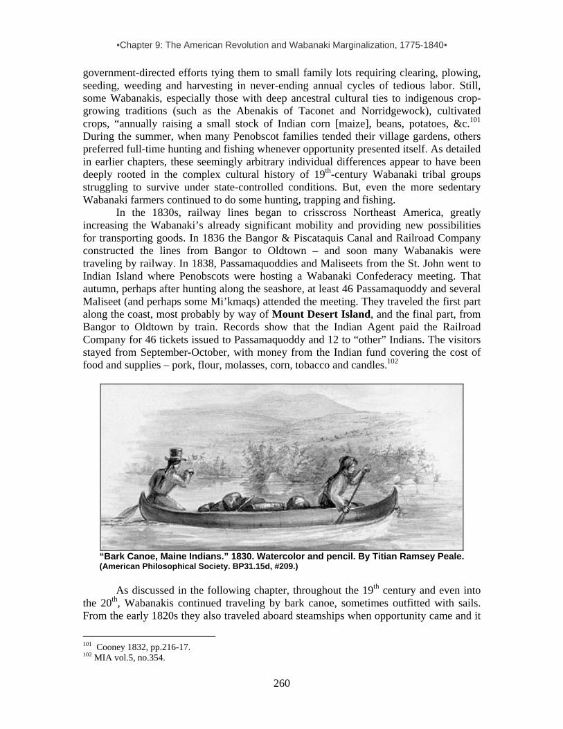
▪Chapter 9: The American Revolution and Wabanaki Marginalization, 1775-1840▪
260
government-directed efforts tying them to small family lots requiring clearing, plowing, seeding, weeding and harvesting in never-ending annual cycles of tedious labor. Still, some Wabanakis, especially those with deep ancestral cultural ties to indigenous crop-growing traditions (such as the Abenakis of Taconet and Norridgewock), cultivated crops, “annually raising a small stock of Indian corn [maize], beans, potatoes, &c.101 During the summer, when many Penobscot families tended their village gardens, others preferred full-time hunting and fishing whenever opportunity presented itself. As detailed in earlier chapters, these seemingly arbitrary individual differences appear to have been deeply rooted in the complex cultural history of 19th-century Wabanaki tribal groups struggling to survive under state-controlled conditions. But, even the more sedentary Wabanaki farmers continued to do some hunting, trapping and fishing.
In the 1830s, railway lines began to crisscross Northeast America, greatly increasing the Wabanaki’s already significant mobility and providing new possibilities for transporting goods. In 1836 the Bangor & Piscataquis Canal and Railroad Company constructed the lines from Bangor to Oldtown – and soon many Wabanakis were traveling by railway. In 1838, Passamaquoddies and Maliseets from the St. John went to Indian Island where Penobscots were hosting a Wabanaki Confederacy meeting. That autumn, perhaps after hunting along the seashore, at least 46 Passamaquoddy and several Maliseet (and perhaps some Mi’kmaqs) attended the meeting. They traveled the first part along the coast, most probably by way of Mount Desert Island, and the final part, from Bangor to Oldtown by train. Records show that the Indian Agent paid the Railroad Company for 46 tickets issued to Passamaquoddy and 12 to “other” Indians. The visitors stayed from September-October, with money from the Indian fund covering the cost of food and supplies – pork, flour, molasses, corn, tobacco and candles.102
“Bark Canoe, Maine Indians.” 1830. Watercolor and pencil. By Titian Ramsey Peale. (American Philosophical Society. BP31.15d, #209.)
As discussed in the following chapter, throughout the 19th century and even into
the 20th, Wabanakis continued traveling by bark canoe, sometimes outfitted with sails. From the early 1820s they also traveled aboard steamships when opportunity came and it
101 Cooney 1832, pp.216-17. 102 MIA vol.5, no.354.

▪Chapter 9: The American Revolution and Wabanaki Marginalization, 1775-1840▪
261
suited their needs. In the winter they continued to hunt and to catch smelt and oysters. And during the late spring and early summer they still speared salmon, lobster, eels and other fish from their canoes, or trapped them in weirs. They also hunted porpoise from their canoes, harvesting the animals for their valuable oil. Typically, they sold their catch at the town market or ship wharves, and used the cash earned to purchase flour, molasses, blankets, hardware and a host of other products.
Some Wabanakis turned to part-time wage labor, hiring themselves out as cheap seasonal workers at white-owned farms, fisheries or lumber camps. Whatever their new subsistence strategies, most families had no choice but to supplement their income by making and selling items such as utility baskets, broom sticks and barrel staves, as well as moccasins (used in lumber camps). In addition, they found an emerging market for specialty baskets, porcupine quillwork, birchbark toys and other crafts. Some, gifted with knowledge about healing diseases, became itinerant Indian “doctors” (or medicine men), peddling medicinal herbs throughout the northeast.
As long as Wabanakis held on to their traditional life as hunters, fishers and gatherers, they retained many elements of their distinctive dress, including leggings, tunics, robes, moccasins and various ornaments. In the late 18th century, an Italian visitor to Indian Island described the colorful dress of Penobscot men and women as follows:
Their attire is no longer the ancient one, made of skins, but European dresses and shirts, and uniforms of French and English soldiers. A few wear European-style hats, decorated with feathers. Others always go bareheaded, and their long black, glossy hair is cut short over the upper half of the head, while that of the nape comes down to their shoulders. Some paint their faces red and black in various designs, others have the cartilage of their ears cut and hanging down; others adorn them with silver rings, which sometimes hang even from their
nostrils. They also wear, sometimes across their shoulders, sometimes around their necks, canvas bags covered with wampum or tiny bugle beads of various colors arranged in patterns. Some have silver bracelets or rings, and others, plaques or medallions of the same teal hanging around their necks. The upper part of their thighs is bare, and they cover their nakedness with a piece of cloth or canvas, ordinarily red in color, which they slip between their thighs and hold up with a band…. Their shoes [are] made of deer or [moose] skins cured and tanned a hazelnut brown, and very elegantly fashioned. [The] women also wear European dresses, draped over their shoulders and coming down only to their knees, their legs and feet covered with the same stockings and shoes… They, too, wear earrings, bracelets, and similar ornaments, and a few of them have pointed caps decorated with glass beads or wampum.103
In time, as they took up farming or seasonal wage-labor such as lumberjacking and riverdriving, Wabanaki men discarded most of their characteristic clothes in favor of a less conspicuous appearance. With few regional exceptions, most began giving up their 103 Castiglioni 1785, p.39.

▪Chapter 9: The American Revolution and Wabanaki Marginalization, 1775-1840▪
262
unique dress in the 1830s. In 1843, Lt. Governor John Neptune of the Penobscot tribe was described as follows: “His dress consisted of a coarse, soiled blue frock, fastened about his waist with a leathern belt, from which was suspended a small hunting knife. He had a pair of moose shank moccasins on his feet, and on his head a cast-off beaver [hat] of the fashion of other days. . . .”104
Wabanaki women generally held on to customary clothing longer than the men. Increasingly involved in marketing baskets and other wares, they often traveled long distances and camped near town centers, still dressed “in their gay and ancient costume.”105 Typically, they wore “a coloured bed-gown and loose blanket thrown over the shoulders like a shawl; with petticoats of various colours.” They also wore “a high pointed cap of blue or red cloth, with loose ends falling almost over the shoulders, - highly ornamented with beadwork of various
patterns, and adorned with ribbons.” Beads were also worn “in strings around the neck” and were “often worked into [a woman’s] jacket . . . [and] moccasins.”106
Penobscot River, 1837. (Note women in peaked caps on right.) (MHS 2385-67.)
As for housing, birchbark wigwams remained popular among some Wabanaki groups well into 19th century. By the 1880s, however, only a few families would be found living in them year-round. Some would continue to use them in the summer, but during the rest of the year most would live in frame “houses built of boards and logs, furnished like a backwoodsman's shanty.” 107
104 The Rover, vol. 2, cited in Eckstorm 1945, p128. See also Gilpin 1878, pp110-11. 105 In Whitehead 1991, p.239. 106Unicke 1865, p.156 107 Halleck 1869, pp.430-431.

▪Chapter 9: The American Revolution and Wabanaki Marginalization, 1775-1840▪
263
Mi’kmaq women, bark wikuoms and canoe at Cape Breton Island. (Photo by M. Miot, 1959.) Mount Desert Indian Lore: Ambivalent Racism Considering the epidemics and other calamities, it was widely expected that the Wabanaki would slowly die out. Certainly their numbers had fallen to dramatically low levels by the mid-1800s. Demographic data based on estimates by Indian agents indicate that their population had dropped to about 1,000 in Maine. Although that began to slowly rebound in the second half of the 19th century, mainstream society had embraced the idea of the American Indian as a “vanishing race.” Reflecting what has been termed “imperialist nostalgia,” the false historical romanticism about the natural wilderness and its indigenous peoples ruthlessly being destroyed in the name of “Manifest Destiny” or “Natural Progress,” white settlers and visitors to Mount Desert Island also penned or spoke their memories of the past in idyllic terms conform the island’s emerging reputation as a coastal “Eden.”
These romantic reminiscences of Wabanakis juxtaposed alongside the other stereotype of the “savage” Indian reflect white dominant society’s complex ideology with respect to America’s natural heritage, its destruction in the name of Progress and Development, and the dispossession of its original inhabitants in the name of Manifest Destiny and Natural Law. The indigenous peoples of Pemetic (Mount Desert Island) and the magnificent surrounding coastal area were cast by dominant society as divinely destined by Providence to leave the beautiful land and its bountiful resources to the new “Native Americans” – to the Anglo-Saxon Patriots defending their newfound land of the free as the home of the brave. The popular 19th-century myth of the Vanishing Indian, of course, forms part of this “ambivalent racism of Anglo-American society, which repressed Native spirituality and traditional customs while creating cultural space for the invented Indian of romantic imagination.”108
Stories of injustices faced by Wabanakis in the wake of the Revolutionary War have been passed down through the years, relayed by both settlers and Indians. While it is unlikely that all of the facts in these stories are true, they surely carry elements of truth and thereby hint at the harsh prejudice and outright hostility Wabanakis encountered time and time again. Consider, for example, three “Indian legends” about white trappers killing Wabanaki hunters in the Mount Desert Island region, as later told by non-Indians or published in local newspapers of Bar Harbor and Machias in the 1880s.
108 Prins 1998, p.156: “Cast either as ‘noble’ or as ‘ignoble savages,’ Native Americans have been the subject of conflicting ideologies since their first encounter with European newcomer.”

▪Chapter 9: The American Revolution and Wabanaki Marginalization, 1775-1840▪
264
The first legend relays the alleged murder of Swunkus, a drunk tribesman who lived on Black Island (now called Conary Island) at the eastern entrance of Eggemoggin Reach just west of Bass Harbor:
At this time [in the 1780s] there was an abundance of wild fruit, and the excellent pasturage made it a fine feeding ground for moose and deer [&c.] . . . Here Mr. Conary lived in luxurious idleness and plenty. But, alas. . . . Strong drink led to frequent quarrels between Conary and Swunksus, the aboriginal proprietor of the land. There was room enough for both, and game and fruit enough for both, but as usual the white man wanted it all, and poor Swunksus wanted a part. So bitter did their quarrel become that one day in Northwest Harbor [Deer Isle], by mutual agreement, they parted without a fight, and at their next meeting were to kill each other by fair means if possible. . . . They shook hands and parted. Swunksus took a more direct route through the woods, and having a lighter canoe arrived at the island first and concealed himself near the landing to await the coming of Conary. Then to cheer himself in his weary waiting he took a big drink from his rum jug, and overcome by the potency of the liquor fell into a deep sleep. . . . Conary by this time was returning, and as he cautiously approached the shore heard a loud snoring. . . . Silently he landed, and in the dim twilight crept to where the Indian lay in drunken sleep, placed the muzzle of the gun to his ear. . . . A shallow grave was dug and all that was mortal of the red man was soon covered from sight. But his shadow still walks the island he loved so well. Sometimes his deep, heavy snoring may be heard in broad sunlight; often is the solitary fisherman or the summer tourist startled by the unearthly sounds as darkness gathers over the deep. . . .109
The second legend tells of two tough Indians who tried unsuccessfully to hold their ground against a settler who intruded on their hunting camp near Steuben, less than a dozen miles northeast of Frenchman Bay:
There is a small stream called Parritt, which lies, between the counties of Washington and Hancock and also between the towns of Steuben and Gouldsboro and Number 7 Township. The stream takes its rise from a large meadow and the Tunk Mountains. One day in the year 1790, two Indians followed this stream up to a point where they made a wigwam camp. It was the month of December and they were heavy with guns, traps and other material, for they were on the hunt for game. Their names were Newell and Peter. . . . That next morning a man called Robinson came upon Newell and Peter’s camp, he readied his rifle and out stepped the two men. Then Newell said, ‘I don’t want pale face on my hunting grounds and you must be off quickly. Tomorrow when the sun shines by those pine trees, I shall be here, if you are here I will kill you quick.’ Then Newell turned and he was out of sight. . . . Robinson moved to the south side of the mountains and made plans of his revenges and waited. He
109 This story was told by H.B. Wardwell to the Belfast Journal, in MDH, 6/19/85 p.2. In another version of this story Conary is the drunk, but the gist of the story – him murdering Swunksus to gain undisputed claim to the island – remains the same. See also McLane & Mclane, p.188.
▪Chapter 9: The American Revolution and Wabanaki Marginalization, 1775-1840▪
265
climbed to the top of the mountain and climbed the tallest tree to spy on the Indians to fulfill his plan. At night time he saw their fire and crept up to the wigwam and saw the two men having supper, as they reached for the pot of food their heads came together and Robinson shot his gun loaded with buck shot in it. The gun echoed across the silent forest, before the last echo died away Newell rushed to the door opening and fell to the ground dead. Robinson took the food from the pot and sat there and ate it. He helped himself to the furs lining the wigwam, which came from the hard work of Newell and Peter. A short distance from the camp stood a large pine tree and he decided to bury both the Indians on this spot. As he left the area he told Mr. Whittin the story and the location of the massacre. 110
The third legend aims to justify the murder of two “bad” Indians at Reed Pond near Ellsworth, named for the man who did the deed:
Reed Pond is so called from a hunter by that name, who came to Ellsworth soon after the first settlers. Reed Pond [Mar-las-sic; where Molly Molasses was born in 1775, in a birch canoe], and several small ponds adjacent, were his principal hunting grounds. . . . In 1785 Reed left, and was seen in the settlement no more. It was reported and generally believed, that Reed, and another hunter, killed two Indians, at the head of Reed Pond. The story came from other Indians; they said the Indians killed were bad, and attempted to rob Reed of his furs, and in the fight were killed. It was known that Reed and his companion left the pond suddenly, took nothing with them but their guns and furs, they said they left on account of the Indians, and had sunk their traps in the pond near a large rock at a place now called Jellison Cove. Much time was spent in after years, by some of the settlers hunting and fishing for the traps. It is believed they were never found.111
Contrasting such “ignoble savage” legends are romanticized stories of the so-
called “noble savage.” Among them is the following one about a wise and benevolent Passamaquoddy chief who was baptized and taught enduring lessons by missionaries at Mount Desert Island in his youth. It takes place about 1825 in the coastal hinterland of what we have identified in this report as Asticou’s Island Domain – namely at Taunton Bay upstream from Waukeag Neck:
The Passamaquoddys and the Penobscots and the Tarratines had not dwindled out [at Taunton Bay, in Franklin, Maine,] and there were frequent acts of hostility to the whites. But Tugwassah, the big chief of the Passamaquoddys was a guardian angel of the settlers. Moses Abbot said that Tugwassah calmed and civilized a good many white settlers who came in after Mr. Abbot's father did. Tugwassah had been taught in his youth by some Jesuit missionaries at Mt. Desert. He learned many things from them which, even when he became a chief, he practiced. He visited the sick, whether white or Indian. Always bringing
110 “A Massacre in Steuben” Machias Observer, 5/5/1884. 111 MDH, 9/4/1885, p.3.

▪Chapter 9: The American Revolution and Wabanaki Marginalization, 1775-1840▪
266
some gifts from the woods, and he followed the bier of everyone whom he had known if he was in the vicinity when the burial took place. It was Tugwassah who told the white settlers the names the Indians had for the ponds and streams and hills in the vicinity of Franklin, and those names they bear today. Tugwassah is buried at Butler's Point [an ancient village site] in Franklin, but his grave is unmarked by stone or slab.112
Indian legends on both ends of the noble-ignoble spectrum, passed on from one generation to the next, were relished by a fresh wave of newcomers – the “rusticators” who ventured to Mount Desert Island in the latter half of the 1800s to escape city life and experience the wonders of nature.
Mount Desert Bearing NW. (Plate XX in an atlas of plates Illustrating the geology of Maine, featured in The First Report on the Geology of the State, by Charles T. Jackson, engraving and lithography by Thomas Moore, 1837. (Maine Memory Network.)
◘ ◘ ◘ ◘
112Story of Moses Abbot, from interview by Zelda Havey and Ivy Young. Maine Folklife Center Collections – provided by Donald Soctomah Feb. 2004. See www.franklinmaine.net/inspiration.htm for more local lore on Tugwassah.

▪Chapter 10: Wabanakis & Rusticators, 1840s-1920s▪
267
CHAPTER 10: WABANAKIS AND RUSTICATORS IN THE MOUNT DESERT ISLAND NEIGHBORHOOD, 1840s-1920s
Wabanakis offer canoe and guiding services to three “rusticators” (far left & far right). Bar Harbor’s north shore, just east of the Indian encampment located at the foot of Bar/Bridge Street, c1880. (MHPC.)
The Indian encampment at . . .Bar Harbor will be found a pleasant place to wile away an hour or two. These [Indians] are expert with their canoes and at hunting and fishing. The village is composed of a score or two of little wood and canvas shanties, in which are sold a great variety of aboriginal trinkets, skins of seal and deer, baskets of birch-bark, moccasins, bead-work, snow-shoes, gulls’ breasts, stuffed birds, clubs, carved sticks, bows and arrows, etc. (Chisholm’s Mount Desert Guide, 1888.)
Decades before Moses Sweetser published his first guide to Mount Desert Island for Chisholm Brothers Publishers, Adelma Somes (b1837) was gathering childhood

▪Chapter 10: Wabanakis & Rusticators, 1840s-1920s▪
268
memories about Wabanakis, later relayed in a collection of reminiscences about growing up in Somesville. Adelma was the great granddaughter of Somesville founder Abraham Somes. As detailed in the previous section of this report, Abraham claimed he first visited MDI in 1755. Six years later he returned to put down stakes between the pond and the great saltwater inlet or fjord that came to be known by his name. In 1762 he brought his family there and settled in to stay. From early on, the family had associations with Wabanakis who came to the area seasonally. Adelma recalled her grandfather John Somes saying that when he was a boy (c1770s) one of the Indians who camped nearby taught him how to make a scoop net for fishing, another made him a pair of snowshoes, and an Indian woman showed him how to make splint baskets.1
In 1831 Adelma’s uncle Daniel Somes established MDI’s first hotel, Mount Desert House, in the middle of the village. Here, before long, stagecoaches stopped to deliver mail and passengers, including many of MDI’s earliest summer visitors. By 1837, the year of Adelma’s birth, Somesville had become the island’s small economic center, having nine families, a small store, blacksmith and shoemaker shops, a tan-yard, bark mill, saw mill, lath mill, shingle mill, and grist mill, plus two shipyards and a school house.2
Wabanakis, dispossessed of almost all territories across northern New England and beyond, where their ancestors had ranged freely for countless generations, gravitated seasonally to settlements such as Somesville, following a marginal survival strategy that combined limited hunting and fishing (thwarted by the state’s shifting game laws and loss of hunting territories) with making and selling hand-crafted goods to locals. As described by Adelma, writing about her first-hand recollections from the 1840s:
The Indians of the Penobscot Tribe, since I can remember, were always camping around the fresh water ponds, I suppose for the purpose of trapping mink and muskrats. . . . They made beautiful baskets and did beautiful bead work. I remember, it must have been around 1847, of several camps in my grandfather’s pasture. They were on the edge of the pond (then called Lilly Pond) now called Somes Pond. I can remember so well of going with my mother and several other women to their camps made of boughs; one Mary Ann the fortune teller, Mrs. Glassene in another, and there were some others that they did not seem well enough acquainted to visit. The Glassene boy went to school with us. . . . One party of Indians camped on the Oak Hill Road by the Pond and I remember of riding over one winter day in a sleigh with my father, my sister and my brother.3
A poem in Adelma’s reminiscences reveals the dubious romantic nostalgia of the age
while providing more details about the Penobscots who camped near her girlhood home: I loved the Indian, when he built his wigwam by the pond And hunted, unmolested. No canvas wigwam had he, But one of boughs, I’ve sat and watched the [women] Doing their beadwork, and wished I were an Indian.
1 Somes-Sanderson, p.70. This is an unusually early date for Wabanaki splint basketry. 2 Thornston, p.243. See also Pugh et al. In Hansen, p.46. 3 A. Joy 13:1-2. See also Somes-Sanderson, p.71, Thornton pp.254-56. [Note: Mrs. “Glassene” may be one of two widows listed as “Classian” on the 1858 & 1860 Penobscot census: Sarah (b.c1815) or Mary (b. c1818).]

▪Chapter 10: Wabanakis & Rusticators, 1840s-1920s▪
269
They were our friends, and we were theirs; They came and we welcomed them; they lived upon our land, No rent was paid or asked, our children played with theirs And loved the Indian. They often made us visits, wearing their bright plaid shawls And shining beaver hats. They sat at table with them on; It was their custom. We treated them like honored guests, And they looked it. Why should we not? Were they not here before us?4
Of course they were – and they had not invited newcomers such as the Somes family and so many others, who in their own struggle for survival as hardscrabble farmers and fishers had moved into an untamed habitat where everything seemed free for the taking. And take they did—trees, clams, lobsters, fish, ducks, seals, beaver, moose, and a host of other natural resources long valued by the Wabanaki as essential in their livelihoods. Sometime in the 1850s, Indians ceased camping in Somesville, facing diminished game and drawn by opportunity to other parts of the island, in particular Southwest Harbor and Bar Harbor. Pressed by the growing need for money in the cash economy surrounding them, Wabanakis were drawn to seasonal encampments that offered good prospects for marketing traditional skills (craftmaking, canoeing, hunting/guiding and cultural performances) to summertime tourists and residents at coastal resorts. The saltwater shores of Mount Desert Island soon topped the list of New England destinations.
Mi’kmaq encampment, 1890. Taken in Baddeck on Cape Breton Island, Nova Scotia, this picture by H.L. Rand (who also photographed Indians on Mount Desert Island), gives an idea how some of the Somes Pond encampments must have looked in the mid-1840s. (SWH Library.)
4 A.Joy, 13:2-3 and 14:2.
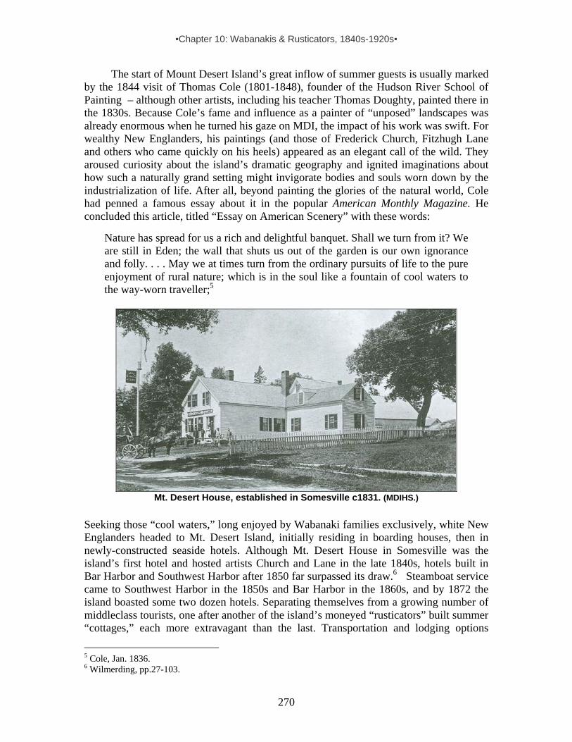
▪Chapter 10: Wabanakis & Rusticators, 1840s-1920s▪
270
The start of Mount Desert Island’s great inflow of summer guests is usually marked by the 1844 visit of Thomas Cole (1801-1848), founder of the Hudson River School of Painting – although other artists, including his teacher Thomas Doughty, painted there in the 1830s. Because Cole’s fame and influence as a painter of “unposed” landscapes was already enormous when he turned his gaze on MDI, the impact of his work was swift. For wealthy New Englanders, his paintings (and those of Frederick Church, Fitzhugh Lane and others who came quickly on his heels) appeared as an elegant call of the wild. They aroused curiosity about the island’s dramatic geography and ignited imaginations about how such a naturally grand setting might invigorate bodies and souls worn down by the industrialization of life. After all, beyond painting the glories of the natural world, Cole had penned a famous essay about it in the popular American Monthly Magazine. He concluded this article, titled “Essay on American Scenery” with these words:
Nature has spread for us a rich and delightful banquet. Shall we turn from it? We are still in Eden; the wall that shuts us out of the garden is our own ignorance and folly. . . . May we at times turn from the ordinary pursuits of life to the pure enjoyment of rural nature; which is in the soul like a fountain of cool waters to the way-worn traveller;5
Mt. Desert House, established in Somesville c1831. (MDIHS.)
Seeking those “cool waters,” long enjoyed by Wabanaki families exclusively, white New Englanders headed to Mt. Desert Island, initially residing in boarding houses, then in newly-constructed seaside hotels. Although Mt. Desert House in Somesville was the island’s first hotel and hosted artists Church and Lane in the late 1840s, hotels built in Bar Harbor and Southwest Harbor after 1850 far surpassed its draw.6 Steamboat service came to Southwest Harbor in the 1850s and Bar Harbor in the 1860s, and by 1872 the island boasted some two dozen hotels. Separating themselves from a growing number of middleclass tourists, one after another of the island’s moneyed “rusticators” built summer “cottages,” each more extravagant than the last. Transportation and lodging options
5 Cole, Jan. 1836. 6 Wilmerding, pp.27-103.
▪Chapter 10: Wabanakis & Rusticators, 1840s-1920s▪
271
continued to multiply, and by 1887 MDI’s total summer visitor count had reached 20,000.7
Clearly, all of these visitors, as well as the local farmers, fishers and boat builders who welcomed them were latecomers compared to Maine’s indigenous inhabitants. While it is true that Wabanaki presence in the area had always been largely seasonal and was interrupted repeatedly in the 17th-18th centuries due to colonial warfare, shellmiddens and other Native prehistoric remains on MDI and other nearby island and coastal sites testify to the presence of hundreds of generations of Native peoples over thousands of years. And once the smoke of colonial warfare and the American Revolution cleared, Wabanakis again frequented the area in numbers. Beyond hunting, gathering and fishing like their ancestors, they pursued buyers for the goods and services they had to offer. This marketing niche was a key element in their marginal subsistence strategy – a difficult adaptation that came about in response to land loss, hunting laws and other restrictions imposed by quickly expanding Euramerican communities. While state Indian agents tried to tie Wabanakis to their small reservations by promoting small-scale farming through subsidies, most members of Maine’s surviving Indian population pursued livelihoods that echoed aspects of traditional life, including a pattern of seasonal migrations. Selling crafts to settlers made this possible. According to an Indian Agent Report on the Penobscot and Passamaquoddy communities from 1847-51:
The Indians of our State are in a transition from the hunters’ to agricultural, from savage to civilized life. Their forest game is so far exhausted as to afford them but partial employment, and a scanty and precarious reward for their toil and supply for their necessities. A part of them, at some seasons of the year, eke out a miserable existence by leading a wandering gipsy-like life amongst our white population, supplying them with baskets and other articles of Indian ingenuity.
The rise of tourist resorts made Wabanaki existence noticeably less “miserable,” as
noted by Indian agents and various newspaper accounts about Wabanakis and their “wares” in the decades that followed. Fancy woodsplint and sweetgrass baskets proved to be the most marketable items, but sealskins, mounted antlers, moccasins, snowshoes, seagull breasts, carved paddles and birchbark items such as toy canoes, picture frames and boxes embroidered with dyed porcupine quills were also popular. Some made rustic furniture, but full-size birch bark canoes were the prized, large-tag item. In addition, they hunted porpoises, extracting and selling the oil. During the most prosperous years for such sales (1875-1905), Indian agent reports featured comments such as:
About 20 [Indian] families are at Bar Harbor, selling their wares and catching porpoises. Those who remain here are employed in basketmaking and killing porpoises [in Frenchman Bay], and in the latter business they have been very successful.8
The year as a whole has been one of more than usual prosperity to the tribe. The revival of business has brought them constant and remunerative
7 Eastport Sentinel, 7/10/1872; MDH, 10/28/87. Cf.Sweetzer, 1888, p.71. 8 Hobart (Passamaquoddy Indian Agent), 1875.
▪Chapter 10: Wabanakis & Rusticators, 1840s-1920s▪
272
employment. The basket trade has been active, and all, except the persistently indolent, have reaped substantial benefits.9 The summer season was profitable to those who went abroad to vend their manufactured articles.10 The growing resort trade [on MDI] has discouraged farming by encouraging Indians to sell baskets, sea gull breasts, canoes, etc.11 The summer at the seaside generously added to their supply of cash, and basket-making has been fairly profitable throughout the year.12
The one thing, perhaps, which militates most against the highest success in farming is the yearly departure from home in the month of July of nearly if not quite three-fourths of the entire tribe, who go to the seaside and other summer resorts, for the purpose of selling their baskets and various other articles of manufacture.13 Local newspapers show that Maliseets and Mi’kmaqs, as well as Penobscots and
Passamaquoddies, came to Mount Desert Island to market their goods. Indian agents for these tribal groups also made note of this. For instance, in 1895 the Indian agent for the Maliseet reserve at Kingsclear, on the St. John River in New Brunswick, reported:
The sole industry engaged in by this band is the manufacture of Indian wares and farming. A few of the young men work in the woods in winter and hire at streamdriving. Last year and this, fully half of the band left the reserve for watering places in the state of Maine and points between Fredericton and St. John [New Brunswick]. At these places most of the sales of Indian wares are made to tourists and visitors. . . . The most of the articles sold are fancy baskets, bead work, etc., for which it is said the Indians get good prices. They usually remain at this business until the approach of fall.14
The marketing of handmade goods was so important to the Wabanaki during this period that a slow summer season at the coast (due to such uncontrollable forces as weather or illness at the encampments, both of which discouraged buyers from coming), spelled financial hardship for reservation families for the entire year. As noted by one state Indian agent: “The summer trade of the Indians is, in a small way, a sort of commercial barometer, indicating whether the general money market is easy or tight, and the readings of this barometer can be inferred quite correctly, by noting the number of new and improved dwellings among our [Penobscot Indian] island friends. Judged by this standard, the readings were [this year] of mean height and the money market not easy.”15
9 Indian Agent Report (Penobscot) for 1880, p.14. 10 Indian Agent Report (Penobscot) for 1882, p.9. 11 Indian Agent Report (Passamaquoddy) for 1883, p.5. 12 Indian Agent Report (Penobscot) for 1887, p.7. 13 Indian Agent Report (Penobscot) for 1888, p.6. 14 Sessional Papers vol.10:14, pp.42-43. 15 Indian Agent Report (Penobscot) for 1891, pp.8-9.

▪Chapter 10: Wabanakis & Rusticators, 1840s-1920s▪
273
Detail from Xanthus Smith’s “Encampment of Passamaquoddy Indians, Bar Harbor” the earliest known image of Indian encampments there. The title is misleading, given written evidence of other Wabanaki groups also camping there at the time. Note sale tents in the background on the left side of the drawing. (Courtesy of Clark Point Gallery.) (Image darkened) Still, overall, summer trade offered Wabanakis the greatest potential for financial gain during this time. Seeking close proximity to potential clients, they typically left their reservation homes between late May and early July to set up camps near the houses, inns and docks of resort areas. Initially makeshift, the encampments became subject to increasing regulation with each passing year. As discussed later in this chapter, by 1890, concerns of the Bar Harbor Village Improvement Society led to standardized platform sales tents at a newly designated “Indian Encampment” at the southern edge of town between lower Main Street and Ledgelawn Ave.16 GETTING TO MOUNT DESERT ISLAND
Wabanakis came to Mount Desert Island various ways. Initially, they paddled and portaged their canoes, taking traditional lake, riverine and inner coastal passages that avoided long stretches of difficult open sea travel.17 For instance, Passamaquoddy coming from Indian Township could canoe west across Big Lake and West Grand Lake, travel south into Third Machias Lake, then follow the Machias River to the coast, and from there paddle via coastal route to MDI, with portages along the way. From Pleasant Point, one could go via Cobscook Bay to Machias Bay and then on to MDI, with periodic portages. Penobscots, traveling from Indian Island and other locations along the Penobscot River could travel inland water routes east to Union River leading to Blue Hill Bay. Or they could follow the Minneokun (“many directions route”) from the Castine peninsula at the mouth of the Penobscot, up the Bagaduce River, down Walker Pond, and then a half-mile carry into Eggemoggin Reach. From there they could travel the length of the Reach to Naskeag Point and on to MDI. (Or, more safely, they could avoid rounding Naskeag Point by paddling just 4-5 miles along the Reach, turning up the Benjamin River, making a short carry to Salt Pond and continuing on to Blue Hill Bay and MDI – entering the island at Squid Cove or Pretty Marsh.) As noted by anthropologist William 16 See inventory and maps of seasonal Wabanaki encampments on MDI in Chapter 20. 17 Personal communication from Donald Soctomah, May 2005.

▪Chapter 10: Wabanakis & Rusticators, 1840s-1920s▪
274
Haviland, a third-generation Deer Isle resident, the Bagaduce route to Eggemoggin Reach is half the distance of going around Cape Rosier. Plus, by traveling the Bagaduce,
entirely protected from the sea and wind, canoeists avoided the dangerous tides and strong currents of Cape Rosier. . . . Moreover, by choosing the right time, one got a significant boost from the strong tidal currents in the Bagaduce. This would have been especially helpful on a going tide, when returning to [Old Town]. To canoe past Cape Rosier, going against the strong river and tidal currents is hard work; by contrast, one would paddle with the currents down the Bagaduce. Similarly a coming tide would help carry one upstream.18
After steamboat service to Mount Desert Island became available by way of
Rockland and Machiasport in the 1850s and 1860s respectively, many Wabanakis used it, typically paying a fee to have their canoes transported with them. Those coming from Old Town could travel by train to Bangor, take the Boston steamer as far as Rockland, and there catch a steamer to MDI. Those coming from the Passamaquoddy villages still had to get to Machiasport by canoe or land to catch a steamer to MDI.19 In 1872, the Eastport Sentinel offered this travel description for Bar Harbor tourists:
There are two ways for tourists to go to Bar Harbor [from Eastport]. One by the International Line to Portland then steamer “Lewiston” to Bar Harbor; the other way is by land to Machiasport then by steamer to Bar Harbor. The drive from Eastport to Machiasport was delightful, the only drawback being the innumerable mosquitoes and in the woods between Dennysville and East Machias, horseflies. The view along the road from Dennysville to Machiasport has changed very little for the last thirty years. At Machiasport we board the steamer Lewiston, stopping a short time at Jonesport and Millbridge and reaching our destination at half past ten. At Millbridge a tugboat comes out and brings passengers and freight aboard. At Mt. Desert very little meat is furnished to the traveler, but he is permitted to feast upon fish. But the crowds that flock to Bar Harbor every year are willing to overlook the food, while it is not a fashionable resort but frequented more than any other watering resort. The people who pass the summer on the rough, rocky island leave their big trunks at home. During the day, parties of several persons start off on a walking expedition of five, ten and fifteen miles to one or another of the many objects of interest on the sea shore or up the mountains. There is a vigorous sensible, healthy feeling in all they do”20
18Wm.Haviland, p.c.10/26/05 and July 2003, p.2. Noting that Eggemoggin Reach can be difficult to paddle “when the wind blows out of the northwest or south,” Haviland describes an alternate route to a straight shot through the reach – from Punch Bowl southeast between Little Deer Isle and Deer Isle, continuing south along the west flank of northern Deer Isle into Northwest Harbor, carrying over into Long Cove, which gave access to several options for reaching Blue Hill Bay. See canoe route inventory in Chapter 21. 19 By 1885 direct steamship service between Bangor and Bar Harbor was available. (Ryan. See also Richardson, Short & Sears, Albion et al.) By 1882, the steamship Admiral offered direct service from Eastport to Bar Harbor. (See Eastport Sentinel 9/9/1882.) 20 Eastport Sentinel 7/10/1872. See also MDH, 8/20/1881, p.3, re. Eastern Railroad Co. purchasing several acres of land in 1866 for building a wharf at Bar Harbor to accommodate steamships.

▪Chapter 10: Wabanakis & Rusticators, 1840s-1920s▪
275
Over the next decade steamboat service to MDI expanded, tourism grew mightily, and in 1881 the Mount Desert Herald reported: “Thirteen years ago the little steamer Rockland made one trip a week between Rockland and Millbridge, touching at Bar Harbor. Now we have steamers City of Richmond, Lewiston, Mt. Desert, Little Buttercup, Acadia, and Queen City of Bangor all running to and from this port.”21
Steamer “Mt. Desert” leaving Southwest Harbor, c1900. Built by Goss & Sawyer Co. at Bath, Maine, 1879, for the Rockland, Mount Desert, & Sullivan Steamboat Co. Known as “Old Mounty,” it traveled between Rockland and Bar Harbor, stopping at Bass Harbor, Southwest Harbor and Sullivan. It was 163’ long, with a capacity of about 150 passengers. In 1904 the J.T. Morse took over Old Mounty’s Rockland-Bar Harbor run. (See Short & Sears, p.159.) (Photo by G.A. Neal. SWH Library Collections.)
Sometimes the Herald mentioned Wabanaki use of steamship travel. In 1881 the
paper reported: “Our Indian population is increasing rapidly. Every steamer brings additions to the colony.”22 Three years later it noted: “Over fifty Indians from the Passamaquoddy Tribe arrived at Bar Harbor on the steamship Frances.”23
For Wabanakis living on Indian Island at Old Town or other reservation islands further up the Penobscot River, getting to Bar Harbor became especially easy in 1884. That year a railroad extension was completed from Bangor through Ellsworth to the Mount Desert Ferry on Hancock Point. From there it was just a short ride to Bar Harbor on the steamer Sebenoa or her successors.24
Even after the introduction of train and steamboat transportation, some Wabanakis continued to travel all or part of the journey to MDI by canoe, as evident in this 1893 excerpt from the Bangor Industrial Journal:
Francis Dana, a well-known Indian hunter and guide whose home is at East Machias, having built a 16-foot birch canoe, started out last week to find a customer for it. He put to sea Friday in his frail craft, and having no sail paddled to Bar Harbor, where he disposed of the canoe, and returned home by Saturday’s steamer. The distance is sixty miles, and the water was rough.25
21 MDH, 7/17/1881, p.3. 22 MDH, 8/6/1881, p.3. 23 MDH, 8/22/1884. 24 Albion et al, p.212. 25 The [Bangor] Industrial Journal, 7/21/1893.

▪Chapter 10: Wabanakis & Rusticators, 1840s-1920s▪
276
Detail (western half), Map of the Boston & Bangor Steamship Co. Showing Route Between Boston and Bangor and Mount Desert. (Rand Avery Supply Co., Engr’s, Boston. 1885.)

▪Chapter 10: Wabanakis & Rusticators, 1840s-1920s▪
277
Detail (eastern half), Map of the Boston & Bangor Steamship Co. Showing Route Between Boston and Bangor and Mount Desert. (Rand Avery Supply Co., Engr’s, Boston. 1885.)

▪Chapter 10: Wabanakis & Rusticators, 1840s-1920s▪
278
Long distance canoe travel had its ups and downs, as evident in this 1885 news bit:
Rev. Mr. O’Dowd, Catholic priest at the Indian settlement at Pleasant Point, whose visit to Bar Harbor we noticed recently, had a rough passage while returning. At Machiasport he met an Indian from Pleasant Point who was going to Eastport in a canoe. The Indian was afraid to go so far in a canoe alone, and Mr. O’Dowd, who has become accustomed to that mode of travel and can wield a paddle as well as some Indians . . . readily consented to go with him. Soon after they started, a heavy fog shut out the sight of land, and when night came on a storm arose, and the priest and Indian found themselves on the ocean fifteen miles from any land, a high sea running, thick fog all around, the wind blowing, and nothing between them and the waves but a bark canoe. They paddled through the darkness till 11 o’clock, the Indian much frightened and the priest nearly tired out, when they landed on a small island by chance, wet and tired. They were cared for by a fisherman.26
Passamaquoddy Lewis Mitchell, c1885, noted for paddling his canoe all the way around MDI in just 12 hours. (Courtesy of Donald Soctomah.)
Still, numerous examples of Wabanakis retaining canoeing skills and paddling endurance appear in written records of the 19th and 20th centuries. For instance, in 1881 the Mount Desert Herald reported that Passamaquoddy “Lewis Mitchell recently paddled his canoe entirely around the island of Mt. Desert, a distance of sixty miles, in twelve hours.”27 Several years later, a popular 1888 MDI guidebook noted: “The Indian boatmen of the island sometimes make an adventurous voyage by taking their boats up to Eagle Lake, and crossing that sheet of water; carrying over the portage; and descending to Jordan’s Pond, and so on down to Seal Harbor; whence they return to Bar Harbor by the sea.”28
Zoologist Addison Emery Verrill, who grew up in Maine and did maritime fieldwork in Passamaquoddy Bay, introduced his son Hyatt (1871-1954) to the Passamaquoddy. 26 MDH 9/11/1885, p.2. 27 This appeared in a recurring ad for renting canoes (and Indian guides) in Bar Harbor, MDH, 7/31-9/3/1881, p.3. Profile of Lewis Mitchell appears further on in this section under the heading “Notable Wabanakis on MDI. 28 Sweetser, 1888, p.61.

▪Chapter 10: Wabanakis & Rusticators, 1840s-1920s▪
279
Hyatt, who became a prolific author, illustrator, and naturalist, wrote about his experiences with them – including his observations of their seafaring skills. For instance, he noted, “I have seen Passamaquoddy canoes, far out to sea, manned only by a woman and several youngsters, scudding home from the fishing banks, with a blanket for a sail, when the fishing schooners were making heavy weather of it under double-reefed sails. One old Indian of the tribe actually paddled and sailed his canoe from Eastport to [Bridgeport,] Connecticut – merely to see my father – and thought nothing of the feat.” Verrill also wrote about a steamship captain seeing an Indian wildly signaling him from a canoe out of sight of land. Assuming he was in trouble, the captain stopped his ship, only to find that the Passamaquoddy paddler simply wanted matches to light his pipe. 29
Equally telling is this recollection from a now long-deceased Isle au Haut resident: “I remember Big Thunder. . . . I used to borrow his canoe to go up to the pond. Mighty tippy. He never minded. A birch canoe was a good boat if there was an Indian in it. Took their canoes [across Penobscot Bay] right out to Matinicus [Island].30
(Left: Wallace Lewy (b. c1869), c1930. Courtesy Donald Soctomah.) Former Passamaquoddy governor John Stevens of Indian Township, born in 1933, offered more recent memories of family travels to Mount Desert Island. He reminisced about his mother, Maria Lewy Stevens, being born at the Bar Harbor Ledgelawn Indian encampment in 1909 when her parents Eleanor and Wallace Lewy were there selling crafts. And he recalled how his grandparents and parents31 continued the tradition of going to MDI for the summer season well into his boyhood years in the 1930s –
still traveling part of the distance by canoe. In Stevens’ words:
[They left from the] big landing place at [Peter] Dana Point in front of our house. I remember them all getting ready to go. Usually early spring, around May…. They went by canoe [to catch the train at Princeton to Eastport]. A lot of kids went with their parents. But we didn’t. I think my mother and my father and my grandmother and grandfather, they had so much junk—I mean stuff they’d sell—and they had only one canoe, and it was long, I remember. It might have been 15 feet. But to me it was longer than that, and wide. It was a sea-going one. To me it was a very nice looking canoe, and I would have loved to go with them…. They had huge tents. [I remember them] packin’ ‘em right in their boat, and other wares that they had. A lot of stuff that they use, I guess, that they make baskets out of. They take it with ‘em. They used to have a tea [kettle] and they said, “That has to go with us.” My father [always] said, “If you have tea, you’ll survive.”…. There’d be about five, six families goin’. They’d all go together.32
29 Verrill, 1932, p.109 and 1954, p.97. 30 Gooden Grant, interview by Franklin. See Bunting, 2000, p.70. Also, on p.358, n.l, Bunting notes, “Grant was also quoted as saying that Indians from ‘East Quoddy’ as well as Old Town visited Isle au Haut.” 31 John Stevens’ maternal grandparents, Eleanor and Wallace Louis/Lewey, appear on the 1910 Federal census for Peter Dana Point as 22 and 41 years old, respectively. Wallace is identified as a guide and their daughter Maria is listed as a one-year-old. 32 Stevens, interview by McBride.
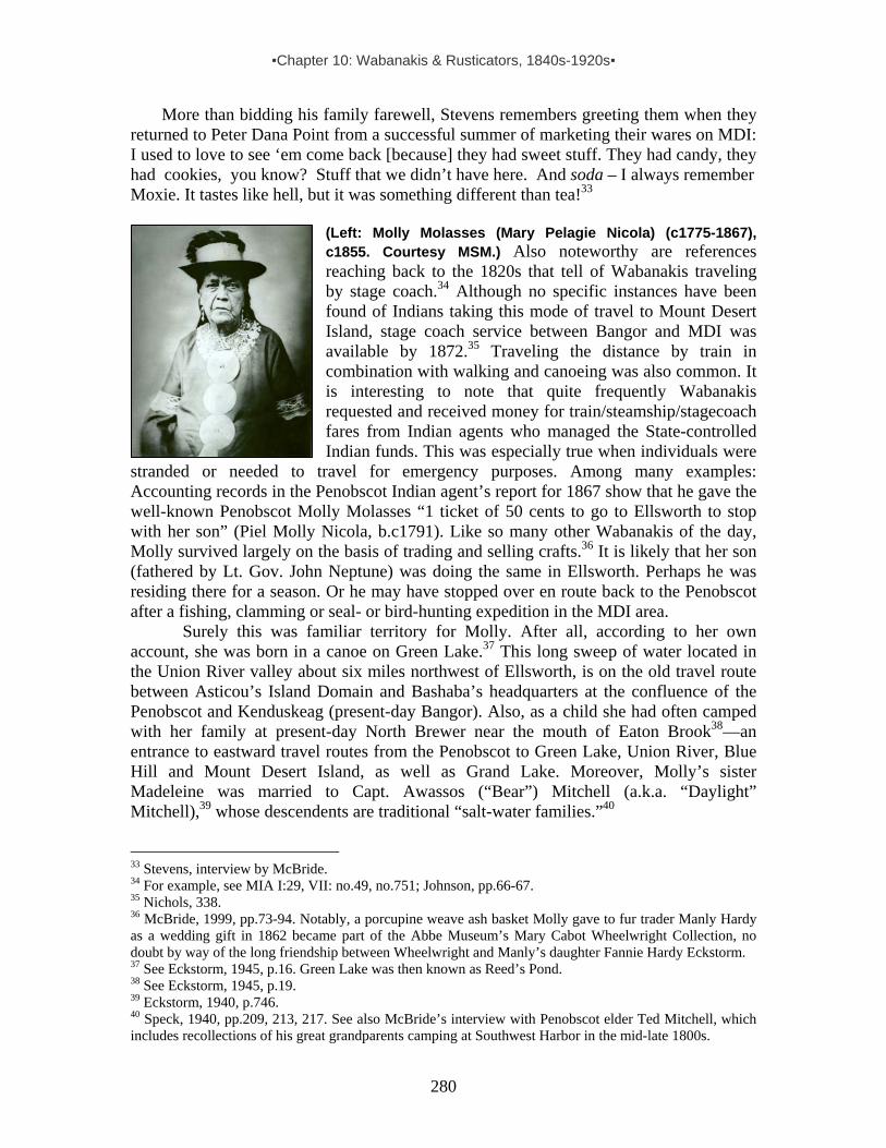
▪Chapter 10: Wabanakis & Rusticators, 1840s-1920s▪
280
More than bidding his family farewell, Stevens remembers greeting them when they returned to Peter Dana Point from a successful summer of marketing their wares on MDI: I used to love to see ‘em come back [because] they had sweet stuff. They had candy, they had cookies, you know? Stuff that we didn’t have here. And soda – I always remember Moxie. It tastes like hell, but it was something different than tea!33
(Left: Molly Molasses (Mary Pelagie Nicola) (c1775-1867), c1855. Courtesy MSM.) Also noteworthy are references reaching back to the 1820s that tell of Wabanakis traveling by stage coach.34 Although no specific instances have been found of Indians taking this mode of travel to Mount Desert Island, stage coach service between Bangor and MDI was available by 1872.35 Traveling the distance by train in combination with walking and canoeing was also common. It is interesting to note that quite frequently Wabanakis requested and received money for train/steamship/stagecoach fares from Indian agents who managed the State-controlled Indian funds. This was especially true when individuals were
stranded or needed to travel for emergency purposes. Among many examples: Accounting records in the Penobscot Indian agent’s report for 1867 show that he gave the well-known Penobscot Molly Molasses “1 ticket of 50 cents to go to Ellsworth to stop with her son” (Piel Molly Nicola, b.c1791). Like so many other Wabanakis of the day, Molly survived largely on the basis of trading and selling crafts.36 It is likely that her son (fathered by Lt. Gov. John Neptune) was doing the same in Ellsworth. Perhaps he was residing there for a season. Or he may have stopped over en route back to the Penobscot after a fishing, clamming or seal- or bird-hunting expedition in the MDI area.
Surely this was familiar territory for Molly. After all, according to her own account, she was born in a canoe on Green Lake.37 This long sweep of water located in the Union River valley about six miles northwest of Ellsworth, is on the old travel route between Asticou’s Island Domain and Bashaba’s headquarters at the confluence of the Penobscot and Kenduskeag (present-day Bangor). Also, as a child she had often camped with her family at present-day North Brewer near the mouth of Eaton Brook38—an entrance to eastward travel routes from the Penobscot to Green Lake, Union River, Blue Hill and Mount Desert Island, as well as Grand Lake. Moreover, Molly’s sister Madeleine was married to Capt. Awassos (“Bear”) Mitchell (a.k.a. “Daylight” Mitchell),39 whose descendents are traditional “salt-water families.”40
33 Stevens, interview by McBride. 34 For example, see MIA I:29, VII: no.49, no.751; Johnson, pp.66-67. 35 Nichols, 338. 36 McBride, 1999, pp.73-94. Notably, a porcupine weave ash basket Molly gave to fur trader Manly Hardy as a wedding gift in 1862 became part of the Abbe Museum’s Mary Cabot Wheelwright Collection, no doubt by way of the long friendship between Wheelwright and Manly’s daughter Fannie Hardy Eckstorm. 37 See Eckstorm, 1945, p.16. Green Lake was then known as Reed’s Pond. 38 See Eckstorm, 1945, p.19. 39 Eckstorm, 1940, p.746. 40 Speck, 1940, pp.209, 213, 217. See also McBride’s interview with Penobscot elder Ted Mitchell, which includes recollections of his great grandparents camping at Southwest Harbor in the mid-late 1800s.

▪Chapter 10: Wabanakis & Rusticators, 1840s-1920s▪
281
THE INDIAN ENCAMPMENTS ON MOUNT DESERT ISLAND
Wabanaki encampment next to the Parker home at Clark Point, Southwest Harbor, c1880s. The campsite was used at least from the 1840s until 1925. (SWH Library.) Proximity to Natural Resources Beyond close proximity to marketing possibilities, Wabanakis sought campsites that gave them access to water and ideally to other resources as well. This is evident in various descriptions, including those concerning the Indian encampment situated next to the Parker’s home at Clark Point in Southwest Harbor. The earliest written record of this encampment, told by Eunice Deering and included in Adelma Somes Joy’s Reminiscences, reaches back to 1847. That year, recalled Deering, “came a tribe of Indians from Old Town, some fifteen or twenty, and camped on the salt water shore opposite Parkers.”41 In a later reminiscence, Jesse Parker noted that the Penobscot families who summered there gathered sweetgrass “from the marshes at Bass Harbor. . . . [and] also cut some ash wood for use in making the wooden baskets.” A similar account provided by Nellie Thornton mentioned that the “right” to cut ash, as well as to gather sweetgrass, was “vouchsafed by the owners of the land as it was an unwritten law that Indians could have an occasional tree to use in their work from the land that, not so long before, had belonged entirely to them.”42 For water, they depended upon the Parkers’ well. This is known thanks to P.G. Rhoads of
41 A.Joy 14:1. For overview of campsites, see Inventory of Wabanaki Encampments on MDI in Chapter 20. 42 Thornton, pp.166-67.

▪Chapter 10: Wabanakis & Rusticators, 1840s-1920s▪
282
Wilmington, Delaware, who, around 1925, purchased property from the Parkers, built a cottage on the campsite, and henceforth referred to it as “the Indian Lot.” Eventually, Rhoads acquired two historic items tied to the place: an 1885 map that shows the location of the encampment, and a basket (pictured on previous page), which he tagged as follows:
Basket bought by P.G. Rhoads from Mrs. Jesse Parker, who told him it had been given to the Parkers by Indians camping on Indian Lot in gratitude for permission to get fresh water from the Parkers. Told in 1966. Obtained June 25, 1967.43
Mount Desert Island resident Larry Closson remembered that “Indians in the Southwest Harbor/Bass Harbor area used to collect sweetgrass in a place we called ‘the marsh’ behind [present-day] Gott’s Construction, which is behind Gott’s Store – on the left [east] about 2 miles along the coast from Southwest Harbor.”44 And, according to Frank Stanley, “If you walk down the road [in SWH] in the summer at the right time, you can smell sweet grass. I’ve never found it, but I smell it.”45
Clark Point, Southwest Harbor, c1870s. The Indian encampment of tents and wood shanties is just above the ship’s bowsprit. (SWH Library.)
43 Today the map and basket are owned by Rhoads’ great niece, Judy Obbard. She and her husband Pete Obbard summer in the cottage, marked by a sign that says “Indian Lot.” See the map Rhoads bought in map section of this report. We place its date at 1885 based on an 1881 map of Clark Point and historic information about when buildings were erected. It has to pre-date 1886 since it includes the lobster cannery which was relocated that year, and it has to post-date 1883 since it includes the Congregational church, constructed between 1883-85 and dedicated in 1985. Combining Deering’s comment that 15-20 Indians camped opposite Parker's in 1847 with the 1885 Clark Point map and personal communication from Judy Obbard that PG Rhoads said Indians were still coming to camp there at the time he built the house in 1925, we have a recorded use that spans 80 years. And it is quite possible that the encampment was established pre-1847. 44 Interview by McBride, Jan. 2004. Closson is related to the late Hattie Gordius of Bass Harbor & SWH. Born in 1892, Hattie was granddaughter to Frank “Big Thunder” Loring (c1827-1906). 45 Interview by McBride, Jan. 2004.
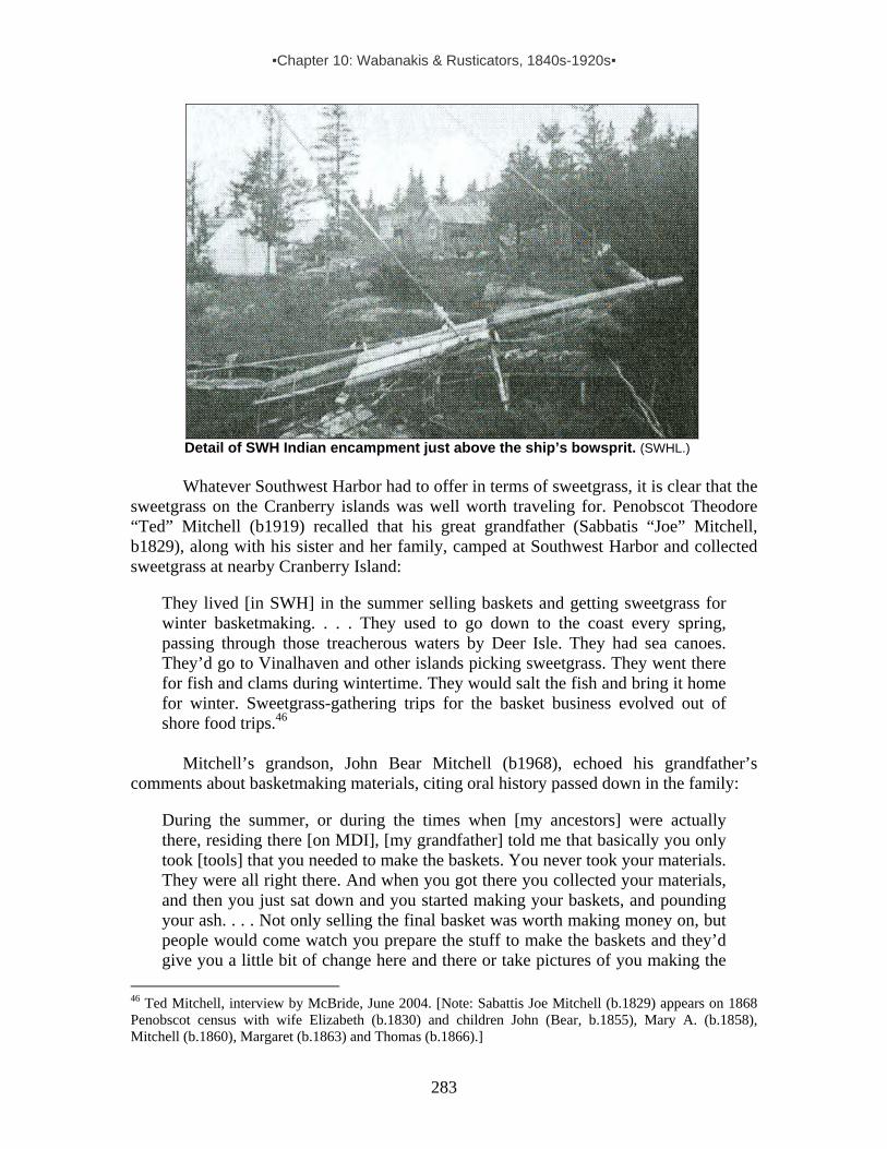
▪Chapter 10: Wabanakis & Rusticators, 1840s-1920s▪
283
Detail of SWH Indian encampment just above the ship’s bowsprit. (SWHL.)
Whatever Southwest Harbor had to offer in terms of sweetgrass, it is clear that the
sweetgrass on the Cranberry islands was well worth traveling for. Penobscot Theodore “Ted” Mitchell (b1919) recalled that his great grandfather (Sabbatis “Joe” Mitchell, b1829), along with his sister and her family, camped at Southwest Harbor and collected sweetgrass at nearby Cranberry Island:
They lived [in SWH] in the summer selling baskets and getting sweetgrass for winter basketmaking. . . . They used to go down to the coast every spring, passing through those treacherous waters by Deer Isle. They had sea canoes. They’d go to Vinalhaven and other islands picking sweetgrass. They went there for fish and clams during wintertime. They would salt the fish and bring it home for winter. Sweetgrass-gathering trips for the basket business evolved out of shore food trips.46
Mitchell’s grandson, John Bear Mitchell (b1968), echoed his grandfather’s
comments about basketmaking materials, citing oral history passed down in the family:
During the summer, or during the times when [my ancestors] were actually there, residing there [on MDI], [my grandfather] told me that basically you only took [tools] that you needed to make the baskets. You never took your materials. They were all right there. And when you got there you collected your materials, and then you just sat down and you started making your baskets, and pounding your ash. . . . Not only selling the final basket was worth making money on, but people would come watch you prepare the stuff to make the baskets and they’d give you a little bit of change here and there or take pictures of you making the
46 Ted Mitchell, interview by McBride, June 2004. [Note: Sabattis Joe Mitchell (b.1829) appears on 1868 Penobscot census with wife Elizabeth (b.1830) and children John (Bear, b.1855), Mary A. (b.1858), Mitchell (b.1860), Margaret (b.1863) and Thomas (b.1866).]
▪Chapter 10: Wabanakis & Rusticators, 1840s-1920s▪
284
basket. You know, splitting the wood, carving the ash and whatnot. And if you look at [the timing of] it, sweetgrass-picking season is . . . the beginning of July, and most of the sales were done in July and August. That’s when [tourists] come to Maine. That’s the best time to come. So there was always a market for the process and the final product.47
Ralph Stanley, renowned boat builder, local historian and lifelong resident of
Southwest Harbor, offered this boyhood recollection of a Passamaquoddy man who lived and hunted in the area and sold crafts for a living: “There was an Indian, Mr. Francis, I remember as a boy. He lived up in the woods somewhere. I have a birch bark model canoe he made for my grandmother. He got my father to take him out to Cranberry Island to shoot seal. My father had a sealskin belt he made. There are still descendants of the Francis family in Bass Harbor.”48 Similarly, locals in Northeast Harbor and Bar Harbor have shared recollections of Passamaquoddy John Snow (1869-1937), who lived in both towns. Snow sold baskets all around MDI, and according to numerous accounts, gathered sweetgrass for the work on Little Cranberry Island. (Snow is profiled later in this section under the heading “Notable Wabanakis.”) While Snow is remembered by name, many other unidentified Wabanakis also gathered sweetgrass on Little Cranberry:
Francis Fernald remembered that in the 1930s two or three loads of Penobscots and, separately, Passamaquoddies, came to Little Cranberry each summer. ‘They landed near the Marsh and collected sweetgrass there. Usually they slept on the shore beneath their canoes.’. . . [and] Lawrence Beal told of entering the Coast Guard’s key post on Marsh Head [northeast end of Little Cranberry] only to find it filled with sleeping Indians.49
While it is true that Wabanakis gathered raw materials on and near Mount Desert
Island for the production of crafts made of fibers, fur and feathers, they also arrived with ready-made items, plus the tools and materials needed to make more. We see this in Passamaquoddy John Stevens’ description of his parents and grandparents loading their canoes with basketmaking “stuff” when beginning their journeys from Peter Dana Point to MDI. And John Snow’s daughter, Susie Snow Holmes, noted that her father bought sealskins from Passamaquoddy hunters back at Pleasant Point to make moccasins.50
Wabanakis also fished while at Bar Harbor, probably setting weirs near the bar, as well as doing line fishing from the piers and spear fishing in the shallows. This was still the case in the mid-1880s, as evident in this brief excerpt from an 1884 newspaper article: “Every Summer [Wabanakis] come to Bar Harbor in numbers of about one hundred and fifty. . . . Between peddling, swapping and fishing, they seem to get along first-rate.”51
Historic records show that Wabanakis hunted deer and other mammals on Mount Desert Island in the latter decades of the 19th century, but they also reveal that game laws increasingly obstructed their pursuit of game – particularly deer: 47 John Bear Mitchell, interview by McBride, Jan. 2004. 48 Interview by McBride, Jan. 2004. 49 Dwelley, pp.11-12. See also Irene Bartlett quoted in Locke & Montgomery, p.28. 50 Interviews by McBride, Jan. 2004. 51 “One of the Attractions of Bar Harbor.” Frank Leslie’s Illustrated Newspaper, 8/23/1884, p.6.

▪Chapter 10: Wabanakis & Rusticators, 1840s-1920s▪
285
Deer are still found in the mountains [on Mount Desert Island]. Last summer a Harvard student found a pair of antlers on Pemetic [MDI]. . . . Oldtown Indians resort here every season to hunt them, in connection with the otter, fox, wild-cat, muskrat and mink. The law allows the deer to be hunted for three months, ending with the fifteenth of December.52 Deer still roam the forests, and the Oldtown Indians come in the fall to hunt them in the three months’ time allowed by law.53 The Fish and Game Laws of Maine state the following laws now enforced. …Act for the protection of deer on the island of Mt. Desert. No person, except during…November and December, shall…hunt or kill any deer…. Indians are liable to the foregoing penalties the same as any other person.54 The board of Fish and Game commissioners…decided…to prohibit fishing in Eagle lake for trout or salmon between…October and May, and also…the taking of deer on Mount Desert Island for periods of four years.55
Bar Harbor Indian encampment, foot of Bar/Bridge Street, 1881. By Kilburn (MHPC.)
In Bar Harbor the first historically described Wabanaki encampment linked to
selling crafts to tourists was established in the early 1860s – beachside at the northeast end of the emerging town, between Birch Point and Newport House hotel. According to the lifelong Bar Harbor resident who recalled this campsite, “In the olden days, or from about 1860 to 1900, I well remember that in the early Spring, Indian encampments or ‘villages’ were the order of things in Bar Harbor, and indeed, when we saw the first of 52 DeCosta, pp.96-97. “Pemetic” is the original Wabanaki name for MDI. 53 Bar Harbor Blue Book & Mount Desert Guide 1881, p.7. 54 MDH, 1/1/1887. 55 Bar Harbor Record, 6/10/1896.
▪Chapter 10: Wabanakis & Rusticators, 1840s-1920s▪
286
their little tents being set up, and the hunters racing in the Bay for porpoises, we were sure that the ‘season’ had really begun.”56 His recollection adds to the inventory of references showing that Wabanakis who camped on MDI utilized natural resources in the area, including wildlife. Indian porpoise-hunting in Frenchman’s Bay continued at least until 1875 when Passamaquoddy Indian Agent Hobart noted in his annual report: “About 20 families are at Bar Harbor, selling their wares and catching porpoises” – hunting the porpoises for food and for saleable oil used to fuel lighthouse beacons and lubricate clocks and watches.
A 19th-century author writing about Wabanakis camped in Bar Harbor c1890 had this to say about the gathering of local materials to make baskets: “These gypsies are everywhere allowed to hew and hack the woods unchallenged. You can hardly turn off the road to the right or left without seeing some noble birch stripped of its bark to make knickknacks of. . . . You meet them slinking about after nightfall with loads of basket-stuff on their shoulders. Their fathers knew how to split skulls; these fellows know how to split basket-stuff.” To this derisive, yet informative, narrative, he added a brief comment about natural dyes: “Apropos of basket-making, the Indians possess the secret of dyeing wood to a degree of perfection not yet attained by our most skillful workmen, though it is believed that the former make use of vegetable substances only. . . .”57 Brown ash (fraxinus nigra) used to make woodsplint baskets could be found on the island along streambeds and marshy areas within the town and its outskirts.58
According to Mount Desert Island resident Innes MacPike, who was born in Northeast Harbor in 1905 and lived in Bar Harbor from 1918 onward, Passamaquoddy Frank Lewey (b1862) resided year-round in the Bar Harbor area and “traveled all around the bay with a canoe gathering sweetgrass to make his baskets.”59 Similarly, speaking of his parents’ and grandparents’ use of basketmaking resources in the Bar Harbor area, Passmaquoddy John Stevens commented: “They used to talk about the beautiful ash that grows around there and sweetgrass.”60
Frank Lewey and Stevens’ ancestors probably ventured across Frenchman Bay to nearby Hancock Point (site of Douaquet Indian village in the late 17th century), given this recollection by Lois Crabtree Johnson (b1933) of the Hancock Historical Society:
My mother (Lura Young) was born in 1892. She told of Indians coming to her family home [on Crabtree Neck near Hancock Point] every summer during her childhood [late 1800s-early 1900s] to get permission from her father to cut sweetgrass. They came by canoe up the Skillings River. (This I can swear, for my mother never told a lie or embroidered the truth. . . .) The house was on Crabtree Neck on the West Side Road (now known as Point Road) about 4.75 miles from Hancock Point. It’s part of an area that since the late 1700s or so was
56 Higgins. Note: Demolished in 1938, Newport House stood just south of present-day Agamont Park. 57 Drake, 1891, pp.306-313. 58 See illustrated plant inventory in Chapter 17. 59 Innes MacPike, interviewed by Ellen Lerner Nov. 1985. F.W Lewey appears with his second wife Delphine (b1871) on the Federal census for Eden (Bar Harbor) in 1910, living on Upper School St. She is listed on the town’s 1900 census as Delphine Laumiere, boarding at the Indian encampment with her aunt, Christine Laumiere. 60 Interview by McBride. Jan. 2004. Information about natural dyes can be found in the narrative about Wabanaki uses of flora & fauna for material culture purposes.
▪Chapter 10: Wabanakis & Rusticators, 1840s-1920s▪
287
called “Sweetland.” No one has been able to figure out why it was called that, but it recently dawned on me that a likely reason is that it is where Indians came for sweetgrass. My great great grandfather Calvin Berry bought the land ca 1840 from heirs of my great great great grandfather Stephen Merchant and it stayed in the family until recently.61
Other Wabanaki basketmakers who came seasonally to Mount Desert Island
gathered sweetgrass in the Pretty Marsh area on the west side of the island. And, according to at least one reminiscence, they also set up camp there:
Native Americans gathered sweetgrass from the marshy areas in Pretty Marsh, and other areas, with which to weave baskets for their own use and, in the late nineteenth and early twentieth centuries, to sell to local folk and summer visitors. Josephine (Gray) Doe [b. c1900] remembers three Indian families who came to the meadow behind her house [between Round Pond and Squid Cove, by Indian Point Road] when she was a child, arriving with loud whoops and hollers. They set up their wigwams and went about their business of gathering, but felt free to enter the Gray’s house to help themselves to pie or stew left by Josephine’s mother – usually on purpose.62
Commentaries about Wabanaki camps on other islands and mainland shores in
Mount Desert Island’s “neighborhood” include B.F. DeCosta’s 1871 Rambles on Mount Desert, which places Indians at MDI, Iron-bound Island (in Frenchman Bay due east of Bar Harbor) and Grand Manan. A brief excerpt from his detailed descriptions of hunting and the production of baskets and canoes for sale says:
At Mount Desert they occasionally find a good-sized shark or horse mackerel, but oftener the porpoise thus comes into the weir. Schools of these continually gambol about the bay for the edification of visitors, or as a prize for the Indians who hunt them for oil. I started once across Frenchman’s Bay for their camp on Iron-bound Island to see them at home, paddling with an old trapper in his bark canoe; but when we got halfway over, a hard rain-storm set in, and we thought it best to return at once. Still the trip afforded an opportunity of testing the qualities of the ‘bark’ on the long ocean swell. No boat could have behaved more admirably. . . . We stepped upon the smooth shore of Indian Beach [on Grand Manan]. Here are the lodges of the Indians, built chiefly of bark, and kept in place by large stones laid on the roofs and against the sides. It was a windy afternoon and unfit for porpoise hunting. . . . At all seasons of the year the people are more or less scattered, being engaged in hunting, fishing and basket-making. . . . Here on the beach we found quite a colony. A part of them spoke English. Their canoes,
61 Interview by McBride, Jan. 2005. The area described by Johnson is now owned by Lawrence and Marion Alley. Johnson added that “Crabtree Neck is the old part of Hancock, originally affiliated with Sullivan. The northern part of Hancock was always more connected to Ellsworth.” 62 Smith in Hansen, p.53. This association may well have preceded Josephine Gray’s childhood since Pretty Marsh Harbor and Squid Cove were MDI entry points for Wabanakis – part of a well-established canoe & carry route to/from Somesville and Somes Sound.
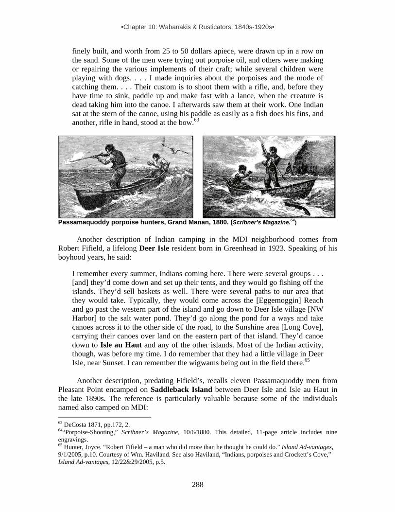
▪Chapter 10: Wabanakis & Rusticators, 1840s-1920s▪
288
finely built, and worth from 25 to 50 dollars apiece, were drawn up in a row on the sand. Some of the men were trying out porpoise oil, and others were making or repairing the various implements of their craft; while several children were playing with dogs. . . . I made inquiries about the porpoises and the mode of catching them. . . . Their custom is to shoot them with a rifle, and, before they have time to sink, paddle up and make fast with a lance, when the creature is dead taking him into the canoe. I afterwards saw them at their work. One Indian sat at the stern of the canoe, using his paddle as easily as a fish does his fins, and another, rifle in hand, stood at the bow.63
Passamaquoddy porpoise hunters, Grand Manan, 1880. (Scribner’s Magazine.64)
Another description of Indian camping in the MDI neighborhood comes from Robert Fifield, a lifelong Deer Isle resident born in Greenhead in 1923. Speaking of his boyhood years, he said:
I remember every summer, Indians coming here. There were several groups . . . [and] they’d come down and set up their tents, and they would go fishing off the islands. They’d sell baskets as well. There were several paths to our area that they would take. Typically, they would come across the [Eggemoggin] Reach and go past the western part of the island and go down to Deer Isle village [NW Harbor] to the salt water pond. They’d go along the pond for a ways and take canoes across it to the other side of the road, to the Sunshine area [Long Cove], carrying their canoes over land on the eastern part of that island. They’d canoe down to Isle au Haut and any of the other islands. Most of the Indian activity, though, was before my time. I do remember that they had a little village in Deer Isle, near Sunset. I can remember the wigwams being out in the field there.65
Another description, predating Fifield’s, recalls eleven Passamaquoddy men from
Pleasant Point encamped on Saddleback Island between Deer Isle and Isle au Haut in the late 1890s. The reference is particularly valuable because some of the individuals named also camped on MDI: 63 DeCosta 1871, pp.172, 2. 64“Porpoise-Shooting,” Scribner’s Magazine, 10/6/1880. This detailed, 11-page article includes nine engravings. 65 Hunter, Joyce. “Robert Fifield – a man who did more than he thought he could do.” Island Ad-vantages, 9/1/2005, p.10. Courtesy of Wm. Haviland. See also Haviland, “Indians, porpoises and Crockett’s Cove,” Island Ad-vantages, 12/22&29/2005, p.5.
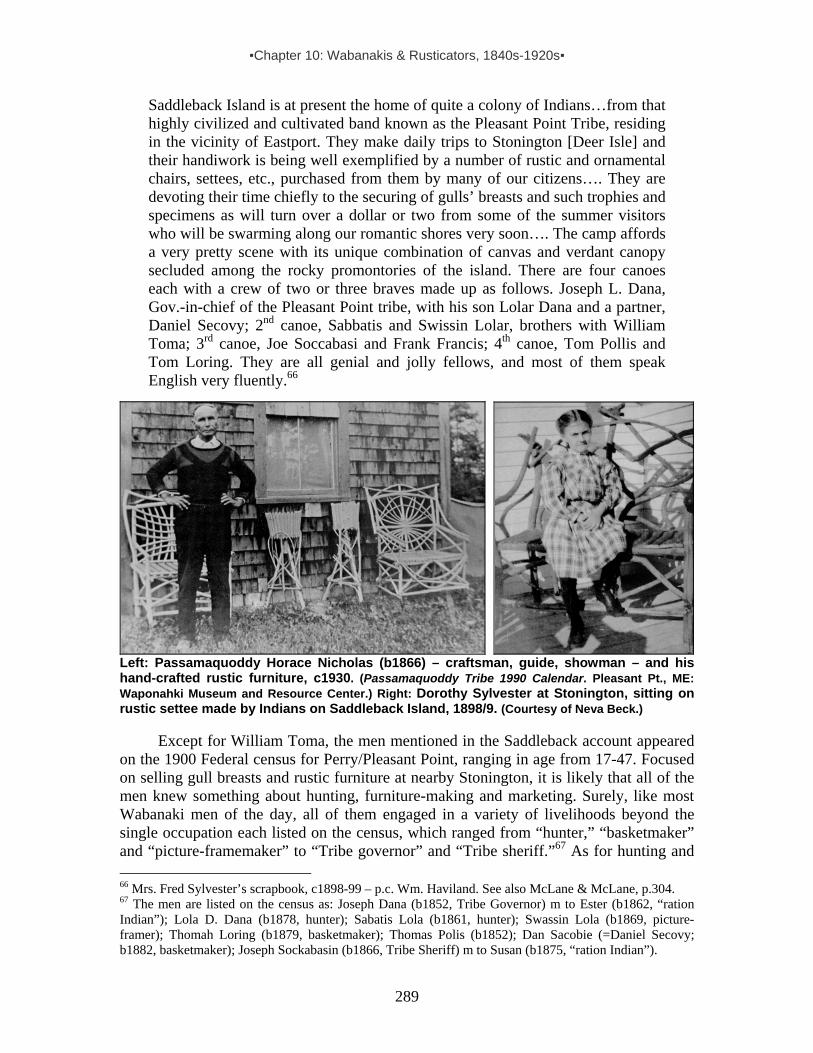
▪Chapter 10: Wabanakis & Rusticators, 1840s-1920s▪
289
Saddleback Island is at present the home of quite a colony of Indians…from that highly civilized and cultivated band known as the Pleasant Point Tribe, residing in the vicinity of Eastport. They make daily trips to Stonington [Deer Isle] and their handiwork is being well exemplified by a number of rustic and ornamental chairs, settees, etc., purchased from them by many of our citizens…. They are devoting their time chiefly to the securing of gulls’ breasts and such trophies and specimens as will turn over a dollar or two from some of the summer visitors who will be swarming along our romantic shores very soon…. The camp affords a very pretty scene with its unique combination of canvas and verdant canopy secluded among the rocky promontories of the island. There are four canoes each with a crew of two or three braves made up as follows. Joseph L. Dana, Gov.-in-chief of the Pleasant Point tribe, with his son Lolar Dana and a partner, Daniel Secovy; 2nd canoe, Sabbatis and Swissin Lolar, brothers with William Toma; 3rd canoe, Joe Soccabasi and Frank Francis; 4th canoe, Tom Pollis and Tom Loring. They are all genial and jolly fellows, and most of them speak English very fluently.66
Left: Passamaquoddy Horace Nicholas (b1866) – craftsman, guide, showman – and his hand-crafted rustic furniture, c1930. (Passamaquoddy Tribe 1990 Calendar. Pleasant Pt., ME: Waponahki Museum and Resource Center.) Right: Dorothy Sylvester at Stonington, sitting on rustic settee made by Indians on Saddleback Island, 1898/9. (Courtesy of Neva Beck.)
Except for William Toma, the men mentioned in the Saddleback account appeared on the 1900 Federal census for Perry/Pleasant Point, ranging in age from 17-47. Focused on selling gull breasts and rustic furniture at nearby Stonington, it is likely that all of the men knew something about hunting, furniture-making and marketing. Surely, like most Wabanaki men of the day, all of them engaged in a variety of livelihoods beyond the single occupation each listed on the census, which ranged from “hunter,” “basketmaker” and “picture-framemaker” to “Tribe governor” and “Tribe sheriff.”67 As for hunting and 66 Mrs. Fred Sylvester’s scrapbook, c1898-99 – p.c. Wm. Haviland. See also McLane & McLane, p.304. 67 The men are listed on the census as: Joseph Dana (b1852, Tribe Governor) m to Ester (b1862, “ration Indian”); Lola D. Dana (b1878, hunter); Sabatis Lola (b1861, hunter); Swassin Lola (b1869, picture-framer); Thomah Loring (b1879, basketmaker); Thomas Polis (b1852); Dan Sacobie (=Daniel Secovy; b1882, basketmaker); Joseph Sockabasin (b1866, Tribe Sheriff) m to Susan (b1875, “ration Indian”).

▪Chapter 10: Wabanakis & Rusticators, 1840s-1920s▪
290
selling gulls, the market value for the feather breasts they secured on Saddleback Island was just peaking at this time, as evident in these citations:
In 1899 a New York millinery dealer furnished Eastern Maine’s Passamaquoddy Indians with guns and ammunition to kill gulls of all kinds. The dealers paid 40 cents each for adults, 20 cents for the brown immature gulls. . . . It is estimated that 5,000,000 gulls were killed each year for the millinery trade.68
Frank Chapman, distinguished ornithologist, conducted a survey during two afternoon walks through the streets of New York. 542 heads out of a total of 700 had been decorated with feathered hats from 20-odd species, including terns, owls, herons, etc.69
Sea gull breasts and wings are now in great demand by western buyers and the poor old fowl now enjoys only little peace and quiet. The Indians are constantly on its tracks, and dozens upon dozens are shot each week. The breasts and wings, when cured, bring in a price of $3.50 to $6 a dozen.”70
The price of gull wings and breasts has been steadily declining in the western market and now the business of shooting them is less productive. Now they hardly pay for the powder and shot, and the Indians do not spend the time to hunt them anymore because they are not worth anything. The seagull in the last few months was a fad of style. Now it is less of a fad.71
Wabanakis ventured even closer to Mount Desert Island than Saddleback to hunt
seabirds for their feathers. A June 1889 news item about two Penobscot men in the Oldtown paper announced: “Last Saturday John Bear [Mitchell, b.1851] and Peal Sockose [b.1822?] came home from Ar-bes-son-nuck, ‘Mt. Desert,’ with one hundred sea gulls as the result of a four weeks hunt.”72 (Notably, hunting gulls for feather sales was hardly a new occupation. Records show that Wabanakis in the Penobscot Bay area began selling feathers to white traders in the early 1700s.) SELLING BASKETS AND OTHER HAND-CRAFTED GOODS The central purpose of Wabanaki encampments on MDI from the mid-1800s through the 1920s was the sale of hand-crafted goods. Echoing long-established marketing practices, Wabanakis sold their wares door-to-door and at train stations and boat landings. They also encouraged customers to come to sale tents at their encampments. Before 1890, Indian encampments at Bar Harbor featured a range of dwellings - from canvas tents to birchbark wigwams to shanties covered with strips of bark or wooden planks. No doubt some slept in their sale tents, because they had no other place to stay – and/or in order to guard their goods. Indians who were just passing through for a few days sometimes slept 68 Graham, Frank, Jr. Gulls. Citation provided by Wm.Haviland, p.c. 69 Conkling, p159-60. Citation provided by Wm. Haviland, p.c. 70 Eastport Sentinel, 9/20/1899. In Soctomah 2002 p.63. 71 Eastport Sentinel, 11/29/1899. In Soctomah 2002 p.65. 72 Oldtown Enterprise, 6/1/1889. John B. Mitchell (Penobscot, b1851) is listed on the 1880 Federal census for Indian Island, m to Maria Newell (Penobscot, b1858) with one child, Martha (b1878). On the 1900 census he appears with 4 children in addition to Martha – Elizabeth (b1889), Theodore (b1890), Clara (b1892) and Sabattis (b1897). By this time he had remarried a young woman named Mary (b1873).
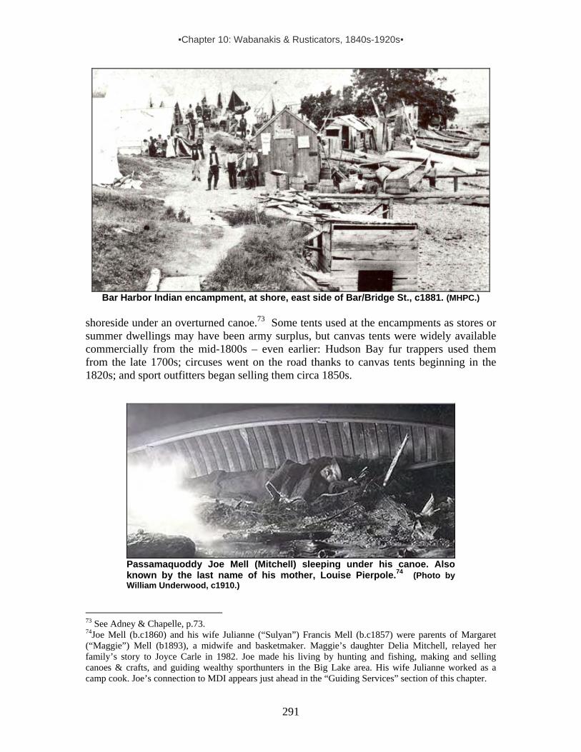
▪Chapter 10: Wabanakis & Rusticators, 1840s-1920s▪
291
Bar Harbor Indian encampment, at shore, east side of Bar/Bridge St., c1881. (MHPC.)
shoreside under an overturned canoe.73 Some tents used at the encampments as stores or summer dwellings may have been army surplus, but canvas tents were widely available commercially from the mid-1800s – even earlier: Hudson Bay fur trappers used them from the late 1700s; circuses went on the road thanks to canvas tents beginning in the 1820s; and sport outfitters began selling them circa 1850s.
Passamaquoddy Joe Mell (Mitchell) sleeping under his canoe. Also known by the last name of his mother, Louise Pierpole.74 (Photo by William Underwood, c1910.)
73 See Adney & Chapelle, p.73. 74Joe Mell (b.c1860) and his wife Julianne (“Sulyan”) Francis Mell (b.c1857) were parents of Margaret (“Maggie”) Mell (b1893), a midwife and basketmaker. Maggie’s daughter Delia Mitchell, relayed her family’s story to Joyce Carle in 1982. Joe made his living by hunting and fishing, making and selling canoes & crafts, and guiding wealthy sporthunters in the Big Lake area. His wife Julianne worked as a camp cook. Joe’s connection to MDI appears just ahead in the “Guiding Services” section of this chapter.

▪Chapter 10: Wabanakis & Rusticators, 1840s-1920s▪
292
Aiming to draw customers to their encampments, Wabanakis offered home delivery of goods purchased and did whatever they could to ease any fears the public might have about shopping in their makeshift village. In Bar Harbor, this included arranging for electrical lighting the very same year the town itself began the shift from gas to electric lights. As announced by the local paper in the summer of 1884: “Arrangements are making to light the Indian encampment at the foot of Holland avenue, by electricity. The new feature is due solely to Indian enterprise, Mr. Peter J. Gabriel being the leader of the movement.”75
Passamaquoddy Peter J. Gabriel, c. 1890s. Gabriel (b.1841) was responsible for bringing electric lighting to the Bar Harbor Indian encampment in 1884. In this photo he is sitting in front of a tent, probably at Bar Harbor. Notice toy birchbark tipi to the right and deerskin draped over tent, top left. Also of note is Gabriel’s Plains Indian style war bonnet, reflecting the growing influence Wild West shows were having on the popular imagination concerning “Indian” identity. (Courtesy of Donald Soctomah)
Among other efforts aimed at attracting visitors, some Wabanakis dressed in semi-traditional garb (often borrowing from Plains Indian styles popularized in Wild West shows) and placed newspaper ads such as this one, which appeared regularly during July and August in 1884:
INDIAN ENCAMPMENT FOOT OF HOLLAND AVENUE, Bar Harbor. The Passamaquoddy, Penobscot, and Mellissa [Maliseet] (or St. John River) Tribes.At this encampment may be found a great variety of Indian Wares and Curiosities, Comprising Baskets of all kinds, Gull Breasts, Seal Skins, and Deer Skins, Moccasins, Canoes and Birch Bark ware. The camp is open on pleasant evenings until half-past ten o’clock and will be found both quiet and orderly. Perfectly safe for any one to visit. Goods purchased at this encampment will be delivered at any part of the village, free of charge.76
Apparently, such efforts were successful, given the positive comments made by Indian agents in their annual reports – and the soaring number of Indians who descended upon Bar Harbor the following year when the local newpaper reported: “There are about two hundred and fifty Indians now in camp at Bar Harbor. They are of the Passamaquoddy, Penobscot, and St. John [Maliseet] tribe. They occupy forty tents at the foot of Holland 75 MDH, 8/8/1884, p3. Peter J. Gabriel, b.1841, is listed as a basketmaker married to Sarah (b.1864, “ration Indian”) on the 1900 Federal census for Perry/Pleasant Pt. He served as tribal representative to the state legislature in 1887. 76 Recurring ad in MDH, 8/8-9/19/1884, p.2 or 3.

▪Chapter 10: Wabanakis & Rusticators, 1840s-1920s▪
293
Avenue.”77 No doubt the Mi’kmaq were also represented here, since intermarriage among all of these groups was common. Beyond the remarkable number of Wabanakis working and selling on-site that year, individuals back on the Pleasant Point reservation sent goods to sell, as illustrated by this item:
We had a pleasant call, Wednesday, from the Rev. John O’Dowd, Catholic priest in charge of the Passamaquoddy Indian Mission at Pleasant Point. He came to Bar Harbor on Monday, August 11, with a very large and choice selection of fancy baskets. These baskets were sold to the Indians – the proceeds to be used for repairing the Indian chapel at Pleasant Point. The baskets were furnished the Indians at wholesale rates (they were originally made by the Indians and contributed to the church,) and are now on sale at the Indian encampment.78
Among descriptions of Wabanaki encampments on Mount Desert Island, the following is uniquely detailed. It describes the seasonal Indian village as it was when located near Hamor’s wharf in Bar Harbor the mid-1880s:
On the morning of the third day there were symptoms of a change [in weather]. The fog took on a silvery lustre. We saw, over against Bald Porcupine [Island], the dazzle of white canvas where the sunlight settled on the sails of a yacht whose hull was still invisible. Green summits of the island next emerged from the void. . . . Longing for a row, we set out to go to the Indian wharf [Hamor’s]. . . . When we pulled away from our dock the water was absolutely smooth. In ten minutes a flow of wind swept over the bay, ruffling its surface into long green ridges, capped with foam. . . .
Bar Harbor Indian encampment near Hamor’s Wharf at foot of Holland Ave., c1885. (MHPC.)
Having failed to reach the Indian encampment on that occasion, we walked there the next day…. It was a pleasant walk across the bluff leading to the Indian camp. So many wild-roses grew there, amid thickets of sweet-fern and vanilla grass, that the air was embalmed with odors. Approaching the settlement in the rear, we saw more of their inside life than in front, where all is swept and
77 MDH, 7/31/85, p.3. 78 MDH, 8/14/85, p.3.

▪Chapter 10: Wabanakis & Rusticators, 1840s-1920s▪
294
garnished for customers. Old women hovering over pots and kettles; girls up to their elbows in dye-stuff; old men mounting birds, curing seal-skins, or hanging upon lines the dyed splints to be woven into baskets; dogs and babies without number…. In religion many of them are Catholics, attending on Sunday the little Church of St. Sylvia nestling beneath the crest of Malden Hill at Bar Harbor. We met an Indian maiden once upon her way home from mass, and, in her fashionably-made polonaise of ruby velvet, and Gainsboro’s hat and plumages, she looked like a bird-of-paradise in a barn-yard, beside the island girls.
With these Penobscots unite certain Passama-quoddies in the business of supplying Bar Harbor visitors with their wares. Their dwellings, half tent, half booth, are erected to leave a well-swept carriage-road between the lines, and here, every day during the season, come throngs of people…. Within the booths
are draperies of red and blue and orange calico, or bunting. Broad shelves, serving as counters, present a charming medley of harmonious colors. Baskets of every shape and tint are piled into glowing masses. Seal-skins and deer-skins, pipes and sticks fashioned from distorted roots, canoes and paddles great and small, snow-shoes, lacrosse-
bats, bows and arrows, moccasins and caps—what do not their skilful fingers put into captivating guise to witch away the money of the idler? Then there are gulls’ breasts and wings, stuffed owls, pearly grebe plumage, and, their latest novelties, wood-baskets and flower-pots of birch-bark, etched with a frieze of native scenes. (Above photo: Bar Harbor Indian tent interior c1885 (MHPC.)) Lola, the queen,79 is a sovereign of generous proportions, living in a circular tent, around which are planted vines of the California cucumber, and sunflowers. We found her that day sitting on a low splint-bottomed chair, knee to knee with a gossip in shawl and bonnet, suggesting Betsy Prig. Fast as her hands could fly she was shaping a waste-paper basket of deep, soft yellow, braided with vanilla grass…. My mistress bought of Lola a flat basket to hold handkerchiefs, then passed on to a tent where the proprietor, a stately old fellow, wore a clean gauze undershirt, with brand-new slop-shop trousers. At his feet sat the prettiest little maid, with ripe red lips, and dusky hair tied up with a knot of crimson! They had dressed her in a petticoat of yellow stuff and a dark-blue jersey. Spite of the visitors who
79 This pipe-smoking woman appeared in Frank Leslie’s Illustrated Newspaper (8/23/1884 p.5) with a brief article identifying her as Passamaquoddy. Describing her as “the largest Indian we ever saw,” the writer said she “must have weighed 300 pounds [and that] she wore a man’s hat and shoes, carried a stout staff, and sat on a bench complacently smoking a T.D. pipe. Later we saw this big [woman] promenading up Mount Desert Street . . . hat, pipe and all. . . .” In all likelihood, she is “Lola, the queen,” either Josephine Lola (b.1843), a widow and mother of 4, or Hannah Lola (b.1837), married to Nicolas Lola (b.1825).

▪Chapter 10: Wabanakis & Rusticators, 1840s-1920s▪
295
came and went, she kept busy with the playthings in her lap—a china doll, some shells, some bits of silk and ribbon packed in a small tin box.
A visitor, in talking with the owner of this tent, asked for news of his ne’er-do well nephew, a Moosehead [Lake] guide of unsavory reputation.80 “John?” grunted the Indian; “John he git hanged pooty soon. Do John good to hang him, anyway.” In another tent we found a pretty young woman, helping her husband to dispose of the sweet grass baskets, for which they were particularly famed. The man, a good-looking fellow, wore a smart red shirt, with bands of Indian work, and an embroidered belt. It so happened that every basket of which my mistress asked the price was valued at “one-dollar-half.” While waiting for her to make selection, the young [woman] heard a sound we had not noticed in the rear tent, darted in there, and presently reappeared carrying in her arms a rose-bud of a baby.
Wabanaki family at Bar Harbor encampment. Hamor’s Wharf, 1886. Note sealskin, antlers, and baskets. (MHPC.)
“Oh! What a beauty!” exclaimed my mistress. “I suppose you will sell him,
too, for one-dollar-half.” “Not for all the money in the world!” answered the mother, her stolid face becoming suddenly aglow with feeling, as she hugged her treasure close. It was a pretty little scene.
80As already noted concerning the 11 Passamaquoddy men hunting gulls on Saddleback Island, Wabanakis who summered on Mount Desert Island had ties to other resort locations where they or their relatives also marketed their wares and solicited guiding jobs. Among many other examples, Andrew Nicholas, a guide born in Greenville at Moosehead Lake, spent the summers of 1894 & 1901 (and perhaps other summers in between) in Bar Harbor, offering guiding services. His wife, Mary Francis Nicholas, gave birth to three children while they were on MDI – twins Lewis and Mary in 1894 and Annie in 1901.
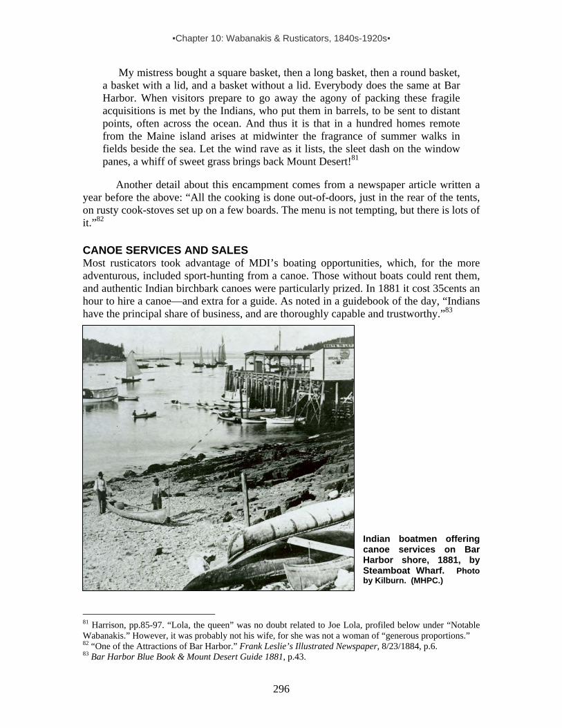
▪Chapter 10: Wabanakis & Rusticators, 1840s-1920s▪
296
My mistress bought a square basket, then a long basket, then a round basket, a basket with a lid, and a basket without a lid. Everybody does the same at Bar Harbor. When visitors prepare to go away the agony of packing these fragile acquisitions is met by the Indians, who put them in barrels, to be sent to distant points, often across the ocean. And thus it is that in a hundred homes remote from the Maine island arises at midwinter the fragrance of summer walks in fields beside the sea. Let the wind rave as it lists, the sleet dash on the window panes, a whiff of sweet grass brings back Mount Desert!81
Another detail about this encampment comes from a newspaper article written a year before the above: “All the cooking is done out-of-doors, just in the rear of the tents, on rusty cook-stoves set up on a few boards. The menu is not tempting, but there is lots of it.”82 CANOE SERVICES AND SALES Most rusticators took advantage of MDI’s boating opportunities, which, for the more adventurous, included sport-hunting from a canoe. Those without boats could rent them, and authentic Indian birchbark canoes were particularly prized. In 1881 it cost 35cents an hour to hire a canoe—and extra for a guide. As noted in a guidebook of the day, “Indians have the principal share of business, and are thoroughly capable and trustworthy.”83
Indian boatmen offering canoe services on Bar Harbor shore, 1881, by Steamboat Wharf. Photo by Kilburn. (MHPC.)
81 Harrison, pp.85-97. “Lola, the queen” was no doubt related to Joe Lola, profiled below under “Notable Wabanakis.” However, it was probably not his wife, for she was not a woman of “generous proportions.” 82 “One of the Attractions of Bar Harbor.” Frank Leslie’s Illustrated Newspaper, 8/23/1884, p.6. 83 Bar Harbor Blue Book & Mount Desert Guide 1881, p.43.
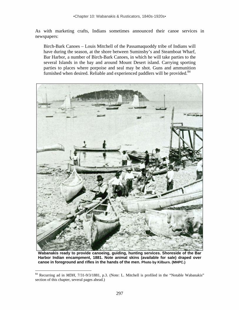
▪Chapter 10: Wabanakis & Rusticators, 1840s-1920s▪
297
As with marketing crafts, Indians sometimes announced their canoe services in newspapers:
Birch-Bark Canoes – Louis Mitchell of the Passamaquoddy tribe of Indians will have during the season, at the shore between Suminsby’s and Steamboat Wharf, Bar Harbor, a number of Birch-Bark Canoes, in which he will take parties to the several Islands in the bay and around Mount Desert island. Carrying sporting parties to places where porpoise and seal may be shot. Guns and ammunition furnished when desired. Reliable and experienced paddlers will be provided.84
Wabanakis ready to provide canoeing, guiding, hunting services. Shoreside of the Bar Harbor Indian encampment, 1881. Note animal skins (available for sale) draped over canoe in foreground and rifles in the hands of the men. Photo by Kilburn. (MHPC.)
84 Recurring ad in MDH, 7/31-9/3/1881, p.3. (Note: L. Mitchell is profiled in the “Notable Wabanakis” section of this chapter, several pages ahead.)

▪Chapter 10: Wabanakis & Rusticators, 1840s-1920s▪
298
An 1888 guidebook noted these details about Bar Harbor boating activities and services on Frenchman Bay:
Conners and Pendleton and other boatmen have more than a hundred rowboats and canoes, and a score or so of yachts, besides three or four small steamers, for lease. There are also catamarans, Rob-Roys, canvas-boats, cat-boats, and all manner of small craft, insomuch that the harbor is at times fairly crowded with little shipping. The rates for row-boats are thirty-five cents an hour, or seventy-five cents with a boatman. People unacquainted with these waters should take boatmen with them, for the rocks are scattered about inconveniently; and there are occasional unexpected squalls, attended with little or no danger to one familiar with the place, but hazardous for strangers. Cat-boats and yachts, with competent skippers, can be hired for longer voyages up and down or across the bay, to the lower Heads, Egg Rock, Ironbound, the Ovens, South Gouldsborough, Winter Harbor, Sullivan, or Sorrento. The most expert of the canoeists, naturally, are the Indians, who carry visitors in their frail boats around the harbor and islands, or even on longer and more daring voyages.85
Indian-made canoes were also available for purchase. In fact, buyers could even
watch the construction process, as suggested by this 1881 notice in the local paper: “Birchbark canoes made by the Indians at Bar Harbor, sell at prices ranging from $25 to $40. And they are very nicely made too.”86 Another notice, appearing in a Bangor newspaper showed that birchbark canoes were in demand well beyond the bounds of Bar Harbor: “The canoe has become so popular a craft among sports men and tourists, even indispensable with the former class, that the building of this light and graceful craft is now quite an important industry in Maine, especially on the Penobscot River. . .thirty-five dollars, the usual price, is none too much for a good canoe.”87 Passamaquoddy Peter Joe Dana (a.k.a. Nicola Denis, c1820-1889) was among canoe-makers linked to Bar Harbor in the historic record. Adney & Chapelle’s well-known book on canoes includes this description of a canoe Dana built “sometime between 1890 and 1892” for his son Francis “who used it at Frenchman’s Bay”:
The outside of the canoe was painted red, the inside was pale yellow, the gunwales and middle portions of the thwarts were cobalt blue, the ends of the thwarts were red. The wulegessis88 was blue, and the ‘canoe mark’ was a painted representation of the spread eagle of the United States seal, the border being in black and white and the eagle in black, yellow, and white, holding a brown branch with green leaves. The whole panel was outlined in red. On the side of the canoe, near the stern, was a white swallowtail pennant on which was
85 Sweetser 1888, pp.20-21. For more information on canoe services, see the profile on Frank “Big Thunder” Loring in the “Notable Wabanakis” section of this chapter. 86 MDH, 9/3/1881. 87 The [Bangor] Industrial Journal, 5/15/85. This article also describes scarcity of suitable white birch trees and method of building canoe and making paddles. 88 Wulegessis is the piece of bark fitted over the fold of the gunwales, which formed the flaps below the outwales on each side, and often was decorated with the personal mark of the owner identifying the owner’s habits, activities, or simply his personal likings.

▪Chapter 10: Wabanakis & Rusticators, 1840s-1920s▪
299
lettered ‘Frenchmans Bay’ in black capital letters. This canoe was used for fishing and also for porpoise and seal hunting.89
Peter Dana’s son carried on the canoe-building tradition – and continued to paddle Frenchman’s Bay, as noted by a journalist in 1893: “Francis Dana, a well-known Indian hunter and guide whose home is at East Machias, having built a 16-foot birch canoe, started out last week to find a customer for it. He put to sea Friday in his frail craft, and having no sail paddled to Bar Harbor, where he disposed of the canoe, and returned home by Saturday’s steamer. The distance is sixty miles, and the water was rough.”90
“Peter Joe at Work.” Drawing by Tappan Adney for his article “How an Indian Birch-Bark Canoe is Made.” (Harper’s Young People, supplement, 29 July 1890.)
Among MDI rusticators, keen interest in canoeing led to the founding of the Mount Desert Canoe Club in 1886. Incorporated the following year, the club initially had its boat house at the Pendleton & Roberts Wharf and a club house on Bob Sproul’s property at Albert Meadow. In 1888 it combined both at a Bar Island site visible from Bar Harbor’s Main Street shore.91 The follow passage from Richard Hale’s 1949 book about the town offers a good summary of the club, including the role Wabanakis played in the organization:
The ever-useful Rodick family [of the Rodick Hotel fame] had a site on Bar Island on which was established a canoe house, safely away from the waterfront of West Street and to be reached at low tide by a walk or carriage ride, at high tide by a fee and a ride in a hired boat. At the Club House were established the ever-present Indians of the Penobscot and Passamaquoddy tribes, who would give instruction in the fine art of paddling or themselves furnish propulsive power. And at least thrice a year, the ladies of the Canoe Club would entertain at tea, sending out engraved cards to announce the event.92
89 Adney & Chapelle, pp.71, 76-77. 90 The [Bangor] Industrial Journal, 7/21/1893. 91 Helfrich & O’Neil, p.111; Sweetser 1888, pp.20-21. 92 Hale, pp.172.

▪Chapter 10: Wabanakis & Rusticators, 1840s-1920s▪
300
Bar Harbor Canoe Club, c1890. The canoe club grew steadily until it reached a peak of 300 members in 1900. A
year earlier newspaper magnate Joseph Pulitzer hosted a lavish party for club members at Chatwold, his grand estate on Ocean Drive. According to one reminiscence:
The unforgettable highlight of the party [was] a parade of canoes in the sheltered cove on the ocean side of Chatwold…. Most of the canoes, handmade from birch bark, had been purchased at the Indian Village off lower Main Street…where Penobscots from Indian Island came many years to camp, bringing for sale the products of their winter’s handiwork. The Indians also supplied members of the Bar Harbor Canoe Club with hand-carved individual paddles with the owner’s initials etched into the wood, and many of the braves were employed to instruct the children of the rich in the art of paddling the fragile craft over Frenchman’s Bay. Each canoe in the spectacular parade was dazzling decorated with lighted Japanese lanterns. The great line of illuminated craft, carrying splendidly attired passengers, moved rhythmically around the cove to the background music of dozens of strumming banjos, while a full moon shed its glory on the breathtaking scene.93
93 Cole, pp.60-62, 67,90, 95-97.

▪Chapter 10: Wabanakis & Rusticators, 1840s-1920s▪
301
Henry Richards (in the stern) and family in a birchbark canoe purchased in the 1870s. Richards, a young architect, was traveling to Mount Desert Island by steamboat to supervise construction of a summer home for Mrs. Charles Dorr. On that same steamer, an unidentified Wabanaki was carrying a fleet of bark canoes that he would rent to Bar Harbor’s burgeoning tourist population. Before disembarking the steamer, Richards bought this canoe and two paddles for $30. It remained in his family until 2006, when his grandson presented it as a gift to the Abbe Museum. (Image & caption courtesy of the Abbe Museum.)
GUIDING SERVICES FOR SPORT HUNTERS Impressed by Wabanaki canoeing skills, hunting prowess and other wilderness know-how, non-Indian sport hunters commonly hired Native guides for extended expeditions or day-long outings. On federal censuses in the latter 19th and early 20th centuries, it is not at all uncommon to see “guide” or “hunter” noted in the occupation column alongside the names of Wabanaki men.94 Some identified as such also spent time at one or more of the Indian encampments on Mount Desert Island. Among them was Passamaquoddy Joe Mell (Mitchell), especially known for guiding hunters in the Grand Lake region.
Joe Mell was also known for guiding hunter-turned-photographer William Lyman Underwood every spring and fall for nearly four decades. Grandson to William Underwood, who established the Underwood Canning Company in Boston around 1825, young William set up a fish cannery in Southwest Harbor in 1880 and oversaw the operation for two decades – until 1899 when his father died and left the business to Henry, who soon edged out William. Evidently, during the years William was involved in the SWH plant, he met Joe Mell. For nearly four decades, Joe and William ventured into the woods together every spring and fall. After 1900, William became more interested in nature preservation and wildlife photography than in hunting for trophies. He and Joe still hunted fish, fowl and game for food during their expeditions, but increasingly William focused on taking photographs (including the one shown here of Joe). In his book Wilderness Adventures William described Joe visually and verbally as follows:
94 Wabanaki sporthunters known to have stayed at the MDI Indian encampments include Wallace Lewey, Joe Mell (Mitchell) and Frank Loring.

▪Chapter 10: Wabanakis & Rusticators, 1840s-1920s▪
302
There is no better guide for the woods than a man who has lived and been brought up there, as has Joe. . . . Nothing escapes Joe’s keen eyes. His power of sight, especially the knack of finding things, is nothing short of marvelous. Often, with the naked eye he has seen a canoe hugging the farthest shores of a cove in the lake, while I with powerful binoculars have difficulty in locating it. [His ears were equally acute.] One evening, our larder being empty, we had gone up into a little swampy pond after black duck. None were there, however, and much disappointed, we paddled back towards camp. It was in the dusk of the evening, and the western sky in front of us was red with the afterglow of sunset. From downstream came the raucous voice of quacking black duck. Instantly I grasped my gun. Rapidly, the sound drew nearer, and three ducks came into view, flying directly towards us, their bodies silhouetted against the ruddy sky. I fired both barrels, but the birds held their flight and disappeared into the dusk. “Missed them,” I muttered in great disgust. “You got one,” said Joe. “Heard it fall, break limb on dead cedar in swamp. Too dark to find him now.” Early the next day. . . . [although] a needle in a haystack would be easier to find than the duck, . . . Joe slopped about, knee deep in the bushy swamp, . . . Soon he came back and said not a word, and we continued to camp. “I told you it was no use,” I remarked. “How could you find a duck that you only heard drop in the dark? Even if you had seen him fall in the swamp in the daylight you would have a hard time finding him.” To my long dissertation his reply was, “Look, I got him,” and he held up the duck to my astonished gaze.95
Wm. Lyman Underwood (2nd from L) and hunting companions. L to R: Passamaquoddy Wallace Lewey, Penobscots Stephen & Nick Newell, Passamaquoddy Joe Mell (Mitchell), c1915. Lewey and Mell both spent time at Mount Desert Island Indian encampments. (In: Carle & Mitchell.)
95 Underwood, 1927. See also Lyons, pp.15-18, for more on Joe Mell & Wm. Underwood. Lyons’ book is the source for the small portrait of Joe Mell that appears on the previous page.
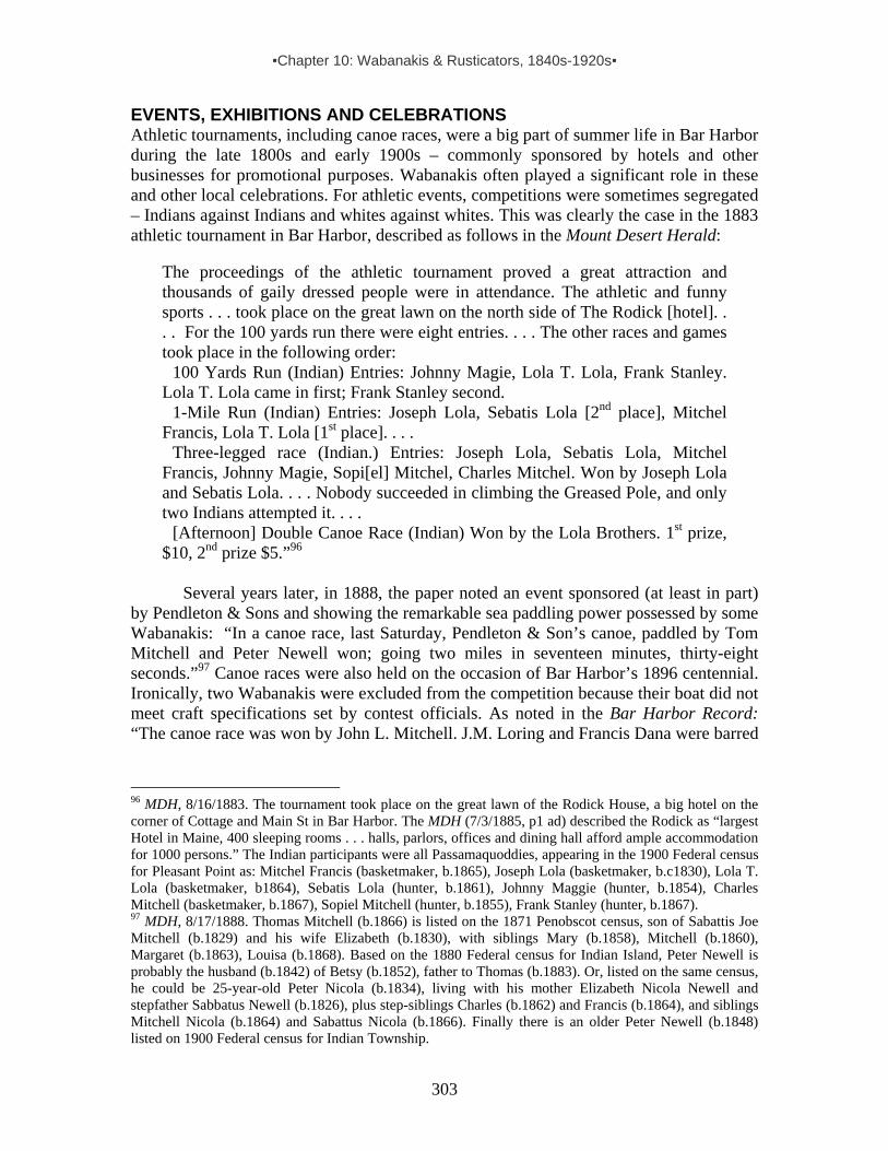
▪Chapter 10: Wabanakis & Rusticators, 1840s-1920s▪
303
EVENTS, EXHIBITIONS AND CELEBRATIONS Athletic tournaments, including canoe races, were a big part of summer life in Bar Harbor during the late 1800s and early 1900s – commonly sponsored by hotels and other businesses for promotional purposes. Wabanakis often played a significant role in these and other local celebrations. For athletic events, competitions were sometimes segregated – Indians against Indians and whites against whites. This was clearly the case in the 1883 athletic tournament in Bar Harbor, described as follows in the Mount Desert Herald:
The proceedings of the athletic tournament proved a great attraction and thousands of gaily dressed people were in attendance. The athletic and funny sports . . . took place on the great lawn on the north side of The Rodick [hotel]. . . . For the 100 yards run there were eight entries. . . . The other races and games took place in the following order:
100 Yards Run (Indian) Entries: Johnny Magie, Lola T. Lola, Frank Stanley. Lola T. Lola came in first; Frank Stanley second.
1-Mile Run (Indian) Entries: Joseph Lola, Sebatis Lola [2nd place], Mitchel Francis, Lola T. Lola [1st place]. . . .
Three-legged race (Indian.) Entries: Joseph Lola, Sebatis Lola, Mitchel Francis, Johnny Magie, Sopi[el] Mitchel, Charles Mitchel. Won by Joseph Lola and Sebatis Lola. . . . Nobody succeeded in climbing the Greased Pole, and only two Indians attempted it. . . .
[Afternoon] Double Canoe Race (Indian) Won by the Lola Brothers. 1st prize, $10, 2nd prize $5.”96
Several years later, in 1888, the paper noted an event sponsored (at least in part)
by Pendleton & Sons and showing the remarkable sea paddling power possessed by some Wabanakis: “In a canoe race, last Saturday, Pendleton & Son’s canoe, paddled by Tom Mitchell and Peter Newell won; going two miles in seventeen minutes, thirty-eight seconds.”97 Canoe races were also held on the occasion of Bar Harbor’s 1896 centennial. Ironically, two Wabanakis were excluded from the competition because their boat did not meet craft specifications set by contest officials. As noted in the Bar Harbor Record: “The canoe race was won by John L. Mitchell. J.M. Loring and Francis Dana were barred
96 MDH, 8/16/1883. The tournament took place on the great lawn of the Rodick House, a big hotel on the corner of Cottage and Main St in Bar Harbor. The MDH (7/3/1885, p1 ad) described the Rodick as “largest Hotel in Maine, 400 sleeping rooms . . . halls, parlors, offices and dining hall afford ample accommodation for 1000 persons.” The Indian participants were all Passamaquoddies, appearing in the 1900 Federal census for Pleasant Point as: Mitchel Francis (basketmaker, b.1865), Joseph Lola (basketmaker, b.c1830), Lola T. Lola (basketmaker, b1864), Sebatis Lola (hunter, b.1861), Johnny Maggie (hunter, b.1854), Charles Mitchell (basketmaker, b.1867), Sopiel Mitchell (hunter, b.1855), Frank Stanley (hunter, b.1867). 97 MDH, 8/17/1888. Thomas Mitchell (b.1866) is listed on the 1871 Penobscot census, son of Sabattis Joe Mitchell (b.1829) and his wife Elizabeth (b.1830), with siblings Mary (b.1858), Mitchell (b.1860), Margaret (b.1863), Louisa (b.1868). Based on the 1880 Federal census for Indian Island, Peter Newell is probably the husband (b.1842) of Betsy (b.1852), father to Thomas (b.1883). Or, listed on the same census, he could be 25-year-old Peter Nicola (b.1834), living with his mother Elizabeth Nicola Newell and stepfather Sabbatus Newell (b.1826), plus step-siblings Charles (b.1862) and Francis (b.1864), and siblings Mitchell Nicola (b.1864) and Sabattus Nicola (b.1866). Finally there is an older Peter Newell (b.1848) listed on 1900 Federal census for Indian Township.

▪Chapter 10: Wabanakis & Rusticators, 1840s-1920s▪
304
because of their canvas canoes.”98 The two-day centennial celebration offered an array of events other than canoe races, including a parade featuring Maine’s original inhabitants. As announced in the local paper:
A week from tomorrow begins the most important event in the life of Eden and Bar Harbor—the centennial. It will continue two days…. Mr. Fennelly, the chairman, is rapidly completing the make up of the procession. One of the features will be Queen Francis of the Passamaquoddy tribe and several Indians in their original costumes.99
In 1913 Bar Harbor’s Church of the Holy Redeemer hosted another historic event
featuring Wabanaki pageantry, with Cardinal Bonzano presiding as Papal delegate of the Holy See of Rome. The event was described as follows:
The Maine Central Railroad furnished a special car for the party from Portland and the steamship Norumbega carried the group across Frenchman’s Bay from Mount Desert ferry to Bar Harbor. The party arrived in Bar Harbor on Tuesday evening, August 5, and was received by the Rev. Fr. O’Brien, pastor of Bar Harbor, and General Edward de V. Morrell. Gen. Morrell was host to the Papal delegate and bishops attending. . . . At 10:30 a.m. the procession began, led by the crucifix; the candles were borne by priests on each side of the cross. Penobscot Indians, descendants of those who had first greeted Catholic settlers at St. Sauveur, next came in line wearing brightly colored festive costumes with features and medals of ornament. . . .100
Wabanakis and Catholic Church officials at Bar Harbor’s Church of the Holy Redeemer at a celebration marking the 300th anniversary of the landing of Jesuit fathers on MDI. (BHHS.)
98“Eden’s Gala Day,” Bar Harbor Record, 7/4/96, p.1. John L. Mitchell was a Passamaquoddy, b.1868. Francis Dana is Frank Dana, noted at “Mattanaqcook Island, opp. Lincoln.” in 1893-94 Penobscot County Directory. J.M.Loring may be Penobscot Joseph M. Lolar (b.1871), listed in 1900 Federal census for Indian Island as married to Mary J (b.1870), father of Joseph M. jr.(b.1899), Hannah (n.a.) and Alice (b.1883). 99 “One Week Away: Eden’s Centennial Will Attract Thousands—New Details,” Bar Harbor Record, 6/24/96, p.1. “Queen Francis” was probably Elizabeth Francis, b.1840. 100 “Celebration. . . .”

▪Chapter 10: Wabanakis & Rusticators, 1840s-1920s▪
305
After a season of providing services to summertime visitors and residents on Mount Desert Island, most Wabanakis went back to their reservations. Often, the local papers noted their return, as in this 1890 Eastport Sentinel newsclip:
Quite a delegation of returning summer visitors arrived from Bar Harbor by the Winthrop boat Monday; women of quiet, modest demeanor with touches of fashion about their traveling outfit, and sturdy looking men…. No member of the patrician families at Mount Desert Island could boast of purer American blood than they, and they enjoy an unusual advantage for visitors at a pleasure resort in bringing back more money than they carried away. Friends were on the wharf to meet them…. Doubtless, on their homes at Pleasant Point the events of the summer will be talked over in their own quiet way and plans made for another season, much as they will be in stately houses on Beacon Street and Fifth Avenue.101
NOTABLE WABANAKIS IN THE MOUNT DESERT ISLAND NEIGHBORHOOD Many of the best known names in Wabanaki Indian Country ventured to Bar Harbor. Each of those profiled below represents countless other unnamed individuals. Frank “Big Thunder” Loring (1827-1906)102
Frank Loring may have been the best known Wabanaki on Mount Desert Island in the 19th century. Born in 1827, he was the youngest of eight children. His mother died before he reached the age of twelve, and he and his sisters took up basketry to survive. They traveled about Maine, Pennsylvania and New York hawking their wares. By the late1840s, he had added public showmanship to his survival strategy, and in 1860 he and his wife headlined an 8-month “Indian Exhibition” at Barnum’s American Museum on Broadway in New York.103 Loring spent much of the rest of his life producing, directing, and acting in Indian “entertainments” throughout New England. A consummate showman, he was a leader among those Indians who, in the course of the 19th century, resorted to commodifying their cultures to make a living. His name appears in dozens of newspapers and historic records across the state of Maine, including those concerning the MDI area.
While recognized far and wide as an entertainer, he was also known as an outdoorsman – a skilled hunter, trapper, and canoeist, who was also knowledgeable about traditional Wabanaki healing methods. The photo just above captures him as an Indian guide.104
101 Eastport Sentinel, 17 Sept. 1890. 102 See Prins 1998 for the most complete telling to date of Loring’s life. 103 See placard announcing Indian Exhibition in Wiscasset, www.Mainememory.net 104 Bar Harbor Record Centennial Souvenir Edition 1796-1896. (Sawtelle Coll. Box 43, ANP Archives.)

▪Chapter 10: Wabanakis & Rusticators, 1840s-1920s▪
306
The earliest known mention of Loring’s presence on Mount Desert Island was in Southwest Harbor, recollected by Eunice Deering:
In the year of 1847. . . . came a tribe of Indians from Old Town, some fifteen or twenty, and camped on the salt water shore opposite Parkers [at Clark Point]. The chief [Loring] said they had been rehearsing their old customs and would like to give exhibitions if we had a hall large enough. The woolen factory [in Somesville] was the only place and in the winter there was no use for it. The carding machine being in one end was partitioned off and that left a very large hall. Crowds flocked to those Indian shows. . . . They stayed all winter, hunting, fishing and giving shows. . . .105
Woolen mill, Cemetery Road, Somesville, c1880. Sometimes used as a public hall, the mill was used c1847 for an Indian exhibition given by a group of Penobscots,106 in all likelihood directed by Frank Loring. (MDIHS.)
Although Loring is not mentioned by name in the above passage, the full reminiscence makes it quite clear that Penobscot fiddler Johnny Newell and members of his family were among the performers, and the historic record shows that the Newells traveled with Loring at this time.107 If the performers stayed all winter as Deering recalled and the Somesville mill was indeed the “woolen factory” she referred to, it is likely the troupe camped by Somesville at sites already established by fellow tribesmen,108 for it was a six-mile trek from the Clark Point Indian campsite to the Somesville factory.
In Bar Harbor, Frank Loring’s presence was so well established that the “Indian Guide” photo of him at the start of this profile appeared in the Bar Harbor Record Centennial Souvenir Edition 1796-1896 with a caption reading: “At the Bar Harbor wharves are all kinds of sailing craft, which can be hired for a moderate sum. Every visitor to Bar Harbor knows ‘Big Thunder’ the ancient Indian, who for years has canoed the children of summer visitors, and the parents oft-times themselves when they were children, about the points of interest in the bay.”109 105 Deering, Eunice, in A. Joy 14:1. 106 Shettleworth & Vandenbergh identify this as the mill where the Penobscot performances took place. 107 See Johnson 1861, p.41. 108 See A. Joy, 109 July 1896, p.22.

▪Chapter 10: Wabanakis & Rusticators, 1840s-1920s▪
307
Frank “Big Thunder” Loring's canoe rental sign (foreground) atop boat house by Bar Harbor steamboat landing, c1895. The boat house probably belonged to Pendleton Co., which rented a variety of boats and no doubt recognized the advertising boost of Big Thunder’s canoe rental sign. (In Bunting, 2000, p.291.)
Loring gave at least two performances in Bar Harbor. As reported in the local
paper in the summer of 1882: “Big Thunder, the famous Indian Chief, gave an exhibition at the pavilion on West Street last evening. He was supported by his wife and family. The exhibition consisted of an exemplification of Indian customs and relics.”110 Two years later, again in Bar Harbor, he had a flyer printed to promote another “Grand Entertainment” starring himself and his family “showing the manners and customs of the Indians.”111
110 MDH, 8/27/81, cited in Abbe Museum permanent hall exhibit, summer 2003. 111 Loring’s first wife, Mary/Molly Lola Socoby (b.1832) was from the Passamaquoddy reservation. They had at least 9 children together, including those on the placard: Susie (b.1872), Peter (b.1876), (Joseph) Mitchell (b.1863). We did not find Alzoma on censuses. Mitchell is the great grandfather of Donna Loring (b.1948), Penobscot representative. to the state legislature 1997-2004, 2006-. He married Phoebe Manchester of Tremont and his son George M. and grandson George M. jr. (Donna’s father) were born in Bar Harbor in 1888 and 1914.
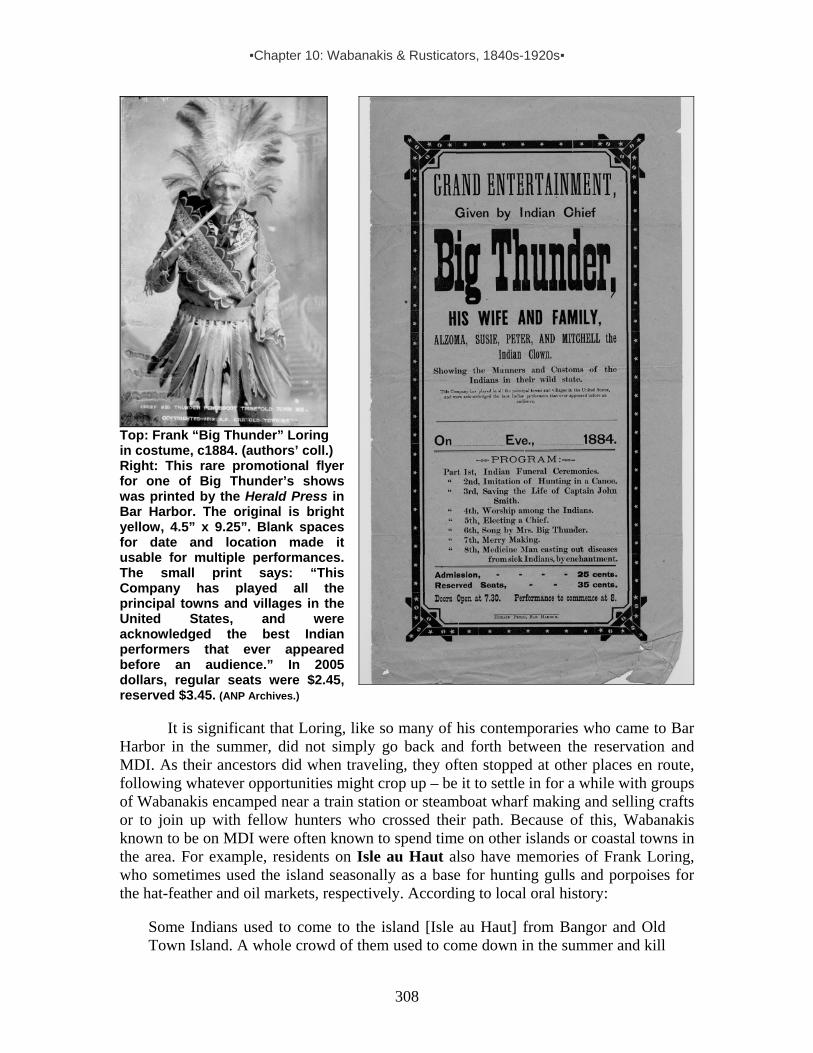
▪Chapter 10: Wabanakis & Rusticators, 1840s-1920s▪
308
Top: Frank “Big Thunder” Loring in costume, c1884. (authors’ coll.) Right: This rare promotional flyer for one of Big Thunder’s shows was printed by the Herald Press in Bar Harbor. The original is bright yellow, 4.5” x 9.25”. Blank spaces for date and location made it usable for multiple performances. The small print says: “This Company has played all the principal towns and villages in the United States, and were acknowledged the best Indian performers that ever appeared before an audience.” In 2005 dollars, regular seats were $2.45, reserved $3.45. (ANP Archives.) It is significant that Loring, like so many of his contemporaries who came to Bar Harbor in the summer, did not simply go back and forth between the reservation and MDI. As their ancestors did when traveling, they often stopped at other places en route, following whatever opportunities might crop up – be it to settle in for a while with groups of Wabanakis encamped near a train station or steamboat wharf making and selling crafts or to join up with fellow hunters who crossed their path. Because of this, Wabanakis known to be on MDI were often known to spend time on other islands or coastal towns in the area. For example, residents on Isle au Haut also have memories of Frank Loring, who sometimes used the island seasonally as a base for hunting gulls and porpoises for the hat-feather and oil markets, respectively. According to local oral history:
Some Indians used to come to the island [Isle au Haut] from Bangor and Old Town Island. A whole crowd of them used to come down in the summer and kill

▪Chapter 10: Wabanakis & Rusticators, 1840s-1920s▪
309
the gulls for the feathers. . . . The government came in and put in a law to stop it. That hurt the Indians. It was a big business for them. . . . Those Old Town fellows were good guys. They used to ship those feathers to New York to trim hats. The feathers were as white as chalk. . . . Indians still came down after they couldn't shoot the gulls; they came to get porpoises for the oil. I remember Big Thunder. . . . I used to borrow his canoe to go up to the pond. Mighty tippy. He never minded. A birch canoe was a good boat if there was an Indian in it. Took their canoes [across Penobscot Bay] right out to Matinicus [Island, following an ancient sea route documented in the early 1600s]. I’d never do that.112
Seagoing Indian canoes in Isle au Haut Thoroughfare, 1890s. (In Bunting, 2000, p.70.)
Similar recollections exist concerning Eagle Island in Penobscot Bay, just west of
Deer Isle. Loring and other Penobscots also ventured there by canoe and sometimes camped in the company of Joe Dana (b1852) and other Passamaquoddies from Pleasant Point in the 1880s and ‘90s. As noted by one local historian:
A number of the former residents of Eagle Island tell about visits to the island by small bands of Indians beginning in the 1880s. They either witnessed these visits personally or were told about them by their parents or older friends. Not only the Penobscots from the upper Penobscot River Valley [Passadumkeag & Mattawamkeag] and the Old Town area, but also the Passamaquoddies from
112 Gooden Grant (b.1876), interview by Lynn Franklin. See Bunting, 2000, p.70; cf n.l on p.358: “Grant was also quoted as saying that Indians from ‘East Quoddy’ as well as Old Town visited Isle au Haut.” Wm. Haviland, who knew Grant, noted (p.c. 1/16/05) that Grant “lived at Head Harbor, on the [south] seaward end of Isle au Haut . . . where [apparently] these Indians camped. This makes sense for gull hunting, as Head Harbor, with its good beach for hauling out canoes, is the most convenient spot to set off for Great and Little Spoon Islands, which are major bird nesting islands. There are also a number of good seal haulouts on that side of Isle au Haut.” Noting another Indian encampment at the north end of Isle au Haut where the summer cottage colony began in 1880, Haviland said Indians there “seem to have been less interested in bird hunting than in selling baskets and craft items.”

▪Chapter 10: Wabanakis & Rusticators, 1840s-1920s▪
310
Pleasant Point, came down the Penobscot River and Bay and along the coast in their canoes and visited certain islands in the Bay. . . . These summer excursions were made for . . . gathering shellfish, collecting gull’s eggs, and obtaining sweet grass from which to make baskets. Harold Ball, son of Capt. John Ball, recalls several of the Indian visits. The [Penobscots], led by Chief Big Thunder, whom Harold came to know personally, landed in Lighthouse Cove and came to the light to get permission from Capt. Ball to camp on the island. They camped east of the spring which I located near Lighthouse Beach. Although the boundary line between the lighthouse property and the Samuel Quinn farm runs through the middle of the spring and the Indians camped on Quinn land, they always got permission to camp from Capt. Ball. . . .
The Indian chief took Capt. Ball and his wife out for a ride in a large bark canoe. The Indians seemed to relish seal hunting. They speared them as they basked on the rocky shore or nearby ledges. At times, they also killed porpoises.113
Wherever he ventured, Frank Loring was known as a storyteller – a man who could fill someone’s ear whether selling a basket, paddling a canoe, entertaining on stage or just sitting on the stoop of the little relic shop he established on Indian Island in the last years of his life. The birchbark sign out front read: “Big Thunder, Indian Relics and Indian Traditions Told.” He did just what the sign said: selling “relics” and telling tales that enhanced their value.114 In a 1907 booklet titled Historic Maine and Indian Mythology
appears a short profile on Loring, including a story he told to the author-writer—identified as West in his drawing of Loring. Part of the section based on the West’s visit with Loring reads as follows:
I was told the most of this interesting legend [“The Mythological Secret of Mt. Kineo”] by the Penobscot Chief “Big Thunder” whose sketch with distant and watery eyes, I took at the time. The chief lamented the condition of his people. . . . [and] in the summer of 1899 he made himself an old-time birch canoe, sewed with roots and without a nail, with deer skin costume and birch wigwam, to paddle all the way to Washington to plead with President McKinley to save his people. He journeyed in true ancient fashion, ate nothing but gulls’ eggs and fish, made his fires with friction sticks, etc. The old man’s strength gave out before he was half way down the New England coast and he had to turn back….115
113 Enk, p.327. Wm. Haviland, p.c. 11/15/05 noted, “Lighthouse Cove…was the best access point for going to nearby Hardhead Island, where gulls (not to mention guillemots & cormorants) nest in large numbers. Maybe this was one of the draws to Eagle Island? Also, the Quinns ran a summer boarding house on Eagle, and on neighboring Butter Island in 1896 a summer resort opened (see McLane & McLane); both would have afforded opportunity for sale of baskets and other crafts.” 114 McBride 1995, p.46. 115 A year later, Loring told the same story to the New York World (see SanduskyDaily Star, 9/3/1900).

▪Chapter 10: Wabanakis & Rusticators, 1840s-1920s▪
311
Whether Loring actually attempted a canoe trip to Washington, D.C., or simply spun a good yarn about it, this passage reveals something of the feistiness he possessed right into the last decade of his life. At age 74, two years after his avowed seacoast journey, he was elected lieutenant-governor of the Penobscot Nation, having already served in various other capacities, including wampum keeper. Eleven months before his death in April 1906, Loring was working on a new “Indian Play” to be performed in the Town Hall of Lewiston. An article about the event appeared in the Lewiston Journal under the headline “Big Thunder, Mighty Medicine Man, Chief of the Tarratines.” Loring must have chuckled with pleasure when he read the passage that lauded him as the tribe’s historian: “It is to Big Thunder that the young Indian who would know of the greatness of the [Penobscots] goes for information. To him, too, go those members of the tribe who wish to retain a knowledge of the customs of the days when the Tarratines ruled Maine from end to end.”116 When Loring died the following year at age 79, Penobscots buried him in Indian Island’s Catholic cemetery. Numerous newspapers ran obituaries heralding his celebrity, and his death was front-page news in the Old Town Enterprise: “Not since the passing away of Molly Molasses,” the paper declared, “has the Penobscot Tribe of Indians lost from its midst such a famous personage. . . . ‘Big Thunder’ . . . bears the record of being the last of the old chiefs of the Penobscot tribe.”117 Elizabeth “Queen” Francis (1839- c1915)
In all likelihood, this engraving shows Elizabeth Francis in her tent near the foot of Holland Avenue in Bar Harbor. It was published in 1884 with several other engravings and a brief article, which noted that a sign posted by one of the tents at the Indian encampment read as follows: “The Great Fortune Teller, by Madam Francis.” The article went on to say, “This means that for twenty-five cents Madam Francis will tell you how your luck will ‘pan out’ in the future.”118 Journalists and locals usually referred to her as “Queen Francis.” At least two other Passamaquoddy women were called “Queen” in the 19th and early 20th centuries – “Queen Lola” and “Queen [Mary] Mitchell” (c1820-1910). But
neither is noted with the frequency and pomp given to Elizabeth Francis of Pleasant Point. Yet, few details about her life have been unearthed.
The 1900 Federal census shows that Elizabeth, born at Pleasant Point in 1839, was married to basketmaker Edmon Francis (b.1840). She knew how to read and write English, but her husband did not. Of the nine children she bore, four had survived as of 116 6/6-11/1905, in Prins 1998, p.152. 117 In Prins, 1998, p.152. 118 Frank Leslie’s Illustrated Newspaper, 8/23/1884, pp.5-6.

▪Chapter 10: Wabanakis & Rusticators, 1840s-1920s▪
312
1900. Newspaper accounts make it clear that she was a well-known figure in Bar Harbor from 1877 (if not earlier) through at least 1896. Among Mount Desert Island news bits about her is this one from 1883: The Indian ‘Queen Frances’ was out riding yesterday in full gala day costume. The queen and her party occupy four tents near Hamor’s wharf and have a fine lot of baskets and small wares. This is her seventh season at Bar Harbor.”119 In August 1889, when Elizabeth’s grandson nearly died in a hunting accident in Sorrento, just across Frenchman Bay, the story was especially interesting to Bar Harbor residents because the child was related to her. As reported in the local paper:
A sad accident occurred Saturday at Sorrento. A little Indian boy, grandson of the queen Elizabeth Francis was over there gunning with his father and accidentally discharged the gun in such a manner that the bullet passed through his right lung. He was brought home and at last accounts, was suffering intensely and the doctors had no hope of his recovery. . . . A very pleasant party went over to Sorrento, Sunday morning, on the little steamer Sorrento to hear the Rev. H. Bernard Carpenter. . . . Mr. Carpenter, before commencing his discourse, spoke of the little Indian boy who met with the accident at Sorrento, and in whom the Sorrento people have shown a deal of interest. He was glad to tell them, he said, that the boy was having excellent care and that the doctors reported each day a very little gain. . . .120
A month later, mixing up the tribal names of Penobscot and Passamaquoddy and
confusing Elizabeth with a Penobscot woman of the same name,121 the newspaper announced her death – only to run a correction the following week:
Elizabeth Francis, an aged [woman] of the Penobscot tribe, known to Bar Harbor people as ‘Queen Francis’ was burned to death on Thursday morning of last week in her house in Oldtown, which was totally destroyed, together with that of her son next door. The cause of the fire is a little mysterious, but it is surmised that it took from a tobacco pipe, as Mrs. Francis was a habitual smoker. The unfortunate woman had just finished her summer business of basket-selling at Bar Harbor and returned home.122 It now appears that the Indian woman, Elizabeth Francis, who was burned to death at Oldtown recently, was not ‘Queen Francis’ [Passamaquoddy, b1839] but another Elizabeth Francis [Penobscot, b1835], who summered at Southwest Harbor. Queen Francis is yet at Bar Harbor.123
Like Frank Loring, Elizabeth Francis figured significantly in Bar Harbor’s 1896 centennial celebration. The festivity included a parade featuring Maine’s original inhabitants. As noted in the Bar Harbor Record: A week from tomorrow begins the most important event in the life of Eden and Bar Harbor – the centennial. It will continue two 119 MDH, 7/26/1883, p.3. 120 MDH, 8/16/89 p3, 8/9/1889, p.3. 121 Born in 1835, the Penobscot Elizabeth was just four years older than Elizabeth Francis of Pleasant Point. She was married to fellow Penobscot Thomas Francis and some individuals at the Old Town reservation referred to her as his “queen,” adding to the confusion between the two women. 122 MDH, 9/20/1889, p.3. 123 MDH, 9/27/1889, p.3.

▪Chapter 10: Wabanakis & Rusticators, 1840s-1920s▪
313
days. . . . Mr. Fennelly, the chairman, is rapidly completing the make up of the procession. One of the features will be Queen Francis of the Passamaquoddy tribe and several Indians in their original costumes.124 The federal census for 1910 shows the Elizabeth and Edmund were still alive, she age 71, he 70. Neither appears on the 1920 census. Louis/Lewis/Lewy/Lewey Mitchell (1847- 1931)
No matter how one spells his first name, Passamaquoddy Lewis Mitchell was a well-known figure on Mount Desert Island and beyond. Like Frank Loring, he epitomized the versatility of many Wabanakis of his era. He was an expert hunter, canoeist and guide; a tribal representative in the Maine State legislature; an out-spoken advocate for traditional hunting and fishing rights; an ace pitcher in baseball games; and a rich source for anthropologists interested in tribal lore and traditional Passamaquoddy ways and beliefs. Notably, he provided scholars information in both written and oral form.125 Born at Pleasant Point in 1847, son of Peter Mitchell Neptune, Lewis Mitchell married Bridget (b.c1855), who could speak English, but did not write or read. They had their first child, James, in 1881, followed by Susan (b1883), Nichola (b1888) and Evelyn (b1897). All of their children learned to read and write.
Lewis Mitchell, c1880s. (C.A. Conlon Studio, St. John, N.B., Courtesy of Donald Soctomah)
By 1881, at age 34, Mitchell appears to have been well established in the Bar
Harbor summer scene – enough so to have posted this recurring ad in the local paper:
Birch-Bark Canoes – Louis Mitchell of the Passamaquoddy tribe of Indians, will have during the season, at the shore between Suminsby’s and Steamboat wharf, Bar Harbor, a number of Birch-Bark Canoes, in which he will take parties to the several Islands in the bay and around Mount Desert island. Carrying sporting parties to places where porpoise and seal may be shot. Guns and ammunition furnished when desired. Reliable and experienced paddlers will be provided. Lewis Mitchell recently paddled his canoe entirely around the island of Mt. Desert, a distance of sixty miles, in twelve hours.126
124 BHR 6/24/96, p.1. 125 For more on this, see anthropologist profiles in Chapter 11. 126 MDH, 7/31-9/3/1881, p.3.

▪Chapter 10: Wabanakis & Rusticators, 1840s-1920s▪
314
Evidently, Mitchell’s entrepreneurial spirit was already in action, for the ad suggests that he was soliciting work for several “experienced paddlers” in addition to himself. The reputation he earned as an expert canoeist stayed with him for many years, prompting the author of the most comprehensive guidebook to MDI to describe him as one of the “expert . . . aboriginal Argonauts.”127 Sometimes Mitchell’s adventurous spirit reached the point of audacity. At age 52 he made headlines when he and fellow tribesman Xavier Francis attempted an all but impossible canoe feat. A summary version of a full-length story about the event read as follows:
The canoe in which Lewis Mitchell and his partner Francis, of Pleasant Point, attempted to shoot the falls at St. John [River] was at the International Wharf [in Eastport] and attracted a good deal of attention. The canoe is a canvas affair and was none the worse on this foolhardy trip, which cost Francis his life and came near being fatal to Mitchell also. Lewis said a few years ago he could have performed the feat successfully, but was now too old for such a trial.128
When folklorist Charles G. Leland came to Bar Harbor seeking Wabanaki informants, Mitchell proved to be a most valuable resource, earning this acknowledgment in Leland’s Algonquin Legends:. “To this gentleman I am greatly indebted for manuscripts, letters, and oral narrations of great value.” With such an endorsement, it is not surprising that when linguist John Dyneley Prince followed in Leland’s steps to Bar Harbor in 1887, he too met with Mitchell. They discussed Passamaquoddy language and traditions, including the Wapapi Akonutomakonos or Wampum Records concerning the formation of a pan-Indian alliance in northeast America about 1700, and a description of its protocol and the functions of wampum belts and strings. Publishing on the subject a decade later, Prince commented, “I obtained the Wampum Records at Bar Harbor, Me., in 1887, from a Passamaquoddy Indian, Mr. Louis Mitchell, who was at the time a member of the Maine Legislature.” Mitchell’s manuscript, Prince added, “contained both the Indian text and a translation into Indian-English.”129
Fannie Hardy Eckstorm also sought out Mitchell in her Wabanaki research. They corresponded on a range of topics – from the origins of family and place names to traditional stories and songs to oral history on Wabanaki involvement in the American Revolution. Also, he assisted Miss Mary Cabot Wheelwright (1878-1958), a wealthy Bostonian who summered on Sutton Island just south of Northeast Harbor, in her collection of Wabanaki oral histories and artifacts. (Wheelwright’s remarkable collection of Wabanaki handicrafts, ultimately donated to the Abbe Museum in Bar Harbor, includes moccasins, beadwork, baskets, birchbark work, baskets, powder horns, crooked knives, etc.) In a 1930 letter to Eckstorm, Mitchell wrote:
127 Sweetzer 1888, pp.20-21. 128 Eastport Sentinel, 9/7/1898. 129 Prince, J.D. 1897, p.481. The records Mitchell gave Prince came through oral tradition from the po-too-us-win (wampum keeper) Sopiel Selmo (also spelled Selma or Selmore), one of the Passamaquoddy’s last delegates to the Great Council Fire in Caughnawaga in 1870. See Raymond; Speck, 1915, pp.492-508. The preface to Prince’s 1921 publication, Passamaquoddy Texts (featuring the Wampum Records, and several legends) notes, “These documents…came into my possession some years ago, but were all destroyed by fire in 1911, since which time Mr. Mitchell industriously reproduced them at my request from memory.”
▪Chapter 10: Wabanakis & Rusticators, 1840s-1920s▪
315
I have few relics for Miss Wheelwright such as old crooked knives and rattle, or powder horn, and the original stick used with Indian quick-step dance, very old. Also I know where I can get 3 silver Breast Plates, 5-inch, decorated, and a French Hatchet, used by Indians probably 300 years ago and 2 of the Indians can sing Indian Songs yet, such as Love Songs, Salutation Songs, very interesting, Dancing Tunes – these ought to be preserved.130
On the political front, Mitchell served several terms as tribal representative to the Maine State legislature in Augusta between 1880 and 1911. His political activities were commonly recounted in newspapers around the state, including in the Mount Desert Herald, which in 1888 reported that: “Passamaquoddy representative Lewis Mitchell requested from the Maine state government that the Indian agency at Calais would be removed to Eastport, and that a subagency would be created in Princeton, because of the difficulty Passamaquoddies had to get their state aid in the form of food and money and permissions in times of sickness.” 131 While concerned with an array of issues, he was especially committed to challenging state game laws that made it increasingly difficult for Wabanakis to rely on hunting as the key means of subsistence. His efforts to convince state officials that game laws ran counter to aboriginal treaty rights were frequently chronicled in various newspapers. For instance, a paper reported in 1891:
An interesting question has come up before the Maine Governor and his Council, in relation to the treaty rights of the Indians in this State. It will be remembered that not long ago Lewis Mitchell, one of the brightest of the Passamaquoddy Tribe, made the point that his Tribe should not be subjected to the restrictions of the game laws of this State because the treaty which his Tribe signed especially stipulated that the Indians should have the uninterrupted right to hunt and fish at their pleasure in the State. . . . Mitchell has been to Massachusetts studying the archives. . . . The effect of allowing the claim advanced by Lewis Mitchell might have a widespread effect upon the sporting interest of the State.”132
Mitchell’s efforts were ongoing. A decade after the previous newspaper account, the following appeared:
One of the picturesque figures about the capital in Augusta last week was Lewis Mitchell, the Representative of the Passamaquoddy Tribe…. Mr. Mitchell is anxious to have Indians exempted from the operation of seagull laws. He declares that only about 50 of his people are engaged in the hunting of gulls. He declares that men who gather the eggs of the birds are the ones who do the most to destroy them. He declares that his people are recognized and protected in their hunting, fishing and fowling privileges by many different treaties between 1693 and 1777, which he believes to be properly in force at the present time.133
130 Mitchell, 17 May 1930, Letter to Eckstorm. 131 MDH, 1/6/1888 132 Eastport Sentinel, 4/29/1891. In Soctomah 2002, p.44. 133 Eastport Sentinel, 2/20/1901. In Soctomah 2002, p.76.

▪Chapter 10: Wabanakis & Rusticators, 1840s-1920s▪
316
When verbal protests failed, Mitchell turned to civil disobedience, even while serving as tribal representative to the Maine state legislature. The following newspaper excerpt chronicles an incident that occurred in 1902:
The old claim of the Maine Indians that they have certain inalienable rights not accorded their paleface brethren is to be again thrashed out in the courts. Game warden Miller recently seized a box containing 13 dozen pairs of gull’s wings shipped from Eastport to Boston. Lewis Mitchell was arrested, tried, and adjudged guilty of having thus violated the game laws. He was sentenced to pay a fine of five dollars and costs and to serve 10 days in jail. Mitchell appealed his sentence, claiming that under the treaty with the Indians, he had a perfect right to kill the birds. The case will be tried at the January term of court. Hon. Hanson of Calais is counsel for Mitchell.134
Remarkably, Mitchell was still at it two decades later at age 74, as per this news clip:
Lewis Mitchell and Thomas [Joe] Lola from Pleasant Point reservation at Perry were before US commissioner Reid in Bangor Friday on charges of unlawful possession of certain migratory birds and offering them for sale, contrary to the convention entered into between US/Great Britain and in accordance with the act of Congress. It was charged that the men had taken gulls and were selling the breasts. They entered pleas of not guilty through their Council [sic], Edward Murray. Probably cause was found and the respondents were held in $500 each for their appearance at February term of court.135
Passamaquoddies Tom Joe Lola (front, b1855) and Lewis Mitchell in canvas canoe with rolled sail, c1910. (Courtesy of Donald Soctomah.)
134 Eastport Sentinel, 12/17/1902. In Soctomah 2002, p.81. 135 Eastport Sentinel, 6/23/1920.

▪Chapter 10: Wabanakis & Rusticators, 1840s-1920s▪
317
While Mitchell was a man with many skills, he identified himself as “basketmaker” to census takers. But, as with the rent-a-canoe/rent-a-paddler business he established in Bar Harbor, when it came to baskets he was an entrepreneur with an eye for expansion. As the following news clip shows, he became a middleman in the basket trade, sometimes providing basketmakers with raw materials needed for their work:
Lewis Mitchell and Joe Dana [b1852], who are noted for their thrift and enterprise, and who do an extensive business in baskets and other Indian wares, are making great preparation for the coming season’s trade, having recently received a carload of [brown] ash logs from Houlton via the railroad, which is to be converted during the winter months into baskets of various designs. Mr. Mitchell’s industry is a great benefit to the Tribe, furnishing them, particularly the female population, with means of earning a livelihood during the winter months. The industry is a lucrative one, both men said to be laying a generous competence [compensation?] for old age and rainy days.136
Beyond selling fancy baskets in Eastport and resort areas such as Mount Desert
Island, Mitchell capitalized on the need sardine-packing factories had for work baskets. In 1888 the Eastport Sentinel reported the growing demand for “sardine baskets,” noting, “The Pleasant Point Indians have supplied a large part of the demand. . . . Lewy Mitchell who is interested in the manufacture of the goods says that there have been probably $6000 worth made and disposed of since last fall at the Point.”137 By 1902 Mitchell was busy shipping both types of baskets to his clients, as noted in this newspaper excerpt:
Basket making is a rushing business this winter, $100 worth of baskets being brought to Eastport and shipped to other factory towns weekly. Lewis Mitchell, one of the largest dealers, has mostly sardine baskets, while shipments to the west are fancy baskets. The industry is a growing one and of great value to the village, as it provides labor and income to most of the residents of Pleasant Point.138
In August, 1918, Mitchell’s wife died at age 62 after 46 years of marriage. He appears on the 1920 U.S. census for Pleasant Point as an 83-year-old widower living with daughters Susan Dana and Evelyn, along with Evelyn’s newborn boy Aloysius. His profession is still identified as “basketmaker.” In 1930 we find him living with Evelyn and her husband John Newell (Passamaquoddy, b1890), along with their children Aloysius and Margaret (b1912). Again, Mitchell is listed as a basketmaker. In his last known letter to Eckstorm, written in early 1931, Mitchell commented that he was old and sick. Soon thereafter, on 15 March 1931, he passed away, having lived a long and remarkable life.
(Photo left: Lewis Mitchell, c1915. Courtesy of Donald Soctomah.)
136 Eastport Sentinel, 12/25/1901. In Soctomah, 2002, p.78. Joseph Dana is listed in 1900 Federal census for Pleasant Point as “Tribal Governor.” 137 Eastport Sentinel. In MDH 6/8/1888, p.3. 138 Eastport Sentinel, 2/26/1902. In Soctomah, 2002, p.79.

▪Chapter 10: Wabanakis & Rusticators, 1840s-1920s▪
318
Joseph Lola (1830-??)
Passamaquoddy Joseph Lola (also spelled Lolah or Lolar) was a regular at the summer Indian village in Bar Harbor. Over the years the sign posted by his tent appeared in three different pictures taken at the town’s shifting encampment sites. In addition to posting a sign on location, Lola sometimes solicited business by placing ads in the local paper. During the summer of 1885, the following ad ran weekly in the Mount Desert Herald:
“PASSAMAQUODDY INDIAN BASKET SALE, At the INDIAN ENCAMPMENT near Hamor’s wharf, BAR HARBOR. Commencing Friday, July 3, and to continue until the end of the season. – A large assortment of INDIAN WARES of all kinds, Baskets of every description. A very fine assortment of Sea Fowl Feathers. Toy Canoes, Bows, Arrows, etc. Please call and examine our wares. JOSEPH LOLA & Co.139
Bar Harbor Indian encampment, c1885. (MHPC)
Elected tribal governor at Pleasant Point in 1888, Lola was equally innovative when it came to finding or creating year-round markets for his crafts. Sometimes he traveled long distances to do so, as seen in these two wintertime newspaper excerpts:
Joseph Lola, Governor of the Passamaquoddy tribe of Indians was in Boston, Monday, to sell baskets and other articles of Indian manufacture. He visited the State House and exhibited a handsome sealskin prepared for a mat, which he said he desired to send to President Harrison as a Christmas greeting, and wanted information as to how it should be directed and sent. The information was supplied by Secretary Pierce and Joseph departed, happy at the thought that his little contribution would reach the Great White Chief.140
While Joe Lola [who sold crafts in Bar Harbor for many summers] was in New York City he created some excitement in city hall. He is a man with long black hair and a dark complexion who was carrying a mysterious looking canvas bag under one arm. He came into the corridor and walked around for a while, peering into doorways and looking suspiciously at everyone who approached him. He wore no overcoat, his trousers and coat were two sizes too big for him, and his black hat was pulled down so low on his head as to conceal his piercing black eyes. When policemen and janitors and a scrubwoman began to gather around him he clutched his canvas bag nervously and began to speak his native language, which no one could understand. Then everyone moved back a few
139 MDH, recurring ad, 7/3-8/28/1885, p.4. 140 The Journal, 12/27/1889, p.3.

▪Chapter 10: Wabanakis & Rusticators, 1840s-1920s▪
319
steps and looked at the canvas bag and thought he may have dynamite. Finally, a big policeman who was passing by in the hallway, after listening to him for a while makes out he was looking for the mayor’s office. Then most of the crowd felt for sure that he had dynamite in his canvas bag. A second big policeman and the mayor’s messenger stopped Lola just outside the mayor’s door and demanded to know the contents of the bag. With evident reluctance, Lola started to pour out his bag onto the floor and again the crowd scattered. Chattering away in his native tongue, he poured out a pile of wonderfully designed and constructed little baskets made of bark and painted red, white, blue and old gold colors. After much effort he made the crowd understand that he was an Indian from Pleasant Point Reservation in Maine and had come to the city to sell his baskets. He said, in English, his name was Joseph Lola and he was a member of the Passamaquoddy Tribe. He wanted to find the mayor to get a license to sell his baskets on the streets. He was referred to the mayor’s marshall.141
John Leonard Snow (1868-1937)
John Snow’s life began on the Passamaquoddy reservation at Pleasant Point in 1868,142 but he spent at least half of his life on Mount Desert Island, making and selling crafts to locals and visitors. He appears on the 1900 Federal census for Bar Harbor as a resident of dwelling #266 at the Ledgelawn “Indian Camp.” In all likelihood, it was not his first summer on MDI. He was there with his wife of two years, Penobscot Mary Ann Fransway Francis Snow (c1855-1946) – both listed as basketmakers. Over the next four decades he became a well-known figure on MDI, especially in Northeast Harbor and the Cranberry islands. In 1910, we find him listed twice in Federal records: on the Northeast Harbor census (recorded April 23) as a married man living alone, owning his own house, and employed in “general work,” and on the Indian Island/Old Town census (recorded May 6) as a married man living with his wife Mary Ann as boarders in the
141 Eastport Sentinel, 1/11/1893, In Soctomah, Donald 2002 p.29. 142 It appears that he was the son of Lewis Snow, listed as Lewy Snow, head of a household of three, on the Indian agent’s Passamaquoddy census taken Nov. 1876. Lewis served as tribal representative to the state legislature in 1874 and possibly 1876 as well. A description of Lewis by Wilbur Day (1864-1924) appears in Wilbur Day: Hunter, Guide, and Poacher: “The first hunt that ever I had with an Indian, I was quite a young boy, and the Indian’s name was Lewis Snow. . . . He lived at Pleasant Point near Eastport. That man was a prince, six-feet-six-inches tall in his stocking feet and weighed two hundred and sisty pounds. He had not once ounce of useless flesh. . . . I was allowed to go [on a hunt with him]. . . . Mr. Snow got two or three deer and canoe bark. He built himself a big hand sled and put on his load and started to drag it to Pleasant point. . . .” (For the full story of Day’s hunt with Lewis Snow, see Ives, pp.64-65.)
John Snow, c1905. (Abbe Museum.)

▪Chapter 10: Wabanakis & Rusticators, 1840s-1920s▪
320
A. Sapier household.143 Sometime between 1910 and 1919 John and Mary parted ways, and in 1919
Passamaquoddy Alice Sockabasin gave birth to John’s daughter Susan Snow in Bar Harbor. Alice (separated from Mitchell Francis of Pleasant Point) was also a basketmaker and like other Passamaquoddies had boarded with John on Mount Desert Island. She settled in with him at Northeast Harbor, and they had three more children together – Phillip (b.1920), Bertha (b.1922) and Juanita (b.1921). As year-round residents, all of the children attended the local school. Alice’s children by Mitchell Francis (Josephine/b.1903, Lewey/b.19__, and Daniel/b.1915) sometimes lived with them in the small wooden house by the intersection of South Shore and Manchester roads within sight of the old steamboat wharf. Susan described the place as “camp-like” with “about four bedrooms,” and recalled that they used front room or livingroom for basketmaking in the winter and as a storefront in the summer. Heat came from a woodstove in the kitchen and a potbelly coal stove in the livingroom. It was cold in the house in the winter, but, noted Susan, “us kids never complained. I guess we were used to it. We never got up in the morning until after my father got the heat going.”144 She and her siblings grew up well aware of nature’s food offerings in the area – clamming and fishing near the wharf, and collecting dandelion greens and wild berries that grew in nearby fields.
Alice made most of the fancy baskets John sold, often with help from her daughters and any Wabanaki women who might be visiting. John prepared the ash and collected the sweetgrass for their work and made numerous crafts himself – including birchbark boxes, frames and toy canoes, as well as sealskin moccasins. His primary sweetgrass-gathering place was Little Cranberry Island. He was not the only Wabanaki getting basket grass there. According to one oral history, told by a Little Cranberry Island resident as she showed some of Snow’s work to her grand-daughter:
In the summertime [during the early 1900s] Passamaquoddy Indians would come around the Islands and sell all these kinds of baskets and woven napkin rings and so forth. Not expensive. They came door-to-door. . . . These are John Snow’s baskets. He was a Passamaquoddy who lived with several other Indians in Northeast Harbor. . . . He used to come out to [Little Cranberry] and pick sweetgrass. They’d even come up from Eastport in big canoes to pick it.”145
As for basket ash, often he obtained it from fellow Passamaquoddies at Pleasant
Point. (In the 1900s ashwood was a line item in the tribal budget managed by the Indian agent. Suitable ash trees had become scarce around the reservation, so ash “sticks” were brought in by boat and made available to basketmakers. In addition, Snow likely obtained ash from Lewis Mitchell, who brought it in by the train carload from Aroostook County.
143 Figures in the two censuses are contradictory, but it is clear that Mary Ann was older than John (by 9-16 years) and that previously she was married to John M. Francis (b.1843-98, son of Mary Socktomah Lola & Joseph Mitchell Francis). Of the seven children Mary Ann gave birth to, only one survived and is not listed as living with the couple on the 1900 or 1910 censuses. (The surviving child must have been Alice (Tellis) Francis, listed in the Penobscot Nation genealogical records as born c1873 on Olamon Island to Mary Ann Fransway and her first husband John M. Francis. After growing up, Alice had three husbands before her death in 1953: Anselm Sapiel, Newell B. Miles, & Joseph M. Swassian.) 144 All Susan Snow Holmes quotes in this brief profile come from her 2004 interview with McBride. 145 Locke.
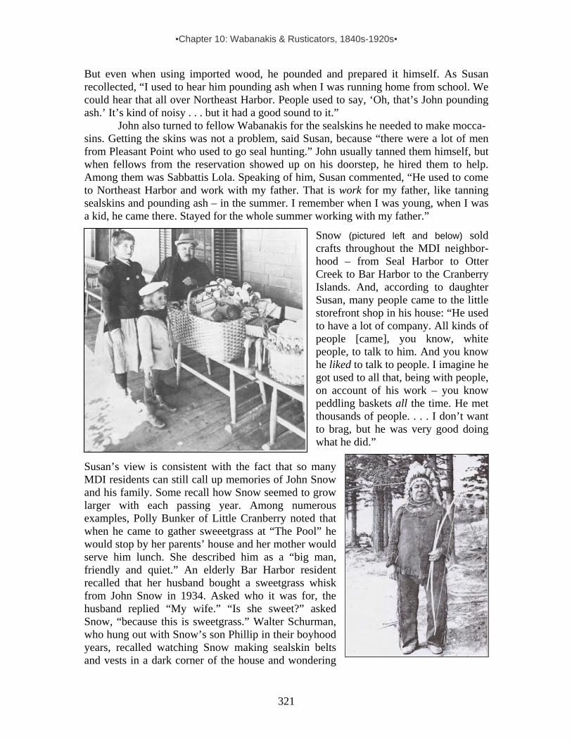
▪Chapter 10: Wabanakis & Rusticators, 1840s-1920s▪
321
But even when using imported wood, he pounded and prepared it himself. As Susan recollected, “I used to hear him pounding ash when I was running home from school. We could hear that all over Northeast Harbor. People used to say, ‘Oh, that’s John pounding ash.’ It’s kind of noisy . . . but it had a good sound to it.”
John also turned to fellow Wabanakis for the sealskins he needed to make mocca- sins. Getting the skins was not a problem, said Susan, because “there were a lot of men from Pleasant Point who used to go seal hunting.” John usually tanned them himself, but when fellows from the reservation showed up on his doorstep, he hired them to help. Among them was Sabbattis Lola. Speaking of him, Susan commented, “He used to come to Northeast Harbor and work with my father. That is work for my father, like tanning sealskins and pounding ash – in the summer. I remember when I was young, when I was a kid, he came there. Stayed for the whole summer working with my father.”
Snow (pictured left and below) sold crafts throughout the MDI neighbor-hood – from Seal Harbor to Otter Creek to Bar Harbor to the Cranberry Islands. And, according to daughter Susan, many people came to the little storefront shop in his house: “He used to have a lot of company. All kinds of people [came], you know, white people, to talk to him. And you know he liked to talk to people. I imagine he got used to all that, being with people, on account of his work – you know peddling baskets all the time. He met thousands of people. . . . I don’t want to brag, but he was very good doing what he did.”
Susan’s view is consistent with the fact that so many MDI residents can still call up memories of John Snow and his family. Some recall how Snow seemed to grow larger with each passing year. Among numerous examples, Polly Bunker of Little Cranberry noted that when he came to gather sweeetgrass at “The Pool” he would stop by her parents’ house and her mother would serve him lunch. She described him as a “big man, friendly and quiet.” An elderly Bar Harbor resident recalled that her husband bought a sweetgrass whisk from John Snow in 1934. Asked who it was for, the husband replied “My wife.” “Is she sweet?” asked Snow, “because this is sweetgrass.” Walter Schurman, who hung out with Snow’s son Phillip in their boyhood years, recalled watching Snow making sealskin belts and vests in a dark corner of the house and wondering

▪Chapter 10: Wabanakis & Rusticators, 1840s-1920s▪
322
how such a big man managed to catch seals.146 Another resident summed up Snow’s work like this: “Mr. Snow made beautiful
sweetgrass baskets, picture frames of birchbark and sweetgrass, toy birchbark canoes and many other items, which he sold door to door with his children, mainly to our summer residents. He also dug clams and chopped wood for locals and summer residents alike. The children were enrolled in school and one of the boys Phillip “Porky” Snow was in my mother’s class at Stetson School.”147
John Snow’s daughter, Susan Snow Holmes, in the Abbe Museum looking at items and images tied to his life, 2003. (Abbe Museum.)
Beyond being a craftsman, salesman, general laborer and frequent employer of other Wabanaki crafters, John Snow collected, told and wrote down traditional Wabanaki stories – in Passamaquoddy and English. When asked what it was that made her father so memorable, Susan Snow told about his storytelling:
Well, he had a pretty good personality. He used to tell stories too. Indian stories. And he’d translate them in English. . . . I remember [when I was about 10 in 1929] we went to this BIG house in Northeast Harbor and this lady – we all sat out back in her garden. It was so pretty there. Well, rich people. So we all sat in back. I was with my father. And my father was reading her the story. I don’t even remember what the story was about. It was all Passamaquoddy language. . . . After that he translated to her in English. . . . He wrote it down and gave it to her [in] both languages. He sold it to her.
146 Information in this paragraph comes from Erin Damon, “The Search for John Snow: An Intern’s Quest for a Local Icon.” Abbe Museum exhibit. 2003. (First photo on p.321 from Abbe Museum, second from NEH Library.) 147 Dana.

▪Chapter 10: Wabanakis & Rusticators, 1840s-1920s▪
323
Susan did not remember who the woman was who bought the story, but it may well
have been historian Fannie Hardy Eckstorm or her wealthy friend Mary Cabot Wheelwright, who had a summer home at Northeast Harbor and collected Indian folklore and artifacts. One of numerous letters written by Passamaquoddy Lewis Mitchell in his correspondence with Eckstorm gives credence to this possibility, saying, in part:
I received your letter Saturday…. Also I received a letter from John Snow…. He came to see me about three weeks ago with about 20 pages of Kluskap Stories and one Indian Love Song, both in Indian and English. He claims the stories to be straightening out. He says some Indian words in the stories [still needed] to be translated in English, which I did…. He also says to me that you cannot understand my spelling on some words, but did not tell me the words. I will gladly explain them to you. I can read my own writing.
Maine writer Elizabeth Coatsworth (1893-1986), whose family purchased a
carved cane from Snow in his later years, wrote down this recollection of his storytelling:
In his mind the old stories and traditions lay in dimmed and broken images; yet, as a sort of gypsy dweller beside the white men’s houses, he still remembered something of the tales, which his mother had told him as a little boy. He remembered about the great sea monster, and about the small people known as Pukwudgies. They stood no higher than a man’s waist, and their heads were long, or so said the few who had seen them, for they were shy, and hard to get a glimpse of. They would visit a hunter’s camp while he was away, and if they were in good humor they might cook him a dinner and leave it for him to find simmering in his pot over the coals of a fire; or they might scrap a hide for him, or do some other kindness. But if something had happened to put them in bad humor, they would upset all his things, throw his supplies in the bushes, hide his blankets – there was no end to their mischievous tricks. The Pukwudgies were childish, but they were very wise. They knew the future, and if one approached them properly they would answer questions. As a man, John Snow remembered that his mother had once taken him as a little boy to a rock near the mouth of Machias River. There were old marks on it [petroglyphs] . . . [and he remembered] that he and she stood by the rock, and that she called out a question and that the Pukwudgies answered it.148
In 1934, Alice decided she wanted to return to Pleasant Point, so John built a home there for the family. Over the next few years they spent winters on the reservation and summers in Northeast Harbor. Their MDI home continued to be a stopover place for other Indians – until John Snow’s death in 1937. His strong ties to Northeast
Harbor remained evident even after death, for he is buried there in Forest Hill Cemetery. 148 Coatsworth.
John Snow’s headstone, Forest Hill Cemetery, NEH. (Abbe Museum.)

▪Chapter 10: Wabanakis & Rusticators, 1840s-1920s▪
324
ACT RELATING TO HAWKERS AND PEDDLERS, 1889 The individuals profiled above, and all other Wabanakis who traveled to sell their wares, faced a new obstacle in 1889. That year the Maine State legislature passed an act requiring door-to-door peddlers to obtain official licenses that would be issued only to an applicant “of good moral character” who swore under oath “that he is the person named [in the certificate] and that he is a citizen of the United States.” Furthermore, the act stated:
The secretary of state shall cause to be inserted in every such license the names of such cities and towns as the applicant selects, with the sums to be paid to the respective treasurers thereof. . . . Every person licensed . . . shall pay to the treasurer of each city or town mentioned in his license, the sums following: [$3 for towns of 1,000 inhabitants or less, $6 for up to 2,000 inhabitants, plus $2 more for every thousand inhabitants in excess of 2,000 up to $20]. . . . Every person licensed to peddle . . . when his license is demanded of him by a mayor, alderman, selectman, sheriff or his deputy, constable or police officer, shall forthwith exhibit it, and if he neglects or refuses to do so, shall be subject to the same penalty as if he had no license. . . . Whoever goes from town to town, or from place to place in the same town, carrying for sale or exposing for sale, any goods, wares or merchandises, contrary to the provisions of this act, shall be punished by a fine not exceeding two hundred dollars for each offense. . . . Sheriffs and their deputies, constables and police officers, shall arrest and prosecute every person within their jurisdiction who they have reason to believe guilty of violation of any of the provisions of this act; and one-half of any fine recovered under section eleven of this act shall inure to the prosecutor, the balance to the town or city in which the offense was committed.149
While this legislation applied to every peddler trying to sell something from door to
door, it is not difficult to see how this state law favored local shop keepers, who paid their taxes. And although it posed a financial burden and bureaucratic obstacle on all peddlers, it turned undocumented foreigners and those without official US residence into potential lawbreakers. Obviously, this applied to Gypsies as well as many Indians, in particular Maliseets and Mi’kmaqs seasonally based on small reserves in Canada’s Maritime Provinces, as well as Abenakis from reserves in Quebec. Beyond the cost and hassle of obtaining licenses, it is not clear how this act affected summertime settlements of Wabanakis at places such as Mount Desert Island, but it must have had an impact.
149 An Act Relating to Hawkers and Peddlers, Chaptr 298. Acts and Resolves.Maine State Legislature. Augusta, ME. 1889, p.263.
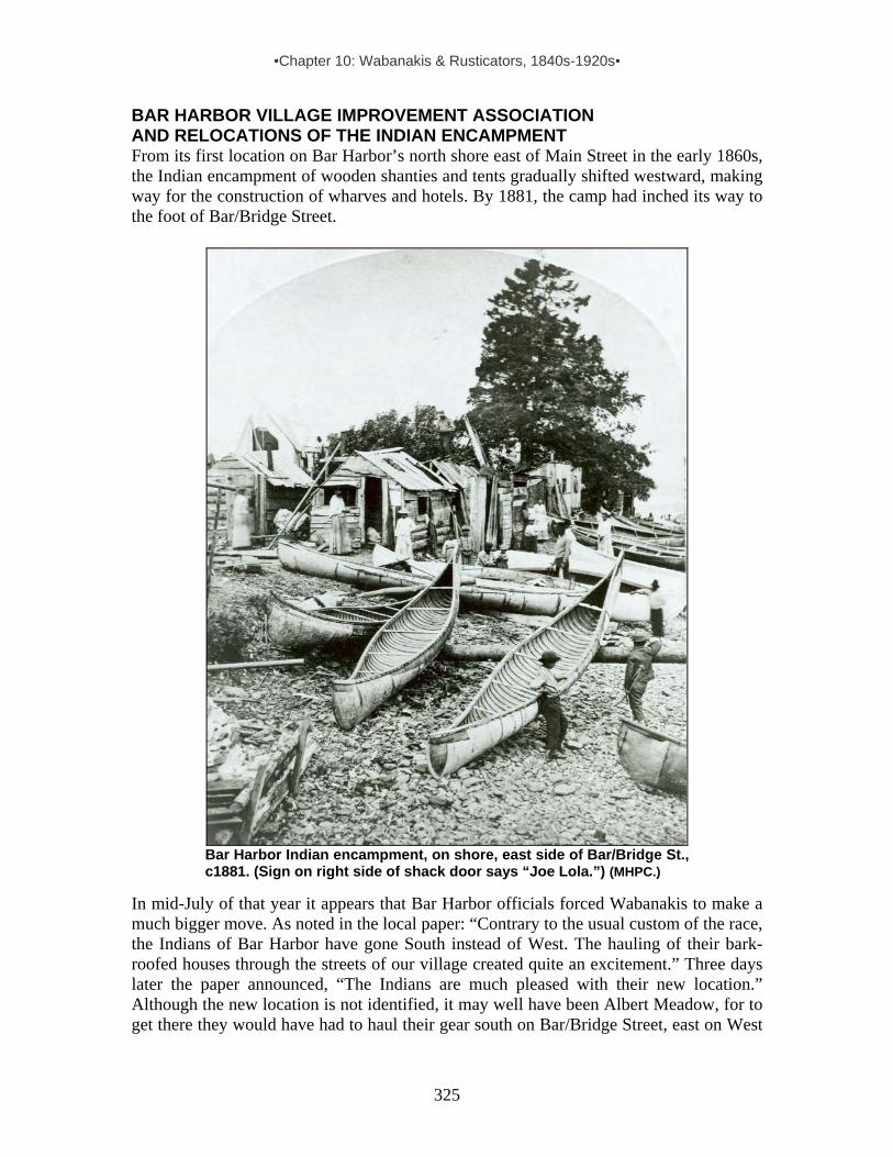
▪Chapter 10: Wabanakis & Rusticators, 1840s-1920s▪
325
BAR HARBOR VILLAGE IMPROVEMENT ASSOCIATION AND RELOCATIONS OF THE INDIAN ENCAMPMENT From its first location on Bar Harbor’s north shore east of Main Street in the early 1860s, the Indian encampment of wooden shanties and tents gradually shifted westward, making way for the construction of wharves and hotels. By 1881, the camp had inched its way to the foot of Bar/Bridge Street.
Bar Harbor Indian encampment, on shore, east side of Bar/Bridge St., c1881. (Sign on right side of shack door says “Joe Lola.”) (MHPC.)
In mid-July of that year it appears that Bar Harbor officials forced Wabanakis to make a much bigger move. As noted in the local paper: “Contrary to the usual custom of the race, the Indians of Bar Harbor have gone South instead of West. The hauling of their bark-roofed houses through the streets of our village created quite an excitement.” Three days later the paper announced, “The Indians are much pleased with their new location.” Although the new location is not identified, it may well have been Albert Meadow, for to get there they would have had to haul their gear south on Bar/Bridge Street, east on West

▪Chapter 10: Wabanakis & Rusticators, 1840s-1920s▪
326
Street, then south on Main and east over to the meadow on the town’s eastside shore near Balance Rock.150 A.L. Higgins mentions Albert Meadow as one of the Indian encampment sites he personally observed during the “olden days from 1860-1900.”151
At summer’s end in 1881, individuals dubbing themselves the Bar Harbor Village Improvement Association adopted a constitution late one evening “at an adjourned citizen’s meeting, held at the Cottage Street school-house.” Apparently, an agenda item for the association in its nascent year was the banning or relocation of the Indian encampment. Records suggest the issue remained unresolved, for the following summer the local paper reported: “Just now the question is ‘Where shall the Indian go this summer?’ Otter Creek, one of the Porcupines, Kebo road, and many other places have been suggested, but no decision reached. Some of the Aborigines, tired of waiting, have already encamped on the shore near Hamor’s wharf, not far from their old [Bar/Bridge St.] camping ground. The authorities should look after this important matter at once.”152 An item in the newspaper the following month suggests that Mount Desert Island’s seasonal visitors were not in agreement with what appears to have been a movement among some locals to ban Indians from Bar Harbor: “Now that the Indians have not been allowed to come here, we begin to appreciate their value. Summer guests say they ‘think it a perfect shame’ that there is no Indian Camp here. ‘It used to be one of the unique attractions of the place.’ We are afraid there will be a general outcry among the fairer sex, if the Indians are not allowed camping ground. Hundreds of people visited them every day and considered it great fun to look over and purchase the wares of the aborigines.”153 For Wabanakis, such mixed signals meant the door to commerce was not shut, so they continued to come. In late July the paper announced: “On Friday there was quite a large arrival of Penobscot Indians, who located near Hamor’s wharf. Eight tents.”154
Bar Harbor Indian Encampment, foot of Holland Ave. 1884. (Frank Leslie’s Illustrated Newspaper 8/23/1884. Courtesy of Donald Soctomah.)
150 MDH, 7/14/1881 & 17/1881. 151 Higgins, 1934. 152 MDH, 6/16/1882. See also Souvenir of Bar Harbor. A bird’s-eye illustration of Bar Harbor published in this booklet situates the Indian encampment c1882 sprawled on the shore between Bar/Bridge Street and Holland Ave., indicating a slight westward movement from the center of town toward the newly built Hamor’s Wharf. Although Hamor’s wharf is excluded from this illustration, it appears on a map of the town in the same booklet. (See maps in the encampment inventory featured in Chapter 20.) 153 MDH, 7/18/1882. 154 MDH, 7/25/1882.

▪Chapter 10: Wabanakis & Rusticators, 1840s-1920s▪
327
News items about the Bar Harbor encampment from 1883-1886 place it “at the foot of Holland Avenue, near Hamor’s Wharf.” A handful of written descriptions and illustrations reveal a somewhat formalized camp, with dwellings that were “half tent, half booth . . . erected to leave a well-swept carriage-road between the lines.155
In the summer of 1887, the camp shifted a bit more westward to “the rear of Mr. A.W. Ells store at Eddy Brook.”156 An 1887 map locates the store just east of Eddy Brook on the south side of Eden St.157 The 1880 federal census for Bar Harbor lists Arthur W. Ells and his wife Julia with their 6-year-old son Edward. Arthur is identified as a carpenter and Julia as a housekeeper, so it appears the store was established after 1880. Since the 1890 Federal census was destroyed, we have no census record of this couple at the time they had the store with the Indian encampment situated behind and spreading down the slope to the sea.158 However, we do have a photograph of the camp, and also a brief narrative written in 1888 that describes the place, its inhabitants, and the goods they offered for sale:
The Indian encampment at the outlet of Eddy Brook, just north-west of Bar Harbor, will be found a pleasant place to wile away an hour or two. These [Indians] are of the Penobscot, Passamaquoddy, and St. John River [Maliseet] tribes . . . expert with their canoes and at hunting and fishing. The village is composed of a score or two of little wood and canvas shanties, in which are sold a great variety of aboriginal trinkets, skins of seal and deer, baskets of birch-bark, moccasins, bead-work, snow-shoes, gulls’ breast, stuffed birds, clubs, carved tusks, bows and arrows, etc.
Bar Harbor Indian encampment near Eddy Brook outlet at rear of Ells’ Store on Eden St. (MHPC.)
155 Harrison 1887, pp.85-97. 156 MDH, 6/2/1887. See also Sweetser 1888. 157 “Plan of Bar Harbor” pub. by Colby & Stuart. June 1887. Copy in Library of Congress. 158 In the 1900 census, Julia appears as a widow with four sons – Edward (age 24), Leroy (19), Daniel (?) (14) and Johnnie (11). She working as a laundress and Leroy is listed as a salesman.
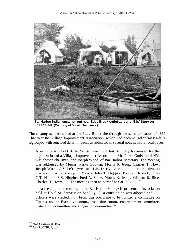
▪Chapter 10: Wabanakis & Rusticators, 1840s-1920s▪
328
Bar Harbor Indian encampment near Eddy Brook outlet at rear of Ells’ Store on Eden Street. (Courtesy of Donald Soctomah.)
The encampment remained at the Eddy Brook site through the summer season of 1889. That year the Village Improvement Association, which had become rather laissez-faire, regrouped with renewed determination, as indicated in several notices in the local paper:
A meeting was held at the St. Sauveur hotel last Saturday forenoone, for the organization of a Village Improvement Association. Mr. Parke Godwin, of NY, was chosen chairman, and Joseph Wood, of Bar Harbor, secretary. The meeting was addressed by Messrs. Parke Godwin, Morris K Jesup, Charles T. How, Joseph Wood, C.S. Leffingwell and L.B. Deasy. A committee on organization was appointed consisting of Messrs. John T. Higgins, Fountain Rodick, Elihu G.T. Hamor, B.S. Higgins, Fred A. Shaw, Morris K. Jesup, William R. Rice, Charles. T. Howe. . . . The meeting then adjourned to Sat. July 27.159
At the adjourned meeting of the Bar Harbor Village Improvement Association held at Hotel St. Sauveur on Sat July 17, a constitution was adopted and . . . officers were elected. . . . From this board are to be formed a committee on Finance and an Executive comm., inspection comm., entertainment committee, water front committee, and suggestion committee.160
159 MDH 6/26/1889, p.3. 160 MDH 8/2/1889, p.3.
▪Chapter 10: Wabanakis & Rusticators, 1840s-1920s▪
329
Now that the Bar Harbor Village improvement Association has emerged from its dormant condition and been newly organized for business, it will be of interest to all Bar Harbor people to know just what the society is and what it proposes to do. This information can be given in no better way than by publishing its Constitution and ByLaws, and we take pleasure in laying them before our readers. “Constitution: Preamble. Whereas it is evident to all who are interested I the village of Bar Harbor that some method of united action is needed in order to preserve the natural beauties of the place, and to encourage artificial improvements, by the ornamentation of the streets and public grounds of the village; by planting and cultivating trees; erecting tasteful buildings, clearing and repairing sidewalks, lighting streets and doing such other acts as shall tend to beautify, adorn and be for the convenience of the village. . . .”161
The goals of the revitalized Improvement Association, combined with the growing
value of and demand for prime property along West Street (which now extended to Holland Avenue), had direct consequences for Wabanakis who camped in Bar Harbor each summer to market their goods and services – and whose ancestors had frequented the island for many centuries. The official Indian encampment was relocated to the southern edge of town, near Cromwell Stream on the east side of Ledgelawn Avenue, probably near the intersection of Cromwell Harbor Road and what came to be Ash Street. School Street had not yet been extended that far south, so it did not separate the encampment from a large swatch of land owned by the Rodick family on the west side of lower Main Street – a piece of property that in the early 1900s became the town’s athletic field. The first known written indicator of the “Ledgelawn Indian encampment” comes from a description published in 1891, probably describing the scene as it was in 1890:
The winding shore path leading to Cromwell’s Cove is still as charming a promenade as ever. You enjoy the open sea-view, the bracing air, the splash of the waves at your feet, the gliding sails, the tasteful cottages. . . . I found it quite different, however, when walking in the street [Main St.] skirting this fine bit of shore. Here the inhospitable warnings, ‘No Thoroughfare,’ ‘No Trespassing,’ or ‘No Passage,’ stare one in the face as often as some inviting by-way tempts one to turn aside. . . . In going a little farther on I ran up against the ill-favored camp of some peripatetic Indians. . . .162
The new Indian village at the town’s southern end featured two central rows of
wooden-walled platform tents with wide double-doors that families opened to indicate when they were open for business. Apparently, being relegated to a location that was not shoreside did not discourage Wabanakis who depended on sales in Bar Harbor for their livelihoods. As noted by the Mount Desert Herald in the fall of 1890:
161 MDH 8/9/1889, p.2. 162 Drake, 1891. (Note: Published in 1891, this passage probably refers to the scene as it was in 1890, suggesting the relocation of the Indian camp took place that year.)

▪Chapter 10: Wabanakis & Rusticators, 1840s-1920s▪
330
The Eastport Sentinel of September 17 . . . chronicles the return of Indians to their winter home at Pleasant Point. Quite a delegation of returning summer visitors arrived from Bar Harbor by the Winthrop boat Monday.163
Ledgelawn Indian Encampment, c1890. (Abbe Museum.)
With the formal establishment of the seasonal Indian village by Ledgelawn Avenue, Indian encampments along the north shore of town were officially banned, as evidenced in this excerpt from the deed for a piece of property on the corner of West and Bridge streets:
All rights, privileges and benefits derived under and all rights whether in law or equity to enforce certain restrictions upon other lands, which restrictions are so imposed for the benefit of the land herein described as conveyed, in and by a certain warranty deed thereof from Sylvanus Jordan to Charles F. Mayer, which deed is dated July 11th, 1893, and recorded July 12th, 1893, in the Hancock County, Maine, Registry of Deeds, Book 271, Page 403. This conveyance of said parcel is made subject to the restriction on said parcel (not a condition subsequent) that no fish houses nor fish stands nor stable, except such private stable as may be appurtenant to a residence thereon, shall ever be erected or operated on said parcel, nor shall any Indians or vagrants ever be allowed to occupy or encamp thereof.164
In 1892 a measles epidemic on the reservation kept many Passamaquoddy families
from traveling to Bar Harbor. Meanwhile, a new branch of the Village Improvement Association known as the “Sanitary Committee” worried that the encampment – often referred to as “Squaw Hollow – was fraught with unsanitary conditions that could breed disease. Thus, at the end of that summer season the Bar Harbor Record printed this announcement:
163 MDH, 10/2/1890. 164 Excerpt from 7/11/93 deed re. shore property on NW corner of West and Bridge streets.

▪Chapter 10: Wabanakis & Rusticators, 1840s-1920s▪
331
The Board of Managers be advised by the [Sanitary] Committee [of the Bar Harbor Village Improvement Association] to communicate to the Board of Health our opinion of the unsanitary and threatening condition of ‘Squaw Hollow.’ In the present possibility of a visitation of cholera to this country next summer, it is of the gravest importance to every community that any unhealthy spot should be thoroughly cleansed, and your Committee believe the only safe way of dealing with ‘Squaw Hollow’ is to empty it of its inhabitants and have its whole neighborhood disinfected.165
In the course of the 1890s and early 1900s, the Village Improvement Association
initiated other changes, including running a sewer through the encampment to keep it “clean and healthy.”166 In 1901, responding to fears that “typhoid fever might occur among the Indians living in Squaw Hollow because they were compelled to drink the water of Cromwells Harbor brook which contains much sewage,” members of the Sanitary Committee solicited the Water Company to install a pipe and faucet that provided safe drinking water.167 Meanwhile, others in the town focused on what they saw as the purification of souls. As one Bar Harbor resident speaking of this era recalled: “The Indian village was where the ballfield is today. We used to go from tent to tent buying sweet smelling baskets and admiring the children and babies. Lovely young Alice Shepard (later Morris) went every week to give the children a Sunday school lesson.168
Indian encampment, Ledgelawn Ave., Bar Harbor, c1900. (Abbe Museum.)
165 Third Annual Report of the Village Improvement Association. 1892, pp.17-18. 166 Fifth Annual Report of the Bar Harbor Village Improvement Association, 1894, p.7. 167 Thirteenth Annual Report of the Bar Harbor Village Improvement Association. 1902, p.13. 168 Peabody.
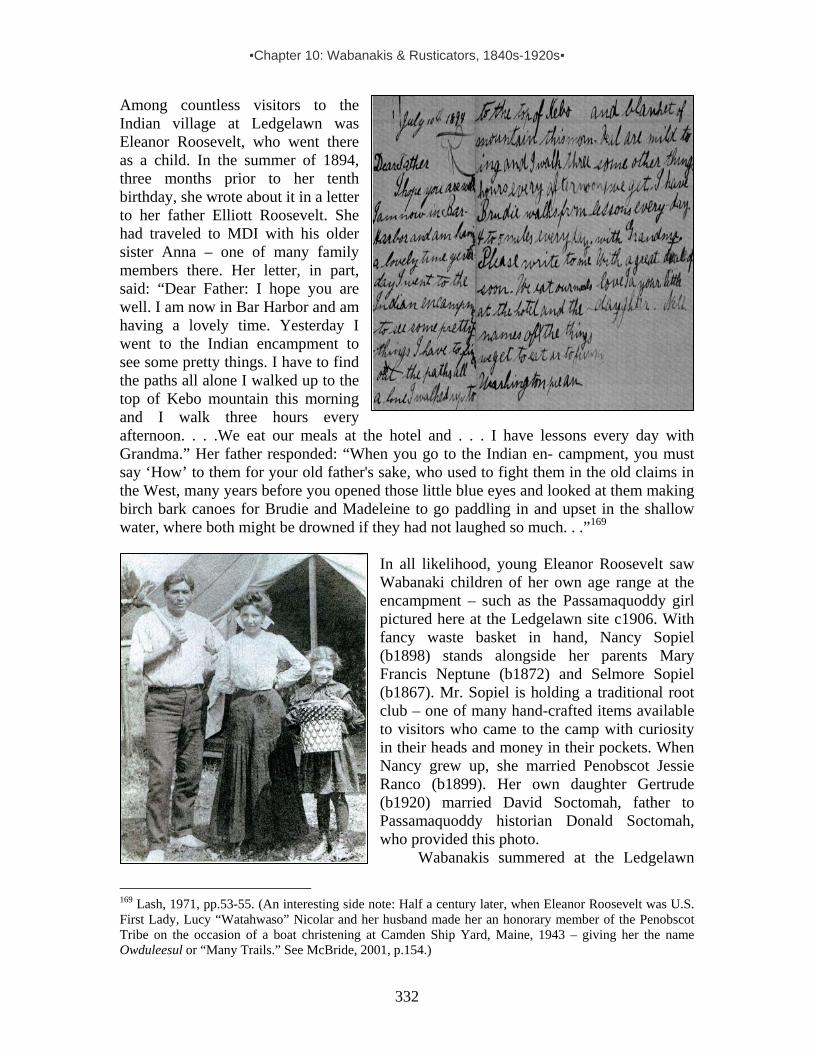
▪Chapter 10: Wabanakis & Rusticators, 1840s-1920s▪
332
Among countless visitors to the Indian village at Ledgelawn was Eleanor Roosevelt, who went there as a child. In the summer of 1894, three months prior to her tenth birthday, she wrote about it in a letter to her father Elliott Roosevelt. She had traveled to MDI with his older sister Anna – one of many family members there. Her letter, in part, said: “Dear Father: I hope you are well. I am now in Bar Harbor and am having a lovely time. Yesterday I went to the Indian encampment to see some pretty things. I have to find the paths all alone I walked up to the top of Kebo mountain this morning and I walk three hours every afternoon. . . .We eat our meals at the hotel and . . . I have lessons every day with Grandma.” Her father responded: “When you go to the Indian en- campment, you must say ‘How’ to them for your old father's sake, who used to fight them in the old claims in the West, many years before you opened those little blue eyes and looked at them making birch bark canoes for Brudie and Madeleine to go paddling in and upset in the shallow water, where both might be drowned if they had not laughed so much. . .”169
In all likelihood, young Eleanor Roosevelt saw Wabanaki children of her own age range at the encampment – such as the Passamaquoddy girl pictured here at the Ledgelawn site c1906. With fancy waste basket in hand, Nancy Sopiel (b1898) stands alongside her parents Mary Francis Neptune (b1872) and Selmore Sopiel (b1867). Mr. Sopiel is holding a traditional root club – one of many hand-crafted items available to visitors who came to the camp with curiosity in their heads and money in their pockets. When Nancy grew up, she married Penobscot Jessie Ranco (b1899). Her own daughter Gertrude (b1920) married David Soctomah, father to Passamaquoddy historian Donald Soctomah, who provided this photo.
Wabanakis summered at the Ledgelawn
169 Lash, 1971, pp.53-55. (An interesting side note: Half a century later, when Eleanor Roosevelt was U.S. First Lady, Lucy “Watahwaso” Nicolar and her husband made her an honorary member of the Penobscot Tribe on the occasion of a boat christening at Camden Ship Yard, Maine, 1943 – giving her the name Owduleesul or “Many Trails.” See McBride, 2001, p.154.)

▪Chapter 10: Wabanakis & Rusticators, 1840s-1920s▪
333
encampment until about 1920, and to this day quite a few individuals can recall family stories about the place. Because the undeveloped Rodick-family property flanking the west side of Main Street became the town’s athletic field, it figures in many Wabanaki recollections of the encampment. For instance, Dolly Dana, a Passamaquoddy living at Pleasant Point, offered this memory:
In August 189[6] my great aunt Margaret Basset Nicholas was born in Bar Harbor. . . . In the early 1980s [when she was about 90], I was in Bar Harbor with her for the Native American Festival sponsored by the Abbe Museum. She told me, “I want you to know I was born right here in this ballfield.” My cousin Lisa Altvater remembers Margaret saying she was born on third base in that ballfield. Lisa has a picture of Margaret pointing to the spot. Margaret told her there used to be a big white mansion that you could see from the ballfield when she was a girl. A lot of the Indian women worked in that house over the years. Margaret said people called the encampment at the ballfield “Squaw Hollow” because there were so many women and children there.170
Margaret Basset Nicholas pointing to her 1896 birthplace “on third base” in the ballfield at the old Ledgelawn Avenue Indian encampment site in Bar Harbor, c1988. (Photo courtesy of the family.)
Numerous written and oral sources show that it was common for Wabanaki women
to be at the encampment on their own with their children. Often their husbands, fathers or brothers were busy elsewhere with other tasks, such as working as river drivers or guiding sport hunters. In 1912, one historian described the situation like this:
The Indians of Old Town Island are . . . among the most skilled and faithful of all the twenty-three hundred registered guides of Maine and are always in
170 Personal communication, Dolly Dana, Pleasant Point, 9/23/04. Geneaologist Sheldon Goldthwait places Margaret’s birth at 8/12/1896. Both of her parents were Passamaquoddy: Frances (Frank) Basset (b1872) and Francis (Fannie Lolar) Basset (b1877).

▪Chapter 10: Wabanakis & Rusticators, 1840s-1920s▪
334
demand among visiting sportsmen who make the canoe trips of hundreds of miles down the vast waterways of the Maine woods. During the summer while the men are pursuing this avocation one who visits any of the seashore resorts along the coast of Maine and Massachusetts will see Indian women and girls, many of them comely and attractive, in little stalls, selling Indian baskets and moccasins, miniature war clubs, canoes, snow shoes and a hundred and one similar trinkets, useful and ornamental, which they have made during leisure hours in their homes in their little village on Indian Island in the Penobscot river.”171
And so it was that over the generations children were frequently born at the Indian encampments on Mount Desert Island. Maria Lewey, mother of Passamaquoddy tribal leader John Stevens, was among those whose lives began on the island. She took her first breath in the summer of 1909 at the Ledgelawn campsite in Bar Harbor. Like Margaret Basset Nicholas and many other Wabanakis, she learned early on that with ingenuity, flexibility and companionship, one could create a sense of home almost anywhere. (Photo left: Maria Lewey [Stevens], 1910. (Courtesy of Donald Soctomah.)
By the time Maria reached her teenage years in the 1920s, the Bar Harbor
community had lost interest in hosting a summer Indian encampment on valuable property near the center of their town. One new idea for the Ledgelawn site came from the creators of Mount Desert Island’s new national park, who envisioned it as an income-generating public campground. Also, Wabanaki interest in coming to the island was beginning to wane. Toward the end of the decade, the demand for fancy baskets diminished and many Indian families turned to new seasonal work opportunities: harvesting blueberries in Washington County during August and picking potatoes in Aroostook County in September. The latter job called for harvesting containers, and Wabanakis proved ready to provide sturdy woodsplint “potato baskets” by the thousands. Still, ties to MDI continued, with some Wabanakis living in rental properties on the island seasonally or year round, making baskets and doing various menial jobs, from gardening to quarrying, housecleaning, waiting table, or working in fish factories in the southwestern part of the island.
171 Sprague, pp.3-9.
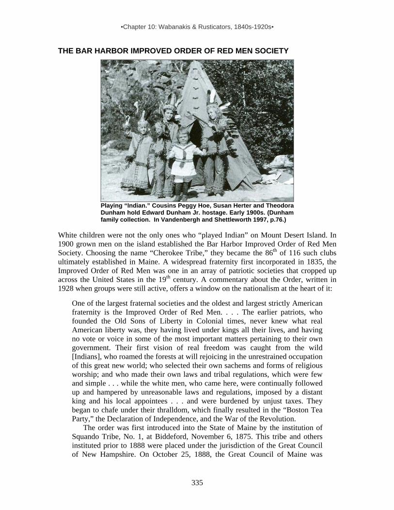
▪Chapter 10: Wabanakis & Rusticators, 1840s-1920s▪
335
THE BAR HARBOR IMPROVED ORDER OF RED MEN SOCIETY
Playing “Indian.” Cousins Peggy Hoe, Susan Herter and Theodora Dunham hold Edward Dunham Jr. hostage. Early 1900s. (Dunham family collection. In Vandenbergh and Shettleworth 1997, p.76.)
White children were not the only ones who “played Indian” on Mount Desert Island. In 1900 grown men on the island established the Bar Harbor Improved Order of Red Men Society. Choosing the name “Cherokee Tribe,” they became the 86th of 116 such clubs ultimately established in Maine. A widespread fraternity first incorporated in 1835, the Improved Order of Red Men was one in an array of patriotic societies that cropped up across the United States in the 19th century. A commentary about the Order, written in 1928 when groups were still active, offers a window on the nationalism at the heart of it:
One of the largest fraternal societies and the oldest and largest strictly American fraternity is the Improved Order of Red Men. . . . The earlier patriots, who founded the Old Sons of Liberty in Colonial times, never knew what real American liberty was, they having lived under kings all their lives, and having no vote or voice in some of the most important matters pertaining to their own government. Their first vision of real freedom was caught from the wild [Indians], who roamed the forests at will rejoicing in the unrestrained occupation of this great new world; who selected their own sachems and forms of religious worship; and who made their own laws and tribal regulations, which were few and simple . . . while the white men, who came here, were continually followed up and hampered by unreasonable laws and regulations, imposed by a distant king and his local appointees . . . and were burdened by unjust taxes. They began to chafe under their thralldom, which finally resulted in the “Boston Tea Party,” the Declaration of Independence, and the War of the Revolution. The order was first introduced into the State of Maine by the institution of Squando Tribe, No. 1, at Biddeford, November 6, 1875. This tribe and others instituted prior to 1888 were placed under the jurisdiction of the Great Council of New Hampshire. On October 25, 1888, the Great Council of Maine was

▪Chapter 10: Wabanakis & Rusticators, 1840s-1920s▪
336
instituted in the city of Bath. . . . At that time there were nine tribes in the Reservation of Maine: Rockmego, No. 2, Auburn; Machigonne, No. 3, Portland; Nahanda, No. 4, Rockland; Cogawesco, No. 5, Portland; Abenakis, No. 6, Bangor; Mecadecut, No. 7, Rockport; Segochet, No. 8, Warren; Pokumkeswawaumokesis, No. 9, Lewiston; Mavooshan, No. 10, Pemaquid. These tribes had a combined membership of 698. The cardinal principles of the order are Freedom, Friendship, and Charity. One of the greatest works of charity done by the order is the care of indigent orphan children in private homes. The order is now caring for some 3143 orphans annually. . . . The word ‘Redmanship’ means Americanism. The history of the Improved Order of Red Men is coincident with that of the United States of America. It is a purely pure American organization. To become a member of the Improved Order of Red Men, one must be a white American citizen.172
So it was that white patriots, seeking to express their nationalism through a largely
imaginary “Native” cultural repertoire, invented traditions they considered representative of “the sublimity and grandeur of the unsullied characteristics of the primitive race.” Conforming to the “Indian” character of their clubs, called “tribes,” they ranked their officers as sachems, sagamores and braves, and gathered around a “council fire” kindled in the center of their “wigwam.” They also donned quasi (Plains) Indian costumes and used Indian pipes and other “paraphernalia” in their meetings.173 It was all indicative of a profound ambivalent racism.
Ultimately, membership in the Bar Harbor group grew to 131. Among other branches in the Mount Desert Island area was the “Eggemoggin Tribe, No. 11, Imperial Order of the Red Men.” The Mount Desert Herald reported on the latter’s inaugural meeting, held 15 November 1888 at Green’s Landing (Stonington, Deer Isle). According to the paper, members of the new group – “composed of the most prominent businessmen of the place” – had elected a grand sachem (along with senior and junior sagamores, a prophet, chief of records, keeper of wampum, first sanup, guard of wigwam, guard of forest and warriors) and ordered “first-class paraphernalia.” Also, noted the paper, “A Council of Pocahontas [for white women] will be organized in about three weeks.”174 While America’s indigenous peoples were expected to disappear, if not biologically then at least culturally, the invented Indian of the white man's imagination was becoming an omnipresent fetish of American popular culture, appearing in a growing array of forms – from Red Men societies to postcards to advertising logos. In time, the list would grow to include everything from sport team mascots to fighter plane names. As noted in the Portland Tribune in 1844: “We are more in love with Indian names in this country than we are with the Indians themselves, and often having despoiled them of their lands, their lakes and territories, the sentimentalists are very desirous of complimenting them by restoring aboriginal titles.”175
◘ ◘ ◘ ◘ 172 Coe, Harrie B. (ed.) 1928. Maine: Resources, Attractions, and Its People. A History. New York: The Lewis Historical Publishing Co. vol. 2, pp.771-74. 173 Improved Order of Red Men. 1893: 4, 251 (emphasis added). 174 MDH, 11/23/1888. 175 Portland Tribune 3/30/1844, p.407.

▪Chapter 11: Anthropologists & Conservationists, 1880s-1920s▪
337
CHAPTER 11: ANTHROPOLOGISTS & CONSERVATIONISTS AT MOUNT DESERT ISLAND, 1880s-1920s
The development of tourism on Mount Desert Island coincided with the emergence of American anthropology. Early anthropologists also bought into the idea of the “Vanishing Indian.” With this in mind, they committed themselves to recording Native cultures and languages before they disappeared. Given the large number of Wabanakis who came to MDI each summer to market their goods, it is not surprising that anthropologists sought them out there – including Charles Godfrey Leland, John Dyneley Prince, Albert Samuel Gatschet, Fannie Hardy Eckstorm and Frank Speck. Charles Godfrey Leland (1824-1903)
Leland, a folklorist, lecturer and author of some fifty books, wrote Algonquin Legends of New England—Myths and Folk Lore of the Micmac, Passamaquoddy, and Penobscot Tribes, in addition to several classic texts on English Gypsies and Italian witches. Born into a well-to-do Philadelphia family, his fascination with folklore and the supernatural began early in life. According to his biographer, as a baby, “he was carried up to the garret by his old Dutch nurse, who was said to be a sorceress, and left there with a Bible, a key, and a knife on his breast, lighted candles, money, and a plate of salt at his head” – a rite intended to bring him luck and help him “rise in
life and become a scholar and a wizard.” Such influences continued as he learned about fairies from an Irish servant and Voodoo from a black woman who worked in the kitchen.
Formally educated at Princeton, Leland continued his studies in Europe – in Heidelberg, Munich and Paris. Returning to Philadelphia, he passed the bar exam. But law did not have his heart, and he devoted himself to writing – primarily as a journalist traveling throughout America.When the U.S. Civil War errupted in 1861, he launched a magazine advocating abolition of slavery. At the war’s end, he turned his attention to humor, and in 1868 authored Hans Breitmann’s Party and Ballads – the first in a series of highly popular dialect poems burlesquing German Americans. By this time he had moved to England, where he began his studies of Gypsy society and lore.
Not a man to sit still, Leland traveled often and spent much of the early 1880s back in the U.S., based in Philadelphia. Hearing of the Indian encampment in Bar Harbor, he found his way there and began to inquire about Wabanaki legends and stories. In spring 1881, he noted in a letter: “‘Expect to go to Mount Desert, Maine, in July. Injuns live there who take you out in their canoes!’”1 He continued this pursuit for three years and, according to his niece and biographer, Elizabeth Robins Pennell, he developed a “close alliance with the peaceful Passamaquoddies weaving their baskets in the pine woods of Bar Harbor and Campobello.”2 By that time he had gathered enough information to publish Algonquin Legends. As reported in the Mount Desert Herald in 1884:
Charles Leland who during the past three summers has lived among the Indians of the Passamaquoddy with the view to learning their traditions, superstitions
1 4/18/1881, to Walter Besant. In Pennell, vol 2, p.101. 2 Pennell, vol 1, p.21.
▪Chapter 11: Anthropologists & Conservationists, 1880s-1920s▪
338
and national songs, is now engaged in compiling his material preparatory to publishing it in book form. “When I first turned my mind to this subject,” he said, “I went to Bar Harbor, the summer rendezvous for all the Indians in the country, and began work. At first my efforts were fruitless. Do what I would, the Indians would not confide in me, and after spending the entire summer among them, I found that I had learned nothing of their traditions. Their reticence was not without reason. The Indians live among the commonest white people, who take no interest whatever in their legends and superstitions; and besides, the Indians being Roman Catholics, are taught to regard legends as superstition, and as such must be forgotten. Now while they by no means forget them, they are averse to relating them broadcast. Somewhat disappointed with my Bar Harbor results, I turned to Campobello, New Brunswick, in the summer of 1882. There I became acquainted with three Passamaquoddy Indians, men who traveled a great deal and were quite intelligent. They were Peter Gabriel [of Pleasant Pt., b1841], his son [Mitchell?, b1866], and Toma-quhah (Tomah Joseph) [of Indian Township, b1839]. Winning the confidence of these men, I was delighted at discovering the existence among the Indians of a real mythology and folklore, and cycles of legends and traditions. . . .”3
In the front pages of this book, under the heading “Authorities,” Leland identified
in a single list the scholars and Wabanakis he consulted in writing the work. Of the Indians listed, at least three spent summers in Bar Harbor (Tomah Joseph(s), Peter Gabriel, and Louis/Lewis Mitchell):
Tomah Josephs, Passamaquoddy, Indian Governor at Peter Dana’s Point, Maine; John Gabriel, and his son Peter J. Gabriel, Passamaquoddy Indians, of Point Pleasant, Maine; Noel Josephs, of Peter Dana’s Point, alias Che gach goch, the Raven. [Cacagous is the name of a Mi’kmaq chief noted in the early 1600s.]; Joseph Tomah, Passamaquoddy, of Pleasant Point; Louis Mitchell, Indian member of the Legislature of Maine. To this gentleman I am greatly indebted for manuscripts, letters, and oral narrations of great value; Sapiel Selmo, keeper of the Wampum Record, formerly read every four years at the great fire at Canawagha [Mohawk reservation]; Marie Saksis of Oldtown, a capital and very accurate narrator of many traditions; Noel Neptune, Penobscot, Oldtown, Maine.
After publishing Algonquin Tales, Leland returned to England, where his research
among and writing about Gypsies intensified. In 1888 he became the first president of the Gypsy Lore Society, and the following year he served as president of the first European folklore congress, held in Paris. On a visit to Florence, Italy, he met a woman who made her living as a fortuneteller. Upon learning that she was a Witch, he hired her to help him carryout research on Italian Witchcraft. As it turned out, he devoted much of the rest of his life to this work – but not to the exclusion of everything else. In 1902 he and 3 MDH, 1/17/1884. Leland's summer field assistant Abby L. Alger found the work of collecting these legends “so delightful” that she continued gathering on her own and in 1897 published her book, In Indian Tents: As Told By: Penobscot, Passamaquoddy and Micmac Indians. “The supply of legends and tales,” she wrote, “seems to be endless, one supplementing and completing another, so that there may be a dozen versions of one tale, each containing something new."

▪Chapter 11: Anthropologists & Conservationists, 1880s-1920s▪
339
Columbia University linguist John Dyneley Prince published a series of Gluskap poems. He mentioned the poems – and the value of Indian lore in one of his last letters:
I have had a great part of the proofs of the Epic of Kuloskap, Glusgabe – Glooskap. Do keep an eye on the book – it will be out soon. And try – try to collect Indian poems. It is a new field, and I recommend you to collect them and correspond with Prof. Prince. Go at it earnestly, be among the first. For I foresee that sooner or later every scrap, good or bad, will be studied and admired to a degree of which no one now living has any idea whatever, and men will wonder that among all the scholars of our age so few cared for such a marvelous record of the vanished race.4
In this same letter, Leland also lamented the recent death of his devoted wife Isabel,
who had stood by him and his work for nearly 50 years: “I miss her who was my only company for so many years and entered so into every little consultation and deed of life that to have nobody and be responsible to no one . . . is as bewildering and new to me as if I myself had died!” Within less than a year of Isabel’s passing, Leland died. His sister and her husband the Rev. Wood were by his side and made sure that his ashes were transported across the ocean and placed in a grave alongside Isabel’s.5 Albert Samuel Gatschet (1832–1907) Born in Switzerland, Albert S. Gatschet was trained as a linguist at universities in Bern, Switzerland, and Berlin, Germany. Coming to the United States in 1869, he helped pioneer the study of Native American languages. In 1877 he became ethnologist of the U.S. Geological Survey and in 1879 a member of the newly organized Bureau of American Ethnology at the Smithsonian in Washington, DC. He remained on the Bureau’s staff for nearly 30 years, retiring in 1905, two years before his death.
Like the anthropologists profiled here who did some of their research on Mount Desert Island, Gatschet worked especially with Lewis Mitchell. But he also gathered information from Newell Salomon Francis (Passamaquoddy, b1840) and his brother-in-law Lewis Soctomah (Passamaquoddy, b1833). About Soctomah, Gatschet noted, “‘knows all about old local names; over 70 years old. Lives in Pleasant Point.’”6
Gatschet also consulted with Newell S. Francis in Washington, D.C. Apparently Francis was there helping fellow Passamaquoddies Joe Tomah and Francis Lola work on an exhibition for the Zoological Park, described in the following newspaper excerpt:
The Washington Post of March 25th has the following description of an old-time Passamaquoddy Indian hut, recently built in that city by two Passamaquoddy Indians, Joe Tomah, who now lives in Rockland, Maine [overlooking Penobscot Bay], and Francis Lola of Pleasant Point, who is still in Washington, DC. The Indians were employed for this work on the recommendation of Prof. Gatschet who spent last summer in eastern Maine. The primitive birch bark wigwam, which has been in course of construction during the past winter at the Zoological
4 Letter to Mary A. Owen, 8/13/1902. In Pennell vol. 2, p.420. 5 Pennell, vol. 2, pp.425-26, 6 Lewy Soctomah appears on 1900 Federal census for Pleasant Pt. as Lewy Soctomah, b1823, living with son Solomon (b1851) and daughter Hannah (also b1851).
▪Chapter 11: Anthropologists & Conservationists, 1880s-1920s▪
340
Park, is now practically completed and is probably the only one of its kind in existence today. It was constructed under the supervision of the Bureau of Ethnology as an attraction for the visitors to the Zoo. . . . The structure is 15 feet long, 13.5 feet broad and 9 feet high. The Indians first drove tall stakes of arbor vitae into the ground for each side of the building. These were bent over at the top in a half circle and tied together with thongs of split ash. Other poles were driven at both ends of the building and then smaller poles were tied across these after the manner of slats in a shingle roof. The birch-bark was put on in large square pieces and sewed together with split spruce root. The sewing of these pieces of bark is the most attractive part of the work, and was accomplished with a needle made of bone. . . . The bark is turned with the outside exposed and renders the wigwam impervious to the severest rains. Inside, just as you enter, there is a small square space divided off by poles laid upon the ground. Inside of this space the floor is bare earth and here is the fireplace directly beneath the opening in the roof. All around next to the walls little branches of spruce are spread and this is used for the sleeping place. . . .7
Although Newell Francis is not mentioned in the above article, Gatschet described
him as “‘builder of the Indian wigwam in the Zoological Park, District of Columbia, in January 1897.’. . . He and Francis met on several occasions over a period of at least three months, and Gatschet made use of these sessions to continue his linguistic and ethnographic work.”8 Francis, like Lewis Mitchell and several of Gatschet’s other Passamaquoddy informants, helped the linguist with Penobscot words and phrases as well as with those in Passamaquoddy. Given the long-time association among Wabanaki groups, extensive intermarriage and shared seasonal encampments, such language versatility is not surprising. As noted by linguist Philip Lesourd: “Many Passamaquoddy speakers in the last decade of the 19th c had a good knowledge of Penobscot and at least some familiarity with Western Abenaki. Some thirty years earlier, Eugene Vetromile, a Jesuit missionary who ministered to the Indian population of Maine, noted that ‘the Passamaquoddy Indians generally know the Catechism in Penobscot language.’”9 Fannie Hardy Eckstorm (1866-1946)
Graduating from Smith College in 1888, Fannie Hardy was among an elite group of women in her day who gained a formal education beyond high school. Moreover, she was well educated by her life circumstances and by a keen intellectual curiosity that drove her to explore the depths of the fragmented Wabanaki communities that comprised part of her world. As the grand-daughter of furtrader Jonathan Hardy who was in regular contact with Penobscot Indians in Maine’s Bangor/Brewer area, she had a unique opportunity to look into the lifeways of Maine’s indigenous peoples.10 Her father,
7 Eastport Sentinel, 3/31/1897: entire article in Soctomah 2002, pp.49-50. 8 Lesourd, p.446. 9 Gatschet (1858, p.299) in Lesourd, p.446. 10 Her grandfather began his furtrade career at Castine in the early 1830s, harvesting mink, etc., from the Penobscot valley and eastward as far east as MDI, Frenchman Bay and Machias. See Krohn, p.4.

▪Chapter 11: Anthropologists & Conservationists, 1880s-1920s▪
341
Manly Hardy, grew up well connected to Wabanaki traditions and woods lore. He passed on much of what he absorbed to Fannie, who continued and deepened the association as a prolific writer of Wabanaki history and culture. In the words of Fannie’s biographer, Elizabeth Ring, Manly Hardy “counseled [his daughter] to win and deserve the confidence of the Indians, to learn their language and the meaning of their nomenclature, and to study their tribal customs.”11 This she did, and her resulting contributions to our understanding of 19th-century Wabanaki life in particular are considerable – ranging from commentaries on the region’s natural and industrial history to an ambitious investigation of Wabanaki nomenclature to a collection of folklore and songs to biographical writing about individuals whose lives were emblematic of Native communities in Maine.
Growing up in Brewer among her father’s Wabanaki friends and associates in the heyday of Maine lumbering and shipping, Fannie Hardy saw first-hand the lumbering industry’s impact on the Native population and their habitat. Her father was a naturalist and she roamed the woods with him countless times until her 1893 marriage to Protestant minister Jacob Eckstorm in 1893. In the words of her biographer Elizabeth Ring:
These years that preceded her marriage were the genesis of her later work. As she tramped the woods with her father, she learned the habits of mink and of coon . . . . wolf [and] otter. . . . He encouraged her to keep wildlife notes. In her later life, as other interests crowded out her study in this field, she would note the records of trappers with an appraising eye and compare them with those made years earlier by her father. When down on the Cranberry Isles, where she would go on a hunt for ballads or to note Indian landmarks, she would absorb the stories of Indian trappers and later recall them at will.12
The passage above tells us that Eckstorm spent time with Wabanakis on the
Cranberries, and in all likelihood she also visited Indian encampments on MDI. Certainly she met with Passamaquoddy craftsman John Snow in Northeast Harbor – perhaps when visiting her friend Mary Cabot Wheelwright or at the time she collected a version of the ballad “The Indian Elopement” from Mrs. Rose Robbins who also lived in the village.13 In addition, Eckstorm may be the woman who bought a Passamaquoddy story from Snow at a c1929 social gathering in Northeast Harbor recalled by his daughter. We know she and Snow were in touch thanks to a letter Passamaquoddy Lewis Mitchell wrote to Eckstorm.14 Mitchell and Eckstorm were in frequent contact by mail, and probably first met on MDI.15 Their exchanges center on “relics” he was acquiring (mostly for Eckstorm’s friend Wheelwright) and information he offered in response to her queries. For example, here are excerpts from letters they exchanged in May 1930:
Dear Madam, When I look over my letters, some Questions you asked for I did not answer. . . . One of the Neptunes your father mentioned, Sabattis Mitchell[‘s] father-in-law,
11 Ring, p.51. 12 Ring, p.51. 13 Eckstorm 1960. 14 See details on these comments in the profile on John Snow, several pages ahead in this section. 15 In 1930, financed by Mary Wheelwright, Eckstorm traveled to the Passamaquoddy reservations and purchased several pieces. See Eckstorm 2003 (reprint of Eckstorm 1932, preface by Rebecca Cole-Will).

▪Chapter 11: Anthropologists & Conservationists, 1880s-1920s▪
342
he was John Francis Neptune. He was Chief of the Passamaquoddy Tribe for 30 years. He died in 1872. He was the son of Francis Joseph Neptune of the Revolutionary War. His grandfather Bah-gal-wett, also of the Revolutionary times; his Christian name is Jean Babtist Neptune. Both the Neptunes fought under Col. John Allan. . . . I have few relics for Miss Wheelwright [here at Northeast Harbor]. . . . If you want more place names I can get them now the weather is warmer, such as marks on Roque’s Bluffs. The Indians go by the place on their seal-hunting trips. If Miss Wheelwright come home please let me know. . . .
My Dear Mr. Mitchell, Your letter came at just the right time; for I was thinking of writing today to Miss Wheelwright’s Boston address to find out whether she was home yet and to ask when she wanted me to send her the stories I got from you last winter…. I have not been able to get the meaning for M’jelm’t, the name you gave as nickname of old John Neptune. Oldtown Indians say they did not know he had any nickname. Though I never heard the story of the Mohawk who lived here, I knew that there were Mohawks in our Tribe. In Revolutionary times they went by the name of Cook – Joseph Cook was one. My father used to go muskrat hunting with Joe Mary Mohawk, a man older than himself.
Upon marrying Rev. Eckstorm in 1893, Fannie had moved to Boston with him and
taken up motherhood and editing work. But the marriage lasted only six years due to his death in 1899. After his passing, she moved back to Brewer with their children and began a career of research and writing that continued for the rest of her life. Her important publications include Indian Place Names of the Penobscot Valley and the Maine Coast, first published in 1941. John Dyneley Prince (1868-1945) In the summer of 1887, some 20,000 visitors came to Mount Desert Island.16 Among them was noted linguist John Dyneley Prince.17 While in Bar Harbor, Prince met Passamaquoddy tribal representative Lewis Mitchell from Pleasant Point, and they discussed Passamaquoddy linguistics, oral traditions and the Wapapi Akonutomakonol or Wampum Records.18 As detailed in Chapter 10, Mitchell gleaned these records orally from Passamaquoddy wampum keeper Sopiel Selmo (also spelled Selma or Selmore). (Photo of Selmo courtesy of Donald Soctomah.) After a return trip to Mount Desert Island the following year, Prince wrote “Notes on the Language of Eastern Algonkin Tribes,” noting in the conclusion that “it was solely from the mouths of the Indians in Bar Harbor . . . that I gathered the above
16 MDH 10/28/87. 17 It appears that Prince’s Dutch ancestors came to the U.S. some time in the 19th century and originally spelled their name “Prins.” 18 Prince 1897, p.481.

▪Chapter 11: Anthropologists & Conservationists, 1880s-1920s▪
343
information.”19 In the years that followed, Prince continued to come to MDI for his linguistic research among the Passamaquoddy and Penobscot.
By 1899, Prince was well known as a professor of Semitic languages. He was also making a name for himself as a scholar of northeastern Algonquian languages. That year he brought with him to Bar Harbor the latest in high-tech sound equipment: a wax cylinder phonograph,20 which he used to record “six tales of witchcraft” told in Passamaquoddy by 60-year-old Newell S[alomon] Francis of Pleasant Point,21 one of many Wabanakis at the Indian encampment that summer. The next year Prince published his transcriptions and analyses of these texts in the American Philosophical Society’s Proceedings under the title “Some Passamaquoddy Witchcraft Tales.” He continued to work with Francis for some time, probably during his subsequent trips to Bar Harbor. 22 In a 1902 article on Penobscot and Canadian Abenaki dialects, he reported, “The Penobscot material used in this treatise has all been gathered orally from Indians in Bar Harbor, Maine.” Significantly, among the examples of Penobscot sentences given in this paper we see the following: “I know your language a little. I learned it at Bar Harbor.”23 In his 1910 American Anthropologist article, “The Penobscot Language of Maine,” Prince commented that the stories, phrases and glossary included embodied “the whole of Penobscot material, which I have obtained orally from Penobscot Indians at Bar Harbor, Me., during the past ten years.”
Prince also collaborated with fellow academics, co-publishing Kuloskap the Master, and other Algonquin Poems with Charles G. Leland in 1902, and a Mohegan language study in 1903 with his Columbia University student Frank Speck, who went on to write many works concerning Wabanakis, including the classic Penobscot Man. In 1906 Prince entered politics, becoming a member of the New Jersey State House of Assembly for three years, serving as Speaker of the Assembly in 1909 and then as state senator from 1910-12. From 1921-1926 he was U.S. Minister to Denmark. In 1926 he became U.S. Minister to the Kingdom of the Serbs, Croats & Slovenes – a position that was changed to U.S. Minister to Yugoslavia in 1929. He left this last appointment a year early in 1932, after being passed over for the post of U.S. Ambassador to the Netherlands. 19 Prince 1888, p.316. 20 Nine years earlier, in Calais, Maine, Jesse Walter Fewkes of the Bureau of American Ethnology had made the first sound recordings of any Native American language – using the newly available phonograph to record Passamaquoddy songs, texts and vocabulary. Prince lived in New Jersey, near the lab of Thomas Edison, who invented this recording device. 21 Prince 1900, p.181. 22 Lesourd, pp.441-42. Cf. Prince 1888, p.311, 1901, p.381; Leland & Prince 1902, p.21; Fewkes 1890; Brady et al. 1984, p.3. [Note: Newell S. Francis is on the 1900 Federal Census for Eden (Bar Harbor) as a basketmaker (b1840) married to Sarah (b1836) with 4 children: Hannah (b1886), Thomas (b1879), Joseph (b1877), and Benett (b1874), plus daughter-in-law Adeline (b1874) and granddaughter Mary (b1897). He and Sarah also appear with their children on the 1900 Federal census for Pleasant Point/Perry, apparently with incorrect birthdates.] 23 Prince1902, pp.18, 29.
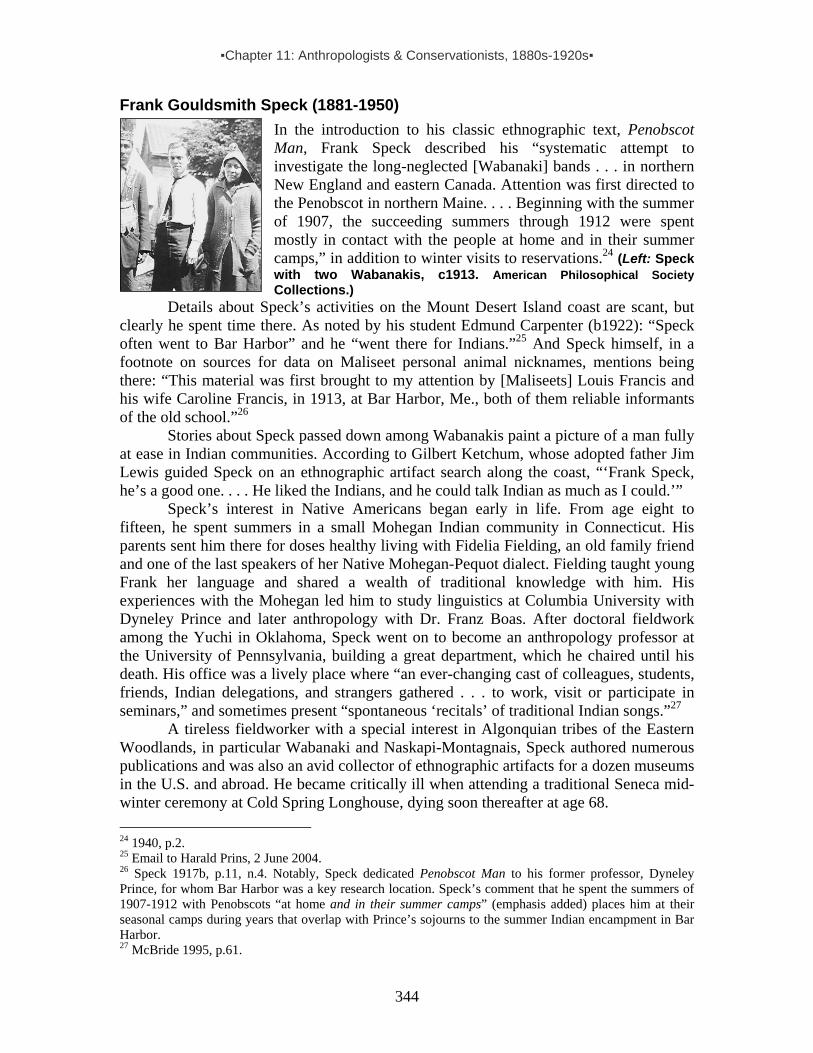
▪Chapter 11: Anthropologists & Conservationists, 1880s-1920s▪
344
Frank Gouldsmith Speck (1881-1950)
In the introduction to his classic ethnographic text, Penobscot Man, Frank Speck described his “systematic attempt to investigate the long-neglected [Wabanaki] bands . . . in northern New England and eastern Canada. Attention was first directed to the Penobscot in northern Maine. . . . Beginning with the summer of 1907, the succeeding summers through 1912 were spent mostly in contact with the people at home and in their summer camps,” in addition to winter visits to reservations.24 (Left: Speck with two Wabanakis, c1913. American Philosophical Society Collections.)
Details about Speck’s activities on the Mount Desert Island coast are scant, but clearly he spent time there. As noted by his student Edmund Carpenter (b1922): “Speck often went to Bar Harbor” and he “went there for Indians.”25 And Speck himself, in a footnote on sources for data on Maliseet personal animal nicknames, mentions being there: “This material was first brought to my attention by [Maliseets] Louis Francis and his wife Caroline Francis, in 1913, at Bar Harbor, Me., both of them reliable informants of the old school.”26
Stories about Speck passed down among Wabanakis paint a picture of a man fully at ease in Indian communities. According to Gilbert Ketchum, whose adopted father Jim Lewis guided Speck on an ethnographic artifact search along the coast, “‘Frank Speck, he’s a good one. . . . He liked the Indians, and he could talk Indian as much as I could.’” Speck’s interest in Native Americans began early in life. From age eight to fifteen, he spent summers in a small Mohegan Indian community in Connecticut. His parents sent him there for doses healthy living with Fidelia Fielding, an old family friend and one of the last speakers of her Native Mohegan-Pequot dialect. Fielding taught young Frank her language and shared a wealth of traditional knowledge with him. His experiences with the Mohegan led him to study linguistics at Columbia University with Dyneley Prince and later anthropology with Dr. Franz Boas. After doctoral fieldwork among the Yuchi in Oklahoma, Speck went on to become an anthropology professor at the University of Pennsylvania, building a great department, which he chaired until his death. His office was a lively place where “an ever-changing cast of colleagues, students, friends, Indian delegations, and strangers gathered . . . to work, visit or participate in seminars,” and sometimes present “spontaneous ‘recitals’ of traditional Indian songs.”27 A tireless fieldworker with a special interest in Algonquian tribes of the Eastern Woodlands, in particular Wabanaki and Naskapi-Montagnais, Speck authored numerous publications and was also an avid collector of ethnographic artifacts for a dozen museums in the U.S. and abroad. He became critically ill when attending a traditional Seneca mid-winter ceremony at Cold Spring Longhouse, dying soon thereafter at age 68. 24 1940, p.2. 25 Email to Harald Prins, 2 June 2004. 26 Speck 1917b, p.11, n.4. Notably, Speck dedicated Penobscot Man to his former professor, Dyneley Prince, for whom Bar Harbor was a key research location. Speck’s comment that he spent the summers of 1907-1912 with Penobscots “at home and in their summer camps” (emphasis added) places him at their seasonal camps during years that overlap with Prince’s sojourns to the summer Indian encampment in Bar Harbor. 27 McBride 1995, p.61.

▪Chapter 11: Anthropologists & Conservationists, 1880s-1920s▪
345
BIRTH OF ACADIA NATIONAL PARK While the anthropologists profiled above came to Mount Desert Island as part of their efforts to preserve a record of Wabanaki cultures and languages, others on the island focused on preserving the natural habitat. In the summer of 1901 Harvard University President Charles W. Eliot (a founding member of Northeast Harbor’s summer colony) called a meeting among fellow cottagers from Northeast Harbor, Bar Harbor and Seal Harbor to discuss the idea of establishing “reservations at points of interest on this Island for the perpetual use of the public.” The group organized the Hancock County Trustees of Public Reservations, and within a year and half this corporation had tax free status and a charter that stated its purpose as follows: “To acquire, by devise, gift or purchase, and to own, arrange, hold, maintain or improve for public use lands in Hancock County, Maine, which by reason of scenic beauty, historical interest, sanitary advantage or other like reasons may become available for such purpose.”28 Among those in attendance at the first meeting in 1901 was George Dorr, one of Bar Harbor’s original wealthy rusticators. Captivated by the idea of preserving the natural beauty of the island that had been his seasonal home since boyhood, Dorr devoted over four decades of his life – and much of his family fortune – to the cause. By 1913 the corporation had acquired 6000 acres. Dorr, hoping for national park status, offered the land to the federal government. He achieved partial victory in 1916 when President Woodrow Wilson announced the creation of Sieur de Monts National Monument. Dorr continued to acquire property and held to the goal to obtaining full national park status for the expanding preserve. In 1919 President Wilson signed the act establishing Lafayette National Park, the first national park east of the Mississippi. Ten years later, it would be renamed Acadia National Park.29 For Wabanakis, the park was just one more layer of restrictions in a place where their ancestors had freely ranged. Its creation even impacted the Indian encampment at Ledgelawn Avenue, which in the early 1920s was converted into a short-lived auto camp for park visitors. Eventually, park administrators and Wabanakis would develop a mutual appreciation and even engage in collaborative efforts. But that did not happen for many years. BIRTH OF THE ABBE MUSEUM For many decades residents and summer rusticators in the Mount Desert Island area engaged in recreational artifact-hunting in local shellmiddens. Wealthy people placed their findings on fireplace mantels or display cases. Those of lesser means displayed them
on windowsills – or sold them to boost the family income. And so it was that one day in 1922 Bar Harbor summer resident Dr. Robert Abbe (pictured left) took a walk down Cottage Street, saw a window display of prehistoric tools and decided to buy the collection for study. Over the next six years, before his death in 1928, Abbe bought other collections and committed himself to protecting and displaying such artifacts to ensure public awareness of the region’s original inhabitants and to prod
contemplation about life as it was so very long ago before the onset of industrialization.
28 Dorr, pp.13-15. 29 Dorr, pp.50-55, 70-74.

▪Chapter 11: Anthropologists & Conservationists, 1880s-1920s▪
346
His goal was not to amass a vast inventory. Rather, in his words, he hoped to “fix indelibly a fact of incontrovertible history on the minds of the large and rapidly growing traveling public. My aim has been to create a permanent classic ‘one show’ historic incident in the path of the ‘Madding Crowd’ and to make it as perfect as possible,” a place where people would “linger and dream over this small and unique collection.”
Dr. Abbe received considerable help from his friends George Dorr and Charles Eliot, the founding fathers of Acadia National Park, who envisioned an Indian artifact museum as a complement to the park’s offerings. In a remarkably short time his dream was realized in a lovely trailside museum situated at Sieur de Monts Spring. Founded in 1927, the museum opened in the summer of 1928. Its dedicatory
ceremony also served as a memorial for Dr. Abbe, who died in March of that year. Beyond gathering the collection housed in the new building, he had created maps and drawings for its displays. Shortly before his death, he painted a small watercolor of the museum, pictured here. Dr. Abbe’s absence on opening day was conspicuous. But it appears that people in the crowd failed to notice that he was not the only missing person invested in the artifacts on display. Wabanakis, whose ancestors had made and used the items in the museum’s collection, were not part of this inaugural event. Their absence, coupled with the museum’s original full name – The Lafayette National Park Museum of Stone-age Antiquities – underscores the common mainstream assumption that Indians in Maine were part of the past, not the present. Even Dr. Abbe, it seems, bought into the idea of the “Vanishing Indian.” Had he lived another fifty years, he would have been surprised – not only by the survival and cultural resurgence of Maine’s Wabanaki tribes, but by the supportive role the museum he founded would have in that revitalization.
Opening day of the Abbe Museum, 1927. (Abbe Museum Collections.)
◘ ◘ ◘ ◘

▪Chapter 12: Myth of the Vanishing Wabanakis, 1930-1960▪
347
CHAPTER 12: MYTH OF THE VANISHING WABANAKIS, 1930-1960
Molly Spotted Elk, c1932. (Courtesy Jean Archambaud Moore.)
In the summer of 1935, the internationally famous Penobscot dancer, Molly Spotted Elk, accepted a one-day engagement at the Abbe Museum, situated on a knoll in a forest clearing within Acadia National Park. Tribal governor Howard Ranco drove her there from Indian Island in the priest’s car, loaded with baskets. Under an open sky, Molly gave a performance rooted in Wabanaki dances that had been passed down through countless generations. She recorded the event in her diary: “Sang and danced on the green, the audience under shady trees. Howard sold some baskets.”1
At the Abbe Museum of Stone-Age Antiquities, founded with one eye on the past and the other on a future that most assumed would be void of living Indian cultures, Molly’s performance was probably viewed as a piece of romantic nostalgia for bygone days of the “Vanishing Wabanakis.” If so, the audience missed the point. In fact, Molly danced in defiance of the notion that her people would disappear.
1 McBride 1995, pp.236-37. The photo was taken a couple of years earlier in Bois de Vincennes, Paris.

▪Chapter 12: Myth of the Vanishing Wabanakis, 1930-1960▪
348
Like many other Native Americans across the country, Molly built a career in the entertainment industry by playing into dominant society’s historical romanticism, which idealized a vanishing natural wilderness – trees, animals, and, of course, “primitive” Indians. Born of ambivalent racism,2 coupled with a reaction to industrialization, this false romanticism had provided a ready audience for several generations of Native Americans – for artful pragmatists willing to act out generic versions of tribal traditions in order to put food on the table. But for some, including Molly, altering traditions – giving the public what it expected or wanted to see from “an Indian” in order to sell tickets or baskets or hunting guide services – did not really signal a surrender of indigenous cultural identity. In fact, it was a time-tested way of politely signaling We’re not you. Moreover, inside the commercial packaging remained an essential core of Wabanaki ways of feeling, thinking and overall being. For many Wabanakis in the 1930s-50s this included holding on to a degree of independence and self-determination by maintaining a measure of mobility and avoiding the confines of white society’s by-the-clock work patterns. Several seasonal work opportunities of the day made that possible – especially lumbering, potato picking and blueberry raking. Selling crafts to Maine’s summer tourists continued, but lost its dominance as the backbone of Wabanaki livelihoods. The demand for fancy baskets, originally created to suit Victorian taste of the late 1800s, dipped. Moreover, the 1929 stock-market crash and subsequent Great
Depression impacted the sale of these baskets and other Native novelties. Shattered by the economic crisis, businesses laid off many workers so that even the American middle class had little money for non-essentials. On top of this drop in demand for their non-utilitarian crafts, Wabanakis faced hard times in the general labor market. As noted by the Passamaquoddy Indian agent in 1932:
The depression . . . has hit the Indian people harder than any other people in the State. There is practically no sale for their baskets and novelties . . . and it is impossible for them to obtain work of any kind. If I as their agent ask a contractor for work which they are capable of doing the answer is: when we hire a man, it is a tax payer and you will have to take care of the Indians as they are wards of the State and we are not employing that class of laborers.”3
While craft sales did not disappear altogether, prices went down considerably. A
contributing factor to this was competition from small groups of traveling Gypsies: 2 Prins 1998. 3 Passamaquoddy Indian Agent Report for 1932 (25. Jan. 1933). See also Agent Report for 1934.

▪Chapter 12: Myth of the Vanishing Wabanakis, 1930-1960▪
349
Income which might result from basket work, they [Passamaquoddy at Pleasant Point] complain, is carried away by gypsies who haunt Maine resorts with a variety of cheap basketry which they palm off as Indian ware, passing themselves off as Indians while they do it. The State has recently passed a law setting up penalties for impersonating an Indian but evidently the law has not been enforced.4
Although crippled by low prices, a fair number of Wabanakis continued the basketry tradition, camping near tourist resorts, train stations, bridges and boat landings, or along roadsides to market their work – including locations on and near Mount Desert Island. Some shifted their production to include more utility baskets, especially the sturdy, double-bottom round ones used to harvest the colossal potato crop in Aroostook County – although the bigger baskets were less profitable because they required collecting and preparing much more brown ash wood than fancy work. Others sought alternative outlets for their crafts, including short-term sale opportunities at city fairs and other special events.
Potato Harvest, Caribou, Maine. By Katherine Olmstead. Pageants and Parades In 1931, looking for ways to counter the economic downturn, Wabanakis joined forces with the Maine Development Commission, which sponsored an “Inter-tribal Ceremonial” at the Penobscot Valley Country Club in Bangor. A commercial event modeled after the Pendleton Round-up in Oregon, the gathering was promoted as a day of “entertainment, education and historical value to preserve the customs and crafts of our Maine Indians and to bring real financial benefits to the state.” About forty Penobscots and Passamaquoddies participated in the occasion, presenting an elaborate, Hiawatha-styled melodrama, directed by the nationally-acclaimed Penobscot performer Lucy Nicolar, known as “Princess Watahwaso.” The entertainment also included Wabanaki songs and dances, plus demonstrations of various other Native traditions. Basketmakers, along with local business people, all promoted their wares and just about everyone involved garnered accolades and gained at least some economic ground.5
The following year Old Town’s Chamber of Commerce determined to profit from its proximity to Indian Island by hosting a spectacular three-day Indian pageant designed to outdo the Bangor event. Town leaders hired Lucy Nicolar to direct Native participation, and as an experienced show woman, she played a principal role in making the gala an extraordinary success. This time, she commandeered more than 100 4 Eastport Sentinel, 27 Oct. 1937. Picked up from “Indians at Work” article by Darcy McNickle published by the Smithsonian Institution’s Office of Indian Affairs, 18 Oct. 1937. 5 McBride, 2001. This paragraph and others about Watahwaso are all based on this source.

▪Chapter 12: Myth of the Vanishing Wabanakis, 1930-1960▪
350
Wabanakis who presented a range of “entertainments” – a parade of canoes, an opening pipe ceremony, canoe races and other competitions, a program of Wabanaki dances, songs and legends. Also featured were demonstrations of making and using traditional crafts (canoes, paddles, bows & arrows, baskets).
As the daughter of famous tribal leader, orator and writer Joseph Nicolar (author of The Life and Traditions of the Red Man, 1894), Lucy had received a formal education and was also well schooled in Penobscot traditions by her mother Elizabeth, as well as by her father. During her childhood years, she had performed traditional songs and dances spontaneously for tourists who stopped by her family’s summer encampment in Kennebunkport. Thus, at an early age she learned that entertainment could win favors and promote sales. By the time she reached age seventeen in 1900, she had adopted the stage name Watahwaso, started a serious performance career, and gained a reputation as “the pet of New York society.”6 In the years that followed, she presented Indian songs, legends and dances in numerous venues across the country, including the renowned Redpath Chautauqua Circuit and major vaudeville houses. It is likely that she performed on Mount Desert Island prior to 1930, but to date we have no evidence of her there before the 1950s. (Left: Lucy Nicolar, 1900. (Courtesy of her nephew, Robert Anderson.) Below: Lucy and her Kiowa husband Bruce Poolaw, c1945. (Courtesy of Lucy’s nephew Charles Shay.)
In 1930, at age 48, Lucy returned to the reservation with her lover – a Kiowa Indian named Bruce Poolaw, who had been a member of her vaudeville troupe. Eventually, the couple married, and together they played a key role in keeping traditional arts alive during an era when the Great Depression and intense forces of assimilation profoundly challenged the survival of Wabanaki culture. In 1933, aided by Bruce, Lucy directed yet another pageant, even more successful and extravagant than the previous two. However, putting the event together annually was such a huge undertaking that the couple abandoned the effort for a few years – until 1940 when they produced a smaller pageant on the reservation. The next year, hired by Old Town officials, they co-directed and co-starred in a full-scale revival of the 1933 pageant. In the decades that followed, the pageant was an on-again off-again affair that 6 “Penobscotbells,” Bangor Daily Commercial, 12 Jan. 1900.

▪Chapter 12: Myth of the Vanishing Wabanakis, 1930-1960▪
351
varied in scale. Sometimes several years passed between the events. As for Lucy and Bruce, they directed their last pageant in 1947, but continued to participate in one way or another in those that followed.
Penobscot Pageant, Indian Island, Old Town, 1933. (Authors’ collection.)
Other Wabanaki groups commonly joined in these festivities – and hosted some of their own. Among Passamaquoddies, Joe Nicholas, whose family had sold crafts from Tent #3 at the Indian encampment in Bar Harbor in the 1880s,7 led the way during this era when it came to keeping traditional dances and songs alive. Pictured to the left and professionally known as “Leaping Deer,” this singer/dancer/musician performed all around New England. Traveling with his family, he set up a makeshift Indian “village” each place they stopped. Living in tents, eating and sleeping on show grounds, he and his family performed and sold baskets. Sometimes, when back home on the reservation, he gathered young people together and taught them Native dances. For instance in 1932 he trained a group of Passamaquoddies for a “Hiawatha” show in Eastport.8
Photo Courtesy of Donald Soctomah.
Also, Passamaquoddies and other Wabanakis commonly dressed in regalia for local parades. Much about these parades and pageants played into Indian stereotypes (usually based on Plains Indian traditions), but these grand gatherings also offered rituals for identifying and holding on to ethnic distinctiveness. In fact, they provided a cultural 7 “One of the Attractions of Bar Harbor.” 8 Eastport Sentinel, 9 Nov. 1932. In Soctomah, 2003.

▪Chapter 12: Myth of the Vanishing Wabanakis, 1930-1960▪
352
platform on which tribal communities could regroup, redefine, and reclaim themselves as a people with a particular heritage. Moreover, they provided much needed venues for selling traditional crafts.
Old Town parade, 1930s. (Authors’ collection.) Scattered Wabanakis in the Mt. Desert Island Neighborhood Although the large, multi-family Indian encampments in Southwest Harbor and Bar Harbor had come to a close by 1925, Wabanakis remained part of the scene on Mount Desert Island and in the general neighborhood – some year-round, some seasonally. Best known among the Wabanaki residents was Passamaquoddy John Snow.9 After two decades in his Northeast Harbor bungalow near Rockend, he built a home for his family back at Pleasant Point in 1930. Still, they returned to MDI every summer until John’s death in 1937.
During the 1920s Passamaquoddy Sylvester Francis (b.1880) lived in on Stage Road in Southwest Harbor with his Passamaquoddy wife Fannie D. (b.1879).10 The 1930 census shows him newly married to (“Indian”) Lillian M., living with her and her10- and 12-year-old daughters Welphar and Lottie. That year Sylvester is identified as a gardener on a private estate. But John Snow’s daughter Susan Snow Holmes recalled that he and Lillian worked in a fish factory there during the 1930s.11 Noted boat builder Ralph Stanley, a lifelong resident of Southwest Harbor, recalled an Indian family in the neighborhood. In all likelihood this was the Francises, with the addition of a son born within a year of Sylvester and Lillian’s 1930 marriage. According to Stanley’s recollection, the boy attended his school and the father worked at Stinson’s Sardine Cannery. In his words:
They lived in one of the factory camps. The factory had four to five little buildings for workers. Some were just bare studdings, some had plaster walls.
9 See Snow’s profile in Chapter 10, “Wabanakis & Rusticators.” 10 U.S. Census, 1920. 11 Susan Snow Holmes, interview by McBride, Jan. 2004.
▪Chapter 12: Myth of the Vanishing Wabanakis, 1930-1960▪
353
People came in the summer and worked in the factory. The Indian family stayed in one year round. . . . It must have been some cold. The children went to school in Southwest Harbor. I used to play with one of them in particular. We used to build tipis, putting up poles and covering them with rugs. This was when I was seven or eight, back in 1936 or so.12
Passamaquoddy Frank Peter Lewey, his wife Delphine and their son John (born in
Bar Harbor in 1910) also lived on the island year-round.13 While working various other jobs, both Frank and Delphine made and sold baskets. Over the years they lived in several different houses on Edgewood Street. Among various local memories of the family is the following, from Innes MacPike, who first knew them as a child in Bar Harbor. Her recollection spans the 1920s into the early 30s:
[John Lewey] was friendly with my brothers. He grew up and went to school here. Graduated from the University of Maine. Frank Lewey traveled all around the bay with a canoe gathering sweetgrass to make his baskets, and he worked—when there was any work—and everybody respected him. [The work was] just jobbing around. He would be a tender for masons and that kind of—anything he could do. Just a laborer. He was quite a devout Catholic. I remember that when he was getting old and his wife was too old to walk, every Sunday morning he wrapped her in an Indian blanket and put her on a sled and hauled her to church. . . . If anyone asked [Frank Lewey] how old he was, he didn’t know, but he would tell them he came here when Green [Cadillac] Mountain was thimble high. . . . He was short and pudgy, about as big one way as the other. Typical Indian. He wore about the same clothes as the white people wore. . . . [His family kept to] themselves. But he was friendly with everybody on the street. Everybody was friendly with him. But they didn’t have any [white people] come to their place of abode.14
Among other Wabanakis residents on Mount Desert Island during this time was Hattie Loring Gordius (b1892), daughter of J. Mitchell Loring and granddaughter of the famous Frank “Big Thunder” Loring (Penobscot, c1827-1906). In 1907 Hattie began the first of 75 years of seasonal work at William Underwood’s fish factory in Bass Harbor, canning sardines, clams, shrimp, etc. Hattie’s father was part of the Penobscot community based on Olamon Island in the Penobscot River, 14 miles north of Indian Island, Old Town. Her mother, Phoebe Manchester of Tremont, descended from a family that was shipwrecked in Ship Harbor. She met Mitchell during one of his summer sojourns on MDI. According to a profile about Hattie in the Wabanaki Alliance:
Hattie reached the sixth grade in the one-room Olamon school…. An early memory is of a pot of simmering sweetgrass, harvested along the coast that
12 Ralph Stanley, interview by McBride, Jan. 2004. 13 Frank Peter Lewey was born on the Passamaquoddy reservation in Princeton in 1856. On 10/13/1908 he married Delphine Aubin (b1866) in Old Town and died in Bar Harbor in 1932. His son John Frank Lewey was born 7/12/10 in Bar Harbor and died there 9/29/67. [Goldthwait] The family appears on the local census beginning in 1900. See chronology for details. See also B.E. Joy, 1974, p.62. 14 Innes MacPike, Interview by Ellen Lerner, Nov. 1985.
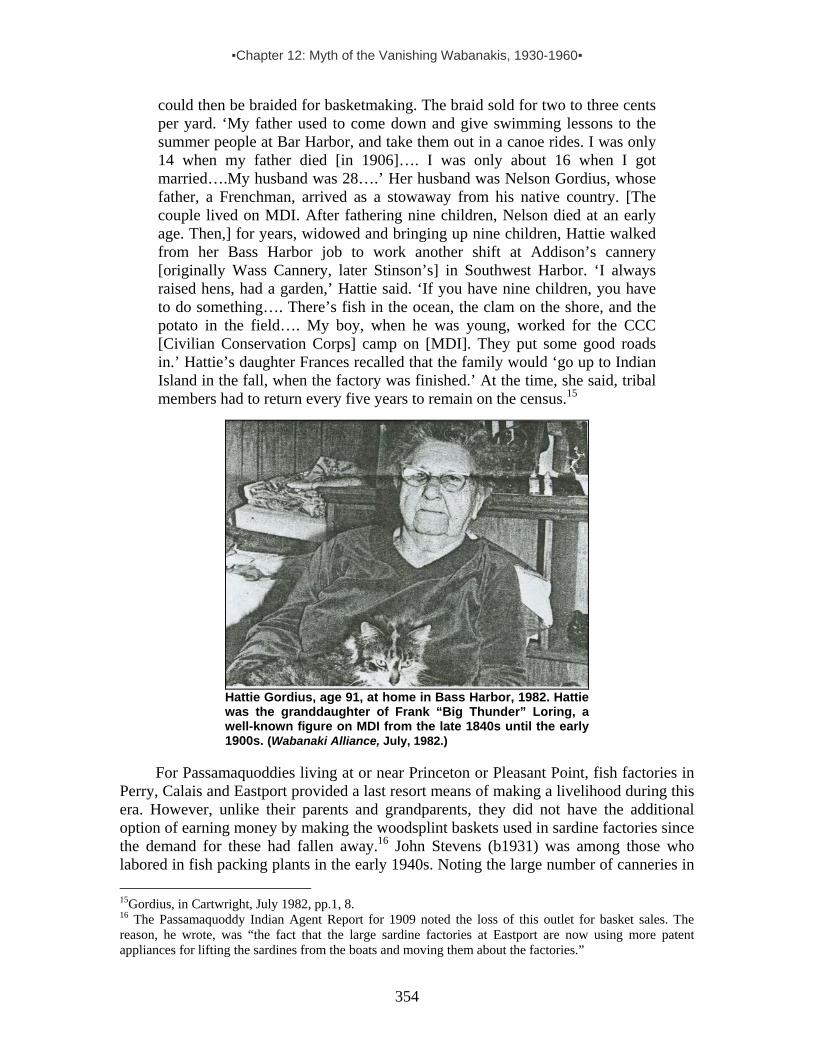
▪Chapter 12: Myth of the Vanishing Wabanakis, 1930-1960▪
354
could then be braided for basketmaking. The braid sold for two to three cents per yard. ‘My father used to come down and give swimming lessons to the summer people at Bar Harbor, and take them out in a canoe rides. I was only 14 when my father died [in 1906]…. I was only about 16 when I got married….My husband was 28….’ Her husband was Nelson Gordius, whose father, a Frenchman, arrived as a stowaway from his native country. [The couple lived on MDI. After fathering nine children, Nelson died at an early age. Then,] for years, widowed and bringing up nine children, Hattie walked from her Bass Harbor job to work another shift at Addison’s cannery [originally Wass Cannery, later Stinson’s] in Southwest Harbor. ‘I always raised hens, had a garden,’ Hattie said. ‘If you have nine children, you have to do something…. There’s fish in the ocean, the clam on the shore, and the potato in the field…. My boy, when he was young, worked for the CCC [Civilian Conservation Corps] camp on [MDI]. They put some good roads in.’ Hattie’s daughter Frances recalled that the family would ‘go up to Indian Island in the fall, when the factory was finished.’ At the time, she said, tribal members had to return every five years to remain on the census.15
Hattie Gordius, age 91, at home in Bass Harbor, 1982. Hattie was the granddaughter of Frank “Big Thunder” Loring, a well-known figure on MDI from the late 1840s until the early 1900s. (Wabanaki Alliance, July, 1982.)
For Passamaquoddies living at or near Princeton or Pleasant Point, fish factories in Perry, Calais and Eastport provided a last resort means of making a livelihood during this era. However, unlike their parents and grandparents, they did not have the additional option of earning money by making the woodsplint baskets used in sardine factories since the demand for these had fallen away.16 John Stevens (b1931) was among those who labored in fish packing plants in the early 1940s. Noting the large number of canneries in 15Gordius, in Cartwright, July 1982, pp.1, 8. 16 The Passamaquoddy Indian Agent Report for 1909 noted the loss of this outlet for basket sales. The reason, he wrote, was “the fact that the large sardine factories at Eastport are now using more patent appliances for lifting the sardines from the boats and moving them about the factories.”

▪Chapter 12: Myth of the Vanishing Wabanakis, 1930-1960▪
355
the area during his childhood, he recalled working in one located in Perry as a boy: “I was only eight or nine and had to work because there was nobody home except Mama. . . . They had fish scales and heads and guts they’d throw on the floor. I’d get one of them squeegee [like things and] I’d shovel [that stuff] right in a hole and it goes into the water back into the ocean – and [did it] stink! God almighty. Every time I see a sardine [now], I can’t even look at it.”17
Sardine factory baskets, early 1900s, and Indian Township children with priest, c1940 – about the time John Stevens (back row, third from right) began working in the Perry fish factory. (Both photos courtesy of Donald Soctomah.)
While John worked in the fish factory, his uncles and one of his brothers served in World War II, as did a significant percentage of Wabanaki men. Meanwhile, during and after the war, Wabanakis trickled on and off Mount Desert Island, even after the great ten-day fire of 1947 wreaked sufficient havoc on the island to discourage visitors for a several years. Among various memories of Natives coming to MDI during this time is this one, offered by seasoned scholar Nicholas Smith, a long-time friend of Wabanakis:
In ’53 or ‘4 Sylvester Neptune told me about a trip he took down the Penobscot with plans to go to the Isle of Haut. He camped on Mt. Desert Island, started a fire to boil tea. The owner of the property smelled smoke and followed her nose to his little campfire. ‘Don’t you know you are trespassing? Fires aren’t allowed here. You’re going to set my woods on fire.’ She was completely out of it as far as a way of life where a person was comfortable canoeing around and camping, making a fire to cook over or even warm himself. I feel that the islands were originally part of a person’s hunting territory. They offered a family the opportunity to obtain what the ocean produced and the Indian needed.18
Some Wabanakis came to Mount Desert Island to visit or board with fellow tribespeople living there.19 Among many examples, Penobscot Donna Loring and other relatives of Hattie Gordius recall regular family visits to her home on the island.20 And 17 John Stevens, Interview by McBride, Jan. 2004. 18 Nicolas Smith, personal email communication, 12/15/03. 19 For example, members of the Loring family, regularly visited Hattie Gordius who lived in Bass Harbor. 20 Donna Loring, Interview by McBride, Jan. 2004.
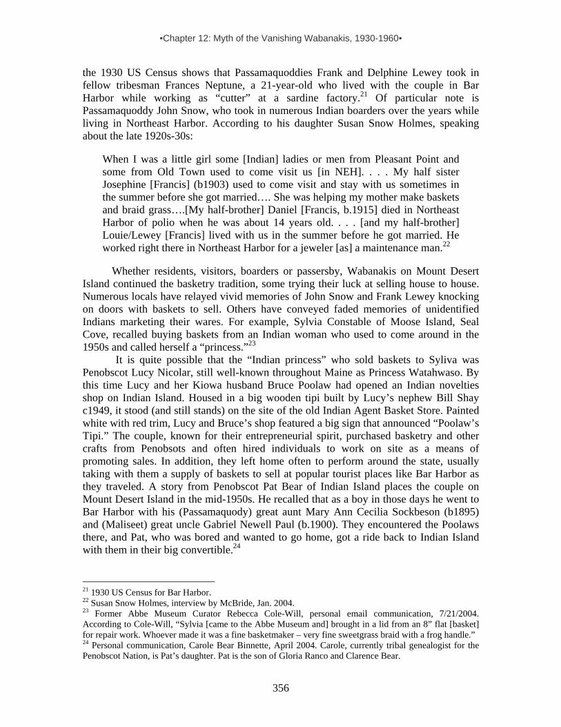
▪Chapter 12: Myth of the Vanishing Wabanakis, 1930-1960▪
356
the 1930 US Census shows that Passamaquoddies Frank and Delphine Lewey took in fellow tribesman Frances Neptune, a 21-year-old who lived with the couple in Bar Harbor while working as “cutter” at a sardine factory.21 Of particular note is Passamaquoddy John Snow, who took in numerous Indian boarders over the years while living in Northeast Harbor. According to his daughter Susan Snow Holmes, speaking about the late 1920s-30s:
When I was a little girl some [Indian] ladies or men from Pleasant Point and some from Old Town used to come visit us [in NEH]. . . . My half sister Josephine [Francis] (b1903) used to come visit and stay with us sometimes in the summer before she got married…. She was helping my mother make baskets and braid grass….[My half-brother] Daniel [Francis, b.1915] died in Northeast Harbor of polio when he was about 14 years old. . . . [and my half-brother] Louie/Lewey [Francis] lived with us in the summer before he got married. He worked right there in Northeast Harbor for a jeweler [as] a maintenance man.22
Whether residents, visitors, boarders or passersby, Wabanakis on Mount Desert
Island continued the basketry tradition, some trying their luck at selling house to house. Numerous locals have relayed vivid memories of John Snow and Frank Lewey knocking on doors with baskets to sell. Others have conveyed faded memories of unidentified Indians marketing their wares. For example, Sylvia Constable of Moose Island, Seal Cove, recalled buying baskets from an Indian woman who used to come around in the 1950s and called herself a “princess.”23
It is quite possible that the “Indian princess” who sold baskets to Syliva was Penobscot Lucy Nicolar, still well-known throughout Maine as Princess Watahwaso. By this time Lucy and her Kiowa husband Bruce Poolaw had opened an Indian novelties shop on Indian Island. Housed in a big wooden tipi built by Lucy’s nephew Bill Shay c1949, it stood (and still stands) on the site of the old Indian Agent Basket Store. Painted white with red trim, Lucy and Bruce’s shop featured a big sign that announced “Poolaw’s Tipi.” The couple, known for their entrepreneurial spirit, purchased basketry and other crafts from Penobsots and often hired individuals to work on site as a means of promoting sales. In addition, they left home often to perform around the state, usually taking with them a supply of baskets to sell at popular tourist places like Bar Harbor as they traveled. A story from Penobscot Pat Bear of Indian Island places the couple on Mount Desert Island in the mid-1950s. He recalled that as a boy in those days he went to Bar Harbor with his (Passamaquody) great aunt Mary Ann Cecilia Sockbeson (b1895) and (Maliseet) great uncle Gabriel Newell Paul (b.1900). They encountered the Poolaws there, and Pat, who was bored and wanted to go home, got a ride back to Indian Island with them in their big convertible.24
21 1930 US Census for Bar Harbor. 22 Susan Snow Holmes, interview by McBride, Jan. 2004. 23 Former Abbe Museum Curator Rebecca Cole-Will, personal email communication, 7/21/2004. According to Cole-Will, “Sylvia [came to the Abbe Museum and] brought in a lid from an 8” flat [basket] for repair work. Whoever made it was a fine basketmaker – very fine sweetgrass braid with a frog handle.” 24 Personal communication, Carole Bear Binnette, April 2004. Carole, currently tribal genealogist for the Penobscot Nation, is Pat’s daughter. Pat is the son of Gloria Ranco and Clarence Bear.

▪Chapter 12: Myth of the Vanishing Wabanakis, 1930-1960▪
357
On the north side of Frenchman Bay, Hancock Point resident Ted Omeara recalled Passamaquoddies visiting each summer during this period with baskets to sell:
The Passamaquoddy had a big black powerboat full of baskets—sweetgrass baskets and things. And that was kind of an event. They’d come out and anchor off right off here [Hancock Point] and then take their big baskets full of their baskets and go door to door all over the point. So for a while, up until the 30s and maybe even the 40s we had more dam Indian baskets floatin’ around this house than you can shake a stick at! They were the same people every year—really a family thing—and they made beautiful baskets.25
Throughout the 1930s-50s (and beyond), Wabanakis continued coming to the Mount Desert Island area for sweetgrass. Here Penobscot carver and medicine man Ronald Francis (“Senabeh,” b.1914) and his sister, basketmaker Christine Nicholas (b.1912), gather sweetgrass in Prospect Harbor in 1950. (In Konrad & Nicholas, p.8.)
Wabanakis at Sport-hunting Camps in the Mt. Desert Island Neighborhood During the 1930s-50s, summer lodges and sport-hunting camps continued to flourish in Maine, and Wabanakis continued to be associated with them. For example, Speck’s Penobscot informant Roland Nelson, a.k.a. “Needahbeh” (“My Friend”) worked at Pinewood Camps in Canton, Oxford County. As the “Indian-in-residence” he guided fishing and hunting parties, gave fly casting exhibitions, demonstrated basketry, wood carving, leatherwork and beadwork, and also performed Penobscot songs and dances. For promotional purposes the camp published his brief historical sketch on Penobscots. It included a profile about Roland and a note that when it came to bow and arrow shooting he demonstrated “both white man’s and Indian’s methods, [challenging] any golfer to a game of archery golf, using his bows and arrows while the golfer uses his clubs.”26 25 In Phippen, 1986. 26 Nelson 1935.

▪Chapter 12: Myth of the Vanishing Wabanakis, 1930-1960▪
358
Closer to Mount Desert Island, Aroostook Mi’kmaq Mary Lafford Sanipass (b.1935) worked just across Frenchman Bay at a camp in Sullivan during the 1950s.27 She gravitated there in part because her Mi’kmaq relatives had been raking blueberries in the area since the early 1940s. In her own words, “I was working at Big Chief Sporting Camps, cooking and other things at the time. The place was run by ‘Chief” Stanwood, who wasn’t an Indian. It was at Tunk Road in Sullivan, Maine. I lived right there in the camp. The place was owned by Harry Stanwood and his wife Sue. She was a proud lady – big, strong, rugged and nice. I used to wash her clothes. Her dresses were like big nightgowns on me. She cut her own wood, 22 cords – Chief had a bad heart – and she lugged great big ice cakes from the ice house all by herself.”28
Stanwood tapped Mary, a beautiful young woman, to star as the “Indian maiden” in several short movies made to promote the camp. “I was in some films for the camp,” Mary recalled, offering these details:
I had to do everything the way the camera wanted it. I did the Indian dance – just something I made up. I had to dance around wearing a long white flowery dress. In another scene I had to put on a cowboy hat. They put out 50-yard targets for me. I shot at them with a 44 pistol. When I wasn’t looking Chief Stanwood poked two pencil holes in the target. He didn’t tell me until much later. I thought I’d hit the target…. Then they had me sit down by the brook and when the cameraman closed in on me I had to wink. Then I had to come out of the woods in my bathing suit, walk up almost to the cameraman, test the water with my toes, wade in a ways and dive in…. Then I came out…sat on a rock, and when the camera closed in on me, I winked [again]. In between shots of me they took pictures of Schoodic Mountain and the rest of the scenery. In the last scene I sat on a log [on the upper west side of Big Tunk Lake], feeling the water with my hand. I didn’t wear no Indian clothes – I didn’t have any! [big laugh.] Chief Needahbeh [Roland Nelson] got married at the camp…. Chief Stanwood had pictures of him at the camp.29
Seasonal Stoop Labor in and Beyond the Mt. Desert Island Neighborhood During the 1940s-60s, several Wabanaki families lived and worked in the Gouldsboro area on Frenchman Bay, not far from Stanwood’s camp in Sullivan. Some stayed seasonally, some year-round, and others simply passed through. Among them was Aroostook Mi’kmaq Donald Sanipass (1928-2000), who met Mary Lafford (b.1935), his wife-to-be, during the time she worked the camp. Donald tells it like this:
I met Mary in Gouldsboro. By then I was living in a trailer in Prospect Harbor during the work week, but usually came to Gouldsboro for the weekends and shared a place with [Mary’s brothers] Harold and Henry [Lafford]. Uncle Joe Daniel [Sanipass] was living in Gouldsboro then. He’d gone there ‘cause he’d
27 Sullivan is the area of the 15-wigwam Wabanaki village of Douaquet mentioned in the 1687 French census, and is in the Cadillac’s land grant that also included MDI. See Wabanaki-European Contacts section of this report. 28 Mary Lafford Sanipass, Interview by McBride, July 2003. After Harry Stanwood died in 1958, Sue ran the camp for three years. In 1961, Ruth and Fred Ulrich bought the place with Chandler Williams and changed the name to Four Seasons Lodge 29 Mary Lafford Sanipass, Interview by McBride, July 2003.
▪Chapter 12: Myth of the Vanishing Wabanakis, 1930-1960▪
359
heard about pulp cutting jobs from his [Mi’kmaq] friend Noel Phillips (1914-1959). [Noel and Joe’s wives were sisters from the Nova Scotia Mi’kmaq reservation at Afton, where their relative Anna Mae Pictou also grew up.] Daniel was cutting pulp part of the year and in the spring he was harvesting trap poles – young spruce limbs that could be bent to make lobster traps. Joe Daniel used to get 5 cents for a 20-stick bundle. Anyway, Mary was in Gouldsboro that weekend and I met her.
After that first meeting, Mary and Don met regularly in Gouldsboro during the weekends. Within a year, they married, and then, according to Donald,
We did clamming [in Frenchman Bay] so we could survive – did it in Sullivan. We got $7 a bushel, and we could get 10-12 bushels in low tide in 1-1.5 hours. Sometimes you’d get two tides a day. You’d have to wash ‘em and hide ‘em in the bushes until you found someone to take ‘em in a pick-up to a factory five miles away in North Sullivan…. I also cut pulp [wood] in Gouldsboro. Noel [Phillips, Mary’s uncle] and his brother and sons were also there working in the woods. And they dug clams there. They were just a step away from us. You could see Bar Harbor from there. We’d go sightseeing at Bar Harbor and Schoodic. Indians were scattered all over Maine. A lot of us worked in the woods and then came to rake blueberries.30
After blueberry season, many Wabanakis went up to Aroostook County for the fall
potato harvest. In addition to picking potatoes, some supplied farmers with sturdy potato baskets used in the field. Maine’s potato industry took off in the late 1800s, but it was between 1920 and 1965 in particular that potato picking and basket weaving were integral factors in the migratory seasonal working patterns of countless Wabanaki Indians. The heyday of the state’s potato industry was mid-twentieth century when acreage peaked at nearly 200,000 and it took nearly 40,000 pickers to bring in the crop – including many youngsters who were able to work because schools were closed during the harvest. Since each picker needed a basket, that period was also the heyday of potato basketry. Aroostook Mi’kmaq basketmaker Sarah Harquail Lund (1927-2001) recalled that in those boom days, an Indian family that got a big order for potato baskets usually hired other Indians, not always from the same tribe, to help out. “We were all intertwined,” said Sarah. “I used to make basket bottoms for a Maliseet family in the 1960s. They paid me twenty-five cents a bottom to wear out my hands.”31 During the 20th century, a clear work cycle emerged in the scattered Wabanaki communities that in some ways echoed their traditional seasonal migrations for hunting/gathering/trading. Many moved about as seasonal laborers, digging potatoes in the fall; lumbering in the winter; river driving in the spring; raking blueberries, clamming, and hawking baskets among farmers and tourists in the summer; and making 30Donald Sanipass, Interview by McBride, July 2003. A significant number of Wabanaki men worked in the woods cutting pulp wood during this time, including on at least one island in our research area. According to an Eagle Island resident, In 1959 Wabanakis described as “Canadian Indians” (Mi’kmaqs and/or Maliseets) went to Eagle Island with a contractor who “‘pulped’ the island. For a part of the time, they used the old dance hall in the Quinn House as sleeping quarters” (Enk, p.328). 31 Sarah Lund, Interview by McBride, 1981.

▪Chapter 12: Myth of the Vanishing Wabanakis, 1930-1960▪
360
baskets or working in potato houses whenever there was a labor lull. Sarah, who first picked potatoes in 1933 when she was sixteen, was typical:
I went back and forth [between Maine and New Brunswick] for years, following work opportunities and sometimes just following the crazy winds of fate. In June and July I’d be making potato baskets in Aroostook. Then in August I’d go to Washington County picking blueberries. Come September I’d be back up in Aroostook for the potato harvest. After that, if I could find a good rent in Maine, I’d stay here through the winter months. If not, I’d just return north. In those cold months we just survived. Come spring, we’d dig clams in Dalhousie [New Brunswick], pick fiddleheads in Aroostook. In between it all, I’d work out in people’s homes for a dollar a day – cooking, cleaning, looking after things.32
Wabanakis at Work in Acadia National Park Meanwhile, back on Mount Desert Island, several Passamaquoddy teenagers took summer jobs at Jordan Pond House in Acadia National Park. Among them was Wayne Newell, who grew up to be a leading educator and traditionalist at Indian Township. This is an excerpt from his recollections about working in the park:
I worked at the Jordan Pond House in the summer . . . when I was in high school [in the late 1950s]….I cooked lobsters…. [and] because I started working there, I opened it up for my brother and for Peter Bailey at Pleasant Point, who was really not a Passamaquoddy, but he grew up with us, so I regard him as Passamaquoddy. He speaks the language. . . . Oh, we certainly had a whole bunch of Passamaquoddies there! And even a Penobscot, Lena Neptune, worked there…. They had a women’s residence and a male residence. And we lived there.
Jordan Pond is a very beautiful place to eat, but it’s certainly quite exclusive…. People that were famous came there. You know, it was like Gary Cooper would drive in, or that famous columnist, Walter Winchell from New York—people like that, or you’d see people from the families, the Rockefellers or somebody like that…. It was a happening, and we would peek out from the kitchen. We were told not stare at them, but we would peek out at them just to see these people that we were serving…. Most of the people there were [not Mainers]. I was used to people treating me a certain way…. And now all of a sudden there was like a positive treatment of being Native from all these southerners. It was something real special. People would ask me about my heritage…. In talking with my mother about her experience at Pemaquid [where she went during the summer to sell baskets with the Penobscot family who raised her, I learned two things]: Number one, it was an economic thing, first and foremost. Number two, they were really treated well by the summer people. And I can run that parallel to my own experience. That probably was true for the other [resort] places [where Wabanakis sold their wares], from what I can determine from what people
32 In McBride, 1990, p.21.

▪Chapter 12: Myth of the Vanishing Wabanakis, 1930-1960▪
361
have said to me – that it was a good, pleasant experience. They were certainly [seen as] novelties! [But,] you know, being a novelty wasn’t all that bad [compared to being] nonexistent! [laugh] So being a novelty was good at the time.33
It was slightly different at the Abbe Museum. There, also, Wabanakis were looked
upon as not-quite-exotic curios, but in addition they were essential as cultural resources. Staff members treated them with respect for whatever traditional knowledge they had that could enhance the Abbe’s Indian artifact collection. As for the idea of collaborating with Wabanakis to revitalize the Native communities themselves, that concept simply did not yet exist. A handful of individuals were used for “salvage ethnography” efforts34 – especially to provide information needed to document various objects. There are no indications that anyone connected with the museum prior to the 1960s expected the tribes to survive along with the remnants of material culture, written descriptions and recorded stories about them. Indeed, the “melting pot” and “Vanishing Indian” myths were entrenched in mainstream American society.
Speaking of the museum’s emphasis on the past during this earlier era, the Abbe’s former curator, Rebecca Cole-Will, noted that when trustees voted to accept Mary Cabot Wheelwright’s collection of Wabanaki artifacts and stories in 1931, they did so with the idea that it represented “a survival of Stone Age technique,”35 not because it had something to say about contemporary Wabanakis. Concerning Wabanaki participation in the museum’s early years, Cole-Will said, “I don't think there was much Native involvement until [curator] Wendell Hadlock began working on documenting birchbark collections, along with Eva Butler in the late 1940s and 50s. Then, they spent time at Passamaquoddy interviewing elders and artists, [including] Sylvester Gabriel and Sabatis Tomah. Hadlock had collected several old birchbark pieces about Perry and Machias and interviewed these two regarding bark work.” Notably, Sylvester Gabriel was invited down to the museum in 1948 to make a birchbark box on site – but this was the only example Cole-Will could recall of Native demonstrators asked to come to the Abbe prior to the 1970s.
33 Wayne Newell, Interview by McBride, Jan. 2004. 34 The following passage effectively explains the idea behind “salvage ethnography”: “While the first generation of self-taught anthropologists began their careers working for museums, those coming after them were increasingly more often academically trained in the discipline and became active in newly-founded anthropology departments from around the turn of the century. Almost invariably, the latter did their fieldwork on tribal reservations where indigenous communities were falling apart in the face of disease, poverty, and demoralization brought on by pressures of forced assimilation. While government bureaucrats, Christian missionaries, and many other whites were pushing what they euphemistically referred to as “Indian reform”, many anthropologists felt troubled about this disappearing world and committed themselves to salvage ethnography. They interviewed tribal elders still able to recall the ancestral way of life prior to their reservation confinement, and collected oral histories, traditions, myths, legends, and other information, as well as old artifacts for research, preservation, and public display. In this context, they also identified, photographed and sometimes even filmed” (Prins 2004:510). 35 Rebecca Cole-Will, personal communication, April 2005. Wheelwright (1878-1958) was a wealthy Bostonian who summered on Sutton Island just south of Northeast Harbor.
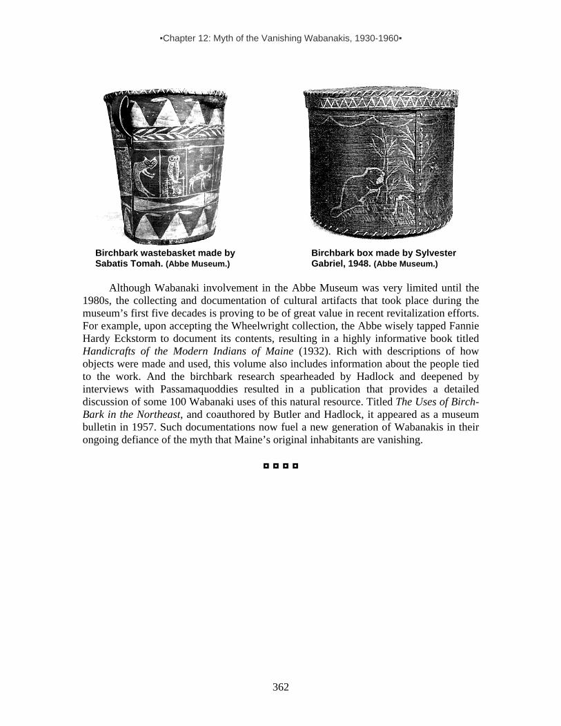
▪Chapter 12: Myth of the Vanishing Wabanakis, 1930-1960▪
362
Birchbark wastebasket made by Birchbark box made by Sylvester Sabatis Tomah. (Abbe Museum.) Gabriel, 1948. (Abbe Museum.)
Although Wabanaki involvement in the Abbe Museum was very limited until the
1980s, the collecting and documentation of cultural artifacts that took place during the museum’s first five decades is proving to be of great value in recent revitalization efforts. For example, upon accepting the Wheelwright collection, the Abbe wisely tapped Fannie Hardy Eckstorm to document its contents, resulting in a highly informative book titled Handicrafts of the Modern Indians of Maine (1932). Rich with descriptions of how objects were made and used, this volume also includes information about the people tied to the work. And the birchbark research spearheaded by Hadlock and deepened by interviews with Passamaquoddies resulted in a publication that provides a detailed discussion of some 100 Wabanaki uses of this natural resource. Titled The Uses of Birch-Bark in the Northeast, and coauthored by Butler and Hadlock, it appeared as a museum bulletin in 1957. Such documentations now fuel a new generation of Wabanakis in their ongoing defiance of the myth that Maine’s original inhabitants are vanishing.
◘ ◘ ◘ ◘

▪Chapter 13: Wabanaki Rights & Cultural Revitalization, 1960s-Today▪
363
CHAPTER 13: WABANAKI RIGHTS & CULTURAL REVITALIZATION, 1960s-TODAY
Wabanaki leaders at time of the 1980 Maine Indian Claims Settlement. Row 1: Donald Nelson, Erlene Paul, Mike Crawford, Terry Polchies, Eugene Francis. Row 2: Wayne Newell, Grace Roderick, Susan Stevens (non-Native wife of John Stevens), Ralph Dana, Tom Tureen (attorney). Row 3: Allan Sockabasin, Tom Battiste, Andrew Akins, John Stevens, Jim Sappier. (Courtesy of Donald Soctomah.)
Maine Indian Claims Settlements
In 1957, an elderly Passamaquoddy woman named Louise Sockabesin came across some old papers in a trunk and decided to call her grand-niece's husband John Stevens to ask him if he wanted to take a look at them before she threw them out. Stevens, then Tribal Governor at Motahkokmikuk (Indian Township Reservation), told her to hold on to them. As this Passamaquoddy tribal leader recently recalled, a few years passed and Louise called him and said,
“If you don’t come [to look at those papers soon,] I’m going to throw them away.” I said okay, let’s go down. She got out this old trunk . . . and she was digging through it and [pulled out this long thing] all rolled up [with] a red ribbon on it. So I undo that and . . . when I pull it apart I could see that blue seal on there and it says Commonwealth of Massachusetts on the back. And I said, oh oh, this must be it. So I read it. It was that old handwriting. And I read it and said this is the 1794 treaty.1
1 John Stevens, Interview by McBride 2004.

▪Chapter 13: Wabanaki Rights & Cultural Revitalization, 1960s-Today▪
364
Having before him a copy of a treaty concluded between his tribe and the Commonwealth of Massachusetts, Stevens quickly realized that it provided evidence that the state of Maine had sold or leased off 6,000 acres of reservation land. The Passamaquoddy decided to send a delegation to Augusta in the hope of reclaiming the lands swindled away in the course of time. As “wards” of the state, Stevens and his men asked for an audience with the Maine governor and drove to the state capital with treaty in hand. “They were very rude to us. [Governor John H.] Reed kept us waiting outside his office for five hours. . . . [and] we were literally laughed out of the state house.... They said we had no ground to claim this territory, that we were paupers and that we were there on the good graces of the state.” Deeply insulted, the Passamaquoddy delegation decided that they had enough. According to Stevens, “We met the following day with all the council and the tribal members. One of the council members – it might have been my father or Fred Tomah – said, ‘Why John Stevens, 1971. (Photo by Harald Prins.) don’t we go out and protest? All the Blacks in the United States are protesting. It’s time that we stood up too.’ I said, ‘Okay, let’s go.’”2
In the turbulent years that followed, aided by young Pine Tree Legal Services attorney Tom Tureen, an anonymous donor from Perry and others committed to the cause of Native Rights, the Passamaquoddy Tribe joined forces with the Penobscot Indian Nation and boldly laid claim to two-thirds of the State of Maine. Spearheaded by Stevens, a Korean War veteran, they let it be known that they still held aboriginal title to their ancestral domains and filed lawsuits in federal court. Offering a radically original legal interpretation of the 1790 Trade and Intercourse Act, their argument was as brazen as it was simple. Although this federal law expressly forbade any state, private company, or individual to purchase land from Indian tribal nations without approval by US Congress, government officials had never thought of applying it to any of the tribal nations inhabiting domains historically situated in the 13 original American colonies. However, the Passamaquoddy and Penobscot argued they were not exempt and maintained that because US Congress had not approved land sales and treaties signing away their ancestral domains, they still possessed aboriginal title to almost all of Central and Northeastern Maine. A claim on behalf of the Houlton Band of Maliseets was not asserted until 1979, and no lawsuit was ever filed in court on the Band’s behalf. However, the Penobscot and Passamaquoddy tribes agreed that this Maliseet group in northern Maine be included in the settlement and the Federal and State governments accepted their addition in the final legislation. After much complex legal wrangling and political horse-trading, and 2 John Stevens, Interview by McBride 2004.

▪Chapter 13: Wabanaki Rights & Cultural Revitalization, 1960s-Today▪
365
premised on the violation of the 1790 federal law, this long-standing dispute involving millions of acres was finally settled out-of-court in 1980. Abolishing aboriginal title, the Maine Indian Claims Settlement Act (MICSA) provided these three tribes with $81.5 million, much of it earmarked for the purchase of 300,000 acres of trust lands.
Left: At a 10 Oct. 1980 White House ceremony President Jimmy Carter signed the Maine Indian Claims Settlement Act with an eagle feather pen. From left are: Maine Gov. Joseph Brennan, Sec. of State Edmund Muskie, U.S. Sen. George Mitchell, Houlton Band of Maliseets Chairman Terry Polchies. Right: After signing MICSA Carter shakes hands with Polchies. Behind stand Sen. Mitchell, Penobscots Andrew Akins and Butch Phillips. (Associated Press file photos.)
The outcome of a bitter struggle and a difficult compromise, MICSA was heralded as a major landmark in Indian land claims settlement cases. When President Jimmy Carter signed the settlement into law with an eagle feather, the Bangor Daily News ran a headline: “End of the road.” This banner may have made news, but was shortsighted and misleading. Controversial from the beginning, the new law left much unclear and unresolved. Most seriously, it ignored Maine’s fourth tribe, the Aroostook Band of Micmacs, erroneously abolishing its aboriginal title and precluding it from legal and administrative actions otherwise still potentially open to this landless group neighboring the newly recognized Maliseets. Documentation of Mi’kmaq history in Maine had not been completed at the time of MICSA due to inadequate resources. Now, going it alone, it took another decade for this band to win its rights. In 1991, with endorsements from the other tribes and scholarly and legal support through Pine Tree Legal Assistance (the state’s federally funded legal aid agency), the Band persuaded the U.S. government to pass The Aroostook Band of Micmacs Settlement Act. Allowed to pass into law by President George H.W. Bush, this act provided federal recognition of the group’s tribal status (entitling members to certain federal services and benefits), plus a $900,000 land acquisition fund to purchase 5000 acres of trust lands, as well as a $50,000 property tax fund. As a result, this Mi’kmaq band and its lands have the same status as other Maine tribes. Although current tribal-state relations remain problematic, these Native rights cases represent impressive gains for the now federally-recognized tribal communities in Maine and have revolutionized their political status. From small and powerless state-dependent communities, they now possess dramatically improved self-determination rights and represent a considerable political and economic force in the state.

▪Chapter 13: Wabanaki Rights & Cultural Revitalization, 1960s-Today▪
366

▪Chapter 13: Wabanaki Rights & Cultural Revitalization, 1960s-Today▪
367
Wabanakis’ Ongoing Presence in the Mount Desert Island Neighborhood In relation to the ethnographic survey in hand, it is significant that Mount Desert Island did not fall within the Maine Indian land claim area, which extended from the Penobscot drainage eastward (skirting just above MDI) and northwards to the Canadian border. However, since lands eastward of Frenchman Bay did fall within this disputed area, 100 acres of Acadia National Park at Schoodic Peninsula were on the table.3 Although this piece of Schoodic did not end up being part of the 1980 Maine Indian Claims Settlement, Native association with Schoodic and other areas in the MDI neighborhood continued after the Settlement, as it had before. Some Wabanakis resided year-round in the MDI area, including on the island, others passed through seasonally to pick sweetgrass, sell baskets, sightsee and picnic or visit family members living there. Announcements of the marriages and deaths of Wabanakis residing in the area continued to appear in local papers. And some individuals came to work with the Abbe Museum and for Acadia National Park. The following passages are a small sampling of examples drawn from numerous oral and written accounts:
When I was growing up (late 50s-early 70s) my family used to go down by Southwest Harbor to visit my aunt Hattie Gordius [Penobscot Indian grand-daughter of Frank “Big Thunder” Loring] who lived there.4 Passamaquoddy John Frank Lewey died in Bar Harbor 9/29/67. He worked as caretaker at Eastcoat, a summer home. He was born 7/12/1910 in Bar Harbor to Frank and Delphine Lewey and on 1/1/1947 married Avis Mae Lawford.5
A 1967 newspaper article featured this photo of John and Mary Soctomah with the caption: “Gathering Sweetgrass – This Indian couple gathers sweet grass near West Gouldsboro. They color this grass and make beautiful sweet grass baskets and other ornaments from patterns that have been handed down through generations. Tourists buy these hand made baskets and ornaments as fast as the Maine Indians can make them because this ancient art is fast disappearing in this modern, mechanical age.”6 Their grandson, Passamaquoddy historian Donald Soctomah, commented, “My grand-parents had a summer camp along the shore in Gouldsboro
and were friends with the property owner. Last year [2004] the owner moved away and gave me a root club my grandfather made for them.”7
3 “The Coast.” Wabanaki Alliance, December 1981, p.2. 4 Donna Loring, Interview by McBride, 2004. Hattie’s father was born in Tremont on MDI. 5 Sheldon Goldthwait, personal communication, 2004. 6 Crane. 7 Donald Soctomah, personal communication, Feb. 2005.
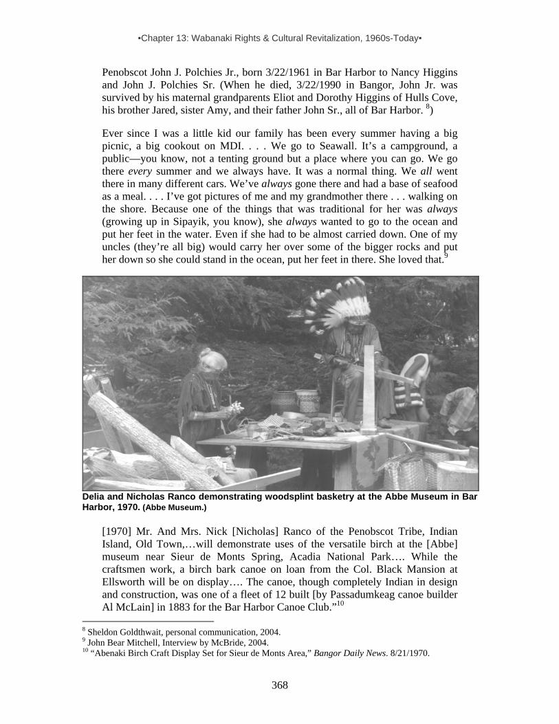
▪Chapter 13: Wabanaki Rights & Cultural Revitalization, 1960s-Today▪
368
Penobscot John J. Polchies Jr., born 3/22/1961 in Bar Harbor to Nancy Higgins and John J. Polchies Sr. (When he died, 3/22/1990 in Bangor, John Jr. was survived by his maternal grandparents Eliot and Dorothy Higgins of Hulls Cove, his brother Jared, sister Amy, and their father John Sr., all of Bar Harbor. 8) Ever since I was a little kid our family has been every summer having a big picnic, a big cookout on MDI. . . . We go to Seawall. It’s a campground, a public—you know, not a tenting ground but a place where you can go. We go there every summer and we always have. It was a normal thing. We all went there in many different cars. We’ve always gone there and had a base of seafood as a meal. . . . I’ve got pictures of me and my grandmother there . . . walking on the shore. Because one of the things that was traditional for her was always (growing up in Sipayik, you know), she always wanted to go to the ocean and put her feet in the water. Even if she had to be almost carried down. One of my uncles (they’re all big) would carry her over some of the bigger rocks and put her down so she could stand in the ocean, put her feet in there. She loved that.9
Delia and Nicholas Ranco demonstrating woodsplint basketry at the Abbe Museum in Bar Harbor, 1970. (Abbe Museum.)
[1970] Mr. And Mrs. Nick [Nicholas] Ranco of the Penobscot Tribe, Indian Island, Old Town,…will demonstrate uses of the versatile birch at the [Abbe] museum near Sieur de Monts Spring, Acadia National Park…. While the craftsmen work, a birch bark canoe on loan from the Col. Black Mansion at Ellsworth will be on display…. The canoe, though completely Indian in design and construction, was one of a fleet of 12 built [by Passadumkeag canoe builder Al McLain] in 1883 for the Bar Harbor Canoe Club.”10
8 Sheldon Goldthwait, personal communication, 2004. 9 John Bear Mitchell, Interview by McBride, 2004. 10 “Abenaki Birch Craft Display Set for Sieur de Monts Area,” Bangor Daily News. 8/21/1970.

▪Chapter 13: Wabanaki Rights & Cultural Revitalization, 1960s-Today▪
369
[When I lived in Boston,] 30-35 years ago [1969-74], I had my little mattress in my Volvo so I used to . . . camp out different places along the coast. I’d come up to [Indian] Island [in Old Town] and get a bunch of baskets from my grandmother, and I’d go down and peddle them by the side of the road. I used to usually stop just at the [MDI] causeway where I think there’s an information center now. And I used to park right around there and sell my baskets out of the Volvo. . . . After that, if I was up there for the weekend, then I’d go on [MDI]. Back then you could always find some place where you could stash your Volvo away, and I could get out and build a little fire and spend the night there. . . . but all these other places by the water where I like to go, they’re all gone now. 11 [1970s]“The best commercial exhibit [of baskets] the writer ever saw is at the Jordan Pond House. The managers have special Indian craftsmen and women experts from whom they collect the display every summer. The prices are very reasonable, considering the work involved in the artistic and useful baskets. It is stated that such baskets are now in great demand, as people are recognizing the skillful work involved for what it is, the product of a remarkable Native American culture.”12 Sorry for anyone who missed the ‘Pride of Maine’ fair at Bar Harbor last month. The three-day event included an honest tribute to Passamaquoddy skills and culture. A selected group of Indians presented various aspects of Indian lore, such as cooking, drums, basketry, language and herbal medicine. . . . Deserving special mention are Wayne Newell, Passamaquoddy linguist and health director; Joan and Martin Dana, cook and drum maker respectively; linguist David (Martin) Francis; bilingual director [non-Indian] Robert Leavitt; Fred Tomah, medicine man; . . . Also, Elizabeth and Dyke Sopiel, basket weaver and ash-pounder respectively; and cook Blanche Socobasin. . . . A special bonus [were Nova Scotia Micmac musicians], fiddler [Lee Cremo, pictured right] and his piano accompanist [Vincent Joe].13 [Penobscot] Rhonda Louise Ranco married Richard W. Kelley 8/17/80 in Southwest Harbor. [Rhonda’s parents: Roger Ranco (b4/25/33) and Patricia A. Seeley.] Currently working here at 1st National Bank, Rhonda is now married to Robert F. Sawyer.14
11 Watie Akins, Interview by McBride, 2004. 12 Joy, B.E. Historical Notes on Mt. Desert Island, vol. 3 (5/1/1975), p.81. 13 Wabanaki Alliance, Aug. 1979, p.2. The photo of Lee Cremo appeared with this article. Audio tapes of the event, made by Judith Blank, are at MFC, UMO. 14 Sheldon Goldthwait of Bar Harbor, personal communication, 2004.

▪Chapter 13: Wabanaki Rights & Cultural Revitalization, 1960s-Today▪
370
There was an Indian shop in Bar Harbor in the 1970s. I have the sign [pictured right]. 15 I worked at Acadia National Park in 1980 or 1981 as part of the trail crew. We maintained the trail system throughout the park. This job was for the summer and it was in coordination with the University of Maine system.16 It was quite a few years back [c1985] when I first started going to Bar Harbor to sell [baskets]…. think it was [Aroostook Micmac] Richard Silliboy that was there besides myself. And we were selling at the ball field…. the old [Indian encampment] site…. I had been selling baskets right out of my home [and at] a little gift shop in [Indian] Township. And somebody came by and wanted to know if I was interested to go sell in Bar Harbor. I said sure…. So within a short period of time I got a letter from, I think it was the Chamber of Commerce…. [and] I went. And we did all right, I mean people were very receptive of our being there and we did all right. . . . I was selling fancies, I was selling all the other type of baskets too – utility baskets, clothes and backpacks and whatever else I can get a hold of. Because I bought, and I sold, and I made and traded…. I had [Passamaquoddy] Sylvia Gabriel's [baskets with me]. And I had Doris Chapman's. My mother's, Irene Dana, and Elizabeth Sappiel's, my aunt. I even had Frances' baskets, my mother-in-law from Pleasant Point. And if I remember correctly, I had some of Maggie Neptune's baskets. I had so many people's baskets because what I did was I went around and I bought baskets from different people. I gave a little bit more money than what other people gave them, so they would have good money for all their hard work.17 Our family used to go down [to MDI] and had a place where we’d…gather sweetgrass. Sometimes we’d go down there and head up to Cranberry Island, and we had a certain spot on Cranberry Island where that we used to pick it…. I used to go out there every other year with [one of my uncles] for a while [late 1980s, early 1990s]. Now he can’t really do those trips. But we used to go out there, and I remember a couple of times we took my mother. She wanted to go. We’d pick the sweetgrass. It was funny because we had these big…bundles of sweetgrass, and they’re all tied together in neat little bunches because we’d do a lot of the cleaning right there too. It wasn’t just mad picking. It was casual and it was fun. It was a social event as well. We’d pick and comb it out right there, and
15 Watie Akins, Interview by McBride, 2004. Photo of sign courtesy of Akins. 16 Donald Soctomah, Interview by McBride, 2004, and personal communication 13 June 2005. 17 Molly Neptune Parker, Interview by McBride, 2004.

▪Chapter 13: Wabanaki Rights & Cultural Revitalization, 1960s-Today▪
371
bundle it up as neatly as we could because, you know, you had to carry it. So, what happened was, we would take this and bundle it all together, and tie it up into like one big bundle of sweetgrass that would probably be maybe 4 or 5 feet around—huge—by the time we were done because it was just so bountiful out there. And you have to get on this little lobster boat ferry to get off the island. And I kinda sensed a couple times that people were irritated because I was taking up space with my sweetgrass, you know. [laugh] Like that’s taking a seat. So I’d try to hold it or something, but then it would stick out because it’s like 3 or 4 feet long. I mean, what can you do? Then, here we are, you know, dressed in LL Bean clothes, really comfortable and really warm, and we’re out gathering bundles of grass, which meant nothing to these people. Basically, we used it for two different things: ceremonial and for basketmaking.18 1989-Today: Wabanaki craftspeople, artists, performers and sightseers come to Bar Harbor for the annual summer Native American Festival (detailed below). “Some of the [Wabanaki] people who go to the basket show [in Bar Harbor] have ceremonies early in the morning on the day of the show . . . [and] go to the top of Mt. Cadillac to greet the day.”19 [Maliseet] Francis James “Donald” Joseph (b12/14/35 in Houlton to Mary Louise Saulis and Frank Xavier Joseph) died in Bar Harbor 11/8/95. He was survived by his [Maliseet] wife Veronica (Sabattis) Joseph of Bar Harbor and 3 sons—Francis J. Jr. of Bangor, Robert R. of Bar Harbor, and Donald L of Wisconsin; 6 daughters, Judy Butler of Florida, Mae Joseph of Bucksport, and Erica Joseph, Kylie L Joseph, Jesse A Joseph, and Ann Akerson all of Bar Harbor; his brother Peter Joseph of Houlton. 20 [Maliseet] Veronica Sabattis Joseph of Bar Harbor & Houlton, died 8/5/1997 at a Bangor hospital. Born 11/7/42 at Woodstock, NB. Survived by several children, including Ann Akerson, Robert R., Erica L., Kylie A, and Jesse M. Joseph, all of Bar Harbor. (Brother is Maliseet Clair/Al Sabbatis of Houlton).21 I’ve canoed the Penobscot from Mt. Katahdin to North Haven five years in a row, which is a 200-some odd mile paddle….as I’m traveling down the Penobscot going towards MDI, I often wonder like how many times I come around a corner and see what my great grandfather or great-great grandfather or grandfather might even have seen when they were younger.22
Countless other examples could be added to this collection of snapshots showing Wabanaki presence on and near MDI since the 1960s, but few are as telling as the story of T.R.I.B.E. which follows.
18 John Bear Mitchell, interview by McBride, 2004. 19 Donald Soctomah, personal communication 7/4/2004. 20 Obituary, provided by Sheldon Goldthwait, 2004, who noted that Ann Akerson was currently working at Jordan’s restaurant in Bar Harbor. 21 Obituary and personal communication from Sheldon Goldthwait of Bar Harbor, 10/20/04. 22 John Bear Mitchell, interview by McBride, 2004.
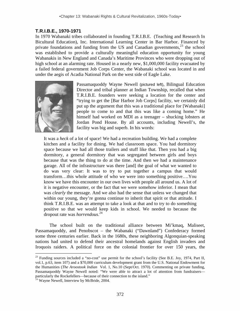
▪Chapter 13: Wabanaki Rights & Cultural Revitalization, 1960s-Today▪
372
T.R.I.B.E., 1970-1971 In 1970 Wabanaki tribes collaborated in founding T.R.I.B.E. (Teaching and Research In Bicultural Education), Inc. International Learning Center in Bar Harbor. Financed by private foundations and funding from the US and Canadian governments,23 the school was established to provide a culturally meaningful education opportunity for young Wabanakis in New England and Canada’s Maritime Provinces who were dropping out of high school at an alarming rate. Housed in a nearly new, $1,000,000 facility evacuated by a failed federal government Job Corps Center, the Wabanaki school was located in and under the aegis of Acadia National Park on the west side of Eagle Lake.
Passamaquoddy Wayne Newell (pictured left), Bilingual Education Director and tribal planner at Indian Township, recalled that when T.R.I.B.E. founders were seeking a location for the center and “trying to get the [Bar Harbor Job Corps] facility, we certainly did put up the argument that this was a traditional place for [Wabanaki] people to come to and that this was like a coming home.” He himself had worked on MDI as a teenager – shucking lobsters at Jordan Pond House. By all accounts, including Newell’s, the facility was big and superb. In his words:
It was a heck of a lot of space! We had a recreation building. We had a complete kitchen and a facility for dining. We had classroom space. You had dormitory space because we had all those trailers and stuff like that. Then you had a big dormitory, a general dormitory that was segregated between girls and boys because that was the thing to do at the time. And then we had a maintenance garage. All of the infrastructure was there [and] the goal of what we wanted to do was very clear: It was to try to put together a campus that would transform…this whole attitude of who we were into something positive….You know we have this encounter in our own lives with people all around us. A lot of it is negative encounter, or the fact that we were somehow inferior. I mean that was clearly the message. And we also had the sense that unless we changed that within our young, they’re gonna continue to inherit that spirit or that attitude. I think T.R.I.B.E. was an attempt to take a look at that and to try to do something positive so that we would keep kids in school. We needed to because the dropout rate was horrendous.24
The school built on the traditional alliance between Mi’kmaq, Maliseet, Passamaquoddy, and Penobscot – the Wabanaki (“Dawnland”) Confederacy formed some three centuries earlier. Back in the 1680s, these neighboring Algonquian-speaking nations had united to defend their ancestral homelands against English invaders and Iroquois raiders. A political force on the colonial frontier for over 150 years, the 23 Funding sources included a “no-cost” use permit for the school’s facility (See B.E. Joy, 1974, Part II, vol.1, p.63, item 107) and a $70,000 curriculum development grant from the U.S. National Endowment for the Humanities (The Aroostook Indian Vol. 1, No.10 (Sept/Oct. 1970). Commenting on private funding, Passamaquoddy Wayne Newell noted: “We were able to attract a lot of attention from fundraisers—particularly the Rockefellers—because of their connection to the island.” 24 Wayne Newell, Interview by McBride, 2004.
▪Chapter 13: Wabanaki Rights & Cultural Revitalization, 1960s-Today▪
373
confederacy was known among Mi'kmaq and Maliseet as buduswagan, “convention council.” Passamaquoddies called it tolakutinaya, to "be related to one another.” Wabanaki Confederacy meetings, or council fires, were held periodically in centrally-located Indian villages to discuss war and peace, exchange information, and make agreements. Chiefs and delegates sat on opposite sides of the fire under a large wooden hoop hanging from the council house ceiling. Attached to this hoop were the wampum belts, which served as diplomatic records. One of the most important represented the Wabanaki Confederacy itself. Representing the union of the four allied tribes, that belt featured four white triangles on a blue background. During peace negotiations with foreign leaders, an orator would speak for the Confederacy and present certain wampum belts. Following the outbreak of the American Revolution, the Wabanaki Confederacy pledged its support at the 1776 Treaty of Watertown in Massachusetts (which controlled Maine until 1820). After that war, the new border between Canada and the United States sliced through Wabanaki lands and the Confederacy became a political problem for both White governments. Under pressure, the alliance ceased to function politically by 1870. But a century later it was revitalized with the founding of T.R.I.B.E., whose directors represented the Maliseet, Mi’kmaq,Passamaquoddy and Penobscot tribes from Maine and Canada. Passamaquoddy John Stevens, whose mother was born in Bar Harbor, served as president with:
Vice-President, Terry Polchies (Maliseet), Houlton Anthony Francis (Mik’maq), Richibuctou, New Brunswick George Francis (Maliseet), Tobique, New Brunswick Eugene Francis (Passamaquoddy), Pleasant Point Alice Metallic (Mi’kmaq), Restigouche, Quebec Michael Jadis (Mi’kmaq), Prince Edward Island Peter Perro (Mi’kmaq), Antigonish, Nova Scotia John Peters (Mi’kmaq), Lennox Island, Prince Edward Island James Sappier (Penobscot), Indian Island25
The “high point” of T.R.I.B.E. according to Newell was: “The time when the students all arrived. You could see that there was a lot of hope, willingness on the part of the students. There was a newness. That’s what I remember the most.” This is evident in the closing passage of an article written by Frederick D. Tomah (Sonny), then a “Student Consultant” for T.R.I.B.E.: “Too often the schools have told our children little about the North American Indian, and what they have said is often wrong. At Tribe, Inc., they are attempting to correct this wrong by doing research in bi-cultural education and promoting and administering new educational programs. This school is to help Indians as well as mankind; I know because I am a student here at Tribe, Inc., and also an INDIAN.”26
T.R.I.B.E.’s ten staff members carried the charge of teaching academic subjects, plus Native arts, crafts, music and dancing. All were committed to challenging the repressive status quo, and among them was Nova Scotia Mi’kmaq Anna Mae Pictou. Coming to Maine from Boston, where she had volunteered at the Boston Indian Council
25 The Aroostook Indian vol.1 no.10, p.5 (Sept/Oct. 1970). 26 The Aroostook Indian vol.3, no.5, pp..3-4. 1971.

▪Chapter 13: Wabanaki Rights & Cultural Revitalization, 1960s-Today▪
374
and participated in her first American Indian Movement (AIM) protest, she arrived at T.R.I.B.E. inspired by “Red Power” activism. Passing the fire on to her junior-high and high school students, she had them review standard textbooks – prodding them to identify, discuss and challenge distortions of the historical roles attributed to Indians.27 As it turned out, T.R.I.B.E. was a short-lived dream, lasting just one full academic year. Wayne Newell explained its demise like this:
The program] expanded to a much bigger plate than I think [was envisioned by] those of us that originally thought of the concept. All of sudden we had some 35 communities involved from the whole Wabanaki area. In a sense that was wonderful, but in a sense the politics of all of these different places killed it too. They couldn’t see beyond the resource allocation. You know, we were fighting over the little bones again. We couldn’t go beyond that. We couldn’t get into the educational phase of that. The problem is that we dragged in all of the problems from the 35 communities and that became more of a thing than our primary mission. I think if we could have somehow disconnected from the local politics and just had a committee, it might still be in existence today, and probably today would be at university level. You gotta think here, this was at the very infancy stage of the community college movement across the country…. Now you find [Indian] community colleges all over the place, and strangely enough we’re one of the places you don’t have one. And we really should have one. We should have a Wabanaki Community College in order to do those kinds of things.28
When T.R.I.B.E. ended in 1971, Anna Mae Pictou returned to the Boston Indian
Council, joined AIM and became increasingly involved in the militant organization. A few years later, she was murdered at the Lakota Indian reservation of Pine Ridge, South Dakota. Better known as Anna Mae Aquash, she is now remembered as a pioneer and martyr in the Wabanaki native rights struggle. Meanwhile, Wayne Newell was hired to handle the closure of T.R.I.B.E. To put it mildly, it was a disheartening task. “I had just graduated from Harvard,” he recalled, “and my first job was to close the place down.
27Born at Shubenacadie reserve, NS, in 1945, Anna Mae moved to Pictou’s Landing at age 4 when her mother Mary Ellen Pictou married Mi’kmaq traditionalist Noel Sapier. After Sappier died in 1956, her mother married Wilford Barlow [at Antigonish?]. As a teen Anna Mae worked the blueberry and potato harvests in Maine. In 1962 she moved to Boston with Mi’kmaq Jake Maloney, and found work in a factory. By 1965 she and Jake had two daughters (Denise and Deborah) and she was volunteering at the Boston Indian Council (BIC). Highly motivated, she formed part of the emerging Native rights movement, calling for cultural recognition, and the fulfillment of promises made in treaties. Her council work centered on helping young, urban Natives develop self-esteem, aimed at helping them avoid alcohol abuse. Jake did not share her passion, nor was he faithful. They parted ways. While working at the BIC, Anna Mae joined in her first American Indian Movement (AIM) protest – challenging the "official" version of Thanksgiving by converging on the Mayflower II, a reconstruction of the ship that carried the Pilgrims to America. Soon thereafter, she moved to Bar Harbor with her daughters to work at T.R.I.B.E. A year later, she returned to Boston and from there joined AIM’s “March on Washington,” also known as the “Trail of Broken Treaties.” Her political activism continued to grow – and ultimately, swept up in conflict, she was murdered. (Profile drawn from Harald Prins’ file on Pictou-Aquash, comprised of notes, interview material, articles, etc. See also Devon A. Mihesuah, Anna Mae Pictou-Aquash: An American Indian Activist, in Theda Perdue, ed. 2001. Sifters: Native American Women’s Lives, Oxford University Press, pp.204-222.) 28 Wayne Newell, Interview by McBride, 2004.

▪Chapter 13: Wabanaki Rights & Cultural Revitalization, 1960s-Today▪
375
That was a real depressing way to graduate from college.” It was especially difficult because Newell felt personally invested in T.R.I.B.E.: “As a student I was there [while it was running]. I was a grad student so I would go back and forth [from Cambridge to Bar Harbor]. They would give me as much work as possible just because I needed the cash as a student. And at the time I graduated they said we need someone to turn the facility back and to shut it down. [So, my wife] Sandy and I lived there. We had two small children and we were the only ones that lived there. We boxed everything up.”29
Short-lived as it was, T.R.I.B.E. played a significant role in preparing young Wabanakis to participate in the Native rights struggles that resulted in the Maine Indian Claims Settlement Act of 1980 and the Aroostook Micmac Settlement Act of 1991.30 And it helped open the door to Governor Kenneth Curtis’ decision to appoint 40-year-old Passamaquoddy tribal leader John Stevens as Maine's new Indian Affairs Commissioner. Stevens, who served as president of T.R.I.B.E. and had been repeatedly re-elected as the highly respected Passamaquoddy governor at Indian Township, became the first Native American ever named to a top state post in Maine. Artful Activism: The Role of Wabanaki Crafts and Dance in the Struggle for Cultural Survival By the 1960s, the demand for fancy splint and sweetgrass baskets had continued to decline and by 1970 mechanized potato harvesting in Aroostook County had severely diminished the demand for hand-pickers and the sturdy Wabanaki baskets they used to bring in the crop. This impacted all of Maine’s Wabanaki communities, but especially Aroostook County’s Mi’kmaqs and Maliseets who were particularly invested in the potato harvest as “stoop laborers” and “potato basket” makers. For Mi’kmaqs, left out of MICSA, the loss of this market for their wares was a double blow. Seeking a way to redress their exclusion from the settlement and a demise in the demand for their basketwork, in 1982 members of the Aroostook Band of Micmacs established the “Basket Bank” at tribal headquarters in Presque Isle. The Bank, owned by the Band, was committed to buying baskets year-round at fair prices and then marketing and distributing them beyond the bounds of the County where buyers were accustomed to low prices that did not begin to reflect the amount of labor and skill involved in making the baskets. But the Basket Bank was more than a tribal business; it was a public face for the band in its Native rights struggle.
About 1983, Marlene Sanipass Morey, a young Mi’kmaq activist and the Bank’s first manager, began representing the Aroostook Band at major craft fairs around the state, usually traveling there with at least one other basketmaker.31 Wherever they went they did demonstrations alongside a finished basket that held flyers describing the band’s political struggle to gain Federal recognition and funds to buy back some aboriginal land. Talks with onlookers about basketry gradually turned into talks about the social injustices Mi’kmaqs were facing in Maine. Baskets literally became the containers in which the
29 Wayne Newell, Interview by McBride, 2004. Note: Asked where this material is now, Newell said he did not know, then added “Ed Hinckley would probably have a recollection.” 30 James Sappier, in “Discussion Notes, Micmac Symposium at Indian Island, 3/3/1982,” Prins & McBride. 31 Marlene’s parents Donald & Mary Sanipass, well known Wabanaki basketmakers, spent many years in the Gouldsboro, Schoodic, Cherryfield area, clamming, harvesting blueberries, often spending time with Mi’kmaq relatives in Steuben. For years, Marlene and her siblings continued the traditions.

▪Chapter 13: Wabanaki Rights & Cultural Revitalization, 1960s-Today▪
376
Aroostook Band took its cause to the public. When representatives of the band attended meetings with local and state political leaders, they went with a basket in hand, presented it as a gift, talked about their traditional ways of making a living from the woods, and eventually got around to their struggle to gain federal recognition and reclaim lost land.
In 1985, the Aroostook Micmac Council sponsored a 50-minute documentary about their community, primarily focusing on their traditional work as basketmakers. Mi’kmaq chief Donald Sanipass and his daughter Marlene, both featured in the film, attended its premiere at the American Indian Film and Video Festival in New York City. After it aired on public television, print and broadcast journalists began interviewing community members, who grew increasingly skilled at presenting their cause to the public. In 1991, as noted above, the band’s efforts came to fruition through US Congressional legislation resulting in recognition of their tribal status and funds to purchase land.
A year-and-a-half before winning federal recognition, the band set out to establish its own museum quality collection of the works of contemporary Mi’kmaq basketmakers. Before
the close of 1990 they had put together a collection that included oral histories of each craftsperson and photographs taken by the former Aroostook Band chief Donald Sanipass, who was also a basketmaker and photographer. The images, stories and crafts became the basis for a traveling exhibit and book, both named after the film, Our Lives in Our Hands. Among various other places, the exhibit showed at the Abbe Museum in Bar Harbor.
As for traditional Wabanaki dances, these had been kept alive from one
generation to the next by culture-conscious leaders on the reservations. Although held erratically, Indian Island pageants held during the 1930s-60s played an important role in preserving dance traditions. Besides Lucy Nicolar Poolaw (and her Kiowa husband Bruce Poolaw), Mildred Nelson Akins32 was a key contributor when it came to teaching dances to the younger generation. In Passamaquoddy Country, according to a 1971 Down East Magazine article, the old dances had also been preserved, but “had not been presented as a festival for over a quarter of a century until Joseph A. Nicholas formed and rehearsed a group for public performances in 1965.” The article went on to offer a brief profile of Nicholas and his dance revitalization efforts: 32 Mildred, b1910 on Indian Island danced professionally around New England from 1926-1933 before marrying Cherokee musician Watie Akins and settling back on the reservation to raise a family – which included Watie Akins, Jr., profiled toward the end of this narrative. Mildred was the younger sister of the famous dancer Molly Spotted Elk (Mary Alice Nelson Archambaud), pictured at the start of this chapter.
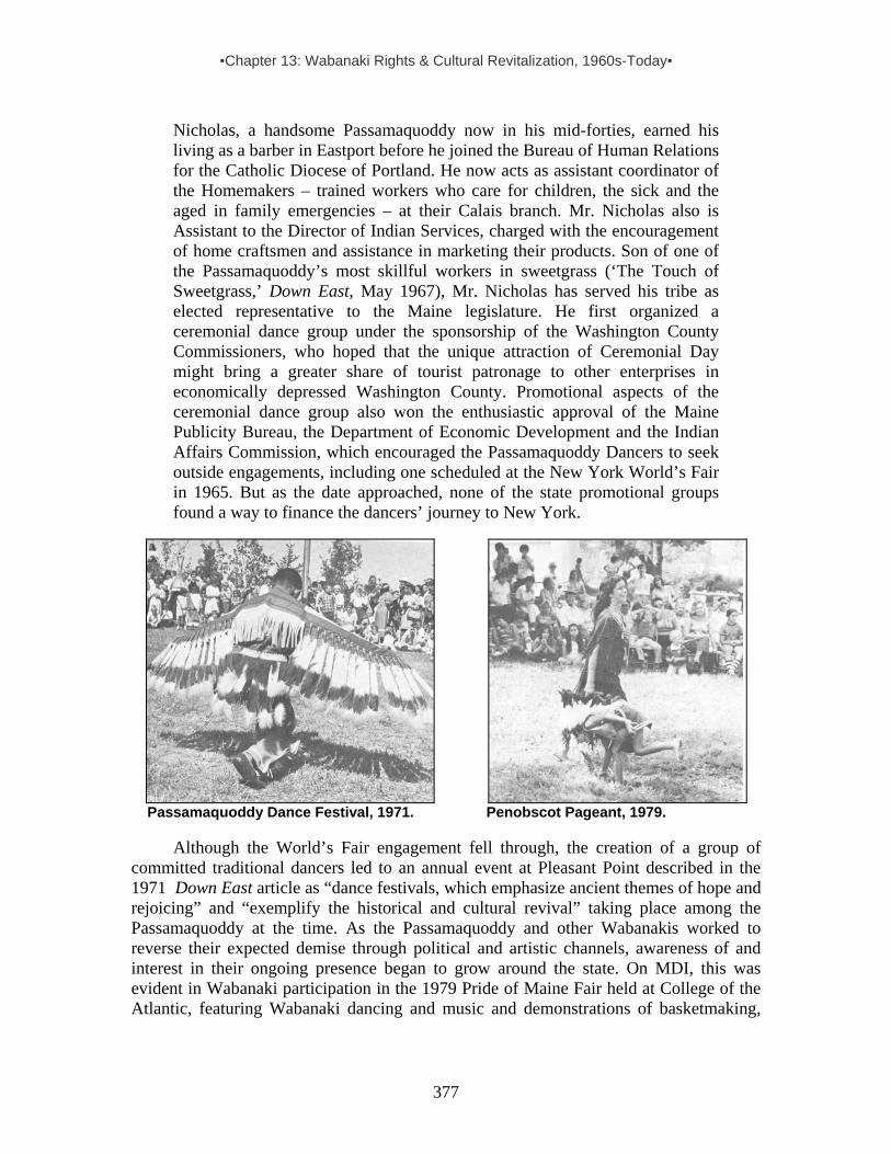
▪Chapter 13: Wabanaki Rights & Cultural Revitalization, 1960s-Today▪
377
Nicholas, a handsome Passamaquoddy now in his mid-forties, earned his living as a barber in Eastport before he joined the Bureau of Human Relations for the Catholic Diocese of Portland. He now acts as assistant coordinator of the Homemakers – trained workers who care for children, the sick and the aged in family emergencies – at their Calais branch. Mr. Nicholas also is Assistant to the Director of Indian Services, charged with the encouragement of home craftsmen and assistance in marketing their products. Son of one of the Passamaquoddy’s most skillful workers in sweetgrass (‘The Touch of Sweetgrass,’ Down East, May 1967), Mr. Nicholas has served his tribe as elected representative to the Maine legislature. He first organized a ceremonial dance group under the sponsorship of the Washington County Commissioners, who hoped that the unique attraction of Ceremonial Day might bring a greater share of tourist patronage to other enterprises in economically depressed Washington County. Promotional aspects of the ceremonial dance group also won the enthusiastic approval of the Maine Publicity Bureau, the Department of Economic Development and the Indian Affairs Commission, which encouraged the Passamaquoddy Dancers to seek outside engagements, including one scheduled at the New York World’s Fair in 1965. But as the date approached, none of the state promotional groups found a way to finance the dancers’ journey to New York.
Passamaquoddy Dance Festival, 1971. Penobscot Pageant, 1979.
Although the World’s Fair engagement fell through, the creation of a group of committed traditional dancers led to an annual event at Pleasant Point described in the 1971 Down East article as “dance festivals, which emphasize ancient themes of hope and rejoicing” and “exemplify the historical and cultural revival” taking place among the Passamaquoddy at the time. As the Passamaquoddy and other Wabanakis worked to reverse their expected demise through political and artistic channels, awareness of and interest in their ongoing presence began to grow around the state. On MDI, this was evident in Wabanaki participation in the 1979 Pride of Maine Fair held at College of the Atlantic, featuring Wabanaki dancing and music and demonstrations of basketmaking,

▪Chapter 13: Wabanaki Rights & Cultural Revitalization, 1960s-Today▪
378
and traditional cooking and medicinal practices.33 That same summer each of Maine’s three reservations also hosted their own pageants. Changes at the Abbe Museum The Abbe’s interest in showcasing the Our Lives in Our Hands basketry exhibit largely created by members of the Aroostook Band of Micmacs reflected a change in attitude that began to emerge during the Native rights movement of the 1970s and continued to gain momentum in the wake of MICSA. It was part of a growing recognition that Wabanaki cultures were not relics of the past, but living, breathing entities whose members had more to offer than basketmaking demonstrations. And with this recognition came a shift toward inclusiveness and collaboration, which has gradually become a hallmark that sets the Abbe apart from most other museums in the state.
In 1986, Penobscot Ted N. Mitchell (b1919) became the first Wabanaki to sit on the Abbe Museum board, although several other Native individuals had been tapped as informal advisors at least since 1980. Having worked at the University of Maine in various capacities since the 1960s – initially dealing with minority issues and ultimately becoming an Associate Dean of Student Services – Mitchell was a mentor for many Wabanaki students who sought higher education through the Indian Scholarship Program within the University of Maine system. Rooted in the traditions of Indian Island, hailing from a family that had frequented MDI for generations, and well-connected to all of the Wabanaki communities in the state, he was well equipped to offer the Abbe a Native perspective concerning programs and exhibits. When Mitchell retired from the board, formal tribal representation continued, and still continues to this day. 34
Aroostook Band of Micmacs President Penobscot John Bear Mitchell, story- Mary Philbrook, 1993 Bar Harbor Native teller/educator.1993 Bar Harbor Native American Festival. (Abbe Museum.) American Festival. (Abbe Museum.)
33 Wabanaki Alliance, Aug. 1979, p.2. Cassette tapes of this event are at the Maine Folklife Center at University of Maine, Orono. 34 Personal communication, Rebecca Cole-Will, (then) Abbe Museum curator, May 2005.

▪Chapter 13: Wabanaki Rights & Cultural Revitalization, 1960s-Today▪
379
In 1989, picking up on the 1979 Pride of Maine Fair held at College of the Atlantic, the Abbe organized the first annual Bar Harbor Native American Festival in cooperation with the tribes – held at the town ballfield, by the old Indian encampment site. In 1990 it was held at the village green, and in 1991 and 1992 in Agamont Park. In 1993 it moved to College of the Atlantic, where it has been held ever since.35 With each passing year, Wabanaki ownership of the festival grew, in large part due to the influence of the Maine Indian Basketmakers Alliance, initiated in 1992. Maine Indian Basketmakers Alliance
In 1992 Penobscot Theresa Secord (pictured left, courtesy of Secord) took her first steps toward organizing the Maine Indian Basketmakers Alliance (MIBA). It was a bold effort, given the independent nature of Maine’s four tribes, not to mention of the basketmakers themselves. But all of the basketmakers had common challenges that Theresa and several others believed might better be met collectively than individually. These ranged from the extremely low market value of baskets to getting their wares to market to locating healthy stands of brown ash trees and sweet grass. In addition, some of the older basketmakers were no longer physically able to go into the woods to get and prepare their own raw materials. And, superseding all of these concerns, it appeared that the craft was slowly
dying out. With all of this in mind, Theresa worked with funding and assistance from the Traditional Arts branch of the Maine Arts Council to organize the first inter-tribal basketmakers meeting in November 1992. Breaking through obstacles of isolationism and pessimism, basketmakers came together and successfully established an alliance that has effectively helped meet the challenges they all faced. The success of MIBA over the last dozen years can be measured in several ways. Numbers tell part of the story:
◘ MIBA’s 50 founding members averaged 63 years in age. Within its first ten years, 17 died, but the number of basketmakers in the alliance grew to 115 and the average age dropped to 43. With a growing number of young people participating, the craft was revitalized.
◘ In its first year MIBA developed its own one-on-one Master/Apprentice basketry training program, taking over the Maine Arts Council program that had sponsored Theresa’s own apprenticeship with the late Madeline Shay. The number of year-long apprenticeships grew annually, reaching 21 in 2002. By that time, MIBA had sponsored some 100 apprenticeships.
35 Personal communication, Julia Clarke, Abbe Museum collections manager, Feb. 2005.

▪Chapter 13: Wabanaki Rights & Cultural Revitalization, 1960s-Today▪
380
◘ Thanks to MIBA’s promotional materials and its highly publicized festivals and workshops, the average market value of baskets made by Native Americans in Maine has increased nearly tenfold, making basketry a viable career option.36
As a full partner with the Abbe Museum in coordinating the annual Native
American Festival in Bar Harbor, MIBA exemplifies the “new Abbe,” which fills a gap in Robert Abbe’s Museum of Stone-age Antiquities by exhibiting an interest in present and future Wabanaki life and culture in addition to that of the past.
There are many other examples of the collaborative spirit that has emerged at the Abbe in the past 25 years. Among the most interesting is the story of Penobscot Watie Akins, who has served the museum in various capacities since the 1990s. Speaking of visits to Bar Harbor as a child in the 1940s, Watie said, “I can recall . . . going to the Abbe Museum and looking at all those dioramas. And I used to love—I used to be fascinated by them and my mother had to come in and drag me away.” Born into a family that played a vital role in keeping traditions alive on Indian Island, Watie’s fascination with displays at the Abbe came from deep roots. His grandmother Philomene Nelson was one of the best and most productive basketmakers on Indian Island. His aunt, Mollydell Nelson Archambaud, professionally known as Molly Spotted Elk, gained international fame as a Native American dancer and actress, and as a child made a point of gathering up old Wabanaki legends, which she later wrote down.37 And his mother, Mildred Nelson Akins, played a vital role in making sure the generations after her knew the traditional dances. Although Watie lived off the reservation for many years, he visited regularly and usually left with baskets. Some he sold, but others he held on to. In time, his collection grew until it took up so much space that he packed up all the baskets in boxes and stored them in his attic. But then something unexpected happened. As he told it:
Every now and then, I don’t know, I’d just get lonely or somethin’ and I’d take ‘em down, open up all my boxes, put all the baskets around me and just sit there. [laugh] Started to get teary-eyed…. [Then,] when I moved [back to Indian Island] I just didn’t have room to display them. And I wanted them displayed. I wanted people to be able to see them. And so I started thinking who could I give my baskets to. I considered several sources in the state of Maine. The way Maine has treated us, I said, no, they’ll never see any of my baskets. I thought about the University of Maine, but…decided against that. And about that time, Theresa had started the Maine Indian Basketmakers Alliance, [which had a relationship with the Abbe]. So I thought maybe this is the place. I’d been to the Abbe enough to know that I liked it. I always liked to go out to Sieur du Monts and see the museum there and walk around their little garden. So I decided I was going to put them down there because Theresa was working with them, and they had started the Indian [Festival] there out at the College of the Atlantic. So I did. So I called them up. I forget who I spoke with originally. But finally, I think, Diane Kopek and Rebecca [Cole-Will] came up with some boxes and they came in and looked at all the baskets and put ‘em in their boxes, and zip they were
36 Based on McBride 2003 interview with Theresa Secord, plus various documents, articles about MIBA. 37 The legends she collected were published in 2003 by the Maine Folklife Center at University of Maine, Orono, under the title Katahdin: Wigwam’s Tales of the Abnaki Tribe. Northeast Folklore XXXVII.
▪Chapter 13: Wabanaki Rights & Cultural Revitalization, 1960s-Today▪
381
gone out of here. And [later] I asked, “How come you did that so fast?” And they said, “We didn’t want you to change your mind!” [laugh] Because it’s funny, once they left, it’s like you’re sitting there and saying, “Wow.” And it just felt so empty inside. Oh, I’ve gotten over that. I know I made the right decision. I know that they’ll treat them well and take care of them. Even now, when I look at the baskets—I gave them 69 baskets—I look at some of them now and I can see some of the little ties loosening up or broken, the splints, and you know. So I probably did it just in time. . . .
After I gave the collection, I started to get involved in the Abbe a little bit. They asked me to get on one of the committees to raise funds for the new Museum – they said that my collection was the one that put them over the edge, that they ran out of space [laugh] and that they needed to have a new Abbe. [laugh]…. Since it was my fault, I joined with ‘em. They used to ask me to go along when they were fund raising. And I had a great time doing that. Went to these different gatherings and said—you know, people, usually summer residents, they had money and beautiful places. It would be nice just to go there in a car. Everybody was always dressed up and everything, you know the way they do in their chinos and their blue blazers and striped ties. And the women all looked very nice. And I just had a good time. . . . [Then] they wanted me to give a little talk about different things…. I did, and people seemed to like it, and they responded well…. And they always had good food. [laugh] You know that’s one of the first things whether you’ll go to a gathering or not. They say would you come down and talk and join us, and I say sure, are they gonna have food there? [laugh]…. The whole thing was just a good experience.
And when they started construction [in 2000]…they realized they probably needed somebody [on hand with knowledge in that area to keep an eye on things.] So because of both my design and construction background they asked me to come down and sort of check it once a week. I went down there [early on when] they probably had about 50-60 feet of footing in place. And I looked at it and I didn’t like it. The bottom of the footing wasn’t prepared properly. The forms weren’t completely aligned. The reinforcement was going every which way. I was trained to do inspection by the Corps of Engineers back in the late 50s and ‘60s.... So I basically condemned it. I said I’m not accepting that. I want it all redone—which they did. I liked that because first of all, it established my authority, and second, it gave us the type of quality that I want to see go into the Abbe. 38
There is one more piece to the Watie Akins’ story: In 2004 a beautiful new exhibit opened at the Abbe, titled “My Grandmother’s Baskets.” Changes at Acadia National Park A noticeable shift has occurred in Wabanaki-Acadia National Park relations in recent years, in particular since the turn of the millennium. Lee Terzis, ANP’s Cultural Resources Program Manager, noted that from “early 2004 to the present, the park has held four formal meetings with leaders and representatives of the Maine tribes, in 38 Watie Akins, Interview by McBride, 2004.

▪Chapter 13: Wabanaki Rights & Cultural Revitalization, 1960s-Today▪
382
addition to numerous ad hoc meetings. We are currently seeking to sign an MOU with the tribes that would provide a general framework for the government-to-government consultation process. Additional collaborative projects/initiatives include: NE Tribal Environmental Training workshops (exotic plant management with Maliseets), joint archeological reconnaissance of some sites in the park (with Penobscots and the Abbe Museum), NPS job fairs (on Maliseet and Micmac reservations). The Penobscots are holding a language immersion program for tribal members at the Schoodic Education and Research Center (SERC), the second year that the tribe has chosen to hold this event there. SERC is one of the 13 designated NPS research and learning centers.”
Also, adds Terzis, “there was the formation of the Wabanaki Advisory Committee, whose members advise the park on matters related to cultural resources. They are asked to review all pertinent park planning documents, e.g., Schoodic General Management Plan/EIS, St. Croix Island Fire Management Plan, Hiking Trails Management Plan, and a host of other minor compliance documents.”39 Among the park’s Wabanaki advisors is Passamaquoddy Tribal Historian Donald Soctomah, who has advised NPS and Parks Canada on numerous issues that relate to St. Croix Island International Historic Site (which is jointly managed by these agencies) and helped both build a stronger relationship with the Passamaquoddy in the US and Canada. Soctomah marks the park’s turn toward collaboration with the tribes to the Clinton administration: “The federal agencies are complying with the Presidential mandate of working with the Tribes. I believe this was put in place during Clinton’s term and reinforced during Bush II’s term.”40 He offered the following list of collaborative efforts between the Wabanakis and ANP:
◘ From 1999-2004 there was a trail project for which the ANP had comments from the tribe concerning places and uses. The tribe also attended meetings to give comments on the completed research. [Historic Hiking Trails of Mount Desert Island Cultural Landscape Report – published in 2006].
◘ Starting in 2000, I began using ANP’s research room for the Place Names project, photo searches and other tribal history research. ◘ From 2002-2004, the tribe worked closely with ANP on the Red Beach site, and the St. Croix Island site. A reburial and forensic study of the French cemetery on St. Croix Island (2003) included historical information on the sites and comments on the statue design and layout. For the St. Croix quadricentennial, marking the 400th anniversary of the meeting of the French explorers and the tribe, much work was completed between ANP and the Tribe in organizing the event. ◘ During 2003-2005 we worked with ANP on the St. Croix/Passamaquoddy educational trunk; this trunk contained many articles about the tribe. (A Passamaquoddy teaching kit - a resource for Maine teachers to help students learn about Wabanaki culture and history as required by LDL291, a newly enacted Maine law that requires the curriculum to include the teaching of Wabanaki history and culture.)
39 Lee Terzis, personal communication, 6/13/05. 40 Personal communication.

▪Chapter 13: Wabanaki Rights & Cultural Revitalization, 1960s-Today▪
383
◘ Since 2002, the Schoodic Education Center (former Navy base) now owned by ANP has been the site of many meetings between the tribes and ANP, discussing use of site and issues such as a MOU for the whole ANP and the Tribes.
◘ Also, the 2004 redesign of the gift shop on the summit of Mt. Cadillac included tribal comments on the installation of a small exhibit on Maine’s indigenous peoples and the inclusion of more tribal crafts.41
Tashina Soctomah (Donald’s Passamaquoddy historian Donald daughter), ANP Visitor Guide, Soctomah, 2004. (Harald Prins.)
2000. (Donald Soctomah.)
Today, the flow of Wabanakis onto Mount Desert Island rivals that of the late 1800s and prehistoric times. In addition to individuals living on the island year round, many others come as tourists or to gather sweetgrass, attend Abbe Museum board meetings and advise on exhibitions. Still others come to perform, give craft demonstrations, or sell work at the annual Native American Festival. Most get there by car, although some avid canoeists still occasionally paddle to the island from their home reservations. Nowadays, the coming and going of Maine’s Native people to MDI is year round, and a head count is all but impossible beyond official recordings of the births/deaths/marriages of those who actually reside on the island.
◘ ◘ ◘ ◘
41 Donald Soctomah, Interview by McBride, 2004, and personal communication 6/13/2005.

▪Chapter 13: Wabanaki Rights & Cultural Revitalization, 1960s-Today▪
384

National Park ServiceU.S. Department of the Interior
Ethnography ProgramNortheast Region
ASTICOU’S ISLAND DOMAIN:WABANAKI PEOPLES AT
MOUNT DESERT ISLAND 1500-2000
ACADIA NATIONAL PARK
ETHNOGRAPHIC OVERVIEW & ASSESSMENT
VOLUME 1
PrinsMcBride
AcadiaNational
Park
Acadia National ParkPO Box 177
Bar Harbor, ME 04609-0177Phone: 207-288-3338
Web: www.nps.gov/acad/
AST
ICO
U’SISL
AN
DD
OM
AIN
,VO
L.1Asticou's Island Domain Volume 1 cover - 2nd printing 01-2008:volume 1 cover.qxp 1/24/2008 9:44 AM Page 1


![Grana acalculia 2006[1]NPS](https://static.fdokumen.com/doc/165x107/6313b81efc260b71020f3816/grana-acalculia-20061nps.jpg)