Cultural landscape report for Adams birthplaces - NPS History
256
National Park Service U.S. Department of the Interior CULTURAL LANDSCAPE REPORT FOR ADAMS BIRTHPLACES ADAMS NATIONAL HISTORICAL PARK
-
Upload
khangminh22 -
Category
Documents
-
view
3 -
download
0
Transcript of Cultural landscape report for Adams birthplaces - NPS History

National Park ServiceU.S. Department of the Interior
Cultural landsCape report
for adams BirthplaCes adams national historiCal park


“We have the finest Season here
that I have know for many
years...the corn looks well, Hay
will be plenty...”
Abigail Adams,
letter to John Adams,
July 10, 1777
Cultural landsCape report
for adams BirthplaCes
adams national historiCal park
QuinCy, massaChusetts
site history
existing Conditions
analysis and evaluation
treatment
Prepared by
Kirsten Holder, Historcal Landscape Architect
James Bertolini, Conservation Associate
Jaime R. Young, Conservation Associate
Olmsted Center for Landscape Preservation
National Park Service, Boston, Massachusetts, 2014

Cultural landsCape report for adams BirthplaCes
ii
The Olmsted Center for Landscape Preservation promotes the stewardship of
significant landscapes through research, planning, and sustainable preservation
maintenance. The Center accomplishes its mission in collaboration with a
network of partners including national parks, universities, government agencies,
and private nonprofit organizations. Techniques and principles of preservation
practice are made available through training and publications. The Olmsted
Center perpetuates the tradition of the Olmsted firm’s and Frederick Law
Olmsted’s lifelong commitment to people, parks, and public spaces.
Olmsted Center for Landscape Preservation Boston National Historical Park Charlestown Navy Yard, Quarters C Boston, MA 02129 www.nps.gov/oclp/
National Park Service Denver Service Center: ADAM 386 126557, PMIS 97516
Library of Congress Cataloging-in-Publication Data
Holder, Kirsten.
Cultural landscape report for Adams birthplaces, Adams National Historical Park,
Quincy, Massachusetts : site history, existing conditions, analysis and evaluation,
treatment / prepared by Kirsten Holder, Historical Landscape Architect, James
Bertolini, Conservation Associate, Jaime R. Young, Conservation Associate.
pages cm
Includes bibliographical references.
1. Adams National Historical Park (Quincy, Mass.) 2. Adams, John,
1735-1826--Homes and haunts--Massachusetts--Quincy. 3. Adams, John Quincy,
1767-1848--Homes and haunts--Massachusetts--Quincy. 4. Historic house
museums--Conservation and restoration--Massachusetts--Quincy. 5. Cultural
landscapes--Massachusetts--Quincy. 6. Quincy (Mass.)--Buildings, structures,
etc. 7. Adams family. I. Bertolini, James. II. Young, Jaime R. (Conservation
Associate) III. Olmsted Center for Landscape Preservation (U.S.) IV. Title.F74.Q7H65 2014974.4’7--dc23 2014037049
Publication Credits: Graphics may not be reproduced without the permission
of the owners noted in the captions. Other information in this publication may
be copied and used with the condition that full credit is given to the authors and
publisher. Appropriate citations and bibliographic credits should be made for
each use.
Cover Photo: The John Adams birthplace (left) and John Quincy Adams
birthplace (right), view looking southeast (Olmsted Center for Landscape
Preservation, hereafter OCLP, November 2011).
Title Page: John Quincy Adams birthplace with John Adams birthplace partially
visible in background, view looking north, 1910. (Historic New England).

Table of ConTenTs
iii
Table of ConTenTs
LIST OF ILLUSTRATIONS v
FOREWORD ix
ACKNOWLEDGMENTS xi
INTRODUCTION 1
Purpose, Scope, and Methodology 2
Summary of Findings 3
SITE HISTORY 9
Early History to 1720 9
Deacon John Adams through John Adams, 1720–1803 25
John Quincy Adams, 1803–1848 43
Charles Francis Adams, 1848–86 57
Adams Real Estate Trust, 1886–1940 71
City of Quincy, 1940–1979 97
National Park Service, 1979–2014 109
EXISTING CONDITIONS 133
Landscape Context 133
Park Operations 136
Landscape Characteristics and Features 138
ANALYSIS AND EVALUATION 147
National Register Status 147
Evaluation of Landscape Integrity 153
Analysis of Landscape Characteristics and Features 157
TREATMENT 185
Treatment Framework 186
Treatment Objectives and Tasks 195
Treatment Implementation 227
REFERENCES 233

Cultural landsCape report for adams BirthplaCes
iv

List of iLLustrations
v
lisT of illusTraTions
FIGURES
INTRODUCTION
0.1 Location of Adams National Historical Park within Quincy 1
SITE HISTORY
1.1 Map by John Winthrop, 1633 13
1.2 Map by Mostyn John Armstrong showing Boston area, 1775 33
1.3 Map by John Groves Hales, 1819 showing Quincy area 44
1.4 Watercolor sketch of Adams birthplaces, 1822 46
1.5 Drawing of Adams birthplaces, c. 1828 48
1.6 Map by John Groves Hales, 1833 showing Quincy area 49
1.7 Drawing of Adams birthplaces, c. 1828 50
1.8 Photograph of John Adams birthplace and adjacent barn, c. 1845 50
1.9 Map of Boston area, 1849 showing early railroad lines 51
1.10 Painting by G. N. Frankenstein of Adams birthplaces, 1850 58
1.11 Engraving of the Adams birthplaces, 1852 59
1.12 Map by H.F. Walling, 1857 of the Town of Quincy 60
1.13 Map by H. F. Walling, 1866 showing Penns Hill and the birthplaces 61
1.14 Map of Dorchester and Quincy by W. Simons, 1868 61
1.15 Map of Southern Quincy, 1876 showing Adams farm and birthplaces 62
1.16 Aerial perspective map of Quincy by Edwin Whitefield, 1877 62
1.17 Sketch of the Adams birthplaces by Edwin Whitefield, c. 1879 63
1.18 Photograph of John Adams birthplace, c. 1880 64
1.19 Adams birthplaces, c. 1885 64
1.20 Adams birthplaces, c. 1885 64
1.21 John Quincy Adams birthplace, c. 1885 65
1.22 John Adams birthplace, c. 1885 65
1.23 Map of the Town of Quincy, 1888 72
1.24 Adams birthplaces, c. 1890 73
1.25 Adams birthplaces, c. 1890 73
1.26 John Adams birthplaces, c. 1890 74
1.27 Panoramic photograph of Quincy and the Blue Hills, c. 1892 74
1.28 Map by T. H. Whitman, c. 1894 75
1.29 John Quincy Adams birthplace, 1897 76
1.30 John Quincy Adams birthplace, 1897 76

Cultural landsCape report for adams BirthplaCes
vi
1.31 Well and John Adams birthplace, c. 1899 76
1.32 Well and John Adams birthplace, c. 1899 76
1.33 Adams birthplaces, c. 1899 77
1.34 Adams birthplaces, c. 1900 78
1.35 John Quincy Adams birthplace, c. 1900 78
1.36 Map of City of Quincy by Ernest W. Branch, 1907 79
1.37 Adams birthplaces, c. 1905 79
1.38 Adams birthplaces, c. 1910 80
1.39 Adams birthplaces, c. 1910 80
1.40 Adams birthplaces, c. 1910 81
1.41 John Adams birthplace and well, c. 1910 81
1.42 John Adams birthplace, c. 1910 81
1.43 John Adams birthplace, c. 1910 82
1.44 John Adams birthplace, c. 1910 82
1.45 Adams birthplaces, c. 1914 82
1.46 John Adams birthplace, c. 1914 83
1.47 Adams birthplaces, c. 1914 83
1.48 Adams birthplaces, c. 1914 83
1.49 Map of South Quincy, 1924 84
1.50 Adams birthplaces, 1924 85
1.51 John Adams birthplace, 1929 86
1.52 John Adams birthplace, 1929 86
1.53 Adams birthplaces, 1929 87
1.54 John Quincy Adams birthplace, 1929 87
1.55 John Adams birthplace, c. 1930 88
1.56 John Adams birthplace, c. 1930 88
1.57 John Adams birthplace, 1930 89
1.58 John Quincy Adams birthplace, 1930 89
1.59 Plan of Adams birthplaces, 1936 90
1.60 John Adams birthplace, 1941 90
1.61 John Quincy Adams birthplace, 1941 91
1.62 Adams birthplaces, c. 1975 99
1.63 National Park Service ceremony, Adams birthplaces lawn, 1979 100
1.64 National Park Service ceremony, Adams birthplaces lawn, 1979 101
1.65 Adams birthplaces, c. 1979 101
1.66 Adams birthplaces, c. 1979 102
1.67 Adams birthplaces, 1979 102
1.68 Adams birthplaces, 1979 102
1.69 Plan of Adams birthplaces, 1979 103
1.70 John Adams birthplace, 1980 110
1.71 John Adams birthplace, 1980 110
1.72 John Adams birthplace, 1980 111

List of iLLustrations
vii
1.73 Adams birthplaces, 1980 111
1.74 John Quincy Adams birthplace, 1980 111
1.75 Adams birthplaces, 1985 112
1.76 John Adams birthplace, c. 1995 112
1.77 John Adams birthplace, c. 1995 113
1.78 John Adams birthplace, c. 1995 113
1.79 John Adams birthplace, c. 1995 113
1.80 John Quincy Adams birthplace, c. 1995 114
1.81 Adams birthplaces, c. 1995 114
1.82 Adams birthplaces, c. 1995 114
1.83 Norway maple removal and pruning at Adams birthplaces, 2010 115
1.84 Norway maple removal and pruning at Adams birthplaces, 2010 115
1.85 Tree inspection at Adams birthplaces, 2010 116
1.86 Kwanzan cherries blooming along Franklin Street, 2010 116
1.87 Sign, north lawn area, and John Adams birthplace, 2010 116
1.88 Adams birthplaces special exhibit, 2010 117
EXISTING CONDITIONS
2.1 View north from Penn’s Hill summit toward Boston and Abigail Adams Cairn, 2013
134
2.2 View west from Penn’s Hill summit toward Pine Hill and the Blue Hills, with Abigail Adams Cairn, 2013
134
2.3 View north from Penn’s Hill summit toward Adams birthplaces, obscured by houses, 2013
135
2.4 View west from lawn area north of John Quincy Adams birthplace of well and neighboring commerical and residential development, 2013
135
2.5 View northeast of north lawn area at Adams birthplaces, 2013 135
2.6 View east from lawn area south of John Quincy Adams birthplace of intersection, 2013
137
2.7 View northwest from Franklin Street of intersection south of John Quincy Adams birthplace, 2013
137
2.8 View southwest of Independence Avenue from south of John Quincy Adams birthplace, 2013
137
2.9 View northwest of Franklin Street, trolley stop, and birthplaces, 2013 138
2.10 View northeast of north lawn area and mature trees, 2013 139
2.11 View northeast of John Adams birthplace framed by shade trees, 2013 141
2.12 View southeast of rear entry of John Quincy Adams birthplace, stone wall, and lawn, 2013
141
2.13 View northeast of flagstone path to John Adams birthplace, 2013 141
2.14 View southwest of Kwanzan cherry trees along Franklin Street, 2013 142
2.15 View northwest of Adams birthplaces, 2013 142
2.16 View southeast of fence and wall surrounding birthplaces, 2013 142
2.17 View north of law office entry at John Quincy Adams birthplace, 2013 143
2.18 View northwest of park sign at southwest corner of property, 2013 143

Cultural landsCape report for adams BirthplaCes
viii
TREATMENT
4.1 Trolley stop location on Franklin Street 196
4.2 Photo-simulation of new park entrance on Franklin Street 196
4.3 Trolley stop location on Presidents Avenue 197
4.4 Photo-simulation of new park entrance on Presidents Avenue 197
4.5 Watercolor of birthplaces landscape, 1822 198
4.6 Lithograph of birthplaces landscape, 1877 198
4.7 Realignment of Franklin Street at intersection 199
4.8 Photo-simulation of enlarged John Quincy Adams house front yard 199
4.9 Photo-simulation of new trolley stop on Franklin Street 200
4.10 Existing flagstone path to John Adams birthplace 201
4.11 Photo-simulation of stonedust path to John Adams birthplace 201
4.12 Specification for compacted crushed stone or stonedust path 203
4.13 Section and plan for existing John Adams birthplace entry 204
4.14 Section and plans for proposed John Adams birthplace entry 205
4.15 Existing conditions at John Adams birthplace 206
4.16 Photo-simulation of John Adams birthplace stonedust path 206
4.17 Photo-simulation of permanent ramp at John Adams birthplace 206
4.18 Rear entry at John Adams birthplace 207
4.19 Portable ramp with permanent railings 207
4.20 Portable ramp with collapsible railing 207
4.21 Portable ramp with no railing 207
4.22 Photo-simulation of stonedust path to John Quincy Adams door 208
4.23 Section and plan for existing John Quincy Adams birthplace entry 208
4.24 Section and plans for proposed John Quincy Adams birthplace entry 208
4.25 Photo-simulation of ramp at John Quincy Adams door 210
4.26 Photo-simulation of more graded gradual path and ramp to door 210
4.27 Photo-simulation of ramp with retaining curbs on either side of walk 210
4.28 Existing Norway maples in fair and poor condition 212
4.29 Photo-simulation of healthy trees along Presidents Avenue 212
4.30 Photograph of tree south of John Quincy Adams birthplace, c. 1910 213
4.31 View of south of John Quincy Adams birthplace, 2013 213
4.32 Existing Kwanzan cherries along Franklin Street 214
4.33 Photo-simulation of elms along Franklin Street 214
4.34 Diagram of the Adams Birthplaces Local Historic District 215
4.35 Existing mature white pines along north property line 216
4.36 Photo-simulation of young evergreens along north property line 216
4.37 Photograph of shrubs in front of John Adams birthplace, c. 1930 217
4.38 Plan of vegetation on birthplaces property, 1936 217
4.39 Garden display beds at Minute Man National Historical Park 218
4.40 Plan showing five alternative sites for a shelter 219
4.41 Photo-simulation of small shelter location, alternative #1 220

List of iLLustrations
ix
4.42 Photo-simulation of larger shelter alternative, location #1 220
4.43 Photo-simulation of view looking north of larger shelter, location #1 221
4.44 Photo-simulation of small shelter, location #2 221
4.45 Photo-simulation of small shelter, location #3 222
4.46 Photo-simulation of small shelter, location #4 222
4.47 Photo-simulation of small shelter, location #5 222
4.48 Diagram of board fence for north property line 223
4.49 Historic photograph of stone wall, 1897 224
4.50 Existing condition of stone wall, 2013 224
4.51 Photo-simulation of repaired stone wall 224
4.52 Diagram showing walking route to Penn’s Hill 225
4.53 Photo-simulation of new benches at the Adams birthplaces 226
DRAWINGS
SITE HISTORY
1.1 Early History to 1720 Penn’s Hill Context Period Plan 21
1.2 Early History to 1720 Birthplaces Period Plan 23
1.3 1720–1803 Penn’s Hill Context Period Plan 39
1.4 1720–1803 Birthplaces Period Plan 41
1.5 1803–1848 Penn’s Hill Context Period Plan 53
1.6 1803–1848 Birthplaces Period Plan 55
1.7 1848–1886 Penn’s Hill Context Period Plan 67
1.8 1848–1886 Birthplaces Period Plan 69
1.9 1886–1940 Penn’s Hill Context Period Plan 93
1.10 1886–1940 Birthplaces Period Plan 95
1.11 1940–1979 Penn’s Hill Context Period Plan 105
1.12 1940–1979 Birthplaces Period Plan 107
1.13 1979–2014 Penn’s Hill Context Period Plan 119
1.14 1979–2014 Birthplaces Period Plan 121
EXISTING CONDITIONS
2.1 2014 Existing Conditions Birthplaces 145
ANALYSIS AND EVALUATION
3.1 Analysis and Evaluation, Birthplaces 183
TREATMENT
4.1 Treatment Tasks 231
Cultural landsCape report for adams BirthplaCes
x
TABLES
ANALYSIS AND EVALUATION
3.1 Landscape Characteristics and Features Summary 167
TREATMENT
4.1 Treatment Philosophy for the Adams Birthplaces Landscape 190
4.2 Treatment Tasks for Adams Birthplaces 227
4.3 Landscape Treatment Tasks and FMSS Hierarchy 229

Foreword
xi
foreword
The history of the Adams family is tightly woven into the fabric of our country
and that of Quincy, Massachusetts, where two United States Presidents were born
and raised. For John Adams, his farm and family were of foremost importance,
“My Mind has been running, chiefly upon my Farm and its Inhabitants and
Furniture, and my Horses, Oxen, Cows, Swine, Walls, Fences etc. I have in several
late Rambles very particularly traced, and pursued every Swamp and Spring upon
the North Side of Penn’s Hill from its Source to its Outlet.” Similarly, for his wife
Abigail, their farm was a source of strength, “Having learnt the virtue and the
Art, To live on little with a cheerful Heart.” Passing their dedication to farming to
their son, John Quincy Adams wrote to his wife Louisa Catherine, “My farming
advances slowly . . . and next Spring I hope you come and take a taste of farming
too.” Now surrounded by less than an acre of open land, the birthplaces retain
their integrity as the nucleus of a working farm during the founding of the nation.
The Adamses used and appreciated every aspect of their working farm. Whether
harvesting apples, planting trees, building stone walls, or tending cows, the
working landscape was an important part of family life for multiple generations of
the Adams family, in addition to their dedication to careers in government, civic
virtue, and patriotism.
This cultural landscape report documents in detail both the evolution of the
places that John Adams and his son John Quincy Adams called home during
the American Revolution as well as the larger Penn’s Hill farm once owned by
multiple generations of the Adams family. The report identifies the defining
landscape characteristics to be preserved and enhanced for the enjoyment
and education of present and future generations of visitors. Building upon
the guidance set forth in the park’s General Management Plan, the cultural
landscape report also recognizes that the birthplaces attract thousands of visitors
annually, and that the landscape requires some rehabilitation to improve the park
experience for all visitors. Ranging from accessible walkways and trolley access,
to shade and pedestrian safety improvements, the cultural landscape report
offers treatment recommendations that strengthen the site’s historic preservation
mandate while leveraging opportunities to improve the experience for all visitors.
The authors call attention to the need for a visitor contact station and shelter to
orient groups and provide restrooms, a critical need also identified in the park’s
General Management Plan. The park seeks to acquire an adjacent parcel on a
willing-buyer/willing-seller basis. An adjacent parcel would also enable the park

Cultural landsCape report for adams BirthplaCes
xii
to better interpret the bucolic setting that once surrounded the homes in what is
now the heart of Quincy.
The cultural landscape report is a valuable tool for the park as we look forward
to the three-hundredth anniversary of the construction of the birthplaces and
the one-hundredth anniversary of the National Park Service. I thank the talented
team at the Olmsted Center for Landscape Preservation for their quality work in
producing this report, as well as the site staff and many professionals at historical
societies and libraries who assisted the team. The report will benefit the Adams
National Historical Park for many years to come.
Marianne Peak
Superintendent
Adams National Historical Park
Acknowledgments
xiii
aCknowledgmenTs
This report reflects a collaborative effort between Adams National Historical Park
and the Olmsted Center for Landscape Preservation. At the Adams National
Historical Park, the authors would like to extend a special thanks to Marianne
Peak, Superintendent; Caroline Keinath, Deputy Superintendent; Kelly Cobble,
Curator, Karen Yourell, Supervisory Park Ranger; Kevin Kelly, Facility Manager;
Robert Mackenzie, Gardener; Richard Shaner, Brian Egan, Carole Waite,
and Joseph McGlaughlin, Visitor Services staff; Bruce Beck and Chris Blood,
Maintenance staff; and Patty Smith, Museum Technician.
Many people at local repositories assisted with locating materials including James
Fahey, Director of the Braintree Historic Society Museum and Research Center;
staff at the Norman B. Leventhal Map Center at the Boston Public Library;
Jeanne Gamble, Library and Archives Specialist at Historic New England; Anna
Cook, Reference Librarian at the Massachusetts Historical Society; Mary Clark,
Reference Librarian at the Thomas Crane Public Library in Quincy; staff at the
Boston Athenaeum; and Edward Fitzgerald, PhD, Executive Director of the
Quincy Historical Society.
At the Olmsted Center, Kirsten Holder, Historical Landscape Architect, served
as the primary author. Conservation Associates Jim Bertolini and Jaime Young
contributed to the report. ‘Designing the Parks’ intern Ashley Braquet also
assisted with the historic period plans, maps, and treatment chapter of the report.
Bob Page, Director, and Margie Coffin Brown, Senior Project Manager, provided
overall project guidance.

Cultural landsCape report for adams BirthplaCes
xiv

IntroductIon
1
Figure 0.1. Location map showing the
sites within Adams National Historical
Park. The Adams birthplaces are
located to the south of the Old House
at Peace field and the park visitor
center (Olmsted Center for Landscape
Preservation, hereafter OCLP).
IntroductIon
The Adams birthplaces are part of the Adams National Historical Park within the
City of Quincy in Norfolk County, Massachusetts, approximately eight miles south
of Boston. A vestige of the former 200-acre Penn’s Hill farmstead once owned
by the Adams family, the birthplaces stand on adjacent parcels at the intersection
of Franklin Street and Presidents Avenue, one mile south of Quincy Center.
The distinctive saltbox homes are surrounded by a maintained lawn with stone
walls, wooden fences, shade trees, and ornamental shrubs, all of which create
a park-like setting in a dense suburban neighborhood of mixed residential and
commercial buildings. The birthplaces are two of several sites within the fourteen-
acre park including the Peace field property with the Old House, the Beale estate,
and associated sites in Quincy Center including the United First Parish Church,
Hancock Cemetery, and park visitor center (Figure 0.1). The park’s purpose is

Cultural landsCape report for adams BirthplaCes
2
to preserve and protect the landscapes, homes, and personal property of four
generations of the Adams family, and to interpret the history these resources
represent to educate and inspire current and future generations.
The oldest presidential birthplaces and among the oldest homes in the country,
the two saltbox buildings are listed on the National Register of Historic Places
and designated National Historic Landmarks. John Adams, second President of
the United States, was born in 1735 in the house that his father purchased in 1720.
John Quincy Adams, sixth President, was born in 1767 in the neighboring home
that his father inherited in 1761. John Adams used the old kitchen of this home
as his law office beginning in 1764 and drafted his Thoughts on Government in
1776. These writings lay the foundation of the Massachusetts Constitution, which
he drafted in his law office in 1779, and was later used as a model for the Federal
Constitution in 1787. John’s wife, Abigail Smith managed their farm during the
American Revolution and described the events on the home front in her diary
and letters. The homes remained in the Adams family for over 200 years and were
formally opened to public visitation in 1897.
Recent documentaries and publications have contributed to a resurgence of
interest in the Adams family and greatly increased the number of park visitors
coming to the birthplaces to learn more about the Adamses and their family
farm. A General Management Plan for the park (National Park Service, 1996)
puts forth a vision for the birthplace properties to enhance visitor experiences
and educational opportunities. To better understand the site and enhancement
opportunities for its historic landscape characteristics and features, this report
describes the evolution of the entire Penn’s Hill farm as well as an in-depth
examination of the landscape surrounding the two birthplaces.
PROJECT SCOPE AND METHODOLOGY
A cultural landscape report is the primary document used by the National
Park Service to inform long-term management and treatment decisions for its
historically significant landscapes. The report follows the approach defined in
the Guide to Cultural Landscape Reports: Contents, Process, and Techniques (NPS,
1998). This report for the Adams birthplaces cultural landscape is organized
into four chapters: site history, existing conditions, analysis and evaluation,
and treatment. The first chapter includes a detailed history of the landowners
and evolution of the Penn’s Hill farm and built features. The second chapter
documents the existing conditions of the birthplaces landscape in 2013. The third
chapter contains an analysis and evaluation of the significance and integrity of the
birthplaces landscape using the criteria established by the National Register of
Historic Places. The final treatment chapter provides guidance for the long-term
management of the landscape.

IntroductIon
3
Research for this report has been undertaken at a thorough level of investigation,
which includes review of all available historic resources including both primary
and secondary sources. Primary source materials included letters, diary entries,
maps, and photographs from the collections of the Adams National Historical
Park archives, Quincy Historical Society, Thomas Crane Public Library in Quincy,
Boston Public Library, Massachusetts Historical Society, Boston Athenaeum,
Braintree Historic Society, and Historic New England. A wealth of secondary
source material exists through the work of several researchers over the years
relating to the character and history of the Adams birthplaces and the Penn’s Hill
farm. Sources included family and regional histories by Charles Francis Adams
and Henry Adams, the draft Historic Structures Report (Perrault, 1993), Historic
Furnishings Report (Racine, 2001), New Area Study for the Birthplaces (NPS, 1978),
National Register documents (1975), and the park’s General Management Plan
(NPS, 1996). These reports, and many others, provide landscape context, describe
extant features, document the landscape’s significance, and provide a framework
for the treatment approach and recommendations.
SUMMARY OF FINDINGS
OVERVIEW OF SITE HISTORY
The first chapter, site history, is organized into seven sections that correspond with
distinct periods in the development of the birthplaces landscape from the area’s
pre-contact history to present. Each section describes key developments, uses,
patterns, features, and important individuals and events related to the changes
in the landscape. The site history is accompanied by historic photographs, maps,
diagrams, and period plans that illustrate the condition of the landscape at the end
of each historical period.
The first section covers the early history of the region, when members of the
Massachusetts confederation of Native Americans occupied the Quincy area
prior to the arrival of European settlers in the early 1600s. The Massachusett
primarily relied on farming along the local waterways and in low-lying areas.
The parcel of land that would later become the Adams farmstead was situated
along the Plymouth Road, also known as the Country Road and the Plymouth
Turnpike, between the North and South Commons. Homesteaders, including the
Needham, Belcher, and Penniman families, established clusters of homes along the
Plymouth Road and delineated outlying agricultural fields with fences and walls.
William Needham acquired twenty acres in 1639. In about 1675, Needham sold
his property to Joseph Penniman, who possibly built a home in 1681, then passed
the property to his son, James Penniman in 1705. James Penniman likely rebuilt the
house between 1710 and 1720. To the south, Gregory Belcher received fifty-two
acres around 1639 and passed the property to his son, Samuel Belcher in 1663. The

Cultural landsCape report for adams BirthplaCes
4
Belchers built a home around 1663, but the structure was rebuilt in about 1716.
The second section of the site history covers the first period of Adams ownership
of the future birthplaces. During this period the population of Braintree swelled as
shipbuilding and fishing industries flourished along the coastline. Further inland,
small businesses relied on local streams for water power to process grains and
manufacture goods. In 1720 Deacon John Adams purchased six acres from James
Penniman, which included an orchard, barn, and house. Here he and his wife
Susanna Boylston raised three sons, the eldest, John Adams, was born in the house
in 1735. Deacon John Adams also purchased the adjacent home and property to
the south in 1744, which was subsequently the birthplace of his grandson, John
Quincy Adams.
Young John Adams aspired to become a farmer, but his parents preferred that he
study law. Graduating from Harvard in 1755, John divided his time between his
family farm and his emerging profession as a lawyer, writer, and orator. Following
his father’s death in 1761, his mother resided in the birthplace home and John
inherited a portion of his father’s landholdings, including the adjacent home and
approximately forty acres. In 1764, John married Abigail Smith and they resided
in the home and raised four children, including the eldest, John Quincy Adams,
who was born in 1767. During the American Revolution, John Adams served in
the Continental Congress in Philadelphia while Abigail managed the farm and
raised the children. John’s political career resulted in lengthy absences during
which he and Abigail provided advice and support for each other through their
extensive correspondence. In 1787, two years before becoming the country’s first
Vice President, John and Abigail purchased the former Vassall-Borland estate in
Braintree, yet retained the Penn’s Hill farm property. Adams served as the nation’s
second President from 1797 to 1801. Throughout the late 1700s and early 1800s,
the Adamses increased their landholdings in Braintree, a portion of which became
Quincy in 1792.
The third section of the site history covers the ownership of the birthplaces by
John Quincy Adams who, like his father, maintained a life-long connection with
the Penn’s Hill farm and birthplace homes. He purchased the farm from his father
in 1803, which at that time consisted of approximately one hundred acres, three
houses, three barns, five woodlots, two pasture lots, and a salt marsh. After his
childhood years, he returned to his birthplace home with his wife Louisa and their
children during the summers of 1805 and 1806. Thereafter, the house was leased
to tenant farmers. John Quincy Adams’ political career drew him to Europe and
Washington, D. C. in his later years, including his term as U.S. President from 1825
to 1829, hence property management was passed to their youngest son, Charles
Francis Adams. When John Quincy Adams and Louisa returned for short periods
to Quincy, they spent most of their time at their Mount Wollaston farm, which
encompassed over 600 acres in North Quincy in the area known as Merrymount.

IntroductIon
5
John Quincy Adams left an enduring signature on the Quincy landscape by
planting numerous shade trees on his properties, some of which are still standing.
The fourth section spans the ownership of Charles Francis Adams, who inherited
the 200-acre Penn’s Hill farm, birthplaces, and associated farm buildings and
the Mount Wollaston farm upon his father’s death in 1848, and retained the
properties and continued farm operations. He leased the farm to several tenant
families, including Charles Spear, who made major improvements to the farmland
to increase hay production and raised dairy cows. Many other farms disappeared
in Quincy, as the population more than doubled during the late 1800s due to the
growing boot, shoe, quarry, and ship building industries and the rail line, which
allowed Quincy to serve as a suburb of Boston.
The fifth section describes major changes to the Adams land holdings following
the death of Charles Francis Adams in 1886, when his heirs transferred ownership
of his properties to the Adams Real Estate Trust and sold most of the Penn’s
Hill farm to residential developers, retaining only a .34-acre parcel with the
birthplaces. Recognizing the significance of the Adams family as Quincy natives
and nationally significant figures, the City established the Quincy Historical
Society in 1893 and appointed Charles Francis Adams, Jr. as its first president.
The society restored the John Quincy Adams house to an earlier appearance and
rehabilitated the landscape to create a commemorative setting for the historic
home. Next door, the Adams Chapter of the Society of the Daughters of the
Revolution managed and rehabilitated the John Adams birthplace. The two
properties received new turf, a stone wall, reconstructed well, post and rail fence,
turnstile, trees, shrubs, vines, and a flagpole. Both homes opened to the public in
1897. For the next forty years the sites remained relatively unchanged, while the
City of Quincy grew at a fast pace due to the proliferation of jobs, housing, and
automobiles.
The sixth section describes changes to the birthplaces when the City of Quincy
acquired the .34-acre property in 1940 and funded capital improvements and
maintenance for the buildings while the two local organizations continued to
manage public programs. The Daughters of the Revolution managed the John
Adams birthplace until 1950, when they passed their responsibilities to the
Quincy Historical Society. The City purchased two adjacent house lots situated
to the north of the John Adams birthplace in the 1950s and removed the houses,
enlarging the commemorative site from .34 to .72 acre and expanding the
setting for the houses. In the 1960s the properties were listed in the National
Register and as National Historic Landmarks. By the mid-1970s, the sites
received approximately 9,400 visitors a year. With the national recognition of
the significance of the birthplaces and the fiscal burden on the city, the Quincy
Historical Society lobbied for the transfer to the National Park Service, which had
been managing the nearby Adams Peace field property since 1946.

Cultural landsCape report for adams BirthplaCes
6
The final section of the site history chronicles the most recent period of
development, when the City of Quincy gifted the property to the National Park
Service in 1979. For the next four years the park service restored the interiors
of the buildings to reflect the John Adams and John Quincy Adams period of
ownership, reopening them to the public in 1984. The park service carried out
minor changes in the landscape based on research recommendations in the 1979
Historic American Building Survey and the 1993 draft Historic Structures Report.
The City of Quincy also completed alterations to the landscape surrounding the
property, installing Kwanzan cherry street trees in the early 1990s and replacing
the Franklin Street sidewalk in 2012. The birthplaces property now receives
approximately 120,000 visitors a year, and thousands of people pass by the site
each day on the busy Franklin Street.
EXISTING CONDITIONS
The existing conditions chapter documents the appearance of the landscape in
2013 through narrative and graphics. It is based upon field inventory, the most
recent site survey and plans, and geographic information system (GIS) data. The
chapter describes the landscape context for the birthplaces, adjoining properties,
park operations, and the .72-acre park property. Characteristics and features
documented include spatial organization, circulation, vegetation, buildings and
structures, views and vistas, small-scale features, and archeological sites.
ANALYSIS AND EVALUATION
The analysis and evaluation chapter reviews the National Register of Historic
Places and National Historic Landmark documentation for the John Adams and
John Quincy Adams birthplaces. The documentation is limited and does not
ascribe a specific period of significance. Areas of significance include Criterion A
for architecture and politics/government, Criterion B for association with the lives
of individuals significant in our past, and Criterion C for locally significant early
colonial saltbox homes.
Based on the findings of this cultural landscape report, the authors recommend
updating the National Register documentation to provide greater detail and clarity
on the areas of significance, contributing resources, and significant landscape
features. The authors recommend highlighting the roles of both the Presidents
and the First Lady Abigail Adams, as well as the family’s role in the historic
preservation movement in the late 1800s and early 1900s.
IntroductIon
7
TREATMENT
Management direction related to the treatment of the Adams birthplaces is
articulated in the park’s 1996 General Management Plan. The plan specifies that
the birthplaces will be a locus for interactive programs that convey the story of
seventeenth and eighteenth century life, where visitors of all ages can learn about
duty, responsibility, and education and can participate in activities highlighting the
home life of the Adamses and the skills they used to fulfill their obligations and
maintain their close family. While the home interiors have been restored to reflect
the Adamses occupation, the site reflects the later commemorative period of the
late 1800s and 1900s, when the family and local groups created a park-like setting
for the homes, initiated their restoration, and opened them for public viewing and
education.
As detailed in the treatment chapter, the Adams birthplaces landscape will be
rehabilitated to reflect its appearance at the time that the Adams Real Estate
Trust passed the property to the City of Quincy in 1940, while also allowing for
ongoing use as an educational public property. The landscape retains a high
level of historical integrity to the late 1890s when the Quincy Historical Society
and Daughters of the Revolution installed a commemorative landscape, while
the homes reflect their 1700s appearance, when they were occupied by the
John, Abigail, and John Quincy Adams. Rehabilitation is the primary treatment
approach for the landscape because it enables the park to repair and replace
deteriorated and missing features, while simultaneously allowing compatible
alterations and new additions to facilitate its continued use as a commemorative
site. A rehabilitation approach will allow the park to maintain fences along the
current property edges, add durable walkways to facilitate movement through
the landscape, add screen plantings and fencing along the northern edge of
the property, and create opportunities for visitor engagement and comfort in
a sheltered setting. The report also incorporates a prioritized implementation
strategy that integrates current Facility Management Software System (FMSS)
data.
RECOMMENDATIONS FOR FURTHER RESEARCH
During the research phase of the cultural landscape report, the team hoped to find
detailed information about the domestic landscape surrounding the homes during
the 1700s. While the team found information about plant species, no specific
drawings or photographs captured the physical location of a kitchen garden
associated with either home. Further research of the Adams Family papers and
tenant records may reveal more information about the kitchen gardens.

Cultural landsCape report for adams BirthplaCes
8

Site HiStory
9
Site HiStory
This chapter details the evolution of the Adams birthplaces landscape. The history
is organized into seven time periods, beginning with the pre-contact landscape
and extending up to the present. The focus is on the landscape within the current
birthplaces property but the site history also addresses the full extent of the Penn’s
Hill farm landholdings.
EARLY HISTORY TO 1720
The first period includes the geological processes that formed the hills and
valleys, the use of the area by Native Americans, and the arrival of European
settlers. This period extends into the colonial period, when the Town of Boston
issued land grants along the South Shore, and through the earliest landowners,
Needham and Ellis. The period ends in 1720 with the two colonists, Penniman
and Belcher, who owned the future birthplaces of John Adams and John Quincy
Adams. The record of early landscape characteristics for the birthplaces prior to
1720 is limited. Though deeds exist from the some of the first settlers in what was
the North Precinct of Braintree, their land use activities lack concise descriptions.
Consequently, much of the following narrative synthesizes the few period sources,
including the History of Braintree, Massachusetts (1639-1708) and The North
Precinct of Braintree (1708-1792) by Charles Francis Adams in 1891, as well as
contextual descriptions of the New England environment and its agriculture in the
pre-contact and early colonial period.
PRE-CONTACT HISTORY
Quincy lays at the southern edge of the geologic and physiographic area known
as the Boston Basin. The receding North American Laurentide ice sheet formed
ground moraines, terminal moraines, and drumlins about 12,000 years ago.1 Spruce
(Picea sp.) forests covered most of the Boston Basin 11,000 years ago, and by 9,000
years ago the land was dominated by pine (Pinus sp.) forests. By 8,000 years ago the
forests contained oak (Quercus sp.) and other hardwoods. A warming climate and
melting ice increased the sea level, flooding the basin and isolating high points in
Boston Harbor. As the glaciers retreated north, the Charles, Mystic, and Neponset
Rivers formed within the Boston Basin. In the Quincy area, drumlins punctuated
the sandy outwash plains and ground moraines, while low points retained tidal
marshes and inland swamps and ponds.2

Cultural landsCape report for adams BirthplaCes
10
Prior to Euro-American settlement, the Massachusett tribe of Native Americans
inhabited the coastal area within the Boston Basin. The Massachusett relied
on agriculture for the majority of their food, complimenting this with hunting,
fishing, and gathering of nuts and berries from the surrounding region. Along the
tributaries of what became Quincy’s Town River, the Massachusett cleared fertile
lowlands for crops, planted corn mounds with bean and squash varieties, and
moved their farming settlements every few years as they depleted the soils.3
The forests were dominated by oak but also included chestnut (Castanea sp.),
maple (Acer sp.), and hickory (Carya sp.).4 The Massachusett frequently burned
upland areas and created patches of meadow to attract game. They also removed
underbrush for easy travel and hunting, which led to the dominance of fire-
resistant trees like the oak and chestnut. In wet bottom lands such as the areas
along Fresh Brook and the Town River, fires were less frequent, resulting in a
forest with dense thickets and stands of red maple (Acer rubrum), American beech
(Fagus grandifolia), ash (Fraxinus sp.), and alder (Alnus sp.). An early New England
writer described the tribal land management practices: “for it being the custome
of the Indians to burne the wood in November, when the grasse is withered, and
leaves dryed, it consumes all the underwood, and rubbish, which otherwise would
over grow the Country, making it unpassable, and spoile their much affected
hunting.” Wet areas, protected from the fires, were a tangle of underbrush. This
fluctuating mosaic of forest, meadow, and cropland persisted until the arrival of
Europeans in the late sixteenth century.5
Accounts of early European exploration along the New England coast
describe encounters with tribes that lived in the coastal areas. In 1602, Captain
Bartholomew Gosnold made the first attempt to settle in New England, where
his recorder John Brereton noted “five Indians, in a barke-shallop with mast and
saile, an iron grapple, and a kettle of copper, came boldly aboard us...” and several
additional encounters, though none hostile.6 Over the next decade, Europeans
recorded contact with the local tribes, including Martin Pring in 1603, George
Weymouth, and Samuel Champlain in 1605, and John Smith and Thomas Hunt
in 1614. The earliest accounts refer to large numbers of Indians inhabiting the
coast of New England, especially around Massachusetts Bay. John Smith counted
forty considerable settlements from the Penobscot River to Cape Cod, and often
mentioned cleared corn fields.7
Between 1616 and 1618, Native Americans were devastated by an epidemic of
European disease that swept through the coastal region. The disease, introduced
by the early European expeditions, killed an estimated one to two thirds of the
native population in New England, with local death rates of the Massachusett
tribe as high as ninety percent.8 When the Pilgrims arrived in Plymouth in 1620,
they described deserted villages, empty houses, and abandoned agricultural fields
lying fallow.9

Site HiStory
11
COLONIAL SETTLEMENT AND LAND GRANTS
The landscape of the future Penn’s Hill farm of John Adams transitioned quickly
after the founding of the Plymouth Colony in 1620 to the southeast and the
Massachusetts Bay Colony in 1628 in the present-day city of Boston to the north.
Early explorers such as Captain Wollaston established trading posts among the
surviving Massachusett Indians, including one at Passonagessit in 1625, near what
is now called ‘Merry Mount.’10 In 1635, the Boston General Court made efforts to
purchase the land from the Massachusett tribe but “had some trouble in buying
up the rights…of the Indians.”11 Puritan colonists began actively converting the
greatly diminished population of Native Americans at praying towns that were
established throughout New England, including Ponkapoag near the Blue Hills
and Herring Pond in Plymouth. The colonization of New England effectively
removed the Native Americans of present-day Quincy into Christian communities
by 1700. In their wake came new Euro-American settlers who attempted to
reorder the New World in the model of the old, all the while adapting to their new
environment.12
During the 1630s the town of Boston received a large influx of English immigrants,
requiring the colony to expand. In 1634 the General Court noted that Boston
was “too small to contain many,” that those living there were “constrained to
take farms in the country,” and could find “convenient enlargement at Mount
Wollaston.”13 A survey by Governor John Winthrop carried out in the previous
year depicts the waterways to the south of Boston and an early overland route to
the Plymouth Colony (Figure 1.1). In 1634, Mount Wollaston incorporated as part
of the town of Boston and a ferry was established across the Neponset River.14 In
this year, William Wood wrote about his travels in the Massachusetts Bay area and
shared his own views of the newly-established settlement. He described Mount
Wollaston as a place with “a very fertile soil, and a place very convenient for
farmers’ houses, there being great store of plain ground without trees. Near this
place is Massachusetts Fields, where the greatest sagamore in the country lived
before the plague, who caused it to be cleared himself. The greatest inconvenience
is that there are not very many springs, as in other places of the country, yet water
may be had for digging. A second inconvenience is that boats cannot come in at a
low water, nor ships ride near the shore.”15
An “enlargement” of 365 acres of land in Mount Wollaston was initially granted
to Reverend John Wilson. Further land grants followed in 1636 and 1637, and
most of the Mount Wollaston bay-front passed to Atherton Hough, William
Coddington, and Edmund Quincy.16 Later that year, Reverend John Wheelwright
received 250 acres adjacent to Wilson and established the first meeting house for
the settlement.17 Following these large land grants or “Great Lotts” the General
Court issued many smaller lots to “the common people” as they continued
to arrive from England. Generally allotments consisted of four acres per an

Cultural landsCape report for adams BirthplaCes
12
individual. By the time Braintree was incorporated in 1640, 105 allotments had
been parceled out to 565 people, though not all were residing in the community.18
During the initial colonization of Mount Wollaston and later Braintree, Fresh
Brook and the Town River influenced settlement patterns, with the marshes of
Fresh Brook carving between Pine and Penn’s Hill to the east and west and the
area known as ‘the Rock’ to the north. The marshes surrounding the brook were
“rich ground” that brought “plenty of hay, of which the cattle feed and like as if
they were fed with the best upland hay in New England.”19 Such rich grasslands
grew “commonly between the marshes and the woods,” joined in the valley
west of Penn’s Hill by an expansive open area named Captain’s Plain by its first
settlers. Plains such as this were dry sandy lowlands above the marshes with
grass growing “as high as a man’s middle, some as high as the shoulders,” which
provided “coarse fodder” for cattle.20 To the southwest was a prominent knob
known as Pine Hill, dominated by red cedar. To the east, Penn’s Hill (alternately
called Payne’s Hill) received its name from William Penn, a local landowner
who established part of his homestead on its slopes. As water from Fresh Brook
collected behind Richard Wright’s dam, it created the mill pond, a swampy loop
of meadow at the north end of Captain’s Plain that surrounded the Island, a rise
that split Fresh Brook into two forks before it rejoined at the mill dam. From here,
water in the brook flowed north and east until emptying into the Town River
by present-day Quincy Center. It is likely that the marshes along Fresh Brook
extended from the salt marshes along the sea inland past what became the Adams
birthplaces. Swamps were extensive, being “ten, some twenty, some thirty miles
long, being preserved by the wetness of the soil wherein they grow.”21 Above the
plain and meadows, the landscape transitioned into rocky upland and forest.”22
Due to the isolation of the land grants, a church or meeting house and a school
house were integral to each settlement. Reverend Wheelwright is credited with
erecting the first meeting house near a small bridge and possibly near the Town
River, but its exact location is unknown. The Church of Braintree formed in
1639, and was the fifteenth to be established in the Massachusetts Bay Colony.23
The following year, the community of Braintree incorporated, separating itself
from Boston and establishing authority over land presently in Quincy, Braintree,
Randolph, and Holbrook.24 By 1647, the General Court ordered the establishment
of schoolhouses in every township.25 Braintree, however, did not establish a
schoolhouse until 1697, when a one-room structure was built below Penn’s Hill
on what would become part of the Adams farm.26
In 1646 the town of Braintree established iron works along Furnace Brook
near the future Adams property known as Peace field.27 Iron was one of the few
essential building products that was not already available in the Massachusetts Bay
Colony. A substantial amount of timber was needed to sustain the furnace, and by
1653 the operation was too expensive and went bankrupt. Charles Francis Adams

Site HiStory
13
Figure 1.1. Copy of a map prepared by John Winthrop in 1633 showing the Boston area including the rivers and brooks and
the highway to Plymouth, the precursor of the Country Highway. Annotations by the authors indicate the location of the
Adams birthplaces site, the Blue Hills, and Boston. Courtesy of the private collection of Roy Winkelman, from the Florida
Center for Instructional Technology, ect.usf.edu/maps/8527.
Blue Hills
Way to Plymouth
Boston
x Future Birthplaces

Cultural landsCape report for adams BirthplaCes
14
later remarked that the company failed as “every pound of iron made cost more
than two pounds imported from Europe.”28
Initially the Mount Wollaston settlers relied on boats rather than roads to
reach Boston. As the settlers pressed inwards and grew in number, roads and
river crossings became a necessity. The colony’s General Court ordered the
construction of the “Country Highway” from Boston to Plymouth, built by
the labor of those along it, to connect colonies by way of Braintree.29 Upon its
completion in 1648, the road passed by the meeting house at a ford in the Town
River. While sections of the road had to cut across wet areas with a tangle of
underbrush that “swarmed with reptile life,” the route generally traversed higher
ground and areas cleared by homesteaders.30 It was common practice to plant
shade trees along highways and roads in the Massachusetts Bay area, meaning
that indigenous trees probably lined the Country Road as it passed by the farms
near Penn’s Hill.31 Though passable, the road remained a rough route for several
decades. Residents of South Braintree complained in 1695 that it was difficult to
travel to the meeting house and “very irksome, especially in winter, to come so far
as most of them came to meeting, and through such bad ways, whereby the Lord’s
day, which is a day of rest, was to them a day of labor rather.”32
Though it is not clear precisely when Braintree established its commons, the
North Commons, South Commons, and ministerial lands totaling 1,500 acres
had been set aside by the end of the 1640s.33 Covering much of the upland from
present day Adams Street south to near Fresh Brook’s headwaters, the North
Commons was a rocky pasture that provided timber and grazing land west of the
Country Road. The South Commons lay east of the road and covered most of the
Penn’s Hill upland with open, rocky woodland and at least two springs feeding
streams that flowed off the hill’s northern and western slopes.34 The commons
provided valuable resources such as stone, timber, thatch, and pasture and in 1646
the town of Braintree passed a vote “authorizing legal inhabitants to take timber
off the commons for any use in the town.”35
SETTLEMENT OF FRESH BROOK AND PENN’S HILL AREA
Most early farmers in what later became Quincy received large parcels of land
along the coast and along waterways such as Fresh Brook which offered fertile,
easily plowed, and well-watered land.36 Among the first grants made along
the Fresh Brook was for a mill to process grains. As millers were a rarity in the
colonies, towns frequently offered prime land and a monopoly on milling to
attract a specialist. In February 1640, Richard Wright received from the town of
Boston “a narrow piece of land lying at Mount Wollaston between the Rocks and
the Fresh brooke,” at which he established a small grist mill.37 Wright received the
land and a portion of the grain he milled in return for operating what was, in many
respects, a public service. Lying adjacent to lands that would become part of the

Site HiStory
15
Adams’ family farm, the transfer describes the land given to Wright as a meadow
“situated on both sides of the Fresh Brook” that was “undoubtedly good mowing
land.”38 The low flow rate of Fresh Brook compelled Wright to construct a dam
that created “Mill Pond,” a marsh on the west end of Wright’s land. The pond
allowed Wright to control the flow of the brook and store enough water power to
grind when needed (Drawing 1.1).
NEEDHAM AND ELLIS-BELCHER HOMESTEADS, MID 1600S
The same year, other settlers joined Wright, establishing farms upstream. Gregory
Baxter and Deacon Samuel Bass received grants west of the brook on land known
as the Captain’s Plain. William Needham received twenty acres located directly
south of Wright’s grant along the brook. Needham’s grant would later pass to
Deacon John Adams, the home of which became the John Adams birthplace. To
the south of Needham, William Ellis (or Allis) received a grant of fifty-two acres
upon which he built a house, the site of which became the John Quincy Adams
birthplace.39 The date of Ellis’ grant is not known, and an “Ellis” or “Allis” does
not appear on William Pattee’s list of homesteaders that arrived in the 1630s and
40s.40 It is likely that Ellis purchased the parcel from one of the original settlers
sometime around 1650 (see Drawing 1.1).
Records indicate that Ellis constructed a residence (the future John Quincy
Adams birthplace) around 1660, possibly accompanied by several outbuildings.41
However, also in 1660, Ellis sold his farmstead to Gregory Belcher for reasons
unknown. The deed transferred “one dwelling house situate in Braintree [illeg.]
with the Barnes buildings cowhowses stables shops & outhowses orchyards
gardins and seventene acres of land…the Comon Roadway leading to Waymouth
running through the middle thereof.”42 Like most early colonial farms, the
farmstead included several outbuildings devoted to specialized tasks, which may
have included meat-curing to cider-making, and were clustered near the farm
house.43 Small gardens likely grew adjacent to the house that were fertilized with
fish and manure and fenced in to keep livestock out. Irregularly-spaced apple tree
orchards provided fodder for livestock and crop for cider.44 These homesteads
filled the valley area known collectively as the mill pond and the Captain’s Plain
and passed frequently to newcomers or family members. In 1663, Gregory Belcher
passed the former Ellis farm to his son Samuel.45
Alongside Fresh Brook and on the western edge of the Needham and Belcher
farms, lowland meadows provided grass for haying and pasturing cattle. These
meadows were optimal for farming and drew colonists away from concentrated
settlements near the coast to inland farms along the Neponset River and upstream
along Fresh Brook toward what became Braintree.46 Though native marsh grasses
provided nutritious fodder for livestock during the summer, feed during the
winter was nearly impossible to find, requiring storage of surplus feed and the

Cultural landsCape report for adams BirthplaCes
16
limitation of herd sizes. Initially farmers preserved meadow and salt marsh lots
and excluded livestock so the grasses could be cut and cured for winter storage.47
However, both accidental and intentional importation of Eurasian grass varieties
transformed the grasslands and meadows of New England, leading to marked
changes in the pastures of Needham and Ellis. By 1650, the Massachusetts Bay
Colony actively imported “Herd’s grass” or timothy, a perennial bluegrass.
‘English Grass,” a mixture of this import with white clover, began thriving along
the tidewater settlements including those in the area that became eastern Quincy.
The arrival of these new grasses shifted the meadows of the New England
colonies toward one that was more familiar and nutritious for European livestock.
It also provided the new and struggling colonies with a boost to their subsistence,
as English grasses remained green into December, long after American grasses had
browned for the winter.48 The success of these grasses allowed the pasturing of
livestock and meat and dairy production that defined Braintree and later Quincy
until the late 1800s.
While early settlers clustered together to share resources including pastureland,
the clearing of plots and cultivation of English grass allowed Needham and
Belcher, and those who followed them, to successfully farm in terrain that
normally would have yielded little pasture for livestock.49 Despite their success,
most family stock herds remained at a dozen animals or less into the eighteenth
century. Though cattle were initially the predominant livestock, sheep became an
important commodity by the end of the 1660s.50
In the upland fields, the first North Braintree farmers grew wheat, maize, and
other grains. Marginal areas were used for woodlots, orchards, and to pasture
livestock, while vegetable plots and assorted fruit trees were placed closer to
the homesteads.51 In the eighteenth and nineteenth centuries, common orchard
practice dictated that trees be spaced “three or four rods apart so the roots of one
rarely crossed those of another. After the trees matured, most farmers pastured
cattle among them.”52 Cattle frequently browsed on low-hanging branches
creating a ‘browse-line’ of clear trunks up to six feet on the tree.53 Though all fruit
trees with the exception of plums were European imports, by the 1650s Boston
area farmers began to incorporate the American Roxbury Russet variety into their
orchards. Cherry tree imports flourished in New World orchards to the point that
by 1700, they were considered a weed in some communities. Quince trees also
proved ubiquitous in early colonial orchards but declined in popularity by the
1800s.54
Homesteaders such as Needham, Ellis, and Belcher brought with them a new
kind of agriculture rooted in permanent settlement. Where the Native Americans
rotated through farming sites every few years as the soil’s nutrients gave out,
New England colonists expected homesteads to sustain a family for generations.
Permanent agriculture required a change in practice from the slash-and-burn

Site HiStory
17
style of the natives to a fertilizer-based agriculture for the colonists. Manure,
fish remains, seaweed, and potash all supplied nitrogen and other nutrients
for soils that normally would have become barren after more than a few years
of agricultural use. To fill land adjacent to the new homesteads, New England
farmers grew maize for similar reasons as had the Native Americans before them:
it grew well in poorly plowed, half-cleared fields which were plentiful in the
hilly farmlands of coastal Massachusetts. Furthermore, it fertilized well with the
remains of alewives, fish that migrated up streams like Fresh Brook, requiring little
transport.55
English grains such as wheat, rye, and barley performed better in the fields of New
Jersey, New York, and Pennsylvania, and few areas in Massachusetts outside the
Connecticut River valley had the soils and terrain to sustain large-scale English
grain production. Braintree famers began sowing grains in the seventeenth
century, but by the eighteenth century, they faced the introduction of blight
and black-stem rust. These diseases, combined with the inability to compete
economically with larger western farms, crippled their capacity to produce English
grains. Consequently, North Braintree farmers adopted crops and techniques
more suitable for smaller farms with smaller fields. They grew corn in mounds and
continued to plant beans and squash alongside these, resembling the gardens of
the Native Americans more than European crop fields. Most fields were only an
acre or two, plowed by horse in the spring or autumn but tilled by hand through
most of the summer. The tillage and the importation of English crops also brought
English weeds such as Couch grass and Saint-John’s-wort that competed with
food crops and invaded pastures.56
Deeds reveal that North Braintree farmers fenced their small fields as early as
the 1660s. An influx of immigrants following the end of the English Civil War
compelled many freeholders to press for more lands farther inland, increasing the
population of Braintree in areas south and west of Penn’s Valley and increasing
the need for clear property boundaries.57 In 1668, as the mill property to the
north of Needham’s land changed hands, the deed between Jonathan Gatlin and
John Holbrook mentions that the mill was “within a common fence, bounded
with the said fence and pond toward the north.”58 It is likely that the properties
of Needham and Ellis were also bounded and perhaps divided by wooden fences
by this time.59 By 1672, part of the mill property transferred to Moses Fields who
built a dwelling house on six acres north of Needham’s grant.60 Many of the
earliest fences, used mostly to keep free-range livestock out of crop fields and
gardens, would have been a collection of markers, both natural landmarks and
wooden stakes to mark the boundary. After the grants of 1640, Ellis and Needham
would have progressively established more permanent fencing to delineate their
property lines. The lack of stones and abundant timber meant that the first fences
would have been wood, either closely-spaced pales or stakes combined with short
lines of piled rocks.61 Once Needham and Ellis established their farmsteads, they

Cultural landsCape report for adams BirthplaCes
18
probably built wooden split-rail fences. As fields were cultivated and soils eroded,
farmers moved exposed stones to boundary walls.
Late in the seventeenth century, Braintree developed into two concentrated
communities to the east and southwest of Penn’s Hill, with the Penn’s Valley
farms in between. By 1696, Ship Cove along what is now the Quincy shoreline
established a shipwright that contributed small vessels to the coastal trading fleets
of Massachusetts.62 In October of 1697, the town government elected to build
the school house between the two Braintree communities, “between Clement
Cox his house and Gregory Belchers, hard by the white oak tree,” placing it
across the road and only a few hundred feet from what became the John Adams
birthplace.63 Farther to the north, in what is now Quincy Center, Benjamin Webb
established the first tannery for the community, which later attracted boot and
shoe businesses to the town.64 The development of North Braintree compelled the
community to establish two precincts of governance, splitting off Penn’s Valley
and the Mount Wollaston area into the north precinct in 1708.65
PENNIMAN AND BELCHER HOMESTEADS, LATE 1600S AND EARLY 1700S
Amid King Philip’s War in 1675, the landowners of North Braintree began selling
their lots in Penn’s Valley to newcomers to the area. That year, William Needham
sold his homestead, which included about seven acres of farm land and the
house, to Joseph Penniman. The deed transferred “all houses, outhouses, gardens,
orchards, yards, fences, and trees,” on the lot (the future John Adams birthplace).66
Needham sold the remaining thirteen acres to Theophilus Curtis, William Vesey,
and Gregory Belcher. Penniman also purchased about nine or ten acres from
William Savil to the north on what had been the mill property. Sometime after,
Penniman added houses to both properties. Penniman subsequently leased the
Needham property to a newcomer, physician Leonard Hoar of Boston.67
To the south of Penniman’s lot, the Belcher family continued to develop the fifty-
two acre farm formerly homesteaded by William Ellis. Upon Samuel Belcher’s
death in 1679, the farm, including a “Dwelling house Barn Orchard & Land
adjoining,” passed to his brother, Deacon Gregory Belcher.68 Deacon Gregory
likely added a two-story, two-room wide, one-room deep house with a large
central chimney.69 An inventory of the property the following year listed a dwelling
house, barn, orchard, and land with a value of £160. The Belchers expanded their
house in 1716, constructing what became the John Quincy Adams birthplace.70
In 1705, Joseph Penniman passed away and his wife, Sarah, and his sons Moses
and James inherited his Braintree land holdings. Sarah received the homestead,
though it appears James became the property’s steward. Between 1710 to 1720,
James Penniman constructed a new home at the farm, either to replace the old
or add to it, creating what is considered to be the John Adams birthplace.71 Two

Site HiStory
19
years later, Penniman added a lean-to onto the rear of the house. In 1720, James
Penniman sold his property to Deacon John Adams, the father of John Adams.
The deed transferred
a certaine Peice or Parcel of Land in Braintree afores’d, containing six acres (be it more or less) being orchard & arrable Land, adjacent to the Country Road, Situate in the North Precinct of Braintree afores’d. Bounded Eastwardly on the afores’d Road, Northwardly on the lands of Moses Curtiss, Southward mostly on the lands of Dec. Gregory Belchor…together with a Dwelling House, Barn and Well thereon…72
The Penniman’s neighbors to the north on the west side of the Country Road
were Moses Curtis, and further north, William and Amy Vesey. The Veseys
indentured a portion of their farm to Peter Webb in 1706, the compact of which
described the tract as “20 acres of land, arrable, meadow and swampy land
[counted?] in the old mill field” at the back of their lot, providing access to it by
way of a road over the mill dam.73 Deacon John Adams later purchased about five
acres from John Vesey that lay west of his property, extending the Adams tract to
Fresh Brook. The addition included “Fresh meadow” and “upland…situated in
the ‘Old Mill Pond’ so-called.”74
LANDSCAPE SUMMARY, 1720
In 1720, as illustrated in Drawings 1.1 and 1.2, the Penn’s Hill farm contained
about fifty-two acres owned by the Belcher family and six acres owned by the
Penniman family. The open landscape included agricultural fields, pastures,
meadows, swamps, and woodlots with a few houses dispersed along the Country
Road. The rural farming area between the north and south precincts of Braintree,
known as Penn’s Valley, supported around a dozen families, including the Adams,
Belchers, Veseys, Paynes, and Pennimans. The Penniman and Belcher properties
lay between the road to the east and Fresh Brook to the west. To the east of the
homes and across the road were several tracts of orchards and fields owned by the
Veseys and Belchers.75
Circulation in South Quincy included the Country Road, which ran adjacent to
the birthplaces, and the Boston-Plymouth Highway, which lay east of the Country
Road. Other roads around the Penn’s Hill farm included the road to the mill,
which connected the Country Road to the Mill and the ‘Way to 600 acres’ (Granite
Street), which ran along the North Common. The John Adams birthplace, owned
by the Pennimans, was a two-room wide, one-room deep, hall-and-parlor plan
house with a partial lean-to at the rear (or north side) of the house.76 A barn likely
stood south west of the house and several outbuildings may have stood clustered
near the house. The John Quincy Adams birthplace, owned by the Belcher family,
was a two-story, two-room wide, one-room deep house with a chimney. A barn
likely stood to the south west of the house. The Braintree schoolhouse was across
the road, and north from the John Adams birthplace. Vegetation around the

Cultural landsCape report for adams BirthplaCes
20
birthplaces likely included vegetable gardens near the homes, orchards and crop
fields farther west, and pastures and meadows near Fresh Brook. A white oak tree
likely grew across the road from the John Adams birthplace.
From the top of Penn’s Hill, views likely extended toward the Braintree shoreline
and north to Boston. Views from the birthplaces into the surrounding fields were
open as Native Americans and settlers cleared most of the forested areas. These
views extended to the neighboring homes and farms and past the surrounding
hills. Small-scale features included post-and-rail fences that marked property
lines, surrounded livestock, and divided pastures. A well stood to the west of the
John Quincy Adams birthplace, which may have been shared by the two families.

National Park Service
Olmsted Center for Landscape Preservation
SOURCES
DRAWN BY
NOTES
Kirsten Holder, AutoCAD 2013 and Illustrator CS5
OLMSTED
for LANDSCAPE PRESERVATION
CENTER
www.nps.gov/oclp
1. All features shown in approximate scale and location.
2. Plan shows conditions in 2013.
1. City of Quincy, 2011
2. Aerial photograph, 2012
3. Site visit November, 2013
4. Lawrence D. Gall, 1981
5. Quincy Historical Society, Ezekiel C. Sargent Quincy
Land Records Collection
0’ 400’ 800’ 1600’
LEGEND
Existing roads
Roads
Creek
Stone wall
Existing building
10 Feet contour10 ft
Adams birthplaces
Property lines
Historic property lines
Cultural Landscape Report
BirthplacesAdams National Historical ParkQuincy, MA
Existing railroad
Town of Boston to Richard Wright, 1640
Moses Penniman, 1706
Town of Boston to William Needham, c.1639
Orchard and crop fields owned by the Veseys and Belchers
Town of Boston to William Ellis, c.1650,Ellis to Gregory Belcher, 1660,
Belcher to Samuel Belcher, 1663,Belcher to Deacon Gregory Belcher, 1679
Gregory Belcher home, 1660,Samuel Belcher, 1663,
Deacon Gregory Belcher, 1679,expanded 1716
Early History to 1720
William Needham to Joseph Penniman, 1675,Penniman to James Penniman, 1705
Fresh Brook
Fresh B
roo
k
Fresh BrookWilliam Needham to William Vesey, 1675, Vesey to Peter Webb, 1706
William Needham to T. Curtis, 1675Curtis to Moses Curtis
PENN’S HILL
PINE HILL
ROCK COMMONS
NORTH COMMON
COUNTRY ROAD TO PLYMOUTH, 1641COUNTRY ROAD TO PLYMOUTH, 1641
WAY
THRO
UGH THE
COM
MO
N, 166
0
Needham home, c.1640Penniman home, 1675, rebuilt, 1705, 1710
WAY TO 600 ACRES, 1640
School house, 1697and white oak tree, 1697
Drawing 1.1
See Drawing 1.2
John Vesey toDeacon Gregory Belcher,
1727
Deacon Gregory Belcher to Nathaniel Belcher, 1727,Belcher to Joseph Field, 1761
Deacon Gregory Belcher to Samuel Belcher, 1727,Belcher to Joseph Field, 1761
Joseph Adams to Deacon John Adams, 1731, Adams to Peter Boyleston Adams, 1761, Adams to John Adams, 1774
Joseph Adams toDeacon John Adams, 1731
Deacon John Adams to John Adams, 1761
Samuel Payne to Deacon John Adams, 1733,Adams to Peter Boyleston Adams, 1761,Adams to John Adams, 1774
Moses Babcock to Abigail Adams, 1783
Deacon Gregory Belcher to Gregory Belcher Jr., 1727, Belcher to Abigail Bracket Belcher, 1728Belcher to Lewis Vassal, 1742, Vassal to John and Richard Billings, 1743, Billings to Deacon John Adams, 1744,Adams to John Adams, 1761
Moses Payne to Deacon John Adams, 1733Adams to Peter Boyleston Adams, 1761, Adams to John Adams, 1803
Josiah Crosby toJohn Adams, 1765
Elkanah Thayer to John Adams, 1793
Town of Braintree toJohn Adams, 1765
Town of Braintree to Peter Boyleston Adams, 1765,Adams to John Adams, 1774
Elijah Veazie to John Adams, 1803
Ann Savil to John Adams, 1770
Town of BraintreeJohn Adams, 1765
James Thayer toJohn Adams, 1785
Joseph Field and Peter Boylston Adams to John Adams, 1771
Ann Savil to John Adams, 1770
Joseph Palmer toJohn Adams, 1771
Joseph Field house, 1771
Joseph Palmer to John Adams, 1771
Fresh Brook
Post and elm placed by Deacon John Adams, 1731
James Penniman to Deacon John Adams, 1720Deacon John Adams to Peter Boyleston Adams, 1761,Adams to John Adams, 1774
Moses Curtis to John Vesey, 1721, William and Amy Vesey to
John Adams, 1788Tompson Baxter to John Adams, 1771
Mill
Deacon John Adams, through John Adams, 1720–1803
Joseph Palmer corn house and well, 1771
Marsh
Orchard
Garden
Cow Yard
Apple orchard
Potatoes
Corn
Vesey house and farm, 1762See Drawing 1.4
Drawing 1.3
COUNTRY ROAD TO PLYMOUTH COUNTRY ROAD TO PLYMOUTH
Fresh Brook
Fresh Brook
PENN’S HILL
PINE HILL
ROCK COMMONS
NORTH COMMON
John Adams to Town of Quincy, 1822
John Quincy Adams to Town of Quincy, 1803
John Adams to John Quincy Adams, 1803
John Adams to John Quincy Adams,
1803
John Adams to John Quincy Adams,
1803
John Adams to John Quincy Adams,
1803
John Adams to John Quincy Adams, 1803
John Adams to John Quincy Adams, 1803
John Adams to John Quincy Adams,
1803
John Adams to John Quincy Adams, 1803
John Adams to John Quincy Adams, 1803
John Quincy Adams to Nathaniel White, 1827
John Adams to John Quincy Adams, 1803
John Adams to John Quincy Adams, 1803
John Adams to John Quincy Adams, 1803
John Adams to John Quincy Adams, 1803
John Adams to John Quincy Adams, 1803
John Adams to John Quincy Adams, 1803
John Quincy Adams to Samuel Curtis, 1829
John Quincy Adams to Benjamin Crane, 1836
Joseph Field
Joseph Field
Belcher?Fresh Brook
John Quincy Adams, 1803–1848
Drawing 1.5
COUNTRY ROAD TO PLYMOUTH COUNTRY ROAD TO PLYMOUTH
See Drawing 1.6
PENN’S HILL
PINE HILL
Charles Francis Adams,1848–86
INDEPENDENCE AVENUE (1865)
PRESIDENTS AVENUE (C.1885)
QU
ARR
Y ST
REET
(188
4)
John Quincy Adams to Charles Francis Adams,
1848
John Quincy Adams to Charles Francis Adams,
1848
Charles Francis Adams,date unknown
John Quincy Adams to Charles Francis Adams,
1848
John Quincy Adams to Charles Francis Adams,
1848
Drawing 1.7
FRANKLIN
AVEN
UE
FRANKLIN AVENUE
WASHINGTON STREET
PHIPPS STREET (1874)
See Drawing 1.8
PENN’S HILL
PINE HILL
Qu
incy
Brain
tree
Adams Real Estate Trust,1886–1940
Adams Real Estate Trust,
1907
Charles Francis Adams to Adams Real Estate Trust,
1886
Adams Chapter of the Society of theDaughters of the Revolution installs cairn
Charles Francis Adams to Adams Real Estate Trust,
1886
Charles Francis Adams to Adams Real Estate Trust,
1886
Drawing 1.9
See Drawing 1.10
PENN’S HILL
PINE HILL
QUINCY CENTER
City of Quincy,1940–79
Adams Real Estate Trust to City of Quincy, 1940Adams Birthplaces
Craig and McCausland families to City of Quincy, 1956-57
MBTAQuincy Adams Station
MBTAQuincy Center
MBTA Red Line
Drawing 1.11
See Drawing 1.12
PENN’S HILL
PINE HILL
QUINCY CENTER
Cairn for Abigail Adams and John Quincy Adams
National Park ServiceUnited First Parish Church
City of Quincy to National Park Service, 1979
Adams Birthplaces
MBTAQuincy Adams Station
MBTAQuincy Center
MBTA Red Line
National Park Service, 1979–Present
Drawing 1.13
See Drawing 1.14
PENN’S HILL
PINE HILL
QUINCY CENTER
Cairn for Abigail Adams and John Quincy Adams
National Park ServiceUnited First Parish Church
National Park ServiceAdams Birthplaces
MBTAQuincy Adams Station
MBTAQuincy Center
MBTA Red Line
Existing Conditions
Drawing 2.1
See Drawing 2.2
PENN’S HILL
QUINCY CENTER
PINE HILL
Cairn for Abigail Adams and John Quincy Adams


National Park Service
Olmsted Center for Landscape Preservation
SOURCES
NOTES
OLMSTED
for LANDSCAPE PRESERVATION
CENTER
www.nps.gov/oclp
1. All features shown in approximate scale and location.
1. HABS Survey, 1936, 1979
2. City of Quincy, 2011
3. Aerial photograph, 2012
4. Site visit November, 2013, 2014
0’ 15’ 30’ 60’
Cultural Landscape Report
BirthplacesAdams National Historical ParkQuincy, MA
DRAWN BYUpdated by Ashley M. Braquet, Illustrator CS6, 2014Kirsten Holder, AutoCAD 2013 and Illustrator CS5, 2013
LEGEND
Existing roads
Stone wall
Flagstones
Deciduous and Evergreen trees
Existing building
10 Feet contour
Adams Birthplaces Property Lines
Deciduous shrubs
Property Lines
Picket Fence
Split Rail Fence
Chain link fence
Dirt road
Gardens
Town of Boston to William Ellis, c.1650Ellis to Gregory Belcher, 1660Belcher to Samuel Belcher, 1663Belcher to Deacon Gregory Belcher, 1679
Possible location of barn or outbuilding
Possible location school house (built 1697)
Possible location of white oak tree
Well (c.1660)
Possible location of barn
Town of Boston to William Needham, 1640William Needham to Joseph Penniman, 1675Joseph Penniman to James Penniman, 1705
William Needham to T. Curtis, 1675Curtis to Moses Curtis
Ellis home (1660)
Needham home (c.1640)Penniman home (expanded or re-built, 1710)
Vegetable garden
Orchards and vegetable gardens
Orchards and vegetable gardens
Vegetable garden
Drawing 1.2
COUNTRY ROAD TO PLYMOUTH, 1641
Early History to 1720
2. Fences are most likely located on property lines, although no specific information is available.
Fenced in front yard,(c.1730)
Lilac shrubs
Grass yard
William and Sarah Vesey to John Adams, 1788
Deacon John Adams, through John Adams, 1720–1803
Deacon Gregory Belcher to Gregory Belcher Jr., 1727 Belcher to Abigail Bracket Belcher, 1728Belcher to Lewis Vassal, 1742, Vassal to John and Richard Billings, 1743 Billings to Deacon John Adams, 1744Adams to John Adams, 1761
James Penniman to Deacon John Adams, 1720Deacon John Adams to Peter Boyleston Adams, 1761Adams to John Adams, 1774
Possible change in ownership from:James Penniman to Deacon John Adams, 1720Adams to John Adams, 1774
Possible location of barn (c.1736), and possible location of new barn (c. 1796)
Possible location of barn
Well
Drawing 1.4
COUNTRY ROAD TO PLYMOUTH
Possible locationof sheds, (1764)
Stone wall, (1762)
John Adam
s
birthplace
John Quincy Adams birthplace
Removed feature
5. John Adams Diary, AFP/MHS
6. Eliza Susan Quincy, 1822
John Quincy Adams to Benjamin Crane, 1836
Joseph Crane house, 1831
John Quincy Adams to Samuel Curtis, 1829
John Quincy Adams to Nathaniel White, 1827
John Adams to John Quincy Adams, 1803
John Adams to John Quincy Adams, 1803
John Quincy Adams, 1803–1848
Well
COUNTRY ROAD TO PLYMOUTH
Drawing 1.6
Possible location of barn(c.1805)
Possible location of barn (c.1805)
Possible location of shed(c.1805)
Possible locationof shagbark tree
Wooden fence(c. 1805)
John Adam
s
birthplace
John Quincy Adams birthplace
Removed feature
John Quincy Adams to Charles Francis Adams, 1848
John Quincy Adams to Charles Francis Adams, 1848
Charles Francis Adams,1848–1886
PAY
NE STR
EET (C.1884)
Drawing 1.8
FRANKLIN STREET
PRESIDENTS AVENUE (C.1884)
Possible location of barn Shed
Possiblelocationof barn
Possible location of barn
Well
Ac pl
Ul am
Ul am
Ul am
Ul am
Syvu
Ac pl
Lat in name C ommon name ID
Acer platanoides Norway maple Ac pl
Chaenomeles speciosa common flowering quince Ch sp
Ulmus americana American elm Ul am
Syringa vulgaris common lilac Sy vuJohn A
dams
birthplace
John Quincy Adams birthplace
Removed feature
5. 1888 Map Norfolk County, Quincy, TCPL
Adams Real Estate Trust,1886–1940
Charles Francis Adams to Adams Real Estate Trust,
1886
Turnstile (1896)Split-rail fence (1896)
Craig house (1886-87)McCausland house (1886-87)
Relocated well (1896)
Removed barn (c.1887)
Removed sheds (c.1895-96)
Removed barn (c.1887)
Street car line, c.1890
Drawing 1.10
FRANKLIN STREET
PRESIDENTS AVENUE
Ac pl
Ul am
Ul am
Sy vu
Wi si
Ul am
Ul am
Ul am
Ul am
Ac pl
Ac pl
Ac pl
Ac pl
Sy vu
Sy vu
Sp va
Sy vu
Syvu
Sy vu
Sy vu/Sp va
Ac pl
Ac pl
Ac pl
Pedestrian walkway(c.1896)
Franklin Street widened andPayne Street removed (c.1921)
5. 1888 Map Norfolk County, Quincy, TCPL
Shed(c.1896)
Stone wall (built 1896)
Fa sy
Co fl
Ac pl
Flagpole(c.1926)
Lat in name C ommon name ID
Acer platanoides Norway maple Ac pl
Cornus florida flowering dogwood Co fl
Fagus sylvatica copper beech Fa sy
Syringa vulgaris common lilac Sy vu
Vanhoutte spirea
Spiraea x vanhouttei
Sp va
Ulmus americana American elm Ul am
Wisteria sinensis Chinese wisteria Wi si
John Adam
s
birthplace
John Quincy Adams birthplace
Removed feature
City of Quincy,1940–1979
Adams Real Estate Trust to City of Quincy, 1940Adams Birthplaces
McCausland family to City of Quincy, 1956-57
Craig family to City of Quincy, 1956-57
Craig house(removed 1958)
McCausland house(removed 1958)
Drawing 1.12
Hancock TV and Appliance,1957
FRANKLIN STREET
PRESIDENTS AVENUE
Ac pl
Ac pl
Ac pl
Eu al/Sy vu
Tilia cordataFa sy
Pi st
Cladrastis kentukea
Co fl
Ac pl
Ac pl
Ac pl
Ac pl
Ac pl
Wi si
Pi st
Pi st
Sy vu
Split-rail fence/gate
Pedestrian path(c.1951)
Flagstone pathway(1951)
Lat in name C ommon name ID
Acer platanoides Norway maple Ac pl
Chaenomeles speciosa common flowering quince Ch sp
Cornus florida flowering dogwood Co fl
Euonymus alatus burning bush Eu al
Fagus sylvatica copper beech Fa sy
Pinus strobus white pine Pi st
Rosa species rose Ro sp
Quercus rubra red oak Qu ru
Syringa vulgaris common lilac Sy vu
Vanhoutte spirea Spiraea x vanhouttei Sp va
Buxus sempervirens boxwood Bu se
Wisteria sinensis Chinese wisteria Wi si
John Adam
s
birthplace
John Quincy Adams birthplace
Removed feature
Sy vu
Sy vu
Bu se
Bu se
Bu se
Bu se
Bu se
Ro spCh sp
Sy vu
Sy vu
Sp va
Sy vu/Sp va
Sy vu
FRANKLIN STREET
Pr se Pr sePr se
Pr se
Pr se
Ac pl
Bu se
Bu se
Flagpole(c.1979)
Ac pl
Ti co
Fa sy
Pi st
Pi st
Pi st
Qu ruFo sp/Sy vu
Cl ke
Co fl
Ch sp
Eu al/Sy vu
Ch sp
Sy vu
Sy vu
Ac pl
Ac pl
Ac pl
Well
Stone wall
Gate
flagstone pathway
John Adam
s
birthplace
Hancock TV and Appliance
John Quincy Adams birthplace
Basementdoor
Park sign
Park sign
PRESIDENTS AVENUE National Park Service, 1979–2014
2. Plan shows conditions in 2014.
Drawing 1.14
Park signNPS bus parking zone
Shed removed(c.1981)
Pedestrian path removed(c. 1981)
Split-rail fence
Lat in name C ommon name ID
Acer platanoides Norway maple Ac pl
Chaenomeles speciosa common flowering quince Ch sp
Cornus florida flowering dogwood Co fl
Cladrastis kentukea yellowwood Cl ke
Eu al
Buxus sempervirens boxwood Bu se
Pinus strobus white pine Pi st
Prunus serrulata ‘Kwanzan’ Kwanzan cherry Pr se
Quercus rubra red oak Qu ru
Syringa vulgaris
Euonymus alatus burning bush
Fo spForsythia speciosa forsythia
common lilac Sy vu
Removed feature
FRANKLIN STREET
Pr se Pr sePr se
Pr se
Pr se
Ac pl
Il cr
Il cr
Flagpole
Ac pl
Ac pl
Fa gr
Pi st
Pi st
Pi st
Qu ru
Sp va
Co fl
Co fl
Ch sp
Va sp
Ch sp
Sy vu
Sy vu
Ac pl
Ac pl
Ac pl
Well
Stone wall
Split-rail fence/gate
Stepping stone pathway
John Adam
s
Birthplace
Hancock TV and Appliance
John Quincy Adams Birthplace
Basementdoor
Park sign
Park sign
PRESIDENTS AVENUE Existing Conditions
2. Plan shows conditions in 2014.
Drawing 2.1
Park sign
Split-rail fence
Lat in name C ommon name ID
Acer platanoides Norway maple Ac pl
Chaenomeles speciosa common flowering quince Ch sp
Cornus florida flowering dogwood Co fl
Ilex crenata Japanese holly Il cr
Pinus strobus white pine Pi st
Prunus serrulata ‘Kwanzan’ Kwanzan cherry Pr se
Quercus rubra red oak Qu ru
Syringa vulgaris common lilac Sy vu
Vanhoutte spirea Spiraea x vanhouttei Va sp
Ulmus americana American elm Ul am
Wisteria sinensis Chinese wisteria Wi si
Removed feature
Ul am
Ul am
Wi si
Ul am
Ul am
Ul am
Ul am
Ac pl
Ac pl
Ac pl
Sy vu
Sy vu
Sy vu
Syvu
Syvu
Sp vaSy vu/Sp va
Ac pl
Ac pl
Ac pl
Ac pl
100’
Split-rail fence/gate
Flagstone pathway (1951)
John Adam
s
Birthplace
Hancock TV and Appliance
John Quincy Adams Birthplace
Park sign(2008)
Park sign(2008)
5 - Pr se(early 1990s)
Pr sePr sePr se
Pr se
PRESIDENTS AVENUE Analysis and Evaluation
2. Plan shows conditions in 2014.
Drawing 3.1
Flag pole(c. 1979)
Park sign(2008)
Stone wall
Well
Split-rail fence
Walkway(c.1896-1951)
Feature added/built since 1940
since 1940
FRANKLIN STREET
Shed(c.1896-1951)Flagpole
(1896-1926)Ac pl
Ti co
Pi st
Pi st
Pi st
Qu ru
Fo sp/Sy vu
Co fl
Ch sp
Eu al/Sy vu
Ch sp
Sy vu
Sy vu
Sy vu
Craig house (1886/87-1958)
Acquired by City of Quincy,(1956-57)
Sidewalk widened(c. 1990 and 2012)
McCausland house (1886/87-1958)
Acquired by City of Quincy(1956-57)
Lat in name C ommon name ID
Acer platanoides Norway maple Ac pl
Chaenomeles speciosa common flowering quince Ch sp
Cornus florida flowering dogwood Co fl
Buxus sempervirens boxwood Bu se
Cladrastis kentukea yellowwood Cl ke
Euonymus alatus burning bush Eu al
Forsythia species forsythia Fo sp
Fagus sylvatica copper beech Fa sy
Lat in name C ommon name ID
Prunus serrulata ‘Kwanzan’ Kwanzan cherry Pr se
Quercus rubra red oak Qu ru
Syringa vulgaris common lilac Sy vu
Tilia cordata little leaf linden Ti co
Vanhoutte spirea Spiraea x vanhouttei Sp va
Ulmus americana American elm Ul am
Wisteria sinensis Chinese wisteria Wi si
Bu se
Bu se
Ac pl
Removed feature
Fa sy
Ac pl
Cl ke
Pinus strobus white pine Pi st


Site HiStory
25
DEACON JOHN ADAMS THROUGH JOHN ADAMS, 1720–1803
During the eighteenth century the population of Braintree increased as the
shipbuilding and fishing industries expanded along the shoreline. Farther
inland, small business such as the tanneries and the town mill operated along
local streams. Immigrants from Germany settled in the planned community at
Germantown by the bay at the outlet of the Town River, where laborers specialized
in glass works and other labor-intensive trades. Granite mining increased in West
Braintree, attracting laborers to extract, cut, and transport the stone. Landowners
built homesteads or small country estates along the Country Road, often with
large agricultural fields and pastures. Residents in the North Precinct of Braintree
first attempted to form a separate town in 1728.77 However, the Braintree Town
Committee did not initially support the division.
The Adamses established a strong presence in the community during this period.
John Adams, Sr. was a Congregationalist deacon, a lieutenant in the Massachusetts
colonial militia, a tax collector, and a selectman of the Town of Braintree. His
wife, Susanna Boylston was from a prominent family of scientists and medical
doctors. At a young age John Adams, Jr. distinguished himself as a capable lawyer,
writer, and orator. At the outset of the American Revolution, Adams was elected
to represent Massachusetts in the first and second Continental Congresses.
His diligence and political acumen would eventually lead to his election as the
nation’s first Vice President and second President. His wife, Abigail Smith, was the
daughter of a Congregational minister and descended from the prominent Quincy
family. As the nation’s first Second Lady and second First Lady, Abigail took an
active role in politics and policy, and in her letters communicated her emotional
and intellectual respect for her husband throughout his long and often turbulent
political career. The Penn’s Hill farm was essential for sustenance, yet also a
source of pride and devotion for generations of the Adams family.
Early on in the development of Braintree, the North and South commons
provided ample resources such as stones for building walls and foundations,
timber for fences and houses, and land for pasture. With an increasing number of
settlers throughout Braintree, land and resources became scarce, and the town of
Braintree attempted to lease the commons and use the income to fund the schools.
Neither the town people, nor the lessees, were happy with the more formal
arrangement, as townspeople frequently removed walls and trespassers removed
resources from the commons.78 In 1749, Boston built the King’s Chapel, which
reportedly used surface stones collected from the commons.79 The town struggled
for several decades with how to distribute resources found in the commons. By
1764, a town committee led by the younger John Adams proposed the division and
sale of the commons.80
By 1765, the population of Quincy, Braintree, and Randolph reached 2,433
people, with about 780 residents living in what later became Quincy.81 In 1791 the

Cultural landsCape report for adams BirthplaCes
26
North Precinct of Braintree, Knight’s Neck, and Milton petitioned the General
Court to form as an independent municipality. Quincy incorporated in 1792 and
was named after Col. John Quincy. Norfolk County was established the following
year.
ADAMS EXPANSION OF PENN’S HILL FARM
In 1720, Deacon John Adams purchased six acres from James Penniman, which
included a house (the future John Adams birthplace), barn, and orchard.82 Adams
also purchased about five acres from John Vesey, which extended his landholdings
between the Country Road to the east, and Fresh Brook to the west.83 That same
year, Moses Curtis sold twenty acres of orchards and meadows, lying west of the
birthplaces, to John Vesey.84
When Joseph Adams (Deacon John Adams’ father) died in 1731, Deacon John
Adams inherited “Twelve acres of Fresh meadow and upland at the East End of
my [Joseph Adams’] Home Lot adjoining to his own Lands.”85 Two years later,
Deacon John Adams acquired eighteen acres to the southwest of his existing
holdings from Samuel Payne and Moses Payne.86 While living on the small farm,
Deacon John Adams and his wife Susanna Boylston had three children, John in
1735, Peter Boylston in 1738, and Elihu in 1741. `
At the neighboring house to the south, Deacon Gregory Belcher passed away in
1727 and his three sons inherited the home and fifty-two acre parcel of farmland
near Penn’s Hill. Belcher’s son, Gregory Belcher Jr., received a nine-and-a-half
acre parcel that included a house, which later became the John Quincy Adams
birthplace.87 Following Gregory Belcher Jr.’s death in 1728 and the death of his
wife soon after, the couple’s daughter Abigail Belcher inherited the house, barn,
and nine-and-a-half acre farm.88 The Belcher family leased the house and farm
to tenant farmers who fenced in the front yard and made minor home repairs.
Abigail Belcher married Samuel Nightingale in 1742, and sold the nine-acre farm
to Lewis Vassall, which included “all the Edifices Buildings Fences Trees Wood
Underwoods Ways Passages Rights Easements Profits and appurtenances.”89
When Vassall died in 1743, his family deeded the farm to John and Richard
Billings.90 In 1744, Deacon John Adams purchased the nine-acre farm with “a
dweling house and Barne” from the Billings brothers, thus expanding Adams’
landholdings to the south and uniting the two birthplace properties.91
Deacon John Adams made improvements to the buildings—including the
John Adams and future John Quincy Adams birthplaces and farm, in the years
ahead. Deacon John Adams continued to live with his family in the John Adams
birthplace and leased the future John Quincy Adams birthplace to tenants. In
1750, Deacon John Adams expanded the lean-to across the entire back of the John
Adams birthplace, thus creating a “saltbox profile,” and built a shed on the north
end of the site.92

Site HiStory
27
JOHN ADAMS INHERITS PENN’S HILL FARM
As a young adult, John Adams lived with his parents in Braintree and graduated
from Harvard Law School in 1755.93 John maintained a diary in which he
recorded daily life on the farm. At twenty-one, admiring the countryside, he
wrote, “I take great Pleasure, in viewing and examining the magnificent Prospects
of Nature, that lie before us in this Town…I perceive a wide extensive Tract before
me, made up of Woods, and meadows, wandring streams, and barren Planes,
covered in various places by herds of grazing Cattle, and terminated by the distant
View of the Town.”94 John Adams wrote about how he preferred a quiet life in the
country over that of the city—in 1759 he wrote, “In such silent scenes, as riding or
walking thro the Woods or sitting alone in my Chamber, or lying awake in my Bed,
my Thoughts commonly run upon Knowledge, Virtue, Books, &c. tho I am apt
to forget these, in the distracting Bustle of the Town, and ceremonious Converse
with Mankind.”95 John Adams believed that colonization had benefited the local
landscape: “The whole Continent was one continued dismall Wilderness, the
haunt of Wolves and Bears and more savage men. Now, the Forests are removed,
the Land coverd with fields of Corn, orchards bending with fruit, and the
magnificent Habitations of rational and civilized People.”96
Adams wrote several entries in the 1750s that described events from the day or
observations from the house or farm. In the fall of 1755, he recorded, “We had
a severe Shock of an Earthquake. It continued near four minutes. I was then at
my Fathers in Braintree, and awoke out of my sleep in the midst of it. The house
seemed to rock and reel and crack as if it would fall in ruins about us. Seven
Chimnies were shatter’d by it within one mile of my Fathers house.”97 In the
spring of 1756, Adams wrote short entries for each day that often included a
description of the surrounding environment such as, “Charming Weather. The
Fields begin to look verdant. The leaves and bloss begin to shew themselves on
the apple Trees, and Blossoms on the peach Trees.”98 By May he detailed, “The
Weather and the Season are beyond expression delightful. The Fields are coverd
with a bright and lively Verdure. The Trees are all in bloom, and the atmosphere
is filled with a ravishing Fragrance. The Air is soft and yielding and the Setting
sun Sprinkled his departing Rays over the Face of Nature, and enlivened all the
Land skips around me. The Trees put forth their Leaves and the Birds fill the
Spray.”99 He also recorded his descriptions of the landscape that surrounded the
birthplaces, stating, “The Road is walled on each side with a Grove of Trees. The
stillness, silence, and the uniformity of the Prospect puts the Mind into a stirring,
thoughtful Mood.”100
Following Deacon John Adams’ death from influenza in 1761, his three sons
inherited his extensive landholdings in Braintree, including the birthplaces and
adjacent farm land. His wife, Susanna, continued to reside in the John Adams
birthplace. Deacon John’s probate inventory included a “House Out Houses and

Cultural landsCape report for adams BirthplaCes
28
35 Acres… House & Barn 10 Acres Land … House 92 Acres land … 7 Acres Salt
Marsh … 8 Acres fresh Meadow … 12 Acres Upland … 22 Acres Woodland and
2 Acres Cedar Swamp” and land held jointly with Ebenezer Adams and Samuel
Bass.101 Peter Boylston Adams inherited the family’s primary residence that
included the thirty five-acre Penn’s Hill farm and house (John Adams birthplace).
John Adams inherited forty acres of the Penn’s Hill farm including ten acres near
the road, eight acres of meadow, twelve acres of upland pasture and orchard,
and ten acres of woodland, the future John Quincy Adams birthplace, which
Doctor Elisha Savel was renting, and a barn. Elihu Adams received the third house
mentioned in the probate with ninety-two acres in the South Precinct of Braintree
(which later became Randolph), and saltmarsh.
As the owner of the forty-acre farm, John Adams made several upgrades to
increase crop production and to improve the pastures.102 With his assistant Tirrell,
Adams made improvements along Fresh Brook, clearing away “all the Trees and
Bushes, Willows, Alders, Arrow Wood, Dog Wood, Briars, Grape Vines, Elms,
Ashes, Oaks, Birches, &c. that grew upon the Brook and burned them.”103
Fences were essential to protect crops and hold livestock. The amount of labor
required to build stone walls meant that many landowners had to hire out to
workers to help complete their fencing. Adams wrote, “Have contracted with Jo.
T[irrell]to clear my swamp and to build me a long string of stone Wall, and with
Isaac [Tirrell] to build me 16 Rods more and with Jo Field to build me 6 Rods
more.”104 The need to reduce labor costs led some farmers to begin bounding their
lots and fields with split-rail fences, though this did not become common practice
in New England until the mid-1800s after forests had recovered.105
Adams’ primary crops were corn, potato, and other hardy vegetables. He
maintained apple orchards for cider and pastures for cattle. In the fall of 1762,
before his marriage to Abigail and the beginning of his political career, he
described farm work:
Sometimes I am at the orchard Ploughing up Acre after Acre and Planting,
pruning Apple Trees, mending Fences, carting Dung. Sometimes in the Pasture,
digging stones, clearing Bushes, Pruning Trees, building Wall to redeem Posts
and Rails, and sometimes removing Button Trees down to my House. Some-
times I am at the old swamp, burning Bushes, digging stumps and Roots, cutting
Ditches, across the Meadow, and against my Uncle, and am sometimes at the
other End of the Town, buying Posts and Rails, to Fence against my Uncle and
against the Brook, and am sometimes Ploughing the Upland, with 6 Yoke of
oxen, and planting Corn, Potatoes, &c. and digging up the Meadow and sowing
onions, planting cabbages &c. &c.
Sometimes I am at the Homestead running Cross Fences, and planting Pota-
toes by the Acre, and Corn by the two Acres, and running a Ditch along the
Line between me and Field, and a Fence along the Brook [against] my Brother
and another Ditch in the Middle from Fields Line to the Meadow. Sometimes
Site HiStory
29
am Carting Gravel from the Neighboring Hills, and sometimes Dust from the
streets upon the fresh Meadow. And sometimes plowing, sometimes digging
those Meadows, to introduce Clover and other English Grasses.106
John Adams became increasingly involved in town affairs. In 1763 he was
appointed Surveyors of Highways. Although Adams claimed he knew very little
about road construction he, “went to ploughing and ditching and blowing rocks
upon Penn’s Hill, and building an entire new bridge of stone.”107 In 1763 or 1764,
the town sought counsel on the ongoing dispute on whether to lease or sell the
Commons. John Adams later wrote,
The south parish was zealous, and the middle parish much inclined to the sale;
the north parish was against it. The lands in their common situation appeared to
me of very little utility to the public or to individuals; under the care of pro-
prietors where they should be come private property, they would probably be
better managed and more productive. My opinion was in favor of the sale. The
town now adopted the measure, appointed Mr. Niles, Mr. Bass, and me to sur-
vey the lands, divide them into lots, to sell them by auction, and execute deeds
of them in behalf of the town.108
John Adams subsequently purchased a large portion of the North Common at
auction, including parcels known as Mount Ararat Pasture and Rocky Pasture (or
Red Cedar Pasture), which he later conveyed back to the town for the endowment
of temple and an academy.109 Adams later described these parcels in more detail,
“The North Common Pasture has a numerous Growth of Red Cedars upon it,
perhaps 1000, which in 20 years if properly pruned may be worth a Shilling each.
It is well walled in all round. The Prunings of those Cedars will make good Browse
for my Cattle in Winter, and good fuel when the Cattle have picked off all they will
eat. There is a Quantity of good Stone in it too.”110
John and Abigail Adams
In 1764 John Adams married Abigail Smith, Daughter of the Reverend William
Smith of Weymouth, and Granddaughter of the Honorable John Quincy Esquire
of Braintree. John Adams moved out of his birthplace and the newlyweds settled
into the neighboring house, which later became John Quincy Adams’ birthplace.
John Adams’ mother, Susanna, and brother, Peter, remained in the John Adams
birthplace. John and Abigail Adams made several changes to the John Quincy
Adams birthplace, likely adding two new sheds, one on the north face and one
on the west face, and a door to John Adams’ law office.111 These alterations are
depicted in later sketches of the property.
Following the move into John Quincy Adams birthplace, John Adams quickly
expanded the Penn’s Hill farm. In 1765, he purchased eleven acres, south of the
birthplaces and on the Country Road, from Peter Boylston and Joseph Fields.
The deed was recorded as “a certain Tract of Land partly upland and partly

Cultural landsCape report for adams BirthplaCes
30
Fresh Meadow.”112 That same year, the Town of Braintree transferred two upland
pastures near Pine Hill to Adams, including a twenty-three acre parcel and a
fourteen-acre parcel, located southwest of the birthplaces.113
Adams acquired two parcels from Ann Savil in 1770, which included five acres
of salt marsh near the old mill pond, north of the birthplaces, and four acres of
upland pasture, south of the birthplaces.114 The following year, Adams purchased
five parcels from Joseph Palmer. Two of these parcels, a seventeen-acre parcel and
a thirteen-acre parcel, were located at the base of Penn’s Hill.115 Later in 1771,
Adams purchased about an acre of salt marsh from Tompson Baxter, located north
of the birthplaces and near the mill pond.116
John Adams’ law practice and political career often drew him away from
Braintree. In his work, Adams found both local and regional recognition. In 1765,
he drafted the Braintree Instructions for the town’s position on the Stamp Act,
and in 1767 he defended John Hancock against the Townshend Acts, which placed
taxes on common household items. In court, Adams defended the British soldiers
involved in the Boston Massacre in 1770. Shortly thereafter, he won a seat in the
House of Representatives.
Despite his frequent travel away from Braintree, Adams wrote about the Penn’s
Hill farm while he was away. While on a trip to Cambridge, Adams recorded, “My
Mind has been running, chiefly upon my Farm and its Inhabitants and Furniture,
my Horses, Oxen, Cows, Swine, Walls, Fences &c. I have in several late Rambles
very particularly traced, and pursued every Swamp and Spring upon the North
Side of Penn’s Hill from its Sourse to its Outlet. And I think if I owned the whole
of that Side of the Hill I could make great Improvements upon it, by Means of
Springs, and Descents and falls of Water.”117
While at the farm, Adams frequently rode around his land to check in on tenants
and agricultural production. In late December 1765 he wrote, “Walked in the
Afternoon into the Common and quite thro my Hemlock Swamp. I find many fine
Bunches of young Maples, and nothing else but Alders.”118 In mid August in 1770
he wrote, “Arose and walked with Patten to see the neighbouring Fields of English
Grass and Grain and Indian Corn, consuming before the Worms.”119
John and Abigail moved back and forth between Braintree and Boston several
times but John felt healthier and more at home in Braintree. They moved to
Boston in 1768, moved back to Braintree two years later, and returned to Boston
again in 1772. By this time, John and Abigail had four surviving children, Abigail
“Nabby” Adams, born in 1765, John Quincy Adams, born in 1767, Charles Adams,
born in 1770, and Thomas Boylston Adams, born in 1772. After their departure
from Braintree in 1772, John’s mother, Susanna, and her second husband, Lt. John
Hall, leased the John Quincy Adams birthplace. John Adams wrote upon returning
to Boston that, “if my Health should again decline, I must return to Braintree and

Site HiStory
31
renounce the Town entirely. I hope however to be able to stay there many Years!
To this End I must remember Temperance, Exercise and Peace of Mind. Above all
Things I must avoid Politicks, Political Clubbs, Town Meetings, General Court,
&c. &c. &c.”120 Despite the family’s move to Boston, Adams retained Penn’s Hill
farm and wrote, “I must ride frequently to Braintree to inspect my Farm, and
when in Boston must spend my Evenings in my Office, or with my Family, and with
as little Company as possible.”121
As the American Revolution approached, and John Adams spent most of his
time in Philadelphia, Adams felt that his family would be safer in Braintree. They
returned to Braintree in 1774, and Adams purchased his birthplace from his
brother Peter. John Adams described the purchase as, “my fathers Homestead,
and House where I was born. The House, Barn and thirty five acres of Land
of which the Homestead consists, and Eighteen acres of Pasture in the North
Common, cost me 440…The Buildings and the Water, I wanted, very much.”122
Adams was very fond of this property and had several ideas on how to improve its
function:
That beautifull, winding, meandering Brook, which runs thro this farm, always
delighted me. How shall I improve it? Shall I try to introduce fowl Meadow And
Herds Grass, into the Meadows? or still better Clover and Herdsgrass? I must
ramble over it, and take a View. The Meadow is a great Object—I suppose near
10 Acres of [it]—perhaps more—and may be made very good, if the Mill below,
by overflowing it, dont prevent. Flowing is profitable, if not continued too late
in the Spring. This Farm is well fenced with Stone Wall against the Road, against
Vesey, against Betty Adams’s Children, vs. Ebenezer Adams, against Moses
Adams, and against me.123
While away from his family, John wrote about how he longed to spend more time
at the farm. In 1774, he wrote in a letter to Abigail, “I believe it is Time to think
a little about my Family and Farm… It is a great Mortification to me that I could
not attend every Step of their Progress in mowing, making and carting. I long to
see what Burden.”124 Despite his great interest in farming, John Adams’s role in
government would absorb most of his time in the decade ahead.
AMERICAN REVOLUTION AND LANDLORDS FOR THE PENN’S HILL FARM
During the American Revolution, John Adams served in the Continental Congress
in Philadelphia. As the revolution solidified, John Adams’s insights on government
structure drew him further into the role of drafting a new constitution. His
pamphlet, Thoughts on Government, Applicable to the Present State of the American
Colonies laid the foundation for his future contribution the Massachusetts State
Constitution and the foundation for the United States Constitution. While he
was away, Abigail cared for the Braintree house and farm. This was a difficult task
as Abigail had four young children, limited access to supplies, and the Penn’s

Cultural landsCape report for adams BirthplaCes
32
Hill farm required constant oversight. Abigail leased a portion of John Adams
birthplace to a man named Hayden. 125 He and his two sons worked in the dairy,
which helped pay their rent.
Abigail watched the Battle of Bunker Hill with her son, John Quincy, from the top
of Penn’s Hill on June 17, 1775 (Figure 1.2). On that day, mother and son climbed
up the hill, which was about a half mile southeast of their home, where they had
an unobstructed view over the Boston Harbor. In a letter to John the following
day Abigail wrote, “The Day; perhaps the decisive Day is come on which the fate
of America depends…How [many ha]ve fallen we know not—the constant roar of
the cannon is so [distre]ssing that we can not Eat, Drink or Sleep.”126 John Quincy
Adams, who was eight years old at that time, later recalled, “I saw with my own
eyes those fires, and heard Britannia’s thunders in the Battle of Bunker’s hill and
witnessed the tears of my mother and mingled with them my own, at the fall of
Warren a dear friend of my father, and a beloved Physician to me.”127
John and Abigail maintained frequent correspondence while he lived in
Philadelphia and later traveled to France. She wrote about the farm with detailed
notes on the cattle and sheep and conditions for that season. She processed dairy
products, of which they were never in short supply, with her staff. They had an
abundance of produce, including asparagus, corn, hay, and apples, which she
often shared with other families.128 Abigail made her own apple cider from the
orchards on Penn’s Hill. In the fall of 1775, she wrote to her husband, “We have
lately had a week of very cold weather, as cold as January, and a flight of snow…It
has spoild many hundreds of Bushels of Apples, which were designd for cider, and
which the great rains had prevented people from making up.”129 In June of 1777,
during a productive year, she wrote, “The season promisses plenty at present and
the english grass never lookd better. You inquire after the Asparagrass. It performs
very well this year and produces us a great plenty.”130 The next month she
reiterated, “We have the finest Season here that I have known for many years…
the Corn looks well, Hay will be plenty, but your Farm wants manure. I shall
endeavour to have Sea weed carted every Leasure moment that can be had.”131
Adams often advised Abigail on how to better manage the farm. Later that month
he wrote, “The true Maxim of profitable Husbandry is to contrive every Means
for the Maintenance of Stock.—Increase your Cattle and inrich your Farm.—We
bestow too much manure upon Corn—too little upon Grass. Make Manure, make
food for Cattle, increase your stock—this is the Method.”132
During the war years John served in the government while Abigail managed
the farm and household, leasing a portion of the farm. In July 1778 she wrote
to John, “The Season has been fine for grass but for about 3 weeks past we have
had a sharp and severe Drouth which has greatly injured our grain and a blast
upon english grain with a scarcity for flower so that a loaf which once sold for
4 pence is 4 shillings.”133 From 1778 to 1792, Matthew and James Pratt lived in

Site HiStory
33
Figure 1.2. Portion of map prepared in 1775 by Mostyn John Armstrong showing thirty mile radius from Boston. Each circle represents a
five mile distance. The Plymouth Road is depicted extending south from Boston through Braintree and across the Smelt River. (Courtesy
of the Norman B. Leventhal Map Center at the Boston Public Library).
the John Adams birthplace and leased the farm from Abigail. The Pratt brothers
also managed the dairy.134 Under this agreement, Abigail named the brothers as
“Tenants to the halves,” which entitled them to half the farm produce.135 In 1779
the region suffered from droughts and storms. Abigail wrote, “Not a single Barrel
of cider was made upon the Farm. I do not exaggerate when I say that 100 and
hundreds of families have not a mouth full of Bread to eat.”136
As the financial burden of the war increased, farming became even more difficult
in the North Precinct as high taxes and inflation forced many landowners to sell
their farms. Abigail wrote to John, “Land here is so high taxed that people are for
Birthplaces

Cultural landsCape report for adams BirthplaCes
34
selling their Farms & retireing back.”137 In the fall of 1780, Abigail wrote to her
friend Mercy Otis Warren that, “the Scenes arround me wore a dismal aspect—the
dyeing Corn, the Barren pastures and the desolated Gardens threaten us with
distress, and Hunger.”138
John Adams returned to the farm for a brief period after serving as commissioner
to the French Court. In 1779, while in Braintree, he drafted the Massachusetts
Constitution. Later the same year, he returned to Europe to negotiate with Great
Britain and France, and then went on to Amsterdam until 1783.139 The Adams
outlook on farming must have improved slightly by 1783 when Abigail purchased
three acres of woodlands and four acres of pasture from Moses Babcock, west of
Fresh Brook.140 Writing to Abigail in June, John Adams regretted his distance from
his family and farm, “I had rather chop Wood, dig Ditches, and make fence upon
my poor little farm. Alass! poor Farm and poorer Family.”141
In 1784, Abigail and her daughter, Nabby, joined John Adams and John Quincy in
England, France, and back in England, where they lived until 1788. Prior to their
departure, Abigail searched for a tenant for their house. She instructed her uncle
Cotton Tufts, who managed the farm in her absence with her sister Mary Cranch,
that:
The dwelling house, Garden and furniture to be left in the care of Pheby and
Abdee, who are to have their Rent the privilege of occupying the kitchen,
Buttery, 2 Back chambers and cellar with the yard belonging to the house…
They are to be allowed to keep a pig, in the yard upon which the Barn stands
and which I used to occupy for the same purpose. They are during the present
year to have the use of the Garden east of the House and that part of the Great
Garden next the road—all the fruit which grows in the Garden.142
Cotton Tufts responded to Abigail that, “Pheebe has been exceeding attentive to
the Preservation and cleanliness of Your House and Houshold Stuff, and Your
Farm is well managed by Pratt at present.”143 Phoebe (referred to as Pheby or
Pheebe in letters) was previously a slave owned by Abigail’s father, who was freed
after his death in 1783. Phoebe and her husband, William Abdee, moved into the
John Quincy Adams birthplace and Abdee continued to aid Abigail’s sisters.
While they lived abroad, Adams purchased additional farmland around the Penn’s
Hill farm. In 1785, he bought a twenty-acre pasture from James Thayer Jr.144 He
then purchased five acres from James Apthorp, which was likely located on Penn’s
Hill, south of the birthplaces.145 In 1786, Abigail’s niece wrote with updates about
the farm, “Phoebe says the Peach trees are decaying—the others are in good
condition. The Laylocks are just opening, & have grown very much. The grass Plot
before the house looks most delightfully green.”146 While production on the farm
declined during some years, the Adams continued to lease a portion of the Penn’s
Hill farm to the Pratt brothers who lived in the John Adams birthplace. In 1786,

Site HiStory
35
Cotton Tufts wrote to Abigail, “The Losses sustained in the Stock and the low
Price of Produce greatly lessened your Income.”147
MOVE TO PEACE FIELD
While in England in 1787, the Adamses purchased the forty-six acre Vassall-
Borland property, which they subsequently named “Peace field.”148 Their new
house was larger than their house by Penn’s Hill and included several buildings,
a garden, and an orchard. John and Abigail returned from Europe in June of
1788, and moved into their new estate. Soon after, John Adams was elected Vice
President in 1789 and President in 1796. He lived first in New York, then in
Philadelphia with Abigail, and eventually in Washington, D.C. The Penn’s Hill
farm continued to have several unproductive years and fell short of the Adams
financial expectations.
In the fall of 1790 Abigail wrote to her sister and stated, “In short I do not know
of any persons property so unproductive as ours is. I do not belive that it yealds
us one pr. Cent pr Annum… I am really however very uneasy with Pratt as a
Farmer.”149 James Faxon leased the John Adams birthplace for two years beginning
in 1792, and managed the same farm land that the Pratt brothers had previously
farmed.150 Regardless of the unproductive years at the end of the eighteenth
century, John Adams continued to purchase new tracts of land, thus adding to the
Penn’s Hill farm. In 1793, Adams purchased several parcels from Elkanah Thayer
including two parcels near Pine’s Hill, southwest of the birthplaces.151 John and
Abigail continued to own and lease the Penn’s Hill farm and buildings until 1803
when they encountered financial trouble.
While living in Philadelphia in 1795, John Adams hired John Briesler to construct
a foundation for a new barn, east of the barn built by his father, Deacon John
Adams, near John Adams birthplace.152 By the time construction began, Moses
French leased the John Adams birthplace and likely ran a small agricultural
operation.153 In 1796 John wrote to Abigail, “it is high time I had a Barn to Shelter
my Hay that the Cattle may not complain of it so much, as they do this year, with
Justice. I shall build only the shell this year—Raise the Barn & Board & Shingle,
it.”154 John Adams described the new barn’s relationship to the barn his father
built, “My new Barn is to be raised this Afternoon, a Rod or two from my Fathers
which he built when I was two or three Years old—about 58 years ago, or 59…
This Day my new Barn was raised near the Spot where the old Barn stood which
was taken down by my Father when he raised his new barn in 1737. The Frame is
50 by 30–13 foot Posts.”155
John Adams returned to Braintree for short periods at a time where he oversaw
work on the farm and buildings. He recorded several diary entries in the summer
of 1796, writing, “My Corn this Year, has been injured by two Species of Worms...

Cultural landsCape report for adams BirthplaCes
36
I have been to see my Barn, which looks very stately and strong. Rode up to
Braintree and saw where Trask has been trimming Red Cedars.”156 The next day
he “Went with 3 hands, Puffer, Sullivan Lathrop and Mr. Bass, to Braintree and
cutt between 40 and 50 Red Cedars and with a team of five Cattle brought home
22 of them at a Load.”157 A couple days later, he describes another haul:
Rode to the Swamp, at the Top of Penns hill. Trask is mowing the Bushes, cut-
ting the Trees, and leaves only the White Oaks which he trims and prunes as
high as he can reach…Walked in the Afternoon over the Hills and across the
fields and Meadows, up to the old Plain. The Corn there is as good as any I have
seen, excepting two or three Spots…My beautiful Grove, so long preserved by
my Father and my Uncle, proves to be all rotten. More than half the Trees We
cutt are so defective as to be unfit for any Use but the fire. I shall save the White
Oaks, and cutt the rest.158
During his rides around Penn’s Hill farm, John Adams recorded several tree
species that grew within his property. “Bass staid and cutt down and cutt up an
old Walnut, murdered: by the Women and Children for their Dye Potts, cutt down
and cutt up an old Appletree and a Buttonwood Tree.”159
The John Quincy Adams birthplace was likely vacant for several years until 1797
when Reverend William Clark leased a portion of the house.160 In 1800 Reverend
Peter Whitney leased the house. Meanwhile, James Shipley leased the John
Adams birthplace and farm in 1801, followed by John Briesler in 1802. Briesler
had traveled to Europe with the family in 1784 as a servant, managed the Mt.
Wollaston farm in 1788, and helped build the barn in 1796. Briesler also managed
the Penn’s Hill farm until 1807. Cotton Tufts continued to manage the Penn’s Hill
farm while the Adams lived in Philadelphia. In 1800 Abigail wrote instructions to
Tufts, which included a description of the houses, barns, fences, and walls at the
birthplaces:
Mr. Whitney shall have the House and he requests that you would sit Mr. Beals
to paint the outside stone coulour, to repair the Garden fence…The old Barn
which is in the yard had better be considered as attachted to the House & the
spot of ground which we used to make a Garden of, provided you have not
already let it to French. I mention this to avoid all interference between families
a Fence between the two places had better be run of post & rails, or if you
think of part wall. This French can do immediately. The well must always be in
common, but if the yards be in common, as they do now cattle will trespass and
offences will come, which it is desirable to avoid particularly between minister
and people.161
Following a failed reelection for second term as president in 1800, John and
Abigail returned to the Peace field property in 1801. John Adams encountered
financial trouble in 1803 when the merchant banking firm of Bird, Savage & Bird
failed. In an attempt to save his parents, John Quincy Adams purchased the Penn’s
Hill farm from John Adams in 1803. This included land willed to John Adams
Site HiStory
37
by Deacon John Adams, land purchased from Peter Boylston Adams, and three
additional parcels. The parcels were described as “a certain Tract of Land, situated
on the Plain below Penns hill, in Quincy aforesaid containing by estimation, about
one hundred and Eight acres be the same more or less, with the three Houses,
Three Barns and other buildings upon it, and bounded Easterly on the Country
Road to Plymouth.”162 A subsequent survey by John Quincy Adams revealed that
the parcels covered ninety-one acres.
LANDSCAPE SUMMARY, 1803
In 1803, as illustrated in Drawings 1.3 and 1.4, the ninety-one acre Penn’s Hill
farm included a cluster of buildings, crop fields, pastures, and was bisected by
the road. Neighbors included the Field and Belcher families. The farm lay within
the recently incorporated town of Quincy, which was still rural with residents
regularly traveling to Boston for goods on foot, on horseback, in chairs or carts,
or by water. Local roads were rough and oxen-driven carts were used to transport
farm goods, cordwood, and manure. Main roads at this time included the Country
Road and Common Street, which ran through the center of Quincy. Many
unnamed lanes ran through farm land that would later be improved for roads.
Quincy offered a diverse range of jobs at the quarries, near the shoreline, and
along the waterways. Farmers tended to lease their agricultural land, typically to
tenants who grew corn or raised cattle.
The John Adams and John Quincy Adams birthplaces abutted the road and
tenants occupied both homes. Deacon John Adams had expanded John Adams
birthplace with a lean-to and built a shed at the rear (or north side) of the house.
A barn stood just west of the John Adams birthplace. The John Quincy Adams
birthplace remained unchanged with a barn southwest of the home. Vegetation
around the birthplaces likely included lilacs and lawn in front of the John Quincy
Adams birthplace, vegetable gardens near the homes, and orchards, pastures,
farther west and near Fresh Brook. The Adams grew a variety of produce near
their home such as asparagus and corn, and maintained orchards that supplied
them with apples for cider. The farmland was made up of meadow, pasture, salt
marsh, woodlands, and orchards. Deciduous trees may have lined many of the
roads and around the perimeter of farms.
From the top of Penn’s Hill, views extended north to Boston, east to the shoreline,
south to farmland, and west toward the Blue Hills and quarries. Views from the
birthplaces included nearby pastures and fields. Stone walls and picket and split-
rail fences lined the road that passed by the John Quincy Adams and John Adams
birthplaces. Stone walls began to take the place of post-and-rail fencing and lined
most of the agriculture fields in Penn’s Valley.

Cultural landsCape report for adams BirthplaCes
38

National Park Service
Olmsted Center for Landscape Preservation
SOURCES
DRAWN BY
NOTES
Kirsten Holder, AutoCAD 2013 and Illustrator CS5
OLMSTED
for LANDSCAPE PRESERVATION
CENTER
www.nps.gov/oclp
1. All features shown in approximate scale and location.
2. Plan shows conditions in 2013.
1. City of Quincy, 2011
2. Aerial photograph, 2012
3. Site visit November, 2013
4. Lawrence D. Gall, 1981
5. Quincy Historical Society, Ezekiel C. Sargent Quincy
Land Records Collection
0’ 400’ 800’ 1600’
LEGEND
Existing roads
Roads
Creek
Stone wall
Existing building
10 Feet contour10 ft
Adams birthplaces
Property lines
Historic property lines
Cultural Landscape Report
BirthplacesAdams National Historical ParkQuincy, MA
Existing railroad
Town of Boston to Richard Wright, 1640
Moses Penniman, 1706
Town of Boston to William Needham, c.1639
Orchard and crop fields owned by the Veseys and Belchers
Town of Boston to William Ellis, c.1650,Ellis to Gregory Belcher, 1660,
Belcher to Samuel Belcher, 1663,Belcher to Deacon Gregory Belcher, 1679
Gregory Belcher home, 1660,Samuel Belcher, 1663,
Deacon Gregory Belcher, 1679,expanded 1716
Early History to 1720
William Needham to Joseph Penniman, 1675,Penniman to James Penniman, 1705
Fresh Brook
Fresh B
roo
k
Fresh BrookWilliam Needham to William Vesey, 1675, Vesey to Peter Webb, 1706
William Needham to T. Curtis, 1675Curtis to Moses Curtis
PENN’S HILL
PINE HILL
ROCK COMMONS
NORTH COMMON
COUNTRY ROAD TO PLYMOUTH, 1641COUNTRY ROAD TO PLYMOUTH, 1641
WAY
THRO
UGH THE
COM
MO
N, 166
0
Needham home, c.1640Penniman home, 1675, rebuilt, 1705, 1710
WAY TO 600 ACRES, 1640
School house, 1697and white oak tree, 1697
Drawing 1.1
See Drawing 1.2
John Vesey toDeacon Gregory Belcher,
1727
Deacon Gregory Belcher to Nathaniel Belcher, 1727,Belcher to Joseph Field, 1761
Deacon Gregory Belcher to Samuel Belcher, 1727,Belcher to Joseph Field, 1761
Joseph Adams to Deacon John Adams, 1731, Adams to Peter Boyleston Adams, 1761, Adams to John Adams, 1774
Joseph Adams toDeacon John Adams, 1731
Deacon John Adams to John Adams, 1761
Samuel Payne to Deacon John Adams, 1733,Adams to Peter Boyleston Adams, 1761,Adams to John Adams, 1774
Moses Babcock to Abigail Adams, 1783
Deacon Gregory Belcher to Gregory Belcher Jr., 1727, Belcher to Abigail Bracket Belcher, 1728Belcher to Lewis Vassal, 1742, Vassal to John and Richard Billings, 1743, Billings to Deacon John Adams, 1744,Adams to John Adams, 1761
Moses Payne to Deacon John Adams, 1733Adams to Peter Boyleston Adams, 1761, Adams to John Adams, 1803
Josiah Crosby toJohn Adams, 1765
Elkanah Thayer to John Adams, 1793
Town of Braintree toJohn Adams, 1765
Town of Braintree to Peter Boyleston Adams, 1765,Adams to John Adams, 1774
Elijah Veazie to John Adams, 1803
Ann Savil to John Adams, 1770
Town of BraintreeJohn Adams, 1765
James Thayer toJohn Adams, 1785
Joseph Field and Peter Boylston Adams to John Adams, 1771
Ann Savil to John Adams, 1770
Joseph Palmer toJohn Adams, 1771
Joseph Field house, 1771
Joseph Palmer to John Adams, 1771
Fresh Brook
Post and elm placed by Deacon John Adams, 1731
James Penniman to Deacon John Adams, 1720Deacon John Adams to Peter Boyleston Adams, 1761,Adams to John Adams, 1774
Moses Curtis to John Vesey, 1721, William and Amy Vesey to
John Adams, 1788Tompson Baxter to John Adams, 1771
Mill
Deacon John Adams, through John Adams, 1720–1803
Joseph Palmer corn house and well, 1771
Marsh
Orchard
Garden
Cow Yard
Apple orchard
Potatoes
Corn
Vesey house and farm, 1762See Drawing 1.4
Drawing 1.3
COUNTRY ROAD TO PLYMOUTH COUNTRY ROAD TO PLYMOUTH
Fresh Brook
Fresh Brook
PENN’S HILL
PINE HILL
ROCK COMMONS
NORTH COMMON
John Adams to Town of Quincy, 1822
John Quincy Adams to Town of Quincy, 1803
John Adams to John Quincy Adams, 1803
John Adams to John Quincy Adams,
1803
John Adams to John Quincy Adams,
1803
John Adams to John Quincy Adams,
1803
John Adams to John Quincy Adams, 1803
John Adams to John Quincy Adams, 1803
John Adams to John Quincy Adams,
1803
John Adams to John Quincy Adams, 1803
John Adams to John Quincy Adams, 1803
John Quincy Adams to Nathaniel White, 1827
John Adams to John Quincy Adams, 1803
John Adams to John Quincy Adams, 1803
John Adams to John Quincy Adams, 1803
John Adams to John Quincy Adams, 1803
John Adams to John Quincy Adams, 1803
John Adams to John Quincy Adams, 1803
John Quincy Adams to Samuel Curtis, 1829
John Quincy Adams to Benjamin Crane, 1836
Joseph Field
Joseph Field
Belcher?Fresh Brook
John Quincy Adams, 1803–1848
Drawing 1.5
COUNTRY ROAD TO PLYMOUTH COUNTRY ROAD TO PLYMOUTH
See Drawing 1.6
PENN’S HILL
PINE HILL
Charles Francis Adams,1848–86
INDEPENDENCE AVENUE (1865)
PRESIDENTS AVENUE (C.1885)
QU
ARR
Y ST
REET
(188
4)
John Quincy Adams to Charles Francis Adams,
1848
John Quincy Adams to Charles Francis Adams,
1848
Charles Francis Adams,date unknown
John Quincy Adams to Charles Francis Adams,
1848
John Quincy Adams to Charles Francis Adams,
1848
Drawing 1.7
FRANKLIN
AVEN
UE
FRANKLIN AVENUE
WASHINGTON STREET
PHIPPS STREET (1874)
See Drawing 1.8
PENN’S HILL
PINE HILL
Qu
incy
Brain
tree
Adams Real Estate Trust,1886–1940
Adams Real Estate Trust,
1907
Charles Francis Adams to Adams Real Estate Trust,
1886
Adams Chapter of the Society of theDaughters of the Revolution installs cairn
Charles Francis Adams to Adams Real Estate Trust,
1886
Charles Francis Adams to Adams Real Estate Trust,
1886
Drawing 1.9
See Drawing 1.10
PENN’S HILL
PINE HILL
QUINCY CENTER
City of Quincy,1940–79
Adams Real Estate Trust to City of Quincy, 1940Adams Birthplaces
Craig and McCausland families to City of Quincy, 1956-57
MBTAQuincy Adams Station
MBTAQuincy Center
MBTA Red Line
Drawing 1.11
See Drawing 1.12
PENN’S HILL
PINE HILL
QUINCY CENTER
Cairn for Abigail Adams and John Quincy Adams
National Park ServiceUnited First Parish Church
City of Quincy to National Park Service, 1979
Adams Birthplaces
MBTAQuincy Adams Station
MBTAQuincy Center
MBTA Red Line
National Park Service, 1979–Present
Drawing 1.13
See Drawing 1.14
PENN’S HILL
PINE HILL
QUINCY CENTER
Cairn for Abigail Adams and John Quincy Adams
National Park ServiceUnited First Parish Church
National Park ServiceAdams Birthplaces
MBTAQuincy Adams Station
MBTAQuincy Center
MBTA Red Line
Existing Conditions
Drawing 2.1
See Drawing 2.2
PENN’S HILL
QUINCY CENTER
PINE HILL
Cairn for Abigail Adams and John Quincy Adams


National Park Service
Olmsted Center for Landscape Preservation
SOURCES
NOTES
OLMSTED
for LANDSCAPE PRESERVATION
CENTER
www.nps.gov/oclp
1. All features shown in approximate scale and location.
1. HABS Survey, 1936, 1979
2. City of Quincy, 2011
3. Aerial photograph, 2012
4. Site visit November, 2013, 2014
0’ 15’ 30’ 60’
Cultural Landscape Report
BirthplacesAdams National Historical ParkQuincy, MA
DRAWN BYUpdated by Ashley M. Braquet, Illustrator CS6, 2014Kirsten Holder, AutoCAD 2013 and Illustrator CS5, 2013
LEGEND
Existing roads
Stone wall
Flagstones
Deciduous and Evergreen trees
Existing building
10 Feet contour
Adams Birthplaces Property Lines
Deciduous shrubs
Property Lines
Picket Fence
Split Rail Fence
Chain link fence
Dirt road
Gardens
Town of Boston to William Ellis, c.1650Ellis to Gregory Belcher, 1660Belcher to Samuel Belcher, 1663Belcher to Deacon Gregory Belcher, 1679
Possible location of barn or outbuilding
Possible location school house (built 1697)
Possible location of white oak tree
Well (c.1660)
Possible location of barn
Town of Boston to William Needham, 1640William Needham to Joseph Penniman, 1675Joseph Penniman to James Penniman, 1705
William Needham to T. Curtis, 1675Curtis to Moses Curtis
Ellis home (1660)
Needham home (c.1640)Penniman home (expanded or re-built, 1710)
Vegetable garden
Orchards and vegetable gardens
Orchards and vegetable gardens
Vegetable garden
Drawing 1.2
COUNTRY ROAD TO PLYMOUTH, 1641
Early History to 1720
2. Fences are most likely located on property lines, although no specific information is available.
Fenced in front yard,(c.1730)
Lilac shrubs
Grass yard
William and Sarah Vesey to John Adams, 1788
Deacon John Adams, through John Adams, 1720–1803
Deacon Gregory Belcher to Gregory Belcher Jr., 1727 Belcher to Abigail Bracket Belcher, 1728Belcher to Lewis Vassal, 1742, Vassal to John and Richard Billings, 1743 Billings to Deacon John Adams, 1744Adams to John Adams, 1761
James Penniman to Deacon John Adams, 1720Deacon John Adams to Peter Boyleston Adams, 1761Adams to John Adams, 1774
Possible change in ownership from:James Penniman to Deacon John Adams, 1720Adams to John Adams, 1774
Possible location of barn (c.1736), and possible location of new barn (c. 1796)
Possible location of barn
Well
Drawing 1.4
COUNTRY ROAD TO PLYMOUTH
Possible locationof sheds, (1764)
Stone wall, (1762)
John Adam
s
birthplace
John Quincy Adams birthplace
Removed feature
5. John Adams Diary, AFP/MHS
6. Eliza Susan Quincy, 1822
John Quincy Adams to Benjamin Crane, 1836
Joseph Crane house, 1831
John Quincy Adams to Samuel Curtis, 1829
John Quincy Adams to Nathaniel White, 1827
John Adams to John Quincy Adams, 1803
John Adams to John Quincy Adams, 1803
John Quincy Adams, 1803–1848
Well
COUNTRY ROAD TO PLYMOUTH
Drawing 1.6
Possible location of barn(c.1805)
Possible location of barn (c.1805)
Possible location of shed(c.1805)
Possible locationof shagbark tree
Wooden fence(c. 1805)
John Adam
s
birthplace
John Quincy Adams birthplace
Removed feature
John Quincy Adams to Charles Francis Adams, 1848
John Quincy Adams to Charles Francis Adams, 1848
Charles Francis Adams,1848–1886
PAY
NE STR
EET (C.1884)
Drawing 1.8
FRANKLIN STREET
PRESIDENTS AVENUE (C.1884)
Possible location of barn Shed
Possiblelocationof barn
Possible location of barn
Well
Ac pl
Ul am
Ul am
Ul am
Ul am
Syvu
Ac pl
Lat in name C ommon name ID
Acer platanoides Norway maple Ac pl
Chaenomeles speciosa common flowering quince Ch sp
Ulmus americana American elm Ul am
Syringa vulgaris common lilac Sy vuJohn A
dams
birthplace
John Quincy Adams birthplace
Removed feature
5. 1888 Map Norfolk County, Quincy, TCPL
Adams Real Estate Trust,1886–1940
Charles Francis Adams to Adams Real Estate Trust,
1886
Turnstile (1896)Split-rail fence (1896)
Craig house (1886-87)McCausland house (1886-87)
Relocated well (1896)
Removed barn (c.1887)
Removed sheds (c.1895-96)
Removed barn (c.1887)
Street car line, c.1890
Drawing 1.10
FRANKLIN STREET
PRESIDENTS AVENUE
Ac pl
Ul am
Ul am
Sy vu
Wi si
Ul am
Ul am
Ul am
Ul am
Ac pl
Ac pl
Ac pl
Ac pl
Sy vu
Sy vu
Sp va
Sy vu
Syvu
Sy vu
Sy vu/Sp va
Ac pl
Ac pl
Ac pl
Pedestrian walkway(c.1896)
Franklin Street widened andPayne Street removed (c.1921)
5. 1888 Map Norfolk County, Quincy, TCPL
Shed(c.1896)
Stone wall (built 1896)
Fa sy
Co fl
Ac pl
Flagpole(c.1926)
Lat in name C ommon name ID
Acer platanoides Norway maple Ac pl
Cornus florida flowering dogwood Co fl
Fagus sylvatica copper beech Fa sy
Syringa vulgaris common lilac Sy vu
Vanhoutte spirea
Spiraea x vanhouttei
Sp va
Ulmus americana American elm Ul am
Wisteria sinensis Chinese wisteria Wi si
John Adam
s
birthplace
John Quincy Adams birthplace
Removed feature
City of Quincy,1940–1979
Adams Real Estate Trust to City of Quincy, 1940Adams Birthplaces
McCausland family to City of Quincy, 1956-57
Craig family to City of Quincy, 1956-57
Craig house(removed 1958)
McCausland house(removed 1958)
Drawing 1.12
Hancock TV and Appliance,1957
FRANKLIN STREET
PRESIDENTS AVENUE
Ac pl
Ac pl
Ac pl
Eu al/Sy vu
Tilia cordataFa sy
Pi st
Cladrastis kentukea
Co fl
Ac pl
Ac pl
Ac pl
Ac pl
Ac pl
Wi si
Pi st
Pi st
Sy vu
Split-rail fence/gate
Pedestrian path(c.1951)
Flagstone pathway(1951)
Lat in name C ommon name ID
Acer platanoides Norway maple Ac pl
Chaenomeles speciosa common flowering quince Ch sp
Cornus florida flowering dogwood Co fl
Euonymus alatus burning bush Eu al
Fagus sylvatica copper beech Fa sy
Pinus strobus white pine Pi st
Rosa species rose Ro sp
Quercus rubra red oak Qu ru
Syringa vulgaris common lilac Sy vu
Vanhoutte spirea Spiraea x vanhouttei Sp va
Buxus sempervirens boxwood Bu se
Wisteria sinensis Chinese wisteria Wi si
John Adam
s
birthplace
John Quincy Adams birthplace
Removed feature
Sy vu
Sy vu
Bu se
Bu se
Bu se
Bu se
Bu se
Ro spCh sp
Sy vu
Sy vu
Sp va
Sy vu/Sp va
Sy vu
FRANKLIN STREET
Pr se Pr sePr se
Pr se
Pr se
Ac pl
Bu se
Bu se
Flagpole(c.1979)
Ac pl
Ti co
Fa sy
Pi st
Pi st
Pi st
Qu ruFo sp/Sy vu
Cl ke
Co fl
Ch sp
Eu al/Sy vu
Ch sp
Sy vu
Sy vu
Ac pl
Ac pl
Ac pl
Well
Stone wall
Gate
flagstone pathway
John Adam
s
birthplace
Hancock TV and Appliance
John Quincy Adams birthplace
Basementdoor
Park sign
Park sign
PRESIDENTS AVENUE National Park Service, 1979–2014
2. Plan shows conditions in 2014.
Drawing 1.14
Park signNPS bus parking zone
Shed removed(c.1981)
Pedestrian path removed(c. 1981)
Split-rail fence
Lat in name C ommon name ID
Acer platanoides Norway maple Ac pl
Chaenomeles speciosa common flowering quince Ch sp
Cornus florida flowering dogwood Co fl
Cladrastis kentukea yellowwood Cl ke
Eu al
Buxus sempervirens boxwood Bu se
Pinus strobus white pine Pi st
Prunus serrulata ‘Kwanzan’ Kwanzan cherry Pr se
Quercus rubra red oak Qu ru
Syringa vulgaris
Euonymus alatus burning bush
Fo spForsythia speciosa forsythia
common lilac Sy vu
Removed feature
FRANKLIN STREET
Pr se Pr sePr se
Pr se
Pr se
Ac pl
Il cr
Il cr
Flagpole
Ac pl
Ac pl
Fa gr
Pi st
Pi st
Pi st
Qu ru
Sp va
Co fl
Co fl
Ch sp
Va sp
Ch sp
Sy vu
Sy vu
Ac pl
Ac pl
Ac pl
Well
Stone wall
Split-rail fence/gate
Stepping stone pathway
John Adam
s
Birthplace
Hancock TV and Appliance
John Quincy Adams Birthplace
Basementdoor
Park sign
Park sign
PRESIDENTS AVENUE Existing Conditions
2. Plan shows conditions in 2014.
Drawing 2.1
Park sign
Split-rail fence
Lat in name C ommon name ID
Acer platanoides Norway maple Ac pl
Chaenomeles speciosa common flowering quince Ch sp
Cornus florida flowering dogwood Co fl
Ilex crenata Japanese holly Il cr
Pinus strobus white pine Pi st
Prunus serrulata ‘Kwanzan’ Kwanzan cherry Pr se
Quercus rubra red oak Qu ru
Syringa vulgaris common lilac Sy vu
Vanhoutte spirea Spiraea x vanhouttei Va sp
Ulmus americana American elm Ul am
Wisteria sinensis Chinese wisteria Wi si
Removed feature
Ul am
Ul am
Wi si
Ul am
Ul am
Ul am
Ul am
Ac pl
Ac pl
Ac pl
Sy vu
Sy vu
Sy vu
Syvu
Syvu
Sp vaSy vu/Sp va
Ac pl
Ac pl
Ac pl
Ac pl
100’
Split-rail fence/gate
Flagstone pathway (1951)
John Adam
s
Birthplace
Hancock TV and Appliance
John Quincy Adams Birthplace
Park sign(2008)
Park sign(2008)
5 - Pr se(early 1990s)
Pr sePr sePr se
Pr se
PRESIDENTS AVENUE Analysis and Evaluation
2. Plan shows conditions in 2014.
Drawing 3.1
Flag pole(c. 1979)
Park sign(2008)
Stone wall
Well
Split-rail fence
Walkway(c.1896-1951)
Feature added/built since 1940
since 1940
FRANKLIN STREET
Shed(c.1896-1951)Flagpole
(1896-1926)Ac pl
Ti co
Pi st
Pi st
Pi st
Qu ru
Fo sp/Sy vu
Co fl
Ch sp
Eu al/Sy vu
Ch sp
Sy vu
Sy vu
Sy vu
Craig house (1886/87-1958)
Acquired by City of Quincy,(1956-57)
Sidewalk widened(c. 1990 and 2012)
McCausland house (1886/87-1958)
Acquired by City of Quincy(1956-57)
Lat in name C ommon name ID
Acer platanoides Norway maple Ac pl
Chaenomeles speciosa common flowering quince Ch sp
Cornus florida flowering dogwood Co fl
Buxus sempervirens boxwood Bu se
Cladrastis kentukea yellowwood Cl ke
Euonymus alatus burning bush Eu al
Forsythia species forsythia Fo sp
Fagus sylvatica copper beech Fa sy
Lat in name C ommon name ID
Prunus serrulata ‘Kwanzan’ Kwanzan cherry Pr se
Quercus rubra red oak Qu ru
Syringa vulgaris common lilac Sy vu
Tilia cordata little leaf linden Ti co
Vanhoutte spirea Spiraea x vanhouttei Sp va
Ulmus americana American elm Ul am
Wisteria sinensis Chinese wisteria Wi si
Bu se
Bu se
Ac pl
Removed feature
Fa sy
Ac pl
Cl ke
Pinus strobus white pine Pi st


Site HiStory
43
JOHN QUINCY ADAMS, 1803–1848
The population of Quincy increased slowly as new transportation corridors
improved access to the South Shore and industries grew, creating more jobs and
prompting the need for more housing. The Braintree-Weymouth Turnpike and
the Neponset Turnpike and bridge opened in 1803, and the Quincy-Hingham
Turnpike in 1812 (Figure 1.3). Industrial and manufacturing growth gradually took
the place of farming as the primary source of income in Quincy as land was more
available elsewhere and the city’s resources provided valuable opportunities for
new businesses. By the 1820s, the primary source of jobs in Quincy included two
shipyards by the harbor, boot and shoe businesses along the town brooks, and
granite industries in West Quincy. The town remained relatively small with only
one tavern, a couple of manufacturing companies, leather businesses related to
shoe making, fishing operations, and a coach lace company.163
By the late 1820s, the Quincy Canal Corporation built a canal through the center
of town to aid with the transport of granite.164 Crews built the First Parish Church
(also known as the United First Parish Church) in Quincy Center in 1826, using
local granite. The Granite Railway, the country’s first commercial railway, opened
in Quincy in 1826. Quarry workers transported stone on the granite railway from
West Quincy, near the present day Blue Hills Reservation, to the wharfs on the
Neponset River.165 The success of the local granite and shipbuilding industries
attracted more residents and the town population doubled from 1800 to 1830,
resulting 2,200 inhabitants.166 Built in 1845, the Old Colony Railroad improved
transportation between Quincy and Boston, creating an opportunity for
increased housing development. By the middle of the nineteenth century, Quincy
was becoming a suburb of Boston with easy access into the city and a thriving
industrial center of its own.
BIRTHPLACES AND EXPANSION OF PENN’S HILL FARM
In the same year that John Quincy Adams assumed ownership of the ninety-one
acre Penn’s Hill farm, he was elected to the U.S. Senate and served until 1808.
In 1804, he resided for part of the summer with his parents at Peace field and
managed the Penn’s Hill farm. Tenant farmer John Briesler lived in John Adams
birthplace and various tenants leased Penn’s Hill farmland.167
During the summer of 1804, John Quincy Adams recorded several observations
from his trips to the farm, stating, “Went up to my farm this morning, and fixed
upon a place for setting out an orchard…”168 Around this time John Adams gifted
sixteen acres at the base of Penn’s Hill and seventeen acres of pasture and swamp
to John Quincy Adams.169 A couple days later he wrote continued work on his
orchard stating, “Had 55 more trees set out in my new orchard.”170 He wrote to
Louisa reporting, “I have set out an Orchard of nearly an hundred trees, which

Cultural landsCape report for adams BirthplaCes
44
Figure 1.3. Map by John Groves Hales in 1819 showing Quincy and the towns in the Boston Metropolitan area. Labeled features include
Plymouth Turnpike, Hingham Turnpike, Payne’s (Penn’s) Hill, Pine Hill, and the home of John Adams (Peace field). The Plymouth Turnpike
runs east of Penn’s Hill and a parallel road to the west extends up the north side of the hill. (Courtesy of the Norman B. Leventhal Map
Center at the Boston Public Library).
Birthplaces

Site HiStory
45
will I hope one day produce fruit for our children.”171 In May he wrote, “I observe
the progress of the vegetation, and think myself growing a farmer” and a few days
later he added, “My farming advances slowly… and next Spring I hope you come
and take a taste of farming, too.”172
By this time the couple had two children, George Washington Adams, born in
1801, and John Adams II, born in 1803. In May of 1804, young John Adams II
almost drowned in the rainwater barrel, which sat outside of the John Quincy
Adams house, when Eliza rescued him and brought him inside.173 That fall,
Adams witnessed the 1804 New England Hurricane and wrote, “saw more than
a hundred trees, of all sizes torn up by the roots, or shettered into fragments.
Windows blown down, roofs blown away…and other marks of the most violent
storm I ever witness’d upon the land…One of my own barns has lost part of its
roof.”174 Later that year he wrote in his diary that he paid for work on a “corn
house” at the farm.175
John Quincy Adams and his wife, Louisa Catherine Adams, lived with their
children in his birthplace during the summers of 1805 and 1806. He managed both
birthplace homes as well as the Penn’s Hill farm. Louisa’s sister, Eliza Johnson,
assisted the Adamses while they lived in the John Quincy Adams birthplace.
During the winter of 1805, prior to the family’s visit to the farm for the summer,
Louisa wrote to Abigail requesting, “make William do up the garden a little, that
is to sow some different sorts of Peas some mustard…”176 During the spring of
1805, John Quincy Adams was back at work on at Penn’s Hill farm recording,
“…I had a number of peach, pear and cherry trees set out this afternoon; in the
spot I have allotted for a nursery…Here I propose to reside during the Summer
Seasons; in the intervals from my attendance in Congress—At the expiration of
my term of service, my intention is to remove again into Boston; all in my power,
for the preservation of my family.”177 In May he recorded that he reserved part of
the day to, “layout out my garden” to the west of the house and in June he wrote,
“One of the cherry-stones I sowed this spring behind my Barn has also thrown up
a shoot.”178
In the fall of 1805 Adams surveyed the boundary of his property and recorded,
“There is on great part of it no fence between me and Mr. Bracket my next
neighbor. A large pine tree standing in the gap between two walls, and on which
Mr. French says the number of the lot was marked has been cut down by a
trespasser. The stump alone now remains. From this the line northward is marked
by heaps of stones at small distances—one other pine tree stands in the direct
course—the line passes through the centre of that Tree, and I marked an A. on my
side of it; which I carved with a penknife.”179 Later in 1805, the Adams returned to
Washington and left their two sons, George and John with their grandparents at
Peace field.

Cultural landsCape report for adams BirthplaCes
46
Figure 1.4. Watercolor of the Adams birthplaces painted by Eliza Susan Quincy in 1822 as viewed from Penn’s Hill, looking north. The
John Quincy Adams birthplace is on the left and the John Adams birthplace to its right. The sketch also shows the Blue Hills and Boston
spires in the distance. The home of Joseph Marsh is depicted at the far right. (Adams National Historical Park).
After a second summer at the Penn’s Hill farm in 1806 John Quincy Adams moved his
family to Boston and their third child, Charles Francis Adams, was born in 1807. In 1809,
President James Madison appointed John Quincy Adams to a post in Russia, and John
Quincy Adams and Louisa moved with their youngest son, once again leaving their two
older sons with their grandparents. While traveling, Louisa gave birth to a daughter, Louisa
Catherine in 1811 who died a year later. Louisa, John Quincy Adams, and young Charles
moved from Russia to London in 1814, where John Quincy Adams served as minister
to the court. In 1817, the entire family moved to Washington, D.C., where John Quincy
Adams served as secretary of state. In 1825 John Quincy Adams was elected President of
the United States and served one term.
TENANTS AT JOHN QUINCY ADAMS BIRTHPLACE
John Quincy Adams managed several tenants in his birthplace after he acquired the
building from his father in 1803.180 After the Adams family moved out in 1806, Joseph
Faxon leased the house from 1807 to 1813.181 In 1814, Luther Spear leased the house
for one year.182 From 1815 to 1823, Ebenezer Green leased the house with his wife and
nine children (Figure 1.4).183 Various tenants leased the house from 1824 through 1840,
including John Faxon (1824–27), who was a butcher; Noah Clark and Tom Hayden

Site HiStory
47
(1825–29), who shared the house, ran an apothecary, and worked as shoemaker
and cordwainer; William Field and Harvey Field (1829–1833), who worked in
the quarry and worked in various trades; Carr (1833); Henry Wilson (1834), who
worked in the stone cutting business; Charles Spear (1841), who also leased the
John Adams birthplace; and Thomas Kelley (1840), who lived with several other
tenants.184
Meanwhile, tenants in John Adams birthplace remained for longer periods of
time and typically leased a portion of the Penn’s Hill farm. Joseph Arnold leased
the John Adams birthplace and a large portion of the Penn’s Hill farm in 1808.185
While living abroad, John Quincy Adams’ brother, Thomas Boylston Adams,
managed the Penn’s Hill farm and lived in the John Adams birthplace from 1810
to 1820.186 Thomas managed a law office in the farm house but suffered from
alcoholism. By the late 1820s, John Quincy Adams no longer trusted his brother
with the family’s financial responsibilities.
For the next decade, two Curtis families leased the John Adams birthplace.187
The Curtis brothers operated a cordwaining shop from the house and lived there
until they were able to build their own house.188 The Crane family moved into the
house, either while the Curtis brothers were still living there, or shortly after, and
they stayed for a couple years. After leaving John Adams birthplace, the Crane
family built a house across the street from the birthplaces.189 George Hardwick
leased the house from 1830 to 1841.190 Sukey Burrell likely leased the house
in 1833, where he managed a private school.191 By 1841, Charles Spear and his
family leased the John Adams birthplace and remained in the house until 1868.192
While leasing the house, Charles Spear operated the dairy and housed seamen,
servants, and later, farm laborers. Charles had married Caroline Green, who
was the daughter of Ebenezer Green, an early tenant of the John Quincy Adams
birthplace.
In his final years, John Adams continued to divest himself of land. He sold to
John Quincy Adams a seventeen-acre parcel of pasture known as the “Verchild
Pasture,” located south of the birthplaces and at the base of Penn’s Hill in 1819.193
Three years later, as noted earlier, John Adams conveyed two parcels to the Town
of Quincy to endow a temple and academy including the Mount Ararat parcel and
a “Rocky Pasture commonly known by the name of the Red Cedar Pasture, or the
Centre Rock Pasture, situated near the Grist Mill.”194 Prior to John Adams’ death
in 1826, he appointed John Quincy Adams and Josiah Quincy (Abigail Adams’
cousin) as his executors.195
In 1829 John Quincy Adams and his son Charles Francis Adams surveyed the
Penn’s Hill farm, after which Charles Francis Adams’ recorded, “I obtained
some acquaintance with this property which I never had before and perhaps
attached a little more idea of value to it than heretofore although in truth it is
most unmanageable property as to any change to be made of it.”196 Around that

Cultural landsCape report for adams BirthplaCes
48
Figure 1.5. Watercolor of the Adams birthplaces by Ann G. Gray, August 1828. The John Quincy Adams birthplace (left) has a lean-to or
shed as well as a barn near the northwest corner of the house. The John Adams birthplace (right) has a lean-to behind the home and a
shed to the west. This image portrays a split-rail fence in front of the homes, while most other images show picket fences in front of the
homes and stone walls beyond and along the east side of the road. (Adams National Historical Park).
time, Charles began assisting his father with regular maintenance at the Penn’s
Hill farm. A drawing from about 1828 shows the birthplaces and associated
outbuildings. A barn stands to the northwest of the John Quincy Adams birthplace
and sheds stand to the north and west of the John Adams birthplace (Figure 1.5).
FARMING AND SUBURBANIZATION IN QUINCY
Prior to the 1830s, Quincy had a primarily agricultural based economy where
large landowners farmed or leased land to tenant farmers. Beginning in the
1830s, small industries such as boot making and stonecutting provided more
jobs and the economy shifted away from agriculture, spurring development of
the region (Figure 1.6).197 With the increase in local labor and housing demand,
landowners, including John Quincy Adams, subdivided their farmland for house
lots. In 1829, he sold a half acre along Plymouth Road, north of the birthplaces,
to Samuel Curtis, whose brother built a home.198 In 1831, he sold a small parcel
across the Country Road to Joseph Crane, who built a house, near an abandoned
schoolhouse and stone wall.199 In 1836, Adams sold a parcel of land north of the
birthplaces to Benjamin F. Curtis.200
During the 1830s, John Quincy Adams became increasingly interested in planting
trees on his properties, some of which are recorded in 1840s images (see Figures
1.5, 1.7, and 1.8). He planted horse chestnuts (Aesculus hippocastanum), elm
(Ulmus sp.), sycamore (Platanus), maple (Acer), and hickory seeds (Carya) in the

Site HiStory
49
Figure 1.6. Map by John Groves Hales in 1833 of the Boston area showing early roads. Plymouth Turnpike extends south and is east of
Penn’s Hill. Like the 1819 map, a parallel road to the west extends around the west side of Penn’s Hill. Noted the addition of the Quincy
Railway to the quarries to the northwest of Penn’s Hill. Also, three rail lines radiate from Boston. (Courtesy of the Norman B. Leventhal
Map Center at the Boston Public Library).
Birthplaces

Cultural landsCape report for adams BirthplaCes
50
Penn’s Hill area.201 While he tended to the Penn’s Hill farm, he spent most of his
time at his Mount Wollaston farm, planting rows of oaks, acorns, walnuts, and
apple seeds. In 1836, John Quincy Adams described a shagbark tree (Carya ovata)
in the yard at the John Adams birthplace, he wrote:
There is at the northwest corner of the garden adjoining the old house in which
my father was born at the foot of Penn’s Hill a Shagbark tree transplanted from
my garden here by my brother, when he lived in the old house about 1811, and
was from one of the nuts that I planted in 1804. The tree there is not more than
half the size of height of the one in my garden, but it now bears nuts – These
two trees alone have survived of my plantation of October 1804.202
Figure 1.7. Drawing of the Adams birthplaces, c.1840, as viewed looking northwest. A barn and shed appear in the background, with
small trees and shrubs around the two birthplaces. Split-rail fences extend in front of the homes. (Quincy Historical Society, 73.445).
Figure 1.8. Daguerreotype of John Adams birthplace and adjacent barn by John Adams Whipple, c.1845. View looking northwest with
the road running between a picket fence on the west side and a stone wall with split-rail gate on the east side of the road. A small tree
grows in front of the house. (Adams NHP, 18379).

Site HiStory
51
In 1845, the Old Colony Railroad was built through Quincy Center and near the
Adams birthplaces (Figure 1.9).203 As land became more valuable, John Quincy
Adams continued to sell parcels of the Penn’s Hill farm. In 1846, he sold 2.25 acres
along Fresh Brook, southwest of the birthplaces.
John Quincy Adams served in the House of Representatives until his death in
1848. Upon his death, Louisa Catherine Adams and Charles Francis Adams
inherited the majority of his estate including the Penn’s Hill farm, Peace field,
Mount Wollaston, and several properties throughout Boston and Quincy. Charles
Francis Adams received the, “Penn’s Valley [Hill] Farm, with two dwelling houses,
deed John Adams to J.Q. Adams, 8 August 1803.”204
Figure 1.9. Map engraved of the Boston area in 1849, a year after John Quincy Adams died, showing early railroad lines radiating from
Boston. The Old Colony Line cuts across the Adams land at Peace field and the Penn’s Hill farm. (Courtesy of the Norman B. Leventhal
Map Center at the Boston Public Library).
Birthplaces
Cultural landsCape report for adams BirthplaCes
52
LANDSCAPE SUMMARY, 1848
In 1848, as illustrated in Drawings 1.5 and 1.6, the Penn’s Hill farm contained
about two hundred acres owned by John Quincy Adams. Agricultural fields,
pastures, salt marshes, and woodlots covered the landscape and the John Adams
and John Quincy Adams birthplaces stood at the edge of the road, soon to be
known as Franklin Street. Though John Quincy Adams served in the U.S. Senate
and spent much of his time in Washington, D.C., he made frequent trips to his
farm and his parent’s Peace field property, slowly expanding his landholdings at
the Penn’s Hill farm, while also selling off houselots. Tenants of the John Adams
birthplace farmed a portion of the Penn’s Hill farm and operated the dairy.
A railroad line and several new roads improved transportation with new turnpikes
along the coast and through central Quincy. The John Adams birthplace remained
unchanged and inhabited by tenants. The John Quincy Adams birthplace had two
additions, one on the north side and one on the west side of the house. Two barns
likely remained standing northwest of the houses and it is likely that a new shed
stood northwest of the John Adams birthplace. Vegetation around the birthplaces
included small gardens and a few trees, and possibly some lilacs. Surrounding
orchards consisted of peach, pear, cherry, and apple trees. Pastures lined the
foothills with meadows, small forests, and crops on the lower terrain.
From the top of Penn’s Hill, views included the surrounding farmlands, quarries,
Quincy Bay, and Boston in the distance. Views from the birthplaces included the
surrounding agricultural land and dispersed homes along the Country Road and
neighboring streets. Small-scale features included the stone walls and split-rail
fences that lined the road and property boundaries. The well remained in the yard
west of the John Quincy Adams birthplace and a picket fence wrapped around the
small front yard of the John Quincy Adams birthplace.

National Park Service
Olmsted Center for Landscape Preservation
SOURCES
DRAWN BY
NOTES
Kirsten Holder, AutoCAD 2013 and Illustrator CS5
OLMSTED
for LANDSCAPE PRESERVATION
CENTER
www.nps.gov/oclp
1. All features shown in approximate scale and location.
2. Plan shows conditions in 2013.
1. City of Quincy, 2011
2. Aerial photograph, 2012
3. Site visit November, 2013
4. Lawrence D. Gall, 1981
5. Quincy Historical Society, Ezekiel C. Sargent Quincy
Land Records Collection
0’ 400’ 800’ 1600’
LEGEND
Existing roads
Roads
Creek
Stone wall
Existing building
10 Feet contour10 ft
Adams birthplaces
Property lines
Historic property lines
Cultural Landscape Report
BirthplacesAdams National Historical ParkQuincy, MA
Existing railroad
Town of Boston to Richard Wright, 1640
Moses Penniman, 1706
Town of Boston to William Needham, c.1639
Orchard and crop fields owned by the Veseys and Belchers
Town of Boston to William Ellis, c.1650,Ellis to Gregory Belcher, 1660,
Belcher to Samuel Belcher, 1663,Belcher to Deacon Gregory Belcher, 1679
Gregory Belcher home, 1660,Samuel Belcher, 1663,
Deacon Gregory Belcher, 1679,expanded 1716
Early History to 1720
William Needham to Joseph Penniman, 1675,Penniman to James Penniman, 1705
Fresh Brook
Fresh B
roo
k
Fresh BrookWilliam Needham to William Vesey, 1675, Vesey to Peter Webb, 1706
William Needham to T. Curtis, 1675Curtis to Moses Curtis
PENN’S HILL
PINE HILL
ROCK COMMONS
NORTH COMMON
COUNTRY ROAD TO PLYMOUTH, 1641COUNTRY ROAD TO PLYMOUTH, 1641
WAY
THRO
UGH THE
COM
MO
N, 166
0
Needham home, c.1640Penniman home, 1675, rebuilt, 1705, 1710
WAY TO 600 ACRES, 1640
School house, 1697and white oak tree, 1697
Drawing 1.1
See Drawing 1.2
John Vesey toDeacon Gregory Belcher,
1727
Deacon Gregory Belcher to Nathaniel Belcher, 1727,Belcher to Joseph Field, 1761
Deacon Gregory Belcher to Samuel Belcher, 1727,Belcher to Joseph Field, 1761
Joseph Adams to Deacon John Adams, 1731, Adams to Peter Boyleston Adams, 1761, Adams to John Adams, 1774
Joseph Adams toDeacon John Adams, 1731
Deacon John Adams to John Adams, 1761
Samuel Payne to Deacon John Adams, 1733,Adams to Peter Boyleston Adams, 1761,Adams to John Adams, 1774
Moses Babcock to Abigail Adams, 1783
Deacon Gregory Belcher to Gregory Belcher Jr., 1727, Belcher to Abigail Bracket Belcher, 1728Belcher to Lewis Vassal, 1742, Vassal to John and Richard Billings, 1743, Billings to Deacon John Adams, 1744,Adams to John Adams, 1761
Moses Payne to Deacon John Adams, 1733Adams to Peter Boyleston Adams, 1761, Adams to John Adams, 1803
Josiah Crosby toJohn Adams, 1765
Elkanah Thayer to John Adams, 1793
Town of Braintree toJohn Adams, 1765
Town of Braintree to Peter Boyleston Adams, 1765,Adams to John Adams, 1774
Elijah Veazie to John Adams, 1803
Ann Savil to John Adams, 1770
Town of BraintreeJohn Adams, 1765
James Thayer toJohn Adams, 1785
Joseph Field and Peter Boylston Adams to John Adams, 1771
Ann Savil to John Adams, 1770
Joseph Palmer toJohn Adams, 1771
Joseph Field house, 1771
Joseph Palmer to John Adams, 1771
Fresh Brook
Post and elm placed by Deacon John Adams, 1731
James Penniman to Deacon John Adams, 1720Deacon John Adams to Peter Boyleston Adams, 1761,Adams to John Adams, 1774
Moses Curtis to John Vesey, 1721, William and Amy Vesey to
John Adams, 1788Tompson Baxter to John Adams, 1771
Mill
Deacon John Adams, through John Adams, 1720–1803
Joseph Palmer corn house and well, 1771
Marsh
Orchard
Garden
Cow Yard
Apple orchard
Potatoes
Corn
Vesey house and farm, 1762See Drawing 1.4
Drawing 1.3
COUNTRY ROAD TO PLYMOUTH COUNTRY ROAD TO PLYMOUTH
Fresh Brook
Fresh Brook
PENN’S HILL
PINE HILL
ROCK COMMONS
NORTH COMMON
John Adams to Town of Quincy, 1822
John Quincy Adams to Town of Quincy, 1803
John Adams to John Quincy Adams, 1803
John Adams to John Quincy Adams,
1803
John Adams to John Quincy Adams,
1803
John Adams to John Quincy Adams,
1803
John Adams to John Quincy Adams, 1803
John Adams to John Quincy Adams, 1803
John Adams to John Quincy Adams,
1803
John Adams to John Quincy Adams, 1803
John Adams to John Quincy Adams, 1803
John Quincy Adams to Nathaniel White, 1827
John Adams to John Quincy Adams, 1803
John Adams to John Quincy Adams, 1803
John Adams to John Quincy Adams, 1803
John Adams to John Quincy Adams, 1803
John Adams to John Quincy Adams, 1803
John Adams to John Quincy Adams, 1803
John Quincy Adams to Samuel Curtis, 1829
John Quincy Adams to Benjamin Crane, 1836
Joseph Field
Joseph Field
Belcher?Fresh Brook
John Quincy Adams, 1803–1848
Drawing 1.5
COUNTRY ROAD TO PLYMOUTH COUNTRY ROAD TO PLYMOUTH
See Drawing 1.6
PENN’S HILL
PINE HILL
Charles Francis Adams,1848–86
INDEPENDENCE AVENUE (1865)
PRESIDENTS AVENUE (C.1885)
QU
ARR
Y ST
REET
(188
4)
John Quincy Adams to Charles Francis Adams,
1848
John Quincy Adams to Charles Francis Adams,
1848
Charles Francis Adams,date unknown
John Quincy Adams to Charles Francis Adams,
1848
John Quincy Adams to Charles Francis Adams,
1848
Drawing 1.7
FRANKLIN
AVEN
UE
FRANKLIN AVENUE
WASHINGTON STREET
PHIPPS STREET (1874)
See Drawing 1.8
PENN’S HILL
PINE HILL
Qu
incy
Brain
tree
Adams Real Estate Trust,1886–1940
Adams Real Estate Trust,
1907
Charles Francis Adams to Adams Real Estate Trust,
1886
Adams Chapter of the Society of theDaughters of the Revolution installs cairn
Charles Francis Adams to Adams Real Estate Trust,
1886
Charles Francis Adams to Adams Real Estate Trust,
1886
Drawing 1.9
See Drawing 1.10
PENN’S HILL
PINE HILL
QUINCY CENTER
City of Quincy,1940–79
Adams Real Estate Trust to City of Quincy, 1940Adams Birthplaces
Craig and McCausland families to City of Quincy, 1956-57
MBTAQuincy Adams Station
MBTAQuincy Center
MBTA Red Line
Drawing 1.11
See Drawing 1.12
PENN’S HILL
PINE HILL
QUINCY CENTER
Cairn for Abigail Adams and John Quincy Adams
National Park ServiceUnited First Parish Church
City of Quincy to National Park Service, 1979
Adams Birthplaces
MBTAQuincy Adams Station
MBTAQuincy Center
MBTA Red Line
National Park Service, 1979–Present
Drawing 1.13
See Drawing 1.14
PENN’S HILL
PINE HILL
QUINCY CENTER
Cairn for Abigail Adams and John Quincy Adams
National Park ServiceUnited First Parish Church
National Park ServiceAdams Birthplaces
MBTAQuincy Adams Station
MBTAQuincy Center
MBTA Red Line
Existing Conditions
Drawing 2.1
See Drawing 2.2
PENN’S HILL
QUINCY CENTER
PINE HILL
Cairn for Abigail Adams and John Quincy Adams

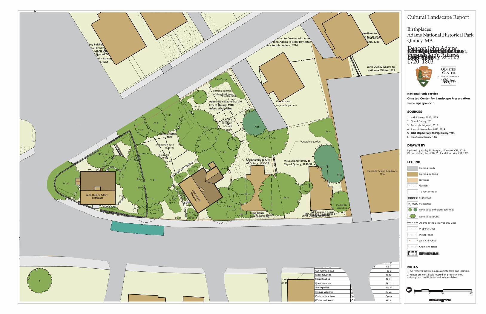
National Park Service
Olmsted Center for Landscape Preservation
SOURCES
NOTES
OLMSTED
for LANDSCAPE PRESERVATION
CENTER
www.nps.gov/oclp
1. All features shown in approximate scale and location.
1. HABS Survey, 1936, 1979
2. City of Quincy, 2011
3. Aerial photograph, 2012
4. Site visit November, 2013, 2014
0’ 15’ 30’ 60’
Cultural Landscape Report
BirthplacesAdams National Historical ParkQuincy, MA
DRAWN BYUpdated by Ashley M. Braquet, Illustrator CS6, 2014Kirsten Holder, AutoCAD 2013 and Illustrator CS5, 2013
LEGEND
Existing roads
Stone wall
Flagstones
Deciduous and Evergreen trees
Existing building
10 Feet contour
Adams Birthplaces Property Lines
Deciduous shrubs
Property Lines
Picket Fence
Split Rail Fence
Chain link fence
Dirt road
Gardens
Town of Boston to William Ellis, c.1650Ellis to Gregory Belcher, 1660Belcher to Samuel Belcher, 1663Belcher to Deacon Gregory Belcher, 1679
Possible location of barn or outbuilding
Possible location school house (built 1697)
Possible location of white oak tree
Well (c.1660)
Possible location of barn
Town of Boston to William Needham, 1640William Needham to Joseph Penniman, 1675Joseph Penniman to James Penniman, 1705
William Needham to T. Curtis, 1675Curtis to Moses Curtis
Ellis home (1660)
Needham home (c.1640)Penniman home (expanded or re-built, 1710)
Vegetable garden
Orchards and vegetable gardens
Orchards and vegetable gardens
Vegetable garden
Drawing 1.2
COUNTRY ROAD TO PLYMOUTH, 1641
Early History to 1720
2. Fences are most likely located on property lines, although no specific information is available.
Fenced in front yard,(c.1730)
Lilac shrubs
Grass yard
William and Sarah Vesey to John Adams, 1788
Deacon John Adams, through John Adams, 1720–1803
Deacon Gregory Belcher to Gregory Belcher Jr., 1727 Belcher to Abigail Bracket Belcher, 1728Belcher to Lewis Vassal, 1742, Vassal to John and Richard Billings, 1743 Billings to Deacon John Adams, 1744Adams to John Adams, 1761
James Penniman to Deacon John Adams, 1720Deacon John Adams to Peter Boyleston Adams, 1761Adams to John Adams, 1774
Possible change in ownership from:James Penniman to Deacon John Adams, 1720Adams to John Adams, 1774
Possible location of barn (c.1736), and possible location of new barn (c. 1796)
Possible location of barn
Well
Drawing 1.4
COUNTRY ROAD TO PLYMOUTH
Possible locationof sheds, (1764)
Stone wall, (1762)
John Adam
s
birthplace
John Quincy Adams birthplace
Removed feature
5. John Adams Diary, AFP/MHS
6. Eliza Susan Quincy, 1822
John Quincy Adams to Benjamin Crane, 1836
Joseph Crane house, 1831
John Quincy Adams to Samuel Curtis, 1829
John Quincy Adams to Nathaniel White, 1827
John Adams to John Quincy Adams, 1803
John Adams to John Quincy Adams, 1803
John Quincy Adams, 1803–1848
Well
COUNTRY ROAD TO PLYMOUTH
Drawing 1.6
Possible location of barn(c.1805)
Possible location of barn (c.1805)
Possible location of shed(c.1805)
Possible locationof shagbark tree
Wooden fence(c. 1805)
John Adam
s
birthplace
John Quincy Adams birthplace
Removed feature
John Quincy Adams to Charles Francis Adams, 1848
John Quincy Adams to Charles Francis Adams, 1848
Charles Francis Adams,1848–1886
PAY
NE STR
EET (C.1884)
Drawing 1.8
FRANKLIN STREET
PRESIDENTS AVENUE (C.1884)
Possible location of barn Shed
Possiblelocationof barn
Possible location of barn
Well
Ac pl
Ul am
Ul am
Ul am
Ul am
Syvu
Ac pl
Lat in name C ommon name ID
Acer platanoides Norway maple Ac pl
Chaenomeles speciosa common flowering quince Ch sp
Ulmus americana American elm Ul am
Syringa vulgaris common lilac Sy vuJohn A
dams
birthplace
John Quincy Adams birthplace
Removed feature
5. 1888 Map Norfolk County, Quincy, TCPL
Adams Real Estate Trust,1886–1940
Charles Francis Adams to Adams Real Estate Trust,
1886
Turnstile (1896)Split-rail fence (1896)
Craig house (1886-87)McCausland house (1886-87)
Relocated well (1896)
Removed barn (c.1887)
Removed sheds (c.1895-96)
Removed barn (c.1887)
Street car line, c.1890
Drawing 1.10
FRANKLIN STREET
PRESIDENTS AVENUE
Ac pl
Ul am
Ul am
Sy vu
Wi si
Ul am
Ul am
Ul am
Ul am
Ac pl
Ac pl
Ac pl
Ac pl
Sy vu
Sy vu
Sp va
Sy vu
Syvu
Sy vu
Sy vu/Sp va
Ac pl
Ac pl
Ac pl
Pedestrian walkway(c.1896)
Franklin Street widened andPayne Street removed (c.1921)
5. 1888 Map Norfolk County, Quincy, TCPL
Shed(c.1896)
Stone wall (built 1896)
Fa sy
Co fl
Ac pl
Flagpole(c.1926)
Lat in name C ommon name ID
Acer platanoides Norway maple Ac pl
Cornus florida flowering dogwood Co fl
Fagus sylvatica copper beech Fa sy
Syringa vulgaris common lilac Sy vu
Vanhoutte spirea
Spiraea x vanhouttei
Sp va
Ulmus americana American elm Ul am
Wisteria sinensis Chinese wisteria Wi si
John Adam
s
birthplace
John Quincy Adams birthplace
Removed feature
City of Quincy,1940–1979
Adams Real Estate Trust to City of Quincy, 1940Adams Birthplaces
McCausland family to City of Quincy, 1956-57
Craig family to City of Quincy, 1956-57
Craig house(removed 1958)
McCausland house(removed 1958)
Drawing 1.12
Hancock TV and Appliance,1957
FRANKLIN STREET
PRESIDENTS AVENUE
Ac pl
Ac pl
Ac pl
Eu al/Sy vu
Tilia cordataFa sy
Pi st
Cladrastis kentukea
Co fl
Ac pl
Ac pl
Ac pl
Ac pl
Ac pl
Wi si
Pi st
Pi st
Sy vu
Split-rail fence/gate
Pedestrian path(c.1951)
Flagstone pathway(1951)
Lat in name C ommon name ID
Acer platanoides Norway maple Ac pl
Chaenomeles speciosa common flowering quince Ch sp
Cornus florida flowering dogwood Co fl
Euonymus alatus burning bush Eu al
Fagus sylvatica copper beech Fa sy
Pinus strobus white pine Pi st
Rosa species rose Ro sp
Quercus rubra red oak Qu ru
Syringa vulgaris common lilac Sy vu
Vanhoutte spirea Spiraea x vanhouttei Sp va
Buxus sempervirens boxwood Bu se
Wisteria sinensis Chinese wisteria Wi si
John Adam
s
birthplace
John Quincy Adams birthplace
Removed feature
Sy vu
Sy vu
Bu se
Bu se
Bu se
Bu se
Bu se
Ro spCh sp
Sy vu
Sy vu
Sp va
Sy vu/Sp va
Sy vu
FRANKLIN STREET
Pr se Pr sePr se
Pr se
Pr se
Ac pl
Bu se
Bu se
Flagpole(c.1979)
Ac pl
Ti co
Fa sy
Pi st
Pi st
Pi st
Qu ruFo sp/Sy vu
Cl ke
Co fl
Ch sp
Eu al/Sy vu
Ch sp
Sy vu
Sy vu
Ac pl
Ac pl
Ac pl
Well
Stone wall
Gate
flagstone pathway
John Adam
s
birthplace
Hancock TV and Appliance
John Quincy Adams birthplace
Basementdoor
Park sign
Park sign
PRESIDENTS AVENUE National Park Service, 1979–2014
2. Plan shows conditions in 2014.
Drawing 1.14
Park signNPS bus parking zone
Shed removed(c.1981)
Pedestrian path removed(c. 1981)
Split-rail fence
Lat in name C ommon name ID
Acer platanoides Norway maple Ac pl
Chaenomeles speciosa common flowering quince Ch sp
Cornus florida flowering dogwood Co fl
Cladrastis kentukea yellowwood Cl ke
Eu al
Buxus sempervirens boxwood Bu se
Pinus strobus white pine Pi st
Prunus serrulata ‘Kwanzan’ Kwanzan cherry Pr se
Quercus rubra red oak Qu ru
Syringa vulgaris
Euonymus alatus burning bush
Fo spForsythia speciosa forsythia
common lilac Sy vu
Removed feature
FRANKLIN STREET
Pr se Pr sePr se
Pr se
Pr se
Ac pl
Il cr
Il cr
Flagpole
Ac pl
Ac pl
Fa gr
Pi st
Pi st
Pi st
Qu ru
Sp va
Co fl
Co fl
Ch sp
Va sp
Ch sp
Sy vu
Sy vu
Ac pl
Ac pl
Ac pl
Well
Stone wall
Split-rail fence/gate
Stepping stone pathway
John Adam
s
Birthplace
Hancock TV and Appliance
John Quincy Adams Birthplace
Basementdoor
Park sign
Park sign
PRESIDENTS AVENUE Existing Conditions
2. Plan shows conditions in 2014.
Drawing 2.1
Park sign
Split-rail fence
Lat in name C ommon name ID
Acer platanoides Norway maple Ac pl
Chaenomeles speciosa common flowering quince Ch sp
Cornus florida flowering dogwood Co fl
Ilex crenata Japanese holly Il cr
Pinus strobus white pine Pi st
Prunus serrulata ‘Kwanzan’ Kwanzan cherry Pr se
Quercus rubra red oak Qu ru
Syringa vulgaris common lilac Sy vu
Vanhoutte spirea Spiraea x vanhouttei Va sp
Ulmus americana American elm Ul am
Wisteria sinensis Chinese wisteria Wi si
Removed feature
Ul am
Ul am
Wi si
Ul am
Ul am
Ul am
Ul am
Ac pl
Ac pl
Ac pl
Sy vu
Sy vu
Sy vu
Syvu
Syvu
Sp vaSy vu/Sp va
Ac pl
Ac pl
Ac pl
Ac pl
100’
Split-rail fence/gate
Flagstone pathway (1951)
John Adam
s
Birthplace
Hancock TV and Appliance
John Quincy Adams Birthplace
Park sign(2008)
Park sign(2008)
5 - Pr se(early 1990s)
Pr sePr sePr se
Pr se
PRESIDENTS AVENUE Analysis and Evaluation
2. Plan shows conditions in 2014.
Drawing 3.1
Flag pole(c. 1979)
Park sign(2008)
Stone wall
Well
Split-rail fence
Walkway(c.1896-1951)
Feature added/built since 1940
since 1940
FRANKLIN STREET
Shed(c.1896-1951)Flagpole
(1896-1926)Ac pl
Ti co
Pi st
Pi st
Pi st
Qu ru
Fo sp/Sy vu
Co fl
Ch sp
Eu al/Sy vu
Ch sp
Sy vu
Sy vu
Sy vu
Craig house (1886/87-1958)
Acquired by City of Quincy,(1956-57)
Sidewalk widened(c. 1990 and 2012)
McCausland house (1886/87-1958)
Acquired by City of Quincy(1956-57)
Lat in name C ommon name ID
Acer platanoides Norway maple Ac pl
Chaenomeles speciosa common flowering quince Ch sp
Cornus florida flowering dogwood Co fl
Buxus sempervirens boxwood Bu se
Cladrastis kentukea yellowwood Cl ke
Euonymus alatus burning bush Eu al
Forsythia species forsythia Fo sp
Fagus sylvatica copper beech Fa sy
Lat in name C ommon name ID
Prunus serrulata ‘Kwanzan’ Kwanzan cherry Pr se
Quercus rubra red oak Qu ru
Syringa vulgaris common lilac Sy vu
Tilia cordata little leaf linden Ti co
Vanhoutte spirea Spiraea x vanhouttei Sp va
Ulmus americana American elm Ul am
Wisteria sinensis Chinese wisteria Wi si
Bu se
Bu se
Ac pl
Removed feature
Fa sy
Ac pl
Cl ke
Pinus strobus white pine Pi st


Site HiStory
57
CHARLES FRANCIS ADAMS, 1848–86
During the middle of the nineteenth century, housing clusters surrounded
railroad stations and major streets, large farms covered low lying fertile areas,
and granite quarries dotted the Blue Hills around Quincy. Growing industries
attracted new residents and Quincy’s population more than doubled from 5,017
people in 1850, to 12,145 in 1885.205 For example, the Curtis family employed over
four hundred people and produced forty-eight thousand pairs of shoes in 1856.206
Granite production in South and West Quincy increased in the mid-nineteenth
century as new steam and compressed air technologies increased the rate of
granite extraction and reduced labor.207 As a result, employment opportunities
for new immigrants of primarily Irish, English, and Scottish descent in the granite
industry shifted from the quarries to stone cutting businesses. During the peak of
granite production, local groups constructed several granite buildings including
the Adams Academy, built in 1872, the Thomas Crane Library, built in 1882, and
various churches. Granite production decreased at the end of the century as
quarries farther inland could transport stone blocks efficiently by train and steel
replaced stone as the primary building material.
The granite railway was replaced by the Old Colony and Newport Railway in
1871. At that time, steam trains transported the granite directly to Boston. The
Old Colony Railroad ran through Quincy Center and near the Adams birthplaces
with multiple stations in Quincy (see Figure 1.9). The railroad attracted industrial
development along the line as well as early suburban development near the
stations and in North Quincy. While the granite industry created jobs in South and
West Quincy, the shipbuilding industry expanded along the waterfront. Deacon
George Thomas operated a ship yard at Quincy Point in the mid-nineteenth
century and in 1883, Thomas A. Watson founded the Fore River Shipyard, which
began in Braintree and later moved downstream to Quincy.208 Shipbuilding would
soon become Quincy’s largest industry.
PENN’S HILL FARM
Following the death of John Quincy Adams in 1848, Charles Francis Adams
inherited the 200-acre Penn’s Hill farm, which included the birthplaces and
associated farm buildings (Figure 1.10). In anticipation of the demand for
suburban growth, Charles Francis Adams purchased woods, salt marsh, and
pastureland throughout South Quincy in the 1840s through 60s, and at the same
time gave up parcels for the development of roads and railroads. He continued
to lease the farm and birthplaces to various tenants and never lived at the base of
Penn’s Hill.
Charles Francis Adams had a long political career while he owned the Penn’s
Hill farm, though he invested most of his free time at the Mount Wollaston

Cultural landsCape report for adams BirthplaCes
58
farm, which he received from his father in 1840. He served as a member of the
Massachusetts House of Representatives from 1841 to 1843, the Massachusetts
state senate from 1844 to 1845, and the Congress from 1859 to 1861. Meanwhile,
tenant farmer Charles Spear leased and made substantial improvements to the
200-acre Penn’s Hill farm while living in the John Adams birthplace. During that
time, Charles Francis Adams leased the John Quincy Adams birthplace to tenants
John Harrison and Patrick Hailey, who worked as boot makers, followed by
Ebenezer Green, his wife, and the Joseph Branbury family.209
Since Charles Francis Adams was more engaged in politics and spent his free time
at the Wollaston farm, Spear likely maintained the dairy farm and made most of
the agricultural improvements at Penn’s Hill during the middle of the nineteenth
century. As farmers in the Midwest were able to grow grain on cheaper and larger
parcels of land, farmers in New England frequently shifted away from grain
and toward dairy and vegetable production.210 In 1860, the Norfolk Agricultural
Society described the Penn’s Hill Farm:
The Committee was gratified to see many fine and some rare species of trees,
which were planted by the ancestors of the present proprietor, and not less grat-
ified at the sight of others, which under his own direction, have added beauty
and interest to the place. Several acres of land lying on each side of a fine stream
of water, have within a few years been converted from an unsightly waste to a
beautiful meadow, producing large crops of good hay.211
Figure 1.10. Oil painting by Godfrey
N. Frankenstein of the Adams
birthplaces, 1850. View looking
northwest from the Plymouth
Road of the birthplaces and several
outbuildings. Stone walls extend
along both sides of the road, but
the wall on the west side of the
road changes to picket fence in
front of the birthplaces. The Blue
Hills appear in the background.
(Adams NHP, 8453).

Site HiStory
59
The Agricultural Society commended Spear’s farming practices, stating:
This farm, consisting of about 200 acres, has been leased for several years to
Mr. Charles A. Spear, whose management presents such an example of the
profits of farming as is seldom seen in this country. He pays a rent which is
considered equal to a fair interest on the value of the farm—not, of course, what
some of it might be worth for house-lots—and makes for himself a satisfactory
profit—thus making tenant farming profitable to both landlord and tenant.
By the improvement of some portions of the farm and greatly increasing the
growth of grass, he has been enabled to more than double the number of cattle
kept. The improvements have been expensive, but have still been made to pay.
On some boggy and wet lands, which were formerly actually worthless, so far
as regards the production of a crop, he has expended $100 per acre in drainage
and covering with earth—mostly gravel—yet it has for five years paid interest of
more than $200 per acre. It has produced an average of more than three tons (at
two cuttings) of good hay to the acre each season. The produce of the farm is
converted chiefly into milk.212
While Spear managed Penn’s Hill farm, there were few physical changes. One
minor change was an addition to the shed located north of the John Adams
birthplace in 1850 (see Figures 1.10 and 1.11).213
Figure 1.11. Engraving of the Adams
birthplaces in Gleason’s Pictorial
Drawing Room Companion, August
1852. View looking southwest
with the stone wall, picket fence,
and a small tree in the foreground.
(Courtesy of Historic New England,
2336A).

Cultural landsCape report for adams BirthplaCes
60
DEVELOPMENT AROUND THE BIRTHPLACES
Large farms remained into the 1870s, when local industries created more jobs
and increased demand for suburban development (Figures 1.12). Many large
landowners subdivided their farms and sold parcels for house lots. Before the
city installed street cars, developers built subdivisions near the railroad stations,
particularly in the northern part of Quincy, as residents frequently took the train
into Boston. The horse railway, constructed in 1861, provided another method
of transport from the Penn’s Hill area into Boston, and sparked dispersed
development along the railway lines, which later became street car lines. (Figures
1.13 and 1.14).
The town constructed Independence Avenue, which connected to Franklin
Street just south of the John Quincy Adams birthplace, in around 1865 (Figure
1.15).214 The birthplaces sat at the edge of Franklin Street since their construction,
however, the new intersection created by Independence Avenue cut very close to
the birthplaces, reducing the frontage of both lots (Figures 1.16 and 1.17). In the
c. 1879 sketch, sections of picket fence and scant vegetation separated the yards
Figure 1.12. Map by H.F. Walling in 1857 of the Town of Quincy. Labeled features include the Old Colony and Fall River Railroad, Franklin
Street, Paynes (Penn) Hill, and several granite quarries. (Courtesy of the Norman B. Leventhal Map Center at the Boston Public Library).
Birthplaces

Site HiStory
61
Figure 1.13. Map by H.F. Walling in 1866. Labeled features include Penns Hill and the birthplaces (Courtesy of the Norman B. Leventhal
Map Center at the Boston Public Library).
Figure 1.14. Map of Dorchester and Quincy by W. Simons in 1868. Labeled features include Franklin Street, Mt Pleasant (Penn’s Hill), the
train depot, and the Railway to the granite quarries. (Courtesy of the Norman B. Leventhal Map Center at the Boston Public Library).
Birthplaces
Birthplaces

Cultural landsCape report for adams BirthplaCes
62
Figure 1.15. Map of Southern Quincy in 1876. Labeled features include Adams farm and the birthplaces, C.F. Adams properties, and the
Town Brook. Newly constructed Independence Avenue is visible, but runs off of the lower edge of the map (Maps of Norfolk County,
Courtesy of Thomas Crane Public Library).
Figure 1.16. Aerial perspective map of Quincy by Edwin Whitefield in 1877. Labeled features include the Adams birthplaces, schools,
and churches. The Adams birthplaces appear on the lower part of the map, near the railroad. (Courtesy of the Norman B. Leventhal Map
Center at the Boston Public Library).
Birthplaces
Birthplaces

Site HiStory
63
from the road. Walks to the front door of each house were compacted earth. Note
that the door to John Adams’ law office at the southeast corner of the John Quincy
Adams birthplace is gone.
Early photographs depict the John Adams and the John Quincy Adams birthplaces
in the 1800s. Features documented include the earthen sidewalk along Franklin
Street, low vegetation around the two birthplaces, wood picket fences, and tall
trees north of the John Adams birthplace. The land west of the birthplaces was
a patchwork of agricultural land with industrial development along the railroad
corridor. By about 1886, Presidents Avenue cut across the western edge of the lots
(Figures 1.18 through 1.22).
Beginning in 1882, Charles Francis Adams started subdividing the Penn’s Hill
farm and several of the farm buildings associated with the Penn’s Hill farm were
removed.215 In 1883, he gave several parcels around the Quincy Adams station, to
the Old Colony Railroad. With these parcels the Old Colony Railroad was able to
build new public streets that led to the station. In 1884, he deeded most of Penn’s
Figure 1.17. Lithograph of the
Adams birthplaces by Edwin
Whitefield in c.1879. View looking
northwest from the road toward
John Quincy Adams birthplace on
the left and John Adams birthplace
on the right. Picket fences and
low vegetation appear in the
foreground. A shed appears to the
right of the John Adams birthplace
and a lean-to connects to the rear
of the house. (Illustration from The
Homes of our Forefathers by Edwin
Whitefield).

Cultural landsCape report for adams BirthplaCes
64
Figure 1.18. Photograph of the John
Adams birthplace, c.1880. View
looking southwest toward the
rear addition and shed. The shed is
adjacent to the rear addition and
offset to the west. A picket fence
with top and bottom rails runs
from the northeast corner of the
house toward the road. A shrub or
vine grows adjacent to the house
(Courtesy of Quincy Historical
Society).
Figure 1.20. Photograph of the Adams birthplaces, c.1885. View looking northwest from Franklin Street. A shed or barn and another
home appear north of the John Adams birthplace. Low picket fencing frames the two front yards and is in need of repair. A few shrubs
grow adjacent to both houses. (Courtesy of Quincy Historical Society, 74.83.3).
Figure 1.19. Photograph of the
Adams birthplaces, c.1885. View
looking northwest with the picket
fence along Franklin Street. The
widened street cuts close to the
homes. A split-rail fence is visible to
the rear (west) of the John Quincy
Adams birthplace. A barn or house
appears behind the John Adams
birthplace and a large shrub, most
likely a lilac, grows in front. (Courtesy
of Historic New England).

Site HiStory
65
Figure 1.21. View looking northwest of the John Quincy Adams birthplace, c.1885, with new industrail development in the background,
along the railroad corridor. Low shrubs grow along the south side of the John Quincy Adams birthplace. A picket fence is visible to the
northeast, extending toward the John Adams birthplace. (Courtesy of Historic New England).
Figure 1.22. John Adams birthplace, c.1885. The picket fence parallels Franklin Avenue and between the two birthplaces. Shrubs grow
around the home, most likely lilacs and light-colored roses, with driveway at left. (Courtesy of Historic New England).

Cultural landsCape report for adams BirthplaCes
66
Hill farm to his son, Charles Francis Adams Jr.216 At the time of his death in 1886,
Charles Francis Adams owned the quarter-acre birthplaces property along with
the homes and a barn, in addition to several parcels to the south near Penn’s Hill
and west of the birthplaces. Upon his death, his heirs formed the Adams Real
Estate Trust to manage the remaining Adams’ estate.
LANDSCAPE SUMMARY, 1886
In 1886, as illustrated in Drawings 1.7 and 1.8, the John Adams and John Quincy
Adams birthplaces stood on a .34-acre parcel owned by the estate of Charles
Francis Adams, and located between Franklin Street, Presidents Avenue, and
Payne Street. The Penn’s Hill farm was fragmented by the encroaching suburban
development as Charles Francis Adams had sold several parcels to developers.
Traffic and development increased around the birthplaces with the construction
of Independence Avenue, Presidents Avenue, and the Old Colony and Newport
Rail lines. The John Adams birthplace had a shed at the rear (north) side of the
house. The John Quincy Adams birthplace included two lean-tos on the north
and west sides of the house. Three barns may have stood near the houses, one
between the two birthplaces and the other two northwest of the John Adams
birthplace. Vegetation included deciduous trees and lilacs in front of the John
Adams birthplace. Both tenants likely grew small gardens near the houses but the
vegetation was fairly barren with a lot of overgrown grasses and shrubs. Within
other areas at the Penn’s Hill farm, orchards consisted of peach, pear, cherry, and
apple trees. Tenants of the John Adams birthplace farmed a portion of the Penn’s
Hill farm and operated a dairy.
From the top of Penn’s Hill, views consisted of more houses along Franklin
Street, quarries on the hilltops, industry near the railroads, and the remaining
agricultural fields. Views from the birthplaces included new homes, streets, and
more industry. Features included the split rail and picket fences, remnant stone
walls, and a well for water.

National Park Service
Olmsted Center for Landscape Preservation
SOURCES
DRAWN BY
NOTES
Kirsten Holder, AutoCAD 2013 and Illustrator CS5
OLMSTED
for LANDSCAPE PRESERVATION
CENTER
www.nps.gov/oclp
1. All features shown in approximate scale and location.
2. Plan shows conditions in 2013.
1. City of Quincy, 2011
2. Aerial photograph, 2012
3. Site visit November, 2013
4. Lawrence D. Gall, 1981
5. Quincy Historical Society, Ezekiel C. Sargent Quincy
Land Records Collection
0’ 400’ 800’ 1600’
LEGEND
Existing roads
Roads
Creek
Stone wall
Existing building
10 Feet contour10 ft
Adams birthplaces
Property lines
Historic property lines
Cultural Landscape Report
BirthplacesAdams National Historical ParkQuincy, MA
Existing railroad
Town of Boston to Richard Wright, 1640
Moses Penniman, 1706
Town of Boston to William Needham, c.1639
Orchard and crop fields owned by the Veseys and Belchers
Town of Boston to William Ellis, c.1650,Ellis to Gregory Belcher, 1660,
Belcher to Samuel Belcher, 1663,Belcher to Deacon Gregory Belcher, 1679
Gregory Belcher home, 1660,Samuel Belcher, 1663,
Deacon Gregory Belcher, 1679,expanded 1716
Early History to 1720
William Needham to Joseph Penniman, 1675,Penniman to James Penniman, 1705
Fresh Brook
Fresh B
roo
k
Fresh BrookWilliam Needham to William Vesey, 1675, Vesey to Peter Webb, 1706
William Needham to T. Curtis, 1675Curtis to Moses Curtis
PENN’S HILL
PINE HILL
ROCK COMMONS
NORTH COMMON
COUNTRY ROAD TO PLYMOUTH, 1641COUNTRY ROAD TO PLYMOUTH, 1641
WAY
THRO
UGH THE
COM
MO
N, 166
0
Needham home, c.1640Penniman home, 1675, rebuilt, 1705, 1710
WAY TO 600 ACRES, 1640
School house, 1697and white oak tree, 1697
Drawing 1.1
See Drawing 1.2
John Vesey toDeacon Gregory Belcher,
1727
Deacon Gregory Belcher to Nathaniel Belcher, 1727,Belcher to Joseph Field, 1761
Deacon Gregory Belcher to Samuel Belcher, 1727,Belcher to Joseph Field, 1761
Joseph Adams to Deacon John Adams, 1731, Adams to Peter Boyleston Adams, 1761, Adams to John Adams, 1774
Joseph Adams toDeacon John Adams, 1731
Deacon John Adams to John Adams, 1761
Samuel Payne to Deacon John Adams, 1733,Adams to Peter Boyleston Adams, 1761,Adams to John Adams, 1774
Moses Babcock to Abigail Adams, 1783
Deacon Gregory Belcher to Gregory Belcher Jr., 1727, Belcher to Abigail Bracket Belcher, 1728Belcher to Lewis Vassal, 1742, Vassal to John and Richard Billings, 1743, Billings to Deacon John Adams, 1744,Adams to John Adams, 1761
Moses Payne to Deacon John Adams, 1733Adams to Peter Boyleston Adams, 1761, Adams to John Adams, 1803
Josiah Crosby toJohn Adams, 1765
Elkanah Thayer to John Adams, 1793
Town of Braintree toJohn Adams, 1765
Town of Braintree to Peter Boyleston Adams, 1765,Adams to John Adams, 1774
Elijah Veazie to John Adams, 1803
Ann Savil to John Adams, 1770
Town of BraintreeJohn Adams, 1765
James Thayer toJohn Adams, 1785
Joseph Field and Peter Boylston Adams to John Adams, 1771
Ann Savil to John Adams, 1770
Joseph Palmer toJohn Adams, 1771
Joseph Field house, 1771
Joseph Palmer to John Adams, 1771
Fresh Brook
Post and elm placed by Deacon John Adams, 1731
James Penniman to Deacon John Adams, 1720Deacon John Adams to Peter Boyleston Adams, 1761,Adams to John Adams, 1774
Moses Curtis to John Vesey, 1721, William and Amy Vesey to
John Adams, 1788Tompson Baxter to John Adams, 1771
Mill
Deacon John Adams, through John Adams, 1720–1803
Joseph Palmer corn house and well, 1771
Marsh
Orchard
Garden
Cow Yard
Apple orchard
Potatoes
Corn
Vesey house and farm, 1762See Drawing 1.4
Drawing 1.3
COUNTRY ROAD TO PLYMOUTH COUNTRY ROAD TO PLYMOUTH
Fresh Brook
Fresh Brook
PENN’S HILL
PINE HILL
ROCK COMMONS
NORTH COMMON
John Adams to Town of Quincy, 1822
John Quincy Adams to Town of Quincy, 1803
John Adams to John Quincy Adams, 1803
John Adams to John Quincy Adams,
1803
John Adams to John Quincy Adams,
1803
John Adams to John Quincy Adams,
1803
John Adams to John Quincy Adams, 1803
John Adams to John Quincy Adams, 1803
John Adams to John Quincy Adams,
1803
John Adams to John Quincy Adams, 1803
John Adams to John Quincy Adams, 1803
John Quincy Adams to Nathaniel White, 1827
John Adams to John Quincy Adams, 1803
John Adams to John Quincy Adams, 1803
John Adams to John Quincy Adams, 1803
John Adams to John Quincy Adams, 1803
John Adams to John Quincy Adams, 1803
John Adams to John Quincy Adams, 1803
John Quincy Adams to Samuel Curtis, 1829
John Quincy Adams to Benjamin Crane, 1836
Joseph Field
Joseph Field
Belcher?Fresh Brook
John Quincy Adams, 1803–1848
Drawing 1.5
COUNTRY ROAD TO PLYMOUTH COUNTRY ROAD TO PLYMOUTH
See Drawing 1.6
PENN’S HILL
PINE HILL
Charles Francis Adams,1848–1886
INDEPENDENCE AVENUE (1865)
PRESIDENTS AVENUE (C.1885)
QU
ARR
Y ST
REET
(188
4)
John Quincy Adams to Charles Francis Adams,
1848
John Quincy Adams to Charles Francis Adams,
1848
Charles Francis Adams,date unknown
John Quincy Adams to Charles Francis Adams,
1848
John Quincy Adams to Charles Francis Adams,
1848
Drawing 1.7
FRANKLIN
AVEN
UE
FRANKLIN AVENUE
WASHINGTON STREET
PHIPPS STREET (1874)
See Drawing 1.8
PENN’S HILL
PINE HILL
Qu
incy
Brain
tree
Adams Real Estate Trust,1886–1940
Adams Real Estate Trust,
1907
Charles Francis Adams to Adams Real Estate Trust,
1886
Adams Chapter of the Society of theDaughters of the Revolution installs cairn
Charles Francis Adams to Adams Real Estate Trust,
1886
Charles Francis Adams to Adams Real Estate Trust,
1886
Drawing 1.9
See Drawing 1.10
PENN’S HILL
PINE HILL
QUINCY CENTER
City of Quincy,1940–79
Adams Real Estate Trust to City of Quincy, 1940Adams Birthplaces
Craig and McCausland families to City of Quincy, 1956-57
MBTAQuincy Adams Station
MBTAQuincy Center
MBTA Red Line
Drawing 1.11
See Drawing 1.12
PENN’S HILL
PINE HILL
QUINCY CENTER
Cairn for Abigail Adams and John Quincy Adams
National Park ServiceUnited First Parish Church
City of Quincy to National Park Service, 1979
Adams Birthplaces
MBTAQuincy Adams Station
MBTAQuincy Center
MBTA Red Line
National Park Service, 1979–Present
Drawing 1.13
See Drawing 1.14
PENN’S HILL
PINE HILL
QUINCY CENTER
Cairn for Abigail Adams and John Quincy Adams
National Park ServiceUnited First Parish Church
National Park ServiceAdams Birthplaces
MBTAQuincy Adams Station
MBTAQuincy Center
MBTA Red Line
Existing Conditions
Drawing 2.1
See Drawing 2.2
PENN’S HILL
QUINCY CENTER
PINE HILL
Cairn for Abigail Adams and John Quincy Adams


National Park Service
Olmsted Center for Landscape Preservation
SOURCES
NOTES
OLMSTED
for LANDSCAPE PRESERVATION
CENTER
www.nps.gov/oclp
1. All features shown in approximate scale and location.
1. HABS Survey, 1936, 1979
2. City of Quincy, 2011
3. Aerial photograph, 2012
4. Site visit November, 2013, 2014
0’ 15’ 30’ 60’
Cultural Landscape Report
BirthplacesAdams National Historical ParkQuincy, MA
DRAWN BYUpdated by Ashley M. Braquet, Illustrator CS6, 2014Kirsten Holder, AutoCAD 2013 and Illustrator CS5, 2013
LEGEND
Existing roads
Stone wall
Flagstones
Deciduous and Evergreen trees
Existing building
10 Feet contour
Adams Birthplaces Property Lines
Deciduous shrubs
Property Lines
Picket Fence
Split Rail Fence
Chain link fence
Dirt road
Gardens
Town of Boston to William Ellis, c.1650Ellis to Gregory Belcher, 1660Belcher to Samuel Belcher, 1663Belcher to Deacon Gregory Belcher, 1679
Possible location of barn or outbuilding
Possible location school house (built 1697)
Possible location of white oak tree
Well (c.1660)
Possible location of barn
Town of Boston to William Needham, 1640William Needham to Joseph Penniman, 1675Joseph Penniman to James Penniman, 1705
William Needham to T. Curtis, 1675Curtis to Moses Curtis
Ellis home (1660)
Needham home (c.1640)Penniman home (expanded or re-built, 1710)
Vegetable garden
Orchards and vegetable gardens
Orchards and vegetable gardens
Vegetable garden
Drawing 1.2
COUNTRY ROAD TO PLYMOUTH, 1641
Early History to 1720
2. Fences are most likely located on property lines, although no specific information is available.
Fenced in front yard,(c.1730)
Lilac shrubs
Grass yard
William and Sarah Vesey to John Adams, 1788
Deacon John Adams, through John Adams, 1720–1803
Deacon Gregory Belcher to Gregory Belcher Jr., 1727 Belcher to Abigail Bracket Belcher, 1728Belcher to Lewis Vassal, 1742, Vassal to John and Richard Billings, 1743 Billings to Deacon John Adams, 1744Adams to John Adams, 1761
James Penniman to Deacon John Adams, 1720Deacon John Adams to Peter Boyleston Adams, 1761Adams to John Adams, 1774
Possible change in ownership from:James Penniman to Deacon John Adams, 1720Adams to John Adams, 1774
Possible location of barn (c.1736), and possible location of new barn (c. 1796)
Possible location of barn
Well
Drawing 1.4
COUNTRY ROAD TO PLYMOUTH
Possible locationof sheds, (1764)
Stone wall, (1762)
John Adam
s
birthplace
John Quincy Adams birthplace
Removed feature
5. John Adams Diary, AFP/MHS
6. Eliza Susan Quincy, 1822
John Quincy Adams to Benjamin Crane, 1836
Joseph Crane house, 1831
John Quincy Adams to Samuel Curtis, 1829
John Quincy Adams to Nathaniel White, 1827
John Adams to John Quincy Adams, 1803
John Adams to John Quincy Adams, 1803
John Quincy Adams, 1803–1848
Well
COUNTRY ROAD TO PLYMOUTH
Drawing 1.6
Possible location of barn(c.1805)
Possible location of barn (c.1805)
Possible location of shed(c.1805)
Possible locationof shagbark tree
Wooden fence(c. 1805)
John Adam
s
birthplace
John Quincy Adams birthplace
Removed feature
John Quincy Adams to Charles Francis Adams, 1848
John Quincy Adams to Charles Francis Adams, 1848
Charles Francis Adams,1848–1886
PAY
NE STR
EET (C.1884)
Drawing 1.8
FRANKLIN STREET
PRESIDENTS AVENUE (C.1884)
Possible location of barn Shed
Possiblelocationof barn
Possible location of barn
Well
Ac pl
Ul am
Ul am
Ul am
Ul am
Syvu
Ac pl
Lat in name C ommon name ID
Acer platanoides Norway maple Ac pl
Chaenomeles speciosa common flowering quince Ch sp
Ulmus americana American elm Ul am
Syringa vulgaris common lilac Sy vuJohn A
dams
birthplace
John Quincy Adams birthplace
Removed feature
5. 1888 Map Norfolk County, Quincy, TCPL
Adams Real Estate Trust,1886–1940
Charles Francis Adams to Adams Real Estate Trust,
1886
Turnstile (1896)Split-rail fence (1896)
Craig house (1886-87)McCausland house (1886-87)
Relocated well (1896)
Removed barn (c.1887)
Removed sheds (c.1895-96)
Removed barn (c.1887)
Street car line, c.1890
Drawing 1.10
FRANKLIN STREET
PRESIDENTS AVENUE
Ac pl
Ul am
Ul am
Sy vu
Wi si
Ul am
Ul am
Ul am
Ul am
Ac pl
Ac pl
Ac pl
Ac pl
Sy vu
Sy vu
Sp va
Sy vu
Syvu
Sy vu
Sy vu/Sp va
Ac pl
Ac pl
Ac pl
Pedestrian walkway(c.1896)
Franklin Street widened andPayne Street removed (c.1921)
5. 1888 Map Norfolk County, Quincy, TCPL
Shed(c.1896)
Stone wall (built 1896)
Fa sy
Co fl
Ac pl
Flagpole(c.1926)
Lat in name C ommon name ID
Acer platanoides Norway maple Ac pl
Cornus florida flowering dogwood Co fl
Fagus sylvatica copper beech Fa sy
Syringa vulgaris common lilac Sy vu
Vanhoutte spirea
Spiraea x vanhouttei
Sp va
Ulmus americana American elm Ul am
Wisteria sinensis Chinese wisteria Wi si
John Adam
s
birthplace
John Quincy Adams birthplace
Removed feature
City of Quincy,1940–1979
Adams Real Estate Trust to City of Quincy, 1940Adams Birthplaces
McCausland family to City of Quincy, 1956-57
Craig family to City of Quincy, 1956-57
Craig house(removed 1958)
McCausland house(removed 1958)
Drawing 1.12
Hancock TV and Appliance,1957
FRANKLIN STREET
PRESIDENTS AVENUE
Ac pl
Ac pl
Ac pl
Eu al/Sy vu
Tilia cordataFa sy
Pi st
Cladrastis kentukea
Co fl
Ac pl
Ac pl
Ac pl
Ac pl
Ac pl
Wi si
Pi st
Pi st
Sy vu
Split-rail fence/gate
Pedestrian path(c.1951)
Flagstone pathway(1951)
Lat in name C ommon name ID
Acer platanoides Norway maple Ac pl
Chaenomeles speciosa common flowering quince Ch sp
Cornus florida flowering dogwood Co fl
Euonymus alatus burning bush Eu al
Fagus sylvatica copper beech Fa sy
Pinus strobus white pine Pi st
Rosa species rose Ro sp
Quercus rubra red oak Qu ru
Syringa vulgaris common lilac Sy vu
Vanhoutte spirea Spiraea x vanhouttei Sp va
Buxus sempervirens boxwood Bu se
Wisteria sinensis Chinese wisteria Wi si
John Adam
s
birthplace
John Quincy Adams birthplace
Removed feature
Sy vu
Sy vu
Bu se
Bu se
Bu se
Bu se
Bu se
Ro spCh sp
Sy vu
Sy vu
Sp va
Sy vu/Sp va
Sy vu
FRANKLIN STREET
Pr se Pr sePr se
Pr se
Pr se
Ac pl
Bu se
Bu se
Flagpole(c.1979)
Ac pl
Ti co
Fa sy
Pi st
Pi st
Pi st
Qu ruFo sp/Sy vu
Cl ke
Co fl
Ch sp
Eu al/Sy vu
Ch sp
Sy vu
Sy vu
Ac pl
Ac pl
Ac pl
Well
Stone wall
Gate
flagstone pathway
John Adam
s
birthplace
Hancock TV and Appliance
John Quincy Adams birthplace
Basementdoor
Park sign
Park sign
PRESIDENTS AVENUE National Park Service, 1979–2014
2. Plan shows conditions in 2014.
Drawing 1.14
Park signNPS bus parking zone
Shed removed(c.1981)
Pedestrian path removed(c. 1981)
Split-rail fence
Lat in name C ommon name ID
Acer platanoides Norway maple Ac pl
Chaenomeles speciosa common flowering quince Ch sp
Cornus florida flowering dogwood Co fl
Cladrastis kentukea yellowwood Cl ke
Eu al
Buxus sempervirens boxwood Bu se
Pinus strobus white pine Pi st
Prunus serrulata ‘Kwanzan’ Kwanzan cherry Pr se
Quercus rubra red oak Qu ru
Syringa vulgaris
Euonymus alatus burning bush
Fo spForsythia speciosa forsythia
common lilac Sy vu
Removed feature
FRANKLIN STREET
Pr se Pr sePr se
Pr se
Pr se
Ac pl
Il cr
Il cr
Flagpole
Ac pl
Ac pl
Fa gr
Pi st
Pi st
Pi st
Qu ru
Sp va
Co fl
Co fl
Ch sp
Va sp
Ch sp
Sy vu
Sy vu
Ac pl
Ac pl
Ac pl
Well
Stone wall
Split-rail fence/gate
Stepping stone pathway
John Adam
s
Birthplace
Hancock TV and Appliance
John Quincy Adams Birthplace
Basementdoor
Park sign
Park sign
PRESIDENTS AVENUE Existing Conditions
2. Plan shows conditions in 2014.
Drawing 2.1
Park sign
Split-rail fence
Lat in name C ommon name ID
Acer platanoides Norway maple Ac pl
Chaenomeles speciosa common flowering quince Ch sp
Cornus florida flowering dogwood Co fl
Ilex crenata Japanese holly Il cr
Pinus strobus white pine Pi st
Prunus serrulata ‘Kwanzan’ Kwanzan cherry Pr se
Quercus rubra red oak Qu ru
Syringa vulgaris common lilac Sy vu
Vanhoutte spirea Spiraea x vanhouttei Va sp
Ulmus americana American elm Ul am
Wisteria sinensis Chinese wisteria Wi si
Removed feature
Ul am
Ul am
Wi si
Ul am
Ul am
Ul am
Ul am
Ac pl
Ac pl
Ac pl
Sy vu
Sy vu
Sy vu
Syvu
Syvu
Sp vaSy vu/Sp va
Ac pl
Ac pl
Ac pl
Ac pl
100’
Split-rail fence/gate
Flagstone pathway (1951)
John Adam
s
Birthplace
Hancock TV and Appliance
John Quincy Adams Birthplace
Park sign(2008)
Park sign(2008)
5 - Pr se(early 1990s)
Pr sePr sePr se
Pr se
PRESIDENTS AVENUE Analysis and Evaluation
2. Plan shows conditions in 2014.
Drawing 3.1
Flag pole(c. 1979)
Park sign(2008)
Stone wall
Well
Split-rail fence
Walkway(c.1896-1951)
Feature added/built since 1940
since 1940
FRANKLIN STREET
Shed(c.1896-1951)Flagpole
(1896-1926)Ac pl
Ti co
Pi st
Pi st
Pi st
Qu ru
Fo sp/Sy vu
Co fl
Ch sp
Eu al/Sy vu
Ch sp
Sy vu
Sy vu
Sy vu
Craig house (1886/87-1958)
Acquired by City of Quincy,(1956-57)
Sidewalk widened(c. 1990 and 2012)
McCausland house (1886/87-1958)
Acquired by City of Quincy(1956-57)
Lat in name C ommon name ID
Acer platanoides Norway maple Ac pl
Chaenomeles speciosa common flowering quince Ch sp
Cornus florida flowering dogwood Co fl
Buxus sempervirens boxwood Bu se
Cladrastis kentukea yellowwood Cl ke
Euonymus alatus burning bush Eu al
Forsythia species forsythia Fo sp
Fagus sylvatica copper beech Fa sy
Lat in name C ommon name ID
Prunus serrulata ‘Kwanzan’ Kwanzan cherry Pr se
Quercus rubra red oak Qu ru
Syringa vulgaris common lilac Sy vu
Tilia cordata little leaf linden Ti co
Vanhoutte spirea Spiraea x vanhouttei Sp va
Ulmus americana American elm Ul am
Wisteria sinensis Chinese wisteria Wi si
Bu se
Bu se
Ac pl
Removed feature
Fa sy
Ac pl
Cl ke
Pinus strobus white pine Pi st


Site HiStory
71
ADAMS REAL ESTATE TRUST, 1886–1940
Quincy developed rapidly during the end of the nineteenth century as job
growth triggered new transportation corridors and residential subdivisions.
Manufacturing companies developed along railroad corridors, the shipbuilding
industry expanded at the waterfront, and quarries operated in South and West
Quincy. Quincy became an incorporated city in 1888, and in 1890 it housed
almoste seventeen thousand residents.
Following Charles Francis Adams’ death, his heirs established the Adams Real
Estate Trust in 1886 and started selling large parcels of the Penn’s Hill farm for
the development of house lots. As the demand for development increased, local
citizens recognized the importance of preserving the city’s historic resources,
such as the John Adams and John Quincy Adams birthplaces. In 1893, the city
established the Quincy Historical Society, and appointed Charles Francis Adams
Jr. as its first president. The Adams Real Estate Trust retained ownership of the
birthplaces and leased the houses from 1886 to 1896. Beginning in 1896, the
Daughters of the Revolution managed the John Adams birthplace, and the Quincy
Historical Society managed the John Quincy Adams birthplace. Both buildings
were opened to the public in 1897.
Suburban and industrial growth in the 1920s spurred development of more
communities throughout Quincy. The availability of the automobile in the early
twentieth century enabled residents to live in suburban neighborhoods and
commute to Boston. Quincy’s population increased by over twenty thousand
people in the 1920s, and included seventy-two thousand residents by 1930.217
INDUSTRIAL DEVELOPMENT
Blocks surrounding the railway stations were already developed with housing,
and communities grew around manufacturing centers such as the shipyard and
the granite quarries (Figure 1.23). The Quincy & Boston Street Railway Co.
opened the electric street railway on Hancock Street, Washington Street, Quincy
Avenue, and Independence Avenue in 1888.218 This spurred the development of
denser residential neighborhoods near the streetcar stops, which was particularly
attractive for residents who commuted to Boston. In 1893, the New York, New
Haven and Hartford Railroad Company leased the Old Colony line and operated
the Atlantic, Norfolk Downs, Wollaston, Quincy, and Quincy Adams stations.219
Quincy’s population growth at the end of the nineteenth century was primarily
due to the success of the local shipbuilding and granite industries. Businessmen
Thomas A. Watson and Frank O. Wellington moved their shipbuilding company
to Quincy in 1901 from its original location on the Fore River. The new location
enabled them to work on larger government and naval contracts until Bethlehem

Cultural landsCape report for adams BirthplaCes
72
Steel Corporation purchased the shipyard in 1913. At the outset of World War I in
1914, Quincy shipyards supplied the Navy and other military needs and quickly
grew into the city’s leading industry.220 Bethlehem Steel built the seventy-acre
“Victory Plant” in 1917, where they manufactured destroyers. By 1929, the Quincy
yard employed 3,500 workers.221 The granite industry grew until the end of the
nineteenth century, when the majority of Quincy granite was depleted and used
for cemeteries and monuments. Despite its decline in production, the granite
industry remained the second largest employer in Quincy, and by 1924 employed
1,035 workers in seven quarries.222
DEVELOPMENT AROUND THE BIRTHPLACES
During the end of the nineteenth century, developers purchased and built
residential houses on the blocks surrounding the birthplaces. Open parcels near
the birthplaces were desirable locations because of the nearby Quincy Adams
Railway Station, streetcar lines on Water and Franklin Streets, and proximity to
Quincy Center (see Figure 1.23).
Figure 1.23. Portion of map
entitled, Part of the Town
of Quincy, 1888, showing
the birthplaces with three
associated outbuildings. Labeled
features include Franklin Street,
Independence Avenue, the
Quincy Adams Rail Road station,
and Payne Street. Large parcels
remaining include portions of
the C. F. Adams estate, J. Faxon
estate, and Faxon Park (Courtesy
of Thomas Crane Public Library).
Birthplaces

Site HiStory
73
Prior to 1886, the birthplaces property was divided into three parcels, with the
two birthplaces and three associated buildings on the southern parcel, and two
parcels to the north (See Figure 1.23). A private developer built the Craig house,
a large Queen Anne building, immediately to the north of the John Adams
birthplace on Franklin Street in 1886–87 (Figure 1.24).223 The new neighbors likely
planted a beech tree north of the John Adams birthplace around the end of the
nineteenth century.
The heirs of Charles Francis Adams, including John Quincy Adams, Charles
Francis Adams Jr., Henry Adams, Mary Adams Quincy, and Brooks Adams
established the Adams Real Estate Trust to manage the birthplaces and
surrounding landholdings (Figure 1.25).224 The trust sold most of the Penn’s
Hill farm for house lots and by 1889, soon after Quincy became a city, most of
the remaining farm land was sold. The trust retained the John Adams and John
Quincy Adams birthplaces, leased them to tenants, and removed the outbuildings
and horse stable located adjacent to the John Adams birthplace (Figure 1.26).225
During their ownership of the property, the Adams family considered removing
the John Adams and John Quincy Adams birthplaces because they were in need of
repair and brought in little rent.226
Figure 1.24. Photograph of the
Adams birthplaces, c.1890. View
looking northwest with the Craig
house (built in 1886-87) behind the
John Adams birthplace. A telephone
pole stands along Franklin Street
and the picket fences are gone or in
disrepair. (Courtesy of Historic New
England).
Figure 1.25. View looking northeast
of the Adams birthplaces, c.1890,
from an empty lot on Presidents
Avenue. A gabled rear ell is visible
on the back of the John Adams
birthplace and a shed lean-to
attachment is visible at the rear of
the John Quincy Adams birthplace.
The yard around the John Quincy
Adams birthplace is overgrown and
clothesline posts and fence posts
stand to the northwest of the house.
A grape arbor stands to the west of
the John Adams birthplace. The tops
of elms are visible along the Franklin
Street corridor. (Courtesy of Historic
New England, H-2457e).

Cultural landsCape report for adams BirthplaCes
74
As suburban growth in Quincy increased, local residents recognized the
significance of historic structures as well as the threat of losing them (Figures
1.27 and 1.28). In 1892, the Quincy Patriot published a letter in which W.A.F., a
concerned local citizen, stated:
Have all our old landmarks—in this age of dollar chasing—to be destroyed in
order to make room for brown stone fronts, for street railways, for 16-storied
business houses? Must our children and our children’s children grow up in
entire ignorance of everything of an historical nature save what they learn from
books? Can we not leave something in tangible shape that was closely related
to great events in the history of our great country? Or must we eventually
lose our identity entirely as Americans and gradually become absorbed in the
mighty flood of humanity which is pouring in upon us from across the sea; and
to whom a history of our once beautiful country and the grand deeds of those
who took so active a part in making its history will be of no more interest, or as
much, probably, as the price of monkeys in Ceylon.227
Figure 1.26. Photograph of the John
Adams birthplace and barn, c.1890 or
ealier. View looking northwest with
the picket fence in the foreground
and a lilac growing on the south
side of the house. The shed is now
visible behind the house. (Adams NHP
archives).
Figure 1.27. Panoramic photograph
of Quincy and the Blue Hills, c.1892.
The Quincy Adams Railway Station
and the Old Colony Railroad appear
behind the birthplaces. Agricultural
fields with crops and orchards
extend to the east and south of the
birthplaces. (Courtesy of Quincy
Historical Society).
Birthplaces

Site HiStory
75
The editor of the Patriot also stated:
The houses [birthplaces] should be put in good repair, neatly painted and have
nice lawns around them. They should be filled with all the old relics of the
Adams family, that can be collected…An affable and pleasant lady or gentle-
man should be engaged to show the visitors about and to answer any questions
curiosity seekers might wish to know.228
In 1893, the City of Quincy established the Quincy Historical Society with Charles
Francis Adams Jr. as its president. The society was established to preserve and
promote awareness of Quincy history and as a storage facility for local archives.229
In 1896, the Quincy Historical Society moved into the John Quincy Adams
birthplace and Charles Francis Adams Jr. agreed to cover the cost to restore the
house to an earlier appearance. The restoration, led by William Gardner Spear
who was the Quincy Historical Society’s first librarian, included new board siding,
a new roof, reopening of the fireplace, new paint, and the house was raised about
two feet to meet the new street level.230
In 1896, Charles Francis Adams Jr. allowed the Daughters of the Revolution to
use the John Adams birthplace as their meeting house. This chapter was led by
Mrs. Nelson V. (Lillian Blanche) Titus, who recalled, “At that meeting [January 27,
1896], I [Lillian B. Titus] stated to the members [of the Adams Chapter D.R.] that
Figure 1.28. Map by H.T. Whitman,
c.1894. Labeled features include
Presidents Avenue, Independence
Avenue, Paynes Hill, and the New
York, New Haven & Hartford
Railroad. The number of streets in
the vicinity reflects the tremendous
increase in development. (Courtesy
of the Norman B. Leventhal Map
Center at the Boston Public Library).
Birthplaces

Cultural landsCape report for adams BirthplaCes
76
Figure 1.29. Photograph of the John Quincy
Adams birthplace, 1897. View looking east
with decorations on the house to celebrate
the centennial anniversary of John Adams’
Presidential inauguration. The earliest image
of the stone wall constructed by the Quincy
Historical Society in 1896 around the John
Quincy Adams birthplace. (Courtesy of Quincy
Historical Society).
Figure 1.30. Photograph of the John Quincy
Adams birthplace, 1897. View looking
southeast with the well on the north side of
the house near an old tree stump, which is
used to draw water. A barrel collects water
from the roof. The stone wall built by the
Quincy Historical Soceity in 1896 extends
around the southern portion of the property
with a wood gate at the western side. A shed
addition on the north side of the house is
gone. Elm and maple trees grow along the
roads in the distance. (Courtesy of Quincy
Historical Society).
Figure 1.31. View looking northeast of
the well and stone wall in the foreground
and the John Adams birthplace, shed, and
surrounding shrubs in the background, c.1899.
Also visible in the background are the roofs
of the Craig and McCausland homes, built in
1886 and 1887 and removed in the 1950s. A
split rail fence is visible along the northern
property line of the John Adams birthplace
property. Elms grow along Franklin Street.
(Courtesy of Historic New England).

Site HiStory
77
I had applied to the Hon. C. F. Adams for permission to use this famous old house
[John Adams birthplace] for our Chapter meetings. For years these two houses
had fallen into comparative disuse, and were occupied by tenants who cared
nothing for their great historic value. …On Oct. 19, 1896 the Adams Chapter took
formal possession of the house Mr. Adams having dismissed the tenant so that we
should have complete occupancy of the property.”231 Titus supervised restoration
of the John Adams birthplace in the fall of 1897, which included new windows,
opening the chimney, new wallpaper, new paint, removal of an interior wall, and a
new coat of red paint for the exterior of the house.232
The birthplaces sat on a .34-acre corner lot, bordered by Franklin Street and
Presidents Avenue. At the John Quincy Adams birthplace, the Quincy Historical
Figure 1.32. Photograph of the Adams
birthplaces, c.1899. View looking
northeast with the stone wall and
split-rail fence along Presidents
Avenue. The well appears on the
north side of the John Quincy Adams
birthplace. (Courtesy of Thomas Crane
Public Library, Parker Collection).
Figure 1.33. Photograph of the Adams
birthplaces, c.1899. View looking north.
(Courtesy of Historic New England).

Cultural landsCape report for adams BirthplaCes
78
Society constructed a stone wall and reconstructed the well (Figures 1.29, 1.30,
and 1.31).233 At the John Adams birthplace, the Daughters of the Revolution
installed a split-rail fence, turnstile, and a flagpole (see Figure 1.31).234 During
restoration at the John Adams birthplace, the workers found a brick inscribed
with “1681,” which was likely the date of the original house on the site.235 Later
dendrochronology analysis indicates that the house was substantially rebuilt in
1716.
During their restoration efforts, the Adams Chapter of the Society of the
Daughters of the Revolution installed a cairn on the top of Penn’s Hill that
Figure 1.35. View northwest of the
Adams birthplaces from Franklin
Street, c.1900. Both houses are
painted red and street car lines run
above the road. (Courtesy of Historic
New England).
Figure 1.34. Photograph of the John
Quincy Adams birthplace, c.1900.
View looking northwest with new
development on Presidents Avenue in
the background. A turn style appears
at a break in the stone wall between
the two birthplaces and a bird house
stands northeast of the John Quincy
Adams birthplace, in the shape of
the First Parish Church. Streetcar
tracks run in the foreground along
the street. (Courtesy of Historic New
England).

Site HiStory
79
commemorated the location where Abigail Adams and her children viewed the
Battle of Bunker Hill.236 On June 17, 1897, the Quincy Historical Society opened
the John Quincy Adams birthplace to visitors and the site was “visited by large
crowds of people from this city and surrounding towns.”237 The society continued
to use the house for meetings.238 Later that year, on October 19, the Daughters
of the Revolution opened the John Adams birthplace to visitors.239 Both groups
employed a caretaker to maintain the house and show it to visitors.
Numerous photographs of the birthplaces in the early 1900s show an increasing
effort to enhance the landscape surrounding the homes, including the well area,
walls and fences, and vegetation. The well stood at the northwest side of the house
beside an old tree stump, which supported a tree limb and container that drew
water from the well. A barrel collected water from the roof. A stone wall extended
around the John Quincy Adams birthplace with a wood gate at the southern
corner (see Figures 1.30 through 1.34). Wooden fences bounded the John Adams
birthplace (see Figure 1.33). While the land around the birthplaces was densely
developed, a large tract of land in western Quincy was set aside for parkland as
part of the Blue Hills Reservation (Figure 1.36). Throughout Quincy, shade trees
were planted along roadways. Historic photographs also illustrate shade trees,
shrubs, and vines surrounding the birthplaces (Figures 1.37 through 1.48).
Figure 1.36. Map by Ernest W. Branch
in 1907. Labeled features include the
North and South Commons, Adams
Square, the Blue Hills Reservation,
and the streetcar lines. (Courtesy of
the Norman B. Leventhal Map Center
at the Boston Public Library).
Birthplaces

Cultural landsCape report for adams BirthplaCes
80
Figure 1.38. View looking northwest
of the Adams birthplaces in the
winter, c.1910. The Craig and
McCausland homes are visible at right
and a new apartment building at left.
(Courtesy of Historic New England).
Figure 1.39. View looking northwest
of the Adams birthplaces from
Franklin Street, c.1910. An elm grows
west of and behind the John Quincy
Adams birthplace and vines grow
on the stone wall and south side of
the house. Another elm and shrubs
grow south of and in front of the
John Adams birthplace. (Courtesy of
Historic New England).
Figure 1.37. View looking northwest
of the Adams birthplaces from
Franklin Street, c.1905. A wisteria vine
grows on the south side of the John
Quincy Adams birthplace, other vines
cover the stone wall, and numerous
shrubs and a tree grow in front of the
John Adams birthplace. (Courtesy of
Historic New England).

Site HiStory
81
Figure 1.40. View looking northwest
of the Adams birthplaces from
Franklin Street, c.1910. View looking
northwest from Franklin Street. Vines
cover the stone wall around the John
Quincy Adams birthplace, shrubs
obscure the John Adams birthplace,
and an elm grows between the two
properties along Franklin Street--at
far right of photograph. A bird house
modeled after the First Parish Church
stands on a post between the homes.
(Courtesy of Historic New England).
Figure 1.41. View looking northeast
of the John Adams birthplace with
the well, stone wall, and four-rail
fence in the foreground, c. 1910. The
gabled rear ell, a portion of a shed,
and the Craig house appear behind
the house at left. (Courtesy of Historic
New England).
Figure 1.42. View looking west of
the John Adams birthplace with a
three-rail fence and turnstile in the
foreground, c.1910. Shrubs and trees
visible in the photograph include
lilacs at left and Vanhoutte spirea
at right, plus a young elm at the
far right. (Courtesy of Historic New
England).

Cultural landsCape report for adams BirthplaCes
82
Figure 1.45. Postcard of the Adams
birthplaces, c.1910. (Courtesy of
Historic New England).
Figure 1.44. Postcard of the Adams
birthplaces, c.1910. (Courtesy of
Historic New England).
Figure 1.43. Hand colored postcard of
the John Adams birthplace, c.1914.
(Courtesy of Historic New England).

Site HiStory
83
Figure 1.46. View looking northwest
of the John Adams birthplace, c.1910.
Lilacs grow around the house. The
split rail fence transitions from three
rail to four rail as it travels south
along the property line (Courtesy of
Historic New England).
Figure 1.47. View looking north of
the John Quincy Adams birthplace,
c.1912. A young Norway maple tree
grows south of the house in the
foreground, vines cover the wall and
grow on the south side of the house.
Elms grow to the west, northwest,
and northeast of the house. (Courtesy
of Historic New England).
Figure 1.48. View looking northwest
of the Adams birthplaces, c.1914. The
Norway maple at the south (left) of
the property is as tall as the house.
(Courtesy of Historic New England).

Cultural landsCape report for adams BirthplaCes
84
SUBURBAN GROWTH
Quincy’s population growth in the 1920s, resulting from the success of local
manufacturing and the shipbuilding industries, put a strain on city services.
Tourists and residents gained better access to Quincy neighborhoods in the early
1900s when the Metropolitan District Commission and Metropolitan Highway
Commission completed Quincy Shore Drive in 1903, Furnace Brook Parkway in
1916, and the Southern Artery in 1926. These new transportation corridors also
improved the commute into Boston (Figure 1.49).
Residential developments, which began in the early part of this period, continued
to grow in South Quincy, North Quincy, Wollaston, and Squantum.240 With the
increase in population and residential housing, the city was overwhelmed with
the number of requests for paved streets, utilities, sewers, traffic improvements,
and better control of growth.241 In response to these requests, the city produced a
zoning study in 1921 and constructed new institutional buildings such as schools.
By the early twentieth century, developers constructed more multiple family
dwellings, including several along the Presidents Avenue and Franklin Street
blocks. By 1920, most of the Penn’s Hill farm land once owned by Charles
Francis Adams was developed for housing. The birthplaces property was further
diminished by the city’s widening of Franklin Street to accommodate more
parking. In 1921, Charles Francis Adams opposed this expansion and compared
Figure 1.49. Map of a portion of
South Quincy, 1924. Labeled features
include the birthplaces and adjacent
homeowners. (Courtesy of Thomas
Crane Public Library).
Birthplaces

Site HiStory
85
the project to “a street through the centre of Mount Vernon to save a few dollars
as to cut off any of the land of the Adams homesteads.”242
PROTECTION OF BIRTHPLACES
Despite its diminished setting, Quincy valued the preservation of historic sites and
promoted tourism, featuring the birthplaces as key attractions with in the city (see
Figures 1.46 through 1.48). The Quincy Historical Society published a guide book
in 1921 with the intent to “create an interest and thereby to educate the citizens
and younger generations in the past history of our city, which has, through its
distinguished sons and daughters, contributed so much to elevate our Country to
its present position among the Nations of the World.”243 This guide detailed routes
to the birthplaces, through City Square, along Quincy Bay and the Neponset River,
and near the shipbuilding areas. Institutional buildings, parks, historic sites, and
areas of interest were labeled on the map with a brief paragraph about each site.
Furthermore, the birthplaces were accessible by train and street car (Figure 1.49
and 1.50). In 1929, the Boston Sunday Post published a map showing Quincy’s
attractions that featured the birthplaces, the old cedar groves, the first railroad,
and shipbuilding plants.244 These maps show the town’s pride in local history and
resources.
Another guidebook published in 1937, the WPA Guide to Massachusetts, contains
a short tour of Quincy, with stops at the Adams mansion (Peace field), granite
quarry, birthplaces, and Crane Public Library. The booklet includes a “Quincy
Tour” map with the major visitor attractions labeled. The John Adams birthplace is
described as “a small red clapboard salt-box farmhouse built in 1681, enclosed by
Figure 1.50. Photograph of the
Adams birthplaces, 1924. View
looking north from Franklin Street
with the streetcar lines overhead.
A mature elm arches over Franklin
Street north of the John Adams
birthplace. The shadow of the
Norway maple that grew south of
the John Quincy Adams birthplace
is visible on the side of the home.
(Courtesy of Quincy Historical
Society).

Cultural landsCape report for adams BirthplaCes
86
Figure 1.51. Photograph of John
Adams birthplace, 1929. A split rail
fence with turnstile entrance extends
along the Franklin Street concrete
sidewalk. The signs identify the
house and hours. Lilacs and spirea
grow in front of the house. A large
American elm grows to the north
(behind) the house. Also visible are
the Craig and McCausland homes
that were removed between 1956
and 1958 (Courtesy of the Trustees
of the Boston Public Library, Leon H.
Abdalian Collection).
Figure 1.52. Photograph of John
Adams birthplace, 1929. Lilacs and
spirea grow in front of the house
and a stonedust path extends to the
front door (Courtesy of the Trustees
of the Boston Public Library, Leon H.
Abdalian Collection).
an ancient pole fence and turnstile…” and the John Quincy Adams birthplace is
described as “a red clapboard salt-box farmhouse with a huge central chimney.”245
In the 1930s the Patriot Ledger published a series of articles about historical
shrines in Quincy. These articles call attention to the birthplaces and other historic
sites to encourage more visitors. The article recommends, “A visit to the birthplace
of the second president gives one the opportunity of stepping into the very room
in which John Adams was born. Courteous attendants show visitors through the
various rooms…”246 The articles goes on to state, “Few buildings in the country

Site HiStory
87
have the wealth of historical relics housed in the John Quincy Adams house.”247
At the end, the article states, “A visit to the Adams houses enables one to sense
the very spirit of the Revolution. In them one breathes the very air that animated
those molders of the nation, John, John Quincy, and Samuel Adams, Otis, Henry,
Washington, and Jefferson.”248
Newspaper articles and survey maps capture several features added to the
birthplaces landscape in the 1920s and 1930s. The Adams Chapter of the
Daughters of the Revolution installed a new steel flagpole in 1926.249 Photographs
from 1929 and 1930 show the split-rail fence along Franklin Street, which by
that time had a paved sidewalk. Tall shrubs and trees surrounded John Adams
birthplace. Tall trees grew behind John Quincy Adams birthplace and a stone wall
ran along the sidewalk (Figures 1.51 through 1.58).
In 1936, the National Park Service completed a Historic American Buildings
Figure 1.53. Photograph of the Adams
birthplaces, 1929. Mature trees
surround the homes. A stone wall
extends around the perimeter of the
John Quincy Adams property and a
split-rail fence around the John Adams
property (Courtesy of the Trustees
of the Boston Public Library, Leon H.
Abdalian Collection).
Figure 1.54. Photograph of John
Quincy Adams birthplace, 1929. A
Chinese wisteria grows on the south
side of the John Quincy Adams
birthplace. (Courtesy of the Trustees
of the Boston Public Library, Leon H.
Abdalian Collection).

Cultural landsCape report for adams BirthplaCes
88
Survey (HABS) that included architectural and landscape documentation for the
birthplaces (Figures 1.59, 1.60, and 1.61).250 Norway maples (Acer platanoides) and
American elms (Ulmus americana) surrounded the homes, while stone walls and
split-rail fence ran along the property lines. A shed stood at the northwest corner
of the John Adams birthplace with a lattice along the west façade of the shed.
Common lilacs (Syringa vulgaris) and Vanhoutte spirea (Spiraea x vanhouttei)
grew around the John Adams birthplace and Chinese wisteria (Wisteria sinensis)
grew at the southeast corner of the John Quincy Adams birthplace. A pathway
connected the John Adams birthplace entrance at Franklin Street to Presidents
Avenue. A stone wall surrounded the John Quincy Adams property and a split-rail
fence surrounded the John Adams house with a turnstile at the front entrance.
Figure 1.55. Photograph of the John
Adams birthplace, c.1930. View
looking northwest with the split-rail
fence, turnstile, and sidewalk in the
foreground. (Courtesy of Historic New
England).
Figure 1.56. Photograph of John
Adams birthplace, c.1930. Note the
information sign on the east side
of the house. Ornamental shurbs
surround and obscure the home
(Courtesy of Historic New England).

Site HiStory
89
LANDSCAPE SUMMARY, 1940
In 1940, as illustrated in Drawings 1.9 and 1.10, the John Adams and John Quincy
Adams birthplaces stood on a .34-acre parcel, between Franklin Street and
Presidents Avenue, owned by the Adams Real Estate Trust. The Adams Real Estate
Trust retained fragments of the Penn’s Hill farmland, including land along the
Town Brook and at the base of Pine Hill and Penn’s Hill. Most of the city blocks in
South Quincy were fully developed with residential and commercial buildings by
this time and very little agricultural land remained.
Figure 1.57. Photograph of the John
Adams birthplace, 1930. (Courtesy
of the Trustees of the Boston Public
Library, Leslie Jones Collection).
Figure 1.58. Photograph of John
Quincy Adams birthplace, 1930.
Note the Norway maples and elms
surrounding the home (Courtesy of
the Trustees of the Boston Public
Library, Leslie Jones Collection).

Cultural landsCape report for adams BirthplaCes
90
Figure 1.59. General Plan of the
Adams Birthplaces, 1936. Labeled
features include the shed and
vegetation at John Adams birthplace,
and the maples and elm trees around
the property boundaries. (Margaret M
Webster, DEL, National Park Service,
Works Progress Administration
Official Project No 65-1715, 1936,
sheet 11 of 12).
Figure 1.60. Photograph of John
Adams birthplace, 1941. Lilacs grow
at the south entrance to the house.
(Frank O. Branzetti for Historic
American Building Survey).

Site HiStory
91
The proliferation of private vehicles resulted in the construction of Quincy Shore
Drive in 1903, Furnace Brook Parkway in 1916, and the Southern Artery in 1926.
In the neighborhood surrounding the birthplaces new roads with paved sidewalks
cut through the remaining large parcels. Streetcar tracks ran down Independence
and Franklin streets.
Within the birthplaces parcel, a pedestrian path led from Franklin Street, around
the John Adams birthplace, and toward Presidents Avenue. The John Adams
birthplace had a small shed northwest of the house and two buildings stood on
Franklin Street north of the birthplace. The John Quincy Adams birthplace no
longer had sheds attached to the house. Similarly, the barns no longer stood to
the west of the birthplaces. Vegetation around the birthplaces included Norway
maples and American elms around the perimeter of the property and between the
two birthplaces, with lilacs, spirea, and wisteria near the buildings.
Views from the top of Penn’s Hill looked out over a dense urban fabric with
commercial and residential development throughout the city. Views from the
birthplaces included commercial development and transportation infrastructure.
Small-scale features included the reconstructed stone wall around the John
Quincy Adams birthplace property, wooden gates, split-rail fences around John
Adams birthplace, the relocated well, steel flagpole, and turnstile.
Figure 1.61. Photograph of John
Quincy Adams birthplace, 1941.
Several large trees grow around the
house. (Frank O. Branzetti for Historic
American Building Survey).

Cultural landsCape report for adams BirthplaCes
92

National Park Service
Olmsted Center for Landscape Preservation
SOURCES
DRAWN BY
NOTES
Kirsten Holder, AutoCAD 2013 and Illustrator CS5
OLMSTED
for LANDSCAPE PRESERVATION
CENTER
www.nps.gov/oclp
1. All features shown in approximate scale and location.
2. Plan shows conditions in 2013.
1. City of Quincy, 2011
2. Aerial photograph, 2012
3. Site visit November, 2013
4. Lawrence D. Gall, 1981
5. Quincy Historical Society, Ezekiel C. Sargent Quincy
Land Records Collection
0’ 400’ 800’ 1600’
LEGEND
Existing roads
Roads
Creek
Stone wall
Existing building
10 Feet contour10 ft
Adams birthplaces
Property lines
Historic property lines
Cultural Landscape Report
BirthplacesAdams National Historical ParkQuincy, MA
Existing railroad
Town of Boston to Richard Wright, 1640
Moses Penniman, 1706
Town of Boston to William Needham, c.1639
Orchard and crop fields owned by the Veseys and Belchers
Town of Boston to William Ellis, c.1650,Ellis to Gregory Belcher, 1660,
Belcher to Samuel Belcher, 1663,Belcher to Deacon Gregory Belcher, 1679
Gregory Belcher home, 1660,Samuel Belcher, 1663,
Deacon Gregory Belcher, 1679,expanded 1716
Early History to 1720
William Needham to Joseph Penniman, 1675,Penniman to James Penniman, 1705
Fresh Brook
Fresh B
roo
k
Fresh BrookWilliam Needham to William Vesey, 1675, Vesey to Peter Webb, 1706
William Needham to T. Curtis, 1675Curtis to Moses Curtis
PENN’S HILL
PINE HILL
ROCK COMMONS
NORTH COMMON
COUNTRY ROAD TO PLYMOUTH, 1641COUNTRY ROAD TO PLYMOUTH, 1641
WAY
THRO
UGH THE
COM
MO
N, 166
0
Needham home, c.1640Penniman home, 1675, rebuilt, 1705, 1710
WAY TO 600 ACRES, 1640
School house, 1697and white oak tree, 1697
Drawing 1.1
See Drawing 1.2
John Vesey toDeacon Gregory Belcher,
1727
Deacon Gregory Belcher to Nathaniel Belcher, 1727,Belcher to Joseph Field, 1761
Deacon Gregory Belcher to Samuel Belcher, 1727,Belcher to Joseph Field, 1761
Joseph Adams to Deacon John Adams, 1731, Adams to Peter Boyleston Adams, 1761, Adams to John Adams, 1774
Joseph Adams toDeacon John Adams, 1731
Deacon John Adams to John Adams, 1761
Samuel Payne to Deacon John Adams, 1733,Adams to Peter Boyleston Adams, 1761,Adams to John Adams, 1774
Moses Babcock to Abigail Adams, 1783
Deacon Gregory Belcher to Gregory Belcher Jr., 1727, Belcher to Abigail Bracket Belcher, 1728Belcher to Lewis Vassal, 1742, Vassal to John and Richard Billings, 1743, Billings to Deacon John Adams, 1744,Adams to John Adams, 1761
Moses Payne to Deacon John Adams, 1733Adams to Peter Boyleston Adams, 1761, Adams to John Adams, 1803
Josiah Crosby toJohn Adams, 1765
Elkanah Thayer to John Adams, 1793
Town of Braintree toJohn Adams, 1765
Town of Braintree to Peter Boyleston Adams, 1765,Adams to John Adams, 1774
Elijah Veazie to John Adams, 1803
Ann Savil to John Adams, 1770
Town of BraintreeJohn Adams, 1765
James Thayer toJohn Adams, 1785
Joseph Field and Peter Boylston Adams to John Adams, 1771
Ann Savil to John Adams, 1770
Joseph Palmer toJohn Adams, 1771
Joseph Field house, 1771
Joseph Palmer to John Adams, 1771
Fresh Brook
Post and elm placed by Deacon John Adams, 1731
James Penniman to Deacon John Adams, 1720Deacon John Adams to Peter Boyleston Adams, 1761,Adams to John Adams, 1774
Moses Curtis to John Vesey, 1721, William and Amy Vesey to
John Adams, 1788Tompson Baxter to John Adams, 1771
Mill
Deacon John Adams, through John Adams, 1720–1803
Joseph Palmer corn house and well, 1771
Marsh
Orchard
Garden
Cow Yard
Apple orchard
Potatoes
Corn
Vesey house and farm, 1762See Drawing 1.4
Drawing 1.3
COUNTRY ROAD TO PLYMOUTH COUNTRY ROAD TO PLYMOUTH
Fresh Brook
Fresh Brook
PENN’S HILL
PINE HILL
ROCK COMMONS
NORTH COMMON
John Adams to Town of Quincy, 1822
John Quincy Adams to Town of Quincy, 1803
John Adams to John Quincy Adams, 1803
John Adams to John Quincy Adams,
1803
John Adams to John Quincy Adams,
1803
John Adams to John Quincy Adams,
1803
John Adams to John Quincy Adams, 1803
John Adams to John Quincy Adams, 1803
John Adams to John Quincy Adams,
1803
John Adams to John Quincy Adams, 1803
John Adams to John Quincy Adams, 1803
John Quincy Adams to Nathaniel White, 1827
John Adams to John Quincy Adams, 1803
John Adams to John Quincy Adams, 1803
John Adams to John Quincy Adams, 1803
John Adams to John Quincy Adams, 1803
John Adams to John Quincy Adams, 1803
John Adams to John Quincy Adams, 1803
John Quincy Adams to Samuel Curtis, 1829
John Quincy Adams to Benjamin Crane, 1836
Joseph Field
Joseph Field
Belcher?Fresh Brook
John Quincy Adams, 1803–1848
Drawing 1.5
COUNTRY ROAD TO PLYMOUTH COUNTRY ROAD TO PLYMOUTH
See Drawing 1.6
PENN’S HILL
PINE HILL
Charles Francis Adams,1848–1886
INDEPENDENCE AVENUE (1865)
PRESIDENTS AVENUE (C.1885)
QU
ARR
Y ST
REET
(188
4)
John Quincy Adams to Charles Francis Adams,
1848
John Quincy Adams to Charles Francis Adams,
1848
Charles Francis Adams,date unknown
John Quincy Adams to Charles Francis Adams,
1848
John Quincy Adams to Charles Francis Adams,
1848
Drawing 1.7
FRANKLIN
AVEN
UE
FRANKLIN AVENUE
WASHINGTON STREET
PHIPPS STREET (1874)
See Drawing 1.8
PENN’S HILL
PINE HILL
Qu
incy
Brain
tree
Adams Real Estate Trust,1886–1940
Adams Real Estate Trust,
1907
Charles Francis Adams to Adams Real Estate Trust,
1886
Adams Chapter of the Society of theDaughters of the Revolution installs cairn
Charles Francis Adams to Adams Real Estate Trust,
1886
Charles Francis Adams to Adams Real Estate Trust,
1886
Drawing 1.9
See Drawing 1.10
PENN’S HILL
PINE HILL
QUINCY CENTER
City of Quincy,1940–79
Adams Real Estate Trust to City of Quincy, 1940Adams Birthplaces
Craig and McCausland families to City of Quincy, 1956-57
MBTAQuincy Adams Station
MBTAQuincy Center
MBTA Red Line
Drawing 1.11
See Drawing 1.12
PENN’S HILL
PINE HILL
QUINCY CENTER
Cairn for Abigail Adams and John Quincy Adams
National Park ServiceUnited First Parish Church
City of Quincy to National Park Service, 1979
Adams Birthplaces
MBTAQuincy Adams Station
MBTAQuincy Center
MBTA Red Line
National Park Service, 1979–Present
Drawing 1.13
See Drawing 1.14
PENN’S HILL
PINE HILL
QUINCY CENTER
Cairn for Abigail Adams and John Quincy Adams
National Park ServiceUnited First Parish Church
National Park ServiceAdams Birthplaces
MBTAQuincy Adams Station
MBTAQuincy Center
MBTA Red Line
Existing Conditions
Drawing 2.1
See Drawing 2.2
PENN’S HILL
QUINCY CENTER
PINE HILL
Cairn for Abigail Adams and John Quincy Adams


National Park Service
Olmsted Center for Landscape Preservation
SOURCES
NOTES
OLMSTED
for LANDSCAPE PRESERVATION
CENTER
www.nps.gov/oclp
1. All features shown in approximate scale and location.
1. HABS Survey, 1936, 1979
2. City of Quincy, 2011
3. Aerial photograph, 2012
4. Site visit November, 2013, 2014
0’ 15’ 30’ 60’
Cultural Landscape Report
BirthplacesAdams National Historical ParkQuincy, MA
DRAWN BYUpdated by Ashley M. Braquet, Illustrator CS6, 2014Kirsten Holder, AutoCAD 2013 and Illustrator CS5, 2013
LEGEND
Existing roads
Stone wall
Flagstones
Deciduous and Evergreen trees
Existing building
10 Feet contour
Adams Birthplaces Property Lines
Deciduous shrubs
Property Lines
Picket Fence
Split Rail Fence
Chain link fence
Dirt road
Gardens
Town of Boston to William Ellis, c.1650Ellis to Gregory Belcher, 1660Belcher to Samuel Belcher, 1663Belcher to Deacon Gregory Belcher, 1679
Possible location of barn or outbuilding
Possible location school house (built 1697)
Possible location of white oak tree
Well (c.1660)
Possible location of barn
Town of Boston to William Needham, 1640William Needham to Joseph Penniman, 1675Joseph Penniman to James Penniman, 1705
William Needham to T. Curtis, 1675Curtis to Moses Curtis
Ellis home (1660)
Needham home (c.1640)Penniman home (expanded or re-built, 1710)
Vegetable garden
Orchards and vegetable gardens
Orchards and vegetable gardens
Vegetable garden
Drawing 1.2
COUNTRY ROAD TO PLYMOUTH, 1641
Early History to 1720
2. Fences are most likely located on property lines, although no specific information is available.
Fenced in front yard,(c.1730)
Lilac shrubs
Grass yard
William and Sarah Vesey to John Adams, 1788
Deacon John Adams, through John Adams, 1720–1803
Deacon Gregory Belcher to Gregory Belcher Jr., 1727 Belcher to Abigail Bracket Belcher, 1728Belcher to Lewis Vassal, 1742, Vassal to John and Richard Billings, 1743 Billings to Deacon John Adams, 1744Adams to John Adams, 1761
James Penniman to Deacon John Adams, 1720Deacon John Adams to Peter Boyleston Adams, 1761Adams to John Adams, 1774
Possible change in ownership from:James Penniman to Deacon John Adams, 1720Adams to John Adams, 1774
Possible location of barn (c.1736), and possible location of new barn (c. 1796)
Possible location of barn
Well
Drawing 1.4
COUNTRY ROAD TO PLYMOUTH
Possible locationof sheds, (1764)
Stone wall, (1762)
John Adam
s
birthplace
John Quincy Adams birthplace
Removed feature
5. John Adams Diary, AFP/MHS
6. Eliza Susan Quincy, 1822
John Quincy Adams to Benjamin Crane, 1836
Joseph Crane house, 1831
John Quincy Adams to Samuel Curtis, 1829
John Quincy Adams to Nathaniel White, 1827
John Adams to John Quincy Adams, 1803
John Adams to John Quincy Adams, 1803
John Quincy Adams, 1803–1848
Well
COUNTRY ROAD TO PLYMOUTH
Drawing 1.6
Possible location of barn(c.1805)
Possible location of barn (c.1805)
Possible location of shed(c.1805)
Possible locationof shagbark tree
Wooden fence(c. 1805)
John Adam
s
birthplace
John Quincy Adams birthplace
Removed feature
John Quincy Adams to Charles Francis Adams, 1848
John Quincy Adams to Charles Francis Adams, 1848
Charles Francis Adams,1848–1886
PAY
NE STR
EET (C.1884)
Drawing 1.8
FRANKLIN STREET
PRESIDENTS AVENUE (C.1884)
Possible location of barn Shed
Possiblelocationof barn
Possible location of barn
Well
Ac pl
Ul am
Ul am
Ul am
Ul am
Syvu
Ac pl
Lat in name C ommon name ID
Acer platanoides Norway maple Ac pl
Chaenomeles speciosa common flowering quince Ch sp
Ulmus americana American elm Ul am
Syringa vulgaris common lilac Sy vuJohn A
dams
birthplace
John Quincy Adams birthplace
Removed feature
Adams Real Estate Trust,1886–1940
Charles Francis Adams to Adams Real Estate Trust,
1886
Turnstile (1896)Split-rail fence (1896)
Craig house (1886-87)McCausland house (1886-87)
Relocated well (1896)
Removed barn (c.1887)
Removed sheds (c.1895-96)
Removed barn (c.1887)
Street car line, c.1890
Drawing 1.10
FRANKLIN STREET
PRESIDENTS AVENUE
Ac pl
Ul am
Ul am
Sy vu
Wi si
Ul am
Ul am
Ul am
Ul am
Ac pl
Ac pl
Ac pl
Ac pl
Sy vu
Sy vu
Sp va
Sy vu
Syvu
Sy vu
Sy vu/Sp va
Ac pl
Ac pl
Ac pl
Pedestrian walkway(c.1896)
Franklin Street widened andPayne Street removed (c.1921)
5. 1888 Map Norfolk County, Quincy, TCPL
Shed(c.1896)
Stone wall (built 1896)
Fa sy
Co fl
Ac pl
Flagpole(c.1926)
Lat in name C ommon name ID
Acer platanoides Norway maple Ac pl
Cornus florida flowering dogwood Co fl
Fagus sylvatica copper beech Fa sy
Syringa vulgaris common lilac Sy vu
Vanhoutte spirea
Spiraea x vanhouttei
Sp va
Ulmus americana American elm Ul am
Wisteria sinensis Chinese wisteria Wi si
John Adam
s
birthplace
John Quincy Adams birthplace
Removed feature
City of Quincy,1940–1979
Adams Real Estate Trust to City of Quincy, 1940Adams Birthplaces
McCausland family to City of Quincy, 1956-57
Craig family to City of Quincy, 1956-57
Craig house(removed 1958)
McCausland house(removed 1958)
Drawing 1.12
Hancock TV and Appliance,1957
FRANKLIN STREET
PRESIDENTS AVENUE
Ac pl
Ac pl
Ac pl
Eu al/Sy vu
Tilia cordataFa sy
Pi st
Cladrastis kentukea
Co fl
Ac pl
Ac pl
Ac pl
Ac pl
Ac pl
Wi si
Pi st
Pi st
Sy vu
Split-rail fence/gate
Pedestrian path(c.1951)
Flagstone pathway(1951)
Lat in name C ommon name ID
Acer platanoides Norway maple Ac pl
Chaenomeles speciosa common flowering quince Ch sp
Cornus florida flowering dogwood Co fl
Euonymus alatus burning bush Eu al
Fagus sylvatica copper beech Fa sy
Pinus strobus white pine Pi st
Rosa species rose Ro sp
Quercus rubra red oak Qu ru
Syringa vulgaris common lilac Sy vu
Vanhoutte spirea Spiraea x vanhouttei Sp va
Buxus sempervirens boxwood Bu se
Wisteria sinensis Chinese wisteria Wi si
John Adam
s
birthplace
John Quincy Adams birthplace
Removed feature
Sy vu
Sy vu
Bu se
Bu se
Bu se
Bu se
Bu se
Ro spCh sp
Sy vu
Sy vu
Sp va
Sy vu/Sp va
Sy vu
FRANKLIN STREET
Pr se Pr sePr se
Pr se
Pr se
Ac pl
Bu se
Bu se
Flagpole(c.1979)
Ac pl
Ti co
Fa sy
Pi st
Pi st
Pi st
Qu ruFo sp/Sy vu
Cl ke
Co fl
Ch sp
Eu al/Sy vu
Ch sp
Sy vu
Sy vu
Ac pl
Ac pl
Ac pl
Well
Stone wall
Gate
flagstone pathway
John Adam
s
birthplace
Hancock TV and Appliance
John Quincy Adams birthplace
Basementdoor
Park sign
Park sign
PRESIDENTS AVENUE National Park Service, 1979–2014
2. Plan shows conditions in 2014.
Drawing 1.14
Park signNPS bus parking zone
Shed removed(c.1981)
Pedestrian path removed(c. 1981)
Split-rail fence
Lat in name C ommon name ID
Acer platanoides Norway maple Ac pl
Chaenomeles speciosa common flowering quince Ch sp
Cornus florida flowering dogwood Co fl
Cladrastis kentukea yellowwood Cl ke
Eu al
Buxus sempervirens boxwood Bu se
Pinus strobus white pine Pi st
Prunus serrulata ‘Kwanzan’ Kwanzan cherry Pr se
Quercus rubra red oak Qu ru
Syringa vulgaris
Euonymus alatus burning bush
Fo spForsythia speciosa forsythia
common lilac Sy vu
Removed feature
FRANKLIN STREET
Pr se Pr sePr se
Pr se
Pr se
Ac pl
Il cr
Il cr
Flagpole
Ac pl
Ac pl
Fa gr
Pi st
Pi st
Pi st
Qu ru
Sp va
Co fl
Co fl
Ch sp
Va sp
Ch sp
Sy vu
Sy vu
Ac pl
Ac pl
Ac pl
Well
Stone wall
Split-rail fence/gate
Stepping stone pathway
John Adam
s
Birthplace
Hancock TV and Appliance
John Quincy Adams Birthplace
Basementdoor
Park sign
Park sign
PRESIDENTS AVENUE Existing Conditions
2. Plan shows conditions in 2014.
Drawing 2.1
Park sign
Split-rail fence
Lat in name C ommon name ID
Acer platanoides Norway maple Ac pl
Chaenomeles speciosa common flowering quince Ch sp
Cornus florida flowering dogwood Co fl
Ilex crenata Japanese holly Il cr
Pinus strobus white pine Pi st
Prunus serrulata ‘Kwanzan’ Kwanzan cherry Pr se
Quercus rubra red oak Qu ru
Syringa vulgaris common lilac Sy vu
Vanhoutte spirea Spiraea x vanhouttei Va sp
Ulmus americana American elm Ul am
Wisteria sinensis Chinese wisteria Wi si
Removed feature
Ul am
Ul am
Wi si
Ul am
Ul am
Ul am
Ul am
Ac pl
Ac pl
Ac pl
Sy vu
Sy vu
Sy vu
Syvu
Syvu
Sp vaSy vu/Sp va
Ac pl
Ac pl
Ac pl
Ac pl
100’
Split-rail fence/gate
Flagstone pathway (1951)
John Adam
s
Birthplace
Hancock TV and Appliance
John Quincy Adams Birthplace
Park sign(2008)
Park sign(2008)
5 - Pr se(early 1990s)
Pr sePr sePr se
Pr se
PRESIDENTS AVENUE Analysis and Evaluation
2. Plan shows conditions in 2014.
Drawing 3.1
Flag pole(c. 1979)
Park sign(2008)
Stone wall
Well
Split-rail fence
Walkway(c.1896-1951)
Feature added/built since 1940
since 1940
FRANKLIN STREET
Shed(c.1896-1951)Flagpole
(1896-1926)Ac pl
Ti co
Pi st
Pi st
Pi st
Qu ru
Fo sp/Sy vu
Co fl
Ch sp
Eu al/Sy vu
Ch sp
Sy vu
Sy vu
Sy vu
Craig house (1886/87-1958)
Acquired by City of Quincy,(1956-57)
Sidewalk widened(c. 1990 and 2012)
McCausland house (1886/87-1958)
Acquired by City of Quincy(1956-57)
Lat in name C ommon name ID
Acer platanoides Norway maple Ac pl
Chaenomeles speciosa common flowering quince Ch sp
Cornus florida flowering dogwood Co fl
Buxus sempervirens boxwood Bu se
Cladrastis kentukea yellowwood Cl ke
Euonymus alatus burning bush Eu al
Forsythia species forsythia Fo sp
Fagus sylvatica copper beech Fa sy
Lat in name C ommon name ID
Prunus serrulata ‘Kwanzan’ Kwanzan cherry Pr se
Quercus rubra red oak Qu ru
Syringa vulgaris common lilac Sy vu
Tilia cordata little leaf linden Ti co
Vanhoutte spirea Spiraea x vanhouttei Sp va
Ulmus americana American elm Ul am
Wisteria sinensis Chinese wisteria Wi si
Bu se
Bu se
Ac pl
Removed feature
Fa sy
Ac pl
Cl ke
Pinus strobus white pine Pi st

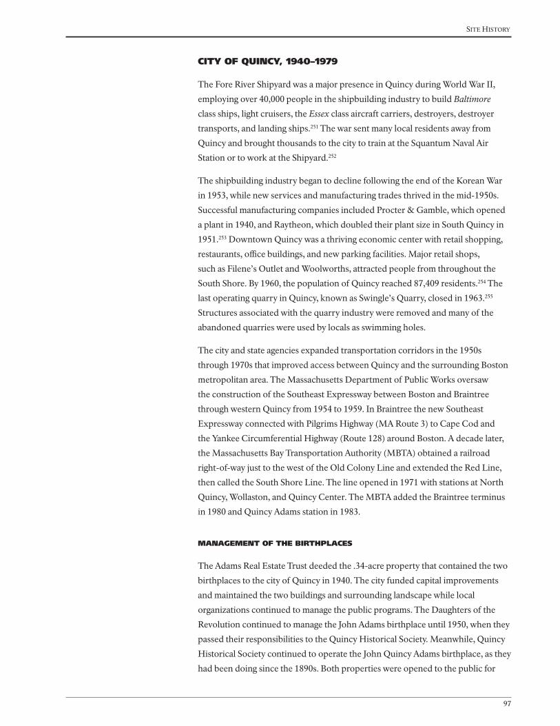
Site HiStory
97
CITY OF QUINCY, 1940–1979
The Fore River Shipyard was a major presence in Quincy during World War II,
employing over 40,000 people in the shipbuilding industry to build Baltimore
class ships, light cruisers, the Essex class aircraft carriers, destroyers, destroyer
transports, and landing ships.251 The war sent many local residents away from
Quincy and brought thousands to the city to train at the Squantum Naval Air
Station or to work at the Shipyard.252
The shipbuilding industry began to decline following the end of the Korean War
in 1953, while new services and manufacturing trades thrived in the mid-1950s.
Successful manufacturing companies included Procter & Gamble, which opened
a plant in 1940, and Raytheon, which doubled their plant size in South Quincy in
1951.253 Downtown Quincy was a thriving economic center with retail shopping,
restaurants, office buildings, and new parking facilities. Major retail shops,
such as Filene’s Outlet and Woolworths, attracted people from throughout the
South Shore. By 1960, the population of Quincy reached 87,409 residents.254 The
last operating quarry in Quincy, known as Swingle’s Quarry, closed in 1963.255
Structures associated with the quarry industry were removed and many of the
abandoned quarries were used by locals as swimming holes.
The city and state agencies expanded transportation corridors in the 1950s
through 1970s that improved access between Quincy and the surrounding Boston
metropolitan area. The Massachusetts Department of Public Works oversaw
the construction of the Southeast Expressway between Boston and Braintree
through western Quincy from 1954 to 1959. In Braintree the new Southeast
Expressway connected with Pilgrims Highway (MA Route 3) to Cape Cod and
the Yankee Circumferential Highway (Route 128) around Boston. A decade later,
the Massachusetts Bay Transportation Authority (MBTA) obtained a railroad
right-of-way just to the west of the Old Colony Line and extended the Red Line,
then called the South Shore Line. The line opened in 1971 with stations at North
Quincy, Wollaston, and Quincy Center. The MBTA added the Braintree terminus
in 1980 and Quincy Adams station in 1983.
MANAGEMENT OF THE BIRTHPLACES
The Adams Real Estate Trust deeded the .34-acre property that contained the two
birthplaces to the city of Quincy in 1940. The city funded capital improvements
and maintained the two buildings and surrounding landscape while local
organizations continued to manage the public programs. The Daughters of the
Revolution continued to manage the John Adams birthplace until 1950, when they
passed their responsibilities to the Quincy Historical Society. Meanwhile, Quincy
Historical Society continued to operate the John Quincy Adams birthplace, as they
had been doing since the 1890s. Both properties were opened to the public for

Cultural landsCape report for adams BirthplaCes
98
house tours and maintained by caretakers. Tourism and public interest in Quincy’s
historic sites and the Adams family grew during this period with ongoing efforts
to promote tourism and the presence of the National Park Service at Peace field
beginning in 1946.
The city expanded the birthplaces parcel from .34 to .72 acre after they acquired
the two residential lots to the north of the John Adams birthplace. Once in
possession of the two parcels, which were originally part of John Adams’ farm,
the city relocated the residences, and re-graded the landscape. This additional
open space provided a much needed buffer around the house. Following building
repairs, new pedestrian circulation, and grounds maintenance in the 1940s and
1950s, the city was no longer able to fund the necessary maintenance and repairs
for the buildings. The National Park Service acquired the Adams Mansion (Peace
field) in 1946, and established the Adams Mansion National Historic Site. In 1952,
they expanded the boundary to include a strip of land along the Furnace Brook
Parkway and renamed the park, Adams National Historic Site.
Transfer to the City of Quincy
In 1940, Charles Francis Adams contacted Quincy mayor, Thomas S. Burgin, to
discuss the Adams family’s desire to transfer the birthplaces parcel to the City
of Quincy. Charles Francis Adams reasoned, “in view of the historic value of
the houses the family would like to give them to the city under certain terms
and conditions.”256 The city accepted the property and agreed to, “preserve and
maintain such premises with any additions thereto or improvements thereon
as places of historic and public interest and not for profit, with the purpose of
fostering civic virtue and patriotism…and in general to do all things which may
be necessary or proper to preserve said premises and the buildings now built
thereon and the personal property which may from time to time be placed thereon
or therein.”257 The city council and mayor approved the transfer for the .34-acre
property, including the John Adams and the John Quincy Adams birthplaces, on
June 18, 1940. Under city ownership, the property would not be taxed. Shortly
after assuming ownership, the city council appropriated $2000 for repairs, which
funded interior and exterior building repairs at the John Adams birthplace (see
Figures 1.60 and 1.61).258
The Daughters of the Revolution had managed and cared for the John Adams
birthplace since 1896. By 1950, the Daughters of the Revolution Adams chapter,
which was down to one member, was no longer able to manage the building.
The Board of Managers of Historical Places asked the Quincy Historical Society
to manage the John Adams birthplace, in addition to the John Quincy Adams
birthplace. The Quincy Historical Society received the Adams family furniture,
which remained in the house. The Quincy Historical Society operated the
birthplaces and opened them to the public, while city of Quincy maintained and

Site HiStory
99
funded improvements at the houses. The city made additional repairs to mitigate
termite and dry rot damage at both buildings, introduce electricity and plumbing,
and improve structural beams in 1950-51.259 Prior to opening in 1951, the city
added new vegetation and a flagstone path between the two birthplaces.260 New
plantings likely included spring-flowering bulbs along the stone walls and split-rail
fences.
Expansion of the Birthplaces
As residential and commercial development thrived during the middle of the
century, the city sought to improve the setting of the birthplaces. In 1956, the
city acquired the two-and-a-half story Queen Anne house and adjoining land,
immediately north of the John Adams birthplace at 127 Franklin Street, from the
Craig family.261 The Craig house, built in 1886, sat only a few yards away from
Adams birthplace, and was considered a fire hazard that detracted from the
historic character of the birthplaces. The city relocated the house and regraded
the vacant lot in 1958. To the north of the Craig house, the McCausland house,
went on the market in 1957, and the city Council voted to acquire this property.
The house was moved and the lot was graded and seeded in 1958. The new open
space increased the setting of the birthplaces property from a .34-acre parcel to a
.72 acre parcel.
Local designations
The National Park Service designated the birthplaces of Presidents John Adams
and John Quincy Adams as National Historic Landmarks in 1960. The properties
were administratively listed in the National Register in 1966. The birthplaces
received approximately 9,400 visitors in 1974.262 The following year, city council
approved designation of two local Historic Districts in 1975, the Adams Birthplace
Historic District and the Quincy Center Historic District (Figure 1.62). The Adams
Figure 1.62. Photograph of the Adams
birthplaces, c.1975. Note the American
elm tree growing near the stone wall
and the split-rail fence in front of the
John Adams birthplace. (Adams NHP
archives).

Cultural landsCape report for adams BirthplaCes
100
Birthplace Historic District included the birthplaces on Franklin Street and
surrounding thirty-one properties. The Quincy Center Historic District included
115 properties and encompassed Quincy Square. National Historic Landmark
documentation was prepared for the birthplaces and accepted in 1978.
Despite the national recognition of the birthplaces, the city of Quincy was no
longer able to maintain the property after nearly three decades of ownership. In
1977, William A. O’Connell, President of the Quincy Historical Society, lobbied
for the transfer of the birthplaces to the National Park System, an obvious
candidate because of their presence at Peace field a mile and a half north of the
birthplaces. O’Connell wrote to the mayor, city council, senators, representatives,
local news media, and the historic commission expressing his concern over
the condition of the birthplaces property. O’Connell was concerned about
the structural integrity of the birthplaces, lack of fire and burglar alarms, and
deteriorated appearance. In public letter to Mayor Joseph J. LaRaia, he stated,
“The society feels it is necessary to once again reinforce that immediate steps
must be taken to stop the rapid deterioration of these buildings and to properly
preserve what is of great importance to the city and nation. We hope that you
appreciate that the present situation is critical and that immediate action is of
utmost importance.”263 Following a burglary in 1978 and ongoing repairs for the
two buildings, it became clear that neither the City of Quincy, nor the County of
Norfolk, was able to afford necessary maintenance and repairs.264 Members of
the Quincy Historical Society voted in support that the U.S. Department of the
Interior assume ownership of the .72-acre parcel (Figures 1.63 and 1.64).
Figure 1.63. Photograph at the Adams
birthplaces during the National Park
Service ceremony, 1979. (Courtesy of
Quincy Historical Society).

Site HiStory
101
Figure 1.64. Photograph at the Adams
birthplaces during the National Park
Service ceremony, 1979. (Courtesy of
Quincy Historical Society).
Just prior to the transfer to the National Park Service in 1979, the Quincy
Historical Society hired Richard Cheek to photograph the birthplaces. Antiques
magazine published a story, written by Quincy Historical Society historian H.
Hobart Holly that featured the property in the December issue (Figures 1.65 and
1.66). Photographs showcased the two red houses surrounded by the stone wall,
split-rail fence, and colorful fall vegetation including Norway maple and American
elm trees (Figures 1.67 and 1.68).
Figure 1.65. Photograph of the
Adams birthplaces in the fall, c.1979.
(Courtesy of Historic New England).

Cultural landsCape report for adams BirthplaCes
102
Figure 1.66. Photograph of the Adams
birthplaces, c.1979. (Courtesy of
Historic New England).
Figure 1.67. Photograph of the Adams
birthplaces from Franklin Avenue,
1979. (Adams NHP archives).
Figure 1.68. Photograph of the
Adams birthplaces and surrounding
landscape, 1979. View looking
southeast toward the houses with
deciduous shrubs and trees in the
foreground. (Adams NHP archives).

Site HiStory
103
LANDSCAPE SUMMARY, 1979
In 1979, as illustrated in Drawings 1.11 and 1.12, the John Adams and John
Quincy Adams birthplaces stood on a .72-acre parcel between Franklin Street and
Presidents Avenue, owned by the City of Quincy. None of the remaining Penn’s
Hill farm remained intact. Quincy was a dense residential and commercial city
with mixed industry near the shoreline.
Circulation improvements to Quincy included the construction of the MBTA
Red Line and new stations. City streets divided the remaining large parcels in
South Quincy, which were transformed into residential developments. Pedestrian
circulation within the birthplaces property included a flagstone path that ran
from Franklin Street to the front door to the John Adams birthplace, through an
opening in the stone wall, and to the front and back doors of the John Quincy
Adams birthplace. The paved pathway between John Adams birthplace and
Presidents Ave remained. The John Adams birthplace had a small lean-to attached
to the northwest corner of the house. Vegetation around the birthplaces included
Norway maples and American elms along the streets and between the buildings.
Pines, red maples, a beech tree, and a dogwood tree stood to the north of the
John Adams birthplace. Lilacs, spirea, and Chinese wisteria grew around the
foundation of the birthplaces.
Views from the birthplaces property included residential and commercial
development along Franklin Street and Presidents Avenue. Landscape features
Figure 1.69. Landscape plan for
the Adams birthplaces, 1979. The
plan documents site features such
as the stepping stone pathway,
stone wall and well location, and
the vegetation. (Drawn by Keith
S. Andreucci for Historic American
Building Survey).

Cultural landsCape report for adams BirthplaCes
104
included the stone wall around the John Quincy Adams birthplace with a wooden
split-rail gate, a split-rail fence around John Adams birthplace, the reconstructed
well to the northwest of the John Quincy Adams birthplace, a flagpole, and a park
sign.

National Park Service
Olmsted Center for Landscape Preservation
SOURCES
DRAWN BY
NOTES
Kirsten Holder, AutoCAD 2013 and Illustrator CS5
OLMSTED
for LANDSCAPE PRESERVATION
CENTER
www.nps.gov/oclp
1. All features shown in approximate scale and location.
2. Plan shows conditions in 2013.
1. City of Quincy, 2011
2. Aerial photograph, 2012
3. Site visit November, 2013
4. Lawrence D. Gall, 1981
5. Quincy Historical Society, Ezekiel C. Sargent Quincy
Land Records Collection
0’ 400’ 800’ 1600’
LEGEND
Existing roads
Roads
Creek
Stone wall
Existing building
10 Feet contour10 ft
Adams birthplaces
Property lines
Historic property lines
Cultural Landscape Report
BirthplacesAdams National Historical ParkQuincy, MA
Existing railroad
Town of Boston to Richard Wright, 1640
Moses Penniman, 1706
Town of Boston to William Needham, c.1639
Orchard and crop fields owned by the Veseys and Belchers
Town of Boston to William Ellis, c.1650,Ellis to Gregory Belcher, 1660,
Belcher to Samuel Belcher, 1663,Belcher to Deacon Gregory Belcher, 1679
Gregory Belcher home, 1660,Samuel Belcher, 1663,
Deacon Gregory Belcher, 1679,expanded 1716
Early History to 1720
William Needham to Joseph Penniman, 1675,Penniman to James Penniman, 1705
Fresh Brook
Fresh B
roo
k
Fresh BrookWilliam Needham to William Vesey, 1675, Vesey to Peter Webb, 1706
William Needham to T. Curtis, 1675Curtis to Moses Curtis
PENN’S HILL
PINE HILL
ROCK COMMONS
NORTH COMMON
COUNTRY ROAD TO PLYMOUTH, 1641COUNTRY ROAD TO PLYMOUTH, 1641
WAY
THRO
UGH THE
COM
MO
N, 166
0
Needham home, c.1640Penniman home, 1675, rebuilt, 1705, 1710
WAY TO 600 ACRES, 1640
School house, 1697and white oak tree, 1697
Drawing 1.1
See Drawing 1.2
John Vesey toDeacon Gregory Belcher,
1727
Deacon Gregory Belcher to Nathaniel Belcher, 1727,Belcher to Joseph Field, 1761
Deacon Gregory Belcher to Samuel Belcher, 1727,Belcher to Joseph Field, 1761
Joseph Adams to Deacon John Adams, 1731, Adams to Peter Boyleston Adams, 1761, Adams to John Adams, 1774
Joseph Adams toDeacon John Adams, 1731
Deacon John Adams to John Adams, 1761
Samuel Payne to Deacon John Adams, 1733,Adams to Peter Boyleston Adams, 1761,Adams to John Adams, 1774
Moses Babcock to Abigail Adams, 1783
Deacon Gregory Belcher to Gregory Belcher Jr., 1727, Belcher to Abigail Bracket Belcher, 1728Belcher to Lewis Vassal, 1742, Vassal to John and Richard Billings, 1743, Billings to Deacon John Adams, 1744,Adams to John Adams, 1761
Moses Payne to Deacon John Adams, 1733Adams to Peter Boyleston Adams, 1761, Adams to John Adams, 1803
Josiah Crosby toJohn Adams, 1765
Elkanah Thayer to John Adams, 1793
Town of Braintree toJohn Adams, 1765
Town of Braintree to Peter Boyleston Adams, 1765,Adams to John Adams, 1774
Elijah Veazie to John Adams, 1803
Ann Savil to John Adams, 1770
Town of BraintreeJohn Adams, 1765
James Thayer toJohn Adams, 1785
Joseph Field and Peter Boylston Adams to John Adams, 1771
Ann Savil to John Adams, 1770
Joseph Palmer toJohn Adams, 1771
Joseph Field house, 1771
Joseph Palmer to John Adams, 1771
Fresh Brook
Post and elm placed by Deacon John Adams, 1731
James Penniman to Deacon John Adams, 1720Deacon John Adams to Peter Boyleston Adams, 1761,Adams to John Adams, 1774
Moses Curtis to John Vesey, 1721, William and Amy Vesey to
John Adams, 1788Tompson Baxter to John Adams, 1771
Mill
Deacon John Adams, through John Adams, 1720–1803
Joseph Palmer corn house and well, 1771
Marsh
Orchard
Garden
Cow Yard
Apple orchard
Potatoes
Corn
Vesey house and farm, 1762See Drawing 1.4
Drawing 1.3
COUNTRY ROAD TO PLYMOUTH COUNTRY ROAD TO PLYMOUTH
Fresh Brook
Fresh Brook
PENN’S HILL
PINE HILL
ROCK COMMONS
NORTH COMMON
John Adams to Town of Quincy, 1822
John Quincy Adams to Town of Quincy, 1803
John Adams to John Quincy Adams, 1803
John Adams to John Quincy Adams,
1803
John Adams to John Quincy Adams,
1803
John Adams to John Quincy Adams,
1803
John Adams to John Quincy Adams, 1803
John Adams to John Quincy Adams, 1803
John Adams to John Quincy Adams,
1803
John Adams to John Quincy Adams, 1803
John Adams to John Quincy Adams, 1803
John Quincy Adams to Nathaniel White, 1827
John Adams to John Quincy Adams, 1803
John Adams to John Quincy Adams, 1803
John Adams to John Quincy Adams, 1803
John Adams to John Quincy Adams, 1803
John Adams to John Quincy Adams, 1803
John Adams to John Quincy Adams, 1803
John Quincy Adams to Samuel Curtis, 1829
John Quincy Adams to Benjamin Crane, 1836
Joseph Field
Joseph Field
Belcher?Fresh Brook
John Quincy Adams, 1803–1848
Drawing 1.5
COUNTRY ROAD TO PLYMOUTH COUNTRY ROAD TO PLYMOUTH
See Drawing 1.6
PENN’S HILL
PINE HILL
Charles Francis Adams,1848–1886
INDEPENDENCE AVENUE (1865)
PRESIDENTS AVENUE (C.1885)
QU
ARR
Y ST
REET
(188
4)
John Quincy Adams to Charles Francis Adams,
1848
John Quincy Adams to Charles Francis Adams,
1848
Charles Francis Adams,date unknown
John Quincy Adams to Charles Francis Adams,
1848
John Quincy Adams to Charles Francis Adams,
1848
Drawing 1.7
FRANKLIN
AVEN
UE
FRANKLIN AVENUE
WASHINGTON STREET
PHIPPS STREET (1874)
See Drawing 1.8
PENN’S HILL
PINE HILL
Qu
incy
Brain
tree
Adams Real Estate Trust,1886–1940
Adams Real Estate Trust,
1907
Charles Francis Adams to Adams Real Estate Trust,
1886
Adams Chapter of the Society of theDaughters of the Revolution installs cairn
Charles Francis Adams to Adams Real Estate Trust,
1886
Charles Francis Adams to Adams Real Estate Trust,
1886
Drawing 1.9
See Drawing 1.10
PENN’S HILL
PINE HILL
QUINCY CENTER
City of Quincy,1940–1979
Adams Real Estate Trust to City of Quincy, 1940Adams Birthplaces
Craig and McCausland families to City of Quincy, 1956-57
MBTAQuincy Adams Station
MBTAQuincy Center
MBTA Red Line
Drawing 1.11
See Drawing 1.12
PENN’S HILL
PINE HILL
QUINCY CENTER
Cairn for Abigail Adams and John Quincy Adams
National Park ServiceUnited First Parish Church
City of Quincy to National Park Service, 1979
Adams Birthplaces
MBTAQuincy Adams Station
MBTAQuincy Center
MBTA Red Line
National Park Service, 1979–Present
Drawing 1.13
See Drawing 1.14
PENN’S HILL
PINE HILL
QUINCY CENTER
Cairn for Abigail Adams and John Quincy Adams
National Park ServiceUnited First Parish Church
National Park ServiceAdams Birthplaces
MBTAQuincy Adams Station
MBTAQuincy Center
MBTA Red Line
Existing Conditions
Drawing 2.1
See Drawing 2.2
PENN’S HILL
QUINCY CENTER
PINE HILL
Cairn for Abigail Adams and John Quincy Adams


National Park Service
Olmsted Center for Landscape Preservation
SOURCES
NOTES
OLMSTED
for LANDSCAPE PRESERVATION
CENTER
www.nps.gov/oclp
1. All features shown in approximate scale and location.
1. HABS Survey, 1936, 1979
2. City of Quincy, 2011
3. Aerial photograph, 2012
4. Site visit November, 2013, 2014
0’ 15’ 30’ 60’
Cultural Landscape Report
BirthplacesAdams National Historical ParkQuincy, MA
DRAWN BYUpdated by Ashley M. Braquet, Illustrator CS6, 2014Kirsten Holder, AutoCAD 2013 and Illustrator CS5, 2013
LEGEND
Existing roads
Stone wall
Flagstones
Deciduous and Evergreen trees
Existing building
10 Feet contour
Adams Birthplaces Property Lines
Deciduous shrubs
Property Lines
Picket Fence
Split Rail Fence
Chain link fence
Dirt road
Gardens
Town of Boston to William Ellis, c.1650Ellis to Gregory Belcher, 1660Belcher to Samuel Belcher, 1663Belcher to Deacon Gregory Belcher, 1679
Possible location of barn or outbuilding
Possible location school house (built 1697)
Possible location of white oak tree
Well (c.1660)
Possible location of barn
Town of Boston to William Needham, 1640William Needham to Joseph Penniman, 1675Joseph Penniman to James Penniman, 1705
William Needham to T. Curtis, 1675Curtis to Moses Curtis
Ellis home (1660)
Needham home (c.1640)Penniman home (expanded or re-built, 1710)
Vegetable garden
Orchards and vegetable gardens
Orchards and vegetable gardens
Vegetable garden
Drawing 1.2
COUNTRY ROAD TO PLYMOUTH, 1641
Early History to 1720
2. Fences are most likely located on property lines, although no specific information is available.
Fenced in front yard,(c.1730)
Lilac shrubs
Grass yard
William and Sarah Vesey to John Adams, 1788
Deacon John Adams, through John Adams, 1720–1803
Deacon Gregory Belcher to Gregory Belcher Jr., 1727 Belcher to Abigail Bracket Belcher, 1728Belcher to Lewis Vassal, 1742, Vassal to John and Richard Billings, 1743 Billings to Deacon John Adams, 1744Adams to John Adams, 1761
James Penniman to Deacon John Adams, 1720Deacon John Adams to Peter Boyleston Adams, 1761Adams to John Adams, 1774
Possible change in ownership from:James Penniman to Deacon John Adams, 1720Adams to John Adams, 1774
Possible location of barn (c.1736), and possible location of new barn (c. 1796)
Possible location of barn
Well
Drawing 1.4
COUNTRY ROAD TO PLYMOUTH
Possible locationof sheds, (1764)
Stone wall, (1762)
John Adam
s
birthplace
John Quincy Adams birthplace
Removed feature
5. John Adams Diary, AFP/MHS
6. Eliza Susan Quincy, 1822
John Quincy Adams to Benjamin Crane, 1836
Joseph Crane house, 1831
John Quincy Adams to Samuel Curtis, 1829
John Quincy Adams to Nathaniel White, 1827
John Adams to John Quincy Adams, 1803
John Adams to John Quincy Adams, 1803
John Quincy Adams, 1803–1848
Well
COUNTRY ROAD TO PLYMOUTH
Drawing 1.6
Possible location of barn(c.1805)
Possible location of barn (c.1805)
Possible location of shed(c.1805)
Possible locationof shagbark tree
Wooden fence(c. 1805)
John Adam
s
birthplace
John Quincy Adams birthplace
Removed feature
John Quincy Adams to Charles Francis Adams, 1848
John Quincy Adams to Charles Francis Adams, 1848
Charles Francis Adams,1848–1886
PAY
NE STR
EET (C.1884)
Drawing 1.8
FRANKLIN STREET
PRESIDENTS AVENUE (C.1884)
Possible location of barn Shed
Possiblelocationof barn
Possible location of barn
Well
Ac pl
Ul am
Ul am
Ul am
Ul am
Syvu
Ac pl
Lat in name C ommon name ID
Acer platanoides Norway maple Ac pl
Chaenomeles speciosa common flowering quince Ch sp
Ulmus americana American elm Ul am
Syringa vulgaris common lilac Sy vuJohn A
dams
birthplace
John Quincy Adams birthplace
Removed feature
Adams Real Estate Trust,1886–1940
Charles Francis Adams to Adams Real Estate Trust,
1886
Turnstile (1896)Split-rail fence (1896)
Craig house (1886-87)McCausland house (1886-87)
Relocated well (1896)
Removed barn (c.1887)
Removed sheds (c.1895-96)
Removed barn (c.1887)
Street car line, c.1890
Drawing 1.10
FRANKLIN STREET
PRESIDENTS AVENUE
Ac pl
Ul am
Ul am
Sy vu
Wi si
Ul am
Ul am
Ul am
Ul am
Ac pl
Ac pl
Ac pl
Ac pl
Sy vu
Sy vu
Sp va
Sy vu
Syvu
Sy vu
Sy vu/Sp va
Ac pl
Ac pl
Ac pl
Pedestrian walkway(c.1896)
Franklin Street widened andPayne Street removed (c.1921)
Shed(c.1896)
Stone wall (re-built 1896)
Fa sy
Co fl
Ac pl
Flagpole(c.1926)
100’
Lat in name C ommon name ID
Acer platanoides Norway maple Ac pl
Cornus florida flowering dogwood Co fl
Fagus sylvatica copper beech Fa sy
Syringa vulgaris common lilac Sy vu
Vanhoutte spirea
Spiraea x vanhouttei
Sp va
Ulmus americana American elm Ul am
Wisteria sinensis Chinese wisteria Wi si
John Adam
s
birthplace
John Quincy Adams birthplace
Removed feature
City of Quincy,1940–1979
Adams Real Estate Trust to City of Quincy, 1940Adams Birthplaces
McCausland family to City of Quincy, 1956-57
Craig family to City of Quincy, 1956-57
Craig house(removed 1958)
McCausland house(removed 1958)
Drawing 1.12
Hancock TV and Appliance,1957
FRANKLIN STREET
PRESIDENTS AVENUE
Ac pl
Ac pl
Ac pl
Eu al/Sy vu
Tilia cordataFa sy
Pi st
Cladrastis kentukea
Co fl
Ac pl
Ac pl
Ac pl
Ac pl
Ac pl
Wi si
Pi st
Pi st
Sy vu
Split-rail fence/gate
Pedestrian path(c.1951)
Flagstone pathway(1951)
Lat in name C ommon name ID
Acer platanoides Norway maple Ac pl
Chaenomeles speciosa common flowering quince Ch sp
Cornus florida flowering dogwood Co fl
Euonymus alatus burning bush Eu al
Fagus sylvatica copper beech Fa sy
Pinus strobus white pine Pi st
Rosa species rose Ro sp
Quercus rubra red oak Qu ru
Syringa vulgaris common lilac Sy vu
Vanhoutte spirea Spiraea x vanhouttei Sp va
Buxus sempervirens boxwood Bu se
Wisteria sinensis Chinese wisteria Wi si
John Adam
s
birthplace
John Quincy Adams birthplace
Removed feature
Sy vu
Sy vu
Bu se
Bu se
Bu se
Bu se
Bu se
Ro spCh sp
Sy vu
Sy vu
Sp va
Sy vu/Sp va
Sy vu
FRANKLIN STREET
Pr se Pr sePr se
Pr se
Pr se
Ac pl
Bu se
Bu se
Flagpole(c.1979)
Ac pl
Ti co
Fa sy
Pi st
Pi st
Pi st
Qu ruFo sp/Sy vu
Cl ke
Co fl
Ch sp
Eu al/Sy vu
Ch sp
Sy vu
Sy vu
Ac pl
Ac pl
Ac pl
Well
Stone wall
Gate
flagstone pathway
John Adam
s
birthplace
Hancock TV and Appliance
John Quincy Adams birthplace
Basementdoor
Park sign
Park sign
PRESIDENTS AVENUE National Park Service, 1979–2014
2. Plan shows conditions in 2014.
Drawing 1.14
Park signNPS bus parking zone
Shed removed(c.1981)
Pedestrian path removed(c. 1981)
Split-rail fence
Lat in name C ommon name ID
Acer platanoides Norway maple Ac pl
Chaenomeles speciosa common flowering quince Ch sp
Cornus florida flowering dogwood Co fl
Cladrastis kentukea yellowwood Cl ke
Eu al
Buxus sempervirens boxwood Bu se
Pinus strobus white pine Pi st
Prunus serrulata ‘Kwanzan’ Kwanzan cherry Pr se
Quercus rubra red oak Qu ru
Syringa vulgaris
Euonymus alatus burning bush
Fo spForsythia speciosa forsythia
common lilac Sy vu
Removed feature
FRANKLIN STREET
Pr se Pr sePr se
Pr se
Pr se
Ac pl
Il cr
Il cr
Flagpole
Ac pl
Ac pl
Fa gr
Pi st
Pi st
Pi st
Qu ru
Sp va
Co fl
Co fl
Ch sp
Va sp
Ch sp
Sy vu
Sy vu
Ac pl
Ac pl
Ac pl
Well
Stone wall
Split-rail fence/gate
Stepping stone pathway
John Adam
s
Birthplace
Hancock TV and Appliance
John Quincy Adams Birthplace
Basementdoor
Park sign
Park sign
PRESIDENTS AVENUE Existing Conditions
2. Plan shows conditions in 2014.
Drawing 2.1
Park sign
Split-rail fence
Lat in name C ommon name ID
Acer platanoides Norway maple Ac pl
Chaenomeles speciosa common flowering quince Ch sp
Cornus florida flowering dogwood Co fl
Ilex crenata Japanese holly Il cr
Pinus strobus white pine Pi st
Prunus serrulata ‘Kwanzan’ Kwanzan cherry Pr se
Quercus rubra red oak Qu ru
Syringa vulgaris common lilac Sy vu
Vanhoutte spirea Spiraea x vanhouttei Va sp
Ulmus americana American elm Ul am
Wisteria sinensis Chinese wisteria Wi si
Removed feature
Ul am
Ul am
Wi si
Ul am
Ul am
Ul am
Ul am
Ac pl
Ac pl
Ac pl
Sy vu
Sy vu
Sy vu
Syvu
Syvu
Sp vaSy vu/Sp va
Ac pl
Ac pl
Ac pl
Ac pl
100’
Split-rail fence/gate
Flagstone pathway (1951)
John Adam
s
Birthplace
Hancock TV and Appliance
John Quincy Adams Birthplace
Park sign(2008)
Park sign(2008)
5 - Pr se(early 1990s)
Pr sePr sePr se
Pr se
PRESIDENTS AVENUE Analysis and Evaluation
2. Plan shows conditions in 2014.
Drawing 3.1
Flag pole(c. 1979)
Park sign(2008)
Stone wall
Well
Split-rail fence
Walkway(c.1896-1951)
Feature added/built since 1940
since 1940
FRANKLIN STREET
Shed(c.1896-1951)Flagpole
(1896-1926)Ac pl
Ti co
Pi st
Pi st
Pi st
Qu ru
Fo sp/Sy vu
Co fl
Ch sp
Eu al/Sy vu
Ch sp
Sy vu
Sy vu
Sy vu
Craig house (1886/87-1958)
Acquired by City of Quincy,(1956-57)
Sidewalk widened(c. 1990 and 2012)
McCausland house (1886/87-1958)
Acquired by City of Quincy(1956-57)
Lat in name C ommon name ID
Acer platanoides Norway maple Ac pl
Chaenomeles speciosa common flowering quince Ch sp
Cornus florida flowering dogwood Co fl
Buxus sempervirens boxwood Bu se
Cladrastis kentukea yellowwood Cl ke
Euonymus alatus burning bush Eu al
Forsythia species forsythia Fo sp
Fagus sylvatica copper beech Fa sy
Lat in name C ommon name ID
Prunus serrulata ‘Kwanzan’ Kwanzan cherry Pr se
Quercus rubra red oak Qu ru
Syringa vulgaris common lilac Sy vu
Tilia cordata little leaf linden Ti co
Vanhoutte spirea Spiraea x vanhouttei Sp va
Ulmus americana American elm Ul am
Wisteria sinensis Chinese wisteria Wi si
Bu se
Bu se
Ac pl
Removed feature
Fa sy
Ac pl
Cl ke
Pinus strobus white pine Pi st


Site HiStory
109
NATIONAL PARK SERVICE, 1979–PRESENT
The National Park Service already had a long-time presence in Quincy when they
acquired the birthplaces property from the city in 1979. The Peace field property,
acquired in 1946, received over 20,000 visitors a year by 1978. Meanwhile, the
birthplaces received around 10,000 each year.265 Following the acquisition in 1979,
park staff documented the existing conditions later that summer, renovated the
interior and exterior of the birthplaces, furnished the houses, and implemented
minor changes to the vegetation, grading, and small-scale features. Park staff gave
tours from the exterior of the birthplaces until the buildings opened to the public
in 1984.
By the 1980s, the city blocks that surrounded the birthplaces were fully developed,
with commercial buildings concentrated along Franklin Street, and residential
development in the surrounding city blocks. City staff maintained the sidewalk
and streets surrounding the birthplaces and park staff maintained the buildings
and landscape within the park boundary. Major reports by the National Park
Service for the birthplaces included the New Area Study in 1978, a Draft Historic
Structure Report in 1993, the General Management Plan in 1996, and the Historic
Furnishings Report in 2001. The National Park Service designated Adams National
Historic Site as a National Historical Park in 1998 to reflect the multiple properties
within the park.
NATIONAL HISTORIC SITE
Congress passed the enabling legislation for the acquisition of the birthplaces,
part of Public Law 95-625, on November 10, 1978 and allowed the National
Park Service to officially acquire the .72-acre property on April 20, 1979.266 The
National Park Service celebrated the acquisition on May 1, 1979, with an opening
that included park and city representatives (see Figures 1.63 and 1.64). Wilhelmina
S. Harris, who served as the first superintendent for Adams National Historic Site,
and her staff, managed both the Peace field and birthplaces properties.
The National Park Service renovated the buildings at the birthplaces property
from 1979 to 1984, while the interiors of the birthplaces remained closed to
visitors. The National Park Service updated the Historic American Building
Survey (HABS) to document architectural details, interior measurements,
exterior sketches, and elevations of the John Adams and John Quincy Adams
birthplaces (see Figures 1.69 through 1.74). The survey team also mapped the
location of vegetation, circulation, and small-scale features on the site. In the
HABS survey, Architectural Historian Carole Perrault recorded that the John
Quincy Adams birthplace was “surrounded on three sides by a stone fence and in
the rear by a split-rail fence” and that “historically, a farm constituting numerous
acres of farm land, is now characterized by a semi-commercial and residential
center. Historically, there was a stone fence and a split-rail fence. Currently, both

Cultural landsCape report for adams BirthplaCes
110
Figure 1.70. Photograph of the John
Adams birthplace from the sidewalk
at Franklin Avenue, 1980. Note the
sheared Japanese yew in front of
the home and winged euonymus
along the east side of the home
that were subsequently removed.
A young linden tree is visible to the
right, northeast of the home. (Walter
Smiling for HABS).
Figure 1.71. Photograph of the John
Adams birthplace, 1980. Note the
lilacs in front of the house and the
removal of other shrubs. A small
boxwood grows by the stone wall.
(Walter Smiling for HABS).
exist; however they are later additions and their placement is not historically
accurate.”267 During John Adams and John Quincy Adams lives, the stone wall and
split-rail fences lined the property boundaries, which were much larger parcels, as
well as the early road, which was narrower than Franklin Street is today.
The birthplaces were two of many historic structures in Quincy. Preservation
consultants, Monique Lehner and Minxie Fannin led the Quincy Multiple
Resource Area study beginning in 1986, which included 96 contributing and 28
non-contributing resources. The authors conducted a comprehensive inventory
of Quincy, which they submitted to the Massachusetts Historical Commission,
and included more than 600 properties from the 1600s through 1940. The study
imposed restrictions on new development within this area of Quincy.
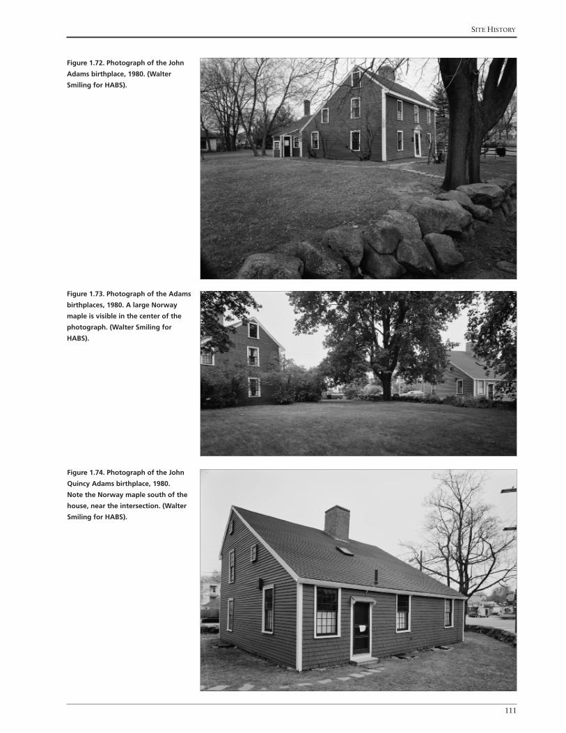
Site HiStory
111
Figure 1.72. Photograph of the John
Adams birthplace, 1980. (Walter
Smiling for HABS).
Figure 1.73. Photograph of the Adams
birthplaces, 1980. A large Norway
maple is visible in the center of the
photograph. (Walter Smiling for
HABS).
Figure 1.74. Photograph of the John
Quincy Adams birthplace, 1980.
Note the Norway maple south of the
house, near the intersection. (Walter
Smiling for HABS).

Cultural landsCape report for adams BirthplaCes
112
In the 1990s, city and park staff made several changes to the birthplaces landscape
to improve the visitor experience, wayfinding, and circulation (Figures 1.76
through 1.82). In the early 1990s, the city planted Kwanzan cherry trees (Prunus
serrulata ‘Kwanzan’) in the sidewalk on Franklin Street (see Figures 1.77, 1.80,
1.81). Around this time, the city painted a red line on the sidewalk along Franklin
Street, similar to the Freedom Trail in Boston, to help visitors navigate between
the historic sites in Quincy (see Figure 1.82). Park staff simplified pedestrian
circulation by removing the walkway between Presidents Avenue and the back
door of John Adams birthplace and removing the flagstones that led from the
front door of John Adams birthplace to the back door. Park staff planted irises
and daffodils along the south side of the stone wall between the birthplaces (see
Figures 1.77 and 1.78). In the mid-1990s, park staff removed an aged, deteriorating
Figure 1.75. Photograph of the
Adams birthplaces, 1985. (Adams NHP
archives).
Figure 1.76. Photograph of the John
Adams birthplace, c.1995. (Adams
NHP archives).

Site HiStory
113
Figure 1.77. Photograph of the John
Adams birthplace, c.1995. Note the
purple irises growing at the base of
the stone wall. (Adams NHP archives).
Figure 1.78. Photograph of the John
Adams birthplace, c.1995. Note the
daffodils growing at the base of the
stone wall. (Adams NHP archives).
Figure 1.79. Photograph of the John
Adams birthplace, c.1995. View
looking north through the stone wall.
Note the Norway maple and Japanese
holly growing near the stone wall.
(Adams NHP archives).

Cultural landsCape report for adams BirthplaCes
114
Figure 1.82. Photograph of the Adams
birthplaces, c.1995. Note the Kwanzan
cherry trees in the sidewalk. (Adams
NHP archives).
Figure 1.80. Photograph of the John
Quincy Adams birthplace, c.1995.
Note the young Kwanzan cherry tree
in the sidewalk in front of the John
Quincy Adams birthplace. (Adams
NHP archives).
Figure 1.81. Photograph of the Adams
birthplaces, c.1995. (Adams NHP
archives).

Site HiStory
115
Norway maple at the corner of Franklin Street and Presidents Avenue (see Figure
1.69). The tree was not replaced. They removed the split-rail fence around the
John Adams birthplace in the 1990s for a brief amount of time, then installed a
new split-rail fence. As a result of street and sidewalk widening, the park and city
removed a portion of the stone wall that ran along the front of the John Quincy
Adams birthplace. Just to the north of the John Quincy Adams birthplace, the park
installed new “Adams National Historic Site” signs with park information (see
Figure 1.76). They also painted the John Quincy Adams birthplace cream with a
yellow door. Prior to painting, the John Adams birthplace had dark wood siding.
Figure 1.84. View looking north up
Presidents Avenue of removal of one
Norway maple and stabilization of
the two remaining Norway maples
along the western edge of the John
Adams birthplace property, 2010.
(Adams NHP archives).
Figure 1.83. View looking northwest
of removal of one Norway maple
and stabilization of two remaining
Norway maples along Presidents
Avenue at the western edge of the
John Adams birthplace property, 2010.
(Adams NHP archives).

Cultural landsCape report for adams BirthplaCes
116
Figure 1.85. View looking northwest
of tree care crew working on the
yellowwood at the northeast corner
of the John Adams birthplace
property, 2010. (Adams NHP archives).
Figure 1.86. View looking south of the
Kwanzan cherries in full bloom along
Franklin Street. The back side of the
John Adams birthplace is visible at
right beyond the trunks of a mature
beech and linden tree, 2010. Note the
low branches of the cherry tree along
the sidewalk. (Adams NHP archives).
Figure 1.87. View looking south of the
John Adams birthplace and Franklin
Street sidewalk in the spring, 2010.
The flowering quince is blooming
along the split-rail fence. (Adams NHP
archives).

Site HiStory
117
Figure 1.88. View looking southwest
of a special exhibit in front of
the John Adams birthplace, 2010.
The stone wall and John Quincy
Adams birthplace are visible in the
background. (Adams NHP archives).
In 1996, the National Park Service drafted the Adams National Historic Site
General Management Plan, which outlined the long term goals for the park.
The plan emphasized youth programing and education at the birthplaces.268 In
2001, the National Parks Conservation Association drafted State of the Parks:
Adams National Historical Park, A Resource Assessment. The report found that
“the birthplaces landscape (0.72 acres), where plantings need to be replaced, is
in poor condition.”269 The report recommended that the park, “Determine how
many visitors is the optimum number (the “carrying capacity”) for the presidential
birthplaces and Old House to ensure that visitation does not take a toll on these
buildings and that visitors have a positive experience.”270
In 1998 the park name changed from Adams National Historic Site to Adams
National Historical Park, recognizing the 1979 acquisition of the birthplaces and
addition of the off-site visitor center in Quincy Center. In the early 2000s, park
staff made minimal changes to the birthplaces landscape. With less than an acre
of land, park staff concentrated their effort in tree care, lawn maintenance, and
trash clean up (Figures 1.83 through 1.88). Park staff mowed the lawn around the
birthplaces approximately one time per week and frequently picked up trash.271
A large maple along the north boundary of the John Adams birthplace parcel
was removed in 2005. Another large Norway maple that stood between the John
Adams and John Quincy Adams birthplaces and was removed and replaced in-
kind in 2006.
Working with Harpers Ferry Center in 2008 the park implemented a park signage
plan and all on-site park signs were changed to reflect the park’s name change
and installed according to NPS sign standards. Three new signs were installed at
the birthplaces, one In 2008, park staff installed three new park signs, one at the
corner of Franklin Street and Presidents Avenue and two along Franklin Street.
Park staff planted lilacs and forsythia along Presidents Avenue and fenced off and

Cultural landsCape report for adams BirthplaCes
118
re-seeded the lawn in front of the entrance to John Adams birthplace. In 2010
park staff removed one of three Norway maples that stood near the fence line at
Presidents Avenue. This tree was not replaced. Park staff pruned and installed
cables on the American beech tree and dogwood tree that stand north of the John
Adams birthplace. The City of Quincy replaced the sidewalk on Franklin Street
in 2012. Due to the close proximity of the house to the sidewalk, the back step for
the John Quincy Adams birthplace overlaps with the new sidewalk.
LANDSCAPE SUMMARY, 2014
In 2013, as illustrated in Drawings 1.13 and 1.14, the John Adams and John
Quincy Adams birthplaces stood on a .72-acre parcel, surrounded by Franklin
Street and Presidents Avenue, owned by the National Park Service. Circulation
improvements included a new flagstone pathway between the birthplaces and
the removal of a paved walkway to the John Adams birthplace. The pedestrian
pathway between the John Adams birthplace and Presidents Avenue was removed.
The re-paved city sidewalk, which wraps around the eastern, southern, and
western edges of the property, encroached the park boundary near the John
Quincy Adams birthplace. The John Adams birthplace no longer had a lean-to
at the northwest corner. Vegetation around the birthplaces included Norway
maples, pines, dogwoods, a beech tree, and an oak tree in fair to good condition.
The lilacs were also in good condition. Kwanzan cherry trees lined the eastern
edge of the property, outside the park boundary, and maintained by the City of
Quincy.
Views from the birthplaces property included residential and commercial
development. Small-scale features within the parcel included the stone wall
around the John Quincy Adams birthplace, a wooden gate and split-rail fences
around John Adams birthplace, the well, and flagpole. A more detailed description
of the existing conditions is contained in the next chapter.

National Park Service
Olmsted Center for Landscape Preservation
SOURCES
DRAWN BY
NOTES
Kirsten Holder, AutoCAD 2013 and Illustrator CS5
OLMSTED
for LANDSCAPE PRESERVATION
CENTER
www.nps.gov/oclp
1. All features shown in approximate scale and location.
2. Plan shows conditions in 2013.
1. City of Quincy, 2011
2. Aerial photograph, 2012
3. Site visit November, 2013
4. Lawrence D. Gall, 1981
5. Quincy Historical Society, Ezekiel C. Sargent Quincy
Land Records Collection
0’ 400’ 800’ 1600’
LEGEND
Existing roads
Roads
Creek
Stone wall
Existing building
10 Feet contour10 ft
Adams birthplaces
Property lines
Historic property lines
Cultural Landscape Report
BirthplacesAdams National Historical ParkQuincy, MA
Existing railroad
Town of Boston to Richard Wright, 1640
Moses Penniman, 1706
Town of Boston to William Needham, c.1639
Orchard and crop fields owned by the Veseys and Belchers
Town of Boston to William Ellis, c.1650,Ellis to Gregory Belcher, 1660,
Belcher to Samuel Belcher, 1663,Belcher to Deacon Gregory Belcher, 1679
Gregory Belcher home, 1660,Samuel Belcher, 1663,
Deacon Gregory Belcher, 1679,expanded 1716
Early History to 1720
William Needham to Joseph Penniman, 1675,Penniman to James Penniman, 1705
Fresh Brook
Fresh B
roo
k
Fresh BrookWilliam Needham to William Vesey, 1675, Vesey to Peter Webb, 1706
William Needham to T. Curtis, 1675Curtis to Moses Curtis
PENN’S HILL
PINE HILL
ROCK COMMONS
NORTH COMMON
COUNTRY ROAD TO PLYMOUTH, 1641COUNTRY ROAD TO PLYMOUTH, 1641
WAY
THRO
UGH THE
COM
MO
N, 166
0
Needham home, c.1640Penniman home, 1675, rebuilt, 1705, 1710
WAY TO 600 ACRES, 1640
School house, 1697and white oak tree, 1697
Drawing 1.1
See Drawing 1.2
John Vesey toDeacon Gregory Belcher,
1727
Deacon Gregory Belcher to Nathaniel Belcher, 1727,Belcher to Joseph Field, 1761
Deacon Gregory Belcher to Samuel Belcher, 1727,Belcher to Joseph Field, 1761
Joseph Adams to Deacon John Adams, 1731, Adams to Peter Boyleston Adams, 1761, Adams to John Adams, 1774
Joseph Adams toDeacon John Adams, 1731
Deacon John Adams to John Adams, 1761
Samuel Payne to Deacon John Adams, 1733,Adams to Peter Boyleston Adams, 1761,Adams to John Adams, 1774
Moses Babcock to Abigail Adams, 1783
Deacon Gregory Belcher to Gregory Belcher Jr., 1727, Belcher to Abigail Bracket Belcher, 1728Belcher to Lewis Vassal, 1742, Vassal to John and Richard Billings, 1743, Billings to Deacon John Adams, 1744,Adams to John Adams, 1761
Moses Payne to Deacon John Adams, 1733Adams to Peter Boyleston Adams, 1761, Adams to John Adams, 1803
Josiah Crosby toJohn Adams, 1765
Elkanah Thayer to John Adams, 1793
Town of Braintree toJohn Adams, 1765
Town of Braintree to Peter Boyleston Adams, 1765,Adams to John Adams, 1774
Elijah Veazie to John Adams, 1803
Ann Savil to John Adams, 1770
Town of BraintreeJohn Adams, 1765
James Thayer toJohn Adams, 1785
Joseph Field and Peter Boylston Adams to John Adams, 1771
Ann Savil to John Adams, 1770
Joseph Palmer toJohn Adams, 1771
Joseph Field house, 1771
Joseph Palmer to John Adams, 1771
Fresh Brook
Post and elm placed by Deacon John Adams, 1731
James Penniman to Deacon John Adams, 1720Deacon John Adams to Peter Boyleston Adams, 1761,Adams to John Adams, 1774
Moses Curtis to John Vesey, 1721, William and Amy Vesey to
John Adams, 1788Tompson Baxter to John Adams, 1771
Mill
Deacon John Adams, through John Adams, 1720–1803
Joseph Palmer corn house and well, 1771
Marsh
Orchard
Garden
Cow Yard
Apple orchard
Potatoes
Corn
Vesey house and farm, 1762See Drawing 1.4
Drawing 1.3
COUNTRY ROAD TO PLYMOUTH COUNTRY ROAD TO PLYMOUTH
Fresh Brook
Fresh Brook
PENN’S HILL
PINE HILL
ROCK COMMONS
NORTH COMMON
John Adams to Town of Quincy, 1822
John Quincy Adams to Town of Quincy, 1803
John Adams to John Quincy Adams, 1803
John Adams to John Quincy Adams,
1803
John Adams to John Quincy Adams,
1803
John Adams to John Quincy Adams,
1803
John Adams to John Quincy Adams, 1803
John Adams to John Quincy Adams, 1803
John Adams to John Quincy Adams,
1803
John Adams to John Quincy Adams, 1803
John Adams to John Quincy Adams, 1803
John Quincy Adams to Nathaniel White, 1827
John Adams to John Quincy Adams, 1803
John Adams to John Quincy Adams, 1803
John Adams to John Quincy Adams, 1803
John Adams to John Quincy Adams, 1803
John Adams to John Quincy Adams, 1803
John Adams to John Quincy Adams, 1803
John Quincy Adams to Samuel Curtis, 1829
John Quincy Adams to Benjamin Crane, 1836
Joseph Field
Joseph Field
Belcher?Fresh Brook
John Quincy Adams, 1803–1848
Drawing 1.5
COUNTRY ROAD TO PLYMOUTH COUNTRY ROAD TO PLYMOUTH
See Drawing 1.6
PENN’S HILL
PINE HILL
Charles Francis Adams,1848–1886
INDEPENDENCE AVENUE (1865)
PRESIDENTS AVENUE (C.1885)
QU
ARR
Y ST
REET
(188
4)
John Quincy Adams to Charles Francis Adams,
1848
John Quincy Adams to Charles Francis Adams,
1848
Charles Francis Adams,date unknown
John Quincy Adams to Charles Francis Adams,
1848
John Quincy Adams to Charles Francis Adams,
1848
Drawing 1.7
FRANKLIN
AVEN
UE
FRANKLIN AVENUE
WASHINGTON STREET
PHIPPS STREET (1874)
See Drawing 1.8
PENN’S HILL
PINE HILL
Qu
incy
Brain
tree
Adams Real Estate Trust,1886–1940
Adams Real Estate Trust,
1907
Charles Francis Adams to Adams Real Estate Trust,
1886
Adams Chapter of the Society of theDaughters of the Revolution installs cairn
Charles Francis Adams to Adams Real Estate Trust,
1886
Charles Francis Adams to Adams Real Estate Trust,
1886
Drawing 1.9
See Drawing 1.10
PENN’S HILL
PINE HILL
QUINCY CENTER
City of Quincy,1940–1979
Adams Real Estate Trust to City of Quincy, 1940Adams Birthplaces
Craig and McCausland families to City of Quincy, 1956-57
MBTAQuincy Adams Station
MBTAQuincy Center
MBTA Red Line
Drawing 1.11
See Drawing 1.12
PENN’S HILL
PINE HILL
QUINCY CENTER
Cairn for Abigail Adams and John Quincy Adams
National Park ServiceUnited First Parish Church
City of Quincy to National Park Service, 1979
Adams Birthplaces
MBTAQuincy Adams Station
MBTAQuincy Center
MBTA Red Line
National Park Service, 1979–2014
Drawing 1.13
See Drawing 1.14
PENN’S HILL
PINE HILL
QUINCY CENTER
Cairn for Abigail Adams and John Quincy Adams
National Park ServiceUnited First Parish Church
National Park ServiceAdams Birthplaces
MBTAQuincy Adams Station
MBTAQuincy Center
MBTA Red Line
Existing Conditions
Drawing 2.1
See Drawing 2.2
PENN’S HILL
QUINCY CENTER
PINE HILL
Cairn for Abigail Adams and John Quincy Adams


National Park Service
Olmsted Center for Landscape Preservation
SOURCES
NOTES
OLMSTED
for LANDSCAPE PRESERVATION
CENTER
www.nps.gov/oclp
1. All features shown in approximate scale and location.
1. HABS Survey, 1936, 1979
2. City of Quincy, 2011
3. Aerial photograph, 2012
4. Site visit November, 2013, 2014
0’ 15’ 30’ 60’
Cultural Landscape Report
BirthplacesAdams National Historical ParkQuincy, MA
DRAWN BYUpdated by Ashley M. Braquet, Illustrator CS6, 2014Kirsten Holder, AutoCAD 2013 and Illustrator CS5, 2013
LEGEND
Existing roads
Stone wall
Flagstones
Deciduous and Evergreen trees
Existing building
10 Feet contour
Adams Birthplaces Property Lines
Deciduous shrubs
Property Lines
Picket Fence
Split Rail Fence
Chain link fence
Dirt road
Gardens
Town of Boston to William Ellis, c.1650Ellis to Gregory Belcher, 1660Belcher to Samuel Belcher, 1663Belcher to Deacon Gregory Belcher, 1679
Possible location of barn or outbuilding
Possible location school house (built 1697)
Possible location of white oak tree
Well (c.1660)
Possible location of barn
Town of Boston to William Needham, 1640William Needham to Joseph Penniman, 1675Joseph Penniman to James Penniman, 1705
William Needham to T. Curtis, 1675Curtis to Moses Curtis
Ellis home (1660)
Needham home (c.1640)Penniman home (expanded or re-built, 1710)
Vegetable garden
Orchards and vegetable gardens
Orchards and vegetable gardens
Vegetable garden
Drawing 1.2
COUNTRY ROAD TO PLYMOUTH, 1641
Early History to 1720
2. Fences are most likely located on property lines, although no specific information is available.
Fenced in front yard,(c.1730)
Lilac shrubs
Grass yard
William and Sarah Vesey to John Adams, 1788
Deacon John Adams, through John Adams, 1720–1803
Deacon Gregory Belcher to Gregory Belcher Jr., 1727 Belcher to Abigail Bracket Belcher, 1728Belcher to Lewis Vassal, 1742, Vassal to John and Richard Billings, 1743 Billings to Deacon John Adams, 1744Adams to John Adams, 1761
James Penniman to Deacon John Adams, 1720Deacon John Adams to Peter Boyleston Adams, 1761Adams to John Adams, 1774
Possible change in ownership from:James Penniman to Deacon John Adams, 1720Adams to John Adams, 1774
Possible location of barn (c.1736), and possible location of new barn (c. 1796)
Possible location of barn
Well
Drawing 1.4
COUNTRY ROAD TO PLYMOUTH
Possible locationof sheds, (1764)
Stone wall, (1762)
John Adam
s
birthplace
John Quincy Adams birthplace
Removed feature
5. John Adams Diary, AFP/MHS
6. Eliza Susan Quincy, 1822
John Quincy Adams to Benjamin Crane, 1836
Joseph Crane house, 1831
John Quincy Adams to Samuel Curtis, 1829
John Quincy Adams to Nathaniel White, 1827
John Adams to John Quincy Adams, 1803
John Adams to John Quincy Adams, 1803
John Quincy Adams, 1803–1848
Well
COUNTRY ROAD TO PLYMOUTH
Drawing 1.6
Possible location of barn(c.1805)
Possible location of barn (c.1805)
Possible location of shed(c.1805)
Possible locationof shagbark tree
Wooden fence(c. 1805)
John Adam
s
birthplace
John Quincy Adams birthplace
Removed feature
John Quincy Adams to Charles Francis Adams, 1848
John Quincy Adams to Charles Francis Adams, 1848
Charles Francis Adams,1848–1886
PAY
NE STR
EET (C.1884)
Drawing 1.8
FRANKLIN STREET
PRESIDENTS AVENUE (C.1884)
Possible location of barn Shed
Possiblelocationof barn
Possible location of barn
Well
Ac pl
Ul am
Ul am
Ul am
Ul am
Syvu
Ac pl
Lat in name C ommon name ID
Acer platanoides Norway maple Ac pl
Chaenomeles speciosa common flowering quince Ch sp
Ulmus americana American elm Ul am
Syringa vulgaris common lilac Sy vuJohn A
dams
birthplace
John Quincy Adams birthplace
Removed feature
Adams Real Estate Trust,1886–1940
Charles Francis Adams to Adams Real Estate Trust,
1886
Turnstile (1896)Split-rail fence (1896)
Craig house (1886-87)McCausland house (1886-87)
Relocated well (1896)
Removed barn (c.1887)
Removed sheds (c.1895-96)
Removed barn (c.1887)
Street car line, c.1890
Drawing 1.10
FRANKLIN STREET
PRESIDENTS AVENUE
Ac pl
Ul am
Ul am
Sy vu
Wi si
Ul am
Ul am
Ul am
Ul am
Ac pl
Ac pl
Ac pl
Ac pl
Sy vu
Sy vu
Sp va
Sy vu
Syvu
Sy vu
Sy vu/Sp va
Ac pl
Ac pl
Ac pl
Pedestrian walkway(c.1896)
Franklin Street widened andPayne Street removed (c.1921)
Shed(c.1896)
Stone wall (re-built 1896)
Fa sy
Co fl
Ac pl
Flagpole(c.1926)
100’
Lat in name C ommon name ID
Acer platanoides Norway maple Ac pl
Cornus florida flowering dogwood Co fl
Fagus sylvatica copper beech Fa sy
Syringa vulgaris common lilac Sy vu
Vanhoutte spirea
Spiraea x vanhouttei
Sp va
Ulmus americana American elm Ul am
Wisteria sinensis Chinese wisteria Wi si
John Adam
s
birthplace
John Quincy Adams birthplace
Removed feature
City of Quincy,1940–1979
Adams Real Estate Trust to City of Quincy, 1940Adams Birthplaces
McCausland family to City of Quincy, 1956-57
Craig family to City of Quincy, 1956-57
Craig house(removed 1958)
McCausland house(removed 1958)
Drawing 1.12
Hancock TV and Appliance,1957
FRANKLIN STREET
PRESIDENTS AVENUE
Ac pl
Ac pl
Ac pl
Eu al/Sy vu
Tilia cordataFa sy
Pi st
Cladrastis kentukea
Co fl
Ac pl
Ac pl
Ac pl
Ac pl
Ac pl
Wi si
Pi st
Pi st
Sy vu
Split-rail fence/gate
Pedestrian path(c.1951)
Flagstone pathway(1951)
Lat in name C ommon name ID
Acer platanoides Norway maple Ac pl
Chaenomeles speciosa common flowering quince Ch sp
Cornus florida flowering dogwood Co fl
Euonymus alatus burning bush Eu al
Fagus sylvatica copper beech Fa sy
Pinus strobus white pine Pi st
Rosa species rose Ro sp
Quercus rubra red oak Qu ru
Syringa vulgaris common lilac Sy vu
Vanhoutte spirea Spiraea x vanhouttei Sp va
Buxus sempervirens boxwood Bu se
Wisteria sinensis Chinese wisteria Wi si
John Adam
s
birthplace
John Quincy Adams birthplace
Removed feature
Sy vu
Sy vu
Bu se
Bu se
Bu se
Bu se
Bu se
Ro spCh sp
Sy vu
Sy vu
Sp va
Sy vu/Sp va
Sy vu
FRANKLIN STREET
Pr se Pr sePr se
Pr se
Pr se
Ac pl
Bu se
Bu se
Flagpole(c.1979)
Ac pl
Ti co
Fa sy
Pi st
Pi st
Pi st
Qu ruFo sp/Sy vu
Cl ke
Co fl
Ch sp
Eu al/Sy vu
Ch sp
Sy vu
Sy vu
Ac pl
Ac pl
Ac pl
Well
Stone wall
Gate
flagstone pathway
John Adam
s
birthplace
Hancock TV and Appliance
John Quincy Adams birthplace
Basementdoor
Park sign
Park sign
PRESIDENTS AVENUE National Park Service, 1979–2014
2. Plan shows conditions in 2014.
Drawing 1.14
Park signNPS bus parking zone
Shed removed(c.1981)
Pedestrian path removed(c. 1981)
Split-rail fence
Lat in name C ommon name ID
Acer platanoides Norway maple Ac pl
Chaenomeles speciosa common flowering quince Ch sp
Cornus florida flowering dogwood Co fl
Cladrastis kentukea yellowwood Cl ke
Eu al
Buxus sempervirens boxwood Bu se
Pinus strobus white pine Pi st
Prunus serrulata ‘Kwanzan’ Kwanzan cherry Pr se
Quercus rubra red oak Qu ru
Syringa vulgaris
Euonymus alatus burning bush
Fo spForsythia speciosa forsythia
common lilac Sy vu
Removed feature
FRANKLIN STREET
Pr se Pr sePr se
Pr se
Pr se
Ac pl
Il cr
Il cr
Flagpole
Ac pl
Ac pl
Fa gr
Pi st
Pi st
Pi st
Qu ru
Sp va
Co fl
Co fl
Ch sp
Va sp
Ch sp
Sy vu
Sy vu
Ac pl
Ac pl
Ac pl
Well
Stone wall
Split-rail fence/gate
Stepping stone pathway
John Adam
s
Birthplace
Hancock TV and Appliance
John Quincy Adams Birthplace
Basementdoor
Park sign
Park sign
PRESIDENTS AVENUE Existing Conditions
2. Plan shows conditions in 2014.
Drawing 2.1
Park sign
Split-rail fence
Lat in name C ommon name ID
Acer platanoides Norway maple Ac pl
Chaenomeles speciosa common flowering quince Ch sp
Cornus florida flowering dogwood Co fl
Ilex crenata Japanese holly Il cr
Pinus strobus white pine Pi st
Prunus serrulata ‘Kwanzan’ Kwanzan cherry Pr se
Quercus rubra red oak Qu ru
Syringa vulgaris common lilac Sy vu
Vanhoutte spirea Spiraea x vanhouttei Va sp
Ulmus americana American elm Ul am
Wisteria sinensis Chinese wisteria Wi si
Removed feature
Ul am
Ul am
Wi si
Ul am
Ul am
Ul am
Ul am
Ac pl
Ac pl
Ac pl
Sy vu
Sy vu
Sy vu
Syvu
Syvu
Sp vaSy vu/Sp va
Ac pl
Ac pl
Ac pl
Ac pl
100’
Split-rail fence/gate
Flagstone pathway (1951)
John Adam
s
Birthplace
Hancock TV and Appliance
John Quincy Adams Birthplace
Park sign(2008)
Park sign(2008)
5 - Pr se(early 1990s)
Pr sePr sePr se
Pr se
PRESIDENTS AVENUE Analysis and Evaluation
2. Plan shows conditions in 2014.
Drawing 3.1
Flag pole(c. 1979)
Park sign(2008)
Stone wall
Well
Split-rail fence
Walkway(c.1896-1951)
Feature added/built since 1940
since 1940
FRANKLIN STREET
Shed(c.1896-1951)Flagpole
(1896-1926)Ac pl
Ti co
Pi st
Pi st
Pi st
Qu ru
Fo sp/Sy vu
Co fl
Ch sp
Eu al/Sy vu
Ch sp
Sy vu
Sy vu
Sy vu
Craig house (1886/87-1958)
Acquired by City of Quincy,(1956-57)
Sidewalk widened(c. 1990 and 2012)
McCausland house (1886/87-1958)
Acquired by City of Quincy(1956-57)
Lat in name C ommon name ID
Acer platanoides Norway maple Ac pl
Chaenomeles speciosa common flowering quince Ch sp
Cornus florida flowering dogwood Co fl
Buxus sempervirens boxwood Bu se
Cladrastis kentukea yellowwood Cl ke
Euonymus alatus burning bush Eu al
Forsythia species forsythia Fo sp
Fagus sylvatica copper beech Fa sy
Lat in name C ommon name ID
Prunus serrulata ‘Kwanzan’ Kwanzan cherry Pr se
Quercus rubra red oak Qu ru
Syringa vulgaris common lilac Sy vu
Tilia cordata little leaf linden Ti co
Vanhoutte spirea Spiraea x vanhouttei Sp va
Ulmus americana American elm Ul am
Wisteria sinensis Chinese wisteria Wi si
Bu se
Bu se
Ac pl
Removed feature
Fa sy
Ac pl
Cl ke
Pinus strobus white pine Pi st


Site HiStory
123
ENDNOTES, SITE HISTORY
1 Early history is derived from the 2012 Cultural Landscape Inventory for Peace field. Margie Coffin Brown, Allison Crosbie, and Aaron Ahlstrom. “Peace field: Cultural Landscape Inventory,” (Adams National Historical Park, National Park Service. Cultural Landscape Inventories. 2012).
2 Eric S. Johnson, Archeological Overview and Assessment of the Adams National Historic Site, (New England System Support Office National Park Service U.S. Department of the Interior, 1996).
3 William Cronon, Changes in the Land, (New York: Hill and Wang, 1983): 42-53; Bert Salwen, “Indians of Southern New England and Long Island: Early Period,” in Handbook of North American Indians, Vol. 15, edited by Bruce G. Trigger, (Washington, D.C.: Smithsonian Institution, 1978): 170.
4 Charles V. Cogbill, John Burk, and G. Motzkin, “The forests of pre-settlement New England, USA: spatial and compo-sitional patterns based on town proprietor surveys,” Journal of Biogeography 29 (2002): 1289.
5 William Wood, New England’s Prospect, edited by Alden T. Vaughan, (Amherst: University of Massachusetts Press: 1634, reprint 1993): 17. William Cronon, Changes in the Land, 28-33.
6 Brereton, John. A Briefe and True Relation of the Discoverie of the North Part of Virginia in 1602. (New York: Dodd, Mead & Company, 1903): 4.
7 Phillips, James Duncan. Salem in the Seventeenth Century. (Boston: Houghton Mifflin Company, 1933): 16.
8 Bratton, Timothy (1988). “Identity of the New England Indian Epidemic of 1616-1619.” Bulletin of the History of Medicine, 62 (3): 352–383.
9 Bradford, William, edited by Charles Deane. History of Plymouth Plantation. (Boston: Massachusetts Historical Soci-ety, 1856): 87.
10 William C. Edwards, A Chronology of Historic Quincy, 1614 – 1944, (Quincy, Mass.: Quincy Historical Society, 1945 [reprint 1979]): 1.
11 Boston Town Records, 4th Dec. 1635, in William S. Pattee, A History of Old Braintree and Quincy with a sketch of Ran-dolph and Holbrook, (Quincy: Green & Prescott, 1878): 21.
12 John Peacock, “Principles and Effects of Puritan Appropriation of Indian Land and Labor,” Ethnohistory 31, No. 1 (1984): 39-44; Carolyn Merchant, Ecological Revolutions: Nature, Gender, and Science in New England, (Chapel Hill: University of North Carolina Press, 1989): 96.
13 Charles Francis Adams, History of Braintree, (Cambridge, MA: Riverside Press, 1891) 2-3; Howard S. Russell, A Long, Deep Furrow: Three Centuries of Farming in New England, (Hanover: University Press of New England, 1976, abridged 1982): 13.
14 Minxie J. Fannin and Monique B. Lehner, Quincy Historic and Architectural Survey Overview, (Quincy, MA: July 1986), “Contact Period,” http://thomascranelibrary.org/htm/overview.htm#IV; Laurel A. Racine, Historic Furnishings Report: The Birthplaces of Presidents John Adams and John Quincy Adams, U.S. Department of the Interior, National Park Service, April 2001: 14; William C. Edwards, A Chronology of Historic Quincy, 1614 – 1944, (Quincy, Mass.: Quincy Historical Society, 1945 [reprint 1979]): 1.
15 William Wood, New England’s Prospect, 57-58.
16 Charles Francis Adams, Three Episodes of Massachusetts History: The Settlement of Boston Bay, The Antinomian Contro-versy, A Study of Church and Town Government, Vol. II, (Boston: Houghton, Mifflin and Company, 1893): 583.
17 Charles Francis Adams, History of Braintree, 2-3.
18 Charles Francis Adams, History of Braintree, 4.
19 William Wood, 33-34.
20 Ibid, 33-34.
21 Ibid, 38-39.
22 William Wood noted that due to the devastating effects of European diseases on the Massachusett Indians, the land between Weymouth and Plymouth had “much underwood…because it hath not been burned. Ibid, 38-39.

Cultural landsCape report for adams BirthplaCes
124
23 Charles Francis Adams, History of Braintree, 7, 12-13.
24 Racine, 14.
25 John R. Stilgoe, Common Landscape of America, 1580to 1845, (New Haven: Yale University Press, 1982): 242.
26 Records of the Town of Braintree, 1640 to 1793, edited by Samuel A. Bates, (Randolph, Mass.: Daniel H. Huxford, 1886): 36, at Braintree Historical Society, Braintree, Massachusetts (hereafter BHS).
27 William C. Edwards, A Chronology of Historic Quincy, 1614 – 1944, 1.
28 Charles Francis Adams, History of Braintree, 288.
29 Minxie J. Fannin and Monique B. Lehner, Quincy Historic and Architectural Survey Overview, (Quincy, MA: July 1986), “Contact Period,” http://thomascranelibrary.org/htm/overview.htm#IV; Carole Louise Perrault, “Historic Structures Report, Birthplaces of John Adams and John Quincy Adams, Volume I: Administrative Data and Historical Background,” Draft, U.S. Department of the Interior, National Park Service, (Boston, MA: 1993): 58; Howard S. Rus-sell, A Long, Deep Furrow: Three Centuries of Farming in New England, (Hanover: University Press of New England, 1976, abridged 1982): 45.
30 Charles Francis Adams, History of Braintree, 14.
31 Howard S. Russell, 93-94.
32 Charles Francis Adams, History of Braintree, 29.
33 Ibid, 65.
34 The Ezekiel C. Sargent Quincy Land Records Collection, Quincy Historical Society, Book I: Plan I 4, QHS. John Adams Diary 2, 5-30-1771, Adams Family Papers, Massachusetts Historical Society, http://www.masshist.org/publica-tions/apde/index.php.
35 Charles Francis Adams, Three Episodes, II, 658.
36 Robert M. Thorson, Stone by Stone: The Magnificent History in New England’s Stone Walls, (New York: Walker & Com-pany, 2002): 82-83.
37 Boston Town Records, 2-18-1639 and Town of Boston, Deed to William Needham, 1-27-1640, in The Ezekiel C. Sar-gent Quincy Land Records Collection (hereafter, Sargent Papers), Book C: 1-2, 5, 29, 39, at Quincy Historical Society, Quincy, Massachusetts (hereafter QHS);
38 Ibid.
39 Perrault, 58; Stilgoe, 305-07.
40 Pattee, 28-31, 34-35.
41 Racine, 151. The exact date of construction varies among sources. The Archeological Report from 1991 reports that Samuel Belcher built the house in 1663 and Deacon Gregory Belcher expanded it in 1716. Darcie A. MacMahon, Archeological Collections Management at Adams National Historic Site, (Boston: National Park Service, 1991).
42 William and Mary Allis (Ellis), Deed to Gregorye Bellcher, 20 March 1660, Library, Quincy Historical Society, Quincy, MA, in Racine, 152. Quotation text is copied from original sources. All misspellings are from original material.
43 Stilgoe, 205.
44 Susan A. Dolan, Fruitful Legacy: A Historic Context of Orchards in the United States, with Technical Information for Registering Orchards in the National Register of Historic Places, U.S. Department of the Interior, National Park Service, (Pacific West Regional Office: 2009): 14-15.
45 National Park Service historians Laurel Racine and Carole Perrault presume that Samuel Belcher developed much of the farmstead that later became the John Quincy Adams Birthplace. Racine, 153; Perrault, 105.
46 Howard S. Russell, 26.
47 Ibid, 24.

Site HiStory
125
48 Stilgoe, 182-84, 193.
49 Ibid.
50 Howard S. Russell, 52, 83.
51 Carolyn Merchant, Ecological Revolutions: Nature, Gender, and Science in New England, (Chapel Hill: University of North Carolina Press, 1989): 103-04.
52 Stilgoe, 200-01.
53 Ibid, 200-01.
54 Susan A. Dolan, Fruitful Legacy, 19, 23-24.
55 Howard S. Russell, 23.
56 Stilgoe, 184-88, 203.
57 Charles Francis Adams, Three Episodes of Massachusetts History, Vol. II, 659.
58 Sargent Papers, Book C: 3, QHS.
59 The 1720 deeds included fencing in the text. Sargent Papers, Book C, 37, QHS.
60 Sargent Papers, Book C: 4, QHS.
61 Robert M. Thorson, 96-98.
62 Edwards, 2.
63 Records of the Town of Braintree, 1640 to 1793, edited by Samuel A. Bates, (Randolph, Mass.: Daniel H. Huxford, 1886): 36.
64 Fannin and Lehner, “Colonial Period.”
65 Racine, 14.
66 Racine, 18; Sargent Papers, Book C, 33, 35; Joseph Penniman, Mortgage to Leonard Hoar, 1675, Suffolk Deeds, vol. 9, p. 257, quoted in Sprague (1959, p20).
67 Racine, 18; Sargent Papers, Book C, 33, 35; Joseph Penniman, Mortgage to Leonard Hoar, 1675, Suffolk Deeds, vol. 9, p. 257, quoted in Sprague (1959, p20).
68 Samuel Belcher Inventory, 1680, in Racine, 153.
69 Racine, 154.
70 Ibid, 154.
71 Perrault, 69. The exact date of construction varies among sources. The Archeological Report from 1991 reports that William Needham built the house around 1639 and Joseph Penniman replaced the house in 1681. Darcie A. MacMa-hon, Archeological Collections Management at Adams National Historic Site, (Boston: National Park Service, 1991).
72 James Penniman Deed to John Adams (Deacon), Adams Office Files, Box 2, Folder 13. MHS.
73 Sargent Papers, Book C, 38, QHS.
74 Sargent Papers, Book C, 37, QHS.
75 Sargent Papers, Book C, 36, QHS.
76 Racine, 17, 20-21.
77 William S. Pattee, A History of Old Braintree and Quincy with a sketch of Randolph and Holbrook, (Quincy: Green & Prescott, 1878): 57.
78 C.F. Adams, Three Episodes, 661-665.

Cultural landsCape report for adams BirthplaCes
126
79 William C. Edwards, A Chronology of Historic Quincy, 1614 – 1944, (Quincy, Mass.: Quincy Historical Society, 1945 [reprint 1979]), 2.
80 C.F. Adams, Three Episodes, 661-665.
81 Fannin and Lehner, “Colonial Period”
82 Racine, 17, 20-21; James Penniman Deed to John Adams (Deacon), Adams Office Files, Box 2, Folder 13. MHS.
83 Sargent Papers, Book C, 37, QHS.
84 Sargent Papers, Book C, 36, QHS.
85 Joseph Adams, Will, 1731, Adams Papers Microfilm, Reel #306, in Racine, 23
86 Gall, 4
87 Racine, 154.
88 Racine, 155; Perrault, 114.
89 Quotation of the Deed to Vassall from Nightingale (Abigail Belcher married Samuel Nightingale), in Racine, 156.
90 Lewis Vassall, Deed to John and Richard Billings, 1742, Suffolk County Deeds, Vol. 66, 238-39; Racine 156.
91 John and Richard Billings Deed to John Adams, April 13, 1744, Adams Office Files, Box 2, Folder 13, Massachusetts Historical Society (MHS).
92 Racine, 17.
93 James Grant, John Adams: Party of One, (New York: Macmillan, 2006), 24.
94 John Adams Diary 1, 2-11-1756, AFP/MHS. This description was most likely not recorded at the birthplace property, but described the nearby town of Braintree and surrounding countryside south of the birthplaces.
95 John Adams Diary 1, Spring 1759, AFP/MHS.
96 John Adams Diary 1, 6-15-1756, AFP/MHS
97 John Adams Diary 1, 11-18-1755 electronic edition. Adams Family Papers: An Electronic Archive. Massachusetts Historical Society. http://www.masshist.org/digitaladams/ (hereafter AFP/MHS).
98 John Adams Diary 1, 4-20-1756, AFP/MHS.
99 John Adams Diary 1, 5-11-1756, AFP/MHS
100 John Adams Diary 1, Spring 1759, AFP/MHS.
101 Racine, 23; Perrault, 75-76; John Adams (Deacon) Will, 1761, MHS
102 While working on the farm, Adams was an avid horticulturalist. In the fall of 1762 he observed, “ … several Ginger Bushes. They Grow in Bunches like Willows and Alders, in low Grounds, between Upland and Meadows. They grow Eight feet high, and about an Inch thro at the Butt. They have Bark of a dark Colour, speckled over with little, white rough Spots, near the Ends of the Bows [Boughs] they branch out into a Multitude of little Sprigs. The Bush I saw had shed all its Leaves. All over the Branches and sprigs, are little fresh Buds at this season. It has a spicy Taste. The Spriggs and Buds and Bark have a spicy Taste.” John Adams Diary 1, 10-23-1762, MHS.
103 John Adams Diary 1, 10-23-1762, MHS.
104 John Adams Diary 1, 10-24-1762, AFP/MHS
105 Stilgoe, 188-92.
106 John Adams Diary 1, 10-24-1762, AFP/MHS.
107 John Adams Diary 3, 1763; Charles Francis Adams, History of the North Precinct of Braintree, 83.

Site HiStory
127
108 John Adams quoted in History of the North Precinct of Braintree by Charles Francis Adams, 73, https://archive.org/stream/historyofbraintr00adam#page/72/mode/2up, accessed October 25, 2013.
109 Adams, Charles Francis, 73 and John Adams, deed, July 27, 1822.
110 John Adams Diary 2, 2-28-1774, AFP/MHS.
111 Racine, 32-33; 151, 158 and Sprague, 12. The two sheds, which are no longer extant, appeared in mid-nineteenth cen-tury sketches of John Quincy Adams Birthplace. Records show that John Adams paid Luke Lambard in 1767 for work completed in 1764 at the John Quincy Adams Birthplace.
112 Peter Boylston Adams and Joseph Field Deed to John Adams, April 1764, Adams Office Files, Box 2, Folder 13, MHS.
113 Town of Braintree Deed to John Adams, April 13, 1765, Adams Office Files, Box 2, Folder 13, MHS.
114 Ann Savil Deed to John Adams, 4-21-1770, Adams Office Files, Box 2, Folder 13, MHS.
115 Joseph Palmer Deed to John Adams, 5-6-1771, Adams Office Files, Box 2, Folder 13, MHS.
116 Tompson Baxter Deed to John Adams, 9-21-1771, Adams Office Files, Box 2, Folder 13, MHS.
117 John Adams Diary 2, 5-30-1771, AFP/MHS.
118 John Adams Diary 1, 12-31-1765, AFP/MHS.
119 John Adams Diary, Vol. 1, 7-13-1770, AFP/MHS.
120 John Adams Diary 2, 11-21-1772, AFP/MHS
121 John Adams Diary 2, 11-21-1772, AFP/MHS
122 John Adams Diary 2, 2-28-1774, AFP/MHS.
123 John Adams Diary 2, 2-28-1774, AFP/MHS.
124 John Adams to Abigail Adams, 7-6-1774, AFP/MHS.
125 Racine, 36.
126 Abigail Adams to John Adams, 6-18-1775, AFP/MHS.
127 Abigail Adams to John Adams, 6-18-1775, AFP/MHS.
128 Abigail Adams to John Adams, 1774–79.
129 Abigail Adams to John Adams, 11-27-1775
130 Abigail Adams to John Adams, 6-8-1777, AFP/MHS.
131 Abigail Adams to John Adams, 7-10-1777, AFP/MHS.
132 John Adams to Abigail Adams, 7-30-1777, AFP/MHS.
133 Letter from Abigail Adams to John Adams, 7-15-1778, AFP/MHS. Twelve pence was equal to one shilling.
134 Racine, 38.
135 Letter from Abigail Adams to John Adams, 7-15-1778, AFP/MHS.
136 Abigail Adams to John Adams, 1-2-1779, AFP/MHS.
137 Abigail Adams to John Adams, 3-17 to 3-25-1782, Perrault, 194. The phrase “retireing back” might refer to landowners selling their land moving into smaller properties or it might refer to moving back to England.
138 Abigail Adams to Mercy Otis Warren, 9-1-1780, AFP/MHS.
139 Racine, 162.

Cultural landsCape report for adams BirthplaCes
128
140 Moses Babcock Deed to Abigail Adams, 5-2-1783, Adams Office Files, Box 2, Folder 13, MHS.
141 John Adams to Abigail Adams, 6-9-1783, AFP/MHS.
142 Abigail Adams to Cotton Tufts, 6-18-1784, AFP/MHS.
143 Letter from Cotton Tufts to Abigail Adams, 12-1-1784, AFP/MHS.
144 James Thayer, Jr., Deed to John Adams, 1-8-1785, Adams Office Files, Box 2, Folder 13, MHS.
145 James Apthorp Deed to John Adams, 4-4-178?; Adams Office Files, Box 2, Folder 13, MHS.
146 Elizabeth Cranch to Abigail Adams, 5-20-1786, AFP/MHS.
147 Cotton Tufts to Abigail Adams, 9-15-1786, AFP/MHS.
148 Katherine Lacy, Cultural Landscape Report for Adams National Historic Site: Illustrated Site Chronology (Boston, Mass.: National Park Service, Olmsted Center for Landscape Preservation, 1997), 9.
149 Abigail Adams to Mary Cranch, 10-10-1790, in Perrault, 199.
150 Racine, 39. Very little is known about Faxon and his time in the John Adams birthplace. It is unknown if he actually lived in the house.
151 Elkanah Thayer Deed to John Adams, 11-4-1793, Adams Office Files, Box 2, Folder 13, MHS.
152 John Adams Diary, 12 July 1795, Adams Papers Microfilm, Reel #2, in Racine, 42.
153 Racine, 40.
154 John Adams to Abigail Adams, 3-9-1796, in Perrault, 200-01.
155 John Adams Diary 3, 7-13-1796, AFP/MHS.
156 John Adams Diary 3, 7-14-1796, AFP/MHS.
157 John Adams Diary 3, 7-15-1796, AFP/MHS.
158 John Adams Diary 3, 7-20-1796, AFP/MHS.
159 John Adams Diary 3, July 25, 1796, AFP/MHS.
160 Racine, 194.
161 Abigail Adams to Cotton Tufts, 3-18-1800, in Perrault, 199-200.
162 John Adams, Deed to John Quincy Adams, 1803. Cited in Racine 43. When John Quincy Adams later hired surveyor Lemuel Humphrey to survey his lands, they found that the Penn’s Hill farm contained 91 acres rather than 108, as John Adams had previously believed.
163 H. Hobart Holly, Quincy 350 Years, (Quincy, Massachusetts, Quincy Heritage Inc.) 1974, 26.
164 Quincy: MHC Reconnaissance Survey Town Report, (Massachusetts Historical Commission: Boston, MA, 1981), 7.
165 Fannin and Lehner, “Federal Period;” C.F. Adams, Three Episodes, 927.
166 Quincy: MHC Reconnaissance Survey Town Report, (Massachusetts Historical Commission: Boston, MA, 1981), 7.
167 Racine, 45.
168 John Quincy Adams Diary, April 19, 1804, APM, Reel 30 in Perrault, 207.
169 John Adams Deed to John Quincy Adams, 4-23-1804, Adams Office Files, Box 2, Folder 13, MHS.
170 John Quincy Adams Diary, April 24, 1804, APM, Reel 30 in Perrault, 207.
171 John Quincy Adams to Louis Catherine Adams, 4-24-1804. Adams Family Papers: An Electronic Archive. Massachu-setts Historical Society. http://www.masshist.org/digitaladams/

Site HiStory
129
172 John Quincy Adams to Louisa Catherine Adams, quoted in Perrault, 143, 207.
173 Racine, 199.
174 John Quincy Adams Diary, October 10, 1804, MHS/AFP.
175 John Quincy Adams Financial Record, in Perrault, 208; Racine, 44.
176 Louisa Catherine Adams to Abigail Adams, 2-11-1805, in Perrault, 144.
177 John Quincy Adams Diary, April 25, 1805, MHS/AFP.
178 John Quincy Adams Diary, May 2, and June 21, 1805, MHS/AFP.
179 John Quincy Adams Diary, November 6, 1805, MHS/AFP.
180 Racine includes a detailed account of the tenants in the Historic Furnishings Report.
181 John Quincy Adams Diary, 3 May 1807, Adams Papers Microfilm, Reel #30 cited in Racine, 208.
182 Town of Quincy Tax Bill, 1792–1811 cited in Racine, 209.
183 Town of Quincy Tax Bill, 1811–1826 cited in Racine, 209.
184 Racine 210–14. Racine provides a detailed history of the tenants in the John Quincy Adams birthplace. All dates are approximate as many of them are based on John Quincy Adams’ diary entries.
185 Lawrence D. Gall, “The Adams Birthplaces: An Interpretive Study in New England Preservation History,” (Brighton: 1978), 3 and Racine, 45.
186 Town of Quincy Tax Bill, 1811–1826 cited in Racine, 46. Boylston also made alterations to the interior of the John Adams birthplace.
187 Town of Quincy Tax Bill, 1811–1826 cited in Racine, 51.
188 Racine, 53–4.
189 Lawrence D. Gall, “Topographical Notes on John Adams’ Farm at Penn’s Hill,” 1981, 2.
190 Racine, 54.
191 Sprague, The President John Adams and President John Quincy Adams Birthplaces, p. 37 cited in Racine, 55.
192 Racine, 55.
193 John Adams Deed to John Quincy Adams, 9-25-1819, Adams Office Files, Box 2, Folder 15, MHS.
194 Sargent Papers, Book I, 37, QHS.
195 Racine, 49; John Adams Estate Deed to John Quincy Adams, 10-4-1826, Adams Office Files, Box 2, Folder 15, MHS. This removed Thomas Boylston Adams from ownership of the estate.
196 CFA Diary, 10-7-1829 and John Quincy Adams Diary, 11-21-1829, in Perrault, 210.
197 The WPA Guide to Massachusetts, (Boston: Commonwealth of Massachusetts, 1937), 336.
198 John Quincy Adams Diary, 25 August 1829, Adams Papers Microfilm, Reel #39, in Racine, 43, 52-53.
199 Lawrence D. Gall, “Topographical Notes on John Adams’ Farm at Penn’s Hill,” 1981, 2.
200 The Ezekiel C. Sargent Quincy Land Records Collection, Quincy Historical Society.
201 Mona Rose McKindley, “With a Heart of Oak: John Quincy Adams, Scientific Farmer and Landscape Gardener,” Harvard University, thesis, 2013, 42.
202 John Quincy Adams Diary, 8-11-1836
203 Fannin and Lehner, “Early Industrial Period.”

Cultural landsCape report for adams BirthplaCes
130
204 John Quincy Adams Will, 1848, MHS.
205 Patriot Ledger, “Population of Quincy and South Shore Towns 1776–1935” (Quincy, Massachusetts: January 7, 1937).
206 H. Hobart Holly, Quincy 350 Years (Quincy, Massachusetts: Quincy Heritage Inc., 1974), 27.
207 Minxie J. Fannin and Monique B. Lehner, “Quincy Historic and Architectural Survey Overview” (Quincy, MA: July 1986), “Early Industrial Period,” http://thomascranelibrary.org/htm/overview.htm#IV.
208 Ibid.
209 Perrault, 157.
210 Michael M. Bell, “Did New England Go Downhill?” Geographical Review, 79, No. 4 (1989), 460.
211 Norfolk Agricultural Society. Transactions of the Norfolk Agricultural Society for 1860, (Norfolk County, Mass.: Agri-cultural Society, 1860), 28-29, in Box 42 / Shelf 109 “Quincy History,” QHS.
212 Ibid.
213 Racine, 17
214 Ezekiel C. Sargent, Ezekiel C. Sargent Quincy Land Records Collection, Book I, North and South Common, Plan I–18–1, Quincy Historical Society, Quincy, MA.
215 Henry Adams, The Birthplaces of Presidents John and John Quincy Adams, (Quincy, Mass.: Adams Memorial Society, 1936), 1.
216 Charles Francis Adams deed to Charles Francis Adams, 4-26-1884, Adams Office Files, Box 2, Folder 13, MHS.
217 Patriot Ledger, “Population of Quincy and South Shore Towns 1776–1935” (Quincy, Massachusetts: January 7, 1937).
218 U.S. Department of the Interior, Quincy Multiple Resource Area, National Park Service, 1989
219 H. Hobart Holly, Quincy 350 Years, Quincy Heritage Inc. Quincy, Massachusetts, 1974, 29.
220 Paul Robert Lyons, Quincy: A Pictorial History. The Donning Company, Norfolk, Virginia, 1983, 99
221 Minxie J. Fannin and Monique B. Lehner, Quincy Historic and Architectural Survey Overview, July 1986 (http://thomascranelibrary.org/htm/overview.htm) accessed February 6, 2012.
222 Ibid.
223 Perrault, 215. The house appears in several photographs towering over the smaller John Adams birthplace.
224 Racine, 57.
225 Ibid, 57.
226 Waldo Chamberlain Sprague, The President John Adams and President John Quincy Adams Birthplaces, Quincy, Mas-sachusetts, (Quincy MA.: Quincy Historical Society, 1964), 14.
227 Quincy Patriot, Aug. 20, 1892, cited in Lawrence D. Gall, The Adams Birthplaces: An Interpretive Study in New Eng-land Preservation History, (National Park Service: 1978), 6.
228 Ibid.
229 “Quincy Historical Society,” http://quincyhistory.org/index.php/about-qhs/ (Accessed May 1, 2013).
230 Sprague, 15–16.
231 Quotation from an 1899 lecture by Lillian B. Titus: “The Restoration of the Birthplace of John Adams at Penn’s Hill, Quincy, Mass.,” p.1, QHS, cited in Racine, 59 and Perrault, Appendix C-6.
232 Racine, 59–60.
233 Sprague, 16; Perrault, 64; Racine, 218.

Existing Conditions
131
234 Perrault, 66, and Racine, 60.
235 Racine, 79.
236 William J. and Elaine A Pepe, Quincy: Postcard History Series, Arcadia Publishing, Charleston, South Carolina, 2008.
237 New York Times, Adams Houses Restored, June 18, 1897.
238 Racine, 219.
239 Racine, 61.
240 Minxie J. Fannin and Monique B. Lehner, Quincy Historic and Architectural Survey Overview, July 1986 (http://thomascranelibrary.org/htm/overview.htm) accessed February 6, 2012
241 U.S. Department of the Interior, Quincy Multiple Resource Area, National Park Service, 1989
242 New York Times, Would Save Adams Homes, August 8, 1921.
243 Quincy Historical Society, Quincy Massachusetts: Historical Information with Route Map, 1921.
244 Map copied by Earl M. Smith from Boston Sunday Post, January 27, 1929, shown in Helen F. Burke Quincy Industries 1625–1943, Property of Historical Society Inc.
245 Federal Writers’ Project of the Works Progress Administration, The WPA Guide to Massachusetts, Pantheon Books, New York, 1937, reprinted in 1983. In Quincy Historical Society, Box 44, Shelf 109.
246 “Two Small Red Houses Famed in Adams History” Patriot Ledger, April 29, 1933. Adams Birthplaces, Notes and Clip-pings, Historic Homes, Parker 974.47, Folder 1, Thomas Crane Public Library.
247 Ibid.
248 Ibid.
249 “New Flagpole Erected John Adams Birthplace” Patriot Ledger, May 29, 1926, Adams Birthplaces, Notes and Clip-pings, Historic Homes, Parker 974.47, Folder 1, Thomas Crane Public Library.
250 Margaret M. Webster, National Park Service, Works Progress Administration Official Project No 65-1715, 1936, sheet 11 of 12.
251 H. Hobart Holly, “South Shore Maritime: A Brief History” in Quincy’s Legacy: Topics in Four Centuries of Massachu-setts History. Quincy Historical Society, Quincy Massachusetts, 1998, 139.
252 Ibid, 126.
253 Paul Robert Lyons, Quincy: A Pictorial History. (The Donning Company: Norfolk, Virginia), 1983, 139, 167.
254 U.S. Department of Commerce, Bureau of the Census, Number of Inhabitants, Massachusetts, 1980 Census of Popu-lation, http://www2.census.gov/prod2/decennial/documents/1980a_maABC-01.pdf
255 H. Hobart Holly, “Quincy’s Quarry Areas” in Quincy’s Legacy: Topics in Four Centuries of Massachusetts History. Quincy Historical Society, Quincy Massachusetts, 1998, 90.
256 Thomas S. Burgin, Burgin Recalls Conditions on Which Presidents Adams Birthplaces Were Turned Over to City, Quincy Sun, June 16, 1977.
257 Adams Real Estate Trust, Deed to City of Quincy, 1940, Norfolk County Deeds, vol 2281, pp. 535-536, Norfolk County Courthouse, Dedham, MA cited in Racine, 63.
258 Racine, 63.
259 “Council Votes to Repair Adams Cottages,” Quincy Patriot Ledger, 19 September 1950 cited in Racine, 63-4.
260 Grace Bonsall to Marion U. Mansur, 7 May 1950, Birthplaces Information File, Director’s Office, Quincy Historical Society, Quincy, MA cited in Racine, 64.
261 Sprague, 29.

Cultural landsCape report for adams BirthplaCes
132
262 “At the Birthplaces.” Quincy Historical Society Newsletter, Quincy, MA, Fall 1975.
263 “We Must Take Steps To Save the Birthplaces” Quincy Historical Society Newsletter, Quincy, MA, Summer, 1977.
264 U.S. Department of the Interior, New Area Study for the Birthplaces of Presidents John Adams and John Quincy Adams, Quincy Massachusetts, U.S. Department of the Interior, National Park Service, 1978, 20.
265 National Park Service, https://irma.nps.gov/Stats/Reports/ReportList (Accessed April 24, 2013.) and New Area Study, 20
266 The legislation states “in order to preserve for the benefit, education, and inspiration of present and future genera-tions the birthplaces of John Adams and John Quincy Adams, the Secretary is authorized to accept the conveyance … together with such adjacent real property as may be desirable . . . . with … furnishings and personal property relating to such birthplaces. Public Law 95-625, November 10, 1978 and James A. Burke to William A. O’Connell, 12 April 1978, Birthplaces Information File, Director’s Office, Quincy Historical Society, Quincy, MA. City of Quincy, Deed to United States of America, 1979, Norfolk County Deeds, vol. 5612, pp. 485-486, Norfolk County Courthouse, Dedham, MA.
267 Historic American Building Survey: Architect’s Work Sheet for Photo Data Books, John Quincy Adams Birthplace and John Adams Birthplace, June 1979, included in Perrault, Appendix E-2.
268 The GMP states, “The Adams Birthplaces will be the focus for interpretation for children and students at Adams Na-tional Historic Site because they provide the opportunity for an interactive program telling the story of 17th and 18th century life. Educational programs will take place at the John Adams Birthplace. At the Birthplace schoolchildren can learn about duty, responsibility, and education and can participate in activities highlighting the home life of the Adam-ses and the skills they used to fulfill their obligations and maintain their close family.” U.S. Department of the Interior, Adams National Historic Site General Management Plan, U.S. Department of the Interior, National Park Service, 1996
269 The report does not specify which plantings at the birthplaces were in need of replacement. National Parks Conserva-tion Association, State of the Parks: Adams National Historical Park, A Resource Assessment, Washington, D.C., 2001, 7.
270 National Parks Conservation Association, State of the Parks: Adams National Historical Park, A Resource Assessment, Washington, D.C., 2001, 7.
271 Kevin Kelly and Kelly Cobble, interview with Kirsten Holder and Margie Coffin Brown, March 28, 2013.

Existing Conditions
133
exisTing CondiTions
This chapter describes the existing conditions for the Adams birthplaces property
in 2013 in greater detail, including the landscape context, park operations,
and the juxtaposition of historic and contemporary features in the landscape.
Characteristics documented include spatial organization, circulation, vegetation,
buildings and structures, views and vistas, small-scale features, and archeological
sites. Photos and plans supplement descriptions of the landscape characteristics.
The existing conditions documented in this chapter focus on the .72-acre parcel
of the Adams birthplaces property. The surrounding residential and commercial
developed areas that were once part of the Adams Penn’s Hill farm are discussed
in the Landscape Context section below.
LANDSCAPE CONTEXT
The Adams birthplaces property sits on relatively flat terrain within the Boston
Basin and is surrounded by moraines, terminal moraines, and drumlins that
remain from the glacial period. The birthplaces lie between the Neponset River to
the north, and the Monatiquot River to the south. The birthplaces property has
a gentle, one to five percent slope, with a high point at around one hundred-feet
in the center of the property and a low point at around ninety-eight feet in the
northwest corner.
The Adams birthplaces property is located within the Adams National Historical
Park, which also includes the Peace field property with the Old House, the Beale
estate, and associated sites in Quincy Center including the United First Parish
Church, Hancock Cemetery, and park visitor center. The park sites are located
within the City of Quincy, in Norfolk County, Massachusetts in the South Shore
region. Nearby historic sites in Quincy include the USS Salem and U.S. Naval
Shipbuilding Museum, Hancock Cemetery, Quincy Historical Society, Dorothy
Quincy Homestead, Josiah Quincy Home, Thomas Crane Public Library, and the
United First Parish Church. Quincy is approximately ten miles south of Boston.
The town is bounded by Dorchester and the Quincy Bay to the north, Weymouth
to the east, Braintree and Randolph to the south, and Milton to the west. Quincy
contains about twenty-seven square miles of residential, commercial, and
industrial development, with the bay covering the northeastern corner of the city.
The topography of Quincy slopes from the Blue Hills at the southwest corner of
the city down to Quincy Bay at the northeast corner.

Cultural landsCape report for adams BirthplaCes
134
During the nineteenth and twentieth centuries, Quincy was home to an expansive
granite quarry and then a ship building industry that attracted laborers and
their families from throughout the region. Today, Quincy is primarily a dense
suburban residential and commercial city, with a population of 92,271 people in
the year 2010.1 The primary employers include financial services, insurance, and
healthcare.
South of the birthplaces, Franklin Street ascends Penn’s Hill. At the summit, the
Abigail Adams Cairn marks the location where Abigail Adams and her seven-year
old son, John Quincy Adams, watched the burning of Charlestown on Saturday,
June 17, 1775, during the Battle of Bunker Hill (Figures 2.1, 2.2, and 2.3). The
cairn was erected on June 17, 1896, by the Adams Chapter of the Society of the
Daughters of the Revolution. The summit also offers a view to the west toward
Pine Hill, but the view north to the Adams birthplaces is obscured by homes.
ADJOINING PROPERTIES
West of the birthplaces, Presidents Avenue contains two- and three-story
residences and the Sweeny Brothers Home for Funerals, with a large parking
lot facing Presidents Avenue (Figure 2.4). When not used for funerals, visitors
Figure 2.1. View north from Penn’s Hill summit toward
Boston with skyscrapers visible on the horizon. The
Daughters of the Revolution erected the Abigail Adams
Cairn (foreground) in 1896 (OCLP, October 2013).
Figure 2.2. View west from Penn’s Hill summit toward Pine
Hill and the Blue Hills, with the Abigail Adams Cairn on the
right (OCLP, October 2013).

Existing Conditions
135
Figure 2.3. View north from Penn’s
Hill summit. Houses obscure the view
to the Adams birthplaces. The tablet
for the Abigail Adams Cairn is visible
at left (OCLP, October 2013).
Figure 2.4. View west from the
lawn area north of the John Quincy
Adams birthplace toward Presidents
Avenue, showing the parking lot of
the funeral home and surrounding
residential development. The well
stone lies in the foreground. Stone
walls ring the John Quincy Adams
birthplace site and split-rail fence
bounds the John Adams birthplace
site (OCLP, October 2013).
Figure 2.5. View looking northeast
of north lawn to the north of the
John Adams birthplace, with Franklin
Street and commercial buildings
partially visible through the trees and
shrubs. (OCLP, October 2013).

Cultural landsCape report for adams BirthplaCes
136
to the birthplaces are occasionally allowed to park in their lot with permission
during special events. To the northwest of the birthplaces is the home at 56
Presidents Avenue, which stands adjacent to the birthplaces. North of the Adams
birthplaces parcel on Franklin Street stands the Hancock TV and Appliance store
with a rear parking lot and driveway adjacent to the birthplaces. The building
was constructed in 1957 (Figure 2.5). Also on Franklin Street and east of the site,
stands McKay’s Breakfast and Lunch, a bank, and a mix of commercial buildings
farther north (Figure 2.6). The intersection of Franklin Street and Independence
Avenue is ofted congested, particularly during funerals (Figure 2.7). To the south
at the intersection of Franklin Street and Independence Avenue, is Auto Truck and
Tow. Independence Avenue contains a mix of residential and small commercial
buildings (Figure 2.8). To the southeast, Bradford Street contains two- to three-
story private residences.
PARK OPERATIONS
The National Park Service acquired the .72-acre parcel from the City of Quincy
in 1979 in order to preserve the John Adams and John Quincy Adams birthplaces
and small landscape setting, and to interpret the lives of the two presidents. The
visitor experience begins at a temporary off-site visitor center, which is located
between the Adams birthplaces site and the Old House at Peace field at 1250
Hancock Street in Quincy Center. All visitors are directed to begin their park
experience at this visitor center. Validated parking is available in the parking
garage adjacent to the visitor center. The visitor center includes a 26-minute film,
a bookstore operated by Eastern National, and a small exhibit area. A free trolley
bus service provides transportation to the birthplaces and Peace field.
At the birthplaces, park staff greet visitors arriving by trolley, lead them through
the first floor of each birthplace, provide information on the president’s lives at
the time they lived in each of the houses, and guide them back to the trolley before
they visit Peace field (Figure 2.9). The second floors of the birthplace houses are
closed to the public and the John Adams birthplace contains a small back room for
park operations.
Visitors must be on a trolley tour to visit the interiors of the Old House,
Library, and the Adams birthplaces. Tours are $5.00 per person and a full
park tour, including viewing the park film and transportation to each site takes
approximately three hours. The homes are open April 19 through November 10,
seven days a week, from 9:00 am to 5:00 pm. Park grounds are open year round.
In 2012 the park received 336,031 visitors with the highest visitation in September.
The National Park Service administrative headquarters for Adams National
Historical Park are located at Peace field in the Beale house and in the carriage
barn.

Existing Conditions
137
Figure 2.6. View east from the lawn
area south of the John Quincy
Adams birthplace toward the
intersection of Franklin Street (left)
and Independence Avenue (beyond
frame to right). A commercial building
stands across the intersection. (OCLP,
October 2013).
Figure 2.7. View looking northwest
from the Franklin Street crosswalk
toward Presidents Avenue. The
funeral home is at left and the John
Quincy Adams birthplace at right.
The stone wall that surrounds the
John Quincy Adams birthplace is
visible at right (OCLP, October 2013).
Figure 2.8. View southwest from the
southern edge of the John Quincy
Adams birthplace at the crosswalk
on Franklin Street, looking toward
Independence Avenue with line
of waiting vehicles. Commercial
buildings are visible extending down
Independence Avenue (OCLP, October
2013).

Cultural landsCape report for adams BirthplaCes
138
LANDSCAPE CHARACTERISTICS AND FEATURES
The following section describes the landscape characteristics and features present
at the Adams birthplaces property (Drawing 2.1).
SPATIAL ORGANIZATION
Spatial organization is the three-dimensional organization of physical forms and
visual associations in the landscape, including the articulation of ground, vertical,
and overhead planes that define and create spaces. The Adams birthplaces
property contains three zones that are defined by vegetation and the buildings,
including: the north lawn, the John Adams birthplace and grounds, and the John
Quincy Adams birthplace and grounds.
Figure 2.9. View looking northwest
from the east side of Franklin
Street toward the birthplaces. The
trolley stop is located between
the birthplaces on the west side of
Franklin Street (OCLP, October 2013).
Figure 2.10. View looking northeast
of the north lawn area, which
is ringed with mature trees. The
northwest corner of the John Adams
birthplace is visible at right (OCLP,
October 2013).

Existing Conditions
139
The north lawn is bounded by the fence and driveway for Hancock TV and
Appliance to the north, the sidewalk and fence along Franklin Street to the east,
the John Adams birthplace and grounds to the south, the sidewalk and fence
along Presidents Avenue to the west, and the fence for 56 Presidents Avenue to the
northwest (see Figures 2.5 and 2.10). The north lawn contains large shade trees
and deciduous shrubs around the perimeter with an open lawn area in the center.
Special park programs often occur within the north lawn because of the large
open space.
The John Adams birthplace and grounds is bounded by the north lawn area, the
sidewalk and fence along Franklin Street to the east, the John Quincy Adams
birthplace and grounds to the south, and the sidewalk and fence along Presidents
Avenue to the west (Figure 2.11). The John Adams birthplace and grounds contain
the house and fence on two sides, shade trees around the perimeter, and open
lawn in the center. Tours typically start at the front door to the house on an area
of lawn just inside the fence. The John Quincy Adams birthplace and grounds
is bounded by a stone wall with the John Adams birthplace and grounds to the
north, the sidewalk along Franklin Street to the east, the intersection of Franklin
Street and Presidents Avenue to the south, and the sidewalk along Presidents
Avenue to the west (Figure 2.12). The John Quincy Adams birthplace and grounds
contain the house and small lawn areas within the stone wall.
CIRCULATION
Circulation consists of the spaces, features and surfaces that constitute the
systems of movement in the landscape. A pedestrian pathway made of stepping
stones connects the sidewalk at Franklin Street to the front door of John Adams
birthplace and the front and back door of the John Quincy Adams birthplace
(Figure 2.13). A concrete sidewalk surrounds the Adams birthplaces property
along Franklin Street and Presidents Avenue. Vehicular access is limited to
Franklin Street and Presidents Avenue. No designated vehicular drives exist within
the birthplaces property, except for one fenced entry driveway on Presidents
Avenue, near the John Quincy Adams birthplace. The park trolley parks in the
designated trolley zone between the two birthplaces on Franklin Street (see Figure
2.9).
VEGETATION
Vegetation includes deciduous and evergreen trees, shrubs, vines, ground covers,
and herbaceous plants, both indigenous and introduced in the landscape.
The Adams birthplaces property is composed of maintained lawn areas with
deciduous and evergreen species in the lawn and around the parcel’s boundaries.
Within the north lawn area deciduous and evergreen trees line the perimeter
and grow near the John Adams birthplace. Deciduous shrubs grow along the

Cultural landsCape report for adams BirthplaCes
140
fence to the north, east, and west. Common lilacs (Syringa vulgaris) and common
flowering quince (Chaenomeles speciosa) grow in the northwest corner of the
property and near the fence at 56 Presidents Avenue and near Franklin Street.
Common lilac also grows near the driveway to Hancock TV and Appliance.
The northern boundary includes a red oak (Quercus rubra), white pine (Pinus
strobus), American beech (Fagus grandifolia), flowering dogwood (Cornus florida),
and yellowwood (Cladrastis kentukia) (see Figure 2.10). Norway maples (Acer
platanoides) grow north of the John Adams birthplace, in the lawn. Within the
John Adams birthplace and grounds Norway maples grow along Presidents
Avenue, and near the stone wall, between the two birthplaces (see Figure 2.11).
Common lilacs grow near the corner of the stone wall near Franklin Street.
Within the John Quincy Adams birthplace and grounds, two common boxwood
(Buxus sempervirens) grow at the opening of the stone wall near the John Adams
birthplace (see Figure 2.13). Kwanzan cherry trees (Prunus serrulata ‘Kwanzan’)
grow in cutouts in the sidewalk along Franklin Street (Figure 2.14).
BUILDINGS AND STRUCTURES
Buildings refer to elements constructed primarily for sheltering human activity
while structures refer to elements constructed for functional purposes such as
walls and cisterns. The Adams birthplaces property contains two buildings, the
John Adams and John Quincy Adams birthplace and two structures, the stone
wall and well (see Figures 2.4, 2.11, and 2.12). The John Adams birthplace, built
in 1720, is a two-story, two-room wide, two-room deep house with a chimney
and addition at the northwest side. Deacon John Adams expanded the house in
1750 when he expanded the lean-to across the entire back of the house. The John
Quincy Adams birthplace, rebuilt in 1716, is a two-story, two-room wide, two-
room deep house with a large central chimney (Figure 2.15).
The stone wall surrounds the John Quincy Adams birthplace with openings for
the front and side entrance at the sidewalk (see Figure 2.15). Quincy Historical
Society built the stone wall around 1897 following the construction of Presidents
Avenue. The northern portion of this wall was originally built in the eighteenth
century between the two households, which each had extensive farms. The stone
well is at the base of the stone wall and near the John Quincy Adams birthplace.
The well stone is 84” long by 51” wide and roughly 8” in height. The diameter of
the roughly circular opening ranges from 22 to 28” (see Figure 2.4). It originally sat
west of the birthplace until the Quincy Historical Society relocated it to its current
location around 1897.
VIEWS AND VISTAS
Views are the expansive or panoramic prospect of a broad range of vision
while vistas are the controlled prospect of a linear range of vision, deliberately

Existing Conditions
141
Figure 2.11. View northeast of the
John Adams birthplace, framed by
shade trees, with Franklin Street
visible beyond the home. A bench
for visitors is visible by the corner of
the house and a stone wall separates
the two birthplaces properties. (OCLP,
October 2013).
Figure 2.12. View looking southeast
of the rear entry of the John
Quincy Adams birthplace, with the
intersection of Presidents Avenue (at
right) and Independence Avenue (far
right), and Franklin Street (left) visible
in the distance. The funeral home is
at right. A stone wall surrounds the
John Quincy Adams birthplace and a
well stone lies in the yard, which is
partially visible at left (OCLP, October
2013).
Figure 2.13. View northeast of the
flagstone path leading from the John
Adams birthplace to the John Quincy
Adams birthplace (not visible). Two
trimmed boxwood shrubs mark the
opening in the stone wall between
the two properties. The park
maintains a small flower garden,
visible at right along the wall within
the John Quincy Adams birthplace
property (OCLP, October 2013).

Cultural landsCape report for adams BirthplaCes
142
Figure 2.14. View southwest of the
Kwanzan cherry trees planted in
the Franklin Street sidewalk, with
the John Adams birthplace visible
at right and the John Quincy Adams
birthplace in the distance. The cherry
trees are heavily pruned to enable
safe passage along the sidewalk and
vehicle parking (OCLP, October 2013).
Figure 2.15. View northwest from
Franklin Street of the John Quincy
Adams birthplace at left and the
John Adams birthplace at right in the
distance (OCLP, October 2013).
Figure 2.16. View southeast of the
fence and wall surrounding the John
Adams (left) and John Quincy Adams
(right) birthplaces. (OCLP, October
2013).

Existing Conditions
143
contrived. The prospect of the two birthplaces on Franklin Street is similar to
what early travelers saw from the Country Road. The surrounding development
and additional streets changed this context dramatically (see Figures 2.4 through
2.8). Views from the Adams birthplaces include the surrounding commercial and
residential development. Views south from the John Quincy Adams birthplace are
toward the area formerly known as Penn’s Hill (see Figure 2.6).
Figure 2.17. View looking north of the
south-facing law office entry at the
John Quincy Adams birthplace, with a
granite block step and a cane holder.
Franklin Street has been widened to
the extent that the house step is now
in the sidewalk (OCLP, October 2013).
Figure 2.18. View northwest of the
park sign at the southwest corner of
the John Quincy Adams birthplace.
A stone wall wraps around the
home site. Visible in the distance
is a Norway maple on the John
Adams birthplace property, which is
declining. Shade trees formerly on
the John Quincy Adams birthplace
property have all been removed
(OCLP, October 2013).
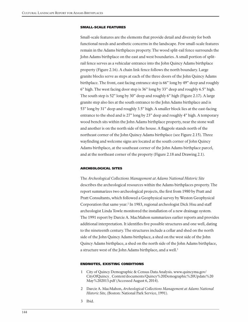
Cultural landsCape report for adams BirthplaCes
144
SMALL-SCALE FEATURES
Small-scale features are the elements that provide detail and diversity for both
functional needs and aesthetic concerns in the landscape. Few small-scale features
remain in the Adams birthplaces property. The wood split-rail fence surrounds the
John Adams birthplace on the east and west boundaries. A small portion of split-
rail fence serves as a vehicular entrance into the John Quincy Adams birthplace
property (Figure 2.16). A chain link fence follows the north boundary. Large
granite blocks serve as steps at each of the three doors of the John Quincy Adams
birthplace. The front, east facing entrance step is 66” long by 49” deep and roughly
6” high. The west facing door step is 36” long by 33” deep and roughly 6.5” high.
The south step is 52” long by 30” deep and roughly 6” high (Figure 2.17). A large
granite step also lies at the south entrance to the John Adams birthplace and is
53” long by 31” deep and roughly 3.5” high. A smaller block lies at the east-facing
entrance to the shed and is 27” long by 23” deep and roughly 4” high. A temporary
wood bench sits within the John Adams birthplace property, near the stone wall
and another is on the north side of the house. A flagpole stands north of the
northeast corner of the John Quincy Adams birthplace (see Figure 2.15). Three
wayfinding and welcome signs are located at the south corner of John Quincy
Adams birthplace, at the southeast corner of the John Adams birthplace parcel,
and at the northeast corner of the property (Figure 2.18 and Drawing 2.1).
ARCHEOLOGICAL SITES
The Archeological Collections Management at Adams National Historic Site
describes the archeological resources within the Adams birthplaces property. The
report summarizes two archeological projects, the first from 1980 by Pratt and
Pratt Consultants, which followed a Geophysical survey by Weston Geophysical
Corporation that same year.2 In 1983, regional archeologist Dick Hsu and staff
archeologist Linda Towle monitored the installation of a new drainage system.
The 1991 report by Darcie A. MacMahon summarizes earlier reports and provides
additional interpretation. It identifies five possible structures and one well, dating
to the nineteenth century. The structures include a cellar and shed on the north
side of the John Quincy Adams birthplace, a shed on the west side of the John
Quincy Adams birthplace, a shed on the north side of the John Adams birthplace,
a structure west of the John Adams birthplace, and a well.3
ENDNOTES, EXISTING CONDITIONS
1 City of Quincy Demographic & Census Data Analysis. www.quincyma.gov/CityOfQuincy_ Content/documents/Quincy%20Demographic%20Update%20May%202013.pdf (Accessed August 6, 2014).
2 Darcie A. MacMahon, Archeological Collections Management at Adams National Historic Site, (Boston: National Park Service, 1991).
3 Ibid.

National Park Service
Olmsted Center for Landscape Preservation
SOURCES
NOTES
OLMSTED
for LANDSCAPE PRESERVATION
CENTER
www.nps.gov/oclp
1. All features shown in approximate scale and location.
1. HABS Survey, 1936, 1979
2. City of Quincy, 2011
3. Aerial photograph, 2012
4. Site visit November, 2013, 2014
0’ 15’ 30’ 60’
Cultural Landscape Report
BirthplacesAdams National Historical ParkQuincy, MA
DRAWN BYUpdated by Ashley M. Braquet, Illustrator CS6, 2014Kirsten Holder, AutoCAD 2013 and Illustrator CS5, 2013
LEGEND
Existing roads
Stone wall
Flagstones
Deciduous and Evergreen trees
Existing building
10 Feet contour
Adams Birthplaces Property Lines
Deciduous shrubs
Property Lines
Picket Fence
Split Rail Fence
Chain link fence
Dirt road
Gardens
Town of Boston to William Ellis, c.1650Ellis to Gregory Belcher, 1660Belcher to Samuel Belcher, 1663Belcher to Deacon Gregory Belcher, 1679
Possible location of barn or outbuilding
Possible location school house (built 1697)
Possible location of white oak tree
Well (c.1660)
Possible location of barn
Town of Boston to William Needham, 1640William Needham to Joseph Penniman, 1675Joseph Penniman to James Penniman, 1705
William Needham to T. Curtis, 1675Curtis to Moses Curtis
Ellis home (1660)
Needham home (c.1640)Penniman home (expanded or re-built, 1710)
Vegetable garden
Orchards and vegetable gardens
Orchards and vegetable gardens
Vegetable garden
Drawing 1.2
COUNTRY ROAD TO PLYMOUTH, 1641
Early History to 1720
2. Fences are most likely located on property lines, although no specific information is available.
Fenced in front yard,(c.1730)
Lilac shrubs
Grass yard
William and Sarah Vesey to John Adams, 1788
Deacon John Adams, through John Adams, 1720–1803
Deacon Gregory Belcher to Gregory Belcher Jr., 1727 Belcher to Abigail Bracket Belcher, 1728Belcher to Lewis Vassal, 1742, Vassal to John and Richard Billings, 1743 Billings to Deacon John Adams, 1744Adams to John Adams, 1761
James Penniman to Deacon John Adams, 1720Deacon John Adams to Peter Boyleston Adams, 1761Adams to John Adams, 1774
Possible change in ownership from:James Penniman to Deacon John Adams, 1720Adams to John Adams, 1774
Possible location of barn (c.1736), and possible location of new barn (c. 1796)
Possible location of barn
Well
Drawing 1.4
COUNTRY ROAD TO PLYMOUTH
Possible locationof sheds, (1764)
Stone wall, (1762)
John Adam
s
birthplace
John Quincy Adams birthplace
Removed feature
5. John Adams Diary, AFP/MHS
6. Eliza Susan Quincy, 1822
John Quincy Adams to Benjamin Crane, 1836
Joseph Crane house, 1831
John Quincy Adams to Samuel Curtis, 1829
John Quincy Adams to Nathaniel White, 1827
John Adams to John Quincy Adams, 1803
John Adams to John Quincy Adams, 1803
John Quincy Adams, 1803–1848
Well
COUNTRY ROAD TO PLYMOUTH
Drawing 1.6
Possible location of barn(c.1805)
Possible location of barn (c.1805)
Possible location of shed(c.1805)
Possible locationof shagbark tree
Wooden fence(c. 1805)
John Adam
s
birthplace
John Quincy Adams birthplace
Removed feature
John Quincy Adams to Charles Francis Adams, 1848
John Quincy Adams to Charles Francis Adams, 1848
Charles Francis Adams,1848–1886
PAY
NE STR
EET (C.1884)
Drawing 1.8
FRANKLIN STREET
PRESIDENTS AVENUE (C.1884)
Possible location of barn Shed
Possiblelocationof barn
Possible location of barn
Well
Ac pl
Ul am
Ul am
Ul am
Ul am
Syvu
Ac pl
Lat in name C ommon name ID
Acer platanoides Norway maple Ac pl
Chaenomeles speciosa common flowering quince Ch sp
Ulmus americana American elm Ul am
Syringa vulgaris common lilac Sy vuJohn A
dams
birthplace
John Quincy Adams birthplace
Removed feature
Adams Real Estate Trust,1886–1940
Charles Francis Adams to Adams Real Estate Trust,
1886
Turnstile (1896)Split-rail fence (1896)
Craig house (1886-87)McCausland house (1886-87)
Relocated well (1896)
Removed barn (c.1887)
Removed sheds (c.1895-96)
Removed barn (c.1887)
Street car line, c.1890
Drawing 1.10
FRANKLIN STREET
PRESIDENTS AVENUE
Ac pl
Ul am
Ul am
Sy vu
Wi si
Ul am
Ul am
Ul am
Ul am
Ac pl
Ac pl
Ac pl
Ac pl
Sy vu
Sy vu
Sp va
Sy vu
Syvu
Sy vu
Sy vu/Sp va
Ac pl
Ac pl
Ac pl
Pedestrian walkway(c.1896)
Franklin Street widened andPayne Street removed (c.1921)
Shed(c.1896)
Stone wall (re-built 1896)
Fa sy
Co fl
Ac pl
Flagpole(c.1926)
100’
Lat in name C ommon name ID
Acer platanoides Norway maple Ac pl
Cornus florida flowering dogwood Co fl
Fagus sylvatica copper beech Fa sy
Syringa vulgaris common lilac Sy vu
Vanhoutte spirea
Spiraea x vanhouttei
Sp va
Ulmus americana American elm Ul am
Wisteria sinensis Chinese wisteria Wi si
John Adam
s
birthplace
John Quincy Adams birthplace
Removed feature
City of Quincy,1940–1979
Adams Real Estate Trust to City of Quincy, 1940Adams Birthplaces
McCausland family to City of Quincy, 1956-57
Craig family to City of Quincy, 1956-57
Craig house(removed 1958)
McCausland house(removed 1958)
Drawing 1.12
Hancock TV and Appliance,1957
FRANKLIN STREET
PRESIDENTS AVENUE
Ac pl
Ac pl
Ac pl
Eu al/Sy vu
Tilia cordataFa sy
Pi st
Cladrastis kentukea
Co fl
Ac pl
Ac pl
Ac pl
Ac pl
Ac pl
Wi si
Pi st
Pi st
Sy vu
Split-rail fence/gate
Pedestrian path(c.1951)
Flagstone pathway(1951)
Lat in name C ommon name ID
Acer platanoides Norway maple Ac pl
Chaenomeles speciosa common flowering quince Ch sp
Cornus florida flowering dogwood Co fl
Euonymus alatus burning bush Eu al
Fagus sylvatica copper beech Fa sy
Pinus strobus white pine Pi st
Rosa species rose Ro sp
Quercus rubra red oak Qu ru
Syringa vulgaris common lilac Sy vu
Vanhoutte spirea Spiraea x vanhouttei Sp va
Buxus sempervirens boxwood Bu se
Wisteria sinensis Chinese wisteria Wi si
John Adam
s
birthplace
John Quincy Adams birthplace
Removed feature
Sy vu
Sy vu
Bu se
Bu se
Bu se
Bu se
Bu se
Ro spCh sp
Sy vu
Sy vu
Sp va
Sy vu/Sp va
Sy vu
FRANKLIN STREET
Pr se Pr sePr se
Pr se
Pr se
Ac pl
Bu se
Bu se
Flagpole(c.1979)
Ac pl
Ti co
Fa sy
Pi st
Pi st
Pi st
Qu ruFo sp/Sy vu
Cl ke
Co fl
Ch sp
Eu al/Sy vu
Ch sp
Sy vu
Sy vu
Ac pl
Ac pl
Ac pl
Well
Stone wall
Gate
flagstone pathway
John Adam
s
birthplace
Hancock TV and Appliance
John Quincy Adams birthplace
Basementdoor
Park sign
Park sign
PRESIDENTS AVENUE National Park Service, 1979–2014
2. Plan shows conditions in 2014.
Drawing 1.14
Park signNPS bus parking zone
Shed removed(c.1981)
Pedestrian path removed(c. 1981)
Split-rail fence
Lat in name C ommon name ID
Acer platanoides Norway maple Ac pl
Chaenomeles speciosa common flowering quince Ch sp
Cornus florida flowering dogwood Co fl
Cladrastis kentukea yellowwood Cl ke
Eu al
Buxus sempervirens boxwood Bu se
Pinus strobus white pine Pi st
Prunus serrulata ‘Kwanzan’ Kwanzan cherry Pr se
Quercus rubra red oak Qu ru
Syringa vulgaris
Euonymus alatus burning bush
Fo spForsythia speciosa forsythia
common lilac Sy vu
Removed feature
FRANKLIN STREET
Pr se Pr sePr se
Pr se
Pr se
Ac pl
Il cr
Il cr
Flagpole
Ac pl
Ac pl
Fa gr
Pi st
Pi st
Pi st
Qu ru
Sp va
Co fl
Co fl
Ch sp
Va sp
Ch sp
Sy vu
Sy vu
Ac pl
Ac pl
Ac pl
Well
Stone wall
Split-rail fence/gate
Stepping stone pathway
John Adam
s
Birthplace
Hancock TV and Appliance
John Quincy Adams Birthplace
Basementdoor
Park sign
Park sign
PRESIDENTS AVENUE Existing Conditions
2. Plan shows conditions in 2014.
Drawing 2.1
Park sign
Split-rail fence
Lat in name C ommon name ID
Acer platanoides Norway maple Ac pl
Chaenomeles speciosa common flowering quince Ch sp
Cornus florida flowering dogwood Co fl
Ilex crenata Japanese holly Il cr
Pinus strobus white pine Pi st
Prunus serrulata ‘Kwanzan’ Kwanzan cherry Pr se
Quercus rubra red oak Qu ru
Syringa vulgaris common lilac Sy vu
Vanhoutte spirea Spiraea x vanhouttei Va sp
Ulmus americana American elm Ul am
Wisteria sinensis Chinese wisteria Wi si
Removed feature
Ul am
Ul am
Wi si
Ul am
Ul am
Ul am
Ul am
Ac pl
Ac pl
Ac pl
Sy vu
Sy vu
Sy vu
Syvu
Syvu
Sp vaSy vu/Sp va
Ac pl
Ac pl
Ac pl
Ac pl
100’
Split-rail fence/gate
Flagstone pathway (1951)
John Adam
s
Birthplace
Hancock TV and Appliance
John Quincy Adams Birthplace
Park sign(2008)
Park sign(2008)
5 - Pr se(early 1990s)
Pr sePr sePr se
Pr se
PRESIDENTS AVENUE Analysis and Evaluation
2. Plan shows conditions in 2014.
Drawing 3.1
Flag pole(c. 1979)
Park sign(2008)
Stone wall
Well
Split-rail fence
Walkway(c.1896-1951)
Feature added/built since 1940
since 1940
FRANKLIN STREET
Shed(c.1896-1951)Flagpole
(1896-1926)Ac pl
Ti co
Pi st
Pi st
Pi st
Qu ru
Fo sp/Sy vu
Co fl
Ch sp
Eu al/Sy vu
Ch sp
Sy vu
Sy vu
Sy vu
Craig house (1886/87-1958)
Acquired by City of Quincy,(1956-57)
Sidewalk widened(c. 1990 and 2012)
McCausland house (1886/87-1958)
Acquired by City of Quincy(1956-57)
Lat in name C ommon name ID
Acer platanoides Norway maple Ac pl
Chaenomeles speciosa common flowering quince Ch sp
Cornus florida flowering dogwood Co fl
Buxus sempervirens boxwood Bu se
Cladrastis kentukea yellowwood Cl ke
Euonymus alatus burning bush Eu al
Forsythia species forsythia Fo sp
Fagus sylvatica copper beech Fa sy
Lat in name C ommon name ID
Prunus serrulata ‘Kwanzan’ Kwanzan cherry Pr se
Quercus rubra red oak Qu ru
Syringa vulgaris common lilac Sy vu
Tilia cordata little leaf linden Ti co
Vanhoutte spirea Spiraea x vanhouttei Sp va
Ulmus americana American elm Ul am
Wisteria sinensis Chinese wisteria Wi si
Bu se
Bu se
Ac pl
Removed feature
Fa sy
Ac pl
Cl ke
Pinus strobus white pine Pi st


AnAlysis And EvAluAtion
147
analysis and evaluaTion
The Adams birthplaces property has undergone many changes over its long
history, yet it retains its significance and integrity as the birthplace of two
Presidents who played a leading role in the formative years of the United States
government. Once surrounded by hundreds of acres of fields and pasture and part
of the Penn’s Hill farm, the Adams birthplaces property preserves the core of two
early American homesteads that helped shape the ideologies and political values
of Presidents John Adams and John Quincy Adams.
This chapter provides an analysis of the historical significance of the Adams
birthplaces landscape and an evaluation of its historic character based on the
findings of the site history and existing conditions chapters. The analysis and
evaluation have been developed according to the National Register Criteria for
the Evaluation of Historic Properties and the National Park Service’s Guide to
Cultural Landscape Reports: Contents, Process, and Techniques. The first section
of this chapter reviews the significance of the landscape presented in the existing
National Register documentation and evaluates the landscape’s historical integrity.
The second section evaluates the historic character of the Adams birthplaces
landscape based on the National Park Service cultural landscape methodology,
which organizes the landscape into characteristics and features. Each feature is
evaluated to determine whether or not it contributes to the historical significance
of the landscape (Table 1).
NATIONAL REGISTER STATUS
The National Park Service evaluates the historical significance of properties
through a process of identification and evaluation defined by the National
Register of Historic Places program. According to the National Register, historic
significance may be present in districts, sites, buildings, structures, and objects
that possess integrity of location, design, setting, materials, workmanship, feeling,
and association. A property can be found to have significance on a national,
state, or local level, and must meet one or more of the following criteria in order
to be considered eligible for the National Register: (A) Association with events
that have made a significant contribution to the broad patterns of our history;
(B) Association with the lives of persons significant in our past; (C) Embody the
distinctive characteristics of a type, period, or method of construction, or that
represents the work of a master, or possesses high artistic values, or represents
a significant and distinguishable entity whose components may lack individual

Cultural landsCape report for adams BirthplaCes
148
distinction; or (D) Has yielded, or may yield, information important in pre-contact
history or history.1
EXISTING NATIONAL REGISTER DOCUMENTATION
The National Park Service designated the birthplaces of Presidents John Adams
and John Quincy Adams as National Historic Landmarks on December 19,
1960. The properties were administratively listed in the National Register on
October 15, 1966. Quincy City Council approved designation of two local historic
districts in 1975, the Adams Birthplace Historic District and the Quincy Center
Historic District. The National Historic Landmark documentation and boundary
description for each home was accepted on April 3, 1978. Enabling legislation
for the acquisition of the Adams birthplaces property, part of Public Law 95-625,
passed on November 10, 1978 and allowed the National Park Service to officially
acquire the .72-acre Adams birthplaces parcel on April 20, 1979.2
When the National Park Service acquired the Adams birthplaces in 1979, the site
was administratively included in the Adams National Historic Site, which was
created in 1946 and originally known as the Adams Mansion National Historic
Site. In 1998, the park name changed to Adams National Historical Park to
recognize the multiple sites within the park.
On April 3, 1978, two National Historic Landmark documentation forms for the
John Adams and John Quincy Adams birthplaces were accepted. For the John
Adams birthplace, significance was identified in the area of politics/government as
the birthplace and boyhood home of John Adams for the period of 1700 to 1799.
Specific dates listed are 1681 (the presumed date of home construction at the time
of the listing) and 1735 (the birth of John Adams in the house). The Statement of
Significance in the John Adams documentation suggests a period of significance
of 1735 to 1940, beginning with the birth of John Adams and ending with the
transfer of the birthplace from the Adams family to the City of Quincy. For the
John Quincy Adams birthplace, significance was identified in the area of politics/
government as the home of two American presidents and the birthplace of John
Quincy Adams for the periods of 1700 to 1799 and 1800 to 1899. Specific dates
were listed as 1716 (the date an older house was replaced with the main portion
of the current house), 1761 to 1783 (the period when John Adams acquired and
occupied the house and John Quincy was born in 1767), and 1803 to 1807 (for
the period when John Quincy Adams purchased and lived in the house). The
Statement of Significance in the John Quincy Adams documentation suggests a
period of significance of 1761 to 1940, beginning when John Adams inherited
the house from his father and ending with the transfer of the birthplace from the
Adams family to the City of Quincy. In both nomination forms, the boundary
description of the .72-acre property included both the houses and surrounding
open space because they were located within the same city lot.

AnAlysis And EvAluAtion
149
The period of significance for the Adams birthplaces and other properties
within the park was reviewed in 1994 as part of the List of Classified Structures
documentation. Specifically, on November 21, 1994, the Massachusetts State
Historic Preservation Office (SHPO) concurred with the National Park Service
on the itemization of previously evaluated and unevaluated contributing
resources in the park, as part of an update of the List of Classified Structures.
The SHPO supported the end date of the period of significance as 1940 (the date
that the properties were passed from the Adams family to the City of Quincy)
to include the changes to the properties by the Adams Chapter of the Society
of the Daughters of the Revolution and the newly formed Quincy Historical
Society in the 1890s. Although not specifically mentioned in the correspondence
between the SHPO and NPS, this end date would include several features built or
reconstructed by the Daughters of the Revolution in 1896-97: the well, stone wall,
and wood post fence. As such they were listed as contributing resources in the
LCS.
Based on the findings of this cultural landscape report, the authors recommend
updating the National Register and Landmark documentation to provide
greater detail and clarity on areas of significance and contributing resources
and more detailed information on the landscape features. In particular, the
updated documentation should address the role of the birthplaces in the area of
conservation, relating specifically to the historic preservation movement, and the
role of First Lady Abigail Adams.
STATEMENT OF SIGNIFICANCE
Based on the research conducted for this report, the authors recommend the
following statement of significance. The Adams birthplaces property is significant
at the national level under Criterion B for the period of 1735 (the birth of John
Adams) to 1848 (the death of John Quincy Adams) for its association with
significant political and literary figures of the eighteenth and nineteenth centuries
including John and Abigail Adams, and John Quincy Adams. The property is
significant at the local level for conservation for the period of 1848 (the death of
John Quincy Adams) to 1940 (the property passed from the Adams family to the
City of Quincy), encompassing the efforts of Charles Francis Adams and members
of the Adams Real Estate Trust/Adams Memorial Society, the Adams Chapter of
the Society of the Daughters of the Revolution, and Quincy Historical Society,
who protected and managed the birthplaces. The property is significant at the
local level under Criterion C in the area of architecture beginning in 1716 for its
late seventeenth and early eighteenth century buildings.
Collectively, the period of significance for the Adams birthplaces extends from
1716 (the oldest extant building—the John Quincy Adams birthplace) to 1940
(when the property passed from the Adams Real Estate Trust to the City of

Cultural landsCape report for adams BirthplaCes
150
Quincy). All significant features within the Adams birthplaces property were built
or installed within that time period beginning in 1716, through the installation of
the stone wall and wood fence in 1896. Key dates are the rebuilding of the John
Quincy Adams birthplace in about 1716, rebuilding of the John Adams birthplace
in about 1720, the birth of John Adams in 1735, the birth of John Quincy Adams
in 1767, and the opening of the sites to the public in1897. The Adams birthplaces
property retains integrity to the end of the period of significance, including
location, design, setting, materials, workmanship, feeling, and association. Each
area of significance is described below.
NATIONAL REGISTER CRITERION B: POLITICS/GOVERNMENT
The Adams birthplaces property is significant at the national level for politics/
government from 1735 to 1886 for its association with John Adams, Abigail
Adams, and John Quincy Adams.
Association with John Adams
A significant political and literary figure of the late eighteenth and early nineteenth
century, John Adams served as the nation’s first Vice President from 1789 to 1797
and the nation’s second President from 1797 to 1801. Adams played a leading
role in the development of the American nation and was born and died in Quincy
(then Braintree). John Adams inherited the home later known as the John Quincy
Adams birthplace in 1761. In 1774 he purchased the house in which he was born
from his younger brother, Peter Boylston Adams. While residing in the home
where his children were born, John Adams used the old kitchen as his law office
from 1764 to 1774 and drafted the Massachusetts Constitution, which became
a model for the Federal Constitution. The Penn’s Hill farm property included
approximately ninety-five acres of associated land to the north and south of the
house, most of which was under cultivation or used as pasture. The homes and
home sites are associated with the John Adams period of ownership, and possibly
the granite thresholds and well stone. Lilacs also persist at the site.
Association with Abigail Adams
The Adams birthplaces property is significant at the national level in the area
of politics/government for its association with Abigail Adams, who was the
country’s second First Lady and the mother of the country’s sixth president. She
was a prolific writer, sending detailed correspondence to her husband John and
other friends including Thomas Jefferson that detailed life in the late eighteenth
and early nineteenth century America. Abigail’s primary association with the
landscape was with the Penn’s Hill farm operations, particularly during the
American Revolution when John Adams was away in Philadelphia and abroad,
leaving Abigail to manage the family, home (John Quincy Adams birthplace),
and farm. Exchanging over one thousand letters, their correspondence included

AnAlysis And EvAluAtion
151
descriptions of every day events, walks around the farm, new plants, as well as
questions about how to manage the farm. Their correspondence also recorded
significant events. Abigail Adams described the Battle of Bunker Hill and her view
with John Quincy Adams from the top of Penn’s Hill in a letter to John Adams
in 1775. She also recounted the circumstances relating to the colonial militia
camping and drilling in the yard. In addition, Abigail tended a garden and fruit
trees, and planted lilacs near the houses.
Association with John Quincy Adams
The Adams birthplaces property is significant at the national level in the area of
politics/government for its association with John Quincy Adams, the nation’s sixth
President from 1825 to 1829. John Quincy Adams also served in the Senate and
the House of Representatives, where he spoke out forcefully against slavery and
in favor of a strong federal government. He was born in the home at the Penn’s
Hill farm in 1767 and spent his formative years there. John Quincy was five years
old when his father was called to serve in the First Continental Congress and
seven years old when the American Revolution began with the April 19, 1775
Battle of Lexington and Concord. His mother, Abigail Adams, took him to the
summit of Penn’s Hill to witness the burning of Charlestown during the June
17, 1775 Battle of Bunker Hill. Once married, he and his wife, Louisa Catherine
Adams, made Peace field their summer home from 1826 to 1848, and only resided
at his birthplace home for two summers. Due to their extensive travel and time
in Washington, D.C., they passed much of the responsibility for managing the
Quincy properties to their son Charles Francis Adams. John Quincy was an
avid horticulturist and in the early 1800s began planting trees on the Penn’s Hill
farm and Peace field properties. He wrote frequent journal entries about the
birthplaces and surrounding farm land until his death in 1848. At the birthplaces
property, only the homes remain from his period of ownership, and possibly the
granite threshold steps and well stone.
First Lady Louisa Catherine Adams was a significant political and literary figure of
the nineteenth century. However, she only spent two summers living in the John
Quincy Adams birthplace and wrote several letters during her stay. She traveled
with John Quincy Adams for his appointments in Prussia, Russia, France, and
England.
NATIONAL REGISTER CRITERION A: CONSERVATION
The Adams birthplaces are significant at the local level in the area of conservation
for the period of 1848 to 1940, as an early example of the Historic Preservation
Movement of the late 1800s and early 1900s. Charles Francis Adams inherited the
birthplaces from his father John Quincy Adams in 1848 and continued to lease
the two homes until 1886. His son, Charles Francis Adams, Jr. took a leading role
in establishing the Quincy Historical Society in 1893, and with his siblings and

Cultural landsCape report for adams BirthplaCes
152
relatives formed the Adams Real Estate Trust, later named the Adams Memorial
Society. Charles Jr. continued to lease the two homes, but then transferred
management of the property to the Adams Chapter of the Society of the
Daughters of the Revolution (John Adams birthplace) and the Quincy Historical
Society (John Quincy Adams birthplace) in 1896. The homes and grounds were
restored and opened for public viewing shortly thereafter.
The Adams family preservation efforts fit the late nineteenth and early twentieth
century trends in the historic preservation movement, which emphasized cultural
legacies by preserving homes and associated buildings. Family groups often
formed small preservation associations. For example, the Mount Vernon Ladies
Association was formed in 1853 to preserve President George Washington’s estate.
They emphasized the property as a symbol of American patriotism. During the
early to mid-twentieth century several presidential sites were preserved including
the cabin where President Abraham Lincoln was born, and the homes of Franklin
Pierce, Andrew Johnson, and Franklin D. Roosevelt.
Preservation efforts by the Adams family were unique because the descendants,
beginning with Charles Francis Adams, worked to protect his family’s
landholdings. Members of the Adams Real Estate Trust included Charles Francis
Adams Jr., Henry Adams, Mary Adams Quincy, and Brooks Adams managed the
birthplaces and sold off much of the Penn’s Hill farm. The trust retained the two
birthplaces, removed some of the outbuildings, and leased the houses to tenants.
With a limited income, the Quincy Historical Society and Adams Chapter of
the Society of the Daughters of the Revolution were able to maintain the homes
and offer guided tours. The Quincy Historical Society opened the John Quincy
Adams house for public viewing in June 1897 and the Daughters of the Revolution
opened the John Adams house in October of the same year. By 1940, the
organizations could no longer maintain the structures, and the buildings passed
to the City of Quincy. The homes were transferred to the National Park Service in
1979.
NATIONAL REGISTER CRITERION C: COLONIAL ARCHITECTURE
The Adams birthplaces property is significant at the local level under Criterion C
from 1716 to 1940 as surviving examples of early eighteenth century architecture
in Massachusetts. The original home on the site of the John Quincy Adams
birthplace was built around 1660 by William Ellis, and the original home on the
John Adams birthplace site was built between 1660 and 1710 by William Needham
or James Penniman. Penniman likely rebuilt the house between 1710 and 1720,
and added a lean-to at the rear (north side) of the John Adams birthplace before
he sold the house and farm to Deacon John Adams (father of John Adams) in
1720. Similarly, the home on the John Quincy Adams birthplace site was likely
rebuilt in about 1716 before Deacon John Adams acquired the property in 1744,

AnAlysis And EvAluAtion
153
which he leased to various tenants. In 1750 Deacon John Adams expanded the
lean-to at the rear of the John Adams birthplace across the entire back of the
house, thus creating a saltbox profile. John Adams inherited the future John
Quincy Adams house in 1761 and lived in the house until he and Abigail Adams
purchased Peace field. John Adams used a room in the John Quincy Adams
birthplace for his law office when he lived in the house from 1761 through 1783.
John Quincy Adams was born in this house in 1767 and later lived in the house
with his wife and children for a couple years. John Adams also used the home as
his law office and drafted the Massachusetts Constitution, which was ratified in
1780.
Following the death of Charles Francis Adams in 1886, his heirs transferred
ownership of his properties to the Adams Real Estate Trust and sold most of
Penn’s Hill farm to residential developers, retaining only a .34-acre parcel that
encompassed the two birthplaces. The Quincy Historical Society was established
in 1893 to preserve and promote Quincy history, and managed repairs to the John
Quincy Adams birthplace in 1896. This work included new board siding, a new
roof, reopening of the fireplace, new paint, and raising of the house two feet to
meet the new street level. After years of tenant occupancy, the Adams Chapter of
the Society of the Daughters of the Revolution restored the John Adams birthplace
in 1897, installing new windows, opening the chimney, removing interior
walls, and applying new paint. Both houses were open for public tours in 1897.
Preservation and maintenance by the two groups continued until 1940, when
the birthplaces property was transferred to the City of Quincy in 1940. While no
longer used as a home, the Adams birthplaces have retained a high level of historic
integrity as detailed below.
EVALUATION OF LANDSCAPE INTEGRITY
Integrity is the ability of a property to convey its significance. In order for a
property to retain its integrity, it must possess the essential characteristics and
features that characterized it during the period of significance. The National
Register program identifies seven aspects of integrity: location, design, setting,
materials, workmanship, feeling, and association.
Location
Location is the place where the historic property was constructed or the place where
the historic event occurred.
Situated on Franklin Street, in Quincy, Norfolk County, Massachusetts, the John
Adams and John Quincy Adams birthplaces remain in their original locations
when constructed in the late seventeenth and early eighteenth centuries. The flat
site not far from Town Brook, with fertile soils and a viable well, offered a desirable
location for homesteads. The homes pass through multiple generations of the

Cultural landsCape report for adams BirthplaCes
154
Adams family, then passed to preservation groups including the Adams Real Estate
Trust, Quincy Historical Society, Adams Chapter of the Society of the Daughters
of the Revolution, City of Quincy, and finally the National Park Service. In
addition, the stone wall, well, and wood fence remain in their same location from
the end of the historic period. The agricultural fields and pasture that once made
up the Penn’s Hill farm no longer remain. Despite changes to the surrounding
landscape, the property retains integrity of location.
Design
Design is the combination of elements that create the form, plan, space, structure, and
style of a property.
The Adams birthplaces landscape continues to represent its character as a
vernacular landscape as it evolved through the historic period. It also represents
an open park-like landscape with lawn areas surrounded by deciduous trees and
shrubs. The Colonial architectural design elements are present in the John Adams
and John Quincy Adams birthplaces. Ornamental and shade tree plantings remain
throughout the property, as well as buffer plantings along the property lines. The
property retains design integrity to the period of significance.
Setting
Setting is the physical environment of a historic property.
Despite the extensive development around the Adams birthplaces, the setting
of the property, including the circulation, vegetation, and outward views, has
changed relatively little since the end of the historic period in 1940. During
John Adams and John Quincy Adams ownership, the birthplaces property was
surrounded by crop fields and pasture, a few homes, and located close to the road.
The rural setting changed with the subdivision of land for housing developments
during Charles Francis Adams’ ownership in the mid-nineteenth century and
during Adams Real Estate Trust ownership of the birthplaces and Penn’s Hill
farmland in the late nineteenth and early twentieth centuries. Furthermore, the
construction of Presidents Avenue and Payne Street in the mid-nineteenth century
changed the immediate context of the property. For the most part, however, the
physical environment of the buildings, lawn and vegetated border is the same as
the end of the period of significance except for the addition of the two homes
north of the birthplaces on Franklin Street, which were later removed. However,
new commercial and suburban development on Franklin Street after the period of
significance detracts from the Birthplace property’s historic rural setting. Overall,
the property retains integrity of setting to the period of significance.

AnAlysis And EvAluAtion
155
Materials
Materials are the physical elements that were combined or deposited during a
particular period of time and in a particular pattern or configuration to form a
historic property.
Most of the historic materials used in construction or during restoration of the
Adams birthplaces remain intact. These materials were brought to or gathered on
site during construction of the buildings in the late seventeenth or early eighteenth
centuries or during site restoration at the end of the nineteenth century. The
majority of the trees and shrubs within the birthplaces property date from the
historic period, or are replacements in-kind. However, many shrubs around the
John Adams birthplace no longer remain and a couple of the trees around the
perimeter of the property were not replaced. The stepping stones that make up
the pedestrian circulation are a new material since the end of the historic period.
Enough material from the historic period remains for the property to retain
integrity to the period of significance.
Workmanship
Workmanship is the physical evidence of the crafts of a particular culture or people
during any given period in history or prehistory.
Within the Adams birthplaces landscape, workmanship remains evident in the
buildings and structures, circulation, vegetation, and small-scale features. Much
of the vegetation remains or has been replaced in-kind. Most of the materials and
construction techniques of the buildings and structures remain intact. In addition,
some of the materials of the small-scale features at Adams birthplaces remain
intact including the stone well, stone wall, and wood fence. Some vegetation no
longer remains such as the cluster of lilacs and spirea that grew around the south
and west sides of John Adams birthplace, Chinese wisteria that grew on the south
side of the John Quincy Adams birthplace, one elm tree that grew east of the
John Adams birthplace, one maple that grew at the corner of Franklin Street and
Presidents Avenue, and one maple that grew west of the John Adams birthplace.
Enough workmanship from the historic period remains for the property to retain
integrity to the period of significance.
Feeling
Feeling is a property’s expression of the aesthetic or historic sense of a particular
period of time.
During the early half of the historic period, the Adams birthplaces were small rural
residences on the Country Road, surrounded by crop fields and pasture within
the Penn’s Hill farm. The domestic area around the two houses contained small
gardens and orchards with views into the surrounding fields used for crops or
grazing. Stone walls and wood fences divided the properties, protected crops, and
retained livestock. Physical remnants of the property’s history are evident in the

Cultural landsCape report for adams BirthplaCes
156
homes themselves, the well, stone walls, and aged trees. During the latter half of
the historic period, the Adams birthplaces were leased to tenants and then used by
the Daughters of the Revolution and Quincy Historical Society as a meeting house
and house museum. Following the end of the historic period, both houses were
restored and opened to the public. While the Adams birthplaces are no longer
used as a private residence, the property retains many of the historic features
designed to meet the family’s needs such as the stone wall, wood fence, and well.
While the small gardens and vegetable beds no longer exist on the property, many
of the trees remain or have been replaced in-kind. The residential, commercial,
and transportation development that now surrounds the Adams birthplaces
detract from the historic feeling. Despite the changes to the Adams birthplaces
landscape, the property retains integrity of feeling.
Association
Association is the direct link between an important historic event or person and a
historic property.
While many of the properties and agricultural fields in Quincy and Braintree
were subdivided and redeveloped following the historic period, the Adams site
retains its physical appearance and association as the birthplace to two early U.S.
Presidents. Although the birthplaces are no longer private homes or managed by
members of the Adams family, evidence of its connection to the Adams family is
evident. The property retains integrity of association.
Summary Evaluation of Integrity
Overall, the landscape of the Adams birthplaces retains historic integrity and
conveys its historic significance through existing resources. All aspects of integrity
are evident. Construction of Presidents Avenue and the expansion of Franklin
Street changed the landscape immediately surroundings the birthplaces, and
suburban growth replaced the agricultural land that once made up the Penn’s
Hill farm. Following the historic period, the City of Quincy removed the two
buildings north of the John Adams birthplace, thus restoring the land adjacent to
the houses. The National Park Service has made very little changes to the property
since acquiring it in 1979.

AnAlysis And EvAluAtion
157
ANALYSIS OF LANDSCAPE CHARACTERISTICS AND
FEATURES
The analysis of landscape characteristics and features serves to identify the
landscape components that define the historic character of the Adams birthplaces
landscape. Landscape characteristics and features are evaluated using the
categories of spatial organization, land use, circulation, vegetation, buildings and
structures, views and vistas, small-scale features, and archeological sites. Each
feature associated with these landscape characteristics is evaluated according to
the following method:
Historic Condition: a brief discussion of the feature’s history and evolu-tion during the period of significance (1720–1940);
Post Historic and Existing Conditions: an overview of changes that have occurred since the end of the period of significance; and
Evaluation: a comparison of historic and existing conditions to deter-mine whether the feature contributes to the historic character of the cultural landscape.
Contributing features generally date to the period of significance (1720–1940),
and help communicate the landscape’s historic design and character. Non-
contributing features generally date after the period of significance or have been
altered from their historic condition. Each feature includes a corresponding List
of Classified Structures (LCS) number and park building number, if applicable,
and is labeled on the Analysis and Evaluation plan (Drawings 3.1). Select features
that no longer exist within the Adams birthplaces property, or were removed
during the period of significance, are included in this section because of their
prominence during the period of significance or proximity to other extant
features.
SPATIAL ORGANIZATION
Spatial organization refers to the three-dimensional organization of physical
forms and visual associations in a landscape, including the articulation of
ground, vertical, and overhead planes that define and create spaces. At the time
the birthplaces were constructed, spatial organization was largely dictated by
natural systems and topography. The Adams birthplaces property sits on the
southern edge of the geologic and physiographic area known as the Boston Basin.
The Charles, Mystic, and Neponset Rivers formed within the basin, which was
dotted with drumlins, marshes, and ponds. Drumloid hills include Penn’s Hill
(or Payne’s Hill) to the east of the birthplaces and formerly part of the Adams’s
Penn’s Hill farm, and several nearby hills including Pine Hill and the Blue Hills to
the southwest, Forbes Hill to the northwest, Mount Wollaston to the north, and
Mount Pleasant to the east (see Figures 1.4, 1.6, and 1.27). The middle elevations

Cultural landsCape report for adams BirthplaCes
158
along the sides of these hillsides were often used for grazing. The low-lying
elevations were made of rich agricultural lands or wet swampy areas.
The natural systems and topographical conditions of the Adams birthplaces
property remained constant during the historic period and through today. At the
time of construction of the two birthplaces, the Needham/Penniman and Belcher
families built the two homes at the edge of each property and near the road to
Plymouth. Early settlers often built houses near one another, and close to the
road, in order to share resources. The families grew orchards, grain crops, and
vegetable gardens, and raised sheep and cattle on the steeper terrain. Early settlers
typically grew field crops and raised sheep or cattle in pastures farther away from
their homes and grew vegetable gardens and sometimes orchards close to their
homes.
Fresh Brook ran along the western edge of the original Belcher and Needham
properties, west of the future birthplaces. By the late eighteenth century, as
Deacon John Adams acquired land farther west, Fresh Brook ran through various
portions of the Penn’s Hill Farm. Today, Fresh Brook, or Town Brook, runs from
the Old Quincy Reservoir, north toward the Southeast Expressway before it
disappears into culverts southwest of the birthplaces property. During the early
part of the historic period John Adams and John Quincy Adams reported that they
rode through large wooded areas. Suburban and commercial development rather
than hardwood forests now cover the terrain around the Adams birthplaces.
For the Adams birthplaces, the historic spatial organization is relatively intact since
the end of the period of significance and includes three character areas defined by
circulation, historic property boundaries, and vegetation (see Drawing 3.1). These
three areas include the north lawn area, the John Adams birthplace parcel, and the
John Quincy Adams birthplace parcel.
North lawn area
Historic Condition:
Once part of the John Adams birthplace property, the Adamses likely used the
north lawn area to grow vegetables or for smaller structures such as sheds and
barns because of its close proximity to the John Adams birthplace. The north lawn
area was subdivided in the 1820s by John Quincy Adams who saw that the land
along the Country Road to the north of the John Adams birthplace was valuable
for new house lots. Between 1886 and 1887 the Craig house and McCausland
house were built on the lots (see Figures 1.51 and 1.52). The Craig property
stretched from Franklin Street to Presidents Avenue and the McCausland house
abutted Franklin Street and the former Payne Street. These families likely planted
the beech tree, north of the Craig house, and the flowering dogwood, north of the
McCausland house.

AnAlysis And EvAluAtion
159
During the early twentieth century, the north lawn area included the two homes,
and perhaps a barn near the Craig house, and was bounded by houses on Franklin
Street and Presidents Avenue. A wood split-rail fence divided the John Adams
birthplace from the Craig property and three maples and two elm trees likely grew
within the John Adams birthplace property and near the fence line.
Post Historic and Existing Conditions:
Following the end of the historic period, the City of Quincy acquired the Craig
and McCausland homes and properties. The city removed the houses around
1958 to decrease the fire hazard that the Craig house posed on the John Adams
birthplace and to enlarge the setting of the two birthplaces. When the National
Park Service acquired the Adams birthplaces in 1979, the property included the
parcels to the north of the John Adams birthplace. The beech (Fagus sylvatica)
and flowering dogwood (Cornus florida), planted adjacent to the two homes,
continued to mature and remain today. A little-leaf linden (Tilia cordata),
likely planted in the mid-1900s, grows between the beech and the John Adams
birthplace (see Figure 1.69). The National Park Service planted pine trees and
a row of common lilacs to screen the birthplaces from the parking lot and
businesses on Franklin Street. Today, the National Park Service mows the north
lawn areas routinely and has stabilized or removed declining trees.
Evaluation: Contributing
The north lawn area, subdivided in the 1820s by John Quincy Adams and later
reacquired by the City of Quincy, contributes to the historic character of the
Adams birthplaces landscape.
John Adams birthplace and grounds
Historic Condition:
A home likely stood on the John Adams birthplace property by 1650 or 1660.
After inheriting the property from his father in 1705, James Penniman likely
constructed a new home in about1720, which later became known as the John
Adams birthplace. The Penniman home stood near the road at the eastern edge of
the property with farm outbuildings, including a barn and a shed to the west, and
vegetable gardens nearby. Wood split-rail fences marked the property boundary
and lined the edge of the road. Deacon John Adams purchased the property in
1720, plus additional acreage. He and his wife, Susanna Boylston Adams raised
their three children in the home: John, Peter, and Elihu. John Adams acquired
the property from his brother Peter in 1774. John Quincy Adams acquired the
property from his father in 1803. During the mid-nineteenth century, while
Charles Francis Adams owned the birthplaces, the land around John Adams
birthplace became more fragmented with the construction of Payne Street to the
north and Presidents Avenue to the west. Tenants built new barns and sheds at the
rear of the home and continued to fence the front yard (see Figures 1.18 and 1.19).

Cultural landsCape report for adams BirthplaCes
160
Once the land to the north of the birthplace was sold and developed around 1886,
the landscape around the birthplace was limited to a much smaller lot (see Figure
1.24). At the end of the period of significance, a pedestrian walkway ran between
Franklin Street and Presidents Avenue, several maple and elm trees grew along the
northern, western, and southern boundary, and a shed stood to the northwest of
the John Adams house (see Figure 1.59).
Post Historic and Existing Conditions:
Following the end of the historic period, the John Adams birthplace and grounds
were limited to a small residential lot bounded by the Craig house to the north,
the John Quincy Adams birthplace to the south, Presidents Avenue to the west,
and Franklin Street to the east. Once the City of Quincy removed the Craig
and McCausland homes in 1958, the John Adams birthplace was once again
surrounded by a larger amount of open lawn and deciduous trees, similar to
landscape conditions in the mid-nineteenth century. After acquiring the property
in 1979, the National Park Service made a few minor alterations to the property by
removing the paved walk west of the house and the shed at the northwest corner.
Trees matured around the house and park staff maintained or replaced in-kind the
extant trees. The most of the lilacs and all of the spirea that once grew around the
east, south, and west sides of the house no longer remain (see Figure 2.11).
Evaluation: Contributing
The spatial organization of the John Adams birthplace and grounds, established
in early 1700s and altered by the subsequent Adams family members and tenants
in the following centuries, contributes to the historic character of the Adams
birthplaces landscape. By the late nineteenth century the birthplace was open to
visitors rather than used as a home. The house and grounds still define the core of
the property.
John Quincy Adams birthplace and grounds
Historic Condition:
William Ellis (or Allis) acquired his homestead around 1650 and constructed a
home by 1660. The home stood near the road, at the northeastern edge of the
property, and was likely surrounded by a few other homes that also stood near the
road. The Ellis or Belcher family likely built a barn to the southwest of the house
and installed a well to the west. Dendrochronological analysis indicates that the
house was rebuilt in about 1716. Deacon John Adams acquired the property in
1744 and passed it to his son John in 1761. John and Abigail Adams lived in the
house during the 1760s and early 1770s before they purchased the Peace field
property in 1787. Correspondence by Abigail indicates that the Adamses fenced
in the front yard and early drawings suggest that there were lilacs and other
plantings along the east façade of the home. John Quincy Adams likely added
sheds to the north and west sides of the home and built a new barn to the west of

AnAlysis And EvAluAtion
161
the house. The property was bounded by fence, and later a stone wall along the
northern edge. A picket fence bounded the road, which was removed when the
road was widened (see Figure 1.21). During the mid-nineteenth century, while
Charles Francis Adams owned the birthplaces, the land around John Quincy
Adams birthplace became more fragmented with the construction of Presidents
Avenue to the west and expansion of Franklin Street. The Quincy Historical
Society removed two sheds around 1895, relocated the well, and built a new stone
wall around the perimeter of the property. Elm and maple trees grew along the
northern and western walls. At the end of the nineteenth century the John Quincy
Adams birthplace was bounded by roadways to the east, south, and west (see
Figure 1.25).
Post Historic and Existing Conditions:
Following the end of the historic period (1940), the John Quincy Adams
birthplace and grounds were limited to a small residential lot bounded by John
Adams birthplace to the north and the intersection of Presidents Avenue, Franklin
Street, and Independence Avenue. The Quincy Historical Society added a pathway
in 1951 that connected the birthplaces, and later planted low shrubs and bulbs
on the inside of the stone wall to the north of the John Quincy Adams birthplace
(see Figure 1.69 and 1.71). After acquiring the property in 1979, the National Park
Service made a few minor alterations to the property by installing park signs and
maintaining the lawn area. Today, most the vegetation along the stone wall no
longer remains except for two boxwood shrubs at the opening between the two
properties, vines that are trimmed, and a bed with bulbs and herbaceous flowers
along the stone wall at the northeastern edge of the property.
Evaluation: Contributing
The spatial organization of the John Quincy Adams birthplace and grounds,
established in 1660 and altered by the subsequent Adams family members and
tenants in the following centuries, contributes to the historic character of the
Adams birthplaces landscape. By the late nineteenth century the birthplace was
open to visitors rather than used as a home. Today, the house and grounds still
define the core of the property.
LAND USE
Land use is defined as the principal human activities that form, shape, and
organize a landscape. For the Adams birthplaces, residential and agricultural
use persisted throughout most of the historic period when Deacon John Adams,
John Adams, John Quincy Adams, Charles Francis Adams, and members of the
Adams Real Estate Trust owned the birthplaces and Penn’s Hill farm. By 1896 the
Adams birthplaces were no longer used as a private residence and most of Penn’s
Hill farm was sold for the development of house lots. Under the Society of the
Daughters of the Revolution and Quincy Historical Society management, the

Cultural landsCape report for adams BirthplaCes
162
two homes were used for meetings and opened to the public for tours. Once the
National Park Service acquired the property in 1979, they continued to keep the
homes open to the public for tours. The existing land use is compatible with the
historic character of the landscape.
Agriculture
Historic Condition:
Cultivating the land was essential to life in eighteenth century New England.
Every rural household maintained corn fields, vegetable gardens, and orchards
to provide food. Enough crops had to be produced to store and use over the
long winter months. Early writings by the Adams family suggest the presence
of a kitchen garden and orchard trees in close proximity to the homes. During
the John Adams and John Quincy Adams’ periods, the birthplaces served as the
nucleus for the larger Penn’s Hill Farm, but most of the land was sold by the early
1900s.
Post Historic and Existing Conditions:
Little evidence of agriculture remains on or in association with the property today.
A small non-historic cultivated plot near the stone wall on the John Quincy Adams
property contains flowering bulbs, annuals, and perennials (see Figure 2.13). The
garden plot was added by the National Park Service.
Evaluation: No longer evident
Active agriculture is no longer associated with the farm homesteads.
Historic Preservation
Historic Condition:
The City of Quincy established the Quincy Historical Society in 1893 with Charles
Francis Adams, Jr. as its first president. The society restored the John Quincy
Adams birthplace and the Adams Chapter of the Society of the Daughters of the
Revolution managed the John Adams birthplace. Both opened for public tours in
1897.
Post Historic and Existing Conditions:
The City of Quincy acquired the birthplaces in 1940 and continued to preserve
and maintain the properties, while local organizations managed the public
programs. The city passed the properties to the National Park Service in 1979.
Evaluation: Contributing
Historic preservation at the site continues to be a significant land use.

AnAlysis And EvAluAtion
163
CIRCULATION
Circulation is comprised of the spaces, features, and materials that make up the
network of pedestrian and vehicular movement. For the Adams birthplaces,
the circulation system includes the flagstone pathway that connects the two
homes. Outside of the park property, the close proximity of Presidents Avenue
and Franklin Street, the pedestrian sidewalks, and the trolley drop off zone on
Franklin Street influences the circulation in the birthplaces landscape (see Figure
2.9).
When the two homes were built in the early 1700s, the primary circulation route in
this area of North Braintree was the Plymouth Road, also known as the Plymouth
Turnpike, which passed by the site to the east of Penn’s (or Payne’s) Hill. Built in
1641, the roadway was unpaved and lined with trees, homes, and stone or wood
fences (see Figures 1.2 and 1.3). Homes were typically built near the road and
in small clusters so residents could share resources. A railroad line and several
new roads were built in the early nineteenth century to improve transportation
between Boston and the industrial development in the South Shore (see Figure
1.9). The Adams birthplaces area changed dramatically with the construction of
Independence Avenue in 1865 and Presidents Avenue in 1885. A streetcar line was
installed on Franklin Street around 1890, which included tracks on the edge of the
road (see Figures 1.49 and 1.50). A compacted earth sidewalk ran along the city
streets during the nineteenth century and was paved by 1929 (see Figures 1.53 and
1.54). The expansion of regional transportation corridors continued in the early
twentieth century when the Metropolitan District Commission and Metropolitan
Highway Commission built Quincy Shore Drive, Furnace Brook Parkway, and the
Southern Artery.
During restoration work in 1896, the Adams Chapter of the Society of the
Daughters of the Revolution installed a pedestrian stonedust walkway from
Presidents Avenue to the rear door of the John Adams birthplace (see Figure 1.59).
This pathway was later rebuilt by the City of Quincy in 1951 and then removed
by the National Park Service in 1981. Overall, the circulation of the Adams
birthplaces retains its historic character, however temporary walkways such as the
paved walkway near the John Adams birthplace no longer remain.
Flagstone path
Historic Condition:
The flagstone path did not exist during the historic period.
Post Historic and Existing Conditions:
The City of Quincy added a flagstone path within the property around 1951. The
new path led from a turnstile on Franklin Street to the front and rear door of the
John Adams birthplace, and the front and rear door of the John Quincy Adams

Cultural landsCape report for adams BirthplaCes
164
birthplace. Around that same time the City of Quincy replaced a paved pathway
from the backdoor of the John Adams birthplace to Presidents Avenue (see Figure
1.69). In the early 1990s, park staff simplified pedestrian circulation by removing
the flagstones that led from the front to rear door of John Adams birthplace.
Evaluation: Non-Contributing
The flagstone path currently extends from the fence opening on Franklin Street
to the front door of the John Adams birthplace, continues through a gap in the
stonewall to the John Quincy Adams birthplace, then splits to the front and back
doors. Installed in 1951, the flagstones do not contribute to the historic character
of the Adams birthplaces landscape because they did not exist during the historic
period (see Figure 2.13).
Paved walk between Franklin and Presidents Avenue (no longer exists)
Historic Condition:
The Daughters of the Revolution installed a stonedust walk in 1896 that ran
between Franklin Street, the front door of the John Adams birthplace, the back
west-facing door, and Presidents Avenue (see Figure 1.42).
Post Historic and Existing Conditions:
The walkway was upgraded and altered by the City of Quincy in 1951, when they
paved the section between Presidents Avenue and the rear door to the John Adams
birthplace. They overlaid flagstones on the remainder of the pathway as described
under flagstone path above (also see Figure 1.69). Around 1981, during restoration
of the two homes, National Park Service staff removed the paved walk west of the
John Adams birthplace.
Evaluation: No longer exists
The paved walk, installed in 1896, modified in 1951, and removed in 1981, no
longer exists as it did during the end of the historic period. The loss of the paved
walkway does not detract from the historic character of the landscape because it
was installed during restoration efforts in the late nineteenth century (see Figure
2.16).
Sidewalks on Franklin Street and Presidents Avenue
Historic Condition:
The sidewalks along both Franklin Street and Presidents Avenue were present
during the historic period, but were not as close to the birthplaces as they are
now. The first documented indication of a sidewalk on Franklin Street appeared
in an 1885 photograph. On Presidents Avenue, the first sidewalk was most
likely constructed in conjunction with the new road, and is visible in an 1890
photograph (see Figure 1.25). Both sidewalks are depicted on the 1936 WPA plan
(see Figure 1.59).

AnAlysis And EvAluAtion
165
Post Historic and Existing Conditions:
The sidewalks on Franklin Street and Presidents Avenue are concrete and asphalt,
respectively, with granite curbing and four to five feet wide (Figure 2.17, see also
Figures 2.14 and 2.16). The sidewalk on Franklin Street is closer to the homes and
wider than during the historic period.
Evaluation: Non-contributing
The non-contributing sidewalks are maintained by the City of Quincy and intrude
on the historic site.
VEGETATION
Vegetation includes managed individual specimens and masses of deciduous
and evergreen trees, shrubs, vines, groundcovers, and herbaceous material,
both indigenous and introduced. Vegetation at the Adams birthplaces property
includes rows of deciduous trees, shrubs, and vines around the property, between
the two buildings, and north of the John Adams birthplace. More recent additions
include evergreen trees and shrubs that provide screening, and street trees in the
sidewalk on Franklin Street.
Prior to the construction of the Adams birthplaces at the end of the seventeenth
and beginning of the eighteenth centuries, meadows, creeks, clearings, and
wooded areas covered much of the future Penn’s Hill farm and Adams birthplaces
property. Early homesteaders grew fruit trees, planted grain crops, and raised
livestock. In 1720, Deacon John Adams purchased a small farm and home
from the Penniman family and later expanded his landholdings to include the
surrounding orchards, meadows, and fields. Following Deacon John Adams death
in 1761, his three sons, including John Adams, inherited portions of the Penn’s
Hill farm that included salt marshes, meadows, uplands, swamps, and wooded
areas (see Figure 1.4). John Adams married Abigail Smith and they improved the
farmland by clearing vegetation along the rivers and building new fences and
continued to acquire additional farm land where they grew corn, potatoes, and
planted orchards of apple trees, and planted small vegetable gardens near their
home. After their eldest son John Quincy Adams purchased the Penn’s Hill farm
in 1803, he planted more fruit and nut trees, as well as maples and elms, and
leased the fields and birthplaces to tenants who maintained Penn’s Hill farm
(see Figure 1.5). When the property passed to Adams Real Estate Trust in the late
1800s, the Quincy Historical Society and Daughters of the Revolution added elms,
Norway maples, flowering vines, and numerous ornamental shrubs including
lilac and spirea (see Figures 1.55 through 1.58). Toward the end of the nineteenth
century much of the Penn’s Hill farmland was subdivided and sold for housing
developments.
Following the end of the period of significance (1940), the Adams birthplaces
stood on a .34-acre residential parcel surrounded by city streets and suburban

Cultural landsCape report for adams BirthplaCes
166
development. The property included a few specimen trees with lines of deciduous
trees around the borders and ornamental shrubs and vines growing near the
buildings (see Figure 1.59). None of the Penn’s Hill farm remained intact. The
trees growing near the birthplaces and around the perimeter of the property
retain a substantial degree of integrity because the trees were maintained or
replaced in-kind by park staff. The Penn’s Hill farm, which once included over
two-hundred acres, has lost much of its historic character since the nineteenth
century. Overall, the vegetation of the Adams birthplaces retains its historic
character.
Specimen trees around birthplaces
Historic Condition:
Several trees grew around the John Adams and John Quincy Adams birthplaces
throughout much of the historic period. John Quincy Adams planted trees
thoughout the Penn’s Hill farm property and elsewhere in Quincy, and species
included horse chestnut, elm, sycamore, maple, and hickory. He also wrote of a
shagbark hickory that grew at the northeast corner of the John Adams birthplace
property in the early 1800s. In addition, he or one of his tenants, likely planted
the American elm tree that grew at the northeast corner of John Adams birthplace
and is visible as a mature tree in a 1924 photograph (see Figure 1.50). Once the
property passed to the Adams Real Estate Trust and was managed by the Quincy
Historical Society and the Daughters of the Revolution, several maples and elms
were planted. As documented in 1936 by the Works Progress Administration, a
maple grew at the corner of Presidents Avenue and Franklin Street, two American
elm trees grew west and northwest of the John Quincy Adams birthplace, two
elms and a Norway maple grew on the north side of the stone wall between the
birthplaces, three Norway maples grew along Presidents Avenue within the John
Adams birthplace lot, three more grew along the northwest property line, and two
elms grew northeast and north of the John Adams birthplace (see Figures 1.59 and
1.69).
Post Historic and Existing Conditions:
Following the historic period, some of the trees were removed and not replaced
in-kind. This included the elm tree to the northeast of the John Adams birthplace,
which was gone by the 1950s. The Norway maple at the corner of Presidents
Avenue and Franklin Street was removed by park staff in the mid-1990s. NPS staff
removed a younger but failing Norway maple west of the John Adams birthplace,
and another Norway maple along Presidents Avenue in 2010 (see Figure 1.83). A
Norway maple that grew between the two birthplaces, just north of the stone wall
and near the gap, fell down in 2007, and was replaced in-kind in 2008 (see Figure
2.11).

AnAlysis And EvAluAtion
167
Evaluation: Contributing
The trees near the John Adams and John Quincy Adams birthplace, planted in
the late nineteenth century and early twentieth century contribute to the historic
character of the Adams birthplaces landscape. Overall there are fewer shade trees
than at the end of the historic period.
Trees in north lawn
Historic Condition:
The Craig and McCausland families likely planted the beech tree to the north of
the Craig house and the flowering dogwood tree to the north of the McCausland
house during the end of the nineteenth century or beginning of the twentieth
century (see Figure 1.50 and 1.51). Around that time the families, or possibly the
Daughters of the Revolution or City of Quincy planted the linden, maples, oaks,
and pine trees that grow in the north lawn portion of the birthplaces property (see
Figure 1.59 and 1.63).
Post Historic and Existing Conditions:
Following the historic period, the City of Quincy followed by the National Park
Service has maintained the mature trees in the north lawn area.
Evaluation: Contributing
The trees in the north lawn, established at the end of the nineteenth century
or by mid twentieth century, contribute to the historic character of the Adams
birthplaces landscape. Mature trees remain despite the construction and removal
of the two houses that stood from 1886 to 1958, including a beech, linden,
flowering dogwood, pines, and yellowwood (see Figures 2.5 and 2.10).
Street trees on Franklin Street
Historic Condition:
From the mid-1800s to mid-1900s an elm grew along Franklin Street to the north
of the John Adams birthplace. After the tree was removed, no trees stood along
the west side of the road adjacent to the birthplaces for about fifty years.
Post Historic and Existing Conditions:
In the 1990s, the City of Quincy planted five Kwanzan cherry trees (Prunus
serrulata ‘Kwanzan’) in the sidewalk on the west side of Franklin Street (see
Figure 1.86). The trees grow outside of the park boundary and are maintained by
the City of Quincy (see Figure 2.14).
Evaluation: Non-Contributing
The Kwanzan cherry trees on Franklin Street, planted in the 1990s by the City
of Quincy, do not contribute to the historic character of the Adams birthplaces
landscape. The trees are not on National Park Service property and are not
representative of the species that grew on the site during the historic period.
Cultural landsCape report for adams BirthplaCes
168
Perimeter shrubs and vines
Historic Condition:
Generations of the Adams family and tenants who occupied the birthplaces in the
eighteenth and nineteenth centuries likely planted small gardens and ornamental
shrubs near the two birthplaces. The Daughters of the Revolution and Quincy
Historical Society likely planted many of the shrubs around the perimeter of the
Adams birthplaces property around 1896 when they restored the homes, installed
the split-rail fence, constructed the stone wall, and reconstructed the well. Vines,
possibly Virginia creeper and trumpet vine, grew along the stone wall, and in
ensuing years, covered much of the wall (see Figures 1.44 and 1.48). The 1936
WPA HABS survey shows lilacs and spirea growing to the east, south, and west of
the John Adams birthplace (as described under foundation plantings below), and
Chinese wisteria growing on the south side of the John Quincy Adams birthplace
(see Figure 1.59).
Post Historic and Existing Conditions:
Most of the shrubs and the Chinese wisteria that grew during the historic period
no longer remain. The Virginia creeper and trumpet vine persist, but are cut back
regularly. The National Park Service likely added many of the shrubs that remain
today to screen surrounding properties. These include the common lilacs (Syringa
vulgaris), forsythia (Forsythia sp.), and winged euonymus (Euonymus alatus)
along Presidents Avenue and the northern fence line; common flowering quince
(Chaenomeles sp.) at the eastern fence and near the northwestern fence line; and
boxwood (Buxus sempervirens) next to the opening in the stone wall between the
two properties (see Figures 2.13 and 2.16).
Evaluation: Non-Contributing
The screening shrubs that grow along Franklin Street and Presidents Avenue
were added by the National Park Service to evoke the character of the Adams
birthplaces residential landscape.
Foundation plantings
Historic Condition:
Generations of the Adams family and tenants who occupied the birthplaces in the
eighteenth and nineteenth centuries likely planted shrubs near the two homes.
In 1786, Elizabeth Cranch wrote to Abigail Adams about the John Quincy Adams
birthplace reporting that, “The Laylocks are just opening, & have grown very
much. The grass Plot before the house looks most delightfully green.”3 Small trees
and shrubs appear in several early paintings and photographs from the mid to late
nineteenth century (see Figures 1.4, 1.5, and 1.10). Photographs taken throughout
the mid to late 1800s show shrubs around the homes (see Figures 1.21 and 1.22)
Once the birthplaces were no longer used as a private homes, the Daughters of the
Revolution and Quincy Historical Society likely preserved the existing lilacs and

AnAlysis And EvAluAtion
169
planted more lilacs and spirea in front of the John Adams birthplace around 1896
when they restored the homes (see Figures 1.51 and 1.56). Postcards from the
early twentieth century display lush shrub and vine plantings around both of the
birthplaces (see Figures 1.46 through 1.48). The 1936 WPA HABS survey shows
lilacs and spirea growing on the south and west sides of the John Adams birthplace
and wisteria at the south side of the John Quincy Adams birthplace (see Figure
1.59).
Post Historic and Existing Conditions:
The foundation plantings that grew during the historic period no longer remain.
The lilacs and spirea that grew in front of the John Adams birthplace were likely
removed when the National Park Service restored the two homes in 1980.
Evaluation: No longer exist
The foundation plantings, which included masses of lilacs and spirea near
the John Adams birthplace, and wisteria at the south side of the John Quincy
Adams birthplace no longer remain from the end of the historic period. Historic
photographs show that the foundation plantings varied during the historic period
when the birthplaces were used first as a home to the Adams family, than leased to
tenants, then opened to visitors.
Adams flower, herb, and vegetable beds
Historic Condition:
Beginning in the eighteenth century and extending to the mid-nineteenth century,
members of the Adams family and various tenants maintained flower, herb,
and vegetable gardens to the north and west of the two birthplaces. In 1784,
Abigail wrote to Cotton Tuffs about the Pratt family, who lived in the John Adams
birthplace from 1778-92. She stated, “They are during the present year to have the
use of the Garden east of the House and that part of the Great Garden next the
road—all the fruit which grows in the Garden. Mr. Pratt and his wife may have
liberty to eat currents out of the Garden but no Children to be permitted to go in
to the garden.” In 1836 John Quincy Adams wrote in his diary about the garden,
“There is at the northwest corner of the garden adjoining the old house in which
my father was born at the foot of Penn’s Hill a Shagbark tree transplanted from my
garden here by my brother, when he lived in the old house about 1811, and was
from one of the nuts that I planted in 1804. The tree there is not more than half
the size of height of the one in my garden, but it now bears nuts—These two trees
alone have survived of my plantation of October 1804.”4 Following construction
of Presidents Avenue and Payne Street, and the reduction of the landscape that
surrounded the two birthplaces, it is unlikely that tenants continued to maintain
flower, herb, or vegetable garden beds. By the time the Daughters of Revolution
and Quincy Historical Society managed the two birthplaces, no garden beds
remained.

Cultural landsCape report for adams BirthplaCes
170
Post Historic and Existing Conditions:
Following the historic period, a narrow garden bed appeared on the John Quincy
Adams birthplace, along the northern stone wall (see Figure 1.71). The National
Park Service continues to maintain a three-foot wide bed of bulbs and herbaceous
flowers.
Evaluation: No longer exist and non-contributing
The Adams family and tenant flower, herb, and vegetable gardens, likely planted in
the eighteenth century, no longer exist as they did in the historic period. A small
bed of bulbs and herbaceous flowers is located at the northeast corner of the
John Quincy Adams birthplace, along the stone wall, which is maintained by the
National Park Service is non-contributing, but does not detract from the historic
setting (see Figure 2.13).
BUILDINGS AND STRUCTURES
Buildings are elements constructed primarily for sheltering any form of human
activity in the landscape, such as the John Adams and John Quincy Adams
birthplaces. Structures are elements constructed for functional purposes other
than sheltering human activity in the landscape such as a shed. The John Quincy
Adams birthplace, originally built around 1660 by William Ellis, and rebuilt
around 1716, and the John Adams birthplace, built around 1650 to 1660, and
likely rebuilt by James Penniman in about 1720 remain in their original locations.
In the following years, homeowners and tenants built sheds and barns near the
two birthplaces, which were built, removed, and rebuilt several times and their
exact locations remain uncertain. At the end of the nineteenth century, the Quincy
Historical Society and the Daughters of the Revolution restored the birthplaces
before they used the homes for meetings and small gatherings. In 1950, the City
of Quincy stabilized and made several repairs to both buildings, and in 1980, the
National Park Service restored the two birthplaces.
Structures include a well, fences, and a stone wall. The well was likely first built in
the seventeenth century by the Ellis or Belcher families. In the eighteenth century
the Adams family built picket and split-rail fences and stone walls. The Daughters
of the Revolution and Quincy Historical Society rebuilt small scale features such
as the stone wall and split-rail fence.
Overall, the buildings and structures on the Adams birthplaces property, including
the John Adams and John Quincy Adams birthplace, retain integrity. While the
outbuildings no longer exist, such as the various sheds and barns, these features
contributed to the historic character during the period of significance and are
included in the analysis.

AnAlysis And EvAluAtion
171
John Adams birthplace, LCS: 021036
Historic Condition:
Sources are unclear as to who first built the two-room wide, one-room deep
home, later known as the John Adams birthplace. Early settler William Needham,
built a dwelling on his eight-acre parcel around 1650–60, however, the property’s
low sale price to James Penniman’s father, Joseph Penniman, indicated that the
house might have been a smaller or entirely different structure than what stands
today. It is possible that James Penniman rebuilt the home in between 1710 and
1720, as is suggested by recent dendrochronological analysis. In 1712, Penniman
added a partial lean-to at the rear (north side) of the building that was present at
that time. In 1720, Penniman sold the property and house to Deacon John Adams,
father of John Adams. In 1750, Deacon John Adams expanded the lean-to across
the entire back of the house, thus creating a saltbox profile, and built a shed at
the north east edge of the house. In 1761, Peter Boylston Adams inherited the
thirty five-acre Penn’s Hill farm and building from his father. John and Abigail
Adams purchased John’s birthplace from his brother, Peter Boylston Adams,
and returned to Braintree in 1774. John Adams described the purchase as, “my
fathers Homestead, and House where I was born. The House, Barn and thirty five
acres of Land of which the Homestead consists, and Eighteen acres of Pasture in
the North Common, cost me 440…The Buildings and the Water, I wanted, very
much.”5 John Adams, and later John Quincy Adams and Charles Francis Adams,
leased the John Adams birthplace to various tenants through the end of the
nineteenth century.
During the latter half of the nineteenth century the land around John Adams
birthplace became more fragmented with the construction of Payne Street to the
north and Presidents Avenue to the west. The Adams Real Estate Trust managed
the birthplaces during the end of the nineteenth century when most of the Penn’s
Hill farm was sold for housing developments. Following decades of tenant
occupancy, Charles Francis Adams Jr. (of the Adams Real Estate Trust) allowed
the Daughters of the Revolution to use the John Adams birthplace as their meeting
house beginning in 1896. The Daughters of American Revolution restored the
John Adams birthplace in 1897, installing new windows, opening the chimney,
removing interior walls, and applying new paint.
Post Historic and Existing Condition:
After the City of Quincy acquired the two birthplaces in 1940, City Council
appropriated funding to add new siding, beams, flooring, and asphalt shingles.
In 1950, the home was closed to the public while the city made repairs. The city
also reversed some of the alterations made by the Daughters of the Revolution
including rebuilding an interior wall that was removed in 1896. They added
electricity and then opened the houses to the public in 1951. After the National
Park Service acquired the birthplaces they closed the homes and made interior

Cultural landsCape report for adams BirthplaCes
172
and exterior repairs from 1979–84. They installed wooden shingles on the roof,
made interior changes to door openings and walls, removed the northern ell, and
furnished the home (see Figure 2.11).
Evaluation: Contributing
The John Adams birthplace, built sometime between 1710 and 1720, and
renovated in 1750, 1896, and 1940, 1950, and 1979–84, contributes to the historic
character of the Adams birthplaces landscape. The building is one of two focal
points within the .72-acre parcel. Although the house is no longer used as a private
residence, the structure remains in good condition with minimal changes since the
historic period.
John Quincy Adams birthplace, LCS: 021035
Historic Condition:
William Ellis (or Allis) received a fifty-two acre land grant from the City of Boston
in 1640, and built a two-story, two-room wide, one-room deep house, later
known as the John Quincy Adams Birthplace, in 1660.6 Ellis sold his property
to Gregory Belcher that same year, and he passed it to Samuel Belcher in 1663.
Upon Samuel Belcher’s death in 1679, the farm, including a “Dwelling house Barn
Orchard & Land adjoining,” passed to his brother, Deacon Gregory Belcher.7
According to recent dendrochronological analysis Belcher likely rebuilt the house
in 1716 and added a lean-to at the rear sometime between 1716 and1727, before
Gregory Belcher Jr. inherited the house. In 1728, Belcher’s wife and daughter,
Abigail Bracket Belcher and Abigail Belcher inherited the home although did not
make any changes other than minor repairs. In 1742 Lewis Vassal purchased the
home and property, and then in 1743, John and Richard Billings purchased the
land and retained the property for one year. It is unlikely that the Vassals, or the
Billings brothers, lived in the home. The Billings brothers sold the home in 1744 to
Deacon John Adams, who was already living next door in the future John Adams
birthplace, and Deacon John rented the home to tenants.
John Adams inherited the future John Quincy Adams house in 1761 and lived
there periodically until he and Abigail Adams purchased Peace field. John Adams
used a room in the John Quincy Adams birthplace for his law office where he
added an exterior door for clients. He also likely added two new sheds, one on the
north face and one on the west face of the house in 1764. John Quincy Adams was
born in this house in 1767. After John Quincy Adams acquired the home from his
father in 1803, he lived there during the summers of 1805 and 1806 with his wife,
Louisa Catherine Adams, and their children. John Quincy Adams made minor
repairs to the house before moving in for the summer in 1805 but was unable to
enlarge the house as Louisa had previously planned. In the following years tenants
occupied the John Quincy Adams birthplace and often one or two families lived in
the home together. Charles Francis Adams inherited the birthplaces in 1848 from
his father, John Quincy Adams.

AnAlysis And EvAluAtion
173
The Quincy Historical Society moved into the John Quincy Adams birthplace in
1895, and William Gardner Spear, who was the Quincy Historical Society’s first
librarian, managed the restoration efforts that began in 1896. This work included
new board siding, shingles, window openings, a new roof, reopening the fireplace,
new paint, and raising the house two feet to meet the new street level. The shed
that stood at the rear (west side) of the house was also removed. The Quincy
Historical Society also made extensive repairs in the early 1920s, which included
new siding, repainting, and a new roof.
Post Historic and Existing Condition:
After the City of Quincy acquired the two birthplaces in 1940, City Council
appropriated funds to paint and repair the roof. In 1950, the home was closed to
the public while the city stabilized the structure and stopped termites and dry rot
from further damaging the building. The Quincy Historical Society continued to
manage the building until 1979 when thieves broke into the building. After the
National Park Service acquired the birthplaces park staff closed the homes and
made interior and exterior repairs from 1979–84. They removed non-historic
material from the interior, removed non-historic interior walls and doors, and
updated plumbing and electricity. Park staff furnished the home and opened it to
the public in 1984.
Evaluation: Contributing
The John Quincy Adams birthplace, built in 1660, rebuilt in about 1716, and
renovated in 1764, 1896, and 1940, 1950, and 1979–84, contributes to the historic
character of the Adams birthplaces landscape. The building is one of two focal
points within the .72-acre parcel. Although the house is no longer used as a private
residence, the structure remains in good condition with minimal changes since the
historic period (see Figure 2.12).
Barn at John Adams birthplace (no longer exists)
Historic Condition:
The first barn on the John Adams birthplace property was likely built by the
Penniman family during the end of the seventeenth century.8 Deacon John Adams
likely removed the Penniman’s barn and built a new barn west of the house in
around 1736. In 1795, John Adams hired John Briesler to construct a foundation
for a new barn about twenty feet from his father’s barn (and closer to the original
barn’s location). This barn measured fifty by thirty feet and stood about thirteen
feet tall. Adams envisioned that this barn would hold the hay for his cows
during the winter. A barn appears in sketches from 1828 and 1840 and an early
photograph from 1845 (see Figures 1.4, 1.7, 1.8, 1.20, 1.21, 1.26, 1.27, 1.31, 1.38,
1.40, 1.72).
Post Historic and Existing Condition:
The barn was likely removed at the end of the nineteenth century with the sale of

Cultural landsCape report for adams BirthplaCes
174
surrounding land and construction and development of Presidents Avenue in the
1880s. The barn does not exist today.
Evaluation: No longer exists
The barn at the John Adams birthplace, installed before 1720, replaced in 1736,
replaced again in 1795, and removed during the end of the nineteenth century, no
longer exists as it did during the historic period.
Barn at John Quincy Adams birthplace (no longer exists)
Historic Condition:
The barn near the John Quincy Adams birthplace was likely built by the Ellis
family as it was included in the 1660 deed to Gregory Belcher.9 The barn appears
in sketches from 1828 and 1840, and in photographs from 1845 through 1890,
but does not appear in photographs from the twentieth century, after Presidents
Avenue was constructed in the 1880s (see Figures 1.4, 1.7, 1.9, 1.25, 1.40).
Post Historic and Existing Condition:
The barn was likely removed at the end of the nineteenth century with the sale of
surrounding land and construction and development of Presidents Avenue in the
1880s. The barn does not exist today.
Evaluation: No longer exists
The barn at the John Quincy Adams birthplace, installed during the end of the
seventeenth century removed during the end of the nineteenth century, no longer
exists as it did during the historic period.
Well, LCS 040275
Historic Condition:
The well was likely first built by the Ellis, Penniman, or Belcher family in the late
seventeenth century when the two Adams birthplace homes were first built. The
well was shared by families living at the future John Adams and John Quincy
Adams birthplaces and was located west of the John Quincy Adams birthplace.
The well was mentioned in the 1720 deed that transferred the John Adams
birthplace property from James Penniman to Deacon John Adams.10 Even though
the two properties were divided by a stone wall or fence, in 1800 Abigail Adams
wrote, “the well must always be in common.”11 Between 1896 and 1897 the Quincy
Historical Society reconstructed the well at the northwest side of the John Quincy
Adams birthplace. Another cased well was found during archeological surveys
in 1980. This well was likely built and covered during the twentieth century (see
Figure 1.25, 1.29, and 1.44).
Post Historic and Existing Condition:
Following the historic period, the well remained in the same location, northwest
of the John Quincy Adams birthplace. The well’s stone slab measures 84 inches by
51 inches with a 22 to 28 inch diameter opening in the center.

AnAlysis And EvAluAtion
175
Evaluation: Contributing
The well and well stone, installed in the seventeenth century contributes to the
historic character of the Adams birthplaces landscape.
Split-rail fence, LCS 040274
Historic Condition:
The Needham and Ellis families likely built split-rail and picket wood fences
around their properties to establish their farmsteads and keep animals in or out
of enclosed areas. At that time, wood was readily available since large woodlots
remained in the town commons and other forested areas. Homesteaders also built
stone walls using the stones extracted from their farm fields. Early drawings of the
birthplaces from 1822 to 1850 show a combination of stone, split-rail, and picket
fencing around the birthplaces.12 A picket fence surrounded the yard in front of
the John Quincy Adams birthplace during the nineteenth century and another
picket fence stood directly in front of the John Adams birthplace during the end
of the nineteenth century (with a stone wall lining the east side of the road). With
the expansion of Franklin Street and construction of Presidents Avenue the land
surrounding the birthplaces diminished, thus changing the boundaries of the two
homes. In 1896–97 the Daughters of the Revolution built a split-rail fence around
John Adams birthplace, along Franklin Street and Presidents Avenue, and installed
a turnstile at the entrance on Franklin Street. The Quincy Historical Society built
a stone wall around the John Quincy Adams birthplace with a split-rail gate in an
opening in the wall along Presidents Avenue (see Figures 1.4, 1.7, 1.20, 1.41, and
1.43). 13
Post Historic and Existing Condition:
Following the historic period, the split-rail wood fence surrounded the John
Adams birthplace for several years. In the early 1990s park staff removed the fence
and rebuilt it a couple years later.14
Evaluation: Contributing
The split-rail fence, first built in the seventeenth century, rebuilt in 1896–97, and
re-built again in the early 1990s, contributes to the historic character of the Adams
birthplaces landscape. However, for most of the John Adams and John Quincy
Adams periods of ownership, a wood picket fence fronted the homes.
Stone wall, LCS 040273
Historic Condition:
John Adams hired Jo Tirrell in 1762, to build a stone wall along the Country Road
in front of the John Quincy Adams birthplace.15 In 1774, John Adams described
stone walls along the Country road (east), as well as to the north, west, and south
(between the two birthplaces), within the thirty-five acre John Adams birthplace
property.16 By 1800 the stone wall had likely deteriorated as Abigail Adams ordered

Cultural landsCape report for adams BirthplaCes
176
a new wooden post and rail fence to be built using portions of the existing wall. By
1838, the stone wall along Franklin Street had been replaced with a wooden picket
fence. During restoration of the birthplaces landscape the Quincy Historical
Society built a stone wall around the John Quincy Adams birthplace in 1896 (see
Figure 1.29).
Post Historic and Existing Condition:
Following the historic period, the stone wall that was built in 1896 remained,
surrounding the John Quincy Adams birthplace along Franklin Street, Presidents
Avenue, and between the two birthplaces. The wall ranges from 2 to 3 feet in
height. A section is missing in front of the John Quincy Adams birthplace due to
the widening of Franklin Street and the sidewalk. Other sections are partially
collapsed.
Evaluation: Contributing
The stone wall, built in 1896 in its current location, contributes to the historic
character of the Adams birthplaces landscape. However, for most of the John
Adams and John Quincy Adams periods of ownership, a wood picket fence
fronted the homes.
VIEWS AND VISTAS
Views are the panoramic or expansive prospect of a broad range of vision, which
may be naturally occurring or deliberately contrived. Vistas are controlled aspects
of a discrete, linear range of vision, which is deliberately contrived. Two key views
existed during the early ownership of the Adams birthplaces including the view
of the two birthplaces from Country Road, known as Franklin Street after the
mid nineteenth century, and the view from Penn’s Hill toward Boston. While
integral in defining the character of the property, these two views served different
purposes; the first showed the close location of the two birthplaces to one another
and to the road, and the second to capture the community’s close vicinity to
Boston during the American Revolutionary War. While the view from Penn’s
Hill is outside of the birthplaces property, it contributed to the historic character
during the period of significance, and is included in the analysis.
View of the birthplaces from Country Road/Franklin Street
Historic Condition:
The two birthplaces, built around the end of the seventeenth century, both stood
at the far eastern edge of the two properties and adjacent to the Country Road.
Starting from Deacon John Adams through Charles Francis Adams ownership
of the two properties, residents of the two homes and visitors would have
viewed the two homes adjacent to one another. The view looking north toward
the birthplaces, from Franklin Street, remained unchanged during much of the
historic period as they were the only two homes in this area on the west side of the

AnAlysis And EvAluAtion
177
road. This view appears in several paintings, sketches, postcards, and photographs
of the birthplaces throughout the historic period. Owners built and removed
sheds and barns during this time but the two homes remained in their original
location. Toward the end of the historic period the view of the two homes changed
dramatically with construction of Independence Avenue and Presidents Avenue in
the end of the nineteenth century, widening of Franklin Street, and construction
of new residential and commercial development.
Post Historic and Existing Condition:
The view of the two homes persisted after the end of the historic period although
the surrounding landscape changed dramatically. New infrastructure such as
paved roads, concrete sidewalks, and overhead utility lines and traffic signals
changed the setting but the two homes remained in their same location adjacent
to the road.
Evaluation: Contributing, Not on NPS land
The view of the two homes contributes to the historic character of the Adams
birthplaces landscape. Although the houses are no longer surrounded by gardens,
orchards, and pasture, the view toward the two homes remains intact since the
historic period.
View from Penn’s Hill
Historic Condition:
John Adams purchased the land on the northwestern slope of Penn’s Hill in
1771 from Joseph Palmer. On June 17, 1775, Abigail and John Quincy Adams
walked south and climbed Penn’s Hill from their home at the John Quincy Adams
birthplace, and watched the Battle of Bunker Hill. During that time housing was
limited to a few homes along the Country Road and agriculture fields, orchards,
and pasture covered much of the surrounding terrain. From the top of Penn’s Hill
one could view Boston and Charlestown to the north, as Abigail and John Quincy
Adams did in 1775, Boston Harbor to the northeast, and the Blue Hills to the west.
The parcel that lay on the northwestern slope of Penn’s Hill transferred to John
Quincy Adams in 1803. A panoramic photograph taken from the top of Penn’s Hill
in around 1890 shows the rural landscape east of John Quincy Adams birthplace.
Furthermore, the landscape on the hill remained mostly undeveloped with a few
homes and farms on the hillside. By the end of the nineteenth century either John
Quincy Adams or Charles Francis Adams likely sold the parcel on the northwest
slope of the hill for development (see Figures 2.1, 2.2, and 2.3).
Post Historic and Existing Condition:
Following the historic period, views north toward the birthplaces from Penn’s Hill
became obstructed by new housing development and mature trees. The view to
the Boston skyline is extant.

Cultural landsCape report for adams BirthplaCes
178
Evaluation: Partial view exists, Not on NPS land
The a portion of the panoramic view from Penn’s Hill north to Boston exists on
top of Penn’s Hill at the Abigail Adams Cairn.
SMALL-SCALE FEATURES
Small-scale features include minor built elements that provide aesthetic detail
and function, such as benches and lights. The City of Quincy and National Park
Service later installed signs and a flagpole. Today, a combination of historic and
contemporary small-scale features exists on the site.
Granite Steps and metal stand
Historic Condition:
Large rectangular granite blocks were placed at the foot of the east (front), south
(side), and west (rear) doors of the John Quincy Adams birthplace as well as the
south (front) door and north (shed) door of the John Adams birthplace. The steps
appear in drawings and photographs from the 1910–30s but were likely placed
there during restoration of the homes in 1896. A boot scraper or cane holder that
is mounted to the right side of the step at the front door of the John Quincy Adams
birthplace appears in a 1929 photograph (see Figure 1.54).
Post Historic and Existing Condition:
Following the historic period, the steps likely remained at the foot of the east
(front), south (side), and west (rear) doors of the John Quincy Adams birthplace
as well as the south (front) door of the John Adams birthplace. The metal stand
at the side door of the John Quincy Adams birthplace does not appear until the
1990s.
Evaluation: Contributing
The granite steps and metal stand, likely installed in 1896, contribute to the
historic character of the Adams birthplaces landscape.
Flagpole
Historic Condition:
The Adams Chapter of the Daughters of the Revolution installed a steel flagpole
southwest of the John Adams birthplace in 1926.17 The flagpole appears on the
1936 WPA HABS drawing for the birthplaces (see Figure 1.59).
Post Historic and Existing Condition:
Following the historic period, the steel flagpole remained in the same location,
southwest of the John Adams birthplace, for several years and is visible in
photographs. National Park Service staff likely removed the steel flagpole installed
a new flagpole between 1979 and 1984. The current flagpole stands northeast of
the John Quincy Adams birthplace.

AnAlysis And EvAluAtion
179
Evaluation: Contributing
The flagpole, installed in 1926 and replaced and relocated around 1979, does
not contribute to the historic character of the Adams birthplaces landscape. Due
to its location, the flagpole does not detract from the historic character of the
landscape.
National Park Service signs (informational and directional)
Historic Condition:
The National Park Service signs did not exist during the historic period.
Post Historic and Existing Condition:
When acquired in 1979, the National Park Service installed signs throughout the
Adams birthplaces property including the south corner of John Quincy Adams
birthplace and two along Franklin Street. These signs were replaced in 2008.
Evaluation: Non-contributing
The National Park Service signs, installed between 1979 and 2008, do not
contribute to the historic character of the Adams birthplaces landscape because
they did not exist during the historic period. Due to their limited number,
location, and size the signs do not detract from the historic character of the
landscape (see Figure 2.18).
Site furniture
Historic Condition:
The site’s movable furniture, including the two wooden benches, did not exist
during the historic period.
Post Historic and Existing Condition:
Today, the National Park Service puts out two wood benches each day. The two
free-standing wood benches measure approximately six feet long. During site
visits in 2013, the benches sat to the southwest of the John Adams birthplace, just
north of the gap in the stone wall between the birthplaces.
Evaluation: Non-contributing
The movable benches, placed outdoors after the historic period, do not contribute
to the historic character of the Adams birthplaces landscape. Due to their limited
number, location, and size the benches do not detract from the historic character
of the landscape.
ARCHEOLOGICAL SITES
This characteristic is comprised of materials or physical evidence of past human
life or activities that are of archeological interest. Prior to European settlement,
the Adams birthplaces property was home to the Massachusett tribe of Native

Cultural landsCape report for adams BirthplaCes
180
Americans until around 1616 when European explorers introduced foreign
epidemics that killed the majority of local tribes. During the 1640–50s, farmers,
including William Needham and William Ellis, acquired the land between Fresh
Brook and Penn’s Hill.
Birthplaces archeological sites
After acquiring the birthplaces property, the National Park Service conducted
several archeological surveys that uncovered the remains of several landscape
features. Weston Geophysical Corporation conducted a geophysical study in
1979 using resistivity and ground radar survey techniques to locate archeological
deposits. Shortly after in 1980, the Pratt and Pratt study tested the preliminary
findings from the geophysical survey. This study divided the property into three
areas, the area around John Quincy Adams birthplaces, John Adams birthplace,
and the two nineteenth century homes. The survey team dug test pits every ten
to twenty feet and identified a brick floor, wall, remains of a shed, two possible
foundations, and other ground disturbances. A second archeological investigation
took place in 1983 when Linda Towle and Dick Hsu from the National Park
Service monitored digging during the installation of a new drainage system
around the birthplaces. The Archeological Collections Management at Adams
National Historic Site, ACMP Series 9 by Darcie A MacMahon compiles findings
from both surveys and maps the known ground disturbances and artifacts found
in the birthplaces property. Archeologists were unable to find artifacts from the
seventeenth or eighteenth centuries. The majority of the glass bottles and ceramic
vessels found during excavations date to the nineteenth century, when tenants
occupied the birthplaces.
Evaluation: Contributing
Despite a moderate level of site disturbance and the raising the John Quincy
Adams birthplace about two feet to meet the new street level in the 1890s, the
birthplaces archeological sites contribute to the significance of the property and
have the potential to yeild additional information about the history of the site.

AnAlysis And EvAluAtion
181
TABLE 3.1. LANDSCAPE FEATURES AT ADAMS BIRTHPLACES
Preferred Name/ LCS ID Evaluation Historical Condition and Notes Page #
SPATIAL ORGANIZATION
North lawn area Contributing Sold by Adams 1884, bought back by City of
Quincy 1956
158
John Adams birthplace grounds Contributing John Adams born 1735 159
John Quincy Adams birthplace grounds Contributing John Quincy Adams born 1767 160
LAND USE
Agriculture No longer exists Ceased 1886 162
Historic preservation Contributing Initiated by Charles Francis Adams 1848 162
CIRCULATION
Flagstone path Non-contributing Route established c. 1896, flagstones installed c.
1951 by City of Quincy
163
Paved walk between Franklin Street and
Presidents Avenue
No longer exists Installed c. 1896, altered by City of Quincy in
1951, removed by NPS 1981
164
Sidewalks on Franklin Street and Presidents
Avenue
Non-contributing Present in 1880s, widened 2012, excessive width is
diminishing integrity of site
164
VEGETATION
Specimen trees around birthplaces Contributing Planted c. 1896 166
Trees in north lawn Contributing Planted c. 1886 167
Street trees on Franklin Street Non-contributing Planted c. 1990 167
Perimeter shrubs and vines Contributing and
Non-contributing
Some planted c. 1896 by local groups, additional
shrubs planted by NPS in 1980s
168
Foundation plantings No longer exist Planted c. 1820 or earlier
Visible in early paintings and photos
168
Adams flower, herb, vegetable beds No longer exist Original garden areas no longer exist, current
flower bed evident c. 1980
169
BUILDINGS AND STRUCTURES
John Adams birthplace, LCS 021036 Contributing Built c. 1660, rebuilt between 1710 and 1720 171
John Quincy Adams birthplace, LCS 021035 Contributing Built c. 1660, rebuilt c. 1716 172
Barn at John Adams birthplace No longer exists Built pre 1720, rebuilt 1736 and 1795 173
Barn at John Quincy Adams birthplace No longer exists Built pre 1660, extant until 1845 174
Well, LCS 040275 Contributing Built in current location 1896-97 174
Split-rail fences, LCS 040274 Contributing Built in current location 1896-97 175
Stone wall, LCS 040273 Contributing Built in current location 1896-97 175
VIEWS AND VISTAS
View of the birthplaces from road Contributing Recorded in paintings and photographs 176
Panoramic view from Penn’s Hill No longer exists Described by Abigail Adams, 1775 177
SMALL-SCALE FEATURES
Granite steps and metal stand Contributing Installed 1896 or earlier 178
Flagpole Non-contributing Installed 1926, replaced and relocated 1979 178
National Park Service signs Non-contributing Installed 1979, updated 2012 179
Site furniture Non-contributing Added by NPS c. 2000 179
ARCHEOLOGICAL SITES
Adams birthplaces sites Contributing Documented in 1979, 1980, and 1983 180

Cultural landsCape report for adams BirthplaCes
182
ENDNOTES, ANALYSIS AND EVALUATION
1 United States Department of the Interior, National Park Service, Cultural Resources, National Register Bulletin 16A: How to Complete the National Register Nomination Form (Washington, DC: Government Printing Office, 1991).
2 The legislation states “in order to preserve for the benefit, education, and inspiration of present and future genera-tions the birthplaces of John Adams and John Quincy Adams, the Secretary is authorized to accept the conveyance … together with such adjacent real property as may be desirable . . . . with … furnishings and personal property relating to such birthplaces. Public Law 95-625, November 10, 1978 and James A. Burke to William A. O’Connell, 12 April 1978, Birthplaces Information File, Director’s Office, Quincy Historical Society, Quincy, MA. City of Quincy, Deed to United States of America, 1979, Norfolk County Deeds, vol. 5612, pp. 485-486, Norfolk County Courthouse, Dedham, MA.
3 Elizabeth Cranch to Abigail Adams, 5-20-1786, AFP/MHS.
4 John Quincy Adams Diary, 8-11-1836.
5 John Adams Diary 2, 2-28-1774, AFP/MHS
6 Perrault, 58; Stilgoe, 305-07.
7 Samuel Belcher Inventory, 1680, in Racine, 153.
8 When Deacon John Adams purchased the future John Adams home in 1720, the deed included, “with a Dwelling House, Barn and Well thereon.” James Penniman Deed to John Adams (Deacon), Adams Office Files, Box 2, Folder 13. MHS.
9 The 1660 deed included, “one dwelling house situate and being in Braintree [illeg.] with the Barnes buildings cow-howses stables shops & outhowses orchyards gardins” William and Mary Allis, Deed to Gregorye Bellcher, 20 March 1660, Library, Quincy Historical Society, Quincy, MA, in Racine, 152.
10 The 1720 deed stated, “together with a Dwelling House, Barn and Well thereon” James Penniman Deed to John Adams (Deacon), Adams Office Files, Box 2, Folder 13. MHS.
11 Abigail Adams to Cotton Tufts, 3-18-1800, in Perrault, 199-200.
12 Sketch from 1828 shows a stone wall along the east side of the Country Road and a combination wood fence and stone wall along the west side, in front of the birthplaces. A drawing from 1840 shows only a wood fence. Similar to the 1828 image, the 1850 painting by Frankenstein depicts a stone wall along the east side of the street and a combination of wood fence and stone wall along the west side, in front of the birthplaces.
13 The split-rail fence along Franklin Street and Presidents Avenue appears in photographs from around 1896 and re-mains in the same location through the end of the historic period.
14 A photograph from around 1995 does not show the fence, however, photographs from that similar time period show a split-rail fence.
15 John Adams Diary 1, 10-24-1762, AFP/MHS
16 John stated, “This Farm is well fenced with Stone Wall against the Road, against Vesey, against Betty Adams’s Children, vs. Ebenezer Adams, against Moses Adams, and against me” John Adams Diary 2, 2-28-1774, AFP/MHS
17 “New Flagpole Erected John Adams Birthplace” Patriot Ledger, May 29, 1926, Adams Birthplaces, Notes and Clip-pings, Historic Homes, Parker 974.47, Folder 1, Thomas Crane Public Library.

National Park Service
Olmsted Center for Landscape Preservation
SOURCES
NOTES
OLMSTED
for LANDSCAPE PRESERVATION
CENTER
www.nps.gov/oclp
1. All features shown in approximate scale and location.
1. HABS Survey, 1936, 1979
2. City of Quincy, 2011
3. Aerial photograph, 2012
4. Site visit November, 2013, 2014
0’ 15’ 30’ 60’
Cultural Landscape Report
BirthplacesAdams National Historical ParkQuincy, MA
DRAWN BYUpdated by Ashley M. Braquet, Illustrator CS6, 2014Kirsten Holder, AutoCAD 2013 and Illustrator CS5, 2013
LEGEND
Existing roads
Stone wall
Flagstones
Deciduous and Evergreen trees
Existing building
10 Feet contour
Adams Birthplaces Property Lines
Deciduous shrubs
Property Lines
Picket Fence
Split Rail Fence
Chain link fence
Dirt road
Gardens
Town of Boston to William Ellis, c.1650Ellis to Gregory Belcher, 1660Belcher to Samuel Belcher, 1663Belcher to Deacon Gregory Belcher, 1679
Possible location of barn or outbuilding
Possible location school house (built 1697)
Possible location of white oak tree
Well (c.1660)
Possible location of barn
Town of Boston to William Needham, 1640William Needham to Joseph Penniman, 1675Joseph Penniman to James Penniman, 1705
William Needham to T. Curtis, 1675Curtis to Moses Curtis
Ellis home (1660)
Needham home (c.1640)Penniman home (expanded or re-built, 1710)
Vegetable garden
Orchards and vegetable gardens
Orchards and vegetable gardens
Vegetable garden
Drawing 1.2
COUNTRY ROAD TO PLYMOUTH, 1641
Early History to 1720
2. Fences are most likely located on property lines, although no specific information is available.
Fenced in front yard,(c.1730)
Lilac shrubs
Grass yard
William and Sarah Vesey to John Adams, 1788
Deacon John Adams, through John Adams, 1720–1803
Deacon Gregory Belcher to Gregory Belcher Jr., 1727 Belcher to Abigail Bracket Belcher, 1728Belcher to Lewis Vassal, 1742, Vassal to John and Richard Billings, 1743 Billings to Deacon John Adams, 1744Adams to John Adams, 1761
James Penniman to Deacon John Adams, 1720Deacon John Adams to Peter Boyleston Adams, 1761Adams to John Adams, 1774
Possible change in ownership from:James Penniman to Deacon John Adams, 1720Adams to John Adams, 1774
Possible location of barn (c.1736), and possible location of new barn (c. 1796)
Possible location of barn
Well
Drawing 1.4
COUNTRY ROAD TO PLYMOUTH
Possible locationof sheds, (1764)
Stone wall, (1762)
John Adam
s
birthplace
John Quincy Adams birthplace
Removed feature
5. John Adams Diary, AFP/MHS
6. Eliza Susan Quincy, 1822
John Quincy Adams to Benjamin Crane, 1836
Joseph Crane house, 1831
John Quincy Adams to Samuel Curtis, 1829
John Quincy Adams to Nathaniel White, 1827
John Adams to John Quincy Adams, 1803
John Adams to John Quincy Adams, 1803
John Quincy Adams, 1803–1848
Well
COUNTRY ROAD TO PLYMOUTH
Drawing 1.6
Possible location of barn(c.1805)
Possible location of barn (c.1805)
Possible location of shed(c.1805)
Possible locationof shagbark tree
Wooden fence(c. 1805)
John Adam
s
birthplace
John Quincy Adams birthplace
Removed feature
John Quincy Adams to Charles Francis Adams, 1848
John Quincy Adams to Charles Francis Adams, 1848
Charles Francis Adams,1848–1886
PAY
NE STR
EET (C.1884)
Drawing 1.8
FRANKLIN STREET
PRESIDENTS AVENUE (C.1884)
Possible location of barn Shed
Possiblelocationof barn
Possible location of barn
Well
Ac pl
Ul am
Ul am
Ul am
Ul am
Syvu
Ac pl
Lat in name C ommon name ID
Acer platanoides Norway maple Ac pl
Chaenomeles speciosa common flowering quince Ch sp
Ulmus americana American elm Ul am
Syringa vulgaris common lilac Sy vuJohn A
dams
birthplace
John Quincy Adams birthplace
Removed feature
Adams Real Estate Trust,1886–1940
Charles Francis Adams to Adams Real Estate Trust,
1886
Turnstile (1896)Split-rail fence (1896)
Craig house (1886-87)McCausland house (1886-87)
Relocated well (1896)
Removed barn (c.1887)
Removed sheds (c.1895-96)
Removed barn (c.1887)
Street car line, c.1890
Drawing 1.10
FRANKLIN STREET
PRESIDENTS AVENUE
Ac pl
Ul am
Ul am
Sy vu
Wi si
Ul am
Ul am
Ul am
Ul am
Ac pl
Ac pl
Ac pl
Ac pl
Sy vu
Sy vu
Sp va
Sy vu
Syvu
Sy vu
Sy vu/Sp va
Ac pl
Ac pl
Ac pl
Pedestrian walkway(c.1896)
Franklin Street widened andPayne Street removed (c.1921)
Shed(c.1896)
Stone wall (re-built 1896)
Fa sy
Co fl
Ac pl
Flagpole(c.1926)
100’
Lat in name C ommon name ID
Acer platanoides Norway maple Ac pl
Cornus florida flowering dogwood Co fl
Fagus sylvatica copper beech Fa sy
Syringa vulgaris common lilac Sy vu
Vanhoutte spirea
Spiraea x vanhouttei
Sp va
Ulmus americana American elm Ul am
Wisteria sinensis Chinese wisteria Wi si
John Adam
s
birthplace
John Quincy Adams birthplace
Removed feature
City of Quincy,1940–1979
Adams Real Estate Trust to City of Quincy, 1940Adams Birthplaces
McCausland family to City of Quincy, 1956-57
Craig family to City of Quincy, 1956-57
Craig house(removed 1958)
McCausland house(removed 1958)
Drawing 1.12
Hancock TV and Appliance,1957
FRANKLIN STREET
PRESIDENTS AVENUE
Ac pl
Ac pl
Ac pl
Eu al/Sy vu
Tilia cordataFa sy
Pi st
Cladrastis kentukea
Co fl
Ac pl
Ac pl
Ac pl
Ac pl
Ac pl
Wi si
Pi st
Pi st
Sy vu
Split-rail fence/gate
Pedestrian path(c.1951)
Flagstone pathway(1951)
Lat in name C ommon name ID
Acer platanoides Norway maple Ac pl
Chaenomeles speciosa common flowering quince Ch sp
Cornus florida flowering dogwood Co fl
Euonymus alatus burning bush Eu al
Fagus sylvatica copper beech Fa sy
Pinus strobus white pine Pi st
Rosa species rose Ro sp
Quercus rubra red oak Qu ru
Syringa vulgaris common lilac Sy vu
Vanhoutte spirea Spiraea x vanhouttei Sp va
Buxus sempervirens boxwood Bu se
Wisteria sinensis Chinese wisteria Wi si
John Adam
s
birthplace
John Quincy Adams birthplace
Removed feature
Sy vu
Sy vu
Bu se
Bu se
Bu se
Bu se
Bu se
Ro spCh sp
Sy vu
Sy vu
Sp va
Sy vu/Sp va
Sy vu
FRANKLIN STREET
Pr se Pr sePr se
Pr se
Pr se
Ac pl
Bu se
Bu se
Flagpole(c.1979)
Ac pl
Ti co
Fa sy
Pi st
Pi st
Pi st
Qu ruFo sp/Sy vu
Cl ke
Co fl
Ch sp
Eu al/Sy vu
Ch sp
Sy vu
Sy vu
Ac pl
Ac pl
Ac pl
Well
Stone wall
Gate
flagstone pathway
John Adam
s
birthplace
Hancock TV and Appliance
John Quincy Adams birthplace
Basementdoor
Park sign
Park sign
PRESIDENTS AVENUE National Park Service, 1979–2014
2. Plan shows conditions in 2014.
Drawing 1.14
Park signNPS bus parking zone
Shed removed(c.1981)
Pedestrian path removed(c. 1981)
Split-rail fence
Lat in name C ommon name ID
Acer platanoides Norway maple Ac pl
Chaenomeles speciosa common flowering quince Ch sp
Cornus florida flowering dogwood Co fl
Cladrastis kentukea yellowwood Cl ke
Eu al
Buxus sempervirens boxwood Bu se
Pinus strobus white pine Pi st
Prunus serrulata ‘Kwanzan’ Kwanzan cherry Pr se
Quercus rubra red oak Qu ru
Syringa vulgaris
Euonymus alatus burning bush
Fo spForsythia speciosa forsythia
common lilac Sy vu
Removed feature
FRANKLIN STREET
Pr se Pr sePr se
Pr se
Pr se
Ac pl
Il cr
Il cr
Flagpole
Ac pl
Ac pl
Fa gr
Pi st
Pi st
Pi st
Qu ru
Sp va
Co fl
Co fl
Ch sp
Va sp
Ch sp
Sy vu
Sy vu
Ac pl
Ac pl
Ac pl
Well
Stone wall
Split-rail fence/gate
Stepping stone pathway
John Adam
s
Birthplace
Hancock TV and Appliance
John Quincy Adams Birthplace
Basementdoor
Park sign
Park sign
PRESIDENTS AVENUE Existing Conditions
2. Plan shows conditions in 2014.
Drawing 2.1
Park sign
Split-rail fence
Lat in name C ommon name ID
Acer platanoides Norway maple Ac pl
Chaenomeles speciosa common flowering quince Ch sp
Cornus florida flowering dogwood Co fl
Ilex crenata Japanese holly Il cr
Pinus strobus white pine Pi st
Prunus serrulata ‘Kwanzan’ Kwanzan cherry Pr se
Quercus rubra red oak Qu ru
Syringa vulgaris common lilac Sy vu
Vanhoutte spirea Spiraea x vanhouttei Va sp
Ulmus americana American elm Ul am
Wisteria sinensis Chinese wisteria Wi si
Removed feature
Ul am
Ul am
Wi si
Ul am
Ul am
Ul am
Ul am
Ac pl
Ac pl
Ac pl
Sy vu
Sy vu
Sy vu
Syvu
Syvu
Sp vaSy vu/Sp va
Ac pl
Ac pl
Ac pl
Ac pl
100’
Split-rail fence/gate
Flagstone pathway (1951)
John Adam
s
Birthplace
Hancock TV and Appliance
John Quincy Adams Birthplace
Park sign(2008)
Park sign(2008)
5 - Pr se(early 1990s)
Pr sePr sePr se
Pr se
PRESIDENTS AVENUE Analysis and Evaluation
2. Plan shows conditions in 2014.
Drawing 3.1
Flag pole(c. 1979)
Park sign(2008)
Stone wall
Well
Split-rail fence
Walkway(c.1896-1951)
Feature added/built since 1940
since 1940
FRANKLIN STREET
Shed(c.1896-1951)Flagpole
(1896-1926)Ac pl
Ti co
Pi st
Pi st
Pi st
Qu ru
Fo sp/Sy vu
Co fl
Ch sp
Eu al/Sy vu
Ch sp
Sy vu
Sy vu
Sy vu
Craig house (1886/87-1958)
Acquired by City of Quincy,(1956-57)
Sidewalk widened(c. 1990 and 2012)
McCausland house (1886/87-1958)
Acquired by City of Quincy(1956-57)
Lat in name C ommon name ID
Acer platanoides Norway maple Ac pl
Chaenomeles speciosa common flowering quince Ch sp
Cornus florida flowering dogwood Co fl
Buxus sempervirens boxwood Bu se
Cladrastis kentukea yellowwood Cl ke
Euonymus alatus burning bush Eu al
Forsythia species forsythia Fo sp
Fagus sylvatica copper beech Fa sy
Lat in name C ommon name ID
Prunus serrulata ‘Kwanzan’ Kwanzan cherry Pr se
Quercus rubra red oak Qu ru
Syringa vulgaris common lilac Sy vu
Tilia cordata little leaf linden Ti co
Vanhoutte spirea Spiraea x vanhouttei Sp va
Ulmus americana American elm Ul am
Wisteria sinensis Chinese wisteria Wi si
Bu se
Bu se
Ac pl
Removed feature
Fa sy
Ac pl
Cl ke
Pinus strobus white pine Pi st


TreaTmenT
185
TreaTmenT
As defined by the National Park Service, the purpose of a landscape treatment
plan is to set forth guidelines for preserving and enhancing historic landscape
characteristics and features within the context of contemporary park uses.1
Treatment describes the future appearance of the landscape at the planning level
with preliminary design recommendations. It does not provide construction level
details necessary for implementation, nor does it address routine maintenance.
The Adams birthplaces property is fundamental resource within the Adams
National Historical Park and is the first destination on the park’s trolley circuit.
While park staff lead over 120,000 visitors through the homes each year, there are
several issues that the park would like to address. These issues include the public
arrival sequence from the trolley, accessibility within the site, visitor circulation,
programming, and the relationship of the property with the surrounding
neighborhood and the heavily traveled Franklin Street. In response to the issues,
this chapter establishes objectives and tasks for treatment .72-acre historic
landscape. This guidance will aid the park in responding to current issues while
preserving and enhancing the historic character of the landscape based on its
significance, existing condition, and use.
The plan for treating the Adams birthplaces landscape is organized into three
sections, with the goal of providing a basis for landscape stewardship and
planning. The first section establishes a framework for treatment based on the
National Park Service mission and policies, the park’s enabling legislation, and
park planning efforts. This framework articulates a treatment philosophy that
describes the intended character of the landscape, defines a primary treatment
for the landscape, and sets a treatment date as a benchmark for assessing historic
character. Based on this treatment framework, the second section describes
general treatment issues that address impacts to the landscape’s historic
character. The third section provides treatment objectives and tasks necessary to
retain, enhance, and reestablish the historic character of the Adams birthplaces
property. The section follows the format of the analysis section with treatment
recommendations grouped into spatial organization, land use, circulation,
vegetation, buildings and structures, views and vistas, and small-scale features.
The report concludes with suggestions for implementation, a table of treatment
tasks (Table 4.3), and an appendix with source documents. The narrative is
supported by graphics and a treatment plan (Drawing 4.1).

Cultural landsCape report for adams BirthplaCes
186
TREATMENT FRAMEWORK
A treatment framework is based on the National Park Service mission and
policies, legislation, and park planning, all of which inform treatment of the
cultural landscape. Chief among park planning documents is the General
Management Plan, which Adams National Historical Park completed in 1996.
Based on the General Management Plan’s direction, this chapter articulates a
treatment philosophy that calls for rehabilitating the Adams birthplaces landscape
to enhance its historic character as it appeared from 1897 to 1940, the period
when the Adams Real Estate Trust collaborated with the Quincy Historical Society
and Daughters of the Revolution to manage the properties before transferring
them to the City of Quincy.
MISSION AND POLICIES
Landscape treatment is guided by the mission of the National Park Service,
defined in the Organic Act of 1916, “to conserve the scenery and the natural
and historic objects and the wild life therein and to provide for the enjoyment
of the same in such manner and by such means as will leave them unimpaired
for the enjoyment of future generations.”2 The application of this mission to
cultural resources is articulated in the National Park Service Management Policies
(2006), which call for the National Park Service to “provide for the long-term
preservation of, public access to, and appreciation of, the features, materials, and
qualities contributing to the significance of cultural resources.” These policies
are based on the Secretary of the Interior’s Standards for the Treatment of Historic
Properties, and are applied to cultural landscapes in NPS-28 National Park Service
Cultural Resource Management Guideline (1998).
ENABLING LEGISLATION
Treatment of the Adams birthplaces landscape is based on the enabling legislation
that created Adams National Historical Park (initially known as Adams Mansion
National Historic Site) in 1945 and the birthplaces enabling legislation dated
November 10, 1978, when an act permitted the National Park Service to acquire
the birthplaces as part of the Adams National Historic Site: “to preserve for
the benefit, education, and inspiration of present and future generations the
birthplaces of John Adams and John Quincy Adams, the Secretary is authorized
to accept the conveyance, without monetary consideration, of the property
known as the John Adams birthplace at 133 Franklin Street, and the property
known as the John Quincy Adams birthplace at 141 Franklin Street, in Quincy
Massachusetts.”3
TreaTmenT
187
GENERAL MANAGEMENT PLAN
Management direction related to the treatment of the Adams birthplaces
landscape is articulated in the 1996 General Management Plan. The Adams
National Historical Park’s purpose is to “preserve and protect the grounds,
homes, and personal property of four generations of the Adams family and to
use these resources to interpret the history they represent and to educate and
inspire current and future generations.”4 Additional management objectives
include: managing the site resources in an unimpaired state so that they accurately
represent the use and occupancy of the structures and lands by four generations
of the Adams family; ensuring a safe and enjoyable experience for visitors, with a
minimum of logistical confusion, and provide year-round visitor information and
orientation; preserving the legacy of the Adams family by promoting cooperation
with individuals, associations, and communities; encouraging the use of public
transportation; and avoiding adverse impacts on site resources while promoting
optimal working and visiting conditions that reflect the National Park Service’s
commitment to environmentally sound design.5
The General Management Plan specifies that the Adams birthplaces “will be the
focus for interpretation for children and students at the Adams National Historic
Site because they provide the opportunity for an interactive program telling the
story of the seventeenth and eighteenth century life. Educational programs will
take place at the John Adams birthplace. At the birthplace schoolchildren can
learn about duty, responsibility, and education and can participate in activities
highlighting the home life of the Adamses and the skills they used to fulfill their
obligations and maintain their close family.”6
The General Management Plan sets forth several management objectives and
potential actions for the Adams birthplaces property, including:7
● Construct a shelter to serve as an educational facility and to protect visitors
from inclement weather: “A shelter will be built outside the existing site for
visitor staging and to protect people from inclement weather as they wait for
tours. This shelter will also provide interpretive material and tour schedule
information; parking will be nearby. Property for this purpose will be
acquired on a willing-buyer/willing-seller basis.”8
● Work with the City of Quincy to realign intersection of Presidents Avenue and
Franklin Street to re-establish the yard area to the south of the John Quincy
Adams birthplace. Also remove eight to ten parking spaces along the west side
of Franklin Street and re-establish the yard area in front of the John Quincy
Adams birthplace.
● Plant a vegetative buffer along Presidents Avenue to partially screen
commercial and residential lots.

Cultural landsCape report for adams BirthplaCes
188
While each proposed General Management Plan action requires collaboration
with the City of Quincy to implement, this treatment chapter presents guidelines
and tasks necessary to advance this vision of the birthplaces site.
PRESERVATION PLANNING
Several reports document the Adams birthplaces historical attributes, identify
treatment issues, and provide guidance. A New Area Study for the Birthplaces of
Presidents John Adams and John Quincy Adams, Quincy Massachusetts, completed
in 1978, documents the park conditions prior to the National Park Service
acquisition of the birthplaces. The report points out the lack of public restrooms
and the lack of a shelter to wait and gather for tours during inclement weather.
The report recommends that the legislation be flexible enough to allow for
additional land acquisition in the future for parking, facilities, and a gathering area
during inclement weather. The report also states that research on the grounds
might yield sufficient data to make a small garden, to reflect the farm life of the
Adamses.9
A draft report entitled Historic Structures Report, Birthplaces of John Adams and
John Quincy Adams, Volume I: Administrative Data and Historical Background,
completed in 1993, documents the historical development and existing conditions
of the birthplaces with a focus on the two structures, including their paint colors.
A Historic Furnishings Report: The Birthplaces of Presidents John Adams and John
Quincy Adams, completed in 2001, documents the historical development of
the two birthplaces with a focus on the interior elements. Both reports provided
information related to the history and significance of the property as well as
treatment recommendations, with a focus on the buildings.
TREATMENT PHILOSOPHY
The treatment philosophy articulates the essential qualities of the landscape that
convey its significance and helps to guide decisions and provide context for the
treatment tasks in this report. The Adams birthplaces landscape is a surviving
remnant of two colonial homesteads that once included agricultural land,
outbuildings, orchards, pasture land, and flower, herb, and vegetable gardens.
The earliest landowners produced enough food and resources to support their
families. As described in the 2001 Historic Furnishings Report, the two saltbox-style
homes were restored, and to an extent reconstructed, to reflect their appearance
at the time of the birth of John Adams in 1735 and John Quincy Adams in 1767.
The surrounding .72-acre landscape reflects a late nineteenth and early twentieth
century commemorative landscape, installed by the Quincy Historical Society and
Daughters of the Revolution, and perpetuated by the City of Quincy and National
Park Service. The commemorative landscape is surrounded by nineteenth and
twentieth century commercial and residential development, and busy streets.

TreaTmenT
189
Each birthplace has lost its associated domestic yard, outbuildings, and overall
agricultural context. Despite the loss of setting, the Adams birthplaces property
provides the home sites to interpret key figures and events in the nation’s history.
The existing landscape illustrates the evolution of the two properties during the
historic period of significance from 1716 to 1940. From the seventeenth century
until 1886, the domestic area was a working farm. After 1886, the birthplaces
property shifted to one of commemoration and preservation by Adams family
descendants and local groups—decades before passing to the National Park
Service.
Restoration of the homes and rehabilitation of the landscape will allow visitors
and school groups to understand the site’s evolution, and allow for cyclical and
long-term changes inherent with the growth and decline of trees and shrubs.
Restoration of the birthplaces to portray the early life of two presidents began in
the 1890s and has been perpetuated by the National Park Service with additional
research and documentation. Most notably, the homes themselves reflect the
exterior finishes that were present at the times of John Adams’ birth in 1735
and John Quincy Adams’ birth in 1767. Rehabilitation will be applied to the
landscape to preserve the existing park-like setting and resources, including the
stone walls, split-rail fences, a well site, and vegetation. Rehabilitation will include
interpretation of the surrounding landscape so that visitors are aware of the larger
Penn’s Hill farm landscape as well as the history of conservation by members of
the Adams family, the City of Quincy, Quincy Historical Society, and Daughters of
the Revolution.
The Adams birthplaces will continue to serve as the first stop for guided tours
that begin at the visitor center, followed by a tour at Peace field, and return to the
visitor center. The Adams birthplaces will also continue to serve as the setting
for group gatherings and interactive programs. The north lawn, the location of
the two nineteenth century homes that the City of Quincy removed in 1958,
will serve as a visitor welcome area with a new trolley stop location and space
for interpretation and group gatherings. Park furnishings, interpretive material,
wayfinding signs, and universal access routes necessary for public use will be
compatible with the historic rural character of the landscape.
The park will update its Land Protection Plan to reflect the need to acquire and
adjacent site and continue to seek opportunities to construct a shelter adjacent
to the existing site for visitor comfort and education. The sheltered space would
provide protection from inclement weather while waiting for tours or the trolley
and include a gathering area, restrooms, sales area, and ticket office. The nearby
parcel would be acquired from a willing seller as described in the park’s 1996
General Management Plan.

Cultural landsCape report for adams BirthplaCes
190
TABLE 4.1. TREATMENT PHILOSOPHY FOR ADAMS BIRTHPLACES LANDSCAPE
• The essential spatial organization and landscape features that contribute to the significance
of the landscape will be perpetuated, including the homes, vegetation, and small-scale
features.
• The evolution of the landscape—from Colonial settlement, through the ownerships of
Deacon John and Susannah Adams, John and Abigail Adams, John Quincy and Louisa
Catherine Adams, Charles Francis and Abigail Brooks Adams, the Adams Real Estate Trust
(Adams Memorial Society), Quincy Historical Society, and Daughters of the Revolution—
will be presented through illustrative media and other interpretive methods.
• Visitors will be aware of the larger landscape that the two homes were once a part of, and the
domestic core of a larger farmscape.
• Visitors will be aware of the history of conservation/historic preservation by the Adams
family, the Quincy Historical Society, Adams Chapter of the Society of the Daughters of the
Revolution, and City of Quincy.
• With restoration of the homes to the eighteenth century and rehabilitation of the landscape
to the early twentieth century as the treatment approach, compatible alterations to, and uses
of, the grounds will be accommodated to allow visitors of all physical abilities to experience
the property, to mitigate the impact of surrounding development and noises, and to enhance
opportunities for visitors to engage with the site’s history.
• The landscape will continue to receive a high level of skilled care in order to present the
horticultural, agricultural, and ornamental qualities that characterized the property through
multiple generations of Adams stewardship, and visitors will have the opportunity to learn
about the plants and animals that were vital to the Adamses.
• Enhancement of the landscape will strengthen cooperation with individuals, associations,
and communities, while advancing the preservation, education, and interpretation goals of
the park.
• Replacement in-kind of aged features will be carried out with the recognition of cyclic and
long-term changes inherent in landscape features, land use practices, and natural systems.
• The north lawn, formerly the location of two nineteenth century homes, will serve as a
visitor welcome area with a new trolley stop location and space for interpretation and group
gatherings. The park will seek opportunities to provide visitor amenities and shelter either
on an adjacent parcel or in an area of the existing site that would not diminish the historic
setting of the birthplaces.
• Park furnishings, signs, and other features necessary for public use and comfort will be
inconspicuous and compatible with the historic setting, and allow for tranquility, solitude,
and contemplation.
• The park will work with the community to protect the historic setting around the site and
update its Land Protection Plan to reflect the need for an adjacent site. The park boundary
will be expanded as necessary to ensure resource protection and provide visitor shelter.
TreaTmenT
191
NATIONAL PARK SERVICE A CALL TO ACTION
The treatment philosophy aligns with the National Park Service mandate to
prepare for a second century of stewardship and engagement. A Call to Action
rallies the park and partners to advance a shared vision for 2016, the 100th
anniversary of the federal agency, and to proceed into the second century with
specific goals and measurable actions that chart a new direction for the National
Park Service. Launched in 2011, the following are specific actions that align with
the implementation of the Adams treatment tasks as described below.
Connecting Parks to People
(3) History Lesson: Landscape rehabilitation at the birthplaces will potentially
excite and involve new audiences in the exploration of American history through
discovery events, projects, and activities in the landscape.
(4) In My Backyard: The birthplaces landscape can improve urban resident’s
awareness of and access to outdoor and cultural experiences, provide safe and
enjoyable connections with the landscape, and offer a variety of sustainable
transportation methods.
Advancing the NPS Education Mission
(16) Live and Learn: The Adams birthplaces landscape offers multiple ways for
children to learn about National Parks, and what they reveal about nature, the
nation’s history, and issues central to our civic life. These lessons can be taught
through real and virtual field trips, teacher training, classroom teaching, materials,
online resources, and educational partnerships.
(17) Go Digital: Using various forms of digital media, the park will convey the
evolution of the Adams landscape through multiple generations and multiple
centuries of Quincy’s history to new audiences.
Preserving America’s Special Places
(24) Invest Wisely: By prioritizing landscape treatment issues, the park will be able
to invest wisely to address health and safety issues and accessibility within the
landscape.
(25) What’s Old is New: By applying the Secretary of the Interior’s Standards for
the Treatment of Historic Properties standards to the Adams birthplaces landscape,
the park will be able to rehabilitate the landscape—making compatible alterations
that improve visitor experience, as further described below.

Cultural landsCape report for adams BirthplaCes
192
PRIMARY LANDSCAPE TREATMENT: REHABILITATION
The recommended primary treatment for the Adams birthplaces landscape is
Rehabilitation, one of four treatments defined by the Secretary of the Interior
along with Preservation, Restoration, and Reconstruction. Rehabilitation is
defined as “…the act or process of making possible a compatible use of a
property through repair, alterations, and additions while preserving those
portions or features which convey its historical, cultural, or architectural values.”10
The Secretary of the Interior identifies the following ten standards under
Rehabilitation:
1. A property will be used as it was historically or be given a new use that requires
minimal change to its distinctive materials, features, spaces, and spatial relationships.
2. The historic character of a property will be retained and preserved. The removal
of distinctive materials or alteration of features, spaces, and spatial relationships that
characterize a property will be avoided.
3. Each property will be recognized as a physical record of its time, place, and
use. Changes that create a false sense of historical development, such as adding
conjectural features or elements from other historic properties, will not be
undertaken.
4. Changes to a property that have acquired historic significance in their own right
shall be retained and preserved.
5. Distinctive materials, features, finishes, and construction techniques or examples
of craftsmanship that characterize a property will be preserved.
6. Deteriorated historic features will be repaired rather than replaced. Where the
severity of deterioration requires replacement of a distinctive feature, the new
feature will match the old in design, color, texture, and, where possible, materials.
Replacement of missing features will be substantiated by documentary and physical
evidence.
7. Chemical or physical treatments, if appropriate, will be undertaken using the
gentlest means possible. Treatments that cause damage to historic materials will not
be used.
8. Archeological resources will be protected and preserved in place. If such resources
must be disturbed, mitigation measures will be undertaken.
9. New additions, exterior alterations, or related new construction will not destroy
historic materials, features, and spatial relationships that characterize the property.
The new work will be differentiated from the old and will be compatible with the
historic materials, features, size, scale and proportion, and massing to protect the
integrity of the property and its environment.

TreaTmenT
193
10. New additions and adjacent or related new construction will be undertaken in
such a manner that, if removed in the future, the essential form and integrity of the
historic property and its environment would be unimpaired.
Rehabilitation is the most appropriate treatment for the Adams birthplaces
landscape because of the need to provide for contemporary park functions, visitor
services, and environmental sustainability. While alterations are expected to occur
with the property, the ninth standard emphasizes differentiating the old and new
as well as the selection of updated compatible historic materials. This treatment
focuses on managing the landscape for its historic character by preserving
significant landscape characteristics and features, replacing in-kind key features,
and allowing for changes in parking and circulation to accommodate park visitors.
Contemporary changes will be in keeping with the historic character of the
landscape and represent a minor component in the overall treatment.
TREATMENT DATE
Definition of a treatment date provides a benchmark for managing historic
character in a landscape. The treatment date corresponds to a time during the
historic period when the landscape culminated its development in relation to the
areas of significance, and when the property best illustrates the park’s significance
and interpretive themes.
The recommended treatment date for the Adams birthplaces landscape is 1897
to 1940. This date corresponds with the end of active use of the farmhouses by
tenant farmers and the beginning of the commemorative and educational use
of the site, which was supported by the Adams Real Estate Trust and carried out
by the Daughters of the Revolution and Quincy Historical Society. The 1897
to 1940 date encompasses the construction of the stone walls, split-rail fences,
well, and much of the existing vegetation. The appearance of the landscape
during this period is well documented through a late 1930s to 1940 Historic
American Buildings Survey (HABS) carried out in part by the Works Progress
Administration (see Figure 1.59). The restoration of the homes to the 1700s and
rehabilitation of the landscape supports park goals to interpret the birthplaces
during the Colonial period, at the time of the birth of John Adams and John
Quincy Adams, the American Revolution period when Abigail managed the
farm and household, and the subsequent stewardship by multiple generations of
Adamses and preservation groups. The landscape retains a high level of integrity
to the treatment date and is in good condition.
GENERAL TREATMENT ISSUES
The following are general treatment recommendations for the Adams birthplaces
landscape that inform the treatment objectives and tasks in the second part of

Cultural landsCape report for adams BirthplaCes
194
this chapter. These recommendations are associated with visitor experience,
circulation, and tree maintenance for the Adams birthplaces property.
Visitor arrival and experience
The majority of park visitors arrive by the trolley, which parks between the
two birthplaces on Franklin Street. Visitors disembark for a half-hour visit and
gather in front of the John Adams home on a well-worn lawn. Visitors tour the
John Adams birthplace, walk to the rear (west) door of the John Quincy Adams
birthplace, tour the house, then exit the front door, and board the trolley. A
designated gathering space away from the heavily traveled Franklin Street would
improve visitor experience and reduce impact on the front lawn area. The visitor
arrival sequence should be universally accessible and relate to wayfinding plans.
Visitors arrive with the anticipation of seeing and experiencing Penn’s Hill farm.
Visitor Services staff are faced with the question, “Where is the farm?” Treatment
actions should address the setting and sense of place of the historic property
within the constraints of its current urban setting.
Pedestrian access and wayfinding
Park interpreters lead visitors from the trolley through both homes, then back to
the trolley. Additional pedestrian access and wayfinding would provide visitors
with more opportunities to explore the property and learn about the individuals
that resided on the property and their connection to the land, the agricultural
history of Penn’s Hill farm, and the former outbuildings and uses. In addition,
interpretive information in the landscape would provide visitors that are not on
tours with more information about the property.
Specimen Trees
The Adams birthplaces landscape contains several large specimen deciduous
trees. The park currently maintains aged trees and has replaced some of the
hazardous and aged trees in-kind. Ongoing replacement and rejuvenation of
vegetation is necessary to preserve the character of the Adams birthplaces
landscape. This is particularly important around the homes and north of the John
Adams birthplace where vegetation conveys the historic character of the house
and property. Three maple trees grew along Presidents Avenue during the historic
period and the middle tree was removed in 2010 and never replaced. Similarly,
the maple tree that grew at the corner of Franklin Street and Presidents Avenue
was removed in the mid-1990s and never replaced. Elms also once grew along the
surrounding streets but likely succumbed to Dutch elm disease. A comprehensive
tree replacement strategy will benefit the property.

TreaTmenT
195
TREATMENT OBJECTIVES AND TASKS
This section provides treatment objectives and tasks to enhance the historic
landscape setting including programming and visitor experience, circulation,
vegetation, buildings and structures, views and vistas, and small-scale features.
Treatment objectives include:
• Convey evolution of Adams property using illustrations, models, and/or media
• Promote events that foster civic virtue and patriotism
• Improve visitor circulation through the landscape
• Improve views and create a “sense of place” experience by screening incongruous development
• Preserve and replant trees and shrubs
• Manage parking, accessible parking, and trolley stop
• Address wildlife management and dog use
• Minimize signs in the landscape
• Identify demonstration areas and features within the landscape
• Provide shelter for visitor safety, comfort, and engagement and for storage of supplies and materials for educational programs
The individual treatment tasks are listed with a code using the feature category
abbreviation: PV-Programming and Visitor Experience, CR-Circulation, VG-
Vegetation, BS-Buildings and Structures, VV-Views and Vistas, and SS-Small-scale
Features. The task narratives identify affected landscape features as inventoried
in the Analysis and Evaluation chapter. Preservation is the default treatment for
historic landscape features having no specific tasks identified. Tasks are identified
on Drawing 4.1 and summarized in Table 4.2.
PROGRAMMING AND VISITOR EXPERIENCE
PV-1: Reconfigure arrival sequence and pedestrian circulation
Visitors currently disembark from the trolley stop on Franklin Street, pass
through a either a 32-inch wide or 37-inch wide opening in the John Adams
birthplace split-rail fence, and gather on the front lawn of the John Adams home.
A designated gathering space is needed that is separate from the heavily-traveled
Franklin Street to improve visitor experience and reduce compaction of the John
Adams birthplace front lawn area. In addition, the visitor arrival sequence should
be universally accessible and relate to wayfinding plans.
Two alternate arrival sequences offer an improved visitor experience. The first
option is to move the trolley stop north on Franklin Street to the northeast corner

Cultural landsCape report for adams BirthplaCes
196
of the birthplaces site. By creating a 48-inch wide opening in the split-rail fence,
visitors can enter the site through a shady grove of trees, some of which are over
a century old. Traveling along a compacted 3-foot wide stonedust path, visitors
will experience a transition between the busy Franklin Street-scape and the quiet
domestic setting of the birthplaces. By gathering on the northern edge of the
property (in the north lawn area) or the west side of the John Adams birthplaces—
either under a shade tree or a proposed shelter (see BS-1)—visitors will be less
distracted by the Franklin Street traffic. The group would then continue around
the John Adams birthplace and enter through the south-facing front door. From
the John Adams birthplace, visitors continue on a stonedust path to the John
Quincy Adams birthplace and enter through the John Adams law office door. After
touring both homes, visitors can retrace their route through the site to the trolley
stop, or walk north along Franklin Street (Figures 4.1 and 4.2).
The second option for a new arrival sequence is to relocate the trolley stop to
Presidents Avenue, west of the John Adams birthplace. By creating a forty-eight-
inch wide opening in the split-rail fence, visitors can enter the site via the less-
trafficked Presidents Avenue and approach the homes framed by trees. Traveling
along a compacted three foot wide stone-dust path, visitors would experience a
Figure 4.1. Plan showing trolley stop
and visitor entry point relocated
to the north lawn to the north of
the John Adams birthplace. Visitors
would be greeted and oriented under
the Norway maple to the northwest
of the house or in a proposed shelter
(OCLP).
Figure 4.2. Photo-simulation of entry
point with four-foot opening in the
split rail fence. A three-foot wide
stonedust path leads around the west
side of the John Adams birthplace
(OCLP).

TreaTmenT
197
transition between the street and the quiet domestic landscape of the birthplaces.
Like the previous option, visitors would gather on the west side of the John
Adams birthplaces, tour both homes, then retrace their route through the site
to the trolley stop, or walk south on Franklin Street and turn onto Presidents
Avenue to return to the trolley (Figures 4.3 and 4.4). Removing the current trolley
stop location would facilitate regaining the front yard of the John Quincy Adams
birthplace and narrowing Franklin Street and the crosswalk at the intersection as
described in CR-1.
PV-2: Create programming to interpret the evolution of the Adams birthplaces
landscape
The Adams family’s Penn’s Hill farm once extended far beyond the present-day
birthplaces property. John Adams owned around ninety-one acres of fields,
orchards, and pastures around Penn’s Hill and Fresh Brook. John Quincy Adams
inherited the property in 1803 and acquired addition land to expand the Penn’s
Hill farm to about 200 acres, then passed it to Charles Francis Adams in 1848. The
farm was actively tended by tenant farmers through the latter half of the historic
period. In the 1880s, Charles Francis Adams began subdividing and selling parcels
of Penn’s Hill farm. Tenant farming ceased by the end of the century and the land
Figure 4.3. Plan showing trolley stop
and visitor entry point relocated to
the west side of the property along
Presidents Avenue, west of the John
Adams birthplace (image bottom).
Visitors would be greeted and
oriented under the Norway maple to
the northwest of the house (image
top) or in a proposed shelter (OCLP).
Figure 4.4. Photo-simulation of entry
point along Presidents Avenue with
four-foot opening in the split rail
fence. A three-foot wide stonedust
path leads to the west side of the
John Adams birthplace (OCLP).
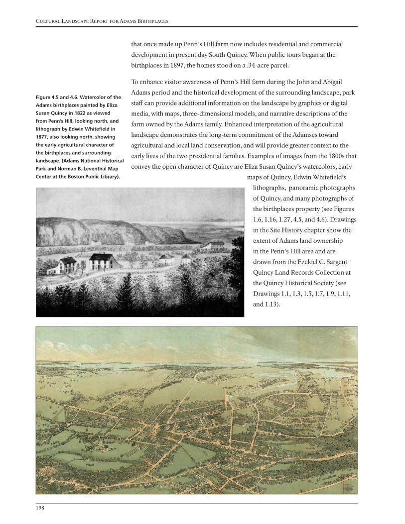
Cultural landsCape report for adams BirthplaCes
198
that once made up Penn’s Hill farm now includes residential and commercial
development in present day South Quincy. When public tours began at the
birthplaces in 1897, the homes stood on a .34-acre parcel.
To enhance visitor awareness of Penn’s Hill farm during the John and Abigail
Adams period and the historical development of the surrounding landscape, park
staff can provide additional information on the landscape by graphics or digital
media, with maps, three-dimensional models, and narrative descriptions of the
farm owned by the Adams family. Enhanced interpretation of the agricultural
landscape demonstrates the long-term commitment of the Adamses toward
agricultural and local land conservation, and will provide greater context to the
early lives of the two presidential families. Examples of images from the 1800s that
convey the open character of Quincy are Eliza Susan Quincy’s watercolors, early
maps of Quincy, Edwin Whitefield’s
lithographs, panoramic photographs
of Quincy, and many photographs of
the birthplaces property (see Figures
1.6, 1.16, 1.27, 4.5, and 4.6). Drawings
in the Site History chapter show the
extent of Adams land ownership
in the Penn’s Hill area and are
drawn from the Ezekiel C. Sargent
Quincy Land Records Collection at
the Quincy Historical Society (see
Drawings 1.1, 1.3, 1.5, 1.7, 1.9, 1.11,
and 1.13).
Figure 4.5 and 4.6. Watercolor of the
Adams birthplaces painted by Eliza
Susan Quincy in 1822 as viewed
from Penn’s Hill, looking north, and
lithograph by Edwin Whitefield in
1877, also looking north, showing
the early agricultural character of
the birthplaces and surrounding
landscape. (Adams National Historical
Park and Norman B. Leventhal Map
Center at the Boston Public Library).

TreaTmenT
199
CIRCULATION
CR-1: Reconfigure sidewalk near John Quincy Adams birthplace
The park’s General Management Plan (1996) recommends the removal of parking
spaces along the west side of Franklin Street near the intersection with Presidents
Avenue and the realignment of the intersection to regain the front yard of the John
Quincy Adams birthplace. Historic photographs from the late 1800s and early
1900s show the yard in front of the John Quincy Adams house, which was present
throughout the historic period (see Figures 1.20, 1.29, and 1.58). Within the past
decade, street and sidewalk widening projects have greatly impacted the historic
site (see Figure 2.17).
A related issue is that crossing Franklin Street is dangerous because of the broad
width of the street, and the bend in the road. To calm traffic, improve pedestrian
safety, and restore the historic setting of the John Quincy Adams home, the street
should be narrowed, and parking spaces
and the trolley stop relocated from the
west side of Franklin Street in front of the
John Quincy Adams birthplace to further
north on Franklin Street or to Presidents
Avenue (see Drawing 4.1 and Figures 4.7
and 4.8).
Figure 4.7 and 4.8. Drawing showing
the realignment of the intersection
of Franklin Street and Presidents
Avenue (above). Photo-simulation of
the enlarged front yard and rebuilt
stone wall in front of the John Quincy
Adams birthplace (right).
See Figure 2.17 to compare with
existing conditions. (OCLP).

Cultural landsCape report for adams BirthplaCes
200
CR-2: Establish accessible parking and event parking in the vicinity of the site
One or two accessible parking spaces are needed visitors that arrive at the
birthplaces by vehicle. Ideally the spaces would be designated on the less-traveled
Presidents Avenue. In association with the accessible parking space(s) a curb cut
and entrance are needed into the site (see PV-1 and Drawing 4.1).
Since visitors are encouraged to take the trolley, most visitors arrive without a
vehicle. However, an event parking plan would identify feasible parking areas
within walking distance of the site. Ideally the parking locations map or website
would include points of interest associated with the former Penn’s Hill farm. For
example, the Sweeny Brothers Funeral home parking lot (with their permission)
is the former John and Abigail Adams garden area. Goddard Street passes through
their former cow yard and Federal Avenue is within their former orchard area as
shown on Drawing 1.3; however, these areas do not retain their bucolic character.
CR-3: Reconfigure trolley drop off zone
The trolley drop off location should be relocated to improve visitor experience as
described in PV-1. Possible locations are north on Franklin Street (Figure 4.9) or
west on Presidents Avenue (see Figure 4.4).
CR-4: Reconfigure pedestrian circulation to create an accessible pedestrian route
Earthen paths existed at the birthplaces for almost two centuries (see Figures 1.17,
1.20, and 1.22). The Daughters of the Revolution installed a stonedust path to the
John Adams birthplace in the early 1900s, which is visible in early photographs
(see Figures 1.42 and 1.52). The City of Quincy installed the flagstone path around
1951 after they acquired the Adams birthplaces from the Adams Real Estate Trust
(see Figure 1.69). Most of the flagstones remain and start at the park entrance on
Franklin Street, run toward the front door of the John Adams birthplace, and then
split with one fork leading to the front and the other to the rear door of the John
Quincy Adams birthplace (see Drawing 2.1). The flagstones are set in the ground
and sit close to one another, with turf growing along the edges (Figure 4.10).
To improve pedestrian circulation, install an accessible pedestrian route that
connects the proposed new entrance (see PV-1) north or west of the John Adams
birthplace. Though aesthetically pleasing, the existing flagstone pathways do not
provide for universal access because the surface is uneven and does not easily
accommodate wheelchairs. Because the flagstone pathways are not historically
significant and non-contributing resources, they should be replaced throughout
the site to accommodate the width of a wheelchair, provide a suitable surface
for wheels, and provide a safer surface for pedestrians. Minimum accessibility
requirements call for 36 inches clear width, with a slope of less than 1:20 (5
percent), a cross-slope of less than 1:48 (2 percent) throughout, and a firm and
stable surface. As the site is relatively flat, slope on pathways is not an issue. The

TreaTmenT
201
Figure 4.10. Photograph of the
existing flagstone path from Franklin
Street to the front door of the John
Adams birthplace. The path is worn,
uneven, and limits accessibility. (OCLP,
November 2013).
Figure 4.11. Photo-simulation of a
3-foot wide compacted earth-tone
stonedust path from Franklin Street
to the front door of the John Adams
birthplace. The path is harmonizes
with the historic setting and improves
accessibility. (OCLP).
Figure 4.9 Photo-simulation of a
proposed new location for the trolley
stop north on Franklin Street. The
other proposed location is visible in
Figure 4.4 and Drawing 4.1. (OCLP).

Cultural landsCape report for adams BirthplaCes
202
cross-slope should be set at two percent or the path should have a crowned profile to
adequately shed water. In order to install the new pathways, the soil will need to be
excavated to six inches. Topsoil and subsoil should be separated, with topsoil being
stockpiled for future use.
The path should be a minimum of three feet in width and surfaced with compacted
subgrade and stabilized stone dust. Archeological review and monitoring is
recommended before and during installation of a compacted subsurface. The route
should be excavated to a depth of six to eight inches to remove loamy topsoil.
Once excavated, install and compact a base layer of crusher mixed stone aggregate
(ASTMD 2940 or CR6) and surface with one to two inches of compacted stonedust
with a clay binder or soil stabilizer. If a binder or stabilizer is not used, the surface
will require replacement every one to two years and could be tracked into the
historic homes. For the recommended path alignment, see Drawing 4.1. The crusher
mixed stone aggregate should consist of no more than one inch aggregate size,
be free from clay lumps, organic matter, or other deleterious material. Fines shall
be evenly mixed throughout the aggregate. Screening shall be graded within the
following limits:
Sieve Size Percent Passing
by Weight
1 inch 100
3/4 inch 95
No. 4 65
No. 10 55
No. 20 43
No. 40 29
No. 50 21
No. 100 13
No. 200 8
The surface material should be an earth-tone aggregate consisting of eight percent
clay, which binds the mix for a durable surface. It shall consist of hard, durable
particles or fragments of crushed stone or gravel conforming to the following
requirements and gradations.
Gradation Percent
Los Angeles abrasion, ASTM C131 and C535 50% max*
Fractured faces (one face) 95% max*
Fractured faces (two faces) 75% max*
Soundness loss, five cycles, ASTM C88 (magnesium) 18% max*
Flat/elongated (length to width) > ASTM D4791 15% max*
*Based on the portion retained on the 3/8 inch sieve.
The surface material should be free from organic material and lumps or balls of clay.
Material passing the No. 4 sieve shall consist of natural or crushed sand and fine
mineral particles. The material, including any blended filler, shall have a plasticity
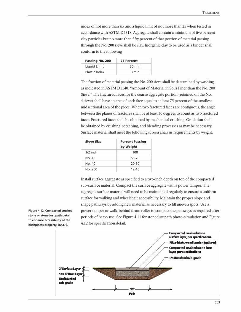
TreaTmenT
203
index of not more than six and a liquid limit of not more than 25 when tested in
accordance with ASTM D4318. Aggregate shall contain a minimum of five percent
clay particles but no more than fifty percent of that portion of material passing
through the No. 200 sieve shall be clay. Inorganic clay to be used as a binder shall
conform to the following :
Passing No. 200 75 Percent
Liquid Limit 30 min
Plastic Index 8 min
The fraction of material passing the No. 200 sieve shall be determined by washing
as indicated in ASTM D1140, “Amount of Material in Soils Finer than the No. 200
Sieve.” The fractured faces for the coarse aggregate portion (retained on the No.
4 sieve) shall have an area of each face equal to at least 75 percent of the smallest
midsectional area of the piece. When two fractured faces are contiguous, the angle
between the planes of fractures shall be at least 30 degrees to count as two fractured
faces. Fractured faces shall be obtained by mechanical crushing. Gradation shall
be obtained by crushing, screening, and blending processes as may be necessary.
Surface material shall meet the following screen analysis requirements by weight.
Sieve Size Percent Passing
by Weight
1/2 inch 100
No. 4 55-70
No. 40 20-30
No. 200 12-16
Install surface aggregate as specified to a two-inch depth on top of the compacted
sub-surface material. Compact the surface aggregate with a power tamper. The
aggregate surface material will need to be maintained regularly to ensure a uniform
surface for walking and wheelchair accessibility. Maintain the proper slope and
shape pathways by adding new material as necessary to fill uneven spots. Use a
power tamper or walk-behind drum roller to compact the pathways as required after
periods of heavy use. See Figure 4.11 for stonedust path photo-simulation and Figure
4.12 for specification detail.
Figure 4.12. Compacted crushed
stone or stonedust path detail
to enhance accessibility of the
birthplaces property. (OCLP).

Cultural landsCape report for adams BirthplaCes
204
CR-5: Add ramps to improve accessibility
Ramps may be added at the birthplace entrances to improve accessibility to the
buildings. To provide a solid base for a permanent or temporary ramp, extend the
granite threshold steps to provide a solid surface on which to lay a ramp to access
each building (Figures 4.12 through 4.25). For the John Adams birthplace, the
granite threshold step is currently eight inches below the threshold and can not
be raised because of the overhanging woodwork. The least obtrusive solution is
to extend the granite from the building and use a portable ramp as diagrammed in
Figures 4.13 through 4.21. Sample ramps and a similar treatment is recommended
for the John Quincy Adams birthplace are shown in Figures 4.22 through 4.27.
Ideally the ramp would be 5 feet in width to facilitate rotation of a wheel chair
because because the house doorways are too narrow for entry.
Figure 4.13. Section and plan views
of the existing entry to the John
Adams birthplace. The section (right,
top) shows the existing flagstone
path, the 4 1/2-inch high threshold
granite block, and the 8-inch step to
the door threshold. The plan view
(bottom) shows the relationship
of the threshold to the existing
flagstone path. (OCLP).

TreaTmenT
205
Figure 4.14. Section and plan
views of the proposed entry
to the John Adams birthplace.
The section (right, top) shows
the proposed replacement and
relocation of the path with
compacted stonedust, the
extension of the 4 1/2-inch high
threshold with two additional
granite blocks, and the addition
of a ramp to accommodate
the 8-inch step rise to the door
threshold. The plan views
(below) show grading in two
inch increments (dashed lines)
and the placement of three
granite blocks, which would
support a portable ramp.
(OCLP).

Cultural landsCape report for adams BirthplaCes
206
Figure 4.17. Photo-simulation of a
more permanent ramp. (OCLP).
Figure 4.16. Photo-simulation showing
3-foot wide stonedust path and
regrading of lawn area to eliminate
the 4-1/2-inch step. (OCLP).
Figure 4.15. Existing conditions at
entrance to John Adams birthplace.
Visitors walk along a flagstone path
and ascend a 4-1/2-inch granite block
step and an 8” threshold step. (OCLP).

TreaTmenT
207
Figure 4.20. Ramp alternatives for house
entry. Image of a portable ramp with a
single collapsible handrail.
Figure 4.21. Ramp alternatives for house
entry. Image of a portable folding ramp
with no handrails for a gentle slope.
Figure 4.19. Ramp alternatives for house
entry. Image of a portable ramp with
permanent handrails.
Figure 4.18. The backdoor of the John
Adams birthplace offers an alternative
entry, but is only 30-inches wide, with
an 11-inch rise from the ground, and
a tight turn and additional 3-inch rise
once inside the building. (OCLP).

Cultural landsCape report for adams BirthplaCes
208
Figure 4.23. Section and plan views of
the existing entry to the John Quincy
Adams birthplace. The section (right)
shows the existing flagstone path,
the 6-inch high threshold granite
block, and the current 12-inch rise to
the door threshold. The plan view
(below) shows the relationship of the
threshold to the existing flagstone
path. (OCLP).
Figure 4.22. Photo-simulation showing
flagstones removed and three-foot
wide stonedust path installed. The
existing granite block is raised by six
inches so that without a ramp, visitors
ascend a 6-inch granite block then a
6-inch door threshold. (OCLP).

TreaTmenT
209
Figure 4.24. Section and
plan views of the existing
entry to the John Quincy
Adams birthplace. The
section (right) shows the
proposed replacement
and relocation of the
path with compacted
stonedust, the extension
of the threshold block with
two additional granite
blocks, and the addition of
a ramp to accommodate
the 6-inch step rise to
the door threshold. The
plan views (below) show
the grading in 2-inch
increments (dashed lines)
and placement of granite
blocks, which would
support a portable ramp.
(OCLP).

Cultural landsCape report for adams BirthplaCes
210
Figure 4.26. Photo-simulation showing
new route for stonedust path to
provide a flatter route into the John
Quincy Adams birthplace home. A
temporary ramp is laid over three
granite blocks that extend from the
house. (OCLP).
Figure 4.25. Photo-simulation showing
ramp laid across threshold to aid
visitors with limited mobility. (OCLP)
Figure 4.27. Photo-simulation of
threshold blocks and temporary
ramp into the John Quincy Adams
birthplace. The eight-foot long
ramp would help visitors assend the
six inches from the ground to the
doorway. Note the recessed granite
curbing on either side of the walk
that retains the stonedust where
the path rises to meet the top of the
granite block.

TreaTmenT
211
VEGETATION
VG-1: Maintain and replant trees
The John Adams and John Quincy Adams birthplaces property originally
extended from the Country Road in the east to the Fresh Brook in the west.
Once Deacon John Adams and John Adams acquired more property, their land
expanded much farther in all directions. Drawings and photographs of the
1800s Quincy landscape show open fields divided by rows and groves of trees
(see Figures 1.16 and 1.27). Trees lined the streets surrounding the birthplaces
(see Figures 1.25 and 1.30). The number of trees lining the streets diminished
throughout the twentieth century due to subdivisions, street widening, and
pests and diseases. At the end of the historic period, trees within the birthplaces
property are documented in the 1936 HABS drawing (see Figure 1.59). Elms and
Norway maples grew around the homes. Most have since died and some have
been replaced in-kind or with substitute species.
To enhance visitor experience and the park setting, and to block incongruous
views and street noise, the trees and shrubs within and surrounding the site
should be improved and missing trees planted along Franklin Street and
Presidents Avenue (see also VG-2). Trees that are in poor condition should be
replaced in-kind if they date to the historic period, or replaced with compatible
species (Figures 4.28 and 4.29). Shrubs should also be rejuvenated or replaced
in-kind to provide screening, or replace with compatible species as detailed in
VG-5. Openings in vegetation surrounding the site should also be maintained,
so that there are some sightlines through the property from Franklin Street and
Presidents Avenue (see Drawing 4.1).
When replanting missing trees, select species that are described by the Adams
family and in Penn’s Hill notes that are tolerant of urban conditions. As
summarized in “The Birthplaces of Presidents John Adams and John Quincy
Adams: An Interpretive Presentation of the Grounds,” prepared by Lawrence Gall
in 1978–79, species present during the historic period included:
• Trees and Shrubs: Lilac, cedar, hemlock, walnut, white oak, buttonwood
(sycamore), elm, maple, savin (red cedar or juniper bush), white pine, willow,
alder, birch, ash, dogwood, and arrowwood.
• Fruit trees: apples, peach, pear, plum, cherry.
Of the tree species listed above, Eastern red cedar, oak, elm, maple, white pine,
and birch would be appropriate. The other species, hemlock, walnut, sycamore,
willow, birch, ash, and dogwood are vulnerable to pests and diseases that limit
their viability and sustainability, or are not compatible with urban conditions.
Norway maples were planted by the Daughters of the Revolution and Quincy

Cultural landsCape report for adams BirthplaCes
212
Historical Society and several persist on the site. In the long term, these species
should be replaced with species that were present during the earlier Adams period
of ownership, as Norway maple is a non-native invasive species. For example,
red maple and red or white oak can be substituted for the Norway maple that
once grew to the south, west and northwest of the John Quincy Adams birthplace
(Figures 4.30 and 4.31).
Figure 4.28. Photograph of existing
conditions in 2013 showing Norway
maples along the western edge of
the birthplaces property. One is in
fair condition and the other in poor
condition. (OCLP).
Figure 4.29. Photo-simulation
of trees added along Presidents
Avenue and at the intersection
with Franklin Street. Also note the
proposed visitor entry on Presidents
Avenue. (OCLP).

TreaTmenT
213
Figure 4.31. Existing conditions
showing the loss of vegetation
surrounding the John Quincy
Adams birthplace after the removal
of a Norway maple shown in the
photograph above to the south of the
house. The recommended species to
replant is red maple. (OCLP, 2013).
Figure 4.30. Photograph looking
north of the John Quincy Adams
birthplace showing young trees
planted by the Quincy Historical
Society including a Norway maple to
the south of the house (foreground)
and elms along the stone wall
(background). Vines grow on the
wall and house, c. 1910. (Historic
New England).

Cultural landsCape report for adams BirthplaCes
214
VG-2: Coordinate with City and neighbors to replace and add vegetation
The sidewalk along Franklin Street contained an American elm during the historic
period (see Figure 1.36 and 1.50). Large trees also grew between the homes and
Franklin Street at the end of the nineteenth century (see Figures 1.44 and 1.58).
The parcel was also ringed with trees (see Figures 1.59 and Drawing 1.10). In the
1990s the City of Quincy planted the five Kwanzan cherry trees in openings in the
paved sidewalk. These ornamental flowering cherry trees provide a splash of color
in the spring and some shade along the sidewalk. However, trees are mature and
too broad for the sidewalk. Generally, the Kwanzan cherry is not recommended as
a street tree and is incompatible with the historic landscape (see Figures 1.86 and
2.14).
To enhance the eastern border of the Adams birthplaces property, coordinate
with the City of Quincy on replacing the cherry trees that grow in the sidewalk
along Franklin Street. New trees should be planted that harmonize with the
historic setting. Roots should not encroach the foundation of either of the homes.
Recommended species include red oak; disease-resistant varieties of elm, such as
‘Jefferson’ or ‘Princeton;’ or other less common species that would tolerate the
urban growing conditions, including red maple, white oak, scarlet oak, black oak,
and bur oak (Figures 4.32 and 4.33).
Figure 4.32. Existing conditions
showing Kwanzan cherry trees, now
about 25 years old, crowding the
sidewalk. (OCLP).
Figure 4.33. Photo-simulation of a
disease-resistant elm growing in
the sidewalk along Franklin Street.
The proposed narrowing of Franklin
Street and the reconfigured sidewalk
allows the stone wall to be rebuilt
in front of the John Quincy Adams
birthplace. (OCLP).

TreaTmenT
215
The birthplaces are part of a local historic district
that extends beyond the birthplaces site (Figure
4.34). The replanting of street trees that were
present in the late 1800s and early 1900s will
enhance the overall character of the local historic
district.
In addition to improving street trees, the park can
collaborate with the City of Quincy and nearby
commercial parcels to improve screening around
the site. For example, planting islands can be
added along the sidewalk adjacent to the Sweeney
Brothers Home for Funerals. Adding evergreen
shrubs such as Eastern red cedar and yew will
screen the parking area and enhance the setting of
the historic site as diagrammed on Drawing 4.1.
VG-3: Improve resilience of lawn in front of the John Adams birthplace
In the eighteenth and nineteenth century, the front yard of the John Adams
birthplace contained lilacs and other ornamental plants during the historic period.
The front yard of the John Adams birthplace is now a gathering space when
visitors arrive for a tour of the birthplaces. Park interpreters give an introduction
to the property in this area before entering the house. The turf is currently worn
down by frequent use and foot traffic. To improve appearance of the lawn in front
of the John Adams birthplace, interpreters can orient groups to the north or west
of the John Adams house, or at a proposed shelter (see BS-1). The resilience of
the front lawn can be improved with amendments such as calcined diatomaceous
earth (Axis®), which would diminish compaction and improve turf growth (see
Figures 4.10 and 4.11).
VG-4: Avoid soil compaction and disturbance under beech tree
Beech trees deteriorate quickly if subjected to foot traffic, root disturbance, and
soil compaction. To preserve the mature beech tree north of the John Adams
birthplace, avoid directing visitors under the tree or adding a visitor amenities in
the vicinity of the tree roots.
Figure 4.34. Diagram of the Adams
Birthplaces local historic district

Cultural landsCape report for adams BirthplaCes
216
VG-5: Replace pines along northern property line
The properties to the north of the Adams birthplaces, a residence and a business,
do not contribute to the historic setting of the Adams birthplaces. Similarly,
incongruous uses, such as dumpsters, delivery trucks, a private swimming pool,
and barking dogs, detract from the park setting. Evergreen vegetation and a board
fence would improve screening of these adjacent lots (see also BS-2). Existing pine
trees, planted in the mid-1900s, possibly under the direction of the City of Quincy,
no longer provide screening of the neighboring properties.
To enhance visitor experience, replace existing pine trees growing along the
northern property line in-kind or with another evergreen species that does
not grow as tall, such as American holly or Eastern red cedar. If the evergreens
become thin due to lack of light, thin the canopy or use more shade tolerant
evergreens such as rhododendron.
Figure 4.35. Existing conditions
showing mature evergreens that
are no longer screening adjacent
properties. (OCLP).
Figure 4.36. Photo-simulation
showing young white pine trees,
American hollies, Eastern red
cedar, or rhododendron added for
screening incongrous views (OCLP).

TreaTmenT
217
Figure 4.37. This c. 1930 photograph
portrays the ornamental vegetation
that grew in front of the John Adams
birthplace during the historic period,
including lilacs and Vanhoutte spirea
(in bloom).
Figure 4.38. The 1936 plan of the
birthplaces property illustrates the
assortment of trees, shurbs, and
vines that grew on the property at
this time. (OCLP).
VG-6: Replant historic shrubs and remove invasive species around the birthplaces
Photographs from the late 1800s and early 1900s depict several clusters of
lilacs surrounding the John Adams birthplace, and spirea by the 1920s. These
clusters are also documented in the 1936 HABS drawing (see Figure 1.59). One
cluster of lilacs currently grows in front of the John Adams house and is in need
of rejuvenation. To enhance the historic setting, propagate the extant lilac and
replant clusters around the home. Maintain the clusters at a height of four to
five feet, so that they do not obscure the home. Note that the lilacs appear very
large in some historic photographs, but varied in size throughout the historic
period. Also remove invasive species from the perimeter of the property, including
euonymous and forsythia, and plant fruit shrubs that would have been present
during the historic period (see VG-1 and VG-7).

Cultural landsCape report for adams BirthplaCes
218
VG-7: Construct raised garden beds that contain flowers, herbs, and vegetables
that would have been in the Adams garden
If staff time, volunteer time, and space allows, the park is interested in adding
a garden that would display the plant species cultivated by the Adamses, and
serve as a place of engagement with the landscape. The site for such a garden
would most likely be in conjunction with the new visitor contact station on
the park site or on an adjacent parcel (BS-1). The simple garden can consist of
two or four raised garden beds, filled will quality garden soil and compost, and
planted seasonally with grasses, grains, flowers, herbs, fruits, and vegetables
that Abigail and John Adams wrote about in their correspondence and diaries.
Food production continues to be an important theme for our nations leaders,
as reflected in the addition of a vegetable garden at the White House. Display
gardens are also maintained at other historical parks (Figure 4.39). The following
is a list of crops that were present at the Penn’s Hill farm from “The Birthplaces of
Presidents John Adams and John Quincy Adams: An Interpretive Presentation of
the Grounds,” prepared by Lawrence Gall in 1978–79.
• Grains, Grasses, and Other Staple Crops: Indian corn, Siberian wheat, rye, oats,
barley, “English grass,” “English hay,” clover, salt hay, and flax.
• Vegetables and garden fruits: potatoes, onions, cabbage, peas, beans, pumpkins,
carrots, parsnips, beets, asparagus, pepper grass (garden cress), mustard,
lettuce, watermelon, and muskmelon.
• Fruit shrubs, and vines: strawberries, raspberries, grapes, currants, and
huckleberries.
Rather than a restoration, the raised beds would serve as display beds to interpret
the plants that were grown by the Adamses. The beds should be placed in full
sun, but not where they will be an obstacle to circulation, special programs,
or maintenance operations. The beds will require planting, weeding, fertilizer,
and watering throughout the growing season. An associated storage area is
needed for garden tools and a watering hose.
Crops most likely to be successful with low
maintenance include grasses, grains, onions,
beans, and strawberries. If a garden group were
to be engaged in the project, a larger number of
raised beds may be feasible and a greater variety
of crops. The recommended raised bed size is
three to four feet wide by ten to twelve feet long
by one foot height, with a minimum of four
foot spacing between beds. If the beds are not
adequately maintained, they can be somewhat
easily removed from the site.
Figure 4.39. Example of raised
garden beds at Minute Man National
Historical Park, located behind the
Hartwell Tavern (OCLP, October
2014).
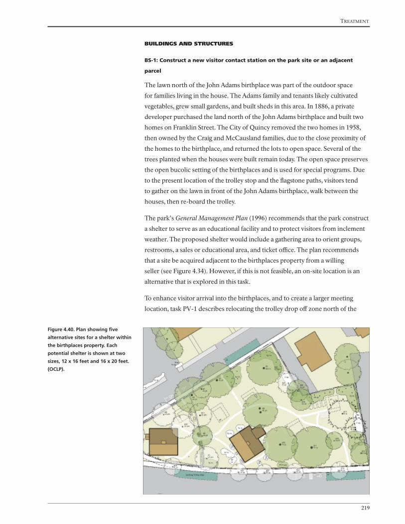
TreaTmenT
219
BUILDINGS AND STRUCTURES
BS-1: Construct a new visitor contact station on the park site or an adjacent
parcel
The lawn north of the John Adams birthplace was part of the outdoor space
for families living in the house. The Adams family and tenants likely cultivated
vegetables, grew small gardens, and built sheds in this area. In 1886, a private
developer purchased the land north of the John Adams birthplace and built two
homes on Franklin Street. The City of Quincy removed the two homes in 1958,
then owned by the Craig and McCausland families, due to the close proximity of
the homes to the birthplace, and returned the lots to open space. Several of the
trees planted when the houses were built remain today. The open space preserves
the open bucolic setting of the birthplaces and is used for special programs. Due
to the present location of the trolley stop and the flagstone paths, visitors tend
to gather on the lawn in front of the John Adams birthplace, walk between the
houses, then re-board the trolley.
The park’s General Management Plan (1996) recommends that the park construct
a shelter to serve as an educational facility and to protect visitors from inclement
weather. The proposed shelter would include a gathering area to orient groups,
restrooms, a sales or educational area, and ticket office. The plan recommends
that a site be acquired adjacent to the birthplaces property from a willing
seller (see Figure 4.34). However, if this is not feasible, an on-site location is an
alternative that is explored in this task.
To enhance visitor arrival into the birthplaces, and to create a larger meeting
location, task PV-1 describes relocating the trolley drop off zone north of the
Figure 4.40. Plan showing five
alternative sites for a shelter within
the birthplaces property. Each
potential shelter is shown at two
sizes, 12 x 16 feet and 16 x 20 feet.
(OCLP).

Cultural landsCape report for adams BirthplaCes
220
present day trolley stop on Franklin Street or on Presidents Avenue. If an off-site
shelter can not be acquired, the park can create a visitor contact station in the
north lawn area. A visitor contact station could provide visitors who are not on a
tour with interpretive information on the two birthplaces.
The building characteristics of Adams outbuildings, no longer extant, can
inform the design of the new structure. Several barns and sheds stood near the
John Adams and John Quincy Adams birthplaces, which are documented in
engravings, paintings, and photographs from the early 1800s through early 1900s.
John Adams built two sheds adjacent to John Quincy Adams birthplace and a
barn near his birthplace near the end of the eighteenth century. Furthermore,
developers built two homes in 1886 north of the John Adams birthplace, along
Franklin Street. All sheds and barns were removed at the end of the nineteenth
century and the two Victorian homes were removed in 1958. Structure sizing
could range from a 12’x16’ to 16’x20’ footprint and be differentiated from the
Figure 4.41. Photo-simulation of 12
x 16-foot building within the north
corner of the north lawn area (see
Location #1 on Drawing 4.1). The
building would be accessed via a
new entrance at the northeast corner
of the property in conjunction with
the relocated trolley stop. The small
building would be largely concealed
by existing trees. (OCLP).
Figure 4.42. Photo-simulation of 16 x
20-foot building with shelter area in
the north corner of the north lawn
area (see Location #1 on Drawing
4.1). The building would be accessed
via a new entrance at the northeast
corner of the property in conjunction
with the relocated trolley stop.
(OCLP).

TreaTmenT
221
Figure 4.44. Photo-simulation of
12 x 16-foot building to the north
of the John Adams birthplace (see
Location #2 on Drawing 4.1). The
building would be accessed via
a new entrance at the northeast
corner of the property in conjunction
with the relocated trolley stop. The
small building would be largely
concealed by existing trees. Due
to the proximity of tree roots,
only a temporary building without
a foundation is feasible in this
location. (OCLP).
birthplaces while still compatible with the historic materials. Cover should
provide protection from inclement weather, seating for small groups, and
interpretive material. A contact station could be built in the north lawn and near
the proposed trolley zone, northwest of the John Adams birthplace where a barn
likely stood in the nineteenth century, or between the birthplaces. Construction
of a new building should not cause harm to cultural artifacts or landscape
features.
Park staff expressed interest in an outbuilding for education programs that
could serve as a visual barrier, screening incongruous views to the north or to
the west, as well as offering protective cover for visitors and staff. Currently,
park interpreters hold spring and fall educational programs at Peace field in the
Carriage House. Since some of these events took place when John and Abigail
Adams lived in the John Quincy Adams birthplace, the park would like to pursue
the possibility of holding the programs on the birthplaces site.
Figure 4.43. Photo-simulation of 16 x
20-foot building with shelter area in
the north corner of the north lawn
area (see Location #1 on Drawing
4.1). The building would be accessed
via a new entrance at the northeast
corner of the property in conjunction
with the relocated trolley stop.
(OCLP).

Cultural landsCape report for adams BirthplaCes
222
Figure 4.45. Photo-simulation of 12
x 16-foot building west of the John
Adams birthplace (see Location #3
on Drawing 4.1). The building would
be accessed via a new entrance at
the northeast corner or west side of
the property in conjunction with the
relocated trolley stop. (OCLP).
Figure 4.46. Photo-simulation of
12 x 16-foot building southwest
of the John Adams birthplace (see
Location #4 on Drawing 4.1). The
building would be accessed via a
new entrance at the west side of
the property in conjunction with the
relocated trolley stop. (OCLP).
Figure 4.47. Photo-simulation of
12 x 16-foot building west of the
John Quincy Adams birthplace (see
Location #5 on Drawing 4.1). The
building would be accessed via a
new entrance at the west side of
the property in conjunction with the
relocated trolley stop. (OCLP).

TreaTmenT
223
Figure 4.48. Diagram showing
composite wood fencing to install
along the northern boundary of the
birthplaces property. (OCLP).
BS-2: Construct wood or recycled plastic board fence along northern property line
A four foot high chain link fence currently runs between the Adams birthplaces
and the two properties to the north. The fence is in need of replacement. A six
foot high board fence could screen the neighboring properties and reduce the
noise from delivery trucks and animals. Existing common lilacs and common
flowering quince planted near the chain link fence should be retained. The
fencing material can be wood board or recycled plastic board. For example,
Nature’s Composites makes and ornamental style composite fence that allows
for some visibility. Walpole Woodworkers makes solid cellular vinyl fences stock
that has the look and feel of natural wood, and also manufactures wooden fences.
Trex makes wood-alternative seclusion fencing in three feasible earth-tone colors.
Many additional manufacturers produce comparable materials. Approximately
250 linear feet of fencing at six feet height are needed to screen the north
boundary of the site.

Cultural landsCape report for adams BirthplaCes
224
Figure 4.49. Photograph of stone
wall shortly after construction,
1897 (Courtesy of Quincy Historical
Society).
Figure 4.50. Existing condition of
stone wall as a result of street and
sidewalk widening. (OCLP, 2013).
Figure 4.51. Photo-simulation of
the narrowed street and sidewalk
and rebuilt stone wall. Rebuilding
the wall will improve visitor safety.
(OCLP).
BS-3. Rebuild sections of stone wall that are damaged or missing around John
Quincy Adams birthplace
To restore the historic setting and improve visitor safety, missing and damaged
sections of the stone wall should be rebuilt. In the 1890s the Quincy Historical
Society and Daughters of the Revolution oversaw the construction of a stone
wall around the John Quincy Adams birthplace. The wall has persisted but in
some places is collapsed or missing. Once Franklin Street in reconfigured (see
CR-1), the section of missing wall can be rebuilt. Other sections need to be reset.
Replacing missing sections will require the acquisition of additional stones that
match the shape, color, and
dimensions of the existing
stones. Because the stones
are dry laid, the park may
seek the expertise of the Dry
Stone Conservancy, based in
Kentucky, for guidance and
training on dry stone masonry.

TreaTmenT
225
VIEWS AND VISTAS
VV-1: Create interpretive connections to Quincy historic sites, Penn’s Hill farm
views, and the greater Quincy landscape
Quincy is known as the “City of Presidents” and contains numerous historic sites.
The Quincy Historical Walking Trail featured on the city’s website describes a
3-1/2 mile walk that highlights important heritage sites within the community.
The Adams birthplaces property is included as the southernmost site on the tour.
Based on the research compiled for this report, the park and city should promote
a walking tour that incorporates the Abigail Adams Cairn and views from the
shoulder of Penn’s Hill at the intersection of Franklin Street and Viden Road.
Park staff can also lead neighborhood walking tours to offer glimpses of the
former Penn’s Hill farm. From the birthplaces site, a half mile walk south (up
Franklin Street) brings visitors to the shoulder of Penn’s Hill and the Abigail
Adams Cairn erected by the Daughters of the Revolution near Viden Road.
Here, walkers can view Boston to the north and the Blue Hills to the west. From
this point, the walking route would travel along Nichol Street and Alton Road
to reach Faxon Park. While this parcel was not part of the Penn’s Hill farm, its
rustic character and mix of native species provides an undeveloped landscape
setting that harkens back to the early Quincy landscape known by the Adamses.
In addition to abundant native species, the park offers a pavillion and place for
reflection before returning to the Adams
birthplaces property by way of Kendrick
Ave, Madison Ave, and Bradford Street. The
Bradford Street playground represents a
parcel formerly owned by Charles Francis
Adams that has remained as open space. The
route offers insights into the relationship
of Quincy to Boston and the development
of the community during the successive
generations of Adams ownership (see
Drawings 1.1 through 1.14).
By promoting the walks described above and
collaborating with local organizations and
web-based groups that promote walking and
cycling routes (see SS-2), the park can reach
a broader audience regarding the significance
of the Adams birthplaces, the views from
Penn’s Hill, and the vestiges of the Adamses
Penn’s Hill farm.
Figure 4.52. Diagram showing
potential route of walking tour from
the birthplaces to the shoulder of
Penn’s Hill. (OCLP, MassGIS).

Cultural landsCape report for adams BirthplaCes
226
SMALL-SCALE FEATURES
SS-1: Install site furnishings that are compatible with the historic setting
The park includes two benches set beneath the shade of a recently replanted
Norway maple. Visitors take advantage of the benches when receiving a welcome
from the park visitor services staff. The benches should be updated to provide
comfortable, stable seating as shown in Figure 4.53.
SS-2: Install bicycle rack that does not detract from the historic setting
An increasing number of visitors are coming to the site by bicycle due to initiatives
within the City of Quincy to improve bicycle corridors. To accommodate visitors
arriving by bicycle, install a bicycle rack at the northeast corner of the property in
conjunction with Task CR-3 and CR-4 as shown on Drawing 4.1.
Figure 4.53. Photo-simulation of new
matching benches at the Adams
birthplaces property. Flagstones
are laid in a circle near the benches
to provide a visitor orientation
gathering space (OCLP).

TreaTmenT
227
TREATMENT IMPLEMENTATION
The landscape tasks described above are summarized in Table 4.2 and 4.3.
National Park Service uses the Facility Management Software System (FMSS)
to manage park resources, track costs, prioritize projects, and create funding
requests and work orders.
TABLE 4.2. TREATMENT TASKS FOR ADAMS BIRTHPLACES
Task ID Task Page # Related Tasks
PROGRAMMING AND VISITOR EXPERIENCE
PV-1 Reconfigure arrival sequence and pedestrian circulation 195 BS-1, CR-1, VG-6
PV-2 Create programming to interpret the evolution of the Adams
birthplaces landscape
197 VG-6
CIRCULATION
CR-1 Reconfigure sidewalk near John Quincy Adams birthplace 199 PV-1, SS-2
CR-2 Establish accessible parking and event parking in vicinity 200 PV-1, CR-1
CR-3 Reconfigure trolley drop off zone 200
CR-4 Reconfigure pedestrian circulation to create an accessible pedestrian
route
200 PV-1, BS-1
CR-5 Add ramps to improve accessibility 204 BS-1
VEGETATION
VG-1 Maintain and replant trees around birthplaces 211 VG-2
VG-2 Coordinate with City of Quincy to replace and add street trees and add
screening vegetation
214 VG-1
VG-3 Improve resilience of lawn in front of the John Adams birthplace 215 CR-1
VG-4 Avoid soil compaction and disturbance under beech tree 215 CR-3, BS-1
VG-5 Replace pines along northern property line to improve screening 216 VG-1, VG-2
VG-6 Replant historic shrub species and remove invasives around birthplaces 217 VG-1
VG-7 Construct raised garden beds for interpretation 218 BS-1
BUILDINGS AND STRUCTURES
BS-1 Construct a new visitor contact station on the park site or an adjacent
parcel
219 PV-1, CR-1, VG-6
BS-2 Construct wood or recycled plastic board fence along northern
property line
223 VG-4
BS-3 Rebuild sections of stone wall that are damaged or missing 224 CR-1
VIEWS AND VISTAS
VV-1 Restore visual connections to Adam’s Penn’s Hill farm 225 PV-2
SMALL-SCALE FEATURES
SS-1 Install site furnishings that are compatible with the historic setting 226 VG-1
SS-2 Install bicycle rack that does not detract from the historic setting 226 PV-1, CR-3

Cultural landsCape report for adams BirthplaCes
228
INTEGRATING TREATMENT RECOMMENDATIONS WITH FMSS
The Adams birthplaces property is managed through the National Park Service
Facility Management Software System (FMSS). This system is structured to track
costs associated with asset management, as well as asset condition. FMSS is also
fundamental in generating funding requests for all rehabilitation, restoration,
repair, and capital improvement projects through the National Park Service
Project Management Information System (PMIS). Integration with FMSS is
essential to implement the treatment recommendations in this report.
Physical features or “assets” of the cultural landscape are tracked in FMSS
through a variety of “Asset Types,” including the maintained landscape and
buildings. The Adams birthplaces landscape-related assets are tracked under the
maintained landscape Asset Type, with a code of “3100.” Within the Birthplace
District (74056) are the Birthplace Grounds (74084). Assets include:
• Barriers and Fencing: Adams birthplaces wood post fence (1274813) and
chain-link fence (1274815)
• Furnishings: flag pole (1274816) and trash barrels (1274817)
• Liquid and Gas: well (1274820)
• Signage and Marking: park identity signs (1274821)
• Structures: stone wall (1274823) and paths (1274824)
• Surface: vegetation (1274825) and lawn (1274826)
Table 4.3 below summaries the landscape treatment tasks in this report
according to FMSS Asset Type, Location, and asset as a first step in translating
cultural landscape treatment recommendations into project funding requests.
Quantities are provided to facilitate cost estimating. Additional professional
services, such as design or construction oversight, is required to implement some
recommendations.

TreaTmenT
229
TABLE 4.3. LANDSCAPE TREATMENT TASKS AND FMSS HIERARCHY
CLR Treatment Task/FMSS Work
Order
CLR Treatment Task
Component/FMSS Task
Units of
Material
FMSS
Asset/
Location
FMSS Work
Type/ Sub-
type
Existing
PMIS
Project
Recurring
Maintenance
Needed
PROGRAMMING AND VISITOR EXPERIENCE
PV-1. Reconfigure arrival sequence
and pedestrian circulation
Install 4’ break in split-rail
fence
20 LF 3100/
74084
FM / LMAC 154113 Repair fence
PV-2. Create programming to
interpret the evolution of site
Install digital technology hub N/A N/A CI / NC 171160 Add digital
equipment
CIRCULATION
CR-1. Reconfigure sidewalk near
John Quincy Adams birthplace
Reconfigure road and
sidewalk, remove concrete,
reconstruct stone wall
100 LF 3100/
74084
FM / LMAC 154113 Repair stone
wall
CR-2. Establish accessible parking
and event parking in vicinity
Add paint and signage 40 LF 3100/
74084
FM / LMAC None Maintain &
paint signs
CR-3. Reconfigure trolley drop off
zone
Add paint and signage 50 LF 3100/
74084
FM / LMAC None Maintain &
paint signs
CR-4. Reconfigure pedestrian
circulation to create an accessible
pedestrian route
Excavate route, add
compacted aggregate and
compacted surface
1000 LF 3100/
74084
FM / LMAC None Maintain
surface
CR-5. Add ramps to improve
accessibility
Regrade door entry area, add
stones and temporary ramp
30 LF 3100/
74084
CI / LMAC 208385 Maintain
surface
VEGETATION
VG-1. Maintain and replant trees
around birthplaces
Prune, remove, replant as
needed
21 EA 3100/
74084
FO / GC None Maintain
plants
VG-2. Coordinate with City to
replace and add trees and screens
Replace trees and add
screening vegetation
16 EA 3100/
74084
FM / DM None Maintain
plants
VG-3. Improve resilience of lawn in
front of the John Adams birthplace
Add amendments, reseed 600 SF 3100/
74084
FM / RM None Aerate,
overseed
VG-3. Avoid soil compaction and
disturbance under beech tree
Minimize visitor foot traffic
and use of area
400 SF 3100/
74084
FO / GC None N/A
VG-5. Replace pines along northern
property line
Remove mature trees, plant
young trees
3 EA 3100/
74084
FM / DM None Stake, water
VG-6. Replant lilac and spirea
around birthplaces
Plant shrubs 7 EA 3100/
74084
FM / DM None Water, weed,
mulch
VG-7. Construct raised garden beds
for interpretation
Construct frames, add loam
and compost, plant
72 SF 3100/
74084
CI / NC 171160 Water, weed,
fertilize
BUILDINGS AND STRUCTURES
BS-1. Construct a new visitor
contact station
Excavate, construct bldg,
plumbing, electricity
320 SF 3100/
74084
CI / NC 63055,
178569
Bldg
maintenance
BS-2. Construct fence along
northern property line
Dig post holes, install posts,
add fence sections
250 LF 3100/
74084
FM / DM 154113 fence repairs,
WO 1691244
BS-3. Rebuild sections of stone wall
that are damaged or missing
Remove concrete walk, rebuild
drylaid wall
30 LF 3100/
74084
FM / DM 154113 repair stone
wall
SMALL-SCALE FEATURES
SS-1. Install site furnishings that
are compatible
Replace existing benches,
install underground cable lock
6 LF x 2 3100/
74084
FM / LMAC None Security
SS-1. Install bicycle rack Install rack, install
underground cable lock
5 LF 3100/
74084
CI / NC None Security

Cultural landsCape report for adams BirthplaCes
230
ENDNOTES, TREATMENT
1 Robert R. Page, Cathy A. Gilbert, and Susan Dolan, A Guide to Cultural Landscape Reports: Contents, Process, and Techniques (Washington, D.C.: National Park Service, 1998), 81.
2 An Act to Establish a National Park Service, and for other purposes (National Park Service Organic Act, August 25, 1916), 39 Stat. 535.
3 U.S. Department of the Interior. Adams National Historic Site, Massachusetts, General Management Plan. (National Park Service, 1996), 50.
4 Ibid, 17.
5 Ibid, 18.
6 Ibid, 31. Educational programs are conducted in both homes and on the grounds. Younger students are directed to the birthplaces to explore the Revolutionary War theme, colonial living, the boyhood lives of the presidents, and Abigail Adams’ role of “Patriot on the homefront.” In addition, the park works with the Quincy Public Schools and the Quincy Historical Society in providing educational programs for all fifth grade students.
7 Ibid, 26.
8 Ibid, 31.
9 New Area Study for the Birthplaces of Presidents John Adams and John Quincy Adams, Quincy Massachusetts (1978).
10 The Secretary of the Interior’s Standards for the Treatment of Historic Properties (Department of the Interior, 1995).

National Park Service
Olmsted Center for Landscape Preservation
SOURCES
DRAWN BYUpdated by Ashley M. Braquet, 2014 Illustrator CS6Drawn by Kirsten Holder and Jaime Young, 2013 AutoCAD 2013 and Illustrator CS5
OLMSTED
for LANDSCAPE PRESERVATION
CENTER
www.nps.gov/oclp
1. All features shown in approximate scale and location.
1. HABS Survey, 1936
2. HABS Survey, 1979
3. City of Quincy, 2011
4. Site visit November, 2011
5. Aerial photograph, 2012
0’ 15’ 30’ 60’
LEGEND
Cultural Landscape Report
BirthplacesAdams National Historical ParkQuincy, MA
Existing roads
Stone wall
Stepping stones
Deciduous and Evergreen trees
Existing building
10 Feet contour
Adams Birthplaces Property Lines
Deciduous shrubs
Property Lines
Wood fence
Chain link fence
Dirt road
Gardens
NOTES
Feature to add or alter
Flagstone Pavers
Feature to remove
#4
#3
#2
#1
#5
#2
#2
PV-1 and CR-3. Reconfiguretrolley drop-off zone
CR-2. ProvideADA parking
#1Existing Trolley Stop #1
Ul amUl am
Ul am
Ac pl
Wi si
Ul am
flo
wer b
ed
#14Pi st
#21Pi st
#15Pi st
#7Ac pl
#16Ul am
#8Ul am
#1Ul am
#17Ul am
100’
John Adam
s
Birthplace
John Quincy Adams Birthplace
PRESIDENTS AVENUE
Treatment Plan
2. Plan shows conditions in 2014.
Drawing 4.1
CR-4. Reconfigure pedestrian circulation to create an accessible route
VG-5. Replace pine trees withAmerican holly as a screen to neighboring property
BS-2. Construct wood board fence along northern property line
BS-1. Five alternate locations to construct visitor contact station
VG-7. Construct raised garden beds in full sun
VG-5. Replace pine trees withAmerican holly as a screen to neighboring property
VG-1. Coordinate with City of Quincy to replace trees on Franklin St
CR-4. Create a wheelchair-accessiblegate in split-rail fence to match new path location
SS-2. Install bicycle rack
FRANKLIN STREET
VG-1. Replant missing shade trees
CR-1. Reconfigure street and sidewalk near John
Quincy Adams birthplace
SS-1. Install sitefurnishings
BS-3. Repairstone wall
CR-5. Add ramp to improve accessibilityBulkhead
BS-3. Rebuild section of stone wall
VV-1. Restore visual connection to farm PV-2. Create programming
to interpret evaluation of landscape
CR-5. Add ramp to improve accessibility
CR-4. Replace flagstones with awider path of stone dust surface
VG-3. Improve resilience of lawn
VG-2. Coordinate with City ofQuincy and funeral home
to install sidewalk andvegetative buffer
VG-1. Maintain and replant trees
VG-6. Replant historicshrubs and remove invasives
VG-6. Replant historic shrubs and remove invasives
Lat in name C ommon name ID
Acer platanoides Norway maple Ac pl
Chaenomeles speciosa common flowering quince Ch sp
Campsis radicans trumpet vine Ca ra
Buxus sempervirens boxwood Bu se
Cornus florida flowering dogwood
Crataegus sp. hawthorn Cr sp
Cladrastis kentukea American yellowwood Cl ke
Pinus strobus white pine Pi st
Juniperus chinensis Eastern red cedar Ju sp
Fagus sylvatica copper beech Fa sy
Forsythia sp. forsythia Fo sp
Prunus serrulata ‘Kwanzan’ Kwanzan cherry Pr se
Ilex opaca American holly Il op
Syringa vulgaris common lilac Sy vu
Co fl
Quercus rubra red oak Qu ru
Taxus sp. yew Ta sp
Tilia cordata little leaf linden Ti co
Ulmus americana American elm Ul am
Vanhoutte spirea Spiraea x vanhouttei Sp va
Hancock TV and Appliance
CR-2. Provide ADA parking
VG-4. Avoid soil compactionunder beech
PV-1 and CR-3. Reconfigure trolley drop-off zone
#9Ac pl
#18Ac pl
#20Ac pl
#10Ti co
#13Cl ke
#11Fa sy
#19Pr se#23
Pr se#24Pr se
#25Pr se
#26Pr se
#6Qu ru
Sy vu
Sy vu
#12Co fl
Ch sp
Ch sp
#22Cr Sp
Ch sp
Sy vu
Il op
Il op
Sy vu
Sy vu
#2Ac pl
Ca ra
#4Ac pl
#3Ac pl
Ju sp
Ta sp
Ju sp Ta sp
Bu se
Bu se
Ul amSy vu
Syvu
Sy vu
Sy vu
Sp va
Sp va
Syvu
Sy vu
#5Ac pl


RefeRences
233
referenCes
BOOKS AND REPORTS
Adams, Charles Francis. History of Braintree, Massachusetts. Cambridge: Riverside Press, 1891.
Adams, Charles Francis. Three Episodes of Massachusetts History: The Settlement of Boston Bay, The Antinomian Controversy, A Study of Church and Town Govern-ment, Vol. II. Boston: Houghton, Mifflin and Company, 1893.
Adams, Henry. The Birthplaces of Presidents John and John Quincy Adams. Quincy: Adams Memorial Society, 1936.
Brereton, John. A Briefe and True Relation of the Discoverie of the North Part of Virginia. New York: Dodd, Mead and Company, 1602, reprinted in 1903.
Bradford, William, edited by Charles Deane. History of Plymouth Plantation. Bos-ton: Massachusetts Historical Society, 1856.
Brown, Margie Coffin, Allison Crosbie, and Aaron Ahlstrom. Peace field: Cultural Landscape Inventory, Adams National Historical Park, National Park Service. Cultural Landscapes Inventories, 2012.
Cronon, William, Changes in the Land. New York: Hill and Wang, 1983.
Dolan, Susan A. Fruitful Legacy: A Historic Context of Orchards in the United States, with Technical Information for Registering Orchards in the National Register of Historic Places, U.S. Department of the Interior, National Park Service. Pacific West Regional Office, 2009.
Edwards, William C. A Chronology of Historic Quincy, 1614–1944. Quincy: Quincy Historical Society, 1945, reprint 1979.
Fannin, Minxie J. and Monique B. Lehner, Quincy Historic and Architectural Survey Overview. Quincy, July 1986. “Contact Period,” http://thomascranelibrary.org/htm/overview.htm#IV
Federal Writers’ Project of the Works Progress Administration, The WPA Guide to Massachusetts. Pantheon Books, New York, 1937, reprinted in 1983.
Gall, Lawrence D. “The Adams Birthplaces: An Interpretive Study in New England Preservation History.” Adams National Historic Site, 1978.

Cultural landsCape report for adams BirthplaCes
234
Gall, Lawrence D. “Topographical Notes on John Adams’ Farm at Penn’s Hill,” Adams National Historic Site, 1981.
Gall, Lawrence D. “The Birthplaces of Presidents John Adams and John Quincy Adams: An Interpretive Presentation of the Grounds [extended version]” Quincy, MA: Adams National Historical Park, 1978–79.
Grant, James. John Adams: Party of One. New York: Macmillan, 2006.
Holly, H. Hobart. Quincy 350 Years. Quincy, Massachusetts: Quincy Heritage Inc., 1974.
Holly, H. Hobart. “Quincy’s Quarry Areas” in Quincy’s Legacy: Topics in Four Centuries of Massachusetts History. Quincy: Quincy Historical Society, 1998.
Holly, H. Hobart. “South Shore Maritime: A Brief History” in Quincy’s Legacy: Topics in Four Centuries of Massachusetts History. Quincy: Quincy Historical Soci-ety, 1998.
Johnson, Eric S. Archeological Overview and Assessment of the Adams National His-toric Site, New England System Support Office National Park Service U.S. Depart-ment of the Interior, 1996.
Lacy, Katherine. Cultural Landscape Report for Adams National Historic Site: Illustrated Site Chronology. Boston: National Park Service, Olmsted Center for Landscape Preservation, 1997.
Lyons, Paul Robert. Quincy: A Pictorial History. Norfolk, Virginia: The Donning Company, 1983.
MacMahon, Darcie A. Archeological Collections Management at Adams National Historic Site, Massachusetts. Boston: National Park Service, 1991.
McKindley, Mona Rose. “With a Heart of Oak: John Quincy Adams, Scientific Farmer and Landscape Gardener,” Harvard University, thesis, 2013.
Merchant, Carolyn. Ecological Revolutions: Nature, Gender, and Science in New England. Chapel Hill: University of North Carolina Press, 1989.
National Parks Conservation Association, State of the Parks: Adams National Historical Park, A Resource Assessment, Washington, D.C., 2001.
Norfolk Agricultural Society. Transactions of the Norfolk Agricultural Society for 1860, Norfolk County, Massachusetts: Agricultural Society, 1860. (Box 42 / Shelf 109 “Quincy History,” Quincy Historical Society)
Pattee, William S. A History of Old Braintree and Quincy with a sketch of Randolph and Holbrook. Quincy: Green & Prescott, 1878.
Pepe, William J. and Elaine A. Quincy: Postcard History Series, Charleston, South Carolina: Arcadia Publishing, 2008.

RefeRences
235
Perrault, Carole Louise. Historic Structures Report, Birthplaces of John Adams and John Quincy Adams, Volume I: Administrative Data and Historical Background, Draft, Boston: U.S. Department of the Interior, National Park Service, 1993.
Phillips, James Duncan. Salem in the Seventeenth Century. Boston: Houghton Mifflin, 1933
Quincy Historical Society. Quincy, Massachusetts: Historical Information with Route Map. Quincy: Quincy Historical Society, 1921.
Racine, Laurel A. Historic Furnishings Report: The Birthplaces of Presidents John Adams and John Quincy Adams, Volume I, Historical Data. Boston: U.S. Department of the Interior, National Park Service, April 2001.
Rettig, Polly M. “National Register of Historic Places Inventory Nomination Form: John Adams Birthplace.” National Park Service, United States Department of the Interior, 1960, revised 1978.
Rettig, Polly M. “National Register of Historic Places Inventory Nomination Form: John Quincy Adams Birthplace.” National Park Service, United States Department of the Interior, 1960, revised 1978.
Russell, Howard S. A Long, Deep Furrow: Three Centuries of Farming in New England. Hanover: University Press of New England, 1976, abridged 1982.
Salwen, Bert. “Indians of Southern New England and Long Island: Early Period,” in Handbook of North American Indians, Vol. 15, edited by Bruce G. Trigger. Washington, D.C.: Smithsonian Institution, 1978.
Sprague, Waldo Chamberlain. The President John Adams and President John Quincy Adams Birthplaces, Quincy, Massachusetts. Quincy: Quincy Historical Society, 1964.
Stilgoe, John R. Common Landscape of America, 1580 to 1845. New Haven: Yale University Press, 1982.
Thorson, Robert M. Stone by Stone: The Magnificent History in New England’s Stone Walls. New York: Walker & Company, 2002.
United States Department of the Interior, Quincy Multiple Resource Area, National Park Service, 1989.
United States Department of the Interior, New Area Study for the Birthplaces of Presidents John Adams and John Quincy Adams, Quincy Massachusetts, U.S. Department of the Interior, National Park Service, 1978, 20.
United States Department of the Interior, National Park Service, Cultural Resources, National Register Bulletin 16A: How to Complete the National Register Nomination Form. Washington, D.C.: Government Printing Office, 1991.

Cultural landsCape report for adams BirthplaCes
236
United States Department of the Interior, Adams National Historic Site General Management Plan, U.S. Department of the Interior, National Park Service, 1996.
Webster, Margaret M. National Park Service, Works Progress Administration Official Project No 65-1715, 1936.
William Wood, New England’s Prospect, edited by Alden T. Vaughan. Amherst: University of Massachusetts Press: 1634, reprint 1993.
ARTICLES AND WEBSITES
Adams Family Papers: An Electronic Archive. Massachusetts Historical Society. www.masshist.org/digitaladams/ (accessed 2013).
“Adams Houses Restored,” New York Times, June 18, 1897.
“At the Birthplaces,” Quincy Historical Society Newsletter, Quincy MA, Fall 1975.
Bell, Michael M. “Did New England Go Downhill?” Geographical Review 79, No. 4. 1989.
Bratton, Timothy. “Identity of the New England Indian Epidemic of 1616–1619.” Bulletin of the History of Medicine, 1988.
City of Quincy Demographic & Census Data Analysis. www.quincyma.gov/CityOfQuincy_ Content/documents/Quincy%20Demographic%20Update%20May%202013.pdf (Accessed August 6, 2014).
Cogbill, Charles V., John Burk, and G. Motzkin, “The forests of pre-settlement New England, USA: spatial and compositional patterns based on town proprietor surveys,” Journal of Biogeography 29, 2002.
“Council Votes to Repair Adams Cottages,” Quincy Patriot Ledger, Quincy MA, September 19, 1950.
Mass GIS for map bases.
National Park Service. National Park Service, https://irma.nps.gov/Stats/Reports/ReportList (Accessed April 24, 2013).
“New Flagpole Erected John Adams Birthplace” Patriot Ledger, May 29, 1926, (Adams Birthplaces, Notes and Clippings, Historic Homes, Parker 974.47, Folder 1, Thomas Crane Public Library)
Peacock, John. “Principles and Effects of Puritan Appropriation of Indian Land and Labor,” Ethnohistory 31, No. 1, 1984.
“Population of Quincy and South Shore Towns 1776–1935.” Patriot Ledger, Quincy, January 7, 1937.

RefeRences
237
Quincy Patriot, August 20, 1892. (cited in Lawrence D. Gall, The Adams Birthplaces: An Interpretive Study in New England Preservation History, National Park Service, Adams National Historical Park Files, 1978).
“Quincy Historical Society,” http://quincyhistory.org/index.php/about-qhs/ (Accessed May 1, 2013).
Quincy, Quincy Historical Walking Trail. http://www.quincyma.gov/Government/PLANNING/QuincyHistoricalWalkingTrail.cfm
Smith, Earl M. Map. Boston Sunday Post, January 27, 1929, shown in Helen F. Burke Quincy Industries 1625–1943, Property of Historical Society Inc.
Titus, Lillian B., Adams Chapter of Quincy of the Society of the Daughters of the Revolution. “The Restoration of the Birthplace of John Adams at Penn’s Hill, Quincy, Mass.,” Lecture, 1899, Quincy Historical Society. (in Racine, Appendix B-1).
“Two Small Red Houses Famed in Adams History” Patriot Ledger, April 29, 1933. (Adams Birthplaces, Notes and Clippings, Historic Homes, Parker 974.47, Folder 1, Thomas Crane Public Library).
U.S. Department of Commerce, Bureau of the Census, Number of Inhabitants, Massachusetts, 1980 Census of Population, http://www2.census.gov/prod2/decennial/documents/1980a_maABC-01.pdf (accessed 2013).
“We Must Take Steps To Save the Birthplaces” Quincy Historical Society Newsletter, Quincy MA, Summer 1977.
“Would Save Adams Homes,” New York Times, August 8, 1921.
INTERVIEWS, NOTES, CORRESPONDENCE
Kevin Kelly and Kelly Cobble, interview with Kirsten Holder and Margie Coffin Brown, March 28, 2013.
DEEDS AND PROBATE RECORDS
Note: A complete list of deeds and wills in Racine, 2001, Furnishings Report, 480-489.
Adams Real Estate Trust, Deed to City of Quincy, 1940, Norfolk County Deeds, Volume 2281, pp. 535-536, Norfolk County Courthouse, Dedham, MA
City of Quincy, Deed to United States of America, 1979, Norfolk County Deeds, Volume 5612, pp. 485-486, Norfolk County Courthouse, Dedham, MA.
John Adams Deed to John Quincy Adams, 9-25-1819, Adams Office Files, Box 2, Folder 15, Massachusetts Historical Society.

Cultural landsCape report for adams BirthplaCes
238
John Adams Estate Deed to John Quincy Adams, 10-4-1826, Adams Office Files, Box 2, Folder 15, Massachusetts Historical Society.
John Quincy Adams Will, 1848, Massachusetts Historical Society.
Records of the Town of Braintree, 1640 to 1793, edited by Samuel A. Bates, (Randolph, Mass.: Daniel H. Huxford, 1886): 36, at Braintree Historical Society, Braintree, Massachusetts.
Boston Town Records, February 18, 1639 and Town of Boston, Deed to William Needham, January 27, 1640, in The Ezekiel C. Sargent Quincy Land Records Collection , Quincy Historical Society, Quincy, Massachusetts.
Records of the Town of Braintree, 1640 to 1793, edited by Samuel A. Bates. Ran-dolph, Mass.: Daniel H. Huxford, 1886.
Charles Francis Adams deed to Charles Francis Adams, April 26, 1884, Adams Of-fice Files, Box 2, Folder 13, Massachusetts Historical Society.
REPOSITORIES AND COLLECTIONS
Adams National Historical Park, Archives, 135 Adams Street, Quincy, MA
Boston Athenaeum, 10 ½ Beacon Street, Boston, MA
Boston Public Library, 700 Boylston Street, Boston, MA
Braintree Historical Society, 786 Washington Street, Braintree, MA
Historic New England, Archives, 141 Cambridge Street, Boston, MA
Massachusetts Historical Society, Adams Family Papers, 1154 Boylston Street, Boston, MA
Massachusetts State Archives, 220 Morrissey Boulevard, Boston, MA
Norfolk County Records, Norfolk County Courthouse, 649 High Street, Dedham, MA
Quincy Historical Society, Ezekiel C. Sargent Quincy Land Records Collection and other collections, 8 Adams Street, Quincy, MA
Suffolk County Records, Suffolk County Courthouse, 1 Timberton Square, Boston, MA
Thomas Crane Public Library, 40 Washington Street, Quincy, MA


Olmsted Center fOr landsCape preservatiOn
Boston National Historical Park Charlestown Navy Yard, Quarters C Boston, MA 02129Phone: 617.241.6954 Fax: 617.241.3952www.nps.gov/oclp/
National Park ServiceU.S. Department of the Interior