Little Guilin - Lee Kong Chian Natural History Museum
107
A FIELD GUIDE TO THE GEOLOGY OF SINGAPORE 2 ND EDITION Grahame J. H. Oliver and Avijit Gupta Lee Kong Chian Natural History Museum National University of Singapore Singapore 2019 Gombak Gabbro Fault Granite dyke Little Guilin
-
Upload
khangminh22 -
Category
Documents
-
view
5 -
download
0
Transcript of Little Guilin - Lee Kong Chian Natural History Museum
A FIELD GUIDE TO THE GEOLOGY OF SINGAPORE
2ND EDITION
Grahame J. H. Oliver and Avijit Gupta
Lee Kong Chian Natural History Museum National University of Singapore
Singapore 2019
Gombak Gabbro
Fault
Granite dyke
Little Guilin

A FIELD GUIDE TO THE GEOLOGY OF SINGAPORE
2ND EDITION
Grahame J. H. Oliver1 and Avijit Gupta2 1Former Address: Asian School of the Environment, College of Science
Nanyang Technological University, 50 Nanyang Avenue Singapore 639798, Republic of Singapore
2School of Earth and Environmental Sciences, University of Wollongong Northfields Avenue, Wollongong NSW2522, Australia
Email: [email protected] (GJHO) and [email protected] (AG)
Lee Kong Chian Natural History Museum National University of Singapore
Singapore 2019
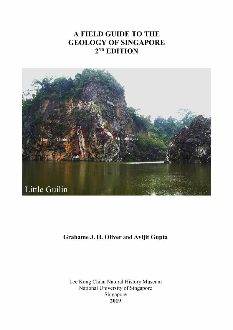
A Field Guide to the Geology of Singapore, 2nd Edition by Grahame J. H. Oliver and Avijit Gupta is published by the: Lee Kong Chian Natural History Museum Faculty of Science National University of Singapore 2 Conservatory Drive Singapore 117377 REPUBLIC OF SINGAPORE Website: https://lkcnhm.nus.edu.sg Email: [email protected] Editor: Hugh T. W. Tan Copy Editor: Clarisse Y. D. Tan Typesetter: Chua Keng Soon Cover photograph of Little Guilin showing a fault and a white granite dyke cutting the strongly jointed dark Gombak Gabbro © Grahame J. H. Oliver. The height of the quarry face is 45 m. ISBN 978-981-11-7536-7 (online) DOI: 10.26107/LKCNHM-EBOOK-2019-0002 © 2019 Lee Kong Chian Natural History Museum All rights reserved. No part of this publication may be reproduced, stored in a retrieval system, or transmitted, in any form, or by any means, electronic, mechanical, photocopying, recording or otherwise, without the prior permission of the copyright holder. For information regarding permission(s), please write to: [email protected]

A Field Guide to the Geology of Singapore, 2nd Edition
1
CONTENTS
1. Part One: Plate Tectonic Evolution of Singapore.................................................................. 1 a. The Eastern Belt ................................................................................................................ 2 b. The Central Belt ................................................................................................................ 2 c. The Western Belt ............................................................................................................... 3 d. The Bentong-Raub Suture Zone ........................................................................................ 3 e. Plate Tectonic Model of the Malaysian Peninsula ............................................................ 3
2. Part Two: The Geology of Singapore ..................................................................................... 5 a. Sajahat Formation ............................................................................................................. 5 b. Gombak Gabbro ................................................................................................................ 5 c. Murai Slate ........................................................................................................................ 6 d. Bukit Timah Granite ......................................................................................................... 6 e. Pengerang Volcanics ......................................................................................................... 7 f. Jurong Formation: Marine ................................................................................................. 7 g. Jurong Formation: Non-marine ......................................................................................... 9 h. Palaeogeography of Lake Sentosa .................................................................................. 10 i. Kusu Formation ............................................................................................................... 12 j. Fort Canning Boulder Bed .............................................................................................. 12 k. Bukit Batok Formation .................................................................................................... 13 l. Pulau Ubin Jetty Diorite .................................................................................................. 14 m. Old Alluvium .................................................................................................................. 14 n. Huat Choe, Tekong and Kallang Formations .................................................................. 16 o. Conclusions ..................................................................................................................... 16
3. Part Three: Field Excursions................................................................................................. 16 a. Pulau Sajahat Excursion .................................................................................................. 17 b. Western Catchment Excursion: Pasir Laba Thrust, Jurong Formation, Murai Slate ...... 20 c. Bukit Timah Excursion: Little Guilin, Dairy Farm Quarry, Singapore Quarry, Hindhoek
Quarry and Bukit Timah ................................................................................................. 25 d. Pulau Ubin Excursion: Pulau Ubin Jetty, Chek Jawa, Ketam Quarry, Keket Quarry,
Outward Bound School, Ubin Quarry, Tanjong Tagam ................................................. 36 e. Punggol Point Excursion ................................................................................................. 45 f. Sentosa Excursion ........................................................................................................... 47 g. Labrador Park Excursion ................................................................................................. 54 h. Southern Islands Excursion: St. John’s, Lazarus, Kusu islands ..................................... 59 i. Excursion to the “Badlands” of Woodlands .................................................................... 78 j. Excursion to East Coast Park ......................................................................................... 81 k. Excursion to Bukit Batok West Orchard Road Excursion .............................................. 84 l. Sembawang Hot Spring Excursion ................................................................................. 91 m. Orchard Road Excursion ................................................................................................. 94 n. Excursion on Flood Prevention along the Bukit Timah Valley ...................................... 97
4. Acknowledgements ............................................................................................................... 101 5. Literature Cited .................................................................................................................... 101 6. How to Cite this Book ........................................................................................................... 103
PART ONE: PLATE TECTONIC EVOLUTION OF SINGAPORE
The aim of the second edition of this guide is to introduce the reader to the geology of Singapore by way of field excursions to relevant sites of interest. Since the first edition was published in 2017, we have been given access to more sites, particularly in the Southern Islands.
Oliver & Gupta
2
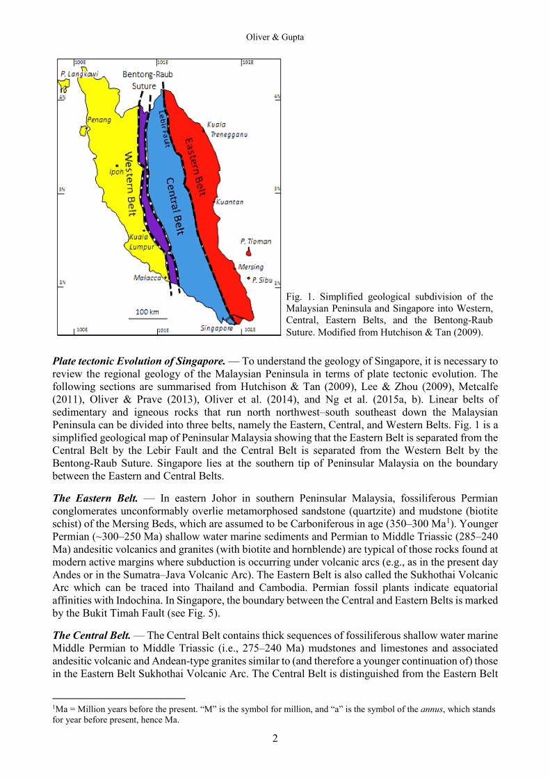
Plate tectonic Evolution of Singapore. — To understand the geology of Singapore, it is necessary to review the regional geology of the Malaysian Peninsula in terms of plate tectonic evolution. The following sections are summarised from Hutchison & Tan (2009), Lee & Zhou (2009), Metcalfe (2011), Oliver & Prave (2013), Oliver et al. (2014), and Ng et al. (2015a, b). Linear belts of sedimentary and igneous rocks that run north northwest‒south southeast down the Malaysian Peninsula can be divided into three belts, namely the Eastern, Central, and Western Belts. Fig. 1 is a simplified geological map of Peninsular Malaysia showing that the Eastern Belt is separated from the Central Belt by the Lebir Fault and the Central Belt is separated from the Western Belt by the Bentong-Raub Suture. Singapore lies at the southern tip of Peninsular Malaysia on the boundary between the Eastern and Central Belts. The Eastern Belt. — In eastern Johor in southern Peninsular Malaysia, fossiliferous Permian conglomerates unconformably overlie metamorphosed sandstone (quartzite) and mudstone (biotite schist) of the Mersing Beds, which are assumed to be Carboniferous in age (350‒300 Ma1). Younger Permian (~300‒250 Ma) shallow water marine sediments and Permian to Middle Triassic (285‒240 Ma) andesitic volcanics and granites (with biotite and hornblende) are typical of those rocks found at modern active margins where subduction is occurring under volcanic arcs (e.g., as in the present day Andes or in the Sumatra–Java Volcanic Arc). The Eastern Belt is also called the Sukhothai Volcanic Arc which can be traced into Thailand and Cambodia. Permian fossil plants indicate equatorial affinities with Indochina. In Singapore, the boundary between the Central and Eastern Belts is marked by the Bukit Timah Fault (see Fig. 5). The Central Belt. — The Central Belt contains thick sequences of fossiliferous shallow water marine Middle Permian to Middle Triassic (i.e., 275‒240 Ma) mudstones and limestones and associated andesitic volcanic and Andean-type granites similar to (and therefore a younger continuation of) those in the Eastern Belt Sukhothai Volcanic Arc. The Central Belt is distinguished from the Eastern Belt
1Ma = Million years before the present. “M” is the symbol for million, and “a” is the symbol of the annus, which stands for year before present, hence Ma.
Fig. 1. Simplified geological subdivision of the Malaysian Peninsula and Singapore into Western, Central, Eastern Belts, and the Bentong-Raub Suture. Modified from Hutchison & Tan (2009).

A Field Guide to the Geology of Singapore, 2nd Edition
3
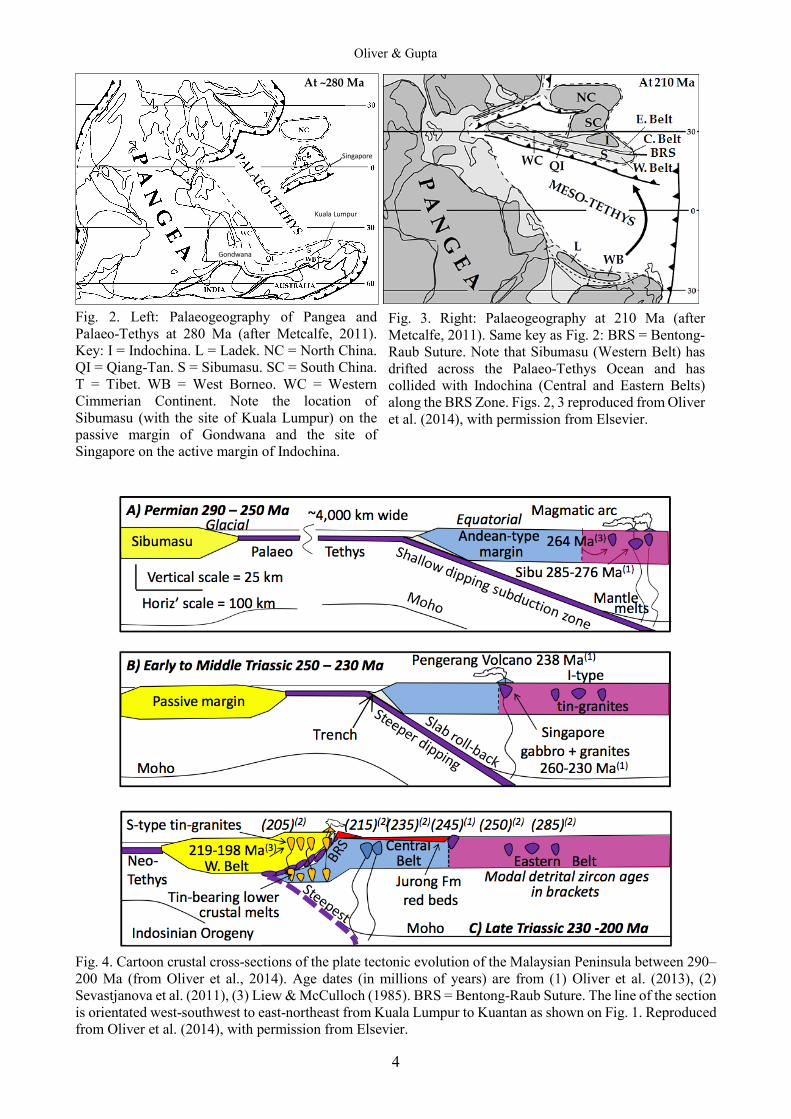
by having Late Triassic (i.e., 230‒200 Ma) continental red-bed deposits of sandstones and conglomerates. The Western Belt. — The Western Belt has a Cambrian (~500 Ma) to Middle Triassic (~240 Ma) marine sedimentary sequence including low latitude Permo-Carboniferous glacial marine beds. There is a notable lack of Permian volcanic activity in the Western Belt generally and no record of Late Triassic sedimentation. Fossils indicate cold water Gondwana Permian fauna in contrast to the equatorial Indochinese Permian fauna of the Eastern Belt. The Western Belt is thought to represent the passive continental margin of Gondwanaland. Granites in the Western Belt contain biotite and muscovite, similar to Himalayan continental collision granites and in contrast to the biotite-hornblende subduction zone granites in the Central and Eastern Belts. Western Belt granites are dated as Late Triassic (between 220‒200 Ma) and are therefore younger than the Central Belt granites (280‒220 Ma). The Bentong-Raub Suture Zone. — The Bentong-Raub Suture Zone, which separates the Western and Central Belts, is a highly tectonised mixture of broken rocks of the former ocean floor such as serpentinite (formed by metamorphism of mantle peridotite) and amphibolite (formed by metamorphism of ocean crust basalt and gabbro). Limestone formed around submarine basalt volcanoes. Cherts represent accumulations of pelagic radiolaria micro-organisms and have Lower Devonian to Middle Triassic (i.e., ~410‒240 Ma) ages which give the age of the sea floor. The tectonism and metamorphism that caused the deformation of the Palaeo-Tethys Ocean floor is thought to have occurred when the Western Belt collided with the Central Belt and the two were sutured together. The Bentong-Raub Suture Zone is overlain by conglomeratic continental red-beds, lavas, ash, and felsic volcanics stitched through with Late Triassic (226 Ma) granites. On this evidence, the collision and suturing is dated at between 240 (the age of the youngest chert) and 226 million years ago (the age of the oldest stitching granite intrusions) in the Late Triassic. Plate tectonic Model of the Malaysian Peninsula. — The Western Belt is part of a continental slice called Sibumasu (because it is found in Siam, Burma, Malaysia, and Sumatra) rifted off from glacial Gondwanaland. Sibumasu drifted across the Palaeo-Tethys Ocean to collide with the equatorial Sukhothai Arc along the Bentong-Raub Suture (Figs. 2, 3). The Sukhothai Volcanic Arc was initiated in the Early Permian (i.e., the age of the oldest volcanics). This is probably also the time when Sibumasu rifted away from Gondwana. The age of the beginning of the collision of Sibumasu with Indochina (i.e., Western Belt against Central Belt in Malaysia) is dated by the age of the first Himalayan-type (muscovite) granites in the Western Belt: i.e., 226 Ma (Late Triassic). The end of collisional processes of crustal thickening and crustal melting is dated by the youngest Western Belt granite: i.e., 198 Ma (Earliest Jurassic). The ages 226–198 Ma coincide with the age of the Late Triassic continental red beds in Singapore. Most hypotheses push the Western Belt eastwards under the Central Belt during the collision, thus doubling the continental crustal thickness and causing Himalayan-type lower crustal melting. These models would cause crustal melts to rise up and intrude into the Central Belt. This is not the case: Himalayan-type crustal melts intrude the Western Belt, not the Central Belt. Oliver et al. (2014) proposed that the Eastern Belt Sukhothai Arc was initiated in the Early Permian and the Central Belt was pushed westwards under Western Belt during a Late Triassic collision. This explains why Himalayan-type granites occur in the Western Belt and not in the Central Belt. This palaeogeography is illustrated in Fig. 4. The Bentong-Raub Suture Zone therefore contains the relicts of the floor of a ~3,500 km wide Palaeo-Tethys Ocean that once separated Sibumasu (i.e., the Western Belt) from Indochina (i.e., the Central and Eastern Belts).
Oliver & Gupta
4
At ~280 Ma
Gondwana
Singapore
Kuala Lumpur
Fig. 2. Left: Palaeogeography of Pangea and Palaeo-Tethys at 280 Ma (after Metcalfe, 2011). Key: I = Indochina. L = Ladek. NC = North China. QI = Qiang-Tan. S = Sibumasu. SC = South China. T = Tibet. WB = West Borneo. WC = Western Cimmerian Continent. Note the location of Sibumasu (with the site of Kuala Lumpur) on the passive margin of Gondwana and the site of Singapore on the active margin of Indochina.
Fig. 4. Cartoon crustal cross-sections of the plate tectonic evolution of the Malaysian Peninsula between 290‒200 Ma (from Oliver et al., 2014). Age dates (in millions of years) are from (1) Oliver et al. (2013), (2) Sevastjanova et al. (2011), (3) Liew & McCulloch (1985). BRS = Bentong-Raub Suture. The line of the section is orientated west-southwest to east-northeast from Kuala Lumpur to Kuantan as shown on Fig. 1. Reproduced from Oliver et al. (2014), with permission from Elsevier.
Fig. 3. Right: Palaeogeography at 210 Ma (after Metcalfe, 2011). Same key as Fig. 2: BRS = Bentong-Raub Suture. Note that Sibumasu (Western Belt) has drifted across the Palaeo-Tethys Ocean and has collided with Indochina (Central and Eastern Belts) along the BRS Zone. Figs. 2, 3 reproduced from Oliver et al. (2014), with permission from Elsevier.

A Field Guide to the Geology of Singapore, 2nd Edition
5
The Bentong-Raub Suture Zone and the Central and Eastern Belts are partly covered in continental red beds which are considered to be river, flood plain and lake deposits formed during the erosion of mountains thrown up when Sibumasu collided with Indochina. This period on mountain building in South East Asia is known as the Indosinian Orogeny which lasted from 226‒200 Ma.
PART TWO: THE GEOLOGY OF SINGAPORE
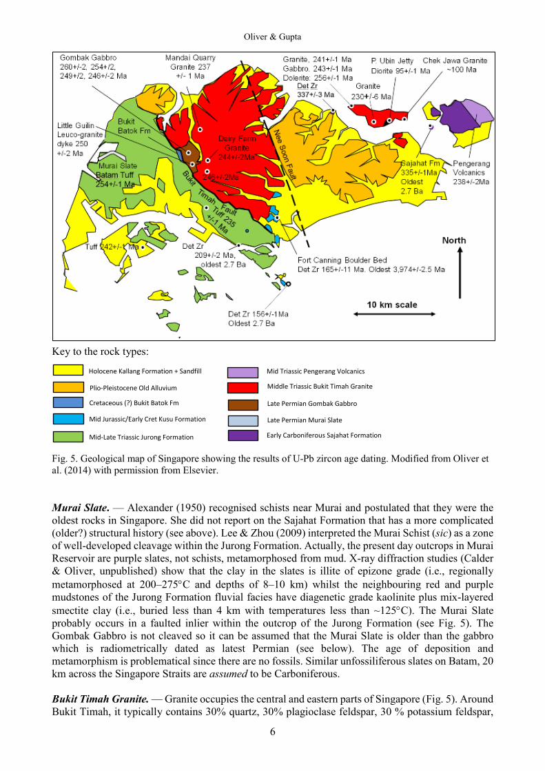
The Geology of Singapore. — The following text is a recent revision and reinterpretation of the geological history as presented by Lee & Zhou (2009), based on new mapping and new U-Pb zircon radiometric age dating by Oliver & Prave (2013), Oliver et al. (2014) and Ng & Oliver (unpublished). The geology of Singapore can be represented on a map by eight units, namely the Sajahat Formation, Murai Slate, Gombak Gabbro, Singapore Granites, Pengerang Volcanics, Jurong Formation, Old Alluvium, and Kallang Formation (see Fig. 5). Sajahat Formation. — Pulau Sajahat is an islet, located between Changi and Pulau Tekong, (Fig. 5) and is the type locality for the unfossiliferrous Sajahat Formation of so called argillites and quartzites. Lee & Zhou (2009) discussed two hypotheses for the age of deposition, i.e., either Lower Palaeozoic (and the oldest rocks in Singapore) or interdigitated with the Pengerang Volcanics in south Johor. The latter were formally considered to be Lower Palaeozoic but have since been U-Pb zircon dated at 238 ± 2 Ma, Middle Triassic (Oliver et al., 2014). Field work by GJHO revealed that the argillites (former mudstones) and interbedded quartzites (former sandstones) were deposited as turbidites, possibly in a deep sea fan. Pan et al. (in press) have recently obtained detrital U-Pb zircon ages from the Sajahat Formation from Ponggol Point and from Pulau Sajahat: the youngest age being 337 ± 3 Ma. Furthermore, on Pulau Sajahat, a cross-cutting granite vein has a U-Pb magmatic zircon age of 335 ± 1 Ma (Ng & Oliver, unpublished). Therefore, the Sajahat Formation must be lower Carboniferous (Mississippian) in age. The Sajahat Formation is very similar to the unfossiliferous, regionally metamorphosed, Mersing Formation in eastern Johor which is assumed to be Carboniferous in age because it is unconformably overlain by fossiliferous Permian conglomerates (Hutchison & Tan, 2009). It maybe that the Mersing (and Sajahat) Formations were tectonised when Indochina rifted away from Gondwanaland in the Carboniferous (Metcalf, 2011). If this is correct, then there is a case for correlating this with tectonic events in Thailand (Booth & Sattayarak, 2011). Gombak Gabbro. — Gabbro occurs around the Gombak district in the centre of Singapore Island (Fig. 5). At Little Guilin, it contains 50% plagioclase, 35% orthopyroxene, 5% olivine, 5% brown hornblende and 5% opaques and is locally called the Gombak Norite. The zircon U-Pb dating ages vary from 260.3 ± 2.3 at Little Guilin (Late Permian) to 245.6 ± 2.3 million years old (Middle Triassic) on Bukit Batok. There is a prominent north-east/south-west trending ~3 m thick granite dyke in the middle of Little Guilin Quarry. It has an Early Triassic zircon U-Pb age of 249.9 ± 1.9 million years (Oliver et al., 2014). Significantly, the granite dyke does not have chilled margins, suggesting that the country rock gabbro was still hot during the dyke intrusion and that the gabbro and granite dyke are cogenetic.
Oliver & Gupta
6
Key to the rock types: Fig. 5. Geological map of Singapore showing the results of U-Pb zircon age dating. Modified from Oliver et al. (2014) with permission from Elsevier. Murai Slate. — Alexander (1950) recognised schists near Murai and postulated that they were the oldest rocks in Singapore. She did not report on the Sajahat Formation that has a more complicated (older?) structural history (see above). Lee & Zhou (2009) interpreted the Murai Schist (sic) as a zone of well-developed cleavage within the Jurong Formation. Actually, the present day outcrops in Murai Reservoir are purple slates, not schists, metamorphosed from mud. X-ray diffraction studies (Calder & Oliver, unpublished) show that the clay in the slates is illite of epizone grade (i.e., regionally metamorphosed at 200‒275°C and depths of 8‒10 km) whilst the neighbouring red and purple mudstones of the Jurong Formation fluvial facies have diagenetic grade kaolinite plus mix-layered smectite clay (i.e., buried less than 4 km with temperatures less than ~125°C). The Murai Slate probably occurs in a faulted inlier within the outcrop of the Jurong Formation (see Fig. 5). The Gombak Gabbro is not cleaved so it can be assumed that the Murai Slate is older than the gabbro which is radiometrically dated as latest Permian (see below). The age of deposition and metamorphism is problematical since there are no fossils. Similar unfossiliferous slates on Batam, 20 km across the Singapore Straits are assumed to be Carboniferous. Bukit Timah Granite. — Granite occupies the central and eastern parts of Singapore (Fig. 5). Around Bukit Timah, it typically contains 30% quartz, 30% plagioclase feldspar, 30 % potassium feldspar,
Holocene Kallang Formation + Sandfill Plio-Pleistocene Old Alluvium
Mid-Late Triassic Jurong Formation
Mid Triassic Pengerang Volcanics Middle Triassic Bukit Timah Granite Late Permian Gombak Gabbro
Early Carboniferous Sajahat Formation Late Permian Murai Slate Mid Jurassic/Early Cret Kusu Formation
Cretaceous (?) Bukit Batok Fm
A Field Guide to the Geology of Singapore, 2nd Edition
7
and 5% biotite. Some varieties, particularly those from Pulau Ubin, contain 5‒10% hornblende. Mineralogically and chemically they are typical of the Eastern Belt, Andean-type granites formed in the Sukhothai Volcanic Arc in Thailand and Eastern Malaysia (see Fig. 4). Singapore granites have been U-Pb zircon dated by Oliver et al. (2014) on the flanks of Bukit Timah at Dairy Farm Quarry (244 ± 1 million years), Mandai Quarry (237.0 ± 1.4 million years) and Ketam Quarry on Pulau Ubin (230.2 ± 5.9 million years). These age dates range from the Middle Triassic to the early part of the Late Triassic. Gabbro from the northeast tip of Pulau Ubin has a magmatic zircon U-Pb age of 243 ± 1 Ma. An enclave of dolerite inside the gabbro has a zircon U-Pb age of 256 ± 1 Ma, whilst a granite dyke cutting the gabbro has a magmatic U-Pb age of 241 ± 1 Ma; Ng & Oliver, unpublished). These intrusion age dates range from the latest Permian, the Middle Triassic to the early part of the Late Triassic. Pengerang Volcanics. — There are poor outcrops of andesitic tuff (lithified volcanic ash) and agglomerate tuff (volcanic ash with ejected lava bombs) on the east side of Pulau Tekong (see Fig. 5). Similar pink rhyolite lava associated with andesitic agglomerate from a coastal outcrop of the Pengerang Volcanics at Telkuma, southeastern Johor and gives a Middle Triassic, U-Pb zircon dating age of 238.4 ± 1.9 million years (Oliver et al., 2014), which is statistically the same age as the Mandai Quarry Granite (237.1 ± 1.4 Ma) and indicates that intrusion of magma chambers and extrusion of volcanoes were contemporaneous in the Singapore‒Johor region. Based on the size of ejected bombs, Pulau Tekong was less than 3 km from the central crater of the Pengarang Volcano (Zainal, 1984). Boulders from Pengerang quarries can be seen at Punggol Point where they have been used for beach protection. From the 15 km diameter of the present day outcrops of the Pengarang Volcanics, compared to present day diameter of volcanoes in Sumatra and Java, it is possible that the Pengarang volcano was 3 km high. Jurong Formation: Marine. — The boundary between the Eastern and Central Belts can be drawn through Singapore along the Bukit Timah Fault, which separates the Singapore Granites from the Jurong Formation (see Fig. 5). The Jurong Formation contains an older fossiliferous shallow marine sedimentary sequence interbedded with rhyolite lithic tuffs (known as the Ayer Chawan Facies). Sadly, the fossil localities have been built over. There is also a younger unfossiliferous fluvial and lacustrine sequence (known as the Rimau and Queenstown Facies). The marine and non-marine facies may be tectonically interlayered by thrusts. Fig. 6 illustrates typical fossils from the Jurong Formation. Table 1 is a list of fossils from the Jurong district given by Lee & Zhou (2009). Figure 7 displays the age range distribution of these fossils based on the age data given in Fossil Works (2018) and the Global Biodiversity Information Facility (2018). The age range is from the Ansian to the Carnian: i.e., from 247–227 Ma. Also shown in Fig. 7 are the results of zircon U-Pb age dating of the Batam andesite tuff (254 ± 1 Ma), rhyolite lithic tuff from Jurong Island petroleum storage caverns (242 ± 1 Ma) and a borehole from the Lee Kong Chian Natural History Museum at Kent Ridge (235 ± 1 Ma (Ng & Oliver, unpublished). The radiometric ages from the Singapore tuffs coincide with the fossil ages of their enclosing siltstones. As noted previously, the Batam andesitic tuffs are the same age as the Gombak Gabbro. The Singapore rhyolite tuffs are the same ages as the Bukit Timah Granites from Dairy Farm Quarry (244 ± 1 Ma) and Mandai Quarry (237 ± 1 Ma). With these same age dates in mind, it can be envisaged that the Bukit Timah granite could be the magmatic roots of another large volcano like the Pengarang volcano that erupted rhyolite ashes into the surrounding shallow seas at the same time that siltstones were being deposited in a coastal area.

Oliver & Gupta
8
Fig. 6. Typical fossil scallops and corals from the marine facies of the Jurong Formation. (Photographs reproduced from Lee & Zhou [2009]). A, Plicatula cf. carinata (Healy) Upper Triassic; B, Palaeonucula sp.; C and D, Coral species from the Padan Limestone. Reproduced from Lee & Zhou (2009) with permission from the Defence Science and Technology Agency, Singapore. Table 1. Fossils listed by Lee and Zhou (2009) from the Ayer Chawan Facies of the Jurong Formation. Ages are those quoted by Global Biodiversity Information Facility (2018): GBIF, and Fossilworks (2018): FW.
A B
C D
A Field Guide to the Geology of Singapore, 2nd Edition
9
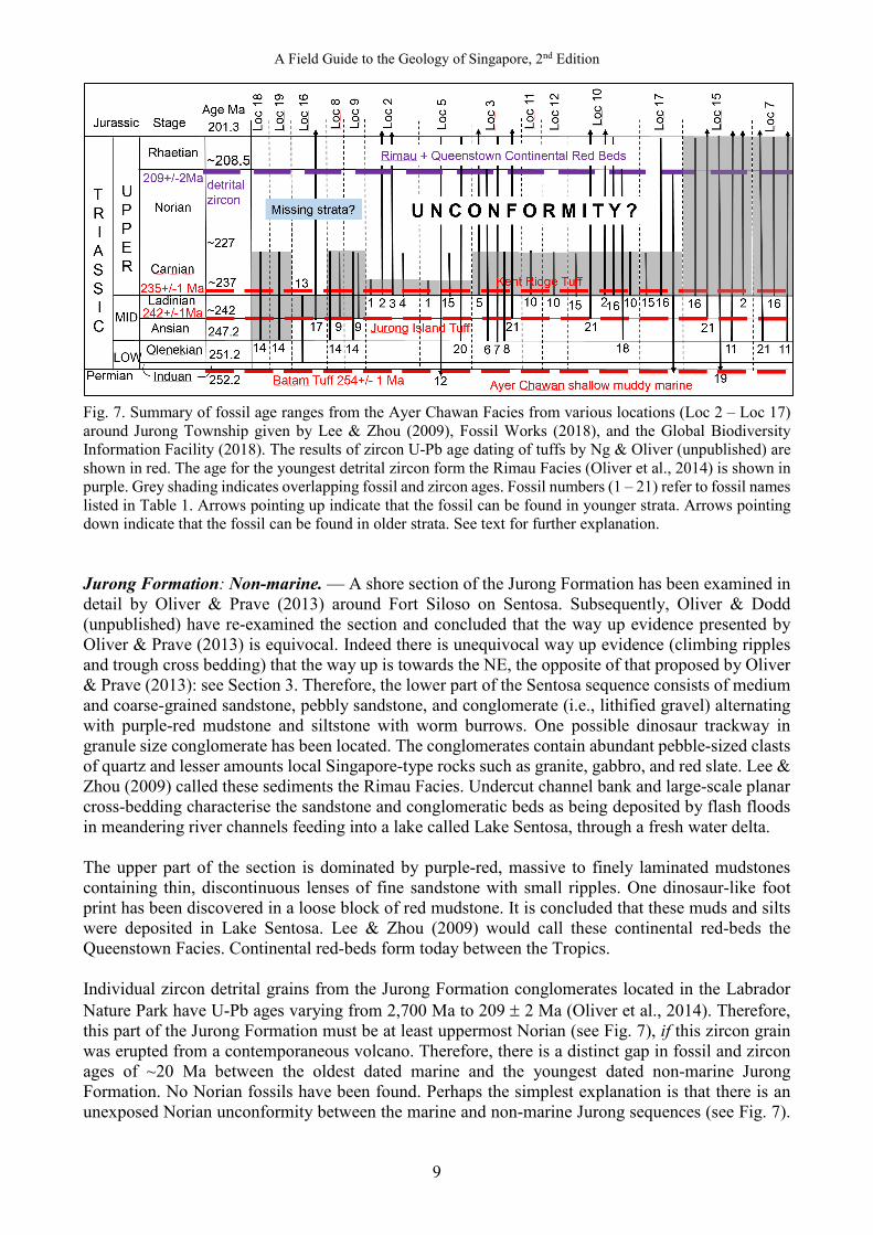
Fig. 7. Summary of fossil age ranges from the Ayer Chawan Facies from various locations (Loc 2 – Loc 17) around Jurong Township given by Lee & Zhou (2009), Fossil Works (2018), and the Global Biodiversity Information Facility (2018). The results of zircon U-Pb age dating of tuffs by Ng & Oliver (unpublished) are shown in red. The age for the youngest detrital zircon form the Rimau Facies (Oliver et al., 2014) is shown in purple. Grey shading indicates overlapping fossil and zircon ages. Fossil numbers (1 – 21) refer to fossil names listed in Table 1. Arrows pointing up indicate that the fossil can be found in younger strata. Arrows pointing down indicate that the fossil can be found in older strata. See text for further explanation. Jurong Formation: Non-marine. — A shore section of the Jurong Formation has been examined in detail by Oliver & Prave (2013) around Fort Siloso on Sentosa. Subsequently, Oliver & Dodd (unpublished) have re-examined the section and concluded that the way up evidence presented by Oliver & Prave (2013) is equivocal. Indeed there is unequivocal way up evidence (climbing ripples and trough cross bedding) that the way up is towards the NE, the opposite of that proposed by Oliver & Prave (2013): see Section 3. Therefore, the lower part of the Sentosa sequence consists of medium and coarse-grained sandstone, pebbly sandstone, and conglomerate (i.e., lithified gravel) alternating with purple-red mudstone and siltstone with worm burrows. One possible dinosaur trackway in granule size conglomerate has been located. The conglomerates contain abundant pebble-sized clasts of quartz and lesser amounts local Singapore-type rocks such as granite, gabbro, and red slate. Lee & Zhou (2009) called these sediments the Rimau Facies. Undercut channel bank and large-scale planar cross-bedding characterise the sandstone and conglomeratic beds as being deposited by flash floods in meandering river channels feeding into a lake called Lake Sentosa, through a fresh water delta. The upper part of the section is dominated by purple-red, massive to finely laminated mudstones containing thin, discontinuous lenses of fine sandstone with small ripples. One dinosaur-like foot print has been discovered in a loose block of red mudstone. It is concluded that these muds and silts were deposited in Lake Sentosa. Lee & Zhou (2009) would call these continental red-beds the Queenstown Facies. Continental red-beds form today between the Tropics. Individual zircon detrital grains from the Jurong Formation conglomerates located in the Labrador Nature Park have U-Pb ages varying from 2,700 Ma to 209 ± 2 Ma (Oliver et al., 2014). Therefore, this part of the Jurong Formation must be at least uppermost Norian (see Fig. 7), if this zircon grain was erupted from a contemporaneous volcano. Therefore, there is a distinct gap in fossil and zircon ages of ~20 Ma between the oldest dated marine and the youngest dated non-marine Jurong Formation. No Norian fossils have been found. Perhaps the simplest explanation is that there is an unexposed Norian unconformity between the marine and non-marine Jurong sequences (see Fig. 7).
Oliver & Gupta
10
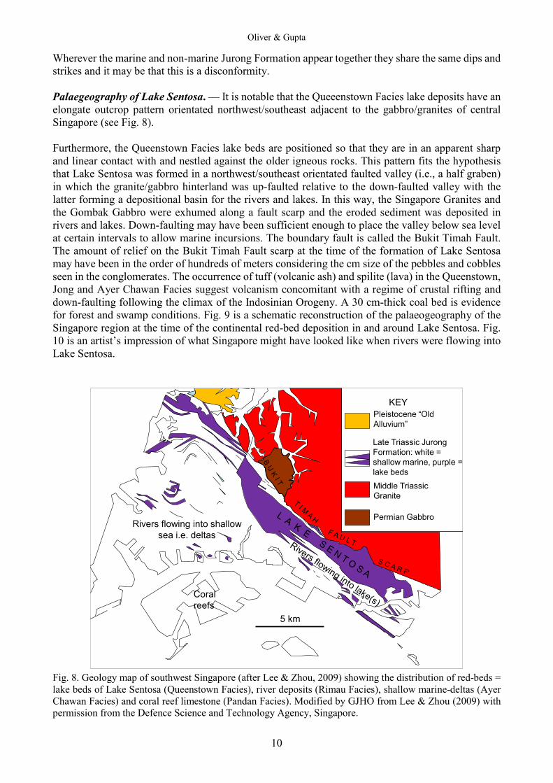
Wherever the marine and non-marine Jurong Formation appear together they share the same dips and strikes and it may be that this is a disconformity. Palaegeography of Lake Sentosa. — It is notable that the Queeenstown Facies lake deposits have an elongate outcrop pattern orientated northwest/southeast adjacent to the gabbro/granites of central Singapore (see Fig. 8). Furthermore, the Queenstown Facies lake beds are positioned so that they are in an apparent sharp and linear contact with and nestled against the older igneous rocks. This pattern fits the hypothesis that Lake Sentosa was formed in a northwest/southeast orientated faulted valley (i.e., a half graben) in which the granite/gabbro hinterland was up-faulted relative to the down-faulted valley with the latter forming a depositional basin for the rivers and lakes. In this way, the Singapore Granites and the Gombak Gabbro were exhumed along a fault scarp and the eroded sediment was deposited in rivers and lakes. Down-faulting may have been sufficient enough to place the valley below sea level at certain intervals to allow marine incursions. The boundary fault is called the Bukit Timah Fault. The amount of relief on the Bukit Timah Fault scarp at the time of the formation of Lake Sentosa may have been in the order of hundreds of meters considering the cm size of the pebbles and cobbles seen in the conglomerates. The occurrence of tuff (volcanic ash) and spilite (lava) in the Queenstown, Jong and Ayer Chawan Facies suggest volcanism concomitant with a regime of crustal rifting and down-faulting following the climax of the Indosinian Orogeny. A 30 cm-thick coal bed is evidence for forest and swamp conditions. Fig. 9 is a schematic reconstruction of the palaeogeography of the Singapore region at the time of the continental red-bed deposition in and around Lake Sentosa. Fig. 10 is an artist’s impression of what Singapore might have looked like when rivers were flowing into Lake Sentosa.
Middle TriassicGranite
Permian Gabbro
KEYPleistocene “OldAlluvium”
Late Triassic JurongFormation: white =shallow marine, purple =lake beds
Rivers flowing into shallowsea i.e. deltas
Coral reefs
5 km
Fig. 8. Geology map of southwest Singapore (after Lee & Zhou, 2009) showing the distribution of red-beds = lake beds of Lake Sentosa (Queenstown Facies), river deposits (Rimau Facies), shallow marine-deltas (Ayer Chawan Facies) and coral reef limestone (Pandan Facies). Modified by GJHO from Lee & Zhou (2009) with permission from the Defence Science and Technology Agency, Singapore.

A Field Guide to the Geology of Singapore, 2nd Edition
11
Fig. 9. A reconstruction of the geography of Singapore ~ 200 Ma. Modified from Oliver & Prave (2013) with permission of Elsevier. Key: 1 = lake. 2 = delta. 3 = flood plain. 4 = delta front. 5 = fault scarp. 6 = alluvial fan apex. 7 = proximal alluvial fan. 8 = medial alluvial fan. 9 = distal alluvial fan. 10 = Gilbert delta. 11 = turbidites.
Fig. 10. Artist’s impression of what Singapore might have looked like looking north from the vicinity of Sentosa in the Late Triassic Period (200 Ma) before the mountains were eroded away to the low hills of the present time. The Bukit Timah Fault scarp and the Bukit Timah Granite and Gombak Gabbro form the mountains in the distance. In the foreground braided rivers drain into Lake Sentosa. The dinosaur in the front centre is the predator Coelophysis. Painted by W. Sillins. Reproduced here with permission from http://www.willsillin.com/Natural%20History.html. Lee & Zhou (2009) comment that the Queenstown Facies (i.e., continental red-beds) is interdigitated with the marine facies, demonstrating alternating shallow marine and fresh water conditions. Probably the subsidence rate on the Bukit Timah Fault, rate of supply of gravel, sand and mud via rivers, and changing sea levels, all oscillated in a complex way.
Oliver & Gupta
12
The Jurong Formation continental red-beds are regionally important because they represent the change from deep marine conditions in the Palaeo-Tethys Ocean from the (Early Permian till the lower Late Triassic) to tropical continental conditions following the collision of Sibumasu and Indochina (in the middle Late Triassic) that caused the Indosinian Orogeny. Kusu Formation. — In the 1st edition of this field guide, the fluvial sandstones from the centre and eastern side of Kusu Island, were correlated with the non-marine Jurong Formation and therefore would be Upper Triassic in age. However, subsequently Ng & Oliver (unpublished) have U-Pb dated detrital zircons from Kusu and discovered that the youngest zircon is 156 ± 1 Ma: i.e., Upper Jurassic, not Upper Triassic. Re-examination of the Kusu exposures shows that the Jurassic sandstones do not have the regional penetrative cleavage seen in the neighbouring Jurong Formation. Furthermore, the dips and strikes of the Triassic and Jurassic strata on Kusu are quite different: 30 degrees to the SE for the Jurassic strata and 25 degrees to the SW for the Triassic strata (Fig. 11). For these reasons, a putative angular unconformity is drawn from Kusu up to Toa Payoh. These Jurassic strata can be defined at the type locality as the Kusu Formation (see Section 3). Similar uncleaved planar cross-bedded sandstone outcrop in Telok Ayer Park and neighbouring Amoy Street. This gives credibility to the idea that Kusu Formation extends from Kusu to Toa Payoh (Fig. 11). On the S side of the Telok Blangah PUB Reservoir, there is an outcrop of pebbly sandstones within which there a notable erosive and 20° angular discordance in the bedding. This might be an angular unconformity between the Kusu Formation and the non-marine Jurong Formation (A. G. Leslie, pers. comm. 2017). Alternatively, the angular contact could be an intraformational down-cutting fluvial channel within the Jurong Formation. Fort Canning Boulder Bed. — Boulders of unfoliated sandstone, suspended in a clay and silt landslide deposit, are frequently encountered in underground works in the Central Business District of Singapore, but not at the surface. Detrital zircons from an unfoliated sandstone boulder sampled from the Fort Canning Boulder Bed in the excavations for Bencoolan MRT station (see Fig. 11) give U-Pb age dates between 3,974 ± 2.5 Ma and 145 ± 1 Ma (Ng & Oliver, unpublished). The ~4 billion year old Archean date is remarkably old, given that the age of the earth is 4.56 billion. A cathode luminescence image (Fig. 12) suggest that this detrital grain has a zoned magmatic core which grew in a granitic magma and has been inherited and overgrown by a rim of un-zoned magmatic zircon in a younger granite magma. This zircon grain could have originated either from rocks beneath Singapore, or from the nearest outcrops of 4 billion year old rocks in N China or NW Australia. Obviously, this zircon must have gone through many rock cycles since 4 billion years ago before it was deposited in the Fort Canning Boulder Bed. The youngest detrital zircon from the boulder was dated at 145 ± 1 Ma (Jurassic/Cretaceous boundary), which is not much younger than the youngest Kusu Formation (Upper Jurassic) detrital zircon (156 ± 1 Ma). Thus, the boulder is Cretaceous or younger in age and possible derived from the unfoliated Kusu Formation. Continental sandstones from the Bertangga Formation in the Central Belt of the Malaysian Peninsular has detrital U-Pb zircon ages as young as 139 Ma (Lower Cretaceous), (Basori et al., in press). Thus, the Kusu and Bertangga Formations may be correlated. Fossil marine shells from Mount Guthrie (near Mount Faber but now excavated away, see Fig. 11) are apparently quite different from any Triassic fossils from Singapore or Malaysia and were suggested to be Middle Jurassic by Newton (1923) or, Early Jurassic by Kobayashi & Tamura (1968a, b).

A Field Guide to the Geology of Singapore, 2nd Edition
13
Fig. 11. Geological map of southern Singapore showing the distribution of the NS striking Kusu Formation, the NW/SE striking Jurong Formation and the putative unconformity between them. Key: Mt F = Mount Faber, TBR = Telok Blangah Reservoir. Modified from Lee & Zhou (2009) with permission from the Defence Science and Technology Agency, Singapore. Bukit Batok Formation. — During 2017, extensive excavations were undertaken in the western Bukit Batok area, particularly between Bukit Batok Road and Bukit Batok West Avenues 2 and 3 (Fig. 5). Penetratively cleaved red (and grey) siltstones of the Jurong Formation Queenstown Facies are exposed in the new road cut and extension of Bukit Batok Avenue 6. However, excavations on the hill adjacent to Bukit Batok Avenue 2, have revealed a ~400 m section of subvertical uncleaved red, grey, green, and white laminated mudstone and claystone with occasional sandstone and thin conglomerate, striking WNW/ESE and younging to the SSW. One coal bed has been analysed for pollen age dating but gave negative results (M. Dodds, pers. comm.). This may be a fluvio-lacustrine deposit. The lack of cleavage in the mudstones and claystones is in marked contrast to the nearby, strongly cleaved Jurong Formation. This suggests that the uncleaved rocks are younger than the cleaved Upper Triassic non-marine Jurong Formation. This clay-dominated lacustrine facies is quite different from the uncleaved Mid-Jurasssic/Lower Cretaceous Kusu Formation fluvial sandstone facies, although it
Fig. 12. Cathode luminescence image of 4 billion year old detrital zircon grain extracted from a sandstone from the Fort Canning Boulder Bed. Source: Ng & Oliver (unpublished).
Oliver & Gupta
14
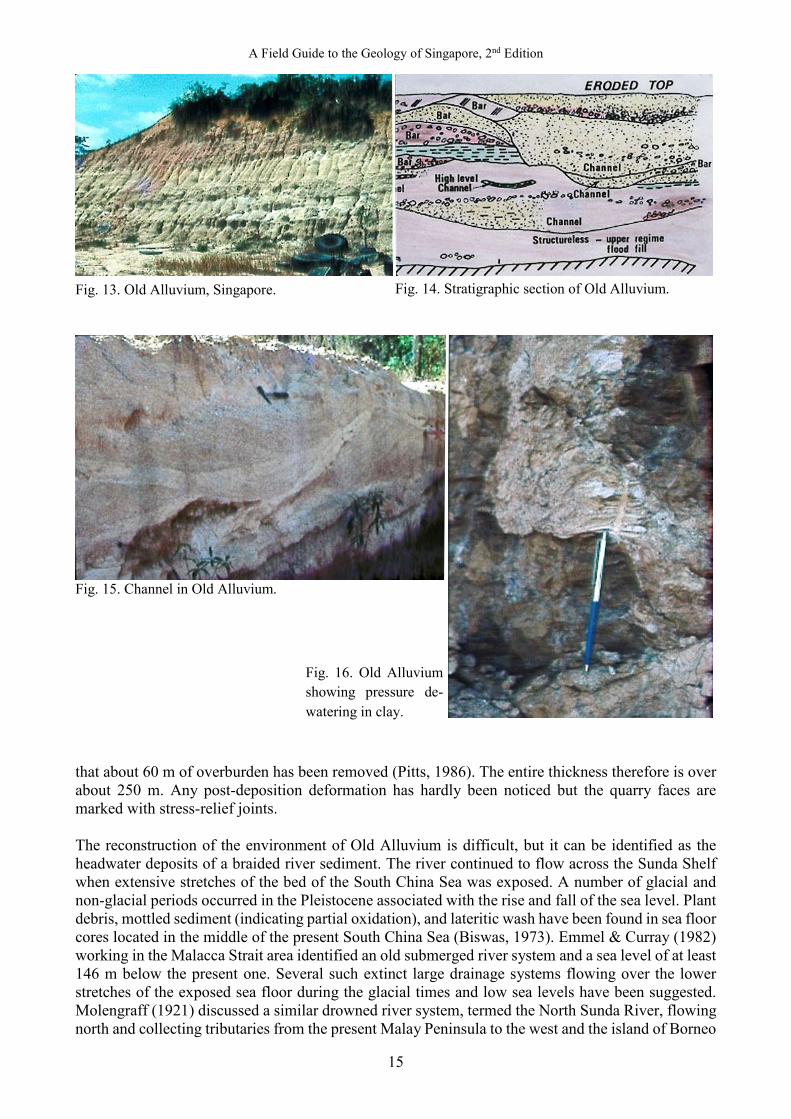
could be the same age or younger. Because of these distinctive features, it is proposed to informally call these rocks at Bukit Batok West, the Bukit Batok Formation. The NE contact is against the Gombak Norite along the Bukit Timah Fault. The SW contact is probably another fault against the Jurong Formation. Therefore, the outcrop may be confined as a fault sliver associated with the Bukit Batok Fault. The length of this fault sliver is not known. The Bukit Timah Fault must have been active after the deposition of the Bukit Batok Formation: i.e., at least post-Early Cretaceous and maybe younger. Thus, the Bukit Timah Fault was active in the Upper Triassic and again in the Cretaceous. Pulau Ubin Jetty Diorite. — At Pulau Ubin Jetty, (Fig. 5) a dark, coarse-grained, equigranular, crystalline diorite (i.e., a darker version of granite but with quartz [30%], clear plagioclase [30%], clinopyroxene [15%], hornblende [10%], and weakly chloritised biotite [5%]) has a U-Pb zircon Cretaceous age of 94.6 ± 0.8 million years (Oliver et al., 2014). It is characterised by spherical enclaves of mafic microgabbro. Similar diorite occurs as a dyke on Pulau Sajahat. Pink granite from Chek Jawa, E Pulau Ubin (Fig. 5) has a discordant U-Pb zircon magmatic age of “around” 100 Ma, indistinguishable from the age of the Pulau Ubin Diorite. It contains abundant inherited zircons with U-Pb ages of 235 Ma, the same age as the granite from Ketam Quarry, 5.5 km to the west (Ng & Oliver, unpublished). It seems that Triassic Ketam Quarry granite has been melted to make Cretaceous Chek Jawa granite. The cause of this melting is unknown as yet: it may be hot spot or subduction related or neither. From the Cretaceous to the Plio-Pleistocene (95 million years ago till ~2.7 million years ago) there is no rock record in Singapore until the deposition of the Old Alluvium (see next section). This was presumably because Singapore was an internal part of the stable continental plate called Sundaland. Old Alluvium. — The Old Alluvium (Fig. 13) is a semi-consolidated deposit, mainly of medium to coarse sand and fine pebbles, deposited on a basement of granitic and metamorphic rocks. It has been studied in quarry faces in the Tampines–Bedok‒Changi area and in boreholes. A number of quarries were excavated in east Singapore for land reclamation. In such quarries, a variety of beds were seen in truncated conditions. The composition and structure of the beds identify the Old Alluvium as a river deposit (Fig. 14). Compositionally, the beds can be grouped into four textural classes: (1) coarse sand mixed with fine pebbles, (2) medium and coarse sand, (3) pebble beds, and (4) clay with silt. Old Alluvium is essentially made of the first two classes. Structurally, pebbly longitudinal sandy river bars, transverse sandy river bars, thick flood-deposited channel fills, and upper flow regime plane beds are visible and can be recognised. Several flood channels also are evident (Fig. 15). The Old Alluvium of Singapore therefore has been identified as sandy deposit of a braided river with seasonal regime and large floods (Gupta et al., 1987). The mineralogy of pebbles, sand, and clay suggests a mixed provenance of granite and low-grade metamorphic rocks. The source material for the Old Alluvium in Singapore could very well be the Bukit Timah Granite and nearby Sajahat Formation. The freshness and angularity of several feldspar grains suggest erosion of unweathered rock, rapid and brief transportation, and quick burial. In Singapore, age determination of the Old Alluvium is difficult because of the absence of fossils or organic material, apart from a clast of a charred partially silicified part of an angiosperm. A Pleistocene age has been attributed to the Old Alluvium from indirect observations. The present top surface of the Old Alluvium is in reality located somewhere in the middle of this three-dimensional deposit. The part above it has been eroded and removed. As shown in boreholes, the Old Alluvium is at least well over 200 m thick in the subsurface. Though the top of the sediment has been eroded, it occurs at an elevation of 35 m up local hills, and the use of the undrained cohesive strength to the effective overburden pressure for some of the deformed clay beds (Fig. 16) indicates
A Field Guide to the Geology of Singapore, 2nd Edition
15
Fig. 13. Old Alluvium, Singapore.
Fig. 15. Channel in Old Alluvium. that about 60 m of overburden has been removed (Pitts, 1986). The entire thickness therefore is over about 250 m. Any post-deposition deformation has hardly been noticed but the quarry faces are marked with stress-relief joints. The reconstruction of the environment of Old Alluvium is difficult, but it can be identified as the headwater deposits of a braided river sediment. The river continued to flow across the Sunda Shelf when extensive stretches of the bed of the South China Sea was exposed. A number of glacial and non-glacial periods occurred in the Pleistocene associated with the rise and fall of the sea level. Plant debris, mottled sediment (indicating partial oxidation), and lateritic wash have been found in sea floor cores located in the middle of the present South China Sea (Biswas, 1973). Emmel & Curray (1982) working in the Malacca Strait area identified an old submerged river system and a sea level of at least 146 m below the present one. Several such extinct large drainage systems flowing over the lower stretches of the exposed sea floor during the glacial times and low sea levels have been suggested. Molengraff (1921) discussed a similar drowned river system, termed the North Sunda River, flowing north and collecting tributaries from the present Malay Peninsula to the west and the island of Borneo
Fig. 14. Stratigraphic section of Old Alluvium.
Fig. 16. Old Alluvium showing pressure de-watering in clay.

Oliver & Gupta
16
to the east. The present-day Singapore could have been about 300 km from the sea, draining south or southeast to this North Sunda River. The sediment was derived from severe erosion of granitic and low-grade metamorphic slopes. The climate was less wet than present day, seasonal, and with periodic large floods. The distal parts of the sediment are currently submerged under the shallow water of the South China Sea. Similar deposits occur regionally around the South China Sea and the Malacca Strait. Incised channels on top of the Old Alluvium, infilled with unconsolidated alluvium, shallow marine sand, and clay, have been found from offshore seismic work (CCOP, 1980). The surface of the Old Alluvium has been exposed, eroded, and infilled with later sediments with the rise of sea level. Some of the infill, if investigated, probably would correlate with the post-Old Alluvium material on land. Huat Choe, Tekong, and Kallang Formations. — Of these three Holocene formations, the Huat Choe is extremely limited in extent, and probably no exposure of it currently exists. The Tekong Formation normally occurs as coastal terraces in islands such as Pulau Tekong and Pulau Tekong Kechil. It is also seen as discontinuous patches along coasts and the lower parts of certain valleys inland. The Tekong Formation has been interpreted as beach and sand deposits related to a higher sea level early in the Holocene. It is, however, difficult to distinguish between the sediments of the Tekong and Kallang formations in many places. The Kallang Formation is made of sand, pebble, peat and clay, deposited during the Middle or Late Holocene. It is found near coasts, beaches, and reefs and also extends along the major river valleys of Singapore Island. This is potentially an important formation as it underlies much of the coastal plain and valleys, and in general, coincides with densely built-up areas and valley-bottom arterial roads. It carries information regarding the changing sea level and geomorphic processes of the Holocene and of geotechnical importance. It is often exposed when foundations for buildings are dug in coastal areas. Conclusions. — The geology of Singapore is intriguing but it is not easily visible or understood because most of it has been covered by the growth of a global city where one tends to see a paved surface more than rocks. This guide includes a series of excursions where the geology and geomorphology of Singapore can still be studied. The walks are almost entirely on Singapore’s geological past but also includes two on the present: enhanced flooding mainly caused by anthropogenic developments. Singapore is a naturally flood-prone island given its physical features and intense rainfall, but the propensity to flood has increased owing to the rapid extension of impervious surfaces such as streets, parking lots, rooftops, and others simultaneously with concrete storm drains and sewers. The last two excursions illustrate the change and some of the steps taken to alleviate the problem. This has given rise to street scenes that are eminently Singaporean.
PART THREE: FIELD EXCURSIONS Field Excursions. — Any field excursion should be carried out in a group led by a competent, field-trained leader who MUST carry out a risk assessment prior to each excursion. The leader should hold a safety briefing at the beginning of each excursion. As far as possible, each excursion follows the same format: (1) Each is located on the geological map of Singapore as well as on a Google Earth Map. (2) The localities to be visited are located on small scale maps as Location 1, Location 2, and so on. (3) Each location has field photographs. (4) Each excursion is accessible by public transport except those into the military training areas and some of the southern offshore islands.
A Field Guide to the Geology of Singapore, 2nd Edition
17
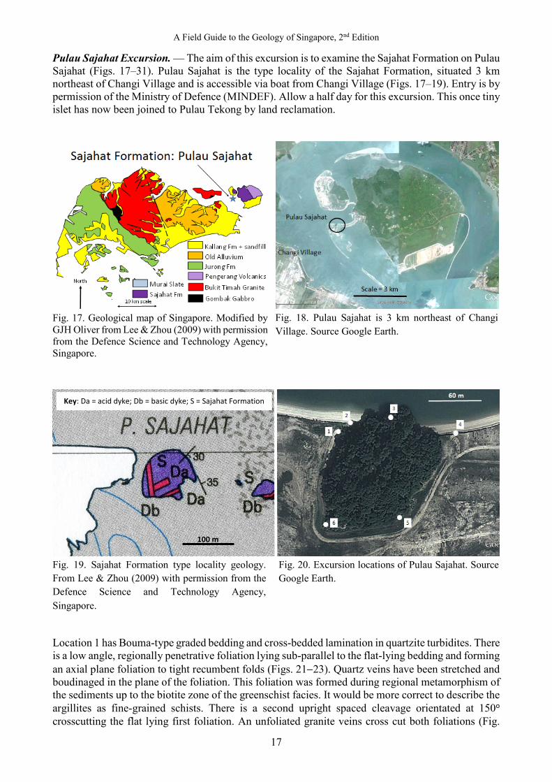
Pulau Sajahat Excursion. — The aim of this excursion is to examine the Sajahat Formation on Pulau Sajahat (Figs. 17‒31). Pulau Sajahat is the type locality of the Sajahat Formation, situated 3 km northeast of Changi Village and is accessible via boat from Changi Village (Figs. 17‒19). Entry is by permission of the Ministry of Defence (MINDEF). Allow a half day for this excursion. This once tiny islet has now been joined to Pulau Tekong by land reclamation.
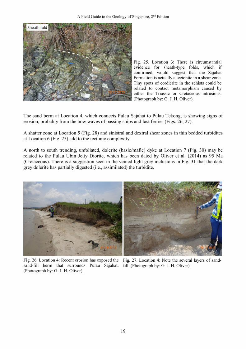
Location 1 has Bouma-type graded bedding and cross-bedded lamination in quartzite turbidites. There is a low angle, regionally penetrative foliation lying sub-parallel to the flat-lying bedding and forming an axial plane foliation to tight recumbent folds (Figs. 21−23). Quartz veins have been stretched and boudinaged in the plane of the foliation. This foliation was formed during regional metamorphism of the sediments up to the biotite zone of the greenschist facies. It would be more correct to describe the argillites as fine-grained schists. There is a second upright spaced cleavage orientated at 150o crosscutting the flat lying first foliation. An unfoliated granite veins cross cut both foliations (Fig.
Fig. 18. Pulau Sajahat is 3 km northeast of Changi Village. Source Google Earth.
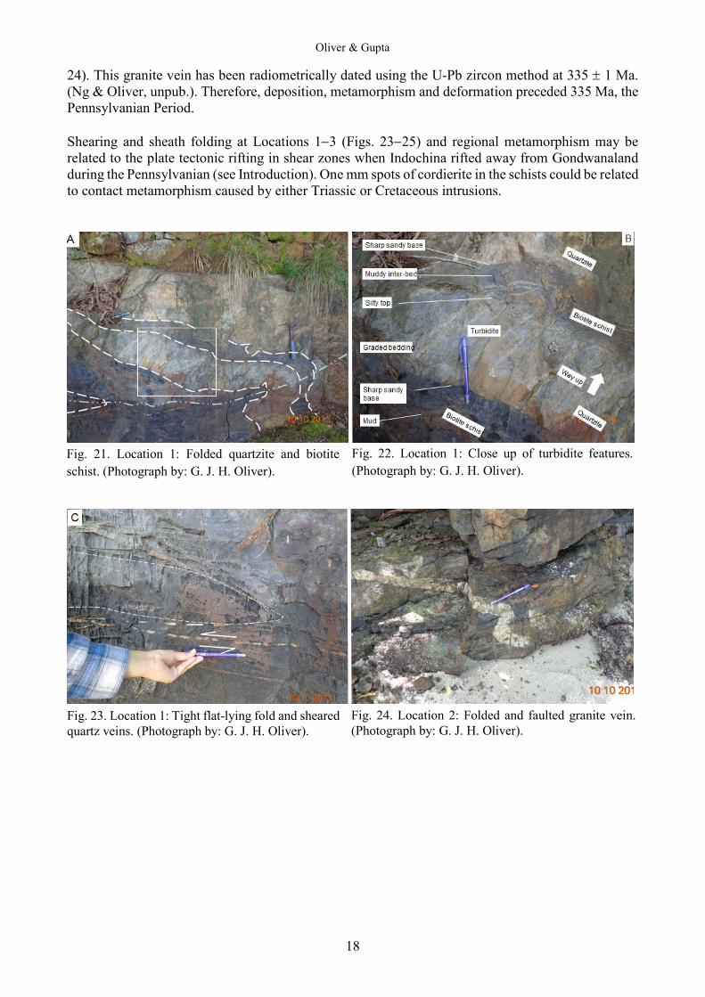
Fig. 20. Excursion locations of Pulau Sajahat. Source Google Earth.
Fig. 17. Geological map of Singapore. Modified by GJH Oliver from Lee & Zhou (2009) with permission from the Defence Science and Technology Agency, Singapore.
Fig. 19. Sajahat Formation type locality geology. From Lee & Zhou (2009) with permission from the Defence Science and Technology Agency, Singapore.
Key: Da = acid dyke; Db = basic dyke; S = Sajahat Formation
100 m
Oliver & Gupta
18
24). This granite vein has been radiometrically dated using the U-Pb zircon method at 335 ± 1 Ma. (Ng & Oliver, unpub.). Therefore, deposition, metamorphism and deformation preceded 335 Ma, the Pennsylvanian Period. Shearing and sheath folding at Locations 1−3 (Figs. 23−25) and regional metamorphism may be related to the plate tectonic rifting in shear zones when Indochina rifted away from Gondwanaland during the Pennsylvanian (see Introduction). One mm spots of cordierite in the schists could be related to contact metamorphism caused by either Triassic or Cretaceous intrusions.
Fig. 21. Location 1: Folded quartzite and biotite schist. (Photograph by: G. J. H. Oliver).
Fig. 22. Location 1: Close up of turbidite features. (Photograph by: G. J. H. Oliver).
Fig. 23. Location 1: Tight flat-lying fold and sheared quartz veins. (Photograph by: G. J. H. Oliver).
Fig. 24. Location 2: Folded and faulted granite vein. (Photograph by: G. J. H. Oliver).
A Field Guide to the Geology of Singapore, 2nd Edition
19
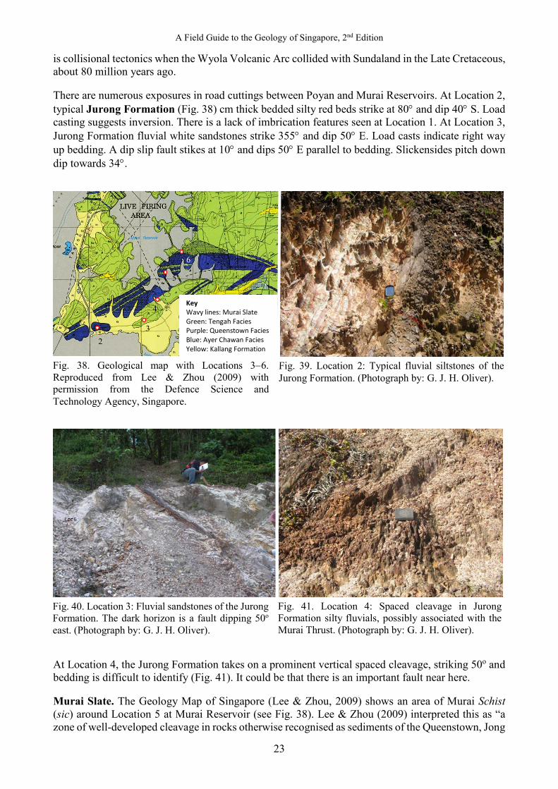
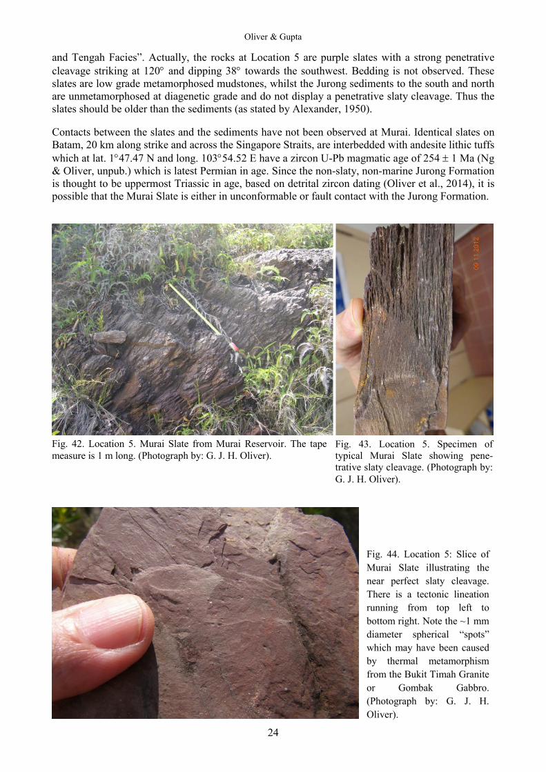
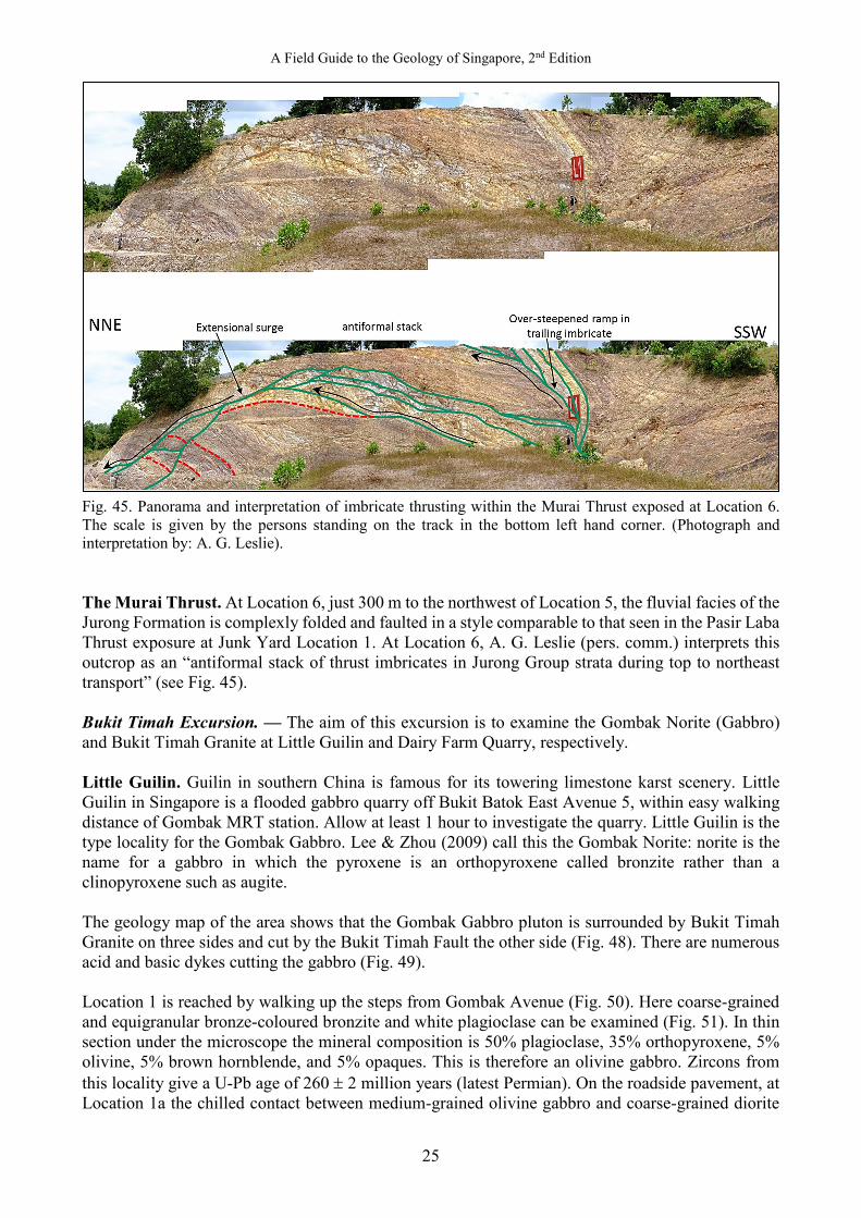
The sand berm at Location 4, which connects Pulau Sajahat to Pulau Tekong, is showing signs of erosion, probably from the bow waves of passing ships and fast ferries (Figs. 26, 27). A shatter zone at Location 5 (Fig. 28) and sinistral and dextral shear zones in thin bedded turbidites at Location 6 (Fig. 25) add to the tectonic complexity. A north to south trending, unfoliated, dolerite (basic/mafic) dyke at Location 7 (Fig. 30) may be related to the Pulau Ubin Jetty Diorite, which has been dated by Oliver et al. (2014) as 95 Ma (Cretaceous). There is a suggestion seen in the veined light grey inclusions in Fig. 31 that the dark grey dolerite has partially digested (i.e., assimilated) the turbidite.
Fig. 25. Location 3: There is circumstantial evidence for sheath-type folds, which if confirmed, would suggest that the Sajahat Formation is actually a tectonite in a shear zone. Tiny spots of cordierite in the schists could be related to contact metamorphism caused by either the Triassic or Cretaceous intrusions. (Photograph by: G. J. H. Oliver).
Fig. 26. Location 4: Recent erosion has exposed the sand-fill berm that surrounds Pulau Sajahat. (Photograph by: G. J. H. Oliver).
Fig. 27. Location 4: Note the several layers of sand-fill. (Photograph by: G. J. H. Oliver).
Oliver & Gupta
20
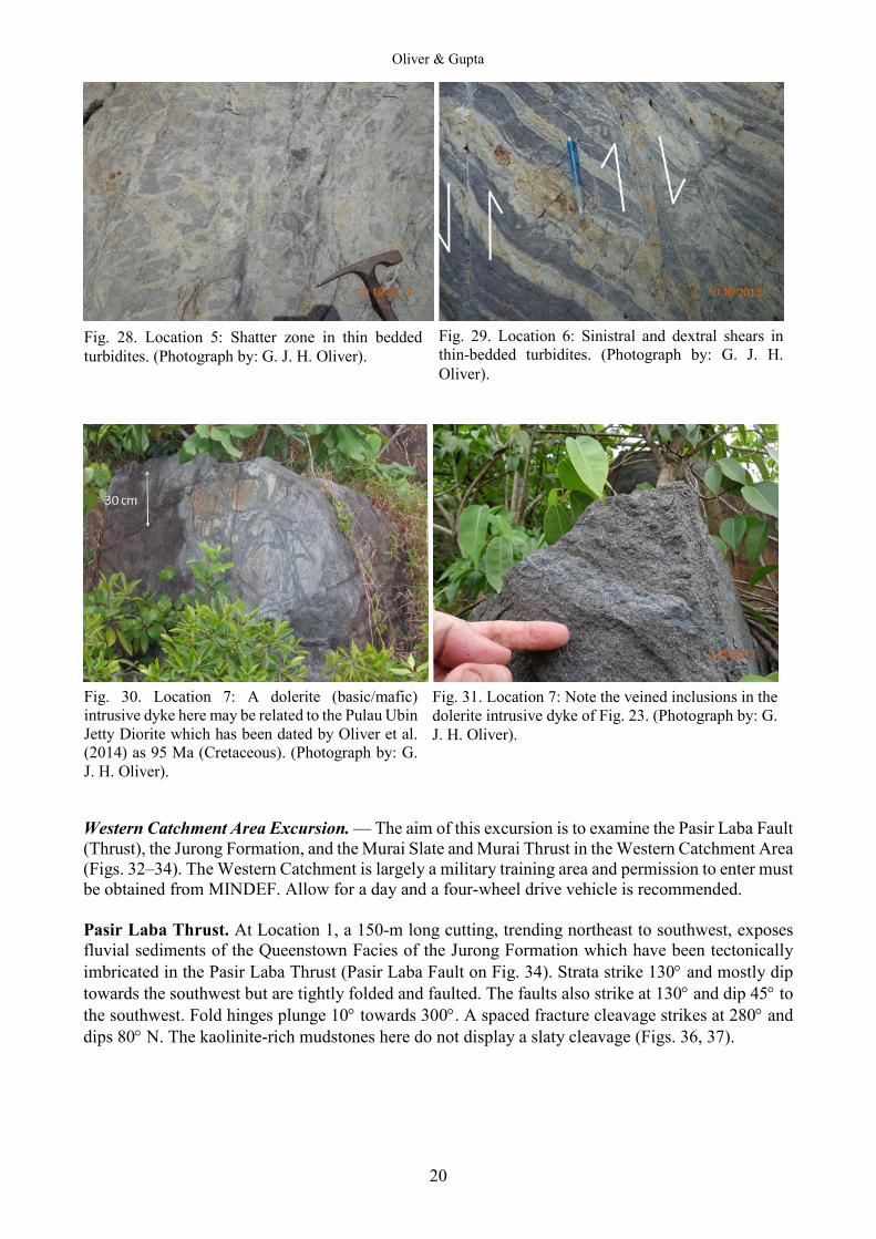
Western Catchment Area Excursion. — The aim of this excursion is to examine the Pasir Laba Fault (Thrust), the Jurong Formation, and the Murai Slate and Murai Thrust in the Western Catchment Area (Figs. 32‒34). The Western Catchment is largely a military training area and permission to enter must be obtained from MINDEF. Allow for a day and a four-wheel drive vehicle is recommended. Pasir Laba Thrust. At Location 1, a 150-m long cutting, trending northeast to southwest, exposes fluvial sediments of the Queenstown Facies of the Jurong Formation which have been tectonically imbricated in the Pasir Laba Thrust (Pasir Laba Fault on Fig. 34). Strata strike 130° and mostly dip towards the southwest but are tightly folded and faulted. The faults also strike at 130° and dip 45° to the southwest. Fold hinges plunge 10° towards 300°. A spaced fracture cleavage strikes at 280° and dips 80° N. The kaolinite-rich mudstones here do not display a slaty cleavage (Figs. 36, 37).
Fig. 28. Location 5: Shatter zone in thin bedded turbidites. (Photograph by: G. J. H. Oliver).
Fig. 29. Location 6: Sinistral and dextral shears in thin-bedded turbidites. (Photograph by: G. J. H. Oliver).
Fig. 30. Location 7: A dolerite (basic/mafic) intrusive dyke here may be related to the Pulau Ubin Jetty Diorite which has been dated by Oliver et al. (2014) as 95 Ma (Cretaceous). (Photograph by: G. J. H. Oliver).
Fig. 31. Location 7: Note the veined inclusions in the dolerite intrusive dyke of Fig. 23. (Photograph by: G. J. H. Oliver).

A Field Guide to the Geology of Singapore, 2nd Edition
21
Fig. 34. Geological map of the Pasir Laba Thrust Fault at Junkyard. Reproduced from Lee & Zhou (2009) with permission from the Defence Science and Technology Agency, Singapore.
Fig. 32. Geological map of Singapore showing the location of the Pasir Laba Fault and the Murai Slates. Reproduced from Lee & Zhou (2009) with permission from the Defence Science and Technology Agency, Singapore.
Fig. 33. Locations 1–5. Source: Google Earth.
Jt = Tengah Facies Jq = Queenstown Facies Jac = Ayer Chawan Facies K = Kallang Formation
Location 1
500 m
N

Oliver & Gupta
22
NE SW Fig. 35. Location 1: Pasir Laba Thrust at Junkyard: Imbricate thrust zone within the Jurong Formation illustrating repeated sequences of faulted fluvial facies sandstone, siltstone and mudstone redbeds. White kaolinite mudstone is conspicuous. Fourteen faults can be counted. See Figs. 36 and 37 for details inside white square (Photographs by: G. J. H. Oliver).
Oliver & Prave (2013) proposed that the depositional basin for the Jurong Formation was formed in an extensional half-graben along the Bukit Timah Fault. The Pasir Laba Fault is clearly a later compressional fault zone, formed during the inversion of that basin. Imbricate thrusting is characteristic of thin-skinned tectonics. It may be that this outcrop is a small scale example of the large scale structure of the Jurong Formation. It is not known what caused this faulting: one possibility
Fig. 36. Location 1: Close-up of inset area above. Tape measure is 1 m long. (Photograph by: G. J. H. Oliver).
Fig. 37. Location 1: Interpretation: Drag folding caused by thrust faulting; top has moved towards the northeast. Tape measure is 1 m long. (Photograph by: G. J. H. Oliver).
NE
Imbricate fault Fold
A Field Guide to the Geology of Singapore, 2nd Edition
23
is collisional tectonics when the Wyola Volcanic Arc collided with Sundaland in the Late Cretaceous, about 80 million years ago. There are numerous exposures in road cuttings between Poyan and Murai Reservoirs. At Location 2, typical Jurong Formation (Fig. 38) cm thick bedded silty red beds strike at 80° and dip 40° S. Load casting suggests inversion. There is a lack of imbrication features seen at Location 1. At Location 3, Jurong Formation fluvial white sandstones strike 355° and dip 50° E. Load casts indicate right way up bedding. A dip slip fault stikes at 10° and dips 50° E parallel to bedding. Slickensides pitch down dip towards 34°.
At Location 4, the Jurong Formation takes on a prominent vertical spaced cleavage, striking 50o and bedding is difficult to identify (Fig. 41). It could be that there is an important fault near here. Murai Slate. The Geology Map of Singapore (Lee & Zhou, 2009) shows an area of Murai Schist (sic) around Location 5 at Murai Reservoir (see Fig. 38). Lee & Zhou (2009) interpreted this as “a zone of well-developed cleavage in rocks otherwise recognised as sediments of the Queenstown, Jong
Fig. 38. Geological map with Locations 3−6. Reproduced from Lee & Zhou (2009) with permission from the Defence Science and Technology Agency, Singapore.
Fig. 39. Location 2: Typical fluvial siltstones of the Jurong Formation. (Photograph by: G. J. H. Oliver).
Key Wavy lines: Murai Slate Green: Tengah Facies Purple: Queenstown Facies Blue: Ayer Chawan Facies Yellow: Kallang Formation
2 3
4
5
6
Fig. 40. Location 3: Fluvial sandstones of the Jurong Formation. The dark horizon is a fault dipping 50o east. (Photograph by: G. J. H. Oliver).
Fig. 41. Location 4: Spaced cleavage in Jurong Formation silty fluvials, possibly associated with the Murai Thrust. (Photograph by: G. J. H. Oliver).
Oliver & Gupta
24
and Tengah Facies”. Actually, the rocks at Location 5 are purple slates with a strong penetrative cleavage striking at 120° and dipping 38° towards the southwest. Bedding is not observed. These slates are low grade metamorphosed mudstones, whilst the Jurong sediments to the south and north are unmetamorphosed at diagenetic grade and do not display a penetrative slaty cleavage. Thus the slates should be older than the sediments (as stated by Alexander, 1950). Contacts between the slates and the sediments have not been observed at Murai. Identical slates on Batam, 20 km along strike and across the Singapore Straits, are interbedded with andesite lithic tuffs which at lat. 1°47.47 N and long. 103°54.52 E have a zircon U-Pb magmatic age of 254 ± 1 Ma (Ng & Oliver, unpub.) which is latest Permian in age. Since the non-slaty, non-marine Jurong Formation is thought to be uppermost Triassic in age, based on detrital zircon dating (Oliver et al., 2014), it is possible that the Murai Slate is either in unconformable or fault contact with the Jurong Formation.
Fig. 44. Location 5: Slice of Murai Slate illustrating the near perfect slaty cleavage. There is a tectonic lineation running from top left to bottom right. Note the ~1 mm diameter spherical “spots” which may have been caused by thermal metamorphism from the Bukit Timah Granite or Gombak Gabbro. (Photograph by: G. J. H. Oliver).
Fig. 42. Location 5. Murai Slate from Murai Reservoir. The tape measure is 1 m long. (Photograph by: G. J. H. Oliver).
Fig. 43. Location 5. Specimen of typical Murai Slate showing pene-trative slaty cleavage. (Photograph by: G. J. H. Oliver).
A Field Guide to the Geology of Singapore, 2nd Edition
25
Fig. 45. Panorama and interpretation of imbricate thrusting within the Murai Thrust exposed at Location 6. The scale is given by the persons standing on the track in the bottom left hand corner. (Photograph and interpretation by: A. G. Leslie). The Murai Thrust. At Location 6, just 300 m to the northwest of Location 5, the fluvial facies of the Jurong Formation is complexly folded and faulted in a style comparable to that seen in the Pasir Laba Thrust exposure at Junk Yard Location 1. At Location 6, A. G. Leslie (pers. comm.) interprets this outcrop as an “antiformal stack of thrust imbricates in Jurong Group strata during top to northeast transport” (see Fig. 45). Bukit Timah Excursion. — The aim of this excursion is to examine the Gombak Norite (Gabbro) and Bukit Timah Granite at Little Guilin and Dairy Farm Quarry, respectively. Little Guilin. Guilin in southern China is famous for its towering limestone karst scenery. Little Guilin in Singapore is a flooded gabbro quarry off Bukit Batok East Avenue 5, within easy walking distance of Gombak MRT station. Allow at least 1 hour to investigate the quarry. Little Guilin is the type locality for the Gombak Gabbro. Lee & Zhou (2009) call this the Gombak Norite: norite is the name for a gabbro in which the pyroxene is an orthopyroxene called bronzite rather than a clinopyroxene such as augite. The geology map of the area shows that the Gombak Gabbro pluton is surrounded by Bukit Timah Granite on three sides and cut by the Bukit Timah Fault the other side (Fig. 48). There are numerous acid and basic dykes cutting the gabbro (Fig. 49). Location 1 is reached by walking up the steps from Gombak Avenue (Fig. 50). Here coarse-grained and equigranular bronze-coloured bronzite and white plagioclase can be examined (Fig. 51). In thin section under the microscope the mineral composition is 50% plagioclase, 35% orthopyroxene, 5% olivine, 5% brown hornblende, and 5% opaques. This is therefore an olivine gabbro. Zircons from this locality give a U-Pb age of 260 ± 2 million years (latest Permian). On the roadside pavement, at Location 1a the chilled contact between medium-grained olivine gabbro and coarse-grained diorite
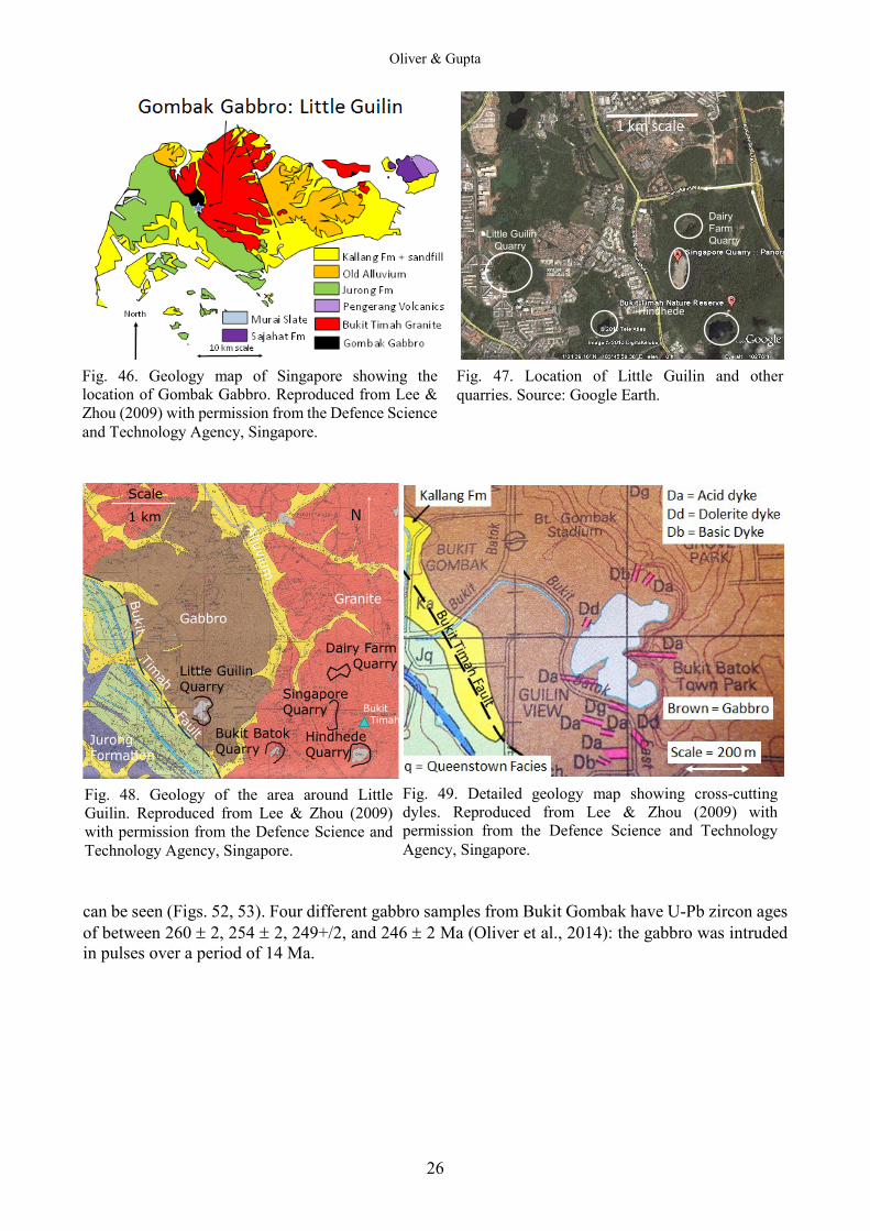
Oliver & Gupta
26
Little GuilinQuarry
Dairy Farm Quarry
Scale
1 km N
Bukit BatokQuarry
SingaporeQuarry
HindhedeQuarry
GabbroGranite
Jurong Formation
Bukit Timah
can be seen (Figs. 52, 53). Four different gabbro samples from Bukit Gombak have U-Pb zircon ages of between 260 ± 2, 254 ± 2, 249+/2, and 246 ± 2 Ma (Oliver et al., 2014): the gabbro was intruded in pulses over a period of 14 Ma.
DairyFarm QuarryLittle Guilin
Quarry
Hindhede
1 km scale
Fig. 46. Geology map of Singapore showing the location of Gombak Gabbro. Reproduced from Lee & Zhou (2009) with permission from the Defence Science and Technology Agency, Singapore.
Fig. 47. Location of Little Guilin and other quarries. Source: Google Earth.
Fig. 48. Geology of the area around Little Guilin. Reproduced from Lee & Zhou (2009) with permission from the Defence Science and Technology Agency, Singapore.
Fig. 49. Detailed geology map showing cross-cutting dyles. Reproduced from Lee & Zhou (2009) with permission from the Defence Science and Technology Agency, Singapore.
A Field Guide to the Geology of Singapore, 2nd Edition
27
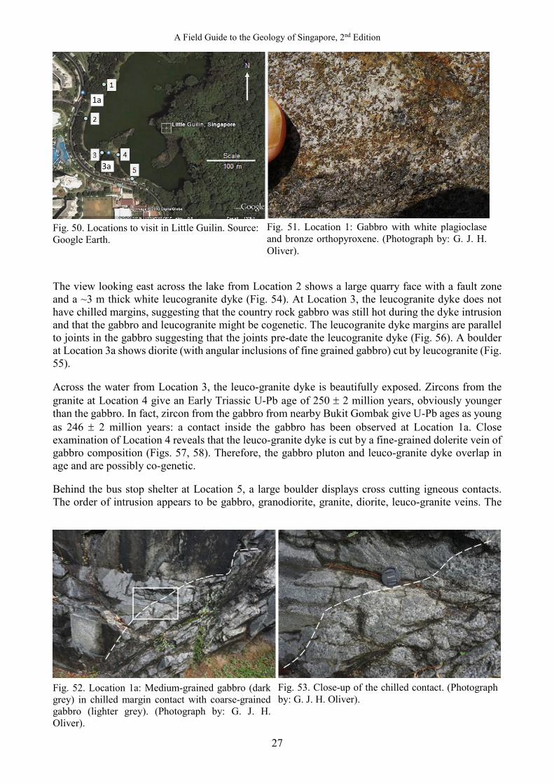
Fig. 50. Locations to visit in Little Guilin. Source: Google Earth. The view looking east across the lake from Location 2 shows a large quarry face with a fault zone and a ~3 m thick white leucogranite dyke (Fig. 54). At Location 3, the leucogranite dyke does not have chilled margins, suggesting that the country rock gabbro was still hot during the dyke intrusion and that the gabbro and leucogranite might be cogenetic. The leucogranite dyke margins are parallel to joints in the gabbro suggesting that the joints pre-date the leucogranite dyke (Fig. 56). A boulder at Location 3a shows diorite (with angular inclusions of fine grained gabbro) cut by leucogranite (Fig. 55). Across the water from Location 3, the leuco-granite dyke is beautifully exposed. Zircons from the granite at Location 4 give an Early Triassic U-Pb age of 250 ± 2 million years, obviously younger than the gabbro. In fact, zircon from the gabbro from nearby Bukit Gombak give U-Pb ages as young as 246 ± 2 million years: a contact inside the gabbro has been observed at Location 1a. Close examination of Location 4 reveals that the leuco-granite dyke is cut by a fine-grained dolerite vein of gabbro composition (Figs. 57, 58). Therefore, the gabbro pluton and leuco-granite dyke overlap in age and are possibly co-genetic. Behind the bus stop shelter at Location 5, a large boulder displays cross cutting igneous contacts. The order of intrusion appears to be gabbro, granodiorite, granite, diorite, leuco-granite veins. The
Fig. 52. Location 1a: Medium-grained gabbro (dark grey) in chilled margin contact with coarse-grained gabbro (lighter grey). (Photograph by: G. J. H. Oliver).
Fig. 53. Close-up of the chilled contact. (Photograph by: G. J. H. Oliver).
Fig. 51. Location 1: Gabbro with white plagioclase and bronze orthopyroxene. (Photograph by: G. J. H. Oliver).
1a
3a

Oliver & Gupta
28
granodiorite contains an inclusion of ultramafic rock which may be a cumulate pyroxenite. Geochemical analyses might show that all these rock compositions are related to a fractionation series, starting with olivine gabbro and terminating with the leuco-granite. Joint orientations at Location 1 are dominated by north to south and east-southeast to west-northwest directions. Joint orientations at Location 4 are dominated by north-northwest to south-southeast directions (Fig. 60). These might be cooling joints.
Fig. 57. Location 4: The granite dyke is cut by a thin vein of dolerite. (Photograph by: G. J. H. Oliver).
Fig. 56. The granite dyke observed from Location 3. (Photograph by: G. J. H. Oliver).
Fig. 54. Location 2: View of a fault and a white granite dyke cutting strongly jointed, dark gabbro. (Photograph by: G. J. H. Oliver).
Fig. 55. Location 3: Granite dyke cutting gabbro. Note the lack of chilled margins and gabbro inclusion. (Photograph by: G. J. H. Oliver).
A Field Guide to the Geology of Singapore, 2nd Edition
29
Fig. 58. Location 4: Close up of dolerite vein (sill) cutting leuco-granite. (Photograph by: G. J. H. Oliver).
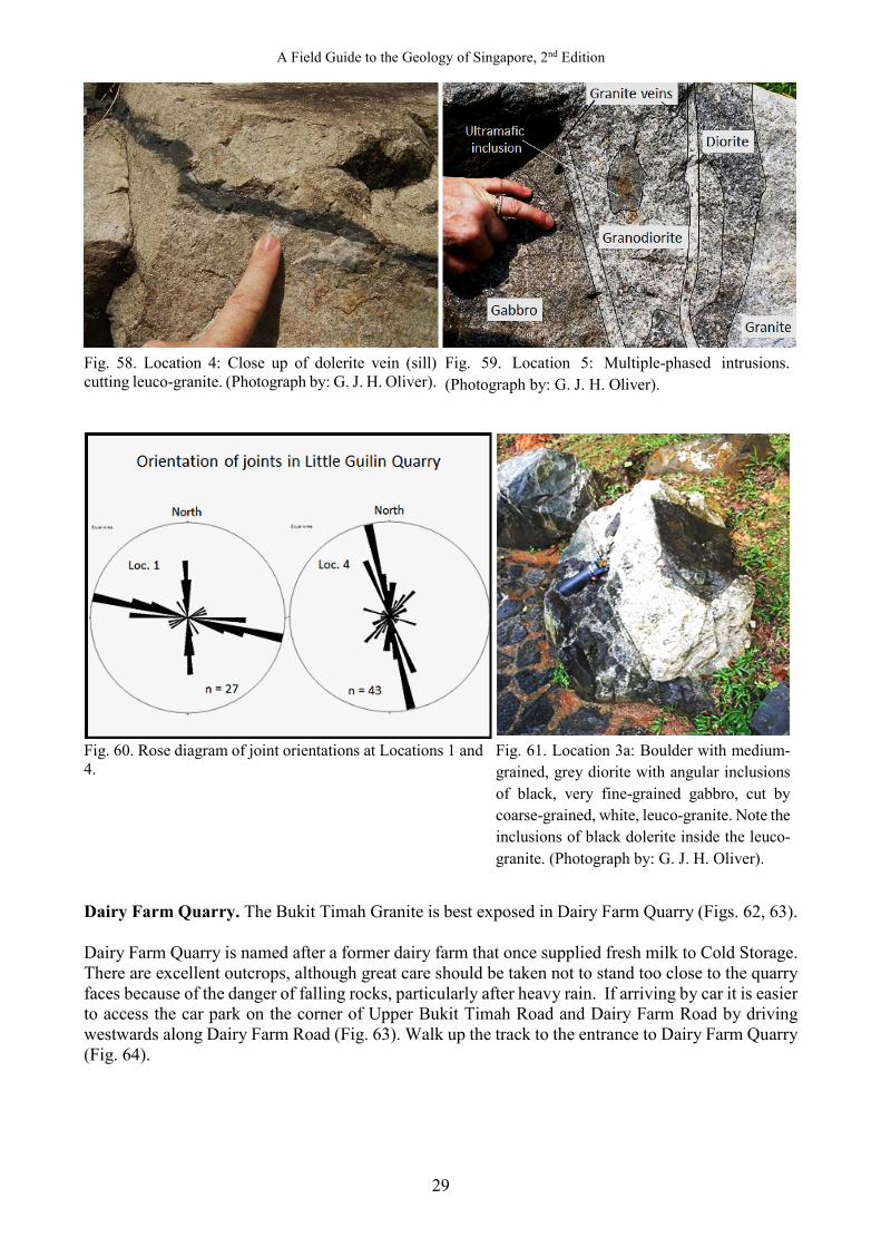
Fig. 60. Rose diagram of joint orientations at Locations 1 and 4. Dairy Farm Quarry. The Bukit Timah Granite is best exposed in Dairy Farm Quarry (Figs. 62, 63). Dairy Farm Quarry is named after a former dairy farm that once supplied fresh milk to Cold Storage. There are excellent outcrops, although great care should be taken not to stand too close to the quarry faces because of the danger of falling rocks, particularly after heavy rain. If arriving by car it is easier to access the car park on the corner of Upper Bukit Timah Road and Dairy Farm Road by driving westwards along Dairy Farm Road (Fig. 63). Walk up the track to the entrance to Dairy Farm Quarry (Fig. 64).
Fig. 59. Location 5: Multiple-phased intrusions. (Photograph by: G. J. H. Oliver).
Fig. 61. Location 3a: Boulder with medium-grained, grey diorite with angular inclusions of black, very fine-grained gabbro, cut by coarse-grained, white, leuco-granite. Note the inclusions of black dolerite inside the leuco-granite. (Photograph by: G. J. H. Oliver).
Oliver & Gupta
30
Little GuilinQuarry
Dairy Farm Quarry
Scale
1 km N
Bukit BatokQuarry
SingaporeQuarry
HindhedeQuarry
GabbroGranite
Jurong Formation
Bukit Timah
Car park entrance
Dairy FarmQuarry
Scale
100 m N
From the entrance to Dairy Farm Quarry at Location 1, the view towards the southwest is of the main quarry face, which displays joint surfaces in massive granite and a sharp undulating contact with ~10 m of red/brown soil called oxisol (Figs. 65, 66). Location 2 is under an overhang of the quarry wall. Beware of falling rocks! Here there is a north−south fault zone trending 012° and dipping steeply to the east, with both sub-horizontal and sub-vertical slickensides. Above head height, the fault planes in the zone are curved and anastomosing, indicating normal faulting with the hanging wall moving down to the east (Figs. 67, 68).A clean surface shows coarse equigranular granite with 30% glassy quartz, 30% creamy K-feldspar, 30% white plagioclase, and 5% black flaky biotite (Fig. 69).
Fig. 62. Geological map with the location of Bukit Timah. Reproduced from Lee & Zhou (2009) with permission from the Defence Science and Technology Agency, Singapore.
Fig. 63. Geological map with the locations of the quarries. Modified from Lee & Zhou (2009) with permission from the Defence Science and Technology Agency, Singapore.
Fig. 64. Location of Dairy Farm Quarry. Source: Google Earth.
Fig. 65. Locations 1 to 4 within Dairy Farm Quarry. Source: Google Earth.
A Field Guide to the Geology of Singapore, 2nd Edition
31
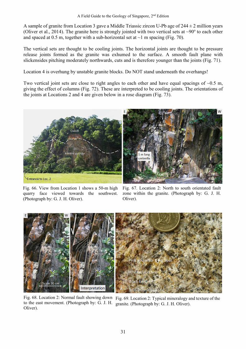
A sample of granite from Location 3 gave a Middle Triassic zircon U-Pb age of 244 ± 2 million years (Oliver et al., 2014). The granite here is strongly jointed with two vertical sets at ~90o to each other and spaced at 0.5 m, together with a sub-horizontal set at ~1 m spacing (Fig. 70). The vertical sets are thought to be cooling joints. The horizontal joints are thought to be pressure release joints formed as the granite was exhumed to the surface. A smooth fault plane with slickensides pitching moderately northwards, cuts and is therefore younger than the joints (Fig. 71). Location 4 is overhung by unstable granite blocks. Do NOT stand underneath the overhangs! Two vertical joint sets are close to right angles to each other and have equal spacings of ~0.5 m, giving the effect of columns (Fig. 72). These are interpreted to be cooling joints. The orientations of the joints at Locations 2 and 4 are given below in a rose diagram (Fig. 73).
Fig. 66. View from Location 1 shows a 50-m high quarry face viewed towards the southwest. (Photograph by: G. J. H. Oliver).
Fig. 67. Location 2: North to south orientated fault zone within the granite. (Photograph by: G. J. H. Oliver).
Fig. 68. Location 2: Normal fault showing down to the east movement. (Photograph by: G. J. H. Oliver).
Fig. 69. Location 2: Typical mineralogy and texture of the granite. (Photograph by: G. J. H. Oliver).

Oliver & Gupta
32
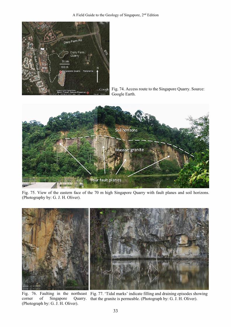
Singapore Quarry. Bukit Timah Granite is well exposed in the Singapore Quarry but again, the quarry faces are dangerous. Access is either a 15-minute walk along the cycle track through the forest from Dairy Farm Quarry or from the Rail Mall on Upper Bukit Timah Road (Fig. 74). There is a convenient and safe viewing platform at the quarry entrance. On a quiet day, long-tailed macaques, monitor lizards, sea eagles, kingfishers, crested grebes, gold fish, and koi carp can be observed in and around the waters of the flooded quarry. The massive quarry face in front of the viewing platform is formed by at least four steeply dipping, close-spaced fault planes (Fig. 75). Jointing is not observed on the fault planes so the faulting post-dates the jointing. In the northeast corner of the quarry, several parallel fault planes can be seen to strike at 7° and dip 80° to the west (Fig. 76). These faults strike northwards into Dairy Farm Quarry where both strike-slip and dip-slip movements were recognised by the orientations of slickensides (Figs. 68, 71). “Tide-marks” on the quarry walls point to filling and draining episodes of the quarry lake, indicating that the granite is permeable (Fig. 77). Ground water can be seen leaking out of joints in the quarry walls (Fig. 78). When the lake level is low, it is possible to walk around to the northeast corner of the quarry to view this in detail. Otherwise, binoculars are useful.
Fig. 70. Location 3: Vertical and sub-horizontal joint sets. (Photograph by: G. J. H. Oliver).
Fig. 71. Location 3: A smooth fault plane with slickensides. (Photograph by: G. J. H. Oliver).
Fig. 72. Location 4: Two sets of vertical cooling joints at ~90° give a column effect. (Photographs by: G. J. H. Oliver).
Fig. 73. Rose diagram of fault orientations from Locations 2 and 4.
A Field Guide to the Geology of Singapore, 2nd Edition
33
Fig. 75. View of the eastern face of the 70 m high Singapore Quarry with fault planes and soil horizons. (Photography by: G. J. H. Oliver).
Fig. 74. Access route to the Singapore Quarry. Source: Google Earth.
Fig. 76. Faulting in the northeast corner of Singapore Quarry. (Photograph by: G. J. H. Oliver).
Fig. 77. ‘Tidal marks’ indicate filling and draining episodes showing that the granite is permeable. (Photograph by: G. J. H. Oliver).

Oliver & Gupta
34
At the top of the quarry, a deep soil has formed. This soil is a typical oxisol formed in a wet tropical climate (Fig. 79). 1. Layer 1 is the O horizon, made up of organic matter. 2. Layer 2 is the A horizon, made up of mineral soil mixed with humus. 3. Layer 3 is the E horizon, a zone of leaching of clay, Fe, and Al. 4. Layer 4 is the B horizon, a zone of accumulation of clay, Fe, and Al. 5. Layer 5 is the C horizon, a zone of relatively unweathered blocks which give rise to core stones. 6. Layer 6 is bedrock (granite). Hindhede Quarry and Bukit Timah. Allow three hours for this part of the excursion. The quarry is located behind the National Parks Board (NParks) Headquarters (HQ) of the Bukit Timah Nature Reserve, which is a 30-minute walk from the Singapore Quarry along the cycle track in the forest. Alternatively, there are bus routes along Upper Bukit Timah Road with bus stops near Hindhede Drive, which leads to the HQ. There is a path leading from the NParks museum (which is very much worth a visit) to a viewing platform inside the quarry (Fig. 80). The view to the east is of massive jointed granite, overlain by oxisols. The former entrance to the (now fenced off) quarry is cut into a dyke of fine-grained, quench-textured, leuco-granite with phenocrysts of quartz, trending 040° and dipping 75° northwest. This dyke has a U-Pb zircon age of 246 ± 2 Ma (Ng & Oliver, unpublished) which is the same age (within error) as the Bukit Timah Granite from Dairy Farm Quarry. The quarry is flooded and the variation of water levels indicated by “tide marks” show that lake water is infiltrating the fractured granite (Fig. 81). It is worth walking from the NParks HQ up to the top of Bukit Timah (163.63 m) if only because it is the highest hill in Singapore. There are some weathered outcrops of granite in the road cuttings on the way up. Bukit Timah translates as “Tin Hill” although mineralisation in the form of cassiterite quartz veins has not been observed. The view at the top is blocked by the forest. The standing stone that marks the top is rounded and was probably a core-stone dug out of the local soil having suffered from exfoliation caused by deep chemical weathering when buried (Figs. 82, 83). Fig. 84 illustrates the equigranular texture seen in the summit granite boulder: rectangular crystals of orthoclase (white), in a matrix of plagioclase (pale green), quartz (glassy), and hornblende (black). This is a good example of a typical Andean-type hornblende granite formed in a subduction zone environment. The pavement here is made from imported andesite lava slabs (Fig. 85).
Fig. 78. Ground water leaking from a joint in permeable granite. (Photograph by: G. J. H. Oliver).
Fig. 79. Close up of the soil horizons in the Singapore Quarry. (Photograph by: G. J. H. Oliver).

A Field Guide to the Geology of Singapore, 2nd Edition
35
Fig. 84. Close up of equigranular texture in summit granite boulder: rectangular crystals of orthoclase (white), in a matrix of plagioclase (very pale green), quartz (glassy), and hornblende (black). (Photograph by: G. J. H. Oliver).
Fig. 82. Summit standing stone of Bukit Timah Granite. (Photograph by: G. J. H. Oliver).
Fig. 81. ‘Tide marks’ indicate filling and draining episodes showing that the granite is permeable. (Photograph by: G. J. H. Oliver).
Fig. 80. General view of Hindhede Granite Quarry. (Photograph by: G. J. H. Oliver).
Fig. 83. Edge on view of stone in Fig. 82 showing exfoliation. (Photograph by: G. J. H. Oliver).
Fig. 85. The pavement slabs hereabouts are cut from andesitic lava with conspicuous pink orthoclase and black hornblende crystals set in a fine-grained matrix: this has no comparison with any rock from Singapore and must have been imported. (Photograph by: G. J. H. Oliver).
Oliver & Gupta
36
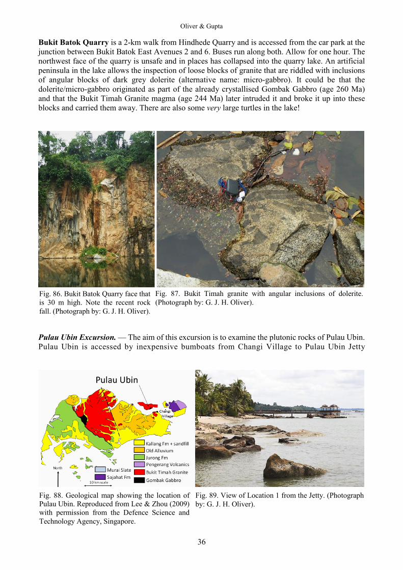
Bukit Batok Quarry is a 2-km walk from Hindhede Quarry and is accessed from the car park at the junction between Bukit Batok East Avenues 2 and 6. Buses run along both. Allow for one hour. The northwest face of the quarry is unsafe and in places has collapsed into the quarry lake. An artificial peninsula in the lake allows the inspection of loose blocks of granite that are riddled with inclusions of angular blocks of dark grey dolerite (alternative name: micro-gabbro). It could be that the dolerite/micro-gabbro originated as part of the already crystallised Gombak Gabbro (age 260 Ma) and that the Bukit Timah Granite magma (age 244 Ma) later intruded it and broke it up into these blocks and carried them away. There are also some very large turtles in the lake!
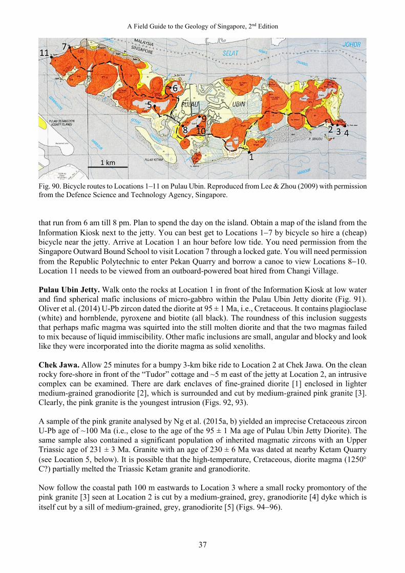
Pulau Ubin Excursion. — The aim of this excursion is to examine the plutonic rocks of Pulau Ubin. Pulau Ubin is accessed by inexpensive bumboats from Changi Village to Pulau Ubin Jetty
Fig. 86. Bukit Batok Quarry face that is 30 m high. Note the recent rock fall. (Photograph by: G. J. H. Oliver).
Fig. 87. Bukit Timah granite with angular inclusions of dolerite. (Photograph by: G. J. H. Oliver).
Fig. 88. Geological map showing the location of Pulau Ubin. Reproduced from Lee & Zhou (2009) with permission from the Defence Science and Technology Agency, Singapore.
Fig. 89. View of Location 1 from the Jetty. (Photograph by: G. J. H. Oliver).
A Field Guide to the Geology of Singapore, 2nd Edition
37
Fig. 90. Bicycle routes to Locations 1–11 on Pulau Ubin. Reproduced from Lee & Zhou (2009) with permission from the Defence Science and Technology Agency, Singapore. that run from 6 am till 8 pm. Plan to spend the day on the island. Obtain a map of the island from the Information Kiosk next to the jetty. You can best get to Locations 1−7 by bicycle so hire a (cheap) bicycle near the jetty. Arrive at Location 1 an hour before low tide. You need permission from the Singapore Outward Bound School to visit Location 7 through a locked gate. You will need permission from the Republic Polytechnic to enter Pekan Quarry and borrow a canoe to view Locations 8−10. Location 11 needs to be viewed from an outboard-powered boat hired from Changi Village. Pulau Ubin Jetty. Walk onto the rocks at Location 1 in front of the Information Kiosk at low water and find spherical mafic inclusions of micro-gabbro within the Pulau Ubin Jetty diorite (Fig. 91). Oliver et al. (2014) U-Pb zircon dated the diorite at 95 ± 1 Ma, i.e., Cretaceous. It contains plagioclase (white) and hornblende, pyroxene and biotite (all black). The roundness of this inclusion suggests that perhaps mafic magma was squirted into the still molten diorite and that the two magmas failed to mix because of liquid immiscibility. Other mafic inclusions are small, angular and blocky and look like they were incorporated into the diorite magma as solid xenoliths. Chek Jawa. Allow 25 minutes for a bumpy 3-km bike ride to Location 2 at Chek Jawa. On the clean rocky fore-shore in front of the “Tudor” cottage and ~5 m east of the jetty at Location 2, an intrusive complex can be examined. There are dark enclaves of fine-grained diorite [1] enclosed in lighter medium-grained granodiorite [2], which is surrounded and cut by medium-grained pink granite [3]. Clearly, the pink granite is the youngest intrusion (Figs. 92, 93). A sample of the pink granite analysed by Ng et al. (2015a, b) yielded an imprecise Cretaceous zircon U-Pb age of ~100 Ma (i.e., close to the age of the 95 ± 1 Ma age of Pulau Ubin Jetty Diorite). The same sample also contained a significant population of inherited magmatic zircons with an Upper Triassic age of 231 ± 3 Ma. Granite with an age of 230 ± 6 Ma was dated at nearby Ketam Quarry (see Location 5, below). It is possible that the high-temperature, Cretaceous, diorite magma (1250° C?) partially melted the Triassic Ketam granite and granodiorite. Now follow the coastal path 100 m eastwards to Location 3 where a small rocky promontory of the pink granite [3] seen at Location 2 is cut by a medium-grained, grey, granodiorite [4] dyke which is itself cut by a sill of medium-grained, grey, granodiorite [5] (Figs. 94−96).
1 km
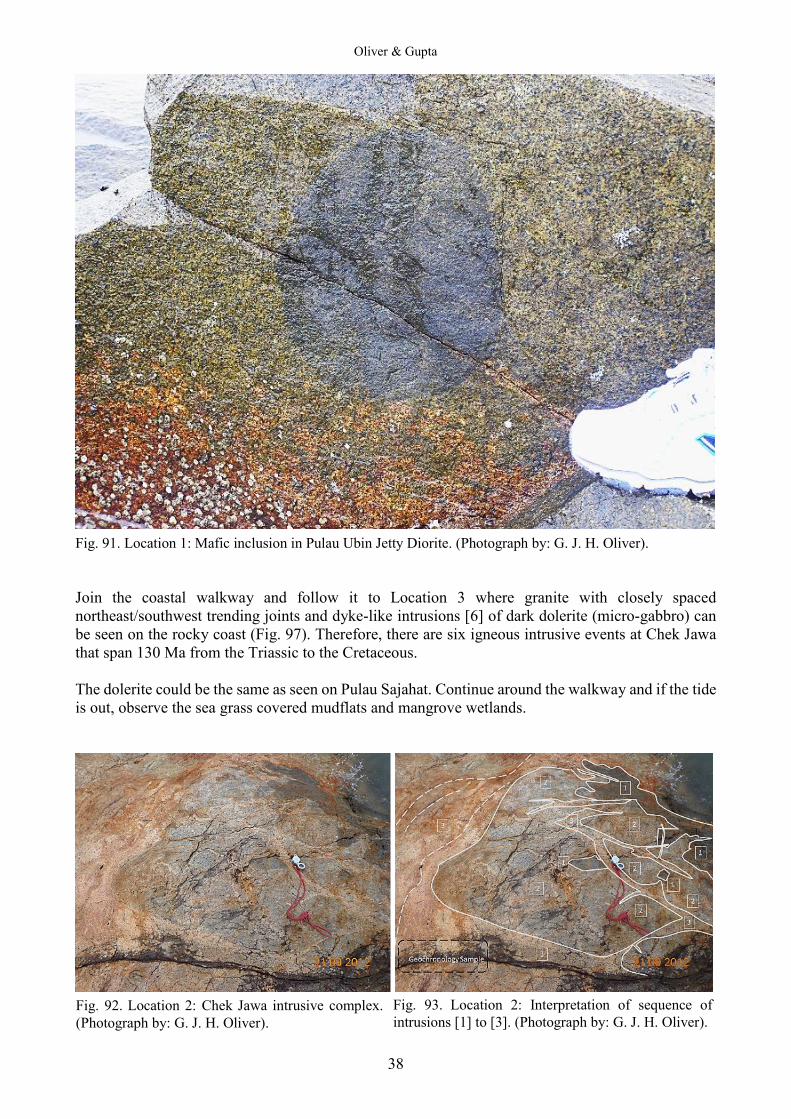
Oliver & Gupta
38
Fig. 91. Location 1: Mafic inclusion in Pulau Ubin Jetty Diorite. (Photograph by: G. J. H. Oliver). Join the coastal walkway and follow it to Location 3 where granite with closely spaced northeast/southwest trending joints and dyke-like intrusions [6] of dark dolerite (micro-gabbro) can be seen on the rocky coast (Fig. 97). Therefore, there are six igneous intrusive events at Chek Jawa that span 130 Ma from the Triassic to the Cretaceous. The dolerite could be the same as seen on Pulau Sajahat. Continue around the walkway and if the tide is out, observe the sea grass covered mudflats and mangrove wetlands.
Fig. 92. Location 2: Chek Jawa intrusive complex. (Photograph by: G. J. H. Oliver).
Fig. 93. Location 2: Interpretation of sequence of intrusions [1] to [3]. (Photograph by: G. J. H. Oliver).
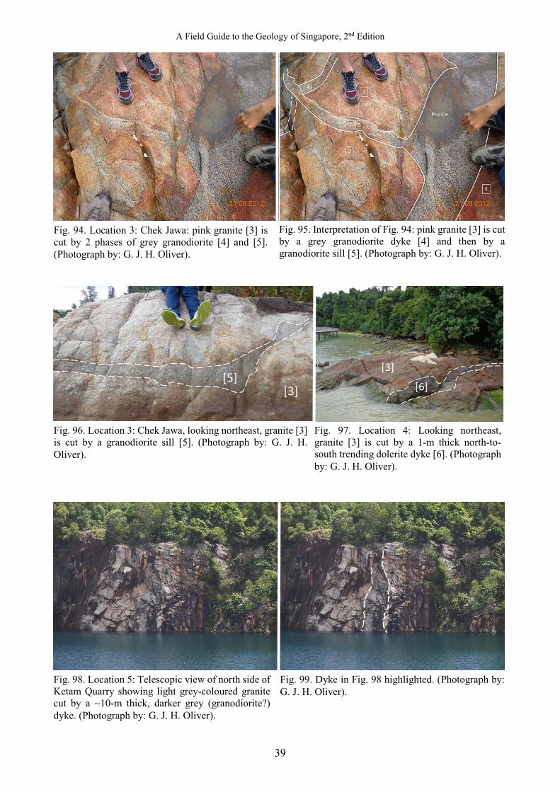
A Field Guide to the Geology of Singapore, 2nd Edition
39
Fig. 96. Location 3: Chek Jawa, looking northeast, granite [3] is cut by a granodiorite sill [5]. (Photograph by: G. J. H. Oliver).
Fig. 94. Location 3: Chek Jawa: pink granite [3] is cut by 2 phases of grey granodiorite [4] and [5]. (Photograph by: G. J. H. Oliver).
Fig. 95. Interpretation of Fig. 94: pink granite [3] is cut by a grey granodiorite dyke [4] and then by a granodiorite sill [5]. (Photograph by: G. J. H. Oliver).
Fig. 97. Location 4: Looking northeast, granite [3] is cut by a 1-m thick north-to-south trending dolerite dyke [6]. (Photograph by: G. J. H. Oliver).
Fig. 98. Location 5: Telescopic view of north side of Ketam Quarry showing light grey-coloured granite cut by a ~10-m thick, darker grey (granodiorite?) dyke. (Photograph by: G. J. H. Oliver).
Fig. 99. Dyke in Fig. 98 highlighted. (Photograph by: G. J. H. Oliver).
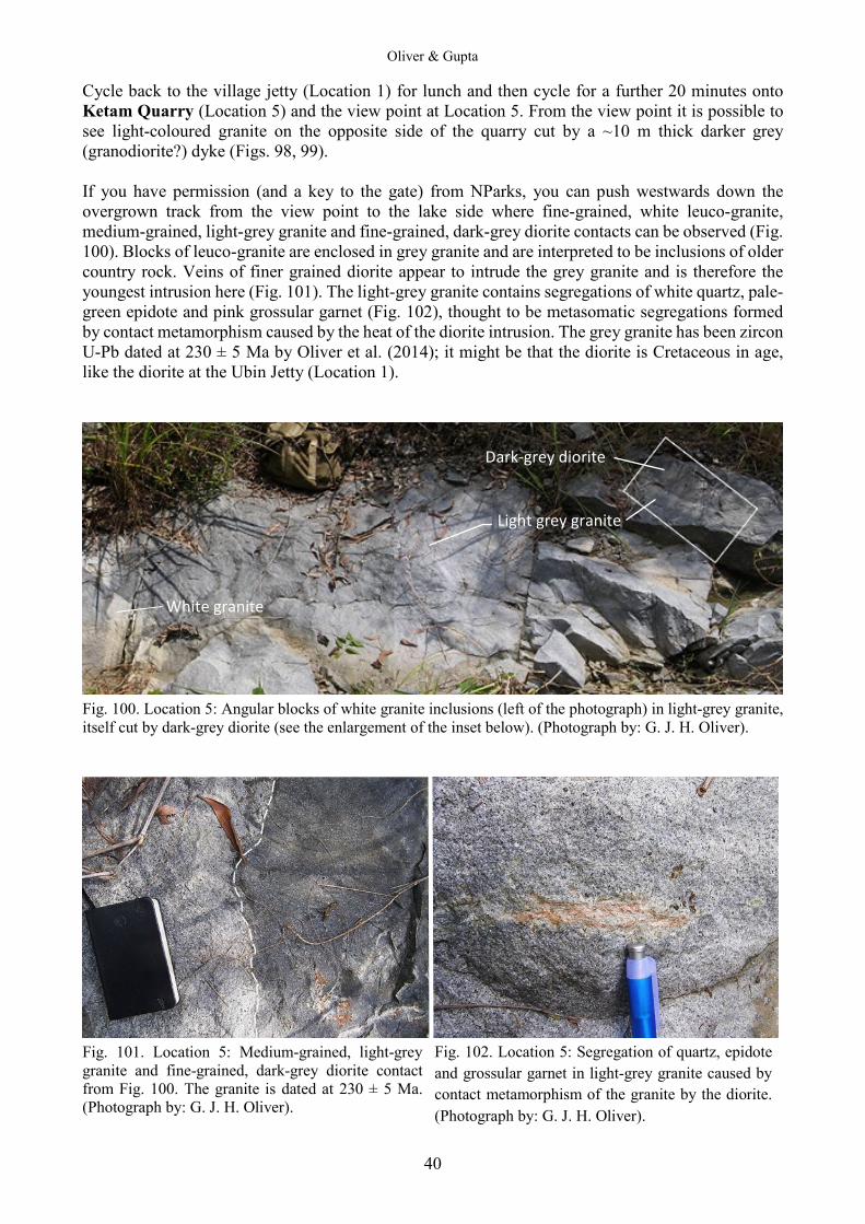
Oliver & Gupta
40
Cycle back to the village jetty (Location 1) for lunch and then cycle for a further 20 minutes onto Ketam Quarry (Location 5) and the view point at Location 5. From the view point it is possible to see light-coloured granite on the opposite side of the quarry cut by a ~10 m thick darker grey (granodiorite?) dyke (Figs. 98, 99). If you have permission (and a key to the gate) from NParks, you can push westwards down the overgrown track from the view point to the lake side where fine-grained, white leuco-granite, medium-grained, light-grey granite and fine-grained, dark-grey diorite contacts can be observed (Fig. 100). Blocks of leuco-granite are enclosed in grey granite and are interpreted to be inclusions of older country rock. Veins of finer grained diorite appear to intrude the grey granite and is therefore the youngest intrusion here (Fig. 101). The light-grey granite contains segregations of white quartz, pale-green epidote and pink grossular garnet (Fig. 102), thought to be metasomatic segregations formed by contact metamorphism caused by the heat of the diorite intrusion. The grey granite has been zircon U-Pb dated at 230 ± 5 Ma by Oliver et al. (2014); it might be that the diorite is Cretaceous in age, like the diorite at the Ubin Jetty (Location 1).
Fig. 100. Location 5: Angular blocks of white granite inclusions (left of the photograph) in light-grey granite, itself cut by dark-grey diorite (see the enlargement of the inset below). (Photograph by: G. J. H. Oliver).
Fig. 101. Location 5: Medium-grained, light-grey granite and fine-grained, dark-grey diorite contact from Fig. 100. The granite is dated at 230 ± 5 Ma. (Photograph by: G. J. H. Oliver).
Fig. 102. Location 5: Segregation of quartz, epidote and grossular garnet in light-grey granite caused by contact metamorphism of the granite by the diorite. (Photograph by: G. J. H. Oliver).
White granite
Dark-grey diorite
Light grey granite

A Field Guide to the Geology of Singapore, 2nd Edition
41
The west side of this flooded quarry at Location 6 is accessible by bicycle and is 15 minutes from Ketam Quarry. By the gate at the water’s edge, medium-grained granodiorite is in sharp contact with finer-grained granodiorite. Perhaps the finer-grained granodiorite is the younger intrusion. Down near the water-level, there is a swirly mixture of darker dioritic material within the granodiorite which is suggestive of magma injection and mixing (Figs. 103, 104). Singapore Outward Bound School. At the western end of Pulau Ubin, there is a track leading to a pier at Location 7. However, there is a locked gate and you will need to liaise with the Singapore Outward Bound School administrators for permission to enter. On the south side of the steps down to the pier, coarse-grained, hornblende gabbro is cut first by narrow, coarse-grained granite sills and dykes (Fig. 105) and then by a dolerite dyke (Fig. 106). The gabbro gives a U-Pb zircon age of 243 ± 1 Ma, the granite dyke gives a U-Pb zircon age of 241 ± 1 Ma (Ng & Oliver, unpublished). On the north side of the steps, a ragged raft of dolerite, with a U-Pb zircon age of 256 ± 1 Ma (Ng & Oliver, unpublished) has been injected by the gabbro (Figs. 107, 108). These ages are of the same range as the gabbros and granites from around Bukit Timah and Little Guilin.
Fig. 105. Location 8: Hornblende gabbro (243 ± 1 Ma) cut by a granite (241 ± Ma) sill and dyke. (Photograph by: G. J. H. Oliver).
Fig. 106. Location 8: Gabbro country rock (243 ± 1 Ma) and granite vein cut by black dolerite dyke. (Photograph by: G. J. H. Oliver).
Fig. 103. Location 6: Sharp contact between medium and fine grained granodiorite. (Photograph by: G. J. H. Oliver).
Fig. 104. Location 6: Swirly mixture of darker dioritic material in lighter granodiorite suggestive of magma injection and mixing. (Photograph by: G. J. H. Oliver).
Oliver & Gupta
42
You will have noticed the locked gate to the flooded Ubin Quarry on your way to Ketam Quarry. You need to ask the Republic Polytechnic administrators for permission to enter and borrow a canoe. Take care as there are many loose blocks balanced on the quarry walls so wear a hard hat. At Location 8, red oxisol with a relict core stone of granite can be seen (Fig. 109). This highly oxidised and leached soil is so enriched in aluminium that it was once mined as bauxite in neighbouring Johor. Around the lake at Location 9, cliffs of grey, well-jointed, equigranular, granodiorite (Fig. 110) show enclaves of dark-grey, fine-grained, equigranular, diorite (Fig. 111). Under the dangerous big cliffs at Location 10, medium-grained, equigranular granodiorite is in sharp contact with medium-grained, equigranular diorite (Fig. 112). Nearby, rounded masses of dark-grey, fine-grained, equigranular diorite inside grey, medium-grained, equigranular granodiorite suggest that globules of diorite magma were injected into molten granodiorite: presumably, the two magmas have not mixed because of immiscibility (Fig. 113). Finally, white granite veins have been intruded along the margins of the diorite globules. There is one example of a quartz-feldspar pegmatite at Location 10 that has black prisms of tourmaline and what might be cassiterite (Fig. 114).
Fig. 107. Location 8: Hornblende gabbro (243 ± 1 Ma) with ragged raft of black, fine-grained dolerite (256 ± 1 Ma). Height of outcrop is 2 m. (Photograph by: G. J. H. Oliver).
Fig. 108. Location 8: Close-up of Fig. 107 showing gabbro injected into the dolerite raft. (Photograph by: G. J. H. Oliver).
Fig. 109. Location 8: Bauxite oxysol with relict granite core stone. (Photograph by: G. J. H. Oliver).
Fig. 110. Location 9: Well-jointed granodiorite. (Photograph by: G. J. H. Oliver).
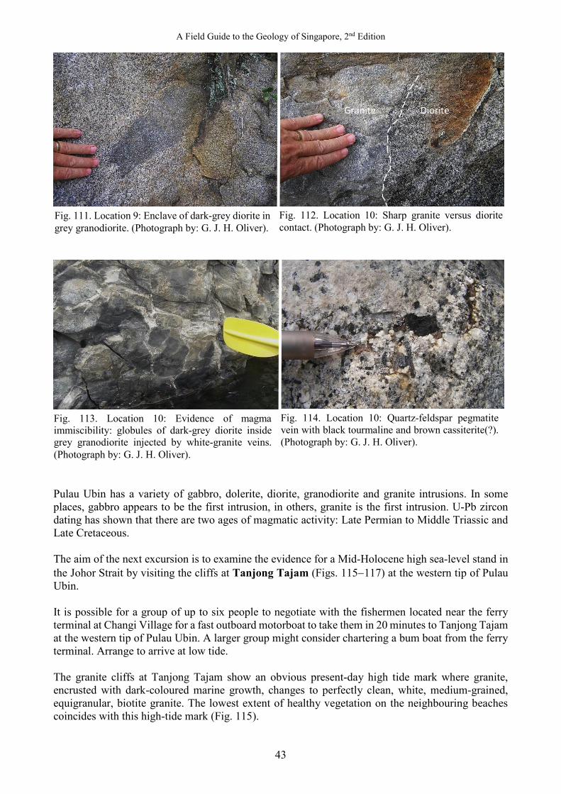
A Field Guide to the Geology of Singapore, 2nd Edition
43
Pulau Ubin has a variety of gabbro, dolerite, diorite, granodiorite and granite intrusions. In some places, gabbro appears to be the first intrusion, in others, granite is the first intrusion. U-Pb zircon dating has shown that there are two ages of magmatic activity: Late Permian to Middle Triassic and Late Cretaceous. The aim of the next excursion is to examine the evidence for a Mid-Holocene high sea-level stand in the Johor Strait by visiting the cliffs at Tanjong Tajam (Figs. 115−117) at the western tip of Pulau Ubin. It is possible for a group of up to six people to negotiate with the fishermen located near the ferry terminal at Changi Village for a fast outboard motorboat to take them in 20 minutes to Tanjong Tajam at the western tip of Pulau Ubin. A larger group might consider chartering a bum boat from the ferry terminal. Arrange to arrive at low tide. The granite cliffs at Tanjong Tajam show an obvious present-day high tide mark where granite, encrusted with dark-coloured marine growth, changes to perfectly clean, white, medium-grained, equigranular, biotite granite. The lowest extent of healthy vegetation on the neighbouring beaches coincides with this high-tide mark (Fig. 115).
Granite Diorite
Fig. 111. Location 9: Enclave of dark-grey diorite in grey granodiorite. (Photograph by: G. J. H. Oliver).
Fig. 112. Location 10: Sharp granite versus diorite contact. (Photograph by: G. J. H. Oliver).
Fig. 113. Location 10: Evidence of magma immiscibility: globules of dark-grey diorite inside grey granodiorite injected by white-granite veins. (Photograph by: G. J. H. Oliver).
Fig. 114. Location 10: Quartz-feldspar pegmatite vein with black tourmaline and brown cassiterite(?). (Photograph by: G. J. H. Oliver).
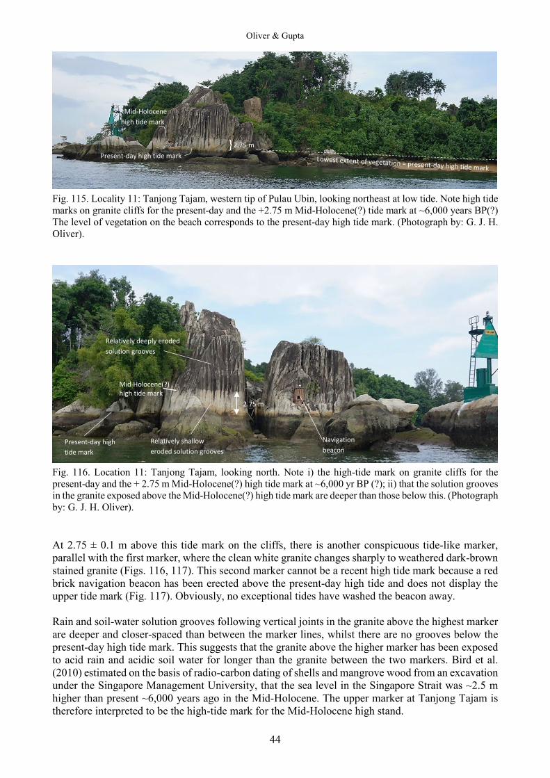
Oliver & Gupta
44
Fig. 115. Locality 11: Tanjong Tajam, western tip of Pulau Ubin, looking northeast at low tide. Note high tide marks on granite cliffs for the present-day and the +2.75 m Mid-Holocene(?) tide mark at ~6,000 years BP(?) The level of vegetation on the beach corresponds to the present-day high tide mark. (Photograph by: G. J. H. Oliver).
Fig. 116. Location 11: Tanjong Tajam, looking north. Note i) the high-tide mark on granite cliffs for the present-day and the + 2.75 m Mid-Holocene(?) high tide mark at ~6,000 yr BP (?); ii) that the solution grooves in the granite exposed above the Mid-Holocene(?) high tide mark are deeper than those below this. (Photograph by: G. J. H. Oliver). At 2.75 ± 0.1 m above this tide mark on the cliffs, there is another conspicuous tide-like marker, parallel with the first marker, where the clean white granite changes sharply to weathered dark-brown stained granite (Figs. 116, 117). This second marker cannot be a recent high tide mark because a red brick navigation beacon has been erected above the present-day high tide and does not display the upper tide mark (Fig. 117). Obviously, no exceptional tides have washed the beacon away. Rain and soil-water solution grooves following vertical joints in the granite above the highest marker are deeper and closer-spaced than between the marker lines, whilst there are no grooves below the present-day high tide mark. This suggests that the granite above the higher marker has been exposed to acid rain and acidic soil water for longer than the granite between the two markers. Bird et al. (2010) estimated on the basis of radio-carbon dating of shells and mangrove wood from an excavation under the Singapore Management University, that the sea level in the Singapore Strait was ~2.5 m higher than present ~6,000 years ago in the Mid-Holocene. The upper marker at Tanjong Tajam is therefore interpreted to be the high-tide mark for the Mid-Holocene high stand.
Present-day high tide mark
Mid-Holocene high tide mark
} 2.75 m
Mid-Holocene(?) high tide mark
Present-day high tide mark
Relatively deeply eroded solution grooves
Relatively shallow eroded solution grooves
2.75 m
Navigation beacon
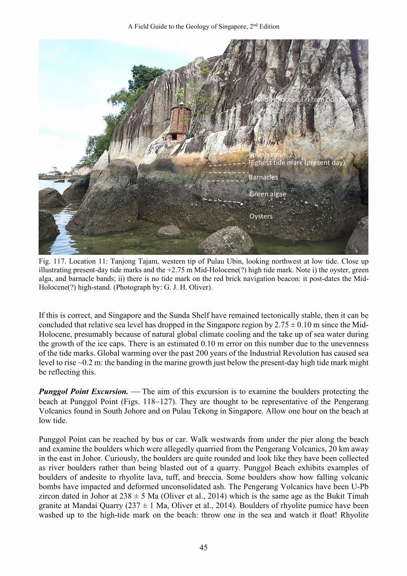
A Field Guide to the Geology of Singapore, 2nd Edition
45
Fig. 117. Location 11: Tanjong Tajam, western tip of Pulau Ubin, looking northwest at low tide. Close up illustrating present-day tide marks and the +2.75 m Mid-Holocene(?) high tide mark. Note i) the oyster, green alga, and barnacle bands; ii) there is no tide mark on the red brick navigation beacon: it post-dates the Mid-Holocene(?) high-stand. (Photograph by: G. J. H. Oliver). If this is correct, and Singapore and the Sunda Shelf have remained tectonically stable, then it can be concluded that relative sea level has dropped in the Singapore region by 2.75 ± 0.10 m since the Mid-Holocene, presumably because of natural global climate cooling and the take up of sea water during the growth of the ice caps. There is an estimated 0.10 m error on this number due to the unevenness of the tide marks. Global warming over the past 200 years of the Industrial Revolution has caused sea level to rise ~0.2 m: the banding in the marine growth just below the present-day high tide mark might be reflecting this. Punggol Point Excursion. The aim of this excursion is to examine the boulders protecting the beach at Punggol Point (Figs. 118−127). They are thought to be representative of the Pengerang Volcanics found in South Johore and on Pulau Tekong in Singapore. Allow one hour on the beach at low tide. Punggol Point can be reached by bus or car. Walk westwards from under the pier along the beach and examine the boulders which were allegedly quarried from the Pengerang Volcanics, 20 km away in the east in Johor. Curiously, the boulders are quite rounded and look like they have been collected as river boulders rather than being blasted out of a quarry. Punggol Beach exhibits examples of boulders of andesite to rhyolite lava, tuff, and breccia. Some boulders show how falling volcanic bombs have impacted and deformed unconsolidated ash. The Pengerang Volcanics have been U-Pb zircon dated in Johor at 238 ± 5 Ma (Oliver et al., 2014) which is the same age as the Bukit Timah granite at Mandai Quarry (237 ± 1 Ma, Oliver et al., 2014). Boulders of rhyolite pumice have been washed up to the high-tide mark on the beach: throw one in the sea and watch it float! Rhyolite
Mid-Holocene (?) high tide mark
Splash zone Highest tide mark (present day)
Barnacles
Green algae
Oysters
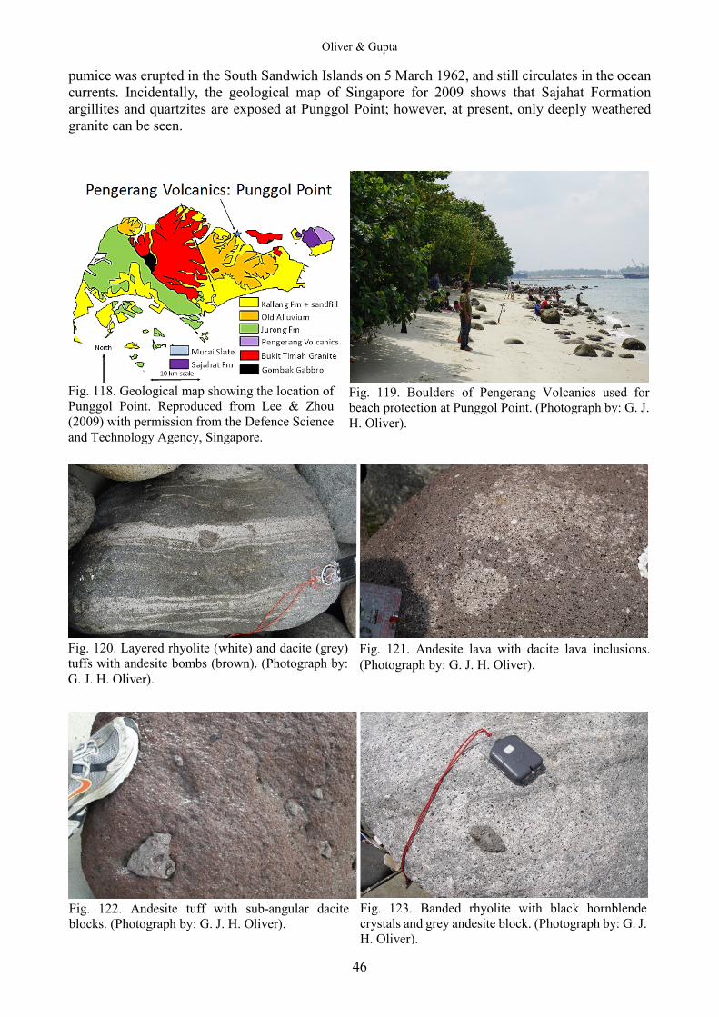
Oliver & Gupta
46
pumice was erupted in the South Sandwich Islands on 5 March 1962, and still circulates in the ocean currents. Incidentally, the geological map of Singapore for 2009 shows that Sajahat Formation argillites and quartzites are exposed at Punggol Point; however, at present, only deeply weathered granite can be seen.
Fig. 120. Layered rhyolite (white) and dacite (grey) tuffs with andesite bombs (brown). (Photograph by: G. J. H. Oliver).
Fig. 121. Andesite lava with dacite lava inclusions. (Photograph by: G. J. H. Oliver).
Fig. 122. Andesite tuff with sub-angular dacite blocks. (Photograph by: G. J. H. Oliver).
Fig. 123. Banded rhyolite with black hornblende crystals and grey andesite block. (Photograph by: G. J. H. Oliver).
Fig. 118. Geological map showing the location of Punggol Point. Reproduced from Lee & Zhou (2009) with permission from the Defence Science and Technology Agency, Singapore.
Fig. 119. Boulders of Pengerang Volcanics used for beach protection at Punggol Point. (Photograph by: G. J. H. Oliver).
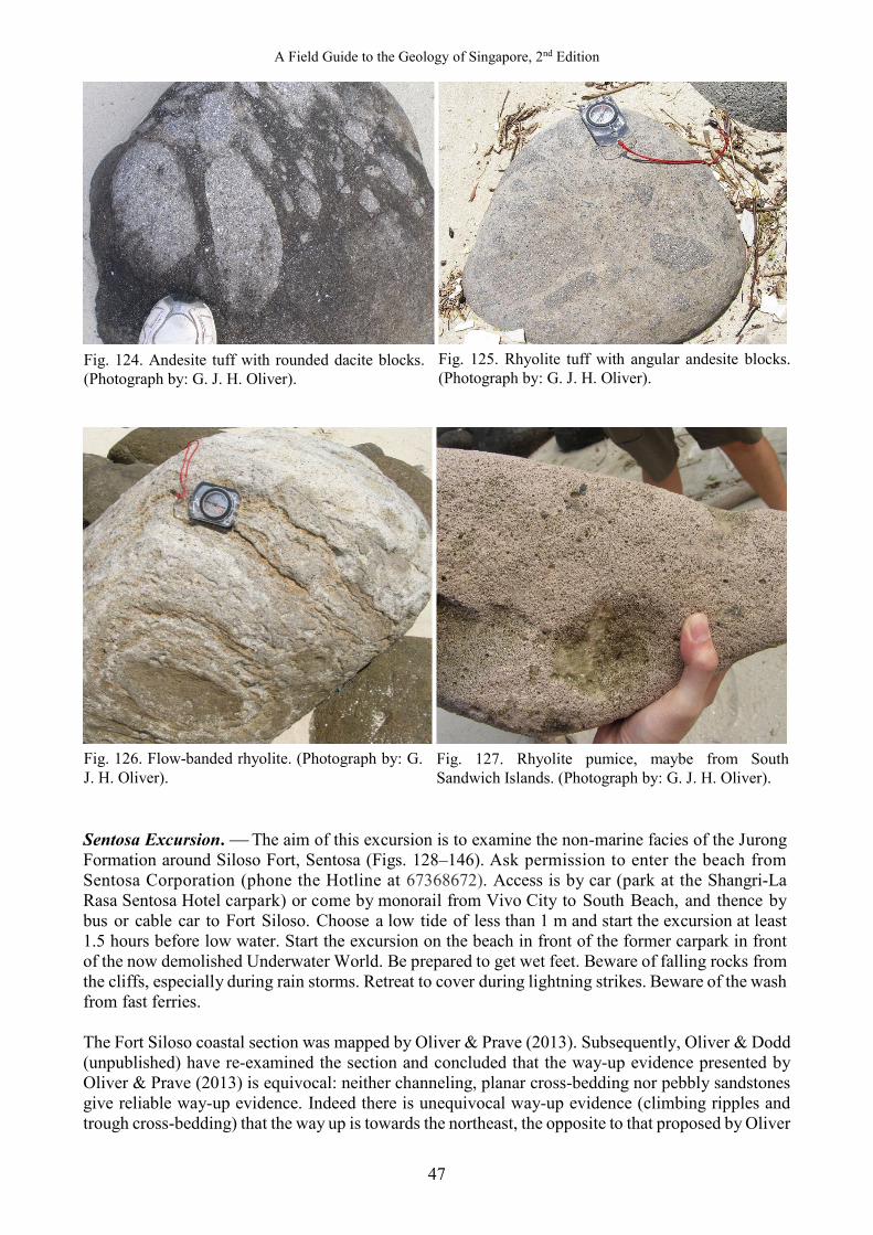
A Field Guide to the Geology of Singapore, 2nd Edition
47
Sentosa Excursion. The aim of this excursion is to examine the non-marine facies of the Jurong Formation around Siloso Fort, Sentosa (Figs. 128–146). Ask permission to enter the beach from Sentosa Corporation (phone the Hotline at 67368672). Access is by car (park at the Shangri-La Rasa Sentosa Hotel carpark) or come by monorail from Vivo City to South Beach, and thence by bus or cable car to Fort Siloso. Choose a low tide of less than 1 m and start the excursion at least 1.5 hours before low water. Start the excursion on the beach in front of the former carpark in front of the now demolished Underwater World. Be prepared to get wet feet. Beware of falling rocks from the cliffs, especially during rain storms. Retreat to cover during lightning strikes. Beware of the wash from fast ferries. The Fort Siloso coastal section was mapped by Oliver & Prave (2013). Subsequently, Oliver & Dodd (unpublished) have re-examined the section and concluded that the way-up evidence presented by Oliver & Prave (2013) is equivocal: neither channeling, planar cross-bedding nor pebbly sandstones give reliable way-up evidence. Indeed there is unequivocal way-up evidence (climbing ripples and trough cross-bedding) that the way up is towards the northeast, the opposite to that proposed by Oliver
Fig. 124. Andesite tuff with rounded dacite blocks. (Photograph by: G. J. H. Oliver).
Fig. 125. Rhyolite tuff with angular andesite blocks. (Photograph by: G. J. H. Oliver).
Fig. 126. Flow-banded rhyolite. (Photograph by: G. J. H. Oliver).
Fig. 127. Rhyolite pumice, maybe from South Sandwich Islands. (Photograph by: G. J. H. Oliver).
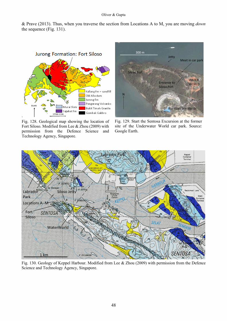
Oliver & Gupta
48
& Prave (2013). Thus, when you traverse the section from Locations A to M, you are moving down the sequence (Fig. 131).
.
JettyMeet in car park
WATERWORLD
300 m
N
Siloso Fort
Entrance to Siloso Fort
Bus stop/Taxi stands
Fig. 130. Geology of Keppel Harbour. Modified from Lee & Zhou (2009) with permission from the Defence Science and Technology Agency, Singapore.
Fig. 128. Geological map showing the location of Fort Siloso. Modified from Lee & Zhou (2009) with permission from the Defence Science and Technology Agency, Singapore.
Fig. 129. Start the Sentosa Excursion at the former site of the Underwater World car park. Source: Google Earth.
Labrador Park
Labrador Park
Siloso Jetty
Locations A−M
Fort Siloso
WaterWorld
1 km

A Field Guide to the Geology of Singapore, 2nd Edition
49
Fig. 131. Geological map of the northwest end of Sentosa with locations of outcrops A‒M. Mapped and drawn by G. J. H. Oliver. Figs. 132 to 146 are illustrations of outcrops A to M, respectively, in Fig. 131. They show the continental red-beds of the Jurong Formation along the forshore underneath Fort Siloso, Sentosa. According to Lee & Zhou (2009), Locations A to B are mapped as the St. John Facies, i.e., flycsh-like marine muddy fine sandstone with minor laminae of carbonaceous materials. By definition, flysch is a deep marine sediment: these chanellised sandstones are interpreted by Oliver & Prave (2013) to be fluvial deposits.
Fig. 132. Locality A: Channelised yellow sandstone interpreted as fluvial. The top of the photo is towards the southeast. The beds are younging from right to left, i.e., towards the northeast. (Photograph by: G. J. H. Oliver).
M
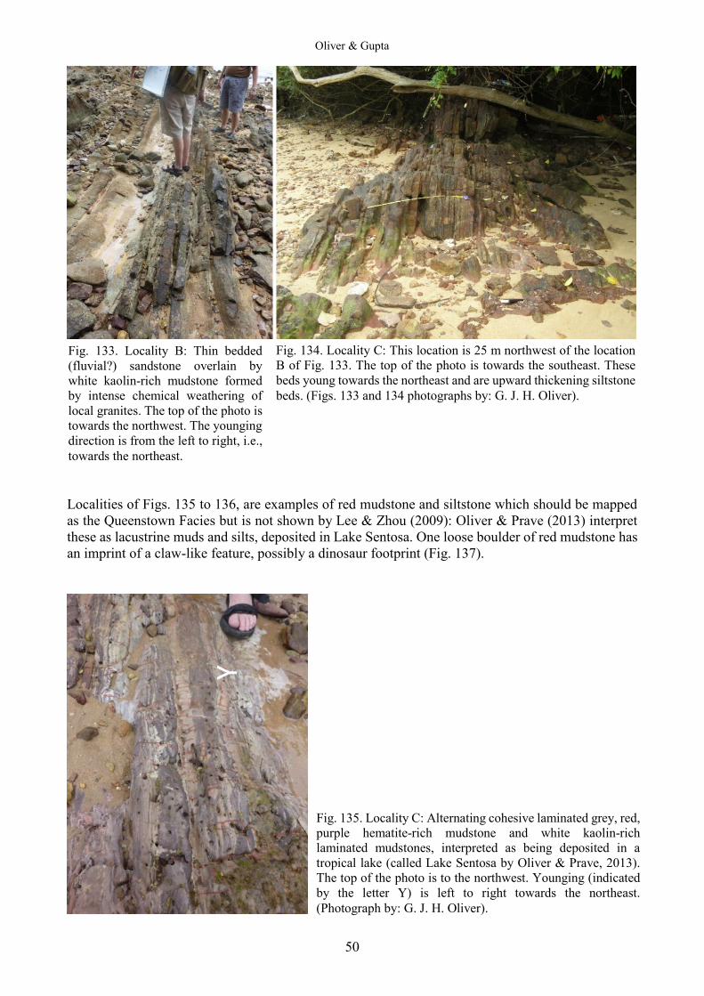
Oliver & Gupta
50
Localities of Figs. 135 to 136, are examples of red mudstone and siltstone which should be mapped as the Queenstown Facies but is not shown by Lee & Zhou (2009): Oliver & Prave (2013) interpret these as lacustrine muds and silts, deposited in Lake Sentosa. One loose boulder of red mudstone has an imprint of a claw-like feature, possibly a dinosaur footprint (Fig. 137).
Y
Fig. 133. Locality B: Thin bedded (fluvial?) sandstone overlain by white kaolin-rich mudstone formed by intense chemical weathering of local granites. The top of the photo is towards the northwest. The younging direction is from the left to right, i.e., towards the northeast.
Fig. 134. Locality C: This location is 25 m northwest of the location B of Fig. 133. The top of the photo is towards the southeast. These beds young towards the northeast and are upward thickening siltstone beds. (Figs. 133 and 134 photographs by: G. J. H. Oliver).
Fig. 135. Locality C: Alternating cohesive laminated grey, red, purple hematite-rich mudstone and white kaolin-rich laminated mudstones, interpreted as being deposited in a tropical lake (called Lake Sentosa by Oliver & Prave, 2013). The top of the photo is to the northwest. Younging (indicated by the letter Y) is left to right towards the northeast. (Photograph by: G. J. H. Oliver).

A Field Guide to the Geology of Singapore, 2nd Edition
51
Fig. 136. Locality D: Close up of earthy hematite-rich mudstone; note the tiny flakes of detrital, silvery muscovite, possibly a soil horizon eroded from granite or gneiss. (Photograph by: G. J. H. Oliver).
Fig. 137. Locality E: Possible dinosaur claw print in red mudstone: scale is indicated by the tip of the pen. Loose block. (Photograph by: G. J. H. Oliver).
Fig. 138. Locality E: Red and purple mudstones with yellow siltstone associated with possible claw print. The siltstone is cross-bedded indicating younging towards the northeast. Plan view, top of photo is towards the southeast. Hammer for scale is 30 cm long. (Photograph by: G. J. H. Oliver).

Oliver & Gupta
52
Localities illustrated by Figs. 139 to 146, F to M are from around Serang Rimau Point, the type-section of the “transitional” Rimau Facies of Lee & Zhou (2009). Oliver & Prave (2013) interpret these sands and gravels to have been deposited in river delta channels flowing into Lake Sentosa.
Fig. 141. Locality I: Vertical, mottled purple, lake bed silt and sandstone from Serang Rimau, burrowed by worms. Note both purple silt filled- and white sand-filled, near vertical Skolithos burrows. Strata young towards the northeast from right to left. (Photograph by: G. J. H. Oliver).
Y
Y Fig. 139. Locality F: Typical pebble conglomerate showing graded distribution of clasts including vein quartz, granite, gabbro, and slate. Bedding is younging (Y) right to left to the northeast. This is interpreted as flood channel fills on a delta top. (Photograph by: G. J. H. Oliver).
Fig. 140. Locality G: Graded pebble conglomerate in sharp contact with white siltstone; coarser ‘armoured’ bed tops are inferred to be water-winnowed lags. The top of photo is to the southeast, younging (Y) is right to left towards the northeast. (Photograph by: G. J. H. Oliver).
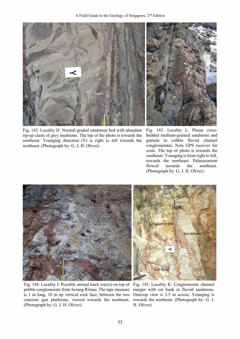
A Field Guide to the Geology of Singapore, 2nd Edition
53
Fig. 144. Locality J: Possible animal track way(s) on top of pebble conglomerate from Serang Rimau. The tape measure is 1 m long. 10 m up vertical rock face, between the two concrete gun platforms, viewed towards the northeast. (Photograph by: G. J. H. Oliver).
Fig. 145. Locality K: Conglomerate channel margin with cut bank in fluvial sandstone. Outcrop view is 2.5 m across. Younging is towards the northeast. (Photograph by: G. J. H. Oliver).
Fig. 142. Locality H: Normal graded sandstone bed with abundant rip-up clasts of grey mudstone. The top of the photo is towards the southeast. Younging direction (Y) is right to left towards the northeast. (Photograph by: G. J. H. Oliver).
Fig. 143. Locality L: Planar cross-bedded medium-grained sandstone and granule to cobble fluvial channel conglomerates. Note GPS receiver for scale. The top of photo is towards the southeast. Younging is from right to left, towards the northeast. Palaeocurrent flowed towards the southeast. (Photograph by: G. J. H. Oliver).
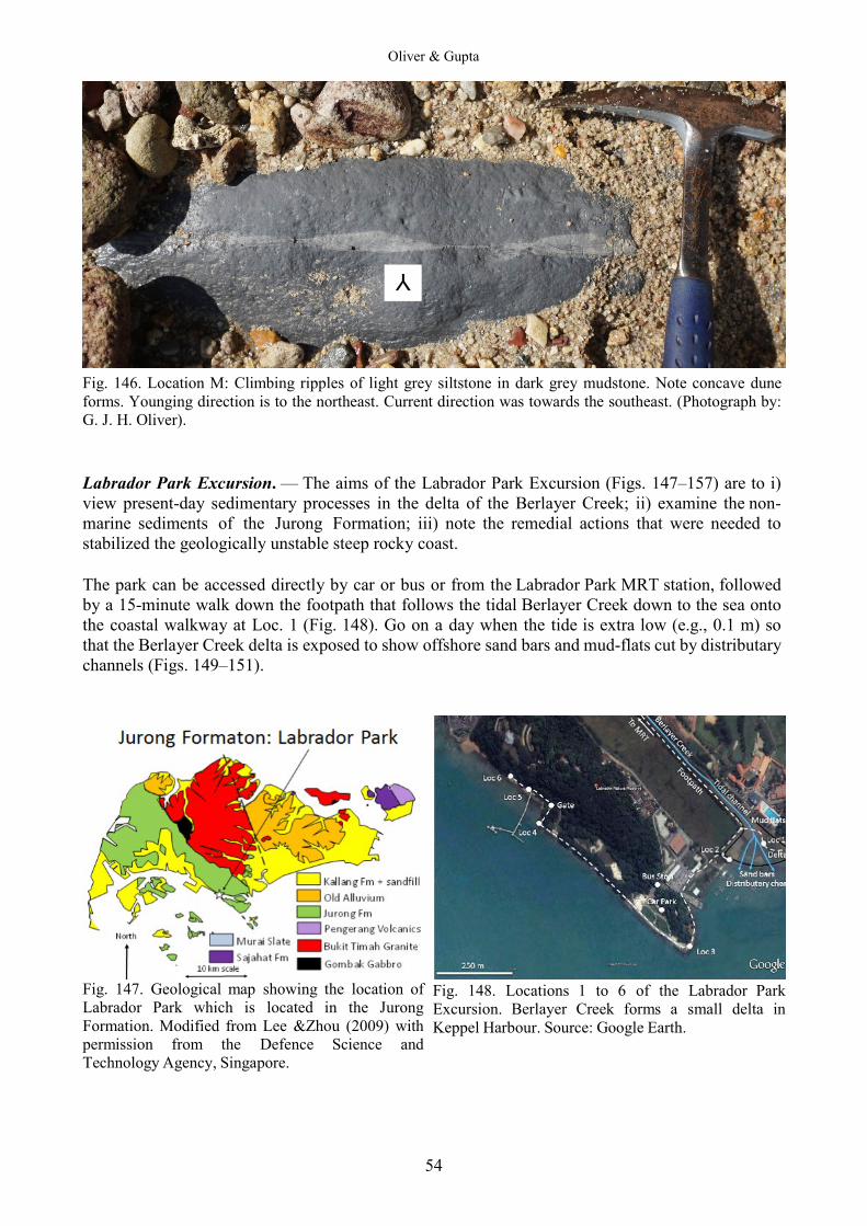
Oliver & Gupta
54
Fig. 146. Location M: Climbing ripples of light grey siltstone in dark grey mudstone. Note concave dune forms. Younging direction is to the northeast. Current direction was towards the southeast. (Photograph by: G. J. H. Oliver). Labrador Park Excursion. — The aims of the Labrador Park Excursion (Figs. 147–157) are to i) view present-day sedimentary processes in the delta of the Berlayer Creek; ii) examine the non-marine sediments of the Jurong Formation; iii) note the remedial actions that were needed to stabilized the geologically unstable steep rocky coast. The park can be accessed directly by car or bus or from the Labrador Park MRT station, followed by a 15-minute walk down the footpath that follows the tidal Berlayer Creek down to the sea onto the coastal walkway at Loc. 1 (Fig. 148). Go on a day when the tide is extra low (e.g., 0.1 m) so that the Berlayer Creek delta is exposed to show offshore sand bars and mud-flats cut by distributary channels (Figs. 149–151).
Fig. 147. Geological map showing the location of Labrador Park which is located in the Jurong Formation. Modified from Lee &Zhou (2009) with permission from the Defence Science and Technology Agency, Singapore.
Fig. 148. Locations 1 to 6 of the Labrador Park Excursion. Berlayer Creek forms a small delta in Keppel Harbour. Source: Google Earth.
Y
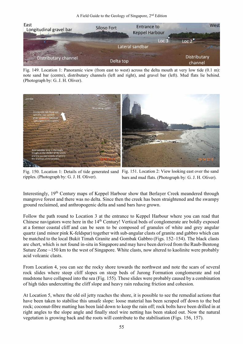
A Field Guide to the Geology of Singapore, 2nd Edition
55
Fig. 149. Location 1: Panoramic view (from east to west) across the delta mouth at very low tide (0.1 m): note sand bar (centre), distributary channels (left and right), and gravel bar (left). Mud flats lie behind. (Photograph by: G. J. H. Oliver).
Fig. 150. Location 1: Details of tide generated sand ripples. (Photograph by: G. J. H. Oliver). Interestingly, 19th Century maps of Keppel Harbour show that Berlayer Creek meandered through mangrove forest and there was no delta. Since then the creek has been straightened and the swampy ground reclaimed, and anthropogenic delta and sand bars have grown. Follow the path round to Location 3 at the entrance to Keppel Harbour where you can read that Chinese navigators were here in the 14th Century! Vertical beds of conglomerate are boldly exposed at a former coastal cliff and can be seen to be composed of granules of white and grey angular quartz (and minor pink K-feldspar) together with sub-angular clasts of granite and gabbro which can be matched to the local Bukit Timah Granite and Gombak Gabbro (Figs. 152–154). The black clasts are chert, which is not found in-situ in Singapore and may have been derived from the Raub-Bentong Suture Zone ~150 km to the west of Singapore. White clasts, now altered to kaolinite were probably acid volcanic clasts. From Location 4, you can see the rocky shore towards the northwest and note the scars of several rock slides where steep cliff slopes on steep beds of Jurong Formation conglomerate and red mudstone have collapsed into the sea (Fig. 155). These slides were probably caused by a combination of high tides undercutting the cliff slope and heavy rain reducing friction and cohesion. At Location 5, where the old oil jetty reaches the shore, it is possible to see the remedial actions that have been taken to stabilise this unsafe slope: loose material has been scraped off down to the bed rock; coconut-fibre matting has been laid down to keep the rain off; rock bolts have been drilled in at right angles to the slope angle and finally steel wire netting has been staked out. Now the natural vegetation is growing back and the roots will contribute to the stabilisation (Figs. 156, 157).
Fig. 151. Location 2: View looking east over the sand bars and mud flats. (Photograph by: G. J. H. Oliver).
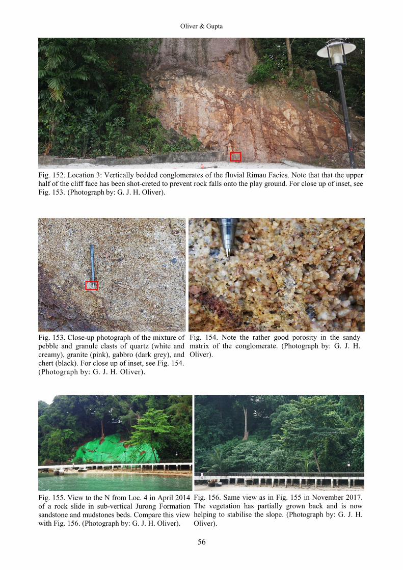
Oliver & Gupta
56
Fig. 152. Location 3: Vertically bedded conglomerates of the fluvial Rimau Facies. Note that that the upper half of the cliff face has been shot-creted to prevent rock falls onto the play ground. For close up of inset, see Fig. 153. (Photograph by: G. J. H. Oliver).
Fig. 153. Close-up photograph of the mixture of pebble and granule clasts of quartz (white and creamy), granite (pink), gabbro (dark grey), and chert (black). For close up of inset, see Fig. 154. (Photograph by: G. J. H. Oliver).
Fig. 155. View to the N from Loc. 4 in April 2014 of a rock slide in sub-vertical Jurong Formation sandstone and mudstones beds. Compare this view with Fig. 156. (Photograph by: G. J. H. Oliver).
Fig. 154. Note the rather good porosity in the sandy matrix of the conglomerate. (Photograph by: G. J. H. Oliver).
Fig. 156. Same view as in Fig. 155 in November 2017. The vegetation has partially grown back and is now helping to stabilise the slope. (Photograph by: G. J. H. Oliver).
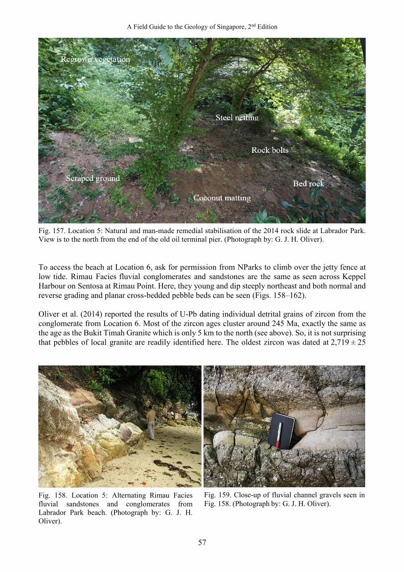
A Field Guide to the Geology of Singapore, 2nd Edition
57
Fig. 157. Location 5: Natural and man-made remedial stabilisation of the 2014 rock slide at Labrador Park. View is to the north from the end of the old oil terminal pier. (Photograph by: G. J. H. Oliver). To access the beach at Location 6, ask for permission from NParks to climb over the jetty fence at low tide. Rimau Facies fluvial conglomerates and sandstones are the same as seen across Keppel Harbour on Sentosa at Rimau Point. Here, they young and dip steeply northeast and both normal and reverse grading and planar cross-bedded pebble beds can be seen (Figs. 158–162). Oliver et al. (2014) reported the results of U-Pb dating individual detrital grains of zircon from the conglomerate from Location 6. Most of the zircon ages cluster around 245 Ma, exactly the same as the age as the Bukit Timah Granite which is only 5 km to the north (see above). So, it is not surprising that pebbles of local granite are readily identified here. The oldest zircon was dated at 2,719 ± 25
Fig. 158. Location 5: Alternating Rimau Facies fluvial sandstones and conglomerates from Labrador Park beach. (Photograph by: G. J. H. Oliver).
Fig. 159. Close-up of fluvial channel gravels seen in Fig. 158. (Photograph by: G. J. H. Oliver).
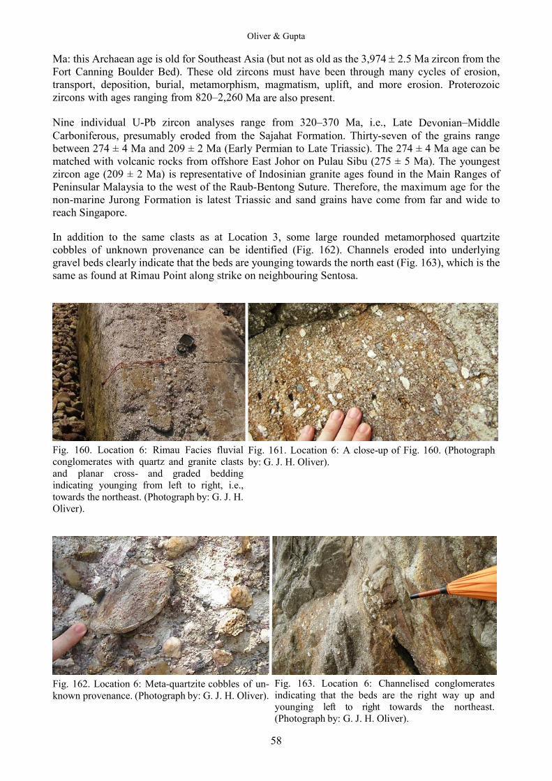
Oliver & Gupta
58
Ma: this Archaean age is old for Southeast Asia (but not as old as the 3,974 ± 2.5 Ma zircon from the Fort Canning Boulder Bed). These old zircons must have been through many cycles of erosion, transport, deposition, burial, metamorphism, magmatism, uplift, and more erosion. Proterozoic zircons with ages ranging from 820–2,260 Ma are also present. Nine individual U-Pb zircon analyses range from 320–370 Ma, i.e., Late Devonian–Middle Carboniferous, presumably eroded from the Sajahat Formation. Thirty-seven of the grains range between 274 ± 4 Ma and 209 ± 2 Ma (Early Permian to Late Triassic). The 274 ± 4 Ma age can be matched with volcanic rocks from offshore East Johor on Pulau Sibu (275 ± 5 Ma). The youngest zircon age (209 ± 2 Ma) is representative of Indosinian granite ages found in the Main Ranges of Peninsular Malaysia to the west of the Raub-Bentong Suture. Therefore, the maximum age for the non-marine Jurong Formation is latest Triassic and sand grains have come from far and wide to reach Singapore. In addition to the same clasts as at Location 3, some large rounded metamorphosed quartzite cobbles of unknown provenance can be identified (Fig. 162). Channels eroded into underlying gravel beds clearly indicate that the beds are younging towards the north east (Fig. 163), which is the same as found at Rimau Point along strike on neighbouring Sentosa.
Fig. 160. Location 6: Rimau Facies fluvial conglomerates with quartz and granite clasts and planar cross- and graded bedding indicating younging from left to right, i.e., towards the northeast. (Photograph by: G. J. H. Oliver).
Fig. 162. Location 6: Meta-quartzite cobbles of un-known provenance. (Photograph by: G. J. H. Oliver).
Fig. 161. Location 6: A close-up of Fig. 160. (Photograph by: G. J. H. Oliver).
Fig. 163. Location 6: Channelised conglomerates indicating that the beds are the right way up and younging left to right towards the northeast. (Photograph by: G. J. H. Oliver).
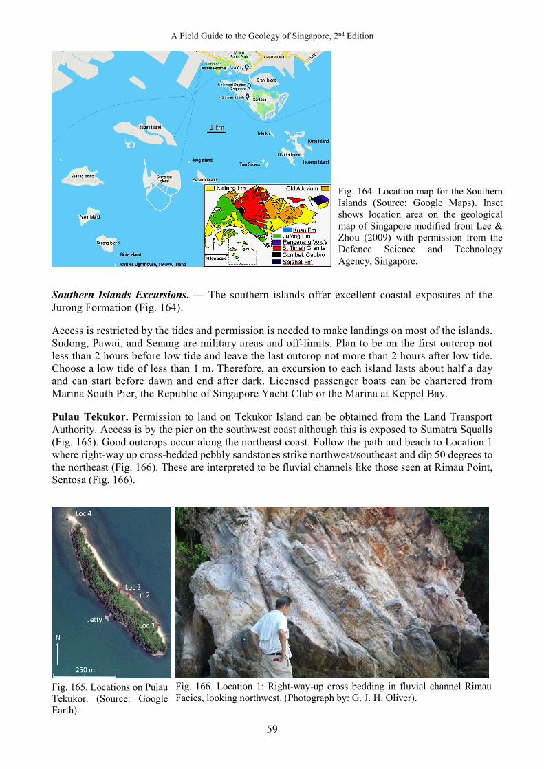
A Field Guide to the Geology of Singapore, 2nd Edition
59
Southern Islands Excursions. — The southern islands offer excellent coastal exposures of the Jurong Formation (Fig. 164). Access is restricted by the tides and permission is needed to make landings on most of the islands. Sudong, Pawai, and Senang are military areas and off-limits. Plan to be on the first outcrop not less than 2 hours before low tide and leave the last outcrop not more than 2 hours after low tide. Choose a low tide of less than 1 m. Therefore, an excursion to each island lasts about half a day and can start before dawn and end after dark. Licensed passenger boats can be chartered from Marina South Pier, the Republic of Singapore Yacht Club or the Marina at Keppel Bay. Pulau Tekukor. Permission to land on Tekukor Island can be obtained from the Land Transport Authority. Access is by the pier on the southwest coast although this is exposed to Sumatra Squalls (Fig. 165). Good outcrops occur along the northeast coast. Follow the path and beach to Location 1 where right-way up cross-bedded pebbly sandstones strike northwest/southeast and dip 50 degrees to the northeast (Fig. 166). These are interpreted to be fluvial channels like those seen at Rimau Point, Sentosa (Fig. 166).
Fig. 165. Locations on Pulau Tekukor. (Source: Google Earth).
Fig. 164. Location map for the Southern Islands (Source: Google Maps). Inset shows location area on the geological map of Singapore modified from Lee & Zhou (2009) with permission from the Defence Science and Technology Agency, Singapore.
Fig. 166. Location 1: Right-way-up cross bedding in fluvial channel Rimau Facies, looking northwest. (Photograph by: G. J. H. Oliver).

Oliver & Gupta
60
At Location 2, ductile shear zones in quartz-rich conglomerate can be seen (Figs. 167, 168). A black biotite schist clast probably originated from the Sajahat Formation. Sub-vertical pebbly sandstone and conglomerate at Location 3 have graded and cross beds that young to the northeast. They are in conformable sedimentary contact with reds siltstones (Fig. 169) which have a strong penetrative cleavage that dips 35° to the southwest (Fig. 170). The cleavage is facing sideways to the northeast: either it may have been stronly refracted, or there may be a flat lying antiformal structure hereabouts. A bedding plane on the cliff face near Location 3 has a pattern of green (reduced) cracks in red silt (stone) which resembles mud cracks (Fig. 171). These siltstones may represent overbank flood deposits, associated with the river channel sands and gravels. There is a prominent sea stack of graded pebbly sandstone at the northwest tip of the island, younging towards the northeast (Location 4, Fig. 172).
Fig. 167. Location 2: Ductile shear zone in quartz conglomerate. Note the black clast of biotite schist. Top is to the south. (Photograph by: G. J. H. Oliver).
Fig. 169. Location 3: Sub-vertical sandstone and conglomerate in sedimentary contact with cleaved red siltstones. Looking southeast. (Photograph by: G. J. H. Oliver).
Fig. 168. Location 2: Former sand and gravel beds in river channels: now lithified as sandstone and conglomerate. Looking southeast. (Photograph by: G. J. H. Oliver).
Fig. 170. Location 3: Close-up of the boxed area in Fig. 169 showing the southwest dipping cleavage in red siltstones. Looking southeast. Tape measure is 2 m long. (Photograph by: G. J. H. Oliver).

A Field Guide to the Geology of Singapore, 2nd Edition
61
Fig. 171. Location 3: Possible mud crack pattern on a bedding plane in red siltstones. (Photograph by: G. J. H. Oliver). St John’s Island. — The aim of this excursion is to examine the geology of St. John’s Island (Pulau Sakijang Bendera) and Kusu Island (Pulau Tembakul, Peak Island) which are basically an along-strike extension of the Jurong Formation seen on Sentosa and Tekuko, but with the advantage of better outcrops and the opportunity to observe a classic anticlinal fold structure. Access is by Singapore Island Cruise ferries, which depart from South Marina Pier at 9 am weekends and returns via Kusu Island by 6.30 pm. Alternatively, private charters can be arranged from South Marina Pier. The trip to St John’s Island takes ~30 minutes. Choose a day with a low spring tide at ~11.30 am or you will not be able to access the outcrops along the rocky shores. You will need a packed lunch and stout shoes to walk on the slippery rocks. You will likely get your feet wet. If you are travelling on the ferry then you need to plan your itinerary and move quite fast because you will be restricted by the tides and by the departure time of the last ferry from St John’s at ~4.30 pm.
Fig. 173. Geological map of St. John’s Island and neighbouring islands with Locations 1–11. Modified from Lee & Zhou (2009) with permission from the Defence Science and Technology Agency, Singapore.
Fig. 172. Location 4: Sea stack of graded pebbly sandstone, younging towards the northeast. (Photograph by: G. J. H. Oliver).
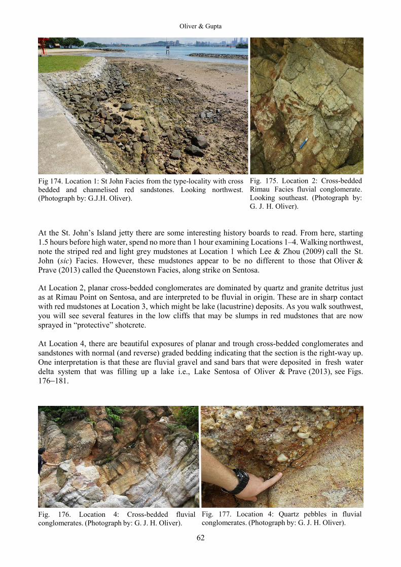
Oliver & Gupta
62
Fig 174. Location 1: St John Facies from the type-locality with cross bedded and channelised red sandstones. Looking northwest. (Photograph by: G.J.H. Oliver). At the St. John’s Island jetty there are some interesting history boards to read. From here, starting 1.5 hours before high water, spend no more than 1 hour examining Locations 1–4. Walking northwest, note the striped red and light grey mudstones at Location 1 which Lee & Zhou (2009) call the St. John (sic) Facies. However, these mudstones appear to be no different to those that Oliver & Prave (2013) called the Queenstown Facies, along strike on Sentosa. At Location 2, planar cross-bedded conglomerates are dominated by quartz and granite detritus just as at Rimau Point on Sentosa, and are interpreted to be fluvial in origin. These are in sharp contact with red mudstones at Location 3, which might be lake (lacustrine) deposits. As you walk southwest, you will see several features in the low cliffs that may be slumps in red mudstones that are now sprayed in “protective” shotcrete. At Location 4, there are beautiful exposures of planar and trough cross-bedded conglomerates and sandstones with normal (and reverse) graded bedding indicating that the section is the right-way up. One interpretation is that these are fluvial gravel and sand bars that were deposited in fresh water delta system that was filling up a lake i.e., Lake Sentosa of Oliver & Prave (2013), see Figs. 176–181.
Fig. 176. Location 4: Cross-bedded fluvial conglomerates. (Photograph by: G. J. H. Oliver).
Fig. 175. Location 2: Cross-bedded Rimau Facies fluvial conglomerate. Looking southeast. (Photograph by: G. J. H. Oliver).
Fig. 177. Location 4: Quartz pebbles in fluvial conglomerates. (Photograph by: G. J. H. Oliver).
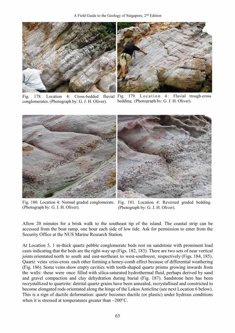
A Field Guide to the Geology of Singapore, 2nd Edition
63
Fig. 178. Location 4: Cross-bedded fluvial conglomerates. (Photograph by: G. J. H. Oliver).
Fig. 180. Location 4: Normal graded conglomerate. (Photograph by: G. J. H. Oliver). Allow 20 minutes for a brisk walk to the southeast tip of the island. The coastal strip can be accessed from the boat ramp, one hour each side of low tide. Ask for permission to enter from the Security Office at the NUS Marine Research Station. At Location 5, 1 m-thick quartz pebble conglomerate beds rest on sandstone with prominent load casts indicating that the beds are the right-way up (Figs. 182, 183). There are two sets of near vertical joints orientated north to south and east-northeast to west-southwest, respectively (Figs. 184, 185). Quartz veins criss-cross each other forming a honey-comb effect because of differential weathering (Fig. 186). Some veins show empty cavities with tooth-shaped quartz prisms growing inwards from the walls: these were once filled with silica-saturated hydrothermal fluid, perhaps derived by sand and gravel compaction and clay dehydration during burial (Fig. 187). Sandstone here has been recrystallized to quartzite: detrital quartz grains have been annealed, recrystallised and constricted to become elongated rods orientated along the hinge of the Lokos Anticline (see next Location 6 below). This is a sign of ductile deformation: quartz becomes ductile (or plastic) under hydrous conditions when it is stressed at temperatures greater than ~200°C.
Fig. 179. L o c a t i o n 4 : Fluvial trough-cross bedding. (Photograph by: G. J. H. Oliver).
Fig. 181. Location 4: Reversed graded bedding. (Photograph by: G. J. H. Oliver).
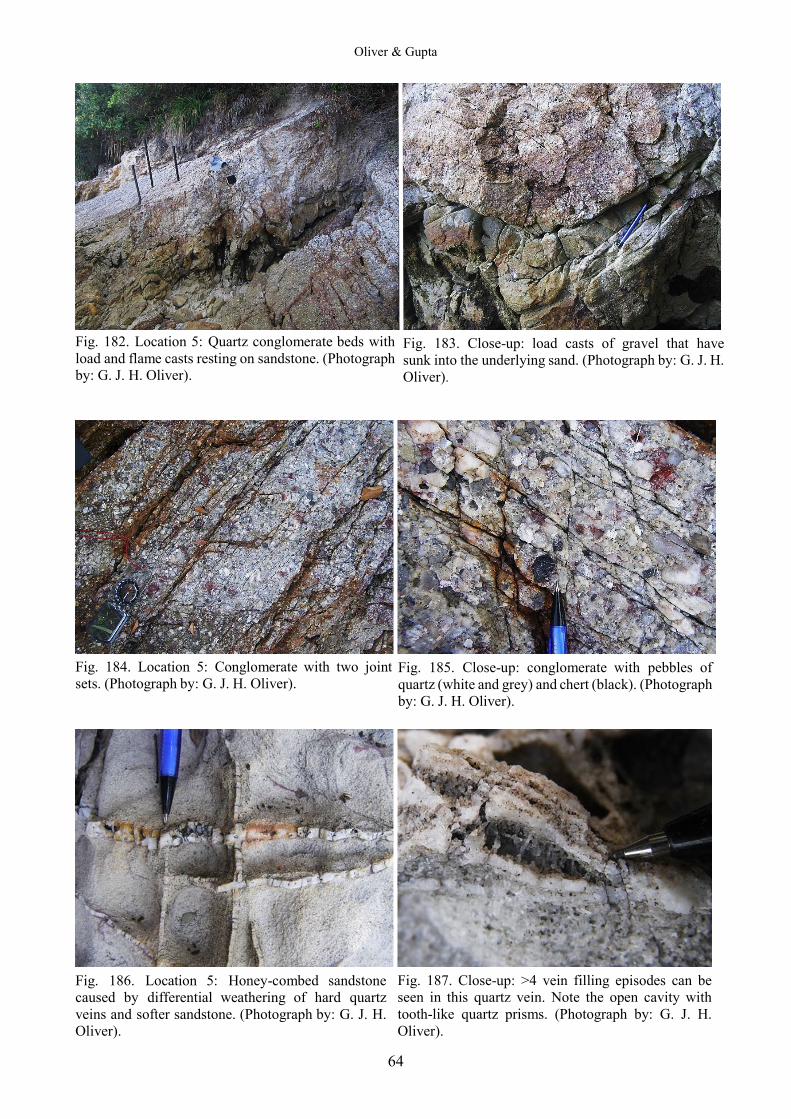
Oliver & Gupta
64
Fig. 182. Location 5: Quartz conglomerate beds with load and flame casts resting on sandstone. (Photograph by: G. J. H. Oliver).
Fig. 184. Location 5: Conglomerate with two joint sets. (Photograph by: G. J. H. Oliver).
Fig. 186. Location 5: Honey-combed sandstone caused by differential weathering of hard quartz veins and softer sandstone. (Photograph by: G. J. H. Oliver).
Fig. 183. Close-up: load casts of gravel that have sunk into the underlying sand. (Photograph by: G. J. H. Oliver).
Fig. 185. Close-up: conglomerate with pebbles of quartz (white and grey) and chert (black). (Photograph by: G. J. H. Oliver).
Fig. 187. Close-up: >4 vein filling episodes can be seen in this quartz vein. Note the open cavity with tooth-like quartz prisms. (Photograph by: G. J. H. Oliver).

A Field Guide to the Geology of Singapore, 2nd Edition
65
At the southeast tip of the island (Location 6, Tanjong Lokos) the Lokos Anticline is exposed in the cliff below the radar station (Fig. 189). Note how a spaced fracture cleavage in the sandstones radiates (i.e., refracts) around the fold limbs such that it dips northeast on the southwest limb and southwest on the northeast limb as defined by the bedding. The axial plane dips steeply to the southwest. The fold crest is horizontal and trends northwest/southeast. Sandstone in the core of the fold at sea level shows brittle crushing: the fold as a whole has formed in the brittle-ductile transition since the limbs exhibit ductile deformation (e.g., at Location 5). Because the bedding is the right way up, structural geologists would say “this fold faces up towards the northeast” (i.e., along the axial plane of the fold, the beds get younger upwards towards the northeast). This fold is not quite symmetric: it has an axial plane that dips steeply to the southwest and the northeast limb has a slightly shorter and steeper dip than the southwest limb. Structural geologists would say “this fold verges towards the northeast”.
Fig. 189. Location 6: Lokos Anticline, looking northwest. Note the refracted cleavage bedding geometries and the brittle crushed sandstone in the core of the fold. (Photographs by: G. J. H. Oliver).
Fig. 188. Location 5: Sandstone here has been recrystallised to become a quartzite. (Photograph by: G. J. H. Oliver).
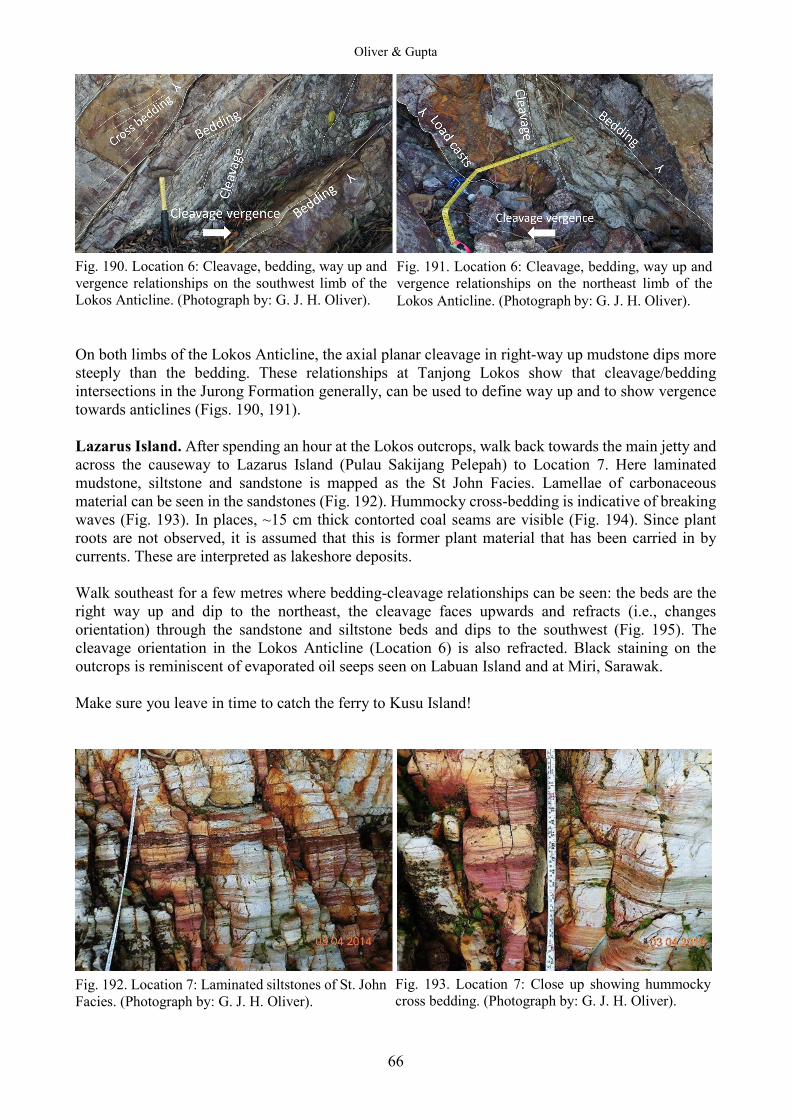
Oliver & Gupta
66
Fig. 190. Location 6: Cleavage, bedding, way up and vergence relationships on the southwest limb of the Lokos Anticline. (Photograph by: G. J. H. Oliver). On both limbs of the Lokos Anticline, the axial planar cleavage in right-way up mudstone dips more steeply than the bedding. These relationships at Tanjong Lokos show that cleavage/bedding intersections in the Jurong Formation generally, can be used to define way up and to show vergence towards anticlines (Figs. 190, 191). Lazarus Island. After spending an hour at the Lokos outcrops, walk back towards the main jetty and across the causeway to Lazarus Island (Pulau Sakijang Pelepah) to Location 7. Here laminated mudstone, siltstone and sandstone is mapped as the St John Facies. Lamellae of carbonaceous material can be seen in the sandstones (Fig. 192). Hummocky cross-bedding is indicative of breaking waves (Fig. 193). In places, ~15 cm thick contorted coal seams are visible (Fig. 194). Since plant roots are not observed, it is assumed that this is former plant material that has been carried in by currents. These are interpreted as lakeshore deposits. Walk southeast for a few metres where bedding-cleavage relationships can be seen: the beds are the right way up and dip to the northeast, the cleavage faces upwards and refracts (i.e., changes orientation) through the sandstone and siltstone beds and dips to the southwest (Fig. 195). The cleavage orientation in the Lokos Anticline (Location 6) is also refracted. Black staining on the outcrops is reminiscent of evaporated oil seeps seen on Labuan Island and at Miri, Sarawak. Make sure you leave in time to catch the ferry to Kusu Island!
Fig. 192. Location 7: Laminated siltstones of St. John Facies. (Photograph by: G. J. H. Oliver).
Fig. 191. Location 6: Cleavage, bedding, way up and vergence relationships on the northeast limb of the Lokos Anticline. (Photograph by: G. J. H. Oliver).
Fig. 193. Location 7: Close up showing hummocky cross bedding. (Photograph by: G. J. H. Oliver).
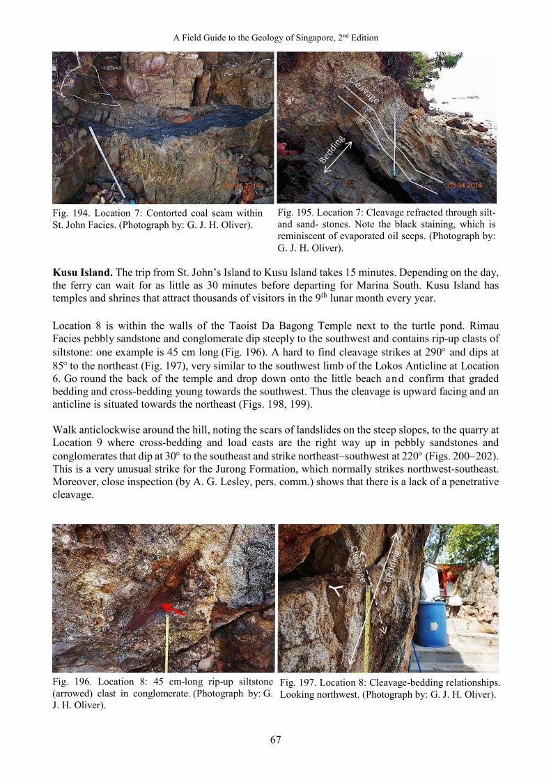
A Field Guide to the Geology of Singapore, 2nd Edition
67
Fig. 194. Location 7: Contorted coal seam within St. John Facies. (Photograph by: G. J. H. Oliver). Kusu Island. The trip from St. John’s Island to Kusu Island takes 15 minutes. Depending on the day, the ferry can wait for as little as 30 minutes before departing for Marina South. Kusu Island has temples and shrines that attract thousands of visitors in the 9th lunar month every year. Location 8 is within the walls of the Taoist Da Bagong Temple next to the turtle pond. Rimau Facies pebbly sandstone and conglomerate dip steeply to the southwest and contains rip-up clasts of siltstone: one example is 45 cm long (Fig. 196). A hard to find cleavage strikes at 290° and dips at 85° to the northeast (Fig. 197), very similar to the southwest limb of the Lokos Anticline at Location 6. Go round the back of the temple and drop down onto the little beach and confirm that graded bedding and cross-bedding young towards the southwest. Thus the cleavage is upward facing and an anticline is situated towards the northeast (Figs. 198, 199). Walk anticlockwise around the hill, noting the scars of landslides on the steep slopes, to the quarry at Location 9 where cross-bedding and load casts are the right way up in pebbly sandstones and conglomerates that dip at 30° to the southeast and strike northeast−southwest at 220° (Figs. 200−202). This is a very unusual strike for the Jurong Formation, which normally strikes northwest-southeast. Moreover, close inspection (by A. G. Lesley, pers. comm.) shows that there is a lack of a penetrative cleavage.
Fig. 196. Location 8: 45 cm-long rip-up siltstone (arrowed) clast in conglomerate. (Photograph by: G. J. H. Oliver).
Fig. 195. Location 7: Cleavage refracted through silt- and sand- stones. Note the black staining, which is reminiscent of evaporated oil seeps. (Photograph by: G. J. H. Oliver).
Fig. 197. Location 8: Cleavage-bedding relationships. Looking northwest. (Photograph by: G. J. H. Oliver).

Oliver & Gupta
68
In the first edition of this book, what is now seen as spaced parallel jointing was mistaken for cleavage. As noted in Part 1, U-Pb dating of detrital zircon from Location 9 shows that these fluvial deposits have a maximum age of 156 ± 1 Ma: i.e. Upper Jurassic, not Upper Triassic as in the Rimau Facies of the Jurong Formation. It is concluded that these uncleaved rocks on Kusu Island are a separate formation and are informally named here the Kusu Formation.
Fig. 200. Location 9: Cross bedding in Kusu Formation sandstones. (Photograph by: G. J. H. Oliver).
Fig. 201. Location 9: Cross bedding, load casts, and graded bedding. (Photograph by: G. J. H. Oliver).
Fig. 198. Location 8: Rimau Facies dipping steeply southwest with graded- and cross bedding younging towards the southwest. (Photograph by: G. J. H. Oliver).
Fig. 199. Location 8: Close-up plan view of cross bedding in Fig. 198, younging towards the southwest. (Photograph by: G. J. H. Oliver).
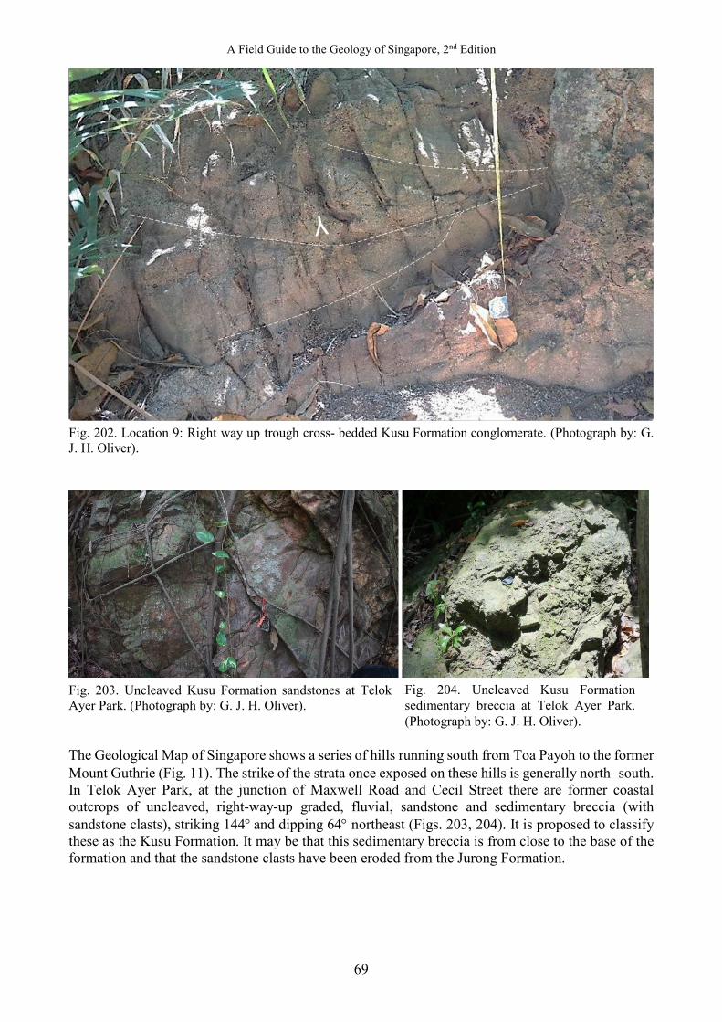
A Field Guide to the Geology of Singapore, 2nd Edition
69
Fig. 202. Location 9: Right way up trough cross- bedded Kusu Formation conglomerate. (Photograph by: G. J. H. Oliver).
Fig. 203. Uncleaved Kusu Formation sandstones at Telok Ayer Park. (Photograph by: G. J. H. Oliver). The Geological Map of Singapore shows a series of hills running south from Toa Payoh to the former Mount Guthrie (Fig. 11). The strike of the strata once exposed on these hills is generally north−south. In Telok Ayer Park, at the junction of Maxwell Road and Cecil Street there are former coastal outcrops of uncleaved, right-way-up graded, fluvial, sandstone and sedimentary breccia (with sandstone clasts), striking 144° and dipping 64° northeast (Figs. 203, 204). It is proposed to classify these as the Kusu Formation. It may be that this sedimentary breccia is from close to the base of the formation and that the sandstone clasts have been eroded from the Jurong Formation.
Fig. 204. Uncleaved Kusu Formation sedimentary breccia at Telok Ayer Park. (Photograph by: G. J. H. Oliver).
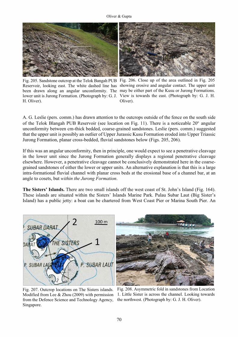
Oliver & Gupta
70
Fig. 205. Sandstone outcrop at the Telok Bangah PUB Reservoir, looking east. The white dashed line has been drawn along an angular unconformity. The lower unit is Jurong Formation. (Photograph by: G. J. H. Oliver). A. G. Leslie (pers. comm.) has drawn attention to the outcrops outside of the fence on the south side of the Telok Blangah PUB Reservoir (see location on Fig. 11). There is a noticeable 20° angular unconformity between cm-thick bedded, coarse-grained sandstones. Leslie (pers. comm.) suggested that the upper unit is possibly an outlier of Upper Jurassic Kusu Formation eroded into Upper Triassic Jurong Formation, planar cross-bedded, fluvial sandstones below (Figs. 205, 206). If this was an angular unconformity, then in principle, one would expect to see a penetrative cleavage in the lower unit since the Jurong Formation generally displays a regional penetrative cleavage elsewhere. However, a penetrative cleavage cannot be conclusively demonstrated here in the coarse-grained sandstones of either the lower or upper units. An alternative explanation is that this is a large intra-formational fluvial channel with planar cross beds at the erosional base of a channel bar, at an angle to cosets, but within the Jurong Formation. The Sisters’ Islands. There are two small islands off the west coast of St. John’s Island (Fig. 164). These islands are situated within the Sisters’ Islands Marine Park. Pulau Subar Laut (Big Sister’s Island) has a public jetty: a boat can be chartered from West Coast Pier or Marina South Pier. An
Fig. 207. Outcrop locations on The Sisters islands. Modified from Lee & Zhou (2009) with permission from the Defence Science and Technology Agency, Singapore.
Fig. 206. Close up of the area outlined in Fig. 205 showing erosive and angular contact. The upper unit may be either part of the Kusu or Jurong Formations. View is towards the east. (Photograph by: G. J. H. Oliver).
Fig. 208. Asymmetric fold in sandstones from Location 1. Little Sister is across the channel. Looking towards the northwest. (Photograph by: G. J. H. Oliver).
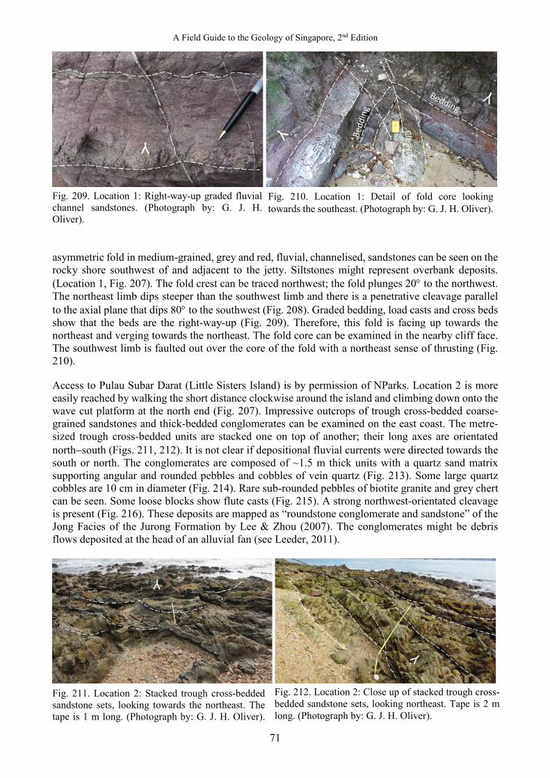
A Field Guide to the Geology of Singapore, 2nd Edition
71
Fig. 209. Location 1: Right-way-up graded fluvial channel sandstones. (Photograph by: G. J. H. Oliver). asymmetric fold in medium-grained, grey and red, fluvial, channelised, sandstones can be seen on the rocky shore southwest of and adjacent to the jetty. Siltstones might represent overbank deposits. (Location 1, Fig. 207). The fold crest can be traced northwest; the fold plunges 20° to the northwest. The northeast limb dips steeper than the southwest limb and there is a penetrative cleavage parallel to the axial plane that dips 80° to the southwest (Fig. 208). Graded bedding, load casts and cross beds show that the beds are the right-way-up (Fig. 209). Therefore, this fold is facing up towards the northeast and verging towards the northeast. The fold core can be examined in the nearby cliff face. The southwest limb is faulted out over the core of the fold with a northeast sense of thrusting (Fig. 210). Access to Pulau Subar Darat (Little Sisters Island) is by permission of NParks. Location 2 is more easily reached by walking the short distance clockwise around the island and climbing down onto the wave cut platform at the north end (Fig. 207). Impressive outcrops of trough cross-bedded coarse-grained sandstones and thick-bedded conglomerates can be examined on the east coast. The metre-sized trough cross-bedded units are stacked one on top of another; their long axes are orientated north−south (Figs. 211, 212). It is not clear if depositional fluvial currents were directed towards the south or north. The conglomerates are composed of ~1.5 m thick units with a quartz sand matrix supporting angular and rounded pebbles and cobbles of vein quartz (Fig. 213). Some large quartz cobbles are 10 cm in diameter (Fig. 214). Rare sub-rounded pebbles of biotite granite and grey chert can be seen. Some loose blocks show flute casts (Fig. 215). A strong northwest-orientated cleavage is present (Fig. 216). These deposits are mapped as “roundstone conglomerate and sandstone” of the Jong Facies of the Jurong Formation by Lee & Zhou (2007). The conglomerates might be debris flows deposited at the head of an alluvial fan (see Leeder, 2011).
Fig. 211. Location 2: Stacked trough cross-bedded sandstone sets, looking towards the northeast. The tape is 1 m long. (Photograph by: G. J. H. Oliver).
Fig. 212. Location 2: Close up of stacked trough cross-bedded sandstone sets, looking northeast. Tape is 2 m long. (Photograph by: G. J. H. Oliver).
Fig. 210. Location 1: Detail of fold core looking towards the southeast. (Photograph by: G. J. H. Oliver).
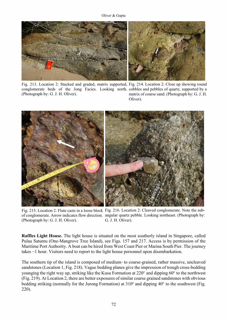
Oliver & Gupta
72
Fig. 213. Location 2: Stacked and graded, matrix supported, conglomerate beds of the Jong Facies. Looking north. (Photograph by: G. J. H. Oliver).
Fig. 215. Location 2: Flute casts in a loose block of conglomerate. Arrow indicates flow direction. (Photograph by: G. J. H. Oliver). Raffles Light House. The light house is situated on the most southerly island in Singapore, called Pulau Satumu (One-Mangrove Tree Island), see Figs. 157 and 217. Access is by permission of the Maritime Port Authority. A boat can be hired from West Coast Pier or Marina South Pier. The journey takes ~1 hour. Visitors need to report to the light house personnel upon disembarkation. The southern tip of the island is composed of medium- to coarse-grained, rather massive, uncleaved sandstones (Location 1, Fig. 218). Vague bedding planes give the impression of trough cross-bedding younging the right way up, striking like the Kusu Formation at 220° and dipping 60° to the northwest (Fig. 219). At Location 2, there are better exposures of similar coarse grained sandstones with obvious bedding striking (normally for the Jurong Formation) at 310° and dipping 40° to the southwest (Fig. 220).
Fig. 216. Location 2: Cleaved conglomerate. Note the sub-angular quartz pebble. Looking northeast. (Photograph by: G. J. H. Oliver).
Fig. 214. Location 2: Close up showing round cobbles and pebbles of quartz, supported by a matrix of coarse sand. (Photograph by: G. J. H. Oliver).
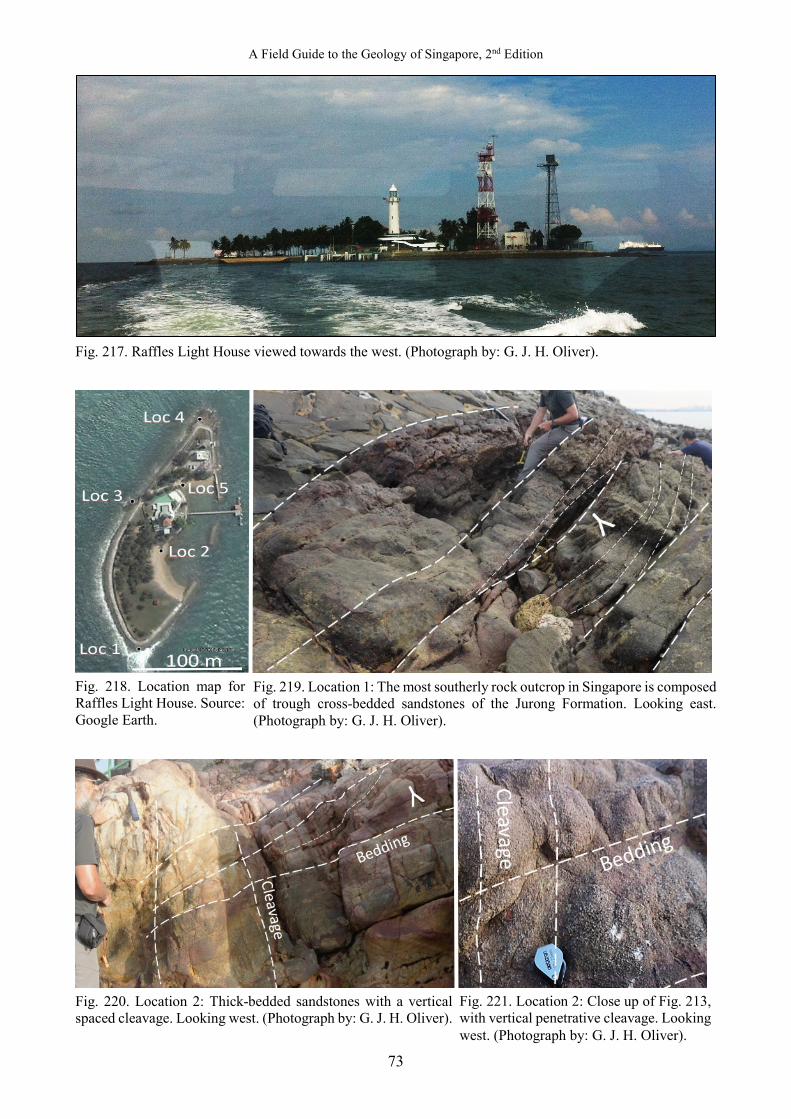
A Field Guide to the Geology of Singapore, 2nd Edition
73
Fig. 217. Raffles Light House viewed towards the west. (Photograph by: G. J. H. Oliver).
Fig. 218. Location map for Raffles Light House. Source: Google Earth.
Fig. 220. Location 2: Thick-bedded sandstones with a vertical spaced cleavage. Looking west. (Photograph by: G. J. H. Oliver).
Fig. 219. Location 1: The most southerly rock outcrop in Singapore is composed of trough cross-bedded sandstones of the Jurong Formation. Looking east. (Photograph by: G. J. H. Oliver).
Fig. 221. Location 2: Close up of Fig. 213, with vertical penetrative cleavage. Looking west. (Photograph by: G. J. H. Oliver).
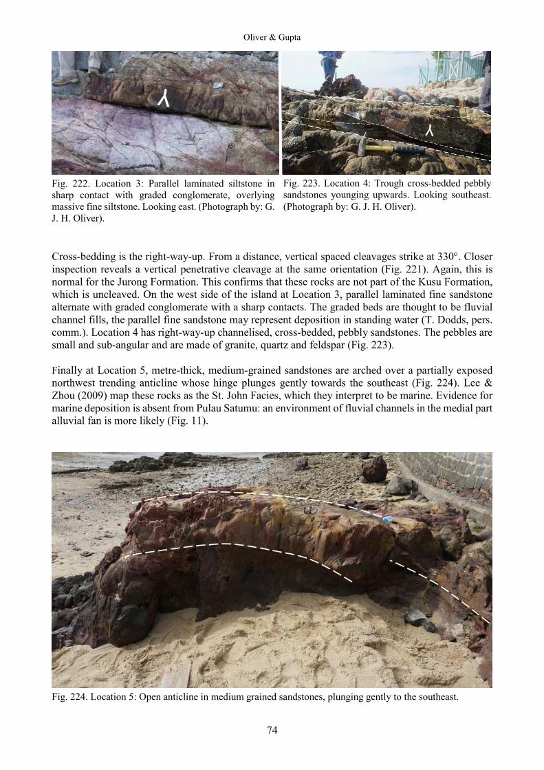
Oliver & Gupta
74
Fig. 222. Location 3: Parallel laminated siltstone in sharp contact with graded conglomerate, overlying massive fine siltstone. Looking east. (Photograph by: G. J. H. Oliver). Cross-bedding is the right-way-up. From a distance, vertical spaced cleavages strike at 330°. Closer inspection reveals a vertical penetrative cleavage at the same orientation (Fig. 221). Again, this is normal for the Jurong Formation. This confirms that these rocks are not part of the Kusu Formation, which is uncleaved. On the west side of the island at Location 3, parallel laminated fine sandstone alternate with graded conglomerate with a sharp contacts. The graded beds are thought to be fluvial channel fills, the parallel fine sandstone may represent deposition in standing water (T. Dodds, pers. comm.). Location 4 has right-way-up channelised, cross-bedded, pebbly sandstones. The pebbles are small and sub-angular and are made of granite, quartz and feldspar (Fig. 223). Finally at Location 5, metre-thick, medium-grained sandstones are arched over a partially exposed northwest trending anticline whose hinge plunges gently towards the southeast (Fig. 224). Lee & Zhou (2009) map these rocks as the St. John Facies, which they interpret to be marine. Evidence for marine deposition is absent from Pulau Satumu: an environment of fluvial channels in the medial part alluvial fan is more likely (Fig. 11).
Fig. 224. Location 5: Open anticline in medium grained sandstones, plunging gently to the southeast.
Fig. 223. Location 4: Trough cross-bedded pebbly sandstones younging upwards. Looking southeast. (Photograph by: G. J. H. Oliver).
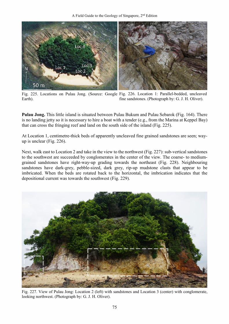
A Field Guide to the Geology of Singapore, 2nd Edition
75
Fig. 225. Locations on Pulau Jong. (Source: Google Earth). Pulau Jong. This little island is situated between Pulau Bukum and Pulau Sebarok (Fig. 164). There is no landing jetty so it is necessary to hire a boat with a tender (e.g., from the Marina at Keppel Bay) that can cross the fringing reef and land on the south side of the island (Fig. 225). At Location 1, centimetre-thick beds of apparently uncleaved fine grained sandstones are seen; way-up is unclear (Fig. 226). Next, walk east to Location 2 and take in the view to the northwest (Fig. 227): sub-vertical sandstones to the southwest are succeeded by conglomerates in the center of the view. The coarse- to medium-grained sandstones have right-way-up grading towards the northeast (Fig. 228). Neighbouring sandstones have dark-grey, pebble-sized, dark grey, rip-up mudstone clasts that appear to be imbricated. When the beds are rotated back to the horizontal, the imbrication indicates that the depositional current was towards the southwest (Fig. 229).
Fig. 227. View of Pulau Jong: Location 2 (left) with sandstones and Location 3 (center) with conglomerate, looking northwest. (Photograph by: G. J. H. Oliver).
Fig. 226. Location 1: Parallel-bedded, uncleaved fine sandstones. (Photograph by: G. J. H. Oliver).
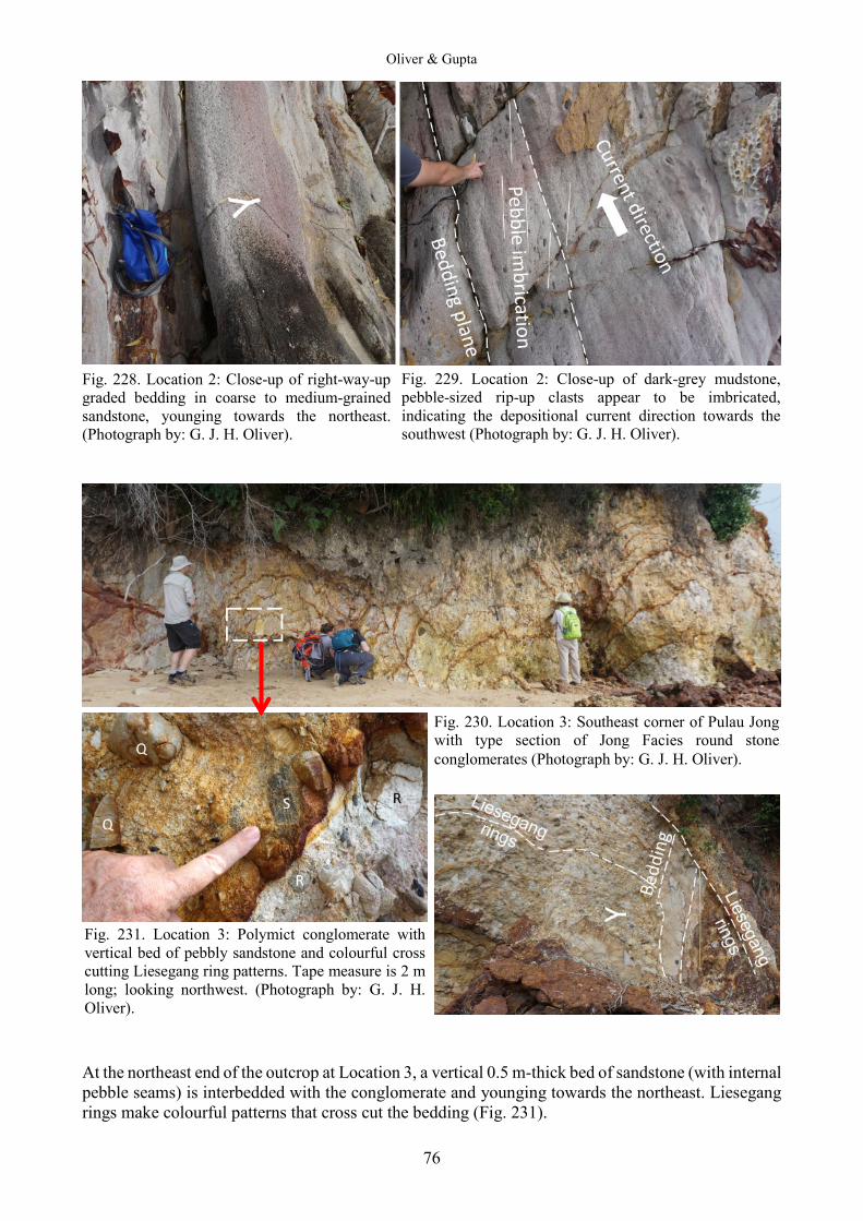
Oliver & Gupta
76
Fig. 228. Location 2: Close-up of right-way-up graded bedding in coarse to medium-grained sandstone, younging towards the northeast. (Photograph by: G. J. H. Oliver).
At the northeast end of the outcrop at Location 3, a vertical 0.5 m-thick bed of sandstone (with internal pebble seams) is interbedded with the conglomerate and younging towards the northeast. Liesegang rings make colourful patterns that cross cut the bedding (Fig. 231).
Fig. 229. Location 2: Close-up of dark-grey mudstone, pebble-sized rip-up clasts appear to be imbricated, indicating the depositional current direction towards the southwest (Photograph by: G. J. H. Oliver).
Fig. 230. Location 3: Southeast corner of Pulau Jong with type section of Jong Facies round stone conglomerates (Photograph by: G. J. H. Oliver).
Fig. 231. Location 3: Polymict conglomerate with vertical bed of pebbly sandstone and colourful cross cutting Liesegang ring patterns. Tape measure is 2 m long; looking northwest. (Photograph by: G. J. H. Oliver).
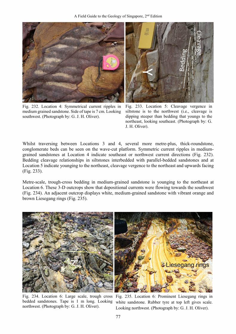
A Field Guide to the Geology of Singapore, 2nd Edition
77
Fig. 232. Location 4: Symmetrical current ripples in medium grained sandstone. Side of tape is 7 cm. Looking southwest. (Photograph by: G. J. H. Oliver). Whilst traversing between Locations 3 and 4, several more metre-plus, thick-roundstone, conglomerate beds can be seen on the wave-cut platform. Symmetric current ripples in medium-grained sandstones at Location 4 indicate southeast or northwest current directions (Fig. 232). Bedding cleavage relationships in siltstones interbedded with parallel-bedded sandstones and at Location 5 indicate younging to the northeast, cleavage vergence to the northeast and upwards facing (Fig. 233). Metre-scale, trough-cross bedding in medium-grained sandstone is younging to the northeast at Location 6. These 3-D outcrops show that depositional currents were flowing towards the southwest (Fig. 234). An adjacent outcrop displays white, medium-grained sandstone with vibrant orange and brown Liesegang rings (Fig. 235).
Fig. 234. Location 6: Large scale, trough cross bedded sandstones. Tape is 1 m long. Looking northwest. (Photograph by: G. J. H. Oliver).
Fig. 233. Location 5: Cleavage vergence in siltstone is to the northwest (i.e., cleavage is dipping steeper than bedding that youngs to the northeast, looking southeast. (Photograph by: G. J. H. Oliver).
Fig. 235. Location 6: Prominent Liesegang rings in white sandstone. Rubber tyre at top left gives scale. Looking northwest. (Photograph by: G. J. H. Oliver).
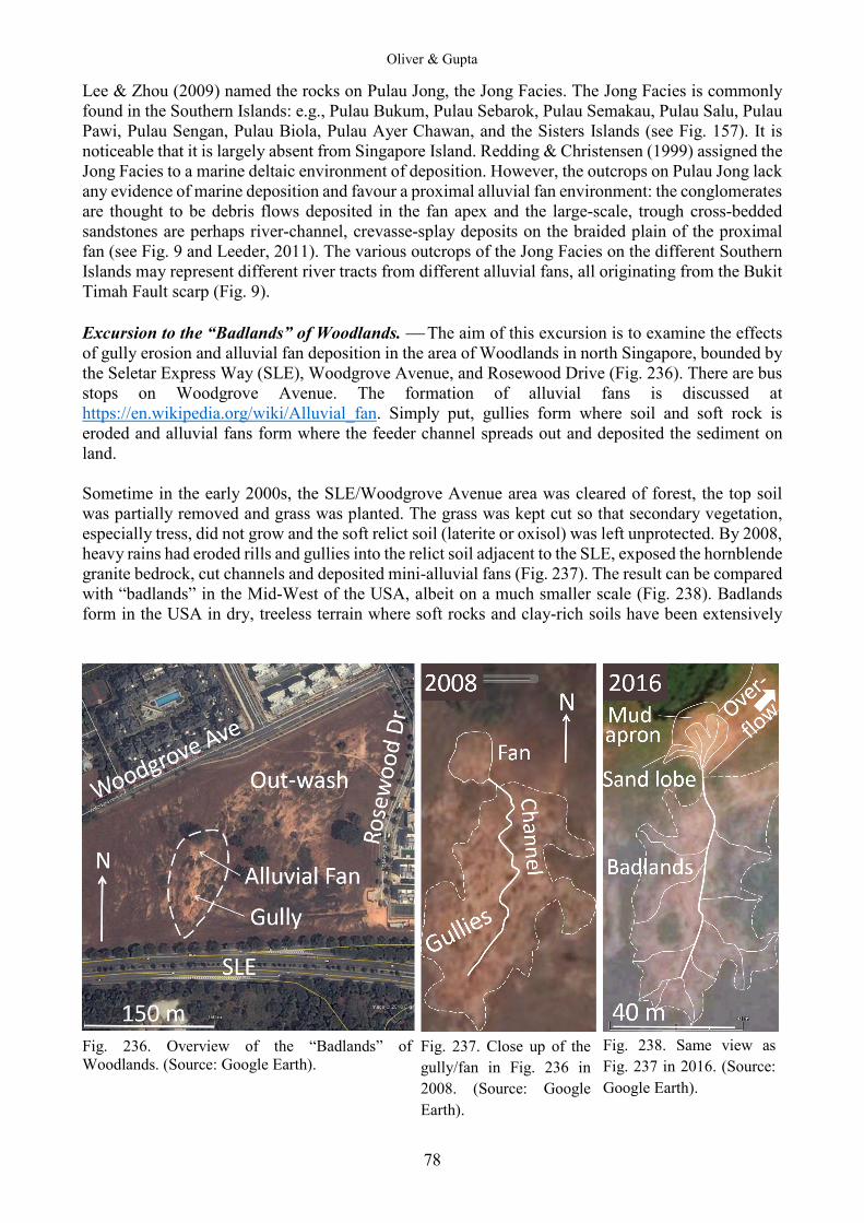
Oliver & Gupta
78
Lee & Zhou (2009) named the rocks on Pulau Jong, the Jong Facies. The Jong Facies is commonly found in the Southern Islands: e.g., Pulau Bukum, Pulau Sebarok, Pulau Semakau, Pulau Salu, Pulau Pawi, Pulau Sengan, Pulau Biola, Pulau Ayer Chawan, and the Sisters Islands (see Fig. 157). It is noticeable that it is largely absent from Singapore Island. Redding & Christensen (1999) assigned the Jong Facies to a marine deltaic environment of deposition. However, the outcrops on Pulau Jong lack any evidence of marine deposition and favour a proximal alluvial fan environment: the conglomerates are thought to be debris flows deposited in the fan apex and the large-scale, trough cross-bedded sandstones are perhaps river-channel, crevasse-splay deposits on the braided plain of the proximal fan (see Fig. 9 and Leeder, 2011). The various outcrops of the Jong Facies on the different Southern Islands may represent different river tracts from different alluvial fans, all originating from the Bukit Timah Fault scarp (Fig. 9). Excursion to the “Badlands” of Woodlands. The aim of this excursion is to examine the effects of gully erosion and alluvial fan deposition in the area of Woodlands in north Singapore, bounded by the Seletar Express Way (SLE), Woodgrove Avenue, and Rosewood Drive (Fig. 236). There are bus stops on Woodgrove Avenue. The formation of alluvial fans is discussed at https://en.wikipedia.org/wiki/Alluvial_fan. Simply put, gullies form where soil and soft rock is eroded and alluvial fans form where the feeder channel spreads out and deposited the sediment on land. Sometime in the early 2000s, the SLE/Woodgrove Avenue area was cleared of forest, the top soil was partially removed and grass was planted. The grass was kept cut so that secondary vegetation, especially tress, did not grow and the soft relict soil (laterite or oxisol) was left unprotected. By 2008, heavy rains had eroded rills and gullies into the relict soil adjacent to the SLE, exposed the hornblende granite bedrock, cut channels and deposited mini-alluvial fans (Fig. 237). The result can be compared with “badlands” in the Mid-West of the USA, albeit on a much smaller scale (Fig. 238). Badlands form in the USA in dry, treeless terrain where soft rocks and clay-rich soils have been extensively
Fig. 236. Overview of the “Badlands” of Woodlands. (Source: Google Earth).
Fig. 237. Close up of the gully/fan in Fig. 236 in 2008. (Source: Google Earth).
Fig. 238. Same view as Fig. 237 in 2016. (Source: Google Earth).

A Field Guide to the Geology of Singapore, 2nd Edition
79
eroded by wind and water. If the vegetation at Woodgrove Avenue had been allowed to grow back with trees and bushes (i.e., formed secondary forest) this erosion would not have occurred. By 2016, the newly exposed granite had been partially laterised: i.e., K-feldspar and plagioclase decomposed to kaolinite and bauxite clay, hornblende oxidized to clay and hematite, and quartz released as sand grains. The gully system had cut back and deepened and the alluvial fan had grown new lobes and overflowed down the gentle outwash slope towards Woodgrove Avenue (Fig. 238). The following images (Figs. 239–248) were taken serendipitously in late January 2016, after a period of wet weather when the features were still fresh and not trampled. The terminology used in the photographs is from Leeder (2011). Fig. 239 shows the headwater of the gully where rills are cutting back into the weathered rockhead and relict oxisols. Fig. 240 shows the remains of the oxisol, sheet erosion and loose material being carried away in channels. Fig. 241 shows the main channel in the gully with a mid-channel sand bar and eroded terraces cut into the gravel plain. The gravel plain is made up of clasts of partially weathered granite plus sand grains of resistant quartz. Any clay at the surface will have been washed away during heavy rain. Fig. 242 is a close up of a mid-channel sand bar and a crevasse sand splay. Figs. 243 and 244 are views of the fan apex and the proximal, medial and distal zones of the alluvial fan. The apex of the fan is where the channel exits the gully and sediment starts to fan out. The proximal zone is made up of pebbly sand in channels cut into a braidplain. The medial zone is made up of sandy channels, sand sheets and muddy flood plains. The distal zone is made up of a mud apron and terminal sand splays. The mud is made up of clay formed by the weathering of the granite.
Fig. 239. View of the headwater of the gully, looking northwest. (Photograph by: G. J. H. Oliver).
Fig. 241. Mid-channel sand bar in the main feeder channel, cutting across the gravel plain, with cut banks. Current flow is from top to bottom. (Photograph by: G. J. H. Oliver).
Fig. 240. View down the gully channel looking to the north. (Photograph by: G. J. H. Oliver).
Fig. 242. Close up of mid-channel sand bar and crevasse sand splay and cut banks. Current flow is from left to right. Note tyre tracks for scale. (Photograph by: G. J. H. Oliver).
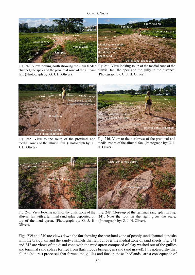
Oliver & Gupta
80
Fig. 243. View looking north showing the main feeder channel, the apex and the proximal zone of the alluvial fan. (Photograph by: G. J. H. Oliver).
Fig. 245. View to the south of the proximal and medial zones of the alluvial fan. (Photograph by: G. J. H. Oliver).
Fig. 247. View looking north of the distal zone of the alluvial fan with a terminal sand splay deposited on top of the mud apron. (Photograph by: G. J. H. Oliver). Figs. 239 and 240 are views down the fan showing the proximal zone of pebbly sand channel deposits with the braidplain and the sandy channels that fan out over the medial zone of sand sheets. Fig. 241 and 242 are views of the distal zone with the mud apron composed of clay washed out of the gullies and terminal sand splays formed from flash floods bringing in sand (and gravel). It is noteworthy that all the (natural) processes that formed the gullies and fans in these “badlands” are a consequence of
Fig. 244. View looking south of the medial zone of the alluvial fan, the apex and the gully in the distance. (Photograph by: G. J. H. Oliver).
Fig. 246. View to the northwest of the proximal and medial zones of the alluvial fan. (Photograph by: G. J. H. Oliver).
Fig. 248. Close-up of the terminal sand splay in Fig. 241. Note the foot on the right gives the scale. (Photograph by: G. J. H. Oliver).
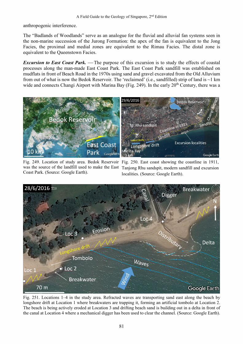
A Field Guide to the Geology of Singapore, 2nd Edition
81
anthropogenic interference. The “Badlands of Woodlands” serve as an analogue for the fluvial and alluvial fan systems seen in the non-marine succession of the Jurong Formation: the apex of the fan is equivalent to the Jong Facies, the proximal and medial zones are equivalent to the Rimau Facies. The distal zone is equivalent to the Queenstown Facies. Excursion to East Coast Park. The purpose of this excursion is to study the effects of coastal processes along the man-made East Coast Park. The East Coast Park sandfill was established on mudflats in front of Beach Road in the 1970s using sand and gravel excavated from the Old Alluvium from out of what is now the Bedok Reservoir. The ‘reclaimed’ (i.e., sandfilled) strip of land is ~1 km wide and connects Changi Airport with Marina Bay (Fig. 249). In the early 20th Century, there was a
Fig. 249. Location of study area. Bedok Reservoir was the source of the landfill used to make the East Coast Park. (Source: Google Earth).
Fig. 251. Locations 1–4 in the study area. Refracted waves are transporting sand east along the beach by longshore drift at Location 1 where breakwaters are trapping it, forming an artificial tombolo at Location 2. The beach is being actively eroded at Location 3 and drifting beach sand is building out in a delta in front of the canal at Location 4 where a mechanical digger has been used to clear the channel. (Source: Google Earth).
Fig. 250. East coast showing the coastline in 1911, Tanjong Rhu sandspit, modern sandfill and excursion localities. (Source: Google Earth).
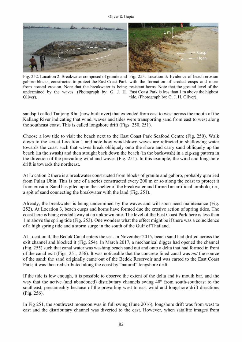
Oliver & Gupta
82
Fig. 252. Location 2: Breakwater composed of granite and gabbro blocks, constructed to protect the East Coast Park from coastal erosion. Note that the breakwater is being undermined by the waves. (Photograph by: G. J. H. Oliver). sandspit called Tanjong Rhu (now built over) that extended from east to west across the mouth of the Kallang River indicating that wind, waves and tides were transporting sand from east to west along the southeast coast. This is called longshore drift (Figs. 250, 251). Choose a low tide to visit the beach next to the East Coast Park Seafood Centre (Fig. 250). Walk down to the sea at Location 1 and note how wind-blown waves are refracted in shallowing water towards the coast such that waves break obliquely onto the shore and carry sand obliquely up the beach (in the swash) and then straight back down the beach (in the backwash) in a zig-zag pattern in the direction of the prevailing wind and waves (Fig. 251). In this example, the wind and longshore drift is towards the northeast. At Location 2 there is a breakwater constructed from blocks of granite and gabbro, probably quarried from Pulau Ubin. This is one of a series constructed every 200 m or so along the coast to protect it from erosion. Sand has piled up in the shelter of the breakwater and formed an artificial tombolo, i.e., a spit of sand connecting the breakwater with the land (Fig. 251). Already, the breakwater is being undermined by the waves and will soon need maintenance (Fig. 252). At Location 3, beach cusps and horns have formed due the erosive action of spring tides. The coast here is being eroded away at an unknown rate. The level of the East Coast Park here is less than 1 m above the spring tide (Fig. 253). One wonders what the effect might be if there was a coincidence of a high spring tide and a storm surge in the south of the Gulf of Thailand. At Location 4, the Bedok Canal enters the sea. In November 2015, beach sand had drifted across the exit channel and blocked it (Fig. 254). In March 2017, a mechanical digger had opened the channel (Fig. 255) such that canal water was washing beach sand out and onto a delta that had formed in front of the canal exit (Figs. 251, 256). It was noticeable that the concrete-lined canal was not the source of the sand: the sand originally came out of the Bedok Reservoir and was carted to the East Coast Park; it was then redistributed along the coast by “natural” longshore drift. If the tide is low enough, it is possible to observe the extent of the delta and its mouth bar, and the way that the active (and abandoned) distributary channels swing 40° from south-southeast to the southeast, presumeably because of the prevailing west to east wind and longshore drift directions (Fig. 256). In Fig 251, the southwest monsoon was in full swing (June 2016), longshore drift was from west to east and the distributary channel was diverted to the east. However, when satallite images from
Fig. 253. Location 3: Evidence of beach erosion with the formation of eroded cusps and more resistant horns. Note that the ground level of the East Coast Park is less than 1 m above the highest tide. (Photograph by: G. J. H. Oliver).
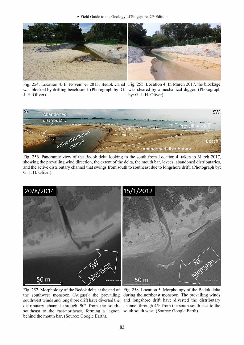
A Field Guide to the Geology of Singapore, 2nd Edition
83
Fig. 254. Location 4: In November 2015, Bedok Canal was blocked by drifting beach sand. (Photograph by: G. J. H. Oliver).
Fig. 256. Panoramic view of the Bedok delta looking to the south from Location 4, taken in March 2017, showing the prevailing wind direction, the extent of the delta, the mouth bar, levees, abandoned distributaries, and the active distributary channel that swings from south to southeast due to longshore drift. (Photograph by: G. J. H. Oliver).
Fig. 257. Morphology of the Bedok delta at the end of the southwest monsoon (August): the prevailing southwest winds and longshore drift have diverted the distributary channel through 90° from the south-southeast to the east-northeast, forming a lagoon behind the mouth bar. (Source: Google Earth).
Fig. 255. Location 4: In March 2017, the blockage was cleared by a mechanical digger. (Photograph by: G. J. H. Oliver).
Fig. 258. Location 5: Morphology of the Bedok delta during the northeast monsoon. The prevailing winds and longshore drift have diverted the distributary channel through 45° from the south-south east to the south south west. (Source: Google Earth).
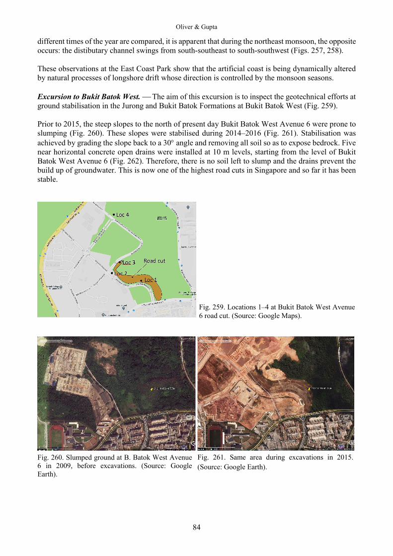
Oliver & Gupta
84
different times of the year are compared, it is apparent that during the northeast monsoon, the opposite occurs: the distibutary channel swings from south-southeast to south-southwest (Figs. 257, 258). These observations at the East Coast Park show that the artificial coast is being dynamically altered by natural processes of longshore drift whose direction is controlled by the monsoon seasons. Excursion to Bukit Batok West. The aim of this excursion is to inspect the geotechnical efforts at ground stabilisation in the Jurong and Bukit Batok Formations at Bukit Batok West (Fig. 259). Prior to 2015, the steep slopes to the north of present day Bukit Batok West Avenue 6 were prone to slumping (Fig. 260). These slopes were stabilised during 2014–2016 (Fig. 261). Stabilisation was achieved by grading the slope back to a 30° angle and removing all soil so as to expose bedrock. Five near horizontal concrete open drains were installed at 10 m levels, starting from the level of Bukit Batok West Avenue 6 (Fig. 262). Therefore, there is no soil left to slump and the drains prevent the build up of groundwater. This is now one of the highest road cuts in Singapore and so far it has been stable.
Fig. 260. Slumped ground at B. Batok West Avenue 6 in 2009, before excavations. (Source: Google Earth).
Fig. 261. Same area during excavations in 2015. (Source: Google Earth).
Fig. 259. Locations 1–4 at Bukit Batok West Avenue 6 road cut. (Source: Google Maps).

A Field Guide to the Geology of Singapore, 2nd Edition
85
Fig. 262. View to the west along Bukit Batok West Avenue 6 in 2017, illustrating the graded 30° slope and the 5 levels of drainage ditches. Note the cleaned-off outcrops of Jurong Formation grey and red siltstones dipping down slope. (Photograph by: G. J. H. Oliver).
Fig. 263. Same area with drain system in 2016 and site locations. (Source: Google Earth). There is presently enough outcrop between Locations 1–3 (Fig. 263) to draw a geological map (Fig. 264). A ~40 m thick band of centimeter bedded red and purple siltstones and mudstones dips at ~45° to the southwest, in between grey and green siltstones and mudstones. It is apparent that the slumped ground seen prior to 2015, occurred on a southwest facing slope that was sliding on thin-bedded sedimentary strata of the Jurong Formation, dipping in the same southwest direction. In times of heavy rain (i.e., during the November–December Northeast Monsoon), it is no wonder this dip slope was prone to slumping. Fig. 265 is a panorama of the road cut taken from the 4th floor of the multi-storey carpark opposite Location 1. The band of red beds can be traced easily.
Fig. 264. Geological map by G. J. H. Oliver (2018), base map sourced from Google Earth.
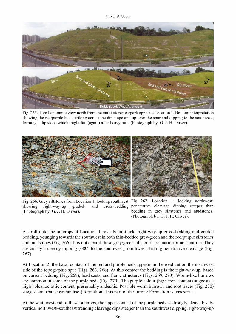
Oliver & Gupta
86
Fig. 265. Top: Panoramic view north from the multi-storey carpark opposite Location 1. Bottom: interpretation showing the red/purple beds striking across the dip slope and up over the spur and dipping to the southwest, forming a dip slope which might fail (again) after heavy rain. (Photograph by: G. J. H. Oliver).
Fig. 266. Grey siltstones from Location 1, looking southwest, showing right-way-up graded- and cross-bedding. (Photograph by: G. J. H. Oliver). A stroll onto the outcrops at Location 1 reveals cm-thick, right-way-up cross-bedding and graded bedding, younging towards the southwest in both thin-bedded grey/green and the red/purple siltstones and mudstones (Fig. 266). It is not clear if these grey/green siltstones are marine or non-marine. They are cut by a steeply dipping (~80° to the southwest), northwest striking penetrative cleavage (Fig. 267). At Location 2, the basal contact of the red and purple beds appears in the road cut on the northwest side of the topographic spur (Figs. 263, 268). At this contact the bedding is the right-way-up, based on current bedding (Fig. 269), load casts, and flame structures (Figs. 269, 270). Worm-like burrows are common in some of the purple beds (Fig. 270). The purple colour (high iron-content) suggests a high volcanoclastic content, presumably andesitic. Possible worm burrows and root traces (Fig. 270) suggest soil (palaeosol/andisol) formation. This part of the Jurong Formation is terrestrial. At the southwest end of these outcrops, the upper contact of the purple beds is strongly cleaved: sub-vertical northwest–southeast trending cleavage dips steeper than the southwest dipping, right-way-up
Y
Fig 267. Location 1: looking northwest; penetrative cleavage dipping steeper than bedding in grey siltstones and mudstones. (Photograph by: G. J. H. Oliver).

A Field Guide to the Geology of Singapore, 2nd Edition
87
Fig. 268. Location 2: Road cut at the base of the red and purple beds mapped in Fig. 265, looking southeast. (Photograph by: G. J. H. Oliver).
Fig. 269. Close-up of inset in Fig. 268. Note right-way-up cross-bedding and load casts in the purple beds younging to the southwest, and the weak cleavage. Tape is 1 m long. (Photograph by: G. J. H. Oliver). bedding (Fig. 271). According to the rules of cleavage vergence (Fig. 272), the cleavage here is upward facing and the cleavage vergence is towards the northeast. Therefore, this part of Bukit Batok West is located on the southwest limb of a northwest–southeast trending anticline (see the red square in Fig. 272). Furthermore, the penetrative slaty cleavage indicates a period of low grade regional metamorphism. Not all of the road cut along Bukit Batok West Avenue 6 is stable. At Location 3, at the base of the spur (see Fig. 263) there is ample evidence of slope instability. The trouble seems to be caused by the lack of drainage ditches on the flat tops of the terraces which have not been cut down to bed rock. Rain water has saturated the soil and the added weight, lessened cohesion and reduced friction and slumping has started on this dip slope. In January 2017, bright green newly grown grass indicated the water saturated and slumped ground (Figs. 273, 274).
Fig. 270. Close-up of inset in Fig. 269. Note possible pink worm burrows in the center of the purple bed and possible root traces in the top of the bed which might be a palaeosol. (Photograph by: G. J. H. Oliver).
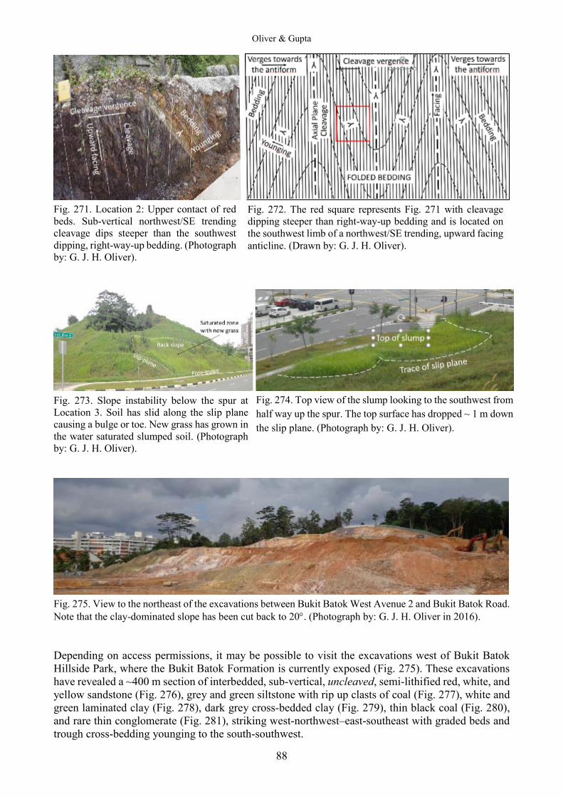
Oliver & Gupta
88
Fig. 271. Location 2: Upper contact of red beds. Sub-vertical northwest/SE trending cleavage dips steeper than the southwest dipping, right-way-up bedding. (Photograph by: G. J. H. Oliver).
Fig. 273. Slope instability below the spur at Location 3. Soil has slid along the slip plane causing a bulge or toe. New grass has grown in the water saturated slumped soil. (Photograph by: G. J. H. Oliver).
Fig. 275. View to the northeast of the excavations between Bukit Batok West Avenue 2 and Bukit Batok Road. Note that the clay-dominated slope has been cut back to 20°. (Photograph by: G. J. H. Oliver in 2016). Depending on access permissions, it may be possible to visit the excavations west of Bukit Batok Hillside Park, where the Bukit Batok Formation is currently exposed (Fig. 275). These excavations have revealed a ~400 m section of interbedded, sub-vertical, uncleaved, semi-lithified red, white, and yellow sandstone (Fig. 276), grey and green siltstone with rip up clasts of coal (Fig. 277), white and green laminated clay (Fig. 278), dark grey cross-bedded clay (Fig. 279), thin black coal (Fig. 280), and rare thin conglomerate (Fig. 281), striking west-northwest–east-southeast with graded beds and trough cross-bedding younging to the south-southwest.
Fig. 272. The red square represents Fig. 271 with cleavage dipping steeper than right-way-up bedding and is located on the southwest limb of a northwest/SE trending, upward facing anticline. (Drawn by: G. J. H. Oliver).
Fig. 274. Top view of the slump looking to the southwest from half way up the spur. The top surface has dropped ~ 1 m down the slip plane. (Photograph by: G. J. H. Oliver).
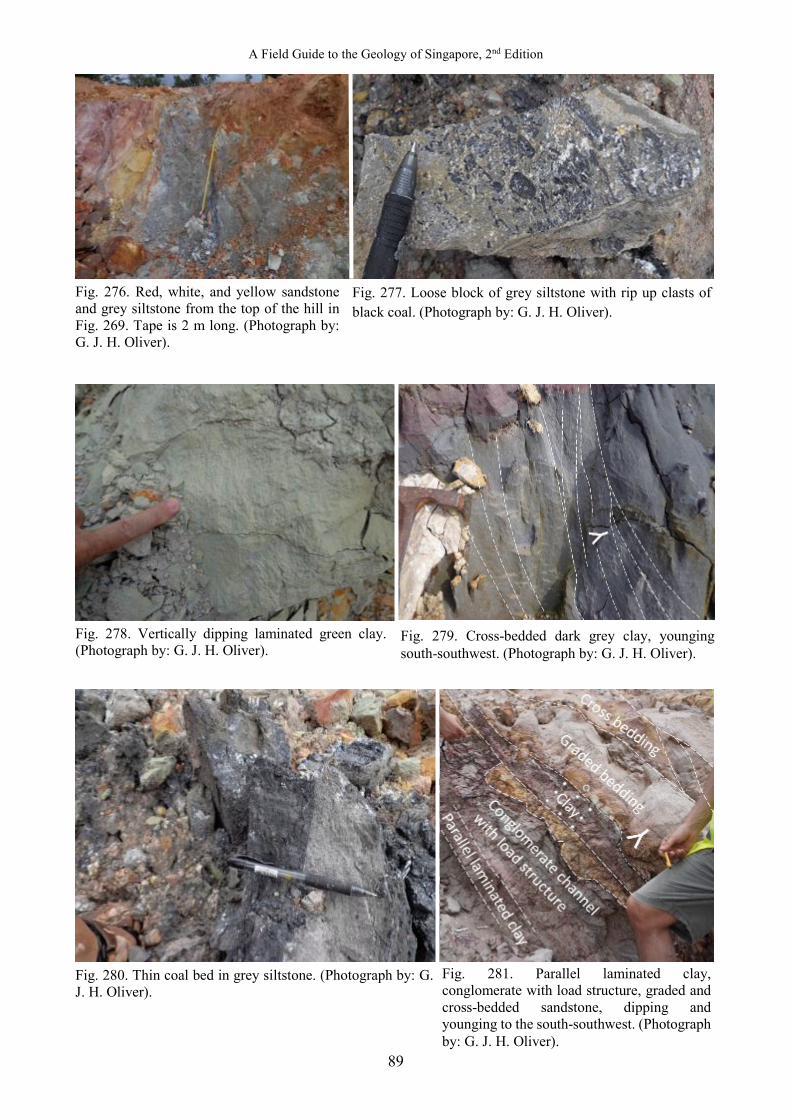
A Field Guide to the Geology of Singapore, 2nd Edition
89
Fig. 276. Red, white, and yellow sandstone and grey siltstone from the top of the hill in Fig. 269. Tape is 2 m long. (Photograph by: G. J. H. Oliver).
Fig. 278. Vertically dipping laminated green clay. (Photograph by: G. J. H. Oliver).
Fig. 280. Thin coal bed in grey siltstone. (Photograph by: G. J. H. Oliver).
Fig. 277. Loose block of grey siltstone with rip up clasts of black coal. (Photograph by: G. J. H. Oliver).
Fig. 279. Cross-bedded dark grey clay, younging south-southwest. (Photograph by: G. J. H. Oliver).
Fig. 281. Parallel laminated clay, conglomerate with load structure, graded and cross-bedded sandstone, dipping and younging to the south-southwest. (Photograph by: G. J. H. Oliver).
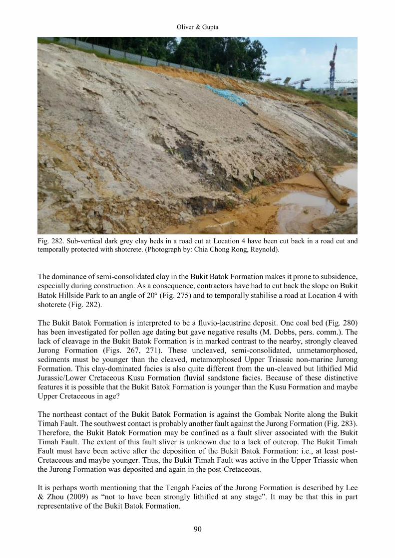
Oliver & Gupta
90
Fig. 282. Sub-vertical dark grey clay beds in a road cut at Location 4 have been cut back in a road cut and temporally protected with shotcrete. (Photograph by: Chia Chong Rong, Reynold). The dominance of semi-consolidated clay in the Bukit Batok Formation makes it prone to subsidence, especially during construction. As a consequence, contractors have had to cut back the slope on Bukit Batok Hillside Park to an angle of 20° (Fig. 275) and to temporally stabilise a road at Location 4 with shotcrete (Fig. 282). The Bukit Batok Formation is interpreted to be a fluvio-lacustrine deposit. One coal bed (Fig. 280) has been investigated for pollen age dating but gave negative results (M. Dobbs, pers. comm.). The lack of cleavage in the Bukit Batok Formation is in marked contrast to the nearby, strongly cleaved Jurong Formation (Figs. 267, 271). These uncleaved, semi-consolidated, unmetamorphosed, sediments must be younger than the cleaved, metamorphosed Upper Triassic non-marine Jurong Formation. This clay-dominated facies is also quite different from the un-cleaved but lithified Mid Jurassic/Lower Cretaceous Kusu Formation fluvial sandstone facies. Because of these distinctive features it is possible that the Bukit Batok Formation is younger than the Kusu Formation and maybe Upper Cretaceous in age? The northeast contact of the Bukit Batok Formation is against the Gombak Norite along the Bukit Timah Fault. The southwest contact is probably another fault against the Jurong Formation (Fig. 283). Therefore, the Bukit Batok Formation may be confined as a fault sliver associated with the Bukit Timah Fault. The extent of this fault sliver is unknown due to a lack of outcrop. The Bukit Timah Fault must have been active after the deposition of the Bukit Batok Formation: i.e., at least post-Cretaceous and maybe younger. Thus, the Bukit Timah Fault was active in the Upper Triassic when the Jurong Formation was deposited and again in the post-Cretaceous. It is perhaps worth mentioning that the Tengah Facies of the Jurong Formation is described by Lee & Zhou (2009) as “not to have been strongly lithified at any stage”. It may be that this in part representative of the Bukit Batok Formation.
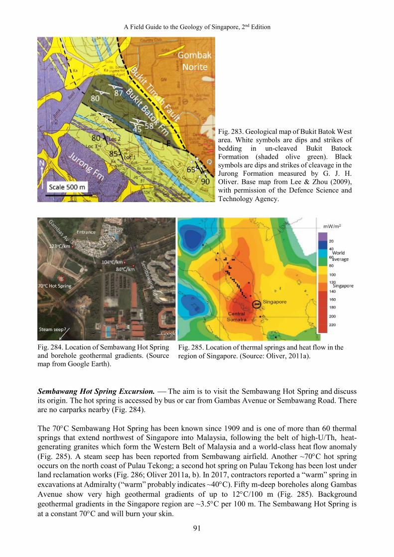
A Field Guide to the Geology of Singapore, 2nd Edition
91
Fig. 284. Location of Sembawang Hot Spring and borehole geothermal gradients. (Source map from Google Earth). Sembawang Hot Spring Excursion. The aim is to visit the Sembawang Hot Spring and discuss its origin. The hot spring is accessed by bus or car from Gambas Avenue or Sembawang Road. There are no carparks nearby (Fig. 284). The 70°C Sembawang Hot Spring has been known since 1909 and is one of more than 60 thermal springs that extend northwest of Singapore into Malaysia, following the belt of high-U/Th, heat-generating granites which form the Western Belt of Malaysia and a world-class heat flow anomaly (Fig. 285). A steam seep has been reported from Sembawang airfield. Another ~70°C hot spring occurs on the north coast of Pulau Tekong; a second hot spring on Pulau Tekong has been lost under land reclamation works (Fig. 286; Oliver 2011a, b). In 2017, contractors reported a “warm” spring in excavations at Admiralty (“warm” probably indicates ~40°C). Fifty m-deep boreholes along Gambas Avenue show very high geothermal gradients of up to 12°C/100 m (Fig. 285). Background geothermal gradients in the Singapore region are ~3.5°C per 100 m. The Sembawang Hot Spring is at a constant 70°C and will burn your skin.
Fig. 283. Geological map of Bukit Batok West area. White symbols are dips and strikes of bedding in un-cleaved Bukit Batock Formation (shaded olive green). Black symbols are dips and strikes of cleavage in the Jurong Formation measured by G. J. H. Oliver. Base map from Lee & Zhou (2009), with permission of the Defence Science and Technology Agency.
Fig. 285. Location of thermal springs and heat flow in the region of Singapore. (Source: Oliver, 2011a).
Oliver & Gupta
92
Fig. 286. Model for four geothermal plays in Singapore (Oliver et al., 2011a). Geology modified from Lee & Zhou (2009) with permission from the Defence Science and Technology Agency, Singapore. The spring is thought to be pressured by the 120 m high head of ground water on Bukit Timah, the highest point in Singapore. Rain water will sink into the “hot” granite and be heated and under the head of water on Bukit Timah, be pushed NE along the preferred orientation of lineaments (faults and joints in Singapore) until it meets an extension of the Nee Soon Fault and comes to the surface as a 70°C hot spring. Fig. 280 to Fig. 286 shows four geothermal plays for Singapore. Tjiawi et al. (2012) constructed computer models of the Singapore geothermal system and showed that geothermal water at 2 km depth below the Sembawang Hot Spring could be 150°C (Fig. 287). Geochemical analysis of K+, Na+, and Ca2+ dissolved in the spring water suggests that the reservoir temperature is 160°C. Calcite is precipitating on the standpipes and taps where the hot spring water is evaporating (Fig. 288). A faint smell of hydrogen sulphide can be detected in the air although the spring pH is neutral. The water was once bottled and sold as mineral water but be aware of the high fluorine content. Thermophilic cyanobacteria (blue-green algae) grow in the overflowing hot water, which is hot enough to cook an egg. Life may have originated 3.5 million years ago in hot springs like this (Figs. 289, 290). Oliver et al. (2011a, b) discussed how this hot spring could be utilised for electricity generation, district cooling, or desalination.

A Field Guide to the Geology of Singapore, 2nd Edition
93
Fig. 287. Results of a computer model: 150°C water is 2 km below the Sembawang Hot Spring. (Source: Tjiawi, 2013).
Fig. 288. Calcite is precipitating on the taps at Sembawang Hot Spring. (Photograph by: H. Tjiawi).
Fig. 290. Life may have originated in hot springs like this whose water is hot enough to cook an egg. (Photograph by: G. J. H. Oliver).
Fig. 289. Thermophilic cyanobacteria (blue-green algae) grow in the hot water from the spring. (Photograph by: G. J. H. Oliver).
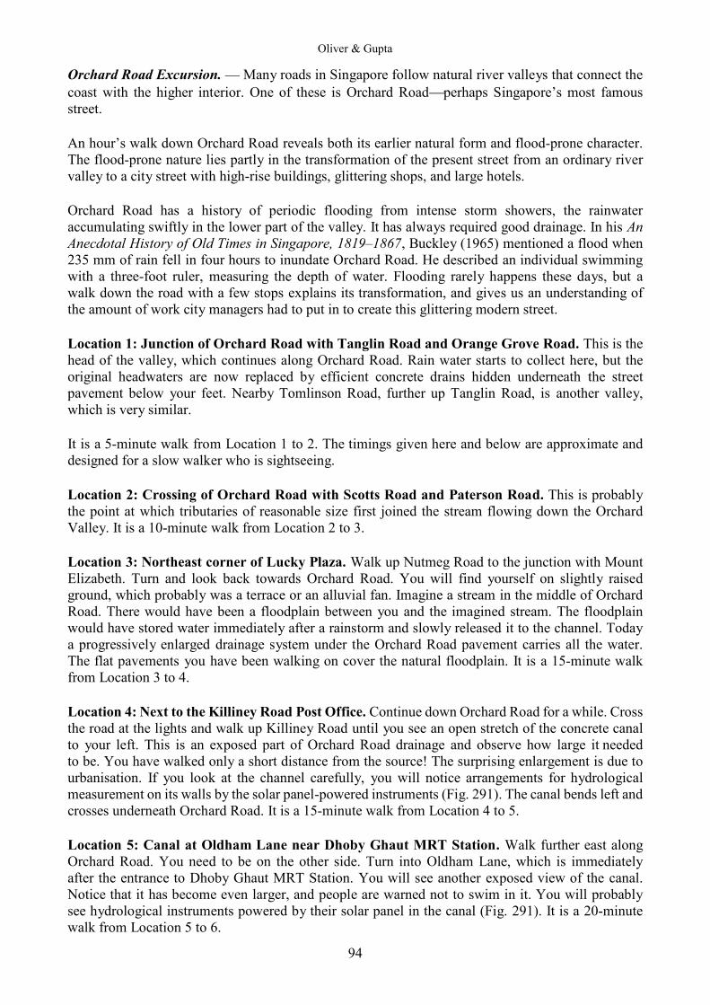
Oliver & Gupta
94
Orchard Road Excursion. — Many roads in Singapore follow natural river valleys that connect the coast with the higher interior. One of these is Orchard Roadperhaps Singapore’s most famous street. An hour’s walk down Orchard Road reveals both its earlier natural form and flood-prone character. The flood-prone nature lies partly in the transformation of the present street from an ordinary river valley to a city street with high-rise buildings, glittering shops, and large hotels. Orchard Road has a history of periodic flooding from intense storm showers, the rainwater accumulating swiftly in the lower part of the valley. It has always required good drainage. In his An Anecdotal History of Old Times in Singapore, 1819‒1867, Buckley (1965) mentioned a flood when 235 mm of rain fell in four hours to inundate Orchard Road. He described an individual swimming with a three-foot ruler, measuring the depth of water. Flooding rarely happens these days, but a walk down the road with a few stops explains its transformation, and gives us an understanding of the amount of work city managers had to put in to create this glittering modern street. Location 1: Junction of Orchard Road with Tanglin Road and Orange Grove Road. This is the head of the valley, which continues along Orchard Road. Rain water starts to collect here, but the original headwaters are now replaced by efficient concrete drains hidden underneath the street pavement below your feet. Nearby Tomlinson Road, further up Tanglin Road, is another valley, which is very similar. It is a 5-minute walk from Location 1 to 2. The timings given here and below are approximate and designed for a slow walker who is sightseeing. Location 2: Crossing of Orchard Road with Scotts Road and Paterson Road. This is probably the point at which tributaries of reasonable size first joined the stream flowing down the Orchard Valley. It is a 10-minute walk from Location 2 to 3. Location 3: Northeast corner of Lucky Plaza. Walk up Nutmeg Road to the junction with Mount Elizabeth. Turn and look back towards Orchard Road. You will find yourself on slightly raised ground, which probably was a terrace or an alluvial fan. Imagine a stream in the middle of Orchard Road. There would have been a floodplain between you and the imagined stream. The floodplain would have stored water immediately after a rainstorm and slowly released it to the channel. Today a progressively enlarged drainage system under the Orchard Road pavement carries all the water. The flat pavements you have been walking on cover the natural floodplain. It is a 15-minute walk from Location 3 to 4. Location 4: Next to the Killiney Road Post Office. Continue down Orchard Road for a while. Cross the road at the lights and walk up Killiney Road until you see an open stretch of the concrete canal to your left. This is an exposed part of Orchard Road drainage and observe how large it needed to be. You have walked only a short distance from the source! The surprising enlargement is due to urbanisation. If you look at the channel carefully, you will notice arrangements for hydrological measurement on its walls by the solar panel-powered instruments (Fig. 291). The canal bends left and crosses underneath Orchard Road. It is a 15-minute walk from Location 4 to 5. Location 5: Canal at Oldham Lane near Dhoby Ghaut MRT Station. Walk further east along Orchard Road. You need to be on the other side. Turn into Oldham Lane, which is immediately after the entrance to Dhoby Ghaut MRT Station. You will see another exposed view of the canal. Notice that it has become even larger, and people are warned not to swim in it. You will probably see hydrological instruments powered by their solar panel in the canal (Fig. 291). It is a 20-minute walk from Location 5 to 6.
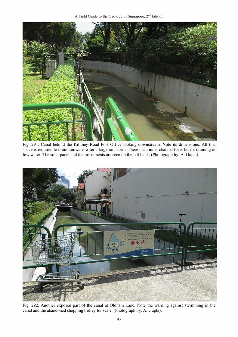
A Field Guide to the Geology of Singapore, 2nd Edition
95
Fig. 291. Canal behind the Killiney Road Post Office looking downstream. Note its dimensions. All that space is required to drain rainwater after a large rainstorm. There is an inner channel for efficient draining of low water. The solar panel and the instruments are seen on the left bank. (Photograph by: A. Gupta).
Fig. 292. Another exposed part of the canal at Oldham Lane. Note the warning against swimming in the canal and the abandoned shopping trolley for scale. (Photograph by: A. Gupta).

Oliver & Gupta
96
Fig. 293. Bras Basah Road (in front of the Rendezvous Grand Hotel) occupies the flood plain of a river that was once here. Orchard Road, which continues into Bras Basah Road, is also built on the same flood plain. (Photograph by: A. Gupta). Walk back to Orchard Road and look upwards. You will see that low hills on both sides restrict the extent of the floodplain. This explains the story of exposed rocks that the washermen once used in the channel, giving it the name of Dhoby Ghaut, which is derived from the “Bengali and Madrasi dhobies (laundrymen) who used to wash the clothes of local residents in Sungei Bras Basah, now Stamford Canal, and dry them on the land now occupied by the YMCA Building. Ghaut is Hindi for “landing place or flight of steps leading to a riverbank”Dunlop (2000). Location 6: Junction with Victoria Street. Orchard Road connects to Bras Basah Road. Walk further east on this road to its junction with Victoria Street but you will not see the canal as it is under decorated pavements and gardens. But notice the wide flat surface (Fig. 293). This is the extended plain of the river near its end. This probably explains why this was once chosen for drying wet rice giving it the name of ‘Bras Basah’, which means wet rice in Malay. It is intriguing to try to follow the valley after this point, until it merges with the old coast, which was near Beach Road. Coastal reclamation work has modified the landscape so the coast has moved further south. Do note how the size of the canal had to increase to cope with the urbanised drainage and how a small valley has been transformed into a modern road system.

A Field Guide to the Geology of Singapore, 2nd Edition
97
Excursion on Flood-Prevention along the Bukit Timah Valley. — This is a longer walk than the one along Orchard Road and difficult to do it entirely on foot, especially on a sunny day. It is easier done in a car or by taking a sequence of buses along Dunearn Road, and observing the features described from various pedestrian bridges over Bukit Timah Canal. The walk is an excellent illustration of how flood propensity rises with urbanisation. Location 1. Start near the railway bridge, east of the junction of Clementi Road with Bukit Timah and Dunearn Roads. The canal used to be a small stream between low granitic hills on either side of the valley. The area is still not densely built, small areas of secondary vegetation are common, and the canal is lined but not wide. The stream was first straightened as an alluvial canal, but later the channel needed to be lined for rapidly draining the floodwater after rainstorms (Fig. 294). The two arterial roads on either side of the canal occupy the old flat floodplain under vegetation that used to hold floodwater and slowly release it to the stream. Similar situations can still be found in south Johor in Peninsular Malaysia. Continue along Dunearn Road to the junction with Swiss Club Road. If possible, walk the stretch between Swiss Club Road and Sixth Avenue and check the canal from various pedestrian bridges (Fig. 295). Notice the disappearance of natural vegetation and increase in urbanisation with denser residential population and larger amount of impervious area. The hills continue on both sides of the valley. The size of the canal becomes bigger as it has to transport larger volumes of water after rainstorms because of the changes in land use.
Fig. 294. The concrete-lined upper Bukit Timah Canal as seen from the new bridge near the Albert Park MRT station. Note the shape of the entire canal and the low-flow channel in the bottom. Storm drainage from side valleys reach the canal rapidly after a rainstorm. The arterial roads of Bukit Timah and Dunearn occur on floodplains on either side of the canal. (Photograph by: A. Gupta).

Oliver & Gupta
98
Fig. 295. The canal between Fig. 294 and Swiss Club Road. The size of the canal is bigger. (Photograph by: A. Gupta). Location 2. — Sixth Avenue. The runoff following rainstorms became too large for the old canal to rapidly transport floodwater and prevent inundation of the two arterial roads running on former floodplain (Fig. 296). A diversion towards the southwest now takes excessive water through an engineered channel to the Sungei Ulu Pandan, the next basin to the south. This is the first diversion after the rapid and intense urbanisation of the Bukit Timah Basin. The diversion is located between Maple Avenue and Anamalai Avenue. Also note that the channel is trapezium-shaped with a low- flow channel in the middle. Hydrological instruments and solar panels are visible on this stretch of the canal. Continue along Dunearn Road. This is a section of the basin that demonstrates intense urbanisation. It you have transport, go for a drive along Second, Third, (Fig. 297) or Fourth Avenues off Bukit Timah Road, or Watten Estate off Dunearn Road. You will notice impervious surfaces built on steep granitic hills. You will have no problem imagining a very high percentage of the rainwater running on the surface, and quickly draining into the Bukit Timah Canal in large volume. Notice the efficient drainage system for the side slopes. The canal has to find space for all the water to prevent flooding of streets, shops, and residences in the area. Location 3. Look at the canal from the overhead pedestrian bridge near Shelford Road (Fig. 296). Look for (1) intense urbanisation in the valley, (2) the busy traffic on the floodplain roads, and (3) the enlarged size of the canal to carry the excess floodwater. A lot of effort is needed to keep the city going.

A Field Guide to the Geology of Singapore, 2nd Edition
99
Fig. 296. The canal near Sixth Avenue designed to carry large volumes of floodwater even after diversion. To beautify them, the canal sides are landscaped with ornamental plants such as the butterfly palms (Dypsis lutescens; left background and right foreground) and turf as seen here. (Photograph by: A. Gupta).
Fig. 297. View up Third Avenue. Steeper slope of the granite hills contacts sharply with the flatter floodplain. The contact approximately follows the line of shadow across the road. Note increased impervious area and only small open spaces remain. (Photograph by: A. Gupta).
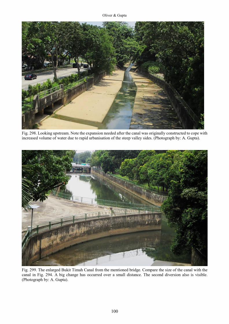
Oliver & Gupta
100
Fig. 298. Looking upstream. Note the expansion needed after the canal was originally constructed to cope with increased volume of water due to rapid urbanisation of the steep valley sides. (Photograph by: A. Gupta).
Fig. 299. The enlarged Bukit Timah Canal from the mentioned bridge. Compare the size of the canal with the canal in Fig. 294. A big change has occurred over a small distance. The second diversion also is visible. (Photograph by: A. Gupta).
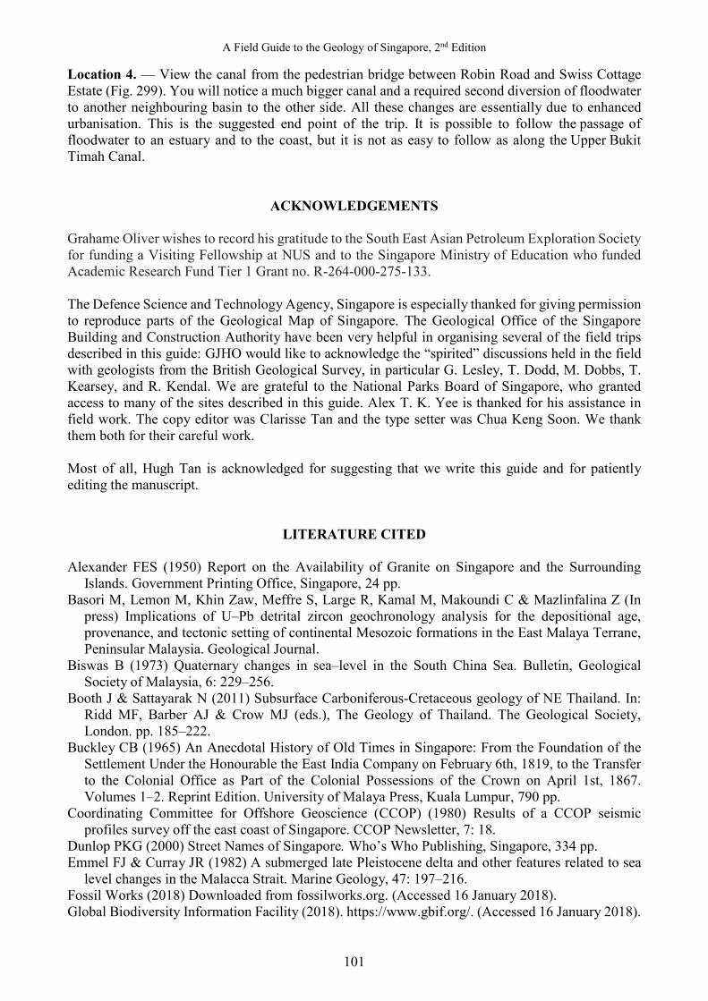
A Field Guide to the Geology of Singapore, 2nd Edition
101
Location 4. — View the canal from the pedestrian bridge between Robin Road and Swiss Cottage Estate (Fig. 299). You will notice a much bigger canal and a required second diversion of floodwater to another neighbouring basin to the other side. All these changes are essentially due to enhanced urbanisation. This is the suggested end point of the trip. It is possible to follow the passage of floodwater to an estuary and to the coast, but it is not as easy to follow as along the Upper Bukit Timah Canal.
ACKNOWLEDGEMENTS Grahame Oliver wishes to record his gratitude to the South East Asian Petroleum Exploration Society for funding a Visiting Fellowship at NUS and to the Singapore Ministry of Education who funded Academic Research Fund Tier 1 Grant no. R-264-000-275-133. The Defence Science and Technology Agency, Singapore is especially thanked for giving permission to reproduce parts of the Geological Map of Singapore. The Geological Office of the Singapore Building and Construction Authority have been very helpful in organising several of the field trips described in this guide: GJHO would like to acknowledge the “spirited” discussions held in the field with geologists from the British Geological Survey, in particular G. Lesley, T. Dodd, M. Dobbs, T. Kearsey, and R. Kendal. We are grateful to the National Parks Board of Singapore, who granted access to many of the sites described in this guide. Alex T. K. Yee is thanked for his assistance in field work. The copy editor was Clarisse Tan and the type setter was Chua Keng Soon. We thank them both for their careful work. Most of all, Hugh Tan is acknowledged for suggesting that we write this guide and for patiently editing the manuscript.
LITERATURE CITED
Alexander FES (1950) Report on the Availability of Granite on Singapore and the Surrounding Islands. Government Printing Office, Singapore, 24 pp.
Basori M, Lemon M, Khin Zaw, Meffre S, Large R, Kamal M, Makoundi C & Mazlinfalina Z (In press) Implications of U–Pb detrital zircon geochronology analysis for the depositional age, provenance, and tectonic setting of continental Mesozoic formations in the East Malaya Terrane, Peninsular Malaysia. Geological Journal.
Biswas B (1973) Quaternary changes in sea–level in the South China Sea. Bulletin, Geological Society of Malaysia, 6: 229‒256.
Booth J & Sattayarak N (2011) Subsurface Carboniferous-Cretaceous geology of NE Thailand. In: Ridd MF, Barber AJ & Crow MJ (eds.), The Geology of Thailand. The Geological Society, London. pp. 185–222.
Buckley CB (1965) An Anecdotal History of Old Times in Singapore: From the Foundation of the Settlement Under the Honourable the East India Company on February 6th, 1819, to the Transfer to the Colonial Office as Part of the Colonial Possessions of the Crown on April 1st, 1867. Volumes 1–2. Reprint Edition. University of Malaya Press, Kuala Lumpur, 790 pp.
Coordinating Committee for Offshore Geoscience (CCOP) (1980) Results of a CCOP seismic profiles survey off the east coast of Singapore. CCOP Newsletter, 7: 18.
Dunlop PKG (2000) Street Names of Singapore. Who’s Who Publishing, Singapore, 334 pp. Emmel FJ & Curray JR (1982) A submerged late Pleistocene delta and other features related to sea
level changes in the Malacca Strait. Marine Geology, 47: 197‒216. Fossil Works (2018) Downloaded from fossilworks.org. (Accessed 16 January 2018). Global Biodiversity Information Facility (2018). https://www.gbif.org/. (Accessed 16 January 2018).
Oliver & Gupta
102
Gupta A, Rahman A, Wong PP & Pitts J (1987) The Old Alluvium of Singapore and the extinct drainage system to the South China Sea. Earth Surface Processes and Landforms, 12: 259‒275.
Hutcheson CS & Tan DNK (eds.) (2009) Geology of Peninsular Malaysia. University of Malaya and the Geological Society of Malaya, Kuala Lumpur, 479 pp.
Kobayashi T & Tamura M (1968a) Myophoria (s.l.) in Malaya with a note on the Triassic Tigoniacea. In: Kobayashi T & Toriyama R (eds.) Geology and Palaeontology of Southeast Asia, Vol. 5, University of Tokyo Press. Pp. 88−137.
Kobayashi T & Tamura M (1968b) Upper Triassic pelecypods from Singapore. In: Kobayashi T & Toriyama R (eds.) Geology and Palaeontology of Southeast Asia, Vol. 5, University of Tokyo Press. Pp. 138−150.
Lee KW & Zhou Y (2009) Geology of Singapore. 2nd Edition. Defence Science and Technology Agency, Singapore, 90 pp.
Liew TC & McCulloch MT (1985) Genesis of granitoid batholiths of Peninsular Malaysia and implications for models of crustal evolution: evidence from a Nd–Sr isotopic and U–Pb, zircon study. Geochimica et Cosmochimica Acta, 49: 587–600.
Leeder M (2011) Sedimentology and Sedimentary Basins. 2nd Edition. Wiley-Blackwell, UK, 768 pp. Metcalfe I (2011) Tectonic framework and Phanerozoic evolution of Sundaland. Gondwana
Research, 19: 3–21. Molengraff GAF (1921) Modern deep–sea research in the East Indian Archipelago. Geographical
Journal, 58: 95‒121. Newton RB (1923) On marine Triassic shells from Singapore. Annals and Magazine of Natural
History, 12: 300‒321. Ng SW, Chung S-L, Robb LJ, Searle MP, Ghani AA, Whitehouse MJ, Oliver GJH, Sone M, Gardiner
NJ & Roselee MH (2015a) Petrogenesis of Malaysian granitoids in the Southeast Asian tin belt: Part 1. Geochemical and Sr–Nd isotopic characteristics. Geological Society of America Bulletin, 127: 1209–1237.
Ng SW, Chung S-L, Robb LJ, Searle MP, Ghani AA, Whitehouse MJ, Oliver GJH, Sone M, Gardiner NJ & Roselee MH (2015b) Petrogenesis of Malaysian granitoids in the Southeast Asian tin belt: Part 2. U–Pb zircon geochronology and tectonic model. Geological Society of America Bulletin, 127: 1238–1258.
Oliver GJH & Prave AR (2013) Palaeogeography of Late Triassic red–beds in Singapore and the Indosinian Orogeny. Journal of Asian Earth Science, 76: 214–224.
Oliver GJH, Khin Zaw, Hotson M, Meffre S & Manka T (2014) U–Pb zircon geochronology of Early Permian to Late Triassic rocks from Singapore and Johor: A plate tectonic reinterpretation. Gondwana Research, 26: 132–143.
Oliver GJH, Palmer A, Tjawi H & Zulkefli F (2011a) Geothermal power for Singapore: Does Singapore have a natural resource? Innovation Magazine, 10: 26–29.
Oliver GJH, Palmer A, Tjawi H & Zulkefli F (2011b) Engineered geothermal power systems for Singapore. Journal of the Inst of Engineers, Singapore, Part A: Civil and Structural Engineering, 4: 245–253.
Pan X, Oliver GJH, Chu J, Goh KH & Wei X (in press) Zircon age dating of the Sajahat Formation from Punggol, Singapore. 10th Asian Rock Mechanics Symposium, 29 Oct – 03 Nov 2018, Singapore.
Pitts J (1986) An indirect method of determining magnitudes of erosion using the c/p’ ratio. Earth Surface Processes and Landforms, 11: 107‒110.
Redding J & Christensen JB (1999) Geotechnical feasibility study into rock cavern construction in the Jurong Formation. Final project report by Ove Arup & Partners International Ltd and Nonconsult Internatioal A/S.
Sevastjanova I, Clements B, Hall R, Belousova EA, Griffin WL & Pearson N (2011) Granitic magmatism, basement ages, and provenance indicators in the Malay Peninsula: insights from detrital zircon U–Pb and Hf-isotope data. Gondwana Research, 19: 1024–1039.
Tjiawi H (2013) Numerical Simulation Studies of the Geothermal Resource in Singapore. PhD
A Field Guide to the Geology of Singapore, 2nd Edition
103
Thesis, Department of Civil & Environmental Engineering, National University of Singapore, Singapore, 179 pp.
Tjiawi H, Palmer AC & Oliver GJH (2012) Natural state modeling of Singapore Geothermal Reservoir. UNIMAS E-Journal of Civil Engineering, 3(Special Issue): 34–40.
Zainal I (1984) Petrology and Geochemistry of Santi Area, Pengerang, South-east Johore. Unpublished B.Sc. (Honours) Thesis, Department of Geology, University of Malaya, Kuala Lumpur, 53 pp.
HOW TO CITE THIS BOOK Oliver GJH & Gupta A (2019) A Field Guide to the Geology of Singapore. 2nd Edition. Lee Kong Chian Natural History Museum, National University of Singapore, Singapore, 103 pp. Uploaded 19 February 2019. https://lkcnhm.nus.edu.sg/lkcnhm-e-books/LKCNHM-EBOOK-2019-0002.pdf.