Late Quaternary core stratigraphy of the northern New South Wales continental shelf
16
Australian Journal of Earth Sciences (2004) 51, 141–156 Late Quaternary core stratigraphy of the northern New South Wales continental shelf J. J. ROBERTS AND R. BOYD* Discipline of Geology, University of Newcastle, NSW 2308, Australia. On the southeast Australian continental margin, mixed siliciclastic and temperate carbonate sedi- ments are presently forming along the narrow 20–35 km-wide northern New South Wales shelf over an area of 4960 km 2 . Here, year-round, highly energetic waves rework inner and mid-shelf clastic sedi- ments by northward longshore currents or waning storm flows. The strong East Australian Current flows south, sweeping clastic and outer shelf biogenic sands and gravels. Quaternary siliciclastic inner shelf cores consist of fine to medium, lower shoreface sand and graded storm beds of fine to coarse sand. Physically abraded, disarticulated molluscs such as Donacidae and Glycymeridae form isolated gravel lags. Highstand inner shelf clastics accumulate at 0.53 m/10 3 y in less than 50 m water depth. Clastic mid-shelf cores contain well-sorted, winnowed, medium shoreface sands, with a fine sand component. Fine sand and mud in this area is discharged mainly from New South Wales' largest river, the Clarence. The seaward jutting of Byron Bay results in weakened East Australia Current flows through the mid-shelf from Ballina to Yamba allowing the fine sediments to accumulate. Quaternary carbon- ate outer shelf cores have uniform and graded beds forming from the East Australian Current and are also influenced by less frequent storm energy. Modern clastic-starved outer shelf hardgrounds are cemented by coralline algae and encrusting bryozoans. Clay-sized particles are dominantly high-Mg calcite with minor aragonite and smectite/kaolinite. Carbonate sands are rich in bryozoan fragments and sponge spicules. Distinctive (gravel-sized) molluscs form isolated shells or shell lag deposits comprising Limopsidae and Pectinidae. The upper slope sediments are the only significant accumulation of surficial mud on the margin (18–36 wt%), filling the interstices of poorly sorted, biogenic gravels. Pectinid molluscs form a basal gravel lag. During highstand the outer shelf accumulates sediment at 0.40 m/10 3 y, with the upper slope accumulating a lower 0.23 m/10 3 y since transgression. Transgression produced a diachronous (14–10 ka) wave-ravinement surface in all cores. Relict marine hardgrounds overlie the wave-ravinement surface and are cemented by inorganic calcite from the shallow and warm East Australian Current. Transgressive estuarine deposits, oxygen isotope Stage 3–5 barriers or shallow bedrock underlie the wave-ravinement surface on the inner and mid shelf. Northern New South Wales is an example of a low accommodation, wave- and oceanic current-dominated margin that has produced mixed siliciclastic–carbonate facies. Shelf ridge features that characterise many storm-dominated margins are absent. KEY WORDS: carbonate, continental shelf, currents, New South Wales, Quaternary, sediments, silici- clastics, stratigraphy, temperate water. INTRODUCTION From extensive onshore Quaternary studies (Thom & Roy 1985; Roy & Boyd 1996; Carter & Woodroffe 1997) coastal southeast Australia is regarded as a classic wave-domin- ated coast. The southeast Australian margin is >1500 km long, extending southward from southeast Queensland to Victoria (Figure 1). However, less well-known than the coastal features are the offshore shelf physiography, sedimentology, stratigraphy and marine sediment- transport processes. The central New South Wales shelf was recognised early as having distinct inner and outer shelf sediment provinces (Shirley 1964). The inner shelf is dominated by siliciclastic sands that contrast with the outer shelf's temperate-water carbonate sands and gravel. An under- standing of the spatial, temporal and compositional vari- ation of these shelf sediments is limited by the location of previous marine surveys. For example, much of the inner shelf of the New South Wales coast has been investigated during heavy-mineral exploration (Figure 1) (Marshall 1979, 1980; Kudrass 1982; Colwell 1983; Browne 1994), although the outer shelf stratigraphy has been well studied only off central New South Wales (Ferland & Roy 2000). The present paper discusses the Late Quaternary evo- lution of the northern New South Wales shelf, principally from seabed morphology, surface samples and analysis of 12 vibrocores collected during the Franklin 15/1998 cruise. Further, these data are compared to 46 published (Kudrass 1982) and 83 unpublished core descriptions. The latter unpublished core descriptions were produced by Cable Sands Holdings as part of an exploration project for heavy minerals on the shelf and provided in reports by this company to the New South Wales Government (Cable Sands Holdings 1991). The synthesis of these datasets provides a better understanding of the surficial and near- surface facies evolution of the whole northern New *Corresponding author: [email protected]
-
Upload
newcastle-au -
Category
Documents
-
view
0 -
download
0
Transcript of Late Quaternary core stratigraphy of the northern New South Wales continental shelf
Australian Journal of Earth Sciences
(2004)
51
,
141–156
Late Quaternary core stratigraphy of the northern New South Wales continental shelf
J. J. ROBERTS AND R. BOYD*
Discipline of Geology, University of Newcastle, NSW 2308, Australia.
On the southeast Australian continental margin, mixed siliciclastic and temperate carbonate sedi-ments are presently forming along the narrow 20–35 km-wide northern New South Wales shelf over anarea of 4960 km
2
. Here, year-round, highly energetic waves rework inner and mid-shelf clastic sedi-ments by northward longshore currents or waning storm flows. The strong East Australian Current flowssouth, sweeping clastic and outer shelf biogenic sands and gravels. Quaternary siliciclastic inner shelfcores consist of fine to medium, lower shoreface sand and graded storm beds of fine to coarse sand.Physically abraded, disarticulated molluscs such as Donacidae and Glycymeridae form isolatedgravel lags. Highstand inner shelf clastics accumulate at 0.53 m/10
3
y in less than 50 m water depth.Clastic mid-shelf cores contain well-sorted, winnowed, medium shoreface sands, with a fine sandcomponent. Fine sand and mud in this area is discharged mainly from New South Wales' largest river,the Clarence. The seaward jutting of Byron Bay results in weakened East Australia Current flows throughthe mid-shelf from Ballina to Yamba allowing the fine sediments to accumulate. Quaternary carbon-ate outer shelf cores have uniform and graded beds forming from the East Australian Current and arealso influenced by less frequent storm energy. Modern clastic-starved outer shelf hardgrounds arecemented by coralline algae and encrusting bryozoans. Clay-sized particles are dominantly high-Mgcalcite with minor aragonite and smectite/kaolinite. Carbonate sands are rich in bryozoan fragmentsand sponge spicules. Distinctive (gravel-sized) molluscs form isolated shells or shell lag depositscomprising Limopsidae and Pectinidae. The upper slope sediments are the only significantaccumulation of surficial mud on the margin (18–36 wt%), filling the interstices of poorly sorted,biogenic gravels. Pectinid molluscs form a basal gravel lag. During highstand the outer shelfaccumulates sediment at 0.40 m/10
3
y, with the upper slope accumulating a lower 0.23 m/10
3
y sincetransgression. Transgression produced a diachronous (14–10 ka) wave-ravinement surface in all cores.Relict marine hardgrounds overlie the wave-ravinement surface and are cemented by inorganiccalcite from the shallow and warm East Australian Current. Transgressive estuarine deposits, oxygenisotope Stage 3–5 barriers or shallow bedrock underlie the wave-ravinement surface on the inner andmid shelf. Northern New South Wales is an example of a low accommodation, wave- and oceaniccurrent-dominated margin that has produced mixed siliciclastic–carbonate facies. Shelf ridgefeatures that characterise many storm-dominated margins are absent.
KEY WORDS: carbonate, continental shelf, currents, New South Wales, Quaternary, sediments, silici-clastics, stratigraphy, temperate water.
INTRODUCTION
From extensive onshore Quaternary studies (Thom & Roy1985; Roy & Boyd 1996; Carter & Woodroffe 1997) coastalsoutheast Australia is regarded as a classic wave-domin-ated coast. The southeast Australian margin is >1500 kmlong, extending southward from southeast Queensland toVictoria (Figure 1). However, less well-known than thecoastal features are the offshore shelf physiography,sedimentology, stratigraphy and marine sediment-transport processes.
The central New South Wales shelf was recognisedearly as having distinct inner and outer shelf sedimentprovinces (Shirley 1964). The inner shelf is dominated bysiliciclastic sands that contrast with the outer shelf'stemperate-water carbonate sands and gravel. An under-standing of the spatial, temporal and compositional vari-ation of these shelf sediments is limited by the location ofprevious marine surveys. For example, much of the innershelf of the New South Wales coast has been investigated
during heavy-mineral exploration (Figure 1) (Marshall1979, 1980; Kudrass 1982; Colwell 1983; Browne 1994),although the outer shelf stratigraphy has been well studiedonly off central New South Wales (Ferland & Roy 2000).
The present paper discusses the Late Quaternary evo-lution of the northern New South Wales shelf, principallyfrom seabed morphology, surface samples and analysis of12 vibrocores collected during the
Franklin
15/1998 cruise.Further, these data are compared to 46 published (Kudrass1982) and 83 unpublished core descriptions. The latterunpublished core descriptions were produced by CableSands Holdings as part of an exploration project for heavyminerals on the shelf and provided in reports by thiscompany to the New South Wales Government (CableSands Holdings 1991). The synthesis of these datasetsprovides a better understanding of the surficial and near-surface
facies
evolution
of
the
whole
northern
New
*Corresponding author: [email protected]

142
J. J. Roberts and R. Boyd
South Wales shelf, and its contrast to the central NewSouth Wales shelf (Davies 1979; Jones & Kudrass 1982;Ferland & Roy 2000), and other global shelf sedimentationpatterns.
The study area is located on the northern New SouthWales shelf between 29
�
30
�
S and 28
�
05
�
S and covers an areaof 4690 km
2
(Figure 1). In the study area, the coastlineextends for 190 km between Yamba in the south to TweedHeads in the north. The coast trends north-northeast from
Yamba to Byron Bay, then north towards Tweed Heads.Three significant rivers discharge onto the shelf, namelythe Tweed, Richmond and Clarence Rivers.
By global standards (Shepard 1973), the shelf physio-graphy between Yamba and Tweed Heads is both narrowand steep. The shelf has a minimum width of 20 kmoffshore from Byron Bay, to a maximum width of 35 kmoffshore from Yamba (Figure 1). The shelf break shallowsin a northerly direction from 120 m to 90 m.
Figure 1 Core localities offshorenorthern New South Wales.Upper inset: location of studyarea. Lower inset: location of 412surficial sediment samples.Water depth contours in metres.CSH, Cable Sands Holdings.Orange circles, grab samples.

Quaternary shelf stratigraphy, northern NSW
143
Three major lithotectonic units provide the bedrockcontainers for deposition of Quaternary sediments,namely, the Palaeozoic New England Fold Belt, MesozoicClarence–Moreton Basin and Cenozoic Intraplate IgneousComplexes (Johnston 1989; Wells & O’Brien 1995; Veevers2000). These units form different styles of outcrop on theinner to mid-shelf, and are generally buried below outershelf sediments. Irregular outcrops with vertical relief ofone to tens of metres are formed by Palaeozoic metasilt-stones/sandstones and Tertiary Volcanics, offshore fromTweed Heads to Byron Bay. In contrast, laterally continu-ous, undulatory terraces of the Clarence–Moreton Basinoccur in the offshore Yamba Trough that extends to 60 mwater depth (Shaw
et al
. 2001). The presence of bedrock,rapid Quaternary fluctuations of sea level and a low sub-sidence rate in northern New South Wales (Roy & Thom
1981) results in low accommodation space for the preserv-ation of sedimentary units.
The
northern
New
South
Wales
shelf
is
influencedby strong wave and current processes, similar to thesoutheast African margin (Figure 2) (Johnson & Baldwin1996).
The
detritus
on
the
northern
New
South
Walesshelf
is
provided
from
coastal
rivers
and
the shorelineby nearshore currents or cannibalised from laterallyadjacent drowned strandlines. This has produced well-rounded
inner
shelf
sediments
of
quartzose
compositionwith minor (5–10%) feldspar and lithics (Roy & Crawford1977;
Colwell
1983).
The
recycling
of
these
sedimentsover
multiple
sea-level
cycles
also
produced
an
iron-stained quartz and carbonate detrital fraction that isparticularly abundant at sea-floor depths of 20–60 m(Colwell 1982).
Figure 2 Top left, process–response classification of modernshelves. Top right, Byron Baymean monthly maximum waveheight record (1980–2000) Bottomleft, thermal satellite image of theEast Australian Current. Middleright, dominant wind directionand strength at Byron Bay.Bottom right, oxygen isotopeproxy of Pleistocene sea-level(Chappell & Shackleton 1986).

144
J. J. Roberts and R. Boyd
New South Wales shelf processes
Sea-level fluctuation is a primary forcing agent for thestratigraphic evolution of the New South Wales coast andshelf. A Quaternary sea-level record obtained from theoxygen isotope record in raised corals and deep-sea cores(Martinson
et al
. 1987; Shackleton 1987; Chappell & Polach1991; Chappell
et al
. 1996) indicates a Pleistocene sea-levelhighstand 4 m higher than present at 125 ka (Figure 2).Following this, the sea-level fluctuated 30–80 m belowpresent until 18 ka. The last glacial maximum occurredaround 18 ka when sea-level reached a lowstand level of120 m, producing a subaerially exposed shelf. From 18 kauntil 6.5 ka, the sea flooded the entire shelf during the post-glacial marine transgression. The present Holocene high-stand has persisted since 6.5 ka (Thom & Roy 1985; Nakada& Lambeck 1989), with slight rises of relative sea-leveldetected in east coast tide gauges over the past 150 years(Mitchell
et al
. 2001).
Oceanography and climate
Northern New South Wales experiences a warm-temperateclimate (mean daily temperatures between 15
�
C and 23
�
Cand mean annual rainfall of 1460 mm). The Clarence Rivercatchment of 20 746 km
2
produces the largest annual dis-charge of any river in New South Wales [4.92
�
10
9
m
3
/year(Anon 1976)]. In contrast, the Richmond and Tweed dis-charge 2.49
�
10
9
m
3
/year and 1.92
�
10
9
m
3
/year, respec-tively. The local climate is driven by five meteorologicalsystems, namely tropical and east coast cyclones, mid-latitude cyclones, zonal anticyclone highs and summerconvection breezes (Short & Trenaman 1992), whichproduce a high-energy, variable wave climate (Figure 2)(Public Works Department 1985; Short & Trenaman 1992).The most frequently occurring swell directions are fromthe south and east-southeast. This establishes a north-ward-flowing littoral current up to 0.8 m/s in the surf zone,and extending to 10 m water depth (Gordon
et al
. 1979).However, the greatest wave energy is produced by tropicalcyclones (6–8 m significant wave height and 13 s period)with an associated coastal setup ranging to 1.4 m. Themicrotidal coastline has a mean spring tidal range of1.35 m (Floyd & Druery 1976).
The strong south-flowing East Australian Current is acomplex western boundary current that contains surfaceflows measured up to 7.2 km/h (Godfrey
et al
. 1980). TheEast Australian Current moves as an incursion of warmwater and anticyclonic eddies onto the shelf, with anassociated change in dynamic surface height (Figure 2).Given the complex changes in coastal alignment, thecurrent frequently separates at promontories such asSugarloaf Point in central New South Wales and sweepsclose to the coast in the study area at Byron Bay. Heresouth-directed bottom currents of 0.6 m/s have beenmeasured in 30 m of water (Gordon
et al
. 1979). Sedimento-logical implications are little understood, apart fromcurrent-aligned ripples in headland-attached shelf sandbodies at Byron Bay (Shirley 1964; Gordon
et al
. 1979;Godfrey
et al
. 1980; Jones & Kudrass 1982). However, mid-shelf muds occur along the relatively wide central NewSouth Wales shelf south of the major flow separation at
Sugarloaf Point (Shirley 1964; Godfrey
et al
. 1980), indi-cating that their absence to the north is related to EastAustralia Current activity.
PREVIOUS WORK
Surface
samples
from
the
northern
New
South
Walesshelf (Figure 1) were initially obtained by Conolly (1969),with
regional
sampling
(Marshall
1980)
by
the
Bureauof Mineral Resources (now Geoscience Australia). TheBureau of Mineral Resources' samples were at 10 nautical-mile spacing, revealing the dominance of sand-sizeddetritus
across
the
whole
shelf.
Outer
shelf
and
upperslope environments exhibit extensive modern and relictauthigenic sedimentation (Marshall 1979, 1980), illustrat-ing their complex nature and likely minimal accumulationrates. For example, upper slope northern New South Walessediments contain authigenic phosphatic nodules andclasts, together with fossils such as an Early Miocene–Early Pliocene crab (
Ommatocarcinus corioensis
: Von DerBorch 1970).
More comprehensive inner shelf surficial sampling wasundertaken for heavy-mineral exploration (Colwell 1982),with detailed coastal surveys of onshore beaches andcoastal littoral sands at sites of major coastal developmentsuch as Byron Bay and Yamba (Gordon
et al
. 1979; Briton1984). Four surficial sediment units have been identified inthese studies: upper and lower nearshore sands, mobileinner shelf sand sheets and headland-attached sand lobes.These are distinguished on the basis of differing grainsize/sorting,
carbonate
content,
and the presence or absenceof mud and iron-stained clasts. Inner shelf facies showdistinct spatial variability at the 1–10 km scale.
Previously, 46 vibrocores (Figure 1) obtained along thenorthern New South Wales inner and mid-shelf (Kudrass1982) revealed nine lithostratigraphic units. Colwell (1983)described surficial nearshore fine sand, inner shelfmedium–coarse sand and carbonate gravel, and mid-shelffine sand and mud. These Holocene highstand shelf sedi-ments have an average thickness of 1.7 m. Underlying theseare shelly or gravelly lags, estuarine mud and muddy sandthat formed during sea-level rise. Suspected Pleistocenedeposits include leached/humate–cemented barrier sands,estuarine or back barrier swamp deposits, and calcareous,partly cemented marine, shallow marine and barriersands. These lithotypes are analogous to well-studiedQuaternary onshore deposits in northern New SouthWales (Winward 1974; Roy 1982; Thom 1983; Chappell 1993;Huq 1995; Stables 2001).
Outer shelf and upper slope marine investigation issparse in northern New South Wales. However, conditionsare similar to the central New South Wales area, asdescribed by Ferland and Roy (2000) and Troedson andDavies (2001). Ferland and Roy (2000) recognised the mixedsiliciclastic–carbonate character of the central New SouthWales margin, documenting sedimentological and macro-faunal species variation. Their outer shelf cores containcyclical, intermediate and high sea-level fine carbonatesands and mollusc shells intercalated with a coarser unitof densely packed Pecten fumatus. Along the upper slope acontrasting sedimentary succession is recognised, that of

Quaternary shelf stratigraphy, northern NSW 145Ta
ble
1S
um
mar
y of
nor
ther
n N
ew S
outh
Wal
es s
hel
f an
d u
pper
slo
pe li
thof
acie
s ch
arac
teri
stic
s.
Un
itM
axim
um
thic
kn
ess
(m)
Col
our
(Mu
nse
ll)
Mea
n s
ize*
(�)
Com
posi
tion
Sed
imen
tary
stru
ctu
res
Ich
nol
ogy
Inte
rpre
tati
on
Yel
low
gre
y F
U s
and
(Sg)
3.62
Y-G
r 2.
5Y6/
11.
53Q
, <10
%F
+L
, <2%
HM
, 6%
CA
Ero
sion
al b
ase,
FU
Sk
olit
hos
, Pla
nol
ites
Mod
ern
in
ner
sh
elf,
gr
aded
sto
rm b
eds
Un
ifor
m F
-M s
and
(Su
)0.
95F
awn
-gr
1.8
Q, r
are
L, n
o C
AC
ompa
ct, w
ell s
orte
d,
upp
er s
urf
ace
eros
ion
al
Sk
olit
hos
Low
er s
hor
efac
e
M-C
san
dy g
rave
l (L
cs)
0.05
–0.2
Ran
geC
oars
e sa
nd
and
grav
el2–
27%
car
bon
ate
Lag
Nil
Inn
er s
hel
f st
orm
lag
F-M
san
d (S
mg)
3.6
5Y 5
/22.
2Q
, min
or m
ediu
m
angu
lar
Q, F
an
d F
e st
ain
ed,>
22%
mu
d (Q
, kao
lin
ite,
sm
ecti
te,
tr. a
rago
nit
e,ca
lcit
e),
<12
% C
A
Ero
sion
al b
ase,
2–5
cm
sh
ell h
ash
laye
rs,
FU
gra
ded
beds
Sk
olit
hos
, Pla
nol
ites
Gra
ded
stor
m b
ed w
ith
C
lare
nce
Riv
er i
npu
t
Wel
l sor
ted
F-M
san
d (S
wg)
3.52
Gr
2.0
Q, <
10%
F+
L, <
2%H
M,
6% c
arbo
nat
e, fi
nes
an
gula
r, 5
–25%
F+
L
Gra
vel l
ag b
ase,
gr
adat
ion
al t
opS
kol
ith
os, P
lan
olit
esW
inn
owed
rel
ict
barr
ier
FU
car
bon
ate
san
d (C
s)3.
5Y
-r (7
.5Y
R 6
/6)
M-c
san
dQ
+C
A (a
v. 1
8.5%
)E
rosi
onal
bas
e, F
UN
ilD
eep
wat
er fa
un
a +
cu
rren
t w
inn
owin
gC
arbo
nat
e ce
men
ted
clas
tic
san
ds (C
p)10
cm
+R
ange
NA
Car
bon
ate
cem
ente
d Q
an
d C
AL
agN
AIn
sit
u c
emen
tati
on o
f sh
elf
and
slop
e fa
cies
Bio
gen
ic m
udd
y gr
avel
(Usg
)1.
95Y
-b 2
.5Y
6/2
Mu
ddy
grav
elB
ioge
nic
CA
Ero
sion
al b
ase,
FU
u
pper
20c
mN
ilD
eep
wat
er fa
un
a +
cu
rren
t w
inn
owin
gS
ilty
cla
y (E
c)0.
95M
id g
r-bl
ack
(2.5
Y 4
/1)
Sil
ty c
lay
Q, C
lay,
Org
anic
ric
h
(18.
4%)
CU
, ero
sion
al t
op
wit
h G
loss
ifu
ngi
tes
surf
ace
Abu
nda
nt,
T
ereb
elli
na,
Th
alas
sin
oide
s,T
ered
olit
es r
ootl
ets
Est
uar
ine
cen
tral
ba
sin
(Ec)
Inte
rbed
ded
san
dy
clay
an
d pe
at (E
mg)
0.4
Bro
wn
(2.5
Y 2
/1)
Mix
ed s
and
clay
an
d pe
atO
rgan
ic m
atte
r, Q
, C
lay
Sh
arp
upp
er a
nd
low
er
con
tact
s, la
min
atio
ns
Pal
aeop
hyc
us,
C
asu
arin
a ro
otle
tsIn
tert
idal
to
supr
atid
al
estu
ary
FU
san
d an
d gr
avel
(E
cg)
1.14
Gr
F-m
san
dQ
, L p
ebbl
es, s
hel
lsE
rosi
onal
bas
e, li
thic
(4
–30
mm
) + s
hel
l lag
, F
U
Nil
Bas
al t
idal
ch
ann
el
F-M
CU
san
d (E
sg)
2.47
Gr
F-m
san
dQ
, CA
sh
ells
Ero
sion
al b
ase,
CU
, lo
w-a
ngl
e la
min
atio
ns
Sk
olit
hos
, Pla
nol
ites
, P
alae
oph
ycu
sF
lood
tid
al d
elta
Fin
e sa
nd
(Du
)>
0.5
Pal
e w
hit
eF
ine
to v
ery
fin
e sa
nd
Dom
inan
tly
quar
tz
and
min
or fe
ldsp
arpl
us
hea
vy m
iner
als,
no
carb
onat
e
Nil
Bio
turb
ated
upp
er
con
tact
(?
Glo
ssif
un
gite
s su
rfac
e)
Ple
isto
cen
e du
ne
Q, q
uar
tz; F
, fel
dspa
r; L
, lit
hic
s; C
A, c
arbo
nat
e; H
M, h
eavy
min
eral
s; F
U, fi
nin
g u
p; C
U, c
oars
enin
g u
p; F
-m, fi
ne-
med
ium
; M-c
, med
ium
-coa
rse;
Y, y
ello
w; G
r, g
rey;
b, b
row
n; r
, red
; tr,
tra
ce;
NA
, not
app
lica
ble.
Th
e fa
cies
cod
ing
(e.g
. Sg)
is
shor
than
d fo
r th
e fu
ll u
nit
nam
e (i
n t
his
cas
e ye
llow
gre
y fi
nin
g-u
pwar
d sa
nd)
.*E
xclu
din
g gr
avel
lag.

146 J. J. Roberts and R. Boyd
fine siliciclastic material and pelagic carbonate. Here low-stand shedding of fine muds appears to be responsible forthe dilution of in situ carbonate production on the centralNew South Wales margin (Ferland & Roy 2000; Troedson &Davies 2001).
METHODS
The present paper describes the surficial Quaternary evo-lution of the northern New South Wales shelf, from asynthesis of previously acquired data together with seabedmorphology, surface samples and vibrocores obtained onthe Franklin 15/1998 cruise. The aim was to obtain coresacross the entire shelf, allowing a comparison with moredetailed inner shelf sampling (Kudrass 1982; Cable SandsHoldings 1991). Two cross-shelf core profiles were obtainedoffshore from the Tweed and Clarence Rivers. The Tweedsurvey also sampled upper slope sediments beyond theshelf break.
Fourteen sedimentological units have been identified,classified into facies (Walker 1984) and correlated within asequence-stratigraphic framework for modern sediments(Boyd et al. 1989). The facies analysis approach of thepresent study (Tables 1, 2) is consistent with previousinner shelf vibrocore facies of Kudrass (1982) and shallowcores along the coast at Byron Bay and Yamba (Gordonet al. 1979; Briton 1984; Anon 2000). The core localitiesare prefixed by the abbreviations TR (Tweed River), BB(Byron Bay) and CR (Clarence River).
Seabed morphological units were determined from 31cross-shelf profiles spaced between 4 km and 6 km apart.These were correlated with 3-D slope and change in slopemodels determined from 34 199 bathymetric points. Abathymetric grid was constructed using a power function(1.54) with a coast parallel anisotropy angle of 010� in theSurfer 7 program (Golden Software, Boulder, CO, USA).Contouring of surficial grainsize values has utilised aradial basis interpolation function. Grainsize value con-touring used kriging function parameters of search radius30 000 m, anisotropy ratio of 2. Carbonate value contouringused linear kriging function parameters of 60 000 m searchradius, slope ratio 1 and anisotropy of 1. Contouring pro-duced a raster output with cell sizes of 600 m2 and 900 m2,for grainsize and carbonate values, respectively.
Vibrocore techniques were used to obtain cores in75 mm diameter aluminium pipes that penetrated a maxi-mum sediment depth of 6 m. Cores were cut at 1 m lengthsand halved onboard into working and archive sections,which were both preserved in shrink-wrap. Working halveswere logged and described, noting lithological unit proper-ties and boundaries, digitally photoarchived and sampled.The sampling aimed to characterise sedimentological andichnological variation in cores. Samples were obtained atthe base, middle and tops of lithological units, or at distinctsedimentological and ichnological features.
Core samples were obtained for grainsize, petrology,total carbonate content (loss on ignition technique ofMooers 1999), magnetic susceptibility and X-ray diffrac-tion analysis of clay units. All analyses were undertaken atthe University of Newcastle. Samples of macrofauna wereobtained from all facies. D. I. Loch assisted in comparingthese samples to the Australian Museum MalacologyCollection. An additional 12 samples were radiocarbondated at Waikato Laboratories, New Zealand (Table 3).
RESULTS
Morphological context of surficial sediments
The morphological context of Quaternary sediments aresummarised here and in Figure 3. This morphologicaldescription provides a physical framework for under-standing the 'morphodynamic' (Wright & Thom 1977) pro-cesses explaining the stratigraphic development. Further,sea-floor observations such as side-scan sonar images pro-vide detail of lateral facies variation and bedforms.
The onshore morphology consists of a coastal mega-planform (50–100 km scale) that is controlled by the outcropdistribution of major lithotectonic units such as theTweed Shield Volcano and Clarence–Moreton Basin.These features define the drainage basins for the Clarence,Richmond and Tweed Rivers. Quaternary coastal plainsediments are developed mainly in coastal valleys andbetween bedrock headlands.
Four shelf physiographic zones are distinguished:shoreface (including the littoral transport zone), innershelf plain, mid-shelf slope and outer shelf plain. Theshoreface frequently extends from bedrock-compart-
Table 2 Northern New South Wales lithofacies classification and diagnostic macrofauna associations.
Lithofaciesunit
Diagnostic bivalve and gastropod assemblages
Sg Glycymeris holocenicus, G. striatularis, Placamen placidum, Donax deltoides, Hemidonax verinus, Neverita inceiLcs Mactra pusilla, M. rufescens, M. jacksonensisSmg Venericardia bimaculata, Dentalium grahami, Nemocardium thetidis, Gazameda gunniiSwg Neocardium thetidis and Gazameda gunni (only)Cs Limopsis loringi, L. soboles, L. woodwardi, Anachlamys flabellata, Amusium balloti, Pecten fumatus (minor)Usg Anachlamys flabellataEc Nemocardium thetidis, Callista (Notocallista) diemenensis, Spisula (Notospisula) trigonella, Tellina deltoidalis,
Conuber conicum, Conus cyanostomusEmg No species identifiableEcg Saccostrea glomerataEsg Callista (Notocallista) diemenensis, Timoclea scabra, Antigona persimilis, Turrella tenuilirata, Leiopyrga lineolarisDu No macrofauna present

Quaternary shelf stratigraphy, northern NSW 147
mentalised beaches to submerged reefs (in water depths<25–30 m). The shoreface shows spatial variation, withprotected southern corners having steep reflective profilesand northern sections of beaches having a relatively dissi-pative beach state (Short 1999). Seaward of the ClarenceRiver is found a lobate (10 � 20 km) subaqueous delta front.Elsewhere the shoreface extends from beaches to the innershelf plain. The inner shelf plain extends to 50–60 m waterdepth and is 12 km wide in the south, narrowing to thenorth, particularly offshore from Byron Bay. The outershelf plain occupies a relatively flatter area between theinner shelf plain and the north-trending shelf break.
As seen on Figure 3, the inner shelf plain extends fromthe base of the shoreface to 60 m water depth, being 6–8 km-wide offshore from Byron Bay to Tweed Heads. Sea-floorgradients of 0.16–0.31� are common, with a distinctive mid-shelf slope (0.31–0.63�) at 60 m. Further south offshore fromBallina, the relatively flat (0–0.16�) inner shelf plain reachesa maximum width of 12 km. A less distinctive mid-shelfslope is present offshore from Evans Head to Yamba(0.16–0.31�). No bedforms have been observed along thissouthern inner shelf plain, although the recoveredsurficial and near-surface samples indicate muddy sandsoverlying relict barrier sediments (Figure 3).
Side-scan sonar images are available for the northerninner shelf plain, from Hastings Point to Fingal Head(Cable Sands Holdings 1991). This survey in water depthsof 15–60 m indicates four major sea-floor surfaces: (i) gravelpatches; (ii) bedrock reefs; (iii) sand ripple fields withelongate or irregular crests that are both closely andwidely spaced; and (iv) areas of non-sonar observablebedforms. These sea-floor types vary at scales of one tohundreds of metres with both distinct and gradationalboundaries. For instance, gravel (carbonate and clastic)patches have distinct boundaries occupying depressionsup to 0.2 m deep surrounding bedrock reefs. Ripple fieldshave gradational boundaries over tens to a few hundredmetres. These bedforms reflect the highly energetic andvariable wave regime as well as coarse grainsize of theclastic and carbonate sediments.
Offshore from Byron Bay is a large (10 � 15 km) coast-parallel sand body, similar to other headland-attached shelfsand bodies in central New South Wales. This sand body islocated on a relatively steep bedrock substrate and is at a
major divergence of the East Australia Current alongnorthern New South Wales. Divergent, 1–5 m wavelengthripple fields were identified on this sand lobe, which wasformed by the interaction of the longshore transportsystem, East Australia Current and the steep bedrocktopography (Colwell 1983).
The outer shelf (Figure 3) has a relatively subduedmorphology, carbonate-rich surficial sediment type anddistinctive bedforms that contrast with the inner and mid-shelf. The outer shelf plain occupies a linear zone of lowgradient (0.16–0.47�), along a length of 150 km and width of6–12 km. Bedforms include linear, north–south-trendingsymmetrical furrows of 30 m wavelength and crescenticripples indicating north to south flows in 60 m water depth.
The shelf break depth is at 110 m offshore from Yambaand shallows abruptly to 90 m offshore, and north, fromBallina. At the shelf break the sea-floor gradient changesfrom 0.15� to 0.94� over 1–4 km. The upper slope is less well-defined, although a gradient of 0.78–1.88� is typical betweenthe shelf break and 250 m water depth. Lower gradientterraces are present on the upper slope at 120 m waterdepth offshore from Tweed Heads.
Sediment facies, facies associations, and inferred depositional environments and processes
Thirteen distinct sedimentary units are identifiable in theshelf cores. They are summarised in Table 1 and groupedinto four facies associations (Walker 1984) below. Eightsurficial and near-surface marine units are necessary toaccount for the diverse inner shelf siliciclastic sands,mid-shelf clastic sands and outer shelf and upper slopetemperate carbonate sands and gravels. The other fiveunits comprise relict estuarine sediments. The surficialand near-surface clastic sands occur from the presentshoreline to mid-shelf depths of 75 m. Typical thicknessesof surficial units along the inner shelf vary between 1 and5 m, with lateral differences at scales of 1–10 km. Beyondthis depth carbonate sands and hardgrounds predominate.
FACIES ASSOCIATION 1: SILICICLASTIC INNER SHELF
All facies of the well-defined inner shelf (north of 28�55�S)in northern New South Wales have erosional bases, fining-
Table 3 Radiocarbon dates of core samples from the northern New South Wales shelf.
Waikato sample Age (years) Sample material Core and depth (m) Enclosing facies
7205 9950 ± 110 Marine shell CR4A 0.50–0.60 Swg7206 12000 ± 900 Marine shell CR4A 3.07–3.12 Ecg7207 12800 ± 110 Organic matter CR4A 3.85–3.91 Ec7208 13500 ± 100 Marine shell CR5 3.51–3.65 Cp7209 13190 ± 190 Marine shell CR7 0.90–0.97 Esg7210 12780 ± 150 Marine shell CR7 1.36–1.57 Cs7211 6310 ± 70 Marine shell TR1 1.30–1.43 Cs7212 7970 ± 100 Marine shell TR1 1.30–1.43B Cs7213 5080 ± 80 Marine shell TR3 2.90–3.40 Cs7214 10970 ± 100 Marine shell TR3 3.83–4.03 Cp7215 9660 ± 80 Marine shell TR5 2.06–2.24 Su7216 6650 ± 70 Marine shell TR6 1.60–1.75 Su7217 13950 ± 180 Marine shell TR10 2.10–2.19 Cp
Age dating carried out at the Waikato Laboratories, New Zealand.
148 J. J. Roberts and R. Boyd
up or uniform grainsize trends and an absence of sedi-mentary structures except for lag deposits or internalravinement surfaces. These siliciclastic inner shelf sedi-ments may be further subdivided into component faciesSg, Su and Lcs (Table 1). The surficial clastic facies arealways present on the inner shelf, except where bedrock isexposed. The lateral extent and maximum water depth ofFacies Association 1 is variable (Gordon et al. 1979).
FACIES ASSOCIATION 2: SILICICLASTIC INNER/MID-SHELF
Facies Association 2 is found on the northern New SouthWales inner/mid-shelf south of Ballina. It consists of faciesSmg, Swg and Lcs (Table 1). All these facies have erosionalbases and graded or uniform bedding, and are thussimilar to Facies Association 1. However, these unitshave a distinct sedimentology, indicating a significant
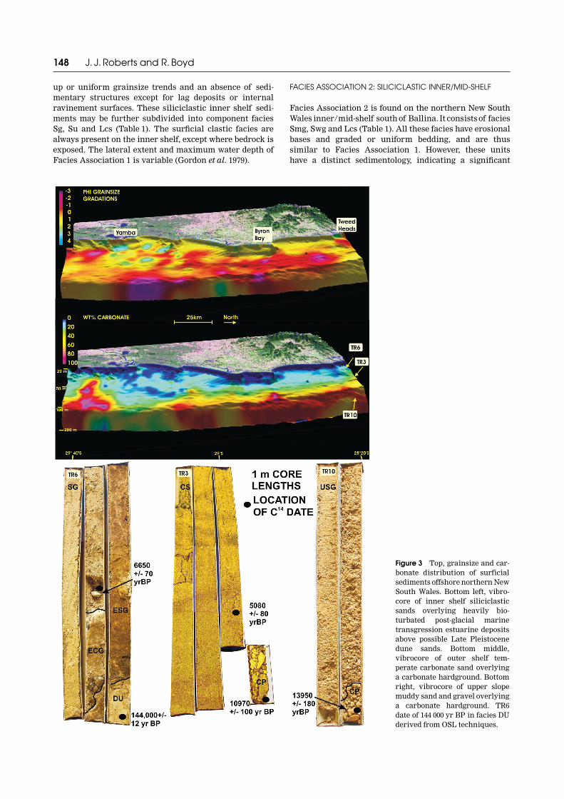
Figure 3 Top, grainsize and car-bonate distribution of surficialsediments offshore northern NewSouth Wales. Bottom left, vibro-core of inner shelf siliciclasticsands overlying heavily bio-turbated post-glacial marinetransgression estuarine depositsabove possible Late Pleistocenedune sands. Bottom middle,vibrocore of outer shelf tem-perate carbonate sand overlyinga carbonate hardground. Bottomright, vibrocore of upper slopemuddy sand and gravel overlyinga carbonate hardground. TR6date of 144 000 yr BP in facies DUderived from OSL techniques.

Quaternary shelf stratigraphy, northern NSW 149
input of terrigenous detritus and a restricted spatialdevelopment. Facies Association 2 is most distinctiveoffshore from the Clarence River along the inner/mid-shelf, in intermediate water depths of 35–76 m. Moderndeposition of facies Smg is interpreted to be currentlyoccurring and it contains the only significant proportionof mud along the northern New South Wales shelf. Recog-nition of these muddy sands in the subsurface is alsopossible with the identification of intercalated shelllayers comprising mid-shelf bivalves and gastropods.The diagnostic species that identify this mid-shelf settingare Venericardia bimaculata, Dentalium grahami, Nemo-cardium thetidis and Gazameda gunnii.
FACIES ASSOCIATION 3: CARBONATE OUTER SHELF
Facies Association 3 on the outer shelf of northern NewSouth Wales contains two facies rich in temperate-watercarbonate detritus, Cs and Cp (Table 1). These sedimentsare distinctive, with high but variable carbonate content(e.g. outer shelf surficial samples of Marshall & Davies1978; Marshall 1980). Five cores (TR1, TR2, TR3, CR4A andCR7) sampled these sediments offshore from TweedHeads to Yamba in water depths of 55–80 m. Unit Cs isbest distinguished by high carbonate content (typically64–91 wt%, mean 83%) and a diverse faunal array of bryo-zoans and deep-water bivalves (Limopsis and Pectinidae).This facies association is similar along the shelf betweenTweed Heads and Yamba. Unit Cs is 1–3.5 m thick and wasconsistently observed to overlie a carbonate-cementedclastic hardground (Cp). Further, bathymetric data andseismic traverses also indicate the presence in this zone ofshelf-break-parallel mounds, interpreted as temperate-water reefs (Figure 3).
FACIES ASSOCIATION 4: MIXED CARBONATE–CLASTIC UPPER SLOPE
Facies Association 4 consists of only one facies, Usg(Table 1), a biogenic muddy gravel from core TR10 [125 mbelow sea-level (bsl)]. Unit Usg has a distinct and complexsedimentology, dominated by sponge spicules and bryo-zoan fragments, and contains the greatest abundant finesin any marine unit observed in northern New South Wales(average: 18–36wt% < 4�). The erosionally based, uniformto fining-up unit Usg is interpreted to form from gravityand current processes. The isolated deep-water speciesthroughout the whole core suggests that the unit formedentirely in deep water. Further, the grainsize, sorting andcomposition of the uppermost 0.1 m of the core are similarto the underlying sediment, suggesting formation by thesame processes. The above features suggest that the unitdid not begin deposition immediately after transgression(15–18 ka at 120 m bsl), but formed in deep water prior toand since the time of highstand (ca 6500 a BP).
FACIES ASSOCIATION 5: PALAEOESTUARY
Five estuarine and barrier facies were encountered belowthe surficial marine sands. These sediments vary fromsilty clay and sand, to interbedded sandy clay and peat.Estuarine units on the northern New South Wales shelf
have been cored along the inner shelf offshore from TweedHeads and inner to mid-shelf offshore from Yamba.Vertical thickness ranges up to 10 m (based on seismicdata: Browne 1994), being particularly well-preserved inbedrock depressions.
Facies Association 5 comprises five facies: Du, Ec, Emg,Ecg and Esg (Table 1). Estuarine units may be recognisedby their distinctive restricted bioturbation [abundanttraces of Terebellina, Thalassinoides and Palaeophycus (asdescribed in Exxon Production Research Company 1992)];restricted macrofaunal assemblages (Callista (Notocallista)diemenensis, Antigona perimilis, Turrella tenuilirata) andthe presence of mangrove-sourced peaty organic material.Facies Ec and Emg are the only mud- and clay-dominatedsedimentary units present along the northern New SouthWales shelf. These transgressive sediments are confined tothe subsurface on the inner shelf (<50 m depth) offshorefrom Tweed Heads to Byron Bay, but are present at mid-shelf depths up to 80 m offshore from the Clarence River.Northern New South Wales palaeoestuary facies conformwell with the Dalrymple et al. (1992) summary descriptionsof tidal delta and central basin sediments.
Stratigraphic core correlation
The five facies associations recognised on the northernNew South Wales shelf and upper slope can be character-ised by two stratigraphic correlations offshore from theTweed and Clarence Rivers (Figure 4). The five faciesassociations developed during Quaternary fluctuationsin sea-level and are interpreted here within a sequence-stratigraphic framework (Boyd et al. 1989; Posamentier &Allen 1999). Separating the five facies successions are keysixth-order stratigraphic surfaces (Vail et al. 1991) such asa transgressive wave and tidal ravinement surface or acombined sequence boundary/flooding surface.
The uppermost facies associations in the 12 cores aremarine, including inner shelf siliciclastics, inner/mid-shelf siliciclastics and outer shelf carbonates. They consistof graded beds along the inner shelf and graded to uniformbeds along the mid- and outer shelf. These units all haveerosional bases and vary in thickness from 1 m to 3.6 m. Allmarine units contain isolated macrofauna that are specificto water depth, energy regime and nutrient conditions (e.g.the deep-water species Amusium balloti). The lateral extentof these marine units is variable (Figure 3), particularlywith the absence of mid-shelf muddy sands offshore fromthe Tweed River.
Marine units (shaded units in Figure 4) can be correl-ated across the entire shelf, based on their facies characterand the identification of an underlying wave-ravinementsurface in each core. The wave-ravinement surface isidentified as a gravel or shell lag, a sharp discontinuitywithout a lag or as a Glossifungites surface (Pembertonet al. 1992). Transgression of the base of the shoreface at82.5 m bsl in the offshore Clarence area occurred at12 780 ± 150 a BP (Figure 4). In the Tweed region, CoreTR10, (126 m bsl) contains a transgressive lag dated at13 950 ± 180 a BP, providing the deepest record of trans-gression in this area. In both regions, the wave-ravinementsurface becomes progressively younger in shallower cores(C14-dated hardgrounds), which is in agreement with the

150 J. J. Roberts and R. Boyd
relative sea-level curve of Figure 5. The wave-ravinementsurface was thus produced by shoreface translation duringtransgression from the Stage 2 lowstand. The boundarybetween the outer shelf carbonate facies and upper slopemixed siliciclastic–carbonate facies appears to be the shelfbreak, located at 90 m depth offshore from Tweed Heads.
Vibrocores taken on the inner and mid-shelf containestuarine facies underlying the marine units and wave-ravinement surface. The siliciclastic estuarine facies
association contains the facies Ec, Emg, Ecg and Esgand can be correlated across the inner shelf (Figure 4).These facies have a variable character but each contains aunique estuarine macrofaunal assemblage (e.g. Nemocar-dium thetidis, Callista (Notocallista) diemenensis, Spisula(Notospisula) trigonella and Turrella deltoidalis in theestuarine central basin facies). The vertical thickness ofthe recovered estuarine facies association is variable(1.96–3.6 m), as is the proportion of each facies.
Figure 4 Correlated vibrocorecross-sections from the TweedShelf (top) and Clarence Shelf(bottom) showing stratigraphicsurfaces, facies distribution andradiocarbon dates (small blackor white circles). Large blackcircles represent positions ofgrab samples. See Figure 1 forlocation. Gravel lags containmacrofauna with species specificto facies association.

Quaternary shelf stratigraphy, northern NSW 151
Tidal-ravinement surfaces were preserved in innershelf cores, despite microtidal estuary flows and sub-sequent transgression by a high wave-energy shoreface.Tidal-ravinement surfaces were identified in cores CR4A,CR7, TR6 TR4A (Figure 4). The differentiation of a tidalchannel base (tidal-ravinement surface) from the overlyingwave-ravinement surface was possible only with identifi-cation of an intervening tidal channel facies containinga distinct macrofaunal assemblage. Further, these tidal-ravinement surfaces often separate clay-rich and sand-richunits.
An amalgamated sequence boundary flooding surface ispresent in core TR6 (32.9 m bsl: Figure 5). This surfaceoccurs at the contact of a transgressive estuarine depositand an underlying terrestrial dune facies (Du). Because theestuarine deposit formed during the post-glacial marinetransgression, the dune facies must be at least as old asoxygen isotope Stage 3 (Figure 2) and has been dated byoptically stimulated luminescence (OSL) dating techniquesas Stage 6 (144 ± 12 ka BP). The dune facies is therefore notcorrelatable with any unit found in the other cores.
DISCUSSION
Shallow vibrocores from the northern New South Walesshelf exhibit a complex array of thin facies, developedduring rapid fluctuations in Quaternary sea-level. Control-ling mechanisms for the sedimentological and strati-graphic development of the southeast New South Walesshelf facies are discussed below.
Marine clastic sedimentation
Modern northern New South Wales coastal and nearshoresedimentation is well documented as a wave-dominatedmargin (Roy & Thom 1981) characterised by regressiveshorefaces and transgressive barriers. The distribution ofthick clastic sediment accumulations corresponds closelyto the position of relict underlying barrier and shoreface
complexes perched on the shelf (Browne 1994). Thesebarriers, together with transgressive clastic marinesands, cover a total area of 2556 km2 or 54.4% of thenorthern New South Wales shelf. A maximum barrierwidth of 12 km and a maximum depth of 80 m bsl is reachedoffshore from Yamba. More typically, the clastic sandsextend to 55 m depth such as offshore from Tweed Heads.These clastic marine sands form a large, regionally exten-sive sheet-sand body, despite the relatively narrow north-ern New South Wales shelf width (Figure 3). The totalaccumulation of clastic marine sediments above the wave-ravinement surface is typically thin (1–3 m) based on 10cores examined in the present study and the thickness of<8.5 m reported in Kudrass (1982). Highstand (<6500 a)sediment accumulation rates along the northern NewSouth Wales inner shelf average 0.53 m/103 y (based on 10cores sampled between 19 m and 57 m water depth).
The sedimentological effects of both waves and the EastAustralian Current have not been previously assessed onthe northern New South Wales margin. Coastal wave andwind processes are well understood from a 20 year waveclimate record offshore Byron Bay (Figure 2), and 3-D shelfmorphology can be readily assessed from Figures 1, 3. Themost striking aspect of these data is the absence of shelfridges from the northern New South Wales margin despitetheir common presence on other margins (see review inJohnson & Baldwin 1996). Despite the presence of highwave energy and frequent storms, no ridges were detectedin either the shelf bathymetry or core data. The implic-ation from this result is that the northern New South Walesshelf is more representative of a wave- and current-dominated shelf than a storm-dominated shelf. Thefrequent high wave energy is considered responsible forinhibiting the development of shelf ridges.
Surface bedform observations indicate coastal-aligneddunes (wavelengths of 25 m and amplitude of <1 m) incoarse sand. Cores collected in 33–55 m water depth containlittle evidence of small-scale sedimentary structures,instead consisting entirely of medium to coarse, gradedsand beds (cf. Snedden & Nummedal 1991). Large- andsmall-scale cross-beds are typical on many shelves, forinstance along the Mid Atlantic Bight of the USA, and thetidal sand bodies of the North China Sea (Liu et al. 1998).The absence of cross-beds on the southeast Australian shelfmay be due to the general coarse character of the sedimentor to the frequent reworking of sediments in plane bed flowduring storm events (Boyd 1980). The abundant Skolithosand Planolites bioturbation by molluscs and infaunal poly-chaetes may also significantly contribute to the destructionof the original bedding structures.
The East Australian Current impinges on the shelf withsouth-flowing surface velocities up to 7.2 km/h (2 m/s),but little is known about its effect at the seabed. Bottomcurrents of 0.8 m/s have been measured at 30 m depthoffshore Byron Bay, which have produced east–west-trending megaripples at 28–45 m depth. Further, linearsymmetrical sand furrows trending north–south, withwavelengths of 30 m and 1–3 m amplitude, are reported in55 m water depth offshore from Brunswick Heads (CableSands Holdings 1991). Superimposed on this are crescenticscours indicating north to south transport, as well asminor oblique wave-formed ripples. The formation of sand
Figure 5 Radiocarbon dates of post-glacial marine transgres-sion marine and estuarine deposits in relation to the New SouthWales sea-level curve of Thom and Roy (1985) and Ferland andRoy (2000) and the curve of Chappell and Polach (1991).
152 J. J. Roberts and R. Boyd
furrows rather than dune bedforms attests to the sediment-starved character of the margin, particularly at the edge ofreworked Late Pleistocene falling stage clastic barriers.The shallowest water depth at which the East AustralianCurrent has a sedimentological effect is 30 m offshore fromByron Bay, (Gordon et al. 1979), but above this depth wave-generated bedforms usually dominate the clastic sands.
The surficial shelf facies provide evidence of minimalclastic supply from rivers at highstand times. During floodevents, fine clastic sands and muds are ejected onto theshelf but do not accumulate due to the high wave andcurrent energy. Only New South Wales' largest river, theClarence River, is able to supply muds and sands insufficient quantities to accumulate on the mid-shelf,especially in the lee of a strong East Australian Currentseparation at the Byron Bay headland. The only othersignificant mid-shelf mud accumulation on the New SouthWales shelf is south of a major flow separation at SugarloafPoint, 400 km to the south (Godfrey et al. 1980).
Marine temperate-water carbonate production
Temperate-water carbonate detritus dominates the outershelf plain of northern New South Wales. Covering an areaof 1099 km2, this sediment zone is located outboard of theclastic inner and mid-shelf (55–80 m depth) and inboard ofthe shelf break (90–120 m depth). The northern New SouthWales outer shelf plain is substantially shallower than thatof central New South Wales (135–150 m: Roy & Thom 1981).This is attributable to differences in underlying bedrockand possibly Tertiary deposits.
Three faunal assemblages are identified along thenorthern New South Wales margin (Table 1) in distinctivebiogenic-rich subenvironments. First, the inner shelfassemblage comprises isolated molluscs such as Glycy-meris holocenicus, G. striatularis and Placamen placidumin graded-sand storm beds. This assemblage also containsthe highest proportion of abraded, disarticulated heavyshelled beach species (e.g. Donax deltoides). An inner shelfsubenvironment occurs around subtidal rocky reefs, richin diverse biota. Recently, 43 species of tropical coralshave been identified on these reefs in 5–18 m water depth,with the surficial cover dominated by coralline algae andsponges (Harriott et al. 1999). Thus, the northern New
South Wales shelf occurs at an important oceanographiccrossover zone between northern tropical reef organismsand more southern temperate-water molluscan-dominatedrather than bryozoan-dominated assemblages.
The second distinctive faunal assemblage is present onthe outer shelf and occurs in distinct grainsize fractions.The macrofauna (gravel-sized detritus) are primarily deep-water molluscs such as Limopsis loringi, L. soboles andL. woodwardi and pectinids Anachlamys flabellata,Amusium balloti with minor Pecten fumatus. The sandfraction is dominantly medium to coarse bryozoan frag-ments and foraminifers. The volumetric abundance ofcarbonate relative to clastics on the outer shelf extends tothe finest grainsize fraction. Clay-sized particles have adominantly carbonate composition, with high-magnesiumbeing more abundant than low-magnesium calcite andminor aragonite. The presence of all three carbonate typesis typical of temperate shelves, with more abundant high-rather than low-magnesium calcite indicating generallywarmer temperate waters (Rao 1996). This outer shelffaunal assemblage is likely to occur as far south asSeal Rocks around 32�33�S, where a strong warm EastAustralian Current is regularly present. The dominantmolluscan species varies over this 400 km length, asevidenced by the transition from Amusium balloti innorthern New South Wales to Pecten fumatus along centralNew South Wales (Ferland & Roy 2000). The transition froman A. balloti- to a P. fumatus-dominated assemblage mayreflect natural latitudinal variation in bivalve ecosystemson the east coast of Australia (Dame 1996; Roy & Martien2001; D. I. Loch pers. comm. 2002).
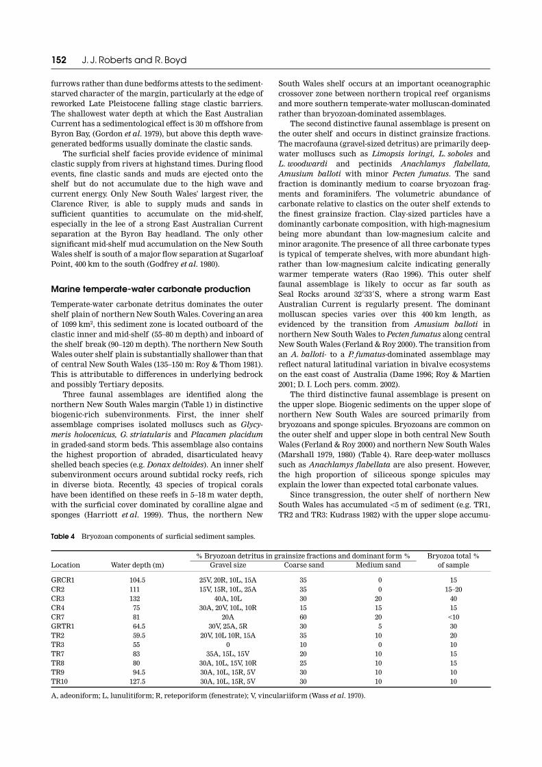
The third distinctive faunal assemblage is present onthe upper slope. Biogenic sediments on the upper slope ofnorthern New South Wales are sourced primarily frombryozoans and sponge spicules. Bryozoans are common onthe outer shelf and upper slope in both central New SouthWales (Ferland & Roy 2000) and northern New South Wales(Marshall 1979, 1980) (Table 4). Rare deep-water molluscssuch as Anachlamys flabellata are also present. However,the high proportion of siliceous sponge spicules mayexplain the lower than expected total carbonate values.
Since transgression, the outer shelf of northern NewSouth Wales has accumulated <5 m of sediment (e.g. TR1,TR2 and TR3: Kudrass 1982) with the upper slope accumu-
Table 4 Bryozoan components of surficial sediment samples.
Location Water depth (m)% Bryozoan detritus in grainsize fractions and dominant form % Bryozoa total %
of sampleGravel size Coarse sand Medium sand
GRCR1 104.5 25V, 20R, 10L, 15A 35 0 15CR2 111.0 15V, 15R, 10L, 25A 35 0 15–20CR3 132.0 40A, 10L 30 20 40CR4 75. 30A, 20V, 10L, 10R 15 15 15CR7 81. 20A 60 20 <10GRTR1 64.5 30V, 25A, 5R 30 5 30TR2 59.5 20V, 10L 10R, 15A 35 10 20TR3 55. 0 10 0 10TR7 83. 35A, 15L, 15V 20 10 15TR8 80. 30A, 10L, 15V, 10R 25 10 15TR9 94.5 30A, 10L, 15R, 5V 30 10 10TR10 127.5 30A, 10L, 15R, 5V 30 10 10
A, adeoniform; L, lunulitiform; R, reteporiform (fenestrate); V, vinculariiform (Wass et al. 1970).

Quaternary shelf stratigraphy, northern NSW 153
lating <3 m of sediment (e.g. core TR10). This is an averagerate of carbonate accumulation of approximately 0.4 mm/yon the shelf and 0.23 mm/y on the upper slope, since inun-dation at ca 14–13 ka (Figure 5).
Although similar thicknesses of carbonate accumu-lation exist along the central and northern New SouthWales outer shelves, the type and timing of maximumcarbonate productivity and accumulation is different.Offshore central New South Wales highstand fine-grainedcarbonate sands are intercalated with lowstand horizon-tally bedded mollusc shells. These deposits are cyclicaland developed over oxygen isotope Stages 1–8. Carbonateproductivity and accumulation (1–2 m) is highest duringshallow-water lowstand times (Ferland & Roy 2000) whencool-water bivalves were deposited. Less than 50 cm ofcarbonate detritus has accumulated since 6500 a BPon the central New South Wales outer shelf, which isapproximately a factor of five less than the same periodfor northern New South Wales. This may reflect lowerprimary productivity of the deeper water with lessnutrient-rich waters off central New South Wales(Roughan & Middleton 2002). Along the northern NewSouth Wales outer shelf, transgressive and highstandcarbonate sediments overlie a transgressive carbonatehardground, with little evidence of the lowstand sedi-mentation preserved. Importantly, the New South Walesshelf break varies between 90 m and 110 m depth while thecentral New South Wales shelf break varies between 140 mand 150 m. Both the central and northern New South Walesouter shelves have experienced differences in the timing ofQuaternary shelf inundation and zones of wave reworkingthat have produced the differing carbonate sediment-ologies and stratigraphy.
Marine carbonate-cemented clastic hardgrounds
Along the northern New South Wales shelf, surficialcarbonate hardgrounds are located along the mid- andouter shelf, in water depths of 59–80 m. These surficialhardgrounds have a variable biotic composition andsimilar cement. Offshore from the Clarence River, thecemented sands resemble other inner/mid-shelf sedimentsthat are bound by radial fibrous calcite indicating marineprecipitation. Sediments are also bound together byencrusting bryozoans, and by relatively large proportionsof calcareous algae, which are now recognised tooccur as far south as 29�30�S (Harriott et al. 1999).This late recognition of coralline algae in northernNew South Wales may be due to the limited areal extentof the organisms near their environmental (temperature)limit.
Offshore from the Tweed River, surficial carbonate-cemented hardgrounds are bound by encrusting and abun-dant branched bryozoans (Table 1) and marine calcitecement. More nutrient-rich waters or less turbid watersmay encourage the growth of more diverse zooarial formsin the Tweed area relative to the Clarence area. The totalproportion of bryozoan-sourced detritus is relatively smalland variable along the northern New South Wales outershelf, at 5–40% compared to 30–70% of outer shelf sedi-ments on the central and southern New South Wales shelf(Wass et al. 1970; Ferland & Roy 2000). In cold, nutrient-rich
waters off South Australia, bryozoans commonly exceed60% of the total sediment production (Lees & Buller1972).
Subsurface hardgrounds are present in all outer shelfcores along the wave-ravinement surface. Further, hard-grounds were identified in some mid-shelf cores of theClarence area and the upper slope offshore from TweedHeads. Cemented sediments resemble overlying transgres-sive and highstand sediments, suggesting a persistence ofclastic–carbonate division on the shelf. The exact age ofcementation is difficult to determine. Transgressive ages ofshells within carbonate hardgrounds of northern NewSouth Wales place a minimum age on the included sedi-ment, with all dates indicating an early transgressive ageof 14–12 ka. During the early transgression, incursions ofwarm East Australian Current waters onto a shallow shelfwould provide ideal conditions for the precipitation ofmarine cements. Calcite-cemented hardgrounds are wide-spread on the New South Wales shelf and extend from theTweed region to central and southern New South Wales(Smith & Iredale 1924).
Shelf-break and slope processes
The northern New South Wales margin has a shelf break(first major break in slope) that shallows from 110 moffshore from Yamba to 90 m in the north. Offshore fromYamba, the shelf break is concurrent with the LatePleistocene lowstand shoreline position. Grab samples ofcarbonate-cemented clastic hardgrounds were recoveredfrom this position, indicating the presence of a clasticshoreline. However, a distinctive palaeoshoreline morph-ology is absent at 120 m but present at the edge ofshallower (50–80 m) relict barriers. This may suggestin situ or along-shelf reworking of the lowstand clasticshoreline by wave or current processes during trans-gression and highstand times and/or a reduced sedimentflux during more arid glacial lowstand times. Further, thepreservation of a lowstand shoreline as a carbonate-cemented clastic hardground is uncommon. Rapid cement-ation may reflect the warm bottom currents of the EastAustralian Current and/or high carbonate productivity insediments immediately following transgression.
Between Ballina and Tweed Heads, the shelf break is at90–100 m (Figure 1), with the lowstand shoreline positioncorresponding to an upper slope location. This majorchange in depth of the shelf break corresponds to changesin onshore basement lithology between easily erodedMesozoic basin sediments to the south and more resistantPalaeozoic metasediments or Cenozoic volcanics to thenorth. In a regional synthesis, Jones and Marshall (1975)described a significant break in slope in offshore NewSouth Wales to correspond to greater depths of 145–375 mand changes in outcropping bedrock. Clearly, the shallowershelf break defined in the present study (Figure 3) cannotdirectly relate to outcropping bedrock or the position of thelowstand shoreline. As such, the shelf break position off-shore of northern New South Wales is suggested to relateto changing sediment transport capacities of the EastAustralian Current where the shelf widens at Ballina,together with contrasting Tertiary sediment thicknessesabove bedrock.
154 J. J. Roberts and R. Boyd
Evidence of a lowstand shoreline was not recoveredbelow the shelf break offshore from Tweed Heads. Instead,limited coring (TR10) over the shelf break indicatesdeposition of mud-rich biogenic gravel. These mud-richgravels comprise the whole 1.2 m of the core and overlie awave-ravinement surface above a carbonate hardground.Perhaps the East Australia Current and high wave energyhave removed or winnowed the clastic sediments depositedduring lowstand beyond the shelf break between Ballinaand Tweed Heads. This high-energy regime may havefurther inhibited deposition on the upper slope untildeep water had covered the shelf, indicating a substantialportion of the post-glacial marine transgression wheresands would be shed along-strike or to deeper water.Similarly, the upper slope seaward from Noosa Heads andSydney accumulates the most sediment during transgres-sion and highstand, not during lowstand times (Troedson& Davies 2001).
Transgressive processes and preservation potential
A regional comparison of modern onshore estuariesand offshore palaeoestuaries reveals similarities insediment type, but differences in the total thickness ofsediments and their stratigraphic development. Post-glacial marine transgression palaeoestuaries, like theirmodern counterparts, display strongly bioturbated clays,muds, silts, sands and peats with a high degree of lateralvariation.
Post-glacial marine transgression estuarine depositshave been recovered from cores along the inner and mid-shelf, but not outer shelf, of northern New South Wales(Kudrass 1982). Estuarine transgressive system tract depo-sits were recovered on the inner shelf offshore from theTweed River (30–40.5 m bsl) and inner to mid-shelf (55.5–80 m bsl) offshore from the Clarence River. Clastic coastal-plain facies appear to be absent from the northern NewSouth Wales outer shelf even though the shoreline reachedthe shelf break or below prior to transgression. Thismay be explained by effective reworking by marine pro-cesses during the early transgression. Further, post-glacialmarine transgression estuarine sediments are preservedfurther seaward offshore from the Clarence River relativeto the Tweed River (Figure 5).
Timing of transgression in northern New South Walesis consistent with the sea-level envelopes of Thom and Roy(1985) and Ferland and Roy (2000). The wave-ravinementsurface is diachronous, transgressing from the upper slopeprior to marine hardground formation (ca 13 ka, e.g. TR10)to the inner shelf before sea-level stabilised at 6.5 ka. Theexact timing of transgression of the shelf has beenaccurately determined by dating Late Pleistocene–Holocene supratidal peat deposits that are preservedbeneath the transgressive wave-ravinement surface (e.g.CR4A: 12 800 ± 110 a BP).
Tidal-ravinement surfaces were only observed ininner or mid-shelf cores. Distinguishing between tidal-and wave-ravinement surfaces required identification oferosional lags and molluscan assemblages in the deposits.Shelf species were generally absent from estuarinedeposits. However, some estuarine-dwelling organisms
were found to be reworked seaward during shorefacetranslation. Despite a high wave-energy regime, micro-tidal estuarine conditions and low accommodation space,tidal-ravinement surfaces were still preserved, indicatingthat the tidal-ravinement surface frequently extends togreater depths than the wave-ravinement surface in thisarea.
Post-glacial marine transgression estuarine depositswere developed during the half sea-level cycle between18 ka and 6.5 ka. Deposition during the transgression ofestuarine sediments was diachronous, while barriers werelaterally translated over distances of ~20 km. Cored trans-gressive system tract estuarine sediments range in thick-ness from 1–5 m (present study) and up to 7.5 m (Kudrass1982). Palaeoestuary deposits have been seismicallyimaged offshore, with the greatest thicknesses of up to 10 moccurring in bedrock depressions (Browne 1994). Thesethicknesses are substantially less than modern onshoreNew South Wales estuaries (Roy et al. 2001): for example,Holocene tidal channels in the Clarence River valley haveincised up to 50 m and contain 30 m of estuarine channelfill. Development and preservation of estuarine facies onthe shelf suggests that valleys were not deeply incisedseaward of the modern shoreline. It also suggests thatsubsequent wave ravinement removed much of the earlierestuarine deposits outside channels.
Coastal-plain facies on the shelf are not restricted to thepost-glacial marine transgression. Regional occurrence ofLate Pleistocene highstand and falling-stage deposits atshallow core depths (e.g. TR6 and Kudrass 1982) indicateswidespread preservation of Quaternary deposits bothwithin and outside incised valleys. Offshore from theTweed area, an example of a combined sequence bound-ary–estuarine-flooding surface separates an intermediatesea-level Pleistocene dune sand from the post-glacialmarine transgression deposition. This suggests that thematerial underlying the surficial estuarine and marinedeposits on the inner shelf is a shoreline deposit, as imagedseismically by Browne (1994).
CONCLUSIONS
Twelve cores in the present study and previously pub-lished vibrocore descriptions from the northern NewSouth Wales continental shelf and upper slope reveal 13facies that formed in the Late Quaternary. These aresummarised as four marine and one estuarine faciesassociations.
Holocene transgressive and highstand inner shelf sedi-ments are wave- and storm-reworked mature quartzoseclastic sediments. The East Australian Current is able totransport sands on the middle and outer shelf, ensuringminimal fine sand and mud deposition. However, due tovariations in coastal alignment and the presence of NewSouth Wales' largest river, some fine sand and mud is ableto accumulate on the relatively wide inner/mid-shelf atYamba.
The northern New South Wales shelf is wave- andocean-current-dominated, and has none of the shelf sandridges that characterise storm-dominated shelves on othermargins. Surficial sediments on the shelf consist primarily

Quaternary shelf stratigraphy, northern NSW 155
of a thin transgressive clastic sheet sand, characterised bymultiple units of graded bedding.
Holocene transgressive and highstand outer shelf andupper slope sediments comprise temperate-water carbon-ates, dominantly with bivalves and bryozoans, which aredeposited under the influence of storm activity and theEast Australian Current. During transgression, the warmEast Australian Current produced marine-cementedcarbonate hardgrounds.
A diachronous (14–12 ka) Holocene transgressive wave-ravinement surface is correlatable across the entiremargin, separating marine deposits from thin (<10 m) andcomplex transgressive estuarine sediments. Palaeoestua-rine facies resemble modern estuarine sediments andcontain distinct bioturbation and mollusc assemblages.Tidal-ravinement surfaces produced by microtidal flowsare preserved despite the high wave energy and lowaccommodation.
ACKNOWLEDGEMENTS
We would like to thank Conoco Inc. for financial supportduring the MSc project of JJR, and John Suter for tech-nical contributions to this project. We thank BHP Petro-leum and Exxon/Mobil for financial support in datacollection. RB thanks the Centre for Coastal and OceanMapping at the University of New Hampshire for supportprovided while there on study leave. Thanks also to thecrew of the Franklin 15/1998 cruise, particularly JohnHudson and Peter Roy for assistance in collecting thevibrocores. Peter Roy also provided the radiocarbon datesand much early input on the core lithofacies. Ian Loch ofthe Australian Museum identified molluscs and gaveadvice on faunal ecology. Kevin Ruming (University ofNewcastle) assisted with computing procedures andproduction of 3-D models. Digital bathymetric data wereprovided by the Royal Australian Navy, Landsat imageryby the New South Wales Department of Land and WaterConservation, and sediment data by C. Jenkins at Uni-versity of Colorado (formerly University of Sydney). Con-structive reviews that improved the paper were providedby P. Harris and J. Marshall.
REFERENCES
ANON. 1976. Review of Australia’s Water Resources. Australian Govern-ment Publishing Services, Canberra.
ANON. 2000. Clarence River Estuary Processes Study. New South WalesDepartment of Mineral Resources, Sydney.
BOYD R. L. 1980. Sediment dispersal on the central New South Walescontinental shelf. PhD thesis, University of Sydney, Sydney(unpubl.).
BOYD R. L., SUTER J. R. & PENLAND S. 1989. Relationship of sequencestratigraphy to modern sedimentary environments. Geology 17,926–929.
BRITON G. W. 1984. Yamba waters coastal engineering study. NewSouth Wales Department of Public Works Record PWD83027.
BROWNE I. 1994. Seismic stratigraphy and relict coastal sediments offthe east coast of Australia. Marine Geology 121, 81–107.
CABLE SANDS HOLDINGS. 1991. Marine Geophysical Pilot Study by Hydro-sets Pty Ltd for Picon Exploration Pty Ltd. Report held by NewSouth Wales Department of Mineral Resources, Sydney (unpubl.).
CARTER R. W. G. & WOODROFFE C. D. 1997. Coastal evolution: lateQuaternary shoreline morphodynamics. In: Carter R. W. G. &Woodroffe C. D. eds. IGCP Project 274: Coastal Evolution in theQuaternary, pp. 1–32. Cambridge University Press, Cambridge.
CHAPPELL J. M. 1993. Holocene evolution of fluvio-deltaic lowlands:comparison of the Clarence and Tweed Valleys of northern NewSouth Wales with other systems in different estuarine and tec-tonic regimes. In: Brierley G. J., Brooks A. & Ferguson R. eds.Floodplain Systems Along the Coastal Plain of New South Wales,pp. 49–54. Geological Society of Australia, Australasian Sedi-mentologists Group Field Guide 7.
CHAPPELL J. M., OMURA A. & ESAT T. 1996. Reconciliation of lateQuaternary sea levels derived from coral terraces at Huon penin-sula with deep oxygen isotope records. Earth and PlanetaryScience Letters 141, 227–236.
CHAPPELL J. M. & POLACH H. 1991. Post-glacial sea-level rise from acoral record at Huon Peninsula, Papua New Guinea. Nature 349,147–149.
CHAPPELL J. M. & SHACKLETON N. J. 1986. Oxygen isotopes and sea-level. Nature 324, 137–140.
COLWELL J. B. 1982. Heavy-mineral data from east Australia coastalsediments, Newcastle to Fraser Island. Geologisches Jahrbuch,Reihe D, Mineralogie, Petrologie, Geochemie, Lagerstattenkunde56, 49–53.
COLWELL J. B. 1983. Description of subsurface sediments from the EastAustralian Continental Shelf (Sonne Cruise SO-015). GeologicalSurvey of New South Wales Report 83/21, 111–124.
CONOLLY J. R. 1969. Western Tasman sea floor. New Zealand Journalof Geology and Geophysics 12, 310–343.
DALRYMPLE R. W., ZAITLIN B. A. & BOYD R. 1992. Estuarine faciesmodels: conceptual basis and stratigraphic implications. Journalof Sedimentary Petrology 62, 1130–1146.
DAME R. F. 1996. Ecology of Marine Bivalves: An Ecosystem Approach.CRC Press, Boca Raton.
DAVIES P. J. 1979. Marine geology of the continental shelf off South-eastern Australia. Bureau of Mineral Resources Bulletin 195.
EXXON PRODUCTION RESEARCH COMPANY 1992. Trace Fossils, 1: Ichno-logical Concepts and Selected Core Studies. Exxon, Houston(unpubl.).
FERLAND M. A. & ROY P. S. 2000. Southeastern Australia: sea-leveldependent, cool-water carbonate margin. In: Clarke J. & JamesN. P. eds. Cool-Water Carbonates, pp. 37–52. SEPM SpecialPublication 56.
FLOYD C. D. & DRUERY B. M. 1976. Results of river mouth training onthe Clarence bar N.S.W., Australia. In: Proceedings of 11th Inter-national Conference on Coastal Engineering, Hawaii, pp. 1738–1755. American Society of Civil Engineers, Reston.
GODFREY J. S., CRESSWELL G. R., BOYD R., GOLDING T. J. & PEARCE A. F.1980. The separation of the east Australian current. Journal ofPhysical Oceanography 10, 430–440.
GORDON A. D., LORD D. B. & NOLAN M. W. 1979. Byron Bay–HastingsPoint erosion study. New South Wales Department of Public WorksRecord PWD78026.
HARRIOTT V. J., BANKS S. A., MAU R. L., RICHARDSON D. & ROBERTS L. G.1999. Ecological and conservation significance of the subtidalrocky reef communities of northern New South Wales, Australia.Marine and Freshwater Research 50, 299–306.
HUQ N. E. 1995. Clarence River lowland floodplain: a morpho-stratigraphic analysis of a complex Holocene floodplain. PhDthesis, Australian National University, Canberra (unpubl.).
JOHNSON H. D. & BALDWIN C. T. 1996. Shallow clastic seas. In: ReadingH. G. ed. Sedimentary Environments: Processes, Facies andStratigraphy, pp. 232–281. Blackwell Science, Oxford.
JOHNSTON R. W. (Editor). 1989. Intraplate Volcanism in Eastern Aus-tralia and New Zealand. Cambridge University Press, Cam-bridge.
JONES H. A. & KUDRASS H. R. 1982. Sonne Cruise (SO-15 1980) off theeast coast of Australia, bathymetry and seafloor morphology.Geologisches Jahrbuch, Reihe D, Mineralogie, Petrologie, Geo-chemie, Lagerstattenkunde 56, 55–68.
JONES H. A. & MARSHALL J. F. 1975. Origin of the shelf break offsoutheast Australia. Journal of the Geological Society of Australia22, 71–78.
KUDRASS H-R. 1982. Cores of Holocene and Pleistocene sediments fromthe east Australian continental shelf (SO-15 cruise 1980). Geolo-

156 J. J. Roberts and R. Boyd
gisches Jahrbuch, Reihe D, Mineralogie, Petrologie, Geochemie,Lagerstattenkunde 56, 137–163.
LEES A. & BULLER A. T. 1972. Modern temperate-water and warmwater shelf carbonate sediments contrasted. Marine Geology 13,67–73.
LIU Z. X., XIA D. X., BERNE S., YANG W. K., MARSSET T., TANG Y. X. &BOURILLET J. F. 1998. Tidal depositional systems of China’s contin-ental shelf, with special reference to the Bohai Sea. MarineGeology 145, 225–253.
MARSHALL J. F. 1979. The development of the continental shelf ofnorthern New South Wales. BMR Journal of Australian Geology& Geophysics 4, 281–288.
MARSHALL J. F. 1980. Continental Shelf Sediments: Southern Queens-land and Northern New South Wales. Bureau of MineralResources Bulletin 207.
MARSHALL J. F. & DAVIES P. J. 1978. Skeletal carbonate variation on theouter continental shelf of eastern Australia. BMR Journal ofAustralian Geology & Geophysics 3, 85–92.
MARTINSON D. G., PISIAS N. G., HAYS J. D., IMBRIE J., MOORE T. C. &SHACKLETON N. J. 1987. Age dating and orbital theory of ice ages:development of a high resolution 0–300 000-year chronostrati-graphy. Quaternary Research 27, 1–29.
MITCHELL W., CHITTLEBOROUGH J., RONAI B. & LENNON G. W. 2001. Sealevel rise in Australia and the Pacific. In: Grzechnik M. & Chittle-borough J. eds. Pacific Islands Conference on Climate Change,Climate Variability and Sea Level Rise, p. 88. National TidalFacility Australia, Flinders University, Adelaide.
MOOERS H. D. 1999. Comparison of loss on ignition and coulometerictitration for determining carbonate content of till. Glacial Geol-ogy and Geomorphology 11, 1–13.
NAKADA M. & LAMBECK K. 1989. Late Pleistocene and Holocene sea-level change in the Australian region and mantle rheology.Geophysical Journal 96, 497–517.
PEMBERTON S. G., MACEACHERN J. A. & FREY R. W. 1992. Trace fossilfacies models: environmental and allostratigraphic significance.In: Walker R. & James N. P. eds. Facies Models: Response to SeaLevel Change, pp. 47–73. Geological Society of Canada, Ontario.
POSAMENTIER H. W. & ALLEN G. P. 1999. Siliciclastic Sequence Strati-graphy: Concepts and Applications. Society for SedimentaryGeology, Tulsa.
PUBLIC WORKS DEPARTMENT 1985. Elevated Ocean Levels StormsAffecting the New South Wales Coast 1880–1980. Report preparedfor Coastal Engineering Branch, Public Works Department ofNew South Wales, by Blain, Bremner & Williams Pty Ltd inconjunction with Weatherex Meteorological Services Pty Ltd.Public Works Department of New South Wales Coastal BranchReport 85041.
RAO C. P. 1996. Modern Carbonates: Tropical, Temperate, Polar.Printing Authority of Tasmania, Hobart.
ROUGHAN M. & MIDDLETON J. H. 2002. A comparison of observedupwelling mechanisms off the east coast of Australia. ContinentalShelf Research 22, 2551–2572.
ROY P. S. 1982. Regional geology of the central and northern NewSouth Wales coast. Geologisches Jahrbuch, Reihe D, Mineralogie,Petrologie, Geochemie, Lagerstattenkunde 56, 25–35.
ROY P. S. & BOYD R. L. 1996. Quaternary Geology of a TectonicallyStable, Wave-Dominated, Sediment Deficient Margin, SoutheastAustralia. Geological Survey of New South Wales, Sydney.
ROY P. S. & CRAWFORD E. A. 1977. Significance of sediment distributionin major coastal rivers, Northern New South Wales. In: 3rdAustralian Conference on Coastal and Ocean Engineering,pp. 18–21. The Institute of Engineers, Melbourne.
ROY K. & MARTIEN K. K. 2001. Latitudinal distribution of body size innorth-eastern Pacific marine bivalves. Journal of Biogeography28, 485–493.
ROY P. S. & THOM B. G. 1981. Cainozoic shelf sedimentation model forthe Tasman Sea margin of Southeastern Australia. In: WilliamsM. A. J., De Decker P. & Kershaw A. P. eds. The Cainozoic inAustralia: A Reappraisal of the Evidence, pp. 119–136. GeologicalSociety of Australia Special Publication 18.
ROY P. S., WILLIAMS R. J., JONES A. R., YASSINI I., GIBBS P. J., COATES B.,WEST R. J., SCANES P. R., HUDSON J. P. & NICHOL S. 2001. Structureand function of South-Eastern Australian estuaries. Estuarine,Coastal and Shelf Science 53, 351–384.
SHACKLETON N. J. 1987. Oxygen isotopes, ice volume and sea level.Quaternary Science Reviews 6, 183–190.
SHAW R. D., ALDER J. D. & AADIL N. 2001. The offshore Clarence–Moreton Basin in New South Wales: a new petroleum play? In:Hill H. C. & Bernecker T. eds. Eastern Australasian Basins Sym-posium, pp. 201–210. Petroleum Exploration Society of Australia,Melbourne.
SHEPARD F. P. 1973. Submarine Geology. Harper & Row, New York.SHIRLEY J. 1964. An investigation of the sediments on the continental
shelf of New South Wales, Australia. Journal of the GeologicalSociety of Australia 11, 331–342.
SHORT A. D. 1999. Wave-dominated beaches. In: Short A. D. ed. Hand-book of Beach and Shoreface Morphodynamics, pp. 173–203. JohnWiley & Sons, Sydney.
SHORT A. D. & TRENAMAN N. L. 1992. Wave climate of the Sydney region,an energetic and highly variable ocean wave regime. AustralianJournal of Marine and Freshwater Research 43, 765–791.
SMITH T. H. & IREDALE T. 1924. Evidence of negative movement of thestrandline of 400 ft in New South Wales. Journal of the RoyalSociety of New South Wales 53, 157–168.
SNEDDEN J. W. & NUMMEDAL D. 1991. Origin and geometry of storm-deposited sand beds in modern sediments of the Texas contin-ental shelf. In: Swift D. J. P., Tillman R. W. & Oertel G. F., eds.Shelf Sand and Sandstone, Geometry, Facies and Sequence Strati-graphy, pp. 282–308. International Association SedimentologistsSpecial Publication 14.
STABLES M. 2001. Late Holocene coastal evolution between Woody Bayand Iluka, North Coast, New South Wales. BSc (Hons) thesis,University of Newcastle, Newcastle (unpubl.).
THOM B. G. 1983. Transgressive and regressive stratigraphies ofcoastal sand barriers in Southeast Australia. Marine Geology56, 137–158.
THOM B. G. & ROY P. S. 1985. Relative sea levels and coastal sedi-mentation in southeast Australia in the Holocene. Journal ofSedimentary Petrology 55, 257–264.
TROEDSON A. L. & DAVIES P. J. 2001. Contrasting facies patterns insubtropical and temperate continental slope sediments: infer-ences from east Australian late Quaternary records. MarineGeology 172, 265–285.
VAIL P. R., AUDEMARD F., BOWMAN S. A., EISNER P. N. & PEREZ-CRUZ C.1991. The stratigraphic signatures of tectonic, eustasy and sedi-mentology: an overview. In: Einsele G., Ricken W. & Seilacher S.eds. Cycles and Events in Stratigraphy, pp. 617–659. Springer-Verlag, Berlin.
VEEVERS J. J. (Editor) 2000. Billion-Year Earth History of Australia andNeighbours in Gondwanaland. GEMOC Press, Sydney.
VON DER BORCH C. C. 1970. Phosphatic concretions and nodules fromthe upper continental slope, northern New South Wales. Journalof the Geological Society of Australia 16, 755–759.
WALKER R. G. 1984. General introduction: facies, facies sequencesand facies models. In: Walker R. G. ed. Facies Models, pp. 1–13.Geological Association of Canada Publications, Toronto.
WASS R. E., CONOLLY J. R. & MACINTYRE R. J. 1970. Bryozoan carbonatesand continuous along southern Australia. Marine Geology 9,63–73.
WELLS A. T. & O’BRIEN P. E. 1995. Geology and petroleum potential ofthe Clarence–Moreton Basin, New South Wales and Queensland.Australian Geological Survey Organisation Bulletin 241.
WINWARD K. 1974. Quaternary coastal sediments. In: Markham N. L. &Basden H. eds. The Mineral Deposits of New South Wales, pp. 595–622. Department of Mines, Sydney.
WRIGHT L. D. & THOM B. G. 1977. Coastal depositional landforms: amorphodynamic approach. Progress in Physical Geography 1,412–459.
Received 9 April 2003; accepted 13 December 2003