Subsurface stratigraphy and geochemistry of late Quaternary ...
Upload
independentCategory
view
2download
0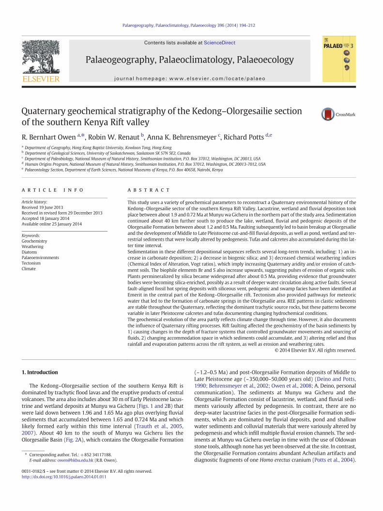
Palaeogeography, Palaeoclimatology, Palaeoecology 396 (2014) 194–212
Contents lists available at ScienceDirect
Palaeogeography, Palaeoclimatology, Palaeoecology
j ourna l homepage: www.e lsev ie r .com/ locate /pa laeo
Quaternary geochemical stratigraphy of the Kedong–Olorgesailie sectionof the southern Kenya Rift valley
R. Bernhart Owen a,⁎, Robin W. Renaut b, Anna K. Behrensmeyer c, Richard Potts d,e
a Department of Geography, Hong Kong Baptist University, Kowloon Tong, Hong Kongb Department of Geological Sciences, University of Saskatchewan, Saskatoon SK S7N 5E2, Canadac Department of Paleobiology, National Museum of Natural History, Smithsonian Institution, P.O. Box 37012, Washington, DC 20013, USAd Human Origins Program, National Museum of Natural History, Smithsonian Institution, P.O. Box 37012, Washington, DC 20013-7012, USAe Palaeontology Section, Department of Earth Sciences, National Museums of Kenya, P.O. Box 40658, Nairobi, Kenya
⁎ Corresponding author. Tel.: +852 34117188.E-mail address: [email protected] (R.B. Owen).
0031-0182/$ – see front matter © 2014 Elsevier B.V. All rihttp://dx.doi.org/10.1016/j.palaeo.2014.01.011
a b s t r a c t
a r t i c l e i n f oArticle history:Received 19 June 2013Received in revised form 29 December 2013Accepted 18 January 2014Available online 25 January 2014
Keywords:GeochemistryWeatheringDiatomsPalaeoenvironmentsTectonismClimate
This study uses a variety of geochemical parameters to reconstruct a Quaternary environmental history of theKedong–Olorgesailie sector of the southern Kenya Rift Valley. Lacustrine, wetland and fluvial deposition tookplace between about 1.9 and 0.72Ma atMunyuwa Gicheru in the northern part of the study area. Sedimentationcontinued about 40 km further south to produce the lake, wetland, fluvial and pedogenic deposits of theOlorgesailie Formation between about 1.2 and 0.5 Ma. Faulting subsequently led to basin breakup at Olorgesailieand the development of Middle to Late Pleistocene cut-and-fill fluvial deposits, as well as pond, wetland and ter-restrial sediments that were locally altered by pedogenesis. Tufas and calcretes also accumulated during this lat-ter time interval.Sedimentation in these different depositional sequences reflects several long-term trends, including: 1) an in-crease in carbonate deposition; 2) a decrease in biogenic silica; and 3) decreased chemical weathering indices(Chemical Index of Alteration, Vogt ratios), which imply increasing Quaternary aridity and/or erosion of catch-ment soils. The biophile elements Br and S also increase upwards, suggesting pulses of erosion of organic soils.Plants permineralized by silica became widespread after about 0.5 Ma, providing evidence that groundwaterbodies were becoming silica-enriched, possibly as a result of deeper water circulation along active faults. Severalfault-aligned fossil hot spring deposits with siliceous vent, pedogenic and swamp facies have been identified atEmerit in the central part of the Kedong–Olorgesailie rift. Tectonism also provided pathways for meteoricwater that led to the formation of carbonate springs in the Olorgesailie area. REE patterns in clastic sedimentsare stable throughout the Quaternary, reflecting the dominant trachytic source rocks, but these patterns becomevariable in later Pleistocene calcretes and tufas documenting changing hydrochemical conditions.The geochemical evolution of the area partly reflects climate change through time. However, it also documentsthe influence of Quaternary rifting processes. Rift faulting affected the geochemistry of the basin sediments by1) causing changes in the depth of fracture systems that controlled groundwater movements and sourcing offluids, 2) changing accommodation space in which sediments could accumulate, and 3) altering relief and thusrainfall and evaporation patterns across the rift system, as well as erosion and weathering rates.
© 2014 Elsevier B.V. All rights reserved.
1. Introduction
The Kedong–Olorgesailie section of the southern Kenya Rift isdominated by trachytic flood lavas and the eruptive products of centralvolcanoes. The area also includes about 30 m of Early Pleistocene lacus-trine and wetland deposits at Munyu wa Gicheru (Figs. 1 and 2B) thatwere laid down between 1.96 and 1.65 Ma ago plus overlying fluvialsediments that accumulated between 1.65 and 0.724 Ma and whichlikely formed early within this time interval (Trauth et al., 2005,2007). About 40 km to the south of Munyu wa Gicheru lies theOlorgesailie Basin (Fig. 2A), which contains the Olorgesailie Formation
ghts reserved.
(~1.2–0.5 Ma) and post-Olorgesailie Formation deposits of Middle toLate Pleistocene age (~350,000–50,000 years old) (Deino and Potts,1990; Behrensmeyer et al., 2002; Owen et al., 2008; A. Deino, personalcommunication). The sediments at Munyu wa Gicheru and theOlorgesailie Formation consist of lacustrine, wetland, and fluvial sedi-ments variously affected by pedogenesis. In contrast, there are nodeep-water lacustrine facies in the post-Olorgesailie Formation sedi-ments, which are dominated by fluvial deposits, pond and shallowwater sediments and colluvial materials that were variously altered bypedogenesis andwhich infill multiple fluvial erosion channels. The sed-iments at Munyu wa Gicheru overlap in time with the use of Oldowanstone tools, although none has yet been observed at the site. In contrast,the Olorgesailie Formation contains abundant Acheulian artifacts anddiagnostic fragments of one Homo erectus cranium (Potts et al., 2004).
Mau Tuffs
Singaraini/Ol Tepesi BasaltCentral volcanoesPre-rift lavas
Limuru Trachytes
Suswa
Lake Magadi
Magadi Trachytes
Quaternary sediments
KENYA
Nairobi
200 km
Studysite
A
Koo
ra
Gra
ben
>1800 m1500-18001200-15001020-1200900-1020<900 m
OlorgesailieFormation
C
5 km
Ol Esakut
Munyu waGicheru
Olorgesailie
Emerit
Koora Graben
B
RoadRailStream
10 km
Mt. Olorgesailie
Fig. 1. Geology and location of the Kedong–Olorgesailie sector of the East African Rift System. A: General location. B: Regional geology and setting of study sites. See Fig. 2 for detailed ge-ology of the outlined areas. C: Topography in the Olorgesailie region and location of the Olorgesailie Formation.
195R.B. Owen et al. / Palaeogeography, Palaeoclimatology, Palaeoecology 396 (2014) 194–212
The Middle to Late Pleistocene sequences have produced fossil verte-brates and Middle Stone Age tools (Brooks et al., 2007). The area hasthus been occupied by ancestral humans for at least 1.2 million years.
Efforts to understand the development of stone tools and humanevolution have previously been related to environmental and climaticchanges (Potts, 1998; Potts et al., 1999; Potts, 2013). However, attemptsto decipher past climates in the Kedong–Olorgesailie rift have provedcomplicated because of the influence of both rift faulting and volcanism.Research has focused mainly on the Olorgesailie Formation and to alesser extent on the Munyu wa Gicheru deposits (Trauth et al., 2003,2005, 2007; Owen et al., 2009a; Trauth and Maslin, 2009; Owen et al.,
2012). The environmental record in the region has previously beenexplored using a variety of approaches, including: facies analysis andthe logging of detailed lithostratigraphy (Ngecu and Njue, 1999;Behrensmeyer et al., 2002), the use of diatoms and sedimentologicalstudies (Owen and Renaut, 1981, 2000; Owen et al., 2008, 2009b,2011), the development of stable isotope records (Sikes et al., 1999;Lee et al., 2013), geochemical research (Owen et al., 2012) and investi-gations of clay mineralogy (Deocampo et al., 2010).
Studies of elemental geochemistry have been carried out in a varietyof sedimentary basins, yielding clues, for example, about source rocks,weathering and past environments (Nesbitt and Young, 1982, 1984;
500 m
Mt. Olorgesailie fanglomerates
Mb 10-14
Mb 1-9Basalts
} OlorgesailieFormation
Post-Olorgesailie Formation seds.Fault
Magadi TrachytesCentral volcano trachyphonolites and nephelinites
Mount Olorgesailie
Road
Legemunge Plain
Oltepesi Plain
Ol K
ejuNyiro
River
Mb 4–13
N
Nairobi
D
A
C
B
OLT
Locality
1˚34.0'S
36˚25.5'E
G
Railway
A
Undifferentiated sediments
B01/1B
OLT05/01
G05/02
G06/03
D01/1
D01/1
D99/06
D98/03 & 04
Section
TP10-1
TR10-1
MT09-1
D10-B1
N
1600
1590
1580
1570
M1A & B
PhonoliteU. MemberM. MemberL. MemberObsidian
Munyu waGicheruseduments.
Faults
Contours (m)
Section
120 m
B
}
MWG2
G, D, AD, A,C, B, OLT
AD
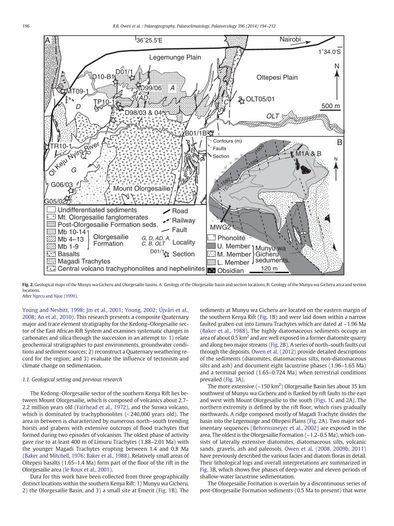
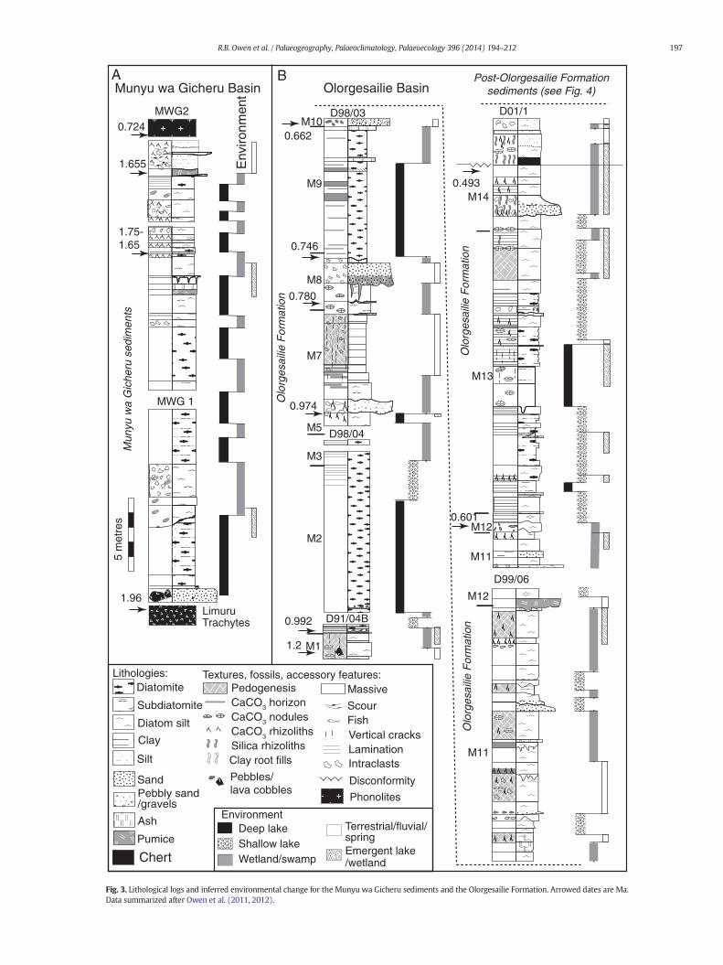
Fig. 2.Geological maps of the Munyuwa Gicheru and Olorgesailie basins. A: Geology of the Olorgesailie basin and section locations, B: Geology of theMunyuwa Gicheru area and sectionlocations.After Ngecu and Njue (1999).
196 R.B. Owen et al. / Palaeogeography, Palaeoclimatology, Palaeoecology 396 (2014) 194–212
Young and Nesbitt, 1998; Jin et al., 2001; Young, 2002; Újvári et al.,2008; Ao et al., 2010). This research presents a composite Quaternarymajor and trace element stratigraphy for the Kedong–Olorgesailie sec-tor of the East African Rift System and examines systematic changes incarbonates and silica through the succession in an attempt to: 1) relategeochemical stratigraphies to past environments, groundwater condi-tions and sediment sources; 2) reconstruct a Quaternaryweathering re-cord for the region; and 3) evaluate the influence of tectonism andclimate change on sedimentation.
1.1. Geological setting and previous research
The Kedong–Olorgesailie sector of the southern Kenya Rift lies be-tween Mount Olorgesailie, which is composed of volcanics about 2.7–2.2 million years old (Fairhead et al., 1972), and the Suswa volcano,which is dominated by trachyphonolites (b240,000 years old). Thearea in between is characterized by numerous north–south trendinghorsts and grabens with extensive outcrops of flood trachytes thatformed during two episodes of volcanism. The oldest phase of activitygave rise to at least 400 m of Limuru Trachytes (1.88–2.01 Ma) withthe younger Magadi Trachytes erupting between 1.4 and 0.8 Ma(Baker and Mitchell, 1976; Baker et al., 1988). Relatively small areas ofOltepesi basalts (1.65–1.4 Ma) form part of the floor of the rift in theOlorgesailie area (le Roux et al., 2001).
Data for this work have been collected from three geographicallydistinct locationswithin the southern Kenya Rift: 1)MunyuwaGicheru,2) the Olorgesailie Basin, and 3) a small site at Emerit (Fig. 1B). The
sediments at Munyu wa Gicheru are located on the eastern margin ofthe southern Kenya Rift (Fig. 1B) and were laid down within a narrowfaulted graben cut into Limuru Trachytes which are dated at ~1.96 Ma(Baker et al., 1988). The highly diatomaceous sediments occupy anarea of about 0.5 km2 and arewell exposed in a former diatomite quarryand along twomajor streams (Fig. 2B). A series of north–south faults cutthrough the deposits. Owen et al. (2012) provide detailed descriptionsof the sediments (diatomites, diatomaceous silts, non-diatomaceoussilts and ash) and document eight lacustrine phases (1.96–1.65 Ma)and a terminal period (1.65–0.724 Ma) when terrestrial conditionsprevailed (Fig. 3A).
The more extensive (~150 km2) Olorgesailie Basin lies about 35 kmsouthwest of Munyu wa Gicheru and is flanked by rift faults to the eastand west with Mount Olorgesailie to the south (Figs. 1C and 2A). Thenorthern extremity is defined by the rift floor, which rises graduallynorthwards. A ridge composed mostly of Magadi Trachyte divides thebasin into the Legemunge and Oltepesi Plains (Fig. 2A). Twomajor sed-imentary sequences (Behrensmeyer et al., 2002) are exposed in thearea. The oldest is theOlorgesailie Formation (~1.2–0.5Ma), which con-sists of laterally extensive diatomites, diatomaceous silts, volcanicsands, gravels, ash and paleosols. Owen et al. (2008, 2009b, 2011)have previously described the various facies and diatom floras in detail.Their lithological logs and overall interpretations are summarized inFig. 3B, which shows five phases of deep-water and eleven periods ofshallow-water lacustrine sedimentation.
The Olorgesailie Formation is overlain by a discontinuous series ofpost-Olorgesailie Formation sediments (0.5 Ma to present) that were
Deep lakeShallow lake Wetland/swamp
5 m
etre
s
M1
M2
M3
M5
M7
M8
M9
M10
M11
M11
M12
M12
M13
M14
0.662
0.746
0.780
0.974
0.493
0.601
0.992
1.2
0.724
1.655
1.75-1.65
1.96
Pebbles/lava cobbles
MWG 1
MWG2 D01/1
D99/06
D98/03
D98/04
D91/04B
Munyu wa Gicheru Basin
Olo
rges
ailie
For
mat
ion
Mun
yu w
a G
iche
ru s
edim
ents
Olo
rges
ailie
For
mat
ion
Olo
rges
ailie
For
mat
ion
Diatomite
Diatom silt
Clay
Silt
Sand
Pumice
Phonolites
Limuru Trachytes
Ash
Pebbly sand/gravels
Subdiatomite
Intraclasts
CaCO3 rhizolithsSilica rhizoliths
CaCO3 horizonCaCO3 nodules
Pedogenesis
Vertical cracksLamination
ScourFish
Clay root fills
Massive
Lithologies: Textures, fossils, accessory features:
Post-Olorgesailie Formationsediments (see Fig. 4)
Environment
Emergent lake/wetland
Olorgesailie Basin
Terrestrial/fluvial/spring
Chert
Disconformity
Env
ironm
ent
A B
Fig. 3. Lithological logs and inferred environmental change for the Munyu wa Gicheru sediments and the Olorgesailie Formation. Arrowed dates are Ma.Data summarized after Owen et al. (2011, 2012).
197R.B. Owen et al. / Palaeogeography, Palaeoclimatology, Palaeoecology 396 (2014) 194–212
198 R.B. Owen et al. / Palaeogeography, Palaeoclimatology, Palaeoecology 396 (2014) 194–212
laid down in and adjacent to a series of major incised river channels(Behrensmeyer et al., 2002). The dominant lithologies include volcanicsilts, sands and gravels that are variably affected by pedogenesis. Thedeposits were previously assigned to the Olkesiteti Formation and theyounger Oltepesi Beds (Brooks et al., 2007; Haradon, 2010), but are cur-rently under stratigraphic revision. Lee et al. (2013) describe severalextensive areas of post-Olorgesailie Formation tufas (carbonate mud-stones and packstones, boundstones and rudstones) that were precipi-tated along stream channels, in shallow ponds and at fissure vents.Calcretes are also present.
The third study site lies directly east of Emerit village (~1°26′50″ S,36°28′54″ E; Fig. 1B) where a series of six fossil hot-spring sinter de-posits occur at a height of about 1100 m. The deposits rest on and fill
Table 1Dominant diatoms by stratigraphic unit and ecological preferences.
Po
st-O
lorg
esa
ilie
Fo
rma
tio
n s
ed
ime
nts
Sil
icic
last
ic s
ed
ime
nts
Group Dominant diatoms
P-OF1 Cyclotella meneghiniana, Thalassiosira faurii, Epithe
P-OF2 Aulacoseira ambigua, A. granulata, Encyonema mue
argus, E. hyndmani
P-OF3 Rhopalodia gibberula, Diploneis elliptica, Nitzschia
P-OF4 Epithemia argus, E. adnata, E. hyndmanii, Rhopalod
vermicularis
P-OF5 Caloneis bacillum, Cocconeis placentula, Epithemia
frustulum
P-OF6 Aulacoseira agassizi, A. distans, A. granulata, A. gran
angustissima
P-OF7 Mastogloia braunii, A. granulata, Nitzschia frustulu
P-OF8 Hantzschia amphioxys, Navicula mutica
Tu
fas
P-OF9 Nitzschia palea, N. amphibia, Rhopalodia gibberula
P-OF10 Achnanthidium exiguum var. heterovalvum, Encyon
Epithemia sorex, Mastogloia braunii, Hantzschia am
P-OF11 Navicula seminuloides, Gomphonema parvulum, Au
granulata, A. agassizi
P-OF12 Nitzschia amphibia
P-OF13 Synedra ulna, Rhopalodia gracilis
Olo
rge
sail
ie F
orm
ati
on
OF1 Anomoeoneis sphaerophora, Campylodiscus clypeus
Cyclotella atomus
OF2 Thalassiosira rudolfii, Thalassiosira faurii.
OF3 Cyclotella meneghiniana, C. kuetzingiana, C. stellige
OF4 Aulacoseira granulata, A. granulata var. valida, A. it
bacilligera, Stephanodiscus astraea
OF5 Aulacoseira agassizi, A. ambigua, A. distans var. afri
granulata var. angustissima.
OF6 Cocconeis placentula, Encyonema muelleri, Epithem
adnata, E. sorex,
OF7 Sellaphora pupula, Navicula cryptocephala, Calonei
Staurosira construens
Mu
ny
a w
a G
ich
eru
de
po
sits
MG1 Aulacoseira granulata v. valida, A. granulata var. an
MG2 Cyclotella meneghiniana, C. pseudostelligera
MG3 Cyclotella stelligera
MG4 Encyonema muelleri, Epithemia adnata, E. sorex, Co
placentula, Gomphonema parvulum, Synedra ulna.
MG5 Stephanodiscus niagarae, S. transilvanicus, Aulacose
goetzeana
MG6 Aulacoseira agassizi, A. ambigua and A. granulata v
curvata
MG7 Pseudostaurosira zeilleri, P. zeilleri v. elliptica
fractures in Magadi Trachyte at the base of a fault scarp. Each fossilspring is associated with extensive outcrops of silica sinter that formedwithin and downstream of springs vents. The six fossil springs extendfor about 200 m following a NW–SE trend that intersects with N–Strending rift margin faults. Such NW–SE trends are associated with ac-tive hot-spring activity elsewhere in the southern Kenya Rift (e.g.,northern Nasikie Engida).
2. Methods
A total of 239 samples constitute the geochemical database for thisresearch. These were collected from two sections at Munyu wa Gicheru(MWG1; MWG2), from five sections within the Olorgesailie Formation
Ecology
mia argus Shallow saline ponds
lleri, Epithemia Shallow fresh water,
ephiphytic habitats
frustulum Shallow mildly saline
water
ia gibberula, R. Shallow mildly saline
water, epiphytic habitats
argus, Nitzschia Fresh water, epiphytic
habitats, flowing water
ulata var. Shallow fresh
ponds/lakes
m Shallow fresh water
bodies
Damps soils/swamps
Fresh spring ponds
ema muelleri,
phioxys
Fresh spring ponds with
epiphytic habitats
lacoseira Shallow fresh spring
ponds
Moderately deep spring
ponds
Fresh water swamps
, Craticula elkab, Highly saline, benthonic.
Highly saline, planktonic.
ra. Mildly to strongly saline,
variable water depth.
alica var. Fresh, deep water.
cana, A. Fresh, shallow water.
ia argus, E. Fresh, epiphytic habitats.
s bacillum, Fresh, benthonic habitats.
gustissima, Shallow fresh to mildly
saline turbid lakes
Saline shallow waters
Shallow fresh lake
cconeis Shallow fresh lake,
epiphytic habitats
ira granulata, A. Dilute deep lake
ar. angustissima f. Shallow to moderate
water depths, fresh water
Shallow fresh to mildly
saline lake
199R.B. Owen et al. / Palaeogeography, Palaeoclimatology, Palaeoecology 396 (2014) 194–212
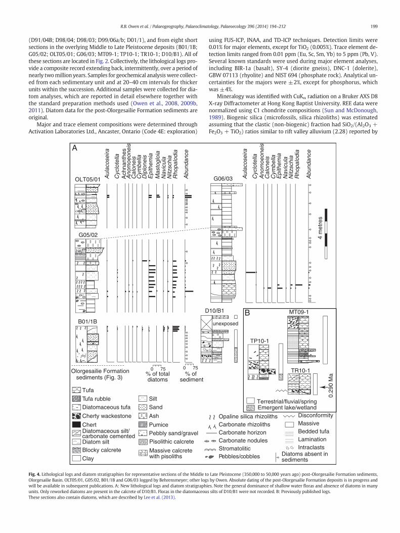
(D91/04B; D98/04; D98/03; D99/06a/b; D01/1), and from eight shortsections in the overlying Middle to Late Pleistocene deposits (B01/1B;G05/02; OLT05/01; G06/03; MT09-1; TP10-1; TR10-1; D10/B1). All ofthese sections are located in Fig. 2. Collectively, the lithological logs pro-vide a composite record extending back, intermittently, over a period ofnearly twomillion years. Samples for geochemical analysiswere collect-ed from each sedimentary unit and at 20–40 cm intervals for thickerunits within the succession. Additional samples were collected for dia-tom analyses, which are reported in detail elsewhere together withthe standard preparation methods used (Owen et al., 2008, 2009b,2011). Diatom data for the post-Olorgesailie Formation sediments areoriginal.
Major and trace element compositions were determined throughActivation Laboratories Ltd., Ancaster, Ontario (Code 4E: exploration)
Cherty wackestone
Diatomaceous silt/carbonate cemented
Chert
Tufa
OLT05/01
B01/1B
G05/02
Olorgesailie Formation sediments (Fig. 3)
Diatom silt
Clay
Silt
Sand
Pumice
Ash
Tufa rubble
Diatomaceous tufa
Pebbly sand/gravel
Blocky calcrete Massive calcretewith pisoliths
Pisolithic calcrete
D
Rho
palo
dia
Aul
acos
eira
Ano
moe
onei
s C
alon
eis
Cyc
lote
lla
Cym
bella
Dip
lone
isE
pith
emia
Ach
nant
hes
0 75 0 75% of totaldiatoms
Mas
togl
oia
Abu
ndan
ce
Nav
icul
aN
itzsc
hia
A
% of sediment
Fig. 4. Lithological logs and diatom stratigraphies for representative sections of the Middle toOlorgesailie Basin. OLT05/01, G05/02, B01/1B and G06/03 logged by Behrensmeyer; other logswill be available in subsequent publications. A: New lithological logs and diatom stratigraphiunits. Only reworked diatoms are present in the calcrete of D10/B1. Floras in the diatomaceouThese sections also contain diatoms, which are described by Lee et al. (2013).
using FUS-ICP, INAA, and TD-ICP techniques. Detection limits were0.01% for major elements, except for TiO2 (0.005%). Trace element de-tection limits ranged from 0.01 ppm (Eu, Sc, Sm, Yb) to 5 ppm (Pb, V).Several known standards were used during major element analyses,including BIR-1a (basalt), SY-4 (diorite gneiss), DNC-1 (dolerite),GBW 07113 (rhyolite) and NIST 694 (phosphate rock). Analytical un-certainties for the majors were ±2%, except for phosphorus, whichwas ±4%.
Mineralogy was identified with CuKα radiation on a Bruker AXS D8X-ray Diffractometer at Hong Kong Baptist University. REE data werenormalized using C1 chondrite compositions (Sun and McDonough,1989). Biogenic silica (microfossils, silica rhizoliths) was estimatedassuming that the clastic (non-biogenic) fraction had SiO2/(Al2O3 +Fe2O3 + TiO2) ratios similar to rift valley alluvium (2.28) reported by
Opaline silica rhizoliths
G06/03
4 m
etre
s
Pebbles/cobbles
Intraclasts
Carbonate rhizolithsCarbonate horizon
Lamination
Massive
Emergent lake/wetlandDisconformity
StromatoliticCarbonate nodules
Bedded tufa
TP10-1
MT09-1
0.29
0 M
a
TR10-1
unexposed
10/B1
Rho
palo
dia
Aul
acos
eira
Ano
moe
onei
s C
alon
eis
Cyc
lote
lla
Cym
bella
Epi
them
ia
Abu
ndan
ce
Nav
icul
aN
itzsc
hia
B
Diatoms absent insediments
Terrestrial/fluvial/spring
Late Pleistocene (350,000 to 50,000 years ago) post-Olorgesailie Formation sediments,by Owen. Absolute dating of the post-Olorgesailie Formation deposits is in progress and
es. Note the general dominance of shallow water floras and absence of diatoms in manys silts of D10/B1 were not recorded. B: Previously published logs.
200 R.B. Owen et al. / Palaeogeography, Palaeoclimatology, Palaeoecology 396 (2014) 194–212
Baker (1958). These values are comparable to sediments in Member 7(M7: 2.21) and Member 11 (M11: 2.68) of the Olorgesailie Formationthat lack siliceous microfossils.
Mass Loss on Ignition (MLOI) was determined at Hong Kong BaptistUniversity. A total of 98 samples were heated to 550 °C in a muffle fur-nace after initial overnight drying at 110 °C. Organic carbon (OC) wasdetermined on a smaller set of samples (n= 45) using a PE2400 SeriesII CHN elemental analyzer linked to a microbalance system. Carbonatewas first removed with HCl, followed by sample drying at 80 °C. Thebulk sample was then placed in tin boats and weighed. Control checkswere carried out after every 15th sample.
3. Results
3.1. Diatom floras
Table 1 summarizes the diatom data for theMunyuwa Gicheru sed-iments and the Olorgesailie Formation based on Owen et al. (2008,2009b, 2011, 2012) who have previously presented detailed diatomstratigraphies for both of these sequences. The floras in these sedimentsinclude varied epiphytic, benthonic and planktonic taxa indicative ofshallow to deep lakes and wetlands that were characterized by freshto mildly saline conditions.
New data for the post-Olorgesailie Formation sediments are pre-sented here. Eight diatom assemblages (P-OF1–8, Table 1) can be distin-guished, all of which indicate shallowwater conditions. Flora P-OF5, forexample, with abundant Caloneis bacillum may also reflect flowingwater, whereas P-OF8 likely indicates damp soils or very shallowswamps. Most assemblages record fresh to mildly saline conditions, ex-cept for P-OF1, which indicates more saline settings, possibly in desic-cating ponds.
SiO2
Al2O3
Fe2O
3(T)
MnO
B01/1B
G05/2
OLT05/1
Mun
yu w
a G
iche
ru s
edim
ents
Olo
rges
ailie
For
mat
ion
Pos
t-O
lorg
esai
lieF
orm
atio
n se
ds.
D91/04B
D98/04
D98/03
D99/06
D01/1
MwG1
MwG2
30 60 90
161 5
1 10
0.01 0.1 0
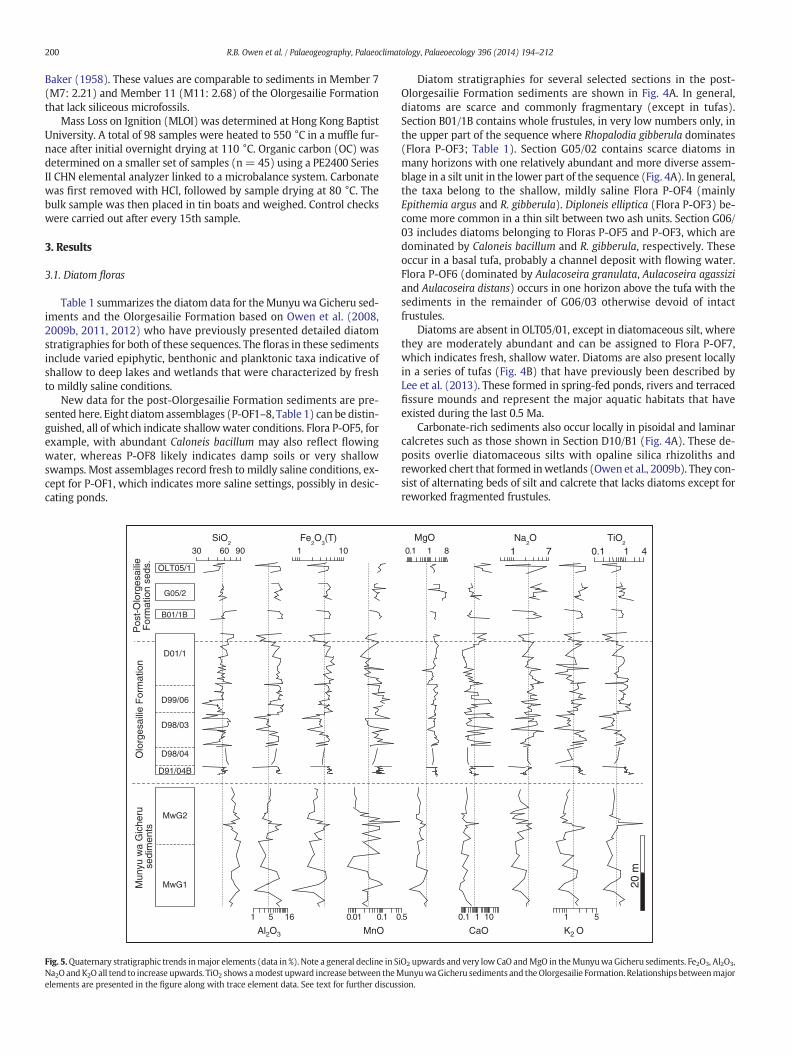
Fig. 5.Quaternary stratigraphic trends inmajor elements (data in %). Note a general decline in SNa2O andK2O all tend to increase upwards. TiO2 shows amodest upward increase between theMelements are presented in the figure along with trace element data. See text for further discus
Diatom stratigraphies for several selected sections in the post-Olorgesailie Formation sediments are shown in Fig. 4A. In general,diatoms are scarce and commonly fragmentary (except in tufas).Section B01/1B contains whole frustules, in very low numbers only, inthe upper part of the sequence where Rhopalodia gibberula dominates(Flora P-OF3; Table 1). Section G05/02 contains scarce diatoms inmany horizons with one relatively abundant and more diverse assem-blage in a silt unit in the lower part of the sequence (Fig. 4A). In general,the taxa belong to the shallow, mildly saline Flora P-OF4 (mainlyEpithemia argus and R. gibberula). Diploneis elliptica (Flora P-OF3) be-come more common in a thin silt between two ash units. Section G06/03 includes diatoms belonging to Floras P-OF5 and P-OF3, which aredominated by Caloneis bacillum and R. gibberula, respectively. Theseoccur in a basal tufa, probably a channel deposit with flowing water.Flora P-OF6 (dominated by Aulacoseira granulata, Aulacoseira agassiziand Aulacoseira distans) occurs in one horizon above the tufa with thesediments in the remainder of G06/03 otherwise devoid of intactfrustules.
Diatoms are absent in OLT05/01, except in diatomaceous silt, wherethey are moderately abundant and can be assigned to Flora P-OF7,which indicates fresh, shallow water. Diatoms are also present locallyin a series of tufas (Fig. 4B) that have previously been described byLee et al. (2013). These formed in spring-fed ponds, rivers and terracedfissure mounds and represent the major aquatic habitats that haveexisted during the last 0.5 Ma.
Carbonate-rich sediments also occur locally in pisoidal and laminarcalcretes such as those shown in Section D10/B1 (Fig. 4A). These de-posits overlie diatomaceous silts with opaline silica rhizoliths andreworked chert that formed inwetlands (Owen et al., 2009b). They con-sist of alternating beds of silt and calcrete that lacks diatoms except forreworked fragmented frustules.
MgO Na2O
K2 O
20 m
0.1 1 10 1 5.5
0.1 1 8 1 7
CaO
TiO2
0.1 1 4
iO2 upwards and very low CaO andMgO in theMunyuwa Gicheru sediments. Fe2O3, Al2O3,unyuwaGicheru sediments and theOlorgesailie Formation. Relationships betweenmajor
sion.
201R.B. Owen et al. / Palaeogeography, Palaeoclimatology, Palaeoecology 396 (2014) 194–212
Diatomaceous parts of the Middle to Late Pleistocene siliciclastic se-quences contain similar, mainly benthonic, diatom floras. Frustules areoften absent or scarce and are commonly fragmented. A few horizonscontain abundant diatoms. Overall, the data imply shallow temporarywaters interspersed with terrestrial and/or fluvial settings.
3.2. Chemostratigraphy and mineralogy
Organic carbon is generally low in all of the sediments collected, in-cluding horizons identified as palaeosols, with OC values ranging be-tween 0.06 and 0.59 wt.% C. The average organic carbon content forMunyu wa Gicheru sediments is 0.25 wt.% (n = 11) with a similaraverage of 0.31 wt.% (n = 22) for Olorgesailie Formation deposits.Post-Olorgesailie Formation (n = 12) OC values are slightly higher, av-eraging 0.52wt.% C. MLOI data (n=98) range between 0.5 and 2.4wt.%(average = 1.1%) for all sediments.
Fig. 5 shows the stratigraphic distribution of major elementsthrough the composite sections. Although there are many fluctuations,total silica generally declines from very high concentrations in theEarly Pleistocene Munyu wa Gicheru deposits (56.1–84.8%) through tothe Middle to Late Pleistocene sediments (27.8–78.6%; Fig. 4), and tovalues of 0.9% in tufas and calcretes (not shown in Fig. 5; see Lee et al.,2013). Silica exhibits weak correlations with Al2O3 (r = 0.21), which,
98/03-B15
D01/1-B28
D01/1-B1
D99/06-B17
D98/03-B31
D99/06b-B24
D99/06b-B44
D91/04-1
MwG2-46
D98/04-B48
D01/1-B78
D01/1-B48
D01/1-B96
MwG1-22
MwG1-10
MwG2-12
MwG2-29
MwG2-42
0 10 20 30 40 50
Olo
rges
ailie
For
mat
ion
Mun
yu w
a G
iche
ruse
dim
ents
3000
2000
1000
0
coun
ts
S
S
SS
G?
K
K
K
K
K
S
K
K K
K
K
K
K
K
C C
C C
C C
C C
C
2-θ
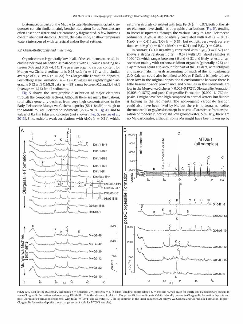
SA B
Fig. 6. XRD data for the Quaternary sediments. S = smectite; C = calcite; K = K-feldspar (sansome Olorgesailie Formation sediments (e.g. D01/1-B1). Note the absence of calcite in Munyupost-Olorgesailie Formation sediments, with tufas (MT09/1) and calcretes (D10-B1-8) comOlorgesailie Formation deposits (note change in count scale for MT09/1 samples).
in turn, is strongly correlatedwith total Fe2O3 (r= 0.87). Both of the lat-ter elements have similar stratigraphic distributions (Fig. 5), tendingto increase upwards through the various Early to Late Pleistocenesediments. Al2O3 is also positively correlated with K2O (r = 0.61),Na2O (r = 0.41) and TiO2 (r = 0.59), but exhibits very weak correla-tions with MgO (r = 0.04), MnO (r = 0.01) and P2O5 (r = 0.08).
In contrast, CaO is negatively correlated with Al2O3 (r = 0.57) andshows a strong relationship (r = 0.67) with LOI (dried samples at1050 °C), which ranges between 3.9 and 43.8% and likely reflects an as-sociation mainly with carbonate. Minor organics (generally b2%) andclay minerals could also account for part of the LOI data, with feldsparsand scarce mafic minerals accounting for much of the non-carbonateCaO. Calcium could also be linked to SO4 or F. Sulfate is likely to havebeen low in the original depositional environment because there islittle basement-rock provenance and S values in the sediments arelow in theMunyu wa Gicheru (b0.005–0.172%), Olorgesailie Formation(0.003–0.187%) and post-Olorgesailie Formation (0.002–1.17%) de-posits. F might have been high compared to normal waters, but fluoriteis lacking in the sediments. The non-organic carbonate fractioncould also have been fixed by Na, but there is no trona, nahcolite,thermonatrite or gaylussite except in recent efflorescence from evapo-ration of modern runoff or shallow groundwater. Similarly, there areno Mg-carbonates, although some Mg might have been taken up by
3000
2000
1000
0
S
KG05/02-13
G06/03-15
G06/03-9
0
2000
4000
6000
8000
10000
10 20 30 40 50
10 20 30 40 50
post
-Olo
rges
ailie
For
mat
ion
coun
tsco
unts
MT09/1 (all samples)
min
or s
mec
tite
K Ca
± sm
ectit
e or
illit
e
KC
C
CC C C
C C
G06/03-19
S
G06/03-12
K
K K
K
K
K
K
K
K
K
C
C
C
C C CC
C S
S
2-θ
2-θ
D10-B1-8
idine, anorthoclase); G = gypsum? Small peaks for quartz and plagioclase are present inwa Gicheru sediments. Calcite is locally present in Olorgesailie Formation deposits and
mon in the latter sequence. A: Munyu wa Gicheru and Olorgesailie Formation; B: post-
-2.0 -1.0 0.0 1.0 2.0Axis 1 (39.7 %)
-1.2
0.0
1.2
2.4
Axi
s 2
(11.
5 %
)
SiO2 (T)
Bio Si
Al2O3
Fe2O3(T)
MgO
CaO
K2OP2O5
LOI
As
Ba
Be
Br
CdCo
Cr
Cs
Hf
Ni
Pb
Rb
Sb
Sr
TaTh
U
Y
Zn
Zr
LaCe
NdSm
EuTb
Yb
TiO2
Mo
Ag
Na2O
S
Sc
Cu
W
Lu
MnO
Fig. 7. PCA analysis for all sediments showing relationships between major and trace ele-ments. Axis 1 distinguishes between lithogenic elements (negative values) and biogenicelements (positive values). The latter include biological silica, which comprisesmainlymi-crofossil silica (mostly diatoms and sponge spicules) and permineralized silica in plants.The elements S and Brmay relate to organic inputs to the basin. CaO and LOImainly reflectcarbonate deposits and also yield positive values, but are clearly distinguished on axis 2from the biogenic elements. See text for further discussion.
202 R.B. Owen et al. / Palaeogeography, Palaeoclimatology, Palaeoecology 396 (2014) 194–212
clays. Dolomite, if present, is minor and not recorded in our analyses.Consequently, calcium in the geochemical data set is believed tomainlyreflect calcite, which is present in XRD data.
Representative XRD data for each of the major stratigraphic se-quences show dominance by K-feldspar and smectite at each site, withcalcite becoming common in the Olorgesailie and post-Olorgesailie for-mations (Fig. 6). Nearly pure calcite tufas and calcretes (e.g., MT09/1and D10/B1 in Figs. 4 and 6) are present in the latter deposits. Minorphases present in Olorgesailie samples include quartz, plagioclase,nepheline, riebeckite, arfvedsonite, and hornblende. Minor illite and in-terstratified smectite–illite might be present in some Olorgesailie sam-ples, but separate analyses of the clay fraction were not undertaken.Deocampo et al. (2010), however, reported consistent smectite domi-nance in the ultrafine clay fraction. Minor doming at 20–26° in somesamples may reflect non-crystalline silica (diatom opal-A), volcanicglass and/or poorly crystalline clay. Gypsum (oxidized pyrite?) issuspected, but unconfirmed, in a few Olorgesailie Formation samples.
Stratigraphically, there are major changes in CaO content (Fig. 5).The Munyu wa Gicheru deposits record very low CaO values of b0.46%in all but one sample (1.8%). CaO generally ranges between 0.2 and35% in theOlorgesailie Formation, peaking at 46.5% in a carbonatemark-er bed. The Middle to Late Pleistocene deposits show a similar overallCaO variability (0.3–30%), alsowithmultiple discrete peaks. The highestvalues (up to 49.6%) are associatedwith tufas and calcretes present onlyin the post-Olorgesailie Formation sediments (Fig. 4) andwhich are ex-cluded in the chemostratigraphy for the siliciclastic deposits presentedin Fig. 5.
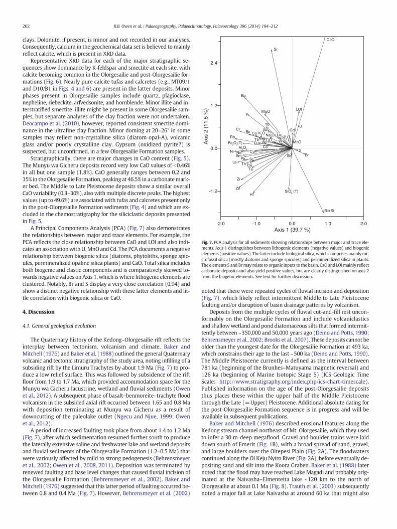
A Principal Components Analysis (PCA) (Fig. 7) also demonstratesthe relationships between major and trace elements. For example, thePCA reflects the close relationship between CaO and LOI and also indi-cates an associationwithU,MnOand Cd. The PCA documents a negativerelationship between biogenic silica (diatoms, phytoliths, sponge spic-ules, permineralized opaline silica plants) and CaO. Total silica includesboth biogenic and clastic components and is comparatively skewed to-wards negative values on Axis 1,which iswhere lithogenic elements areclustered. Notably, Br and S display a very close correlation (0.94) andshow a distinct negative relationship with these latter elements and lit-tle correlation with biogenic silica or CaO.
4. Discussion
4.1. General geological evolution
The Quaternary history of the Kedong–Olorgesailie rift reflects theinterplay between tectonism, volcanism and climate. Baker andMitchell (1976) and Baker et al. (1988) outlined the general Quaternaryvolcanic and tectonic stratigraphy of the study area, noting infilling of asubsiding rift by the Limuru Trachytes by about 1.9 Ma (Fig. 7) to pro-duce a low relief surface. This was followed by subsidence of the riftfloor from 1.9 to 1.7 Ma, which provided accommodation space for theMunyu wa Gicheru lacustrine, wetland and fluvial sediments (Owenet al., 2012). A subsequent phase of basalt–benmoreite–trachyte floodvolcanism in the subsided axial rift occurred between 1.65 and 0.8 Mawith deposition terminating at Munyu wa Gicheru as a result ofdowncutting of the paleolake outlet (Ngecu and Njue, 1999; Owenet al., 2012).
A period of increased faulting took place from about 1.4 to 1.2 Ma(Fig. 7), after which sedimentation resumed further south to producethe laterally extensive saline and freshwater lake and wetland depositsand fluvial sediments of the Olorgesailie Formation (1.2–0.5 Ma) thatwere variously affected by mild to strong pedogenesis (Behrensmeyeret al., 2002; Owen et al., 2008, 2011). Deposition was terminated byrenewed faulting and base level changes that caused fluvial incision ofthe Olorgesailie Formation (Behrensmeyer et al., 2002). Baker andMitchell (1976) suggested that this latter period of faulting occurred be-tween 0.8 and 0.4 Ma (Fig. 7). However, Behrensmeyer et al. (2002)
noted that there were repeated cycles of fluvial incision and deposition(Fig. 7), which likely reflect intermittent Middle to Late Pleistocenefaulting and/or disruption of basin drainage patterns by volcanism.
Deposits from the multiple cycles of fluvial cut-and-fill rest uncon-formably on the Olorgesailie Formation and include volcaniclasticsand shallowwetland andponddiatomaceous silts that formed intermit-tently between ~350,000 and 50,000 years ago (Deino and Potts, 1990;Behrensmeyer et al., 2002; Brooks et al., 2007). These deposits cannot beolder than the youngest date for the Olorgesailie Formation at 493 ka,which constrains their age to the last ~500 ka (Deino and Potts, 1990).The Middle Pleistocene currently is defined as the interval between781 ka (beginning of the Brunhes–Matuyama magnetic reversal) and126 ka (beginning of Marine Isotopic Stage 5) (ICS Geologic TimeScale: http://www.stratigraphy.org/index.php/ics-chart-timescale).Published information on the age of the post-Olorgesailie depositsthus places these within the upper half of the Middle Pleistocenethrough the Late (=Upper) Pleistocene. Additional absolute dating forthe post-Olorgesailie Formation sequence is in progress and will beavailable in subsequent publications.
Baker and Mitchell (1976) described erosional features along theKedong stream channel northeast of Mt. Olorgesailie, which they usedto infer a 30 m-deep megaflood. Gravel and boulder trains were laiddown south of Emerit (Fig. 1B), with a broad spread of sand, gravel,and large boulders over the Oltepesi Plain (Fig. 2A). The floodwaterscontinued along the Ol Keju Nyiro River (Fig. 2A), before eventually de-positing sand and silt into the Koora Graben. Baker et al. (1988) laternoted that the flood may have reached Lake Magadi and probably orig-inated at the Naivasha–Elmenteita lake ~120 km to the north ofOlorgesailie at about 0.1 Ma (Fig. 8). Trauth et al. (2003) subsequentlynoted a major fall at Lake Naivasha at around 60 ka that might also
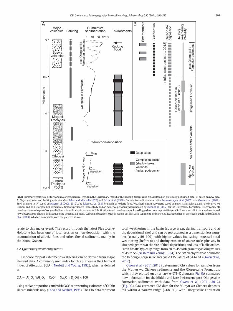
0
0.5
1.0
1.5
2.0
0 40 80 120
non-deposition
non-deposition
Mun
yu w
a G
iche
ruO
lorg
esai
lie F
orm
atio
npo
st-O
lorg
esai
lie
For
mat
ion
sedi
men
ts
Mun
yu w
a G
iche
ruO
lorg
esai
lie F
orm
atio
npo
st-O
lorg
esai
lie
For
mat
ion
sedi
men
ts
Erosion/non-deposition
LimuruTrachytes
Oltepesibasalts
MagadiTrachytes
Suswavolcanics
Majorvolcanics
Cumulativesedimentation
0 40
m
m
Environments
Env
ironm
ents
Sili
cific
atio
n
Car
bona
te
depo
sitio
n
Deep lakes
Complex deposits(shallow lakes, wetlands,fluvial, pedogenic)
Rel
ativ
e w
eath
erin
gin
tens
ity
Kedongflood
Mill
ion
year
s
BA
+ tu
fas
(see
Lee
et a
l., 2
013)
Bas
ed o
n da
ta in
Ow
en e
t al.
(201
2)
No
sedi
men
ts a
vaila
ble
Faulting
Fig. 8. Summary geological history and major geochemical trends in the Quaternary record of the Kedong–Olorgesailie rift. A: Based on previously published data; B: based on new data.A: Major volcanics and faulting episodes after Baker and Mitchell (1976) and Baker et al. (1988). Cumulative sedimentation after Behrensmeyer et al. (2002) and Owen et al. (2012).Environments in “A” based on Owen et al. (2008, 2012). See Baker et al. (1988) for details of Kedong flood.Weathering summary trend based on new stratigraphic data for theMunyuwaGicheru and post Olorgesailie Formation sediments presented in this study and on evidence previously documented by Owen et al. (2012) for theOlorgesailie Formation. B: Environmentsbased on diatoms in post-Olorgesailie Formation siliciclastic sediments. Silicification trend based on unpublished logged sections in post-Olorgesailie Formation siliciclastic sediments andnewobservations of faulted siliceous spring deposits at Emerit. Carbonate based on logged sections of siliciclastic sediments and calcretes. Excludes data on previously published tufas (Leeet al., 2013), which is compatible with the patterns shown.
203R.B. Owen et al. / Palaeogeography, Palaeoclimatology, Palaeoecology 396 (2014) 194–212
relate to this major event. The record through the latest Pleistocene/Holocene has been one of local erosion or non-deposition with theaccumulation of alluvial fans and other fluvial sediments mainly inthe Koora Graben.
4.2. Quaternary weathering trends
Evidence for past catchment weathering can be derived from majorelement data. A commonly used index for this purpose is the ChemicalIndex of Alteration (CIA) (Nesbitt and Young, 1982), which is definedas:
CIA ¼ Al2O3= Al2O3 þ CaO� þNa2Oþ K2Oð Þ½ � � 100
usingmolar proportions andwith CaO* representing estimates of CaO insilicate minerals only (Fedo and Nesbitt, 1995). The CIA data represent
total weathering in the basin (source areas, during transport and atthe depositional site) and can be represented as a dimensionless num-ber (usually 50–100), with higher values indicating increased totalweathering (before to and during erosion of source rocks plus any insitu pedogenesis at the site of final deposition) and loss of labile oxides.Fresh basalts typically range from 30 to 45 with granites yielding valuesof 45 to 55 (Nesbitt and Young, 1984). The rift trachytes that dominatethe Kedong–Olorgesailie area yield CIA values of 54 to 61 (Owen et al.,2012).
Owen et al. (2011, 2012) determined CIA values for samples fromthe Munyu wa Gicheru sediments and the Olorgesailie Formation,which they plotted on a ternary A–CN–K diagram. Fig. 9A comparesnew information for the Middle and Late Pleistocene post-OlorgesailieFormation sediments with data from Owen et al. (2011, 2012)(Fig. 9B). CaO corrected CIA data for the Munyu wa Gicheru depositsfall within a narrow range (~68–80), with Olorgesailie Formation
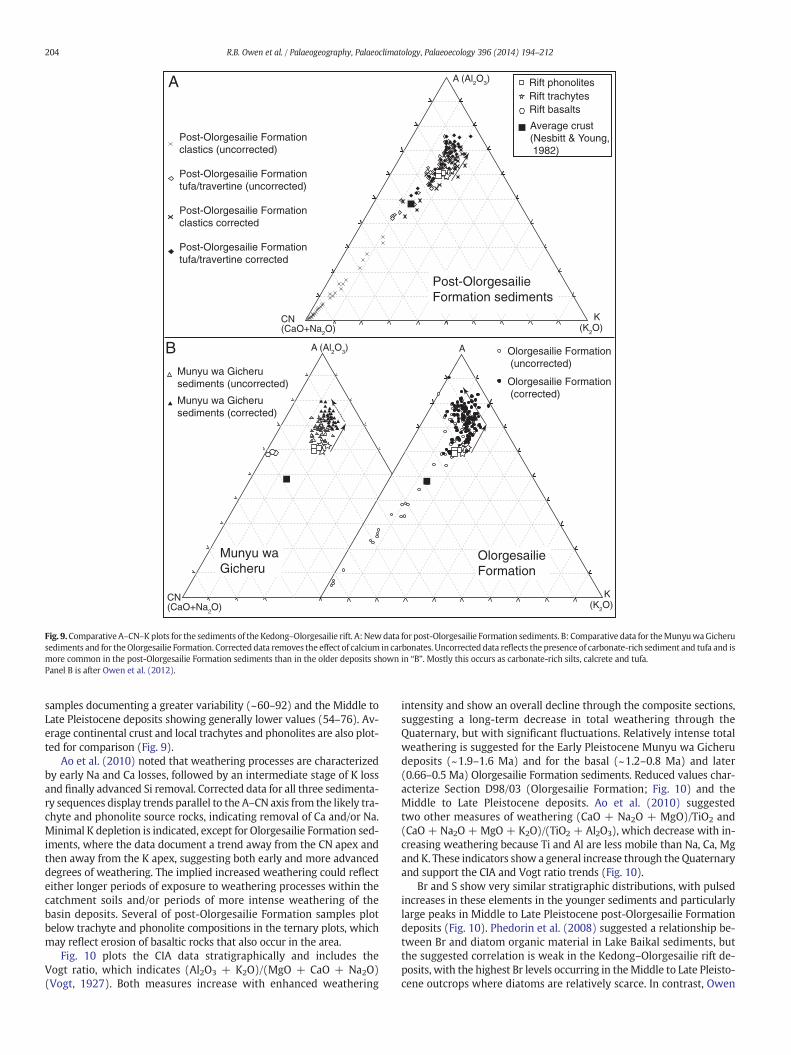
A (Al2O3)
A (Al2O3)
A
CN (CaO+Na2O)
CN (CaO+Na2O)
B axis
Munyu wa Gicherusediments (uncorrected)
Munyu wa Gicherusediments (corrected)
Olorgesailie Formation (corrected)
Olorgesailie Formation (uncorrected)
Post-Olorgesailie Formationclastics (uncorrected)
Post-Olorgesailie Formationtufa/travertine (uncorrected)
Post-Olorgesailie Formationclastics corrected
Post-Olorgesailie Formation tufa/travertine corrected
K (K2O)
K (K2O)
Munyu waGicheru
OlorgesailieFormation
Post-OlorgesailieFormation sediments
A
B
Average crust (Nesbitt & Young, 1982)
Rift trachytesRift phonolites
Rift basalts
Fig. 9.ComparativeA–CN–Kplots for the sediments of the Kedong–Olorgesailie rift. A:Newdata for post-Olorgesailie Formation sediments. B: Comparative data for theMunyuwaGicherusediments and for theOlorgesailie Formation. Corrected data removes the effect of calcium in carbonates. Uncorrected data reflects the presence of carbonate-rich sediment and tufa and ismore common in the post-Olorgesailie Formation sediments than in the older deposits shown in “B”. Mostly this occurs as carbonate-rich silts, calcrete and tufa.Panel B is after Owen et al. (2012).
204 R.B. Owen et al. / Palaeogeography, Palaeoclimatology, Palaeoecology 396 (2014) 194–212
samples documenting a greater variability (~60–92) and the Middle toLate Pleistocene deposits showing generally lower values (54–76). Av-erage continental crust and local trachytes and phonolites are also plot-ted for comparison (Fig. 9).
Ao et al. (2010) noted that weathering processes are characterizedby early Na and Ca losses, followed by an intermediate stage of K lossand finally advanced Si removal. Corrected data for all three sedimenta-ry sequences display trends parallel to the A–CN axis from the likely tra-chyte and phonolite source rocks, indicating removal of Ca and/or Na.Minimal K depletion is indicated, except for Olorgesailie Formation sed-iments, where the data document a trend away from the CN apex andthen away from the K apex, suggesting both early and more advanceddegrees of weathering. The implied increased weathering could reflecteither longer periods of exposure to weathering processes within thecatchment soils and/or periods of more intense weathering of thebasin deposits. Several of post-Olorgesailie Formation samples plotbelow trachyte and phonolite compositions in the ternary plots, whichmay reflect erosion of basaltic rocks that also occur in the area.
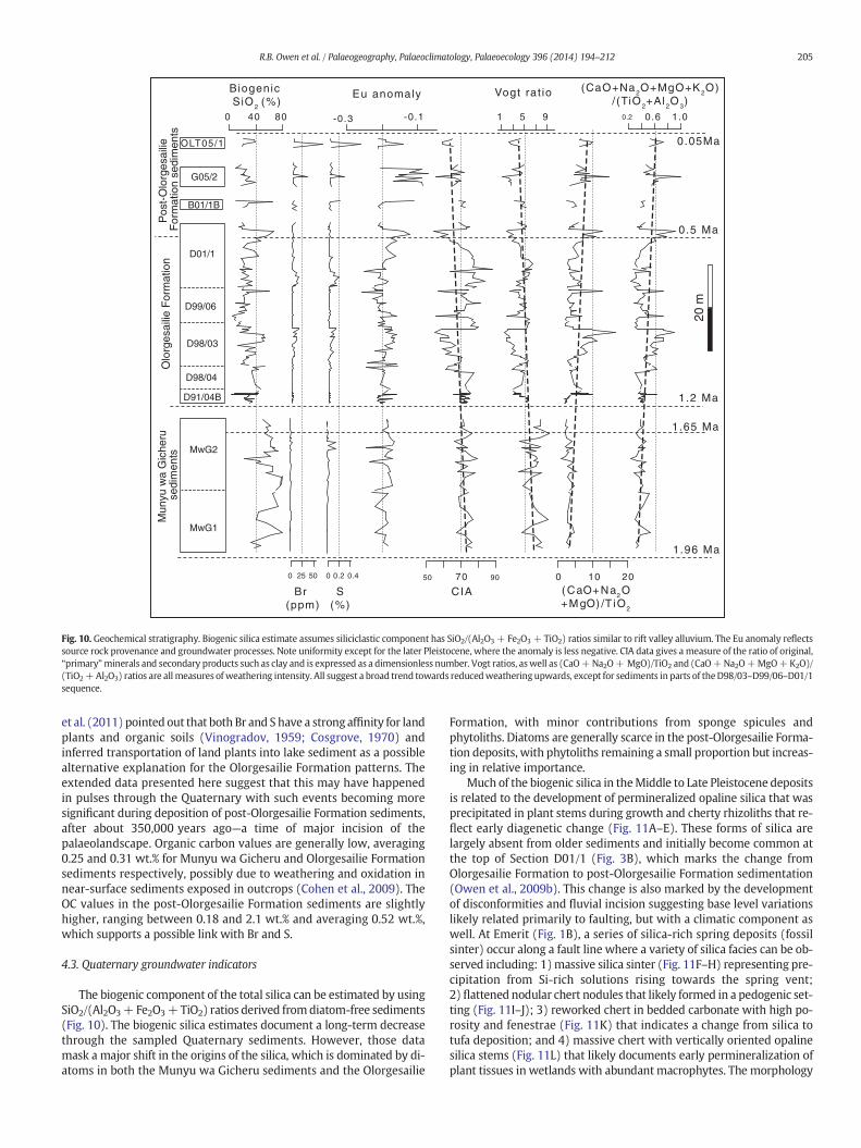
Fig. 10 plots the CIA data stratigraphically and includes theVogt ratio, which indicates (Al2O3 + K2O)/(MgO + CaO + Na2O)(Vogt, 1927). Both measures increase with enhanced weathering
intensity and show an overall decline through the composite sections,suggesting a long-term decrease in total weathering through theQuaternary, but with significant fluctuations. Relatively intense totalweathering is suggested for the Early Pleistocene Munyu wa Gicherudeposits (~1.9–1.6 Ma) and for the basal (~1.2–0.8 Ma) and later(0.66–0.5 Ma) Olorgesailie Formation sediments. Reduced values char-acterize Section D98/03 (Olorgesailie Formation; Fig. 10) and theMiddle to Late Pleistocene deposits. Ao et al. (2010) suggestedtwo other measures of weathering (CaO + Na2O + MgO)/TiO2 and(CaO + Na2O + MgO + K2O)/(TiO2 + Al2O3), which decrease with in-creasing weathering because Ti and Al are less mobile than Na, Ca, Mgand K. These indicators show a general increase through the Quaternaryand support the CIA and Vogt ratio trends (Fig. 10).
Br and S show very similar stratigraphic distributions, with pulsedincreases in these elements in the younger sediments and particularlylarge peaks in Middle to Late Pleistocene post-Olorgesailie Formationdeposits (Fig. 10). Phedorin et al. (2008) suggested a relationship be-tween Br and diatom organic material in Lake Baikal sediments, butthe suggested correlation is weak in the Kedong–Olorgesailie rift de-posits, with the highest Br levels occurring in theMiddle to Late Pleisto-cene outcrops where diatoms are relatively scarce. In contrast, Owen
50 90
0.2
Mun
yu w
a G
iche
ru s
edim
ents
Olo
rges
ailie
For
mat
ion
B01/1B
G05/2
Biogenic SiO2 (%)
Eu anomaly
CIA
Vogt rat io
( CaO+ Na2O+ M gO) /T iO2
(CaO+Na2O+MgO+K2O)/(TiO2+Al2O3)
0 40 80 -0.3 -0.1
70
1 5 9
0 10 20
0.6 1.0
OLT05/1
20 m
Pos
t-O
lorg
esai
lie
For
mat
ion
sedi
men
ts
MwG1
MwG2
D91/04B
D98/04
D98/03
D99/06
D01/1
0.5 Ma
1.2 Ma
1.65 Ma
1.96 Ma
0.05Ma
0 25 50 0 0.2 0.4
Br (ppm)
S(%)
Fig. 10. Geochemical stratigraphy. Biogenic silica estimate assumes siliciclastic component has SiO2/(Al2O3 + Fe2O3 + TiO2) ratios similar to rift valley alluvium. The Eu anomaly reflectssource rock provenance and groundwater processes. Note uniformity except for the later Pleistocene, where the anomaly is less negative. CIA data gives a measure of the ratio of original,“primary”minerals and secondary products such as clay and is expressed as a dimensionless number. Vogt ratios, aswell as (CaO+Na2O+ MgO)/TiO2 and (CaO+Na2O+MgO+K2O)/(TiO2+Al2O3) ratios are all measures of weathering intensity. All suggest a broad trend towards reducedweatheringupwards, except for sediments in parts of theD98/03–D99/06–D01/1sequence.
205R.B. Owen et al. / Palaeogeography, Palaeoclimatology, Palaeoecology 396 (2014) 194–212
et al. (2011) pointed out that both Br and S have a strong affinity for landplants and organic soils (Vinogradov, 1959; Cosgrove, 1970) andinferred transportation of land plants into lake sediment as a possiblealternative explanation for the Olorgesailie Formation patterns. Theextended data presented here suggest that this may have happenedin pulses through the Quaternary with such events becoming moresignificant during deposition of post-Olorgesailie Formation sediments,after about 350,000 years ago—a time of major incision of thepalaeolandscape. Organic carbon values are generally low, averaging0.25 and 0.31 wt.% for Munyu wa Gicheru and Olorgesailie Formationsediments respectively, possibly due to weathering and oxidation innear-surface sediments exposed in outcrops (Cohen et al., 2009). TheOC values in the post-Olorgesailie Formation sediments are slightlyhigher, ranging between 0.18 and 2.1 wt.% and averaging 0.52 wt.%,which supports a possible link with Br and S.
4.3. Quaternary groundwater indicators
The biogenic component of the total silica can be estimated by usingSiO2/(Al2O3+ Fe2O3+TiO2) ratios derived fromdiatom-free sediments(Fig. 10). The biogenic silica estimates document a long-term decreasethrough the sampled Quaternary sediments. However, those datamask a major shift in the origins of the silica, which is dominated by di-atoms in both the Munyu wa Gicheru sediments and the Olorgesailie
Formation, with minor contributions from sponge spicules andphytoliths. Diatoms are generally scarce in the post-Olorgesailie Forma-tion deposits, with phytoliths remaining a small proportion but increas-ing in relative importance.
Much of the biogenic silica in theMiddle to Late Pleistocene depositsis related to the development of permineralized opaline silica that wasprecipitated in plant stems during growth and cherty rhizoliths that re-flect early diagenetic change (Fig. 11A–E). These forms of silica arelargely absent from older sediments and initially become common atthe top of Section D01/1 (Fig. 3B), which marks the change fromOlorgesailie Formation to post-Olorgesailie Formation sedimentation(Owen et al., 2009b). This change is also marked by the developmentof disconformities and fluvial incision suggesting base level variationslikely related primarily to faulting, but with a climatic component aswell. At Emerit (Fig. 1B), a series of silica-rich spring deposits (fossilsinter) occur along a fault line where a variety of silica facies can be ob-served including: 1)massive silica sinter (Fig. 11F–H) representing pre-cipitation from Si-rich solutions rising towards the spring vent;2) flattened nodular chert nodules that likely formed in a pedogenic set-ting (Fig. 11I–J); 3) reworked chert in bedded carbonate with high po-rosity and fenestrae (Fig. 11K) that indicates a change from silica totufa deposition; and 4) massive chert with vertically oriented opalinesilica stems (Fig. 11L) that likely documents early permineralization ofplant tissues in wetlands with abundantmacrophytes. The morphology
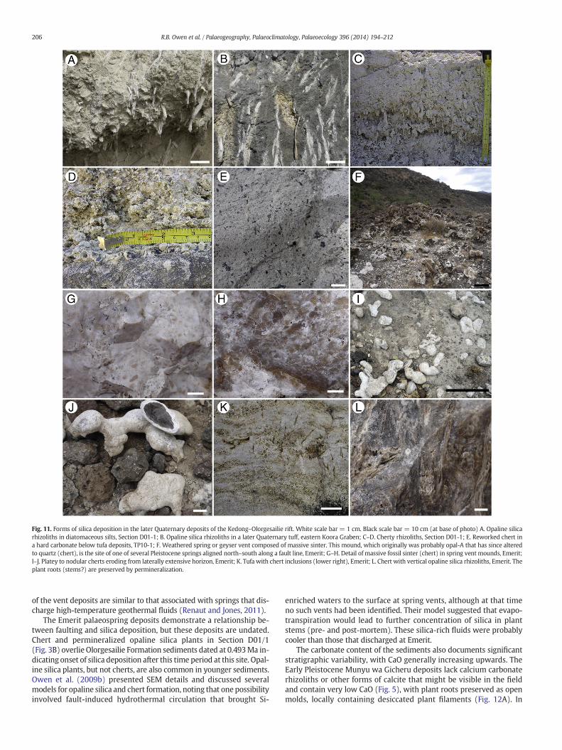
Fig. 11. Forms of silica deposition in the later Quaternary deposits of the Kedong–Olorgesailie rift. White scale bar = 1 cm. Black scale bar = 10 cm (at base of photo) A. Opaline silicarhizoliths in diatomaceous silts, Section D01-1; B. Opaline silica rhizoliths in a later Quaternary tuff, eastern Koora Graben; C–D. Cherty rhizoliths, Section D01-1; E. Reworked chert ina hard carbonate below tufa deposits, TP10-1; F. Weathered spring or geyser vent composed of massive sinter. This mound, which originally was probably opal-A that has since alteredto quartz (chert), is the site of one of several Pleistocene springs aligned north–south along a fault line, Emerit; G–H. Detail of massive fossil sinter (chert) in spring ventmounds, Emerit;I–J. Platey to nodular cherts eroding from laterally extensive horizon, Emerit; K. Tufa with chert inclusions (lower right), Emerit; L. Chert with vertical opaline silica rhizoliths, Emerit. Theplant roots (stems?) are preserved by permineralization.
206 R.B. Owen et al. / Palaeogeography, Palaeoclimatology, Palaeoecology 396 (2014) 194–212
of the vent deposits are similar to that associated with springs that dis-charge high-temperature geothermal fluids (Renaut and Jones, 2011).
The Emerit palaeospring deposits demonstrate a relationship be-tween faulting and silica deposition, but these deposits are undated.Chert and permineralized opaline silica plants in Section D01/1(Fig. 3B) overlie Olorgesailie Formation sediments dated at 0.493Ma in-dicating onset of silica deposition after this time period at this site. Opal-ine silica plants, but not cherts, are also common in younger sediments.Owen et al. (2009b) presented SEM details and discussed severalmodels for opaline silica and chert formation, noting that one possibilityinvolved fault-induced hydrothermal circulation that brought Si-
enriched waters to the surface at spring vents, although at that timeno such vents had been identified. Their model suggested that evapo-transpiration would lead to further concentration of silica in plantstems (pre- and post-mortem). These silica-rich fluids were probablycooler than those that discharged at Emerit.
The carbonate content of the sediments also documents significantstratigraphic variability, with CaO generally increasing upwards. TheEarly Pleistocene Munyu wa Gicheru deposits lack calcium carbonaterhizoliths or other forms of calcite that might be visible in the fieldand contain very low CaO (Fig. 5), with plant roots preserved as openmolds, locally containing desiccated plant filaments (Fig. 12A). In
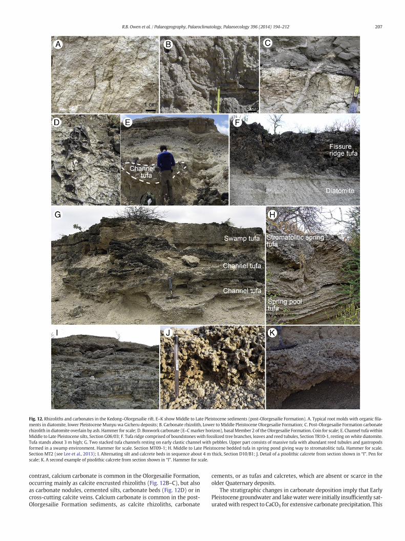
Fig. 12. Rhizoliths and carbonates in the Kedong–Olorgesailie rift. E–K show Middle to Late Pleistocene sediments (post-Olorgesailie Formation). A. Typical root molds with organic fila-ments in diatomite, lower Pleistocene Munyu wa Gicheru deposits; B. Carbonate rhizolith, Lower to Middle Pleistocene Olorgesailie Formation; C. Post-Olorgesailie Formation carbonaterhizolith in diatomite overlain by ash. Hammer for scale; D. Boxwork carbonate (E–Cmarker horizon), basal Member 2 of the Olorgesailie Formation. Coin for scale; E. Channel tufa withinMiddle to Late Pleistocene silts, Section G06/03; F. Tufa ridge comprised of boundstoneswith fossilized tree branches, leaves and reed tubules, Section TR10-1, resting on white diatomite.Tufa stands about 3 m high; G. Two stacked tufa channels resting on early clastic channel with pebbles. Upper part consists of massive tufa with abundant reed tubules and gastropodsformed in a swamp environment. Hammer for scale. Section MT09-1; H. Middle to Late Pleistocene bedded tufa in spring pond giving way to stromatolitic tufa. Hammer for scale.Section MT2 (see Lee et al., 2013); I. Alternating silt and calcrete beds in sequence about 4 m thick, Section D10/B1; J. Detail of a pisolithic calcrete from section shown in “I”. Pen forscale; K. A second example of pisolithic calcrete from section shown in “I”. Hammer for scale.
207R.B. Owen et al. / Palaeogeography, Palaeoclimatology, Palaeoecology 396 (2014) 194–212
contrast, calcium carbonate is common in the Olorgesailie Formation,occurring mainly as calcite encrusted rhizoliths (Fig. 12B–C), but alsoas carbonate nodules, cemented silts, carbonate beds (Fig. 12D) or incross-cutting calcite veins. Calcium carbonate is common in the post-Olorgesailie Formation sediments, as calcite rhizoliths, carbonate
cements, or as tufas and calcretes, which are absent or scarce in theolder Quaternary deposits.
The stratigraphic changes in carbonate deposition imply that EarlyPleistocene groundwater and lakewaterwere initially insufficiently sat-urated with respect to CaCO3 for extensive carbonate precipitation. This
208 R.B. Owen et al. / Palaeogeography, Palaeoclimatology, Palaeoecology 396 (2014) 194–212
could reflect climatic control, but may also reflect palaeogeographic po-sition within the developing rift. For example, diatom data for theMunyu wa Gicheru palaeolakes indicate that they were generally verydilute, whereas theOlorgesailie palaeolakes ranged fromdilute to saline(Owen et al., 2012), implying greater evaporation in the latter area andperiods of basin closure. Today, as a result of rift tectonics, the Munyuwa Gicheru area lies at a higher altitude and was likely also relativelyelevated in the past, which would have tended to produce moreorographically-induced rainfall there than at Olorgesailie between 1.2and 0.5 Ma. This locational contrast in elevation is absent when consid-ering the Olorgesailie basin deposits alone, where the trend towards in-creased carbonate deposition can also be discerned in the increasedpresence of Middle to Late Pleistocene calcretes and spring-fed tufas(Lee et al., 2013) along fault lines.
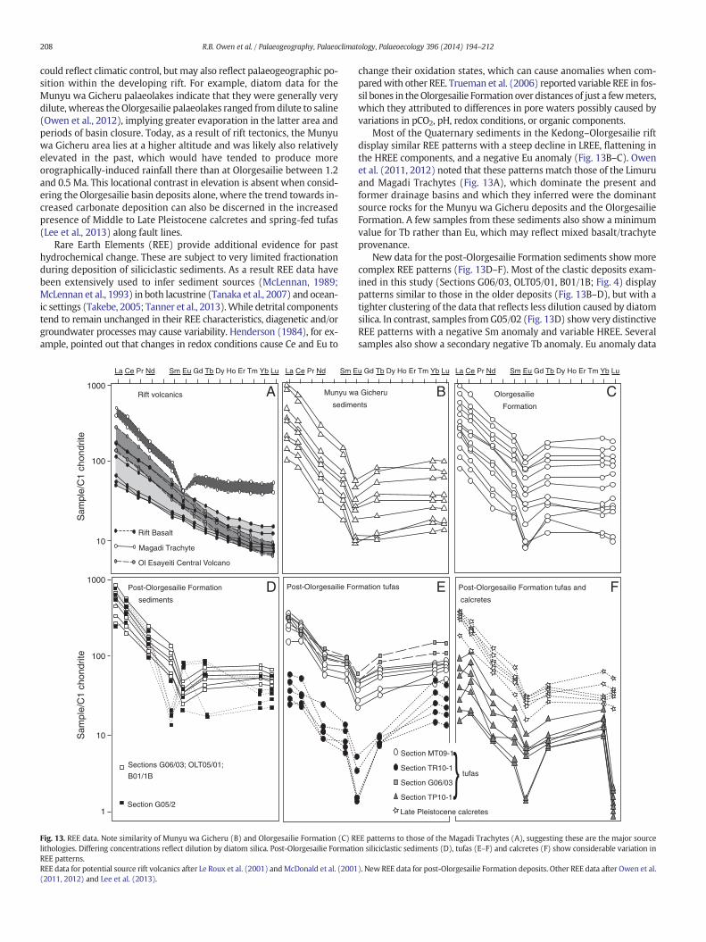
Rare Earth Elements (REE) provide additional evidence for pasthydrochemical change. These are subject to very limited fractionationduring deposition of siliciclastic sediments. As a result REE data havebeen extensively used to infer sediment sources (McLennan, 1989;McLennan et al., 1993) in both lacustrine (Tanaka et al., 2007) and ocean-ic settings (Takebe, 2005; Tanner et al., 2013).While detrital componentstend to remain unchanged in their REE characteristics, diagenetic and/orgroundwater processes may cause variability. Henderson (1984), for ex-ample, pointed out that changes in redox conditions cause Ce and Eu to
La Ce Pr Nd Sm Eu Gd Tb Dy Ho Er Tm Yb Lu
Sam
ple/
C1
chon
drite
Sam
ple/
C1
chon
drite
1000
Rift Basalt
Ol Esayeiti Central Volcano
Rift volcanics
La Ce Pr Nd Sm E
1000
100
10
100
10
1
Munyu wa
sedime
Post-Olorgesailie Formation
sediments
Magadi Trachyte
Post-Olorgesailie Fo
A
D
Section G05/2
Sections G06/03; OLT05/01;
B01/1B
Fig. 13. REE data. Note similarity of Munyu wa Gicheru (B) and Olorgesailie Formation (C) Rlithologies. Differing concentrations reflect dilution by diatom silica. Post-Olorgesailie FormatiREE patterns.REE data for potential source rift volcanics after Le Roux et al. (2001) andMcDonald et al. (2001(2011, 2012) and Lee et al. (2013).
change their oxidation states, which can cause anomalies when com-paredwith other REE. Trueman et al. (2006) reported variable REE in fos-sil bones in theOlorgesailie Formation over distances of just a fewmeters,which they attributed to differences in pore waters possibly caused byvariations in pCO2, pH, redox conditions, or organic components.
Most of the Quaternary sediments in the Kedong–Olorgesailie riftdisplay similar REE patterns with a steep decline in LREE, flattening inthe HREE components, and a negative Eu anomaly (Fig. 13B–C). Owenet al. (2011, 2012) noted that these patterns match those of the Limuruand Magadi Trachytes (Fig. 13A), which dominate the present andformer drainage basins and which they inferred were the dominantsource rocks for the Munyu wa Gicheru deposits and the OlorgesailieFormation. A few samples from these sediments also show a minimumvalue for Tb rather than Eu, which may reflect mixed basalt/trachyteprovenance.
New data for the post-Olorgesailie Formation sediments showmorecomplex REE patterns (Fig. 13D–F). Most of the clastic deposits exam-ined in this study (Sections G06/03, OLT05/01, B01/1B; Fig. 4) displaypatterns similar to those in the older deposits (Fig. 13B–D), but with atighter clustering of the data that reflects less dilution caused by diatomsilica. In contrast, samples fromG05/02 (Fig. 13D) show very distinctiveREE patterns with a negative Sm anomaly and variable HREE. Severalsamples also show a secondary negative Tb anomaly. Eu anomaly data
Section MT09-1
Section TR10-1
Section G06/03
Section TP10-1
u Gd Tb Dy Ho Er Tm Yb Lu La Ce Pr Nd Sm Eu Gd Tb Dy Ho Er Tm Yb Lu
Gicheru
ntsOlorgesailie
Formation
Post-Olorgesailie Formation tufas and
calcretes
rmation tufas
CB
FE
Late Pleistocene calcretes
tufas
EE patterns to those of the Magadi Trachytes (A), suggesting these are the major sourceon siliciclastic sediments (D), tufas (E–F) and calcretes (F) show considerable variation in
). New REE data for post-Olorgesailie Formation deposits. Other REE data after Owen et al.

209R.B. Owen et al. / Palaeogeography, Palaeoclimatology, Palaeoecology 396 (2014) 194–212
(Fig. 10) for the post-Olorgesailie Formation deposits range betweenabout −0.2 and −0.05, distinctly higher than for older sediments(−0.25 to−0.16). These variations could reflect differing source lithol-ogies. However, existing data for other rift volcanics in the area(Fig. 13A) do not show any potential source rocks with Sm minima orvariable HREE, suggesting that a diagenetic or groundwater processmight be involved.
Detailed studies of the phosphate in fossil bones in the OlorgesailieFormation have shown variable REE patterns (Trueman et al., 2006),thus uptake by apatite is a potential source of REE variability in thepost-Olorgesailie Formation deposits. However, XRD data show no sig-nificant quantities of apatite, although one post-Olorgesailie depositmay have contained minor fluorapatite. Geochemical analyses (Fig. 10)indicate low concentrations of P2O5 for the Munyu wa Gicheru sedi-ments (b0.01–0.6%), the Olorgesailie Formation (0.04–0.42%) and forthe post-Olorgesailie Formation deposits (0.01–0.48%). Changes in thequantity of apatite are therefore unlikely to be a major contributor tothe REE variability, although the ability of apatite to take up REE in re-sponse to groundwater changes might have played a partial role.
REE data for tufas (Lee et al., 2013), which are recorded only duringthe Middle to Late Pleistocene, are also very variable. The MT09-1 tufaREE patterns (Fig. 13E) resemble those documented for the older clasticsediments. This may partially reflect the inclusion of minor trachytedebris, which ranges from 0 to 5% in microscope studies. Diatomsalso form a minor component. XRD data indicate a strong dominanceby calcite, with only minor clay (possibly smectite and/or illite) andK-feldspar (Fig. 6B). In contrast, carbonates from TR10-1 (Figs. 2A and13F) show a distinct enrichment in HREE, whereas samples fromTP10-1 (Figs. 2A and 13F) display HREE depletion. XRD data for the lat-ter tufas suggestminimal detrital contributions, but diatoms are again aminor component. Tufas with higher mineral contents are also present,but are not included with the analyses reported above. REE in tufas areprecipitated from groundwater, which may be characterized by REEpatterns that differ from host sediments. This can be caused, for exam-ple, by preferential mobilization of HREE as colloidal or dissolved com-plexes, or by selective loss of light middle REE following sorption onsedimentary particles such as apatite (Sholkovitz, 1992; Reynard et al.,1999).
Metzger et al. (2004) reported that a general increase inHREE enrich-ment can be associated with soil formation. Trueman et al. (2006) alsosuggested that paleosol variability could cause local changes in pCO2,pH, redox conditions, and organic components that would influenceREE composition. Middle to Late Pleistocene calcretes (Fig. 13F) showsimilar LREE patterns to that of Olorgesailie Formation sediments, aswell as a distinct Eu anomaly. However, in contrast to the older deposits,HREE show small increases or decreases in Yb and Lu compared with Tb.
Sediments associatedwith springs, spring tufas and calcretes thus allshow varying degrees of REE variability compared with potential riftvolcanic and sedimentary source materials. The variable REE data, andchanges in both silica and carbonate precipitation collectively implychanging hydrochemical conditions and/or water sources, with majormodifications occurring at about the same time as the period of increas-ingly intense grid faulting that led to incision of Olorgesailie Formationsediments after about 0.5 Ma (Fig. 13).
4.4. Palaeoclimate and rifting
Numerous studies have attempted to relate East African climatechange to global-scale climate patterns (Deino et al., 2006; Ashley,2007; Trauth et al., 2007),which have, in turn, been influenced by orbit-al variations and closure of seaways since the Pliocene (Cane andMolnar, 2001; Molnar, 2008). At a regional scale, marine dust and bio-marker data from the northwestern Indian Ocean suggest generally in-creasing aridity and climate variability in East Africa over the last fivemillion years, with a broad trend towards forest reduction and moreopen grasslands (deMenocal, 1995, 2004; Feakins et al., 2005; Trauth
et al., 2009) with considerable regional variability in this overalltrend (Feakins et al., 2013). Comparative terrestrial records havebeen mainly derived from the East African Rift System (EARS) andadjacent areas (Deino et al., 2006; Ashley, 2007), but are more difficultto interpret due to the influence of rift tectonism and volcanism. On-shore palaeoenvironmental studies include pollen data (Bonnefille,1995; Bonnefille et al., 2004) and mammalian faunas (Bobe, 2006;Fernández and Vrba, 2006) that have been used to infer increasinglyopen grasslands and drier conditions through the Plio-Pleistocene.
Several researchers have also used contemporary lake level fluctua-tions in multiple basins in attempts to overcome the influence of tecto-nism when inferring past climate change (Yuretich, 1982; Bonnefille,1995; Barker et al., 2004). Trauth et al. (2005, 2007) noted that severaldeep lakes developed in the East African Rift from 2.7 to 2.5, from 1.9to 1.7 and from 1.1 to 0.9 Ma, which they interpreted as climaticallydriven wetter periods. The latter two intervals span the times whenlake/wetland/fluvial deposits were forming at Munyu wa Gicheru andOlorgesailie. These sediments accumulated in response to both tectonicand climatic controls and document complicated wetter–drier intervalswith variable conditions during deposition rather than continuous wetphases (Owen et al., 2008, 2009a, 2012). Other palaeoenvironmentalstudies in the EARS have focused on stable isotopes in pedogenic car-bonates in the Turkana and Awash Basins of northern Kenya andEthiopia. These investigations indicate an overall increase of C4 vegeta-tion through the Plio-Pleistocene and wetter conditions than today(Wynn, 2004; Quinn et al., 2007; Cerling et al., 2011; Levin et al., 2011).
Temperature and rainfall are the major controls on weathering,given similar source rocks. The overall trend in the Kedong–Olorgesailiesector of the EARS is for decreasing total rock and/or soil weathering in-tensity during the Quaternary, but with substantial variability in theweathering indices (Fig. 10). Disentangling the causes of the changesin weathering indices is complex as there are at least two possible ex-planations for variations in total weathering (inherited from erodedsource lithology, occurring during transportation, and/or occurring atthe final depositional location). In general, reduced weathering takesplace when there are: 1) cooler temperatures and/or drier conditionsthat minimize chemical weathering processes and/or 2) increased ero-sion, transportation and deposition rates that result in shorter exposuretimes toweathering processes. The first possibilitywould be compatiblewith the general Plio-Pleistocene aridification trends noted above,which have previously been attributed to decreases in the strength ofthe southeasterly monsoon and lowered moisture transport overKenya after about 1.7 Ma (deMenocal, 2004; Levin et al., 2011). Howev-er, Sepulchre et al. (2006) noted that long-term regional aridificationmight also reflect tectonic uplift and consequent changes in zonal circu-lation across East Africa. Alternatively, variations in topographic eleva-tion caused by rifting could have also influenced local erosion ratesand exposure times to weathering on the palaeoland surface and thushave influenced CIA values in the Quaternary sediments.
Clearly many of the proxies (e.g., diatom inferred lake expansion,pollen inferred vegetation changes) commonly used to document pastenvironments and, in turn, infer climate variability can also reflect theinfluence of tectonism on both regional and local scales. Tectonically-influenced changes specific to the Kedong–Olorgesailie rift include:1) the development and loss of accommodation space through gridfaulting; 2) changing base levels due to graben subsidence that inducedfluvial incision and lowered lake outlet heights; and 3) relative uplift ofrift flanks, lower topography of the rift floor, and the development of asoutherly regional tilt that could have influenced rainfall, temperatures,and evaporation rates, aswell asweathering and erosion rates. Intermit-tent volcanism also likely contributed to reduction in accommodationspace and periodic drainage disruption through river diversion as wellas providing influxes of airfall ash and large volumes of fluviallyreworked ash and pumice lapilli.
Weathering of the rift volcanics provided sufficient silica for thegrowth and eventual sedimentation of abundant siliceous microfossils.
210 R.B. Owen et al. / Palaeogeography, Palaeoclimatology, Palaeoecology 396 (2014) 194–212
The permineralization of higher plants by silica after about 0.5Ma likelyreflects a combination of evapotranspiration, and faulting that allowedsilica-rich spring waters to reach the surface. Chemical sedimentationin the form of tufas is also a result of both tectonism and climate. Tecto-nism determines flow pathways via faults that control subsurface watermovements and whether shallow or deep meteoric waters are tappedas sources, either alone or through mixing. Climate influences surfacewater availability during wetter and drier periods and the amount ofgroundwater recharge. Temperatures can also play a role in controllingtufa formation by determining evaporation rates, which in turn influ-ence the availability of CaCO3 for calcrete formation. Calcium carbonatesolubility also decreases with increasing temperature.
The precipitation of tufa is also related to the presence of dissolvedcarbon in the system, inorganic or biogenic or often both, as well asthe appropriate physicochemical conditions and also the presence ofbiofilms (Rogerson et al., 2008, and references therein). Lee et al.(2013) observed that volcanogenic CO2 was a possible carbon contribu-tor, but noted that the high CO2 fluxes typical of deep geothermalsystems in rifts (Darling et al., 1995) were unlikely given that most ev-idence supported tufa precipitation from ambient to moderately warm,springwaters. Consequently, they suggested that themost likely controlof the δ13C in the post-Olorgesailie Formation tufas was vegetation typeand associated soil organic matter (SOM), which in turn would reflectclimatic influences during the last half million years. Lee et al. (2013)also reported δ18O data noting a wide range of values that suggestedclimate-related differences in evaporation rates and/or possibly turbu-lent CO2 degassing, as well as possible variations in source rainfalland/or temperatures during deposition.
Based on the number of cycles of lacustrine sediments for theOlorgesailie Formation, Behrensmeyer et al. (2002) suggested thatlonger-term deposition might reflect obliquity cycles, and more gener-ally postulated that sedimentation was mainly controlled by climate attime scales of 103–104 years. They also suggested that over longerperiods (104–105 years) deposition reflected variable subsidence rates(i.e., tectonic controls). The longer Quaternary record presentedhere similarly indicates that sediment accumulation in the broaderKedong–Olorgesailie rift reflects complex influences of faulting, volca-nism and climate, but with long-term climate change reflected in theoverall geochemical trends documented through the past 2 Ma.
5. Conclusions
The Kedong–Olorgesailie rift records a history of environmentalchange caused by the interplay of rift volcanism, faulting and climate.The relative roles of these factors can be difficult to separate and haveproduced a complex set of deposits. Major aspects of the environmentalevolution of the area include the following:
1. REE data indicate that source lithologies were dominated by trachyt-ic compositions (lava or pyroclastic sources) partially mixed withother rift volcanics. Potential major local sources include extensiveareas of Magadi Trachytes and Ol Keju Nyiro basalt (present afterM11 Olorgesailie Formation times).
2. A general decrease in weathering intensity with time that suggestseither a) increasing aridity and/or reduced temperatures; and/or b)shorter exposure times of weathering profiles and increased erosionrates. The former aridity interpretation would be compatible withother regional palaeoclimate data from pedogenic carbonates andpollen data, but tectonic influences on erosion and deposition ratescannot be excluded.
3. Pulsed increases in the accumulation of the biophile elements Br andS in the younger sediments, possibly suggesting erosion of organicsoils in the catchment and delivery to the depocenters.
4. Decreasing microfossil silica (mainly diatoms) with time, reflectingchanges from lakes with low sediment inputs (Munyu wa Gicherudeposits) to lakes and wetlands that periodically dried out and
becameexposed to pedogenesis (Olorgesailie Formation) to environ-ments dominated by subaerial conditions and fluvial depositionwithonly minor wetlands and shallow water bodies (post-OlorgesailieFormation sediments).
5. Increasing carbonate deposition with time leading to the develop-ment of carbonate rhizoliths and carbonate cements in theOlorgesailie Formation, and then to carbonate rhizoliths, cements,calcretes and tufas in post-Olorgesailie Formation sediments, indicat-ing increased CaCO3 saturation of lake and groundwaters throughthe Quaternary, consistent with increased aridity and enhancedevaporation.
6. Widespread fluvial incision and deposition after about 0.5 Ma inmultiple cut and fill cycles, possibly controlled by local tectonicprocesses.
7. Middle to Late Pleistocene post-Olorgesailie Formation tufas andcalcretes show greater REE variability than other post OlorgesailieFormation lacustrine and fluvial sediments, which likely reflects var-iable groundwater REE during deposition of the calcium carbonatedeposits.
8. Widespread formation of early diagenetic permineralized silica inplant tissues during theMiddle to Late Pleistocene that was likely re-lated to deeper water circulation along faults followed by evapo-transpiration and increased silica concentrations in near-surfaceground water and vegetation.
Much of this environmental record is dependent on the volcano-tectonic setting of the area, including some degree of local climate var-iability in the southern Kenyan Rift linked with regional uplift and localsubsidence. These patterns of environmental variability were occurringat the basin scale at the same time as broader shifts toward greater arid-ity affectedmuch of East Africa. Major changes were also taking place inhominin cultural and physical evolution during the Quaternary, includ-ing, for example, a shift from Acheulian to Middle Stone Age tool mak-ing. Environmental change has been suggested as a major driver inhuman evolution. In evaluating such relationships it is important tonote that there is a need to consider geological controls on the localand basin scale as well as climatic factors that reflect both localtectonically-controlled topography and long-term (~2 Ma) changes atcontinental to global scales.
Acknowledgments
The authors would like to thank the National Museums of Kenya fortheir support of work at Olorgesailie and the Ministry of Science andTechnology, Republic of Kenya for permission to carry out this investi-gation. Funding for Owen was provided by the Research Grant Councilof Hong Kong (HKBU201911). Renaut was supported by NSERC(Canada) Discovery Grant 629-08. Behrensmeyer and Potts were sup-ported by the National Science Foundation (HOMINID grant 0218511),the Peter Buck Fund for Human Origins Research, and the SmithsonianHuman Origins Program. Prof. Stanley Ambrose first reported the fossilsilica sinters at Emerit to the authors. We thank Peter Ditchfield for theuse of his logged section D99/06a/b.
References
Ao, H., Deng, C., Dekkers, M.J., Sun, Y., Liu, Q., Zhu, R., 2010. Pleistocene environmentalevolution in the Nihewan Basin and implication for early human colonization ofNorth China. Quat. Int. 223–224, 472–478.
Ashley, G.M., 2007. Orbital rhythms, monsoons, and playa lake response, Olduvai Basin,equatorial East Africa (ca. 1.85–1.74 Ma). Geology 35, 1091–1094.
Baker, B.H., 1958. Geology of the Magadi area: Geological Survey of Kenya Report No. 42(81 pp.).
Baker, B.H., Mitchell, J.G., 1976. Volcanic stratigraphy and geochronology of the Kedong–Olorgesailie area and the evolution of the South Kenya rift valley. J. Geol. Soc. Lond.132, 467–484.
Baker, B.H., Mitchell, J.G., Williams, L.A.J., 1988. Stratigraphy, geochronology and volcano-tectonic evolution of the Kedong–Naivasha–Kinangop region, Gregory Rift Valley,Kenya. J. Geol. Soc. Lond. 145, 107–116.

211R.B. Owen et al. / Palaeogeography, Palaeoclimatology, Palaeoecology 396 (2014) 194–212
Barker, P.A., Talbot, M.R., Street-Perrott, F.A., Marret, F., Scourse, J.D., Odada, E., 2004. LateQuaternary climatic variability in intertropical Africa. In: Battarbee, R.W., Gasse, F.,Stickley, C.E. (Eds.), Past Climate Variability Through Europe and Africa: Develop-ments in Paleoenvironmental Research. Kluwer Academic Publishers, Dordrecht,pp. 117–138.
Behrensmeyer, A., Potts, R., Deino, A., Ditchfield, P., 2002. Olorgesailie, Kenya: a millionyears in the life of a rift basin. In: Renaut, R.W., Ashley, G.M. (Eds.), Sedimentationin Continental Rifts. SEPM Special Publication, 73, pp. 97–106.
Bobe, R., 2006. The evolution of arid ecosystems in eastern Africa. J. Arid Environ. 66,564–584.
Bonnefille, R., 1995. A reassessment of the Plio-Pleistocene pollen record of East Africa. In:Vrba, E.S., Denton, G.H., Partridge, T.C., Burckle, L.H. (Eds.), Paleoclimate and EvolutionWith Emphasis on Human Origins. Yale University Press, New Haven, pp. 299–310.
Bonnefille, R., Potts, R., Chalié, F., Jolly, D., Peyron, O., 2004. High-resolution vegetation andclimate change associated with Pliocene Australopithecus afarensis. Proc. Natl. Acad.Sci. 101 (33), 12125–12129.
Brooks, A., Behrensmeyer, K., Yellen, J., Deino, A., Sharp, W., Potts, R., 2007. After theAcheulean: stratigraphy, dating, and archeology of two new formations in theOlorgesailie basin, southern Kenya Rift. Paleoanthropol. Internet J. Paleoanthropol.Soc. A5.
Cane, M.A., Molnar, P., 2001. Closing of the Indonesian seaway as a precursor to EastAfrican aridification around 3–4 million years ago. Nature 411, 157–162.
Cerling, T.E., Levin, N.E., Passey, B.H., 2011. Stable isotope ecology in the Omo–TurkanaBasin. Evol. Anthropol. 20, 228–237.
Cohen, A., Arrowsmith, R., Behrensmeyer, A.K., Campisano, C., Feibel, C., Fisseha, S.,Johnson, R., Bedaso, Z.K., Lockwood, C., Mbua, E., Olago, D., Potts, R., Reed, K.,Renaut, R., Tiercelin, J.-J., Umer, M., 2009. Understanding paleoclimates and humanevolution through the Hominin Sites and Paleolakes Drilling Project. Sci. Drill. 8,60–65.
Cosgrove, M.E., 1970. Iodine in the bituminous Kimmeridge shales of the Dorset Coast.Geochim. Cosmochim. Acta 34, 830–836.
Darling, W.G., Griesshaber, E., Andrews, J.N., Armannsson, H., O'Nions, R.K., 1995. The or-igin of hydrothermal and other gases in the Kenya Rift Valley. Geochim. Cosmochim.Acta 59, 2501–2512.
Deino, A.L., Potts, R., 1990. Single crystal 40Ar–39Ar dating of the Olorgesailie Formation,southern Kenya Rift. J. Geophys. Res. 95 (B6), 8453–8470.
Deino, A.L., Kingston, J.D., Glen, J.M., Edgar, R.K., Hill, A., 2006. Precessional forcing of la-custrine sedimentation in the late Cenozoic Chemeron Basin, Central Kenya Rift,and calibration of the Gauss/Matuyama boundary. Earth Planet. Sci. Lett. 247, 41–60.
deMenocal, P.B., 1995. Plio-Pleistocene African climate. Science 270, 53–59.deMenocal, P.B., 2004. African climate change and faunal evolution during the Pliocene–
Pleistocene. Earth Planet. Sci. Lett. 220, 3–24.Deocampo, D.M., Behrensmeyer, A.K., Potts, R., 2010. Ultrafine clayminerals of the Pleisto-
cene Olorgesailie Formation, southern Kenya rift: diagenesis and paleoenvironmentsof early hominins. Clay Clay Miner. 58, 294–310.
Fairhead, J., Mitchell, J., Williams, L., 1972. New K/Ar determinations on rift volcanics of S.Kenya and their bearing on age of rift faulting. Nature 238 (83), 66–69.
Feakins, S.J., deMenocal, P.B., Eglinton, T.I., 2005. Biomarker records of late Neogenechanges in northeast African vegetation. Geology 33, 977–980.
Feakins, S.J., Levin, N.E., Liddy, H.M., Sieracki, A., Eglinton, T.I., Bonnefille, R., 2013. North-east African vegetation change over 12 m.y. Geology 41, 295–298.
Fedo, C., Nesbitt, H.W., 1995. Unraveling the effects of potassium metasomatism in sedi-mentary rocks and paleosols, with implications for paleoweathering conditions andprovenance. Geology 23, 921–924.
Fernández, H.M., Vrba, E., 2006. Plio-Pleistocene climatic change in the Turkana Basin(East Africa): evidence from large mammal faunas. J. Hum. Evol. 50, 595–626.
Haradon, C.M., 2010. The Ecological Context of the Acheulean to Middle Stone Age Tran-sition in Africa. (PhD Dissertation) George Washington University (395 pp.).
Henderson, P., 1984. General geochemical properties and abundances of the rare earth el-ements. In: Henderson, P. (Ed.), Rare Earth Element Geochemistry. Elsevier, NewYork, pp. 1–32.
Jin, Z., Wang, S., Shen, J., Zhang, E., Li, F., Ji, J., Lu, X., 2001. Chemical weathering since theLittle Ice Age recorded in lake sediments: a high resolution proxy of past climate.Earth Surf. Process. Landf. 26, 775–782.
Le Roux, A.P., Späth, A., Zartman, R.E., 2001. Lithospheric thickness beneath the southernKenya Rift: implications from basalt geochemistry. Contrib. Mineral. Petrol. 142,89–106.
Lee, R.K.L., Owen, R.B., Renaut, R.W., Behrensmeyer, A.K., Potts, R., Sharp, W., 2013. Facies,geochemistry and diatoms of late Pleistocene Olorgesailie tufas, southern Kenya Rift.Palaeogeogr. Palaeoclimatol. Palaeoecol. 374, 197–217.
Levin, N.E., Brown, F.H., Behrensmeyer, A.K., Bobe, R., Cerling, T.E., 2011. Paleosol carbon-ates from the Omo Group: isotopic records of local and regional environmentalchange in East Africa. Palaeogeogr. Palaeoclimatol. Palaeoecol. 307, 75–89.
McDonald, R., Rogers, N.W., Fitton, J.G., Black, S., Smith, M., 2001. Plume–lithosphere in-teractions in the generation of the basalts of the Kenya Rift, East Africa. J. Petrol. 42,877–900.
McLennan, S.M., 1989. Rare Earth Elements in sedimentary rocks: influence of the prove-nance and sedimentary process. Rev. Mineral. Geochem. 21, 169–200.
McLennan, S.M., Hemming, S., McDaniel, D.K., Hanson, G.N., 1993. Geochemical ap-proaches to sedimentation, provenance, and tectonics. In: Johnsson, M.J., Basu, A.(Eds.), Processes Controlling the Composition of Clastic Sediments: Boulder. Colorado,Geological Society of America Special Paper, 284, pp. 21–40.
Metzger, C.A., Terry, D.O., Grandstaff, D.E., 2004. Effect of paleosol formation on rare earthelement signatures in fossil bone. Geology 32, 467–500.
Molnar, P., 2008. Closing of the Central American Seaway and the ice age: a critical re-view. Paleoceanography 23, PA220 (15 pp.).
Nesbitt, H.W., Young, G.M., 1982. Early Proterozoic climates and plate motions inferredfrom major element chemistry of lutites. Nature 299, 715–717.
Nesbitt, H.W., Young, G.M., 1984. Prediction of some weathering trends of plutonic andvolcanic rocks based on thermodynamic and kinetic considerations. Geochim.Cosmochim. Acta 48, 1523–1534.
Ngecu, W., Njue, J., 1999. Lithostratigraphy and distribution of Pleistocene sediments ofthe Munyu wa Gicheru Formation in South Kenya Rift Valley. J. Afr. Earth Sci. 29,411–421.
Owen, R.B., Renaut, R.W., 1981. Paleoenvironments and sedimentology of the MiddlePleistocene Olorgesailie Formation, southern Kenya Rift Valley. Palaeoecol. Afr. 13,147–174.
Owen, R.B., Renaut, R.W., 2000. Spatial and temporal facies variations in the PleistoceneOlorgesailie Formation, southern Kenya Rift Valley. In: Gierlowski-Kordesch, E.H.,Kelts, K.K. (Eds.), Lake Basins Through Space and Time. American Assoc. PetroleumGeologists, pp. 553–559.
Owen, R.B., Potts, R., Behrensmeyer, A.K., Ditchfield, P., 2008. Diatomaceous sedimentsand environmental change in the Pleistocene Olorgesailie Formation, southernKenya Rift Valley. Palaeogeogr. Palaeoclimatol. Palaeoecol. 269, 17–37.
Owen, R.B., Potts, R., Behrensmeyer, A.K., 2009a. Reply to the comment on “Diatomaceoussediments and environmental change in the Pleistocene Olorgesailie Formation,southern Kenya Rift Valley” by R.B. Owen, R. Potts, A.K. Behrensmeyer and P.Ditchfield. Palaeogeogr. Palaeoclimatol. Palaeoecol. 282, 147–148.
Owen, R.B., Renaut, R.W., Scott, J.J., Potts, R., Behrensmeyer, A.K., 2009b. Wetland sedi-mentation and associated diatoms in the Pleistocene Olorgesailie Basin, southernKenya Rift Valley. Sediment. Geol. 222, 124–137.
Owen, R.B., Renaut, R.W., Potts, R., Behrensmeyer, A.K., 2011. Geochemical trends throughtime and lateral variability of diatom floras in the Pleistocene Olorgesailie Formation,southern Kenya Rift Valley. Quat. Res. 76, 167–179.
Owen, R.B., Lee, R.K.L., Renaut, R.B., 2012. Early Pleistocene lacustrine sedimentation anddiatom stratigraphy at Munyu wa Gicheru, southern Kenya Rift Valley. Palaeogeogr.Palaeoclimatol. Palaeoecol. 331, 60–74.
Phedorin, M.A., Fedotov, A.P., Vorobieva, S.S., Ziborova, G.A., 2008. Signature of longsupercycles in the Pleistocene history of Asian limnic systems. J. Paleolimnol. 40,445–452.
Potts, R., 1998. Variability selection in hominid evolution. Evol. Anthropol. 7, 81–96.Potts, R., 2013. Hominin evolution in settings of strong environmental variability. Quat.
Sci. Rev. 73, 1–13.Potts, R., Behrensmeyer, A.K., Ditchfield, P., 1999. Paleolandscape variation and Early
Pleistocene hominid activities: members 1 and 7, Olorgesailie Formation, Kenya.J. Hum. Evol. 37, 747–788.
Potts, R., Behrensmeyer, A.K., Deino, A., Ditchfield, P., Clark, J., 2004. Small mid-Pleistocenehominin associated with East African Acheulian Technology. Science 305, 75–78.
Quinn, R.L., Lepre, C.J., Wright, J.D., Feibel, C.S., 2007. Paleogeographic variations ofpedogenic carbonate δ13C values from Koobi Fora, Kenya: implications for floralcompositions of Plio-Pleistocene hominin environments. J. Hum. Evol. 53,560–573.
Renaut, R.W., Jones, B., 2011. Hydrothermal environments, terrestrial. In: Reitner, J., Theil,V. (Eds.), Encyclopedia of Geobiology. Springer, Berlin, pp. 467–479.
Reynard, B., Lécuyer, C., Grandjean, P., 1999. Crystal–chemical controls on rare earth elementconcentrations in fossil biogenic apatites and implications for paleoenvironmental re-constructions. Chem. Geol. 155, 233–241.
Rogerson, M., Pedley, H.M., Wadhawan, J.D., Middleton, R., 2008. New insights into bio-logical influence on the geochemistry of freshwater carbonate deposits. Geochim.Cosmochim. Acta 72 (20), 4976–4987.
Sepulchre, P., Ramstein, G., Fluteau, F., Schuster, M., Tiercelin, J.-J., Brunet, M., 2006.Tectonic uplift and eastern Africa aridification. Science 311, 1419–1423.
Sholkovitz, E.R., 1992. Chemical evolution of rare-earth elements—fractionation betweencolloidal and solution phases of filtered river water. Earth Planet. Sci. Lett. 114, 77–84.
Sikes, N.E., Potts, R., Behrensmeyer, A.K., 1999. Early Pleistocene habitat in Member 1Olorgesailie based on paleosol stable isotopes. J. Hum. Evol. 37, 721–746.
Sun, S.-S., McDonough, W.F., 1989. Chemical and isotopic systematics of oceanic basalts:implications for mantle composition and processes. In: Saunders, A.D., Norry, M.J.(Eds.), Magmatism in the Ocean Basins, Geological Society, London, Special Publica-tion, 42, pp. 313–345.
Takebe, M., 2005. Carriers of rare earth elements in Pacific deep-sea sediments. J. Geol.113, 201–215.
Tanaka, K., Akagawa, F., Yamamoto, K., Tani, Y., Kawabe, I., Kawai, T., 2007. Rare earth el-ement geochemistry of Lake Baikal sediment: its implication for geochemical re-sponse to climate change during the Last Glacial/Interglacial transition. Quat. Sci.Rev. 26, 1362–1368.
Tanner, P.W.G., Armstrong, H.A., Owen, A.W., 2013. Rare earth element and La–Th–Scanalysis of cherts from the Highland Border Complex, Scotland: geochemical deter-mination of the sedimentary environment in greenschist facies rocks. Scott. J. Geol.49, 15–31.
Trauth, M.H., Maslin, M.A., 2009. Comments on “Diatomaceous sediments and environ-mental change in the Pleistocene Olorgesailie Formation, southern Kenya Rift” by R.Bernhart Owen, Richard Potts, Anna K. Behrensmeyer and Peter Ditchfield.Palaeogeogr. Palaeoclimatol. Palaeoecol. 282, 145–146.
Trauth, M.H., Deino, A.L., Bergner, A.G.N., Strecker, M.R., 2003. East African climate changeand orbital forcing during the last 175 kyr BP. Earth Planet. Sci. Lett. 206, 297–313.
Trauth, M.H., Maslin, M.A., Deino, A., Strecker, M.R., 2005. Late Cenozoic moisture historyof East Africa. Science 309, 2051–2053.
Trauth,M.H.,Maslin,M.A., Deino, A.L., Strecker,M.R., 2007. High- and low-latitude forcing ofPlio-Pleistocene East African climate and human evolution. J. Hum. Evol. 53, 475–486.
Trauth, M.H., Larrasoaña, J., Mudelsee, M., 2009. Trends, rhythms and events in Plio-Pleistocene African climate. Quat. Sci. Rev. 28, 399–411.

212 R.B. Owen et al. / Palaeogeography, Palaeoclimatology, Palaeoecology 396 (2014) 194–212
Trueman, C.N., Behrensmeyer, A.K., Potts, R., Tuross, N., 2006. High-resolution records oflocation and stratigraphic provenance from the rare earth element composition offossil bones. Geochim. Cosmochim. Acta 70, 434–4355.
Újvári, G., Varga, A., Balogh-Brunstad, Z., 2008. Origin, weathering and geochemical com-position of loess in southwestern Hungary. Quat. Res. 69, 421–437.
Vinogradov, A.P., 1959. The Geochemistry of Rare and Dispersed Chemical Elements inSoils2nd edition. Consultant Bureau, New York (209 pp.).
Vogt, T., 1927. Sulitjelmafeltets geologi og petrografi. Nor. Geol. Unders. 121, 1–560 (InNorwegian with English abstract).
Wynn, J.G., 2004. Influence of Plio-Pleistocene aridification on human evolution frompaleosols of the Turkana Basin, Kenya. Am. J. Phys. Anthropol. 123, 106–118.
Young, G.M., 2002. Geochemical investigation of Neoproterozoic glacial unit: theMineral Fork Formation in the Wasatch Range, Utah. Geol. Soc. Am. Bull. 114,387–399.
Young, G.M., Nesbitt, H.W., 1998. Processes controlling the distribution of Ti and Al inweathering profiles, siliciclastics sediments and sedimentary rocks. J. Sediment. Res.68, 448–455.
Yuretich, R.F., 1982. Possible influences upon lake development in the East African RiftValleys. J. Geol. 90, 329–337.
Copyright © 2022 FDOKUMEN