Spatial Distribution of Shear Wave Velocity for Late Quaternary Alluvial Soil
Upload
independentCategory
view
1download
0
Late Pleistocene alluvial plain sedimentation in Lower Narmada Valley,
Western India: Palaeoenvironmental implications
S. Bhandari, D.M. Maurya, L.S. Chamyal*
Department of Geology, Faculty of Science, M.S. University of Baroda, Vadodara 390002, Gujarat, India
Received 7 February 2003; revised 24 September 2003; accepted 19 December 2003
Abstract
Late Pleistocene fluvial sediments that were deposited in a slowly sinking basin are now exposed as 30–50 m high incised vertical cliffs all
along the Lower Narmada Valley in western India. The exposed fluvial deposits have been classified into two sediment packages, alluvial fan
sediments overlain by alluvial plain sediments. The alluvial plain sequence has not been studied previously. It consists mainly of sands and
silts and is dominated by overbank deposits. Occurrence of large scale bedforms in the alluvial plain sequence points to the existence of a
large sand bed river in an alluvial plain setting. The major sedimentary facies in stratigraphic order include large channel fills, giant epsilon
cross bedded strata, overbank fines occurring in horizontal, massive and undulatory stratified forms associated with crevasse splay and
backswamp deposits, and a reddish brown palaeosol overlain by thinly stratified sands and silts at the top of the exposed sediment succession.
Large sized channel fills occur at two stratigraphic levels, which are morphologically similar and are indicative of high rates of deposition
and avulsion. The large channel fill structures and the giant epsilon cross bedded strata indicate a large single channel river that was
consistently 10–15 m deep and about 70–80 m wide even during the dry seasons. These dimensions are larger than those of the present day
Narmada River at low discharge levels. The overbank sediments indicate rapid deposition through frequent overbank floods and floodplain
aggradation by a laterally shifting river. Available chronologic data suggests that the reddish brown palaeosol correlates with a regional phase
of pedogenesis in the alluvial plain of Gujarat prior to the Last Glacial Maximum (LGM). The thinly stratified sands and silts overlying the
palaeosol were deposited by a considerably depleted but perennial river during the arid phase of the Last Glacial Maximum. Overall, the
alluvial plain sediments of the Lower Narmada valley, particularly those below the palaeosol, have been attributed to a hyper-avulsive large
river with low sinuosity whose high discharge levels were determined primarily by a large catchment area further to the east and not by the
semiarid climate prevailing in the Gujarat alluvial plain during the upper part of the Late Pleistocene. The study concludes that the Narmada
River has maintained a large catchment at least since the last 100 ka, however, the river was characterised by a much bigger channel during
much of the Late Pleistocene with discharge levels higher than the present day.
q 2004 Elsevier Ltd. All rights reserved.
Keywords: Late Pleistocene; Fluvial aggradation; Large river; Palaeoenvironment; Lower Narmada valley
1. Introduction
Fluvial deposits and their relationships with geomorpho-
logical elements, stratification and depositional facies are
reasonably well understood (Cant and Walker, 1978;
Bridge, 1985; Bristow, 1996). Channel morphology is the
most important controlling factor in the deposition of fluvial
sediments (Rust, 1978). The geomorphological elements in
a fluvial system include channels, point bars, levees and
floodplain, and stratification results both from lateral
migration of bedforms and by vertical deposition
(Cant and Walker, 1978). The vertical arrangement of
lithofacies is particularly diagnostic of spatial and temporal
changes in fluvial processes over time. Most studies
concerning fluvial channel responses to autogenic and
allogenic factors, and resultant depositional models, have
been carried out on pre-Quaternary rocks. Studies on
Quaternary sediments are extremely valuable in this respect
as they can reveal fluvial responses to various factors that
can take place on shorter time scales (Blum and Tornquist,
2000) and can be further used to test models derived from
older rocks.
Sediments deposited by large rivers tend to give rise to
large scale bedforms (Coleman, 1969). However, case
studies dealing with geological controls on sedimentation
by large river systems are sparse. Large rivers usually
1367-9120/$ - see front matter q 2004 Elsevier Ltd. All rights reserved.
doi:10.1016/j.jseaes.2003.12.011
Journal of Asian Earth Sciences 24 (2005) 433–444
www.elsevier.com/locate/jaes
* Corresponding author.
E-mail address: [email protected] (L.S. Chamyal).

transcend several climatic zones on their way to the sea. A
question, central to any geological study on big rivers,
therefore, is their age or antiquity (Potter, 1978). Here, we
describe the major sedimentary characteristics of the Late
Pleistocene fluvial sediments of the lower Narmada valley
(Fig. 1A) that form the southern extremity of the laterally
extensive alluvial plain in Gujarat.
2. The Narmada River
The Narmada River is the third largest river of India after
the Brahmaputra and Ganges in terms of discharge and size
of the drainage basin. A major part (upper and middle
reaches) of the course of the Narmada drainage basin falls
within the rocky terrain of homogenous lithology dominated
by the Palaeocene basaltic flows popularly known as the
Deccan Trap with small inliers of Late Cretaceous
sedimentary rocks. The channel of the Narmada River in
its upper and middle reaches alternates between stretches of
bedrock gorges and patches of alluvium (Kale et al., 1994;
Ely et al., 1996) and is characterised by waterfalls, rapids
and scablands (Rajaguru et al., 1995). The lower part of the
course of the Narmada River falls in the alluvial plain in
Gujarat (Fig. 1A), which marks the sink for the sediments
carried by the Narmada River. The basin preserves the
thickest sequence (,800 m) of Quaternary sediments in
the entire Gujarat alluvial plain (Maurya et al., 1995), the
deposition being facilitated mainly by syn-sedimentary
subsidence of the basin along the Narmada-Son Fault (NSF)
in a compressive stress regime (Chamyal et al., 2002). The
top 40–50 m of the total basin fill of Late Pleistocene age is
exposed due to incision by the Narmada River in response to
basin uplift during the Holocene (Chamyal et al., 2002). In
this paper, we deduce the fluvial environments based on
sedimentary structures and the lateral and vertical variations
in the alluvial plain sediments. From these observations, we
infer the type of river that may have deposited these
sediments and the environmental implications.
3. Late Pleistocene stratigraphy of Lower Narmada
valley
Lithostratigraphic studies of the exposed Late Pleisto-
cene sediments in the lower Narmada valley (Chamyal et al.,
2002) have revealed a basal marine pedogenised clay of
1–2 m thickness (Figs. 1B and 2) apparently deposited
during the last interglacial high sea level (,125 ka). This
clay is overlain by vertically stacked fluvial sediments now
exposed in the imposing 30–50 m high incised cliffs all
along the Narmada River. Two major lithofacies have been
identified (Chamyal et al., 2002)—the alluvial fan facies
and the alluvial plain facies (Figs. 1B and 2). The alluvial
fan facies comprises two large alluvial fans whose
sedimentological details are available in Chamyal et al.
(1997, 2002). However, the sediments comprising the
alluvial plain facies, that stratigraphically overlie the
alluvial fan sediments (Figs. 1B and 2), have remained
unclassified. Deformation structures in the alluvial plain
sediments indicate slow synsedimentary subsidence in
compressive stress regime (Chamyal et al., 2002).
The alluvial plain facies is dominated by overbank
sediments without palaeosols, further indicating synsedi-
mentary subsidence. Attainment of tectonically stable
conditions is indicated towards the top of the alluvial
plain sediment succession, where a 4–5 m thick reddish
brown palaeosol occurs (Chamyal et al., 2002). The
palaeosol is again overlain by stratified fluvial sands and
silts (Fig. 2). Chronological studies on the palaeosol
Fig. 1. (A) Map of the Narmada drainage basin showing the lithology and location of the study area. Major climatic zones are after Singh et al. (1991). (B)
Composite lithostratigraphic profile of the exposed Late Pleistocene sediments in lower Narmada valley (after Chamyal et al. (2002)).
S. Bhandari et al. / Journal of Asian Earth Sciences 24 (2005) 433–444434

suggest that it is correlatable with the pre-Last Glacial
Maximum pedogenic phase reflected in the adjacent Mahi
and Sabarmati basins (Tandon et al., 1997; Juyal et al.,
2000; Chamyal et al., 2002). Chronological studies (Juyal
et al., 2004) in the adjacent Mahi River basin and the
Orsang basin (a tributary basin of the Narmada River), have
shown that the aeolian sediments overlying the palaeosol
correspond to the arid phase of the Last Glacial Maximum
(LGM). This means that the entire alluvial plain of Gujarat
witnessed aeolian accretion during the LGM, the southern
limit of which lay very close to the northern bank of the
Narmada River.
4. Sedimentary characteristics and facies
The alluvial plain sequence of the lower Narmada valley
is easily distinguished from the stratigraphically older fan
sediments by its finer grain size, and large scale sandy
bedforms that indicate deposition by a freely meandering
river in an alluvial plain. The sediments comprising the
alluvial plain sequence are exposed in long continuous cliff
exposures along the river, which allows for accurate
determination of lateral and vertical relationships of the
various strata and sedimentary facies. The exposed
sediments were studied by preparing vertical lithologs at
several places (Fig. 2). In addition, lateral facies variations
were noted by tracing individual strata along the length of
the outcrops. A large percentage (,70%) of the exposed
alluvial plain sequence is composed of stratified and
unstratified overbank fines. In general, the E–W trending
outcrops are largely homogenous overbank sediments while
the NNW–SSE and NNE–SSW trending cliff faces display
more heterogeneous fluvial sedimentary environments. One
such outcrop, trending roughly in a N–S direction, normal
to the general west oriented course of the Narmada River
located at the confluence of Narmada and Orsang rivers
(Fig. 3), has been found particularly useful for stratigraphi-
cally constraining the various sedimentary facies exposed at
other sites. The outcrop, about 400 m long and 35–40 m in
height, is the only one in lower Narmada valley, which
exposes the full alluvial plain sequence. Some other sections
are also almost equally spectacular in dimensions but they
appear to lack the completeness of the stratigraphic record.
A striking feature of the entire alluvial plain sequence
of lower Narmada valley is the large dimension of
Fig. 2. (A) Map showing location of sites studied. (B) Vertical lithologs of the Late Pleistocene sediments exposed along the Narmada river.
S. Bhandari et al. / Journal of Asian Earth Sciences 24 (2005) 433–444 435

the associated sedimentary structures, including channel
scours and fills. The major sedimentary facies encountered
include overbank fines that occur as massive and horizontal
and undulatory stratified forms and associated crevasse
splay and backswamp deposits, large channel fills and giant
epsilon cross strata. A reddish brown palaeosol tops the
overbank succession and is overlain by thinly stratified
sands and silts. In the following paragraphs we describe
these sedimentary facies as they occur in stratigraphic order.
4.1. Channel fills
The channel fills observed in the lower Narmada valley
are large and are well exposed in the reach between
Chandod and Kanjetha. Most of the large channel fills have
lost some part of their structure to the present day erosional
processes of the river. However, the preservation is
sufficient to allow estimation of the channel size. In lower
Narmada valley, channel fills are observed at two
stratigraphic levels, which are separated by the epsilon
cross stratified facies (e.g. Chandod, Figs. 3 and 4).
However, all large channel fills show similar morphologic
and sedimentary characteristics. In general, the channel fills
of lower Narmada valley show broad and concave upward
profiles, have abrupt contacts with the laterally adjacent
sediments and are dominated by vertical accretion.
At Chandod, the stratigraphically oldest channel fill
overlies the gravel deposits which belongs to the distal
alluvial fan facies (Chamyal et al., 2002) with a deeply
scoured base. The channel fill is overlain by epsilon cross
bedded horizon midway in the succession exposed at
Chandod (Figs. 3 and 4). The channel fill shows a gentler
concave-upward geometry and is filled by vertically
accreted fine to medium sands. Overall, the structure
indicates a westward oriented channel that was ,70 m
wide and about 4 m deep. A stratigraphically comparable
large channel fill of about 70 m width and 5 m depth is
located at Kanjetha (Fig. 5). Here, the channel fill sediments
comprise concave shaped sand sheets separated by erosive
surfaces that progressively become horizontal towards the
top (Fig. 5). Each channel filling sheet is about 1 m thick
along the channel axis, decreasing to 0.3 m at the margins.
Internally, the sands show fine horizontal laminations and a
complete absence of lateral accretion features. This suggests
filling up of the channel primarily through vertical accretion
in an almost standing body of water. This happens normally
in chute cutoffs where deposition takes place in the
remaining body of standing water after the channel is
Fig. 3. Photomosaic showing a part of the laterally extensive cliff exposure at Chandod. All units show erosional bases. Height of the person is 1.78 m. (1) distal
alluvial fan facies, (2) large channel fill sands (3) giant epsilon cross bedded strata, (4) horizontally stratified overbank strata, (5) palaeosol, (6) thinly stratified
sands and silts.
Fig. 4. Sketch figure (not to scale) showing the vertical relationship between the sediments exposed in the .400 m long cliff exposure at Chandod (Part of the
exposure is shown in Fig. 3). Note the vertical stacking of the sediments and two generations of channel fills. All units are separated by erosional surfaces.
S. Bhandari et al. / Journal of Asian Earth Sciences 24 (2005) 433–444436
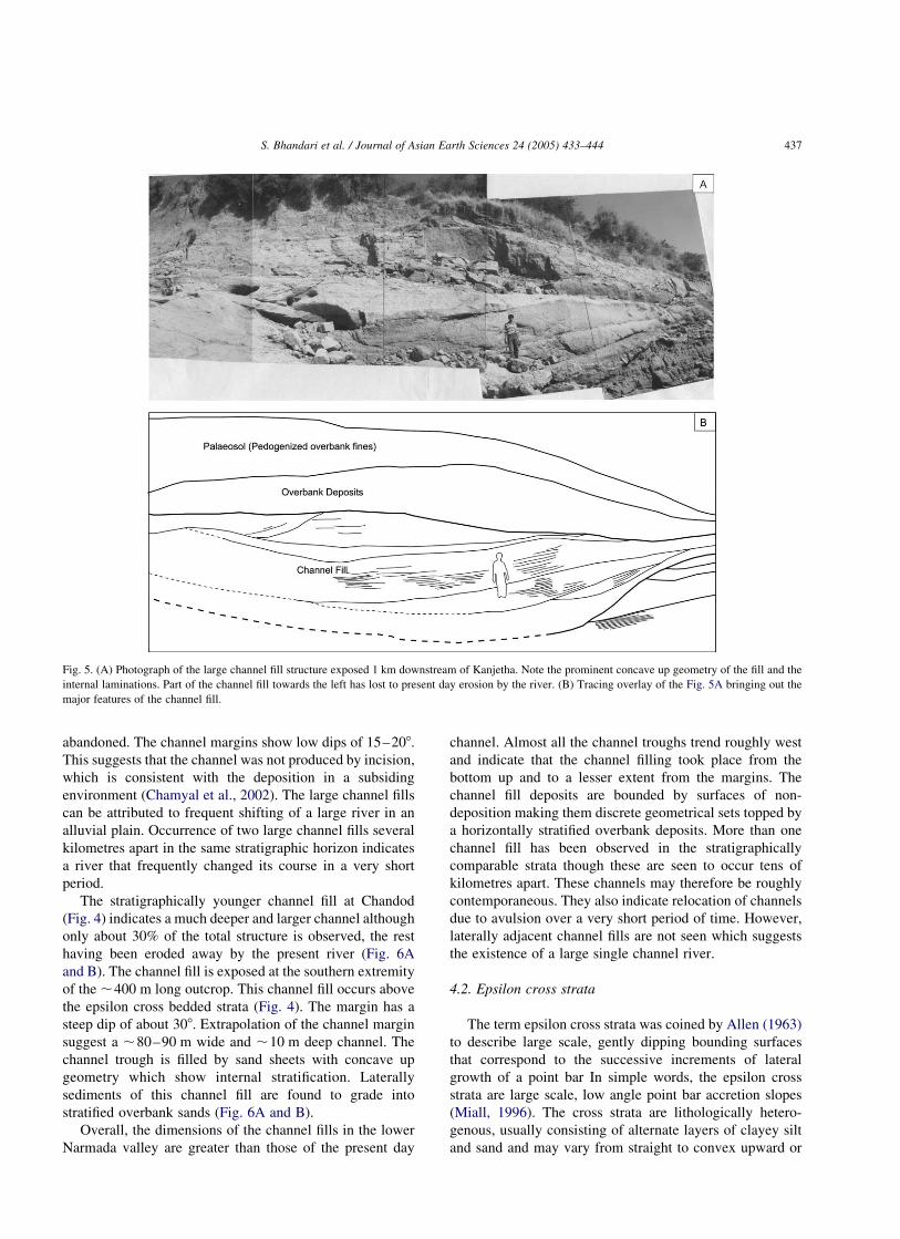
abandoned. The channel margins show low dips of 15–208.
This suggests that the channel was not produced by incision,
which is consistent with the deposition in a subsiding
environment (Chamyal et al., 2002). The large channel fills
can be attributed to frequent shifting of a large river in an
alluvial plain. Occurrence of two large channel fills several
kilometres apart in the same stratigraphic horizon indicates
a river that frequently changed its course in a very short
period.
The stratigraphically younger channel fill at Chandod
(Fig. 4) indicates a much deeper and larger channel although
only about 30% of the total structure is observed, the rest
having been eroded away by the present river (Fig. 6A
and B). The channel fill is exposed at the southern extremity
of the ,400 m long outcrop. This channel fill occurs above
the epsilon cross bedded strata (Fig. 4). The margin has a
steep dip of about 308. Extrapolation of the channel margin
suggest a ,80–90 m wide and ,10 m deep channel. The
channel trough is filled by sand sheets with concave up
geometry which show internal stratification. Laterally
sediments of this channel fill are found to grade into
stratified overbank sands (Fig. 6A and B).
Overall, the dimensions of the channel fills in the lower
Narmada valley are greater than those of the present day
channel. Almost all the channel troughs trend roughly west
and indicate that the channel filling took place from the
bottom up and to a lesser extent from the margins. The
channel fill deposits are bounded by surfaces of non-
deposition making them discrete geometrical sets topped by
a horizontally stratified overbank deposits. More than one
channel fill has been observed in the stratigraphically
comparable strata though these are seen to occur tens of
kilometres apart. These channels may therefore be roughly
contemporaneous. They also indicate relocation of channels
due to avulsion over a very short period of time. However,
laterally adjacent channel fills are not seen which suggests
the existence of a large single channel river.
4.2. Epsilon cross strata
The term epsilon cross strata was coined by Allen (1963)
to describe large scale, gently dipping bounding surfaces
that correspond to the successive increments of lateral
growth of a point bar In simple words, the epsilon cross
strata are large scale, low angle point bar accretion slopes
(Miall, 1996). The cross strata are lithologically hetero-
genous, usually consisting of alternate layers of clayey silt
and sand and may vary from straight to convex upward or
Fig. 5. (A) Photograph of the large channel fill structure exposed 1 km downstream of Kanjetha. Note the prominent concave up geometry of the fill and the
internal laminations. Part of the channel fill towards the left has lost to present day erosion by the river. (B) Tracing overlay of the Fig. 5A bringing out the
major features of the channel fill.
S. Bhandari et al. / Journal of Asian Earth Sciences 24 (2005) 433–444 437

curved in plan (Allen, 1963). The process of formation
involves erosion of the outer bank of the meandering
channel from the channel floor upward and concomitant
deposition on the gently sloping inner bank or point bar
(Allen, 1963). Epsilon cross strata are deposited on the point
bar of the channels while contemporaneous trough cross
bedded sands are deposited in the channel bottoms (Massop
and Flach, 1983). The height or thickness of the epsilon
cross strata approximates the depth of the channel (Miall,
1996) and can be used to estimate the channel scale (eg.
Massop and Flach, 1983).
In lower Narmada valley, individual outcrops are found
to show one set of epsilon cross strata that ranges in
thickness from 10–15 m (Figs. 3, 4 and 7). The epsilon
cross sets normally terminate against the overlying thick
bedded overbank facies. Laterally, the epsilon beds pass into
horizontal strata and further away merge with the overbank
deposits in the updip direction. The contact is therefore both
of truncation and transitional. Fig. 7 shows a well defined set
of epsilon cross beds. The surfaces dip 10–158. The epsilon
cross strata consist of 25–50 cm thick beds of very fine
sands with the top marked by clayey silt. The base of each
stratum is sharp with evidence of small scale scouring. Each
stratum is dominated by current ripple cross lamination with
5–15 mm thick ripple sets. Local occurrences of epsilon
cross sets have less than average depositional dips (,58).
Such local variations are believed to represent gradation
between epsilon cross stratified facies and the thick bedded
sand facies (Massop and Flach, 1983). Palaeocurrent data
recorded from the epsilon cross sets and other channel
troughs indicate a unidirectional pattern of transport
towards the W–WSW. The palaeocurrent directions are
found to be approximately parallel to the depositional strike
of the epsilon cross sets.
The large scale stratification and thicker bedding of the
epsilon cross strata in the lower Narmada valley indicate
deposition under higher flow regime compared to the
present. We attribute the deposition of this facies to lateral
migration of very deep (15–20 m) sand bed river channels.
Similar large scale epsilon cross bedded strata have been
attributed to deposition in deep water (Jackson, 1978).
4.3. Overbank deposits
Overbank deposits are defined as deposits left on the
floodplain by flood waters flowing outside the normal
channel. Floodplains border the channel belts of all alluvial
rivers that experience overbank floods, regardless of the
channel pattern. These areas receive sediment as bedload
and suspended load via crevasse channel flows or sheetflows
(Bridge, 1984). Apart from the flood plain, the continuum of
overbank environment includes crevasse splay and back-
swamp deposits. In lower Narmada valley, overbank
deposits overlie the epsilon cross strata and comprise
following sediment types.
4.3.1. Horizontally stratified sands
This facies forms the bulk of the exposed sediment
column in the lower Narmada valley. Exceptional thick-
nesses in the range of 20–25 m are seen in some of the cliff
sections, particularly towards the mouth where the entire
exposed sections consist of these sediments. In other
sections, they occur with other sediment facies and range
Fig. 6. (A) Photograph of the partially eroded away channel fill structure
occurring at the southern tip of the laterally extensive cliff exposure at
Chandod. This channel fill overlies the epsilon cross bedded strata. Note the
channel filling sediments grading away into overbank strata towards the
right. (B) Tracing overlay of the photograph showing major characteristics
of the channel fill as seen in the outcrop.
Fig. 7. (A) Field photograph of the epsilon cross bedded strata exposed
2 km downstream of Kanjetha. This horizon overlies the channel fill
structure shown in Fig. 5A and B. (B) Tracing overlay bringing out the
epsilon cross bedding.
S. Bhandari et al. / Journal of Asian Earth Sciences 24 (2005) 433–444438

from 5–10 m in thickness. These deposits are well exposed
at Chandod, Nanderiya, Moletha, Ambali, Patan, Kanjetha
and Sinor, where they comprise laterally extensive and
horizontally stratified fine to medium sand sheets (Fig. 8).
Internally each sand sheet is characterized by flat parallel
laminations and they typically lack lateral accretion
features. Internal stratification is generally well preserved
mainly due to very weak pedogenesis. Each sand sheet
shows fining upward trend and may have been deposited in a
single dynamic event, when flow conditions remain in a
critical stage for many hours such as in the case of large
floods (Kale et al., 1997). The facies may be attributed
to overbank deposition resulting because of successive
episodic floods (Miall, 1985).
4.3.2. Massive sands
Massive sand deposits are exposed throughout the lower
Narmada valley. The facies is composed of extensive sheets
of fine to medium sands. These comprise laterally extensive
sheets having an individual average thickness of 1.5–2 m.
At some places these reach a thickness of 5 m. These sand
bodies are devoid of any internal stratification and lack
lateral accretion surfaces, suggesting vertical accretion.
The sediments show only weak pedogenesis and are well
short of being categorised as typical palaeosols (Chamyal
et al., 2002). This indicates frequent submergence of
the floodplains during bank topping floods and rapid
sedimentation. The deposits resemble those of a meandering
channel where large floods submerge the floodplains
depositing sand sheets across the valley (Miall, 1985).
4.3.3. Undulatory bedded sands
Undulatory bedded overbank sands and silts occur in
association with the stratified sand facies and are separated
from the underlying sediments by erosional surfaces. The
undulations are prominent in sections perpendicular to the
regional palaeocurrent direction (Fig. 9). The grain size
varies from fine silty sand to medium sand. The undulations
have an average wavelength of about 10 m and heights up to
1 m. Individual beds are 0.25 to 1 m thick. The beds
progressively change height from one crest to another. In
plan view, the undulations appear as cross sections through
long low ridges parallel to the flow occurring along the sides
of large river as described by McCabbe (1977). Internal
erosion surfaces are common within the undulatory beds. A
similar facies consisting of fine sands is reported from the
Brahmputra (Coleman, 1969) where the crest to crest length
is 9–30.5 m and heights of 1.2 m. The generally massive
nature of the beds suggest rapid deposition by strong
currents under peak flood conditions (McCabbe, 1977).
4.3.4. Crevasse splay deposits
Crevasse splay deposits of the lower Narmada valley are
found to occur as thin sheet like bodies several tens of
meters across and 1–2 m thick passing laterally into
overbank fines. These occur at several stratigraphic levels
within the overbank deposits. These are fine to medium
grained sands with interbedded laminae of sand, silt and
mud. These deposits are characterized by thin bedding and
abundant surfaces of non-deposition reflecting their origin
by sheet flooding. The grain size decreases away from the
main channel towards the fringes of the splay and fines
upward within the splays. Levee deposits are normally
associated with crevasse splays but are difficult to
distinguish since they are lithologically similar because
Fig. 8. Field photograph of the horizontally stratified overbank sands
exposed at Ranapur. Height of the person in the photo is 1.65 m.
Fig. 9. Field photograph of undulatory bedded sand and silt deposits at Kanjetha. Height of the person in the photo is 1.65 m.
S. Bhandari et al. / Journal of Asian Earth Sciences 24 (2005) 433–444 439

both are deposited from decelerating sheetfloods that
overtop natural levee and crevasse channels (Farrel, 1987).
4.3.5. Backswamp deposits
These are represented by the clayey sands and sandy silts
upto about 5 m thick and are intimately associated with the
overbank deposits in the lower Narmada valley. These
deposits are introduced into backswamps by crevasse
channels and are deposited as a result of flow expansion
and loss of flow power. Rhizocretions (root structures) are
abundant. The backswamp deposits (Fig. 10) represent
periods of standing water deposition, incursions of splay
sediments (silty sand unit), into the standing water body and
progradation of overbank deposits from the channel belt into
the flood basins.
4.4. Palaeosol
Towards the top of the alluvial plain sediments, a 3–6 m
thick brownish red to reddish brown soil occurs, which is
easily identifiable by its distinct appearance and laterally
consistent nature in the lower Narmada basin. The soil is
well exposed at Chandod, Nanderiya, Moletha, Ambali,
Patan, Kanjetha, Sinor, Ranapur, Nikora and Tavra. The
parent material for the soil is fluvial overbank fine sands and
silts, though the internal stratification is totally obliterated
by pedogenesis (Fig. 11) particularly by the formation of
calcrete throughout the soil. The paleosol marks the post-
depositional phase of pedogenic transformation of the
overbank sediments.
The palaeosol in lower Narmada valley has been
attributed to a regionally correlatable phase of pedogenesis
(Chamyal et al., 2002) which is seen in the adjacent Mahi
and Sabarmati basins also (Merh and Chamyal, 1997).
This buried soil has been used by earlier workers as a
marker horizon for stratigraphical correlation of Late
Pleistocene sediments in the various river valleys of Gujarat
alluvial plains (Pant and Chamyal, 1990; Merh and
Chamyal, 1997). Thermoluminescence dating of fluvial
sediments in which the palaeosol is formed have yielded an
age of 40 ^ 10 ka in the Mahi basin (Juyal et al., 2000) and
58 ^ 5.2 ka in the Sabarmati basin (Tandon et al., 1997).
Pedogenic calcrete nodules of this palaeosol in lower
Narmada basin have been dated to ,24,000 yr B.P.
(Allchin et al., 1978) and from Mahi to 26,410 ^ 690 yr
B.P. (Maurya et al., 2000) which mark the pre-LGM phase
of pedogenic alteration of the overbank sediments.
4.5. Thinly stratified sands and silts overlying palaeosol
Thinly stratified fine sands and silts overlie the palaeosol
(Fig. 11). They occur consistently throughout the cliff
sections marking the top of the exposed Late Pleistocene
sequence. Apart from the well preserved stratification, no
other sedimentary structure is observed. Morphologically,
they appear similar to the stratified overbank sand facies
described earlier; the only difference being the significantly
thinner bedding (Fig. 11). The beds average 0.25 m in
thickness and each bed may represent a single overbank
flood. There is no evidence of pedogenesis. The thin bedded
nature in comparison to the thick bedded sequence
underlying the palaeosol, suggest that the sediments were
deposited by a river that was significantly shallower with a
lower discharge level. The chronological data available for
the underlying palaeosol (Allchin et al., 1978) indicates that
these sediments were deposited during the arid phase of the
Last Glacial Maximum. In the Orsang basin, a tributary of
the Narmada River, the aeolian sediments of this phase
directly overlie the palaeosol (Juyal et al., 2004). These
sediments are attributed to the extreme arid climate during
Fig. 10. Field photograph showing close view of the backswamp deposits at
Nava Tavra. Note the abundant root structures in the form of rhizocretions.
Length of the pen is 14 cm.
Fig. 11. Field photograph of the top of the exposed Late Pleistocene sequence (Loc. 1 km downstream of Ambali). (1) horizontally stratified overbank sands,
(2) palaeosol, (3) thinly stratified sands and silts.
S. Bhandari et al. / Journal of Asian Earth Sciences 24 (2005) 433–444440

Late Pleistocene which peaked around 18 ka (Yan and
Petit-Maire, 1994) resulting in the extension of the Thar
desert into the Gujarat alluvial plains (Allchin et al., 1978).
However, the absence of aeolian sediments along the cliff
exposures in the lower Narmada valley and their presence in
Orsang valley suggests that the geographic limit of aeolian
accretion during the LGM was very close to the Narmada
River, though a significant reduction in fluvial activity is
suggested by the thinly stratified fluvial sediments overlying
the palaeosol. Absence of root structures and dessication
cracks indicate that the river may still have been perennial
and that the river retained the large catchment even during
the extremely arid phase of Last Glacial Maximum.
5. Palaeofluvial implications
Presently the Narmada appears as a misfit river (Chamyal
et al., 2002) and follows a channel that is confined by
incised cliffs. The largest flood discharges are not enough to
fill the entire channel (Rajaguru et al., 1995). However, the
Late Pleistocene alluvial plain sequence overlying the
alluvial fan sediments (Chamyal et al., 2002) reveal fluvial
characteristics that are at variance with the present day
channel characteristics of the Narmada River. The alluvial
plain sequence in the lower Narmada valley is dominated by
the overbank sediments and comprise large channel fills,
horizontally stratified sands, massive sand sheets, and
crevasse splay and backswamp deposits. However, the
overall dominance of sands and silts suggests, in general, a
sand bed river meandering through a wide alluvial plain.
The large channel fills are a significant component of the
alluvial plain sediments in the lower Narmada valley. These
occur as large sediment bodies of broad concave-up
geometry with gently sloping channel margins. This is in
contrast to the U shaped channel fills with steep channel
margins which indicate incision of the underlying deposits
before aggradation takes place (Hopkins, 1985). The
channel fills are filled with sand sheets with internal
laminations, which are thickest along the trough axis. These
may have been filled by deposition in standing body of
water remaining after the channel was abandoned. Such
filling of channels in modern settings has been demon-
strated by Meckel (1972). The nature of the fill is
determined by the rapidity of channel abandonment
(Hopkins, 1985). A sand filled channel indicates progressive
abandonment by diversion of flow through a favoured
distributary (Hopkins, 1985).
The channel fills indicate a large river having roughly
70–80 m width and ,8–15 m depth during periods of
low discharge. This is much larger in comparison to the
30–40 m width and ,5 m deep channel of the present day
Narmada River during lean seasons. The large scale
stratification and thicker bedding of the epsilon cross strata
indicate deposition due to lateral migration of very deep
(15–20 m) sand bed river channels. The large channel fill
structures occur in isolation and are associated with
overbank sediments. Occurrence of large channel fills,
adjacent overbank strata, and absence of laterally adjacent
channel fills indicate mainly a large single channel river.
The channel troughs indicate consistently west oriented
channels. No large scale variance in palaeocurrent direc-
tions derived from other independent parameters from the
outcrops is seen. This is indicative of a channel with
relatively low sinuosity and frequent occurrence of chute
cutoffs (Bridge et al., 2000).
Two generations of channel fills are present in the lower
Narmada valley. The one occurring at Kanjetha underlies
the epsilon cross bedded strata. A similar large channel fill
with a broader concave-up shape occurs below the epsilon
cross bedded strata. The partially exposed channel fill
structure at Chandod overlies the epsilon cross bedded strata
(Fig. 4). Vertical superposition of channel fills indicates
high deposition rates accompanied by high channel
migration rates. Since no significant variation in the fluvial
regime is visible that may suggest distinct climate change,
we attribute the frequent shifts of the river channel across
the alluvial plain to autocyclic factors.
Overbank sediments result from deposition due to
overtopping of the banks during river floods or avulsions.
A large amount of work has been done on the sedimentation
processes in overbank regions by Allen (1965), Elliott
(1974), Smith (1983), Bridge (1984), Farrel (1987), Sinha
and Friend (1999). Miall (1985) assigned overbank deposits
to a single architectural element, however, overbank
sequences have been shown to have complex and varied
architecture (Behrensmeyer, 1987; Brown and Kraus, 1987;
Kraus and Aslan, 1993; Smith, 1990, 1993). A common
characteristic of overbank deposits is the presence of
horizontal stratification (Willis and Behrensmeyer, 1994)
ranging from thinly stratified to thickly stratified. Overbank
deposits with well preserved stratification can result from
relatively rapid deposition. Rapid deposition and high rate
of channel shifting can lead to absence of palaeosols in
overbank sequences which seems to be the case in the lower
Narmada valley given the conditions of a slowly subsiding
basin (Chamyal et al., 2002) and the dominance of overbank
strata in the sediment succession. During increased
aggradation rate avulsion frequency is also high (Bridge
et al., 2000). Flooding processes were repetitive under the
conditions of overall aggradation of the floodplain, a
phenomena commonly associated with avulsion (Rhee
et al., 1993). The crevasse splay deposits occur in close
association with the overbank sediments, which suggests
that the crevasse deposits were formed far away from the
trunk channel (Rhee et al., 1993). Channel shifts (avulsions)
can be gradual or abrupt. Rapid abandonment takes when a
new channel is formed in a catastrophic flood event,
whereas gradual abandonment takes place when successive
high water stages result in enlargement of a crevasse finally
causing river diversion (Hopkins, 1985; Rhee et al., 1993).
We believe that channel abandonment may have taken place
S. Bhandari et al. / Journal of Asian Earth Sciences 24 (2005) 433–444 441

by both means in the lower Narmada valley during the Late
Pleistocene.
The thick palaeosol marks a phase of pedogenesis of the
overbank sediments. Chronologic data on this regionally
recorded pedogenic phase indicates that it is pre-LGM
(Allchin et al., 1978; Tandon et al., 1997; Juyal et al., 2004).
The overlying thinly stratified sands and silts therefore
appear to have been deposited during the arid phase of the
Last Glacial Maximum. These multibed sediments were
deposited by vertical accretion during successive floods in
broad shallow channels, which may have remained stable
for relatively longer time. The sheet like nature of the
deposits and the lack of erosional downcutting indicate that
these were formed by vertical accretion on a broad poorly
channelised alluvial plain. These deposits therefore mark
significant reduction in fluvial activity due to considerably
depleted water supply which is directly related to the onset
of aridity. Continued sedimentation indicates that the river
retained a large catchment during the arid phase. Lack of
root structures and dessication cracks also suggest that the
flow was perennial.
6. Palaeoenvironmental implications
The exposed sediments of the lower Narmada valley
indicate two distinct phases of changes in the fluvial regime.
One is the multidistributary channel system that deposited
the alluvial fan sediments (Chamyal et al., 1997, 2002),
followed by the deposition of finer alluvial plain sequence,
described in this paper, by a large river in an alluvial plain
setting. The reasons for the sudden change of multi-
distributary river system to a more integrated single channel
river system, are not clear. The observed sedimentary
characteristics of the alluvial plain sequence discussed
above indicate a low sinuosity, single channel large river
that was hyperavulsive. On a conservative estimate, the
avulsions may have taken place on a scale of hundreds of
years. The river was characterised by a ,8–15 m deep
channel that was ,70–80 m wide even during low
discharge levels. Present day large rivers show similar
characteristics (eg. Brahmputra, Coleman, 1969) in which
the sediments show large-scale bedforms while the river
migrates at a high rate. Presently, the Narmada has a large
drainage basin most of which lies in the humid region
further east of the Gujarat alluvial plain. This accounts for
the high discharge levels of the Narmada River which is
next only to those of the Brahmaputra and the Ganges
(Coleman, 1969).
The phase of alluviation up to the palaeosol appears to be
synchronous regionally and globally. Studies in adjacent
Mahi, Orsang (Juyal et al., 2004) and Sabarmati basins
(Tandon et al., 1997) point towards the existence of largely
semiarid climate and ephemeral river systems in Gujarat
alluvial plains during most of the Late Pleistocene. The
present study on the alluvial plain sedimentation in lower
Narmada valley, however, indicates deposition by a large
river which was supported by a climate significantly wetter
than present. Though a general correlatability of the
depositional phases during Late Pleistocene is obvious
(Chamyal et al., 2002), the large-scale sedimentary bed-
forms of the type described here are not observed in the
Mahi and Sabarmati basins. The exposed sediments and the
modern discharge levels of the Narmada River, therefore,
present a contrasting picture as far as Gujarat alluvial plain
is concerned.
Late Pleistocene fluvial sediments exposed in the
15–20 m high cliffs in upper and middle reaches of the
Narmada River (Gupta et al., 1999; Ely et al., 1996; Kale
et al., 2003) have been studied mainly for their rich
mammalian fauna and archaeological artefacts (Badam
et al., 1986; Biswas, 1997; Mishra and Rajaguru, 2001).
The sediments comprise massive silts, cross bedded sands
and layers of gravels and boulders (Gupta et al., 1999)
though no stratigraphic or sedimentologic details are
available on them as yet. A recent study (Kale et al.,
2003) has described an imbricated boulder bed (average
clast size 35 cm) in a section located on an abandoned
channel of the Narmada River near Bhedaghat, which has
been dated to 25,160 ^ 550 yrs B. P. based on radiocarbon
dating of shells found in this horizon. The boulder bed has
been attributed to an extraordinary flood or series of great
floods (Kale et al., 2003) which suggests existence of
humid climate in the upper reaches of the Narmada river
during Late Pleistocene. The rich mammalian fauna found
in the Late Pleistocene deposits in central and upper
Narmada basin has also led to the conclusion that the
Central India was a mosaic of dense forests, park savannas
and water bodies (Badam et al., 1986) during this period.
The Narmada River in the Late Pleistocene has been
inferred to be a mobile meandering river which carried
large quantities of sand (Gupta et al., 1999) with periods of
large floods (Kale et al., 2003). Studies on Holocene
palaeoflood deposits in central India (Kale, 1999; Kale
et al., 1994, 2003; Ely et al., 1996) have revealed a strong
correlation between periods of extreme discharges and
stronger monsoons. We, therefore, infer that the alluvial
plain sediments of the lower Narmada valley suggest humid
climate in the large catchment area located further to the
east. Additional evidence for a large catchment of the
Narmada River during Late Pleistocene is provided by
the dominance of subrounded clasts in the alluvial fan
sediments (Chamyal et al., 1997) which underlie the
alluvial plain sediments (Fig. 1B). The subrounded clasts
(a deviation from the normal angular clast composition of
alluvial fans) has been attributed to longer distance of
transport before they were deposited in alluvial fan
environment in the lower Narmada valley. This suggests
that the Narmada River has maintained a large catchment at
least during the last 100 ka. The alluvial plain sequence of
the lower Narmada valley suggest discharges higher than
the present day Narmada River in the upper part of
S. Bhandari et al. / Journal of Asian Earth Sciences 24 (2005) 433–444442
the Late Pleistocene. The palaeosol occurring towards the
top of the sequence however correlates with the regional
phase of intense pedogenic activity in the Gujarat alluvial
plain before the Last Glacial Maximum. The overlying
stratified sands and silts reflect a significant weakening of
fluvial regime during the arid phase of the Last Glacial
Maximum, though the river still remained perennial, again
mainly because of the large catchment area of the drainage
basin.
Overall, the 50–25 ka period is a period of widespread
fluvial aggradation in India as seen from the studies on
alluvial sequences in Gujarat alluvial plain (Tandon et al.,
1997; Juyal et al., 2000; Maurya et al., 2000), Maharashtra
upland rivers (Kale and Rajaguru, 1987), Central Narmada
(Badam et al., 1986; Gupta et al., 1999; Kale et al., 2003),
Son and Belan valleys (Williams and Clarke, 1984) and the
Indo-Gangetic plain (Singh, 1996). Well dated global fluvial
sediment records from Guadalope basin in Spain (Fuller
et al., 1998), the entire Mediterranean region (Macklin et al.,
2002), Thames River (Maddy et al., 2001), Mississippi
River (Autin, 1996; Blum et al., 2000), and Australia
(Nanson et al., 1992; Kershaw and Nanson, 1993) also
suggest enhanced fluvial aggradation under humid climate
during the 50–30 ka time period. Palaeoclimatic studies on
the calcretes of Thar desert (Andrews et al., 1998), loess
deposits in China (Maher and Thompson, 1995), marine
sediment cores from Arabian Sea near Oman (Clemens et al.,
1991) provide evidence for strong monsoon and enhanced
precipitation levels during this time. There is thus a strong
reason to believe that the deposition of alluvial plain
sediments below the palaeosol and showing large scale
bedforms in the lower Narmada valley took place by a large
river that operated in conditions humidier than present in
response to global climatic perturbations. The humid
climate together with a large catchment area contributed
to the high discharges leading to the formation of large scale
sedimentary structures in these sediments.
7. Conclusions
The alluvial plain sequence of the lower Narmada valley
is characterised by the dominance of overbank sediments
and large scale sandy bedforms. The sequence was
deposited by a low sinuosity large river with high discharge
levels (higher than the present day) that laterally migrated
across the alluvial plain at a high rate. The deposition was
mainly controlled by the humid conditions prevailing in the
large catchment further east of the study area and not by the
semi arid climate of the Gujarat alluvial plain. The present
study on the alluvial plain sequence together with the earlier
studies on the underlying alluvial fan sediments suggest that
the Narmada River has retained a large catchment since the
last 100 ka.
Acknowledgements
The authors gratefully acknowledge financial support
from the Department of Science and Technology (DST),
New Delhi (Project No. ESS/23/VES/008/98). Constructive
reviews and valuable suggestions by Prof. R. J. Wasson and
Prof. Lisa L. Ely were useful in improving the paper.
References
Allchin, B., Goudie, A., Hegde, K.T.M., 1978. The Prehistory And
Palaeogeography of the Great Indian Thar Desert, Academic Press,
London, 370 pp.
Allen, J.R.L., 1963. The classification of cross-stratified units, with notes on
their origin. Sedimentology 2, 93–114.
Allen, J.R.L., 1965. A review of the origin and characteristics of recent
alluvial sediments. Sedimentology 5, 89–191.
Andrews, J.E., Singhvi, A.K., Kaliath, A.J., Kuhn, R., Dennis, P.F.,
Tandon, S.K., Dhir, R.P., 1998. Do stable isotope data from calcrete
record Late Pleistocene monsoonal climate variation in the Thar desert
of India? Q. Res. 50, 240–251.
Autin, W.J., 1996. Pleistocene stratigraphy in the southern Lower
Mississippi Valley. Engng. Geol. 45, 87–112.
Badam, G.L., Ganjoo, R.K., Salahuddin, 1986. Preliminary taphonomical
studies of some Pleistocene Fauna from the Central Narmada Valley,
Madhya Pradesh, India. Palaeogeog. Palaeoclimat. Palaeoecol. 53,
335–348.
Behrensmeyer, A.K., 1987. Miocene fluvial facies and vertebrate
taphonomy in Northern Pakistan. In: Ethridge, F.G., Flores, R.M.,
Harvey, M.D. (Eds.), Recent Developments in Fluvial Sedimentology,
SEPM Special Publication, Tulsa, Oklahama, USA, vol. 39,
pp. 169–176.
Biswas, S., 1997. Fossil Mammalia of the Quaternary Sequence of the
Narmada Valley: Their Affinity, Age and Ecology, Geological Survey
of India, Calcutta Special Publication, vol. 46., pp. 91–104.
Blum, M.D., Tornquist, T.E., 2000. Fluvial responses to climate and sea
level change: a review and look forward. Sedimentology 47, 2–48.
Blum, M.D., Guccione, M.J., Wysocki, D.A., Robnett, P.C., Rutledge,
E.M., 2000. Late Pleistocene evolution of the lower Mississippi valley,
southern Missouri to Arkansas. Geol. Soc. Am. Bull. 112, 221–235.
Bridge, J.S., 1984. Large-scale facies sequences in alluvial overbank
environments. J. Sed. Petr. 54, 583–588.
Bridge, J.S., 1985. Palaeochannel patterns inferred from alluvial deposits: a
critical evaluation. J. Sed. Petr. 55, 579–589.
Bridge, J.S., Jalfin, G.A., Georgieff, S.M., 2000. Geometry, lithofacies, and
spatial distribution of Cretaceous Fluvial Sandstone Bodies, San Jorge
Basin, Argentina: outcrop analog for the hydrocarbon-bearing Chubut
Group. J. Sed. Res. 70 (2), 341–359.
Bristow, C., 1996. Reconstructing fluvial channel morphology from
sedimentary sequences. In: Carling, P.A., Dawson, M.R. (Eds.),
Advances in Fluvial Dynamics and Stratigraphy, Wiley, New York,
pp. 351–371.
Brown, T.W., Kraus, M.J., 1987. Integration of channel and floodplain
suites, I. Developmental sequence and lateral relations of alluvial
palaeosols. J. Sed. Petr. 57, 587–601.
Cant, D.J., Walker, R.G., 1978. Fluvial processes and facies sequences in
the sandy braided South Saskatchewan River, Canada. Sedimentology
25, 625–648.
Chamyal, L.S., Khadkikar, A.S., Malik, J.N., Maurya, D.M., 1997.
Sedimentology of the Narmada Alluvial Fan, Western India. Sed.
Geol. 107, 263–279.
Chamyal, L.S., Maurya, D.M., Bhandari, S., Raj, R., 2002. Late Quaternary
geomorphic evolution of the Lower Narmada Valley, Western India:
S. Bhandari et al. / Journal of Asian Earth Sciences 24 (2005) 433–444 443
implications for neotectonic activity along the Narmada–Son Fault.
Geomorphology 46 (3–4), 177–202.
Clemens, S., Prell, W., Murray, D., Shimmield, G., Weedon, G., 1991.
Forcing mechanisms of the Indian Ocean monsoon. Nature 368,
533–536.
Coleman, J.M., 1969. Brahmaputra river: channel processes and sedimen-
tation. Sed. Geol. 3, 129–239.
Elliott, T., 1974. Interdistributary bay sequences and their genesis.
Sedimentology 21, 611–621.
Ely, L.L., Enzel, Y., Baker, V.R., Kale, V.S., Mishra, S., 1996. Changes in
the magnitude and frequency of late Holocene monsoon floods on the
Narmada river, central India. Geol. Soc. Am. Bull. 108, 1134–1148.
Farrel, K.M., 1987. Sedimentology and facies architecture of overbank
deposits of the Mississippi River, False River region, Louisiana. In:
Ethridge, F.G., Flores, R.M., Harvey, M.D. (Eds.), Recent Develop-
ments in Fluvial Sedimentology, SEPM Special Publication, Tulsa,
Oklahama, USA, 39, pp. 111–120.
Fuller, I.C., Macklin, M.G., Lewin, J., Passmore, D.G., Wintle, A.G., 1998.
River response to high frequency climate oscillations in southern
Europe over the past 200 k.y. Geology 26, 275–278.
Gupta, A., Kale, V.S., Rajaguru, S.N., 1999. The Narmada river, India,
through space and time. In: Miller, A.J., Gupta, A. (Eds.), Varieties of
fluvial forms, Wiley, New York, pp. 113–143.
Hopkins, J.C., 1985. Channel-Fill deposits formed by aggradation in deeply
scoured, superimposed distributaries of the Lower Kootenai Formation
(Cretaceous). J. Sed. Petr. 55 (1), 42–52.
Jackson, R.G., 1978. Preliminary evaluation of lithofacies models for
meandering alluvial streams. In: Miall, A.D., (Ed.), Fluvial sedimentol-
ogy, vol. 5. Mem. Can. Soc. Petrol. Geol., pp. 543–576.
Juyal, N., Raj, R., Maurya, D.M., Chamyal, L.S., Singhvi, A.K., 2000.
Chronology of Late Pleistocene environmental changes in the lower
Mahi basin, western India. Journal of Quaternary Science 15, 501–508.
Juyal, N., Chamyal, L.S., Bhandari, S., Maurya, D.M., Singhvi, A.K., 2004.
Environmental changes during Late Pleistocene in the Orsang River
basin, Western India. Geol. Soc. Ind. Mem. in press.
Kale, V.S., 1999. Long-period fluctuations in monsoon floods in the Deccan
Peninsula. Ind. J. Geol. Soc. Ind. 53, 5–15.
Kale, V.S., Rajaguru, S.N., 1987. Late Quaternary alluvial history of the
Northwestern Deccan Upland region. Nature 325, 612–614.
Kale, V.S., Mishra, S., Baker, V.R., 1997. A 2000-year palaeoflood record
from Sakarghat on Narmada, Central India. J. Geol. Soc. Ind. 50,
283–288.
Kale, V.S., Mishra, S., Enzel, Y., Ely, L., Baker, V.R., Rajaguru, S.N.,
1994. Geomorphic and hydrologic aspects of monsoon floods on the
Narmada and Tapi Rivers in central India. Geomorphology 10,
157–168.
Kale, V.S., Mishra, S., Baker, V.R., 2003. Sedimentary records of
palaeofloods in the bedrock gorges of the Tapi and Narmada rivers,
central India. Curr. Sci. 84, 1072–1079.
Kershaw, A.P., Nanson, G.C., 1993. The last full glacial cycle in the
Australian region. Global Planetary Changes 7, 1–9.
Kraus, M.J., Aslan, A., 1993. Eocene hydromorphic palaeosols: signifi-
cance for interpreting ancient floodplain processes. J. Sed. Petr. 63,
453–463.
Macklin, M.G., Fuller, I.C., Lewin, J., Maas, G.S., Passmore, D.G., Rose,
J., Woodward, J.C., Black, S., Hamlin, R.H.B., Rowan, J.S., 2002.
Correlation of fluvial sequences in the Mediterranean basin over the last
200 ka and their relationship to climate change. Q. Sci. Rev. 21,
1633–1641.
Maddy, D., Bridgland, D.R., Westway, R., 2001. Uplift-driven valley
incision and climate controlled river terrace development in the Thames
valley, U.K. Q. Int. 79, 23–36.
Maher, B.A., Thompson, R., 1995. Paleorainfall reconstructions from
pedogenic magnetic susceptibility variations in the Chinese loess and
palaeosols. Q. Res. 44, 383–391.
Massop, G.D., Flach, P.D., 1983. Deep channel sedimentation in the Lower
Cretaceous McMurray Formation, Athabasca Oil Sands, Alberta.
Sedimentology 30, 493–509.
Maurya, D.M., Chamyal, L.S., Merh, S.S., 1995. Tectonic evolution of the
Central Gujarat plain, Western India. Curr. Sci. 69, 610–613.
Maurya, D.M., Rachna Raj, Chamyal, L.S., 2000. History of tectonic
evolution of Gujarat alluvial plains, western India during Quaternary: a
review. J. Geol. Soc. Ind. 55, 343–366.
McCabbe, P.J., 1977. Deep distributary channels and giant bedforms in the
Upper Carboniferous of the Central Pennines, northern England.
Sedimentology 24, 271–290.
Meckel, L.D., 1972. Anatomy of distributary channel-fill deposits in recent
mud deltas (Abstract). Am. Assoc. Petroleum Geologists Bull. 56, 639.
Merh, S.S., Chamyal, L.S., 1997. The Quaternary geology of Gujarat
alluvial plains. Proc. Ind. Natl Sci. Acad. 63, 1–98.
Miall, A.D., 1985. Architectural element analysis: a new method of analysis
applied to fluvial deposits. Earth Sci. Rev. 22, 261–308.
Miall, A.D., 1996. The geology of fluvial deposits, Springer-Verlag,
Berling, 581 pp..
Mishra, S., Rajaguru, S.N., 2001. Late Quaternary palaeoclimates of
Western India: a geoarchaeological approach. Mausam 52, 285–296.
Nanson, G.C., Price, D.M., Short, S.A., 1992. Wetting and drying of
Australia over the past 300 ka. Geology 20, 791–794.
Pant, R.K., Chamyal, L.S., 1990. Quaternary sedimentation pattern and
terrain evolution in Mahi river basin Gujarat. Proc. Ind. Nat. Sci. Acad.,
Phys. Sci. New Delhi. 56, 501–511.
Potter, P.E., 1978. Significance and origin of big rivers. J. Geol. 86, 13–33.
Rajaguru, S.N., Gupta, A., Kale, V.S., Ganjoo, R.K., Ely, L.L., Enzel, Y.,
Baker, V.R., 1995. Channel form and processes of the flood-
dominated Narmada River, India. Earth Surf. Process. Landforms 20,
407–421.
Rhee, C.W., Ryang, W.H., Chough, S.K., 1993. Contrasting development
patterns of crevasse channel deposits in Cretaceous alluvial succes-
sions, Korea. Sed. Geol. 85, 401–410.
Rust, B.R., 1978. A classification of alluvial channel systems. In: Miall,
A.D., (Ed.), Fluvial Sedimentology, vol. 5. Can. Soc. Petrol. Geol.
Mem., pp. 187–198.
Singh, I.B., 1996. Geological evolution of Ganga Plain—An Overview.
J. Palaeont. Soc. India 41, 99–137.
Singh, N., Pant, G.B., Mulye, S.S., 1991. Distribution and long term
features of the spatial variations of the moisture regions over India. Int.
J. Climat. 11, 413–427.
Sinha, R., Friend, P.F., 1999. Pedogenic alteration in the overbank
sediments, North Bihar Plains, India. J. Geol. Soc. Ind. 53, 163–171.
Smith, D.G., 1983. Anastomosed fluvial deposits: modern examples from
Western Canada. Int. Assoc. Sedimentologists Spec. Publ. 6, 155–168.
Smith, R.M.H., 1990. Alluvial paleosols and pedofacies sequences in the
Permian lower Beaufort of the southwestern Karoo Basin, South Africa.
J. Sed. Petr. 60, 258–276.
Smith, R.M.H., 1993. Vertebrate taphonomy of Late Permian floodplain
deposits in the Southwestern Karoo Basin of South Africa. Palaios 8,
45–67.
Tandon, S.K., Sareen, B.K., Someshwar Rao, M., Singhvi, A.K., 1997.
Aggradation history and lumminescence chronology of the Sabarmati
basin, Gujarat, Western India. Palaeogeog. Palaeoclimat. Palaeoecol.
128, 339–357.
Williams, M.A.J., Clarke, M.F., 1984. Late Quaternary environments in
north-central India. Nature 308, 633–635.
Willis, B.J., Behrensmeyer, A.K., 1994. Architecture of Miocene overbank
deposits in Northern Pakisthan. J. Sed. Petr. B64 (1), 60–67.
Yan, Z., Petit-Maire, N., 1994. The last 140 ka in the Afro-Asian arid-
semiarid transitional zone. Palaeogeog. Palaeoclimat. Palaeoecol. 110,
217–233.
S. Bhandari et al. / Journal of Asian Earth Sciences 24 (2005) 433–444444
Copyright © 2022 FDOKUMEN