Postglacial sea-level rise and sedimentary response in the Guadiana Estuary, Portugal/Spain border
Upload
independentCategory
view
1download
0
Available online at www.sciencedirect.com
008) 404–419www.elsevier.com/locate/geomorph
Geomorphology 99 (2
Last glacial aggradation and postglacial sediment production from thenon-glacial Waipaoa and Waimata catchments, Hikurangi Margin,
North Island, New Zealand
Michael Marden a,⁎, Colin Mazengarb b, Alan Palmer c, Kelvin Berryman d, Donna Rowan a
a Landcare Research, P.O. Box 445, Gisborne, New Zealandb Mineral Resources Tasmania, P.O. Box 56, Rosny Park, Tasmania, Australia
c Institute of Natural Resources, College of Sciences, Massey University, Palmerston North, New Zealandd Institute of Geological and Nuclear Sciences, P.O. Box 30-368, Lower Hutt, New Zealand
Received 8 November 2005; received in revised form 5 December 2007; accepted 6 December 2007Available online 15 December 2007
Abstract
The sediment flux generated by postglacial channel incision has been calculated for the 2150 km2, non-glacial, Waipaoa catchment located on thetectonically active Hikurangi Margin, eastern North Island, New Zealand. Sediment production both at a sub-catchment scale and for the Waipaoacatchment as a whole was calculated by first using the tensioned spline method within ARC MAP to create an approximation of the aggradationalWaipaoa-1 surface (contemporaneous with the Last GlacialMaximum), and second using grid calculator functions in the GIS to subtract themodern daysurface from the Waipaoa-1 surface. The Waipaoa-1 surface was mapped using stereo aerial photography, and global positioning technology fixed theposition of individual terrace remnants in the landscape. The recent discovery of Kawakawa Tephra within Waipaoa-1 aggradation gravels in thiscatchment demonstrates that aggradation was coincidental with or began before the deposition of this 22600 14C-year-old tephra and, using thestratigraphic relationship of Rerewhakaaitu Tephra, the end of aggradation is dated at ca 15000 14C years (ca 18000 cal. years BP). The construction oftheWaipaoa-1 terrace is considered to be synchronous and broadly correlated with aggradation elsewhere in the North Island and northern South Island,indicating that aggradation ended at the same time over a wide area. Subsequent downcutting, a manifestation of base-level lowering following a switchto postglacial incision at the end of glacial-age aggradation, points to a significant Southern Hemisphere climatic warming occurring soon after ca15000 14C years (ca 18000 cal. years BP) during theOlderDryas interval. Elevation differences between theWaipaoa-1 (c.15 ka) terrace and the level ofmaximum channel incision (i.e. before aggradation since the turn of the 20th century) suggest about 50% of the topographic relief within headwaterreaches of the Waipaoa catchment has been formed in postglacial times. The postglacial sediment flux generated by channel incision from Waipaoacatchment is of the order of 9.5 km3, ofwhich ~6.6 km3 is stored within the confines of the Poverty Bay floodplain. Thus, although the postglacial periodrepresented a time of high terrigenous sediment generation and delivery, only ~30% of the sediment generated by channel incision from Waipaoacatchment probably reached the marine shelf and slope of the Hikurangi Margin during this time. The smaller adjacent Waimata catchment probablycontributed an additional 2.6 km3 to the same depocentre to give a total postglacial sediment contribution to the shelf and beyond of ~5.5 km3. Sedimentgenerated by postglacial channel incision represents only ~25%of the total sediment yield from this landscapewith ~75%of the estimated volume of thepostglacial storage offshore probably derived from hillslope erosion processes following base-level fall at times when sediment yield from thesecatchments exceeded storage.© 2007 Elsevier B.V. All rights reserved.
Keywords: Sediment flux; Postglacial; Fluvial terraces; Tephra; Waipaoa River; Hikurangi Margin
⁎ Corresponding author. Tel.: +64 6 863 1345; fax: +64 6 863 1346.E-mail address: [email protected] (M. Marden).
0169-555X/$ - see front matter © 2007 Elsevier B.V. All rights reserved.doi:10.1016/j.geomorph.2007.12.003
1. Introduction
Estimating the flux and fate of fluvial sediments dischargedglobally to the ocean from small, steep catchments located ontectonically active margins has proved to be difficult (Milliman&

405M. Marden et al. / Geomorphology 99 (2008) 404–419
Syvitski, 1992; Walling & Fang, 2003). The Waipaoa River(2150 km2), together with the smaller (~370 km2) neighbouringWaimata River which also drains into Poverty Bay, are positionedon the tectonically active northern Hikurangi Margin, and are twoof several high sediment yield systems that drain the steep andunstable terrain of the Raukumara Ranges on the East Coast,North Island, New Zealand (Fig. 1).
Fig. 1. Inset A: Regional tectonic setting of the eastern North Island, New Zealand (adCatchment in relation to Okataina and Taupo Volcanic Centres (adapted from figure suwhich terrace heights were projected to generate longitudinal river and terrace profil(adapted from Berryman et al., 2000). (1b) Generalised geology of Waipaoa and Wa
To date, several studies in this catchment have focussed onthe effects of post-European deforestation on sediment genera-tion and transport (Gomez et al., 1999; Marutani et al., 1999;Marden et al., 2005) and delivery to the ocean (Hicks et al.,2000); however, little is known about sediment generation anddelivery from this catchment during the late Quaternary andHolocene.
apted from Lewis and Pettinga, 1993). Inset B: Geographic location of Waipaoapplied by A. Palmer). Inset C: (1a) Details of drainage network, profile lines ontoes (see also Fig. 5) and structural elements of Waipaoa and Waimata catchmentsimata catchments (adapted from Mazengarb and Speden, 2000).

406 M. Marden et al. / Geomorphology 99 (2008) 404–419
Because of the proximity of the Waipaoa catchment to thecentral North Island volcanoes (Fig. 1), it has the potential toprovide possibly the best chronology for environmental changeacross the glacial–postglacial transition within the North Island.In recent years, remnants of four Quaternary-aged fluvial ter-races have been identified in the middle and upper reaches ofthe main stem of the Waipaoa River (Berryman et al., 2000).Each represents a former floodplain correlated with cold/coolclimate episodes and now isolated or buried as a result of laterclimatic, tectonic, and erosion processes. The youngest of theaggradation levels, the Waipaoa-1 terrace, is the most extensiveand has the ca. 14700 14C-year-old (ca. 17700 cal. years BP)(Froggatt & Lowe, 1990) Rerewhakaaitu Tephra as the oldestpart of the coverbed sequence, indicating cessation of aggrada-tion about 15000 14C years ago (ca. 18000 cal. years BP). Thisprovides the best estimate so far for the end of the last glacialaggradation event in North Island, New Zealand (Eden et al.,2001). Following the culmination of glacial-age aggradationthere was a switch to postglacial incision, representing a majorchange in climate, river dynamics, and upper catchment erosionrates. Downcutting produced a sequence of fluvial terraces thechronology of which, in principle, can be correlated regionally(Litchfield & Berryman, 2005; Clement & Fuller, 2007). Not-withstanding, while downcutting in the headwater reach of theWaipaoa River has been ~120 m since 1500014C years BP(Berryman et al., 2000), it has been shown that downcuttinghistories vary between tributaries (Berryman et al., 2000; Edenet al., 2001) and depend on the location of their confluencewithin the greater Waipaoa River catchment, on the averagegradient of the tributary, and on the tributary catchment area(Berryman et al., in press). The postglacial period thusrepresents a time of major sediment flux from the Waipaoaand Waimata Rivers to offshore Poverty Bay and beyond to theHikurangi Margin (Orpin et al., 2002). With the presence ofparticularly well-preserved tephras as coverbeds on fluvialterraces and within the resultant sediment currently stored on-shore beneath the Poverty Bay Flats and offshore as slope andshelf deposits, the compact Waipaoa River sedimentary systemaffords a rare opportunity to correlate terrestrial with marinesequences and to balance the sediment budget for a small-scale(b10000 km2) (Milliman & Syvitski, 1992) river basin.
Using seismic profiles and cores, offshore postglacial sedi-mentation was investigated by Foster and Carter (1997). Whiletheir study noted the significant capture of Holocene terrigenoussediment on the shelf, Orpin (2004) quantified rates of hemi-pelagic sedimentation in two mid-slope basins. Thus, whileattempts have been made to quantify the offshore storage com-ponent of this postglacial flux, the amount generated from thecatchment itself and the onshore storage component comprisingPoverty Bay Flats, is less well known. Determination of thisflux in space and time for the postglacial Waipaoa catchmentrequires an understanding of the geographic position and eleva-tion of the Waipaoa-1 aggradational terrace (Last Glacial Maxi-mum). To date, this is known only for the main stem of theWaipaoa River (Berryman et al., 2000; Eden et al., 2001) and a2 km reach of a tributary, the Waihuka River (Berryman et al., inpress).
In this paper we present a catchment-wide representation oftheWaipaoa-1 aggradation terrace, and based on this we attemptfor each major tributary of the Waipaoa catchment and for theWaimata catchment (Fig. 1) a first-order calculation of thepostglacial sediment flux generated by channel incision. Al-though a separate catchment, we include theWaimata catchmentbecause it also flows into Poverty Bay, and at times sedimentdischarged from it probably contributed to the same postglacialwedge of sediment located on the shelf offshore of Poverty Bay.We briefly discuss uncertainties in attempting to quantify thispostglacial sediment flux, assess the importance of Poverty BayFlats as a sediment sink, and attempt to reconcile differencesbetween estimated volumes of onshore sediment generation andstorage versus offshore shelf accumulation.
2. Study area
2.1. Tectonic setting
New Zealand lies across the boundary between the Australianand Pacific crustal plates (Fig. 1, inset A) in a dynamic landscapeunderscored by tectonic processes and sculptured by thefluctuating climates of the Quaternary (Newnham et al., 1999).
The Waipaoa River, one of the major rivers draining theRaukumara Peninsula, is situated within the active forearc mar-gin of the Hikurangi subduction trench where the occurrence oflateMiocene–Recent normal faulting is widespread (Mazengarbet al., 1991).
Late Quaternary vertical movements involving both upliftand subsidence have been described by Ota et al. (1991, 1992)and by Brown (1995). Most of the coastal areas in the Rau-kumara Peninsula are recognised as undergoing uplift with ratesof 2–4 m ka−1 occurring in the vicinity of Gisborne City (Otaet al., 1988; Brown, 1995). In contrast, part of the Poverty BayFlats is an area of net subsidence of ~2 m ka−1 adjacent to theWaipaoa River mouth (Brown, 1995). Based on relief and astudy of summit accordance, greatest uplift is likely at the crestof the Raukumara Range (Yoshikawa, 1988). However, within a10 km distance of the Waipaoa catchment divide, where thereare uplift and downcutting data, downcutting is about four timesfaster than tectonic uplift (see Fig. 8B in Berryman et al., 2000).Thus, climate fluctuations are interpreted to be the primarycontrol on the formation of fluvial terrace landscapes in theregion (Berryman et al., 2000; Eden et al., 2001). Analysis ofriver terrace sequences suggest tectonic deformation takes theform of broad regional uplift in the range of 0.5 to 1.1 mm yr−1
(Berryman et al., 2000, in press), probably driven by subductionprocesses in the middle part of the catchment and by a com-bination of deep-seated subduction processes and local defor-mation associated with active faults and folds in the lowervalley area.
2.2. Catchment geology and landscape morphology
The slope and shelf sediments offshore of the Waipaoacatchment range in age from late Cretaceous to Recent and havebeen derived from three main lithologic units (Fig. 1b). In the
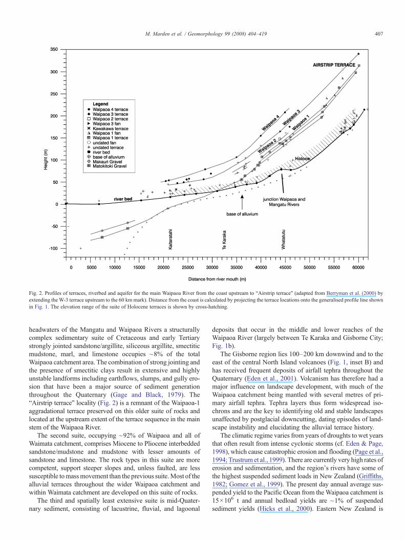
Fig. 2. Profiles of terraces, riverbed and aquifer for the main Waipaoa River from the coast upstream to “Airstrip terrace” (adapted from Berryman et al. (2000) byextending the W-3 terrace upstream to the 60 kmmark). Distance from the coast is calculated by projecting the terrace locations onto the generalised profile line shownin Fig. 1. The elevation range of the suite of Holocene terraces is shown by cross-hatching.
407M. Marden et al. / Geomorphology 99 (2008) 404–419
headwaters of the Mangatu and Waipaoa Rivers a structurallycomplex sedimentary suite of Cretaceous and early Tertiarystrongly jointed sandstone/argillite, siliceous argillite, smectiticmudstone, marl, and limestone occupies ~8% of the totalWaipaoa catchment area. The combination of strong jointing andthe presence of smectitic clays result in extensive and highlyunstable landforms including earthflows, slumps, and gully ero-sion that have been a major source of sediment generationthroughout the Quaternary (Gage and Black, 1979). The“Airstrip terrace” locality (Fig. 2) is a remnant of the Waipaoa-1aggradational terrace preserved on this older suite of rocks andlocated at the upstream extent of the terrace sequence in the mainstem of the Waipaoa River.
The second suite, occupying ~92% of Waipaoa and all ofWaimata catchment, comprises Miocene to Pliocene interbeddedsandstone/mudstone and mudstone with lesser amounts ofsandstone and limestone. The rock types in this suite are morecompetent, support steeper slopes and, unless faulted, are lesssusceptible tomassmovement than the previous suite.Most of thealluvial terraces throughout the wider Waipaoa catchment andwithin Waimata catchment are developed on this suite of rocks.
The third and spatially least extensive suite is mid-Quater-nary sediment, consisting of lacustrine, fluvial, and lagoonal
deposits that occur in the middle and lower reaches of theWaipaoa River (largely between Te Karaka and Gisborne City;Fig. 1b).
The Gisborne region lies 100–200 km downwind and to theeast of the central North Island volcanoes (Fig. 1, inset B) andhas received frequent deposits of airfall tephra throughout theQuaternary (Eden et al., 2001). Volcanism has therefore had amajor influence on landscape development, with much of theWaipaoa catchment being mantled with several metres of pri-mary airfall tephra. Tephra layers thus form widespread iso-chrons and are the key to identifying old and stable landscapesunaffected by postglacial downcutting, dating episodes of land-scape instability and elucidating the alluvial terrace history.
The climatic regime varies from years of droughts to wet yearsthat often result from intense cyclonic storms (cf. Eden & Page,1998), which cause catastrophic erosion and flooding (Page et al.,1994; Trustrum et al., 1999). There are currently very high rates oferosion and sedimentation, and the region's rivers have some ofthe highest suspended sediment loads in New Zealand (Griffiths,1982; Gomez et al., 1999). The present day annual average sus-pended yield to the Pacific Ocean from the Waipaoa catchment is15×106 t and annual bedload yields are ~1% of suspendedsediment yields (Hicks et al., 2000). Eastern New Zealand is

408 M. Marden et al. / Geomorphology 99 (2008) 404–419
estimated to account for about 1% of the sediment input into theworld's oceans (Carter et al., 1996).
The combination of active tectonics, erodible lithologies andclimate regime conditions the dynamics of this catchment.
2.3. Waipaoa-1 aggradation terrace
2.4. Distribution and morphologyThe Waipaoa-1 aggradation terrace (Figs. 2, 3 and 4) is the
most widespread of the four glacial-aged surfaces identified inthe Waipaoa catchment (Fig. 2). In the main stem this terracebecomes emergent above the modern floodplain a few kilo-metres upstream of Te Karaka and rapidly increases in elevationfrom the modern floodplain farther upstream, where at the“Airstrip terrace” (Figs. 1 and 2) it is 120 m above the modernriver level. The emergent part of the Waipaoa-1 terrace isrecognised as aggradational in origin on the basis of its wide-spread distribution and the thickness of associated materialoverlying a strath cut into the underlying bedrock. Downstreamfrom Te Karaka, this terrace surface dips beneath the presentfloodplain where the alluvium has been traced through subsur-face borehole and well records (Brown, 1995).
The more expansive remnants of the Waipaoa-1 terrace ap-pear flat but have a gentle down-valley gradient of around 2 to15 m/km and consist of three treads (Fig. 2) separated verticallyby between 2 and 15 m. Typically, the uppermost tread is therepository for Holocene and modern fan deposits. The distal partsof these fans are often truncated, suggesting they were depositedon the surface before the onset of postglacial downcutting, andthus are generally of late glacial to early Holocene age. Forextensive parts of the Waipaoa catchment, where the Waipaoa-1aggradation terrace is intact, valley slopes above the terrace haveremained relatively stable for the past 15000 years, during whichrainfall increased and forest cover became established (McGloneet al., 1984). Elsewhere, the absence of the Waipaoa-1 andyounger terraces is due to hillslope adjustment processes, in-cluding mass movement and gullying, in response to postglaciallowering of stream base-level.
Braided drainage patterns are not seen on these surfaces be-cause they have beenmasked by the presence of tephra coverbeds.Erosion channels are rare and found only as discontinuous rem-nants at terrace edges. There are no oxbows present on theWaipaoa-1 terrace and the coverbeds are devoid of dateableorganic material.
2.5. Previous investigations of coverbed stratigraphy
Kawakawa Tephra (22600 14C years) (Froggatt & Lowe,1990) is not included in the coverbeds of the Waipaoa-1 terrace,but does occur on older terraces and on hillslopes with greaterelevation than the Waipaoa-1 terrace. The recent discovery ofKawakawa tephra within Waipaoa-1 aggradation gravel (Berry-man et al., in press) and at Mahaki (this paper) (Fig. 1a) providesthe best evidence to date that this period of aggradation withinWaipaoa catchment occurred before, during and after the depo-sition of the Kawakawa Tephra. Its purity and texture suggest it isprimary airfall, while its location within this sequence, a metre
above the bedrock strath, indicates aggradation started at least22600 14C years ago and ceased before 15 ka in the constructionof the Waipaoa-1 terrace. Kawakawa Tephra has previously beenfound within aggradation gravels at 13 other localities in predo-minantly eastern North Island catchments (Litchfield, 2003;Litchfield & Berryman, 2005).
The coverbed stratigraphy (finer sediments resting on thegravel surface or tread) and tephra identification of theWaipaoa-1terrace have previously been investigated at four geographiclocations in the main stem of Waipaoa River (Eden et al. 2001)and within a 2.2 km section of the Waihuka tributary, near Otoko(Fig. 1a) (Berryman et al., in press).
3. Methods
3.1. Terrace mapping and dating
Waipaoa-1 terraces were identified stereoscopically from1:25000 scale, non-orthorectified, aerial photography, mappedas closed polygons, then transferred onto topographic transpar-encies from which they were subsequently digitised in ARCINFO (Fig. 3). For age control, samples of tephra were collectedfrom augered and cored sites and from natural river and roadembankments for identification. Tephra identification was by acombination of ferromagnesian mineralogy and electron micro-probe analysis of glass shards. Samples were analysed by theJEOL 733 Electron Microprobe. A 10 μm beam diameter and8.5 nA beam current were used for all analyses.
Tephra provided the primary means of establishing the tim-ing of the Waipaoa-1 aggradation phase and to the cessation ofthe Waipaoa-1 aggradational terrace. Key tephra sample sitesare shown in Fig. 3. Tephra critical to the timing of the cessationof the Waipaoa-1 aggradation are listed in Table 1.
Where age control of terraces remains limited (i.e. in mosttributary streams), we use terrace heights obtained by GPS(Global Positioning System) technology to extrapolate betweenterrace remnants. The architecture of the GPS system was a basestation located at Te Karaka (Fig. 1a), within 40 km of theperiphery of all parts of the catchment. We are confident that allGPS-derived positions and heights have an uncertainty of nogreater than ±0.3 m and report all elevations to the nearestmetre, but expect that the data are better than this.
Using GPS and nickpoint heights we have attempted toextrapolate and interpolate from dated terrace remnants to othersurfaces of uncertain age but similar position in the landscape,to create a long-section profile of the Waipaoa-1 terrace for eachtributary (Fig. 5). Terrace and river longitudinal profiles werecompiled by projecting GPS locations and elevations to asingle, middle of the valley profile line as shown for the mainstem of the Waipaoa River (Fig. 1a).
Nickpoints at or near the Waipaoa-1 aggradational levelwere mapped from aerial photography and used as a surrogatewhere remnants of the Waipaoa-1 terrace were absent orfar apart. Elevations were measured at the base and top ofnickpoints using GPS. The position of the nickpoint in the mainstem of each of the major tributary streams is shown in Figs. 3and 5.

Fig. 3. Catchment-wide distribution of the Waipaoa-1 (Last Glacial Maximum) aggradation terrace within the Waipaoa and Waimata catchments. Key tephra samplelocations are numbered 1 to 17. Tephra identifications are presented in Table 1. Locations of nickpoints for major tributaries are numbered A to H. Dashed linesrepresent NZMS 260 map sheet boundaries.
409M. Marden et al. / Geomorphology 99 (2008) 404–419
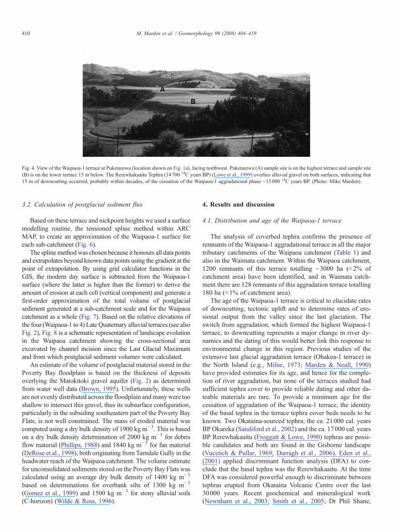
Fig. 4. View of the Waipaoa-1 terrace at Puketarewa (location shown on Fig. 1a), facing northwest. Puketarewa (A) sample site is on the highest terrace and sample site(B) is on the lower terrace 15 m below. The Rerewhakaaitu Tephra (14700 14C years BP) (Lowe et al., 1999) overlies alluvial gravel on both surfaces, indicating that15 m of downcutting occurred, probably within decades, of the cessation of the Waipaoa-1 aggradational phase ~15000 14C years BP. (Photo: Mike Marden).
410 M. Marden et al. / Geomorphology 99 (2008) 404–419
3.2. Calculation of postglacial sediment flux
Based on these terrace and nickpoint heights we used a surfacemodelling routine, the tensioned spline method within ARCMAP, to create an approximation of the Waipaoa-1 surface foreach sub-catchment (Fig. 6).
The splinemethodwas chosen because it honours all data pointsand extrapolates beyond known data points using the gradient at thepoint of extrapolation. By using grid calculator functions in theGIS, the modern day surface is subtracted from the Waipaoa-1surface (where the latter is higher than the former) to derive theamount of erosion at each cell (vertical component) and generate afirst-order approximation of the total volume of postglacialsediment generated at a sub-catchment scale and for the Waipaoacatchment as a whole (Fig. 7). Based on the relative elevations ofthe four (Waipaoa-1 to 4) Late Quaternary alluvial terraces (see alsoFig. 2), Fig. 8 is a schematic representation of landscape evolutionin the Waipaoa catchment showing the cross-sectional areaexcavated by channel incision since the Last Glacial Maximumand from which postglacial sediment volumes were calculated.
An estimate of the volume of postglacial material stored in thePoverty Bay floodplain is based on the thickness of depositsoverlying the Matokitoki gravel aquifer (Fig. 2) as determinedfrom water well data (Brown, 1995). Unfortunately, these wellsare not evenly distributed across the floodplain andmanywere tooshallow to intersect this gravel, thus its subsurface configuration,particularly in the subsiding southeastern part of the Poverty BayFlats, is not well constrained. The mass of eroded material wascomputed using a dry bulk density of 1900 kg m−3. This is basedon a dry bulk density determination of 2000 kg m−3 for debrisflow material (Phillips, 1988) and 1840 kg m−3 for fan material(DeRose et al., 1998), both originating from Tarndale Gully in theheadwater reach of the Waipaoa catchment. The volume estimatefor unconsolidated sediments stored on the Poverty Bay Flats wascalculated using an average dry bulk density of 1400 kg m−3
based on determinations for overbank silts of 1300 kg m−3
(Gomez et al., 1999) and 1500 kg m−3 for stony alluvial soils(C-horizon) (Wilde & Ross, 1996).
4. Results and discussion
4.1. Distribution and age of the Waipaoa-1 terrace
The analysis of coverbed tephra confirms the presence ofremnants of the Waipaoa-1 aggradational terrace in all the majortributary catchments of the Waipaoa catchment (Table 1) andalso in the Waimata catchment. Within the Waipaoa catchment,1200 remnants of this terrace totalling ~3000 ha (b2% ofcatchment area) have been identified, and in Waimata catch-ment there are 128 remnants of this aggradation terrace totalling180 ha (b1% of catchment area).
The age of the Waipaoa-1 terrace is critical to elucidate ratesof downcutting, tectonic uplift and to determine rates of ero-sional output from the valley since the last glaciation. Theswitch from aggradation, which formed the highest Waipaoa-1terrace, to downcutting represents a major change in river dy-namics and the dating of this would better link this response toenvironmental change in this region. Previous studies of theextensive last glacial aggradation terrace (Ohakea-1 terrace) inthe North Island (e.g., Milne, 1973; Marden & Neall, 1990)have provided estimates for its age, and hence for the comple-tion of river aggradation, but none of the terraces studied hadsufficient tephra cover to provide reliable dating and other da-teable materials are rare. To provide a minimum age for thecessation of aggradation of the Waipaoa-1 terrace, the identityof the basal tephra in the terrace tephra cover beds needs to beknown. Two Okataina-sourced tephra; the ca. 21000 cal. yearsBP Okareka (Sandiford et al., 2002) and the ca. 17000 cal. yearsBP Rerewhakaaitu (Froggatt & Lowe, 1990) tephras are possi-ble candidates and both are found in the Gisborne landscape(Vucetich & Pullar, 1969; Darragh et al., 2006). Eden et al.,(2001) applied discriminant function analysis (DFA) to con-clude that the basal tephra was the Rerewhakaaitu. At the timeDFAwas considered powerful enough to discriminate betweentephras erupted from Okataina Volcanic Centre over the last30000 years. Recent geochemical and mineralogical work(Newnham et al., 2003; Smith et al., 2005; Dr Phil Shane,

Table 1Waipaoa-1 terrace locations where Rerewhakaaitu (ca. 14700 14C years BP) (Froggatt & Lowe, 1990) and/or Okareka (ca. 18000 cal. years BP) (Sandiford et al.,2002) tephra are possible candidates for basal airfall on the Waipaoa-1 aggradation surface, Waipaoa catchment a
Site no. Site name b NZMS grid reference c Catchment Tephra name Method of identification Reference
1 Airstrip Terrace Y16 344160 Main stemWaipaoa
Rerewhakaaitu Mineralogy, Glasschemistry
Eden et al. 2001
2 Wheterau Stud Y16 337117 Main stemWaipaoa
Rerewhakaaitu/Okareka?
Mineralogy This paper
3 Waikakariki Y16 313064 Main stemWaipaoa
Rerewhakaaitu Mineralogy, Glasschemistry
Eden et al. 2001
4 Puketarewa main Y17 306029 Main stemWaipaoa
Rerewhakaaitu Mineralogy, Glasschemistry
Eden et al. 2001
5 Puketarewa– 15 m degradational level Y17 312026 Main stemWaipaoa
Rerewhakaaitu Mineralogy, Glasschemistry
Eden et al. 2001
6 Makahakaha main Y17 335089 Main stemWaipaoa
Rerewhakaaitu/Okareka?
Mineralogy This paper
7 Quilters X17 255934 Wharekopae Rerewhakaaitu/Okareka?
Mineralogy This paper
8 Quilters Silage X17 258941 Waihuka Rerewhakaaitu/Okareka?
Mineralogy This paper
9 Otoko 2 X17 173934 Waihuka Rerewhakaaitu Mineralogy, Glasschemistry
Berryman et al.(in press)
10 Claridge Road Y16 396150 Mangaorongo Rerewhakaaitu/Okareka?
Mineralogy This paper
11 Omapere main X17 266038 Mangatu Rerewhakaaitu/Okareka?
Mineralogy This paper
12 Otara Quarry Y17 319974 Main stemWaipaoa
Rerewhakaaitu/Okareka?
Mineralogy, Glasschemistry
Eden et al. 2001
Waikohu Station X17245928 Wharekopae Rerewhakaaitu Glass chemistry This paper14 Otoko walkway X17225936 Waihuka Rerewhakaaitu Glass chemistry This paper15 Gisborne Waterworks X18262565 Te Arai Rerewhakaaitu Glass chemistry This paper16 Dymock Road Y17329896 Maungatarehu Rerewhakaaitu Glass chemistry This paper17 Waimata Stream X18288633 Te Arai Rerewhakaaitu Glass chemistry This papera The Rerewhakaaitu and Okareka tephras have very similar glass chemistry and mineralogy (Smith et al., 2005). In every case the Rerewhakaaitu is the most likely
tephra since two separate tephras with similar chemistry do not occur together at any one site.b Site locations shown on Fig. 3.c The map references are for the NZMS 260 1:50000 New Zealand metric map series.
411M. Marden et al. / Geomorphology 99 (2008) 404–419
University of Auckland, pers. comm., 2006) shows that theRerewhakaaitu and Okareka tephras are compositionally hete-rogeneous because the eruptive episodes involved multiplemagmas. Their major element glass chemistry and mineralogycompletely overlap so that it is now difficult to be confidentwhich one is the basal tephra on the Waipaoa-1 terrace. Sinceonly one of these tephra is present on theWaipaoa-1 terrace andgiven the good preservation potential for tephra on riverterraces similarly positioned in the landscape (accuratelyestablished using GPS), together with the large number ofsites examined, it is logical to conclude that the basal tephra isthe younger Rerewhakaaitu Tephra, rather than the olderOkareka Tephra.
The presence of the ca. 14700 14C-year-old (ca 17700 cal. yearsBP; Lowe et al., 1999) Rerewhakaaitu Tephra in the lower part ofcover beds on Waipaoa-1 terrace indicates the aggradation thatformed this terrace ceased some time before 14700 14C years ago.There was clearly an undefined period of time when the riverremained close to the terrace since there are often 2 m or more ofoverbank silts and stream alluvium underlying this tephra. Fur-thermore, the presence of a paleosol underlying the RerewhakaaituTephra and evidence for an increase in weathering, through thepresence of more clay, in the top 0.1 m of the aggradation gravel,suggest the age of the Waipaoa-1 terrace is probably within the
range of 15000–15500 14C years BP (18000–18500 cal. yearsBP) (Eden et al., 2001).
These stratigraphic and age relationships provide a confidentbasis for correlating the Waipaoa-1 terraces with similarly agedsurfaces in southern North Island (Palmer, 1982; Marden &Neall, 1990; Pillans et al., 1993). It would appear therefore thatthe cessation of the last glacial aggradation at around 15000 14Cyears BP was a regional event throughout eastern and southernNorth Island (Litchfield, 2003) and we conclude that the for-mation of the most extensive of the Waipaoa-1 terrace treads,within the Waipaoa catchment, was a synchronous event. Weillustrate this period of aggradation in relation to the isotopicrecord of Shackleton (1987) in Fig. 8.
4.2. Mechanism for downcutting
Berryman et al. (2000) calculated that only about one quarterof the downcutting could have been accomplished as a result oftectonic uplift. The cessation of aggradation that formed thehighest Waipaoa-1 tread, followed by downcutting, reflects amajor change in river dynamics within the Waipaoa catchmentaround 15000 14C years ago (ca. 18000 cal. years BP).Geomorphic evidence indicating an absence of extensive ter-races below the Waipaoa-1 set in the main stem (Berryman

Fig. 5. River and Waipaoa-1 terrace profiles for the main stem and selected tributaries in Waipaoa catchment. Profiles for upper parts of Mangatu, Waipaoa, andWaingaromia rivers are incomplete owing in part to inaccessibility and to the poor preservation of terraces as a result of mass wasting.
412 M. Marden et al. / Geomorphology 99 (2008) 404–419
et al., 2000) suggests that once degradation had started it wassustained until historic times when anthropogenic aggradationoccurred. Therefore, the many metres of downcutting was morelikely driven by a combination of (i) stabilisation of the upper
catchment landscape by a reduction in the severity of physicalweathering and an increase in vegetation cover, and (ii) anincrease in discharge that increased the capacity of the river toincise (Bull, 1988; Berryman et al., 2000). A similar

Fig. 6. The modelled Waipaoa-1 terrace surface within Waipaoa and Waimata catchments. The axis of separation between sub-catchments of greater incision (in thenorth and east) from those of lesser incision (to the south and west) is shown. Waipaoa catchment, in the north and west, reaches an elevation at the divide of ~1000 ma.s.l.
Fig. 7. Volume of sediment excavated from sub-catchments of the Waipaoa and Waimata Rivers since the culmination of aggradation to form the Waipaoa-1 (LastGlacial Maximum) terrace.
413M. Marden et al. / Geomorphology 99 (2008) 404–419

Fig. 8. Schematic representation of landscape evolution in the Waipaoa Catchment showing the age of major aggradation terraces in relation to the oxygen isotopecurve (adapted from Shackleton, 1987) and tephra ages (adapted from Berryman et al., 2000). This information brackets the position of inferred aggradation episodescorresponding to Waipaoa 1–4 terraces. Also shown is the cross-sectional channel area excavated since the Last Glacial Maximum and from which sediment volumesgenerated by downcutting were calculated. Terrace and river heights are based on GPS readings near Whatatutu (Fig. 1b). No horizontal scale intended.
414 M. Marden et al. / Geomorphology 99 (2008) 404–419
stabilisation of an alpine landscape during warmer climaticperiods was described from the central North Island (Vella,1963; Milne, 1973; Pillans et al., 1993; Newnham et al., 1999).
The similar ages for the uppermost and lowermost Waipaoa-1 terraces (15 m apart vertically) suggest the early part of thedowncutting cycle was rapid and may have been in response toan abrupt climate shift rather than to incremental change. Sud-den climate transitions that took place over decades rather thancenturies or millennia have been recognised increasingly in icecores (e.g., Adams et al., 1999; Severinghaus & Brook, 1999;Dansgaard et al., 1989). Furthermore, pollen evidence from theChilean Lake District (Moreno et al., 1999) indicates abruptwithdrawal of ice at around 14600 14C years BP (ca. 17600 cal.Years BP). This is very similar to our evidence for the natureand timing of climate change at the end of the last glaciation inNorth Island, New Zealand. These evidences (see also Dentonet al., 1999) point to significant Southern Hemisphere cli-matic warming occurring soon after ca. 15000 14C years BP(ca. 18000 cal. years BP) during the Older Dryas interval.
4.3. Hillslope adjustment in response to postglacial downcutting
In places where the Waipaoa-1 aggradation terrace has beenpreserved, postglacial hillslope adjustments have largely beenconfined to slopes below the level of this terrace. Mass wasting,in the form of earth flows, rotational slumping and gullies pre-dominates. In contrast, valley slopes above this terrace haveremained relatively stable for the past 15000 years, duringwhich
rainfall increased and forest cover became established (McGloneet al., 1984). On these latter slopes, the presence of coverbedmaterials that include the Kawakawa Tephra (Taupo VolcanicCentre) and/or the older Omataroa (~28 ka years BP) (Jurado-Chichay & Walker, 2000) and Rotoehu (~55–57 ka years BP)(Berryman, 1992) Tephras (Okataina Volcanic Centre) suggeststhe postglacial incision process has not influenced parts of thiscatchment's landscape. These same slopes do, however, showevidence of slope adjustment that pre-dates the postglacial in-cision period and, probably formed in response to earlier periodsof river incision, climate change or earthquake triggering.
Our findings suggest postglacial hillslope adjustment is morestrongly correlated with the depth of river incision than withlithology. Catchments within which postglacial slope adjust-ment has been minimal include those that drain Tertiary litho-logies where postglacial river incision is typically of the order of25–50 m below the Waipaoa-1 terrace (e.g., Wharekopae,Waihuka, Waikohu Rivers) (Fig. 5). These valleys are typicallynarrow and steep-sided — a reflection of the inherent strengthof the decimetre-bedded lithologies — and here the preserva-tion of remnants of the Waipaoa-1 terrace decouples slopes fromthe channel for much of the river's length. As a consequence,and since postglacial incision began, these channels have be-come progressively narrower. Importantly, the contribution ofsediment derived from slope adjustment in response to post-glacial base-level fall in these tributary catchments is low. Thisis because a significant proportion of these catchments lie up-stream of a major nickpoint where slope adjustment has yet to

415M. Marden et al. / Geomorphology 99 (2008) 404–419
occur. In contrast, hillslope adjustment is widespread in deeplyincised catchments, particularly those that drain older andtectonically more disrupted lithologies of late Cretaceous–earlyTertiary age (e.g., Mangatu River and upper reaches of theWaipaoa River), and in catchments within areas of Tertiarylithologies dominated by mudstone with its greater propensityfor mass wasting (e.g., Waingaromia River). In these catch-ments the net postglacial incision is more typically 80–100 m,nickpoints have retreated to the catchment divide, and hillslopeadjustment is widespread. In addition, hillslopes are more oftencoupled with channels and postglacial adjustment is byearthflow, slump and gully processes that often extend fromvalley floor to the watershed divide. The result is poor terracepreservation and wider valleys with gentle 15–35° side slopes.Notwithstanding, within the Waipaoa catchment the highestvolumes of sediment released during the postglacial period werefrom these latter tributaries valleys (Fig. 7). On average, thethickness of aggradational terrace deposits upon the Waipaoa-1surface is ~20% of the total depth of postglacial incision, with~80% of incision being within bedrock. Areally, Cretaceouslithologies occupy only ~8% of the total Waipaoa catchmentarea. The volume and composition of sediment eroded duringthe postglacial period is therefore dominated by material de-rived from the remaining ~92% of this catchment where Ter-tiary mudstone and sandstone are the dominant lithologies.Here, and over the longer term, slope-derived sediment inputswould be diluted and masked by bedrock-derived sediment. Inthe shorter term, however, evidence for the episodic stripping ofsurficial slope materials (colluvium and tephric beds) and/orincreased sediment input as a consequence of mass slope failure(e.g., rotational slumping), in response to climatic and tectonicperturbations, is often preserved as valley fill at downstreamsites.
Berryman et al. (in press) estimated that at Otoko in theWaihuka River (Fig. 1a), 17 km upstream from the confluencewith the Waipaoa River and 50 km from the coast, rapid incisiondid not occur until ~8000 14C years ago. They suggest that for
Table 2Minimum rates of nickpoint retreat since the culmination of Waipaoa-1 aggradation (cnickpoint
Siteno.
Site name a Nickpoint NZMSgrid reference b
Feature Height ofnickpoint
A Wharekopae X17201866 Waterfall 15B Totangi X17247862 Waterfall 2C Taumatapoupou X17229860 Waterfall 3D Hihiroa X17177904 Rapids and
waterfall21
E Waihora Y17446986 Waterfall 12F Wheo X17211007 Waterfall 6G Te Arai X18288577 Waterfall 15H Waimata Stream (a tributary of
the Te Arai River)
X18215646 Waterfall 18
a Site locations shown on Fig. 3.b The map references are for the NZMS 260 1:50000 New Zealand metric map sc Minimum rate of nickpoint retreat is based on river distance from the curren
~15000 14C years ago (18000 cal. years BP). These are minimum rates because at timof its current position.
the reach upstream of the Waihuka/Waipaoa junction (Fig. 1)the average nickpoint retreat rate was ~2 km ka−1. The mainstems of the Waipaoa River and the Waihuka River are bothincised into the same lithological units. We therefore contendthat nickpoint retreat occurred in both rivers at a similar rate toreach Puketarewa (Fig. 1a) (in the main stem of the WaipaoaRiver) and some unknown point immediately downstream ofOtoko (in the Waihuka), a similar distance upstream from thecoast, at about the same time. Also, while nickpoint retreat inthe main stem was unimpeded and continued upstream ofPuketarewa, at Otoko it stalled for ~8000 14C years BP. Thecause of this delay is unknown. The most likely explanation isthat the rate of nickpoint retreat in the Waihuka slowed inresponse to a loss in stream power when the nickpoint passedupstream of the Wharekopae and Waikohu River junctions,respectively. Other possible explanations include (i) thepresence of a localised and more resistant lithology in thegorge-like reach downstream of Otoko, and (ii) a barrier causedby bedrock displacement on the Otoko/Totangi fault where ittraverses Waihuka River, downstream of the Otoko study site(Fig. 1a), although no surface displacement has been observedat this locality. In addition, we find that postglacial river incisionand nickpoint retreat also stalled in each of the Wharekopae,Totangi, Taumatapoupou, Hihiroa, Waihora, and Te Arai Riversand in the Waimata Stream (a tributary of Te Arai River). Inthese rivers the nickpoint is a near-vertical waterfall. In Table 2we present minimum rates of nickpoint retreat, since theculmination of maximum aggradation at ca. 15000 14C yearsBP, based on the river distance from the current coastline to thefirst nickpoint encountered.
We found that nickpoint retreat in tributaries nearer the coast(e.g., Te Arai River) occurred at about half the rate (~1.2–1.4 km ka−1) of that in tributaries draining the mid-reaches ofthe Waipaoa catchment (~2.5–2.9 km ka−1). The rate ofnickpoint retreat for the main stem of the Waipaoa River isconsidered a minimum rate because there is no nickpointpresent in the main channel and the assumption is that it has
a. 18000 cal. years BP) (Berryman et al., 2000) for the reach downstream of each
(m)Distance from thecoast (km)
Min rate of nickpoint retreat since the culmination ofmaximum aggradation (ca 18 ka cal. yrs BP) c
51.5 2.86 km ka−1
50.5 2.80 km ka−1
50.2 2.78 km ka−1
51 2.83 km ka−1
45.2 2.51 km ka−1
52.8 2.93 km ka−1
26 1.44 km ka−1
22 1.22 km ka−1
eries.t coastline divided by the time (years) since the culmination of aggradationes of lower sea level the coastline would have been an unknown distance seaward

416 M. Marden et al. / Geomorphology 99 (2008) 404–419
retreated the full length of this river system. Differences incatchment area and a reduction in stream power as nickpointsretreated upstream of tributary confluences would account forsome of the inter-tributary variability in these rates. In riverswhere a nickpoint is present, the reach upstream is considerablyless well-incised than the downstream reach, and hillslopeadjustment often has yet to occur.
4.4. Postglacial sediment flux
Comparisons of longitudinal stream and terrace profiles(Fig. 5) show stream incision and the consequent production ofsediment to have been greatest in tributary catchments in thenorth and east of the Waipaoa catchment (Mangatu River, upperreaches of main stem of the Waipaoa River, Waingaromia River,and Waihora River), and in the Waimata catchment, and least inthose tributary catchments in the southwest (Waihuka River,Waikohu River, Wharekopae River, and Te Arai River). Interms of identifying likely source areas and the timing of sedi-ment flux to the Poverty Bay shelf, sub-catchments in the areaof greatest tectonic uplift would be expected to display morerapid responses and to generate higher sediment volumes inresponse to base-level fall. Our model confirms this to be thecase with differences in sediment production likely to be due touplift occurring in the north and east and subsidence in the southand west (Fig. 6). The positioning of the NW–SE-trending axis,separating areas of uplift from subsidence, corresponds closelywith rates determined from drillhole data on the Poverty Bayfloodplain (see Fig. 2 in Berryman et al., 2000) and is consistentwith known rates of uplift and downcutting derived from terraceprofiles (Berryman et al., 2000, in press). From our terrace andriver profiles (Fig. 5), elevation differences between the Wai-paoa-4 terrace (90–110 ka), the Waipaoa-1 terrace (c.15 ka) andthe level of maximum incision in modern times (i.e. beforeaggradation since the turn of the 20th century) suggest up to50% of the topographic relief within headwater reaches of theWaipaoa River has formed since the Last Glacial Maximum,that is in 15% of the time since the earliest aggradation episode(Waipaoa-4) recorded in this catchment.
For the configuration of sub-catchments presented here amultiple regression analysis of the relationship of catchment areato sediment volume appears not to be significant (F1, 9=1.45,p=0.26), thereby supporting the contention that tectonic regime(uplift/subsidence) at the tributary catchment level has probablybeen more influential than catchment area in determining thevolume and rate of postglacial sediment generation from theWaipaoa and Waimata catchments (Fig. 7). Against this back-ground of tectonic forcing, variations in rock type betweentributary catchments appear to be of lesser importance.
Our estimate of the total postglacial sediment volume eroded bychannel incision from Waipaoa catchment is ~9.5 km3 and~2.6 km3 fromWaimata catchment (Fig. 7). By comparison, FosterandCarter (1997) estimated that 20 km3 ofmud has been depositedon the Poverty Bay shelf since 18000 cal. years BP, of which 8 km3
accumulated since 8000 cal. years BP, andOrpin (2004) concludedthat during the mid- to late Holocene a further 3 km3 lobe ofpostglacial hemipelagic sediment accumulated inmid-slope basins.
These estimates of shelf and slope sediment accumulationare based on the existence of two major seismic reflectors: one(assumed to be last glacial in age) defines the unconformitybetween unconsolidated postglacial mud and the underlyingdeformed and indurated Neogene strata; the other, a conform-able reflector in the top 15 m of the prism, has been assumed tobe early Holocene in age (~8–10000 14C years BP) after Pantin(1966). The presence of Tuhua tephra (6970 cal. years BP) at14.13 m depth in the Calypso core MD97-2122 (Gomez et al.,2001) from the Poverty Bay mid-shelf basin, is considered toconfirm that the underlying reflector is early Holocene in age(Orpin, 2004). The offshore sediment storage pattern appears tosupport the contention of an early (before ~8000 14C years BP)and rapid phase of onshore downcutting that potentially pro-duced ~12 km3 of offshore sedimentation, followed by a periodof slower downcutting during which ~8–11 km3 of offshoresediment accumulation occurred in the last 8000 years of theHolocene period. We estimate the combined volume of post-glacial terrestrial sediment generated from the Waipaoa andWaimata catchments (12.1 km3) to be about half that estimatedto be stored on the Poverty Bay shelf (23 km3). In addition, ourestimate of the volume of unconsolidated postglacial materialstored within the confines of the Poverty Bay floodplain is6.6 km3. That is, of the total eroded postglacial sediment vol-ume derived from the Waipaoa catchment (9.5 km3), ~70% hasbeen trapped onshore. The initial trapping of this sediment wasprobably enhanced during times of marine incursion ~9000–7000 14C years BP (Brown, 1995) and subsequently by thepresence of a lowland forest cover and unrestricted flood flowacross this extensive floodplain. If we then assume that just2.9 km3 of the sediment eroded from Waipaoa catchment wasdischarged beyond the Poverty Bay floodplain to the shelf andthat all the sediment eroded from the Waimata catchment(2.6 km3) reached the same depocentre, (the Waimata Riverdoes not have a coastal floodplain and, at times in the past,likely drained directly into Poverty Bay), total postglacial se-diment contribution to the shelf and beyond amounted to~5.5 km3. Accordingly, there appears to be a ~4-fold differencebetween our estimate of postglacial sediment generated bychannel incision onshore and that stored offshore.
Potential sources of error in the methodology used to calculatethe volume of sediment generated include, first, a paucity of GPSheight control in the upper reaches of most sub-catchments where,in some instances, nickpoints and dummy points were used toconstrain the Waipaoa-1 surface. Thus, volume estimates for themain channels, where there was superior height control on theWaipaoa-1 surface, will be more accurate than for tributarychannels where volumes have probably been underestimated.Second, due to historical aggradation since the turn of the 20thcentury, the maximum depth of channel incision in some sub-catchments is unknown and once again our volume calculation willhave been underestimated. Most importantly, our volume calcula-tion only accounts for sediment removed fromwithin the vicinity ofriver channels as a consequence of postglacial fluvial incision anddoes not therefore account for the significant throughput ofsediment generated as a consequence of slope adjustment. That is~75% of the estimated volume of the postglacial sediment in

417M. Marden et al. / Geomorphology 99 (2008) 404–419
storage offshore was probably derived from hillslope erosionprocesses following base-level fall and at times when sedimentyield from these catchments exceeded storage.
A refinement of the estimates of onshore sediment produc-tion and storage will require a) a better understanding of var-iations in the rate of incision during the postglacial period, b) agreater accuracy in defining the extent of glacial-aged versuspostglacial hillslope adjustment and of the Waipaoa-1 aggrada-tional terrace itself (particularly at sub-catchment scale), c) thedetermination of rates of hillslope adjustment by mass move-ment (predominantly rotational slumping and earthslide), and d)greater stratigraphic detail from additional and deeper drillholesand seismic profiling of the Poverty Bay floodplain and ofaggraded channels. Refinement of the offshore postglacial sedi-ment storage component is also required, particularly for theearly Holocene, through better age control.
5. Conclusions
Identification of the Rerewhakaaitu Tephra (ca. 14700 14Cyears or ca. 17700 cal. years BP) as the basal tephra layer onremnants of the Waipaoa-1 aggradational terrace throughout theWaipaoa catchment provides the best date so far for the cessationof last glacial aggradation in North Island, New Zealand.
In the period before and after rapid incision, downcuttingrates averaging 1 m ka−1 may represent the regional tectonicuplift rate. However, Rerewhakaaitu Tephra is also present atthe base of the coverbeds on a Waipaoa-1 terrace that is ca. 15 mlower than the main surface. This suggests downcutting fromthe highest to the lowest Waipaoa-1 terrace treads was rapid inthe main stem. Where we have both downcutting and uplift datafor the postglacial incision phase we find downcutting rates ofup to 7 m ka−1 in upper reaches of the river where upliftaccounts for only ~1 m ka−1. In the middle reaches of the mainstem downcutting is about four times faster than tectonic uplift.Thus, climatically driven changes in river dynamics and uppercatchment erosion rates are interpreted to be the primary controlon the formation of fluvial terrace landscapes in the region andmark the transition to the postglacial in eastern North Island.
While this change in river dynamics was significant andtriggered an episode of channel incision that was rapid (pro-bably decades rather than centuries) in the main stem, within theWaihuka sub-catchment, at a similar distance upstream to that inthe main stem, incision did not occur until ~10000–8000 yearsago. Each tributary of the Waipaoa River therefore has its ownpostglacial history of downcutting and sediment flux in res-ponse to base-level fall, with tectonic regime (uplift/subsidence)probably being more influential than catchment area in de-termining the volume and rate of postglacial sediment generation.
Our estimate of the postglacial sediment flux derived bychannel incision for Waipaoa catchment is in the order of9.5 km3, of which 6.6 km3 is stored within the confines of thePoverty Bay floodplain. With just 2.9 km3 of the postglacialsediment derived from Waipaoa catchment and 2.6 km3 fromthe Waimata catchment reaching the same offshore depocentre,total postglacial sediment contribution to the shelf and beyondamounted to ~5.5 km3. Thus, sediment generated by postglacial
channel incision represents only ~25% of the total sedimentyield from this landscape with ~75% of the estimated volume ofthe postglacial storage offshore (23 km3) likely derived fromhillslope erosion processes following base-level fall at timeswhen sediment yield from these catchments exceeded storage.
Further refinements of onshore sediment production andstorage are needed and, for individual tributaries, will require anunderstanding of rates of postglacial downcutting, definition ofthe extent of postglacial hillslope adjustment and of theWaipaoa-1 aggradation terrace itself, measurement of rates ofhillslope mass movement processes, and the acquisition of ad-ditional and deeper drillhole data together with seismic profilingof aggraded river channels and of the Poverty Bay floodplain.Refinement of the offshore postglacial sediment storage com-ponent through better age control is also required.
Acknowledgements
This research is part of a wider programme that examineslandscape processes in the Gisborne region funded by the NewZealand Foundation for Research, Science, and Technologycontract no. CO9X0013. We thank Ted Pinkney for his drillingexpertise in the field and Kate Wilson for her role in theidentification of tephra. Anne Sutherland, Nicolette Faville andJanie Jansen produced figures and maps, and Anne Austin ofLandcare Research Ltd, NZ, edited the script.
References
Adams, J., Maslin, M., Thomas, E., 1999. Sudden climate transitions during theQuaternary. Progress in Physical Geography 23, 1–36.
Berryman, K., 1992. A stratigraphic age of Rotoehu Ash and late Pleistoceneclimate interpretation based on marine terrace chronology, Mahia Peninsula,North Island, New Zealand. New Zealand Journal of Geology and Geophysics35, 1–7.
Berryman, K., Marden, M., Eden, D., Mazengarb, C., Ota, Y., Moriya, I., 2000.Tectonic and paleoclimatic significance of Quaternary river terraces of theWaipaoa River, east coast, North Island, New Zealand. New Zealand Journalof Geology and Geophysics 43, 229–245.
Berryman, K., Marden, M., Palmer, A., Wilson, K., Mazengarb, C., Litchfield,N., in press. The postglacial downcutting history in the Waihuka tributary ofthe Waipaoa River, Gisborne District, New Zealand, and implications fortectonics and landscape evolution. Marine Geology.
Brown, L.J., 1995. Holocene shoreline depositional processes at Poverty Bay,a tectonically active area, northeastern North Island, New Zealand. Qua-ternary International 26, 21–33.
Bull, W.B., 1988. Floods: degradation and aggradation. In: Baker, V.R. (Ed.),Flood Geomorphology. Wiley-Interscience, pp. 157–165.
Carter, L., Carter, R.M., McCave, I.N., 1996. Regional sediment recycling in theabyssal Southwest Pacific Ocean. Geology 24, 735–738.
Clement, A.J.H., Fuller, I.C., 2007. Fluvial responses to environmental changein the North Island, New Zealand, during the past c.30 ka recorded in riverterrace sequences: a review and model for river behaviour. New ZealandJournal of Geology and Geophysics 50, 101–116.
Dansgaard, W., White, J.W.C., Johnsen, S.J., 1989. The abrupt termination ofthe Younger Dryas climate event. Nature 339, 532–534.
Darragh, M., Cole, J., Nairn, I., Shane, P., 2006. Pyroclastic stratigraphy anderuption dynamics of the 21.9 ka Okareka and 17.6 Rerewhakaaitu eruptionepisodes from Tarawera Volcano, Okataina Volcanic Centre, New Zealand.New Zealand Journal of Geology and Geophysics 49, 309–328.
Denton, G.H., Heusser, C.J., Lowell, T.V., Moreno, P.I., Andersen, B.G.,Heusser, L.E., Schlucter, C., Marchant, D.R., 1999. Interhemispheric

418 M. Marden et al. / Geomorphology 99 (2008) 404–419
linkage of paleoclimate during the last glaciation. Geografiska Annaler 81,107–153.
DeRose, R.C., Gomez, B., Marden, M., Trustrum, N., 1998. Gully erosion inMangatu Forest, New Zealand, estimated from digital elevation models.Earth Surface Processes and Landforms 23, 1045–1053.
Eden, D.N., Page, M.J., 1998. Palaeoclimatic implications of a storm erosionrecord from late Holocene lake sediments, North Island, New Zealand.Palaeogeography, Palaeoclimatology, Palaeoecology 139, 37–58.
Eden, D.N., Palmer, A.S., Cronin, S.J.,Marden,M., Berryman, K.R., 2001. Datingthe culmination of river aggradation at the end of the last glaciation using distaltephra compositions, eastern North Island, New Zealand. Geomorphology 38,133–151.
Foster, G., Carter, L., 1997. Mud sedimentation on the continental shelf at anaccretionary margin, Poverty Bay, New Zealand. New Zealand Journal ofGeology and Geophysics 40, 157–173.
Froggatt, P.C., Lowe, D.J., 1990. A review of late Quaternary silicic and someother tephra formations from New Zealand: their stratigraphy, nomenclature,distribution, volume and age. New Zealand Journal of Geology and Geo-physics 33, 89–109.
Gage, M., Black, R.D., 1979. Slope-stability and geological investigations atMangatu State Forest. Technical Paper 66. O.D.C. 114, 116–014.1. ForestResearch Institute, New Zealand Forest Service, Wellington.
Gomez, B., Eden, D.N., Hicks, D.M., Trustrum, N.A., Peacock, D.A.,Wilmshurst,J.M., 1999. Contribution of floodplain sequestration to the sediment budget ofthe Waipaoa River, New Zealand. In: Marriott, S.B., Alexander, J. (Eds.),Floodplains: Interdisciplinary Approaches. Geological Society London, Spe-cial Publication, vol. 163, pp. 69–88.
Gomez, B., Carter, L., Trustrum, N., 2007. A 2400 yr record of natural eventsand anthropogenic impacts in intercorrelated terrestrial and marine sedimentcores: Waipaoa sedimentary system, New Zealand. Geological Society ofAmerica Bulletin. doi:10.1130/B25996.1 11 figures; 1 table.
Griffiths,G.A., 1982. Spatial and temporal variability in suspended sediment yieldsof North Island basins, New Zealand. Water Resources Bulletin 18, 575–584.
Hicks, D.M., Gomez, B., Trustrum, N.A., 2000. Erosion thresholds and suspendedsediment yields: Waipaoa River Basin, New Zealand. Water Resource Re-search 36, 1129–1142.
Jurado-Chichay, Z., Walker, G.P.L., 2000. Stratigraphy and dispersal of theMangaone Subgroup pyroclastic deposits, Okataina Volcanic Centre,NewZealand. Journal ofVolcanology andGeothermal Research 104, 319–383.
Lewis, K.B., Pettinga, J.R., 1993. The emerging, imbricate frontal wedge of theHikurangi Margin. In: Balance, P.B. (Ed.), South Pacific Sedimentary Basinsof the World, vol. 2. Elsevier, Amsterdam, pp. 225–250.
Litchfield, N., 2003. Maps, stratigraphic logs and age control data for riverterraces in the eastern North Island. Institute of Geological and NuclearSciences Science Report 2003/31. 102 pp.
Litchfield, N.J., Berryman, K.R., 2005. Correlation of fluvial terraces within theHikurangi Margin, New Zealand: implications for climate and baselevelcontrols. Geomorphology 68, 291–313.
Lowe, D.G., Newnham, R.M., Ward, C.M., 1999. Stratigraphy and chronologyof a 15 ka sequence of multi-sourced silicic tephras in a montane peat bog ineastern North Island, New Zealand. New Zealand Journal of Geology andGeophysics 42, 565–579.
McGlone, M.S., Howorth, R., Pullar, W.A., 1984. Late Pleistocene stratigraphy,vegetation and climate of the Bay of Plenty and Gisborne regions,New Zealand. New Zealand Journal of Geology and Geophysics 27, 327–350.
Marden, M., Neall, V.E., 1990. Dated Ohakean terraces offset by the WellingtonFault near Woodville, New Zealand. New Zealand Journal of Geology andGeophysics 33, 449–453.
Marden, M., Arnold, G., Gomez, B., Rowan, D., 2005. Pre- and post-reforestationgully development in Mangatu Forest, East Coast, North Island, New Zealand.River Research and Applications, vol. 21, pp. 757–771.
Marutani, T., Kasai, M., Reid, L.M., Trustrum, N.A., 1999. Influence of storm-related sediment storage on the sediment delivery from tributary catchmentsin the upper Waipaoa River, New Zealand. Earth Surface Processes andLandforms 24, 881–896.
Mazengarb, C., Speden, I.G., 2000. Geology of the Raukumara area, Map 6,scale 1.250 000, 1 sheet, 60 pp. Institute of Geological and Nuclear Science,Lower Hutt, New Zealand. (Compilers).
Mazengarb, C., Francis, D.A., Moore, P.R., 1991. Sheet Y16-Tauwhareparae.Geological map of New Zealand scale 1:50000. New Zealand Departmentof Scientific and Industrial Research, Lower Hutt.
Milliman, J.D., Syvitski, P.M., 1992. Geomorphic/tectonic control of sedimentdischarge to the ocean: the importance of small mountainous rivers. TheJournal of Geology 100, 525–544.
Milne, J.D.G., 1973. Upper Quaternary geology of the Rangitikei drainage basin,North Island, New Zealand. Unpublished PhD thesis, Victoria University ofWellington, Wellington, New Zealand.
Moreno, P.I., Lowell, T.V., Jacobson Jr., G.L., Denton, G.H., 1999. Abrupt vege-tation and climate changes during the last glacialmaximumand last terminationin the Chilean Lake District: a case study from Canal de la Puntilla 418S.Geografiska Annaler 81, 285–310.
Newnham, R.M., Lowe, D.J., Williams, P.W., 1999. Quaternary environmentalchange inNewZealand: a review. Progress in PhysicalGeography 23, 567–610.
Newnham, R.M., Eden, D.N., Lowe, D.G., Hendy, C.H., 2003. RerewhakaaituTephra, a land–sea marker for the last Termination in New Zealand, withimplications for global climate changes. Quaternary Science Reviews 22,567–610.
Orpin, A.R., 2004. Holocene sediment deposition on the Poverty slope (doesthis really have a hyphen?) margin by the muddy Waipaoa River, East CoastNew Zealand. Marine Geology 209, 69–90.
Orpin, A.R., Carter, L., Kuehl, S.A., Trustrum, N.A., Lewis, K.B., Alexander,C.R., Gomez, B., 2002. Deposition from very high sediment-yield NewZealand rivers is captured in upper margin basins. MARGINS Newsletter,vol. 9, pp. 1–4.
Ota, Y., Berryman, K.R., Hull, A.G., Miyauchi, T., Iso, N., 1988. Age and heightdistribution of Holocene transgression deposits in eastern North Island,New Zealand. Palaeogeography, Palaeoclimatology, Palaeoecology 68,135–151.
Ota, Y., Hull, A.G., Berryman, K.R., 1991. Coseismic uplift of Holocene marineterraces in the Pakarae River area, eastern North Island, New Zealand.Quaternary Research 35, 331–346.
Ota, Y., Hull, A.G., Iso, N., Ikeda, Y., Moriya, I., Yoshikawa, T., 1992. Holocenemarine terraces on the northeast coast of North Island, New Zealand, andtheir tectonic significance. New Zealand Journal of Geology and Geophysics35, 273–288.
Page, M.J., Trustrum, N.A., Dymond, J., 1994. Sediment budget to assess thegeomorphic effect of cyclonic storm, New Zealand. Geomorphology 9,169–188.
Palmer, A.S., 1982. Kawakawa Tephra in Wairarapa, New Zealand, and its use forcorrelatingOhakea loess. NewZealand Journal ofGeology andGeophysics 25,305–316.
Pantin, H.M., 1966. Sedimentation in Hawke Bay. New Zealand Oceano-graphic. Institute Memoir, vol. 28. 70 pp.
Phillips, C.I., 1988. Rheological investigations of debris flow material.Unpublished PhD thesis, Lincoln College, New Zealand. 211 pp.
Pillans, B., McGlone, M., Palmer, A., Mildenhall, D., Alloway, B., Gerger, G.,1993. The Last Glacial Maximum in central and southern North Island,New Zealand: a paleoenvironmental reconstruction using the KawakawaTephra Formation as a chronostratigraphic marker. Palaeogeography,Palaeoclimatology, Palaeoecology 101, 283–304.
Sandiford, A., Horrocks, M., Newnham, R., Ogden, L., Alloway, B., 2002.Environmental change during the last glacial maximum (c. 25000–c.16500 years BP) at Mt Richmond, Auckland Isthmus, New Zealand. Journalof the Royal Society of New Zealand 32, 155–167.
Severinghaus, J.P., Brook, E.J., 1999. Abrupt climate change at the end of thelast glacial period inferred from trapped air in polar ice. Science 286,930–934.
Shackleton, N.J., 1987. Oxygen isotopes, ice volume and sealevel. QuaternaryScience Reviews 6, 183–190.
Smith, V.C., Shane, P., Nairn, I.A., 2005. Trends in rhyolite geochemistry,mineralogy, and magma storage during the last 50kyr at Okataina and Taupovolcanic centres, Taupo Volcanic Zone, New Zealand. Journal of Volca-nology and Geothermal Research 148, 372–406.
Trustrum, N.A., Gomez, B., Page, M.J., Reid, L.M., Hicks, D.M., 1999.Sediment production, storage and output: the relative role of magnitudeevents in steepland catchments. Zeitschrift fur Geomorphology 115, 71–86.

419M. Marden et al. / Geomorphology 99 (2008) 404–419
Vella, P., 1963. Upper Pleistocene succession in the inland part of the WairarapaValley, New Zealand. Transactions of the Royal Society of New Zealand,Geology 2 (4), 63–78.
Vucetich, C.G., Pullar, W.A., 1969. Stratigraphy and chronology of LatePleistocene volcanic ash beds in central North Island, New Zealand.New Zealand Journal of Geology and Geophysics 12, 784–837.
Walling, D.E., Fang, D., 2003. Recent trends in the suspended sediment loads ofthe world's rivers. Global and Planetary Change 39, 111–126.
Wilde, R.H., Ross, C.W., 1996. New Zealand reference soil collection and thenational soils database. New Zealand Soil News 44, 224–226.
Yoshikawa, T., 1988. Pattern and rate of tectonic movement and late Quaternarygeomorphic development in the Raukumara Peninsula, northeastern NorthIsland, New Zealand. Bulletin of the Department of Geography Universityof Tokyo 20, 1–28.
Copyright © 2022 FDOKUMEN