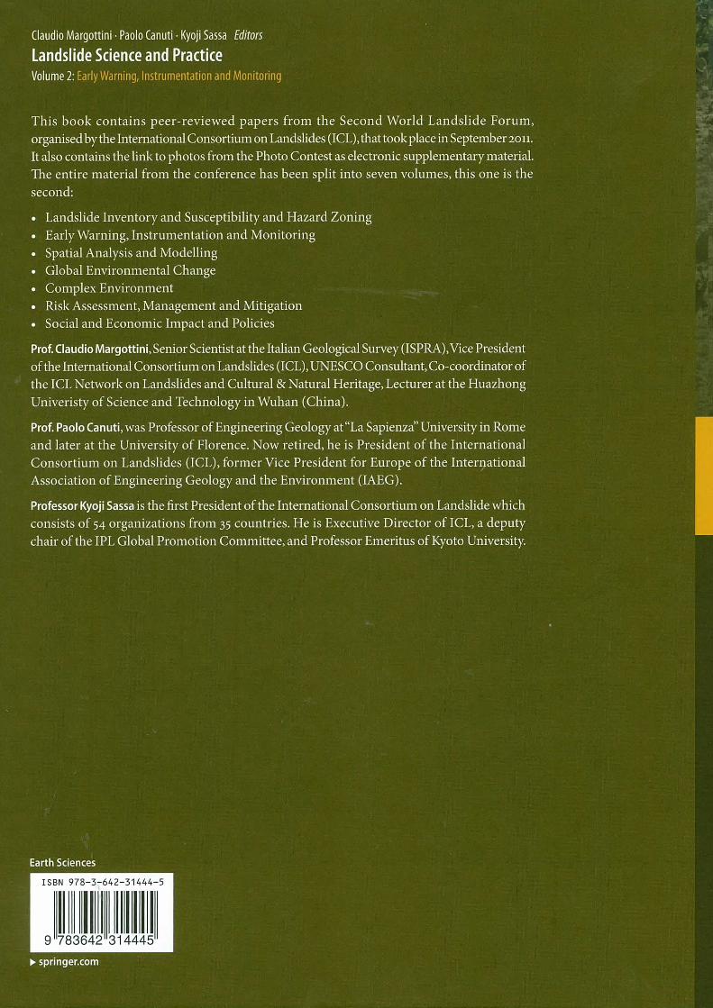
Landslide Science and Practice Volume 2 Early Warning, Instrumentation and Monitoring
38
Landslide Science and Practice Volume 2 Early Warning, Instrumentation and Monitoring Claudio Margottini Paolo Canuti · Kyoji Sassa Editors
Transcript of Landslide Science and Practice Volume 2 Early Warning, Instrumentation and Monitoring

Landslide Science and PracticeVolume 2Early Warning, Instrumentation and Monitoring
Claudio MargottiniPaolo Canuti · Kyoji Sassa Editors

Landslide Science and Practice

Claudio Margottini • Paolo Canuti • Kyoji Sassa
Editors
Landslide Scienceand Practice
Volume 2: Early Warning, Instrumentationand Monitoring
EditorsClaudio MargottiniISPRA - Italian Institute forEnvironmental Protection and Research
Geological Survey of ItalyRome, Italy
Kyoji SassaUNITWIN Headquarters BuildingKyoto University Uji CampusUji, Kyoto, Japan
Associate Editors
Filippo CataniDepartment of Earth SciencesUniversity of FlorenceFirenze, Italy
Paolo CanutiICL - International Consortium on LandslidesFlorence, Italy
Alessandro TrigilaISPRA - Italian Institute forEnvironmental Protection and Research
Geological Survey of ItalyRome, Italy
Additional material to Volume 1 can be downloaded from http://extras.springer.com
ISBN 978-3-642-31444-5 ISBN 978-3-642-31445-2 (eBook)DOI 10.1007/978-3-642-31445-2Springer Heidelberg New York Dordrecht London
Library of Congress Control Number: 2013932640
# Springer-Verlag Berlin Heidelberg 2013This work is subject to copyright. All rights are reserved by the Publisher, whether the whole or part of the material isconcerned, specifically the rights of translation, reprinting, reuse of illustrations, recitation, broadcasting, reproductionon microfilms or in any other physical way, and transmission or information storage and retrieval, electronicadaptation, computer software, or by similar or dissimilar methodology now known or hereafter developed.Exempted from this legal reservation are brief excerpts in connection with reviews or scholarly analysis or materialsupplied specifically for the purpose of being entered and executed on a computer system, for exclusive use by thepurchaser of the work. Duplication of this publication or parts thereof is permitted only under the provisions of theCopyright Law of the Publisher’s location, in its current version, and permission for use must always be obtained fromSpringer. Permissions for use may be obtained through RightsLink at the Copyright Clearance Center. Violations areliable to prosecution under the respective Copyright Law.The use of general descriptive names, registered names, trademarks, service marks, etc. in this publication does notimply, even in the absence of a specific statement, that such names are exempt from the relevant protective laws andregulations and therefore free for general use.While the advice and information in this book are believed to be true and accurate at the date of publication, neither theauthors nor the editors nor the publisher can accept any legal responsibility for any errors or omissions that may bemade. The publisher makes no warranty, express or implied, with respect to the material contained herein.
Printed on acid-free paper
Springer is part of Springer ScienceþBusiness Media (www.springer.com)
Preface
Landslide Science and Practice
Proceedings of the Second World Landslide Forum
The Second World Landslide Forum (WLF) was organized at the headquarters of the Food
and Agriculture Organization of the United Nations (FAO), Rome, Italy, on 3–9 October 2011.
WLF is a triennial mainstream conference of the International Programme on Landslides
(IPL) which is jointly managed by the IPL Global Promotion Committee consisting of the
International Consortium on Landslides (ICL), the United Nations Educational, Scientific and
Cultural Organization (UNESCO), the World Meteorological Organization (WMO), the Food
and Agriculture Organization of the United Nations (FAO), the United Nations International
Strategy for Disaster Risk Reduction (UNISDR), the United Nations University (UNU), the
International Council for Science (ICSU), and the World Federation of Engineering
Organizations (WFEO).
Background to the World Landslide Forums
The International Consortium on Landslides (ICL) was established by the 2002 Kyoto
Declaration “Establishment of an International Consortium on Landslides,” with the Statutes
adopted in January 2002. The Statutes defined the General Assembly of ICL: In order to
report and disseminate the activities and achievements of the consortium, a General Assembly
shall be convened every 3 years by inviting Members of the International Consortium on
Landslides, individual members within those organizations, and all levels of cooperating
organizations and individual researchers, engineers, and administrators. The General Assem-
bly will receive reports on Consortium activities and provide a forum for open discussion and
new initiatives from all participants.
The First General Assembly 2005 to the First World Landslide Forum 2008
The First General Assembly was organized at the Keck Center of the National Academy of
Sciences in Washington D.C., USA, on 12–14 October 2005. At this Assembly, the first full-
color book reporting consortium activities for the initial 3 years, 2002–2005, was published as
“Landslides-Risk analysis and sustainable disaster management” through Springer. The 2006
Tokyo Round-Table Discussion – “Strengthening Research and Learning on Earth System
Risk Analysis and Sustainable Disaster Management within UN-ISDR as Regards Landslides”
– toward a dynamic global network of the International Programme on Landslides (IPL) was
held at the United Nations University, Tokyo, on 18–20 January 2006. The 2006 Tokyo
v
Action Plan – Strengthening research and learning on landslides and related earth system
disasters for global risk preparedness – was adopted. The Tokyo Action Plan established a
new global International Programme on Landslides (IPL) including holding World Landslide
Forums. Accordingly, the Second General Assembly 2008 was replaced by the First World
Landslide Forum and held at the United Nations University, Tokyo, Japan, on 18–21
November 2008.
Report of the Second World Landslide Forum
The Second World Landslide Forum – Putting Science into Practice – was organized at the
Headquarters of the Food and Agriculture Organization of the United Nations (FAO) on 3–9
October 2011. It was jointly organized by the IPL Global Promotion Committee (ICL,
UNESCO, WMO, FAO, UNISDR, UNU, ICSU, WFEO) and two ICL members in Italy: the
Italian Institute for Environmental Protection and Research (ISPRA) and the Earth Science
Department of the University of Florence with support from the Government of Italy and
many Italian landslide-related organizations.
• 864 people from 63 countries participated. Attendance was larger than expected, and twice
the attendance at the First World Landslide Forum 2008 in Tokyo (430 participants: 175
from Japan and 255 from abroad).
• 25 technical sessions were held, and 465 full papers were submitted. All accepted papers
were edited in 7 volumes including this volume:
1. Landslide Inventory and Susceptibility and Hazard Zoning
2. Early Warning, Instrumentation and Monitoring – this volume
3. Spatial Analysis and Modeling
4. Global Environmental Change
5. Complex Environment
6. Risk Assessment, Management and Mitigation
7. Social and Economic Impact and Policies
Requests of Cooperation for Further Development of ICL and IPL
ICL and IPL are global multidisciplinary and cross-sectoral initiatives to promote landslide
science and capacity-development to reduce landslide disasters. The core activities of ICL and
IPL are Landslides: Journal of International Consortium on Landslides, World Landslide
Forum, and IPL projects. Thanks to worldwide support of the journal, the Impact Factor of
Landslides was 2.216 for 2011 which is the highest within 30 ISI journals in category of
Engineering, Geological. The journal will develop from a quarterly journal to a bimonthly
journal from Vol. 10 in 2013. The Third World Landslide Forum – Landslide risk mitigation
toward a safer geo-environment – at the China National Convention Center, Beijing, China, on
2–6 June (conference) and 7–11 June (Field Trip) 2014. The ICL entered into the second
decade of its activities and organized a 10th anniversary Conference on 17–20 January 2012,
in Kyoto, Japan. ICL adopted the ICL Strategic Plan 2012–2021, To create a safer geo-
environment- as an outcome of this conference.
ICL is an international nongovernmental and nonprofit scientific organization promoting
landslide research and capacity-building for the benefit of society and the environment, and is
vi Preface

.

the thematic landslides platform in the UNISDR Global Platform for Disaster Risk Reduction.
ICL activities are supported by voluntary efforts of ICL members and supporting
organizations. All people involving in landslide research and landslide disaster mitigation
activities are requested to cooperate for the development of this initiative through its second
decade 2012–2021. (http://www.iplhq.org/ and http://icl.iplhq.org/).
We are deeply appreciative of all e Second World Landslide Forum participants and of the
contributions from our UNESCO, WMO, FAO, UNISDR, UNU, ICSU, WFEO partners and
all of our colleagues in ICL for the development of IPL up to now. Finally we address our
sincere thanks to Filippo Catani and Alessandro Trigila (the associate editors) for their
extensive efforts covering the technical sessions, and reviewing and editing the papers as
well as to Patrizia Musina and Deodato Tapete for revising all the manuscripts.
ICL and IPL Secretariat
IPL office: UNITWIN headquarters Buildings, Kyoto University Uji Campus,
Uji, Kyoto 611-0011, Japan
ICL office: The Association for Diaster Prevention Research,
138-1 Tanaka Asukai-cho, Sakyo-ku, Kyoto 606-8226, Japan
Email: [email protected]
URL: http://www.iplhq.org/ and http://icl.iplhq.org/
Claudio Margottini Paolo Canuti Kyoji Sassa
Forum Chair President of ICL Executive Director of ICL
Preface vii

Organizational Structure of the Second WorldLandslide Forum
Organizers
IPL Global Promotion Committee including:
• International Consortium on Landslides (ICL) *
• United Nations Educational, Scientific and Cultural Organization (UNESCO)
• World Meteorological Organization (WMO)
• Food and Agriculture Organization of the United Nations (FAO)
• United Nations International Strategy for Disaster Risk Reduction (UNISDR)
• United Nations University (UNU)
• International Council for Science (ICSU)
• World Federation of Engineering Organizations (WFEO)
• Italian Institute for Environmental Protection and Research (ISPRA)
(* Members are listed in the last page of this book)
Co-sponsors
• International Union of Geological Sciences (IUGS)
• International Union of Geodesy and Geophysics (IUGG)
• International Geographical Union (IGU)
• International Flood Initiative (IFI)
Under the Auspices of
• International Association for Engineering Geology and the Environment, Italian
Section (IAEG)
• Italian Association of Engineering Geologists (AIGA)
• Italian Association of Geotechnique (AGI)
• Italian Association for Mining Engineers, Environment and Territory (ANIM)
• Italian Georesources and Environment Association (GEAM)
International Organizing Board
Honorary Chairpersons
• Irina BOKOVA (UNESCO Director-General)
• Catherine BRECHIGNAC (ICSU President)
• Jacques DIOUF (FAO Director-General)
ix
• Michel JARRAUD (WMO Secretary-General)
• Maria P. LAFFARGUE (WFEO President)
• Konrad OSTERWALDER (UNU Rector)
• Bernardo DE BERNARDINIS (ISPRA President)
• UNISDR Director
Chairpersons
• Claudio MARGOTTINI (ISPRA, Forum Chair)
• Paolo CANUTI (ICL President)
• Kyoji SASSA (ICL Executive-Director)
Deputy Chairpersons
• Peter BOBROWSKY (IUGS Secretary General)
• Deliang CHEN (ICSU Executive Director)
• Peter LYTTLE (ICL Vice President, US Geological Survey)
• Eduardo ROJAS-BRIALES (Assistant Director General of FAO)
• Badaoui ROUHBAN (Director of UNESCO’s Section for Disaster Reduction)
• Yueping YIN (ICL Vice President, China Geological Survey)
Scientific Advisory Board
Representing Organisation
• Irasema ALCANTARA-AYALA (Vice President of International Geographical Union -
IGU)
• Walter AMMAN (President Davos Forum)
• Michael CROZIER (President of International Association of Geomorphologists - IAG)
• Carlos DELGADO (President of International Association of Engineering Geology -
IAEG)
• Luca DEMICHELI (Secretary General of EuroGeoSurveys)
• John HARDING (United Nations Secretariat to International Strategy for Disaster Reduc-
tion - UNISDR)
• Srikantha HERATH (Senior Academic Programme Officer of the United Nations Univer-
sity - UNU)
• Thomas HOFER (Forestry officer, Food and Agriculture Organization of the United
Nations - FAO)
• Yumio ISHII (Chair of the Committee on Disaster Risk Management of The World
Federation of Engineering Organizations WFEO)
• Derek MARTIN (Vice President for North America of International Society for Rock
Mechanics - ISRM)
• Howard MOORE (Senior Advisor, International Council for Science - ICSU)
• Pedro SECO E PINTO (Past President of International Society for Soil Mechanics and
Geotechnical Engineering - ISSMGE)
• Luciano PICARELLI (Chairperson of the Joint Technical Committee on Landslides and
Engineered slopes - JTC1 of ISSMGE, ISRM, IAEG)
• Kaoru TAKARA (Vice chairperson of the Intergovernmental Council of the International
Hydrological Programme of UNESCO - IHP)
• Kuniyoshi TAKEUCHI (President of GeoRisk Commission of International Union of
Geodesy and Geophysics - IUGG)
x Organizational Structure of the Second World Landslide Forum
Landslide Experts
• Giovanni BARLA (Politecnico di Torino, Italy)
• R.K. BHANDARI (Consultant, India)
• Christophe BONNARD (Swiss Federal Institute of Technology, Lausanne, Switzerland)
• Nicola CASAGLI (University of Florence, Italy)
• Leonardo CASCINI (University of Salerno, Italy)
• Giovanni CROSTA (University of Milano Bicocca, Milano, Italy)
• Jordi COROMINAS (Technical University of Catalonia, Barcelona, Spain)
• Dave CRUDEN (University of Alberta, Edmonton, Alberta, Canada)
• Thomas GLADE (University of Vienna, Austria)
• Jerome DE GRAFF (United States Department of Agriculture , Fresno - Ca - USA)
• Michel HERMELIN (Universidad EAFIT, Medellin, Colombia)
• Ken HO (Hong Kong Geotechnical office, Hong Kong, China)
• Jurgen KROPP (Potsdam Institute for Climate Change - PIK, Potsdam, Germany)
• Richard M. IVERSON (United States Geological Survey - Vancouver, WA , USA)
• C. F. LEE (Hong Kong University, China)
• Jacques LOCAT (University of Laval, Canada)
• Paul MARINOS (University of Athens, Greece)
• Hideaki MARUI (Niigata University, Japan)
• Hormoz MODARESSI (BRGM, Orleans, France)
• Farrouk NADIM (Norwegian Geothecnical Institute - NGI, Oslo, Norway)
• Gabriele SCARASCIA MUGNOZZA (University of Rome, Italy)
• Wang SIJING (Tsinghua University, China)
• Vern SINGHROY (Canada Centre for Remote Sensing, Ottawa, Canada)
• Alexander STROM (Institute of Geospheres Dynamics, RAS, Moscow, Russia)
• Ikuo TOWHATA (University of Tokyo, Japan)
• Keith TURNER (Emeritus Professor, Colorado School of Mines, Denver, Colorado USA)
• Keizo UGAI (Gunma University, Kiryu,Gunma, Japan)
• Roger URGELES (Institut de Ciencies del Mar - CSIC, Barcelona, Spain
• Yasser el SHAYEB (Cairo University, Egypt)
• Sergio SEPULVEDA (University of Chile, Santiago)
• Mauro SOLDATI (University of Modena and Reggio Emilia, Italy)
• Pasquale VERSACE (Calabria University, Cosenza, Italy)
• Cees van WESTEN ( ITC, Enschede, Netherlands)
• Kifle WOLDEAREGAY (University of Mekelle, Ethiopia)
Local Organizing Board
Forum Chairs
• Paolo CANUTI (ICL President - WLF2 Chairperson)
• Claudio MARGOTTINI (ISPRA - WLF2 Chairperson)
• Kyoji SASSA (ICL Secretary General - WLF2 Chairperson)
Scientific Programme Committee
• Luciano PICARELLI (Second University of Napoli)
• Marco AMANTI (ISPRA)
• Filippo CATANI ( University of Firenze)
• Fausto GUZZETTI (CNR-IRPI)
• Javier HERVAS (JRC)
Organizational Structure of the Second World Landslide Forum xi
• Thomas HOFER (FAO)
• Carla IADANZA (ISPRA)
• Claudio MARGOTTINI (ISPRA - WLF2 Chairperson)
• Paolo TOMMASI (CNR-IGAG)
• Alessandro TRIGILA (ISPRA)
Editorial Committee
• Filippo CATANI ( University of Firenze)
• Riccardo FANTI ( University of Firenze)
• Fausto GUZZETTI (CNR-IRPI)
• Javier HERVAS (JRC)
• Irene RISCHIA (ISPRA)
• Gabriele SCARASCIA MUGNOZZA ( Universita di Roma "La Sapienza")
• Alessandro TRIGILA (ISPRA)
Logistic Committee
• Thomas HOFER (FAO)
• Claudio MARGOTTINI (ISPRA - WLF2 Chairperson)
• Orlando PANDOLFI (ECN)
• Luna GUBINELLI
Field Trips
• Gabriele SCARASCIA MUGNOZZA ( University of Roma "La Sapienza")
• Giuseppe DELMONACO (ISPRA)
• Riccardo FANTI ( University of Firenze)
• Irene RISCHIA (ISPRA)
• Daniele SPIZZICHINO (ISPRA)
• Paolo TOMMASI (CNR-IGAG)
Fund Raising and Exhibition
• Claudio MARGOTTINI (ISPRA - WLF2 Chairperson)
• Paolo FARINA (IDS SpA)
• Giorgio LOLLINO (CNR-IRPI)
SecretariatISPRA, Italian Institute for Environmental Protection and Research
Dept. Geological Survey of Italy, Via Vitaliano Brancati, 48-00144 Rome, Italy.
Logistics and AdministrationOrlando PANDOLFI - ECN yourLIFE Foundation
xii Organizational Structure of the Second World Landslide Forum
Contents
Part I Landslide Instrumentation and Monitoring
Introduction by Rajenda K. Bhandari, Leonardo Cascini, and Dario Peduto
New Real-Time Landslide Monitoring System in Polish Carpathians . . . . . . . . 3
Zbigniew Bednarczyk
Application of the PS-InSAR Technique for the Post-Failure Landslide
Deformation Monitoring at Lubietova Site in Central Slovakia . . . . . . . . . . . . 15
Vladimir Greif and Jan Vlcko
Monitoring of the “Razanj” Landslide in Serbia . . . . . . . . . . . . . . . . . . . . . . . 25
Svetozar Milenkovic, Branko Jelisavac, Vladeta Vujanic, and Milovan Jotic
Terrestrial Laser Scanning for the Montaguto Landslide (Southern Italy) . . . . 33
Domenico Denora, Lia Romano, and Giulia Cecaro
Landsliding Events Triggered by Rainfalls in the Enna Area (South Italy) . . . 39
Francesco Castelli and Valentina Lentini
Assessing Volume Earthwork by Using Unconventional Photogrammetry . . . . 49
Cheng-Yang Hsiao, Pao-Shan Hsieh, and Shu-Yeong Chi
The Ancona Early Warning Centre, Instrumentation and Continuous
Monitoring of the Landslides . . . . . . . . . . . . . . . . . . . . . . . . . . . . . . . . . . . . . . 57
Stefano Cardellini and Paolo Osimani
Slope Stability Assessment and Monitoring of a Vulnerable Site on
Rishikesh-Uttarkashi Highway, India . . . . . . . . . . . . . . . . . . . . . . . . . . . . . . . . 67
Shantanu Sarkar, Amitava Ghosh, Debi Prasanna Kanungo, and Zamir Ahmad
Landslide Displacement Monitoring from Multi-Temporal Terrestrial Digital
Images: Case of the Valoria Landslide Site . . . . . . . . . . . . . . . . . . . . . . . . . . . 73
Mirco Motta, Fabio Gabrieli, Alessandro Corsini, Vinicio Manzi, Francesco Ronchetti,
and Simonetta Cola
A Geosensor Network Based Monitoring and Early Warning System
for Landslides . . . . . . . . . . . . . . . . . . . . . . . . . . . . . . . . . . . . . . . . . . . . . . . . . . 79
Kurosch Thuro, John Singer, and Judith Festl
Underground Landslide Displacement Monitoring: A New MMES
Based Device . . . . . . . . . . . . . . . . . . . . . . . . . . . . . . . . . . . . . . . . . . . . . . . . . . 87
Andrea Segalini and Corrado Carini
Groundwater Investigations Using Optical and Microwave Remote Sensing
Data in Solani Watershed, India . . . . . . . . . . . . . . . . . . . . . . . . . . . . . . . . . . . . 95
Amed Bennia, S.K. Srivastav, and R.S. Chatterjee
xiii
Application of a Multiplet-Location Coupled Technique to Microseismic
Data for Identification of Rock Slope Active Surfaces . . . . . . . . . . . . . . . . . . . 101
Cristina Occhiena, Marina Pirulli, and Claudio Scavia
Slope Disaster Monitoring System Using Battery-Operated Wireless
Sensor Network . . . . . . . . . . . . . . . . . . . . . . . . . . . . . . . . . . . . . . . . . . . . . . . . 109
Keigo Koizumi, Kenji Hirata, Kazuhiro Oda, Yukishige Fujita, and Sadayuki Kamide
The Use of ERT for Investigation of Berzhita Landslide,
Tirana Area, Albania . . . . . . . . . . . . . . . . . . . . . . . . . . . . . . . . . . . . . . . . . . . . 117
Hamza Reci, Ylber Muceku, and Idriz Jata
Conventional and Innovative Techniques for the Monitoring
of Displacements in Landslide Affected Area . . . . . . . . . . . . . . . . . . . . . . . . . . 125
Loredana Antronico, Luigi Borrelli, Dario Peduto, Gianfranco Fornaro,
Giovanni Gulla, Luca Paglia, and Giovanni Zeni
Spatio-Temporal Evolution of Ground Displacement of the Tena
Landslide (Spain) . . . . . . . . . . . . . . . . . . . . . . . . . . . . . . . . . . . . . . . . . . . . . . . 133
Nguyen Anh Tuan, Saillard Marianne, Darrozes Jose, Oliver Marc,
Herrera Garcia Gerardo, Garcia Lopez-Davalillo Joan Carlos,
Gonzalez Nicieza Celestino, Alvarez Fernandez Inmaculada, Monod Bernard, Mulas
De Pena Joaquim, Soula Jean-Claude, Guerrero Nicole, and Courjaul-Rade Pierre
Long-Term Analysis of Landslides Via SBAS-DInSAR Technique . . . . . . . . . . 141
Manuela Bonano, Fabiana Calo, Michele Manunta, Luca Paglia, and Giovanni Zeni
4D Monitoring of Active Landslides by Multi-Temporal
Airborne LiDAR Data . . . . . . . . . . . . . . . . . . . . . . . . . . . . . . . . . . . . . . . . . . . 147
Guido Ventura, Giuseppe Vilardo, Carlo Terranova, and Eliana Bellucci Sessa
Experiences of Debris-Flow Monitoring and Warning at Catchment
Scale in the Pyrenees . . . . . . . . . . . . . . . . . . . . . . . . . . . . . . . . . . . . . . . . . . . . 153
Marcel Hurlimann, Claudia Abanco, and Jose Moya
Setup of a Landslide Monitoring System on the Philippine Island of Leyte
Near the Village of Malinao (Municipality of St. Bernard) . . . . . . . . . . . . . . . . 161
Christian Arnhardt and Olaf Neussner
Application of the Newly Frequency Domain Electromagnetic Method
Survey in a Landslide Area . . . . . . . . . . . . . . . . . . . . . . . . . . . . . . . . . . . . . . . 169
Gen Furuya, Tatsuo Katayama, Akira Suemine, Takayuki Kozato,
Takahiro Watanabe, and Hideaki Marui
Characterization and Study of a Complex Landslide Site in Northern Italy . . . 177
Roberto Passalacqua and Rossella Bovolenta
HR Satellite Imaging and Borehole Monitoring of Landslides
in Daunia, Italy . . . . . . . . . . . . . . . . . . . . . . . . . . . . . . . . . . . . . . . . . . . . . . . . . 185
Janusz Wasowski, Caterina Lamanna, Giuseppe Gigante, Domenico Casarano,
and Pier Paolo Limoni
Monitoring Concepts and Requirements for Large Rockslides in Norway . . . . 193
Las Harald Blikra and Lene Kristensen
Continuous Monitoring and Near-Real Time Processing of GPS Observations
for Landslide Analysis: A Methodological Framework . . . . . . . . . . . . . . . . . . . 201
Jean-Philippe Malet, Patrice Ulrich, Aline Deprez, Frederic Masson, Candide Lissak,
and Olivier Maquaire
xiv Contents
Retrogressive Slope Failures in Natural Slope: A Case Study . . . . . . . . . . . . . 211
Che Hassandi Abdullah and Ghazali Hussin
Performance of Image Correlation Techniques for Landslide Displacement
Monitoring . . . . . . . . . . . . . . . . . . . . . . . . . . . . . . . . . . . . . . . . . . . . . . . . . . . . 217
Julien Travelletti, Christophe Delacourt, Jean-Philippe Malet, Pascal Allemand,
Jean Schmittbuhl, and Renaud Toussaint
A Novel Fiber Optic Sensing System for Monitoring Debris Flows . . . . . . . . . 227
Chung-Ray Chu, Ching-Jer Huang, and Tsung-Mo Tien
Integrated Monitoring of Lateral Spreading Phenomena Along
the North-West Coast of the Island of Malta . . . . . . . . . . . . . . . . . . . . . . . . . . 235
Stefano Devoto, Emanuele Forte, Matteo Mantovani, Arianna Mocnik,
Alessandro Pasuto, Daniela Piacentini, and Mauro Soldati
InSAR Data for Mapping and Monitoring Landslides in Tena Valley . . . . . . . 243
Juan-Carlos Garcıa-Davalillo, Gerardo Herrera, Davide Notti, Mario Hernandez-Ruiz,
Jose-Antonio Fernandez-Merodo, Inmaculada Alvarez-Fernandez,
Celestino Gonzalez-Nicieza, Tazio Strozzi, and Oscar Mora
Monitoring Displacement on the Mannen Rockslide in Western Norway . . . . . 251
Lene Kristensen and Lars Harald Blikra
Multitemporal Study of the San Martino Sulla Marrucina Landslide
(Central Italy) . . . . . . . . . . . . . . . . . . . . . . . . . . . . . . . . . . . . . . . . . . . . . . . . . 257
Elisa Damiano, Daniele Giordan, Paolo Allasia, Marco Baldo, Nicola Sciarra,
and Giorgio Lollino
Surface and Deep Displacements Evaluated by GPS and Inclinometers
in a Clayey Slope . . . . . . . . . . . . . . . . . . . . . . . . . . . . . . . . . . . . . . . . . . . . . . . 265
Caterina Di Maio, Roberto Vassallo, Margherita Vallario, Stefano Calcaterra,
and Piera Gambino
A Possible Mechanism of Movement of an Ancient Clayey Landslide . . . . . . . 273
Roberto Vassallo, Caterina Di Maio, and Margherita Vallario
Results of Geoelectrical Monitoring of Landslides Collected
by the SafeLand/TEMPEL Network . . . . . . . . . . . . . . . . . . . . . . . . . . . . . . . . . 281
Robert Supper, Birgit Jochum, Ivo Baron, Alexander Romer, Mario Lovisolo,
David Ottowitz, and Stefano Cardellini
Geophysical-Geotechnical Sensor Networks for Landslide Monitoring . . . . . . 289
Jonathan Chambers, Philip Meldrum, David Gunn, Paul Wilkinson, Andrew Merritt,
William Murphy, Jared West, Oliver Kuras, Edward Haslam, Peter Hobbs,
Catherine Pennington, and Chris Munro
Remedial Works on the Smrecje Landslide, Croatia . . . . . . . . . . . . . . . . . . . . 295
Zeljko Arbanas, Vedrana Galijasevic, Petra Ðomlija, and Martina Vivoda
Monitoring Slow-Moving Landslides Using Spatially Adaptive Least
Squares Image Matching . . . . . . . . . . . . . . . . . . . . . . . . . . . . . . . . . . . . . . . . . 301
Misganu Debella-Gilo and Andreas Kaab
Seismometric Monitoring of Hypogeous Failures Due
to Slope Deformations . . . . . . . . . . . . . . . . . . . . . . . . . . . . . . . . . . . . . . . . . . . 309
Luca Lenti, Salvatore Martino, Antonella Paciello, Alberto Prestininzi,
and Stefano Rivellino
Contents xv
Use of Persistent Scatterer InSAR within Terrafirma Landslide Services . . . . 317
Sandro Moretti, Francesca Cigna, Federico Raspini, Geraint Cooksley,
Marie-Josee Banwell, Hugo Raetzo, Gerardo Herrera, Davide Notti,
and Juan Carlos Garcıa Davalillo
Detection and Characterization of Rock Slope Instabilities Using a
Portable Radar Interferometer (GPRI) . . . . . . . . . . . . . . . . . . . . . . . . . . . . . . 325
Andrew Kos, Tazio Strozzi, Reto Stockmann, Andreas Wiesmann,
and Charles Werner
Landslides and Hydro-Climatic Conditions in the Hutna Catchment Area
(Central Slovakia) . . . . . . . . . . . . . . . . . . . . . . . . . . . . . . . . . . . . . . . . . . . . . . 331
Roberta Prokesova, Alzbeta Medvedova, and Zora Snopkova
Landslide Umka: The First Automated Monitoring Project in Serbia . . . . . . . 339
Biljana Abolmasov, Svetozar Milenkovic, Branko Jelisavac, and Vladeta Vujanic
Landslide-Related PS Data Interpretation by Means
of Different Techniques . . . . . . . . . . . . . . . . . . . . . . . . . . . . . . . . . . . . . . . . . . 347
Diego Di Martire, Gabriele De Luca, Massimo Ramondini, and Domenico Calcaterra
Advanced Image Analysis for Automated Mapping of Landslide
Surface Fissures . . . . . . . . . . . . . . . . . . . . . . . . . . . . . . . . . . . . . . . . . . . . . . . . 357
A. Stumpf, U. Niethhammer, S. Rothmund, A. Mathieu, J.P. Malet, N. Kerle,
and M. Joswig
Portable Ring Shear Apparatus and Its Application . . . . . . . . . . . . . . . . . . . . 365
Maja Ostric, Kyoji Sassa, Bin He, Kaoru Takara, and Yosuke Yamashiki
Assessing of Spatio-Temporal Factors Influencing Landslides
Using PSInSAR . . . . . . . . . . . . . . . . . . . . . . . . . . . . . . . . . . . . . . . . . . . . . . . . 371
Mateja Jemec Auflic, Magda Carman, and Marko Komac
Methodological and Technological Advances in the Application
of Spaceborne DInSAR for Landslide Monitoring . . . . . . . . . . . . . . . . . . . . . . 379
G. Fornaro, D.O. Nitti, R. Nutricato, F. Bovenga, D. Peduto, and L. Cascini
Freeze-Thaw Cycle and Rockfall Monitoring . . . . . . . . . . . . . . . . . . . . . . . . . . 385
Diego Arosio, Laura Longoni, Fabrizio Mazza, Monica Papini, and Luigi Zanzi
Rapid Assessment of Landslide Activity in Emilia Romagna Using
GB-InSAR Short Surveys . . . . . . . . . . . . . . . . . . . . . . . . . . . . . . . . . . . . . . . . . 391
Alessandro Corsini, Matteo Berti, Antonio Monni, Marco Pizziolo,
Francesco Bonacini, Federico Cervi, Giuseppe Ciccarese, Francesco Ronchetti,
Eleonora Bertacchini, Alessandro Capra, Angela Gallucci, Mauro Generali,
Giampiero Gozza, Valeria Pancioli, Sara Pignone, and Giovanni Truffelli
Resolving Landslide-Bedrock Interaction by Nanoseismic Monitoring . . . . . . . 401
Marco Walter and Manfred Joswig
SAR Interferometry for Landslides Risk Assessment at Local Scale:
The Case Study of Castagnola (Northern Apennines, Italy) . . . . . . . . . . . . . . . 407
Francesco Antolini, Veronica Tofani, Chiara Del Ventisette, Guido Luzi,
Nicola Casagli, and Sandro Moretti
In Situ and Remote Long Term Real-Time Monitoring of a Large
Alpine Rock Slide . . . . . . . . . . . . . . . . . . . . . . . . . . . . . . . . . . . . . . . . . . . . . . . 415
Federico Agliardi, Giovanni B. Crosta, Rosanna Sosio, Carlo Rivolta,
and Gregorio Mannucci
xvi Contents
C/X-Band SAR Interferometry Used to Monitor Slope Instability
in Daunia, Italy . . . . . . . . . . . . . . . . . . . . . . . . . . . . . . . . . . . . . . . . . . . . . . . . . 423
Raffaele Nutricato, Janusz Wasowski, Fabio Bovenga, Alberto Refice,
Guido Pasquariello, Davide Oscar Nitti, and Maria Teresa Chiaradia
Landslide 3D Surface Deformation Model Obtained Via
RTS Measurements . . . . . . . . . . . . . . . . . . . . . . . . . . . . . . . . . . . . . . . . . . . . . 431
Andrea Manconi, Paolo Allasia, Daniele Giordan, Marco Baldo, Giorgio Lollino,
Angelo Corazza, and Vincenzo Albanese
Application of SqueeSARTM to the Characterization of Deep
Seated Gravitational Slope Deformations: The Berceto
Case Study (Parma, Italy) . . . . . . . . . . . . . . . . . . . . . . . . . . . . . . . . . . . . . . . . 437
Andrea Tamburini, Sara Del Conte, Gianfranco Larini, Luigi Lopardo,
Claudio Malaguti, and Paolo Vescovi
Use of the Seismic Dilatometer (SDMT) in Landslide
Research and Practice . . . . . . . . . . . . . . . . . . . . . . . . . . . . . . . . . . . . . . . . . . . 445
Sara Amoroso, Ferdinando Totani, and Gianfranco Totani
Gravitational Instability Analysis of the Prato Carnico Village . . . . . . . . . . . . 451
Marco Del Fabbro, Roberto Meriggi, and Nicola Stefanelli
Rockfall Full Scale Field Tests . . . . . . . . . . . . . . . . . . . . . . . . . . . . . . . . . . . . . 461
Alberto Clerici, Ezio Giuriani, Danilo Cambiaghi, Antonio Isceri, Giorgio Vassena,
Egidio Marchina, and Luca Cominoli
Sprinkling Tests to Understand Hydrological Behaviour of Mudslide . . . . . . . 469
Dominika Krzeminska, Thom Bogaard, Taha-Hocine Debieche, Vincent Marc,
and Jean-Philippe Malet
High Resolution InSAR Monitoring of Coastal Landslides . . . . . . . . . . . . . . . . 475
Vernon Singhroy, Francois Charbonneau, Junhua Li, and Rejean Couture
Evaluation of Temperature Effects on Strain Measurements with DTSS . . . . . 479
Gerhard Kapeller, Rafael P.O. Rocha, Luiz Alkimin de Lacerda, and Markus Aufleger
Measurements of Hydraulic Subsurface Processes by Means
of Distributed Fiber Optic Temperature Sensing (DTS) . . . . . . . . . . . . . . . . . . 487
Gerhard Kapeller, Thomas Etzer, and Markus Aufleger
Applying GPR and 2D ERT for Shallow Landslides Characterization:
A Case Study . . . . . . . . . . . . . . . . . . . . . . . . . . . . . . . . . . . . . . . . . . . . . . . . . . 495
Biljana Abolmasov, Aleksandar Ristic, and Miro Govedarica
Monitoring and Modelling of Rainfall-Induced Landslide
in Volcanic Soil Slope . . . . . . . . . . . . . . . . . . . . . . . . . . . . . . . . . . . . . . . . . . . . 503
Adrin Tohari, Khori Sugianti, and Katsumi Hattori
Impact Pressure Measurements in Shallow Landslides . . . . . . . . . . . . . . . . . . 511
Bugnion Louis and Wendeler Corinna
Application of Terrestrial Laser Scanner to the Assessment of the Evolution
of Diachronic Landslides . . . . . . . . . . . . . . . . . . . . . . . . . . . . . . . . . . . . . . . . . 517
Jose A. Palenzuela, Clemente Irigaray, Jorge D. Jimenez-Peralvarez,
and Jose Chacon
Ground-Based Radar for Permanent Monitoring of Landslides . . . . . . . . . . . . 525
Richard Norland and Rune Gundersen
Contents xvii
The Ganderberg Landslide (South Tyrol, Italy): Mitigation of Residual Risk
by Real-Time Monitoring . . . . . . . . . . . . . . . . . . . . . . . . . . . . . . . . . . . . . . . . . 531
Martina Stefani, Matteo Mantovani, Volkmar Mair, Gianluca Marcato,
Alessandro Pasuto, and Ludwig Nossing
The Case History of the Bagnaschino Landslide, from Early Warning
to Site Specific Rainfall Threshold . . . . . . . . . . . . . . . . . . . . . . . . . . . . . . . . . . 537
Corrado Faletto, Enzo Novello, and Paolo Tible
Application of Monitoring Data for the Prediction of the Time to Failure
and Risk Management . . . . . . . . . . . . . . . . . . . . . . . . . . . . . . . . . . . . . . . . . . . 543
Ziaoddin Shoaei and Karim Karamsoltani
Development of WILMS: Well Inform Landslide Monitoring System
for USM Healthy Campus . . . . . . . . . . . . . . . . . . . . . . . . . . . . . . . . . . . . . . . . 549
Fauziah Ahmad, Ahmad Shukri Yahaya, Mohd Azam Osman, Wong Poh Lee,
and Ahmad Badri Ismail
Integrating Landslide Monitoring into Multi-Hazard Monitoring Systems . . . 559
Guido Bernardi and Fabio Procopio
Part II Early Warnings and Emergency Plans
Introduction by Nicola Casagli and Yin Yuepin
An Appraisal on Ongoing Practices for Landslide Early Warning Systems
in Selected South and East Asian Countries . . . . . . . . . . . . . . . . . . . . . . . . . . . 573
Elmer B. Billedo, Rajinder K. Bhasin, Oddvar Kjekstad, and N.M.S.I. Arambepola
Examples of Cost Effective Practices for Landslide Monitoring
for Early Warning in Developing Countries of Asia . . . . . . . . . . . . . . . . . . . . . 581
R.M.S. Bandara, Rajinder K. Bhasin, Oddvar Kjekstad, and N.M.S.I. Arambepola
Validation and Interpretation of Monitored Behavior of Slopes
Vulnerable to Failure . . . . . . . . . . . . . . . . . . . . . . . . . . . . . . . . . . . . . . . . . . . . 589
Taro Uchimura, Ikuo Towhata, Lin Wang, and Jianping Qiao
Overview of Some Empirical Methods to Correlate Rainfall and Shallow
Landslide and Applications in Malaysia . . . . . . . . . . . . . . . . . . . . . . . . . . . . . . 597
Suhaimi Jamaludin and Faisal Hj Ali
Experimental Alert Model for Hydrogeological Risk: A Case Study in Sicily . . . 603
Giuseppe Basile and Marinella Panebianco
An Operational Warning System for the Forecasting of Landslide Occurrence
at Regional Scale . . . . . . . . . . . . . . . . . . . . . . . . . . . . . . . . . . . . . . . . . . . . . . . 611
Samuele Segoni, Gianluca Martelloni, Daniela Lagomarsino, Riccardo Fanti,
and Filippo Catani
Radar Interferometry for Early Stage Warning on Monuments at Risk . . . . . 619
Deodato Tapete, Nicola Casagli, and Riccardo Fanti
Landwarn: An Operative Early Warning System for Landslides Forecasting
Based on Rainfall Thresholds and Soil Moisture . . . . . . . . . . . . . . . . . . . . . . . 627
Francesco Ponziani, Nicola Berni, Marco Stelluti, Renato Zauri, Claudia Pandolfo,
Luca Brocca, Tommaso Moramarco, Diana Salciarini, and Claudio Tamagnini
Method of Residual-State Creep Test to Understand the Creeping Behaviour
of Landslide Soils . . . . . . . . . . . . . . . . . . . . . . . . . . . . . . . . . . . . . . . . . . . . . . . 635
Deepak Raj Bhat, Netra P. Bhandary, and Ryuichi Yatabe
xviii Contents
Operational Procedure for a Hydrogeological Warning System
in Aosta Valley . . . . . . . . . . . . . . . . . . . . . . . . . . . . . . . . . . . . . . . . . . . . . . . . . 643
Sara Maria Ratto, Herve Stevenin, Evelyne Navillod, and Marco Cauduro
Defining Physically-Based Rainfall Thresholds for Early Warning Systems . . . 651
Diana Salciarini, Claudio Tamagnini, Francesco Ponziani, and Nicola Berni
Rainfall Threshold Analysis and Landslide Susceptibility Mapping
in Wudu County . . . . . . . . . . . . . . . . . . . . . . . . . . . . . . . . . . . . . . . . . . . . . . . . 659
Shibiao Bai, Jian Wang, Thomas Glade, Rainer Bell, and Benni Thiebes
Cloud Monitoring: An Innovative Approach for the Prevention
of Landslide Risks . . . . . . . . . . . . . . . . . . . . . . . . . . . . . . . . . . . . . . . . . . . . . . 665
Bigarre Pascal, Verdel Thierry, Klein Emmanuelle, and Gueniffey Yves
Landslide Triggering and Local Rainfall Thresholds in Bradanic Foredeep,
Basilicata Region (Southern Italy) . . . . . . . . . . . . . . . . . . . . . . . . . . . . . . . . . . 671
Maurizio Lazzari, Marco Piccarreta, and Domenico Capolongo
Development of Debris Flow Early Warning System for Volcanic Rivers
at Mt. Merapi Area . . . . . . . . . . . . . . . . . . . . . . . . . . . . . . . . . . . . . . . . . . . . . 679
Teuku Faisal Fathani, Djoko Legono, Adam Pamudji Rahardjo, Dwikorita Karnawati,
and Irawan Eko Prabowo
Contents xix

.
Part I
Landslide Instrumentation and Monitoring
Introduction by Rajenda K. Bhandari1, Leonardo Cascini2,and Dario Peduto2
1) Centre for Disaster Mitigation and Management Vellore Institute ofTechnology University, India
2) Department of Civil Engineering, University of Salerno,Fisciano (Salerno) 84084, Italy
Session L07 of the Second World Landslide Forum was devoted to “Landslide instrumenta-
tion and monitoring”.
This 4-day Session attracted several researchers with diverse backgrounds in different
fields of science and technology spanning from landslide numerical modelling to in situ-
and laboratory instrumentations and remote sensing monitoring techniques. The success of the
Session was obvious from large audience (130 participants) and the lively multi-disciplinary
discussions on 75 submitted full papers, 52 oral and 28 poster presentations
The present chapter is a compendium of all the papers and well documented case studies on
landslide instrumentation and monitoring contributed by landslide experts from different parts
of the world.
An overview of the session papers highlights that scientific studies of landslide phenomena
derive their strength from thorough analyses of multitude of factors such as subsoil geology
and minor geological details, predisposing and triggering factors, physical-mechanical and
engineering properties of soil, groundwater regime and piezometric characteristics, and
landslide kinetics including surface/deep displacements and displacement rates. Indeed,
landslide investigations and instrumentations play a fundamental role for the comprehension
of the landslide mechanics, for their monitoring and for exercising a check on the efficacy and
effectiveness of landslide prevention and control works. Considering the differences in
landslide features, the typology of these measurements often differs according to: the geo-
environmental setting and catchment characteristics; the typology of the phenomena; the scale
of the analysis; the parameter to be monitored (i.e. magnitude and rate of rainfall; slope
displacements; piezometric variations, etc.). The above topics addressed in the papers are
briefly summarized below.
Focus on landslide modelling is found in Del Fabbro et al.; Hassandi and Ghazali, etc.,
whereas aspects of either fast or slow-moving landslide monitoring are analysed by Vassallo
et al.; Sarkar et al.; Chambers et al.; Bugnion andWendeler; Passalacqua and Bovolenta. Some
innovative field tests for the investigation of both mechanical (Ostric et al.) and hydraulic
(Krzeminska et al.; Kapeller et al.) properties of the involved soils are also presented. As far as
fast-moving landslides are concerned, several case studies dealing with rockfall are presented
(Clerici et al., Arosio et al.) also furnishing general concepts and requirements for their
monitoring (Blikra and Kristensen). In this regard, some Authors (Lenti et al.; Amoroso
et al.; Walter et al.; Occhiena et al.) show a number of applications with seismic sensor
networks.
Multi-parameter (i.e. temperature, groundwater levels, displacements, etc.) monitoring
systems increasingly involve wireless sensor networks (Berti et al.; Koizumu et al.), fiber-
optic sensing systems (Chu et al.; Kapeller et al.) and remote sensing data which can be less
expensive and time-consuming than the conventional techniques.
Changes of geo-environmental features and related information (i.e. surfacial
displacements, width of surfacial cracks, variations of vegetation cover, etc.) have been
shown to be successfully detectable by optical (Debella-Gilo et al.; Wasowski et al.; Stumpf
et al.; Travelletti et al.) image processing techniques over areas affected by different
typologies of landslides.
With reference to deep/surfacial displacement monitoring, innovative techniques (i.e.
Micro Electro-Mechanical System (MMES), Segalini et al.) as well as advanced procedures
for the use of almost consolidated techniques such as GPS (Deprez et al.), total station
(Manconi et al.) and LIDAR (Ventura et al.) are described.
The positive trend in the application of remote sensing data, especially when dealing with
analyses over large areas, is testified in this chapter by the high number of contributions
focusing on the use of synthetic aperture radar images—acquired from both spaceborne and
ground-based platforms—processed via differential interferometric techniques (DInSAR). In
particular, these data prove to be a valuable tool for superficial displacement monitoring over
both large areas and single phenomena (Fornaro et al.; Singhroy et al.; Nutricato et al.; Moretti
et al.; Antolini et al.; Tamburini et al.; Bonanno et al.; Kos et al.; Farina et al.; Norland and
Gundersen; Agliardi et al.; Kristensen et al; Antronico et al.; Bozzano et al.; Tuan et al.; etc.)
Finally, some case studies reporting experiences in Europe, India and South-East Asia of
either long-time working (Cardellini; Supper et al.) or recently built up (Sarkar et al., Kurosch
et al.; Arnhardt et al.; Bednarczyk) early warning systems are also presented.
The overall impression gathered from the papers and poster presentations of the session has
been heartening in terms of the high scientific value of the contributions made, rewarding in
terms of the frontier of knowledge advanced and stimulating in terms of the limitations and
problems uncovered for future research and development work. Then, referring to innovative
ground-based and remote sensing techniques, a knowledge deepening appears necessary for
their confident use considering that the results furnished up to now are very promising. To this
end, a close cooperation among landslide experts, scientists and technologists involved in the
development of advanced algorithms and instrumentations seems the most widely shared
recipe to achieve more reliable data and, in turn, to foster the continuous updating of both
processing algorithms and technologies.
2 Part I Landslide Instrumentation and Monitoring
Part II
Early Warnings and Emergency Plans
Introduction by Nicola Casagli1 and Yin Yuepin2
1) University of Florence, Florence, Italy2) China Geological Survey, Beijing, China
Introduction
The Session L16 of the 2nd World Landslide Forum address technical and operational aspects
related to the implementation of early warning systems and emergency plans for reducing
landslide risk at local, regional and national levels.
These aspects involve technological development, landslide impact scenarios, capacity
building, planning mitigation, preparedness and recovery actions.
Critical issues of early warning systems are discussed, such as the understanding of critical
factors of landslide triggering, the rapid identification of precursors and anomalies, the
correlation among different indicators, the multi-parameteric monitoring, the definition of
thresholds and alert levels.
Moreover the session embraces the technical and scientific requirements of emergency
plans associated to early warning systems, such as the modeling of risk scenarios, the
implementation of fast risk reduction measures, the planning of civil rescue actions and
their scheduling for the different alert levels.
Special consideration has been given to those papers reporting innovative methods, new
technologies, remote sensing and best practices of scientific and technological transfer.
Eighteen contributions have been submitted to this session. They can be divided into the
following broad topics:
• Early warning systems based on rainfall thresholds and hydrological models
• Early warning systems based on measurements of soil properties
• Emergency management
• Capacity building
• Technological development
Early Warning Systems Based on Rainfall Thresholds and HydrologicalModels
Bai et al. present a study on rainfall threshold analysis and landslide susceptibility mapping in
Wudu county (China). Rainfall thresholds are calculated using an antecedent daily rainfall
model based on the landslides induced by multi-temporal rainfall events in the region. Three
susceptibility maps of the region were produced based on historic, earthquake and rainfall
data. An integrated landslide susceptibility score is computed considering the maximum
landslide probability of the three factors.
Jamaludin and Hj Ali present a review of some empirical methods to correlate rainfall and
shallow landslide triggering at national level in Malaysia. This national early warning system
is based on three types of empirical rainfall thresholds: (1) intensity versus duration
thresholds, (2) intensity versus working rainfall and (3) intensity versus antecedent thresholds.
A group of presentations is focused on the National Early Warning System established in
2004 in Italy by the Government and implemented by the National Civil Protection and by the
Regions. This system is based on rainfall forecasting and nowcasting as input of threshold
models for the forecasting of landslide triggering at regional scale.
Basile and Panebianco describe the experience in the Sicily region where warning models
are based on the combination of precipitation intensity and antecedent rainfall of the previous
15 days. The warning model is associated to specific procedures to activate the regional civil
protection system and on-site assessment carried out by geologists.
Lazzari et al. present a study on local rainfall thresholds for landslide triggering in the
Basilicata region (Southern Italy). The authors set up a database of historical landslides and
climatic data with more than 300 well-dated landslides. For each recorded landslide, the daily
rainfall and the previous cumulate rainfalls on 2, 3, 5, 10, 15 and 30 days are calculated in
order to identify precipitation thresholds. Moreover the use of a standardized precipitation
index is investigated.
Martelloni et al. describe an operational warning system for forecasting landslide occur-
rence at regional scale in the Emilia-Romagna region (Northern Italy). The system, named
SIGMA, combines rain gauges measurements and rainfall forecasts and compares them with a
series of statistical rainfall thresholds based on the total amount of rainfall, which was
cumulated considering different time intervals from 1 up to 365 days. The model is integrated
into the regional warning system of Emilia Romagna for civil protection purposes. For its
simplicity, the proposed model seems particularly appropriate for developing countries that
have no systematic information on landslide distribution.
Ratto et al. illustrate the operational procedures for hydrogeological warning system in the
Aosta region (Norhern Italy). They define multi-parametric thresholds based on previous
precipitations, current precipitations (maximum and average) and snow level. The associated
operational procedures are based on alert levels defined taking into account monitoring results
and actual scenarios. The result is given in terms of probability (low, medium or high). For the
mountainous range a new network of soil moisture sensors has been installed for feeding a
specific hydrological model.
Ponziani et al. present the Landwarn model, an operative early warning system for
landslides forecasting based on rainfall thresholds and soil moisture of the Umbria region
(Central Italy). The authors developed and tested a continuous physically based soil water
balance model, addressed to the estimation of soil moisture conditions over the whole region.
Landslide triggering thresholds are defined by coupling the computed soil moisture conditions
with rainfall intensity thresholds.
Salciarini et al. propose a method for defining physically-based rainfall thresholds for early
warning systems. The authors combine short-time rainfall forecasts with a GIS-based code
which evaluates the spatial distribution of the minimum rainfall intensity, which triggers
shallow landslides and debris flows over a given area, based on the rainfall duration and the
local geometric, hydrologic and mechanical characteristics of the slopes. An example of
application to a study area of the Umbria Region in Central Italy is presented, describing
the capability of the model of providing site-specific thresholds for different rainfall scenarios
and issuing different levels of hazard warning.
Early Warning Systems Based on Measurements of Soil Properties
Raj Bhat et al. stress the importance of a residual-state creep test to understand the creeping
behavior of landslide soils. This can improve the prediction performance of warning models
based on the analysis of time series of landslide displacements or velocities. A residual - state
creep test procedure was developed by the authors with a modified torsional ring shear
568 Part II Early Warnings and Emergency Plans
machine, which is capable of measuring the displacement with respect to time under the
application of constant creep load.
Chae et al. propose an innovative method of landslide early warning based on
measurements of the gradient of volumetric water content. Their study is based on a real
time monitoring system to observe physical property changes in soil during rainfall events.
According to the authors, the response of volumetric water content is faster than pore water
pressure, and volumetric water content maintains the maximum value for some time before
slope failure. The results show that a large rainfall amount and a high gradient of volumetric
water content induce slope failures. Based on these results, it is possible to suggest a threshold
of the gradient of volumetric water for early warning of landslides related to rainfall.
Emergency Management
Dell’Acqua et al. describe a case study of successful emergency management carried out by
the Italian Civil Protection with the support of research institutes. The case is the reactivation
of the Montaguto earth flow, which on March 2010 caused the interruption of both a railway
and a route of national relevance. A real-time monitoring system was deployed, combining
real-time total stations with ground-based radar interferometry. The continuos real-time
monitoring system was employed for the design and the implementation of stabilization
measures, based on the observational method. The landslide stabilization was achieved with
drainage and engineering solutions at low environmental impact.
Fischer Gramani presents a successful case study for the identification of processes and risk
scenarios during the emergency actions and field works undertaken in the Vale do Itajai in
2008 (Brazil). Several mass movements were triggered by heavy rains in the month of
November, affecting the region of Santa Catarina State, South of Brazil, causing 135 deaths,
2 missing, nearly 80,000 displaced and homeless people. The recognition of the different
scenarios and understanding of their evolution allowed local authorities to define the preven-
tive actions and to establish the procedures for the safety of persons and of teams working in
rescue operations. Technical inspections and geotechnical safety procedures were adopted
during the post disaster operations in the affected area.
Capacity Building
Bandara et al. and Billedo et al. present a joint regional project of the Asian Disaster Prepared-
ness Center (ADPC) and the Norwegian Geotechnical Institute (NGI) for documenting and
sharing good practices for early warning of landslides in Bangladesh, Bhutan, China, India,
Indonesia, Nepal, Pakistan, Philippines, Sri Lanka, Thailand, and Vietnam. This ongoing project
aims to promote cost effective practices for monitoring and early warning of landslides for
sustainable development. This is currently being achieved through data gathering from existing
approaches and through the formation of joint working groups to identify critical factors. The
project expects to disseminate knowledge on good practices of landslide monitoring to promote
landslide early warning among participating countries.
Fathani et al. describe the early warning system for debris flows in the region of the volcano
Merapi in Indonesia. This system was set up after the 2010 major volcanic eruption, in order to
monitor the triggering of debris flow along the Boyong/Code River and to protect the city of
Yogyakarta. The debris flows are affected by the presence of accumulated sediment in the
upstream sectors of the rivers and are triggered by rainfall. The early warning system is based
on the most adaptive, least cost, and collaborative-based technology. The system was devel-
oped by considering the community aspiration in determining the types and placement of
monitoring equipment, and maintaining its sustainability.
Part II Early Warnings and Emergency Plans 569
Technological Development
Towhata et al. present the validation and interpretation of slope monitoring provided by low-
cost multi-sensor devices installed on unstable slopes. The employed sensor can monitor slope
deformation by means of tiltmeters during heavy rainfalls. A wireless network periodically
collects signals from the sensors and warns local authorities through cellular phones, sending
an alert signal or an emergency evacuation order, depending upon the progress of tilting of
sensors. The developed equipment has been deployed in several slopes in the recent times for
validation of field performance.
Tapete et al. describe an early warning system for monuments at risk based on ground-
based radar interferometry (GB-InSAR) and Permanent Scatterers (PSInSAR) technique,
presenting case studies in the archaeological areas of Rome (Italy). The high sampling
frequency and spatial resolution of Ground-Based InSAR (GB-InSAR) instrumentation
allowed the authors to perform real-time monitoring of the displacements and of the structural
behaviour of Roman monuments. An automatic data analysis was exploited for the real-time
detection of displacement anomalies as deviations from the normal trend, while PS time series
were used to warn about actual instability of monuments.
Pascal et al. stress the importance of data fusion for effective early warning systems based
on real-time multi-parameter monitoring technologies. They propose the use of the term
“cloud monitoring” as an innovative approach which includes heterogeneous clustered field
instrumentation, smart data acquisition protocols and sophisticated transmission technologies,
as well as on-line processing routines and multiple levels alarm capabilities. Cloud monitoring
also involves datawarehouse capacities with data redundancy and secured long-term interac-
tive accessibility to data and metadata.
References
Bandara MS, Bhasin RK, Kjekstad O, Arambepola NMSI. Cost effective practices for landslide monitoring for
early warning in selected countries in Asia
Pascal B, Emmanuelle K, Yves G, Thierry V. Cloud monitoring: an innovative approach for the prevention of
landslide risks
Billedo EB, Bhasin RK, Kjekstad O, Arambepola NMSI. An appraisal on ongoing practices for landslide early
warning systems in selected South and East Asian countries
Chae B, Choi J, Seo Y. An alternative method of landslide early warning by gradient of volumetric water
content
Bhat DR, Bhandary NP, Yatabe R. Method of residual-state creep test to understand the creeping behavior of
landslide soils
Tapete D, Casagli N, Fanti R. Radar interferometry for early stage warning on monuments at risk
Salciarini D, Tamagnini C, Ponziani F, Berni N. Defining physically-based rainfall thresholds for early warning
systems
Ponziani F, Berni N, Stelluti M, Zauri R, Brocca L, Moramarco T, Salciarini D, Tamagnini C. Landwarn: an
operative early warning system for landslides forecasting based on rainfall thresholds and soil moisture
Martelloni G, Segoni S, Fanti R, Catani F. An operational warning system for the forecasting of landslide
occurrence at regional scale
Basile G, Panebianco M. Experimental alert modelling in hydrogeological risk and related procedures to
activate civil protection systems: a real case study in Sicily
Towhata I, Uchimura T, Wang L, Qiao J. Validation and interpretation of monitored behavior of slopes
vulnerable to failure
Gramani MF. Processes and risk scenarios identified during the emergency actions undertaken in the Vale do
Itajai (Brazil) in 2008
Lazzari M, Piccarreta M, Capolongo D. Landslide triggering and local rainfall thresholds in Bradanic foredeep,
Basilicata region (southern Italy)
Dell’Acqua N, Albanese V, Corazza A, Pagliara P, Casagli N, Moretti S, Proietti C, Lollino G, Guzzetti F,
Guadagno F. Integration of technological development and civil protection activities during a landslide
emergency phase
570 Part II Early Warnings and Emergency Plans

Ratto SM, Stevenin H, Navillod E, Cauduro M. Operational procedure for hydrogeological warning system in
Aosta Valley
Bai S, Wang J, Glade T, Bell R, Thiebes B. Rainfall threshold analysis and integrated landslide susceptibility
mapping: application to landslide management in Wudu, China
Jamaludin S, Hj Ali F. Review of some empirical methods to correlate rainfall and shallow landslide and
applications in Malaysia
Fathani TF, Legono D, Rahardjo AP, Karnawati D, Prabowo I. Development of debris flow early warning
system for volcanic rivers at Mt. Merapi area
Part II Early Warnings and Emergency Plans 571

Experimental Alert Model for Hydrogeological Risk:A Case Study in Sicily
Giuseppe Basile and Marinella Panebianco
Abstract
The north-eastern part of Sicily (Messina district) is often hit by violent storms that cause
great damage resulting from flash floods and debris flows. On 1st October 2009 there were 37
victims and on other occasions events have led to serious risks to both public and private safety.
The environment is characterized by the presence of high slopes, clay terrains deriving
from mainly metamorphic rocks, and intensely inhabited territories: conditions that make
risk mitigation measures particularly difficult.
Since there is very little time between the event of rainfall and the subsequent need for
preventive intervention, the preparation of a civil protection system is a fundamental
requirement.
For these reasons the Sicilian Department of Civil Protection has an ongoing series of
initiatives that seek to reduce response times: instrument installation (rain and temperature
sensors, X-band meteorological radar), development of an alert model based on critical
rainfall thresholds, and the development of a plan for activating civil protection procedures.
Keywords
Hydrogeological risk � Soil slip � Debris flow � Rain thresholds � Civil protection plan
The Geographical and Meteorological Context
On 1st October 2009 a violent storm hit the northeast coast of
Sicily in a restricted area from Pezzolo Village to Giampilieri
Village, and from Scaletta Zanclea to Itala (about 25 km2).
The event was recorded by a single rain-gauge in Santo
Stefano di Briga, a few kilometres north of the affected area
(Fig. 1).
In 7 h about 225 mm of rain fell with a peak intensity
of about 53 mm/h and an average intensity of about 32 mm/h
(Fig. 2). The ground-effects in the affected areas were wide-
spread and very severe: 37 victims due tomudflows and floods
and more than 600 shallow landslides (Ardizzone et al. 2009;
Basile 2009).
Since in the rain gauge area there was no corresponding
damage of any significance, it is possible to estimate that the
amount of precipitation in the affected area at considerably
more than 225 mm.
After the event the Sicilian Department of Civil Protection
set up six real-time weather stations (data transmitted by radio
signals) to measure the amount and the intensity of precipita-
tion, the air temperature and the humidity in the affected area.
Even more recently an X-band micro radar was installed.
The Determination of Rainfall Thresholds
Historical and Statistical Analysis
The question under consideration is how to assign rainfall
thresholds and associated alert levels and how to decide
what the civil protection system must do in order to mitigate
hydraulic and geomorphic risks.
G. Basile (*) � M. Panebianco
Sicilian Department of Civil Protection, via Abela, 5,
Palermo 90141, Italy
C. Margottini et al. (eds.), Landslide Science and Practice, Vol. 2,DOI 10.1007/978-3-642-31445-2_79, # Springer-Verlag Berlin Heidelberg 2013
603
Several authors have examined the issue using approaches
based on physical or empirical models. Most common empir-
ical models study historic rainfall and their ground effects
(Aleotti 2004; Brunetti et al. 2010; Caine 1980; Cannon et al.
2008; Cevasco et al. 2010; Chleborad et al. 2006; Corominas
et al. 2002; Guzzetti et al. 2005; Iverson 2000; Luino 2008;
Zezere et al. 2008).
From these studies it is evident that the meteorological,
morphological and geological characteristics of each geo-
graphic area induce different results with regard to the deter-
mination of rainfall thresholds for mudslides. For this reason
threshold values may have only a local validity.
In the case in question we have only one rain gauge
(the one at S. Stefano Briga) to study previous events, but its
historical data does not include hourly rainfall intensity values.
The analysis of cumulative rainfall from 1 to 15 rainy
days shows some relevant events with total amounts greater
than in October 2009 (Fig. 3).
From data examination it is possible to conclude that:
– Very critical situations occurred oftenwith P(1d)> 100mm,
P(5dd) > 150 mm, P(15dd)> 200 mm;
– Critical situations occurred occasionally with P
(1d) > 70 mm, P(5dd) > 100 mm, P(15dd) > 150 mm;
– Sometimes critical situations occurred with sudden
intense rainfall events > ¼ 100 mm in a day without
significant previous rainfall.
Filtering the entire data-set (from 1924 to 2009) we obtain
196 events with P(1d) > 50 mm and we consider the average
of these values to represent the most critical situation for the
pre-conditional factors leading to hydrogeological risk.
The exponential fitting of these values is shown in
Table 1:
Criteria for Threshold Evaluation
The value of the ‘d’ parameter (rainy days before the generic
event) in the previous equation is not of secondary impor-
tance because the alert levels depend on this value.
We may only assume that physical phenomenon induces
soil slips and debris flows, but we do not know with preci-
sion the total amount of water required. Other unknown
factors are the physical and mechanical constitution of the
soil (mineralogy, density, porosity, permeability, cohesion,
friction angle), the contribution of air temperature to
evaporation, and the quantitative role of vegetation and
burrowing animals.
Thus, although the system is influenced by many unknown
variables, the only data of which we are sure is the amount of
rainfall.
However, even if we know with certainty the exact phys-
ical process that causes the debris flows, in order to establish
the threshold level we must also take into account human
inertia factors.
The population’s “practice” to alerts is another unknown
element that we must consider: while avoiding too many
false alarms, we must not overlook the possibility of unex-
pected phenomena.
In addition, the software used by the weather stations has
two kinds of alarms: for cumulative and for intense rainfall.
For these reasons, the thresholds are based on two
indicators: the pre-conditional factors with cumulative
rainfall and the triggering factors with rainfall intensity.
The above formula (1) shows the maximum level for
pre-conditional factors while the lower levels are a
fraction of the ‘d’ coefficient. Thus we have the following
expressions (as shown in Fig. 4):
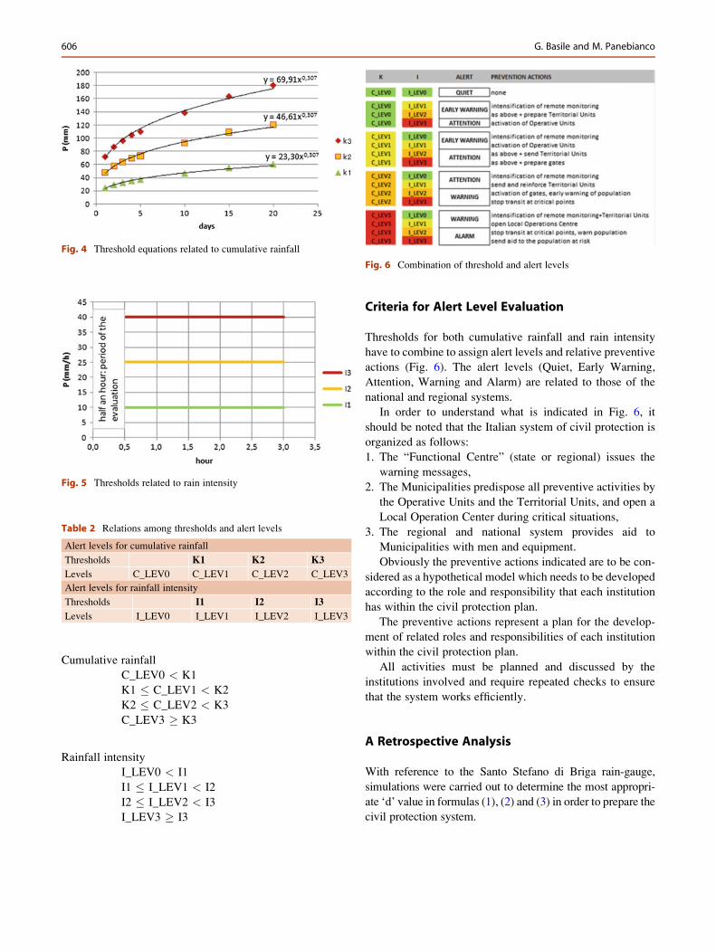
K3 ¼ 69:91�d 0:307 (1)
K2 ¼ 46:61�d 0:307 (2)
K1 ¼ 23:30�d 0:307 (3)
Triggering factors caused by rainfall intensity (mm/h) are
unknown because of inexistent historical data. However, based
on only a few events (October 25, 2007; November 15, 2008;
Fig. 1 The area affected by the storm of 1st October 2009
604 G. Basile and M. Panebianco
October 1, 2009; March 1, 2011) we can assign the following
levels (Fig. 5):
I1 ¼ 10 mm/h
I2 ¼ 25 mm/h
I3 ¼ 40 mm/h
To avoid alarm activation caused by a series of abrupt
changes in rainfall intensity, the minimum duration of the
intense event must be half an hour.
Respectively, the three thresholds identified four alert
levels (LEV0, LEV1, LEV2, LEV3), as shown in Table 2:
Fig. 2 Diagram of event of
1st October 2009
Fig. 3 Annual trend of
S. Stefano Briga rain-gauge
Table 1 Average values for cumulative rainfall from 1 to 20 consecutive days (1924–2009 years) and best fit equation
P1d P2d P3d P4d P5d P10d P15d P20d
72 87 97 105 110 139 164 181
[1] K3 ¼ 69.91*d0.307
linear form
[1’] K3 ¼ 8.89*d�3.12 logarithmic form
Experimental Alert Model for Hydrogeological Risk: A Case Study in Sicily 605
Cumulative rainfall
C_LEV0 < K1
K1 � C_LEV1 < K2
K2 � C_LEV2 < K3
C_LEV3 � K3
Rainfall intensity
I_LEV0 < I1
I1 � I_LEV1 < I2
I2 � I_LEV2 < I3
I_LEV3 � I3
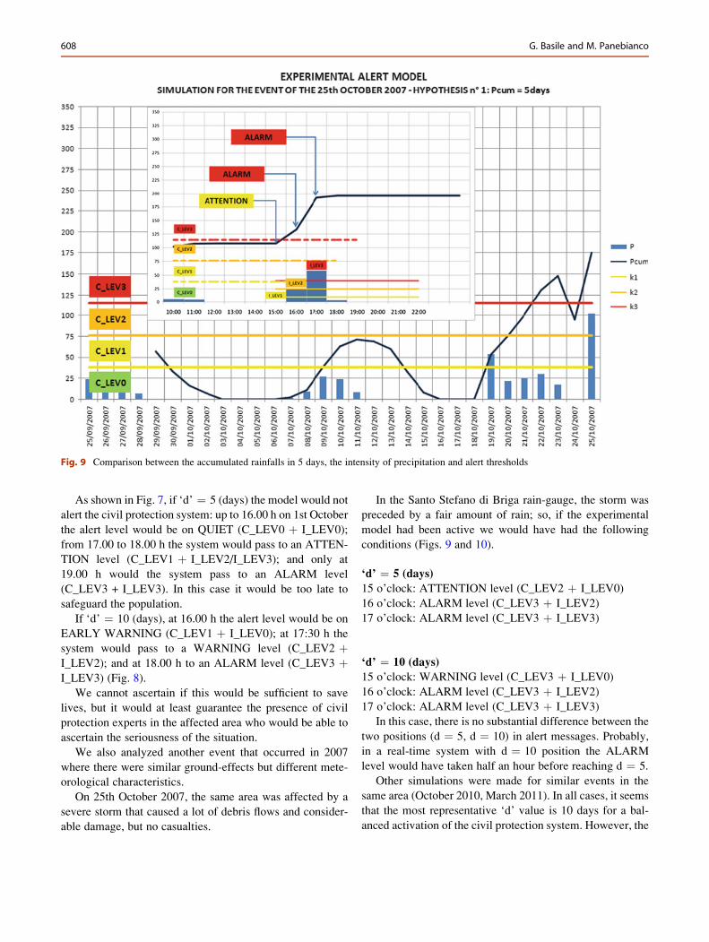
Criteria for Alert Level Evaluation
Thresholds for both cumulative rainfall and rain intensity
have to combine to assign alert levels and relative preventive
actions (Fig. 6). The alert levels (Quiet, Early Warning,
Attention, Warning and Alarm) are related to those of the
national and regional systems.
In order to understand what is indicated in Fig. 6, it
should be noted that the Italian system of civil protection is
organized as follows:
1. The “Functional Centre” (state or regional) issues the
warning messages,
2. The Municipalities predispose all preventive activities by
the Operative Units and the Territorial Units, and open a
Local Operation Center during critical situations,
3. The regional and national system provides aid to
Municipalities with men and equipment.
Obviously the preventive actions indicated are to be con-
sidered as a hypothetical model which needs to be developed
according to the role and responsibility that each institution
has within the civil protection plan.
The preventive actions represent a plan for the develop-
ment of related roles and responsibilities of each institution
within the civil protection plan.
All activities must be planned and discussed by the
institutions involved and require repeated checks to ensure
that the system works efficiently.
A Retrospective Analysis
With reference to the Santo Stefano di Briga rain-gauge,
simulations were carried out to determine the most appropri-
ate ‘d’ value in formulas (1), (2) and (3) in order to prepare the
civil protection system.
Fig. 4 Threshold equations related to cumulative rainfall
Fig. 5 Thresholds related to rain intensity
Table 2 Relations among thresholds and alert levels
Alert levels for cumulative rainfall
Thresholds K1 K2 K3
Levels C_LEV0 C_LEV1 C_LEV2 C_LEV3
Alert levels for rainfall intensity
Thresholds I1 I2 I3
Levels I_LEV0 I_LEV1 I_LEV2 I_LEV3
Fig. 6 Combination of threshold and alert levels
606 G. Basile and M. Panebianco
Fig. 7 Comparison between the accumulated rainfall in 5 days, the intensity of precipitation and alert thresholds
Fig. 8 Comparison between the accumulated rainfall in 10 days, the intensity of precipitation and alert thresholds
Experimental Alert Model for Hydrogeological Risk: A Case Study in Sicily 607
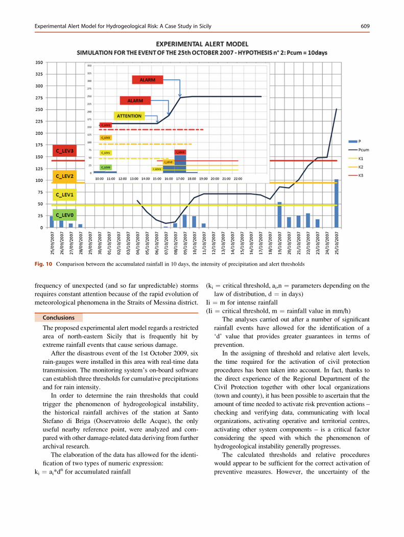
As shown in Fig. 7, if ‘d’ ¼ 5 (days) the model would not
alert the civil protection system: up to 16.00 h on 1st October
the alert level would be on QUIET (C_LEV0 þ I_LEV0);
from 17.00 to 18.00 h the system would pass to an ATTEN-
TION level (C_LEV1 þ I_LEV2/I_LEV3); and only at
19.00 h would the system pass to an ALARM level
(C_LEV3 + I_LEV3). In this case it would be too late to
safeguard the population.
If ‘d’ ¼ 10 (days), at 16.00 h the alert level would be on
EARLY WARNING (C_LEV1 þ I_LEV0); at 17:30 h the
system would pass to a WARNING level (C_LEV2 þI_LEV2); and at 18.00 h to an ALARM level (C_LEV3 þI_LEV3) (Fig. 8).
We cannot ascertain if this would be sufficient to save
lives, but it would at least guarantee the presence of civil
protection experts in the affected area who would be able to
ascertain the seriousness of the situation.
We also analyzed another event that occurred in 2007
where there were similar ground-effects but different mete-
orological characteristics.
On 25th October 2007, the same area was affected by a
severe storm that caused a lot of debris flows and consider-
able damage, but no casualties.
In the Santo Stefano di Briga rain-gauge, the storm was
preceded by a fair amount of rain; so, if the experimental
model had been active we would have had the following
conditions (Figs. 9 and 10).
‘d’ ¼ 5 (days)
15 o’clock: ATTENTION level (C_LEV2 þ I_LEV0)
16 o’clock: ALARM level (C_LEV3 þ I_LEV2)
17 o’clock: ALARM level (C_LEV3 þ I_LEV3)
‘d’ ¼ 10 (days)
15 o’clock: WARNING level (C_LEV3 þ I_LEV0)
16 o’clock: ALARM level (C_LEV3 þ I_LEV2)
17 o’clock: ALARM level (C_LEV3 þ I_LEV3)
In this case, there is no substantial difference between the
two positions (d ¼ 5, d ¼ 10) in alert messages. Probably,
in a real-time system with d ¼ 10 position the ALARM
level would have taken half an hour before reaching d ¼ 5.
Other simulations were made for similar events in the
same area (October 2010, March 2011). In all cases, it seems
that the most representative ‘d’ value is 10 days for a bal-
anced activation of the civil protection system. However, the
Fig. 9 Comparison between the accumulated rainfalls in 5 days, the intensity of precipitation and alert thresholds
608 G. Basile and M. Panebianco
frequency of unexpected (and so far unpredictable) storms
requires constant attention because of the rapid evolution of
meteorological phenomena in the Straits of Messina district.
Conclusions
The proposed experimental alert model regards a restricted
area of north-eastern Sicily that is frequently hit by
extreme rainfall events that cause serious damage.
After the disastrous event of the 1st October 2009, six
rain-gauges were installed in this area with real-time data
transmission. The monitoring system’s on-board software
can establish three thresholds for cumulative precipitations
and for rain intensity.
In order to determine the rain thresholds that could
trigger the phenomenon of hydrogeological instability,
the historical rainfall archives of the station at Santo
Stefano di Briga (Osservatroio delle Acque), the only
useful nearby reference point, were analyzed and com-
pared with other damage-related data deriving from further
archival research.
The elaboration of the data has allowed for the identi-
fication of two types of numeric expression:
ki ¼ ai*dn for accumulated rainfall
(ki ¼ critical threshold, ai,n ¼ parameters depending on the
law of distribution, d ¼ in days)
Ii ¼ m for intense rainfall
(Ii ¼ critical threshold, m ¼ rainfall value in mm/h)
The analyses carried out after a number of significant
rainfall events have allowed for the identification of a
‘d’ value that provides greater guarantees in terms of
prevention.
In the assigning of threshold and relative alert levels,
the time required for the activation of civil protection
procedures has been taken into account. In fact, thanks to
the direct experience of the Regional Department of the
Civil Protection together with other local organizations
(town and county), it has been possible to ascertain that the
amount of time needed to activate risk prevention actions –
checking and verifying data, communicating with local
organizations, activating operative and territorial centres,
activating other system components – is a critical factor
considering the speed with which the phenomenon of
hydrogeological instability generally progresses.
The calculated thresholds and relative procedures
would appear to be sufficient for the correct activation of
preventive measures. However, the uncertainty of the
Fig. 10 Comparison between the accumulated rainfall in 10 days, the intensity of precipitation and alert thresholds
Experimental Alert Model for Hydrogeological Risk: A Case Study in Sicily 609
working model, together with the poor correlation
between rainfall and mudslides, is considerable and as a
consequence “false alarms” and “missed alarms” are
possible during the inevitable initial calibration period.
These, however, will help to make the necessary
corrections to the system.
In the current absence of more sophisticated
procedures that take into account other parameters
(for example: the air temperature and the consequent
variations of the quantity of water held in the soil) which
could have an effect on the development of mudflows and
debris flows, the only other currently available instruments
of preventive analysis are those which observe rainfall
in real time. Only relatively recently has a band X meteo-
rological micro radar been installed in the area which could
help the real time monitoring of rainfall distribution.
Nonetheless, bearing in mind the predisposition to
hydrogeological instability of the area concerned and
the high level of urbanization, a suitable emergency
plan that is able to activate a timely risk prevention action
is of fundamental importance.
Acknowledgments Many thanks to Tony Lawson for the translation
of this document into English.
References
Aleotti P (2004) A warning system for rainfall-induced shallow
failures. Eng Geol 73:247–265
Ardizzone F, Basile G, Cardinali M, Del Conte S, Fiorucci F, Iovine G,
Mondini A, Moretti S, Panebianco M, Raspini F, Reichenbach P,
Rossi M, Terranova O, Casagli N, Guzzetti F (2009) Mapping
rainfall-induced landslides and inundated areas using remote sensing
technology and field surveys: the 1 Oct 2009, Messina, Sicily, event.
European Geosciences Union, General Assembly, Vienna, 19–24
Apr 2009
Basile G (2009) Rapporto sugli eventi meteo che hanno colpito la
provincia di Messina il 1 ottobre 2009. Department document:
www.protezionecivilesicilia.it
Brunetti MT, Peruccacci S, Rossi M, Luciano S, Valigi D, Guzzetti F
(2010) Rainfall thresholds for the possible occurrence of landslides
in Italy. Nat Hazards Earth Syst Sci 10:447–458
Caine N (1980) The rainfall intensity-duration control of shallow
landslides and debris flows. Geogr Ann 62A:23–27
Cannon SH, Gartner JE, Wilson RC, Bowers JC, Laber JL (2008) Storm
rainfall conditions for floods and debris flows from recently areas in
Southwestern Colorado and southern California. Geomorphology
96:250–269
Cevasco A, Sacchini A, Robbiano A, Vincenzi E (2010) Evaluation of
rainfall thresholds for triggering shallow landslides on the Genoa
municipality area (Italy): the case study of the Bisagno Valley.
Italian J Eng Geol Environ 1:35–50
Chleborad AF, Baum RL, Godt JW (2006) Rainfall thresholds for
forecasting landslides in the Seattle, Washington, area – exceedance
and probability. U.S. Geological SurveyOpen-File Report 2006-1064
Corominas J, Moya J, Hurlimann M (2002) Landslide rainfall triggers in
the Spanish Eastern Pyrenees. Mediterranean Storms. In: Proceedings
of the 4th EGS Plinius conference, Mallorca, Oct 2002
Guzzetti F, Stark CP, Salvati P (2005) Evaluation of flood and landslide
risk to the opulation in Italy. Environ Manage 36(1):15–36
Iverson RM (2000) Landslide triggering by rain infiltration. Water
Resour Res 36:1897–1910
Luino F (2008) Definizione delle soglie pluviometriche d’innesco di
frane superficiali e colate torrentizie: accorpamento per aree
omogenee. Istituto Regionale di Ricerca della Lombardia. Rapporto
finale, Milano
Zezere JL, Trigo RM, Fragoso M, Oliveira SC, Garcia AC (2008)
Rainfall-triggered landslides in the Lisbon region over 2006 and
relationships with the North Atlantic Oscillation. Nat Hazards Ear
Syst Sci 8:483–499
610 G. Basile and M. Panebianco