Landscape history of the area between Portogruaro and Caorle on the Venetian-Friulian plain (Italy).
48
Landscape history of the area between Portogruaro and Caorle on the Venetian-Friulian plain (Italy). A chronology of landscape reconstructions in four timeframes from the end of the Last Glacial Maximum up to recent times. Jochem Ypma, BSc. [email protected] April 2014 Utrecht University Department of Physical Geography Supervisor: Dr. E. Stouthamer
-
Upload
independent -
Category
Documents
-
view
0 -
download
0
Transcript of Landscape history of the area between Portogruaro and Caorle on the Venetian-Friulian plain (Italy).
Landscape history of the area between Portogruaro and Caorle on the
Venetian-Friulian plain (Italy).
A chronology of landscape reconstructions in four timeframes from the end of the Last Glacial Maximum up to recent times.
Jochem Ypma, BSc. [email protected]
April 2014
Utrecht University
Department of Physical Geography
Supervisor: Dr. E. Stouthamer
2
Table of contents
List of Figures .................................................................................................................................. 3 List of Appendices ........................................................................................................................... 3 1. Introduction ............................................................................................................................ 4 2. Research area .......................................................................................................................... 4 3. Methods .................................................................................................................................. 5
3.1. Literature research ........................................................................................................... 5 3.2. Source materials ............................................................................................................... 5 3.3. Fieldwork .......................................................................................................................... 6
4. Geomorphologic settings ........................................................................................................ 7 4.1. Initial settings (pre-Holocene) .......................................................................................... 7 4.2. Holocene development .................................................................................................... 8 4.3. Holocene depositional environments ............................................................................ 11
5. Regional demography: periodic chronology and characteristics ......................................... 15 5.1. Bronze and Iron Age ....................................................................................................... 15 5.2. Roman Era ...................................................................................................................... 16 5.3. Medieval period ............................................................................................................. 18 5.4. Modern Age .................................................................................................................... 19
6. Data analysis ......................................................................................................................... 20 6.1. Bronze and Iron Age ....................................................................................................... 21 6.2. The Roman Era ............................................................................................................... 22 6.3. Medieval Period ............................................................................................................. 24 6.4. Modern Age .................................................................................................................... 26
7. Discussion.............................................................................................................................. 31 8. Conclusions ........................................................................................................................... 33 9. Recommendations ................................................................................................................ 35
9.1. Additional methods ........................................................................................................ 35 9.2. Additional fieldwork ....................................................................................................... 36 9.3. Additional research ........................................................................................................ 36
Acknowledgments......................................................................................................................... 37 References .................................................................................................................................... 38 Appendices .................................................................................................................................... 40
3
List of Figures
Figure 1 Location of the research area ........................................................................................... 5 Figure 2 Map of the situation 6000 years B.P. ................................................................................ 9 Figure 3 Holocene stratigraphy - Venetian-Friulian plain to the Caorle Lagoon .......................... 10 Figure 4 Overview of major river courses. .................................................................................... 12 Figure 5 Fragment of a historic map (Angelo del Cortivo, 1527). ................................................ 13 Figure 6 Fragment of map in appendix 6. ..................................................................................... 23 Figure 7 The Livenza diversion project (Zendrini, 1811)............................................................... 27 Figure 8 Overview of canals dug to divert the Livenza ................................................................. 28 Figure 9 Overview of reclamations in the area. ............................................................................ 30
List of Tables
Table 1 Bronze and Iron Age archaeological sites ........................................................................ 16 Table 2 Roman era archaeological sites ....................................................................................... 17 Table 3 Medieval period archaeological sites ............................................................................... 19 Table 4 Overview of datings ......................................................................................................... 20
List of Appendices
Appendix 1 Overview map of the research area (including coring and transect locations) ........ 40 Appendix 2 Geomorphologic map of the research area (Bondesan, 2004b). .............................. 41 Appendix 3 Digital Elevation map of the research area ............................................................... 42 Appendix 4 The diversion project of the Piave (Zendrini, 1811). ................................................. 43 Appendix 5 Map # 1 Bronze and Iron Age .................................................................................... 44 Appendix 6 Map # 2 Roman Era ................................................................................................... 45 Appendix 7 Map # 3 Medieval Period ........................................................................................... 46 Appendix 8 Map # 4 Modern Age ................................................................................................. 47 Appendix 9 Transects .................................................................................................................... 48
4
1. Introduction
This report was written in the context of a Guided Research at the Department of Physical Geography of the Utrecht University. The research was supervised by Dr. E. Stouthamer. The report describes the results of a three-week field trip that took place during June 2012, combined with a literature research. The report investigates the relation between human activities and changing environmental conditions in the research area. The research combines data retrieved by the fieldwork, with literature research and previous research that includes geological, geomorphologic and archaeological fieldwork and mapping. The location of the research area is the Venetian-Friulian region in Italy, with a focus on the area in between the Livenza and Tagliamento rivers, including the cities of Portogruaro, Concordia Sagittaria and Caorle. The goal of this report is to establish a chronology of landscape reconstructions through different timeframes. This way we have tried to understand the impact of environmental conditions on human activities in the area.
To be able to investigate the relation between human activities and changing environmental conditions, we investigated and mapped these factors. First we outlined the research that had already been done in the area (Chapter 4). This material, including fieldwork data and literature resulting from previous research, was used as the base on which we continued our research. We identified the different periods of human settlements in order to establish a series of timeframes (Chapter 5). Research on previous literature and archaeological data provided the major archaeological characteristics of the region. Subsequently, we analyzed the environmental settings for each of the timeframes and we created a context in which we placed the archaeological findings (Chapter 6). However, the corings that were performed in the context of this research have been the decisive factor and were used to reconstruct the geomorphologic settings.
In the end, the combination of data resulted in a series of maps. These maps represent the evolution of the landscape in means of geomorphologic data, throughout the timeframes that were set up. By combining each of these maps with archaeological data of the specific timeframes, we constructed an overview of human activities. Eventually we created an overview of the impact of changes in environmental conditions on human activities (and vice versa).
On top of the research goals described above, this report is used to make some recommendations for further research in the area. We pose some recommendations, to improve the combination of archaeological and geomorphological research. This includes additional locations and methods that might be used during new fieldtrips and research about the area.
2. Research area
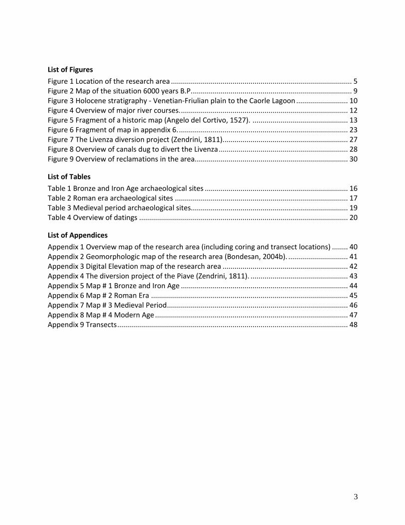
This report is about the research that was done along the coast in the Venetian-Friulian region in Northern Italy. The research area is bordered by the Adriatic Sea in the south, the Tagliamento river in the East, and the Livenza river in the West. In the north, the area stretches up to the city of Portogruaro. Other cities within the research area include Caorle and Concordia Sagittaria. The main geomorphologic features include beach ridges, the Caorle lagoon and the Dolomitic mountains (situated northwestern), where a series of rivers originates from. The most important rivers are the (palaeo) channels of the Tagliamento; a 7th order river originating from the Dolomites (Monte Mauria) with a length of 175 kms, a watershed of almost 3000 km2 and an annual average discharge (a.a.d.) of 100 m3/s (Spaliviero, 2003; Tockner et al., 2003). The second river of the area is the Livenza, with a length of 112 kms, a watershed of approximately 2200 km2, and an a.a.d. of 85 m3/s (Distretto Idrografica delle Alpi Orientali, 2010). Other rivers in the area include the Lemene (45 kms long, a.a.d. 30 m3/s) and the Loncon (30 kms long, a.a.d. 5 m3/s) rivers which are both groundwater-fed rivers (Distretto Idrografica delle Alpi Orientali, 2010). The location of the research area is shown in Figure 1 and an overview map (Appendices
5
Appendix 1) shows the research area with toponyms of settlements, rivers and other landscape elements in it.
Figure 1 Location of the research area The area in between Caorle and Portogruaro is located within the Venetian-Friulian region in Northern Italy, along the Adriatic coast (Google Maps).
3. Methods
3.1. Literature research
Previous information published about the research area includes publications about the geomorphologic settings throughout the Late Glacial Maximum (Fontana et al., 2010; Marocco, 1991; Monegato et al., 2007; and others) to Holocene and recent history of the area (Amorosi et al., 2008; Antonioli et al., 2009; Carton et al., 2009; Fontana et al., 2008; Galassi & Marocco, 1999; Lambeck et al., 2004; and others), and about the demographic developments in the region from Bronze and Iron Ages and onward (Asta et al., 2012; Bertollo, 2001; Fontana & Pessina, 2007; Zendrini, 1811; and others). This literature was used to sketch the background and genesis of the area and describe its Holocene development. Moreover, it was used to set up a chronology of human settlements throughout history.
We should however be aware of the fact that the area has only been investigated by a relative small group of scientists of Padova University. Additional research performed by other institutions, such as Utrecht University, should review the findings that have been done so far. This way experts can compare the research area with similar regions, to place it in a broader context.
3.2. Source materials
Several other researches were done in the area in which multiple coring sessions were performed and published. These mainly include the papers of Antonioli et al. (2009), Fontana et al. (2008, 2010), Marocco (1991), Galassi & Marocco (1999). Moreover datings were performed on some of these corings, which were also published. These corings and datings help us to reconstruct the landscape and combined with the datings the findings of landmarks can be placed within the certain timeframes.
Archaeological data from excavations that took place in the area were collected by Bondesan et al. (2004a, 2004b). Together with archaeological data that were published elsewhere, we used these findings in this research. Moreover, we plotted the archaeological findings for each of the timeframes in a series of maps.
6
Maps that were used can be divided into two different types. The first of these include a series of geological and geomorphological maps that are used to reconstruct the initial settings of the landscape and its development during the Holocene (Bondesan et al., 2004b). These maps are also used to plot the archaeological findings in the research area. Besides of these recent maps, also some older maps are used. These maps are mainly used to get insight on the area and what the landscape looked like at certain moments throughout human history.
In contradiction to the recent maps that were used in the research, the use of historic maps requires some additional investigation. These maps are always funded and published by certain clients. These can include a certain government; for example hydrologic maps, strategic war maps, and land reclamation projects, or an individual; for example judicial conflict maps, land owners, and artists. These varying goals may influence the usability of the map for this research and therefore good care is taken while interpreting these maps.
3.3. Fieldwork
Based on supporting literature research, a series of topographical and digital elevation maps was printed, provided with locations of cross sections along which the corings would be performed (Appendix 1). These maps were combined with use of a GPS device to determine the exact location of the boreholes. A set of two cross-sections was assigned to each couple of students that were instructed to perform the corings.
3.2.1 Transects and corings
A series of transects was set up parallel to the coastline, which is east-west orientated (Appendix 1). The locations of the cross-sections were based upon geomorphological maps and personal communications with Dr. Fontana. The cross-sections were located in such a way that students were likely to find representative results; preferably the transects cut into the lithological units and structures within the subsurface . This way the majority of the channels are perpendicularly cut into. The cross-sections are each represented as a series of dots in a line on each of the resulting maps (Appendix 1). Along the cross-sections corings (with varying depths, see below) were performed with approximately 100 meters in between two different coring locations.
To perform the corings, the following drilling equipment was used. Until the groundwater table depth was reached, the Edelman hand auger was used. Below the groundwater table, the Edelman was combined with a gauge, enabling drillings up to 15 m deep (Van den Meene et al., 1979; Oele et al.,1983). In the case of the encountering of a sand or fine gravel body (under the groundwater table), the Van der Staay suction corer was used (Van de Meene et al., 1979).
The sediment cores were described in the field. At 10 cm intervals the texture, color, organic material content, gravel content, median grain size, groundwater occurrence, content of iron and calcium carbonate, abundance of shell and other characteristics were described (Berendsen and Stouthamer, 2001). A 5% hydrochloric acid solution was used to determine the amount of calcareous matter. The grain size was determined using a sand ruler, and in the case of clayey samples, by biting on it.
All corings were performed by students participating in the second year bachelor field trip lowland genesis. Subsequently, all corings were described and interpreted by these students. The resulting data, including borehole data, cross-sections, and some maps, were analyzed and used for this research. On top of the normal interpretation, some features were encountered by the students that were specific for the research area; these were the abundance of certain shell species, the Roman peat layer, and the Caranto layer (Lambeck et al., 2004; Personal communications, Dr. A. Fontana, 2012). The Cerastoderma Glaucum shell is typical for lagoonal deposits along the Italian coast and is associated with lagoonal deposits of a depth of zero to two meters relative to mean sea level. The Roman peat layer is a
7
layer of peat found throughout the research area and used to link to transects with each other. Characteristics of the Caranto layer are described in chapter 4.
The fieldwork on which this research is largely based, was performed by bachelor students on their 2nd year fieldtrip. Although the students had been extensively prepared and they have been working under professional guidance, there are some matters that should be taken into account when using the fieldwork data. At first these include the method of interpretation, annotation, and analysis of the coring data by the students. This can differ for each of the groups and should therefore be interpreted carefully.
The amount of corings performed by each of the students differs, therefore the resolution varies for each of the transects. Moreover, the distance between two adjacent corings varies as at some locations corings were not allowed, logistically not possible, or just skipped. Due to the variety in coring resolution, additional corings might be needed to discover and detect landscape features that are not yet known.
3.2.2 Museum visit
Besides of the coring activities, several museums were visited during the fieldwork. At first there were the national Museum of Concordia and the Civic Palace. In this museum a large collection of Roman remnants is exposed, describing the Roman history of Concordia Sagittaria and its surrounding area. The excavations, on top of which the Basilica is build, were also visited. Here the remnants of a burial place were found, together with a bridge and thermal baths, including findings of pavements, mosaics, and potsherds.
The other museum that was visited was the “TerredAcque” (Land and water) exhibition in the Bafile Cultural Centre in Caorle (Asta et al., 2012). This exhibition represented a preview of the National Sea-Archaeology museum, which is to be realized soon. The exhibition shows the history (from Roman times on) and development of the city of Caorle. Its main issue is the relationship of Caorle and its surrounding waters; changing environment around Caorle, its role as a transit harbour, and its struggling to be safe for rising waters.
4. Geomorphologic settings
In this chapter we sketch the geomorphologic settings in the Venetian-Friulian region throughout the Holocene, starting with the late-LGM conditions described before. Based on ancient maps, literature research and data obtained by fieldwork, we have outlined the major geomorphologic system of the area. To do so we discuss the major geomorphologic units on the map and the dynamics that are ongoing in the region. For each of the major units, including the lagoon, the rivers, and the coastal area, we have described the settings and consider the changes that these were subject to throughout the Holocene.
4.1. Initial settings (pre-Holocene)
Earliest depositions on the Venetian-Friulian plain date from the Pliocene Era, when the area was submerged under the Adriatic Sea and eroded material was deposited on the seabed (Fontana et al., 2008, 2010). Subsequently a phase of alternating transgressive and regressive sequences caused the deposition of shallow-marine (on the present day plain) and continental deposits (on the present day coastal areas) during the middle and late Pleistocene (Fontana et al., 2010). Then, during the Saalien and Weichselien glacials alluvial aggradation took place; especially the Last Glacial Maximum (LGM) was characterized by high deposition rates. This period, lasting from 25.000 to 14.000 years B.P., caused the main phase of alluvial sedimentation in the area (Fontana et al., 2008, 2010). During the first phase of the LGM, the Pleniglacial (30.000 to 20.000 years B.P.), a differentiation between the higher and the
8
lower plains took place. These plains were formed by the fluvioglacial outwash of the Alps. Close to the Prealps the upper plains were formed by gravels deposited by braided rivers, whereas further away from the Alps the lower plains were formed by clays and silts deposited by (semi-) meandering rivers (Fontana et al., 2008, 2010).
When the glaciation ended (during the cataglacial phase, 20.000-17.000 years BP), fluvial systems started to entrench in the upper part of the plain. Decrease of sediment supply by rivers led to an increase in stream power and river downcutting (Fontana, 2008). Most of the alluvial systems in the plain were abandoned and deactivated, only in the area of the present lagoon some fluvial branches were activated causing fluvial ridges to build up. However, large areas of the plains remained unaffected by sedimentation until the existing valleys were submerged by the sea, due to sea level rise during the Holocene (Figure 2, p. 9)(Fontana et al., 2008, 2010).
Alluvial sediments forming the coastal plain date from the LGM and were deposited during the phase of sea level lowstand. Later, these were buried by lagoonal sediments that were deposited during phase of sea level highstand in the (late) Holocene. The uppermost layer of the underlying alluvial deposits is consolidated, harder, and more resistant than underlying deposits. This layer is known as the “Caranto” (after “caris”, Latin for stone) and was called a palaeosol of overconsolidated clay, formed by the interaction between alluvial sediments and organic matter (Donnici et al., 2011).
4.2. Holocene development
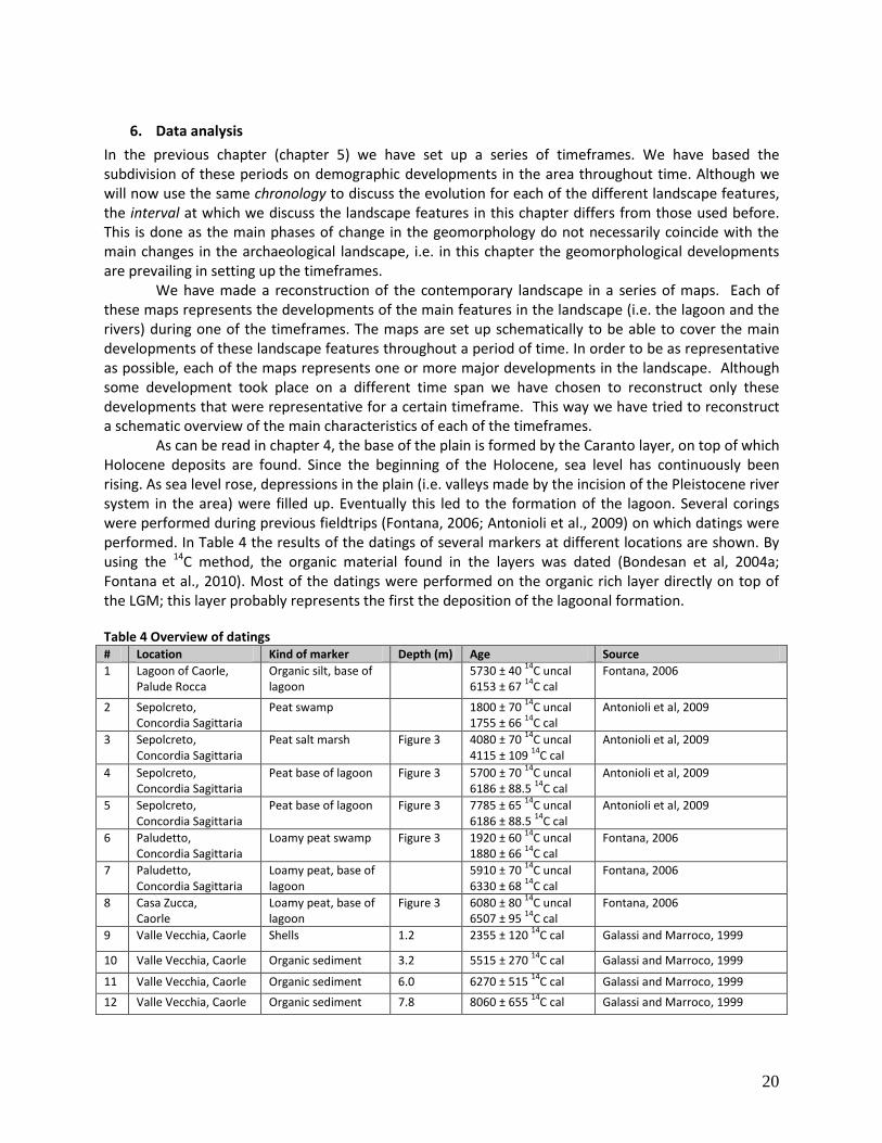
When the LGM had ended, the research area was characterized by different types of landscapes due to the experience of strong environmental changes related to relative sea-level variations and the influence of rivers. 20.000 Years B.P. sea level was around 120 m below present while 7.000 years B.P., sea-level had risen up to 5 m below present level (Amorosi et al., 2008; Antonioli et al., 2009; Galassi & Marocco, 1999). Between 12.000 and 9.000 years B.P. the Tagliamento river passed the area of the present city Concordia Sagittaria (Appendices Appendix 1, p.40) forming two incisions with a maximum depth of 20 meters (Appendix 4, Bondesan et al, 2004a). During the Atlantic (7.500 – 5.000 years B.P.) eustatic base level rise declined, creating the conditions for the formation of a brackish environment at the border between the plain and the sea, enclosed between the rivers Tagliamento and Livenza (Galassi & Marocco, 1999). Since then relative sea-level has kept on rising, until the present sea-level was reached, causing the formation of the Caorle lagoon on its way. Until 4000 – 3000 years B.P. only the depressions were affected by deposition, after that aggradation started to take place throughout the area (Antonioli et al. 2009). First, the rising sea level caused the depressions on the lower plain to be filled up, then the brackish environment extended until it reached the city of Portogruaro, where it subsequently filled up the incisions (Galassi & Marocco, 1999; Antonioli et al. 2009).
4.2.1 Phase of transgression
From the period of the first settlers (during Bronze and Iron Age) and ongoing during the Roman Era, the morphological settings in the area were stabilizing. However, in between the 5th and the 11th century there was a phase of transgression. During this period multiple flooding events took place in the region, caused by an increased discharge of the rivers from the Alps and the rise of the relative sea level (Asta et al., 2012).

9
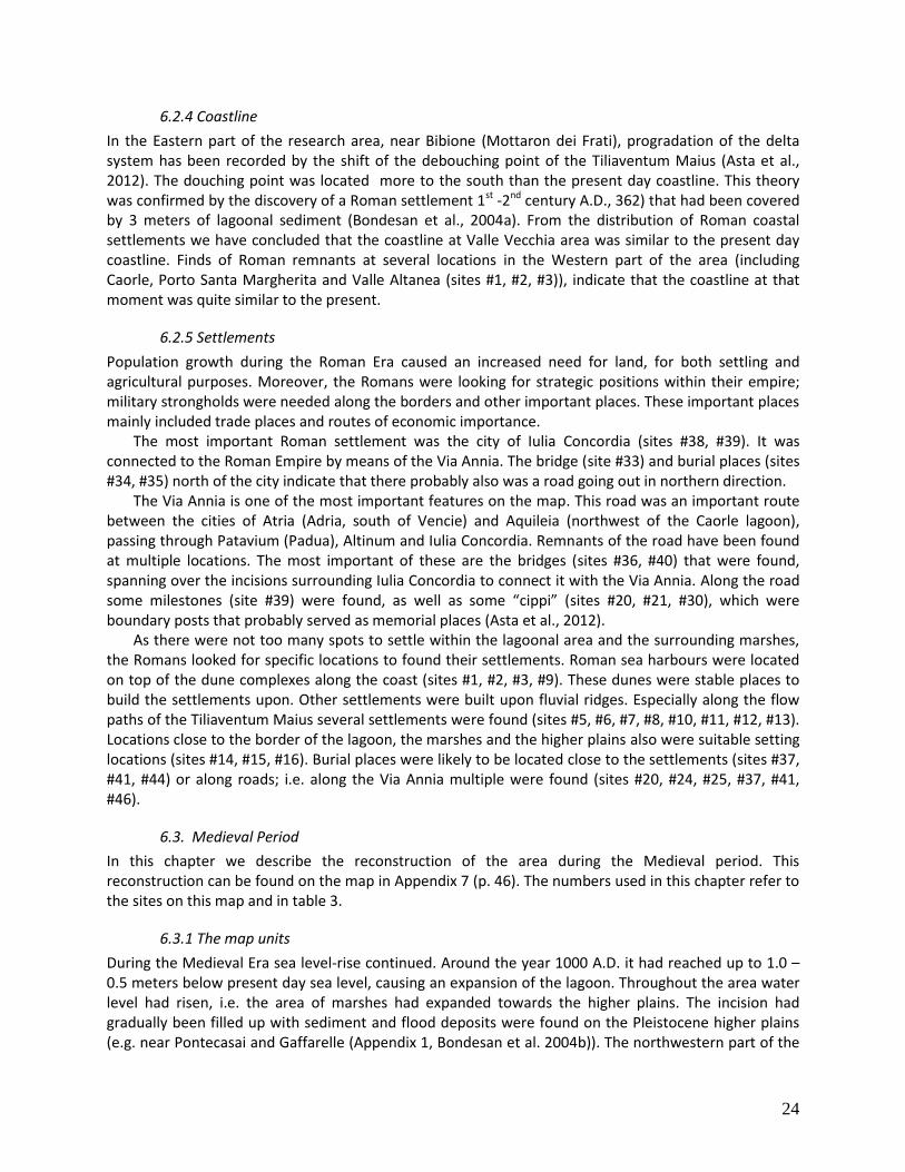
Figure 2 Map of the situation 6000 years B.P.
10
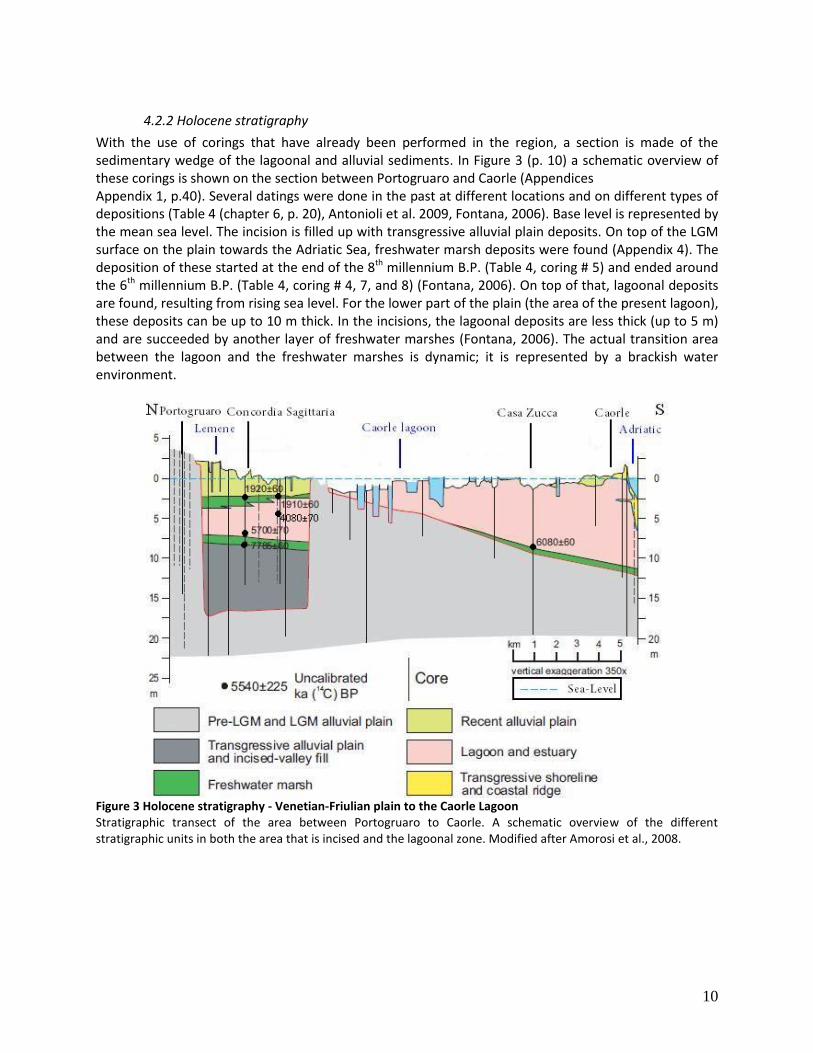
4.2.2 Holocene stratigraphy
With the use of corings that have already been performed in the region, a section is made of the sedimentary wedge of the lagoonal and alluvial sediments. In Figure 3 (p. 10) a schematic overview of these corings is shown on the section between Portogruaro and Caorle (Appendices Appendix 1, p.40). Several datings were done in the past at different locations and on different types of depositions (Table 4 (chapter 6, p. 20), Antonioli et al. 2009, Fontana, 2006). Base level is represented by the mean sea level. The incision is filled up with transgressive alluvial plain deposits. On top of the LGM surface on the plain towards the Adriatic Sea, freshwater marsh deposits were found (Appendix 4). The deposition of these started at the end of the 8th millennium B.P. (Table 4, coring # 5) and ended around the 6th millennium B.P. (Table 4, coring # 4, 7, and 8) (Fontana, 2006). On top of that, lagoonal deposits are found, resulting from rising sea level. For the lower part of the plain (the area of the present lagoon), these deposits can be up to 10 m thick. In the incisions, the lagoonal deposits are less thick (up to 5 m) and are succeeded by another layer of freshwater marshes (Fontana, 2006). The actual transition area between the lagoon and the freshwater marshes is dynamic; it is represented by a brackish water environment.
Figure 3 Holocene stratigraphy - Venetian-Friulian plain to the Caorle Lagoon Stratigraphic transect of the area between Portogruaro to Caorle. A schematic overview of the different stratigraphic units in both the area that is incised and the lagoonal zone. Modified after Amorosi et al., 2008.
11
4.3. Holocene depositional environments
4.3.1 The Tagliamento river
In the fourth millennium B.P., the Tagliamento river consisted of a single channel up to Lugugnana (Figure 4, p.12), where it bifurcated to two branches. The main channel, called the Tiliaventum Maius in Roman times, flowed through Vado (Appendices Appendix 1, p. 40) and debouched nearby Valle Vecchia (Appendices Appendix 1). At this point there had been a delta system which was eroded during Medieval times (from the 6th century A.D. until the 10th century A.D.). The other channel, which initially was smaller, was called the Tiliaventum Minus and flowed through Cesarolo (Figure 4) and then joined the present path of the Tagliamento (Figure 4). The location of its delta was close to the present delta, near Mottaron dei Frati (Appendices Appendix 1), where dune ridges were found (Asta et al., 2012).
In between the 6th and 10th century A.D. a series a floods (associated with the period of transgression) had a massive impact on the rivers in the area, causing changes in geographical and geomorphological settings. The delta system developed by the Tiliaventum Minus at Valle Vecchia (Figure 4) was probably eroded by these floods (Asta et al., 2012). Eventually the increased discharge led to an avulsion; in the 6th century A.D. the Tagliamento river changed its path, a new channel, which was gradually activated, developed along the path of the present Tagliamento river. Before the former path of the Tagliamento river was fully deactivated, it partly shifted its path in western direction; it now flowed towards Concordia (Figure 4). This temporary channel, which existed of multiple branches, has only been active for a few centuries (6th – 10th century A.D.) but while passing through the area of Concordia, it had buried some parts of the city and silted up the depressions around it. Towards the 10th century A.D. both the newly developed path towards Concordia and the path of the Tiliaventum Maius, were deactivated and progressively abandoned in favor of the new path (Figure 4) (Bondesan et al., 2004a, Bondesan et al., 2004b). The old channel of the Tiliaventum Maius has partly remained active until the 8th century A.D. Later, during the 17th to the 19th century the channel has been used again during times of flood of the Tagliamento river, which is witnessed by sand layers that were found and dated (Bondesan et al., 2004a).
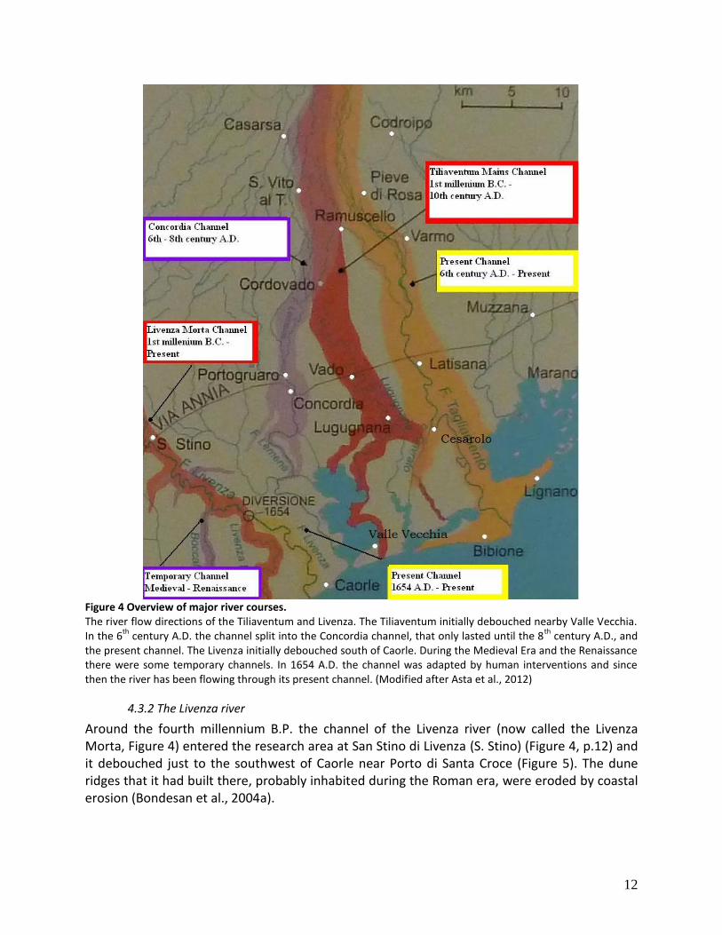
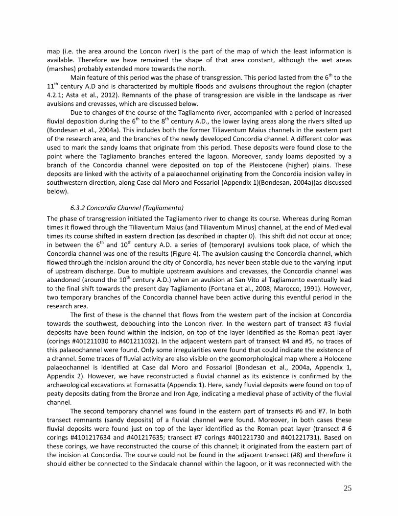
12
Figure 4 Overview of major river courses. The river flow directions of the Tiliaventum and Livenza. The Tiliaventum initially debouched nearby Valle Vecchia. In the 6
th century A.D. the channel split into the Concordia channel, that only lasted until the 8
th century A.D., and
the present channel. The Livenza initially debouched south of Caorle. During the Medieval Era and the Renaissance there were some temporary channels. In 1654 A.D. the channel was adapted by human interventions and since then the river has been flowing through its present channel. (Modified after Asta et al., 2012)
4.3.2 The Livenza river
Around the fourth millennium B.P. the channel of the Livenza river (now called the Livenza Morta, Figure 4) entered the research area at San Stino di Livenza (S. Stino) (Figure 4, p.12) and it debouched just to the southwest of Caorle near Porto di Santa Croce (Figure 5). The dune ridges that it had built there, probably inhabited during the Roman era, were eroded by coastal erosion (Bondesan et al., 2004a).
13
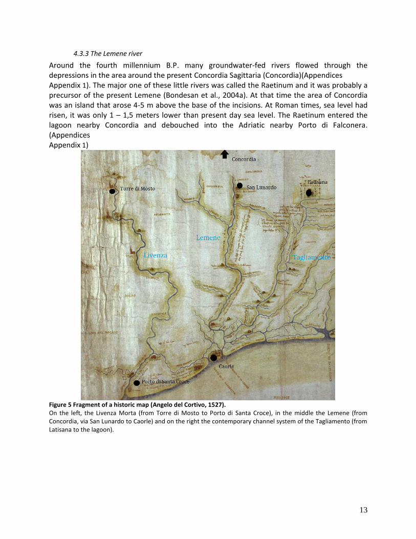
4.3.3 The Lemene river
Around the fourth millennium B.P. many groundwater-fed rivers flowed through the depressions in the area around the present Concordia Sagittaria (Concordia)(Appendices Appendix 1). The major one of these little rivers was called the Raetinum and it was probably a precursor of the present Lemene (Bondesan et al., 2004a). At that time the area of Concordia was an island that arose 4-5 m above the base of the incisions. At Roman times, sea level had risen, it was only 1 – 1,5 meters lower than present day sea level. The Raetinum entered the lagoon nearby Concordia and debouched into the Adriatic nearby Porto di Falconera. (Appendices Appendix 1)
Figure 5 Fragment of a historic map (Angelo del Cortivo, 1527). On the left, the Livenza Morta (from Torre di Mosto to Porto di Santa Croce), in the middle the Lemene (from Concordia, via San Lunardo to Caorle) and on the right the contemporary channel system of the Tagliamento (from Latisana to the lagoon).
14
4.3.4 The Caorle lagoon
Until the fourth millennium B.P. the coast was wave-dominated, creating a barrier coast. Barrier coasts are formed by waves during a period of gradual sea level rise. When transgression rates started to increase, tidal inlets arose in between the barriers, allowing a lagoon to form inland.
The Livenza and Tagliamento rivers are the main contributors to the shape of this lagoon. The formation and maintenance of the lagoon is a result of the interaction and balance between the input of water and sediment. This balance is regulated by the sea level of the Adriatic Sea and the water and sediment input of both the Livenza and the Tagliamento rivers. The largest part of the different Tagliamento channels debouched to the East of the Caorle lagoon, close to the city of Bibione (Appendices
Appendix 1). The temporary channel that flowed towards Concordia, and some channels of the Tiliaventum Maius channel flowed through the lagoon. However, the Livenza has always flowed through the lagoon providing the sediment supply to maintain the existence of the lagoon. Around the second millennium B.P. sea level used to be 1 – 1,5 meters lower than present day sea level. The lagoon had a shape that was quite similar to the present day shape, but it had a smaller extent towards the mainland. This shape remained like this until in the 4th – 5th century A.D the hydrology in the region changed due to the phase of transgression (Asta et al., 2012).
15
5. Regional demography: periodic chronology and characteristics
Based on the developments of the landscape throughout time, from the end of the LGM up to present times, we have set up a series of timeframes. A set of four timeframes was chosen, each representing a period with specific characteristics. The first of these are the Bronze Age and Iron Age, representing the period starting with the first settlers in the area, ending with the arrival of the Romans. The second timeframe is defined by the period that the Romans have been active in the region. The third timeframe is defined by the Medieval Era, this is the most diverse period as it describes the regional activities from the early until the late Medieval. The final timeframe represents the most recent era; that is the period in which the human impact on the landscape has become important. For each of these timeframes we have outlined the major landmarks and characteristic landscape features; the archaeological findings were listed in separate tables. The overview of characteristics landscape features is based on the interpretation of historic maps, literature research, and data made available by local museums.
5.1. Bronze and Iron Age
The oldest archaeological remnants that were found in the research area date back to the last centuries of the second millennium B.C. These remains include wooden elements used for construction of houses and craft platforms. During the Final Bronze Age and Early Iron Age (1100 B.C.) the first people started to permanently settle on the Venetian-Friulian plain (Ridgway, 1988). These first settlers belonged to the Proto-Villanovan Culture, they had Central - East European roots and were influenced by Greek traders (Randall-MacIver, 1924; Ridgway, 1988). Besides of the introduction of iron-working to the area, the Villanovans were known to cremate their dead and burying the ashes in pottery urns (Randall-MacIver, 1924).
5.1.1 Concordia Sagittaria
At the location of the present city of Concordia Sagittaria, settlements have been found dating back to final Bronze Age (10th century B.C.) located directly on top of the LGM in between two Tagliamento incisions (#5, #6, #7, #8 (Table 1, p. 16)). In the southern part of the city of Concordia Sagittaria nearby Fornasatta (#3, #4 (Table 1)), an excavation has been performed that revealed the remnants of a settlement dating back to Late Bronze Age (Bertelle et al., 2000). The remnants of this settlement are covered by typical lagoonal sediments, indicating that the settlers had abandoned this site before the Early Iron Age (Bondesan et al., 2004a).
5.1.2 San Gaetano
Nearby Casa Zucca excavations have revealed the existence of the Bronze Age settlement of San Gaetano (#1 (Table 1)), located 4 km to the northeast of the present center of the city of Caorle (Asta et al., 2012). It has been active during the 14th to the 12th century B.C. and was built on wooden poles and platforms on land reclaimed from the swampy underground. The area around the site was deforested and intensely farmed. The settlement was located at the coastline on the edge of the lagoon, at the border between the freshwater swampy environment and the mouth of the Livenza (Bondesan et al., 2004a, 2004b). Although the intrusion of brackish water caused the settlers to abandon the areas closest to the coast (leaving behind several wooden structures) the settlement remained active up to 11th century B.C. However, when the amount of rising seawaters increased, the area was eventually definitely abandoned. Another period of inhabitation started at the beginning of the Iron Age, when the fresh water lagoon had expanded (Asta et al., 2012).
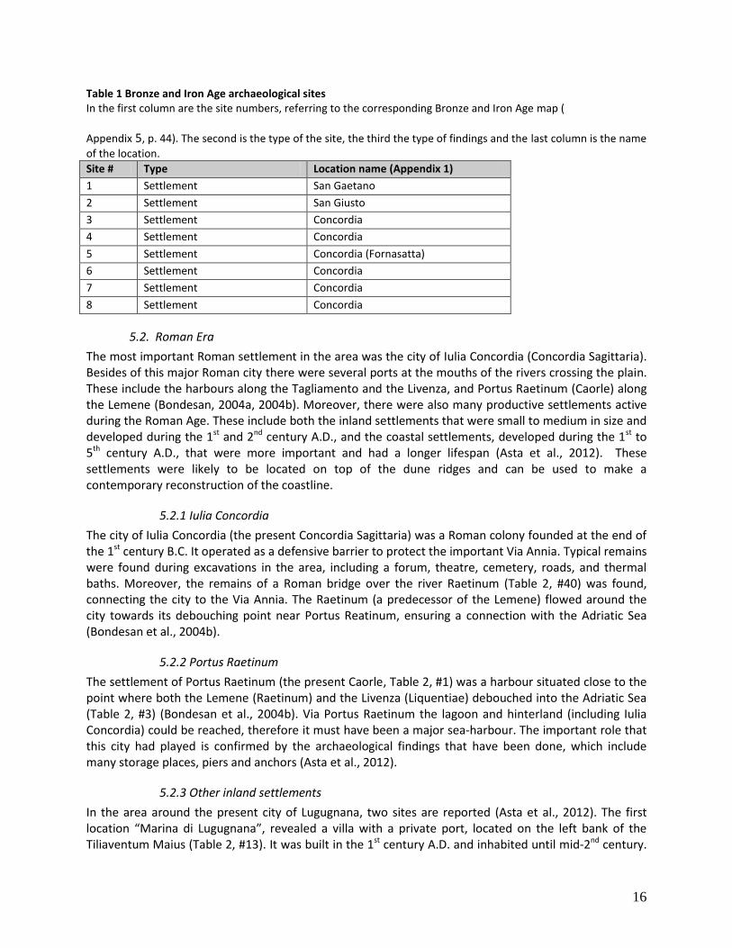
16
Table 1 Bronze and Iron Age archaeological sites In the first column are the site numbers, referring to the corresponding Bronze and Iron Age map (
Appendix 5, p. 44). The second is the type of the site, the third the type of findings and the last column is the name
of the location.
Site # Type Location name (Appendix 1)
1 Settlement San Gaetano
2 Settlement San Giusto
3 Settlement Concordia
4 Settlement Concordia
5 Settlement Concordia (Fornasatta)
6 Settlement Concordia
7 Settlement Concordia
8 Settlement Concordia
5.2. Roman Era
The most important Roman settlement in the area was the city of Iulia Concordia (Concordia Sagittaria). Besides of this major Roman city there were several ports at the mouths of the rivers crossing the plain. These include the harbours along the Tagliamento and the Livenza, and Portus Raetinum (Caorle) along the Lemene (Bondesan, 2004a, 2004b). Moreover, there were also many productive settlements active during the Roman Age. These include both the inland settlements that were small to medium in size and developed during the 1st and 2nd century A.D., and the coastal settlements, developed during the 1st to 5th century A.D., that were more important and had a longer lifespan (Asta et al., 2012). These settlements were likely to be located on top of the dune ridges and can be used to make a contemporary reconstruction of the coastline.
5.2.1 Iulia Concordia
The city of Iulia Concordia (the present Concordia Sagittaria) was a Roman colony founded at the end of the 1st century B.C. It operated as a defensive barrier to protect the important Via Annia. Typical remains were found during excavations in the area, including a forum, theatre, cemetery, roads, and thermal baths. Moreover, the remains of a Roman bridge over the river Raetinum (Table 2, #40) was found, connecting the city to the Via Annia. The Raetinum (a predecessor of the Lemene) flowed around the city towards its debouching point near Portus Reatinum, ensuring a connection with the Adriatic Sea (Bondesan et al., 2004b).
5.2.2 Portus Raetinum
The settlement of Portus Raetinum (the present Caorle, Table 2, #1) was a harbour situated close to the point where both the Lemene (Raetinum) and the Livenza (Liquentiae) debouched into the Adriatic Sea (Table 2, #3) (Bondesan et al., 2004b). Via Portus Raetinum the lagoon and hinterland (including Iulia Concordia) could be reached, therefore it must have been a major sea-harbour. The important role that this city had played is confirmed by the archaeological findings that have been done, which include many storage places, piers and anchors (Asta et al., 2012).
5.2.3 Other inland settlements
In the area around the present city of Lugugnana, two sites are reported (Asta et al., 2012). The first location “Marina di Lugugnana”, revealed a villa with a private port, located on the left bank of the Tiliaventum Maius (Table 2, #13). It was built in the 1st century A.D. and inhabited until mid-2nd century.
17
A few kilometers upstream, also on the left bank, another villa and a necropolis were found (Table 2, #12). Downstream of Lugugnana traces of Roman activities were found at Portus Tiliaventum Maius, the harbour where the Tiliaventum debouched into the Adriatic Sea (Asta et al., 2012). Besides of the harbours along the above mentioned Tagliamento and Lemene, there was also Portus Liquentiae (the present Torre di Mosto), located at the debouching point of the Livenza (Asta et al., 2012).
5.2.4 Coastal settlements
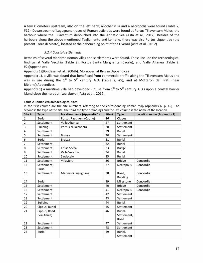
Remains of several maritime Roman villas and settlements were found. These include the archaeological findings at Valle Vecchia (Table 2), Portus Santa Margherita (Caorle), and Valle Altanea (Table 2, #2)(Appendices Appendix 1)(Bondesan et al., 2004b). Moreover, at Brussa (Appendices Appendix 1), a villa was found that benefitted from commercial traffic along the Tiliaventum Maius and was in use during the 1st to 5th century A.D. (Table 2, #5), and at Motteron dei Frati (near Bibione)(Appendices Appendix 1) a maritime villa had developed (in use from 1st to 5th century A.D.) upon a coastal barrier island close the harbour (see above) (Asta et al., 2012). Table 2 Roman era archaeological sites In the first column are the site numbers, referring to the corresponding Roman map (Appendix 6, p. 45). The second is the type of the site, the third the type of findings and the last column is the name of the location.
Site # Type Location name (Appendix 1) Site # Type Location name (Appendix 1)
1 Burial Portus Raetinum (Caorle) 26 Cippus
2 Settlement Valle Altanea 27 Settlement
3 Building Portus di Falconera 28 Settlement
4 Settlement 29 Burial
5 Settlement Brussa 30 Settlement
6 Burial Brussa 31 Burial
7 Settlement 32 Burial
8 Settlement Fossa Secca 33 Bridge
9 Settlement Valle Vecchia 34 Burial
10 Settlement Sindacale 35 Burial
11 Settlement Villaviera 36 Bridge Concordia
12 Settlement, Burial
37 Necropolis Concordia
13 Settlement Marina di Lugugnana 38 Road, Building
Concordia
14 Burial 39 Milestone Concordia
15 Settlement 40 Bridge Concordia
16 Settlement 41 Necropolis Concordia
17 Settlement 42 Settlement
18 Settlement 43 Settlement
19 Building 44 Burial
20 Cippus, Burial 45 Settlement
21 Cippus, Road (Via Annia)
46 Burial, Settlement, Road
22 Settlement 47 Settlement
23 Settlement 48 Settlement
24 Burial 49 Burial, Settlement
18
25 Burial
5.3. Medieval period
When the Roman domination ended and the Pax Romana declined at the end of the 5th century A.D., peace and stability were gone in the region. Due to periodic invasions from barbarians, people searched for safer places to settle; they fled towards cities and the lagoonal area (Bertollo, 2001). Moreover, some major floods had led to a change of path of some rivers. Out of strategic considerations, Venetians diverted discharge through the Livenza channel to prevent the siltation of the Venice lagoon (De Nardi, 2009).
5.3.1 Portogruaro
Starting from a small settlement, existing of only a castle, the city of Portogruaro (Appendix 1) gradually expanded. In 1140 A.D. the local bishop gave fisherman the right to settle and build a river port. The main phase of activity started in 1420 A.D., when the city became part of the Republic of Venice and it could expand economically.
5.3.2 Concordia Sagittaria
The ancient Roman city of Iulia Concordia (Concordia Sagittaria)(Appendix 1) had lost its strategic position in between the branches of the Lemene. A series of floods of the Tiliaventum Maius, a temporary secondary branch of the river that flowed around Iulia Concordia, caused the depressions to be silted up and a part of the city to be buried. Combined with the Barbarian attacks, this led to abandonment of the city between the 5th and 6th century (Asta et al., 2012). Later, under influence of Christianity, the city gradually expanded and its commercial activities bloomed again. Remains of this period include the Basilica (4th century), a baptistery and the cathedral that still exists (both from the 10th – 11th century).
5.3.3 Caorle
Due to the crisis in the Roman colony of Iulia Concordia between the 5th and 6th century and in need of a stronghold in the area of the Roman harbour Portus Raetinum, Caorle was born (Appendix 1). Archaeological excavations indicate the first settling during the 4th and 5th century and Caorle (Caprulae) was first mentioned in a document from 840 A.D. Several protection measures were found to defend the land from erosion caused by the tide and rising waters, including dikes and barriers made of wood, stones and wicker weave (Asta et al., 2012). Defensive works to protect the city from barbarian attacks were found only on the seaside of the city; on the inland side the presence of the sheltered lagoon functioned as protection (Asta et al., 2012).
5.3.4 Other settlements
Besides of the cities described above, not many settlements were present in the region during the Medieval era. However, a few settlements existed, mostly built upon the ridges of (abandoned) rivers and other relative high places. These include the settlements at Lugugnana, San Giacomo, Villaviera, Viola, San Lunardo and San Giorgio di Livenza (Appendix 1). Moreover, some trade points were active, just as some monasteries (at Santa Croce and at Santa Margherita)(Appendix 1).
19
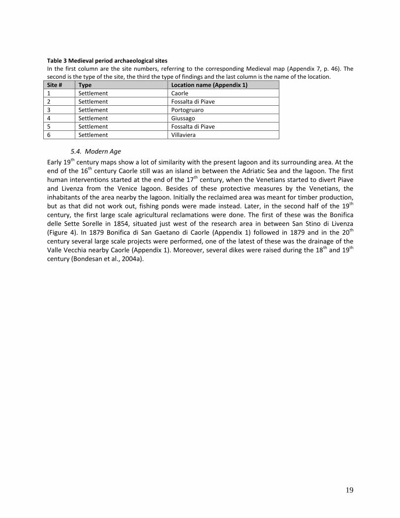
Table 3 Medieval period archaeological sites In the first column are the site numbers, referring to the corresponding Medieval map (Appendix 7, p. 46). The second is the type of the site, the third the type of findings and the last column is the name of the location.
Site # Type Location name (Appendix 1)
1 Settlement Caorle
2 Settlement Fossalta di Piave
3 Settlement Portogruaro
4 Settlement Giussago
5 Settlement Fossalta di Piave
6 Settlement Villaviera
5.4. Modern Age
Early 19th century maps show a lot of similarity with the present lagoon and its surrounding area. At the end of the 16th century Caorle still was an island in between the Adriatic Sea and the lagoon. The first human interventions started at the end of the 17th century, when the Venetians started to divert Piave and Livenza from the Venice lagoon. Besides of these protective measures by the Venetians, the inhabitants of the area nearby the lagoon. Initially the reclaimed area was meant for timber production, but as that did not work out, fishing ponds were made instead. Later, in the second half of the 19th century, the first large scale agricultural reclamations were done. The first of these was the Bonifica delle Sette Sorelle in 1854, situated just west of the research area in between San Stino di Livenza (Figure 4). In 1879 Bonifica di San Gaetano di Caorle (Appendix 1) followed in 1879 and in the 20th century several large scale projects were performed, one of the latest of these was the drainage of the Valle Vecchia nearby Caorle (Appendix 1). Moreover, several dikes were raised during the 18th and 19th century (Bondesan et al., 2004a).
20
6. Data analysis
In the previous chapter (chapter 5) we have set up a series of timeframes. We have based the subdivision of these periods on demographic developments in the area throughout time. Although we will now use the same chronology to discuss the evolution for each of the different landscape features, the interval at which we discuss the landscape features in this chapter differs from those used before. This is done as the main phases of change in the geomorphology do not necessarily coincide with the main changes in the archaeological landscape, i.e. in this chapter the geomorphological developments are prevailing in setting up the timeframes.
We have made a reconstruction of the contemporary landscape in a series of maps. Each of these maps represents the developments of the main features in the landscape (i.e. the lagoon and the rivers) during one of the timeframes. The maps are set up schematically to be able to cover the main developments of these landscape features throughout a period of time. In order to be as representative as possible, each of the maps represents one or more major developments in the landscape. Although some development took place on a different time span we have chosen to reconstruct only these developments that were representative for a certain timeframe. This way we have tried to reconstruct a schematic overview of the main characteristics of each of the timeframes.
As can be read in chapter 4, the base of the plain is formed by the Caranto layer, on top of which Holocene deposits are found. Since the beginning of the Holocene, sea level has continuously been rising. As sea level rose, depressions in the plain (i.e. valleys made by the incision of the Pleistocene river system in the area) were filled up. Eventually this led to the formation of the lagoon. Several corings were performed during previous fieldtrips (Fontana, 2006; Antonioli et al., 2009) on which datings were performed. In Table 4 the results of the datings of several markers at different locations are shown. By using the 14C method, the organic material found in the layers was dated (Bondesan et al, 2004a; Fontana et al., 2010). Most of the datings were performed on the organic rich layer directly on top of the LGM; this layer probably represents the first the deposition of the lagoonal formation. Table 4 Overview of datings # Location Kind of marker Depth (m) Age Source
1 Lagoon of Caorle, Palude Rocca
Organic silt, base of lagoon
5730 ± 40 14
C uncal 6153 ± 67
14C cal
Fontana, 2006
2 Sepolcreto, Concordia Sagittaria
Peat swamp 1800 ± 70 14
C uncal 1755 ± 66
14C cal
Antonioli et al, 2009
3 Sepolcreto, Concordia Sagittaria
Peat salt marsh Figure 3 4080 ± 70 14
C uncal 4115 ± 109
14C cal
Antonioli et al, 2009
4 Sepolcreto, Concordia Sagittaria
Peat base of lagoon Figure 3 5700 ± 70 14
C uncal 6186 ± 88.5
14C cal
Antonioli et al, 2009
5 Sepolcreto, Concordia Sagittaria
Peat base of lagoon Figure 3 7785 ± 65 14
C uncal 6186 ± 88.5
14C cal
Antonioli et al, 2009
6 Paludetto, Concordia Sagittaria
Loamy peat swamp Figure 3 1920 ± 60 14
C uncal 1880 ± 66
14C cal
Fontana, 2006
7 Paludetto, Concordia Sagittaria
Loamy peat, base of lagoon
5910 ± 70 14
C uncal 6330 ± 68
14C cal
Fontana, 2006
8 Casa Zucca, Caorle
Loamy peat, base of lagoon
Figure 3 6080 ± 80 14
C uncal 6507 ± 95
14C cal
Fontana, 2006
9 Valle Vecchia, Caorle Shells 1.2 2355 ± 120 14
C cal Galassi and Marroco, 1999
10 Valle Vecchia, Caorle Organic sediment 3.2 5515 ± 270 14
C cal Galassi and Marroco, 1999
11 Valle Vecchia, Caorle Organic sediment 6.0 6270 ± 515 14
C cal Galassi and Marroco, 1999
12 Valle Vecchia, Caorle Organic sediment 7.8 8060 ± 655 14
C cal Galassi and Marroco, 1999
21
Based on the corings and associated datings in Table 4 an impression of the initial extension of the Caorle lagoon is made. Most of the layers that were dated, originate from the earliest lagoonal deposits, these were found directly on top of the Pleistocene sediment. The oldest lagoonal deposits were found close to the present coastline (Valle Vecchia and Casa Zucca, Figure 3), the younger ones closer to the inland (Concordia Sagittaria). The lagoonal deposits that were dated include organic sediment, peat deposits (salt marshes and swamps) and shells. The oldest lagoonal deposits were found as organic sediment at depths up to 8 meters (Table 4; corings #8, #11 and #12).
Based on the data in Table 4 and the corings performed during the fieldwork a reconstruction is made of the landscape before the first settlers arrived (8000 years B.P., Figure 2). On the map we find a distinction between LGM material and post-LGM deposits. The latter consisted of lagoonal deposits; these post-LGM deposition-bodies extended continuously with rising sea level. The (northern) cross sections resulting from the fieldwork, were used to recognize the incision in the area. Most of the southern transects were almost completely built up (from surface to bottom of the corings) of lagoonal sediment. The thickness of the lagoonal sediment decreases with distance from the present coastline; close to Caorle the lagoonal sediment was up to 10 meters thick whereas in transects #9 and #10 (Appendix 1) it was around 5 meters thick.
6.1. Bronze and Iron Age
In this chapter we describe the reconstruction of the area during Bronze and Iron Age. This reconstruction can be found on the map in Appendix 5 (p. 44). The numbers used in this chapter refer to the sites on this map and in table 1.
6.1.1 The map units
During Bronze and Iron Age the Lemene river (and its tributary Reghena) occupied the space within the Tagliamento incision in the area of Concordia. Due to the rise of brackish water of the lagoon from the 6th to 4th century B.C., there was a backflow within the Lemene branches (Bondesan et al., 2004a). A reconstruction (based on corings within the northern transects) shows the remnants of the developments in the area; this sequence represents an alternation of peat and lagoonal clays (transect 3 #401211029 to #401211034 (west) and #401212337 to #401212344 (east); transect 4 #401214030 to #401214031 (west)) (Appendix 1, Appendix 9).
Upstream of the debouching point of the present Tagliamento channel, two sand bodies were found. Bondesan et al. (2004a) conclude that these sand ridges (found in the present landscape as dune complexes located nearby Bibione) probably are remnants of a delta system, and that they witness progradation of the river system in that area.
Moreover, the palaeochannels that flowed there can be recognized on both the digital elevation map (Appendix 3) and the geomorphologic map (Appendix 2). During the fieldwork a series of corings performed along transect #10 (#40121344 to #40121348, Appendix 1, Appendix 9) revealed a palaeochannel. The bottom of this channel was incised in the LGM surface which was identified at a depth of approximately 5 meters in this transect. Based on the grain size, the depth at which the remnants were found, and its position relative to the adjacent layers, Fontana (Personal communications, Dr. A. Fontana, 2012) concluded that the channel probably was a remnant of a meandering river channel that had been active until 400 years ago. The palaeochannel had been one of the channels that flowed through the lagoon and was possibly one of the predecessors of the Lemene.
22
6.1.2 Settlements
The geomorphologic settings within the area of the incision composed a dry place to settle with fresh water access. Combined with the geographic position, the dwellers of the Bronze Age thus settled along the Lemene river within the incision.
Other sites that satisfied the conditions of this time were found along the coastline. At equivalent locations north and south of the Caorle lagoon, people settled on the dune ridges on which they were assured of a high and dry place and access to the lagoonal waters (Bertollo, 2001). However, except for San Gaetano, excavations have not revealed any remnants of Bronze and Iron Age settlements on top of these beach ridges. The area along the coast became too wet, and as there were no specific needs to settle directly to the coast, towards the end of the first millennium B.C. the dwellers moved to the higher plain to settle there.
6.2. The Roman Era
In this chapter we describe the reconstruction of the area during Roman age. This reconstruction can be found on the map in Appendix 6 (p. 45). The numbers used in this chapter refer to the sites on this map and in table 2.
6.2.1 The map units
Remnants of the Roman Era found during the fieldwork and previous research were located throughout the research area (Table 2, Appendix 7). During the fieldwork accompanying this research the only Roman traces that were found were remnants of bricks; previous fieldworks however have revealed much more material, as described in chapter 5.2 and in Table 2. The depth at which the Roman surface layer was found during the fieldwork, varied with the distance from the coast. In the northern part of the research area the Roman surface level was found back directly on top of the LGM layer; at the city of Concordia Sagittaria remnants were found close (at circa 4 m) to present day surface level. However, Roman remnants found nearby the coastline were found at a depth of up to 10 m. On the southern part of the map the lagoon is visible. It was crossed by several rivers, including the Livenza, the Tiliaventum Maius and some groundwater-fed rivers (Raetinum). The exact borders of the lagoon are hard to identify as these were dynamic. However, to the south, the lagoon is bordered by dune complexes, cutting it off of the Adriatic whilst enabling sea water to enter by means of multiple inlets. The marshes in the eastern part of the map form another border of the lagoon. Although the exact transition between the marshes and the lagoon is not identified during this research, in the east it is probably the area around the Livenza and in the west it is probably bordered by the debouching Tiliaventum Maius. By making use of the extent of the lower laying space within the incisional area surrounding Iulia Concordia, the lagoon probably extended up to Portogruaro in northern direction. In the valleys around Concordia, deposits typical for a lagoon and marshes were found, deposited on top of Roman Remnants. These clayey deposits (found on top of Roman walls and Roman cemeteries located within the incised area) indicate that around the 2nd and 3rd centuries A.D. the sea level had already risen at least a meter relative to the mean sea level during the Bronze Age. The map unit called “higher plains” includes the areas that were suitable for settlers. This area is located north of the marshes and the lagoon. The area is cut through by the incision of the Tagliamento river, which at that time was in use by groundwater-fed rivers like the Lemene. We have based the extent of this area on archaeological finds that are associated with settlements. However we were not able to exactly determine the border between the lagoon and marshes, and the higher plains.
23
6.2.2 The Roman peat layer
Stalagmite (Frisia et al., 2005), glacier (Röthlisberger, 1986) and deep-sea sediment (Bianchi et al., 1999) records have been used as proxies to confirm that from the 1st century B.C. to 4th century A.D. temperatures were significantly higher than during the precedent and following periods. As a result of the warm climate during this Roman Warm Period, a peat layer was formed. This layer, identified as the Roman peat layer, has been found throughout the research area in the different cross-sections and can subsequently be used to correlate the cross-sections (transects #3, #4, #5, #6 and #7 (Appendix 1)) with each other. This layer was found at a depth that varies and increases in southern direction, in the area around Iulia Concordia (transects #3 and #4) it was found at 3-4 meters depth, while further to the south (in transects #5, #6 and #7) it was found at 5-7 meters depth. At some locations (archaeological sites) it could be linked with archaeological finds of Roman Age and therefore it was dated to the first centuries A.D. (Bondesan et al., 2004a, 2004b).
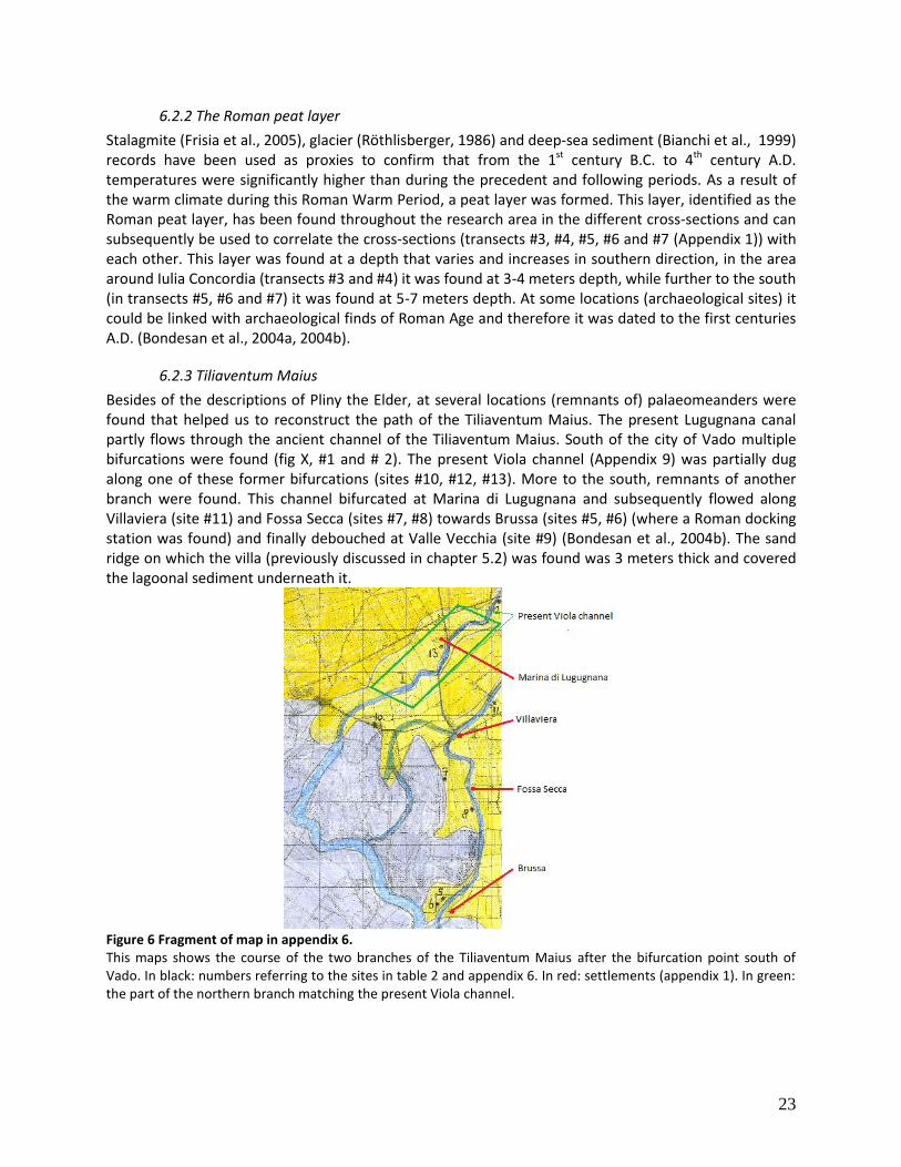
6.2.3 Tiliaventum Maius
Besides of the descriptions of Pliny the Elder, at several locations (remnants of) palaeomeanders were found that helped us to reconstruct the path of the Tiliaventum Maius. The present Lugugnana canal partly flows through the ancient channel of the Tiliaventum Maius. South of the city of Vado multiple bifurcations were found (fig X, #1 and # 2). The present Viola channel (Appendix 9) was partially dug along one of these former bifurcations (sites #10, #12, #13). More to the south, remnants of another branch were found. This channel bifurcated at Marina di Lugugnana and subsequently flowed along Villaviera (site #11) and Fossa Secca (sites #7, #8) towards Brussa (sites #5, #6) (where a Roman docking station was found) and finally debouched at Valle Vecchia (site #9) (Bondesan et al., 2004b). The sand ridge on which the villa (previously discussed in chapter 5.2) was found was 3 meters thick and covered the lagoonal sediment underneath it.
Figure 6 Fragment of map in appendix 6. This maps shows the course of the two branches of the Tiliaventum Maius after the bifurcation point south of Vado. In black: numbers referring to the sites in table 2 and appendix 6. In red: settlements (appendix 1). In green: the part of the northern branch matching the present Viola channel.
24
6.2.4 Coastline
In the Eastern part of the research area, near Bibione (Mottaron dei Frati), progradation of the delta system has been recorded by the shift of the debouching point of the Tiliaventum Maius (Asta et al., 2012). The douching point was located more to the south than the present day coastline. This theory was confirmed by the discovery of a Roman settlement 1st -2nd century A.D., 362) that had been covered by 3 meters of lagoonal sediment (Bondesan et al., 2004a). From the distribution of Roman coastal settlements we have concluded that the coastline at Valle Vecchia area was similar to the present day coastline. Finds of Roman remnants at several locations in the Western part of the area (including Caorle, Porto Santa Margherita and Valle Altanea (sites #1, #2, #3)), indicate that the coastline at that moment was quite similar to the present.
6.2.5 Settlements
Population growth during the Roman Era caused an increased need for land, for both settling and agricultural purposes. Moreover, the Romans were looking for strategic positions within their empire; military strongholds were needed along the borders and other important places. These important places mainly included trade places and routes of economic importance.
The most important Roman settlement was the city of Iulia Concordia (sites #38, #39). It was connected to the Roman Empire by means of the Via Annia. The bridge (site #33) and burial places (sites #34, #35) north of the city indicate that there probably also was a road going out in northern direction.
The Via Annia is one of the most important features on the map. This road was an important route between the cities of Atria (Adria, south of Vencie) and Aquileia (northwest of the Caorle lagoon), passing through Patavium (Padua), Altinum and Iulia Concordia. Remnants of the road have been found at multiple locations. The most important of these are the bridges (sites #36, #40) that were found, spanning over the incisions surrounding Iulia Concordia to connect it with the Via Annia. Along the road some milestones (site #39) were found, as well as some “cippi” (sites #20, #21, #30), which were boundary posts that probably served as memorial places (Asta et al., 2012).
As there were not too many spots to settle within the lagoonal area and the surrounding marshes, the Romans looked for specific locations to found their settlements. Roman sea harbours were located on top of the dune complexes along the coast (sites #1, #2, #3, #9). These dunes were stable places to build the settlements upon. Other settlements were built upon fluvial ridges. Especially along the flow paths of the Tiliaventum Maius several settlements were found (sites #5, #6, #7, #8, #10, #11, #12, #13). Locations close to the border of the lagoon, the marshes and the higher plains also were suitable setting locations (sites #14, #15, #16). Burial places were likely to be located close to the settlements (sites #37, #41, #44) or along roads; i.e. along the Via Annia multiple were found (sites #20, #24, #25, #37, #41, #46).
6.3. Medieval Period
In this chapter we describe the reconstruction of the area during the Medieval period. This reconstruction can be found on the map in Appendix 7 (p. 46). The numbers used in this chapter refer to the sites on this map and in table 3.
6.3.1 The map units
During the Medieval Era sea level-rise continued. Around the year 1000 A.D. it had reached up to 1.0 – 0.5 meters below present day sea level, causing an expansion of the lagoon. Throughout the area water level had risen, i.e. the area of marshes had expanded towards the higher plains. The incision had gradually been filled up with sediment and flood deposits were found on the Pleistocene higher plains (e.g. near Pontecasai and Gaffarelle (Appendix 1, Bondesan et al. 2004b)). The northwestern part of the
25
map (i.e. the area around the Loncon river) is the part of the map of which the least information is available. Therefore we have remained the shape of that area constant, although the wet areas (marshes) probably extended more towards the north.
Main feature of this period was the phase of transgression. This period lasted from the 6th to the 11th century A.D and is characterized by multiple floods and avulsions throughout the region (chapter 4.2.1; Asta et al., 2012). Remnants of the phase of transgression are visible in the landscape as river avulsions and crevasses, which are discussed below.
Due to changes of the course of the Tagliamento river, accompanied with a period of increased fluvial deposition during the 6th to the 8th century A.D., the lower laying areas along the rivers silted up (Bondesan et al., 2004a). This includes both the former Tiliaventum Maius channels in the eastern part of the research area, and the branches of the newly developed Concordia channel. A different color was used to mark the sandy loams that originate from this period. These deposits were found close to the point where the Tagliamento branches entered the lagoon. Moreover, sandy loams deposited by a branch of the Concordia channel were deposited on top of the Pleistocene (higher) plains. These deposits are linked with the activity of a palaeochannel originating from the Concordia incision valley in southwestern direction, along Case dal Moro and Fossariol (Appendix 1)(Bondesan, 2004a)(as discussed below).
6.3.2 Concordia Channel (Tagliamento)
The phase of transgression initiated the Tagliamento river to change its course. Whereas during Roman times it flowed through the Tiliaventum Maius (and Tiliaventum Minus) channel, at the end of Medieval times its course shifted in eastern direction (as described in chapter 0). This shift did not occur at once; in between the 6th and 10th century A.D. a series of (temporary) avulsions took place, of which the Concordia channel was one of the results (Figure 4). The avulsion causing the Concordia channel, which flowed through the incision around the city of Concordia, has never been stable due to the varying input of upstream discharge. Due to multiple upstream avulsions and crevasses, the Concordia channel was abandoned (around the 10th century A.D.) when an avulsion at San Vito al Tagliamento eventually lead to the final shift towards the present day Tagliamento (Fontana et al., 2008; Marocco, 1991). However, two temporary branches of the Concordia channel have been active during this eventful period in the research area.
The first of these is the channel that flows from the western part of the incision at Concordia towards the southwest, debouching into the Loncon river. In the western part of transect #3 fluvial deposits have been found within the incision, on top of the layer identified as the Roman peat layer (corings #401211030 to #401211032). In the adjacent western part of transect #4 and #5, no traces of this palaeochannel were found. Only some irregularities were found that could indicate the existence of a channel. Some traces of fluvial activity are also visible on the geomorphological map where a Holocene palaeochannel is identified at Case dal Moro and Fossariol (Bondesan et al., 2004a, Appendix 1, Appendix 2). However, we have reconstructed a fluvial channel as its existence is confirmed by the archaeological excavations at Fornasatta (Appendix 1). Here, sandy fluvial deposits were found on top of peaty deposits dating from the Bronze and Iron Age, indicating a medieval phase of activity of the fluvial channel.
The second temporary channel was found in the eastern part of transects #6 and #7. In both transect remnants (sandy deposits) of a fluvial channel were found. Moreover, in both cases these fluvial deposits were found just on top of the layer identified as the Roman peat layer (transect # 6 corings #4101217634 and #401217635; transect #7 corings #401221730 and #401221731). Based on these corings, we have reconstructed the course of this channel; it originated from the eastern part of the incision at Concordia. The course could not be found in the adjacent transect (#8) and therefore it should either be connected to the Sindacale channel within the lagoon, or it was reconnected with the
26
other branch. We have connected this course with the Sindacale channel as its the flow direction at the transect was southeastern. This channel has probably been active (with intervals) from the 6th to the 10th century A.D. (Personal communications, Dr. A. Fontana, 2012).
6.3.3 The Bocca Fossa Channel (Livenza)
The phase of transgression also had its impact on the Livenza. Irregularities in discharge had led to avulsions and crevasses in the downstream part of the Livenza (Asta et al., 2012). Within the research area some of these (temporary) avulsions are known. Besides of a few small scale avulsions in eastern direction towards the lagoon, another course is still visible in the landscape. This channel is located in the far western part of the research area; it bifurcated from the Livenza near the settlement of Bocca Fossa (Appendix 1), from which the name of this channel was derived. Based on historical cartography, this channel was reconstructed to be active during medieval times upon the (Italian) renaissance. In Figure 5 the Bocca Fossa course is not visible anymore. No corings have been performed in this area to verify the phases of activity of this channel.
6.3.4 The Loncon river
The Loncon swamp, of which the origin probably dates back to Holocene Superior, has been drained by the Loncon river (a tributary of the Lemene river) since the Roman Age. Close to the Via Annia, remnants of these drainage channels filled with organic material were found (Bondesan et al., 2004a).
6.3.5 Settlements
As the phase of stability in the region had ended after the decease of the Roman empire, people were urged to look for a safe place to settle. However, due to the rising sea level, the lagoon had expanded towards the mainland, causing some settlements that were inhabited during Roman times to be drowned. One of these settlements was San Gaetano; as it was located on the edge of the lagoon and the coastline, at the sea outlet of the Livenza, it could not any longer be protected against rising sea level. Another settlement that disappeared from the map was the harbour of Baseleghe (near Bibione). Its disappearance can be explained by a combination of factors. Whereas the channel of the Tiliaventum Maius was characterized by subsidence (both land subsidence (compaction of Holocene sediments and compaction of clay caused by siltation (Tosi et al., 2009)) and sea level rise (Lambeck et al., 2004; Antonioli et al., 2009)), the delta of the present Tagliamento was expanding (Bondesan et al., 2004a). This caused the opening in the lagoon to close due to siltation. As the harbour of Baseleghe also suffered from siltation due to drifting along the coast, the harbour could not be used anymore from the 17th century A.D. The geomorphologic map, and historic maps, on which land distribution pattern are visible, also show inhabitation in the Loncon area, situated along the drainage channels. Here, the remnants of clay pits were found. The city of Caorle was positioned on an island in between the lagoon and the Adriatic Sea (Asta et al., 2012) Moreover, some other settlements were known, mostly build upon filled palaeochannels along the Tagliamento (Bevazzana), Lemene (San Lunardo) and Livenza (San Giorgio di Livenza) (chapter 5.3, Appendix 8).
6.4. Modern Age
In this chapter we describe the reconstruction of the area during Modern age. This reconstruction can be found on the map in Appendix 8 (p. 47). The numbers used in this chapter refer to the sites on this map and in table 4.
27
6.4.1 The map units
The dynamics of the courses of the major rivers in the research area can be derived from historic maps dating from the 16th and 17th centuries. Using this spatial information the extent and the location of the lagoon could also be determined; in the east it was limited by the Livenza Morta and in the west by the Lemene river. The path of the Tagliamento River had moved in eastern direction and therefore it did not flow through the research area anymore. The lagoon was now located in between Caorle and Valle Zignano (Figure 5; Appendix 8). Around the lagoon there were several marsh areas with some sandy ridges within them. As these areas were very dynamic, it is almost not possible to identify the exact locations of the sand ridges. However, the settlements that were located at the border of the lagoon and within the swamp areas, must have been established upon these sand ridges.
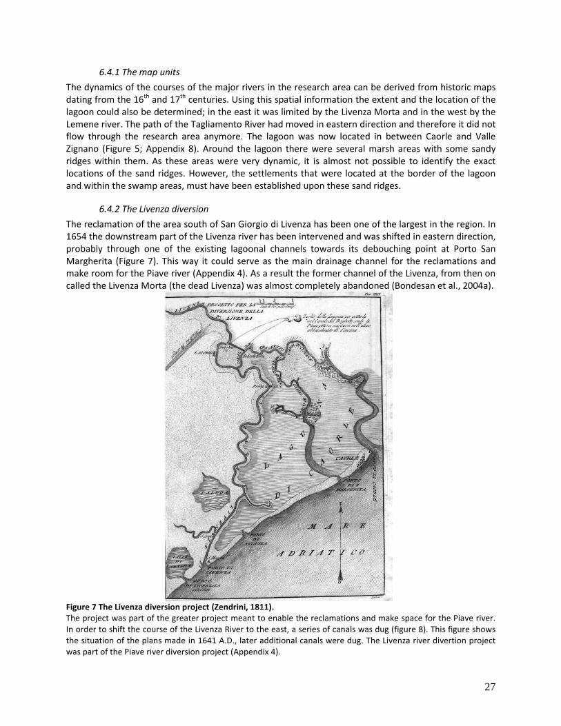
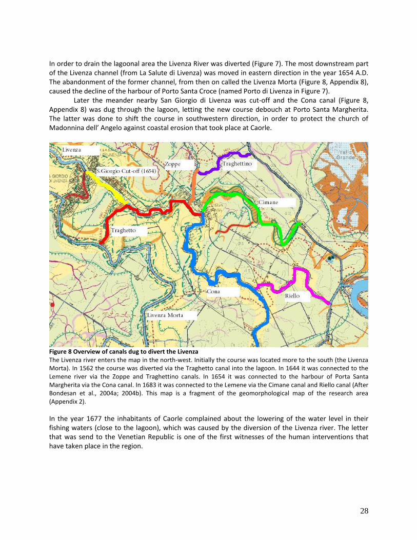
6.4.2 The Livenza diversion
The reclamation of the area south of San Giorgio di Livenza has been one of the largest in the region. In 1654 the downstream part of the Livenza river has been intervened and was shifted in eastern direction, probably through one of the existing lagoonal channels towards its debouching point at Porto San Margherita (Figure 7). This way it could serve as the main drainage channel for the reclamations and make room for the Piave river (Appendix 4). As a result the former channel of the Livenza, from then on called the Livenza Morta (the dead Livenza) was almost completely abandoned (Bondesan et al., 2004a).
Figure 7 The Livenza diversion project (Zendrini, 1811). The project was part of the greater project meant to enable the reclamations and make space for the Piave river. In order to shift the course of the Livenza River to the east, a series of canals was dug (figure 8). This figure shows the situation of the plans made in 1641 A.D., later additional canals were dug. The Livenza river divertion project was part of the Piave river diversion project (Appendix 4).
28
In order to drain the lagoonal area the Livenza River was diverted (Figure 7). The most downstream part of the Livenza channel (from La Salute di Livenza) was moved in eastern direction in the year 1654 A.D. The abandonment of the former channel, from then on called the Livenza Morta (Figure 8, Appendix 8), caused the decline of the harbour of Porto Santa Croce (named Porto di Livenza in Figure 7).
Later the meander nearby San Giorgio di Livenza was cut-off and the Cona canal (Figure 8, Appendix 8) was dug through the lagoon, letting the new course debouch at Porto Santa Margherita. The latter was done to shift the course in southwestern direction, in order to protect the church of Madonnina dell’ Angelo against coastal erosion that took place at Caorle.
Figure 8 Overview of canals dug to divert the Livenza The Livenza river enters the map in the north-west. Initially the course was located more to the south (the Livenza Morta). In 1562 the course was diverted via the Traghetto canal into the lagoon. In 1644 it was connected to the Lemene river via the Zoppe and Traghettino canals. In 1654 it was connected to the harbour of Porta Santa Margherita via the Cona canal. In 1683 it was connected to the Lemene via the Cimane canal and Riello canal (After Bondesan et al., 2004a; 2004b). This map is a fragment of the geomorphological map of the research area (Appendix 2).
In the year 1677 the inhabitants of Caorle complained about the lowering of the water level in their fishing waters (close to the lagoon), which was caused by the diversion of the Livenza river. The letter that was send to the Venetian Republic is one of the first witnesses of the human interventions that have taken place in the region.
29
In 1683 the Riello and Cimane canals were dug (Figure 8, Appendix 8); the Riello canal is still in use while the Cimane channel was cut-off at the beginning of the 19th century. The latter can still be found in the present landscape by means of a sandy-loam ridge that arises above the compacted soil of the reclaimed area surrounding it. During the fieldwork this remnants of the Cimane channel were found in transect # 10 (Appendix 1, Appendix 9). In the middle of this transect a large sand body was found, consisting of multiple levees (transect #10 corings #401213145 to 401213147).
Due to a stable average stream flow and a limited input of coarse sediment, the Livenza could develop a series a well-shaped meanders. Until the end of the 19th century, the Livenza was mainly fed by groundwater-fed tributaries (originating from the risorgive area)(Vallerani et al., 2008). During human interventions in the late 19th century A.D. the Meduna, a tributary of the Livenza with an Alpine origin, had been canalized. The canalization of the floodwaters of the Meduna also increased the sediment supply of the Livenza, which has gradually lead to the formation of a plain at the middle- to end segment of the river.
6.4.3 The Lemene
The Loncon, Lison and some minor tributaries of the Lemene represent the watershed in between de Livenza and the Tagliamento. The Loncon, which eventually debouched into the Lemene, drains the zone that served as a buffer for the floods until the Livenza was canalized (as described above). The name of the Loncon might be derived from the old Slavian word “Lonca” or “Locca”, which means swamp (Bondesan et al, 2004a).
South of San Gaetano one can find a ridge consisting of two meander bends, both in the landscape and on the geomorphogical map (Figure 8, Appendix 2). The corings performed along transect #11 (Appendix 1, Appendix 9) reveal a sandy body that probably represents a former channel. When we compare the present day course of the Lemene to that of the mid-17th century (which is shown in Figure 7), we can see that the former course has been canalized. The ridge that has been verified to be a channel, is thus likely to be a palaeochannel of the Lemene. Although the map (Figure 7) made in the 17th century is probably not very accurate, the course of the Lemene does not look canalized at that moment. It thus might have flowed through the palaeochannel upon the time it was canalized, being after the 17th century. By dating the infill of the palaeochannel one can find out until what time it has been active.
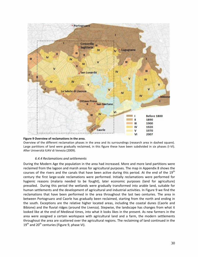
30
Figure 9 Overview of reclamations in the area. Overview of the different reclamation phases in the area and its surroundings (research area in dashed square). Large partitions of land were gradually reclaimed, in this figure these have been subdivided in six phases (I-VI). After Università IUAV di Venezia (2009).
6.4.4 Reclamations and settlements
During the Modern Age the population in the area had increased. More and more land partitions were reclaimed from the lagoon and marsh areas for agricultural purposes. The map in Appendix 8 shows the courses of the rivers and the canals that have been active during this period. At the end of the 19th century the first large-scale reclamations were performed. Initially reclamations were performed for hygienic reasons (malaria needed to be fought), later economic purposes (land for agriculture) prevailed. During this period the wetlands were gradually transformed into arable land, suitable for human settlements and the development of agricultural and industrial activities. In Figure 9 we find the reclamations that have been performed in the area throughout the last two centuries. The area in between Portogruaro and Caorle has gradually been reclaimed, starting from the north and ending in the south. Exceptions are the relative higher located areas, including the coastal dunes (Caorle and Bibione) and the fluvial ridges (around the Livenza). Stepwise, the landscape has changes from what it looked like at the end of Medieval times, into what it looks likes in the present. As new farmers in the area were assigned a certain workspace with agricultural land and a farm, the modern settlements throughout the area are scattered over the agricultural regions. The reclaiming of land continued in the 19th and 20th centuries (Figure 9, phase VI).
31
7. Discussion
The results of this research consist of a series of maps and their explanation that together form a landscape reconstruction of the research area. The construction of these maps was based on literature research, archaeological and geomorphological data of earlier research and additional data resulting from the recent fieldwork in the area. The combined use of the sources mentioned above has had several consequences for the interpretation of these data and thus for the subsequent results. Besides of some assumptions that had to be made, we also had to take into account the accuracy and reliability of the used methods. This research was largely based on the results of the fieldwork carried out by a group of bachelor students. Research performed by a large group of student s results in varying interpretations of several types of field data, we have however assumed that the fieldwork data were consistent. Field data that may have been interpreted differently by the students; e.g. the distinction of different types of clay, silt and sand, the salinity of clay (indicating the fluvial, lagoonal or marine origin of deposits), the occurrence of shells, and the rate of “peatiness” of deposits. Another major remark about the research is the fact that the data of the recent fieldwork were considered prevalent in this study. The mapping of the borders of the Tagliamento incision, one of the main landscape features in the research area, was primarily based upon fieldwork data. The data gathered during the fieldwork was considered of high resolution in means of the border between the Pleistocene material and the incision, as the students performing the cores were well-informed and instructed to be able to distinguish Holocene and LGM material. Therefore, the borders of the incision were based directly on the borders as they were indicated by the bachelor students in the transects.
Moreover, the borders between the different map units were primarily based on the data retrieved during the fieldwork. This information was complemented with other data (literature, earlier published corings, a geomorphologic map). Therefore, less data was available for the areas from which no cores have been taken during the fieldwork. The detail of the reconstruction was lower in these areas on the map. The areas that remained underexposed during this research include the northern parts, both west and east, the area east of the Livenza river and the area around the former Tagliamento branches, in the western part of the map.
On the maps, a division is made between the higher plain and the lower plain. However, the border between these areas is arbitrary and there is a gradual transition in between them. The division of these map units was based upon the humidity or “swampyness”, which determines the suitability for human land use and possibilities to settle. The conditions of the map unit called “higher plain” are eligible for these purposes, while the lower lying areas in general are not. The latter is subdivided into subclasses, of which the suitability for human settling differs. One should take into account that this division was purely used to increase the understanding of the map, and realize that the transition is gradual.
The exact location of the reconstructed palaeochannels of rivers was not always known. At some locations, the location of could be based directly on corings of the bachelor students. The course of rivers was interpolated in between the transects when a good correlation could be made in between the corings at the adjacent transects. This correlation was based on the type of deposition, the dimension of the palaeochannel and on top of that the gradient of the river was taken into account. During the process of interpolating the geomorphologic map was also used.
Besides of the interpolation that was used to reconstruct the areas in between the transects, the process of extrapolation was used to reconstruct the remaining areas (including the upper northwest
32
and northeastern regions). In the areas where no corings were available, the reconstruction was based on the geomorpholical map and previous research, combined with an extrapolation of landscape features extending from the areas of which more data was available. However, one needs to take into account the methods that were based for the reconstruction of each map area and should therefore be aware of the uncertainties that apply at each location of the maps. As no comparable research has been performed yet, in terms of a landscape reconstruction based on both archaeological and physical geographical data, we cannot put the results of this study in a broader context. However, the two types of data that we have used do match quite well; the data from the fieldwork correspond with, extend, and fill in blank areas on, the previous geomorphologic maps (Bondesan et al. 2004b). Moreover, these physical geographical landscape pattern are confirmed by occupational patterns as derived from archaeological data (resulting from literature research). However, the maps resulting from this research do not cover an area of equal reliability and resolution. That is due to a lack of a regular distribution of archaeological data throughout the study area, but also due to the fact that the area is not completely covered by the transects, i.e. detailed physical geographical data is also not regularly distributed. Equivalent research in adjacent areas shows a similar relationship between the natural landscape and occupation pattern. Due to other conditions and other local developments of the natural landscape, occupation patterns however do differ from those in our study area. Although the study area resembles the coastal area to the north and south, it has undergone different developments than those areas. Whereas the study area was initially characterized by the incision of the Tagliamento, this main distinctive landscape feature was missing in the adjacent areas. During the Roman Era, changes in the human landscape depended heavily on developments in the Roman empire and the locations that were chosen by the Romans to settle and establish water and land routes. Later the Venetian had a great impact on the landscape development in the area directly south of the study area; the Venetians used rivers and the lagoon to protect their city whereas our research area was situated in the area that was used by the Venetians to maintain their advantageous location. A similar development happened throughout the region during Modern Age, large areas were reclaimed and settlements expanded. However, the latter has not only depended on natural factor, but merely on other factors such as environmental, economic and social reasons.
33
8. Conclusions
The landscape in the research area is built up of Pleistocene sediment on which Holocene sediments of both fluvial and lagoonal origin were deposited . The interaction between these factors has determined the landscape throughout human history by shaping its main features including fluvial incisions, (palaeo-) rivers, coastal dune complexes and a lagoon.
The first permanent settlers arrived in the area during the Bronze and Iron Age; different types of settlements were established then. Suitable settling areas were situated close to the transitional area between the lagoon and the higher plain. During the first few millennia B.C. suitable locations were found along the fluvial incision (at present day Concordia Sagittaria) and on top of the dune complexes along the coast. Relative dry places and nearby freshwater sources are the main characteristics of the locations where settlements were raised. To survive storm and flooding events, buildings in these settlements were supported with wooden structures. However, when sea level increased settlers eventually were forced to leave the lowest lying areas (i.e. the areas closest to the coast).
During Roman Era strategic considerations let the Romans decide to settle in the area, as it was close to the northeastern corridor of the Roman empire. Around the incisional area (at present day Concordia Sagittaria) a city and some minor settlements were found. Other settlements were located along the coast (on dune ridges), and along the rivers debouching into the lagoon and the Adriatic. The pattern of settlements throughout the area had changed over time due to changes of river courses; settlements disappeared while other settlements arose according to the same basic needs as before. However, besides of the continuous need for a dry place to settle and fresh water sources, new factors had arisen that had an impact on the selection of a site to the settle. An important development included the presence of important trade routes through the area. Multiple settlements arose Along the Via Annia, an important trade road. Besides of this overland trade route, some harbours were founded at the river mouths to provide oversea trading possibilities. Another factor was the increased need for food supplies, caused by the growing population in the area and throughout the Roman Empire.
When the Roman Empire had gradually collapsed, peace throughout the region had disappeared and safety became the new factor that was brought into consideration for settling locations. In the search for safer places to settle during the Medieval Period, people fled towards the lower lying areas in order to gain protection from the sheltered lagoon. Another important factor affecting settling patterns was the period of transgression. Due to the combination of an increased fluvial discharge and rising sea level during this period, rivers changed their courses, river valleys silted up and harbours suffered from siltation.
During the Modern Era sea level kept on rising and protective measures were taken throughout the area. However, more land was needed continuously for both housing purposes and food production. The first land reclamations were used for timber production and fishing ponds. Later, large parts of land were reclaimed for agricultural purposes. The gradual reclamations required more and more waterways in order to drain all the newly developed land. Besides of that, existing waterways were rearranged and new canals were dug to enable aquatic connections in between cities and to the Adriatic harbours.
In the end we can conclude that both nature and anthropological factors have had a major
influence on the settlement pattern in the research area throughout the last millennia. The role of these factors has varied over time; at some times the natural factors were prevalent and at other times the contemporary anthropological settings were more important. Moreover, the factors initially created settling opportunities whilst at other times they imposed restrictions.
34
The most important natural factors included:
Dry and safe locations; throughout human history in the region, rising water level has always been a major issue. Settlers choose locations on top of dune ridges and along fluvial ridges to protect themselves from rising sea level and (fluvial) flooding events. However, as reclamations and embankments were raised and built, the direct restrictions imposed by lower lying areas have been reduced in modern times.
Locations enabling agriculture; to be able to settle and establish a local agriculture, there were several requirements, of which fresh water access was the most important. Moreover, locations that allowed farming, fishing ponds and timber production were sought after.
The main anthropological considerations on the other hand included:
Geopolitical strategic locations; geopolitical considerations have had an ever growing impact on the settling pattern. The role of the geopolitical situation in the area has changed over time. The Romans picked the location for its strategic position relative to the Barbarians that could enter the early Roman Empire from Northeastern direction. The peaceful situation during the reign of the Roman empire imposed no geopolitical restrictions. However, during Medieval and Modern ages the geopolitical situation destabilized causing people to flee towards the lagoon to gain shelter and protection from it.
Economically strategic locations; locations close to trade routes were of great importance for the economy. Trade routes included paved roads, as built first during the Roman Age, and nautical routes along rivers and the Adriatic. Locations along rivers, the coast and especially at river mouths were used to build harbours and transfer points. During Modern times, land reclamations can also be explained from an economical point of view; relative cheap areas were reclaimed for agricultural purposes.
When we look towards the future, a few additional remarks can be made. While there is no space
for new settlers in the region, the ever changing factors summed up above ask for adaptations by the current inhabitants of the area. While the region is stable in terms of geopolitics and economy, the changing climate will have its effects on the natural factors. Assuming a continued rise of the sea level combined with an increased total fluvial discharge, measures should be taken to guaranty the safety of the lower lying and coastal areas. Moreover, rising sea level causes salt water to penetrate the area (salinization) endangering (the quality of) the agricultural land.
35
9. Recommendations
9.1. Additional methods
Dating methods could be used in this part of the research area to confirm the exact period that the different river channels were active. Optically Stimulated Luminescence (OSL) dating is a method that can be used to date sand deposited by a river, lagoon or sea (Lauer et al., 2011). OSL can be used as long as the sediment was not deposited under water; the OSL signal needs to be reset by exposing it to sunlight. Moreover, one needs to take into account the minimum age of 300 years that can be detected with this technique. However, the method is still in development and will be improved. OSL can be used in the future to determine the phases of activity of several river channels, including the Roman and Medieval Tagliamento channels, the palaeochannels of the Livenza (Livenza Morta and the Bocca Fossa channel) and lagoonal channels (along transect #10, (Appendix 1, Appendix 9)). As the origin of sand deposits (fluvial/lagoonal/sea) can be derived from the shells that are in it, the phases of activity of these different depositors can be found by dating the sand with the OSL technique. Moreover, the phases of siltation can be dated in order to date floods and periods of high discharges.
Besides of the OSL method, the radiocarbon (14C) method can be used to date organic material. Peat deposits and deposits of other organic materials (such as wood or terrestrial seed) can be dated with this method as has been done before in the area in previous research (Bondesan et al, 2004a; Fontana et al., 2010). There are two main applications of this technique, of which the first is the dating of organic material in fluvial and lagoonal deposits. Another use of the 14C method is dating organic materials in wooden remnants of human activities. This includes wooden handcrafts and tools, wood used in building structures, road and water works, defensive works and wharfs. Wood used in boats can be very useful, as they can be interpreted to date the usage of certain boats and harbours, and the activity (navigability) of river channels. Datable wooden objects include structures from Bronze and Iron Age (San Gaetano), structures from the Roman Age (harbours and wharfs), and harbours and defensive works from the Medieval Period. From Modern Age, objects and structures from Modern Age can be dated. However, more and more maps and descriptions are available about recent applications of wooden structures.
Another additional technique that can be used to date the second type of wooden objects (as summed up above) is dendrochronology. Dendrochronology is the scientific method that uses a series of tree rings measured in a wood sample to determine the age of a wooden objects. Such a series is build up by annual growth rings of which the pattern reflects the regional climatic conditions. By combining multiple tree ring series of a certain wood species, a chronology can be established for that wood species in a specific region. Wood samples can be dated by matching tree ring series of wood samples with these chronologies. However, to be able to date wooden objects from our research area, first a reference chronology needs to be constructed for each of period of interest. Previous dendrochronological research has been performed in adjacent areas for the medieval period by Martinelli et al. (2014).
On top of the above methods that can be used for dating purposes, there are also techniques that can be useful in reconstructing the landscape. One of these is palynology which involves the analysis of pollen. Pollen are microfossils of plants that after a chemical preparation can be analyzed under a microscope. A researcher counts the amount of each pollen species to eventually produce a pollen diagram. This diagram represents the relative abundances of plant species and can be used to visualize the floral landscape throughout time. Moreover, the human use of plants can be investigated, including the agricultural methods and products, and the seasonality of site occupation.
36
Another additional technique in landscape reconstruction includes the investigation of shells. Although some shells have been researched during the fieldwork, especially under the supervision of Dr. Fontana, there might be more opportunities with this technique. Due to specific characteristics of each shell species including features as depth, salinity and water activity, different shell species all represent a certain environment of deposition. Depositional environments can thus be deduced by the abundance of certain shell species. If students are trained to distinguish a certain amount of shell species, this technique can be used (in the field) to derive the depositional environment of shells at a certain depth in a coring.
9.2. Additional fieldwork
The research area included three main rivers; the Livenza, the Lemene and the Tagliamento rivers. The latter has only partly been reviewed by means of the Tiliaventum Maius. This was done as only that part of the river, the present Lugugnana channel, flows through the research area. However, to investigate the Tiliaventum Maius, the complete flow regime of the river should be reviewed and therefore the research area should be expanded or shifted in eastern direction. In addition to information retrieved from archaeological research, literature and historical maps, more fieldwork is needed.
To understand the Tagliamento system additional research is needed, at least along the Lugugnana channel (Villaviera) and at known locations of avulsions and contemporary branches. These include both the Tiliventum Maius and Tiliaventum Minus, both flowing in the area north of the cities of Caorle and Bibione. Additional corings can also be used in the area around the Loncon and the Livenza, to enable a more detailed reconstruction of the channels of these rivers throughout time. Moreover, more insight can be gained in the dynamics of the lagoonal channel pattern.
To gain additional insight in the processes and transformations in the landscape, additional fieldwork in the research area should be done. Suggested are coring locations along transects that are situated in between the current transects, in order to improve the coring resolution. Moreover, additional corings should be performed on transects perpendicular to the rivers channels as they are represented on the resulting maps.
9.3. Additional research
Literature research was combined with the research of historic maps in this research, resulting in reconstruction from Bronze and Iron Age until Modern Age. However, the most recent period (from the 18th century up to present times) was not investigated and reconstructed during this research. This was done as a complete other type of research would be needed to do so. During the last few centuries a lot of changes have occurred in the area; a whole series of reclamations (and supporting waterworks) have taken place. This would mainly include archival research such as literature research, the usage of maps and land registration data (cadastral), requiring information from local water boards and governments.
37
Acknowledgments
At first I want to thank Dr. E. Stouthamer who granted me the opportunity to do this project. After inviting me for a conversation about the possibilities for a guided research, she offered me this project based on my interests in the relation between physical geography and archaeology. Moreover I would like to thank Esther for her supervision and assistance during the preparation, field trip, and writing of this report. At last I am grateful for the patience that she has had with me writing this report. I am also grateful to all the other participants that joined the fieldwork in Italy. Dr. Alessandro Fontana for his assistance from the University of Padua, Prof. Dr. Hans Middelkoop and Dr. Rens van Beek for their interesting excursion, and Dr. Wim Hoek, Dr. Maarten van der Vegt, Dr. Kim Cohen, Drs. Jan Peeters, Anouk de Bakker, Tjalling de Haas and Chris Roosendaal for their different contributions to both the field trip and my research. Moreover I want to thank all of the people mentioned above (including Esther) for the nice time that I have had working with them. At last my thanks go out to the bachelor students that participated in the fieldwork. In fact, my research is largely based on data retrieved by the work performed during long (and hot) field days by those students. Not only have I used their coring data, I have also used the transects that they had produced. Moreover, I have enjoyed their company during the stay in Italy. I want to thank the “jochies” in particular, including Bram, Michiel, Harry, Harm, Lennart and Wilhelm. I have had a nice time with them in our apartment in Caorle and all the hours we have spent in the minivan during the fieldtrip. Although she is not one of the “jochies”, special thanks go out to Evelien with whom I have had a great time.
38
References
Amorosi A., Fontana A., Antonioli F., Primon S., Bondesan A. (2008) Post-LGM sedimentation in the NW
Adriatic coastal area. GeoActa, Vol. 7, pp. 41-67. Antonioli F., Ferranti L., Fontana A., Amorosi A., Bondesan A., Braitenberg C., Dutton A., Fontolan G.,
Furlani S., Lambeck K., Mastronuzzi G., Monaco C., Spada G., Stocchi P. (2009) Holocene relative sea-level changes and vertical movements along the Italian and Istrian coastlines. Quaternairy International, Vol. 206, No. 1-2, pp. 102-133.
Asta A., Citton E.B., Capulli M., De Angeli G., Fontana A., Fozzati, L., Gobbo V., Rinaldi F., Tine’ V., Tomaello E., Vigoni A. (2012) TerredAcque; per un’anteprima del musea nazionale di archaeologia del mare. Exhibition by Soprintendenza per i beni archaeologici del Veneto and Comune di Caorle.
Berendsen H.J.A., Stouthamer E. (2001) Palaeogeographic development of the Rhine-Meuse delta, the Netherlands. Van Gorcum: Assen.
Bertelle M., Calogero S., Oddone M., Salerno R., Segnan R., Stievano L. (2000) Journal of Cultural Heritage, Vol. 1, No. 3, pp. 261-279.
Bertollo P. (2001) Assessing Landscape Health: A case study from Northeastern Italy. Environmental Management, Vol. 27, No. 3, pp. 349-365.
Bianchi G.G., McCave N. (1999) Holocene periodicity in North Atlantic climate and deep-ocean flow south of Iceland. Nature, Vol. 397, pp. 515-517.
Bondesan A., Meneghel M., Bassan V., Bertani B., Fontana A., Fontolan G., Furlanetto P., Magri S., Mozzi P., Primon S., Roselli R., Vitturi A. (2004a) Geomorfologia della provincia di Venezia; Note illustrative della Carta geomorfologica della provincia di Venezia. Provincia di Venezia, Padua, 509 pp.
Bondesan A., Meneghel M., Vitturi A. (2004b) Carta Geomorfologica della provincial di Venezia, scala 1:50.000, Foglio N. 1- Nord. Provincia di Venezia, Padua.
Carton A., Bondesan A., Fontana A., Meneghel M., Miola A., Mozzi P., Primon S., Surian N. (2009) Geomorphological evolution and sediment transfer in the Piave River system (northeastern Italy) since the Last Glacial Maximum. Géomorphologie: relief, processus, environment, Vol. 3, pp. 155-174.
David A. (2008) Caorle, Quaderni di cartografia storica, No. 3, 79 pp. De Nardi S. (2009) Landscapes of the prehistoric Veneto, Italy. A plurality of local identities reflected in
cult and landscape perception. Papers from the Institute of Archaeology, Vol. 18, pp. 39-56. Distretto Idrografica delle Alpi Orientali (2010) Piano di gestione dei bacini idrografici delle Alpi Orientali
(2010) - 8 Bacino del fiume Livenza, 9 Bacino del fiume Lemene, 10 Bacino del fiume Tagliamento Donnici A., Serandrei-Barbero R., Bini C., Bonardi M., Lezziero A. (2011) The caranto palaeosol and its
role in the early urbanization of Venice. Geoarchaeology, Vol. 26, No. 4, pp. 514-543. Fontana A., Pessina A. (2007) Early farming landscapes in the Friuli plain(NE Italy). In: Hidden Landscapes
of Mediterranean Europe, proceedings of the international meeting in Siena, Italy, May 2007. Paper no. 23, pp. 193-200.
Fontana A., Mozzi P., Bondesan A. (2008) Alluvial megafans in the Venetian–Friulian Plain (north-eastern Italy): Evidence of sedimentary and erosive phases during Late Pleistocene and Holocene. Quaternary International, Vol. 189, pp. 71-90.
Fontana A., Mozzi P., Bondesan A. (2010) Late Pleistocene evolution of the Venetian-Friulian Plain. Rendiconti Lincei, Vol. 21, pp. 181-196.
Frisia S., Borsato A., Spötl C., Villa I.M., Cucchi F. (2005) Climate variability in the SE Alps of Italy over the past 17000 years reconstructed from a stalagmite record. Boreas, Vol. 34, pp. 445-455.
39
Galassi P., Marocco R. (1999) Relative sea level rise and subsidence in the Caorle Lagoon (Northern Adriatic Sea), Italy, during Holocene. Il Quaternario, Vol. 12, pp. 249-256.
Lambeck K., Antonioli F., Purcell A., Silenzi S. (2004) Sea-level change along the Italian coast for the past 10,000 yr. Quaternary Science Reviews, Vol. 23, pp. 1567-1598
Lauer, T., Frechen, M. Klostermann, J., Krbetschek, M., Schollmayer, G., Tsukamoto, S. (2011) Luminescence dating of Last Glacial and Early Holocene fluvial deposits from the Lower-Rhine – methodological aspects and chronological framework. Zeitschrift der Deutschen Gesellschaft für Geowissenschaften, Vol. 162, pp. 47-61.
Marocco R. (1991) Evoluzione tardopleistocenica-olocenia del Delta del F. Tagliamento e delle Lagune di Marano e Grado (Golfo di Trieste). Il Quaternario, Vol. 4, pp. 223-232.
Martinelli, N., Meadows, J., Valzolgher, E., Pignatelli, O., Angiani, L., Kromer, B. (2014) Open Journal of Archaeometry, Vol. 2, No. 1., pp. 49-54.
Università IUAV di Venezia (2009) Minestero per i beni e le attività culturali, Comuni di Caorle, Regione del Veneto, Piano Paessaggistico di dettaglio “La laguna di Caorle”, 64 pp.
Monegato G., Ravazzi C., Donegana M., Pini R., Calderoni G., Wick L. (2007) Evidence of a two-fold glacial advance during the last glacial maximum in the Tagliamento end moraine system (eastern Alps). Quaternary Research, Vol. 68, pp. 284-302.
Oele E., Apon W., Fischer M.M., Hoogendoorn R., Mesdag C.S., De Mulder E.F.J., Overzee B., Sesören A., Westerhoff W.E. (1983) Surveying the Netherlands: sampling techniques, maps and their applications. In: Special issue in the honour of J.D. de Jong; van den Berg. Geologie en Mijnbouw, Vol. 62, pp. 355-372.
Randall-MacIver D. (1924) Villanovans and Early Etruscans. In: Villanovan Culture, Columbia Electronic Encyclopedia, 6th Edition, 2011.
Ridgway D. (1988) Italy from the Bronze Age to the Iron Age. Chapter 12 in: The Cambridge Ancient History, Vol. 4, Cambridge University Press, 2008
Röthlisberger, F. (1986) 10.000 Jahre Gletschergeschichte der Erde: ein Vergleich zwischen Nord- und Südhemisphäre. Sauerländer, 416 pp.
Spaliviero M. (2003) Historical fluvial development of the Alpine/foreland Tagliamento River, Italy, and consequences for floodplain management. Geomorphology, Vol. 52, No. 3-4, pp. 317-333.
Tockner K., Ward J.V., Arscott D.B., Edwards P.J., Kollman J., Gurnell A.M., Petts G.E., Maiolini B. (2003) The Tagliamento River: a model ecosystem of European importance. Aquatic Sciences, Vol. 65, pp. 239-253.
Tosi, L., Teatini, P., Carbognin, L., Brancolini, G. (2009) Using high resolution data to reveal depth-dependent mechanisms that drive land subsidence: the Venice coast, Italy. Tectonophysics, Vol. 474, No. 1-2, pp. 271-284.
Vallerani F., Ciriacono S., Cavallo F.L., Zago F., Paulon G. (2008) Dalle praterie vallive alla bonifica; cartografi e storica ed evoluzione del paessaggio nel Veneto Orientale dal ‘500 ad oggi. Consorzio di bonifica Pianura Veneta tra Livenza e Tagliamento, 287 pp.
Van de Meene E.A., Van der Staay J., Teoh Lay Hock (1979) The Van der Staay Suction Corer- A simple apparatus for drilling in sand below groundwater table. Rijks Geologische Dienst, Haarlem.
Zendrini B. (1811) Memorie storiche dello stato antico e modern delle lagune di Venezia. Seminario Press Padova, Vol. 2, 455 pp.

40
Appendices
Appendix 1 Overview map of the research area (including coring and transect locations)

41
Appendix 2 Geomorphologic map of the research area (Bondesan, 2004b).

42
Appendix 3 Digital Elevation map of the research area
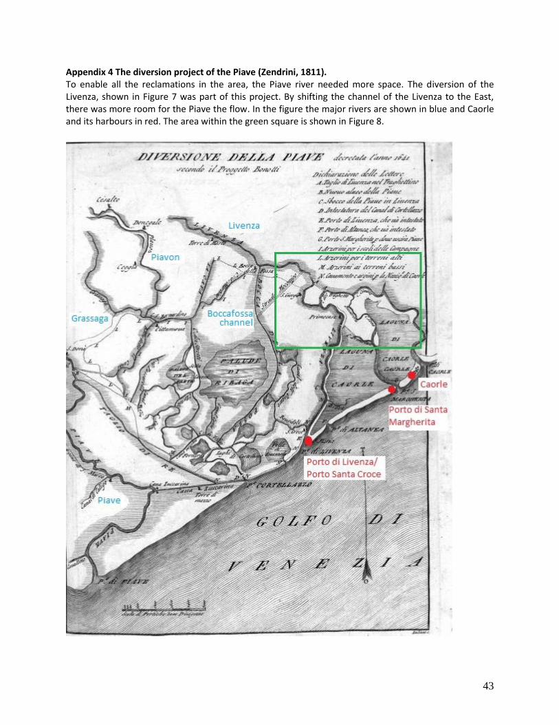
43
Appendix 4 The diversion project of the Piave (Zendrini, 1811). To enable all the reclamations in the area, the Piave river needed more space. The diversion of the Livenza, shown in Figure 7 was part of this project. By shifting the channel of the Livenza to the East, there was more room for the Piave the flow. In the figure the major rivers are shown in blue and Caorle and its harbours in red. The area within the green square is shown in Figure 8.
44
Appendix 5 Map # 1 Bronze and Iron Age

45
Appendix 6 Map # 2 Roman Era

46
Appendix 7 Map # 3 Medieval Period

47
Appendix 8 Map # 4 Modern Age
48
Appendix 9 Transects
In this appendix we find the transects. Each of the transects were reconstructed by a couple of two bachelor students participating in the fieldtrip. The location of the transects is found in Appendix 1. Some of the transects are divided into an eastern and western part. Transect 3 East West Transect 4 East West Transect 5 East West Transect 6 Transect 7 East West Transect 8 East West Transect 9 Transect 10 Transect 11 Transect 12 Transect 13