Landscape construction and long-term economic practices: an example from the Spanish Mediterranean...
27
Landscape Construction and Long-Term Economic Practices: an Example from the Spanish Mediterranean Uplands Through Rock Art Archaeology María Cruz Berrocal & María Sebastián López & Antonio Uriarte González & Jose Antonio López-Sáez # Springer Science+Business Media New York 2012 Abstract We argue in this paper that Levantine rock art in the Spanish Mediterra- nean basin allows us to ‘map’ the economic landscape of its makers. Rock art would be the ‘monumental’ side of a dual process of landscape construction: on the one hand, rock art is the first ‘cultural’ action on the landscape beginning in the Early Neolithic; on the other hand, the first evidence of active modification of the Medi- terranean vegetation comes from this period. But this evidence as well as other kinds of archaeological remains are still relatively scarce in the uplands; rock art is therefore the most complete type of evidence we can use to support an early use of the Mediterranean upland environment. We use statistical and geographical analysis, together with archaeological, ethnohistorical, and ethnographic sources and pollen data, in order to support the idea of early use and exploitation of the Mediterranean uplands since the Neolithic, and into contemporary times. Keywords Mediterranean landscape . Neolithic . Rock art . Economic resources Introduction This paper argues that Levantine rock art is the first visible sign of the existence of economic practices specifically adapted to the potential land use associated with the uplands of the Spanish Mediterranean basin. These economic practices took full shape during the Early Neolithic (Bernabeu et al. 1993) and are in place until contemporary times (see below). The existence of rock art, and its location in very specifically selected places in the landscape, intimately associated with a particular landscape structure, are the main supports of this proposal. It is precisely the land use J Archaeol Method Theory DOI 10.1007/s10816-012-9157-0 M. Cruz Berrocal (*) : M. Sebastián López : A. Uriarte González : J. A. López-Sáez Institute of History, Center for the Social Sciences and Humanities (CCHS), High Council for Scientific Research (CSIC), c/ Albasanz 26-28, Madrid 28037, Spain e-mail: [email protected]
Transcript of Landscape construction and long-term economic practices: an example from the Spanish Mediterranean...
Landscape Construction and Long-Term Economic Practices:an Example from the Spanish Mediterranean UplandsThrough Rock Art Archaeology
María Cruz Berrocal & María Sebastián López &
Antonio Uriarte González &
Jose Antonio López-Sáez
# Springer Science+Business Media New York 2012
Abstract We argue in this paper that Levantine rock art in the Spanish Mediterra-nean basin allows us to ‘map’ the economic landscape of its makers. Rock art wouldbe the ‘monumental’ side of a dual process of landscape construction: on the onehand, rock art is the first ‘cultural’ action on the landscape beginning in the EarlyNeolithic; on the other hand, the first evidence of active modification of the Medi-terranean vegetation comes from this period. But this evidence as well as other kindsof archaeological remains are still relatively scarce in the uplands; rock art is thereforethe most complete type of evidence we can use to support an early use of theMediterranean upland environment. We use statistical and geographical analysis,together with archaeological, ethnohistorical, and ethnographic sources and pollendata, in order to support the idea of early use and exploitation of the Mediterraneanuplands since the Neolithic, and into contemporary times.
Keywords Mediterranean landscape . Neolithic . Rock art . Economic resources
Introduction
This paper argues that Levantine rock art is the first visible sign of the existence ofeconomic practices specifically adapted to the potential land use associated with theuplands of the Spanish Mediterranean basin. These economic practices took fullshape during the Early Neolithic (Bernabeu et al. 1993) and are in place untilcontemporary times (see below). The existence of rock art, and its location in veryspecifically selected places in the landscape, intimately associated with a particularlandscape structure, are the main supports of this proposal. It is precisely the land use
J Archaeol Method TheoryDOI 10.1007/s10816-012-9157-0
M. Cruz Berrocal (*) :M. Sebastián López : A. Uriarte González : J. A. López-SáezInstitute of History, Center for the Social Sciences and Humanities (CCHS),High Council for Scientific Research (CSIC), c/ Albasanz 26-28, Madrid 28037, Spaine-mail: [email protected]
associated with rock art from the beginning of farming and agriculture which hasactually built the Mediterranean upland landscape as we know it, and it is preciselythe abandonment of these economic activities the main cause of its decay and in somecases its destruction.
The Mediterranean uplands are middle-altitude mountainous ranges, where ‘typicalMediterranean’ (e.g., Hobbs et al. 1995, p. 17) derivative vegetation formations(maquía and garrigue) prone to fire (Riera 1996; Walsh 1999; Riera et al. 2004;Carrión et al. 2007) coexist with derivative forests. It is generally accepted that theMediterranean upland areas of the Iberian Peninsula have remained fairly stable alongtime, or more accurately, resilient: they have kept the “ability to resist or accommo-date external pressures without seriously transforming itself” (Redman et al. 2004, p.3), due to the modification of the environment caused by extensive exploitativepractices at the broad regional scale; changing conditions at the local level did notnecessarily change the basic long-term regional picture (Aura et al. 1998; Carrión2002; Gil-Romera et al. 2010).
A reliable proof of this resilient character is to be found in rock art: Levantine rock artsites have been used from the Early Neolithic to the twentieth century most likely due totheir sheltering capacity and their relationship with specific resources in their surround-ings, thus keeping a very relevant role throughout history as part of a system of riskbuffering of the farming economy in the Iberian Peninsula, especially significant in theMediterranean facade. Thus, although rock art is often thought of as a means of accessinto the cognitive, religious, and cultural realms of a social formation, we will ratherargue that rock art can help us understand the long-term rythms of landscapes—itsconstruction processes and its use along time. In short, we observe rock art as a veryrelevant kind of archaeological evidence for the understanding of landscapes, mainlybecause it allows us to observe a territory as a meaningful cultural or social spatial entity.Otherwise it would be easy to only see a compound of fragmentary spaces.
Palaeoenvironmental, geomorphological, archaeological, and ethnographic andethnohistoric records are of course relevant for this study; lacunae in their data setsare however still important. It seems that lack of information has been widespread inthe archaeology of mountainous areas and the study of long-term land use andlandscape structures in the uplands. As Barker and Bintliff (1999, p. 209) put it,there is a general “lack of emphasis on investigating the prehistory and history ofMediterranean uplands”. Being rock art one of the few material types of evidence ofhuman use of the uplands since very early times, it is odd that its potential has notbeen strongly emphasized before, as this paper does.
Legitimate concerns that “…modern or early modern ethnohistoric parallels aremerely a source of models, not a blueprint for claiming, for example, a continuity ofland use and mode de vie in a given regional landscape” (Barker and Bintliff 1999, p.207) have been raised; certainly, while there may be a basic continuity in land use dueto suitable environmental conditions, political forms and ways of life may differradically. Economic exploitative practices may remain basically unaltered, but theirsignificance varies according to regional and interregional social, political, andeconomic dynamics. In the Mediterranean basin, pastoral, agricultural, and forestryresources have been shaped and used in the same ways for millennia (Lasanta 1987);yet their historical contexts and institutional matrices have differed. A focus onsilvopastoral land use does not imply that the access to resources, the organization
Cruz Berrocal et al.

of labor, and, in general, the social relations enabling these economic practices,remained the same throughout the ages. In fact, we know that this was not the case.Ways of life can retain basic features while larger social structures and political formschange. Thus, in this paper, we argue for continuity, not for statism.
A further reflection applies here. As we propose in this paper, the Mediterraneanlandscape is the corollary of at least seven millennia of human work. In the context ofa scenario of inertia and resilience at a palaeoecological scale (Carrión 2002; Carriónet al. 2007; Gil-Romera et al. 2010), with fundamental continuity and slow, gradualand cumulative pace of change (Butzer 2005; Shiel 1999) along millennia, humanactivity plays a big role, both in Eastern and Western Mediterranean (Horden andPurcell 2000; van der Leeuw and de Vries 2002; Butzer 2005; Berger et al. 2007).1
This brings us to the notion of ‘working landscape’ (Diekmann et al. 2007) todescribe the Mediterranean uplands: a cumulative enterprise, a historical scenariobasically contingent and dialectic in nature, the product of long-term co-evolutionaryprocesses (Davis and Rutherford 1995; Naveh 1998) of human–environment depen-dence (or ‘a system in non-equilibrium’, see Naveh 1998). Mediterranean resilience isa product of the dependence between human labor and ‘nature’, so much so that theability of the Mediterranean landscape to stay resilient is totally entrenched in theinvestment of social work (van der Leeuw and de Vries 2002; Butzer 2005; Gil-Romera et al. 2010).2 Ways of life, meaning ways of work, do produce and sustainparticular ‘working landscapes’. It follows that real environmental degradation is afunction of sociopolitical disturbance or change (e.g., Butzer 2005), as it produces astop or forces a shift in the invested work. This is what happened in the last decades inthe Spanish Mediterranean basin, especially in the lowlands: a dramatic change inland use, a likely important factor in its degradation (e.g., Hobbs et al. 1995; Naveh1998; Rundel 1998; Butzer 2005; González-Hidalgo et al. 2007; García-Ruiz 2010).In the uplands, work has traditionally been less work intensive and therefore the risksproduced by abandonment are also less pressing, but traditional ways of life fadeaway generation after generation (Creighton and Seguí 1998; Christie et al. 2007). Anecologically fine-tuned Mediterranean environment (Butzer 1996) is increasinglyunder siege, and prospects for future management and preservation are doomed tofail as long as they are not accompanied by policies that keep people living andworking the landscape. In our view, studies that emphasize the long-term nature ofthe Mediterranean uplands should be relevant in order to understand the scope of theproblem.
1 The history of the Mediterranean landscape is, to some extent, a history of erosive processes and soil loss,and the determination of their climatic vs. anthropic origin. The debate ‘Younger Fill’ (Vita-Finzi 1969) vs.non-synchronic accumulations of human-induced episodes of soil erosion (e.g. van Andel et al. 1990;Walsh 1999; Horden and Purcell 2000)—see Bintliff (2002) for a review—was a significant landmark inthis regard. After the Neolithic, however, it is difficult to isolate climatic events as triggers of global culturalchanges in the Mediterranean (Jalut et al. 1997; Carrión et al. 2000), and emphasis is increasingly put onthe interplay of decision-making humans and their environment (e.g. Davis and Richardson 1995; Rundelet al. 1998; Naveh 1998; Horden and Purcell 2000; van der Leeuw and de Vries 2002; Butzer 2005).2 Co-evolution has created its own dynamics of risk, crisis and threats. It has been proposed (Horden andPurcell 2000; van der Leeuw and de Vries 2002; de Vries et al. 2002) that the additive and reiterativehuman work and modification of the landscape led to the replacement of short-term risks, such as seasonalfloods, by long-term risks, triggering unpredictable instability on the long term.
Landscape Construction and Long-Term Economic Practices
We will present first the current pollen evidence pointing to a vegetation modifi-cation starting in the Neolithic. Next, we will present our interpretation of thearchaeological record as observed in the Levantine rock art, with input from theethnohistorical and ethnographic record.
Palaeoenvironmental Context
The existing pollen records, anthracological analyses and geomorphological datapoint to anthropogenic modification of the vegetation in different parts of the WesternMediterranean beginning with the Neolithic, as well as changes produced by shiftingclimatic conditions (Dupré 1988; Badal et al. 1994; Badal and Roiron 1995; Carriónand van Geel 1999; López-Sáez and López-García 1999; Sánchez-Goñi and Hannon1999; López-García and López-Sáez 2000; Carrión et al. 2001a, b; Carrión 2002;Riera et al. 2004; López-Sáez et al. 2006, 2011, González-Sampériz et al. 2006,2008). In the Spanish Mediterranean basin, several cycles of vegetation replacementor loss have been observed on lowlands and upland areas, although response timescannot be measured, and it remains open to debate how the combination of climatewith human impact is ultimately responsible for the observed rapid shifts in vegeta-tion (Jalut et al. 2000; Carrión 2001a; Carrión et al. 2010).
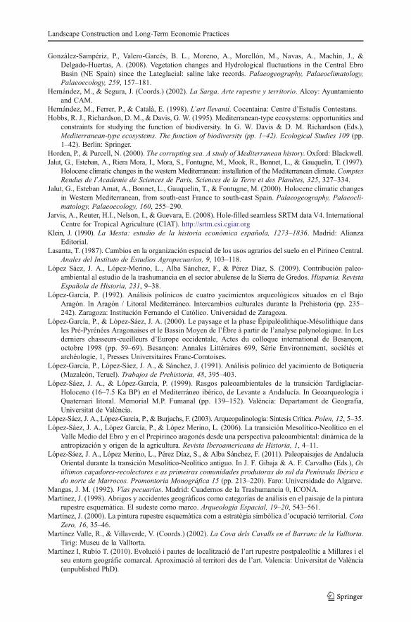
In the last decades, an important effort has been made in Spain to study non-archaeological pollen sequences in the uplands (e.g., Carrión 2001b, c, 2002; Carriónet al. 2001a, 2004, 2007, 2010) that complete the pollen sequences obtained fromarchaeological sites or natural deposits located in the lowlands (e.g., López-Sáez et al.2003, 2011). Despite an important debate over the natural or anthropic role of fire in themodification of the vegetation cover (Davis 1994; López-García and López-Sáez 2000;Stevenson 2000; Carrión et al. 2001a, b; González-Sampériz 2004) in the Mediter-ranean basin, and some data voids, a general picture can now be presented (Fig. 1).
In the Catalan Pyrenees the first evidence of anthropic modification is placedbetween ca. 7,000 and 6,000 cal BP (e.g., Montserrat and Vilaplana 1987; Gómez andEsteban 1993; Pèlachs et al. 2007; Pérez-Obiol et al. 2012). The pollen sequencefrom the Estanilles peat bog (2,247 m.a.s.l.), for instance, shows a clear episode ofopen land vegetation during the Neolithic, starting at ca. 7,000 cal BP. It is related tothe use of fire and signals of soil erosion, as well as to indicators of pollen ofanthropic origin (Pérez-Obiol et al. 2012). In the Andorran eastern Pyrenees (Perafitaand Madriu valleys), the pollen data (sequences from Planells de Perafita, Bosc delsEstanyons, and Riu dels Orris; 2,150, 2,180, and 2,390 m.a.s.l., respectively) suggesthuman presence in the sub-alpine belt as early as the late Mesolithic–Early Neolithictransition (ca. 8,350–7,700 cal BP). This presence was likely of a seasonal nature, butthe vegetation appears to be strongly influenced by human activities (agriculture andgrazing) only at the end of the early Neolithic, ca. 7,250–6,850 cal BP (Miras et al.2007, 2010; Ejarque et al. 2010).
In the Aragón Pyrenees, this anthropic impact is delayed until the fifth milleniumcal BP (Montserrat 1992), although some intriguing data remain. Early Neolithicpollen evidence coming from Chaves cave, dated to 6,770±70 (7,750–7,495 cal),6,650±80 (7,660–7,425 cal) and 6,460±70 (7,500–7,255 cal) BP, show human activemodification of the vegetation through fire, plausibly interpreted as an aim to open
Cruz Berrocal et al.

areas for pasture (López-García and López-Sáez 2000; López-Sáez et al. 2006). Moredata from Aragón showing early evidence of modification of the environmentthrough fire come from Botiquería del Moros (Mazaleón, Teruel; López-García etal. 1991; López-García and López-Sáez 2000), and El Pontet (Maella, Zaragoza;López-García 1992; López-García and López-Sáez 2000).
In the Southern Iberian System, some evidence of human intervention through firearound 6,800 cal BP3 could be interpreted from Ojos del Tremedal, possibly linked tograzing due to the parallel emergence of a livestock indicator (Plantago lanceolata;Stevenson 2000).
In south-eastern Spain, the intensity and timing of human impact on vegetationvaried among regions. Peripheral and lowland sites such as Navarrés, Elx, and Salines(Burjachs et al. 1997; Carrión and van Geel 1999) show anthropogenic pollenindicators since Neolithic and Chalcolithic times, but there is no firm palynologicalevidence of human disturbance in the Baetic mountain range (Carrión 2001b, c, 2002;Carrión et al. 2001b, 2004, 2007) until later periods (López-Sáez et al. 2011). Above
3 This date, as well as the dates provided in footnote 4, are not absolute datations but estimates made by theauthors from the curve age–depth elaborated for the respective deposits.
Fig. 1 Pollen samples from natural and archaeological deposits, and Levantine rock art sites
Landscape Construction and Long-Term Economic Practices
all, the problem seems to be that direct relationships between human occupationmaxima and severe ecological disturbance cannot be established (Carrión et al. 2007,p. 1471). However, as in other mountain ranges of the Iberian Peninsula (López Sáezet al. 2009), grazing may have occurred for thousands of years before the lastmillenium, leaving no traces in the landscape. The Baetic mountain range is indeeda suitable place for grazing and human habitation in the summer, and it is thereforeconceivable that high-altitude vegetation was pushed higher by locally increasedgrazing pressure (Carrión et al. 2001a).
It is possible to see these pieces of data as evidence of human activities taking placein high and mid-elevation areas well before conventional anthropogenic pollen indi-cators can show them in the record in full-fledged fashion (Carrión 2002).4 Humanoccupation was sparse throughout the area from the Neolithic to the Bronze age.Since there is no firm evidence concerning the intensification of agriculture beforeRoman times (Buxó 1997), economic activities were probably linked to an extensiveeconomic exploitation, specifically for the creation of pastures. Seasonal movementsin search of pastures have been proposed already for the Early Neolithic in theMediterranean coast of Valencia, and there are both rock shelters and caves thatpresent evidence of use as occasional corrals during that early time (Bernabeu 1995;Bernabeu et al. 2002).
Although the debate about the human role in Mediterranean mountain envi-ronments, and its impact, is not closed, in our opinion, the existing evidencetends to support that mountains were not isolated and marginal environments,but important reservoirs of economic resources at least since the beginning ofthe Neolithic as it is the case in other Western Mediterranean areas (Barker2005; Robb 2007). The existence of rock art in those chronologies would also supportthis idea.
The Location of Levantine Paintings
Rock art in the Spanish Mediterranean basin is a compound of three styles ofpainting: Levantine, Schematic, and Macroschematic. These paintings are found ina largely fragmented area under very different conditions—a small-scale ‘Mediterra-nean’—, comprising the Pre-Pyreneean mountains to the Baetic Range. Middle-rangemountainous settings are clearly priority locations for rock art, but sites are also foundat high altitudes and in coastal areas.
We have only considered Levantine rock art in this paper. It has been dated, notwithout discussion, to the Neolithic. The evidence for this date is mostly indirect,based on iconography (see Cruz Berrocal 2005; Cruz Berrocal and Vicent 2007), and
4 In the Baetic ranges, for instance, Riccia, a non-pollen palynomorph indicative of local grazing, appearsearlier at high altitudes (Cañada de la Cruz, ca. 3,700 cal BP), in oromediterranean biotopes, probablybecause extensive pastures were naturally found here rather than at lower altitudes, in the supramediterra-nean ones, where the dates are much recent (Siles, ca. 2,400 cal BP) (Carrión et al. 2001a; Carrión 2002). Incontrast, Plantago and other indicators of agriculture, arboriculture, and forest degradation, appear first inthe pollen record of lowland sites (Villaverde, ca. 2,200–1,660 cal BP) than in the upland ones (Siles, ca.1,400 cal BP; El Sabinar, ca. 1,353 cal BP; Cañada de la Cruz, ca. 670 cal BP) (Carrión et al. 2001a, b,2004; Carrión 2002).
Cruz Berrocal et al.
the only existing absolute datation established an open chronological framework priorto 6,180±35 BP (7,170–6,960 cal BP) at least in the Cuenca region (Ruiz et al. 2006).
The chronological attribution of the paintings is independent of any environmentalor locational consideration. Rock art is thus an independent reference in a landscapestudy, as shown at the regional and local scales in Cruz Berrocal (2004, 2005), CruzBerrocal and Vicent (2007), Fairén (2006), Ruiz (2006), Martínez and Rubio (2010)and Sebastián López (2011). Results from these analyses are encouragingly consis-tent: the location of the rock art sites shows clear trends. Following the experimentalinferential approach proposed by Vicent (1991) for the geographical study of thelocation of archaeological sites, we have performed GIS and statistical analysis5
based on a set of relevant landscape variables in order to test the existence of theselocational patterns.
According to this methodology, we have compared the characteristics of Levantinerock art locations against those of a control random sample that we presume sum-marize the structural landscape features of the Mediterranean facade of the IberianPeninsula. Despite the likely geographical variability contained in such a wide area,the analysis has been performed at a macro-regional scale, considering the whole setof Levantine rock art sites as a consistent phenomenon with identifiable commonfeatures.
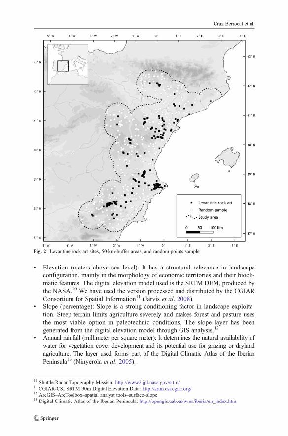
We have used a set of 370 rock art sites drawing on the information contained inthe Dossier UNESCO, produced by the Spanish Autonomous Communities for thedeclaration of this rock art as World Heritage. The information was later completedby our own fieldwork. Each rock art site has been georeferenced by a pair of XYcoordinates. We have generated an equal-size random sample of point locations6
within a previously defined study region. This region consists of a 50-km buffer7
around Levantine rock art sites, excluding the sea (Fig. 2). This fixed distancerepresents a two-day-walking hinterland, easily consistent with a trasterminant-based economic territory. An alternative procedure for the definition of the studyarea—the use of real geographical features such as river basins—was considered, butit was discarded because it included areas quite far from Levantine rock art sites. Inorder to test the randomness of the control sample, we performed a nearest neighboranalysis8 with positive results.9
The surroundings of each location—rock art sites and random points—havebeen established by means of a 1-km circular buffer around its coordinatespoint. Each buffer has been characterized through a series of geographicallayers that we consider relevant structural factors of the landscape, useful tocontrast general hypotheses about prehistoric economies (Fernández-Freire andUriarte 2011). These layers, and the digital cartography used to implement them inthe GIS, are:
5 ArcGIS (v. 10) has been used for managing, extracting, and tabulating geographical variables and IBMSPSS Statistics (v. 19) and Stata (v. 10) for analyzing them. Coordinate system selected for GIS layers isUTM 30 North, European Datum 1950.6 ArcGIS–ArcToolbox–feature class–create random points7 ArcGIS–ArcToolbox–analysis tools–proximity–buffer8 ArcGIS–ArcToolbox–spatial statistics tools–analyzing patterns–average nearest neighbor9 Nearest neighbor ratio01.023; z score00.855, p value00.397.
Landscape Construction and Long-Term Economic Practices
& Elevation (meters above sea level): It has a structural relevance in landscapeconfiguration, mainly in the morphology of economic territories and their biocli-matic features. The digital elevation model used is the SRTM DEM, produced bythe NASA.10 We have used the version processed and distributed by the CGIARConsortium for Spatial Information11 (Jarvis et al. 2008).
& Slope (percentage): Slope is a strong conditioning factor in landscape exploita-tion. Steep terrain limits agriculture severely and makes forest and pasture usesthe most viable option in paleotechnic conditions. The slope layer has beengenerated from the digital elevation model through GIS analysis.12
& Annual rainfall (millimeter per square meter): It determines the natural availability ofwater for vegetation cover development and its potential use for grazing or drylandagriculture. The layer used forms part of the Digital Climatic Atlas of the IberianPeninsula13 (Ninyerola et al. 2005).
10 Shuttle Radar Topography Mission: http://www2.jpl.nasa.gov/srtm/11 CGIAR-CSI SRTM 90m Digital Elevation Data: http://srtm.csi.cgiar.org/12 ArcGIS–ArcToolbox–spatial analyst tools–surface–slope13 Digital Climatic Atlas of the Iberian Peninsula: http://opengis.uab.es/wms/iberia/en_index.htm
Fig. 2 Levantine rock art sites, 50-km-buffer areas, and random points sample
Cruz Berrocal et al.

& Average of maximum temperatures in July (degrees Celsius): Summer temper-atures influence draught and consequently pasture availability in this season. Thislayer has also been taken from the Digital Climatic Atlas of the Iberian Peninsula.
& Bioclimatic levels: Defined by Rivas Martínez (1987) for the Spanish context,these are general altitude or latitude zones with characteristic climatic and bio-geographical traits. They have been taken from the digital version of the Vegeta-tion Series Map of Spain.14 We have considered the four following levels asrepresentative of our study area: termomediterranean, mesomediterranean, supra-mediterranean, and montane. The first three levels, much more widespread,belong to the Mediterranean biogeographical region and include various kindsof vegetation series from more to less sclerophyllous. The montane level, onlypresent in the Pyrenees in our study region, belongs to the Eurosiberian biogeo-graphical region and is related to vegetation series adapted to moister conditions.
& Soil types: the layer used is the soil map of Spain 1:1,000,00015 (Gómez-Miguel2006), based on the USDA Soil Taxonomy (Soil Survey Group 2003). Fourwidespread soils have been selected, all typical of Mediterranean environments:inceptisol xerept (soil with a certain edaphic development and a certain presenceof organic matter), entisol orthent (thin soil without edaphic development, withmain presence of its lithologic substratum), entisol fluvent (non-developed soil,formed on alluvial land), and aridisol calcid (soil typical of Mediterranean aridareas, poor in organic matter and rich in calcium carbonate).
& Land uses: We have considered three basic land uses representative of Mediter-ranean landscape exploitation (Gilman and Thornes 1985, pp. 38–40): forest andpastoral activities, dryland agriculture, and irrigation agriculture. We have elab-orated a GIS layer of these three classes using as data source the Corine LandCover (version 2000).16 We assume that present-day land uses reflect basicstructural land use potentialities in a general scale, despite the huge temporalgap and the obvious techno-economical changes. The Corine Land Cover cate-gories have been reclassified into a few general groups: sea, inland water, urban,improductive, forest and pastoral activities, dryland agriculture, and irrigationagriculture. We have just worked the last three, considering the rest as“indeterminate”.
From these layers, we have computed a series of variables for describing thebuffer areas (Table 1). For those layers representing a continuous quantitativemagnitude (elevation, slope, annual rainfall, and average of maximum temperaturesin July) we have calculated two values: mean, as a summary of the central tendency,and standard deviation, as a measure of variability.17 For qualitative layers (biocli-matic levels, soil types, and land uses), we have considered each majority value (seeabove) and calculated its area percentage into each 1-km buffer.18 The result is a
14 Mapa de Series de Vegetación de España 1:400.000. Ministerio de Agricultura, Alimentación y MedioAmbiente: http://www.magrama.gob.es/15 Mapa de Suelos de España 1:1,000,000. Instituto Geográfico Nacional. Centro Nacional de InformaciónGeográfica.16 Corine Land Cover 2000 (CLC2000). European Environmental Agency: http://www.eea.europa.eu/data-and-maps/data/corine-land-cover-2000-clc2000-seamless-vector-database17 ArcGIS–ArcToolbox–spatial analyst tools–zonal–zonal statistics as table18 ArcGIS–ArcToolbox–analysis tools–overlay–intersect
Landscape Construction and Long-Term Economic Practices
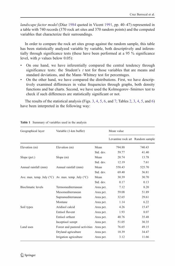
landscape factor model (Díaz 1984 quoted in Vicent 1991, pp. 40–47) represented ina table with 740 records (370 rock art sites and 370 random points) and the computedvariables that characterize their surroundings.
In order to compare the rock art sites group against the random sample, this tablehas been statistically analyzed variable by variable, both descriptively and inferen-tially through significance tests (these have been performed at a 95 % significancelevel, with p values below 0.05):
& On one hand, we have inferentially compared the central tendency throughsignificance tests: the Student’s t test for those variables that are means andstandard deviations, and the Mann–Whitney test for percentages.
& On the other hand, we have compared the distributions. First, we have descrip-tively examined differences in value frequencies through graphs, both densityfunctions and bar charts. Second, we have used the Kolmogorov–Smirnov test tocheck if such differences are statistically significant or not.
The results of the statistical analysis (Figs. 3, 4, 5, 6, and 7; Tables 2, 3, 4, 5, and 6)have been interpreted in the following way:
Table 1 Summary of variables used in the analysis
Geographical layer Variable (1-km buffer) Mean value
Levantine rock art Random sample
Elevation (m) Elevation (m) Mean 794.88 740.43
Std. dev. 59.77 41.40
Slope (pct.) Slope (m) Mean 20.74 13.78
Std. dev. 12.19 7.61
Annual rainfall (mm) Annual rainfall (mm) Mean 558.43 525.70
Std. dev. 69.40 36.81
Ave. max. temp. July (°C) Av. max. temp. July (°C) Mean 30.39 30.70
Std. dev. 0.17 0.13
Bioclimatic levels Termomediterranean Area pct. 7.12 8.20
Mesomediterranean Area pct. 59.08 51.89
Supramediterranean Area pct. 32.65 29.61
Montane Area pct. 1.14 6.22
Soil types Aridisol calcid Area pct. 4.26 15.47
Entisol fluvent Area pct. 1.93 8.07
Entisol orthent Area pct. 40.76 35.48
Inceptisol xerept Area pct. 51.05 30.35
Land uses Forest and pastoral activities Area pct. 76.65 49.15
Dryland agriculture Area pct. 18.39 34.47
Irrigation agriculture Area pct. 3.12 11.66
Cruz Berrocal et al.
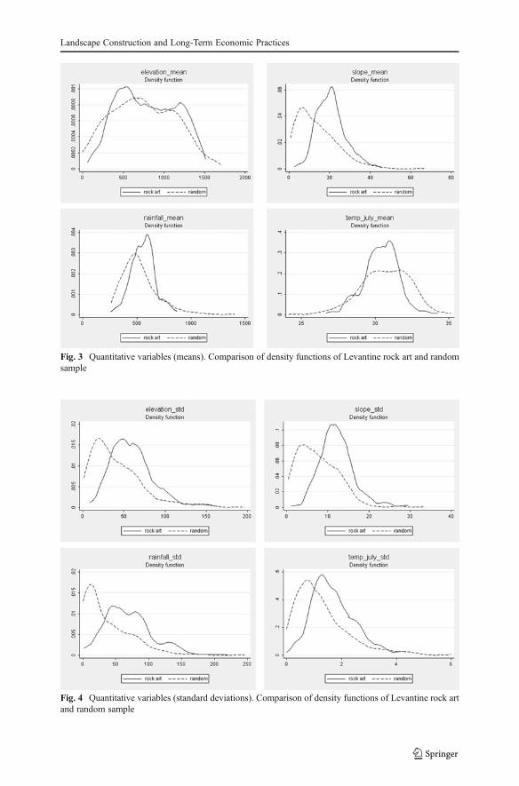
Fig. 3 Quantitative variables (means). Comparison of density functions of Levantine rock art and randomsample
Fig. 4 Quantitative variables (standard deviations). Comparison of density functions of Levantine rock artand random sample
Landscape Construction and Long-Term Economic Practices
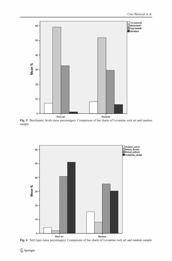
Fig. 5 Bioclimatic levels (area percentages). Comparison of bar charts of Levantine rock art and randomsample
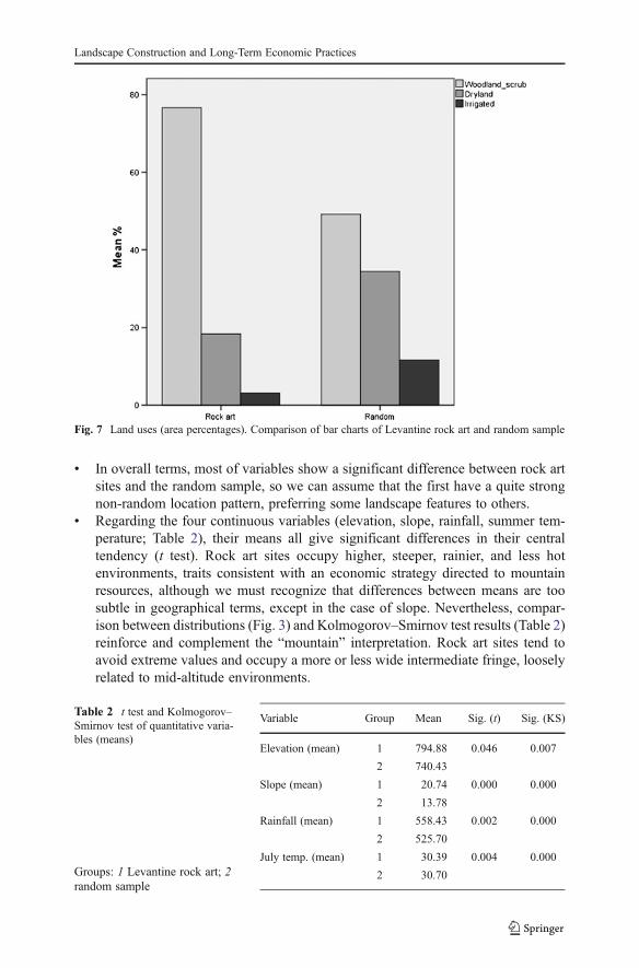
Fig. 6 Soil types (area percentages). Comparison of bar charts of Levantine rock art and random sample
Cruz Berrocal et al.
& In overall terms, most of variables show a significant difference between rock artsites and the random sample, so we can assume that the first have a quite strongnon-random location pattern, preferring some landscape features to others.
& Regarding the four continuous variables (elevation, slope, rainfall, summer tem-perature; Table 2), their means all give significant differences in their centraltendency (t test). Rock art sites occupy higher, steeper, rainier, and less hotenvironments, traits consistent with an economic strategy directed to mountainresources, although we must recognize that differences between means are toosubtle in geographical terms, except in the case of slope. Nevertheless, compar-ison between distributions (Fig. 3) and Kolmogorov–Smirnov test results (Table 2)reinforce and complement the “mountain” interpretation. Rock art sites tend toavoid extreme values and occupy a more or less wide intermediate fringe, looselyrelated to mid-altitude environments.
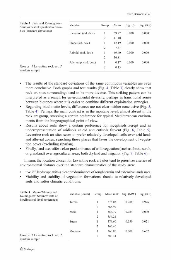
Fig. 7 Land uses (area percentages). Comparison of bar charts of Levantine rock art and random sample
Table 2 t test and Kolmogorov–Smirnov test of quantitative varia-bles (means)
Groups: 1 Levantine rock art; 2random sample
Variable Group Mean Sig. (t) Sig. (KS)
Elevation (mean) 1 794.88 0.046 0.007
2 740.43
Slope (mean) 1 20.74 0.000 0.000
2 13.78
Rainfall (mean) 1 558.43 0.002 0.000
2 525.70
July temp. (mean) 1 30.39 0.004 0.000
2 30.70
Landscape Construction and Long-Term Economic Practices
& The results of the standard deviations of the same continuous variables are evenmore conclusive. Both graphs and test results (Fig. 4, Table 3) clearly show thatrock art sites surroundings tend to be more diverse. This striking pattern can beinterpreted as a search for environmental diversity, perhaps in transitional zonesbetween biotopes where it is easier to combine different exploitation strategies.
& Regarding bioclimatic levels, differences are not clear neither conclusive (Fig. 5,Table 4). Perhaps the main contrast is in the montane level, almost absent in therock art group, stressing a certain preference for typical Mediterranean environ-ments from the biogeographical point of view.
& Results about soils show a certain preference for inceptisols xerept and anunderrepresentation of aridisols calcid and entisols fluvent (Fig. 6, Table 5).Levantine rock art sites seem to prefer relatively developed soils over arid landsand alluvial zones, searching those places that favor the development of vegeta-tion cover (excluding riparian).
& Finally, land uses offer a clear predominance of wild vegetation (such as forest, scrub,or grassland) over agricultural areas, both dryland and irrigation (Fig. 7, Table 6).
In sum, the location chosen for Levantine rock art sites tend to prioritize a series ofenvironmental features over the standard characteristics of the study area:
& “Wild” landscape with a clear predominance of rough terrain and extensive lands uses.& Viability and stability of vegetation formations, thanks to relatively developed
soils and softer climatic conditions.
Table 3 t test and Kolmogorov–Smirnov test of quantitative varia-bles (standard deviations)
Groups: 1 Levantine rock art; 2random sample
Variable Group Mean Sig. (t) Sig. (KS)
Elevation (std. dev.) 1 59.77 0.000 0.000
2 41.40
Slope (std. dev.) 1 12.19 0.000 0.000
2 7.61
Rainfall (std. dev.) 1 69.40 0.000 0.000
2 36.81
July temp. (std. dev.) 1 0.17 0.000 0.000
2 0.13
Table 4 Mann–Whitney andKolmogorov–Smirnov tests ofbioclimatical level percentages
Groups: 1 Levantine rock art; 2random sample
Variable (levels) Group Mean rank Sig. (MW) Sig. (KS)
Termo 1 375.03 0.288 0.976
2 365.97
Meso 1 386.79 0.034 0.000
2 354.21
Supra 1 374.60 0.550 0.021
2 366.40
Montane 1 360.86 0.001 0.652
2 380.14
Cruz Berrocal et al.
& Diversity in potential resources for economic activities, in environmentally het-erogeneous zones.
Interpreting the Patterns
The regularities shown in the location of the Levantine rock art sites point to a strongadaptation to specific geographical conditions, in order to meet certain requirementswhich in our view are related to the role of rock art in the social and economiclandscape of the Neolithic groups. In particular, we can start to see this role whenlooking at traces of the strong relationship existing between the rock art shelters andthe traditional pastoral way of life and land use.
Fieldwork developed between 1999–2000 and 2008–2009 in Villar del Humo(Cuenca), Albarracín and Tormón (Teruel), Júcar (Valencia), La Sarga (Alicante),Maestrazgo (Castellón), Maestrazgo (Zaragoza), Vero river (Huesca), and MartínRiver (Teruel) rendered evidence of occupation by shepherds in 3/4 of the rock artsites, be it through hints such as fire marks on the shelter walls, or in the form of pens,built using the shelter as a side wall.
Other sites have been reported to have had such use: among many others, the Abricde Pinós (Hernández et al. 1998, p. 126), Cueva del Garroso and most of the sites inthis area (Beltrán and Royo 2001), Barranco del Mortero (río Martín), Abrigo delSecans (Utrilla 2005), Plano del Pulido (Utrilla et al. 2010), Abrigo del Ángel (Utrillaand Bea 2011), Cova de Santa Maira (Badal 1999), Cova del Mansano (Aparicio etal. 1988, p. 19), Cova de la Tia Isabel (Aparicio et al. 1988, p. 41), Cuevas del
Table 5 Mann–Whitney andKolmogorov–Smirnov tests of soiltype percentages
Groups: 1 Levantine rock art; 2random sample
Variable (soils) Group Mean rank Sig. (MW) Sig. (KS)
Inceptisol xerept 1 414.98 0.000 0.000
2 326.02
Entisol orthent 1 381.55 0.135 0.008
2 359.45
Entisol fluvent 1 354.09 0.000 0.088
2 386.91
Aridisol calcid 1 344.25 0.000 0.001
2 396.75
Table 6 Mann–Whitney andKolmogorov–Smirnov tests ofland use percentages
Groups: 1 Levantine rock art; 2random sample
Variable (land uses) Group Mean rank Sig. (MW) Sig. (KS)
Woodland and scrub 1 443.48 0.000 0.000
2 297.52
Dryland agriculture 1 334.51 0.000 0.000
2 406.49
Irrigation agriculture 1 341.61 0.000 0.000
2 399.39
Landscape Construction and Long-Term Economic Practices
Engarbo (Soria and López 1999, p. 32), Abric de la Falaguera (Bernabeu et al. 2002,p. 173), Coves de la Vila (Hernández et al. 1998, p. 50), Abric de les Torrudanes(Hernández et al. 1998, p. 94), and the following sites described in Ruiz (2006):Rinconada de González (p. 134), Cueva del Tío Modesto (p. 139), Cabeza Sancha (p.179), Corbeteros I (p. 186), Corbeteros II (p. 195), Corbeteros III (p. 205), Colladodel Toro IV (p. 303), Cueva del Bullón (p. 347), Rambla del Anear (p. 382), Colladode la Losa (p. 389), Hoya del Niño I (p. 398), Los Arenales (p. 487), Peñalta (p. 503).They are mostly refuges for shepherds, or they contain structures to pen up livestock.
This kind of information has been consistently neglected in the publications, and thesame is true for place names, an interesting and complicated piece of evidence. On theone hand, researchers follow unexplicit and changing criteria to name sites, and manytimes this has led to a loss of information when the traditional names are not recorded. Asecond issue is the misunderstanding of the vernacular place name due to linguisticdifficulties. But all in all, there is a correlation between rock art sites and names related tohusbandry, such as Abrigo de la Paridera de las Tajadas, Abrigo de las Cañadas,Balma de les Ovelles, Cañada de la Cruz, Cerrada del Tío Jorge, Corral de laGascona, or Mallata, among many others.
Rock shelters are easily converted into pens, receive natural light, and renderprotection against the elements (Colón Díaz 1998, p. 205). And their situation insidegullies enhances their quality as refuges: 90.9 % of the total sample of sites aresheltered inside gullies, particularly suitable, in terms of size, water, and vegetation,to keep and feed livestock, as the traditional pastoralist activities show.19
This is due to the fact that, in the arid and semiarid Mediterranean environments,gullies are a most interesting resource since they hold microclimatic conditions thatallow them to retain some humidity, or even water lenses, throughout the year. Thismeans that also vegetation is more likely to endure the summer inside these naturalrefuges, making them, therefore, particularly suitable as a feeding source for animals.Both water—an essential resource in the karstic areas and the most valued in socialterms, and most so in the Mediterranean (Farnós et al. 1993; Colón Díaz 1998;Horden and Purcell 2000)—and vegetation, are strategic resources (Carrión et al.2000). These microclimatic advantages are also supported by topographical ones,since small-sized gullies favor the management of animals within them (Beltrán1993; Davidson 1989).
At the broader regional scale, the rock art is located, as shown above, in areas ofgeneral limited agricultural potential, but featuring an ecologically transitional char-acter between low- and uplands, or biotopes, that provides a combination of differentmicroenvironments (Rivas Martínez 1982). This favors a set of complementaryeconomic activities, based on pastures and forest. Thus, hunting, gathering, and evensome agriculture are possible at the small scale (Bacaicoa et al. 1993; Roigé Venturaet al. 1993; Pallaruelo 1993; Rubio de Lucas et al. 1993a) in combination with
19 Most interestingly, rock art sites tend to be located at particular places inside the ravines, be these theheads, confluences, or mouths. Only in Aragón, Los Estrechos, Los Chaparros (Martín river), Arenal deFonseca (Ladruñán), and Chimiachas (Vero river) seem to mark the access to gullies; Gallineros and HuertoRaso (Lecina), as well as Benedí (Jaraba), among others, mark the confluence of two ravines. On the otherhand, the Cerrao paintings (Obón), Fenellosa (Beceite), Cantalar I, El Mortero (Alacón), Cerro Felío, laCañada de Marco, Barranco de Solencio, and Prado del Tormón, among many others, mark water sourcesand naturally occurring water accumulations.
Cruz Berrocal et al.

husbandry: grass tends to grow under the forest cover, which allows grazing duringsummer time (Bacaicoa et al. 1993; Roigé Ventura et al. 1993). Seasonality is in factone of two very significant aspects of land use in the area; the other is an extensive,low-impact work investment: since forested and open areas compete, pastures have tobe maintained through fire (Pallaruelo 1993; Butzer 1996). But this work investmentis relatively small, and keeping the forest in check is not a limitation for theexploitation of other resources.
Herding and cultivation in the lowlands are, thus, traditionally, complementary toeach other (Butzer 2005), and a sustainable economic activity (Mangas 1992; Butzer1996; Creighton and Seguí 1998; Sánchez Moreno 1998; Christie et al. 2007), withdifferent dimensions, ranging from mixed husbandry-farming activities to trastermi-nant short movements between close areas, the likely precedent of trashumance20
(Pallaruelo 1993; López Sáez et al. 2009). In all cases, regardless of the localspecificities, the seasonal and varied character of these middle-altitude ranges madethem very important in traditional rural economies, and especially important assummer pastures in traditional husbandry, well studied by Klein (1990), Bacaicoaet al. (1993), Farnós et al. (1993), Roigé Ventura et al. (1993), Rubio et al. (1993a,b), Pallaruelo (1993), or Fernández Temprado et al. (1996).
The time-depth of the practice is however not well established. Researchers tend toassume that it goes fairly back in time (Butzer 1988; Pallaruelo 1993; Ruiz Gálvez2002). Seasonal patterns of mobility between Mediterranean up- and lowlands havebeen traced back to the Palaeolithic and Mesolithic (Aura and Pérez 1992; Aura et al.1998) and trasterminant movements in search of pastures have been described for theearly Neolithic for some areas (Bernabeu 1995), with rock shelters and caves beingused as occasional corrals (Bernabeu 1995; Bernabeu et al. 2002), and as researchand evidence grow, more regional case studies are highlighted that illustrate contin-uous husbandry since the Neolithic (e.g., Ejarque and Orengo 2009, or the alternativeoccupation and abandonment of Cueva de Olvena, close to Remosillo rock art siteand dated between the Early Neolithic and Late Bronze Age, interpreted as a stop inthe transhumant movement towards Sierra Ferrera). By Roman times, the patterns ofhusbandry found later on were already in place (Butzer 1988; López Sáez et al.2009).
Medieval trashumance, on the other hand, has been thoroughly studied (e.g.,Butzer 1988; Mangas 1992; Bacaicoa et al. 1993; Farnós et al. 1993; Pallaruelo1993; Roigé Ventura et al. 1993; Rubio de Lucas et al. 1993a, b; FernándezTemprado et al. 1996; López Sáez et al. 2009), as one example of this type ofpastoral institutions in the Mediterranean (Mientjes 2004; Barker 2005). The studyof transhumance is only partially useful when tracing back the practice and continuityof the Mediterranean pastoral activities, because certain historical, political, andsocial factors enabled transhumance—among others, royal privileges allowed the
20 Studies are slightly biased towards research on transhumance, since small-scale movements, directedtowards subsistence rather than large-scale economic activities, lacked the social significance and thehistoric connotations of trashumance, and were therefore hardly considered and recorded, even in latertimes. There are exceptions, in areas with a very strong altitudinal gradient where some ethnographic workof trasterminant vertical short movements has been done, such as in the Pyrenees (Roigé Ventura et al.1993), the Baetic Ranges (Alcaraz, Cazorla, and Segura) (Rubio de Lucas et al. 1993a), the Maestrazgo(Fernández Temprado et al. 1996), and the Aitana and Mariola sierras (Fernández Temprado et al. 1996).
Landscape Construction and Long-Term Economic Practices
institution of the Mesta to gather its power (Davidson 1980; Butzer 1988)—this studyis however significant.
Spanish transhumance consisted of massive movements of herds, composed most-ly by sheep, from their areas of winter-staying to areas of summer pastures usinglivestock paths. These movements involved extremely long distances throughoutmost areas of the Peninsula. The Medieval written documentation reflects what werealready traditional rights at the time. Islamic conquerors of the peninsula could havebeen the introducers of the practice of long-distance movement of sheep, but afterButzer (1988, p. 40), “…overall the Islamic data suggest more continuity thanchange. In effect, these early Medieval sources provide a longer perspective on theevolution of livestock raising on the peninsula that emphasizes persistence since lateprehistoric times, a characteristic that must be attributed to ecological factors”.Christian documents about transhumant practices date to the Reconquista (e.g., Klein1990; Bacaicoa et al. 1993; Roigé Ventura et al. 1993); they show the institutional-ization of the practice in the thirteenth century across Sierra Morena, the PrebaeticRanges (Rubio de Lucas et al. 1993a), between the coastal ranges and the uplands ofthe Iberian Range (Fernández Temprado et al. 1996), and between Cuenca, Albaceteand Murcia (Fernández Temprado et al. 1996, p. 30). In Catalonia, the transhumantsystem was recorded by documents as early as the eleventh to twelfth centuries, whenrural communities took their flocks to the low flat lands for the winter (Roigé Venturaet al. 1993). The first pastoral infrastructures recorded between the Ebro delta and theTuria basin date from the twelfth century (Farnós et al. 1993).
Livestock paths articulate this regional system. They are major lines of contactbetween up- and lowlands: they clearly establish the link between different andsometimes distant regions, through a dense network of mostly minor pathways.
Livestock paths are, in a sense, archaeological remains. But they are also histor-ically dynamic entities and have changed along time. Butzer (1988, p. 42) describedthe Spanish network of livestock paths as “…a complex hierarchy of web-like sheeptrails that defies mapping on a national scale. The only fixed points in this unstablepattern appear to have been the royal toll stations (…)”. In a previous work (Fairén etal. 2006), we developed some experimental analysis in order to test this statement.
First we tested the hypothesis that the livestock paths correspond to least-costroutes, in an area comprising the Vall d’Albaida (south Valencia) and the middleSerpis basin (north Alicante). The results were negative: the livestock paths tend tofollow water divides and sheer zones because they must avoid agricultural fieldswhile at the same time looking for the good pastures that grow in the river basins.Therefore, they go along divides or middle slopes. The livestock paths did correlatewith the location of villages in the lowlands, though. The reason is that this region itis a point of departure for herds that go into the uplands. Thus, livestock paths in theseareas gather herds from the villages, and villages are, therefore, the most determiningfactor in their location.
But in the uplands, point of arrival for the herds, the situation is reversed. Thepaths’ courses are much more influenced by other elements, such as the location ofwater. In these areas, paths are greatly ramified, and their size diminish. The greaterthe ramification, the greater the stability of the network, thus allowing its preserva-tion. The more inconspicuous the role of livestock paths in the landscape, the morestable and relevant they become in archaeological terms. Overall, livestock paths
Cruz Berrocal et al.
have been preserved fairly well in the uplands, and they are key elements in theregional network of economic activity.
In previous works (Cruz Berrocal 2004, 2005; Fairén et al. 2006; Cruz Berrocaland Vicent 2007), we have shown a geographical correlation between the location ofLevantine rock art sites and livestock paths—no rock art site is in isolation orremoved from the network created by livestock paths—as well as an overlapping ofrock art sites and traditional pastures. This is in our view a major argument tounderstand the existence and distribution of rock art sites: they can be seen as fixedpoints within the network, as Butzer (1988, p. 42) thought of the much later royal tollstations. Moreover, they, as the paths, themselves, can be assumed to relate to a set ofresources.
The Archaeology of Rock Art As an Archaeology of Landscape
In a sense, livestock paths make visible the underlying structure of the territory,reproduced by the location of rock art sites, which also ‘map’ the territory pointing tospecific resources (pasture, water, refuge). Thus, rock art sites are archaeologicallytraceable material expressions of an early integration of the mountainous areas of theMediterranean basin in people’s economic life.
The study of rock art from the point of view of its distribution is therefore a way ofundertaking a literal ‘archaeology’ of the landscape. Its distribution “materialize[s](…) one single territory out of all the different regions” (Cruz Berrocal and Vicent2007, p. 689). Unlike settlements—their locational differences through time may beexplained in functional, social, cultural or even environmental terms—, rock artallows us to observe a complete landscape (Cruz Berrocal and Vicent 2007), in whichlowlands and uplands are linked forming a single regional territory, composed of aseries of articulated local areas (Cruz Berrocal 2004, 2005; Cruz Berrocal and Vicent2007). Thus, rock art shows the interplay of the macro–micro, the connectivity thatcharacterizes the fragmented Mediterranean.21 Of course, one major advantage in thisregard is that, unlike paths, rock art may be a dated evidence; we can at least assign aterminus post quem to this process of landscape construction.
The correlation between the distribution of the Neolithic paintings and the pastoraltraditional landscape may be further interpreted as a continuum in the use of a seriesof very valuable economic resources in the Mediterranean uplands for as long asseveral millennia, marked by archaeological indicators pointing to its beginning andpossibly its end. Life along this continuum is not easy to grasp archaeologicallyotherwise. Archaeology and ethnoarchaeology of pastoralism in the Mediterranean isgrowing (e.g., Creighton and Seguí 1998; Mientjes 2004; Christie et al. 2007) as well
21 Mediterranean mountains “are actually closely integrated into the patterns of production and communi-cation that abut them” (Horden and Purcell 2000, p. 81). Geography shows this: in the Spanish Mediter-ranean basin, numerous natural corridors link the coast to the inland and mountainous areas—e.g. theVinalopó and Segura—the first linking the Mediterranean coast with the inland, through the mountainpasses of Almansa and Caudete, the second linking the Mediterranean basin with Andalucía and theGuadalquivir basin; or the North-South corridors, such as Alcoià-Comtat, Salinas, Novelda-Monforte delCid to Alicante, lower Vinalopó to lower Segura, and corridors that link the Alto Maestrazgo with the coastin Castellón, and the Upper Tagus with the Lower Vinalopó/Lower Segura (Ruiz Gálvez 2002).
Landscape Construction and Long-Term Economic Practices
as studies focused on change and continuity in a specific region (e.g., Ejarque andOrengo 2009). But because of the very nature of these regions and their use, there isscarce or no evidence of settlement in the Mediterranean mountains until the very lateperiods. Rock art sites themselves are shallow shelters that can hardly retain anysediment, while their locations in gullies prone to seasonal flooding do not contributefurther evidence, since archaeological remains would be swept away every season.Therefore, archaeological evidence is scarce.22
As for the paintings themselves, there are some intriguing depictions in some ofthe shelters pointing to continued visits through time (e.g., the equestrian figure inAbrigo X, Cingle de la Gasulla, Castellón, dated to the Iron Age (Ripoll 1962)), butthere is no regular repainting on the rock shelters.
This does not necessarily mean that people were not aware of the Neolithicpaintings, however. In our fieldwork, we found some evidence of an impact of theNeolithic rock art in the subsequent reconstruction of landscapes later in time. In threeof the areas (Gasulla, Villar del Humo, and Albarracín) other rock art depictions wereprobably made in Medieval times, exactly surrounding the coherent ‘systems’ formedby the Neolithic rock art sites. Thus, while they ‘respect’ them, they probably usethem as references. In a sense, the Medieval sites are enlargements of the prehistoricconstructions, but they are scarce and, somehow, marginal. They can be considered asexceptions (see also Ruiz 2006), as opposed to the Neolithic rock art. Thus, thecontrasts probably point to a very different sociological context for the making of thedepictions both in Neolithic and Medieval times. In the first case, rock art wasinserted in a wider territorial system, and subject to rules as to how and where, andprobably who and when, the art should be made, as shown in the clear regularitiesand patterns that characterize the Levantine paintings. In the case of Medieval rockart, its features point to a set of individual actions that create unique sites with scarceor no regular features among them. As a product of independent and unique events,this rock art does not appear to belong in a broader social logic, as it was the case ofthe Neolithic paintings; rather, it is the patrimony of specific, even marginal, sectionsof the society (probably herders), and its materiality has therefore totally changed.Neolithic rock art worked as a social institution, whereas in Medieval times rock artappears as an idiosincratic personal or group expression (Cruz Berrocal 2005). It isnot necessarily irrelevant, but it has lost its previous social significance.
In other words, the archaeology of rock art also shows a wider social context throughthe existence or absence of patterns, and therefore an accordingly changed socialsignificance and even a different social formation behind its making. In our presentcase it also points to a ‘folk knowledge’ of the landscape, and to a continuity in the use ofplaces, even under different social and economic conjunctures. Unfortunately, we do nothave extensive information about this sort of social memory and knowledge, since it liesat the confluence of three under researched topics: first, the rock art of historic times;second, the relationship between local people and archaeological remains, especiallyrock art, in Spanish rural areas; and third, the archaeology of mountain areas.
22 Ripoll (1968) already noted a general correlation between Levantine rock art shelters and Neolithiccardial pottery, later reasserted by other findings, and lately, by a number of projects in areas of specialconcentration of rock art, which show long sequences of settlement throughout the Neolithic and laterperiods (e.g. Martínez and Villaverde 2002; Hernández and Segura 2002; Ruiz 2006, among others).
Cruz Berrocal et al.
Therefore, our proposals are just hints in these directions, approaching now ourconclusion: as the evidence of use of the uplands is subtle, almost by definition,especially in early times, it is necessary to weave together different kinds of data andsources, in order to fill the gap, such as maps of potential economic resources andpotential erosion, livestock paths, ethnohistorical documentation on herding practi-ces, and palaeoenvironmental records. Rock art may be one of the most importantpieces of evidence. The presence of an intentional and highly systematic type ofremains such as rock art is enough to demonstrate the social character of thisotherwise scarcely imprinted environment. Moreover, basic continuity in the use ofthe Spanish Mediterranean uplands under a similar exploitative regime can beprobably acknowledged since the Neolithic to the contemporary times.
Conclusions
Levantine rock art sites are a ‘map’ of the territory; they reflect structural character-istics of the Mediterranean mountain ranges, including topography and seasonalstreams, critical within the Mediterranean food production economy. These structuralfeatures are not prone to change; they are likely to have remained stable along time.At the same time, human action on the landscape and especifically on the vegetationappears to be detected at around the same time that the making of the rock art, duringthe Early Neolithic (Carrión et al. 2001b). The patterns of vegetation change reachtheir maximum complexity between the mid- and late-Holocene. Thus, for instance,although an aridification trend over the last five millennia is well-established, thetiming of forest decline is spatially uneven and cannot be solely explained by currentdifferences in physical setting (Carrión 2002). Among the factors involved, the role ofanthropogenic disturbance, which was undoubtedly spatially heterogeneous, shouldbe considered. Burning and pastoralism, among other activities, may have beenhistorically decisive and site-specific (Carrión et al. 2007; López Sáez et al. 2009).
Thus the idea of landscape construction, beginning in the Neolithic, is not anabstract proposition: it has material correlates, both ‘cultural’ and ‘environmental’.The human-induced changes in the vegetation have their ‘cultural’ side in thepermanent transformation of the rock shelters, and by the same token, in the perma-nent transformation of the perception of that landscape. Rock art is then a means ofmonumentalization, implying a re-conceptualization of space—transformed into a‘place’ (Casey 1996)—and time.
Both environmental and cultural action and construction of the landscape are two earlyparallel processes in upland Mediterranean areas, dated to the Neolithic. They appear tobe intrinsically linked to the long-term history of extensive use of certain resources,almost in between ‘domestic hunting’ and ‘wild husbandry’, namely pastoralism, inbroad senses. Pastoralism, intended for the creation of surplus (Barker 2005; Robb 2007)and the buffering of risks (Horden and Purcell 2000) in combination with agriculture,is the economic activity that shaped the Mediterranean upland environments (Hordenand Purcell 2000; Carrión 2001b; Barker 2005; López-Sáez et al. 2011).
We do not choose to establish a positive and definitive relationship between rockart and pastoralism in the Mediterranean basin, although there are precedents for it(e.g., Martínez 1998, 2000). The environment offers potential good conditions, and
Landscape Construction and Long-Term Economic Practices
after Prescott’s (1995, p. 168) criteria (domesticates presence, relation to pastures,and potential good natural conditions), it is possible to suggest a reliable link amongNeolithic sites, rock art sites, and herding practices—especially of ovicaprids. But weprefer instead to observe rock art as a ‘proxy’ to understand the underlying structureof the landscape, since the rock art, a permanent feature, kept being ‘used’ throughtime. If society and nature form a complex system, the use of environmental markersto reconstruct social history may be supplemented by the use of historical markers toreconstruct, or at least to think, the environment. Rock art studies can benefit from aregional archaeological perspective, but also a regional archaeology can benefit fromrock art studies. In fact, we hope to have shown that the study of a territory cannot beeffectively completed if the rock art evidence is not taken into account.
Acknowledgments We wish to acknowledge comments and references provided by Agustín DiezCastillo, Juan Gaspar Leal Valladares, Fernando Sedano, and Javier López Precioso. We also thank JuanRuiz the unpublished manuscript of his doctoral dissertation. Lorenzo Mateos, from ESRI Support, helpedin the GIS analysis. José Manuel Rojo, Concepción Murillo, and Ma. Ángeles Toribio, from the CCHS-CSIC Statistical Analysis Unit, and Laura Barrios, from the CSIC Scientific Calculus Center, collaboratedin the statistical analysis.
This work has partially benefited from financial and technical support provided by the SpanishConsolider Program (CSD2007-00058), and the Spanish Plan Nacional de I+D+i, Ministry of Scienceand Innovation (projects HAR2008-06477-C03-03/HIST and CGL2011-30512-C02-01).
References
Aparicio, J., Beltrán, A., & Boronat, J. (1988). Nuevas pinturas rupestres en la Comunidad Valenciana.Valencia: Academia de Cultura Valenciana, Serie Arqueológica 13 (I).
Aura, J. E., & Pérez, M. (1992). Tardiglaciar y Postglaciar en la región mediterránea de la Península Ibérica(13500-8500 BP): transformaciones industriales y económicas. Saguntum, 25, 25–47.
Aura, J. E., Villaverde, V., González, M., González, C., Zilhão, J., & Straus, L. G. (1998). The Pleistocene–Holocene transition in the Iberian Peninsula: continuity and change in human adaptations. QuaternaryInternational, 49(50), 87–103.
Bacaicoa, I., Elías, J. M., & Grande, J. (1993). Albarracín–Cuenca–Molina. Madrid: Cuadernos de laTrashumancia 8, ICONA.
Badal, E. (1999). El potencial pecuario de la vegetación mediterránea: las Cuevas Redil. II Congrés delNeolític a la Península Ibérica. Saguntum-PLAV, 2, 69–75. extra.
Badal, E., & Roiron, P. (1995). La prehistoria de la vegetación en la Península Ibérica. Saguntum, 28, 29–48.Badal, E., Bernabeu, J., & Vernet, J.-L. (1994). Vegetation changes and human action from the Neolithic to
the Bronze Age (7000–4000 B.P.) in Alicante, Spain, based on charcoal analysis. Vegetation Historyand Archaeobotany, 3, 155–166.
Barker, G. (2005). Agriculture, pastoralism, and Mediterranean landscapes in prehistory. In E. Blake & A.B. Knapp (Eds.), The archaeology of Mediterranean prehistory (pp. 46–76). Oxford: Blackwell.
Barker, G., & Bintliff, J. (1999). Geoarchaeology in Mediterranean landscape archaeology: concludingcomments. In P. Leveau, F. Trément, K. Walsh, & G. Barker (Eds.), Environmental reconstruction inMediterranean landscape archaeology (pp. 207–210). Oxford: The Archaeology of MediterraneanLandscapes 2, Oxbow Books.
Beltrán, A. (1993). Arte prehistórico en Aragón. Zaragoza: Ibercaja.Beltrán, A., & Royo, J. (2001). La Cueva del Tío Garroso en el Cerro Felío (Alacón, Teruel). BARA, 4, 23–60.Berger, J.-F., Nuninger, L., & Van Der Leeuw, S. (2007). Modeling the role of resilience in socioenvironmental
co-evolution: the Middle Rhône Valley between 1000 BC and AD 1000. In T. Kohler & S. van der Leeuw(Eds.), The model-based archaeology of socionatural systems (pp. 41–59). Santa Fe: SAR Press.
Bernabeu, J. (1995). Origen y consolidación de las sociedades agrícolas. El País Valenciano entre elNeolítico y la Edad del Bronce. Actes de les Segones Jornades d’Arqueologia (pp. 37–60). Alcofás delPi: Conselleria de Cultura. Generalitat de València.
Cruz Berrocal et al.
Bernabeu, J., Aura, J. E., & Badal, E. (1993). Al oeste del Edén. Las primeras sociedades agrícolas en laEuropa mediterránea. Historia Universal Prehistoria 4. Madrid: Síntesis.
Bernabeu, J., Orozco, T., & Díez, A. (2002). El poblamiento neolítico: desarrollo del paisaje agrario en lesValls de l’Alcoi. In M. S. Hernández, J. M. Segura Martí (Coords.), La Sarga. Arte rupestre y territorio(pp. 171–184). Alcoi: Ayuntamiento de Alcoi, Caja de Ahorros del Mediterráneo.
Bintliff, J. (2002). Time, process and catastrophism in the study of Mediterranean alluvial history: a review.World Archaeology, 33(3), 417–435.
Burjachs, F., Giralt, S., Roca, J. R., Seret, G., & Julià, R. (1997). Palinología holocena y desertización en elMediterráneo Occidental. In J. J. Ibáñez, B. Valero, & C. Machado (Eds.), El paisaje mediterráneo a travésdel espacio y del tiempo. Implicaciones en la desertificación (pp. 379–394). Logroño: GeoformaEdiciones.
Butzer, K. (1988). Cattle and sheep from old to new Spain: historical antecedents. Annals of the Associationof American Geographers, 78(1), 29–56.
Butzer, K. (1996). Ecology in the long view: settlement histories, agrosystemic strategies, and ecologicalperformance. Journal of Field Archaeology, 23(2), 141–150.
Butzer, K. (2005). Environmental history in the Mediterranean world: cross-disciplinary investigation ofcause-and-effect for degradation and soil erosion. Journal of Archaeological Science, 32, 1773–1800.
Buxó, R. (1997). Arqueología de las Plantas. Barcelona: Crítica.Carrión, J. S. (2001a). Condicionantes de la respuesta vegetal al cambio climático. Una perspectiva
paleobiológica. Acta Botanica Malacitana, 26, 157–176.Carrión, J. S. (2001b). Dialectic with climatic interpretations of Late-Quaternary vegetation history in
Mediterranean Spain. Journal of Mediterranean Ecology, 2, 145–156.Carrión, J. S. (2001c). Pastoreo y vulnerabilidad de la vegetación en la alta montaña mediterránea durante el
Holoceno. Cuadernos de Geografía, 69(70), 7–22.Carrión, J. S. (2002). Patterns and processes of Late Quaternary environmental change in a montane region
of southwestern Europe. Quaternary Science Reviews, 21, 2047–2066.Carrión, J. S., & van Geel, B. (1999). Fine-resolution Upper Weichselian and Holocene palynological
record from Navarrés (Valencia, Spain) and a discussion about factors of Mediterranean forestsuccession. Review of Palaeobotany and Palynology, 106, 209–236.
Carrión, J. S., Munuera, M., Navarro, C., & Sáez, F. (2000). Paleoclimas e historia de la vegetacióncuaternaria en España a través del análisis polínico. Viejas falacias y nuevos paradigmas. Complutum,11, 115–142.
Carrión, J. S., Munuera, M., Dupré, M., & Andrade, A. (2001a). Abrupt vegetation changes in the SeguraMountains of southern Spain throughout the Holocene. Journal of Ecology, 89, 783–797.
Carrión, J., Andrade, A., Bennet, K., Navarro, C., & Munuera, M. (2001b). Crossing forest thresholds:inertia and collapse in a Holocene sequence from south central Spain. The Holocene, 11, 635–653.
Carrión, J. S., Yll, E. I., Willis, K. J., & Sánchez, P. (2004). Holocene forest history of the eastern plateauxin the Segura Mountains (Murcia, southeastern Spain). Review of Palaeobotany and Palynology, 132,219–236.
Carrión, J. S., Fuentes, N., González-Sampériz, P., Sánchez Quirante, L., Finlayson, C., Fernández, S., &Andrade, A. (2007). Holocene environmental change in a montane region of southern Europe with along history of human settlement. Quaternary Science Reviews, 26, 1455–1475.
Carrión, J. S., Fernández, S., González-Sampériz, P., Gil-Romera, G., Badal, E., Carrión-Marco, Y., López-Merino, L., López Sáez, J. A., Fierro, E., & Burjachs, F. (2010). Expected trends and surprises in theLateglacial and Holocene vegetation history of the Iberian Peninsula and Balearic Islands. Review ofPalaeobotany and Palynology, 162, 458–475.
Casey, E. (1996). How to get from space to place in a fairly short stretch of time. In S. Feld & K. H. Basso(Eds.), Senses of Place (pp. 13–52). School of American Research. Advanced Seminar Series (pp. 13–52). Santa Fe: School of American Research Press.
Christie, N., Beavitt, P., Gisbert Santonja, J., Gil Senís, V., & Seguí, J. (2007). Peopling the Recent Past inthe Serra de L’Altmirant: Shepherds and Farmers at the Margins. International Journal of HistoricalArchaeology, 11, 304–321.
Colón Díaz, M. (1998). Montaña y karst mediterráneo. Especificidad, antropización y gestión ambiental.Cádiz: Universidad de Cádiz.
Creighton, O. H., & Seguí, J. R. (1998). The ethnoarchaeology of abandonment and post-abandonmentbehaviour in pastoral sites: evidence from Famorca, Alacant Province, Spain. Journal of Mediterra-nean Archaeology, 11(1), 31–52.
Cruz Berrocal, M. (2004). La investigación del arte rupestre desde la geografía: la pintura neolítica delámbito mediterráneo de la Península Ibérica. Trabajos de Prehistoria, 61(2), 41–62.
Landscape Construction and Long-Term Economic Practices
Cruz Berrocal, M. (2005). Paisaje y arte rupestre. Patrones de localización de la pintura levantina.Oxford: BAR S1409.
Cruz Berrocal, M., & Vicent, J. (2007). Rock art as an archaeological and social indicator: the neolithisationof the Iberian Peninsula. Journal of Anthropological Archaeology, 26, 676–697.
Davidson, I. (1980). Transhumance, Spain and ethnoarchaeology. Antiquity, 54, 144–147.Davidson, I. (1989). La economía del final del paleolítico en la España oriental. Serie de Trabajos Varios
del SIP 85. Valencia: Diputación Provincial de Valencia.Davis, B. S. A. (1994). Palaeolimnology and Holocene environmental change from Endoreic lakes in the
Ebro Basin, North-East Spain. Ph.D. Thesis. Newcastle: University of Newcastle Upon Tyne.Davis, G. W., & Richardson, D. (Eds.). (1995). Mediterranean-type ecosystems. The function of biodiver-
sity. Berlin: Springer.Davis, G. W., & Rutherford, M. C. (1995). Ecosystem function of biodiversity: can we learn from the
collective experience of MTE research? In G. W. Davis & D. M. Richardson (Eds.), Mediterranean-type ecosystems. The function of biodiversity (pp. 335–350). Ecological Studies 109. Berlin: Springer.
Díaz, J. R. (1984). Geografía y agricultura. Componentes de los espacios agrarios. Madrid: Cincel.de Vries, B., Thompson, M., & Wirtz, K. (2002). Understanding: fragments of a unifying perspective. In B.
L. de Vries & J. Goudsblom (Eds.), Mappae Mundi: humans and their habitats in a long-term socio-ecological perspective (pp. 257–300). Amsterdam: Amsterdam University Press.
Diekmann, L., Panich, L., & Striplen, CH. (2007). Native American management and the legacy ofworking landscapes in California. Western landscapes were working long before Europeans arrived.Rangelands, 46–50.
Dupré, M. (1988). Palinología y paleoambiente. Nuevos datos españoles. Serie de Trabajos Varios del SIP84. Valencia: Diputación Provincial de Valencia.
Ejarque, A., & Orengo, H. (2009). Legacies of change: the shaping of cultural landscapes in a marginalMediterranean Mountain Range, the Garraf Massif, North-Eastern Spain. Oxford Journal of Archae-ology, 28(4), 425–440.
Ejarque, A., Miras, Y., Riera, A., Palet, J. M., & Orengo, H. A. (2010). Testing micro-regional variability inthe Holocene shaping of high mountain cultural landscapes: a palaeoenvironmental case-study in theeastern Pyrenees. Journal of Archaeological Science, 37, 1468–1479.
Fairén, S. (2006). El paisaje de la neolitización. Alicante: Universidad de Alicante.Fairén, S., Cruz Berrocal, M., López-Romero González De La Aleja, E., & Walid Sbeinati, S. (2006). Las
vías pecuarias como elementos arqueológicos. In I. Grau Mira (Ed.), La aplicación de los SIG en laarqueología del paisaje (pp. 55–68). Alicante: Universidad de Alicante.
Farnós, A., Arasa, J., Argudo, J. L., Gargallo, E., Porres, A., Querol, J. V., & Virgili, J. (1993). Gúdar-Maestrazgo. Madrid: Cuadernos de la Trashumancia 14, ICONA.
Fernández Temprado, C., Farnós, I., Brel, A., Obiol Menero, E., Rodríguez García, M., Virgili Guardia, J.,& Arasa Centelles, J. (1996). Mediterráneo. Madrid: Cuadernos de la Trashumancia 19, OrganismoAutónomo Parques Nacionales.
Fernández-Freire, C., & Uriarte, A. (2011). Modelización del paisaje mediante SIG para la investigación desociedades agrarias paleotécnicas. In V. Mayoral & S. Celestino (Eds.), Tecnologías de InformaciónGeográfica y Análisis Arqueológico del Territorio. Actas del V Simposio Internacional de Arqueologíade Mérida (pp. 449–458). Mérida: Junta de Extremadura—Consorcio de Mérida.
García-Ruiz, J. M. (2010). The effects of land uses on soil erosion in Spain: a review. Catena, 81(1), 1–11.Gilman, A., & Thornes, J. B. (1985). Land-use and prehistory in south-east Spain. London: Allen & Unwin.Gil-Romera, G., López Merino, L., Carrión, J. S., González-Sampériz, P., Martín-Puertas, C., López Sáez,
J. A., Fernández, S., García Antón, M., & Stefanova, V. (2010). Interpreting resilience through long-term ecology: potential insights in Western Mediterranean landscapes. The Open Ecology Journal,3, 43–53.
Gómez, A., & Esteban, A. (1993). Análisis polínico de la turbera de La Feixa (La Màniga, Cerdanya, 2.150 m).Evolución del paisaje. In M. P. Fumanal & J. Bernabeu (Eds.), Estudios sobre Cuaternario, medios sedimen-tarios, cambios ambientales, hábitat humano (pp. 185–190). València: Universitat de València.
Gómez-Miguel, V. (2006).Mapa de Suelos de España 1:1.000.000. Madrid: Instituto Geográfico Nacional.González-Hidalgo, J. C., Peña-Monné, J. L., & De Luis, M. (2007). A review of daily soil erosion in
Western Mediterranean areas. Catena, 71, 193–199.González-Sampériz, P. (2004). Evolución paleoambiental del sector central de la cuenca del Ebro durante
el Pleistoceno superior y Holoceno. Zaragoza: Instituto Pirenaico de Ecología-CSIC.González-Sampériz, P., Valero-Garcés, B. L., Moreno, A., Jalut, G., García-Ruiz, J. M., Martí-Bono, C.,
Delgado-Huertas, A., Navas, A., Otto, T., & Dedoubat, J. J. (2006). Climate variability in the SpanishPyrenees during the last 30,000 yr revealed by the El Portalet sequence.Quaternary Research, 66, 38–52.
Cruz Berrocal et al.
González-Sampériz, P., Valero-Garcés, B. L., Moreno, A., Morellón, M., Navas, A., Machín, J., &Delgado-Huertas, A. (2008). Vegetation changes and Hydrological fluctuations in the Central EbroBasin (NE Spain) since the Lateglacial: saline lake records. Palaeogeography, Palaeoclimatology,Palaeoecology, 259, 157–181.
Hernández, M., & Segura, J. (Coords.) (2002). La Sarga. Arte rupestre y territorio. Alcoy: Ayuntamientoand CAM.
Hernández, M., Ferrer, P., & Català, E. (1998). L’art llevantí. Cocentaina: Centre d’Estudis Contestans.Hobbs, R. J., Richardson, D. M., & Davis, G. W. (1995). Mediterranean-type ecosystems: opportunities and
constraints for studying the function of biodiversity. In G. W. Davis & D. M. Richardson (Eds.),Mediterranean-type ecosystems. The function of biodiversity (pp. 1–42). Ecological Studies 109 (pp.1–42). Berlin: Springer.
Horden, P., & Purcell, N. (2000). The corrupting sea. A study of Mediterranean history. Oxford: Blackwell.Jalut, G., Esteban, A., Riera Mora, I., Mora, S., Fontugne, M., Mook, R., Bonnet, L., & Gauquelin, T. (1997).
Holocene climatic changes in the western Mediterranean: installation of the Mediterranean climate.ComptesRendus de l’Academie de Sciences de Paris, Sciences de la Terre et des Planètes, 325, 327–334.
Jalut, G., Esteban Amat, A., Bonnet, L., Gauquelin, T., & Fontugne, M. (2000). Holocene climatic changesin Western Mediterranean, from south-east France to south-east Spain. Palaeogeography, Palaeocli-matology, Palaeoecology, 160, 255–290.
Jarvis, A., Reuter, H.I., Nelson, I., & Guevara, E. (2008). Hole-filled seamless SRTM data V4. InternationalCentre for Tropical Agriculture (CIAT). http://srtm.csi.cgiar.org
Klein, J. (1990). La Mesta: estudio de la historia económica española, 1273–1836. Madrid: AlianzaEditorial.
Lasanta, T. (1987). Cambios en la organización espacial de los usos agrarios del suelo en el Pirineo Central.Anales del Instituto de Estudios Agropecuarios, 9, 103–118.
López Sáez, J. A., López-Merino, L., Alba Sánchez, F., & Pérez Díaz, S. (2009). Contribución paleo-ambiental al estudio de la trashumancia en el sector abulense de la Sierra de Gredos. Hispania. RevistaEspañola de Historia, 231, 9–38.
López-García, P. (1992). Análisis polínicos de cuatro yacimientos arqueológicos situados en el BajoAragón. In Aragón / Litoral Mediterráneo. Intercambios culturales durante la Prehistoria (pp. 235–242). Zaragoza: Institución Fernando el Católico. Universidad de Zaragoza.
López-García, P., & López-Sáez, J. A. (2000). Le paysage et la phase Épipaléolithique-Mésolithique dansles Pré-Pyrénées Aragonaises et le Bassin Moyen de l’Èbre à partir de l’analyse palynologique. In Lesderniers chasseurs-cueilleurs d’Europe occidentale, Actes du colloque international de Besançon,octobre 1998 (pp. 59–69). Besançon: Annales Littéraires 699, Série Environnement, sociétés etarchéologie, 1, Presses Universitaires Franc-Comtoises.
López-García, P., López-Sáez, J. A., & Sánchez, J. (1991). Análisis polínico del yacimiento de Botiquería(Mazaleón, Teruel). Trabajos de Prehistoria, 48, 395–403.
López-Sáez, J. A., & López-García, P. (1999). Rasgos paleoambientales de la transición Tardiglaciar-Holoceno (16–7.5 Ka BP) en el Mediterráneo ibérico, de Levante a Andalucía. In Geoarqueologia iQuaternari litoral. Memorial M.P. Fumanal (pp. 139–152). València: Departament de Geografia,Universitat de València.
López-Sáez, J. A., López-García, P., & Burjachs, F. (2003). Arqueopalinología: Síntesis Crítica. Polen, 12, 5–35.López-Sáez, J. A., López García, P., & López Merino, L. (2006). La transición Mesolítico-Neolítico en el
Valle Medio del Ebro y en el Prepirineo aragonés desde una perspectiva paleoambiental: dinámica de laantropización y origen de la agricultura. Revista Iberoamericana de Historia, 1, 4–11.
López-Sáez, J. A., López Merino, L., Pérez Díaz, S., & Alba Sánchez, F. (2011). Paleopaisajes de AndalucíaOriental durante la transición Mesolítico-Neolítico antiguo. In J. F. Gibaja & A. F. Carvalho (Eds.), Osúltimos caçadores-recolectores e as primeiras comunidades produtoras do sul da Península Ibérica edo norte de Marrocos. Promontoria Monográfica 15 (pp. 213–220). Faro: Universidade do Algarve.
Mangas, J. M. (1992). Vías pecuarias. Madrid: Cuadernos de la Trashumancia 0, ICONA.Martínez, J. (1998). Abrigos y accidentes geográficos como categorías de análisis en el paisaje de la pintura
rupestre esquemática. El sudeste como marco. Arqueología Espacial, 19–20, 543–561.Martínez, J. (2000). La pintura rupestre esquemàtica com a estratègia simbòlica d’ocupació territorial. Cota
Zero, 16, 35–46.Martínez Valle, R., & Villaverde, V. (Coords.) (2002). La Cova dels Cavalls en el Barranc de la Valltorta.
Tirig: Museu de la Valltorta.Martínez I, Rubio T. (2010). Evolució i pautes de localització de l’art rupestre postpaleolític a Millares i el
seu entorn geográfic comarcal. Aproximació al territori des de l’art. Valencia: Universitat de València(unpublished PhD).
Landscape Construction and Long-Term Economic Practices
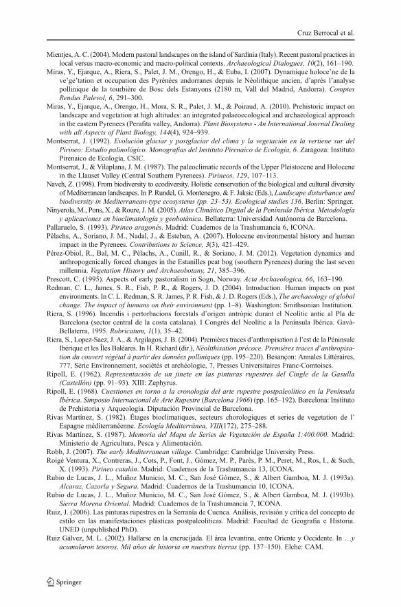
Mientjes, A. C. (2004).Modern pastoral landscapes on the island of Sardinia (Italy). Recent pastoral practices inlocal versus macro-economic and macro-political contexts. Archaeological Dialogues, 10(2), 161–190.
Miras, Y., Ejarque, A., Riera, S., Palet, J. M., Orengo, H., & Euba, I. (2007). Dynamique holoce’ne de lave’ge’tation et occupation des Pyrénées andorranes depuis le Néolithique ancien, d’après l’analysepollinique de la tourbière de Bosc dels Estanyons (2180 m, Vall del Madrid, Andorra). ComptesRendus Palevol, 6, 291–300.
Miras, Y., Ejarque, A., Orengo, H., Mora, S. R., Palet, J. M., & Poiraud, A. (2010). Prehistoric impact onlandscape and vegetation at high altitudes: an integrated palaeoecological and archaeological approachin the eastern Pyrenees (Perafita valley, Andorra). Plant Biosystems - An International Journal Dealingwith all Aspects of Plant Biology, 144(4), 924–939.
Montserrat, J. (1992). Evolución glaciar y postglaciar del clima y la vegetación en la vertiene sur delPirineo: Estudio palinológico. Monografías del Instituto Pirenaico de Ecología, 6. Zaragoza: InstitutoPirenaico de Ecología, CSIC.
Montserrat, J., & Vilaplana, J. M. (1987). The paleoclimatic records of the Upper Pleistocene and Holocenein the Llauset Valley (Central Southern Pyrenees). Pirineos, 129, 107–113.
Naveh, Z. (1998). From biodiversity to ecodiversity. Holistic conservation of the biological and cultural diversityof Mediterranean landscapes. In P. Rundel, G. Montenegro, & F. Jaksic (Eds.), Landscape disturbance andbiodiversity in Mediterranean-type ecosystems (pp. 23–53). Ecological studies 136. Berlin: Springer.
Ninyerola, M., Pons, X., & Roure, J. M. (2005). Atlas Climático Digital de la Península Ibérica. Metodologíay aplicaciones en bioclimatología y geobotánica. Bellaterra: Universidad Autónoma de Barcelona.
Pallaruelo, S. (1993). Pirineo aragonés. Madrid: Cuadernos de la Trashumancia 6, ICONA.Pèlachs, A., Soriano, J. M., Nadal, J., & Esteban, A. (2007). Holocene environmental history and human
impact in the Pyrenees. Contributions to Science, 3(3), 421–429.Pérez-Obiol, R., Bal, M. C., Pèlachs, A., Cunill, R., & Soriano, J. M. (2012). Vegetation dynamics and
anthropogenically forced changes in the Estanilles peat bog (southern Pyrenees) during the last sevenmillennia. Vegetation History and Archaeobotany, 21, 385–396.
Prescott, C. (1995). Aspects of early pastoralism in Sogn, Norway. Acta Archaeologica, 66, 163–190.Redman, C. L., James, S. R., Fish, P. R., & Rogers, J. D. (2004). Introduction. Human impacts on past
environments. In C. L. Redman, S. R. James, P. R. Fish, & J. D. Rogers (Eds.), The archaeology of globalchange. The impact of humans on their environment (pp. 1–8). Washington: Smithsonian Institution.
Riera, S. (1996). Incendis i pertorbacions forestals d’origen antròpic durant el Neolític antic al Pla deBarcelona (sector central de la costa catalana). I Congrés del Neolític a la Península Ibérica. Gavà-Bellaterra, 1995. Rubricatum, 1(1), 35–42.
Riera, S., Lopez-Saez, J. A., & Argilagos, J. B. (2004). Premières traces d’anthropisation à l’est de la PéninsuleIbérique et les Îles Baléares. In H. Richard (dir.), Néolithisation précoce. Premières traces d’anthropisa-tion du couvert végétal à partir des données polliniques (pp. 195–220). Besançon: Annales Littéraires,777, Série Environnement, sociétés et archéologie, 7, Presses Universitaires Franc-Comtoises.
Ripoll, E. (1962). Representación de un jinete en las pinturas rupestres del Cingle de la Gasulla(Castellón) (pp. 91–93). XIII: Zephyrus.
Ripoll, E. (1968). Cuestiones en torno a la cronología del arte rupestre postpaleolítico en la PenínsulaIbérica. Simposio Internacional de Arte Rupestre (Barcelona 1966) (pp. 165–192). Barcelona: Institutode Prehistoria y Arqueología. Diputación Provincial de Barcelona.
Rivas Martínez, S. (1982). Étages bioclimatiques, secteurs chorologiques et series de vegetation de l’Espagne méditerranéenne. Ecología Mediterránea, VIII(172), 275–288.
Rivas Martínez, S. (1987). Memoria del Mapa de Series de Vegetación de España 1:400.000. Madrid:Ministerio de Agricultura, Pesca y Alimentación.
Robb, J. (2007). The early Mediterranean village. Cambridge: Cambridge University Press.Roigé Ventura, X., Contreras, J., Cots, P., Font, J., Gómez, M. P., Parès, P. M., Peret, M., Ros, I., & Such,
X. (1993). Pirineo catalán. Madrid: Cuadernos de la Trashumancia 13, ICONA.Rubio de Lucas, J. L., Muñoz Municio, M. C., San José Gómez, S., & Albert Gamboa, M. J. (1993a).
Alcaraz, Cazorla y Segura. Madrid: Cuadernos de la Trashumancia 10, ICONA.Rubio de Lucas, J. L., Muñoz Municio, M. C., San José Gómez, S., & Albert Gamboa, M. J. (1993b).
Sierra Morena Oriental. Madrid: Cuadernos de la Trashumancia 7, ICONA.Ruiz, J. (2006). Las pinturas rupestres en la Serranía de Cuenca. Análisis, revisión y crítica del concepto de
estilo en las manifestaciones plásticas postpaleolíticas. Madrid: Facultad de Geografía e Historia.UNED (unpublished PhD).
Ruiz Gálvez, M. L. (2002). Hallarse en la encrucijada. El área levantina, entre Oriente y Occidente. In …yacumularon tesoros. Mil años de historia en nuestras tierras (pp. 137–150). Elche: CAM.
Cruz Berrocal et al.
Ruiz, J., Mas, M., Hernanz, A., Gavira, J. M., Rowe, M., & Steelman, K. (2006). First Radiocarbon datingof Oxalate Crusts over Spanish Prehistoric Rock Art. Inora Newsletter, 46.
Rundel, P. (1998). Landscape disturbance in Mediterranean-type ecosystems: an overview. In P. Rundel, G.Montenegro, & F. Jaksic (Eds.), Landscape disturbance and biodiversity in Mediterranean-typeecosystems (pp. 3–22). Ecological studies 136. Berlin: Springer.
Rundel, P., Montenegro, G., & Jaksic, F. (Eds.). (1998). Landscape disturbance and biodiversity inMediterranean-type ecosystems. Berlin: Springer.
Sánchez Moreno, E. (1998). De ganados, movimientos y contactos. Revisando la cuestión trashumante enla Protohistoria hispana: la meseta occidental. Studia Historica. Historia Antigua, 16, 53–84.
Sánchez-Goñi, M. F., & Hannon, G. (1999). High-altitude vegetational pattern on the Iberian MountainChain (north-central Spain) during the Holocene. The Holocene, 9, 39–57.
Sebastián López, M. (2011). Geografía del Arte Rupestre: herramientas espaciales y TIG para el análisis territorialdel arte rupestre levantino y esquemático en Aragón. Zaragoza: Universidad de Zaragoza (unpublished PhD).
Shiel, R. S. (1999). Reconstructing past soil environments in the Mediterranean region. In P. Leveau, F.Trément, K. Walsh, & G. Barker (Eds.), Environmental reconstruction in Mediterranean landscapearchaeology (pp. 67–79). Oxford: The Archaeology of Mediterranean Landscapes 2, Oxbow Books.
SOIL SURVEY GROUP (2003). Keys to soil taxonomy. United States Department of Agriculture.Soria, M., & López, M. (1999). Los abrigos con arte rupestre levantino de la Sierra de Segura. Sevilla:
Arqueología Monografías, Junta de Andalucía.Stevenson, A. C. (2000). The Holocene forest history of the Montes Universales, Teruel, Spain. The
Holocene, 10, 603–610.Utrilla, P. (2005). El arte rupestre en Aragón. 100 años después de Calapatá. In M. Hernández & J. Soler
(Eds.), Actas del Congreso de Arte rupestre en la España Mediterránea (Alicante, 2004) (pp 341–378).Instituto Alicantino de Cultura Juan Gil-Albert y Caja de Ahorros del Mediterráneo: Alicante.
Utrilla, P., & Bea, M. (2011). Las cerámicas del Plano del Pulido (Caspe). Sagvntvm, 12, 147–153.Utrilla, P., Bea, M., & Benedí, S. (2010). Hacia el Lejano Oeste. Arte levantino en el acceso a la Meseta: la
Roca Benedí (Jaraba, Zaragoza). Trabajos de Prehistoria, 67(1), 227–243.van Andel, T. H., Zangger, E., & Demitrack, A. (1990). Land use and soil erosion in prehistoric and
historical Greece. Journal of Field Archaeology, 17, 379–396.van der Leeuw, S., & de Vries, B. L. (2002). Empire: the Romans in the Mediterranean. In B. L. de Vries &
J. Goudsblom (Eds.), Mappae Mundi: Humans and their habitats in a long-term socio-ecologicalperspective (pp. 209–256). Amsterdam: Amsterdam University Press.
Vicent, J. M. (1991). Fundamentos teórico-metodológicos para un programa de investigación arqueo-geográfica.In P. López (Ed.), El cambio cultural del IV al II milenios a.C. en la comarca noroeste de Murcia (pp.29–117). Madrid: CSIC.
Vita-Finzi, C. (1969). The Mediterranean valleys: geological changes in historical times. Cambridge:Cambridge University Press.
Walsh, K. (1999). Mediterranean landscape archaeology and environmental reconstruction. In P. Leveau, F.Trément, K. Walsh, & G. Barker (Eds.), Environmental reconstruction in Mediterranean landscapearchaeology (pp. 1–8). Oxford: The Archaeology of Mediterranean Landscapes 2, Oxbow Books.
Landscape Construction and Long-Term Economic Practices