Landscape Change and Ecosystem Classification in a Municipal District of a Small City (Isernia,...
13
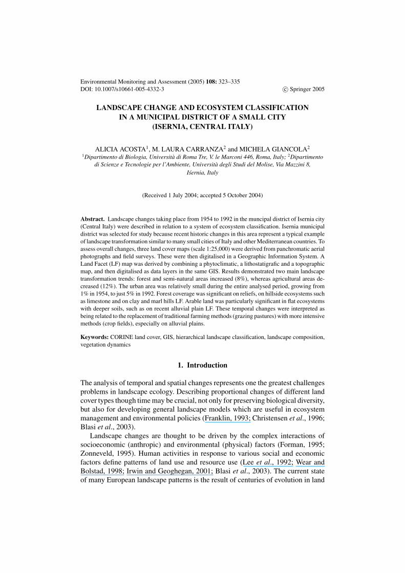
Environmental Monitoring and Assessment (2005) 108: 323–335 DOI: 10.1007/s10661-005-4332-3 c Springer 2005 LANDSCAPE CHANGE AND ECOSYSTEM CLASSIFICATION IN A MUNICIPAL DISTRICT OF A SMALL CITY (ISERNIA, CENTRAL ITALY) ALICIA ACOSTA 1 , M. LAURA CARRANZA 2 and MICHELA GIANCOLA 2 1 Dipartimento di Biologia, Universit` a di Roma Tre, V. le Marconi 446, Roma, Italy; 2 Dipartimento di Scienze e Tecnologie per l’Ambiente, Universit` a degli Studi del Molise, Via Mazzini 8, I´ sernia, Italy (Received 1 July 2004; accepted 5 October 2004) Abstract. Landscape changes taking place from 1954 to 1992 in the muncipal district of Isernia city (Central Italy) were described in relation to a system of ecosystem classification. Isernia municipal district was selected for study because recent historic changes in this area represent a typical example of landscape transformation similar to many small cities of Italy and other Mediterranean countries. To assess overall changes, three land cover maps (scale 1:25,000) were derived from panchromatic aerial photographs and field surveys. These were then digitalised in a Geographic Information System. A Land Facet (LF) map was derived by combining a phytoclimatic, a lithostatigrafic and a topographic map, and then digitalised as data layers in the same GIS. Results demonstrated two main landscape transformation trends: forest and semi-natural areas increased (8%), whereas agricultural areas de- creased (12%). The urban area was relatively small during the entire analysed period, growing from 1% in 1954, to just 5% in 1992. Forest coverage was significant on reliefs, on hillside ecosystems such as limestone and on clay and marl hills LF. Arable land was particularly significant in flat ecosystems with deeper soils, such as on recent alluvial plain LF. These temporal changes were interpreted as being related to the replacement of traditional farming methods (grazing pastures) with more intensive methods (crop fields), especially on alluvial plains. Keywords: CORINE land cover, GIS, hierarchical landscape classification, landscape composition, vegetation dynamics 1. Introduction The analysis of temporal and spatial changes represents one the greatest challenges problems in landscape ecology. Describing proportional changes of different land cover types though time may be crucial, not only for preserving biological diversity, but also for developing general landscape models which are useful in ecosystem management and environmental policies (Franklin, 1993; Christensen et al., 1996; Blasi et al., 2003). Landscape changes are thought to be driven by the complex interactions of socioeconomic (anthropic) and environmental (physical) factors (Forman, 1995; Zonneveld, 1995). Human activities in response to various social and economic factors define patterns of land use and resource use (Lee et al., 1992; Wear and Bolstad, 1998; Irwin and Geoghegan, 2001; Blasi et al., 2003). The current state of many European landscape patterns is the result of centuries of evolution in land
-
Upload
independent -
Category
Documents
-
view
1 -
download
0
Transcript of Landscape Change and Ecosystem Classification in a Municipal District of a Small City (Isernia,...
Environmental Monitoring and Assessment (2005) 108: 323–335DOI: 10.1007/s10661-005-4332-3 c© Springer 2005
LANDSCAPE CHANGE AND ECOSYSTEM CLASSIFICATIONIN A MUNICIPAL DISTRICT OF A SMALL CITY
(ISERNIA, CENTRAL ITALY)
ALICIA ACOSTA1, M. LAURA CARRANZA2 and MICHELA GIANCOLA2
1Dipartimento di Biologia, Universita di Roma Tre, V. le Marconi 446, Roma, Italy; 2Dipartimentodi Scienze e Tecnologie per l’Ambiente, Universita degli Studi del Molise, Via Mazzini 8,
Isernia, Italy
(Received 1 July 2004; accepted 5 October 2004)
Abstract. Landscape changes taking place from 1954 to 1992 in the muncipal district of Isernia city(Central Italy) were described in relation to a system of ecosystem classification. Isernia municipaldistrict was selected for study because recent historic changes in this area represent a typical exampleof landscape transformation similar to many small cities of Italy and other Mediterranean countries. Toassess overall changes, three land cover maps (scale 1:25,000) were derived from panchromatic aerialphotographs and field surveys. These were then digitalised in a Geographic Information System. ALand Facet (LF) map was derived by combining a phytoclimatic, a lithostatigrafic and a topographicmap, and then digitalised as data layers in the same GIS. Results demonstrated two main landscapetransformation trends: forest and semi-natural areas increased (8%), whereas agricultural areas de-creased (12%). The urban area was relatively small during the entire analysed period, growing from1% in 1954, to just 5% in 1992. Forest coverage was significant on reliefs, on hillside ecosystems suchas limestone and on clay and marl hills LF. Arable land was particularly significant in flat ecosystemswith deeper soils, such as on recent alluvial plain LF. These temporal changes were interpreted asbeing related to the replacement of traditional farming methods (grazing pastures) with more intensivemethods (crop fields), especially on alluvial plains.
Keywords: CORINE land cover, GIS, hierarchical landscape classification, landscape composition,vegetation dynamics
1. Introduction
The analysis of temporal and spatial changes represents one the greatest challengesproblems in landscape ecology. Describing proportional changes of different landcover types though time may be crucial, not only for preserving biological diversity,but also for developing general landscape models which are useful in ecosystemmanagement and environmental policies (Franklin, 1993; Christensen et al., 1996;Blasi et al., 2003).
Landscape changes are thought to be driven by the complex interactions ofsocioeconomic (anthropic) and environmental (physical) factors (Forman, 1995;Zonneveld, 1995). Human activities in response to various social and economicfactors define patterns of land use and resource use (Lee et al., 1992; Wear andBolstad, 1998; Irwin and Geoghegan, 2001; Blasi et al., 2003). The current stateof many European landscape patterns is the result of centuries of evolution in land
324 ALICIA ACOSTA ET AL.
use (Kienast, 1993). The importance of rural culture and the role of different typesof applied technology have been recognised in various regions of the world (Goszand Sharpe, 1989; Bowman et al., 2001; Chen et al., 2001; Hietala-Koivu, 2002,and many others).
Although human activity is a major factor in the shaping of landscapes, theunderlying physical structure of land also often influences its use (Pan et al., 1999).It has been proposed that landscape heterogeneity is a function of the scale ofobservation (Forman, 1995; O’Neill et al., 1992), and many studies on ecosystemclassification have been performed according to this view (Klijn and Udo de Haes,1994; Zonneveld, 1995; Bailey, 1996; Matson and Power, 1996; Bredenkamp, et al.,1998). Regarding Italy, Blasi et al. (2000b) proposed a classification system fordescribing and mapping Italian landscapes at different scales. This approach hasbeen conceived as a hierarchical structure, where pattern and function at eachecosystem level depend on the limits imposed by higher levels.
The aims of the present study were to quantify land cover changes in the localmunicipal district of Isernia (“Comune”) from 1954 to 1992, in order to explainchanges in the landscape of the area surrounding a small city in a rural Europeansetting. These changes were then related to a hierarchical landscape classificationof the same area, in order to derive an environmental framework. In this way landcover changes were related to the physical characteristics of the landscape whichare thought to be a discriminating factor constraining land use. The current paperdeals with the following two major questions (a) what type of landscape changesoccurred? and (b) where did these changes occurred? (in which ecosystems ?).
The municipal district of Isernia was selected for this study because the aban-doning of traditional rural activities in this area, along with recent developments ininfrastructures, appear to have caused rapid changes in land cover which are typicalof small cities in many areas of Italy and other Mediterranean countries since theend of the second world war.
2. Material and Methods
2.1. STUDY AREA
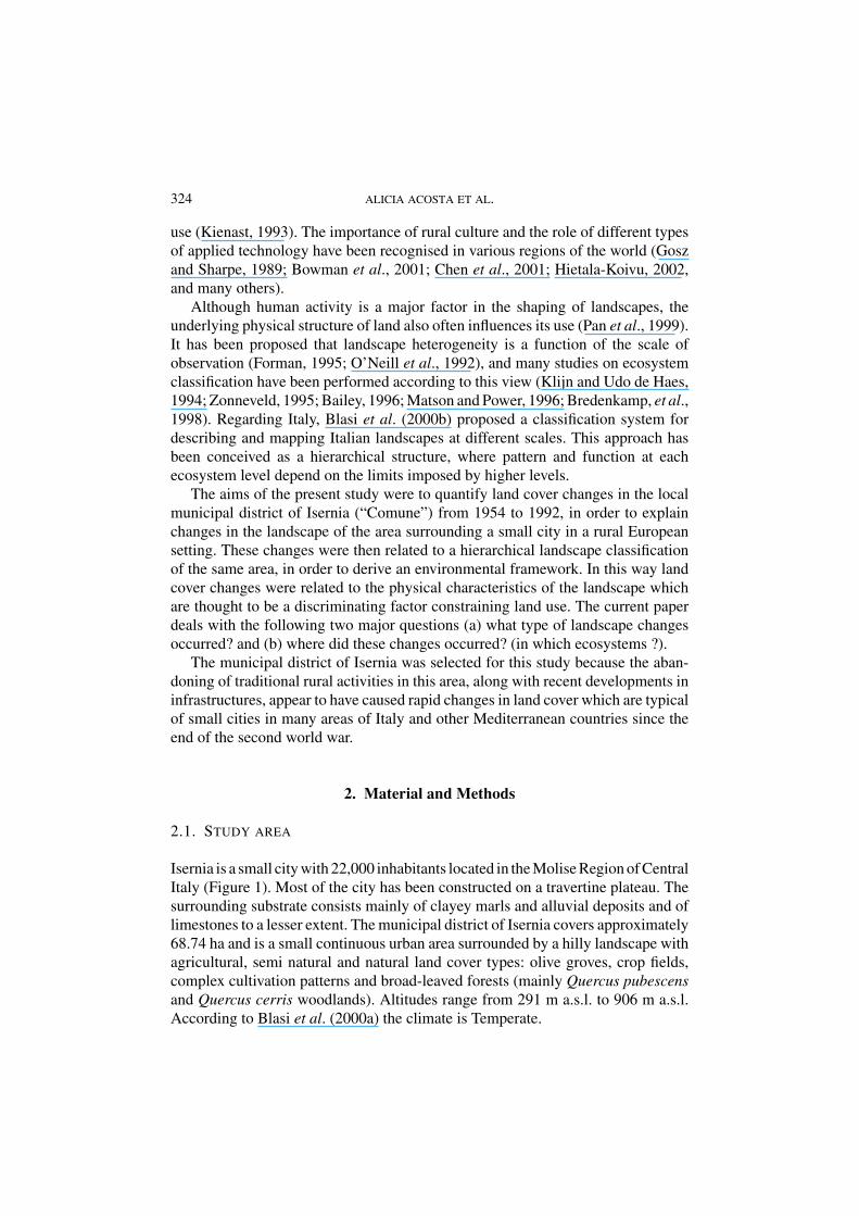
Isernia is a small city with 22,000 inhabitants located in the Molise Region of CentralItaly (Figure 1). Most of the city has been constructed on a travertine plateau. Thesurrounding substrate consists mainly of clayey marls and alluvial deposits and oflimestones to a lesser extent. The municipal district of Isernia covers approximately68.74 ha and is a small continuous urban area surrounded by a hilly landscape withagricultural, semi natural and natural land cover types: olive groves, crop fields,complex cultivation patterns and broad-leaved forests (mainly Quercus pubescensand Quercus cerris woodlands). Altitudes range from 291 m a.s.l. to 906 m a.s.l.According to Blasi et al. (2000a) the climate is Temperate.
LANDSCAPE CHANGE AND ECOSYSTEM CLASSIFICATION 325
Figure 1. Location and general situation of the study area.
2.2. METHODS
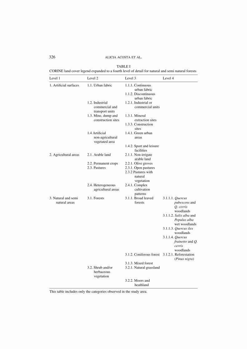
The analysis of historical sequences of aerial photographs is an important methodfor determining the medium-term dynamics of land cover on a landscape scale. Toassess overall changes in land cover, three land cover maps (scale 1:25,000) werederived from panchromatic aerial photographs and field surveys. Aerial photographsof the study area were available for the years 1954 (scale 1:33,000), 1981 (1:15,000)and 1992 (1:15,000). Land cover was manually interpreted, and then digitalised andcompiled in a Geographic Information System (GIS ArcView 3.2). Owing to thedifference in scale between the 1954 aerial photographs (although high in quality)and those of 1981 and 1992, the three land cover maps were transferred manuallyonto a digital topographic map (scale 1: 25,000) for further data processing. Thethree land cover maps were then digitised in raster format with a spatial resolution of50 m. The legend followed CORINE land cover (Anon, 1993) expanded to a fourthlevel of detail for natural and semi-natural forests. This expansion was performedusing information derived from phytosociological releves performed in the majorvegetation types mapped (Table I).
Regarding landscape classification, the approach of Blasi et al. (2000b)was adopted, in which macroclimate is considered to be the primary factor in
326 ALICIA ACOSTA ET AL.
TABLE ICORINE land cover legend expanded to a fourth level of detail for natural and semi natural forests
Level 1 Level 2 Level 3 Level 4
1. Artificial surfaces 1.1. Urban fabric 1.1.1. Continuousurban fabric
1.1.2. Discontinuousurban fabric
1.2. Industrialcommercial andtransport units
1.2.1. Industrial orcommercial units
1.3. Mine, dump andconstruction sites
1.3.1. Mineralextraction sites
1.3.3. Constructionsites
1.4 Artificialnon-agriculturalvegetated area
1.4.1. Green urbanareas
1.4.2. Sport and leisurefacilities
2. Agricultural areas 2.1. Arable land 2.1.1. Non-irrigatearable land
2.2. Permanent crops 2.2.1. Olive groves2.3. Pastures 2.3.1. Open pastures
2.3.2 Pastures withnaturalvegetation
2.4. Heterogeneousagricultural areas
2.4.1. Complexcultivationpatterns
3. Natural and seminatural areas
3.1. Forests 3.1.1. Broad leavedforests
3.1.1.1. Quercuspubescens andQ. cerriswoodlands
3.1.1.2. Salix alba andPopulus albawet woodlands
3.1.1.3. Quercus ilexwoodlands
3.1.1.4. Quercusfrainetto and Q.cerriswoodlands
3.1.2. Coniferous forest 3.1.2.1. Reforestation(Pinus nigra)
3.1.3. Mixed forest3.2. Shrub and/or
herbaceousvegetation
3.2.1. Natural grassland
3.2.2. Moors andheathland
This table includes only the categories observed in the study area.
LANDSCAPE CHANGE AND ECOSYSTEM CLASSIFICATION 327
differentiation. Therefore, the first units reported in the classification scheme areLand Regions (LR) determined by macroclimatic features and defined on a broadscale (1: 250,000). Within the land regions, Land Systems (LS) are delimited ac-cording to significant lithological differences (1:100,000). Land Facets (LF) areseparated at intermediate scales (1:50,000–25,000) and delimited according tolithomorphological features. Land Region, System and Facet Units were obtainedby combining a phytoclimatic map (Paura and Lucchese, 1996; Blasi and Iovino,2003), a lithostatigrafic map (Accordi et al., 1988) and a topographic map (IGM,Italian Geographic Military Institute). A Land Facet map of the Isernia area wasderived and digitalised as GIS data layers in ArcView 3.2.
To analyse the dynamics of land cover, areas of each CORINE category werecalculated for the overall study area. Histograms were prepared showing the differ-ent levels of detail of the land cover legend for the three maps. By overlapping landcover maps with the LF map it was possible to analyse land cover changes in thedifferent LF. To illustrate the temporal dynamics of each LS, land cover changes inone representative LF are presented.
3. Results
3.1. OVERALL LAND COVER CHANGES
Twenty one land cover categories were identified in the study area. Maps showingtheir distribution in 1954, 1981 and 1992 are shown in Figure 2.
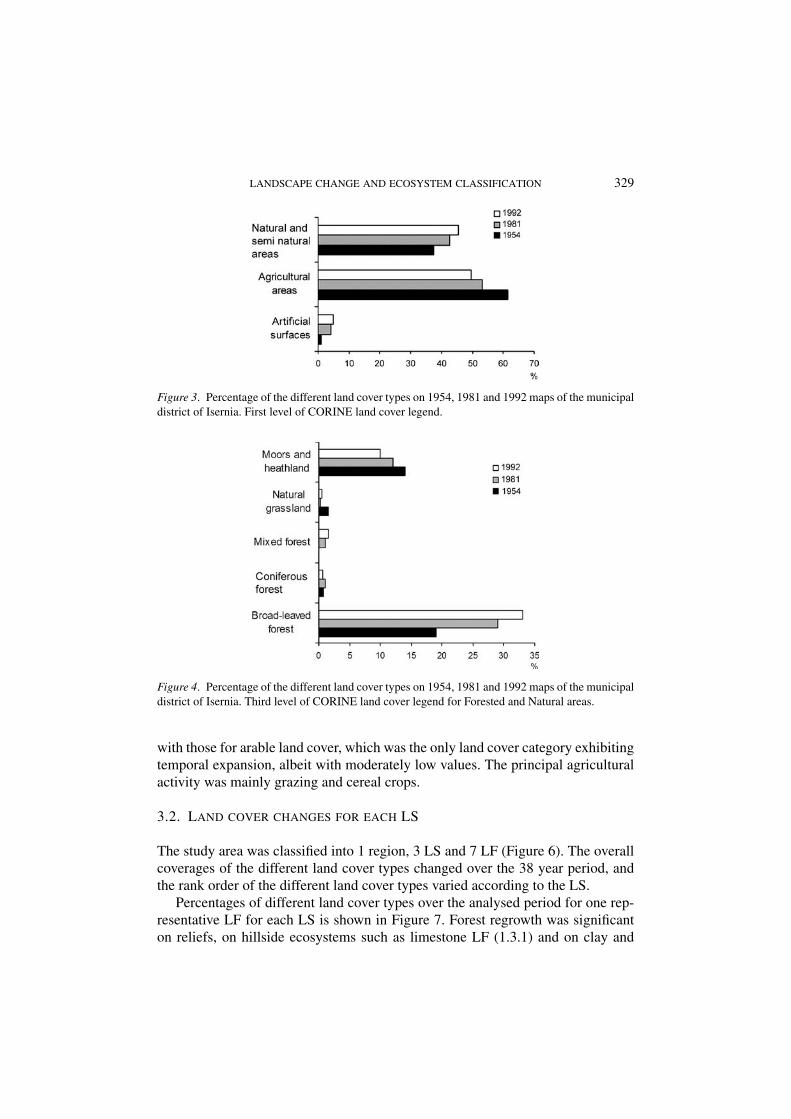
During the analysed period (1955–1992) almost 50% of the study area changed(Carranza et al., 2003). Changes in land cover were mainly due to two trendssummarised by the first level of the CORINE land cover legend (Figure 3): forestand semi-natural areas increased by 8%, whereas agricultural areas decreased by12%. Secondarily, the area of artificial surfaces increased, but to a lesser degree(about 4%). Note that the urban area is quite small in all the analysed period growingfrom 1% in 1955, to almost 5% in 1992.
A detailed analysis of the landscape composition of the municipal district ofIsernia (third level of the CORINE land cover, Figure 4), shows that the increasein forest and semi-natural land cover type was mainly broad-leaved forest (around15%). At a fourth level of detail, these forest areas are mainly Quercus cerris andQuercus pubescens woodlands and secondarily of Quercus frainetto and Quercuscerris woodlands and of Quercus ilex woodlands. Moors and heathlands showed aslight decrease while the other land cover types (natural grasslands, mixed forestand coniferous forest) maintained their low values.
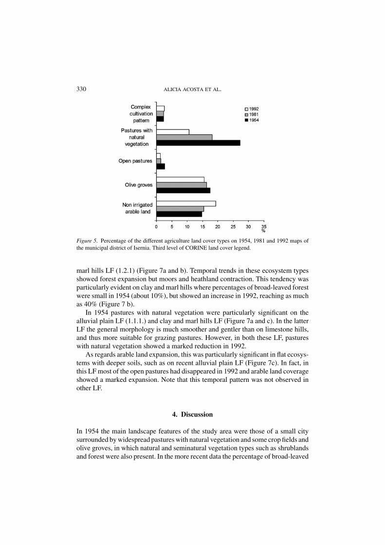
In 1954 and 1981 (Figure 5) the agricultural areas consisted mainly of pastureswith natural vegetation. In this area, open pastures were mainly used for sheep andcattle grazing. This type of land cover showed a marked decline by 1992 (17%),while olive groves remained almost unchanged (15–17%). These changes contrast
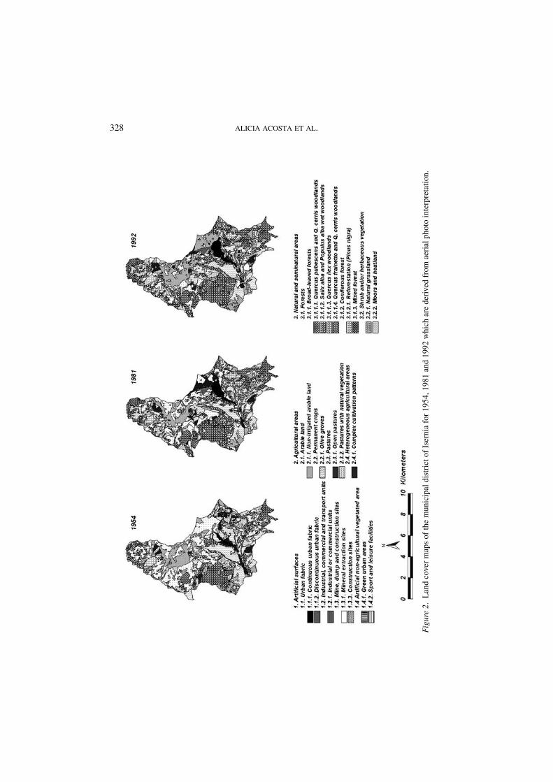
328 ALICIA ACOSTA ET AL.
Fig
ure
2.L
and
cove
rm
aps
ofth
em
unic
ipal
dist
rict
ofIs
erni
afo
r19
54,1
981
and
1992
whi
char
ede
rive
dfr
omae
rial
phot
oin
terp
reta
tion.
LANDSCAPE CHANGE AND ECOSYSTEM CLASSIFICATION 329
Figure 3. Percentage of the different land cover types on 1954, 1981 and 1992 maps of the municipaldistrict of Isernia. First level of CORINE land cover legend.
Figure 4. Percentage of the different land cover types on 1954, 1981 and 1992 maps of the municipaldistrict of Isernia. Third level of CORINE land cover legend for Forested and Natural areas.
with those for arable land cover, which was the only land cover category exhibitingtemporal expansion, albeit with moderately low values. The principal agriculturalactivity was mainly grazing and cereal crops.
3.2. LAND COVER CHANGES FOR EACH LS
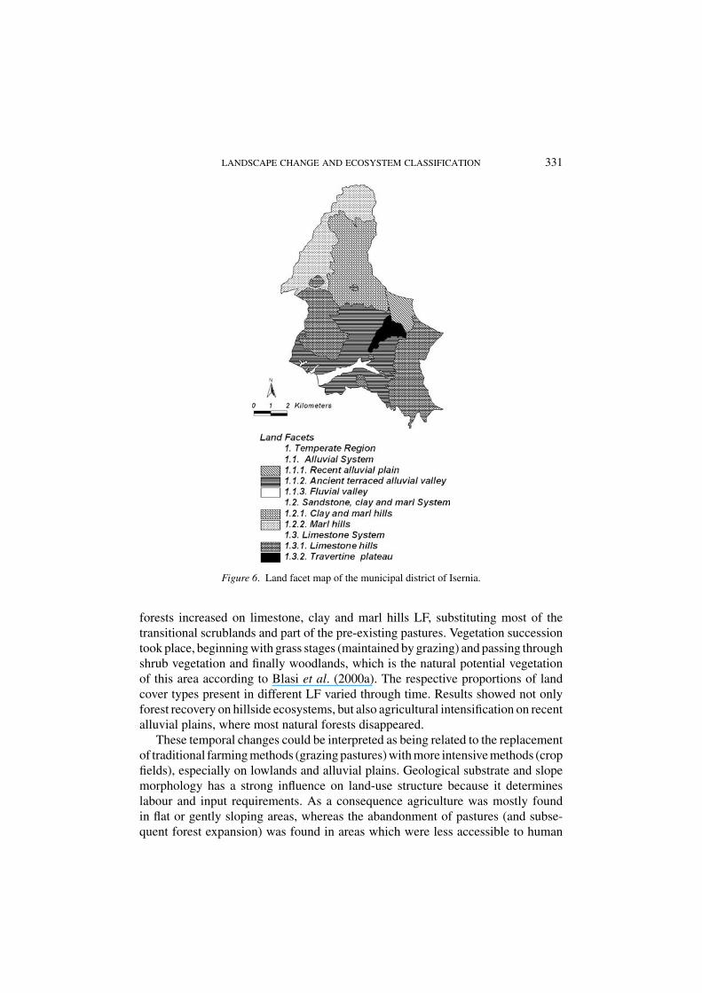
The study area was classified into 1 region, 3 LS and 7 LF (Figure 6). The overallcoverages of the different land cover types changed over the 38 year period, andthe rank order of the different land cover types varied according to the LS.
Percentages of different land cover types over the analysed period for one rep-resentative LF for each LS is shown in Figure 7. Forest regrowth was significanton reliefs, on hillside ecosystems such as limestone LF (1.3.1) and on clay and
330 ALICIA ACOSTA ET AL.
Figure 5. Percentage of the different agriculture land cover types on 1954, 1981 and 1992 maps ofthe municipal district of Isernia. Third level of CORINE land cover legend.
marl hills LF (1.2.1) (Figure 7a and b). Temporal trends in these ecosystem typesshowed forest expansion but moors and heathland contraction. This tendency wasparticularly evident on clay and marl hills where percentages of broad-leaved forestwere small in 1954 (about 10%), but showed an increase in 1992, reaching as muchas 40% (Figure 7 b).
In 1954 pastures with natural vegetation were particularly significant on thealluvial plain LF (1.1.1.) and clay and marl hills LF (Figure 7a and c). In the latterLF the general morphology is much smoother and gentler than on limestone hills,and thus more suitable for grazing pastures. However, in both these LF, pastureswith natural vegetation showed a marked reduction in 1992.
As regards arable land expansion, this was particularly significant in flat ecosys-tems with deeper soils, such as on recent alluvial plain LF (Figure 7c). In fact, inthis LF most of the open pastures had disappeared in 1992 and arable land coverageshowed a marked expansion. Note that this temporal pattern was not observed inother LF.
4. Discussion
In 1954 the main landscape features of the study area were those of a small citysurrounded by widespread pastures with natural vegetation and some crop fields andolive groves, in which natural and seminatural vegetation types such as shrublandsand forest were also present. In the more recent data the percentage of broad-leaved
LANDSCAPE CHANGE AND ECOSYSTEM CLASSIFICATION 331
Figure 6. Land facet map of the municipal district of Isernia.
forests increased on limestone, clay and marl hills LF, substituting most of thetransitional scrublands and part of the pre-existing pastures. Vegetation successiontook place, beginning with grass stages (maintained by grazing) and passing throughshrub vegetation and finally woodlands, which is the natural potential vegetationof this area according to Blasi et al. (2000a). The respective proportions of landcover types present in different LF varied through time. Results showed not onlyforest recovery on hillside ecosystems, but also agricultural intensification on recentalluvial plains, where most natural forests disappeared.
These temporal changes could be interpreted as being related to the replacementof traditional farming methods (grazing pastures) with more intensive methods (cropfields), especially on lowlands and alluvial plains. Geological substrate and slopemorphology has a strong influence on land-use structure because it determineslabour and input requirements. As a consequence agriculture was mostly foundin flat or gently sloping areas, whereas the abandonment of pastures (and subse-quent forest expansion) was found in areas which were less accessible to human

332 ALICIA ACOSTA ET AL.
Figure 7. Percentage of different land cover types on 1954, 1981 and 1992 maps of the followingthree Land Facets. a) Limestone hills (1.3.1.), b) Clay and marl hills (1.2.1.), c) Recent alluvial plain(1.1.1.).
LANDSCAPE CHANGE AND ECOSYSTEM CLASSIFICATION 333
activity. These results concerning agricultural intensification and abandonment oftraditional land use activities through time could be associated to processes whichare probably widespread in many European landscapes and which have been par-ticularly evident in recent decades (Forman and Godron, 1986). Few studies havereported these phenomena (Vos and Stortelder, 1992; Di Pietro and Filibeck, 2000;Carranza et al., 2003) which may be generalised in many Italian hillside landscapes.In fact, socio-economic changes in Italy since the end of World War II, togetherwith the increasing establishment of intensive agricultural systems and agriculturalmechanization, have led to a sharp decline in the number of people involved intraditional agricultural and grazing activities (Di Pietro and Filibeck, 2000; Blasiet al., 2003). These authors mentioned that the progressive abandonment of olivegroves (traditionally found on stepped terraces) represented the main cause of rapidchanges in sub-Mediterranean hilly landscapes. However, in the Isernia area, whilea contraction in the land area devoted to pastures was found to have occurred, onlya slight reduction in olive grove cover was observed.
5. Conclusions
Following a reduction in grazing practices, natural succession occurred and this,together with the intensification of crop cultivation, constitutes the main processesof the area’s landscape dynamics. In this study we have not only provided infor-mation regarding these processes, but we have also analysed the environmentalcharacteristics of landscape change. By overlapping land cover changes with a sys-tem of ecosystem classification we were able to frame the landscape transformationpatterns in an ecologically significant manner. An appreciation of the direction andproportions of landscape change could help managers make the best use of avail-able resources. Information derived from this kind of study should be taken intoaccount when developing management policies and particularly when consideringthe possible ecological implications for biological diversity.
Acknowledgments
This research was partially supported by the Italian Ministry of Education (MIUR).
References
Anon: 1993: CORINE Land Cover. Guide technique, CECA-CEE-CEEA, Bruxelles.Accordi, G., Carbone, F., Civitelli, G., Corda, L., De Rita, D., Esu, D., Funiciello, R., Kotsakis, T.,
Mariotti, G. and Sposato, A.: 1988, Carta delle litofacies del Lazio-Abruzzo ed aree limitrofi,Consiglio Nazionale delle Ricerche, Quaderni della Ricerca Scientifica. Roma.
Bailey, R. G.: 1996, Ecosystem Geography, Springer Verlag, New York.

334 ALICIA ACOSTA ET AL.
Blasi, C., Acosta, A., Paura, B., Di Martino, P., Giordani, D., Di Marzio, P., Fortini, P. and Carranza,M. L.: 2000a, ‘Classificazione e cartografia del paesaggio: i sistemi e i sottosistemi di paesaggiodel Molise,’ Informatore Botanico Italiano 31, 15–25.
Blasi, C., Carranza, M. L., Frondoni, R. and Rosati, L.: 2000b, ‘Ecosystem classification and mapping:A proposal for Italian landscapes,’ Appl. Veg. Sci. 3, 233–242.
Blasi, C. and Iovino, F.: 2003, Bioclima d’Italia, In: C. Blasi (ed.) Conoscenze naturalistiche inItalia/Ecological Information in Italy, Societa Botanica Italiana – Ministero dell’Ambiente edella Tutela del Territorio, Roma, pp.: 11–12.
Blasi, C., Smiraglia, D. and Carranza, M. L.: 2003, ‘Analisi multitemporale del paesaggio all’internodi un sistema di classificazione gerarchica del territorio. Il caso dei Monti Lepini (Italia Centrale),’Informatore Botanico Italiano 35(1), 31–41.
Bowman, D. M., Walsh, A. and Milne, D. J.: 2001, ‘Forest expansion and grassland contraction withina Eucalyptus savanna matrix between 1941 and 1992 at Litchfield National Park in the Australianmonsoon tropics,’ Global Ecol. Biogeogr. 10, 535–548.
Bredenkamp, G., Chytry, M., Fischer, H. S., Neuhauslova, Z. and van der Maarel, E.: 1998, ‘Vegetationmapping: Theory, methods and case studies,’ Intro. Appl. Veg. Sci. 1, 162–164.
Carranza, M. L., Ricotta, C., Fortini, P. and Blasi, C.: 2003, ‘Quantifying landscape change withactual vs. potential natural vegetation maps,’ Phytocoenologia 33(4), 591–601.
Carranza, M. L., Acosta, A. and Giancola, M.: 2003, ‘Analisi dei cambiamenti della copertura delsuolo.’ Estimo e Territorio 66(6), 12–16.
Christensen, N. L., Bartuska, A. M., Brown, J. H., Carpenter, S., D’Antonio, C., Francis, R., Franklin,J. F., Mac Mahon, J. A., Noss, R. F., Parsons, D. J., Peterson, C. H., Turner, M. G. and Woodmansee,R. G.: 1996, ‘The report of the Ecological Society of America committee on the scientific basisfor ecosystem management,’ Ecol. Appl. 6, 665–691.
Chen, L., Bojie Fu, J. and Qui, Y.: 2001, ‘Land-use change in a small catchment of northern LoessPlateu, China,’ Agric. Ecosyst. Environ. 86, 163–172.
Di Pietro, R. and Fillibeck, G.: 2000, ‘Terrazzamenti abbandonati e recupero della vegetazione spon-tanea: Il caso dei Monti Aurunci,’ Inf. Bot. Ital. 32(1–3), 17–30.
Forman, R. T. T.: 1995, Land Mosaic, Cambridge University Press, Cambridge.Forman, R. T. T. and Godron, M.: 1986, Landscape Ecology, Wiley, New York.Franklin, J. F.: 1993, ‘Preserving biodiversity: Species, ecosystems or landscapes?’ Ecol. Appl. 3,
202–205.Gosz, J. R. and Sharpe, P. J. H.: 1989, ‘Broad-scale concepts for interactions of climate, topography,
and biota at biome transitions,’ Landscape Ecol. 3, 229–243.Hietala-Koivu, R.: 2002, ‘Landscape and modernizing agriculture: A case study of three areas in
Finland in 1954–1998,’ Agric. Ecosyst. Environ. 91, 273–281.Irwin, E. G. and Geoghegan, J.: 2001, ‘Theory, data, methods: Developing spatially explicit economic
models of land use change,’ Agric. Ecosyst. Environ. 85, 7–23.Kienast, F.: 1993, ‘Analysis of historic landscape patterns with a Geographical Information System:
A methodological outline,’ Landscape Ecol. 8, 103–118.Klijn, F. and Udo de Haes, H.A.: 1994, ‘A hierarchical approach to ecosystems and its implications
for ecological land classification,’ Landscape Ecol. 9, 89–104.Lee, R. G., Flamm, R. O., Turner, M. G., Bledsoe, C., Chandler, P., De Ferrari, C., Gottfried, R.,
Naiman, R.J., Schumaker, N. and Wear, D.: 1992, ‘Integrating Sustainable Development andEnvironmental Vitality,’ in: R.J. Naiman (Ed.) Watershed Management: Balancing Sustainabilityand Environmental Change, Springer-Verlag. New York, pp. 499–521.
Matson, B. E. and Power, R. G.: 1996, ‘Developing an ecological land classification for the FundyModel Forest,’ south-eastern New Brunswick, Canada, Environ. Monitor. Assess. 39, 149–172.
O’Neill, R. V., Gardner, R. H. and Turner, M. G.: 1992, ‘A hierarchical neutral model for landscapeanalysis,’ Landscape Ecol. 7, 55–61.
LANDSCAPE CHANGE AND ECOSYSTEM CLASSIFICATION 335
Pan, D., Domon, G., de Bois, S. and Bouchard, A.: 1999, ‘Temporal (1958–1993) and spatial patternsof lands use changes in Haut-Saint-Laurent (Quebec, Canada) and their relation to landscapephysical attributes,’ Landscape Ecol. 14, 35–52.
Paura, B. and Lucchese, F.: 1996, ‘Lineamenti fitoclimatici del Molise,’ Giorn. Bot. Ital. 130, 521.Vos, W. and Stortelder, A.: 1992, Vanishing Tuscan Landscapes. Landscape Ecology of a
Submediterranean-Montane Area (Solano Basin, Tuscany, Italy), Pudoc Scientific PublishersWageningen.
Wear, D. and Bolstad, P.: 1998, ‘Land-use changes in southern Appalachian Landscapes: Spatialanalysis and forecast evaluation,’ Ecosystems 1, 575–594.
Zonneveld, I. S.: 1995, Land Ecology: An Introduction to Landscape Ecology as a Base for LandEvaluation, Land Management and Conservation, S P B Academic Publishing, Amsterdam.