Callan Park Draft Land Use Structure Plan - Inner West Council
Upload
khangminh22Category
view
0download
0
LAND USE AND DEVELOPMENT CONTROL PLAN 2017
BURDWAN DEVELOPMENT AUTHORITY 1
Abbreviations
AG Agriculture
BM Burdwan Municipality
BPA Burdwan Planning Area
BDA Burdwan Development Authority
EWS Economically Weaker Section
FAR Floor Area Ratio
GP Gram Panchayat
HCV Heavy Commercial Vehicle
IT Information Technology
KMA Kolkata Metropolitan Area
LUDCP Land Use and Development Control Plan
LPD Litres Per Day
LIG Low Income Group
LCV Light Commercial Vehicle
LBS Licensed Building Surveyor
MGD Million Gallons per Day
MCV Medium Commercial Vehicle
RF River Front
RWH Rain Water Harvesting
STP Sewage Treatment Plant
WBPCB West Bengal Pollution Control Board
LAND USE AND DEVELOPMENT CONTROL PLAN 2017
BURDWAN DEVELOPMENT AUTHORITY 2
Contents
1 BACKGROUND ............................................................................................................................................... 10
1.1 INTRODUCTION ...................................................................................................................................... 10
1.2 STATUTORY PROVISION ......................................................................................................................... 10
1.3 OBJECTIVES ............................................................................................................................................ 12
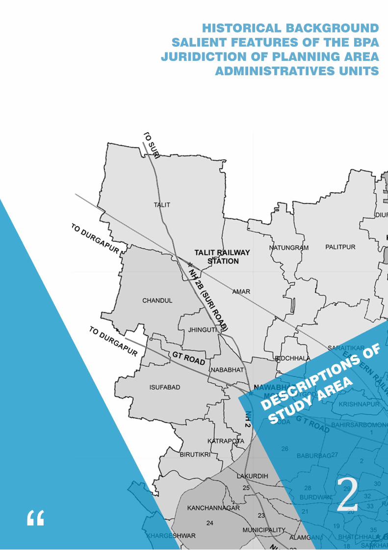
2 DESCRIPTIONS OF THE STUDY AREA .............................................................................................................. 17
2.1 HISTORICAL BACKGROUND - THE TOWN & ITS CULTURAL SETTING ...................................................... 17
2.2SALIENT FEATURES OF THE BPA .............................................................................................................. 17
2.3JURISDICTION OF PLANNING AREA ......................................................................................................... 18
2.4 ADMINISTRATIVE UNITS ......................................................................................................................... 18 2.4.1 Burdwan Municipality (BM).............................................................................................................................. 18 2.4.2 BelkashGram Panchayat ................................................................................................................................... 19 2.4.3 Rayan-I Gram Panchayat .................................................................................................................................. 20 2.4.4Saraitikar Gram Panchayat ................................................................................................................................ 20 2.4.5Kshetia Gram Panchayat ................................................................................................................................... 21 2.4.6Baghar-II Gram Panchayat ................................................................................................................................. 21 2.4.7 Baikunthapur – IGram Panchayat ..................................................................................................................... 22 2.4.8 Baikunthapur-IIGram Panchayat ...................................................................................................................... 22
3 DEMOGRAPHY ............................................................................................................................................... 26
3.1 INTRODUCTION ...................................................................................................................................... 26 3.1.1 Burdwan Planning Area (BPA) .......................................................................................................................... 26 3.1.2 Burdwan Municipality ...................................................................................................................................... 29 3.1.3 Growth of Population ....................................................................................................................................... 29 3.1.4 Sex Ratio ........................................................................................................................................................... 31 3.1.5 Literacy ............................................................................................................................................................. 31
3.2 SEX RATIO ............................................................................................................................................... 32
3.3 CHILD POPULATION ............................................................................................................................... 33
3.4 CHILD SEX RATIO .................................................................................................................................... 33
3.5 LITERACY RATE ....................................................................................................................................... 34
3.6 POPULATION GROWTH TREND .............................................................................................................. 35
3.7 POPULATION DENSITY............................................................................................................................ 36
4 SOCIO-ECONOMIC PROFILE ........................................................................................................................... 39
4.1 SOCIO ECONOMIC SURVEY ..................................................................................................................... 39 4.1.1 Age – Sex characteristics .................................................................................................................................. 39 4.1.2 Age – Structure ................................................................................................................................................. 39 4.1.3 Education – Structure ....................................................................................................................................... 40 4.1.4 Religion – Distribution ...................................................................................................................................... 40
4.2. INPUTS FOR PLANNING ......................................................................................................................... 41 4.2.1. Economy .......................................................................................................................................................... 41 4.2.2. Administrative Functions ................................................................................................................................. 43 4.2.3 Business and Trade ........................................................................................................................................... 43 4.2.4. Transport and Transhipment Functions .......................................................................................................... 43 4.2.5. Health and Educational Activities .................................................................................................................... 43 4.2.6. Real Estate Functions ...................................................................................................................................... 43 4.2.7. Housing ............................................................................................................................................................ 44 4.2.8. Tourism and Recreation .................................................................................................................................. 45
LAND USE AND DEVELOPMENT CONTROL PLAN 2017
BURDWAN DEVELOPMENT AUTHORITY 3
4.2.9. Living and Motivation ...................................................................................................................................... 45 4.2.10. Motivation to stay ......................................................................................................................................... 46
5 EXISTING LAND USE & INFRASTRUCTURE ...................................................................................................... 48
5.1 LAND USE PATTERN ............................................................................................................................... 48 5.1.1 Land Use Classification ..................................................................................................................................... 48
5.2 OWNERSHIP PATTERN OF BDA .............................................................................................................. 59
5.3 LAND USE ANALYSIS OF LUDCP .............................................................................................................. 61 Burdwan Planning Area ............................................................................................................................................. 61 Burdwan Municipality ............................................................................................................................................... 62 Belkash GP ................................................................................................................................................................. 63 Rayan I ....................................................................................................................................................................... 64 Saraitikar GP .............................................................................................................................................................. 65 Kshetia GP ................................................................................................................................................................. 66 Baghar-II GP ............................................................................................................................................................... 67 Baikunthapur - I GP ................................................................................................................................................... 67 Baikunthapur -I I GP .................................................................................................................................................. 68
5.3 PHYSICAL INFRASTRUCTURE .................................................................................................................. 69 5.3.1 Road Infrastructure .......................................................................................................................................... 69 5.3.2. Water Supply ................................................................................................................................................... 69 5.3.3 Sanitation And Sewerage ................................................................................................................................. 71 5.3.4 Drainage ........................................................................................................................................................... 72 5.3.5 Solid Waste Management ................................................................................................................................ 74
5.4 SOCIAL INFRASTRUCTURE ...................................................................................................................... 76 5.4.1 Introduction...................................................................................................................................................... 76 5.4.2. Education ......................................................................................................................................................... 76 5.4.3 Health Care ....................................................................................................................................................... 79 5.4.4 Other Social Infrastructural facilities ................................................................................................................ 81
6 SALIENT FEATURES OF PREVIOUS PLANS ....................................................................................................... 84
6.1 LAND USE & DEVELOPMENT CONTROL PLAN ........................................................................................ 84
6.2 PERSPECTIVE PLAN 2025 ........................................................................................................................ 85 6.2.1 The Regional Context ....................................................................................................................................... 85 6.2.2Nature of development and land forms in BPA ................................................................................................. 85 6.2.3Transit Oriented Development .......................................................................................................................... 86
7 STAGES OF PLAN PREPARATION AND IMPLEMENTATION ............................................................................. 88
7.1 STAGES OF PLAN PREPARATION ............................................................................................................ 88
7.2 GIS BASED DATA COLLECTION ................................................................................................................ 89 7.2.1 Outline of the GIS database creation ............................................................................................................... 90 7.2.2 Source of Information/ Map/ Data ................................................................................................................... 90
7.3 PLAN IMPLEMENTATION ........................................................................................................................ 90
8 PROPOSED LANDUSE PLAN ............................................................................................................................ 92
8.1 PLAN PERIOD .......................................................................................................................................... 92
8.2 PLANNING DIRECTIVES ........................................................................................................................... 92
8.3 PLANNING APPROACH ........................................................................................................................... 93
8.4 DEMAND ASSESSMENT FOR LAND UNDER RESIDENTIAL AND ASSOCIATED ACTIVITIES ....................... 93
8.5 PROPOSED LAND USE ............................................................................................................................. 94
9 INSTRUMENTS FOR DEVELOPMENT CONTROL ........................................................................................ 98
9.1 ZONING REGULATION ..................................................................................................................... 98
LAND USE AND DEVELOPMENT CONTROL PLAN 2017
BURDWAN DEVELOPMENT AUTHORITY 4
9.1.1 Development Control Zones ............................................................................................................ 98 9.1.1.1 Development Control Zone ‘Residential’ ....................................................................................................... 99 9.1.1.2 Development Control Zone ‘Mixed Use’ ....................................................................................................... 99 9.1.1.3 Development Control Zone ‘Commercial’ ..................................................................................................... 99 9.1.1.4 Development Control Zone ‘Industrial’ ......................................................................................................... 99 9.1.1.5 Development Control Zone ‘Public / Semi – public ....................................................................................... 99 9.1.1.6 Development Control Zone ‘Recreational’ .................................................................................................... 99 9.1.1.7 Development Control Zone ‘Transportation’ .............................................................................................. 100 9.1.1.8 Development Control Zone ‘Agriculture’..................................................................................................... 100 9.1.1.9 Development Control Zone ‘Water Bodies’ ................................................................................................. 100 9.1.1.10 Development Control Zone ‘Riverfront’ .................................................................................................... 100 9.1.1.11 Development Control Zone ‘Special Land’ ................................................................................................ 100
9.2 LEVY OF DEVELOPMENT CHARGES ............................................................................................... 127
9.3 REGULATORY FRAMEWORK FOR BUILDINGS................................................................................ 127
9.3.1 Essential Provision for Development ............................................................................................. 127
9.3.2 Definitions ..................................................................................................................................... 128
9.3.3 Development Control Regulation .................................................................................................. 133 9.3.3.1 Regulations for Means of Access ................................................................................................................. 133 9.3.3.2 Regulations for Ground Coverage for Building ............................................................................................ 133 9.3.3.3 Regulation for Permissible Floor Area Ratio (FAR) ...................................................................................... 134 9.3.3.4 Regulation for Height of Building ................................................................................................................ 136 9.3.3.5 Regulation for Open Spaces ........................................................................................................................ 138 9.3.3.6 Distance from electric lines ......................................................................................................................... 143 9.3.3.7 Regulation for Provision of Parking withina Plot ......................................................................................... 144 9.3.3.8 Requirement of Parts of Buildings ............................................................................................................... 147 9.3.3.9 Exit Requirement of the Building................................................................................................................. 150 9.3.3.10 Requirements Regarding Staircase ............................................................................................................ 151 9.3.3.11 Consultation with the Director of Fire Services before Granting Permission to Erect a Building .............. 152 9.3.3.12 Regulation for Control of Development of Plot Containing More Than One Building ............................... 153 9.3.3.13 Regulations for Control of Development of Residential Building for Economically Weaker Section and
Low-Income Group Housing Scheme Approved by Burdwan Development Authority ........................................... 154 9.3.3.14 Provisions Regarding Existing Buildings ..................................................................................................... 155 9.3.3.15 Regulations for Development of Building Site ........................................................................................... 155 9.3.3.16 Regulations for Sub-Divisions of Plots ....................................................................................................... 156 9.3.3.17 For New Township ..................................................................................................................................... 157 9.3.3.18 Regulation for Environmental Provisions .................................................................................................. 157 9.3.3.19 Regulations for Control of Development of Plots Use as Agriculture within “AG” Zone ........................... 158
9.3.4 Regulations for Control of Development of Plots Use as Riverfrontwithin “RF” Zone .................. 158
9.3.5 Regulation for Control of Development of Parks and Public Open Spaces ................................... 159
10 PROPOSED SCHEMES AND PROJECTS ........................................................................................................ 162
10.1. TRAFFIC AND TRANSPORTATION ...................................................................................................... 162 10.1.1. Circular Road ............................................................................................................................................... 162
10.2. BEAUTIFICATION & ENVIRONMENT .................................................................................................. 163 10.2.1. Eco-Tourism ................................................................................................................................................. 163 10.2.2. Combined Sewerage System ....................................................................................................................... 163
LAND USE AND DEVELOPMENT CONTROL PLAN 2017
BURDWAN DEVELOPMENT AUTHORITY 5
Figure
Figure 1: Burdwan Municipality ............................................................................................................ 19
Figure 2: Belkash Gram Panchayat ....................................................................................................... 19
Figure 3: Rayan-I Gram Panchayat ........................................................................................................ 20
Figure 4: Saraitikar Gram Panchayat ..................................................................................................... 20
Figure 5: Kshetia Gram Panchayat ........................................................................................................ 21
Figure 6: Baghar-II Gram Panchayat ..................................................................................................... 21
Figure 7: Baikunthapur – I Gram Panchayat ......................................................................................... 22
Figure 8: Baikunthapur-II Gram Panchayat ........................................................................................... 22
Figure 9: Increase in Population over a Decade ................................................................................... 26
Figure 10: Increase in Density over a Decade ....................................................................................... 27
Figure 11: BPA Percentage Share of Population ................................................................................... 28
Figure 12: Ward wise population for year 2001 and 2011 ................................................................... 30
Figure 13: Change in Population over a Decade ................................................................................... 30
Figure 14: Population Density Map ...................................................................................................... 31
Figure 15: Comparison of Sex Ratio ...................................................................................................... 32
Figure 16: Sex ratio within BPA ............................................................................................................. 32
Figure 17: Comparison of Child Population .......................................................................................... 33
Figure 18: Child Population within BPA ................................................................................................ 33
Figure 19: Comparison of Child Sex Ratio ............................................................................................. 34
Figure 20: Child Sex Ratio within BPA ................................................................................................... 34
Figure 21: Comparison of Literacy Rate ................................................................................................ 35
Figure 22: Literacy Rate within BPA ...................................................................................................... 35
Figure 23: Decadal growth for 2021-2041 ............................................................................................ 36
Figure 24: Comparison of Density (2001-2011) .................................................................................... 36
Figure 25: Increase in Density over a Decade ....................................................................................... 37
Figure 26: Age Sex Pyramid ................................................................................................................... 39
Figure 27: Age Structure ....................................................................................................................... 40
Figure 28: Educational Beak up ............................................................................................................. 40
Figure 29: Religious Break up ................................................................................................................ 41
Figure 30: Population Break up ............................................................................................................. 42
Figure 31: Duration of stay in BPA ........................................................................................................ 46
Figure 32: BPA - Existing Land Use 2017 ............................................................................................... 50
Figure 33: Burdwan Municipality – Existing Land Use 2017 ................................................................. 52
Figure 34: Belkash GP– Existing Land Use 2017 .................................................................................... 53
Figure 35: Rayan - I -Existing land Use 2017 ......................................................................................... 54
Figure 36: Saraitikar GP - Existing Land Use 2017 ................................................................................. 55
Figure 37: Kshetia GP - Land Use 2017 ................................................................................................. 56
Figure 38: Baghar-II GP - Land Use 2017 ............................................................................................... 57
Figure 39: Baikunthapur - I GP Land Use 2017 ..................................................................................... 58
Figure 40: Baikunthapur - II GP Land Use 2017 .................................................................................... 59
LAND USE AND DEVELOPMENT CONTROL PLAN 2017
BURDWAN DEVELOPMENT AUTHORITY 6
Figure 41: BDA Vested Land .................................................................................................................. 60
Figure 42: Land Ownership ................................................................................................................... 60
Figure 43: LUDCP –BPA ......................................................................................................................... 62
Figure 44: LUDCP – Burdwan Municipality ........................................................................................... 63
Figure 45: LUDCP-Belkash ..................................................................................................................... 64
Figure 46: LUDCP-Rayan I ...................................................................................................................... 65
Figure 47:LUDCP-Saraitikar ................................................................................................................... 66
Figure 48 : LUDCP-Ksetia ....................................................................................................................... 66
Figure 49: LUDCP-Baghar ...................................................................................................................... 67
Figure 50: LUDCP-Baikunthapur I.......................................................................................................... 68
Figure 51: LUDCP-Baikunthapur II......................................................................................................... 69
Figure 52: Distribution of potable water in BPA ................................................................................... 70
Figure 53: Methodology ........................................................................................................................ 93
Figure 54: Proposed Circular Road ...................................................................................................... 163
Figure 55: Sanitation Facilities ............................................................................................................ 164
Figure 56: Sanitation in BPA ................................................................................................................ 164
Figure 57:Waste-water generation in BPA ......................................................................................... 165
Figure 58: Population Projection in BPA ............................................................................................. 165
LAND USE AND DEVELOPMENT CONTROL PLAN 2017
BURDWAN DEVELOPMENT AUTHORITY 7
List of Table
Table 1: General Profile ........................................................................................................................ 18
Table 2: Details of Administrative Areas within BPA ............................................................................ 23
Table 3: Demographics 1981 and 2011 ................................................................................................ 26
Table 4: BPA Population Breakup ......................................................................................................... 27
Table 5: BPA - Facts and Figures ........................................................................................................... 28
Table 6: Caste wise male female population ........................................................................................ 29
Table 7: Growth of population (percent) 2001 to 2011 ....................................................................... 29
Table 8: Change in sex ratio 2001 to 2011 ............................................................................................ 31
Table 9: Change in literacy rate 2001 to 2011 ...................................................................................... 31
Table 10: Population Projection of Burdwan Municipality ................................................................... 35
Table 11: Population projection of BPA ................................................................................................ 36
Table 12: Profile of study area .............................................................................................................. 39
Table 13: Land Use Layer for Land Use Maps ....................................................................................... 48
Table 14: BPA – Existing Land Use 2017 ............................................................................................... 49
Table 15: Comparison between previous and existing ......................................................................... 51
Table 16: Burdwan Municipality Land Use Breakup ............................................................................. 52
Table 17: Belkash GP Land Use Breakup ............................................................................................... 53
Table 18: Rayan-I GP Land Use Breakup ............................................................................................... 54
Table 19: Saraitikar GP- Land Use Breakup ........................................................................................... 55
Table 20: Kshetia GP - Land Use Breakup ............................................................................................. 56
Table 21: Baghar-II GP - Land Use Breakup........................................................................................... 57
Table 22: Baikunthapur - I GP - Land Use Breakup ............................................................................... 58
Table 23: Baikunthapur - I GP - Land Use Breakup ............................................................................... 59
Table 24: Percentage of Land Use Breakup in BPA ............................................................................... 61
Table 25: Percentage of Land Use Breakup in Burdwan Municipality .................................................. 62
Table 26: Percentage of Land Use Breakup in Belkash ......................................................................... 63
Table 27: Percentage of Land Use Breakup in Rayan I .......................................................................... 64
Table 28: Percentage of Land Use Breakup in Saraitikar GP ................................................................. 65
Table 29: Percentage of Land Use Break Up in Kshetia GP ................................................................... 66
Table 30: Percentage of Land Use Break Up in Baghar GP ................................................................... 67
Table 31:Percentage of Land Use Break Up in Baikunthapur-GP ......................................................... 67
Table 32: Percentage of Land Use Break Up in Baikunthapur-II-GP ..................................................... 68
Table 33: Existing Educational Facilities in BPA (2004) ......................................................................... 77
Table 34: Health Facilities in BPA 2001 ................................................................................................. 80
Table 35: Social Infrastructural facilities in BPA 2001........................................................................... 81
Table 36: Social Infrastructural facilities (Amenities) in BPA 2001 ....................................................... 81
Table 37: Additional Area requirement ................................................................................................ 94
Table 38:Proposed Land Use Classification .......................................................................................... 95
Table 39: Proposed Land Use area break-up of BPA ............................................................................ 96
Table 40: Zoning regulation in BPA ..................................................................................................... 100
LAND USE AND DEVELOPMENT CONTROL PLAN 2017
BURDWAN DEVELOPMENT AUTHORITY 8
Table 41 : Maximum permissible Ground Coverage ........................................................................... 133
Table 42 : Maximum Permissible Floor Area Ratio (FAR) ................................................................... 134
Table 43: The maximum permissible height of buildings on a plot shall be as given in the table below:
............................................................................................................................................................ 136
Table 44 : Minimum Open Spaces with respect to building for Residential Use ................................ 138
Table 45: Minimum Open Spaces with respect to building for Educational Use ............................... 139
Table 46 : Minimum Open Spaces with respect to building for Institutional, Assembly, Business,
Mercantile and Mixed Use .................................................................................................................. 139
Table 47 : Minimum Open Spaces with respect to building for Industrial and Storage Building ....... 140
Table 48: Individual Ventilation shaft for Kitchen or Toilet ................................................................ 141
Table 49: Combined Ventilation shaft for Kitchen and Toilet ............................................................. 141
Table 50: Distance from electric lines ................................................................................................. 143
Table 51 : Off Street Car Parking Space .............................................................................................. 145
Table 52: Minimum width of stairways for Residential Building ........................................................ 151
Table 53: Minimum width of stairways as per category of Buildings ................................................. 151
Table 54: Minimum width provision for passage and corridors ......................................................... 152
Table 55: Width and Length of Internal Roads ................................................................................... 153
Table 56: Maximum length of the means of access ........................................................................... 156
LAND USE AND DEVELOPMENT CONTROL PLAN 2017
BURDWAN DEVELOPMENT AUTHORITY 9
LAND USE AND DEVELOPMENT CONTROL PLAN 2017
BURDWAN DEVELOPMENT AUTHORITY 10
1 BACKGROUND
1.1 INTRODUCTION Purba Bardhaman, being the granary of West Bengal, has a potential for development of Mandi town
amidst vast agriculture hinterland. With rich agricultural resources, considerable labour forces, high
per capita income, good connectivity, established trade-commercial-industrial setup, new housing,
health premises, building material industries etc; and above all, vast land suitable for all kind of
institutions, transport & commerce, this area has ample opportunity for further growth and
development. It is quite evident that the population of this planning area will increase rapidly in future.
This increase in population would thus create a pressure on the use of land and infra-structure both
in urban as well as in the rural areas of BPA.
Burdwan Municipality was established in the year 1865, though its urban entity had come in 1657. At
that time the Municipal area was 12.8 Sq. km. with a population of 39,818. As per the 2011 census,
the population and area of Burdwan Municipality was 3, 14,265 and 26.8 Sq. km. respectively. A rapid
urban growth is experienced in and around the Municipality along the major transportation corridor
due to a rich hinterland of agricultural, mineral, industrial and historical importance without sufficient
development to its infrastructural facilities.
1.2 STATUTORY PROVISION The Land Use and Development Control Plan had been proposed for BPA as per provision under
Section 31 of The West Bengal Town & Country (Planning and Development) Act, 1979 (West Bengal
Act XIII of 1979) states:
(1) A Planning Authority or Development Authority shall, within two years of the declaration of a
Planning Area, prepare a plan [hereinafter called the “Land Use and Development Control
Plan”] for the Planning Area and forward a copy thereof to the State Government:
Provided that the concerned authority may prepare the plan in respect of any portion of the Planning
Area, but the plan in respect of the entire Planning Area shall be completed within a period of three
years or within such time as the State Government may from time to time extend.
(2) The Land Use and Development Control Plan in any area shall be a written statement —
(a) Formulating the policy and the general proposals including maps of the Planning Authority or
the Development Authority in respect of the development and general use of land in that area
including measures for the improvement of the physical environment;
(b) Stating relationship between these proposals and general proposals for the development and
general use of land in neighbouring areas which may be expected to affect the area; and
(c) Containing such other matters as may be prescribed or directed by the State Government.
(3) A Land Use and Development Control Plan in any area shall contain or be accompanied by
such maps, diagrams, illustrations and descriptive maters as the Planning Authority or the
LAND USE AND DEVELOPMENT CONTROL PLAN 2017
BURDWAN DEVELOPMENT AUTHORITY 11
Development Authority thinks appropriate for the purpose of explaining or illustrating the
proposals in the plan and such diagrams, illustrations and descriptive matters shall be treated
as parts of the plan.
(4) The Land Use and Development Control Plan may also—
(a) Indicate broadly the manner in which the Planning Authority or the Development Authority
proposes that land in such area should be used;
(b) Indicate areas or buildings requiring preservation and conservation for historical,
architectural, environmental and ecological and religious purposes;
(c) Allocate areas or zones of land for use—
(i) For residential, commercial, industrial, agricultural, natural scenic beauty, forest, wild life,
natural resources, fishery and landscaping;
(ii) For public and semi-public open spaces, parks and playgrounds;
(iii) For such other purposes as the Planning Authority or the Development Authority may
think fit;
(d) Indicate, define or provide for—
(i) The existing and proposed national highways, arterial roads, ring roads and major streets;
(ii) The existing and proposed lines of communications, including railways, transports,
airports, canals and linkage between towns and villages;
(iii) The existing and proposed amenities, services and utilities, systems for water supply
including improvement of lakes, rivers, fountains and the like, sewerage, drainage and
waste disposal, generation and distribution of electric power and distribution of gas, etc;
(e) Include regulations (hereinafter called zoning and sub-division regulations) to control within
each zone the location, height, number of storeys and size of buildings and other structures,
the size of yards, courts and other open spaces and the use of buildings, structures and land
and sub-division of land and the street alignments, set-back distances, embankments,
constructional activities destroying natural scenic beauty and provide for amenities in hill
areas and coastal areas and such other issues as may be considered appropriate by the
Authority;
(f) Locate cluster of villages and huts and designate land for hats, markets, cottage industry,
livestock, pasture festivals, fairs, melas and like community facilities and conservation of trees
and forests;
LAND USE AND DEVELOPMENT CONTROL PLAN 2017
BURDWAN DEVELOPMENT AUTHORITY 12
(g) Indicate areas or zones for catchment, soil conservation, and plantation, unsafe for any
construction, subsidence for any reason including operation of mines, earthquake-prone area
and control of natural disaster.
(h) Designate land as subject to acquisition for any public purposes.
1.3 OBJECTIVES Land use planning and development control, which is delineation and/or restrictions of rights over
land within certain spatial confines, is widely regarded as key instrument of planning regulation and
can be seen as environmental regulation in its broadest sense. Land use planning assigns and restricts
rights to the development and, use of land and improvements. Development control intervenes in the
processes of land development, construction, occupancy and use, to enable and constrain
transactions in accordance with prescribed rights and rules.
Literature review suggests that much of the legislation for land use zoning had the stated intent of
promoting the ‘health, safety, morals, order, convenience, prosperity and general welfare, as well as
efficiency and economy in the process of development’.
The task of land use planning has three key objectives:
a. To separate incompatible land uses, which generate negative externalities to harm each
other;
b. To integrate compatible land uses, which generate positive externalities so that they are
mutually beneficial; and
c. To interject public goods like roads and open space in suitable location.
Land use planning is meant to prevent the natural state of random distribution of activities over space,
and hence associated chaos. Land use zoning is supposed to group compatible activities into classes
i.e. land use zones, and arrange land use zones spatially in land use map with the purpose of
preventing uses which are mutually incompatible to each other.
Assigning use or property rights on land is a sovereign task. As land use planning and its
implementation through regulation and development control involves commands (laws, rules and
regulations) that can only be issued and enforced by the state, it is essentially a task which can be
exercised by a public agency enabled with adequate legislative support. Land use and development
control plan is essentially an intervention to the land market – which can be viewed as the market’s
institutional environment.
The economic rationale behind land use planning and development control lies in the fact that land
and property markets are imperfect and the outcomes are often inefficient. Inefficiency in allocation
of land uses is based on Pareto efficiency, where it is believed that some people could be made better
off in terms of allocation of land resources without making others worse off.
LAND USE AND DEVELOPMENT CONTROL PLAN 2017
BURDWAN DEVELOPMENT AUTHORITY 13
For example, land markets, may not be able to control or regulate nuisances generated from
incompatible land uses. The negative externalities (i.e. adverse impacts not absorbed by the producer
or the consumer such as smoke from a factory) generated out of consumption or production of private
goods will remain unaccounted and it implies that social cost of production or consumption will be
often be higher than market price or cost of production.
On the other hand, certain type of combination of public-private goods will not be produced which
are socially beneficial – as the market is not in a position to value and absorb the positive externalities
(i.e.desirable impacts not absorbed by producer or consumer, such as leaving space on side of
buildings so that neighbours can get adequate light, ventilation and privacy). This is because the
willingness to pay for production or consumption of such combinations is lower than the social benefit
it generates.
Moreover, provision or supply of public goods (goods of non-rival and non-excludable nature), i.e.
roads, open spaces etc., will not happen as markets do not have any incentive to supply them. In this
context, the Pigouvian planning theory (initiated in 1920s by Arthur Pigou in his treatise named The
Economics of Welfare) recognises it as ‘market failures’ where maximisation of social welfare is not
possible. This makes a case for public intervention to regulate the market for maximisation of the
social welfare arising out of allocation of land resources among competing land uses. The role of the
government/state/public is seen as a force outside the economic system altogether which has come
to rectify the distortions which unhindered and inhibited market forces can bring, and create
conditions for market failures.
However, the Pigouvian social welfare approach to allocation of land resources has been heavily
criticised, mostly by the Coasian planning theory (initiated by Ronald Coase in 1960s in his Nobel prize
winning article named The Problem of Social Cost) which revisits the role of state and market in
allocating land uses. Coasian approach rests on the premise that in well-operating markets the
allocation of land to various uses will be exactly same as the one derived by maximisation of social
welfare.
Therefore, the cost of regulation i.e. institutional costs to enact and enforce the regulation is
unnecessary and is a burden on the society. It practically says that Pigouvian approach might have
outcome efficiency i.e. efficiency in producing a desirable outcome in terms of land utilisation, but it
lacks process efficiency as it imposes a social burden in arriving at that outcome through regulation
and enforcement, which are often resource intensive. However, this approach is wise enough to point
out that markets cannot operate efficiently where transaction costs are very high. Transaction costs
are costs spent on legal, administrative and information-gathering tasks associated during a market
transaction, say buying and selling a parcel of land. Land markets essentially have very high
transactions costs, particularly in India, mostly due to two reasons:
a. Information is scarce and gathering them is more difficult [information can be on ownership,
use restrictions specified by multiple agencies, land prices prevailing for various types of uses,
LAND USE AND DEVELOPMENT CONTROL PLAN 2017
BURDWAN DEVELOPMENT AUTHORITY 14
future investments in and around, government’s intention and policies, procedural
information on sanctions, permits, fees, charges etc.]
b. High asset specificity i.e. a kind of inter-dependence where investment in land is tied to many
other things, both spatially and temporally [investment in land and landed property is for
considerable duration, which means it has greater lock-in period; market value11 of any
development is also dependent on what developments will take place in vicinity; so any
investments on land or landed property will be subjected to a kind of inter-dependence
spatially and temporally, for which people often do not have adequate and reliable
information leading to uncertainty.]
Coasian planning approach recommends intervention of state through minimal regulation to reduce
the transaction costs of land markets, so that markets can efficiently allocate the land to various uses
– aiming at both outcome efficiency and process efficiency. Put in another way, the role of state is not
as an outside actor in deciding the final allocation of land uses and completely replacing the role of
market, butto work as a governance institution choosing those set of legal rules and procedures and
administrative mechanism which will help land market to allocate land uses and maximise the social
welfare.
Land use zoning plan and development control guidelines will have a significant impact on the land
market – particularly in reducing the transaction costs in the land market. It supplies one of the
essential public goods i.e. authentic and consistent information, about the future land use allowed on
land, the kind of development intensity permitted, locations of public infrastructure proposed,
procedures to be followed to carry on development activities etc. Information of such kind will reduce
the uncertainty and will be available at very little cost – thus reducing the transaction costs in land
market.
Absence of such information leads to a land market where there is no certainty about which land use
can come in which location. As some people tend to have inside information or educated knowledge
or experienced intuition about public infrastructure projects, large private investments and any other
information which might influence the land market, land buying and selling takes place in imperfect
market due to asymmetric information among buyers and sellers. Land transactions are frequently
subjected to opportunism and misrepresentation in a viciously speculative environment – where a
large number of people become vulnerable. As in India, a large amount of household income and
wealth is invested in land and landed property; it has the potential to create an exploitative land
market where few will make fortune at the cost of many.
American planning system has been greatly influenced by Coasian approach where markets play a
greater role in deciding the allocation of land. On the contrary, European planning system, particularly
British planning, have been greatly influenced by Pigouvian approach, where state occupies a greater
role in deciding land use and intensity of development. Indian planning has always been deeply

LAND USE AND DEVELOPMENT CONTROL PLAN 2017
BURDWAN DEVELOPMENT AUTHORITY 15
influenced by British planning system and bestows great responsibility on state for deciding future
utilisation of land.
The discussion in this section has clearly pointed out that there might be certain problems with the
regulation but it will be difficult to completely abandon it. Any planning initiative in contemporary
times also must encourage the desirable market forces in shaping the future urban and regional
structure – but also check the undesirable market conditions and outcomes.
The West Bengal Town and Country (Planning and Development) Act, 1979 [West Bengal Act XIII of
1979] provided the legislative framework where Development Authority will play a key role in
preparing the Land Use and Development Control Plan for its planning area. The Development
Authority has considerable autonomy to choose the nature of land use zoning plan and regulatory
framework for development control as it finds suitable. In this present exercise, efforts will be made
to keep these key issues, discussed in this section, under consideration while preparing the land use
zoning plan and framing the development control guidelines.
LAND USE AND DEVELOPMENT CONTROL PLAN 2017
BURDWAN DEVELOPMENT AUTHORITY 16
LAND USE AND DEVELOPMENT CONTROL PLAN 2017
BURDWAN DEVELOPMENT AUTHORITY 17
2 DESCRIPTIONS OF THE STUDY AREA
2.1 HISTORICAL BACKGROUND - THE TOWN & ITS CULTURAL SETTING During the period of Jahangir this place was named Badh-e-dewan (district capital). The city owes its
historical importance to being the headquarters of the Maharajas of Burdwan, the premier noblemen
of lower Bengal, whose rent-roll was upwards of 300,000. Bardhaman Raj was founded in 1657 by
SangamRai, of a Hindu Khatri family of Kotli in Lahore, Punjab, whose descendants served in turn the
Mughal Emperors and the British government. The East Indian Railway from Howrah was opened in
1855. The great prosperity of the raj was due to the excellent management of Maharaja Mahtab Chand
(died 1879), whose loyalty to the government especially during the "Hul" (Santhal rebellion) of 1855-
56 and the Indian rebellion of 1857 was rewarded with the grant of a coat of arms in 1868 and the
right to a personal salute of 13 guns in 1877. Maharaja BijaychandMahtab (born 1881), who succeeded
his adoptive father in 1888, earned great distinction by the courage with which he risked his life to
save that of Sir Andrew Fraser, the lieutenant-governor of Bengal, on the occasion of the attempt to
assassinate him made by freedom fighters of Bengal on 7 November 1908.
Mahtab Chand Bahadur and later Bijoy Chand Mahtab struggled their best to make this region
culturally, economically and ecologically healthier. The chief educational institution was the Burdwan
Raj College, which was entirely supported out of the maharaja's estate. SadhakKamalakanta as
composer of devotional songs and Kashiram Das as a poet and translator of the great Mahabharata
were possibly the best products of such an endeavour. Pratap Chandra Roy was the publisher of the
first translation in the world to translate Mahabharata in English (1883–1896). The society at large
also continued to gain the fruits. We find, among others, the great rebel poet KaziNazrul Islam and
Kala-azar-famed U. N. Brahmachari as the relatively recent illustrious sons of this soil.
BatukeshwarDutta an Indian revolutionary and independence fighter in the early 1900s was born on
18 November 1910 in a village Oari in Burdwan district. He is best known for having exploded a few
bombs, along with Bhagat Singh, in the Central Legislative Assembly in New Delhi on 8 April 1929. The
city became an important centre of North-Indian classical music as well.
Burdwan has a multi-cultural heritage. The deuls (temples of rekha type) found here are reminiscent
of Bengali Hindu architecture. The old temples bear signs of Hinduism, mostly belonging to the Sakta
and Vaishnava followers.
The Kankaleswari Kali is also located in the city of Burdwan. Burdwan experienced and survived
numerous violent conflicts, mainly due to Mughal, Pashtun and Maratha invaders. The city of
Bardhaman was visited by notables of the Delhi Sultanate from Raja Todarmal to DaudKarnani, from
Sher Afghan and Kutub-ud-din to Ajimuswan to the future Mughal emperor Shah Jahan while he was
still a rebel. Bardhaman also has a number of Bengali Christians, and although they are a minority,
there are many churches in the city.
2.2SALIENT FEATURES OF THE BPA Purba Bardhaman Planning Area, as delineated by Burdwan Development Authority (BDA), extends
over 148.03 sq.km. accommodating about 4.82 lakhs population. It is located in the south-central part
LAND USE AND DEVELOPMENT CONTROL PLAN 2017
BURDWAN DEVELOPMENT AUTHORITY 18
of Purba Bardhaman district, 107 km north-west to Kolkata Metropolitan Area (KMA), forming a rural
urban continuum between KMA and ADDA complex. Burdwan town, besides being administrative
centre of the district also serves as the primate trading centre of goods and services for the flourishing
agricultural hinterland. Purba Bardhaman, being the granary of West Bengal, has a potential for
development of Mandi town amidst vast agriculture hinterland, with considerable labour forces, high
per capita income, good connectivity with other districts and an established trade-commerce and
industrial setup. This area is principally urban in character mainly due to the presence of district head
quarter functions. More than 54.8% of the total population of BPA (4.82 lakhs) is in urban as per 2011
census.
Table 1: General Profile
West Beangal
Purba Bardhaman District
BPA % share in District
Total Population 91276115 7717563 482165 6.25
Urban Population 29093002 3078299 264416 8.59
Percentage of Urban Population 31.87 39.88 54.8 -
No. Of Households Total 20380315 1730927 110615 6.39
Urban 6567150 659366 79293 1.2
Rural 13813165 1071561 31322 2.92
Area Under Jurisdiction (sq. km.) 88752 7024 148.03 2.24
Density (person/sq. km.) 1029 1099 3060 -
2.3JURISDICTION OF PLANNING AREA The BPA comprises of 63 mouzas under the jurisdiction of Burdwan Police Station. The total area of
planning area is 148.03Sq. Km. The local bodies falling within BPA area includes Burdwan Municipality,
Belkash G.P, Rayan-I G.P, Saraitikar G.P, Kshetia G.P, Baghar-II G.P, Baikunthapur - I G.Pand
Baikunthapur-II G.P(Refer Table 1).
2.4 ADMINISTRATIVE UNITS The BPA comprises of seven local bodies and one urban local body.
2.4.1 Burdwan Municipality (BM)
Burdwan Municipality, with population of about 3.1 lakh is Purba Bardhaman district’s the most
populous municipality located in Purba Bardhaman district of the state West Bengal in India. Total
geographical area of Burdwan Municipality is 26 km2 and it is the 3rd biggest city by area in the district.
Population density of the city is 11949 persons per km2. There are 35 wards in the city, among them
Burdwan Ward No 12 is the most populous ward with population of about 16 thousand and Burdwan
Ward No 31 is the least populous ward with population of 4235.
LAND USE AND DEVELOPMENT CONTROL PLAN 2017
BURDWAN DEVELOPMENT AUTHORITY 19
Figure 1: Burdwan Municipality
Nearest railway station is Burdwan Junction which is within the city. Burdwan is the sub district head
quarter of the city. District head quarter of the city is Burdwan Sadar. Kolkata is the state head quarter
and is 105 km far from here. Yearly average rainfall of the city is 1442 mm. Maximum temperature
here reaches up to 44°C and minimum temperature goes down to 7.1°C.(Figure 1 shows the location
of municipality)
2.4.2 BelkashGram Panchayat
Figure 2: Belkash Gram Panchayat
LAND USE AND DEVELOPMENT CONTROL PLAN 2017
BURDWAN DEVELOPMENT AUTHORITY 20
Belkash lies on West side of BM. The GP has 12 mouzas, 6 complete and 6 in part. Chandul, Jhinguti,
Nababhat , Isufabad, Fakirpur, Khargeswar (P), Idilpur (P), Kanchannagar (P), Birutikri, Katrapota (P),
Bongpur (P) andGoda (P) (CT), in total they cover 20.33 Sq.Km.(Figure 2 shows the location of Belkash)
2.4.3 Rayan-I Gram Panchayat
Figure 3: Rayan-I Gram Panchayat
Rayan-I lies on the East side of BM. The GP has 4 mouzas, 2 complete and 2 in part. Rayan, Kantia,
Sadhanpur (P) and Nari (P) (CT), in total they cover 16.10 Sq.Km.(Figure 3 shows the location of Rayan)
2.4.4Saraitikar Gram Panchayat
Figure 4: Saraitikar Gram Panchayat
LAND USE AND DEVELOPMENT CONTROL PLAN 2017
BURDWAN DEVELOPMENT AUTHORITY 21
Saraitikar lies on the North of the BM. The GP has 9 mouzas, 8 complete and 1 in part. Amar,
Krishnapur, Jotgoda, Bidchhala, Saraitikar, Palitpur, Diuri, Mirzapur (CT) and BahirSarbamangala (P)
(CT), in total they cover 32.07 Sq.Km.(Figure 4 showas the location of Saraitikar)
2.4.5Kshetia Gram Panchayat
Figure 5: Kshetia Gram Panchayat
Kshetia lies on the North East of BM. The GP has 2 mouzas. Kamnara and Malkita, in total they cover
6.76 Sq.Km.(Figure 5 1 shows the location of Kshetia)
2.4.6Baghar-II Gram Panchayat
Figure 6: Baghar-II Gram Panchayat
LAND USE AND DEVELOPMENT CONTROL PLAN 2017
BURDWAN DEVELOPMENT AUTHORITY 22
Baghar-II lies on the North West of BM. The GP has 1 mouza. Talit, it covers 7.02 Sq.Km.(Figure 6 1
shows the location of Baghar)
2.4.7 Baikunthapur – IGram Panchayat
Figure 7: Baikunthapur – I Gram Panchayat
Baikunthapur – I lies on the South East of BM. The GP has 11 mouzas. Kalyanpur, Nandara, Dangachha,
Bamchandaipur, Kandarsona, Gangpur (CT), Jotram, Baikunthapur, Aswatthagaria, Nawapara and
Shyamsundarpur, in total they cover 19.44 Sq. Km.(Figure 71 shows the location of Baikunthapur-I)
2.4.8 Baikunthapur-IIGram Panchayat
Figure 8: Baikunthapur-II Gram Panchayat

LAND USE AND DEVELOPMENT CONTROL PLAN 2017
BURDWAN DEVELOPMENT AUTHORITY 23
Baikunthapur – I lies on the South East of BM. The GP has 12 mouzas, 8 complete and 4 in part. Alisha,
Shrirampur, Hatsimul, Pamra, Kathalgachhi, Chaitpur, Amirpur, Nandur, Ichhlabad (P), Kanainatshal
(P), Gopalnagar (P) and Becharhat (P), in total they cover 19.5 Sq. Km.(Figure 81 shows the location of
Baikunthapur-II)
Table 2: Details of Administrative Areas within BPA
Name of Administrative unit
Total No. of Mouzas
Mouzas falling within BPA Area (Sq. Km.)
Burdwan Municipality 10 mouza in complete and
16 in part mouzas
Birutikri (P), Katrapota (P), Khargeswar (P), Idilpur (P), Lakurdih (P),Goda (P),
BahirSarbamangala (P), Gopalnagar (P), Sadhanpur(P), Nari (P), Ichhalabad (P),
Kanainatshal (P), Becharhat (P), Bongpur (P), Fakirpur (P), Kanchannagar (P),Alamganj,
Burdwan, Baburbag, Batchhala, Khajeanwarberh, Mirchhoba,
Balidanga,Sankharipukur, Radhanagar , Jagatberh
26.8
Belkash GP 6 mouza in complete and
6 in part mouzas
Chandul, Jhinguti, Nababhat , Isufabad, Khargeswar (P), Idilpur (P), Fakirpur,
Kanchannagar (P), Birutikri, Katrapota (P), Bongpur (P), Goda (P) (CT)
20.33
Rayan-I GP 2 mouza in complete and
2 in part mouzas
Sadhanpur (P), Nari (P) (CT), Rayan, Kantia 16.10
Saraitikar GP 8 mouza in complete and
1 in part mouza
BahirSarbamangala (P) (CT), Amar, Krishnapur, Jotgoda, Bidchhala, Saraitikar,
Palitpur, Diuri, Mirzapur (CT)
32.07
LAND USE AND DEVELOPMENT CONTROL PLAN 2017
BURDWAN DEVELOPMENT AUTHORITY 24
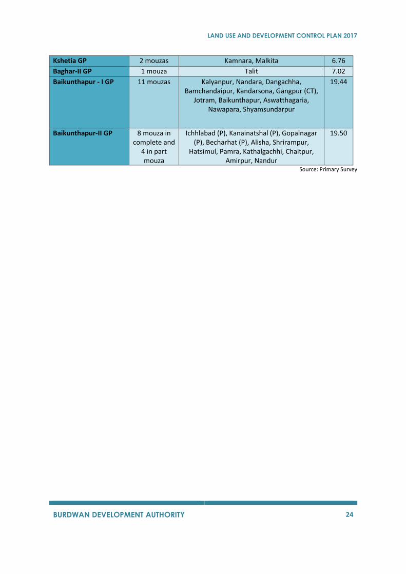
Kshetia GP 2 mouzas Kamnara, Malkita 6.76
Baghar-II GP 1 mouza Talit 7.02
Baikunthapur - I GP 11 mouzas Kalyanpur, Nandara, Dangachha, Bamchandaipur, Kandarsona, Gangpur (CT),
Jotram, Baikunthapur, Aswatthagaria, Nawapara, Shyamsundarpur
19.44
Baikunthapur-II GP 8 mouza in complete and
4 in part mouza
Ichhlabad (P), Kanainatshal (P), Gopalnagar (P), Becharhat (P), Alisha, Shrirampur,
Hatsimul, Pamra, Kathalgachhi, Chaitpur, Amirpur, Nandur
19.50
Source: Primary Survey
LAND USE AND DEVELOPMENT CONTROL PLAN 2017
BURDWAN DEVELOPMENT AUTHORITY 25

LAND USE AND DEVELOPMENT CONTROL PLAN 2017
BURDWAN DEVELOPMENT AUTHORITY 26
3 DEMOGRAPHY
3.1 INTRODUCTION Demography is the study of human population with respect to size, composition, spatial distribution,
and changes in the population that occur over time. The importance of studying demography is to
identify changes within the population such as the growth of the population, mortality and morbidity
rates, migration and marriage. This information helps governments to evaluate their policies and helps
in forecasting future trends. Study and analysis of population is important for planning as proposals
and standards are made in relation to population of the planning area, its size, composition and
distribution.
3.1.1 Burdwan Planning Area (BPA)
BPA comprises of 63 Mouzas and it is under the jurisdiction of Burdwan Police Station. It has an area
of 148.03 Sq.km.
Table 3: Demographics 1981 and 2011
1981 1991 2001 2011
India 683329900 838583988 1028610328 1210854977
West Bengal 54580650 68077965 80176197 91276115
Purba Barddhaman 4835388 6050605 6895514 7717563
BPA 238525 334441 406966 482165
3.1.1.1 Population of BPA
The urban area of BPA consists mostly of Burdwan Municipality. The rural area consists of seven gram
panchayats; namely,Belkash GP, Rayan-I GP, Saraitikar GP,Kshetia GP, Baghar-II GP, Baikunthapur - I
GP, Baikunthapur-II GP.
Figure 9: Increase in Population over a Decade
0
50000
100000
150000
200000
250000
300000
350000
2001 2011
Po
pu
lati
on
Population Growth
Belkash GP
Rayan-I GP
Saraitikar GP
Kshetia GP
Baghar-II GP
Baikunthapur - I GP
Baikunthapur - II GP
Municipality
LAND USE AND DEVELOPMENT CONTROL PLAN 2017
BURDWAN DEVELOPMENT AUTHORITY 27
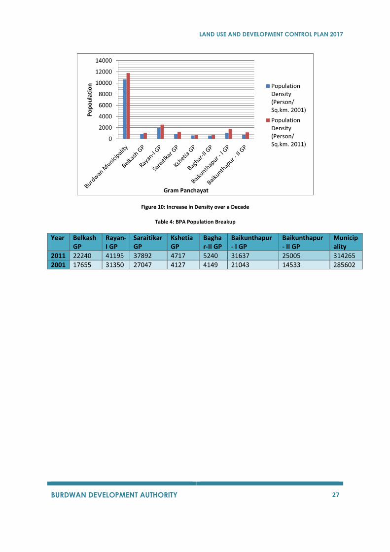
Figure 10: Increase in Density over a Decade
Table 4: BPA Population Breakup
Year Belkash GP
Rayan-I GP
Saraitikar GP
Kshetia GP
Baghar-II GP
Baikunthapur - I GP
Baikunthapur - II GP
Municipality
2011 22240 41195 37892 4717 5240 31637 25005 314265
2001 17655 31350 27047 4127 4149 21043 14533 285602
0
2000
4000
6000
8000
10000
12000
14000
Po
po
ula
tio
n
Gram Panchayat
PopulationDensity(Person/Sq.km. 2001)
PopulationDensity(Person/Sq.km. 2011)
LAND USE AND DEVELOPMENT CONTROL PLAN 2017
BURDWAN DEVELOPMENT AUTHORITY 28
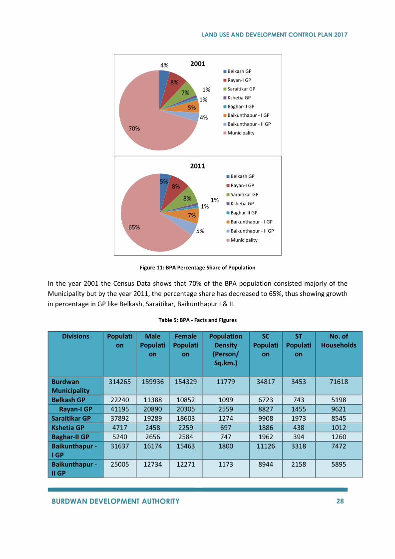
Figure 11: BPA Percentage Share of Population
In the year 2001 the Census Data shows that 70% of the BPA population consisted majorly of the
Municipality but by the year 2011, the percentage share has decreased to 65%, thus showing growth
in percentage in GP like Belkash, Saraitikar, Baikunthapur I & II.
Table 5: BPA - Facts and Figures
Divisions Population
Male Populati
on
Female Populati
on
Population Density
(Person/ Sq.km.)
SC Populati
on
ST Populati
on
No. of Households
Burdwan Municipality
314265 159936 154329 11779 34817 3453 71618
Belkash GP 22240 11388 10852 1099 6723 743 5198
Rayan-I GP 41195 20890 20305 2559 8827 1455 9621
Saraitikar GP 37892 19289 18603 1274 9908 1973 8545
Kshetia GP 4717 2458 2259 697 1886 438 1012
Baghar-II GP 5240 2656 2584 747 1962 394 1260
Baikunthapur - I GP
31637 16174 15463 1800 11126 3318 7472
Baikunthapur - II GP
25005 12734 12271 1173 8944 2158 5895
4%
8%
7% 1%
1%5%
4%
70%
2001Belkash GP
Rayan-I GP
Saraitikar GP
Kshetia GP
Baghar-II GP
Baikunthapur - I GP
Baikunthapur - II GP
Municipality
5%8%
8% 1%1%
7%
5%65%
2011
Belkash GP
Rayan-I GP
Saraitikar GP
Kshetia GP
Baghar-II GP
Baikunthapur - I GP
Baikunthapur - II GP
Municipality
LAND USE AND DEVELOPMENT CONTROL PLAN 2017
BURDWAN DEVELOPMENT AUTHORITY 29
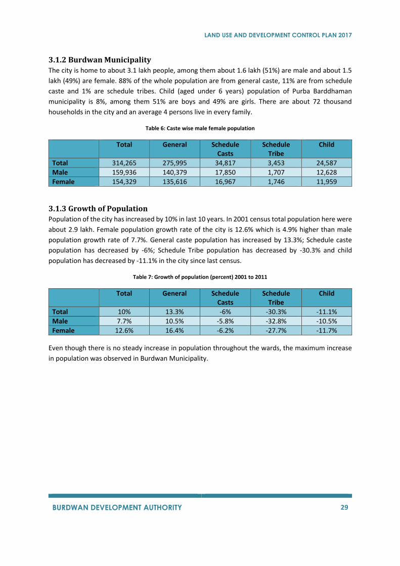
3.1.2 Burdwan Municipality
The city is home to about 3.1 lakh people, among them about 1.6 lakh (51%) are male and about 1.5
lakh (49%) are female. 88% of the whole population are from general caste, 11% are from schedule
caste and 1% are schedule tribes. Child (aged under 6 years) population of Purba Barddhaman
municipality is 8%, among them 51% are boys and 49% are girls. There are about 72 thousand
households in the city and an average 4 persons live in every family.
Table 6: Caste wise male female population
Total General Schedule Casts
Schedule Tribe
Child
Total 314,265 275,995 34,817 3,453 24,587
Male 159,936 140,379 17,850 1,707 12,628
Female 154,329 135,616 16,967 1,746 11,959
3.1.3 Growth of Population
Population of the city has increased by 10% in last 10 years. In 2001 census total population here were
about 2.9 lakh. Female population growth rate of the city is 12.6% which is 4.9% higher than male
population growth rate of 7.7%. General caste population has increased by 13.3%; Schedule caste
population has decreased by -6%; Schedule Tribe population has decreased by -30.3% and child
population has decreased by -11.1% in the city since last census.
Table 7: Growth of population (percent) 2001 to 2011
Total General Schedule Casts
Schedule Tribe
Child
Total 10% 13.3% -6% -30.3% -11.1%
Male 7.7% 10.5% -5.8% -32.8% -10.5%
Female 12.6% 16.4% -6.2% -27.7% -11.7%
Even though there is no steady increase in population throughout the wards, the maximum increase
in population was observed in Burdwan Municipality.
LAND USE AND DEVELOPMENT CONTROL PLAN 2017
BURDWAN DEVELOPMENT AUTHORITY 30
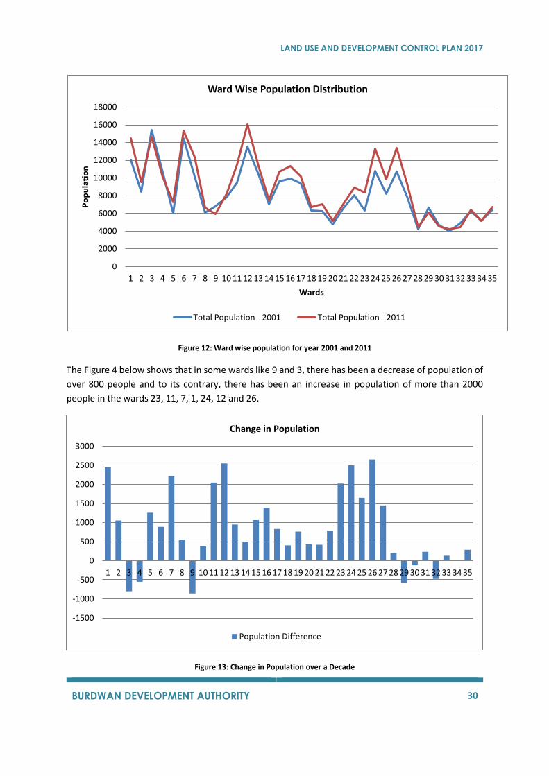
Figure 12: Ward wise population for year 2001 and 2011
The Figure 4 below shows that in some wards like 9 and 3, there has been a decrease of population of
over 800 people and to its contrary, there has been an increase in population of more than 2000
people in the wards 23, 11, 7, 1, 24, 12 and 26.
Figure 13: Change in Population over a Decade
0
2000
4000
6000
8000
10000
12000
14000
16000
18000
1 2 3 4 5 6 7 8 9 10 11 12 13 14 15 16 17 18 19 20 21 22 23 24 25 26 27 28 29 30 31 32 33 34 35
Po
pu
lati
on
Wards
Ward Wise Population Distribution
Total Population - 2001 Total Population - 2011
-1500
-1000
-500
0
500
1000
1500
2000
2500
3000
1 2 3 4 5 6 7 8 9 10 11 12 13 14 15 16 17 18 19 20 21 22 23 24 25 26 27 28 29 30 31 32 33 34 35
Change in Population
Population Difference
LAND USE AND DEVELOPMENT CONTROL PLAN 2017
BURDWAN DEVELOPMENT AUTHORITY 31
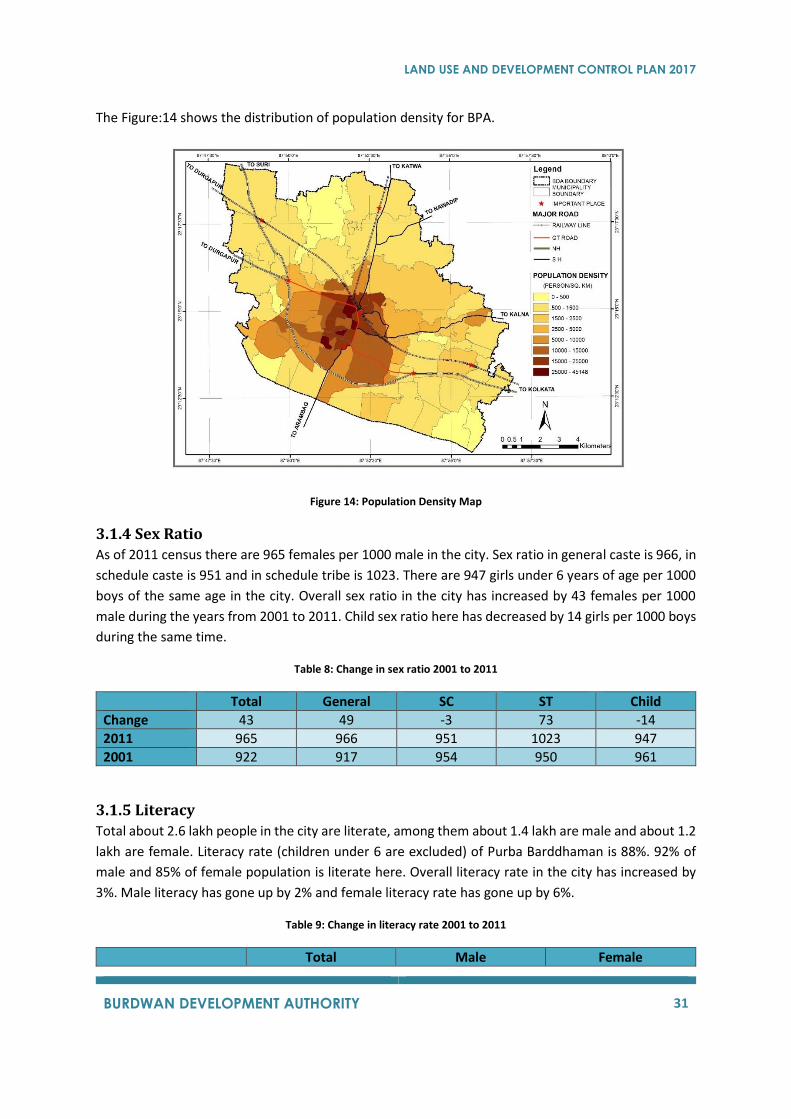
The Figure:14 shows the distribution of population density for BPA.
Figure 14: Population Density Map
3.1.4 Sex Ratio
As of 2011 census there are 965 females per 1000 male in the city. Sex ratio in general caste is 966, in
schedule caste is 951 and in schedule tribe is 1023. There are 947 girls under 6 years of age per 1000
boys of the same age in the city. Overall sex ratio in the city has increased by 43 females per 1000
male during the years from 2001 to 2011. Child sex ratio here has decreased by 14 girls per 1000 boys
during the same time.
Table 8: Change in sex ratio 2001 to 2011
Total General SC ST Child
Change 43 49 -3 73 -14
2011 965 966 951 1023 947
2001 922 917 954 950 961
3.1.5 Literacy
Total about 2.6 lakh people in the city are literate, among them about 1.4 lakh are male and about 1.2
lakh are female. Literacy rate (children under 6 are excluded) of Purba Barddhaman is 88%. 92% of
male and 85% of female population is literate here. Overall literacy rate in the city has increased by
3%. Male literacy has gone up by 2% and female literacy rate has gone up by 6%.
Table 9: Change in literacy rate 2001 to 2011
Total Male Female
LAND USE AND DEVELOPMENT CONTROL PLAN 2017
BURDWAN DEVELOPMENT AUTHORITY 32
Change 3.7% 2.3% 5.5%
2011 88.3% 91.8% 84.7%
2001 84.6% 89.5% 79.2%
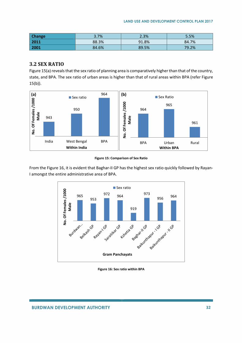
3.2 SEX RATIO Figure 15(a) reveals that the sex ratio of planning area is comparatively higher than that of the country,
state, and BPA. The sex ratio of urban areas is higher than that of rural areas within BPA (refer Figure
15(b)).
Figure 15: Comparison of Sex Ratio
From the Figure 16, it is evident that Baghar-II GP has the highest sex ratio quickly followed by Rayan-
I amongst the entire administrative area of BPA.
Figure 16: Sex ratio within BPA
943
950
964
India West Bengal BPA
No
. Of
Fem
ale
s /1
00
0
Mal
e
Within India
(a)Sex ratio
964965
961
BPA Urban Rural
No
. Of
Fem
ale
s /1
00
0
Mal
e
Within BPA
(b)Sex Ratio
965953
972964
919
973956
964
No
. Of
Fem
ale
s /1
00
0
Mal
e
Gram Panchayats
Sex ratio
LAND USE AND DEVELOPMENT CONTROL PLAN 2017
BURDWAN DEVELOPMENT AUTHORITY 33
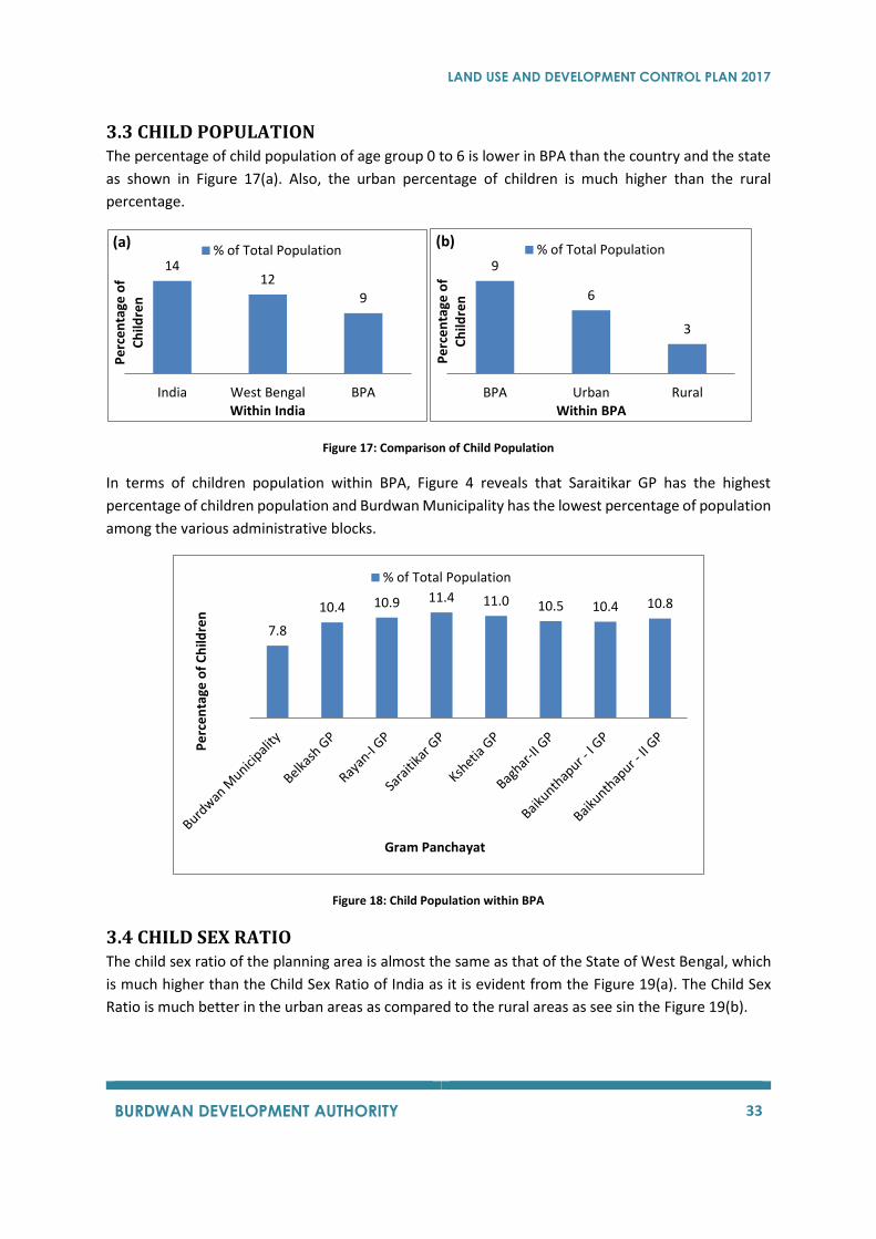
3.3 CHILD POPULATION The percentage of child population of age group 0 to 6 is lower in BPA than the country and the state
as shown in Figure 17(a). Also, the urban percentage of children is much higher than the rural
percentage.
Figure 17: Comparison of Child Population
In terms of children population within BPA, Figure 4 reveals that Saraitikar GP has the highest
percentage of children population and Burdwan Municipality has the lowest percentage of population
among the various administrative blocks.
Figure 18: Child Population within BPA
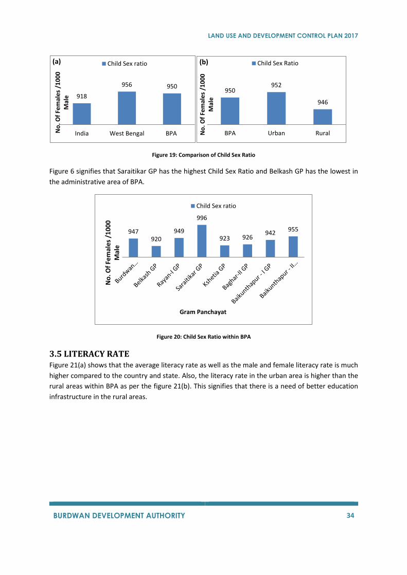
3.4 CHILD SEX RATIO The child sex ratio of the planning area is almost the same as that of the State of West Bengal, which
is much higher than the Child Sex Ratio of India as it is evident from the Figure 19(a). The Child Sex
Ratio is much better in the urban areas as compared to the rural areas as see sin the Figure 19(b).
1412
9
India West Bengal BPA
Pe
rce
nta
ge o
f C
hild
ren
Within India
(a)% of Total Population
9
6
3
BPA Urban Rural
Pe
rce
nta
ge o
f C
hild
ren
Within BPA
(b)% of Total Population
7.8
10.4 10.9 11.4 11.0 10.5 10.4 10.8
Pe
rce
nta
ge o
f C
hild
ren
Gram Panchayat
% of Total Population
LAND USE AND DEVELOPMENT CONTROL PLAN 2017
BURDWAN DEVELOPMENT AUTHORITY 34
Figure 19: Comparison of Child Sex Ratio
Figure 6 signifies that Saraitikar GP has the highest Child Sex Ratio and Belkash GP has the lowest in
the administrative area of BPA.
Figure 20: Child Sex Ratio within BPA
3.5 LITERACY RATE Figure 21(a) shows that the average literacy rate as well as the male and female literacy rate is much
higher compared to the country and state. Also, the literacy rate in the urban area is higher than the
rural areas within BPA as per the figure 21(b). This signifies that there is a need of better education
infrastructure in the rural areas.
918
956 950
India West Bengal BPANo
. Of
Fem
ale
s /1
00
0
Mal
e(a) Child Sex ratio
950952
946
BPA Urban RuralNo
. Of
Fem
ale
s /1
00
0
Mal
e
(b) Child Sex Ratio
947920
949
996
923 926942
955
No
. Of
Fem
ales
/1
00
0
Mal
e
Gram Panchayat
Child Sex ratio
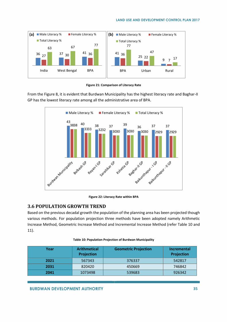
LAND USE AND DEVELOPMENT CONTROL PLAN 2017
BURDWAN DEVELOPMENT AUTHORITY 35
Figure 21: Comparison of Literacy Rate
From the Figure 8, it is evident that Burdwan Municipality has the highest literacy rate and Baghar-II
GP has the lowest literacy rate among all the administrative area of BPA.
Figure 22: Literacy Rate within BPA
3.6 POPULATION GROWTH TREND Based on the previous decadal growth the population of the planning area has been projected though
various methods. For population projection three methods have been adopted namely Arithmetic
Increase Method, Geometric Increase Method and Incremental Increase Method (refer Table 10 and
11).
Table 10: Population Projection of Burdwan Municipality
Year Arithmetical Projection
Geometric Projection Incremental Projection
2021 567343 376337 542817
2031 820420 450669 746842
2041 1073498 539683 926342
36 37 4127 30 36
63 6777
India West Bengal BPA
(a) Male Literacy % Female Literacy %
Total Literacy %
4125
9
3622
7
77
47
17
BPA Urban Rural
(b) Male Literacy % Female Literacy %
Total Literacy %
4340 38 37 39
36 37 373833 32 30 30 30 29 29
3833 32 30 30 30 29 29
Male Literacy % Female Literacy % Total Literacy %

LAND USE AND DEVELOPMENT CONTROL PLAN 2017
BURDWAN DEVELOPMENT AUTHORITY 36
Table 11: Population projection of BPA
Year Arithmetical Projection
Geometric Projection Incremental Projection
2021 847689 603949 837331
2031 1213214 756492 1182138
2041 1578738 947564 1516587
Figure 23: Decadal growth for 2021-2041
3.7 POPULATION DENSITY The population density of BPA has been compared for the year 2001 and 2011.
Figure 24: Comparison of Density (2001-2011)
847689
1213214
1578738
603949756492
947564837331
1182138
1516587
2021 2031 2041
Population Projection for BPA
Arithmetical Projection Geometric Projection Incremental Projection
02000400060008000
100001200014000
Po
pu
lati
on
Gram Panchayats
Population Density(Person/ Sq.km. 2001)
Population Density(Person/ Sq.km. 2011)
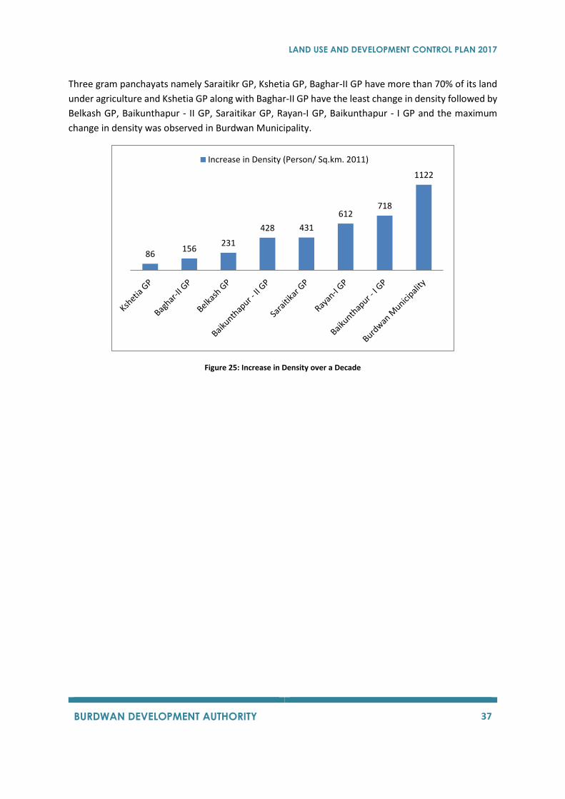
LAND USE AND DEVELOPMENT CONTROL PLAN 2017
BURDWAN DEVELOPMENT AUTHORITY 37
Three gram panchayats namely Saraitikr GP, Kshetia GP, Baghar-II GP have more than 70% of its land
under agriculture and Kshetia GP along with Baghar-II GP have the least change in density followed by
Belkash GP, Baikunthapur - II GP, Saraitikar GP, Rayan-I GP, Baikunthapur - I GP and the maximum
change in density was observed in Burdwan Municipality.
Figure 25: Increase in Density over a Decade
86156
231
428 431
612718
1122
Increase in Density (Person/ Sq.km. 2011)
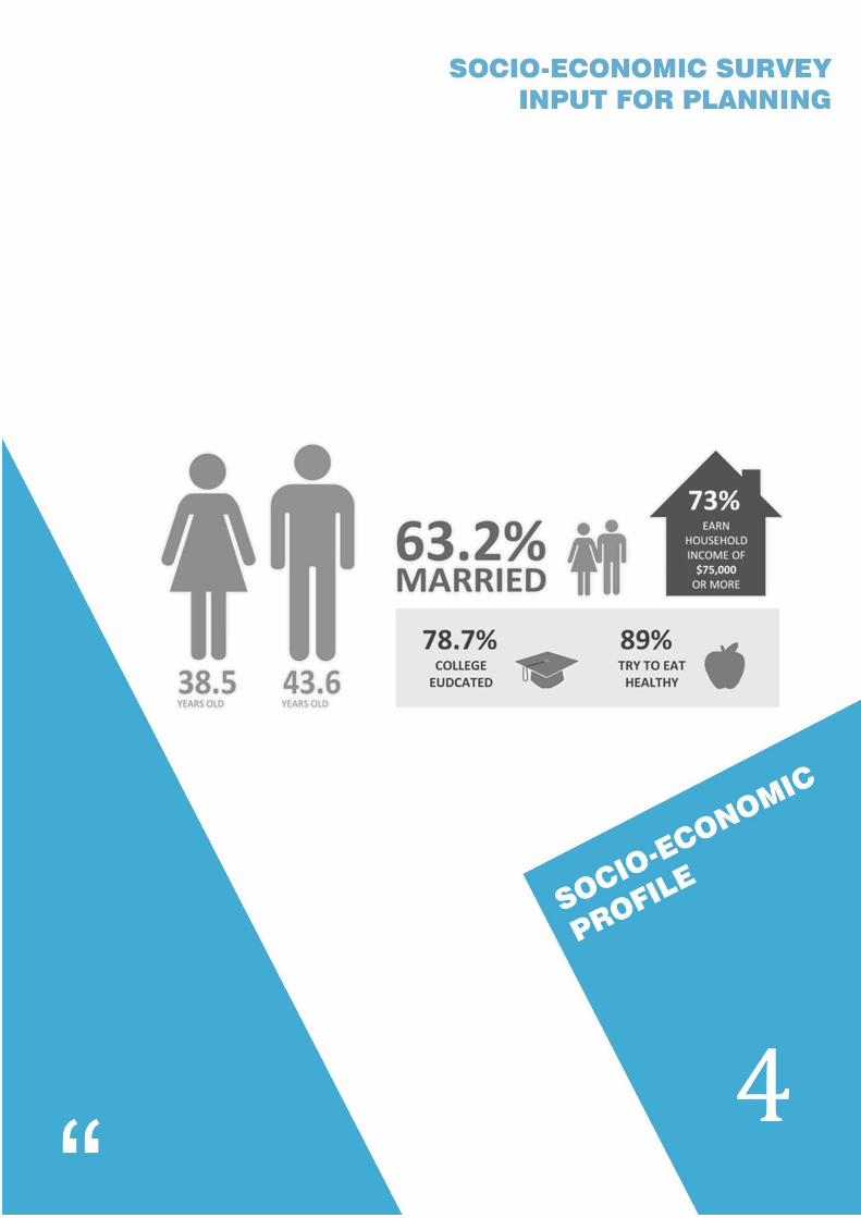
LAND USE AND DEVELOPMENT CONTROL PLAN 2017
BURDWAN DEVELOPMENT AUTHORITY 38
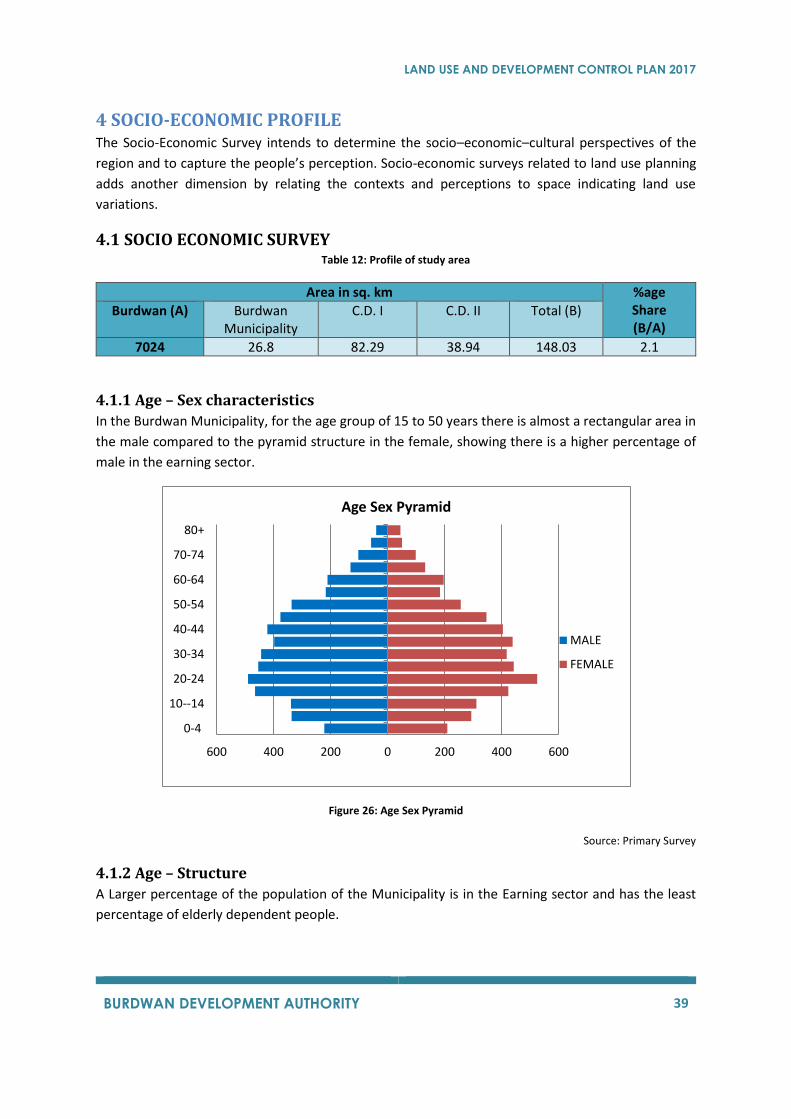
LAND USE AND DEVELOPMENT CONTROL PLAN 2017
BURDWAN DEVELOPMENT AUTHORITY 39
4 SOCIO-ECONOMIC PROFILE The Socio-Economic Survey intends to determine the socio–economic–cultural perspectives of the
region and to capture the people’s perception. Socio-economic surveys related to land use planning
adds another dimension by relating the contexts and perceptions to space indicating land use
variations.
4.1 SOCIO ECONOMIC SURVEY Table 12: Profile of study area
Area in sq. km %age Share (B/A)
Burdwan (A) Burdwan Municipality
C.D. I C.D. II Total (B)
7024 26.8 82.29 38.94 148.03 2.1
4.1.1 Age – Sex characteristics
In the Burdwan Municipality, for the age group of 15 to 50 years there is almost a rectangular area in
the male compared to the pyramid structure in the female, showing there is a higher percentage of
male in the earning sector.
Figure 26: Age Sex Pyramid
Source: Primary Survey
4.1.2 Age – Structure
A Larger percentage of the population of the Municipality is in the Earning sector and has the least
percentage of elderly dependent people.
600 400 200 0 200 400 600
0-4
10--14
20-24
30-34
40-44
50-54
60-64
70-74
80+
Age Sex Pyramid
MALE
FEMALE
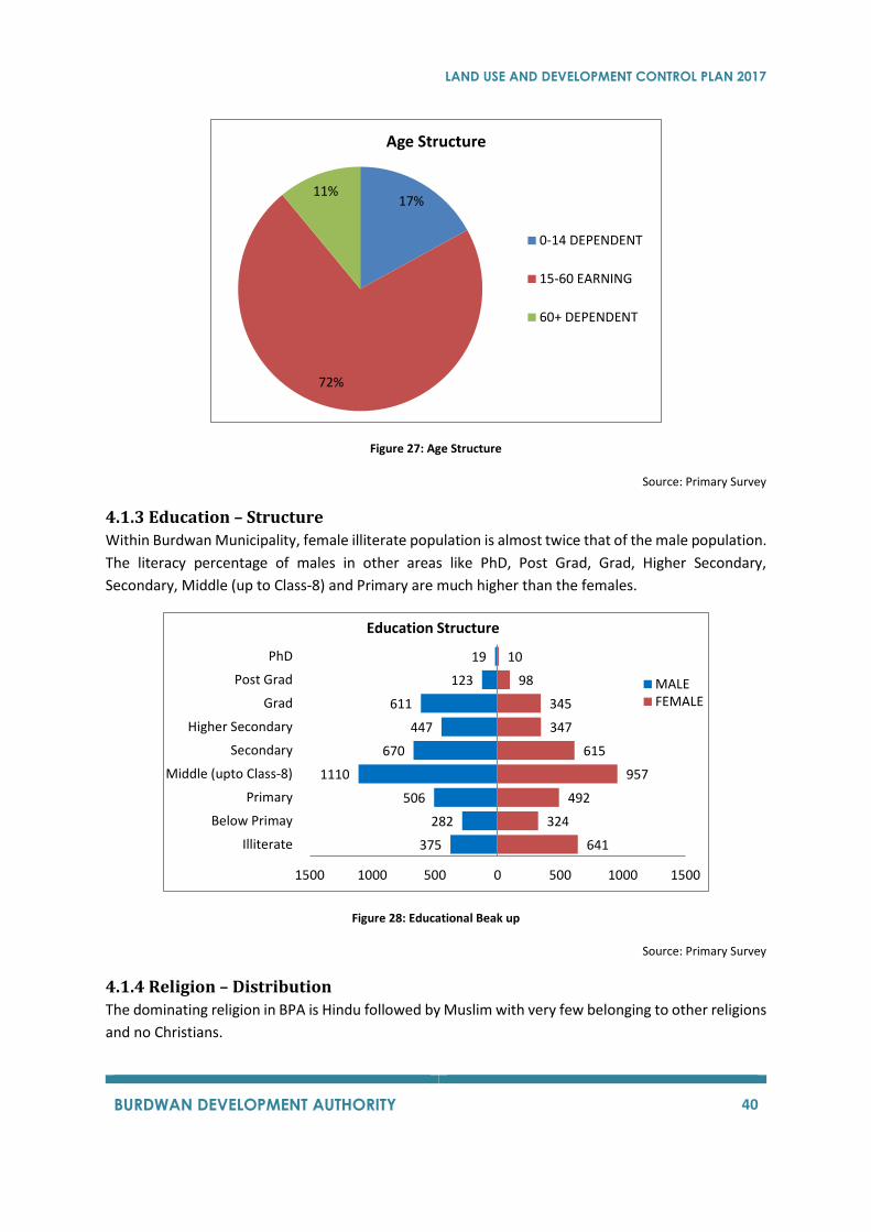
LAND USE AND DEVELOPMENT CONTROL PLAN 2017
BURDWAN DEVELOPMENT AUTHORITY 40
Figure 27: Age Structure
Source: Primary Survey
4.1.3 Education – Structure
Within Burdwan Municipality, female illiterate population is almost twice that of the male population.
The literacy percentage of males in other areas like PhD, Post Grad, Grad, Higher Secondary,
Secondary, Middle (up to Class-8) and Primary are much higher than the females.
Figure 28: Educational Beak up
Source: Primary Survey
4.1.4 Religion – Distribution
The dominating religion in BPA is Hindu followed by Muslim with very few belonging to other religions
and no Christians.
17%
72%
11%
Age Structure
0-14 DEPENDENT
15-60 EARNING
60+ DEPENDENT
641
324
492
957
615
347
345
98
10
375
282
506
1110
670
447
611
123
19
1500 1000 500 0 500 1000 1500
Illiterate
Below Primay
Primary
Middle (upto Class-8)
Secondary
Higher Secondary
Grad
Post Grad
PhD
MALEFEMALE
Education Structure
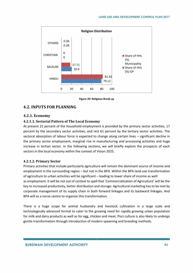
LAND USE AND DEVELOPMENT CONTROL PLAN 2017
BURDWAN DEVELOPMENT AUTHORITY 41
Figure 29: Religious Break up
4.2. INPUTS FOR PLANNING
4.2.1. Economy
4.2.1.1. Sectorial Pattern of The Local Economy
At present 22 percent of the household employment is provided by the primary sector activities, 17
percent by the secondary sector activities, and rest 61 percent by the tertiary sector activities. The
sectoral absorption of labour force is expected to change along certain lines – significant decline in
the primary sector employment, marginal rise in manufacturing and processing activities and huge
increase in tertian sector. In the following sections, we will briefly explore the prospects of each
sectors in the local economy within the context of Vision 2025.
4.2.1.2. Primary Sector
Primary activities that include particularly agriculture will remain the dominant source of income and
employment in the surrounding region – but not in the BPA. Within the BPA land-use transformation
of agriculture to urban activities will be significant – leading to lower share of income as well
as employment. It will be not out of context to spell that ‘Commercialization of Agriculture’ will be the
key to increased productivity, better distribution and storage. Agricultural marketing has to be met by
corporate management of its supply chain in both forward linkages and its backward linkages. And
BPA will as a nerve centre to organise this transformation.
There is a huge scope for animal husbandry and livestock cultivation in a large scale and
technologically advanced format to cater to the growing need for rapidly growing urban population
for milk and dairy products as well as for egg, chicken and meat. Pisci culture is also likely to undergo
gentle transformation through introduction of modern spawning and breeding methods.
79.12
20.6
0
0.28
81.92
17.71
0
0.36
0 20 40 60 80 100
HINDU
MUSLIM
CHRISTIAN
OTHERS
Religion Distribution
Share of HHs(%)MunicipalityShare of HHs(%) GP
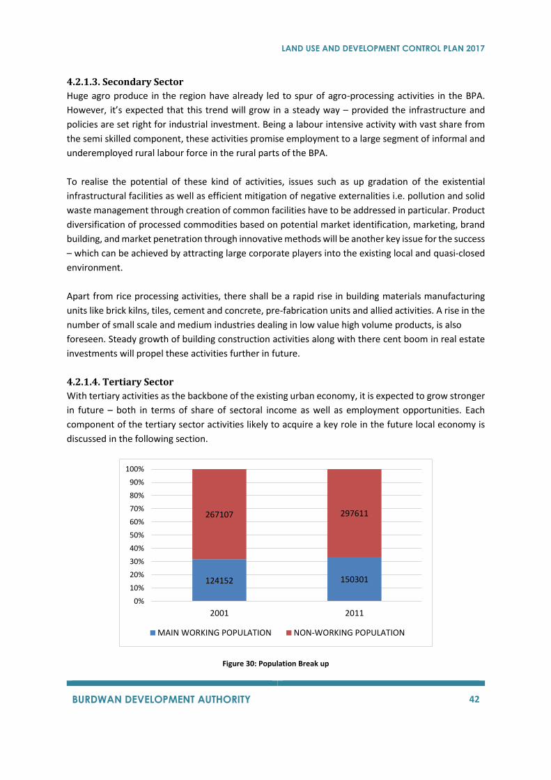
LAND USE AND DEVELOPMENT CONTROL PLAN 2017
BURDWAN DEVELOPMENT AUTHORITY 42
4.2.1.3. Secondary Sector
Huge agro produce in the region have already led to spur of agro-processing activities in the BPA.
However, it’s expected that this trend will grow in a steady way – provided the infrastructure and
policies are set right for industrial investment. Being a labour intensive activity with vast share from
the semi skilled component, these activities promise employment to a large segment of informal and
underemployed rural labour force in the rural parts of the BPA.
To realise the potential of these kind of activities, issues such as up gradation of the existential
infrastructural facilities as well as efficient mitigation of negative externalities i.e. pollution and solid
waste management through creation of common facilities have to be addressed in particular. Product
diversification of processed commodities based on potential market identification, marketing, brand
building, and market penetration through innovative methods will be another key issue for the success
– which can be achieved by attracting large corporate players into the existing local and quasi-closed
environment.
Apart from rice processing activities, there shall be a rapid rise in building materials manufacturing
units like brick kilns, tiles, cement and concrete, pre-fabrication units and allied activities. A rise in the
number of small scale and medium industries dealing in low value high volume products, is also
foreseen. Steady growth of building construction activities along with there cent boom in real estate
investments will propel these activities further in future.
4.2.1.4. Tertiary Sector
With tertiary activities as the backbone of the existing urban economy, it is expected to grow stronger
in future – both in terms of share of sectoral income as well as employment opportunities. Each
component of the tertiary sector activities likely to acquire a key role in the future local economy is
discussed in the following section.
Figure 30: Population Break up
124152 150301
267107 297611
0%
10%
20%
30%
40%
50%
60%
70%
80%
90%
100%
2001 2011
MAIN WORKING POPULATION NON-WORKING POPULATION

LAND USE AND DEVELOPMENT CONTROL PLAN 2017
BURDWAN DEVELOPMENT AUTHORITY 43
4.2.2. Administrative Functions
Burdwan, being a district capital, has played a pivotal role in anchoring the urban activities. And in
future, it is going to pull a vast array of semi-public and private functions due to agglomerative forces.
As already hinted, the commercialization of agriculture will create this town as the nerve centre for
the surrounding agro-hinterland.
4.2.3 Business and Trade
4.2.3.1. Wholesale Trade Functions Being located in the centre of the vast agricultural hinterland, BPA shall continue to serve as the nodal
point for wholesale trade functions, particularly for the agricultural produce. However, it is expected
that the scattered landscape of whole activities across the town will consolidate in
the outskirts of the town in close proximity to regional level connectors.
4.2.3.2. Retail trade of commerce
Burdwan town has emerged as one of the important retail trade and commerce destination of the
Southern West Bengal due to its rapidly growing per-capita income and consumption propensity. This
trend will continue to fuel the demand for retail trade and commerce However, it will experience a
gradual transformation from informal and unorganized to a formal, structured and organized one. In
addition to this, Banking services, Finance and Credit institutions will increase as a derivative to the
growth in trade, both retail and whole sale.
4.2.4. Transport and Transhipment Functions Increasing modal shift of freight movement will demand more road-based Terminal facilities, Storage
and Warehousing, Transfer and Transhipment facilities in vicinity of the town. Being the whole sale
and retail trade hub of the region, transport and transhipment activities is expected to expand inBPA
at a steady rate. Given the rise in processing activities demand for specialised storage facility will also
increase.
4.2.5. Health and Educational Activities Burdwan has developed an image of being the hub for health services catering a vast region. The
proposed health city at mouza Goda in the periphery of the city will further add strength to its pull
factor. There is a possibility of exploring Knowledge based economic activities that has a tremendous
potential in Purba Barddhaman – especially in the field of higher education and research.
Given the proximity to Kolkata this function will help to position itself as a complimentary destination
to the metropolitan attraction for health and knowledge based services.
4.2.6. Real Estate Functions
The burgeoning growth of population will also create a sustainable market for real estate and building
construction activities. Large real estate developers have already shown their keen interest in the
untapped informal type real estate market in Purba Barddhaman. In future, this trend will further
strengthen, providing the people of this town more choices to exercise –therefore creating a better
quality of living.
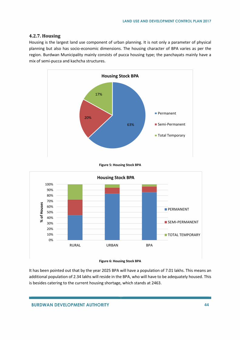
LAND USE AND DEVELOPMENT CONTROL PLAN 2017
BURDWAN DEVELOPMENT AUTHORITY 44
4.2.7. Housing Housing is the largest land use component of urban planning. It is not only a parameter of physical
planning but also has socio-economic dimensions. The housing character of BPA varies as per the
region. Burdwan Municipality mainly consists of pucca housing type; the panchayats mainly have a
mix of semi-pucca and kachcha structures.
Figure 5: Housing Stock BPA
Figure 6: Housing Stock BPA
It has been pointed out that by the year 2025 BPA will have a population of 7.01 lakhs. This means an
additional population of 2.34 lakhs will reside in the BPA, who will have to be adequately housed. This
is besides catering to the current housing shortage, which stands at 2463.
63%
20%
17%
Housing Stock BPA
Permanent
Semi-Permanent
Total Temporary
0%
10%
20%
30%
40%
50%
60%
70%
80%
90%
100%
RURAL URBAN BPA
% o
f H
ou
ses
Housing Stock BPA
PERMANENT
SEMI-PERMANENT
TOTAL TEMPORARY
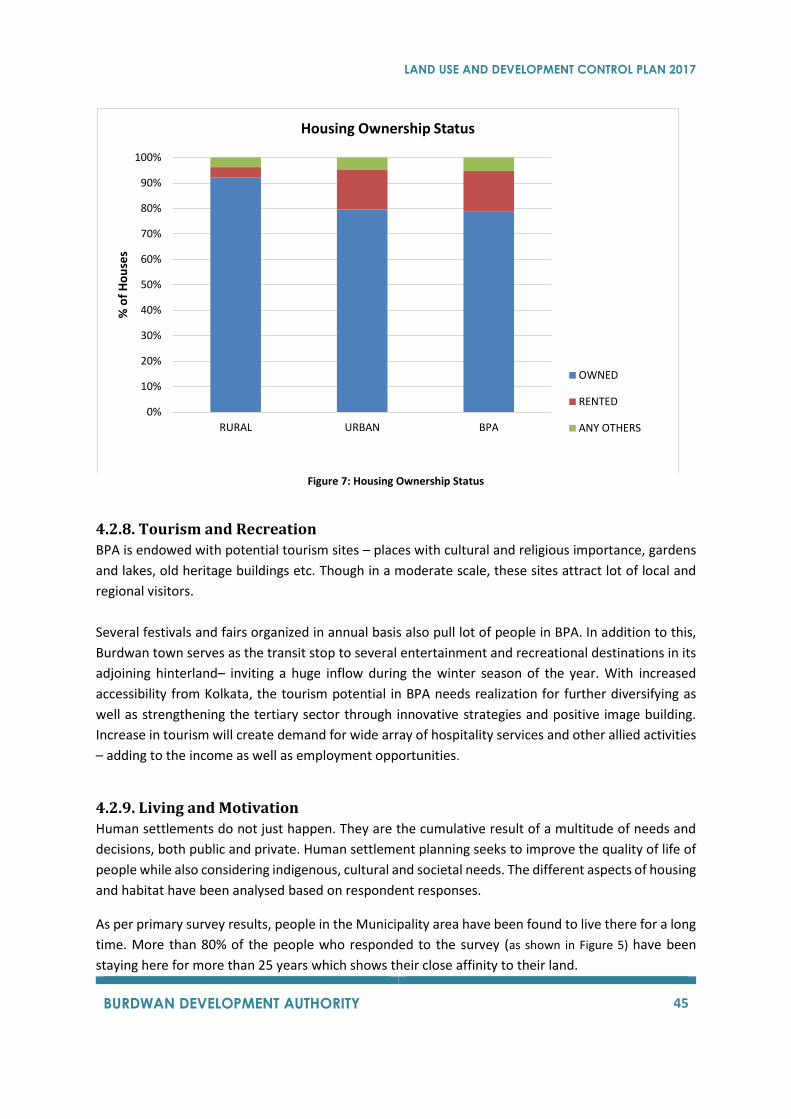
LAND USE AND DEVELOPMENT CONTROL PLAN 2017
BURDWAN DEVELOPMENT AUTHORITY 45
Figure 7: Housing Ownership Status
4.2.8. Tourism and Recreation
BPA is endowed with potential tourism sites – places with cultural and religious importance, gardens
and lakes, old heritage buildings etc. Though in a moderate scale, these sites attract lot of local and
regional visitors.
Several festivals and fairs organized in annual basis also pull lot of people in BPA. In addition to this,
Burdwan town serves as the transit stop to several entertainment and recreational destinations in its
adjoining hinterland– inviting a huge inflow during the winter season of the year. With increased
accessibility from Kolkata, the tourism potential in BPA needs realization for further diversifying as
well as strengthening the tertiary sector through innovative strategies and positive image building.
Increase in tourism will create demand for wide array of hospitality services and other allied activities
– adding to the income as well as employment opportunities.
4.2.9. Living and Motivation
Human settlements do not just happen. They are the cumulative result of a multitude of needs and
decisions, both public and private. Human settlement planning seeks to improve the quality of life of
people while also considering indigenous, cultural and societal needs. The different aspects of housing
and habitat have been analysed based on respondent responses.
As per primary survey results, people in the Municipality area have been found to live there for a long
time. More than 80% of the people who responded to the survey (as shown in Figure 5) have been
staying here for more than 25 years which shows their close affinity to their land.
0%
10%
20%
30%
40%
50%
60%
70%
80%
90%
100%
RURAL URBAN BPA
% o
f H
ou
ses
Housing Ownership Status
OWNED
RENTED
ANY OTHERS
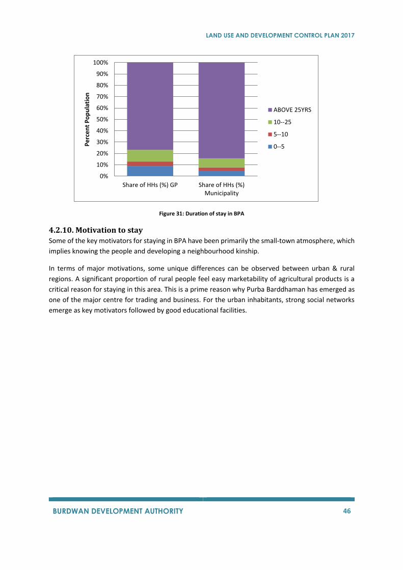
LAND USE AND DEVELOPMENT CONTROL PLAN 2017
BURDWAN DEVELOPMENT AUTHORITY 46
Figure 31: Duration of stay in BPA
4.2.10. Motivation to stay
Some of the key motivators for staying in BPA have been primarily the small-town atmosphere, which
implies knowing the people and developing a neighbourhood kinship.
In terms of major motivations, some unique differences can be observed between urban & rural
regions. A significant proportion of rural people feel easy marketability of agricultural products is a
critical reason for staying in this area. This is a prime reason why Purba Barddhaman has emerged as
one of the major centre for trading and business. For the urban inhabitants, strong social networks
emerge as key motivators followed by good educational facilities.
0%
10%
20%
30%
40%
50%
60%
70%
80%
90%
100%
Share of HHs (%) GP Share of HHs (%)Municipality
Pe
rce
nt
Po
pu
lati
on
ABOVE 25YRS
10--25
5--10
0--5
LAND USE AND DEVELOPMENT CONTROL PLAN 2017
BURDWAN DEVELOPMENT AUTHORITY 47

LAND USE AND DEVELOPMENT CONTROL PLAN 2017
BURDWAN DEVELOPMENT AUTHORITY 48
5 EXISTING LAND USE & INFRASTRUCTURE
5.1 LAND USE PATTERN In this section, land use pattern of the planning area has been discussed briefly. Land use composition
for various existing land uses is presented here for the better understandings about the utilisation of
land in Planning Area.
5.1.1 Land Use Classification
Table 13 gives a list of land use layers that would be used for existing land use maps.
Table 13: Land Use Layer for Land Use Maps
S. No. Land Use Type Colour S. No. Land Use Type Colour
Residential Yellow 22 Special Recreational Zone (Restricted Open Spaces)
1 Pucca Residential (Less than G+2)
2 Pucca Residential (Above G+2) Transportation Grey
3 Village Settlement 23 Collector Roads
4 Temporary Residential/ Squatter 24 Kutcha Roads
25 Sub Arterial Roads
Mixed Use Orange 26 National Highway
5 Mixed Use (Commercial + Residential)
27 Truck Terminals
28 State Highway
Commercial Deep Blue
29 Bus Depots/ Terminals
6 General Business and Commercial District/ Centres
30 Railway With Stations
7 Whole Sale, Godowns, Warehousing, Regulated Markets
31 Railways
8 Retail Shopping Zones
Agriculture Green
Industry Violet 32 Agriculture
9 Service and Light Industry 33 Forest
10 Brick Kilns 34 Poultry/ Animal Husbandry/ Dairy Farm
11 Extensive and Heavy Industry 35 Unorganised Dairy Farms/ Khatal
12 Open Cast Mines
13 Special Industrial zones, Hazardous, Chemical and Noxious
Water Body Sky Blue
36 Rivers/ Streams/ Natural Drains
Public-Semi Public Red 37 Pond/ Lake/ Reservoir
14 Education and Research
15 Govt./ Semi Govt./ Public Office Special Land Light Green
16 Cremation and Burial Ground 38 Heritage and Conservation Areas
17 Social Cultural and Religion 39 Scenic Value Area
18 Medical and health
19 Utilities and Services Vacant Land White
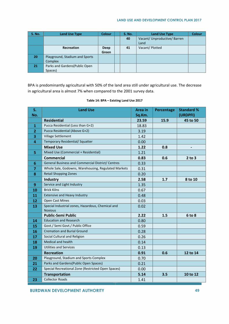
LAND USE AND DEVELOPMENT CONTROL PLAN 2017
BURDWAN DEVELOPMENT AUTHORITY 49
S. No. Land Use Type Colour S. No. Land Use Type Colour
40 Vacant/ Unproductive/ Barren Land
Recreation Deep Green
41 Vacant/ Plotted
20 Playground, Stadium and Sports Complex
21 Parks and Gardens(Public Open Spaces)
BPA is predominantly agricultural with 50% of the land area still under agricultural use. The decrease
in agricultural area is almost 7% when compared to the 2001 survey data.
Table 14: BPA – Existing Land Use 2017
S. No.
Land Use Area in Sq.Km.
Percentage Standard % (URDPFI)
Residential 23.59 15.9 45 to 50
1 Pucca Residential (Less than G+2) 18.83
2 Pucca Residential (Above G+2) 3.19
3 Village Settlement 1.42
4 Temporary Residential/ Squatter 0.00
Mixed Use 1.22 0.8 -
5 Mixed Use (Commercial + Residential) 1.21
Commercial 0.83 0.6 2 to 3
6 General Business and Commercial District/ Centres 0.33
7 Whole Sale, Godowns, Warehousing, Regulated Markets 0.31
8 Retail Shopping Zones 0.20
Industry 2.58 1.7 8 to 10
9 Service and Light Industry 1.35
10 Brick Kilns 0.67
11 Extensive and Heavy Industry 0.48
12 Open Cast Mines 0.03
13 Special Industrial zones, Hazardous, Chemical and Noxious
0.02
Public-Semi Public 2.22 1.5 6 to 8
14 Education and Research 0.80
15 Govt./ Semi Govt./ Public Office 0.59
16 Cremation and Burial Ground 0.28
17 Social Cultural and Religion 0.26
18 Medical and health 0.14
19 Utilities and Services 0.13
Recreation 0.91 0.6 12 to 14
20 Playground, Stadium and Sports Complex 0.70
21 Parks and Gardens(Public Open Spaces) 0.21
22 Special Recreational Zone (Restricted Open Spaces) 0.00
Transportation 5.14 3.5 10 to 12
23 Collector Roads 1.41
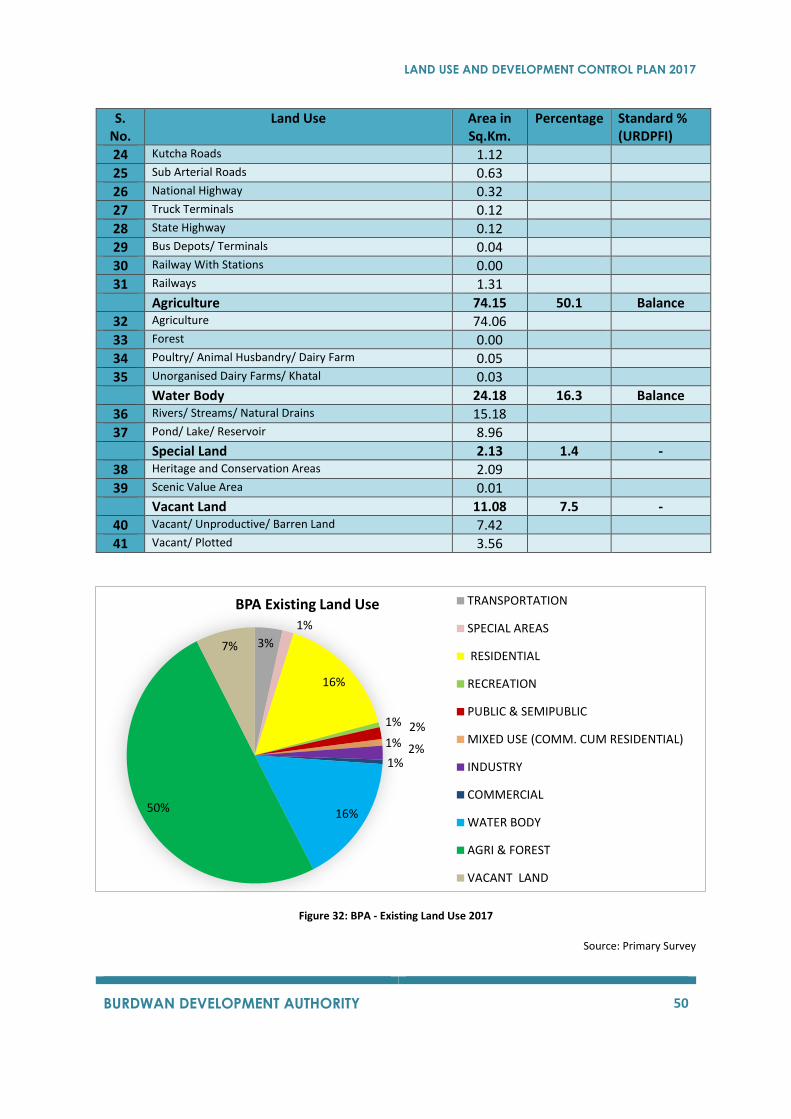
LAND USE AND DEVELOPMENT CONTROL PLAN 2017
BURDWAN DEVELOPMENT AUTHORITY 50
S. No.
Land Use Area in Sq.Km.
Percentage Standard % (URDPFI)
24 Kutcha Roads 1.12
25 Sub Arterial Roads 0.63
26 National Highway 0.32
27 Truck Terminals 0.12
28 State Highway 0.12
29 Bus Depots/ Terminals 0.04
30 Railway With Stations 0.00
31 Railways 1.31
Agriculture 74.15 50.1 Balance
32 Agriculture 74.06
33 Forest 0.00
34 Poultry/ Animal Husbandry/ Dairy Farm 0.05
35 Unorganised Dairy Farms/ Khatal 0.03
Water Body 24.18 16.3 Balance
36 Rivers/ Streams/ Natural Drains 15.18
37 Pond/ Lake/ Reservoir 8.96
Special Land 2.13 1.4 -
38 Heritage and Conservation Areas 2.09
39 Scenic Value Area 0.01
Vacant Land 11.08 7.5 -
40 Vacant/ Unproductive/ Barren Land 7.42
41 Vacant/ Plotted 3.56
Figure 32: BPA - Existing Land Use 2017
Source: Primary Survey
3%
1%
16%
1% 2%1% 2%1%
16%50%
7%
BPA Existing Land Use TRANSPORTATION
SPECIAL AREAS
RESIDENTIAL
RECREATION
PUBLIC & SEMIPUBLIC
MIXED USE (COMM. CUM RESIDENTIAL)
INDUSTRY
COMMERCIAL
WATER BODY
AGRI & FOREST
VACANT LAND
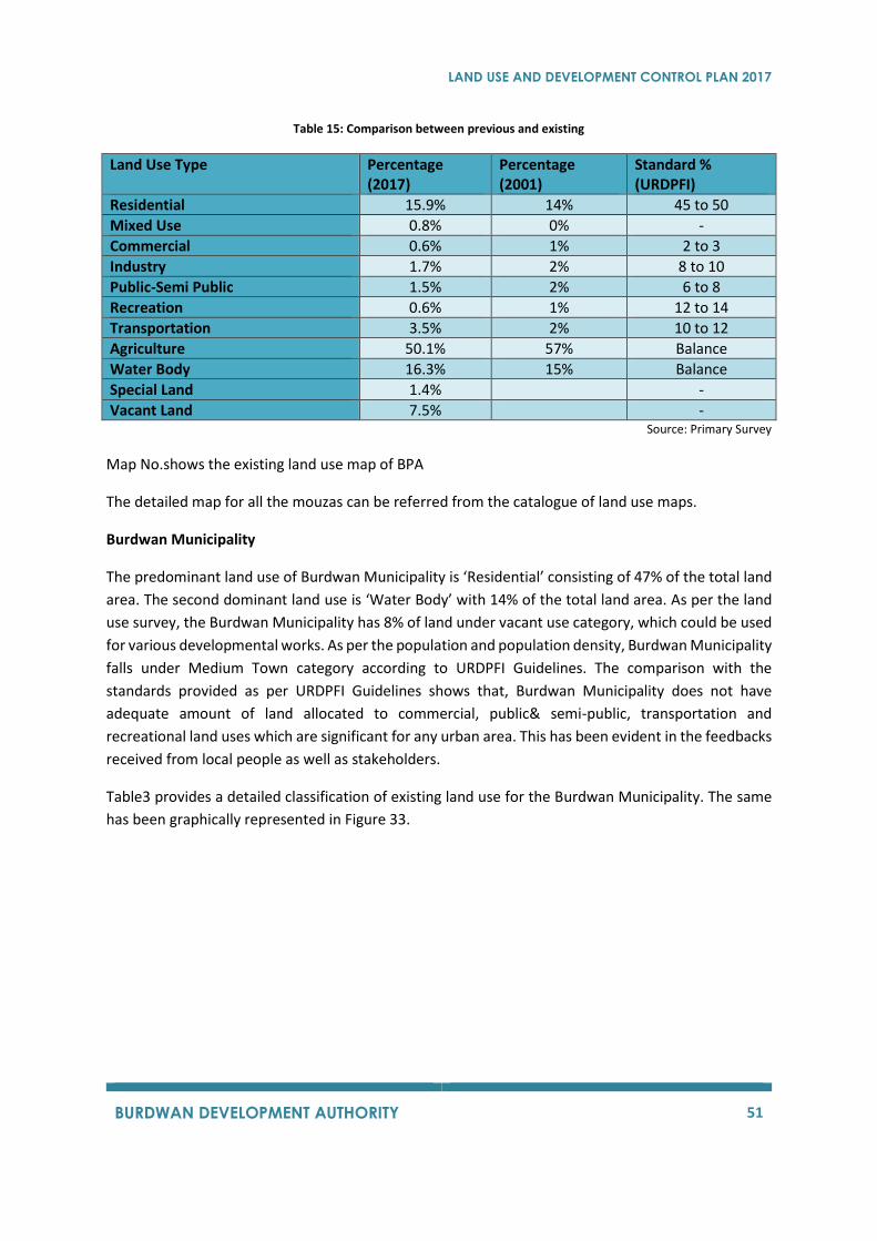
LAND USE AND DEVELOPMENT CONTROL PLAN 2017
BURDWAN DEVELOPMENT AUTHORITY 51
Table 15: Comparison between previous and existing
Land Use Type Percentage (2017)
Percentage (2001)
Standard % (URDPFI)
Residential 15.9% 14% 45 to 50
Mixed Use 0.8% 0% -
Commercial 0.6% 1% 2 to 3
Industry 1.7% 2% 8 to 10
Public-Semi Public 1.5% 2% 6 to 8
Recreation 0.6% 1% 12 to 14
Transportation 3.5% 2% 10 to 12
Agriculture 50.1% 57% Balance
Water Body 16.3% 15% Balance
Special Land 1.4% -
Vacant Land 7.5% - Source: Primary Survey
Map No.shows the existing land use map of BPA
The detailed map for all the mouzas can be referred from the catalogue of land use maps.
Burdwan Municipality
The predominant land use of Burdwan Municipality is ‘Residential’ consisting of 47% of the total land
area. The second dominant land use is ‘Water Body’ with 14% of the total land area. As per the land
use survey, the Burdwan Municipality has 8% of land under vacant use category, which could be used
for various developmental works. As per the population and population density, Burdwan Municipality
falls under Medium Town category according to URDPFI Guidelines. The comparison with the
standards provided as per URDPFI Guidelines shows that, Burdwan Municipality does not have
adequate amount of land allocated to commercial, public& semi-public, transportation and
recreational land uses which are significant for any urban area. This has been evident in the feedbacks
received from local people as well as stakeholders.
Table3 provides a detailed classification of existing land use for the Burdwan Municipality. The same
has been graphically represented in Figure 33.
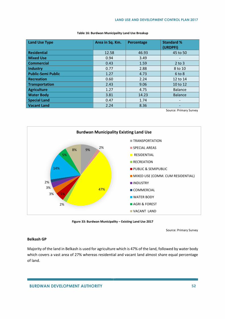
LAND USE AND DEVELOPMENT CONTROL PLAN 2017
BURDWAN DEVELOPMENT AUTHORITY 52
Table 16: Burdwan Municipality Land Use Breakup
Land Use Type Area in Sq. Km. Percentage Standard % (URDPFI)
Residential 12.58 46.93 45 to 50
Mixed Use 0.94 3.49 -
Commercial 0.43 1.59 2 to 3
Industry 0.77 2.88 8 to 10
Public-Semi Public 1.27 4.73 6 to 8
Recreation 0.60 2.24 12 to 14
Transportation 2.43 9.06 10 to 12
Agriculture 1.27 4.75 Balance
Water Body 3.81 14.23 Balance
Special Land 0.47 1.74 -
Vacant Land 2.24 8.36 - Source: Primary Survey
Figure 33: Burdwan Municipality – Existing Land Use 2017
Source: Primary Survey
Belkash GP
Majority of the land in Belkash is used for agriculture which is 47% of the land, followed by water body
which covers a vast area of 27% whereas residential and vacant land almost share equal percentage
of land.
9%2%
47%
2%
5%3%
3%
2%
14%
5%
8%
Burdwan Municipality Existing Land Use
TRANSPORTATION
SPECIAL AREAS
RESIDENTIAL
RECREATION
PUBLIC & SEMIPUBLIC
MIXED USE (COMM. CUM RESIDENTIAL)
INDUSTRY
COMMERCIAL
WATER BODY
AGRI & FOREST
VACANT LAND
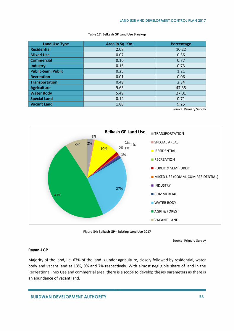
LAND USE AND DEVELOPMENT CONTROL PLAN 2017
BURDWAN DEVELOPMENT AUTHORITY 53
Table 17: Belkash GP Land Use Breakup
Land Use Type Area in Sq. Km. Percentage
Residential 2.08 10.22
Mixed Use 0.07 0.36
Commercial 0.16 0.77
Industry 0.15 0.73
Public-Semi Public 0.25 1.21
Recreation 0.01 0.06
Transportation 0.48 2.34
Agriculture 9.63 47.35
Water Body 5.49 27.01
Special Land 0.14 0.71
Vacant Land 1.88 9.25 Source: Primary Survey
Figure 34: Belkash GP– Existing Land Use 2017
Source: Primary Survey
Rayan-I GP
Majority of the land, i.e. 67% of the land is under agriculture, closely followed by residential, water
body and vacant land at 13%, 9% and 7% respectively. With almost negligible share of land in the
Recreational, Mix Use and commercial area, there is a scope to develop theses parameters as there is
an abundance of vacant land.
2%
1%
10% 0%
1%
1%1%
1%
27%
47%
9%
Belkash GP Land Use TRANSPORTATION
SPECIAL AREAS
RESIDENTIAL
RECREATION
PUBLIC & SEMIPUBLIC
MIXED USE (COMM. CUM RESIDENTIAL)
INDUSTRY
COMMERCIAL
WATER BODY
AGRI & FOREST
VACANT LAND
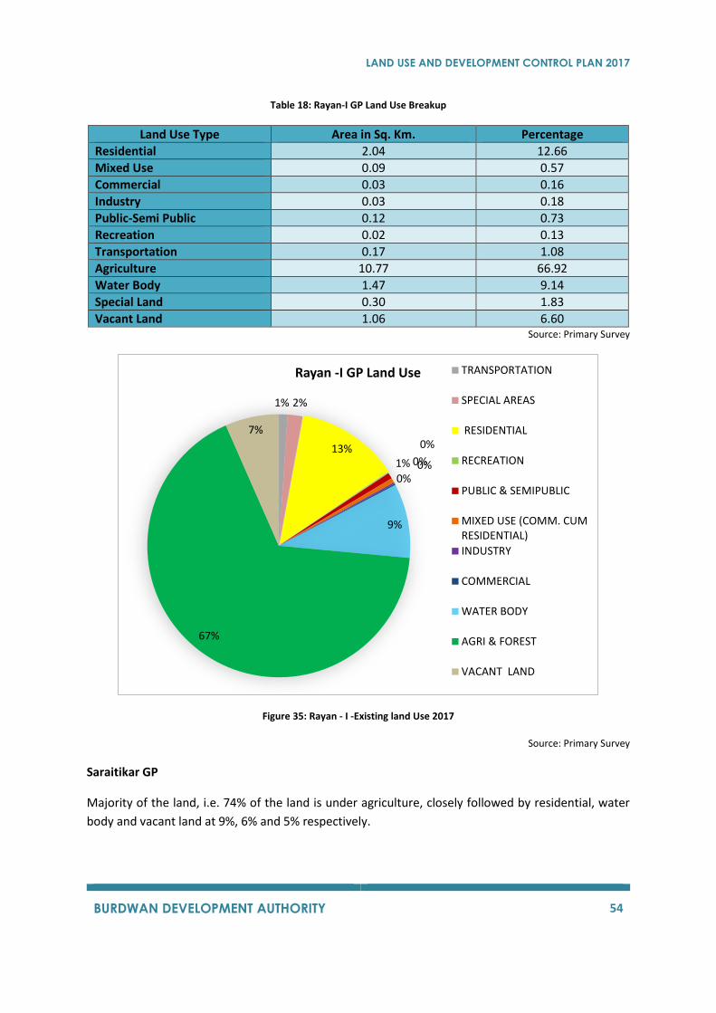
LAND USE AND DEVELOPMENT CONTROL PLAN 2017
BURDWAN DEVELOPMENT AUTHORITY 54
Table 18: Rayan-I GP Land Use Breakup
Land Use Type Area in Sq. Km. Percentage
Residential 2.04 12.66
Mixed Use 0.09 0.57
Commercial 0.03 0.16
Industry 0.03 0.18
Public-Semi Public 0.12 0.73
Recreation 0.02 0.13
Transportation 0.17 1.08
Agriculture 10.77 66.92
Water Body 1.47 9.14
Special Land 0.30 1.83
Vacant Land 1.06 6.60 Source: Primary Survey
Figure 35: Rayan - I -Existing land Use 2017
Source: Primary Survey
Saraitikar GP
Majority of the land, i.e. 74% of the land is under agriculture, closely followed by residential, water
body and vacant land at 9%, 6% and 5% respectively.
1% 2%
13% 0%
1% 0%
0%0%
9%
67%
7%
Rayan -I GP Land Use TRANSPORTATION
SPECIAL AREAS
RESIDENTIAL
RECREATION
PUBLIC & SEMIPUBLIC
MIXED USE (COMM. CUMRESIDENTIAL)
INDUSTRY
COMMERCIAL
WATER BODY
AGRI & FOREST
VACANT LAND
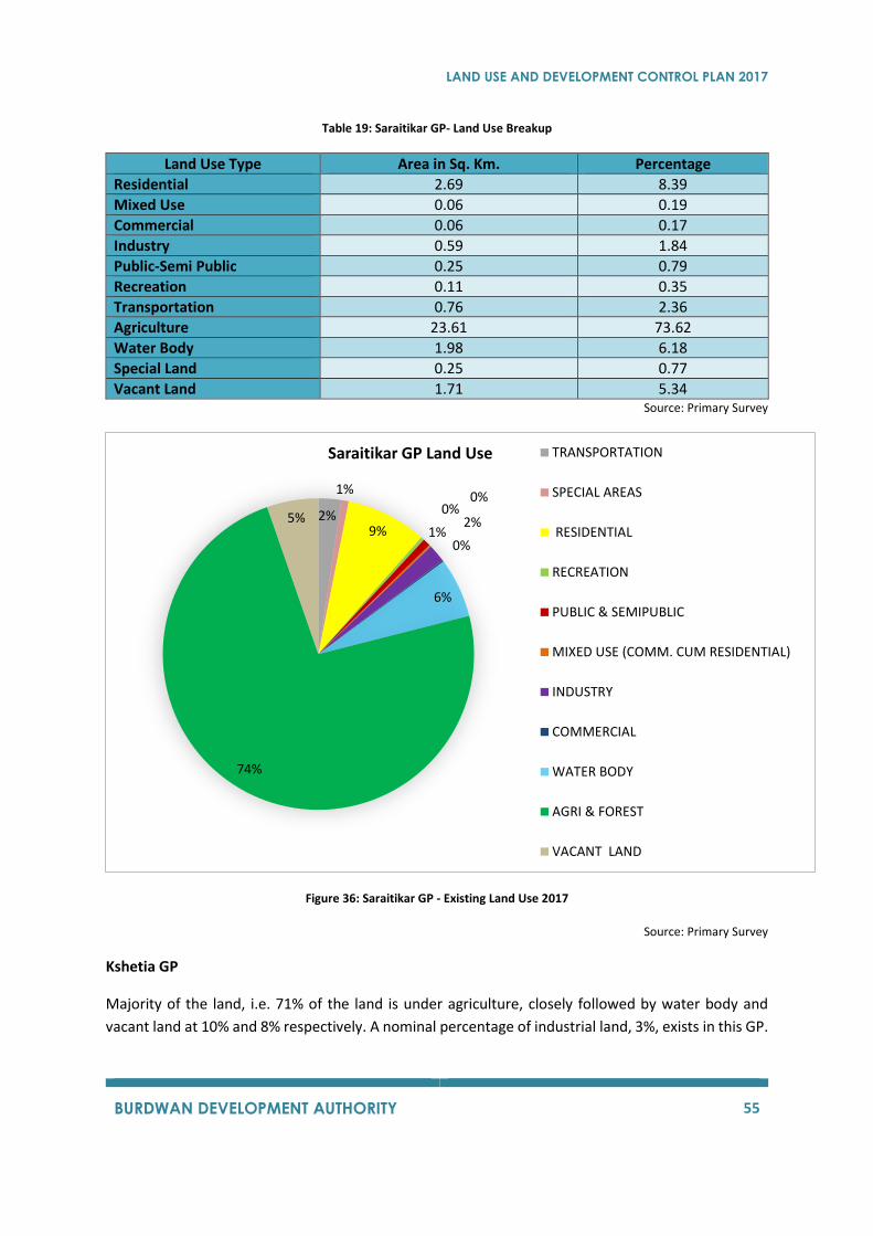
LAND USE AND DEVELOPMENT CONTROL PLAN 2017
BURDWAN DEVELOPMENT AUTHORITY 55
Table 19: Saraitikar GP- Land Use Breakup
Land Use Type Area in Sq. Km. Percentage
Residential 2.69 8.39
Mixed Use 0.06 0.19
Commercial 0.06 0.17
Industry 0.59 1.84
Public-Semi Public 0.25 0.79
Recreation 0.11 0.35
Transportation 0.76 2.36
Agriculture 23.61 73.62
Water Body 1.98 6.18
Special Land 0.25 0.77
Vacant Land 1.71 5.34 Source: Primary Survey
Figure 36: Saraitikar GP - Existing Land Use 2017
Source: Primary Survey
Kshetia GP
Majority of the land, i.e. 71% of the land is under agriculture, closely followed by water body and
vacant land at 10% and 8% respectively. A nominal percentage of industrial land, 3%, exists in this GP.
2%
1%
9%
0%
1%
0%
2%
0%
6%
74%
5%
Saraitikar GP Land Use TRANSPORTATION
SPECIAL AREAS
RESIDENTIAL
RECREATION
PUBLIC & SEMIPUBLIC
MIXED USE (COMM. CUM RESIDENTIAL)
INDUSTRY
COMMERCIAL
WATER BODY
AGRI & FOREST
VACANT LAND
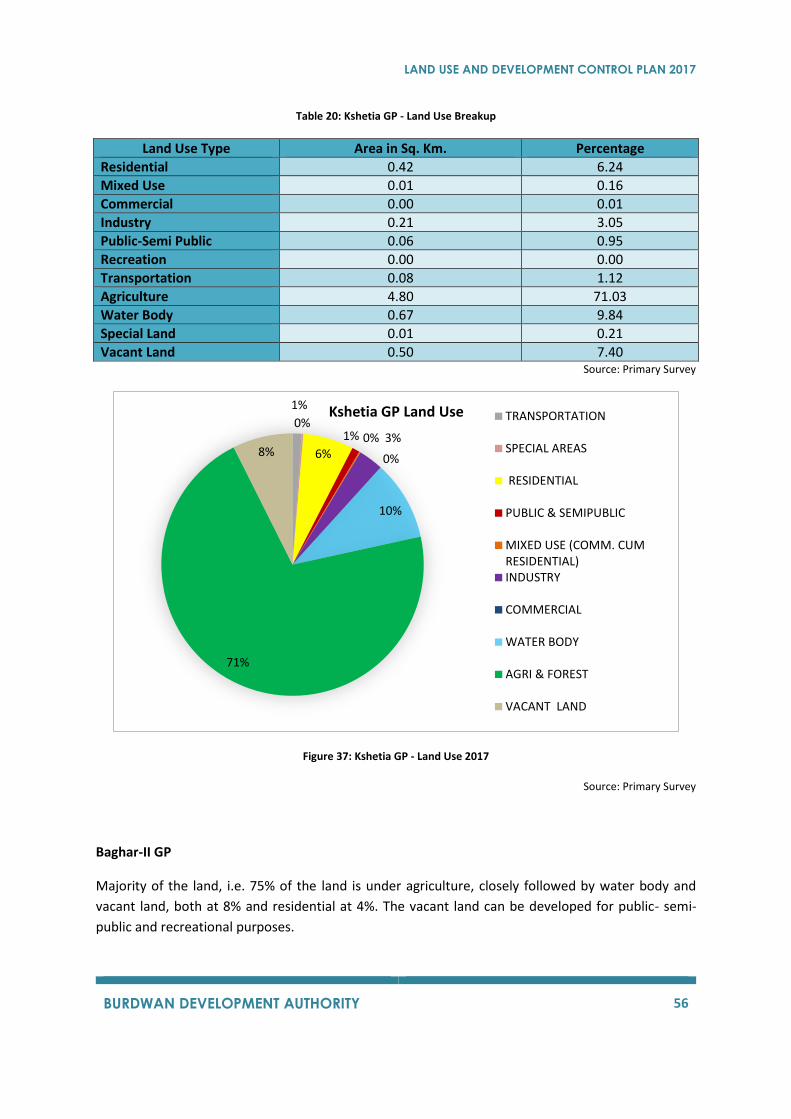
LAND USE AND DEVELOPMENT CONTROL PLAN 2017
BURDWAN DEVELOPMENT AUTHORITY 56
Table 20: Kshetia GP - Land Use Breakup
Land Use Type Area in Sq. Km. Percentage
Residential 0.42 6.24
Mixed Use 0.01 0.16
Commercial 0.00 0.01
Industry 0.21 3.05
Public-Semi Public 0.06 0.95
Recreation 0.00 0.00
Transportation 0.08 1.12
Agriculture 4.80 71.03
Water Body 0.67 9.84
Special Land 0.01 0.21
Vacant Land 0.50 7.40 Source: Primary Survey
Figure 37: Kshetia GP - Land Use 2017
Source: Primary Survey
Baghar-II GP
Majority of the land, i.e. 75% of the land is under agriculture, closely followed by water body and
vacant land, both at 8% and residential at 4%. The vacant land can be developed for public- semi-
public and recreational purposes.
1%
0%
6%
1% 0% 3%
0%
10%
71%
8%
Kshetia GP Land Use TRANSPORTATION
SPECIAL AREAS
RESIDENTIAL
PUBLIC & SEMIPUBLIC
MIXED USE (COMM. CUMRESIDENTIAL)INDUSTRY
COMMERCIAL
WATER BODY
AGRI & FOREST
VACANT LAND
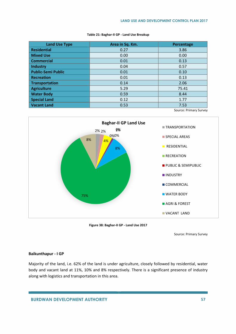
LAND USE AND DEVELOPMENT CONTROL PLAN 2017
BURDWAN DEVELOPMENT AUTHORITY 57
Table 21: Baghar-II GP - Land Use Breakup
Land Use Type Area in Sq. Km. Percentage
Residential 0.27 3.86
Mixed Use 0.00 0.00
Commercial 0.01 0.13
Industry 0.04 0.57
Public-Semi Public 0.01 0.10
Recreation 0.01 0.13
Transportation 0.14 2.06
Agriculture 5.29 75.41
Water Body 0.59 8.44
Special Land 0.12 1.77
Vacant Land 0.53 7.53 Source: Primary Survey
Figure 38: Baghar-II GP - Land Use 2017
Source: Primary Survey
Baikunthapur - I GP
Majority of the land, i.e. 62% of the land is under agriculture, closely followed by residential, water
body and vacant land at 11%, 10% and 8% respectively. There is a significant presence of industry
along with logistics and transportation in this area.
2% 2%
4%
0%
0%1%
0%
8%
75%
8%
Baghar-II GP Land UseTRANSPORTATION
SPECIAL AREAS
RESIDENTIAL
RECREATION
PUBLIC & SEMIPUBLIC
INDUSTRY
COMMERCIAL
WATER BODY
AGRI & FOREST
VACANT LAND
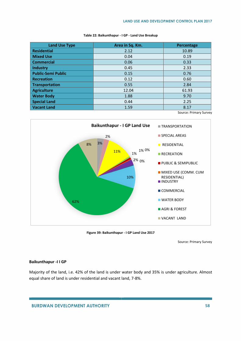
LAND USE AND DEVELOPMENT CONTROL PLAN 2017
BURDWAN DEVELOPMENT AUTHORITY 58
Table 22: Baikunthapur - I GP - Land Use Breakup
Land Use Type Area in Sq. Km. Percentage
Residential 2.12 10.89
Mixed Use 0.04 0.19
Commercial 0.06 0.33
Industry 0.45 2.33
Public-Semi Public 0.15 0.76
Recreation 0.12 0.60
Transportation 0.55 2.84
Agriculture 12.04 61.93
Water Body 1.88 9.70
Special Land 0.44 2.25
Vacant Land 1.59 8.17 Source: Primary Survey
Figure 39: Baikunthapur - I GP Land Use 2017
Source: Primary Survey
Baikunthapur -I I GP
Majority of the land, i.e. 42% of the land is under water body and 35% is under agriculture. Almost
equal share of land is under residential and vacant land, 7-8%.
3%
2%
11%1%
1% 0%
2% 0%
10%
62%
8%
Baikunthapur - I GP Land Use TRANSPORTATION
SPECIAL AREAS
RESIDENTIAL
RECREATION
PUBLIC & SEMIPUBLIC
MIXED USE (COMM. CUMRESIDENTIAL)INDUSTRY
COMMERCIAL
WATER BODY
AGRI & FOREST
VACANT LAND
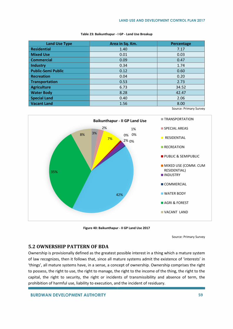
LAND USE AND DEVELOPMENT CONTROL PLAN 2017
BURDWAN DEVELOPMENT AUTHORITY 59
Table 23: Baikunthapur - I GP - Land Use Breakup
Land Use Type Area in Sq. Km. Percentage
Residential 1.40 7.17
Mixed Use 0.01 0.03
Commercial 0.09 0.47
Industry 0.34 1.74
Public-Semi Public 0.12 0.60
Recreation 0.04 0.20
Transportation 0.53 2.73
Agriculture 6.73 34.52
Water Body 8.28 42.47
Special Land 0.40 2.06
Vacant Land 1.56 8.00 Source: Primary Survey
Figure 40: Baikunthapur - II GP Land Use 2017
Source: Primary Survey
5.2 OWNERSHIP PATTERN OF BDA
Ownership is provisionally defined as the greatest possible interest in a thing which a mature system
of law recognizes, then it follows that, since all mature systems admit the existence of ‘interests’ in
‘things’, all mature systems have, in a sense, a concept of ownership. Ownership comprises the right
to possess, the right to use, the right to manage, the right to the income of the thing, the right to the
capital, the right to security, the right or incidents of transmissibility and absence of term, the
prohibition of harmful use, liability to execution, and the incident of residuary.
3%
2%
7%0%
1%
0%
2% 0%
42%
35%
8%
Baikunthapur - II GP Land Use TRANSPORTATION
SPECIAL AREAS
RESIDENTIAL
RECREATION
PUBLIC & SEMIPUBLIC
MIXED USE (COMM. CUMRESIDENTIAL)INDUSTRY
COMMERCIAL
WATER BODY
AGRI & FOREST
VACANT LAND
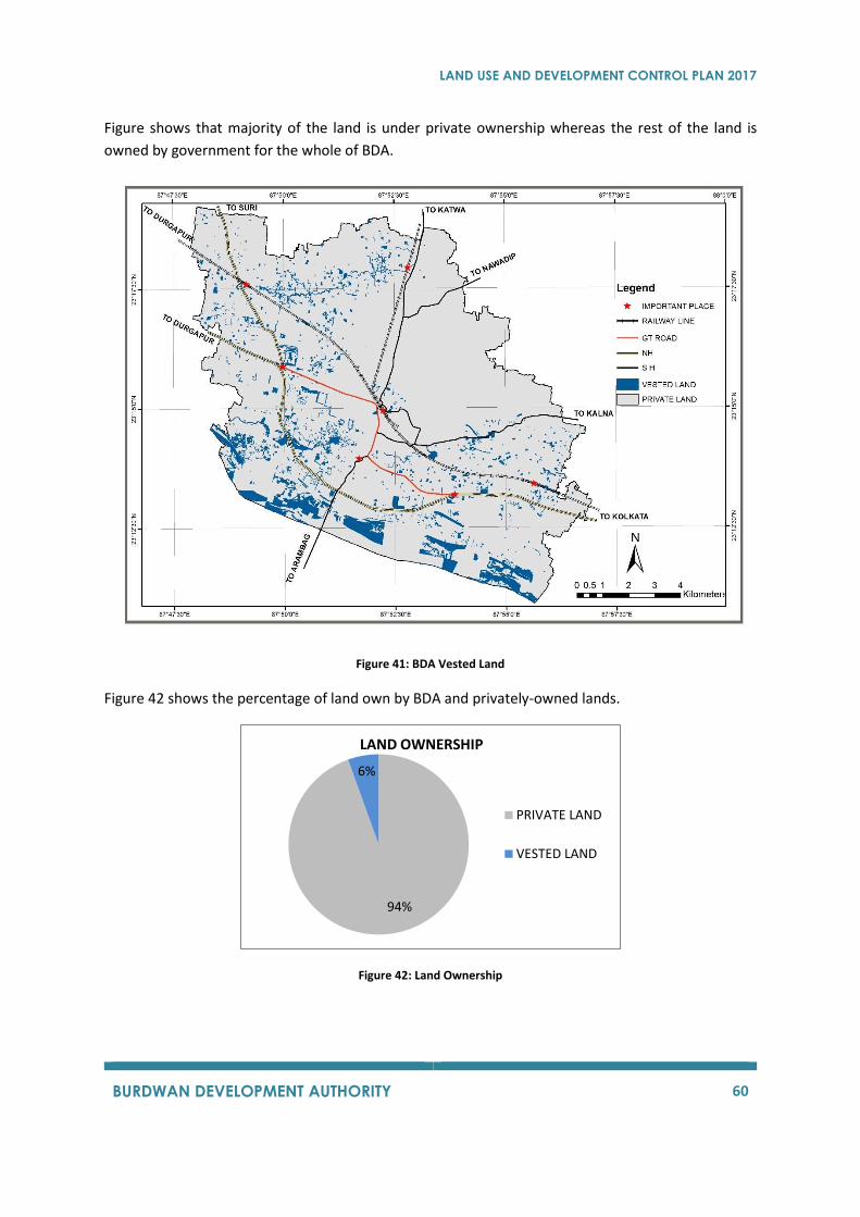
LAND USE AND DEVELOPMENT CONTROL PLAN 2017
BURDWAN DEVELOPMENT AUTHORITY 60
Figure shows that majority of the land is under private ownership whereas the rest of the land is
owned by government for the whole of BDA.
Figure 41: BDA Vested Land
Figure 42 shows the percentage of land own by BDA and privately-owned lands.
Figure 42: Land Ownership
94%
6%
LAND OWNERSHIP
PRIVATE LAND
VESTED LAND
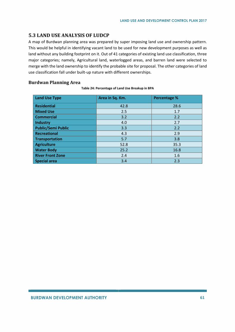
LAND USE AND DEVELOPMENT CONTROL PLAN 2017
BURDWAN DEVELOPMENT AUTHORITY 61
5.3 LAND USE ANALYSIS OF LUDCP A map of Burdwan planning area was prepared by super imposing land use and ownership pattern.
This would be helpful in identifying vacant land to be used for new development purposes as well as
land without any building footprint on it. Out of 41 categories of existing land use classification, three
major categories; namely, Agricultural land, waterlogged areas, and barren land were selected to
merge with the land ownership to identify the probable site for proposal. The other categories of land
use classification fall under built-up nature with different ownerships.
Burdwan Planning Area Table 24: Percentage of Land Use Breakup in BPA
Land Use Type Area in Sq. Km. Percentage %
Residential 42.8 28.6
Mixed Use 2.5 1.7
Commercial 3.2 2.2
Industry 4.0 2.7
Public/Semi Public 3.3 2.2
Recreational 4.3 2.9
Transportation 5.7 3.8
Agriculture 52.8 35.3
Water Body 25.2 16.8
River Front Zone 2.4 1.6
Special area 3.4 2.3
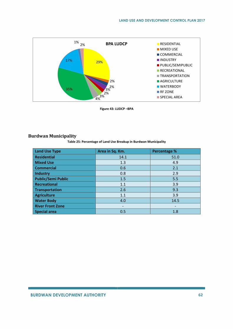
LAND USE AND DEVELOPMENT CONTROL PLAN 2017
BURDWAN DEVELOPMENT AUTHORITY 62
Figure 43: LUDCP –BPA
Burdwan Municipality Table 25: Percentage of Land Use Breakup in Burdwan Municipality
Land Use Type Area in Sq. Km. Percentage %
Residential 14.1 51.0
Mixed Use 1.3 4.9
Commercial 0.6 2.1
Industry 0.8 2.9
Public/Semi Public 1.5 5.5
Recreational 1.1 3.9
Transportation 2.6 9.3
Agriculture 1.1 3.9
Water Body 4.0 14.5
River Front Zone - -
Special area 0.5 1.8
29%
2%
2%3%
2%3%
4%
35%
17%
1%2% BPA LUDCP RESIDENTIAL
MIXED USE
COMMERCIAL
INDUSTRY
PUBLIC/SEMIPUBLIC
RECREATIONAL
TRANSPORTATION
AGRICULTURE
WATERBODY
RF ZONE
SPECIAL AREA
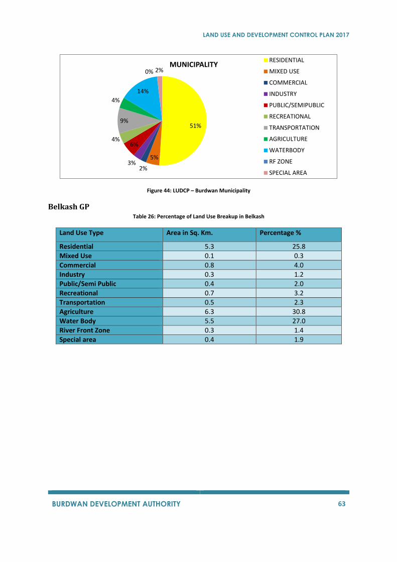
LAND USE AND DEVELOPMENT CONTROL PLAN 2017
BURDWAN DEVELOPMENT AUTHORITY 63
Figure 44: LUDCP – Burdwan Municipality
Belkash GP Table 26: Percentage of Land Use Breakup in Belkash
Land Use Type Area in Sq. Km. Percentage %
Residential 5.3 25.8
Mixed Use 0.1 0.3
Commercial 0.8 4.0
Industry 0.3 1.2
Public/Semi Public 0.4 2.0
Recreational 0.7 3.2
Transportation 0.5 2.3
Agriculture 6.3 30.8
Water Body 5.5 27.0
River Front Zone 0.3 1.4
Special area 0.4 1.9
51%
5%
2%3%
6%4%
9%
4%
14%
0% 2%MUNICIPALITY
RESIDENTIAL
MIXED USE
COMMERCIAL
INDUSTRY
PUBLIC/SEMIPUBLIC
RECREATIONAL
TRANSPORTATION
AGRICULTURE
WATERBODY
RF ZONE
SPECIAL AREA
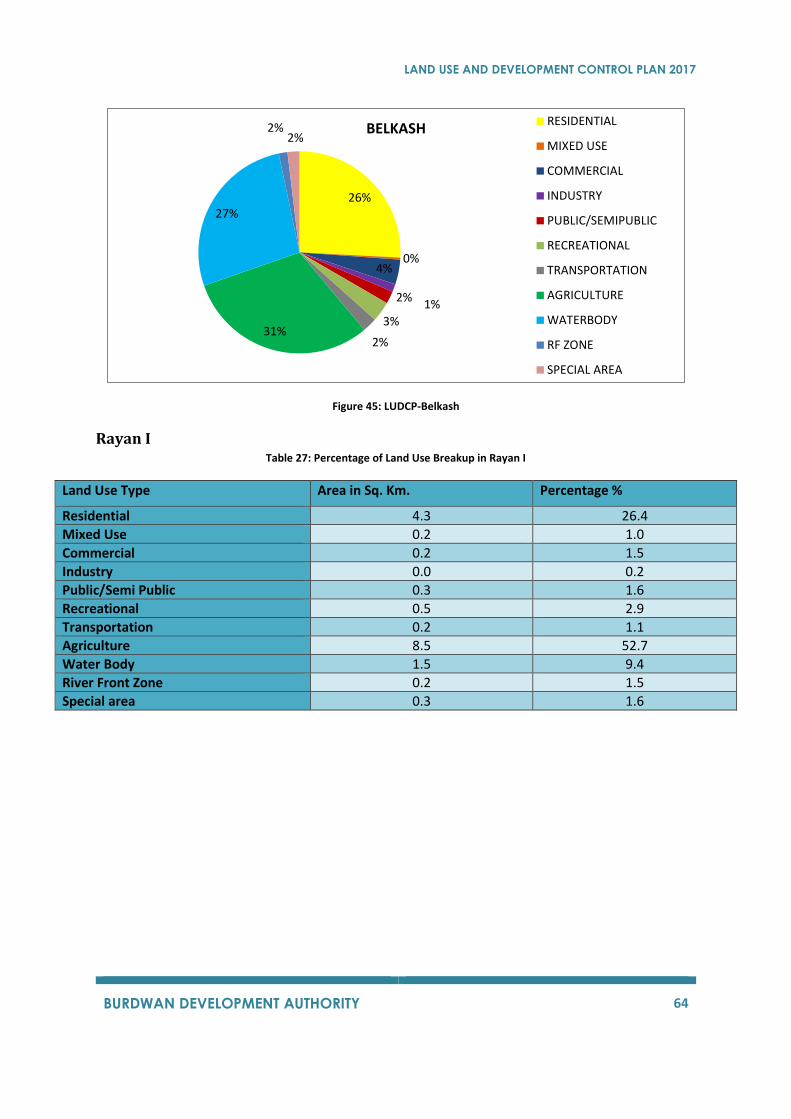
LAND USE AND DEVELOPMENT CONTROL PLAN 2017
BURDWAN DEVELOPMENT AUTHORITY 64
Figure 45: LUDCP-Belkash
Rayan I Table 27: Percentage of Land Use Breakup in Rayan I
Land Use Type Area in Sq. Km. Percentage %
Residential 4.3 26.4
Mixed Use 0.2 1.0
Commercial 0.2 1.5
Industry 0.0 0.2
Public/Semi Public 0.3 1.6
Recreational 0.5 2.9
Transportation 0.2 1.1
Agriculture 8.5 52.7
Water Body 1.5 9.4
River Front Zone 0.2 1.5
Special area 0.3 1.6
26%
0%4%
1%2%
3%
2%31%
27%
2%2%
BELKASH RESIDENTIAL
MIXED USE
COMMERCIAL
INDUSTRY
PUBLIC/SEMIPUBLIC
RECREATIONAL
TRANSPORTATION
AGRICULTURE
WATERBODY
RF ZONE
SPECIAL AREA
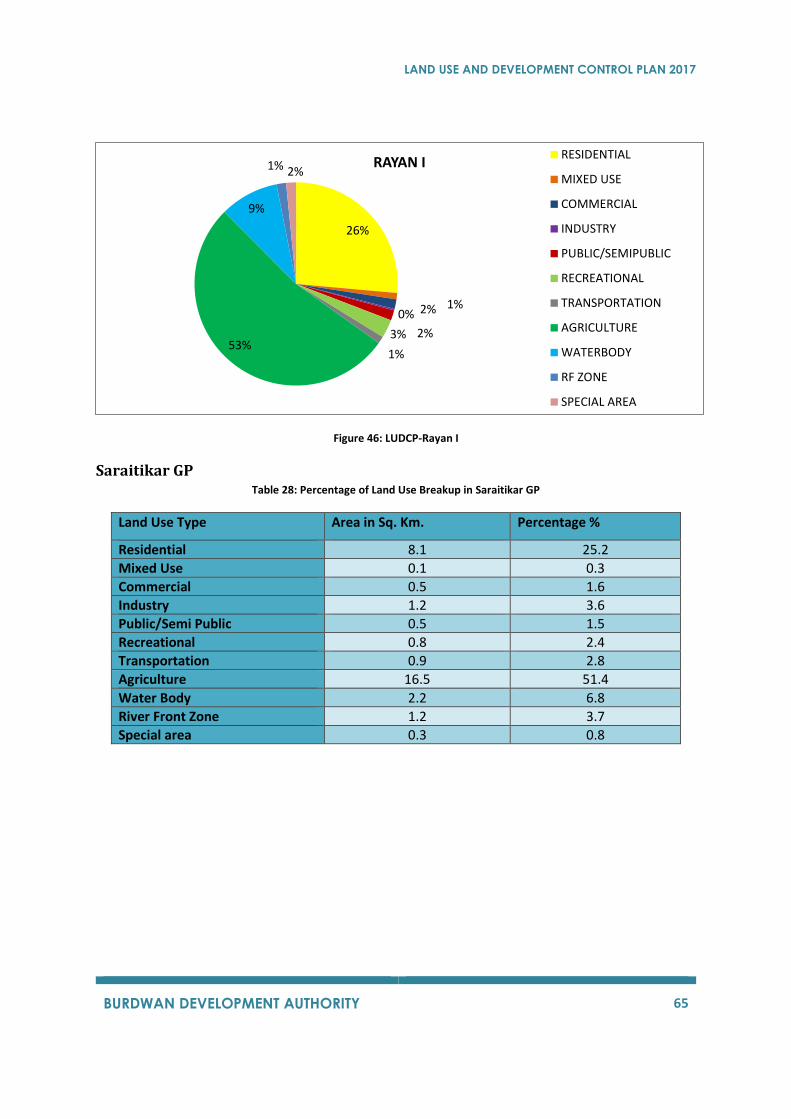
LAND USE AND DEVELOPMENT CONTROL PLAN 2017
BURDWAN DEVELOPMENT AUTHORITY 65
Figure 46: LUDCP-Rayan I
Saraitikar GP Table 28: Percentage of Land Use Breakup in Saraitikar GP
Land Use Type Area in Sq. Km. Percentage %
Residential 8.1 25.2
Mixed Use 0.1 0.3
Commercial 0.5 1.6
Industry 1.2 3.6
Public/Semi Public 0.5 1.5
Recreational 0.8 2.4
Transportation 0.9 2.8
Agriculture 16.5 51.4
Water Body 2.2 6.8
River Front Zone 1.2 3.7
Special area 0.3 0.8
26%
1%2%0%
2%3%
1%53%
9%
1% 2%RAYAN I
RESIDENTIAL
MIXED USE
COMMERCIAL
INDUSTRY
PUBLIC/SEMIPUBLIC
RECREATIONAL
TRANSPORTATION
AGRICULTURE
WATERBODY
RF ZONE
SPECIAL AREA
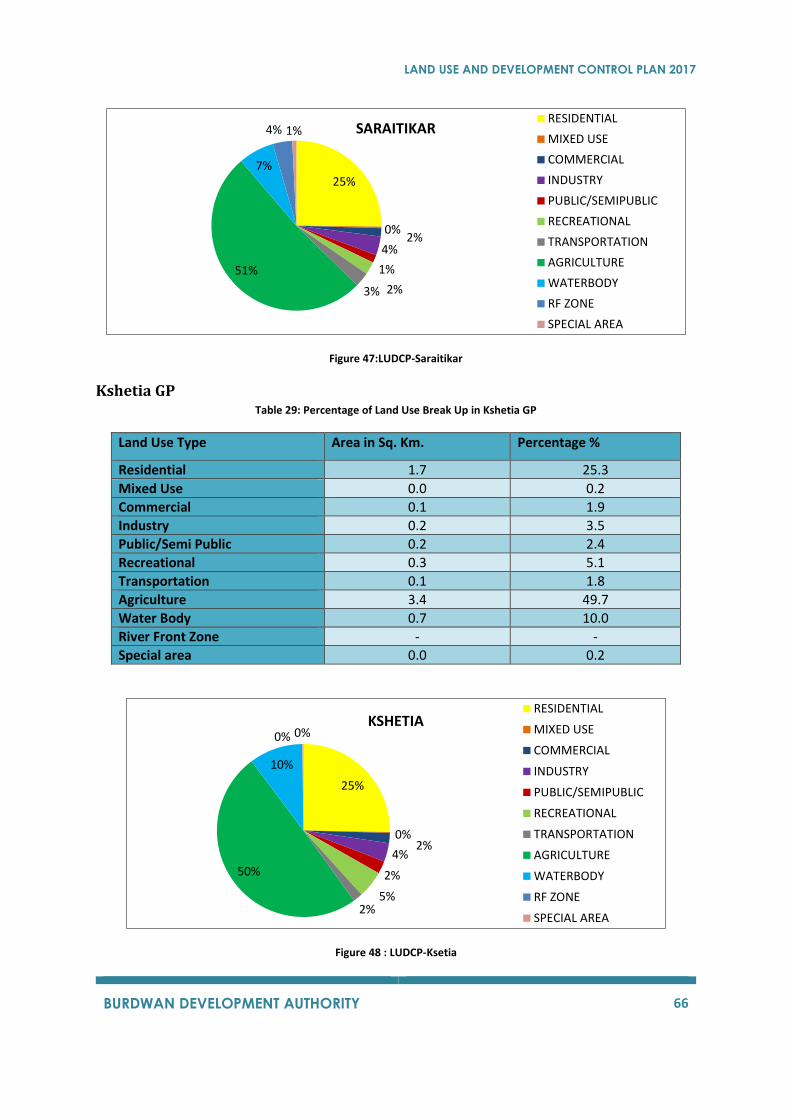
LAND USE AND DEVELOPMENT CONTROL PLAN 2017
BURDWAN DEVELOPMENT AUTHORITY 66
Figure 47:LUDCP-Saraitikar
Kshetia GP Table 29: Percentage of Land Use Break Up in Kshetia GP
Land Use Type Area in Sq. Km. Percentage %
Residential 1.7 25.3
Mixed Use 0.0 0.2
Commercial 0.1 1.9
Industry 0.2 3.5
Public/Semi Public 0.2 2.4
Recreational 0.3 5.1
Transportation 0.1 1.8
Agriculture 3.4 49.7
Water Body 0.7 10.0
River Front Zone - -
Special area 0.0 0.2
Figure 48 : LUDCP-Ksetia
25%
0%2%
4%
1%
2%3%
51%
7%
4% 1% SARAITIKAR RESIDENTIAL
MIXED USE
COMMERCIAL
INDUSTRY
PUBLIC/SEMIPUBLIC
RECREATIONAL
TRANSPORTATION
AGRICULTURE
WATERBODY
RF ZONE
SPECIAL AREA
25%
0%2%
4%
2%
5%2%
50%
10%
0% 0%KSHETIA
RESIDENTIAL
MIXED USE
COMMERCIAL
INDUSTRY
PUBLIC/SEMIPUBLIC
RECREATIONAL
TRANSPORTATION
AGRICULTURE
WATERBODY
RF ZONE
SPECIAL AREA
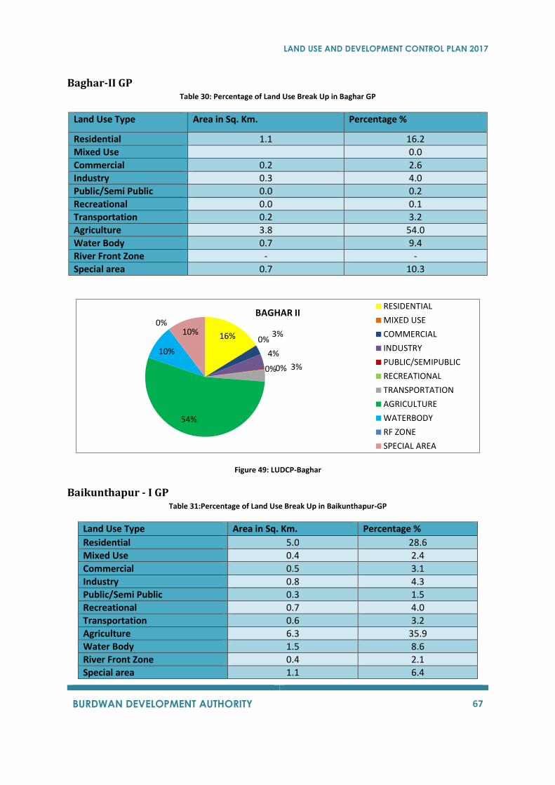
LAND USE AND DEVELOPMENT CONTROL PLAN 2017
BURDWAN DEVELOPMENT AUTHORITY 67
Baghar-II GP Table 30: Percentage of Land Use Break Up in Baghar GP
Land Use Type Area in Sq. Km. Percentage %
Residential 1.1 16.2
Mixed Use 0.0
Commercial 0.2 2.6
Industry 0.3 4.0
Public/Semi Public 0.0 0.2
Recreational 0.0 0.1
Transportation 0.2 3.2
Agriculture 3.8 54.0
Water Body 0.7 9.4
River Front Zone - -
Special area 0.7 10.3
Figure 49: LUDCP-Baghar
Baikunthapur - I GP Table 31:Percentage of Land Use Break Up in Baikunthapur-GP
Land Use Type Area in Sq. Km. Percentage %
Residential 5.0 28.6
Mixed Use 0.4 2.4
Commercial 0.5 3.1
Industry 0.8 4.3
Public/Semi Public 0.3 1.5
Recreational 0.7 4.0
Transportation 0.6 3.2
Agriculture 6.3 35.9
Water Body 1.5 8.6
River Front Zone 0.4 2.1
Special area 1.1 6.4
16% 0%3%
4%
0%0% 3%
54%
10%
0%10%
BAGHAR II RESIDENTIAL
MIXED USE
COMMERCIAL
INDUSTRY
PUBLIC/SEMIPUBLIC
RECREATIONAL
TRANSPORTATION
AGRICULTURE
WATERBODY
RF ZONE
SPECIAL AREA
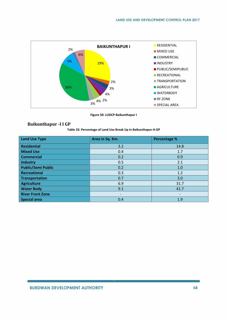
LAND USE AND DEVELOPMENT CONTROL PLAN 2017
BURDWAN DEVELOPMENT AUTHORITY 68
Figure 50: LUDCP-Baikunthapur I
Baikunthapur -I I GP Table 32: Percentage of Land Use Break Up in Baikunthapur-II-GP
Land Use Type Area in Sq. Km. Percentage %
Residential 3.2 14.8
Mixed Use 0.4 1.7
Commercial 0.2 0.9
Industry 0.5 2.1
Public/Semi Public 0.2 1.0
Recreational 0.3 1.2
Transportation 0.7 3.0
Agriculture 6.9 31.7
Water Body 9.1 41.7
River Front Zone - -
Special area 0.4 1.9
29%
2%
3%
4%
2%4%3%
36%
9%
2%
6%
BAIKUNTHAPUR I RESIDENTIAL
MIXED USE
COMMERCIAL
INDUSTRY
PUBLIC/SEMIPUBLIC
RECREATIONAL
TRANSPORTATION
AGRICULTURE
WATERBODY
RF ZONE
SPECIAL AREA
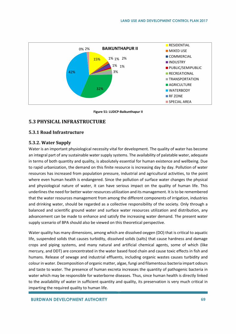
LAND USE AND DEVELOPMENT CONTROL PLAN 2017
BURDWAN DEVELOPMENT AUTHORITY 69
Figure 51: LUDCP-Baikunthapur II
5.3 PHYSICAL INFRASTRUCTURE
5.3.1 Road Infrastructure
5.3.2. Water Supply
Water is an important physiological necessity vital for development. The quality of water has become
an integral part of any sustainable water supply systems. The availability of palatable water, adequate
in terms of both quantity and quality, is absolutely essential for human existence and wellbeing. Due
to rapid urbanization, the demand on this finite resource is increasing day by day. Pollution of water
resources has increased from population pressure, industrial and agricultural activities, to the point
where even human health is endangered. Since the pollution of surface water changes the physical
and physiological nature of water, it can have serious impact on the quality of human life. This
underlines the need for better water resources utilization and its management. It is to be remembered
that the water resources management from among the different components of irrigation, industries
and drinking water, should be regarded as a collective responsibility of the society. Only through a
balanced and scientific ground water and surface water resources utilization and distribution, any
advancement can be made to enhance and satisfy the increasing water demand. The present water
supply scenario of BPA should also be viewed on this theoretical perspective.
Water quality has many dimensions, among which are dissolved oxygen (DO) that is critical to aquatic
life, suspended solids that causes turbidity, dissolved solids (salts) that cause hardness and damage
crops and piping systems, and many natural and artificial chemical agents, some of which (like
mercury, and DDT) are concentrated in the water based food chain and cause toxic effects in fish and
humans. Release of sewage and industrial effluents, including organic wastes causes turbidity and
colour in water. Decomposition of organic matter, algae, fungi and filamentous bacteria impart odours
and taste to water. The presence of human excreta increases the quantity of pathogenic bacteria in
water which may be responsible for waterborne diseases. Thus, since human health is directly linked
to the availability of water in sufficient quantity and quality, its preservation is very much critical in
imparting the required quality to human life.
15% 1% 1% 2%
1% 1%
3%
32%
42%
0% 2% BAIKUNTHAPUR II RESIDENTIAL
MIXED USE
COMMERCIAL
INDUSTRY
PUBLIC/SEMIPUBLIC
RECREATIONAL
TRANSPORTATION
AGRICULTURE
WATERBODY
RF ZONE
SPECIAL AREA

LAND USE AND DEVELOPMENT CONTROL PLAN 2017
BURDWAN DEVELOPMENT AUTHORITY 70
The hectic agricultural activities in BPA may contribute to fertilizer residues and pesticides in
considerable amounts to the surface water sources, in addition to the increasing domestic waste
discharges. The domestic 46 wastewaters (around 70-80% of water used) may drain out to the nearby
ponds, tanks or rivers thereby polluting it. Areas adjacent to many surface water sources are used by
people for open defecation, which will add to high coliform count (E coli) in water and is the root cause
of many water borne diseases. This is to be treated as a grave issue severely affecting the water quality
in BPA which demands urgent attention.
5.3.2.1. The Existing Drinking Water Scenario
Purba Bardhaman district is bounded by natural water systems all along its periphery and is rich in
both surface and ground water resources. The river system in Purba Bardhaman is said to include the
Bhagirathi Hooghly in the east, the Ajay and its tributaries in the north and the Dwarakeshwar, the
Damodar and its branches in the south-west. Besides, there are innumerable old beds of rivers all over
the area. Mainly the rivers Bhagirathi, Damodar, and Ajoy are forming important surface water
sources of the district. The major sources of potable water are from tap, tube wells and wells (both
own and community). Majority of the households are depending on ground water for drinking through
own tube wells rather than community wells. Limited areas are provided with tap water in urban
centres. A negligibly small percentage of people are using tanks, canals and rivers for water supply.
Though majority of people in urban areas are satisfied with the availability of potable water, it is
comparatively low in rural areas. The general rate of dependency of population for hygienic sources
of potable water in the Bardhaman Planning Area (BPA) is mainly on the tube well water, followed by
tap water (Fig. 52).
Figure 52: Distribution of potable water in BPA
17% 0%0%
0%
1%
2%
18%
18%
44%
The General Distribution Of Persons In BPA By Sources Of Potable Water
Tube well (comm.)
Well (own)
Well(comm.)
Tank
River,Canal
Not reported
Tap (own)
Tap (comm.)
Tube well (own)
LAND USE AND DEVELOPMENT CONTROL PLAN 2017
BURDWAN DEVELOPMENT AUTHORITY 71
Other sources are used in negligible percentages. The water supply department maintained by the
Municipality provides a28.75 MLD distribution system (designed to deliver 66 lakhs gallons per day)
with ground water as the source of supply using 37 submersible pumps with capacities of 20,000 Gph.
A distribution network of 272 km and 6 service reservoirs are provided to serve nearly 21,390 domestic
connections at 40lpcd, apart from 14 industrial and commercial connections.
On the basis of the data from the ‘Report on the socio-economic survey of households in Bardhaman
planning area, 2002-03 (by SEP and AME unit)’, the distinction in rate of dependency on the sources
of potable water between the populations in urban (municipal area) and rural areas is represented in
Fig. 52, which clearly depicts the urban-rural divide. In general, the community tube wells are less
preferred and people insists ontap water connections, wherever made available. But, tap water
connections are limited to the urban (municipal) areas, though rural population also desires to have
it. The dependency on tube well water (ground water) is evident in both the figures, showing the
limited use of surface waters and the increasing stress on ground water sources. It is also observed
from the data available, that 78.2% of households in BPA have their own arrangements within the
household premises for potable water. Around 17% of households could collect water from a distance
of 50 m, but 5.2% have to travel more than 51 meters for collection. On an average, nearly 95% of
populations of BPA have drinking water sources within a distance of 50 m. But, a comparative
assessment on the ‘access to drinking water sources’ by urban and rural populations (Fig. 6.3) shows
that rural areas demand more attention. In rural areas, the installation of tube wells is more preferred
in localities, where density of population is little high. In areas like Bongpur,Idilpur, Kamnara and Talit
where the populations are scattered over a large area, the proximity to tube well is less. It is also to
be mentioned that people prefer exclusive use of water sources rather than depending upon common
facilities. In urban areas 71.2% of population depends on the ‘own facilities’, where as it is 61.9% in
rural areas; indicating more dependency on ‘community facilities’.
In general, it appears that the existing water supply scenario in BPA is adequate, to meet the water
demands of people at present. Looking on to the demand and availability of water, it seems that BPA
is quickly moving onto its saturation level expansions on the water front, especially in the case of
ground water. So, issues of water requirements and allocation are to be dealt with caution. The
available data presented above clearly shows an‘urban-rural divide’ in BPA in the water availability,
allocation and distribution. Also, the ‘closer and cleaner’ drinking water is still a dream for
considerable portion of the rural populations of BPA.
5.3.3 Sanitation And Sewerage
5.3.3.1 Need for a wastewater management system
The improper management of human and animal waste products is regarded as the root cause of
many communicable diseases in our society. So, the need for a systematic wastewater management
system has been considered as a ‘necessity’ rather than an ‘option’ for any modern society.
The development of effective water and wastewater treatment methods has virtually eliminated
major water borne epidemics in developed countries. Advanced wastewater treatment process is
LAND USE AND DEVELOPMENT CONTROL PLAN 2017
BURDWAN DEVELOPMENT AUTHORITY 72
currently being so developed that it will produce palatable water from domestic wastewater.
Developing countries like ours, where treated water is not available to majority of the population; still
experience the epidemics like cholera and typhoid. The report of the planning commission of India for
the tenth five-year plan, emphasizes that all cities, towns and industrial areas should have
compulsorily sewage treatment plants and are to be implemented in a time bound manner.
It has been observed that the sanitation and drainage scenario in BPA is well below the quality levels,
expected out of an urban agglomeration. It is high time to have a meaningful analysis of the gravity
and enormity of the problem and impending action.
5.3.3.2 The existing sanitation scenario in BPA
The absence of a systematic wastewater management and drainage system has been visibly felt in
BPA. The area as a whole appears to have no systematic drainage facilities. The available drainage
channels are highly incapable of handling the present wastewater and storm water generation.
There is no centralized collection system for sewage or storm water runoff. The sanitation facilities in
urban individual houses include septic tanks, but are not provided with soak pits. As a result, the
leachate containing highly putrescible organic matter and pathogenic microorganisms will ultimately
reach ground water and will add heavily to pollution. Even the recommended clearance between soak
pits and wells are not maintained in most of the houses, may be either because of ignorance or
discharging the leachate directly into streets outside. Even the wastewater outlet in most of the
houses is directed towards the main streets, roads and or drains. Ultimately the roads and streets act
as sinks for the household liquid wastes including sewage effluents.
BPA, as of today, is not having any sewerage system. Though septic tank and soak pit system is
predominant in most of the city areas, few people are still using service privy and pit methods.
Majority of the households in the town and urban areas are said to have septic tank and pit privy
arrangements. A section of people (in municipal areas and slums) uses the community latrines, though
less preferred, (maybe) due to economical reasons. Though 100% households have been covered
under sanitary toilets and open defecation tends to nil.
5.3.3.3 Wastewater Generation
The expected wastewater generation in BPA for the years 2006 and 2025 are shown in Fig. 6.8. It is
expected that the Bardhaman municipality alone will produce nearly 13 MGD wastewater as against
the present 9.2 MGD (assuming a per capita water use of 135+losses =160 lpd and 80% of water may
contribute to wastewater generation). So, it is necessary to have wastewater or sewage treatment
plant (STP) with capacity 13 MGD to treat the wastewater that will be generated within the municipal
areas alone.
5.3.4 Drainage
Though BPA is fast growing in a rapid pace, a systematic drainage system does nowhere exist. It is
reported that a total of 110.514 km pucca, 40 km of kutcha, and 0.02 km underground drainage lines
LAND USE AND DEVELOPMENT CONTROL PLAN 2017
BURDWAN DEVELOPMENT AUTHORITY 73
are provided in the area. The drainage in town is mostly dependent on open drains. Pucca open drains
were found available in certain developed areas but in most of thesemi-urban areas it is open kutcha
type. On an average, the underground drainage system covers only 1.75% of households in BPA; while
53.14%and 12.3% of households have ‘open pucca’ and ‘open kutcha’ drain respectively. It is observed
that nearly one-third of the total number of households live in premises without any drainage facility.
In rural areas 60-65% households are not having any drainage facilities. The pucca drains are limited
only to average 9.13% households in rural areas (Fig. 6.11), whereas62.56% have no facilities at all. In
many areas, even outlets of septic tank effluents are also directed to the open drainage channels
making the total environment unhygienic. The absence of a proper solid waste management system
adds much to the misery as even the limited drains available usually get blocked due to indiscriminate
and continuous dumping of solid waste.
5.3.4.1 Submergence and water logging
Considerable portions of BPA suffer badly from flooding and water logging. During heavy rainy seasons especially, considerable portion of the city area gets inundated during heavy down pours due to inadequate drainage systems coupled with back water stage of the rivers in high flood. The existing (drainage) system has proved inadequate to evacuate storm water from these lower portions of the city. Life of the inhabitants becomes miserable as sewage gets mixed with storm water and finds their way into the house holds creating very unhygienic situation which paves the way for the spreading epidemics. The complaints from people about the occurrence of water logging after a heavy rain are indicative of the poor drainage facilities available. Flooding and water logging are common features in many areas of Barddhaman. It is learned that more than 50% of the households, even in many urban locations are facing water logging. It is said that even though, the big outlet channels passing through Radha nagar, Kundapukurhas been carrying major flow of drain water into the river Banka, the intensity of water logging is considerable in town areas, and severe in rural areas.
5.3.4.2 Critical Observations
1. Some of the important aspects encountered in the urban and rural drainage systems of BPA
are mainly associated with the inadequacy of the drainage channels (primary and secondary
systems) for transport of storm water and its proper maintenance. The frequent flooding and
water logging, immediately after a rain (especially during monsoon) clearly indicate the
inadequate carrying capacity of the drains. Also, the capacity of most of the drainage channels
are much less than that is required to carry the storm water load from drainage areas.
2. The ponds and tanks, which have had been regarded as the unique topographical features of
the area, are getting filled-up due to increasing building construction activities. These ponds
serve as indigenous alternatives for holding excess storm run-off, aids in preventing water
logging and flooding, thereby recharging the ground water potential of the area. Thus the wet
lands and water ponds which used to moderate flood flows earlier are being degraded or lost
in the process of urbanization. The high rate of urbanization has also led to water logging
situation in some areas as infiltration to the sub soil and ground is reduced with tremendous
increase in built up area.
LAND USE AND DEVELOPMENT CONTROL PLAN 2017
BURDWAN DEVELOPMENT AUTHORITY 74
3. The drains are getting silted up frequently due to insufficiency in the hydraulic design of the
channels. This results in the growth of weeds, shrubs, water hyacinth and other plants which
make these drains non-functional. Illegal encroachments, construction of pucca houses in the
close proximity, inadequate space for periodic cleaning maintenance and repair, construction
of structures like bridges, culverts etc. are found affecting the efficiency of the drainage
system. The surface water runoff as well as domestic wastewater is discharged along the road
side surface drain most of which have lost their original flow carrying capacity due to
indiscriminate dumping of garbage in the drain and also due to the accumulation of sand and
grit.
5.3.5 Solid Waste Management
5.3.5.1 The existing scenario of solid waste management in BPA
The solid waste in Bardhaman is observed to be a complex mixture of household, construction,
commercial, industrial and hospital wastes. The sources of solid waste include street sweeping,
households, hotels and restaurants, shops and establishment complex/commercial area, markets
vegetables and fruit, meat/fish, and bio-medical wastes from hospitals, nursing homes and clinics.
Almost all or substantial part of the MSW generated in BPA remains unattended and grows in heaps
at poorly maintained collection centres and dumping yards. There are waste bins to collect, mainly,
the household wastes, but the system is not efficient. The bins are, however, not available in all the
areas. Further, these waste binsare inadequate in size and are open, providing easy access for birds
and animals. Some of these bins are often misplaced, forcing the residents to throw away garbage in
open areas of the probable bin sites. Even when the bins are available, sometimes wastes are thrown
outside the bins anyway and since the wastes are always thrown loose the problem become
unmanageable very quickly. The loose wastes from large market places and grocery centres are
thrown on the ground around the roadside waste bins. Stinky rubbish lies around the waste bins in
the residential areas and market before getting collected by trucks, the wastes swept from the roads
are piled on the side of the roads. Animals and scavengers dig into the piles made-up of swept up
wastes and scatter it. Moving vehicles scatter overflowing garbage from the piles. The uncollected
wastes usually contain a significant portion of fecal matter, and as a result, children play around these
wastes and scavengers who handle these wastes, face high risks of health problems. These problems
are especially significant for the inhabitants of the larger and most densely populated informal or
illegal settlements where regular garbage collection service and waste bins are not available. In case
of delay in waste collection, the task becomes unimaginably massive. At present, open dumping is
going on in around 7 acres of land made available at Nari Mouza area. The present system of collection
by the Bardhaman Municipality includes 175 numbers of handcarts, 6 numbers of trucks and around
9 numbers of tractor-trailers. Uncontrolled dumps generate a wide range of pollutants and poses
serious threat to human health. Substances produced during garbage decomposition, when disposed
of in an improper manner; results in a significant source of soil contamination. This is one of the most
frequent externalities of inappropriate garbage disposal. As garbage decomposes, leachate is
produced and drains into ground. It contains large number of chemicals produced in waste
degradation, and can subsequently affect the groundwater, which in turn, may pollute the entire
LAND USE AND DEVELOPMENT CONTROL PLAN 2017
BURDWAN DEVELOPMENT AUTHORITY 75
subsoil of the region. With the exception of sanitary landfills, every other site is a risk to human health
and a source of environmental pollution. So, in a nut shell, the present system of solid waste 69
collection is through dust bins placed at different areas and street sweeping followed by carriage
through open trucks, tractors by the employees of Bardhaman Municipality. Since adequate land is
not earmarked for waste disposal, roads, open drains, river beds and available open lands are being
used as open land fill sites. Since the ground water availability, potential and use in BPA is very high,
the leachates from these disposal ground will have severe impact on the quality of the ground water.
5.3.5.2 Sources of solid waste generation
restaurants), markets, streets, sidewalks, alleys, vacant lots, construction and demolition sites,
remodelling, repairing sites, parks, gardens, roadside trees, and the bio-medical wastes from hospitals,
clinics and nursing homes.
5.3.5.3 Quantification of Solid Waste
In India, the amount of waste generated by individuals is quite low-between300 and 600
gm/person/day and the per capita. It is estimated that the solid waste generation increase at 1.33%
per year (Report of the high power committee, Urban Solid waste Management in India, Planning
Commission, Government of India, 1995). The average solid waste generation rate for2006 is taken as
400 gm/capita/day for urban areas and 300 gm/capita/day for rural areas and the corresponding
figures for future projection are taken as 500 and 400. It is expected that the amount of SW generation
in Bardhaman-I Block, Bardhaman-II Block and Burdwan Municipality will be of the order of 75, 32 and
218 MT/day respectively in 2025 (Table6.5) compared with the current solid waste generation (Fig.
6.12).
This increase in solid waste generation will have significant impacts in terms of the land requirement
for disposal, impending ground water pollution, methane emissions to atmosphere due to open
burning (contributing significantly to global warming) and the health impacts on people. If land filling
is adopted, the total land area requirement will be enormously high to fulfil the requirements of solid
waste dumping. The increase in solid waste generation demands cumulative requirement of land for
disposal of MSW. But, very high diversion of land for waste disposal would be physically impossible
since areas with largest concentration of solid waste would also be the areas with serious scarcity of
vacant land. Thus, if the current methods of solid waste disposal persist, the waste would have to be
carried over long distance necessitating great deal of transport facilities and infrastructure which
would involve enormous additional finances and liabilities to the local bodies in future.
5.2.5.4 Treatment and Disposal
In BPA, no land has been exclusively earmarked, for treatment and disposal of solid waste. So the local
bodies are duty bound to find minimum 20-40acres of land to meet the requirement of solid waste
treatment in the concerned locations. The solid waste can be processed by composting, vermi-
composting, anaerobic digestion, sanitary land filling, incineration or any other biological processing
for stabilization of wastes. Since it contains high amount of biodegradable portion, composting may
be a cost-effective option for processing. The process of microbial composting or vermin composting

LAND USE AND DEVELOPMENT CONTROL PLAN 2017
BURDWAN DEVELOPMENT AUTHORITY 76
may be adopted with least mechanization to keep the cost low, and to market the compost to
adjoining villages. The rejects from these plants and domestic hazardous wastes may be carefully land-
filled. The biomedical wastes may be disposed off as per the Bio-Medical Waste Management and
Handling Rules as described above.
Of late, there is a trend towards smaller, manually operated composting plants at community level,
initiated primarily by citizens’ initiatives or nongovernmental organizations (NGOs) and also supported
by international funds. In combination with primary waste collection, composting improves the
precarious waste situation in the communities, and residents become less dependent on the poor
municipal waste collection service. Decentralized composting can be operated by an appropriate
technology and implemented at reduced investment and operating costs. Manual composting in
small, decentralized plants is more easily integrated in the prevailing Indian level of development and
socio-economic background, as it requires labour-intensive processes. It will create employment
opportunities and a source of income to the underprivileged people in the rural areas of BPA.
Decentralized composting allows reuse of organic waste where it is generated, thereby reducing waste
quantities to be transported as well as transport costs. This has a positive effect on the overall
municipal waste management costs.
5.4 SOCIAL INFRASTRUCTURE
5.4.1 Introduction
BPA, being an important region in Purba Bardhaman district, have 4.07 lakhs of living people who need
education, who need health care cannot be neglected by a civilized government. They form a part of
social infrastructure.
BDA is not directly involved in the planning of education or making of programmes for health
institutions. The Govt. of West Bengal has its own department of education and health, which prepare
and execute plans for these services for the entire State including areas covered by BPA. However,
there is one particular aspect of social infrastructure planning in which involvement of BDA is essential
and unavoidable. That aspect is the aspect of space, which indeed poses a great problem in years to
come, if not planned today. An attempt has been made in the following paragraphs to provide a brief
account of the need for educational institution as also for health institutions and on that basis, make
a rough calculation of the need for additional space. The requirements are estimated. In BPA, data
and studies indicate that social infrastructure has a scope for improvement, both quantitatively and
qualitatively. However, it may be prudent to mention the recommended standards for educational
institutions and henceforth recommend for the future situation.
5.4.2. Education
One of the prime components of social infrastructure is education. As such education and healthcare
have a direct bearing on the “quality of life” and forms the basis of resident satisfaction of people. The
existing situation regarding educational institutions, student enrolment and student teacher ratio at
primary, secondary and graduate level for Purba Bardhaman Planning Area will be discussed herein.
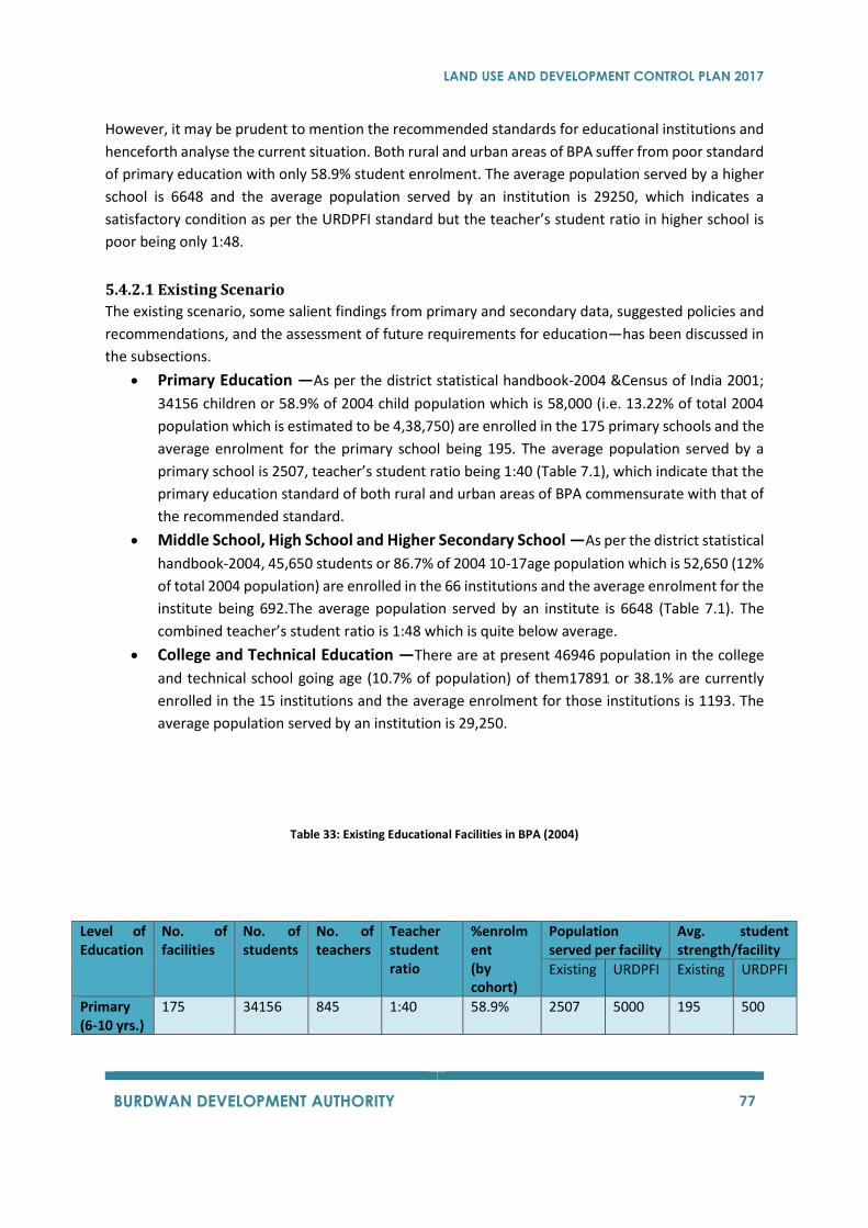
LAND USE AND DEVELOPMENT CONTROL PLAN 2017
BURDWAN DEVELOPMENT AUTHORITY 77
However, it may be prudent to mention the recommended standards for educational institutions and
henceforth analyse the current situation. Both rural and urban areas of BPA suffer from poor standard
of primary education with only 58.9% student enrolment. The average population served by a higher
school is 6648 and the average population served by an institution is 29250, which indicates a
satisfactory condition as per the URDPFI standard but the teacher’s student ratio in higher school is
poor being only 1:48.
5.4.2.1 Existing Scenario
The existing scenario, some salient findings from primary and secondary data, suggested policies and
recommendations, and the assessment of future requirements for education—has been discussed in
the subsections.
• Primary Education —As per the district statistical handbook-2004 &Census of India 2001;
34156 children or 58.9% of 2004 child population which is 58,000 (i.e. 13.22% of total 2004
population which is estimated to be 4,38,750) are enrolled in the 175 primary schools and the
average enrolment for the primary school being 195. The average population served by a
primary school is 2507, teacher’s student ratio being 1:40 (Table 7.1), which indicate that the
primary education standard of both rural and urban areas of BPA commensurate with that of
the recommended standard.
• Middle School, High School and Higher Secondary School —As per the district statistical
handbook-2004, 45,650 students or 86.7% of 2004 10-17age population which is 52,650 (12%
of total 2004 population) are enrolled in the 66 institutions and the average enrolment for the
institute being 692.The average population served by an institute is 6648 (Table 7.1). The
combined teacher’s student ratio is 1:48 which is quite below average.
• College and Technical Education —There are at present 46946 population in the college
and technical school going age (10.7% of population) of them17891 or 38.1% are currently
enrolled in the 15 institutions and the average enrolment for those institutions is 1193. The
average population served by an institution is 29,250.
Table 33: Existing Educational Facilities in BPA (2004)
Level of Education
No. of facilities
No. of students
No. of teachers
Teacher student ratio
%enrolment (by cohort)
Population served per facility
Avg. student strength/facility
Existing URDPFI Existing URDPFI
Primary (6-10 yrs.)
175 34156 845 1:40 58.9% 2507 5000 195 500
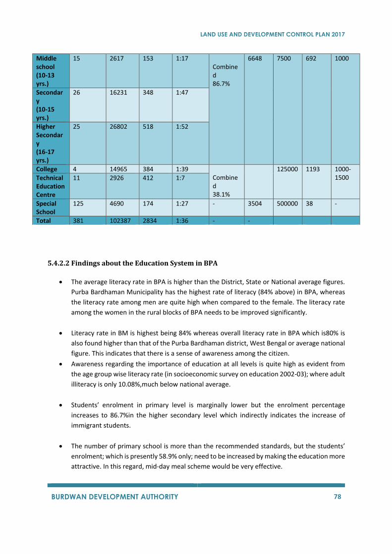
LAND USE AND DEVELOPMENT CONTROL PLAN 2017
BURDWAN DEVELOPMENT AUTHORITY 78
5.4.2.2 Findings about the Education System in BPA
• The average literacy rate in BPA is higher than the District, State or National average figures.
Purba Bardhaman Municipality has the highest rate of literacy (84% above) in BPA, whereas
the literacy rate among men are quite high when compared to the female. The literacy rate
among the women in the rural blocks of BPA needs to be improved significantly.
• Literacy rate in BM is highest being 84% whereas overall literacy rate in BPA which is80% is
also found higher than that of the Purba Bardhaman district, West Bengal or average national
figure. This indicates that there is a sense of awareness among the citizen.
• Awareness regarding the importance of education at all levels is quite high as evident from
the age group wise literacy rate (in socioeconomic survey on education 2002-03); where adult
illiteracy is only 10.08%,much below national average.
• Students’ enrolment in primary level is marginally lower but the enrolment percentage
increases to 86.7%in the higher secondary level which indirectly indicates the increase of
immigrant students.
• The number of primary school is more than the recommended standards, but the students’
enrolment; which is presently 58.9% only; need to be increased by making the education more
attractive. In this regard, mid-day meal scheme would be very effective.
Middle school (10-13 yrs.)
15 2617 153 1:17 Combined 86.7%
6648 7500 692 1000
Secondary (10-15 yrs.)
26 16231 348 1:47
Higher Secondary (16-17 yrs.)
25 26802 518 1:52
College 4 14965 384 1:39 Combined 38.1%
125000 1193 1000-1500 Technical
Education Centre
11 2926 412 1:7
Special School
125 4690 174 1:27 - 3504 500000 38 -
Total 381 102387 2834 1:36 - -
LAND USE AND DEVELOPMENT CONTROL PLAN 2017
BURDWAN DEVELOPMENT AUTHORITY 79
• Analysis based on age cohorts of population indicates that student enrolment level increases
drastically from 58.9% at primary level to 86.7% till higher secondary level. One of the reasons
may be the immigrant student from other parts of district getting enrolled for the higher
secondary education level.
• The existing teacher student’s ratio in primary level (1:40) seems to be sufficient but this ratio
must be increased to 1:30 at the secondary and higher secondary level where the present
ratio is very poor (1:47 and1:52 respectively).
• There is a demand for new and upcoming disciplines of study to foster renewed interest in
professional courses. Private sector in management education should been courage in to the
mainstream of the education system.
• The combined student enrolment in college and technical institution is38.1% which is
marginally lower. Hence, there is a need for opening up new training institution to
accommodate more youth in various vocational and professional training, thereby taking this
figure to 50%(excluding the enrolment in informal and unorganized training courses).
• Awareness about vocational and professional training needs to be increased among the youth,
especially Purba Barddhaman being the district headquarter town, so that they can engage
themselves in some sort of gainful employment in the future. The scope should be further
diversified through formal discussion with National Accreditation Board.
• Private sector in management education should be encouraged into the main stream of the
education system. Possibilities of bank finance is very high and thus be explored in coming
future.
• There is also a need to augment the infrastructural support in the primary section of some of
the existing schools for the purpose of increasing enrolment.
• The present provision for classrooms, drinking water, toilets, laboratories and libraries for
some of the existing schools and colleges indicate that there is a need for increase in the
number and the quality of most of these facilities.
5.4.3 Health Care
Health is both an end and a means of good life. To ensure the progress of any region, it is important
to verify that its citizens are healthy and have access to adequate health infra-structure. The existing
scenario in health facilities, some salient findings from secondary data, suggested policies and
recommendations and the assessment of future requirements for health care– have been elaborated
in the subsequent paragraphs.
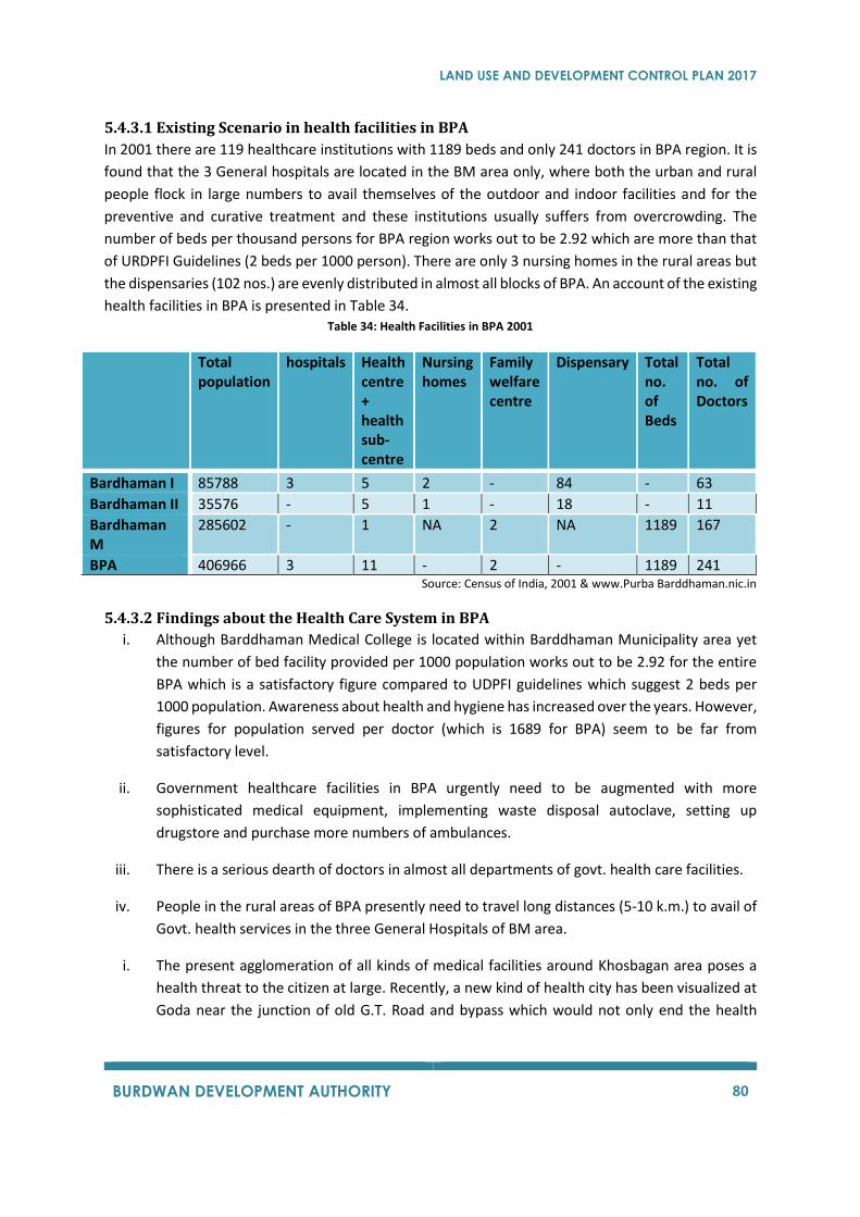
LAND USE AND DEVELOPMENT CONTROL PLAN 2017
BURDWAN DEVELOPMENT AUTHORITY 80
5.4.3.1 Existing Scenario in health facilities in BPA
In 2001 there are 119 healthcare institutions with 1189 beds and only 241 doctors in BPA region. It is
found that the 3 General hospitals are located in the BM area only, where both the urban and rural
people flock in large numbers to avail themselves of the outdoor and indoor facilities and for the
preventive and curative treatment and these institutions usually suffers from overcrowding. The
number of beds per thousand persons for BPA region works out to be 2.92 which are more than that
of URDPFI Guidelines (2 beds per 1000 person). There are only 3 nursing homes in the rural areas but
the dispensaries (102 nos.) are evenly distributed in almost all blocks of BPA. An account of the existing
health facilities in BPA is presented in Table 34. Table 34: Health Facilities in BPA 2001
Total population
hospitals Health centre + health sub-centre
Nursing homes
Family welfare centre
Dispensary Total no. of Beds
Total no. of Doctors
Bardhaman I 85788 3 5 2 - 84 - 63
Bardhaman II 35576 - 5 1 - 18 - 11
Bardhaman M
285602 - 1 NA 2 NA 1189 167
BPA 406966 3 11 - 2 - 1189 241 Source: Census of India, 2001 & www.Purba Barddhaman.nic.in
5.4.3.2 Findings about the Health Care System in BPA
i. Although Barddhaman Medical College is located within Barddhaman Municipality area yet
the number of bed facility provided per 1000 population works out to be 2.92 for the entire
BPA which is a satisfactory figure compared to UDPFI guidelines which suggest 2 beds per
1000 population. Awareness about health and hygiene has increased over the years. However,
figures for population served per doctor (which is 1689 for BPA) seem to be far from
satisfactory level.
ii. Government healthcare facilities in BPA urgently need to be augmented with more
sophisticated medical equipment, implementing waste disposal autoclave, setting up
drugstore and purchase more numbers of ambulances.
iii. There is a serious dearth of doctors in almost all departments of govt. health care facilities.
iv. People in the rural areas of BPA presently need to travel long distances (5-10 k.m.) to avail of
Govt. health services in the three General Hospitals of BM area.
i. The present agglomeration of all kinds of medical facilities around Khosbagan area poses a
health threat to the citizen at large. Recently, a new kind of health city has been visualized at
Goda near the junction of old G.T. Road and bypass which would not only end the health
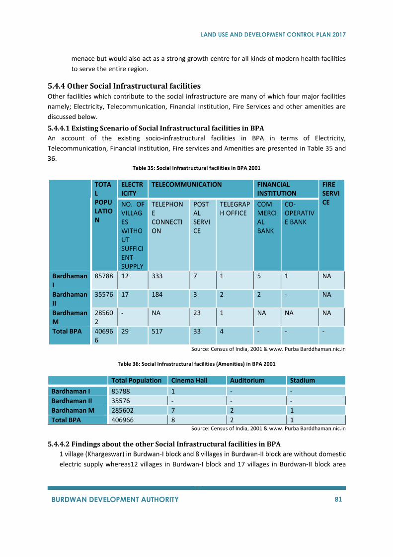
LAND USE AND DEVELOPMENT CONTROL PLAN 2017
BURDWAN DEVELOPMENT AUTHORITY 81
menace but would also act as a strong growth centre for all kinds of modern health facilities
to serve the entire region.
5.4.4 Other Social Infrastructural facilities
Other facilities which contribute to the social infrastructure are many of which four major facilities
namely; Electricity, Telecommunication, Financial Institution, Fire Services and other amenities are
discussed below.
5.4.4.1 Existing Scenario of Social Infrastructural facilities in BPA
An account of the existing socio-infrastructural facilities in BPA in terms of Electricity,
Telecommunication, Financial institution, Fire services and Amenities are presented in Table 35 and
36. Table 35: Social Infrastructural facilities in BPA 2001
TOTAL POPULATION
ELECTRICITY
TELECOMMUNICATION FINANCIAL INSTITUTION
FIRE SERVICE NO. OF
VILLAGES WITHOUT SUFFICIENT SUPPLY
TELEPHONE CONNECTION
POSTAL SERVICE
TELEGRAPH OFFICE
COMMERCIAL BANK
CO-OPERATIVE BANK
Bardhaman I
85788 12 333 7 1 5 1 NA
Bardhaman II
35576 17 184 3 2 2 - NA
Bardhaman M
285602
- NA 23 1 NA NA NA
Total BPA 406966
29 517 33 4 - - -
Source: Census of India, 2001 & www. Purba Barddhaman.nic.in
Table 36: Social Infrastructural facilities (Amenities) in BPA 2001
Total Population Cinema Hall Auditorium Stadium
Bardhaman I 85788 1 - -
Bardhaman II 35576 - - -
Bardhaman M 285602 7 2 1
Total BPA 406966 8 2 1 Source: Census of India, 2001 & www. Purba Barddhaman.nic.in
5.4.4.2 Findings about the other Social Infrastructural facilities in BPA
1 village (Khargeswar) in Burdwan-I block and 8 villages in Burdwan-II block are without domestic
electric supply whereas12 villages in Burdwan-I block and 17 villages in Burdwan-II block area
LAND USE AND DEVELOPMENT CONTROL PLAN 2017
BURDWAN DEVELOPMENT AUTHORITY 82
without electric supply for all purposes (mainly agricultural purpose). Thus, immediate extension
of electric supply scheme is required in these villages.
Present postal services in BPA is satisfactory in terms of number of post offices and telegraph
offices and also the population served per post office is 12332 and is satisfactory when compared
to URDPFI Guidelines which suggests 15000population per post office.
13 villages in Burdwan-I block have financial institutions within 5 kms whereas it is within 5 to 50
kms for the other 10 villages. In case of Burdwan-II block 16 villages have banks within 5kms and
6 villages having bank within 5 to 10 kms. When compared with the URDPFI Guidelines, the
number of financial institutions required to be in the rural areas are 12. Hence the existing number
of financial institutions, which is 8, is below satisfactory level.
The present condition of amenities is very poor in terms cinema halls, auditoriums and stadium in
the entire BPA when compared to standards. However the few outdoor recreation facilities which
are located in Burdwan Municipality need improvement and up gradation in qualitative terms.
LAND USE AND DEVELOPMENT CONTROL PLAN 2017
BURDWAN DEVELOPMENT AUTHORITY 83
LAND USE AND DEVELOPMENT CONTROL PLAN 2017
BURDWAN DEVELOPMENT AUTHORITY 84
6 SALIENT FEATURES OF PREVIOUS PLANS
6.1 LAND USE & DEVELOPMENT CONTROL PLAN i) All major water bodies shall be preserved.
ii) The present pattern of mixed land use will be allowed to continue in general, but certain
non-conforming uses will be prohibited in order to improve the environment and living
condition.
iii) The existing parks and public open spaces will be preserved and efforts will be made for
creation of new parks and public open spaces.
iv) Buildings and areas that are important from historical, architectural, environmental or
ecological points of view will be indicated for preservation and conservation.
v) Considering the increasing importance of Burdwan Municipal Area as a district Head
Quarters, efforts shall be made to encourage central area activities necessary for
effective functioning of district Head Quarters.
vi) The development of buildings and land for different purposes in different Zones will be
guided and controlled through appropriate regulations considering the available
circulation and infrastructure facilities with a view to making the area functionally
efficient and environmentally acceptable.
vii) Efforts will be made for development of the river front in B.D.A. with pedestrian plaza
and other conforming facilities along the river bank.
viii) In areas with intense commercial activities and where intense commercial activities are
expected in future, efforts will be made to promote a development form with reduced
ground coverage resulting in reduction of traffic congestion and overcrowding at street
level but at the same time ensuring proper utilisation of the high value land in such areas.
ix) Efforts will be made for future widening of street and establishing road hierarchy.
x) In view of increasing demand for car parking spaces, parking facilities within the area
in the form of multi-storeyed car parking or parkomat will be encouraged.
xi) Parking on road, unauthorized structures on footpath etc. will be strictly prohibited.
xii) Directional signage, road maps showing blocks, advertisement, road sign and symbols
etc. would be provided at specified locations to help the vehicular and pedestrian
traffic.
xiii) Non-conventional energy utilization and rain water harvesting would be encouraged.
xiv) Each and every plot must have good landscaping and shaded trees may be provided along
the boundary wall of the plot.
xv) Utility and services within the premises should be provided according to specific
standards and will be maintain properly.
Agricultural uses will be allowed to continue in the rest of the Panchayat areas as far as
practicable. However, in consideration of the mounting pressure within the Burdwan Planning Area,
effort will be made for accommodating urban uses and activities within certain strips of land along the
side of major roads and also preserved certain strip of agricultural land for future communication and
services for the sustainable development of Burdwan Planning Area.
LAND USE AND DEVELOPMENT CONTROL PLAN 2017
BURDWAN DEVELOPMENT AUTHORITY 85
6.2 PERSPECTIVE PLAN 2025 The broad objective of this plan would be to put the region in the fast track of development, through
setting up of destination hubs for attracting multifaceted investments, building positive image through
promotion of cultural, built and natural heritage, removing all kinds of regional disparities and above
all an improved quality of life. In other words preparing a plan to achieve an environmentally
sustainable land use for the coming 25 years, that would strike a balance between the two apparently
conflicting interests i.e. growing demand for land associated urbanisation and preservation of
agriculture and wet lands.
6.2.1 The Regional Context
The present configuration of BDA is a consequence of forces operating over the past five decades in
the hinterland of Bardhaman district. The total area is lying towards south-central part of Purba
Bardhaman district while River Damodar maps the southern boundary. Bardhaman town, having
located as a district head quarter. For the entire region, serves as a nodal point enjoying multi modal
connectivity with other important region within the district. The connection towards west in the
hinterland consisting of Durgapur-Asansol Industrial Complex provides an excellent job opportunity
centre as equally as of towards the east in Kolkata Metropolitan Area. The two districts in the southern
part across Damodar, Bankura and Purulia which are also rich in mineral resources could be more
intensively utilised for promoting new industrialisation in this area. Setting up of a new thermal power
plant near Katwa would provide the right kind of impetus in this zone. Besides other factors, the
emergence of Siliguri-Jalpaiguri Agro based complex in North-Bengal, port based Haldia complex in
the South-East and consumer based market complex of Kolkata is expected to significantly influence
the shaping of the future structure of this rural-urban conurbation.
6.2.2Nature of development and land forms in BPA
There are several factors that explain the East-West linear growth of BPA. The constricting &
confirming nature of topography between Eastern Railway Line and Damodar rivers is mainly
responsible for extending the growth in the East-West directions. The land in this part was formed
under distinct Geomorphology & Soil condition. The slope of the land is easterly towards east and
southerly towards river Damodar. Leaving a fragile ridge line, along the railway tracks. A bund has
been created along river Damodar to combat seasonal flooding. Further, expansion of highways and
creation of by-pass acted as catalysts for further concentration of urban corridor development. The
map of BPA reveals that the densely built up urban areas exists mainly within Burdwan Municipal area
with a concentration towards Railway Station. Leaving Damodar for water and waste discharge. An
overview of the region depicts that the utilization of physical development extends up to 2-3 km only
on both sides of old N.H.-2, beyond which the population density is low and rural in character. Apart
from BM and other two CD Blocks have unorganized, unplanned growth, with narrow roads, irregular
plot divisions, deficiency in public utilities, inadequate amenities and shortage of housing stock. Since
rice mill activities are sporadic in nature in the region, this has been imposing a tremendous problem
on the infrastructure, environment and the drainage system in BPA.
LAND USE AND DEVELOPMENT CONTROL PLAN 2017
BURDWAN DEVELOPMENT AUTHORITY 86
6.2.3Transit Oriented Development
The essence of human nature is freedom and manifestation of which in urban planning means
improved mobility – mobility for the entire cross section of the people residing in that settlement.
Perhaps this is the reason why most of the recent urban planning initiatives are guided by ‘Transit
Oriented Development’ and ‘Smart Growth’. Both attempts to arrive at a spatio-economic allocation
of resources so that improved accessibility to opportunities and facilities for the all sections of the
society can be attained, especially the poor, disabled and under-privileged sections in the community.
LAND USE AND DEVELOPMENT CONTROL PLAN 2017
BURDWAN DEVELOPMENT AUTHORITY 87
LAND USE AND DEVELOPMENT CONTROL PLAN 2017
BURDWAN DEVELOPMENT AUTHORITY 88
7 STAGES OF PLAN PREPARATION AND IMPLEMENTATION The Revised LUDCP for BPA aims to induce new development in the area through land use zoning and
control regulations. The aim is to achieve outcomes that are positive for the people, the economy and
the environment. This plan will help in development of this area as an attractive place to live, work
and make investments.
The stages of plan preparation have been designed to ensure that the development and use of land is
in the public interest, that it optimizes the area’s economic, environmental and social benefits and
overcome its drawbacks.
For the preparation of the LUMR the following four phases were taken into consideration,
Phase1:- All existing hard copy data was digitizes and converted into Auto Cad and GIS data formats
for ease of use and accuracy.
Phase 2:- A complete land survey of the BPA was conducted to know the existing condition of land use
in BPA.
Phase 3:- All survey data and attributes were added to the digitized maps for the preparation of the
LUMR.
Phase 4:- After discussions held with the public and other committee official, the changes were
incorporated into the LUMR for the preparation of the LUDCP.
7.1 STAGES OF PLAN PREPARATION The stages involved in preparation of this plan mainly include spatial data collection, socioeconomic
survey, survey of the existing land use, analysis of the data collected, followed by discussion with the
officials of the Burdwan Development Authority, stakeholders’ meetings and preparation of maps.
Stage 1: The planning process began with the surveying of the present land use condition in the
planning area. The consultants conducted the survey of the existing land use, which was then mapped
on GIS software. The previously prepared existing land use data was mapped and was used to update
the existing land use. It was then collated with cadastral revenue sheets on GIS platform.
For effective data management and complex planning decisions, GIS platform was used all through
the processes. GIS is a powerful tool for creating, managing, analysing, and using geospatial data. It,
thus, provided the consultant with improved operations, effective time management, and effective
decision-making opportunities.
Stage 2: The ‘Surveyed Land Use Data’, the geo-referenced satellite images, mouza maps were
digitised in GIS. Other information regarding the location of BPA acquired land, location of existing
industries were then obtained from the BPA and DL&LRO (District Land & Land Reforms Officer).
Stage 3: The data collected in the Stage 1 and Stage 2 was then transferred on to the GIS platform. It
was further verified and necessary corrections were made. This database is created up to plot level
LAND USE AND DEVELOPMENT CONTROL PLAN 2017
BURDWAN DEVELOPMENT AUTHORITY 89
detail, such that one can easily find the information related to existing and proposed land use, of any
particular plot.
The final ‘Existing Land Use Map’, after its acceptance, formed the basis for preparation of the LUDCP.
At the same time; many interactive sessions were conducted with local authorities, public and other
stakeholders for incorporating changes and corrections to the LUMR.
Stage 4: The data obtained in Stage 1, 2 and 3 aided in a preliminary analysis of the strengths,
weaknesses, opportunities and threats of the Planning Area. All these efforts incorporated into the
draft copy of the present Land Use map that was published on 11/05/2016.
Stage 5: Simultaneously Socio-economic survey was conducted by a private Consultancy firm, and
the gathered survey data was handed over to the consultant for its analysis, the outcome of which has
been submitted to BDA.
Stage 6: The Burdwan Planning Area has a long history of plan preparations by various organizations.
The salient features of previous planning efforts have been highlighted in Chapter 6. Each of these
plans was studied and their proposals were taken into consideration during the preparation of LUDCP
for BDA.
Stage 7: To explore the potential and suitability for new development, the distribution of the existing
land use was analysed. In this analysis, the existing land use pattern, location of major facilities and
their impact were identified. Chapter 5 discusses the present land use pattern. It played a key role in
allocation of different land uses in the planning area as the nature and scale of existing land use affects
the adjoining land uses.
Stage 8: Population and future demand for facilities were projected for Burdwan Planning Area. The
calculated population was then suitably allocated to the various mouzas and the municipal area.
Stage 9: LUDCP included the detailed land use distribution, zoning, and development control
regulations, which were elaborately discussed with the officials of BDA and other stakeholders. During
the meeting, several suggestions and feedbacks from concerned authorities outlined the need for
further modifications of the prepared documents.
Stage 10: Based on the feedback received from the LUMR necessary modifications were incorporated
in the draft of LUDCP.
7.2 GIS BASED DATA COLLECTION For plan preparation, it is necessary to assess the existing situation and future projection. This
assessment requires a lot of data. GIS is a very efficient tool to collect, manage and process the data.
Data collection has two components: data capture (direct data from field) and data transfer (input of
data from other systems).
Two main types of data capture are:
LAND USE AND DEVELOPMENT CONTROL PLAN 2017
BURDWAN DEVELOPMENT AUTHORITY 90
• Collection from primary sources that are collected directly from field specifically for use in a
GIS project.
• Collection from secondary sources which are digital and analog datasets that were originally
captured for other purposes and need to be converted into a suitable digital format for use in
a GIS project.
The process of data collection is a combination of allied tasks such as data capture, automation,
conversion, transfer, translation, and digitization.
7.2.1 Outline of the GIS database creation
a) Primary land use, socio-economic and geographic data capture
b) Secondary land use, socio-economic and geographic data capture
c) Obtaining data from external sources (data transfer)
d) Transferring spatial and statistical data in GIS
e) Capturing and inputting attribute data
f) Data management and analysis
7.2.2 Source of Information/ Map/ Data
Table 7.1 outlines the data that was collected from different sources.
Table 7.1: Source of data
7.3 PLAN IMPLEMENTATION The plan will finally be accepted and notified by the State Government under West Bengal Town and
Country (Planning and Development) Act 1979, prior to which people’s participation will be asked for
in the form of objections and suggestions. The hearing procedure will be conducted by BDA towards
this end.
The plan has also been supplemented with zoning and development control regulation. Thus, the
revised LUDCP will primarily adopt these regulations once approved by the state government.
All development shall have to incorporate the guidelines mentioned in this report. Applications for
permissions shall be accordingly reviewed and scrutinized by the Burdwan Development Authority
and/or Burdwan Municipality or the Gram Panchayats. However, the Development Authority, in
addition to enforcement of the plan, shall also fulfil the infrastructure demand and the need for
economically weaker section.
Some budgetary estimation has to be prepared and priority for the development has to be finalised.
It must also be kept in mind to follow the phase wise development and mobilize resources from the
users and prospective financial institutions.
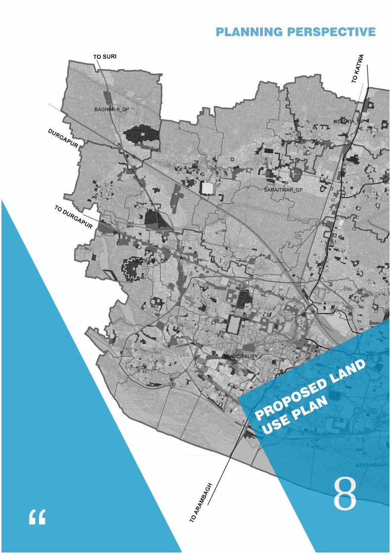
LAND USE AND DEVELOPMENT CONTROL PLAN 2017
BURDWAN DEVELOPMENT AUTHORITY 91
LAND USE AND DEVELOPMENT CONTROL PLAN 2017
BURDWAN DEVELOPMENT AUTHORITY 92
8 PROPOSED LANDUSE PLAN
8.1 PLAN PERIOD Rapid urbanization in the Burdaman Planning Area is characterised by haphazard urban growth of the
city with narrow roads as well as weak enforcement of regulation concerning land development
control. With the Land Use and Development Control Plan, it is expected that the Burdaman
Development Authority will be better equipped to manage and regulate the development in the
region.
8.2 PLANNING DIRECTIVES The main objective of LUDCP is to allocate land uses to ensure public welfare and better standard of
living. The land use distribution is based on compatibility of uses. The development control plan
manages and regulates land development and ensures that all developments conform to a pre-
determined set of objectives, policies or standards. Thus the Land Use and Development Control Plan
must be inclusive of the physical, environmental, economic, social and aesthetic aspects.
To prepare this plan certain planning directives were followed:
1. Land use plan shall respond to the natural surroundings, topography, geology, hydrology,
ecology, etc.
2. The land use shall show location of settlements both urban and rural. It will earmark
agricultural land, forestland, river basins, flood prone areas, streams and canals, water bodies.
3. The riverbank shall be protected by a green belt / plantation.
4. Location of central business district as well as other ancillary economic activities will be
earmarked
5. Green Belt will be introduced to segregate the industrial zone from the densely developed
residential areas.
6. The existing industry is allowed to continue operations. Their expansion may be permitted if
it is of non-polluting nature.
7. Priory aspects must be decided as per the development priorities obtained in the socio-
economic survey.
8. While allocating public infrastructures, priority will be given to the land under the possession
of the government and the Burdwan Development Authority. Ownership of plots of land will
be given importance.
9. Areas of Heritage value will be given due importance and incorporated in the plan.
10. Provision of public facilities and infrastructures like health, education, government,
recreation, community development, will be made as per the URDPFI Guidelines.
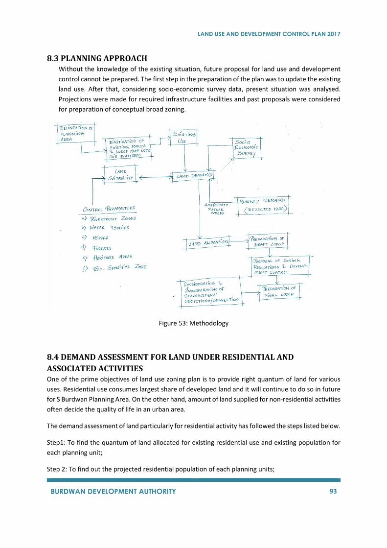
LAND USE AND DEVELOPMENT CONTROL PLAN 2017
BURDWAN DEVELOPMENT AUTHORITY 93
8.3 PLANNING APPROACH Without the knowledge of the existing situation, future proposal for land use and development
control cannot be prepared. The first step in the preparation of the plan was to update the existing
land use. After that, considering socio-economic survey data, present situation was analysed.
Projections were made for required infrastructure facilities and past proposals were considered
for preparation of conceptual broad zoning.
Figure 53: Methodology
8.4 DEMAND ASSESSMENT FOR LAND UNDER RESIDENTIAL AND
ASSOCIATED ACTIVITIES One of the prime objectives of land use zoning plan is to provide right quantum of land for various
uses. Residential use consumes largest share of developed land and it will continue to do so in future
for S Burdwan Planning Area. On the other hand, amount of land supplied for non-residential activities
often decide the quality of life in an urban area.
The demand assessment of land particularly for residential activity has followed the steps listed below.
Step1: To find the quantum of land allocated for existing residential use and existing population for
each planning unit;
Step 2: To find out the projected residential population of each planning units;
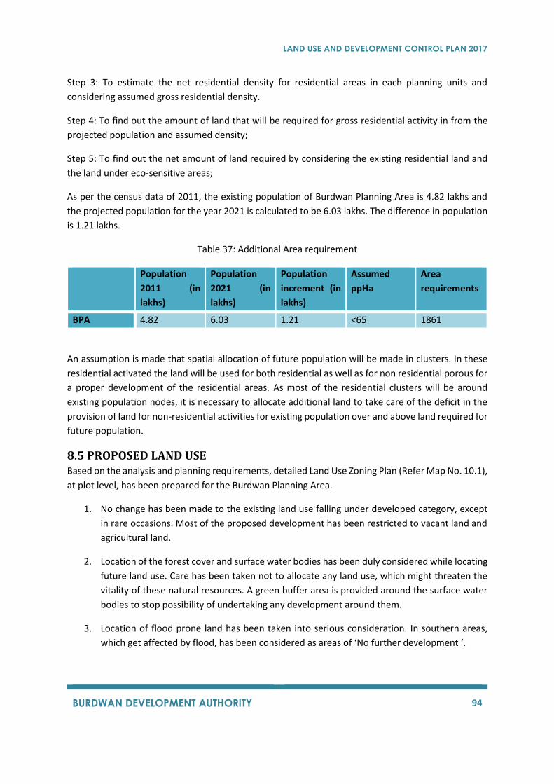
LAND USE AND DEVELOPMENT CONTROL PLAN 2017
BURDWAN DEVELOPMENT AUTHORITY 94
Step 3: To estimate the net residential density for residential areas in each planning units and
considering assumed gross residential density.
Step 4: To find out the amount of land that will be required for gross residential activity in from the
projected population and assumed density;
Step 5: To find out the net amount of land required by considering the existing residential land and
the land under eco-sensitive areas;
As per the census data of 2011, the existing population of Burdwan Planning Area is 4.82 lakhs and
the projected population for the year 2021 is calculated to be 6.03 lakhs. The difference in population
is 1.21 lakhs.
Table 37: Additional Area requirement
Population
2011 (in
lakhs)
Population
2021 (in
lakhs)
Population
increment (in
lakhs)
Assumed
ppHa
Area
requirements
BPA 4.82 6.03 1.21 <65 1861
An assumption is made that spatial allocation of future population will be made in clusters. In these
residential activated the land will be used for both residential as well as for non residential porous for
a proper development of the residential areas. As most of the residential clusters will be around
existing population nodes, it is necessary to allocate additional land to take care of the deficit in the
provision of land for non-residential activities for existing population over and above land required for
future population.
8.5 PROPOSED LAND USE Based on the analysis and planning requirements, detailed Land Use Zoning Plan (Refer Map No. 10.1),
at plot level, has been prepared for the Burdwan Planning Area.
1. No change has been made to the existing land use falling under developed category, except
in rare occasions. Most of the proposed development has been restricted to vacant land and
agricultural land.
2. Location of the forest cover and surface water bodies has been duly considered while locating
future land use. Care has been taken not to allocate any land use, which might threaten the
vitality of these natural resources. A green buffer area is provided around the surface water
bodies to stop possibility of undertaking any development around them.
3. Location of flood prone land has been taken into serious consideration. In southern areas,
which get affected by flood, has been considered as areas of ‘No further development ‘.
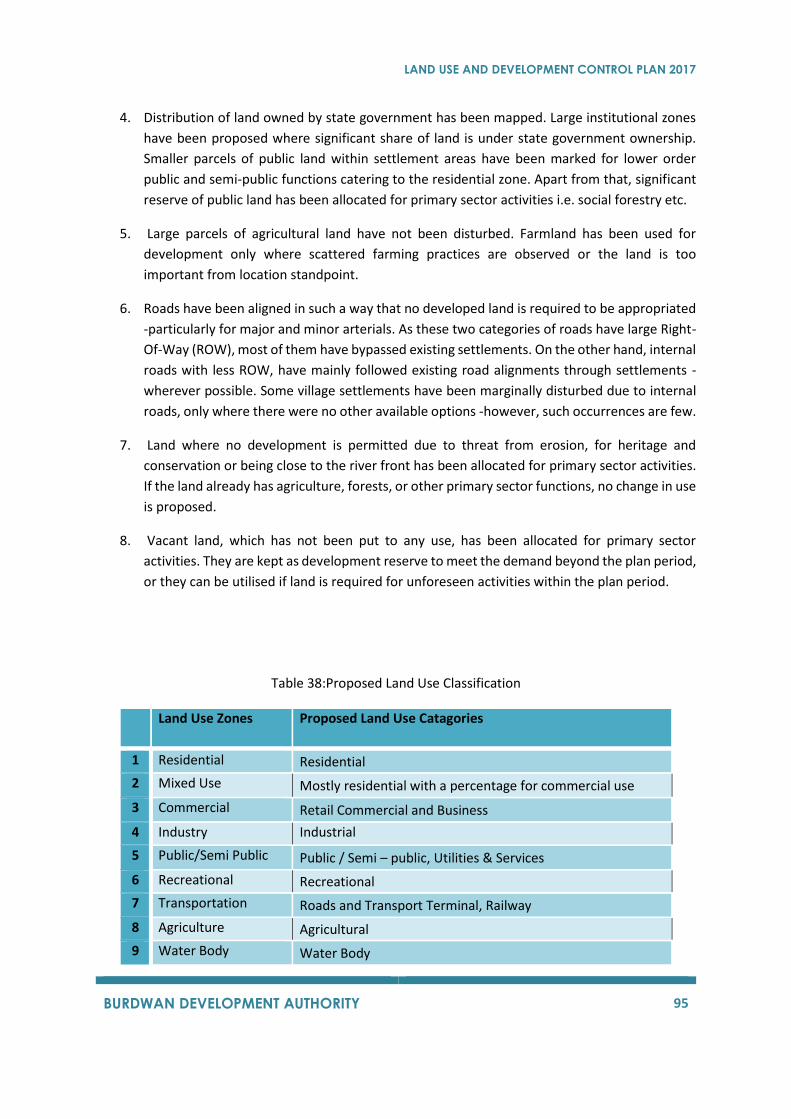
LAND USE AND DEVELOPMENT CONTROL PLAN 2017
BURDWAN DEVELOPMENT AUTHORITY 95
4. Distribution of land owned by state government has been mapped. Large institutional zones
have been proposed where significant share of land is under state government ownership.
Smaller parcels of public land within settlement areas have been marked for lower order
public and semi-public functions catering to the residential zone. Apart from that, significant
reserve of public land has been allocated for primary sector activities i.e. social forestry etc.
5. Large parcels of agricultural land have not been disturbed. Farmland has been used for
development only where scattered farming practices are observed or the land is too
important from location standpoint.
6. Roads have been aligned in such a way that no developed land is required to be appropriated
-particularly for major and minor arterials. As these two categories of roads have large Right-
Of-Way (ROW), most of them have bypassed existing settlements. On the other hand, internal
roads with less ROW, have mainly followed existing road alignments through settlements -
wherever possible. Some village settlements have been marginally disturbed due to internal
roads, only where there were no other available options -however, such occurrences are few.
7. Land where no development is permitted due to threat from erosion, for heritage and
conservation or being close to the river front has been allocated for primary sector activities.
If the land already has agriculture, forests, or other primary sector functions, no change in use
is proposed.
8. Vacant land, which has not been put to any use, has been allocated for primary sector
activities. They are kept as development reserve to meet the demand beyond the plan period,
or they can be utilised if land is required for unforeseen activities within the plan period.
Table 38:Proposed Land Use Classification
Land Use Zones Proposed Land Use Catagories
1 Residential Residential
2 Mixed Use Mostly residential with a percentage for commercial use
3 Commercial Retail Commercial and Business
4 Industry Industrial
5 Public/Semi Public Public / Semi – public, Utilities & Services
6 Recreational Recreational
7 Transportation Roads and Transport Terminal, Railway
8 Agriculture Agricultural
9 Water Body Water Body
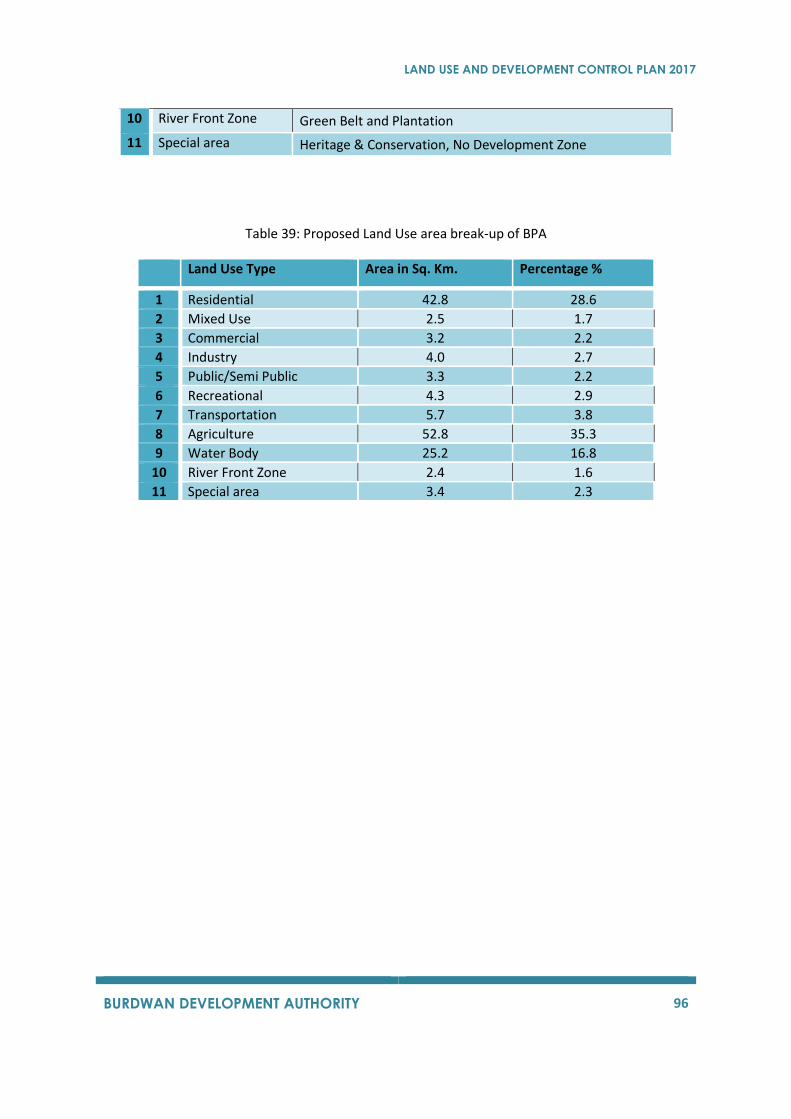
LAND USE AND DEVELOPMENT CONTROL PLAN 2017
BURDWAN DEVELOPMENT AUTHORITY 96
10 River Front Zone Green Belt and Plantation
11 Special area Heritage & Conservation, No Development Zone
Table 39: Proposed Land Use area break-up of BPA
Land Use Type Area in Sq. Km. Percentage %
1 Residential 42.8 28.6
2 Mixed Use 2.5 1.7
3 Commercial 3.2 2.2
4 Industry 4.0 2.7
5 Public/Semi Public 3.3 2.2
6 Recreational 4.3 2.9
7 Transportation 5.7 3.8
8 Agriculture 52.8 35.3
9 Water Body 25.2 16.8
10 River Front Zone 2.4 1.6
11 Special area 3.4 2.3
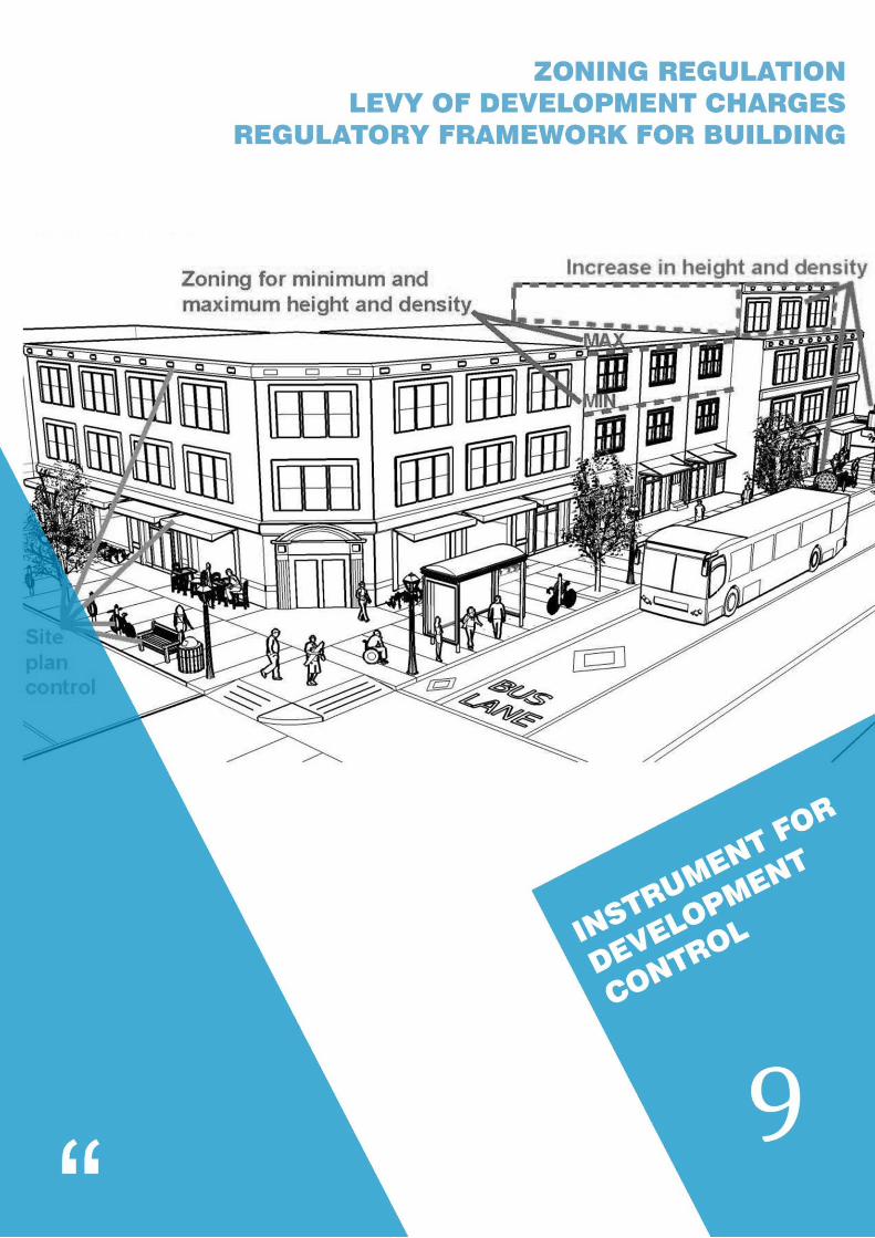
LAND USE AND DEVELOPMENT CONTROL PLAN 2017
BURDWAN DEVELOPMENT AUTHORITY 97
LAND USE AND DEVELOPMENT CONTROL PLAN 2017
BURDWAN DEVELOPMENT AUTHORITY 98
9 INSTRUMENTS FOR DEVELOPMENT CONTROL
9.1 ZONING REGULATION The aim of this section is to enable the implementation of the Land Use Plan by providing specific
regulations regarding the allowable uses of land under the purview of this Plan. These regulations are
forwarded to preserve the characteristics of the various land use zones proposed, while resolving
compatibility issues of the various activities. It is expected that the zoning regulations will promote
and protect public health, safety, convenience, general welfare and the natural environment of the
planning area.
9.1.1 Development Control Zones There are eleven broad categories of land use zones adopted for the Land Use Plan and Development
Control Regulations. For the purpose of clear understanding and proper implementation of
development control regulations, these land use zones shall be called as “Development Control
Zones”. “In Development Control Zones, all other activities which are required to support a zone are
also allowed within the zone. These activities are termed as “Broad Uses” under Development Control
Zones. They include residential activities, commercial activities, institutional activities,
industrial/manufacturing activities, recreational activities, transport activities along with some
farming and plantations. However, there is a scale up to which activities are allowed. A limit on plot
area or floor area or operational unit to control the intensity and extent of such activities has been
placed.
The list of detailed activities/uses that will be allowed within the proposed zones has been discussed
in detail. (Refer Table 40)
The list contains three types of uses/activities that will be allowed to carry out in the proposed zones:
a) Permitted uses: Uses/activities listed under this column/category for a specific land
use zone will be allowed unconditionally under normal circumstances.
b) Permissible Uses: Uses/activities listed under this column/category will be considered
on an application to the Development Authority i.e. the competent authority in this
case, subject to scrutiny by the Development Authority, and may or may not be
permitted, with or without conditions as deemed appropriate.
c) Prohibited Uses: The uses/activities, which are otherwise not allowed in a particular
use zone, are termed as Prohibited activities/Uses. Development Authority shall not
allow the activities listed under this category. No application or correspondence will
be acceptable in this regard.
The zoning regulations elaborate the activities that are General ‘permitted’,
‘permissible’ or ‘prohibited’ within each of the eleven development control zones. No
person shall construct, or move a building, and no person shall establish a new use of
land, expand, or intensify an existing use unless it conforms to the uses provided in
the development control zone. Similarly, previously mentioned activities cannot take
LAND USE AND DEVELOPMENT CONTROL PLAN 2017
BURDWAN DEVELOPMENT AUTHORITY 99
place unless it conforms to a permit and regulations authorizing a discretionary use
of land in the development control zone. All construction, alteration, reconstruction
or enlargement of buildings and all uses of buildings and land shall comply with all
provisions of this chapter except as otherwise provided for nonconforming structures
and uses.
9.1.1.1 Development Control Zone ‘Residential’
This comprises the areas that are primarily used for residential purposes mixed with other uses. This
zone also includes the areas, which are likely to be used in future for mainly residential purposes (Refer
Map No.10.1). However, all other non-residential activities, which are required to support a residential
zone and won’t adversely affect the surrounding are also allowed within this zone. They include
commercial activities, institutional activities, manufacturing activities, recreational activities,
transport activities along with some farming and plantations. However, there is a scale up to which
activities are allowed. A limit on plot area or floor area or operational unit to control the intensity and
extent of such non-residential activities has been placed.
9.1.1.2 Development Control Zone ‘Mixed Use’
This comprises of the areas that are used principally for commercial/residential purpose, mixed with
other uses that are permissible as per the zoning regulations indicated in this document. This zone
also includes areas, which are likely to be used in future for commercial/residential activities. (Refer
Map No.10.1)
9.1.1.3 Development Control Zone ‘Commercial’
This comprises of the areas that are used principally for commercial purpose mixed with other uses
that are permissible as per the zoning regulations indicated in this document. This zone includes areas
which are likely to be used in future for activities
9.1.1.4 Development Control Zone ‘Industrial’
This zone mainly comprises of the existing and new industries, which shall preferably be non –
polluting in nature. In addition, list of industries that are allowed in this zone have been provided as
Annexure III along with this DCR. (Refer Map No.10.1)
9.1.1.5 Development Control Zone ‘Public / Semi – public
This zone comprises of the areas that are used principally for educational, assembly institutional,
business and merchandises, health related and social institutions and also Govt. / semi – govt. offices.
This zone has been suitably located so that the institutions can be easily accessible from different parts
of the BPA. (Refer Map No.10.1)
9.1.1.6 Development Control Zone ‘Recreational’
This zone comprises of the areas that are used principally for recreational and green open spaces and
in future shall be used for recreational purposes. (Refer Map No. 10.1)

LAND USE AND DEVELOPMENT CONTROL PLAN 2017
BURDWAN DEVELOPMENT AUTHORITY 100
9.1.1.7 Development Control Zone ‘Transportation’
These zones comprise of the all the transport infrastructure existing in the BPA. This zone shall
comprise of the proposed roads, bus terminal and truck terminal that will come up in the area. (Refer
Map No.10.1)
9.1.1.8 Development Control Zone ‘Agriculture’
This zone comprises of the areas that are used principally for agriculture. This also includes the multi
cropping area within BPA. (Refer Map No. 10.1)
9.1.1.9 Development Control Zone ‘Water Bodies’
This zone comprises of all types of water bodies which includes river, canal, lakes, ponds, etc. (Refer
Map No. 10.1).
9.1.1.10 Development Control Zone ‘Riverfront’
The Riverfront Zone (RFZ) shall be any area within the jurisdiction of BDA up to 50.00 m from the
bank along both sides of the rivers/ canals/ water streams. Riverfront zone shall be classified into
three following groups:
(1) RFZ – 1: These are the ecologically sensitive areas and essential for maintaining the
ecosystem of the water bodies. The area up to 5.00 m from the bank of the rivers/ canals/
water streams shall be earmarked as RFZ – 1.
(2) RFZ – 2: Area within the buffer area of 5.00 m up to 15.00 m from the outer boundary of the
rivers/ canals/ water streams.
(3) RFZ – 3: Area within the buffer area from 15.00 m up to 50.00 m from the outer boundary of
the rivers/ canals/ water streams.
This zone comprises of the Riverfront Area of Burdwan Planning Area along river, canals, water
channels etc as applicable (Refer Map No.10.1).
9.1.1.11 Development Control Zone ‘Special Land’
This zone comprises along with other heritage sites. (Refer Map No. 10.1).
Detailed list of uses/activities have been listed in a tabular format in the following part of this section.
Table 40: Zoning regulation in BPA
Residential Use Zone Broad Uses Uses Permitted Uses Permissible Uses Prohibited
Residential
Plotted housing (detached, semi-detached, row housing), Group housing, Apartments, Multi Dwelling Units, Guest houses, Service apartments, Hostels, Boarding and lodging houses, Old age homes,
Any residential development covering more than 3500 sq. meters of plot area, Transient visitors’ camp,Dharmashala, Night Shelter, Temporary shelter for
Any other non-residential use not mentioned under permissible and permitted
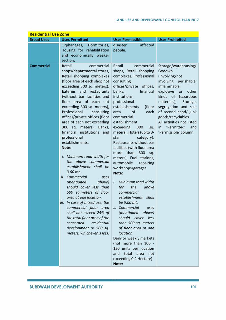
LAND USE AND DEVELOPMENT CONTROL PLAN 2017
BURDWAN DEVELOPMENT AUTHORITY 101
Residential Use Zone Broad Uses Uses Permitted Uses Permissible Uses Prohibited
Orphanages, Dormitories, Housing for rehabilitation and economically weaker section.
disaster affected people.
Commercial
Retail commercial shops/departmental stores, Retail shopping complexes (floor area of each shop not exceeding 300 sq. meters), Eateries and restaurants (without bar facilities and floor area of each not exceeding 300 sq. meters), Professional consulting offices/private offices (floor area of each not exceeding 300 sq. meters), Banks, financial institutions and professional establishments. Note:
i. Minimum road width for the above commercial establishment shall be 3.00 mt.
ii. Commercial uses (mentioned above) should cover less than 500 sq.meters of floor area at one location.
iii. In case of mixed use, the commercial floor area shall not exceed 25% of the total floor area of the concerned residential development or 500 sq. meters, whichever is less.
Retail commercial shops, Retail shopping complexes, Professional consulting offices/private offices, banks, financial institutions, professional establishments (floor area of each commercial establishment exceeding 300 sq. meters), Hotels (up to 3-star category), Restaurants without bar facilities (with floor area more than 300 sq. meters), Fuel stations, automobile repairing workshops/garages Note:
i. Minimum road width for the above commercial establishment shall be 5.00 mt.
ii. Commercial uses (mentioned above) should cover less than 500 sq. meters of floor area at one location
Daily or weekly markets (not more than 100 - 150 units per location and total area not exceeding 0.2 Hectare) Note:
Storage/warehousing/Godown (involving/not involving perishable, inflammable, explosive or other kinds of hazardous materials), Storage, segregation and sale of second hand/ junk goods/recyclables All activities not listed in ‘Permitted’ and ‘Permissible’ column
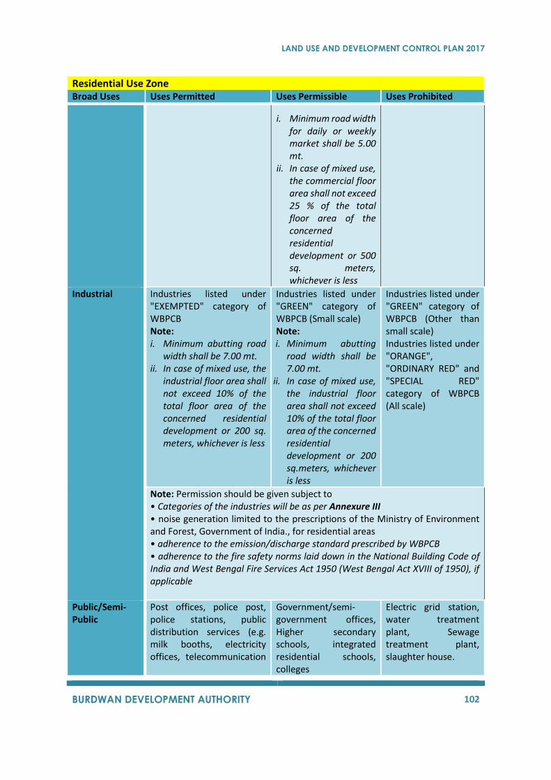
LAND USE AND DEVELOPMENT CONTROL PLAN 2017
BURDWAN DEVELOPMENT AUTHORITY 102
Residential Use Zone Broad Uses Uses Permitted Uses Permissible Uses Prohibited
i. Minimum road width for daily or weekly market shall be 5.00 mt.
ii. In case of mixed use, the commercial floor area shall not exceed 25 % of the total floor area of the concerned residential development or 500 sq. meters, whichever is less
Industrial
Industries listed under "EXEMPTED" category of WBPCB Note: i. Minimum abutting road
width shall be 7.00 mt. ii. In case of mixed use, the
industrial floor area shall not exceed 10% of the total floor area of the concerned residential development or 200 sq. meters, whichever is less
Industries listed under "GREEN" category of WBPCB (Small scale) Note: i. Minimum abutting
road width shall be 7.00 mt.
ii. In case of mixed use, the industrial floor area shall not exceed 10% of the total floor area of the concerned residential development or 200 sq.meters, whichever is less
Industries listed under "GREEN" category of WBPCB (Other than small scale) Industries listed under "ORANGE", "ORDINARY RED" and "SPECIAL RED" category of WBPCB (All scale)
Note: Permission should be given subject to • Categories of the industries will be as per Annexure III • noise generation limited to the prescriptions of the Ministry of Environment and Forest, Government of India., for residential areas • adherence to the emission/discharge standard prescribed by WBPCB • adherence to the fire safety norms laid down in the National Building Code of India and West Bengal Fire Services Act 1950 (West Bengal Act XVIII of 1950), if applicable
Public/Semi-Public
Post offices, police post, police stations, public distribution services (e.g. milk booths, electricity offices, telecommunication
Government/semi-government offices, Higher secondary schools, integrated residential schools, colleges
Electric grid station, water treatment plant, Sewage treatment plant, slaughter house.
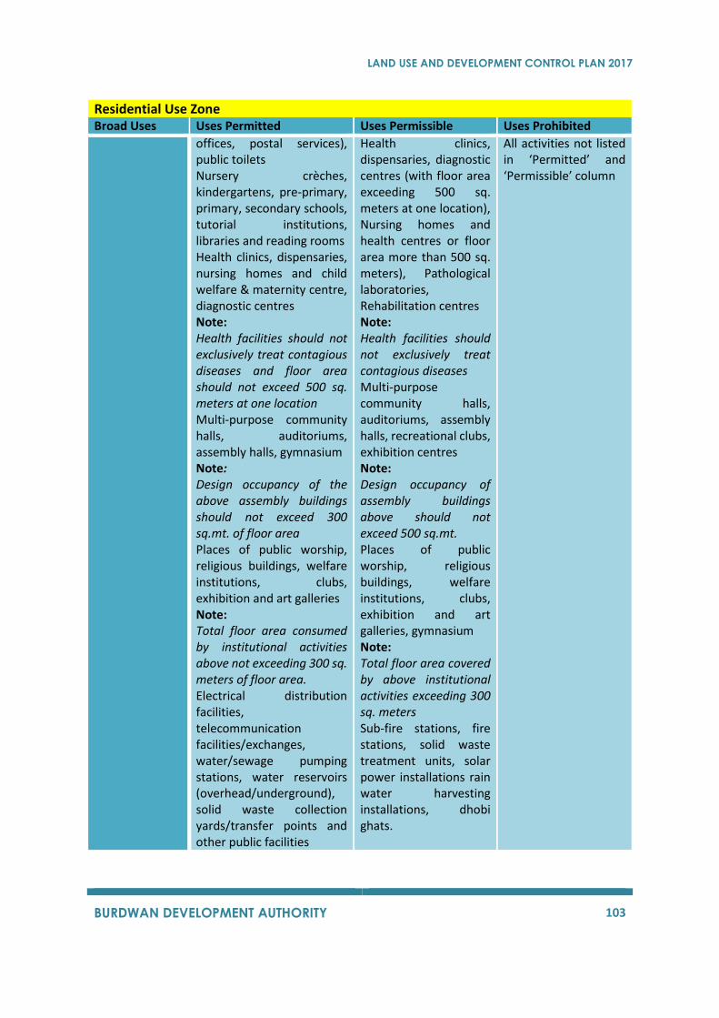
LAND USE AND DEVELOPMENT CONTROL PLAN 2017
BURDWAN DEVELOPMENT AUTHORITY 103
Residential Use Zone Broad Uses Uses Permitted Uses Permissible Uses Prohibited
offices, postal services), public toilets Nursery crèches, kindergartens, pre-primary, primary, secondary schools, tutorial institutions, libraries and reading rooms Health clinics, dispensaries, nursing homes and child welfare & maternity centre, diagnostic centres Note: Health facilities should not exclusively treat contagious diseases and floor area should not exceed 500 sq. meters at one location Multi-purpose community halls, auditoriums, assembly halls, gymnasium Note: Design occupancy of the above assembly buildings should not exceed 300 sq.mt. of floor area Places of public worship, religious buildings, welfare institutions, clubs, exhibition and art galleries Note: Total floor area consumed by institutional activities above not exceeding 300 sq. meters of floor area. Electrical distribution facilities, telecommunication facilities/exchanges, water/sewage pumping stations, water reservoirs (overhead/underground), solid waste collection yards/transfer points and other public facilities
Health clinics, dispensaries, diagnostic centres (with floor area exceeding 500 sq. meters at one location), Nursing homes and health centres or floor area more than 500 sq. meters), Pathological laboratories, Rehabilitation centres Note: Health facilities should not exclusively treat contagious diseases Multi-purpose community halls, auditoriums, assembly halls, recreational clubs, exhibition centres Note: Design occupancy of assembly buildings above should not exceed 500 sq.mt. Places of public worship, religious buildings, welfare institutions, clubs, exhibition and art galleries, gymnasium Note: Total floor area covered by above institutional activities exceeding 300 sq. meters Sub-fire stations, fire stations, solid waste treatment units, solar power installations rain water harvesting installations, dhobi ghats.
All activities not listed in ‘Permitted’ and ‘Permissible’ column
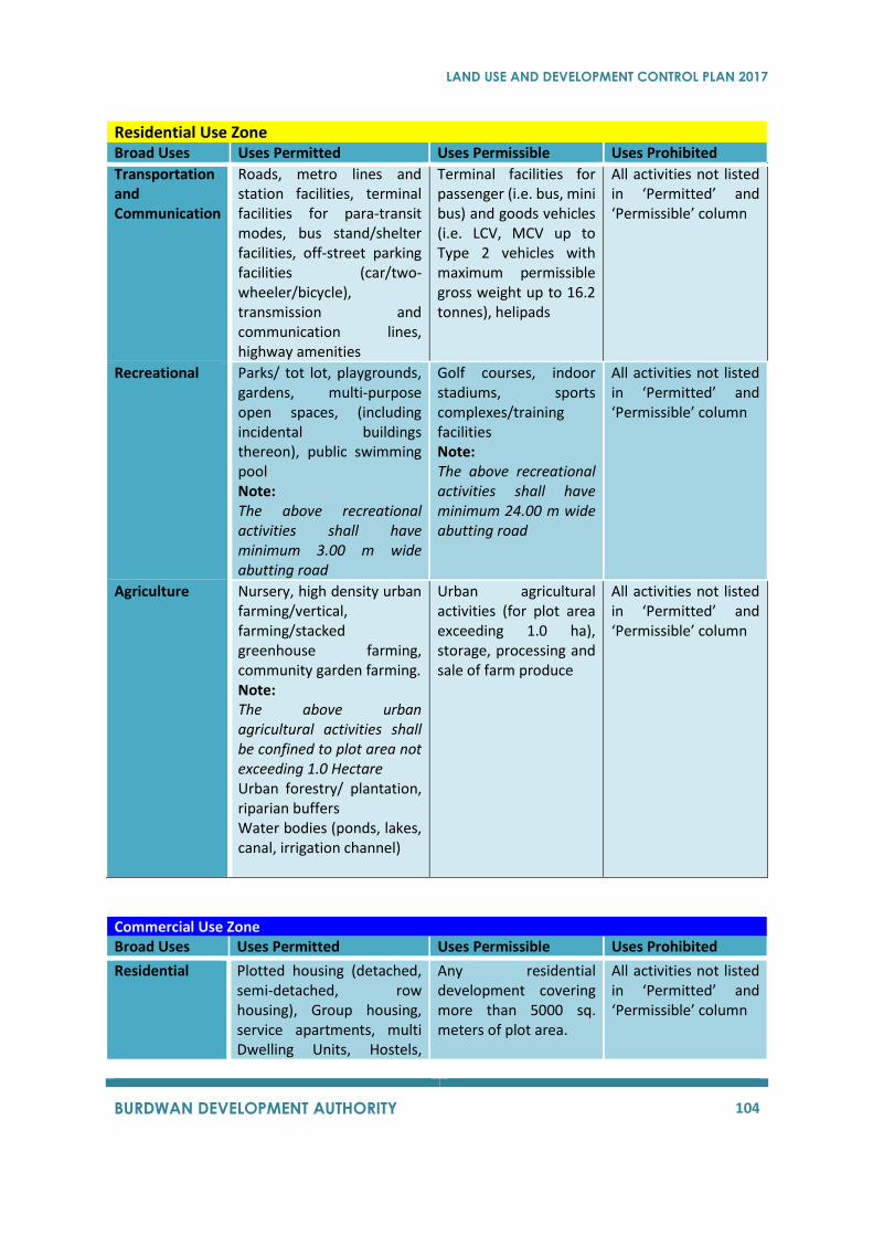
LAND USE AND DEVELOPMENT CONTROL PLAN 2017
BURDWAN DEVELOPMENT AUTHORITY 104
Residential Use Zone Broad Uses Uses Permitted Uses Permissible Uses Prohibited
Transportation and Communication
Roads, metro lines and station facilities, terminal facilities for para-transit modes, bus stand/shelter facilities, off-street parking facilities (car/two-wheeler/bicycle), transmission and communication lines, highway amenities
Terminal facilities for passenger (i.e. bus, mini bus) and goods vehicles (i.e. LCV, MCV up to Type 2 vehicles with maximum permissible gross weight up to 16.2 tonnes), helipads
All activities not listed in ‘Permitted’ and ‘Permissible’ column
Recreational
Parks/ tot lot, playgrounds, gardens, multi-purpose open spaces, (including incidental buildings thereon), public swimming pool Note: The above recreational activities shall have minimum 3.00 m wide abutting road
Golf courses, indoor stadiums, sports complexes/training facilities Note: The above recreational activities shall have minimum 24.00 m wide abutting road
All activities not listed in ‘Permitted’ and ‘Permissible’ column
Agriculture
Nursery, high density urban farming/vertical, farming/stacked greenhouse farming, community garden farming. Note: The above urban agricultural activities shall be confined to plot area not exceeding 1.0 Hectare Urban forestry/ plantation, riparian buffers Water bodies (ponds, lakes, canal, irrigation channel)
Urban agricultural activities (for plot area exceeding 1.0 ha), storage, processing and sale of farm produce
All activities not listed in ‘Permitted’ and ‘Permissible’ column
Commercial Use Zone Broad Uses Uses Permitted Uses Permissible Uses Prohibited
Residential
Plotted housing (detached, semi-detached, row housing), Group housing, service apartments, multi Dwelling Units, Hostels,
Any residential development covering more than 5000 sq. meters of plot area.
All activities not listed in ‘Permitted’ and ‘Permissible’ column
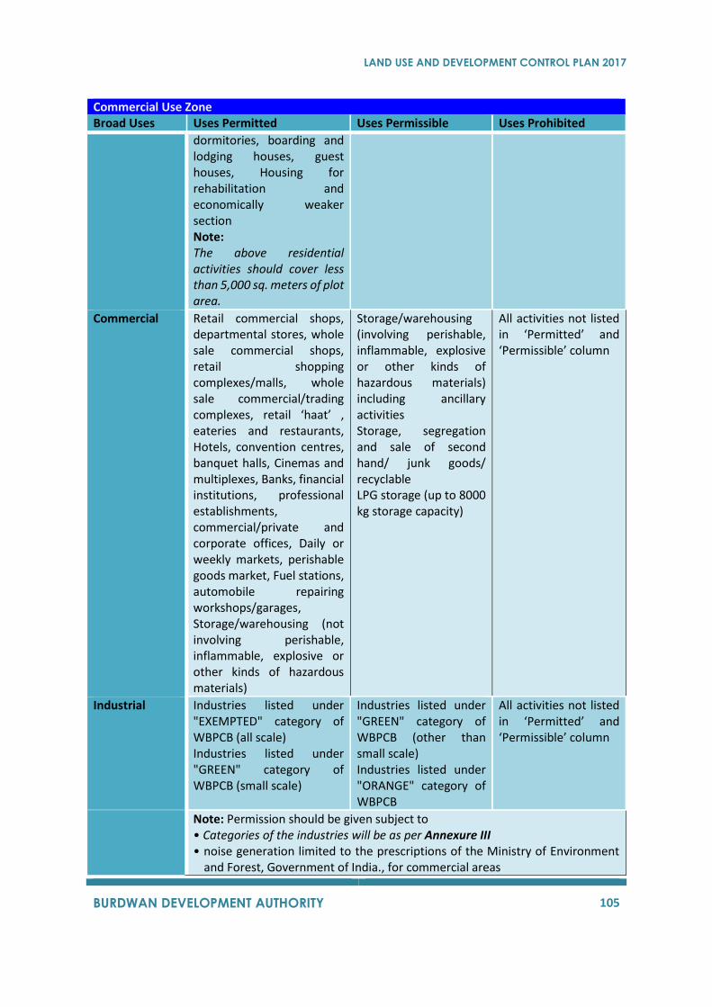
LAND USE AND DEVELOPMENT CONTROL PLAN 2017
BURDWAN DEVELOPMENT AUTHORITY 105
Commercial Use Zone Broad Uses Uses Permitted Uses Permissible Uses Prohibited
dormitories, boarding and lodging houses, guest houses, Housing for rehabilitation and economically weaker section Note: The above residential activities should cover less than 5,000 sq. meters of plot area.
Commercial
Retail commercial shops, departmental stores, whole sale commercial shops, retail shopping complexes/malls, whole sale commercial/trading complexes, retail ‘haat’ , eateries and restaurants, Hotels, convention centres, banquet halls, Cinemas and multiplexes, Banks, financial institutions, professional establishments, commercial/private and corporate offices, Daily or weekly markets, perishable goods market, Fuel stations, automobile repairing workshops/garages, Storage/warehousing (not involving perishable, inflammable, explosive or other kinds of hazardous materials)
Storage/warehousing (involving perishable, inflammable, explosive or other kinds of hazardous materials) including ancillary activities Storage, segregation and sale of second hand/ junk goods/ recyclable LPG storage (up to 8000 kg storage capacity)
All activities not listed in ‘Permitted’ and ‘Permissible’ column
Industrial
Industries listed under "EXEMPTED" category of WBPCB (all scale) Industries listed under "GREEN" category of WBPCB (small scale)
Industries listed under "GREEN" category of WBPCB (other than small scale) Industries listed under "ORANGE" category of WBPCB
All activities not listed in ‘Permitted’ and ‘Permissible’ column
Note: Permission should be given subject to • Categories of the industries will be as per Annexure III • noise generation limited to the prescriptions of the Ministry of Environment
and Forest, Government of India., for commercial areas
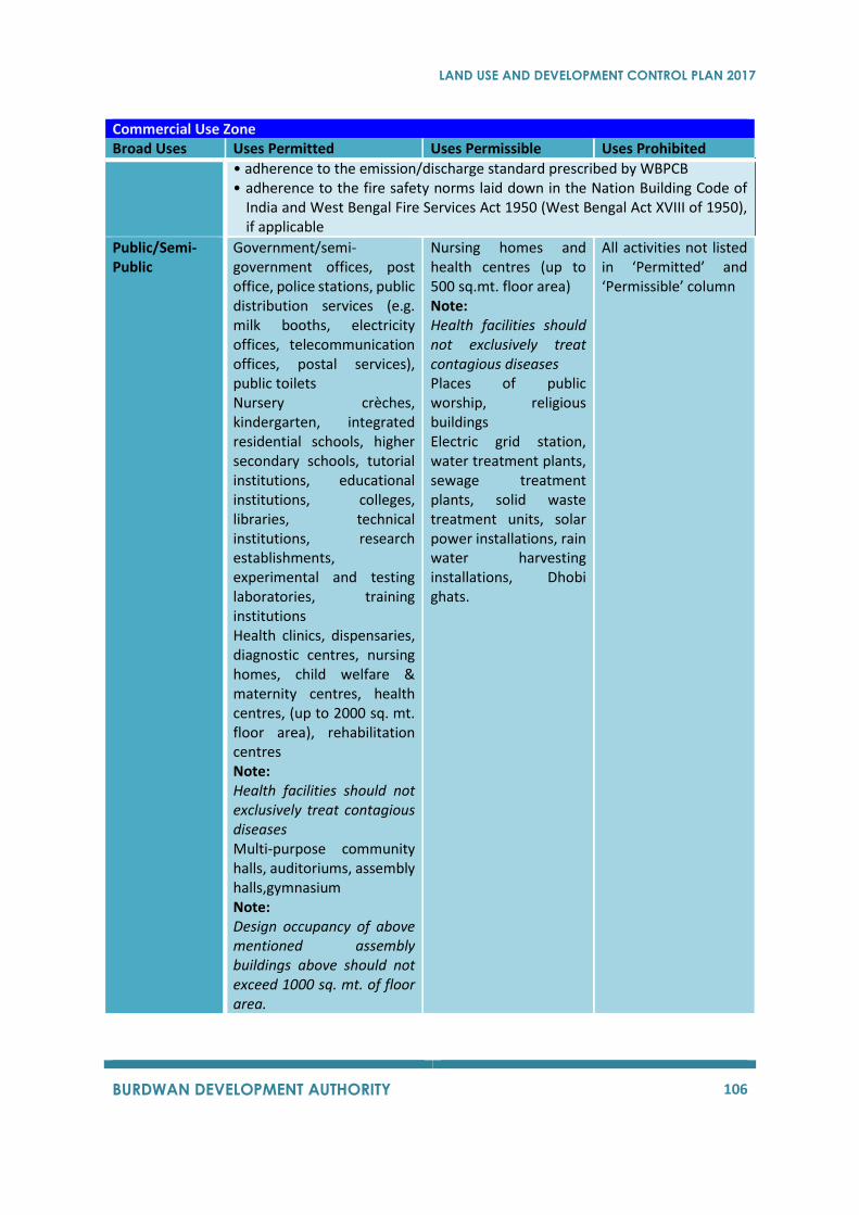
LAND USE AND DEVELOPMENT CONTROL PLAN 2017
BURDWAN DEVELOPMENT AUTHORITY 106
Commercial Use Zone Broad Uses Uses Permitted Uses Permissible Uses Prohibited
• adherence to the emission/discharge standard prescribed by WBPCB • adherence to the fire safety norms laid down in the Nation Building Code of
India and West Bengal Fire Services Act 1950 (West Bengal Act XVIII of 1950), if applicable
Public/Semi-Public
Government/semi-government offices, post office, police stations, public distribution services (e.g. milk booths, electricity offices, telecommunication offices, postal services), public toilets Nursery crèches, kindergarten, integrated residential schools, higher secondary schools, tutorial institutions, educational institutions, colleges, libraries, technical institutions, research establishments, experimental and testing laboratories, training institutions Health clinics, dispensaries, diagnostic centres, nursing homes, child welfare & maternity centres, health centres, (up to 2000 sq. mt. floor area), rehabilitation centres Note: Health facilities should not exclusively treat contagious diseases Multi-purpose community halls, auditoriums, assembly halls,gymnasium Note: Design occupancy of above mentioned assembly buildings above should not exceed 1000 sq. mt. of floor area.
Nursing homes and health centres (up to 500 sq.mt. floor area) Note: Health facilities should not exclusively treat contagious diseases Places of public worship, religious buildings Electric grid station, water treatment plants, sewage treatment plants, solid waste treatment units, solar power installations, rain water harvesting installations, Dhobi ghats.
All activities not listed in ‘Permitted’ and ‘Permissible’ column
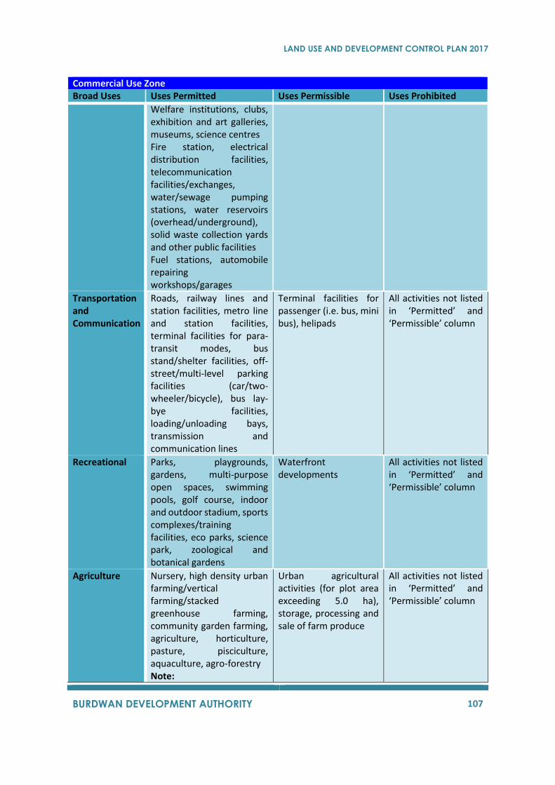
LAND USE AND DEVELOPMENT CONTROL PLAN 2017
BURDWAN DEVELOPMENT AUTHORITY 107
Commercial Use Zone Broad Uses Uses Permitted Uses Permissible Uses Prohibited
Welfare institutions, clubs, exhibition and art galleries, museums, science centres Fire station, electrical distribution facilities, telecommunication facilities/exchanges, water/sewage pumping stations, water reservoirs (overhead/underground), solid waste collection yards and other public facilities Fuel stations, automobile repairing workshops/garages
Transportation and Communication
Roads, railway lines and station facilities, metro line and station facilities, terminal facilities for para-transit modes, bus stand/shelter facilities, off-street/multi-level parking facilities (car/two-wheeler/bicycle), bus lay-bye facilities, loading/unloading bays, transmission and communication lines
Terminal facilities for passenger (i.e. bus, mini bus), helipads
All activities not listed in ‘Permitted’ and ‘Permissible’ column
Recreational
Parks, playgrounds, gardens, multi-purpose open spaces, swimming pools, golf course, indoor and outdoor stadium, sports complexes/training facilities, eco parks, science park, zoological and botanical gardens
Waterfront developments
All activities not listed in ‘Permitted’ and ‘Permissible’ column
Agriculture
Nursery, high density urban farming/vertical farming/stacked greenhouse farming, community garden farming, agriculture, horticulture, pasture, pisciculture, aquaculture, agro-forestry Note:
Urban agricultural activities (for plot area exceeding 5.0 ha), storage, processing and sale of farm produce
All activities not listed in ‘Permitted’ and ‘Permissible’ column
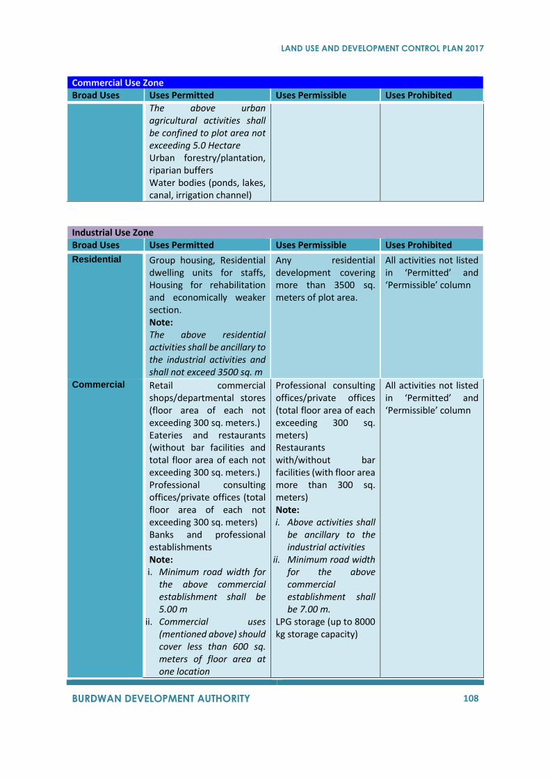
LAND USE AND DEVELOPMENT CONTROL PLAN 2017
BURDWAN DEVELOPMENT AUTHORITY 108
Commercial Use Zone Broad Uses Uses Permitted Uses Permissible Uses Prohibited
The above urban agricultural activities shall be confined to plot area not exceeding 5.0 Hectare Urban forestry/plantation, riparian buffers Water bodies (ponds, lakes, canal, irrigation channel)
Industrial Use Zone Broad Uses Uses Permitted Uses Permissible Uses Prohibited
Residential
Group housing, Residential dwelling units for staffs, Housing for rehabilitation and economically weaker section. Note: The above residential activities shall be ancillary to the industrial activities and shall not exceed 3500 sq. m
Any residential development covering more than 3500 sq. meters of plot area.
All activities not listed in ‘Permitted’ and ‘Permissible’ column
Commercial
Retail commercial shops/departmental stores (floor area of each not exceeding 300 sq. meters.) Eateries and restaurants (without bar facilities and total floor area of each not exceeding 300 sq. meters.) Professional consulting offices/private offices (total floor area of each not exceeding 300 sq. meters) Banks and professional establishments Note: i. Minimum road width for
the above commercial establishment shall be 5.00 m
ii. Commercial uses (mentioned above) should cover less than 600 sq. meters of floor area at one location
Professional consulting offices/private offices (total floor area of each exceeding 300 sq. meters) Restaurants with/without bar facilities (with floor area more than 300 sq. meters) Note: i. Above activities shall
be ancillary to the industrial activities
ii. Minimum road width for the above commercial establishment shall be 7.00 m.
LPG storage (up to 8000 kg storage capacity)
All activities not listed in ‘Permitted’ and ‘Permissible’ column

LAND USE AND DEVELOPMENT CONTROL PLAN 2017
BURDWAN DEVELOPMENT AUTHORITY 109
Industrial Use Zone Broad Uses Uses Permitted Uses Permissible Uses Prohibited
Fuel stations, automobile repairing workshops/garages Storage/warehousing (involving/not involving perishable, inflammable, explosive or other kinds of hazardous materials) including ancillary activities Storage, segregation and sale of second hand/ junk goods/ recyclable
Industrial
Industries listed under "EXEMPTED" category of WBPCB (all scale) Industries listed under "GREEN" category of WBPCB (all scale) Industries listed under "ORANGE" category of WBPCB
Industries listed under "ORDINARY RED" category of WBPCB Industries listed under "SPECIAL RED” category of WBPCB
All activities not listed in ‘Permitted’ and ‘Permissible’ column
Note: Permission should be given subject to
• Categories of the industries will be as per Annexure III
• noise generation limited to the prescriptions of the Ministry of Environment and Forest, Government of India., for industrial areas
• adherence to the emission/discharge standard prescribed by WBPCB adherence to the fire safety norms laid down in the Nation Building Code of India and West Bengal Fire Services Act 1950 (West Bengal Act XVIII of 1950), if applicable
Public/Semi-Public
Government/semi-government offices, post Office, police station, public distribution services (e.g. milk booths, electricity offices, telecommunication offices, postal services), public toilets. Health clinics, dispensaries, nursing homes and health centres (up to 500 sq. mt. of floor area), diagnostic centres Note: The above health facilities should not exclusively treat
Solid/industrial waste(hazardous) treatment units including disposal facilities, solar power installations, alternative energy installations
All activities not listed in ‘Permitted’ and ‘Permissible’ column.
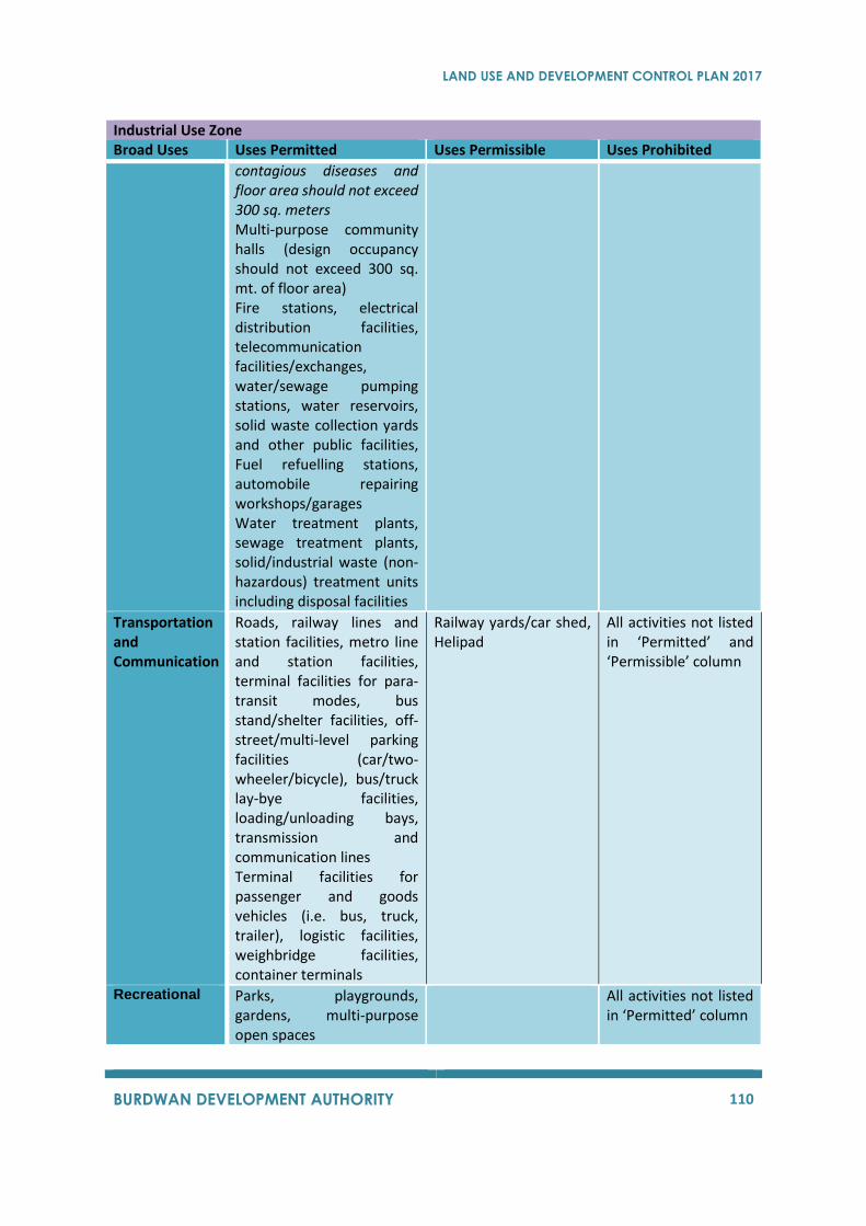
LAND USE AND DEVELOPMENT CONTROL PLAN 2017
BURDWAN DEVELOPMENT AUTHORITY 110
Industrial Use Zone Broad Uses Uses Permitted Uses Permissible Uses Prohibited
contagious diseases and floor area should not exceed 300 sq. meters Multi-purpose community halls (design occupancy should not exceed 300 sq. mt. of floor area) Fire stations, electrical distribution facilities, telecommunication facilities/exchanges, water/sewage pumping stations, water reservoirs, solid waste collection yards and other public facilities, Fuel refuelling stations, automobile repairing workshops/garages Water treatment plants, sewage treatment plants, solid/industrial waste (non-hazardous) treatment units including disposal facilities
Transportation and Communication
Roads, railway lines and station facilities, metro line and station facilities, terminal facilities for para-transit modes, bus stand/shelter facilities, off-street/multi-level parking facilities (car/two-wheeler/bicycle), bus/truck lay-bye facilities, loading/unloading bays, transmission and communication lines Terminal facilities for passenger and goods vehicles (i.e. bus, truck, trailer), logistic facilities, weighbridge facilities, container terminals
Railway yards/car shed, Helipad
All activities not listed in ‘Permitted’ and ‘Permissible’ column
Recreational
Parks, playgrounds, gardens, multi-purpose open spaces
All activities not listed in ‘Permitted’ column
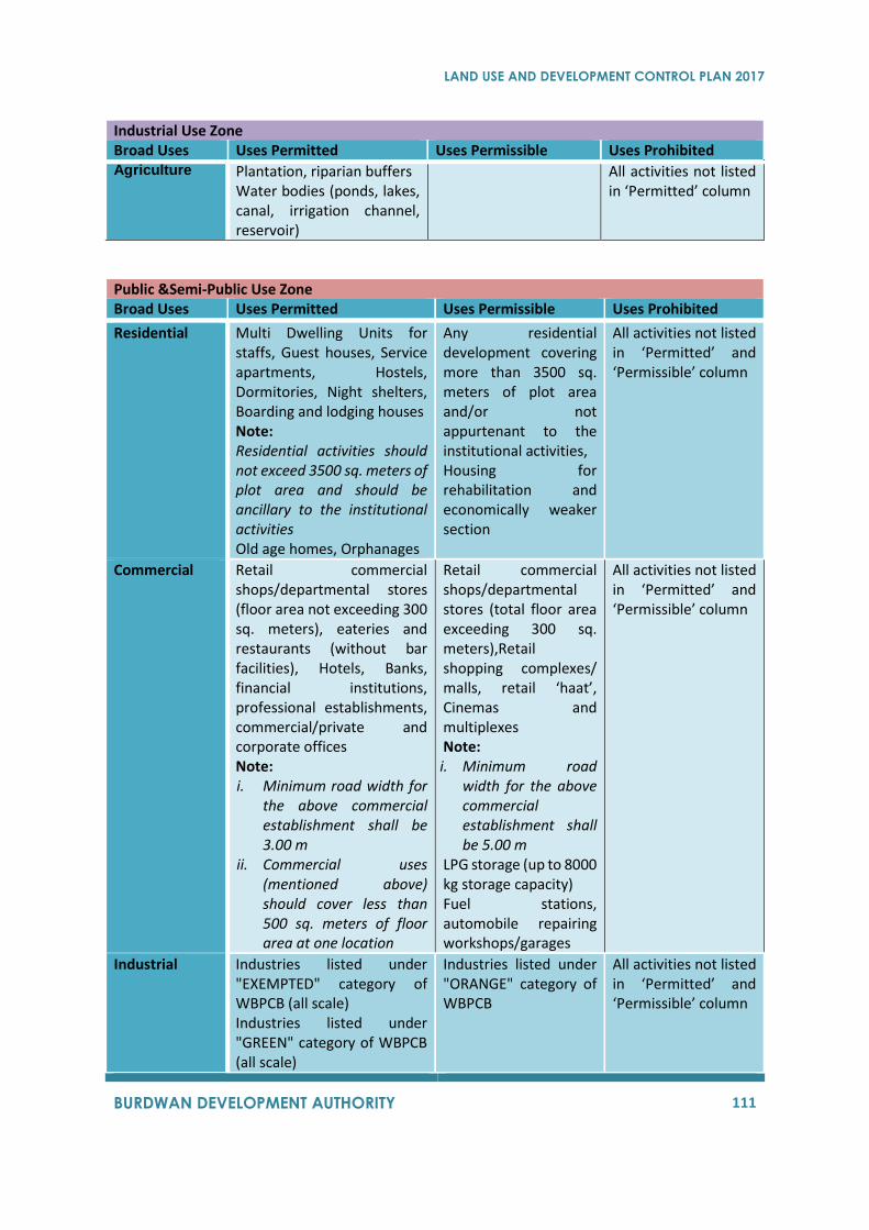
LAND USE AND DEVELOPMENT CONTROL PLAN 2017
BURDWAN DEVELOPMENT AUTHORITY 111
Industrial Use Zone Broad Uses Uses Permitted Uses Permissible Uses Prohibited Agriculture
Plantation, riparian buffers Water bodies (ponds, lakes, canal, irrigation channel, reservoir)
All activities not listed in ‘Permitted’ column
Public &Semi-Public Use Zone Broad Uses Uses Permitted Uses Permissible Uses Prohibited
Residential Multi Dwelling Units for staffs, Guest houses, Service apartments, Hostels, Dormitories, Night shelters, Boarding and lodging houses Note: Residential activities should not exceed 3500 sq. meters of plot area and should be ancillary to the institutional activities Old age homes, Orphanages
Any residential development covering more than 3500 sq. meters of plot area and/or not appurtenant to the institutional activities, Housing for rehabilitation and economically weaker section
All activities not listed in ‘Permitted’ and ‘Permissible’ column
Commercial Retail commercial shops/departmental stores (floor area not exceeding 300 sq. meters), eateries and restaurants (without bar facilities), Hotels, Banks, financial institutions, professional establishments, commercial/private and corporate offices Note: i. Minimum road width for
the above commercial establishment shall be 3.00 m
ii. Commercial uses (mentioned above) should cover less than 500 sq. meters of floor area at one location
Retail commercial shops/departmental stores (total floor area exceeding 300 sq. meters),Retail shopping complexes/ malls, retail ‘haat’, Cinemas and multiplexes Note: i. Minimum road
width for the above commercial establishment shall be 5.00 m
LPG storage (up to 8000 kg storage capacity) Fuel stations, automobile repairing workshops/garages
All activities not listed in ‘Permitted’ and ‘Permissible’ column
Industrial
Industries listed under "EXEMPTED" category of WBPCB (all scale) Industries listed under "GREEN" category of WBPCB (all scale)
Industries listed under "ORANGE" category of WBPCB
All activities not listed in ‘Permitted’ and ‘Permissible’ column
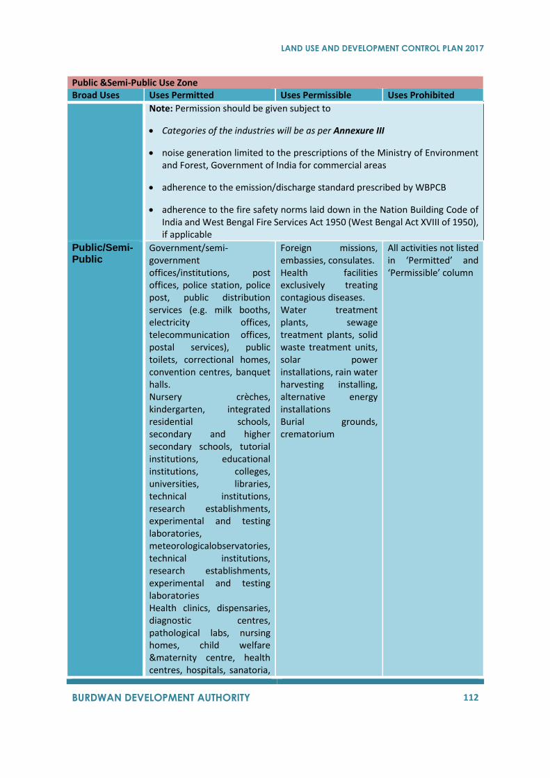
LAND USE AND DEVELOPMENT CONTROL PLAN 2017
BURDWAN DEVELOPMENT AUTHORITY 112
Public &Semi-Public Use Zone Broad Uses Uses Permitted Uses Permissible Uses Prohibited
Note: Permission should be given subject to
• Categories of the industries will be as per Annexure III
• noise generation limited to the prescriptions of the Ministry of Environment and Forest, Government of India for commercial areas
• adherence to the emission/discharge standard prescribed by WBPCB
• adherence to the fire safety norms laid down in the Nation Building Code of India and West Bengal Fire Services Act 1950 (West Bengal Act XVIII of 1950), if applicable
Public/Semi-Public
Government/semi-government offices/institutions, post offices, police station, police post, public distribution services (e.g. milk booths, electricity offices, telecommunication offices, postal services), public toilets, correctional homes, convention centres, banquet halls. Nursery crèches, kindergarten, integrated residential schools, secondary and higher secondary schools, tutorial institutions, educational institutions, colleges, universities, libraries, technical institutions, research establishments, experimental and testing laboratories, meteorologicalobservatories, technical institutions, research establishments, experimental and testing laboratories Health clinics, dispensaries, diagnostic centres, pathological labs, nursing homes, child welfare &maternity centre, health centres, hospitals, sanatoria,
Foreign missions, embassies, consulates. Health facilities exclusively treating contagious diseases. Water treatment plants, sewage treatment plants, solid waste treatment units, solar power installations, rain water harvesting installing, alternative energy installations Burial grounds, crematorium
All activities not listed in ‘Permitted’ and ‘Permissible’ column
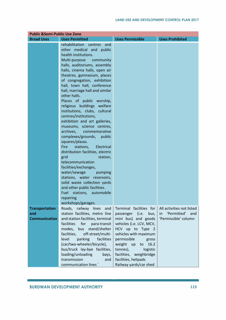
LAND USE AND DEVELOPMENT CONTROL PLAN 2017
BURDWAN DEVELOPMENT AUTHORITY 113
Public &Semi-Public Use Zone Broad Uses Uses Permitted Uses Permissible Uses Prohibited
rehabilitation centres and other medical and public health institutions. Multi-purpose community halls, auditoriums, assembly halls, cinema halls, open air theatres, gymnasium, places of congregation, exhibition hall, town hall, conference hall, marriage hall and similar other halls. Places of public worship, religious buildings welfare institutions, clubs, cultural centres/institutions, exhibition and art galleries, museums, science centres, archives, commemorative complexes/grounds, public squares/plazas. Fire stations, Electrical distribution facilities, electric grid station, telecommunication facilities/exchanges, water/sewage pumping stations, water reservoirs, solid waste collection yards and other public facilities. Fuel stations, automobile repairing workshops/garages.
Transportation and Communication
Roads, railway lines and station facilities, metro line and station facilities, terminal facilities for para-transit modes, bus stand/shelter facilities, off-street/multi-level parking facilities (car/two-wheeler/bicycle), bus/truck lay-bye facilities, loading/unloading bays, transmission and communication lines `
Terminal facilities for passenger (i.e. bus, mini bus) and goods vehicles (i.e. LCV, MCV, HCV up to Type 2 vehicles with maximum permissible gross weight up to 16.2 tonnes), logistic facilities, weighbridge facilities, helipads Railway yards/car shed
All activities not listed in ‘Permitted’ and ‘Permissible’ column
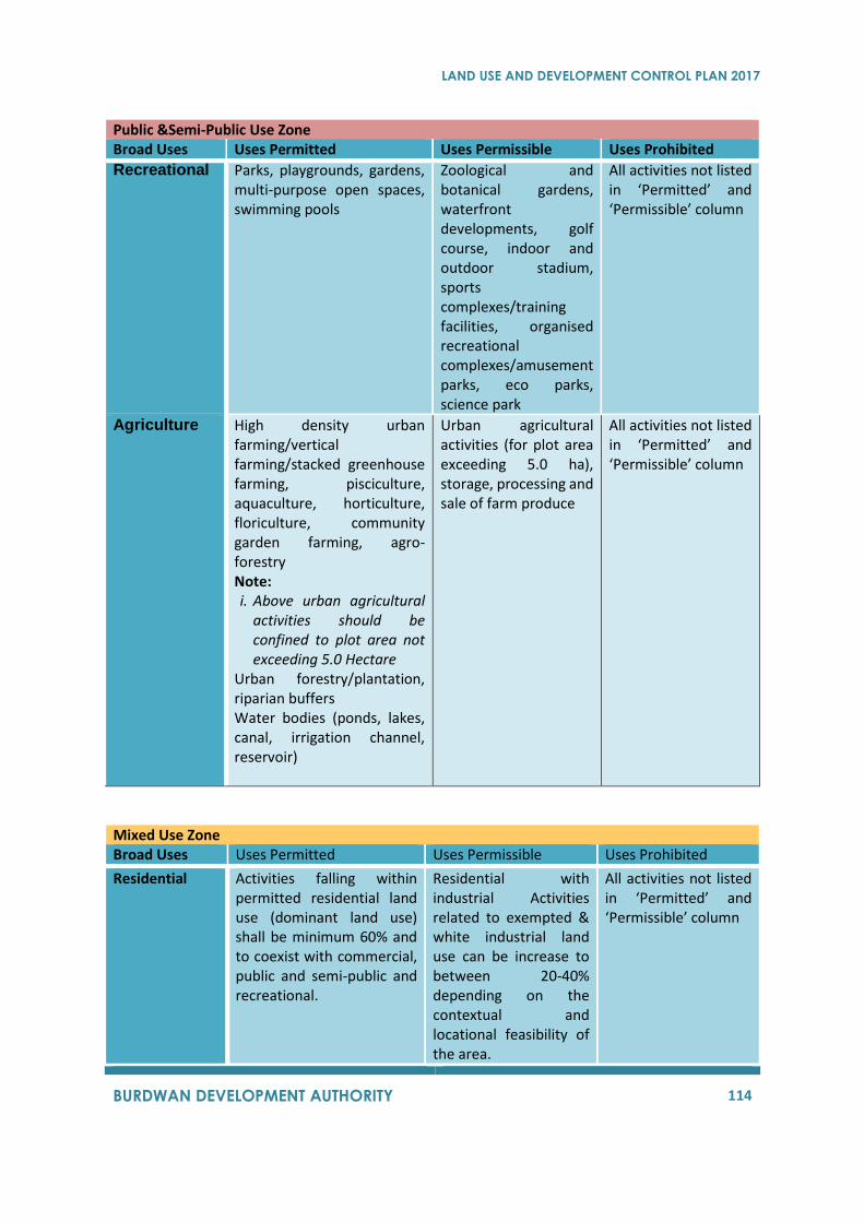
LAND USE AND DEVELOPMENT CONTROL PLAN 2017
BURDWAN DEVELOPMENT AUTHORITY 114
Public &Semi-Public Use Zone Broad Uses Uses Permitted Uses Permissible Uses Prohibited
Recreational Parks, playgrounds, gardens, multi-purpose open spaces, swimming pools
Zoological and botanical gardens, waterfront developments, golf course, indoor and outdoor stadium, sports complexes/training facilities, organised recreational complexes/amusement parks, eco parks, science park
All activities not listed in ‘Permitted’ and ‘Permissible’ column
Agriculture High density urban farming/vertical farming/stacked greenhouse farming, pisciculture, aquaculture, horticulture, floriculture, community garden farming, agro-forestry Note: i. Above urban agricultural
activities should be confined to plot area not exceeding 5.0 Hectare
Urban forestry/plantation, riparian buffers Water bodies (ponds, lakes, canal, irrigation channel, reservoir)
Urban agricultural activities (for plot area exceeding 5.0 ha), storage, processing and sale of farm produce
All activities not listed in ‘Permitted’ and ‘Permissible’ column
Mixed Use Zone Broad Uses Uses Permitted Uses Permissible Uses Prohibited
Residential Activities falling within permitted residential land use (dominant land use) shall be minimum 60% and to coexist with commercial, public and semi-public and recreational.
Residential with industrial Activities related to exempted & white industrial land use can be increase to between 20-40% depending on the contextual and locational feasibility of the area.
All activities not listed in ‘Permitted’ and ‘Permissible’ column
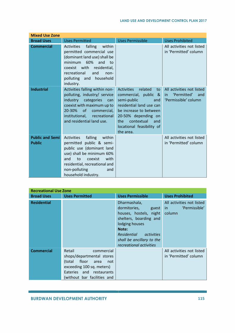
LAND USE AND DEVELOPMENT CONTROL PLAN 2017
BURDWAN DEVELOPMENT AUTHORITY 115
Mixed Use Zone Broad Uses Uses Permitted Uses Permissible Uses Prohibited
Commercial Activities falling within permitted commercial use (dominant land use) shall be minimum 60% and to coexist with residential, recreational and non-polluting and household industry.
All activities not listed in ‘Permitted’ column
Industrial Activities falling within non-polluting, industry/ service industry categories can coexist with maximum up to 20-30% of commercial, institutional, recreational and residential land use.
Activities related to commercial, public & semi-public and residential land use can be increase to between 20-50% depending on the contextual and locational feasibility of the area.
All activities not listed in ‘Permitted’ and ‘Permissible’ column
Public and Semi Public
Activities falling within permitted public & semi-public use (dominant land use) shall be minimum 60% and to coexist with residential, recreational and non-polluting and household industry.
All activities not listed in ‘Permitted’ column
Recreational Use Zone Broad Uses Uses Permitted Uses Permissible Uses Prohibited
Residential Dharmashala, dormitories, guest houses, hostels, night shelters, boarding and lodging houses Note: Residential activities shall be ancillary to the recreational activities
All activities not listed in ‘Permissible’ column
Commercial Retail commercial shops/departmental stores (total floor area not exceeding 100 sq. meters) Eateries and restaurants (without bar facilities and
All activities not listed in ‘Permitted’ column
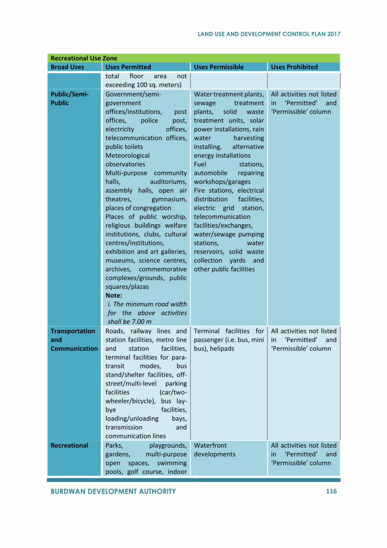
LAND USE AND DEVELOPMENT CONTROL PLAN 2017
BURDWAN DEVELOPMENT AUTHORITY 116
Recreational Use Zone Broad Uses Uses Permitted Uses Permissible Uses Prohibited
total floor area not exceeding 100 sq. meters)
Public/Semi-Public
Government/semi-government offices/institutions, post offices, police post, electricity offices, telecommunication offices, public toilets Meteorological observatories Multi-purpose community halls, auditoriums, assembly halls, open air theatres, gymnasium, places of congregation Places of public worship, religious buildings welfare institutions, clubs, cultural centres/institutions, exhibition and art galleries, museums, science centres, archives, commemorative complexes/grounds, public squares/plazas Note: i. The minimum road width for the above activities shall be 7.00 m
Water treatment plants, sewage treatment plants, solid waste treatment units, solar power installations, rain water harvesting installing, alternative energy installations Fuel stations, automobile repairing workshops/garages Fire stations, electrical distribution facilities, electric grid station, telecommunication facilities/exchanges, water/sewage pumping stations, water reservoirs, solid waste collection yards and other public facilities
All activities not listed in ‘Permitted’ and ‘Permissible’ column
Transportation and Communication
Roads, railway lines and station facilities, metro line and station facilities, terminal facilities for para-transit modes, bus stand/shelter facilities, off-street/multi-level parking facilities (car/two-wheeler/bicycle), bus lay-bye facilities, loading/unloading bays, transmission and communication lines
Terminal facilities for passenger (i.e. bus, mini bus), helipads
All activities not listed in ‘Permitted’ and ‘Permissible’ column
Recreational Parks, playgrounds, gardens, multi-purpose open spaces, swimming pools, golf course, indoor
Waterfront developments
All activities not listed in ‘Permitted’ and ‘Permissible’ column
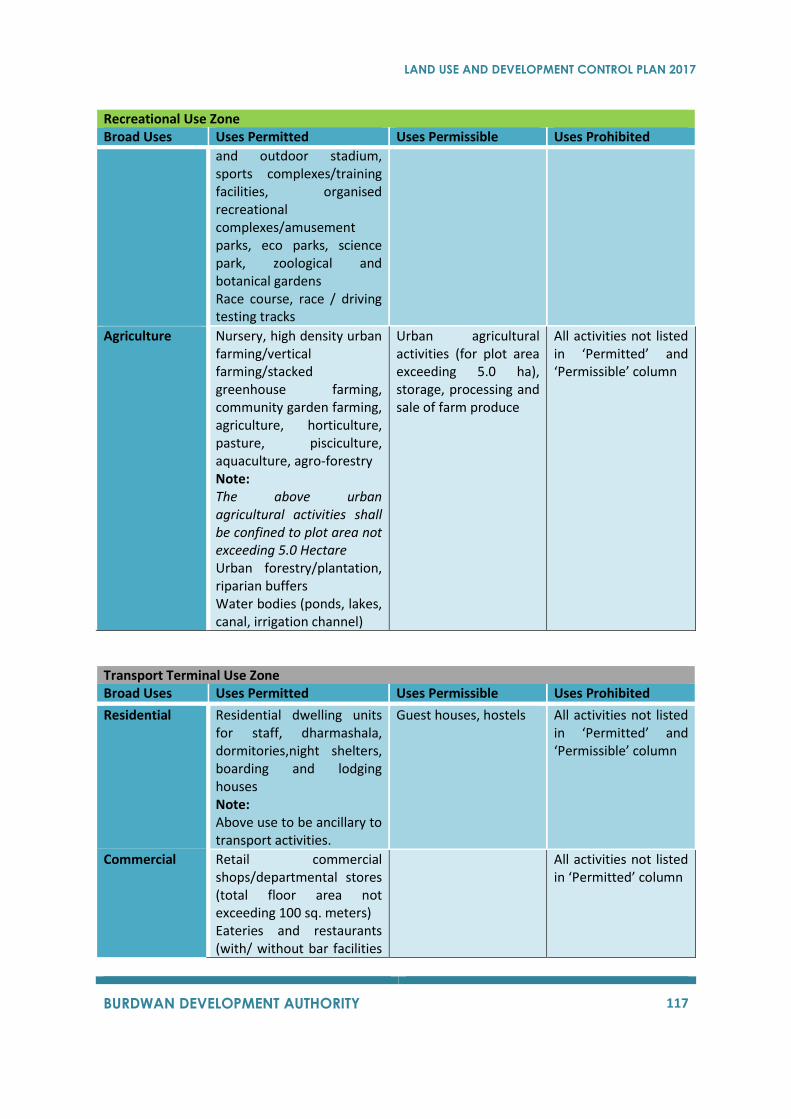
LAND USE AND DEVELOPMENT CONTROL PLAN 2017
BURDWAN DEVELOPMENT AUTHORITY 117
Recreational Use Zone Broad Uses Uses Permitted Uses Permissible Uses Prohibited
and outdoor stadium, sports complexes/training facilities, organised recreational complexes/amusement parks, eco parks, science park, zoological and botanical gardens Race course, race / driving testing tracks
Agriculture Nursery, high density urban farming/vertical farming/stacked greenhouse farming, community garden farming, agriculture, horticulture, pasture, pisciculture, aquaculture, agro-forestry Note: The above urban agricultural activities shall be confined to plot area not exceeding 5.0 Hectare Urban forestry/plantation, riparian buffers Water bodies (ponds, lakes, canal, irrigation channel)
Urban agricultural activities (for plot area exceeding 5.0 ha), storage, processing and sale of farm produce
All activities not listed in ‘Permitted’ and ‘Permissible’ column
Transport Terminal Use Zone Broad Uses Uses Permitted Uses Permissible Uses Prohibited
Residential Residential dwelling units for staff, dharmashala, dormitories,night shelters, boarding and lodging houses Note: Above use to be ancillary to transport activities.
Guest houses, hostels All activities not listed in ‘Permitted’ and ‘Permissible’ column
Commercial Retail commercial shops/departmental stores (total floor area not exceeding 100 sq. meters) Eateries and restaurants (with/ without bar facilities
All activities not listed in ‘Permitted’ column
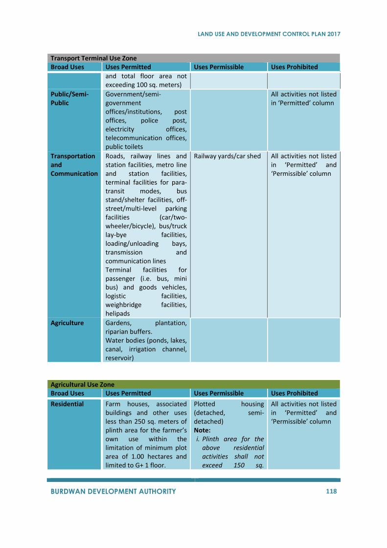
LAND USE AND DEVELOPMENT CONTROL PLAN 2017
BURDWAN DEVELOPMENT AUTHORITY 118
Transport Terminal Use Zone Broad Uses Uses Permitted Uses Permissible Uses Prohibited
and total floor area not exceeding 100 sq. meters)
Public/Semi-Public
Government/semi-government offices/institutions, post offices, police post, electricity offices, telecommunication offices, public toilets
All activities not listed in ‘Permitted’ column
Transportation and Communication
Roads, railway lines and station facilities, metro line and station facilities, terminal facilities for para-transit modes, bus stand/shelter facilities, off-street/multi-level parking facilities (car/two-wheeler/bicycle), bus/truck lay-bye facilities, loading/unloading bays, transmission and communication lines Terminal facilities for passenger (i.e. bus, mini bus) and goods vehicles, logistic facilities, weighbridge facilities, helipads
Railway yards/car shed All activities not listed in ‘Permitted’ and ‘Permissible’ column
Agriculture Gardens, plantation, riparian buffers. Water bodies (ponds, lakes, canal, irrigation channel, reservoir)
Agricultural Use Zone Broad Uses Uses Permitted Uses Permissible Uses Prohibited
Residential
Farm houses, associated buildings and other uses less than 250 sq. meters of plinth area for the farmer’s own use within the limitation of minimum plot area of 1.00 hectares and limited to G+ 1 floor.
Plotted housing (detached, semi-detached) Note: i. Plinth area for the
above residential activities shall not exceed 150 sq.
All activities not listed in ‘Permitted’ and ‘Permissible’ column
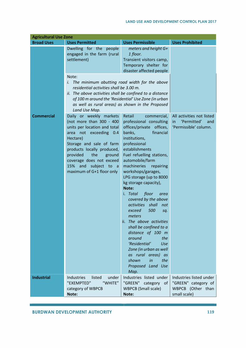
LAND USE AND DEVELOPMENT CONTROL PLAN 2017
BURDWAN DEVELOPMENT AUTHORITY 119
Agricultural Use Zone Broad Uses Uses Permitted Uses Permissible Uses Prohibited
Dwelling for the people engaged in the farm (rural settlement)
meters and height G+ 1 floor.
Transient visitors camp, Temporary shelter for disaster affected people
Note: i. The minimum abutting road width for the above
residential activities shall be 3.00 m. ii. The above activities shall be confined to a distance
of 100 m around the ‘Residential’ Use Zone (in urban as well as rural areas) as shown in the Proposed Land Use Map.
Commercial
Daily or weekly markets (not more than 300 - 400 units per location and total area not exceeding 0.4 Hectare) Storage and sale of farm products locally produced, provided the ground coverage does not exceed 15% and subject to a maximum of G+1 floor only
Retail commercial, professional consulting offices/private offices, banks, financial institutions, professional establishments Fuel refuelling stations, automobile/farm machineries repairing workshops/garages, LPG storage (up to 8000 kg storage capacity), Note: i. Total floor area
covered by the above activities shall not exceed 500 sq. meters
ii. The above activities shall be confined to a distance of 100 m around the ‘Residential’ Use Zone (in urban as well as rural areas) as shown in the Proposed Land Use Map.
All activities not listed in ‘Permitted’ and ‘Permissible’ column.
Industrial
Industries listed under "EXEMPTED" “WHITE” category of WBPCB Note:
Industries listed under "GREEN" category of WBPCB (Small scale) Note:
Industries listed under "GREEN" category of WBPCB (Other than small scale)
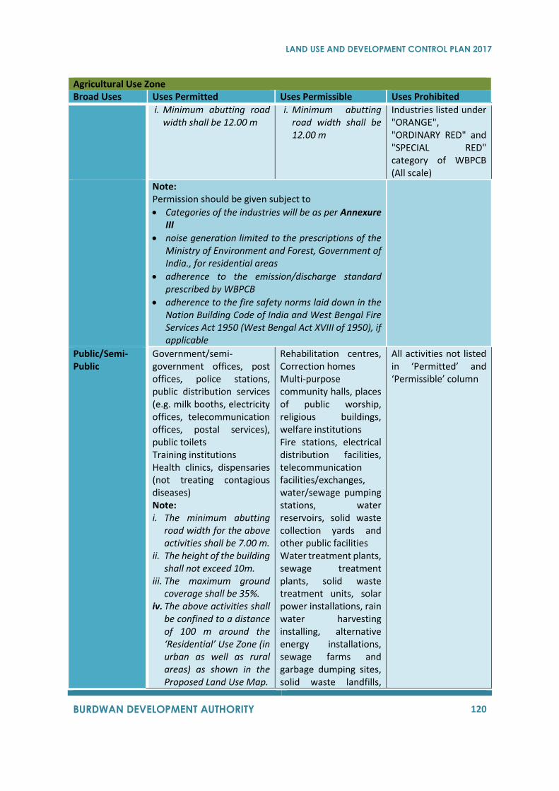
LAND USE AND DEVELOPMENT CONTROL PLAN 2017
BURDWAN DEVELOPMENT AUTHORITY 120
Agricultural Use Zone Broad Uses Uses Permitted Uses Permissible Uses Prohibited
i. Minimum abutting road width shall be 12.00 m
i. Minimum abutting road width shall be 12.00 m
Industries listed under "ORANGE", "ORDINARY RED" and "SPECIAL RED" category of WBPCB (All scale)
Note: Permission should be given subject to
• Categories of the industries will be as per Annexure III
• noise generation limited to the prescriptions of the Ministry of Environment and Forest, Government of India., for residential areas
• adherence to the emission/discharge standard prescribed by WBPCB
• adherence to the fire safety norms laid down in the Nation Building Code of India and West Bengal Fire Services Act 1950 (West Bengal Act XVIII of 1950), if applicable
Public/Semi-Public
Government/semi-government offices, post offices, police stations, public distribution services (e.g. milk booths, electricity offices, telecommunication offices, postal services), public toilets Training institutions Health clinics, dispensaries (not treating contagious diseases) Note: i. The minimum abutting
road width for the above activities shall be 7.00 m.
ii. The height of the building shall not exceed 10m.
iii. The maximum ground coverage shall be 35%.
iv. The above activities shall be confined to a distance of 100 m around the ‘Residential’ Use Zone (in urban as well as rural areas) as shown in the Proposed Land Use Map.
Rehabilitation centres, Correction homes Multi-purpose community halls, places of public worship, religious buildings, welfare institutions Fire stations, electrical distribution facilities, telecommunication facilities/exchanges, water/sewage pumping stations, water reservoirs, solid waste collection yards and other public facilities Water treatment plants, sewage treatment plants, solid waste treatment units, solar power installations, rain water harvesting installing, alternative energy installations, sewage farms and garbage dumping sites, solid waste landfills,
All activities not listed in ‘Permitted’ and ‘Permissible’ column
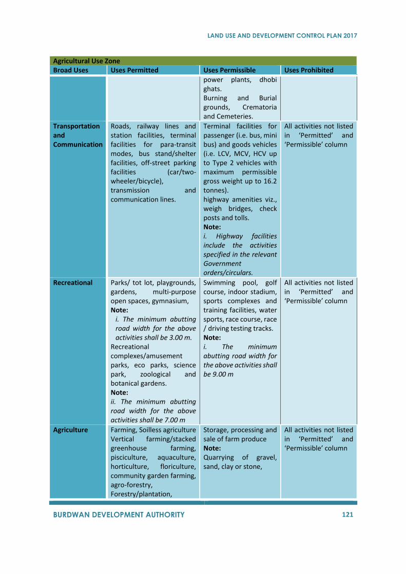
LAND USE AND DEVELOPMENT CONTROL PLAN 2017
BURDWAN DEVELOPMENT AUTHORITY 121
Agricultural Use Zone Broad Uses Uses Permitted Uses Permissible Uses Prohibited
power plants, dhobi ghats. Burning and Burial grounds, Crematoria and Cemeteries.
Transportation and Communication
Roads, railway lines and station facilities, terminal facilities for para-transit modes, bus stand/shelter facilities, off-street parking facilities (car/two-wheeler/bicycle), transmission and communication lines.
Terminal facilities for passenger (i.e. bus, mini bus) and goods vehicles (i.e. LCV, MCV, HCV up to Type 2 vehicles with maximum permissible gross weight up to 16.2 tonnes). highway amenities viz., weigh bridges, check posts and tolls. Note: i. Highway facilities include the activities specified in the relevant Government orders/circulars.
All activities not listed in ‘Permitted’ and ‘Permissible’ column
Recreational
Parks/ tot lot, playgrounds, gardens, multi-purpose open spaces, gymnasium, Note:
i. The minimum abutting road width for the above activities shall be 3.00 m.
Recreational complexes/amusement parks, eco parks, science park, zoological and botanical gardens. Note: ii. The minimum abutting road width for the above activities shall be 7.00 m
Swimming pool, golf course, indoor stadium, sports complexes and training facilities, water sports, race course, race / driving testing tracks. Note: i. The minimum abutting road width for the above activities shall be 9.00 m
All activities not listed in ‘Permitted’ and ‘Permissible’ column
Agriculture
Farming, Soilless agriculture Vertical farming/stacked greenhouse farming, pisciculture, aquaculture, horticulture, floriculture, community garden farming, agro-forestry, Forestry/plantation,
Storage, processing and sale of farm produce Note: Quarrying of gravel, sand, clay or stone,
All activities not listed in ‘Permitted’ and ‘Permissible’ column
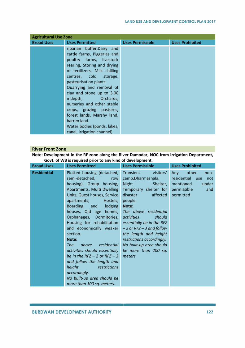
LAND USE AND DEVELOPMENT CONTROL PLAN 2017
BURDWAN DEVELOPMENT AUTHORITY 122
Agricultural Use Zone Broad Uses Uses Permitted Uses Permissible Uses Prohibited
riparian buffer,Dairy and cattle farms, Piggeries and poultry farms, livestock rearing, Storing and drying of fertilizers, Milk chilling centres, cold storage, pasteurisation plants Quarrying and removal of clay and stone up to 3.00 mdepth, Orchards, nurseries and other stable crops, grazing pastures, forest lands, Marshy land, barren land. Water bodies (ponds, lakes, canal, irrigation channel)
River Front Zone Note: Development in the RF zone along the River Damodar, NOC from Irrigation Department,
Govt. of WB is required prior to any kind of development. Broad Uses Uses Permitted Uses Permissible Uses Prohibited
Residential
Plotted housing (detached, semi-detached, row housing), Group housing, Apartments, Multi Dwelling Units, Guest houses, Service apartments, Hostels, Boarding and lodging houses, Old age homes, Orphanages, Dormitories, Housing for rehabilitation and economically weaker section. Note: The above residential activities should essentially be in the RFZ – 2 or RFZ – 3 and follow the length and height restrictions accordingly. No built-up area should be more than 100 sq. meters.
Transient visitors’ camp,Dharmashala, Night Shelter, Temporary shelter for disaster affected people. Note: The above residential activities should essentially be in the RFZ – 2 or RFZ – 3 and follow the length and height restrictions accordingly. No built-up area should be more than 200 sq. meters.
Any other non-residential use not mentioned under permissible and permitted
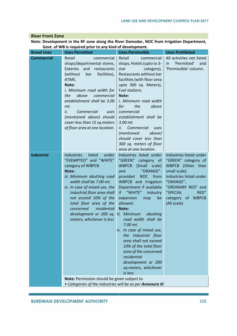
LAND USE AND DEVELOPMENT CONTROL PLAN 2017
BURDWAN DEVELOPMENT AUTHORITY 123
River Front Zone Note: Development in the RF zone along the River Damodar, NOC from Irrigation Department,
Govt. of WB is required prior to any kind of development. Broad Uses Uses Permitted Uses Permissible Uses Prohibited
Commercial
Retail commercial shops/departmental stores, Eateries and restaurants (without bar facilities), ATMS. Note: i. Minimum road width for the above commercial establishment shall be 3.00 mt. ii. Commercial uses (mentioned above) should cover less than 15 sq.meters of floor area at one location.
Retail commercial shops, Hotels (upto to 3-star category), Restaurants without bar facilities (with floor area upto 300 sq. Meters), Fuel stations Note: i. Minimum road width for the above commercial establishment shall be 3.00 mt. ii. Commercial uses (mentioned above) should cover less than 300 sq. meters of floor area at one location.
All activities not listed in ‘Permitted’ and ‘Permissible’ column.
Industrial
Industries listed under "EXEMPTED" and “WHITE” category of WBPCB Note: iii. Minimum abutting road
width shall be 7.00 mt. iv. In case of mixed use, the
industrial floor area shall not exceed 10% of the total floor area of the concerned residential development or 200 sq. meters, whichever is less
Industries listed under "GREEN" category of WBPCB (Small scale) and “ORANGE”- provided NOC from WBPCB and Irrigation Department if available if “WHITE” industry expansion may be allowed. Note:
iii. Minimum abutting road width shall be 7.00 mt.
iv. In case of mixed use, the industrial floor area shall not exceed 10% of the total floor area of the concerned residential development or 200 sq.meters, whichever is less
Industries listed under "GREEN" category of WBPCB (Other than small scale) Industries listed under "ORANGE", "ORDINARY RED" and "SPECIAL RED" category of WBPCB (All scale)
Note: Permission should be given subject to • Categories of the industries will be as per Annexure III
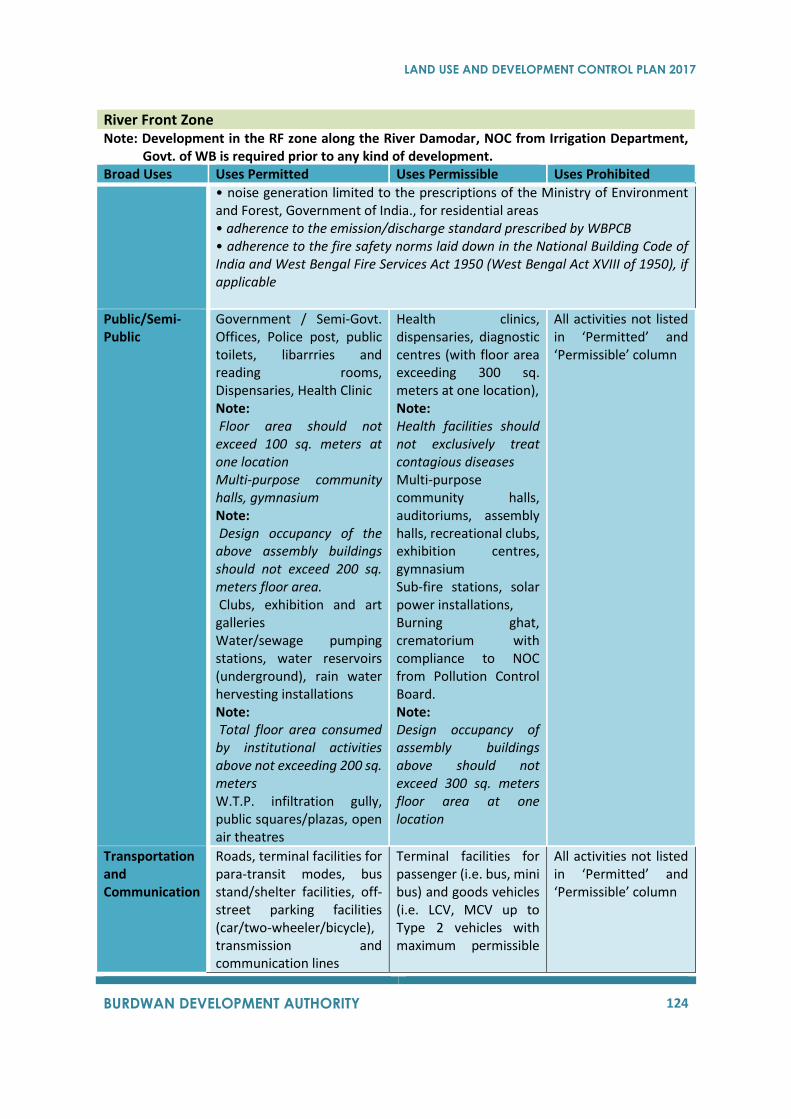
LAND USE AND DEVELOPMENT CONTROL PLAN 2017
BURDWAN DEVELOPMENT AUTHORITY 124
River Front Zone Note: Development in the RF zone along the River Damodar, NOC from Irrigation Department,
Govt. of WB is required prior to any kind of development. Broad Uses Uses Permitted Uses Permissible Uses Prohibited
• noise generation limited to the prescriptions of the Ministry of Environment and Forest, Government of India., for residential areas • adherence to the emission/discharge standard prescribed by WBPCB • adherence to the fire safety norms laid down in the National Building Code of India and West Bengal Fire Services Act 1950 (West Bengal Act XVIII of 1950), if applicable
Public/Semi-Public
Government / Semi-Govt. Offices, Police post, public toilets, libarrries and reading rooms, Dispensaries, Health Clinic Note: Floor area should not exceed 100 sq. meters at one location Multi-purpose community halls, gymnasium Note: Design occupancy of the above assembly buildings should not exceed 200 sq. meters floor area. Clubs, exhibition and art galleries Water/sewage pumping stations, water reservoirs (underground), rain water hervesting installations Note: Total floor area consumed by institutional activities above not exceeding 200 sq. meters W.T.P. infiltration gully, public squares/plazas, open air theatres
Health clinics, dispensaries, diagnostic centres (with floor area exceeding 300 sq. meters at one location), Note: Health facilities should not exclusively treat contagious diseases Multi-purpose community halls, auditoriums, assembly halls, recreational clubs, exhibition centres, gymnasium Sub-fire stations, solar power installations, Burning ghat, crematorium with compliance to NOC from Pollution Control Board. Note: Design occupancy of assembly buildings above should not exceed 300 sq. meters floor area at one location
All activities not listed in ‘Permitted’ and ‘Permissible’ column
Transportation and Communication
Roads, terminal facilities for para-transit modes, bus stand/shelter facilities, off-street parking facilities (car/two-wheeler/bicycle), transmission and communication lines
Terminal facilities for passenger (i.e. bus, mini bus) and goods vehicles (i.e. LCV, MCV up to Type 2 vehicles with maximum permissible
All activities not listed in ‘Permitted’ and ‘Permissible’ column
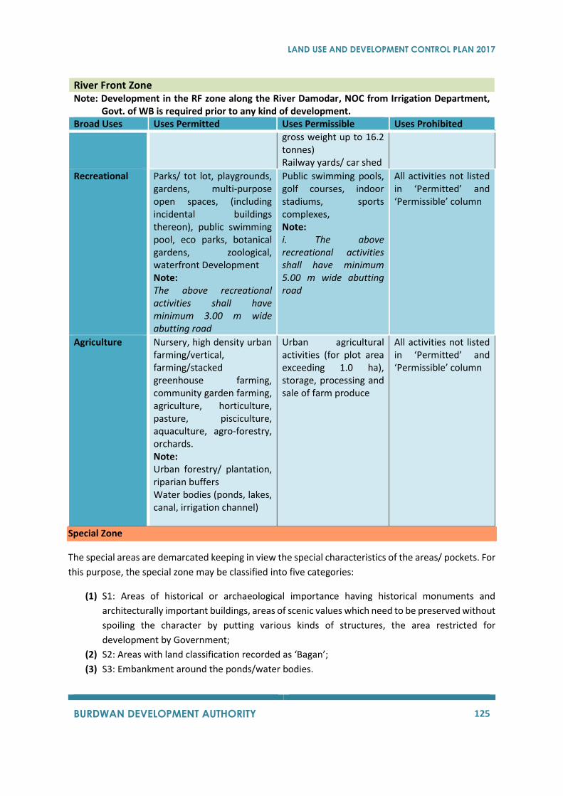
LAND USE AND DEVELOPMENT CONTROL PLAN 2017
BURDWAN DEVELOPMENT AUTHORITY 125
River Front Zone Note: Development in the RF zone along the River Damodar, NOC from Irrigation Department,
Govt. of WB is required prior to any kind of development. Broad Uses Uses Permitted Uses Permissible Uses Prohibited
gross weight up to 16.2 tonnes) Railway yards/ car shed
Recreational
Parks/ tot lot, playgrounds, gardens, multi-purpose open spaces, (including incidental buildings thereon), public swimming pool, eco parks, botanical gardens, zoological, waterfront Development Note: The above recreational activities shall have minimum 3.00 m wide abutting road
Public swimming pools, golf courses, indoor stadiums, sports complexes, Note: i. The above recreational activities shall have minimum 5.00 m wide abutting road
All activities not listed in ‘Permitted’ and ‘Permissible’ column
Agriculture
Nursery, high density urban farming/vertical, farming/stacked greenhouse farming, community garden farming, agriculture, horticulture, pasture, pisciculture, aquaculture, agro-forestry, orchards. Note: Urban forestry/ plantation, riparian buffers Water bodies (ponds, lakes, canal, irrigation channel)
Urban agricultural activities (for plot area exceeding 1.0 ha), storage, processing and sale of farm produce
All activities not listed in ‘Permitted’ and ‘Permissible’ column
Special Zone
The special areas are demarcated keeping in view the special characteristics of the areas/ pockets. For
this purpose, the special zone may be classified into five categories:
(1) S1: Areas of historical or archaeological importance having historical monuments and
architecturally important buildings, areas of scenic values which need to be preserved without
spoiling the character by putting various kinds of structures, the area restricted for
development by Government;
(2) S2: Areas with land classification recorded as ‘Bagan’;
(3) S3: Embankment around the ponds/water bodies.
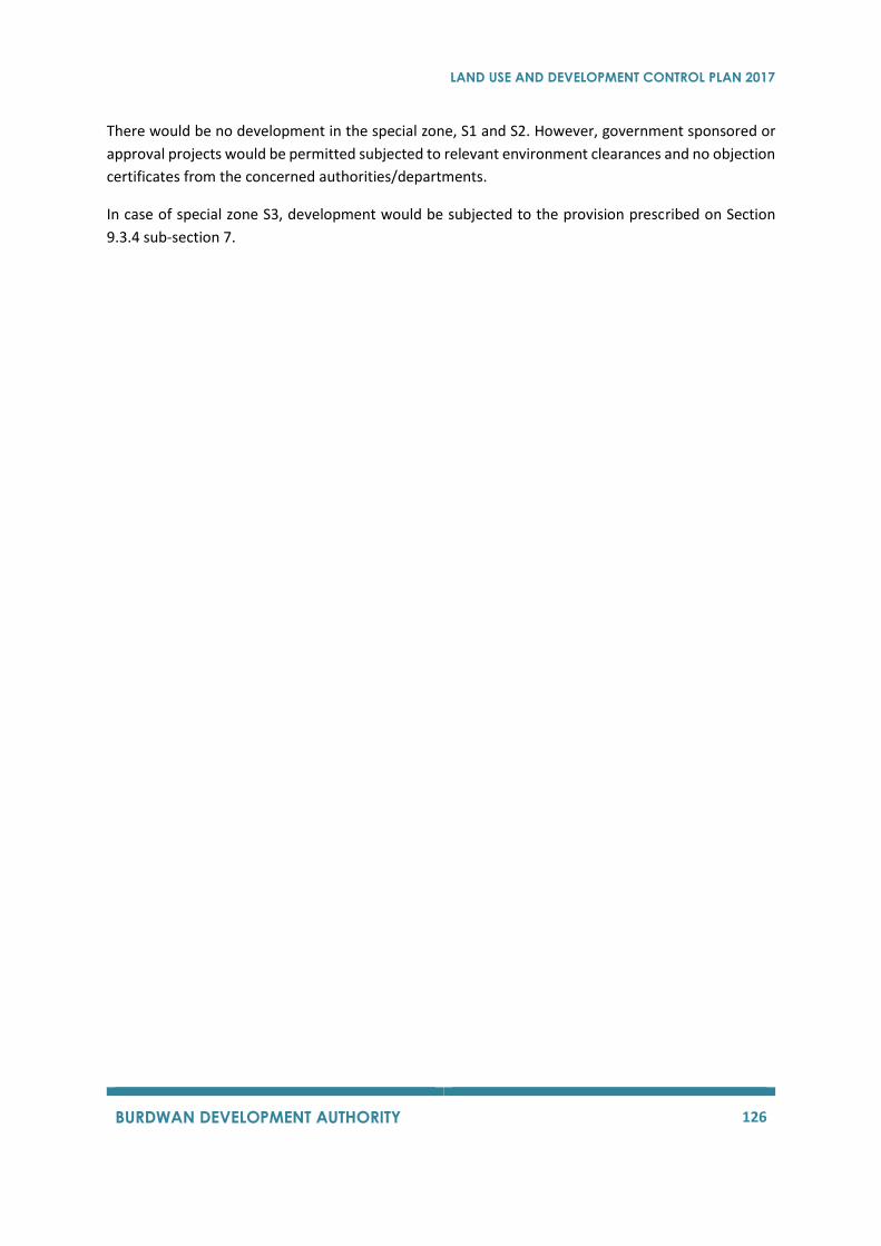
LAND USE AND DEVELOPMENT CONTROL PLAN 2017
BURDWAN DEVELOPMENT AUTHORITY 126
There would be no development in the special zone, S1 and S2. However, government sponsored or
approval projects would be permitted subjected to relevant environment clearances and no objection
certificates from the concerned authorities/departments.
In case of special zone S3, development would be subjected to the provision prescribed on Section
9.3.4 sub-section 7.
LAND USE AND DEVELOPMENT CONTROL PLAN 2017
BURDWAN DEVELOPMENT AUTHORITY 127
9.2 LEVY OF DEVELOPMENT CHARGES Levy, assessment and recovery of Development charges (as outlined in Chapter IX, Section 102, 103,
104, 105 and 106 of the West Bengal Town & Country Planning and Development Act, 1979):
All activities listed under 'Residential use' in each Development Control Zone (entries in the first
column of the table) of the Land Use and Development Control Plan, under taken in any land, will be
accounted as 'residence' for fixing the rates of development charges for the institution of use or for
change of use.
All activities listed under 'Commercial use', 'Public and Semi-public use', ‘Recreational use' and
'Transportation use' in each Development Control Zone (entries in the first column of the table) of the
Land Use and Development Control Plan, under taken in any land, will be accounted as 'commerce'
for fixing the rates of development charges for the institution of use or for change of use.
All activities listed under 'Industrial use' in each Development Control Zone (entries in the first column
of the table) of the Land Use and Development Control Plan, under taken in any land, will be accounted
as 'industry' for fixing the rates of development charges for the institution of use or for change of use.
All activities related to farming, forestry and animal husbandry listed under ‘Agriculture’ (i.e.
Agriculture; High density farming/vertical farming/stacked greenhouse farming,
Pisciculture/aquaculture, horticulture, floriculture, community garden farming; Orchards, nurseries,
grazing pastures, wet lands, barren land and water bodies; Community forestry, plantation, agro-
forestry, riparian buffer; Dairy and cattle farms, piggeries and poultry farms and any kind of animal
husbandry and livestock rearing) in each Development Control Zone (entries in the first column of the
table) of the Land Use and Development Control Plan, under taken in any land, will be accounted as
'agriculture' for fixing the rates of development charges for the institution of use or for change of use.
All other activities listed under 'Agriculture' (i.e. Storage, processing and sale of farm produce;
quarrying and removal of clay, gravel, sand or stone up to 3 m depth; Land reclamation activities) in
each Development Control Zone (entries in the first column of the table) of the Land Use and
Development Control Plan, under taken in any land, will be accounted as 'commerce' for fixing the
rates of development charges for the institution of use or for change of use.
No development charge shall be levied on development, or change of use, of any land vested in or
under the control or possession of the Central Government, the State Government or any local
authority (Section 102 of the Act).
9.3 REGULATORY FRAMEWORK FOR BUILDINGS
9.3.1 Essential Provision for Development In the previous sections, Land Use Zoning Plan for BDA along with its various aspects has been
presented, which will help to find out what kind of broad uses can come up in which part of the
planning area. In this section, Development Control Regulations will be presented, which must be read
LAND USE AND DEVELOPMENT CONTROL PLAN 2017
BURDWAN DEVELOPMENT AUTHORITY 128
in tandem with the Proposed Land Use. These regulations will help to regulate the activities in the
land use zones and intensity of development for various activities in proposed land use zones.
As per The West Bengal Town and Country (Planning and Development) Act, 1979, the Land Use and
Development Control Plan may also allocate areas or zones of land for residential, commercial,
industrial, agricultural, natural scenic beauty, forest, wildlife, and such other purposes as the Planning
Authority or the Development Authority may think fit. Thus, the Development Authority has power of
imposing zoning regulations to control activities within each zone.
Before proceeding into the development control regulations, some important aspects are discussed
which will help understand the proposed regulations in better perspective. A list of definitions has
been listed for better understanding. These have been adopted from the definitions used in the
existing West Bengal Town and Country (Planning and Development) Act, 1979,
Municipal/Corporation building rules in West Bengal and National Building Code.
9.3.2 Definitions
1) "Addition to a building'' means addition to the cubic content or to the floor area of a building.
2) "Area" in relation to a building, means the superficies of a horizontal section thereof made at
the plinth level, inclusive of the external walls and such portion of the party-walls as belongs
to the building.
3) "Alteration" means change from one occupancy to another, or a structural change, such as
an addition to the area or height, or the removal of part of a building, or any change to the
structure, such as, the construction of, cutting into or removal of any wall, partition, column,
beam, joist, floor or other support, or a change to the fixture or equipment.
4) "Apartment" means part of a property having a direct exit to a street or a passage or to a
common area leading to such street or passage which together with its undivided interest in
the common areas and facilities forms an independent unit.
5) "Applicant" means owner of the land and includes authorised representative of the owner or
anybody having construction right in accordance with law and shall also include the
transferee.
6) "Architect" means a person who is registered as an Architect by the Council of Architecture
under the Architects Act, 1972 (20 of 1972).
7) “Authority” means the Burdwan Development Authority constituted under Section II of this
Act may also be referred to as BPA in this document.
8) "Balcony" means a semi open space including horizontal projection with a handrail or
balustrade to serve as passage or sitting out place.
9) "Basement or cellar" means the lower storey of a building partly or wholly below the ground
level or the abutting road level, whichever is higher.
10) "Building" means any structure constructed for whatsoever purpose and of whatsoever
materials and every part thereof whether used for human habitation or not including
foundations, plinth wall, chimney, drainage work, fixed platform, verandas, balcony, cornice
or projected part of a building or anything affixed there to.
LAND USE AND DEVELOPMENT CONTROL PLAN 2017
BURDWAN DEVELOPMENT AUTHORITY 129
11) "Building plan" means a plan for permission for erection, or re-erection, or addition to, or
alteration of, a building.
12) "Building services" or "services", in relation to a building, means lighting and ventilation,
electrical installations, air-conditioning and heating, acoustics and sound insulation,
installation of lifts, travellators and escalators, water supply, sewerage and Revised Land Use
& Development Control Plan BDA 2025 drainage, gas supply, fire fighting arrangements, solid
waste management, electronic, telecommunication and telephone installations.
13) "Chajja or cornice" means a sloping, horizontal or structural, overhung usually provided over
openings on external walls to provide protection from the sun and rain.
14) "Chimney" means the construction by means of which a flue is formed for the purpose of
carrying the products of combustion to the open air and includes chimney stack and flue-pipe.
15) "Covered area" means the ground area covered by building immediately above plinth level
considering all the floors at all levels, but does not include the space covered by: (a) garden,
boundary, well and well structure, plant nursery, water pool, swimming pool (if not covered),
platform round a tree, tank, fountain or bench, (b) drainage, culvert, conduit, septic tank or
soak pit, (c) compound wall and gate, and area covered by Chajja.
16) "Depth", in relation to a plot, means the distance from the front to the rear line of the plot.
17) “Development” shall have the same meaning as in section 2(7) of the Act. Section 2(7) –
“Development” with its grammatical variation means the carrying out of building,
engineering, mining or other operations, in, on, over or under land or the making of any
material change in building or land or in the use of any building or land including subdivision
of any land.
18) "Drain" includes sewer, a house drain, or a drain of any other description, a tunnel, a culvert,
a ditch, a channel and any other device for carrying off sullage, sewage, offensive matter,
polluted water, rain water or subsoil water.
19) "Drainage" means the removal of any liquid by a system provided for the purpose
20) "Dwelling unit" means an independent housing unit with separate living, cooking and sanitary
facilities.
21) "Engineer" means a person having minimum Bachelor degree in Civil Engineering or in
Construction Engineering of a recognised University or Institute.
22) "Escalator" means a mechanical device to transport persons between two or more levels in
an inclined direction by means of guided moving steps.
23) "Floor" means the lower surface in a storey, after the finishing of which one normally walks in
a building.
24) "Floor Area Ratio" or "FAR." (being the abbreviation of the whole words "Floor Area Ratio")
means the quotient obtained by dividing the total floor area of all the floors of a building by
the gross area of the plot.
25) "Framed building" means a building where the dead load and superimposed load are
transferred to foundation through framed members with rigid joints, which may be of R.C.C.,
pre-stressed concrete, steel, timber, or the like, such members at the transfer of loads being
not only experienced with directional stress but also bending stress and sheer stress as well
LAND USE AND DEVELOPMENT CONTROL PLAN 2017
BURDWAN DEVELOPMENT AUTHORITY 130
26) "Geo-technical Engineer" shall mean a person who having a minimum bachelor’s degree in
civil or construction engineering from a recognized university, institute or an equivalent
engineering qualification recognized by the Government and having not less than five years’
experience in soil investigation work and formulation of basis for design and construction of
different types of foundation.
27) "Ground coverage" is the percentage of the largest covered area as per roof plan of
building/buildings against the area of the plot including the area of the water bodies, if any,
within the plot. This is expressed as a percentage
Ground coverage = The area of plot covered by building × 100
Total area of plot
28) "Ground level" means the level at a height of 15 cm above the average level of the centre line
of the street or passage to which the plot abuts.
29) "Height of a building" shall mean vertical distance measured from the ground level, to the
highest point of the building, in case of flat roofs and in the case of sloped roofs, the mid-point
between the eaves level and the ridge.
30) "Ledge" or "Tand" means a shelf-like projection, supported in any manner except by means
of vertical supports, within a room itself but not having projection wider than 0.60 metre, for
being used only as storage space.
31) "Licensed Building Surveyor (LBS)" means a qualified surveyor who has been licensed under
appropriate rules.
32) "Lift" means an appliance designed to transport persons or materials between two or more
levels in a vertical or substantially vertical direction by means of guided car platform.
33) "Loft" means an intermediary floor between two floors or a residual space in a pitched roof
above normal floor level which is constructed or adopted for storage purposes.
34) "Means of access" means a public or private street or passage open to the sky, as shown in
the survey map or other records of the Municipality or Present Land Use Map and Register
and includes a passage which may not be open to the sky in the case of partition of an existing
building.
35) "Open space" means an area, forming an integral part of the site, at the ground level open to
the sky.
36) "Parapet" means a low wall or railing built along the edge of a roof or a floor.
37) "Parking space" means an area enclosed or unenclosed, covered or open, sufficient in size to
part vehicles with a driveway connecting the parking space with a street or alley and
permitting ingress and egress of vehicle.
38) "Passage" implies a means of access which is not a private or public street and which provides
access to not more than three plots, and includes footway and drains attached to the passage
and also includes all lands up to the property line of the plots abutting the passage.
39) "Plinth" means the part of a wall or structure between the ground level and the level of the
lowest floor of a building above ground level
40) "Principal occupancy" means highest occupancy among the different use of
building/buildings but not less than 50 % of the total usable area.
The classification of buildings on the basis of occupancy shall include:
LAND USE AND DEVELOPMENT CONTROL PLAN 2017
BURDWAN DEVELOPMENT AUTHORITY 131
A) “Residential building” means, any building in which sleeping accommodation is
provided for normal residential purpose as the principal use with cooking facility
or dining facility or both; such building shall include one or two or multi-family
dwellings, hostels, apartment houses and flats; in case of hostels or dormitories
attached to educational institutions there may or may not be any cooking
facilities.
B) “Educational building” means, any building used for school, college, or day-care
purposes involving assembly for instruction, education or recreation incidental to
educational buildings
C) “Institutional building” means, any building or part thereof ordinarily providing
sleeping accommodation for occupants and used for the purposes of medical or
other treatment or care of persons suffering from physical or mental illness,
disease or infirmity, care of infants, convalescents or aged persons and for penal
or correctional detention in which the liberty of the inmates is restricted; such
buildings shall include hospitals, clinics, dispensaries, sanatoria, custodial
institutions and penal institutions like jails, prisons, mental hospitals and
reformatories.
D) “Assembly building” means, any building or part thereof where group of people
congregate or gather for amusement or recreation or for social, religious,
patriotic, civil, travel, sports, and similar other purposes; such buildings shall
include theatres, motion picture houses, drive-in theatres, city halls, town halls,
auditoria, exhibition halls, museums, skating rinks, gymnasium, restaurant,
seating houses, hotels, boarding houses, lodging or rooming houses, guest-
houses, dormitories, places of worship, dance halls, club rooms, gymkhanas,
passenger stations and terminals of air, surface and other public transportation
services, recreation piers, multiplex and stadia.
E) “Business building” means any building or part thereof used for transaction of
business for keeping of accounts and records or for similar purposes; such
buildings shall include offices, banks, professional establishments and court
houses and libraries for the principal function of transaction of public business
and keeping of books and records and shall also include office buildings (premises)
solely or principally used as an office or for office purposes.
Explanation:
a. The expression “office purpose” shall include the purpose of
administration and clerical work (including telephone and telegraph and
computer operating), and
b. The expression “clerical work” shall include writing, book-keeping, sorting
papers, typing, filing, duplicating, punching cards or tapes, machine
calculating, drawing of matter for publication, and editorial preparation
of matter for publications;
F) “Mercantile building” means, any building or part thereof used as shops, stores
or markets for display or sale of merchandise, either wholesale or retail, or for

LAND USE AND DEVELOPMENT CONTROL PLAN 2017
BURDWAN DEVELOPMENT AUTHORITY 132
office, storage and located in the same building; such building shall include
establishments wholly or partly engaged in wholesale trade, manufacturer’s
wholesale outlets (including related storage facilities), warehouses and
establishments engaged in truck transport (including truck transport booking
agency)
G) “Industrial building” means, any building or structure or part there thereof in
which products or materials of all kinds and properties are fabricated, assembled
or processed as in assembly plants; such buildings shall include laboratories,
power plants, smoke houses, refineries, gas plants, mills, dams, factories,
workshops, automobile repair garages, and printing presses
H) “Storage building” means, any building or part thereof used primarily for the
storage or sheltering of goods, wares or merchandise as in warehouses; such
building shall include cold storages, freight depots, transit sheds, store houses,
public garages, hangars, truck terminals, grain elevators, barns and stables
I) “Hazardous building” means, any building or part thereof used for the storage,
handling, manufacture or processing of highly combustible or explosive materials
or products which are liable to burn with extreme rapidity or which may produce
poisonous.
41) “Mixed occupancy” shall mean those buildings in which more than two compatible
occupancies are intended to be present in different proportions of the total floor area and
which shall have mixed use rules in the matter of means of access, occupancy distribution,
permissible use of open space, FAR, car parking and height of building for the purposes of
these rules
42) "Row housing" means a row of houses with only front open space and rear open space and
interior open space where applicable
43) "Service rooms" means rooms and covered spaces meant primarily for purposes other than
human habitation such as for the purpose of using it for parking, air-conditioning plant room
or room for the other machines used for any building service or for other purposes such as
space for a stand-by generator for power supply, storage space for household or other goods
of non-inflammable nature, strong room or bank cellar, and dark room
44) "Set back line" means a line usually parallel with the centre line of a road or street, laid down
by a competent authority beyond which nothing can be constructed towards the road
45) "Single building" means a building having single block or multiple blocks connected at any
level including basement where mandatory open spaces are considered in respect of the
tallest block;
46) "Site" or "building site" means the entire area covered by a building without-houses, and
includes the land at the front or in the sides of, and pertaining to, such building and the land
required by rules to be left open
47) "Storey" means the portion of a building included between the surface of any floor and the
surface of the floor next above it, or if there be no floor above it, then the space between any,
floor and the top of roof next above it

LAND USE AND DEVELOPMENT CONTROL PLAN 2017
BURDWAN DEVELOPMENT AUTHORITY 133
48) "Stair cover" means a structure with a covering roof over a staircase and its landing built to
enclose only the stair for the purpose of providing protection from weather and not used for
human habitation
49) "Structural engineer" shall mean an engineer having a minimum bachelor degree in civil
engineering or structural engineering from a recognized university or an equivalent
engineering qualification recognized by the Government having at least five years’ experience
in the field of design and construction of structure of the building of different types with at
least 5 years’ experience in structural designs
50) "To construct a building" with its grammatical variation means:
a. to construct a new building, or
b. to re-construct a building, or
c. to convert a building or any part of a building, not being a flat or block, into a flat or
block;
51) "Tenement" means an independent dwelling unit with a kitchen.
52) "Width of a street" means the whole extent of space, including the roadway over any public
bridge or flyover, footway and drains attached to such street, within the boundaries of the
street as specified in the survey map or other records of a Municipality or Present Land Use
Map and Register.
53) Words and expressions used but not otherwise defined shall have the same meaning as in
West Bengal Town and Country (Planning and Development) Act, 1979 and in the West Bengal
Municipal (Building) Rules, 2007, as the proposed regulations have largely followed the same
framework.
9.3.3 Development Control Regulation The aim of this section is to enable the implementation of the Land Use Plan by providing specific
regulations regarding the allowable uses of land under the purview of this Plan. These regulations are
forwarded to preserve the characteristics of the various land use zones proposed, while resolving
compatibility issues of the various activities. It is expected that the zoning regulations will promote
and protect public health, safety, convenience, general welfare and the natural environment of the
planning area.
9.3.3.1 Regulations for Means of Access
Every plot shall abut a means of access which may be a public street or a private street or passage.
The relationship between the width of the means of access and the maximum permissible height of
building shall be indicated in Section 9.3.3.4 of this regulation.
9.3.3.2 Regulations for Ground Coverage for Building
The maximum permissible ground coverage for building, when a plot contains a single building, shall
depend on the plot size and the use of the building as given in the Table 2 below:
Table 41 : Maximum permissible Ground Coverage
(Plot Containing Single Building)
LAND USE AND DEVELOPMENT CONTROL PLAN 2017
BURDWAN DEVELOPMENT AUTHORITY 134
Type of building Maximum permissible ground coverage
Residential Use
a) Plot size up to 200sq. m. 65%
b) Plot Size of above 500 sq. m.; 50%
2. Other uses including mixed use
c) Plot size up to 500 sq. m. 50%
d) Plot Size of above 500 sq. m.; 40%
i) For any other size of the plot, in between the plot size of 200 to 500 square meters for a
building, the percentage of coverage shall be calculated by direct interpolation.
ii) When a plot contains more than one building, the maximum permissible ground coverage for
the building shall be as stipulated in Section9.3.3.12.
iii) For buildings on plots measuring 5,000 sq. m. or more, the additional ground coverage to the
extent of 15% may be allowed for car parking and building services. The additional ground
coverage of 15% will be exclusively utilized for car parking, ramps, staircase, lift for upper
room, generator room; fire fighting equipment, electrical equipment not exceeding 5% out of
such 15% shall be used subject to compliance of other relevant building rules.
iv) For the purpose of calculating the Ground Coverage, all the projections and over hangs shall
be included in the covered area excepting cornice, weather shed, chajja and alcove, wardrobe
(only at front and rear open space) not more than 0.50 meters in width.
For plots within a scheme for Economically Weaker Section and Low-Income Group Housing approved
by Burdwan Development Authority the maximum permissible ground coverage for the building shall
as indicated in Section 9.3.3.13 of this Land Use and Development Control Plan.
9.3.3.3 Regulation for Permissible Floor Area Ratio (FAR)
9.3.3.3.1 General
For every building in the Burdwan Planning Area, the Floor Area Ratio shall be as specified in the table
below: -
Table 42 : Maximum Permissible Floor Area Ratio (FAR)
Sl. No.
Width of Means of Access (m)
Residential Buildings
Use Groups of Buildings
Educational, Assembly, Institutional, Business, and Mercantile Buildings including Mixed use buildings
1. Above 1.2 to 3.0 1.75 Nil
2. Above 3.0 to 7.0 2.00 1.75
LAND USE AND DEVELOPMENT CONTROL PLAN 2017
BURDWAN DEVELOPMENT AUTHORITY 135
3. Above 7.0 to 9.0 2.25 2.00
4. Above 9.0 to 12.0 2.50 2.25
5. Above 12.0 to 15.0 2.75 2.5
6. Above 15.0 3.00 2.75
Provided that the width of means of access mentioned in the table above is to taken as the average
road width abutting the entire length of the plot:
9.3.3.3.2 F.A.R. Exemptions
i. Stair cover not exceeding 3.0 meters in height and stair case with landing up to the extent of
the width of the stairway in each floor including ramp if there by any,
ii. Lift machine room as per latest edition of the National Building Code. Lift Landing lobby with
a maximum area of 3.00sq. m. for every lift in each floor including roof, if any;
iii. Roof tanks and their support, the height of support not exceeding 1 meter;
iv. Chimneys, ventilating, air-conditioning and service equipment attached to the building:
v. Provided that the aggregate area of these structures mentioned at (i) to (iv) shall not exceed
one-third area of the roof upon which these are erected;
vi. The actual area under covered car parking space and area of basement used for car parking
only in accordance with the Table 51subject to a maximum permissible limit for one car
parking space as 25.00sq. m. for ground floor and 35.00sq. m. other than ground floor
inclusive of all circulation spaces and ramps. However, the area actually covered by the car
parking space may be allowed even if the same is more than mandatory requirement. But the
covered car parking shall be within the permissible ground coverage.
vii. Areas of loft, ledge or tend and areas of cupboards or wardrobes up to a maximum extent of
3% of total area but shall include the area of mezzanine floor; Area of service floor as
permitted in clause no viii;
viii. Service floor: One service floor having maximum clear height of 1500 mm. may be allowed
between any two floors for plumbing, electrical and other utility services in case of buildings
other than residential use.
ix. The areas for garden covered with permeable material, pergola, expanded or similar other
materials at the roof level, up to 5% of the total roof area or 10.00sq. m. whichever is less,
subject to adoption of adequate structural safety measures;
x. In addition to the above provision, the exemptions in calculation of FAR shall also be
permissible as per provision in Section 9.3.3.3.3.
9.3.3.3.3 Allowing Additional Floor Area Ratio
(1) Notwithstanding anything contained in Section 9.3.3.3.1 and Section 9.3.3.3.2 of these rules,
incremental Floor Area Ratio may be allowed over and above the Floor Area Ratio allowable under
the aforementioned sections in the following cases:
LAND USE AND DEVELOPMENT CONTROL PLAN 2017
BURDWAN DEVELOPMENT AUTHORITY 136
a) 10% additional Floor Area Ratio shall be allowed in cases of any proposed or constructed green
building and certification of green building will be done by the designated authorities or
agencies to be notified by the Authority;
b) Additional Floor Area Ratio of 15% may be allowed in cases of Mass Housing Projects,
Hospitals, Information Technology Buildings, Mega Commercial Projects, if there are adequate
infrastructure and facilities available in the locality to cater to the enhanced civic demands:
c) In areas located within 500 metres on either side of the operational metro corridor where
Construction work has actually begun, a maximum of 15% additional Floor Area Ratio may be
allowed over the prescribed limit in respect of the properties abutting means of access of 15
meters to less than 24 meters, and a maximum of 20% addition Floor Area Ratio may be
allowed over the prescribed limit for properties abutting means of access 24 meters and
above.
(2) For allowing additional Floor Area Ratio, as mentioned in clauses (a) to (c) in sub-rule (1) of this
rule, following conditions, shall be complied with:
a) In no case the benefit, as mentioned in clauses (a) to (c) in sub-rule (1) of this rule, shall be
clubbed;
b) The grant of additional Floor Area Ratio must be in conformity with the Land Use Development
Control Plan and must not contravene any other building rule or the norm for structural
stability or any norm of other regulatory authorities (e.g. Environment Department, Pollution
control Board, Fire and Emergency Services Authority, Etc.);
9.3.3.4 Regulation for Height of Building
The height of a building shall be the vertical distance measured from the average level of the centre
line of the adjoining street or passage on which the plot abuts to the highest point of the building,
whether with flat roof or sloped roof.
Table 43: The maximum permissible height of buildings on a plot shall be as given in the table below:
Width of Means of Access (in meter)
Maximum Permissible height
(in meter)
Permissible height of the building (in meters)
In case of gifting of strip of land having a width of 2.5 m throughout the frontage of the entire plot
(i) Above 1.2 upto 3.0 7.0 Nil
(ii) Above 3.0 upto 5.0 10.0 12.5
(iii) Above 5.0 upto 7.0 12.5 15.5
(iv) Above 7.0 upto 9.0 20.0 25.5
(v) Above 9.0 upto 12.0 40.0 -
(vi) Above 12.0 upto 15.0 60.0 -
(vii) Above 15.0 No restriction -
LAND USE AND DEVELOPMENT CONTROL PLAN 2017
BURDWAN DEVELOPMENT AUTHORITY 137
1. There will be no restriction in height of buildings for plots abutting means of access above 10 metres
in width subject to free gifting of strip of land [having a width of 5 meters or as per street alignment,
whichever is higher]. However, this increase in height as mentioned above shall be permissible
provided the minimum area of the plot is 2500 sq. m. and minimum frontage of the plot abutting the
main road is 15 meters.
2. In case of such additional height by free gifting the strip of land as mentioned hereinabove, the
applicant will get FAR of original road width only. However, the applicant will be given benefit of FAR
and ground coverage of the portion gifted to the local authority.
9.3.3.4.1 Height Exemption
1) The following appurtenant structures shall not be included in the height of the building.
i) Roof tank and their supports, the height of the support not exceeding 1.0 m.
ii) Ventilating, air conditioning and other service equipment.
iii) Chimneys
iv) Parapet walls not exceeding 1.5m in height.
v) Lift machine room as per the latest publication of the National Building Code of India.
vi) Stair cover not exceeding 2.4m in height from the roof level.
vii) Toilet at roof level up to a height of 3.0 meters. Subject to maximum floor area of 3.00sq. m.
viii) Garden cover with permeable material not exceeding 3.00 meters in height.
ix) Height above mid-point between eaves level and ridge-level.
x) Equipment for communication such as Microwave Antenna, Towers, Dish Antenna as well as
room for installing the said equipment or their support equipment subject to a maximum area
of 20 sq. m. and further subject to permission of the same from Local Authority.
2) The aggregate area of the structures mentioned in clauses (i – x) shall not exceed one-third of the
area of the roof upon which these are erected.
3) The Authority may, if necessary, restrict the height of building in any area within the Burdwan
Planning Area, below the permissible height provided under Section 9.3.3.4 of this rule for reasons
to be recorded in writing.
4) For plots in a scheme for Economically Weaker Section and Low-Income Group housing approved
by Burdwan Development Authority, the maximum permissible height of building shall be as
indicated in Section 9.3.3.13 of this Land Use and Development Control Plan.
5) For Plots used as agriculture within ‘AG’ Zone the maximum permissible height of building shall be
as indicated in Section 9.3.3.19 of this Land Use and Development Control Plan.
9.3.3.4.2 Height limit for the civil aviation purposes
For any building to be erected or re-erected or added to in the vicinity of aerodrome, or which may
affect the functioning of any microwave system for tele-communication purposes, the height of such
building shall be governed by such rules or directions as may be made or issued in this behalf by the
Central Government or any other concerned authority.

LAND USE AND DEVELOPMENT CONTROL PLAN 2017
BURDWAN DEVELOPMENT AUTHORITY 138
9.3.3.5 Regulation for Open Spaces
9.3.3.5.1 General
a) Every room intended for human habitation shall abut an interior or exterior open space or an
open verandah open to such interior or exterior open space. Open spaces shall be areas forming
integral parts of the plot at ground level and shall be open to the sky without any projection or
overhang excepting cornices, chajja or weather-shades of not more than 0.50 meter in width;
b) Every building shall have exterior open spaces comprising front open space, rear open spaces and
side open spaces as mentioned in this Regulation. The minimum width prescribed for front open
spaces, rear open space and side open space shall be provided along the entire front, rear and
side faces of the building respectively. For this purpose, the front of the building shall be that
face of the building which faces the means of access of the building and the rear of a building
shall be deemed to be that face of the building which is farthest from the means of access. These
provisions shall also be applicable to each individual building when a plot contains more than one
building. In the case of a corner plot located at the crossing of more than one street or passage,
the rear of the building shall be deemed to be that face of the building which is farthest from the
widest of all such streets and or passages;
c) Open spaces prescribing to one side cannot be taken for another side. No building shall at any
time be erected on any open space prescribed in these regulations for a building and from part
of the site thereof, nor shall such open space be taken into account in determining the area of
any open space required under these regulations for any other buildings;
d) If the front open space is 3.00 meters or more, “Gate Goomti” for security purpose may be
allowed in the said open space. The covered area of such “Goomti” shall not exceed 3.00sq.
m.and the height of such Goomti shall not exceed 3.0m. The covered area of the “Gate Goomti”
shall not be included in the calculation of Floor Area Ratio (FAR) and Ground Coverage. However,
“Gate Goomti” shall not obstruct the vehicular movement from the means of access to the side
and rear open spaces.
(A) For Residential Use Table 44 : Minimum Open Spaces with respect to building for Residential Use
Height of building
Front Open space Open space on side – 1
Open space on side – 2
Rear Open space
Upto 7.0 m 1.2 m 1.2 m 1.2 m 2.0 m
Above 7.0 m upto 10.0 m
1.2 m 1.2 m 1.2 m 3.0 m
Above 10.0 m upto 12.5 m
1.2 m 1.2 m 1.5 m 3.0 m
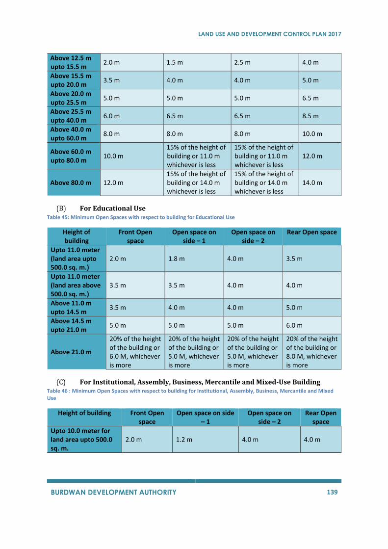
LAND USE AND DEVELOPMENT CONTROL PLAN 2017
BURDWAN DEVELOPMENT AUTHORITY 139
Above 12.5 m upto 15.5 m
2.0 m 1.5 m 2.5 m 4.0 m
Above 15.5 m upto 20.0 m
3.5 m 4.0 m 4.0 m 5.0 m
Above 20.0 m upto 25.5 m
5.0 m 5.0 m 5.0 m 6.5 m
Above 25.5 m upto 40.0 m
6.0 m 6.5 m 6.5 m 8.5 m
Above 40.0 m upto 60.0 m
8.0 m 8.0 m 8.0 m 10.0 m
Above 60.0 m upto 80.0 m
10.0 m 15% of the height of building or 11.0 m whichever is less
15% of the height of building or 11.0 m whichever is less
12.0 m
Above 80.0 m 12.0 m 15% of the height of building or 14.0 m whichever is less
15% of the height of building or 14.0 m whichever is less
14.0 m
(B) For Educational Use Table 45: Minimum Open Spaces with respect to building for Educational Use
Height of building
Front Open space
Open space on side – 1
Open space on side – 2
Rear Open space
Upto 11.0 meter (land area upto 500.0 sq. m.)
2.0 m 1.8 m 4.0 m 3.5 m
Upto 11.0 meter (land area above 500.0 sq. m.)
3.5 m 3.5 m 4.0 m 4.0 m
Above 11.0 m upto 14.5 m
3.5 m 4.0 m 4.0 m 5.0 m
Above 14.5 m upto 21.0 m
5.0 m 5.0 m 5.0 m 6.0 m
Above 21.0 m
20% of the height of the building or 6.0 M, whichever is more
20% of the height of the building or 5.0 M, whichever is more
20% of the height of the building or 5.0 M, whichever is more
20% of the height of the building or 8.0 M, whichever is more
(C) For Institutional, Assembly, Business, Mercantile and Mixed-Use Building Table 46 : Minimum Open Spaces with respect to building for Institutional, Assembly, Business, Mercantile and Mixed Use
Height of building Front Open space
Open space on side – 1
Open space on side – 2
Rear Open space
Upto 10.0 meter for land area upto 500.0 sq. m.
2.0 m 1.2 m 4.0 m 4.0 m
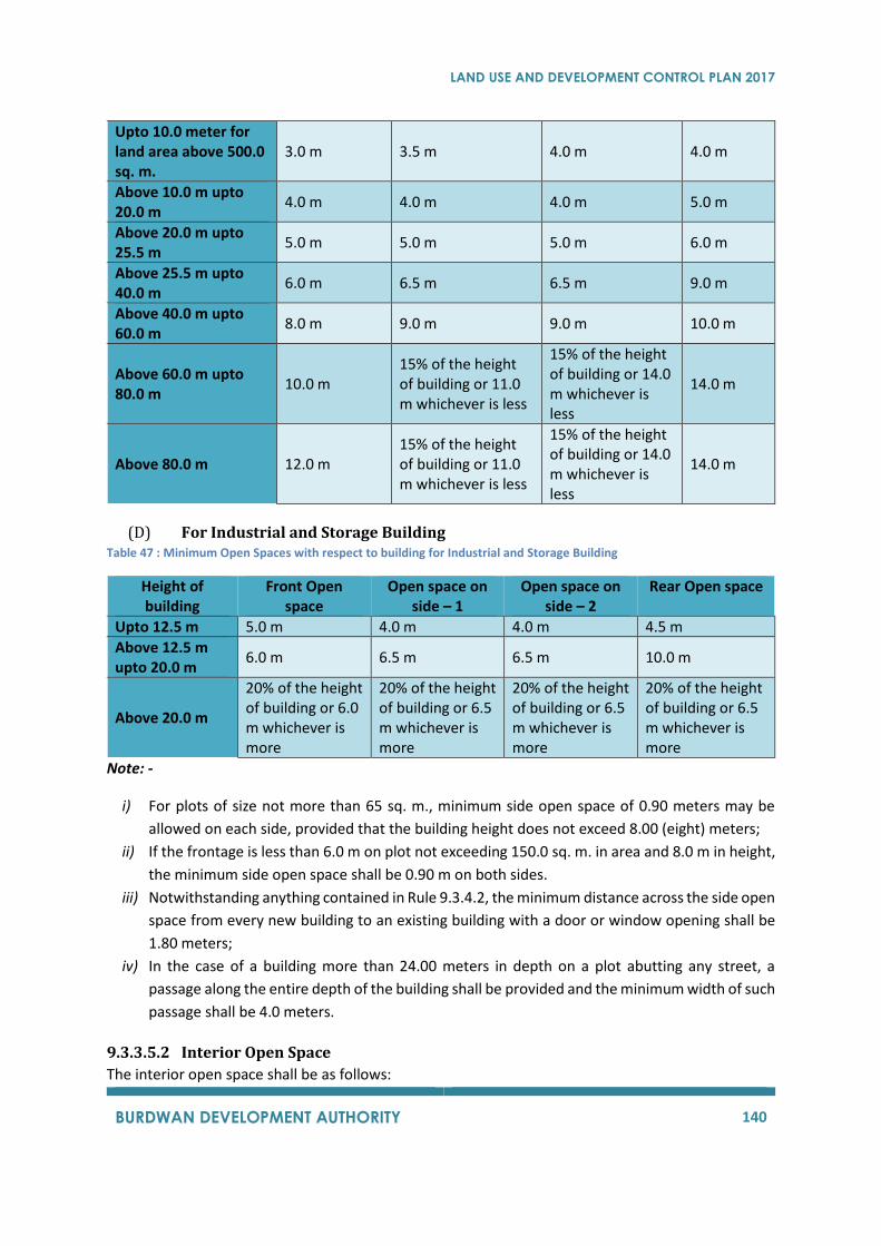
LAND USE AND DEVELOPMENT CONTROL PLAN 2017
BURDWAN DEVELOPMENT AUTHORITY 140
Upto 10.0 meter for land area above 500.0 sq. m.
3.0 m 3.5 m 4.0 m 4.0 m
Above 10.0 m upto 20.0 m
4.0 m 4.0 m 4.0 m 5.0 m
Above 20.0 m upto 25.5 m
5.0 m 5.0 m 5.0 m 6.0 m
Above 25.5 m upto 40.0 m
6.0 m 6.5 m 6.5 m 9.0 m
Above 40.0 m upto 60.0 m
8.0 m 9.0 m 9.0 m 10.0 m
Above 60.0 m upto 80.0 m
10.0 m 15% of the height of building or 11.0 m whichever is less
15% of the height of building or 14.0 m whichever is less
14.0 m
Above 80.0 m 12.0 m 15% of the height of building or 11.0 m whichever is less
15% of the height of building or 14.0 m whichever is less
14.0 m
(D) For Industrial and Storage Building Table 47 : Minimum Open Spaces with respect to building for Industrial and Storage Building
Height of building
Front Open space
Open space on side – 1
Open space on side – 2
Rear Open space
Upto 12.5 m 5.0 m 4.0 m 4.0 m 4.5 m
Above 12.5 m upto 20.0 m
6.0 m 6.5 m 6.5 m 10.0 m
Above 20.0 m
20% of the height of building or 6.0 m whichever is more
20% of the height of building or 6.5 m whichever is more
20% of the height of building or 6.5 m whichever is more
20% of the height of building or 6.5 m whichever is more
Note: -
i) For plots of size not more than 65 sq. m., minimum side open space of 0.90 meters may be
allowed on each side, provided that the building height does not exceed 8.00 (eight) meters;
ii) If the frontage is less than 6.0 m on plot not exceeding 150.0 sq. m. in area and 8.0 m in height,
the minimum side open space shall be 0.90 m on both sides.
iii) Notwithstanding anything contained in Rule 9.3.4.2, the minimum distance across the side open
space from every new building to an existing building with a door or window opening shall be
1.80 meters;
iv) In the case of a building more than 24.00 meters in depth on a plot abutting any street, a
passage along the entire depth of the building shall be provided and the minimum width of such
passage shall be 4.0 meters.
9.3.3.5.2 Interior Open Space
The interior open space shall be as follows:

LAND USE AND DEVELOPMENT CONTROL PLAN 2017
BURDWAN DEVELOPMENT AUTHORITY 141
A. For inner courtyard-
i. In case the whole of one side or part of at least two sides of every habitable room is not
abutting either the front open space, rear open space or side open space, it shall abut an
interior open space. Interior open space at ground level shall be called courtyard.
ii. Any room which is separated only by a verandah from the interior open space shall be deemed
to abut on such interior open space for the purpose of this rule.
iii. The minimum dimension of any side of every interior open space (a) at ground level all sides
of which are enclosed by a building or part thereof shall be 30% of the height of the building
or 3.0 meters, whichever is more (b) at any other level, all sides of which are enclosed by a
building or part thereof shall be 30% of the height of the building or 3.0 meters, whichever is
more, measured from the said level where interior open space is formed.
iv. Notwithstanding anything contained in these regulations, if all sides of an interior open space
is enclosed by a combination of higher and lower blocks of a building, the minimum dimension
of such interior open space shall be governed by the height of lower block; provided that in
no case the covered area under such lower block shall be less than 25% of the total covered
area of the concerned building constituting the interior open space.
v. For the purpose of this rule, if any interior open space or courtyard enclosed on three sides
by a building or part thereof is meant to serve lighting and ventilation purpose to a part or
whole of one side of one or more habitable rooms, the minimum width of such open space
shall be 2.4 meters for building upto 15.5 meters in height, 3.5 meters for building above 15.5
meters upto 25.5 meters height, 5.0 meters for buildings above 25.5 meters upto 40.0 meters
height, and 7.0 meters for all building above 40.0 meters height.
Provided that the depth of such open space shall not exceed twice its width and the same may
be reduced to 1.2 meters if no habitable room, or balcony attached to the habitable room is
facing the interior open space. However, in case the depth of such interior open spaces is less
than the width, the same shall not be considered as interior open space but be called as
“notch” and the same will be permitted without any restriction.
vi. A ventilation shaft having no access to the same except through one door for service purposes
shall be treated as a courtyard if the area of such shaft is less than 20 sq. m.
B. Ventilation Shaft for Kitchen or Toilet – For ventilation of bathroom or water closet or if it does not open into the front open space, rear
open space or side open space or an interior open space, it shall open into a ventilation shaft which
shall not be less than the specification in Table 48andTable 49below –
Table 48: Individual Ventilation shaft for Kitchen or Toilet
Height of the building (in meters)
Minimum size of ventilation shaft (in square meters)
Minimum width of the shaft (in meters)
Up to 11.0 2.5 1.2
Above 11.0 but less than 14.5 5.0 2.0
From 14.5 but less than 20.0 6.0 2.4
20.0 and above 9.0 3.0 Table 49: Combined Ventilation shaft for Kitchen and Toilet
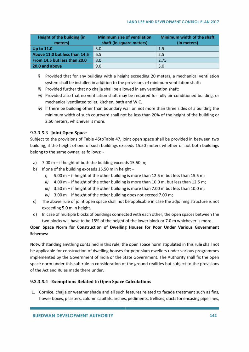
LAND USE AND DEVELOPMENT CONTROL PLAN 2017
BURDWAN DEVELOPMENT AUTHORITY 142
Height of the building (in meters)
Minimum size of ventilation shaft (in square meters)
Minimum width of the shaft (in meters)
Up to 11.0 3.0 1.5
Above 11.0 but less than 14.5 6.5 2.5
From 14.5 but less than 20.0 8.0 2.75
20.0 and above 9.0 3.0
i) Provided that for any building with a height exceeding 20 meters, a mechanical ventilation
system shall be installed in addition to the provisions of minimum ventilation shaft:
ii) Provided further that no chajja shall be allowed in any ventilation shaft:
iii) Provided also that no ventilation shaft may be required for fully air-conditioned building, or
mechanical ventilated toilet, kitchen, bath and W.C.
iv) If there be building other than boundary wall on not more than three sides of a building the
minimum width of such courtyard shall not be less than 20% of the height of the building or
2.50 meters, whichever is more.
9.3.3.5.3 Joint Open Space
Subject to the provisions of Table 45toTable 47, joint open space shall be provided in between two
building, if the height of one of such buildings exceeds 15.50 meters whether or not both buildings
belong to the same owner, as follows: -
a) 7.00 m – if height of both the building exceeds 15.50 m;
b) If one of the building exceeds 15.50 m in height –
i) 5.00 m – if height of the other building is more than 12.5 m but less than 15.5 m;
ii) 4.00 m – if height of the other building is more than 10.0 m. but less than 12.5 m;
iii) 3.50 m – if height of the other building is more than 7.00 m but less than 10.0 m;
iv) 3.00 m – if height of the other building does not exceed 7.00 m;
c) The above rule of joint open space shall not be applicable in case the adjoining structure is not
exceeding 5.0 m in height.
d) In case of multiple blocks of buildings connected with each other, the open spaces between the
two blocks will have to be 15% of the height of the lower block or 7.0 m whichever is more.
Open Space Norm for Construction of Dwelling Houses for Poor Under Various Government
Schemes:
Notwithstanding anything contained in this rule, the open space norm stipulated in this rule shall not
be applicable for construction of dwelling houses for poor slum dwellers under various programmes
implemented by the Government of India or the State Government. The Authority shall fix the open
space norm under this sub-rule in consideration of the ground realities but subject to the provisions
of the Act and Rules made there under.
9.3.3.5.4 Exemptions Related to Open Space Calculations
1. Cornice, chajja or weather shade and all such features related to facade treatment such as fins,
flower boxes, pilasters, column capitals, arches, pediments, trellises, ducts for encasing pipe lines,
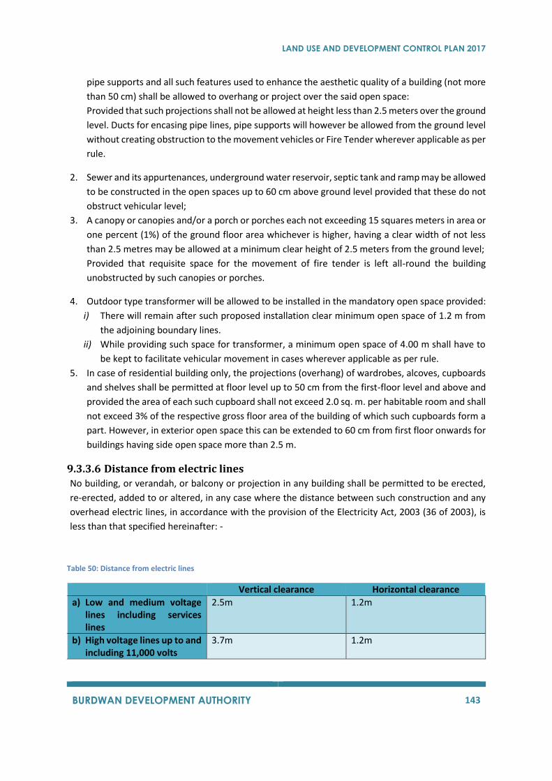
LAND USE AND DEVELOPMENT CONTROL PLAN 2017
BURDWAN DEVELOPMENT AUTHORITY 143
pipe supports and all such features used to enhance the aesthetic quality of a building (not more
than 50 cm) shall be allowed to overhang or project over the said open space:
Provided that such projections shall not be allowed at height less than 2.5 meters over the ground
level. Ducts for encasing pipe lines, pipe supports will however be allowed from the ground level
without creating obstruction to the movement vehicles or Fire Tender wherever applicable as per
rule.
2. Sewer and its appurtenances, underground water reservoir, septic tank and ramp may be allowed
to be constructed in the open spaces up to 60 cm above ground level provided that these do not
obstruct vehicular level;
3. A canopy or canopies and/or a porch or porches each not exceeding 15 squares meters in area or
one percent (1%) of the ground floor area whichever is higher, having a clear width of not less
than 2.5 metres may be allowed at a minimum clear height of 2.5 meters from the ground level;
Provided that requisite space for the movement of fire tender is left all-round the building
unobstructed by such canopies or porches.
4. Outdoor type transformer will be allowed to be installed in the mandatory open space provided:
i) There will remain after such proposed installation clear minimum open space of 1.2 m from
the adjoining boundary lines.
ii) While providing such space for transformer, a minimum open space of 4.00 m shall have to
be kept to facilitate vehicular movement in cases wherever applicable as per rule.
5. In case of residential building only, the projections (overhang) of wardrobes, alcoves, cupboards
and shelves shall be permitted at floor level up to 50 cm from the first-floor level and above and
provided the area of each such cupboard shall not exceed 2.0 sq. m. per habitable room and shall
not exceed 3% of the respective gross floor area of the building of which such cupboards form a
part. However, in exterior open space this can be extended to 60 cm from first floor onwards for
buildings having side open space more than 2.5 m.
9.3.3.6 Distance from electric lines
No building, or verandah, or balcony or projection in any building shall be permitted to be erected,
re-erected, added to or altered, in any case where the distance between such construction and any
overhead electric lines, in accordance with the provision of the Electricity Act, 2003 (36 of 2003), is
less than that specified hereinafter: -
Table 50: Distance from electric lines
Vertical clearance Horizontal clearance
a) Low and medium voltage lines including services lines
2.5m 1.2m
b) High voltage lines up to and including 11,000 volts
3.7m 1.2m
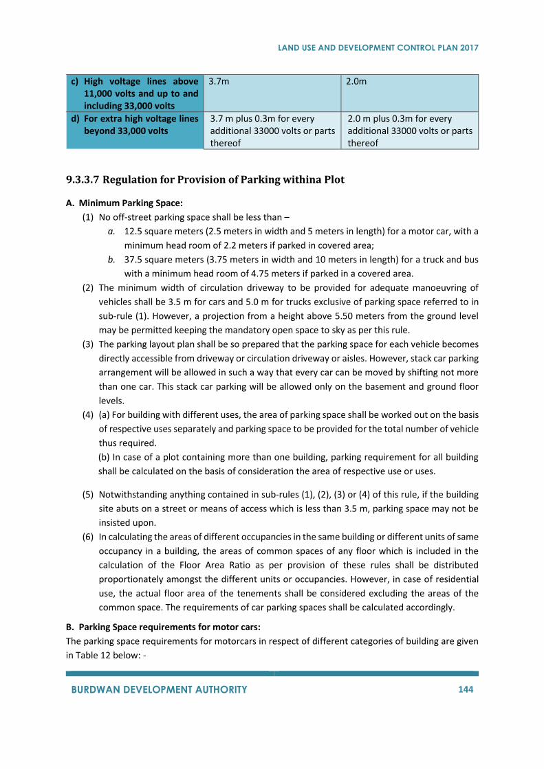
LAND USE AND DEVELOPMENT CONTROL PLAN 2017
BURDWAN DEVELOPMENT AUTHORITY 144
c) High voltage lines above 11,000 volts and up to and including 33,000 volts
3.7m 2.0m
d) For extra high voltage lines beyond 33,000 volts
3.7 m plus 0.3m for every additional 33000 volts or parts thereof
2.0 m plus 0.3m for every additional 33000 volts or parts thereof
9.3.3.7 Regulation for Provision of Parking withina Plot
A. Minimum Parking Space:
(1) No off-street parking space shall be less than –
a. 12.5 square meters (2.5 meters in width and 5 meters in length) for a motor car, with a
minimum head room of 2.2 meters if parked in covered area;
b. 37.5 square meters (3.75 meters in width and 10 meters in length) for a truck and bus
with a minimum head room of 4.75 meters if parked in a covered area.
(2) The minimum width of circulation driveway to be provided for adequate manoeuvring of
vehicles shall be 3.5 m for cars and 5.0 m for trucks exclusive of parking space referred to in
sub-rule (1). However, a projection from a height above 5.50 meters from the ground level
may be permitted keeping the mandatory open space to sky as per this rule.
(3) The parking layout plan shall be so prepared that the parking space for each vehicle becomes
directly accessible from driveway or circulation driveway or aisles. However, stack car parking
arrangement will be allowed in such a way that every car can be moved by shifting not more
than one car. This stack car parking will be allowed only on the basement and ground floor
levels.
(4) (a) For building with different uses, the area of parking space shall be worked out on the basis
of respective uses separately and parking space to be provided for the total number of vehicle
thus required.
(b) In case of a plot containing more than one building, parking requirement for all building
shall be calculated on the basis of consideration the area of respective use or uses.
(5) Notwithstanding anything contained in sub-rules (1), (2), (3) or (4) of this rule, if the building
site abuts on a street or means of access which is less than 3.5 m, parking space may not be
insisted upon.
(6) In calculating the areas of different occupancies in the same building or different units of same
occupancy in a building, the areas of common spaces of any floor which is included in the
calculation of the Floor Area Ratio as per provision of these rules shall be distributed
proportionately amongst the different units or occupancies. However, in case of residential
use, the actual floor area of the tenements shall be considered excluding the areas of the
common space. The requirements of car parking spaces shall be calculated accordingly.
B. Parking Space requirements for motor cars:
The parking space requirements for motorcars in respect of different categories of building are given
in Table 12 below: -
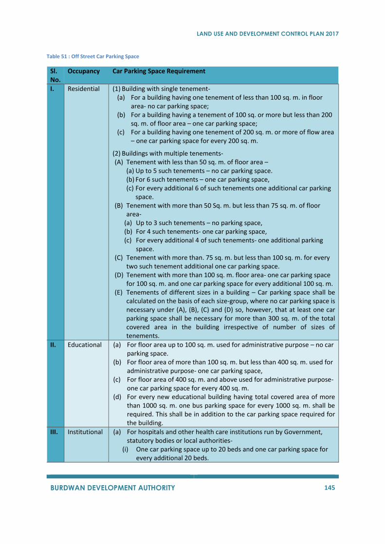
LAND USE AND DEVELOPMENT CONTROL PLAN 2017
BURDWAN DEVELOPMENT AUTHORITY 145
Table 51 : Off Street Car Parking Space
Sl. No.
Occupancy Car Parking Space Requirement
I. Residential (1) Building with single tenement- (a) For a building having one tenement of less than 100 sq. m. in floor
area- no car parking space; (b) For a building having a tenement of 100 sq. or more but less than 200
sq. m. of floor area – one car parking space; (c) For a building having one tenement of 200 sq. m. or more of flow area
– one car parking space for every 200 sq. m.
(2) Buildings with multiple tenements- (A) Tenement with less than 50 sq. m. of floor area –
(a) Up to 5 such tenements – no car parking space. (b) For 6 such tenements – one car parking space, (c) For every additional 6 of such tenements one additional car parking
space. (B) Tenement with more than 50 Sq. m. but less than 75 sq. m. of floor
area- (a) Up to 3 such tenements – no parking space, (b) For 4 such tenements- one car parking space, (c) For every additional 4 of such tenements- one additional parking
space. (C) Tenement with more than. 75 sq. m. but less than 100 sq. m. for every
two such tenement additional one car parking space. (D) Tenement with more than 100 sq. m. floor area- one car parking space
for 100 sq. m. and one car parking space for every additional 100 sq. m. (E) Tenements of different sizes in a building – Car parking space shall be
calculated on the basis of each size-group, where no car parking space is necessary under (A), (B), (C) and (D) so, however, that at least one car parking space shall be necessary for more than 300 sq. m. of the total covered area in the building irrespective of number of sizes of tenements.
II. Educational (a) For floor area up to 100 sq. m. used for administrative purpose – no car parking space.
(b) For floor area of more than 100 sq. m. but less than 400 sq. m. used for administrative purpose- one car parking space,
(c) For floor area of 400 sq. m. and above used for administrative purpose- one car parking space for every 400 sq. m.
(d) For every new educational building having total covered area of more than 1000 sq. m. one bus parking space for every 1000 sq. m. shall be required. This shall be in addition to the car parking space required for the building.
III. Institutional (a) For hospitals and other health care institutions run by Government, statutory bodies or local authorities-
(i) One car parking space up to 20 beds and one car parking space for every additional 20 beds.
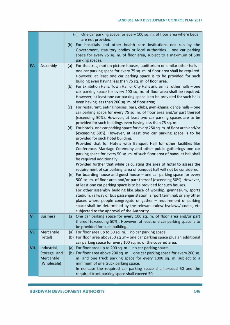
LAND USE AND DEVELOPMENT CONTROL PLAN 2017
BURDWAN DEVELOPMENT AUTHORITY 146
(ii) One car parking space for every 100 sq. m. of floor area where beds are not provided.
(b) For hospitals and other health care institutions not run by the Government, statutory bodies or local authorities – one car parking space for every 75 sq. m. of floor area, subject to a maximum of 500 parking spaces.
IV. Assembly (a) For theatres, motion picture houses, auditorium or similar other halls – one car parking space for every 75 sq. m. of floor area shall be required. However, at least one car parking space is to be provided for such building even having less than 75 sq. m. of floor area.
(b) For Exhibition Halls, Town Hall or City Halls and similar other halls – one car parking space for every 200 sq. m. of floor area shall be required. However, at least one car parking space is to be provided for such halls even having less than 200 sq. m. of floor area;
(c) For restaurant, eating houses, bars, clubs, gym-khana, dance halls – one car parking space for every 75 sq. m. of floor area and/or part thereof (exceeding 50%). However, at least two car parking spaces are to be provided for such buildings even having less than 75 sq. m.
(d) For hotels- one car parking space for every 250 sq. m. of floor area and/or (exceeding 50%). However, at least two car parking space is to be provided for such hotel building: Provided that for Hotels with Banquet Hall for other facilities like Conference, Marriage Ceremony and other public gatherings one car parking space for every 50 sq. m. of such floor area of banquet hall shall be required additionally: Provided further that while calculating the area of hotel to assess the requirement of car parking, area of banquet hall will not be considered.
(e) For boarding house and guest house – one car parking space for every 500 sq. m. of floor area and/or part thereof (exceeding 50%). However, at least one car parking space is to be provided for such houses. For other assembly building like place of worship, gymnasium, sports stadium, railway or bus passenger station, airport terminal; or any other places where people congregate or gather – requirement of parking space shall be determined by the relevant rules/ byelaws/ codes, etc subjected to the approval of the Authority.
V. Business (a) One car parking space for every 100 sq. m. of floor area and/or part thereof (exceeding 50%). However, at least one car parking space is to be provided for such building.
VI. Mercantile (retail)
(a) For floor area up to 50 sq. m. – no car parking space. (b) For floor area above50 sq .m– one car parking space plus an additional
car parking space for every 100 sq. m. of the covered area.
VII. Industrial, Storage and Mercantile (Wholesale)
(a) For floor area up to 200 sq. m. – no car parking space. (b) For floor area above 200 sq. m. – one car parking space for every 200 sq.
m. and one truck parking space for every 1000 sq. m. subject to a minimum of one truck parking space, In no case the required car parking space shall exceed 50 and the required truck parking space shall exceed 50.

LAND USE AND DEVELOPMENT CONTROL PLAN 2017
BURDWAN DEVELOPMENT AUTHORITY 147
Note:Calculations for required car parking space should be made on the basis of carpet area of the
building of the building unless otherwise, mentioned, other than the car parking area itself.
(a) Notwithstanding the provisions of sub-rule (1) this part, the Authority may in any area within
its jurisdiction for the purpose of this rule, require additional parking spaces to be provided in
such area.
(b) Mechanical parking shall be allowed in all floors and in open space without encroaching the
statutory open spaces up to two tier level with 5.0 m ramp and driveways provided advantage
of FAR will be given for one tier of parking only and no back parking will be allowed.
C. Parking Spaces to be distinct
The open spaces required under Section 9.3.3.5and driveway shall not be treated as parking space for
the purpose of these rules. However, open car parking may be allowed on the mandatory open space,
provided that a clear driveway is maintained as follows:
(i) 4.0 m for building height upto 15.5 m.
(ii) 5.0 m for building height upto above 15.5 m and upto 25.5 m; and
(iii) 6.0 m for building height above 25.5 m.
9.3.3.8 Requirement of Parts of Buildings
(A)Plinth
(1) The plinth or any part of a building or any accessory building shall be so located with respect
to the crest of the road level that adequate drainage of the site is assured and in no case, it
shall be at a height less than 60 cm.
(2) Garage and parking space shall be raised at least 15 cm. above the level of the highest crest
of the road of the nearest street and shall be satisfactorily drained.
(3) Every inner courtyard shall be raised at least 30 cm. above the level of the highest crest of the
road of the nearest street and shall be satisfactorily drained.
(4) In case of rehabilitation of tenants for shop or any habitable room or for new shop in the
ground floor in excess of mandatory car parking space, a plinth height of 30.0 cm. may be
allowed.
(B)Habitable Room
(1) The area of a habitable room shall not be less than 6.00 sq. m.with a minimum width of 2.40
meters.
(2) The habitable room for this purpose would be any room to be used for human habitation
other than a kitchen, bath / water closet, store / multipurpose room;
(C)Kitchen
(1) The area of kitchen shall not be less than 4.50 sq. m. with a minimum width of 1.80 meters;
LAND USE AND DEVELOPMENT CONTROL PLAN 2017
BURDWAN DEVELOPMENT AUTHORITY 148
(D)Water Closet and Bath Room
(1) The area of an independent water closet shall not be less than 1.80 sq. m. with a minimum
width of 1.2 metre and a height not less than 2.1 metre.
(2) If water closet is combined with bath room then its floor area shall not be less than 2.6 sq. m.
with a minimum width of 1.2 meters.
(E)Minimum Height of Room
The height of all habitable and multi-purpose rooms shall not be less than 2.60 m from the surface of
the floor to the lowest point of the ceiling. In case of slope roof height shall not be less than 2.4 m at
the lowest part of the ceiling of the slope roof. The height of kitchen, bath / water closet and
corridor/passage shall not be less than 2.40 m.
(F)Lifts
Lift shall conform to the following provisions and the provisions of the latest edition of the National
Building Code of India: -
(1) At least one lift shall be provided in every building more than 12.5 m. in height,
(2) In the case of buildings more than 20m. in height, and 1000 sq. m. of floor area for each floor
at least two lifts shall be provided,
(3) In the case of a proposal to add one additional floor to an existing building having a lift, it will
not be necessary to raise the existing lift to the additional floor.
Subject to the above, the number, type and capacity of lift shall satisfy the requirements of
the National Building Code of India.
(G)Loft
(1) A loft may be permitted in buildings of all use-groups.
(2) The area of any such loft shall be restricted to 25 per cent of the area of the floor of any room
(other than an inhabited room) provided that 100% of the area may be covered over any
corridor.
(3) Maximum height between any loft and ceiling shall be 0.90 m. and the clear height below
the loft shall not be less than 2.10m.
(H)Mezzanine Floor
(1) A mezzanine floor may be permitted to be used for any purpose provided the use conforms
to the relevant rules.
(2) A mezzanine floor may be permitted over a habitable room provided that –
(a) It conforms to any standard for a habitable room as regards lighting and ventilation,
(b) It is so constructed not to interfere under any circumstances with the ventilation of the
space over and under it,
(c) Such mezzanine floor is not sub-divided into smaller compartments,
(d) Such mezzanine floor or any part of it shall not be used as a kitchen, and
(e) In no case a mezzanine floor shall be sub-divided so as to make it liable to be converted
into unventilated compartments.
LAND USE AND DEVELOPMENT CONTROL PLAN 2017
BURDWAN DEVELOPMENT AUTHORITY 149
(3) An area up to 25% of the covered area on the particular floor shall be permitted for
construction of mezzanine floor.
(4) The height of any mezzanine floor shall not be less than 2.1 m from floor level to the ceiling
or underside of the slab.
(I)Garage
(1) No garage shall be less than 2.5m X 5m.
(2) The minimum head room in a garage shall be 2.1 m.
(3) The size of any garage where more than one motor car is parked shall be calculated on basis
of the number of vehicles, in accordance with the provisions of the Section9.3.3.7.
Regulation for Basement
(1) A basement may be put to any of the following uses –
(a) as a parking space.
(b) as an air-conditioning plant room or room for other machines used for any building service or
for other purposes.
(c) as a space for a standby generator for power supply.
(d) as a storage space for house hold or other goods or non-flammable nature.
(e) as a strong room or as a bank cellar
(f) as a dark room
(g) as a stack room in any library
(h) for the purpose of a business building or a mercantile building (retail) or an assembly building
if it is air-conditioned and the top of the basement is at least 750 mm. above the ground level,
provided the fire safety norms as per National Building Code are complied with.
(2) Outer walls of a basement may be extended below ground level up to a maximum of 5m. from
the property line only for one level of basement for use of parking only. In case of more than one
basement is required the depth of the basement shall not exceed the distance between boundary
line and outer periphery of basement in all sides.
(3) No basement or portion thereof shall be used for residential purposes.
(4) No kitchen, bathroom or water closet shall be permitted in any basement unless the sewer levels
permit the same and there is no chance of back flow and flooding of sewerage. If permitted, such
kitchen, bathroom or water closet shall be placed against an external wall of the basement, which
shall also be external wall of the building and shall be adequately lit and ventilated.
(Detailed plans showing arrangement for drainage in including pumping system shall be
submitted in such cases)
(5) Every basement shall –
(a) In every part, be at least 2.4 meters in height on the floor to the underside of the roof slab or
ceiling or any false roofing.
(b) Have adequate arrangement so that surface drainage does not enter the basement and have
adequate arrangement of pumping out water, if necessary.
LAND USE AND DEVELOPMENT CONTROL PLAN 2017
BURDWAN DEVELOPMENT AUTHORITY 150
(c) Have water-tight walls and floor which shall be so designed that the effect of the surrounding
soil and moisture, if any, is taken into account in design and adequate damp-proofing
treatment is given.
(d) In case the parking area in the basement is less than 1,000 sq. m. only one ramp will be
required. In case the parking area in the basement is more than 1,000 sq. m.at least two ramps
shall be provided. Width of each ramp shall not be less than 3.5 meters and the slope shall
not be steeper than one vertical to six horizontal [1:6=vertical: horizotal] and the distance
between the ramps shall be such as may be determined by BDA.
(e) Provided that the basement is not used for the car parking purposes, ramp will not be
required. In such cases at least two staircases of minimum width as per use group shall have
to be provided and such staircases shall be enclosed type.
(f) The case of such basement being used for a purpose as referred in the clause (g) of sub-rule
(1) of this regulation must have sufficient number of access ways and exit ways so that the
travel distance is not more than 15mts.
(g) Have adequate ventilation as required for any occupancy or use group under this Rules,
provided that any deficiency may be met by providing adequate mechanical ventilation in the
form of blowers, exhaust fans at the rate of one exhaust fan for every 50 sq. m. of the
basement area or by air-conditioning.
(h) Comply with the requirements of the West Bengal Fire Service Act,1950 fire prevention and
safety rules, 1996, and provisions are laid in the National Building Code (NBC).
9.3.3.9 Exit Requirement of the Building
(a) “Exit” means and escape route which includes passage, channel or means of access from any
buildings, stories of floor area to a street or other open space of safety and includes a vertical
exit or a horizontal exit or an outside exit.
i) “Vertical exit” means an exit used for ascension and descension between two or more
levels including stairways smoke proof towers, ramps, lifts, escalators and fire escapes.
ii) “Horizontal exit” means a protected opening through or around a fire wall or a bridge
connecting two buildings.
iii) “Outside Exit” means and exit from the building to a street or to an open area leading to a
street or to an enclosed fire resistive passage leading to a street.
(b) “Travel Distance” means the distance from the exit of a tenement of any premises on a floor of
a building to a place of safety, be it a vertical exit, a horizontal exit or an outside exit measured
along the line of travel.
Fire protection: Every building for residential and educational uses of more than 15.5 m in height, and
all building of other uses and buildings with basement shall be provided with adequate means of exit
and all arrangement for protection in case of fire.
Arrangements of exit:
(1) Exits shall be so located that the distance between two exits on the floor shall not exceed, -
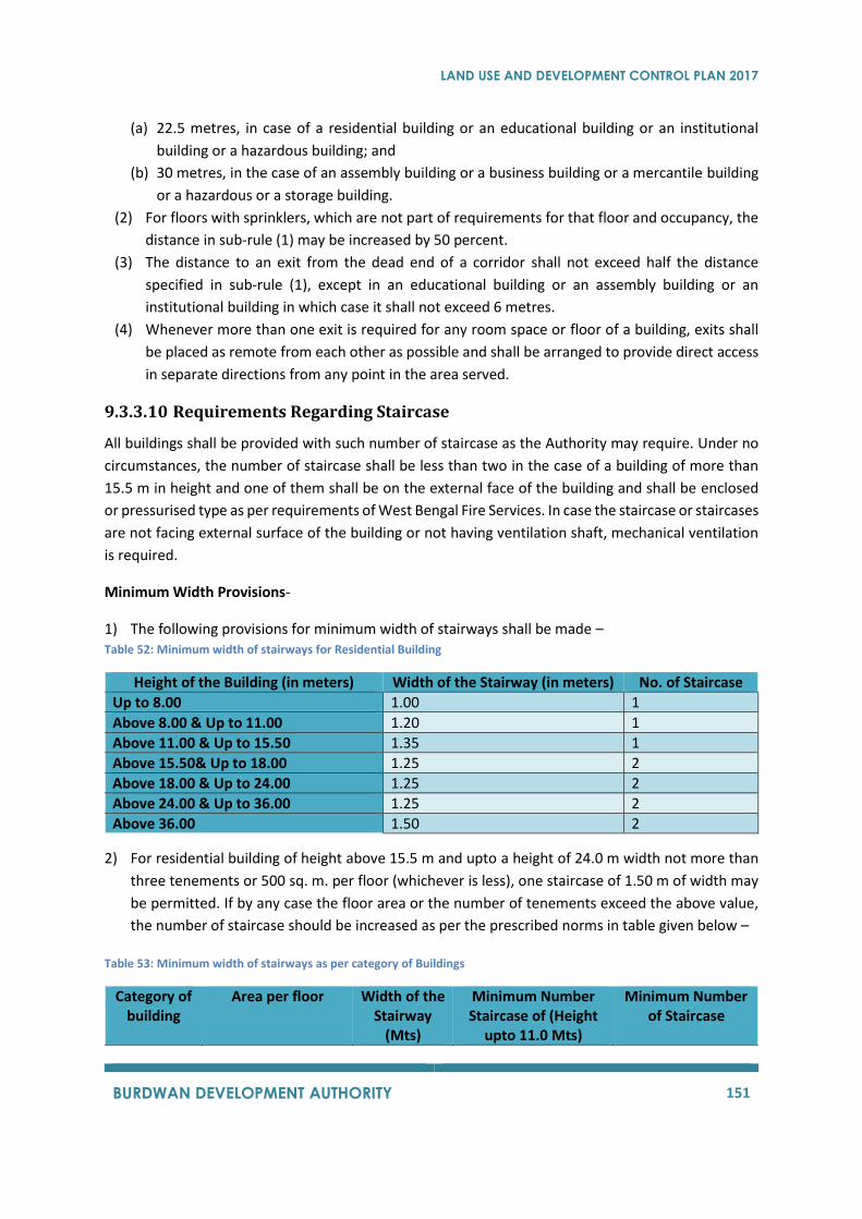
LAND USE AND DEVELOPMENT CONTROL PLAN 2017
BURDWAN DEVELOPMENT AUTHORITY 151
(a) 22.5 metres, in case of a residential building or an educational building or an institutional
building or a hazardous building; and
(b) 30 metres, in the case of an assembly building or a business building or a mercantile building
or a hazardous or a storage building.
(2) For floors with sprinklers, which are not part of requirements for that floor and occupancy, the
distance in sub-rule (1) may be increased by 50 percent.
(3) The distance to an exit from the dead end of a corridor shall not exceed half the distance
specified in sub-rule (1), except in an educational building or an assembly building or an
institutional building in which case it shall not exceed 6 metres.
(4) Whenever more than one exit is required for any room space or floor of a building, exits shall
be placed as remote from each other as possible and shall be arranged to provide direct access
in separate directions from any point in the area served.
9.3.3.10 Requirements Regarding Staircase
All buildings shall be provided with such number of staircase as the Authority may require. Under no
circumstances, the number of staircase shall be less than two in the case of a building of more than
15.5 m in height and one of them shall be on the external face of the building and shall be enclosed
or pressurised type as per requirements of West Bengal Fire Services. In case the staircase or staircases
are not facing external surface of the building or not having ventilation shaft, mechanical ventilation
is required.
Minimum Width Provisions-
1) The following provisions for minimum width of stairways shall be made – Table 52: Minimum width of stairways for Residential Building
Height of the Building (in meters) Width of the Stairway (in meters) No. of Staircase
Up to 8.00 1.00 1
Above 8.00 & Up to 11.00 1.20 1
Above 11.00 & Up to 15.50 1.35 1
Above 15.50& Up to 18.00 1.25 2
Above 18.00 & Up to 24.00 1.25 2
Above 24.00 & Up to 36.00 1.25 2
Above 36.00 1.50 2
2) For residential building of height above 15.5 m and upto a height of 24.0 m width not more than
three tenements or 500 sq. m. per floor (whichever is less), one staircase of 1.50 m of width may
be permitted. If by any case the floor area or the number of tenements exceed the above value,
the number of staircase should be increased as per the prescribed norms in table given below –
Table 53: Minimum width of stairways as per category of Buildings
Category of building
Area per floor Width of the Stairway
(Mts)
Minimum Number Staircase of (Height
upto 11.0 Mts)
Minimum Number of Staircase

LAND USE AND DEVELOPMENT CONTROL PLAN 2017
BURDWAN DEVELOPMENT AUTHORITY 152
(Height upto 11.0 Mts)
Educational Up to 500 sq. m. 1.35 2 2
Above 500 sq. m. 2.0 2 2
Assembly Up to 500 sq. m. 1.25 1 2
Above 500 sq. m. 2.0 2 2
Institutional Up to 500 sq. m. 1.50 1 2
Above 500 sq. m. 2.0 2 2
Business Up to 500 sq. m. 1.50 1 2
Above 500 sq. m. 1.50 2 2
Mercantile Up to 500 sq. m. 1.80 2 2
Above 500 sq. m. 2.00 2 2
Provided that building for marriage halls, Banquet halls, multipurpose halls, etc. shall have at least two
staircases having minimum width of 1.5 m for any height and floor area.
3) The following provisions for the passage and corridors shall be made – Table 54: Minimum width provision for passage and corridors
Category of passage or corridor Minimum width (m)
Passage connecting vertical exit and the tenement or units
Not less than the width of each stairway specified under Table 13& 14
Passage within an apartment 1.0
Passage giving access to shops in a mercantile building –
(a) Shops on one side only (b) Shops on both side
2.0 3.0
Passage in a business building 2.5
9.3.3.11 Consultation with the Director of Fire Services before Granting
Permission to Erect a Building
No permission for the erection, addition to or alteration of, any building other than a residential
building of less than 15.5 m in height shall be granted unless the Authority in consultation with the
Director of fire Services of the Government of West Bengal or any Officer specially empowered by the
Director for the purpose is satisfied about the provision of means of exits and about the arrangements
for protection against fire proposed for the building.
Regulations for Fire Protection:
Provisions of fire protection and fire safety measures in the buildings erected on any plots and
premises according to the Rules of Directorate of Fire Services of the Government of West Bengal shall
be for the buildings as stated below:
(a) For multi-storeyed buildings (high rise buildings) and the building which are of 15.5 m and
above in height.
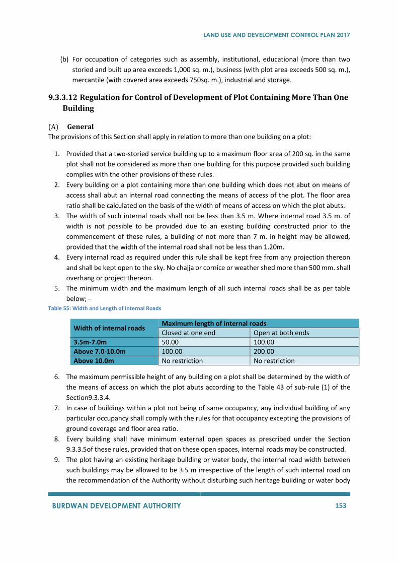
LAND USE AND DEVELOPMENT CONTROL PLAN 2017
BURDWAN DEVELOPMENT AUTHORITY 153
(b) For occupation of categories such as assembly, institutional, educational (more than two
storied and built up area exceeds 1,000 sq. m.), business (with plot area exceeds 500 sq. m.),
mercantile (with covered area exceeds 750sq. m.), industrial and storage.
9.3.3.12 Regulation for Control of Development of Plot Containing More Than One
Building
(A) General
The provisions of this Section shall apply in relation to more than one building on a plot:
1. Provided that a two-storied service building up to a maximum floor area of 200 sq. in the same
plot shall not be considered as more than one building for this purpose provided such building
complies with the other provisions of these rules.
2. Every building on a plot containing more than one building which does not abut on means of
access shall abut an internal road connecting the means of access of the plot. The floor area
ratio shall be calculated on the basis of the width of means of access on which the plot abuts.
3. The width of such internal roads shall not be less than 3.5 m. Where internal road 3.5 m. of
width is not possible to be provided due to an existing building constructed prior to the
commencement of these rules, a building of not more than 7 m. in height may be allowed,
provided that the width of the internal road shall not be less than 1.20m.
4. Every internal road as required under this rule shall be kept free from any projection thereon
and shall be kept open to the sky. No chajja or cornice or weather shed more than 500 mm. shall
overhang or project thereon.
5. The minimum width and the maximum length of all such internal roads shall be as per table
below; - Table 55: Width and Length of Internal Roads
Width of internal roads Maximum length of internal roads
Closed at one end Open at both ends
3.5m-7.0m 50.00 100.00
Above 7.0-10.0m 100.00 200.00
Above 10.0m No restriction No restriction
6. The maximum permissible height of any building on a plot shall be determined by the width of
the means of access on which the plot abuts according to the Table 43 of sub-rule (1) of the
Section9.3.3.4.
7. In case of buildings within a plot not being of same occupancy, any individual building of any
particular occupancy shall comply with the rules for that occupancy excepting the provisions of
ground coverage and floor area ratio.
8. Every building shall have minimum external open spaces as prescribed under the Section
9.3.3.5of these rules, provided that on these open spaces, internal roads may be constructed.
9. The plot having an existing heritage building or water body, the internal road width between
such buildings may be allowed to be 3.5 m irrespective of the length of such internal road on
the recommendation of the Authority without disturbing such heritage building or water body
LAND USE AND DEVELOPMENT CONTROL PLAN 2017
BURDWAN DEVELOPMENT AUTHORITY 154
provide that the existing heritage building or water body or both taken together occupy at least
25% of the land area.
(B) Ground Coverage
Ground Coverage for plots measuring 5,000sq. m. or more in area the maximum permissible ground
coverage shall be 45% for the residential buildings and 35% for buildings of other use groups or of
buildings with mixed occupancy.
Provided that the provisions of Section 9.3.3.2 shall be applicable to plots measuring less than 5,000sq.
m.
(C) Open Spaces
Every building shall have the minimum external open spaces as prescribed in Section 9.3.3.5 provided
that on those open spaces internal roads may be constructed.
(D) F.A.R.
Permissible FAR for building of same occupancy shall be the value for that particular occupancy
prescribed in Section 9.3.3.3 and for building of different occupancies shall be the value for that
particular occupancy which gives the lowest value prescribed in Section 9.3.3.3 of this Development
Control Regulation.
9.3.3.13 Regulations for Control of Development of Residential Building for
Economically Weaker Section and Low-Income Group Housing Scheme
Approved by Burdwan Development Authority
In a scheme for Economically Weaker Section and Low-Income Group Housing approved by Burdwan
Development Authority the following regulations shall be applicable.
i) The following sub-regulations are applicable to core/row housing only in a sites and services
project.
a) That the size of the plot should not be less than 30.00 sq. m.and not more than 65.00 sq.
m. in area.
b) No building shall be allowed on a plot if the width of the means of access to the plot is less
than 1.20 meters.
c) No building exceeding 8.00 meters in height shall be allowed on a plot if the width of
means of access to the plot is less than 3.5 meters.
ii) The maximum permissible ground coverage shall by 75% of the area of the plot.
a) The maximum permissible height of the building shall be 10.00 meters.
b) The minimum front open space shall be 0.80 meters.
c) The minimum rear open space shall be 1.00 meters.
d) The maximum permissible Floor Area Ratio shall be 1.75.
e) There shall be no need to provide side open spaces in the case of any such building,
provided that the maximum aggregate length of such buildings in a row shall be 50.00 meters.
After every 50.00 meters of length of such buildings in a row, there shall be an open space of
not less than 2.50 meters in width for the entire depth of the building, and that such open
LAND USE AND DEVELOPMENT CONTROL PLAN 2017
BURDWAN DEVELOPMENT AUTHORITY 155
space shall not be necessary if there is a street or passage at such location the minimum width
of which is not less than 2.50 meters.
f) There shall be no need to provide any car parking space within the plot.
iii) Except the provisions of clause (i) to (ii) all other provisions of these regulations shall be
applicable.
9.3.3.14 Provisions Regarding Existing Buildings
(i) The provisions of the following regulations shall apply only in case of a building existing. Existing
building for this purpose shall mean any building which was erected before the date of coming
into force of this Land Use and Development Control Plan in accordance with a building plan
sanctioned by an authority competent to sanction such building plan under Bengal Municipal
Act 1932 or any other law for the time being in force.
(ii) In case of an existing building –
(a) Excepting storage buildings, where the open spaces required have not been left, an
addition in the number of stories, if otherwise permissible, may be allowed with a
setback, provided such building continues with the same occupancy. Provided that no
front set back may be necessary up to a height of 8.00 m for adding only one floor over
an existing single storied residential building;
(b) If the height of the building exceeds 15.5 m., the same shall be subject to compliance with
the provisions of Section 9.3.3.3.
(c) The extent of the setback shall be such as to make the addition to the building conform
to the provisions of Section 9.3.4 from the property boundaries.
(d) If any car parking space is required to be provided under Section 9.3.5 for the new area
proposed to be added and no such car parking space can be provided in such existing
building, the floor area allowable under Section 9.3.3.3 shall be reduced by the area
required for such car parking space. For this calculation, the area required for one car
parking space is to be taken as 25.00sq. m. Existing car parking space as per sanctioned
building plan shall be taken into account as car parking spaces, even if the same does not
conform to the specified size of 2.50 m X 5.00 m.
(e) If the dimension of stairs, corridors, ventilating shaft and set backs of an existing building
constructed as per the sanctioned plan are less than those stipulated under the present
regulation, the Chief Executive Officer may allow the construction of the added portion
as per dimensions of the existing portion, without compliance to the provisions of existing
regulations.
(f) The provisions of other Sections of thisLand Use Development and Control Plan shall
apply in all other respects.
9.3.3.15 Regulations for Development of Building Site
No plot shall be used as a site for erection or re-erection of any building, if the level of the plot is lower
than the level of the crown of the nearest public street and unless the land is capable of being well
drained by means of drainage facilities leading to existing public drains or drainage channels.
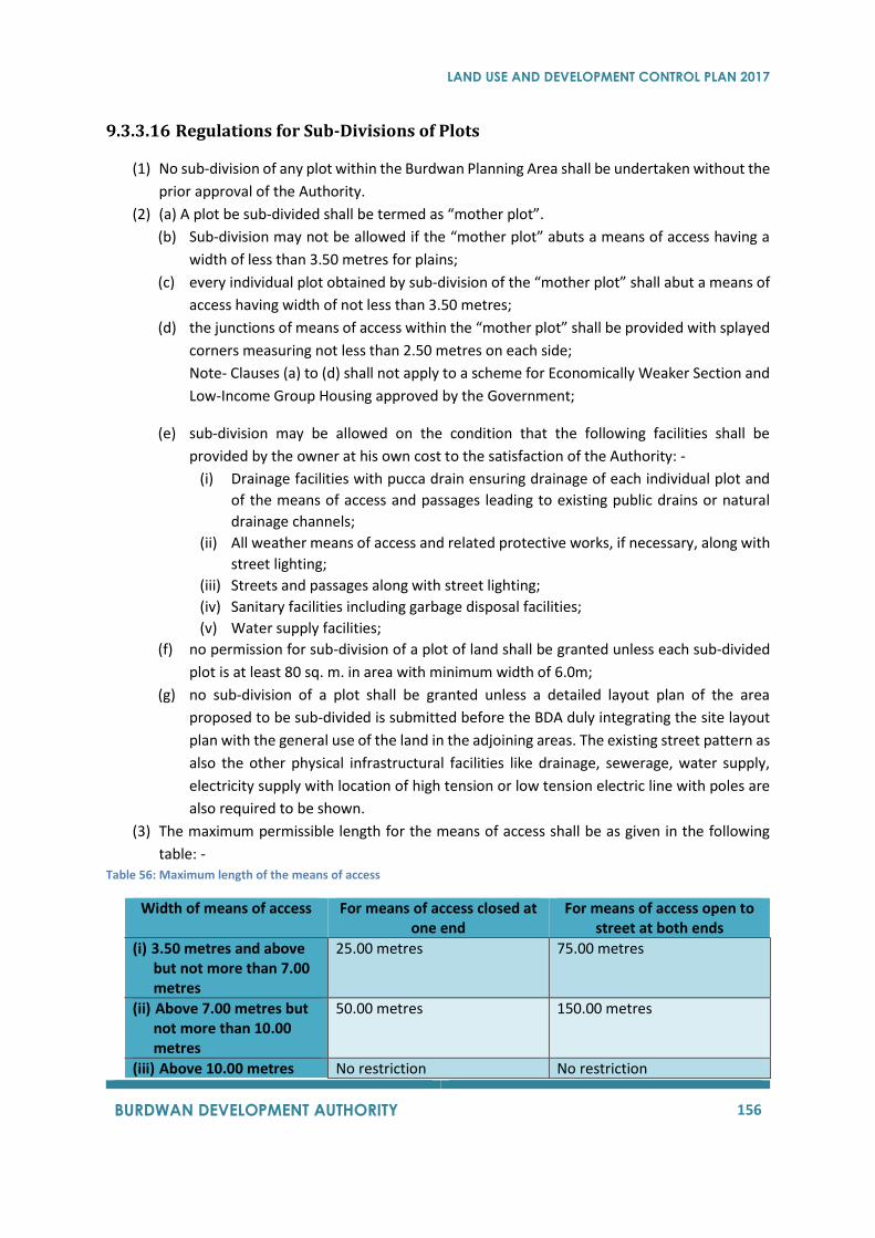
LAND USE AND DEVELOPMENT CONTROL PLAN 2017
BURDWAN DEVELOPMENT AUTHORITY 156
9.3.3.16 Regulations for Sub-Divisions of Plots
(1) No sub-division of any plot within the Burdwan Planning Area shall be undertaken without the
prior approval of the Authority.
(2) (a) A plot be sub-divided shall be termed as “mother plot”.
(b) Sub-division may not be allowed if the “mother plot” abuts a means of access having a
width of less than 3.50 metres for plains;
(c) every individual plot obtained by sub-division of the “mother plot” shall abut a means of
access having width of not less than 3.50 metres;
(d) the junctions of means of access within the “mother plot” shall be provided with splayed
corners measuring not less than 2.50 metres on each side;
Note- Clauses (a) to (d) shall not apply to a scheme for Economically Weaker Section and
Low-Income Group Housing approved by the Government;
(e) sub-division may be allowed on the condition that the following facilities shall be
provided by the owner at his own cost to the satisfaction of the Authority: -
(i) Drainage facilities with pucca drain ensuring drainage of each individual plot and
of the means of access and passages leading to existing public drains or natural
drainage channels;
(ii) All weather means of access and related protective works, if necessary, along with
street lighting;
(iii) Streets and passages along with street lighting;
(iv) Sanitary facilities including garbage disposal facilities;
(v) Water supply facilities;
(f) no permission for sub-division of a plot of land shall be granted unless each sub-divided
plot is at least 80 sq. m. in area with minimum width of 6.0m;
(g) no sub-division of a plot shall be granted unless a detailed layout plan of the area
proposed to be sub-divided is submitted before the BDA duly integrating the site layout
plan with the general use of the land in the adjoining areas. The existing street pattern as
also the other physical infrastructural facilities like drainage, sewerage, water supply,
electricity supply with location of high tension or low tension electric line with poles are
also required to be shown.
(3) The maximum permissible length for the means of access shall be as given in the following
table: - Table 56: Maximum length of the means of access
Width of means of access For means of access closed at one end
For means of access open to street at both ends
(i) 3.50 metres and above but not more than 7.00 metres
25.00 metres 75.00 metres
(ii) Above 7.00 metres but not more than 10.00 metres
50.00 metres 150.00 metres
(iii) Above 10.00 metres No restriction No restriction
LAND USE AND DEVELOPMENT CONTROL PLAN 2017
BURDWAN DEVELOPMENT AUTHORITY 157
(4) For “mother plot” measuring more than 5,000.00 sq. m. in area, sub-division may be allowed,
provided 8% of the total area of the “mother plot” is developed as public open space. The
width of each such open space shall not be less than 10.00 metres and each such open space
shall abut a street having a width of not less than 7.00 metres. The minimum area of each
such open space in one parcel shall be 400 square metres. This open space shall be in addition
to the land required for providing the means of access to the individual plots obtained by sub-
division of “mother plot”.
(5) For “mother plots” measuring more than 25,000.00 sq. m. in area, sub-division may be
allowed, provided 7% of the total area of the mother plot is reserved for use for facilities like
school, health centre, market, police outpost, milk booth, post office, power sub-station,
transport terminal, tree cover, rain water harvesting, sewage recycling, water treatment
plant, sewage treatment plant and the like. Such land shall abut a street having a width of not
less than 10.00 metres in addition to the land necessary for means of access and for open
spaces mentioned in sub-rule (3).
9.3.3.17 For New Township
The new Township Projects shall adhere to all norms and provisions as laid down in the West Bengal
Town and Country (Development of Township Projects) Rules 2008 as amended from time to time.
9.3.3.18 Regulation for Environmental Provisions
(A) Roof top rain water harvesting (RWH)
RWH system shall form a part of the building and shall have to be included in the plan,
either for direct use of the rain water or for ground water recharging or both, in case of
(i) New building or buildings or any housing complex as per Environmental Impact
Assessment Guideline issued by the State Government /Government of India;
(ii) Expansion of any existing building or buildings or housing complex, as per
Environmental Impact Assessment Guidelines Issued by the State Government/
Govt. of India.
This system shall comply with Central and State statutory requirements laid down in the
relevant Acts and bye-Laws.
(B) Landscaping
Provision for tree cover should be included in the plan for building sites-
(i) For any project covering a total floor area of 6000 sq. m. or more, the applicant
should arrange for raising and maintenance of tree cover at his own cost which
should be at least 15% of the land area within the premises.
(ii) For any other project, having lesser total floor area, the tree cover should be reduced
proportionately in the perspective of (i) above.
The applicant shall arrange to raise and maintain the plantation at his own cost and submit
such programme to the Commissioner before the plan is approved.
LAND USE AND DEVELOPMENT CONTROL PLAN 2017
BURDWAN DEVELOPMENT AUTHORITY 158
(C) Waste water recycling
Waste water recycling system shall be incorporated in all buildings including group housing
as per Environmental Impact Assessment Guidelines Issued by the State Government/
Govt. of India.
9.3.3.19 Regulations for Control of Development of Plots Use as Agriculture within
“AG” Zone
All new building including extension building on plots presently being used as agriculture
within ‘AG’ Zone shall be governed by the following regulations; -
9.3.3.19.1 Ground coverage
The maximum permissible ground coverage of a building shall be 5% subject to the condition
that in no case the area of the plot covered by building shall exceed 50.0 sq. m.
9.3.3.19.2 Height of building
No new building or extension of any existing building exceeding the height of 3.75 metres shall
be allowed within this Zone.
9.3.3.19.3 Open spaces
1. Front open space
The minimum front open space for any new building or extension of existing building shall be
2.00 metres at ground level at its narrowest part provided that no portion of the building is
constructed within 6.00 metres from the centre line of the existing means of access.
2. Rear open space
The minimum rear open space of any building shall 5.00 metres
3. Side open spaces
The minimum open space on both sides of any building shall be 2.00 metres.
9.3.4 Regulations for Control of Development of Plots Use as
Riverfrontwithin “RF” Zone
1. The water body should be protected by ensuring that no permanent or temporary
construction or development takes place around it in RFZ -1, i.e., up to a distance of 5m. from
the edge of the water body and the same shall be suitably landscaped.
2. In case of a building in the RFZ - 2 (after 5m. from river bank up to 15m.) or other water fronts
or large water bodies (more than 1000 acres area) the maximum permissible height of a
building in such zone shall be 6.50 m.
3. In case of a building in the RFZ - 3 (after 15m. from river bank up to 50m.) or other water fronts
or large water bodies (more than 1000 acres area) the maximum permissible height of a
building in such zone shall be 15.50 m.
LAND USE AND DEVELOPMENT CONTROL PLAN 2017
BURDWAN DEVELOPMENT AUTHORITY 159
4. No building shall be more than 20.00m. long alongside the river or other water front as per
following:
a) 30m. in case the river width is more than 75m.
b) 20m. in case the river width is between 50m. & 75m.
c) 15m. in case the river width is less than 50m.
5. The maximum permissible covered area of a building in RF zone shall be 200 sq. m.
6. The structures for recreational purpose conforming to this sub-rule may be permitted within
the adjoining land.
7. In case of buildings in front of water bodies.
a) No construction to be made upto a distance of 2m from the water body.
b) In case of a building after 2m. from the water body up to 12m the maximum permissible
height of a building in such zone shall be 10 m.
c) No building shall be more than 20.00m long alongside the water front. There shall be a
clear linear gap of 50.00m between two buildings along side of the water front.
d) The maximum permissible covered area of such building shall be 1000.00 sq. m.
e) No basement is allowed.
8. No canal, water body or wet land shall be filled up, in consideration of drainage, ecology,
environment, pisciculture and fire fighting.
9.3.5 Regulation for Control of Development of Parks and Public Open
Spaces For the purpose of these regulation, public open space shall mean any open space which is open
to the use or enjoyment of the public, whether it is actually used or enjoyed by the public or not
and whether the entry is regulated by any charge or not.
Parks and public open spaces shall be classified for the purpose of these regulations into three
following groups:
i) The parks and public open spaces with area up to 1,500 sq. m. shall be termed as small
parks and public open spaces;
ii) The parks and public open spaces with area more than 1,500 sq. m. but up to 7,000 sq.
m. shall be termed as medium parks and public open spaces;
iii) The parks and public open spaces with area more than 7,000 sq. m. shall be termed as
large parks and public open spaces.
a. The structure above ground level shall be subjected to the following provisions:
i) statue of public interest
ii) structure related to play equipment and fixtures
iii) structure related to public amenities, provided that the height of such buildings shall
not exceed 4.00 metres and the total area covered of such building shall not exceed
10% of the total area of the park and public open spaces, 5% in the case of medium
parks and public open spaces and 3% in the case of large parks and public open spaces.
For the purpose of calculation of total area of parks and public open spaces as
aforesaid the area of water body, if any shall be excluded.
LAND USE AND DEVELOPMENT CONTROL PLAN 2017
BURDWAN DEVELOPMENT AUTHORITY 160
b. The underground structure shall be subject to the following provisions:
i) No underground structure shall be allowed in small and medium parks and public
open spaces.
ii) In large parks and public open space, underground structure for amenities or parking
facilities may be allowed, provided such structures shall not affect the environment
or create traffic problem.
LAND USE AND DEVELOPMENT CONTROL PLAN 2017
BURDWAN DEVELOPMENT AUTHORITY 161
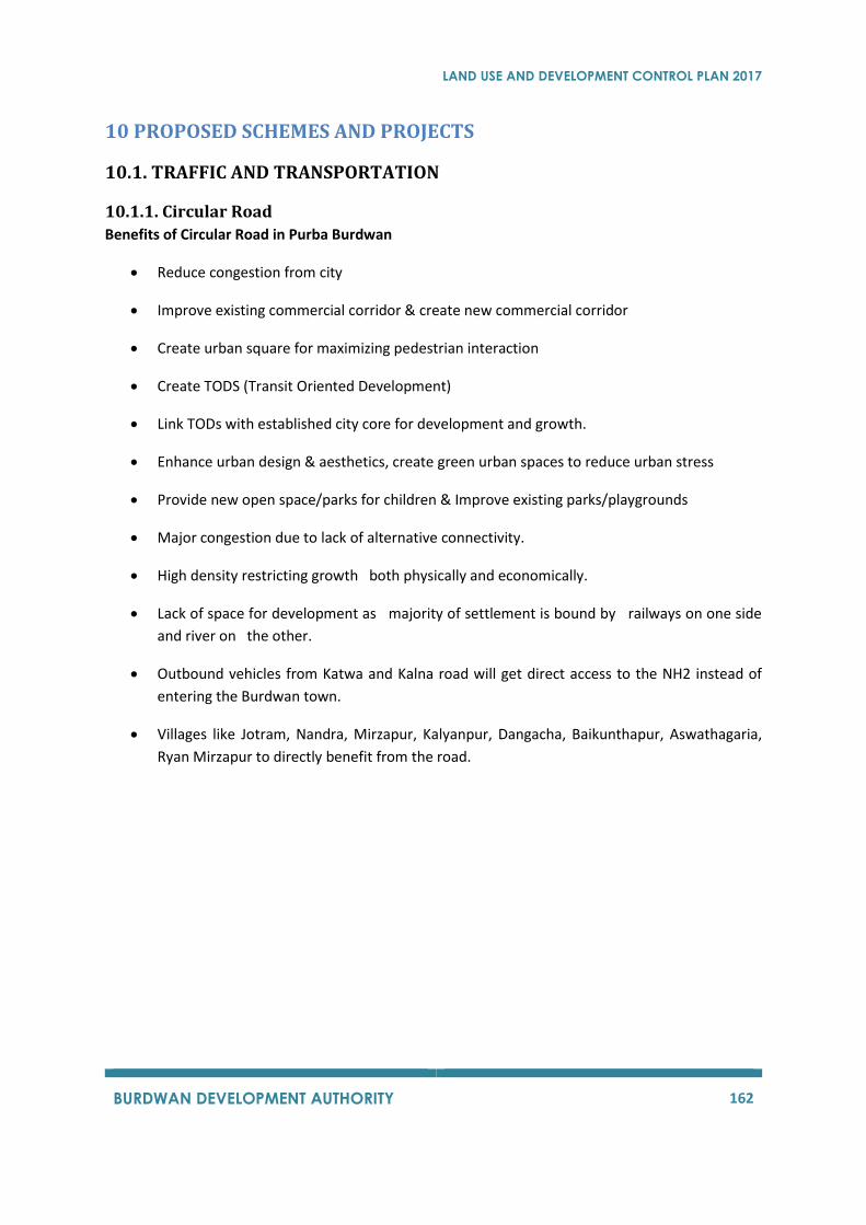
LAND USE AND DEVELOPMENT CONTROL PLAN 2017
BURDWAN DEVELOPMENT AUTHORITY 162
10 PROPOSED SCHEMES AND PROJECTS
10.1. TRAFFIC AND TRANSPORTATION
10.1.1. Circular Road
Benefits of Circular Road in Purba Burdwan
• Reduce congestion from city
• Improve existing commercial corridor & create new commercial corridor
• Create urban square for maximizing pedestrian interaction
• Create TODS (Transit Oriented Development)
• Link TODs with established city core for development and growth.
• Enhance urban design & aesthetics, create green urban spaces to reduce urban stress
• Provide new open space/parks for children & Improve existing parks/playgrounds
• Major congestion due to lack of alternative connectivity.
• High density restricting growth both physically and economically.
• Lack of space for development as majority of settlement is bound by railways on one side
and river on the other.
• Outbound vehicles from Katwa and Kalna road will get direct access to the NH2 instead of
entering the Burdwan town.
• Villages like Jotram, Nandra, Mirzapur, Kalyanpur, Dangacha, Baikunthapur, Aswathagaria,
Ryan Mirzapur to directly benefit from the road.
LAND USE AND DEVELOPMENT CONTROL PLAN 2017
BURDWAN DEVELOPMENT AUTHORITY 163
Figure 54: Proposed Circular Road
10.2. BEAUTIFICATION & ENVIRONMENT
10.2.1. Eco-Tourism
Active Zone - Consisting of Visitor center, Restaurants, Food courts, Urban Museum, Crafts Haat
Theme Area - Consisting of Maidan (open field), Amphitheatre, children's play area, Chinese
garden, formal garden, Bonsai garden, Cactus walk, Butterfly garden, helicornia garden and mist
house and bamboo garden.
Resort Area – cottages, Play area, tree plantation, Water garden and utility area
Water front Zone - A bridge connecting the island, Bengali themed restaurant, Sculpture court,
Lakefront Promenade, Wildflower meadows
Eco-zones - consisting of wetlands, grasslands, tropical and mixed-moist deciduous forests.
10.2.2. Combined Sewerage System
The need of a systematic waste water management system has been considered as a necessity
rather than an option due to the unhygienic disposal of waste and waste water.
The available drainage channels are incapable of handling waste water and storm water
generation and during rainy season it gets flooded and contaminates all water bodies in BPA.
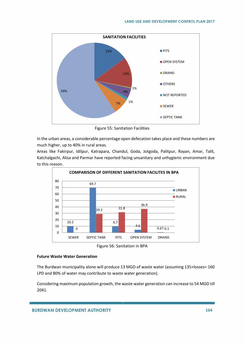
LAND USE AND DEVELOPMENT CONTROL PLAN 2017
BURDWAN DEVELOPMENT AUTHORITY 164
Figure 55: Sanitation Facilities
In the urban areas, a considerable percentage open defecation takes place and these numbers are
much higher, up to 40% in rural areas.
Areas like Fakirpur, Idilpur, Katrapara, Chandul, Goda, Jotgoda, Palitpur, Rayan, Amar, Talit,
Katchalgachi, Alisa and Parmar have reported facing unsanitary and unhygienic environment due
to this reason.
Figure 56: Sanitation in BPA
Future Waste Water Generation
The Burdwan municipality alone will produce 13 MGD of waste water (assuming 135+losses= 160
LPD and 80% of water may contribute to waste water generation).
Considering maximum population growth, the waste water generation can increase to 54 MGD till
2041.
15%
13%
1%4%
1%7%
59%
SANITATION FACILITIES
PITS
OPEN SYSTEM
DRAINS
OTHERS
NOT REPORTED
SEWER
SEPTIC TANK
10.2
69.7
9.74.6
0.670
29.2 31.836.9
0.10
10
20
30
40
50
60
70
80
SEWER SEPTIC TANK PITS OPEN SYSTEM DRAINS
COMPARISON OF DIFFERENT SANITATION FACILITES IN BPA
URBAN
RURAL
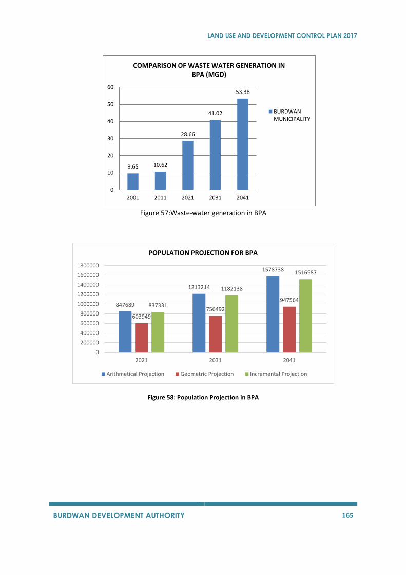
LAND USE AND DEVELOPMENT CONTROL PLAN 2017
BURDWAN DEVELOPMENT AUTHORITY 165
Figure 57:Waste-water generation in BPA
Figure 58: Population Projection in BPA
9.65 10.62
28.66
41.02
53.38
0
10
20
30
40
50
60
2001 2011 2021 2031 2041
COMPARISON OF WASTE WATER GENERATION IN BPA (MGD)
BURDWANMUNICIPALITY
847689
1213214
1578738
603949756492
947564837331
1182138
1516587
0
200000
400000
600000
800000
1000000
1200000
1400000
1600000
1800000
2021 2031 2041
POPULATION PROJECTION FOR BPA
Arithmetical Projection Geometric Projection Incremental Projection
LAND USE AND DEVELOPMENT CONTROL PLAN 2017
BURDWAN DEVELOPMENT AUTHORITY 166
Copyright © 2022 FDOKUMEN