First Consultation Draft Broads Plan 2017 Report by Dir
41
AL/MIC/RG/rpt/ba220116/Page 1 of 3/140116 Broads Authority 22 January 2016 Agenda Item No 13 Broads Plan Review: First Consultation Draft Broads Plan 2017 Report by Director of Planning and Resources Summary: The Broads Plan is the key strategic management plan for the Broads. The current Plan was adopted in May 2011 and its review is identified as a Strategic Priority for 2015/16. It is anticipated that the revised Plan will be adopted in March 2017. This report introduces the first draft Broads Plan 2017, prior to its publication for public consultation. Recommendations: (i) That members’ views are invited on the first consultation draft Broads Plan 2017. (ii) That, subject to the feedback from members, the draft plan is published for public consultation in February. 1 Introduction 1.1 This report sets out progress on the review of the Broads Plan, which is being carried out during 2015/16. It is anticipated that a revised Plan will be adopted in March 2017. 1.2 Members are aware that the Broads Plan is for the Broads, not just for the Broads Authority. As such, while the Broads Authority is responsible for its production, the successful delivery of the Plan depends on a shared vision and commitment to partnership working and on the best use of shared resources. The involvement of partners, key stakeholders and local communities is also a key part of the plan review process. 1.3 The Broads Plan review began earlier this year, and included a Broads Authority and Navigation Committee Member Workshop on 7 October 2015. This was followed by workshops with the Broads Forum on 5 November and the Broads Local Access Forum on 9 December. In addition, focused sessions on the Broads Plan have been held with the Broadland Catchment Partnership, the Broads Conservation Partnership and the Broads Climate Partnership. Feedback from the Member Workshop has also informed the development of the emerging revised Sustainable Tourism Strategy, being produced alongside this first draft Broads Plan. Other input to both reviews has included the four Stakeholder Surveys, evidence from research projects
-
Upload
khangminh22 -
Category
Documents
-
view
0 -
download
0
Transcript of First Consultation Draft Broads Plan 2017 Report by Dir

AL/MIC/RG/rpt/ba220116/Page 1 of 3/140116
Broads Authority 22 January 2016 Agenda Item No 13
Broads Plan Review: First Consultation Draft Broads Plan 2017
Report by Director of Planning and Resources
Summary: The Broads Plan is the key strategic management plan for the Broads. The current Plan was adopted in May 2011 and its review is identified as a Strategic Priority for 2015/16. It is anticipated that the revised Plan will be adopted in March 2017. This report introduces the first draft Broads Plan 2017, prior to its publication for public consultation.
Recommendations: (i) That members’ views are invited on the first consultation draft Broads Plan
2017. (ii) That, subject to the feedback from members, the draft plan is published for
public consultation in February.
1 Introduction 1.1 This report sets out progress on the review of the Broads Plan, which is being
carried out during 2015/16. It is anticipated that a revised Plan will be adopted in March 2017.
1.2 Members are aware that the Broads Plan is for the Broads, not just for the
Broads Authority. As such, while the Broads Authority is responsible for its production, the successful delivery of the Plan depends on a shared vision and commitment to partnership working and on the best use of shared resources. The involvement of partners, key stakeholders and local communities is also a key part of the plan review process.
1.3 The Broads Plan review began earlier this year, and included a Broads Authority and Navigation Committee Member Workshop on 7 October 2015. This was followed by workshops with the Broads Forum on 5 November and the Broads Local Access Forum on 9 December. In addition, focused sessions on the Broads Plan have been held with the Broadland Catchment Partnership, the Broads Conservation Partnership and the Broads Climate Partnership. Feedback from the Member Workshop has also informed the development of the emerging revised Sustainable Tourism Strategy, being produced alongside this first draft Broads Plan. Other input to both reviews has included the four Stakeholder Surveys, evidence from research projects

AL/MIC/RG/rpt/ba220116/Page 2 of 3/140116
and guidance level strategies implemented since the adoption of the current Broads Plan, including the Broads Lake Review, Integrated Access Strategy, Biodiversity and Water Strategy and Broads Local Plan.
1.4. The current Plan was adopted at the start of the last Comprehensive
Spending Review period, and as such it was necessary to balance aspiration and ambition against the likelihood that future finances would be uncertain but diminishing. As predicted, the squeeze on finances has affected public sector bodies, charitable trusts and the private sector, and the scope of key agencies working within the Broads (e.g. Natural England, Environment Agency, RSPB and the Wildlife Trusts) to deliver all that was originally aspired to has been a significant challenge.
1.5 There have also been considerable changes nationally in a number of key
areas since the current Plan was adopted. The introduction of new legislation in the form of the Localism Act 2011 and the raft of revisions to the planning system have been influencing factors, as has the introduction of Local Enterprise Partnerships and Local Nature Partnerships as new funding and delivery bodies at a local level.
1.6 The emerging revised Plan is being produced against a background of further
cuts in public sector funding, which will affect a number of bodies at work in the Broads. Although the Chancellor’s Autumn Statement indicated that funding for National Parks was “protected”, there is as yet no detail as to what this means in practice. However, cuts have been made to the budgets of other Defra bodies and therefore it will be prudent in the new Broads Plan, as in the last one, to balance aspiration with reality about what can actually be achieved on the ground. Continuing to make the most of partnership working and continuing to seek external resources will be fundamental to the Plan’s success.
2 Strategy Production 2.1 Members may recall from the Broads Plan workshop that an ‘Open Strategies’
approach to producing this plan has been adopted. This uses a simple Projects, Results, Uses and Benefits structure and terminology to identify compelling user needs, the results that will enable those needs to be met, and the actions needed to create or maintain the results. This approach is intended to create a clear plan of action with a rationale, with aspirational and guiding actions that will steer more detailed operational delivery.
2.2 As such, the Broads Plan is not intended to be a comprehensive list of all the
work that may be undertaken in the Broads. It should be a high level strategy to address the priority, evidence-based issues that have been identified by the Broads Authority and its partners and on which they will commit time and resources over the lifetime of the next Plan (2017-22).
2.3 A skeleton first draft of the Broads Plan 2017 is attached (Appendix A).
This draft forms a supplement to the 2011 Plan, which contains more background information about the Broads and its special qualities. The final

AL/MIC/RG/rpt/ba220116/Page 3 of 3/140116
2017 Plan will contain more contextual information, but at this early consultation stage it is useful to focus attention and discussion on the general strategic direction. A number of proposed actions are at an early ideas stage, and will need to be developed through partnership working with relevant organisations and communities both during the Plan preparation and after its adoption.
3 Timetable 3.1 The Broads Plan is a statutory plan and its review is therefore subject to
public consultation. It will also undergo Sustainability Appraisal/ Strategic Environmental Assessment (SA/SEA) and Habitats Regulation Assessment (HRA). In the review timetable agreed under the Strategic Priorities report to the Authority in March 2015, public consultation of at least 8 weeks will be carried out in early 2016, with a further round of public consultation on the final draft revised plan in Summer/Autumn 2016. It should be remembered that this is still an early stage in the Plan review, and the document will be subject to ongoing amendments. Members will continue to be updated at each milestone stage of the review process.
3.2 It is proposed that, subject to Members’ comments and suggested
amendments, the first consultation draft Broads Plan 2017 be published for public consultation in February 2016.
Background papers: None Authors: Andrea Long Date of report: 16 December 2015 Broads Plan Objectives: All Appendix: APPENDIX A – First Consultation Draft Broads Plan 2017

Consultation first draft Broads Plan 2017 The strategic partnership plan for the Norfolk and Suffolk Broads
Consultation period: Feb - April 2016 (dates to be confirmed)
Broads Authority Yare House, 62-64 Thorpe Road Norwich NR1 1RY tel: 01603 610734 fax: 01603 756069 email: [email protected] www.broads-authority.gov.uk
APPENDIX A

BA/First draft Broads Plan 2017/p.2
Broads Plan 2017: First draft for consultation
The Broads Plan is the key strategic management plan for the Broads. It sets out the long-
term vision for the Broads and guiding strategic actions for the benefit of the Broads
environment, local communities and visitors.
The Plan is reviewed on a regular basis and updated as necessary. This first draft Broads Plan
2017 is an update to the current Plan (2011) and focuses on proposed strategic priorities for
the period 2017-22. It does not repeat all the background information in Broads Plan 2011,
which will remain largely unchanged and which may be viewed on the Broads Plan website at
www.broads-plan.co.uk.
The draft Broads Plan 2017 is accompanied by a draft Habitats Regulation Assessment
(Appropriate Assessment) and Sustainability Appraisal.
Views on the draft Broads Plan 2017 and accompanying documents are invited.
Please send all comments in writing to:
Maria Conti
Broads Strategy Officer
Broads Authority Yare House, 62-64 Thorpe Road Norwich NR1 1RY
Email: [email protected]
The Broads Authority is also consulting on Issues and Options for the Broads Local Plan.
The Local Plan sits alongside the Broads Plan, and sets out spatial planning policy for the
Broads Executive Area. Your comments on the draft Local Plan are also welcomed.
Consultation on all the above documents is from x February to x April 2016
You may view and download all documents at www.broads-authority.gov.uk or see paper
copies (reference only) at the venues listed on page 14. Alternatively, please contact the
Broads Authority for a paper copy of any of the documents.
First draft/11 January 2016

BA/First draft Broads Plan 2017/p.3
[Contents page to be added]
Introduction
Note on Broads National Park branding
In this draft Broads Plan we are adopting the use of the brand ‘Broads National Park’. The Broads
has equivalent status to a National Park but, in addition to the other parks' two purposes of
conservation and promoting enjoyment, it has a third equally weighted purpose of managing the
navigation. As such it is defined under a different act of Parliament to the other Parks and has been
known as a ‘member of the National Park family’. In 2015, the Broads Authority voted to brand the
area as the ‘Broads National Park’ to promote more clearly its national park credentials and special
qualities. Although Defra was content with this decision, it is currently under legal challenge. For
the purposes of the Broads Plan review process, we are using the branding pending the outcome of
the judicial review. 11 Jan 2016
The Broads
The 15 National Parks in the UK are collectively known as ‘Britain’s Breathing Spaces’. This phrase
echoes the words of the Norfolk naturalist Ted Ellis, who described the Norfolk and Suffolk Broads
as …”a breathing space for the cure of souls”.
The Broads is renowned as the UK’s premier wetland and its third largest inland navigation. It is a
unique and globally important landscape shaped and nurtured by its inhabitants since at least Roman
times. Encompassing an area of 303km2, the Broads Executive Area sits between the peripheral urban
areas of Norwich, Great Yarmouth and Lowestoft, with a short coastal strip at Winterton and an
estuary at Breydon Water on the East coast. The Broads sits at the bottom end of the much larger
Broadland Rivers Catchment, with water flowing through it and out to sea.
The low-lying, mainly open and undeveloped landscape of the Broads comprises an interconnected
wetland mosaic of seven navigable rivers around 63shallow lakes or ‘broads’, fens, drained marshes
and wet woodland, all rich in rare habitats and species, some of which are unique to the area. Its
importance is borne out by a range of national and international designations in recognition of its
landscape, nature conservation and cultural features.
The Broads is also a living, dynamic landscape, formed over centuries by the way local people have
lived and worked. The shallow lakes referred to as ‘broads’ originated as great pits dug for peat to
provide fuel during medieval times. Around the 14th century, these peat diggings flooded and
became part of an extensive communication network for transporting fuel, building materials
including reed for thatch, and livestock and their products, especially wool. The advent of the railways
in the mid-19th century and motor vehicles in the 20th century brought most river-borne commerce
to an end, but made the Broads accessible as a popular tourist destination for boating holidays, with
200km of navigable, lock-free rivers and open water bodies to be explored and enjoyed.

BA/First draft Broads Plan 2017/p.4
No landscape ever stays still. The Broads will continue to be influenced and shaped by
environmental, social, economic, technological and political change. One of the greatest
challenges for this easterly, low-lying freshwater wetland is the predicted more rapid changes to the
climate, together with sea level rise. Other significant changes in global, national and regional
economies, demands on food and energy resources, and population growth and demands for
housing and infrastructure in the East of England will impact upon the landscape and communities
of the Broads.
Understanding and responding now to the challenges ahead will help us to plan a long-term future that
maintains this special and valued landscape. As part of the UK National Parks family and global network
of protected landscapes, the Broads has a vital role to play in demonstrating how wetland resources can
be managed sustainably for the benefit of both nature and people.
The Broads Authority
The Broads Authority is a Special Statutory Authority established under the Norfolk and Suffolk
Broads Act 1988 with very similar responsibilities to those of the English National Park Authorities.
The Authority has a duty to manage the Broads, and is the local planning authority for the area and
a harbour and navigation authority. The Broads executive boundary is drawn tightly around the
flood plains and lower reaches of the rivers Bure, Yare and Waveney and their tributaries the
Thurne, Ant, Wensum and Chet.
The Authority has a duty to manage the Broads for the following three purposes, none of which
takes precedence:
• Conserving and enhancing the natural beauty, wildlife and cultural heritage of the Broads;
• Promoting opportunities for the understanding and enjoyment of the special qualities of the Broads by the public; and
• Protecting the interests of navigation
while having regard to:
• The national importance of the Broads as an area of natural beauty and one which affords opportunities for open-air recreation;
• The desirability of protecting the natural resources of the Broads from damage; and
• The needs of agriculture and forestry and the economic and social interests of those who live or work in the Broads.
The Authority also has the duty to maintain the navigation area for the purposes of navigation to
such standard as appears to it to be reasonably required; and take such steps to improve and
develop it as it thinks fit.

BA/First draft Broads Plan 2017/p.5
The Broads Plan
The Broads Plan is the key strategic management plan for the Broads. It sets out a long-term vision
and guiding action for the area, and integrates a wide range of strategies, plans and policies
relevant to the Broads with the purposes and duties in the Broads Acts.1
A partnership plan
A priority outcome in the Government’s Vision for the English National Parks and the Broads is to
work in partnership to maximise benefits and minimise costs.
The Broads Plan is a plan for the Broads, not just for the Broads Authority. While the Authority is
responsible for its production, a wide range of organisations, interest groups and local communities
are directly or indirectly involved in looking after the area. As such, the success of the Plan depends
on a shared vision and commitment, and on working in partnership to make the best use of shared
knowledge, efforts and resources. Lead and joint partners are identified against actions in this plan.
[list of plan partners to be added]
Funding
In his 2015 Autumn Statement, the Chancellor stated that funding for National Parks would be
protected, although precisely what this means in practice is still unclear at the time of writing this
draft document. However, cuts have been made to other Government (Defra) funded bodies
working in the Broads, notably the Environment Agency and Natural England, and more are
expected. This follows on from funding cuts made to National Parks and other Defra funded bodies
during the last Broads Plan period.
While aspirations remain high, the Broads Plan must be realistic and capable of delivery within this
economic framework and the wider national context. Focused and sometimes difficult choices will
need to be made about priorities for core funding, and partnership working will become more and
more important.
Broads Plan partners will continue to develop their good track record of drawing in additional
resources, for example through external grants, private sponsorship, visitor giving schemes and
commercial sales. They will also continue to foster the invaluable support of a dedicated and
hardworking volunteer workforce. External funding in this plan period already includes a £2.6m
Heritage Lottery Fund award for the Broads Landscape Partnership Scheme, which will support a
wide range of local landscape and community projects in the Broads.
1 Broads Acts: Norfolk and Suffolk Broads Act 1988 and Broads Authority Act 2009

BA/First draft Broads Plan 2017/p.6
Monitoring
The Broads Plan review is informed by an Environmental Report (combining Sustainability Appraisal
and Strategic Environment Assessment). This assesses any significant environmental, economic
and social impacts of implementing the Plan. The Plan also undergoes Appropriate Assessment,
which considers the impacts of the Plan on conservation sites designated under the European
Habitats Directive. [Consultation draft documents: See inside front page for details]
Broads Plan 2011 has been monitored and updated regularly through a dedicated website, and
through a quarterly report to the Broads Authority. A monitoring and reporting process for Broads
Plan 2017 has yet to be determined, but it is likely to include 6-monthly and annual update reports
of all strategic actions.
To view progress against objectives in Broads Plan 2011, visit www.broads-plan.co.uk.
Map 1: Broads Executive Area
© Crown copyright and database rights 2015. Ordnance Survey 100021573
BA/First draft Broads Plan 2017/p.7
Going forward
In managing the precious natural, built and cultural resources of the Broads we are guided by a
long-term vision, long-term aims and a set of fundamental principles. Underlying these is the need
to recognise the enormous value of a diverse, healthily functioning natural environment and the
services it provides for our environmental, economic and social wellbeing.
Valuing our natural capital
The beneficial goods, services and cultural values we get from our natural environment are
sometimes referred to as ‘ecosystem services’. Put simply, ecosystem services are what nature
provides us for free. This includes provisioning services such as food and fibre, regulating services
such as fresh water, carbon storage, flood regulation and air quality, and cultural services such as
recreation, education and inspiration. These functions are all underpinned by supporting services
such as water and nutrient cycling, soil formation and healthy flora and fauna.
To sustain manage healthy, functioning ecosystems and the services they provide now and for
future generations, we need to see the big picture. This is about understanding our ecosystems as a
complex, interdependent whole, rather than focusing on single-interest concerns (such as economic
benefits) or on favourable services (such as flood protection), sometimes at the expense of others.
Some of the key ecosystems services in the Broads are shown below. As a designated, protected
landscape the Broads is well placed to demonstrate the benefits of a ‘bigger, better and more joined
up’ management approach. This approach seeks to balance the condition and needs of a healthy,
multi-functioning natural environment with the sustainable and fair use of the services it provides us.
Broads ecosystem services [pictorial diagram to be added; notes below to be included in appendix]
Biodiversity: Priority Wetland Vision area with largest expanse of species-rich fen in lowland
Britain. A mosaic of habitats including saltmarshes, intertidal mudflats, shallow lakes, fens, drained
marshland, wet woodland and various coastal formations. Ab out 25% of the Broads is nationally
and internationally important for nature, with almost 7000 hectares designated as Sites of Special
Scientific Interest, one-third of which are also designated as National Nature Reserves. Virtually the
entire SSSI network is designated under European Habitats and Birds Directives and Ramsar
Convention on Wetlands of International Importance, especially as waterfowl habitats.
Fresh water supply: Catchment groundwater, rivers and broads supply wetland habitats and water
dependent industries and provide drinking water to local communities.
Food and fibre: Livestock grazing and some arable crops (cereals, sugar beet, brassica, fodder beet,
maize, small fruit), high grade reed and sedge, fen products used as soil improvers.
Energy: Actual and potential renewable energy from wind, tidal water, biomass and wood

BA/First draft Broads Plan 2017/p.8
Genetic diversity: 11,067 recorded taxa, including 1519 priorities for conservation; 31 species
entirely restricted in the UK to the Broads (including all swallowtail butterflies) and a further 35
species with a primary stronghold in the region. Iconic species include the Norfolk hawker
dragonfly, bittern, marsh harrier, otter, fen orchids, dotted footman moth and holly-leaved naiad.
Regulating water flow and water quality: Water falling in the catchment percolates into
groundwater or runs, drains or is pumped into the rivers, ultimately flowing out to sea. 95% of the
Broads lies within the natural floodplain, providing flood storage capacity for heavy rainfall or tidal
surge events.
Climate regulation and carbon storage: The floodplain fen peat soils store 38.8m tonnes of carbon;
coastal and floodplain grazing marsh also offer significant carbon storage resource; reed and sedge,
woodland, scrub and hedgerows lock up carbon over shorter timescales
Regulating soil quality: Fertile floodplain soils of peat and alluvial silts with clays support arable
production in drained areas; grazing marsh is common in wetter areas.
Regulating erosion: Reed rond provides natural protection for river banks, buffering the effects of
wave action and decreasing the need for dredging. Soil cover and organic content on farmland
helps minimise erosion, particularly on free draining peaty soils. Sediment from Norfolk’s soft sea
cliffs feeds the beaches and intertidal habitats, helping to buffer the Broads from coastal flooding
during storm events
Pollination: Meadow, grazing marsh and field-margin habitats provide important nectar sources for
pollinating insects
Disease and pest regulation: Semi-natural habitats such as meadows, field margins and fen provide
important overwintering habitats for invertebrates that feed on pest species. Integrated pest
management approaches help reduce the need for chemical intervention.
Inspiration and tranquillity: A “breathing space for the cure of souls” influencing centuries of artists,
photographers and writers including John Crome, John Sell Cotman, P.H. Emerson and Arthur
Ransome; winding waterways and low-lying ‘big skies’ landscape enhancing the sense of peaceful
seclusion and wildness
Landscape character and cultural heritage: The ‘broads’ (shallow lakes) originated as medieval peat
diggings for fuel and historical flooding. The area is a site of Exceptional Waterlogged Archaeology.
A long history of controlled drainage is evident in the drainage mills, raised and embanked rivers,
and drainage dykes. 25 designated conservation areas and nearly 1,000 architectural and historical
sites worthy of inclusion on the Historic Environment Record
Recreation and tourism: Part of the UK National Parks family, attracting more than seven million
visitors a year; Popular recreational opportunities include boating, angling, walking, bird watching,
and visits to historic and cultural assets such as mills and churches; 200km of inland navigable rivers

BA/First draft Broads Plan 2017/p.9
and 303km of public rights of way, including three long distance trails; surrounding coast and urban
centres (including Norwich, Great Yarmouth and Lowestoft)
Environmental education: ‘Classrooms without walls’ provide opportunities for people from all
walks of life, ages and abilities to understand and enjoy the natural environment
Notes from Broads NCA 80 (NE), Broads Plan, Why Farming Matters in the Broad (NFU), An Ecosystems Services Approach for the Broads
(UEA), Valuing Ecosystems Services: Case Studies from Lowland England (NE), Defra guidance on ecosystems planning
[To be added: Pictorial diagram of key ecosystem services in the Broads]

BA/First draft Broads Plan 2017/p.10
Long-term vision
The Vision for the Broads by 2030 recognises the value of our ecosystems and the services they
provide for people and wildlife. It is based on the Vision for the English Natural Parks and the
Broads produced by Defra in 2010.
Note: This is an amalgamation of the Defra vision and the Vision for the Broads as set out in
tables 2 and 3 in Broads Plan 2011
Table 1: Vision for the Broads
By 2030 the Broads will be a place where:
Wildlife flourishes and habitats are maintained, restored and expanded and linked effectively
to other ecological networks. Landscapes and habitats are managed to create resilience and
enable adaptation. The importance of the waterways for navigation, biodiversity and
recreation is recognised, protected and enhanced.
There is a thriving, living, working landscape notable for its natural beauty and cultural
heritage. It inspires visitors and local communities to live within environmental limits and to
tackle climate change. The ecosystem services it provides (from clean water to sustainable
food) are in good condition and valued by society.
Sustainable development can be seen in action. The communities of the Broads take an active
part in decisions about their future. They are known for having been pivotal in the
transformation to a low carbon society and sustainable living. Renewable energy, sustainable
agriculture, low carbon transport and travel and healthy, prosperous communities have long
been the norm.
Everyone can experience the rich variety of its natural and historic environment, and have the
chance to value it as a place for escape, adventure, enjoyment, inspiration and reflection, and a
source of national pride and identity.
It is recognised as fundamental to our prosperity and wellbeing, forever treasured as a place
that provides a “breathing space for the cure of souls”.

BA/First draft Broads Plan 2017/p.11
Long-term aims to 2030
Note: Long-term aims for the Broads were set out in Broads Plan 2011, under each of the themes in that plan. These aims (Table 2) will be updated through the plan review process, and a revised set included in the final plan.
Table 2: Long-term aims for the Broads (as in Broads Plan 2011)
Responding to Climate Change and Sea Level Rise
All the key agencies believe that the Broads will remain a special area, retaining its wildlife and
heritage importance and continuing to offer extensive recreation and socio-economic
opportunities. Longer-term aspirations and decisions to address the impacts of climate change and
sea level rise will be informed by robust evidence and wide ranging debate on the most appropriate
management options: Primarily, whether to find ways that allow natural processes to direct change
or to seek to retain the status quo of a predominantly freshwater system; and the levels of human
intervention and expenditure required to adapt important assets to new regimes.
Landscape and Cultural Heritage
The Broads is maintained as a unique and special landscape with its own sense of place and historic
significance. The tranquillity and wildness of the Broads is protected and enhanced for people to
enjoy. The key physical, historic and cultural elements of landscape character are recognised,
understood, retained, reinforced and actively managed, while allowing the landscape to continue to
evolve and reflect the interactions between people and nature.
Biodiversity
Biodiversity is protected and enhanced in keeping with the status of the Broads as a globally
important wetland. Management of habitats and species is approached on a landscape scale,
meeting ecological needs as well as wider social and economic benefits. Opportunities are
sought to buffer, connect and create habitat areas to establish ecological networks and increase
resilience of habitats and species to climate change. Invasive species are understood and
managed where possible. Water bodies and wetlands within the Broads are achieving ‘good’
status in accordance with provisions in the Water Framework Directive or favourable ecological
condition targets where under European Conservation designation.
Agriculture and Land Management
Sustainable land management and agri-environmental practices support viable agriculture and a
healthy and good quality environment. Good practice and buffer areas prevent nutrients,
chemicals and sediment polluting the water resource. Careful management of wetland habitats
promote dykes rich in plants and invertebrates and marshes with increasing numbers of wintering
and breeding birds, a healthy livestock industry and a protected historic environment and access
network. Arable production on the valley sides includes biodiversity needs through positive action.

BA/First draft Broads Plan 2017/p.12
The importance of good soil management is recognised as vital for agriculture, water quality and
reduction of greenhouse gas emissions. Land managers are aware of climate change and making
adaptation choices to retain the special qualities of the area. The importance of the food supply
chain is embraced and where beneficial localised, helping to create a buoyant agricultural sector.
Management of the Navigation Area
The importance of the Broads’ waterways for navigation, biodiversity and recreation is recognised
and valued. The waterways and associated riverside and facilities provide opportunities for people
of all ages and abilities to access and enjoy the environment. Sediment is managed to provide
necessary depths for navigation purposes, with dredged material beneficially reused or disposed of
in environmentally and economically sustainable ways. Bank erosion is minimal, with sustainable
engineering solutions used to protect the more vulnerable stretches of waterways. Riverside and
water plants are managed in ways that keep waterways open to navigation, do not impact on the
ecological or archaeological integrity of sites, and provide for appropriate recreation. Restrictions
on navigation due to bridges is minimised and mitigated wherever possible.
Promoting Understanding, Enjoyment and Wellbeing
The Broads is promoted as a distinctive member of the family of National Parks and as an inland
waterway. Clear, consistent and high quality information helps visitors and local people from all
walks of life and of all ages and abilities to understand, enjoy and benefit from the special qualities
of the area. The natural and cultural history that reflects the character of the Broads’ landscape is
understood, documented and promoted through a variety of means that make it accessible to all.
Local people feel that they are actively involved in making decisions about the future of the Broads
and able to contribute to the sustainable management and enjoyment of the area.
Tourism, Recreation and Access
The Broads offers a wide range of high quality land and water based activities in suitable locations
and in harmony with the special qualities of the area and its communities. The value of the Broads
as a place for escape, adventure, enjoyment, inspiration and reflection is recognised and valued.
Tourism is managed at environmentally and socially sustainable levels, contributing to a thriving
local economy and meeting the standards of the Green Tourism Business Scheme.
Access on land and between land and water is sensitively managed to maximise the social,
educational and health benefits of open space to all, while ensuring the resource itself is not
degraded. Where possible, improvements are made to the connectivity and use of access routes,
linked to visitor destination points and sustainable transport.

BA/First draft Broads Plan 2017/p.13
Fundamental principles
To guide the implementation of all actions in the Broads Plan, we have developed a set of
fundamental principles, based on an ecosystem approach.
The first overarching principle is based on the definition of the Precautionary Approach in the
Rio Declaration on Environment and Development, 1992.
Precautionary approach: Where there are likely threats of serious or irreversible damage to
the environment, as a precaution, cost-effective measures will be taken to prevent
environmental degradation in the absence of full scientific certainty of the outcome of such
threats. Such precautionary action will be based on assessment of the costs and benefits of
action, and transparency in decision making.
Manage sustainably: This is about understanding and respecting the complexity and
biological limits of our ecosystems, and conserving their structures to maintain
productivity. We need to manage for long-term benefits, not just for short-term gains.
See the big picture: This is about managing ecosystems at the local scale, while
recognizing the direct or indirect effects on interconnected ecosystems and the beneficial
services they provide. Our management decisions should be made transparently and
fairly, assessing the costs to nature and to people.
Be flexible: It is important to anticipate and cater for inevitable change, taking a cautious
approach to any decision that may block other management options in the longer term. At
the same time, we should consider possible mitigation actions to cope with long-term
impacts such as climate change.
Engage and learn: Decisions should be based on strong evidence, including scientific and
local knowledge, innovations and practices. People must be involved in decisions that
interest and affect them, recognising society’s needs and choices.
Act together: Key to the success of the Broads Plan is working in partnership with
organisations, interest and user groups, businesses and local communities to make the
best use of shared knowledge, effort and resources.

BA/First draft Broads Plan 2017/p.14
Consultation details
Where to view the draft Broads Plan, Broads Local Plan (Issues and Options) and supporting
consultation documents:
Website:
www.broads-authority.gov.uk
Venues: [details to be added]
Venue
Acle Library
Beccles Library
Brundall Library
Bungay Library
Cromer Library
Great Yarmouth Library
Loddon Library
Lowestoft Library
Oulton Broad Library
Norwich Millennium Library
Stalham Library
Wroxham Library
Broads Authority, Yare House, 62-64 Thorpe Road, Norwich
Broadland District Council, Thorpe Road, Norwich
Great Yarmouth District Council, Town Hall
North Norfolk District Council, Holt Road, Cromer
Norwich City Council, City Hall
South Norfolk Council, Swan Lane, Long Stratton
Waveney District Council, Riverside, 4 Canning Road, Lowestoft, NR33 0EQ
Norfolk County Council, County Hall, Norwich
Suffolk County Council, Endeavour House, Ipswich
Whitlingham Visitor Centre, Whitlingham Lane, Trowse
How Hill Tourist Information Centre (Toad Hole Cottage Museum), Ludham (Mar-Apr)
Hoveton Tourist Information Centre, Station Road, Hoveton (Mar-Apr)
Comments on all consultation documents must be submitted in writing to the Broads
Authority by the closing date of 4pm on x April 2016.

Broads Plan 2017: Priority partnership actions 2017-22 (first draft)
Draft strategic actions for the next Broads Plan period 2017-22 are set out in the following tables.
This is not intended to be a comprehensive list of all the work that may be undertaken in the Broads, and does not include many routine operations. It is a guiding strategy
to address priority issues that have been identified by the Broads Plan partners, and on which they are prepared to commit time and resources over the lifetime of the
plan. The proposed actions are at an early stage, and more ideas will emerge through the plan review process and through ongoing partnership working with relevant
organisations, groups and communities.
The actions are listed under 11 ‘headline’ aspirations. Targets will be developed for each aspiration, and regular monitoring will flag up any need for changes to the actions
and the reasons for them. Monitoring reports are taken to the quarterly meetings of the Broads Authority and published on the Authority’s website.
Managing flood risk and
water resources Aspiration 1: Develop an integrated long-term flood risk management strategy for the Broads and interrelated coastal frontage, and improve water capture and water efficiency across the Broads catchment
Conserving priority habitats
and species
Aspiration 2: Protect, maintain and enhance the quality of habitats in accordance with the vision, priorities and principles in the Broads Biodiversity and Water Strategy
Aspiration 3: Conserve and enhance species of conservation concern as identified by the Broads Biodiversity Audit (2011)
Maintaining the navigation Aspiration 4: Apply a catchment-scale approach to improve the balance of sediment inputs and outputs into the system, reduce the sediment backlog and sustainably reuse or dispose of dredged material
Conserving local landscape
character Aspiration 5: Improve understanding, protection, conservation and enhancement of the Broads landscape character and distinctive built, cultural and archaeological assets
Supporting sustainable
development Aspiration 6: Facilitate development within and adjacent to the Broads, while minimising adverse impacts on the Broads’ special qualities
Building climate-smart
communities Aspiration 7: Improve local community awareness of climate and sea level impacts, and build local mitigation and adaptive capacity
Providing distinctive
recreational experiences Aspiration 8: Provide a range of distinctive recreational experiences in suitable locations in harmony with the special qualities of the area
Promoting understanding
Aspiration 9: Strengthen and promote key messages and tourism offer in keeping with the area’s national park status, special qualities, history and traditions
Aspiration 10: Improve and more widely share understanding and expertise about the Broads natural environment
Connecting local communities Aspiration 11: Reconnect a wider audience, particularly local communities and young people, with the Broads environment

BA/First draft Broads Plan 2017/p.16
Managing flood risk and water resources
Summary of current issues
The groundwater, rivers and broads within the Broadland rivers catchment are a vital water source for maintaining the healthy status and functioning of the Broads wetland habitats, and for supplying water for farmland and other water dependent businesses, public drinking water and waterways recreation. Water management and land use practices in the whole catchment, most of which lies outside the Authority’s executive boundary, are crucially important for the Broads, the basin at the bottom of the catchment.
Sea level rise and the predicted more rapid changes to the climate pose enormous challenges to the future of this easterly, low-lying, predominantly freshwater wetland. The biggest risk to the Broads comes from changes in sea level, with global warming exacerbating the issue. Higher sea levels can hold back water trying to drain from the rivers, which can directly cause flooding. If a combination of weather and high tides causes a surge in the North Sea additional, saline water can be pushed up the rivers, putting flood defences under threat. Higher sea levels along the north-east Norfolk and north Suffolk coast also bring an increased risk of sea defences being overtopped or breached, with possible inundation and increasing incursion of saline water into a predominantly freshwater ecosystem. Major, robustly informed decisions must be made about desirable and realistic longer-term flood risk management options for the Broads and linked coastal frontages beyond the current ‘hold the line’ policy position.
Predicted drier summers, wetter winters and more intense periods of rainfall will affect surface water levels and the seasonal variability in river flows and groundwater resources. Abstraction of water for domestic and agricultural use has risen in recent decades and will be impacted further by climate change and by ongoing significant development growth and regeneration around the Broads.
Over half the rivers in the catchment have been physically modified, often as a result of historic flood defence, land drainage or milling activities. While this has provided social and environmental benefits, it has affected water dependent habitats and increased downstream flood risk in some areas, with water in the catchment ultimately flowing through, or under, the low-lying (at or below sea level) Broads area and out to sea.
Aspiration 1 Develop an integrated long-term flood risk management strategy for the Broads and interrelated coastal frontage, and improve water capture and water efficiency across the Broads catchment Targets: to be added
Ref PROJECTS RESULTS (products, services, infrastructure) USES BENEFITS
Guidance 1.1 Manage local coastal, fluvial and surface water flood risk to 2021 and develop longer-term strategic responses (Freshwater) wetland habitats are maintaining healthy functioning Local people, property and infrastructure are being protected from significant flood impacts
Thriving wetland habitats; communities /businesses better able to cope with change and more involved in decisions affecting their future
1.1.1 Maintain current coastal defence regime and rivers flood bank maintenance programme to 2021 Environment Agency (EA)
Current ‘hold the line’ coastal and fluvial flood risk management strategy in place to 2021/ next phase implementation (Eccles to Great Yarmouth Shoreline Management Plans, Broadland Flood Alleviation Project)
1.1.2 Prepare longer-term (post-2021) flood risk management strategy for the Broads, Gt Yarmouth and interrelated coastal frontage, including:
Develop and run widespread stakeholder engagement events to share evidence and identify issues, options and research needs EA/Broads Climate Partnership
Range of active stakeholder engagement processes in place through Broads Climate Partnership /Broads
oCommunity
initiative
Robust and understandable information available publicly on desirable and feasible management options for long-term flood risk (e.g. modelling, mapping, animated visualisations)

BA/First draft Broads Plan 2017/p.17
Identify needs and commission research and modelling arising from 2016 high-level technical overview of coastal frontage defences, tidal barriers and floodwalls EA/Broads Climate Partnership
Next phase (post-2021) Broads and interrelated coastal frontage flood risk strategy developed/in place
Communities are sharing ideas and actions on coping at a local level with climate change and sea level impacts High-level authorities and funders are being lobbied to improve local flood risk protection, informed by robust evidence
1.1.3 Plan and promote schemes and measures to fit, upgrade or retrofit urban and rural drainage, particularly in high risk areas Norfolk County Council, Suffolk County Council
Surface Water Management Plan measures promoted and implemented
Practical guidance on improving sustainable drainage at local level available and promoted to the public
1.1.4 Identify locations and develop site projects in liaison with landowners to hold back or divert water (e.g. reconnecting rivers with floodplains in non-tidal areas, re-meandering river channels) Broadland Catchment Partnership
Opportunity mapping and project proposals developed (incl. ‘Slow the Flow’ campaign) and permissions and consents in place (also see Guidance 4.1 Sediment Management)
Guidance 1.2 Improve water capture and water efficiency measures across the Broads catchment
Wetland habitats are maintaining healthy functioning People have enough water for domestic, land management and business needs and are using it responsibly
Thriving wetland habitats; communities and businesses better able to cope with change; better valued and more sustainably used water resources
1.2.1 Facilitate a ‘whole farm’ water management approach across Broadland rivers sub-catchments, including:
Promote installation of on-site low-cost, low technology water capture schemes and infrastructure
Provide tailored water management advice and support to land managers
Develop and promote ‘Down but Not Out’ water management campaign
Essex & Suffolk Water (ESW), Anglian Water (AW), Norfolk Rivers Trust, Natural England (NE)
Water capture schemes and infrastructure in place, e.g. rainwater harvesting, irrigation reservoirs, constructed wetlands, field bunds, cover crops, tramline disruption
Environmental land management measures, advice and support (incl. payments) available to land managers (through Countryside Stewardship, Campaign for Farmed Environment, Catchment Sensitive Farming, Water Sensitive Farming, water management campaigns)
1.2.2 Promote and implement measures to manage water resources and respond to periods of water shortage and scarcity, including water abstraction controls, water transfer and trading, and water infrastructure improvements EA, ESW, AW
Water abstraction licencing measures in place (Broadland Catchment Abstraction Management Strategy)
Water resource management plans and drought plans in place (AW/ ESW business plans)
1.2.3 Promote good practice water efficiency and water capture measures at community level through targeted campaigns and incentives to homes and businesses EA, ESW, AW
Water efficiency measures (e.g. campaign to increase domestic water metering) and targeted campaigns (e.g. ‘Water Wise’) in place and promoted to domestic and business water users
BA/First draft Broads Plan 2017/p.18
Conserving priority habitats and species
Summary of current issues
The Broads is one of Europe’s finest and most important wetlands for nature conservation, with a mosaic of habitats comprising, among other things, saltmarshes, intertidal mudflats, shallow lakes, fens, drained marshland, wet woodland and various coastal formations. Twenty-eight sites covering a total of more than 7500 hectares are nationally designated as Sites of Special Scientific Interest. Most of these sites are of international importance for their habitats and/or bird populations or species and have been included with the European Directives and the Broads Special Areas of Conservation and the Broads Special Protection Areas. An area of the wetland is also designated under the international Ramsar Convention for protected landscapes. One third of the SSSIs are also National Nature Reserves. Biodiversity 2020 sets the national strategy for England’s wildlife and ecosystem services; aimed at halting the overall loss of biodiversity, supporting healthy well-functioning ecosystems and establishing coherent ecological networks, with more and better places for nature for the benefit of wildlife and people.
Water bodies: Good quality water is clear, low in nutrients and free of harmful substances, characterised by a diversity of aquatic plants and supporting healthy populations of fish, invertebrates and water birds. Currently, all Broads’ water bodies and river reaches and over 90% of rivers in the catchment monitored for European Water Framework Directive purposes are failing targets for ‘good’ overall ecological status or potential. Despite improvements in recent decades, water quality continues to be affected by diffuse pollution, primarily phosphorus and nitrogen from farmland and waste water, and by sediment erosion, physical modification of water courses, dissolved oxygen and fish populations, saline incursion and competing demands for water use. The water and related habitats have a tendency to change over relatively short periods of time, and their ecological and hydrological functioning needs to be better understood.
Fens and reed bed: The Broads is a priority Wetland Vision area, reflecting the national importance of the largest expanse (around 75%) of species-rich calcareous fen in lowland Britain. Many of the fen sites are designated for nature conservation value, and around 60% are owned or managed by conservation organisations. Environmental land management support to landowners and managers, targeted restoration projects and a mosaic of management regimes have helped to retain priority fens as open landscapes. Despite this, the Fen Ecological Survey (2010) identified clear evidence of change, relating to fragmentation and isolation of sites and a lack of fen management resulting in less rich habitats dominated by common reed and scrub, fewer wet fen areas, competing demands for water, nutrient enrichment and increasing salinity. The significant capture of around 40 million tonnes of carbon within the Broads peat vegetation is dependent on ongoing optimal hydrological and management conditions of the fen habitat.
Grazing marsh: The grazing marshes cover around 40% of the Broads. While many areas do not support significant wildlife value, notable areas attract large and internationally important numbers of breeding and non-breeding birds, and there is a substantial area of internationally important ditch communities. Threats to healthy marsh functioning include potential increases in arable reversion and land drainage, development, and flooding and salt tides, resulting in habitat loss and fragmentation and a decline in species numbers and movement. Many of the marshes are below sea level, and potential increased incidents and severity of tidal surges could bring threats of flooding with river water that can be high in nutrients and salt. The marshes provide one third of East Anglia’s cattle grazing land, but many local farmers feel that proposed new environmental land management agreements are too short-term and inflexible for local needs.
Species: There are more than 11,000 recorded species in the Broads, including 26% of all UK Biodiversity Action Plan species and 17% of all nationally notable or scarce species. 66 species are restricted entirely to the Broads or rarely seen elsewhere in Britain. Iconic species include the bittern, marsh harrier, otter, fen orchid, Norfolk hawker dragonfly and the entire UK populations of the swallowtail butterfly, dotted footman moth and holly-leaved naiad. Some species are in decline or on the brink of survival, including the fen orchid, water beetles, stoneworts and aquatic snails. Many priority species, including the Broads’ specialists, face challenges from increases in seasonal variability in river flows and depleted groundwater resources, salinity from tidal flooding, nutrient enrichment and pollution of the waterways, habitat loss and fragmentation, and increasing threats from invasive non-native species. Most of the Broads specialists require bespoke management to survive. Species recovery and translocation programmes can require substantial time and resources, as can biosecurity measures to control invasive non-native species. However, there have been noticeable successes in the increased population of otters, bittern, crane and marsh harrier, and the control of invasives such as Himalayan balsam, American mink and killer shrimp.

BA/First draft Broads Plan 2017/p.19
Aspiration 2
Protect, maintain and enhance the quality of habitats in accordance with the vision, priorities and principles in the Broads Biodiversity and Water Strategy Targets: 95% of SSSI sites in favourable or recovering condition, with 50% of these in favourable condition by 2020
Ref PROJECTS RESULTS (products, services, infrastructure) USES BENEFITS
Guidance 2.1 Restore, maintain and enhance water bodies (lakes, rivers and estuary) in the Broads and priority catchment
Water bodies are being maintained and used sustainably and healthily Navigation channels are being maintained Agricultural land is being managed healthily and sustainably for cropping and grazing, and for biodiversity and landscape gains
Thriving wetland biodiversity; businesses and communities able to cope with climate change; improved agricultural land quality, yields and profits
2.1.1 Carry out lake enhancement works, including bio-manipulation; use Hoveton Great Broad and Hickling Broad projects to trial further innovative restoration techniques (e.g. bio-filtration), and monitor results BA, conservation bodies
In-lake restoration, maintenance and enhancement works carried out at priority sites in accordance with Lake Restoration Strategy priorities
Monitoring in place to identify results of bio-manipulation and other techniques and analysis available
2.1.2 Promote and implement measures to reduce levels of nutrient and pesticide pollution to watercourses, including:
Offer tailored pollution management advice and support to land managers
Demonstrate and implement environmental land management measures
Develop and install public and private waste water practical infrastructure and land management works, and run public awareness campaigns
Water companies, land managers, conservation bodies
Environmental land management measures, advice and support (incl. payments) available to land managers (e.g. Countryside Stewardship, Campaign for Farmed Environment, Catchment Sensitive Farming, Water Sensitive Farming, ‘Down But Not Out’ water campaign)
Pollution reduction measures in place (e.g. water company sewage treatment works, constructed wetlands and reed beds), and support and advice available to businesses and communities (e.g. ‘Keep it Clear’ campaign)
Guidance 2.2 Restore, maintain and enhance priority fen and reed bed habitats
Fen vegetation is controlled; fens have enough clean freshwater flow to maintain healthy functioning
Species are nesting, breeding and resting in healthy habitats
Healthier, better connected fen habitats; thriving species better able to cope with change; less productivity pressure on areas of high environmental value; more high quality reed and sedge, supporting local economy and maintaining local landscape character
2.2.1 Promote and implement measures to reduce fen pollutant inputs and where possible, manage fen water levels and salinity, including:
Implement water level management controls at protected sites
Provide advice and support to fen land managers
Water Level Management Plan control measures in place and landowner support available
Environmental land management measures, advice and support (incl. payments) available to land managers (through Countryside Stewardship, Campaign for Farmed Environment, Catchment Sensitive Farming, Water Sensitive Farming, ‘Down But Not Out’ water campaign)
Broads LPS Programme 5: Natural Landscapes activities implemented

BA/First draft Broads Plan 2017/p.20
2.2.2 Manage a greater area of priority fen and reed bed sites, including:
Apply site-specific traditional and/or innovative techniques (including grazing, commercial reed and sedge cutting for thatch, long-rotation conservation cutting, conversion of cut material to biomass and soil improvers, and turf ponding)
Identify and develop appropriate buffer land adjoining priority fen and reed bed sites
Potential BLP policy option to minimise/ protect peat disruption and seek reuse of peat
Stewardship agreements and management prescriptions in place at priority sites (ref. Fen Audit)
Advice and practical support available to Broads reed and sedge cutters, including equipment, training and cutting contracts (see action 5.2.2)
Processes in place to manage productive re-use of fen litter for biomass and composting
Broads LPS Programme 5: Natural Landscapes activities implemented
Fen and reed bed habitats are being managed and used sustainably and healthily
Land managers are producing and selling high quality food and fibre (reed and sedge) and sustainably reusing fen litter
Guidance 2.3 Manage wet grassland to improve populations of breeding and wintering waders, dyke plants and invertebrates
Grazing marsh sites are being maintained and used sustainably and healthily
Priority grazing marsh is being retained
Land managers are producing and selling high quality food and fibre
Healthy species better able to cope with change; improved agricultural land quality, yields and profits; less productivity pressure on areas of high environmental value
2.3.1 Promote and implement measures to maintain wet grassland water levels and peat condition, and to reduce salinity and pollutant inputs, including:
Implement water level management measures at protected sites
Provide advice and support to grazing marsh managers
Water Level Management Plan control measures in place and landowner support available
Environmental land management measures, advice and support (incl. payments) available to land managers (through Countryside Stewardship, Campaign for Farmed Environment, Catchment Sensitive Farming, Water Sensitive Farming, ‘Down But Not Out’ water campaign)
2.3.2 Maintain and retain priority grazing marsh through traditional and innovative management techniques, including grazing livestock at suitable densities and timings, foot drain creation, and appropriately timed hay-silage cuts
Stewardship agreements and management prescriptions in place at priority sites
Broads LPS Programme 5: Natural Landscapes activities implemented

BA/First draft Broads Plan 2017/p.21
Guidance 2.4 Create new and extended areas of priority habitat, habitat networks, buffer zones and green infrastructure
2.4.1 Create and develop projects for ‘bigger, better and more joined up’ areas of priority habitats, including:
- Identify potential /opportunistic areas of new priority habitat, habitat networks and buffer zones, based on existing mapping
- Identify and trial pilot areas for new and extended habitat and buffer strips
- Develop site-specific management strategies, e.g. transition habitats, habitat connections between river valleys, increased network of pollinator sites (e.g. bee lines)
- Extended/new areas of priority habitat identified and management plans/pilot programmes in place
- Extended/ new field buffer strips, particularly adjoining priority habitat sites, mapped and in place
- Environmental land management advice and support (incl. environmental payments) available to land managers, particularly in identified high value areas
- Increased patchwork of semi-natural habitat ‘wildlife corridors’ between river valleys mapped and in place
Priority species are nesting, breeding and resting in healthy habitats, and moving between sites in response to change
People are visiting country-side / urban green areas, without causing environmental damage
Healthier species better able to cope with change; happy and healthy people enjoying the natural environment
Aspiration 3 Conserve and enhance species of conservation concern as identified by the Broads Biodiversity Audit (2011) Targets: To be added
Guidance 3.1 Define and carry out species enhancement programmes, targeted on groups of species of conservation concern, and reduce threats posed by alien invasive species
3.1.1 Implement species recovery/support programmes for some of the 66 species of conservation concern and other key species, including research and trialling of species translocation where appropriate
Targeted species management plans and trial adaptation schemes in place Priority species are
nesting, breeding and resting in healthy habitats, and moving between sites in response to change
Healthier native species better able to cope with change
3.1.2 Control threats posed by invasive alien species colonisation, by:
Monitoring present and potential threats and carry out remedial work where threats are highest, focusing on the ‘Big 6’ alien invasive species
Developing and promoting public information and guidance on recognising and controlling invasive alien species Norfolk Non-Native Species Initiative
Monitoring regimes in place and data available
Biosecurity plans and management programmes in place for prioritised alien invasive species
Public information and guidance available through targeted campaigns (e.g. ‘Check, Clean, Dry’) and advice
Landscape character and native priority species are being maintained through control of invasive species
Healthier habitats supporting thriving native species, supported by engaged local communities

BA/First draft Broads Plan 2017/p.22
Maintaining the navigation
Summary of current issues
The Broads is an extensive and varied inland waterways system offering 200km of boating on lock-free tidal rivers. The executive area comprises approximately 1974ha of water space and 63 open water bodies, covering 841 ha. Dredging of the waterways is carried out to provide reasonable depths for safe navigation, and to help restore degraded or shallowing water bodies by removing excess nutrients in the mud. It also helps to improve water quality by reducing turbidity, creating depth for aquatic plants to flourish and stabilise the bed, and by providing greater capacity for water storage.
Dredging and the disposal of dredged material is the largest navigation maintenance cost to the Broads Authority. The current budgeted target to remove 50,000m3 of material per
year is making a positive but limited impact on the estimated backlog of 1.04million m3 in the Broads system. River bank erosion is a key sediment source, caused by wind, tidal
action and boat induced waves and feral geese; land use and soil and vegetation type on riverbanks and uplands are also contributory factors.
A catchment approach to sediment management is required to reduce the amount of sediment entering the system, as well as removing it from the Broads waterways. Many historically available disposal sites are now protected under European legislation and opportunities for using adjacent land are limited. More sustainable and innovative approaches are needed for managing dredged material, taking account of its value for agriculture, habitat creation and flood protection, and reusing it wherever possible. The management of aquatic plants and riverside tree and scrub also needs to recognise multiple interests for navigation, biodiversity and landscape character.
Aspiration 4 Apply a catchment-scale approach to improve the balance of sediment inputs and outputs into the system, reduce the sediment backlog and sustainably reuse or dispose of dredged material Targets: To be added
Ref PROJECTS RESULTS (products, services, infrastructure) USES BENEFITS
Guidance 4.1 Reduce sediment input through catchment-wide erosion protection and reduction measures
Healthier waterways for wildlife and people; viable long-term dredging programme; improved water quality and flow; enhanced landscape character; improved agricultural soil quality, yields and profits
4.1.1 Maintain, develop and implement measures to control erosion (incl. agricultural land soil run-off reduction measures, river bank fencing, sensitive drainage ditch management, and bank protection schemes in stretches of severe river bank erosion), and provide environmental guidance to land managers and recreational users
BA, EA, NE, Broadland Catchment Partnership
Agricultural land management measures in place, e.g. increased cover crops, fen litter composting, buffers and sustainable drainage, soil organic improvements, and soil compaction reduction
Bank protection schemes in place and environmental good practice guidance available to riparian and catchment area land managers
Environmental good practice advice available to recreational water users (see action 8.3)
Riverbanks and margins are stable and landscape character is being maintained
Wildlife is visiting, nesting and breeding in restored and extended habitat
Land managers are producing and selling high quality produce

BA/First draft Broads Plan 2017/p.23
Guidance 4.2 Remove sediment from Broads system and dispose of it in environmentally and economically sustainably ways
4.2.1 Carry out annual dredging programme in accordance with defined waterways specifications, seeking a minimum target of 50,000m
3 p.a. BA
Annual dredging programme implemented People are taking part in water-based recreational activities
The ecological and archaeological integrity of the waterways is being maintained and enhanced
Dredged material is being disposed of sustainably, environmentally and economically
4.2.2 Develop and implement innovative schemes to reuse dredged material whenever possible, supported by identifying and negotiating additional local dredging disposal sites as part of a Broads-wide network of sites
BA
Innovative dredging techniques and sediment reuse schemes trialled and in place, including river bank/ island/ reed margin creation and recreation schemes
Enhanced network of local licensed sediment disposal sites in place

BA/First draft Broads Plan 2017/p.24
Conserving local landscape character
Summary of current issues
The Broads is a low-lying ‘big skies’ landscape of interconnected wetland habitats, following the edge of level, open marshland and valleys drained by three principal rivers and their tributaries. It is a living and working landscape, influenced over time by patterns of human existence. The ‘broads’ (shallow lakes) themselves originated as medieval peat diggings for fuel and historical flooding, and a history of controlled drainage is evident in the mills, raised and embanked rivers, and dykes. Villages and settlements are often grouped round a parish staithe, riverside common, ferry or bridge, with isolated churches on the surrounding uplands.
The Broads landscape character faces a number of challenges from planned regional development and regeneration and from changes in the economy, population growth and mobility, agriculture and land use, technology, governance, the impacts of sea level rise and climate change, and simply from historic or ongoing neglect.
The heritage value of the Broads is recognised in the designation of 25 Conservation Areas and the scheduling of 12 Ancient Monuments, more than 270 listed buildings and an evolving Broads local list of heritage assets, including mills, riverside chalets and staithes. While much has been achieved to protect, conserve and enhance key historic and cultural assets, there remains a gradual erosion of the condition, quality and distinctiveness of the built environment, with 10% of listed buildings identified as being at risk. Vulnerable assets include more than 70 drainage mills, many of which are isolated, inaccessible and in a deteriorating condition. The Broads is identified as a site of Exceptional Waterlogged Archaeology, but many of its archaeological features remain hidden and vulnerable to changes in water levels, development and other land use pressures.
Local heritage skills such as reed and sedge cutting, thatching and millwrighting remain a small but important part of life and landscape asset management in the Broads, but are in danger of being lost, together with other local skills, traditions, crafts and cultures.
Aspiration 5 Improve understanding, protection, conservation and enhancement of the Broads landscape character and distinctive built, cultural and archaeological assets Targets: To be added
Ref PROJECTS RESULTS (products, services, infrastructure) USES BENEFITS
Guidance 5.1 Protect, conserve and enhance the distinctive landscape character and historic assets of the Broads Enhanced distinctive landscape character and historic environment, valued and maintained for future generations
5.1.1 Prepare and implement owner/developer guidance and bespoke management plans for identified ‘at risk’ and ‘locally important’ heritage assets BA
Comprehensive, up-to-date HAR Register and Broads Local List in place
Asset management plans in place for identified local assets, including drainage mills and riverside chalets
Support and advice available to asset owners, developers and planning applicants
Activities implemented under Broads LPS Programme 3: Learning and Future Skills and Programme 4: Historic Landscapes
Local areas of special architectural or historical interest are recognised and protected

BA/First draft Broads Plan 2017/p.25
5.1.2 Protect local landscape character and areas of architectural or historical interest, including:
Promote Landscape Character Assessment advice to planners and developers
Carry out Conservation Area designation and re-designation processes BA
Where a need is identified, facilitate preparation of ‘villagescape’ enhancement plans (e.g. neighbour-hood plans, village design statements) and projects
Broads Landscape Character Assessment guidance available to inform planners and developers, supporting planning policy guidance
Up-to-date Conservation Area designations in place, supported by scheduled reappraisal processes
Village enhancement plans and schemes developed/in place
Special landscape features and heritage assets are being cared for and, where suitable, people are accessing them for a range of purposes
5.1.3 Develop and implement processes to investigate, record and protect the area’s archaeology and potential hidden heritage, including waterlogged assets, waterways history, settlement patterns, and WWII remains Broads LPS partners
Activities implemented under Broads LPS Programme3: Learning and Future Skills and Programme 4: Historic Landscapes
(Also see aspiration 9)
Guidance 5.2 Develop and support local heritage industries and associated skills training
5.2.1 Develop the provision of local heritage construction and maintenance skills training and qualifications across a range of disciplines, through FE providers and apprenticeship schemes Broads LPS partners
Heritage construction skills activities implemented under Broads LPS Programme 3: Learning and Future Skills and Programme 4: Historic Landscapes
Landscape features and heritage assets are being maintained and enhanced by an employed, skilled workforce
Distinctive landscape character and historic environment, and local heritage skills and traditions, retained for current and future generations
5.2.2 Develop and provide policy, advice and practical assistance to traditional heritage workers and businesses, including reed and sedge cutters
Advice and support available to local reed and sedge cutters, incl. equipment, training and contracts (including implementation of BRASCA Action Plan)
Use of traditional reed and sedge products for thatch and screening promoted through spatial planning policy (Broads Local Plan)

BA/First draft Broads Plan 2017/p.26
Supporting sustainable development
Summary of current issues
Local planning authorities have a duty to support development that strengthens the local economic base for a sustained period without damaging the landscape, waterways, wildlife and historic environment, both within the Broads and in adjacent districts. The Broads sits within an area of Eastern England that is growing and, in parts, in need of significant regeneration. Its executive boundary touches the urban areas of Norwich, Great Yarmouth and Lowestoft, providing opportunities to attract and retain investment and support a higher quality of life for these settlements. It is also a significant asset for the wider area in terms of opportunities for green infrastructure enhancement as a result of new development growth, which in turn helps to manage and divert visitor pressures.
While the Broads is a “breathing space”, it is also a place where people live and work. The sluggish recovery of the national economy is impacting local businesses and employment opportunities. Agriculture, tourism and the leisure marine industry are significant contributors to the Broads economy, but must continue to diversify and change practices to survive, with implications for land use and character, infrastructure and employment. Small but important heritage industries such as reed and sedge cutting, thatching and millwrighting are struggling to survive.
The Broads executive boundary is drawn tightly to the rivers and broads, meaning that in most cases only parts of individuals settlements sit within it. There is an estimated population of 6,350 in the Broads, with approximately 2970 households, around 20% of which are classified as holiday homes or second residences. Housing supply is relatively static and house prices considerably higher than in other parts of Norfolk and Suffolk. The Strategic Housing Market Assessment for Central Norfolk has calculated an objectively assessed housing need of 274 dwellings for the whole of the Broads Executive Area over the period 2012-36. The capacity to meet this target is being assessed through the Broads Local Plan process, alongside related issues such as affordable housing, rural enterprise dwellings and residential moorings.
A sense of tranquillity, dark skies and wildness is integral to the distinctiveness of much of the Broads. This can be impacted by man-made visual intrusion and noise and light pollution from within and outside the Broads. At the same time, it is recognised that in some areas of concentrated holiday or leisure development, it is the bustling activity that gives the area its character and supports the local economy and communities.
Aspiration 6 Facilitate development within and adjacent to the Broads, while minimising adverse impacts on the Broads’ special qualities Targets: To be added
Ref PROJECTS RESULTS (products, services, infrastructure) USES BENEFITS
Guidance 6.1 Maintain sustainable development within and outside the Broads Executive Area through policy and cross-boundary cooperation
6.1.1 Develop and adopt planning policies and sites allocations within the Broads that facilitate a range of available premises for business use; community facilities and services; housing sizes, types and tenures; and transport choices BA
Adopted Broads Local Plan to 2036 in place, supported by availability of pre-application advice and guidance
Sites for different uses within Broads Executive Area identified and allocated through Broads Local Plan
Broads Objectively Assessed Housing Need identified
Local people are living in suitable homes and using community facilities for a range of needs
Businesses are operating in suitable premises and people are employed in
Happy, safe residents; sustainable pattern of development; thriving businesses and communities; well-maintained natural and built environment
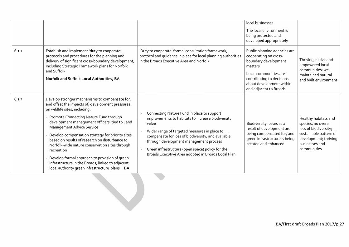
BA/First draft Broads Plan 2017/p.27
local businesses
The local environment is being protected and developed appropriately
6.1.2 Establish and implement ‘duty to cooperate’ protocols and procedures for the planning and delivery of significant cross-boundary development, including Strategic Framework plans for Norfolk and Suffolk
Norfolk and Suffolk Local Authorities, BA
‘Duty to cooperate’ formal consultation framework, protocol and guidance in place for local planning authorities in the Broads Executive Area and Norfolk
Public planning agencies are cooperating on cross-boundary development matters
Local communities are contributing to decisions about development within and adjacent to Broads
Thriving, active and empowered local communities; well-maintained natural and built environment
6.1.3 Develop stronger mechanisms to compensate for, and offset the impacts of, development pressures on wildlife sites, including:
Promote Connecting Nature Fund through development management officers, tied to Land Management Advice Service
Develop compensation strategy for priority sites, based on results of research on disturbance to Norfolk-wide nature conservation sites through recreation
Develop formal approach to provision of green infrastructure in the Broads, linked to adjacent local authority green infrastructure plans BA
Connecting Nature Fund in place to support improvements to habitats to increase biodiversity value
Wider range of targeted measures in place to compensate for loss of biodiversity, and available through development management process
Green infrastructure (open space) policy for the Broads Executive Area adopted in Broads Local Plan
Biodiversity losses as a result of development are being compensated for, and green infrastructure is being created and enhanced
Healthy habitats and species, no overall loss of biodiversity; sustainable pattern of development; thriving businesses and communities

BA/First draft Broads Plan 2017/p.28
Guidance 6.2 Reduce the adverse impacts of visual intrusion, noise and light pollution within and adjacent to the Broads, to help maintain tranquillity
6.2.1 Implement a range of schemes and incentives to reduce impacts of visual intrusion and noise and light pollution, including:
Progress undergrounding wires programme Ofgem/EDF Energy
Develop, implement and promote noise reduction measures in recreation provision BA, Broads Tourism
Complete comprehensive dark skies assessment of Broads Executive Area to inform spatial planning policy and potential for Dark Sky Place status BA
Current Broads undergrounding wires scheme implemented and new programme bids submitted through Ofgem agreement
Enhanced noise reduction schemes and infrastructure and in place, e.g. eco-boating initiatives, electric boating and charging points
Dark skies mapping assessment in place / (dark sky status considered/ applied for)
People and wildlife are being protected from adverse impacts of visual, noise and light pollution in areas of the Broads where it is excessive, or not wanted or expected
Maintained and enhanced sense of tranquillity, landscape character and historic environment

BA/First draft Broads Plan 2017/p.29
Building climate-smart communities
Summary of current issues
The predicted impacts of sea level rise and climate change pose considerable challenges to the future of the Broads, its special qualities and its communities. Based on probable climate projections, over the coming 50 years the Broads is likely to see hotter, drier summers; slightly wetter, warmer winters; streams and the sea getting warmer; and more extremes in the intensity and frequency of rainfall and storms and possibly heatwaves and drought.
Key impacts of sea level rise and climate change are likely to include changes in the distribution of habitats and species, with some net loss of native biodiversity and increasing pressure from invasive non-native species; changes in the visual landscape character, including possible damage or loss of archaeological and built heritage features; damage to property and infrastructure; greater pressures on water resources; changes in agriculture patterns and production; changes to siltation rates and patterns; wetter and warmer conditions stimulating plant growth, requiring greater management; changes in tourism patterns and visitor numbers; and pressures on the development management process.
A Climate Adaptation Plan for the Broads was prepared in 2015 by the Broads Climate Partnership. A primary focus is on the development of longer-term water level management, including flood risk management (Aspiration 1). In wider terms, the plan also proposes the adoption of a proactive ‘climate-smart’ approach at local community level, aimed at helping local people and visitors feel more informed about and more resilient to future change, and fully involved in wide ranging debate and decision making about the longer-term future for the area and its communities.
Mitigation and adaptation planning will to take into account the effects of any management choices on all the interconnected and interdependent ecosystems of the Broads and the services they provide, such as biodiversity, flood regulation, food and fibre, water supply, recreation and carbon capture. Management decisions must be made transparently and equitably, assessing the cost to nature and people.
Aspiration 7 Improve local community awareness of climate and sea level impacts, and build local mitigation and adaptive capacity Targets: To be added
Ref PROJECTS RESULTS (products, services, infrastructure) USES BENEFITS
Guidance 7.1 Build and share concerns, knowledge and practical mitigating and adaptive change responses at community level
7.1.1 Develop and promote tailored ‘climate smart’ advice and support to local communities through the Broads
oCommunity initiative and Local Authority
energy and sustainability advisors Broads Climate Partnership
‘Climate smart’ processes and good practice developed and promoted through Broads
oCommunity and Local Authorities
(Also see action 1. flood management)
Local communities are ‘future proofing’ their homes, businesses and local environment
Safer and more empowered ‘climate-smart’ local communities
7.1.2 Develop and promote targeted policies, schemes and incentives to encourage greater uptake of renewable energy use and ‘green’ initiatives by local communities, businesses and visitors, including:
Update review of renewable energy solutions in
Measures are in place to increase uptake of appropriate renewable energy initiatives
Local communities, businesses and visitors are reducing their carbon footprint
Reduction in CO2 and other harmful emissions into the environment

BA/First draft Broads Plan 2017/p.30
the Broads to inform assessment of renewable and low carbon energy generation
Build on and promote ‘green tourism’ measures for recreational activities, visitor provision and public transport options in the Broads
Review of renewable energy solutions in the Broads updated and informing assessment of renewable and low carbon energy generation options
Green tourism schemes and incentives in place and promoted, through Green Tourism Business Scheme, The GreenBlue, etc

BA/First draft Broads Plan 2017/p.31
Providing distinctive recreational experiences
Summary of current issues
The Broads is a member of the UK National Parks family and attracts more than seven million visitors a year. Popular recreational pastimes include boating, angling, walking, bird watching, and visits to historic and cultural assets such as mills and churches. The area has 200km of inland navigable, lock-free waterways and 303km of public rights of way, including three long distance trails. The surrounding coast and urban centres, including Norwich, Great Yarmouth and Lowestoft, also provide access and recreational opportunities.
There are over 12,000 licensed boats using the Broads, ranging from canoes and rowing boats to large hire craft and commercial passenger vessels. The hire boat industry remains a significant part of the Broads economy, with diversification and improvements in environmental and quality standards in response to changes in traditional holiday patterns and visitor needs being crucial to its ongoing survival. Sailing is integral to the Broads’ history and landscape, and canoeing and rowing are increasingly popular. These activities are in keeping with the philosophy of quiet recreation and rely on suitable provision of access to and onto the water, shore side facilities and user support and guidance, and an emphasis on attracting and supporting young and new users to waterways activities. Angling is a major contributor to the local and regional economy, and the Broads offers some of the best coarse fishing in England. Key areas of strategic focus identified in the Broads Angling Strategy relate to managing and enhancing fisheries management and ecology, access to the water’s edge, information and environmental education, and urban fishery development.
Land-based recreation ranges from the passive, such as sitting at a riverside viewing point, to more active pursuits such as walking and cycling, and visiting local amenities and sites of interest. Walking is a particularly popular activity, but is threatened by significant reductions in local authority rights of way and footpath maintenance budgets. The appeal of the local wildlife, notably birds, is seen as highly relevant to boosting visitor demand throughout the year. At the same time, there is a need to ensure that visitor activity does not damage habitats or disturb wildlife.
A wide range of proposals to create or improve physical access to and around the Broads and between land and water, linked to destination points, facilities and services and sustainable transport options, have been identified through the 2015/16 review of the Integrated Access Strategy for the Broads. However, the ability to implement these projects depends significantly on gaining landowner agreements and on resource capacity of the Broads Plan partners and wider recreational providers.
Aspiration 8 Provide a range of distinctive recreational experiences in suitable locations in harmony with the special qualities of the area Targets: To be added
Ref PROJECTS RESULTS (products, services, infrastructure) USES BENEFITS
Guidance 8.1 Maintain and enhance the integrated physical access network to and around the Broads and between land and water
8.1.1 Map, develop and implement projects and associated permissions to create or improve access points and routes, incorporating opportunities for people with mobility and sensory needs. Priorities are to:
Improve small craft launch points linked to published canoe trails (incl. use of parish staithes) and improve existing
Access improvement projects implemented through Integrated Access Strategy, county access plans and local community plans
Implementation of Broads Landscape Partnership Scheme (Programme 2)
People are taking part in a variety of recreational activities on land and water
Improved health and wellbeing; increased public understanding of area’s special qualities ; increased

BA/First draft Broads Plan 2017/p.32
published launch facilities BA
Audit land access to Broads viewpoints; from moorings to facilities, services and public transport links; and across rivers and alongside water, and develop access improvement projects BA
Review water space access, including broads, and identify and develop potential to extend access for various types of craft BA
Create range of new moorings/stopping places (including wild/quiet moorings) in priority locations and maintain existing network BA
Implement NCC Cycling and Walking Action Plan; develop schemes to create new cycle routes and upgrade priority routes; develop proposals for Cycling Ambition in National Parks funding; develop potential for increased provision of cycle hire/ promoted cycle and walking routes from rail stations /bus routes using path network BA/County Councils
Audit physical access for people with disabilities and develop upgrades to routes (incl. ‘Tramper’ routes), moorings and access points to water BA/County Councils
Implement River Wensum Strategy projects to improve access and facilities along the River Wensum and link Norfolk Trails through Norwich to the Broads Norwich City Council
Develop and implement physical access community projects through Broads Landscape Partnership Scheme BA
Promote angling initiatives as identified in Broads Angling Strategy EA/BASG
business income providing for sustainable local economy
Guidance 8.2 Coordinate and implement a year-round programme of events relating to themes, products, places and activities associated with the Broads
Improved health and wellbeing; increased public understanding of area’s special qualities ;
8.2.1 Maintain and develop a year-round programme of events, run and supported by a range of local organisations, groups and communities, including:
People are taking part in a variety of recreational activities

BA/First draft Broads Plan 2017/p.33
Running and supporting annual multi-events programmes, e.g. Broads Outdoor Festival, Outdoors in the Broads, Walkability, Bird Fayre
Supporting local community festivals and activities, including implementation of Broads Landscape Partnership projects
Establishing and promoting events calendar/programme through tourism businesses and event providers
Broads-related presence promoted through local, national and international events
Range of annual and one-off events available and actively promoted
Activities implemented under Broads LPS Programmes 1-6, in particular ‘Gateways to the Broads’ and ‘Going the Extra Mile’ activities
on land and water and trying new experiences
increased business income providing for sustainable local economy
Guidance 8.3 Maintain, improve and promote navigation safety and environmentally friendly behaviour on land and water
8.3.1
Implement, promote and monitor measures to manage better safety for the navigation and boats, and to encourage environmentally friendly behaviour by recreational users. BA, Broadsbeat
Safety Management System and Boat Safety Scheme measures in place
BA Ranger and Broadsbeat patrolling in place, supported by volunteer complement
Navigation infrastructure maintenance regimes in place
Temporal or spatial zoning agreements and pilot schemes in place as required
Range of guidance, advice and events on safe and environmentally friendly behaviour available and promoted, incl. BA Super Safety Days, boat hirer information pack
People are taking part in a variety of waterborne recreational activities in safe and environmentally responsible ways
Improved safety, health and wellbeing; increased public understanding of the special qualities of the area

BA/First draft Broads Plan 2017/p.34
Promoting understanding
Summary of current issues
Tourism drivers the economy of the Broads and is a key product in the wider economy of the East of England, bringing nearly £600m to the local economy and supporting more than 7600 FTE jobs. The attraction of the Broads also recognises the significant tourism appeal of its surrounding area, including the historic urban centre of Norwich, the coastal resorts of Great Yarmouth and Lowestoft, and the North Norfolk coast.
The sustainable tourism strategy for the Broads is being refreshed (2015-16). The strategic approach for 2017-22 centres around developing, managing and promoting high quality sustainable tourism, taking into account the needs of the environment, local residents, local businesses and visitors, now and in the future. Cuts in public sector budgets will impact on support for tourism marketing, management and infrastructure; strong partnership working and engagement of the tourism industry and private sector agencies will continue to be vital in supporting the industry. Other issues include a lack of adequate visitor facilities in some areas; inconsistent quality of accommodation and catering; labour, skills and volunteer shortages; and a lack of coordination between tourism/destination bodies. Potential opportunities include a growing market interest in experiences, activities and wellbeing, particularly focused around wildlife; forecast growth in domestic and inbound markets; and private sector interest in sponsorship.
While the Broads may mean different things to different people, a unifying brand and key messages can help create an overall feeling about the area that captures its essence, places the area in pe0ples’ minds and makes them want to be part of it and care for it. Information and interpretation needs to provide consistent and coordinated messages that help to strengthen visitor understanding, awareness and enjoyment of the area, both before and during their visit. The Broads has equivalent status to a National Park but, in addition to the other parks' two purposes of conservation and promoting enjoyment, it has a third equally weighted purpose of managing the navigation. As such it is defined under a different act of Parliament to the other Parks and has been known as a ‘member of the National Park family’. In 2015, the Broads Authority voted to brand the area as the ‘Broads National Park’ to promote more clearly its national park credentials and special qualities. Although Defra was content with this decision, it is currently under legal challenge (as at Jan 2016) and an outcome is awaited before further branding decisions are taken.
Aspiration 9 Strengthen and promote key messages and tourism offer in keeping with the area’s national park status, special qualities, history and traditions Targets: To be added
Ref PROJECTS RESULTS (products, services, infrastructure) USES BENEFITS
Guidance 9.1 Improve and promote information and interpretation to attract visitors and assist them during their visit
9.1.1
Maintain and establish processes to raise awareness of, and support for, the special status, qualities and heritage of the Broads, including:
Maintain a high quality, up-to-date visitor destination website, promoting strong images, messages and point of need information
Establish and strengthen partnership processes to promote coordinated messages that underpin the Broads brand and strategic
Www.EnjoytheBroads.com website maintained and available to visitors, linked to other destination websites at local, regional, national and international level
Actively managed PR presence and social media campaigns in place (e.g. Facebook, Twitter, YouTube) with communications processes, protocols and technology support available through established social media/PR team
Destination marketing of the Broads in place through wider campaigns featuring Norfolk, East Anglia, UK waterways and UK
People have information they want before and during their visit, helping them to understand, access and enjoy the area in sustainable ways New audiences (visitors and local communities) are introduced to what
More visitors enjoying the area’s special qualities More resilient and responsible tourism economy

BA/First draft Broads Plan 2017/p.35
priorities, through print/digital media and PR activity
Develop and run linked destination marketing campaigns at domestic and overseas campaigns
Develop, promote and monitor use of Broads National Park brand identity in print/digital online media and signage
National Parks
Broads branding design and use guidelines/toolkit available
Physical and virtual information and interpretation available to visitors, through targeted public events and activities, oral history research and archiving projects, multimedia products and drama
Activities implemented under Broads LPS programme 1: Interpreting the Landscape
Your Park initiative/Residents newsletter developed
(Visitor support for conservation support – see action 11.1)
there is to do in the Broads and are taking part in activities
9.1.2 Support a positive visitor experience to the Broads by maintaining and upgrading the provision of point of need information:
Maintain and monitor Broads Visitor Centres (BA) and develop Broads information presence within other appropriate local centres
Design and install range of promotional and information displays at entry points and key sites, including railway stations, and improve Broads destination signage
Maintain and widely distribute ‘Broadcaster’ and other print/digital information for visitors, including trail maps and apps
Broads visitor centres maintained at Whitlingham, Hoveton and How Hill; Broads information presence available at other local centres in the Broads and urban locations
Broads promotional and information displays in place at entry points and key sites
Yacht stations maintained at Great Yarmouth and Norwich
Broadcaster, orientation maps, apps and other visitor material produced and available online and through visitor destination hubs
People have information they want before and during their visit, helping them to understand, access and enjoy the area in sustainable ways
Increased public understanding and enjoyment of area’s special qualities ; increased business income providing for sustainable local economy
9.1. 3 Maintain and develop measures to strengthen the quality and distinctiveness of the tourism offer in the Broads, including:
Maintain and further develop processes to assess and support high quality standards and environmental sustainability in local tourism provision
Create and deliver staff training events for hire boat operators and other tourism businesses
Systems in place to assess and guide quality and environmental sustainability standards in local tourism provision, incl. Broads Quality Charter
Tailored tourism staff training programmes and events available through hire boat operators and tourism businesses
Customers are getting consistent, high quality standards from local tourism and recreational businesses Visitors are taking part in a wide range of recreational activities to suit their needs and interests
Better service for visitors; increased business income providing for sustainable local economy

BA/First draft Broads Plan 2017/p.36
to meet visitor information needs
Develop and support initiatives to promote tourism related careers to young people, with associated training
Aspiration 10 Improve and more widely share understanding and expertise about the Broads natural environment
Ref PROJECTS RESULTS (products, services, infrastructure) USES BENEFITS
Guidance 10.1 Coordinate and develop Broads monitoring and research efforts, focusing on water, wet grasslands, and fen hydrology and ecology
10.1.1 Create and maintain coordinated partner database of conservation monitoring and research priorities, including: Fen vegetation and invertebrates; groundwater level management; control of pollutant inputs; impacts of drought, flooding and salinity
Coordinated research, monitoring and trial programmes in place and data made available to partners and academic research bodies
Organisations and community groups are learning more about the Broads natural environment and making informed management decisions
Healthy environment supported by more informed management evidence
10.1.2 Develop and coordinate citizen sciences initiatives in the Broads, including:
Pool knowledge on approaches for monitoring/recording by volunteers, and share best practice
Coordinate records through central, publically accessible location
Robust nature conservation monitoring and recording processes in place, supported by volunteer programmes
Comprehensive, up-to-date nature conservation records in place and available to the public
Organisations and communities are learning more about the Broads natural environment through hands-on observation
Healthy environment supported by more informed management evidence; community more involved in their local area

BA/First draft Broads Plan 2017/p.37
Connecting local communities
Summary of current issues
It is recognised that some groups visit National Parks and the Broads less than others, such as ethnic minorities, young people, people from disadvantaged circumstances, and people with disabilities. The Vision for English National Parks and the Broads encourages Authorities to take a proactive approach to enabling people from all walks of life and from all ages and abilities, particularly children and young people, to experience and enjoy these areas at first hand.
A lack of physical or cultural access, information or simply motivation can mean that many local urban and rural communities are disconnected from the special landscape on their doorstep and the opportunities it offers for recreation, learning, health and wellbeing. Accessible, informative and inspirational opportunities need to be in place to support and encourage people from all walks of life and all ages and abilities, particularly children and young people, to ‘go the extra mile’ and reconnect with their local env ironment.
The use of the Broads as a resource for environmental education is an important part of raising awareness and understanding, and provides valuable opportunities to contribute to the former Government’s ‘Every Child’s Future Matters’ initiative. It has long been an aspiration of the Broads Authority that every child in the Broads executive area should experience the Broads at some time during their school career. With limited resources, the Authority and its environmental education partners need to focus efforts where they are best placed to impact upon and add value to the learning of groups and individuals, particularly those who might otherwise not have such opportunities.
As well as focusing on partnership working and shared resources, organisations caring for the Broads will need to look increasingly to external financial and manpower resources to support their activities, particularly within the economic context of an ongoing squeeze in public sector finances.
Aspiration 11 Reconnect a wider audience, particularly local communities and young people, with the Broads environment Targets: To be added
Ref PROJECTS RESULTS (products, services, infrastructure) USES BENEFITS
Guidance 11.1 Develop participatory initiatives for local communities and visitors to support the Broads environment
11.1.1 Develop and promote a range of participatory community events and activities through the Broads Landscape Partnership Scheme, including entry level activities for young people and ‘go the extra mile’ events BA
Range of activities implemented under Broads LPS Programmes 1-6
Range of multi-media promotional material in place / + motivational incentives
People are visiting the Broads for recreation, fitness, learning and socialising Local organisations and community groups are achieving more through additional resources Local communities and groups are receiving financial and practical support to help look after
Healthier, happier local communities feeling more connected to their natural environment; healthier and better managed environment
11.1.2 Run and promote practical organisational and community led volunteering schemes and activities, and provide training and support to volunteers Broads Plan partners
Flexible and diverse range of volunteering opportunities, training schemes and promotional events available through range of organisations and amenity/interest groups Trained and available volunteer complement in place to support local organisations and groups
11.1.3 Support visitor giving and sponsorship schemes and initiatives and develop new opportunities for
Income generation sponsorship and visitor giving schemes and activities (incl. Love the Broads) in place and promoted through

BA/First draft Broads Plan 2017/p.38
increasing revenue generation for Broads projects, including through visitor hubs and events Broads Trust, Broads Plan partners
local supporting establishments Plans and processes in place to increase sales revenue at BA visitor centres, yacht stations and other appropriate outlets
the Broads
Guidance 11.2 Maintain and develop opportunities for young people (aged 5-21), including those from disadvantaged backgrounds, to have a ‘Broads experience’
11.2.1 Develop and run a range of Broads themed environmental education programmes and events for local schoolchildren Broads Environmental Education Network (BEEN)
Range of environmental education schemes and activities available through BEEN partners and mainstream education providers, including Broads Curriculum programmes
Coordinated environmental educational resource tools, including Broads Curriculum materials, available to BEEN partners and education providers
Local schoolchildren are experiencing the Broads through classroom and outdoor activities
Educators are offering consistent, coordinated Broads environmental education
Healthier, more active and more inspired local /disadvantaged young people with an enhanced sense of wellbeing and life skills
11.2.2 Develop, promote and run skills training, work experience and volunteering programmes and activities for young people BEEN
Skills training, work experience and award scheme opportunities available through FE providers, BEEN partners and Broads LPS Programme
Volunteering opportunities available to young people and family groups, e.g. Broads Young Rangers (Broads LPS Scheme)
Young people are getting social and vocational skills and qualifications through ‘hands on’ experience
11.2.3 Establish, promote and run accessible and motivational environmental outreach programmes and initiatives for disadvantaged young people from local and national areas of high deprivation BEEN
Outreach programmes and initiatives in place, incl. Forest Schools, Broads Short Stay and Broads Discovery Days / + motivational incentives
Activities implemented under Broads LPS Programme3: Learning and Future Skills
Disadvantaged young people are taking part in motivational outdoor activities, many for the first time
(end of draft table)