TEN-YEAR LAND MANAGEMENT PLAN BABCOCK RANCH ...
86
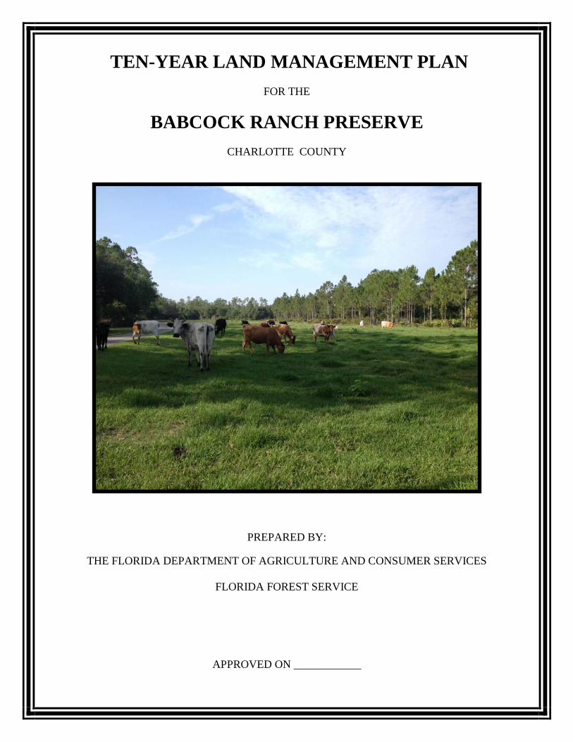
TEN-YEAR LAND MANAGEMENT PLAN FOR THE BABCOCK RANCH PRESERVE CHARLOTTE COUNTY PREPARED BY: THE FLORIDA DEPARTMENT OF AGRICULTURE AND CONSUMER SERVICES FLORIDA FOREST SERVICE APPROVED ON ____________
-
Upload
khangminh22 -
Category
Documents
-
view
0 -
download
0
Transcript of TEN-YEAR LAND MANAGEMENT PLAN BABCOCK RANCH ...
TEN-YEAR LAND MANAGEMENT PLAN
FOR THE
BABCOCK RANCH PRESERVE
CHARLOTTE COUNTY
PREPARED BY:
THE FLORIDA DEPARTMENT OF AGRICULTURE AND CONSUMER SERVICES
FLORIDA FOREST SERVICE
APPROVED ON ____________

TEN-YEAR LAND MANAGEMENT PLAN
FOR THE
BABCOCK RANCH PRESERVE
Approved by:
Jim Karels, Director Florida Forest Service
'/- -Z.7-1~
--~~ ..... ... ,I, Assistant Director Florida Forest Service
fizrL;IP D;uc
fjW~ Brad Ellis, Chief
Forest Management Bureau, Florida Forest Service
1-27-lb Dale '

TEN-YEAR LAND MANAGEMENT PLAN BABCOCK RANCH PRESERVE
TABLE OF CONTENTS
Land Management Plan Executive Summary ......................................................................... 1
I. Introduction ......................................................................................................................... 2 A. General Mission and Management Plan Direction ...................................................... 2 B. History and Background............................................................................................... 3 C. Goals / Objectives for the Next Ten-Year Period ........................................................ 4
II. Administration Section ....................................................................................................... 10 A. Descriptive Information ............................................................................................... 10
1. Common Name of Property .................................................................................... 10 2. Legal Description and Acreage ............................................................................... 10 3. Proximity to Other Public Resources ...................................................................... 10 4. Property Acquisition and Land Use Considerations ............................................... 11
B. Management Authority, Purpose and Constraints ....................................................... 12 1. Purpose for Acquisition / Management Prospectus ................................................ 12 2. Degree of Title Interest Held by the Board of Trustees .......................................... 13 3. Designated Single or Multiple-Use Management ................................................... 13 4. Revenue Producing Activities................................................................................. 14 5. Conformation to State Lands Management Plan .................................................... 15 6. Legislative or Executive Constraints ...................................................................... 16 7. Aquatic Preserve / Area of Critical State Concern ................................................. 16
C. Capital Facilities and Infrastructure ............................................................................. 16 1. Property Boundaries, Establishment and Preservation ........................................... 16 2. Improvements ......................................................................................................... 18 3. On-Site Housing...................................................................................................... 19 4. Operations Infrastructure ........................................................................................ 19
D. Additional Acquisitions and Land Use Considerations ............................................... 20 1. Alternate Uses Considered ...................................................................................... 20 2. Additional Land Needs ........................................................................................... 20 3. Surplus Land Assessment ....................................................................................... 21 4. Adjacent Conflicting Uses ...................................................................................... 21 5. Compliance with Local Comprehensive Plans ....................................................... 21 6. Utility Corridors and Easements ............................................................................. 21
E. Agency and Public Involvement .................................................................................. 22 1. Responsibilities of Managing Agencies.................................................................. 22 2. Law Enforcement .................................................................................................... 23 3. Public and Local Government Involvement ........................................................... 23 4. Volunteers ............................................................................................................... 23 5. Friends of Florida State Forests – Babcock Ranch Preserve ................................. 24
III. Archaeological / Cultural Resources and Protection ........................................................ 25 A. Past Uses ...................................................................................................................... 25 B. Archaeological and Historical Resources .................................................................... 26 C. Previous Actions .......................................................................................................... 27 D. Ground Disturbing Activities ....................................................................................... 28 E. Survey and Monitoring ................................................................................................. 28

IV. Natural Resources and Protection ..................................................................................... 29 A. Topography .................................................................................................................. 29 B. Soils and Geologic Resources ...................................................................................... 29
1. Resources ................................................................................................................ 29 2. Description .............................................................................................................. 29 3. Soil Protection ......................................................................................................... 29 4. Soil Management .................................................................................................... 30
C. Water Resources ........................................................................................................... 30 1. Resources ................................................................................................................ 31 2. Water Protection ..................................................................................................... 33 3. Hydrological Plan ................................................................................................... 34 4. Maintenance ............................................................................................................ 35
D. Wildlife Resources ....................................................................................................... 35 1. Rare, Threatened and Endangered Species ............................................................. 35 2. Game Species and Other Wildlife........................................................................... 37 3. Survey and Monitoring ........................................................................................... 37
E. Sustainable Forest Resources ....................................................................................... 39 F. Beaches and Dune Resources ....................................................................................... 39 G. Mineral Resources........................................................................................................ 39 H. Unique Natural Features and Outstanding Native Landscapes .................................... 39 I. Research Projects / Specimen Collection ...................................................................... 39 J. Ground Disturbing Activities ........................................................................................ 40
V. Public Access and Recreation ............................................................................................ 40 A. Existing ....................................................................................................................... 41 B. Planned ......................................................................................................................... 42 C. Hunting ......................................................................................................................... 43 D. Education ..................................................................................................................... 44
VI. Forest Management Practices ........................................................................................... 44 A. Prescribed Fire ............................................................................................................. 44 1. Fire Management ................................................................................................... 45 B. Wildfires, Prevention, Fire / Prescribed Fire Strategies ............................................... 46 1. Suppression Strategies ........................................................................................... 47 2. Smoke Management............................................................................................... 47 3. Fire Breaks and Fire Lines ..................................................................................... 48 4. Sensitive Areas....................................................................................................... 48 5. Fire Adapted Communities ..................................................................................... 49 6. Adjacent Neighbor Contacts ................................................................................... 49 7. Post-Burn Evaluations ............................................................................................ 49 C. Sustainable Forestry & Silviculture ............................................................................. 49
1. Strategies ................................................................................................................. 49 2. Silvicultural Operations .......................................................................................... 49 3. Forest Inventory ..................................................................................................... 50 4. Timber and Other Forest Product Sales .................................................................. 50
D. Non-Native Invasive Species Control .......................................................................... 51 E. Insects, Disease and Forest Health ............................................................................... 52 F. Use of Private Contractors ............................................................................................ 53

VII. Proposed Management Activities for Current Natural Community Cover Types .......... 53 A. Mesic Flatwoods .......................................................................................................... 55 B. Strand Swamp .............................................................................................................. 56 C. Wet Flatwoods.............................................................................................................. 58 D. Wet Prairie ................................................................................................................... 59 E. Dry Prairie ................................................................................................................... 60 F. Depression Marsh ........................................................................................................ 61 G. Basin Marsh ................................................................................................................. 62 H. Dome Swamp ............................................................................................................... 63 I. Slough ........................................................................................................................... 64 J. Hydric Hammock ......................................................................................................... 65 K. Mesic Hammock .......................................................................................................... 66 L. Scrubby Flatwoods ....................................................................................................... 67 M. Scrub ............................................................................................................................ 68 N. Altered Landcover Types ............................................................................................. 68 1. Pasture – Improved ................................................................................................ 69 2. Pasture – Semi-Improved ....................................................................................... 69 3. Other Ruderal Sites ................................................................................................ 70
VIII. Ranch Management........................................................................................................ 71 A. Historic Practices ........................................................................................................ 71 B. Grazing and Ranch Management ................................................................................ 72 C. Ranch Administration and Management .................................................................... 73 D. Cattle Operations / Cow-Calf Best Management Practices ........................................ 74 E. Range and Pasture Management and Grazing Routine............................................... 74
1. Rangeland Health .................................................................................................. 74 2. Stocking Rates ...................................................................................................... 74 3. Pasture Maintenance ............................................................................................. 75
F. Farming Operations .................................................................................................... 76 1. Tenant Farming ..................................................................................................... 76 2. Natural Areas ........................................................................................................ 76 3. Charlotte County ................................................................................................... 76 4. Alternative Uses .................................................................................................... 76
G. Irrigation, Fertilization and Pest Management Practices ............................................ 76 H. Other Agricultural Practices ....................................................................................... 77 I. Field Rotations ............................................................................................................ 77
X. References .......................................................................................................................... 78 XI. Glossary of Abbreviations ................................................................................................ 79

TEN-YEAR LAND MANAGEMENT PLAN
BABCOCK RANCH PRESERVE
EXHIBITS
Legal Description of the Property ............................................................................................... Exhibit A Location Maps ............................................................................................................................. Exhibit B Tract Maps ................................................................................................................................. Exhibit C Proximity to Significant Managed Areas .................................................................................... Exhibit D Florida Forever Projects in Charlotte County and Lee County ................................................... Exhibit E Department of Environmental Protection, Outstanding Florida Waters ..................................... Exhibit F Florida Forever Proposal and Evaluation Report / Management Prospectus .............................. Exhibit G Facilities and Improvements Map ............................................................................................... Exhibit H Roads Map ................................................................................................................................. Exhibit I Optimal Management Boundary Map ......................................................................................... Exhibit J Land Management Review Reports ........................................................................................... Exhibit K Department of State, Division of Historical Resources Response .............................................. Exhibit L Management Procedures for Archaeological and Historical Sites and Properties ...................... Exhibit M Soil Maps and Descriptions......................................................................................................... Exhibit N Water Resources Map ................................................................................................................. Exhibit O Water Management District Water Storage Project Information ................................................ Exhibit P FNAI Managed Area Tracking Record ....................................................................................... Exhibit Q FNAI 2008 Rare Plants on BRP Inventory ................................................................................. Exhibit R FNAI 2008 Rare Animals on BRP Inventory ............................................................................. Exhibit S FWC Response ............................................................................................................................ Exhibit T Recreation Map ........................................................................................................................... Exhibit U FNAI 2008 Non-Native Invasive Species Inventory .................................................................. Exhibit V Arthropod Control Plan ............................................................................................................... Exhibit W Historic Natural Communities Map ............................................................................................ Exhibit X FNAI 2008 Current Natural Communities and Cover Type Map ............................................... Exhibit Y Natural Community Descriptions................................................................................................ Exhibit Z Babcock Ranch Natural Community Mapping Project ............................................................... Exhibit AA Management Plan Advisory Group Meeting Summaries ........................................................... Exhibit AB Compliance with Local Comprehensive Plan Letter ................................................................... Exhibit AC Budget Summary ......................................................................................................................... Exhibit AD DOS/DHR Guidelines for Ground Disturbing Activities ........................................................... Exhibit AE

TABLES Table 1 Nearby Public Conservation Lands and Easements ...................................................... Page 11 Table 2 Archaeological and Historical Sites on BRP ................................................................ Page 26 Table 3 Rare, Threatened, Endangered or Species of Special Concern on BRP ....................... Page 35 Table 4 Natural Communities Found on BRP ........................................................................... Page 54 Table 5 Altered Landcover Types Found on BRP ..................................................................... Page 54 Table 6 Average Year for Cattle Management .......................................................................... Page 75 Table 7 Fruit and Vegetable Crop-Grazing-Sod Harvest Rotation ............................................ Page 77

LAND MANAGEMENT PLAN EXECUTIVE SUMMARY
LEAD AGENCY: Florida Department of Agriculture and Consumer Services, Florida Forest Service COMMON NAME: Babcock Ranch Preserve LOCATION: Charlotte County ACREAGE TOTAL: 67,618.81
Historical Natural Communities Approximate Acreage Historical Natural Communities Approximate
Acreage
Mesic Flatwoods 36,543 Dome Swamp 983 Dry Prairie 8,929 Slough 651
Strand Swamp 6,759 Hydric Hammock 381 Wet Flatwoods 5,018 Mesic Hammock 70
Wet Prairie 4,529 Scrubby Flatwoods 4 Depression Marsh 2,133 Scrub 11
Basin Marsh 1,877
USE: Single Multiple X MANAGEMENT AGENCY RESPONSIBILITY Florida DACS, Florida Forest Service General Forest, Cattle and Farm Resource Management Florida Fish and Wildlife Conservation Commission Wildlife Resources & Laws South Florida Water Management District Water Resource Protection & Restoration FDOS, Division of Historical Resources Historical and Archaeological Resource Management DESIGNATED LAND USE: Florida Heritage Working Ranch, Conservation SUBLEASES: Charlotte County; Crown Castle Company; Charlotte County School Board; and various agriculture and Tier
II Area Permits ENCUMBRANCES: SFWMD Permits and Easements; Florida Gas Transmission Company; AT&T; Lee County Electric
Cooperative; Florida Power & Light; and United Telephone Company of Florida TYPE ACQUISITION: General Revenue (Charlotte County property) UNIQUE NATURAL FEATURES: South Florida Flatwoods Ecosystems; FNAI designated Florida imperiled wet prairie
and dry prairie plant communities; Federal and state listed plant and animal species UNIQUE ARCHAEOLOGICAL / HISTORICAL FEATURES: One Linear Resource from Florida Master Site File; Mid-
20th Century buildings characteristic of a working ranch and tourism operation; Town of Rueville MANAGEMENT NEEDS: Encourage sustainable agriculture and working-ranch operations; Maintenance and improvement
of natural communities; Non-native invasive species treatments and control; Watershed protections and improvements; Public access and use
ACQUISITION NEEDS: Approximately 48,800 acres adjacent to Babcock Ranch Preserve have been identified to protect watersheds and provide conservation corridors to other large conservation tracts.
SURPLUS ACREAGE: None PUBLIC INVOLVEMENT: Management Plan Advisory Group; Public Hearings in Charlotte County; and the Acquisition and Restoration Council Public Hearing. - - - - - - - - - - - - - - - - - - - - - - - - - - - - - - - - - - - - - - - - - - - - - - - - - - - - - - - - - - - - - - - - - - - - - - - - - - - - - - - - - - - - - - - - - - - - - - - -
DO NOT WRITE BELOW THIS LINE (FOR DIVISION OF STATE LANDS USE ONLY) ARC Approval Date: ___________________________ TIITF Approval Date: ___________________________________ Comments: ___________________________________________________________________________________________ _________________________________________________________________________________________________________________________________________________________________________________________________________________________________________________________________________________________________________

2
I. Introduction This Ten-Year Land Management Plan will become effective on August 1, 2016. At such time, Florida Forest Service (FFS) management of Babcock Ranch Preserve (BRP, or the Preserve) will commence. Babcock Ranch Management, LLC will continue to utilize the plan dated March 6, 2008, as prepared by Pandion Systems, Inc., until July 31, 2016.
The BRP occupies 67,619 acres in southeast Charlotte County, approximately 17.5 miles east of Punta Gorda and 34 miles west of Lake Okeechobee. It represents one of the single largest purchases of conservation land in the State of Florida's history, and is the first parcel purchased to operate as a working ranch that preserves Florida’s cattle heritage. The BRP protects regionally important water resources, diverse natural habitats, scenic landscapes and historic and cultural resources in the rapidly developing southwestern Florida corridor. Located within the Caloosahatchee River Basin, BRP anchors a conservation corridor of public and private land that stretches from Lake Okeechobee to the Gulf of Mexico. The property spans a diverse mosaic of pinelands, including both wet and mesic pine flatwoods, and dry prairie ecosystems interspersed with cypress domes and cypress swamps. A dominant feature on the landscape is the north-south oriented Telegraph Swamp, a cypress strand swamp located in the western half of the property. BRP’s wetlands contribute to aquifer recharge for southwestern Florida and help maintain the health of the western Everglades ecosystem, particularly the Caloosahatchee River and Charlotte Harbor Estuary. Together with nearby conservation lands, including the Fred C. Babcock - Cecil M. Webb Wildlife Management Area (BWWMA) and the Caloosahatchee Regional Park, as well as Telegraph Creek Preserve, acquired as a Lee County Conservation 20/20 preserve to the southwest, BRP provides habitat for wide-ranging species such as the Florida black bear and Florida panther, and is home to the Osceola subspecies of native wild turkey, which is found only in peninsular Florida. In addition to abundant populations of white-tailed deer, wild turkey, and northern bobwhite quail, 13 wildlife species that are listed as endangered, threatened, or of special concern have been documented to occur within the BRP boundaries. The list includes crested caracara, gopher tortoise, red-cockaded woodpecker, eastern indigo snake, Florida burrowing owl and Florida panther. The BRP is managed as a working ranch while providing public recreational opportunities compatible with agricultural operations. Public recreational opportunities may include, but are not limited to: hunting, hiking, wildlife viewing, bicycling, fishing, camping and horseback riding.
A. General Mission and Management Plan Direction
The primary mission of the Florida Forest Service is to “protect Florida and its people from the dangers of wildland fire and manage the (BRP) resources through a stewardship ethic to assure they are available for future generations.” Management strategies for BRP center on the multiple-use concept, as defined in Sections 589.04(3), 253.034(2)(a), and 259.1053 Florida Statutes (F.S.). Implementation of this concept will utilize and conserve resources in a harmonious and coordinated

3
combination that will best serve the people of the state of Florida, and that is consistent with the purpose for which the property was acquired. Multiple-use management for BRP will be accomplished with the following strategies: Management as a working ranch; Practice sustainable forest and ranch management for the efficient generation of
revenue and in support of forest and ranch management objectives; Provide for resource-based outdoor recreation opportunities for multiple interests. Manage healthy forests and native ecosystems ensuring the long-term viability of
populations and species listed as endangered, threatened or rare, and other components of biological diversity including game and nongame wildlife and plants;
Protect known archaeological, historical, cultural and paleontological resources; Restore, maintain and protect hydrological functions related to water resources and
the health of associated wetland and aquatic communities; Hunting opportunities managed in cooperation with the Florida Fish and Wildlife
Conservation Commission (FWC).
This management plan is provided according to requirements of Sections 253.034, 259.032 and Chapter 373, Florida Statutes, and was prepared utilizing guidelines outlined in Section 18-2.021 of the Florida Administrative Code (FAC). This plan is not an annual work plan or detailed operational plan, but provides general guidance for the management of BRP over the next ten-year period and outlines the major concepts that will guide management activities on the BRP. A BRP Agricultural Management Plan, as well as a BRP Operational/Business Plan will be developed by FFS, or those designated by FFS, to include such issues as: silviculture, prescribed burning, roads and bridges, boundary and survey maintenance, ecological and recreation. FFS may choose to execute a lease or leases for the management of any operations onsite; each lessee will be required to comply with the stipulations set forth in each associated Plan established by FFS, as well as all applicable Best Management Practices (BMPs). FFS will utilize the expertise of the FWCand the Babcock Ranch Advisory Group (BRAG), as needed.
B. History and Background The BRP is comprised of 67,618.81 acres. The State of Florida Board of Trustees of the Internal Improvement Trust Fund (TIITF) owns 67,618.81 acres. Lee County owns 5,620.36 acres immediately to the south of BRP, known as Bob Janes Preserve. Prior to its purchase by the State of Florida, BRP was part of the 91,361-acre working ranch known as Crescent B Ranch. Since 1914 Crescent B Ranch has produced timber, cattle, row crops, and sod, and provided recreation opportunities such as hunting and ecotourism. BRP was acquired by the State of Florida as part of the Florida Forever Program, and with funding from General Revenue. The BRP “is established to protect and preserve the environmental, agricultural, scientific, scenic, geologic, watershed, fish, wildlife, historic,

4
cultural, and recreational values of the preserve, and to provide for the multiple use and sustained yield of the renewable surface resources within the preserve” (FS 259.1052(4). The purchase of BRP is one of the single largest state land conservation acquisitions by the State of Florida, conserving 67,619 acres of property within the Caloosahatchee River Basin. Acquisition of the property from the Babcock family occurred through Kitson & Partners, LLC, which retained some of Crescent B Ranch for development into the Babcock Ranch Community and sold the majority of the land to the State of Florida and Lee County in 2006.
The property acquisition creates a near contiguous parcel that is sufficiently large enough to maintain viable populations for all but the most wide-ranging native wildlife, including many threatened and endangered species. In conjunction with other nearby conservation lands, BRP provides habitat for wide-ranging species. The diversity of natural communities interspersed with agricultural landscapes creates a scenic, rural setting uncommon in the rapidly developing southwestern Florida corridor. Protection of regionally important water resources, diverse natural habitats, scenic landscapes, and Florida’s cultural heritage are significant benefits of the project. BRP lands help to maintain freshwater flows to the Charlotte Harbor Estuary and to serve as a recharge area for southwest Florida.
C. Goals / Objectives for the Next Ten-Year Period
The following goals and objectives provide direction and focus management resources for the next ten-year planning period. Funding, agency program priorities, and wildfire probability during the planning period will determine the degree to which these objectives can be met. Management activities on BRP during this management period must serve to ensure a working ranch is maintained that will conserve, protect, utilize and enhance the natural and historical resources and manage resource-based public outdoor recreation. All compatible activities should enhance the property’s value as a working ranch. The management activities listed below will be addressed within the ten-year management period and are defined as short-term goals, long-term goals or ongoing goals. Short-term goals are goals that will be achievable within a two-year planning period, and long-term goals will be achievable within a ten-year planning period. An ongoing goal refers to periodic goals (annual, quarterly, biennial, etc.) that will be achievable throughout the entire planning period. Objectives are listed in priority order for each goal. Cost estimates are provided below for the FFS and contract services where sufficient information is available to make projections. Costs for some activities cannot be estimated at this time. Other activities will be completed with minimal overhead expense and existing staff. For further details, please see the BRP Budget Summary, Exhibit AE.

5
GOAL 1: Sustainable Ranch Management Objective 1: Prepare and implement a Five-Year Agricultural Management Plan including associated operational activities and goals. (Long Term Goal) Performance Measures: • Completion of Five-Year Agricultural Management Plan with annual updates. • Implementation of Five-Year Agricultural Management Plan (plan implemented). Objective 2: Implement a process for conducting ranch operations, including a GIS database to track ranch operations, roads and other attributes (including but not limited to: agricultural resources, timber resources, wildlife, threatened and endangered species, archaeological resources, non-native invasive species locations, historical areas). (Ongoing Goal) Performance Measures: • Complete GIS database and re-inventory all attributes as required by FFS procedures. • Number of acres inventoried. Objective 3: Conduct ranch inventory updates each year, including, but not limited to, all cattle production figures and equipment, to be completed each fall following cattle evaluations. (Ongoing Goal) Performance Measures: • Ranch inventory conducted annually. • Number of acres inventoried annually.
Objective 4: Conduct annual inventory of usage on ranch, including all farm and grazing leases. (Ongoing Goal) Performance Measure: Acreages of leased areas and carrying capacity reported. Objective 5: FFS will coordinate with appropriate agencies and/or organizations to identify appropriate criteria, monitoring frequency and funding sources necessary to assess environmental impacts (such as water quality, contaminant levels, wildlife habitat quality) related to ranch operations. Additionally, FFS will review this data on an annual basis and will conduct environmental work on an as-needed basis. (Ongoing Goal) Performance measures: • Establishment of appropriate criteria, monitoring frequency and funding sources
necessary to monitor environmental impacts related to ranch operations. • Environmental work completed as necessary.
Objective 6: BRP, under Florida Statute, is to be managed as a self-sustaining property. FFS will therefore give sufficient emphasis to the generation of ranch revenue when considering other ranch uses. (Ongoing Goal) Performance Measure: Amount of revenue received each year. Objective 7: Utilize cow/calf BMPs to protect environmentally sensitive communities. (Ongoing Goal) Performance Measures: • Environmentally sensitive areas mapped.

6
• BMPs utilized. GOAL 2: Public Access and Recreational Opportunities
Objective 1: In order to safely integrate public access onto BRP, develop and implement a Five-Year Outdoor Recreation Plan in coordination with Charlotte County and local recreational user groups, as appropriate, and update annually. (Short Term Goal) Performance Measures: • Development and implementation of the Five-Year Outdoor Recreation Plan. • Five-Year Outdoor Recreation Plan annual update completion. Objective 2: Maintain public access and recreational opportunities to allow for a recreational carrying capacity that is balanced with the operations of the working ranch and its natural resources, while taking the various user groups’ needs into consideration. (Ongoing Goal) Performance Measure: Balancing ranch operations and natural resources while maintaining public access and recreational opportunities. Objective 3: Develop additional public access, educational and recreational opportunities, where feasible, to allow for additional visitors on BRP. (Long Term Goal) Performance Measure: Establishment of additional public access and recreational opportunities. Objective 4: Coordinate with local organizations, volunteers, etc. to establish a Friends of Babcock Ranch Preserve chapter of the Friends of Florida State Forests. (Short Term Goal) Performance Measure: Friends of Babcock Ranch Preserve organization established. Objective 6: Coordinate with state and county agencies, as well as local organizations, to develop an educational program that may provide the public with an experience that highlights ranch operations, the natural environment and the preservation of BRP. (Long Term Goal) Performance Measure: BRP public educational program developed.
GOAL 3: Sustainable Forest Management
Objective 1: Develop and implement a Five-Year Silviculture Management Plan including reforestation, harvesting, prescribed burning, restoration, and timber stand improvement activities and goals. The plan is updated annually. (Long Term Goal) Performance Measures: • Development and implementation of Five-Year Silviculture Management Plan (acres
treated for various practices). • Five-Year Silviculture Management Plan annual update completion.
Objective 2: Develop and implement a Three-Year Prescribed Burning Management Plan that contains an option for the allowance of cattle lessees to burn pastures. The plan is updated annually. (Long Term Goal) Performance Measures:

7
• Development and implementation of the Three-Year Prescribed Burning Management Plan.
• Three-Year Prescribed Burning Management Plan annual update completion.
Objective 3: Implement the FFS process for conducting stand descriptions and forest inventory, including a GIS database containing forest stands, roads and other attributes (including but not limited to: timber resources, reforestation needs, threatened and endangered species, archaeological resources, non-native invasive species locations, historical areas). (Ongoing Goal) Performance Measures: • Complete GIS database and re-inventory all attributes as required by FFS procedures. • Number of acres inventoried. Objective 4: Conduct forest inventory updates each year, according to established criteria in State Forest Handbook. (This objective was a recommendation from the 2014 LMR.) (Ongoing Goal) Performance Measure: Number of acres inventoried annually.
GOAL 4: Habitat Restoration and Improvement
Objective 1: The BRP contains approximately 45,382 acres of fire dependent and/or fire maintained natural communities. In order to increase burning to achieve an average fire return interval of two to four years across the BRP, approximately 12,000 to 24,000 acres will be prescribed burned annually. (Ongoing Goal) Performance Measure: Number of acres burned within target fire return interval.
GOAL 5: Listed and Rare Species Habitat Maintenance, Enhancement,
Restoration, or Population Restoration Objective 1: In consultation with FWC and the Florida Natural Areas Inventory (FNAI), a baseline inventory list was developed of listed and rare species occurrences in 2008. FFS will work with FWC and FNAI to update the inventory list and continue to update the list annually. (Ongoing Goal) Performance Measures: • Baseline listed and rare species occurrence inventory list updated. • Annual update of baseline listed and rare species occurrence inventory list
completion. Objective 2: In cooperation with FWC, develop and implement appropriate listed and rare species surveys and monitoring protocols based on site-specific occurrences, population data, and sustainability potential. (Ongoing Goal) Performance Measure: • Number and species for which survey and monitoring protocols are established. • Number and species for which monitoring protocols are implemented. Objective 3: In cooperation with FWC and the FFS State Lands Forest Ecologist, update and modify the red-cockaded woodpecker (RCW) management plan developed for BRP in 2008, and then implement the revised plan. The revised plan will address goals and

8
objectives regarding habitat conditions, population management, monitoring, and short- and long-term population goals. The plan will be generally consistent with the US Fish and Wildlife Service (USFWS) guidelines, but tailored to conditions specific to BRP. (Long-Term Goal) In the interim, management will be conducted following the USFWS guidelines for southern Florida RCW populations to maintain and improve both population size and foraging habitat conditions, which will include conducting a baseline RCW foraging habitat assessment and a baseline RCW population survey. (Short Term Goal)
Performance Measures: • Plan updated, modified, and implemented. • Baseline RCW foraging habitat assessment completed. • Baseline RCW population survey completed. Objective 4: In cooperation with FWC, improve RCW foraging area habitat using mechanical understory treatments and chemical control to move the sites onto a growing season prescribed fire rotation when weather and fuel loads permit, coordinated with BRP ranch activities and consistent with Goal 4, Objective 1 of this plan. (Long Term Goal) Performance Measures: • Number of clusters with improved foraging area. • Percentage of prescribed burns during growing season. Objective 5: In cooperation with FWC, protect RCW cavity trees from wildfire and prescribed fire by pretreating fuels (including, but not limited to: mowing, raking and pre-burning) at the base of cavity trees, where practical and feasible. (Ongoing Goal) Performance Measure: Number of cavity trees protected per year. Objective 6: In cooperation with FWC, seek funding to conduct more thorough faunal and floral inventories to update species lists and to identify presence and distribution of species that are listed or rare, and consistent with Goal 5, Objective 1. (Long-Term) Performance Measures: • Number/types of funding requests prepared. • Number and type of inventories conducted. Objective 7: In cooperation with FWC, develop an imperiled species management strategy for BRP that is generally consistent with any existing strategies (e.g., crested caracara and Florida panther) and statutory requirements. (Long Term Goal) Performance Measures: • Imperiled species management strategy completed. • Imperiled species management strategy implemented. Objective 8: In cooperation with FWC, maintain and monitor existing bat houses. (Ongoing Goal) Performance Measure: Bat houses are maintained and monitored annually.

9
GOAL 6: Non-Native Invasive Species Maintenance and Control Objective 1: Utilize data from the FNAI 2008 Non-Native Invasive Species Inventory and develop a plan to locate, identify, map and control non-native invasive plant species through a program to sustain past program accomplishments and increase treatments where necessary to contain and reduce Category 1 plant populations. (Ongoing Goal) Performance Measure: • Total number of acres identified and mapped. • Acres and species treated annually. • Treatment efficacy standards established to monitor for success.
GOAL 7: Cultural and Historical Resources
Objective 1: Ensure all known sites are recorded in the Division of Historical Resources (DHR) Florida Master Site file. (Ongoing Goal) Performance Measure: 100% of all known sites recorded in DHR Master Site File. Objective 2: Monitor recorded sites and send updates to the DHR Florida Master Site File as needed. (Ongoing Goal) Performance Measure: Number of sites monitored; reports submitted to DHR. Objective 3: Work with DHR to identify strategies for documenting and protecting all historic buildings and cultural sites. (Long Term Goal) Performance Measure: Protection strategies developed for each historic building and cultural site.
GOAL 8: Protect and Manage Hydrologic Resources Objective 1: Protect, manage and restore hydrological resources through management activities where compatible with the use of Silviculture BMPs, Cow/Calf BMPs, Agriculture BMPs and other applicable BMPs for public lands (Ongoing Goal). Performance Measure: Percent compliance with BMPs that have been properly promulgated by the State of Florida. Objective 2: Coordinate with DACS Agriculture Water Policy, Florida Department of Environmental Protection, Water Management Districts and other federal, state and county agencies to research existing permits for surface/groundwater monitoring and seek assessment from these agencies to determine if additional monitoring associated with BRP is necessary. (Long Term Goal) Performance Measure: • All existing monitoring data collected. • Assessment for determination of additional monitoring completed.
GOAL 9: Ranch and Farm Capital Improvements
Objective 1: Continue maintenance of roads, trails, and other infrastructure. (Ongoing Goal) Performance Measure: The number of miles of roads and miles of trails maintained.

10
Objective 2: Continue annual maintenance of ranch boundary according to the Five-Year Boundary Survey and Maintenance Management Plan (including reworking entire boundary every five years by harrowing, reposting signage, and repainting boundary trees, where necessary). (Ongoing Goal) Performance Measures: • Development and implementation of Five-Year Boundary and Survey Maintenance
Management Plan. • Annual maintenance of ranch boundary completed.
Objective 3: Continue maintenance of fences and facilities. (Ongoing Goal) Performance Measure: Number of fence miles maintained and number of facilities maintained in current condition.
II. Administration Section
A. Descriptive Information 1. Common Name of Property The common name of the property is the Babcock Ranch Preserve (BRP). 2. Legal Description and Acreage The BRP is comprised of 67,618.81 acres and is owned byThe State of Florida Board
of Trustees of the Internal Improvement Trust Fund (TIITF). See Exhibit A for a legal description of the property.
A complete legal description of BRP lands owned by the TIITF is on record at the FFS District Office, Florida Department of Environmental Protection (DEP), and the FFS State Office in Tallahassee.
3. Proximity to Other Public Resources BRP is adjacent to or within close proximity to a wide array of public conservation lands (Exhibit D). Public conservation lands immediately adjacent to BRP include BWWMA, Bob Janes Preserve and Fisheating Creek Florida Forever Project / Fisheating Creek Wildlife Management Area (FCWMA). Please see the Table 1 for additional nearby public conservation lands and easements. The surrounding abundant federal, state, and local lands and water bodies provide a number of nature-based opportunities and natural resource conservation for the public such as hiking, hunting, fishing, biking, canoeing and bird watching. Additionally, the site is close to many coastal recreational opportunities.
There are multiple Florida Forever Projects located in Charlotte County and adjacent Lee County. The Hall Ranch Project is adjacent to BRP. The following projects are located in Charlotte County and/or Lee County but are not in the vicinity of the BRP: Charlotte Harbor Estuary, Charlotte Harbor Flatwoods, Corkscrew Regional Ecosystem Watershed, Estero Bay, and Pineland Site Complex (See Exhibit E).

11
Lands managed by state, federal or local government for conservation of the natural or cultural resources that are located within approximately 70 miles of the BRP are included in Exhibit D. Several of these sites are listed in the table below:
Table 1: Nearby Public Conservation Lands and Easements
TRACT AGENCY DRIVING DISTANCE SFWMD Caloosahatchee Watershed SFWMD Within
Fisheating Creek Florida Forever Project / Fisheating Creek WMA DEP / FWC Adjacent (eastern
boundary) SFWMD Caloosahatchee Watershed SFWMD Within
Bob Janes Preserve Lee County Adjacent (southern boundary)
Caloosahatchee Regional Park Lee County ~4 miles Fred C. Babcock – Cecil M. Webb
WMA FWC Adjacent (western boundary)
Telegraph Creek Preserve Lee County ~2 miles RV Griffin Reserve SFWMD 40.1 miles Myakka State Forest FFS 52.8 miles
Okaloacoochee Slough State Forest FFS 37.6 miles Deer Prairie Creek SFWMD 49.9 miles
Myakka River State Park DRP 62.7 miles CREW Flint Pen Strand CREW 51.3 miles
Florida Panther National Wildlife Refuge USFWS 66.7 miles
Holey Land WMA FWC ~60 miles Highlands Hammock State Park DRP ~70 miles
Cayo Costa State Park DRP 62.3 miles JN “Ding” Darling NWR USFWS 51.6 miles
Charlotte Harbor Preserve State Park DRP 55 miles DRP – Florida Dept. of Environmental Protection, Division of Recreation and Parks FWC – Florida Fish and Wildlife Conservation Commission SFWMD – South Florida Water Management District FFS – Florida Forest Service CREW – Corkscrew Regional Ecosystem Watershed Land and Water Trust USFWS – United State Fish & Wildlife Service
4. Property Acquisition and Land Use Considerations
The TIITF holds fee simple title to approximately 67,618.81 acres. This acreage was purchased on July 31, 2006 using general revenue funds. The BRP was purchased by the State of Florida in 2006. The 67,618.81-acre parcel in Charlotte countyis the single largest purchase of conservation land in the State of Florida’s history.

12
The following entities own portions of and/or have a direct management interest or role on BRP by agreement or statute: Board of Trustees of the Internal Improvement Trust Fund Florida Forest Service/Florida Department of Agriculture and Consumer Services Division of State Lands, Florida Department of Environmental Protection Florida Fish and Wildlife Conservation Commission South Florida Water Management District (SFWMD)
B. Management Authority, Purpose and Constraints
1. Purpose for Acquisition / Management Prospectus Management will be conducted by The Florida Department of Agriculture and Consumer Services, Florida Forest Service, with assistance from FWC and other agencies, as warranted, beginning August 1, 2016. FFS will be the manager of ranch resources, forest resources, recreation, watershed protection, and land use planning on BRP.
In accordance with Section 259.1052(4), FS, the purposes for acquisition of the BRP are set forth as follows: “This section authorizes the acquisition of the state’s portion of the Babcock Crescent B Ranch in order to protect and preserve for future generations the scientific, scenic, historic, and natural values of the ranch, including rivers and ecosystems; to protect and preserve the archaeological, geological, and cultural resources of the ranch; to provide for species recovery; and to provide opportunities for public recreation compatible with the working ranch and agricultural activities conducted on the property.” The spatial extent of BRP, coupled with the fast-growing human population in southwest Florida, makes the ranch an important conservation tract. The BRP can provide nature-based recreation activities for outdoor enthusiasts, while contributing (along with other large conservation lands) to the conservation of habitat used by threatened and endangered species and providing for habitat and dispersal of wildlife with large home ranges. BRP also contributes to the establishment of a conservation corridor between Lake Okeechobee and the Gulf of Mexico comprised of both public conservation lands and lands under private stewardship. BRP may also contribute to aquifer recharge for southwest Florida. The waters of Babcock Ranch’s Telegraph Swamp and Creek contribute to the health of the Everglades ecosystem, particularly the Caloosahatchee River and Charlotte Harbor estuary. Protection of BRP is important as a part of the more than eight billion dollar federal and state effort to restore the Everglades (ARC Liaison Staff and FNAI 2001). Multiple-use management for BRP will be accomplished through the integration of the following strategies: Management as a working ranch;

13
Practice sustainable forest management for the efficient generation of revenue and in support of forest management objectives;
Provide for resource-based outdoor recreation opportunities for multiple interests; Manage healthy forests and native ecosystems ensuring the long-term viability of
populations and species listed as endangered, threatened or rare, and other components of biological diversity including game and nongame wildlife and plants;
Protect known archaeological, historical, cultural and paleontological resources; Restore, maintain and protect hydrological functions related to water resources
and the health of associated wetland and aquatic communities; Provide research and educational opportunities related to natural resource
management.
Revenue derived from ranch operations, agricultural operations, and recreational activities will be used to help offset incurred expenses, capital improvements and personnel costs. Staffing will consist of a Ranch Manager and one Forester. Personnel and equipment is utilized from the Myakka River District and the Caloosahatchee Forestry Center. Volunteer groups such as, but not limited to, the Florida Master Naturalists associated with the University of Florida’s Institute of Food and Agricultural Sciences (UF/IFAS) assist with trail establishment and maintenance. FFS will work to identify additional volunteers from local groups such as, but not limited to: the Florida Trail Association, Florida Gulf Coast University, Friends of Florida State Forests, Inc. and the Caloosa Saddle Club.
2. Degree of Title Interest Held by the Board of Trustees of Trustees
The TIITF holds title to approximately 67,618.81 acres of the BRP. Additionally, TIITF holds a conservation easement over 294 acres which links the Curry Lake Tract with the Telegraph Swamp Recreation Area.
3. Designated Single or Multiple-Use Management The BRP is managed under a multiple-use concept by the FFS, under the authority of
Chapters 253 and 589, Florida Statutes. The Legislature designated the FFS the lead managing agency, and FWC is the cooperating agency, in Section 259.1053, F.S.
Multiple use is the harmonious and coordinated management of timber, recreation, conservation of fish and wildlife, forage, archaeological and historic sites, habitat and other biological resources, and water resources so that they are utilized in the combination that will best serve the people of the state, making the most judicious use of the land for some or all of these resources and giving consideration to their relative values. Local demands, acquisition objectives, and other factors influence the array of uses that are compatible with, and allowed on, any specific area of the BRP. This management approach is believed to provide for the greatest public benefit by allowing compatible uses while protecting overall ranch operations, forest health, native ecosystems and the functions and values associated with them.
14
BRP will be a model for public conservation land management that combines the multiple-use concept and income-producing activities. BRP was established to protect Florida’s historical ranching heritage and conserve the environmental, agricultural, scientific, scenic, geologic, watershed, fish, wildlife, historic, cultural, and recreational values of the Preserve, and to provide for the multiple use and sustained yield of the renewable surface resources within the Preserve (Section 259.1053(3)(b) F.S.). The goal is to have the ranch, agricultural, forestry, recreation, and eco-tourism activities generate revenue to help cover the costs of operations and management of BRP.
4. Revenue Producing Activities Numerous activities on the BRP provide for multiple-use, as well as generate revenue to offset management costs. Revenue producing activities will be considered when they have been determined to be financially feasible and will not adversely impact management of the BRP. Current and potential revenue producing activities for BRP include, but are not limited to: • Cattle Grazing – BRP may graze its own cattle or may utilize cattle grazing lease
agreements which will generate annual income. No additional natural areas will be converted to improved pasture.
• Tenant Farming – BRP may utilize tenant farming lease agreements which will generate annual income. There may be additional tracts of land that have potential to become tenant farming leases. No additional natural areas will be converted to farmed areas.
• Timber Harvests – Pursuant to the Five-Year Silviculture Management Plan, timber harvests on BRP will be conducted on a regular basis to improve forest health, promote wildlife habitat, restore plant communities, generate revenue and provide other benefits. Any forested wetland hardwood and/or cypress harvesting will only be conducted for the purposes of restoration following catastrophic events including, but not limited to, wildfire, hurricanes, tornadoes, and insect or disease outbreaks.
• Recreation – Fees may be collected for day use activities and camping. Other recreation receipts may include commercial vendor permits, BRP use permits, and annual passes.
• Hunting – The FWC, in cooperation with FFS, may establish and administer fees for Tier I and Tier II public hunting on BRP.
• Apiaries – BRP may utilize apiary agreements which will generate annual income. There may be additional tracts of land that have potential to become involved in apiary leases.
• Fuelwood – BRP staff may consider issuance of fuelwood permits, as requested. • Cabbage Palm Harvesting – Commercial sales of cabbage palm may be allowed
if a suitable market can be developed and if conditions permit. Cabbage palms from disturbed sites will be sold prior to those areas being restored.
• Stump sales – Stump sales may occur, in limited cases, following major disturbances such as wildfires, hurricanes, tornadoes, insects or other forces of nature in order to facilitate management goals.

15
• Sod Sales – Sod sales have been used as part of the pasture, agricultural area management and provide income generation.
• Cell Phone Tower Lease- The current lease is with Crown Castle GT Company, LLC and continues for a period of 20 years total, with multiple intermittent five-year extension terms available throughout the lease period. Rent due to the State escalates at 4% per year. The lease provides a moderate revenue source per year.
• Leases and Concessions – Potentially, leases may be awarded to private entities regarding the management of a variety of activities on BRP. The leased activities may include, but are not limited to: a shooting range; BRP Ecotour; Cypress Lodge; cattle drives; cabin rentals; service (volunteer opportunity) trips; overnight guided camping trips on horseback; guided education tours; or other ecotourism-type opportunities compatible with the property (i.e., BRP natural resources and management operations).
o The FDACS and FFS support the goal of sustaining the ecological and economic viability of BRP. FDACS will establish protocol for potentially entering into multiple agreements for the management, use and occupancy of various facilities on BRP. The instrument type(s) utilized in this process may include, but are not limited to the following: One all-encompassing management agreement regarding many or
all activities on BRP; or, Multiple individual agreements, each regarding an individual
activity; or, An agreement which permits certain activities to a specific lessee,
while other activities are simultaneously managed by FFS. o Regardless of which agreement option is utilized, the FDACS protocol
shall ensure reasonable competition and set guidelines for determining appropriate fees, terms, and conditions for such agreements.
• Airstrips – Two inactive airstrips exist on BRP. FFS may lease these areas out to another managing entity.
• Gopher Tortoise Recipient Sites – Portions of BRP may be considered as gopher tortoise recipient sites.
• Other Revenue Sources – Other possible revenue producing activities may include but are not limited to: the sale of wiregrass, palmetto drupes and/or native seeds. Sod harvesting, special events, ziplines, alligator harvesting, and/or alligator egg harvesting may also serve as revenue sources. Additionally, commercial photography/motion picture/television production, and/or native plant nursery activities may be revenue sources.
FFS will have the ability to seek outside state, federal, and private foundation grants and revenue sources, as well as corporate donations to support BRP, once FFS management of BRP commences.
5. Conformation to State Lands Management Plan Management of the BRP under the multiple-use concept complies with the State
Lands Management Plan and provides optimum balanced public utilization of the

16
property. Specific authority for the FFS’s management of public land is derived from Chapters 589, 259, and 253, Florida Statutes.
6. Legislative or Executive Constraints
The Babcock Ranch Preserve Act provides directives that govern the establishment of BRP, its long term management, and the relationship of the agencies and entities involved in its operation and management. Legislative and Executive constraints specifically directed towards the BRP exist. These are outlined in Sections 259.1052 and 259.1053, F.S.
7. Aquatic Preserve / Area of Critical State Concern
a. According to information provided by the Florida Department of Environmental Protection, Office of Coastal and Aquatic Managed Areas, the BRP does not contain and is not adjacent to any of the state’s aquatic preserves.
b. This property is not an Area of Critical State Concern, or under study for such designation.
c. Water Resources and Classification: The Florida Department of Environmental Protection, Bureau of Water Resource Management, records no Outstanding Florida Waters located on the BRP property and all surface water present is characterized as Class III, which is the statewide default classification (See Exhibit F).
C. Capital Facilities and Infrastructure
1. Property Boundaries, Establishment and Preservation The BRP includes 67,618.81 acres and is located in southeast Charlotte County (Exhibit B). The BRP is located approximately 17.5 miles east of Punta Gorda, 5 miles north of the Caloosahatchee River, and 34.5 miles west of Lake Okeechobee. The western boundary of the BRP is separated from the BWWMA by State Road 31 (Exhibit D). A portion the eastern boundary is adjacent to the proposed Fisheating Creek Florida Forever Project (Exhibit E), which is contiguous with the FCWMA to the east. The southern boundary runs along the Lee County boundary line. The site is within the SFWMD Caloosahatchee River Watershed. The boundaries of the property are generally shown in Exhibit J and detailed in the legal description of the property (Exhibit A). Tracts See Exhibit C to view individual tract maps for BRP. BRP encompasses seven “Tracts” of land. The entire BRP property consists of two main parcels connected to each other by a conservation easement. The smaller, separate tract, Curry Lake Tract (approximately 2,300 acres), lies to the west-southwest of the larger piece of BRP, and is adjacent to SR 31 near the community of Tuckers Corner. This parcel is referred to as the Curry Lake Conservation Easement

17
in the Babcock Ranch Florida Forever Application (see Exhibit G to view applicable portion of the Florida Forever Project Proposal, Babcock Florida Company, 2001). The larger BRP parcel surrounds the smaller parcel on the north, east and south, but it is not adjacent, as the two parcels are separated by Babcock Ranch Community (BRC) lands. The larger BRP parcel is divided into six named tracts. The majority of the larger parcel’s acreage may be leased out for private management in the future. The area that may be potentially leased out is divided into two larger tracts:
• the North End Tract, and • the South End Tract
Portions within both the North End and South End Tracts may be subject to FWC Tier II Area Permits, including hunting, in the future. Additionally, the southwestern portion of the North End Tract that may not be subject to Tier II Area Permits may be used for Operation Outdoor Freedom (OOF), disabled veteran and youth-oriented outdoor activities, as well as other public access for recreation. The North End Tract contains an area with multiple houses of various conditions, workshop areas, and the Cypress Lodge. The shooting range is located within this vicinity and may be utilized in a recreational capacity in the future. Also contained on the North End Tract are all structures and equipment associated with the Ecotour. Both the North End and South End Tracts potentially contain multiple hunt camps with associated structures.
The remaining areas not encompassed into the two larger tracts (North End and South End) are areas that may be excluded from any potential leases. These remaining areas are broken into the following tracts:
• Bermont Crossing Recreation Area – This tract is located in the far northwest
corner of BRP, surrounded to the east and south by the North End Tract. State Road 31 runs along the western boundary and County Road 74 runs along the northern boundary. This tract houses the FFS fire tower, a couple of mobile homes and a residential structure. Potential uses of this tract may include, but are not limited to: hiking, primitive camping, OOF and youth-oriented outdoor activities.
• AMI Kids Academy Tract – This tract lies just south of the potential FFS Headquarters area, within the North End Tract. This tract is surrounded on all sides by the North End Tract. This area is managed by the Charlotte County School Board and operates as a boy’s corrective educational institution.
• Telegraph Swamp Recreation Area Tract – This tract is located at the central west portion of the BRP larger parcel. It is adjacent to the North End Tract to the northeast, and the South End Tract to the southeast. Babcock Ranch Community lands lie to the west and south of this tract. Potential future usage on this tract may include, but is not limited to: OOF, disabled veteran and youth-oriented outdoor activities, and general recreational public access related to hiking trails and/or boardwalks, and developed campgrounds.

18
• Jack’s Branch Recreation Tract – This tract is located on the northeastern-most portion of BRP’s larger parcel. The majority of the eastern edge of this tract runs along the Charlotte/Glades County boundary. The southern edge of the tract abuts a portion of the South End Tract, and the western side abuts the majority of the eastern boundary of the North End Tract. This tract is subject to FWC’s Tier I hunt activities and may also contain hunt camps and other recreational activities.
The BRP boundary lines (62.27 miles) will be managed by FFS personnel in accordance with the guidelines of the most current version of the State Forest Handbook. Approximately 15 perimeter gates exist on BRP that require periodic maintenance by FFS.
2. Improvements
BRP is a working ranch with multiple revenue-generating sources including cattle grazing, farming operations, timber harvesting, and ecotourism. As such, a number of improvements occur on the property associated with these uses (Exhibit H). FFS reserves the right to re-purpose existing improvements to best suit the needs of management activities. The property improvements include residences, barns, storage buildings, cattle pens, a two-story administrative office, and the Cypress Lodge. The Ecotour facility includes a restaurant, gift shop, reception building, museum, restrooms, artifact display building, and an animal compound. Site improvements throughout the property include water wells, roads (paved, rock, or graded), perimeter fencing and cross fencing, gates, improved pasture, and irrigated and drained agricultural fields. A number of drainage improvements occur throughout the property, including various sized ditches, culverts, the Big Island Canal, and water control structures such as levees, dams and spillways associated with Telegraph Swamp. FFS reserves the right to maintain existing roads, planted plots, trails and utilities. FFS also reserves the right to construct, expand and install such roads, trails and utilities, as may be or may become reasonably necessary to manage the property and the installations and facilities now existing or constructed during the ten-year planning period on the property. Any future road construction and/or maintenance on BRP will be implemented in accordance with applicable BMPs. Typical construction and maintenance activities may include, but are not limited to: disking, plowing, grading, excavating and the application of clay, gravel, shell or other appropriate material, or any other activity necessary for management purposes. Please see Exhibit I to view the BRP Roads Map.
FFS reserves the right to replace existing structures at their current location. Any such replacement may be increased to a footprint size no larger than 125% of the size of the original structure’s footprint on the ground (square footage may be increased over the 125% allotment in the case of more than one story structures).

19
Once FFS assumes lead management responsibilities on BRP, a ranch inventory will be pursued. Structures currently known to be present on the BRP (Exhibit H) include, but may not be limited to: a. Two story administrative building b. Three equipment maintenance sheds/facilities c. Cypress Lodge d. Ten houses e. Four mobile homes f. Fire Tower g. Seven hunt camps with associated structures h. Babcock Wilderness Adventures (7 buildings) i. AMI Youth Facility (6 buildings) j. One check station k. One vault toilet l. Two trailhead kiosks m. Numerous agricultural barns, cow pens, and other structures utilized for ranch
activities n. Shooting Range (may potentially include living quarters) o. Machine Shop p. Well House q. Potentially historical ranch equipment including several windmills and a possible
logging winch – these items will be catalogued as they are discovered, and documented as appropriate.
3. On-Site Housing
Currently there are twelve residences on the property, in addition to two residences currently occupied by FFS personnel at the FFS Fire Tower Area on the Bermont Crossing Recreation Area. FFS may increase on-site housing (mobile/manufactured home) on BRP if deemed necessary to alleviate security and management issues. If it is determined that there is a need for additional security on BRP, the feasibility of adding housing will be evaluated and established if considered appropriate by the District Manager and approved by the FFS Director. Prior to the occurrence of any ground disturbing activity for the purpose of establishing on-site housing, a notification will be sent to the DHR and FNAI for review and recommendations. This type of housing will not exceed three homes per location. The possibility of more than one on-site housing location may occur if considered necessary by the District Manager and approved by the Director.
4. Operations Infrastructure
Implementation of any of the activities within this management plan is contingent upon availability of funding, other resources, and other statewide priorities.
Utilities onsite include multiple wells, multiple septic systems, phone lines and a utility service provider. FFS will have prepared a complete inventory of available utilities on BRP prior to the August 1, 2016 transfer of management responsibilities.
20
Current staff assigned to BRP is limited to a Ranch Manager and Forester. Staff will have offices at the Punta Gorda Forestry Station, until such time that office space can be secured on BRP. The District Manager will work to achieve the goals outlined in this management plan. Day to day resource management (timber cruising, planning, etc.) will be the responsibility of the Forester, under the direction of the Ranch Manager. Day to day property operations (road maintenance, prescribed burning, etc.) may be addressed in the appropriate leases and agreements; some portions of these operations may be the responsibility of the FFS fire control personnel and other FFS staff, under the direction of the District Manager and respective Forest Area Supervisor.
D. Additional Acquisitions and Land Use Considerations
1. Alternate Uses Considered During this management period, alternate uses will be considered and evaluated for compatibility with existing uses, and with the management goals and objectives of BRP, as requested. Any use that could adversely impact the property’s acquisition purpose will not be permitted. Uses determined as incompatible include but are not limited to: dumping, mining, and oil well stimulation (e.g. hydraulic fracturing/fracking), or as determined by law, regulation, or other incompatible uses as described elsewhere in this management plan.
2. Additional Land Needs
The acquisition of additional land within the optimal management boundary (See Exhibit J) would facilitate restoration, protection, maintenance, and management of the resources on BRP. Approximately 48,800 acres, located in five main sections of land bordering the BRP boundaries, have been identified as located within the optimal boundary (Exhibit J). Four of the sections are portions of, or expanded areas stemming off of, the four distinct blocks of land within the BRP optimal boundary as indicated in the 2008 Pandion Plan. The fifth section of land now within the BRP optimal boundary comprises the “Retained Property,” owned by Kitson & Partners, LLC, and planned to be developed into the Babcock Residential Community (BRC) in the future, year of potential development unknown. This is the section of land that runs between the Curry Lake Tract and the main larger piece of the property. These optimal boundary lands were identified primarily to add to various watershed protection strategies and/or corridor linkages between: upstream wetlands to BRP, BRP to the Caloosahatchee River, and other nearby conservation lands to BRP. The optimal boundary was identified in a collaborative process by plan partners at the August 9th and 10th, 2007 Plan Development Workshop during the creation of the 2008 Pandion BRP Land Management Plan. Additional BRP optimal boundary planning took place during the creation of this 2016 FFS land management plan among FFS land administration staff, and in collaboration with appropriate FFS field staff.

21
In the future, FFS may collaborate with FWC, Department of Environmental Protection / Division of State Lands (DEP/DSL), adjacent/nearby landowners and other potential interested parties, stakeholders, Non-Government Organizations (NGO), working groups, federal entities, counties and municipalities, among others, to refine the BRP Optimal Boundary.
3. Surplus Land Assessment In 2015, FFS conducted an internal evaluation of the state-owned land holdings on BRP to assess which, if any, acreage within the property may be designated as surplus. The surplus assessment performed by FFS involved property evaluation and communications among FFS district and land administration staff. Analyses of aerial photography and various applicable maps; an examination of surrounding land use, accessibility potential, onsite ranch, revenue-producing and forestry resources; and contemplation of compatible public recreational uses and educational opportunities, as well as site-specific management needs, were performed during the assessment. Additionally, potential future or pending nearby or adjacent land exchanges and known applicable county land use exchanges were considered by staff. FFS has completed an assessment to determine which, if any, areas on BRP may be designated as surplus. All lands on BRP have been deemed necessary for management purposes at this time. Therefore, no state-owned lands on BRP are recommended as having current surplus potential. FFS reserves the right to conduct additional assessments for surplus potential at a later date.
4. Adjacent Conflicting Uses
During the development of this management plan, FFS staff identified and evaluated adjacent land uses, reviewed current comprehensive plans, and future land use maps in making the determination that there are currently no known conflicting adjacent land uses. Additionally, FFS staff met with adjacent land owners and maintains liaison with those land owners to ensure that any conflicting future land uses may be readily identified and addressed. FFS will cooperate with adjacent property owners, prospective owners, or prospective developers to discuss methods to minimize negative impacts on management, resources, facilities, roads, and recreation, and discuss ways to minimize encroachment onto the BRP.
5. Compliance with Local Comprehensive Plans
This plan was submitted to the Board of County Commissioners in Charlotte County for review and compliance with their local comprehensive plans (See Exhibit AD).
6. Utility Corridors and Easements Easements on the property include: a. Florida Gas Transmission Company – Multiple easements associated with utilities
and infrastructure b. AT&T – 0.6 acre regeneration station

22
c. Lee County Electric Cooperative – Multiple easements associated with electricalutilities
d. Florida Power & Light – Multiple easements for overhead and undergroundelectrical utility facilities
e. United Telephone Company of Florida – Multiple easements for communicationutility infrastructure
f. Agreement with GTE Mobilnet, Inc.
Sub-Leases on the property include: a. Crown Castle Company - 10.0 acres for communication towerb. Charlotte County - 10.0 acres for Crossroads Wilderness Institutec. Various license / Use agreements for activities including, but not limited to:
agriculture and cattle grazing
Additionally, the SFWMD holds multiple permits for environmental resources, water use, and surface water. For more information see http://mysfwmd.gov/ePermitting/.
The FFS does not favor the fragmentation of natural communities with linear facilities and discourages them to the greatest extent practicable. When linear facility impacts are unavoidable, the construction of linear facilities will be encouraged in disturbed or otherwise altered areas. The FFS does not consider BRP suitable for any new linear facilities, unless reserved as part of acquisitions or needed for the management of BRP.
Collocation of new linear facilities with existing corridors will be considered, but will be used only where expansion of existing corridors does not increase the level of habitat fragmentation and disruption of BRP management activities. The FFS will further encourage the use of underground cable where scenic considerations are desirable. Depending on the size of easements, easements for such utilities are subject to the review and approval by the TIITF. Requests for linear facility uses will be handled according to the Governor and the Cabinet’s linear facilities policy.
E. Agency and Public Involvement 1. Responsibilities of Managing Agencies
The FFS is the lead managing agency, responsible for overall resource management and public recreation activities. Pursuant to the Board of Trustees upland management authorization, the lead managing agency may enter into further agreements or to sub-leases on any part of the BRP.
The FWC has law enforcement responsibilities, enforces hunting regulations, cooperatively sets hunting season dates with FFS, and conducts other wildlife management activities with input from FFS. The Tier I and Tier II Area Permit areas established on BRP are under FWC’s management purview.
The FFS will cooperate with the Department of State – Division of Historical Resources (DOS-DHR) regarding appropriate management practices on historical or

23
archaeological sites on the property as stated in Section 267.061, Florida Statutes. DOS-DHR will be notified prior to the initiation of any ground disturbing activities by the FFS or any other agency involved with the BRP. The SFWMD and appropriate regulatory agencies will be consulted and involved in matters relating to water resources as appropriate.
2. Law Enforcement
Primary law enforcement responsibilities will be handled by law enforcement officers from the FWC. Rules governing the use of BRP are stated in Chapter 5I-4 of the Florida Administrative Code. FWC will enforce fish and wildlife regulations and provide assistance in enforcing rules. The Office of Agricultural Law Enforcement (OALE) will assist with open burning and wildfire investigations as needed. Additional assistance is provided by the Charlotte County Sheriff’s Office as needed.
Special rules under Rule Chapter 5I-4 of the FAC were promulgated for FDACS/FFS,
to manage the use of state lands and better control traffic, camping, and other uses in the BRP.
3. Public and Local Government Involvement This plan has been prepared by the FFS and will be carried out primarily by that
entity. The FFS addresses public involvement through direct communication with individuals, user groups and government officials via liaison committees, advisory groups and public hearings, and through direct contact with user groups. A Land Management Review Team conducted a review of management plan implementation in 2010 and again in July of 2014 (See Exhibit K). Both of the land management reviews were performed under the BRP management of Babcock Ranch Management. The review team’s recommendations were incorporated into this plan as appropriate.
This plan was developed with input from the BRP Management Plan Advisory Group and was reviewed at public hearings on both November 24, 2015 and January 13, 2016. A summary of the advisory group’s meetings and discussions, as well as written comments received on the plan, are included in Exhibit AB. The Acquisition and Restoration Council (ARC) public hearing and meeting will serve as an additional forum for public input and review of the plan. Babcock Ranch Advisory Group – In 2013, the Florida Legislature created the BRAG via Chapter 259.1053, Florida Statutes. This nine-member, Commissioner of Agriculture-appointed advisory group, is tasked with assisting FDACS by providing guidance and advice concerning the management and stewardship of the Babcock Ranch Preserve. FFS will therefore share with the BRAG, the property’s operational plans, as they are developed and updated.
4. Volunteers
Volunteers are important assets to BRP. Depending upon the type of volunteer service needed, volunteer activities may be one-time events or utilized for long-term

24
and/or recurring projects and routine maintenance. The FFS will conduct volunteer recruitment and will encourage volunteers to assist with other activities to further the FFS’s mission on BRP. FFS may work with local agencies and organizations to increase opportunities for volunteer assistance on BRP.
5. Friends of Florida State Forests – Babcock Ranch Preserve
FFS may establish a Friends of Florida State Forests (FFSF) - Friends of Babcock Ranch Preserve chapter, associated with BRP. The FFSF is a charitable direct-support organization (DSO) of the Florida Forest Service, established by Florida statute to support programs within Florida’s 37 state forests, and BRP, and ensure these lands are available for future generations to enjoy. Through community support, the program assists in expanding opportunities for recreation, environmental education, fire prevention and forest management within Florida's state forests and BRP. FFSF is governed by a board of directors representing a variety of interests. A local Friends chapter may be established under the FFSF umbrella, and as such, would serve to promote public information and visitor use of BRP, as well as seek fundraising opportunities to support resource management and visitor activities on the BRP. Their role is strictly voluntary and is focused on promoting and fundraising in support of BRP-related activities. Any potential local FFSF chapter would be separate and independent from the statutorily-established and Commissioner of Agriculture-appointed Babcock Ranch Advisory Group (BRAG). FFSF Organization The FFSF, Inc. organization is made up of a nine (9) member Board of Directors. This includes the three (3) Officers; President (FFS Director), Vice President, and a Secretary-Treasurer. The remaining six (6) Board members are at-large seats and there shall be at least one (1) representative from each of the four (4) Florida Forest Service regions. Chapter representation may exist and shall be limited to one (1) representative per Chapter, and one (1) Program Coordinator and one (1) Fiscal Coordinator to administer the program and provide support to the Board. Responsibilities
Board of Directors • Establishes policy • Provides leadership, direction and planning • Participates with FFSF events • Maintains a fiduciary relationship with the FFSF • Required to use the utmost good faith in the exercise of their power in the
interests of the organization
Program Coordinator • Provides support to Board • Plans Board meetings and events • Guides day to day operations • Directs membership and programs

25
• Provides information to external and internal customers about FFS and FFSF programs and activities
• Maintains and updates FFSF database, website, social media, and other printed and electronic media
• Prepares the FFSF Annual Operating Budget • Evaluates finances and project management • Plans fundraising and promotional activities
Fiscal Coordinator
• Directs day to day fiscal operations • Manages approved annual budget • Ensures financial integrity
The Friends of Florida State Forests program is referenced in Chapter 589.012 of the Florida Statutes. For more information visit: www.floridastateforests.org.
III. Archaeological / Cultural Resources and Protection A. Past Uses
Originally lured to the area for hunting, Pittsburgh lumber magnate Edward Vose (E.V.) Babcock purchased the 91,361-acre tract of land known as Crescent B Ranch in 1914. At the time, the property was used for logging and agriculture. Mr. Babcock struggled for several years trying to find the best way to use the longleaf pine pitch found on the property. One of the markets he discovered came from diamond mines in South Africa. The mines were having trouble because the timber forming the mine braces and infrastructure was easily destroyed by African termites. The excessive pitch in the Crescent B Ranch timber was extremely effective in protecting the timbers from the African termites. He sold the timber to Rue Crate and Lumber Company who then sent the timber to South Africa. After the timber was removed from the property, Fred C. Babcock, the son of Edward, assumed the day-to-day responsibility of managing the ranch. Fred Babcock began the process of replenishing the depleted forests on the Babcock property and removing non-native invasive plant species. A great advocate for conserving natural spaces, Fred Babcock is credited with establishing the tradition of cattle ranching and stewardship that continues to this day. In the 1940s, Fred Babcock entered into a deal with Florida’s Game and Fresh Water Fish Commission (predecessor to FWC) to sell 19,200 acres and donate additional acreage that would become the neighboring BWWMA. Fred Babcock managed the remaining Crescent B Ranch property until his death in 1997. Decades of responsible land management and environmental stewardship by the Babcock family maintained this diverse stretch of cypress domes, swamps, mesic flatwoods, and open pastures as a true environmental treasure.
26
B. Archaeological and Historical Resources Telegraph Swamp and Telegraph Creek located on BRP were named for the alignment of the first telegraph line constructed and extended into southern Florida by the International Ocean Telegraph Company. This line served as the southernmost telegraph office in the U.S., which was located at Punta Rassa. On February 15, 1898, this office was the first to receive news of the sinking of the U.S. Battleship Maine by the Spanish in Havana Harbor, the event that precipitated the Spanish-American War. This event carries significant historical value in U.S. history, as well as regional public interest. The BRP has a number of mid-twentieth century buildings characteristic of a working ranch and ecotourism operation. The 1940s lodge, old barn and workshop, and old hunting camps/cabins are characteristic of a mid-twentieth century Florida ranch. Old logging tram lines and turpentine extraction relics are characteristic of the use of forest resources in Florida in the late 19th and early 20th Centuries. In addition, an old logging town named Rueville, made up of several railroad box cars, was historically located on the property during the time that Rue Crate and Lumber Company was logging pine on Crescent B Ranch. These resources provide opportunities for interpretation of the Florida ranching and forestry traditions of more recent times, which will continue to be of interest as part of the cultural and historical setting of the working ranch that is represented for visitors and tourists at BRP. Information on historic and cultural resources was requested from and supplied by the DOS-DHR. The DHR Florida Master Site file indicates that there are no previously recorded archaeological sites, two resource groups, and no standing structures on BRP. The two linear resource sites on BRP, as documented by DHR, are listed in Table 2, below. Please see Exhibit L to view the response from DOS-DHR.
Table 2: Archaeological and Historical Sites on BRP
SITE ID SITE NAME SITE TYPE CH01893 Big Island Canal Linear Resource
The Big Island Canal historical resource extends through the BRP property and into Lee County and is approximately 5.6 kilometers long and 20 meters wide in total. The Big Island Canal dates back to the 1940s, as it was constructed to drain water from the Telegraph Swamp area toward Telegraph Creek. In the 1970’s, additional water control devices were added to the structure to retain water during arid times of the year. The canal structure is known to be of similar form and function, relative to many other canals that are situated throughout South Florida. FFS is aware that unrecorded historic structures and features exist on BRP. FFS intends on completing site files for all applicable historical and archaeological resources discovered onsite on an ongoing basis as sites are discovered. DHR advises that both prehistoric and historic sites may exist on BRP. More than likely, most of the prehistoric and protohistoric (likely Seminole and Miccosukee) sites that may remain undiscovered on BRP, may be found along the uplands, adjacent to Telegraph Swamp. Furthermore,

27
numerous sites related to the lumber and turpentine industries, as well as ranching and hunt clubs that could date back as far as the late 19th century, may exist on BRP. DHR reports that 66 historic structures, 39 archaeological sites, nine resource groups, three historic bridges and one historical cemetery are currently listed in the Florida Master Site File within five miles of BRP. The archaeological sites in the region consist of prehistoric campsites and habitations, aboriginal mounds and historic building remains and homesteads. The sites date back from the Middle Archaic period (5,000 to 3,000 B.C.) and also include Late Archaic, Glades (1,000 B.C. – A.D. 1700) and 20th century sites.
DHR recommends that FFS may elect to have an Archival and Historical Study conducted on the ranch, from which, a results-based survey may be completed.
C. Previous Actions There have been numerous efforts over the years related to archaeological and cultural studies. Limited funding has precluded further efforts. The following is a list of former historical/archaeological efforts regarding the property: 1. An archaeological and cultural study was conducted by Kimley-Horn and Associates
(KHA) in 2005 as a part of the due diligence study for the acquisition of the Babcock Ranch Preserve. The process included an interview with several long-term employees. No archaeological sites were found.
2. In addition, Dr. William Marquart, Archaeology Professor at the Florida Museum of Natural History, University of Florida, and Director of the Randell Research Center at Pineland in Lee County, reviewed state and local records for the Ranch and found no sites identified in the records.
3. A professionally contracted archaeological study was conducted in the BRP farm field (panther mitigation project) restoration project adjacent to Curry Lake and State Road 31 prior to the beginning of the restoration project as an element of the permit requirement.
4. Kitson & Partners hired Steve Tutko, founder and implementer for Fred Babcock’s Ecotour program and who worked with Mr. Babcock to review all the boxed documents in storage at the Ranch and in West Palm Beach searching for logging records, historic documents of significance, deeds, and other relevant legal or business documents to gain a historic perspective and to shed light on any past management practices, timbering, cattle and other related operations. The State Management Review Team suggested that BRM and possibly BRI request that the Division of Historical Resources (DHR) conduct an archaeological site and cultural study, with particular attention focused on the potential of archaeological sites near Jacks Branch, Telegraph Swamp and Telegraph Creek. In addition, DHR will be requested to identify and evaluate historical structures and features to insure protection from inadvertent demolition.
5. In addition to the Kimley-Horn inventory of cultural structures, locations, and history recognized in the Management Plan as significant resources, BRM in collaboration with Kitson & Partners Babcock Ranch Community planning team, have searched for and identified remnant elements such as logging winches, windmills and other

28
artifacts used in the Ranch past activities that should be preserved and restored. The artifacts found on the BRP property should stay in State possession and may be restored and utilized at key interpretive BRP locations in future exhibits and venues.
D. Ground Disturbing Activities
Representatives of DHR and FNAI will be consulted prior to the initiation of any proposed significant ground disturbing activity, not listed in this plan, by FFS or any other public agency. The FFS will make every effort to protect known archaeological and historical resources. The FFS will follow the “Management Procedures for Archaeological and Historical Sites and Properties on State Owned or Controlled Lands” (See Exhibit M) and will comply with all appropriate provisions of Section 267.061(2) Florida Statutes. Ground disturbing activities not specifically covered by this plan will be conducted under the parameters of the “List of ARC / Division of State Lands Approved Interim Management Activities" and DHR’s “Guidelines for Ground Disturbing Activities” (Exhibit AF).
E. Survey and Monitoring
Currently there are four local district FFS personnel trained by DHR as archaeological site monitors. FFS will consult with public lands archaeologists at DHR to determine an appropriate priority and frequency of monitoring at each of the four listed sites, as well as any protection measures that might be required. FFS field staff will monitor the listed sites to note condition and any existing or potential threats. As information becomes available, and as staffing allows, any known archaeological and historical sites will be identified on maps to aid BRP and law enforcement personnel in patrolling and protecting sites. Applicable surveys will be conducted by FFS staff or others during the process of planning and implementing multiple-use management activities. FFS personnel will remain alert for any environmentally significant resources and protective actions will be taken as necessary. In addition, FFS will seek the advice and recommendations of DHR regarding any additional archaeological survey needs. Trained monitors will oversee ground disturbing activities in which DHR recommends monitoring. The FFS will utilize the services of DHR Public Lands archaeologists, when available, to locate and evaluate unknown resources, and to make recommendations in the management of known resources. DHR has recommended that FFS work with DHR to periodically determine the need for a complete historical cultural resource assessment and to determine how it would be completed. A historic architectural evaluation is recommended prior to the demolition of any structures, including barns and cow pens. All significant ground disturbing projects that are not specifically identified by type of activity and location in this approved management plan will be sent to the Division of State Lands, FNAI, and DHR for review. Recommendations outlined in the Management Procedures for Archaeological and Historical Sites and Properties on State-Owned or Controlled Lands (Exhibit M) and “Guidelines for Ground Disturbing Activities” (Exhibit AF), will be followed.

29
IV. Natural Resources and Protection A. Topography
The BRP is a fairly flat, low-lying area, with elevations ranging from 15 feet above mean sea level in the southwestern portion where Telegraph Creek exits on the property, to 60 feet at points along the northern boundary. Drainage of the area occurs through sloughs that lead into the central Telegraph Swamp / Telegraph Creek drainage area, or to the Jack’s Branch drainage area at the east-northeast corner of BRP. Both creeks eventually drain into the Caloosahatchee River, about one mile to the south of BRP. Swamps on the Curry Lake tract portion of the BRP drain into Trout Creek, which then flows south off that tract. Water depths in the isolated cypress ponds on BRP may range from a few inches to five feet deep. BRP is underlain with Miocene-Pliocene sedimentary deposits composed principally of limestone and calcareous sandstone (e.g., Hawthorn group). Marine sands and shell sediments of ancient Plio-Pleistocene seas overlie the calcareous strata. Ancient sea-level fluctuations, caused by the periodic formation and melting of ice caps, are responsible for much of the gentle topography and poor soils of South Florida.
B. Soils and Geologic Resources 1. Resources
Soils information for BRP was obtained from the United States Department of Agriculture Natural Resources Conservation Service (NRCS). Over 30 different soils are listed on the BRP. The predominant soils listed by the NRCS include: Immokalee sand, Oldsmar sand, Malabar fine sand, Pineda fine sand, Wabasso sand, and Winder sand. For detailed information on the soils present on BRP, see Exhibit N.
2. Description BRP soils are predominantly poorly drained (hydric), acidic sandy soils with an organic or clay hardpan at various depths below the surface. In some lower areas, a layer of organic muck or peat has accumulated. The clay substratum has a profound influence on drainage, preventing water from seeping into the ground when the overlying sand is saturated and interfering with the capillary passage of water up into the topsoil from below the clay substratum during dry periods. The result is that such soils are excessively wet during rainy periods and excessively dry during periods of drought. The flat, acidic sands over organic or clay hardpans are consistent with the vegetation that is seen on BRP. Pine flatwoods, wet prairie, and dry prairie occur on relatively flat, moderately-to-poorly drained acidic soils while swamps, marshes, and forested wetlands are typically confined to poorly drained neutral sands and mucks.
3. Soil Protection Currently, the FFS is not aware of any known soil or erosion problems present on BRP. Management activities will be executed in a manner to minimize soil erosion. If problems arise, corrective action will be implemented by FFS staff under the

30
direction of the FFS Forest Hydrology section in conjunction with recommendations as contained in the most current version of the Florida Silviculture Best Management Practices Manual.
4. Soil Management Most of the natural communities on BRP, including wetlands, have been managed to support ranch operations. Restoration projects that may occur on BRP will be designed to enhance ecological integrity. These projects will occur in conjunction with ranch operations and public access opportunities, requiring considerations of compatibility among activities.
Soil disturbing activities shall be confined to areas disturbed prior to acquisition and that have the least likelihood of experiencing erosion problems, or as specified in this plan. Soil disturbing activities will follow landform contours to the greatest extent practicable. On areas that have been disturbed prior to state acquisition, such as the row crop tenant farms, an assessment will be requested from NRCS to determine if soil erosion is occurring, and if so, appropriate measures will be implemented to stop or control the effects of this erosion. Prior to ground disturbing activities (e.g., construction of buildings, parking lots, and new roads), FNAI and DHR will be consulted. Establishment of new pre-suppression fire lines should be avoided where possible, but if necessary should be located away from wetlands and ecotone areas between wetlands and uplands as much as possible. See Section VI. Forest Management Practices on the use and installation of fire lines.
C. Water Resources
The water resources on BRP perform essential roles in the protection of water quality, groundwater recharge, flood control and aquatic habitat preservation. The BRP and the waters of the Telegraph Swamp and Telegraph Creek are extremely important to the health of the Everglades ecosystem, particularly the Caloosahatchee River and its estuary. In addition, the entire property is within the Charlotte Harbor National Estuary Program’s study area. Water resources on BRP consist of surface water features including wetlands, creeks, canals, and open water areas, as well as the subsurface groundwater aquifers. In addition, Chapter 259, Florida Statutes authorized the acquisition of the state’s portion of the BRP in order to protect and preserve for future generations the scientific, scenic, historic, and natural values of the ranch, including rivers and ecosystems; to protect and preserve the archaeological, geological, and cultural resources of the ranch; and to provide opportunities for public recreation compatible with the working ranch and agricultural activities conducted on the property. The Department of Agriculture and Consumer Services, Florida Forest Service shall, with the cooperation of the Florida Fish and Wildlife Conservation Commission, be the lead managing agency responsible for the management of BRP. In the interest of maintaining these valuable resource functions, management personnel will work with the Florida Forest Service Hydrology Section to incorporate wetland restoration into the overall resource management program as

31
opportunities arise, particularly where wetland systems have been impaired or negatively impacted by previous management activities or natural disasters.
1. Resources
BRP is located north of the Caloosahatchee River within Charlotte County, and is generally bounded on the north by State Road 74, along the south by the Lee County boundary line, along the west by State Road 31 and along the east by Glades County. Historically known as the Crescent B Ranch, BRP has been in operation since the early 1900s. Initially, BRP included lands now known as the Fred C. Babcock-Cecil M. Webb WMA and the Babcock Ranch Communities (BRC) properties that exceeded over 100,000 acres. From its beginnings, BRP was utilized primarily for timber production with cattle production on native range. Surface water drainage improvements in the early 1900s were limited, and given the absence of significant development in the region, were of little consequence. During the mid-1900s, onsite drainage efforts intensified likely in an effort to manage surface waters to allow greater access to more of the site during most of the year. Shortly thereafter, land conversion to improved pasture and row crop farming began, thus increasing the need for drainage. These efforts have, over the years, resulted in an overall shift in vegetative cover in some areas due to changes in the hydrologic regime. The site is designated by the SFWMD as being within two separate watersheds, the Tidal Caloosahatchee watershed, which discharges to the Caloosahatchee River, and the Western Caloosahatchee watershed, which discharges upstream of the Army Corps of Engineers S-79 locks. Historically, storm water runoff from the property reached the Caloosahatchee via one of six named tributaries: Trout Creek, Owl Creek, and Telegraph Creek, that are in the Tidal portion of the Caloosahatchee, and Fichter Branch, Cypress Creek, and Spanish Creek, which are within the Western Caloosahatchee basin, upstream of Structure S-79. There are no Outstanding Florida Waters located on or near BRP, and all surface waters meet or exceed the standards for Class III waters. Class III waters are those that are designated for recreational uses and propagation and maintenance of a healthy, well-balanced population of fish and wildlife. In addition, based on the surface water sampling and results of Stream Condition Index (SCI) data, all waters on BRP show good to excellent water quality. Hence, Total Maximum Daily Loads (TMDL) are not being considered at this time for waters on BRP, as TMDLs are reserved for those waters that fall below state standards. However, there are bodies that are on the state’s TMDL list that are downstream from BRP, i.e. the Caloosahatchee River. For those BRP water bodies that are within the TMDL basin, these will be addressed through DEP’s Basin Management Action Plans. In addition, several of the tributaries into which the BRP property stormwater runoff flows have water quality impairments. Trout Creek has a DEP-adopted TMDL for fecal coliform, and Owl Creek, Telegraph Creek and Cypress Creek are listed as impaired for fecal coliform but do not yet have an adopted TMDL. The

32
Caloosahatchee River has an adopted TMDL for nitrogen and is subject to a Basin Management Action Plan to address total nitrogen load reductions in the portion of the watershed that drains to the Caloosahatchee Estuary below S-79. A change in current land use practices on BRP, or a change in management of current land uses on the property, could have a significant impact upon downstream waters in the Caloosahatchee Basin tributaries. Water quality impacts and potential hydrologic changes shall be evaluated prior to implementation of such changes. To the extent that BRP is contributing to the impairment of the Caloosahatchee River, a strategy to comply with the Caloosahatchee Basin Management Action Plan will be implemented. Conservation of water quality is considered a high priority for BRP and will be accomplished through continued use of all applicable BMPs, protecting wetlands, correct placement and maintenance of wastewater systems, and utilization of trained contractors and practitioners for silviculture/agriculture operations. FFS will continue to support and work with SFWMD and DEP on all water quality monitoring projects on BRP and will make use of all data and studies (such as the Four Corners Project), to ensure that water quality goals are attained currently and continuously into the future. There are no Outstanding Florida Waters located in or near the site (Rule 62-302.700, FAC). Any surface waters on the site are classified as Class III waters (subparagraphs 62-302.400(16)(b)8 and 62-302.400(16)(b)26, FAC, which is the statewide default classification (Exhibit F). Historically, the BRP was dominated by mesic flatwoods, dry prairie and cypress swamps. Other wetland communities, particularly hydric flatwoods, herbaceous marshes and wet prairies, were also located throughout the property. Therefore, it is likely the majority of the BRP was seasonally flooded during normal wet years. Prior to the mid-1940s, development of the working ranch created a system of ditches/canals/culverts to drain and control surface runoff on portions of BRP. The drainage network altered historic hydroperiods and seasonal high water levels, resulting in: (1) the encroachment of flatwood/hammock species such as cabbage palm (Sabal palmetto), South Florida slash pine (Pinus elliottii var. densa) and hardwoods; (2) invasion by non-native invasive vegetation such as Brazilian pepper (Schinus terebinthifolius) and melaleuca (Melaleuca quinquefolia) into cypress swamps; and (3) the movement of transitional wetland plant species into areas that were once open water features such as the centers of marshes and cypress domes and openings in cypress strands. The installation of a dam across the southern portion of Telegraph Swamp allowed for control and retention of surface water from the property as part of the dispersed water storage project. Timber harvesting, agriculture and prescribed burning have eliminated portions of pines in the flatwoods and cypress trees in swamps, converting these areas to early shrub successional stages of upland or wetland plant communities. Past management activities on the ranch have left large tracts of

33
flatwoods intact, replanting pines and limiting the harvest of cypress. A prescribed burning program was initiated in areas of timber management. Additionally, non-native invasive plant and animal controls were implemented. Forested wetlands on the BRP are dominated by cypress and other mixed hardwoods. Historically, there was more hardwood swamp on BRP than occurs today. The majority of this wetland forest type now appears to be cypress swamp. The cypress communities are circular depressions and elongated flow-ways or cypress strands. Telegraph Swamp, which occurs in the western half of the property, is the largest wetland flow-way system on BRP and is oriented onsite flowing from the northwest to the southeast. The majority of the surface water runoff is diverted by a network of ditches, canals and channelized streams into Telegraph Swamp that ultimately discharges to the southwest into the Caloosahatchee River in Lee County. The majority of Telegraph Swamp still remains, but in recent years, portions have been cleared or thinned of cypress trees leaving openings across the forested landscape. Since 1914, all of the cypress trees on the property were harvested, except for one “old growth” stand of 100-foot tall cypress which remains on the east side of Babcock Ranch. No harvesting of cypress, other than salvage sales, may be conducted during this plan’s ten-year management period on BJP.
The surface waters on BRP consist of natural features such as: open water areas in cypress strands, deep water depression marshes and cypress domes, and creeks and man-made features such as canals/ditches, cattle ponds, and borrow ponds. Natural creeks occur onsite such as Telegraph Creek and Clay Gully. Telegraph Creek is the southern outflow for Telegraph Swamp. Clay Gully is a partially channelized creek system which drains areas in the northeast toward the central part of Telegraph Swamp. The site has few remaining natural streams. For the most part, historic streams within the limits of the site have been replaced by a primary and secondary canal and ditch system. The primary canal system has significantly altered the hydrologic regime for the overall site by redirecting surface runoff. Please see Exhibit O for a map of BRP’s water resources.
2. Water Protection Water resource protection measures, at a minimum, will be accomplished through the implementation of Silviculture and Agriculture BMPs. All pertinent ranch activities shall be conducted in accordance with all applicable BMPs and other appropriate measures, and will meet or exceed standards of all applicable BMPs for public conservation lands. Management activities shall be conducted in a manner to minimize soil erosion and wetland degradation. In addition, if future soil and water resource problems arise, they shall immediately be assessed and the appropriate action will be proposed and implemented. The BRP manager shall cooperate with the SFWMD to monitor quantity and quality of groundwater and surface water resources.

34
Furthermore, water resource protection activities will be coordinated with the SFWMD and accomplished mostly by avoidance of impacts to on-site wetlands and surface waters (where possible), and the use of all applicable BMPs. Any new activities planned for BRP will be evaluated for impacts to wetlands, surface water features, and groundwater. Permit conditions shall be complied with to minimize adverse impacts to water resources. If adverse impacts occur, existing permits shall be modified or new permits acquired, to address the proposed activity. Land managers shall protect groundwater and surface water quality by identifying potential sources of surface water, groundwater, soil contamination from existing and former ranch operations, and other future uses on BRP. Managers shall ensure compliance with all federal, state, and local laws involving storage, handling and disposal of chemicals. This includes pesticides, herbicides, petroleum products and equipment used to apply these chemicals.
FFS shall review and approve SFWMD activities associated with the BRP Dispersed Water Storage Project which may occur on and adjacent to the southern and eastern BRP property boundaries in the area of the four county corners. The project will potentially mitigate large, uncontrolled discharges associated with high-rate releases from Lake Okeechobee and the surrounding basin area, from the BRP watershed to the Caloosahatchee River. The discharges can cause adverse impacts to the Caloosahatchee Estuary and adjacent landowners. Associated water storage project activities may include, but are not limited to: permit authorizations, ground disturbing activities associated with berm improvement, berm construction, modification of existing water control structures and construction of new water control structures. All implemented construction will be designed in accordance with applicable engineering standards for minor aboveground impoundment facilities. As mentioned in section IV.J. Ground Disturbing Activities, FFS will consult with the applicable entities regarding any ground disturbing activities onsite. Additional information regarding the WMD’s Water Storage Project can be found in Exhibit P. FFS will work with the SFWMD to update information and management activities associated with the evaluation of current conditions of water resources, any outstanding use permits, and proper management of water resources. The 2008 FNAI assessment is a tool utilized by FFS regarding the condition of wetland communities. FFS will follow BMPs and coordinate with the SFWMD regarding the conditions of swamps, marshes and wetlands on BRP. Currently, the SFWMD monitors and manages all water use permits pertaining to BRP resources and the surrounding areas. All management of water resources on BRP will comply with all applicable BMPs, including, but not limited to: silvicultural, cow/calf, agricultural, equine operations, sod operations and state imperiled species.
3. Hydrological Plan
FFS will review the 2009 Babcock Ranch Preserve Hydrological Analysis prepared by Environmental and Consulting Technology, Inc. and determine whether its
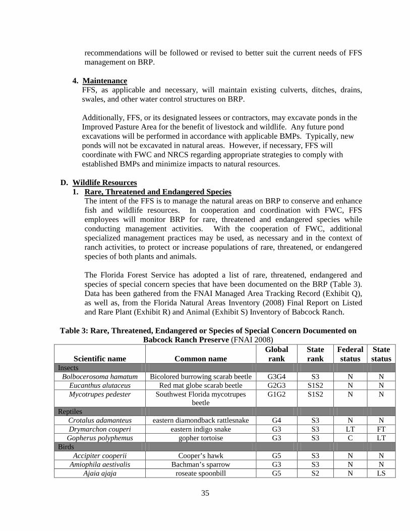
35
recommendations will be followed or revised to better suit the current needs of FFS management on BRP.
4. Maintenance
FFS, as applicable and necessary, will maintain existing culverts, ditches, drains, swales, and other water control structures on BRP.
Additionally, FFS, or its designated lessees or contractors, may excavate ponds in the Improved Pasture Area for the benefit of livestock and wildlife. Any future pond excavations will be performed in accordance with applicable BMPs. Typically, new ponds will not be excavated in natural areas. However, if necessary, FFS will coordinate with FWC and NRCS regarding appropriate strategies to comply with established BMPs and minimize impacts to natural resources.
D. Wildlife Resources
1. Rare, Threatened and Endangered Species The intent of the FFS is to manage the natural areas on BRP to conserve and enhance fish and wildlife resources. In cooperation and coordination with FWC, FFS employees will monitor BRP for rare, threatened and endangered species while conducting management activities. With the cooperation of FWC, additional specialized management practices may be used, as necessary and in the context of ranch activities, to protect or increase populations of rare, threatened, or endangered species of both plants and animals. The Florida Forest Service has adopted a list of rare, threatened, endangered and species of special concern species that have been documented on the BRP (Table 3). Data has been gathered from the FNAI Managed Area Tracking Record (Exhibit Q), as well as, from the Florida Natural Areas Inventory (2008) Final Report on Listed and Rare Plant (Exhibit R) and Animal (Exhibit S) Inventory of Babcock Ranch.
Table 3: Rare, Threatened, Endangered or Species of Special Concern Documented on Babcock Ranch Preserve (FNAI 2008)
Scientific name Common name Global rank
State rank
Federal status
State status
Insects Bolbocerosoma hamatum Bicolored burrowing scarab beetle G3G4 S3 N N
Eucanthus alutaceus Red mat globe scarab beetle G2G3 S1S2 N N Mycotrupes pedester Southwest Florida mycotrupes
beetle G1G2 S1S2 N N
Reptiles Crotalus adamanteus eastern diamondback rattlesnake G4 S3 N N Drymarchon couperi eastern indigo snake G3 S3 LT FT
Gopherus polyphemus gopher tortoise G3 S3 C LT Birds
Accipiter cooperii Cooper’s hawk G5 S3 N N Amiophila aestivalis Bachman’s sparrow G3 S3 N N
Ajaia ajaja roseate spoonbill G5 S2 N LS

36
Ammodramus henslowii Henslow’s sparrow G4 SNRN N N Aramus guarauna limpkin G5 S3 N SSC
Ardea alba great egret G5 S4 N N Athene cunicularia
floridana Florida burrowing owl G4T3 S3 N SSC
Buteo brachyurus short-tailed hawk G4G5 S1 N N Caracara cheriway crested caracara G5 S2 LT FT
Egretta caerulea little blue heron G5 S4 N SSC Egretta thula snowy egret G5 S3 N SSC
Egretta tricolor tricolored heron G5 S4 N SSC Elanoides forficatus swallow-tailed kite G5 S2 N N
Eudocimus albus white ibis G5 S4 N SSC Falco columbarius merlin G5 S2 N N
Grus canadensis pratensis Florida sandhill crane G5T2T3 S2S3 N LT Haliaeetus leucocephalus bald eagle G5 S3 N N
Ixobrychus exilis least bittern G5 S4 N N Mycteria americana wood stork G4 S2 LT FT Nyctanassa violacea yellow-crowned night-heron G5 S3 N N
Nycticorax nycticorax black-crowned night-heron G5 S3 N N Pandion haliaetus osprey G5 S3S4 N N Picoides borealis red-cockaded woodpecker G3 S2 LE FE Picoides villosus hairy woodpecker G5 S3 N N
Plegadis falcinellus glossy ibis G5 S3 N N Mammals
Eumops floridanus Florida bonneted bat G1 S1 LE FE Sciurus niger shermani Sherman’s fox squirrel G5T3 S3 N SSC
Plants Bletia purpurea pinepink G5? S3 N LT
Calopogon multiflorus many-flowered grass-pink G2G3 S2S3 N LE Harrisella porrecta needleroot airplant orchid GU SNR N LT
Lilium catesbaei pine lily G4 S4 N LT Matelea spp. spiny pod G2/G5 S2/NR N E or T
Myrcianthes fragrans twinberry G4 S4 N LT Ophioglossum palmatum hand fern G4 S2 N LE
Pinguicula lutea yellow butterwort G4G5 S3 N LT Pteroglossaspis ecristata giant orchid G2G3 S2 N LT
Sacoila lanceolata leafless beaked orchid G4 S3 N LT Tillandsia balbisiana northern needleleaf G5 S3 N LT Tillandsia fasciculata cardinal airplant G5 SNR N LE Tillandsia utriculata giant airplant G5 S3 N LE
* STATUS/RANK KEY • Federal Status (USFWS): LE= Listed Endangered, LT= Listed Threatened, N= Not currently listed, nor currently being
considered for listing, C=Candidate for Listing. • State Status (FWC): FE = Listed as Endangered Species at the Federal level by the USFWS, FT = Listed as Threatened
Species at the Federal level by the USFWS, ST = State population listed as Threatened by the FWC, SSC = Listed as Species of Special Concern by the FWC, LE= Listed Endangered, LT=Listed Threatened, N= Not currently listed, nor currently being considered for listing.
• FNAI Global Rank: G1= Critically Imperiled, G2 = Imperiled, G3= Very Rare, G4= Apparently Secure, G5= Demonstrably Secure; T#= Taxonomic Subgroup - numbers have same definition as G#’s, G#Q= Rank of questionable species - ranked as species but questionable whether it is species or subspecies (numbers have same definition as above - e.g., G2Q), GNRTNR = Neither the element nor the taxonomic subgroup has yet been ranked.

37
• FNAI State Rank: S1= Critically Imperiled, S2= Imperiled, S3= Very Rare, S4= Apparently Secure, SH = of historical occurrence in Florida, possibly extirpated, but may be rediscovered.
Please see Exhibit T for FWC’s response to FFS’s request for listed species occurrence records and critical habitats on BRP. As can be seen on the appended maps, FWC data indicates that portions of the southern end of the BRP property in Charlotte County and extending into Lee County, are a part of the secondary range-type for Florida black bears (Ursus americanus floridanus) in the vicinity. This secondary range extends to the south and southeast beyond the BRP property. Additionally, FWC data indicates that BRP is adjacent to and perhaps a part of multiple expanses of Strategic Habitat Conservation Areas. FWC data also shows that a portion of the North End Tract is adjacent to a Priority 1 Strategic Habitat Conservation Area. Furthermore, many portions of BRP are adjacent to multiple Priority 2 and 3 Strategic Habitat Conservation Areas. BRP is documented as a site with varying levels of species richness. Areas on BRP that encompass the most diversity include the northern portion of the South End Tract, as well as multiple areas throughout the Jack’s Branch Tract. Several listed species or evidence of their presence, have been documented on BRP and are within FWC’s species location data for the site including, but not limited to: wading bird rookeries, panther locations, black bear telemetry data, and eagle nests. Additionally, Priority Wetlands exist on BRP, as shown in FWC’s associated map, Exhibit T.
2. Game Species and Other Wildlife
Wildlife management will play an important role in the management of resources on BRP. The BRP is established as a miscellaneous area by FWC, instead of a traditional Wildlife Management Area (WMA) or Wildlife and Environmental Area (WEA). The FWC provides cooperative technical assistance in managing fish and wildlife populations, setting seasons, establishing bag and season limits, and enforcement of laws pertaining to fish and wildlife, administering the Tier I hunting and Tier II Area Permits, monitoring game and non-game species, and collecting related biological data. The FFS and FWC cooperatively maintain approximately 55 permanent wildlife openings and planted food plots on the BRP ranging in size from 0.75 to 11 acres. Wildlife openings and food plots will be established and maintained in accordance with the FFS State Forest Handbook. Game species on BRP may include, but not be limited to: white-tailed deer, Florida wild turkey, and northern bobwhite. Non-game species will be managed through the restoration and maintenance of native ecosystems found on the BRP. The State Forest Handbook gives additional details for related resource management such as snag management and retention.
3. Survey and Monitoring
In 2007-2008, FNAI staff conducted a comprehensive inventory for rare, threatened and endangered animal species, performed during all seasons and within appropriate

38
habitats. This inventory used information from a preliminary land cover map, published literature, the FNAI database, and staff expertise to develop a list of species that may occur on BRP. An initial reconnaissance of the survey area confirmed potential habitats, their condition, and thus the site’s potential for rare species. A survey plan was then developed using the reconnaissance information, the preliminary land cover map, and the best season of survey for each animal species. Drift fence surveys, aerial surveys and Sherman’s live trap small mammal surveys were all conducted to detect the presence of rare species. The complete results of the survey, along with management recommendations, can be found in the Listed and Rare Animal Inventory of Babcock Ranch Preserve Final Report (FNAI 2008, Exhibit S). In the future, FFS will consult with FWC to update the 2008 baseline inventory list. FFS will additionally work with FNAI, FWC and other stakeholders to develop monitoring surveys for imperiled species. Currently, there is a small breeding population of red-cockaded woodpeckers (RCW) (Picoides borealis) present on BRP, found primarily in and adjacent to the intact mesic flatwoods, wet prairie and dry prairie communities in the northeastern portion of the ranch. Since acquisition by the state, FWC has developed an RCW management plan (2008) and has been conducting limited monitoring on the population, which is less than ten miles from the BWWMA RCW population, also managed by FWC. During this ten-year planning period, FFS will continue to work with FWC to develop, update and implement strategies and goals associated with the interim RCW management plan that maintains and improves habitat for the species. FFS, in cooperation with FWC, will follow the USFWS guidelines for RCW management and incorporate those guidelines into any new RCW management plans. In addition to the 2007-2008 comprehensive inventory for rare animal species, FNAI staff also conducted a comprehensive inventory for rare plant species. This inventory used habitat information from a preliminary land cover map, the County Distribution and Habitats of Rare and Endangered Species in Florida, the state tracking list for Florida, predictive range maps, the FNAI database, and other online resources to generate a search list of potential rare plants for the BRP, their habitats, and the best survey periods. Once the potential species and habitats were identified, sites were surveyed systematically on foot during the appropriate survey period. Data was also collected opportunistically during natural community mapping activities. Although two federally endangered plants (beautiful pawpaw [Deeringothamnus pulchellus] and Carter’s warea [Warea carteri]) were thought to potentially occur on the property, neither species was found during the course of the surveys. The complete results of this survey, along with management recommendations, can be found in the Listed and Rare Plant Inventory of Babcock Ranch Final Report (FNAI 2008, Exhibit R).

39
E. Sustainable Forest Resources The FFS practices sustainable multiple-use forestry to meet the BRP resource needs and values of the present without compromising those needs and values in the future. Sustainable forestry involves practicing a land stewardship ethic that integrates the reforestation, managing, growing, nurturing, and harvesting of trees for useful products with the conservation of soil, air and water quality, wildlife and fish habitat, and aesthetics. This is accomplished by maintaining and updating accurate estimates of standing timber in order to assure that the timber resources retain their sustainability. Inventories will be updated on a continual basis according to guidelines established by FFS’s Forest Management Bureau.
F. Beaches and Dune Resources No beaches or dunes occur on the BRP. G. Mineral Resources
Mineral production in Charlotte County includes crushed stone and construction sand and gravel as well as crushed limestone rock. There is an active limestone rock and sand/shell aggregate mine (Earthsource, Inc.) just south of the BRP entrance along SR 31.
H. Unique Natural Features and Outstanding Native Landscapes Scenic resources on the BRP include an extensive example of a relatively large south Florida flatwoods ecosystem. This ecosystem comprises a pineland and wetland complex, including mesic flatwoods, wet flatwoods, dry prairie, wet prairie, basin marsh, cypress strands and dome swamps. As a mostly undeveloped rural ranch and natural landscape, BRP has significant scenic resources of interest to both visitors and the residents of Florida.
Wetlands are numerous and varied on the BRP, including cypress domes and strands, depression and basin marshes and sloughs (Exhibit O). In total, these wetlands comprise 18.25% of the land cover on the property. The major wetland feature on the BRP is Telegraph Swamp and its associated Telegraph Creek, which flows through the swamp system. This wetland system is a major natural feature that roughly runs north to south through the western half of the BRP. This swamp system is fed by numerous cypress domes, freshwater marshes, and wet prairies. Water quality has been judged as excellent and the creek supports a healthy population of aquatic insects. A 1997 assessment of the Big Island Canal water quality and aquatic insect indicators was rated as good. See Section IV.C. Water Resources, for more detailed information on water quality.
I. Research Projects / Specimen Collection
Research projects may be performed on BRP on a temporary or permanent basis for the purpose of obtaining information that furthers the knowledge of forestry, wildlife conservation, ranch management and related fields. The FFS cooperates with other governmental agencies, non-profit organizations, and educational institutions, whenever feasible, on this type of research. The FFS will consider assisting with research projects when funds and manpower are available.
40
All research projects to be considered on BRP must be considered in accordance with the guidelines stated in the State Forest Handbook. Any requests for research projects should be submitted in writing to the appropriate field staff to be forwarded to the Forest Management Bureau for approval. Requests must include: a letter outlining the purpose, scope, methodology, and location of the proposed research project. Requests are subject to review by FFS foresters, biologists, the Forest Health Section, and the Forest Hydrology Section, as appropriate. Authorization to conduct research will require that the investigator provide copies of any reports or studies generated from research projects to the BRP staff. Other special conditions may be applicable and the authorization may be terminated at any point if the study is not in compliance.
J. Ground Disturbing Activities Although the FFS’s approach to handling ground disturbing activities is identified in various sections of this plan, the FFS’s overall approach to this issue is summarized here. The FFS recognizes the importance of managing and protecting sensitive resources and will take steps to ensure that such resources are not adversely impacted by ground disturbing activities. This includes areas such as known archaeological, fossil, and historical sites, ecotones, wetlands, and those containing sensitive species. When new pre-suppression firelines, recreational trails, or other low-impact recreational site enhancements are necessary, their placement will be reviewed by BRP field staff to avoid sensitive areas. Such activities may include, but are not limited to: construction of buildings, parking lots and new roads.
V. Public Access and Recreation
Using components of the existing Recreational Master Plan, the FFS will develop and implement a Five-Year Outdoor Recreation Plan for the BRP within two years. The primary recreation objective will be to provide the public with dispersed outdoor recreational activities that are dependent on the natural environment. Outdoor recreational activities may include hunting, fishing, off-road biking, hiking, horseback riding, camping, wildlife viewing, geo-caching, and nature study. Excluding recreational Off-Highway Vehicles (OHV), all outdoor recreation activities that are compatible with state forest management may be considered for BRP. The FFS will continue to promote and encourage public access and recreational use by the public while sustaining the working ranch activities, protecting natural resources, taking various user groups’ needs into consideration and practicing multiple-use management. The BRP annual public recreational carrying capacity will be determined in cooperation with FWC after FFS takes over management authority on BRP in August 2016. Once all approved and funded recreational opportunities that do not negatively impact the natural resources and ranch operations are established, an accurate figure will be determined. This will occur during the ten-year planning period beginning August 1, 2016. Additionally and similarly, the BRP annual carrying capacity for Tier I hunting and Tier II Area Permits will be determined in cooperation with FWC after FFS assumes management

41
authority on BRP in August 2016. A component of the overall recreational uses on BRP includes both Tier I and Tier II recreation opportunities. Administered by FWC, Tier I hunting includes limited entry (quota hunt) opportunities for Archery, Muzzleloading Gun, Family Hunt, General Gun, Mobility-Impaired, Spring Turkey, and Small Game hunting seasons. Tier II recreation opportunities, organized by assigning zones by permit, allows permittees and their guests to visit BRP throughout the year, and hunt game species consistent with area specific regulations. The tiered hunting structure is designed to achieve the management plan public-use goal that is compatible with ranch operations, and conforms to 259.1053(5)(c), FS. Tier I hunts, Tier II Area Permits and hunting allowed under Youth Hunting Program of Florida will continue.
Management of public access on BRP will be an adaptive process requiring time and patience in order to strike a balance between visitors’ desired experiences, the ongoing ranch operations, and the protection of natural resources. New recreational opportunities and facilities, which are compatible with the primary goals and responsibilities of the FFS, will be considered only after compatibility with ranch operations, agricultural operations, and natural resources impacts have been determined by FFS. Periodic evaluations will be conducted by FFS staff to monitor recreational impacts on ranch operations and natural resources. Proper planning will eliminate or minimize conflicts between public access, ranch operations, and impacts to natural resources. However, should negative impacts be identified, modifications to recreational uses will be implemented. The use of OHVs on BRP is allowed in authorized areas only, for the purpose of management activities, emergency situations, for utilization during OOF events and when necessary for compliance with the Americans with Disabilities Act.
A. Existing
Currently, BRP offers several public recreation opportunities including hiking trails, ecotourism, Tier I hunting and scheduled equestrian rides. There are two hiking trails: the Eco-tour Trail (approximately 1 mile in length) is a loop trail near the Ecotour headquarters in the northwest portion of the Telegraph Swamp Recreation Area; the Footprints Trailhead Orange Trail (approximately 2.6 miles) and Purple Trail (approximately 7.5 miles), are located in the Bermont Crossing Recreation Area west of the Forestry Tower at State Road 74. See maps in Exhibit C for BRP Tract locations. Please see Exhibit U for a BRP Recreation Map. Ranch tours are offered through the working cattle ranch, Florida natural communities, the Babcock Family Lodge, a gift shop with Florida souvenirs, and a snack café. The Babcock Ranch Preserve Hunting Area Tier I hunting is managed by the FWC. The WMA encompasses 16,612 acres and provides quota hunt opportunities for individuals, families and the mobility impaired. During the appropriate seasons, game that may be harvested include deer, turkey, small game, and migratory birds. Currently, equestrian rides on BRP are periodically scheduled with local user groups.

42
B. Planned Additional recreational opportunities at BRP will be evaluated and considered for the Bermont Crossing Recreation Area, Jack’s Branch Recreation Area, and the Telegraph Swamp Recreation Area. New recreational opportunities and facilities, which are compatible with the primary goals and responsibilities of the FFS, will be considered and added only after the FFS determines their compatibility with the working ranch and agricultural operations, and natural resource protection. The FFS can expand current recreational opportunities and will evaluate the addition of mutli-use trails, primitive camping, full-facility campgrounds, a shooting range, and OOF. The evaluation and expansion of recreational opportunities will be contingent on compatibility with ranch operations (including agriculture leases), natural resource management, and funding availability. Development of additional opportunities will include input from user groups, cooperator agencies, and review of the Babcock Ranch Preserve Recreational Master Plan (2009), prepared by the Genesis Group. The FFS will place emphasis on funding, leases and the previously mentioned ranching operations and management needs when considering new recreation opportunities on BRP. The FDACS/FFS, as lead manager, will make the final determination to add new recreational opportunities on BRP.
The Footprints Orange and/or Purple hiking trails may be included into the FFS’s Trailwalker Hiking Program. Any future equestrian trails on BRP may be added to the FFS’s Trailtrotter Equestrian Program. Additionally, BRP may be considered for inclusion into the FWC Great Florida Birding Trail. Future equestrian trail, hiking trail or multiple-use trail development, will primarily be in the Jack’s Branch Recreation Area and may be placed over existing trails, firebreaks, tertiary roads, or vacated tertiary roads. This area currently has limited recreation and offers the most potential for expanding recreational opportunities while preserving the ranch operations. The FFS will consider potential recreational trail connectivity when planning additional trails. Additionally, FFS will evaluate the compatibility and impacts of additional recreation at the Bermont Crossing Recreation Area and the Telegraph Swamp Recreation Area. Camping will be evaluated for inclusion in all three Recreation Areas, but may be offered through Special-Use Permit in the Jack’s Branch Recreation Area initially. The current Tier II recreation areas throughout the North End Tract and South End Tract include the opportunity for Tier II permittees to camp as well. Tier II recreation areas currently have associated camps, which may be exclusively occupied by permittees during the year. The FFS permits all designated non-hunting related recreation throughout the year, but will continue to coordinate with FWC to minimize user conflicts during hunting seasons. The FFS can issue a Special Use Permit for non-routine or group recreational activities. They may be issued through the FFS Myakka District Office, a Field Office, or the FFS BRP Headquarters, once established.

43
The FFS will provide outdoor recreational opportunities on BRP to disabled veterans through the FFS’s OOF program. OOF events will initially take place within the Telegraph Swamp Recreation Area, and may be expanded to other areas of BRP. These events will be held in cooperation with the FWC. The OOF events provide veterans with unique, specialized opportunities for recreation, rehabilitation, and socialization. These events may involve many aspects of outdoor recreation activities including, but not limited to: hunting, hiking, fishing, horseback riding, recreational shooting sports and other activities developed for disabled veterans. Supporting participants may include volunteers and any support personnel necessary for the operation, support or funding of such events. Events can be for recreational, fundraising or planning purposes. The OOF program needs may include the upgrading of existing facilities or construction of new facilities, for participant lodging and recreation, and logistical and operational needs of the program. On-site fundraising for the benefit of OOF may occur to assist in these efforts and will be performed under the coordination of, and consistent with, the guidelines of the FFSF. FFS may connect the BRP trails to a regional trails and greenway system which may connect BRP to other regional outdoor recreational opportunities on public lands. A connection to BRP may only be considered if: a regional system was designed to connect existing recreational trails on BRP; did not require additional operations and maintenance from the FFS; and did not impact the management of BRP as a working ranch or adversely affect the natural systems or management of the natural systems (i.e. prescribed fire) on BRP. Further expansion for public recreational opportunities will be planned and outlined in the BRP Five-Year Recreation Plan, which will be updated annually.
C. Hunting
The FWC, in cooperation with the DACS/FFS, shall: 1. Establish and implement public hunting and other fish and wildlife management
activities. Tier I and Tier II area permit opportunities shall be provided consistent with the management plan and the Five-Year Outdoor Recreation Plan. Tier I public hunting shall provide hunting opportunities similar to those offered on WMAs with an emphasis on youth and family-oriented hunts. Additional youth-hunting opportunities may be provided through FWC’s Youth Hunting Program of Florida, in coordination with FFS. Tier II recreational access shall be provided specifically by fee-based permitting, and coordinated between FFS and FWC to ensure compatibility among wildlife conservation, livestock grazing, and other agricultural operations on the BRP.
2. Establish and administer fees for Tier II Area Permits to capitalize on the value of hunting and other recreational opportunities on portions of the preserve and to help ensure BRP is financially self-sufficient. The fees shall be deposited into the FWC’s State Game Trust Fund and may be used to offset the costs to provide public hunting opportunities, to support fish and wildlife management and other land management activities on BRP, pursuant to paragraph 259.1053(5)(c), FS.

44
3. FWC will be responsible for managing and regulating all aspects of the Tier I hunting and Tier II area permit areas, including, but not limited to, the associated camp facilities, grounds and perimeters.
Any and all references to hunting will be superseded by FWC guidelines and Florida Statutes governing FWC practices on state-owned lands. All entities will abide by Section 259.1053. F.S., and state and federal guidelines regarding fish and wildlife management.
D. Education
FFS may create partnerships with local K-12 schools and/or universities for the purpose of the development and implementation of educational opportunities on BRP. Once developed, the Five-Year Outdoor Recreation Plan may lend more insight to management activities as they pertain to future educational opportunities BRP may provide to the public. Additionally, FFS intends to establish an educational program for the public which will highlight to visitors ranch operations, the natural environment and the preservation of BRP.
VI. Forest Management Practices
A. Prescribed Fire Forest management practices on BRP are important to the restoration and maintenance of forest ecosystems and provide a variety of socio-economic benefits to Floridians. Management practices on BRP include a prescribed fire program that is a highly effective tool in wildfire mitigation, controlling the growth of hardwood trees, stimulating the recovery of native herbaceous and grassy ground cover, and promoting the regeneration of native pines.
The annual forest prescribed burning program produces multiple benefits. The purposes of prescribed burning on BRP are to facilitate forest and ranch management operations and enhance wildlife and listed species habitat, to decrease fuel loading, consequently enhancing public safely, and to restore, maintain, and improve the health of native ecosystems, ecotones, and their ecological processes. FFS personnel are responsible for planning and implementing the annual prescribed burn program for BRP, which will consist of growing and dormant season burns. Burns are planned by the BRP staff with input from cooperating agencies as appropriate. A BRP annual Prescribed Burn Plan is developed each year, which identifies the individual burn unit prescriptions, whether the unit is on a growing or dormant season rotation, map of burn unit, and other information specific to that burn unit. The smoke screening system will be used as a smoke management tool to minimize the adverse impact of smoke that may affect residential communities, public roads, schools, and other smoke sensitive areas. Historic, fire dependent natural communities on BRP are estimated to have occupied approximately 57,167 acres, and to have burned at approximately 2-10 year intervals, depending on the community. Past land uses have left some of these historically fire dependent communities in a condition unable to carry prescribed fire. Based on current

45
conditions and management objectives, BRP will plan for 12,000 to 24,000 acres to be prescribed burned annually at approximately 2-4 year intervals. Restoration of these areas by removal of the off-site species and reforestation will increase prescribed burn acreage goals over time. Meeting prescribed fire goals will be largely dependent on weather conditions, personnel, and statewide emergency situations such as wildfires, hurricanes and other natural disaster response and relief. The southern portion of the state has an extended growing season for pines and other vegetation. There is also an extended wet season that could limit the frequency of prescribed burns. Therefore, the objective is to encourage year-round prescribed burning whenever possible, with the understanding that much of the prescribed fire will be applied, but not limited to, the dormant season. This will meet several resource objectives including management of cattle forage on BRP.
Fires caused by lightning at the end of the dry season and through the rainy season (growing season) represent the natural fire regime in southern Florida. It is believed that native range present at BRP has been subjected to this type of fire for many centuries. Numerous groundcover species found in flatwoods and dry prairie communities are adapted to and dependent upon growing season fires. However, Florida ranchers have typically burned native range in winter or early spring. Prescribed fires conducted in late spring or summer will create a ground cover mosaic that will promote herbaceous plant species, while also retaining patches of palmetto cover to provide denning and escape cover for the Florida panther, Florida black bear, and other game and non-game wildlife species. Inclusion of periodic spring and summer prescribed burns in the typical burn regime will likely benefit native plant communities, as well as cattle grazing and wildlife.
Control of wildfires and the proper application of prescribed fire in the Wildland-Urban Interface (WUI) will become important for FFS to address. Current and future encroachment by residential development in close proximity to BRP will continue to present significant smoke and fire management challenges.
1. Fire Management FFS will develop a fire management plan that will serve as a working tool and an informational document for BRP. The plan will provide guidelines in regards to wildfire suppression and prescribed fire management. It will specify burn units, burn unit prescriptions, appropriate fire return intervals, and fire suppression planning. FFS will coordinate with FWC on developing the fire management plan. The plan may be reviewed and amended as necessary. The use of prescribed fire in the management of timber, wildlife, and ecological resources on BRP is necessary if the FFS is to fulfill the goals and objectives stated in this plan including: enhancing and restoring native plant communities, managing protected species, producing grazing forage, managing timber, recreation, historical, and other resource values. The fire management plan and its objectives shall reflect and incorporate these multiple-resource objectives.

46
a. Prescribed Fire: Prescribed fire is the most important land management tool, both ecologically and economically, for managing vegetation and natural communities and perpetuating existing wildlife populations in Florida. Ranch operation records and ranch staff experience should be combined with the FNAI inventory and assessment (2008) to identify areas of saw palmetto or shrub cover with fuel loads that may require mechanical treatments in conjunction with prescribed fire to restore a more natural vegetative structure.
b. Burn Unit Plans: Each prescribed fire will be conducted in accordance with
FFS regulations and state law (Rule Chapter 5I-2 F.A.C., Chapter 590 F.S.) and have a burn unit plan (or prescription). Each prescription will contain, at a minimum, the information, as required by Section 590.125(3), F.S., needed to complete the FFS Prescribed Burn Plan Form FDACS 11461. BRP Prescribed Burn Plans should be augmented with the FNAI inventory and assessment (2008) to develop prescriptions for burn units, fire return intervals, and fire suppression planning. Aerial ignition may be considered for large burn units where this tactic can be cost effective. Consideration should be given to shifting the season of burns to the growing season (April-September) for appropriate burn units. Fire return intervals for a burn unit are recommended to fall within the natural, historic range for the dominant natural community or communities within a given burn unit. Based upon available species survey data, burn units within a prescription that have listed wildlife species shall explicitly state their presence and any restrictions or requirements relative to prescribed burning in proximity to these species or habitats. These may include time of year, pre-burn preparation, fire return intervals, and other burn parameters.
B. Wildfires, Prevention, Fire / Prescribed Fire Strategies
The FFS utilizes a comprehensive wildfire management approach on state forests that includes an ongoing program of wildfire prevention, detection and suppression, and aggressive prescribed burning. Implementation of this program is the responsibility of the FFS’s District Office. Emphasis will be placed on consistently accomplishing the prescribed burning goals and community outreach to increase public understanding of wildfire prevention and the benefits of prescribed fire. The FFS has three paramount considerations regarding wildfires, and these are listed in priority order:
1) Protection of human lives, both that of the firefighter and the public 2) Protection of improvements 3) Protection of natural resources

47
All procedures regarding wildfire will follow the State Forest Handbook and the BRP Fire Management Plan. 1. Suppression Strategies
If a wildfire occurs on BRP there are two alternative suppression strategies as defined below: a. Contain is defined as a suppression strategy where a fire is restricted to a specific
pre-determined area by using natural or constructed barriers that stop the fire’s spread under the prevailing and forecasted weather and fire behavior until dead out. This strategy allows the use of environmentally sensitive tactics while monitoring for smoke and fuel conditions that would warrant more aggressive control tactics, described below.
b. Control is defined as a suppression strategy where aggressive suppression tactics are used to establish firelines around a fire to halt its spread and to extinguish all hotspots. This alternative is used whenever there is a threat to human life, property, private lands, and/or critical natural or cultural resources. This strategy should also be used when the total field unit fire load dictates that crews not be involved with individual fires for any longer than absolutely necessary.
Appropriate suppression action will be that which takes into account the three paramount considerations listed above, provides for the most reasonable probability of minimizing fire suppression cost and critical resource damage by taking into consideration probable fire behavior, total fire load, potential resource and environmental impacts, and smoke management issues. The Incident Command System (ICS) will be used for all suppression actions.
2. Smoke Management
Caution will be exercised to prevent a public safety or health hazard from the smoke of any prescribed burn or wildfire. Prescribed burns must pass the smoke screening procedure. If smoke threatens to cause a safety hazard, then direct immediate suppression action will be taken. Complaints about smoke by residents of suburban and rural housing areas represent a significant threat to the use of prescribed fire by conservation land managers, ranchers, and foresters. The BRC, as well as any other housing areas near BRP, will be affected by smoke from prescribed burns on the preserve. Without prescribed fire, land managers are denied their most important tool to manage natural communities and grazing lands in an ecologically sustainable way.
The use of Smoke Management Guidelines can help BRP continue using fire as a land management tool on lands adjacent to residential and commercial areas. Guidelines also include informing and educating the public about the use of fire.
As development in Florida continues to move into areas adjacent to natural areas (the WUI), concerns arise about protecting homes and property from wildfire. Communities across Florida are being asked to consider adopting policy statements and/or covenants to address smoke management and vegetation management.
48
Communities adjacent to the BRP should be planned with both prescribed fire and wildfire in mind, given the natural role of fire in Florida’s ecosystems. This will help BRP to continue to be maintained with fire, which provides indispensable ecological and grazing benefits as well as critical wildfire protection to residents in the WUI.
3. Fire Breaks and Firelines
A system of permanent pre-suppression firelines will be developed and maintained on the BRP for prescribed burning and wildfire suppression. Such firelines will consist of natural barriers, roads, trails, permanent grass strips and where appropriate, well-maintained harrowed lines. All firelines will meet the established Silvicultural BMP criteria. During wildfire suppression, the use of water and foam, permanent fire breaks, natural barriers and existing roads and trails for firelines can be used when human life safety, property, and resource considerations allow. Plowed and/or bulldozed lines will be used for initial installation of firelines in heavy fuels and in cases where it’s considered necessary to protect life, property, or resources and/or to minimize threats to fire-fighters. Plowed and bulldozed lines will be rehabilitated and BMPs implemented as soon as practical after the fire is suppressed. FFS utilizes map products (e.g., Landmark Systems 2008) which illustrate existing firelines and breaks to delineate burn blocks, when feasible, and minimize the need to establish new ones. FFS uses these map products to assess the current need and condition for these lines and breaks. Wildfire suppression lines are not recommended to be established in wetlands, ecotones, or other sensitive areas. If placement of such lines in wetlands, ecotones, or other sensitive areas is unavoidable, rehabilitation of those lines shall be considered. Newly proposed prescribed fire control lines will be assessed prior to installation so as to avoid wetlands, ecotones, or other sensitive areas and to avoid possible impediments to the natural hydrology. All construction and maintenance of firelines shall be in accordance with the applicable BMPs.
4. Sensitive Areas
DHR indicated that there is a low potential for archaeological resources to occur on this site. If archaeological or historical resources are confirmed within the preserve, care should be to avoid impact to these sites during wildfire suppression or prescribed burning activities (see Section III Archaeological / Cultural Resources and Protection for more detailed information).
All burn crews at BRP will have access to updated maps depicting environmentally sensitive areas such as endangered species locations, wetlands, and historical and archaeological resources. Special precautions will be followed when prescribed burning in sensitive areas on BRP. When possible, fire staff will avoid line construction in wetland ecotones throughout the forest. Prior to intact natural community ground disturbing activities, excluding clearing of existing firelines and chopping, DHR and FNAI will be consulted. Please see Exhibit AF to view the applicable “DOS/DHR Guidelines for Ground Disturbing Activities”.

49
5. Fire Adapted Communities
Communities in wildfire prone areas must work together to be fully prepared for wildfire. A “Fire Adapted Community” incorporates people, buildings, businesses, infrastructure, cultural resources, and natural areas to prepare for the effects of wildfire. The Fire Adapted Community concept serves as an umbrella to the various programs that help communities become more fire adapted. The FFS has implemented the Fire Adapted Community concept for prevention statewide. Specifically, in the area adjacent to or nearby BRP, efforts have included identifying Communities at Risk through the web-based South WRAP (Southern Area Wildfire Risk Assessment Portal) and working with communities to become Firewise.
6. Adjacent Neighbor Contacts
The staff at BRP maintains a list of neighbors that have requested they be notified in advance of prescribed burns. These families are contacted by telephone or email with potential sites and dates of anticipated prescribed burns.
7. Post-Burn Evaluations
A post-burn evaluation is required for each wildfire and prescribed burn on BRP to assess impacts on timber and habitat. Based on the evaluations, decisions will be made on timber salvage operations. A historical fire record for all fires and prescribed burns will be maintained. This will be accomplished by maintaining the burn plans in the Ranch Manager’s files, and through maintenance of GIS data; these records are intended to provide data for future management decisions. The procedures for conducting post-burn evaluations are outlined in the State Forest Handbook.
C. Sustainable Forestry & Silviculture
Timber is a valuable economic and ecological resource, and as such, timber harvesting for the purposes of generating revenue, improving stand viability, forest health, and ecological restoration and maintenance, is critical to the silvicultural objectives on BRP. 1. Strategies
The following silvicultural strategies will apply to silvicultural practices on BRP: a. To restore and maintain forest health and vigor through timber harvesting,
prescribed burning, and reforestation, both naturally and artificially, with species native to the site.
b. To create, through natural regeneration, uneven-aged, and even-aged management, a forest with both young and old growth components that yields sustainable economic, ecological, and social benefits.
2. Silvicultural Operations
Silvicultural operations on BRP will be directed toward improving timber management opportunities, forest health, wildlife habitat, ecological and economical sustainability. Stands of off-site species with merchantable volume will be scheduled for harvest, followed by reforestation with the appropriate tree species. Herbicide

50
applications may be necessary to control woody competition and to re-establish desired natural species of both overstory and ground cover. Site preparation methods may include prescribed fire, mechanical vegetation control, and herbicide applications. Prescribed fire is the most desirable method of vegetation control in fire dependent ecosystems. However, due to the existence of areas where fuel loads have reached dangerous levels or urban interface dictates prescribed fire is not suitable, mechanical or chemical vegetation control may be used. Mechanical and/or chemical vegetation control will be utilized where appropriate as determined by FFS staff for wildlife enhancement, fuel mitigation and reforestation. Maintenance and restoration of timber stands and natural communities through timber harvesting will include thinning for maintenance, regeneration harvests applicable to the species present, and clear-cutting to remove off-site species and other applicable purposes.
All silvicultural activities, including timber harvesting and reforestation, will meet or exceed the standards in the FFS’s Silviculture BMPs and the State Forest Handbook, and will follow the BRP Five-Year Silviculture Management Plan.
3. Forest Inventory
The purpose of a forest inventory is to provide FFS resource managers with information and tools for short and long range resource management and planning. Ten percent of BRP’s forest will be re-inventoried annually to provide an accurate estimation of the standing timber and to ensure that stands will be managed sustainably. Additional timber/forestry resources available on the property may include but are not limited to pine straw, crooked wood, biomass, and other forest resources. At this time, none of these are taking place, but may be considered in the future. See Section II.B.4, Revenue Producing Activities.
4. Timber and Other Forest Product Sales Timber sales are generally advertised for competitive bids and sold on a per unit or lump sum basis. All timber sales are conducted according to guidelines specified in the State Forest Handbook, unless otherwise determined by FFS. Other forest product sales and leases may be considered and will be advertised in the same general manner. Other forest products offered for sale or lease may include, but are not limited to, sustainable cabbage palm harvests, palm frond and palmetto fan harvests, and pine straw harvest. In the case of wildfire, insect, disease, or other catastrophic events, salvage sales may be conducted to harvest dead or dying timber. These sales will typically be per unit sales and advertised for competitive bids as well. The FFS will consult the State Forest Handbook for salvage sale guidance. When conducting salvage cuts, a

51
minimum of 6 snags per acre will be retained where feasible. When possible, the remnant snags shall be greater than 8 inches diameter at breast height (dbh). All timber related activities and other forest product sales or leases on BRP will comply with the most recent version of the Silviculture BMPs, as well as Agricultural Wildlife BMPs for State Imperiled Species.
D. Non-Native Invasive Species Control
FFS employees continually monitor the forest for non-native invasive species while conducting management activities. These occurrences are recorded in the GIS database and updated as new plants are discovered (see Exhibit V). FFS will locate, identify, and apply control measures with the intent to eradicate or control non-native invasive species. When these species are discovered, an eradication or management plan will be developed with the assistance of the Forest Management Bureau’s Forest Health Section as needed. The plan will be implemented based upon the severity of the infestation and the availability of personnel and funding. Adjacent landowners who are known to have these species on their property will be approached in an effort to cooperate on control measures. FFS works to control the spread of non-native invasive species by decontaminating agency equipment and equipment used by private contractors, in accordance with the State Forest Handbook. Guidelines are already in place for private contractors doing work on the state forests, allowing language to be inserted in contracts to accommodate for the cleaning of equipment prior to ingress, and other protocols as appropriate, to prevent the introduction and spread of invasive plants. BRP has a moderately dense population of non-native invasive feral hogs (Sus scrofa). Feral hogs cause negative impacts on agricultural operations, as well as native plant and animal populations. A variety of management techniques may be necessary to maintain this population at reduced densities that minimize impacts to natural resources. The FFS will enlist support from the FWC in the effort to control these and other non-native invasive animals. FWC has issued a feral hog control trapping permit to FFS for all FFS-managed lands, and the FFS will encourage hog removal on BRP through trapping and hunting.
Training in the identification and control of invasive species will be scheduled for personnel as time and resources permit. Training concerning non-native invasive plants will be coordinated with the Forest Management Bureau’s Forest Health Section. Control of non-native invasive species will be target specific and use a variety of methods including appropriately labeled and efficacious herbicides. Melaleuca (Melaleuca quinquenervia) has been documented on BRP and periodic efforts at chemical control have been undertaken since the early 1990s. Brazilian pepper (Schinus terebinthifolius), while not prevalent in natural areas, is common in the farm ditches and other disturbed areas. Old world climbing fern (Lygodium microphyllum) is prevalent throughout Telegraph Creek Swamp. Several hundreds of thousands of dollars

52
have been spent in recent years in an effort to control old world climbing fern with limited results, including the introduction of approved biological control agents. Many other non-native invasive species can be found on BRP, including but not limited to: torpedo grass (Panicum repens), cogongrass (Imperata cylindrica), tropical soda apple (Solanum viarum), Caesar’s weed (Urena lobata), Peruvian primrose willow (Ludwigia peruviana) and natal grass (Rhynchelytrum repens). Currently, much of the non-native invasive plant control efforts, such as with cogongrass, on BRP are conducted through FWC’s invasive plant management section. These efforts are coordinated with other management activities to achieve optimum control. Prior to conducting a prescribed burn in a given unit, for example, melaleuca trees are cut and the stumps are treated with herbicide. By doing so, seeds are concentrated in the immediate area of the stumps and seedlings are then easier to locate for follow-up treatments. With the exception of old world climbing fern, non-native invasive plants on the BRP are considered to be in a maintenance condition, but will require vigilance and continued treatment efforts.
A monitoring program is in place whereby known populations of non-native, invasive species, treatment strategies, observation dates, and GPS locations are recorded and tracked using a GIS database. When new populations of non-native, invasive species are discovered they are recorded in the database and mapped. The 2008 FNAI Non-Native Invasive Inventory of Babcock Ranch is attached as Exhibit V. In the future, FFS, and any applicable lessees, will work with FNAI to update the inventory and location of all non-native, invasive species on BRP.
E. Insects, Disease and Forest Health Currently, there are no known insect or disease problems on BRP. In the event of any outbreak or infestation, consultation with the Forest Management Bureau’s Forest Health Section will occur to formulate an appropriate and effective response. In compliance with Section 388.4111, FS, and in Rule 5E-13.042, FAC., all lands have been evaluated and subsequently designated as environmentally sensitive and biologically highly productive. Such designation is appropriate and consistent with the previously documented natural resources and ecosystem values and affords the appropriate protection for these resources from arthropod control practices that would impose a potential hazard to fish, wildlife and other natural resources existing on this property. The local arthropod control agency in Charlotte County will be notified of the approval of this plan documenting this designation. As a result, prior to conducting any arthropod control activities on BRP, the local agency must prepare a public lands control plan that addresses all concerns that FFS may have for protecting the natural resources and ecosystem values on the state property. In this regard, FFS will provide the local agency details on the management objectives for BRP. This public lands control plan must be in compliance with FDACS guidelines and use the appropriate FDACS form. The plan must then be approved and mutually adopted by the

53
applicable county, FFS, and FDACS prior to initiation of any arthropod control work. Should a local mosquito control district not propose any arthropod control operations on the property, no arthropod control plan is required. See Exhibit W.
F. Use of Private Contractors The ranch manager will make ongoing evaluations of the use of private contractors and consultants to facilitate the total resource management activities of this property. The opportunities for outsourcing land management work may include, but are not limited to: 1. Herbicide application 2. Timber stand improvement activities 3. Tree planting and site preparation 4. FNAI (surveys) 5. Timber harvests 6. Bahia planting 7. Seed harvesting 8. Sod harvesting 9. Hay production 10. Palmetto drupe harvesting 11. Row cropping 12. Cattle management
VII. Proposed Management Activities for Current Natural Community Cover Types
In 2008, FNAI completed an inventory and natural community mapping project on 73,559 acres (acreage mapped included the conservation easement that connects the Curry Lake Tract to the larger contiguous piece of BRP, as well as Bob Janes Preserve to the immediate south in Lee County) of the BRP and, as a result, produced data relating to historic natural communities (Exhibit X) and the current (2008) natural communities (Exhibit Y). The results of this survey are summarized in Table 4; Table 5 summarizes the BRP Altered Landcover Types. For the purposes of this management plan, restoration is defined as the process of returning ecosystems or communities to the appropriate structure, function and species composition, based on soil type. Management during this ten-year period will begin with a forest-wide assessment of the fuel loading, timber densities, reforestation needs and groundcover in order to develop a five-year comprehensive operational plan for prescribed burning across the property. Strategies may include thinning of overly dense pine stands, mowing or chopping in areas of heavy fuel buildup, and/or application of cool dormant season fires. The results of these initial efforts will be monitored; more refined and detailed restoration plans will then be developed. Fire return intervals are included as a guide and may vary depending upon specific conditions. The intention is to use fire in a manner and frequency that will attain the desired goals and objectives for each natural community.
For the purposes of this plan, FFS utilized the 2008 FNAI natural community delineation information, specifically the Natural Community Descriptions (Exhibit Z) and the Babcock Ranch Natural Community Mapping Project (Exhibit AA), for management and planning purposes.

54
Table 4: Natural Communities Found on BRP (including the conservation easement)
Vegetation Type Acres
Mapped (Historic)
Acres Mapped
(Current)
Acres Mapped (Current Pine
Plantation)
Historical Burn Interval
(Years) Mesic Flatwoods 36,544 29,134 502 2 - 4
Strand Swamp 6,759 6,757 -- Varies
Wet Flatwoods 5,018 5,586 -- 2 - 5
Wet Prairie 4,529 2,768 -- 2 - 3
Dry Prairie 8,929 2,491 -- 1 - 2
Depression Marsh 2,133 2,061 -- 1 - 5
Basin Marsh 1,877 1,843 -- 1 - 10
Dome Swamp 983 982 -- 3 - 150
Slough 651 654 -- N/A
Hydric Hammock 381 417 -- N/A
Mesic Hammock 70 288 -- N/A
Scrubby Flatwoods 4 4 -- 8 - 15
Scrub 11 11 -- 5 - 20
Table 5: Altered Landcover Types Found on BRP (including the conservation easement)
Altered Landcover Type* Current Acres Mapped
Pasture Improved 10,044
Pasture – Semi-Improved 1,168
Abandoned Field / Abandoned Pasture 424
Agriculture 2,170
Canal / Ditch 56
Clearing / Regeneration 447
Developed 104
Invasive Monoculture 145
Impoundment 29
Spoil Area 3

55
* Protocol as described in Exhibit 2 of FNAI’s “Guide to the Natural Communities of Florida”, 2010 Edition.
The following community descriptions, existing condition descriptions, and management recommendations are taken from this FNAI mapping project report and the Guide to the Natural Communities of Florida (FNAI 2010), as well as from the knowledge and experience gained by FFS during forest inventory efforts and routine field work on BRP (FNAI 2008). To achieve the objectives in this plan, management activities for each natural community described below will be performed during the next ten-year planning period as necessary. Goals, desired conditions, standards and guidelines provide management area direction. These goals and desired conditions may take many planning cycles to attain.
A. Mesic Flatwoods Description:
Mesic flatwoods are pine forests, varying from moderately dense to open, with a diverse understory of shrubs and herbs occurring in acid sands on generally flat terrain. Mesic flatwoods are the dominant upland natural community on BRP, occupying roughly 29,134 acres. Pine plantations are uncommon on BRP, and range from fewer than ten acres to more than 240 contiguous acres in size, totaling 502 acres across the property. For the purposes of this plan, pine plantation acreage is considered within this community, as they occur in areas that were historically mesic flatwoods and will be managed as such. Saw palmetto (Serenoa repens) and wiregrass (Aristida stricta) are the characteristic shrub and herb species. In addition to these dominant species, there is often a high diversity of shrubs, particularly herbs. Frequent fire is an important factor in maintaining vegetation structure and high diversity in mesic flatwoods. Fires naturally occurred every two to four years during the late spring/early summer lightning season. Mesic flatwoods that have not burned regularly tend to have dense tall shrub layers and sparse to absent herbaceous vegetation.
Current Conditions: The primary canopy species in mesic flatwoods on BRP is south Florida slash pine (Pinus elliottii var. densa) except in the northeast corner of the property where longleaf pine (Pinus palustris) dominates. The pines, oaks (Quercus spp.), and cabbage palm (Sabal palmetto) are typical subcanopy species. Shrubs and herbs are typically co-dominant in the understory, although wetter areas favor greater shrub development, and denser canopy trees. Most shrubs are under six feet tall; common species include saw palmetto, wax myrtle (Myrica cerifera), dwarf live oak (Quercus minima), coastalplain staggerbush (Lyonia fruticosa), and netted pawpaw (Asimina reticulata). Frequent among herbs are wiregrass, lopsided indiangrass (Sorghastrum secundum), chaffheads (Carphephorus spp.), bluestems (Andropogon spp.), tickseeds (Coreopsis spp.), and yellow-eyed grasses (Xyris spp.). Large areas of the historic mesic flatwoods on BRP have been converted to agricultural fields and pastures. Boundaries between these areas and mesic flatwoods often have infestations of non-native invasive species, especially melaleuca (Melaleuca quinquenervia), Brazilian pepper (Schinus terebinthifolius), Caesar weed (Urena lobata),

56
cogongrass (Imperata cylindrica), and old world climbing fern (Lygodium microphyllum). Other disturbances in mesic flatwoods on the property include soil disturbance by feral hogs, which can contribute to the spread of weedy and non-native species, wildlife food plots, OHV trails, firebreaks, ditches and canals. Lack of fire in a few areas has resulted in heavy woody encroachment. Relatively recent timber harvests and subsequent stump removal have resulted in soil disturbances that have reduced the cover of wiregrass and other native non-weedy species. This may allow for the establishment of weedy and non-native invasive plants and potentially hinder the spread of fire during prescribed burns. Management Needs: The primary management tool for BRP mesic flatwoods is prescribed fire. Prescribed fire will continue on a three-year fuel reduction burn cycle in previously burned stands. Stands out of the two to four year recommended burn cycle will be added into the annual burn plan each year to increase the amount of acreage in burn frequency. Before initiating prescribed burning, some areas may need additional fuel treatments, such as chemical applications, chopping or mowing of the palmetto/gallberry understory to reduce fuel loads. Burning intervals may be interrupted to allow for the establishment of natural regeneration after a seed catch. All operations will be conducted in a manner that minimizes impacts to the residual stands with little or no ground-disturbing impacts. Even-aged slash and longleaf stands will be prioritized for thinning. Burning in these stands will continue (one-year pre-thin or post-thin) to reduce fuel loads and enable transition to more seasonal burning. Mechanical treatment of fuels may be needed. Timber management on the mesic flatwoods of BRP will continue to focus primarily on creating uneven-aged stands of longleaf pine and even-aged management of south Florida slash pine. Stands of longleaf pine will be thinned to the appropriate basal area. Natural regeneration is the preferred method of regeneration. However, in larger openings where tree planting is necessary, based on soils, stand history and current conditions either longleaf pine or south Florida slash pine seedlings will be established at appropriate densities. Site preparation may include prescribed fire, chopping and/or herbicide applications. Restoration of mesic flatwoods communities on BRP will focus on identifying, mapping and treating non-native invasive plant species. All known locations of invasive plant species will be re-visited and treated as necessary, ensuring that all updates to records provided by FNAI (2008) are made current. Restoration activities will also focus on addressing impacts to hydrology, where feasible and practical.
B. Strand Swamp Description:
Strand swamps are shallow, forested, usually elongated depressions or channels situated in a trough within a flat limestone plain, and dominated primarily by bald cypress (Taxodium distichum); though smaller strand swamps and shallow edges may instead contain pond cypress (T. ascendens). Small, young cypress trees at the outer edge of strand swamps grade into large old ones in the deeper interior, giving a strand a distinctly

57
rounded cross-sectional profile. The variable woody understory contains a mixture of temperate and tropical elements, while herbaceous ferns, grasses and vines are also present. The warm, humid climate creates ideal habitat for epiphytic orchids and bromeliads throughout the swamp, though greater species diversity is generally found along the deeper sloughs. The normal hydroperiod ranges from 100-300 days, with water levels rising with increasing rainfall around June, and then subsequently decreasing to the lowest levels during winter and early spring. Strand swamps burn very infrequently, usually as the result of wildfire during drought conditions. Current Conditions: The Telegraph Swamp and Jack’s Branch wetland systems represent examples of strand swamp on BRP, which occurs on roughly 6,757 acres. Telegraph Swamp covers a large area in the western half of BRP. Pure stands of pond cypress and bald cypress dominate the strand swamp canopy. Some areas also have red maple (Acer rubrum), Carolina ash (Fraxinus caroliniana), dahoon holly (Ilex cassine), swamp tupelo (Nyssa sylvatica var. biflora), swamp bay (Persea palustris), south Florida slash pine (Pinus elliottii var. densa), diamondleaved oak (Quercus laurifolia), and cabbage palm (Sabal palmetto) in the canopy and subcanopy. The shrub strata varies from open to dense, and may include pond apple (Annona glabra), common buttonbush (Cephalanthus occidentalis), Virginia willow (Itea virginica), wax myrtle (Myrica cerifera), coastalplain willow (Salix caroliniana), and climbing aster (Symphyotrichum carolinianum). The herbaceous plant cover is greater on the swamp edges and lesser in the center where water is deeper. Dominant herbs are toothed midsorus fern (Blechnum serrulatum), clustered sedge (Carex glaucescens), sawgrass (Cladium jamaicense), maidencane (Panicum hemitomon), millet beaksedge (Rhynchospora miliacea), lizard's tail (Saururus cernuus), Hottentot fern (Thelypteris interrupta), and Virginia chain fern (Woodwardia virginica). Epiphytes are common and include several species of airplants (Tillandsia spp.), some of which are state-listed. Common vines are white twinevine (Sarcostemma clausum), laurel greenbrier (Smilax laurifolia), eastern poison ivy (Toxicodendron radicans), and the non-native, invasive old world climbing fern (Lygodium microphyllum). The State-endangered pinepink (Bletia purpurea), a terrestrial orchid, occurs at one location. Most of Telegraph Swamp remains intact but portions were clear-cut of cypress trees in past years. No evidence of logging can be seen along Jack’s Branch. Some clear-cut areas are infested with non-native invasive plant species such as West Indian marsh grass (Hymenachne amplexicaulis), old world climbing fern (Lygodium microphyllum), Peruvian primrosewillow (Ludwigia peruviana), and Caesar's weed (Urena lobata). Other non-native invasive species, including melaleuca (Melaleuca quinquenervia) and Brazilian pepper (Schinus terebinthifolius), occur in a few relatively undisturbed areas of the swamp. Management Needs: Overall, this community is in maintenance condition. Primary management action in this community will focus on landscape level restoration to re-establish natural hydrology where altered, and maintaining high quality surrounding uplands. In order to establish and maintain a natural ecotone between the strand swamp and the surrounding

58
communities, prescribed fires should be encouraged to naturally extinguish on the edges of the swamp margin wherever possible. Additionally, established populations of non-native invasive plant species will be treated and maintained using chemical or mechanical means, or some combination of both.
C. Wet Flatwoods Description:
Wet flatwoods are pine forests with a sparse or absent midstory and a dense groundcover of hydrophytic grasses, herbs, and low shrubs. The pine canopy typically consists of one or a combination of longleaf pine (Pinus palustris), and South Florida slash pine (P. elliottii var. densa). The species richness and composition within wet flatwoods benefit from fire on a two to five year interval during the late spring/early summer lightning season. Wet flatwoods on BRP occupy from one to more than 500 contiguous acres, totaling roughly 5,586 acres. This community often occurs as a mosaic with mesic flatwoods, basin marshes, depression marshes, hydric hammocks, dome swamps, strand swamps, and wet prairies. Current Conditions: The canopy consists mostly of south Florida slash pine (Pinus elliottii var. densa), with occasional pond cypress (Taxodium ascendens) or longleaf pine (Pinus palustris). The subcanopy is open but has greater species diversity. Pines and pond cypress occur in the subcanopy with cabbage palm (Sabal palmetto), swamp bay (Persea palustris), and various oaks (Quercus spp.). Some wet flatwoods on BRP have dense shrub layers while others have a scarcity of shrubs and dense herbaceous groundcover. Common shrubs are wax myrtle (Myrica cerifera), cabbage palm (Sabal palmetto), saw palmetto (Serenoa repens), and St. John's wort (Hypericum spp.). Outside of areas with a dense shrub cover, the herb layer is generally well developed and quite diverse. Species include blue maidencane (Amphicarpum muhlenbergianum), wiregrass (Aristida stricta), clustered bushmint (Hyptis alata), tickseeds (Coreopsis spp.), tenangle pipewort (Eriocaulon decangulare), pineland heliotrope (Heliotropium polyphyllum), and hairawn muhly (Muhlenbergia capillaris). Epiphytes and vines are infrequent in wet flatwoods on BRP. Rare plants include yellow-flowered butterwort (Pinguicula lutea), northern needleleaf (Tillandsia balbisiana), common wild-pine (Tillandsia fasciculata), and giant air-plant (Tillandsia utriculata). Disturbances to wet flatwoods on BRP include feral hog digging, fire exclusion and infestations of non-native invasive plants. Notable occurrences of non-native invasive species include melaleuca (Melaleuca quinquenervia) and Brazilian pepper (Schinus terebinthifolius). Management Needs: Prescribed fire will be utilized every two to five years to reduce woody encroachment and encourage herbaceous species growth. Dormant season burns will be used initially to reduce fuel loads in areas with evidence of fire exclusion. Prescribed fires will be encouraged when soil conditions permit burning into the ecotone of the wetter sites. Management of fire-excluded wet flatwoods involves thinning of pines and removal of undesirable hardwoods. During mesic flatwoods timber sales, the potential to harvest into the edge of wet flatwoods sites will be evaluated. Mechanical and herbicide

59
treatments may be used for reforestation or restoration efforts. Site preparation may include prescribed fire, chopping and/or herbicide applications. Restoration of wet flatwoods communities on BRP will also focus on identifying, mapping and treating non-native invasive plant species. All known locations of invasive plant species will be re-visited and treated as necessary, ensuring that all updates to records provided by FNAI (2008) are made current. Restoration activities will also focus on addressing impacts to hydrology where feasible and practical.
D. Wet Prairie Description:
Wet prairie is a nearly treeless, poorly drained flatland with few shrubs and dominated by a diverse array of wetland herbs. Fires every one to three years are important for maintaining species diversity and composition and for limiting woody encroachment and colonization by invasive plants. Wet prairies differ from wet flatwoods in that they have a longer hydroperiod, which tends to hinder the growth of pines, leaving them susceptible to the frequent fires. On BRP, wet prairie occurs between and along the edges of depression and basin marshes. Wet prairie occurs in association with dry prairie, wet flatwoods and mesic flatwoods. In some locations, the absence of a wet prairie ecotone between wet flatwoods and swamp communities suggests an alteration in natural hydrology. Wet prairies on BRP are typically less than 50 contiguous acres but a few examples approach or even exceed 200 acres, totaling 2,768 acres. Current Conditions: The canopy and subcanopy are mostly absent from wet prairies on BRP, although a few south Florida slash pine (Pinus elliottii var. densa), longleaf pine (Pinus palustris), and pond cypress (Taxodium ascendens) are sometimes present. Shrub cover is generally low but may become dense in fire-excluded areas. Typical shrubs are peelbark St. John's wort (Hypericum fasciculatum), wax myrtle (Myrica cerifera), and water toothleaf (Stillingia aquatica). Herbs are the primary component of wet prairies on BRP. The dominant species include blue maidencane (Amphicarpum muhlenbergianum), broomsedge bluestem (Andropogon virginicus), longleaf threeawn (Aristida palustris), wiregrass (Aristida stricta), pineland rayless goldenrod (Bigelowia nudata), spadeleaf (Centella asiatica), cypress witchgrass (Dichanthelium ensifolium), flattened pipeworts (Eriocaulon spp.), clustered bushmint (Hyptis alata), hairawn muhly (Muhlenbergia capillaris), rosy camphorweed (Pluchea rosea), Baldwin's milkwort (Polygala balduinii), sand cordgrass (Spartina bakeri), queensdelight (Stillingia sylvatica), and yelloweyed-grasses (Xyris spp.). There are few epiphytes or vines in wet prairies. Disturbances to wet flatwoods on BRP include feral hog digging, fire exclusion and infestations of non-native invasive plants. Notable occurrences of non-native invasive species include torpedo grass (Panicum repens), melaleuca (Melaleuca quinquenervia) and Brazilian pepper (Schinus terebinthifolius). Management Needs: This community is largely in maintenance condition. Management action should focus on the use of prescribed fire (one to three year intervals) to prevent encroachment of

60
woody shrubs. Management activities should minimize disturbance of the soils such that hydrology of the site is not disturbed. Soil rutting, trampling, vehicles, plowed firelines, heavy equipment, roads, ditches and hog rooting can cause major changes in species composition which can be expensive to restore. Further management action will be taken to locate, identify and control non-native invasive species.
E. Dry Prairie Description:
Dry prairies are nearly treeless flatlands dominated by a diverse assemblage of herbs and low shrubs. This is a fire-dependent community with a natural fire return interval of one to two years. Fires typically occur during the late spring/early summer lightning season. The treeless landscape of dry prairie may be attributable to flooding immediately following these fires, where slightly increased soil saturation inhibits pine seedling recruitment; though no definitive explanation exists to account for the inability to support pines. On BRP, associated communities include mesic flatwoods, wet flatwoods, wet prairie, basin marsh, and depression marsh. Dry prairie historically occupied a larger percentage of BRP (8,929 acres) than it does today (2,491 acres) as evidenced by General Land Survey Office maps and surveyor notes from 1872. Portions of this community are now agricultural fields (i.e., croplands, pasture and pine plantations). Current Conditions: Shrubs in dry prairies are typically less than three feet tall and are dominated by saw palmetto, dwarf live oak (Quercus minima), dwarf wax myrtle (Myrica cerifera var. pumila), Coastal plain staggerbush (Lyonia fruticosa), Atlantic St. John's wort (Hypericum reductum), and netted pawpaw (Asimina reticulata). The diverse herb layer includes wiregrass (Aristida stricta), bottlebrush threeawn (Aristida spiciformis), slender flattop goldenrod (Euthamia caroliniana), wild pennyroyal (Piloblephis rigida), yellow hatpins (Syngonanthus flavidulus), and yellow-eyed grasses (Xyris spp.). Several rare species occur on BRP dry prairies, including pine lily (Lilium catesbaei), yellow-flowered butterwort (Pinguicula lutea), and giant orchid (Pteroglossaspis ecristata). A few south Florida slash pine (Pinus elliottii var. densa) and longleaf pine (Pinus palustris) may be present. Currently areas of dry prairie on BRP exhibit minor disturbances; these include roads, firelines, and OHV trails. There are limited occurrences of non-native invasive plant species such as cogongrass (Imperata cylindrica), melaleuca (Melaleuca quinquenervia), and Brazilian pepper (Schinus terebinthifolius). It is worth noting, however, that FNAI considers dry prairie on BRP as a reference/exemplary site. Management Needs: Management actions should focus on the use of frequent prescribed fire (one to two year intervals) to reduce and/or exclude woody species encroachment. Restoration of any long unburned dry prairie may require growing season burns to reduce woody species. Mechanical treatments may be evaluated in areas where fire is insufficient to restore natural conditions. Further management action will be taken to locate, identify and control non-native invasive plant species.

61
F. Depression Marsh Description:
Depression marshes are typically rounded, shallow, herb-dominated wetlands in sand substrate. As water depth increases toward the center, distinctive zones of vegetation develop that correspond to depth and hydroperiod. Depression marshes on BRP are typically less than ten acres, but total roughly 2,061 acres across the property. Because this community is filled by rainfall or seepage from surrounding uplands, it is not uncommon for depression marshes to dry out during periods of low rainfall. As a result, they may burn more frequently and more completely than basin marshes. The substrate in depression marshes is usually acid sand, possibly with peat development toward the center or deeper areas. Depression marshes are a frequent feature on BRP and are found in association with wet prairie, wet flatwoods, mesic flatwoods and, occasionally, dry prairie and improved pasture. Current Conditions: Pickerelweed (Pontederia cordata), bull tongue arrowhead (Sagittaria lanceolata), and maidencane (Panicum hemitomon) are typical dominant plants in the center of depression marshes. Carolina willow (Salix caroliniana) and fireflag (Thalia geniculata) may also occur in the deepest areas. Away from the center frequently encountered species are blue maidencane (Amphicarpum muhlenbergianum), witchgrasses (Dichanthelium spp.), sundews (Drosera spp.), spikerushes (Eleocharis spp.), St. John's worts (Hypericum spp.), clustered bushmint (Hyptis alata), bluejoint panicum (Panicum tenerum), combleaf mermaidweed (Proserpinaca pectinata), and beaksedges (Rhynchospora spp.). Ecotones between depression marshes and wet flatwoods, mesic flatwoods and wet prairies can support woody species such as common buttonbush (Cephalanthus occidentalis), swamp rosemallow (Hibiscus grandiflorus), St. John's worts (Hypericum spp.), melaleuca (Melaleuca quinquenervia), wax myrtle (Myrica cerifera), cabbage palm (Sabal palmetto), and coastalplain willow (Salix caroliniana). Disturbances to depression marshes on BRP include agricultural and forestry operations, fire exclusion, livestock grazing, hog digging, ditching and hydrologic alterations, OHV trails, roads, firebreaks, and invasion by non-native invasive species, including Peruvian primrosewillow (Ludwigia peruviana), Caesar's weed (Urena lobata), Brazilian pepper (Schinus terebinthifolius), para grass (Urochloa mutica), and West Indian marsh grass (Hymenachne amplexicaulis). Management Needs: Management activities for depression marshes on BRP should focus on allowing prescribed fires from surrounding uplands to burn into or through the community with a return interval averaging between one to five years. Prescribed fire will be used to decrease woody species abundance and hydrologic and soil disturbances will be minimized. Appropriate prescribed burns will aid in decreasing woody species abundance. Marshes with substantial shrub cover (either within the marsh or on the surrounding edges) will be burned on a shorter return interval than herbaceous sub types, in order to allow conversion to an herb dominated situation. Existing firelines, ditches, beds, berms and other ground-disturbing structures with potential hydrological impacts will be evaluated for restoration opportunities and avoided within and around this

62
community in the future. Additional management consideration will be given to locating, identifying and controlling non-native invasive species.
G. Basin Marsh Description
Basin marshes are regularly inundated freshwater herbaceous wetlands that may occur in a variety of situations but, in contrast to depression marshes, are not small or shallow inclusions within a fire-maintained matrix community. Species composition is heterogeneous, both within and between marshes, but can generally be divided into submersed, floating-leaved, emergent and grassy zones from deepest to shallowest portions; shrub patches may be present within any of these zones. This fire-maintained community usually burns every one to ten years. Basin marshes are distinguished from depression marshes by their irregular shape, large size, deep peat areas, and longer periods of saturation. The largest basin marshes on BRP exceed 50 contiguous acres in size and total 1,843 acres property-wide. Basin marshes may grade into wet prairies, wet flatwoods, mesic flatwoods, dry prairies, hydric hammocks or strand swamps. Current Conditions: Basin marshes often have concentric zones of vegetation that reflect water depth, hydroperiod, or the amount of peat buildup. The deepest zones typically occur in the center but may also exist in pockets throughout the marsh. Open water is often present in these deep areas. In and around the deepest zones and extending into the deepest sand bottom areas are yellow pondlily (Nuphar advena), pickerelweed (Pontederia cordata), bulltongue arrowhead (Sagittaria lancifolia), alligatorflag (Thalia geniculata), and maidencane (Panicum hemitomon). The large but shallower central zones of the marshes support Tracy’s beaksedge (Rhynchospora tracyi), water toothleaf (Stillingia aquatica), longleaf threeawn (Aristida palustris), bluejoint panicum (Panicum tenerum), yellow-eyed grasses (Xyris spp.), and peelbark St. John's wort (Hypericum fasciculatum). The shallowest zone, occurring near the edges of marshes, supports marshpennywort (Hydrocotyle spp.), southern umbrellasedge (Fuirena scirpoidea), turkey tangle fogfruit (Phyla nodiflora), camphorweeds (Pluchea spp.), and sand cordgrass (Spartina bakeri). The perimeters of some basin marshes may support trees and shrubs. These woody species include dahoon (Ilex cassine), swamp tupelo (Nyssa sylvatica var. biflora), swamp bay (Persea palustris), south Florida slash pine (Pinus elliottii), cabbage palm (Sabal palmetto), and pond cypress (Taxodium ascendens). Disturbances to basin marshes on BRP include invasion by non-native invasive species such as Peruvian primrosewillow (Ludwigia peruviana), West Indian marsh grass (Hymenachne amplexicaulis), and Brazilian pepper (Schinus terebinthifolius), as well as hog digging, livestock grazing, hydrological alteration by ditching or canals, fire exclusion, agricultural and forestry operations, OHV trails, and encroachment by wax myrtle (Myrica cerifera) and coastalplain willow (Salix caroliniana). Historically, basin marshes on BRP had notably fewer woody plants. Frequent fires from the surrounding uplands would likely have carried into the marshes, particularly during dry periods, slowing woody encroachment.

63
Management Needs: Prescribed fire will be periodically introduced into the wetlands to maintain wetland vegetation and to keep woody vegetation from encroaching. Fire will be more frequent at the margins than in the center of the ponds. The grassy fringes will be burned with a frequency of one to four years. Periodic burning should be sufficient to maintain native groundcover. This area is not appropriate for silviculture or ranch operations. No artificial plantings, site preparation or grazing will take place in these habitats. Ground disturbance will be avoided when possible to prevent impacts on hydrological processes. Invasion of shrubs and trees and the formation of peat will be restricted by prescribed fire. Management action will be taken to locate, identify and control non-native invasive plant species.
H. Dome Swamp Description:
Dome swamps are typically small, rounded, forested wetlands with a characteristic dome-like profile created by a gradient of tree size, where taller trees grow in the deeper, central portion of the swamps and shorter trees are at the edges. Dome swamps are most often found on flat terraces, where they develop when the overlying sand has slumped into a depression in the underlying limestone, creating a rounded depression connected to a shallow water table. In uplands with clay subsoils, dome swamps may occupy depressions over a perched water table. Soils in dome swamps are variable but are most often composed of a layer of peat, which may be thin or absent at the periphery, becoming thicker toward the center of the dome. This peat layer is generally underlain with acidic sands or marl and then limestone or a clay lens. In southern Florida, dome swamps also occur on peat directly overlying limestone. On BRP, dome swamps are generally less than ten contiguous acres but total to 982acres across the property. They are usually embedded within mesic flatwoods and wet flatwoods but may also occur in wet prairies. Some dome swamps exist as islands within basin marshes. Current Conditions: Dome swamps on BRP typically have a dense canopy of pond cypress (Taxodium ascendens). Less frequently red maple (Acer rubrum), south Florida slash pine (Pinus elliottii var. densa), diamond-leaved oak (Quercus laurifolia), and cabbage palm (Sabal palmetto) can be found in the canopy or subcanopy. Shrub abundance varies among dome swamps, ranging from sparse in some, to quite dense in others. Typical shrubs include common buttonbush (Cephalanthus occidentalis), Carolina ash (Fraxinus caroliniana), dahoon (Ilex cassine), wax myrtle (Myrica cerifera), swamp bay (Persea palustris), and myrsine (Rapanea punctata). Herb cover is similarly variable with typical species including false nettle (Boehmeria cylindrica), maidencane (Panicum hemitomon), camphorweed (Pluchea spp.), smartweed (Polygonum spp.), Canadian germander (Teucrium canadense), and a variety of fern species, especially toothed midsorus fern (Blechnum serrulatum). Epiphytes are present on trees in some dome swamps and are represented by golden polypody (Phlebodium aureum), various species of air plants (Tillandsia spp.), and shoestring fern (Vittaria lineata). Disturbances to dome swamps on BRP include invasion by non-native invasive species, particularly Brazilian pepper (Schinus terebinthifolius), old world climbing fern (Lygodium microphyllum), sword fern

64
(Nephrolepis cordifolia), and Caesar's weed (Urena lobata). Other disturbances include tree thinning or clearing, hog digging, cattle grazing, hydrologic alterations, woody encroachment, OHV trails, firebreaks, and fire exclusion. Management Needs: Most domes are in maintenance condition and do not need management other than including them within the prescribed fire units when planning a burn. Dome swamps ringed with firelines or otherwise altered hydrology will be assessed for restoration. FFS staff will work with the FFS Forest Hydrology section to assess sites for such restoration and remediate as resources permit. Efforts during this planning period will address fire-suppressed dome swamp margins. New firelines will not typically be constructed around dome swamps, and will be rehabilitated if they are constructed during wildfire suppression activities. Silviculture in surrounding uplands will follow Silvicultural BMPs. Management actions will also include efforts to locate, identify and control non-native invasive species.
I. Slough Description:
Sloughs are the deepest drainage-ways within swamps and marsh systems. They are broad channels inundated with slow-moving or nearly stagnant water, except during extreme droughts. The vegetation structure is variable with some sloughs dominated by floating aquatics, others by large emergent herbs, and still others by a low or sparse canopy. Sloughs occur in irregular linear arrangements within the strand swamp community, often forming an intricate mosaic of wetland communities. Sloughs are often aligned with the lowest part of troughs in the underlying limestone bedrock. While they may be common features within a swamp, sloughs are usually not described separately from the swamp vegetation. The soils in a slough are peat, unless consumed by catastrophic fires that may occur during droughts. On BRP, sloughs occur as natural openings in the Telegraph Swamp and Jack’s Branch strand swamps. These openings are typically less than ten acres in size but sloughs may also exceed 50 contiguous acres, totaling 654 acres on BRP. Current Conditions: Canopy trees occur mainly around the periphery of sloughs on BRP and are limited to pond cypress (Taxodium ascendens) and bald cypress (Taxodium distichum). The sub-canopy has young cypress, Carolina ash (Fraxinus caroliniana), and coastal plain willow (Salix caroliniana). Shrubs are infrequent but are represented by pond apple (Annona glabra), common buttonbush (Cephalanthus occidentalis), Peruvian primrose willow (Ludwigia peruviana), wax myrtle (Myrica cerifera), coastal plain willow, and climbing aster (Symphyotrichum carolinianum). The herb layer is often quite extensive, dominated by toothed midsorus fern (Blechnum serrulatum), sawgrass (Cladium jamaicense), bulltongue arrowhead (Sagittaria lancifolia), and alligator flag (Thalia geniculata). Common epiphytes on the trees include northern needle leaf (Tillandsia balbisiana), common wild-pine (Tillandsia fasciculata), ballmoss (Tillandsia recurvata), southern needle leaf (Tillandsia setacea), and Spanish moss (Tillandsia usneoides). Occasional vines include white twinevine (Sarcostemma clausum), laurel greenbrier (Smilax

65
laurifolia), and eastern poison ivy (Toxicodendron radicans). Non-native invasive plants include water hyacinth (Eichhornia crassipes), West Indian marsh grass (Hymenachne amplexicaulis), Peruvian primrosewillow (Ludwigia peruviana), melaleuca (Melaleuca quinquenervia), and water-lettuce (Pistia stratiotes). Management Needs: This community, for the most part, is considered to be in maintenance condition. Management actions will primarily focus on improving and maintaining the proper hydrology for these systems. Sloughs with altered hydrology will be evaluated for further restoration. Management will also focus on locating, identifying and controlling non-native invasive plant species.
J. Hydric Hammock Description:
Hydric hammock is an evergreen hardwood and/or palm forest with a variable understory typically dominated by palms and ferns occurring on moist soils, often with limestone very near the surface. While species composition varies, the community generally has a closed canopy of oaks and palms, an open understory, and a sparse to a moderate groundcover of grasses and ferns. Hydric hammock occurs on low, flat, wet sites where limestone may be near the surface and soil moisture is kept high mainly by rainfall accumulation on poorly drained soils. Soils are variable, usually somewhat acidic to slightly alkaline with little organic matter, and in all cases, alkaline materials are available in the substrate. Deeper soils over limestone (Aripeka series) and deep sands with calcium carbonate nodules and shell fragments underlie many hammocks in peninsular Florida. These substrates are conducive for the growth of calciphiles characteristic of hydric hammock (red cedar, rattan vine, etc.). Hydric hammock is inundated only for short periods following heavy rains. The normal hydroperiod is seldom over 60 days per year. Fires are infrequent but may reach the edge of a hydric hammock with saturated soils and humid, shaded conditions typically limiting the extent of burning into the hammock. Hydric hammocks on BRP occur along or within strand swamps, or as islands within basin marshes. Associated communities include wet flatwoods, mesic flatwoods, wet prairies, and basin marshes. Hydric hammock comprises 417 acres on BRP. Current Conditions: Canopy cover is usually dense and dominated by diamond-leaved oak (Quercus laurifolia). The sub-canopy is more species rich, but cabbage palm (Sabal palmetto) is nearly always present. The dense canopy and subcanopy limit available sunlight for lower strata. Shrubs include wax myrtle (Myrica cerifera), swamp bay (Persea palustris), myrsine (Rapanea punctata), cabbage palm (Sabal palmetto), and saw palmetto (Serenoa repens). Herbs include toothed midsorus fern (Blechnum serrulatum), false nettle (Boehmeria cylindrica), climbing hempvine (Mikania scandens), and hottentot fern (Thelypteris interrupta). Epiphytes can occasionally be found in the canopy, and include golden polypody (Phlebodium aureum), resurrection fern (Pleopeltis polypodioides var. michauxiana), numerous air-plants (Tillandsia spp.), and shoestring fern (Vittaria lineata). The major disturbance to hydric hammocks on BRP is feral hog

66
digging; the extensive ground disturbance in the hammocks allows colonization by non-native invasive plant species such as old world climbing fern (Lygodium microphyllum), Brazilian pepper (Schinus terebinthifolius), and Caesar's weed (Urena lobata). Other disturbances include OHV trails, roads and drainage ditches and canals. Management Needs: This community is largely considered to be in maintenance condition and no large scale management actions are needed in this community, outside of invasive species management (i.e., herbicide treatments, mechanical treatments). Improvements in roads or culverts that impact this community will follow Silvicultural BMP guidelines.
K. Mesic Hammock Description:
Mesic hammock is a well-developed evergreen hardwood and/or palm forest on soils that are rarely inundated. Mesic hammock may occur as “islands” on high ground within basin or floodplain wetlands, as patches of oak/palm forest in dry prairie or flatwoods communities, on river levees, or in ecotones between wetlands and uplands communities. Historically, mesic hammocks were likely restricted to naturally fire-protected areas such as islands and peninsulas of lakes. Other landscape positions that can provide protection from the spread of fire from one or more directions are thus likely places for mesic hammock development. These include edges of lakes, sinkholes, other depressional or basin wetlands, and river floodplains. Soils of mesic hammock are sands mixed with organic matter and may have a thick layer of leaf litter. Rock outcrops are common in some hammocks, especially where limestone is near the surface. In South Florida, tree islands in the Everglades occasionally develop mesic hammock on organic soils, while further west in the Big Cypress, soils supporting mesic hammock are sandier. Mesic hammocks occupy soils that, although well-drained, maintain high moisture by heavy shading of the ground layer and accumulation of litter. Although mesic hammock is not generally considered a fire-adapted community, some small patches of hammock occurring as islands within marshes or prairies may experience occasional low-intensity ground fires. Mesic hammocks occur infrequently throughout BRP, bordering depression marshes, basin marshes, strand swamps, or rarely imbedded within strand swamps. Mesic hammock communities are scattered throughout BRP and are small in acreage, with the largest being just under 20 acres totaling 88 acres combined. Current Conditions: The canopy is dense and typically dominated by live oak (Quercus virginiana) and cabbage palm (Sabal palmetto), sometimes with south Florida slash pine (Pinus elliottii var. densa) and other oaks (Quercus spp.). The sub-canopy is less dense but consists of a similar suite of species. Shrubs less than six feet tall are often quite dense and are the dominant component of the understory. Primary species include saw palmetto (Serenoa repens) and wax myrtle (Myrica cerifera). Herbs are relatively sparse and include blue maidencane (Amphicarpum muhlenbergianum), toothed midsorus fern (Blechnum serrulatum), slender flattop goldenrod (Euthamia caroliniana), toothpetal false rein orchid (Habenaria floribunda), and clustered bushmint (Hyptis alata). Epiphytes are present in most mesic hammocks on BRP and include golden polypody (Phlebodium

67
aureum), resurrection fern (Pleopeltis polypodioides var. michauxiana), and air plants (Tillandsia spp.). The major disturbances in mesic hammocks on BRP are feral hog digging and infestations of non-native invasive plant species, such as Brazilian pepper (Schinus terebinthifolius), cogongrass (Imperata cylindrica), Peruvian primrose willow (Ludwigia peruviana), old world climbing fern (Lygodium microphyllum), and Caesar's weed (Urena lobata). Management Needs: This community is essentially in maintenance condition and active management in mesic hammock will be minimized to preserve this community. Prescribed burns in the adjacent natural communities will naturally extinguish along the hammock edge, so fire does not need to be excluded from these mesic hammocks. New firebreaks will be discouraged to help minimize invasion by weedy or non-native invasive species. Actions will also be taken to locate, identify and control any non-native plant species.
L. Scrubby Flatwoods Description:
Scrubby flatwoods have an open canopy of widely spaced pine trees and a low, shrubby understory dominated by scrub oaks and saw palmetto, often interspersed with areas of barren white sand. Scrubby flatwoods occur on slight rises within mesic flatwoods and in transitional areas between scrub and mesic flatwoods. Soils of scrubby flatwoods are moderately well-drained sands with or without a spodic horizon. Scrubby flatwoods occur at two locations at the south end of BRP imbedded in mesic flatwoods on small, elevated ridges totaling 4 acres. Current Conditions: Scrubby flatwoods on BRP have a canopy of widely scattered south Florida slash pine (Pinus elliottii var. densa) and occasional sand live oak (Quercus geminata). Tall shrubs are dominated by Chapman's oak (Quercus chapmanii), sand live oak, myrtle oak (Quercus myrtifolia), and coastal plain staggerbush (Lyonia fruticosa). These are also present in the dense short shrub layer, with saw palmetto (Serenoa repens), netted pawpaw (Asimina reticulata), tarflower (Bejaria racemosa), Atlantic St. John's wort (Hypericum reductum), gopher apple (Licania michauxii), fetterbush (Lyonia lucida), wax myrtle (Myrica cerifera), and shiny blueberry (Vaccinium myrsinites). In addition to terrestrial lichens (Cladina evansii and Cladonia leporina), the sparse herbaceous layer includes broomsedge bluestem (Andropogon virginicus), wiregrass (Aristida stricta), coastal plain honeycomb-head (Balduina angustifolia), Elliott's milkpea (Galactia elliottii), Florida scrub frostweed (Helianthemum nashii), sandyfield beaksedge (Rhynchospora megalocarpa), and sweet goldenrod (Solidago odora). Occasional vines are earleaf greenbrier (Smilax auriculata) and muscadine (Vitis rotundifolia). Disturbances to scrubby flatwoods include non-native invasive plant species infestation and fire exclusion. One scrubby flatwoods on the property is reported to be planted with grand eucalyptus (Eucalyptus grandis); although the groundcover at this location is disturbed, it nevertheless retains abundant native scrubby flatwoods vegetation.
68
Management Needs: Scrubby flatwoods will be managed similar to surrounding mesic flatwoods, as they are pyrogenic, infrequent, and small; though fire return intervals for scrubby flatwoods are generally between five to fifteen years, based on local fuel conditions. Burning will be encouraged across transition zones. Areas with heavy fuel build up and thick midstory may require mechanical and herbicide treatments prior to re-introducing prescribed fire.
M. Scrub Description:
Scrub is a fire-maintained community composed of evergreen shrubs, with or without a canopy of pines. A ground cover of terrestrial lichens and herbs is generally sparse. Scrub occurs in only a few locations at the south end of BRP, on small, elevated ridges totaling 11 acres. Current Conditions: Scrub canopy trees are generally sparse or absent. South Florida slash pine (Pinus elliottii var. densa), when present, are widely spaced and few in number. Sand live oak (Quercus geminata) occasionally reaches 20 plus feet tall. Most scrub on BRP is composed of dense shrubs to 15 feet in height, dominated by coastal plain Chapman's oak (Quercus chapmanii), sand live oak (Quercus geminata), myrtle oak (Quercus myrtifolia), and staggerbush (Lyonia fruticosa). Other species, found primarily in the diverse short shrub layer (<6 feet) are Atlantic St. John's wort (Hypericum reductum), fetterbush (Lyonia lucida), wild pennyroyal (Piloblephis rigida), scrub palmetto (Sabal etonia), saw palmetto (Serenoa repens), shiny blueberry (Vaccinium myrsinites), deerberry (Vaccinium stamineum), and hog plum (Ximenia americana). The sparse herbaceous layer includes broomsedge bluestem (Andropogon virginicus), Florida alicia (Chapmannia floridana), Elliott's milkpea (Galactia elliottii), Florida scrub frostweed (Helianthemum nashii), and sandyfield beaksedge (Rhynchospora megalocarpa). The vines earleaf greenbrier (Smilax auriculata) and muscadine (Vitis rotundifolia) are occasional. The dominance of tall shrubs indicates fire exclusion within the scrub community. Prescribed fire is necessary to reduce the height and percent cover of the woody species. Management Needs: This community will be managed similarly to the scrubby flatwoods. Fire has been excluded from this community in recent years, and FFS will evaluate the best way to re-introduce fire into the scrub. A reduction in height of the scrub oak species may be considered where it exceeds desired structure.
N. Altered Landcover Types Altered landcover types are those that are defined as landscapes that are not in natural
condition. These landcover types have been converted, either partially or wholly, from their historic natural community type or severely altered by human impacts, such as fire exclusion or agriculture. For the purposes of this land management plan, those landcover types described herein will be managed and maintained in their current state as part of the ranch function and infrastructure.
69
1. Pasture – Improved Description: Improved pasture is generally dominated by planted non-native or domesticated native forage species and evidence of current or recent pasture activity and/or cultural treatments (i.e., mowing, grazing, burning, fertilizing). Improved pastures have been cleared of their native vegetation. Most improved pastures in Florida are planted with bahiagrass (Paspalum notatum) and to a lesser extent with Bermudagrass (Cynodon dactylon) or pangolagrass (Digitaria eriantha). Weedy native species are often common in improved pastures in Florida and include dogfennel (Eupatorium capillifolium), many species of flatsedge (Cyperus spp.), carpetgrasses (Axonopus spp.), crabgrasses (Digitaria spp.), and rustweed (Polypremum procumbens) among many others.
Current Conditions: Improved pasture is an anthropogenic vegetation type dominated by range grasses planted for the purpose of grazing livestock, with approximately 10,044 acres present on BRP. Improved pastures may have been former row crop fields or natural communities. There may be a few scattered canopy trees including south Florida slash pine (Pinus elliottii var. densa) and live oak (Quercus virginiana), particularly on the edges of the pastures. Shrubs are typically sparse and primarily include wax myrtle (Myrica cerifera), the non-native invasive Brazilian pepper (Schinus terebinthifolius), and saw palmetto (Serenoa repens). Herbaceous cover is usually dominated by Bahiagrass (Paspalum notatum). Several weedy species are often present; these include dogfennel (Eupatorium capillifolium), slender flattop goldenrod (Euthamia caroliniana) turkey tangle fogfruit (Phyla nodiflora), smutgrass (Sporobolus indicus), and broomsedge bluestem (Andropogon virginicus). The non-native invasive Caesar's weed (Urena lobata) and tropical soda apple (Solanum viarum) are frequently present, particularly under occasional trees or along the pasture edges.
Management Needs: Primary management actions include herbicide application, fertilizer application, liming (or comparable soil pH treatment), mowing, burning, non-native invasive plant control, and grazing.
2. Pasture – Semi-Improved Description:
Semi-improved pasture is dominated by a mix of planted non-native or domesticated native forage species and native groundcover, due to an incomplete conversion to pasture, not regeneration. Semi-improved pastures have been cleared of a significant percentage of their native vegetation and planted in non-native or domesticated native forage species, but still retain scattered patches of native vegetation with natural species composition and structure (most often small areas of mesic flatwoods) among the pastured areas. The planted areas are usually dominated by bahiagrass (Paspalum notatum) and can resemble improved pastures. Seeding of bahiagrass can also occur

70
within areas of native groundcover. This cover type comprises roughly 1,168 acres across the BRP.
Current Conditions: Areas mapped as semi-improved pasture have been modified by chopping, pasture grass seeding, and grazing, but retain some characteristics of a natural community. On BRP, most of the semi-improved pasture occurs in areas that were historically mesic flatwoods, and share some attributes with mesic flatwoods. Canopy and sub-canopy cover is sparse, if present at all, and consists of south Florida slash pine (Pinus elliottii var. densa). Tall shrubs are common and are generally species that invade flatwoods because of fire exclusion. These include laurel oak (Quercus hemisphaerica), groundsel tree (Baccharis halimifolia), cabbage palm (Sabal palmetto), and the non-native invasive, Brazilian pepper (Schinus terebinthifolius). Short shrubs are moderately dense to sparse and include saw palmetto (Serenoa repens), gallberry (Ilex glabra), coastalplain staggerbush (Lyonia fruticosa), wax myrtle (Myrica cerifera), and American beautyberry (Callicarpa americana). Bahiagrass (Paspalum notatum) is usually the dominant species in the herbaceous layer, occurring in open areas within the shrubs. Other common grasses are tropical carpetgrass (Axonopus compressus), and blue maidencane (Amphicarpum muhlenbergianum). Wiregrass (Aristida stricta) is uncommon in most of the semi-improved pastures. Common weeds include dog fennel (Eupatorium capillifolium), slender flattop goldenrod (Euthamia caroliniana), smutgrass (Sporobolus indicus), licorice weed (Scoparia dulcis), and broomsedge bluestem (Andropogon virginicus). Common non-native invasive herbs include torpedo grass (Panicum repens), tropical soda apple (Solanum viarum), and Caesar's weed (Urena lobata).
Management Needs: Primary management actions include herbicide application, fertilizer application, liming (or comparable soil pH treatment), mowing, burning, non-native invasive plant control, and grazing.
3. Other Ruderal Sites
The following ruderal sites (3,378 acres) can be found on BRP: • Abandoned Field / Abandoned Pasture – Old fields, fallow pastures, early
successional areas formerly grazed or in agriculture without recent activity to maintain the area as pasture or planted field. These areas are often dominated by weedy native (e.g., Rubus spp., Myrica cerifera) and non-native species (e.g., Indigofera hirsuta). In old pastures, generally designated when weedy cover from woody species (Rubus spp., Myrica cerifera, etc.) is greater than 20 percent. (424 acres)
• Agriculture – Row crops, citrus groves, and sod fields that are generally being maintained to grow products for human or domesticated animal use. (2,170 acres)
o Agricultural fields on BJP will be returned to their natural state. Several fields have had hydrological improvements performed on them and several more may be permitted by Lee County
• Canal/Ditch – Artificial drainage way. (56 acres)

71
• Clearing/Regeneration – Dove fields, wildlife food plots, recent or historic clearings that have significantly altered the groundcover and/or overstory of the original natural community (old home sites, etc.). (447 acres)
• Developed – Check stations, OHV use areas, parking lots, buildings, maintained lawns (as part of recreational, business, or residential areas), botanical or ornamental gardens, campgrounds, recreational, industrial, and residential areas. (104 acres)
• Invasive monoculture – Stand of non-native invasive plant species that have eliminated the native vegetation, or nearly so. (145 acres)
• Impoundment – Stream or watershed impoundment. (29 acres) • Spoil area – Area where dredge or spoil material is deposited, may be re-colonized
by plants. (3 acres)
VIII. Ranch Management The agricultural heritage of BRP must be protected for current and future generations by continued operation as a working ranch under a unique management approach that protects the land and resource values of the property and surrounding ecosystems, while allowing the ranch to be financially self-sustaining. Those activities necessary to accomplish the goals of multiple-use and sustained yield of the renewable surface resources include, but are not limited to: silviculture operations, pasture management, livestock management, native plant nursery operations, apiary operations, sod farming, ecotourism, tenant farming and hunting leases. FFS will develop and implement a Five-Year Agricultural Management Plan, which will include associated operational activities and goals. FFS will update this living document on an annual basis.
FFS may conduct environmental assessment work on BRP during each ten-year planning period to ensure the protection of the state’s investment, as well as the property’s environmental resources, including water resources. Any urgent short-term environmental work will be conducted, as necessary, throughout the planning period. Environmental work may include, but is not limited to: performance of an environmental site observation, environmental site assessment, investigative sampling and/or excavation/remediation of contaminants and/or contaminated materials.
While ranch operations include forestry and recreation, the focus of this section is on grazing and agriculture, as other operations are covered in other sections.
A. Historical Practices
Management of grazing at the ranch utilized both improved pastures and native range. The original ranch property, which had a more expansive acreage than the now State-owned BRP property, ran about 4,000 to 5,000 head of cattle in order to produce high quality beef cattle, which were marketed to feedlots in the western part of the United States of America. Both the pastures and the native range were regularly burned during late winter/early spring to stimulate new growth of forage plants and both are utilized for relatively short-term grazing (flash grazing) to take advantage of succulent re-growth of fresh forage. Later in the year, cattle were left on both pasture and native range for longer periods when forage quality is lower. At such times, supplemental feeds were used as

72
needed. Cattle were managed in separate herds depending upon where they were in their reproductive cycle and the type of forage they had available to them was dependent upon this.
B. Grazing and Ranch Management
The ranch provides year round grazing using Best Management Practices (BMPs) that will maximize income without sacrificing production or environmental quality. South Florida native range is generally nutrient poor and thus successful commercial cattle grazing requires careful land management and carefully planned stocking rates. Without regular and frequent fire, or some mechanical means of land clearance, shrubs, particularly saw palmetto, will increase and eventually become almost equivalent to a monoculture over the flatwoods and dry prairies, which is the majority of the range available. Frequent prescribed fires (every one to three years) are the cheapest way to retard saw palmetto encroachment and thus maintain openings in which annual and perennial grasses, shrubs, and forbs can grow. Frequent fires also encourage higher quality forages for both cattle and wildlife and increase diversity in the ground cover. Grasses favored by cattle on South Florida range include chalky bluestem (Andropogon virginicus var. glaucus), creeping bluestem (Schizachyrium scoparium), lopsided indiangrass (Sorghastrum secundum), and maidencane (Panicum hemitomon) (in wetter areas). These grasses are categorized by range scientists as “decreasers” because cattle tend to selectively graze these grasses, thus they are likely to decrease on range that is overgrazed. After a fire, these and other grasses will quickly respond with new growth either from rootstocks, rhizomes, or seed. If several weeks are allowed for establishment, there will be a period of good grazing on young nutritious new growth. Wiregrass, another common grass of South Florida range, is not favored by cattle but the new growth for several weeks after a burn is good forage. Together with other less favorable grasses, including broomsedge and bottlebrush threeawn, wiregrass is classified as an ‘increaser” grass, which is less palatable. Increasers, because they tend not to be selected by cattle until the decreasers are in short supply, will tend to increase on overgrazed range. Numerous forb species will grow among the grasses and also be eaten, including spring beauty, red root, and a number of goldenrods. An important consideration for ranchers as they seek to determine stocking rates and rotational schedules is to determine the existing condition of the range available to them. Range is assessed to determine its “Condition Class” based largely on the ratio of the more desirable grasses to the less desirable grasses. A range can be classified as excellent, good, fair, or poor under this system with excellent range having 76% or more of the forage made up of decreaser grasses, while poor range has less than 25%. In 2002, only about 5% of Florida native range was considered to be excellent according to this scheme and 55% was considered poor (Kalmbacher and Ezenwa 2002).

73
The types and proportions of grasses produced on different ranges are dependent on a complex of conditions associated with soil type, soil moisture, fire regime, and other ecological processes. Recent work by panels of experts in the Journal of Range Management and the National Research Council has proposed that “Rangeland Health” be used to supplant Condition Class assessments. Rangeland Health is defined as “the degree to which the integrity of the soil, vegetation, water, and air as well as ecological processes of the rangeland is balanced and sustained. Integrity is defined as the maintenance of the functional attributes of a locale, including normal variability.” Rangeland Health takes into account dynamic ecological processes, while Condition Class is simply a measure of plants present in a climax community, and is therefore a much more comprehensive assessment. Unfortunately no comprehensive Rangeland Health assessments have been done for South Florida range to date. In lieu of a Rangeland Health assessment, the FNAI habitat assessment, in conjunction with other science-based resources, should be used as a guide by the UF/IFAS Range Cattle Research and Education Center, and/or the NRCS, to establish cattle stocking rates within rangeland areas determined to be below their potential sufficiently such that a temporary reduction in grazing pressure, chopping for shrub control, or some other management input may be appropriate. Fire has long been used as a tool to improve rangeland health due to its creating conditions for a flush of new growth of young and succulent vegetation. Winter fires (November to February) are traditional on Florida ranches. These fires stimulate a flush of spring growth for cattle feed in the late winter and early spring at a time when older, dry forage is of poor quality. Winter fires are easier to manage as they burn cooler and with less intensity. However, the natural fire regime in South and Central Florida is spring and summer fires triggered by lightning. These fires are most common from March through June (burned acreage highest in May and June) and are widely believed to have been a major force in shaping the Florida landscape over many centuries. Plant species in flatwoods and dry and wet prairies are well adapted to frequent fires (every one to five years); seed production of many grasses is triggered by fires (ex. wiregrass and lop-sided indiangrass). Spring fires also kill new growth of woody perennials including saw palmetto (Serenoa repens), gallberry (Ilex glabra), lyonia (Lyonia spp.), and oaks (Quercus spp.) and as a result are very effective at controlling and reducing their abundance.
C. Ranch Administration and Management
FFS may award leases for the management of ranch operations including, but not limited to: silviculture operations, pasture management, livestock management, native plant nursery operations, apiary operations, sod farming, seed harvesting, hay contracts, ecotourism, and tenant farming. FWC administers the Tier I hunting program and the issuance of Tier II Area Permits.
All leases and their respective deliverables and any Invitations to Negotiate, Invitations to Bid or Requests for Proposals for those management activities will delineate the details of the agreements and contain the framework for the responsibilities of all parties. All applicable agreements will use a document approved by FDACS and the FFS.

74
D. Cattle Operations / Cow-Calf Best Management Practices
Agricultural BMPs are practical, cost-effective actions that agricultural producers can take to reduce the amount of pesticides, fertilizers, animal waste, and other pollutants entering our water resources, and to conserve water supply. BMPs are designed to benefit water quality and water conservation while maintaining or even enhancing agricultural production. FDACS develops and adopts BMPs by rule for different types of agricultural operations. Most of the BMPs are outlined in specific manuals. Florida law provides for agricultural producers to reduce their impacts to water quality through the implementation of BMPs adopted by FDACS. In some cases, agricultural BMPs are required. The FFS will require all cattle operations on BRP to follow all applicable BMPs. All relative BMP’s may be accessed on the FDACS Office of Agriculture Water Policy website: http://www.freshfromflorida.com/Divisions-Offices/Agricultural-Water-Policy.
E. Range and Pasture Management and Grazing Routine
1. Rangeland Health Recent work by panels of experts in the Journal of Range Management and the National Research Council has proposed that “Rangeland Health” be used to supplant Condition Class assessments. Rangeland Health is defined as “the degree to which the integrity of the soil, vegetation, water, and air as well as ecological processes of the rangeland are balanced and sustained. Integrity is defined as the maintenance of the functional attributes of a locale, including normal variability.” Rangeland Health takes into account dynamic ecological processes, while Condition Class is simply a measure of plants present in a climax community, and is therefore a much more comprehensive assessment. Unfortunately no comprehensive Rangeland Health assessments have been done for South Florida range to date. In lieu of a Rangeland Health assessment, the FNAI habitat assessment, in conjunction with other science-based resources, should be used as a guide by the UF/IFAS Range Cattle Research and Education Center, and/or NRCS, to establish cattle stocking rates within rangeland areas determined to be below their potential sufficiently such that a temporary reduction in grazing pressure, chopping for shrub control, or some other management input may be appropriate.
2. Stocking Rates On both pastures and native range, stocking rates are determined dependent upon the soil conditions, weather, and condition of forage in different years and at different times of each year. On pastures the rate will vary between 1 cow per 2 acres and 1 cow per 4 acres, while on native range the ratio switched to 1 cow per 30 acres at best and 1 cow per 50 acres under less favorable conditions. No matter how good rangeland health may be, lactating cows with calves generally cannot maintain their weight and health on native range alone. They need some form of supplementation for their diet or it is most likely that they will not be able to breed and carry a new calf immediately after the previous one has weaned. This situation
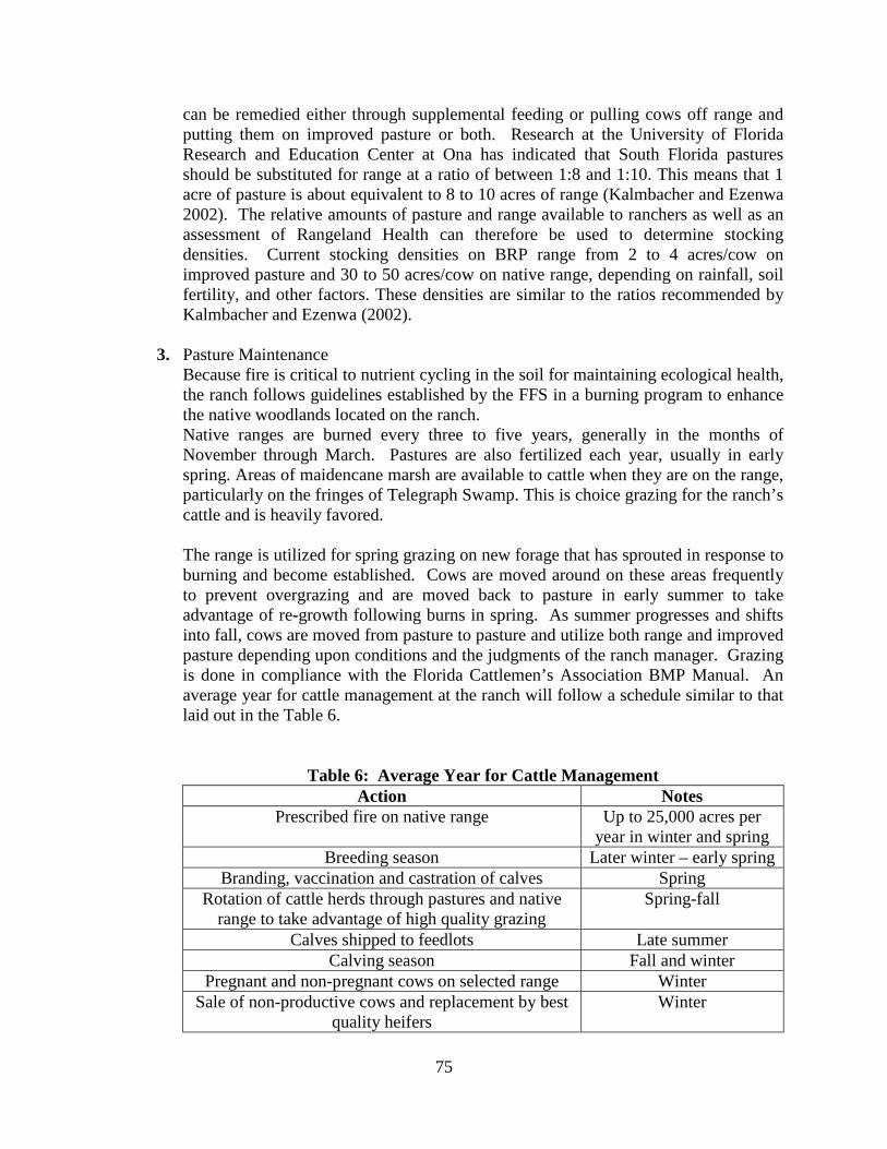
75
can be remedied either through supplemental feeding or pulling cows off range and putting them on improved pasture or both. Research at the University of Florida Research and Education Center at Ona has indicated that South Florida pastures should be substituted for range at a ratio of between 1:8 and 1:10. This means that 1 acre of pasture is about equivalent to 8 to 10 acres of range (Kalmbacher and Ezenwa 2002). The relative amounts of pasture and range available to ranchers as well as an assessment of Rangeland Health can therefore be used to determine stocking densities. Current stocking densities on BRP range from 2 to 4 acres/cow on improved pasture and 30 to 50 acres/cow on native range, depending on rainfall, soil fertility, and other factors. These densities are similar to the ratios recommended by Kalmbacher and Ezenwa (2002).
3. Pasture Maintenance
Because fire is critical to nutrient cycling in the soil for maintaining ecological health, the ranch follows guidelines established by the FFS in a burning program to enhance the native woodlands located on the ranch. Native ranges are burned every three to five years, generally in the months of November through March. Pastures are also fertilized each year, usually in early spring. Areas of maidencane marsh are available to cattle when they are on the range, particularly on the fringes of Telegraph Swamp. This is choice grazing for the ranch’s cattle and is heavily favored. The range is utilized for spring grazing on new forage that has sprouted in response to burning and become established. Cows are moved around on these areas frequently to prevent overgrazing and are moved back to pasture in early summer to take advantage of re-growth following burns in spring. As summer progresses and shifts into fall, cows are moved from pasture to pasture and utilize both range and improved pasture depending upon conditions and the judgments of the ranch manager. Grazing is done in compliance with the Florida Cattlemen’s Association BMP Manual. An average year for cattle management at the ranch will follow a schedule similar to that laid out in the Table 6.
Table 6: Average Year for Cattle Management
Action Notes Prescribed fire on native range Up to 25,000 acres per
year in winter and spring Breeding season Later winter – early spring
Branding, vaccination and castration of calves Spring Rotation of cattle herds through pastures and native
range to take advantage of high quality grazing Spring-fall
Calves shipped to feedlots Late summer Calving season Fall and winter
Pregnant and non-pregnant cows on selected range Winter Sale of non-productive cows and replacement by best
quality heifers Winter

76
FFS, or its designated lessees or contractors, may excavate ponds in the Improved Pasture Area for the benefit of livestock and wildlife. Any future pond excavations will be performed in accordance with applicable BMPs.
F. Farming Operations
Efforts will be made to identify and implement alternative revenue and funding sources for the continued responsible management of BRP. The use of tenant farming will be subject to future evaluation and the development and terms of any future management and business/operational plans. 1. Tenant Farming - If the acreage under tenant farming licenses increases above the
current level, but below the limits set below, only existing improved farm fields or improved pastures will be utilized.
2. Natural Areas – Areas identified as natural areas, as defined by FNAI, shall not be converted to farm fields or other uses.
3. Charlotte County – The total acreage of lands in tenant farming in the Charlotte County portion of the BRP shall not exceed 4,000 acres.
4. Alternative Uses: Management and Alternative Use of Tenant Farm Fields Taken out of Production - An important goal of this plan is to identify, develop, and establish alternative revenue and funding sources. a. Any current use or proposed alternative use of the fields currently licensed to
tenant farming will be evaluated to ensure that degradation of the resources does not occur.
b. Whenever active farm fields are taken out of production, specific actions are recommended to be taken to prevent the infestation of these fields by nuisance invasive plants, especially non-native plants. Agricultural lands left fallow can easily become infested with non-native invasive plants.
c. Cattle grazing has been demonstrated to be a cost-effective way to manage improved pasture on conservation land while that land awaits restoration to native communities. Without grazing, the land is more likely to be invaded by non-native species and oak shrubs that rapidly convert the land to a community type that is not conducive to prescribed fire. Cattle grazing on public conservation lands helps prevent undesirable outcomes, while providing revenue to assist with land management activities.
d. There are a variety of options for uses of these lands, including restoration to native communities, continuation as agricultural fields under the direct management of BRP, conversion to improved pasture for cattle grazing, raising native seed for environmental restoration projects, and conversion to new agricultural enterprises such as native plant nurseries, bio fuels, cellulosics, or forestry plantation.
G. Irrigation, Fertilization, and Pest Management Practices
The FFS will follow the minimum applications as outlined in agreements for tenant farming and any applicable BMP’s for specific crops. Any tenant farming will be subject to applicable BMP’s.

77
Pesticide management strategies are also part of the plan. Integrated Pest Management (IPM) and precision agriculture such as rotational spraying have allowed the ranch to reduce the number of pesticide applications.
H. Other Agricultural Practices
For all agricultural endeavors, the FFS will follow any applicable BMP’s for specific crops. 1. Apiary – There is an apiary operation present on BRP for honey production and
harvesting and in some locations to provide pollination services for tenant farmers. Management of apiaries is a common practice on public conservation lands. The combination of flatwoods communities being restored through the potential of implementing all-season fire, causing an increase in native flowering plants, and potential new markets for honey on neighboring property, will produce conditions on BRP for continued, and possibly enhanced, apiary operations.
I. Field Rotations
In addition to cattle grazing on BRP pastures, fruit and vegetable crops and low-end sod in a range of periodic rotations, determined according to type of crop, have been raised onsite. For instance, sod crops are harvested when appropriate prior to new farm leases. The watermelon production on BRP provides a seven-year crop rotation cycle that will potentially provide sod harvesting on a particular field every seven years.
Engineered field drainage systems help to minimize soil erosion, while the planting of cover crops reduces wind erosion. Pasture rotation is a major component of the ranch's soil conservation program. All farm fields are converted to pasture for cattle grazing following the termination of a farm lease. Pasture-grass sod may be harvested in improved pasture areas as part of ongoing soil stabilization and rotation of grasses for pasture maintenance, provided that no more than twenty percent (20%) of the improved pasture areas are harvested in any one calendar year. Please see Table 7, below, for more information regarding Fruit and Vegetable Crop-Grazing-Sod Harvest Rotation details.
Table 7: Fruit and Vegetable Crop-Grazing-Sod Harvest Rotation
Activity Action Cultivate
watermelons The pasture is prepared for planting in fall.
Fruit and vegetable crops are harvested in spring. Fields are disked.
Plant and manage pasture
Fields are planted with Bahiagrass. Field is left to grow and cattle may graze on it for a short time (flash grazing) depending upon
condition. Cattle grazing Cattle are grazed on the pasture with alternating periods of rest.
Specific scheduling is at the discretion of the ranch manager.

78
Activity Action Sod harvest Sod is harvested and marketed to the “low-end” sod market (sod for
highway medians and other similar uses). Following sod harvest, the field is prepared for fruit and vegetable
planting.
IX. References
Division of Historical Resources. Revised 2013. Management Procedures for Archaeological and Historical Sites and Properties on State-Owned or Controlled Lands. Department of the State, Division of Historical Resources. Tallahassee, Florida. Florida Department of Agriculture and Consumer Services. Revised 2008. Silviculture Best Management Practices (BMPs) for Florida. Florida Department of Agriculture and Consumer Services, Florida Forest Service. Florida Department of Agriculture and Consumer Services. Revised 2004. State Forest Handbook. Florida Department of Agriculture and Consumer Services, Florida Forest Service. Florida Natural Areas Inventory (FNAI). 2010. Guide to the natural communities of Florida: 2010 edition. Florida Natural Areas Inventory, Tallahassee, Florida.
Babcock Ranch Ecological Inventories. Final reports to Florida Fish and Wildlife Conservation Commission. May 2008. Florida Natural Areas Inventory, Tallahassee, Florida.

79
X. Glossary of Abbreviations ARC Acquisition and Restoration Council BMP Best Management Practice BRC Babcock Residential Community BRP Babcock Ranch Preserve BWWMA Fred C. Babcock - Cecil M. Webb Wildlife Management Area CARL Conservation and Recreation Lands CELCP Coastal and Estuarine Land Conservation Program CREW Corkscrew Regional Ecosystem Watershed dbh diameter at breast height DEP Department of Environmental Protection DOS-DHR Department of State, Division of Historical Resources DRP Division of Recreation and Parks DSL Division of State Lands DSO Direct-Support Organization FAC Florida Administrative Code FCWMA Fisheating Creek Wildlife Management Area FDACS Florida Department of Agriculture and Consumer Services FFS Florida Forest Service FNAI Florida Natural Areas Inventory FS Florida Statutes FWC Florida Fish and Wildlife Conservation Commission IPM Integrated Pest Management MOA Memorandum of Agreement NGO Non-Governmental Organization NWR National Wildlife Refuge NRCS Natural Resources Conservation Service OALE Office of Agricultural Law Enforcement OFW Outstanding Florida Water OHV Off-Highway Vehicle RCW Red-cockaded Woodpecker SFWMD South Florida Water Management District TIITF Board of Trustees of the Internal Improvement Trust Fund TMDL Total Maximum Daily Load UF/IFAS University of Florida/ Institute of Food and Agricultural Sciences USFWS United States Fish and Wildlife Service WMA Wildlife Management Area WMD Water Management District WUI Wildland-Urban Interface