River Ranch Management Plan - New Mexico Game and Fish
262
River Ranch Management Plan Photo J.N. Stuart New Mexico Department of Game and Fish 2016 Mark L. Watson, Terrestrial Habitat Specialist Ecological and Environmental Planning Division
-
Upload
khangminh22 -
Category
Documents
-
view
0 -
download
0
Transcript of River Ranch Management Plan - New Mexico Game and Fish

River Ranch Management Plan
Photo J.N. Stuart
New Mexico Department of Game and Fish
2016
Mark L. Watson, Terrestrial Habitat Specialist
Ecological and Environmental Planning Division

River Ranch Management Plan February 2016
1
Table of Contents Table of Contents ............................................................................................................................ 1
River Ranch Purchase ...................................................................................................................... 2
Site Description ............................................................................................................................... 2
River Ranch History ......................................................................................................................... 3
General Management Goals ........................................................................................................... 3
Conservation Elements ................................................................................................................... 4
Soils ............................................................................................................................................. 4
Cottonwood Gallery Forest and Woodland ................................................................................ 4
Tigner Grove ............................................................................................................................... 4
Giant Sacaton Bottomlands ........................................................................................................ 6
Chihuahuan Desert Grasslands and Mesquite ........................................................................... 7
Range and Riparian Assessments and Management Recommendations ...................................... 8
Range Health Assessment ........................................................................................................... 8
Riparian Assessment ................................................................................................................. 10
Biological Surveys .......................................................................................................................... 11
Mimbres River Fish Sampling at River Ranch ........................................................................... 12
Roads and Security ........................................................................................................................ 13
OHV Use ........................................................................................................................................ 13
Hunting .......................................................................................................................................... 13
Gaining Access Into Nature (GAIN) Program ................................................................................ 13
Conservation Education ................................................................................................................ 13
Research ........................................................................................................................................ 14
Water Plan .................................................................................................................................... 14
Monitoring .................................................................................................................................... 16
Existing Conservation Easement ................................................................................................... 17
Literature Cited ............................................................................................................................. 19
Appendices .................................................................................................................................... 24
Appendix A. River Ranch Conceptual Management Plan ......................................................... 24
Appendix B. Rangeland Health Evaluation Report ................................................................... 24
Appendix C. River Ranch Riparian Assessment......................................................................... 24
Appendix D. River Ranch Documented Wildlife Species .......................................................... 24
Appendix E. River Ranch Mimbres River Fish Seining Report .................................................. 24
Appendix F. River Ranch Deed of Conservation Easement ...................................................... 24

River Ranch Management Plan February 2016
2
River Ranch Purchase
River Ranch was purchased by the New Mexico Department of Game and Fish (NMDGF) in 2014 using Natural Resource Damage Assessment funds ($350,000), which were provided by the New Mexico Office of Natural Resources Trustee (ONRT) and the U.S. Fish and Wildlife Service (USFWS)(collectively, the “Trustees”), and Share With Wildlife Program funding ($235,000).
The Trustees engaged in a Natural Resource Damage Assessment and Restoration (NRDAR) process for three copper mines near Silver City, Grant County, owned by Freeport-McMoRan Copper & Gold Inc. (FMI). As part of the NRDAR, the Trustees assessed and quantified damages and injuries to wildlife and wildlife habitats from the operation of three mine sites. As a result, the Trustees were awarded a financial settlement from FMI to compensate the public for injuries to wildlife and wildlife habitat resulting from releases of hazardous substances at these mine sites. Damages were primarily to birds, so protecting and enhancing bird habitat was the primary goal for the selection of projects to fund through the NRDAR process (ONRT 2013).
Funding sources for the River Ranch purchase (NRDAR and Share with Wildlife) possess shared goals of conserving and restoring wildlife habitat. The Share with Wildlife program (SwW) is administered by NMDGF to perpetuate renewable wildlife resources that provide pleasure and recreation to all New Mexicans (7-2-23 NMSA 1978), by supporting projects that consist of biological and ecological studies, habitat conservation and restoration projects, conservation education, and wildlife rehabilitation. Revenues for SwW originate from voluntary contributions generated primarily through the state income tax form, sales of wildlife license plates, yields from the invested SwW trust fund, and federal matching funds that become available as a result of these non-federal contributions. Following its statutory guidance, SwW focuses on conservation and management of wildlife species and their habitats that are generally without other sources of funding.
The Specialty Warranty Deed for the sale of River Ranch from Ponderosa Highlands, Inc., to the New Mexico State Game Commission was recorded by the Luna County Clerk on July 14, 2014, and the Grant County Clerk on July 16, 2014.
With the purchase of River Ranch, the Department assumes the stipulations of the River Ranch Conservation Easement, which was implemented in 2011 by the New Mexico Land Conservancy.
Site Description
The River Ranch is located approximately 23 miles north-northwest of Deming, and approximately 25 miles southeast of Silver City. Deeded lands total 1,010 acres. Of the deeded lands, 400 acres occur in Grant County and 610 acres occur in Luna County. Deeded land elevations range from 5,000 to 5,150 feet. The ranch includes a 1,800 acre Bureau of Land Management grazing allotment, and a 1,120 acre State Land Office grazing allotment.

River Ranch Management Plan February 2016
3
River Ranch History
The River Ranch was created in 1979 when Eugene A. “Gene” and Elisabeth Simon purchased 49 acres with historic buildings from George O. Smith. Gene began stocking the River Ranch by driving on horseback 100 head of livestock down the Mimbres Valley from their Ponderosa Highlands Ranch north of NM Highway 152. The Smith’s had purchased the 49 acre property from the Trujillo family, whose family cemetery is still within the River Ranch boundary, west of NM Highway 61. The Trujillo family homesteaded 81 acres in the area in 1916. Gene Simon greatly expanded the size of River Ranch to 4500 acres with the purchase of the Cerro Mesa Ranch from the Walsh family in 1996. The BLM and New Mexico State Land Office grazing leases were assigned with the purchase of the Cerro Mesa Ranch. Upland habitat portions of River Ranch were later sold by the Simon’s to City of Rocks State Park and a private landowner on Taylor Mountain.
Gene Simon passed away in 2012 at the age of 96, having operated River Ranch for 33 years. As of the writing of this management plan, Elisabeth Simon still lives on the property, and has a life estate with the Department to remain on the property as long as she wishes, or until her passing.
Ultimately is was Gene and Elisabeth Simon’s wish to protect River Ranch from development, and for a public land or wildlife management agency to purchase, manage and conserve River Ranch and its unique wildlife and habitats to benefit the citizens of New Mexico.
General Management Goals1
The River Ranch includes approximately 2.0 miles of the lower Mimbres River, which drains into the Mimbres Closed Basin near Deming. Of the 1,010 deeded acres, approximately 380 acres (38%) are riparian, floodplain and aquatic habitats. Riparian habitat on the ranch is dominated by a mature Fremont cottonwood (Populus fremontii) and velvet ash (Fraxinus velutina) woodland that provides habitat for a high diversity and abundance of wildlife, including 23 SGCN documented on the property. River Ranch provides important wildlife habitat because about 80% of all vertebrates in New Mexico and Arizona are dependent on riparian habitats for at least part of their life cycle (Hubbard 1977).
Department goals and objectives for the aquatic, riparian, floodplain and upland Chihuahuan semi-desert grassland habitats of the River Ranch include: 1) re-generate younger age classes of deciduous riparian trees to replace the mature stands and continue recovery of the riparian system to a fully functioning condition; 2) develop a vegetative understory to provide habitat
1 From the River Ranch Conceptual Management Plan.

River Ranch Management Plan February 2016
4
for Species of Greatest Conservation Need (SGCN); 3) establish wetlands and off-channel ponds for establishment of SGCN; 4) use mowing, burning and/or livestock grazing to maintain healthy stands of native giant sacaton grasslands, which benefits multiple bird and small mammal species, while maintaining some stands in a decadent state to benefit other species dependent on this habitat; 5) use livestock grazing, fire and possibly mechanical means as tools to restore upland Chihuahuan semi-desert grasslands; 6) manage the property in full compliance with the stipulations and conditions of the existing conservation easement (NMLC no date).
Conservation Elements
Soils
In fall 2014, Natural Resource Conservation Service’s Technical Soil Service staff from the Las Cruces office conducted soil and vegetation sampling and mapping on River Ranch. The objective of the NRCS’s soil and vegetative surveys are to provide NMDGF with baseline soils and vegetation data to better understand existing conditions and natural potential vegetation associated with existing soils. Soil surveys identified five distinct soil types and map units in the Mimbres River floodplain portion of River Ranch. Upland soils were generally not analyzed. The floodplain soils are derived from andesitic and rhyolitic bedrock from the surrounding and upstream hills and mountains.
Cottonwood Gallery Forest and Woodland
Of the 1,009 deeded acres, approximately 380 acres (38%) are riparian, floodplain and aquatic habitats. Riparian and aquatic habitats were identified as key habitats in the CWCS, and are being designated as Tier 1 (most important habitat types) in the Department’s 2015 State Wildlife Action Plan (in development).
The River Ranch has a diversity of riparian vegetation communities. There are relatively large and mature woodland stands dominated by Fremont cottonwood, Goodding’s willow (Salix gooddingii), and velvet ash. These communities are mostly associated with the higher river bars and terraces, and are considered some of the most imperiled in the Southwest (NatureServe 2013). Lining the river bank and occasionally on alluvial terraces are shrublands dominated by coyote willows (Salix exigua) and seepwillows (Baccharis salicifolia) along with strands of herbaceous wetlands along the channel. In addition to the woodlands and shrublands, there are extensive swaths of big sacaton (Sporobolus wrightii) grasslands on the upper terraces (Natural Heritage New Mexico 2015).
Tigner Grove
The unique ecological heart of River Ranch is Tigner Grove, which was named after earlier owners of the property. Tigner Grove is a 6.8 acre mature, multi-canopy stand of large diameter deciduous riparian trees, including velvet ash, soapberry (Sapindus saponaria), Arizona walnut (Juglans major), netleaf hackberry (Celtis reticulata), and box elder (Acer

River Ranch Management Plan February 2016
5
negundo). Tigner Grove contains the State, and possibly national, record velvet ash tree. According to the New Mexico State Forestry Division’s Big Tree Program, this record velvet ash tree has a circumference of 224 inches, a height of 95 feet, and a crown spread of 77 feet.
Tigner Grove and other deciduous riparian stands on the property provide documented nesting habitat for SGCN common black-hawk (Buteogallus anthracinus), yellow-billed cuckoo (Coccyzus americanus), and thick-billed kingbird (Tyrannus crassirostris), and the southern-most known population of Arizona gray squirrel (Sciurus arizonensis) in New Mexico. More xeric riparian shrub habitats at the southern end of the property provide documented nesting habitat for SGCN Bell’s vireo (Vireo bellii).
The River Ranch Forest Stewardship Plan (New Mexico Forestry Division 2012) documents that during the Simon’s ownership, a portable sawmill was brought to Tigner Grove and five to six thousand board feet of lumber was milled from dead and down velvet ash trees. Until Gene Simon’s death in 2012, routine bucking and piling of dead and down trees and branches in Tigner Grove was conducted. Large tree trunks were generally left in place. Presumably slash piles in Tigner Grove were burned routinely during Gene Simon’s 33 year tenure at River Ranch.
Since the Department first inspected Tigner Grove in 2012, multiple mature velvet ash trees have fallen over or had their tops blown out, creating a large hole in what was essentially a closed canopy stand in 2012. Several ash trees on the northeast corner of Tigner Grove have been weakened or killed by fire, likely from intentional burning of the adjacent giant sacaton grasslands. Mature velvet ash trees in Tigner Grove appear to be characterized in general by a lack of reproduction, except for a few root suckers, which could be caused by grazing and browsing by livestock and wild ungulates, lack of sunlight from a closed canopy, lack of overbank flooding, competition from giant sacaton grass, or some combination of those factors. Ongoing mortality could be caused by the advanced age of the trees, drought, disease, insect attacks or some combination of these factors.
In February 2015 foresters from the New Mexico Forestry Division inspected ash trees in Tigner Grove for emerald ash borers (Agrilus planipennis) or other insect pests that could cause disease. No insect pests were found. Emerald ash borers are recently introduced beetles from Asia. The larvae feed on the inner bark of Fraxinus species of ash, and have killed millions of ash trees in eastern and central United States. Emerald ash borers were documented in Colorado in the fall of 2013.
The floor of Tigner Grove has been invaded by giant sacaton grasses that create fine fuels that reach five or six feet into the lower canopy of the trees. The low hanging branches of the deciduous ash trees co-mingle with the 6-foot tall giant sacaton grass, creating a fuels ladder into the canopy of the grove. Without constant maintenance, continued falling of trees and branches in Tigner Grove increases the risk of a canopy fire in the entire grove.
The River Ranch deed of conservation easement allows forest management activities to occur to “…maintain the natural habitat’s character and nature…” (p. 8). Continued pruning of lower branches, bucking and piling of fallen branches and dead trees, and occasional winter pile

River Ranch Management Plan February 2016
6
burning will be required to protect Tigner Grove from a severe fire that could eliminate the old growth grove, possibly changing the ecological community to a more open cottonwood/sacaton savanna, as occurs over most the floodplain of River Ranch.
As a result of the potential for wildfire after Gene Simon’s death, the Department has initiated a bucking and piling fuels treatment in Tigner Grove by the New Mexico Forestry Division’s Returning Heroes or Inmate Program. State Forestry Division owns 99.9% of the River Ranch conservation easement, so is a logical partner to conduct these activities. In January 2015, Tonya Vowles of State Forestry Division in Silver City visited Tigner Grove and developed a proposal to buck and pile dead and down course woody material, and limbing low hanging branches to reduce ladder fuels into the tree canopy. The fuels treatment is expected to occur in fall 2015, after the migratory bird breeding nesting season has concluded.
Figure 2. Tigner Grove fuel load (T. Vowles)
Figure 1. Tigner Grove (M. L. Watson)
Giant Sacaton Bottomlands
The primary grass species on River Ranch that typify the C and D floodplain soil types and provide the majority of forage, cover, watershed protection and habitat for various species is giant sacaton (Sporobolus wrightii). Giant sacaton bottomlands can be found throughout southern New Mexico at elevations from 3,400 feet to over 5,000 feet. They occur on floodplains, alluvial fans and stream terraces where the soils are loamy to clayey in texture. On the River Ranch at least 350 acres of the private land along the river is characterized by this species (Gadzia 2015).

River Ranch Management Plan February 2016
7
Extensive giant sacaton grasslands on the property provide nesting habitat for sacaton-nesting obligate and SGCN Botteri’s sparrow. Giant sacaton grasslands once covered riparian floodplains in the southwestern United States and northern Sonora, Mexico, but now occupy less than 5% of their historical range, primarily due to clearing for agriculture (Richter and Stutz 2002). Giant sacaton grasslands naturally spread flood waters and trap sediments, limiting soil erosion (Cox and Morton 1986).
Giant sacaton grass has been described as shade-intolerant. However, under the burning/mowing/grazing regime implemented by the previous owner to manage the giant sacaton stands, the grass has apparently expanded into Tigner Grove. When cured, this tall grass could act as ladder fuel and carry wildfire into the canopy. The recent ranch owners protected Tigner Grove from fire by actively harvesting dead and down wood to reduce fire danger.
Chihuahuan Desert Grasslands and Mesquite
Chihuahuan desert grasslands were identified in the CWCS (NMDGF 2006) as a key habitat type. Dick-Peddie (1993) identifies River Ranch as occurring in the “Desert Grassland” vegetation type. Based on soils and vegetation characterization work conducted by NRCS Las Cruces office staff, some Chihuahuan desert grassland sites on River Ranch have been replaced by honey mesquite (Prosopsis glandulosa) scrub-shrub stands with large patches of mostly unvegetated soils in the interstitial spaces between mesquite shrubs. The following discussion of mesquite invasion of Chihuahuan Desert grasslands (and references therein) is taken from Peters and Gibbens in Havstad et al. eds. (2006).
Chihuahuan Desert vegetation communities such as desert grasslands have experienced major shifts in vegetation composition over the past 50-150 years (York and Dick-Peddie 1969). The most dramatic changes in vegetation and associated ecosystem processes have occurred as a result of woody plant encroachment into perennial grasslands (Grover and Musick 1990, Bahre and Shelton 1993). The conversion from desert grassland to mesquite was likely initiated by changes in climate, historic over-grazing by domestic livestock, modification of fire regime, and small mammal activity (Humphrey 1958; Allred 1996; Reynolds et al 1997; Van Auken 2000).
Where arid environments are dominated by shrubby vegetation, the distribution of soil properties is patchy, with accumulations of plant nutrients under shrubs and relatively infertile soils in the inter-shrub spaces. The spatial heterogeneity of shrubs controls movements of water and soil materials in desert ecosystems (Noy-Meir 1985). Total ground cover is the most important variable influencing runoff and sediment production on desert rangelands in southern New Mexico (Wood et al. 1987). When shrubs replace grasslands, the rate of erosion increases and the surface soil materials are progressively lost from the barren shrub interspaces, especially for sand textured soils (Bull 1979; Abrahams et al. 1994, 1995; Gutierrez and Hernandez 1996). When shrubs are widely spaced, the barren inter-shrub soils are also subject to wind erosion that redistributes soil materials across the landscape (Snow and McClelland 1990; Stockton and Gillette 1990; Okin and Gillette 2001). Losses of soils and soil

River Ranch Management Plan February 2016
8
nutrients are closely tied to the degradation and desertification of desert grasslands in southern New Mexico and other arid and semiarid regions of the world (Schlesigner et al. 1990).
The use of herbicides and minimally ground disturbing mechanical treatments such as mastication or mowing may be required to restore desert grasslands in mesquite-dominated upland areas on River Ranch. An advantage of herbicide use is the lack of ground disturbance, but it may also kill desirable non-target species such as four-wing saltbush (Atriplex canescens) or winterfat (Erotia lanata) (Gadzia 2015). Once mesquite has been removed from upland sites, minimizing livestock dispersal of seed and maintenance of an effective fire regime may be crucial for sustaining herbaceous desert grassland production (Brown and Archer 1999).
Desert grassland communities developed under conditions of relatively lower fire frequencies than many other grassland types (e.g., tallgrass and mixed-grass prairies)(Wright and Bailey 1980). For a discussion of fire treatment effects to mesquite, see Peters and Gibbens 2006 (p. 229).
Range and Riparian Assessments and Management Recommendations
Range Health Assessment
As stated in the River Ranch Conceptual Management Plan (RRCMP; Appendix A), carefully managed livestock grazing can be used as a tool to improve habitat conditions for wildlife (U.S. Forest Service 1990). The Department’s primary goal in purchasing the River Ranch is to benefit bird species, and priority riparian, aquatic and Chihuahuan desert grassland. Because livestock grazing could benefit some or all of these habitats and the associated species, Department goals will be to integrate appropriate livestock grazing to benefit bird species and key habitats, and further the recovery of the Mimbres River riparian and aquatic habitats to fully functioning condition (Baker et al. 2001;New Mexico Department of Game and Fish 2004; Wyman et al 2006).
In the RRCMP, the Department committed to conduct a range health assessment to determine appropriate levels of livestock grazing that could facilitate wildlife habitat restoration. The Department contracted with Kirk Gadzia of Resource Management Services LLC to conduct the assessment. The Report evaluated the health of River Ranch deeded property and BLM and SLO allotment rangelands. The resulting report Rangeland Health Evaluation Report NMDGF River Ranch June 2015 is attached as Appendix B. The following is a summary of the Range Health Assessment’s recommendations:
1. Isolate the River corridor from the floodplain pastures by fencing where practical.
2. Isolate the upland pastures from the floodplain pastures by fencing where practical.
3. Establish 1-3 floodplain pastures on the west side of the river and 6 - 8 floodplain pastures on the east side of the river to facilitate proper stock density, grazing period

River Ranch Management Plan February 2016
9
control, and allow for recovery before re-grazing. Size of floodplain paddocks should reflect roughly equal forage production to facilitate similar grazing periods.
4. Design fences to be resistant to fire damage in order to retain this tool for periodically managing the floodplain Sacaton pastures. Typically this is steel permanent fence or temporary electric fence with steel corners.
5. Provide water for livestock through a pipeline system with drinkers or selected access points to the river with hardened crossing spots for livestock and vehicles.
6. Develop the grazing plan to maximize forage utilization for floodplain and upland vegetation on a rotational basis.
7. Work with BLM and State grazing management personnel to clarify Allotment use boundaries and coordinate goals for land health objectives and habitat needs. Develop alternative watering points and gates that facilitate ease of livestock movement between pastures.
8. Tigner Grove represents a habitat type not commonly found in the Southwest and may be managed differently from other portions of the property to ensure persistence of this unique habitat type.
BLM Allotment
The BLM and State land allotments are located primarily on the upland portions of the ranch, with the private land consisting of approximately one section primarily in the Mimbres River floodplain. The Las Cruces District’s BLM Table Mountain lease 02525 consists of 1,800 acres west of the River Ranch deeded land. BLM lease lands include primarily upland Chihuahuan semi-desert grassland and scrub-shrub habitats. The lease authorizes year-round grazing (1 March 2014 to 28 February 2015) for 372 animal units per year. Annual rental on the allotment is $502.20.
The Range Health Assessment states that carrying capacity of the BLM and State lands are set, but there may be room for an increase. The increase would come from grazing more livestock on these areas, but for a shorter length of time. This would remove the same amount of forage as yearlong grazing but be more effective based on concentrating the use for a shorter period of time. Livestock would spend the remainder of the year grazing the private land giant sacaton pastures. The carrying capacity calculations show a capacity for about 72 head for 8 months on the BLM and State lands and 72 head for 4 months on the private land. Season of use and pasture rotations would be determined in the yearly grazing plan.
The Range Health Assessment documented rangeland infrastructure and health conditions on the BLM and State allotments, and found that in general allotments appeared to be in moderately good health and stable condition. As with the private land sites, some areas were found to be in poor to declining health condition, but these sites were the exception. Access to the BLM and State land allotments are from Taylor Mountain Road and from gates along

River Ranch Management Plan February 2016
10
Highway 61. Some of the gates on BLM land which appear to be in the Allotment were found to be locked.
The Range Health Assessment found that anomalies exist with the BLM and State land allotment boundaries. Fence lines are not located as indicated on the BLM and State land allotment boundary overlays. In several cases the allotment boundaries themselves are not fenced or fences exist that do not show on the BLM maps. Additionally, the private land fence lines do not appear to always follow the private land boundary line as shown on the property ownership overlays (see map on page 41 of the Range Health Assessment). These issues are discussed in more detail in the Grazing Management Plan (within the Range Health Assessment), but will need to be resolved before the grazing plan is implemented.
State Lands Allotment
The State Lands Office Grazing Lease No. GT-2853 consists of 1,120 acres in multiple disjunct parcels west of the River Ranch deeded land. Lease lands include primarily upland Chihuahuan semi-desert grassland and scrub-shrub habitats. Annual rental on the allotment is $760.83. The lease authorizes 17 animal units yearlong from 1 October 2013 to 30 September 2018. Lease renewal is on a 5-year rotation. The allotment is not tied to the base property. The Department will assess State Land Office Lease No. GT-2853 to determine habitat value for SGCN and potential management opportunities. The State Land Office can issue commercial leases for longer than 5 years that designate wildlife habitat as the use. The Department will consider this as well as sub-leasing to retain the option for livestock grazing as a tool to meet upland habitat management goals.
Riparian Assessment
In the RRCMP, the Department committed to conduct a riparian assessment to determine baseline conditions of the Mimbres River riparian and aquatic habitats. Natural Heritage New Mexico (NHNM) conducted the assessment on May 18-20, 2015. The report provides the following recommendations for riparian habitat management on the ranch (see Appendix C for full report):
1. Maintain the maximum possible base flow in the active river channel throughout the year, but particularly during the growing season and in keeping with the property water rights.
2. If future grazing is considered, it will need to be actively managed to protect woody riparian tree and shrub reproduction and recovery. Regardless, current livestock should be kept out of the active channel and adjacent riparian zone for at least two years or more to allow young shrubs and trees to establish and grow to a size where they will be less desirable browse. This will also allow the herbaceous wetland vegetation and the river banks to recover to a more stable state. Once the vegetation has recovered, livestock use will need to be carefully monitored and, if possible, their access to the active channel should remain limited or excluded.

River Ranch Management Plan February 2016
11
3. If recommendations 1 and 2 do not produce increases in woody riparian vegetation, particularly in tree recruitment following the next large (5 to 10 year) spring flood event, then active restoration should be considered. Removal of giant sacaton from selected terrace areas adjacent to the active channel, with lowering of the terrace such that it will be easily flooded during the next high flow can be planned for one or two terraces areas of an acre or more each. Earthwork should be done in the winter, so that the cleared area can be accessed by high water the next spring. If this sort of restoration is attempted, it should be designed by an engineer with an understanding of fluvial processes, and familiar with this type of riparian restoration work. (Examples of successful projects of this type can be found on the Rio Grande (Robert 2005; Muldavin et. al. 2012)
4. Giant sacaton stands around large mature tree stands should be managed to reduce fire risk to the forests. Creating fire breaks in the giant sacaton at the edges of the forest should be sufficient in the short term, and can be achieved mechanically. Burning of the giant sacaton is not recommended, as this would pose a risk to the trees. Also, removal of entire giant sacaton stands is not recommended, except as part of active restoration activities mentioned above in recommendation 3.
5. Removal of Invasive Exotic tree species (saltcedar, Russian olive) now could save money and environmental disruption in the future. There were only a handful of saltcedar and Russian olive individuals observed, and these could be cut down, and treated with topical herbicide efficiently. Left in place these trees may interfere with native riparian tree reproduction.
Observations and recommendations from both the range health assessment (Gadzia 2015) and riparian assessment (Natural Heritage New Mexico 2015) concur regarding limiting livestock grazing within the Mimbres River riparian corridor to short duration dormant season grazing or to access water at limited hardened crossings. Both assessments also concur that irrigation withdrawals that dewater the Mimbres River channel during the growing season need to be addressed to restore riparian habitat below the diversion dam.
Biological Surveys
To fulfill commitments in the RRCMP, a number of wildlife surveys have been conducted by Department biologists to document baseline conditions. The River Ranch Wildlife List is attached as Appendix D. As stated above, to date 23 SGCN have been documented, including Arizona toad (Anaxyrus microscaphus), nesting common black hawks (Buteogallus anthracinus) and yellow-billed cuckoos (Coccyzus americanus), tree roosting western red bats (Lasiurus blossevillii), and Arizona gray squirrel (Sciurus arizonensis).

River Ranch Management Plan February 2016
12
Figure 3. Yellow-billed Cuckoo(M.L. Watson) Figure 4. Western Red Bats (M.L. Watson)
Mimbres River Fish Sampling at River Ranch
As part of the baseline biological inventory of the River Ranch a fish survey was conducted on 17 November 2014 by a crew of NMDGF biologists (Appendix E). The Mimbres River channel through River Ranch is dominated by shallow runs over sand, gravel, and cobble substrates (Photo 1). A few exceptions are shown in Photos 2-4. The locations documented in these photographs show the greatest potential to support the native fish community of the Mimbres River, which consists of Chihuahua Chub (Gila nigrescens), Rio Grande Sucker (Catostomus plebeius), and Beautiful Shiner (Cyprinella formosa).
One Longfin Dace (Agosia chrysogaster) was collected during the survey. It was in pool habitat with a large log for cover. Longfin Dace is known to have persisted through the Silver Fire and subsequent flooding in Moreno Spring approximately 30 miles upstream. Longfin Dace is a species that quickly colonizes new areas, so it is likely that this individual moved from Moreno Spring rather than survived in the Mimbres River at this location.
Additional surveys should be conducted at the River Ranch after the Mimbres River has had more time to recover from recent fires and drought conditions to gain a better understanding of what the fish community may be at the site under normal conditions.

River Ranch Management Plan February 2016
13
Roads and Security
Because of the size of the River Ranch (ca. 1009 acres), roads through the property are limited. Roads consist of primarily 2-tracks that require brush clearing maintenance to provide access. Road improvement may be needed to facilitate use by vehicles, such as on the very southern boundary of the property. However, the Department does not anticipate the need to develop new roads to facilitate ranch management. Existing roads will be used, and if beneficial to habitat restoration and not necessary for management purposes, some existing roads or tracks may be allowed to naturally re-vegetate. The Department intends to secure the property utilizing fences and signage. Signs would be used to delineate the property boundary stating the landowner is the State Game Commission and that rules and regulations apply to the land. A larger set of signs would be installed at the pertinent entrances delineating the property name, the State Game Commission as the owners and any associated rules and regulations that would apply. These security measures would enable Department staff to manage unauthorized use, theft and habitat damage.
OHV Use
OHV use will be exclusively for administrative management activities by the Department.
Hunting
The River Ranch holds abundant populations of game animals and game birds such as mule deer, Merriam’s turkey, Gambel’s quail, and mourning dove. The Department will assess hunting opportunities and make sustainable hunting recommendations to the State Game Commission for consideration.
Gaining Access Into Nature (GAIN) Program
The River Ranch will be incorporated into the Department’s Gaining Access Into Nature (GAIN) or alternative public access program for State Game Commission owned properties. Activities for River Ranch may be limited to pedestrian wildlife viewing and photography along existing roads, two-tracks and trails. Development of a trail network is not anticipated. Public access restrictions may be implemented during sensitive periods to preclude disturbance in sensitive areas and habitats such as during nesting season for state- and/or federally-listed bird species.
Conservation Education
The River Ranch will provide conservation education opportunities for youth and adults. Students and teachers may be instructed by Department personnel or contractors in a wide

River Ranch Management Plan February 2016
14
variety of wildlife-related outdoor education and recreation activities, such as hunting, fishing, trapping, shooting sports, archery, wildlife identification and ecology, habitat management, and citizen science ecological monitoring. Students and teachers may, as appropriate, be able to use the existing facilities for training and long-term habitat monitoring and research.
Research
The Department will support scientific research on the property that provides additional knowledge about wildlife biology, ecology, population status, wildlife habitat restoration techniques, potential effects of climate change on wildlife species and key habitats, and other identified research needs. The Department is already working with researchers from the University of Nebraska Kearney, Western New Mexico University and the University of New Mexico to identify and document SGCN, and to set up long-term monitoring programs to assess SGCN population status and habitat trends.
The Natural Resource Conservation Service’s Las Cruces office staff documented River Ranch soils and vegetation to establish baseline conditions. Because of the quality of riparian habitat, NRCS is also interested in using River Ranch to develop an ecological site description for Chihuahuan Desert riparian habitats. Department staff may work with NRCS to facilitate this work.
Water Plan
In the RRCMP, the Department committed to developing a water management plan (as a section of the larger final management plan). The Deed of Conservation Easement (see Appendix F) states that the Easement Property includes three acre feet per annum of water rights for the irrigation of and appurtenant to 12.8 acres of land, with a priority date of 1880 described in NM State Engineer’s file #M2147. The Department is still the process of determining the most effective and beneficial use of the water rights on the property. The Department will work with the local soil and water conservation district and the NM State Engineer’s office to determine the most effective water usage for the Mimbres river channel, riparian habitats, and native fish and wildlife species.
The Department will investigate the potential to create wetland habitat and/or an off-channel pond. The Office of the State Engineer can make a written determination that wetland habitat restoration or creation is a beneficial use. Wetland and riparian habitat restoration activities at River Ranch connected to the Mimbres River can be authorized through a U.S. Army Corps of Engineers Nationwide Permit 27, Aquatic Habitat Restoration, Establishment and Enhancement Activities (expiration date 18 March 2017). Any changes in use for wetland habitat restoration or creation will be coordinated with the Office of the State Engineer.
Each spring a diversion dam is constructed on River Ranch by a downstream water user to divert Mimbres River flows into an irrigation ditch just south of the main headquarters

River Ranch Management Plan February 2016
15
buildings. As a result, almost all Mimbres River surface water flow is being diverted from the channel into a ditch around the lower three-quarters of the River Ranch reach during the spring-summer irrigation period. In May 2015, Department staff found that a diversion dam was diverting water into the small irrigation ditch that runs along the eastern boundary of the property for approximately 1.5 miles. The water then flows overland across a fallow agricultural field and back into the Mimbres River channel approximately 100 feet north of the southern River Ranch boundary.
As identified in both the range health (Gadzia 2015) and riparian (Natural Heritage New Mexico 2015) assessments, riparian forest and woodland restoration below the diversion dam relies on restoring flows to the dewatered portions of the Mimbres River channel. The Department will explore all options that would insure continued flow of Mimbres River surface water through the entire length of the property.
Figure 5. Mimbres River diversion dam (K. Gadzia)

River Ranch Management Plan February 2016
16
Figure 6. De-watered Mimbres River channel below diversion dam (K. Gadzia)
Monitoring
The RRCMP states that periodic monitoring reports of the effects of recreational and restoration activities will be provided to the Trustees. Initially the Department will strive to provide annual progress reports. After 5 years, the Department will discuss with the Trustees an appropriate future reporting schedule.
The Department will coordinate continuing migratory bird, mammal, amphibian and reptile, lepidopteran and odonate surveys using Department staff, academic researchers, contractors, and citizen scientists and naturalists.
As funding allows, the Department may also consider implementing additional rangeland health assessments using the Resource Management Services methodology (Gadzia 2015) and riparian assessments using the NMRAM methodology (Natural Heritage New Mexico 2015), to document upland and riparian habitat changes over time.
The Department may also initiate photo points at selected areas or other structured monitoring approaches along the Mimbres River riparian area to document changes in riparian vegetation over time.

River Ranch Management Plan February 2016
17
Existing Conservation Easement
River Ranch ownership by the Department is subject to a 7 April 2011 deed of conservation easement granted to the New Mexico Land Conservancy and the New Mexico Energy, Minerals and Natural Resources Department Forestry Division by Ponderosa Highlands, Inc. The complete easement is attached as Appendix F. Key requirements of the easement include:
“Fences-Existing fences may be repaired and replaced, and new fences may be built anywhere on the Easement property with the exception of big game-proof fences, which cannot be constructed on the Property or on the Property’s exterior boundary. All fences shall be constructed in such a manner and with such materials for the purposes of reasonable and customary management of livestock and as not to unduly endanger wildlife safety or to materially inhibit wildlife movement. Grantor shall obtain the Managing Grantee’s prior written approval prior to constructing any fencing on the Property that unduly endangers wildlife safety or that materially inhibits wildlife movement.”
Agriculture: All farming, ranching, and agricultural practices shall be conducted in a sustainable manner, and in keeping with practices that are best suited for the conservation of soil and water, the maintenance of soil and water quality, and so as to avoid erosion, overgrazing, soil contamination, and water pollution.
Forest Management: This deed prohibits clear-cutting of forests and woodlands on the Easement Property. Notwithstanding, Grantor may cut and remove trees and shrubs on a limited basis to prevent personal injury and property damage, to thin stands appropriately for fire management within the designated building envelopes, to control insects or disease, to facilitate erosion control and watershed management, to maintain the natural habitat’s character and nature, and posts, poles, building materials, and firewood for the Grantor’s personal use. This Deed permits selective thinning, prescribed fire, reseeding or replanting trees, and other forest management activities that maintain forest health on the Easement Property in accordance with all federal and state statutes and regulations or rules, and in accordance with a forest management plan. The Grantor may allow forest areas denuded by wildlife, insects, or disease to regenerate naturally or plant them with native tree species.
Roads and Trails: In general, the maintenance, repair, and reconstruction of existing roads and trails are allowed. The construction of new roads is prohibited except as provided for in paragraph 2.B. Grantor may also construct one, single lane bridge across the Mimbres River. Trails for pedestrian and equestrian use may be constructed on the Easement Property provided that: 1) no trail outside of a designated building envelope shall be made of an impervious surface; and 2) plans for new trails shall be approved by the Managing Grantee [NMLC] and Grantee [State Forestry] prior to construction of the trail; and 3)shall be in compliance with the terms of this deed and do not diminish or threaten the Conservation Values.

River Ranch Management Plan February 2016
18
Off-road vehicle use: Use of ATVs, motorcycles or other motorized vehicles off of road or travel ways, is prohibited except for agricultural, Easement Property maintenance or emergency access purposes.
Recreation: Only those low-impact recreational uses such as wildlife viewing, hiking, biking, horseback riding, hunting and fishing not inconsistent with the preservation and protection of the Conservation Values are permitted.
Public Access: The Grantor [owner of River Ranch] retains the right to allow public access to the Easement Property in the future provided that such public access complies with the terms of this Deed and is consistent with preservation of the Conservation Values.
Perpetual Duration: The Easement shall run with the land in perpetuity.

River Ranch Management Plan February 2016
19
Literature Cited
Abrahams, A.D., A. Parsons, and J. Wainwright. 1994. Resistance to overland flow on semiarid grassland and shrubland hillslopes, Walnut Gulch, southern Arizona. Journal of Hydrology 156:431-446. Abrahams, A.D., A. Parsons, and J. Wainwright. 1995. Effects of vegetation change on interrill runoff and erosion. Walnut Gulch, southern Arizona. Geomorphology 13:37-48. Allred, K.W. 1996. Vegetative changes in New Mexico rangeland. New Mexico Journal of Science 36:168-229. Bahre, C.J., and M.L. Shelton. 1993. Historic vegetation change, mesquite increases, and climate in southeastern Arizona. Journal of Biogeography 20:489-504. Baker, T.T., et al. 2001. Strategies for Livestock Management in Riparian Areas of New Mexico. Guide B-119. New Mexico State University, College of Agriculture and Home Economics, Las Cruces, NM. http://www.cahe.nmsu.edu/pubs/_b/b-119.html.
Belsky, A. J., A. Matzke, and S. Uselman. 1999. Survey of livestock influences on stream and riparian ecosystems in the western United States: Journal of Soil and Water Conservation, v. 54, p. 419-431.
Brown, J. R., and S. Archer. 1999. Shrub invasion of grassland: recruitment is continuous and not regulated by herbaceous biomass or density. Ecology 80(7):2385-2396. Bull, W.B. 1979. Threshold of critical power in streams. Bulletin of the Geological Society of America 90:453-464. Cox, J.R., and H.L. Morton. 1986. Big sacaton (Sporobolus wrightii) riparian grassland management: Annual winter burning, annual winter mowing, and spring-summer grazing. Applied Agricultural Research Vol. 1, No. 2, pp. 105-111. Dick-Peddie, W. A. 1993. New Mexico Vegetation: Past, Present and Future. University of New Mexico Press. 244 pp. Gadzia, K. 2015. Rangeland Health Evaluation Report, NMDGF River Ranch. June 2015. Resource Management Services LLC. 78 pp. Grover, H.D., and B. Musick. 1990. Shrubland encroachment in southern New Mexico, USA: An analysis of desertification processes in the American Southwest. Climatic Change 17:305-330.

River Ranch Management Plan February 2016
20
Gutierrez, J., and I. Hernandez. 1996. Runoff and interrill erosion as affected by grass cover in a semiarid rangeland of northern Mexico. Journal of Arid Environments 34:287-295. Harper, J.L. 1977. The population biology of plants. Academic Press, New York, New York, USA. Hubbard, J.P. 1977. Importance of riparian systems: biotic considerations. Pp. 14-18, In: B.R. Johnson and D.A. Jones (tech cords.). Importance, preservation and management of riparian habitat: a symposium. USDA Forest Service General Technical Rep. RM-43. Rocky Mountain Forest and Range Exp. Sta., Fort Collins, CO. Humphrey, R.R. 1958. The desert grassland: A history of vegetational change and an analysis of causes. Botanical Review. 24:193-252. Kauffman, J. B., W. C. Krueger, and M. Vavra. 1983. Impacts of cattle on streambanks in northeastern Oregon: Journal of Range Management, v. 36, p. 683-685
Mahoney, J. M., and S. B. Rood. 1991. A device for studying the influence of declining water table on poplar growth and survival. Tree Physiology 8:305-314.
Magilligan, F. J., and P. F. McDowell. 1997. Stream channel adjustments following elimination of cattle grazing: Journal of the American Water Resources Association, v. 33, p. 867-878.
McIver, J. D., and M. L. McInnis. 2007. Cattle grazing effects on macroinvertebrates in an Oregon mountain stream. Rangeland Ecology and Management 60:293-303.
Milford, E., E. Muldavin, H. Varani, and Y. Chauvin. 2015. Santa Fe River riparian vegetation monitoring; A decade of vegetation and channel change from 2003 to 2013. April 2015. Natural Heritage New Mexico Pub. No.14-GTR-383. Natural Heritage New Mexico, University of New Mexico, Albuquerque, NM. 45 p +CD.
Milford, E, and E. Muldavin. 2004. River bars of the Middle Rio Grande, A comparative study of plant and arthropod diversity. Natural Heritage New Mexico Publ. No. 04-GTR-269. Natural Heritage New Mexico, University of New Mexico, Albuquerque, NM. 74 pp.
Muldavin, E., E. Milford, and Y. Chauvin. 2012. The Albuquerque overbank project: Ten years of vegetation changes following restoration. Natural Heritage new Mexico Publ. No. 12-GTR-370. Natural Heritage New Mexico, University of New Mexico, Albuquerque, NM. 41 pp.
Natural Heritage New Mexico. 2015. River Ranch Riparian Assessment: A Survey of Current Ecological Conditions to Support Resource Management Planning. Natural Heritage New Mexico Report 15-GTR-388 for New Mexico Department of Game and Fish. June 2015. 27 pp.

River Ranch Management Plan February 2016
21
New Mexico Department of Game and Fish. 2004. Guidelines for management of grazing in New Mexico’s riparian areas - towards protection of wildlife and fisheries resources. Santa Fe, New Mexico. http://www.wildlife.state.nm.us/download/conservation/habitat-handbook/project-guidelines/Riparian-Grazing-Guidelines.pdf. New Mexico Department of Game and Fish. 2006. Comprehensive Wildlife Conservation Strategy for New Mexico. New Mexico Department of Game and Fish. Santa Fe, New Mexico. 526 pp. + appendices. New Mexico Forestry Division. 2012. Stewardship Plan for the Rancho del Rio, Mimbres River Valley, Luna and Grant Counties, New Mexico. New Mexico Forestry Division of the New Mexico Energy, Minerals and Natural Resources Department. New Mexico Land Conservancy. No date. Baseline Document Report for the River Ranch Conservation Easement. New Mexico Land Conservancy. P.O. Box 6759, Santa Fe, NM 87502. Noy-Meir, I. 1985. Desert ecosystem structure and function. Pages 93-103 in M. Evenari, I. Noy-Meir and D. Goodall, eds. Hot deserts and shrublands. Elsevier Science, Amsterdam. Office of Natural Resources Trustee. 2013. Draft Wildlife and Wildlife Habitat Restoration Plan and Environmental Assessment for the Chino, Cobre, and Tyrone Mine Facilities. New Mexico Office of Natural Resources Trustee and U.S. Fish and Wildlife Service New Mexico Ecological Services Field Office. January 2013. Okin, G.S., and D. Gillette. 2001. Distribution of vegetation in wind-dominated landscapes: Implications for wind erosion modeling and landscape processes. Journal of Geophysical Research 106:9673-9684. Peters, D. P., and R. P. Gibbens. 2006. Plant Communities in the Jornada Basin: The Dynamic Landscape. Pp. 211-231 in Havstad., K.M., L. Huenneke, and W. Schlesinger, eds. Structure and Function of a Chihuahuan Desert Ecosystem: The Jornada Basin Long-Term Ecological Research Site. 2006. Oxford University Press. Reynolds, J.F., R. Virginia, and W. Schlesinger. 1997. Defining functional types for models of desertification. Pages 194-214 in T.M. Smith, H. Shugart, and F. Woodward, eds. Plant functional types: Their relevance to ecosystem properties and global change. Cambridge University Press, Cambridge. Richter, B.S., and Stutz, J.C. 2002. Mycorrhizal inoculation of big sacaton: Implications for grassland restoration of abandoned agricultural fields. Restoration Ecology 10:607-616.

River Ranch Management Plan February 2016
22
Robert, L. 2005. Middle Rio Grande Ecosystem Bosque Biological Management Plan; The first decade: a review and update. Middle Rio Grande Bosque Initiative and the Bosque Improvement Group. Albuquerque NM.
Samuelson and Rood. 2004. Differing influences of natural and artificial disturbances on riparian cottonwoods from prairie to mountain ecoregions in Alberta, Canada. Journal of Biogeography. Vol. 31, pp. 435-450.
Schlesinger, W.H., J. Reynolds, G. Cunningham, L. Hunneke, W. Jarrell, R. Virginia, and W. Whitford. 1990. Biological feedbacks in global desertification. Science 247:1043-1048.
Snow, J.T., and T. McClelland. 1990. Dust devils at White Sands Missile Range, New Mexico. 1. Temporal and spatial distributions. Journal of Geophysical Research 95:13707-13721.
Stockton, P.H., and D. Gillette. 1990. Field measurement of the sheltering effect of vegetation on erodible land surfaces. Land Degradation and Rehabilitation 2:77-85.
Stromberg, J. C. 1993. Fremont cottonwood-Gooding willow riparian forests: A review of their ecology, threats, and recovery potential. Journal of the Arizona-Nevada Academy of Science. p. 97-110.
Stromberg, J.C. and R. Tiller. 1996. Effects of groundwater decline on riparian vegetation of semiarid regions: The San Pedro, Arizona. Ecological Applications, 6(1) p. 113-131.
USFWS 2008. U.S. Fish and Wildlife Service. 2008. Chiricahua Leopard Frog (Rana chiricahuensis): Considerations for Making Effects Determinations and Recommendations for Reducing and Avoiding Adverse Effects. Southwest Endangered Species Act Team, New Mexico Ecological Services Field Office. U.S. Forest Service. 1990. Can Livestock be Used as a Tool to Enhance Wildlife Habitat? 43rd Annual Meeting of the Society for Range Management. Reno, NV, February13, 1990. U.S. D. A. Forest Service General Technical Report RM-194. Rocky Mountain Forest and Range Experimental Station. Fort Collins, CO. Van Auken, O.W. 2000. Shrub invasions of North American semiarid grasslands. Annual Review Ecology Systematics 31:197-215. Wood, J.C., M. Wood, and J. Tromble. 1987. Important factors influencing water infiltration and sediment production on arid lands in New Mexico. Journal of Arid Environments 12:111-118. Wright, H.A., and A.W. Bailey. 1980. Fire Ecology and Prescribed Burning in the Great Plains - a Research Review. In U.S. Forest Service Intermountain Forest and Range Experiment Station. General Technical Report. 1980. 60 pp.

River Ranch Management Plan February 2016
23
Wyman, S., et al. 2006. Riparian area management: Grazing management processes and strategies for riparian wetland areas. Technical Reference 1737-20. BLM/ST.ST-6/002+1737. U.S. Department of the Interior, Bureau of Land Management, National Science and Technology Center, Denver, CO. York, J.C., and W.A. Dick-Peddie. 1969. Vegetation changes in southern New Mexico during the past hundred years. Pages 157-166 in W.G. McGinnies and B. J. Goldman, eds. Arid Lands in Perspective. University of Arizona Press, Tucson, AZ.

River Ranch Management Plan February 2016
24
Appendices
Appendix A. River Ranch Conceptual Management Plan
Appendix B. Rangeland Health Evaluation Report
Appendix C. River Ranch Riparian Assessment
Appendix D. River Ranch Documented Wildlife Species
Appendix E. River Ranch Mimbres River Fish Seining Report
Appendix F. River Ranch Deed of Conservation Easement

Appendix A: River Ranch Conceptual Management Plan

1
New Mexico Department of Game & Fish
River Ranch Conceptual Management Plan
June 2013
Introduction The New Mexico Office of Natural Resources Trustee and the United States Department of Interior Fish and Wildlife Service (collectively, the “Trustees”) engaged in a Natural Resource Damage Assessment and Restoration (NRDAR) process for Freeport-McMoRan Copper & Gold Inc. and its associated companies’ three copper mine sites near Silver City, New Mexico. As part of the NRDAR, the Trustees assessed and quantified damages and injuries to wildlife and wildlife habitats from the operation of these three mine sites. As a result, the Trustees were awarded a financial settlement from Freeport McMoRan to compensate the public for injuries to wildlife and wildlife habitat resulting from releases of hazardous substances at these mine sites. Damages from releases were primarily to birds, so protecting and enhancing bird habitat was the primary goal for the selection of projects to fund through the NRDAR process (ONRT 2013).
The Trustees and the New Mexico Department of Game and Fish (Department) are providing funds for the acquisition of the River Ranch to protect wildlife and restore wildlife habitat. This conceptual management plan for the River Ranch will identify general guidelines by which activities will be conducted to benefit the wildlife and wildlife habitat that occur on the property.
Acquisition, management and long-term conservation of River Ranch fulfills Department Strategic Plan 2013-2018 goals and objectives by conserving and enhancing significant amounts of wildlife habitat (Objective 8), and attaining measurable progress toward the restoration of wildlife identified as being at the risk of depletion or extinction (Objective 10). Acquisition, management, and long-term conservation of the River Ranch fulfills goals and objectives of the Department’s 2006 Comprehensive Wildlife Conservation Strategy (CWCS) (NMDGF 2006). The acquisition preserves key habitats (riparian, aquatic, and Chihuahuan semi-desert grassland) and a high diversity and abundance of Species Greatest Conservation Need (SGCN) that are known to occur, likely to occur, or may occur as wildlife habitat restoration continues on the property.
Site Description The River Ranch is located approximately 30 miles northwest of Deming, and approximately 35 miles southeast of Silver City, and straddles Luna and Grant Counties. Private fee lands total 1,009 acres. It includes an 1,346 acre Bureau of Land Management grazing allotment, and a 1,030 State Land Office grazing allotment.

2
Conservation Elements The River Ranch includes nearly three miles of the lower Mimbres River, which drains into the Mimbres closed basin near Deming. Of the 1,009 deeded acres at least 380 acres (38%) are riparian, floodplain and aquatic habitats. Riparian habitat on the ranch is dominated by a mature Fremont cottonwood (Populus fremontii) and velvet ash (Fraxinus velutina) woodland that provides habitat for a high diversity and abundance of wildlife, including 17 SGCN already documented on the property. About 80% of all vertebrates in New Mexico and Arizona are dependent on riparian habitats for at least part of their life cycle (Hubbard 1977).
The River Ranch contains the State, and possibly national, record velvet ash tree, which occurs in “Tigner Grove”. Tigner Grove is a 6.8 acre mature, multi-canopy stand of large diameter deciduous riparian trees, including soapberry (Sapindus saponaria), Arizona walnut (Juglans major), and netleaf hackberry (Celtis reticulata). This dense multi-canopy stand, and other deciduous riparian stands on the property, provide documented nesting habitat for SGCN common black-hawk (Buteogallus anthracinus), yellow-billed cuckoo (Coccyzus americanus), and thick-billed kingbird (Tyrannus crassirostris), and the southern-most known population of Arizona gray squirrel (Sciurus arizonensis) in New Mexico. More xeric riparian shrub habitats at the southern end of the property provide documented nesting habitat for SGCN Bell’s vireo (Vireo bellii).
Extensive giant sacaton (Sporobalus wrightii) grasslands on the property provide nesting habitat for sacaton nesting obligate and SGCN Botteri’s sparrow (Aimophila botteri). Giant sacaton grasslands once covered riparian floodplains in the southwestern United States and northern Sonora, Mexico, but now occupy less than 5% of their historical range, primarily due to clearing for agriculture (Richter and Stutz 2002). Giant sacaton grasslands naturally spread flood waters and trap sediments, limiting soil erosion (Cox and Morton 1986).
Giant sacaton grass has been described as shade-intolerant. However, under the burning/mowing/grazing regime implemented by the previous owner to manage the giant sacaton stands, the grass has expanded into Tigner Grove. When cured, this tall grass could act as ladder fuel and carry wildfire into the canopy. The recent ranch owners protected Tigner Grove from fire by actively harvesting dead and down wood to reduce fire danger.
Department goals and objectives for the aquatic(streams and springs), riparian, floodplain and upland Chihuahuan semi-desert grassland habitats of the River Ranch are to: 1) re-generate younger age classes of deciduous riparian trees to replace the mature stands and continue recovery of the riparian system to a fully functioning condition; 2) develop a vegetative understory to provide habitat for SGCN such as Southwestern willow flycatcher (Epidonax traillii extimus); 3) establish wetlands and off-channel ponds for possible establishment of SGCN and federally-threatened Chiricahua leopard frog (Lithobates chiricahuensis); 4) use mowing, burning and/or livestock grazing to maintain healthy stands of native giant sacaton grasslands, which benefits multiple bird and small mammal species, while maintaining some stands in a decadent state to benefit nesting Botteri’s sparrows; 5) use livestock grazing, fire and possibly mechanical means as tools to restore upland Chihuahuan semi-desert grasslands; 6) manage the property in full compliance with the stipulations and conditions of the existing conservation easement (NMLC no date).

3
Within a year of closing, the Department will conduct a riparian habitat assessment to determine baseline conditions of the Mimbres River riparian habitat. Riparian assessment methodologies that could be used include: 1) the New Mexico Environment Department’s Rapid Assessment Method for Montane Riverine Wetlands (NMED 2011), 2) Visual Assessment of Riparian Health (Ward and Atwill 2003); or 3) User’s Guide for the Rapid Assessment of the Functional Condition of Stream-Riparian Ecosystems in the American Southwest (Stacey et al. 2006).
Within a year of closing, the Department will also conduct additional aquatic, riparian, and upland habitat biological inventories to determine species diversity and establish a baseline of biological information to measure success of habitat restoration activities.
Livestock grazing Deeded Land Carefully managed livestock grazing can be used as a tool to improve habitat conditions for wildlife (U.S. Forest Service 1990). The Department’s primary goal in purchasing the River Ranch is to benefit SGCN, riparian, aquatic and Chihuahuan desert grassland key habitats identified in the CWCS. Because livestock grazing could benefit some or all of these habitats and the associated species, Department goals will be to integrate appropriate livestock grazing to benefit SGCN and key habitats, and further the recovery of the Mimbres River riparian and aquatic habitats to fully functioning condition.
Within a year of closing, the Department will initiate a range health assessment to determine potential appropriate levels of livestock grazing that could facilitate wildlife habitat restoration. The assessment will also address existing infrastructure (e.g., existing fences). If the Department determines that livestock grazing is feasible, the Department will develop a livestock management plan to facilitate implementation of livestock grazing based on assessment recommendations. Sustainable livestock grazing strategies that could be implemented include short duration grazing, rest-rotation grazing, and/or dormant season grazing. Herders may be needed to achieve utilization goals. Determining the most appropriate course of action requires consideration of existing fencing, management costs, and the potential need to use fire as a habitat management tool.
BLM Allotment The Las Cruces District’s BLM Table Mountain lease 02525 consists of 1,800 acres west of the River Ranch deeded land. Lease lands include primarily upland Chihuahuan semi-desert grassland and scrub-shrub habitats. The lease authorizes year-round grazing (1 March 2014 to 28 February 2015) for 372 animal units per month. Annual rental on the allotment is $502.20.
The Department will assess the Table Mountain lease to determine habitat value for SGCN and management opportunities. Depending on the results of the assessment, the Department would evaluate directly managing appropriate livestock grazing or sub-leasing the allotment to maintain livestock grazing as a tool to meet habitat management goals.

4
State Lands Allotment The State Lands Office Grazing Lease No. GT-2853 consists of 1,120 acres in multiple disjunct parcels west of the River Ranch deeded land. Lease lands include primarily upland Chihuahuan semi-desert grassland and scrub-shrub habitats. Annual rental on the allotment is $760.83. The lease authorizes 17 animal units yearlong from 1 October 2013 to 30 September 2018. Lease renewal is on a 5-year rotation. The allotment is not tied to the base property.
The Department will assess State Land Office Lease No. GT-2853 to determine habitat value for SGCN and potential management opportunities. The State Land Office can issue commercial leases for longer than 5 years that designate wildlife habitat as the use. The Department will consider this as well as sub-leasing to retain the option for livestock grazing as a tool to meet upland habitat management goals.
Roads Because of the size of the River Ranch (ca. 1009 acres), roads through the property are limited. Roads consist of primarily 2-tracks that require brush clearing maintenance to provide access. Road improvement may be needed to facilitate use by vehicles, such as on the very southern boundary of the property. However, the Department does not anticipate the need to develop new roads to facilitate ranch management. Existing roads will be used, and if beneficial to habitat restoration and not necessary for management purposes, some existing roads or tracks may be allowed to naturally re-vegetate.
OHV Use The Department is not contemplating any public OHV use. OHV use will be exclusively for administrative management activities by the Department.
Hunting The River Ranch holds game animals and game birds such as mule deer, Merriam’s turkey, Gambel’s quail, and mourning dove. The Department will assess hunting opportunities and develop sustainable hunting strategies that support the primary goal of property acquisition to benefit and conserve key wildlife habitats and SGCN.
Gaining Access Into Nature (GAIN) Program The River Ranch will be incorporated into the Department’s Gaining Access Into Nature (GAIN) program. The GAIN program offers outstanding wildlife viewing and other activities on State Game Commission-owned wildlife management areas. GAIN activities for River Ranch will likely be limited to pedestrian wildlife viewing and photography along existing roads, two-tracks, trails, and cross-country. Development of a trail network is not anticipated. All GAIN participants are required to have permits for the appropriate season and activity. Public access restrictions may be implemented during sensitive periods to preclude disturbance in sensitive areas and habitats such as during nesting season for state- or federally-listed bird species.

5
Conservation Education The River Ranch will serve as a conservation education property and destination for K-12 students and teachers from throughout the state. Students and teachers will be instructed by Department personnel or contractors in a wide variety of wildlife-related outdoor education and recreation activities, such as hunting, fishing, trapping, shooting sports, archery, wildlife identification and ecology, habitat management, and citizen science monitoring. Students and teachers will be able to use the existing facilities for training and long-term habitat monitoring and research. The main residence and/or facilities can be used as a conservation education classroom.
Research The Department will encourage scientific research on the property that provides additional knowledge about wildlife biology, ecology, population status, wildlife habitat restoration techniques, potential effects of climate change on SGCN and key habitats, and other research needs as identified in the CWCS.
Water Rights Within a year of closing, the Department will develop a water management plan (as a chapter of the larger final management plan) to determine how water rights will be maintained for beneficial use. The Department will investigate the potential to create wetland habitat as part of long-term Mimbres River restoration activities. Wetland habitat restoration or creation can be determined to be of beneficial use with written approval by the State Engineers office.
Monitoring Within a year of closing, the Department will: 1) conduct or fund a riparian assessment to determine baseline conditions of the Mimbres River riparian habitats; 2) conduct aquatic, riparian and upland habitat biological inventories to determine species diversity and establish a baseline of biological information to measure success of future habitat restoration activities; 3) conduct a range health assessment to determine appropriate land management to facilitate wildlife habitat restoration and improvement. Reports will be provided to Trustees.
In addition, periodic monitoring reports of the effects of recreational and restoration activities will be provided to the Trustees. Initially the Department will strive to provide annual monitoring reports. After 5 years, the Department will discuss with the Trustees an appropriate future reporting schedule.

6
Literature Cited
Cox, J.R., and H.L. Morton. 1986. Big sacaton (Sporobolus wrightii) riparian grassland management: Annual winter burning, annual winter mowing, and spring-summer grazing. Applied Agricultural Research Vol. 1, No. 2, pp. 105-111.
Hubbard, J.P. 1977. Importance of riparian systems: biotic considerations. Pp. 14-18, In: B.R. Johnson and D.A. Jones (tech cords.). Importance, preservation and management of riparian habitat: a symposium. USDA Forest Service General Technical Rep. RM-43. Rocky Mountain Forest and Range Exp. Sta., Fort Collins, Colo.
New Mexico Department of Game and Fish. 2006. Comprehensive Wildlife Conservation Strategy for New Mexico. New Mexico Department of Game and Fish. Santa Fe, New Mexico. 526 pp. + appendices.
New Mexico Environment Department. 2011. New Mexico Rapid Assessment Method (NMRAM) for Montane River Wetlands Manual. Version 1.1. New Mexico Environment Department. Santa Fe, New Mexico.
New Mexico Land Conservancy. No date. Baseline Document Report for the River Ranch Conservation Easement. New Mexico Land Conservancy. P.O. Box 6759, Santa Fe, NM 87502.
Offices of Natural Resources Trustee. 2013. Draft Wildlife and Wildlife Habitat Restoration Plan and Environmental Assessment for the Chino, Cobre, and Tyrone Mine Facilities. New Mexico Office of Natural Resources Trustee and U.S. Fish and Wildlife Service New Mexico Ecological Services Field Office. January 2013.
Richter, B.S., and Stutz, J.C. 2002. Mycorrhizal inoculation of big sacaton: Implications for grassland restoration of abandoned agricultural fields. Restoration Ecology 10:607-616.
Stacey, P.B., A. Jones, J. Catlin, D. Duff, L. Stevens, and C. Gourley. 2006. User’s Guide for the Rapid Assessment of the Functional Condition of Stream-Riparian Ecosystems in the American Southwest. Proceedings of the Seventh Biennial Conference of Research on the Colorado Plateau titled The Colorado Plateau II, Biophysical, Socioeconomic, and Cultural Research. Charles vanRiper III and David J. Mattsen, Eds. Pp. 397-420. University of Arizona Press, Tucson.
U.S. Forest Service. 1990. Can Livestock be Used as a Tool to Enhance Wildlife Habitat? 43rd Annual Meeting of the Society for Range Management. Reno, NV, February13, 1990. U.S. D. A. Forest Service General Technical Report RM-194. Rocky Mountain Forest and Range Experimental Station. Fort Collins, Colo.
Ward, T.A., and E.R. Atwill. 2003. Visual Assessment of Riparian Health. Rangeland Monitoring Series Publication 8089. University of California Division of Agriculture and Natural Resources and California Rangelands Research and Information Center.

29
Appendix B. Rangeland Health Evaluation Report

Rangeland Health Evaluation Report NMDGF River Ranch
June 2015
NMDGF River Ranch Rangeland Health Report – June 2015 Page 0

Table of Contents Rangeland Health Evaluation Report
NMDGF River Ranch June 2015
SECTION Page #’s
Table of Contents 1
Executive Summary 2-3
Introduction and Methodology 4-5
Transect Location Map 6-7
GPS Transect Locations List 8
ESD Map, Key, and Acreages 9-11
Fence Location Map 12
Rangeland Health Transect Data and Photos (7 Sites) 13-33
Data Summary and General Management Options 34-35
Grazing Management Plan 36-51
Appendix A: NRCS Data on riparian area of River Ranch (includes link to Dropbox for complete data details, photos, etc.) 52-54
Appendix B: 1997 BLM Transect Data 55-58
Appendix C: NRCS Ecological Site Descriptions for River Ranch 59-68
Appendix D: Plant, Bird, and Mammal species lists (field work sightings in May) 69-77
Appendix E: Literature Cited 78
NMDGF River Ranch Rangeland Health Report – June 2015 Page 1

Executive Summary
In April of 2015, a contract was signed between the NMDGF (the Department) and Resource Management Services, LLC (RMS) to conduct a Rangeland Health Evaluation and write a Grazing Management Plan for the River Ranch located in Grant and Luna Counties of New Mexico. The purpose of the study and plan is to partially fulfill the commitments of the Department to the Trustees of the River Ranch as outlined in the Conceptual Management Plan (CMP) document of June, 2013.
The evaluation will help determine the current rangeland health status of the resource base and outline potential tools such as livestock grazing, fire, mechanical or other interventions which might improve the current health status. Particular emphasis will be placed on the creation of a flexible outline for a grazing management plan, should the department deem that livestock grazing is feasible. An initial inventory of infrastructure (fences, water, corrals, etc.) was also evaluated in terms of the potential effect on implementing the grazing plan.
The highly varied landscape of the River Ranch created substantial differences in the general soils, vegetation and rangeland health attributes encountered during the study. Despite the best effort to place study sites in representative areas, the variation within each site cannot hope to be captured by a relatively small sample size. However, the rangeland health summary is sufficient to explain the general observed health status of the various types of Ecological Sites Descriptions (ESD’s) located on the property. In general, the range of conditions varied from healthy to moderately unhealthy depending on the location of each transect on the property.
Only one of the transects had any prior data associated with it (RR T-3 BLM 02525). Despite this, the general picture that emerged from the rangeland health study is that much of the property is in a relatively healthy state, and indeed many areas have probably improved significantly over time. Other areas appears stable, and some sites appear to be degrading with current management and conditions.
Of particular note was that the entire riparian corridor encompassing the floodplain and various terraces associated with it were recently studied and re-categorized by personnel from the Natural Resource Conservation District (NRCS) in Las Cruces. Details of the soil and vegetation studies that are associated with the current rangeland health study sites are found in appendix A. There is also a link to the entire report on the NRCS study at River Ranch.
The Ecological Site Descriptions (ESD’s) used to compare the remainder of the study sites at the ranch are also included in this report under Appendix B. A map of the ESD’s and their relative distribution and acreages across the ranch are found on pages 10-13. Considerable thought went into placement of the 7 study sites. The percentage of ESD’s, accessibility for subsequent readings, and overall vegetative production being the three main factors influencing the choices. Thus, 2 of the sites were placed in the D type soil of riparian terrace, 1 in the C type soil, 4 in the Hills ESD, and 1 in the Loamy ESD.
Potential solutions to improve rangeland health on areas of the River Ranch that are in suboptimal condition include planned livestock grazing, prescribed fire, mechanical treatments and/or continuing the current management strategy of primarily using rest as the main management tool. The main reason for using grazing, fire or mechanical approaches would be to provide disturbance and renewal to the stagnant or over mature vegetation types. This might include a high proportion of oxidizing grasses, too high a percentage of standing litter, lack of soil disturbance and other factors.
NMDGF River Ranch Rangeland Health Report – June 2015 Page 2

Anomalies exist in the boundaries shown on property ownership maps and where fence lines are located on Private, BLM and State properties. These issues are discussed in more detail in the Grazing Management Plan (GMP), but they will need to be resolved before the plan is implemented. Another issue that will need to be clarified and resolved is the removal of all river flow into an irrigation channel that runs to the neighboring property to the south.
The current state of infrastructure including fences, watering points, working facilities, and roads is in various states of disrepair. Perhaps one of the greatest concerns would be that the entire riparian corridor has access to livestock at this time due to lack of fences or fences that are down. It is recommended that a general fence plan be developed that separates the river corridor from the surrounding floodplain pasture areas. In addition much of the uplands on the west side of the river are not fenced separately and can be accessed from the river pastures.
The general focus of the grazing plan is to utilize the two main types of forage resources in the most optimum and complimentary manner. The river terraces generally identified as soil types C and D are largely dominated by Giant Sacaton grass. This grass is highly productive but presents unique management issues because of its rapid growth and is relatively non-palatable to livestock when growth is not fresh. Managers thus often turn to burning and mowing as tools to keep these sites productive for livestock grazing.
The uplands portions of the ranch are largely located on the BLM allotment and State lands with about one section located on the private land. The majority of these sites are identified as the Hills ESD. However this classification is highly variable depending on slope, aspect, soil depth and type. About 7% of the land is identified as a Loamy ESD and the transect place in this site showed it to be relatively unhealthy. One factor that probably influenced this result is the proximity of this upland site to the water source at the corrals and river.
Carrying capacity of the BLM and State lands are set, but there may be room for an increase. The increase would come from running more livestock on these areas, but for a shorter length of time. This would remove the same amount of forage as yearlong grazing but be more effective based on concentrating the use for a shorter period of time. The remainder of the year would be spent on the private land grazing the Sacaton pastures. The carrying capacity calculations show a capacity for about 72 head for 8 months on the BLM and State lands and 72 head for 4 months on the private land. Season of use and pasture rotations would be determined in the yearly grazing plan.
The River Ranch is a unique and beautiful property. It represents a wonderful opportunity to further the goals of the Department in terms of wildlife conservation and in particular SGCN. However, it does present some management challenges in implementing a grazing plan because of the current state of infrastructure and identifying the right person to manage the livestock and plan. Clarity is also needed in the area of water rights, boundaries, and fences. The Rangeland Health Study shows that the majority of the ranch is in a relatively health state and this status can be improved over time with proper management.
NMDGF River Ranch Rangeland Health Report – June 2015 Page 3

Introduction Rangeland Health Surveys were conducted in May of 2015 on 7 selected sites within the private and public lands of the River Ranch. The purpose of these studies was to determine the current health status of the resource base. If the studies show that the rangeland health rating was less than desirable for current goals and objectives, the report also recommends potential tools such as grazing, fire, mechanical or other interventions that could improve the rating if implemented.
An initial site visit with NMDGF personnel familiar with the areas and field conditions was completed in January of 2015. In addition to conducting the rangeland health analysis, grazing management planning options were also developed.
Methodology Prior to the initial site visit, the Conceptual Management Plan, maps, and other information were provided for review by the Department. During the meeting at the ranch in January of 2015, the NRCS presented their work to date on reclassification of the soils in the Mimbres River floodplain of the River Ranch. A tour following the meeting provided a beginning knowledge of the roads, access points and some of the infrastructure of the private land portion of the ranch.
The basic methodology chosen for the rangeland health survey was Bullseye! – Targeting Your Rangeland Health Objectives, by Kirk Gadzia and Todd Graham, V2.0 March 2009. http://quiviracoalition.org/images/global/19-Bullseye%25202010%2520Web.pdf A link for downloading this publication is shown above. In addition, a hard copy of the publication is also provided with the report. This methodology is qualitative in nature, meaning that no data points are measured at the site. Instead, an overall assessment is made of the site’s rangeland health based on 14 specific indicators. This methodology was chosen because of its simplicity, affordability and general applicability to the situation for the properties at present.
Maps showing soil types and Ecological Site Descriptions (ESD’s) were generated for all the land ownership areas of the ranch. In addition, the detailed ESD’s narratives were printed and made available for field work. These ESD’s are specific for the general soils, elevations, precipitation zones vegetation species, and other factors that can be expected under various conditions at each site. Some variability in the sites is expected but the evaluation locations were chosen to be generally representative of the ESD as a whole. The major ESD’s used in this study are found in Appendix B.
Because all the monitoring points in the floodplain area are associated with the new NRCS soil investigation, the sites were selected with the assistance of NRCS employee Luis Garcia who helped conduct the investigation. For the other sites, the plant community descriptions in the Ecological Site Descriptions (ESD’s) were used as part of the benchmark for measuring departure from the health of the range conditions. This was done by comparing the current plant community, and other rangeland health parameters, to the potential for the area. Departures from potential are noted in the Rangeland Health Target produced for each evaluation site. In most cases, the ESD identified on the map was a fairly good match to current conditions.
Both the initial reconnaissance visit and field survey were used to determine that the evaluation site chosen for each location was representative of the ESD in the area. Sites were also chosen based on the percentage of the ESD in the ranch acreage. A GPS UTM coordinate reading was recorded at each evaluation site using a Garmin GPSMAP 62S. One digital overview photo of each site was taken from the GPS marker using a Nikon Coolpix AW100 digital camera. The direction of the photo
NMDGF River Ranch Rangeland Health Report – June 2015 Page 4

was variable, but the attempt was to include an easily recognizable feature on the skyline (such as a windmill or sand hill) in the direction of the photo. This should make re-taking subsequent photos from the site easier.
In addition to the overview photo, a digital photo was also taken of a 1M square plot at approximately five paces from the GPS coordinate location. The plot photo was paired with the directional photo and these are shown for each evaluation site location in this report. The plot gives a direct reference to the vegetation cover, soil cover, litter, dung and other attributes measured in the subsequent methodology.
After monitoring and photo points were established, the rangeland health “Bullseye” method was conducted at each site to measure 14 different indicators of rangeland health. A “walkabout” of about an acre was done prior to filling out the scoring form to obtain a general feel for the area, rather than just evaluating the spot adjacent to the GPS coordinate.
A mark was placed on the spoke of each indicator within the Bullseye target. Either the Gold – Achieving Goal, Silver – Moving Toward or Away From Goal, or Bronze – Not Achieving Goal, category was marked to indicate the score for that attribute. The Score Guide on pages 26-27 of the Bullseye manual were used to aid in determining the location of each mark. Additionally, the ESD’s were used to provide benchmarks for comparison where applicable. Upon completion of the 14 indicator score, the overall picture of the individual target placement marks created a visual record of Rangeland Health for each site.
A detailed survey of plant species was not conducted, but the twelve most abundant plant species at each site were listed. The most common herbaceous and woody species were listed because of the importance of both types to the area. Emphasis was given to perennial plant species rather than annuals. A complete list of the plants encountered during the survey is found in Appendix D.
Noxious or invasive weed species were also investigated during the evaluation effort. Fortunately, no large infestations were noted. Salt Cedar (Tamarisk) was noted in some areas along the river, but nowhere in a dense stand. Mesquite is probably the most prevalent invasive species, although it is native to the area. It was seen as a component of nearly all sites visited, but varied in abundance from one or two individuals to dominance of the site. Fortunately only a few areas were severely infested. Other weedy species such as moth mullein and silver leaf nightshade were abundant in some areas, but this may be due to good moisture conditions earlier in the year. These species are not considered noxious.
The combination of photo points, dominant vegetation and rangeland health measurements gives a fairly comprehensive view of the current rangeland health situation on the River Ranch. Although technically a prior reading is needed to access the trend of the rangeland health, a judgment of apparent trend at each site is indicated in this report. The apparent rangeland trend is the author’s opinion from the assessment about the direction or stability of the conditions at each site. Subsequent evaluation efforts will give a much better indication of this trend because a snapshot of conditions in the spring of 2015 will be available to measure against.
Evaluations were conducted in the spring. Although a rainfall total was unavailable, indications were that there has been some good winter/spring moisture in most areas and substantial growth was observed on some grass species. In addition, the mesquite in many areas was severely frosted and is just beginning to resprout. Some of the damage was severe enough it may have caused mortality.
NMDGF River Ranch Rangeland Health Report – June 2015 Page 5

The grazing management plan was developed after taking into account the conditions observed during the rangeland health survey. The plan is an outline of considerations and suggested management options rather than a strict calendar of grazing dates for different areas.
NMDGF River Ranch Rangeland Health Report – June 2015 Page 6

NMDGF River Ranch
Maps, Transect Locations, Rangeland Health Documentation,
and Photo Points
NMDGF River Ranch Rangeland Health Report – June 2015 Page 7

NMDGF River Ranch Rangeland Health Report – June 2015 Page 8

Point # Northing EastingRR T-1 MB-7 Soil Type C 0225734 3608249RR T-2 MC-6 Soil Type D 0225903 3608499
RR T-3 BLM 02525 0223502 3606771RR T-4 0225059 3606711RR T-5 0222498 3608075
RR T-6 MC-1 Soil Type D 0226005 3607214T-7 0225332 3608084
Photo Point 1 BLM N 0222752 3608789 Hills R042XB027NM on BLM Allotment Northern location
New NRCS Soil Type Classification- See supporting cocumentation in Appendix ANew NRCS Soil Type Classification- See supporting cocumentation in Appendix A
Hills R042XB027NM - Transect site for 1997 BLM reading - See documentation in Appendix BHills R042XB027NM - Tobosa / Mesquite dominated site
Hills R042XB027NM - Black Grama / Tobosa dominated site
River Ranch Rangeland Health Monitoring Points Data Collected May 6-10, 2015UTM Format NAD 83 13 South
Ecological Site Description
New NRCS Soil Type Classification- See supporting cocumentation in Appendix ALoamy - R042XB014NM Porter Muhly / Mesquite dominated site
NMDGF River Ranch Rangeland Health Report – June 2015 Page 9

NMDGF River Ranch Rangeland Health Report – June 2015 Page 10

NMDGF River Ranch Rangeland Health Report – June 2015 Page 11

NMDGF River Ranch Rangeland Health Report – June 2015 Page 12

NMDGF River Ranch Rangeland Health Report – June 2015 Page 13

River Ranch Rangeland Health Study
Achieving Goal Moving Toward/Away From Goal Not Achieving Goal
ESD: NRCS Soil Type C (New Classification) Transect T-1 NRCS MB-7Date: 5-6-2015 Examiner: K. Gadzia
Transect LocationGPS Coordintates13S 02235734
3608249
Goals include: wildlife habitat, species of concern, watershed, grazing management, and demonstration area.
1. Bare Ground
2. Erosion
3. Plant Pedastalling
4. Litter Amount
5. Litter Distribution
6. Litter Incorporation
7. Dung Breakdown /Incorporation
8. Percent DesirablePlants
9. Age Class Distribution
10. Plant SpeciesDiversity & Functionality
11. Living Organisms
12. Plant Canopy
13. Plant Vigor / Color
14. Plant Distribution
Gold: Achieving goal. Silver: Moving toward/away from goal. Bronze: Not achieving goal.
This is the first rangeland health evaluation for this site. Judging by the 14 rangeland health indicators monitored, this site is in a moderately healthy state in 2015. The site retains good plant cover, little erosion and some litter cover. This site is strongly dominated by Giant Sacaton with at least 85% of the vegetation production. The concerns are the large bare spaces between many of the plants and areas with no new seedlings of any desired species. The site could benefit from grazing, mowing or perhaps burning followed by other tools. Deer and elk droppings were encountered on this site. This site was chosen because it is representative of soil type C which is a new classification done by the NRCS for the ranch.
NMDGF River Ranch Rangeland Health Report – June 2015 Page 14

RR T-1-M B-7 Overview 5-6-2015 Note Bare Ground
Photo Points
RR T-1-M B-7 Close-up 1-16-2015RR T-1-M B-7 Overview 1-16-2015
RR T-1-M B-7 Plot 5-6-2015
NMDGF River Ranch Rangeland Health Report – June 2015 Page 15

Apparent range trend:Elk and Droppings on T-1 Site Old Burned Cotttonwood tree near transect location
Stable to slightly downward trend due to summary of monitoring indicators.
GiantSacaton
SpikeDropseed
Seepwillow Cottonwood Burroweed Curly Dock Silverleafnightshade
Prickly Poppy Stickleaf Sunflower Lamb'squarters
Snakeweed
12 Most Abundant Plants
Notes: This site appears to be stable with a fairly uniform stand of Giant Sacaton. Concerns are that there are few young plants to be seen and many of the older plants have large buildup of oxidizing material. A fairly diverse community of forbs are present ,but in low numbers. Use by elk and mule deet is evident by dung droppings. Past overuse of fire may have contributed to the lack of litter and bare areas encounted.
NMDGF River Ranch Rangeland Health Report – June 2015 Page 16

River Ranch Rangeland Health Study
Achieving Goal Moving Toward/Away From Goal Not Achieving Goal
ESD: NRCS Soil Type D (New Classification) Transect T-2 NRCS MC-6Date: 5-6-2015 Examiner: K. Gadzia
Transect LocationGPS Coordintates13S 02235903
3608499
Goals include: wildlife habitat, species of concern, watershed, grazing management, and demonstration area.
1. Bare Ground2. Erosion
3. Plant Pedastalling
4. Litter Amount
5. Litter Distribution
6. Litter Incorporation
7. Dung Breakdown /…8. Percent Desirable…
9. Age Class Distribution
10. Plant Species…
11. Living Organisms
12. Plant Canopy
13. Plant Vigor / Color
14. Plant Distribution
Gold: Achieving goal. Silver: Moving toward/away from goal. Bronze: Not achieving goal.
This is the first rangeland health evaluation for this site. Judging by the 14 rangeland health indicators monitored, this site is in a relatively healthy state in 2015. The site retains good plant cover, very little erosion and good litter cover. This site is strongly dominated by Giant Sacaton with at least 90% of the vegetation production. Ther are obvious contrasts between the burned and unburned margins of nearby areas, as shown in the photos. Less litter and more green charachterize the old burned areas. The site could benefit from grazing, mowing or perhaps further burning in unaffected areas. Any burning should be followed by mowing or grazing on a rotational schedule. This site was chosen because it is representative of soil type D which is charachteristic of a large part of the riparian area and is a new classification done by the NRCS for the ranch. There is less diversity of forbs here due to almost compete plant canopy cover.
NMDGF River Ranch Rangeland Health Report – June 2015 Page 17

Photo Points
RR T-2-M C-6 Overview 5-6-2015 RR T-2-M C-6 Plot 5-6-2015
RR T-2-M C-6 Overview 2-23-2015 RR T-2-M C-6 Close-up 2-23-2015
NMDGF River Ranch Rangeland Health Report – June 2015 Page 18

Apparent range trend:Burned area green growth and lack of litter on T-2 Site Old burned sacaton carcass with pedastalling on T-2 site.
Stable trend due to positive summary of monitoring indicators.
GiantSacaton
Moth Mullein Mesquite Silverleafnightshade
Lamb'squarters
No otherplants
encountered
No otherplants
encountered
No otherplants
encountered
No otherplants
encountered
No otherplants
encountered
No otherplants
encountered
No otherplants
encountered
12 Most Abundant Plants
Notes: This site appears to be a mosaic of formerly burned Giant Sacaton and unburned portions. The unburned areas exhibit more litter cover and younger plant recruitment. This patch burning pattern might be an interesting study of direction of land health and the tool of burning in this environment. There is a less diverse community of forbs are present ,mainly cosistng ofMoth Mullein. The lone mesquite plant appears dead or severly frosted, as observed in many other areas.
NMDGF River Ranch Rangeland Health Report – June 2015 Page 19

River Ranch Rangeland Health Study
Achieving Goal Moving Toward/Away From Goal Not Achieving Goal
ESD: Hills RO42XB027NM Transect RRT-3 BLM 02525Date: 5-7-2015 Examiner: K. Gadzia
Transect LocationGPS Coordintates13S 0223502
3606771
Goals include: wildlife habitat, species of concern, watershed, grazing management, and demonstration area.
1. Bare Ground
2. Erosion
3. Plant Pedastalling
4. Litter Amount
5. Litter Distribution
6. Litter Incorporation
7. Dung Breakdown /Incorporation
8. Percent DesirablePlants
9. Age Class Distribution
10. Plant SpeciesDiversity & Functionality
11. Living Organisms
12. Plant Canopy
13. Plant Vigor / Color
14. Plant Distribution
Gold: Achieving goal. Silver: Moving toward/away from goal. Bronze: Not achieving goal.
This is the first rangeland health evaluation for this site. Judging by the 14 rangeland health indicators monitored, this site is in a relativelyely healthy state in 2015. The site retains good plant cover by black grama, little erosion, and fair litter cover. The forb community is diverse here and includes Locoweed, which should be considered in any future grazing plans during the spring. This site was chosen because it had a transect reading and photos from 1997 and is representative of the low slope Hills ESD. As this site moves upward toward the steeper areas and downward towards the more level areas, the vegetation (and production) changes dominance dramatically, although the ESD remains Hills.
NMDGF River Ranch Rangeland Health Report – June 2015 Page 20

Photo Points
RR T-3-BLM 0252 Overview 5-7-2015 RR T-3-BLM 0252 Plot 5-7-2015
RR T-3-BLM Overview 02-04-1997 RR T-3-BLM Plot View 02-04-1997
This image cannot currently be displayed.
NMDGF River Ranch Rangeland Health Report – June 2015 Page 21

Apparent range trend:Kangaroo rat mounds and connecting trails abundant on T-3 Site Locoweed on site should be noted for grazing planning timing.
Upward trend since 1997 due to data compaison and photos.
Black grama 3 Awn Tobosa Vine mesquiteDropseed sp. Mesquite Winterfat Ephdedra Locoweed Bladderpod Rattlepod Globe mallow
12 Most Abundant Plants
Notes: This site appears to be in an upward trend judging from the 1997 reading of the site by the BLM. The black grama grassland community is very stable and appears to be thickening in cover. There is an abundance of various species of forbs interspersed with the grass community, this should make good antelope habitat, although none were observed on this site. There was lots of rooting evidence by Javalena and this disturbance provides good areas for forb regeneration.
NMDGF River Ranch Rangeland Health Report – June 2015 Page 22

River Ranch Rangeland Health Study
Achieving Goal Moving Toward/Away From Goal Not Achieving Goal
ESD: Hills RO42XB027NM Transect RRT-4 Date: 5-7-2015 Examiner: K. Gadzia
Transect LocationGPS Coordintates13S 0225059
3606711
Goals include: wildlife habitat, , species of concern, watershed, grazing management ,and demonstration area.
1. Bare Ground
2. Erosion
3. Plant Pedastalling
4. Litter Amount
5. Litter Distribution
6. Litter Incorporation
7. Dung Breakdown /Incorporation
8. Percent DesirablePlants
9. Age Class Distribution
10. Plant SpeciesDiversity & Functionality
11. Living Organisms
12. Plant Canopy
13. Plant Vigor / Color
14. Plant Distribution
Gold: Achieving goal. Silver: Moving toward/away from goal. Bronze: Not achieving goal.
This is the first rangeland health evaluation for this site. Judging by the 14 rangeland health indicators monitored, this site is in a relativelyely unhealthy state in 2015. The site has too much bare ground, and poor litter cover. However there is good species diversity and recruitment of young of desirable species in the area. This site is located on a fairly shallow soil and is represntative of the Hills ESD as it nears the juntion of the Mimbres river plains and soil types. This site indicates the high variability of the Hills ESD with its Tobosa / Meqsquite dominance as opposed to other areas where black grama dominates (T-3) . Young mesquite plants are abundant and this is probably the biggest concern at this site.
NMDGF River Ranch Rangeland Health Report – June 2015 Page 23

Overview of T-4 Hills to North. Note Loamy ESD in background RR T-4 site with clear boundary of rocky outcrop and cover loss
Photo Points
RR T-4-Hills Tobosa/M esquite Overview 5-7-2015 RR T-4 Hills Tobosa/M esquite Plot 5-7-2015
NMDGF River Ranch Rangeland Health Report – June 2015 Page 24

Apparent range trend:Hedgehog Cactus (Echinocereuss fendleri) in full bloom. Bush muhly established in transitional rocky areas of site.
Stable to downard trend because of apparent mequite encroachement.
Tobosa Bush Muhly Mesquite Bristlegrass Fluffgrass Ephedra Mariola Prickly pear Snakeweed Wofberry Tarbush Texas Croton Baileya
12 Most Abundant Plants
Notes: This site appears to be in a slight downward trend judging from the amount of young mesquite plants. The dominance of tobosa grass quckly gives way to rocky shallow areas that are dominated by other species such as Bush Muhly and mesquite. There is a fairly good variety of forbs interspersed with the grass community and cacti of various species were also observed. The site was chosen to help show the variation in the Hills ESD sites found on the property.
NMDGF River Ranch Rangeland Health Report – June 2015 Page 25

River Ranch Rangeland Health Study
Achieving Goal Moving Toward/Away From Goal Not Achieving Goal
ESD: Hills RO42XB027NM Transect RRT-5Date: 5-8-2015 Examiner: K. Gadzia
Transect LocationGPS Coordintates13S 0222498
3608075
Goals include: wildlife habitat, species of concern, watershed, grazing management, and demonstration area. Location of transect on BLM allotment 0252.
1. Bare Ground
2. Erosion
3. Plant Pedastalling
4. Litter Amount
5. Litter Distribution
6. Litter Incorporation
7. Dung Breakdown /Incorporation
8. Percent DesirablePlants
9. Age Class Distribution
10. Plant SpeciesDiversity & Functionality
11. Living Organisms
12. Plant Canopy
13. Plant Vigor / Color
14. Plant Distribution
Gold: Achieving goal. Silver: Moving toward/away from goal. Bronze: Not achieving goal.
This is the first rangeland health evaluation for this site. Judging by the 14 rangeland health indicators monitored, this site is in a relatively healthy state in 2015. The site has little bare ground and is very rocky with a rock mulch cover between most of the plants. The site is dominated by a healthy stand of blue grama with tobosa and many other grass species encountered. There is also good species diversity of forbs and no invasive species such as mesquite were encountered. . This site is located west of the old caliche pit on BLM property and is represntative of the Hills ESD over much of the BLM acreage on the west side of the ranch. A lone female antelope was seen from the transect site.
NMDGF River Ranch Rangeland Health Report – June 2015 Page 26

View E from T-5 towards Taylor M ountain and Cooks Peak
Photo Points
RR T-5-BLM Hills Black Grama/ Tobosa Overview 5-8-2015 RR T-45 BLM Hills Black Grama-Tobosa Plot 5-8-2015
RR T-5 site with pea vine vetch growing amongst the tobosa
NMDGF River Ranch Rangeland Health Report – June 2015 Page 27

Apparent range trend:Locked gate on BLM 0252 allotment area in background is grazed Windmill and tank located 1 mile SW of RR T-5
Stable to upward trend because of positive health indicators & rock mulch cover
Black grama Tobosa Blue gramaDropseed sp. 3 Awn Halls Panicum Ephedra GlobemallowSnakeweed Wofberry Rattlepod Croton Nightshade
12 Most Abundant Plants
Notes: This site appears to be stable and improving. There was no evidence of grazing or dung on the transect area. The areas with tobosa grass had pea vine vetch growing in them, which is a rare sight. There is a locked gate on a fence on the allotment, which is unusual and the area north of it is grazed. Also, there is a windmill located SW of the transect about one mile. There is no fence between the transect site and this windmill, but it is located off the allotment. Further investigation seems warranted.
NMDGF River Ranch Rangeland Health Report – June 2015 Page 28

River Ranch Rangeland Health Study
Achieving Goal Moving Toward/Away From Goal Not Achieving Goal
ESD: Hills RO42XB027NM Transect RR T-6 MC-1 NRCS Soil Type DDate: 5-9-2015 Examiner: K. Gadzia
Transect LocationGPS Coordintates13S 0226005
3607214
Goals include: wildlife habitat, species of concern, watershed, grazing management, and demonstration area.
1. Bare Ground
2. Erosion
3. Plant Pedastalling
4. Litter Amount
5. Litter Distribution
6. Litter Incorporation
7. Dung Breakdown /Incorporation
8. Percent DesirablePlants
9. Age Class Distribution
10. Plant SpeciesDiversity & Functionality
11. Living Organisms
12. Plant Canopy
13. Plant Vigor / Color
14. Plant Distribution
Gold: Achieving goal. Silver: Moving toward/away from goal. Bronze: Not achieving goal.
This is the first rangeland health evaluation for this site. Judging by the 14 rangeland health indicators monitored, this site is in a relatively unhealthy state in 2015. The site has large areas of bare ground and many of the bare areas are connected and dominated by weedy species. The site is dominated by giant sacaton, but it appears to be losing ground to mesquite invasion. This site is located on the East side of the river towards the center of the ranch property. It is representative of a fairly large are of Soil Type D that appears to be declining in vigor. Disturbance from proper grazing, mowing, and mesquite control would be helpful in rejuvenating this area. Burning might also be used to help with site mainteance.
NMDGF River Ranch Rangeland Health Report – June 2015 Page 29

RR T-6-M C-1 Soil D Plot 5-9-2015 (green plant was clipped in December)
Photo Points
RR T-6-M C-1 Soil D Overview 5-9-2015
NRCS Photo of M C-1 view E taken 12/11/2015 NRCS Photo of M C-1 plot taken 12/11/2015
NMDGF River Ranch Rangeland Health Report – June 2015 Page 30

Apparent range trend:Bare weedy area with old cow dung in RR T-6 site RR T-6 site with good cover from Giant Sacaton
Stable to dowward trend because of negative indicators & areas of bare ground.
Giantdropseed
Bristlegrass Tobosa Vinemesquite
Mesquite Yucca Bindweed Bitterweed Globemallow Senecio Prickly Poppy Tumbleweed
12 Most Abundant Plants
Notes: This site appears to be declining in health because bare ground percentage is high and mesquite are invading the area. The old dung on the transect area has not broken down in many years which indicates a poor mineral cycle. On a positive note, there are adjacent areas that retain good cover from the Giant sacaton grass and have good litter cover as well. This site is abalance of both poor and good qualities, and was chosen because it represents both types in one area.
NMDGF River Ranch Rangeland Health Report – June 2015 Page 31
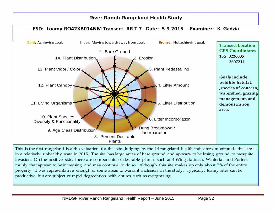
River Ranch Rangeland Health Study
Achieving Goal Moving Toward/Away From Goal Not Achieving Goal
ESD: Loamy RO42XB014NM Transect RR T-7 Date: 5-9-2015 Examiner: K. Gadzia
Transect LocationGPS Coordintates13S 0226005
3607214
Goals include: wildlife habitat, ,species of concern, watershed, grazing management, and demonstration area.
1. Bare Ground
2. Erosion
3. Plant Pedastalling
4. Litter Amount
5. Litter Distribution
6. Litter Incorporation
7. Dung Breakdown /Incorporation
8. Percent DesirablePlants
9. Age Class Distribution
10. Plant SpeciesDiversity & Functionality
11. Living Organisms
12. Plant Canopy
13. Plant Vigor / Color
14. Plant Distribution
Gold: Achieving goal. Silver: Moving toward/away from goal. Bronze: Not achieving goal.
This is the first rangeland health evaluation for this site. Judging by the 14 rangeland health indicators monitored, this site is in a relatively unhealthy state in 2015. The site has large areas of bare ground and appears to be losing ground to mesquite invasion. On the positive side, there are components of desirable plantss such as 4 Wing slatbush, Winterfat and Porters muhly that appear to be increasing and may continue to do so. Although this site makes up only about 7% of the entire property, it was representative enough of some areas to warrant inclusion in the study. Typically, loamy sites can be productive but are subject ot rapid degredation with abuses such as overgrazing.
NMDGF River Ranch Rangeland Health Report – June 2015 Page 32

RR T-7 Plot 5-9-2015
Photo Points
RR T-7 Overview 5-9-2015
Porters muhly plants establishing in the open ground. Healthy Winterfat shrubs growing with Porters muhly grass.
NMDGF River Ranch Rangeland Health Report – June 2015 Page 33

Apparent range trend:Formerly eroding area near RR T-7 showing stabilized erosion. RR T-7 Overview showing mesquite cover.
Stable to dowward trend because of negative indicators & areas of bare ground.
Porter Muhly Bristlegrass Tobosa Giant Dropseed 3 Awn Fluffgrass Mesquite Snakeweed 4 Wing Winterfat Croton Purple mat
12 Most Abundant Plants
Notes: This site appears to be declining in health because bare ground percentage is high and mesquite are invading the area. It might be possible to improve this site with mechanical or chemical clearing of mesquite, but other areas may have a higherpriority for treatment options. Despite past uses that probably degraded this site, it appears to be slowly healing in some ways, such as reduced erosion and establishment of desirable plants. Javalena and rodent activity signs were abunant in the site area.
NMDGF River Ranch Rangeland Health Report – June 2015 Page 34

Rangeland Health Summary Analysis of data from the 7 evaluation sites, as well as driving and walking surveys of the areas indicates that the River Ranch is in a stable to improving condition in most areas. There are many indications that the land was once in far poorer condition, as evidenced by the gully erosion and BLM 1997 data collected. However, as the Bullseye targets show, almost all areas show room for improvement in land health. The drought of 2010-2012 that had impacted the entire region has also had moderate to severe consequences on some sites and may be the reason for some die off of grasses and replacement by woody species such as mesquite.
Because of their importance and uniqueness, 3 of the seven indicators were located in the bottomland area of the private land. Although the land area here is small in comparison to the acreage of the uplands, the productivity and habitat values are much higher on an acre per acre basis. Rangeland Health readings on these sites showed a range from healthy and stable to unhealthy and declining. A detailed description and range of options to improve these sites are discussed in the Grazing Management Plan. There was no recent sign of livestock grazing or fire disturbance in these sites which has led to the buildup of old material in many areas and increased the potential fuel load for a wildfire and tied up the nutrient cycling within these sites.
An equal amount of sites (3) were placed in the Hills ESD, which makes up approximately 80% of the acreage of River Ranch, when including private, BLM and State lands. An effort was made to place these sites to reflect the high degree of variability contained within the Hills sites. This variability is based on many factors but slope, aspect and soil depth are probably the three biggest influences.
Overall, the majority of the land in the Hills classification appears to be in a very healthy to moderately healthy condition at present. The bulk of these areas show no signs of recent livestock grazing or fire. Wildlife sign was noted in most areas including many species of birds (see lists in Appendix D) Javelina, Mule Deer, Elk, Antelope, Rabbits, Coyote, Badger, and many rodents (especially Kangaroo rats).
The lack of disturbance from grazing and fire has produced an oxidized condition (dark gray coloration) of many of the grass plants in these sites. While this can be viewed negatively because of its impacts on mineral cycling and plant vigor, the fact that this does not appear to be negatively affecting wildlife is a consideration that must be considered in any grazing plan. Additionally, Black grama and Tobosa grass which are prevalent on these sites, have the ability to grow over their own old stems and increase cover over time without being choked out, as some bunch grasses are.
The final transect was placed in the Loamy ESD site which makes up about 7% of the total land area. While not significant in size, the site is probably the most degraded area encountered during the survey. Brush encroachment from mesquite is high as is the amount of bare ground and erosion. This is probably mostly an artifact of past management since this area is located next to a water source and the corrals. Even so, there are signs of improvement because desirable species such as Bush Mulhly, Plains Bristle grass, Winterfat and Four Wing Saltbush appear to be increasing across the site.
NMDGF River Ranch Rangeland Health Report – June 2015 Page 35

Other Notes and Observations The overuse or improper use of any land management tool including livestock grazing, fire, mechanical or prolonged rest can have a negative effect on land health. This ranch shows evidence of nearly all these influences, but most recently, the tool of rest.
The Grazing Management Plan which follows, discusses some of the management options in detail and is a beginning point to develop the correct balance of management tools to produce the goals of the Department for the River Ranch.
NMDGF River Ranch Rangeland Health Report – June 2015 Page 36
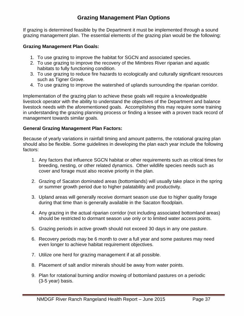
Grazing Management Plan Options
If grazing is determined feasible by the Department it must be implemented through a sound grazing management plan. The essential elements of the grazing plan would be the following:
Grazing Management Plan Goals:
1. To use grazing to improve the habitat for SGCN and associated species.2. To use grazing to improve the recovery of the Mimbres River riparian and aquatic
habitats to fully functioning condition.3. To use grazing to reduce fire hazards to ecologically and culturally significant resources
such as Tigner Grove.4. To use grazing to improve the watershed of uplands surrounding the riparian corridor.
Implementation of the grazing plan to achieve these goals will require a knowledgeable livestock operator with the ability to understand the objectives of the Department and balance livestock needs with the aforementioned goals. Accomplishing this may require some training in understanding the grazing planning process or finding a lessee with a proven track record of management towards similar goals.
General Grazing Management Plan Factors:
Because of yearly variations in rainfall timing and amount patterns, the rotational grazing plan should also be flexible. Some guidelines in developing the plan each year include the following factors:
1. Any factors that influence SGCN habitat or other requirements such as critical times forbreeding, nesting, or other related dynamics. Other wildlife species needs such ascover and forage must also receive priority in the plan.
2. Grazing of Sacaton dominated areas (bottomlands) will usually take place in the springor summer growth period due to higher palatability and productivity.
3. Upland areas will generally receive dormant season use due to higher quality forageduring that time than is generally available in the Sacaton floodplain.
4. Any grazing in the actual riparian corridor (not including associated bottomland areas)should be restricted to dormant season use only or to limited water access points.
5. Grazing periods in active growth should not exceed 30 days in any one pasture.
6. Recovery periods may be 6 month to over a full year and some pastures may needeven longer to achieve habitat requirement objectives.
7. Utilize one herd for grazing management if at all possible.
8. Placement of salt and/or minerals should be away from water points.
9. Plan for rotational burning and/or mowing of bottomland pastures on a periodic(3-5 year) basis.
NMDGF River Ranch Rangeland Health Report – June 2015 Page 37

Private Land Infrastructure Factors: The current state of infrastructure including fences, watering points, working facilities, and roads are in various states of disrepair. Perhaps one of the greatest concerns would be that the entire riparian corridor has access to livestock at this time due to lack of fences or fences that are down. It is recommended that a general fence plan be developed that separates the river corridor from the surrounding floodplain pasture areas. In addition much of the uplands on the west side of the river are not fenced separately and can be accessed from the river pastures. Permanent fences that cross the river should be avoided if possible. A possible plan that shows draft of such paddock development on the private land is shown on page 45.
In general the infrastructure necessary for proper grazing management on the private land portion of the River Ranch is deteriorated or non-existent. Many of the fences are in poor repair and all are down wherever they cross the river. The only functioning water system appears to be associated directly with the corrals, storage building and windmill located west of Tigner Grove. However there is very limited storage of about 1,500 gallons at the small tank located above the corral.
No other functioning watering points, other than some abandoned troughs (see photo below), could be found except those noted on the map on BLM land. Responsibility for maintenance of these windmills must also be clarified. The wells and submersible pumps at the north and south ends of the private land may be functioning but have not yet been tested. Pipelines from these water sources to drinking troughs in other areas also do not appear to exist. The well on the north side appears to be solely used for the irrigation of a small pasture with a side-roll distribution for the water, and the system appears inoperable presently.
The small corral by the functioning windmill would be serviceable with a minimal amount of repair. However, the other set of corrals at the south end of the ranch is completely dilapidated and would need to be entirely rebuilt if required.
NMDGF River Ranch Rangeland Health Report – June 2015 Page 38

The roads system throughout the ranch, with the exception of Taylor Mountain Road, is fairly rough 2 track, and in some areas impassible due to wash outs. A plan to maintain needed roads and properly close unused or unnecessary roads should be developed.
Except for the river, the single existing watering point for livestock is at the working corrals. This situation is problematic and will need to be addressed in the grazing management plan. Because of the productivity of the Giant Sacaton areas, these pastures should be isolated from the uplands wherever practical. At present, because of the fence locations and state of repair, the entire private land is essentially available to any livestock that would be brought in.
The general plan to properly develop grazing infrastructure on the private land to achieve the goals of the Department would be to:
1. Isolate the River corridor from the floodplain pastures by fencing where practical.
2. Isolate the upland pastures from the floodplain pastures by fencing where practical.
3. Establish 1-3 floodplain pastures on the west side of the river and 6 - 8 floodplainpastures on the east side of the river to facilitate proper stock density, grazing periodcontrol, and allow for recovery before re-grazing. Size of floodplain paddocks shouldreflect roughly equal forage production to facilitate similar grazing periods.
4. Design fences to be resistant to fire damage in order to retain this tool for periodicallymanaging the floodplain Sacaton pastures. Typically this is steel permanent fence ortemporary electric fence with steel corners.
5. Provide water for livestock through a pipeline system with drinkers or selected accesspoints to the river with hardened crossing spots for livestock and vehicles.
6. Develop the grazing plan to maximize forage utilization for floodplain and uplandvegetation on a rotational basis.
7. Work with BLM and State grazing management personnel to clarify Allotment useboundaries (see discussion below) and coordinate goals for land health objectives andhabitat needs. Develop alternative watering points and gates that facilitate ease oflivestock movement between pastures.
BLM and State Lease Land Infrastructure Factors: Rangeland infrastructure and health conditions on the BLM (1,800 ac.) and State (1,100 ac.) leased lands were also assessed. In general these areas appear to be in moderately good health and stable condition. As with the private land sites, there are some areas that are in poor to declining health condition, but these are the exception. Access to these areas is from Taylor Mountain Road and from gates along Highway 61. Some of the gates on BLM land which appear to be in the Allotment were found to be locked.
Some anomalies seem to exist in the Allotment and State Land boundaries and the areas that are actually grazeable. It appears that the actual fence lines are somewhat different from the fence lines shown on the BLM Allotment and State Land ownership overlays. In several cases the Allotment boundaries themselves are not fenced or fences exist that do not show on the BLM maps. Additionally, the private land fence lines do not appear to always follow the private land boundary line as shown on the property ownership overlays (See map on page 41).
NMDGF River Ranch Rangeland Health Report – June 2015 Page 39

On the West side of Highway 61 a fence across BLM land runs in a NW direction from the State land southern boundary to the fence around City of Rocks SP and then south along the access road to the SP from the highway. There is no fence on the BLM western boundary of the BLM allotment so that this large area would be open for grazing if livestock were brought in through the gate leading to the caliche mines. Additionally, a good water source with windmill, storage tank and drinker is situated nearly at the center of this pasture on BLM land (see photo below). No grazing is currently taking place in this pasture, which is approximately 1,000 acres.
An important fence line is not shown on any maps. This fence is entirely on BLM property and parallels Taylor Mountain Road (TMR) to the north for about .7 miles before turning east for 1/2 mile and intersecting the private land fence boundary. This fence cuts off grazing access to a large part of the BLM land to the south and the entire State property south of TMR. This fence creates what is labeled Pasture 2 on the map and is approximately 310 acres in size. There does not appear to be any water point associated with this pasture unless there is access given to the water on private land.
Another fence bisects both of the State properties south of TMR and runs in a NE direction to a windmill and corral west of the allotment. Access to this water point and working facility is from a locked gate with a private property sign at Highway 61. This creates what is labeled Pasture 3? on the map which is approximately 1,090 acres in size. However, the 3? denotes that it is unclear if this is part of the Allotment or not. Certainly the only road access to this water point and associated corrals is clearly locked and marked as private.
In general the fences are in fair to good shape but two of the 3 pastures are fairly large and these are the only 2 of that have a water source. Despite the discrepancies in boundaries outlined above, the overall approximate acreage of these 3 areas (2,400 acres) is very close to 2,376 acres reported to be on the combined BLM and State leases.
NMDGF River Ranch Rangeland Health Report – June 2015 Page 40

NMDGF River Ranch Rangeland Health Report – June 2015 Page 41

The land north of the fence described above is inaccessible from the road leading to the caliche mines because the gate is locked and has a No Trespassing / Private Land sign at the gate. The actual gate may be on private property, but this fence cuts off access to the north ½ of the BLM allotment on the west side of the highway as well as all the State land on that side.
Perhaps some trade of use or access agreement has been recorded for these anomalies. In any case, these are major concerns with the grazing plan development. The question is which of these pastures are assigned to the BLM and State leases for the River Ranch? It appears that there is actually about the same amount of acreage in total, but it does not correspond with the Land Management Status maps currently provided. These details would need to be worked out with the agencies prior to finalizing or implementing the plan.
Carrying Capacity: The private land with its highly productive terraces dominated by Giant Sacaton (Sporobolus wrightii) grass, differs greatly in its carrying capacity for livestock than the BLM and State uplands to the west and south. Using a conservative estimate of 750 pounds average of useable forage production per acre for these areas, an estimate of carrying capacity can be projected as follows:
• 750 lbs. per acre x 220 acres (east side of river only) = 165,000 lbs. forage• 165,000 lbs. / 30 lbs. per animal unit per day = 5,500 animal unit days of grazing (AD’s)• 5,500 AD’s / 30 days per month = 183 Animal Unit Months (AUM’s)
The combined overall capacity for the permitted livestock is 31 Animal Units (cow with calf) for one year on the BLM Taylor Mountain Allotment 02525 and 17 Animal Units for the State Land lease GT-2853, for a total of 48 Animal Units year long. 48 Animal Units x 12 months = 576 Total Animal Unit Months (AUM’s)
However, it might be possible to run a higher stocking rate closer to 72 Animal Units if grazing capacities on the BLM and State properties are calculated in Animal Unit Months and the remaining 4 months grazing is on private land.
• 48 AU x 12 mos. on lease land = 576 AUM’s; Current Permitted AUM’s.
• 60 AU X 9 mos. on lease land = 540 AUM’s (26 AUM’s below permitted capacity)• 60 AU X 3 mos. on private land = 180 additional AUM’s taken on private land while leased
land is resting.
The reasons for potentially wanting to have a higher stocking rate include higher stock density, economy of scale, more attractive to potential lessee, and more flexibility to reduce numbers in drought conditions. This increase in animal numbers, but overall reduction in AUM’s removed from the leased land would need to be approved by the BLM and State agencies.
Bottomlands The major species which typifies the C and D soil types and provides the majority of forage, cover, watershed protection and habitat for various species is Giant Sacaton (Sporobolus wrightii). Giant Sacaton bottoms can be found throughout southern New Mexico at elevations from 3,400 feet to over 5,000 feet. They occur on floodplains, alluvial fans and stream terraces where the soils are loamy to clayey in texture. On the River Ranch at least 350 acres of the private land along the river is characterized by this species.
NMDGF River Ranch Rangeland Health Report – June 2015 Page 42

Although Giant Sacaton is potentially extremely productive with annual production varying from 1,000 to over 5,000 pounds per acre, proper management is often problematic. Because the grass is relatively unpalatable to livestock unless it is fresh growth, it tends to build up old material for 3 or more years on the plant. Also, because the growth happens so fast, it is difficult to put on enough livestock to consume the production while the plant is most nutritious.
These factors often lead managers of these areas to use burning or mowing as a way to control the old growth and freshen the plants back up. The following graph shows the decline in forage quality of protein levels through the year with different management regimes.
These strategies
can be effective, but overuse of burning in particular produces negative consequences including loss of soil cover, failure to recruit young plants, and larger spaces between old clumps. Some areas of the ranch exhibit these symptoms and they appear to be a legacy from past management regimes. A neighbor familiar with the past management of the ranch reported that these areas were burned semi-annually, mowed on the alternate years and grazed following these treatments. The combination of these treatments appears top lower productivity of these areas over time.
An excellent publication concerning management of Giant Sacaton is “Prescribed Burning in Giant Sacaton Bottomlands” by Dan Robinett, May 16 2009. In this publication there are several recommendations made for burning and grazing management of Sacaton bottoms in Arizona. Other publications which report data on management practices of Sacaton are listed in Appendix E. The following recommendations are from Robinett, 2009:
The risks associated with Sacaton burns can be minimized by following a good prescription. Risks include; burning without adequate moisture for re-growth and subsequent loss of plant density and productivity, loss of soil cover and increased risk of soil sheet and gully erosion, high fuel loads increases the risk of escaped fire and possible increase in noxious weeds.
A good prescription for Prescribed burning in giant Sacaton bottoms is as follows; Recommended Frequency – No more than once every three years
Robinett, 2009
NMDGF River Ranch Rangeland Health Report – June 2015 Page 43

Burn window – February 15 – March 15
Pre-burn moisture conditions – Should have at least 4 inches of available soil water in a five foot root zone. This can come from winter precipitation (4 inches Nov. 1 through Feb 15) or from late summer or fall flooding during the previous year. Temperatures - Daytime 59-68 degrees F Night -time 23-41 degrees F Relative humidity - Between 20 and 30% Wind speed - Less than 10 mph Extent of burn areas – Large areas of Sacaton bottoms can be treated leaving unburned strips to retain plant cover and prevent erosion in large summer floods Recommended grazing season – May 1 through July 15 Stocking rate – variable but should average 0.5 AUM per acre for the season
Another contributing factor to the decline of the Sacaton bottoms in some areas may be disconnection of the Mimbres River from the upper terrace (D soils) in particular. The riparian survey that has been conducted may help to determine if this is in fact the case. There are restoration techniques that could be implemented to help reconnect the floodplain to improve the chances of periodic flooding.
The higher production sites usually have seasonally high water tables and / or receive extra water from flooding due to runoff from their watershed areas. Lower production sites usually have deeper incised channels and no longer flood although they may have seasonal water tables within the rooting zone of Giant Sacaton. This species has one of the deepest rooting zones of all grasses, at 20-25 feet. In nearly every Sacaton site on the ranch the variation in degree of productivity can be seen due to many factors. The photo below shows a healthy Sacaton bottom site near Tigner Grove. Note the growth is over 6 feet tall in many areas. This photo was taken near the RR T-1 monitoring location.
NMDGF River Ranch Rangeland Health Report – June 2015 Page 44

Grazing Management Recommendations for Tigner Grove
Tigner Grove is a unique environment that is considered a “jewel” along the Mimbres River. The grove of trees that exist here consists primarily of the following species in approximated order of abundance: Velvet Ash Fraxinus velutina Box Elder Acer negundo Cottonwood Populus wislezeni Hackberry Celtis reticulata Arizona Walnut Juglans arizonica Soapberry Sapundis saponerica Mulberry Morus rubra
While these species and others exist along most of the entire riparian corridor, the large size and density of the trees in the grove is remarkable. Although not verified, State record trees of Velvet Ash and Walnut may exist here. Some regeneration of the tree species was observed, but in general the closed canopy, tight spacing, and shading of the ground seems to prevent much new regeneration.
The understory of this grove is dominated by Giant Sacaton, Western Wheatgrass, and various warm and cool season annual grasses and forbs. This dried forage represents a fire threat to the grove which could kill many of the trees. Reduction of the fuel load by grazing is a good option because it would create some soil disturbance and return nutrients to the site through manure deposition. These factors may in fact help with new tree regeneration in the understory of the grove.
The herbaceous forage density under the canopy is widely variable, but I estimated forage production at the time of the survey to be approximately 25 Animal Days per acre. The current fence around the grove defines an area of about 5.2 acres. This 25 ADA’s x 5.2 acres would equal around 130 Animal Days of grazing.
The preferable grazing scenario would be to remove the forage with as many animals as possible for the shortest period of time as possible. Thus, if 130 animal units were put into the grove, they could stay only 1 day. If 25 animal units were put into the grove they could stay about 5 days (130 ADA / 25 Animals).
Currently, the fence around the grove is in need of repair and a water source would need to be provided for the stock at about 20 gallons per day per head depending on the time of year. A forage estimate would need to be done prior and during the grazing period to correctly determine the number of days of grazing desired for the actual conditions at that time.
Because of the large amount of deadfall, sawn timber logs, and firewood piles in the grove; grazing would be preferable to mowing or other mechanical reduction of the fuel load. I also recommend a fixed point monitoring site to be established and data on tree regeneration might also be included. The photos should be taken before and after the grazing treatment, and at approximately one year intervals following the treatment. This will help determine when the grazing may need to be repeated and any positive or negative consequences that result.
NMDGF River Ranch Rangeland Health Report – June 2015 Page 45

Map of Proposed Pasture Numbers and Locations for Upland Pastures: Includes BLM, State, and Private Lands
NMDGF River Ranch Rangeland Health Report – June 2015 Page 46
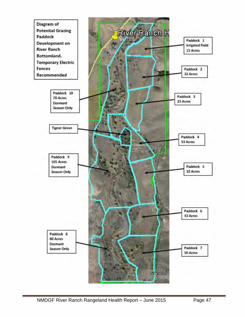
NMDGF River Ranch Rangeland Health Report – June 2015 Page 47

Possible Grazing Schedule for River Ranch As noted earlier in the grazing planning factors section of this report, the timing of livestock grazing must be flexible depending on weather and the other factors that change with each year. The factors also list a number of guidelines for the development of any plan that is put into action. The following chart is only an example of what timings might look like for a grazing schedule that would incorporate the recommendations for paddock development and grazing/recovery guidelines outlined in previous sections. The timing of grazing for each paddock is based on size considerations, but quality and quantity of pasture will vary in each paddock. Thus, timings may be somewhat longer or shorter based on those factors, but will generally be in this range of time. The following table shows the possible livestock grazing periods if all grazing areas are developed and water is available in each grazing area.
LocationPaddock #
Acres Days Recovery
PeriodRR Irrigated East 1 15 6 One YearRR Sacaton East 2 32 13 One YearRR Sacaton East 3 25 10 One YearRR Sacaton East 4 33 13 One YearRR Sacaton East 5 32 13 One YearRR Sacaton East 6 33 13 One YearRR Sacaton East 7 50 21 One Year
RR Private Upland Pasture 1 450 37 One YearBLM State Pasture 2 310 26 One YearBLM State Pasture 3 1090 93 One YearBLM State Pasture 4 1000 85 One Year
Total 3,070 330RR Riparian 8 80 35 3 YearsRR Riparian 9 105 45 3 YearsRR Riparian 10 70 30 3 Years
See Map on Page 45. Grazed in Dormant Season Every 3rd YearSee Map on Page 45. Grazed in Dormant Season Every 3rd Year
See Map on Page 46. Water Access Available
See Map on Page 45. Mow or Burn Every 3rd YearSee Map on Page 45. Mow or Burn Every 3rd YearSee Map on Page 45. Mow or Burn Every 3rd YearSee Map on Page 45. Mow or Burn Every 3rd YearSee Map on Page 45. Mow or Burn Every 3rd YearSee Map on Page 45. Mow or Burn Every 3rd Year
See Map on Page 45. Grazed in Dormant Season Every 3rd Year
See Map on Page 46. Water Access AvailableSee Map on Page 46. Must Develop Water
See Map on Page 46. Water Available, But Access Unkown
River Ranch Possible Grazing Plan Timings If All Grazing Areas Developed
Then Graze One of the Paddocks Below for Approximately 35 days.
Comments
See Map on Page 45. Mow or Burn Every 3rd Year
NMDGF River Ranch Rangeland Health Report – June 2015 Page 48

The following calendar schedule is just a guideline. It begins with the grazing period for the Sacaton bottoms since that is more of a critical time than most other areas. The other most critical timing for grazing is the Riparian paddocks (West side of river) to insure that any grazing takes place in the dormant season. The schedule is to graze one of these areas every third year. All of the dates are approximate and must be flexible with the season and special habitat considerations.
LocationPaddock #
Acres Days Recovery
PeriodRR Irrigated East 1 15 6 One YearRR Sacaton East 2 32 13 One YearRR Sacaton East 3 25 10 One YearRR Sacaton East 4 33 13 One YearRR Sacaton East 5 32 13 One YearRR Sacaton East 6 33 13 One YearRR Sacaton East 7 50 21 One Year
BLM State Pasture 3 1090 93 One YearBLM State Pasture 4 1000 85 One Year
RR Riparian 8 80 35 3 YearsRR Riparian 9 105 35 3 YearsRR Riparian 10 70 35 3 YearsBLM State Pasture 2 310 26 One Year
RR Private Upland Pasture 1 450 37 One YearTotal 2,310 365
River Ranch Possible Grazing Plan Timings If All Grazing Areas Developed
Potential Calender Dates
May 1- May 6
January 25 - February 30 Every 3rd Year
March 1 - March 27January 25 - February 30 Every 3rd Year
May 7 -May 19May 20 - May 29May 30 - June 11June 12 - June 24June 25 - July 7July 8 -July 28
January 25 - February 30 Every 3rd Year
July 29 - October 30October 31 - January 24
March 28- April 31
NMDGF River Ranch Rangeland Health Report – June 2015 Page 49

Reality Check The proposed grazing plan elements represent a fairly sizeable investment of resources in order to develop the infrastructure needed to implement the plan successfully. In addition, a livestock operator familiar with the principles of planned rotational grazing and recovery periods would be needed to apply the system.
However, such operators do exist in the area. David and Tammy Ogilvie ranch in the area and might be interested in operating a lease for the property. Contact information is available from the author if this option might be of interest. In addition the New Mexico Society for Range Management (NMSRM) is offering a tour of the Ogilvie’s U Bar Ranch, July 30–31, 2015 Mr. David Ogilvie has invited participants to his ranch just outside of Silver City where riparian management, range improvements, and grazing are producing beneficial results. A detailed agenda will be forthcoming on the NMSRM webpage, but the general plan is to tour the ranch on Thursday (lunch included), have a social mixer that night, and then engage invited speakers with riparian expertise on Friday morning (adjourn by noon). Contact Dr. Nick Ashcroft for additional details (575-646-5394; [email protected]).
Other options such as minimal internal fence development but using higher numbers of livestock for a shorter period might prove the simplest alternative. However, with large bottomland pastures, it would be harder to get the kind of stock density that would really impact the Sacaton and simulate a “living fire” or mowing. Additionally, it would be difficult to manage the riparian zones unless this corridor was excluded at a minimum.
At present there seem to be many anomalies in the BLM and State land boundary situation. This can probably be sorted out fairly easily with communications between the Departments. However, large areas with few watering points necessitate fairly long grazing periods of several months in some cases. These long grazing periods are offset somewhat by the long recovery periods proposed in the plan.
Fire Burning is a tool that is often discussed, but seldom implemented in many management plans. Often this is because of the planning and personnel needed to accomplish it on the ground. This consideration, as well as the liability it represents should the fire escape the boundaries of the target zone, do represent some of the realities of implementing this plan. Grass fires are generally easier to prescribe and manage than woody areas. However, the current fuel load of several tons per acre in many areas could create unpredictable conditions. The benefits and problems associated with burning Sacaton are discussed in an earlier section of this report.
Mowing Mowing the Sacaton is another alternative to burning. It has the advantage of placing the litter cover on the ground to protect the soil. It is more costly than burning on a per acre basis. Also, in areas like the River Ranch where no grazing or burning has taken place for several years, the buildup of old material is difficult for even heavy duty mowers pulled by tractors to accomplish efficiently. That is why the three tools of grazing, fire and mowing can be useful when rotationally applied.
Mechanical and Chemical Treatment of Brush It is fortunate that much of the ranch retains a dominance of grass. However, some areas have varied levels of brush encroachment, mainly by mesquite. As mesquite becomes more
NMDGF River Ranch Rangeland Health Report – June 2015 Page 50

dominant, changing habitat may affect some species negatively.
The use of machinery such as bulldozers, loaders or excavators to control invasive areas of mesquite is an option in some of the ranch. The same areas would be candidates for herbicide application. The advantage of herbicide use is the lack of ground disturbance, but it may also kill non-target desirable species such as 4 Wing Saltbush or Winterfat. The main reason for such treatments would be to prevent a negative shift in habitat, not to create more forage for livestock. In fact, as discussed in the paper by Holecheck, 1994, it seldom makes financial sense to control mesquite in New Mexico.
The few areas where Salt Cedar was found on the ranch are fortunately not large infestations. These areas can probably be easily treated by hand cutting and treatment of stumps with an herbicide that prevents re-sprouting of the stumps. No other infestations of noxious or invasive plants were encountered.
Continuation of Current Management Continuation of current management practices seems unlikely to create severe negative consequences in the near future for much of the ranch. Probably the biggest consequence of continuing to let the Sacaton bottoms rest is that this strategy will create an increasing fuel load. This might enhance a wildfire that runs unchecked and kills the large trees in areas such as Tigner Grove and the riparian corridor where beautiful specimens of gallery forest exist. Upland areas may become somewhat less productive with the buildup of old growth, but this is not an issue that needs to be addressed in the immediate future.
Conclusion Protecting and enhancing the unique habitats that exist on the River Ranch must be the primary focus of any management plan for the property. Fortunately, the Rangeland Health Study that was conducted for this report shows that most areas are in a healthy condition at present.
Livestock grazing is a wonderful tool for maintaining habitat when used properly, and in conjunction with other tools. Currently, rest is the main tool being used on the ranch and is having some negative effects. However, it is not presently creating severe problems other than an increased risk of fire in some portions of the property.
Finding the right mix of infrastructure that can protect the critical riparian corridor and allow its periodic use seems of primary importance. Any fences that isolate this area should be placed well away from the normal flood zone. Thus, the majority of regularly scheduled grazing in the Sacaton areas should be on the east side of the river. The west side of the river can be incorporated into the riparian corridor to simplify the infrastructure design. These areas could receive periodic grazing during the dormant season every 3rd or 4th year.
Should livestock grazing be deemed an appropriate tool for management by the Department, the biggest difficulty may be finding the right operator to conduct proper grazing management. Livestock grazing can have a positive or very negative affect on habitat objectives. Managed grazing with a plan for controlling grazing periods and providing adequate recovery for plants is the key to creating the positive effect desired if this tool is used.
NMDGF River Ranch Rangeland Health Report – June 2015 Page 51

Appendix A: NRCS Data on riparian area of River Ranch
MB-7 was chosen to represent soil type C with Rangeland Health Transect RR T-1
NMDGF River Ranch Rangeland Health Report – June 2015 Page 52

Ecological Site ID
Ecological Site name
UTM northing
UTM easting
Transect positionNE-SW NW-SE NE-SW NW-SE
37.5 62.5 112.5 12.5 137.5 37.5 62.5 112.5 12.5 137.5
Species name or code P-1 P-2 P-3 P-4 P-5 P-1 P-2 P-3 P-4 P-5 Reconstruction Factors (%)
Herbaceous Weight unit (g) Number of weight units/plot Air Dry Wt Ungrazed Growth Climate HerbaceousSPWR2 84 1 5 8 4 6 75 375 599 300 450 90% 100% 100% 100% 3237.59
HYMO TSelu T
Unhide hidden rows above, if necessary (Tools>Protection>Unprotect Sheet; then unhide). Reconstruction Factors (%) 3237.59Woody Weight unit (g)
Number of weight units/0.01 acre Air Dry Wt Ungrazed Growth Climate
cottonwood 0 0 100 0 0 100% 100% 100% 100%
Unhide hidden rows above, if necessary (Tools>Protection>Unprotect Sheet; then unhide).
3237.59
This worksheet is for cases where 1-m2
herbaceous plots were used in the field.
Herbaceous production is displayed as grams per 9.6-ft2 plot to facilitate RECON data entry.
Point
PSU Mb-7
Date 16-Jan-15
Name(s) lgarcia
= Total woodyease co tact c ae Ca p e t a y quest o s, co e ts, o suggest o s co ce g t s o boo c ae ca p e @ usda go (505) 85 6963 e t
106 = Total Production
Type or paste data into uncolored cells - do not
drag cell contents. Transect Average Reconstructed Weight
(pounds per acre)Grams / 9.6-ft2 plot
= Total herbaceousGrams / 100th-acre plot Woody
All reconstruction factors must be entered in order for reconstructed weight to be calculated. Reconstructed weight should agree with same in the RECON (before being adjusted for maximum allowable weight).
Cover Estimates by Species
Average Annual Average AnnualSpecies Scientific Common Year Foliar Cover % Basal Cover %BOBA2 Bouteloua barbata Lag. sixweeks grama 2014 5.0 0.0DYSSO Dyssodia Cav. dyssodia 2014 0.5 0.0
GUSA2Gutierrezia sarothrae (Pursh) Britton & Rusby broom snakeweed 2014 0.5 0.0
HYMOHymenoclea monogyra Torr. & A. Gray singlewhorl burrobrush 2014 4.0 0.0
POFR2Populus fremontii S. Watson Fremont cottonwood 2014 10.0 0.0
SEVU2Setaria vulpiseta (Lam.) Roem. & Schult. plains bristlegrass 2014 2.5 0.0
SPCO4Sporobolus contractus Hitchc. spike dropseed 2014 1.0 0.0
SPWR2Sporobolus wrightii Munro ex Scribn. big sacaton 2014 74.0 19.5
NMDGF River Ranch Rangeland Health Report – June 2015 Page 53

MC-6 and MC-1 were chosen as representative of Map Unit D as Rangeland Health Transects RR T-2 and RR T-6
NMDGF River Ranch Rangeland Health Report – June 2015 Page 54

Ecological Site ID
Ecological Site name
UTM northing
UTM easting
Transect positionNE-SW NW-SE NE-SW NW-SE
37.5 62.5 112.5 12.5 137.5 37.5 62.5 112.5 12.5 137.5
Species name or code P-1 P-2 P-3 P-4 P-5 P-1 P-2 P-3 P-4 P-5 Reconstruction Factors (%)
Herbaceous Weight unit (g) Number of weight units/plot Air Dry Wt Ungrazed Growth Climate HerbaceousSPWR2 20 9 8 9 161 143 161 95% 100% 100% 100% 1469.14
Unhide hidden rows above, if necessary (Tools>Protection>Unprotect Sheet; then unhide). Reconstruction Factors (%) 1469.14Woody Weight unit (g)
u be o e g t u ts/0 0acre Air Dry Wt Ungrazed Growth Climate
NONE 0 0 0 0 0 100% 100% 100% 100%
Type or paste data into uncolored cells - do not
drag cell contents. Transect Average Reconstructed Weight
(pounds per acre)Grams / 9.6-ft2 plot
= Total herbaceousGrams / 100th-acre plot Woody
Date 23-Dec-14
Name(s) lgarcia
This worksheet is for cases where 1-m2
herbaceous plots were used in the field.
Herbaceous production is displayed as grams per 9.6-ft2 plot to facilitate RECON data entry.
Point MC-6
PSU
All reconstruction factors must be entered in order for reconstructed weight to be calculated. Reconstructed weight should agree with same in the RECON (before being adjusted for maximum allowable weight).
Cover Estimates by Species
Average Annual Average AnnualSpecies Scientific Common Year Foliar Cover % Basal Cover %
AMPAAmaranthus palmeri S. Watson carelessweed 2014 0.4 0.0
BOBA2 Bouteloua barbata Lag. sixweeks grama 2014 10.4 0.0
COBOConyza bonariensis (L.) Cronquist asthmaweed 2014 0.8 0.0
SPWR2Sporobolus wrightii Munro ex Scribn. big sacaton 2014 73.2 16.8
Soil Surface Report Total AvgSoil Surface Category Points Percentvisible lichen 15 10.0moss 0 0.0rock fragment 0 0.0soil 113 75.3stones 0 0.0water 0 0.0
Basal Hits 22 14.7
NMDGF River Ranch Rangeland Health Report – June 2015 Page 55

\Appendix B: BLM Data on Taylor Mountain Allotment 02525 Chosen as RR T-3 Hills for Rangeland Health Study
BLM 02525 1997 RR T-3 Hills 2015
NMDGF River Ranch Rangeland Health Report – June 2015 Page 56

NMDGF River Ranch Rangeland Health Report – June 2015 Page 57

NMDGF River Ranch Rangeland Health Report – June 2015 Page 58

NMDGF River Ranch Rangeland Health Report – June 2015 Page 59
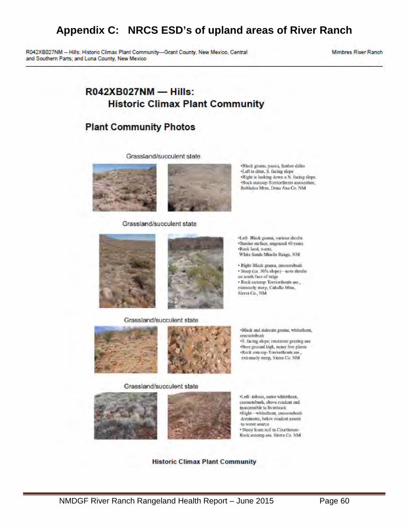
Appendix C: NRCS ESD’s of upland areas of River Ranch
NMDGF River Ranch Rangeland Health Report – June 2015 Page 60

NMDGF River Ranch Rangeland Health Report – June 2015 Page 61

NMDGF River Ranch Rangeland Health Report – June 2015 Page 62

NMDGF River Ranch Rangeland Health Report – June 2015 Page 63

NMDGF River Ranch Rangeland Health Report – June 2015 Page 64

NMDGF River Ranch Rangeland Health Report – June 2015 Page 65
NMDGF River Ranch Rangeland Health Report – June 2015 Page 66

NMDGF River Ranch Rangeland Health Report – June 2015 Page 67

NMDGF River Ranch Rangeland Health Report – June 2015 Page 68

NMDGF River Ranch Rangeland Health Report – June 2015 Page 69

Appendix D: Plant, Bird, and Mammal Species Lists (Field work sightings in May, 2015)
GrassesCommon Name Genus Species
1 Purple 3 Awn Aristida purpurea2 Poverty 3 Awn Aristida divericata3 Cane beardgrass Bothriochloa barbinoides4 Blue grama Bouteloua gracilis5 Sideoats grama Bouteloua curtipendula6 Hairy grama Bouteloua hirsuta7 Black grama Bouteloua eriopoda8 6 Weeks Grama Bouteloua barbata9 Rescuegrass Bromus catharticus
10 Feather Fingergrass Chloris virgata11 Common bermudagrass Cynodon dactylon12 Barnyardgrass Echinochloa crus-galli13 Western wheatgrass Elymus smithii14 Squirreltail Elymus elymoides15 Lehmans lovegrass Eragrostis intermedia16 Plains lovegrass Eragrostis elongatus17 Weeping lovegrass Eragrostis curvula18 Fluffgrass Erioneuron pulchellum19 Foxtail Hordeum jubatum20 Little Barley Hordeum pusillum21 Green sprangletop Leptochloa dubia22 Porter's muhly (hoegrass) Muhlenbergia porteri23 Deergrass Muhlenbergia rigens24 Hall's Panicum Panicum Hallii25 Vine mesquite Panicum obtusum26 Tobosa Pleuraphis mutica27 6 Weeks Bluegrass Poa annua28 Rabbitsfoot grass Polypogon monspeliensis29 Burrograss Sclerepogon brevifolius30 Plains bristlegrass Setaria machrostachya31 Clinging bristlegrass Setaria adhaerens32 Sand Dropseed Sporobolus cryptandrus33 Giant Sacaton Sporobolus giganteus34 Spike dropseed Sporobolus contractus35 New Mexico feathergrass Stipa neomexicana
NMDGF River Ranch Rangeland Health Report – June 2015 Page 70

ForbsCommon Name Genus Species
1 Desert Holly Acourtia wrightii2 Dwarf Desert Holly Acourtia nana3 Wild Onion Allium macropetalum4 Palmer amaranth Amaranthus palmeri5 Carelessweed Amaranthus palmeri6 Western ragweed Ambrosia psilostachya7 Prickly poppy Argemone polyanthemos8 Louisiana Sagewort Artemesia ludoviciana9 Hassayampa milkvetch Astragalus allochorus
10 Desert marigold Bailea multiradiata11 Shepard's Purse Capsella bursa-pastoris12 Dusty maiden Chaenactis stevioides13 Baby Aster Chaetopappa ericoides14 Prostrate Euphorbia Chamaesyce prostrata15 Rattlesnake weed Chamaesyce albomarginata16 Lamb's Quarters Chenopodium sp.17 Blue Mustard Chorispore tenella18 New Mexico thistle Cirsium neomexicanum19 Field Bindweed Convulvus arvensis20 Mare's Tail Conyza canadensis21 Hawksbeard Crepis acuminata22 Croton Croton texensis23 Hiddenflower Cryptantha crassisepala24 Buffalogourd Cucurbita foetidissima25 Foxtail Prairie-clover Dalea leporina 26 Sacred Datura Datura wrightii27 Organ Mtn. Larkspur Delphinium wootonii28 Tansy Mustard Descuriana pinata29 Richardson tansy mustard Descuriana incana30 Spectacal Pod Dimorphacarpa wislizeni31 New Mexico daisy Erigeron neomexicana32 Buckwheat Eriogonum sp.33 Filaree Erodium cicutarium34 Indian blanket Gailardia pulchella35 Gaura Gaura sp.
NMDGF River Ranch Rangeland Health Report – June 2015 Page 71

36 Blueweed Helianthus ciliaris37 Sunflower Helianthus annus38 Trumpet gilia Ipomopsis longiflora39 Kochia Kochia scoparia40 Stickseed Lapula occidentalis41 Bladder Pod Lesquerella fendleri42 Bladderpod Lesquerella fendleri43 Deervetch Lotus piebieus44 Skeleton plant Lygodesmia texana45 Purple Aster Machaeranthera canescens46 Horehound Marrubium vulgare47 Blackfoot daisy Melampodium leucanthum48 Yellow Sweetclover Melilotus officinalis49 White Sweetclover Melilotus alba50 Blazing Star Mentzelia sp.51 Monkeyflower Mimulus guttatus52 Purple mat Nama hipidum53 Desert tobacco Nicotiana obtusifolia54 Stemless evening primrose Oenothera cespitosa55 Purple Locoweed Oxytropis mollissimus56 Fendler penstemon Penstemon fendleri57 Sana Fe Phlox Phlox nana58 Ground Cherry Physalis sp.59 Wooly plantain Plantago purshii60 Prostrate Knotweed Polygonum aviculare61 Purslane, Verdolaga Portulaca oleracea62 Devels claw Proboscidia parviflora63 Gray everlasting Pseudodognaphalium canescens64 False dandelion Pyrrhopappus pauciflorus65 Watercress Roripa sinuata66 Curly Dock Rumex crispus67 Russian Thistle Salsola kali68 Vipers Grass (Savinski's) Scorzonera laciniata69 Threadleaf groundsel Senecio flaccidus70 Silver Leaf Nightshade Solanum eleagnofolium
Forbs Continued
NMDGF River Ranch Rangeland Health Report – June 2015 Page 72

71 Buffalo Bur Solanum rostratum72 Sow Thistle Sonchus asper73 Globemallow Sphaeralcia sp.74 Globe Mallow Sphearalcia sp.75 Yellow Salsify Tragapogon dubius76 Pink sandpuffs Tripterocalyx micranthus77 Mullein Verbascum thapsus78 Verbena Verbena wrightii79 Water speedwell Veronica aquatica80 Slim vetch Vicia ludoviciana81 Cocklebur Xanthium strumarium
Forbs Continued
NMDGF River Ranch Rangeland Health Report – June 2015 Page 73

Shrubs & VinesCommon Name Genus Species
1 Catclaw acacia Acacia greggii2 Burroweed quinine Alenrolfia occidentalis3 Beebush Aloysia wrightii4 4 Wing Saltbush Atriplex canescens5 Yerba de Pasmo Bacharis pteronoides6 Brickelbush Brickellia Sp.7 Fairyduster Caliandra humulis8 Rubber Rabbitbrush Chrysothamnus nauseosus9 Sotol Dasylirion wheeleri
10 Mormon tea Ephedra trifurca11 Winterfat Eurotia lanata12 Apache plume Fallugia paradoxa13 Mountain spray Holodiscus dumosa14 Burrobrush Hymenoclea monogyra15 Crucifix thorn Koeberlinia spinosum16 Range ratany krameria erecta17 Creosote bush Larrea tridentata18 Pale Wolfberry Lycium pallidum19 Morftonia Mortonia semipervins20 Beargrass Nolina macrocarpa21 Prickly Pear Opuntia polycantha22 Cholla Opuntia imbicata23 Mariola Parthenium incanum24 Mesquite Prosopis glandula25 Littleaf Sumac Rhus microphylla26 3 Leaf Sumac Rhus trilobata27 Snakeweed Xanthocephalum sorathorae28 Soapweed Yucca Yucca glauca29 Bannana Yucca Yucca bacata30 Soaptree Yucca Yucca elata31 Yucca Spanish Dagger Yucca sp.32 Graythorn lotebush Ziziphus obtusifolia
NMDGF River Ranch Rangeland Health Report – June 2015 Page 74

TreesCommon Name Genus Species
1 Box Elder Acer negundo2 Hackberry Celtis reticulata3 Mexican Bird of Paradise Cesalpinia mexicana4 Velvet Ash Fraxinus velutina5 Arizona Walnut Juglans major6 Alligator Juniper Juniperus deppeana7 One Seed Juniper Juniperus monosperma8 Mulberry Morus rubra9 Cottonwood Populus wislizeni
10 Lance leaved Cottonwood Populus acuminata11 Emory Oak Quercus emoryi12 Gray Oak Quercus grisea13 Wavy leaf Oak Quercus turbinella14 Soapberry Sapundis saponaria15 Salt Cedar Tamarix pedentrata16 Siberian Elm Ulmus pumila
NMDGF River Ranch Rangeland Health Report – June 2015 Page 75
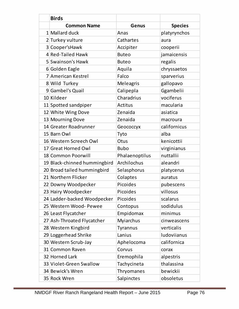
BirdsCommon Name Genus Species
1 Mallard duck Anas platyrynchos2 Turkey vulture Cathartes aura3 Cooper'sHawk Accipiter cooperii4 Red-Tailed Hawk Buteo jamaicensis5 Swainson's Hawk Buteo regalis6 Golden Eagle Aquila chryssaetos7 American Kestrel Falco sparverius8 Wild Turkey Meleagris gallopavo9 Gambel's Quail Calipepla Ggambelii
10 Kildeer Charadrius vociferus11 Spotted sandpiper Actitus macularia12 White Wing Dove Zenaida asiatica13 Mourning Dove Zenaida macroura14 Greater Roadrunner Geococcyx californicus15 Barn Owl Tyto alba16 Western Screech Owl Otus kenicottii17 Great Horned Owl Bubo virginianus18 Common Poorwill Phalaenoptilus nuttallii19 Black-chinned hummingbird Archilochus aleandri20 Broad tailed hummingbird Selasphorus platycerus21 Northern Flicker Colaptes auratus22 Downy Woodpecker Picoides pubescens23 Hairy Woodpecker Picoides villosus24 Ladder-backed Woodpecker Picoides scalarus25 Western Wood- Pewee Contopus sodidulus26 Least Flycatcher Empidomax minimus27 Ash-Throated Flycatcher Myiarchus cinweascens28 Western Kingbird Tyrannus verticalis29 Loggerhead Shrike Lanius ludoviianus30 Western Scrub-Jay Aphelocoma californica31 Common Raven Corvus corax32 Horned Lark Eremophila alpestris33 Violet-Green Swallow Tachycineta thalassina34 Bewick's Wren Thryomanes bewickii35 Rock Wren Salpinctes obsoletus
NMDGF River Ranch Rangeland Health Report – June 2015 Page 76

36 Canyon Wren Catherpes mexicanus37 Blue-gray Gnatcatcher Polioptila Caerulea38 Western Bluebird Sialia mexicanua39 Northern Mockingbird Mimus polyglottus40 Curve-bill Thrasher Toxostroma curviostre41 Sage Thrasher Oreoscoptes montanus42 American Robin Turdus migratorius43 Lucy's Warbler Vermivora luciae44 Yellow Warbler Dendroica petechia45 Yellow-rumped Warbler Dendroica coronata46 Wilson's Warbler Wilsonia pusilla47 Yellow Breasted Chat Icteria virens48 Black-Headed Grosbeak Pheucticus melanocephalus49 Rose-breasted Grosbeak Pheucticus ludoviianus50 Canyon Towhee Pipilo fuscus51 Spotted Towhee Pipilo maculitus52 Blacked-throated Sparrow Amphispiza bilineata53 Chipping Sparrow Spizella passerina54 White-crowned Sparrow Zonotrichia leucophrys55 Bullock's Oriole Icterus bullocki56 Great Tailed Grackle Quiscalus mexicanus57 Brown-headed Cowbird Molothrus ater58 House Finch Carpodacus mexicanus
Birds Continued
NMDGF River Ranch Rangeland Health Report – June 2015 Page 77

Mammals (sighting, tracks, call, burrow, or scat)Common Name Genus Species
1 unknown Bat seen midday large chocolate brown2 Coyote Canis latrans3 Badger Taxidea taxus4 Raccoon Procyon lotor5 Rock Squirrel Citellus variegatus6 Merriam Kangaroo Rat Dipodomis merriami7 Beaver Castor canadensis8 Mexican Woodrat Neotoma mexicana9 Javalina Pecari angulatus
10 Blacktail Jackrabbit Lepus californicus11 Desert Cottontail Sylvilagus audoboni12 Elk Cervus canadensis13 Mule Deer Odocoileus hemionus14 Pronghorn Antelope Antilocapra americana
NMDGF River Ranch Rangeland Health Report – June 2015 Page 78

Appendix E: Literature References
Cox, J.R. and H.L. Morton, 1986, Big sacaton (Sporobolus wrightii) riparian grassland management: Annual winter burning, annual winter mowing and spring-summer grazing. Journal of Applied Agricultural Research, 1: 105-111.
Cox, Jerry R. 1988, Seasonal burning and mowing impacts on Sporobolus wrightii grasslands. Journal of Range Management, 41(1): 12-15.
Holecheck. Jerry. L. 1994, Brush control considerations, a financial perspective. Rangelands 16(5): 193-197.
NM Brush and Weed Control Committee. 2011, Mesquite Control in New Mexico. Monograph; viii, 24 p., ill., 22 cm.; J87.N6 X311.42, Circular no. 505
Robinette, D. 2009. Prescribed Burning in Giant Sacaton Bottomlands Santa Cruz NRCD, Babacomari Cattle Ranch, Elgin, AZ
Steinberg, Peter. 2001. Prosopis glandulosa. In: Fire Effects Information System, [Online]. U.S. Department of Agriculture, Forest Service, Rocky Mountain Research Station, Fire Sciences Laboratory (Producer). Available: http://www.fs.fed.us/database/feis/ [ 2015, May 26].
Wilson, Thomas B.; Webb, Robert H.; Thompson, Thomas L. 2001. Mechanisms of range expansion and removal of mesquite in desert grasslands of the Southwestern United States. Gen. Tech. Rep. RMRS-GTR-81. Ogden, UT: U.S. Department of Agriculture, Forest Service, Rocky Mountain Research Station. 23 p.
NMDGF River Ranch Rangeland Health Report – June 2015 Page 79

30
Appendix C. River Ranch Riparian Assessment

________________________________________________________________________
River Ranch Riparian Assessment
A Survey of Current Ecological Conditions to
Support Resource Management Planning ________________________________________________________________________
________________________________________________________________________
Natural Heritage New Mexico Report – 15-GTR-388 For
New Mexico Department of Game and Fish
June 2015

i
River Ranch Riparian Assessment
A Survey of Current Ecological Conditions to Support Resource Management Planning1
Elizabeth Milford, Esteban Muldavin, and Yvonne Chauvin
Natural Heritage New Mexico, Biology Department, University of New Mexico, Albuquerque, New Mexico 87131
June 2015 ________________________________________________________________________
Executive Summary
The New Mexico Department of Game and Fish (NMDGF) is developing a natural resources
management plan for its newly acquired River Ranch property along the Mimbres River in Luna County,
NM. The long-term goals for the River Ranch are to maintain and improve riparian habitat for all wildlife
species as well as species of greatest conservation need (SGCN). To help meet these goals and support
the planning process, this riparian assessment was conducted on River Ranch May 18 to 20, 2015 to
provide baseline data on biotic and abiotic habitat conditions using the New Mexico Rapid Assessment
Method for Lowland Riverine Wetlands (NMRAM). The NMRAM is a semi-quantitative and efficient
approach to sampling and assessing the ecological status of riverine wetland and riparian areas. The
NMRAM assessment uses a combination of mapping analysis and field surveys to measure 12 metrics
that reflect landscape context, biotic, and abiotic attributes of the riparian ecosystem. These in turn are
rolled-up into an overall ecological condition score by sampling area (SA) and averaged for the site as a
whole.
River Ranch is located approximately 38 km (23 mi) north of Deming, NM on the north edge of
Luna County, within the lower portion of the Mimbres River. The section of the Mimbres River on which
the River Ranch is located is among the last wet portions of the river were it leaves the confines of the
Mimbres Valley and enters the wide, closed desert basin to the south. At the River Ranch, the Mimbres
has mostly perennial flow. However, surface flow can be intermittent, particularly in the summer
months. The River Ranch has a diversity of riparian vegetation communities. These include relatively
large and mature woodland stands dominated by Fremont’s Cottonwood (Populus fremontii),
Goodding’s willow (Salix gooddingii), and velvet ash (Fraxinus velutina), shrublands along the river banks
and some low terraces, and extensive swaths of big sacaton (Sporobolus wrightii) grasslands on the
upper terraces. Associated with this diversity of vegetation communities is a wealth of fauna.
On the River Ranch, livestock grazing was the most recent land use, but the ranch also contains
a few old fields. South of the upstream property boundary 0.6 km (0.4 mi) there is an earthen irrigation
1 Final report Project Work Order Number EEP-150302, New Mexico Department of Game and Fish to the
University of New Mexico.

ii
diversion dam that was diverting about 80% of the base flow when the site was visited in May 2015.
The dam diverts water into an irrigation ditch that runs along the eastern side of the floodplain.
Based on the NMRAM assessment the River Ranch riparian wetlands overall are currently in
excellent condition, with both the lower and upper SA rating excellent, and the middle SA rated good.
The ranch average for both landscape context and biotic metrics was also excellent. The abiotic metrics
were rated in the good category. However, the data from some individual metrics also point out areas
where management is needed to maintain or improve the condition status of the ranch. Both in some
of the biotic and abiotic metrics, there are indications of a decline in groundwater, and losses in
hydrologic connectivity on the ranch. Most measurements showed that these declines were more
severe below the irrigation diversion dam. In particular, the metric Vegetation Vertical Structure
indicated a lack of riparian shrub layers across the lower portion of the ranch, indicating a reduced
groundwater table, as well as possible removal by livestock in the past. Across the ranch scores for the
metric Native Riparian Tree Regeneration were low, with very few young trees observed. This can
indicate both a reduced groundwater table, a loss of hydrological connectivity to the floodplain, and/or
removal of seedling and sapling trees by livestock. Finally the metric Hydrologic Connectivity, which was
measured using two different methodologies, indicated a minor to moderate loss in connectivity from
the expected, with the lowest connectivity scores coming from the middle SA, just below the irrigation
dam.
The recommendations from this assessment are:
1. Maintain maximum possible base flows in the active river channel, particularly in the
growing season, and in keeping with the property water rights. If possible this should
include a redesign of the irrigation dam, and active flow in the irrigation ditch only when
needed for downstream irrigation.
2. Livestock should be kept out of the active channel and adjacent riparian zone until the
woody riparian vegetation has had a chance to reproduce and mature. Once vegetation has
recovered, if grazing is considered, livestock use should be carefully monitored, and access
to the active channel should be limited or excluded.
3. If recommendations 1 and 2 do not produce an improvement in riparian tree reproduction,
it is suggested that the ranch management look into more active restoration, including
earthwork.
4. Big sacaton stands around the large mature tree stands should be managed to create fire
breaks to reduce fire risk to the forests.
5. Removal of the few saltcedar and Russian olive individuals on the ranch is recommended to
prevent expansion of these species and future ecosystem disruption.

iii
Table of Contents
Introduction ..................................................................................................................................... 1Methods........................................................................................................................................... 2
Study area.................................................................................................................................... 2Location and hydrology .......................................................................................................... 2Vegetation and Fauna ............................................................................................................. 6Land use history ...................................................................................................................... 8
Sampling design and analysis ..................................................................................................... 9Results ........................................................................................................................................... 11
NMRAM Scores ....................................................................................................................... 11Discussion ..................................................................................................................................... 21
Summary of Recommendations ................................................................................................ 24References ..................................................................................................................................... 26
Tables
Table 1. River Ranch vegetation plant associations. ..................................................................... 8Table 2. NMRAM Lowland Version 1.0 list of Metrics............................................................... 11Table 3. NMRAM scores for all metrics. ..................................................................................... 12Table 4. Entrenchment Ratios measured for cross-section and average for each SA................... 15
Figures
Figure 1. The Mimbres River near the northern boundary of the River Ranch. ............................ 1Figure 2. River Ranch study area showing three NMRAM Sampling Areas (SAs). ...................... 3Figure 3. Average, maximum, and minimum monthly discharge on the Mimbres River at
Mimbres NM (Gage Station 08477110). ............................................................................... 4Figure 4. Daily discharge at Mimbres gage from Oct 2007 to May 2015 ...................................... 4Figure 5. Annual peak flow in cfs for Mimbres gage from 1978 to 2012. ..................................... 5Figure 6. There are large expanses of big sacaton grasslands on the River Ranch. ....................... 5Figure 7. The Mimbres though the River Ranch supports a wide variety of riparian habitats. ...... 6Figure 8. A Clarks spiny lizard in a Freemont cottonwood on the south end of Tigner grove. .... 6Figure 9. Provisional soils map for River Ranch developed by the Natural Resources
Conservation Service, Las Cruces Office. .............................................................................. 7Figure 10. Earthen irrigation dam in the river channel looking upstream and north. ..................... 9Figure 11. Gooding’s willow branch in the active channel with adventitious shoots .................. 14Figure 12. Fallen cottonwood blocking main channel on lower SA............................................. 16Figure 13. Head cut at top of new channel, just below fallen cottonwood ................................... 16Figure 14. Vegetation Polygon Map for Upper SA - 45Mimbre062.7. ........................................ 18Figure 15. Vegetation Polygon Map for Middle SA - 45Mimbre061.4. ...................................... 19Figure 16. Vegetation Polygon Map for Lower SA - 45Mimbre060.0. ....................................... 20
Cover: View from western terrace towards Mimbres River near the center of the River Ranch property (Photo by E. Muldavin).

1
Introduction
The New Mexico Department of Game and Fish (NMDGF) is developing a natural resources management plan for its newly acquired River Ranch property along the Mimbres River in Luna County, NM. The long-term goals for the River Ranch are to maintain and improve riparian habitat for all wildlife species as well as species of greatest conservation need (SGCN). To help meet these goals and support the planning process, this riparian assessment was conducted on River Ranch May 18 to 20, 2015 to provide baseline data on biotic and abiotic habitat conditions using the New Mexico Rapid Assessment Method for Lowland Riverine Wetlands (NMRAM)2.
The NMRAM is a semi-quantitative and efficient approach to sampling and assessing the ecological status of riverine wetland and riparian areas. For River Ranch, three sampling areas (SAs) were established for the assessment, distributed such that they captured the range of variation in riparian ecological conditions. The NMRAM assessment uses a combination of mapping analysis and field surveys to measure 12 metrics that reflect landscape context, biotic, and abiotic attributes of the riparian ecosystem. These in turn are rolled-up into an overall ecological condition score by SA and averaged for the site as a whole. Based on the information gathered in the NMRAM process—the individual metric scores and other observations made while on the site—we provide an assessment of current conditions with a discussion of the implications for maintaining and improving the riparian habitat of the ranch.
2 The most current version of the NMRAM Handbook and Field Guides can be downloaded from the New Mexico Environment Department, Surface Water Quality Bureau, Wetlands Program website at https://www.env.nm.gov/swqb/Wetlands/NMRAM/. The Lowland draft manual should be available from the site in the fall of 2015.
Figure 1. The Mimbres River near the northern boundary of the River Ranch.

2
Methods
Study area
Location and hydrology
River Ranch is located approximately 38 km (23 mi) north of Deming, NM on the north edge of Luna County, within the lower portion of the Mimbres River (Figure 1). The section of the Mimbres River on which the River Ranch is located is among the last wet portions of the river where it leaves the confines of the Mimbres Valley and enters the wide, closed desert basin to the south. Approximately 5 km (3 mi) below the southern River Ranch boundary the Mimbres becomes a dry drainage that only carries surface flows during large precipitation events. The River Ranch incorporates 3.8 km (2.3 mi) of river reach flowing from north to south, with elevations that range from 1,543 m (5,060 ft) at the upper end to 1,518 m (4,980 ft) at the lower, resulting in a low stream gradient (approximately 0.6-0.7%).
The floodplain varies from approximately 130 to 500 m in width, but is 200 to 400 m in
width on average. The narrower floodplain widths occur at the northern (upstream) end of the River Ranch, where the Mimbres passes through a natural confinement created by bedrock at the base of a hill on the west and a ridge to the east. At the River Ranch, the Mimbres has mostly perennial flow sustained by discharge from a drainage basin of 1,335 km2 (515 mi2). However, surface flow throughout the upper Mimbres valley can be intermittent, particularly in the summer months, due to climatic conditions and irrigation withdrawals (Cooper 2013).
There are no stream gages with consistent data on the Mimbres River below the River
Ranch, but there is a gage at the town of Mimbres (Gage Station 08477110) 38 km (23 mi) upstream of the study site that is used here to understand the general flow regime of the river. Data for this gage is available for the years 1978 to 2014. In general, the data set was complete, but there was a 15-month gap between June 2013 and Oct 2014. Also, peak discharge data was only available for some years. Stream flow shows bi-modal peak flows, with one peak occurring between February and March, and the other occurring in August (Fig. 3). The system is driven by both winter snowmelt and later summer precipitation, with both capable of producing large- magnitude flows. The large peak flow from the fall of 2014 was just under 500 cfs at the Mimbres gage (Fig. 4). Similarly sized peak flow events occurred in 2012 and 2008. Within the period of record, there have been 12 peak-flow events that were more than 1000 cfs, and approximately five in the 500-1000 cfs range (Fig. 5), giving the 2014 flow a two-to-three-year return interval.

3
Figure 2. River Ranch study area showing three NMRAM Sampling Areas (SAs).

4
0
50
100
150
200
Jan Feb Mar Apr May Jun Jul Aug Sep Oct Nov Dec
Dis
char
ge c
fs
Month
Mimbres Gage #8477110Monthy Mean Discharge
1978-2014*
Avg
Min
Max
* Data from some years/months missing
Figure 3. Average, maximum, and minimum monthly discharge on the Mimbres River at Mimbres NM (Gage Station 08477110). Gage period 1978 to 2014.
Figure 4. Daily discharge at Mimbres gage from Oct 2007 to May 2015
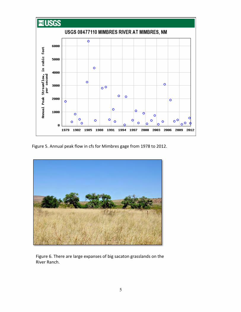
5
Figure 5. Annual peak flow in cfs for Mimbres gage from 1978 to 2012.
Figure 6. There are large expanses of big sacaton grasslands on the River Ranch.
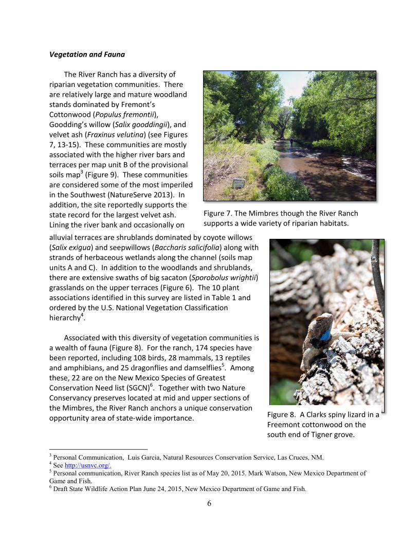
6
Vegetation and Fauna
The River Ranch has a diversity of riparian vegetation communities. There are relatively large and mature woodland stands dominated by Fremont’s Cottonwood (Populus fremontii), Goodding’s willow (Salix gooddingii), and velvet ash (Fraxinus velutina) (see Figures 7, 13-15). These communities are mostly associated with the higher river bars and terraces per map unit B of the provisional soils map3 (Figure 9). These communities are considered some of the most imperiled in the Southwest (NatureServe 2013). In addition, the site reportedly supports the state record for the largest velvet ash. Lining the river bank and occasionally on
alluvial terraces are shrublands dominated by coyote willows (Salix exigua) and seepwillows (Baccharis salicifolia) along with strands of herbaceous wetlands along the channel (soils map units A and C). In addition to the woodlands and shrublands, there are extensive swaths of big sacaton (Sporobolus wrightii) grasslands on the upper terraces (Figure 6). The 10 plant associations identified in this survey are listed in Table 1 and ordered by the U.S. National Vegetation Classification hierarchy4.
Associated with this diversity of vegetation communities is a wealth of fauna (Figure 8). For the ranch, 174 species have been reported, including 108 birds, 28 mammals, 13 reptiles and amphibians, and 25 dragonflies and damselflies5. Amongthese, 22 are on the New Mexico Species of Greatest Conservation Need list (SGCN)6. Together with two Nature Conservancy preserves located at mid and upper sections of the Mimbres, the River Ranch anchors a unique conservation opportunity area of state-wide importance.
3 Personal Communication, Luis Garcia, Natural Resources Conservation Service, Las Cruces, NM. 4 See http://usnvc.org/. 5 Personal communication, River Ranch species list as of May 20, 2015. Mark Watson, New Mexico Department of Game and Fish. 6 Draft State Wildlife Action Plan June 24, 2015, New Mexico Department of Game and Fish.
Figure 7. The Mimbres though the River Ranch supports a wide variety of riparian habitats.
Figure 8. A Clarks spiny lizard in a Freemont cottonwood on the south end of Tigner grove.

7
Figure 9. Provisional soils map for River Ranch developed by the Natural Resources Conservation Service, Las Cruces Office.

8
Table 1. River Ranch vegetation plant associations based on the 2015 reconnaissance survey as order by the U.S. National Vegetation Classification hierarchy (http://usnvc.org/).
National Vegetation Classification Hierarchy NVC Code
1 Forest to Open Woodland
1.B Temperate & Boreal Forest
1.B.3 Temperate Flooded & Swamp Forest
1.B.3.Nd Southwest North American Flooded & Swamp Forest
M036 Warm Southwest Riparian Forest
G508 Sonoran-Chihuahuan Lowland Riparian Forest Group
Fraxinus velutina - Celtis laevigata var. reticulata / Sporobolus wrightii Woodland NHNM000875
Populus fremontii - Juglans major Forest NHNM000874
Populus fremontii - Salix gooddingii / Baccharis salicifolia Forest CEGL002683
Populus fremontii - Salix gooddingii Woodland CEGL000944
Populus fremontii / Sporobolus wrightii Woodland NHNM000878
Salix gooddingii/Baccharis salicifolia Woodland NHNM000877
2 Shrubland & Grassland
2.B Temperate & Boreal Grassland & Shrubland
2.B.6 Temperate & Boreal Freshwater Marsh, Wet Meadow & Shrubland
2.B.6.Nc Southwestern North American Warm Desert Freshwater Marsh
M076 Warm Desert Freshwater Shrubland, Meadow & Marsh
G533 North American Warm Desert Riparian Low Bosque & Shrubland Group
Baccharis salicifolia / Gravel Bar Shrubland CEGL005951
Baccharis salicifolia/Sporobolus wrightii Shrubland NHNM000876
3 Desert & Semi-Desert
3.A Warm Desert & Semi-Desert Woodland, Scrub & Grassland
3.A.2 Warm Desert & Semi-Desert Scrub & Grassland
3.A.2.Na North American Warm Desert Scrub & Grassland
M086 Chihuahuan Desert Scrub
G289 Chihuahuan Mesquite Upland Scrub Group
Prosopis glandulosa / Sporobolus wrightii Shrubland NHNM000653
M087 Chihuahuan Semi-Desert Grassland
G489 Chihuahuan Semi-Desert Lowland Grassland Group
Sporobolus wrightii / Monotypic Herbaceous Vegetation NHNM000270
Land use history The Mimbres valley has a long history of human use going back to the prehistoric
Mimbreño people. Within the last two centuries it has been significantly altered by human activities. The biggest changes to the watershed were initiated by landscape-altering grazing from large numbers of imported livestock and extensive logging for the booming mining industry of the late 19th and early 20th century. Although the forests recovered, the soils and watercourses have not. The Mimbres may have been more cienega-like in the past (NMDGF 2006). Agricultural surface-water diversion, groundwater withdrawal, inappropriate livestock management, channelization, and invasion of exotic plants and animals remain significant threats to the Mimbres River ecosystem as a whole (Cooper 2013).

9
Figure 10. Earthen irrigation dam in the river channellooking upstream and north.
On the River Ranch, livestock grazing was the most recent land use, but the ranch also contains a few old fields, and a very old tomato cannery. South of the upstream property boundary 0.6 km (0.4 mi) there is an earthen irrigation diversion dam approximately three feet higher than the river bottom on the west side, and six feet higher on the east side (Figure 2). The dam had been recently replaced, because the fall 2014 flood had removed the previous
dam, and filled the ditch headgate with sediment.7 This dam was diverting about 80% of the base flow when the site was visited in May 2015. The dam diverts water into an irrigation ditch that runs along the eastern side of the floodplain. In May 2015, the water was being returned to the river via overland flow just above the lower ranch boundary. The ditch continues south along the edge of the floodplain to actively cultivated fields below the property boundary.
Sampling design and analysis
The New Mexico Rapid Assessment Method for Riverine Wetlands (NMRAM) was used to assess the current condition of the Riparian Wetlands on the River Ranch. This assessment method examines landscape context, biotic and abiotic attributes of a wetland of interest, and is based on a combination of mapping and field observations. Currently there are two modules of the NMRAM for unconfined riverine systems. One is for smaller montane streams with gradients above one percent and at higher elevations and associated with montane riparian vegetation, and the other for larger lowland rivers with gradient less than one percent and dominated by desert riparian vegetation. The lower Mimbres, while a relatively small river, occurs in a lowland setting with the type of vegetation and stream gradient that is consistent with the requirements of the Lowland module. Hence, data was collected using the Lowland module (version 1.0). Yet, because it is a small river we also employed a few components of the Montane module that we thought might help in the assessment as supplemental information.
NMRAM data collection occurs in discrete Sampling Areas (SA) with defined boundaries. For the River Ranch, three SAs were created. These SAs were distributed more or less equally from north to south across the property to obtain a representative sample of conditions on the
7 Personal communication, Mark Watson, NMDGF.

10
ranch and to capture the range in variation across the property (Fig 1). There are 12 metrics distributed across three attribute categories: landscape context, biotic, and abiotic (Table 1). Each metric is assessed and assigned a rating based on the data. The data and the scores themselves are entered onto the NMRAM datasheets. The datasheet contains a roll-up table which takes all the individual scores and calculates new scores by attribute categories and then an overall SA score based on the attribute scores. The SA scores for a site are then averaged to produce an overall project score. Finally, the NMRAM datasheets include a series of stressor checklists, which although not used in calculating the final SA score, are included as ancillary information on factors that may be affecting the conditions of the wetland. Copies of the complete NMRAM datasheets, with all of the data collected are provided as part of the Digital Addendum and summaries of the data and are reported below.
All data collected by the NMRAM is done on a rank scale of A to D (4 to 1), with A
representing a wetland in Excellent condition, B a wetland in Good condition, C a wetland in Fair condition, and D a wetland in Poor condition. The implication is that wetlands in excellent condition are providing all of their expected functions and services, while wetlands in poor condition are providing few to none of their expected functions and services. Full descriptions of all the methods for collecting NMRAM data and metric descriptions and rationale can be obtained from the NMRAM field guides available on the New Mexico Environment Departments website (https://www.env.nm.gov/swqb/Wetlands/NMRAM/).
As part of the NMRAM biotic metric assessment process, a vegetation patch map was
created for each SA. These were digitized in GIS and are provided as shapefiles in the Digital Addendum. Additionally, photographs of each vegetation patch were taken, as well as photographs of channel cross-sections, and other features. All photographs are provided in the digital addendum included with the report. The locations of some vegetation and abiotic features, as well as the channel cross-sections were recorded with a Garmin GPS with an accuracy of +/- 3 m (Digital Addendum). An electronic Data Addendum to this report contains all of the raw data in PDF files, along with the photo files and a PDF of this report.

11
Table 2. NMRAM Lowland Version 1.0 list of Metrics.
Attribute categories and metrics
Score weights
Attributes Metrics
Landscape Context Metrics 0.3
1. Buffer Integrity Index 0.3
2. Riparian Corridor Connectivity 0.3
3. Relative Wetland Size 0.2
4. Surrounding Land Use 0.2
Biotic Metrics 0.35
1. Relative Native Plant Community Composition 0.3
2. Vegetation Horizontal Patch Structure 0.2
3. Vegetation Vertical Structure 0.2
4. Native Riparian Tree Regeneration 0.1
5. Invasive Exotic Plant Species Cover 0.2
Abiotic Metrics 0.35
1. Hydrologic Connectivity 0.4
2. Physical Patch Diversity 0.4
3. Soil Surface Condition 0.2
Results
NMRAM Scores
The NMRAM rating scores by attribute category and metric for each sampling area and the overall site scores are provided in Table 3. Each of the metrics measures a different aspect of riparian condition. Below we will present a brief introduction to each of the metrics measured on the ranch, along with the conditions that lead to the scores of each.
Landscape context metrics are designed to measure the conditions surrounding an SA, and are primarily assessed using a GIS, with field confirmation. The Buffer Integrity Index, which is composed of two sub-metrics, Buffer Percent and Buffer Width, is a measure of the amount of natural and semi-natural vegetated buffer on the lateral sides of the SA. Vegetated buffers enhance wetland function and protect the wetland from anthropogenic environmental

12
stressors. Overall buffers on the River Ranch were excellent, with only a slight reduction in width due to Highway 61 to the west, and the dirt County Road to the east.
Table 3. NMRAM scores for all metrics by attribute categories for each sampling area and the overall ranch average.
Sampling Areas
Upper Mid Lower
62.7 61.4 60.0
Ranch
Avg.
Landscape Context Attributes
Buffer Integrity Index 3.5 4 3.5 3.67
Buffer Percent 4 4 4 4
Buffer Width 3 4 3 3.33
Riparain Corridor Connectivity 4 4 4 4
Relative Wetland Size 3 3 4 3.33
Surrounding Land Use 3 3 3 3
Biotic Metrics
Relative Native Plant Community Composition 4 4 3 3.67
Vegetation Horizontal Patch Structure 4 3 4 3.67
Vegetation Vertical Structure 3 2 2 2.33
Native Riparain Tree Regeneration 2 1 2 1.67
Invasive Exotic Pland Species Cover 4 4 4 4
Abiotic Metrics
Hydrologic Connectivity (Multi-channel) 3 2 3 2.67
Physical Patch Diversity 3 3 4 3.33
Soil Surface Condition 4 4 4 4
Additional Montane Abiotic Metrics (Not in score roll-up)
Hydrologic Connectivity (Montane) 2 1 3 2.00
Channel Stability 3 3 3 3
Stream Bank Stability and Cover 3 3 2 2.67
Landscape Context Score 3.45 3.6 3.65 3.57
Biotic Score 3.6 3.1 3.1 3.27
Abiotic Score 3.2 2.8 3.6 3.2
SA Wetland Condition Score 3.415 3.145 3.44 3.33
SA Wetland Rank A B A A

13
Riparian Corridor Connectivity (RCC) measures the integrity of connectivity versus fragmentation of the riverine corridor upstream and downstream from the SA. Intact riparian corridors allow for unimpeded movement of wildlife, intact habitat, and propagation of plant communities. On the ranch riparian corridor connectivity was also excellent. The only break in riparian corridor connectivity that was measured was the earthen dam, but it was small enough to not lower the RCC rating.
Relative Wetland Size is an index of reduction of the current wetland size relative to its
estimated historical extent, due to human-induced disturbances, particularly land-use conversions. Large reductions of area can alter hydrology and ecosystem processes, and may create ecological instability or reduce viability. Overall the ranch had good relative wetland size, and only missed an Excellent rating for this metric due to the presence of old fields at the edge of the floodplain on its east side.
Surrounding Land Use measures the amount and intensity of human land use in the
buffer zone surrounding the SA. The intensity of human activity in the landscape has a proportionate impact on the ecological processes of the riparian ecosystem. The ranch was rated Good on surrounding land use. The rating table for surrounding land use is very strict for the Excellent category, so although the ranch is mostly surrounded by undeveloped range land, there were enough roads and fields in the buffer zone to move it to the Good category.
Biotic metrics measure key biological attributes within the wetland that reflect
ecosystem integrity. Relative Native Plant Community Composition is an index of the abundance of native-dominated vegetation communities versus exotic-dominated vegetation communities. High native plant species diversity generally indicates overall high biotic diversity, stability of wetland biotic communities, increased wildlife habitat and species diversity. The ranch received an Excellent score on relative native-plant community composition. The lower SA scored a Good rather than Excellent on this metric, but that was due to exotic herbaceous species in the understory. Woody dominant species throughout the ranch are predominantly native. Of note, the introduced shrub bird-of-paradise (Caesalpinia gilliesii) was found in scattered patches on the high terraces, although not in large enough numbers to affect the metric rating.
Vegetation Horizontal Patch Structure is an assessment of general vegetation patch
diversity and complexity of the patch pattern (interspersion) within and SA. Multiple horizontal plant patches across the SA indicate high biotic diversity and a history of dynamic fluvial processes. The ranch as a whole earned an Excellent rating on this metric, and generally a high number of different vegetation patches were recorded. However, the amount of area per patch was not very equally distributed in the middle SA, where there was a majority of one vegetation type, big sacaton grasslands.
Vegetation Vertical Structure is an assessment of the overall vertical structural
complexity and richness of the vegetation canopy layers across the SA. Vertical vegetation structure is an integral part of habitat structure and is correlated with overall biodiversity. The

14
ranch earned only a Fair rating on this metric, due to limited riparian shrub layers, both in the understory of mature forest patches and as independent stands. Of note, the upper SA did earn a rating of Good on this metric, as it had a greater percentage of forest with shrub understory than the other SAs.
Native Riparian Tree Regeneration assesses the abundance of riparian tree reproduction
across the SA. Healthy functioning riverine wetlands should consist of a mosaic of woody vegetation stands that include stands of both mature and young regeneration trees. Absence of young trees may indicate ecological dysfunction. The ranch earned a Poor rating on this metric, due to a near absence of native riparian tree reproduction. The upper and lower SAs did earn Fair ratings on this metric, but still had very little active tree reproduction. The majority of reproduction that was seen on the ranch was root, or adventitious shoots (Figure 11)
Invasive Exotic Plant
Species Cover is a measure of the total percent cover of a set of exotic plant species that are considered invasive based on the New Mexico list of noxious weeds8. Invasive non-native species can have a significant impact on community diversity and function. High levels of invasive exotic species within a riparian plant community are a direct threat to maintaining wetland function and biodiversity. The ranch earned an Excellent rating on this metric, as did all three SAs. Only a few isolated Russian olive and saltcedar individuals were observed across the ranch.
The abiotic metrics focus on hydrological conditions, physical ecological complexity and
anthropogenic disturbances. Hydrologic Connectivity is an assessment of the ability of water to flow into or out of the wetland or to inundate adjacent areas. Surface hydrological connectivity between a river and riverine wetlands formed on its floodplain supports key ecological functions and plant and wildlife habitat diversity by promoting an exchange of water, sediment, nutrients and organic carbon (Collins et al. 2008). On the River Ranch we assessed Hydrologic Connectivity using the Lowland module narrative rating system for multi-channel systems, as the method most suited to the lower Mimbres. Using this method the ranch rated Good on
8 List maintained by the New Mexico Department of Agriculture, last updated 2009. Available on the website http://www.nmda.nmsu.edu/apr/noxious-weed-information/
Figure 11. Gooding’s willow branch in the active channel with adventitious shoots (Lower SA).

15
Hydrologic Connectivity as a whole. The majority of back and side channels showed evidence of flow from the fall 2014 flood event, which was estimated to be a two to five-year return event based on gage data (Figures 4 and 5). Of note, the middle SA showed less evidence of water flow through its side channels and thus rated only a Fair on Hydrologic Connectivity.
To get a more complete picture of the Hydrologic Connectivity on the ranch, we also measured the entrenchment ratio within the active channel using the protocols from the Montane module. While entrenchment ratio does not give a complete picture of flow patterns in a multi-channel system, it does speak to the ease or difficulty for water to move out of the main active channel. The entrenchment ratios, with their ratings from the Montane module, are provided in Table 4. As a whole the ranch scored a Fair rating on Hydrologic Connectivity as measured by this method, due to generally poor entrenchment ratios. However, there was a great deal of variability in entrenchment ratios between the SAs, and even within SAs. The lower SA had the least amount of entrenchment on average, but also had the widest variability on entrenchment ratios between cross-sections, with ratios spanning Excellent to Poor. The lower SA also had the highest number of active side and back channels, and showed evidence of a highly dynamic fluvial process. Between the middle and lower cross sections on the lower SA there was a fallen cottonwood in the channel that had recently caused the active channel to be abandoned (Figure 12). Below the fallen tree a head cut had formed a new active channel, while the former main channel was now a side channel (Figure 13). The channel below this head cut was the one with the worst measured entrenchment ratio on the SA.
Table 4. Entrenchment Ratios measured for cross-section and average for each SA. U=Upper cross-section, M=Middle cross-section, L=Lower cross section.
SA
Cross
Section
Entrenchment
Ratio
NMRAM
Rating
Upper (062.7) U 1.96 3 (B)
M 1.45 1 (D)
L 1.28 1 (D)
SA Average 1.56 2 (C)
Middle (061.4) U 1.08 1 (D)
M 1.37 1 (D)
L 1.32 1 (D)
SA Average 1.26 1 (D)
Lower (060.0) U 3.19 4 (A)
M 1.73 2 (C)
L 1.15 1 (D)
SA Average 2.02 3 (B)
River Ranch Average 1.61 2 (C)

16
Physical Patch Diversity describes the physical structural richness of riverine wetlands and associated channels. Variety in physical features leads to a varied and complex habitat that fosters biological diversity. Overall the ranch had an Excellent rating for physical patch diversity, due to a high number of side and back channels, as well as other physical patch types spread across the floodplain. The lower SA was particularly diverse due dynamic multiple channels.
Soil Surface Condition is
a measure of anthropogenic disturbance to the wetland and riparian soils that results in modification of soil characteristics. Disturbance to the soil can affect biological, physical and chemical processes and impede wetland function. The ranch overall, and all three SAs, scored an Excellent rating on soil surface condition, due to the very minimal level of development throughout the ranch.
In addition to the Lowland
module metrics, we also collected Channel Stability, and Stream Bank Stability and Cover metric data using the Montane module protocols. These metrics are not included in the Lowland module because they are not well suited to sand-bedded lowland rivers. Because of this the data collected with these metrics on the River Ranch can only be considered descriptive, and is included here to broaden our understanding. Channel Stability assesses the degree of channel aggradation or degradation based on the departure from characteristic pattern, profile, and dimension. Large, persistent changes to the flow or sediment regime caused by upstream land-use changes, alterations of the watershed, or climatic changes tend to destabilize the channel and cause it to change form (Collins et al. 2008). Overall the ranch as a whole rated a Good on this metric. There were slight indications of aggradation, particularly in the upper SA, but most of the indicators
Figure 12. Fallen cottonwood blocking main channel on lower SA. Beaver activity most likely occurred after the tree fell.
Figure 13. Head cut at top of new channel, just below fallen cottonwood (Figure 12).

17
available to score the metric were only applicable to rock or cobble-bottom streams, so the score is based on three or less indicators per site.
Stream Bank Stability and Cover is a measure of stream bank soil/substrate stability and
stream bank erosion potential that reflect overall stream bank stability, which generally indicates less anthropogenic disturbance. Stable stream banks should support more perennial vegetation and more stable and healthy wetland communities. The ranch overall scored in the Good category on this metric, with the lower SA scoring only fair. In general the banks throughout the ranch had a high degree of variability in the amount of stabilizing vegetation and indicators of erosion potential present, and the scores on this metric often varied greatly from one cross-section to another within an SA.
Based on the NMRAM assessment the River Ranch riparian wetlands overall are in
Excellent condition, with both the lower and upper SA rating Excellent, while the middle SA was rated Good (Table 3). The ranch average for both landscape context and biotic metrics is also Excellent. The abiotic metrics rated in the Good category. However, the data from selected metrics indicate areas of Poor condition, and a potential for future overall conditions to decline without active management, and are discussed below.
There were 14 different vegetation patches types mapped as part of the Biotic Metric data
collection process (Figs. 14 to 16). These patches represent nine recognized plant communities, and four vegetation groups in the U.S. National Vegetation Classification9 (Table 1). Although detailed community composition data was not collected as part of the NMRAM process, there is a wealth of published data available on the majority of the vegetation communities observed on the River Ranch. The ranch’s forest communities dominated by Fremont’s cottonwood, velvet ash and Goodding’s willow are all considered globally rare and highly threatened due to altered hydrologic regimes, flood control structures, and land conversion.
9 Available on http://usnvc.org/

18
Figure 14. Vegetation Polygon Map for Upper SA - 45Mimbre062.7.

19
Figure 15. Vegetation Polygon Map for Middle SA - 45Mimbre061.4.

20
Figure 16. Vegetation Polygon Map for Lower SA - 45Mimbre060.0.

21
Discussion
The remoteness of the River Ranch from urban and town centers provides favorable
landscape context for the site and this is reflected by the high Landscape Context ratings. But there are water-management issues involving upstream and downstream users that will need to be addressed to improve ecological conditions within the property. While the ranch is in overall excellent condition, there are indications that without management intervention ecological conditions will decline. The abiotic and biotic data point to a history of highly dynamic fluvial process that lent to the inherent riparian vegetation and habitat diversity on the ranch. However, the data also show that the system has become less hydrologically connected with limited overbank or terrace flooding and possibly lowered groundwater tables that are impacting the health of the site.
Overall, the River Ranch supports high quality stands of globally rare and important
riparian forest habitat (Figures 14 to 16). However, indications from the NMRAM assessment are that some of these forest stands are relatively old (125+ years), and young reproduction is absent. Most of the forest stands on the ranch consist of old mature trees, with minimal or no riparian shrub understory, which is reflected in the Poor Vertical Vegetation Structure score. Lack of a shrub layer suggests a lowered groundwater table that fails to support wetland obligate and facultative species such as coyote willow (Salix exigua) and seepwillow (Baccharis salicifolia) (Stromberg and Tiller 1996). Further vegetative indicators of a lowered groundwater table were seen in the upland or facultative herbaceous species, such as big sacaton that made up the forest herbaceous understories. Big sacaton, which tolerates deeper water tables than even mature riparian trees (Stromberg and Tiller 1996), also occurred as large nearly monotypic grasslands on the terraces in between the mature forest patches.
Forests with understory shrub layers provide necessary high structure habitat for many
riparian bird species. A healthy, well connected riparian zone would be expected to have a mix of both high structure, shrub rich, forests, and lower structure mature forest stands with open understories. Of note, the upper SA, which is above the irrigation diversion dam, had a better Vegetation Vertical Structure score than the other two SAs, both of which were below the irrigation diversion dam, possibly due to a higher and more stable groundwater table from an undiverted base flow in the river.
The low Vegetation Vertical Structure scores were also related to a paucity of Riparian
shrublands across the ranch. In addition to the obligate and facultative wetland shrub species mentioned above, many riparian shrublands include young riparian trees, which are more sensitive to groundwater depletion than mature trees (Stromberg and Tiller 1996). The limited riparian shrublands on the ranch may also be related to the history of grazing. Coyote willow is highly palatable to cattle, particularly when they are young. Additionally, trampling and soil disturbance from cattle in the active channel and along banks can be deleterious to riparian shrubs. Significant improvements in riparian shrub and herbaceous habitat have been seen with removal from gazing on the Nature Conservancy properties on the Mimbres upstream of
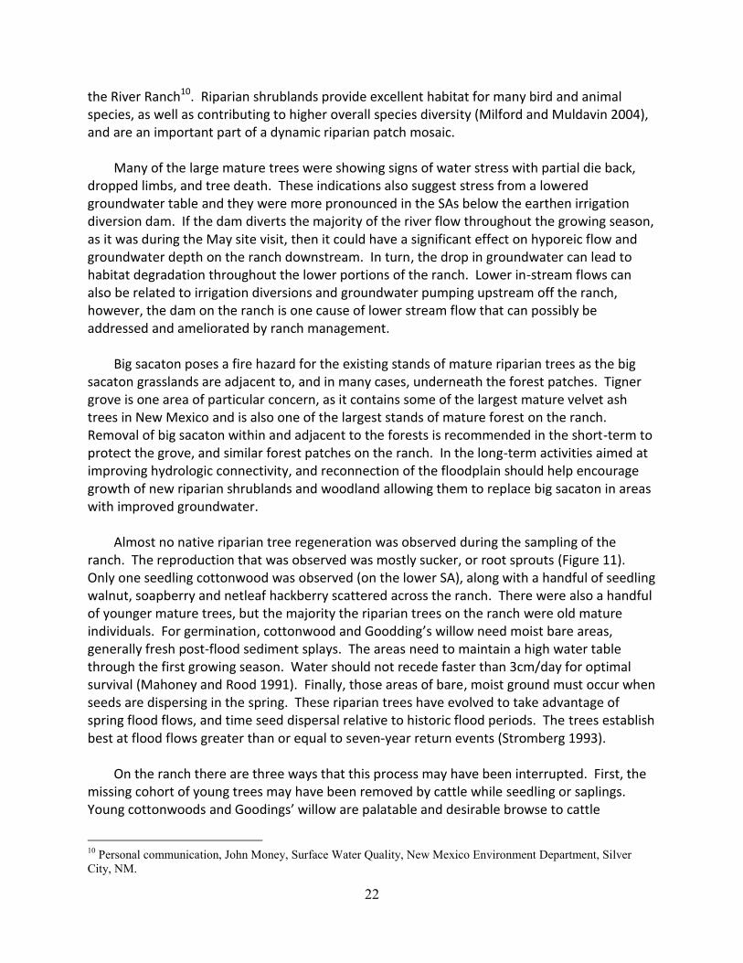
22
the River Ranch10. Riparian shrublands provide excellent habitat for many bird and animal species, as well as contributing to higher overall species diversity (Milford and Muldavin 2004), and are an important part of a dynamic riparian patch mosaic.
Many of the large mature trees were showing signs of water stress with partial die back, dropped limbs, and tree death. These indications also suggest stress from a lowered groundwater table and they were more pronounced in the SAs below the earthen irrigation diversion dam. If the dam diverts the majority of the river flow throughout the growing season, as it was during the May site visit, then it could have a significant effect on hyporeic flow and groundwater depth on the ranch downstream. In turn, the drop in groundwater can lead to habitat degradation throughout the lower portions of the ranch. Lower in-stream flows can also be related to irrigation diversions and groundwater pumping upstream off the ranch, however, the dam on the ranch is one cause of lower stream flow that can possibly be addressed and ameliorated by ranch management.
Big sacaton poses a fire hazard for the existing stands of mature riparian trees as the big sacaton grasslands are adjacent to, and in many cases, underneath the forest patches. Tigner grove is one area of particular concern, as it contains some of the largest mature velvet ash trees in New Mexico and is also one of the largest stands of mature forest on the ranch. Removal of big sacaton within and adjacent to the forests is recommended in the short-term to protect the grove, and similar forest patches on the ranch. In the long-term activities aimed at improving hydrologic connectivity, and reconnection of the floodplain should help encourage growth of new riparian shrublands and woodland allowing them to replace big sacaton in areas with improved groundwater.
Almost no native riparian tree regeneration was observed during the sampling of the ranch. The reproduction that was observed was mostly sucker, or root sprouts (Figure 11). Only one seedling cottonwood was observed (on the lower SA), along with a handful of seedling walnut, soapberry and netleaf hackberry scattered across the ranch. There were also a handful of younger mature trees, but the majority the riparian trees on the ranch were old mature individuals. For germination, cottonwood and Goodding’s willow need moist bare areas, generally fresh post-flood sediment splays. The areas need to maintain a high water table through the first growing season. Water should not recede faster than 3cm/day for optimal survival (Mahoney and Rood 1991). Finally, those areas of bare, moist ground must occur when seeds are dispersing in the spring. These riparian trees have evolved to take advantage of spring flood flows, and time seed dispersal relative to historic flood periods. The trees establish best at flood flows greater than or equal to seven-year return events (Stromberg 1993).
On the ranch there are three ways that this process may have been interrupted. First, the missing cohort of young trees may have been removed by cattle while seedling or saplings. Young cottonwoods and Goodings’ willow are palatable and desirable browse to cattle
10 Personal communication, John Money, Surface Water Quality, New Mexico Environment Department, Silver City, NM.

23
(Stomberg 1993; Samuleson and Rood 2004). Velvet ash reproduction is also affected by grazing (Szaro and Pase 1983). Second, the extensive stands of big sacaton may have limited the available bare ground for seedling establishment. Finally, rapid draw down of the water in the active channel for irrigation in the early summer, and the concomitant drop in the hyporheic zone, may have been too extreme for those seedlings that did establish to survive. Keeping cattle out of the riparian zones, especially when woody riparian vegetation would be most vulnerable in the early spring and summer will prevent loss of young trees to browsing. Maintaining a growing season base flow in the river will aid in maintaining a water table high enough for young trees and shrubs to establish. If, after significant flood events, the two above suggestions are not resulting in native woody reproduction, active earthwork could be used to lower some of the riverside terraces currently dominated by big sacaton, and reconnect them to the river at lower peak flows. This would aid reproduction by both providing bare ground for seed germination, and a higher groundwater table for young trees. It is a technique that has been used with good results on the Rio Grande (Robert 2005; Zeedyk 2009; Muldavin et. al. 2012)
Although all SAs on the ranch scored in the Excellent range for Invasive Exotic Weed Cover, there were scattered individual invasive exotic trees observed. Treating and removing these trees now could prevent a future problem. One Russian olive was observed along the river channel at the lower edge of the upper SA, and there were several scattered individual saltcedars observed in the lower SA. Many of them were marked on the vegetation field maps and invasive exotic weeds are also tracked at the polygon level on the NMRAM datasheets (see digital addendum). Although not considered an invasive exotic species, the introduced shrub bird-of-paradise (Caesalpinia gilliesii) was found in scattered patches on the high terraces, particularly on the eastern side of the ranch. It is not yet widespread enough to affect the Relative Native Plant Community Composition metric, but may continue to spread on the drier floodplain terraces if not addressed.
From the perspective of multi-channel lowland systems, the ranch appeared to be relatively well connected hydrologically. However, there were indications that it was not fully hydrologically connected, particularly in the center of the ranch, just below the irrigation dam. When entrenchment ratio was used to assess hydrologic connectivity, it again was lowest for the center SA. This suggests that the dam is interfering with the hydrologically connectivity, and that the effect is greater proximal to the dam. Although of limited use in a multi-channel system, entrenchment ratios for both the upper and middle SAs indicate an active channel that is relatively entrenched, and limited in its ability to access the floodplain. This may stem from water withdrawals upstream of the ranch, however management aimed at limiting disturbance to the active channel and floodplain, and addressing the hydrological alterations caused by the dam on the ranch, should aid hydrologic connectivity in the long term. Although the lower SA was the one with the most limited base flows, it showed the greatest level of hydrologic connectivity on all measures, with indications of highly dynamic fluvial processes, a promising sign of potential for success with restoration on the middle and upper SAs.

24
There were some indications of aggradation on the ranch from the Channel Stability metric, but any conclusions based on this metric are very tentative, as most of the indicators available to score the metric were only applicable to sandy bottom systems. For a multi-channel, lowland, sand-bedded river aggradation during large flood events is to be expected. The one portion of the ranch where this may be of concern is in the upper SA, which was dominated by rocky pools prior to the fall 2014 flood.11 During the May 2015 site visit the entire upper SA had a flat sand bed. Due to the 2013 Silver Fire in the Black Range, the 2014 flood may have been carrying an abnormal amount of sediment. As the upper watershed revegetates sediment loads in the river will return to normal, and this portion of the reach should scour back to its natural rock bed.
There were also indications that the river banks throughout the ranch may have suffered a loss of vegetation and stability, likely due to grazing, in the past. With rest from grazing these banks should recover, and become more heavily vegetated. Relatively rapid vegetation and bank recovery has been observed in similar riparian systems after exclusion from grazing in as little as 4 to 6 years (Milford et al. 2015; Belsky et al. 1999; Krueper et al 2003; Magilligan and McDowell 1997). Recovery of the vegetation and bank stability will improve not just the terrestrial habitat, but also improve in channel habitat for fish and other aquatic fauna (McIver and McInnis 2007). Additionally better vegetated and stable banks lead to decreased evaporation, which can increase hyporheic exchange (Magilligan and McDowell 1997; Kauffman et al. 1983; Theurer et al. 1985).
Summary of Recommendations
In summary, we make the following recommendations for riparian habitat management on the ranch:
1. Maintain the maximum possible base flow in the active river channel throughout theyear, but particularly during the growing season and in keeping with the property waterrights. Negotiate to redesign the earthen diversion dam in the center of the ranch, suchthat it does not cross the entire active channel. Also, limit flows in the irrigation ditch toonly those times when the water is being actively used for downstream irrigation.
2. If future grazing is considered, it will need to be actively managed to protect woodyriparian tree and shrub reproduction and recovery. Regardless, current livestock shouldbe kept out of the active channel and adjacent riparian zone for at least two years ormore to allow young shrubs and trees to establish and grow to a size where they will beless desirable browse. This will also allow the herbaceous wetland vegetation and theriver banks to recover to a more stable state. Once the vegetation has recovered,
11 Personal communication from Mark Watson, NMDGF

25
livestock use will need to be carefully monitored and, if possible, their access the active channel should remain limited or excluded.
3. If recommendations 1 and 2 do not produce increases in woody riparian vegetation,particularly in tree recruitment following the next large (5 to 10 year) spring flood event,then active restoration should be considered. Removal of big sacaton from selectedterrace areas adjacent to the active channel, with lowering of the terrace such that itwill be easily flooded during the next high flow can be planned for one or two terracesareas of an acre or more each. Earthwork should be done in the winter, so that thecleared area can be accessed by high water the next spring. If this sort of restoration isattempted, it should be designed by an engineer with an understanding of fluvialprocesses, and familiar with this type of riparian restoration work. (Examples ofsuccessful projects of this type can be found on the Rio Grande (Robert 2005; Muldavinet. al. 2012)
4. Big sacaton stands around large mature tree stands should be managed to reduce firerisk to the forests. Creating fire breaks in the big sacaton at the edges of the forestshould be sufficient in the short term, and can be achieved mechanically. Burning of thebig sacaton is not recommended, as this would pose a risk to the trees. Also, removal ofentire big sacaton stands is not recommended, except as part of active restorationactivities mentioned above in recommendation 3.
5. Removal of Invasive Exotic tree species (saltcedar, Russian olive) now could save moneyand environmental disruption in the future. There were only a handful of saltcedar andRussian olive individuals observed, and these could be cut down, and treated withtopical herbicide efficiently. Left in place these trees may interfere with native ripariantree reproduction.
`

26
References
Belsky, A. J., A. Matzke, and S. Uselman. 1999. Survey of livestock influences on stream and riparian ecosystems in the western United States: Journal of Soil and Water Conservation, v. 54, p. 419-431.
Collins, J.N., E.D. Stien, M. Sutula, R. Clark, A.E. Fetshcer, L. Grenier, C. Grosso, and A. Wiskind. 2008. California Rapid Assessment Method (CRAM) for Wetlands, v. 5.0.2.
Cooper, M.S. 2013. Site Conservation Plan, Mimbres River Preserve. The Nature Conservancy, Southwest New Mexico Field Office.
Kauffman, J. B., W. C. Krueger, and M. Vavra. 1983. Impacts of cattle on streambanks in northeastern Oregon: Journal of Range Management, v. 36, p. 683-685.
Krueper, D., J. Bart, and T. D. Rich. 2003. Response of vegetation and breeding birds to the removal of cattle on the San Pedro River, Arizona (USA): Conservation Biology, v. 17, p. 607-615.
New Mexico Department of Game & Fish (NMDGF). 2006. Comprehensive Wildlife Conservation Strategy for New Mexico.
Magilligan, F. J., and P. F. McDowell. 1997. Stream channel adjustments following elimination of cattle grazing: Journal of the American Water Resources Association, v. 33, p. 867-878.
Mahoney, J. M., and S. B. Rood. 1991. A device for studying the influence of declining water table on poplar growth and survival. Tree Physiology 8:305-314.
McIver, J. D., and M. L. McInnis. 2007. Cattle grazing effects on macroinvertebrates in an Oregon mountain stream. Rangeland Ecology and Management 60:293-303.
Milford, E., E. Muldavin, H. Varani, and Y. Chauvin. 2015. Santa Fe River riparian vegetation monitoring; A decade of vegetation and channel change from 2003 to 2013. April 2015. Natural Heritage New Mexico Pub. No.14-GTR-383. Natural Heritage New Mexico, University of New Mexico, Albuquerque, NM. 45 p +CD.
Milford, E, and E. Muldavin. 2004. River bars of the Middle Rio Grande, A comparative study of plant and arthropod diversity. Natural Heritage New Mexico Publ. No. 04-GTR-269. Natural Heritage New Mexico, University of New Mexico, Albuquerque, NM. 74 p.

27
Muldavin, E., E. Milford, and Y. Chauvin. 2012. The Albuquerque overbank project: Ten years of vegetation changes following restoration. Natural Heritage new Mexico Publ. No. 12-GTR-370. Natural Heritage New Mexico, University of New Mexico, Albuquerque, NM. 41 p.
Robert, L. 2005. Middle Rio Grande Ecosystem Bosque Biological Management Plan; The first decade: a review and update. Middle Rio Grande Bosque Initiative and the Bosque Improvement Group. Albuquerque NM.
Samulelson and Rood. 2004. Differing influences of natural and artificial disturbances on riparian cottonwoods from prairie to mountain ecoregions in Alberta, Canada. Journal of Biogeography. Vol. 31, pp. 435-450
Stromberg, J. C. 1993. Fremont cottonwood-Gooding willow riparian forests: A review of their ecology, threats, and recovery potential. Journal of the Arizona-Nevada Academy of Science. p. 97-110.
Stromberg, J.C. and R. Tiller. 1996. Effects of groundwater decline on riparian vegetation of semiarid regions: The San Pedro, Arizona. Ecological Applications, 6(1) p. 113-131.
Szaro, R.C., and C.P. Pase 1983. Short-term changes in a cottonwood-ash-willow association on a grazed and an ungrazed portion of Little Ash Creek in central Arizona. Journal of Range Management, Vol. 36. Pp. 382-384
Theurer, F. D., I. Lines, and T. Nelson. 1985. Interaction between riparian vegetation, water temperature, and salmonid habitat in the Tucannon River: Water Resources Bulletin, v. 21, p. 53-64.
Zeedyk, W.D. 2009. An Introduction to Induced Meandering: a method for restoring stability to incised stream channels. Earth Works Institute and the Quivira Coalition and Zeedyk Ecological Consulting.

31
Appendix D. River Ranch Documented Wildlife Species

32
River Ranch Documented Wildlife Species
(Bold = Species of Greatest Conservation Need)
As of 1 August 2015
Birds
Great Blue Heron (Ardea herodias)
Green Heron (Butorides virescens)
Turkey Vulture (Cathartes aura)
Mexican Duck (Mallard) (Anas platyrhynchos)
Common Merganser (Mergus merganser)
Golden Eagle (Aquila chrysaetos)
Zone-tailed Hawk (Buteo albonotatus)
Red-tailed Hawk (Buteo jamaicensis)
Northern Goshawk (Accipiter gentilis)
Cooper’s Hawk (Accipiter cooperii)
Common Black Hawk (Buteogallus anthracinus)
Northern Harrier (Circus cyaneus)
Swainson’s Hawk (Buteo swainsoni)
American Kestrel (Falco sparverius)
Prairie Falcon (Falco mexicanus)
Spotted Sandpiper (Actitis macularis)
Gambel’s Quail (Callipepla gambelii)
Montezuma Quail (Cyrtonyx montezumae)
Merriam’s Turkey (Meleagris gallopavo merriami)
Killdeer (Charadirus vociferous)
Band-tailed Pigeon (Patagioenas fasciata)
White-winged Dove (Zenaida asiatica)

33
Mourning Dove (Zenaida asiatica)
Inca Dove (Columbina inca)
Greater Roadrunner (Geococcyx californianus)
Yellow-billed Cuckoo (Coccyzus americanus)
Western Screech-Owl (Megascops kennicottii)
Great Horned Owl (Bubo virginianus)
Barn Owl (Tyto alba)
Common Poorwill (Phalaenoptilus nuttallii)
Lesser Nighthawk (Chordeiles acutipennis)
Common Nighthawk (Chordeiles mino)
White-throated Swift (Lampornis clemenciae)
Black-chinned Hummingbird (Archilochus alexandri)
Broad-tailed Hummingbird (Selasphorus platycercus)
Rufous Hummingbird (Selasphorus rufus)
Red-naped Sapsucker (Sphyrapicus nuchalis)
Ladder-backed Woodpecker (Picoides scalaris)
Downy Woodpecker (Picoides pubescens)
Northern (Red-shafted) Flicker (Colaptes auratus)
Western Wood-Pewee (Conotopus sordidulus)
Eastern Phoebe (Sayornis phoebe)
Black Phoebe (Sayornis nigricans)
Say’s Phoebe (Sayornis saya)
Ash-throated Flycatcher (Myiarchius cenerascens)
Brown-crested Flycatcher (Myiarchus tyrannulus)
Vermillion Flycatcher (Pyrocephalus rubinus)
Gray Flycatcher (Empidonax wrightii)
Cordilleran Flycatcher (Empidonax occidentalis)

34
Olive-sided Flycatcher (Conotopus cooperi)
Thick-billed Kingbird (Tyrannus crassirostris)
Cassin’s Kingbird (Tyrannus vociferans)
Western Kingbird (Tyrannus verticalis)
Loggerhead Shrike (Lanius ludovicianus)
Warbling Vireo (Vireo gilvus)
Bell’s Vireo (Vireo bellii)
Western Scrub Jay (Aphelocoma californica)
Common Raven (Corvus corax)
Violet-green Swallow (Tachycineta thalassina)
Northern Rough-winged Swallow (Stelgidopteryx serripennis)
Cliff Swallow (Petrochelidon pyrrhonota)
Barn Swallow (Hirundo rustica)
Bridled Titmouse (Baeolophus wollweberi)
Verdin (Auriparus flaviceps)
Bushtit (Psaltriparus minimus)
White-breasted Nuthatch (Sitta carolinensis)
Cactus Wren (Campylorhynchus brunneicapillus)
Rock Wren (Salpinctes obsoletus)
Bewick’s Wren (Thryomanes bewickii)
Ruby-crowned Kinglet (Regulus calendula)
Western Bluebird (Sialia mexicana)
American Robin (Turdus migratorius)
Northern Mockingbird (Mimus polyglottos)
Curve-billed Thrasher (Toxostoma curvirostre)
Crissal Thrasher (Toxostoma crissale)
European Starling (Sturnus vulgaris)

35
Phainopepla (Phainopepla nitens)
Yellow-rumped Warbler (Setophaga coronata)
Yellow Warbler (Setophaga petechial)
Wilson’s Warbler (Cardellina pusilla)
Common Yellowthroat (Geothlypis trichas)
Yellow-breasted Chat (Icteria virens)
Lucy’s Warbler (Oreothlypis luciae)
Summer Tanager (Piranga rubra)
Western Tanager (Piranga ludoviciana)
Canyon Towhee (Melozone fusca)
Lark Sparrow (Chondestes grammacus)
Black-throated Sparrow (Amphispiza bilineata)
Rufous-crowned Sparrow (Aimophila ruficeps)
Black-headed Grosbeak (Pheuticus melanocephalus)
Blue Grosbeak (Passerina caerulea)
Indigo Bunting (Passerina cyanea)
Eastern Meadowlark (Sturnella magna)
Brown-headed Cowbird (Molothrus ater)
Bullock’s Oriole (Icterus bollockii)
House Finch (Haemorhous mexicanus)
Green-tailed Towhee (Pipilo chlorurus)
Spotted Towhee (Pipilo maculatus)
Rufous-crowned Sparrow (Aimophila ruficeps)
Lark Sparrow (Chondestes grammacus)
White-crowned Sparrow (Zonotrichia leucophrys)
Black-throated Sparrow (Amphispiza bilineata)
Chipping Sparrow (Spizella passerine)

36
Song Sparrow (Melospiza melodia)
Botteri’s Sparrow (Peucaea botterii)
Clay-colored Sparrow (Spizella pallida)
House Sparrow (Passer domesticus)
Dark-eyed Junco (Junco hyemalis)
Lesser Goldfinch (Spinus psaltria)
Mammals
Long-legged Myotis Bat (Myotis volans)
Arizona Myotis Bat (Myotis occultus)
Yuma Myotis Bat (Myotis yumanensis)
California Myotis Bat (Myotis californicus)
Southwestern Myotis Bat (Myotis auriculus)
Fringed Myotis Bat (Myotis thysanodes)
Brazilian Free-tailed Bat (Tadarida braziliensis)
Townsend’s Big-eared Bat (Corynorhinus townsendii)
Pallid Bat (Antrozous pallidus)
Hoary Bat (Lasiurus cinereus)
Canyon Bat (Parastrellus hesperus)
Western Red Bat (Lasiurus blossevillii)
Desert Cottontail (Sylvilagus auduboni)
Black-tailed Jackrabbit (Lepus californicus)
Northern Pygmy Mouse (Baiomys taylori)
Western Harvest Mouse (Reithrodontomys megalotis)
Plains Harvest Mouse (Reithrodontomys montanus)
Silky Pocket Mouse (Perognathus flavus)
Rock Pocket Mouse (Chaetodipus intermedius)

37
White-footed Deer Mouse (Peromyscus leucopus)
Cactus Mouse (Peromyscus aremicus)
Brush Mouse (Peromyscus boylii)
Deer Mouse (Peromyscus maniculatus)
Mearn’s Grasshopper Mouse (Onychomys arenicola)
White-throated Wood Rat (Neotoma albigula)
Hispid Cotton Rat (Sigmodon hispidus)
Tawny-bellied Cotton Rat (Sigmodon fulviventer)
Banner-tailed Kangaroo Rat (Dipodomys spectabilis)
Ord’s Kangaroo Rat (Dipodomys ordii)
Merriam’s Kangaroo Rat (Dipodomys merriami)
American Beaver (Castor canadensis)
Arizona Gray Squirrel (Sciurus arizonensis)
Coyote (Canis latrans)
Cougar (Puma concolor)
Bobcat (Lynx rufus)
Raccoon (Procyon lotor)
Striped Skunk (Mephitis mephitis)
Hognose (Conepatus leuconotus)
Collared Peccary (Peccari tajacu)
Elk (Cervus elaphus)
Mule Deer (Odocoileus hemionus)
Amphibians and Reptiles
Ornate Box Turtle (Terrapene ornata)
Arizona Toad (Anaxyrus microscaphus)
Great Plains Toad (Anaxyrus cognatus)

38
Bullfrog (Lithobates catesbeiana)
Great Plains Skink (Plestiodon obsoletus)
Northern Tree Lizard (Urosaurus ornatus)
Chihuahuan Spotted Whiptail (Aspidoscelis exsanguis)
Little Striped Whiptail (Aspidoscelis inornatus)
Clark’s Spiny Lizard (Sceloporus clarkii)
Texas Horned Lizard (Phrynosoma cornutum)
Terrestrial (Wandering) Garter Snake (Thamnophis elegans)
Black-necked Garter Snake (Thamnophis cyrtopsis)
Western Diamondback Rattlesnake (Crotalus atrox)
Odonata (Dragonflies and Damselflies)
Dragonflies:
Dashed Ringtail (Erpetogomphus heterodon)
Common Green Darner (Anax junius)
Arroyo Darner (Rhionaeschna dugesi)
Serpent Ringtail (Erpetogomphus lampropeltis)
Widow Skimmer (Libellula luctuosa)
Flame Skimmer (Libellula saturata)
Blue Dasher (Pachydiplax longipennis)
Filigree Skimmer (Pseudoleon superbus)
Variegated Meadowhawk (Sympetrum corruptum)
Giant Darner (Anax walsinghamii)
Gray Sanddragon (Progomphus borealis)
Pale-faced Clubskimmer (Brechmorhoga mendax)
Neon Skimmer (Libellula croceipennis)
Roseate Skimmer (Orthemis ferruginea)

39
Western Pondhawk (Erythemis collocata)
Plateau Dragonlet (Erythrodiplax basifusca)
Red Saddlebags (Tramea onusta)
Black Saddlebags (Tramea onusta)
Cardinal Meadowhawk (Sympetrum illotum)
Damselflies:
Great Spreadwing (Archilestes grandis)
American Rubyspot (Hetaerina americana)
Sooty Dancer (Argia lugens)
Aztec Dancer (Argia nahuana)
Springwater Dancer (Argia plana)
Blue-ringed Dancer (Argia sedula)
Fiery-eyed Dancer (Argia oenea)
Amethyst Dancer (Argia pallens)
Arroyo Bluet (Enallagma praevarum)
Painted Damsel (Hesperagrion heterodoxum)
Forktail species (Ischnura sp.)

40
Appendix E. River Ranch Mimbres River Fish Seining Report

41
MimbresRiverRanchTripReport19November2014AndrewMonié,NMDGF
TheNewMexicoDepartmentofGameandFish(NMDGF)purchasedtheMimbresRiverRanchin2014.Thepropertyisapproximately25milesdownstreamfromanotherpropertythatNMDGFownsfortheconservationofChihuahuaChub,afederallyThreatenedspecies(Figure1).ThereisnorecentfishsurveydatafromtheRiverRanchproperty.
TheMimbresRiverflowsinaclosedbasinandnormallybecomessubsurfacedownstreamoftheRiverRanchproperty.DuringdroughtperiodstheterminusofsurfaceflowsmovesupstreamandtheMimbresRiverattheRiverRanchcanbereducedtoisolatedpools(Figure2).
TheSilverFireburnedmuchoftheupperMimbreswatershedin2013anditislikelythatallfishinthemainstemMimbreswerekilled.FishdidsurviveintributariesandtheU.S.FishandWildlifeService’sSouthwestNativeAquaticResearchandRecoveryCenterhasabreedingpopulationofMimbresRiverChihuahuaChub.DuetotheeffectsoftheSilverFireandtherecentdrought,expectationsofahealthyfishcommunityattheRiverRanchpropertywerelow.
AspartofaninitialinventoryoftheRiverRanchafishsurveywasconductedon17November2014byacrewofNMDGFbiologists.Theriverwassurveyedwitha2meterx1.5meterseine.Therearepoolsthataretoodeeptosampleeffectivelywithaseineattheupstreamendoftheproperty.Followupsurveysshouldbeconductedatlowerflowsandwithabackpackelectrofisher.Atthetimeofthesurveyflowswerecontinuesthroughtheproperty.
Thesurveystartedattheupstreamendofthepropertyandworkeddownstream.Allmesohabitatsweresampledwithatotalof11seinehauls.Thechannelisdominatedbyshallowrunsoversand,gravel,andcobblesubstrates(Photo1).AfewexceptionsareshowninPhotos2‐4.ThelocationsdocumentedinthesephotographsshowthegreatestpotentialtosupportthenativefishcommunityoftheMimbresRiver,whichconsistsofChihuahuaChub,RioGrandeSucker,andBeautifulShiner.
OneLongfinDacewascollectedduringthesurvey.Itwasinpoolhabitatwithalargelogforcover.LongfinDacewasknowntohavepersistedthroughtheSilverFireandsubsequentfloodinginMorenoSpringapproximately30milesupstream.LongfinDaceisaspeciesthatquicklycolonizesnewareas,soitislikelythatthisindividualmovedfromMorenoSpringratherthansurvivedintheMimbresRiveratthislocation.
AdditionalsurveysshouldbeconductedattheRiverRanchaftertheMimbresRiverhashadmoretimetorecoverfromrecentfiresanddroughttogainabetterunderstandingofwhatthefishcommunitymaybeatthesiteundernormalconditions.

42
Figure1.LocationofNMDGF’sMimbresRiverRanchshowing17November2014fishsurveyreach.

43
Figure2.Theeffectsofrecentdroughtreducedtherivertoisolatedpools.ThisisanaerialviewofthebedrockchannelshowninPhotos1and3,November2011.

44
Photo1.Longrunhabitatwithsand,gravel,andcobblesubstratesatNMDGFMimbresRiverRanch,November2014.
Photo1.BedrockchannelatupstreamendofRiverRanchProperty.Thepropertyfencelineisvisibleinthebackground,November2014.

45
Photo2.Arun,cobbleriffle,andpooloftheMimbresRiverintheRiverRanch,November2014.Thecoverprovidedbytherootmatontherightsideofthisphotoisascarcehabitatinthisreachoftheriver.

46
Photo3.Thecutofftreetrunkontheleftinthisphotomaybeevidenceofwoodydebrisremoval.Morefishhabitatmaydevelopiflargewoodydebriswasallowedtoremaininthechannel.November,2014.ThepoolintheforegroundisthelocationoftheisolatedpoolvisibleinFigure2.

47
Appendix F River Ranch Deed of Conservation Easement