Walker Ranch Management Plan - Boulder County
94
WALKER RANCH MANAGEMENT PLAN
-
Upload
khangminh22 -
Category
Documents
-
view
7 -
download
0
Transcript of Walker Ranch Management Plan - Boulder County

WALKER RANCH
MANAGEMENT PLAN

Walker Ranch Management Plan
Page 2
Boulder County Parks and Open Space
Walker Ranch Management Plan
July 2013
The Walker Ranch Management Plan provides guidance to Boulder County Parks and Open Space on
management goals at Walker Ranch Open Space.
Public comments on this draft management plan were accepted from May 15 – June 15, 2013. A public
meeting was held at the Clerk and Recorder’s Office in Boulder on June 15 5:30 – 7:30 p.m. , all public
comments were analyzed and any necessary revisions to the draft plan were made. The draft plan was
presented to the Parks & Open Space Advisory Committee on May 23, 2013, beginning at 6:30 p.m., and
the final plan was presented to the Board of County Commissioners at a Public Hearing on July 30, 2013
at 4:30 p.m.
For questions about this document or to provide comments, write Jesse Rounds, Resource Planner,
Boulder County Parks & Open Space, 5201 St. Vrain Road, Longmont, CO 80503; call 303-678-6271; or e-
mail: [email protected].
______________________________________________________________________________
Parks & Open Space Department • Boulder County
ADOPTED:
________________________________________ ____________
Chair, Board of County Commissioners Date
Walker Ranch Management Plan
Page 3
Contents Executive Summary ................................................................................................................................... 7
1 Introduction .......................................................................................................................................... 9
1.1 Introduction .................................................................................................................................. 9
1.2 Property Description ................................................................................................................... 12
Location ............................................................................................................................... 12 1.2.1
Acquisition History .............................................................................................................. 13 1.2.2
Existing Land Uses ............................................................................................................... 15 1.2.3
Access .................................................................................................................................. 15 1.2.4
1.3 Land Use Considerations ............................................................................................................. 15
Adjacent Land Use and Ownership ..................................................................................... 15 1.3.1
Leases, Easements, Encumbrances, and Rights of Way ...................................................... 16 1.3.2
Boulder County Comprehensive Plan ................................................................................. 16 1.3.3
1.4 Special Designations ................................................................................................................... 16
Environmental Conservation Areas .................................................................................... 16 1.4.1
Colorado Natural Heritage Program ................................................................................... 17 1.4.2
1.5 Planning Overview ...................................................................................................................... 17
Purpose ............................................................................................................................... 17 1.5.1
Planning Vision and Goals ................................................................................................... 19 1.5.2
Vision Statement ................................................................................................................. 19 1.5.3
Goals.................................................................................................................................... 19 1.5.4
1.6 Relationship to Other Plans, Programs, and Planning Efforts .................................................... 20
Boulder County Comprehensive Plan ................................................................................. 20 1.6.1
1.6.2 Boulder Valley Comprehensive Plan ................................................................................... 21
1.6.3 Parks and Open Space Resource Policies ............................................................................ 21
1.6.4 Other Federal, State, or Local Plans .................................................................................... 21
1.7 Surveys ........................................................................................................................................ 21
1.8 Planning Process ......................................................................................................................... 24
1.9 Climate Change Impacts ............................................................................................................. 25
2 Management ....................................................................................................................................... 26
2.1 Physical Setting ........................................................................................................................... 26
Climate ................................................................................................................................ 26 2.1.1

Walker Ranch Management Plan
Page 4
Topography ......................................................................................................................... 26 2.1.2
Geology and Soils ................................................................................................................ 26 2.1.3
Water Resources ................................................................................................................. 28 2.1.4
2.2 Natural Resources ....................................................................................................................... 28
General Ecology .................................................................................................................. 28 2.2.1
Overall Biological and Conservation Value ......................................................................... 29 2.2.2
Vegetation ........................................................................................................................... 29 2.2.3
Special Status Species ......................................................................................................... 35 2.2.4
Weeds and Weed Management ......................................................................................... 36 2.2.5
Wildlife ................................................................................................................................ 37 2.2.6
General Wildlife .................................................................................................................. 37 2.2.7
Wildlife Linkages and Corridors .......................................................................................... 41 2.2.8
2.3 Ecosystems Management Direction ........................................................................................... 42
Conservation Areas ............................................................................................................. 44 2.3.1
Summary of Management Recommendation..................................................................... 45 2.3.2
2.4 Forestry ....................................................................................................................................... 46
Meyer’s Gulch ..................................................................................................................... 47 2.4.1
The Central Ranch ............................................................................................................... 47 2.4.2
BLM South ........................................................................................................................... 48 2.4.3
2.5 Forest Management Strategies ................................................................................................... 48
Forest Restoration............................................................................................................... 48 2.5.1
Fire Mitigation ..................................................................................................................... 48 2.5.2
Aspen Enhancement ........................................................................................................... 49 2.5.3
Prescribed Fire .................................................................................................................... 49 2.5.4
Forestry Management Direction ......................................................................................... 49 2.5.5
2.6 Cultural Resources ...................................................................................................................... 52
Cultural Resource Surveys................................................................................................... 52 2.6.1
Prehistoric Resources .......................................................................................................... 52 2.6.2
Euro american History......................................................................................................... 53 2.6.3
Historic Resources ............................................................................................................... 53 2.6.4
Cultural Resource Importance ............................................................................................ 54 2.6.5
2.7 Cultural resource Management Direction .................................................................................. 54

Walker Ranch Management Plan
Page 5
2.8 Recreation Opportunities and Visitor Use .................................................................................. 55
Area Character .................................................................................................................... 55 2.8.1
Visitor Services and Facilities .............................................................................................. 55 2.8.2
2.9 Trails and Facilities Management Direction................................................................................ 58
Trails .................................................................................................................................... 58 2.9.1
Facilities: ............................................................................................................................. 60 2.9.2
Regional Trails ..................................................................................................................... 60 2.9.3
Trail Changes and “The Wall” ............................................................................................. 62 2.9.4
Alternative Recreation ........................................................................................................ 62 2.9.5
Recreation and Facilities Management Summary .............................................................. 63 2.9.6
2.10 Education and Outreach Management ....................................................................................... 64
Education and Outreach Management Direction ............................................................... 64 2.10.1
2.11 Adaptive Management ............................................................................................................... 65
3 Appendices.......................................................................................................................................... 70
Appendix A. Works Cited ........................................................................................................................ 71
Appendix B. Easements and Rights of way reserved on properties within Walker Ranch ..................... 72
Appendix C. Public Comment.................................................................................................................. 74
Appendix D. U.S. National Vegetation Classification System ................................................................. 75
Appendix E. Walker Ranch Plant Species List ......................................................................................... 77
Appendix F. Walker Ranch Wildlife Species List ..................................................................................... 86
Appendix G. Walker Ranch Biological Resource Evaluation ................................................................... 93
Appendix H. Team Members .................................................................................................................. 94
Table of Figures
Figure 1: Area Context ................................................................................................................................ 10
Figure 2: Walker Ranch Property Map ........................................................................................................ 11
Figure 3: Walker Ranch Management Areas .............................................................................................. 14
Figure 4: Comprehensive Plan Designations ............................................................................................... 18
Figure 5: Soils and Hydrology ...................................................................................................................... 27
Figure 6: Vegetation .................................................................................................................................... 32
Figure 7: High Value Wildlife & Vegetation Area Map................................................................................ 38

Walker Ranch Management Plan
Page 6
Figure 8: Protected Areas ........................................................................................................................... 43
Figure 9: Forestry Management ................................................................................................................. 50
Figure 10: Walker Ranch Existing Facilities ................................................................................................. 57
Figure 11: Proposed Facilities ..................................................................................................................... 59

Walker Ranch Management Plan
Page 7
EXECUTIVE SUMMARY
Located west of the City of Boulder in south-central Boulder County, Walker Ranch is one of the most
visited parks in the county’s Parks and Open Space system. From the beginning, Boulder County Parks
and Open Space (BCPOS) has managed the property to balance historic preservation, native habitat
protection, and recreation (Walker Ranch Management Plan, 1985). The purpose of this management
plan is to update the management of the property to take into account additional land acquisition,
major milestones in historic preservation, and to recognize the increasing importance of studying and
protecting native ecosystems.
Purpose
The County Commissioners approved the first Walker Ranch Management Plan in 1985. At the time,
BCPOS owned and managed over 2,500 acres of the original Walker Ranch property. That first plan
recognized the need to maintain and enhance the natural food, cover, and nesting areas for native
wildlife; the importance of historic preservation; and the need to only develop a rudimentary trail
system. Many of those goals were met early in the development of the Open Space.
Now, 28 years after that plan was adopted by the County Commissioners, additional land has been
secured to create 3,616 acres of public land. The property is designated a National Historic Landmark,
contains over 14 miles of trails, and resources are managed to promote wildlife habitat. While many of
the goals of the first plan have been met, the landscape at Walker has changed. The Eldorado Canyon
Fire reduced tree cover on the Central Ranch, trail erosion has begun to impact habitat surrounding
trails, and changes surrounding the property have impact Walker Ranch itself.
The Walker Ranch Management Plan is an update in some respects, but is also an assessment of
different circumstances. Since its opening, Walker Ranch has been managed to balance many different
purposes. The purpose of this management plan is to carry on that tradition.
Management Direction
The Walker Ranch Management Plan proposes a number of new ways to manage the property. Again,
the purpose is to maintain much of what users have come to expect from the open space while ensuring
that the many services the property provides can continue well into the future. Management changes
are focused on that need to address specific issues.
Historic preservation continues to be a focus of management at Walker Ranch. By maintaining a closure
around the Walker Ranch homestead, recognizing the specific standards used to restore the homestead,
and committing to continued educational opportunities; it is the goal of BCPOS to bolster the
preservation of Walker Ranch.
Walker Ranch’s variety of habitats, position linking large areas of native habitat, and low level of
surrounding development; make it a valuable area from an ecological standpoint. By recognizing this
value and conserving particular areas as protected from over-use, BCPOS hopes to safeguard native
populations of both plants and animals.

Walker Ranch Management Plan
Page 8
Recreation is the way that most visitors interact with Walker Ranch’s landscape. Proximity to Boulder
and variety of experiences make Walker Ranch a great destination for recreation. The management
plan focuses on addressing deficiencies in the current trail network, offering new experiences, and
preparing for regional connections throughout the mountains and down to the plains.

Walker Ranch Management Plan
Page 9
1 INTRODUCTION
1.1 INTRODUCTION
This Walker Ranch Management Plan Update is intended to build upon the Walker Ranch Management
Plan approved by the County Commissioners in July 1985. This first plan covered the areas of Walker
Ranch acquired in the original purchase. The management goals and direction are based on a
combination of staff work and public outreach. The goals, direction, and actions cover natural resource
management; visitor use; and cultural resource protection. The update focuses on carrying forward
successes from the original management plan and addressing issues that have developed in the
intervening 27 years.
Walker Ranch now consists of more than 3,616 acres of Open Space. The park consists of lower
montane habitat just west of the City of Boulder in the foothills of the Rocky Mountains. The Ranch’s
size and location mean that it includes stream corridors, gulches, montane shrublands, meadows,
forested slopes, and steep rocky outcrops all of which provide important habitat for plants and wildlife
in the lower montane zone. All of these features may have made this property attractive to the earliest
European settlers in the area. The ranching and logging practices of these settlers had a distinct impact
on the property. Since the property’s acquisition by Boulder County, the park has become a popular
destination for a wide variety of open space users. The properties diverse habitats have attracted
nature lovers for viewing and study. The trails built soon after acquisition; continue to attract hikers,
bikers, runners, and dog walkers. Combined with a considered effort to preserve and interpret the
ranching past of this property, all of these features make Walker Ranch an important part of the
county’s Parks and Open Space program and make management a requirement to preserve the property
for future users.
The main entrances to the property are located directly off Flagstaff Road west of the City of Boulder.
Walker Ranch is situated between the western side of the dramatic Flatirons formation and Gross
Reservoir to the west (Figure 1: Area Map). The Open Space makes up a significant portion of the
Hawkins Gulch, Walker Ranch, Eldorado Canyon Environmental Conservation Area (Boulder County
Comp Plan, 1995) and is situated east of the ecologically important Twin Sisters Peak. In 2006, Boulder
County received a patent for more than 800 acres of Bureau of Land Management property through the
Recreation and Public Purposes Act (R&PPA) along with an additional 125 acres acquired from private
landowners, Walker Ranch now includes almost 1,000 acres of rugged and rarely visited land known as
BLM South. While this southern area includes no legal public access, the majority of Walker Ranch can
be accessed from three BCPOS managed trailheads (Meyers Gulch, Walker Loop, and Ethel Harrold) as
well as an unofficial access point from Gross Dam Road and from the State Parks trailhead at Crescent
Meadows south of the Walker Loop trail.
Boulder County Parks and Open Space acquired the first portions of Walker Ranch from a property
development group beginning in 1977 and acquiring the final piece of the property that includes Meyers
Gulch and Walker Ranch in 1986. As noted above, BCPOS acquired an additional 800 acres from the
BLM in 2006 along with private acreage adjacent to BLM South (Figure 2: Walker Map).

Walker Ranch Management Plan
Page 10
Figure 1: Area Context

Walker Ranch Management Plan
Page 11
Figure 2: Walker Ranch Property Map

Walker Ranch Management Plan
Page 12
The Walker Ranch Management Plan update builds on the existing Management Plan to set forth a
management program for the next 15 to 20 years. The goal of the plan is to maintain the highly valuable
natural resources that were protected through the original acquisition while offering opportunities to
recreate and experience this land that was purchased through the generosity of the residents of Boulder
County. The plan includes protections for important natural resources, describes the importance of the
cultural resources and methods for protecting those resources, recommends trail realignment to protect
resources, and lays out opportunities for regional trail connections.
1.2 PROPERTY DESCRIPTION
LOCATION 1.2.1Walker Ranch Open Space is located in the Front Range of the Rocky Mountains five miles southwest of
the City of Boulder. The property consists of 3,616 acres in the Lower Montane-Foothill ecological zone.
The initial properties that make up Walker Ranch were acquired by Boulder County in 1977. The last of
the properties addressed in this plan was acquired in 2006 (Table 1.Walker Ranch Land Status). The
property is located within portions of Sections 8, 9, 10, 15, 16, 17, 21, 22, 23, 25, 26, 27, 28, 33, 34, and
35 all in Township 1 South, Range 71 West of the 6th Principal Meridian.
The open space has many neighbors. To the north and west the property is bounded by US Forest
Service land, Denver Water, and private property. To the east it is bordered by private property, Bureau
of Land Management, and City of Boulder Open Space and Mountain Parks property. To the south,
Walker Ranch is bordered by Eldorado Canyon State Park and private lands.
The landscape of Walker Ranch is mountainous with meadows, consistent with its location in the
foothills of the Southern Rocky Mountains.
Property Year Purchased
Landowner Area (Acres)
Walker Ranch 1977 BCPOS 1450.898
Walker Ranch 1977 BCPOS 1114.604
Walker Ranch 1986 BCPOS 81.308
BLM –South Boulder Creek 2006 BCPOS 42.7
BLM –South Boulder Creek 2006 BCPOS 76.565
BLM –South Boulder Creek 2006 BCPOS 33.966
BLM –South Boulder Creek 2006 BCPOS 90.322
BLM –South Boulder Creek 2006 BCPOS 443.052
BLM –South Boulder Creek 2006 BCPOS 118.802
BLM –South Boulder Creek 2006 BCPOS 38.6
Stone 2006 BCPOS 37.086
Westphal 2006 BCPOS 46.402
Buffalo Park 2006 BCPOS 42.522

Walker Ranch Management Plan
Page 13
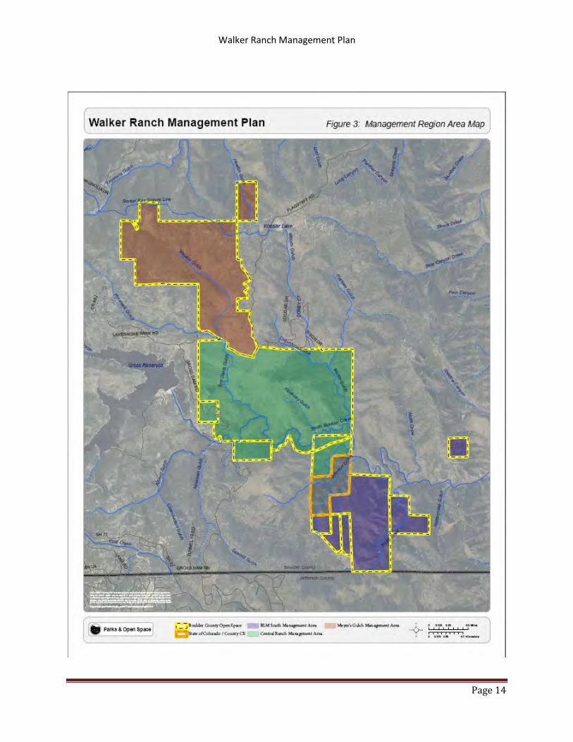
Throughout this plan, Walker Ranch will be discussed as consisting of three distinct management areas:
Meyer’s Gulch, the Central Ranch, and BLM South. The Meyer’s Gulch area is the northernmost section
of the property and is located west and north of Flagstaff Road. It contains the Meyer’s Homestead Trail
and Trailhead as well as the Walker Ranch Link Trail and the property known as Hawkin’s Gulch. The
management area consists of 1,195.9 acres of open space property (Figure 3: Management Areas).
The Central Ranch (1,694.2 acres) contains the Walker Ranch Homestead, remains of the Langridge Dike
mill, the Walker Loop Trail and links to Eldorado Canyon State Park. The Central Ranch area also includes
four properties acquired from the Bureau of Land Management through the Recreation and Public
Purposes Act. The Central Ranch is bounded on the north by Flagstaff Road and private property. To
the east by City of Boulder Open Space and Mountain Parks property, to the south by the Crescent
Meadows annex of Eldorado Canyon State Park, and to the west by Denver Water’s Gross Dam.
South of Crescent Meadows is the BLM South area. The majority of this 687.7 acre management area
was acquired from the BLM through the Recreation and Public Purposes Act. It includes three
properties purchased along with the City of Boulder, but managed by Boulder County Parks and Open
Space. This part of the park is bounded by a variety of publicly-owned land to the north, east and south
and by private property and Crescent Meadows to the west.
The BLM South Management Area also includes the 38.6 acre BLM South Boulder Creek property
located east of the majority of Walker Ranch Open Space. This parcel is bounded by City of Boulder
Open Space on the West, North, and East sides and by Eldorado Canyon State Park on the South.
ACQUISITION HISTORY 1.2.2
In 1977 The County Commissioners entered into a lease-option contract with Mountain Valley
Associates at a price of $2,542,298 to be paid in individual option payments over an eight-year period.
The final payment was made in 1985.
The remaining properties south of Walker Ranch were owned by the Bureau of Land Management (BLM)
and had been mined and hunted throughout the BLM’s ownership. In 1981, Boulder County entered into
an agreement with the BLM through Recreation and Public Purposes Act (R&PPA) in order to acquire the
properties through a improve to own scheme outlined in that Act. For 25 years, BCPOS would manage
the properties and through a plan developed by staff, would provide recreational improvements to the
properties. At the end of the 25-year period, if the BLM believed BCPOS met its obligations, the property
would be deeded to the county in perpetuity. In 2006 the deed was transferred to the county.
Walker Ranch Management Plan
Page 14
Figure 3: Walker Ranch Management Areas

Walker Ranch Management Plan
Page 15
EXISTING LAND USES 1.2.3
Walker Ranch Open Space has been open to the public for nature study, passive recreation, and cultural
resource interpretation for more than 25 years. The land included in the first Walker Ranch
Management Plan was acquired from a private land owner. Since that time, additional land was
acquired from the Bureau of Land Management BLM through the Recreation and Public Purposes Act
R&PPA and from private land owners. This means that while much of the land originally acquired has
been subject to some level of human use for many years, areas within the newly acquired BLM lands
may not have had human impact since mining exploration beyond limited hunting.
In 1984 (expanded in 1988) , Walker Ranch, excluding the properties acquired from the Bureau of Land
Management, was listed in the National Register of Historic Places and the Colorado Register of Historic
Properties. The focal point of the landmark is the Walker Ranch Homestead, however, everywhere on
the property are signs of use by early settlers and there is evidence of use by Native Americans as well.
The property is also one of five properties within the BCPOS system that has a dedicated resident
ranger. This ranger is not solely responsible for patrol at Walker Ranch but provides an added level of
management and enforcement at Walker Ranch.
ACCESS 1.2.4
Walker Ranch is generally accessed through one of the three trailheads on Parks and Open Space
property: Meyer’s Gulch, Walker Loop, or Ethel Harrold. The property can also be accessed from the
Crescent Meadows area of Eldorado Canyon State Park or from the main parking area of the State Park.
Finally there is access along South Boulder Creek from the Gross Reservoir property of Denver Water.
The only emergency vehicular access to trails on the northern part of the property is from Flagstaff
Road. From the south the property can be accessed from Gross Dam Road.
1.3 LAND USE CONSIDERATIONS
ADJACENT LAND USE AND OWNERSHIP 1.3.1
The lands around Walker Ranch Open Space are a mosaic of different ownership and management
goals. Managing relationships with these various owners involves regular formal and informal contacts
with residential land owners and more formal discussions and partnerships with institutional owners
such as the City of Boulder, Colorado Parks and Wildlife, the US Forest Service, and Denver Water. These
relationships allow us to maintain healthy ecosystems, connected trail systems, and reinforces the value
of property rights.
Figure 2 shows the variety of ownership classifications surrounding Walker Ranch. To the east much of
the property borders City of Boulder Open Space and Mountain Parks property. In addition there is
private property, part of the two rural subdivisions that are within the Forestry zone as designated in the
Boulder County Zoning Code. The South BLM property is additionally bordered by Eldorado Canyon
State Park to the east and west. Walker Ranch’s southern border can generally be described as Chute

Walker Ranch Management Plan
Page 16
Road, a private road in Boulder County that is bordered by private property and some U.S. Forest
Service Land. To the west of the remainder of the property is a mix of Denver Water property, private
property, and U.S. Forest Service land. To the north Walker Ranch is bordered again by private property
and land owned by the City of Boulder and managed by Open Space and Mountain Parks or by the
Boulder Utilities Board.
LEASES, EASEMENTS, ENCUMBRANCES, AND RIGHTS OF WAY 1.3.2
A list of easements impacting Boulder County can be found in Appendix B: Easements. Easement
owners and those interested in the impact of specific easements should contact Boulder County Parks
and Open Space for further information or if planning to work within easements.
BOULDER COUNTY COMPREHENSIVE PLAN 1.3.3
The Boulder County Comprehensive Plan provides guidance for the development of this management
plan through the Open Space section of the plan. While the Comprehensive Plan is an “advisory
document,” Parks and Open Space staff looks to it to guide goals for open space properties. Goals within
the plan that relate to Walker Ranch include Environmental Management, Parks & Open Space,
Community Facilities, Public Involvement, and Cultural Resources.
In the Comprehensive Plans appendices, the Commissioners point out important features or future
plans on a series of maps. Much of Walker Ranch is designated as an Environmental Conservation Area
on the Environmental Conservation Areas map and an area is designated as Montane Grassland on the
Natural Communities, Rare Plants, Riparian Corridors, and Critical Wildlife Habitats Map. The map
section of the plan also includes a map called the County Trails Map. The County Trails Map shows the
Meyer’s Homestead and Walker Loop trails, as well as a trail “Corridor” extending from the Walker Loop
trail to the west and to the east.
The Boulder County Comprehensive Plan is revised on an “as needed” basis. At the time of this writing,
the Environmental Resources section of the Plan is being revised. While revisions at this time will not
have any impact on the Walker Ranch Management Plan, future revisions may impact the management
direction of this plan. In cases where these conflicts arise, the direction of the Comprehensive Plan
supersedes the management plan.
1.4 SPECIAL DESIGNATIONS
ENVIRONMENTAL CONSERVATION AREAS 1.4.1
Walker Ranch is part of the Hawkin Gulch/Walker Ranch/Upper Eldorado Canyon Environmental
Conservation Area (ECA), as outlined in the Boulder County Comprehensive Plan. Conservation Areas are
designated in the Boulder County Comprehensive Plan using criteria that identify “landscape scale”
areas that combine sites with critical wildlife habitat, rare plants, natural communities of special
concern, as well as other natural features. The Hawkin/Walker/Eldorado Canyon ECA was designated to

Walker Ranch Management Plan
Page 17
recognize the importance of Walker Ranch as Critical Wintering Range and movement corridor for the
Winiger Ridge Elk Herd, for the stands of old growth Ponderosa Pine, and the large mammal movement
corridor created through the large protected area that is Walker Ranch (Figure 4: Comprehensive Plan
Designations).
COLORADO NATURAL HERITAGE PROGRAM 1.4.2
In 2008, the Colorado Natural Heritage Program (CNHP) completed a county-wide survey of historical
records, observations, and previously developed data to create the Survey of Critical Biological
Resources in Boulder County, Colorado. The plan’s stated purpose was to:
The goal of the project was to systematically identify the locations of rare species and significant natural
plant communities in Boulder County, and to identify and prioritize areas of critical habitat (potential
conservations areas) for these species and communities.
The report noted the presence of many invertebrates in the Walker Ranch area as well as historic
sightings of animals that have not been seen in Boulder County in many years. Based on topography,
biodiversity, and preservation, the Walker Ranch was included in the Boulder Foothills Potential
Conservation Area which is rated as having Very High Biodiversity Significance because of the presence
of some globally rare plants and/or animals and a number of globally common but rare to Colorado
plants and/or animals. While CNHP data is generalized to protect both private property owners and the
rare species being surveyed, the protection of this area is vital due to the large agglomeration of
conserved land. As a unit, the land conserved by the City of Boulder, Boulder County, Colorado State
Parks, the U.S. Forest Service, and the Bureau of Land Management means that a large connected
landmass is conserved in the very long term.
1.5 PLANNING OVERVIEW
PURPOSE 1.5.1
Boulder County Parks and Open Space management plans are documents used by the staff to lay out a
vision of future management for a property or group of properties. The Boulder County Commissioners
approved a management plan for Walker Ranch in 1985. A new plan is necessary to recognize the
changes that have occurred at Walker Ranch in the intervening 22 years. This plan should be reviewed
and updated, as necessary, in approximately 15 years.
Changes in these last 22 years at Walker Ranch Open Space include: an increase in visitor use; trail
expansion; a major wildfire, the acquisition of property around the original purchase; and designation in
the National Register of Historic Places and the Colorado State Register of Historic Properties. While
maintenance and interim closures have met many of the immediate concerns with these changes, they
cannot be effective long term. An update is necessary to keep pace with this change and develop a
management direction and management goals for the next 15 years.

Walker Ranch Management Plan
Page 18
Figure 4: Comprehensive Plan Designations

Walker Ranch Management Plan
Page 19
The Walker Ranch Management Plan Update will provide management direction and goals to guide
actions on the ground, make users aware of planned changes, and allow for accurate and timely
budgeting and forecasting.
PLANNING VISION AND GOALS 1.5.2
In 1985 The Walker Ranch Management Plan began with this statement for the plan’s objectives:
Walker Ranch is owned by Boulder County and managed by the Boulder County Parks
and Open Space Department. The property is managed for low intensity recreation, for
cultural site preservation, and for wildlife habitat preservation. Specific objectives for
the park include the following:
1. Manage the property as a wildlife sanctuary by maintaining or enhancing
natural food, cover, and nesting areas.
2. Manage the property to restore and preserve historic structures.
3. Manage the property to restore or enhance native vegetation to serve as an
“outdoor laboratory” of a typical montane ecosystem.
4. Provide visitors with minimal development of trail, picnic, and other recreation
facilities.
5. Provide on-site environmental education opportunities for the public.
6. Maintain the forest resource of Walker Ranch to minimize fire hazards for
adjacent properties.
7. Encourage development of a regional management plan with agencies managing land
along the South Boulder Creek drainage.
VISION STATEMENT 1.5.3
With this update, comes a new vision and set of goals. Walker Ranch Management Vision and Goals
Walker Ranch is an open space that preserves and interprets Boulder County’s cultural past; protects
vibrant native ecosystems; and offers high quality passive recreation to the citizens of Boulder
County.
GOALS 1.5.4
Based on that vision BCPOS’ management has goals specific to the many areas covered by staff:
Cultural Resources: Walker Ranch should be managed to preserve and promote the historic significance
of its buildings, structures, features, landscape, and archaeological resources on the property.

Walker Ranch Management Plan
Page 20
Management should focus on promoting the historic significance of the ranch and maintaining the
historic physical integrity of the resources.
Forestry: Portions of Walker Ranch experienced a devastating fire in 2001. Forestry in areas affected by
the fire should be focused on maintaining the current landscape. Other areas should be managed to
protect against the threat of fire or to enhance existing forest cover.
Wildlife: The landscape, as well as the key location of Walker Ranch provides habitat and movement
corridors for a wide variety of wildlife.
Management should focus on maintaining and improving habitat suitability. Management should also
focus on providing increased levels of protection for areas deemed highly sensitive and therefore
potentially not appropriate for visitor use.
Vegetation: Management of vegetative resources should focus on improving and maintaining plant
species, plant communities and wildlife habitat and studying existing communities at Walker Ranch.
Visitor Use: While visitors report being largely satisfied with the Walker Ranch user experience, user
conflict should be managed using available tools. Trails should be redesigned to reduce conflict,
properties should be open for public access when possible, and staff should capitalize on educational
opportunities. Recreation is an important part of the value of Walker Ranch, but recreational
opportunities should be balanced against protecting and preserving natural resources.
1.6 RELATIONSHIP TO OTHER PLANS, PROGRAMS, AND PLANNING EFFORTS
BOULDER COUNTY COMPREHENSIVE PLAN 1.6.1
The Boulder County Comprehensive Plan provides guidance for the development of this management
plan through the Open Space section of the plan. While the Comprehensive Plan is an “advisory
document,” Parks and Open Space staff looks to it to guide goals for open space properties. Goals within
the plan that relate to Walker Ranch include Environmental Management, Parks & Open Space,
Community Facilities, Public Involvement, and Cultural Resources.
In the Comprehensive Plans appendices, the Commissioners point out important features or future
plans on a series of maps. Much of Walker Ranch is designated as an Environmental Conservation Area
on the Environmental Conservation Areas map and an area is designated as Montane Grassland on the
Natural Communities, Rare Plants, Riparian Corridors, and Critical Wildlife Habitats Map. The map
section of the plan also includes a map called the County Trails Map. The County Trails Map shows the
Meyer’s Homestead and Walker Loop trails, as well as a trail “Corridor” extending from the Walker Loop
trail to the west and to the east.
The Boulder County Comprehensive Plan is revised on an “as needed” basis. At the time of this writing,
the Environmental Resources section of the Plan is being revised. While revisions at this time will not
have any impact on the Walker Ranch Management Plan, future revisions may impact the management

Walker Ranch Management Plan
Page 21
direction of this plan. In cases where these conflicts arise, the direction of the Comprehensive Plan
supersedes the management plan.
1.6.2 BOULDER VALLEY COMPREHENSIVE PLAN
The Boulder Valley Comprehensive Plan does not directly address Walker Ranch Open Space. However,
it strongly supports trail connections and connecting Boulder Valley with Boulder Creek’s tributaries,
including South Boulder Creek through trail development.
1.6.3 PARKS AND OPEN SPACE RESOURCE POLICIES
Beginning in 2006, Boulder County Parks and Open Space began developing policies based on resources
managed by the county within Open Space properties. The goal of this project was to develop a set of
policy guidelines for the long-term management of county-owned properties. These resource policies
would help translate the broad goals of the Comprehensive Plan to a level that could be used to guide
annual and daily decision-making.
The County Commissioners have approved resource policies for Water, Forestry, Cropland, and
Conservation Easements. The County will complete policies for Wildlife, Grasslands, Cultural Resources,
and Visitor Use in the next several years. The Walker Ranch plan adheres to these policies with an eye
toward maintaining a standard of management for other resources known to exist at Walker Ranch.
1.6.4 OTHER FEDERAL, STATE, OR LOCAL PLANS
Walker Ranch is adjacent to a significant amount of land set aside by state, local, and federal land
management agencies. These lands are governed under separate management doctrines and plans.
However, through communication and cooperation each agency works with others to ensure that
management continues while respecting the management goals of the surrounding agencies.
1.7 SURVEYS
Boulder County regularly conducts countywide surveys of residents in order to gather information
regarding proposed and enacted policies. Questions in these phone surveys often address a wide
variety of subjects, but it is one of the many ways Boulder County Parks and Open Space gathers
information about its visitors.
Since the 1980s, BCPOS has used on-site visitor surveys to gather additional information at specific parks
within the BCPOS system. The surveys are designed to provide decision-makers with new information
about park visitors every five years, but they can also serve as a long-term or longitudinal study of
visitation. Questions are generally broad and some are open-ended in order to try to make allowance
for changing use patterns.
Walker Ranch has been part of the 5 year study since its inception; however, in addition it was studied
separately in 2008 in order to try to understand how visitors and neighbors use the park and how they
feel about management of the park.

Walker Ranch Management Plan
Page 22
Select results from the 5 year study and the Walker Ranch-specific survey are available in the study’s
appendix. The full surveys are available online:
http://www.bouldercounty.org/os/culture/pages/posresearch.aspx.
Survey Results
The five year survey produced some interesting results at Walker Ranch that are relevant to this
management plan:
The neighbor and user survey completed in 2008 outlined some of the management ideas that ought to
be included in the management of the park:
The most recent edition of the Five-year Visitor Survey was completed in 2010. Volunteers and staff
collected 2,388 surveys from park visitors during the survey period (a 70% response rate). The first
question posed by the survey was the primary purpose of the survey-taker’s visit to that particular
property:
Activity Percent of Respondents
(2010)
Percent of Respondents
(2005)
Percent of Respondents
(2000)
Hike 40 46 39 Bike 23 25 21 Run 9 9 6 Walk the Dog 9 0 2 Fish 5 4 10 View Wildlife 5 4 15 Picnic 3 2 18 Ride a Horse 1 1 2
The 8th question in the survey asked about acceptable uses of open space:
Acceptable Unacceptable
Trails/Recreation 94% 6% Preserve Views 92% 8% Wildlife Habitat 86% 14% Conserve Native Ecosystems
81% 19%
Urban Buffers 62% 38% Renewable Energy 36% 64% Agriculture 31% 69%

Walker Ranch Management Plan
Page 23
Question 10 asked, based on the park at which the survey was taken, provide a description of the
number of trails on a scale of 1 to 5:
2010
1 – Not Enough 12% 2 17% 3 – About the right number of trails 60% 4 2% 5 – Too many trails 1% Not sure Blank 8%
Reviewing just the data gathered at Walker Ranch we found the following details: :
Question 1:
Walker Ranch Loop Trailhead
Walker Ranch Meyer’s Homestead Trail
Activity 2010 2005 2000 2010 2005 2000 Hike 41% 33% 40% 65% 51% 51% Bike 42% 63% 4%7 24% 38% 37% Run 10% 2% 2% Walk the dog 2% 3% Ride a Horse Fish 2% 5% Picnic 1% View Wildlife 1% 11% Special Event Family Gathering Photography/Art 3% Other 3% 4% 6% 11%
At the Walker Ranch Loop trailhead, users most often cited the desire to connect to Eldorado Canyon
State Park by bike as a needed improvement for the trail. Meyer’s Homestead Trail users generally cited
the need for more/longer trails from the trailhead. Both trailheads were highly rated for their beauty
and views.
In 2008, staff and volunteers worked together to produce; Walker Ranch Management: A Survey of
Visitors and Neighboring Landowners at Walker Ranch Open Space. Many of the questions were similar
to the visitor use study held every five years.

Walker Ranch Management Plan
Page 24
Trailhead
Activity Type Loop Trailhead
Meyer’s Homestead Trailhead
Ethel Harrold Trailhead
Overall:
Mountain Bike Count 352 85 21 458 % 51.8% 29.4% 55.3% 45.5%
Hike Count 245 161 11 417 % 36.1% 55.7% 28.9% 41.5%
Run Count 36 9 0 45 % 5.3% 3.1% 0.0% 4.5%
Other Count 7 19 0 26 % 1.0% 6.6% 0.0% 2.6%
Walk the Dog Count 16 9 0 25 % 2.4% 3.1% 0.0% 2.5%
Fish Count 16 1 6 23 % 2.4% 0.3% 15.8% 2.3%
View Wildlife Count 1 5 0 6 % 0.1% 1.7% 0.0% 0.6%
Left blank Count 2 0 0 2 % 0.3% 0.0% 0.0% 0.2%
Family Gathering Count 2 0 0 2
% 0.3% 0.0% 0.0% 0.2%
Picnic Count 1 0 0 1 % 0.1% 0.0% 0.0% 0.1%
Photography/Art Count 1 0 0 1 % 0.1% 0.0% 0.0% 0.1%
Totals: Count 679 289 38 1006 % 67.5% 28.7% 3.8% 100.0%
While the vast majority of users visit the Walker Loop Trailhead, the Meyer’s Homestead Trailhead is
more popular with hikers than with bikers. This seems to be borne out by a similar split at Ethel Harrold
Trailhead.
Users at each trailhead were asked what improvement they would most like to see at Walker Ranch in
the future and their answers were tabulated by their planned activity. At the Walker Loop, the vast
majority of users in each user group wanted to keep the trail the same: Mountain bikers (17%), Hikers
(12%) Runners (2%). Dog walkers (3%) of all users surveyed bucked that trend when 1% proposed
allowing off-leash use. At Meyer’s surveyed users said the same thing. All user groups surveyed
preferred changing nothing at the trailhead.
1.8 PLANNING PROCESS
The Walker Ranch Management Plan update process began with internal meetings in the fall of 2010.
While the schedule and specific number of meetings is not standardized, the planning process does
include a combination of internal and external meetings with stakeholders in order to develop a robust

Walker Ranch Management Plan
Page 25
management program. This mix of meetings includes meetings with institutional stakeholders, public
meetings, and interest group meetings. The purpose of this format and the length of the process is to
gather as much information from as many sources as possible to develop a workable management
program that can be implemented over time to realize the goals of the Commissioners.
After initial internal meetings identified a need to consult with specific interest groups, meetings were
arranged with park neighbors, recreationists, and conservationists to try to establish areas of agreement
and possible areas of disagreement. These meetings with a small subset of stakeholders allowed the
staff to understand specific areas of concern for the planning process.
The first public meeting was an open house held at the Clerk and Recorder’s Office in Boulder. This
meeting was designed to gather input by providing information about Walker Ranch through maps and
then encouraging attendees to add notes to the maps to help staff understand management issues
within the park. More than 50 Boulder County residents participated and the information gathered was
shared with staff in order to further focus management goals.
Internal meetings focused on addressing concerns raised by the public and situating the planning
process in the context of other planning processes happening at the same time. Staff presented
information gathered over years of monitoring. After presenting alternatives for management goals,
the staff felt that there were a limited number of changes required to continue management in line with
public input.
In November 2012, BCPOS staff presented the preferred alternative to about 65 residents at the
Transportation Department office in Boulder. The purpose of this meeting was to gauge stakeholders’
response to the preferred management direction developed by staff. As a result of that meeting, the
staff decided to alter some management projects and to reexamine trail development both on the
property and as part of a regional context.
After additional internal consultation, BCPOS staff presented a draft management plan to the public on
April 16, 2013.
1.9 CLIMATE CHANGE IMPACTS
The world’s climate is changing. Regardless of the cause, Boulder County has made the decision to think
critically about the impact of these changes. In 2012, the County Commissioners approved the Boulder
County Climate Change Preparedness Plan. The plan explores the challenges and opportunities available
to the county and the City of Boulder based on the many studies that predict the range of possible
impacts of climate change on the Front Range of Colorado.
Boulder County Parks and Open Space manages and maintains property throughout Boulder County that
will experience significant impacts from climate change. Therefore, management of open space must
maintain a level of flexibility to respond to changes. Management at Walker Ranch must be particularly
sensitive to these changes as the variety of landscapes is likely to respond in divergent ways to changes
in the climate.

Walker Ranch Management Plan
Page 26
2 MANAGEMENT
This chapter provides a description of the existing biological, physical, and socioeconomic
characteristics, including human uses that could be affected by implementing the management direction
presented in this management plan, as described in Chapter 3. Information from resource-specific
surveys and broad-scale assessments was used to help set the context for the planning area. Specific
aspects of each resource discussed in this section were raised during the public and internal scoping
process.
Acreage figures and other numbers used are approximations; readers should not infer that they reflect
exact measurements or precise calculations. Acreages were calculated using GIS technology, and there
may be slight variations in total acres between resources.
2.1 PHYSICAL SETTING
CLIMATE 2.1.1
Walker Ranch is located in the western portion of Boulder County to the west of the City of Boulder. The
park is located in the Rocky Mountain foothills at an elevation between 6,200 and 8,200 feet. The
climate would best be described as semi-arid with high temperature fluctuations and most precipitation
occurring in the spring and summer and an annual average of 23 inches.
TOPOGRAPHY 2.1.2
Walker Ranch lies within the physiographic province known as the Southern Rocky Mountain Province.
The rolling foothills topography seen over all three areas of Walker Ranch today resulted from relatively
recent geologic events coinciding with or following the last great series of mountain uplifts during the
last 70 million years. Since the area was uplifted, erosion has been the dominant force carving the
present topography. Rain and snow melt waters have formed the gullies and gulches that carry water to
South Boulder Creek and to the plains.
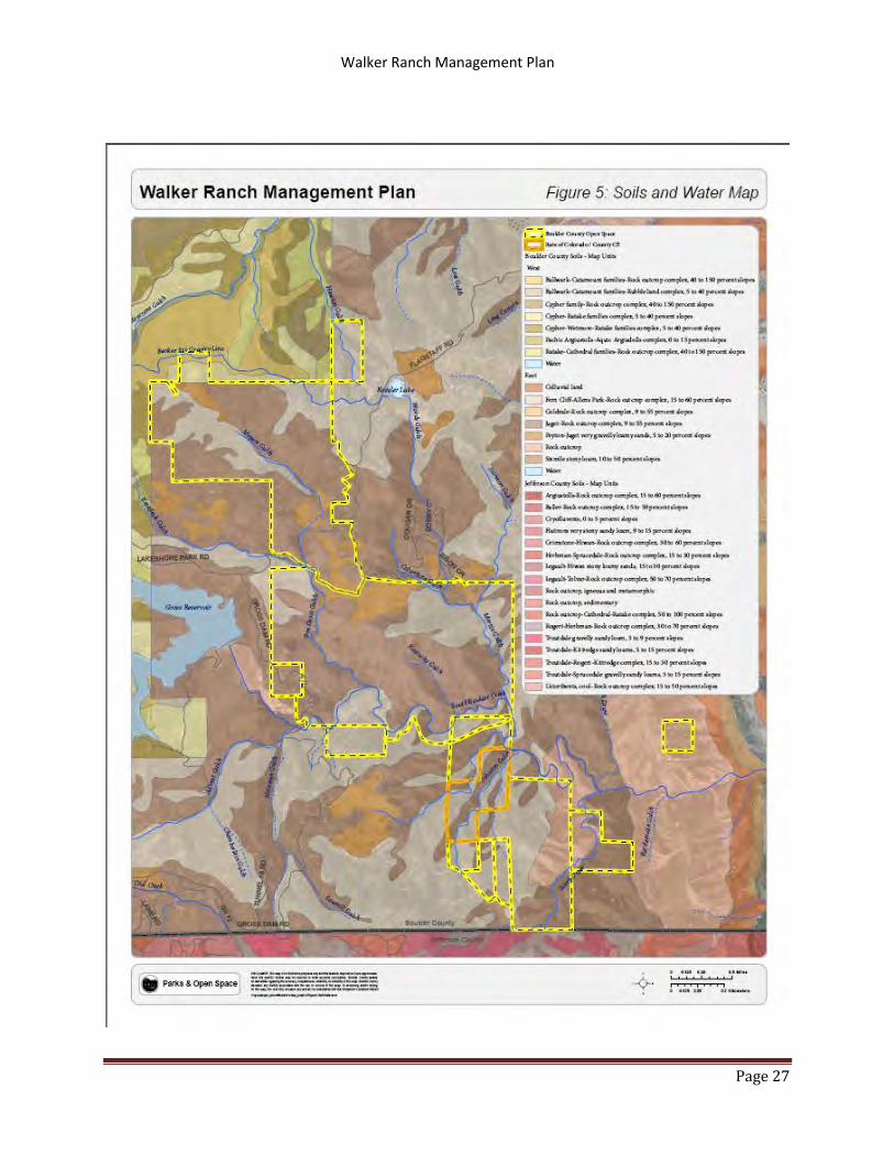
GEOLOGY AND SOILS 2.1.3
2.1.3.1 Classification and Description
The Natural Resource Conservation Service (NRCS) performs periodic soil surveys of land within the
United States. In the latest study of the Walker Ranch area, NRCS identified three (3) soil types: the Fern
Cliff-Allen’s Park complex (FcF), Juget-Rock outcrops (JrF), Peyton-Juget complex PgE, and Ro or Rock
outcrop which consists of steep slopes and cliffs of exposed bedrock (Figure 5: Soils and Water).
The Fern Cliff – Allen’s Park Complex is made up primarily of Fern Cliff and Allen’s Park soils, as the name
implies. The soils in this complex are generally well-drained to excessively-drained. The soil can extend
to 80 inches deep before lithic bedrock and is generally classified as suitable for grazing or forest lands.
The Juget – Rock outcrop soil complex is a mix of shallow excessively-drained Juget type soils and un-
weathered exposed bedrock. This complex is suitable for forested land, wildlife habitat, and grazing.
Walker Ranch Management Plan
Page 27
Figure 5: Soils and Hydrology

Walker Ranch Management Plan
Page 28
A mix of ‘well-drained’ and ‘somewhat excessively-drained’ soils make up the Peyton – Juget soils
complex. Peyton soils make up the majority of this complex and are found mostly in the valley bottoms
in and around Walker Ranch.
The remaining areas of Walker Ranch are classified as Rock outcrops. These areas are the cliffs and rock
faces of Walker Ranch that exhibit the exposed bedrock of the area. Rock outcrops are suitable for
habitat and are generally classified by the Natural Resources Conservation Service as suitable for
recreation and viewsheds.
WATER RESOURCES 2.1.4
2.1.4.1 Surface Water
Water is an important resource on Walker Ranch. South Boulder Creek crosses the southern portion of
Walker Ranch as it leaves Gross Reservoir. The majority of the surface water on Walker Ranch ends up in
South Boulder Creek and it is these gulches and drainages that provide unique habitats across the
property. The major drainages and gulches on the property are: Meyer’s Gulch, Tom Davis Gulch, South
Draw, and Kentucky Gulch (Figure 5: Soil and Water).
2.1.4.2 Groundwater
The steep topography allows runoff to reach streams relatively quickly. However, because of the limited
storage capacity of the hard crystalline rock found at Walker Ranch, much of the precipitation returns to
the atmosphere by evapo-transporation. Only a portion of the amount of rain and snow water that falls
upon the drainage flows out in streams. Much evaporates, some is used by plants, and some seeps into
the ground. The crystalline rocks store water in cracks, and serve as water table aquifers only where the
rock has been fractured. Water may move more rapidly through fractures that occur in these crystalline
rocks. These rocks have a median measured depth to water of 27.5 feet below the surface (Hall, Hillier,
Cain, and Boyd, 1980) in Boulder County in a sample of 149 wells.
2.2 NATURAL RESOURCES
GENERAL ECOLOGY 2.2.1
The physical location of Walker Ranch within the ecotone between the Great Plains to the east and the
high Rocky Mountains to the west, accounts for the environmental conditions in the area. The ecotone
between the two larger ecosystems creates a highly diverse intermixing of plant and animal species.
Additionally, the topography of the property contributes to the diversity of species and communities by
offering a multitude of growing conditions and structures over a short horizontal (elevational) distance.
Also, linear bands of riparian vegetation and complexes of montane forests and meadows within the
property account for high species richness. This richness is further increased by the presence of the
perennial streams, South Boulder Creek and its tributary, South Draw, as well as numerous ephemeral
and seasonally flooded drainages.

Walker Ranch Management Plan
Page 29
On the Front Range, the principle environmental features affecting species richness include slope,
aspect, elevation, soil, water and the primary factors are climate, and natural disturbance. The interplay
of these features and factors help to define the incredibly dynamic ecosystems found at Walker Ranch.
The montane forests at Walker Ranch are interspersed with naturally occurring meadows. These
meadow areas are located where deposition of deep fine textured soils have consolidated these soils
are suited to support forb and grass species. Also found on the property are small patches of aspen
stands. The grass and forb species found among the aspen stands is higher in diversity and includes
more mesic species than is found in the coniferous woodlands and forests. The meadows or grassland
openings at Walker Ranch are generally composed of a mix of native bunch grasses or tufted grasses and
some rhizomatous grasses and native forbs.
The property also includes the presence of differing shrub communities; either associated with dry rocky
sites or mesic conditions (wetter soils and along streams). The area that was burned in the 2000
Eldorado Canyon Fire altered a large portion of the property from montane forests to a spatial mix of
open grass and shrub community with pockets of tree cover. The linear riparian communities include
the presence of coniferous trees and deciduous trees and shrubs. Grasses, sedges, rushes and forbs
make up the understory vegetation.
Historically, anthropogenic factors significantly impacted the ecology of the site by introducing non-
native pasture grasses and forbs that compete with the native species for resources. Additionally, the
use of fire, logging, mining, farming, ranching, water diversion, homesteading, fencing, and any number
of other human impacts have played a role in altering ecosystem function in the area. While our
continued use of the property does have an impact on ecosystems, through management of non-native
species, careful recreation planning, and regular monitoring; we actively manage the natural resources
at Walker Ranch.
OVERALL BIOLOGICAL AND CONSERVATION VALUE 2.2.2
Walker Ranch is recognized in both the Boulder County Comprehensive Plan and the Colorado Natural
Heritage Program’s survey of Boulder County Resources as an area important for biological resources
and high conservation values.
The Boulder County Comprehensive Plan includes Walker Ranch within the Hawkin Gulch/Walker
Ranch/Upper Eldorado Canyon Environmental Conservation Area ECA. This high biodiversity is further
supported by the vegetation mapping findings of at least 48 Plant Alliances (USNVC) and over 720 plant
species.
VEGETATION 2.2.3
This discussion of vegetation at Walker Ranch is not meant to be comprehensive. The purpose of this
section is to provide some context for management decisions as well as to give decision-makers and the
public some framework within which to make future decisions. This section will present information on
plant communities at Walker Ranch divided by the three management areas described earlier in this

Walker Ranch Management Plan
Page 30
plan. This section will provide additional focus to specific species requiring additional attention,
wetlands, areas impacted by the Eldorado Canyon Fire, and weeds.
The information provided in this section is derived from mapping efforts performed by BCPOS and
contractors, property wide surveys conducted by Earthwork Conservation Planning, LLC, and the
Colorado Natural Heritage Program. Vegetation surveying, mapping, and monitoring are guided and
performed by BCPOS’ Plant Ecology staff (Figure 6: Vegetation). This group of four plant ecologists
works within the Resource Management Division to conserve and manage plants across the many
properties managed by BCPOS. The vegetation mapping done at Walker Ranch followed the U.S.
National Vegetation Classification System (USNVC). The USNVC system is a hierarchical system based on
top down structure. Thus the presence of alliances described by upper level tree structure would
preclude the presence of a large number of lower structure alliances. The most significant herbaceous
alliances consisting of shrubs, forbs, and grasses are found located in the forest openings of the park. So
far the vegetation surveys and mapping have identified at least 48 Plant Alliances comprising over 720
plant species. This further supports the inclusion of this area into the Very High Biodiversity as noted by
CNHP. An explanation of U.S. National Vegetation Classification System is located in Appendix D of this
plan (http://usnvc.org/explore-classification/). Where appropriate the vegetation is described using the
USNVC nomenclature. Also included in this plan are the rarity ranking of species and communities as
determined by the Colorado Natural Heritage Program is included (Appendix E and F).
2.2.3.1 Meyer’s Gulch
The Meyer’s Gulch management area features high ridges on the northeast and southwest while
Meyer’s Gulch itself flows northwest to southeast through the middle of the property. This topography
generally dictates the plant communities or vegetation alliances present within the management area.
Forest and woodland communities dominated by Ponderosa Pine (Pinus ponderosa) are located on drier
south and east facing slopes, while Douglas-fir (Pseudotsuga menziesii) dominated communities are
found on north and west facing slopes that are usually wetter. These ridgelines also contain areas of
rocky outcroppings that generally contain very sparse vegetation.
The central valley through the management area contains Meyer’s Gulch as well as a relatively diverse
population of plants and plant alliances. The uplands of this area are dominated by forest and woodland
alliances of ponderosa pine or Douglas-fir largely depending again on the water available on that
particular slope. The southern part of Meyer’s Gulch, impacted by the Eldorado Canyon Fire is
dominated by the Ponderosa Pine Tallgrass Savannah Herbaceous Alliance which is characterized by
widely spaced ponderosa pine intermixed with a healthy understory component that is dominated by
grasses. A large clone of aspen (Populus tremuloides), identified as the Quaking Aspen Forest Alliance, is
located in the north central portion of Meyer’s Gulch. This alliance was naturally occurring on the site,
but management efforts by BCPOS increased the size of the alliance after the action was approved in the
first management plan. The Foothills Ponderosa Pine Tallgrass Savannah Alliance areas contain the
significant plant communities of concern: Pinus ponderosa/Leucopoa kingii Woodland (G3S3), Pinus

Walker Ranch Management Plan
Page 31
ponderosa/Schizachyrium scoparium Woodland (G3S1), and Pinus ponderosa/Muhlenbergia montana
Woodland (G4S2). The largest representatives of these communities are mostly found around the
shelter at the Meyers trailhead.
Wetland and Riparian Areas
The two most substantial ephemeral streams on Meyers Ranch are Meyer’s Gulch and Hawkin Gulch.
Meyers Gulch drains to the southwest and contributes water to South Boulder Creek. Meyer’s Gulch
itself is dominated by vegetation alliances which can tolerate and thrive in flooded or temporarily
flooded conditions. These include alliances still dominated by Ponderosa and Douglas-fir, but much of
the vegetation along the creek is dominated by small trees or shrubs such as the speckled alder (Alnus
incana subsp tenuifolia) and river birch (Betula fontinalis).
The most significant plant communities found along this drainage are the water birch community and
the speckled alder community. The water birch community is located at the very top of the gulch. This
community was classified under the USNVC system as a Water Birch Temporarily Flooded Shrubland
Alliance. This alliance is a rare community as ranked by CNHP as (G3S2). The speckled alder community
is found in the southern end of the drainage near Flagstaff Road. This community was classified as the
Speckled Alder Temporarily Flooded Shrubland Alliance and this community is ranked by CNHP as
(G3S3). Both of these communities were previously identified in the Wright Water Engineers wetland
survey. There are two springs identified on the property that have obligate wetland species including
sedges, rushes and iris.
Hawkin Gulch flows from the top edge of the east portion of Meyers Ranch down to the North to
Boulder Creek. The plant community of significance along the drainage includes Douglas fir, narrowleaf
cottonwoods (Populous angustifolia), alder, birch, mountain maple (Acer glabrum) and aspen. Under the
USNVC system this community was classified as Douglas-fir Temporarily Flooded Shrubland. The CNHP
program would likely place this under the Montane Riparian Forest that is ranked (G3S3).

Walker Ranch Management Plan
Page 32
Figure 6: Vegetation

Walker Ranch Management Plan
Page 33
2.2.3.2 The Central Ranch
The largest area within Walker Ranch is the management area identified as the Central Ranch. This area
includes the Walker Ranch Homestead, South Boulder Creek, Tom Davis Gulch, and much of the Walker
Loop Trail. The area is dominated by an east-west ridge in the north central portion of the property
generally south of the Walker Ranch Homestead, Castle Rock on the western edge of the area, South
Boulder Creek and the steep slopes on either side of the Creek, and numerous drainages on the eastern
edge of the property.
The north-central part of the Central Ranch is the most altered by human use. This is the location of the
Walker Loop parking lot, the Walker Ranch Homestead, and formerly cultivated fields and pastureland.
This area is treated regularly to reduce weed pressure and is managed to maintain the feel of a more
altered landscape. Much of the former pasture is, however, composed of native shrubs, grasses and
forb species that are dominate in a Hairy Golden Aster (Hetertotheca villosa)/Fringed Sagebrush
(Artemisia fridgida) Dwarf-shrubland Alliance. While the main management practice in the area is weed
control, some seeding has occurred in the past near the homestead.
The ridgeline south of the Homestead is similar to other ridges at this elevation with the same wet
side/dry-side split between Douglas-fir and ponderosa pine dominated communities. The exact mix of
species may differ from area to area depending on many factors. Some areas have been impacted by
BCPOS forestry management working to reduce the impact of possible wildfire on the northern side of
the ridge. The south-facing slopes of this main ridge were impacted by the Eldorado Canyon Fire.
Restoration efforts reduced the possibility of erosion and while weeds are present, the area is
predominately covered by the Hairy Golden Aster/Fringed Sagebrush Dwarf-shrubland alliance.
The western side of the Central Ranch management area is separated from the rest of the Central Ranch
by Tom Davis Gulch which joins with Meyer’s Gulch before flowing through the Central Ranch down to
South Boulder Creek. This area was impacted by the Eldorado Canyon Fire and has significant areas of
rock outcroppings associated with Castle Rock. The dominant communities outside of Tom Davis Gulch
are Rocky Mountain Shrubs Alliance and the Buckbrush (Fendler’s ceanothus) Dwarf-shurbland Alliance.
Tom Davis Gulch itself has been identified as a vital resource protection area because of the plant
species present. The alliances present are similar to those found along Meyer’s Gulch in that they
endure seasonal flooding and are thus adapted to those conditions. The Water Birch seasonally and,
Coyote Willow (Salix exigua) Temporarily Flooded Shrubland Alliances dominate.
The Central Ranch’s eastern edge abuts City of Boulder Open Space and Mountain Parks land. The
eastern edge of the property is largely defined by an oil and gas service road, but just west of this road
are a series of wooded slopes with a number of small drainages connecting to South Boulder Creek.
These drainages are heavily wooded with ponderosa pine-dominated alliances.
South Boulder Creek has carved a steep canyon into the southern edge of the Central Ranch
management area. While much of this area is rocky cliffs, ponderosa pine dominated alliances

Walker Ranch Management Plan
Page 34
predominate. There are a few areas along the creek bottom that provide habitat for the Water Birch
Seasonally Flooded Shrubland Alliance.
Wetlands and Riparian Areas Central Walker Ranch
The wetlands and riparian areas are generally composed of trees, shrubs, and understory vegetation
commonly found at these elevation levels. The most significant wetlands on Walker Ranch are
associated with the perennial and ephemeral streams and drainages. There are four areas identified as
springs that are small wetland areas. There is a significant seep that drains from the homestead area to
the northeast.
The riparian communities found along the creeks and drainages at Walker Ranch Open Space are of
relatively high quality. The major perennial stream on the property is Boulder Creek. The riparian
vegetation associated with Boulder Creek is of good quality but may lack the diversity and dynamics of
plants associated with scour and deposition that would occur in an un-dammed river. There are some
sections of the river on the Walker property that include water birch, cottonwoods and coyote willow.
These areas are important for their species composition and contribution to the diversity of the
vegetation all along the riparian areas of the property. The riparian communities that include narrowleaf
cottonwood (Populous angustifolia) and shrubs such as water birch and alder are considered vulnerable
locally and globally (G2S2). A larger portion of the river vegetation is characterized by spruce (Picea sp.) -
douglasfir communities with mountain maple (Acer glabrum), alder, currant (Ribes sp.), and chokecherry
(Padus virginiana) (G3S3).
The major gulches on the property are: Tom Davis Gulch, Martin Gulch and Kentucky Gulch. These
drainages or gulches contain important sensitive plant species and plant communities. The Colorado
Natural Heritage Program (CNHP) ranks the lower montane riparian shrublands that have the species
found on Walker Ranch such as alder, birch, and red osier dogwood (Swida sericea) as critically
imperiled locally (S1) to vulnerable to extirpation (G3S3) across all their range. Also present on the
property is beaked hazelnut (Corylus cornuta). The riparian community that is defined by beaked
hazelnut is ranked by CNHP as vulnerable globally and imperiled locally (G3S1). The beaked hazelnut and
two herbaceous species; wild sarsaparilla (Aralia nudicaulis) and snakeroot (Sanicula marilandica) are
usually found together, all three of these species are considered to be relictual eastern woodland
species.
The most significant wetland that drains towards Columbine Gulch from the homestead is identified as a
Nebraska sedge wetland (Carex nebrascensis) community. This is the largest wetland identified in the
vegetation surveys on the Central Ranch that is not associated with the riparian corridors. There is a
spring identified inside the homestead area that may be contributing to the development of this
wetland.
The 2000 Eldorado Fire impacted much of the central portion of Walker Ranch and the southern end of
Meyer’s Ranch. In these areas the fire affected most of the Tom Davis gulch drainage. Most of the
drainage has recovered to a Seasonally Flooded Water Bbirch Alliance with sections that would be

Walker Ranch Management Plan
Page 35
characterized as Coyote Willow Temporarily Flooded Alliance. The dominant community of water birch
is a significant community because it is considered rare globally and very rare in the state. The Colorado
Natural Heritage Program ranks this alliance or community as G3S1.
2.2.3.3 BLM South
The five properties that make up the BLM South management area are separated from the rest of
Walker Ranch by the Crescent Meadows area of Eldorado Canyon State Park. These properties are also
remote from public access and have not seen regular use since mining occurred in the area. The
property consists of a number of ridges and drainages generally trending north-south and draining into
South Boulder Creek west of the Town of Eldorado.
The majority of acreage on these properties consists of woodland or forested alliances of ponderosa
pine and Douglas-fir depending on aspect and soil moisture. There are, however, significant areas of
Ponderosa Pine Tallgrass Savannah Herbaceous Alliance which has a more open look and a mix of trees
and grasses. The drainage bottoms are, again, dominated by alliances that tolerate temporary and
seasonal flooding. These drainages contain the same important and uncommon plant species and plant
communities found on the Walker and Meyers Ranch portions of the property.
Wetlands and Riparian Areas of BLM South There are four gulches on BLM South, two are unnamed gulches and the other two are Johnson Gulch
and South Draw. These drainages have similar species and plant communities as were found on the
Central Ranch. The 2010 vegetation survey of the Stone and Rice properties characterized the Johnson
Gulch as a Rocky Mountain Maple (Acer glabrum) Temporarily Flooded Shrubland Alliance. This drainage
also had narrowleaf cottonwood (Populous angustifolia), riverbirch, red osier dogwood and hazelnut.
This combination of species makes this drainage unique in the County and important for preservation.
The South Draw drainage is also an ephemeral drainage. This drainage was identified as a Narrowleaf
Cottonwood Temporarily Flooded Woodland Alliance. This drainage also has an important riparian
associated box-elder (Negundo aceroides) and plains cottonwood (Populus deltoides) the important
shrub species such as hazelnut, maple, beaked willow (Salix bebbiana) are also present. The CNHP
rankings of narrowleaf cottonwood communities places them in the vulnerable globally and locally
range.
There were no wetlands not associated with the riparian areas identified in our vegetation surveys on
this complex of properties that are lumped into the BLM South area of this management plan.
SPECIAL STATUS SPECIES 2.2.4
2.2.4.1.1 Federally Listed Species
Boulder County has known populations of two federally listed plant species, Ute ladies’ tresses
(Spiranthes diluvialis Sheviak) and Colorado butterfly plant (Gaura neomexicana var. coloradensis).

Walker Ranch Management Plan
Page 36
There are currently no known occurences of federally listed plant species on the Walker Ranch
properties.
There is one plant species currently listed as a candidate for federal listing Rocky Mountain
monkeyflower (Mimulus gemmiparus). The Walker Ranch property is close to the lowest elevation range
of monkeyflower and may have habitat that supports this species. There are no known observations of
this species being present on BCPOS lands.
NOTE: Describe federal listed species found or potentially found in planning area.
2.2.4.1.2 Species of County Concern
Boulder County Parks and Open Space recognizes all Federally Listed and protected species. The County
is currently working on creating a list of plant species of special concern. The ranking and rating of these
species is currently in development. The basis for the creation of our species list will recognize the
Nature Serve and The Colorado Natural Heritage Programs ranking system. Plant Communities of
Special Concern included here is a list of a five sensitive plant communities found at Walker Ranch, this
list is in no way a complete representation of the possible sensitive communities located at Walker
Ranch.
1. Pinus ponderosa/Leucopoa kingii (ponderosa pine/spike fescue) Woodland (G3S3) 2. Pinus ponderosa/Schizachyrium scoparium (ponderosa pine/little bluestem) Woodland(G3S1) 3. Pinus ponderosa/Muhlenbergia montana (ponderosa pine/mountain muhly) Woodland (G4S2) 4. Betula occidentalis ssp. fontinalis (water birch)Temporarily Flooded Shrublands (G3S1) 5. Populus angustifolia-Pseudotsuga menziesii (narrowleaf cottonwood/douglas fir) Woodland G3S2.
WEEDS AND WEED MANAGEMENT 2.2.5
Weeds are actively managed at Walker Ranch. Using a combination of mechanical and chemical
management techniques, BCPOS staff follows the Weed Management Policy adopted by the County
Commissioners in 2006. Weed management at Walker Ranch is in accordance with Colorado law
regarding the eradication of specific weed species.
The only ‘List A’ species at Walker Ranch is Myrtle spurge. ‘List A’ species are those that are identified
by the State of Colorado as posing a significant threat to the natural ecosystem as an invasive noxious
weed. Myrtle spurge is managed using both chemical and mechanical techniques.
Canada thistle, Musk thistle, Dalmatian toadflax, hounds tongue, leafy spurge and common mullein are
the ‘List B’ species at Walker Ranch. These species are identified by the State of Colorado but
immediate eradication is not required. However, Boulder County works to eradicate these species as
soon as possible in order to promote and improve habitats for native plants and wildlife.
The management direction for weeds is to continue to work with neighbors, the state of Colorado, and
volunteers to remove weeds and reduce weed pressure at Walker Ranch.

Walker Ranch Management Plan
Page 37
WILDLIFE 2.2.6
The diversity of habitat types within Walker Ranch provides for use by a wide range of wildlife. Whether
the wildlife stays year round, migrates, nests, or feeds at Walker, the goal of wildlife management at
Walker Ranch is to maintain a park that supports diverse and stable wildlife populations.
Important data regarding wildlife at Walker Ranch has been gathered from three main sources:
1) Boulder County Parks and Open Space employs wildlife biologists who provide input in support of wildlife resources by conducting research and making management recommendations.
2) Earthwork Conservation Planning also conducted assessments focused on locating and describing areas of importance for wildlife species on the property.
3) The final resource for this project was the work done by the Colorado Natural Heritage Program in identifying areas throughout the county with high wildlife resource value.
The information provided by these studies has led to an increased understanding of habitat values at
Walker Ranch. Specific areas have been designated as having high resource value, therefore requiring
increased protection. In other cases, BCPOS believes that recreational uses can coexist with wildlife
resources when managed appropriately. Later in this document management designations and
management prescriptions for these areas will be described in detail. A map of these areas can be found
in Figure 7: Wildlife.
GENERAL WILDLIFE 2.2.7
Varied landscape features, large size and continuity with adjoining public lands contribute to the high
habitat effectiveness found at Walker Ranch. Many species of wildlife utilize Walker Ranch, including 33
documented mammal species, 112 documented bird species, 5 documented reptiles, 1 amphibian
species, and 79 invertebrates (butterfly species).
Wildlife surveys and observations made over many years contribute to an understanding of how wildlife
uses Walker Ranch. The following section highlights wildlife use by Management Area.

Walker Ranch Management Plan
Page 38
Figure 7: High Value Wildlife & Vegetation Area Map

Walker Ranch Management Plan
Page 39
2.2.7.1 Meyer’s Gulch
The entirety of the Meyer’s Gulch area contains valuable habitat for a variety of wildlife species due to
prominent ridgelines, varied aspects, year-round water, and a mosaic of plant communities and
structure. Additionally, Meyer’s Gulch provides vital continuity of connections to adjoining habitat for
migratory or large-ranging species. As an example, the elk herd that consistently utilizes Walker Ranch
for winter range is dependent on accessing via the north areas of Meyer’s Gulch. This is due to large
landscape features that limit movement from the west, including residential development, and Gross
Dam Reservoir. This herd (Winiger Ridge herd) consistently ranges from higher elevations in the summer
(as far west as Indian Peaks Wilderness) to the lower elevation range within Walker Ranch, for critical
winter foraging.
Meyer’s southern ridge contains habitat that supports rare species such as Olive-sided flycatcher, as well
as uncommon species like golden crowned kinglets. The northeast facing slope has a complex mixture of
conifer species and shrubs, as well as significant downed woody material. These features create
excellent habitat for uncommon species such as dusky grouse and provide structure for small rodents. In
addition, this area’s dense forest stands are vital for visual cover, thermal cover and the movement
corridor for elk as well as other large mammals.
The riparian areas of Meyer’s Gulch and Tom Davis Gulch provide important habitat for mammals, birds,
and reptiles. Maintaining the integrity of the habitat in and around the gulches is important to
maintaining wildlife populations and diversity at Walker Ranch. The northern end of the riparian area of
Meyer’s Gulch contains an area of wetter soils and variable aspects which promotes multi-layered
vegetation structure. This, in turn, provides breeding and nesting habitat for birds such as long-eared
owl and sharp-shinned hawk. The lower reaches of Meyer’s Gulch join Tom Davis Gulch to provide a
riparian travel corridor as well as protected habitat that differs greatly from the surrounding landscape
that was affected by the Eldorado Canyon Fire. In 2007, Preble’s meadow jumping mouse was
confirmed in the Gulch representing the highest elevation record of this species, and denoting high
habitat quality. Additionally, smooth green snakes have been observed nearby this area. This species is
rare in Boulder County, with isolated or restricted populations.
The northern area of Meyer’s Gulch contains large stands of aspen. Aspen associated species such as
red-naped sapsuckers utilize these large stands. Also, in this area, there is a year-round spring which is
vital to wildlife.
Hawkin’s Gulch flows through the northernmost portion of the Meyer’s Gulch area. It is rugged and
relatively isolated from human disturbance. It is mainly surrounded by publically owned lands (OSMP
and USFS) so is part of a larger block of effective habitat. It contains excellent riparian habitat that
supports many species of birds, including goshawks which use the area as part of a probable territorial
range (nesting and foraging).

Walker Ranch Management Plan
Page 40
2.2.7.2 Central Ranch
Historically, the Central Ranch area is where the majority of the activities associated with the active
ranch occurred, including logging and mining. The Walker homestead itself was situated in the large,
open, montane meadow due to the flat topography and sheltered nature. These same aspects make this
area highly suitable for use by many wildlife species including elk, and it is designated as an Elk Winter
Concentration Area. In addition, it provides habitat for elk calving. It also provides important features for
species such as mountain bluebirds which utilize higher elevation, open habitat for foraging. Further, the
rocky outcrops directly south of the homestead provides isolated perching and resting areas associated
with the Castle Rock prairie falcons (see below).
Castle Rock, a large granitic outcrop, which is situated to the west of the homestead area, provides
nesting habitat for prairie falcons, and roosting for golden eagles. Also in this general area, another
granitic outcrop, Langridge dyke, is an important area for butterflies. Historic occurrence records for
Townsends big-eared bats exist for Langridge dyke as well.
Between Castle Rock and Langridge dyke, Tom Davis gulch provides a riparian travel corridor and water
access. The importance of this corridor is heightened due to the effects of the Eldorado Fire decreasing
vegetative cover available in the surrounding area. Additionally, in 2007, Preble’s meadow jumping
mouse was confirmed in this gulch, which represents the highest elevational record for this species. It
also attests to the habitat value within the gulch. Several species of raptors have been confirmed nesting
in the gulch, as well.
South of the Walker Homestead area is the part of Walker Ranch that has essentially been converted to
montane parkland by the Eldorado Canyon fire. This recently converted area now provides a mix of
grasses, shrubs, forbs and cavity trees (snags). It is in part, designated as an Elk Winter Concentration
Area, and also provides ample opportunities for cavity nesters. Additionally, olive-sided flycatchers have
been confirmed nesting in the area, and along with the nesting in Meyers Gulch represents two of the
four known nesting sites in Boulder County. The area contains a mixture of upland grassland habitats
interspersed with several drainages that still contain excellent riparian conditions, including fruit-bearing
shrubs. Due to the amount of foraging opportunities provided by the drainages, the area is designated
as a black bear high density area.
2.2.7.3 BLM South
Due to its isolation and remoteness, BLM South provides excellent effective habitat for many species of
birds and wide-ranging mammals. It contains areas of habitat juxtaposition such as riparian corridors,
north-facing/south-facing slopes, as well as a long section of Boulder Creek. The extreme terrain shows
very little evidence of historic or current human presence, and thus represents a large block of
undisturbed habitat. Given its close proximity to urban areas, it is highly unusual and valuable in this
context.
Specific species determined to be present within the BLM South Conservation Area during survey efforts
include two newly discovered golden eagle nests. The fact that one nesting pair was undiscovered until

Walker Ranch Management Plan
Page 41
2011, underscores the isolated and undisturbed nature of the area in general. Additionally, the recent
discovery of an alternate nesting site used by a separate pair of golden eagles illustrates the continuing
importance of maintaining suitable habitat in a condition conducive to wildlife.
2.2.7.4 Aquatic Resources
A stretch of approximately 3.5 miles of South Boulder Creek flows through the south central portion of
Walker Ranch. This area supports a recreational trout fishery with four points of access. The in-stream
structure and complexity of the stream, along with relatively easy access make it popular with anglers.
Rainbow trout (Oncorhynchus mykiss) and brown trout (Salmo trutta) dominate the stream.
2.2.7.5 Special Status Species
Walker Ranch is home to a variety of wildlife species that are considered as being “special status
species” at the Federal, State, or local level. The list in Appendix F includes status species that have
been identified on the property. Appendix F identifies all species documented on the property via
baseline monitoring, site visits, remote camera detections and documented incidental observations.
WILDLIFE LINKAGES AND CORRIDORS 2.2.8
Habitat fragmentation resulting from increased human activities in natural areas poses challenges to
wildlife when movement corridors providing connectivity to core habitat is disturbed.
Corridors are linear landscape elements that connect two or more patches of natural habitat and
function to facilitate movement (Soule’ and Gilpin 1991).
Maintaining viable populations of a species depends on the ability of that species to move unimpeded
throughout habitat types which provide resources for their survival through all seasons.
Walker Ranch is situated in such a way that it provides a vital movement corridor for the Winiger Ridge
Elk herd and other large mammals. Specifically, the area west of the Meyer’s Gulch trail is essential in
that elsewhere, movement is restricted to the north by Magnolia Road and Boulder Creek and to the
south by Gross Reservoir and housing developments. Keeping this corridor open is key, as it allows
access to elk winter concentration areas, as well as severe winter range*, located at the meadow
surrounding the Walker Ranch homestead.
Severe Winter Range is defined by CPW as “that part of the range of a species where 90 percent of the individuals are located when the annual snowpack is at its maximum and/or temperatures are at a minimum in the two worst winter out of ten” (NDIS 2008).
At a smaller scale, several other areas within Walker Ranch provide important linkages for wildlife
species. The Tom Davis Gulch area provides excellent habitat, but also visual cover that facilitates animal
movement through an area heavily impacted by the Eldorado Canyon fire. Additionally, areas around
South Boulder Creek, including Kentucky Gulch and Chokecherry Gulch have high value for both
movement and forage opportunities for a high concentration of black bears.

Walker Ranch Management Plan
Page 42
2.3 ECOSYSTEMS MANAGEMENT DIRECTION
The natural systems that make Walker Ranch a popular place to visit also make it vital to conserve and
study. The management direction for ecosystems is to continue to monitor and study the natural
systems at Walker and to work with other divisions and the public to protect resources in the long term.
Boulder County Parks and Open Space takes seriously its obligation to protect the natural systems on
our properties and to provide habitat for animals that may move across our properties. While much of
this protection can be provided through careful decision-making involving our staff, it is important to
recognize the vital importance of particular species or locations within our parks and develop specific
management practices for these species and locations.
The updated Walker Ranch Management Plan calls for two areas to be designated as Conservation
Areas. These two locations, Tom Davis Gulch and the BLM South properties contain resources that are
vital, fragile, and largely undisturbed. Specific monitoring or management practices are outside the
scope of this document. However, these areas are recognized by staff as warranting additional
protections within Walker Ranch.
Many areas that play important ecological roles are also popular with visitors to Walker Ranch. Two
important birds of prey utilize the Castle Rock formation on the western edge of the Central Ranch area
as a nesting and/or roosting site. This area is also of potential interest to climbers as a bouldering
location. With the opening of the area previously closed due to safety concerns after the Eldorado Fire,
we recognize that climbers may have an interest in accessing Castle Rock. In order to accommodate
both, this action will close Castle Rock seasonally for nesting raptors. However if, it is determined that
no raptors will be nesting in any given year, the closure will be lifted for that year. If nesting does occur,
Castle Rock will be open outside of the breeding season, as outlined by Colorado Parks and Wildlife.
The above procedure will extend to other seasonal closures that may be necessary during the period
that this Management Plan is in effect. In order to obtain additional closures, Resource Management
and Resource Protection staff must present proposed closures to the Commissioners as part of the
annual review and approval process for closures.
Managing the forested areas of Walker Ranch is a good example of the need for adaptive management.
There are very few ways to predict changes that might occur to the landscape in the next 15 years.
Therefore, actual management may differ significantly from the proposed forestry management on
Figure 12. Particular treatments and scheduling will be carried out through the Capital Improvements
Plan and in accordance with the Vision for Boulder County Parks and Open Space and in cooperation
with surrounding Fire Protection Districts, neighbors, and the Sheriff’s Office. The focus of the plan in
most areas is to promote and maintain healthy forest stands where a lack of past management has
resulted in unsustainable forest conditions. In the area impacted by the Eldorado Fire, management will
focus on maintaining the existing grassland and edge habitat. In areas neighboring mountain

Walker Ranch Management Plan
Page 43
Figure 8: Protected Areas

Walker Ranch Management Plan
Page 44
subdivisions, management will focus on minimizing possible fire impacts. One other area of focus is the
aspen groves within Meyer’s Gulch. In the absence of fire, which is integral to maintaining aspen stands,
these stands may be closely managed in order to maintain them in the long term. The area in the
northwest corner of Meyer’s Gulch is both prime habitat and heavily forested. The plan calls for this
area to remain unmanaged in order to maintain habitat in its current condition.
Resource management must be included in all plans to develop recreational, historical preservation, and
educational resources at Walker Ranch.
In order to consistently monitor resources, Resource Management in concert with Resource Planning
should develop the outline of a consistent monitoring program that can be developed and used in future
planning and decision-making efforts.
CONSERVATION AREAS 2.3.1
Walker Ranch’s varied landscape features; large size and continuity with adjoining public lands
contribute to its high habitat effectiveness. Large, contiguous areas of relatively undisturbed land can
encompass (insolate, buffer) several smaller significant habitat features, such as raptor nesting
substrate. It also can be essential for the continued presence of species that need large, secluded and
unfragmented habitat, such as black bear, elk and mountain lion (Figure 8: Protected Areas).
Two areas within Walker Ranch will be designated as Conservation Areas. Management direction will be
to direct human use away from these areas as the goal within a Conservation Area is to limit the
possibility of disturbance to sensitive resources.
BLM South Conservation Area: The 1,000 acres of contiguous parcels acquired from the BLM using the
R&PPA process represents one of the largest undisturbed landscapes in southern Boulder County. It
contains areas of habitat juxtaposition such as riparian corridors, north-facing/south-facing slopes, as
well as a long, unaltered tributary of Boulder Creek (South Draw). The area is basically undisturbed,
although some mining activity and hunting did occur in the past. The property has been open to the
public since BCPOS purchased it, although there is no way to access the property legally as it is
surrounded by private property or public lands with restricted access. Its current undisturbed state is
rare in the front-range, as developed urban areas exist in close proximity. Extensive staff and
Earthworks Consulting LLC surveys have confirmed the area as having significantly high habitat value
due to its species richness, and long term isolation. Due to these factors, protecting this area is an
important goal of this plan. The proposed BLM South Conservation Area will not be open to public
access.
Specific species determined to be present within the BLM South Conservation Area during survey efforts
include two newly discovered golden eagle nests. The fact that one nesting pair was undiscovered until
2011, underscores the isolated and undisturbed nature of the area in general. Additionally, the recent
discovery of an alternate nesting site used by a separate pair of golden eagles illustrates the continuing
importance of maintaining suitable habitat in a condition conducive to wildlife.

Walker Ranch Management Plan
Page 45
Additionally, survey efforts lead to multiple detections of northern goshawks and their nesting structure.
Northern goshawk is of federal interest, which, due to evidence of population declines, was under
consideration for formal listing under the Endangered Species Act. It is probable that the nest is one of
several alternate nests within a territory in the area and currently represents one of the lowest known
elevation occurrences of nesting goshawks in Boulder County. Further, mottled duskywing butterflies
were located in the BLM South parcel. They are listed as Imperiled in the state by CNHP due to their
declining population numbers.
The very rare combination of inaccessibility and very high habitat value which makes this area of great
importance is further acknowledged by its multiple designations. It is part of the Hawkin Gulch/Walker
Ranch/ Upper Eldorado Canyon ECA and located mostly within the CNHP designated Boulder Foothills
Potential Conservation Area. All of the above mentioned factors have led to the proposed conservation
area encompassing BLM South to be called the BLM South Conservation Area. The BLM South – Boulder
Creek property, east of the BLM South, will be closed seasonally in accordance with CPW guidelines for
raptor nesting sites and we will work with our neighboring land management agencies to ensure the
closure is enforced as appropriate. Collaboration on BLM South – Boulder Creek may include sharing
management responsibilities; allowing patrol and signage installation by representatives of neighboring
land managers, or may include land exchanges or agreements to allow for improved management.
While the BLM South parcel is designated a Conservation Area, a regional trail connection between
Eldorado Canyon and Walker Ranch could be considered in the area above the railroad grade. This
potential alignment is on the perimeter of the property and would not impact significant resource values
in the area below the railroad grade.
Tom Davis Gulch Conservation Area: Tom Davis Gulch is a vital drainage through the center of Walker
Ranch. The area of Tom Davis Gulch, south of Flagstaff Road was partially burned by the Eldorado
Canyon fire in 2000, but recovery within the drainage has been robust. The gulch now provides a vital
movement corridor, as much of the surrounding area has been converted to open grass dominated
slopes that provide very limited cover. Additionally, the presence of Preble’s Meadow Jumping mouse
signifies high quality riparian habitat characteristics, and represents the highest elevation occurrence of
this species ever documented. The area to be conserved will be 150 feet on either side of the center of
Tom Davis Gulch south of Flagstaff Road.
SUMMARY OF MANAGEMENT RECOMMENDATION 2.3.2
Through public outreach, the staff heard many suggestions for how to manage to protect and preserve
habitat at Walker. Some of these suggestions included:
- No dogs allowed off-trail - Seasonal closures of off-trail areas - Maintain Eldorado Canyon Fire closure - Close fire roads to access
Protecting and maintaining healthy ecosystems at Walker Ranch will, in the long run, allow both flora
and fauna to flourish. Management of these natural resources focuses mostly on protecting specific
Walker Ranch Management Plan
Page 46
areas and addressing forest health in particular areas. When possible, BCPOS includes management
suggestions from the public. In many cases however, management suggestions may conflict with either
management policies or regulations approved by the Board of County Commissioners. Management at
Walker Ranch is intended to protect natural resources while encouraging recreation, nature study, and
historic preservation.
The Ecosystems Management Direction for Walker Ranch includes the following:
1. Designate BLM South as a Conservation Area. The BLM South Conservation Area would be closed to public access. The closure would reinforce the fact that BLM South is inaccessible to the public, is extremely rugged, and would protect habitat for bears, golden eagles, goshawks and many other species.
2. Designate Tom Davis Gulch as a Conservation Area. Tom Davis Gulch south of Flagstaff Road is densely vegetated and provides habitat for both flora and fauna. While the area would be closed to off-trail use, if a regional trail connector needed to bisect the area, the best location would be determined by POS and approved by POSAC.
3. Institute a seasonal closure of Castle Rock to protect nesting pairs of raptors. The closure would be in effect for the period recommended by Colorado Parks and Wildlife based on the species of raptor present. The closure would be a spatial closure that could include up to a half-mile around Castle Rock.
4. Manage forests based on the specific prescription for Walker Ranch in this plan in keeping with the Forestry Policy of Boulder County Parks and Open Space.
5. Identify weed infestations early and utilize methods approved in the Weed Management Policy to remove weeds and weed infestations at Walker Ranch in order to promote the health of native plant species.
6. Work with volunteers, researchers, and other partners to maintain monitoring programs for various species at Walker Ranch.
2.4 FORESTRY
The majority of the property is in the lower montane life zone. This zone of vegetation is comprised of
dominant and co-dominant ponderosa pine and Douglas-fir, depending upon aspect, as well as large
openings and meadows. Pure ponderosa pine stands comprised the largest forest type in this life zone,
historically. The main characteristic of these forests is a mosaic of clumps of trees interspersed with
open meadows and grasslands. The open canopy allowed for the development of an understory below
and between trees. This type of forest is typical of warm, dry, exposed sites. Individual trees varied in
size from seedlings to mature-old growth within the clumps depending on the amount of time from the
last disturbance. Mixed conifer stands grew more densely in areas with more shade and moisture, like
canyons and on north-facing slopes. These were more of a closed canopy stand with fewer and smaller
openings present and little understory present. The three main components of the life zone, ponderosa
pine, Douglas-fir and meadows, changed in arrangement and appearance depending on the frequency
and intensity of the disturbance.

Walker Ranch Management Plan
Page 47
Two unique forest components on the property are the large stand of aspen in the north-central portion
of Meyer’s Gulch and the large area of sub-shurbland that was created by the Eldorado Canyon Fire.
They are part of the mosaic on the landscape and are the result of a disturbance driven ecosystem.
Fire was the main disturbance for this life zone. In the southern part of Boulder County, fires would
typically burn every 10-30 years. These tended to be more low and moderate severity fires that would
consume the surface fuels, remove lower branches and prevent the survival of most seedlings. Higher
severity fires did occur on the landscape in this life zone, primarily on northern aspects and areas with
higher fuel loadings, but they tended to be small pockets where all vegetation was consumed. These
openings created by fire would allow for pulses of tree regeneration and would lead to a multi-age
forest structure on the landscape.
The cessation of a natural fire regime coupled with different land management practices, like grazing,
logging and mining has resulted in an altered forest structure that is prone to higher intensity, larger and
more destructive fires. Soil disturbance has allowed more seedlings to establish at a given time and has
resulted in an even-aged forest. The removal of fire has allowed more trees to survive and compete for
the same resources, resulting in smaller trees with continuous canopy to the ground and short branches.
These changes in forest structure, growth and appearance have also led to changes in fire behavior. The
buildup of fuels has raised the potential for more intense fires with negative consequences for the
people who live, work and play in the forests of Boulder County.
MEYER’S GULCH 2.4.1
The Meyer’s Gulch portion of the property is classic example of the lower montane life zone. The
southern, more open part of Meyer’s Gulch is dominated by pure ponderosa pine with larger diameters
and large meadows of grasses, forbs and shrubs. This area has seen mechanical thinning, tree planting,
wildland fire, and insect and disease activity in the past few decades. The east and northern portions of
the property have a higher density of ponderosa pine. These are arranged in groups of varying sizes and
shapes and are adjacent to openings dominated by grasses, forbs and shrubs. The western portions of
the property are more indicative of a dry mixed conifer forest, with Douglas-fir becoming more
dominant and upper montane species like lodgepole pine present. This is a dense forest structure with
little to no understory present under and between trees. The center of the property is dominated by
riparian vegetation with smaller groups of trees interspersed with the larger meadow system.
THE CENTRAL RANCH 2.4.2
This area was the most heavily impacted by the Eldorado Canyon Fire (2000). Most of the forested
portions can be found in drainage bottoms, steep, rocky terrain and north facing slopes. The majority of
the rest of this portion of the property is now a mosaic of grasses, shrubs; best identified as a sub-
shrubland. The exceptions are the areas mentioned previously and the hillside surrounding the Ranch
Complex to the south and east. This area is co-dominated by ponderosa pine and Douglas-fir. Tree
densities are less where ponderosa pines are more abundant and are greater where Douglas-firs are
more prevalent. Thinning projects have occurred on these hillsides for the last 10+ years, targeting
mostly smaller diameter trees and ladder fuels.

Walker Ranch Management Plan
Page 48
BLM SOUTH 2.4.3
The southern portion of the property is a more rugged and remote area. Ponderosa pine dominates the
ridges and flatter areas on top. The forest structure in these areas is quite varied, from more open
grassland with few trees to denser, closed canopy forests. There are several drainages found on this
portion of the property. These tend to be dominated by a mixture of ponderosa pine and Douglas-fir,
with higher tree densities where resources can support them. This area has seen some past mining
activity but for the most part it has seen little disturbance or management.
2.5 FOREST MANAGEMENT STRATEGIES
FOREST RESTORATION 2.5.1
The purpose of these Forest Restoration treatments proposed by BCPOS is to mechanically reduce the
density and return the forest structure to conditions present prior to the interruption of a natural fire
regime (Figure 12: Forestry Management). Once the structure is in place, the forest can be maintained
by episodic prescribed or wildland surface fire. The resulting forest will be uneven in age with large
diameter ponderosa pine and Douglas-Fir grouped together with varying numbers and sizes of smaller
trees surrounded by small to large openings. The resulting open canopy will allow for native grasses and
wildflowers to flourish while at the same time preventing a wildland fire from only moving through the
tree canopy.
Most of these types of treatments will take place on the Meyer’s Gulch portion of the property. Specific
prescriptions will be written for each Project Area based upon inventory data and analysis. A total of
716 acres have been proposed for this treatment type. Depending on how each is implemented, large
contractor to internal staff resources, it could take up to 10 years to complete the thinning portion and
then potentially another 7-10 years to complete the first round of prescribed fire.
FIRE MITIGATION 2.5.2
The purpose of Fire Mitigation treatments is to alter the anticipated fire behavior within a forest. Often,
this type of treatment is referred to as “thin from below”. This can be accomplished by removing small
diameter trees and limbs that can be vectors for fire to climb into the canopy and result in high severity
fire. Fire mitigation treatments only focus on the characteristics of the fuel: arrangement, continuity
and loading. They do not focus on overall forest health or any other ecological process. The treatments
proposed by BCPOS can vary from 300 ft. wide fuel breaks to simple limbing depending on fire behavior
predictions and the proximity to homes. This type of treatment is effective in reducing the likelihood of
ignition of a structure up to a point. The structure itself must be mitigated same as any other potential
fuel.
The main portion of the property that will see this type of treatment is located along the eastern side of
the Meyer’s Gulch area. This area is adjacent to Flagstaff Road and the homes that are along it. This
specific 97 acre area is targeted because its location is an opportunity to alter the fire behavior of a

Walker Ranch Management Plan
Page 49
wildland fire before it moves off of Boulder County land and onto private land and potentially cutting off
one of two main evacuation routes for citizens in the area. Again, depending on the scale of
implementation, this treatment would take 1 to 4 years to complete.
ASPEN ENHANCEMENT 2.5.3
The purpose of Aspen Enhancement treatments is to remove encroaching conifer species from
established aspen stands as well as to stimulate new growth from existing clones. Aspen forests offer
unique habitat and cover for wildlife, well developed understories of native grasses and forbs, and can
be a natural fire break for low to moderate intensity wildland fire. The treatments proposed by BCPOS
will target all but the largest diameter conifer species for removal.
As mentioned previously, the 94 acre aspen stand located in the north-central portion of Meyer’s Gulch
will be the focus of this treatment. This area could be treated in 1-3 years.
PRESCRIBED FIRE 2.5.4
The purpose of Prescribed Fire treatments is to maintain forest structure and reduce the amount of
available fuel for a wildland fire. A regular disturbance regime that mimics the historic patterns will
allow for nutrient cycling, a reduction in ladder fuels and better resiliency in live trees. The treatments
proposed by BCPOS will be conducted under specific conditions to meet specific objectives.
This is slightly different then Forest Restoration in that the only action proposed with this type of
treatment is the application of fire whereas Forest Restoration is part mechanical thinning and part
prescribed fire. The area that this management tool will be utilized is within all the Forest Restoration
treatments previously identified as well as the 851 acres of the Central Ranch that are within the
Eldorado Canyon Fire perimeter. Forest Restoration prescribed fire will occur at a frequency necessary
to re-establish a fire regime, generally 2-3 applications within the first 20 years and then 20-30 years
after that for maintenance. Within the Eldorado Canyon Fire perimeter the frequency will depend on
specific objectives for that area. If the area is to be maintained as an open meadow comprised of
grasses, forbs and shrubs then a general time line would be every 3 to 10 years. A frequency of 20-30
years will be necessary to develop and maintain a successional forest structure.
A prescribed fire plan, in accordance with the Boulder County Parks and Open Space Forest Policy and
the Boulder County Fire Management Plan, will be written for specific project areas and approved by the
Boulder County Prescribed Fire Interdisciplinary Team prior to implementation. The plan will identify
objectives, windows of operation, fire behavior predictions and weather constraints. In addition all
relevant open burning and smoke permits will be obtained from the appropriate county and state
agencies. The plans will be applicable for 5 years after approval.
FORESTRY MANAGEMENT DIRECTION 2.5.5
To manage the forested areas of Walker Ranch, BCPOS staff develops prescriptions based on the
location and composition of forest stands. Management of particular areas is outlined in Figure 9 and
descriptions of treatment methods are outlined above.

Walker Ranch Management Plan
Page 50
1. Manage forests in accordance with management plan, except in the case of emergencies or shifts in forest health require a realigned prescription for the forested areas at Walker Ranch.
2. Monitor and regularly report on forest health at Walker Ranch.
Figure 9: Forestry Management

Walker Ranch Management Plan
Page 51

Walker Ranch Management Plan
Page 52
2.6 CULTURAL RESOURCES
There is significant evidence that the resources of Walker Ranch have been valued by human visitors
from prehistory into the present. Prior to European visitation and settlement of Colorado, the lower
elevations of the Rocky Mountains provided hunting and fishing grounds for Native Americans. Settlers
variously attempted to mine and ranch the landscape of Walker Ranch.
While many visitors to Walker Ranch come to enjoy the ecological and recreational bounty of the Open
Space, the cultural resources can also be enjoyed through both casual visits and formal interpretive
programs and events at historic sites within the Open Space. Interpretation of these resources should
continue in order to connect us to the past along the Front Range.
CULTURAL RESOURCE SURVEYS 2.6.1
Six cultural resource surveys have been completed in the Walker Ranch management plan area to
document the historic and prehistoric resources on the properties. On the Walker Ranch property,
Gordon and Kranzush, Inc. completed two surveys in 1979 and 1980 totaling over 1,600 acres, followed
by the 1987 Engineering-Science Inc. survey of an additional 500 acres. After the September 2000 Eldora
Springs fire that burned a portion of Walker Ranch, Native Cultural Resources completed a cultural
resource survey in 2001 to investigate the burn area to determine the effects of the fire on cultural
resources.
On the BLM South properties, Native Cultural Resources completed a 1,132 acre cultural resource
survey in 1988 as a prerequisite to the County’s purchase of 25 tracts of land from the Bureau of Land
Management.
On the Hawkins Gulch property the Bureau of Land Management completed an 80 acre cultural
resource survey in 1988 in response to Boulder County’s recreation and public purposes lease of the
land.
The Stone, Westphal and Buffalo Park properties have not been surveyed for cultural resources.
PREHISTORIC RESOURCES 2.6.2
Three prehistoric resources were recorded as part of the 1979 and 1980 Gordon and Kranzush surveys.
The resources include a lithic scatter site and two isolated finds comprised of a small number of chert
and percussion flakes.
In addition to the recorded resources listed above, interviews with the granddaughter of James Walker,
Leta Daniels, two additional sites were identified, but no surface artifacts could be found during field
work conducted by Gordon and Kranzush. It is likely any remaining artifacts are buried and both sites
should be regarded as culturally sensitive and any ground disturbance activity avoided.

Walker Ranch Management Plan
Page 53
EURO AMERICAN HISTORY 2.6.3
Walker Ranch’s namesake, James Walker moved to Boulder in 1869 according to some sources
(Gladden, personal communication) or in 1865 according to others (Daniels, personal communication).
In 1869 he took up residence in a lean-to in Meyer’s Gulch and worked as a farmhand and share-farmer
in the summer and as a carpenter in Boulder in the winter.
Walker married Phoebe “Fidelia” Skinner in 1876 and filed a homestead claim in the Walker Ranch Area
in 1882. William Ely Walker was born in March of 1877 but due to physical damage suffered while giving
birth, William and Fidelia lived most of the ensuing years in Boulder. James continued to work Walker
Ranch, but in the winter stayed with his family in Boulder. A permanent ranch house was completed in
1882 and became the permanent residence of the Walker family in 1883. After purchasing the Martin
homestead in 1884 for $700, the Walkers continued to expand their operation. By 1885, the Walkers
had 150 acres of hay, 50 head of milk cows, and 40 head of beef cattle.
James Walker sold and leased portions of the ranch in 1901 to pay off debts from medical bills and failed
business ventures. In 1902, Walker sold the entirety of the ranch to John J. Harris for $55,000. However,
Harris failed to make all the payments and the property reverted to the Walkers.
In 1894 a mining interest offered James $100,000 for the mineral contact for Walker Ranch. The first
installment of that price allowed the Walkers to pay off their debts and introduce Gallaway cattle to the
property. The Langridge cyanide mill opened in 1907 but closed just 7 years later.
After the death of both Fidelia (in 1912) and James (1922), Walker Ranch passed down within the
Walker family until it was sold in 1959 to Dr. Oliver Taylor. Dr. Taylor subdivided the property and sold
the majority of it on to Mountain Valley Associates. In 1977, Boulder County purchased that property
from Mountain Valley Associates.
HISTORIC RESOURCES 2.6.4
The historic record of Walker Ranch can be found in the buildings, structures, and historic archaeology
sites spread across the Open Space. The cultural resource surveys have recorded 45 resources that
document the homesteading, ranching, mining, logging and railroad history on the property. The most
visible reminder of the properties ranching history is the homestead complex. Located in an open
meadow above Columbine Gulch, the complex consists of 12 buildings and structures documenting the
progression the Walker’s occupation on the land from homestead to large ranch operation.
After BCPOS acquired Walker Ranch, the staff worked to first stabilize and then preserve the buildings
and structures within the homestead complex Preservation work started in 1984 with the replacement
of the Walker Cabin sill logs. Major work ended in 2012 with the construction of a garage in the
homestead complex on the site of the original wood shed. While not a reconstruction, the new garage
was built to meet the caretaker’s needs and its exterior appearance is sensitive to the homestead
complex historic nature.

Walker Ranch Management Plan
Page 54
The homestead complex was closed to the public at the beginning of the work to protect the buildings
from any vandalism and the public from the unsafe conditions that existed at this time. With
preservation work complete, the value of the work along with continuing safety concerns, mean that the
complex remains closed to the public accept for special events.
All work on the property has and will continue to follow the Secretary of the Interior’s Standards for the
Treatment of Historic Properties. The adoption of these standards contributed to the success of
preserving the historic resources as well as consulting with historic preservation experts inside and
outside Boulder County government. Skilled BCPOS craftsmen trained in historic preservation
techniques complete the work and are dedicated to retaining the historic character of the property.
2,566 acres of the Walker Ranch property is listed in the National Historic Register of Historic Places and
the Colorado State Register of Historic Properties for its cultural manifestations and the land
representing a chapter in the history of the settlement and expansion of Boulder County and the eastern
foothills of the Rocky Mountains.
CULTURAL RESOURCE IMPORTANCE 2.6.5
The cultural resources at Walker Ranch are important for their contributions to our understanding of the
past and for the potential to yield important information. Their value is immeasurable and their loss is
irreparable. BCPOS staff has preserved all of the major historic buildings and structures in order to
maintain their historic physical integrity. In most cases, cultural resource sites related to European
settlement and James Walker’s homesteading of the property have been signed to warn about the
danger of approaching these resources. Prehistoric resource locations are not identified in order to
protect the integrity of the site and the artifacts contained therein.
2.7 CULTURAL RESOURCE MANAGEMENT DIRECTION
Two thousand five hundred sixty six acres of the Walker Ranch property are listed in the National
Historic Register of Historic Places and the Colorado State Register of Historic Properties. This
designation guides many of the management decisions related to the Walker Ranch buildings,
structures, landscape, and all of the archaeology resources found on the property. The incredible
educational and cultural value of this site requires constant re-evaluation, protection and maintenance.
This section focuses on both protecting cultural resources and improving the interpretation of
discovered and undiscovered resources at Walker Ranch.
The buildings and structures at Walker Ranch help to tell the story of the early Euro American history of
Boulder County, and the western United States. The buildings from the homestead complex to the
remnants of mining, milling and lumber operations throughout the property create a strong link to the
past. The rural landscape of the property is without intrusions and represents a continuum of land use
important to the understanding of cultural patterns in the region. Preserving and interpreting these
visual reminders is an important part of the management of Walker Ranch.
Walker Ranch Management Plan
Page 55
There is much more to the history of Walker Ranch than the buildings and structures themselves. There
is evidence that this part of Boulder County was home, at least from time to time, to Native Americans
long before European settlement. It is clear that identifying and protecting these resources is important
to the community.
Cultural Resource management at Walker Ranch will focus on:
1. The site around the homestead should be closed to public access except during department-sponsored tours and events. (Figure 8: Protected Areas)
2. Maintain buildings and structures according to the Secretary of the Interior’s Standards for the Treatment of Historic Properties.
3. The surrounding landscape should be maintained to minimize the negative impacts of fire and promote historic context for which the property is significant.
4. Re-evaluate buildings and structure for treatment options. 5. Assess interpretation value and develop a plan if interpretation is determined to be viable. 6. Complete cultural resource surveys for previously un-surveyed properties and conduct a
reevaluation of all previously surveyed cultural resources. 7. Develop a strategy to protect and assess interpretation value. 8. Increase cultural resources staff participation with future property development.
2.8 RECREATION OPPORTUNITIES AND VISITOR USE
Most visitors to Walker Ranch come for recreation and to enjoy the natural surroundings. The variety of
trail experiences, historic resources, and varied ecosystems provide a wealth of opportunities to enjoy
Walker Ranch. This section will cover the different recreational opportunities and facilities available to
visitors.
AREA CHARACTER 2.8.1
The three areas within Walker Ranch have taken on specific characters. While this was not planned, it
has become habit for many users and many of the management strategies in this plan come from
visitors’ use patterns. However, it is important to note that this “area character” does not directly
preclude alternative uses unless specifically noted in the management direction.
VISITOR SERVICES AND FACILITIES 2.8.2
2.8.2.1 Visitor Safety
Walker Ranch is one of five parks within the Boulder County system that have resident rangers on-site.
While the ranger at Walker is not solely responsible for maintaining the park and managing visitor
safety, having a ranger on site does improve responsiveness.
The resident ranger lives at the Walker Ranch Homestead and is responsible for regular patrols and for
upkeep within the park. Outside of the time that the ranger is tasked with patrolling the park, it is
patrolled by other Boulder County Parks and Open Space rangers and Boulder County park deputies.

Walker Ranch Management Plan
Page 56
2.8.2.2 Facilities
In order to clearly delineate the facilities available at Walker Ranch, this section will be divided into the
three sections of the park (Figure 9: Existing Facilities).
2.8.2.2.1 Meyer’s Gulch:
Trailheads: There is one trailhead at Meyer’s Gulch. The Meyer’s Gulch Trailhead is located along
Flagstaff Road south of the Boy Scout camp. The trailhead has upper and lower parking areas, a trail
kiosk, an adjacent picnic shelter, and limited trailer parking.
Trails: There are two trails on the Meyer’s Gulch section of Walker Ranch. The 2.6 mile Meyer’s
Homestead Trail follows a fire road from the trailhead to a viewpoint at the northwest edge of the
Walker Ranch property. The trail is multi-use and is heavily used for hiking, walking, equestrian use, and
easy mountain biking.
The second trail on Meyer’s Gulch connects the Meyer’s Gulch trailhead with the Walker Loop trailhead
on the Central Ranch portion of the property. This trail is also multi-use and includes interpretive
signage describing the impact and importance of fire on the landscape at Walker Ranch.
Buildings: A small barn is located just west of the Meyer’s Gulch Trail along Fire Road 2. The barn is not
open to the public to protect visitors and the historic resources.
Fire Roads: There are a number of fire roads on Meyer’s Gulch. These roads, apart from Fire Road 1, are
considered off-trail. Fire Road 1 is the Meyer’s Gulch Trail. Fire Roads 2, 3, 4, and 5 intersect with Fire
Road 1 and are at various levels of maintenance.
2.8.2.2.2 Central Ranch:
Trailheads: There are two trailheads on the Central Ranch. The Walker Loop Trailhead has 30 parking
spaces, a bathroom, an informational kiosk and a small picnic shelter. The trailhead is located off of
Flagstaff Road just south of the gate to the Walker Ranch homestead.
The Ethel Harrold Trailhead is located on the northeastern corner of the Central Ranch area of the Open
Space. It contains 12 parking spaces, a restroom, picnic tables, and an informational kiosk. The Ethel
Harrold trailhead is located off of Bison Drive.
Trails: There is one trail on the Central Ranch section of the property. The Walker Loop Trail is a 7.8 mile
loop that circles the property crossing onto a portion of Eldorado Canyon State Park called Crescent
Meadows for approximately 1 mile. The trail is multi-use and is used for hiking, walking, equestrian use

Walker Ranch Management Plan
Page 57
Figure 10: Walker Ranch Existing Facilities

Walker Ranch Management Plan
Page 58
and advanced mountain bikers, who make up the majority of users of this trail. There is a section of
stairs that discourages equestrian use due to the steepness of the section and the use of narrow and
short stairs.
Buildings and Structures: The Central Ranch contains the Walker Ranch homestead and associated
buildings and structures. This complex has been restored and will continue to be preserved as part of
the historic landscape. There are a number of small outbuildings spread across the Central Ranch.
These are not open to the public for safety reasons.
Fire Roads: There are two fire roads on the Central Ranch section of the property. The eastern fire road
is also a service road for an existing gas pipeline. The second fire road includes the section of the Walker
Loop trail that descends north from the Crescent Meadows area of Eldorado Canyon State Park.
2.8.2.2.3 South BLM
The South BLM properties are located to the southeast of the rest of Walker Ranch Open Space. While
the BLM South properties are designated as open to the public as of 2012, there is no legal access route
to the properties except across the State Park property. Therefore, there are no public facilities on the
property.
2.9 TRAILS AND FACILITIES MANAGEMENT DIRECTION
Most visitors to Walker Ranch will experience the park through its trails and facilities. With three
trailheads, two major trails, two connector trails, and various picnic areas and benches; Walker Ranch
has a lot to offer visitors. This management plan proposes to carry forward the existing recreational
features at Walker Ranch while adding some features to enhance the experience and make Walker a
part of the larger recreational landscape in Boulder County (Figure 11: Proposed Facilities).
TRAILS 2.9.1
The trail system is extensive at Walker Ranch and based on surveys of park visitors and adjacent
landowners, this plan does not call for a significant expansion of the existing trails. In order to address
significant erosion and trail tread issues, reroutes on the Walker Loop are planned for the near term.
Reroutes will be carried out through a process of consultation between the Recreation and Facilities
team and the Resource Management team. Many of these reroutes will involve volunteer groups and
routing may be done in consultation with these volunteer groups in limited circumstances and only after
staff approval. Trail realignments are intended to address maintenance concerns and resource damage.
Realignments should be carefully planned to maintain the current level of difficulty on the Walker Loop.
The Meyer’s Homestead trail tread will be repaired in order to upgrade the road surface for
maintenance and resource management such as forestry. The repair of the Meyer’s Homestead trail
surface may have an impact on access for a short period of time, but the work will result in a smoother
tread and improved drainage which will increase the trails longevity and reduce the impact of erosion on
Meyer’s and Tom Davis Gulch.

Walker Ranch Management Plan
Page 59
Figure 11: Proposed Facilities

Walker Ranch Management Plan
Page 60
Through this plan, staff studied the continuing impact of the closure of much of the Central Ranch
property due to the after-effects of the Eldorado Canyon Fire. Based on the intervening time and the
desire to open more of the property exploration, the closure of this area of the park will be lifted. Off-
trail use within the central ranch, except around Tom Davis Gulch is permitted for all hikers and
equestrians but not for bike users.
FACILITIES: 2.9.2
There are three trailheads on Walker Ranch. The Meyer’s Gulch Trailhead on Meyer’s Gulch and the
Walker Loop and Ethel Harrold trailheads on the Central Ranch property. No expansion is planned for
these lots. However, both the Meyer’s Gulch and Ethel Harrold lots may need re-grading and
realignment to better serve the public through all seasons.
The Meyer’s Gulch Trailhead is split into an upper and lower lot. In order to better serve the users in all
seasons, both lots will be reconfigured to allow the lots to be plowed. This will allow winter access to
the lower lot which has been unplowable up until now. This plan also proposes a nature-play area
adjacent to the existing picnic shelter at Meyer’s Gulch. A footprint for such an area can be found on
Figure 11. This area is intended to provide a family-oriented play area using natural materials such as
rocks and wood.
The Ethel Harrold lot and trailhead have been significantly improved in recent years. However,
improvements should continue to create better drainage for the trailhead and to realign access from the
trailhead into the park if trail realignments necessitate such realignment.
REGIONAL TRAILS 2.9.3
Connecting Walker Ranch with other open space and parks in the region was a goal of the original
Walker Ranch Management Plan and the desire is reflected in the Boulder County Comprehensive Plan.
Connections off of Walker Ranch generally fall outside the scope of this plan since much of the trail
would occur off of Boulder County property. However, Boulder County is leading an effort to define and
formulate a plan for connections in the mountains of Boulder County that should help to address the
desire to connect the plains to the mountains using connections between public lands.
Eldorado Canyon State Park Connection
There is an existing pedestrian/equestrian link between Eldorado Canyon State Park and Walker Ranch
(Figure 10: Existing Facilities). The trail is steep and was not designed as a multi-use trail. For many
years, there has been a desire to create a multi-use link that could accommodate bicycles. Efforts were
made to include that decision in this management plan. However, through discussions between the
property owners involved, it is clear that more research is required. The three agencies have agreed to
hire a consultant to explore different trail options and provide an analysis of the impacts of these
various options. While such a connection to Walker Ranch is appropriate and is permitted through this

Walker Ranch Management Plan
Page 61
plan, the decision with respect to location and extent of the trail will occur outside of this plan and be
approved by the County Commissioners.
Walker Ranch Links to the West
The Mountain Regional Trails Group is tasked with exploring trail connection opportunities in the
mountains of Boulder County. The Boulder County Comprehensive Plan includes a proposed trail
corridor connecting Eldorado Canyon State Park and the Town of Nederland. Corridors in the
Comprehensive Plan are described as possible links and a corridor can be considered up to two miles
wide. Therefore, while the connection was proposed, no further refinement of the route for that
connection had been completed.
Though the mapped corridor is two miles wide, Walker Ranch provides an excellent link in the chain of
trails and properties that will be required to make this connection. After examination of habitat areas
within Walker Ranch, adjacent properties, and appropriate trail corridors to the west, BCPOS staff
proposed and explored the impacts of two options: 1) Meyer’s Gulch and 2) Central Ranch (Figure 11:
Proposed Facilities).
1) Meyer’s Gulch Connection – This connection would proceed north and west from the Meyer’s Homestead Trail. The regional trail would then cross both Forest Service and private property. The following chart was developed by staff to explore the pros and cons of the options:
PROs CONs
Can expand/redesign parking Previously considered as part of Comprehensive Plan, removed for resource damage concerns
Two regional connections (to Ned and Chapman) Potential impact to family character More public ownership Neighbor impacts More backcountry feel Private ownership Meets some existing user desires Expanded parking Potential habitat fragmentation Greater impacts to high value habitat
2) The Central Ranch Connection would link the Walker Loop Trail west across Tom Davis Gulch and then stay north of Castle Rock before crossing on to Denver Water property for a short distance before it would link on to County Road 68J. The pros and cons of this option are listed below:
PROs CONs
No crossing at Flagstaff Some private ownership issues Current use – thus easy access Neighbor impacts Preserves more habitat than MG option Motorized uses exist on 68J Public ownership to the west Requires crossing Tom Davis Gulch Existing public road (68J) More Roads/less backcountry feel Preserve high value habitat Will require expanded parking

Walker Ranch Management Plan
Page 62
Preferred Option
After a review of the two options above the Central Ranch option will be the trail connection. While
both options were explored as possible links, the impacts associated with the Meyer’s Gulch option
make it untenable. Therefore, Figure 11 reflects the Central Ranch Option as the only appropriate
connection to future regional trails.
Parks and Open Space will work to implement a regional trail west from Walker Ranch using the Central
Ranch connector. This trail connection on Walker Ranch will pass between the raptor closure area and
Flagstaff Road.”
TRAIL CHANGES AND “THE WALL” 2.9.4
The majority of trails on BCPOS property are designated as multi-use trails. Our mission is to provide
recreational opportunities to the many different user groups and recreational activities that can be
described as “passive recreation.” Sometimes it is not possible to achieve this goal. Trail construction
on BCPOS property is subject to the limitations of the landscape, engineering, and cost.
A section of the Walker Loop Trail south of South Boulder Creek on the east side of the Loop has come
to be called “The Wall”. This section of trail descends an extremely steep cliff face using a set of stairs.
For this reason it is impassable to equestrians and requires most cyclists to dismount. As a result a
number of users have requested a review of this trail segment.
In 2007, such a study was completed by a consultant for BCPOS. The consultant reviewed a series of
viable trail options and concluded that there were two options that could be used to avoid “The Wall.”
The first required acquisition of property to the east of Walker Ranch. The second would involve
significant costs and would result in damaging an important wildlife movement corridor to the west of
the existing trail. Therefore, no reroute of this section is planned. If conditions change in the future, it
may be appropriate to explore rerouting the Walker Loop to make it a multi-use loop.
Connecting Meyer’s Gulch
To facilitate possible future connections and reduce on-road traffic, BCPOS staff will explore a potential
trail connection along Flagstaff Road to Chapman Drive to the east. Staff will work with the Boulder
County Transportation Department on this effort. The connection may involve easements with
neighboring landowners whose permission would be needed for development of a trail.
ALTERNATIVE RECREATION 2.9.5
Many visitors use BCPOS properties for fishing, rock climbing, and nature study. Fishing is permitted in
South Boulder Creek and off-trail access is permitted along the entire length of the creek. A trailhead
located on Denver Water property west of Walker Ranch provides access to South Boulder Creek on
Denver Water Property. A signed, but unmaintained trail connects Denver Water property with Walker
Ranch on the north side of South Boulder Creek. Climbing access is now permitted within the formerly
closed burn area and only limited on Castle Rock if a closure is instituted to protect nesting raptors. As

Walker Ranch Management Plan
Page 63
usual, pedestrians and equestrians are permitted to go off-trail outside of areas that are closed whether
permanently or seasonally.
RECREATION AND FACILITIES MANAGEMENT SUMMARY 2.9.6
Much of the specific management proposed for Walker Ranch will impact Trails and Facilities. Again the
overarching goal of the management plan is to maintain the current use patterns at the park but
improve services.
Trails and Facilities also attracted the vast majority of comments and proposals from the public.
Management proposals included:
1. Adding a loop trail on Meyers Gulch 2. Adding inner loops or additional loops to the Walker Ranch Trail 3. Closing Meyers Gulch to off-trail access 4. Opening fire roads for bikes 5. Allowing off-leash dog access 6. Re-routing the section of the Walker Loop known as “The Wall” to eliminate steps and allow for
easier access. 7. Allow access to BLM South 8. Develop parallel trails to reduce conflict 9. Create small sections of parallel trail to allow for more difficult trail experiences 10. Create a trail connection to the Boulder Water Pipeline access road 11. Create a trail connection between Walker Ranch and Chapman Drive
In response to proposals from the public and working internally to develop a long-term plan for Walker
Ranch the following is a list of management tasks for Walker Ranch:
1. Realign portions of the Walker Ranch loop to improve sustainability and user experience 2. Explore opportunities for short sections of parallel trail to allow for ‘easy’ and ‘hard’ trail
options. Trail design would be done in consultation with Resource Management and Cultural Resources staff.
3. Improve signage on trails to clearly mark appropriate trails. 4. Investigate and, if possible, create a trail connection between the Meyers Homestead picnic
shelter and both parking lots at Meyers Homestead Trailhead. 5. Limit vehicular access for emergencies on the Central Ranch to the Ethel Harrold and Walker
Loop Trailheads. 6. Improve Meyers Homestead grading and design to allow for better circulation and use of both
lots during the winter months. 7. Add horse trailer parking at Meyers Homestead Trailhead. 8. Redevelop Ethel Harrold Trailhead to formalize parking and work with neighbors to address
drainage from the parking area. 9. Make improvements to the Meyers Homestead Trail such that it can serve as a sustainable trail,
access road, and emergency response route. 10. Identify and map fire roads. 11. Sign fire roads as, “NOT A TRAIL”. 12. Promote alternative recreation such as fishing and climbing in appropriate areas and at
appropriate times of year.

Walker Ranch Management Plan
Page 64
13. Monitor the impacts of alternative recreation and develop guidelines to reduce unintended impacts if necessary.
14. Work with regional trails planning team to connect Walker Ranch to regional trails through the Central Ranch.
15. Conduct and evaluate comparison study of alternatives, and then plan and design for multi-purpose connection between Walker Ranch and Eldorado Canyon State Park along with the City of Boulder and Colorado Parks and Wildlife.
16. Plan, and if possible, design and construct a more sustainable access to the Walker Loop Trail from the Ethel Harrold Trailhead. This should be done in consultation with Resource Management and Cultural Resources staff members in order to minimize impacts.
2.10 EDUCATION AND OUTREACH MANAGEMENT
The Walker Ranch Homestead provides an excellent educational opportunity to study and understand
the conditions of life in the mountains during the settlement of the Rocky Mountains by European
settlers. Boulder County Parks and Open Space provides several opportunities for the public to see
“living history”, to learn about ranch life during the late 1800s. Depending on the time of year and event
theme, visitors can watch volunteers dressed in period clothing demonstrating various chores associated
with rural living including blacksmithing, cooking on a wood-burning stove, and preserving food. Visitors
are also invited to participate in activities such as churning butter, playing historical children’s games,
making wooden shingles and wash laundry the old fashioned way. The department also hosts guided
tours of the homestead and historical activities for groups of 12 or more, including local school children
studying Colorado history.
Sporting a diverse array of ecosystems to explore, Walker Ranch provides great opportunities to educate
visitors about the natural resources and open space management. Trained volunteer naturalists lead
nature hikes tailored to a group’s desires, year-round and free of charge.. All school programs are
developed to meet a number of state and district standards for science, history and geography. The
most popular themes are: Natural Environment (geology, life-zones, and nature through the seasons),
Plants (adaptations, wildflowers, weeds, trees and fire ecology), Wildlife (local wildlife, predator-prey
relationships, wildlife adaptation, and wildlife homes and habitats), and Birds (migration, bird watching,
and raptors).
EDUCATION AND OUTREACH MANAGEMENT DIRECTION 2.10.1
Interactions with the residents of Boulder County and visitors to our open space properties make a
difference as we try to protect and conserve the open spaces that make Boulder County great. Our
outreach program includes efforts to educate trail users, explore the history of our properties, and
various programs on our open spaces both educational and recreational. Continuing these programs
and reinvigorating them is the long term goal of education and outreach at Walker Ranch.
BCPOS is also committed to outreach in the broader sense. Walker Ranch is a large property with
diverse neighbors including both institutional and private landowners. Maintaining and improving
relations with our neighbors is a key part of this plan. The plan encourages working to ensure that

Walker Ranch Management Plan
Page 65
Walker Ranch can be a regional hub without negatively affecting the natural setting that makes this area
so vital. While many specific actions are not listed this is an on-going and constantly evolving part of our
management strategy.
1. Continue to hold educational and interpretive events at the Walker Ranch Homestead. 2. Monitor, replace, and improve signage within the park as needed. 3. As new resources are uncovered, develop interpretive plans for these resources. 4. Work closely with neighbors to explore and remediate any impacts of living adjacent to open
space. 5. Address encroachment issues early before they become habituated. 6. Work closely with institutional landowners to develop long range plans for adjacent lands and to
avoid use conflicts.
2.11 ADAPTIVE MANAGEMENT
Open space is dynamic. Changes on the land, to vegetation, wildlife movement, and alterations in
surrounding land uses can significantly impact how Boulder County manages a particular property.
Management Plans offer a snapshot of existing conditions and provide goals for management in a 15 to
20 year time period. However, management plans cannot predict all future changes or provide
management strategies for every eventuality. Adaptive management strategies provide a way to
manage through change.
Adaptive management relies on observation, regular consultation, and flexible decision-making. As
conditions within Walker Ranch change, management strategies and practices should adapt. The vision
and goals in this plan are broad, respect the past, and are open to future change. This was intentional.
The purpose of these broad goals was to allow for significant change based on the observation of
change.
Change does require regular observation. Boulder County Parks and Open Space relies on staff,
volunteers, and visitors to stay abreast of changes on its properties. Without partners, BCPOS cannot
respond to change

Walker Ranch Management Plan
Page 66
Goals Objectives Management Strategies Timing Priority Primary Responsibility Land and Realty (LR) LR 1: Improve and ease Management Discussions LR 1.1: Divide Property into Management Zones LR 1.1.1: Create Meyer’s Gulch Management Zone Short Term Low Resource Planning & Real Estate LR 1.1.2: Create Central Ranch Management Zone Short Term Low Resource Planning & Real Estate LR 1.1.3: Create BLM South Management Zone Short Term Low Resource Planning & Real Estate Historic Preservation (HP) HP 1: Preserve historic buildings and structures HP 1.1: Walker Ranch Homestead HP 1.1.1: The site around the homestead should be closed to
public access except during department-sponsored tours and events
Long Term High Resource Protection, Resource Planning, Education & Outreach, & Recreation and Facilities (Do we want to use Don’s new work group name “Buildings & Historic Preservation?)
HP 1.1.2: Maintain buildings and structures according to the Secretary of the Interior’s Standards for the Treatment of Historic Properties
Long Term High Resource Planning,Recreation and Facilities, and Education & Outreach
HP 1.1.3: The surrounding landscape should be maintained to minimize the negative impacts of fire and promote historic context for which the property is significant
Long Term High Resource Planning & Recreation and Facilities, Forestry, and Ed & Outreach
HP 1.2: Buildings and structures outside homestead complex HP 1.2.1 Re-evaluate buildings and structures for treatment
options Long Term High Resource Planning & Recreation and
Facilities HP 1.2.1: Assess interpretation value and develop a plan if
interpretation is determined to be viable Long Term Low Resource Planning, Education &
Outreach HP 2: Protect cultural resources HP 2.1.1: Complete cultural resource surveys for previously
un-surveyed properties and conduct a reevaluation of all previously surveyed cultural resources
Long Term Medium Resource Planning
HP 2.1.2: Develop a strategy to protect and assess interpretation value
Long term Low Resource Planning & Recreation and Facilities and Education & Outreach
HP 2.2: Manage interaction between cultural resources and visitor use HP 2.2.1: Increase cultural resources staff participation with
future property development Long Term High Resource Planning, Resource
Management, & Recreation and Facilities, and Education & Outreach
Ecosystems (E) E 1: Protect Vital Resources E 1.1: Limit Access to fragile resources

Walker Ranch Management Plan
Page 67
E 1.1.1: Designate BLM South as a Conservation Area. Long Term High Resource Protection E 1.1.2: Designate Tom Davis Gulch as a Conservation Area Long Term High Resource Protection E 1.2: Use seasonal closures to protect resources E 1.2.1: Close Castle Rock seasonally to encourage raptor
nesting. If nesting does not occur, closure can be lifted within parameters set by the Colorado Division of Parks and Wildlife
Long Term High Resource Management & Resource Protection
E 1.2.2: Closure should be matched to the guidelines set forth by Colorado Parks and Wildlife
Long Term High Resource Management & Resource Protection
E 2: Manage and Monitor Existing Resources E 2.1: Manage Forests E 2.1.1: Manage forested areas based on the Walker Ranch
Management Plan Long Term High Resource Management
E 2.1.2: Management strategy should change based on long term trends.
Long Term Low Resource Management
E 2.2: Manage and eliminate undesirable impacts E 2.2.1: Identify weed issues early Long Term High Resource Management E 2.2.2: In accordance with Weed Management Policy,
eradicate weeds Long Term High Resource Management
E 2.3 Develop Resource Management Program E 2.3.1: Monitor the former burn area for impacts due to
opening Long Term Medium Resource Management
E 2.3.2: Continue to broaden monitoring program where schedule and budget permit
Long Term Medium Resource Management
Trails & Facilities (TF) TF 1: Trails & Trailheads TF 1.1: Improve user experience on trails TF 1.1.1: Realign portions of the Walker Ranch Loop to
improve sustainability and user experience Short Term High Recreation and Facilities
TF 1.1.2: Clearly mark trails Short Term Medium Recreation and Facilities & Resource Protection
TF 1.2: Address trailhead issues TF 1.2.1: Explore connection between Meyer’s Gulch shelter
and both parking lots, if possible, make the connection Medium Term Low Recreation and Facilities
TF 1.2.2: Limit vehicular access to the Walker Ranch Loop to the access points at Ethel Harrold and the Walker Loop Trailhead
Long Term High Recreation and Facilities & Resource Protection
TF 1.2.3: Improve grade at Meyer’s Gulch Trailhead between the upper and lower lot. This would involve moving current road location and make the lot plowable in winter
Short Term High Resource Protection & Recreation and Facilities
TF 1.2.4: Create horse-trailer parking at Meyer’s Gulch Medium Term Medium Recreation and Facilities

Walker Ranch Management Plan
Page 68
TF 1.2.4: Improve Ethel Harrold Trailhead through redesign and work with neighbors to mitigate impacts of drainage issues
Short Term High Recreation and Facilities
TF 2: Road Management TF 2.1: Assess and Maintain Roads TF 2.1.1: The Meyer’s Homestead Trail serves as both an
access road and trail. Improvements should be made to make this sustainable as an access road
Short Term High Recreation and Facilities & Resource Management
TF 2.1.2 Identify Fire Roads in Management Plan and note that they are not considered trails.
Short Term High Resource Planning
TF 2.2: Manage access to Fire Roads TF 2.2.1 Sign Fire Roads as “NOT A TRAIL” Short Term High Resource Protection TF 3: Access & Recreation TF 3.1 Promote alternative recreation TF 3.1.1: Design and implement a nature play area adjacent to
the Meyer’s Gulch Trailhead Medium Term Medium Recreation and Facilities
TF 3.1.2: Monitor and address impacts of climbing and fishing access to minimize impacts
Long Term Medium Recreation and Facilities, Resource Protection, & Resource Management
TF 3.2 Assess the feasibility of new trails TF 3.2.1: Work with the Regional Trails Team to assess the
feasibility of access points into Walker Ranch from the western end of Boulder County
Long Term Medium Recreation and Facilities, Real Estate, Resource Management, & Resource Planning
TF 3.2.2: Finalize and create a multi-use connection between Walker Ranch and Eldorado Canyon State Park TF 3.2.3 Explore new trail access from Ethel Harrold Trailhead to Walker Ranch Loop
Long Term Short/Medium
High High
Recreation and Facilities, Real Estate, Resource Management, & Resource Planning Recreation and Facilities, Resource Management, and Resource Planning
Forestry (F) F 1: Manage forestry resources at Walker Ranch F 1.1: Manage forest resources in accordance with management plan. F 1.1.1: Manage forests in accordance with this management
plan except when conditions warrant changes. Changes must be approved in accordance with the BCPOS Forest Policy
Long Term Medium Resource Management
F 1.2.2: Monitor forest health and work with neighbors to address forestry issues on a watershed scale
Long Term Medium Resource Management
Education & Outreach (EO) EO 1 Maintain Educational Opportunities EO 1.1: Provide educational opportunities within Walker Ranch EO 1.1.1: Continue to hold tours and special events at Walker Long Term Medium Education and Outreach & Resource

Walker Ranch Management Plan
Page 69
Ranch Homestead Planning EO 1.1.2: Develop, monitor, and replace interpretive signage
along trails and trailhead kiosks Long Term Medium Education and Outreach
EO 1.1.3: Develop interpretive plans for resources found within the park
Long Term Medium Education and Outreach
EO 2 Community Cooperation EO 2.1: Maintain relationships with neighbors EO 2.1.1: Work with neighbors to address area issues and
impacts to neighbors of being adjacent to Open Space Long Term High Education and Outreach & Resource
Protection EO 2.1.2: Address encroachment issues when and where
possible Long Term High Education and Outreach & Resource
Protection EO 2.2 Develop and Maintain relationships with institutional landowners EO 2.2.1: Participate in long-range planning discussions with
institutional landowners Long Term High Resource Planning, Education and
Outreach & Resource Protection EO 2.2.2: Work closely on access and adjacency impacts Long Term High Resource Planning, Education and
Outreach & Resource Protection

Walker Ranch Management Plan
Page 70
3 APPENDICES

Walker Ranch Management Plan
Page 71
APPENDIX A. WORKS CITED
Bauer, Michael & Bowie, Michelle. Walker Ranch Management: A Survey of Visitors and Neighboring
Landowners at Walker Ranch Open Space. Boulder County Parks and Open Space. 2009.
Boulder County. 1995. Boulder County Comprehensive Plan. Updated 1995.
Boulder County Nature Association. 2010. Boulder County Avian Species of Special Concern. [Online] Available: http://www.bcna.org/publications.html#avian Boulder County Parks and Open Space. 5-Year Visitor Study 2010. Prepared 2010.
Boulder County Parks and Open Space. Walker Ranch Management Plan. Approved July 1985.
City of Boulder and Boulder County. Boulder Valley Comprehensive Plan. 2010.
Hall, Dennis C., Hillier, Donald E., Cain, Doug, Boyd, Elaine L., 1980, Water Resources of Boulder County,
Colorado, Colorado Geological Survey, Dept. of Natural Resources, Bulletin 42, Denver, CO
Hallock, Dave. Walker Ranch Biological Resource Evaluation. December 1, 2008.
Neid, S., J. Lemly, J. Siemers, K. Decker, and D. Culver. Survey of Critical Biological Resources in Boulder
County, Colorado 2007-2008. Colorado Natural Heritage Program. Fort Collins, CO. 2009.
NDIS 2008. Natural Diversity Information Source [online] available: http://www.ndis.nrel.colostate.edu/
Soulé, M.E. and Gilpin, M.E. (1991). The theory of wildlife corridor capability. In: Nature Conservation 2:
The Role of Corridors (eds D.A. Saunders and R.J. Hobbs), pp. 3–8. Surrey Beatty and Sons, Chipping
Norton

Walker Ranch Management Plan
Page 72
APPENDIX B. EASEMENTS AND RIGHTS OF WAY RESERVED ON PROPERTIES WITHIN WALKER
RANCH
This list represents a simplistic representation of the easements that exist on all properties included in
the Walker Ranch Management Plan. For a more in-depth understanding of the impact of these
easements on management, please consult the BCPOS Real Estate Division.
Walker Ranch
Right-of-way granted to the City and County of Denver (recorded 10/28/1950)
Right-of-way granted to the Public Service Corporation of Colorado (recorded 7/31/1951)
Right-of-way granted to Eastern Colorado Power Company for the construction, operation, and
maintenance of a ditch and pipeline for carrying water (recorded 4/1/1909)
Right-of-way granted for County Road 77 over and across the property.
Within the Moffat Tunnel, Coal Creek Canyon FPD, and Eldorado Springs-Marshall FPD Special
Taxation Districts
Right-of-way granted to City and County of Denver (recorded 2/10/1956)
Right-of-way granted to Colorado Telephone and Telegraph Company for the Gregory Canyon Line
(12/21/1906)
Easement and right-of-way 25 feet wide for oil and gas pipeline to Western Slope Gas Company
(3/25/1971)
Right-of-way for unobstructed flow of South Boulder Creek
Easement and right-of-way 25 feet wide for oil and gas pipeline to Western Slope Gas Company
(9/16/1969)
Easement and right-of-way 25 feet wide for oil and gas pipeline to Western Slope Gas Company
(3/25/1971)
Easement and right-of-way 10 feet wide for oil and gas pipeline to Western Slope Gas Company
(9/18/1975)
Right-of-way for communication and other facilities to Mountain State Telephone and Telegraph
Company (8/1/1973)
BLM South
Right-of-way for access to their property granted to various ROW Colorado 64692
Easement for water cistern granted to Gold Hill Fire Protection District by CO ROW 60632
Right-of-way for power transmission to Public Service Corporation of Colorado
Right-of-way for highway purposes to CDOT (11/9/1921)
Right-of-way for communication equipment purposes to Qwest Corporation (10/21/1976)
Westphal
Easement for electrical transmission and or distribution lines to Union Rural Electric Association
August 1970

Walker Ranch Management Plan
Page 73
Right-of-way whether fee or easement only for Denver and Rio Grande Railways insofar as the same
may affect the access easements
Buffalo Park
Easement for electrical transmission and or distribution lines to Union Rural Electric Association
August 1970
Right-of-way whether fee or easement only for Denver and Rio Grande Railways insofar as the same
may affect the access easements
Terms, conditions, agreements, and obligations contained in Private Way License Contract #28354
10/22/1980 and 10/4/1982

Walker Ranch Management Plan APPENDIX C. PUBLIC COMMENT
The public comments received during the public comment period and at the public hearing can be found at http://www.bouldercounty.org/doc/parks/walkercomments.pdf.
Page 74

Walker Ranch Management Plan
Page 75
APPENDIX D. U.S. NATIONAL VEGETATION CLASSIFICATION SYSTEM
The U.S. National Vegetation Classification System (NVCS) is a standard vegetation classification and
mapping system used by numerous federal, state, and local government agencies, as well as other non-
governmental organizations (e.g. state Natural Heritage programs). Boulder County Parks & Open Space
is utilizing this system to map, classify, and track long-term changes in vegetation across much of its
non-agricultural open space properties.
The following shows the hierarchy and an example of the NVCS and provides definitions for terms
used in the classification system. BCPOS classifies vegetation down to the level of
Alliance.
Hierarchy of U.S. National Vegetation Classification System
Class (vegetation structure, e.g. woodland)
Subclass (leaf phenology, e.g. evergreen woodland)
Group (leaf type, climate type, e.g. temperate or subpolar needle-leaved evergreen woodland)
Subgroup (degree of naturalness, e.g. natural/semi-natural temperate or subpolar needle-leaved
evergreen woodland)
Formation (other physiognomic or environmental factors, e.g. rounded-crowned temperate or
subpolar needle-leaved evergreen woodland)
Alliance (dominant species in uppermost stratum, e.g. Ponderosa pine woodland alliance)
Association (additional dominants from any stratum, e.g. Ponderosa pine/Ross’s sedge
/silver sage/hairy false golden aster/needle-and-thread)
Definition of Terms (from Maybury 1999, Appendix B, p. 26)
Forest: Trees with their crowns overlapping (generally forming 60 percent to 100 percent cover).
Woodland: Open stands of trees with crowns not usually touching (generally forming 25 percent to
60 percent cover).
Shrubland: Shrubs generally greater than 0.5 meter tall with individuals or clumps overlapping to not
touching (generally forming more than 25 percent cover, with trees generally forming less than 25
percent cover). Vegetation dominated by woody vines is generally treated in this class.
Dwarf-Shrubland: Low-growing shrubs usually under 0.5 meter tall with individuals or clumps
overlapping to not touching (generally forming greater than 25 percent cover, with trees and tall
shrubs generally forming less than 25 percent cover).

Walker Ranch Management Plan
Page 76
Herbaceous: Herbaceous plants dominant (generally forming at least 25 percent cover; with trees,
shrubs, and dwarf-shrubs generally forming less than 25 percent cover).
Maybury, K.P., editor. 1999. Seeing the Forest and the Trees: Ecological Classification for
Conservation. The Nature Conservancy, Arlington, VA.23 pp. plus appendices.

Walker Ranch Management Plan
Page 77
APPENDIX E. WALKER RANCH PLANT SPECIES LIST
Genus Species Common Name Lifeform State Weed List
Life History
Trifolium hybridum Alsike clover Forb
Introduced
Alyssum parviflorum alyssum Forb
Introduced
Veronica americana American speedwell Forb
Native
Erigeron speciosus aspen fleabane Forb
Native
Geum sp. avens Forb Actaea rubra Baneberry, Red baneberry Forb
Native
Comandra umbellata Bastard-toadflax Forb
Native
Galium sp. bedstraw Forb Monarda fistulosa Bee-balm Forb
Native
Lappula redowskii Beggar's tick. Stickseed Forb
Native
Drymocallis fissa big flower cinquefoil Forb
Native
Machaeranthera bigelovii Bigelow's tansyaster Forb Convolvulus arvensis bindweed Forb C list Introduced
Cardamine cordifolia Bittercress Forb
Native
Fallopia convolvulus black bindweed Forb
Introduced
Medicago lupulina black medic Forb
Introduced
Rudbeckia hirta Black-eyed Susan Forb
Native
Lesquerella montana bladderpod Forb
Native
Gaillardia aristata blanketflower Forb
Native
Delphinium nuttallianum Blue larkspur Forb
Native
Lactuca tatarica blue lettuce Forb
Native
Mertensia ciliata Bluebells Forb
Native
Collinsia parviflora Blue-eyed Mary, Hunchback flower Forb
Native
Limnorchis dilatata Bog orchid Forb
Native
Limnorchis hyperborea Bog orchid Forb
Native
Pneumonanthe bigelovii bottle gentian Forb
Native
Pteridium aquilinum Bracken Forb
Native
Heuchera bracteata bracted alumroot Forb
Native
Brickellia grandiflora brickellbrush Forb
Native
Cystopteris fragilis Brittlefern Forb
Native
Scutellaria brittonii Britton's skullcap Forb
Native
Typha latifolia broad-leaved cattail Forb
Native
Aphyllon fasciculatum broomrape Forb
Native
Cirsium vulgare bull thistle Forb B list Introduced
Ranunculus uncinatus Buttercup Forb
Native
Senecio spartioides butterweed Forb
Native
Solidago canadensis Canada goldenrod Forb
Native
Breea arvensis Canada thistle Forb B list Introduced
Anemone cylindrica candle anemone Forb
Native
Nepeta cataria catnip Forb
Introduced
Cerastium strictum chickweed Forb
Native
Mertensia lanceolata chiming Bells Forb
Native
Potentilla sp. cinquefoil Forb Triodanis perfoliata clasping venus' looking-glass Forb
Introduced
Galium spurium Cleavers, Goosegrass Forb
Introduced

Walker Ranch Management Plan
Page 78
Aquilegia coerulea Colorado columbine, Colorado blue columbine Forb
Native
Mirabilis multiflora Colorado four o'clock Forb Oxytropis lambertii Colorado loco Forb
Native
Heuchera parvifolia common alumroot Forb
Native
Campanula rotundifolia common harebell Forb
Native
Plantago major common plantain Forb
Introduced
Heracleum sphondylium Cow parsnip Forb
Native
Erigeron compositus Cutleaf fleabane Forb
Native
Linaria genistifolia dalmatian toadflax Forb B list Introduced
Taraxacum officinale dandelion Forb
Introduced
Toxicoscordion venenosum Death Camas Forb
Perennial
Rumex sp. dock Forb Polygonum douglasii Douglas' knotweed Forb
Native
Dracocephalum parviflorum Dragonhead Forb
Native
Gastrolychnis drummondii Drummond's campion Forb
Native
Townsendia grandiflora easter daisy Forb
Native
Townsendia hookeri Easter daisy, Hooker's easter daisy Forb
Perennial
Cirsium eatonii Eaton thistle Forb
Native
Frasera speciosa elkweed Forb
Native
Oenothera villosa evening primrose Forb
Native
Oenothera caespitosa Evening-primrose Forb
Native
Prosartes trachycarpa Fairybells Forb
Native
Boechera fendleri False Arabis Forb
Native
Brickellia rosmarinifolia False boneset Forb
Native
Camelina microcarpa false flax Forb
Introduced
Maianthemum amplexicaule false Solomon's seal Forb
Native
Thalictrum fendleri Fendler's meadow rue Forb
Native
Hydrophyllum fendleri Fendler's waterleaf Forb
Native
Fern sp. fern Forb Equisetum arvense field horsetail Forb
Native
Mentha arvensis field mint Forb
Native
Neolepia campestris fieldcress Forb
Introduced
Chamerion danielsii fireweed Forb
Native
Adenolinum lewisii flax Forb
Native
Erigeron sp. fleabane Forb Erigeron colo-mexicanus fleabane Forb
Native
Cirsium flodmanii Flodman's thistle Forb
Native
Galium triflorum Fragrant bedstraw Forb
Native
Penstemon virens Front Range beardtongue Forb
Native
Liatris punctata gayfeather Forb
Native
Geranium caespitosum geranium Forb
Native
Angelica ampla Giant angelica Forb
Native
Solidago gigantea giant goldenrod Forb
Native
Ipomopsis aggregata Gilia Forb
Native
Rudbeckia ampla golden glow Forb
Native
Thermopsis divaricarpa goldenbanner Forb
Native
Chenopodium atrovirens Goosefoot, Lamb' quarters Forb
Annual
Lupinus argenteus Great Basin lupine Forb
Native
Physalis virginiana groundcherry Forb
Native
Pacera dimorphophylla Groundsel Forb
Native

Walker Ranch Management Plan
Page 79
Senecio integerrimus groundsel Forb
Native
Packera fendleri Groundsel; Fendler's ragwort Forb
Native
Grindelia squarrosa gumweed Forb
Native
Heterotheca foliosa hairy false golden aster Forb
Native
Oxybaphus hirsutus hairy four o'clock/umbrellawort Forb
Native
Epilobium ciliatum hairy willow-herb Forb
Native
Chlorocrepis fendleri Hawkweed; Yellow hawkweed Forb
Native
Arnica cordifolia Heartleaf arnica Forb
Native
Conyza canadensis horseweed Forb
Introduced
Cynoglossum officinale hound's tongue Forb B list Introduced
Iris missouriensis iris Forb
Native
Chenopodium simplex Lamb's quarters Forb
Annual
Scrophularia lanceolata lanceleaf figwort Forb
Native
Geum macrophyllum large-leaved avens Forb
Native
Delphinium sp. larkspur Forb Tithymalus uralensis Leafy spurge Forb
Introduced
Helianthus pumilus little sunflower Forb
Native
Astragalus tenellus Loose-flowered milk vetch Forb
Native
Lysimachia ciliata Loosestrife Forb
Native
Lupinus argenteus Lupine Forb
Native
Hackelia floribunda manyflower stickseed Forb
Native
Calochortus gunnisonii mariposa/sego Lily Forb
Native
Anemonidium canadense Meadow anemone, Canada anemone Forb
Native
Equisetum pratense meadow horsetail Forb Astragalus sp. milkvetch Forb
Native
Oreocarya virgata miners candle Forb
Native
Solidago missouriensis Missourit goldenrod Forb
Native
Aconitum columbianum Monkshood, Columbian monkshood Forb
Native
Moss sp. moss Forb Aletes acaulis Mountain Caraway, Stemless Indian parsley Forb
Native
Antennaria parvifolia Mountain pussytoes, Small-leaf pussytoes Forb
Native
Solidago simplex Mt. Albert goldenrod Forb
Native
Carduus nutans musk thistle Forb B list Introduced
Paronychia jamesii nailwort Forb
Native
Oxybaphus linearis narrow leaf 4 o'clock/umbrellawort Forb
Native
Chenopodium leptophyllum narrowleaf goosefoot Forb
Native
Collomia linearis Narrowleaf mountain trumpet Forb
Native
Plantago lanceolata narrowleaf plantain Forb
Introduced
Cirsium undulatum native thistle Forb
Native
Cerastium nutans Nodding mouse-ears Forb
Annual
Allium cernuum nodding onion Forb
Native
Galium septentrionale northern bedstraw Forb
Native
Antennaria howellii Northern pussytoes, Howell's pussytoes Forb
Native
Potentilla norvegica Norwegian cinquefoil Forb
Introduced
Viola nuttallii Nuttall's violet Forb
Perennial
Orthilia secunda One-sided wintergreen Forb
Native
Arnica fulgens Orange Arnica, Foothill arnica Forb
Perennial
Ligusticum porteri Osha Forb
Native
Orthocarpus luteus Owl-clover Forb
Native
Castilleja miniata Paintbrush Forb
Native

Walker Ranch Management Plan
Page 80
Pulsatilla patens Pasque Flower Forb
Native
Pulsatilla ludoviciana Pasqueflower Forb
Native
Anaphalis margaritacea pearly everlasting Forb
Native
Antennaria pulcherrima Pearly pussytoes Forb
Native
Parietaria pensylvanica Pellitory Forb
Native
Thlaspi arvense pennycress Forb
Introduced
Penstemon sp. penstemon Forb Lepidium densiflorum peppergrass Forb
Introduced
Antennaria rosea Pink pussytoes, Showy pussytoes Forb
Native
Aster porteri porter aster Forb
Native
Potentilla gracilis potentilla Forb
Native
Astragalus laxmannii Prairie milk vetch Forb
Native
Lactuca serriola prickly lettuce Forb
Introduced
Lithospermum multiflorum Puccoon Forb
Native
Bahia dissecta ragleaf bahia Forb
Native
Ambrosia psilostachya ragweed Forb
Native
Trifolium pratense red clover Forb
Introduced
Androsace septentrionalis Rock primrose, Pygmy-flower rock jasmine Forb
Native
Arabis hirsuta Rockcress Forb
Introduced
Boechera drummondii Rockcress Forb
Biennial/Perennial
Tragopogon dubius salsify Forb
Introduced
Micranthes rhomboidea Saxifrage Forb
Native
Phacelia heterophylla scorpionweed Forb
Native
Hippochaete laevigata scouring rush Forb
Native
Hippochaete hyemalis Scouring-rush Forb
Native
Hippochaete variegata Scouring-rush Forb
Perennial
Prunella vulgaris self-heal Forb
Native
Acetosella vulgaris Sheep Sorrel Forb
Introduced
Capsella bursa-pastoris Shepherd's purse Forb
Annual
Dodecatheon pulchellum Shootingstar Forb
Native
Astragalus shortianus Short's milk vetch Forb
Native
Heliomeris multiflora Showy Goldeneye Forb
Native
Asclepias speciosa showy milkweed Forb
Native
Aliciella pinnatifida Showy vervain Forb
Native
Silene antirrhina sleepy catchfly Forb
Introduced
Aster laevis smooth aster Forb
Native
Tradescantia occidentalis spiderwort Forb
Native
Ipomopsis spicata Spike gilia Forb
Biennial/Perennial
Corallorhiza maculata Spotted Coralroot Forb
Native Apocynum androsaemifolium Spreading dogbane Forb
Native
Erigeron divergens Spreading Fleabane Forb
Native
Tithymalus brachyceras spurge Forb
Native
Hypericum perforatum St. Johnswort Forb C list Introduced
Maianthemum stellatum star false Solomon's seal Forb
Native
Urtica gracilis stinging nettle Forb
Native
Chenopodium fremontii Strawberry blite Forb
Native
Corallorhiza striata Striped corlaroot Forb
Perennial
Eriogonum umbellatum sulphur flower Forb
Native
Osmorhiza chilensis Sweet cicely Forb
Native

Walker Ranch Management Plan
Page 81
Osmorhiza depauperata Sweet cicely; Bluntseed sweetroot Forb
Native
Melilotus officinale sweet Pea Forb
Introduced
Tanacetum vulgare Tansy Forb
Introduced
Descurainia sophia tansy mustard Forb
Introduced
Oligosporus pacificus tarragon Forb
Native
Astragalus miser Timber milk vetch Forb
Native
Erigeron flagellaris trailing fleabane Forb
Native
Acosta diffusa tumble knapweed Forb B list Introduced
Sisymbrium altissimum tumble mustard Forb
Introduced
Senecio rapifolius Turnip-leaved senecio Forb
Perennial
Solidago mollis velvety goldenrod Forb
Native
Viola sp. violet Forb Viola rydbergii Violet Forb
Native
Viola scopulorum Violet Forb
Native
Erysimum asperum wallflower Forb
Native
Erysimum capitatum wallflower Forb
Native
Veronica catenata water speedwell Forb
Native
Nasturtium officinale watercress Forb
Native
Claytonia rosea Western spring beauty Forb
Native
Lithospermum ruderale western stoneseed Forb Harbouria trachypleura whiskbroom parsley Forb
Native
Trifolium repens white Dutch clover Forb
Introduced
Geranium richardsonii White geranium Forb
Native
Chlorocrepis albiflora White hawkweed Forb
Native
Virgulus falcatus white prarie aster Forb
Native
Artemisia ludoviciana white sage Forb
Native
Eriogonum flavum Wild buckwheat Forb
Native
Noccaea montana Wild candytuft Forb
Native
Cichorium intybus wild chicory Forb C list Introduced
Geranium caespitosum Wild geranium Forb
Native
Glycyrrhiza lepidota wild licorice Forb
Native
Aralia nudicaulis Wild sarsaparilla Forb
Native
Fragaria vesca wild strawberry Forb
Native
Oligosporus dracunculus wild tarragon Forb
Native
Epilobium brachycarpum willow herb Forb
Native
Pterogonum alatum winged buckwheat Forb
Native
Astragalus flexuosus Wiry milk vetch, Flexile milk vetch Forb
Native
Oxalis dillenii wood sorrel Forb
Native
Pterospora andromedea woodland pinedrops Forb
Native
Potentilla hippiana Woolly cinquefoil Forb
Native
Verbascum thapsus woolly mullein Forb
Introduced
Achillea lanulosa yarrow Forb
Native
Geum aleppicum Yellow avens Forb
Native
Agoseris glauca Yellow false dandelion; pale false dandelion Forb
Native Pseudocymopterus montanus Yellow Mountain Parsley Forb
Native
Amerosedum lanceolatum yellow stonecrop Forb
Native
Acrolasia albicaulis
Forb
Native
Acrolasia dispersa
Forb
Native
Castilleja linariifolia
Forb
Native

Walker Ranch Management Plan
Page 82
Draba aurea
Forb
Native
Gayophytum diffusum
Forb
Native
Micranthes odontoloma
Forb
Native
Mimulus floribundus
Forb
Native
Penstemon glaber
Forb
Perennial
Penstemon virgatus
Forb
Native
Physaria vitulifera
Forb
Perennial
Pocilla biloba
Forb
NA
Potentilla effusa
Forb
Native
Potentilla pensylvanica
Forb
Native
Potentilla pulcherrima
Forb
Native
Ranunculus glaberrimus
Forb
Perennial
Rumex triangulivalvis
Forb
Native
Thermopsis rhombifolia
Forb
Native
Festuca arundinacea Alta fescue, Tall fescue Graminoid
Native
Glyceria grandis American mannagrass Graminoid
Native
Juncus arcticus baltic rush Graminoid
Native
Andropogon gerardii big bluestem Graminoid
Native
Chondrosum gracile blue grama Graminoid
Native
Elymus glaucus Blue wild rye Graminoid
Native
Carex scoparia broom sedge Graminoid
Native
Scirpus pallidus bulrush Graminoid
Native
Poa compressa Canada bluegrass - alien Graminoid
Introduced
Elymus canadensis Canada wildrye Graminoid
Native
Bromopsis canadensis Canadian brome Graminoid
Native
Anisantha tectorum cheat grass Graminoid C list Introduced
Leymus ambiguus Colorado wild rye Graminoid
Native
Agrostis stolonifera creeping bentgrass Graminoid
Introduced
Agropyron desertorum crested wheatgrass Graminoid
Introduced
Juncus dudleyi Dudley's rush Graminoid
Native
Carex emoryi Emory's sedge Graminoid
Native
Festuca sp. fescue Graminoid Festuca rubra Fescue Graminoid
Perennial
Festuca saximontana Fescue Graminoid
Native
Glyceria striata Fowl mannagrass Graminoid
Native
Carex geyeri Geyer's sedge Graminoid
Native
Nassella viridula green Needle Grass Graminoid
Native
Thinopyrum intermedium intermediate wheatgrass Graminoid
Introduced
Bromus japonicus Japanese brome Graminoid
Introduced
Koeleria macrantha June grass Graminoid
Native
Poa pratensis Kentucky bluegrass - alien Graminoid
Introduced
Poa agassizensis Kentucky bluegrass - native Graminoid
Native
Schizachyrium scoparium little bluegrass Graminoid
Native
Piptatherum micranthum littleseed ricegrass Graminoid
Native
Festuca pratensis meadow fescue Graminoid
Introduced
Alopecurus pratensis Meadow foxtail Graminoid
Perennial
Muhlenbergia montana mountain muhly Graminoid
Native
Poa fendleriana Muttongrass Graminoid
Native
Carex nebrascensis Nebraska sedge Graminoid
Native
Hesperostipa comata needle and thread Graminoid
Native

Walker Ranch Management Plan
Page 83
Achnatherum lettermannii Needlegrass Graminoid
Native
Achnatherum nelsonii nelson needlegrass Graminoid
Native
Bromopsis porteri Nodding brome Graminoid
Perennial
Dactylis glomerata orchardgrass Graminoid
Introduced
Danthonia parryi parry's oatgrass Graminoid
Native
Danthonia spicata poverty oatgrass Graminoid
Native
Elytrigia repens Quackgrass Graminoid B list Native
Polypogon interruptus Rabbitfootgrass Graminoid
Perennial
Agrostis gigantea redtop Graminoid
Introduced
Calamagrostis canadensis Reedgrass Graminoid
Native
Ceratochloa carinata Rescue grass Graminoid
Perennial
Carex rossii Ross' sedge Graminoid
Native
Agrostis scabra rough bentgrass Graminoid
Native
Juncus sp. rush Graminoid Sporobolus cryptandrus sand dropseed Graminoid
Native
Achnatherum scribneri Scribner needlegrass Graminoid
Native
Carex sp. sedge Graminoid Carex brevior shortbeak sedge Graminoid
Native
Bouteloua curtipendula sideoats grama Graminoid
Native
Elymus trachycaulus slender wheatgrass Graminoid
Native
Bromopsis inermis smooth brome Graminoid
Introduced
Leucopoa kingii spike fescue Graminoid
Native
Muhlenbergia wrightii spike muhly Graminoid
Native
Eleocharis macrostachya spikerush Graminoid
Native
Elymus elymoides squirreltail Graminoid
Native
Poa palustris Swamp bluegrass Graminoid
Native
Glyceria elata Tall mannagrass Graminoid
Native
Elymus lanceolatus thickspike wheatgrass Graminoid
Native
Elymus lanceolatus Thickspike wheatgrass reclamation Graminoid
Native
Phleum pratense timothy Graminoid
Introduced
Elymus virginicus Virginia wildrye Graminoid
Native
Pascopyrum smithii western wheatgrass Graminoid
Native
Pascopyrum smithii Western wheatgrass Graminoid
Perennial
Poa nervosa Wheeler bluegrass Graminoid
Native
Bromopsis lanatipes Woolly Brome Graminoid
Native
Carex aurea
Graminoid
Native
Carex foenea
Graminoid
Perennial
Carex hystericina
Graminoid
Native
Carex microptera
Graminoid
Native
Carex pensylvanica
Graminoid
Native
Carex petasata
Graminoid
Perennial
Carex stipata
Graminoid
Perennial
Carex xerantica
Graminoid
Native
Juncus alpino-articulatus
Graminoid
Perennial
Poa sp.
Graminoid Pediocactus simpsonii ball cactus/hedghog Shrub
Native
Salix bebbiana Beaked willow Shrub
Native
Salix irrorata bluestem willow Shrub
Native
Oreobatus deliciosus Boulder rasberry Shrub
Native
Ceanothus fendleri buckbrush Shrub
Native

Walker Ranch Management Plan
Page 84
Ceanothus velutinus Buckbrush, Sticky-laurel Shrub
Native
Shepherdia canadensis Buffaloberry Shrub
Native
Distegia involucrata Bush honeysuckle Shrub
Native
Padus virginiana chokecherry Shrub
Native
Juniperus communis common juniper Shrub
Introduced
Ribes cereum currant Shrub
Native
Ribes inerme currant Shrub
Native
Corylus cornuta Hazelnut Shrub
Native
Lonicera morrowii Honeysuckle Shrub
Perennial
Arctostaphylos uva-ursi Kinnikinnik, Bearberry Shrub
Native
Cercocarpus montanus mountain mahogany Shrub
Native
Acer glabrum mountain maple Shrub
Native
Salix monticola Mountain willow Shrub
Native
Physocarpus monogynus ninebark Shrub
Native
Cerasus pensylvanica pin cherry Shrub
Native
Chimaphila umbellata Pipsissewa, Prince's pine Shrub
Native
Swida sericea red osier dogwood Shrub
Native
Rubus idaeus Red raspberry Shrub
Perennial
Betula fontinalis river birch Shrub
Native
Rosa woodsii rose Shrub
Native
Salix exigua sandbar willow Shrub
Native
Salix scouleriana Scouler's willow Shrub
Native
Salix lucida Shiny willow Shrub
Native
Rhus trilobata skunkbush Shrub
Native
Rhus glabra smooth sumac Shrub
Native
Symphoricarpos albus snowberry Shrub
Native
Symphoricarpos occidentalis snowberry Shrub
Native
Symphoricarpos rotundifolia snowberry Shrub Rubacer parviflorum thimbleberry Shrub
Native
Jamesia americana waxflower Shrub
Native
Amelanchier alnifolia western serviceberry Shrub
Native
Salix sp. willow Shrub Heterotheca villosa hairy false golden aster Subshrub
Native
Arctostaphylos uva-ursi kinnikinnick Subshrub
Native
Opuntia phaeacantha New Mexico P-P Cactus Subshrub
Perennial
Mahonia repens oregon grape Subshrub
Native
Toxicodendron rydbergii poison Ivy Subshrub
Native
Rosa arkansana prairie rose Subshrub
Native
Opuntia polyacantha pricky pear Subshrub
Native
Artemisia frigida silver sage Subshrub
Native
Yucca glauca yucca Subshrub
Native
Alnus incana alder Tree
Native
Populus tremuloides aspen Tree
Native
Picea pungens blue spruce Tree
Native
Ulmus pumila Chinese elm Tree
Introduced
Salix fragilis crackwillow Tree
Introduced
Pseudotsuga menziesii Douglas fir Tree
Native
Populus acuminata Lanceleaf cottonwood Tree
Native
Pinus flexilis Limber pine Tree
Native
Populus angustifolia narrowleaf cottonwood Tree
Native

Walker Ranch Management Plan
Page 85
Populus deltoides plains cottonwood Tree
Native
Pinus ponderosa ponderosa pine Tree
Native
Sabina scopulorum Rocky Mtn. juniper Tree
Native
Sabina osteosperma Utah juniper Tree Pinus contorta
Tree
Native

Walker Ranch Management Plan
Page 86
APPENDIX F. WALKER RANCH WILDLIFE SPECIES LIST
Walker Ranch-Documented Avian Species (compiled from original Walker Ranch Plan, and subsequent
surveys through 2012)
Species Detected (common name) Scientific name
American Crow Corvus brachyrhynchos American Goldfinch Carduelis tristis American Kestrel Falco sparverius American Robin Turdus migratorius Black-billed Magpie Pica hudsonia Black-capped Chickadee Poecile atricapillus Blue-grey Gnatcatcher Polioptila caerulea Brown-headed Cowbird Molothrus ater Black-headed Grosbeak Pheucticus melanocephalus Brown Creeper Certhia Americana Broad-tailed Hummingbird Selasphorus platycercus Chipping Sparrow Spizella passerine Clark’s Nutcracker Nucifraga Columbiana Cordilleran Flycatcher Empidonax occidentalis Cooper’s Hawk Accipiter cooperii Common Nighthawk Chordeiles minor Common Raven Corvus corax Common Snipe Gallinago gallinago Dark-eyed Junco Junco hyemalis Dusky Flycatcher Empidonax oberholseri Dusky Grouse Dendragapus obscurus Green-tailed Towhee Pipilo chlorurus Green-winged Teal Anas crecca Hammond’s Flycatcher Empidonax hammondii Hairy Woodpecker Picoides villosus Hermit Thrush Catharus guttatus House Wren Troglodytes aedon Lazuli Bunting Passerina amoena Lesser Goldfinch Carduelis psaltria Lincoln’s Sparrow Melospiza lincolnii Mallard Anas platyrhynchos MacGillivray’s Warbler* Oporornis tolmiei Mountain Bluebird Sialia currucoides Mountain Chickadee Poecile gambeli Mourning Dove Zenaida macroura Northern Flicker Colaptes auratus Northern Goshawk Accipiter gentilis Olive-sided Flycatcher Contopus cooperi Pine Siskin Carduelis pinus Plumbeous Vireo Vireo plumbeus

Walker Ranch Management Plan
Page 87
Pygmy Nuthatch Sitta pygmaea Red-breasted Nuthatch Sitta Canadensis Ruby-crowned Kinglet Regulus calendula Red Crossbill Loxia curvirostra Red-naped Sapsucker Sphyrapicus nuchalis Rock Wren Salpinctes obsoletus Red-tailed Hawk Buteo jamaicensis Song Sparrow Melospiza melodia Spotted Towhee Pipilo maculatus Sharp-shinned Hawk Accipiter striatus Steller’s Jay Cyanocitta stelleri Townsend’s Solitaire Myadestes townsendi American Three-toed Woodpecker Picoides dorsalis Turkey Vulture Cathartes aura Vesper Sparrow Pooecetes gramineus Violet-green Swallow Tachycineta thalassina Virginia’s Warbler Vermivora virginiae Warbling Vireo Vireo gilvus White-breasted Nuthatch Sitta carolinensis Western Bluebird Sialia mexicana Western Meadowlark Sturnella neglecta Western Tanager Piranga ludoviciana Western Wood-Pewee Contopus sordidulus Williamson’s Sapsucker Sphyrapicus thyroideus Wild Turkey Meleagris gallopavo Yellow Warbler Dendroica petechia Yellow-rumped Warbler Dendroica coronata Bald Eagle Pandion haliaetus Northern Harrier Circus cyaneus Golden Eagle Aquila chrysaetos Prairie Falcon Falco mexicanus Great Horned Owl Bubo virginianus Long-eared Owl Asio otus Saw-whet Owl Aegolius acadius Common Poorwill Phalaenoptilus nuttallii Rufous Hummingbird Selasphorus rufus Spotted Sandpiper Actitis macularia Belted Kingfisher Megacerle alcyon Lewis’s Woodpecker Asyndesmus lewis Downy Woodpecker Picoides pubenscens Say’s Phoebe Sayornis saya Western Kingbird Tyrannus verticalis Tree Swallow Tachycineta bicolor Barn Swallow Hirundo rustica Western Scrub jay Aphelocoma coerulescens American Dipper Cinclus mexicanus

Walker Ranch Management Plan
Page 88
Canyon Wren Catherpes mexicanus Golden-crowned Kinglet Regulus satrapa Gray Catbird Dumetella carolinensis Cedar Waxwing Bombycilla cedrorum Northern Shrike Lanius excubitor Loggerhead Shrike Lanuis ludovicianus Wilson’s Warbler Wilsonia pusilla Townsend’s Warbler Dendroica townsendi Brewers Blackbird Euphagus cyanocephalus Chipping Sparrow Spizella pallida Lark Sparrow Chondestes grammacus Fox Sparrow Passerella iliaca Pine Grosbeak Pinicola enucleator House Finch Carpodacus mexicanus Cassin’s Finch Carpodacus cassinii Evening Grosbeak Hesperiphona vespertina Flammulated Owl Otus flammeolus Osprey Pandion haliaetus Common Merganser Mergus merganser Great blue Heron Ardea Herodias Swainson’s Hawk Buteo swainsoni Northern pygmy Owl Glaucidium gnoma Horned Lark Eremophila alpestris Blue Jay Cyanocitta cristata American Pipit Anthus rubescens Bohemian Waxwing Bombycilla cedrorum Lark Bunting Calmospiza melanocorys Common Grackle Quiscalus quiscula Merlin Falco columarius Eastern Kingbird Tyrannus tyrannus Sandhill Crane Grus canadensis Sage Thrasher Oreoscoptes montanus
Bolded entries are species on the Boulder County Species of Concern List (BCNA, 2010)
Mammal Species Documented by Staff, Volunteers and Researchers (compiled from original Walker
Ranch Plan, and subsequent surveys through 2012)
Mammals (common name) Scientific name
Abert’s Squirrel Sciurus abertii American Elk Cervus elaphus Black Bear Ursus americanus Bobcat Felis rufus Coyote Canis latrans Golden-mantled ground squirrel Spermophilus lateralis Gray Fox Urocyon cinereoargenteus Long-tailed weasel Mustela frenata

Walker Ranch Management Plan
Page 89
Mountain Lion Felis concolor Mule Deer Odocoileus hemionus Northern Pocket Gopher Thomomys talpoides Nuttal’s Cottontail Sylvilagus nuttallii Red Fox Vulpes vulpes Snowshoe Hare Lepus americanus Striped Skunk Mephitis mephitis Western Spotted Skunk Spilogale gracilis Yellow-bellied Marmot Marmota flaviventris Montane Shrew Sorex monticolus Water Shrew Sorex palustris Townsend's Big-eared Bat Corynorhinus townsendii White-tailed Jackrabbit Lepus townsendii Least Chipmunk Tamias minumus Wyoming Ground Squirrel Spermophilus elegans Rock Squirrel Spermophilus variegatus Pine Squirrel Tamiasciurus hudsonicus American Beaver Castor Canadensis Deer Mouse Peromyscus maniculatus Western Harvest Mouse Reithrodontomys megalotis Bushy-tailed Woodrat Neotoma cinerea Long-tailed Vole Microtus longicaudus Montane Vole Microtus montanus Preble's Meadow Jumping Mouse Zapus hudsonius preblei
Common Porcupine Erethizon dorsatum
Raccoon Procyon lotor Short-tailed weasel Mustela erminea American Badger Taxidea taxus
Reptile Species Documented by Staff, Volunteers and Researchers (compiled from original Walker Ranch
Plan, and subsequent surveys through 2012)
Reptiles: Common Name Scientific Name Prairie (Plateau or Fence) Lizard Sceloporus consobrinus Smooth Green Snake Liochlorophis vernalis Gopher Snake Pituophis catenifer Western Terrestrial Garter Snake Thamnophis elegans Plains Garter Snake Thamnophis radix Western Rattlesnake Crotalus viridis

Walker Ranch Management Plan
Page 90
Mammal Species of Special Concern, Federal State and CNHP-Documented at Walker Ranch
Common Name
Federal
Status¹
State
Status²
Colorado Natural Heritage
Program³
Townsend’s Big-eared Bat subspecies
SC S2
Preble’s Meadow Jumping Mouse
FT ST S1
1. Federal Status Codes: FE = Federally Endangered; FT = Federally Threatened
2. State Status Codes: SE = State Endangered; ST = State Threatened; SC = State Species of
Concern (not a statutory category)
3. Colorado Natural Heritage Program (CNHP) Status Codes: S1 = Critically imperiled in state;
S2 = Imperiled in state; B = Breeding
Avian Species of Special Concern, Federal, State, CNHP and BCNA-Documented at Walker Ranch
Common Name
Federal
Status (1)
State
Status (2)
Colorado Natural
Heritage Program
(3)
Boulder County
Nature
Association (4)
Northern Goshawk 4,5
Golden Eagle 4
Prairie Falcon 4
Bald Eagle FT ST S1B
Flammulated Owl 4
Long-eared Owl 1
Lewis’s Woodpecker 1,4
American Three-toed
Woodpecker
4
Olive-sided Flycatcher 4

Walker Ranch Management Plan
Page 91
Pygmy Nuthatch 4
American Dipper 4
Golden-crowned Kinglet 4
Loggerhead Shrike 1,4
MacGillivray’s Warbler PIF
Western Tanager PIF
1. Federal Status Codes: FE = Federally Endangered; FT = Federally Threatened
2. State Status Codes: SE = State Endangered; ST = State Threatened; SC = State Species of
Concern (not a statutory category)
3. Colorado Natural Heritage Program (CNHP) Status Codes: S1 = Critically imperiled in state; S2
= Imperiled in state; B = Breeding
4. Boulder County Nature Association (BCNA) Status Codes: 1 – Rare and Declining; 2 –
Declining; 3 – Rare; 4 – Isolated or restricted population; 5 – Needs more research; PIF –
Partners in Flight declining species
Potential Amphibian and Reptile Species of Special Concern, Federal, State and CNHP-Potential Habitat at Walker Ranch
Common Name
Federal
Status¹
State
Status²
Colorado Natural Heritage
Program³
Amphibians
Northern Leopard Frog SC
1. Federal Status Codes: FE = Federally Endangered; FT = Federally Threatened
2. State Status Codes: SE = State Endangered; ST = State Threatened; SC = State Species of
Concern (not a statutory category)
3. Colorado Natural Heritage Program (CNHP) Status Codes: S1 = Critically imperiled in state;
S2 = Imperiled in state; B = Breeding
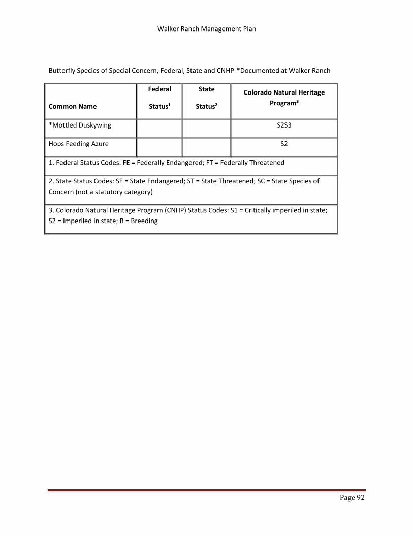
Walker Ranch Management Plan
Page 92
Butterfly Species of Special Concern, Federal, State and CNHP-*Documented at Walker Ranch
Common Name
Federal
Status¹
State
Status²
Colorado Natural Heritage
Program³
*Mottled Duskywing S2S3
Hops Feeding Azure S2
1. Federal Status Codes: FE = Federally Endangered; FT = Federally Threatened
2. State Status Codes: SE = State Endangered; ST = State Threatened; SC = State Species of
Concern (not a statutory category)
3. Colorado Natural Heritage Program (CNHP) Status Codes: S1 = Critically imperiled in state;
S2 = Imperiled in state; B = Breeding

Walker Ranch Management Plan
Page 93
APPENDIX G. WALKER RANCH BIOLOGICAL RESOURCE EVALUATION
The Biological Resource Evaluation that was a guiding document for much of this Management Plan is
located online here: http://www.bouldercounty.org/doc/parks/walkerreseval.pdf

Walker Ranch Management Plan
Page 94
APPENDIX H. TEAM MEMBERS
Walker Ranch Interdisciplinary Planning Team
The Walker Ranch Management Plan Revision was developed through the efforts of the Walker Ranch
Interdisciplinary Planning Team.
Ron Stewart, BCPOS Director Al Hardy – Recreation and Facilities Division Manager Rich Koopmann – Resource Planning Division Manager Therese Glowacki – Resource Management Division Manager Carol Beam – Historic Preservation Specialist Don Burd – Buildings and Historic Preservation Supervisor Meredith Dutlinger – GIS Analyst Pascale Fried – Education and Outreach Supervisor Amanda Hatfield – Ranger/Walker Ranch Caretaker Chad Julian – Forestry and Fire Supervisor Jennifer Kesler – Plant Ecologist Susan Spaulding – Senior Wildlife Biologist Nick Stremel – Forestry Technician Andy Tyler – Trails Supervisor Jim Webster – Trails Specialist