LAND HUSBANDRY AND HILL SIDE IRRIGATION WORKS CARRIED OUT BY SPIU LWH/RSSP IN RULINDO DISTRICT -...
70
i REPUBLIC OF RWANDA MINISTRY OF EDUCATION FACULTY OF AGRICULTURE AND RURAL DEVELOPMENT DEPARTMENT OF CROP SCIENCES OPTION OF CROP PRODUCTION LEVEL V Prepared by: Fi dele BIGANIRO INTERNSHIP REPORT ON LAND HUSBANDRY AND HILL SIDE IRRIGATION WORKS CARRIED OUT BY SPIU LWH/RSSP IN RULINDO DISTRICT - MUYANZA SITE.
Transcript of LAND HUSBANDRY AND HILL SIDE IRRIGATION WORKS CARRIED OUT BY SPIU LWH/RSSP IN RULINDO DISTRICT -...
i
REPUBLIC OF RWANDA
MINISTRY OF EDUCATION
FACULTY OF AGRICULTURE AND RURAL DEVELOPMENT
DEPARTMENT OF CROP SCIENCES
OPTION OF CROP PRODUCTION
LEVEL V
Prepared by:
Fi
dele BIGANIRO
INTERNSHIP REPORT ON LAND HUSBANDRY AND HILL SIDE IRRIGATION WORKS CARRIED OUT BY SPIU
LWH/RSSP IN RULINDO DISTRICT - MUYANZA SITE.

ii
Supervisor: Ing. Angelique MUKAMUGENGA
Done at Muyanza, April 12th 2014
i
DEDICATION
To almighty God;
To my beloved Family;
To my brothers and sisters;
To all my classmates and spiritual advisers;
To all my lecturers;
And finally but not least my field
supervisors.
ii
ACKNOWLEDGEMENTS
I am thankful to the Almighty God for his abundant blessings and
protection during my Internship. I feel highly indebted to the
Ministry of education through UR-CAVM, for improvising excellent
environment to pursue our studies.
My thanks extend to Dr. Laetitia NYINAWAMWIZA Principal of UR-
CAVM and the entire administrative staff who provided all
necessary facilities to conduct our Internship.
I take this opportunity to express my great sense of gratitude to
my field supervisor ENG.ANGELIQUE and her entire team of the
watershed area, for an incredible support and guidance during
this internship.
I am grateful to Dr. Francoise MWABONIMANA, acting Dean of
Faculty of Agriculture and rural development (FARD) for providing
all adequate logistics in order for us to accomplish this work.
My deep sense of gratitude goes to Mr. Aloys FASHAHO, head of the
Department of Crop sciences and specifically my supervisor in a
iii
memoir preparation for his valuable guidance and unceasing
advices and support to work to our best. I am thankful to all
academic staff of crop sciences department for providing
necessary knowledge and skills.
I address my sincerely recognition to kindly my parents, my
brothers and sisters, relatives, friends, class mates for their
advices, commitments, collaborations, trust worthy and their
uncountable efforts, they made during my life and my studies.
I thank gratefully the staff of LWH Muyanza site coordination
especially field supervisors, the way they accepted to offer
their insufficient time to explain to me all activities carried
out in their program.
Fidele BIGANIRO
ABSTRACT
The economic activities of Rwanda, is the agriculture, while its
soil is degraded and washed by water erosion where the soil start
to be infertile and decline. The internship took one month from
12thMarch to 12thApril; it was conducted on sites of SPIU LWH/RSSP
Rulindo coordination. The global objective of this internship was
to know how to protect our soil and fight against water erosion
iv
for improving the soil properties and increasing the soil
fertility in order to rise up the agricultural production.
Different methods and approaches have been used during this one
month internship period; Slope classification for determining the
needed technologies according to the slope; water management with
creating water ways, cut-off-drains, making graded
terraces ,construction of irrigation ditches and implementing
land husbandry and hill side irrigation technologies and further
extension activities such as group make ups, crop husbandry,
compost making.
According to the observation and practical activities at the end
of this internship, we have seen that bench terraces play a great
role in soil conservation especially for fighting against erosion
because bench terraces reduce totally water erosion; these
implemented technologies improved a big range of hilly mountains
in Rulindo watershed area.
Agriculture sector is subjected to devastating problems of soil
degradation due to massive population growth, mismanagement of
natural resources and lack of awareness and capacity to adopt
conservation and production measures.
Soil conservation controls practices are of a great necessity
because erosion problems and their outcomes have been a threat to
farmers of Rulindo district.
v
RESUME
Activité économique au Rwanda est l’agriculture alors que leur
sol est dégradé par l’érosion de l’eau où le sol a été infertile
et décline. Cette stage a duré un mois depuis le 12Mars jusqu’en
12 Avrir 2014 était réalisé dans le projet de SPIU LWH/RSSP,
coordination de Rulindo, site de Muyanza.
L’objectif global était de protéger le sol et la lutte- contre
l’érosion envie d’améliorer ses propriétés suite à l’augmentation
de la fertilité du sol pour augmenter la production agricole /
productivité du sol. Ici différentes méthodes ont été employées
comme la classification des pentes pour déterminer les
technologies nécessaires selon la pente ; creuser les drains,
construction des terrasses d’évacuations des eaux, protégeant la
terre avec des espèces différentes de plantation d'arbres dans
des secteurs de terre de récolte surtout sur les talus,
plantation des herbes et la délimitation de la terre de pâturage
et de forêt.
Les résultats de cette étude ont prouvé que les technologies
mises en application (classification de pente, gestion de l'eau,
terrasses évaluées, gestion de terre pour le développement des
vi
pâturages et régénération de forêt de nature) résultent les
problèmes Muyanza command area.
Les techniques faites, nous avons pu observer que les
technologies implantées dans la région de Muyanza ont eu une
importance primordiale sur la lutte contre l’érosion et de trouve
un grand rendement de production agricole.
Table of ContentsDEDICATION...........................................................i
ACKNOWLEDGEMENTS....................................................ii
ABSTRACT...........................................................iii
Resume………………………………………………………………………………………………………………………………………………….iv
Table of contents………………………………………………………………………………….v
List of tables...............................................vii
LIST OF FIGURES...................................................viii
vii
LIST OF APPENDICES...................................................x
LIST OF ACRONYMS AND ABBREVIATIONS..................................xi
CHAP 1. GENERAL INTRODUCTION.........................................1
1.2. Objectives of the internship....................................2
1.2.1. General objective.......................................2
1.2.2. The specific objectives.................................2
CHAP2. LITERATURE REVIEW............................................3
2.1. Overview of terraces............................................3
2.1.1. Terrace design..........................................4
2.1.2 Terrace location.........................................4
2.1.3. Terrace construction....................................4
2.1.4. Terrace maintenance.....................................4
2.2. Types of terraces.........................................5
2.2.11 Criteria for selection of terraces......................9
2.2.12 Cut-off drains design and spacing......................10
2.3 Generality on Irrigation........................................11
2.3.1. Definition.............................................11
2.3.2. Necessity of irrigation................................11
2.3.3. Scope of irrigation....................................12
2.3.4. Factor of choosing an irrigation method................12
2.3.5. Irrigation methods.....................................13
CHAPTER 3: MATERIALS AND METHODS....................................15
viii
3.1. Overview of internship location................................15
3.1.1. Relief Rulindo.........................................15
3.1.2. Climate................................................16
3.1.3. Soils..................................................16
3.1.4. Other economic activities of Rulindo...................17
3.2. Materials and Instruments used...........................18
3.3. Methodology....................................................18
CHAP 4. DISCUSSION OF THE RESULTS AND ACTIVITIES CONDUCTED..........19
4.1 Introduction....................................................19
4.1.1 Presentation of Muyanza site:.................................19
4.1.2 Scope of our internship period................................19
4.2 Activities conducted during a one month internship..............19
4.2.1 Extension.....................................................20
4.2.1.1 Climbing beans fertilization trial installation.............21
4.2.1.2 Compost making held at Remera village/Muyanza site..........23
4.2.2 Land husbandry................................................26
4.2.2.1 Activities related to the land husbandry....................26
4.2.2.1.1 Follow up and practices on pegging activities before terrace construction..........................................26
4.2.2.1.2. Follow up and learning about terraces construction.......27
a....................................................Land preparation27
b.........................................Selecting the contour lines27
ix
c.......Measurements and materials used in construction of terraces29
4.2.3 Follow up and learning on irrigation ditches and drains construction........................................................30
4.2.3.1 Construction of irrigation ditch:...........................30
4.2.3.2 Construction of drain:......................................30
4.2.4. Summary of all other activities carried out under irrigation and drains construction............................31
4.3. Other activities realized during this period of internship.....32
4.3.1 Community Development branch..................................32
4.3.2 Rural finance & Agribusiness..................................32
4.4 Constraints encountered during the internship works............33
CHAP5. CONCLUSION AND RECOMMENDATIONS...............................33
5.1. Conclusion.....................................................33
5.2. Recommendation:..........................................34
REFERENCES.........................................................35
APPENDICES.........................................................36
Appendix1. Rulindo district map.....................................36
Appendix2. Location of Muyanza operational site.....................37
x
List of tables
Table 1. Generalized guide for Spacing of cut-off-
drains………………………………....9
Table 2. Irrigation system design efficiency………………………………………………13
Table 4. List of materials and instrument used……………………………………………17
Table 5. Construction of terraces………………………………………………………….21
Table 6. Activities done and discussions…………………………………………………..23
xi
LIST OF FIGURES
Figure 1: Irrigation methods……………………………………………………………13Figure2: Fertilizer trial design………………………………………………………….22Figure 3.Colta beans fertilization trial…………………………………………………..22Figure4: Branch spreading on the compost……………………………………………..23Figure5: Chopping down the branches…………………………………………………23Figure6: Water sprinkle…………………………………………………………………24Figure7: Spreading cow dung and urine………………………………………………...24Figure8: Spreading ash………………………………………………………………….24Figure9: Adding soil and water…………………………………………………………25Figure10: Bamboo trees for aeration……………………………………………………25Figure11: Placing the bamboos…………………………………………………………25
xii
Figure 12: Land preparation …………………………………………………………….27 Figure 13: Selecting the contour lines …………………………………………………..28Figure 14: A-Frame is used for making contour line……………………………………29
LIST OF APPENDICES
Appendix1. Rulindo district map…………………………………………………………..34

xiii
Appendix2. Location of Muyanza
site.............................................................
............35
xiv
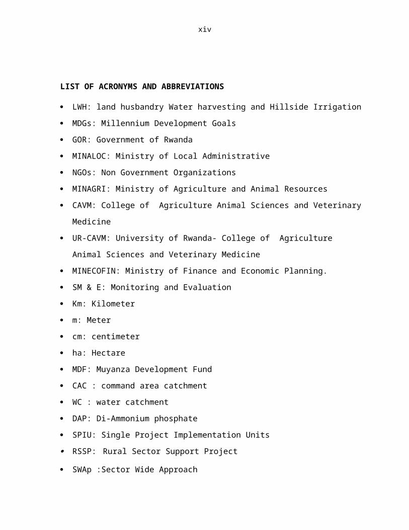
LIST OF ACRONYMS AND ABBREVIATIONS
LWH: land husbandry Water harvesting and Hillside Irrigation
MDGs: Millennium Development Goals
GOR: Government of Rwanda
MINALOC: Ministry of Local Administrative
NGOs: Non Government Organizations
MINAGRI: Ministry of Agriculture and Animal Resources
CAVM: College of Agriculture Animal Sciences and Veterinary
Medicine
UR-CAVM: University of Rwanda- College of Agriculture
Animal Sciences and Veterinary Medicine
MINECOFIN: Ministry of Finance and Economic Planning.
SM & E: Monitoring and Evaluation
Km: Kilometer
m: Meter
cm: centimeter
ha: Hectare
MDF: Muyanza Development Fund
CAC : command area catchment
WC : water catchment
DAP: Di-Ammonium phosphate
SPIU: Single Project Implementation Units
RSSP: Rural Sector Support Project SWAp :Sector Wide Approach

xv
CDO: community development o
1
CHAP 1. GENERAL INTRODUCTION
The government of Rwanda (GoR) as expressed in its vision 2020 is
pursuing a comprehensive strategy for modernization and
commercialization of agriculture in general. Agriculture is
considered as an engine that drives the economy of the country.
The Land husbandry, Water harvesting and Hillside irrigation
(LWH) Project is one of the development initiatives designed
under the Ministry of Agriculture and Animal Resources (MINAGRI)
and partly funded by the World Bank in order to tackle the issues
related to food insecurity and rural communities livelihoods
income. The project focuses on modernization and
commercialization of agriculture for strengthening the economic
access of the rural communities to food for consumption and
livelihoods improvement. The LWH Project has three components
aimed at (A) developing the human and organizational capacity and
(B) providing the required physical infrastructure for hillside
intensification and transformation, as well as a third component
(C) for Sector Wide Approach (SWAp) project management. The Land
Husbandry, Water Harvesting and Hillside Irrigation (LWH) Project
uses a modified watershed approach to introduce sustainable land
husbandry measures for hillside agriculture on selected sites, as
well as developing hillside irrigation for sub-sections of each
site. The Project envisions the production of high-value
(organic) horticultural crops such as apples with the strongest
marketing potential on irrigated portions of hillsides of the
2
watershed. It is in this regard that the Project will invest in
water harvesting infrastructure, including valley dams and
irrigation infrastructure on the selected sites. Water harvesting
infrastructure will be developed jointly with the irrigation
infrastructure including the water conveyance open-channels and
pipes. For this purpose the project conducted detailed
feasibility studies and designs in 2008 of the dams and
supplemental irrigation infrastructure necessary for hillside
irrigation. The project has already been implemented in Karongi,
Rwamagana and Nyanza districts; Rulindo district therefore and
mainly Muyanza site is one of the recent project’s target where
the project LWH is conducting the activities of land husbandry
water harvesting and hillside irrigation as objectives and in the
process of achieving its targets. The Project hired private
Companies to implement land husbandry technologies within the
Project intervention areas. The supervision of the works is done
by the Project staff at District level. Both teams work in group
effort whereby technical assistance is provided to the
implementing company so that the techniques to be implemented are
completed properly according to the Project design through the
illustrated supervision checklist, (Muyanza location map). The
project works in muyanza current implementation site has a very
dynamic potential and a very unusual initiative of group members
who created a development fund (MDF). The fund will assist
members to remain self sustained after the project completion
duration.
3
1.1. Problem Statement
Muyanza A and B are sites located in Rulindo district in Northern
Province where rainfall occurs in two seasons, a long rainy
season and a low rainy season. Normally this area accounts high
rainfall amounts with some dry periods. The problem arises on its
distribution for hill sides of this steep sloped region, many
times the erosion results and also some disasters may occur in
the area. To establish terraces in this area, will increase the
production by irrigation of crops during dry season as the role
of terraces are to protect soil erosion then the importance will
become more attributed to crops since they will not be severely
affected by water, and even minimizing the habilitation risks and
problems as it was noticed in recent previous months.
1.2. Objectives of the internship
1.2.1. General objective
The global objective of the internship is to make practice on
field in order to relate the theory obtained during the class
time and to improve our skills to be accustomed to the future
career related to crop production and relevant basics on soil and
water concepts.
1.2.2. The specific objectives
To analyze the positive impact of the project to the
community members of the close area and the extension
services of benefits.
4
To improve technical skills in land husbandry, crop
husbandry ,water harvesting and hill side irrigation
To know well land husbandry technologies implemented in
command areas.
To improve knowledge on the technologies of irrigated
terraces.
To know different methods used in erosion control.
To know alternative systems of erosion control through
agricultural practices and engineering structures.
To determine the impact of land husbandry, water harvesting
and hill side irrigation.
To know practically the different activities undertaken in
irrigated terraces.
CHAP2. LITERATURE REVIEW
2.1. Overview of terraces
Terraces are earth embankments or a combination of ridges and
channels constructed across the slope to intercept surface runoff
from farmland, (RAYAR, 2003).
5
According to FAO (1965) a terrace is an embankment or a combined
channel and embankment, constructed across the slope at fixed
intervals. The main purpose of terracing is to reduce runoff
velocity and soil erosion by breaking the effective length of
slopes. There are two types of terraces: graded and level. Graded
terraces, combined with suitable sod or subsurface outlets, and
are used in areas of abundant rainfall to safely divert excess
surface water. Although these terraces reduce runoff velocity,
they do little to reduce runoff volume. Graded terraces do not
provide any practical water conservation, but will reduce on-site
erosion damage.
Level terraces are designed for areas with permeable soils and
low to moderate rainfall. They can hold runoff and increase
infiltration from normal rainfall, but need supplementary
waterways and a collection arrangement to handle rainfall that
exceeds terrace storage capacity. Level terraces may conserve
water for crop use along the channel, as well as providing on-
site erosion protection. The principal advantages of terracing
include controlling on-site erosion by reducing runoff velocity
and controlling off-site damage by holding sediment in terrace
channels. Disadvantages include construction costs, long-term
commitment to maintenance, and little water conservation effect
on highly erodible land in areas of low to moderate rainfall.
6
2.1.1. Terrace design
The design of terrace system involves the proper spacing and
location of terraces, the design of a channel with adequate
capacity and the development of a cross-section which will permit
forming on the ridge and in channel. For the graded terrace,
runoff must be removed at non-erosive velocities, both in the
terrace channel and in the outlet. Soil characteristics, cropping
and soil management practices, and good conditions are important
factors to be considered in terrace design (HITIMANA, 2004).
2.1.2 Terrace location
After deciding on the location of outlet, the next step is to
locate the terraces. Minimum maintenance and adequate control of
erosion are the criteria for good terrace location. It is usually
advantageous to place the terrace ridge just above eroded spots,
gullies, and abrupt changes in slope (HITIMANA, 2004).
2.1.3. Terrace construction
The rate of construction of a terrace is affected by the
equipments, soil moisture, crops and crop residues, degree and
regularity of land slope, soil tilth, gullies and other
obstructions,
Terrace length and terrace cross-section, and the experience and
skill of the operator (HITIMANA, 2004).
7
2.1.4. Terrace maintenance
Construction of a well designed system of terraces is only the
beginning. The success of the terraces depends on whether they
are properly maintained and farmed after construction. After
construction and after each heavy rain, the farmer should inspect
the terraces periodically.
For all types of terraces, the maintenance work should include
the following:
- Keep grass growing on the risers and root out weds and vines.
Grass should be cut short and should not endanger the main crops;
- Any small break or landslip from the riser should be repaired
immediately;
- Keep animals away to prevent them trampling the risers or
eating the grass (HITIMANA, 2004).
2.2. Types of terraces
2.2.1 Bench terraces
2.2.2 Definition and description
Bench terraces are a series of level or virtually level strips
running across the slope at vertical intervals, supported by
steep banks or risers.
Bench terracing is one of the oldest mechanical methods of
erosion control, having been used for many centuries in thickly
8
populated countries where economic conditions necessitated the
cultivation of steep slopes. Bench terracing consists of
transforming relatively steep land into a series of level or
nearly level strips, or steps running across the slopes. The
strips are separated by almost vertical risers. The risers with
gentle slope may be of earth construction, steep risers are
supported by masonry. Modern practices favour the adoption of
bench terracing only on slopes steeper than 15% and where soil
conditions are favorable. The use of bench terraces on steep
slopes not only retards erosion losses but it also makes cropping
operations on these slopes possible and safe. However, the cost
of terracing itself, plus the problems and costs of farming
terraced land make this practice economically feasible only where
lands available for cultivation are scarce relative to the need
for agricultural production.
2.2.3 Types of bench terraces may be:
Level and table top, Slopping inwards, or sloping outwards
2.2.4. Objectives of bench terrace
To reduce run-off or its velocity and to minimize soil
erosion.
To conserve soil moisture and fertility and to facilitate
modem cropping operations i.e. mechanization, irrigation and
transportation on sloping land.
9
To promote intensive land use and permanent agriculture on
slopes and reduce shifting cultivation.
2.2.5. Design of bench terrace
- Excavated bench terraces usually have a vertical interval
between benches such that the area to be excavated will equal the
area to be filled. In any case the riser is as steep as possible.
- Conditions of soil, slope, rainfall, climate, farming
practice, have a direct bearing on terrace design and, therefore,
careful consideration should be given to all these factors
The design of bench terraces consists of terrace spacing, terrace
grade and length, and terrace cross-section.
2.2.6 Types of bench terraces and criteria for selection
The following are two main types of bench terraces:
Irrigation or level bench terraces: These are used where
crops, such as rice, need flood irrigation and impounding
water.
Upland bench terraces: These are used mostly for rain-fed
crops or crops which only require irrigation during the dry
season. They are generally sloped for drainage.
In humid regions: Use reverses sloped type.
In arid or semi-arid regions: Use outward-sloped type.
2.2.7 Locations and conditions for use of bench terraces
10
Generally speaking, bench terraces are particularly suited to
countries or communities with the following macro conditions:
- Severe erosion hazards.
- Areas with small holdings and a dense population.
- Areas where there are food shortages or high unemployment
rates.
For micro or site conditions, bench terracing is suitable in the
following cases:
- Where there are relatively deep soils.
- On sites which are not dissected by gullies and not too
stony.
Bench terraces are much more cost-effective if there is potential
for mechanization, irrigation and for growing high-value crops.
2.2.8 Advantages and inconvenient of the bench terraces
This method has as advantage:
Increase of the agricultural production. Indeed we can reach
the construction of the bench terrace, an increase of
agricultural production of 20 to 30%
Terraces keep manures, humidity and the superficial soils,
it improves Soil fertility progressively.
To improve the drainage and to offer some best sites to the
crop.
11
To facilitate the mechanism on the hillsides.
To maximize the profits of irrigation.
To create more arable earths and to permit the free choice
of culture.
To promote some programs of strong coefficients of manpower
(labor) and to create new Possibilities of jobs.
To stimulate the adoption of the improved agronomic
practices.
To embellish (to beautify) the landscapes and to improve the
environment. (SHENG, 1975).
Soil conservation by the reduction of erosion caused by the
rain water flow.
The reduction of the land slope
Note that: The main inconvenience of terraces as explained by
SHENG (1975) is the loose of land; and the typical terrace type
that was adopted at Muyanza site is known as improved bench
terraces.
2.2.9. Radical Terracing
According to COOCASTER (2004), radical terraces are a kind of
bench terraces, which are horizontal flat band formed, with
variable width according to the slope, disposed like steps on
watershed. The role that radical terracing plays shows that it is
an appropriate technique in soil conservation for Rwanda (PGERB,
2001).It is a device which models the slopes by transforming them
into more or less flat areas which retain all the runoffs (total
12
absorption).It is a type of land management which is under much
controversy regarding its generalized popularized a peasant
farming. It is a process which has the advantage of stopping
totally erosion and this sufficient, for its defenders, to
justify required investment effort. The critics on the other
hand, find that this investment is too high and that socio-
economic constraints and techniques are high at the level of the
farmers. Before we come down in favour or against radical
terraces, we find it is useful to quote rapidly some arguments in
favour or against in a general context.
YAMOAH (1987) finds that there are many constraints for the
promotion of radical terraces in the high altitude regions of
Rwanda:
High cost of construction and maintenance,
Loss of arable land (already rare which could be more
than 50%on slopes higher than 60%)
Lack of trained manpower to supervise the application on
peasant forms;
Accumulation of water in terraces causing landslides;
Difficult in letting out excess water via artificial
channels because of the land scarcity and dividing up of
farming land.
Initial reduction of soil fertility which requires
therefore relatively important quantities of organic and
fertilizing amendments unavailable in sufficient quantity
13
in the system. ROOSE et al (1988, P271) specifies that
the advantage of radical terraces is to reduce the slope
and erosion on one hand, and to facilitate the work on
soil on the other hand.
According to the same authors, the inconveniencies are:
The hard work of management (810 man days/ha),
The increase of infiltration localized near the rock
favoring land slide,
The quite long time (some years) required to rebuilt the
soil by massive input of manure, phosphorus (and lime for
acidic soils) before we can be able to see the output
double.
The lixiviation of soluble nutrients favorable by a too
strong reduction of streaming by forcing infiltration;
Globally, radical terracing:
• Suppresses completely the slope and totally the runoffs,
• Capitalizes the acquired fertility through organic and
mineral manure and enables therefore to invest and improve
the soil productivity,
• Allows envisaging small irrigation on hills and mountains.
• However, there are some constraints that reduce its
efficiency:
• It requires the restoring of fertility through massive input
of fertilizers both mineral and organic.
14
• It requires hard work and a very important manpower (500 to
800MH/ha for management and maintenance of embankments);
• There is high risk of land slide in areas of high rainfall
and in areas of light deep soil (MINAGRI, 1997) reported by
KANYARUKIGA et al.
2.2.10 Progressive Terracing
The progressive terracing is formed by its own from grasses
planted on the banks of ditches in a line. The soil cannot go
through the line (during the rain or soil working), and its
accumulation on upstream slowly forms the flat land. A
progressive terrace is formed by grasses cropped on a line
(vegetative barrier) which forms the vertical embankment to stop
the soil erosion while grasses keep on growing (GALLIKER, 1993).
The role of progressive terrace: the progressive terracing is the
most realistic economically. Their major roles are: fight against
erosion, fodder production, and manures as well as improving soil
fertility (GALLIKER, 1993).
2.2.11 Criteria for selection of terraces
Terraces are mainly used for erosion control and for growing
crops on sloping lands.
The selection of suitable types of terraces depends on many
factors, including the following:
Physical conditions of the site such as slope, soils,
rainfall, etc.
15
Socio-economic conditions of the country such as labor
conditions, land use patterns, cropping and farming systems,
population densities, etc.
Farmers' or land owners' conditions and interests including
their age and willingness to accept innovations, available
resources, main crops, tools to be used, etc.
When planning the application of terraces or any soil
conservation work it is the farmer who should make the final
decision.
a) On steep slopes
The relationship between crops and the different types of
terraces required on steep slopes for small and medium farms and
this can be used as a general guide for the selection of
terraces.
b) On gentle slopes
On large farms and gentle slopes where machines are used for
cultivation, broad base terraces are the main conservation
treatment. In regions with heavy rainfall, and/or heavy soils,
the graded or drainage type is used while in regions with light
rainfall and/or light soils, the level or absorption type is
generally used. On small farms situated on gentle slopes, natural
terraces, which possess the advantage of being labor-saving, can
be employed.
16
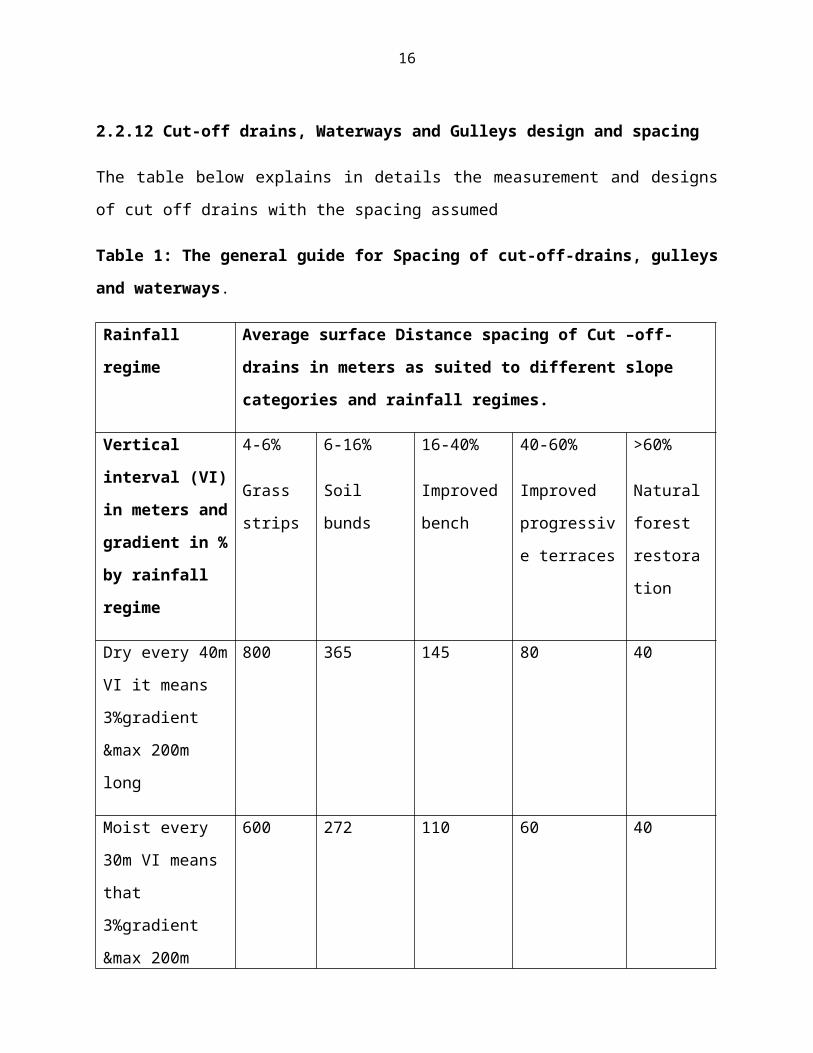
2.2.12 Cut-off drains, Waterways and Gulleys design and spacing
The table below explains in details the measurement and designs
of cut off drains with the spacing assumed
Table 1: The general guide for Spacing of cut-off-drains, gulleys
and waterways.
Rainfall
regime
Average surface Distance spacing of Cut –off-
drains in meters as suited to different slope
categories and rainfall regimes.
Vertical
interval (VI)
in meters and
gradient in %
by rainfall
regime
4-6%
Grass
strips
6-16%
Soil
bunds
16-40%
Improved
bench
40-60%
Improved
progressiv
e terraces
>60%
Natural
forest
restora
tion
Dry every 40m
VI it means
3%gradient
&max 200m
long
800 365 145 80 40
Moist every
30m VI means
that
3%gradient
&max 200m
600 272 110 60 40
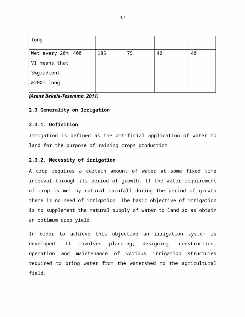
17
long
Wet every 20m
VI means that
3%gradient
&200m long
400 185 75 40 40
(Azene Bekele-Tesemma, 2011)
2.3 Generality on Irrigation
2.3.1. Definition
Irrigation is defined as the artificial application of water to
land for the purpose of raising crops production
2.3.2. Necessity of irrigation
A crop requires a certain amount of water at some fixed time
interval through its period of growth. If the water requirement
of crop is met by natural rainfall during the period of growth
there is no need of irrigation. The basic objective of irrigation
is to supplement the natural supply of water to land so as obtain
an optimum crop yield.
In order to achieve this objective an irrigation system is
developed. It involves planning, designing, construction,
operation and maintenance of various irrigation structures
required to bring water from the watershed to the agricultural
field.
18
The factors which necessitate irrigation can be summarized as
follow:
Inadequate rainfall
Uneven distribution of rainfall
Increasing the yield of crops
Growing perennial crops
Growing superior crops
Insurance against drought (Arora, 2004)
2.3.3. Scope of irrigation
The scope of irrigation can be divided into two heads:
a. Engineering aspects; this deal with design, construction,
and maintenance of all works in connection with the river
diversion, storage works, water conveyance works and
agricultural land drainage.
b. Agricultural aspects; which deals with the study of the
following points:
Proper depth of water necessary in a single application of water
for various crops
Distribution of water uniformly and periodically Capacities of
different soils for irrigation water, and the flow of water in
soils Reclamation of waste and alkaline lands
19
2.3.4. Factor of choosing an irrigation method
To choose an irrigation method, the farmer must know the
advantages and disadvantages of the various methods.
He or she must know which method suits the local conditions best.
Unfortunately, in many cases there is no single best solution:
all methods have their advantages and disadvantages. Testing of
the various methods - under the prevailing local conditions -
provides the best basis for a sound choice of irrigation method
(FAO, 1993).
The suitability of the various irrigation methods, i.e. surface,
sprinkler or drip irrigation depends mainly on the following
factors:
Natural conditions
Type of crop
Type of technology
Required depth of irrigation application
Previous experience with irrigation
Required labor input
Level of technology
Costs and benefits.
20
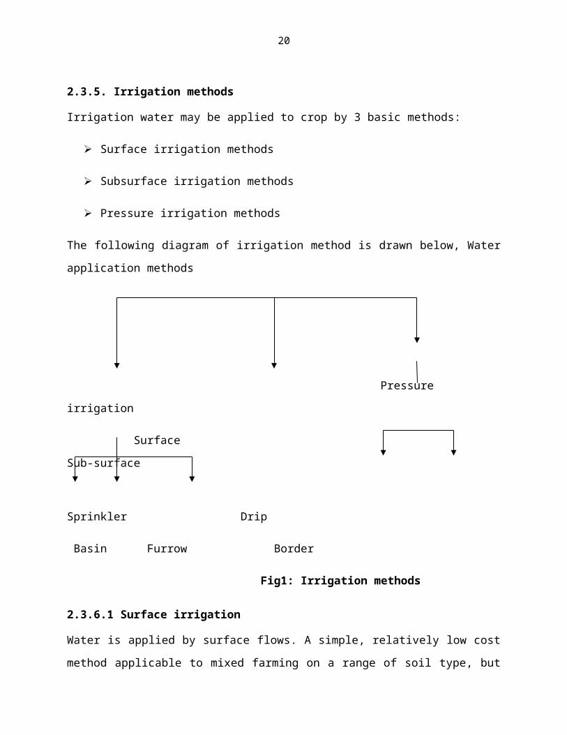
2.3.5. Irrigation methods
Irrigation water may be applied to crop by 3 basic methods:
Surface irrigation methods
Subsurface irrigation methods
Pressure irrigation methods
The following diagram of irrigation method is drawn below, Water
application methods
Pressure
irrigation
Surface
Sub-surface
Sprinkler Drip
Basin Furrow Border
Fig1: Irrigation methods
2.3.6.1 Surface irrigation
Water is applied by surface flows. A simple, relatively low cost
method applicable to mixed farming on a range of soil type, but
21
is relatively inefficient and should be avoided on steep slopes
and sandy soils.
2.3.6.2. Subsurface irrigation
This irrigation method directly supplies water to the root zone
of the crop due to capillary action:
Water is supplied to a series of ditches 0.5-1.0 m deep and 25-50
cm wide having vertical sides.
Water flows at slow rate and seeps into the ground to maintain
the water table high so that water from the capillary fringe is
available to the crops.
2.3.6.3. Sprinkler irrigation
This system is versatile and is suitable for a wide range of
crops, soil types and slopes. Water is supplied under pressure
and distributed through sprinklers.
2.3.6.4. Drip irrigation
Also called trickle irrigation, refers to the application of
water at a slow rate drop by drop through perforations in pipes
or nozzles attached to tubes spread over the soil to irrigate a
limited area around the irrigation (Majumdar, 2004).
a. Definition of drip irrigation
Drip irrigation is the slow localized application of water,
literally drop by drop, at a point or grid of points on the soil
22
surface. As long as the application rate is below the soil’s
potential intake, termed infiltrability, the soil remains
unsaturated and no free water stands or runs over the surface.
(Andreas P. Savva, 2002).
b. Background
Drip irrigation is the most efficient method of irrigating. While
sprinkler systems are around 75-85% efficient, drip systems
typically are 90% or higher. What that means is much less wasted
water. For this reason drip is the preferred method of irrigation
in the desert regions of the United States. But drip irrigation
has other benefits which make it useful almost anywhere. It is
easy to install, easy to design, can be very inexpensive, and can
reduce disease problems associated with high levels of moisture
on some plants. If you want to grow a rain forest however, drip
irrigation will work but might not be the best choice (Andreas P.
Savva, 2002)
c. Drip Irrigation and its components
It is of course necessary to choose an irrigation system before
design, equipment specification and installation can proceed. To
do a proper job of system selection, one must give careful
consideration to both the environment in which the irrigation
system must function, and to the capabilities and limitation of
all potential irrigation system alternatives (Sharma, 2000).
23
CHAPTER 3: MATERIALS AND METHODS
3.1. Overview of internship location
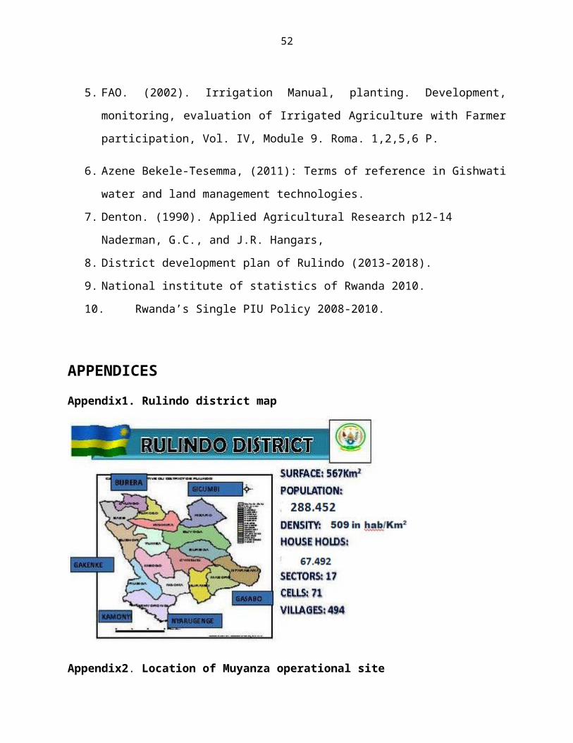
Rulindo District is one of the five Districts in the Northern
Province. It is bordered by Gicumbi to the north, Burera district
to the north-west, Gasabo and Nyarugenge districts to the south,
and Gakenke and Kamonyi to the west & south west.
Rulindo District stretches over an area of 567 km2 with a
population of 288,452 Distributed into 67,492 households. It is
among the districts of Rwanda which have a high density of
509hab. per square kilometer and faces the demographic growth
pressure with average annual growth rate of 2.1 %.
Rulindo District is divided into 17 administrative sectors
(Imirenge), It is subdivided into 71 cells (Akagari) and 494
villages (Imidugudu).
3.1.1. Relief Rulindo
Rulindo district is characterized by the high lands area with
steep features. The estimate terrain elevation above sea level is
1874 meters and the geographical latitudes of the district: -
1°44'17.81" as well as longitudes: 29°59'52.58". The superior
administrative division is Northern province.
On one hand, the topographical characteristics allow the district
to be faced with soil erosion. The various land uses decrease
forest area accentuate the erosion phenomena, bring heavy
24
siltation downstream, and in some cases, the floods may occur.
The sensitive degradation is a constraint for developing
mechanized agriculture with productivity. So, environmental
initiatives should be undertaken to protect the soil.
On the other hand, this relief hinders the development of
Imidugudu and cities which remain the main challenge to economic
growth, off-farm employment and poverty reduction in Rulindo
district. In general, the structure of this kind of habitat is
likely to impact negatively on all the social economic sectors of
the district. The inaccessibility to social economic
infrastructures by a large number of Rulindo populations in rural
areas is mainly due to the isolated habitat. The district has
abundant forest resources but there are no based industries to
provide value addition to this sector. In addition, these forest
resources do not generate high income, employment and foreign
exchange for the country. However, Rulindo district being on the
banks of Kigali city, there is an anticipative hope to advance
soon, since the government of Rwanda has initiated the district
to be one of the second-order administrative divisions of
implementing modern habilitation.
3.1.2. Climate
Rulindo District experiences tropical climate of high altitude.
It is one of Rwanda regions which have high rainfall. The amount
of rainfall in the district benefits the area and it is
characterized by two dry seasons covering the period from
25
December to January and from June to mid September, and It is
also characterized by two rainy seasons the long rains start in
mid-September and end in December and from February to June with
an annual average of temperature varying from 16ᵒC to 21ᵒ 5C.
Annual rain falls ranging from 1100 to 1500 mm, thus these
features are favorable to agriculture and livestock development.
But they are the source of erosion and environmental degradation
in the regions of high altitude. So, there should be a continuous
protection of environment in these areas.
3.1.3. Soils
Rulindo district soils can be categorized into various types.
According to the altitude feature, the soil in some areas is poor
soil degraded by erosion. This situation is getting worse by
agricultural practices such as over exploitation of land, small
size of land for farmers which does not leave the field lying
fallow land;
In other areas, the soil is good but needs to be protected
against environmental phenomena. These considerations imply a
need to add organic and mineral fertilizers in agriculture, and
farmers are not able to get these inputs and this increases the
level of vulnerability and poverty of farmers in Rulindo. In
other areas, there are valley and marsh soils which are favorable
for vegetables, maize, Irish potatoes and cassava on hillsides.
26
3.1.4. Other economic activities of Rulindo
Rulindo district, the agricultural and livestock activities
remain the key economic potentials. This sector is justified by
its contribution to the economy of Rulindo and the number of
people who are employed in this sector. First, agriculture
remains an independent activity to individual farmers, at least
79.1% of households depend mainly on the revenues from
agricultural activities and 15.3% of total households earn the
wages from this sector. This implies that 71.8% of the households
are involved in agriculture. In the district, the export cash
crops and food crops are produced; hence they are a source of
rural incomes. Among the export crops, coffee, tea, sugarcane,
macadamia and the newest stevia crop are the main commercial
crops found in the area while food crops produced in the area
comprise of maize,sorghum, beans, soya beans, peas, irish
potatoes ,bananas, cassava, wheat, vegetables and fruit trees.
The main crops that are cultivated on large land by most of
farmers include beans, sorghum, soya beans, legumes, bananas,
maize, potatoes, peas, and wheat and fruit trees.
In rural areas, farmers rear some animals such as cows, sheep,
goats, pigs, and poultry. Currently, bee-keeping is also being
carried out as a way to increase income for farmers but it is not
developed, as well as fish farming as an activity which generates
income but it is not more developed even though the district is
making much effort. Rulindo districts also accounts for its
27
mining activities such as Rutongo mines which brings works to the
huge population of the district, it has also potential investing
enterprises such Nyirangarama and big range of land where coffee
and tea plantations are grown like Kinihira tea plantations
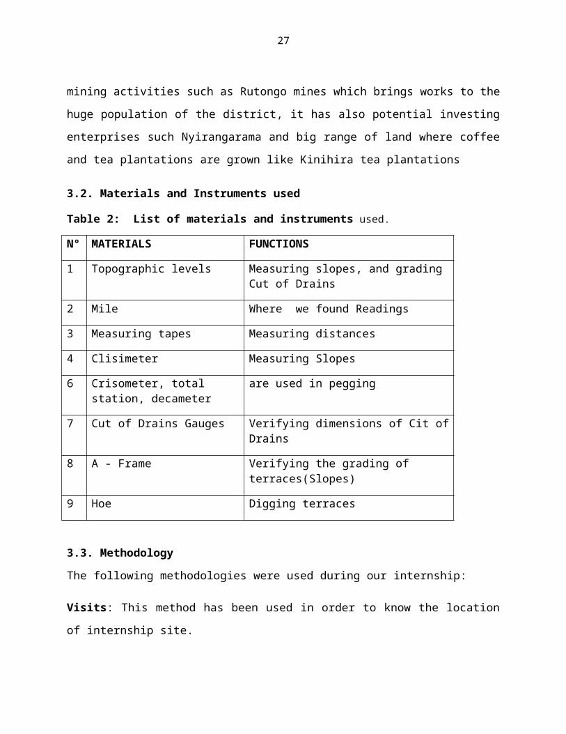
3.2. Materials and Instruments used
Table 2: List of materials and instruments used.
N° MATERIALS FUNCTIONS
1 Topographic levels Measuring slopes, and grading Cut of Drains
2 Mile Where we found Readings
3 Measuring tapes Measuring distances
4 Clisimeter Measuring Slopes
6 Crisometer, total station, decameter
are used in pegging
7 Cut of Drains Gauges Verifying dimensions of Cit ofDrains
8 A - Frame Verifying the grading of terraces(Slopes)
9 Hoe Digging terraces
3.3. Methodology
The following methodologies were used during our internship:
Visits: This method has been used in order to know the location
of internship site.
28
Observation: After visiting the site of internship, I have
observed the different steps (process) of terracing in order to
see if what we have learnt in theory are the same as what are
done in practice.
Participation: After observation and follow the different steps
of terracing, I have participated in different activities such as
land husbandry in terrace works, community development programs
such as group meetings and compost make ups and extension
services such as fertilization trials in order to be experienced
as the future agronomist in crop production field.
Documentation: This method has been used for report preparation
and field leading department for orientation make up in order to
improve our knowledge and skills and to meet the reliable results
of good qualities.
CHAP 4. DISCUSSION OF THE RESULTS AND ACTIVITIES CONDUCTED.
4.1 IntroductionThe LWH/RSSP project is operational at Muyanza since August 2013in order to try helping its beneficiaries in Rulindo district toface the following major challenges:
Unstable climate : drought / storms; Diseases & Pests outbreaks; Poor Pocket potential of the farmer to afford quality seeds& other agro inputs; Infertile soils; Soils erosion; Un-consolidated small parcels of land; Poor/lack of storage facilities;
29
Poor linkage between the farmer and the market.
4.1.1 Presentation of Muyanza site:Location: Rulindo District, Northern Province;
Administrative entities: 5 Sectors (Burega, Buyoga, Cyinzuzi,
Tumba & Mbogo), 14 Cells & 60 Villages;
Number of households: 7,200;
Number of beneficiaries: 36,000 (48.2% are men and 51.8% are
women).
4.1.2 Scope of our internship periodOur academic internship had a limited time from the 12th March to
12th April 2014 a period of only one month. The limited scope of
time forged our activities to a limited extent based on the
LWH/RSSP project’s long programmed activities.
4.2 Activities conducted during a one month internshipThe SPIU-LWH/RSSP-Muyanza site has activities sub divided into 3
departments as the project is concerned: Below is the listing of
the four main branches.
a) Land husbandry
b) Community development
c) Extension
d) And rural finance and agribusiness
30
As one of the future agronomist, the intern worked and
experienced each activity in order to have at least a notion on
any activity elaborated by the project; however as a specialist
in crop sciences the activities during this internship emphasized
a lot on extension and land husbandry as priorities. The
following activities were therefore realized during this period
of internship:
4.2.1 ExtensionUnder the extension department of the project, the listed
activities were directly or indirectly participated into and some
were visited during the internship.
Visiting an area of 1.7ha where onion crops have been grown
on 18th March.
Mobilization of farmers to planting climbing beans for the
2014 season b in the already prepared terraces (Muyanza b)
on 24th March.
Visit at demonstration plots installed in two zones (Muyanza
A & B) on 20 March
Participation in the construction of kitchen gardens and
visiting the constructed ones(about 853 kitchen gardens now
constructed)
Visit an off-farm activity on one demonstration of mushroom
farming installation.
31
Participation in the training on compost making around 84
participants (53men and 31females). Muyanza site has
produced already above 865tonnes of compost fertilizers
which were distributed to farmers for 2014B season and it
was efficiently used. On 27th March 2014 we made one compost
with a youth group called ‘icyizere’.
Visiting the apple plantation at Muyanza B where 600 apples
have been planted.
Survey and mobilization of locals to grow coffee plantations
on a very steep areas where terracing is nearly impossible.
The activity as per now has gone beyond to more than 4000
crops grown in the closer locations of the command area.
Seeds multiplication: about 5ha of climbing beans was found
planted in the season B.
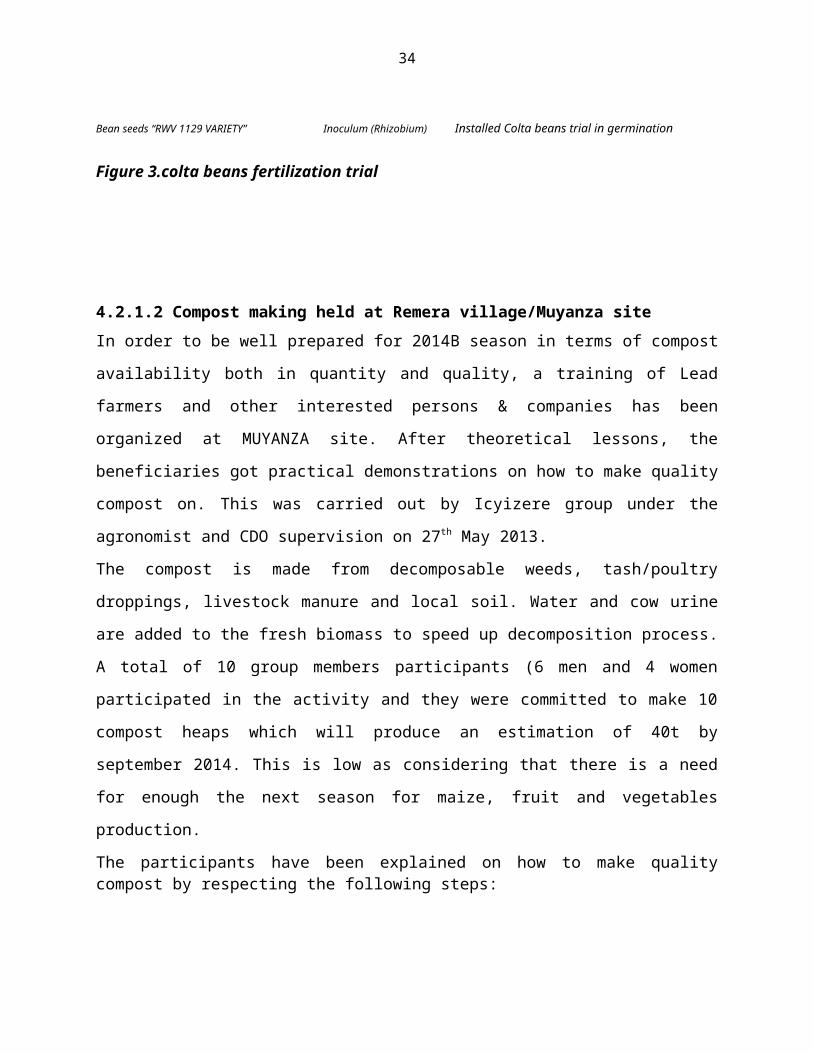
Under the extension activities a trial on Colta beans has been
installed on 31st march 2014. Below is the scheme of work of
the realized activity.
4.2.1.1 Climbing beans fertilization trial installationThe Rwandan economy is based predominantly on agriculture.
However, the sector is facing a set of challenges mainly related
to soil fertility deterioration, low use of fertilizers & other
amendments, etc. In order to determine the response of climbing
bean variety (RWV 1129) to the inoculation and fertilizer
application, a field trial has been installed with closer
32
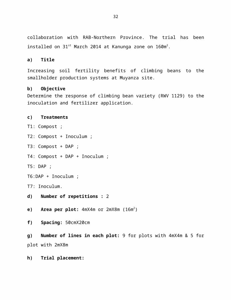
collaboration with RAB-Northern Province. The trial has been
installed on 31st March 2014 at Kanunga zone on 160m2.
a) Title
Increasing soil fertility benefits of climbing beans to thesmallholder production systems at Muyanza site.
b) ObjectiveDetermine the response of climbing bean variety (RWV 1129) to theinoculation and fertilizer application.
c) Treatments
T1: Compost ;
T2: Compost + Inoculum ;
T3: Compost + DAP ;
T4: Compost + DAP + Inoculum ;
T5: DAP ;
T6:DAP + Inoculum ;
T7: Inoculum.
d) Number of repetitions : 2
e) Area per plot: 4mX4m or 2mX8m (16m2)
f) Spacing: 50cmX20cm
g) Number of lines in each plot: 9 for plots with 4mX4m & 5 for
plot with 2mX8m
h) Trial placement:
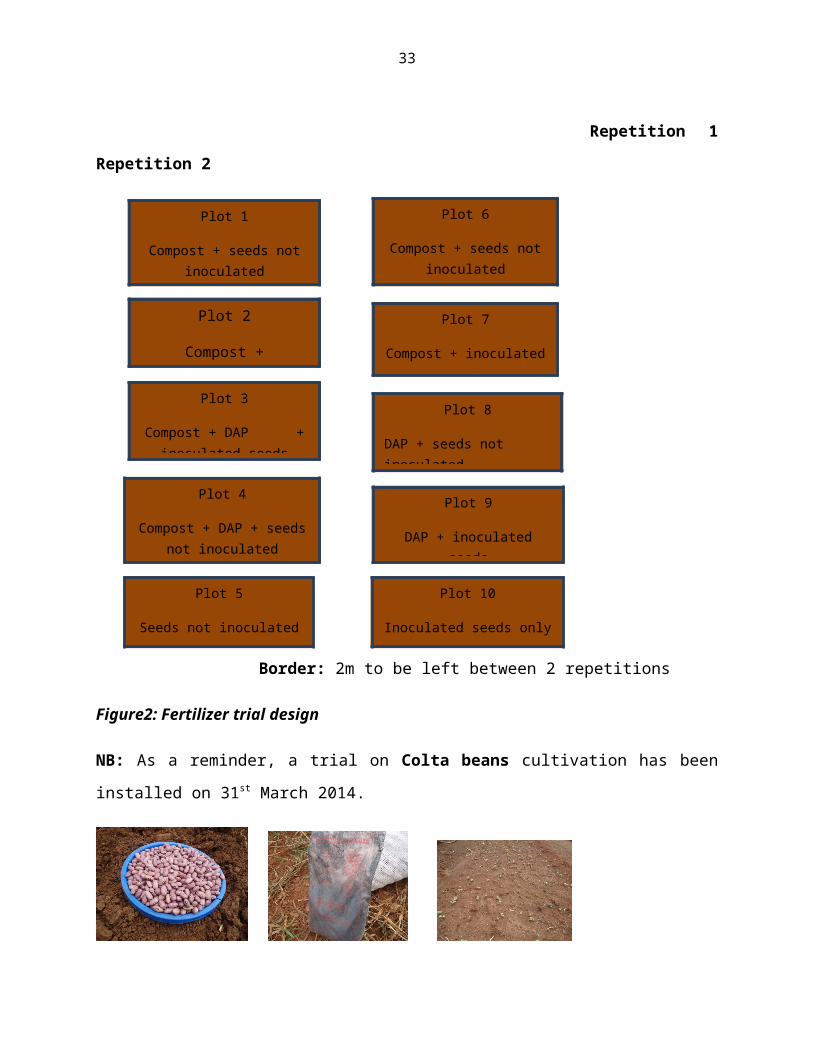
33
Repetition 1
Repetition 2
Border: 2m to be left between 2 repetitions
Figure2: Fertilizer trial design
NB: As a reminder, a trial on Colta beans cultivation has been
installed on 31st March 2014.
Plot 1
Compost + seeds notinoculated
Plot 6
Compost + seeds notinoculated
Plot 2
Compost +
Plot 3
Compost + DAP +inoculated seeds
Plot 5
Seeds not inoculatedonly
Plot 10
Inoculated seeds only
Plot 4
Compost + DAP + seedsnot inoculated
Plot 9
DAP + inoculatedseeds
Plot 8
DAP + seeds not inoculated
Plot 7
Compost + inoculatedseeds
34
Bean seeds “RWV 1129 VARIETY” Inoculum (Rhizobium) Installed Colta beans trial in germination
Figure 3.colta beans fertilization trial
4.2.1.2 Compost making held at Remera village/Muyanza siteIn order to be well prepared for 2014B season in terms of compost
availability both in quantity and quality, a training of Lead
farmers and other interested persons & companies has been
organized at MUYANZA site. After theoretical lessons, the
beneficiaries got practical demonstrations on how to make quality
compost on. This was carried out by Icyizere group under the
agronomist and CDO supervision on 27th May 2013.
The compost is made from decomposable weeds, tash/poultry
droppings, livestock manure and local soil. Water and cow urine
are added to the fresh biomass to speed up decomposition process.
A total of 10 group members participants (6 men and 4 women
participated in the activity and they were committed to make 10
compost heaps which will produce an estimation of 40t by
september 2014. This is low as considering that there is a need
for enough the next season for maize, fruit and vegetables
production.
The participants have been explained on how to make qualitycompost by respecting the following steps:
35
1. Measure 4X3m on which we spread small and coarser branches atthe bottom floor. This helps the air to circulate and any accessmoisture to drain easily;
Figure4: branch spreading on the compost2. Cut biomass into small pieces to speed up decompositionprocess
Figure5: chopping down the branches
3. Spread the biomass on a depth of 14cm and Sprinkle water atthe top to moisten the layer. Make sure that it is not too wet.
Figure6: water sprinkle
4. Spread 3cm layer of fresh cow dung and urine.
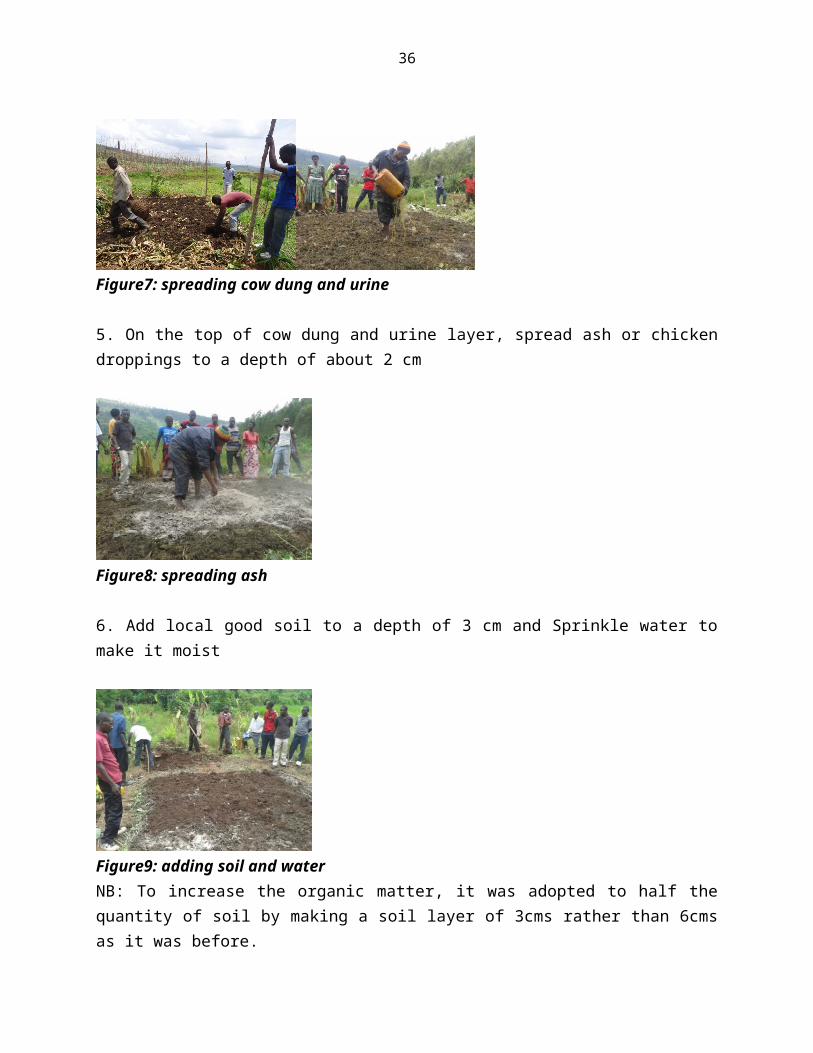
36
Figure7: spreading cow dung and urine
5. On the top of cow dung and urine layer, spread ash or chickendroppings to a depth of about 2 cm
Figure8: spreading ash
6. Add local good soil to a depth of 3 cm and Sprinkle water tomake it moist
Figure9: adding soil and waterNB: To increase the organic matter, it was adopted to half thequantity of soil by making a soil layer of 3cms rather than 6cmsas it was before.
37
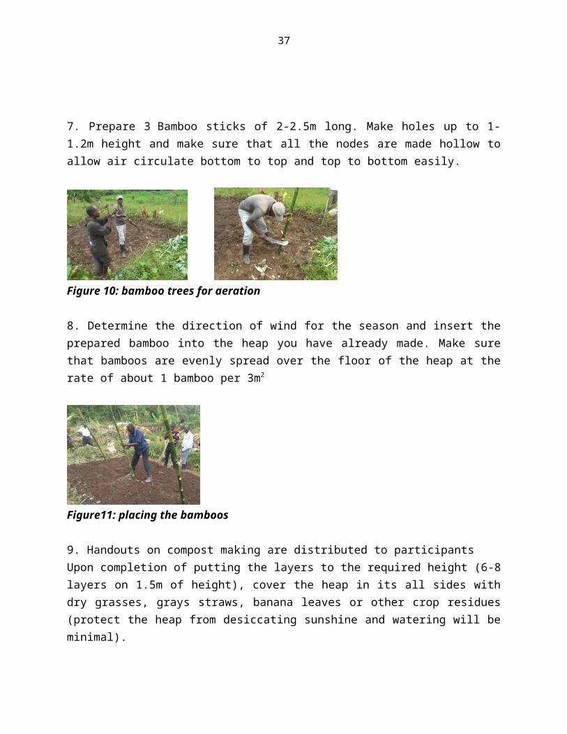
7. Prepare 3 Bamboo sticks of 2-2.5m long. Make holes up to 1-1.2m height and make sure that all the nodes are made hollow toallow air circulate bottom to top and top to bottom easily.
Figure 10: bamboo trees for aeration
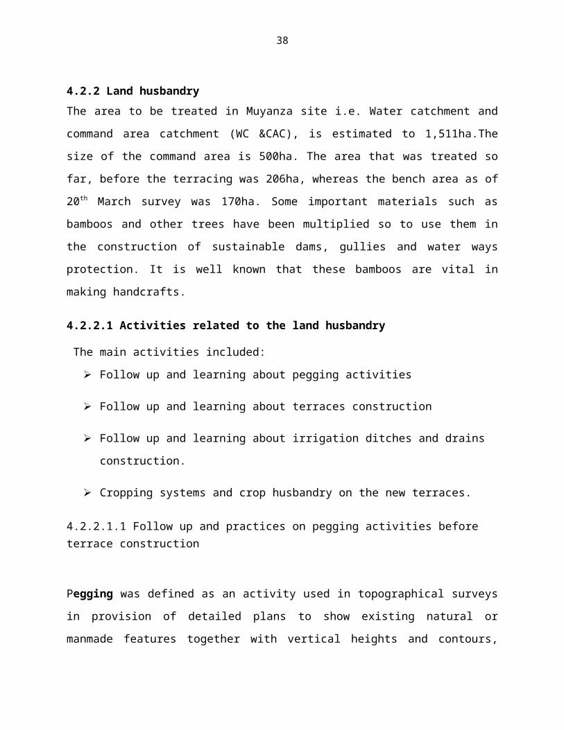
8. Determine the direction of wind for the season and insert theprepared bamboo into the heap you have already made. Make surethat bamboos are evenly spread over the floor of the heap at therate of about 1 bamboo per 3m2
Figure11: placing the bamboos
9. Handouts on compost making are distributed to participants Upon completion of putting the layers to the required height (6-8layers on 1.5m of height), cover the heap in its all sides withdry grasses, grays straws, banana leaves or other crop residues(protect the heap from desiccating sunshine and watering will beminimal).
38
4.2.2 Land husbandryThe area to be treated in Muyanza site i.e. Water catchment and
command area catchment (WC &CAC), is estimated to 1,511ha.The
size of the command area is 500ha. The area that was treated so
far, before the terracing was 206ha, whereas the bench area as of
20th March survey was 170ha. Some important materials such as
bamboos and other trees have been multiplied so to use them in
the construction of sustainable dams, gullies and water ways
protection. It is well known that these bamboos are vital in
making handcrafts.
4.2.2.1 Activities related to the land husbandry
The main activities included:
Follow up and learning about pegging activities
Follow up and learning about terraces construction
Follow up and learning about irrigation ditches and drains
construction.
Cropping systems and crop husbandry on the new terraces.
4.2.2.1.1 Follow up and practices on pegging activities before terrace construction
Pegging was defined as an activity used in topographical surveys
in provision of detailed plans to show existing natural or
manmade features together with vertical heights and contours,
39
making reference pegs on platform of irrigation ditch depends of
slope 0.3/100
Vertical interval of terraces depends of slope category of land.
Slope of 6-16 % , vertical interval is 1m
Slope of 16-40%, vertical interval is 1.5 m
Slope of 40-60 % , vertical interval is 2m
Note that: Some of materials used in pegging activities are
Crisometer, total station, A’ Frame and Decameter
4.2.2.1.2. Follow up and learning about terraces construction From observation and explanation about terraces construction
during internship period,
It is said that in agriculture, a terrace is a piece of sloped
plane that has been cut into a series of successively receding
flat surfaces or platforms, which resemble steps, for the
purposes of more effective farming. This type of landscaping,
therefore, is called terracing. Graduated terrace steps are
commonly used to farm on hilly or mountainous terrain. Terraced
fields decrease erosion and surface runoff, and are effective for
growing crops.
40
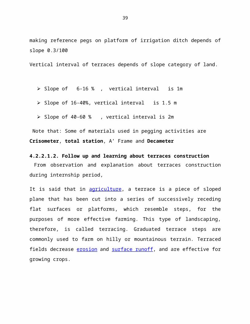
a. Land preparationBefore construction is commenced, all possible grasses, tree
stumps, stones were cleared off the surface of the ground as
indicated in the following figure:
Figure 12:Land preparation
According to the figure above, it is clear that the man powers
are cutting the bananas of selected location for digging terrace.
The distance remained from house to managed land was about 10m
which should be reserved as the location for installing water
close or latrine, sewage and so on.
b. Selecting the contour linesThe contour lines were determined by selecting a site with a
relatively uniform slope, and placing the first stake at the top
of this slope. Then working down the slope, place the stakes
where all the other terraces will go, according to the designed
spacing of the terraces as shown in figure 6.
41
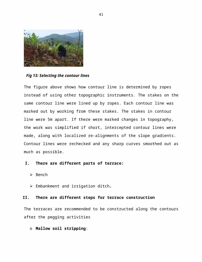
Fig 13: Selecting the contour lines
The figure above shows how contour line is determined by ropes
instead of using other topographic instruments. The stakes on the
same contour line were lined up by ropes. Each contour line was
marked out by working from these stakes. The stakes in contour
line were 5m apart. If there were marked changes in topography,
the work was simplified if short, intercepted contour lines were
made, along with localized re-alignments of the slope gradients.
Contour lines were rechecked and any sharp curves smoothed out as
much as possible.
I. There are different parts of terrace:
Bench
Embankment and irrigation ditch.
II. There are different steps for terrace construction
The terraces are recommended to be constructed along the contours
after the pegging activities
o Mallow soil stripping:
42
Top soil is removed and hipped at some place from 10 m of pipe
before cutting and filling is completed ,40cm of top soil are
removed which is good for cultivation because they contains many
nutrients.
o Row soil building bund:
Cutting of lower soil is used for compaction and filling of
embankment, there is a bund of soil all along its length at the
top of the embankment in order to compensate for the height loss
that may happen due to the settlement of constructed terraces.
o Row soil leveling: lower soil leveling in bench
o Mallow soil restoration: Removed top hipped soil evenly
distributed on the top surface of the constructed terraces
(bench) the place of cultivation.
c. Measurements and materials used in construction of terraces
The terraces are leveled along their length
Embankment gauges inclined up slope at the ratio of 1:1 V: H
(filling) and the ratio of 3:1 V: H of cutting to give them
stability.
Bench is graded at the slope of 0.3% from pipe to drain with
inversed slope of 2% from the notch to the middle of the terrace
and 0% from the middle of terrace to the irrigation ditch in
order to make stability of bench and A-frame is used.
43
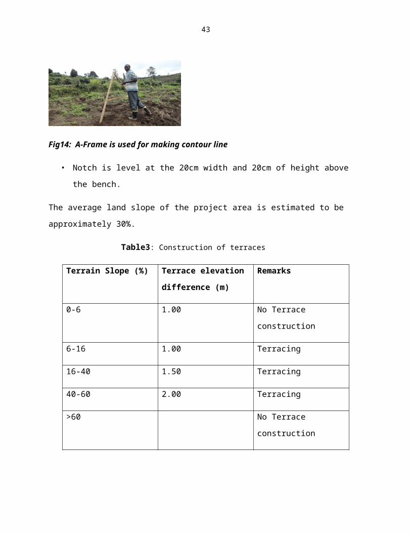
Fig14: A-Frame is used for making contour line
• Notch is level at the 20cm width and 20cm of height above
the bench.
The average land slope of the project area is estimated to be
approximately 30%.
Table3: Construction of terraces
Terrain Slope (%) Terrace elevation
difference (m)
Remarks
0-6 1.00 No Terrace
construction
6-16 1.00 Terracing
16-40 1.50 Terracing
40-60 2.00 Terracing
>60 No Terrace
construction
44
Also the riser for all terraces have a 1/3 (H/V) slope for cut
and 1/1 (H/V) slope to fill with 30cm transition section between
cut and fill sections.
4.2.3 Follow up and learning on irrigation ditches and drains construction.
4.2.3.1 Construction of irrigation ditch: Irrigation ditch is a small canal located in the front part of
the bench used to supply water in the terrace.
• Irrigation ditch is constructed after the terrace is already
constructed
• Irrigation ditch construction starts before the pegging of
its plat form is already made
• Irrigation ditch is graded at 0.3% slope, 20cm of bottom
width, 40cm of top width and 30 cm depth.
4.2.3.2 Construction of drain:o Drain is constructed in the form of inverted trapezoid form
with an average floor width of 40cm with both sides sloping
at 2:1ratio.
o Drain are receiving water from more than one cut off drain,
the width and depth changes and gets wider as it progress to
words it out let.
o The distance from drain to the other drain is 200m
o The distance from pipe to the drain is 100m
45
During my internship period I was assigned to follow 0.392 km
of drain constructed in k13 site.
After the construction of terraces , irrigation ditches, drains
(water ways) the technicians from company and LWH took
measurements and checked the tasks which were not finished,
then they submitted the output report to the LWH office and
company office, the reports are given weekly.
There are other activities which have been done during this
period such as:
Slope classification before terraces construction.
Making of Contour lines.
Construction of Waterways.
Construction of Cutoff-drain.
Maintenance of destroyed terraces.
4.2.4. Summary of all other activities carried out under irrigation and drains constructionThe table below summarizes all the common activities observed on
the field.
Table 4: Activities done and discussions
Activities
Discussion
Making of Contour lines Are making according to slope
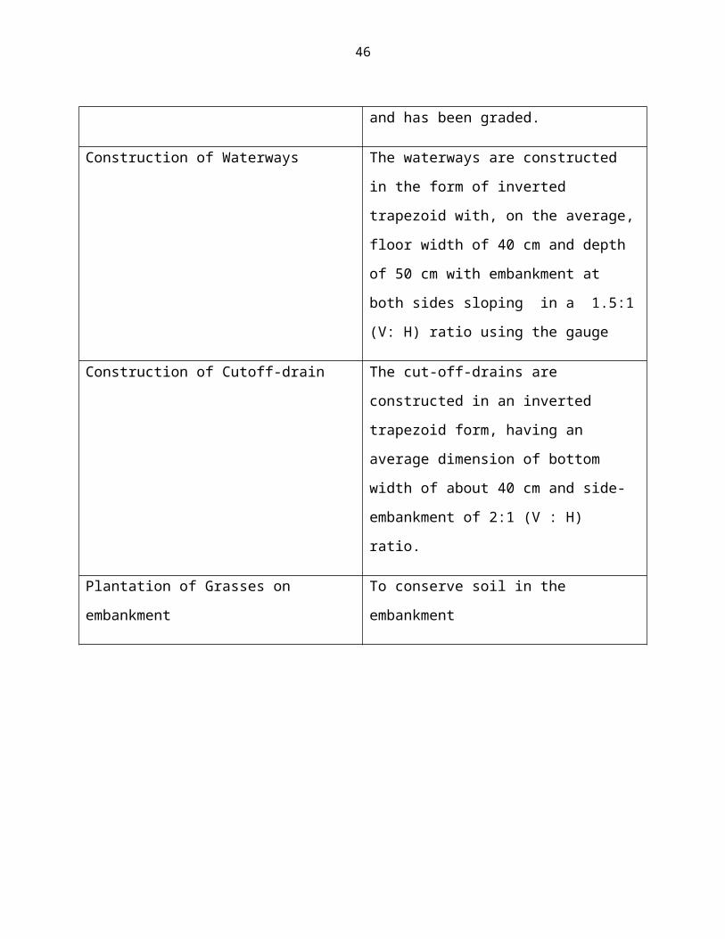
46
and has been graded.
Construction of Waterways The waterways are constructed
in the form of inverted
trapezoid with, on the average,
floor width of 40 cm and depth
of 50 cm with embankment at
both sides sloping in a 1.5:1
(V: H) ratio using the gauge
Construction of Cutoff-drain The cut-off-drains are
constructed in an inverted
trapezoid form, having an
average dimension of bottom
width of about 40 cm and side-
embankment of 2:1 (V : H)
ratio.
Plantation of Grasses on
embankment
To conserve soil in the
embankment
47
4.3. Other activities realized during this period of internship.
From four departments of the LWH/RSSP project Muyanza site, other
activities have been realized besides the above mentioned
activities.
4.3.1 Community Development branch Under the community development branch with the CDOs the
following activities were surveyed and followed up; community
development goes hand in hand with the project’s land husbandry,
extension and rural finance and agribusiness to make livelihood
improvement of the project’s host community.
The intern attended the group formation where until today
there was a completion of 360 groups at Muyanza site level;
Participation in the formation of special groups: 1 of
elders, 1 of youth and 2 of women;
Election of group representatives: all formed groups have
elected their representatives;
Election of mobilizers: 4 mobilizers, commonly named as
INSHUTI Z’UMUSHINGA (friends of the Project) are elected in
each Village to support in mobilization of Project
activities.
4.3.2 Rural finance & Agribusiness As mentioned earlier, the intern participated in the four
targeted areas of the LWH/RSSP project at Muyanza location; few
activities in the rural finance were visited and surveyed by.
48
The intern participated in the regulation of the already
established fund for the beneficiaries of Muyanza watershed
project site.
Helping and working with the members of the community who
are yet to open bank accounts, as per now 102 groups have
been numbered to have already opened accounts.
Under the MDF-Ejoheza the farmers have been assisted to gain
bank loans by the project, as the recent (March-April)
report about 36 farmers recuperated 2,456,000 RwF for
compost making and DAP purchasing. The intern visited the
initiative during this internship period. For example the
ABAGANITERAMBERE group has got 250,000RwF loan to make 4
composts heaps through the guarantee fund.
The intern also participated in the planting of coffee
plantation at the hillsides with a high slopeness; a range
of
4.4 Constraints encountered during the internship works During this internship, we encountered some constraints such
as follows:
Short period of internship
Difficulty of transportation means and communication
facilities.
49
The community members of the command area and near
neighborhood do not respond accordingly to the project
activities
Due to rainfall season, some terracing activities are
destroyed by this rain.
Farmers do not respond equally to growing suggested crops as
the project proposal (climbing beans).
CHAP5. CONCLUSION AND RECOMMENDATIONS
5.1. Conclusion
Our field work on the activities carried out in land husbandry,
water harvesting and hill side irrigation (LWH) and extension
activities helped us to put into practice all theoretical
concepts that we learnt in class. The required technologies as
water management with digging waterways and cut-off-drains, land
slope classification, land husbandry activities, making graded
terraces for cropland that have been implemented and these
contribute in maintenance of land and life for population around.
The proposed systems of land management with working in groups or
cooperatives also result not only the increase of production but
also the unity and community approach between people around where
they were not able to protect the soil. Muyanza has an advanced
approach to community development where the beneficiaries have
been created with a fund to enable them self sufficient after the
50
project’s closing; the fund was named Muyanza Development Fund
(MDF). Irrigation agriculture has made a major contribution to
food production and food security throughout the world: without
irrigation much of the impressive growth in agricultural
productivity over the last 50 years could not have been achieved.
5.2. Recommendation:
After this report the following recommendation was formulated:
To improve equipments especially tools used in breaking
hard soil mixed with stones
To increase number of supervisors in order to minimize
errors.
To give financial facilitation to internees for transport
and accommodation.
The beneficiaries might see the government policy in the
angle of their development and not for the government
interest with maintaining all technologies for increasing
their production in long term;
The farmers should be informed before implementing the
activities in their farms
51
REFERENCES 1. MICHAEL, A.M. and Ojha T.P (2003). Agriculture Engineering
4th edition.Vol.ii Jain brothers, New Delhi (India).P.586.
2. Taffa Tulu. (2002). Soil and water conservation for
sustainable Agriculture. C.T.A. p.150.
3. Illustrated supervision checklist for assessment of the
quality of comprehensive land-husbandry works at LWH project
sites.
4. SPIU-LWH/RSSP-Muyanza site manual project tip/March
52
5. FAO. (2002). Irrigation Manual, planting. Development,
monitoring, evaluation of Irrigated Agriculture with Farmer
participation, Vol. IV, Module 9. Roma. 1,2,5,6 P.
6. Azene Bekele-Tesemma, (2011): Terms of reference in Gishwati
water and land management technologies.
7. Denton. (1990). Applied Agricultural Research p12-14
Naderman, G.C., and J.R. Hangars,
8. District development plan of Rulindo (2013-2018).
9. National institute of statistics of Rwanda 2010.
10. Rwanda’s Single PIU Policy 2008-2010.
APPENDICESAppendix1. Rulindo district map
Appendix2. Location of Muyanza operational site

53