Land degradation and livestock production in Zimbabwe's communal areas
15
LAND DEGRADATION & REHABILITATION, VOL. 3,99-I 13 (1992) LAND DEGRADATION AND LIVESTOCK PRODUCTION IN ZIMBABWE’S COMMUNAL AREAS I. SCOONES International Institute for Environment and Development, 3 Endsleigh Street, London WCIH ODD, UK ABSTRACT This paper considers evidence of land degradation and its impact on livestock production systems in the communal areas of southern Zimbabwe. Various measures of rangeland degradation, using both primary and secondary production indicators, are examined. An apparent contradiction emerges between the high observed levels of soil erosion and the lack of impact on livestock production, as measured by population density trends, cattle production parameters, cumulative stocking levels and extraction rates. Farmers’ observations of land degradation processes support the quantitative data. A possible resolution of the contradiction lies in an assessment of the spatial and temporal dimensions of degradation patterns; this points to the fact that current erosion is concentrated in areas that are not key grazing resources for cattle. The analysis suggests an agenda for degradation research that concentrates on evaluating the time span over which economic impacts of soil erosion are felt and assessing the spatial pattern of soil loss, with a special focus on key grazing resource patches. KEY WORDS Zimbabwe Rangeland degradation Degradation indicators Livestock production Farmer perceptions Spatial patterns of soil loss Range management Common property resources INTRODUCTION High populations of livestock have been maintained in the communal areas of Zimbabwe for the past half century and for most of this time have been significantly in excess of the officially recommended stocking rates (Scoones, 1990). What are the long term consequences of this? Is degradation occurring? This paper considers evidence of land degradation and its impact on livestock production systems in the communal areas of southern Zimbabwe. Evidence of changes in primary and secondary production over time is examined by looking at changes in vegetation and livestock productivity parameters. Evidence of degradation patterns from time series livestock data is compared with local perceptions of environmental change. Changes in vegetation and the erosion of soils are part of the natural processes of savanna ecosystems. The issue is whether existing rates of environmental change are acceptable in terms of economic impact. An appropriate definition of degradation is needed before any assessments can be made. Following Abel and Blaikie (1989), range degradation can be defined as: ‘An effectively permanent decline in the rate at which the land yields livestock products under a given management system’. In assessments of land degradation it is necessary to ask whether such changes are having a detrimental effect on potential economic returns. Economic returns must be defined according to the management objectives of the production system. In preserved areas of national parks, value may be defined in terms of species diversity of the presence of large game animals. However, in the agropastoral system of the communal areas outputs of all livestock products and services, including draft power, transport, milk and meat, need to be taken into account in economic valuations (Scoones, in press). Degradation is a complex concept, requiring precise definition appropriate to the system under consideration. This paper considers a range of evidence from the agropastoral system of a study area in southern Zimbabwe. The following sections review the debate about degradation and livestock in the communal areas and then examine some of the evidence from the study areas. First, evidence of changes in 0898-58 12/92/02OO99- 15S12.50 0 1992 by John Wiley & Sons, Ltd. Received 21 October 1991 Revised 9 January 1992
Transcript of Land degradation and livestock production in Zimbabwe's communal areas

LAND DEGRADATION & REHABILITATION, VOL. 3,99-I 13 (1992)
LAND DEGRADATION A N D LIVESTOCK PRODUCTION IN ZIMBABWE’S COMMUNAL AREAS
I. SCOONES International Institute for Environment and Development, 3 Endsleigh Street, London WCIH ODD, UK
ABSTRACT This paper considers evidence of land degradation and its impact on livestock production systems in the communal areas of southern Zimbabwe. Various measures of rangeland degradation, using both primary and secondary production indicators, are examined. An apparent contradiction emerges between the high observed levels of soil erosion and the lack of impact on livestock production, as measured by population density trends, cattle production parameters, cumulative stocking levels and extraction rates. Farmers’ observations of land degradation processes support the quantitative data. A possible resolution of the contradiction lies in an assessment of the spatial and temporal dimensions of degradation patterns; this points to the fact that current erosion is concentrated in areas that are not key grazing resources for cattle. The analysis suggests an agenda for degradation research that concentrates on evaluating the time span over which economic impacts of soil erosion are felt and assessing the spatial pattern of soil loss, with a special focus on key grazing resource patches.
KEY WORDS Zimbabwe Rangeland degradation Degradation indicators Livestock production Farmer perceptions Spatial patterns of soil loss Range management Common property resources
INTRODUCTION
High populations of livestock have been maintained in the communal areas of Zimbabwe for the past half century and for most of this time have been significantly in excess of the officially recommended stocking rates (Scoones, 1990). What are the long term consequences of this? Is degradation occurring? This paper considers evidence of land degradation and its impact on livestock production systems in the communal areas of southern Zimbabwe. Evidence of changes in primary and secondary production over time is examined by looking at changes in vegetation and livestock productivity parameters. Evidence of degradation patterns from time series livestock data is compared with local perceptions of environmental change.
Changes in vegetation and the erosion of soils are part of the natural processes of savanna ecosystems. The issue is whether existing rates of environmental change are acceptable in terms of economic impact. An appropriate definition of degradation is needed before any assessments can be made. Following Abel and Blaikie (1989), range degradation can be defined as: ‘An effectively permanent decline in the rate at which the land yields livestock products under a given management system’.
In assessments of land degradation it is necessary to ask whether such changes are having a detrimental effect on potential economic returns. Economic returns must be defined according to the management objectives of the production system. In preserved areas of national parks, value may be defined in terms of species diversity of the presence of large game animals. However, in the agropastoral system of the communal areas outputs of all livestock products and services, including draft power, transport, milk and meat, need to be taken into account in economic valuations (Scoones, in press).
Degradation is a complex concept, requiring precise definition appropriate to the system under consideration. This paper considers a range of evidence from the agropastoral system of a study area in southern Zimbabwe. The following sections review the debate about degradation and livestock in the communal areas and then examine some of the evidence from the study areas. First, evidence of changes in
0898-58 12/92/02OO99- 15S12.50 0 1992 by John Wiley & Sons, Ltd.
Received 21 October 1991 Revised 9 January 1992

100 I. SCOONES
primary production is considered. This is then followed by an investigation of changing patterns of secondary production. Finally, local perceptions of degradation processes are considered with an examina- tion of the potential impact of erosion on livestock production.
DEGRADATION INDICATORS
Identification of appropriate indicators that relate ‘effectively permanent’ environmental change to the irreversible reduction of livestock outputs represents a major challenge. This paper concentrates on the analysis of livestock related indicators, but also examines information from soil and vegetation indicators.
The detection of trends in primary production due to factors other than interannual or cyclical rainfall changes is difficult. Temporary shifts in primary productivity or species composition should not be taken as evidence for degradation. Savanna systems are typically resilient; permanent shifts to lower levels of productivity due to shocks and stresses to the system are thought to be rare; indeed resilience may in fact increase with higher stocking rates (Walker, 1980). Evidence of degradation from vegetation monitoring can thus only be expected from long term studies (Warren and Agnew, 1988; Alchrona, 1988).
The same applies to investigating shifts in secondary production. Changes in livestock productivity parameters owing to changes in rainfall conditions do not constitute evidence for degradation. In the same way, changes in parameters owing to changes in population density (e.g. depressed birth rates at high stocking rates) do not represent evidence of the degradation of potential production) as long as no permanent shift in the relationship occurs. For instance, if stocking rates are reduced and birth rates return to previous levels, then permanent changes in system productivity have not occurred as a result of a previous period of high stocking rates.
Spatial and temporal scales must also be considered. For instance, some topland areas may be subject to losses of productivity but erosion and deposition processes may result in increases in production elsewhere. In contrast, if such low lying ‘key resource’ areas suffer irreversible losses of productivity, then this may be critical for overall system sustainability, even though the area is small.
Temporal scale is also significant in terms of understanding what ‘irreversible’ or ‘permanent’ means. The variability of production levels in the savanna agroecosystems of dryland areas is high; such variations may also have a cyclical nature. The time scale over which measurements are made is therefore critical in detecting long tcrm trends over noise produced by interannual variations or cyclical fluctuation.
THE DEGRADATION DEBATE IN ZIMBABWE’S COMMUNAL AREAS
Claims of ‘degradation’ in the communal areas date back to the early colonial period (Watt, 1913; Haviland, 1928). At this time concern about the impact of the new settler farms and ranches was also expressed (Beinart, 1984). Official alarm reached its height during the 1930s and 1940s when land use and livestock policy increasingly included environmental protection as an explicit aim. The destocking policies (1945-61) were the culmination of this trend. Confident statements were made that irreversible damage was being caused and permanent productivity declines were imminent. Dr 0. West commented in his pasture officer’s report after a visit to Belingwe reserve (now Mberengwa communal area) in 1948:
‘[The grazing areas] have by continuous heavy grazing every growing season year after year, been pushed to a point from which, if relief is not afforded very soon, deterioration will become increasingly rapid.’
Since then, others have come to similar conclusions. Cleghorn (1966) concluded that nearly half of the communal lands were bare or overgrazed, whereas Whitlow (1988) reported that over 80 per cent of ‘eroded’ land in the country is within the communal rands. These views are reflected in current government policy, which gives tackling environmental degradation in the communal areas a high priority for policy action (e.g. Government of Zimbabwe, 1986; Government of Zimbabwe, 1987).
ZIMBABWE’S COMMUNAL AREAS 101
There is no question that significant soil erosion occurs within the communal areas of Zimbabwe, caused in part by livestock. This has been demonstrated in a number of studies (Stocking, 1972; Whitlow, 1988). In particular parts of the country, such as the Save Valley, the problem is acute (Campbell, et al., 1988). The question is not whether erosion or vegetation changes occur as they undoubtedly do, both through ‘natural’ and human induced processes. The question is rather: ‘what are the implications for livestock production and so peoples’ livelihoods?’
Much of the confusion and dispute over ‘degradation’ centres on this question. Conventional range assessment measures that are widely used to gauge whether ‘degradation’ is occurring are not necessarily applicable to the communal area agropastoral system (Behnke and Scoones, 1991). They tend to assume a vegetation-herbivore equilibrium coincident with a conservative, beef ranching ‘ideal’, and deviations from this are taken to be evidence of ‘degradation’. The term ‘carrying capacity’ often assumes such conservative stocking rates, with livestock populations restricted to a particular area. However, in many pastoral systems movement is an important response to environmental variability. The nature of the agropastoral livestock economy in Zimbabwe’s communal areas is such that high stocking rates are required and opportunities for extensive migratory movement are limited; this results in less vegetation biomass and (probably) more erosion. The question is, can these levels be sustained?
EVIDENCE FOR DEGRADATION: CHANGES IN PRIMARY PRODUCTION
Rangeland degradation will be detected by primary production studies when long term reductions in productivity are observed; these must be independent of rainfall variation and have a negative effect on livestock output.
Variations in primary production are primarily affected by rainfall, but mediated by soil type. Rangeland experiments carried out in Zimbabwe over many years are equivocal about irreversible changes in potential productivity (O’Connor, 1985). However, the long term impact of herbivores is dependent on soil type. Barnes (1965) showed that 15 years of high stocking levels on sandy soil did not result in significant changes, whereas on clay soils high stocking rates may result in long term lowering of production (Carew, 1976). No long term primary production data exist for communal areas, although there are many reports of areas, especially on clay soil savanna, where degraded patches exist due to changes in physical soil properties (MacDonald, 1978). These can only be reversed by ripping and reseeding. Areas of high stock concentrations around w, dip tanks or watering points are obvious examples.
Kelly (1973) studied primary production ecology at a number of sites with different land use in southeast Zimbabwe. He claimed that the high stocking rates of the communal areas had resulted in degradation. However, no indication was given as to the effects of the observed differences between communal areas and wildlife or ranch systems in grass species (annuals rather than perennials in the communal areas), litter cover (less in the communal areas) and infiltration rates (lower in the communal areas) on actual livestock production potential. The study was thus inconclusive with regard to the sustainability of livestock production in the communal areas (Sandford, 1982).
Thirteen seasons later the same sites were relocated by De Jager (1988) and similar measurements were made. No evidence of directional trends could be found, however; each site had undergone a range of apparently unpredictable changes often due to the interaction of rare events (e.g. fire, high levels of herbivory). Current status in variable savanna systems is thus often the result of the chance interaction of different factors that may act cumulatively, but do not predictably follow any trend.
EVIDENCE FOR DEGRADATION: CHANGES IN SECONDARY PRODUCTION
Degradation will be detected in studies of secondary production when long term changes in output occur (measured by birth rates, extraction rates, draft productivity). These must be independent of variations in rainfall and animal densities. Time series data on livestock populations for six communal areas in the central- southern area of Zimbabwe were investigated to see if permanent changes in secondary production can be detected over the past 65 years. The study areas are clustered in two groups according to rainfall levels. The
102 1. SCOONES
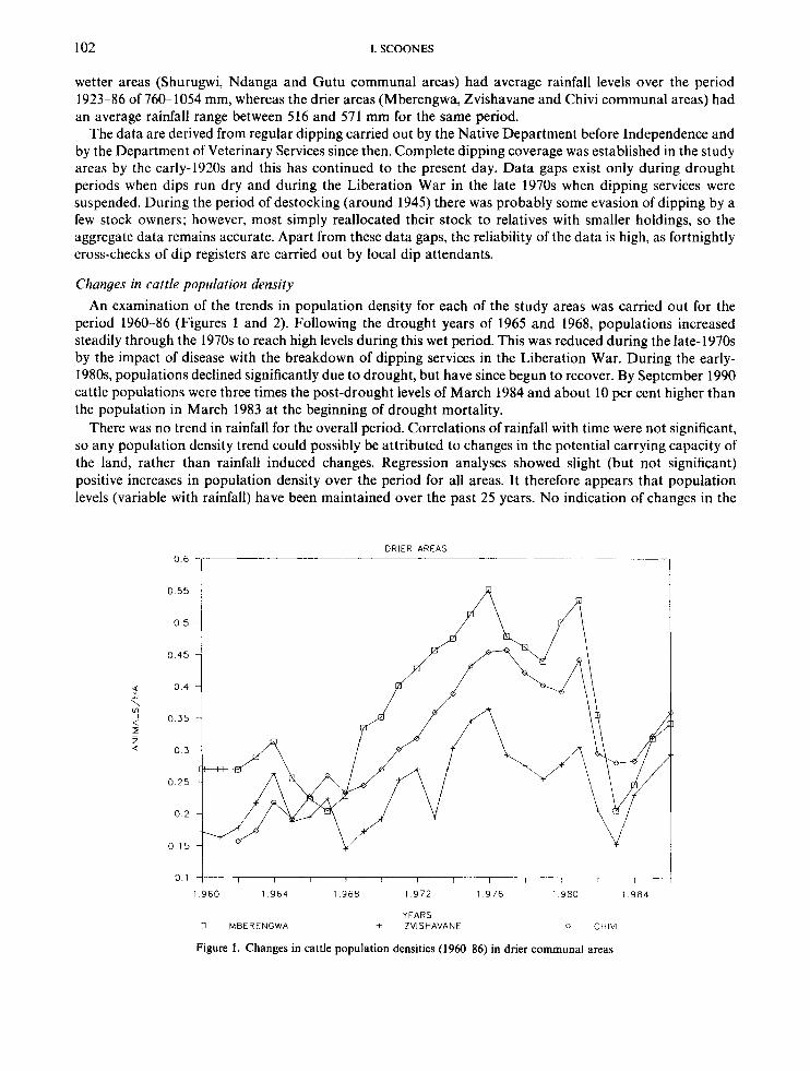
wetter areas (Shurugwi, Ndanga and Gutu communal areas) had average rainfall levels over the period 1923-86 of 760- 1054 mm, whereas the drier areas (Mberengwa, Zvishavane and Chivi communal areas) had an average rainfall range between 516 and 571 mm for the same period.
The data are derived from regular dipping carried out by the Native Department before Independence and by the Department of Veterinary Services since then. Complete dipping coverage was established in the study areas by the early-1920s and this has continued to the present day. Data gaps exist only during drought periods when dips run dry and during the Liberation War in the late 1970s when dipping services were suspended. During the period of destocking (around 1945) there was probably some evasion of dipping by a few stock owners; however, most simply reallocated their stock to relatives with smaller holdings, so the aggregate data remains accurate. Apart from these data gaps, the reliability of the data is high, as fortnightly cross-checks of dip registers are carried out by local dip attendants.
Changes in cattle population density An examination of the trends in population density for each of the study areas was carried out for the
period 1960-86 (Figures 1 and 2). Following the drought years of 1965 and 1968, populations increased steadily through the 1970s to reach high levels during this wet period. This was reduced during the late-1970s by the impact of disease with the breakdown of dipping services in the Liberation War. During the early- 1980s, populations declined significantly due to drought, but have since begun to recover. By September 1990 cattle populations were three times the post-drought levels of March 1984 and about 10 per cent higher than the population in March 1983 at the beginning of drought mortality.
There was no trend in rainfall for the overall period. Correlations of rainfall with time were not significant, so any population density trend could possibly be attributed to changes in the potential carrying capacity of the land, rather than rainfall induced changes. Regression analyses showed slight (but not significant) positive increases in population density over the period for all areas. It therefore appears that population levels (variable with rainfall) have been maintained over the past 25 years. No indication of changes in the
DRIER AREAS 0 6
0 55
0 5
0 45
0 4
0 35
0 1 j I I I I I I I I I 7- 7- 1 9 6 0 1 9 6 4 1 9 6 8 1 9 7 2 1 9 7 6 1 9 8 0 1 9 8 4
YEARS 0 MEERFNGWA + ZVISHAVANE 0 CHlV l
Figure 1 . Changes in cattle population densities (1960-86) in drier communal areas

ZIMBABWE'S COMMUNAL AREAS
WETTER AREAS 0 6 5
0 55
0 1
1 9 6 0 1 9 6 4 1 9 6 8 I 9 7 2 1 9 7 6 1 9 8 0 1 9 8 4
I'EARS
O l 5 L I 1 I I I I I I
0 GUTU CA + NOANGA 0 SHUPUGWI
Figure 2. Changes in cattle population densities (1960-86) in wetter communal areas
103
I
potential population levels is observed, suggesting that degradation processes are not having an impact on the ability of cattle populations to be maintained at high levels.
Although the numbers of animals are being maintained, the data give no indication of production quality (in terms of weight, ability to pull ploughs, or milk production). It is plausible that the degradation of the natural resource base will be felt in terms of these factors first, before any decline in numbers.
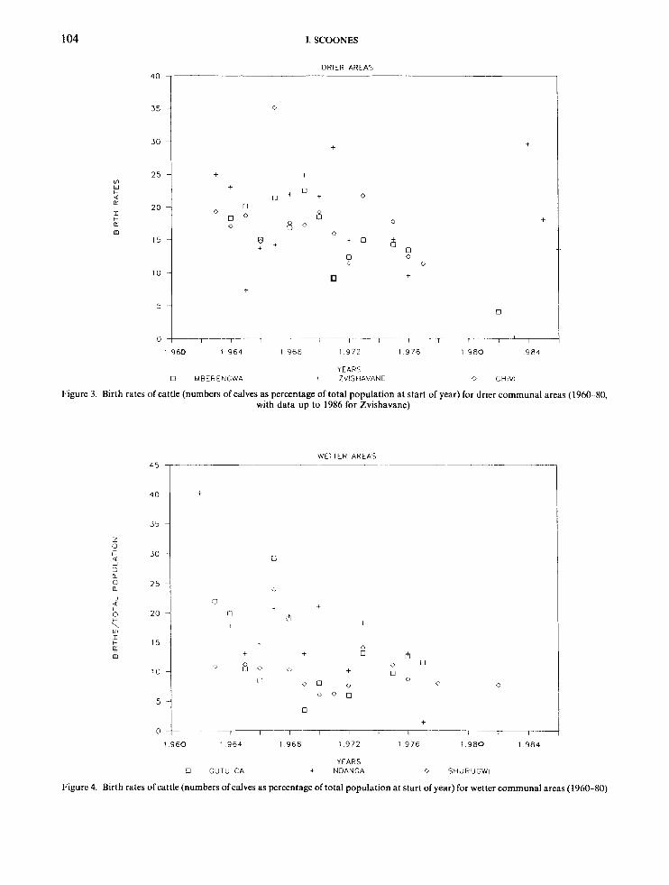
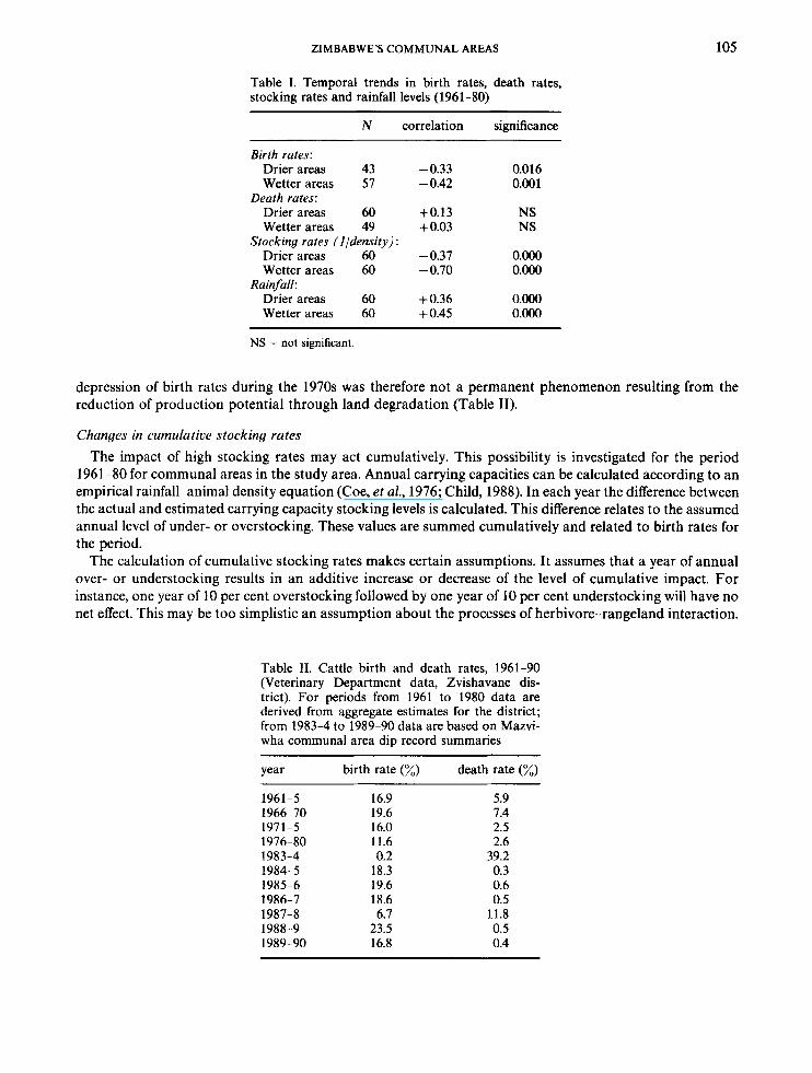
Changes in herd productivity parameters Herd productivity parameters (birth and death rates) can be estimated for the study areas between 1961
and 1980, i.e. the period following destocking. This was a period of increasing rainfall, especially in the late- 1970s, and increasing cattle population densities (in contrast to the period 1965-86). Figures 3 and 4 show the changes in birth and death rates over this period for all areas. Data on birth rates for Mazvihwa (Zvishavane District) are also included for a more recent period. Birth rates, death rates and rainfall levels are correlated with time in Table I to investigate temporal trends. As in previous analyses, the drier communal areas are contrasted with the wetter areas.
Birth rates declined in the two areas between 1961 and 1980, whereas rainfall increased in the two areas for this period, suggesting that it was probably the increases in cattle density that resulted in the lowered birth rates. Death rates do not show any clear trends. Any simple relationship is overshadowed by the impact of high death rates in the drought years of the mid-1960s and early-l970s, particularly in the drier areas.
It appears that the depression of birth rates during the 1960s and 1970s was a density dependent phenomenon. There is no evidence that there has been a permanent change in the form of the relationship between birth rates and animal density. Indeed a consideration of the period after 1980 demonstrates a pattern of recovery following the reduction of livestock populations through drought. Populations crashed during 1982-3 and again in 1987-8 as a result of drought. Lower densities in the 1980s have meant increased birth rates and low death rates in non-drought years, with populations rapidly recovering. It seems that the
104
35 -
3 0 -
2 5 -
20 -
15 -
10 -
5 -
I. SCOONES
DRIER AREAS 4 0
0
t
+ -I
+ u + O + 0
0 0
+
0
0 c
+
0
0 -+-??- --T -- 1 I I I -7-1
I 9 6 0 1 9 6 4 1 9 6 8 1 9 7 2 1 9 7 6 1 9 R O 1 9 8 4
YEARS 0 MRFRENGWA + ZVISHAVANE 0 CHIVI
Figure 3 Birth rates of cattle (numbers of calves as percentage of total population at start of year) for drier communal areas (1960 80, with data up to 1986 for Zvishavane)
45 l-
0 :I
WETTER AREAS
+
0
C1
+
0
-
L I
+ t
m +
0
1 9 6 0 1 9 6 4 1 9 6 8 1 9 7 2 1 9 7 6 1 9 8 0 1 9 8 4
YEARS U GUTU CA + NDANGA 0 SHUPUGWI
Figure 4. Birth rates of cattle (numbers of calves as percentage of total population at start of year) for wetter communal areas (1960-80)
ZIMBABWE’S COMMUNAL AREAS 105
Table I. Temporal trends in birth rates, death rates, stocking rates and rainfall levels (1961-80)
N correlation significance
Birth rates: Drier areas 43 -0.33 0.016 Wetter areas 57 - 0.42 0.00 1
Drier areas 60 +0.13 NS Wetter areas 49 + 0.03 NS
Drier areas 60 -0.37 O.Oo0 Wetter areas 60 -0.70 O.Oo0
Drier areas 60 +0.36 O.Oo0 Wetter areas 60 + 0.45 O.Oo0
Death rates:
Stocking rates (l/density) :
Rain fall:
NS = not significant.
depression of birth rates during the 1970s was therefore not a permanent phenomenon resulting from the reduction of production potential through land degradation (Table 11).
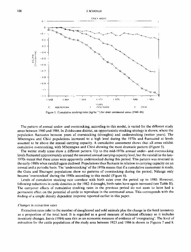
Changes in cumulative stocking rates The impact of high stocking rates may act cumulatively. This possibility is investigated for the period
1961 -80 for communal areas in the study area. Annual carrying capacities can be calculated according to an empirical rainfall-animal density equation (Coe, et al., 1976; Child, 1988). In each year the difference between the actual and estimated carrying capacity stocking levels is calculated. This difference relates to the assumed annual level of under- or overstocking. These values are summed cumulatively and related to birth rates for the period.
The calculation of cumulative stocking rates makes certain assumptions. I t assumes that a year of annual over- or understocking results in an additive increase or decrease of the level of cumulative impact. For instance, one year of 10 per cent overstocking followed by one year of 10 per cent understocking will have no net effect. This may be too simplistic an assumption about the processes of herbivore-rangeland interaction.
Table 11. Cattle birth and death rates, 1961-90 (Veterinary Department data, Zvishavane dis- trict). For periods from 1961 to 1980 data are derived from aggregate estimates for the district; from 1983-4 to 1989-90 data are based on Mazvi- wha communal area dip record summaries
year birth rate (%) death rate (%)
1961-5 16.9 5.9 1966-70 19.6 7.4 1971-5 16.0 2.5 1976-80 11.6 2.6 1983-4 0.2 39.2 1984-5 18.3 0.3 1985-6 19.6 0.6 1986-7 18.6 0.5 1987-8 6.7 11.8 1988-9 23.5 0.5 1989-90 16.8 0.4
106 I. SCOONES
0 1
0
-0 1
-0 2
-0 3
UI - 0 4 $ q! \: - 0 5
t - 0 6
-0 7
-0 a
-0 9
- 1
- 1 1
DRIER AREAS
I I 1 1 I 1 I I 1 I --T---- I
1 9 6 0 1 9 6 4 1 9 6 8 1 9 7 2 1 9 7 6 1 9 8 0 1 9 8 4
YEARS 0 MBERENGWA + ZVISHAVANF 0 CHIVl
Figure 5. Cumulative stocking rates (kg ha- l ) for drier communal areas (1960-86)
The pattern of annual under- and overstocking, according to this model, is varied for the different study areas between 1960 and 1986. In Zvishavane district, an opportunistic stocking strategy is shown, where the population fluctuates between years of overstocking (droughts) and understocking (wetter years). The Mberengwa and Chivi populations increased to a high level during the 1970s and fluctuated at levels assumed to be above the annual carrying capacity. A cumulative assessment shows that all areas exhibit cumulative overstocking, with Mberengwa and Chivi showing the most dramatic pattern (Figure 5).
The wetter study areas show a different pattern. Up to the mid-1970s annual under- and overstocking levels fluctuated approximately around the assumed annual carrying capacity level, but the rainfall in the late- 1970s meant that these areas were apparently understocked during this period. This pattern was reversed in the early-1980s when rainfall again declined. Populations thus fluctuate in relation to carrying capacity on an annual and a periodic basis. The ‘understocking’ of the 1970s means that if a cumulative assessment is made, the Gutu and Shurugwi populations show no patterns of overstocking during the period; Ndanga only became ‘overstocked’ during the 1980s according to this model (Figure 6).
Levels of cumulative stocking rate correlate with birth rates over the period up to 1980. However, following reductions in cattle densities in the 1982-4 drought, birth rates have again increased (see Table 11). The carryover effects of cumulative stocking rates in the previous period do not seem to have had a permanent effect on the potential of cattle to reproduce in the communal areas. This corresponds with the finding of a simple density dependent response reported earlier in this paper.
Changes in extraction rates Extraction rates refer to the number of slaughtered and sold animals plus the change in the herd inventory
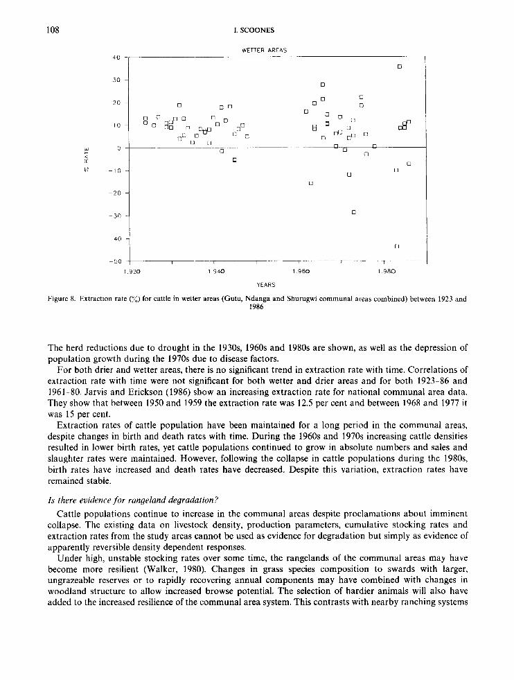
as a proportion of the total herd. It is regarded as a good measure of technical efficiency as it includes inventory changes. Jarvis (1984) uses this as an economic measure of evidence of ‘overgrazing’. The level of extraction for the cattle populations of the study area between 1923 and 1986 is shown in Figures 7 and 8.

ZIMBABWE'S COMMUNAL AREAS 107
4
\ 0 Y
400
300
200
100
0
WETTER AREAS
-300 I 1 I r I 1 1 1 1 1 1 1
1 9 6 0 1 9 6 4 1 9 6 8 1 9 7 2 1 9 7 6 1 9 8 0 1 9 8 4
0 GUTU C A YEARS
+ NDANGA 0 SHURUGWI
Figure 6. Cumulative stocking rates (kg ha-') for wetter communal areas (1960-86)
50
40
30
20
10
W 0
K -10
-20
Q K
-30
-40
- 50
DRIER AREAS
0 0
0 0
0 0 0
0
-60
1 9 2 0 1 9 4 0 1 9 6 0
YEARS
1 .980
Figure 7. Extraction rate (%)for cattle in drier areas (Mberengwa, Zvishavane and Chivi communal areas combined) between 1923 and 1986
108 1. SCOONES
WETTER AREAS
W c
v 6p
30 i
0
~ 1 0
- 30
- 2 0 1 U n u
0
0
0 0 0 0
n n 0
0 0
0
0
0
1 9 2 0 1 9 4 0 1 9 6 0 1 9 8 0
YEARS
Figure 8. Extraction rate (%) for cattle in wetter areas (Gutu, Ndanga and Shurugwi communal areas combined) between 1923 and 1986
The herd reductions due to drought in the 1930s, 1960s and 1980s are shown, as well as the depression of population growth during the 1970s due to disease factors.
For both drier and wetter areas, there is no significant trend in extraction rate with time. Correlations of extraction rate with time were not significant for both wetter and drier areas and for both 1923-86 and 1961-80. Jarvis and Erickson (1986) show an increasing extraction rate for national communal area data. They show that between 1950 and 1959 the extraction rate was 12.5 per cent and between 1968 and 1977 it was 15 per cent.
Extraction rates of cattle population have been maintained for a long period in the communal areas, despite changes in birth and death rates with time. During the 1960s and 1970s increasing cattle densities resulted in lower birth rates, yet cattle populations continued to grow in absolute numbers and sales and slaughter rates were maintained. However, following the collapse in cattle populations during the 1980s, birth rates have increased and death rates have decreased. Despite this variation, extraction rates have remained stable.
Is there evidence for rangeland degradation? Cattle populations continue to increase in the communal areas despite proclamations about imminent
collapse. The existing data on livestock density, production parameters, cumulative stocking rates and extraction rates from the study areas cannot be used as evidence for degradation but simply as evidence of apparently reversible density dependent responses.
Under high, unstable stocking rates over some time, the rangelands of the communal areas may have become more resilient (Walker, 1980). Changes in grass species composition to swards with larger, ungrazeable reserves or to rapidly recovering annual components may have combined with changes in woodland structure to allow increased browse potential. The selection of hardier animals will also have added to the increased resilience of the communal area system. This contrasts with nearby ranching systems

ZIMBABWE’S COMMUNAL AREAS 109
where apparently irreversible changes in productivity have been reported as a result of cumulative overstocking of cattle (Child, 1988).
Evidence of land degradation from available data on cattle production is lacking. The range of parameters examined provide no firm support for the widely held contention that the communal areas are suffering severe land degradation. The next section explores this dilemma from local farmers’ perspectives and asks: what are the local interpretations of rangeland degradation processes?
LOCAL PERCEPTIONS O F RANGELAND DEGRADATION
Discussions with farmers in Mazvihwa communal area focused on local perceptions of environmental change and land degradation. Whitlow’s (1988) study of soil erosion levels and hazard in Zimbabwe indicated from an analysis of aerial photographs that the study area was severely eroded. This was assessed from the degree of exposed bare ground and the number of gullies observed during the dry season of 1985. However, in support of the quantitative data presented, farmers emphasized the resilience of the grassland system, rather than the extent of erosion. Variations in available production (standing crop) were seen to be highly dependent on rainfall, although affected by a range of other factors including the impact of herbivores (cattle and termites). Fifty-seven people were asked the open ended question: ‘what are the reasons for the lack of grass?’ The reasons given and the percentage of all respondents mentioning them are given in Table 111.
Fluctuations in rainfall dominate local people’s understanding of savanna ecology; herbivores act to modify the system by removing biomass. People do not deny that higher cattle populations result in the removal of more grass (in combination with harvester termites on clay soils), but they do dispute that grazing results in major irreversible effects, except in particular instances.
Two examples were cited that represented permanent changes in land productivity with a potential impact on livestock production. Land exhaustion was given as a reason by some informants resident on sandy soils, where there is a view that long term use (including previous cultivation) has resulted in fewer nutrients in the soil. The removal of trees was also mentioned as a factor resulting in permanent shifts towards reduced grass production. People recognize that some trees promote grass, but trees (particularly large trees) are also linked with rainfall (Mukamuri, 1988; Wilson, 1988).
Following this discussion about the reasons for the lack of grass, a follow up question was asked: ‘if rain returns, will grass return-where and where not?’ This was seen by many as a rather ridiculous question as the unanimous verdict was that grass would return to previous levels following drought. To emphasize the point people recounted the rapid recovery of grasslands following the 1984-5 rains, saying that, even in the bare yards of their home compounds, grass sprouted in profusion. However, a number of people added certain caveats to this conclusion. There are particular areas where grass will not return. These include areas where settlements are concentrated together (the villagized ‘lines’), sodic patches in the Colophospermum
Table 111. Reasons for lack of grass: local perceptions
reason for lack of grass percentage of respondents
1 2 3 4 = 4 = 6 7 = 7 = 9 = 9 =
Lack of rainfall Too many cattle Termites Fewer trees Land exhaustion Less grazing area Settlement patterns Hot sun Thatching grass Lack of paddocking
96.5 29.8 22.8
8.8 8.8 5.3 3.5 3.5 1.7 1.7
Source: Field interviews, 1987, Mazvihwa communal area.
110 1. SCOONES
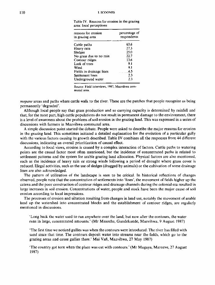
Table IV. Reasons for erosion in the grazing area: local perceptions
reasons for erosion percentage of in grazing area respondents
Cattle paths Heavy rain Sledges No grass due to no rain Contour ridges Lack of trees Wind Fields in drainage lines Settlement lines Underground water
63.6 27.3 25.0 22.7 13.6 9.1 9.1 4.5 2.3 2.3
Source: Field interviews, 1987, Mazvihwa com- munal area.
mopane areas and paths where cattle walk to the river. These are the patches that people recognize as being permanently ‘degraded’.
Although local people say that grass production and so carrying capacity is determined by rainfall and that, for the most part, high cattle populations do not result in permanent damage to the environment, there is a level of awareness about the problems of soil erosion in the grazing land. This was expressed in a series of discussions with farmers in Mazvihwa communal area.
A simple discussion point started the debate. People were asked to describe the major reasons for erosion in the grazing land. This sometimes initiated a detailed explanation for the evolution of a particular gully with the various factors causing its growth described. Table IV combines all the responses from 44 different discussions, indicating an overall prioritization of causal effect.
According to local views, erosion is caused by a complex interaction of factors. Cattle paths to watering points are the causal factor most often mentioned, but the incidence of concentrated paths is related to settlement patterns and the system for arable grazing land allocation. Physical factors are also mentioned, such as the incidence of heavy rain or strong winds following a period of drought where grass cover is reduced. Illegal activities, such as the use of sledges (dragged by animals) or the cultivation of some drainage lines are also acknowledged.
The pattern of utilization of the landscape is seen to be critical. In historical reflections of changes observed, people note that the concentration of settlements into ‘lines’, the movement of fields higher up the catena and the poor construction of contour ridges and drainage channels during the colonial era resulted in large increases in soil erosion. Concentrations of water, people and stock have been the major cause of soil erosion according to local impressions.
The processes of erosion and siltation resulting from changes in land use, notably the movement of arable land up the watershed into concentrated blocks and the establishment of contour ridges, are regularly mentioned in discussions.
‘Long back the water used to run anywhere over the land, but now after the contours, the water runs in large, concentrated amounts.’ (Mr Masoche, Gundekunde, Mazvihwa, 9 August 1987)
‘The first time we noticed gullies was when the contours were introduced. The river has filled with sand since that time. The contours deposit water into streams near the fields, which go to the grazing areas and cause gullies there.’ Mai Vafi, Mazvihwa, 27 May 1987)
‘The country got torn when the place was cut with contours.’ (Mr Magaya, Marozve, 27 August 1987)
ZIMBABWE’S COMMUNAL AREAS 111
The land question is clearly central to the whole issue of degradation in the communal areas. The colonial allocation of African farming land to the hilly, poor soil areas and the squeezing of population into small areas with the establishment of European settlement in ‘the farms’ are common themes.
‘The reason why the Europeans don’t cause soil erosion is that they don’t farm the sloping areas. It is the Africans who have been told to farm these areas and are blamed for soil erosion.’ (Group Discussion, Mukwakwe, 26 August 1987)
‘When the farms came the people saw the problem of overpopulation. When a farm gets into a place with people, that land will be dying.’ (Mr Masoche, Gundekunde, 9 August 1987)
Conflicting evidence: is degradation an issue? Local understanding of land degradation processes is based on a complex analysis of ecological processes
informed by detailed historical observation. Local people do not deny the existence of localized land degradation; this they recognize as the result of identifiable causal factors. However, they do dispute that long term, irreversible change is widespread. Local views therefore coincide with the results of analysis presented earlier in this paper.
An apparent contradiction thus exists between the observation of soil erosion, yet the maintenance of cattle populations at high levels, apparently without long term negative effects on potential productivity. The implication is that, although erosion exists, its impact is not seriously felt. A consideration of temporal and spatial scales of land degradation provides some help in resolving the issue.
Local observation of spatial patterning and understanding of causal factors of erosion are coincident with other studies of erosion levels that correlate observed erosion incidence (mostly gullies observed on aerial photographs) with physical factors (rainfall levels, slope), management factors (arable areas, grazing intensity) and historical factors (settlement history, land use changes) (Whitlow, 1988; Stocking, 1972).
SPATIAL AND TEMPORAL DIMENSIONS TO DEGRADATION
A consideration of spatial scale focuses attention on where erosion is occurring. Gullies formed as a result of cattle paths across topland grazing areas, or sheet erosion derived from bare areas around settlements, may have limited impact on overall grazing potential. This contention is supported by the observations of cattle foraging behaviour (Scoones, 1990). It is particular ‘key resource’ grazing areas that provide the most significant contribution to cattle feed and so ultimately determine the potential carrying capacity of the land, as i t is these areas that provide fodder at the end of dry seasons or in droughts. Reduced primary production of an area of topland will have a lesser impact than reduced primary production of an equivalent key resource area. Erosion processes on the topland may actually increase the potential of bottomland key resource areas through deposition and accumulation (Ingram, 1991).
The most direct link between environmental change and impact on cattle production appears to be through changes in the production potential of key resource areas. An important mechanism by which livestock populations have been maintained at high levels appears to be the use of such resources (dambos, drainage lines, river banks, etc). It seems possible that sufficient key resource areas of high production potential have been maintained within the study areas, so keeping cattle population levels higher than conventional analyses would expect.
Reduced production potential in such areas will have a higher impact relative so soil loss on the toplands. Erosion of key resource areas are highlighted by farmers as potential threats to grazing potential. The advancement of gullies in dambo areas is a particularly grave problem. Grazing d a are particularly susceptible to erosion of this sort (Theisen and Marasha, 1974; Whitlow, 1988; Ingram, 1991). Similarly, gully erosion on river banks and along drainage lines caused by cattle paths and excessive wet season use is also a potential threat.
The temporal impact of soil erosion processes in grazing lands is another important consideration. Biot (1988; 1992) has shown that the residual soil life of hard veld soils in Botswana is of the order of 300-400
112 1. SCOONES
years. In other words, the economic costs of current erosion levels are minimal over reasonable planning time frames. Erosion may be occurring, apparently at an ‘alarming’ rate, but unless this has an impact on potential livestock productivity in the present, with future impacts appropriately discounted, this cannot be termed ‘degradation’. Abel and Blaikie (1989) show, with a simple model, that in Zimbabwean communal areas stocking rate reductions would have to be very large to realize even small increases in herbaceous cover and marginal reductions in erosion levels. The economic costs of reducing erosion would be unacceptably high. A consideration of the temporal dimension thus offers another possible resolution of the apparent contradiction between observed high erosion levels in grazing areas and a seeming lack of impact on livestock production.
CONCLUSIONS
Land degradation has been assumed to be occurring in the grazing lands of the communal areas for a long time. There is an apparent contradiction between the observed high levels of soil erosion and the lack of impact on livestock production, as measured by population density trends, cattle production parameters, cumulative stocking levels and extraction rates.
Farmers’ observations point to localized impacts of livestock in areas of population concentration, along paths and close to dips. A resolution of the contradiction may lie in an assessment of the spatial and temporal dimensions of degradation. Existing erosion may be concentrated on topland areas which have limited value for livestock grazing. Key grazing resources, such as m, river banks and drainage lines, may be sustaining cattle populations but are presently not suffering significant erosion impacts.
The development of local management systems that regulate use of such areas, in relation to local stocking rates, seasonal primary production levels and availability of alternative topland grazing seem a more sustainable option than past and existing practices of land degradation control through destocking, imposed use restrictions of key resources or rotational grazing schemes on topland areas (Scoones and Cousins, 1991).
The analysis of this paper thus suggests an agenda for degradation research that concentrates on evaluating the time span over which the economic impacts of soil erosion are felt and assessing the spatial pattern of soil loss with special attention being paid to key grazing resource patches.
ACKNOWLEDGEMENTS
This paper is based on research carried out in Zimbabwe since 1986. Support for the research came from SERC/ESRC, University of London and the International Institute for Environment and Development. The field research was carried out while the author was a research associate of the Renewable Resources Assessment Group, Imperial College, London and the Department of Biological Sciences, University of Zimbabwe. Ken Wilson, Abraham Mawere, Johnson Madyakuseni and many others greatly assisted in the field research for this paper.
REFERENCES
Abel, N. and Blaikie, P. 1989. ‘Land degradation, stocking rates and conservation policies for the communal rangelands of Botswana
Alchrona, E. 1988. ‘The impact of climate and man on land transformation in central Sudan: applications of remote sensing’,
Barnes, D. 1965. ‘A stocking rate trial in the Rhodesian high altitude sand veld’, Rhodesian Journal of Agricultural Research, 3, 101-107. Behnke, R. and Scoones, I. 1991. Rethinking Range Ecology: new directions in range management in Africa, International Institute for
Environment and Development/Overseas Development Institute, London. Beinart, W. 1984. ‘Soil erosion, conservationism and ideas about development: a southern African exploration, 1900- 1960’, Journal of
Southern A,frican Studies, 11, 52-83. Biot, Y. 1988. ‘Modelling productivity losses caused by erosion’, in Proceedings of the Vth International Soil Conservation Conference,
ISCO, Bangkok. Biot, Y. 1992. ‘How long can high stocking densities be sustained?’ in R. Behnke and I. Scoones (eds) Rethinking Range Ecology: new
directions for range management in Africa, International Institute for Environment and Development/Overseas Development Institute, London.
and Zimbabwe’, Land Degradation & Rehabilitation, I, 1-23.
Meddelanden fran Lunds Universitets Geografiska Institutioner, Avhandlingar, 106, 140.
ZIMBABWE’S COMMUNAL AREAS 113
Campbell, B., du Toit, R. and Attwell, C. 1988. Relationships Between the Environment and Basic Needs Satisfaction in the Save
Carew, C. 1976. ’Stocking rate as a factor determining the profitability of beef production’, Rhodesian Agriculture Journal, 73,111-115. Child, B. 1988. ‘The role of wildlife utilisation in the sustainable economic development of semi-arid rangelands in Zimbabwe’, DPhil
Cleghorn, W. 1966. ‘Report on the conditions of grazing in the Tribal Trust Lands’, Rhodesian Agriculture Journal, 63,57-67. Coe, M., Cumming, D. and Phillipson, J. 1976. ‘Biomass and production of large African herbivores in relation to rainfall and primary
De Jager, P. 1988. ‘Environmental degradation in communal lands’, MSc Thesis, University of Zimbabwe, Harare. Government of Zimbabwe 1986. First Five Year Development Plan, 1986-1990, Government Printers, Harare. Government of Zimbabwe 1987. The National Conservation Strategy: Zimbabwe’s road to survival, Natural Resources Board, Harare. Haviland, P. 1928. ‘Soil erosion’, Rhodesian Agriculture Journal, 25, 217-224. Ingram, J. 1991. ‘Soil and water processes’, Part 2 in I. Scoones (ed.) Wetlands in Drylands: the agroecology of savanna systems in Africa,
Dry lands Programme, International Institute for Environment and Development, London. Jarvis, L. 1984. Overgrazing and range degradation in Africa: is there scope for government control of livestock numbers? Paper
presented to Conference on Livestock Policy Issues in Africa, September 1984, ILCA, Addis Ababa. Jarvis, L. and Erikson, R. 1986. ‘Livestock herds, overgrazing and range degradation in Zimbabwe: how and why do the herds keep
growing?’, ALPAN Network Paper No. 9. ILCA, Addis Ababa. Kelly, R. 1973. ‘A comparative study of primary production under different kinds of land-use in Southern Rhodesia’, PhD Thesis,
University of London. MacDonald, I. 1978. ‘Pattern and process in a semi-arid grass veld in Rhodesia’, Proceedings ofthe Grassland Society of Southern Africa,
13, 103-109. Mukamuri, B. 1988. ‘Rural environmental conservation strategies in south-central Zimbabwe: an attempt to describe Karanga thought
patterns, perceptions and environmental control’, in Proceedings of the African Studies Association Conference, September 1988, African Studies Centre, Cambridge.
O’Connor, T. 1985. ‘A synthesis of field experiments concerning the grass layer in the savanna regions of southern Africa’, South African National Scientific Programme Reports No. 114, 126pp.
Sandford, S. 1982. ‘Livestock in the communal areas of Zimbabwe’, Report prepared for the Ministry of Lands, Resettlement and Rural Development, Overseas Development Institute, London.
Scoones, 1.1990. ‘Livestock populations and the household economy: a case study from southern Zimbabwe’, PhD Thesis, University of London.
Scoones, I. 1992. Why are there so many animals? Cattle populations dynamics in the communal areas of Zimbabwe, in R. Behnke and I. Scoones (eds) Rethinking Range Ecology: new directions for range management in Africa, International Institute for Environment and Development/Overseas Development Institute, London.
Catchment, Zimbabwe, University of Zimbabwe, Harare.
Thesis, University of Oxford.
production’, Oecologia, 22, 341-345.
Scoones, I. in press ’The economic value of livestock in the communal areas of Zimbabwe’, Agricultural Systems. Scoones, I. and Cousins, B. 1991. ‘Key resources for agriculture and grazing: the struggle for control over dambo resources’, Part 3F in I.
Scoones (ed.) Wetland7 in Drylands: the agroecology of savanna systems, Drylands Programme, International Institute for Environment and Development, London.
Stocking, M. 1972. ‘Aspects of the role of man in erosion in Rhodesia’, Zambezia, 2, 1-10. Theisen, R. and Marasha, J. 1974. ‘Livestock in the Que Que Tribal Trust Land: an ecological study of the importance of livestock
Walker, B. 1980. ‘Stable production versus resilience: a grazing management conflict?’, Proceedings of the Grasslands Society of
Warren, A. and Agnew, C. 1988. An Assessment of Desertification and Land Degradation in Arid and Semi-arid Areas. Drylands
Watt, M . 1913. ‘The dangers and prevention of soil erosion’, Rhodesian Agriculture Journal, 10, 5. Whitlow, R. 1988. Land Degradation in Zimbabwe: a geographical study, Department of Natural Resources, Harare. Wilson, K. 1988. ‘Indigenous conservation in Zimbabwe: soil erosion, land-use planning and rural life’, in Proceedings of the African
development ’, Government Report, Gwelo.
Southern Africa, 15, 79-83.
Programme, International Institute of Environment and Development, London.
Studies Association Conference, September 1988, African Studies Centre, Cambridge.