Lake Bourget regional erosion patterns reconstruction reveals Holocene NW European Alps soil...
29
See discussions, stats, and author profiles for this publication at: https://www.researchgate.net/publication/233897501 Lake Bourget regional erosion patterns reconstruction reveals Holocene NW European Alps soil evolution and... Article in Quaternary Science Reviews · September 2012 DOI: 10.1016/j.quascirev.2012.07.025 CITATIONS 44 READS 52 9 authors, including: Some of the authors of this publication are also working on these related projects: CLIMCOR, paleoCLIMatic CORing: High Resolution and Innovations View project Abrupt climate changes View project Fabien Arnaud Université Savoie Mont Blanc 275 PUBLICATIONS 1,669 CITATIONS SEE PROFILE Jacob Jeremy French National Centre for Scientific R… 125 PUBLICATIONS 849 CITATIONS SEE PROFILE Jérôme Poulenard Université Savoie Mont Blanc 187 PUBLICATIONS 1,149 CITATIONS SEE PROFILE Michel Magny University of Franche-Comté 259 PUBLICATIONS 5,650 CITATIONS SEE PROFILE All content following this page was uploaded by Jacob Jeremy on 02 December 2016. The user has requested enhancement of the downloaded file. All in-text references underlined in blue are linked to publications on ResearchGate, letting you access and read them immediately.
-
Upload
univ-savoie -
Category
Documents
-
view
2 -
download
0
Transcript of Lake Bourget regional erosion patterns reconstruction reveals Holocene NW European Alps soil...
Seediscussions,stats,andauthorprofilesforthispublicationat:https://www.researchgate.net/publication/233897501
LakeBourgetregionalerosionpatternsreconstructionrevealsHoloceneNWEuropeanAlpssoilevolutionand...
ArticleinQuaternaryScienceReviews·September2012
DOI:10.1016/j.quascirev.2012.07.025
CITATIONS
44
READS
52
9authors,including:
Someoftheauthorsofthispublicationarealsoworkingontheserelatedprojects:
CLIMCOR,paleoCLIMaticCORing:HighResolutionandInnovationsViewproject
AbruptclimatechangesViewproject
FabienArnaud
UniversitéSavoieMontBlanc
275PUBLICATIONS1,669CITATIONS
SEEPROFILE
JacobJeremy
FrenchNationalCentreforScientificR…
125PUBLICATIONS849CITATIONS
SEEPROFILE
JérômePoulenard
UniversitéSavoieMontBlanc
187PUBLICATIONS1,149CITATIONS
SEEPROFILE
MichelMagny
UniversityofFranche-Comté
259PUBLICATIONS5,650CITATIONS
SEEPROFILE
AllcontentfollowingthispagewasuploadedbyJacobJeremyon02December2016.
Theuserhasrequestedenhancementofthedownloadedfile.Allin-textreferencesunderlinedinblue
arelinkedtopublicationsonResearchGate,lettingyouaccessandreadthemimmediately.
Arnaud et al., Holocene alpine erosion patterns 1
Lake Bourget regional erosion patterns reconstruction reveals Holocene NW 1
European Alps soil evolution and paleohydrology 2
3
Fabien Arnaud1*
, Sidonie Révillon2, Maxime Debret
3, Marie Revel
4, Emmanuel Chapron
5, Jérémy 4
Jacob5, Charline Giguet-Covex
1, Jérôme Poulenard
1, Michel Magny
6 5
6
1) Environnement, Dynamique et Territoires de Montagne (EDYTEM), Université de Savoie, CNRS, 7
73373 Le Bourget du Lac, France 8
2) Géosciences Marines, IFREMER, 29280, Plouzané, France 9
3) Laboratoire de Météorologie Dynamique & CERES-ERTI (IPSL), Ecole Normale Supérieure, 10
75231 Paris, France 11
4) Géosciences Azur, Université de Nice, CNRS, 06000 Nice, France 12
5) Institut des Sciences de la Terre d‟Orléans, Université d‟Orléans, CNRS, 45000 Orléans, France 13
6) Laboratoire chronoenvironnement, Université de Franche-Comté, CNRS, 25000 Besançon, France 14
15
* Corresponding author: [email protected] 16
17
Abstract 18
Two well-dated ca. Holocene-long sedimentary sequences from deepest parts of Lake Bourget provide 19
new insights onto the evolution of erosion patterns at a regional scale in NW European Alps. The 20
combination of high resolution geochemistry – XRF core scanning, calibrated by 150 punctual 21
measurements – and isotope geochemistry (Nd) of the terrigenous fraction permitted the 22
reconstruction not only of the intensity, but also the type (physical erosion vs. chemical weathering) 23
and the location (Prealpine massifs vs. High Crystalline massifs) of dominant erosion processes. Those 24
data point the persistency of weak erosion fluxes from 9600 to 5500 cal. BP due both to a dry climate 25
and the growing sheltering effect of soils that rapidly progressed between 9600 and 8000 cal. BP. Soils 26
then reached a steady state before being destabilised around 4400 cal. BP, probably in response to 27
human impact. The human impact then reached a sufficient intensity to change erosion patterns at a 28
regional scale, but did not result in a significant increase of the regional terrigenous flux. The 29
following enhancement of erosion processes occurred around 2700 cal. BP. It was first paced by 30
changing climatic conditions, but probably reinforced by human impact during Late Iron Age – 31
Antiquity period. Over the long-term trend, the Lake Bourget record pinpoints an evolution of 32
paleohydrological conditions in the Alps dominated by dry conditions from 9500 to 4400 cal. BP and 33
a subsequent drift toward wetter conditions that culminated during the so-called Little Ice Age (ca. 34
1350-1900 AD). In such a context the current dry conditions in European Alps appear out-of-trend. At 35
*ManuscriptClick here to view linked References
hals
de-0
0736
588,
ver
sion
1 -
31 J
an 2
013
Author manuscript, published in "Quaternary Science Reviews, 51 (2012) 81-92" DOI : 10.1016/j.quascirev.2012.07.025
Arnaud et al., Holocene alpine erosion patterns 2
high resolution, 17 periods of enhanced hydrological activity highlight the rapid climatic changes that 1
are typical of the Holocene. 2
3
1. Introduction 4
In contrast to huge temperature shifts that characterised glacial periods, Holocence climate variability 5
is subtle and dominated by changes in moisture distribution (Mayewski et al., 2004; Magny et al., 6
2011). Consequently, it is crucial to be able to reconstruct past hydrological patterns in order to 7
understand past and future consequences of climate changes. Reconstructing erosion fluxes from 8
sediment archives could help reaching this goal, providing the hypothesis that terrigenous input 9
depends principally on the hydrological activity is completed. In the European Alps, such an approach 10
has been applied in large lakes Constance (Wessels, 1998) and Bourget (Arnaud et al., 2005; Chapron 11
et al., 2005; Debret et al., 2010) in order to get a region-wide representative signal that covers most of 12
the Holocene. However the used proxies did not allow to fully discuss processes that link climate and 13
erosion. In particular, very few is known about the role of soil evolution, including human land-use, 14
upon terrigenous fluxes at a regional scale in the Alps. We attempt to address this question by 15
reconstructing erosion patterns through a detailed high resolution geochemical study of two cores 16
taken in Lake Bourget. 17
Most of the Lake Bourget catchments area is made of Mesozoic sedimentary units. However it also 18
includes the Mont Blanc Massif that is made of crystalline rocks. Those parts of the catchment differ 19
also by their geomorphology, only the Mont Massif hosting high elevation glaciers. As a consequence, 20
only the first one is suitable for soil development and downstream human activities which may 21
influence erosion patterns. At the opposite, glaciers are by far the main erosion agent in the Mont 22
Blanc Massif which hence depends only on climate conditions. We took advantage of this bi-partition 23
to investigate the respective roles of soil dynamics – including natural and anthropogenic processes – 24
and climate forcing upon erosion patterns. We use major elements concentrations and neodymium 25
isotope compositions, in attempt to track the intensity of silicate flux (total terrigenous abundance) as 26
well as both its provenance source (Nd) and degree of weathering (K/Ti ratio and Chemical Index of 27
Alteration - CIA). 28
Based on these new data, we attempt to address the controversial question of the potential impact of 29
human activity on erosion patterns (Dearing & Jones, 2003, Piccarreta et al., 2011). Taking account 30
this potential disturbance of the signal, we finally investigate the relationship between the evolution of 31
terrigenous fluxes and paleohydrological conditions over NW European Alps. 32
33
2. Studied site and sediment sequences 34
Lake Bourget is the largest natural lake in France. Its sediment cover was investigated for more than a 35
decade through several geophysics (Chapron, 1999; Chapron et al., 1999; van Rensbergen et al., 1999; 36
Chapron et al., 2005; Ledoux et al., 2010) and coring surveys, both in deep water (Chapron et al., 37
hals
de-0
0736
588,
ver
sion
1 -
31 J
an 2
013
Arnaud et al., Holocene alpine erosion patterns 3
1999; 2002; 2005; Arnaud et al., 2004; 2005; Arnaud, 2005; Revel-Rolland et al., 2005; Jacob et al., 1
2008; 2009; Jung et al., 2008; Debret et al., 2010; Millet et al., 2010; Giguet-Covex et al., 2010) and 2
from shallower sites (Magny and Richard, 1985; Magny et al., 2009). It also hosts several 3
archaeological lake dwelling sites spanning from the Neolithic to the Middle Age which are currently 4
underwater (Marguet, 2000). Although the lake is fed by three main tributaries, the present study 5
focuses on the northern sub-basin where the terrigenous fraction is today mainly supplied by the River 6
Rhône (Fig. 1; Revel-Rolland et al., 2005). 7
River Rhône is the current lake emissary through its natural outlet, but this situation is inverted during 8
major floods when the sediment-loaded waters from the river Rhône enter the lake. As the particulate 9
sediment load from the Swiss alpine Rhône is totally trapped in Lake Geneva (Bravard, 1987), 10
sedimentation in Lake Bourget have recorded the hydrological activity of the French part of the alpine 11
Rhône. Main River Rhône tributaries are here the Arve River (1980 km2 watershed) notably draining 12
the glacier-covered Mont Blanc range and the Fier River (1330 km2 watershed), draining the subalpine 13
Aravis and Bauges massifs. The total River Rhône sediment-supplying catchments area when it enters 14
Lake Bourget is about 4000 km2. 15
The situation of intermittent entering of Rhône River into Lake Bourget has not always prevailed. 16
Indeed, stratigaphic and seismic investigations showed that during the Lateglacial, the ombilic 17
currently occupied by the Lavours and Chautagne swamps (Fig. 1) was entirely occupied by the river 18
Rhône floodplain (Nicoud et al., 1987; Chapron, 1999; Van Rensebergen et al., 1999). By that time 19
river Rhône was directly inflowing Lake Bourget as it is marked by the development of an important 20
delta on the northern end of the lake (Van Rensebergen et al., 1999). Subsequently, following a period 21
of sediment accumulation within the ombilic, river Rhône auto-captured itself within its own incised 22
sediment and left Lake Bourget on its left flank. This permitted the development of peat accumulation 23
in Lavours and Chautagne backswamps, on the right and left flanks of the new Rhône course, 24
respectively. A recent study of a Chautagne swamp sediment core permitted to date the transition 25
between from fluvio-deltaic sediment deposits toward a peat accumulation 8940±45 BP (10,060±150 26
cal. BP; Disnar et al., 2008). Since then, the Chautagne backswamp acts as flood buffer between the 27
Rhône and the lake. From seismic imagery, Chapron (1999) showed this geomorphological change 28
was contemporaneous of a major basin-scale sediment slide. Moreover, due to the sheltering effect of 29
the backswamp, a drastic change in Lake Bourget sedimentation style occurred that was marked by a 30
shift from detrital-dominated prodeltaic sedimentation toward a hemipelagic bio-induced mud drape. 31
This mud drape is made of fine-grained biogenic carbonate (mean size: 5 µm) more or less diluted by 32
clayey-silt terrigenous input (mean size ca. 7 µm; Arnaud, 2005), including both carbonates and 33
silicates (Arnaud et al., 2005; Arnaud, 2005; Revel-Rolland et al., 2005). 34
35
2.1. Core LDB01-I 36
hals
de-0
0736
588,
ver
sion
1 -
31 J
an 2
013
Arnaud et al., Holocene alpine erosion patterns 4
Core LDB01-I (45°44.848'N; 5°50.891'E, 128m water-depth) was taken in 2001, from a site submitted 1
to distal river Rhône interflows (Fig. 2, Chapron et al., 2002) and was first described in Arnaud et al. 2
(2005). Magnetic susceptibility (MS) was used as a marker of Rhône River detrital input over the last 3
7200 years (Arnaud et al., 2005). However, due to high carbonate contents, the insufficient precision 4
of the MS signal in the lowermost part of the core precluded from a fine interpretation of this proxy 5
between 2700 and 7200 cal. BP. We present here new results of major elements concentrations 6
measured following a 5mm-step using an XRF core-scanner, as well as grain size and major element 7
punctual measurements. 8
9
2.2. Core LDB04-I 10
Core LDB04-I (45° 47N; 5°50E, 107m water-depth) was taken in 2004, by 107m water depth in the 11
northern sub-basin (Fig. 2). The same lithological units as in core LDB01-I (Arnaud et al., 2005) were 12
recognised Debret et al. (2010). An additional darker and laminated unit is present (U3). Seismic 13
stratigraphy indicates that U3 corresponds to a giant underwater slide. This slide affected sediments of 14
the former Rhône delta when it was entering directly within Lake Bourget, i.e. prior to ca. 10.5 ka cal. 15
BP. It seems the integrity of the sediment pile was conserved within the slided unit. However, in this 16
paper, we will only consider them as representative of the sediment fraction “prior to the Rhône auto-17
capture” and not as a continuous sedimentary sequence. Between depth 5.8 and 6.8m in LDB04-I 18
sequence, i) an interbedded slump within the sediment series and ii) a sediment hiatus due to coring 19
difficulties through this particular level (fluidised sediment) have been described (Debret et al., 2010). 20
21
3. Analytical procedures 22
23
3.1. Grain size measurements 24
Grain size measurements of the non-carbonated fraction were performed on a Malvern Mastersier 800 25
following the procedure by Trenteseaux et al. (2001), modified by Arnaud (2005). Grainsize data are 26
not used here as a proxy, but they were useful to verify the constancy of detrital input processes. For 27
such a purpose a low resolution was chosen: forty nine and forty seven measurements were hence 28
performed on LDB01-I and LDB04-I, respectively. 29
30
3.2. Geochemistry 31
High resolution geochemical logging was performed on an Avaatech core scanner at the Marum center 32
in Bremen (Germany). Titanium and potassium results only are used in this paper. The chosen 33
sampling steps were 5 mm and 10 mm, for cores LDB01-I and LDB04-I, respectively. The sampling 34
step was chosen in order to provide a less than 10 years resolution. 35
Major element concentrations were measured on 1cm-tick discrete samples using X-Ray Fluorescence 36
(XRF) at the University Claude Bernard of Lyon. The sampling step was about 10cm and 20cm (i.e., 37
hals
de-0
0736
588,
ver
sion
1 -
31 J
an 2
013
Arnaud et al., Holocene alpine erosion patterns 5
98 and 49 samples) in cores LDB01-I and LDB04-I, respectively, to get one calibration measurement 1
every 20 core scanner measurements (Fig. 2). 2
Neodymium isotopic compositions were measured on selected samples. Each sample was sieved at 3
63m and only the fraction <63m was retained for isotope composition analyses. Each sample was 4
chemically treated to remove organic matter and carbonates in order to analyze only the siliciclastic 5
components of the terrigenous material following the procedure described in Revel-Rolland et al., 6
2005. About 100mg of sample were weighted and dissolved in high pressure Teflon bombs in a 7
mixture of HF, HNO3 and HClO4 following the method described in Revillon and Hureau-Mazaudier, 8
2009. Nd was chemically separated using Eichrom specific resins TRU-spec, and Ln-spec following 9
usual procedures Pin and Santos Zalduegui, 1997. 10
Neodymium isotope compositions were measured in static mode on a Finnigan TRITON at the Pôle de 11
Spectrométrie Océan (PSO, UBO/CNRS/IFREMER, Brest, France). Procedural blanks were <300 pg 12
and therefore negligible in all cases. Nd isotope compositions of standard solutions La Jolla and JNdi 13
gave 143
Nd/144
Nd= 0.512852 ± 0.000008 (2, n=16) and 143
Nd/144
Nd= 0.512101 ± 0.000006 (2, n=10) 14
respectively. 143
Nd/144
Nd is normalized to 146
Nd/144
Nd=0.7219. For convenience, Nd isotope results are 15
expressed as: Nd0 = [(143
Nd/144
Nd(meas)/ 143
Nd/144
Nd(CHUR) )-1]*104. The CHUR (Chondritic Uniform 16
Reservoir) value is 0.512638 Jacobsen and Wasserburg, 1980. 17
18
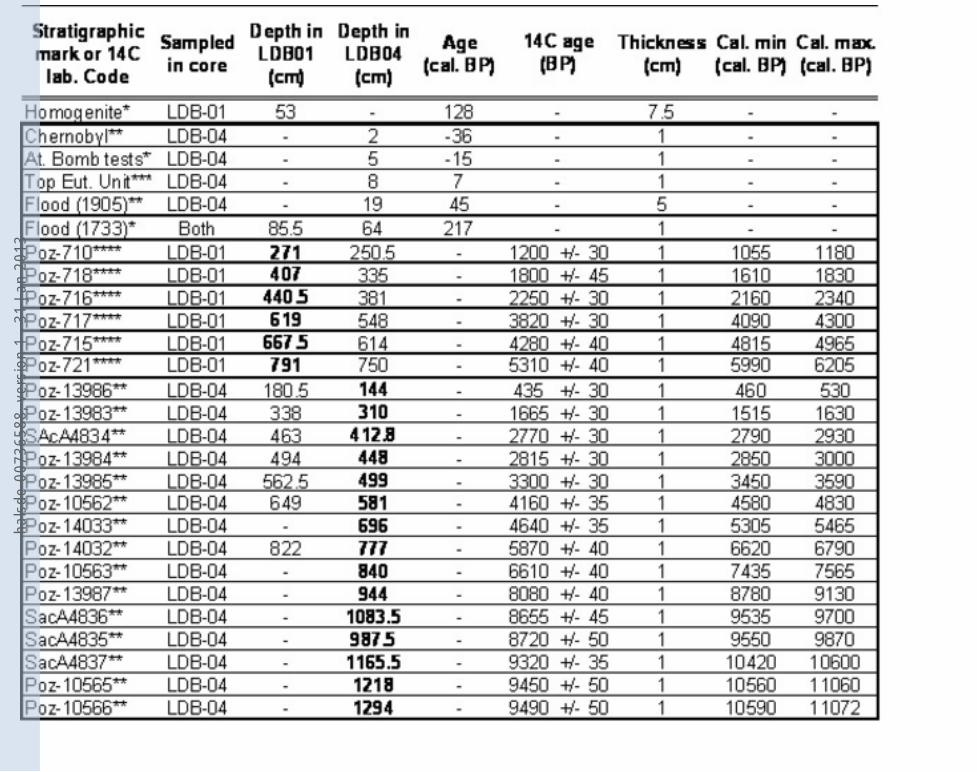
3.3. Chronology 19
Both cores LDB01-I and LDB04-I were previously dated independently (Arnaud et al., 2005; Debret 20
et al., 2010). However, we took advantage of their detailed litho-stratigraphic correlations to add 21
cross-correlated 14
C-dated samples from both of them (Table 1). We thus present a refined age-model 22
for each of the studied cores. This was done by running the “CLAM” program (Blaauw, 2010) under 23
the mathematics software “R” version 2.12.2 (R Development Core Team, 2011). The used calibration 24
curve was Intcal09 (Reimer et al., 2009). All ages were acquired on vegetal terrestrial macroremains to 25
avoid reservoir effect. 26
27
4. Results and discussion 28
29
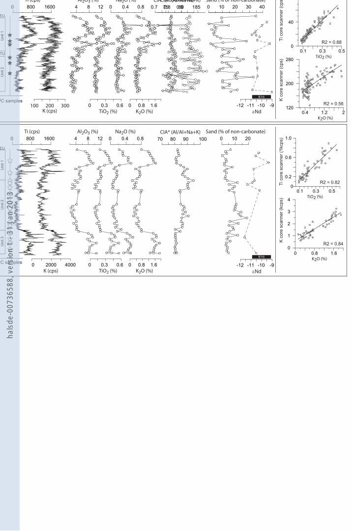
4.1. Downcore evolution of selected proxies 30
Generally speaking, both results from core scanning as well as from punctual measurements, exhibit a 31
strong covariation of all presented elements (Ti, K, Al, Na; Fig. 2). In first instance, this supports our 32
assumption of a simple-mixing system made of two end-members presenting a constant geochemical 33
composition, i.e. biogenic carbonate and river-borne silicates. However the evolution of the CIA index 34
indicates second order changes of the major element composition in both cores. 35
36
hals
de-0
0736
588,
ver
sion
1 -
31 J
an 2
013
Arnaud et al., Holocene alpine erosion patterns 6
The above statement of source constancy must be slightly nuanced in the case of LDB01-I. Indeed in 1
some particular levels this core presents a slight excess in Na and K vs. Ti and Al, as it is marked by 2
low CIA values (Fig. 2). Remarkably, those particular levels also present enrichments in the non-3
carbonate sandy fraction. We thus interpret changes in CIA as the influence of a minor sandy fraction 4
made of a mixture of quartz and although of feldspars, those ones presenting lower CIA indexes than 5
the < 10 µm silty-clays brought by River Rhône (Arnaud, 2005). As a consequence the CIA index will 6
not be used as a proxy for Rhône terrigenous fraction composition in LDB01-I. 7
8
Titanium content is commonly used as a proxy of terrigenous silicate input when interpreting XRF 9
core scanner results as it is strictly of terrigenous origin, well-measured by this technique and is only 10
weakly affected by weathering and underwater redox processes. However, it is a minor element, i.e. its 11
concentration is usually <1%. It is hence more comprehensive to plot the total abundance of the 12
terrigenous fraction to have a clearer image of the evolution of the ratio between allochthonous and 13
autochthonous sedimentations. In that aim, we calculated the total terrigenous fraction abundance, 14
assuming that, in each core, the maximum value of titanium concentration was corresponding to a total 15
terrigenous fraction of 100 % (Wessels, 1998). The maximum Ti content values taken into account 16
were 0.51 % and 0.58 % in LDB01-I and LDB04-I, respectively. The total terrigenous contribution 17
was then computed following: 18
(1a) Total terrigenous abundance = TiO2 / 0.51 x 100, in LDB01-1, and 19
(1b) Total terrigenous abundance = TiO2 / 0.58 x 100, in LDB04-1. 20
21
In addition to Ti and total terrigenous input, which track the quantity of matter brought by the river to 22
the lakes, we used an index derived from the Chemical Index of Alteration (CIA), defined by Nesbitt 23
and Young (1982) as: 24
(2) CIA = Al2O3 / (Al2O3 + CaO + K2O + Na2O).100 25
26
In this study, we were not able to assess the CaO content of the silicate fraction; we thus slightly 27
changed the equation into: 28
(3) CIA = Al2O3 / (Al2O3 + K2O + Na2O).100 29
30
We argue that this did not change considerably the results, as we only discuss about relative variations 31
in CIA. When comparing our results with the CIA of other records or of pure mineral phases, one must 32
however remember that our results are slightly over-estimated. 33
Non-weathered feldspars have CIA around 50 and granites: 45 to 55. At the opposite, clay minerals 34
present higher values: from 70 for illite to 85 for smectite and up to 100 for kaolinite, following an 35
increasing weathering gradient. The CIA index gives thus an assessment of the relative proportion of 36
hals
de-0
0736
588,
ver
sion
1 -
31 J
an 2
013
Arnaud et al., Holocene alpine erosion patterns 7
primary minerals vs. secondary ones. Hence, if the source remains constant it can be interpreted as a 1
proxy for the intensity of chemical weathering. 2
3
The CIA index has been calculated for all punctual XRF measurements; however it was not possible to 4
calculate it from core scanner results because of the poor definition of the aluminum signal. We hence 5
use instead the K/Ti ratio. Indeed K is more concentrated in non-weathered minerals, as it is 6
preferentially leached by weathering processes. Plotting K/Ti vs. CIA index gave a high anti-7
correlation, with a R2 value of 0.8 and 0.85 for LDB04-I and LDB01-I samples, respectively (not 8
shown). 9
10
Isotopic composition of neodymium (Nd) presents fluctuations along both cores, staying roughly 11
within the range of measured samples from core B16 (-9.3 to -10.8; Revel-Rolland et al., 2005; cf. 12
black boxes in Fig. 2). There is a certain relationship between terrigenous fraction abundance and Nd: 13
in general, Nd are more negative when the abundance of the terrigenous fraction is low. However this 14
technique being relatively time consuming, it was not possible to make as many measurements as for 15
major elements. This results in a relatively lower resolution signal which is more difficult to compare 16
with the other ones. For that reason, Nd will be sole proxy for which we will present graphs 17
combining samples taken in different cores vs. a common age-scale. It will hence be easier to interpret 18
its variations as a function of age. 19
20
The right part of Figure 2 presents the correlation between XRF measurements of Ti and K in both 21
cores from both core scanning and punctual samples. The correlation appears to be satisfying for all 22
presented elements except for K in LDB01-I. We will thus not use this last one in further development 23
of this paper. In particular the induced bias precludes to accurately compute the Ti/K ratio from core 24
LDB01-I. 25
26
4.3. Age-depth modelling 27
Age-depth models were computed using a smooth spline function, with a smoothing factor of 0.1 28
(Blaauw, 2010) and reported in Figure 3. One age at 4.6m in LDB01-I (4.1m in LDB04-I) appeared to 29
be slightly too old as it was generating age inversions in the model. It has thus been removed from the 30
dataset and new models were generated. Sedimentation rates were automatically calculated and also 31
displayed on Figure 3 (lower panel). 32
33
The age-depth model comprises both a hiatus and an instantaneous deposit at 6.2-6.75m-depth (Fig. 3 34
inset A). Geotechnics tries yielded a weaker sediment coherency within the suspected mass-wasted 35
deposit. Together with seismic imagery this led to interpret it as a slump (Debret et al., 2010). The age 36
hals
de-0
0736
588,
ver
sion
1 -
31 J
an 2
013
Arnaud et al., Holocene alpine erosion patterns 8
of the deposit has been fixed as the modelled age at 6.2m (4870 +/- 150 cal. BP). The time-cover of 1
the coring-generated hiatus can be assessed by making the difference between the modelled age of the 2
uppermost non-reworked sediment layer (i.e. 5220 cal. BP at 6.75m) and the age of the slump (4870 3
cal. BP): 350 years (i.e. ca. 40cm). 4
5
Following the same procedure, we imposed to the model both a hiatus and an instantaneous deposit 6
between 11 and 10.2m (Fig. 3 inset). The maximum age of the instantaneous deposit (9900 cal. BP) is 7
given by two similar 14
C ages (8645 +/- 45 and 8720 +/-50 BP) present in it. We arbitrary fixed the age 8
of instantaneous deposit as the maximum of probability of those ages (ca. 9700 cal. BP). The resulting 9
hiatus covers the period 9700 – 10350 cal. BP, i.e. ca. 650 years. 10
11
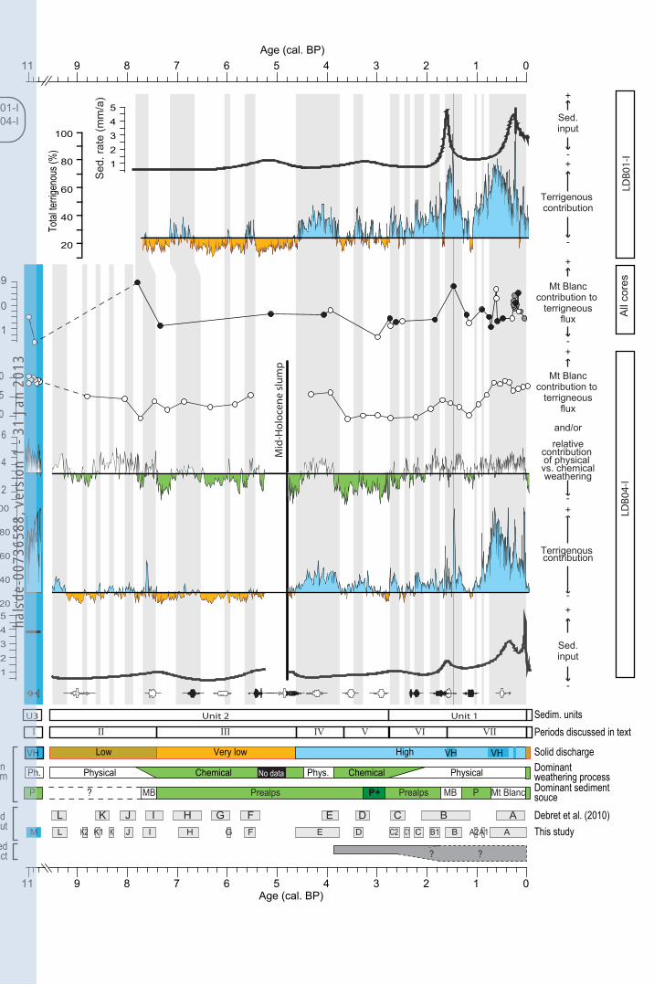
4.4. The Holocene evolution of regional erosion patterns at the Alpine footstep with 12
respect to Alpine soils, vegetation and climate histories 13
In a previous work, Debret et al. (2010) defined 12 periods of enhanced detrital input labelled by 14
letters from A to L. The higher resolutioon of our proxies and the increased consistency given by the 15
comparison of two cores led us to refine this cutting into 17 periods over the last 9600 years. We 16
however kept Debret et al.‟s nomenclature, but slightly refined the limits of defined periods and, when 17
useful, added five new ones in between the former ones (B1, C1, C2, K1, K2). Finally, we added the 18
period M corresponding to the sediments of unit 3. Those short-term fluctuations are superimposed on 19
the long-term evolution of the detrital input we describe below as periods I to VIII (Fig. 4). 20
21
4.4.1. Period I: 11000-10500 ka cal. BP 22
The oldest sediments in core LDB04-I from the deep basin are dated ca. 11 ka cal. BP. According to 23
seismic imagery they are not in place (Debret et al., 2010). No sediment has been recovered dated 24
between 10.5 and 9.6 ka cal. BP. The transition from unit 3 to unit 2 marks the onset of the Holocene 25
drape, i.e. the characteristic Holocene sedimentary facies of Lake Bourget (van Rensbergen et al., 26
1999). 27
The age-depth model within unit 3 (HDU) must be taken cautiously. We will thus not use results from 28
this unit as a continuous record, but as representative, in average, of the very early Holocene period, 29
when River Rhône was directly entering the lake (period M, Fig. 4). Sediments from this period 30
present the highest values of terrigenous abundance and sedimentation rate (3.8mm/a), as well as of 31
proxies of physical weathering (high K/Ti, low CIA). This can be explained easily, considering the 32
river Rhône was entering directly Lake Bourget. 33
The variability of computed terrigenous abundance (40 to 100 %), whereas the CIA (i.e. the 34
composition of the siliciclastic fraction) remains almost constant, indicates that a significant biogenic 35
carbonate production probably occurred. Interestingly, the Nd value is relatively low, whereas the 36
hals
de-0
0736
588,
ver
sion
1 -
31 J
an 2
013
Arnaud et al., Holocene alpine erosion patterns 9
CIA is low. This means the main source of erosion is made of perialpine sedimentary rocks (low Nd) 1
which were by that time only poorly weathered (low CIA), indicating the soil formation processes 2
were still relatively weak. 3
4
4.4.2. Period II: 9700-7400 cal. BP 5
The early Holocene is characterised by low sedimentation rates (< 1 mm/a) and a major contribution 6
of biogenic carbonates (65 to 80 %), as a consequence of very low terrigenous input. However proxies 7
for physical weathering (K/Ti, CIA), as well as Nd are still high, suggesting the predominance of 8
physical erosion in Alpine catchments. 9
Within this period, some peaks in terrigenous abundance indicate periods of enhanced physical erosion 10
around 9.4; 8.9; 8.6; 8.3, 8.0 and 7.6 ka cal. BP (periods L, K2, K1, K, J, I, respectively). Within age 11
uncertainty, period J (8.3 ka cal. BP) could correspond to the so-called 8.2 ka event which has been 12
demonstrated to be relatively wet in Lake Annecy, some kilometres west from Lake Bourget (Magny 13
et al., 2003). However, one must note, it is not a prominent wiggle in detrital input, whereas the 8.2 k 14
event was marked by a dramatic drop in temperature at the footstep of the Alps (von Grafenstein et al., 15
1999). 16
Periods of enhanced terrigenous supplies are frequent, but relatively weak. The persistence of high 17
K/Ti ratio tracks the weakness of pedogenetic processes during this apparently dry, as indicated by 18
low detrital input, period (9.6-7.8 ka cal. BP). The preponderance of physical erosion might reflect the 19
necessary delay for the vegetation, and thus for soils, to recover from Lateglacial conditions. At 7.8 ka 20
cal. BP, a marked drop in K/Ti tracks the increasing contribution of weathered material at the favour 21
of a reduced terrigenous input. We interpret this signal as a marker of active soil formation in the 22
Alpine catchments. 23
Those results are in agreement with recent results from a high altitude lake, within the catchments area 24
of Lake Bourget. Indeed at Lake Anterne (2060 m asl), Giguet-Covex et al. (2011) showed that the 25
period from 11 to 8 ka cal. BP was dominated by physical erosion prior to a period of soil 26
stabilisation. This last one was there evidenced by the deposit of more weathered material interpreted 27
as the response to Alpine soils development (Giguet-Covex et al., 2011). It is noticeable that this 28
period is also marked by the extension of trees up to the Subalpine belt (van der Knaap et al., 2005; 29
David, 1993). The similarity of results from Anterne and Le Bourget suggests trees were developing in 30
the uppermost parts of the catchments area, leading to the development of differentiated soils that 31
modified the chemistry of eroded material carried by Rhône River floods. 32
33
4.4.3. Period III: 7400-5700 cal. BP 34
This period is marked by low K/Ti values, even in periods of relatively higher terrigenous input. We 35
interpret this as the consequence of the soils development in the whole catchment area. This is in 36
agreement with the growing idea that this period of the Holocene was marked by a pedological 37
hals
de-0
0736
588,
ver
sion
1 -
31 J
an 2
013
Arnaud et al., Holocene alpine erosion patterns 10
optimum during which developed soils occupied most of Alpine terranes, including high altitude ones, 1
at least up to 2100 m asl (Mourier et al., 2010; Giguet-Covex et al., 2011). 2
Some peaks in terrigenous input mark periods of slightly enhanced erosion around 6.8 and 6 ka cal. 3
BP (periods H and G). One notes that each rise in terrigenous input is accompanied by a rise in K/Ti, 4
which may indicate a displacement of the sediment source toward the upper Arve catchment where 5
physical erosion still prevails in the Mont Blanc massif. We however do not have Nd isotope 6
compositions data in this period to further confirm this hypothesis. 7
8
4.4.4. Period IV: 5700-3700 cal. BP 9
This period is made of two important rises in terrigenous supply at 5.7-5.4 and 4.8-3.8 ka cal. BP 10
(periods F and E), separated by an apparent pause in river discharge of about 600 years (5.4-4.8 ka cal. 11
BP). The 4.8-3.8 ka cal. BP is the oldest, millennial-long period of enhanced terrigenous supply. It is 12
characterised by some of the highest values of K/Ti, indicating the preponderance of physical erosion. 13
14
4.4.5. Period V: 3700-2800 cal. BP 15
At 3.7 ka cal. BP, the K/Ti signal marks a drastic drop, lasting ca. 1000 years. When compared to 16
previous and following ones, even phases of enhanced detrital supplies from this period present 17
significantly lower K/Ti. This must be interpreted as the preponderant erosion of well-developed soil 18
horizons. Low values of Nd support this interpretation, suggesting the preponderance of Prealps 19
erosion sources. 20
By that time Lake Anterne catchment experienced a strong intensification of erosive processes that has 21
been attributed to human impact (Giguet-Covex et al., 2011) whereas in Austrian Alps Schmidt et al., 22
2002 also report the onset of human impact on erosive fluxes. In Lake Bourget geochemical record, 23
this period does not correspond to a marked rise in terrigenous supply. The intense erosion triggered 24
by human impact on highest catchment areas thus did not generate an excess in terrigenous supply 25
down to the Rhône valley. However it is characterised by the lowest K/Ti ratio of the whole sequence, 26
even during periods of enhanced terrigneous input indicating the deposition of highly weathered 27
material. 28
Based on the study of cores LDB04-I and LDB01-I, Jabob et al. (2008; 2009) demonstrated the 29
synchronous occurrence of two biomarkers: miliacin (olean-18-en-3b-ol methyl ether) and TTHC 30
(3,3,7-trimethyl-1,2,3,4-tetrahydrocrysene) at 3.7 ka cal. BP. Those markers track the introduction of 31
the non-native cultivated cereal Broomcorn millet (Panicum miliaceum) and a dramatic increase in 32
uppermost soils erosion, respectively. Such a result was interpreted as a major shift in agricultural 33
practises and land-use (Jacob et al., 2009). It occurred at a period when the terrigenous input was very 34
low and is synchronous with very low K/Ti values. Once again, this suggests that Bronze human 35
impact on soil stability is detectable qualitatively as it changed the nature of the erosion products, but 36
did not have a significant impact on regional terrigenous fluxes as they are recorded in Lake Bourget. 37
hals
de-0
0736
588,
ver
sion
1 -
31 J
an 2
013
Arnaud et al., Holocene alpine erosion patterns 11
1
4.4.6. Period VI: 2800-1600 cal. BP 2
The terrigenous input significantly increases four times within only 1000 years (periods C2, C1, C and 3
B1; at 2.8, 2.4, 2.2, 1.9 ka cal. BP, respectively). Each of those peaks presents a weaker chemical 4
weathering contribution than the previous one, which can be interpreted as a diminishing contribution 5
of low to mid-altitude non-glaciated catchments. However the Nd remains relatively low, indicating 6
the constancy of the sediments source area. We thus interpret this period as marked by a reinforcement 7
of the physical erosion in subalpine rather than high alpine catchments areas. 8
Remarkably the increase in terrigenous contribution between 2.8 and 1.6 ka cal. BP is more marked in 9
core LDB01-I than at LDB04-I site. The different response of both sites indicates the preponderance 10
during that period of interflows i.e. floods of lower magnitude. This could indicate that changes in 11
both quantity and quality of terrigenous fluxes are driven rather by changes in erosion patterns than by 12
enhanced precipitations. This is particularly true for the Late Iron Age (C) and Antiquity (B1) periods 13
which are known as periods of glacier retreat (Holzhauser et al., 2005; Joerin et al., 2006; 2008) and 14
however presents higher detrital fluxes in our record. In Lake Anterne, the period between 2.2 and 1.8 15
ka cal. BP is marked by the only phase of enhanced erosion which is in contradiction with climate 16
record over the last 3500 years, which has been attributed to human impact (Giguet-Covex et al., 17
2012; David, 2010). It is hence possible that changes in land-use practices at the end of the Iron Age 18
and during the Antique period produce a dramatic increase of erosion in Northern French Alpine 19
catchments areas that was strong enough to be imprinted at a regional scale in Lake Bourget sediment 20
record. Sediment records from Lake Annecy, some kilometres in the NE of Lake Bourget, also pointed 21
the influence of Gallo-Roman land-use reorganisation as a major trigger of erosion cycle disturbance 22
(Dearing et al., 2001; Noël et al., 2001). Noticeably, this scheme is in apparent contradiction with 23
archaeological data from Southern French Alps, indicating a continuous, but moderate exploitation of 24
alpine grasslands at this period (Walsh et al., 2007). It is hence obvious that this period presents a 25
complex human – climate – erosion pattern and requires deeper studies to be fully understood. 26
27
4.4.7. Period VII: 1650-50 cal. BP 28
In LDB01-I, at 1.65 ka cal. BP, both the sedimentation rate and the terrigenous supply experience a 29
dramatic rise (1650-1300 cal. BP, i.e., 300-650 AD). However, in LDB04-I, the same period appears 30
more contrasted and can be cut into two distinct phases: B1 (1650-1450 cal. BP, i.e. 300-500 AD) and 31
B (1450-1300 cal. BP, i.e., 500-650 AD). During phase B1, the terrigenous input is high, but lower 32
than in LDB01-I and moreover the K/Ti ratio remains low. During phase B (500-650 AD), the 33
terrigenous input is even higher and K/Ti reaches some of its highest values in the whole record. 34
Moreover during B1 the Nd reaches an unprecedented value since the Early Holocene, indicating a 35
massive influx of terrigenous particles from the Mt Blanc massif. As a consequence we interpret B1 36
(300-500 AD) as a period of enhanced erosion mainly in the lowest catchment area, characterised by 37
hals
de-0
0736
588,
ver
sion
1 -
31 J
an 2
013
Arnaud et al., Holocene alpine erosion patterns 12
low magnitude floods. Those interpretations match those based on Lake Annecy sediment sequence 1
from Dearing et al. (2001) who pointed the displacement of sediment source toward the lowlands and 2
from Noël et al. (2001) who pointed an unprecedented increase in soil erosion depth since 1700 cal. 3
BP. By contrast, phase B (500-650 AD) is marked by an increasing contribution of the highest 4
catchment area to the terrigenous flux and is interpreted as period of generalised more intense physical 5
erosion. This phasing can be interpreted as a period dominated by human impact at the end of 6
Antiquity (B1), whereas the High Middle Age (B) erosion patterns are dominated by a climate change, 7
as indicated by a major glacier advance (Holzhauser et al., 2005). 8
9
The following period, between phases B and A (1300-1050 cal. BP, i.e., 650-900 AD) is marked by a 10
drastic drop in terrigenous input and in K/Ti, reflecting the reduced influence of the highest catchment 11
areas. The detrital supply rises then gradually until the onset of phase A around 750 cal. BP (1200 AD) 12
and reaches a maximum around 650 cal. BP (1300 AD). This progressive rise is punctuated by two 13
short-lived peaks in detritism around 1050 (A2) and 900 (A1) cal. BP (i.e. 900 and 1050 AD, 14
respectively). 15
The terrigenous flux stays then high until the 20th century AD. This is the longest, most prominent 16
period of erosion throughout our continuous record (since 9600 cal. BP). It is dominated by the input 17
of lowly weathered material (high K/Ti). The Nd has been measured following a relatively higher 18
resolution and presents a strong variability, following variations in detrital input. The Mont Blanc 19
source is hence well-imprinted, but this period of strong erosionnal activity concerns the whole 20
catchment, as shown by the return to relatively low Nd during short-lived phases of relative drop in 21
terrigenous supply. 22
Based on historical evidences, the second half of the Middle Age (800-1500 AD) has been a period of 23
forest clearance in the Alps, especially between 1000 and 1350 AD (cf. Carrier and Mouthon, 2010, 24
for an Alpine-wide review), this could explain the progressive rise in terrigenous regional flux. 25
However, one must also notice that each periods A2, A1 as well as the onset of A corresponds to a 26
marked advance of the Great Aletsch glacier (Holzhauser et al., 2005) as well as marked higher lake 27
level in the neighbouring Jura massif (Magny et al., 2010). It is hence possible that glacier advances 28
that preceded the onset of the LIA sensu stricto and moreover the one of the LIA itself completely 29
hided the effects of human impact, as the glacial erosion was dominating the regional erosion flux. Of 30
course this does not rule out the possibility that locally the human-steered land management led to 31
important reinforcement of erosion processes. This point is however still a research field to be 32
addressed. 33
34
4.4.8. Period VIII: The 20th
century AD 35
Since the early 20th century AD, the terrigenous input experienced a drastic drop, linked to the end of 36
the LIA. This decline coincides with a drop in K/Ti and Nd, marking a diminution in the contribution 37
hals
de-0
0736
588,
ver
sion
1 -
31 J
an 2
013
Arnaud et al., Holocene alpine erosion patterns 13
of high altitude material. This period corresponds both to a major retreat of Alpine glaciers and to a 1
marked regression in agricultural land-use in the Alps. Those causes converged toward a reduction of 2
the terrigenous input. However, very low values in Nd, indicate the higher Arve source of sediment 3
was more reduced than the Prealpine one, indicating the preponderant impact of climate upon the 4
reduction of erosive fluxes after the end of the Little Ice Age. 5
6
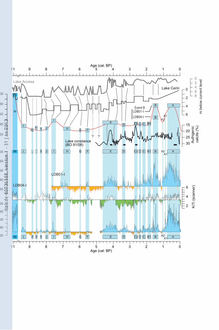
4.5. Regional paleohydrological context 7
8
In a recently published synthetic work Magny et al. (2011) pointed the importance of the long-term 9
Holocene trend in precipitation patterns, in response to orbital forcing. Two of the main series used in 10
Magny et al. (2011), lakes Accesa (Italy, Tuscany) and Cerin (Jura massif, 20km west of Lake 11
Bourget), are reported together with Lake Bourget results on Fig. 4,. Additionally we present in this 12
figure results from Lake Constance (Wessels, 1998) which is a system comparable to Lake Bourget. 13
Wessels (1998) reconstructed past interflow activity from the mid-resolution measurement of major 14
elements concentrations. Here we present the authigenic calcium carbonate concentration, on an 15
inverted axis, as a proxy of Rhine river terrigenous input to Lake Constance. To facilitate the 16
comparison of different records, we reported our 18 phases of enhanced terrigenous input represented 17
as their average terrigenous input value (upper limit of shaded boxes) and have drawn the envelope of 18
those values. 19
20
4.5.1. Long-term trend 21
Obviously, all different records present the same long-term evolution. The early Holocene is marked 22
both by high lake levels and maximum terrigenous supply. The strong decline in terrigenous supply in 23
Lake Bourget between 10.5 and 9.6 ka cal. BP is also marked in lake level records. However, it is first 24
due to a major shift in sediment input pattern following the abandonment of the lake by River Rhône. 25
It is remarkable that this river autro-capture was contemporaneous of a regional drop in lake levels. It 26
can therefore be suggested that this change in local geomorphology is related to a climatic shift toward 27
dryer conditions, leading to the incision of River Rhône bed. 28
The first post-abandonment peak in terrigenous flux (period L, 9.4 ka cal. BP) is well correlated to a 29
phase of high lake levels. The magnitude of this phase will not have an equivalent in lake level or in 30
detrital supply before 4.4 ka cal. BP. Indeed, the period 9.4 – 4.4 ka cal. BP is the one of lowest 31
hydrological activity of the whole Holocene. One marked exception must however be noticed around 32
5.5 ka cal. BP, a date which marks in the Alps the onset of the so-called “Neoglacial” period (Magny 33
et al., 2006; Deline and Orombelli, 2005). The 4.4-3.8 ka cal. BP event marks the onset of more humid 34
conditions resulting both in a marked rise in lake levels and terrigenous input. It is contemporaneous 35
of the so-called 4.2 ka event that is marked regionally by more humid conditions (Magny et al., 2011) 36
hals
de-0
0736
588,
ver
sion
1 -
31 J
an 2
013
Arnaud et al., Holocene alpine erosion patterns 14
and locally by a marked rise in lake level (Magny et al., in press). The trend which is then initiated 1
will culminate during the LIA and will only end at the 20th century AD. 2
We thus confirm the Early and Mid Holocene (9.4-4.4 ka cal. BP) were dry period in NW Alps as well 3
as in the Jura Mountains. On the contrary, the maximum of terrigenous supply during the LIA, but also 4
during the so-called “Dark Age” period (ca. 400-700 AD) is well-associated with a marked rise in lake 5
levels and can thus be interpreted as climatically-forced. Geomorphological data acquired just 6
downstream Lake Bourget from River Rhône sediment themselves corroborate our interpretation as 7
they a long period of low sediment transfer from at least 7000 cal. BP up to 4000 cal. BP. Since then 8
two periods of particularly high energy deposits, well-marked by the progradation of a gravelly 9
bedload, occurred around 1500 cal. BP and during the Little Ice Age (Salvador et al., 2004; Berger et 10
al., 2008). 11
The continuity of our record over the last 9600 years, suggests that the first half part of this period 12
(9600-4600 cal. BP) has been in average, dryer than the 20th century AD. It also suggests that current 13
climatic conditions, marked by low hydrological activity are out-of-trend compared to the Holocene 14
long-term trend toward more humid conditions in NW Alps. Indeed despite a shot period of low 15
terrigenous input during Medieval Warm Period, current conditions were not experienced since the 16
Late Bronze Age driest period. 17
18
4.5.2. Centennial-scale hydrological fluctuations 19
Most of rises in lake levels evidenced in Accesa and Cerin lakes are well-marked in Lake Bourget. 20
Slight discrepancies can occur, but most of them can be explained by different sampling resolutions 21
and/or age-model model uncertainties (cf. correlation lines in Fig. 5). This points out the strong 22
reactivity of Lake Bourget record to changing hydrological conditions, even at an infra-centennial 23
scale. 24
A main discrepancy must however be noticed for the period 5.3 – 4.7 ka cal. BP when two marked 25
rises in lake level are reported both in Cerin and Accesa lakes. Considering Lake Cerin is very close to 26
Lake Bourget, one may not evocate a different climate pattern. However, this period corresponds to 27
important reorganisations of Lake Bourget sedimentation patterns, as it is marked by the occurrence of 28
an important slump deposit. It is hence possible that either the threshold to generate the inversion of 29
flux from the Rhône to the lake was higher or the flood regime was dominated by underflows which 30
have not been recorded in LDB01-I (interflows-dominated) and were not recovered in LDB04-I 31
(missing section). Anyway this question remains open and will require further studies to be solved. 32
The strong correlation of lakes Constance and Bourget peaks in terrigenous between 5 and 2.2 ka cal. 33
BP underlines a common climate forcing leading to high frequency wiggles in terrigenous discharge 34
around the Alps. Since 2.2 ka cal. BP, both records exhibit discrepancies that could be explained by 35
different responses to human impact on erosion. 36
37
hals
de-0
0736
588,
ver
sion
1 -
31 J
an 2
013
Arnaud et al., Holocene alpine erosion patterns 15
5. Conclusion 1
Lake Bourget high resolution geochemical record brings new insights upon both the evolution of soil 2
dynamics and paleohydrology at a regional scale in NW Alps. We show that most of the Holocene was 3
a period of reduced erosion fluxes due to a combination of dry climate and extensive soil development 4
precluding intense erosion where remaining glaciers did not take place. The first impacts of human 5
activities, during the Bronze Age, resulted more into a change in erosion patterns than a marked 6
increase in regional erosion fluxes. In this our record differs from local studies led in small-scale high 7
elevated catchments areas. It is nevertheless likely that at the end of the Iron Age and more probably 8
during the Antiquity, the intensity of human impact was such that it resulted in a regional increase of 9
terrigenous fluxes. However, the subsequent periods were dominated by far by the activation of glacier 10
systems in the Mont Blanc Massif that culminated during the Little Ice Age which is the longest and 11
most intense period of erosion over the whole Holocene. 12
Regarding paleohydrology, our results exhibit a pattern in agreement with previous lower resolution 13
studies, both in the long-term trend and at a higher time resolution. In particular, we illustrate that the 14
Holocene has been marked by dry conditions in the Alps until ca. 5.5 ka cal. BP and the onset of the 15
so-called Neoglacial. Since then a trend was onset toward more humid conditions that culminated 16
during the Little Ice Age. This suggests that current climatic conditions, marked by low hydrological 17
activity, are out-of-trend compared to the Holocene climate evolution and could be attributed to 18
current global warming. 19
20
Acknowledgements 21
22
XRF core-scanner measurements have been performed at the University of Bremen. LDB01-I was 23
measured thanks to the EU-Project "Paleostudies" (contract-no.: HPRI-2001-00124). Drs. Frank Lamy 24
and Holger Kuhlmann are acknowledged for having managed this project. Authors also wish to thank 25
Heike Pfletschinger (University Bremen - ODP Core Repository) for her help in using the core-26
scanner. Dr. Thierry Winiarski (ENTPE-Lyon) is acknowledged for its support for field logistics. 27
This study is part of the research programs Aphrodyte II, funded by the interdisciplinary program 28
Eclipse of the French National Institute of Universe Sciences (INSU) and Pygmalion founded by the 29
French National Research Agency (ANR BLAN07-2_204489). All 14
C ages referred as “SacA” were 30
measured in Saclay LMC14 laboratory in the framework of the national program “Artemis”. The 31
authors express their grateful thanks to the Saclay laboratory team, in particular to Jean-Pascal 32
Dumoulin, as well as to Tomas Goslar from Poznan Radioacarbon Laboratory for constant help in the 33
management of 14
C samples and results. The earlier version of the paper was greatly improved thanks 34
to the remarks from two anonymous reviewers. 35
36
hals
de-0
0736
588,
ver
sion
1 -
31 J
an 2
013
Arnaud et al., Holocene alpine erosion patterns 16
References 1
2
Arnaud, F., 2005. Discriminating the fingerprints of bio-induced and detrital sedimentary processes in 3
particle size distribution spectra of hard water lake sediments. Journ. of Paleolim. 34-4, 519-526. 4
5
Arnaud, F., Revel-Rolland, M., Chapron, E., Desmet, M., Tribovillard, N., 2005. 7200 years of Rhône 6
river flooding activity recorded in Lake Le Bourget: A high resolution sediment record of NW Alps 7
hydrology. Holocene 15, 420-428. 8
9
Arnaud, F., Revel-Rolland, M., Bosch, D., Winiarski, T., Chapron, E., Desmet, M., Tribovillard, N., 10
Givelet, N., 2004. A reliable 300 years-long history of lead contamination in Northern French Alps 11
from distant lake sediment records. Journ. of Env. Mon. 6, 448–456. 12
13
Berger, J.-F, Salvador, P.-G., Franc, O., Vérot-Bourrely, A., Bravard, J.-P., 2008. La chronologie 14
fluviale postglaciaire du haut bassin rhodanien. In Dynamique holocène de l‟environnement dans les 15
Alpes et le Jura: du climat à l‟homme, Desmet, M., Magny, M., Mocci, F. (eds). Cahiers de 16
Paléoenvironnement, Collections Edytem, Université de Savoie: Chambéry; 117-144. http://hal-17
sde.archives-ouvertes.fr/docs/00/66/49/01/PDF/Coll-EDYTEM_6-2008-Cahiers_PalA_oenvironnement_JurAlp.pdf 18
19
Blaauw, M., 2010. Methods and code for „classical‟ age-modelling of radiocarbon sequences. Quat. 20
Geochronology 5, 512-518. 21
22
Bravard, J.-P., 1987. Le Rhône, Du Léman à Lyon. Editions La Manufacture. Lyon. 23
24
Carrier, N. and Mouthon, F., 2010. Paysans des Alpes – Les communautés montagnardes au Moyen 25
Âge. Presses universitaires de Rennes. 420 pp. ISBN 978-2-7535-1091-3. 26
27
Chapron, E., 1999. Contrôle climatique et sismo-tectonique de la sédimentation lacustre dans l‟Avant-28
Pays Alpin (Lac du Bourget) durant le Quaternaire récent. Géologie Alpine, mémoire H.S. n° 30. 29
30
Chapron, E., Beck, C., Pourchet, M & Deconinck, J.-F., 1999. 1822 earthquake-triggered homogenite 31
in Lake Bourget (NW Alps). Terra Nova 11, 86-92. 32
33
Chapron, E., Desmet, M., De Putter, T., Loutre, M.-F., Beck, C., Deconinck, J.-F., 2002. Climatic 34
variability in the northwestern Alps, France, as evidenced by 600 years of terrigenous sedimentation in 35
Lake Bourget. The Holocene 12, 177-185. 36
37
hals
de-0
0736
588,
ver
sion
1 -
31 J
an 2
013
Arnaud et al., Holocene alpine erosion patterns 17
Chapron, E., Arnaud, F., Noël, H., Revel-Rolland, M., Desmet, M., Perdereau, L., 2005. Rhone River 1
flood deposits in Lake Le Bourget: a proxy for Holocene environmental changes in the NW Alps, 2
France. Boreas, 34, 404-416. 3
4
David, F., 2010. An example of the consequences of human activities on the evolution of subalpine 5
landscapes. C. R. Palevol 9, 229–235 6
7
David F., 1993. Extension tardiglaciaire des pins dans les Alpes du Nord. CRAS série II, 317, 123-8
129. 9
10
Dearing, J. A., Hu, Y., Doody, P., James, P. A., Brauer, A., 2001. Preliminary reconstruction of 11
sediment-source linkages for the past 6000 yrs at the Petit Lac d‟Annecy, France, based on mineral 12
magnetic data. Journal of Paleolimnology 25, 245–258. 13
14
Dearing, J. A. & Jones, R. T., 2003. Coupling temporal and spatial dimensions of global sediment flux 15
through lake and marine sediment records. Global and Planetary Change 39, 147-168. 16
17
Debret, M., Chapron, E., Desmet, M., Rolland-Revel, M., Magand, O., Trentesaux, A., Bout-18
Roumazeille, V., Nomade, J., Arnaud, F., 2010. North western Alps Holocene paleohydrology 19
recorded by flooding activity in Lake Le Bourget, France. Quatern. Sci. Rev. 29, 2185–2200. 20
21
Deline, P., Orombelli, G., 2005. Glacier fluctuations in the western Alps during the Neoglacial, as 22
indicated by the Miage morainic amphitheatre (Mont Blanc massif, Italy). Boreas 34, 456–467. 23
24
Disnar, J.-R., Jacob, J., Morched-Issa, M., Arnaud, F., Lottier, N., 2008. Assessment of peat quality 25
by molecular and bulk geochemical analysis; application to the Holocene record of the Chautagne 26
marsh (Haute Savoie, France). Chemical Geology, 254, 101-112. 27
28
Giguet-Covex, C., Arnaud, F., Poulenard, J., Enters, D., Reyss, J.-L., Vidal, O., 2010. Multi-proxy 29
reconstruction of trophic state and hypolimnetic anoxia in a large hard-water lake (Lake Bourget, 30
French Alps) over the past 140 years. Journal of Palaeolimnology 43, 171-190. 31
32
Giguet-Covex C., Arnaud, F., Poulenard, J., Disnar, J.R., Delhon, C., Francus, P., David, F., Enters, 33
D., Rey, P.-J., Delannoy, J.-J., 2011. Changes of erosion patterns during the Holocene in a currently 34
treeless subalpine catchment inferred from lake sediment geochemistry (Lake Anterne, 2063 m asl, 35
NW French Alps). The Holocene 21, 651-665 36
37
hals
de-0
0736
588,
ver
sion
1 -
31 J
an 2
013
Arnaud et al., Holocene alpine erosion patterns 18
Giguet-Covex C., Arnaud, F., Enters, D., Poulenard, J., Millet, L., Francus, P., David, F., Rey, P.-J., 1
Wilhelm, B., Delannoy, J.-J., 2012. Frequency and intensity of high altitude floods over the last 3.5 ka 2
in NW European Alps. Quaternary Research 77, 12-22 3
4
Holzhauser, H., Magny, M., Zumbühl, H.J., 2005. Glacier and lake-level variations in west-central 5
Europe over the last 3500 years. The Holocene 15, 789–801. 6
7
Jacob, J., Disnar, J.-R., Arnaud, F., Chapron, E., Debret, M., Lallier-Vergès, E., Desmet, M., Revel-8
Rolland, M., 2008. Millet cultivation history in the French Alps as evidenced by a sedimentary 9
molecule. Journal of Archaeological Science, 35, 814-820. 10
11
Jacob, J., Disnar, J.-R., Arnaud, F., Gauthier, E., Billaud, Y., Bardoux, G., 2009. Agriculture and soil 12
erosion during the Bronze Age around Lake Le Bourget (French Alps). The Holocene 19, 241-249 13
14
Jacobsen, S. B. and G. J. Wasserburg, 1980. "Sm-Nd isotopic evolution of chondrites." Earth and 15
Planetary Science Letters, 50, 139-155. 16
17
Joerin, U.E., Stocker, T.F., Schlüchter, C., 2006. Multicentury glacier fluctuations in the Swiss Alps 18
during the Holocene. The Holocene 16, 697–704. 19
20
Joerin, U.E., Nicolussi, K., Fischer, A., Stocker, T.F., Schlüchter, C., 2008. Holocene optimum events 21
inferred from subglacial sediments at Tschierva Glacier, Eastern Swiss Alps. Quaternary Science 22
Reviews 27, 337–350. 23
24
Jung, S., Arnaud, F., Bonté, P., Chebbo, G., Lorgeoux, C., Winiarski, T., Tassin, B., 2008. Temporal 25
evolution of urban wet weather pollution: analysis of PCB and PAH in sediment cores from Lake 26
Bourget, France. Water Science & Technology 57, 1503–1510. 27
28
Ledoux, G., Lajeunesse, P., Chapron, E., St Onge, G., 2010. Multibeam bathymetry investigation of 29
mass movements in Lake Le Bourget (NW Alps, France) using a portable platform. In Submarine 30
mass movements and their consequences. Advances in natural and technological hazrds research 28 – 31
II, 423-434. 32
33
Magny, M. and Richard, H., 1985. Contribution à l‟histoire holocène du Lac du Bourget : recherches 34
sédimentologiques et palynologiques sur le site de Conjux-La Chatière (Savoie, France). Revue de 35
Paléobiologie 4, 253-277. 36
37
hals
de-0
0736
588,
ver
sion
1 -
31 J
an 2
013
Arnaud et al., Holocene alpine erosion patterns 19
Magny, M., Bégeot, C., Guiot, J., Peyron, O., 2003. Contrasting patterns of hydrological changes in 1
Europe in response to Holocene climate cooling phases. Quaternary Science Reviews 22, 1589–1596 2
3
Magny, M., Leuzinger, U., Bortenschlager, S., Haas, J. N., 2006. Tripartite climate reversal in Central 4
Europe 5600–5300 years ago. Quaternary Research 65, 3 – 19 5
6
Magny, M., Peyron, O., Gauthier, E., Rouèche, Y., Bordon, A., Billaud, Y., Chapron, E., Marguet, A., 7
Pétrequin, P., Vannière, B., 2009. Quantitative reconstruction of climatic variations during the Bronze 8
and early Iron ages based on pollen and lake-level data in the NW Alps, France. Quaternary 9
International, 200, 102–110 10
11
Magny, M., Arnaud, F., Holzhauser, H., Chapron, E., Desmet, M., Leroux, A., Millet, L., Vannière, 12
B., 2010. Solar and site-sensitivity imprints on palaeohydrological records for the last millennium in 13
west-central Europe Quaternay research 73, 173-179 14
15
Magny, M., Bossuet, G., Ruffaldi P., Leroux A., Mouthon J., 2011. Orbital imprint on Holocene 16
palaeohydrological variations in west-central Europe as reflected by lake level changes at Cerin (Jura 17
Mountains, eastern France). Journal of Quaternary Science, 26, 171–177. 18
19
Magny M., Arnaud F., Billaud, Y., Marguet, A., In press. Lake-level fluctuations at Lake Bourget 20
(eastern France) around 4500-3500 cal BP and their palaeoclimatic and archaeological implications. 21
Journal of Quaternary Science, 27, 494-502 22
23
Marguet, A., 2000, Elaboration de la carte archéologique des gisements du Lac du Bourget in 24
Direction de l‟architecture et du patrimoine in Sous-direction des recherches archéologiques 25
subaquatiques et sous-marines: Bilan Scientifique 2000. Ministère de la culture et de la 26
communication. Paris. pp. 117 – 137. 27
28
Mayewski, P.A., Rohling, E.E., Stager, J.C., Karlén, W., Maasch, K.A., Meeker, L.D., Meyerson, 29
E.A., Gasse, F., van Kreveld, S., Holmgren, K., Lee-Thorp, J., Rosqvist, G., Rack, F., Staubwasser, 30
M., Schneider, R.R. & Steig, E.J., 2004. Holocene climate variability. Quaternary Research, 62, 243-31
255. 32
33
Millet, L., Giguet-Covex, C., Verneaux, V., Druart, J-C., Adatte, T., Arnaud, F., 2010. Reconstruction 34
of the recent history of a large deep prealpine lake (Lake Bourget, France) using subfossil 35
chironomids, diatoms, and organic matter analysis: towards the definition of a lake-specific reference 36
state. Journal of Palaeolimnology, 44, 963-978 37
hals
de-0
0736
588,
ver
sion
1 -
31 J
an 2
013
Arnaud et al., Holocene alpine erosion patterns 20
1
Mourier, B., Poulenard, J., Carcaillet, C., Williamson, D., 2010. Soil evolution and subalpine 2
ecosystem changes in the French Alps inferred from geochemical analysis of lacustrine sediments. 3
Journal of paleolimnology 44, 571-587. 4
5
Nesbitt, H. W. & Young, G. M., 1982. Early proterozoic climates and plate motion inferred from 6
major element chemistry of lutites. Nature 299, 715-717. 7
8
Nicoud, G., Monjuvent, G., Maillet-Guy, G., 1987, Contrôle du comblement quaternaire des vallées 9
alpines du Nord par la dynamique lacustre. Géologie Alpine, Mém. HS 113, 457-468. 10
11
Noël, H., Garbolino, E., Brauer, A., Lallier-Vergès, E., de Beaulieu, J.-L., Disnar, J.-R., 2001. Human 12
impact and soil erosion during the last 5000 yrs as recorded in lacustrine sedimentary organic matter at Lac 13
d‟Annecy, the French Alps. Journal of Paleolimnology 25, 229–244 14
15
Piccarreta, M., Caldara, M., Capolongo, D., Boenzi, F., 2011. Holocene geomorphic activity related to 16
climatic change and human impact in Basilicata, Southern Italy. Geomorphology, 128, 137–147. 17
18
Pin, C. and Santos Zalduegui, J. F., 1997. "Sequential separation of light rare-earth elements, thorium 19
and uranium by miniaturized extraction chromatography: Application to isotopic analyses of silicate 20
rocks." Analytica Chimica Acta, 339, 79-89. 21
22
R Development Core Team (2011). R: A language and environment for statistical computing. R 23
Foundation for Statistical Computing, Vienna, Austria. ISBN 3-900051-07-0, URL http://www.R-24
project.org/. 25
26
Reimer, P.J., Baillie, M.G.L., Bard, E., Bayliss, A., Beck, J.W., Blackwell, P.G., Bronk Ramsey, C., 27
Buck, C.E., Burr, G.S., Edwards, R.L., Friedrich, M., Grootes, P.M., Guilderson, T.P., Hajdas, I., 28
Heaton, T.J., Hogg, A.G., Hughen, K.A., Kaiser, K.F., Kromer, B., McCormac, F.G., Manning, S.W., 29
Reimer, R.W., Richards, D.A., Southon, J.R., Talamo, S., Turney, C.S.M., van der Plicht, J., 30
Weyhenmeyer, C.E., 2009. IntCal09 and Marine09 radiocarbon age calibration curves, 0-50,000 years 31
cal BP. Radiocarbon, 51, 1111-1150. 32
33
Revel-Rolland, M., Arnaud, F., Chapron, E., Desmet, M., Givelet, N., Alibert, C., McCulloch, M. 34
2005. Sr and Nd isotope as a tracer of sources of clastic material, in the Bourget lake sediment (NW 35
Alps, France) during the Little Ice Age. Chemical Geology, 224, 183-200. 36
37
hals
de-0
0736
588,
ver
sion
1 -
31 J
an 2
013
Arnaud et al., Holocene alpine erosion patterns 21
Revillon,, S. and Hureau-Mazaudier, D., 2009. Improvements in Digestion Protocols for Trace 1
Element and Isotope Determinations in Stream and Lake Sediment Reference Materials (JSd-1, JSd-2, 2
JSd-3, JLk-1 and LKSD-1). Geostandards and Geoanalytical Research, 33, 397-413. 3
4
Salvador, P.-G., Berger, J.-F., Fontugne, M., Gauthier, E., 2004. Etude des enregistrements 5
sédimentaires holocènes des paléoméandres du Rhône dans le secteur des Basses Terres (Ain, Isère, 6
France). Quaternaire 16, 315-328. 7
8
Schmidt, R., Koinig, K.A., Thompson, R., Kamenik, C. 2002. A multi-proxy core study of the last 9
7000 years of climate and alpine land-use impacts on an Austrian mountain lake (Unterer 10
Landschitzsee, Nieder Tauern). Palaeogeography, Palaeoclimatology, Palaeoecology 187, 101–20. 11
12
Trentesaux, A., Recourt, P., Bout-Roumazeilles, V., Tribovillard, N., 2001. Carbonate grain sizer 13
distribution in hemipelagic sediment from a laser particle sizer. J. Sediment. Res. Sec. A: Sediment. 14
Petrol. Process, 71, 858–862. 15
16
van Rensbergen, P., De Batist, M., Beck, C., Chapron, E., 1999: High-resolution seismic stratigraphy 17
of glacial to interglacial fill of a deep glacigenic lake: Lake Bourget, North Western Alps, France. 18
Sedimentary Geology 128, 99-129. 19
20
van der Knaap, W.O., van Leeuwen, J. F. N., Finsinger, W., Gobet, E., Pini, R., Schweizer, A., 21
Valsecchi, V., Ammann, B., 2005. Migration and population expansion of Abies, Fagus, Picea, and 22
Quercus since 15000 years in and across the Alps, based on pollen-percentage threshold values. 23
Quaternary Science Reviews, 24, 645–680 24
25
von Grafenstein, U., Erlenkeuser, H., Brauer, A., Jouzel, J., Johnsen, S. J., 1999. A Mid-European 26
Decadal Isotope-Climate Record from 15,500 to 5000 Years B.P. Science, 284, 1654-1657. 27
28
Walsh, K., Mocci, F., Tzortzis, S., Palet-Martinez, J.-M., 2007. Dynamique du peuplement et activités 29
agro-pastorales durant l‟âge du Bronze dans les massifs du Haut Champsaur et de l‟Argentierois 30
(Hautes-Alpes). Documents d‟Archéologie méridionale 28, 25-44. 31
32
Wessels, M., 1998. Natural environmental changes indicated by Late Glacial and Holocene sediments 33
from Lake Constance, Germany. Palaeogeography, Palaeoclimatology, Palaeoecology, 140, 421-432. 34
35
36
37
hals
de-0
0736
588,
ver
sion
1 -
31 J
an 2
013
Arnaud et al., Holocene alpine erosion patterns 22
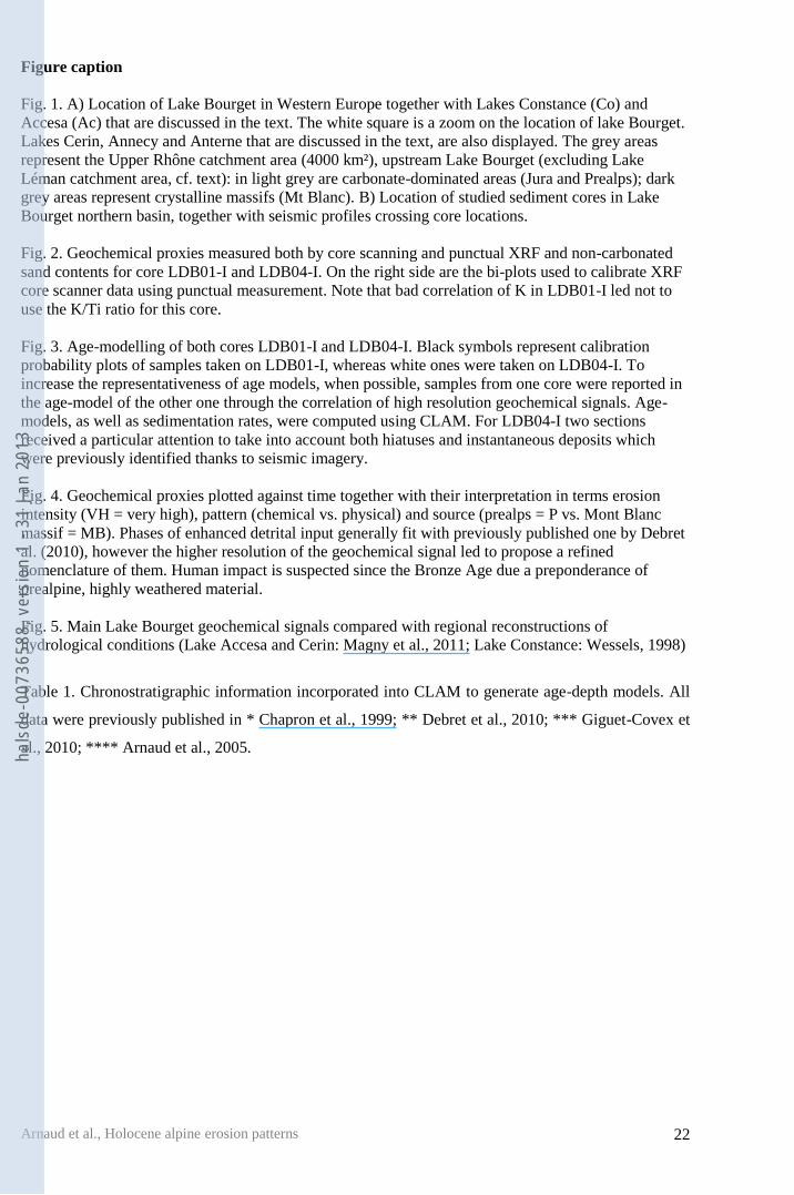
Figure caption 1 2
Fig. 1. A) Location of Lake Bourget in Western Europe together with Lakes Constance (Co) and 3
Accesa (Ac) that are discussed in the text. The white square is a zoom on the location of lake Bourget. 4
Lakes Cerin, Annecy and Anterne that are discussed in the text, are also displayed. The grey areas 5
represent the Upper Rhône catchment area (4000 km²), upstream Lake Bourget (excluding Lake 6
Léman catchment area, cf. text): in light grey are carbonate-dominated areas (Jura and Prealps); dark 7
grey areas represent crystalline massifs (Mt Blanc). B) Location of studied sediment cores in Lake 8
Bourget northern basin, together with seismic profiles crossing core locations. 9
10
Fig. 2. Geochemical proxies measured both by core scanning and punctual XRF and non-carbonated 11
sand contents for core LDB01-I and LDB04-I. On the right side are the bi-plots used to calibrate XRF 12
core scanner data using punctual measurement. Note that bad correlation of K in LDB01-I led not to 13
use the K/Ti ratio for this core. 14
15
Fig. 3. Age-modelling of both cores LDB01-I and LDB04-I. Black symbols represent calibration 16
probability plots of samples taken on LDB01-I, whereas white ones were taken on LDB04-I. To 17
increase the representativeness of age models, when possible, samples from one core were reported in 18
the age-model of the other one through the correlation of high resolution geochemical signals. Age-19
models, as well as sedimentation rates, were computed using CLAM. For LDB04-I two sections 20
received a particular attention to take into account both hiatuses and instantaneous deposits which 21
were previously identified thanks to seismic imagery. 22
23
Fig. 4. Geochemical proxies plotted against time together with their interpretation in terms erosion 24
intensity (VH = very high), pattern (chemical vs. physical) and source (prealps = P vs. Mont Blanc 25
massif = MB). Phases of enhanced detrital input generally fit with previously published one by Debret 26
al. (2010), however the higher resolution of the geochemical signal led to propose a refined 27
nomenclature of them. Human impact is suspected since the Bronze Age due a preponderance of 28
prealpine, highly weathered material. 29
30
Fig. 5. Main Lake Bourget geochemical signals compared with regional reconstructions of 31
hydrological conditions (Lake Accesa and Cerin: Magny et al., 2011; Lake Constance: Wessels, 1998) 32
33
Table 1. Chronostratigraphic information incorporated into CLAM to generate age-depth models. All 34
data were previously published in * Chapron et al., 1999; ** Debret et al., 2010; *** Giguet-Covex et 35
al., 2010; **** Arnaud et al., 2005. 36 hals
de-0
0736
588,
ver
sion
1 -
31 J
an 2
013
TableClick here to download high resolution image
hals
de-0
0736
588,
ver
sion
1 -
31 J
an 2
013
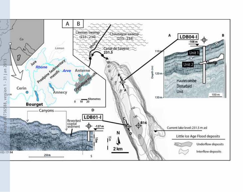
Figure1Click here to download high resolution image
hals
de-0
0736
588,
ver
sion
1 -
31 J
an 2
013
0.7 0.8 0.9 1CIA* (Al/Al+Na+K)
0 800 1600Ti (cps)
4 8 12Al2O3 (%)
0 0.4 0.8Na2O (%)
0 800 1600Ti (cps)
4 8 12Al2O3 (%)
0 0.4 0.8Na2O (%)
30 400 10 20Sand (% of non-carbonate)
-12 -11 -10 -9εNd
0 10 20Sand (% of non-carbonate)
0 0.3 0.6TiO2 (%)
0 0.8 1.6K2O (%)
0 0.3 0.6TiO2 (%)
0 0.8 1.6K2O (%)
70 80 90 100CIA* (Al/Al+Na+K)LDB04-I
LDB01-I
9
8
7
6
5
4
3
2
1
0
Dep
th (m
)
1413121110
9876543210
Dep
th (m
)
EU
Uni
t 1U
nit 2
EU
Uni
t 1
TU
Uni
t 2U
nit 3
-12 -11 -10 -9εNd
100 200 300K (cps)
0 2000 4000K (cps)
0.1 0.3 0.50
0.2
0.6
1.0
Ti c
ore
scan
ner (
1kcp
s)
TiO2 (%)
R2 = 0.82
0 0.8 1.60
1
2
3
4
K c
ore
scan
ner (
kcps
)
K2O (%)
R2 = 0.84
0.1 0.3 0.50
40
80
Ti c
ore
scan
ner (
cps)
TiO2 (%)
R2 = 0.88
0.4 1.2 2120
200
280
K c
ore
scan
ner (
cps)
K2O (%)
R2 = 0.5614C samples
14C samples
75 80 85CIA* (Al/Al+Na+K)
B16
B16
Figure2
hals
de-0
0736
588,
ver
sion
1 -
31 J
an 2
013
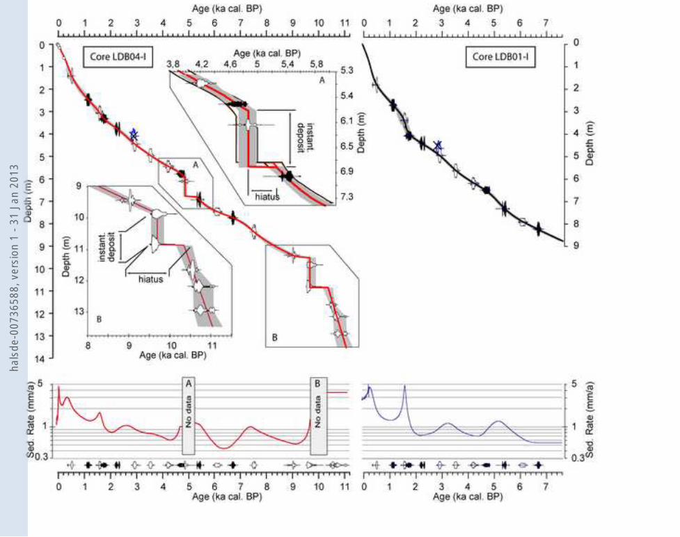
Figure3Click here to download high resolution image
hals
de-0
0736
588,
ver
sion
1 -
31 J
an 2
013
LDB0
1-I
LDB0
4-I
12345
Sed
. rat
e (m
m/a
)
Sed.input
+
-
Terrigenous contribution
+
-
Sed.input
+
-
Terrigenous contribution
+
-
Mt Blanccontribution to
terrigneousflux
and/or
relativecontribution of physical vs. chemicalweathering
+
-
Mt Blanccontribution to
terrigneousflux
+
-
All
core
s
LDB01-ILDB04-IB16
Mid
-Hol
ocen
e sl
ump
20
40
60
80
100
Tota
l terri
geno
us (%
)
9 8 7 6 5Age (cal. BP)
4 3 2 1 011
9 8 7 6 5Age (cal. BP)
4 3 2 1 011
12345
Sed.
rate
(mm
/a)
Erosion pattern
Sedim. units
ABD CEFGHIJKL Debret et al. (2010)Enhanced clastic input
Suspectedhuman impact
This studyK2 AA1A2BB1D C2 C1 CEFGHIJKK1LM
? ?
Dominant sedimentsouce? Prealps Prealps Mt BlancMB PP+P MB
Ph. Chemical Chemical PhysicalPhysical Phys.No data Dominant weathering process
Solid dischargeVery lowLow HighVH VH VH
Periods discussed in textUnit 1Unit 2U3
Tota
l terri
geno
us (%
)
20
40
60
80
100
-11
-10
-9
εNd
2
4
6
K/Ti
CIA*
85
90
80
I II III IV V VI VII
Figure4
hals
de-0
0736
588,
ver
sion
1 -
31 J
an 2
013
ABD C' CEFGHIJKLM C1
LDB01-I
LDB04-I
9 8 7 6 5Age (cal. BP)
4 3 2 1 011
2
4
6K
/Ti (
scan
ner)
Tota
l ter
rig
eno
us
(%)
20
40
60
80
100
20
40
60
80
100
Tota
l ter
rig
eno
us
(%)
AD C'EFGHIJKK'K''LM
Lake Cerin
Lake Accesa
m b
elow
cur
rent
leve
l
LDB01-I
LDB04-I
Event B
D C' CE
FGH
I
JKL
M
AB
B
20
40
60
80
100
Tota
l ter
rig
eno
us
(%)
B1C2 B1C2
B1C2
BCC1 B1C2
K1K2
C1
A1A2
A1A2
A1A2
Lake constance (BO 91/08)
15
20
25
30 Aut
hige
nic
calc
ite (%
)
0
2
4
6
02468
? ?
9 8 7 6 5Age (cal. BP)
4 3 2 1 011
Figure5
hals
de-0
0736
588,
ver
sion
1 -
31 J
an 2
013