Nigerian Erosion and Watershed Management Project
406
1 Nigerian Erosion and Watershed Management Project NEWMAP-AF Environmental and Social Management Framework (ESMF) FINAL REPORT SFG4052 REV Public Disclosure Authorized Public Disclosure Authorized Public Disclosure Authorized Public Disclosure Authorized
-
Upload
khangminh22 -
Category
Documents
-
view
0 -
download
0
Transcript of Nigerian Erosion and Watershed Management Project

Nigerian Erosion and Watershed Management Project
1
Nigerian Erosion and Watershed Management Project
NEWMAP-AF
Environmental and Social Management
Framework (ESMF)
FINAL REPORT
SFG4052 REV P
ublic
Dis
clos
ure
Aut
horiz
edP
ublic
Dis
clos
ure
Aut
horiz
edP
ublic
Dis
clos
ure
Aut
horiz
edP
ublic
Dis
clos
ure
Aut
horiz
ed

Nigerian Erosion and Watershed Management Project
2
ENVIRONMENTAL AND SOCIAL MANAGEMENT FRAMEWORK
Nigerian Erosion and Watershed Management Project, Additional Fanancing
NEWMAP-AF
FINAL (UPDATED) REPORT
FEBRUARY 2018

Nigerian Erosion and Watershed Management Project
3
Table of Content
Contents
EXECUTIVE SUMMARY ................................................................................ 15
Background .......................................................................................................................... 15
TRANSLATION IN IBO LANGUAGE ............................................................ 22
TRANSLATION IN HAUSA LANGUAGE ..................................................... 34
CHAPTER ONE ................................................................................................. 41
INTRODUCTION AND BACKGROUND TO NEWMAP .............................. 41
1.0 Background to the NEWMAP................................................................................... 41
1.1 Purpose of the ESMF ................................................................................................ 42
1.2 Objectives of the Environmental and Social Management Framework .................... 42
1.3 Rational for the Environmental and Social Management Framework ...................... 44
1.4 Application of the ESMF .......................................................................................... 44
1.5. Technical Approach and Methodology ..................................................................... 44
1.6 Project Strategy ......................................................................................................... 45
1.6.1 Literature Review ...................................................................................................... 45
1.6.2 Field Visits ................................................................................................................ 45
1.6.3 Interactive Discussions .............................................................................................. 45
CHAPTER TWO ................................................................................................ 48
POLICY, LEGAL AND REGULATORY FRAMEWORK .............................. 48
2.0 Introduction ............................................................................................................... 48
2.1 Relevant Regulatory Policies of Nigeria ................................................................... 48

Nigerian Erosion and Watershed Management Project
4
2.1.1 The National Policy on the Environment (NPE) of 1989 ......................................... 49
2.1.2 Environmental Impact Assessment Act No. 86, 1992 (FMEnv)............................... 49
2.1.3 The National Guidelines and Standards For Environmental Pollution Control In
Nigeria .................................................................................................................................. 49
2.1.4 The National Effluents Limitations Regulation ........................................................ 49
2.1.5 The NEP (Pollution Abatement In Industries And Facilities Generating Waste)
Regulations ........................................................................................................................... 49
2.1.6 The Management of Solid and Hazardous Wastes Regulations ............................... 49
2.1.7 National Guidelines on Environmental Management Systems (1999) ..................... 50
2.1.8 National Guidelines for Environmental Audit .......................................................... 50
2.1.9 National Policy on Flood and Erosion Control 2006 (FMEnv) ................................ 50
2.1.10 National Air Quality Standard Decree No. 59 of 1991 ............................................. 50
2.1.11 The National Environmental Standards and Regulations Enforcement Agency Act
2007 (NESREA Act) ............................................................................................................ 50
2.1.12 The National Oil Spill Detection and Response Agency Act 2005 (NOSDRA ACT)
50
2.1.13 Land Use Act of 1978 ............................................................................................... 50
2.1.14 Forestry Act ............................................................................................................... 51
2.1.15 Criminal Code ........................................................................................................... 51
2.1.16 Inland Waterways Authority (NIWA)....................................................................... 52
2.2 State Legislations ..................................................................................................... 52
2.2.1 Anambra State Policy on Environment (2010) ......................................................... 52
2.2.2 Anambra State Flood and Erosion Control and Soil Conservation (2010) ............... 53

Nigerian Erosion and Watershed Management Project
5
2.2.3 Anambra State Flood Control and Water Conservation (2010) ................................ 53
2.2.4 Anambra Riverine Area Management Policy (2010) ................................................ 53
2.2.5 Anambra State Watershed Management Policy (2010) ............................................ 53
2.2.6 Anambra State Flood and Erosion Control Management Support System (2010) ... 53
2.2.11 Edo State Environmental & Waste Management Law.............................................. 53
2.2.12 Enugu State Waste Management Authority Law ...................................................... 53
2.2.13 Imo State Bureau For Sanitation & Transport Law .................................................. 53
2.2.14 Imo State Environmental Protection Agency Amendment Lawy ............................. 53
2.3 International Laws and Regulations .......................................................................... 53
2.3.1 Summary of some relevant World Bank Environmental and Social Safeguard Policies
54
2.4 Nigeria EIA Guidelines and World Bank EA Guidelines ......................................... 57
2.4.1 NEWMAP - Adequacy of Legal Instruments for Environmental & Social Issues ... 58
2.5 Other International Laws and Regulations ................................................................ 58
2.5.1 Convention on Biological Diversity .......................................................................... 59
2.5.2 Convention Concerning the Protection of the World Cultural and Natural Heritage
Sites (or World Heritage Convention) ................................................................................. 59
2.5.3 United Nations Framework Convention on Climate Change (1992) ........................ 59
2.5.4 International Environmental Agreements ................................................................. 59
2.5.5 Basel Convention on the control of hazardous wastes and their disposal ................. 59
CHAPTER THREE............................................................................................. 61
PROJECT DESCRIPTION ................................................................................. 61

Nigerian Erosion and Watershed Management Project
6
3.0 Introduction ............................................................................................................... 61
3.1 Components of the NEWMAP-AF ................................................................................ 62
3.2 Project Scope of Works ............................................................................................. 63
3.3 ESMF Implementation Arrangement ........................................................................ 64
3.4 ESMF Implementation Budget.................................................................................. 65
CHAPTER FOUR ............................................................................................... 66
DESCRIPTION OF THE PROJECT STATES .................................................. 66
4.0 Introduction ............................................................................................................... 66
4.1 Baseline Data for some of the states ......................................................................... 66
4.1.1 Abia State .................................................................................................................. 66
4.1.2 Anambra state ............................................................................................................ 67
4.1.3 Cross River state........................................................................................................ 68
4.1.4 Ebonyi State .............................................................................................................. 70
4.1.5 Edo State ................................................................................................................... 70
4.1.6 Enugu State ............................................................................................................... 71
4.1.7 Imo State ................................................................................................................... 73
4.1.8 Kogi State .................................................................................................................. 74
4.1.9 Gombe State ............................................................................................................. 77
4.1.10 Akwa Ibom State ....................................................................................................... 79
4.1.11 Borno State ................................................................................................................ 81
4.1.12 Sokoto State............................................................................................................... 82
CHAPTER FIVE ................................................................................................. 86

Nigerian Erosion and Watershed Management Project
7
PROJECT COORDINATION AND IMPLEMENTATION ARRANGEMENTS
............................................................................................................................. 86
5.0 Introduction .............................................................................................................. 86
5.1 NEWMAP Institutional Arrangement ....................................................................... 86
5.2 Roles and Responsibilities ........................................................................................ 87
5.2.1 Federal Level Institutions .......................................................................................... 87
5.2.2 State Level Institutions .............................................................................................. 91
5.2.2.2 PMU Safeguard Units ....................................................................................... 93
5.2.3 Local Government Level Institutions ........................................................................ 94
5.2.4 Community Level and other Institutions ................................................................... 94
5.2.5 Community Based Organizations (CBO) .................................................................. 94
5.2.6 World Bank ............................................................................................................... 95
5.2.7 Consultants, Contractors and Site Engineers ............................................................ 95
5.2.8 Safeguards Manual ...................................................................................................... 95
CHAPTER SIX ................................................................................................... 96
ENVIRONMENTAL & SOCIAL IMPACTS IDENTIFICATION ................... 96
6.0 Introduction ............................................................................................................... 96
6.1 Screening Process ......................................................................................................... 96
6.1.1 Implementing the ESMF ........................................................................................... 96
6.1.2 Project Screening, Scoping and Categorization ........................................................ 96
6.1.3 Environmental and Social Management Plan (ESMP) ............................................. 97
6.1.4 Sub-Project-Level Environmental and Social Reviews ............................................ 98

Nigerian Erosion and Watershed Management Project
8
6.2 Potential Impacts Identification of the Proposed Project .......................................... 99
6.3 Type of Impacts and their Consideration as Perceived Under the NEWMAP-AF ... 99
6.4 Potential Positive and Adverse Impacts of the Project ............................................. 99
6.4.1 The Potential Positive Impacts ................................................................................ 100
6.4.2 The Potential Adverse Impacts ............................................................................... 101
6.5 NEWMAP: LABOR INFLUX AND GENDER BASED VIOLENCE (GBV) ........... 123
6.5.1 Labor Influx............................................................................................................. 123
6.5.2 Gender Based Violence ........................................................................................... 125
6.5.3 GBV Risk Management Mechanisms ..................................................................... 127
CHAPTER SEVEN........................................................................................... 129
ASSESSMENT OF ALTERNATIVES ............................................................ 129
7.0 Introduction ............................................................................................................. 129
7.1 No Action Alternative ............................................................................................. 129
7.2 Use of Civil Works .................................................................................................. 129
CHAPTER EIGHT ........................................................................................... 131
8.0 Environmental and Social Mitigation Principles .................................................... 131
Impact Source: .................................................................................................. 162
Impact Indicator: ............................................................................................... 162
CHAPTER NINE .............................................................................................. 164
9.0 Public Consultation ...................................................................................................... 164
9.1 Stakeholder Focused Group Discussion and Interpretation .................................... 164
9.2 Consultations with the first mover states as at 2011 (phase I) ................................ 165

Nigerian Erosion and Watershed Management Project
9
9.2.1 Situation Report- Enugu State ................................................................................. 165
9.2.2 Situation Report- Imo State ..................................................................................... 166
9.2.3 Situation Report- Abia State ................................................................................... 167
9.2.4 Situation Report- Cross River State .......................................................................... 168
9.2.5 Situation Report- Anambra State .............................................................................. 169
9.2.6 Situation Report- Edo State ....................................................................................... 170
9.3 Responses to Concerns Raised with the fisrt mover states: .................................... 171
9.4 Consultations in the new/newer states as at 2017 (phaseII) .................................... 172
9.4.1 Stakeholders Issues ................................................................................................. 173
CHAPTER TEN ................................................................................................ 175
PREPARATION OF SITE SPECIFIC ESIA and ESMP ................................. 175
10.1 Introduction ............................................................................................................ 175
10.2 Scoping .................................................................................................................... 175
10.3 Baseline Data Information ...................................................................................... 175
10.4 Public Consultation ................................................................................................. 176
10.4.1 Venue ..................................................................................................................... 176
10.4.2 People Required for Public Consultation ......................................................... 176
10.4.3 Public Consultation Gender Selection Strategy ................................................... 177
10.4.4 What should be recorded? .................................................................................... 177
10.5 ESIA Preparation and Evaluation ........................................................................... 177
10.6 Waste Management and the NEWMAP.................................................................. 178
CHAPTER ELEVEN ........................................................................................ 180

Nigerian Erosion and Watershed Management Project
10
ESMF IMPLEMENTATION AND MANAGEMENT .................................... 180
11.0 Introduction ............................................................................................................ 180
11.1 Implementing the ESMF ......................................................................................... 180
11.2 Institutional Arrangements ...................................................................................... 180
11.3 Capacity Building .................................................................................................... 181
11.4 Grievance Redress Mechanism ............................................................................... 193
* 199
11.5 Environmental and Social Management Plans (ESMPs) ........................................... 202
11.5.1 Monitoring and Evaluation...................................................................................... 202
11.6 Environmental and Social Auditing ........................................................................ 213
11.7 HEALTH IMPACT ASSESSMENT (HIA) .......................................................... 214
11.8 Integrated Pest Management Plan (IPMP) ................................................................. 216
11.9 Forestry Development Plan ........................................................................................ 216
11.10 Chance Find Procedures ........................................................................................... 217
11.11 Disclosures of Safeguard Instruments ..................................................................... 217
ANNEX 001: FEDERAL GUIDELINES FOR EIA PROCESS ...................... 222
ANNEX 002: TERMS OF REFERENCE FOR THE ESIA ............................ 226
ANNEX 003: ENVIRONMENTAL AND SOCIAL SCREENING CHECKLIST
........................................................................................................................... 232
ANNEX 004: GENERIC GUIDELINES FOR PREPARING AND
IMPLEMENTING A PLAN FOR AN ESIA ................................................... 236
ANNEX 005. Environmental and Social Management Plan Outline ............... 238
Nigerian Erosion and Watershed Management Project
11
ANNEX 006: GENERIC GUIDELINES FOR THE DEVELOPMENT OF
TERMS OF REFERENCE (TORS) FOR AN ENVIRONMENTAL AND
SOCIAL MANAGEMENT FRAMEWORK (ESMF) ..................................... 239
ANNEX 007: GENERIC ENVIRONMENTAL AND SOCIAL MITIGATION
MEASURES CHECKLIST .............................................................................. 242
ANNEX 008: INTEGRATED PEST MANAGEMENT PLAN ...................... 245
ANNEX 009: STAKEHOLDERS CONSULTATION IN THE STATES
VISITED ........................................................................................................... 253
ANNEX 010 STAKEHOLDERS ATTENDANCE SHEET ............................ 293

Nigerian Erosion and Watershed Management Project
12
List of Tables
Table 3.0: Total Estimated Budget for Implementing the ESMF 64
Table 5.0 Safeguard Responsibilities for NEWMAP- AF 88
Table 6.0: Some identified impacts and the sources of occurrence 100
Table 6.1: Potential Mitigation Measures of Social Impacts 106
Table 7.0: Evaluation of The ‘No Action’ alternative and Use of civil works 128
Table 8.0 Identified Impacts and Mitigation Measures 130
Table 11.0: Training Programs (Environmental and Social accountability) 180
Table 11.1: Training Programs (Health Impact Assessment) HIA 184
Table 11.2: Training Programs [Occupational Health and Safety Management Plan (OHSMP)
186
Table 11.3: Monitoring & Evaluation Framework for the ESMP 207
Table 11.4: Some information to be disclosed 215

Nigerian Erosion and Watershed Management Project
13
Acronyms and Abbreviations
AEAM Adaptive Environmental Assessment and Management
AIDS Acquired Immune Deficiency Syndrome
AP Affected Person
ARAR Applicable or Relevant and Appropriate Requirements
ASERNGO Association of Enugu State Resident NGOs
ASUTECH Anambra State University of Science and Technology
CBO Community Based Organizations
CO Cleaner Operation
DDI Diversity and Disaster Initiative
EA
Environmental Assessment
EIA
Environmental Impact Assessment
EMP
Environmental Management Plan
EMS Environmental Management System
EMSP
Environmental and Social Management Plan
ESIA
Environmental and Social Impact Assessment
ESMF
Environmental and Social Management Framework
ESSF Environmental and Social Screening Form
ESUT Enugu State University of Science & Technology
FCPF Forest Carbon Partnership Facility
FGD Focused Group Discussions
FGN Federal Government of Nigeria
FMARD Federal Ministry of Agriculture and Rural Development
FME/FMenv Federal Ministry of Environment
FMW Federal Ministry of Works
FMWR Federal Ministry of Water Resources
GEF Global Environment Facility
GIS Geographic Information Systems
GM Green Manager
GMC Green Management Committee
GRC Grievance Redress Committee
GRM Grievance Re-dress Mechanism
HAP/HMP Health Action Plan/Health Management Plan
HAZCOM Hazard Communication Programs
HIA Health Impact Assessment
HIV Human Immunodeficiency Virus
HOD Head of Department
HSE Health Safety and Environment
IDA International Development Association
IFC International Finance Corporation

Nigerian Erosion and Watershed Management Project
14
ILO International Labour Organization
IMM Impact Mitigation and Monitoring
IMT Institute of Management and Technology
IPP Indigenous Peoples Plan
IPPF Indigenous Peoples Planning Framework
IRTCES International Research and Training Centre on Erosion and
Sedimentation
ITC Instruction to Consultants
IWRMC Integrated Water Resources Management Commission
JHA Job Hazard Analysis
LGA Local Government Area
LOI Letter of Invitation
M&E Monitoring and Evaluation
MDA Ministry Departments and Agencies
MSD Musculoskeletal Disorder
MSDS Material Safety Data Sheets
NEWMAP Nigerian Erosion and Water Management Project
NEWMAP-PMU Nigerian Erosion and Watershed Management Project
PMU Project Management/Monitoring Unit
NGO Non-governmental Organization
NHSA National Hydrological Services Agency
NISP Nigerian Institute of Safety Professionals
NPE National Policy on Environment
NWRI National Water Resources Institute
OHS Occupational Health and Safety
OHSMP Occupational Health and Safety Management Plan
OHSRA Occupational Health and Safety Risk Assessment
OP/BP Operational Procedures/Bank Procedures
PAP Project Affected Person
PC Pollution Control
PMU Project Management/Monitoring Unit
PPE Personal Protective Equipment
RAP Resettlement Action Plan
RBDA River Basin Development Authorities
RBDAs River Basin Development Authorities,
RFP Request for Proposal
SEMA Safe Environment Movement for Abia
SME State Ministry of Environment
SMARD State Ministry of Agriculture and Rural Development
SMOH State Ministry of Health
SMW State Ministry of Works
SNEWMAP State Nigerian Erosion and Watershed Management Project
SSA Systematic Sequential Approach
STI Sexually Transmitted Infection
TBD To Be Determined
TOR Terms of Reference
UNIZIK Nnamdi Azikiwe University
UNN University of Nigeria, Nsukka
VOC Voice of Children
WHO World Health Organization

Nigerian Erosion and Watershed Management Project
15
WB World Bank
EXECUTIVE SUMMARY
Background Nigeria faces severe problem of soil erosion – both sheet and gully erosion – due to both natural
and human causes. Over 6000km2 of land are affected by erosion and about 3400km2 are highly
exposed. Erosion has a devastating effect on many peoples’ lives and destroys essential
infrastructure for economic development and poverty alleviation. Gully erosion contributes to
environmental problems and cause damage estimated at over $100 million annually in most
parts of Nigeria. This undermines economic growth and is a threat to the Federal Government
of Nigeria’s “Vision 202020”. Recent assessment of the situation confirms that the scale of the
problem transcends what communities, Local Governments, States and Federal Government
can address without help from development partners. Consequently, the Federal Government
of Nigeria (FGN) has sought and obtained the support of the World Bank to tackle the age long
but worsening problem of erosion and degraded watershed in the affected States in Nigeria
through an eight-year project titled “The Nigeria Erosion and Watershed Management Project,
Additional Financing (NEWMAP-AF)”. NEWMAP-AF aimed at rehabilitating degraded lands
and reducing erosion and climate vulnerability in targeted areas. Specifically, NEWMAP is
currently implemented in seven Southeastern States comprising Abia, Anambra, Cross Rivers,
Ebonyi, Edo, Enugu and Imo and NEWMAP-AF is being extended to include 12 new States
(Akwa Ibom, Delta, Kogi, Sokoto, Plateau, Gombe, Kano, Borno, Katsina, Nassarawa, Niger
and Oyo states).
The project has four primary components: (i) Investment in Erosion and Watershed
Management; (ii) Institutional and Information Systems for Erosion and Watershed
Management; (iii) Climate Change Adaptation and Mitigation; and (iv) Project Management.
In particular, the activities in component one will involve sub-projects each of which may
include construction and/or rehabilitation of various identified erosion or flood sites. These
activities may lead to environmental and social impacts, which must be mitigated in accordance
with today's tenets of sustainable development. This Environmental and Social Management
Framework seeks to provide a clear process including action plans to integrate environmental
and social considerations into the Nigeria Erosion and Watershed Management Project.
A separate document provides Resettlement Framework to address possible involuntary
physical and economic displacements by the program's sub-projects.
Rationale, Scope and Coverage of ESMF
At this time of project’s additional financing preparation, the specific sites that the project
would be implemented in are known with sufficient details in the seven initial states and still
to be known in the 12 new states. Therefore, there is a need for an environment and social
management framework to outline the principles and procedures that would be followed to
ensure that implementation of NEWMAP-AF meets with the existing EIA law in Nigeria and
World Bank Safeguards policies. To realize the objectives of the initial ESMF, the scope of
work included a number of tasks as highlighted below, and similar actions will be undertaken
for the 12 new states.

Nigerian Erosion and Watershed Management Project
16
Task 1 - Environmental Screening and scoping
Task 2 - Environmental Policy and Regulatory Framework
Task 3 – Potential Environmental and Social Impacts
Task 4 - Analysis of Environmental Impact Issues
Task 5 - Development of Management Plan to Mitigate Negative Impact
Task 6 - Institutional Framework
Task 7 - Training Needs
Task 8 - Public Consultation
Policy and Regulatory Framework
There are several national and international environmental guidelines in Nigeria that are
applicable to the operation of the NEWMAP. In Nigeria, the power to enforce all activities that
might impact the environment is vested in the Federal Ministry of Environment (FMEnv). The
ministry has a mandate to co-ordinate environmental protection and conservation of natural
resources for sustainable development in Nigeria.
One of the most relevant legislation of interest in the NEWMAP project is the Environmental
Impact Assessment (EIA) Act No. 86 of 1992. The act makes EIA mandatory for any
development project, and prescribes the procedures for conducting and reporting EIA studies.
It requires that development projects be screened for their potential impact. Based on the
screening, a full, partial, or no Environmental impact assessment may be required. This is in
tandem with the World Bank EA requirements for any development projects and her
categorization (A, B, & C) of EA types. Furthermore, there are several relevant national and
international environmental and social policies and regulations that are applicable to the
NEWMAP and its sub-projects. A number of other government Ministries, Departments and
Agencies (MDAs) have enabling laws, which support the objectives of this ESMF. Some of
these laws also seek to eliminate or minimize environmental and social impacts of activities
associated with their various functions.
Most of the project States have in place environmental regulations backed by State laws.
Nigeria is signatory to a number of international treaties and conventions. These include those
on climate, waste, oil and chemical pollution, labour and others.
Further, the World Bank provides a number of operational and safeguards policies, which aim
to prevent and mitigate undue harm to people and their environment in any development
initiative involving the Bank. The Nigerian EIA Act and the World Bank safeguard policies
are similar. OP.4.01 and Nigerian EIA Act are also similar. World Bank EA Screening
Category A is similar to Nigerian EIA Act category I, World Bank EA Category B is equivalent
to Nigeria EIA Act Category II, World Bank EA Category C is equivalent to the Nigeria EIA
Act Category III. However, in the event of divergence between World Bank safeguard policies
and the Existing Environmental laws in Nigeria during the implementation of the NEWMAP,
the more stringent requirement will take precedence i.e., operationally, the World Bank may
contact interested/affected parties to confirm the validity and determine whether or not the
process and outcomes comply with OP 4.12 Project Description

Nigerian Erosion and Watershed Management Project
17
The Nigeria Erosion and Watershed Management Project (NEWMAP) is a World Bank
supported initiative of the FGN to tackle the problem of Erosion and Watershed management
in the targeted project area.
The project seeks to increase infrastructure service levels and quality through an 8-year
institutional development and PPPI financing program. The project will also contribute to
strengthened institutional governance over key factor markets, improving risk and cost
determinants.
The current financial packet available for the project is a $500 million IDA investment funds
credit and GEF/FCPF grants; an additional $300 million investment funds credit has been made
available for additional financing. The Federal Government of Nigeria and the States have
committed to make available counterpart funding in cash and kind to ensure the successful
implementation of the project.
Potential Environmental and Social Impacts: Although most of the planned activities are of
category B in nature and scope, overall, the project is a Category A. The anticipated positive
impacts of the project are significant including environmental, economic and social benefits
and clearly out-way potential adverse impacts.
Positive Environmental Impacts
Reduction in the phenomenon of erosion in the project area
Reduction in the phenomenon of flooding in the project area
Rehabilitation of degraded lands and their conversion into productive land
Increase in the land area covered by vegetation
Building resilience to climate change
Biodiversity Conservation
Increasing efficiency and speed in the ESIA process
Reducing disaster risks in the project area
Improved environmental performance and governance
Positive Social Impacts
Employment generation
Improved economic growth
Community development programmes
Increased opportunities for easy inter-state movement and business development.
Initiation/ kick-off of rapid production systems and agricultural practices.
Increase in social interactions
Improved livelihood enhancing activities
Increased urbanization
Reduced level of land disputes and ethnic violence
Increase in business/commerce during and after the construction works.
Job creation opportunities.
Adverse Impacts

Nigerian Erosion and Watershed Management Project
18
The corollary of analysis of the potential impact of the Nigeria Erosion and Watershed
Management Project is that while many of the on-the-ground investment will have positive
environmental and social impacts, there will be some adverse impacts. When taken together,
the implementation of NEWMAP-AF could have significant, sensitive, and commutative
adverse impacts typical of EA category “A” projects requiring full Environmental Assessment.
Adverse impacts have been identified for the project and also for sub-project activities. The
associated and potential impacts will also be categorised under negative Environmental
impacts and Social Impacts.
Adverse Environmental Impacts
Increased Traffic
Air and Noise Emissions
Solid Wastes Generation and Handling
Effluents
Use of Natural Resources
Earth movements such as Landslides, Earth flow, Mud flow, etc
Occupational and Public Health issues
Biodiversity Loss, Endangered and Exotic Species
Flooding
Adverse Social Impacts
Population Influx
Loss of Cultural Resources
Occupation of private lands during works;
Land acquisitions/use resulting in involuntary resettlement and/or loss of livelihoods
or access to economic resources.
Social exclusion and poor ethnic/regional coverage
Increased corruption and rent seeking
Mitigation Measures
Mitigation measures are actions taken to enhance positive impacts and minimize negative ones,
have been recommended for NEWMAP-AF.
Impact mitigation measures proffered in this report are general guidelines for dealing with
program and sub-project impacts. In recommending mitigation measures as has been
considered appropriate and practical, the following principles have been taken into
consideration.
Design changes
Avoidance
Preservation
Minimization
Rehabilitation
Restoration

Nigerian Erosion and Watershed Management Project
19
Replacement
Resource compensation
Improvement
Development
Diversification
It is noted that the application of each mitigation measure will be affected by differences in
project types, and environmental and social nuances. Moreover, some measures may be too
costly or completely impractical to implement under certain conditions. In pursuing any of the
proffered mitigation measures, therefore, it is important that for each sub-project component
to assess the following also:
Feasibility;
Ease of implementation;
Local suitability;
Institutional requirements;
Training requirements;
Monitoring requirements;
Cost (capital and operating); and
Cost-effectiveness.
Implementing the ESMF
This ESMF document incorporates a number of elements into an overall Environmental and
Social Management process for the NEWMAP-AF and its sub-projects. The process involves
distinct steps and associated activities that are linked to deliver a robust and veritable
management framework in line with the stated objectives of the ESMF.
Project Screening, Scoping and Categorization
All potential project intervention sites will be screened for Environmental and Social (E&S)
impacts prior to approval by the PMU. A designated officer and/or consultant of the PMUs can
carry out the screening. The screening process will include robust assessment of the project to
determine:
The appropriate project categorization EA;
Applicable World Bank environmental and social safeguards;
Potential for environmental and social liability; and,
Cultural or other sensitivities.
In addition, each project will be screened to identify relevant stakeholders and the nature and
extent of engagement for each stakeholder category. The report of the screening exercise will
be sent to the World Bank for review and approval after project proposal preparation has been
completed and initial environmental examination (IEE/preliminary assessment has been
conducted according to the Nigerian EIA Law (decree 86 of 1992). Following the review of
the screening and scoping, the terms of reference (TOR) and the reports of the ESIA/ESMP
that would ensue will be sent to the World Bank for review and approval prior to disclosure in
Nigeria and at World Bank website.

Nigerian Erosion and Watershed Management Project
20
Environmental and Social Management Plan (ESMP)
The project and all sub-projects shall be required to maintain comprehensive ESMP
underpinned by an Environmental and Social Impact Assessment (ESIA) to achieve health,
safety, and environmental regulatory compliance objectives, institutional responsibilities, and
other related commitments. An ESMP is an important element of the NEWMAP's overall
Environmental and Social Management strategy to ensure environmental, social, and health
performance of the entire project and sub-projects. To this end, the ESMP focuses on policy,
management personnel, competence building, communications with the public, and
monitoring.
Environmental and Social Management Plans for each sub-project will be required at two
stages. During the proposal stage, each intending State PMU will as part of its proposal, submit
an overview of how environmental and social issues of the project will be addressed on a
continuous basis. The plans will also specify standards proposed for the sub-project to ensure
environmental sustainability and social acceptability. Standards and plans proposed to address
social issues including involuntary resettlement and legacy issues (people who would have lost
their houses, lands, livelihood and other assets to erosion prior to the commencement of
NEWMAP) will be particularly important. ESMP will also, be required for the sub-projects
construction and implementation stages.
Capacity Building and Training
In order to achieve the goal of the ESMF, there is an urgent need for capacity building and
strengthening of relevant competencies on environmental and social management at Federal,
States, LGAs and community levels including contractors. To this end, capacity building
should be viewed as more than training. It is human resource development and includes the
process of equipping individuals with the understanding, skills and access to information,
knowledge and training that enables them to perform effectively. It also involves organizational
development, the elaboration of management structures, processes and procedures, not only
within organizations but also the management of relationships between the different
organizations and sectors (public, private and community).
Given the nature of the environmental and social management requirements and provisions
outlined in this ESMF, competencies and capacity building will be required in the following
areas:
Environmental Impact Assessment Process - Screening, scoping, impact analysis,
mitigation measures and monitoring, reviewing EIA Reports
Environmental Due Diligence - Types of due diligence, screening projects for
liabilities, scoping due diligence investigations and reviewing due diligence reports
Monitoring and Evaluation - Understanding the importance of M&E in project
implementation, M&E requirements for environmental and social sustainability of projects
Budget to Implement ESMF

Nigerian Erosion and Watershed Management Project
21
An indicative budget of US$ 19,850,000 has been prepared for the implementation of the
ESMF bearing in mind the elements that make up the implementation process. Assumptions to
provide clarity on the basis of the budget have also been given. The budget covers:
Routine E & S duties of the PMU;
Capacity Building for the PMU and other stakeholders;
Engagement of Environmental and Social Specialists
Environmental and Social Due Diligence investigations and or Audits;
Environmental and Social Impact Assessment (ESIA) Studies commissioned directly
by the PMU of the participating States and by the PMU at the Federal level
Monitoring and evaluation activities of the PMU
The total
estimated
budget for
implementing the ESMF is given below.
Delimitation of NEWMAP Boundaries
In some cases, the Borrower may initiate the preparation of detailed safeguards assessments
and plans for specific sites. The project ESMF and RPF will guide the preparation of
S/N ESMF activity Cost $ (USD)
1. Trainings 1,950,000
2. ESIA/ESMP(including production
of Safeguards manual)
17,120,000
3. Monitoring 780,000
Total 19,850,000

Nigerian Erosion and Watershed Management Project
22
environmental and social impact assessments (ESIAs)/environmental and social management
plans (ESMPs), resettlement action plans (RAPs), and/or other safeguards instruments that will
be prepared for NEWMAP-AF, some of which will may be financed by the Bank.
Translations into Major Languages in the Project Area
In order to ensure that communities in the project area especially “potential project affected
persons (PAPs)” understand the involved issues, the executive summary of the report should
be translated into the major languages in the sub-projects areas (Igbo, Yoruba and Hausa).
Disclosure
The updated ESMF has been prepared in consultation with the Federal level PMU, State
MDAs, CBOs/NGOs and some community groups. The updated ESMF is expected to be
disclosed publicly as a separate and stand-alone document for review and comment through
the Federal/State Ministries of Environment at designated locations at Federal and in the
participating States, and in World Bank website. Individual EIAs/EMPs will be prepared for
each sub-project based on the guidelines and procedures highlighted in this updated ESMF
and would be disclosed in like manner.
TRANSLATION IN IBO LANGUAGE
Nchikota Maka Onyeisi
Mmalite
Nsogbu mbuze di oke egwu na-echere Nigeria aka mgba. Ha di n’udi di iche iche a
kporo aha na bekee (sheet and gully erosion).
Odachi okike uwa na ihe aka mere so n’ihe ndi na-ebute mbuze. Ihe kariri puku km isii uzo
abuo (6000km2), bu obosara ala mbuze bigoro aka, ebe egwu ka dikwa na obosoara ala kariri
puku km ato na nari ano uzo abuo (3,400km2). Mbuze na-emebi otutu ihe obodo ji aga n’iru
n’inweta akunauba na ichu ubiam. O kachasi na Ndida owuwu Anyanwu Nigeria, (SE Nigeria)
oha ka otu nari nde dola (N$ 100m) na-ala n’iyi kwa afo site n’ike mbuze na-akpa na
gburugburu. Nke a wee na-adoghachi aka elekere azu n’igba mbo Gomenti etiti Nigeria isonye
na mba uwa iri abuo kacha nwee mmepe, tupu afo puku abuo nya bu (vision 20-20-20).
E mere nchoputa n’isi nso a, nke gosiri na nsogbu mbuze akariala ihe naani Obodo di
iche iche, Goomenti ime Obodo, nke steeti na nke Etiti Nigeria ga-eme ihe gbasara ya, na-
enweghi nkwado otu enyemeka ndi mba uwa. Nke a mere goomenti etiti Nigeria ji wee na-
acho nkwado Ulo Obaego mba uwa (World Bank), iji bue agha megide nsogbu mbuze a tagoro
oji, ma na-akawanye njo na Ndida ala Najiria site na olu a ga-alu afo asato, isi okwu ya bu na
bekee, (the Nigeria Erosion and Watershed project NEWMAP). Ebumnobi NEWMAP bu
ihazighari ala ndi ahu mbuze lagoro n’iyi, ya na ibenata onodu mbuze na mgbanwe ubochi ji
akpadebe ike na steeti ndi a kporo aha bu, Abia, Anambra, Cross River, Ebonyi, Edo, Enugu
na Imo. steti ebe steti iri na abuo ozo ka agbakwunyere ga e so kwa rita elele a ndi nke gunyere

Nigerian Erosion and Watershed Management Project
23
( Akwa Ibom, Delta, Kogi, Sokoto, Plateau, Gombe, Kano, Oyo, Borno, Katsina, Nassarawa,
na Niger)
E KERE ORU A GA-ARU UZO ANO:
i. Itinye ego n’olu ihazi mbuze na owara mmiri
ii. Ihazi onodu nchikota ozi maka mbuze na owara mmiri.
iii. Isonye n’etu ubochi si agbanwe, ibenata ihe isi ike so ya na
iv. Ihazi ka olu ga-esi gaa.
Otutu olu ndi a ga-alu na nke mbu nwere ike ibute onodu di iche iche na gburugburu
anyi n’Obodo, nke aghaghi idozi n’usoro ejirimara nke mmepe ga-ato ato. Ihazi gburugburu a
ga etinye nime olu, ihazi mbuze na owara mmiri nke Nigeria, usoro doro anya, olu ga esi wee
gaa, nke ga eleba anya n’izugbe, ka o si metu gburugburu na mmekorita mmadu na ibe ya.
Akwukwo ozo e dere gosiri etu a ga-esi kwaghariara ha obi, bu ndi olu ndi ahu a ga-alu nwere
ike ibutere nkwaghari obi.
MKPA O DI NA EBE OLU ESMF GA-ALU
N’oge a na-akwadobe olu a, adighi ama ihe niile gbasaara ebe ndi ahu a ga-alu nya bu olu. O
wee di mkpa iweputa usoro a ga-eso wee mejuputa ihe di n’olu NEWMAP n’usoro iwu di adi
maka ileba anya n’ihe metutara gburugburu, nya bu, (Iwu EIA) nke Najiria, ya na atumatu
nchekwa nke Ulo Obaego Uwa. Iji nweta ebumnobi nke ESMF, olu ndi a ga-alu bu:
Nke mbu: Inyocha gburugburu na imara ebe olu ga-elu
Nke abuo: Atumatu na usoro iwu metutara gburugburu
Nke ato: Ihe o nwere ike iputara gburugburu na mmekorita mmadu na ibe ya.
Nke ano: Ileba anya n’ihe o ga-aputara gburugburu
Nke ise: Ihazi atumatu a ga-eji belata ihe ojoo ga-adaputa
Nke isii: Iweputa usoro oru
Nke asaa: Ihe a choro maka ozuzu
Nke asato: Ijuta oha mmadu
ATUMATU NA USORO IWU
Ha di otutu na Naijiria, bu usoro ime ihe gbasaara gburugburu, bu nke e weputara maka
ala anyi nakwa nke metutara mba na ibe ya, gbasara olu nke NEWMAP. Na Naijiria, o bu
Ministri Etiti na-ahu maka gburugburu, ka e nyere ikike itinye iwu na usoro ndi a n’oru,
Ministri a nwere oru ikpokota oru niile gbasaara i chekwaba akunauba onatarachi, makammepe
ga-ato ato na Naijiria. Otu nime iwu kacha mkpa n’oru NEWMAP bu iwu ilenye anya etu ihe
a na-eme si emetuta gburugburu nke a kporo Environmental Impact Assessment (EIA) Act N0
86 nke 1992.
Nke a mere ka o buru iwu na olu mmepe obula ga-elebariri anya n’etu o si metuta
gburugburu, ma weputakwa usoro a ga-eji na-eme nchocha ma na-enye nkowa. Enyochaakwa
olu mmepe obula a ga-alu iji mara ma aga-elenye anya n’uju, maobu ntakiri etu o si metuta
gburugburu ma obu na agaghi eme ya.
Ulo oru Goomenti di iche iche (MDAs) nwekwara iwu na-akwado ebumnobi a dabara n’ihe
Ulo Obaego mba uwa choro maka olu mmepe obula.

Nigerian Erosion and Watershed Management Project
24
Otutu Steeti ndi a ga-alu olu NEWMAP na ha nwekwara iwu di otu ahu. Naijiria so
wee binye aka na nkwekorita otu mba uwa di iche iche gbasara etu ubochi si di, ihe ndi ejizighi
eme ihe, igwoto mmiri, ikuku na ala a site na ngwoko kemikal na olu di iche iche, w.d.g. Ulo
Obaego mba uwa nwekwara iwu di iche iche ichekwaba na ibelata ihe ojoo idakwasa ndi
mmadu na gburugburu site n’olu mmepe obula a na-alu.
IWU NDI AHU NA NDI E NWERE NA NAIJIRIA YIWERE IBE HA
Ka osinadi, e nwee ndiiche obula di n’etiti iwu ndi nke Naijiria na Ulo Obaego mba
uwa, e were iwu nke sikariri ike wee ruo oru.
NEWMAP bu atumatu oru ihazi ihe gbasara mbuze na owa mmiri na Naijiria, nke Ulo Obaego
mba uwa na-akwado. Nke a ga-akwalite ije ozi nke itinyegasi ihe ndi eji e nyere ndu aka nime
afo asato, a ga alu olu mmepe, na itinye ego n’atumatu ego akporo (PPPI). O ga-atunyekwa
utu ihu na e mere ka nchikwa kwudosie ike.
Ego e nwere ugbua maka ya bu olu bunde dola ise ga-esi n’aka otu enyemaka mmepe mba uwa
($500m, IDA). Gomenti Etiti Naijiria na steeti ya gasi ekwela ituta utu ego na utu ndi ozo nke
ha, iji mee ka ya bu olu gazie.
IHE NWERE IKE IDAPUTA NA GBURUGBURU NA IBI NDU N’OBODO
E nwere ihe ndaputa ndia di mma nke gunyere mmetuta nke gburugburu, akunauba na
mmekorita mmadu na ibe ya.
NDI DI MMA METURU GBURUGBURU
- Ibelata mbuze ebe ndi ahu olu na-aga
- Ibeiata ide ebe ndi ahu olu na-aga
- Ihazighari ala ndi etetosiri meekwa ka ala na-emeputa nri
- Mbawanye ala ahihia na osisi na-eto
- Irunye ihe ndi ga na-esonye n’etu ubochi si agbanwe
- Ichekwaba udi di iche iche nke ihe na-eku ume
- Imawaga etu e si eme ngwangwa n’usoro nke ESIA
- Ibelata ihe ga-ebute odachi n’ebe olu na aga.
- Ime ka gburugburu na nchikwa kawanye mma.
NDI DI MMA METURU MBIKORITA OHA MMADU:
- Inye oru
- Ito eto nke akunauba
- Mmepe Obodo
- Idi mfe nke njekorita site n’otu steeti na nke ozo na agamnihu nke ichu nta ego.
- Mmalite nke usoro omengwangwa n’imeputa ihe, na olu ugbo
- Mbawanye nke mmekorita mmadu na ibe ya.
- Nkwalite nke ihe ndi na enyere ibi ndu aka
- Mbawanye nke nnukwu obodo gasi.
- Mbelata nke izo ala na ogbaaghara agburu na ibe ya.
- Mbawanye nke ichu nta ego na azumaahia, ya na ma olu kuru onu
- Ohere inye oru

Nigerian Erosion and Watershed Management Project
25
IHE NDAPUTA NDI DI NJO
Ka e si nwee ihe ndaputa ndi di mma n’olu NEWMAP, bu ka e si nweekwa ndi di njo. A ga-
ekewakwa ha gbado isi n’etu ha si metuta gburugburu nakwa mbikorita oha mmadu.
KA HA Si METUTA GBURUGBURU
- Nkwoko ugboala ga-akari
- Ihe ojoo, mkpotu di iche iche ga-ejuputa n’ikuku
- Ihe ndi di okpurukpu ejizighi emeihe
- Ihe ndi di mmiri ejizighi eme ihe ga-ejukwa
- Itinye akunauba onatarachi n’olu
- Ozizo ala na ihe ndi so ya
- Okwu gbasaara olu na ahuike
- Ila n’iyi nke ndu di iche iche
- Ide mmiri
KA IHE NDAPUTA OJOO SI METUTA MBIKORITA OHA MMADU:
- Mbawanye onuogu mmadu
- Nfunari nke onatarachi njirimara ndi
- Nnochi ala mmadu n’oge olu
- Iweghara ala nke ga-ebute nkwaghari obi na nfunari nke ihe ndi e ji ebi ndu na
akunauba.
- Mkpachapu na ejejughi agburu na ogbe
- Mbawanye ime mpu na i na ego n’ike
ATUMATU IBELATA NSOGBU
E nwere atumatu di iche iche iji belata ihe nadaputa ojoo na ikwalite ihe oma, NEWMAP
wetara. Ihe ndi e lebara anya wee weputa atumatu ndia bu:
- Mgbanwe nke nhazi olu
- Izere ihe
- Nchekwaba
- Mbelata
- Nhazighari onodu
- Mwechighata
- Ndochikwa
- Ikwu ugwo Itiaka n’obi (Resource Compensation)
- Nkwanite
- Mmepe
- Mgbasapuaka
N’ihi nghota na ufodu usoro a nwere ike i nwe mmetuta nke udi, olu a na-alu, na gburugburu
na mbikorita n’obodo, otutu nime ha nwere ike isi ajo ike ma o ruo n’omume, o di mkpa na e
tinyekwara anya n’usoro ndia.
- Ikwe omume

Nigerian Erosion and Watershed Management Project
26
- Idi nfe omume
- Nkwugide
- Akorongwa a choro
- Akorongwa maka ozuzu
- Akorongwa iledo olu anya
- Ego o ga-ewe
- Ndaba onu ego
IMEJUPUTA IHE DI NA ESMF.
Ihe e dere n’akwukwo gbasara ESMF nwere otutu ihe dabara n’izugbe gabsaara gburugburu
na ihazi usoro mbikorita nke NEWMAP.
INYOCHA OLU, IDEBE NJEDEBE NA IKESA HA N’UDI OBULA
A ga-enyeocha ebe dum a ga-alu olu i mara ka o ga-esi metuta gburugburu na mbikorita tupu
enye ya nkwado si n’aka otu na-eledo anya ka olu si aga, bu PMU. Nke a bu ka e wee matasia:
- Etu a ga-esi hazie olu n’udi ha
- Usoro nchekwa Ulo Obaego Uwa gbasara gburugburu na mbikorita
- Ihe ndi nwere ike ibute nsogbu na gburugburu na mbikorita oha mmadu
- Odinala ma o bu ihe ndi ozo di mkpa
Ozo bu na a ga-enyocha olu ndi ahu iji mata ndi o gbasaara, udi ha di na etu a ga esi
tinyedebe ha aka n’olu. A ga-ezigara ulo Obaego mba uwa mputara nke nyocha ndi ahu, ka ha
leba ya anya, nye nkwado. Nke a ga abu ma e deputachaa ebumnobi maka ya bu olu, ma mee
mmalite nke inyocha gburugburu, dika iwu EIA (decree 86, 1992) si debe ya. Elebachaa anya
na nnyocha na ihe e kwuru ka a luo, ya na etu olu ESIA/ESMP si gaa, a ga-eziga ha n’Ulo
Obaego mba uwa maka nleba anya na nkwado, tupu e mee ka o puta ihe na Naijiria, nya na
odu akuku Ulo Obaego mba uwa.
ATUMATU MAKA IHAZI GBURUGBURU NA MBIKORITA MMADU NA IBE YA
(ESMP)
Oru obula ga-enwe atumatu ihazi gburugburu na mbikorita, gbadoro isi n’ileba anya
etu o si metuta gburugburu na mbikorita, ka e wee nweta ahuike, nchekwa na ime ihe n’usoro,
nke ebumnobi ya bu ihazi gburugburu, olu e nwere ilu na ihe ndi ozo. Atumatu a di mkpa nke
ukwuu na NEWMAP, iji hu na olu ndi a ga-alu nwetara ihe achoro gbasara gburugburu, ahu
ike na mmekorita ndi mmadu. N’ ihi nke a a na-eledo anya n’atumatu, nchikwa, ndi olu,
iwunite onodu ima ihe a na-eme, mkparita ubobo ga-emetuta oha mmadu na nledo anya n’olu
a na-alu.
A ga-acho atumatu ESMP nke olu obula na nkebi abuo. N’oge ikowaputa ebumnuche
maka ya bu olu, ndi na-ezube iso n’otu iledo anya ka olu si aga bu (PMU), ga-etinyekwa ihe
ga-egosi etu aga-esi elekota anya kwa oge, etu olu ahu si metuta gburugburu na mmekorita,
tinyere otu a ga-esi kwagharia obi maka ndi aga-anapu ebe obibi ha, ala na ihe ha ji ebi ndu,
n’ihi mbuze. Aga-eme ihe ndi a tupu ebido olu NEWMAP. A ga-achokwa ESMP n’oge olu
ga na-aga n’iru.
INYE OZUZU

Nigerian Erosion and Watershed Management Project
27
O di mkpa ime ngwa ngwa n’inye ozuzu n’etiti steeti, ochichi ime Obodo nakwa Obodo di iche
iche, ka ndi oru wee mara ihe a ne-eme n’oru ihazi gburugburu na mbikorita. Ndi oru ngo ga-
esokwa nweta nya bu ozuzu. N’ihi nke a, e kwesiri ihuta ozuzu a dika ozuzu ka ibe ya. Obu
ikwado ndi mmadu aga-eji ruo ya bu oru nke oma, nke gunyekwara ime ka ha nwee ezi ngbota,
mata ka esi aru ya bu oru nakwa etu a ga-esi na-nweta akuko, amamihe na ozuzu ga-eme ka ha
ruo oru nke oma.
O metukwara ikwado otu oru, ime ka obuwanye ibu, bu usoro nchikwa, na usoro di iche iche
abughi maka ya bu otu oru, kama na obukwa ichikota mmekorita di n’etiti oru di iche na
mpaghara di iche iche (obu nke gomenti, nke ndi nnooro onwe, ka obu nke otu Obodo).
Eweputara udi ozuzu a ga-acho nke gbadoro isi n’ihe ndi edeputara na ESMF. Ha bu ndia:
Lee ihu akwukwo nke isii n’akwukwuo a na-atughari
IMAPUTA EGO OLU
Ego di nde dola Amerika asato na puku iri ato (US$ 8,030,000), ka akwadoro maka olu ESMF,
buru n’obi ihe nile a ga-aru n’oru ahu.
E werekwaara ya na emeela ka ihe dum doo anya na ya bu amuma ego oru. Ihe ndi a ga-eji
ego ruo bu:
- Olu mgbe mgbe gbasara ihazi gburugburu na mbikorita, nke ngalaba na-eledo oru
anya (PMU) ga na-aru.
- Inye ozuzu maka ndi na-eledo oru anya na ndi ozo o gbasara.
- Ikpobata n’oru nke ndi okachamara n’oru
- Ileba anya maka ikpachapu anya n’oru
- Ileba anya ka ihe ana-aru si metu gburugburu na mbikorita ESIA, nke a ga-enye oru
ya site n’aka ndi na-eledo anya na Steeti, na ndi nke Etiti.
- Iledo oru anya na imata ebe aludebere nke ndi na-eledo olu anya (PMU).
EGO NILE E ZUBERE IJI LUO ESMF BU NKE A:
11. Oz uzu 650 1,950,000
22. ESI ESIA/ESMF, (tinyere ibiputa
akwukwo ma ka usor o nchekwa)
7,12 17,120, 000
33 Il ed Iledo oru anya 260 780,000
Mkpokota 88 19,850,000
IKABI NJEDEBE NEWMAP
Otutu oge obu ndi na-ebiri ego ga-amanite ikwadobe ilenye anya na nchekwa ya na itu atumatu
maka ebe ndi aga-alu olu n’udi n’udi. Aga-elekwasa anya na (ESMF na RPF) wee kwadobe

Nigerian Erosion and Watershed Management Project
28
(ESIAs), (ESMPs) na (RAPs) na usoro nchekwaba ndi ozo nke obu Ulo Obaego a ga-eweta ego
ha ufodu.
TRANSLATION IN YORUBA LANGUAGE
Àkọsílẹ Ìsọnísókí Ìgbìmọ Alásẹ
Ìpìlè:
Orílẹèdè Nigeria n kojú onírúurú ìsòro àgbàrá yíya látàrí àfọwọfà ènìyàn àti àdéyébá. nnkan
bí Igba mẹfa kìlímítà (6000km2) ilẹ ni àgbàrá yìí máa se àkóbá sí àti pé nnkan ó dín díẹ ní igba
mẹrin (3400km2) ilẹ ti àgbàrá yìí ti se àkóbá fún ní ó máa n hàn púpọ. Àgbàra a máa kó ọpọlọpọ
ipa búburú lóri ìgbé ayé àwọn ènìyàn, ẹmí bẹẹ sì ni ó máa n ba ọpọlọpọ dúkìá olówó iyebíye
jẹ bákan náà ní ó máa n se àkóbá fún ìdàgbàsókè ètò ọrọ ajé pẹlú ètò gbígbọnsẹnù. Ìsòro àgbàrá
ti dá ọpọlọpọ ìdàmú àti ìpalára eléyìí tó n fi nnkan bíi ọgọrùnún mílíọnù dọlà sòfò ní ọdọdún
pàápàá jùlọ ní apá gúúsù ìlà oòrùn ilẹ yìí. Eléyìí ló n se àkóbá àti ìfàsẹyìn bá ìdàgbàsókè ètò
ọrọ ajé tó sì n se bẹẹ di ìsòro sí ọrùn ètò àfojúsùn"Vision 2020" ìjọba àpapọ ilẹ Nigeria. Àyẹwò
àti àgbèlèwọn tí wọn se ní àìpẹ yìí fi ìdí rẹ múlẹ pé ìsòro yìí ló ti kọjá ohun tí àgbègbè tàbí
ìgbèríko kan, ìjọba ìbilẹ, ìjọba ìpínlẹ àti ìjọba àpapọ nìkan leè yanjú láì nílò ìrànwọ láti ọdọ àjọ
aranilọwọ. Ní gbogbo ìgbà ni ìjọba àpapọ orílẹèdè Nigeria máa n bèrè fún ìrànwó láti ọdọ ilé
ìfowópamọ àgbáyé láti kojú ìsòro àgbàrá ọlọjọ pípẹ náà pẹlú àtúntò sí ìpèsè omi ní apá gúúsù
ilẹ yìí láti ọdọ èto ọlọdún mẹjọ kan tí wọn pè ní "Àjọ tó n rí sí síse àmójútó àgbàrá àti ìpèsè
omi lórílẹèdè Nigeria ( NEWMAP). Èròngbà àjọ NEWMAP ní láti se àtúnse àwọn ilẹ tí àgbàrá
yìí ti se àkóbá fún pẹlú síse àdínkù sí ìsòro àgbàra eléyìí to máa sába yọrí sí omíyalé-
àgbàráyasọọbù àti ìpèsè ojú ọjọ tó dára ní àwọn agbègbè tí ó bá fi ojúsùn. Ní pàtàkí jùlọ,
lọwọlọwọ báyìí, àjọ NEWMAP wà ní ìpínlẹ méje ní apá gúúsù ilẹ yìí ní ibi tí a ti rí ìpínlẹ;
Abia, Anambra, Cross Rivers, Ebonyi, Edo, Enugu àti Imo tí ọwọjà rẹ sì ti dé àwọn ìpínlẹ
túntun méjìlá mìíràn bíi; Akwa Ibom, Delta, Kogi, Sokoto, Plateau, Gombe, Kano, Oyo, Borno,
Kastina, Nassarawa, àti ìpínlẹ Niger.
Àkànse isẹ yìí ní àkóónú àti àtẹgùn mẹrin tó gùnlé, àwọn àkóónú náà nìyìí:
(i) Dídásí ọrọ àgbàrá àti ìsàn omi;
(ii) Ètò ẹkọ àti ìkéde ètò àjọ yìí;
(iii) Ìsewẹkú tàbí bíbá àyípadà ojú ọjọ dọgba;
(iv) Síse àmójútó àkànse isẹ.
Ní pàtàkì jùlọ, àwọn isẹ inú àkóónú kínní yóò níse pẹlú àwọn àsọgbé isẹ kéékèké eléyìí tó seése
kí á rí kíkọ tàbí àtúnse àwọn ojúkò tí àgbàrá tàbí omíyalé tí n sẹlẹ.
Àwọn isẹ wọnyí leè yọrí sí ipa àwùjọ àti ìgbé ayé àwọn ènìyàn eléyìí tí wọn gbọdọ se ní ìbámu
pẹlú àlàkalẹ fún ìdàgbàsókè. àgbékalẹ fún àmójútó àwọn isẹ yìí ní ó n pè fún ìpèsè àrídájú àti
àfọmọ bíi ìgbésẹ láti se àgbénde àwùjọ pẹlú síse àyẹwò sí àjọ tó wà fún síse àmójúto ọrọ àgbàrá
àti ìsàn omi lórílẹèdè Nigeria.

Nigerian Erosion and Watershed Management Project
29
Àkọsílẹ kan ní pàto wà láti máa rí sí àwọn awuye-wuye tó lè súyọ lákòókò síse àwọn isẹ àkànse
náà.
Àgbékalẹ Àti Ìtànkálẹ Ẹka ESMF
Ní irúfẹ àkókò àkànse isẹ báyìí, àfikún nípa ìnáwó, ojúkò tí isẹ náà yóò ti wáyé ní wọn yóò se
àgbéjáde rẹ ní ẹkúnrẹrẹ ní àwọn ìpinlẹ méje àkọkọ sùgbọn tí wọn kò tìi di mímọ ní àwọn ìpínlẹ
méjìlá tuntun. Ní tórí náà, ó se pàtàkì fún àwùjọ ati ẹka alàmójútó àti àlàkalẹ tí wọn yóò máa
tẹlé láti lè rí dájú pé àgbéjáde àjọ NEWMAP wà ní ìbámu pẹlú ìpìlẹ àti òfin ẹka EIA tó wà nílẹ
tẹlẹ nínú ètò ìdáàbò bò àjọ bánkì àgbáyé. Láti lè se àmúlò àgbẹlẹrọ isẹ bíi iye àwọn ojúse tó
wà eléyìí tí wọn mẹnubà ní ìsàlẹ yìí, àti àwọn ohun tó tún jọ bí rẹ ní wọn yóò gùnle ní àwọn
ìpínlẹ méjìlá tuntun náà.
Wọnyí ni àwọn ojúse náà:
(i) Ìgbéléwọn fún àyẹwò àwùjọ
(ii) Ààtọ àti àmúse isẹ
(iii) Àlàyé kíkún nípa ọrọ ojúse àwùjọ
(iv) Àgbéga sí àmójútó nípa èwu tó wà lórí ìsíkúrò,ìmọ ẹrọ àti àtúnse sí àwọn ohun tó ti bàjẹ
(vi) Ìkẹkọọ nípa àgbékalẹ isẹ
(vii) Síse ìdánilẹkọọ
(viii) Ìfikùnlukùn
Ààtò Àti Àlàkalẹ Isẹ
Ọrísìírísìí ìtosọnà lábẹlé àti lókè òkun nípa ọrọ àwùjọ ló wà ni orílẹèdè Nigeria tó jẹ pé wọn
wà fún ìwúlò ìsọwọ sisẹ àjọ NEWMAP. Ní orílẹèdè Nigeria, agbára láti kan gbogbo àwọn ètò
tó seése kó nípa lórí àwùjọ ní ilé isẹ ìjọba àpapọ tó wà fún ọrọ àyíká (FME). Ilé isẹ náà ní ojúse
àti agbára láti dári ìdáàbò bò àwùjọ àti láti se àkójọpọ àwọn ohun èlò àdáyébá fún ìdàgbàsókè
orílẹèdè Nigeria.
Ọkàn pàtàkì lára òfin nínú àkànse isẹ àjọ NEWMAP ni àyẹwò ipa àwùjọ (EIA) lábẹ ìwé òfin
kẹrìndínláádọrún (86) ti ọdún 1992. Òfin náà kànpá fún EIA fún onírùurú isẹ ìdàgbàsókè, tó sì
se àpèjúwe ìlànà fún síse àmójútó àti ìjabọ ẹkọ nípa EIA. Ó béèrè pé kí wọn se àyẹwò sí ìpa
wọn. Lórí sise àyẹwò, ó seése kí ó nílò síse àyẹwò fínnífínní nípa ìpa àwùjọ tàbí èyí tí kìí se
àwùjọ nìkan. Èyí wà ní ìbámu pẹlú àmúyẹ àti òdiwọn Bánkì àgbàyé fún ìdàgbàsókè àwọn
àkànse isẹ pẹlú ẹyà rẹ bíi ẹka( A, B àti D) EA. Síwájú síi, onírúurú ètò àti ìgbésẹ lábẹlé àti lókè
òkun pẹlú ààtò ìsàmúlò ló wà lọdọ àjọ NEWMAP àti àwọn isẹ kéékèké. Ọpọlọpọ àwọn ilé isẹ
ìjọba, ẹka ilé isẹ àti àwọn àjọ (MDAs) ni wọn ti fi àyè gba òfin tó n sègbè fún ẹka ESMF yìí.
Púpọ nínú àwọn òfin yíí ní ó pè fún kíkásẹ tàbí síse àdínkù sí ìsòro àyíka, orísun wọn àti isẹ
wọn. Ọpọlọpọ nínú àkànse isẹ ìpínlẹ tó níse pẹlú ìsòro àyíká ní òfin fi ààyè gbà. Orílẹèdè
Nigeria je okan lara awon Orileede miran to ti fi owo si aba ati ofin tó n kojú ija si ọpọlọpọ
ìkúnkùkù áti ìsòro tó níse pẹlú ojú ọjọ bíi, ìdọtí, epo àti àwọn kẹmíkà tó n ba ojú ọjọ jẹ (abbl).
Bánkì àgbáyé se ìpèsè onírúurú isẹ ètò ààbò, eléyìí tí èróngbà rẹ dá lórí fífi òpin sí àwọn àrùn
tó lẹwu fún ìgbé ayé àwọn ènìyàn àti àwùjọ wọn nínú àkànse isẹ ìdàgbàsókè èyí tí ó níse pẹlú

Nigerian Erosion and Watershed Management Project
30
Bánkì àgbáyé. Òfin ẹka EIA orílẹèdè Nigeria àti èto ààbò ilé ìfowópamọ àgbáyé se rẹgí. OP4.12
àti EIA ilẹ Nigeria náà bá aramu.
Ètò àyẹwò Bánkì àgbáyé ìpín A se rẹgi pẹlú òfin EIA ìpín I ilẹ yìí. Èto EA Bánkì àgbàyé ìpin
B náà fi ara pẹ òfin EIA ìpin II ilẹ yìí, ètò EA Bánkì àgbáyé ìpín C fi ara jọ òfin EIA ìpin III
ilẹ Nigeria.
Ètò ajọ NEWMAP jẹ ètò ìrànwọ Bánkì àgbáyé fún ìjọba àpapọ láti fi yanjú ìsòro àgbàrá àti
ìsàn omi ní àwọn àgbègbè tí wọn fojúsùn.
Àkànse isẹ náà yóò se àfikún sí isẹ àwọn ilé isẹ nlá-nlá, ìmúnádóko wọn láti ipasẹ ètò ìrànwọ
ọlọdún mẹjọ gbáko yìí.
Nnkan bíi ẹẹdẹgbẹta mílíọnù dọlà ($500) ló wà nílẹ fún àwọn àkanse isẹ tó wà fún síse (IDA)
ètò ẹyáwó GEF/FCPF, àfikùn nnkan bí ọọdúnrún mílíọnù ($300) ẹyáwó fún ìdókòwò ní wọn
ti se báyìí. Ìjọba àpapọ ilẹ yìí àti ìpínlẹ ti farajìn láti se ìpèsè owo fún àseyọrí àgbéjáde àkànse
náà.
Ojúse àti ipa lori àwùjọ: Bí ó ti lẹ jẹpé púpọ nínú àlàkalẹ àwọn ètò ló wà nínú ìpín B nínú
àlàkalẹ àfojúrí, ní àpapọ, àkànse isẹ jẹ ìpín A. Ìrètí ipa rere àkànse isẹ yìí farahàn nínú àwùjọ,
ètò ọrọ ajé àti igbe aye awon eniyan.
Ipa rere lórí àwùjọ
Àdínkù sí ìsòro àgbàrá ni agbègbè tí àkànse isẹ náà bá ti wáyé
Àdínkù sí ìsọwọjà omíyalé-àgbàráyasọọbù ní àwọn agbègbè tí isẹ náà ti wáyé
Àtúnkọ àti àtúnse ilẹ tó ti lùgbàdì àsìkò àti didá wọn padá sí ilẹ ọlọọrá
Síse àfikún sí igi gbígbin fún ìbòjú ilẹ
Síse àgbékalẹ ìsàmúlò ojú ọjọ
Síse àdínkú si ìjàmbá tó máa wáyé ní agbègbè tí àkànse isẹ náà ti wáyé
Síse àfikún sí ìdàgbàsókè àwùjọ àti ìsèjọba
Ipa Rere Lórí Ìgbé Ayé Ènìyàn
Ìpèsè isẹ
Àyípadà ètò ọrọ ajé
Ètò ìdàgbàsókè ìgbèríko
Síse àfikún sí lílọ láti ìpínlẹ kan sí òmíràn ní ìrọrùn pẹlú ìdàgbàsókè ìdókòwò
Àyípadà àti ìdàgbàsókè ní kíákíá lẹka ìpèsè ohun àti ètò ọgbìn
Síse àfikún sí ìbásepọ àwùjọ
Síse àfikún sí ètò ìgbé ayé ìrọrun
Síse àfikún sí ètò sọgbẹ di ìgboro
Síse àdinkú sí ìjà ilẹ àti ẹlẹyàmẹyà

Nigerian Erosion and Watershed Management Project
31
Ànfàní fún ìpèsè isẹ
Ipa Ìsọdìsí
Àlàyé àti àgbékalẹ ipa àkànse isẹ àjọ tó wà fún àmójútó àgbàrá àti ìsàn omi lórílẹèdè Nigeria
(NEWMAP) ní pé ọpọlọpọ ìdókòwò tó ti wà nílẹ yóò ní ìpa rere lórí àwùjọ àti ìgbé ayé, ọpọlọpọ
ìpa ìsòdìsí ni yóò wà, nígbà tí a bá wòó papọ, àgbéjáde àjọ NEWMAP seése kí ó ní ìjọra,
àròjinlẹ àti ipa ìsòdìsí ní pàtó si ìpín "A", síse àyẹwò fínnífínní sí àwọn àkànse isẹ náà lẹkùnún-
rẹrẹ.
Ipa ìsòdìsí ni wọn tí júwe sí ètò àkànse isẹ àti fún àwọn isẹ lábẹ àkànse isẹ.
Àwọn Ipa Ìsòdìsí lórí Àwùjọ
Yóò se àfikún si súnkẹrẹ-fàkẹrẹ
Àléèbù sí àfẹfẹ àti gbígbọ òórùn
Fífi àwọn ohun àlùmọnù sòfò
Síse àmúlò ohun àdáyébá
Ìyípo ayé bíi ilẹ yíyẹ,ilẹ ríru (abbl)
Ìsòro isẹ síse àti ètò ìlera gbogbòògbò
Omiyalé-àgbàráyasọọbù
Àwọn Ipa Ìsòdìsí Lórí Ìgbé Ayé
Àfikún sí iye àwọn olùgbé ibìkan
Pípàdánù àsà àjogúnbá
Gbígba ilẹ lọwọ ẹni ní tipá-tipá
Síse àfikún sí ìwà àjẹbánu
Ìwọn Fún Àdínkù
Ìwọn fún àdínkù ní àwọn ìgbésẹ tó wáyé láti se àmúlò ipa rere àti síse ìdínkù sí àwọn ipa burúkú
ibẹ, tí wọn ti jọwọ rẹ fún àjọ NEWMAP.
Ìwọn fún àdínkú nínú àlàkalẹ yìí jẹ ìtọsọnà fún kíkojú àkanse isẹ àti àwọn isẹ lábẹ isẹ. Níwọn
ìgbà tí wọn ba ti se àfihàn èyí, wọnyí ni àwọn èto àti ìlànà láti gbéyẹwò.
Àyípadà àgbékalẹ
Yíyarẹ fún
Síse àdínkù
Àtúnkọ tàbi àtúnse

Nigerian Erosion and Watershed Management Project
32
Ìdápadà
Ìfirọpọ
Ìmọrirì tàbi ìtùnilójú
Àgbéga
Ó gbọdọ di mimọ pe síse àkọsílẹ ìwọn àdínkù yìí ni ìpalára yóò fún pẹlu orísìírísìí isẹ àkànse
tó bá wáyé bẹẹ sì ni ọpọlọpọ ìwọn leè sún mọ ara wọn, torí náà ó se pàtàkì pe ki àwọn nnkan
wọnyí wà nínú isẹ lábẹ isẹ kọọkan.
Àìfòyà
Ọnà fún àmúlò
Ìdúróore lábẹlé
Àmúyẹ fún ìkẹkọọ
Àmúyẹ fún ìdánilẹkọọ
Àmúyẹ fún ìtọpinpin
Àpapọ isẹ àti àpapọ iye owónáà
Àmúlò Àti Àtẹlé ẹka ESMF
ESMF yìí se àkopọ ọpọlọpọ èròjà nínú àkójọpọ sise àmójútó àwùjọ àti ìgbé ayé ènìyàn fún àjọ
NEWMAP àti àwọn ìsọmọgbé isẹ rẹ. Ìgbésẹ yìí níse pẹlú ìgbésẹ àti àpapọ ètò tí wọn parapọ
láti fẹnukò àti àwọn ohun tó se kókó nínú àlàkalẹ àti èròngbà isẹ tí wọn se àkọsílẹ rẹ nínú
ESMF.
Ayèwò Àkànse Isẹ, Ìgbéléwọn Àti Ìpínsọọwọ
Gbogbo àwọn ojúko fún àtúnse àkànse isẹ ni wọn yóò yẹwò fínnífínní fún ipa àwùjọ àti ìgbé
ayé sáájú kí ẹka PMU tó fi òntẹ lùú. Àsàyàn olóyè ẹgbẹ tàbí àbánijírò nínú ẹka PMU leè se
àyẹwò yìí. Ètò àyẹwò yìí ni yóò se àmúlò àyẹwò pẹlú ìfikùnlukùn nípa àkànse isẹ náà.
Àmúyẹ Pínpín Àkànse Isẹ Sí Ìsọrí-Ìsọrí ti iyewo awujo
Ètò ààbò fún àwùjọ àti ìgbé àyé àwọn ènìyàn tí Bánkì àgbéyé gbékalẹ;
Àsà àti ìse àwọn àmúgbọ tó kù;
Ní àfikún, ọkọọkan àkànse isẹ ní wọn yóò yẹwò láti se ìdámọ àwọn tọrọọkàn pẹlú àmúyẹ fún
àwọn tọrọọkan ní ìsọrí-ìsọrí. Àbọ ètò àyẹwò ọhún ni wọn yóò fi sọwọ sí Bánkì àgbáye láti
yẹwò pẹlú fífi òntẹ lùú lẹyìn tí ìpalẹmọ àbá fún síse àkànse isẹ náà bá ti wáyé. tí ìdánwò láti
ọdọ ẹka IEE lábẹ òfin kẹrìndínláàdọrùn-ún ọdún 1992.
Àlàkalẹ Ìlànà Fún Àmójútó Àwùjọ Àti Ìgbé Ayé Ènìyàn (ESMP)
Ìlànà fún ọkọọkan àwọn ìsọmọgbè isẹ ní wọn yóò farahàn ní ìpele méjì. Lákòókò dídá àbá,
ọkọọkan àwọn ìpinlẹ PMU yóò se àgbékalẹ óye àwùjọ àti bí ìgbé ayé àwọn ènìyan ibi ti àkànse

Nigerian Erosion and Watershed Management Project
33
isẹ náà ti fẹ wáyé tí wọn yóò sì fi ikùlukùn lórí rẹ. Ìlànà ọhún ko ní sáà dá lórí fifi aramọ tàbí
ìfẹnukò.
Ètò Ìdánilẹkọọ Àti Ìrónilágbára
Lójúnà fún àseyọrí ẹka ESMF, ìdí pàtàkì wà fún ìdásí ní kíákíá ìrónilágbára àti kíkójú òsùnwọn
sí lórí àmójútò àwùjọ àti ìgbé àye ẹni láti ìpele ìjọba àpapọ, ìpínlẹ, ìbílẹ àti ìgbèríko pẹlú àwọn
agbasẹse.Ìrónilágbára gbọdọ fi ẹsẹ múlẹ ju ìdánilẹkọọ lọ. Ó jẹ ohun èlò ìdàgbàsókè láti ọwọ
ọmọnìyàn torí náà wọn gbọ se ìrónilágbára fún irúfẹ nnkan bẹẹ. Bákan náà àjọ tó wà fún
ìdàgbàsókè àwùjọ kópa níbẹ, fífí àlàkalẹ ìsèjọba lójú náà kò gbẹyìn, ìlàna àti àtọnà, tí kìí se
láàrin àjọ nìkan sùgbọn bíkò se àmójútó ìbásepọ láàrin orísìírísìí àjọ àti ẹka( àpapọ, aládàáni
àti ìgbèríko).
Nípa fífún àwùjọ àti ìgbé ayé eni ní àwọn ohun tó n fẹ pẹlú àmójútó tó nílò nínú àlàkalẹ
ESMF, dídántọ àti ìrónilágbára ní yóò bèrè fún gẹgẹ bí ó se lọ yìí:
Ipa Àwùjọ Pẹlú Àyẹwò- àyẹwò, ìlànà, ipa àlàyé síse, ìwọn síse àdínkù pẹlú ìtọpinpin,
àtúnyẹwò àwọn ààbọ EIA.
Ìtọpinpin Àti Àgbéléwọn- níní ẹkúnrẹrẹ ìmọ nípa ẹka M&E nínú síse àgbéjáde, àwọn ohun
èlò ti àkànse isẹ náà nílò.
Ẹkúnrẹrẹ iye tí àpapọ owó àbá ìsúná fún àmúlò ESMF lọ báyìí:
Àfihàn àbá ìsúná nnkan bíi ó dín díẹ ní ogún mííọnù dọlà (US$ 19,850,000) ní wọn tí yà kalẹ
fún àgbéjáde ESMF, níi lọkàn pé ó seése kí àwọn àfikún wà.
Ise ẹka Ojúse Agbegbe Àti Igbe Aye Eniyan ti PMU:
Ètò ìrónilágbára fún ẹka PMU àti àwọn tọrọọkàn;
Síse àmúlò àwọn onímọ nípa ọrọ àwùjọ àti ìgbé ayé ẹni
Àyẹwò àti yíyẹ ìwe owó àwùjọ wò bó se tọ àti bó se yẹ;
Àyẹwò ipa àjọ yìí lórí àwùjọ àti ìgbé àyé ẹni( ESIA) kíkọ ẹkọ àwọn akópa ìpínlẹ gbogbo láti
ọdọ ẹka PMU àti titi ẹka PMU ìjọba àpapọ.
Ìtọpinpin àti àgbéléwọn ètò ẹka PMU
S/N
Isẹ ESMF
Iye owo ni dola $(USD)
1.
Ìdánilẹkọọ-
Mílíọnù méjì ó dín díẹ (1,950,000)
2.
ESIA/ESMP( pẹlú owó ati te iwe ààbò
pelebe)
Mílọnù mẹtàdínlógún ó-lé-ọgọfà
(17,120,000)
3.
Ìtọpinpin
Ẹgbẹrúnlọnà ẹẹdẹrin ó-lé ọgọrin
(780,000)
Àkójọpọ/ Àpapọ
Ó dìn díẹ ní ogún mílíọnù dola
(19,850,000)

Nigerian Erosion and Watershed Management Project
34
Síse Gbèdéke Àlà Àjọ NEWMAP
Ní ìgbà mìíràn, àwọn aláyàálò leè se onígbọwọ ìpalẹmọ ẹkúnrẹrẹ àyẹwò ètò ààbò àti ìlànà fún
àwọn ojúkò kan. Àkànse isẹ ESMF àti RPF yóò se ìtọsọnà ìpalẹmọ àyẹwò ìpa àwùjọ àti ìgbé
ayé ẹni (ESIAs) Ìsàkóso àwùjọ àti ìgbé ayé ẹni (ESMPs), ìlànà àtúntò ibùgbé(RAPs) àti àwọn
èto ààbò mìíràn tí yóò se ìpalẹmọ fún àjọ NEWMAP, nínú èyí tí Bánkì àgbáye le kápá pupọ
nínú rẹ.
Síse Àtúpalẹ Sí Àwọn Èdè Abiníbí Agbègbè Tí Àkànse Isẹ Ọhún Yóò Ti Wáyé
Lójúnà láti ríi dájú pé àwọn ìgbèríko tí àkànse isẹ náà yóò ti wáyé , pàápàá jùlọ àwọn agbègbè
tàbi àwọn tó farakásá nínú ìgbésẹ náà (PAPs) mọ ìtumọ ètò yìí, àkọsílẹ nísókí ìgbìmọ alásẹ
nípa àbọ ni wọn gbọdọ se ìtúpalẹ rẹ sí àwọn èdè abínibí (Igbo, Yorùbá àti Hausa) ní àwọn
agbègbè isẹ lábẹ àkànse isẹ nàá.
Ìkéde
Ẹkúnrẹrẹ nípa ẹka ESMF ti wà nílẹ fún ìjíròrò ìjọba àpapọ PMU, ìpínlẹ MDAs, CBOs tàbi àjọ
tí kò rọgbọkúlé- ìjọba àti ọpọlọpọ ìgbèríkò. Ìrèti wà pé íkéde ẹkúnrẹrẹ ESMF ni wọn yóò kéde
rẹ ní gbangba gẹgẹ èyí tó dá dúró fún àyẹwò àti àríwísí láti ẹka ìjọba àpapọ, ìpínlẹ, ilé isẹ ìjọba
tó wà fún ọrọ àyíká àti agbègbè tó fi ìdí sọlẹ sí ojúkò ìjọba àpapọ àti ìpínlẹ tó n kópa, bákan
náà lórí ìtàkùn ayélujára Ba'nkì àgbáyé.
TRANSLATION IN HAUSA LANGUAGE
TAKAITACCEN BAYANI
Matashiya
Najeriya ta sha fama da matsalar zaizayar kasa, koace iri ta dalilin kaddara da kuma wadda
jama’a ke haddasawa. Kimani fili murabba’in kilomita 6,000 wannan al’amari ya shafa a yayin
da kimanin filin da ya kai tsawon murabba’in kilomita 3,400 ne abin yafi kamari. Zaizayar kaa
tayi matukar illa sosai ga ayuwar wasu al’umma inda tayi sanadiyar rasa rayukan jama’a da
dukiyoyi, wanda hakan ke shafar cigaban tattalin arzikin, da ma haddasa talauci. Zaizayar kasa
ta taimaka wajen haddasa matsalolin da muhalli yake fuskanta da lalacewar sa, inda aka kyasta
cewa ana asarar Dalar Amurka miliyan 100 duk shekarar (mafi yawa a shiyar kudu maso
gabacin kasar nan). Wanda hakan ya kawo cikas wajen cigaba da bunkasa tattalin arziki, kuma
yake barazana ga kudirin nan na gwamnatin Tarayya watau “Vision 202”. Kindiddigar kwana-
kwanan nan da aka yi kan wanna al’amarin ta tabbatar da nuna cewa lamarin yana cigaba da
yin kamari a unguwanni, kananan hukumoni, Jihohi wanda gwamnatin Tarayya ita kadai bazata
iiya magancewa ba, ba tare da Taimakon kungiyoyin kasashen duniya ba. Sobada haka shi yasa
gwamnatin Tarayya ta bukaci goyon baya da Taimakon ankin duniya domin magance wannan
matsala da tayi kamari sheka da shekarun kuma take nakasa muhalli a kudancin kasar nan,
aikin za’a gudanar da shine a cikin shekarun takwas a karkashin shirin nan na hukumar kula
tare da magance zaizayar kasa (NEWMAP). Wannan shirin yanada aniyar ssake raya yankin
da zaizayar kasa ta nakasa, tare da rage yawan zaizayar kasa dama sauran matsalolin canjin
yanayi a Jihohin da za’a aiwatar da aikin shirin. A zahiri yanzu an aiwatar da wannan shiri a
Jihohi bakwai (7) na kudancin kasar nan wadanda suka hada da; Jihar Abia, Anambra, Cross
River, Ebonyi, Edo, Enugu da kuma Jihar Imo, a yayin da za’a fadada shi ya zuwa sabbin Jihohi
goma sha biyu (12) sabbin Jihohin sun kunshin (Akwa Ibom, Delta, Kogi, Oyo, Sokoto,

Nigerian Erosion and Watershed Management Project
35
Plateau, Gombe, Kano, Borno, Katsina, Nassarawa da kuma Jihar Niger). Shirin an kasa shi
zuwa gida hudu (4)
(i) Saka hannu jari domin kula da zaizayar kasa a wuraren da ruwa yake.
(ii) Hukumomi da kafafen sadarwa wadanda za su kula da zaizayar kasar
(iii) Yadda za’a kula da canjin yanayi
(iv) Kula da shirin
A zahiri ayyukan da sake a kashi na farko zasu kunshin kananan ayyuka wanda zasu iya hadawa
da aiin gini, kokuma sake gyara wuraren da aka gano suna da zaizayar kasa ko wuraren da
ambaliyar ruwa ta shafa. Wadannan ayyuka zasu yi tasiri ga muhalli da rayuwa al’umma,
wanda yakamata a takaita su kamar yadda yake a cikin shirin na dorewar cigaba. Wannan shirin
yana neman ganin ya samo wata hanya wadda zata hada wani shiri domin kula damuhalli tare
da magance zaizayar kasa. Akwai wadan su kebabbun bayanai wadanda za’a yi amfani da su
domin sake tsugunnar da al’umma da ma magance duk wani abu da ka iya haddasa mutane su
bar wuraren da suke bada son ran su ba ta dalilin aikin shirin.
Makasudin ko dadlilin aikin da kuma wuraren da aikin ya kunsa. (ESMP)
A wannan lokacin da ake kara samar da kudade domin gudanar da shirye-shiryen akwai bukatar
sanin ainahin dukkan wuraren da za’a aiwatar da ayyukan da gamsassun bayanaina jihohi
bakwai (7)na farko da aka fara aiwatar da aikin shirin dama jihohi goma ssha biyu (12) sabbi
wadanda za’a gudanar da aikin shirin.saboda haka akwai bukatar ganin cewa wannan shirin ya
fitar da hanyoyi da ka’idoji wadanda za’a bi domin tabbatar da cewa an aiwatar da shirin
hukumar kula tare da magance zaizayar kasa kamar yadda yake kunshe a cikin dokar kasa da
manufofin bankin duniya. Domin samun nasara kan manufofin shirin na farko; akai bukatar
sanin cewa a bangaren da aikin zai shafa akwai wadan su muhimman ayyuka wadada suke
wajibi, kamar yadda za’a yi bayanin a kasa, kana kuma za’a dauki Matakai iri daya a sauran
sabbin Jihohi goma sha biyu (12).
Aiki na 1. Tantance muhalli
Aiki na 2. Shirye-shiryen kula da muhalli a hukunce
Aiki na 3. Wadataccen muhalli da kuma tasirin sa ga al’umma
Aiki na 4. Sharhi kan muhalli da tasirin sa kan batutuwan
Aikin na 5. Tasirin kula tare da samar da cigaba na magance matsaloli da za’a iya fuskanta
wajen bada taimaka
Aiki na 6. Tasirin shirin na kula tare da sa ido wajen auna ingancin tafiyar da harkokin
gudanarwa
Aiki na 7. Abubuwan da ake bukata wajen bada horo
Aiki na 8. Tuntubar al’umma.
Manufofin da ake amfani da su wajen kula da tafiyar da aikin
Nigerian Erosion and Watershed Management Project
36
Akwai Matakai da dama wadanda suka shafi muhalli a Najeriya dama kasa da kasa da Najeriya
take amfani da su, wadanda kuma ana amfani da su wajen aikin hukumar kula tare da magance
zaizayar kasa (NEWMAP). A Najeriya ikon da ake da shi na tilasta amfani da kowane doka da
ta shafi muhalli hakki ne wanda ta rataya kan ma’aikatar kula da muhalli ta kasa.ma’aikatar
tana da iko kan kare muhalli da kula gandun daji domin dorewar cigaban kasar nan.
Daya daga cikin wadan nan dokoki a karkashin shirin hukumar kula tare da magance zaizayar
kasa shine Bincike kan abubuwan da ka da tasiri ga jama’a (E/A) a dokar ACT. No86 ta 1992.
Dokar ta tilastawa Bincike tare da sanin abubuwan da keda tasiri ga jama’a ga dukkan wani
aikin samar da cigaba, kana kuma dole a bayyana hanyoyin da za’a bi dama bada rahoton
binciken. Shirin yana da bukatar a tantance duk wasu ayyukan cigaba dama alfanun su. Ta
amfani da wannan tantancewa, akwai bukatar sanin cikakken ko kuma wani bangare na alfanun
aikin ga muhalli. Hakan yana kunshe ne a cikin ka’idojin bukatun bankin duniya da dukkan
aikin cigaba kamar yadda bankin ya kasafta su (A,B,C).
Hakazalika akwai abubuwan da dama wadanda suke iri daya a kasar nan dama kasashen duniya
na manufofi shirye-shirye da yadda ake kula da su a bangaren muhalli da wannan shiri na
hukumar kula tare da magance zaizayar kasa (NEWMAP) dama wasu kananan ayyukan shirin.
ma’aikatu da hukumomi da dama wadanda suke da dokoki, wadanda suke taimakawa
manufofin wannan shirin. Wasu daga cikin wannan dokokin suna kokarin danin cewa an cire
ko rage dukkan matsalolin da zasu iya shafar al’umma a yayin da za’a gudanar da ayyukan
shirin.
A mafi yawan Jihohi da ake gudanar da wannan shirin akwai dokoki wadanda suka shafi samar
da kariya ga muhalli. Najeriya ta sanya hannu kan yarjenuyoyi da kasashen duniya a yayin
tarurruka dabam-dabam. Wasu daga cikin wadan nan yarjeniyoyin sun hada da kan canjin
yanayi, shara, gurbatar yanayi ta sanadiyar mai, da sanadarin da ake amfani da shi a
kamfanonin, da kuma ta ma’aikata da sauransu.
Bugu da kari, bankin duniya ya samar da wadan su manufofi wadanda za’a dinga amfani da su
wajen gudanarwa domin samun nasara da niyar rage abun da ka iya cutar da al’umma dama
muhalli a dukkan wani aik da bankin zai Kirkiro da hi. Wanna dokar ta kasa a cikin wannan
shirin E/A dat bankin duniya duk irin su guda wajen gudanar da ayyukan OP 4:01
Hukumar kula tare da magance zaizayar kasa (NEWMAP) shirin ne wanda yake samun tallafin
daga bankin duniya wanda yake karkashin gudanarwar gwamnatin Tarayya domin magance
zaizayar kasa tare da kula da wauraren da ruwa suke wa barazana a Jihohin da abin ya shafa.
Ayyukan shirin za su taimaka wajen kara samarda kayayyakin more rayuwa, da ingantattun
ayyuka da cigaba a cikin shekarun takwas (8) na shirin. Shirin kuma zai taimaka tare da bada
gudumuwa wajen kara karfafa ayyukan shugabanci da sauran muhimman wurare dama
kasuwanci da rage afkuwar hadurra da sauran su.
Adadin kudaden gudanar da ayyukan wadanda ake da su a hanni yanzu shine Dalar Amurka
miliyan 500 wadanda hukumomin GEF/FCPT suka bada dama karin Dala miliya 300 na
abubuwan karbar bashi don sake hannun jari domin kara tallafawa shirin wajen tafiyar da shi.
Gwamnatin Tarayya da kuma Jihohi sun sha alwashin bada nasu kason kudin domin tabattar
da ganin cewa an aiwatar da shirin.
Tasirin da aikin zai yi da muhallin- duk da yake cewa mafi yawan daga cikin ayyukan an shirya
su ne a kashi na biyu (B) a yanayin su da wuraren da za’a aiwatar su, amma daukacin aikin

Nigerian Erosion and Watershed Management Project
37
yana a kashi na daya ne (A). abubuwan da ake sa ran cewa za’a samu wajen cin gajiyar shirin
suna da muhimmanci matuka wadanda suka hada da karuwan tattalin arziki, samar da
kayayyakin more rayuwa da kuma kawar da dukkan abinda ka iya haifa da wats matsala
- Amfani da shirin yake da shi ga muhalli
- Rage matsalar zaizayar kasa a yankin da ake gudanar da aikin shirin
- Sake farfado da dilayen da suka nakasa domin sake raya su yadda za’a amfana da su.
- Kara fadada dasa itatuwa a yankunan shirin
- Kafa ingantaccen yanayi wanda zai jurewa canjin yanayi
- Samar da wasu hanyoyi da za’a sake raya yankin
- Bunkasa aikin yadda zai tafi cikin hanzari
- Rage afkuwar bala’o’i da hadurra a wuraren da ake aikin.
- Inganta yanayin muhalli da shugabanci
- Kyautata yanayin halin zamantakewa
- Samar da ayyukan yi
- Bunkasa tattalin arzikin kasa
- Samar da ayyukan cigaba ga al’umma
- Kara samar da dama domin sauka yin hulda da sauran Jihohi da kuma cigaban
kasuwanci
- Fara Kirkiro da wasu hanyoyi cikin hanzari wadanda za’a yi amfani da dasu a wajen
ayyukan noma.
- Kara inganta yanayi muhalli na jama’a
- Inganta halin rayuwa da bunkasa ayyuka
- Inganta garuruwa zuwa birane
- Rage fadace-fadace kan fili dama kabilanci
- Samar da ayyukan yi
- Matsalolin sa za’a iya fuskanta
Wannan sharhi da aka yi kan amfanin wannan shirin a karkashin hukumar kula tare da magance
zaizayar kasa zai samu ne muddin aka aiwatar da dukka sharuddan shirin domin amfanin
al’umma. Sai dai kuma akwai wasu matsaloli da za’a iya fuskanta. A lokacin da za’a aiwatar d
shirin baki dayan sa na hukumar kula tare d magancea zaizayar kasa (NEWMAP) matsaloli na
musamman wadanda za’a iya cin karo da su kamar wadanda suka shafi na kashi na daya (A)
watau ayyulan wadanda suke bukatar cikakken bayani kan muhalli (EA).
An gano matsalolin da za’a iya fuskanta a cikin aikin shirin dama kananan ayyukan shirin.
Haka kuma za’a iya rarraba wadanda abubuwan da suke da amfani a cikin shirin a karkashin
matsalolin da ka iya bijirowa a bangaren muhalli.
- Matsalolin da za’a fuskanta a muhalli a wannan yanki
- Yawaitar cinkoso
- Kara da iska
- Amfani da abubuwan da ake da su
- Girgizar kasa da sauran su
- Fuskantar matsaloli a bangaren kiwon lafiya ga ma’akata da sauran jama’a
- Kara haddasa asara na jefa wasu namun jeji cikin hatsari

Nigerian Erosion and Watershed Management Project
38
- Ambaliyar ruwa
- Haifar matsaloli ga yanayi rayuwar yau da kullum
- Karuwar jama’a
- Asarar kayan al’adu wadanda aka gada
- Mallakar filaye na dabam a lokacin aikin
- Samun filaye domin tsugunnar da jama’a bada son rai ba
- Asarar rayuka da rashin samun dama na harkokin tattalin arziki
- Nun wariya da rashin samun dama ta bai daya
- Karuwan cin hanci da rashawa da neman wurin zama.
Matakan rage matsalolin
Wannan wat hanya ce da ake bi domin daukan matakan da za su taimakawajen samun nasara
tare da rage matsalolin da za’a iya fuskanta kamar yadda shirin ya bada shawara kan su.
Matakan da ake domin magance matsalolin da za’a iya fuskanta kamar yadda yake wannan
rahoto. Wadan su ka’idoji na bai daya wajen gudanar da shirin dama kananan ayyuka da kuma
amfanin su. Domin amfani da wadannan shawarwari na matakan da za’a dauka yadda ya dace
a zahiri anyi amfani da wadannan ka’idojin:
- Samar da canje-canje
- Gujewa
- Adanawa
- Ragewa
- Rayawa
- Farfadowa
- Canzawa
- Biyan diyya albarkatun
- Ingantawa
- Cibaga
- Habbakawa
An kuma lura da cewa amfani da kowane makatai na rage irin wannan matsala ya dangantada
irin ayyukan da ake gudanarwa da muhalli dake wurin dama halin zamantakewa.bugu da kari
wadan su matakan suna da matukar wahalar ko kuma ma, ba iya amfani da su gaba daya domin
aiwatar su bisa ga wadan su sharuddan. Domin amfani da wadannan Matakai da aka tsara yaka
da kyau ga dukkan wani karamin aik kayi amfani da wadannan abubuwan.
- Ingantaccen yanayi
- Saukin aiwatarwa
- Cancantar wuri
- Cikan sharuddan ma’aikata
- Sharuddan bada horo
- Sharuddan kula tare da so ido
- Kudaden da zai kashe wajen aiki

Nigerian Erosion and Watershed Management Project
39
Hanyoyin da za’ bi domin aiwatar da yadda yadace a kula da muhalli:-
Wadannan bayanai sun kunshin abubuwan da dama kan yadda za’a kula da muhalli a karkashin
shirin hukumar kula tare da magance zaizayar kasa (NEWMAP) da sauran kananan ayyukan
shirin. Hanyoyin sun kushi wadan su Matakai na dabam wadanda suke da nasaba da yadda za’a
bi domin a samu nasara wajen kula da shirin kamar yadda yake kunshe a cikin manufar shirin.
Tantance ayyuka da rarraba su
Za’a tantance dukkan ayyuka da za’a yi na ba agaji domin amfanin su ga al’umma dama
muhalli (EQS) amfanin su gabanin amince da su. Za’a samar da wani jami’i ko kwararren
masani wanda zai kula da wannan tantancewa. Hanyoyin da za’a bi domin tantancewar za su
mai da hankali kan tattar bayanar yadda za’a gudanar da aikin.
- Yadda aka tasa aikin (EA)
- Yadda bankin duniya ya tsara hanyoyin da za’a bi domin samun nasara.
- Arziki da ake da shi a wannan muhalli da sauran abubuwan dake akwai
- Al’adu ko sauran wasu abubuwan masu matukar muhimmanci.
Dadin dadawa za’a tantance kowane aiki domin a gane dukkan masu ruwa da tsaki da suka
kamata da kuma yanayin azamar sua kowane bangare, za’a tura rahoton duk da aka tantance
ga bankin duniya domin yayi Nazari tre da amincewa bayan an kammala shirye-shiryen fara
gudanar da aikin da tattara bayanai tare da duba su (IEE) kamar yadda dokar Najeriya ta kasa
E/A (doka ta 86 ta shekarar 1992). Bayan an kamala Nazari tare da bincink, abubuwan da za’a
duba ko la’akari da su (TOR) da kuma rahoton ESIA/ESMP sai a tura bankin duniya domin
yin Nazari tare da amincewa gabanin a bayyanar da shi a Najeriya da kuma shafin yanar gizo
na bankin duniya.
Shirin kula tare da kyautata muhalli (ESMP)
Shirin da daukacin kanana ayyukan shirin dole ne su kasance sun cika sharuddan shirin nan na
kula da kyautata muhalli- ESMP domin samun nasara a bangaren kiwon lafiya, kare rayuka,
cika sharuddan kula da muhalli lakkokin da suka rataya, ma’aikatu da ire-iren sukula tare da
kyautata muhalli wani Babban jigo a karkashin shirin nan na hukumar kula tare dama magance
zaizayar kasa NEWMA. Babbar, bukatar shirin nan na kula da muhalli shine tabbatar da cewa
an kula da halin da muhalli, da yanayi kyautata rayuwar al’umma, da kula da kiwon lafiya na
dukkan shirin da kananan shirye-shireyen. Saboda haka shi yasa shirin ya maida hankali wajen
kula da manufofin ma’aikata, cancanta, gine-gine, yadda bayanai tsakanin al’umma da sanya
ido.
Kula da muhalli tare da kyautata rayuwa al’umma na kowane kananun aiki a Matakai guda
biyu. A yayin gudanar da wannan aiki kowane shugaban dake kula da aikin hukumar (PMU)
zai gabatar da wasu bayanai kan yadda za’a magance matsalolin da yake fuskanta koyaushe.
Tsarin zai kuma tabbatar da cewa ya tsaida wani sharadi wanda za’a cimma na kananan ayyuka
domin tabbatar da cigaba da sauran dorewar ingantaccen muhalli.ka’idar da shirye-shiryen da
aka tsara domin magance matsalolin wanda suka shafi, tsugunnar da mutane bada son ran su
ba da kuma batutuwa kamar (mutanen da suka yi asarar gidajen su, filaye, rayuka da sauran

Nigerian Erosion and Watershed Management Project
40
kaddarori ta dalilin zaizayar kasa gabanin kafuwar aikin shirin na hukumar kula tare da
magance zaizayar kasa[NEWMAP]) suna da matukar muhimmanci. Wanda kuma za’a bukaci
su domin gudanar da aikin tare da aiwatar da shi daki-daki.
Samar da horo tare da ingantuwar ayyuka
Domin samun nasarar wanna shirin akwai bukatar bada horo domin samu ingantuwar ayyuka
kan muhalli da kyautata rayuwa a matakin gwamnatin Tarayya da Jihohi kananan hukumomi
da Matakai al’umma dama yan-kwangila. Saboda yakamata a sani cewa samarda ingantuwar
ayyuka yafi bada horo muhimmanci, domin yawan jama’a da hanyoyin da suke bi suna amfani
da kayan aiki da Ilimi da suke da shi da basira da ilimin sarrafa kayan aiki da horon da suka
samu shiyasa suke gudanar da ayyukan su yadda ya dace. Kana kuma suma ma’aikatu suna
bada tasu gudumuwa wajen cigaba tare da kula da kayayyakin aiki da yanayi yadda ake tafiyar
da komai, ba wai kawai a ciki hukumar ko ma’aikatar kedai ta har ma da dagantakar da ke
akwai tsakanin bangarorin da abin ya shafa a cikin al’umma.
Ganin yanayin yadda sharuddan kula tare da kyautata mhalli suke da kuma abubuwan da aka
tsara a kan cancanta na ingantuwar ayyuka, akwai bukatar cike wadannan sharuda a wannan
wuraren.
- Hanyoyin tattara bayanai masu amfani tantancewa, sharhi kan matakan da aka bi wajen
tukanta lamurra, Nazari tare da sa ido E/A
- Bin ka’idar muhalli – nau’in bin ka’ida tantance ayyuka domin sanin basussuka da ake
da su, bin ka’ida Bincike tare da yin Nazari kanrahoto daki-daki.
- Sanya ido tare da auna yanayin aikin – sanin muhimmancin sanya ido tare da auna
yanayin aiki (M&E) a wajen aiwatar da shirin cika sharuddan kyautata ayyukan dorewa
muhalli
- Ga daukacin kiyasin kasafin kudi da za’a kashe a karkashin shirin – an shirya kasafin
kudi wanda za’a aiwatar da aikin kansa na Dalar Amurka 19,850,000 duk da cewa kuma
anyi bayani dalla-dalla kan yanayin yadda za’a kashe kudaden da anyi kasafin aikin
kansu kamar haka.
- Ayyukan yau da kullum na shugaban dake kula da aikin na kowane Jiha
- Samar da hro da ingantuwar ayyuka na shugaban dake kula da shirin, sauran masu ruwa
da tsaki
- Ayyuka kwararrun a bangaren muhalli da sauran su
- Bin ka’ida wajen ayyuka dama masu binciken aikn.
An kaddamar binciken wannan shirin ne daga shugabanin kula da aikin shirin na Jihohi
wadanda suke cikin shirin da kuma shugabanin kula da shirin daga matakan gwamnatin
Tarayya.
Kula tare da sa ido kan ayyukan na shugabanin kula da shirin
- Ayyukan shirin ESMF
- Kudin da aka kashe (USD)
Horo – 1,950,000
ESIA/ESMP(dukka kudaden da aka kashe) - $17,120,000
Sanya ido - $ 780,000

Nigerian Erosion and Watershed Management Project
41
Jimla - $19,850,000
Iyaka ko wuraren da aikin shirin hukumar magance zaizayar kasa zai shafa
A wadan su lokuta wanda zai karbi rance zai iya Kirkiro da wadansu cikakken bayani kan
binciken da ya gudanar a wasu wurare na musamman da ake son gudanarwa da aikin shiri.
Aikin shirin zai la’akari da kula da yanayin muhalli tare da kyautatawa al’umma da kuma
dokokin shirin nan asake tsugunnar da jama’a (RAPs) da sauran wadan su muhimman hanyoyi
da za’a bi domin samard da kariya wadanda hukumar kula tare da magance zaizayar kasa zata
shirya (NEWMAP), yayin da wasu daga cikin ayyukan bankin duniya ne zai bada kudin
gudanar da aikin nasu.
Za’a fassara ayyukan shirin a cikin manyan harsunan kasar nan.
Domin tabbatar da cewa al’ummar dake yankin da za’a gudanar da ayyukan musamman
“wadanda zasu ci gajiyar shirin (PAPs)” sun fahimci batutuwan da suke cikin taikaitaccen
bayanin rahoton ayyukan shirin, ya zama wajibi a fassara rahoton kananan ayyukan a cikin
manyan harsunan kasarnan (Igbo, Yoruba, Hausa).
Bayyanawa
Cigaba ko karin bayani da aka samu kan shirin kula da muhalli da kyautatawa al’umma an
shirya shi ne ta hanyar tuntubar shugabanin gydanarwa daga matakan gwamnatin Tarayya dana
ma’aikatu da hukumomin da kungiyoyin da bana gwamnati ba da sauran al’umma. Ana sa ran
cewa wannan karin bayani ko cigaba da ake samu za’a bayyana ga al’umma domin sake
Nazarin sa domin samun bayanai ko gudumuwa daga ma’aikatar muhalli ta kasa dama na jihohi
a wurare dabam dabam na gwamnatin Tarayya da jihohin da abin ya shafa da kuma shafin
bankin duniya na yanar gizo.
Za’a yi amfani da dokar fili ta kasa a yayin aikin kananan shirin bisa ga ka’idoji ko dokokin da
akayi karin bayani kan su a cikin wannan shiri haka kuma za’a bayyanar da su.
CHAPTER ONE
INTRODUCTION AND BACKGROUND TO NEWMAP
1.0 Background to the NEWMAP
The Federal Government of Nigeria (FGN) has initiated the preparation of the Nigeria
Erosion and Watershed Management Project (NEWMAP). The parent project was supported
with an initial financing from the World Bank to the tune of $500 million. The FGN has
requested and obtained an additional financing of $300 million from the World Bank. At the

Nigerian Erosion and Watershed Management Project
42
Federal level, the lead agency is the Department of Erosion Control, Flood and Coastal Zone
Management of the Federal Ministry of Environment.
The project was expected to be implemented in seven states, namely: Anambra, Abia,
Cross River, Edo, Enugu, Ebonyi and Imo States. An additional 12 states in the north and south
(Akwa Ibom, Delta, Kogi, Sokoto, Plateau, Gombe, Kano, Borno, Katsina, Nassarawa, Niger
and Oyo States) have now been included in the project and are advancing their investment
preparations with investment support becoming available when site designs are ready. Each
new state is expected to establish respective project teams, which will be involved in project
preparation and implementation phases of the project at state level. The project is viewed to
exhibit multi- sector operation as the institutional arrangements need to pragmatically involve
other Federal and state ministries, and MDAs concerned with water resources and soil
degradation such as the Federal Ministry of Agriculture, Federal Ministry of Water Resources
(FMWR), River Basin Development Authorities (RBDAs), Integrated Water Resources
Management Commission (IWRMC), and the National Hydrological Services Agency
(NHSA) to mention a few. The local governments and local communities will also, form a
strong forum of stakeholders to be considered as the project commences and continues.
1.1 Purpose of the ESMF
The Environmental and Social Management Framework (ESMF) is used in the case
of operations with multiple sub-projects where the entire range of environmental and social
safeguard issues involved are not fully known; It involves the use of safeguards plans. The
ESMF serves as a statement of the policy, principles, institutional arrangements and procedures
that the project management will follow in each sub-project in addressing environmental and
social issues.
This ESMF identifies environmental and social safeguard policy frameworks,
institutional arrangements and capacity available to identify and mitigate potential
environmental and social safeguards issues and impacts of each subproject. It does not attempt
to deal with site-specific impacts.
The Bank will disclose the ESMF document publicly, in Nigeria and at the World Bank
Info-shop before project appraisal.
1.2 Objectives of the Environmental and Social Management Framework
The major developmental objective of the ESMF is to enable support for effective decision
making in order to ensure that implementation processes during the execution of sub-project
activities such as; construction, civil and rehabilitation works are environmentally sound,
encourage community consultation and participation, enhance social wellbeing and are
sustainable. Specifically, this Environmental and Social Management Framework seeks to
provide a clear process including action plans to integrate environmental and social
considerations into the NEWMAP.
The specific objectives of the ESMF are to:
Ensure the program is carried out in accordance with today’s sustainable development
tenets;

Nigerian Erosion and Watershed Management Project
43
Provide a structure/strategy for the integration of social and environmental consideration
at all stages of the program planning, design, execution and operation of various sub-
projects;
Ensure overall positive social and environmental impacts of sub-projects and
avoid/minimize, and manage any potential adverse impacts;
Establish clear procedures and methodologies for incorporating environmental
management requirements including stake holder engagement in the implementation of the
project and all sub projects;
Provide guidelines to appropriate roles and responsibilities, and outline the necessary
reporting procedures, for managing and monitoring environmental and social concerns of
the program and sub-projects;
Determine the training, capacity building and technical assistance needed to successfully
implement the provisions of the ESMF;
Comply with regulatory and policy requirements (local and international) that are
applicable to the program and sub projects;
To assess the potential environmental and social impacts of the sub-projects (rehabilitation,
extensions of or new constructions in gully erosion sites, livelihood adaption, etc), whether
positive or negative, and propose measures and plans to reduce or mitigate adverse
environmental impacts and enhance the positive impacts of the project.
To identify potential environmental policies, legal and institutional framework pertaining
to the project.
To establish clear directives and methodologies for the Environmental and Social Impact
Assessment (ESIAs) as might be needed for specific sub-projects.
Identify modalities for estimating and budgeting the costs for the implementation of the
environmental Management Plan for the projects.
To ascertain the agencies responsible for the implementation of the projects Environmental
Management Plans and the projects’ Monitoring & Evaluation (M&E).
This ESMF will be used by the NEWMAP-AF together with a separate report providing a
Resettlement Framework (RF) for the project. The RF provides a structure to address possible
involuntary physical and economic displacement of the program's sub-project.
With regard to the ESMF, in seeking to implement the NEWMAP project, the government of
Nigeria intends to take into cognisance relevant state-owned laws, where the project will be
executed and as well comply with all national and international environmental requirements in
order to meet legal obligations and to ensure a sustainable project.
This requires meeting the following objectives:
EIA to meet Nigeria EIA laws
ESIA to meet World Bank EA guidelines and relevant Bank Safeguard policies and
procedures including but not limited to:
OP/BP 4.01 (Environmental Assessment)
OP/BP 4.04 (Natural Habitats)

Nigerian Erosion and Watershed Management Project
44
OP 4.09 (Pest Management)
OP/BP 4.12 (Involuntary Resettlement)
OP 4.36 (Forests)
OP 4.37 (Dam Safety) and
OP/BP 7.50 (Projects on International Waterways).
NEWMAP PMU will disclose the ESMF as required by the Nigeria EIA public notice
and review procedures as well as the World Bank Disclosure Policy.
1.3 Rational for the Environmental and Social Management Framework
The Environment and Social Management Framework (ESMF) has been developed to
address the environmental and social issues arising as a result of the infrastructure development
and execution of other civil work activities in the first seven (7) participating States (Abia,
Anambra, Cross Rivers, Ebonyi, Edo, Enugu, and Imo States) and for those that may arise in
the 12 new participating states: Akwa Ibom, Delta, Kogi, Sokoto, Plateau, Gombe, Kano,
Borno, Katsina, Nassarawa, Niger and Ondo.
The rationale for preparing this ESMF has not changed and is as follows:
The detailed operational activities/civil works of the NEWMAP project are yet to be
carried out.
The bulk detailed project activities to be financed under the NEWMAP-AF are yet to
be identified.
The specific sites for each sub-project activities pertaining to NEWMAP-AF are not
known.
This document did not attempt to address impacts related to individual sites in all the
NEWMAP Study areas. However, issues on ways of integrating and management of social and
environmental aspects of the sub-project components at all stages of the project planning,
design, execution and operation of the entire NEWMAP project were established.
This document will be shared with the various relevant stakeholders in the Sectors of
sub-project and it should form the principles and procedures that will govern the mitigation of
adverse environmental and social impacts that would be apparent by the proposed NEWMAP
project activities
1.4 Application of the ESMF
Application of ESMF to the sub-projects enables preparation of a standardized
environmental and social assessment documents for appraisal and implementation. For
subprojects that will trigger significant environmental / social impacts it will be necessary to
undertake the necessary environmental and social assessments, as mandated by the
Environmental laws of Nigerian Governments (national and state) and conforming to the
safeguard policies of the World Bank. The process for conformance to these procedures is
defined in this framework. The criteria established shall enable the identification of such
projects.
1.5. Technical Approach and Methodology
This ESMF has been prepared in accordance with standard procedures for
environmental assessment including the applicable World Bank safeguard policies and
Nigerian environmental assessment guidelines.

Nigerian Erosion and Watershed Management Project
45
1.6 Project Strategy
The preparation of the ESMF was for a period of 16 weeks - within which the consultant
accomplished all the tasks as stated in the Terms of Reference (TOR). The indicative work
plan, desktop study, scoping activities to understand the projects field of influence, onsite visit
to the initial seven (7) states, mapping and in addition, the review of the existing laws and
policies currently in place at each level of government; in the additional 12 states as well as
relevant World Bank policies and processes will constitute activities for successful project
output.
A step-wise process of ground investigations and community involvement mechanisms
used in the initial seven states has been extended to the new 12 states. The technical approach
was targeted towards obtaining visual information as well as information based on oral
interviews and focused group discussions (FGDs). Below is a brief description of activities
performed in the implementation process of the methodology.
1.6.1 Literature Review
The methodology adopted for the ESMF studies involved an intensive application of desk
reviews & collection of all relevant information in order to achieve successful outputs.
Information was garnered from the Federal Ministry of Environment, Federal Ministry of
Water Resources, Geological Surveys, River Basin Development Authorities (RBDAs) and
National Water Resources Institute (NWRI), Department of Erosion, Flood and Coastal Zone
Management, World Bank, International documents for similar executed projects, etc).
1.6.2 Field Visits
This activity involved:
Visits to all the seven mover States and Priority Erosion Sites Assessments.
Impacts Identification and Assessments
Potential Impacts Assessment and Definitions
Oral interviews, use of questionnaires and focused group discussions.
(The consultant obtained addresses of representatives for State Ministries of Environment (or
implementing agencies) and other stakeholders at the respective states).
1.6.3 Interactive Discussions
1.6.3.1 Community Consultations
This step involved intensive community involvement and participation. The sampling of
community opinions and comments formed the basis for information gathered under this
activity.
The main issues discussed with focus groups included:
• Land degradation & soil erosion • Water pollution • Afforestation and Deforestation • Over-exploitation of wetlands • Anthropogenic activities

Nigerian Erosion and Watershed Management Project
46
• Labour issues and Socio-economics • Public Health (Especially HIV/AIDs; Water-borne diseases & Choleras; STIs; Malaria;
etc)
Field/On-site Focused Group Methodologies used
a) Independent investigation
Principal data source (Federal and state ministries, and MDAs concerned
with water resources such as the Federal Ministry of Water Resources
(FMWR), River Basin Development Authorities (RBDAs), Integrated
Water Resources Management Commission (IWRMC), and the National
Hydrological Services Agency (NHSA).
b) Multi-method study or program
Qualitative & quantitative methods
Triangulation
i. Investigator triangulation: This involved the use of multiple
researchers in an investigation.
ii. Methodological triangulation: This involved using more than one
method to gather data, such as interviews, observations,
questionnaires, and documents.
c) Supplement
Interpretation of quantitative data
d) Questionnaire Alternatives
In-person, directive, structured (Used at the National, State and
Community Leadership levels)
non-directive, unstructured (To be used at the Community household
level)
e) Identification of potential impacts and Mitigation Measures
Although specific sub-projects to be implemented under the NEWMAP programme are not
known at this stage especially in the 12 new states, potential impacts were identified through
initial generic screening of the anticipated sub-projects in the light of the socio-environmental
conditions; field visits and consultations with focused groups.
To ensure all sub-projects are appropriately screened for environmental and social issues at
their conception stage, a checklist tool [See Annex 003] has been developed to screen each
project in terms of:
(i) Appropriate EIA category;
(ii) Applicable local and international regulations and standards (e.g., labour, pollution,
occupational health and other standards);
(iii) Appropriate World Bank safeguards;
(iv) Level of stakeholder engagement (both sectoral and project level);
(v) Existing environmental and other (e.g., pension or compensation) liabilities; and
(vi) Location sensitivities (e.g., sensitive environments and culture)
The screening tools provide necessary information to appropriately scope ESIA studies. These
will include: environmental, social and other due diligence investigations.
Mitigation measures are often proffered to either eliminate or minimize adverse environmental
and social impacts of specific actions, projects or programs, with a purpose to also enhance

Nigerian Erosion and Watershed Management Project
47
positive effects. The approach to mitigation has been primarily preventive principles of
anticipated impacts based on well-known negative outcomes of project-environment
interactions.

Nigerian Erosion and Watershed Management Project
48
CHAPTER TWO
POLICY, LEGAL AND REGULATORY FRAMEWORK
2.0 Introduction
A number of national and international environmental guidelines are applicable to the operation
of the NEWMAP-AF. In Nigeria, the power to enforce all activities that might impact the
environment is vested in the Federal Ministry of Environment (FMEnv). Internationally,
agencies such as the World Bank, IFC and other financial organizations usually set
environmental criteria for projects, which must be met by project proponents before the
agencies invest in them.
2.1 Relevant Regulatory Policies of Nigeria
Federal Policy/Legislation
The Federal Ministry of Environment
The act establishing the Ministry places on it the responsibility of ensuring that all development
and industry activity, operations and emissions are within the limits prescribed in the National
Guidelines and Standards, and comply with relevant regulations for environmental pollution
management in Nigeria as may be released by the Ministry. To fulfil this mandate a number of
regulations/instruments are available (See section on National Legal Instruments on
Environment), however the main instruments in ensuring that environmental and social issues
are mainstreamed into development projects is the Environmental Impact Assessment (EIA)
Act No. 86 of 1992 See Annex 1. With this Act, the FMENV prohibits public and private
sectors from embarking on major prospects or activities without due consideration, at early
stages, of environmental and social impacts. The act makes an EIA mandatory for any
development project, and prescribes the procedures for conducting and reporting EIA studies.
As part of the effective utilization of the EIA tool, the Ministry has produced Sectoral
guidelines detailing the necessary requirements of the EIA process from each Sector. One of
these Sectoral Guidelines that apply to the proposed project is the ‘Sectoral Guidelines on
Infrastructure Development.’
Procedurally, in Nigeria, it is worthy to note that before commencement of an EIA, the FMENV
issues a letter of intent on notification by the proponent, approve the terms of reference, ensure
public participation, review and mediate.
The possible technical activities expected for a proposed project include screening, full or
partial EIA Study, Review, Decision-making, Monitoring Auditing and
Decommissioning/Remediation post-closure.
National Legal Instruments on Environment

Nigerian Erosion and Watershed Management Project
49
2.1.1 The National Policy on the Environment (NPE) of 1989
The National Policy on Environment, 1989 (revised 1999), provides for “a viable national
mechanism for cooperation, coordination and regular consultation, as well as harmonious
management of the policy formulation and implementation process which requires the
establishment of effective institutions and linkages within and among the various tiers of
government – federal, state and local government”.
The objective of the policy is to achieve sustainable development in Nigeria and in particular
to:
Secure a quality environment adequate for good health and well being
Conserve the environment and natural resources for the benefit of present and future
generations.
Raise public awareness and promote understanding of the essential linkages between
the environment resources and development and encourages individual and community
participation in environmental improvement efforts
Maintain and enhance the ecosystems and ecological processes essential for the
functioning of the biosphere to preserve biological diversity;
Co-operate with other countries, international organizations and agencies to achieve
optimal use and effective prevention or abatement of trans-boundary environmental
degradation.
2.1.2 Environmental Impact Assessment Act No. 86, 1992 (FMEnv)
This Act provides guidelines for activities of development projects for which EIA is mandatory
in Nigeria. The Act also stipulates the minimum content of an EIA as well as a schedule of
projects, which require mandatory EIAs.
2.1.3 The National Guidelines and Standards For Environmental Pollution Control In Nigeria
This was launched on March 12th 1991 and represents the basic instrument for monitoring and
controlling industrial and urban pollution.
2.1.4 The National Effluents Limitations Regulation
This instrument makes it mandatory that industrial facilities install anti-pollution equipment,
make provision for further effluent treatment, prescribe maximum limit of effluent parameters
allowed for discharge, and spell out penalties for contravention. It also provides that all
industries in Nigeria should be operated on the basis of Best Available Technology (BAT);
2.1.5 The NEP (Pollution Abatement In Industries And Facilities Generating Waste)
Regulations
Restrictions are imposed hereunder on the release of toxic substances and requirement of
Stipulated Monitoring of pollution to ensure permissible limits are not exceeded; Unusual and
accidental discharges; Contingency plans; Generator's liabilities; Strategies of waste reduction
and safety for workers.
2.1.6 The Management of Solid and Hazardous Wastes Regulations
These regulate the collection, treatment and disposal of solid and hazardous waste for
municipal and industrial sources and give the comprehensive list of chemicals and chemical
waste by toxicity categories.

Nigerian Erosion and Watershed Management Project
50
2.1.7 National Guidelines on Environmental Management Systems (1999)
The guidelines establish the requirement for an Environmental Management System (EMS) in
‘all organisations /facilities in Nigeria’. They also state that this EMS should be audited
annually or as deemed necessary.
2.1.8 National Guidelines for Environmental Audit
These are designed to serve as a reference for compliance with the Environmental Audit
requirements of the FMEnv. It states that it is mandatory for a company to carry out an audit
every 3 years or at the discretion of the Hon. Minister of the FMEnv.
2.1.9 National Policy on Flood and Erosion Control 2006 (FMEnv)
This policy addresses the need to combat erosion in the country utilizing the procedures
outlined in the National Action Plan for Flood and Erosion Control and Technical Guidelines,
developed by the WIC Environmental Committee which was set up to plan an operational
platform for these issues.
2.1.10 National Air Quality Standard Decree No. 59 of 1991
The FMEH is the regulatory agency charged with enforcing ambient air quality standards in
Nigeria. The World Health Organization (WHO) air quality standards were adopted in 1991 as
the national standards by the FMEH. These standards define the levels of air pollutants that
should not be exceeded in order to protect public health.
2.1.11 The National Environmental Standards and Regulations Enforcement Agency Act 2007
(NESREA Act)
After the repealing of the Federal Environmental Protection Act of 1988, the NESREA Act,
2007 became the major statutory regulation or instrument guiding environmental matters in
Nigeria. It specially makes provision for solid waste management and its administration and
prescribes sanction for offences or acts, which run contrary to proper and adequate waste
disposal procedures and practices.
2.1.12 The National Oil Spill Detection and Response Agency Act 2005 (NOSDRA ACT)
This statutory regulation makes adequate regulations on waste emanating from oil production
and exploration and its potential consequences to the environment.
Other Acts and Legislations
2.1.13 Land Use Act of 1978
The land-use Act of 1978 states that “…It is also in the public interest that the rights of all
Nigerians to use and enjoy land in Nigeria and the Natural fruits thereof in sufficient quality to
enable them to provide for the sustenance of themselves and their families should be assured,
protected and preserved’. This implies that acts that could result in the pollution of the land,
air, and waters of Nigeria negates this decree, and is therefore unacceptable.
Furthermore, the Land Use Act of 1978 (modified in 1990) remains the primary legal means
to acquire land in the country. The Act vests all land comprised in the territory of each state in
the Federation in the Governor of the state and requires that such land shall be held in trust and
Nigerian Erosion and Watershed Management Project
51
administered for the use and common benefit of all Nigerians in accordance with the provisions
of this Act.
According to the Act, administration of land area is divided into urban land which will be
directly under the control and management of the Governor of each State; and non-urban land,
which will be under the control and management of the Local Government. State Governors
are given the right to grant statutory rights of occupancy to any person or any purpose; and the
Local Government will have the right to grant customary rights of occupancy to any person or
organization for agricultural, residential and other purposes.
2.1.14 Forestry Act
This Act of 1958 provides for the preservation of forests and the setting up of forest reserves.
It is an offence, punishable with up to 6 months imprisonment, to cut down trees over 2ft in
girth or to set fire to the forest except under special circumstances.
Nigeria is at present a wood deficit nation. In order to ameliorate the situation, the policy on
forest resources management and sustainable use is aimed at achieving self-sufficiency in all
aspects of forest production through the use of sound forest management techniques as well as
the mobilization of human and material resources. The overall objectives of forest policy are
to prevent further deforestation and to recreate forest cover, either for productive or for
protective purposes, on already deforested fragile land.
Specifically, the National Agricultural Policy of 1988 in which the Forestry Policy is
subsumed, provides for:
Consolidation and expansion of the forest estate in Nigeria and its management
for sustained yield.
Regeneration of the forests at rates higher than exploitation.
Conservation and protection of the environment viz: forest, soil, water, flora,
fauna and the protection of the forest resources from fires, cattle grazers and
illegal encroachment.
Development of Forestry industry through the harvesting and utilisation of
timber, its derivatives and the reduction of wastes.
Wildlife conservation, management and development through the creation and
effective management of national parks, game reserves, tourist and recreational
facilities, etc. 2.1.15 Criminal Code
The Nigerian Criminal Code makes it an offence punishable with up to 6 months imprisonment
for any person who:
Violates the atmosphere in any place so as to make it noxious to the health of persons in
general dwelling or carry on business in the neighbourhood, or passing along a public way:
or
Does any act which is, and which he knows or has reason to believe to be likely to spread
the infection of any disease dangerous to life, whether human or animal?
Nigerian Erosion and Watershed Management Project
52
2.1.16 Inland Waterways Authority (NIWA)
Nigeria Inland Water Authority (NIWA) Act 13 of 997 established NIWA whose functions are
among others are to:
Provide regulations for inland navigation;
• Ensure the development of infrastructural facilities for a national inland waterways
network connecting the creeks and the rivers with the economic centres using the
river-ports as nodal points for inter model exchange;
• Ensure the development of indigenous technical and managerial skill to meet the
challenges of modern inland waterways transportation; and
• Carry out environmental impact assessment of navigation and other dredging activi-
ties within the inland water and its right-of-ways.
2.2 State Legislations
Some of the functions of the State Ministries of Environment include:
Liaising with the Federal Ministry of Environment, FMENV to achieve a healthy or
better management of the environment via development of National Policy on
Environment
Co-operating with FMENV and other National Directorates/Agencies in the
performance of environmental functions including environmental
education/awareness to the citizenry
Responsibility for monitoring waste management standards,
Responsibility for general environmental matters in the State, and
Monitoring the implementation of ESIA studies and other environmental studies for all
development projects in the State.
Laws and policies in some of the states include:
2.2.1 Anambra State Policy on Environment (2010)
This policy emphasizes state government efforts to sustainable management of the Anambra
environment with regards to Erosion control. The state government commits to:
Seek the intervention of the Federal Government of Nigeria and relevant partner
agencies in the control of Erosion, to compliment the effort of the state.
Sensitize communities on erosion control efforts.
Procure necessary refuse disposal equipment like trucks, pay loaders, giant bins e.t.c
Involve households, communities, local governments and states in the joint clearance
of drainages.
Sensitization of households on waste disposal practices and management.
Sponsor relevant environmental bills to the state assembly for enactment.
Involve LGAs, communities, and civil society organizations (CSOs) in the enforcement
of environmental laws.
Embark on aggressive afforestation programmes involving LGAs, communities and
civil society organizations (CSOs) in the state.

Nigerian Erosion and Watershed Management Project
53
2.2.2 Anambra State Flood and Erosion Control and Soil Conservation (2010)
This policy is to promote sustainable land use management by minimizing soil erosion and
flooding hazards; achieving this through reducing soil exposure to rainstorms; reduction of
surface run-offs and paved surfaces and restoration of degraded land mass.
2.2.3 Anambra State Flood Control and Water Conservation (2010)
This policy is to forecast, prevent, monitor and manage flooding. Optimal utilization of
floodwater for agricultural and other purposes as well as management of floodplains.
2.2.4 Anambra Riverine Area Management Policy (2010)
This policy is to minimize riverine erosion and other forms of riverine degradation such as
riverbank failures, landslides and alluvional deposits.
2.2.5 Anambra State Watershed Management Policy (2010)
This policy enables the commencement of co-ordinated/holistic/integrated management of
natural resources: Land, water, vegetation, etc. on a watershed basis to ensure resource
conservation through the minimization of land and soil degradation and maintenance of water
quality and yield for environmental sustainability.
2.2.6 Anambra State Flood and Erosion Control Management Support System (2010)
This policy aims at supporting a reliable up-to-date database and integrated management
system as tools to support all erosion and control programs.
Anambra State Environmental Protection Agency Law
Enugu State Environmental Protection Agency Law
Imo State Environmental Protection Agency Law
Abia State Environmental Protection Law
The four above stated laws focus on the protection of the rural and urban environment in the
states. They were made to support the observation of a sanitation day being the last Saturday
of the month.
2.2.11 Edo State Environmental & Waste Management Law
2.2.12 Enugu State Waste Management Authority Law
2.2.13 Imo State Bureau For Sanitation & Transport Law
2.2.14 Imo State Environmental Protection Agency Amendment Lawy
2.3 International Laws and Regulations
Among these are:
The World Bank safeguard policies are designed to help ensure that projects proposed for Bank
financing are environmentally and socially sustainable, and thus improve decision-making. The
Bank has ten safeguards policies and these are:

Nigerian Erosion and Watershed Management Project
54
• OP 4.00 Use of Country Systems
• OP 4.01 Environmental Assessment
• OP 4.04 Natural Habitats
• OP 4.09 Pest Management
• OP 4.11 Physical Cultural Heritage
• OP 4.12 Involuntary Resettlement
• OP 4.10 Indigenous People
• OP 4.36 Forests
• OP 4.37 Safety of Dams
• OP 7.50 Projects on International Waterways
• OP 7.60 Projects in Disputed Areas
2.3.1 Summary of some relevant World Bank Environmental and Social Safeguard Policies
This section focuses on the World Bank Environmental and Social Safeguard Policies as
applicable for to the NEWMAP. These policies provide guidelines for the identification,
preparation, and implementation of programs and projects. The following policies will be
triggered and are relevant for consideration for the NEWPMAP-AF:
1. Environmental Assessment (EA) (OP/BP 4.01)
Environmental Assessment is used in the World Bank to identify, avoid, and mitigate the
potential negative environmental and social impacts associated with Bank’s lending operations
early- on in the project cycle. In World Bank operations, the purpose of Environmental
Assessment is to improve decision making, to ensure that project options under consideration
are sound and sustainable, and that potentially affected people have been properly consulted
and their concerns addressed. This policy is triggered if a project is likely to have potential
adverse environmental and social risks and impacts in its area of influence. The EA has various
tools that can be used, including amongst others Environmental and Social Impact Assessment
(ESIA) or Environmental and Social Management Plan (ESMP). The selection of EA
instruments to be used for a particular project is made through the Environmental and Social
Screening process; all projects proposed for World Bank financing are to be screened, and are
categorized according to their potential environmental and social impacts as preliminarily
assessed during the screening process. Efforts have been made to identify some potential
adverse environmental and social impacts of the NEWMAP-AF.
2. Natural Habitats (OP/BP 4.04)
There is need to ensure that the natural habitat is preserved and protected in order to foster
sustainability in our environment. The Bank ensures that sponsored projects give proper
consideration to the conservation of natural habitats, in order to safeguard their unique
biodiversity and ensure the sustainability of the environmental services and products which
natural habitats provide to human society.
This policy is applicable when a project (including any subproject under a sector investment
or financial intermediary loan) with the potential to cause significant conversion (loss) or
degradation of natural habitats, whether directly (through construction) or indirectly (through
human activities induced by the project).
For projects with potential adverse impacts in the natural habitat, the Bank takes into account
the borrower's ability to implement the appropriate conservation and mitigation measures. If
Nigerian Erosion and Watershed Management Project
55
there are potential institutional capacity problems, the project includes components that
develop the capacity of national and local institutions for effective environmental planning and
management. If the environmental assessment indicates that the project and sub-project would
significantly convert or degrade natural habitats, the proposed project will not be eligible for
financing.
3. Pest Management (OP 4.09)
In assisting borrowers to manage pests that affect either agriculture or public health, the Bank
supports a strategy that promotes the use of biological or environmental control methods and
reduces reliance on synthetic chemical pesticides -- in other words, integrated pest
management. The Bank may finance procurement of pesticides for agriculture when they are
used as part of an integrated approach, or for public health when environmental control
measures alone are not effective. However, the Bank does not finance procurement of any
pesticides in WHO classes IA or IB, and it does not finance procurement of pesticides in class
II unless the country has adequate controls on their distribution, storage, handling and
application. Pest control product screening is required in projects that finance such products.
When a project involves procurement of pesticides or may result in increased pesticide use
even when not procured under the project, pest management issues must be addressed as part
of the environmental assessment process. Depending on the issues, the environmental
management plan may need to include a pest management plan, as described in Annex C to BP
4.01.
4. Forests (OP 4.36)
This operational policy aims to reduce deforestation, enhance the environmental contribution
of forested areas, promote afforestation, reduce poverty, and encourage economic
development. The policy recognizes the role forests play in poverty alleviation, economic
development, and for providing local as well as global environmental services. Success in
establishing sustainable forest conservation and management practices depends not only on
changing the behavior of all critical stakeholders, but also on a wide range of partnerships to
accomplish what no country, government agency, donor, or interest group can do alone.
This policy applies to the following types of Bank financed investment projects:
a. Projects that have or may have impacts on the health and quality of forests;
b. Projects that affect the rights and welfare of people and their level of dependence upon or
interaction with forests;
c. Projects that aim to bring about changes in the management, protection, or utilization of
natural forests or plantations, whether they are publicly, privately, or communally owned.
The Bank does not finance projects that, in its opinion, would involve significant conversion
or degradation of critical forest areas or related critical habitats. If a project involves the
significant conversion or degradation of natural forests or related natural habitats that the Bank
determines are not critical, and the Bank determines that there are no feasible alternatives to
the project and its sitting, and comprehensive analysis demonstrates that overall benefits from
the project substantially outweigh the environmental costs, the Bank may finance the project
provided that it incorporates appropriate mitigation measures.
4. Involuntary Resettlement (OP/BP 4.12).

Nigerian Erosion and Watershed Management Project
56
This policy can be triggered if the project will involve involuntary taking of land and
involuntary restrictions of access to legally designated parks and protected areas. The policy
aims to avoid involuntary resettlement to the extent feasible, or to minimize and mitigate its
adverse social and economic impacts.
It promotes participation of displaced people in resettlement planning and implementation. The
main objective of this policy is to assist displaced persons in their efforts to improve or at least
restore their incomes and standards of living after displacement.
The policy prescribes compensation and other resettlement measures to achieve its objectives
and requires that borrowers prepare adequate resettlement planning instruments prior to Bank
appraisal of proposed projects.
For this policy to be achieved properly, the proponent needs to prepare a resettlement plan or
a resettlement policy framework that should cover measures to ensure that the displaced
persons are informed about their options and rights pertaining to resettlement. The displaced
persons are consulted on, offered choices among, and provided with technically and
economically feasible resettlement alternatives and provided prompt and effective
compensation at full replacement cost for losses of assets attributable directly to the project.
Attention needs to be accredited to vulnerable group such as women, children, and indigenous
and displaced individuals.
6. Projects on International Waterways (OP/BP 7.50)
The Niger River is a major river in West Africa, and the river runs in a crescent through Mali,
Niger, on the border with Benin and through Nigeria, discharging through the Niger Delta into
the Gulf of Guinea in the Atlantic Ocean. This policy will apply for the NEWMAP due to the
premise that the Niger River is shared amongst the other countries other than Nigeria.
This policy relates to the relations between the riparian states. Therefore, the Bank attaches
great importance to the riparian making appropriate agreements or arrangements for the entire
waterway, or parts thereof, and stands ready to assist in this regard. This project is being
undertaken in international waters thus the policy is triggered. The Niger River is an important
water body that is used The Niger River is a source of food, water and drainage for five nations
of West Africa.
7. Physical Cultural Heritage OP 4.11
This policy addresses physical cultural resources, which are defined as movable or immovable
objects, sites, structures, groups of structures, and natural features and landscapes that have
archaeological, paleontological, historical, architectural, religious, aesthetic, or other cultural
significance. The project in itself will not be implemented in any culturally sensitive site. Sites
of cultural significance will be avoided. In the case of a chance find, cultural artifacts will be
collected and secured. Physical cultural resources are important as sources of valuable
scientific and historical information, as assets for economic and social development, and as
integral parts of a people’s cultural identity and practices.
8. Safety of Dams OP 4.37
The safe operation of dams has significant social, economic, and environmental relevance. In
Nigeria, some major dams such as the Shiroro and Jebba dams receive their waters from the
river Niger which also is the major river giving out tributaries to the rivers in the project states.
Civil engineering and bio-engineering works to manage the watershed will need to take into
cognizance upstream and downstream movement of water at check dams, and especially the

Nigerian Erosion and Watershed Management Project
57
probable occurrence of siltation downstream. Also NEWMAP activities will need to employ
dam expertise especially if watershed management activities may lead to foreseeable gradual
overflow of dam reservoirs over the project time frame.
2.4 Nigeria EIA Guidelines and World Bank EA Guidelines
The Environmental Impact Assessment Act No. 86 of 1992 requires that development projects
be screened for their potential impact. Based on the screening, a full, partial, or no
Environmental impact assessment may be required. Guidelines issued in 1995 direct the
screening process.
According to these guidelines the Nigeria EIA Categories include:
Category I projects will require a full Environmental Impact Assessment (EIA) for
projects under this category EIA is mandatory according to Decree No. 86. Projects
includes large-scale activities such as agriculture (500 hectares or more), airport
(2500m or longer airstrip), land reclamation (50 hectares or more), fisheries (land based
aquaculture of 50 hectares or more), forestry (50 hectares or more conversion, etc.
Category II projects may require only a partial EIA, which will focus on mitigation and
Environmental planning measures, unless the project is located near an environmentally
sensitive area--in which case a full EIA is required.
Category III projects are considered to have “essentially beneficial impacts” on the
environment, for which the Federal Ministry of the Environment will prepare an
Environmental Impact Statement.
With regard to environmental assessment, the Bank has also categorized projects based on the
type of EA required, namely:
Category A - projects are those whose impacts are sensitive, diverse, unprecedented,
felt beyond the immediate project environment and are potentially irreversible over the
long term. Such projects require full EA.
Category B - projects involve site specific and immediate project environment
interactions, do not significantly affect human populations, do not significantly alter natural
systems and resources, do not consume much natural resources (e.g., ground water) and
have adverse impacts that are not sensitive, diverse, unprecedented and are mostly
reversible. Category B projects will require partial EA, and environmental and social action
plans.
Category C - Projects are mostly benign and are likely to have minimal or no adverse
environmental impacts. Beyond screening, no further EA action is required for a Category
C project, although some may require environmental and social action plans.
Category FI - A proposed project is classified as Category FI if it involves investment
of Bank funds through a financial intermediary, in subprojects that may result in adverse
environmental impacts.
This World Bank categorization (A, B, & C) corresponds in principle with the Nigeria EIA
requirements of Category I, II and III, which in actual practice is done with regard to the level
of impacts associated with a given project. However, in the event of divergence between the
two, the World Bank safeguard policy shall take precedence over Nigeria EA laws, guidelines
and or standards.

Nigerian Erosion and Watershed Management Project
58
Thus for this ESMF, the Nigeria’s EIA requirements and World Bank operational procedures
were harmonised as far as possible, hence it is made responsive to the objectives of good
practice. It is especially made responsive with regard to the followings:
Early consideration of environmental and social issues (starting at the screening stage);
Identification and early consultation with stakeholders;
Prevention of adverse impacts through the consideration of feasible alternatives; and
Incorporation of mitigation measures into planning and (engineering) design.
2.4.1 NEWMAP - Adequacy of Legal Instruments for Environmental & Social Issues
Generally, with regard to environmental and social management issues, legislation is in a
continuing process of development in Nigeria. Amongst the existing pieces of legislations
highlighted above, there are a number of local, national and international environmental
guidelines applicable to the sub-projects under the proposed NEWMAP project.
In other words, the States have a good governance framework and laws to back up and manage
the environmental and social safeguard issues that shall be triggered.
The Ministries’ officials are conversant with the Environmental Assessment (EA) legislation,
procedures and framework applicable based on the Federal EIA Act 86 of 1992.
In addition, although there are no State laws, the Land Use Act guides the processes of land
acquisition and compensation in the various States, which include: -
Identification of Lands or Sites for various developments
The Publication/Service of Acquisition Notices
Enumeration/Inspections, assessment of compensation and the payment of it.
Documentation of Acquisitions and Gazetting
Thus for the NEWMAP sub-projects, there are guidelines to ensure that the project succeed
socio-environmentally, speaking.
The main challenge would be enforcement of these legislation/guidelines, since most State
Government-owned projects, for instance, rarely or are not accustomed to using EA tool for
state-owned project.
In addition, there are problems of inadequate funding, low human capacity, computerization of
system/information, etc.
Thus as part of this ESMF, in order to support the due diligence process, to avoid causing harm
or exacerbating social tensions, and to ensure consistent treatment of social and environmental
issues across the sub-project intervention areas, institutional capacity strengthening and
funding have been recommended.
2.5 Other International Laws and Regulations
International Union for Conservation of Nature and Natural Resources (IUCN)
Guidelines
Convention of Biological Diversity

Nigerian Erosion and Watershed Management Project
59
Convention Concerning the Protection of the World Cultural and National Heritage
Sites (World Heritage Convention)
United Nations Framework Convention on Climate Change (1992)
2.5.1 Convention on Biological Diversity
The objectives of the Convention include the conservation of biological diversity, the
sustainable use of its components, and the fair and equitable sharing of benefits arising out of
the utilization of genetic resources.
2.5.2 Convention Concerning the Protection of the World Cultural and Natural Heritage
Sites (or World Heritage Convention)
The convention sets aside areas of cultural and natural heritage for protection. The latter is
defined as areas with outstanding universal value from the aesthetic, scientific and conservation
points of view.
2.5.3 United Nations Framework Convention on Climate Change (1992)
In order to achieve sustainable social and economic development, energy consumption for
developing countries needs to grow taking into account the possibilities for achieving greater
energy efficiency and for controlling greenhouse gas emissions in general. This also includes
the application of new technologies on terms, which make such an application economically
and socially beneficial, determined to protect the climate system for present and future
generations.
2.5.4 International Environmental Agreements
International protocols signed by Nigeria, that are relevant to the project include:
2.5.5 Basel Convention on the control of hazardous wastes and their disposal
This agreement aims to address the problems and challenges posed by hazardous waste. The
key objectives of the Basel Convention are:
To minimize the generation of hazardous wastes in terms of quantity and
hazardousness; and
To reduce the movement of hazardous wastes by disposing off as close as possible to
the source.
The convention aims to protect human health and the environment by minimizing hazardous
waste production whenever possible through “environmentally sound management” (ESM).
ESM address the issue through an “integrated life-cycle approach”, which involves strong
controls from the generation of a hazardous waste to its storage, transport, treatment, reuse,
recycling, recovery and final disposal.
Finally, the World Bank provides a number of operational and safeguard policies, which aim
to prevent and mitigate undue harm to people and their environment in any development
initiative involving the Bank. The Nigerian EIA Act and the World Bank safeguard policies
are similar. OP.4.01 and Nigerian EIA Act are also similar. World Bank EA Screening
Category A is similar to Nigerian EIA Act category I, World Bank EA Category B is equivalent
to Nigeria EIA Act Category II, World Bank EA Category C is equivalent Nigeria EIA Act
Category III. However, in the event of divergence between World Bank safeguard policies and

Nigerian Erosion and Watershed Management Project
60
the Existing Environmental laws in Nigeria the more stringent requirement will take
precedence.

Nigerian Erosion and Watershed Management Project
61
CHAPTER THREE
PROJECT DESCRIPTION
3.0 Introduction
NEWMAP is an 8-year multi-sectoral and multi-scale program that on the one hand originally
focused on seven southeastern States with acute gully erosion (Abia, Anambra, Cross River,
Ebonyi, Edo, Enugu and Imo), while laying the foundation for scaling out to additional
southern and northern states. It also focuses on improving livelihoods through sustainable
management of natural resources and small-scale development activities. Additional 12 States
in the north and southwest (Akwa Ibom, Delta, Kogi, Sokoto, Plateau, Gombe, Oyo, Kano,
Borno, Katsina, Nassarawa and Niger states) have now been included in the project and are
advancing their investment preparations with investment support becoming available when site
designs are ready. NEWMAP-AF is structured so that states phase in first to technical
assistance activities when they are ready, and then second, they phase into
The project is designed around three (3) main components- Investments in targeted areas,
Institutional development and investment activities when that technical assistance prepares a
given state to a sufficient degree that the state is then ready to implement site interventions
with high quality designs to international standards.
The project's strategic approach to southern intervention sites is to: (i) start with "damage
control" to slow the expansion of a targeted set of existing aggressive gullies, thereby reducing
the loss to property and infrastructure and helping cultivate community ownership; (ii) leverage
the gully intervention to support integrated watershed management and move towards greater
adoption of sustainable land and water management practices by local people in the sub-
watershed where the gully is located; (iii) improve or protect rural livelihoods in the sub-
watershed and carefully implement local Resettlement Action Plans; (iv) strengthen disaster
risk reduction and preparedness at state, local, and community levels, (v) underpin these efforts
by strengthening relevant institutions and information services, including urban storm water
drainage planning and management, planning for Imo-Anambra and Benin-Owena basins,
building a better knowledge base, enhancing readiness for climate action, and (v) contribute to
improved governance. The size of the sub-watersheds varies from approximately 100 hectares
(ha) to several thousand ha or more, depending on the gully system targeted.
The project's strategic approach to northern intervention sites focuses on securing ecosystem
services from execisive flooding during raining season including erosion management
measures in the Sokoto-Rima basin. The approach will be somewhat different from the
approach in the south which hinges upon gully rehabilitation. In the north, erosion and drought
threaten production lands and the immediate command areas of important multi-purpose
reservoirs (reducing reservoir lifespan). Natural regeneration of vegetation cover could be a
low-cost and effective community-driven approach that has brought entire landscapes back
into production just across the border in the Maradi region of the Republic of Niger, and would
contribute to Nigeria's Great Green Wall Initiative priorities, information systems for erosion
and watershed planning and
Project management: under which selected activities will be implemented to produce outputs
that will contribute towards the achievement of the project. The components of the NEWMAP
are highlighted below.

Nigerian Erosion and Watershed Management Project
62
3.1 Components of the NEWMAP-AF
The project is divided into four components:
Component 1: Erosion and Watershed Management Infrastructure Investments (Original US$
405.98 million equivalent IDA, GEF and SCCF). This component supports on-the-ground
interventions to reduce vulnerability to land degradation. The primary focus during early
implementation has been on addressing gully erosion in south-eastern Nigeria while northern
states develop their site intervention approaches and designs.
Component 2: Erosion and Watershed Management Institutions and Information Services
(Original US$ 39.70 million equivalent IDA and SCCF). The objective is to strengthen the
enabling environment and investment planning and readiness for effective implementation of
erosion and watershed management. The component supports all three tiers of government and
the private sector, but with a special focus on states, with the federal level serving primarily as
facilitator, regulator, monitor, bench marker, information broker, and aggregator.
Component 3: Climate Change Response (Original US$ 30.00 million equivalent IDA). The
objective of this component is to strengthen Nigeria’s capacity to promote low carbon, climate
resilient development. Outcomes focus on providing tools and approaches for government to
become better equipped to respond to climate change; and on supporting demonstration
projects on the ground to test the viability and scaling-up potential of low-carbon development
options.
Component 4: Project Management (Original US$ 32.92 million equivalent IDA). The
component supports: (a) project management and coordination at federal and state levels,
including procurement and financial management; (b) social and environmental safeguards
management and oversight; (c) strategic project communication and documentation; (d) project
M&E, including two Mid-Term Reviews; and (e) impact evaluation.
These components finance, among others: (i) the design and implementation of gully site
interventions prioritized by States, as well as adoption of sustainable land, forest and water
management practices in associated sub-watersheds; (ii) improvement or protection of
livelihoods of people affected by erosion; (iii) effective communication and community
mobilization, ( iv) improved storm water and watershed planning, and other improved climate
resilient development planning; (v) improved meteorological, hydrological, and land
management information systems and monitoring, and (vi) technical assistance to improve the
regulatory environment.
There is a huge demand by the federal and state governments for the scaling up of NEWMAP.
The AF seeks to deepen development effectiveness of the project by supporting additional
activities that will scale up results and build on many of the achievements of the current project
described in the previous section. The opportunity for scale up exists on three dimensions.
First, the demand for NEWMAP-AF support in gully remediation, primarily from states in the
south, has exceeded expectations, and intervention for sites that meet technical and economic
criteria far surpasses existing project finance. Second, the context for project expansion to
states in north has improved with the socio-political situation, and both the Federal authorities
and states seek to move rapidly into post-conflict recovery to assist communities back onto
paths of sustainable development, with NEWMAP-AF well poised to support rural
communities in this endeavour. Third, more states are requesting participation than the eleven
envisioned at the outset of NEWMAP, and any new or recently admitted states would need
technical support to become investment-ready.

Nigerian Erosion and Watershed Management Project
63
Gully remediation and watershed management interventions undertaken by first phase states
in NEWMAP have demonstrated proof of concept, which has spurred state-level technical
preparation for additional sites and requests for NEWMAP finance. Resources under the
existing NEWMAP are insufficient to meet the financing requests for sites that meet
NEWMAP’s site selection criteria. Technical designs for an additional 48 sites had received
World Bank no-objection as of June 2017, and are proceeding to procurement, with an
estimated total cost of US$603 million, compared with estimated uncommitted Component 1
resources of only US$50 million. Over 6,000 sites with land degradation are inventoried on a
preliminary basis by NEWMAP, including both gully erosion and landscape contexts of dry
lands, a number exceeding what even AF would enable addressing. AF will enable tackling
this growing backlog of prepared but unfinanced site interventions, using criteria that address
the severity of the problem combined with equitable distribution of project funds to prioritize
the investments.
The AF will enable NEWMAP to undertake a larger scale of intervention in the north than
anticipated during the parent Project preparation, due to the socio-political situation having
become more secure, and the GoN mobilizing for post-conflict recovery and sustainable
development. A community-designed development (CDD) approach to site-specific,
landscape interventions in vulnerable watersheds will be undertaken. The content of the CDD
approach – identification of menus of appropriate interventions, modalities for engaging and
motivating local communities, communication tools, and governance arrangements for local
appropriation of implementation mechanisms and investment management – is being
developed with the assistance (contractual) of an international organization specialized in this
area. Draft proposals will be vetted with, improved by, and finalized with stakeholders during
the AF preparation process.
The proposed AF would include two new sub-components. The first would be a sub-
component 1D to focus specifically on the landscape interventions of the dryland contexts
predominantly encountered in the states in the north that are joining NEWMAP. The second
sub-component 2E would promote partnership with centres of excellence (e.g. universities and
research institutions) on erosion control and on environmental and social safeguards.
This document is therefore a Report for the updated Environmental and Social Management
Framework (ESMF) for the Additional Financing of the Nigeria Erosion and Watershed
Management Project (NEWMAP), which provides a detailed description of the project states
and their prioritized erosion sites. This report also provides information on the
stakeholder/community consultation processes and documented responses, identification of
potential and adverse environmental and social impacts, ESIA implementation, generic
Environmental and Social Management Plan and annexure.
3.2 Project Scope of Works
The ESMF shall clarify environmental and social mitigation principles, organizational
arrangements and design criteria to be applied to sub-projects, which are to be prepared during
project implementation. Sub-project Environmental and Social Impact Assessments (ESIAs)
consistent with the policy framework will be subsequently submitted to the Bank. The expected
output is a report that provides basic information about the scope of adverse environmental and
social impacts to be induced by project planning, operation, & management; mitigation and
monitoring actions to be taken and cost implications.

Nigerian Erosion and Watershed Management Project
64
It is expected that the ESMF will cover the following:
1. Environmental and social scope analysis
2. Environmental and Social Screening
3. Baseline Data
4. Policy and Regulatory Framework
5. Institutional Needs and Capacity
6. Analysis of Alternatives
7. Development of Management Plans to Mitigate Negative Impacts.
8. Public Consultation
9. Budgeting & Costs Planning for ESMPs
10. Monitoring and Evaluation (M&E) methodologies for ESMPs implementations.
3.3 ESMF Implementation Arrangement
World Bank (WB)
The World Bank will function in the capacity of ‘'Project Donor”. The Bank will lay the
benchmarks for all environmental and social safeguard issues concerned with the development
and implementation of NEWMAP-AF activities. It will provide overall supervision, facilitation
and co-ordination of the NEWMAP-AF. It will also monitor funds and funds allocations; and
project performance indicators.
Federal Ministry of Environment (FME)
The ministry will function in the capacity of the Federal Republic of Nigeria (The Borrower).
It will be the responsible institution for implementing the NEWMAP in Nigeria. The ministry
will also facilitate liaisons with all MDAs that are to be involved in the NEWMAP and ensure
that every effort is made to enhance the positive impacts of the project and reduce/mitigate
negative project impacts. The Environmental Assessment Department of the Federal Ministry
of Environment will ensure that all project/sub-project ESIAs meet international “best
practices” and the NESREA will regulate and enforce the implementation of all EMPs
developed for the NEWMAP-AF.
Department of Flood Control and Coastal Zone Management
This is the designated department of the FME to handle all, issues pertaining to erosion and
coastal zone management. It will be the FMEs primary representative in the execution of the
NEWMAP-AF.
NEWMAP-PMU (Federal) - FPMU
The federal NEWMAP-PMU will co-ordinate all NEWMAP-AF administrative and technical
activities at the national level. It will be responsible for organizing and implementing capacity
building programs, procurement of commodities, consultants and project management. The
federal NEWMAP-PMU will establish a communication system between the state NEWMAP-
PMUs and responsible for project success on behalf of the FME.
NEWMAP-PMU (State) - SPMU
The states NEWMAP-PMU will co-ordinate implementation of NEWMAP activities at the
state level. It will be responsible for all administrative, technical implementation and project

Nigerian Erosion and Watershed Management Project
65
management activities in the state. It will also facilitate liaise with MDAs, CBOs, NGOs and
project affected communities.
Relevant Institutions
These are ministries, departments, agencies, civil societies etc that are directly or indirectly
involved with the implementation of the NEWMAP. Implementation of the NEWMAP-AF
will involve multi-sectoral participation. These institutions will aid in broader activities under
the project.
3.4 ESMF Implementation Budget
The total estimated budget for implementing the ESMF is given below.
Table 3.0: Total estimated budget for implementing the ESMF
S/N ESMF activity Cost $ (USD)
1. Trainings 1,950.000
2. ESIA/ESMP (including production of safeguard manuals) 17,120.000
3. Monitoring 780,000
Total 19,850,000

Nigerian Erosion and Watershed Management Project
66
CHAPTER FOUR
DESCRIPTION OF THE PROJECT STATES
4.0 Introduction
The initial study areas for the NEWMAP project consist of Abia, Anambra, Cross Rivers,
Ebonyi, Edo, Enugu and Imo States but now include the 12 additional States. The Federal
Republic of Nigeria classes Abia, Anambra, Ebonyi, Enugu and Imo under the southeast
geopolitical zone whereas Cross Rivers, Akwa Ibom, Delta and Edo States are classed under
the South-South geopolitical zone, Kogi, Nasarawa, Niger and Plateau States under North
Central, Borno and Gombe States under North East, Kano, Katsina and Sokoto States under
North West while Oyo State is in the South West geopolitical Zone. There is the potential for
NEWMAP to be scaled up to other states in the future, in which case this ESMF will be updated
as necessary.
4.1 Baseline Data for some of the states 4.1.1 Abia State
Located in southeast Nigeria with Umuahia as her capital town, this area constitutes one of the
nine (9) states in the Niger Delta region of Nigeria. The area occupies about 5,834 km2 with a
population of 2,833,999 (2006) and is bounded on the north and Northeast by Anambra, Enugu
and Ebonyi States. The state is bounded to the west by Imo State and to her east and southeast
by Cross River State and Akwa Ibom State respectively.
Local Government: Abia State has 17 local government areas (LGAs). They are: Aba North,
Aba South, Arochukwu, Bende, Ikwuano, Isiala Ngwa North, Isiala Ngwa South, Isuikwuato,
Obi Ngwa, Ohafia, Osisioma Ngwa, Ugwunagbo, Ukwa East, Ukwa West, Umuahia North,
Umuahia South, Umu Nneochi
Socio--Economics: Agriculture is the major occupation with crops such as cashew, Palm oil,
cocoa, rubber, coconut etc. food crops like cassava, yam, rice, maize and plantain. Trading is
another major occupation. A small percentage of the people are public servants.
Education: Higher institutions such as: University of Agriculture, Umudike; Conventional
University at Uturu; Polytechnic at Aba; College of Education (Technical) at Arochukwu etc.
Biological Environment: The rainy season begins in March and ends in October with a break
in August. The dry season which lasts for four months begins in November. Heavy
thunderstorms are characteristic of the onset of the rainy season. The total rainfall decreases
from 2200mm in the south to 1900mm in the north. The relative humidity is usually high
throughout the year, reaching a maximum during the rainy season when values above ninety
per cent are recorded.
Physical Environment: Abia State has a variety of landforms, despite the fact that it is
dominated by flat and low-lying land, generally less than 120m above sea level. The low-lying
plain is the inland extension of the coastal plain from the Bight of Benin. The central part of
the state is characterized by undulating land with many hills. The highland areas are part of the
Enugu - Nsukka - Okigwe cuesta. This area has an average height of between 120m and 180m
above sea level. From Okigwe (Imo State), this escarpment extends in a west-east direction
and, on getting to Afikpo (Ebonyi State), veers southeastwards to Arochukwu where it

Nigerian Erosion and Watershed Management Project
67
terminates. The soils of Abia State fall within the broad group of ferrallitic soils of the coastal
plain sand and escarpment.
Erosion and Watershed Issues: The state is badly hit by the menace called erosion. It is the
biggest ecological problem of the state. It makes other degradation like flooding; poor
sanitation and pollution look like child’s play. It is most prominent in the Northern and central
parts of the state – Umunneochi, Isuikwuato Bende, Arochukwu, Ohafia, Umuahia North &
South and Ikwuano. Solution to it is capital intensive and this is why the state is finding it
almost impossible to handle the menace.
4.1.2 Anambra state
Anambra State is located within the southeastern zone of Nigeria. Onitsha & Nnewi, which are
listed amongst the biggest commercial cities in Africa, are in Anambra State. The state has a
land mass of over 4120 sq. km.
This state is the worst hit by erosion as numerous farmlands, residential homes, and economic
crops have been destroyed and displaced. Currently it is the eighth (8th) most populated state
in Nigeria (2006 Census). Investigations carried out by our preliminary site visits described the
primary causes of erosion especially the gully type as attributable to the hydro-geological and
geotechnical properties of the complex aquifer system underlying the affected erosion sites in
the state. The high hydrostatic pressures in the aquifers produce a reduction in the effective
strength of the unconsolidated coarse sands in the walls of the gullies leading to intense erosion.
The erosion is followed by mass movements and sediment removal by flood flows. This is
most pronounced during the rainy season. The estimated Population of the state is 4,000,000
(four) million people.
Local Government Areas - The twenty-one (21) Local Government Areas in Anambra State
are: Aguata, Anambra East, Anambra West, Aniocha, Awka North, Awka South, Ayamelum,
Dunukofia, Ekwusigo, Idemili North, Idemili South, Ihiala, Njikoka, Nnewi North, Nnewi
South, Ogbaru, Onitsha North, Onitsha South, Orumba North, Orumba South, Oyi.
Socio-Economics- Major economics activities include agriculture, manufacturing and
commerce. Agriculture dominates the rural economy. Agricultural activities include farming,
livestock & forestry. The state has relatively high concentration of trade/commercial activities
artisans and small manufacturing. The state’s economic potential lies in its industrial layouts
in Onitsha and Nnewi.
Education- There are the Nnamdi Azikiwe University (UNIZIK), Awka a federal university
with College of Medicine situated at Nnewi. The UNIZIK Nnewi runs a modern Teaching
Hospital with facilities also at Umunya and Ukpo. The Anambra State University, formerly
known as Anambra State University of Science and Technology (ASUTECH), with two
campuses, one in Uli, and another at Igbariam; the Federal Polytechnic, Oko; Nwafor Orizu
University of Education (formerly known as the Nwafor Orizu College of Education), Nsugbe.
Private Universities include The Tansian University, Oba and Umunya, and Madonna
University, Okija.
Biological Environment – Although annual rainfall is high in Anambra State, ranging from
1,400mm in the north to 2,500mm in the south, it is concentrated in one season, with about
four months of dry ness, November to February. Consequently, the natural vegetation in the

Nigerian Erosion and Watershed Management Project
68
greater part of Anambra State is tropical dry or deciduous forest, which, in its original form,
comprised tall trees with thick under growth and numerous climbers.
Physical Environment - Anambra State lies in the Anambra Basin, the first region where
intensive oil exploration was carried out in Nigeria. The Anambra basin has about 6,000 m of
sedimentary rocks. The sedimentary rocks comprise ancient Cretaceous deltas, somewhat
similar to the Niger Delta, with the Nkporo Shale, the Mamu Formation, the Ajali sandstone
and the Nsukka Formation as the main deposits. On the surface the dominant sedimentary rocks
are the Imo Shale a sequence of grey shales, occasional clay ironstones and Sandstone beds.
Erosion and Watershed Issues: The main ecological hazards in the state are accelerated gully
erosion and flooding. Extensive forest clearing, often by bush burning, and continuous
cropping with little or no replenishment of soil nutrients, resulted in the disruption of the
ecological equilibrium of the natural forest ecosystem. Such a situation in a region of loosely
consolidated friable soils is prone to erosion, giving rise to extensive gully formation.
It is reported that each of the 21 L.G.A. in the state has at least 48 gully erosion sites. 177
communities have at least 6 gully erosion sites each. The rate of growth of gully erosion is
progressive in general and exponential in particular cases. Gully erosion problems have
extremely impacted the socio-economic wellbeing of the state negatively. In the Agulu-Nanka
and Oko areas, which are underlain by the Nanka Sands, the gullies have attained spectacular
and alarming proportions, turning the area into real "bad lands." Many of the gullies are at the
head streams of the rivers that flow down the cuestas. The head streams carve their valleys
deep into the deeply weathered red earth; developing dendritic patterns of gullies. Such gullies
are also found in Nnobi, Alor and Ideani, along the course of the Idemili River. Besides, the
greater part of the state is prone to severe sheet erosion. In the low plains of the Niger and
Mamu Rivers, heavy rains often result in excessive flooding, such that the undulations
occupied by settlements are marooned for some months. The people resort to the use of canoes
for movement and transportation. Oba Ofemili and Ugbenu on the plains of the Mamu River
are sometimes, in the rainy season, cut off from others as their roads remain flooded knee-deep
for many weeks. The floods also cause serious damage to crops.
All Watersheds in Anambra State are massively devastated due to weakness in
implementing the existing regulations.
Flood and erosion control policy and its technical guidelines.
Summits
Capacity-building workshops and formation of erosion watchdogs in communities.
4.1.3 Cross River state
Cross River State is in the south-south geopolitical zone, and within the tropical rainforest belt
of Nigeria. It lies between latitude 4o 28’and 6o 55’ North of the Equator and longitude 7o 50’
and 9o 28’ East of the Greenwich meridian. It shares common boundaries with the Republic of
Cameroun in the East, Benue State in the North, Ebonyi and Abia States in the West, Akwa
Ibom State in the South West and the Atlantic Ocean in the South. It has a land area of 20,156
km2, and it is a coastal region covered with bodies of water from the tributaries of Cross River
and the Atlantic Ocean. Consultations with the state government and non-governmental
organizations domiciled in the state provided written and graphical evidence that in the past

Nigerian Erosion and Watershed Management Project
69
and recent, erosion has destroyed farmlands and land sites allocated for development projects
especially those related to agriculture, wildlife conservation and horticulture/forestry in the
state. The estimated population of the state is 3,000,000 million people.
Local Government Areas: There are 18 LGA’s- Abi, Akampu, Akpabuyo, Bakassi, Bekwara,
Biase, Boki, Calabar-Municipal, Calabar South, Etung, Ikom, Obanliku, Obubra, Obudu,
Odukpani, Ogoja, Yakurr and Yala
Socio-Economics- Tourism and Agriculture are the two major economic thrust of the State.
Agriculture employs about 80 percent of the State’s labour force and contributes about 40
percent to the Gross State Products (GSP). The Tourism infrastructure is well developed to
international standard, like the Obudu Ranch Resort, Tinapa Business Resort, etc. which
currently attracts several tourists to the State. Though the state’s rich forest ecosystem is
acknowledged as one of the 25-biodiversity ‘hotspots’ in the world, it is severely threatened by
unsustainable agricultural practices and illegal logging.
Education: Institutions such as the University of Calabar and the Calabar Polytechnic are
among some of the most popular educational facilities in the state.
Biological Environment: The “Gulf of Guinea” forests, which start east of Cross River, are a
global biodiversity hotspot. Contain 22 primate species including endemics like Cross River
Gorilla, Drill and Preuss Guenon monkey. Butterfly, plant, reptile and amphibian studies all
indicate similar high levels of richness. More than 70% of all of Nigeria’s endangered tree
species are only found in Cross River State.
Physical Environment: high mountains generally surround the state. Ambient temperature
ranges from 28 ºC- 37 °C. It rests in a coastal region covered with bodies of water from the
tributaries of Cross River and the Atlantic Ocean. Similar stratigraphic sequences of thick
cohesion-less sand strata overlain by a red clayey sand stratum and surface earth of sandy loam
or silty loam, are predominant in the area.
Erosion and Watershed issues: The main causes of erosion in the state include:
1. Rainfall regime in the state records double maxima and exhibits high erosivity impact.
2. The soils are mostly susceptible to heavy rains and have slopes, which have high
erodibility index.
3. Rainfall varies from 1800mm to 4500mm annually
4. Inadequate drainage structures
5. Poor agricultural practices
6. Lack of land use planning and sustainable land management practices.
Impacts of erosion in the state
Over 48% of the State vegetation and land is degraded.
2.5% of the state is devastated by erosion gullies.
Over 45.5% of the land in the state is ravaged by sheet erosion threatening food security.
Estimate of the land degradation cost on the state is put at over 500billion naira
In Cross River state, numerous erosion sites have also been identified (Cross River State Basin
Authority- CRSBA). Some of the affected areas are: Adiabo Okurikang, Odukpani Local

Nigerian Erosion and Watershed Management Project
70
Government; Nigerian Television Authority / Ikot Effanga gullies in Calabar; Itigidi, Abi Local
Government Area; Bendie in Obaniku Local Government Area; Ikot Akpaso / Ikot Nkim. Its
Erosion project Akwa Ikot Effanga / Urua Nyom Ebe Akpabuyo; Edim Otop Stream road gully
erosion Calabar; Eso Street Gully Erosion and Flood/ off Atimbo Calabar; Effiong Asi Gully
erosion and flood; Bendi Technical College Obaniku; Federal Government Girls College,
Calabar; Marina Beach, Calabar; Ogoja Ukpagada, Cross River State Road, Ogoja; Ikot
Eneobong / Basin Town, Calabar Municipality.
4.1.4 Ebonyi State
The state covers an area of 5,530 km2 and a population of about 4,339,136 (2006). Ebonyi state
is primarily an agricultural and quarrying production state with also presence of mineral
deposits such as coal and limestone. Mining has long been in existence; some of the mining
pits have been abandoned and over the years have developed into gully sites. The active major
gully sites are spatially distributed in the state. Erosion is a major problem in Ebonyi State. The
failure and/or absence of managerial and technical expertise in the area of disaster management
and emergency planning are a major disadvantage facing the state in its duties to curb the
adverse negative effects of erosion. These poor management practices have led to flooding of
erosion sites with the resultant flooding of nearby habitats causing the destruction of homes,
buildings and extensive inter-local government roadwork destruction. Ebonyi state consists of
the following local government areas: Abakaliki, Afikpo North, Afikpo South, Ezza North,
Ezza South, Ikwo, Ishielu, Ivo, Izzi, Ohaozara, Ohaukwu, Onicha.
4.1.5 Edo State
Edo State is an inland state in central southern Nigeria. Its capital is Benin City. It is bounded
in the north and east by Kogi State in the south by Delta State and in the west by Ondo state.
Edo state covers an area of 19,635 (Sq Km). The estimated population is about 3.23 million
people (2006 Census).
Local Government Areas -. The major Local Government Areas are; Akoko Edo, Egor, Esan
North-East, Esan Central, Esan South-East, Esan West, Etsako Central, Etsako East, Etsako
West, Igueben, Ikpoba Okha, Oredo, Orhionmwon, Ovia North-East, Ovia South-West, Owan
East, Owan West, Uhunmwonde
Socio-Economics- Agriculture is the predominant occupation of people in this State. The
major cash crops produced are rubber, cocoa and palm produce. In addition, the State produces
such crops as yams, cassava; rice, plantains, guinea-corn, and assorted types of fruits and
vegetables. Other economic activities include fishing, Woodwork, Arts, Craft, Oil exploration.
Education- The University of Benin, Benin City, the Ambrose Alli University, Ekpoma, the
Igbinedion University, Okada, and the Benson Idahosa University, Benin City, are among the
institutions of higher learning located in Edo State.
Biological Environment – The state is mainly in the tropical rain forest region of Nigeria but
Northern portions are located in the derived savannah zone of the country and some
communities in the south fall within the mangrove swamp vegetation. The state undergoes two
seasons: rainy season starting from April to October and dry season from November to March
with a cold harmattan spell between December and January. In the state is the Benin lowlands
originally a stretch of tropical forest but the increasing interest in the economic value of rubber

Nigerian Erosion and Watershed Management Project
71
plantations has reduced the forest population. The state also has the Okomu Wildlife Sanctuary
long managed by the Nigerian Conservation Foundation. The Okomu river crosses the old
Okomu Forest reserve from the Northeast to the Southwest and it is from the river that the
forest reserve derives its name. The Okomu sanctuary is located within the state borders and
has various species of butterflies and birds. However, through the years, the forest reserves
surrounding the sanctuary have been threatened by economic activities by various stakeholders
including a 1992 concession granted to Michelin to erect a rubber estate close to the forest
reserves. Other striking features are the Afenmai Hills, Orle Valley Basin, Esan Plateau and
the Benin Lowlands. The Ikpoba River rises from the Esan Plateau where many Ishan
communities live.
Physical Environment - Edo State is endowed with abundant natural resources. The principal
mineral resources include crude oil, natural gas, clay chalk, marbles and limestone. The distinct
relief regions in the state include: the swamps/creeks, the Esan plateau, Orle valley and the
dissected uplands of Akoko-Edo Local Government Area. There are six types of physical
features which con stitute the landscape of Edo State. In the Benin lowlands is found a sandy
coastal plain and alluvium clay with some hills in the east. Slopes are tilled in the southwest
direction. Rivers Osse, Orihionmwon and lkpoba drain the area. With the exception of River
Osse that has a wide flood plain, the other rivers are characterised by steeply incised valleys in
their upper courses; they become broad as they enter River Ethiope in Delta State. The Esan
Plateau ranges from 213 to 305m. It is characterised by sandstone hills, numerous dry valleys,
and steep slopes in the northern and southern portions but gentle slopes in the west. The Orle
valley is developed on sandstone and runs in an east west direction with Rivers Owan and Orle
as the main drainage outlets westwards and eastwards, respectively. The dissected uplands of
AkokoEdo on the other hand, range from 183m to 305m. Outstanding features of the uplands
include granite peaks, which rise above 610m and sandstone in the south. In addition, erosional
and stable land surfaces are predominant.
Erosion and Watershed Issues
The major problem of the State has been Erosion and Watershed degradation as a
result of
Development without adequate planning or provision of services,
Heavy tropical rainfall ~ 2000mm per year,
Natural drainage routes obstructed with no space for green belts or ponding areas,
Deep soils prone to severe erosion and blocked road drainages
4.1.6 Enugu State
Enugu State is one of the states in the South East geopolitical zone of Nigeria, which is located
between latitude 04 30’N and 07 30’N and longitude 06 45’E and 08 45’E. The state derived
its name from the capital city Enugu (top of the hill), which is regarded as the oldest urban area
in the South East geopolitical zone. The state occupies a land area of about 7,738 sq km.
Estimated population - 3,257,298 (2006 census). It has a population density that is two and a
half times the national average.
Local Government Areas - The 17 Local Government Areas in Enugu State are: Aninri,
Awgu, Enugu East, Enugu North, Enugu South, Ezeagu, Igbo Etiti, Igbo Eze North, Igbo Eze
South, Isi Uzo, Nkanu East, Nkanu West, Nsukka, Oji River, Udenu, Udi, Uzo Uwani

Nigerian Erosion and Watershed Management Project
72
Socio-economics- Economically, the state is predominantly rural and agrarian, with a
substantial proportion of its working population engaged in farming. Trading (18%) and
services (12.9%) respectively, are also important. Trading is the dominant occupation in the
urban areas, followed by services, mostly public service. However, the private sector
encouraged by the present state government investment friendly disposition is gaining
increasing impetus.
Education - Every community in Enugu State has at least one Primary/Elementary school and
one Secondary school, funded and run by State Government. There are also large numbers of
private nursery, primary and secondary schools in Enugu State. Nigeria's First Indigenous
University, University of Nigeria, Nsukka (UNN), is located in Enugu State. The state also
hosts the Enugu State University of Science & Technology (ESUT), Institute of Management
and Technology (IMT), Enugu State College of Education Technical, Enugu, Caritas
University, Amorji-Nike, Renaissance University, Ugbawka; Federal Government College
Enugu, Federal School of Dental Technology & Therapy College of Immaculate Conception,
Enugu
Biological Environment - It is characteristically green and is complemented in the Nsukka
area by typical grassy vegetation. Fresh water swamp forests occur in the Niger Anambra
Basin. The climate is comparatively congenial, and particularly equable in the hilly and
ecologically transitional region of Nsukka. The mean monthly temperature in the hottest period
of February to April is about 33°C and the annual rain fall ranges between 152 to 203cm. The
rain is almost entirely seasonal, most of it falling between May and October.
Physical Environment- Enugu State occupies much of the highlands of Awgu, Udi and
Nsukka. The hills are flanked by the rolling lowlands of Oji River, Adada and Anambra Basins
to the west, and the Ebonyi (Aboine) River Basin to the east.
Erosion and Watershed- The area is well drained. The notable rivers and streams that are
found in this state include; Nyaba river, Oji-River, Adada river, Ekulu river, Iyioku river, Ivo
river and Idodo River. The state lies within two River Basins viz; Anambra-Imo River Basin
(North West) and Cross-River Basin (south Eastern part). The State experiences incidences of
erosion menace due to its sedimentary terrain that encourages water percolation.
The main causes of erosion in Enugu state include the hills and valleys that permit speedy flow
of water thereby encouraging erosion menace.
More so the increased industrial activities and fast growing nature of the urban and the
rural areas also enhance erosion.
Majorly the areas degraded were found at the residential areas, roads, forests and farm
lands, etc. They are found in almost all the LGAs of the state.
n Enugu State the gullies are concentrated in the areas underlain by the loose Ajali and Nsukka
geological formations, such as the scarp slopes of Udi Escarpment. There is strong relationship
between the gully formation and expansion and the geomorphology as well as underlying rock
types of the areas
1. In Enugu State, 6252.08 km2 or 80.8 % of the territory are mildly gullied, 1481.41 km2
or 19.2 % of the territory suffer moderate gully impacts.
2. The land degradation cost on the state has been estimated to cost over N8.8bn to
mitigate the menace.
Nigerian Erosion and Watershed Management Project
73
4.1.7 Imo State
Location
Imo State derives its name from Imo River, which takes its course from the Okigwe/Awka
upland. It lies within Latitudes 40 45IN and 70 15IN, and Longitude 60 50IE and 70 25IE. It
occupies the area between the lower River Niger and upper and middle Imo River. The state is
bounded on the East by Abia State, on the west by the River Niger and Delta State; and on the
north by Anambra State while River State lies in the south. Imo state covers an area of about
5,100sq km.
The state is rich in natural resource and farming is a common practice. A combination of heavy
human population, anthropogenic causes and heavy rainfall has contributed to degradation of
the soil leading to massive erosion and flooding in major areas within the state. Estimated
population of Imo state has is about 4,485,499 persons. The population density varies from 350
persons per sq. km. in Oguta/Egbema area, to about 1,500 persons per sq.km. in Mbaise, Orlu,
Mbano and Mbaitoli areas. Low crop yield and loss of land to erosion have combine to induce
people to migrate in search of jobs and even farmland in other parts of the country.
Local Government Areas- The 27 LGA’s in Imo state are; Aboh Mbaise, Ahiazu Mbaise,
Ezinihitte Mbaise, Ihitte Uboma, Ehime Mbano, Ideato North, Ideato South, Ikeduru, Isiala
Mbano, Isu, Mbaitoli, Njaba, NgorOkpala, Nkwerre, Nwangele, Obowo, Oguta,
Ohaji/Egbema, Okigwe, Onuimo, Oru East, Oru West, Orlu, Orsu, Owerri Municipal
Socio- economics
Agricultural Activities: Planting and Growing cocoa, Oil palm, rubber, cashew, citrus fruits,
cassava, maize, plantain/banana, Palm tree, pineapple etc.
Mineral Deposits: Raw materials include metallic & non-metallic mineral and agro-based
resources. e.g. Limestone, Kaolin, Clay, Black Marbel, Gypsum, Glass Sand, Lignite, etc.
Education- Imo state has institutions such as the Federal University of Technology, Owerri
and the Imo State University.
Biological Environment- Imo State has an average annual relative humidity of 75 percent,
which is highest during the rainy season, when it rises to about 90 per cent. The high
temperature and humidity experienced in the state favour luxuriant plant growth, which ideally
should produce the climax vegetation of the tropical rain forest. Economic trees like the iroko,
mahogany, obeche, gmelina, bamboo, rubber and oil palm predominate. But due to high
population density, most of the state has been so farmed and degraded that the original
vegetation has disappeared. Thus, farm ers are forced into marginal lands, a situation
aggravated by the rising demand for fuelwood. Deforestation has triggered off acute soil
erosion especially in the Okigwe Orlu axis.
Physical Environment- Imo State is underlain by the Benin Formation of coastal plain sands.
This formation, which is of late Tertiary age, is rather deep, porous, infertile and highly
leached. In some areas like Okigwe, impermeable layers of clay occur near the surface, while
in other areas, the soil consists of lateritic material under a superficial layer of fine-grained
sand. Rivers are few with vast interfluves that are characterised by dry valleys that carry surface
drainage in periods of high rainfall.

Nigerian Erosion and Watershed Management Project
74
The phenomenal monotony of the terrain may be accounted for by the absence of any tectonic
disturbances and by the homogeneity of the rock structure. The main streams draining the state
are Imo, Otamiri, Njaba and Ulasi rivers, all of which have very few tributaries. With the
exception of Imo River, which runs through the area underlain by the Imo Shales, other rivers
rise within the coastal plain sands.
Generally, river valleys constitute the major physical features, which are often marshy. The
undulating nature of the interfluves gives rise to numerous depressions especially in the
northeast Rainfall distribution is bimodal, with peaks in July and September and a two week
break in August. The rainy season begins in March and lasts till October or early November.
From March to May, there are violent storms, which destroy crops and houses. Rainfall is often
at its maximum at night and during the early morning hours.
Erosion and Watershed Issues- Erosion in Imo State is creating gullies that are killing people,
destroying properties, destroying ancestral lands and living space, and destroying fertility of
agricultural soils. Factors That Influence Soil Erosion in Imo State
1) Soil properties (erodibility); Size of soil particles & Organic matter content
2) Ground slope (topography); Slope length & steepness
3) Vegetation (ground cover), Deforestation, over-grazing, and indiscriminate bush
burning make soils vulnerable to erosion
4) Rainfall characteristics; Frequency, intensity & Duration
5) Changes in land use (anthropogeny); Laterite Excavation is a booming business etc.
4.1.8 Kogi State
Kogi is a state in the central region of Nigeria. It is popularly called the Confluence State
because the confluence of River Niger and River Benue is at its capital, Lokoja, which is the
first administrative capital of modern-day Nigeria. The main ethnic groups are Igala, Ebira and
Okun.
Agriculture is the mainstay of the economy. There are many Farm produce from the state
notably coffee, cocoa, palm oil, cashews, groundnuts, maize, cassava, yam, rice and melon.
Kogi State is also rich in mineral resources. Mineral resources include coal, limestone, iron,
petroleum and tin. The state is home to the largest iron and steel industry in Nigeria known as
Ajaokuta Steel Company Limited and one of the largest cement factories in Africa, the Obajana
Cement Factory.
Geographically, the state is bordered by: Federal Capital Territory (FCT) to the north,
Nasarawa State to the north east, Benue State – to the east, Enugu State – to the south east,
Anambra State – to the south, Edo State – to the south west, Ondo and Ekiti States to the west,
Kwara State – to the North West and Niger State – to the north.
Lokoja the state capital lies about 7.8023° North of the equator and 6.7333° East of the
Meridian. It is about 165 km Southwest of Abuja as the crow flies, and 390 km Northeast of
Lagos by same measure. Residential districts are of varying density, and the city has various
suburbs such as Felele, Adankolo, Otokiti and Ganaja. The town is situated in the tropical Wet
and Dry savanna climate zone of Nigeria, and temperature remains hot all year round.

Nigerian Erosion and Watershed Management Project
75
Physical Environment of Kogi State
Hydrology and Geology
The geology of Kogi State is part and parcel of the geology of Nigeria and the rocks that occur
there are similar to what has been described in the other parts of the country. Coincidentally,
Kogi State has two main rock types, namely, the basement complex rocks of the Precambrian
age in the western half extending slightly eastwards beyond the lower Niger Valley and the
sedimentary rocks in the eastern half. The various sedimentary rock groups extend along the
banks of River Niger and Benue and Southeast wards through Enugu and Anambra States, to
join the Udi Plateau. Generally, the Precambrian rocks of Nigeria are grouped into three
principal subdivisions. These are the ancient magmatite complex, the low grade schists and the
plutonic series together with affiliated minor rocks which bear imprints of Liberian (in 2700
Ma), Eburnean (in 2000 Ma), and Pan African (in 650 Ma) tectonic events. The latter being the
most widespread. However, older ages> 3.0 Ga have recently been reported in some areas such
as the Kaduna Migmatites (Dada & Briqueu, 1996) and this reinforces the view that this
migmatite-gneiss complex may belong to an Archean Protoshield subjected to the Proterozoic
thermotectonic process (Elueze, 1992) and subsequent evolvement of the Phanerozoic basins.
Overlying the older assemblages are sedimentary sequences of Cretaceous to Tertiary ages
deposited in five basins notably Mid-Niger basin, Benue Trough, Anambra Basin all of
Cretaceous ages and the Sokoto, Chad and the Niger- Delta basin of Tertiary and Tertiary to
Recent ages respectively.
Weather and Climate over Kogi State
Kogi State has two distinct seasons in a year, they are the wet and dry seasons. The wet season
spans between middle of March and October. While between the months of October and
March, the state experience the dry season, during this season the air is dry with temperature
missing up during the day. The state has an average maximum temperature of 34.50C and an
average minimum temperature of 22.80C and its annual rainfall is between 1016mm and
1524mm.
Rainfall
Rain falls between the month of April and October. The average annual rainfall is about
1,016mm and 1,524mm. During the rainy season, the wettest months are between June and
September.
Temperature
The temperature is usually higher during the dry season and lower during the wet season. The
maximum temperature of the area ranges from 31oC to 38oC. Highest values are recorded in
January and February which is in the dry season. The area indicates low temperature in June
and October.
Relative Humidity
Higher relative humidity of the area is obtained between the months of April and November in
the years considered ranges. This trend coincides with the values obtained for rainfall. However
the relatively high values for the month of November is as a result of the high moisture content
of the soil at this time. It was also observed that the rivers in the area, most of which are

Nigerian Erosion and Watershed Management Project
76
seasonal, over flow their banks between the months of October and November. This is also the
period the people engage in fishing activities.
Wind Direction and Speed
The wind pattern over Kogi state follows the ITD. This is mainly south-west during the wet
season and north-east during the dry season. In general, the southwest wind is prevalent. There
are winds blowing from different directions during the year namely NE, E, SE, S, SW, W, NW
and N. The wind direction of the area is majorly Westerly and occurring in wet season and
Easterly in dry season.
A wind speed that varies between 9km/h and 10km/h and the wind gust is 14.4km/h for both
dry and wet season was recorded. High wind speed occurs between the months of April and
September. Low wind speed occurs at the peak of the dry season and between December and
January.
Biological Environment
Soils
The soil physical properties are mostly optimum for arable crop production except for their
sandy nature in some areas. The bulk densities of the soils are generally very low (0.48 – 0.57
g/cm3). Also, the hydraulic conductivity values range from 43.0 – 51.2µs/cm and 42.0 –
51.1µs/cm at the top and bottom soil respectively. There is relatively easy passage of water
through the soils. The characteristics almost flat to very gentle slope (0 – 1.3%) of most of the
landscape and the sandy nature of the soils enhance their susceptibility to erosion and further
loss of fertility. The major factors responsible for the low nutrient status of the soil include
poor fertility maintenance practices (e.g burning of farm residues and over cropping) and the
high pressure on the available little land.
Vegetation and Live Stock
The rain forest belt (selva type) covers Dekina, Ofu, Ankpa, Olamaboro, Idah and Bassa local
government areas with rich deciduous and occasional stunted trees including palms, Iroko,
mahogany, akeeapple and other towering trees. Other LGAs such as Adavi and Okene are in
the guinea savannah or parkland savannah belt with tall grasses and some trees.
These are green in the rainy season with fresh leaves and tall grasses, but the land is open
during the dry season, showing charred trees and the remains of burnt grasses. The trees which
grow in clusters are up to 6m tall, interspersed with grasses which grow up to about 3m. These
trees include locust bean, shea butter, oil bean and the isoberlinia trees. The different types of
vegetation are, however, not in their natural luxuriant state owing to the careless human use of
the forest and the resultant derived deciduous and savannah vegetations. Table 5 below
summarizes the plant species identified around the study area.
Livestock production is common in the state, and common animals reared include goat and
sheep. Poultry and fish farming are also practised in the state.
The wildlife found in the state are dominated by birds (such as crows, black kites, ravens,
crows, hornbills, doves and weaver birds), reptiles (including snakes and lizards) and
mammals (including rats, rodents, squirrels, grass cutters, small deer, antelopes and monkeys.
Nigerian Erosion and Watershed Management Project
77
Historical records indicated the presence of tigers, jackals and antelopes in forests, but today
they are already extinct due to long-standing farming pressure and persistent uncontrolled
hunting by the indigenes.
Mineral Resources
Kogi State has deposits of a total of 29 mineral resources available in commercial quantities.
These include coal, dolomite, feldspar, bauxite, iron ore, tar, limestone, gold etc. Each of the
21 LGAs in the state has deposits of at least 2 minerals. One of the coal-rich areas is the Okaba
district of Ankpa LGA which alone holds reserves of 99 million tonnes of coal. As things stand,
Kogi state alone has enough deposits of coal to supply all of Nigeria with electricity for 400
years. Kogi state alone holds enough limestone to keep 3 giant-sized cement factories (with
over 15m tons annual capacity) operational for an unbroken stretch of 99 years.
Ecological Issues
Typical with most state, Kogi state is faced with similar ecological issues such as gully and
sheet erosion, flooding and landslides. This have often cut of various communities and
hindered development in the some part of the states. The erosion in Imo State have also led to
the destruction of properties, ancestral lands and living space, and lands for agricultural
practices.
Social Environment
Tourism
Tourist attractions in Kogi State include the colonial relics (such as Lord Lugard House), the
confluence of Rivers Niger and Benue, Ogidi (An African town with formations of Igneous
Rock mountains and a traditional art & craft industry) and natural land features. Being a 2-hour
drive from Abuja some tourists come for day trips.
Transport and Communication
Kogi State connects the Federal Capital Territory with 22 Southern States. Being in close
proximity to the federal capital territory, Abuja International Airport serves as the national and
international gateway for air travelers from and to the state. Good telecommunications services
are available in the state.
4.1.9 Gombe State
Gombe State was carved out from defunct Bauchi State on the 1st October, 1996 by the former
Head of State and Commander in Chief of Armed Forces, Federal Republic of Nigeria, Late
Gen. Sani Abacha GCFR.The state is made up of people from of diverse ethnic, cultural and
religious backgrounds. Most of the ethic groups are believed to have originated from the
Middle East (Yemen). They migrated to their present locations through the Lake Chad region.
The period of migration and final arrival at their present locations varied among ethnic groups.
However, there is a general agreement that the migration occurred during the turbulent years
of the Kenem-Borno empire and completed during the Fulani Jihad of 19th century.
Location: Gombe State is located on Lat. 100 17n and Long. 110 09E. The state lies in the centre
of the North East Geopolitical Zone of Nigeria. It shares common boundaries with Adamawa

Nigerian Erosion and Watershed Management Project
78
and Taraba states to the south, Bauchi state to the west, Borno state to the east and Yobe state
to the north.
Land Area: The state occupies a total land area of about 20,265sqkm. Maximum temperature
is 270 c above 400 while minimum temperature 120 c to 240 c.
Topography: In terms of topography, the State is mainly mountainous, undulating and hilly
to the south-east and flat open plain in the central, north-east, west and north-west.
Vegetation: The vegetation is Guinea Savanna grassland with concentration of wood land in
the south- east and south -west
LGAs: The state has 11 Local government areas, namely: Akko, Balanga, Billiri, Dukku,
Funakaye, Gombe, Kaltungo, Kwami, Nafada, Shongom and Yamaltu-Deba
Socio-economics: Gombe State is predominantly an agrarian state with more than 80% of the
population engaged in agricultural production. The multi0purpose Dadin-Kowa Dam, which is
the second largest Dam after Kainji is located in Gombe State. It is managed by the Upper
Benue River Basin Development Authority. The Dam has sufficient hydro-eclectic power
generation capacity to meet the requirement of the six north-eastern states of Borno, Yobe,
Adamawa, Taraba, Bauchi and Gombe. Gombe is a home for variety of solid minerals ranging
from industrial and rocks that are yet to be exploited. More than 34 minerals are known to exist
in the state in commercial quantity. Some of these are clay, limestone, gypsum, kaolin, silica
sand, granite, tale, diamonite, hulite, barite etc.
Education: The state current host a number schools including the State owned University,
School of Nursing and Midwifery in Gombe, School of Health Technology in Kaltungo, School
of Basic and Remedial Studies, Kumo, College of Education, Billiri, State Polytechnic, Bajoga,
College of Legal and Islamic Studies, Nafada and Federal University, Kashere.
Erosion and Watershed Issues: Gombe State is well known in terms of gully erosion. In fact,
environmental degradation in form of Gully Erosion is the single most devastating threat to the
Economy of Gombe State. Gully Erosion arising from natural and human activities has ravaged
a considerable portion of the State resulting in substantial loss of agricultural lands, human
settlements, grazing lands, roads etc. The situation has reached monumental stage that the State
Government alone cannot contain the problem. Even contributions from Ecological Funds are
inadequate to meet the annual cost outlay of combating the problem. The mountain range
comprising Kulani-Degri- Jikkar hills, Tula plateau, Dogon Dutse and Kilang hills in Balanga
and Kaltungo LGAs in the southern part of the State also serve as watershed to some rivers
such as Rivers Jalangu, and Pamadu which flow westward towards Bauchi State, as well as
Rivers: Balanga, Puto, Rasemba, Bagwati and Kaltungo which all flow eastward towards
Adamawa State. These rivers are very important to the inhabitants of the state in terms of water
provision for domestic and irrigation purposes especially during the dry season when rainfall
amount is scanty due to the geographical location of the state as expressed by that the climate
of Gombe is characterized by a dry season of six months, alternating with a six months rainy
season.

Nigerian Erosion and Watershed Management Project
79
4.1.10 Akwa Ibom State
Akwa Ibom is one of the 36 states in Nigeria and was created on September 23rd, 1987 by the
military government of Gen Ibrahim Babangida when the Old Cross River State was split into
present-day Cross River and Akwa Ibom States. It is one of the six states in the South-South
geopolitical Zone of Nigeria with Uyo as its Capital. Its other major cities are Eket, Ikot
Ekpene, Oron and Ikot Abasi hosting wide-ranging commercial activities. The state has a
landmass of about 7081 sq km and population of about 5,400,000 (2016 estimate). It is located
in the coastal southern part of the country, lying between latitudes 4°32′N and 5°33′N, and
longitudes 7°25′E and 8°25′E. The state is bordered on the east by Cross River State, on the
west by Rivers State and Abia State, and on the south by the Atlantic Ocean and the
southernmost tip of Cross River State. The State has thirty-one local government areas.
Topography
Akwa lbom State lies entirely on the coastal plain of south-eastern Nigeria, where no part
constitutes an area of appreciable high relief. The landscape of Akwa lbom State comprises a
generally low-lying plain and riverine areas with no portion exceeding 175m above sea-level.
Mangrove swamps are extensively developed in the coastal and estuarine areas in the State. As
in other parts of the Nigerian coast, the mangrove ecosystem is extending into the estuaries and
flood plains of the Imo River at Ikot Abasi, the Kwa River at Eket and the Cross River at Mbo
and Oron. More than 75 per cent of Akwa lbom State consists of level-to-gently undulating
sandy plains where rivers are few and far between. Shallow depressions contain seasonal lakes
that serve as sources of rural water supply in many areas.
Climate
The climate of Akwa Ibom State, like the climate of other parts of Nigeria, or indeed, West
Africa depends upon the movement of the Inter Tropical Discontinuity (ITD), which is a zone
separating the warm humid maritime Tropical (mT) air mass, with its associated southwesterly
winds, from the dry continental Tropical (cT) air mass with its associated northeasterly winds.
The climate in Akwa lbom State is characterized by two seasons, namely, the wet or rainy
season and the dry season. In the south and central parts of the State, the wet or rainy season
lasts for about eight months but towards the far north, it is slightly less. The rainy season begins
about March-April and lasts until mid-November. Akwa lbom State receives relatively higher
rainfall totals than other parts of southern Nigeria. The total annual rainfall varies from
4000mm along the coast to 2000mm inland.
Natural Resources
Akwa Ibom State is richly endowed with human and natural resources which provide fertile
ground for thriving social and economic activities. The natural resources of the State abound
in agriculture, forestry, fishery, solid minerals, crude oil and gas.

Nigerian Erosion and Watershed Management Project
80
Fig. 1: Map of Akwa Ibom State Showing Geology and Soil
Geology
Soils in most parts of Akwa Ibom State are described as loose, friable/unconsolidated and are
formed from the Coastal Plains Sands. The gully rehabilitation project area in these
communities of Eniong and Ewet are predominantly underlain by soils of the Coastal Plains
Sands which are easily detached and transported in accordance with the simplest definition soil
erosion processes.
Education in Akwa Ibom State
Akwa Ibom State is regarded as an educationally advanced state. The current region of Akwa
Ibom State in old Calabar Kingdom was one of the first to encounter Western education in
Nigeria with the establishment of Hope Waddell Training Institute, at Calabar in 1895, and the

Nigerian Erosion and Watershed Management Project
81
Methodist Boys' High School, Oron in 1905 as well as other top schools such as the Etinan
Institute (1915), Holy Family College at Abak (1942), Regina Coeli College in Essene, etc.
Presently, the state has one federal university (University of Uyo), one state university, and
several other public and private tertiary institutions.
Erosion and Flood Challenge in Akwa Ibom State
Erosion menace in the form of gullying in the upland areas, and beach erosion along the coastal
areas have attained a high degree of severity and destructiveness in Akwa lbom State. Factors
that combine to cause severe gully erosion are:
Poor land use practices, especially the development of sunken footpaths along valley
and hill slopes.
Heavy and prolonged rainfall
the loose nature of the soil aggravates soil wash and accelerated formation of gullies
Unsustainable practices in Agriculture, sand mining etc.
Inappropriate termination of drainages
Very long coast line exposes Akwa Ibom State to the threats of coastal erosion and
flooding.
Presently, over 200 active gully erosion sites which spread across the 31 Local Government
Areas of the State have been identified. These gullies have threatened communities, medical
and educational facilities, cut off roads and highways, destroying farm lands and properties,
disrupting transportation and socio-economic activities, among others. In the urban centres, the
gullies are extending through streets, undermining buildings and eventually destroying them
thereby rendering the occupants homeless and displaced with all concomitant problems
including job losses and poverty.
State Environmental Law
In addition to the extant environmental laws in Nigeria, Akwa Ibom State has an environmental
pollution and waste management law which amongst other things establishes a specialized
agency called Akwa Ibom State Environmental Pollution and Waste Management Agency
(AKEPWA). This is in addition to the Akwa Ibom State Ministry of Environment and mineral
Resources
4.1.11 Borno State
Located the north-eastern part of Nigeria between latitude 100N to 130N and longitude 120E to
15oE with Maiduguri as its state capital it occupies a land of about 69,435 sq Km with a
population density of about 140,431,790 (2006 census) and is bounded on the western and
northern by Yobe state and Niger Republic. Lake Chad (the Republic of Chad) to the north east
and Cameroon to the east. On the south and west, it borders the Nigerian states of Adamawa,
Gombe and Yobe.
LOCAL GOVERNMENT
Borno state has 27 local government area, they are; Abadam, Askira/Uba, Bama, Bayo, Biu,
Chibok, Damboa, Dikwa, Gubio, Guzamala, Gwoza, Hawul, Jere, Kaga, Kala/Balge, Konduga,
Kukawa, Kwaya Kusar, Mafa, Magumeri, Maiduguri, Marte, Mobbar, Monguno, Ngala,
Nganzai, Shani

Nigerian Erosion and Watershed Management Project
82
SOCIO ECONOMIC
The major occupation of the people in the state is agriculture with crops like sorghum, millet,
maize and groundnuts. Rearing of animals is also another form of agricultural practices by the
people in the state. Small percentage of the people are traders and civil servants
EDUCATION
In addition to many primary, secondary schools in the state there are higher institutions such
as University of Maiduiguri, Ramat Polytechnics, three colleges of education, college of
agriculture, college of Islamic and legal studies, etc
BIOLOGICAL ENVIRONMENT
Raining season in Borno state begins in June and end in September (4 months) while the dryn
season lasts for 8 months beginning from October – May. Dusty windstorms with very hot
weather conditions are some of the characteristics of the beginning of rainy season. The state
is characteristics with extreme weather conditions, very hot up to even 400c during the hot dry
season and also as cool as 50C during the cool dry season. The rainfall ranges decreases as you
move north ward. The vegetation is made up of short thorny tree species and short annual
grasses.
PHYSICAL ENVIRONMENT
Greater part of the states lies on the Chad formation. The Chad formation is separated by
Cretaceous Birma and Kerri sandstones. The volcanic areas of the Biu Plateau and the basement
complex areas of the mandara mountains are found in the south and south eastern part of the
state. Physiographically Borno State could be divided into 2 broad relied regions;
Hilly/mountainous area over 600m about sea level and the plains of less than 600m above sea
level. Southern and south eastern Borno is predominately hilly, geologically underlain by the
basement complex.
EROSION AND WATERSHED ISSUES
The main Ecological problems in the state are drought and desertification accelerated by;
Massive clearing of forest for security purposes as the result of the insurgent.
Massive clearing of forest for fuel wood and farmlands expansion.
Inaccessibility of most part of the state for any forestry operations / planting.
Little rainfall range, over grazing and bush burning.
However, there are also problems of soil erosion and watershed in the southern and
southeastern part of the state due among other reasons to the relative high rainstorms and also
the sandy/loose nature of the soils. The step sloppy nature of the areas as the result of the
volcanic mountains of Biu plateau and the basement complex of mandara mountain also causes
the erosion.
4.1.12 Sokoto State
Sokoto is a city located in the extreme northwest of Nigeria, near the confluence of the Sokoto
River and the River Rima. The state is within the latitude of 13°4'0"N and a longitude of
5°13'60"E or 13.066667 and 5.233333. As of 2006 Census it has a projected population of 3.7

Nigerian Erosion and Watershed Management Project
83
million made up of 2 ethnic groups namely Hausa and Fulani. Sokoto town, the capital of
Sokoto State has a population of approximately 2.5 million, apart from the Hausa and Fulani,
there are the Zabarmawa minorities in the Local Government border areas. All these group
speak Hausa as a common language Fulfulde is spoken by Fulani.
Hausa people in the State are made up of Gobirawa, Zamfarawa, Kabawa, Adarawa and Arawa.
The Fulani on the other hand are of 2 main groups, the town Fulani (Hausa: Fulani Gida) (Ful:
Fulbe Wuro) and the nomads. The former includes the Torankawa, the clan of the Shehu Usman
Danfodio, Sullubawa and Zoramawa. The Torankawa are the aristocratic since 1804.
Boundary states
Sokoto, state, northwestern Nigeria. Bordering the Republic of Niger to the north, it also shares
boundaries with Kebbi state to the west and south, and Zamfara to the south and east. Sokoto
state occupies an area of short-grass savanna vegetation in the south and thorn scrub in the
north. A generally arid region that gradually merges into the desert across the border in Niger
republic, it has limited rainfall from mid-May to mid-September and is subjected to the
Sahara’s harmattan (dry, dust-laden wind) from November to March. It is drained by the
Sokoto (Kebbi) River and its tributaries, the Sokoto being itself a major tributary of the Niger
River.
Before 1804 and the jihad (holy war) conducted by the Fulani people, the region, including
what is now Sokoto and Kebbi states, was ruled by the Hausa states of Gobir (north), Zamfara
(east), Kebbi (west), and Yauri (south). After the Fulani victory in 1808 over the Hausa peoples
of Gobir, Shehu (Sheikh) Usman dan Fodio, the jihad leader, split his vast domain into two
spheres of influence. In 1809 he made his son, Muhammad Bello, emir of Sokoto and overlord
of the eastern emirates. Upon Usman’s death in 1817, Muhammad succeeded his father as
sarkin musulmi (“commander of the faithful”) and became the first sultan of Sokoto and the
spiritual and political leader of the Fulani empire.
During Muhammad’s reign (1817–37), Sokoto successfully defended the empire from
uprisings of the Hausa peoples. Sokoto signed a treaty of commerce with Great Britain in 1853.
The British were allowed additional trade privileges after a treaty of 1885, but British colonial
expansion was opposed. Following the defeat of Sokoto’s forces by the British in 1903, almost
all of the emirate was incorporated into the Protectorate of Northern Nigeria.
The sarkin musulmi, who, since 1933, has also held the title of sardauna (“sultan”) of Sokoto,
has retained his position as the spiritual ruler of the Fulani and as the leading Muslim figure in
Nigeria. The assassination of Sir Ahmadu Bello, the sardauna of Sokoto, in a military coup
(1966) led by Igbo (Ibo) tribesmen provoked massacres of Igbos in the north and was a factor
leading to the Nigerian civil war (1967–70). Sokoto state still contains Sokoto, one of the most
senior emirates of the former Fulani empire.
Agriculture is the mainstay of the economy, and the riverine floodplains produce cash crops of
peanuts (groundnuts), cotton, and rice. The upland areas are planted with sorghum, millet,
cowpeas, and cassava (manioc). The 3-mile- (5-kilometre-) long Bakolori Dam (1975), one of
the world’s longest, on the Sokoto River provides year-round irrigation in the Sokoto-Rima
basin, but the project has become an economic disaster because the soil is becoming
increasingly infertile as a result of irrigation and there is less water available downstream from
the dam. Much of the land in the state is used for grazing; cattle hides, goatskins, sheepskins,

Nigerian Erosion and Watershed Management Project
84
and finished leather products are significant exports, as are cattle, goats, and fowl. Limestone
and kaolin deposits are exploited. Sokoto town, the state capital, has a cement factory,
tanneries, and a modern abattoir and refrigeration plant. Gusau, a commercial and industrial
centre, has a modern textile industry, a seed-oil mill, and a soybean-processing plant.
Sokoto is sparsely settled. The Fulani and the Hausa are the dominant ethnic groups. The
majority of the population is Muslim. Sokoto town is the site of the Usmanu Danfodio
University (founded 1975). Sokoto town is served by several major roads and also has an
airport. The Kwiambana Game Reserve in the southeast is a major tourist attraction. Pop.
(2006) 3,696,999.
Local Government Areas
Sokoto State consists of twenty-three (23) Local Government Areas. They are:Binji, Bodinga,
Dange Shuni, Gada, Goronyo, Gudu, Gwadabawa, Illela, Isa, Kebbe, Kware, Rabah, Sabon
Birni, ShagariSilame, Sokoto North, Sokoto South, Tambuwal, Tangaza, Tureta, Wamako,
Wurno, Yabo
SOCIO ECONOMICS
Agriculture is the major occupation in the state with like Guinea corn, millet, maze, rice, onion,
garlic, pepper, potatoes, cassava, mangos, cashew and guava. All other occupation such as hide
and skin and trading. A small percentage of the people of the state are public servant.
BIOLOGICAL ENVIRONMENT
Sokoto state is dominated by plains, a lowland topography with an average height of about 300
meters above sea level. In a few places, the lowland is interrupted by isolated hills and
escarpments such as those around Dange and Kalambaina. There are two major rivers, the Rima
and Sokoto, and their tributaries. The Valleys of these rivers are wide and constitute one of the
most fertile and intensely cultivated dry season farmlands in West Africa and Nigeria.
The drainage system in Sokoto state can be described as radical dominated by River Rima and
its tributaries such as Sokoto, Gagare and Bunsuru rivers. Most of the rivers take their source
from the south-eastern part of the northern region, especially in Zamfara and Kaduna states.
The volume of water in these rivers is understandably low during the dry season and their
tributaries are in most cases dry during this period.
Vegetation
The vegetation of the state is Sudan type. It is characterized by woodland and short grasses.
The trees are shorts and have developed a series of drought adaptation mechanisms, such as
long roots systems, leaf shedding during dry season, thin leaves and hard backs. The shrubs
are mainly acacia species and are thorny. Along the river courses plant density is higher.
PHYSICAL ENVIRONMENT
Sandy soil and clayey materials predominate except along the flood plain of the river valley
(Fadama) where alluvial soils are found in the northern parts of the state especially along the
Niger-border, the plains are covered by Aeolian or wind deposits from the Sahara Desert and
Nigerian Erosion and Watershed Management Project
85
the Sahel, and this gives rise to light sandy soil. By extension this feature leads to the problems
of desert encroachment and desertification that are environmental challenges in the state.
Climate Rainfall and Temperature
The climate of Sokoto state is tropical continental and is dominated by two opposing air
masses, the dry Tropical Continental blowing from the Sahara Desert and a moist Tropical
Maritime air mass from the Atlantic Ocean. While the former blows from a north easterly
direction, the later comes from a south westerly direction. These two major air masses result
in two major seasons, the wet and dry. While the rainy season commences from mid-April and
lasts to the end of September, the dry season extends from early October to May. In between
these two major categories there are four sub-seasonal types as rani, kaka, bazara and hunturu
(Hamattan). The Hamattan period is characterized by a dry cold and dusty wind experienced
in the state between November and February. During this period, the weather is usually cold at
night and in the morning with temperature often dropping to less than 20oC in some cases.
Temperature are highest from late March to May, ranging from 35oC to 45oC. Mean annual
rainfall is about 600mm with most of it falling in July and August. Over the last fifty years, the
rainy season has been characterized by late arrivals of rains, long spells aridity of up to twenty
days and early cessations. This is suggestive climate change.
Hydrology
Most of the state is on the lower valleys of the Sokoto and Rima rivers where loss of water to
infiltration and seepage is significant. There is a significant loss of water due to infiltration and
seepage into the sedimentary rock formation. There is also high evaporation due to high
temperatures. On the plains gradients are generally gentle and drainage is not so dense. Most
river are wide and shallow. Sokoto state therefore has three principal source of water supply:
rainfall, surface and underground water. Rain water harvesting is however not common due to
high evaporation among other seasons.
EROSION AND WATERSHED ISSUES
The major ecological problems in the sokoto state are militated gully erosion and flooding.
Bush burning, over grazing and Excessive deforestation and land degradation.

Nigerian Erosion and Watershed Management Project
86
CHAPTER FIVE
PROJECT COORDINATION AND IMPLEMENTATION ARRANGEMENTS
5.0 Introduction
It is necessary to highlight and define the roles, responsibilities and institutional arrangements
for the implementation of the NEWMAP-AF, as they are fundamental to the effective
implementation of the environmental safeguard measures outlined in this ESMF. Accordingly,
details of institution arrangements and the roles and responsibilities of the various institutions
in the implementation of the ESMF are highlighted below.
5.1 NEWMAP Institutional Arrangement
Generally, the NEWMAP project is expected to run at two levels, namely the Federal and State.
At the Federal level, the Federal Project Management Unit (FPMU) supervised by the Federal
Ministry of Environment will manage the Coordination and Program Support. The FPMU will
establish coordination and support relationship with the State counterpart Agencies.
Thus, at the State level, the governments of the NEWMAP States are expected to set up by
State Law, agencies that would work in collaboration with the FPMU, though operating
independently. Albeit, the Ministry of Finance, Budget and /Economic Planning, as the case
may be in the various State is at present taking the lead in the financial coordination of the
NEWMAP preparatory programmes.
The law or legal agreement used in establishing the agencies will insulate the agencies and
specifically the management unit from undue political or administrative interference. In
addition, to implement the NEWMAP-AF program according to the agreed terms and
conditions, a formal agreement is needed between the State Governments, the Implementing
Agencies (PMU) and other MDAs outlining the tasks, responsibilities, schedules, procedures,
deliverables etc., required for preparation and implementation of the approved sub-projects.
Furthermore, the State Project Management Unit (SPMU) will have an advisory board or a
technical steering committee TSC) and a management unit. The board will include
representatives from civil society and the government.
The Project Management Unit (PMU) shall be headed by a Project Coordinator who will
supervise activities of staff within three (3) major departments of the Agency, namely:
Operations, Finance and Administration, and Monitoring & Evaluation (all three departments
will cater for the environmental and social components/issues as concerns the NEWMAP-AF).
To capture the inflow and use of credit proceeds in a transparent manner through the Office of
the Accountant General [Project Financial Management Unit (PFMU) set up for financial
management of donor assisted projects at the state level], the PMU shall establish a relationship
with PFMU.
This relationship would entail:
A copy of the annual budget and work plan will be made available to the PFMU by the
PMU;
PFMU internal auditors will be responsible for regular internal audit in the PMU and
submit quarterly reports to the government (copied to IDA).

Nigerian Erosion and Watershed Management Project
87
A copy of monthly progress reports, quarterly reviews and Interim Financial Reports
(IFRs) shall be sent regularly to the PFMU;
The PFMU internal auditors shall participate in quarterly monitoring visits to
communities as organized by the PMU.
5.2 Roles and Responsibilities
The successful implementation of the ESMF depends on the commitment of the sector and
related institutions, and the capacity within the institutions to apply or use the ESMF
effectively, and the appropriate and functional institutional arrangements, among others.
Thus, details of institutional arrangements, the roles and responsibilities of the institutions that
would be involved in the implementation of the ESMF are highlighted below. For the purpose
of this ESMF, the institutions identified include;
Federal Level Institutions: Federal Ministry of Environment and other relevant
Ministries, Departments and Agencies (MDAs).
Federal Project Management Unit (FPMU)
State Level Institutions: State Ministry of Environment, SPMU and other relevant
Ministries, Departments and Agencies (MDAs).
Local Government Level Institutions: Local Government Review Committee (LGRC);
Local Government Desk Office (LGDO)
Community Level and other Institutions
Direct and Other Stakeholder/Groups: Community Project Management Committee
(CPMC); CDA; CBO/NGOs
Consultants, Contractors and Site Engineers
World Bank and Other Development Partners
Their roles and responsibilities are highlighted below
5.2.1 Federal Level Institutions
The institutions at the Federal level are responsible for the establishment of national policy
goals and objectives and the appropriate provision of technical and financial assistance to State
and local governments.
For this ESMF specifically, the Federal Ministry of Environment and her relevant agencies and
Departments like: Environmental Assessment Department, Department of Erosion, Flood and
Costal Management shall play the role of lead environmental regulator, overseeing compliance
requirements, granting consent and also monitoring or providing supervisory oversight for the
NEWMAP projects. It also shall receive comments from stakeholders, public hearing of project
proposals, and convening technical decision-making panel as well as provide approval and
needed clearance for EA/EMP or other environmental clearance.
Federal Ministry of Environment (FME)
Federal Ministry of Environment (FME) is mandated by the Federal Republic of Nigeria to
ensure environmental protection and natural resources conservation for a sustainable
development in the country. They promote cooperation in environmental science and
conservation technology with similar bodies in other countries and with international bodies
connected with the protection of the environment and the conservation of natural resources.

Nigerian Erosion and Watershed Management Project
88
The Ministry also cooperates with Federal and State Ministries, Local Government, statutory
bodies and research agencies on matters and facilities relating to the protection of the
environment and the conservation of natural resources.
Department of Environmental Assessment
The Department is the lead agency at the federal level for this project. The department is
ultimately responsible for monitoring, assessing, mapping, inventory and generation of
baseline environment data for the prevention, mitigation and control of hydro- meteorological
related disasters in Nigeria. Formulation of resettlement strategies, emergency preparedness
plans, and sociological aspects of coping with flood in affected areas in the country in
cooperation with other related agencies
Department of Erosion, Flood and Costal Management
Monitoring the impact of global change and associated impacts on flood, inland and
coastal Erosion
Land reclamation
Development of Soil Conservation policy and master plan towards efficient land use
practices in Nigeria
Processing and management of satellite data for management of hydro-metrological
related disasters in Nigeria-flood, erosion, water harvest & Coastal Erosion
Inter-basin water transfer from regions of surpluses to region of deficits for water
harvesting for flesh flood prevention
Development and operation of flood, early warning systems.
Studies and designs for control of Soil Erosion, Flood Coastal Zones Management
water harvesting and management.
Public enlightenment on prevention, mitigation and control of Flood Erosion and
Coastal Zone Degradation.
Operation and Maintenance of installed physical structures for control of flood and
erosion, to ensure optimum efficiency and achievement of designed life spans of such
structures.
Protection and management of coastal shoreline against coastal erosion and coastal
degradation.
Establishing linkages with agencies with similar mandates.
Federal Ministry of Water Resources (FMWR)
The Federal Ministry of Water Resources is the umbrella government organ under which all
water resources activities at the Federal levels, including hydrological activities, operate. The
Nigerian Hydrological Services Agency and Integrated Water Resources Commission and
River Basin Development Authorities are under the Ministry.
Nigerian Hydrological Services Agency (NIHSA)
The Nigeria Hydrological Services Agency (NIHSA) operates and maintains hydrological
stations nation-wide for gauging of surface water points. The agency also undertakes
groundwater exploration and monitoring. The data collected is stored in robust database
system, analyzed and processed for the purpose of mapping all the nation's water deposits and
also to provide the vital hydrological and hydrogeological data required for sustainable water
resources budgeting for various purposes such as domestic, irrigation/agricultural development

Nigerian Erosion and Watershed Management Project
89
(for food security and poverty alleviation), hydroelectricity generation, industrialization,
tourism and recreation among others.
Integrated Water Resources Commission
The commission ensures the effective monitoring and evaluating of water sector program, and
also receives and investigates complaints from consumers and other persons in the water
resources sector.
Federal Ministry of Works (FMW)
The Federal Ministry of Works is engaged to ensure modern and reliable national road transport
network in the country. They are also charged with Federal Highways and Bridges (Planning
& Design, Construction & Rehabilitation, Monitoring and Maintenance of Federal Roads
nationwide, Provision of Highway Engineering Infrastructure, Surveying and mapping the
nation’s internal and international boundaries. Under the ministry they have several
departments and agencies.
Federal Ministry of Agriculture and Rural Development (FMARD)
The Federal Ministry of Agriculture and Rural Development ensures that the citizenry are
provided with credible and timely information on government activities, programs and
initiatives; while creating an enabling technological environment for socio-economic
development of the nation.
National Environmental Standards and Regulatory Enforcement Agency (NESREA)
The agency is chiefly responsible for the protection and development of the environmental,
biodiversity conservation and sustainable development of Nigeria’s natural resources in
general and environmental technology including liaison with relevant stakeholders within and
outside Nigeria on matter of enforcement of environmental standards, regulations, rules, laws,
policies and guidelines.
The safeguard responsibilities for the NEWMAP are highlighted in the table 5.0 below
Table 5.0: Safeguard Responsibilities for NEWMAP-AF
S/No Category Roles
I Federal
Government
MDAs
(Federal
Ministry of
Environment
and her agencies
(Such as
NESREA)
Lead role -provision of advice on screening, scoping, review of draft
RAP/EA report (in liaison with State Ministry of Environment),
receiving comments from stakeholders, public hearing of the project
proposals, and convening a technical decision-making panel, Project
categorization for EA, Applicable standards, Environmental and
social liability investigations, Monitoring and evaluation process
and criteria
II State
Government
MDAs
(Ministry of
Lands, Survey
Compliance overseer at State Level, on matters of Land Acquisition
and compensation and other resettlement issues,
Lead role -provision of advice on screening, scoping, review of draft
RAP/EA report (in liaison with Federal Ministry of Environment),
receiving comments from stakeholders, public hearing of the project

Nigerian Erosion and Watershed Management Project
90
and Urban
Development,
Ministry of
Environment,
etc.
proposals, and convening a technical decision-making panel,
Monitoring and evaluation process and criteria.
Other MDAs The MDAs applies when relevant areas or resources under their
jurisdiction are likely to be affected by or implicated sub-projects.
They participate in the EA processes and in project decision-
making that helps prevent or minimize impacts and to mitigate
them. These institutions may also be required, issue a consent or
approval for an aspect of a project; allow an area to be included in
a project; or allow impact to a certain extent or impose restrictions
or conditions, monitoring responsibility or supervisory oversight.
III World Bank Assess implementation
Recommend additional measures for strengthening the management
framework and implementation performance.
IV NEWMAP
FPMU
Safeguards
Unit
Liaise closely with Ministry of Environment in preparing a
coordinated response on the environmental and social aspects of
project development. Ensure compliance with statutory
requirements.
Provides technical guidance on ESMP/RAP implementation. Liaise
between SPMU and World Bank for effective coordination of
NEWMAP projects
V Local
Government
Liaising with the SPMU to verify adequacy of resettlement location
and provide approval for such sites, Providing additional
resettlement area if the designated locations are not adequate,
Provide necessary infrastructures in relocated areas, engage and
encourage carrying out comprehensive and practical awareness
campaign for the proposed sub-projects, amongst the various
relevant grass roots interest groups.
VI CDA
(Community
Development
Associations)
Ensure Community participation by mobilizing, sensitizing
community members;
Consultants,
Contractors, and
Site Engineers
Will work with the PMUs at Federal and State levels, and other
stakeholders. They are to ensure effective project delivery in a
timely, safe and environmentally sound manner.
VII NGOs/CSOs Assisting in their respective ways to ensure effective response
actions, Conducting scientific researches alongside government
groups to evolve and devise sustainable environmental strategies
and rehabilitation techniques, Organizing, coordinating and
ensuring safe use of volunteers in a response action, and actually
identifying where these volunteers can best render services
effectively & Providing wide support assistance helpful in
management planning, institutional/governance issues and other
livelihood related matter, Project impacts and mitigation measure,
Awareness campaigns

Nigerian Erosion and Watershed Management Project
91
VIII The General
Public
Same as above
The other institutions, on the other hand, come in as and when relevant areas or resources under
their jurisdiction or management are likely to be affected by or implicated in the execution of
the project. These institutions are grouped broadly into two – resource based ones and the utility
service providers. They all have a significant role and are consulted as appropriate. They
participate in the EIA processes and in project decision-making that helps prevent or minimize
impacts and to mitigate them. These institutions may also be required:
To issue a consent or approval for an aspect of a sub- project;
To allow impact to a certain extent or impose restrictions or conditions.
Furthermore, the institutions may have monitoring responsibility or supervisory oversight
during in an area of concern or interest to them during implementation.
5.2.2 State Level Institutions
The State level institutions include the SPMU and other relevant Ministries, Departments and
Agencies (MDAs). Some relevant agencies include:
State Environmental Protections Agencies/Authorities (SEPAs)
Most states have set up Environmental Protection agencies as the regulatory body to protect
and manage the environmental issues in their domain. The functions of the SEPAs include:
Enforcement of all environmental legislations in the states
Minimization of impacts of physical development on the ecosystem
Preservation, conservation and restoration to pre-impact status of all ecological process
essential for the preservation of biological diversity.
Protection of air, water, land, forest and wildlife within the state.
Pollution control and environmental health in the state.
State Ministry of Agriculture & Rural Development (SMARD)
The state ministry promotes accelerated agricultural development, increase production in all
the sub sectors; and realization of the structural transformation in the socio-economic
development of the rural areas.
State Ministry of Works (SMW)
The Ministry of Works at the State level ensures the construction and maintenance of rural and
urban road networks. They are also responsible for the physical development of the States
specifically the duties of Planning, Researching, Formulation, Implementation and evaluation
and evaluation of policies on roads, electrical and Mechanical installations as well
as the acquisition of earthmoving equipment and other machines needed in survey and Civil
Engineering works.
State Ministry of Lands
The major function of the Ministry of Land is to ensure that there is optimal utilization of land
resources in their states in order to achieve development. For the NEWMAP purpose, the State

Nigerian Erosion and Watershed Management Project
92
Ministry of land will provide proper guidelines in acquiring land from the members of the
community for the purpose for the work.
State Ministry of Information and Communications
The State Ministry of Information and Communication will be responsible for dissemination
of information that will enhance and facilitate project understanding and acceptance at the level
of the state. It will have an idea on the language of the community members and the culture of
its indigenous people. The ministry will utilize the use of radios, television media, public
awareness campaigns and jingles; going into the communities and informing the people and
other communication media to educate the community members on the importance of the
NEWMAP-AF in their community. This ministry will play a vital role in community
involvement mechanism.
State Ministry of Human Capital Development
This ministry will work with the SNEWMAP to ensure that members of the local communities
gain occupational benefits from sub-project implementation.
Ministry of Rural Development
The State Ministry of Rural Development is responsible for community-based matters such as
community mobilization; self help projects, rural industrialization, neighborhood watch,
training and workshop for community development associations, listing of community
development associations in the State etc. It will assist in educating the community members
on the importance of the NEWMAP-AF. It will provide indigenous communities with
assurance. For example: that the NEWMAP-AF will not disrupt any farming practices but
rather provide a better environment for production systems to thrive.
5.2.2.1 State Agencies/Project Management Unit (SA/PMU)
The SA/PMU, as the implementing authority, has the mandate to:
Co-ordinate all policies, programmes and actions of all related agencies in the States
Ensure the smooth and efficient implementation of the project’s various technical
programmes
Cooperate through a Steering Committee that provides guidance to the technical aspects
of all project activities;
Maintain and manage all funds effectively and efficiently for the sub-projects
Plan, coordinate, manage and develop NEWMAP projects to ensure success.
Coordinate activities of the State Licensing Authority and all vehicle inspection units.
Recommend on policy issues to the Governor including mechanisms for
implementation.
Prepare plans for the management and development of NEWMAP project.
Facilitate the discussion between PAPs and communities regarding compensation for
land acquired for the subprojects micro-projects;
Monitor the project work to ensure that the activities are carried out in a satisfactory
manner;
Organize the necessary orientation and training for the departmental officials so that
they can carry out consultations with communities, support communities in carrying

Nigerian Erosion and Watershed Management Project
93
out RAPs and implement the payment of compensation and other measures (relocation
and rehabilitation entitlement) to PAPs in a timely manner;
Ensure that progress reports are submitted to the World Bank regularly
5.2.2.2 PMU Safeguard Units
To ensure sustainability in all the NEWMAP projects, an Environmental/Social Safeguards
Unit that reports directly to the Project Coordinator shall exists. The paramount objective of
the Environmental/Social Safeguards unit is to ensure the effective consideration and
management of environmental/social concerns in all aspects of NEWMAP project, from the
design, planning, implementation, monitoring and evaluation of initiatives in the various
States. Thus, a key function of the Unit is to engender a broad consensus, through participatory
methods and extensive dialogue with affected and interested parties, on fair and adequate
methods by which rights of way can be cleared of occupants as needed, taking account of
international standards for involuntary displacement as incorporated into the World Bank's OP
4.12 on Involuntary Resettlement and environmental compliance with the EA.
With this, particular attention is directed at minimizing environmental/social risks associated
with the development of sub-project initiatives, as well as the identification and maximization
of social development opportunities arising from investments.
In the implementation of the NEWMAP-AF, the Safeguard Unit will be expected to advise on
the environmental and social costs/benefits of the different options and audit environmental
and social safeguards compliance of sub-projects. The PMU Safeguards Unit will function as
an independent unit. For all environmental and social issues, the Safeguard Unit shall work to
closely with other relevant MDAs in preparing a coordinated response on the environmental
and social aspects of the NEWMAP sub-projects. In order to achieve this made, the PMU
would have in each State Steering Committee (Board) and a Project Implementation Unit (PIU)
for coordinating the day to day activities with the relevant line departments.
Two members of the PMU will be designated as Environmental & Social Officers to oversee
the implementation of Safeguard instrument for the ESMF and the RPF as well as any other
environmental and social provisions as deemed fit for project implementation as per the
regulations of the World Bank and Government of Nigeria and the respective State
government. The roles and responsibilities of the Safeguard Specialists (Environmental and
Social Officers to anchor environmental and social issues distinctively) are described below
Roles & Responsibilities of Safeguard Specialist
Review all EA / SA Documents prepared by consultants and ensure adequacy under the
World Bank Safeguard policies including the OP4.01.
Ensure that the project design and specifications adequately reflect the recommendations
of the EIA / ESIA
Co-ordinate application, follow up processing and obtain requisite clearances required
for the project, if required
Prepare compliance reports with statutory requirements.
Develop, organize and deliver training programme for the PIU staff, the contractors and
others involved in the project implementation, in collaboration with the PMU

Nigerian Erosion and Watershed Management Project
94
Review and approve the Contractor’s Implementation Plan for the environmental
measures, as per the ESIA and any other supplementary environmental studies that may
need to be carried out by the PIU
Liaise with the Contractors and the PIU / State Implementing agency on implementation
of the ESMP / RAP
Liaise with various Central and State Government agencies on environmental,
resettlement and other regulatory matters
Continuously interact with the NGOs and Community groups that would be involved in
the project
Establish dialogue with the affected communities and ensure that the environmental
concerns and suggestions are incorporated and implemented in the project
Review the performance of the project through an assessment of the periodic
environmental monitoring reports; provide a summary of the same to the Project
Manager, and initiate necessary follow-up actions
Provide support and assistance to the Government Agencies and the World Bank to
supervise the implementation
Note: Because of the sectoral nature of the NEWMAP and anticipated project types, and
given the number of safeguard policies, a safeguards manual was prepared by the proponent
during the parent project implementation and shall be reviewed as appropriate
5.2.3 Local Government Level Institutions
The Local Government has become accepted as the government nearest to the people or the
masses. For any meaningful development to take place, this level of government needs to be
galvanized, to execute people oriented programs, which seek to lower poverty level as is
designed in NEWMAP. The LG governs the affairs in the various communities. It is expected
that it serves as an inter-phase between the community members and the SNEWMAP. The LG
can assist in the implementation of the proper community mechanism. Members of the local
government are mostly people from the community and can easily win the trust of the people.
Their staff can work together with the other MDAs and CBOs.
The Local Government Councils in the new participating states have to be fully briefed and
enlightened in the process and steps to be taken in the ESMF/EA/ESMP and the overall project
execution. The Council should in turn engage and should be encouraged to carry out a
comprehensive and practical awareness campaign for the proposed NEWMAP’s AF, amongst
the various relevant grass roots interest groups.
5.2.4 Community Level and other Institutions
This includes direct and other concerned stakeholders/groups. This may have complaints/views
that need to be resolved in the choosing and execution of the various sub-projects. It is obvious
that villages and youth leaders shall ensure that social values are not interfered with.
5.2.5 Community Based Organizations (CBO)
These are organization based in the communities. Organizations in the community can serve
as an inter-phase and can speak for the people. They can communicate to the SNEWMAP, the
intentions and needs of the people and vice versa during the proposed AF.

Nigerian Erosion and Watershed Management Project
95
5.2.6 World Bank
The World Bank will assess the implementation of the updated ESMF and recommend
additional measures for strengthening the management framework and implementation
performance, where need be. The reporting framework, screening procedures and preparation
of management and mitigation plans shall be discussed and agreed by the Bank team and PMU
during the project’s AF implementation.
5.2.7 Consultants, Contractors and Site Engineers
The Consultant and Contractor will work with the PMUs and other stakeholders in prompt
and effective project’s delivery.
5.2.8 Safeguards Manual
A Safeguard manual was prepared in order to enable the NEWMAP-FPMU, NEWMAP-
SPMU, Safeguards Units and implementers of sub-projects, ensure that all sub-project
activities comply with environmental and social safeguards requirements of the World Bank.

Nigerian Erosion and Watershed Management Project
96
CHAPTER SIX
ENVIRONMENTAL & SOCIAL IMPACTS IDENTIFICATION
6.0 Introduction
This Section contains a summary of the impacts that are likely to result from the project as a
result of the interaction between the project components and the environmental elements. The
method of impact identified and evaluated is also given in this Section. It should be noted that
impacts identified are preliminary in nature; potential for occurrence has to be ascertained
during further stages of project design and implementation.
Any sub-project under the NEWMAP-AF, whether it is simple and small, or large and complex
has some level of impacts on the environment and socio-economics. The environmental and
social impacts may be beneficial or adverse, but the main objective of impact identification
especially with emphasis to the NEWMAP-AF is to identify and prioritize areas that are likely
to be affected by the implementation of sub-projects and proffer suitable mitigation measures.
Environmental and social impacts, by definition, imply an alteration of environmental
conditions or creation of new sets of adverse or beneficial environmental and social
consequences caused by the action under consideration.
6.1 Screening Process
The objective of screening is to determine the appropriate level of environmental and social
impact assessment and management for a proposed subproject.
Environmental and Social screening process distinguishes sub-projects and activities that will
require thorough environmental review to prevent/mitigate negative environmental impacts or
those which will provide opportunities to enhance positive impacts.
Thus, one of the objectives of the screening process is to rapidly identify those subprojects,
which have little or no environmental or social issues so that they can move to implementation
in accordance with pre-approved standards or codes of practices for environmental and social
management.
In other words, based on environmental screening, sub-projects with no noticeable impacts are
cleared from an environmental perspective; subprojects with some impacts proceeds to another
level of conducting an environmental assessment, which will be evaluated to clear the
subproject.
6.1.1 Implementing the ESMF
This ESMF document incorporates a number of elements into an overall Environmental and
Social Management process for the Nigeria Erosion and Watershed Project and its sub-projects.
The process involves distinct steps and associated activities that are linked to deliver a robust
and veritable management framework in line with the stated objectives of the ESMF
6.1.2 Project Screening, Scoping and Categorization
All potential project intervention sites in the new participating states will be screened for
Environmental and Social (E&S) impacts prior to approval by the PMU. A designated officer
Nigerian Erosion and Watershed Management Project
97
and or consultant of the PMUs can carry out the screening. The screening process will include
robust assessment of the project to determine:
2 The appropriate project categorization EA;
3 Applicable World Bank environmental and social safe guards;
4 Potential for environmental and social liability; and
5 Cultural or other sensitivities
In addition, each project will be screened to identify relevant stakeholders and, the nature and
extent of engagement for each stakeholder category. The report of the screening exercise
(according to both Nigeria EIA decree and World Bank requirements) will be sent to the World
Bank for review and approval. In addition, following the review of the screening and scoping,
the terms of reference (TOR) and the reports of the ESIA/ESMP that would ensue will be sent
to the World Bank for review and approval prior to disclosure in Nigeria and at World Bank
Info-Shop.
6.1.3 Environmental and Social Management Plan (ESMP)
The project and all sub-projects shall be required to maintain comprehensive ESMPs
underpinned by Environmental and Social Impact Assessments (ESIAs) to achieve health,
safety, and environmental regulatory compliance objectives, institutional requirements (e.g.,
Word Bank), and other related commitments. An ESMP is an important element of the
NEWMAP's overall Environmental and Social Management strategy to ensure environmental,
social, and health performance of the entire project and sub-projects. To this end, the ESMPs
will focus on policy, management of personnel, competence building, communications with
the public, and monitoring.
Environmental and Social Management Plans for each sub-project will be required at two
stages. During the proposal stage, each intending new State PMU will as part of its proposal,
submit an overview of how environmental and social issues of the project will be addressed on
a continuous basis. The plans will also specify standards proposed for the sub-project to ensure
environmental sustainability and social acceptability. Standards and plans proposed to address
social issues including involuntary resettlement and legacy issues.
Environmental assessment will determine the extent of impacts and how the impacts will be
mitigated, or minimized by planning, approaching the activities in an environmentally sensitive
manner and adopting specific mitigation measures.
The environmental and social screening conducted as part of the ESMF is intended to provide
inputs into identification of potential impacts with the implementation of the NEWMAP AF
interventions. EIA/EA/ESIA is a process whose breadth, depth and type of analysis depend on
the nature, scale, and the potential environmental impact of the proposed project. The EA
evaluates a project’s potential environmental risks and impacts in its area of influence;
identifies ways of improving project planning, design and implementation by preventing,
minimizing, mitigating, or compensating for adverse environmental impacts enhancing
positive impacts, including throughout the project implementation. The World Bank favours
preventative measures over mitigation or compensatory measures, whenever feasible.
Generally, the screening process for the execution of this ESMF involves an assessment of sub-
project to determine:
The appropriate project categorization for EA;
Applicable World Bank environmental and social safe guards;

Nigerian Erosion and Watershed Management Project
98
Potential for environmental and social liability; cultural or other sensitivities
The categorisation for EA is done through the use of an Environmental Screening Checklist
(SEE ANNEX 003 for checklist) of sub-projects to determine if they fall under any other EA
Categories (A, B or C) and Nigeria EIA categories 1,2 and 3. Category A projects are those
whose impacts are sensitive, diverse, unprecedented, felt beyond the immediate project
environment and are potentially irreversible over the long term. Such projects require full EA.
Category B Projects will result in adverse environmental impacts on human populations or
environmentally important areas--including wetlands, forests, grasslands, and other natural
habitats-that are less adverse than those of Category A projects. In general, such impacts are
localized; do not affect sensitive area/resources, and reversible, unlike Category A projects. All
category B projects will also require EA/ESIA. However, the scope will be reduced.
Category C - Projects are generally benign and typically do not require EA. However, all such
progress should be screened to determine if specific environmental management plans (e.g.,
waste management plan) are required.
Based on the scope of the projects, the number of initial and new participating states involved
in this project, stakeholders the project is categorised a World Bank category A and Category
1 for Nigerian EIA category.
The current ESMF recognises that majority of the sites and mitigation measures will have
inputs that will fall under category B or C and Nigeria EIA category 2 and therefore a checklist
has been prepared for the screening of the sub-projects. The report from the screening and
scoping exercise will be reviewed and forwarded to the World Bank for concurrence.
6.1.4 Sub-Project-Level Environmental and Social Reviews
The application of ESMF to the NEWMAP sub-projects enables preparation of a standardized
environmental and social assessment documents for appraisal and implementation.
Annex 003 presents an Environmental & Social Screening checklist coherent with the Nigerian
EIA Laws and World Bank safeguard requirements. Projects triggering significant
environmental / social impacts, i.e. projects with potential to trigger impacts on environmental
sensitive areas, or large scale resettlement activities are not envisaged under NEWMAP.
However, in the event of such projects, being critical, the projects shall be included after
undertaking the necessary environmental and social assessments, as mandated by the
Environmental laws of Nigerian Governments (national and state) and conforming to the
safeguard policies of the World Bank. The process for conformance to these procedures is
defined in this framework. The criteria established as per the Checklist of items shall enable
the identification of such projects.
In other words, while most sub-project activities are expected to have generic environmental
and social issues that are manageable through standards and codes of practice, there will be
Project activities that carry a higher risk of environmental and social disruptions and/or
impacts. These subprojects should be the subject of environment and/or social reviews as the
key management tool for identifying opportunities for lower impact project opportunities
(through an alternative analysis exercise whenever possible) and/or for the identification of
necessary mitigation measures in accordance with the prevailing legal framework and the
Bank’s safeguard policies.

Nigerian Erosion and Watershed Management Project
99
At the stage of detailed project preparation, any significant environmental and social issues
that may arise would be addressed and mitigated through an ESMP. The environmental
management measures through the ESMP should be included as part of the specifications and
codified in the bidding documents to ensure implementation.
All ESIAs/ESMPs will be sent to the World Bank for review and clearance to ensure
compliance with OP4.01 and any other relevant policies, procedures and guidelines.
6.2 Potential Impacts Identification of the Proposed Project
For the identification of potential impacts of sub-projects with significant environmental and
social issues, the most useful tool for identifying, assessing, and managing the impacts of the
NEWMAP will be facilitated through undertaking an Environmental and Social Impact
Assessment (ESIA) with rigorous scientific analysis and stakeholder engagement.
The ESIA process will help identify the critical social and environmental issues associated with
the NEWMAP, and ensure that positive impacts are optimized and negative impacts are
minimized or mitigated. The ESIA process will improve the understanding of the project by
the local communities and this will increase trust between the PMU (Project Management Unit)
and the local community. For completeness of the ESMF, a consultant will conduct an
Environmental and Social Assessment to reflect potential impacts of proposed sub-projects
under the NEWMAP; however it is imperative that a concise ESIA is conducted for each major
development sub-project; the PMU will need to procure ESIA/ESMP consultants to conduct
these studies before sub-projects are awarded.
6.3 Type of Impacts and their Consideration as Perceived Under the NEWMAP-AF
For the purpose of this work, identified impacts that are likely to be associated with the
NEWMAP projects have been classified to occur in three (3) phases for the lifespan of the
works.
The phases include:
Preconstruction phase
Construction phase
Operational and Maintenance phase
6.4 Potential Positive and Adverse Impacts of the Project
While most NEWMAP project activities are expected to have generic environmental and social
issues that are manageable through standards and codes of practice, there could be sub-project
activities that carry a higher risk of environmental and social disruptions and/or impacts. These
sub-projects should be the subject of environmental and/or social reviews as the key
management tool for identifying opportunities for lowering negative impacts of the project
(through an alternative analysis exercise whenever possible) and/or for the identification of
necessary mitigation measures in accordance with the prevailing legal framework and the
Bank’s safeguard policies.
Some of the potential positive and negative impacts are discussed below

Nigerian Erosion and Watershed Management Project
100
6.4.1 The Potential Positive Impacts
The project is envisaged to have a range of positive environmental and social impacts. Some
of these are a function of the objectives of the project, while others are a function of the way
in which the project is designed to meet its objectives.
Some of the benefits impacts associated with the project include:
Provision of employment.
Reduction in hunger through the harnessing of previously degraded land for agricultural
purposes
Improved agricultural productivity.
Community development programs.
Reintegration of community and diversification of sources of livelihood.
Improved health statistics.
Promotion of afforestation programs (with all its benefits)
Minimization of flooding and control of coastal overflow.
Provision of proper and well-designed road drainage systems
Rehabilitation of affected lands, vegetation and forests.
Reduced fear perception of loss of property, inhabitation and ancestral origins of the
communities.
Increased financial and technical collaboration between projects affected states and the
NEWMAP-PMU.
Control and Reduction of water body sedimentation rates due to erosion.
Reduction in siltation of rivers due to improved land vegetation covers and decreases
in slope.
Reduction in mortality/morbidity from landslides.
Creation of engineered travel routes and access roads.
Increase in the life span of roads.
Increased opportunities for easy inter-state movement and business development.
Initiation/ kick-off of rapid production systems and agricultural practices.
Increase in social interactions
Improved livelihood enhancing activities
Creation of land mass for new development projects (farms, fruits farms, healthcare
facilities, etc)
Improvement in the eco-balance.
Improvement on aquatic environment and fishing practices.
Increase in urbanization
Reduced level of land disputes and ethnic violence
Increase in business/commerce during and after the construction works.
Job creation opportunities.
The NEWMAP project will create jobs and provide skills that would meaningfully engage the
youths within and outside the project study areas. The project will be a real boost to the

Nigerian Erosion and Watershed Management Project
101
economy of the communities by creating direct and indirect employments create new sources
of income and enhance old sources. Thus, improvements through NEWMAP-AF will allow
economies of scale and specialization, widen opportunities, expand trade, integrate markets,
strengthen effective competition, enhance social interaction, and eventually increase real
income and welfare of the society. These effects will, in general, provide real benefits to most,
if not all, socioeconomic groups, including the poor.
6.4.2 The Potential Adverse Impacts
Implementation of NEWMAP could exert some negative impacts on the social and physical
environment within the communities, in which they are implemented.
The identified impacts will trigger the following World Bank OP/BP: OP/BP 4.01
(Environmental Assessment); OP/BP 4.04 (Natural Habitats); OP 4.09 (Pest Management);
OP/BP 4.12 (Involuntary Resettlement); OP 4.36 (Forests), and OP/BP 7.50 (Projects on
International Waterways).
Issues on Involuntary Resettlement are captured in the Resettlement Policy Framework (RPF),
which is a standalone report.
Table 6.0: Some identified impacts and the sources of occurrence
Project Phase Potential Impact source Potential Impact
Pre-construction phase Land acquisition from
members of the communities
in before the construction
phase.
Negative perception
and discontent
expressions by
members of the
community.
Decrease in accruable
income.
Hostile and unfriendly
community attitudes.
Unresolved issues with
lands acquisition extending
into the construction phase.
Excavation, grading,
compaction, filling and other
civil works.
Excavation and
compaction activities
through construction
works will alter the soil
properties including loss
of valuable top soils,
Channelization of flood
waters
Presence of
undercutting in roads.
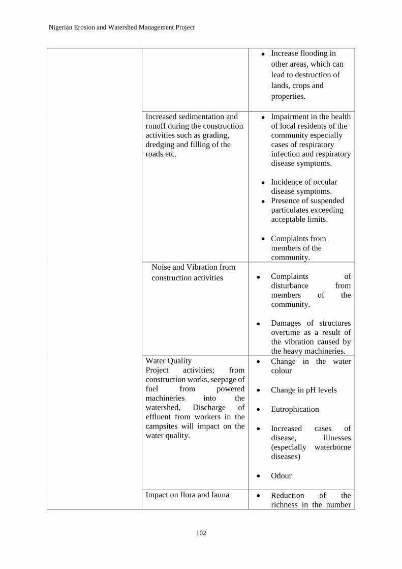
Nigerian Erosion and Watershed Management Project
102
Increase flooding in
other areas, which can
lead to destruction of
lands, crops and
properties.
Increased sedimentation and
runoff during the construction
activities such as grading,
dredging and filling of the
roads etc.
Impairment in the health
of local residents of the
community especially
cases of respiratory
infection and respiratory
disease symptoms.
Incidence of occular
disease symptoms.
Presence of suspended
particulates exceeding
acceptable limits.
Complaints from
members of the
community.
Noise and Vibration from
construction activities
Complaints of
disturbance from
members of the
community.
Damages of structures
overtime as a result of
the vibration caused by
the heavy machineries. Water Quality
Project activities; from
construction works, seepage of
fuel from powered
machineries into the
watershed, Discharge of
effluent from workers in the
campsites will impact on the
water quality.
Change in the water
colour
Change in pH levels
Eutrophication
Increased cases of
disease, illnesses
(especially waterborne
diseases)
Odour
Impact on flora and fauna
Reduction of the
richness in the number

Nigerian Erosion and Watershed Management Project
103
During mobilization of
equipment, construction
activities such as grading,
dredging, filling, excavation
etc.,
Weed invasion/proliferation
of opportunist species (weeds
& pests).
of available living
species.
Reduction in the number
of native wildlife.
Presence of Wildlife
species within
community dwellings
and corridors.
Transportation & Traffic
impact:
Existing travel patterns will be
negatively impacted during
the construction phase of the
project in the states.
Complaints from
members of the
community.
Increase in noise and air
pollution.
Increase in roadside
hazards and accident
Construction Phase Accidents may occur during
the construction phase as a
result of increased vehicular
movements.
Increase in total number
of accidents during the
construction phase.
Increased crime rates Crime rate and dispute
amongst members of
the communities.
Human Displacement
Impact Source: Civil
activities, re-vegetative
activities, watershed
management
Relocation of people and
their sources of
economy.
Archeological & Cultural loss
Impact Source:
Excavation/earth works,
deforestation activities and
other engineering activities e.g
water channelling
Loss of valuable
archaeological and
historical artefacts
Complaints from
members of the
community.
Social stress & disruption
Impact Source:
• Civil work activities.
• Human
•Governance. (Corrupt
practices)
A collapse of the Laws,
rules and norms within
the community.
Increased anti-social
behaviour

Nigerian Erosion and Watershed Management Project
104
Aesthetics
Impact Source: Construction
works
Diminished Aesthetic
levels
Public Health
a. HIV/AIDS and STDs
Impact Sources
1. Influx of non-local
workforce.
2. Low living standards of
members of the host
community which will
increases likelihood of
social vices such as
prostitution, robbery, etc.
b. Water-Borne Diseases (e.g.
Cholera, Dysentery,
Amoebiasis, Salmonellosis
etc.)
Impact Source
1. Poor environmental
sanitation habits exhibited by
members of the contractor’s
workforce.
2.Overload of existing
sanitation facilities.
c. Malaria
• During construction activity
through creation of pools of
stagnant water.
• Poor environmental
sanitation habits by members
of the contractor’s workforce.
• Movement of waste into the
watershed
Increased outbreaks of
HIV/AIDS and other
STDs.
Increase in cases of
opportunistic infections
within the work force,
and members of the host
communities.
Increased outbreak of
water borne diseases
amongst the workforce
and the local
population.
• Increased cases of fevers
amongst workers and
members of the host
communities.
Operation &
Maintenance Phase
Topography
Impact Source
• Construction activities
including movement of
goods and services.
• Agricultural activities.
• Scarification of landscape
• Increase in vehicular
accidents
Air Quality
Complaints from
members of the
community.

Nigerian Erosion and Watershed Management Project
105
Impact Source: Increase in
vehicular traffics
Complaint from local
residents on cases of
respiratory problems.
Increase in particulate
matter more than 10
microns in size (PM-10)
and dust above the
ambient air quality
levels.
Noise and Vibration
Impact Source:
Reported cases of noise
and vibration
disturbance by local
residents.
Water Quality
Impact Source:
Roadway runoff, wastes
(municipal solid wastes,
agricultural wastes, effluent,
hazardous wastes e.t.c)
Changes in pH levels
Turbidity
Change in water colour
Smell
Traffic and Transportation
Impact Source:
Increase in traffic within the
roads and access roads of the
project areas in the seven (7)
states.
An increase in traffic in
the areas around the
sub-projects
implementation
Occupational Health & Safety
a. PPEs
b. Emergency Response &
First Aids
Impact Source:
Exposure of workers to
accidents, working in potential
weather extremes, contact
with natural hazards such as
animals, insects, carnivorous
and poisonous plants.
Injury of workers and
the public during the
operation and maintenance
activities

Nigerian Erosion and Watershed Management Project
106
Social Impact Management Plan
This social impact management plan as outlined below will ensure that the project and its
implementing agencies will incorporate lessons learned and the recommendations identified in
the report of the Global Gender-Based Violence Task Force Report1 in assessing Gender-Based
Violence and Sexual Exploitations and Abuse risks and defining mitigation measures. The plan
could be redefined during implementation and further consultation undertaken in the light of
what has been outlined in the table below.
1 Gupta, Geeta Rao; Sierra, Katherine. 2017. Working together to prevent sexual exploitation and abuse:
recommendations for World Bank investment projects (English). Gender-based violence. Washington, D.C. :
World Bank Group. http://documents.worldbank.org/curated/en/482251502095751999/Working-together-to-
prevent-sexual-exploitation-and-abuse-recommendations-for-World-Bank-investment-projects

Nigerian Erosion and Watershed Management Project
107
Table 6.1 : Potential Mitigation Measures of Social Impacts
Expected
Adverse Impact
Potential Mitigation Measures
Contractor
SPMU/FPMU
World Bank Project-specific – With
Support of the Monitoring/
Supervision Consultant
Broader
Enabling
Environment
All Disputes
Follow GRM provision
Establishment and
operation of an effective
GRM accessible to
community members—
ideally with involvement
of the community and
LGA level committee
and Community Based
Organizations to
facilitate early
identification of
problems and targeted
mitigating interventions
by SPM;
Establishment and
operation of an effective
GBV GRM accessible to
community members and
project contractors—
ideally with involvement
of the Ministry of
Women Affairs, Children
and Social Protection to
facilitate the discrete
Provision of
information to
communities on how
to use the two types
of GRM to report
issues;
Monitoring and
taking appropriate
actions to ensure
CESMP provisions
are met;
Inclusion of relevant
provisions in the
ESMP;
Supportive Inclusion of
relevant
provisions in
the ESMP and
Legal
Agreement;
Provision of
advice on
expected or
likely issues
based on Bank
experience;
Implementation
support to
verify
compliance
with the ESMP
and CESMP;
Monitoring of
GRM
resolution rates
and
identification
of recurring
issues to
discuss with
FPMU/SPMU.

Nigerian Erosion and Watershed Management Project
108
Expected
Adverse Impact
Potential Mitigation Measures
Contractor
SPMU/FPMU
World Bank Project-specific – With
Support of the Monitoring/
Supervision Consultant
Broader
Enabling
Environment
Inclusion of relevant
provisions in the
SPMU contract.
Land
acquisition for
the project
Fair compensation
for affected
structures and crops
at current market
value
Provision of
compensation and
assistance to
vulnerable groups
Provision of
differentiated
treatment for
vulnerable people
Signing of
agreements with
local authorities and
communities.
Ensure the ownership
of land is effectively
established to
mitigate the
possibilities of taking
land owned by
women for public
interest without
ensuring the affected
women are provided
with land for land
replacement option
Ensure consultation with
PAPs, obtain permit,
transfer title and
documentation
Supportive
Government
to provide
adequate fund
for the
payment of
RAP and
livelihood
restoration
Ensure compliance
Risk of social
conflict
Awareness of
historical and cultural
nature of the project
area when dealing
with affected
communities,
Consultations with and
involvement of local
communities in project
planning and
implementation processes;

Nigerian Erosion and Watershed Management Project
109
Expected
Adverse Impact
Potential Mitigation Measures
Contractor
SPMU/FPMU
World Bank Project-specific – With
Support of the Monitoring/
Supervision Consultant
Broader
Enabling
Environment
Ensure that
communication tools
portray correct and
concise information
Provision of
information
regarding Worker
Code of Conduct
Provision of cultural
sensitization training
for workers regarding
engagement with
local community.
Provision of a one-
paragraph
Harassment Policy,
as an addendum to
the Contractor
workers’ contract, to
be signed as a
commitment to
adhere to Worker
Code of Conduct and
GBV prevention.
Commitment to
prioritizing the hiring
of competent locals
to the maximum
extent to avoid inter
or intra-community
tension with migrant
workers.
Awareness-raising among
local community and
workers.
Ensure the Contractor
adheres to Workers code of
conduct and local tradition,

Nigerian Erosion and Watershed Management Project
110
Expected
Adverse Impact
Potential Mitigation Measures
Contractor
SPMU/FPMU
World Bank Project-specific – With
Support of the Monitoring/
Supervision Consultant
Broader
Enabling
Environment
Increased risk
of illicit
behavior and
crime
(including
prostitution,
theft and
substance
abuse)
Paying adequate
salaries for workers
to reduce incentive
for theft;
Hiring of local
workforce;
Creation of
supervised recreation
areas in workers’
camp as well as
temporary rest areas
at work sites;
Cooperation with
local law
enforcement;
Introduction of
sanctions (e.g.,
dismissal) for
workers involved in
criminal activities;
Provision of
substance (drug and
alcohol) abuse
prevention and
management
programs for workers
involved in the
project site
Hiring of young
women in the project
areas to mitigate the
risk of prostitution
and sexual
transactions.
pay wage equal to
men and women on
the basis of equal job
performed and merit.
Ensure assignment of
adequate enforcement staff;
Enforcement of laws on
drug abuse and traffic;
Police monitoring to prevent
drugs trafficking;
Sensitization campaigns for
both workers and local
communities.
Adverse impacts
on community
dynamics
Provision of services
in the workers’ camp
to reduce the need for
Liaison with civil society
organizations to create
integrative action plans;
Investment in
community
participation

Nigerian Erosion and Watershed Management Project
111
Expected
Adverse Impact
Potential Mitigation Measures
Contractor
SPMU/FPMU
World Bank Project-specific – With
Support of the Monitoring/
Supervision Consultant
Broader
Enabling
Environment
workers to use local
community facilities;
Provision of
entertainment and
events for workers
within camp to
reduce incentives for
mixing with local
community (Satellite
Television, diner,
bar).
Restriction of public
access to camps and
construction areas to
be managed by
o assigning
security
personnel to
manage access,
o fencing of
camps,
o installation of
appropriate
signage
Provision of upfront
information on potentially
detrimental impacts on local
communities.
and
engagement
programs.
Impact on
Community
Cultural
Traditions
Contractor is to
ensure the strict
implementation of
Labor Management
Plan to minimize
engagement with the
locals and to ensure
workers are educated
on the local traditions
and proper
interactions. Actions
disapproved by the
communities or by
their traditions must
be corrected,
improved and proper
consultation must be
Provision of upfront
information on potentially
detrimental cultural impacts
on local communities
Liaise with community
based organizations to
create integrative action
plans.

Nigerian Erosion and Watershed Management Project
112
Expected
Adverse Impact
Potential Mitigation Measures
Contractor
SPMU/FPMU
World Bank Project-specific – With
Support of the Monitoring/
Supervision Consultant
Broader
Enabling
Environment
held with the leaders
to ensure satisfaction
of redress
mechanism.
Influx of
Additional
Population
(“Followers”)
Contractor to hire
workers through a
systematic process
managed by the HR
office and avoid
hiring “at the gate” to
discourage
spontaneous influx of
job seekers and
migrant workers.
Development of a
detailed and site-
specific labor influx
management plan.
Prioritize the hiring
of the locals for
qualified skilled and
unskilled work
Train women in
variety of skilled and
non-skilled jobs such
as operating
construction
equipment, involving
them in supervisory
jobs, inform
communities of all
hiring opportunities
in construction areas.
Communications campaign
to manage expectations and
discourage spontaneous
influx of job seekers;
Coordinate with Local
government to address this
additional influx of the
“followers” to ensure that
no illegal and unsafe
settlements develop;
Review and ensure
adherence to labor influx
management plan.
Increased
burden on
public service
Provision
Workers’ camp to
include wastewater
disposal and septic
systems;
Identification of
authorized water
supply source and
prohibition of use
Contingency plans for
temporary rise in demand
for utilities and public
service provision.
Investment in
and capacity
building of
local public
service
providers.
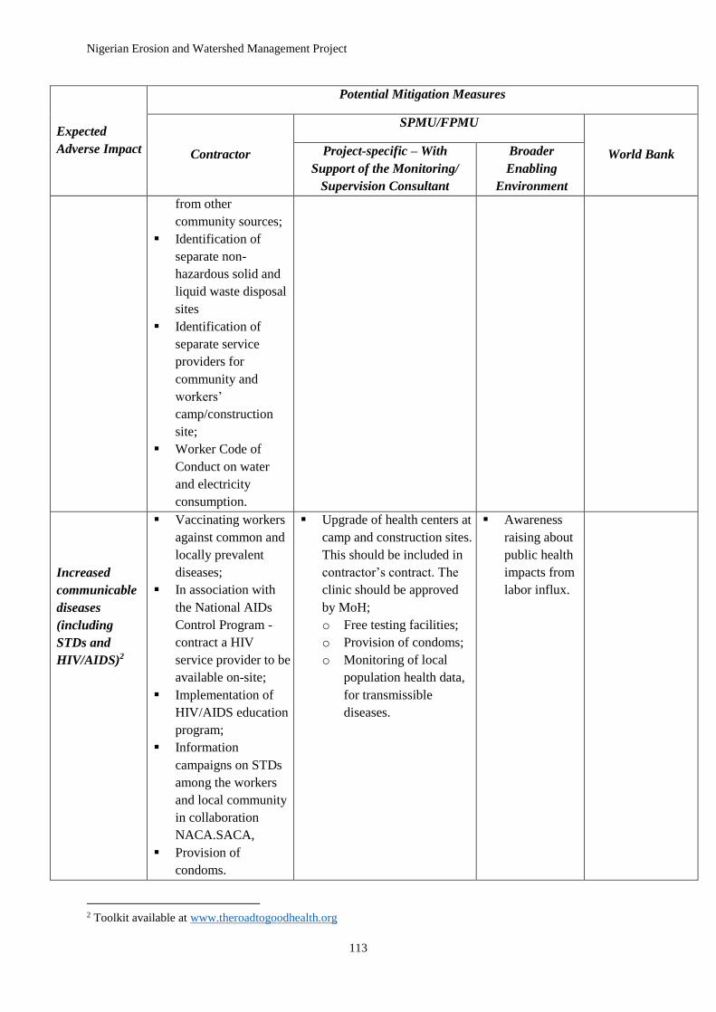
Nigerian Erosion and Watershed Management Project
113
Expected
Adverse Impact
Potential Mitigation Measures
Contractor
SPMU/FPMU
World Bank Project-specific – With
Support of the Monitoring/
Supervision Consultant
Broader
Enabling
Environment
from other
community sources;
Identification of
separate non-
hazardous solid and
liquid waste disposal
sites
Identification of
separate service
providers for
community and
workers’
camp/construction
site;
Worker Code of
Conduct on water
and electricity
consumption.
Increased
communicable
diseases
(including
STDs and
HIV/AIDS)2
Vaccinating workers
against common and
locally prevalent
diseases;
In association with
the National AIDs
Control Program -
contract a HIV
service provider to be
available on-site;
Implementation of
HIV/AIDS education
program;
Information
campaigns on STDs
among the workers
and local community
in collaboration
NACA.SACA,
Provision of
condoms.
Upgrade of health centers at
camp and construction sites.
This should be included in
contractor’s contract. The
clinic should be approved
by MoH;
o Free testing facilities;
o Provision of condoms;
o Monitoring of local
population health data,
for transmissible
diseases.
Awareness
raising about
public health
impacts from
labor influx.
2 Toolkit available at www.theroadtogoodhealth.org

Nigerian Erosion and Watershed Management Project
114
Expected
Adverse Impact
Potential Mitigation Measures
Contractor
SPMU/FPMU
World Bank Project-specific – With
Support of the Monitoring/
Supervision Consultant
Broader
Enabling
Environment
Gender-based
violence,
including
sexual
harassment,
child abuse and
exploitation
Mandatory and
regular training for
workers on required
lawful conduct in the
project site and legal
consequences for
failure to comply
with laws;
Commitment / policy
to cooperate with law
enforcement agencies
investigating
perpetrators of
gender-based
violence;
Creation of
partnership with local
offices of the
Ministry of Women
Affairs, Children and
Social Protection,
NGOs and
community women
groups to report
workers’ misconduct
and
complaints/reports on
gender-based
violence or
harassment through
the GBV GRM;
Provision of
opportunities for
workers to regularly
return to their
families;
Provision of
opportunities for
workers to take
advantage of
entertainment
Capacity building for local
law enforcement and the
FPMU/SPMU to act on
GBV complaints;
Information and awareness
raising campaigns for
community members,
specifically women and
girls;
Provision of information to
the project site about the
contractor’s policies and
Worker Code of Conduct
(where applicable).
Increased
security
presence in
nearby
communities;
Reinforcement
of police force
where needed;
Deployment
of female
police officers
in project
area;
Application of
long-term
community-
based
approaches to
address the
issue;
Enforcement
of laws on
sexual
violence and
human
trafficking.

Nigerian Erosion and Watershed Management Project
115
Expected
Adverse Impact
Potential Mitigation Measures
Contractor
SPMU/FPMU
World Bank Project-specific – With
Support of the Monitoring/
Supervision Consultant
Broader
Enabling
Environment
opportunities away
from rural host
communities.
Commitment to
providing alternative
work schedules or
shifts to
accommodate the
hiring of more local
female workers. This
ensures they can
carry out their
domestic duties and
avoid potential
domestic abuse for
reasons justified in
the ESIA.
Child labor and
school drop out
Ensuring that
children and minors
are not employed
directly or indirectly
on the project.
Communication on hiring
criteria, minimum age, and
applicable laws.
Enforcement
of legislation
on child labor.
Local inflation
of prices and
crowding out of
local consumers
Appropriate mix of
locally and non-
locally procured
goods to allow local
project benefits while
reducing risk of
crowding out of and
price hikes for local
consumers.
Monitoring of
local prices
and security of
supply.
Increased
pressure on
accommodation
and rents
When the local
community supply of
accommodation is
limited, the project
should establish
workers’ camp
facilities with
sufficient capacity for
workers— including
sub-contractors—and
Inclusion in contract of
funding for establishment of
workers’ camp.

Nigerian Erosion and Watershed Management Project
116
Expected
Adverse Impact
Potential Mitigation Measures
Contractor
SPMU/FPMU
World Bank Project-specific – With
Support of the Monitoring/
Supervision Consultant
Broader
Enabling
Environment
associated support
staff.
Increased
traffic and rise
in accidents
Preparation and
implementation of a
traffic management
plan to be approved
by monitoring/
supervision
consultant;
Building
additional/separate
roads to project and
workers’ camp sites,
where necessary;
Organization of
commute from camp
to project to reduce
traffic;
Road safety training
and defensive driving
training for staff;
Sanctions for reckless
driving.
Coordinate with local
government, contractor and
communities to identify
accident hotspots and
formulation of solutions.
Upgrading
and
maintaining
roads affected
by project
(unless
designated as
contractor
responsibility)
.
Risk of
marginalizing
Vulnerable
Groups
To mitigate impact
associated with age
vulnerably, the
SPMU when
conducting the
assessment under
Safeguards
policies/ESMF shall
identify
disadvantaged or
vulnerable
individuals or groups
that will be directly
or indirectly affected
in the project area,
and a process
whereby

Nigerian Erosion and Watershed Management Project
117
Expected
Adverse Impact
Potential Mitigation Measures
Contractor
SPMU/FPMU
World Bank Project-specific – With
Support of the Monitoring/
Supervision Consultant
Broader
Enabling
Environment
differentiated
measures will be
developed to address
circumstances or
needs of such
individuals or groups.
6.4.2.1 Protected Areas, Natural Habitats and Forests
Natural habitats are land and water areas whose ecological functions have not been essentially
modified by human activities. Subprojects like constructions, excavations are likely to lead to
significant conversion or degradation of natural habitats.
6.4.2.2 Biological and Physico-chemical Impacts
Impacts of this sort relate to effects on biological resources such as vegetation, wildlife, crops,
and aquatic life. Impacts affecting soil and landforms, or vulnerability to soil erosion, floods
and sedimentation, would be considered as physical impacts. Chemical impacts relate to sub-
project activities that will cause a chemical change in air/water/soil quality. Smoke emitted
from tractors or bulldozers, for example, may change the amount of sulphur dioxide (SO2)
content of ambient air, while untreated effluent discharged directly into water bodies may
change the chemical characteristics of the water bodies.
The biological component covers all elements, including different forms of plant life, their
functions and interaction with other components of the ecosystem. Another component of a
biological system is the animal life, which ranges from microscopic protozoans to large animals
occupying different niches.
In the planning process of the NEWMAP, the consideration of under-listed four major points
should be made to avoid or minimize the adverse impacts on biophysical components;
All activities, which may affect the biophysical component of the sub-project area(s),
should be carefully analysed and measures to mitigate adverse negative impacts should
be implemented.
Flora and economic plants should be protected and conserved.
Keystone animals constitute important players in food chain, and may be endangered,
rare, threatened, and endemic species, and form an important component of
biodiversity. They should not be affected by the project activities. Measures to protect
such animals and their habitat from any adverse impacts should be included in the
development activity package, and

Nigerian Erosion and Watershed Management Project
118
Any activities, which affect bio/geo-chemical cycle within the ecosystem should be
carefully analysed and efforts should be made to minimise the impacts through the
implementation of appropriate measures.
6.4.2.3 Social Impact
A study of socio-economic impacts would examine the sub-project activities that will alter the
existing social and economic conditions of the communities within or around the project states.
Socio-economic impacts may prove either adverse or beneficial. For example, the construction
of new road networks designed to enhance the movement of goods and services would be
beneficial; while the project might also result in water logging that could produce a salinity
problem with adverse consequences.
Social impacts can be subdivided into the following:
Demographic impacts - such as displacement and relocation effects; and changes
in population characteristics,
Socio-economic impacts - including income and income multiplier effects,
employment rates and patterns, effects on prices of local goods and services, and
taxation effects,
Cultural impacts - traditional patterns of life and work, family structures and
leadership, religious and tribal factors, archaeological features, social networks and
community cohesion,
Institutional impacts - including demands on the government and social service,
NGOs housing, schools, criminal justice, health, welfare and recreation, and
Gender impacts - the implications of the sub-projects on the roles of women in
society, income-generating opportunities, access to resources, employment
opportunities and equity.
For the NEWMAP, analysis must include the following socio-cultural parameters:
Quality of life,
Social organisation and structures,
Cultural life, including language, rituals and general lifestyle. A cultural life
makes a social group immediately recognisable as being distinct from other groups,
and
Dispute-resolution institutions and processes; relationships between generations
and value systems.
The first step in the analysis of social impacts would be the identification of social communities
such as: ethnic/tribal group, occupational groups, socio-economic status, and age and gender
groups.

Nigerian Erosion and Watershed Management Project
119
The distribution of production systems is also another important aspect to be analysed.
Identification and analysis has to be made on:
the existing local institutions and their systems of operation i.e. bio-physical resource
utilization
conflict resolutions,
authority and leadership structures,
Their capability of handling the issues.
Information on vital issues such as resource availability and utilization, impact of inadequate
compensation are extremely useful for formulating environmental mitigation strategy in the
process of ESIAs to be conducted under the NEWMAP sub-projects. Wider social groups can
be broadly categorised into three resource user groups namely:
1. Category 1: those who are resident from generation to generation;
2. Category 2: new settlers, who have comparatively less knowledge of the resource base of
the area for the sub-projects and of sustainable resource-use practices, and usually devastate
the area through excessive use of biophysical resources, and
3. Category 3: Non-resident people, who often visit the area for exploitation of biophysical
resources and are potentially more dangerous than either of the above types,
For the NEWMAP-AF, it is important to analyse all three types of resource users. Involving
the people in all levels of project implementation should enhance the Knowledge, Attitude and
Practices (KAP) of category (1). Categories (2) and (3) of resource users have to be linked with
local authority, leadership or any other kinds of regulating agencies in order to protect the
biophysical resources.
Particular attention must be paid to the consideration of tribal, low- caste, ethnic and minority
groups in implementation of sub-projects; these groups in the society, become most vulnerable
to resettlement/dislocation and changes in socioeconomic status. Otherwise, this might, in turn,
create more environmental problems, as they will be forced to adopt inappropriate production
systems.
However, in some of the project states, native inhabitants are provided resource-use or land
use rights through constitutions, policies/regulation and cultural inheritance; but in many cases,
such rights are nullified due to socio-economic and political situations. In some cases, one
tribal group dominates and others are ignored. In such circumstances, the primary concern of
the ESIA consultant or procured contractor is not to encroach upon the lands and other
properties of these vulnerable groups of people.
From findings on the participatory public consultation with the communities during visits to
priority sites per state; it is recommended that two important aspects be considered in the
identification of social impacts in ESIA:
1. it is always advisable to avoid involuntary resettlement, mostly in cases where
vulnerable groups of people are involved, and

Nigerian Erosion and Watershed Management Project
120
2. In cases, where projects require land acquisition from marginalized territories, the
people affected should be compensated adequately so that their standard of living is
improved or, at the least, is at the similar level.
6.4.2.4 Cultural Impacts
For the NEWMAP,-AF it is important that the ESIA consultant(s) considers sub-project
impacts on cultural heritage. Areas of study should include historic sites, religious shrines or
areas, or traditional practices that may be affected. Cultural resources refer to archaeological,
historical, religious, cultural and aesthetic values. Cultural resources are part of the resource
base, it is therefore important that the development options, under consideration are screened
for potential impacts on cultural properties. Additionally, establishments such as museums,
universities, departments of archaeology, and other relevant agencies should be consulted.
Any sub-project that involves a large-scale modification or disturbance of land and is located
in an area where there are cultural resources will require an intensive survey by qualified
archaeologists. On the basis of findings of intensive survey, the decision-makers have to decide
whether or not the sub-project should go ahead or whether to adopt project alternatives or
devise mitigation measures to be adopted, along with institutional training and monitoring
requirements, etc. In all these processes, involvement of local communities is necessary. If in
the project site, there are some buried materials of archaeological/ historical value, discovered
within three meters under the earth's surface, they are called "Archaeological Chance Finds",
and the sub-project construction contractor should comply with the following rules and Federal
or State archaeological laws:
notify relevant departments of such findings,
request a site inspection,
completely halt work until inspection results are received, and
decide whether or not to proceed with further work.
In the event of relocating sacred religious shrines from the sub-project area, the first step is to
determine whether the shrines are of national or local significance. This has to be confirmed
by consulting a national heritage register. If it is a national treasure, then the concerned MDAs,
NGOs and local people should agree on whether relocation is possible. However, such an
intervention should be scientifically sound, locally acceptable and nationally agreeable. If the
shrine to be relocated is only of local significance, the local people, community leaders, NGOs
and others should reach a consensus and the local people should be involved in the process of
relocation. Alternatively, if there is a series of shrines of archaeological and historical value,
likely to be affected by development activities, then a strategy for restoration, conservation and
management should be developed and implemented.
6.4.2.5 Health Impact
When social impacts are being investigated, the effects of a development project on individual
mental and physiological well being (health status and trends) are often omitted or treated in
an unsatisfactory manner. The World Health Organization (WHO) defines health as a state of
social and individual well being and not just the absence of disease. If this view is accepted,
then the links between health and social impacts are apparent. Often, not always, health impacts

Nigerian Erosion and Watershed Management Project
121
depend on environmental impacts, such change in habitat causing increased in vector or the
likelihood of contact between the vectors and humans. The direct relationship between
biophysical change and incidence of disease may be one of the important reasons. However,
there are disease pathways, which occur solely, within a social context. A common example is
an increased incidence of sexually transmitted disease resulting from the influx of a large
construction labour force.
The following are reasons why the consideration of Health Impact Assessment (HIA), should
be integrated into the ESIA process.
Prevention is better than cure, as with other forms of assessment,
It is specified in many forms of impact assessment legislation,
Environmental degradation is linked with health impacts,
Environmental, social and health outcomes can be improved,
Systematic consideration of health issues improves the legitimacy of the decisions
made and the process through they are taken, and
Human health issues often prompt a public response and their involvement.
However, from past experience, the following are some difficulties in undertaking Health
Impact Assessment:
1 Baseline data - Lack of such data on human health in local communities,
2 Time scale
3 Synergistic effects - The interaction of different chemicals, etc. can make it difficult to
isolate the effects or effects responsible for ill health, variety of human responses to exposures,
4 Lack of knowledge on dose-response relationship, and
5 Issues of confidentiality.
Some groups of individuals may be more exposed to harmful pollutants and their health status
will decline. Also, some groups may suffer a decline in their standards of living and become
poor. Such a change in socio-economic status can be accompanied by increased morbidity and
mortality due to poor nutrition, unsanitary living conditions and reduced physical and financial
access to healthcare facilities. Health impacts also can occur directly from development,
particularly from hazardous installations, when an accident occurs, such as the release of a
certain amount of a toxic gas or an explosion. Similarly, relocation of individuals and groups
to new area can cause disaster development or increase in death and illness rates amongst those
being relocated. The old and the young have been the most vulnerable to illness and death.
6.4.2.6 Economic Impact
The focus in economic impact assessment is the estimation of the change in economic variable
caused by:
Sub-project construction and operation

Nigerian Erosion and Watershed Management Project
122
workforce requirement and the income earned by workers,
materials and other inputs for the project, and
Capital investment.
It is essential to estimate the size of labour force, skilled manpower requirement and the
duration of their involvement. Requirement of manpower will vary at different stages of the
sub-project implementation; for example, the need for labour peaks at the midpoint of
construction and then declines gradually. An estimation of capital expenditure on local
materials, and services is also required for economic evaluation.
A thorough analysis of the labour force and the local economy requires information on:
the categories of labour available,
the categories of labour that are highly demanded and employed, not employed and
partly employed,
estimation of unemployed labour; proportion of female looking for employment, and
The number and type of employment likely to be generated by the sub-project
implementation.
These data can be manipulated for analysing and predicting economic impacts. The money that
comes into the area in the form of wages is the Initial Income Injection (III) into the local
economy. Some part of such money will be spent on buying goods and services, helping to
improve the economy of those who sell goods and services.
Social effects are the outcomes of environmental and economic impacts. In the NEWMAP,
with sub-project activities going on, a large number of people are attracted in search of
employment. Such massive aggregation of people can place significant additional strains on
the local infrastructure, environment and local government resources.
When economic impacts are being investigated, the focus is always on the effects of the nature
and behaviour of the local economy. Commonly, the economic consequences for local and
other governmental organizations are omitted. These consequences are termed fiscal impacts
because they are concerned with changes in the costs and revenues of these organizations. It is
envisaged that the NEWMAP-AF will cause a large increase in local population and, as a result,
cause stress on local services (such as health provision), infrastructure (such as roads and
sewerage), and local resources. Key factors determining fiscal impacts include:
size of investment and labour force requirements,
capacity of existing service delivery and infrastructure systems,
local/regional tax or other revenue-raising processes, and
Likely demographic changes arising from project requirements.
6.4.2.7 Pest Management
The agricultural subprojects are expected to have only minor use for nationally approved
pesticides and there may not be significant issues of pest management and pesticide use to be
addressed in the subprojects.
The World Bank Pest Management Policy (OP 4.09) could be triggered in a variety of
subprojects such as:

Nigerian Erosion and Watershed Management Project
123
New land-use development or changed cultivation practices in an area;
Expansion of agricultural activities into new areas;
It should be emphasized that pests are defined in the broad sense. In addition to agricultural
insect pests and plant diseases, pests also include weeds, birds, rodents, and human or livestock
disease vectors. Similarly, the FAO defines pesticides as any substance or mixture of
substances:
Intended for preventing, destroying or controlling any pest, including a) vectors of
human and animal disease, b) unwanted species of plants or animals causing harm
during, or otherwise interfering with, production, processing, storage, transport or
marketing of food, agricultural commodities, wood and wood products or animal
feedstuffs;
that may be administered to animals for the control of insects, arachnids or other
pests in or on their body;
intended for use as a plant-growth regulator, defoliant, desiccant, or agent for
thinning fruit or preventing the premature fall of fruit; and
substances applied to crops either before or after harvest to protect the commodity
from deterioration during storage and transport.
the commodity from deterioration during storage and transport.
The use of pesticide for Pest Management could result to negative effects of pesticide misuse,
which can result in the destruction of crop pollinators leading to the detriment of the
environment and/or people’s health.
The negative effects of pesticide misuse, can result in the
destruction of crop pollinators leading to poor crop yields;
elimination of the natural enemies of crop pests and consequent loss of natural pest
control that keeps the populations of crop pests very low;
development of pest resistance to pesticides, encouraging further increases in the use
of chemical pesticides;
contamination of the soil and water bodies;
pesticide poisoning of farmers and deleterious effects on human health;
Unacceptable levels of pesticide residues in harvested produce and in the food chain;
and loss of biodiversity in the environment.
6.5 NEWMAP: LABOR INFLUX AND GENDER BASED VIOLENCE (GBV) 6.5.1 Labor Influx
The project may face an influx of non-local labor and working conditions issues as skilled
laborers might not be available in some of the project sites. The project will take concrete
measures to mitigate potential labor influx-related risks such as workers’ sexual relations with
minors and resulting pregnancies, presence of sex workers in the community, the spread of
HIV/AID, sexual harassment of female employees, child labor and abuse, increased dropout
rates from school, inadequate resettlement practices, and fear of retaliation, failure to ensure
community participation, poor labor practice, and lack of road safety. These risks require
careful consideration to improve social and environmental sustainability, resilience and social
cohesion. Therefore, the project will include mitigation measures such as: (a) assessing living
conditions of workers’ camps and ensuring appropriate living conditions; (b) establishing and
enforcing a mandatory Code of Conduct for the company, managers and workers, and an

Nigerian Erosion and Watershed Management Project
124
Action Plan for implementation; (c) ensuring appropriate location for these camps; (d) taking
countermeasures - indicated in the Social Management Plan - to reduce the impact of the labor
influx on the public services; and, (e) devising and implementing a strategy for maximizing
employment opportunities for local population, including women.
The following guidelines lays out the principles that are key to properly assessing and
managing the risks of adverse impacts on project area communities that may result from
temporary NEWMAP induced labor influx.
The SPMU will have to hire, to the maximum extent, skilled and unskilled workers
from affected communities in the project area. The SPMU will adopt or implement all
possible measures to avoid if not minimize labor influx into the project area.
The SPMU will assess and manage labor influx risk based on appropriate instruments
such as those based on risks identified in the ESIA and the Bank’s sector-specific
experience in the country.
Depending on the risk factors and their level, appropriate mitigation instruments need
to be developed including the ESMP, Site-specific Labor Influx Management Plan
and/or a Workers’ Camp Management Plan3,
Risk factors to the SPMU that should be considered, include,
o weak institutional capacity of the implementing agency;
o predominant presence of contractors without strong worker management and
health and safety policies;
o anticipated high volumes of labor influx;
o pre-existing social conflicts or tensions;
o weak local law enforcement;
o prevalence of gender-based violence and social norms towards it in the
community (acceptance of gender based violence);
o prevalence of transactional sex;
o local prevalence of child and forced labor;
o existing conflict situation between communities;
o absorption capacity of workers to the community (See
http://pubdocs.worldbank.org/en/497851495202591233/Managing-Risk-of-
Adverse-impact-from-project-labor-influx.pdf)
The SPMU will be required to incorporate social and environmental mitigation
measures into the civil works contract and responsibilities for managing these adverse
impacts. This will be a binding contractual obligation on the SPMU, with appropriate
mechanisms for addressing non-compliance
The Supervision Consultant shall be responsible for monitoring the contractor performance and
adherence to the labor influx guideline and that of its Sexual Exploitation and Abuse (SEA)
3A Labor Influx Management Plan addresses specific activities that will be undertaken to minimize the impact on the local community,
including elements such as worker codes of conduct, training programs on HIV/AIDS, etc. A Workers’ Camp Management Plan addresses specific aspects of the establishment and operation of workers’ camps.

Nigerian Erosion and Watershed Management Project
125
obligations, with a protocol in place for immediate, timely, mandatory and confidential
reporting in case of incidents to project community.
This allows the SPMU to enforce the implementation of such mitigation measures, which are
required to ensure the consultant’s own compliance with Bank policy requirements. While the
Bank reviews and clears project-level safeguard instruments such as the ESIA/ESMP, it is the
SPMU’s responsibility to: (i) ensure the safeguard instruments are reflected in the contractor’s
ESMP (CESMP), and (ii) ensure the project is implemented in accordance with the CESMP,
safeguard instruments and other relevant contractual provisions.
6.5.2 Gender Based Violence
Nigeria has ratified or acceded to the core international human rights treaties and is a party to
the major regional human rights instrument which obliged States to respect, protect and fulfill
human rights of all persons within the territory and subject to the jurisdiction of the State,
without discrimination. Rape may violate several human rights obligations enshrined in the
instruments ratified by Nigeria and is also a form of gender-based violence and a brutal
manifestation of violence against women. As a State party to the Convention on the Elimination
of All Forms of Discrimination against Women (CEDAW) and the Protocol to the African
Charter on Human and Peoples’ Rights on the Rights of Women in Africa (the “Maputo
Protocol”), Nigeria has made legally binding commitments to exercise due diligence to combat
gender-based violence and discrimination.
Accordingly, Nigeria has an obligation to take all appropriate measures to prevent rape, ensure
that there are adequate sanctions for rape in law and in practice, and ensure access to reparation
for the victims.4 Furthermore, several human rights instruments5 require Nigeria to take special
measures to protect the rights of individuals who are vulnerable to sexual violence, namely
women, children, and persons with disabilities.
The United Nations Special Rapporteur on violence against women has provided guidance on
States’ due diligence obligations in combating sexual violence, noting that it must be
implemented at both individual and systemic levels. Individual due diligence focuses on the
needs of individual survivors and “places an obligation on the State to assist victims in
rebuilding their lives and moving forward,” for instance through the provision of psychosocial
services. Individual due diligence “requires States to punish not just the perpetrators, but also
those who fail in their duty to respond to the violation.”6 As for systemic due diligence, it
includes ensuring “a holistic and sustained model of prevention, protection, punishment and
reparations for acts of violence against women.
4 CEDAW art. 2(c), for example, provides that States must “establish legal protection of the rights of women on an equal basis
with men and ensure through competent national tribunals and other public institutions the effective protection of women
against any act of discrimination.” The Maputo Protocol, art. 4, paras. 2(a) and (e), explicitly provides that laws prohibiting
violence against women must be enforced and perpetrators held accountable; See also CEDAW general recommendation N.19
(n). 5 CRC, CEDAW, CRPD, ACRWC, and the Maputo Protocol. 6 Report of the Special Rapporteur on violence against women, its causes and consequences, para. 70, UN Doc. A/HRC/23/49
(14 May 2013).

Nigerian Erosion and Watershed Management Project
126
International Treaties
The International Covenant on Civil and Political Rights (ICCPR) (2004)
The International Covenant on Economic, Social and Cultural Rights (ICESCR)
(2004)
The Convention against Torture and Other Cruel, Inhuman or Degrading Treatment or
Punishment (CAT) (1993)
The Convention on the Elimination of All Forms of Discrimination against Women
(CEDAW) (1984)
The Convention on the Rights of the Child (CRC) (1990), and the Convention on the
Rights of Persons with Disabilities (CRPD) (2012)
International Convention on the Elimination of All Forms of Racial Discrimination
(1976)
Regional Treaties
The African Charter on Human and Peoples’ Rights (ACHPR) (1982)
The African Charter on the Rights and Welfare of the Child (ACRWC) (2007)
The Protocol to the ACHPR on the Rights of Women in Africa (the “Maputo
Protocol”) (2007)
National polices
The National Action Plan for the Implementation of United Nations Security Council
Resolution 1325 (2009);
The National Gender Policy (2010)
Nigeria is among the 10 percent of countries worldwide that exhibit the highest levels of gender
discrimination according to the OECD’s Social Institutions and Gender Index (see the figure
below), with an assessment of “high” or “very high” in all of the evaluated categories
(discriminatory family code, restricted physical integrity, son bias, restricted resources and
assets, restricted civil liberties). It also falls into the group of countries with highest gender
inequality in human development outcomes (UNDP 2016).
Gender-Based Violence (GBV) remains pervasive and underreported in the country, largely
constraining women’s autonomy and life chances. The 2013 Demographic Health Survey
(DHS) indicates that nationally 38 percent of women between the ages of 15-49 have
experienced some form of physical or sexual violence from the age of 15, and 11 percent
experienced physical violence within the 12 months prior to the survey. 45 percent of women
who experienced violence never sought help or never told anyone about the violence. Besides
interpersonal and sexual violence, child marriage and Female Genital Mutilation are the other
culturally harmful practices prevalent across Nigeria. Conflict in the North East has further
contributed to a steep rise in targeted violence against women and children by Boko Haram
increasingly for abduction and violence. Women are increasingly being used as instruments of
war, making them vulnerable to stigmatization and rejection from their families and
communities. Figure 1 below illustrates pervasiveness of GBV Nigeria on regional:
Figure 6.0 Nigeria Degree of Gender Inequality according to the Social Institutions
and Gender Index

Nigerian Erosion and Watershed Management Project
127
6.5.3 GBV Risk Management Mechanisms
A GBV workshop was conducted to sensitize the SPMU staff on the key principle and
specific requirements to address GBV/SEA have been included in the bidding documents (‘pre-
qualification’ and ‘employers’ requirements’). As such specific measures to reduce and
mitigate the risk of GBV/SEA in the project. Such measures will include:
i) GBV/SEA assessment of project;
ii) mandatory contractors’ code of conduct on sexual harassment;
iii) appointment of NGO to monitor GBV/SEA in NEWMAP-AF;
iv) community and workers’ sensitization on GBV/SEA;
v) provision of referral units for survivors of GBV/SEA;
vi) provisions in contracts for dedicated payments to contractors for GBV/SEA
prevention activities against evidence of completion;
vii) contractor and SPMU requirement to ensure a minimum target of female
employment with incremental rewards of the obtainment of this target.
The following actions are recommended for immediate implementation:
Hiring a dedicated GBV/SEA specialist or retraining SLOs for the project,
Including in the focal NGO’s ToR services for managing social risks associated with
GBV/SEA in the project,
Building and improving FPMU/SPMUs, local communities and other relevant
stakeholders’ capacities to address risks of GBV/SEA by developing and providing
guidance, training, awareness, and dissemination of relevant GBV/SEA materials to
communities,
Developing a clear NEWMAP specific internal “Reporting and Response Protocol" to
guide relevant stakeholders in case of GBV/SEA incidents,
Strengthening operational processes of NEWMAP states project area on GBV/SEA,
Identifying development partners and cultivating pragmatic partnership on GBV/SEA
prevention measures and referral services,
Nigeria Niger MaliSouth
AfricaNamibia Vietnam Brazil Thailand
Overall
Discriminatory family code
Restricted physical integrity
Son bias
Restricted resourcs and assets
Restricted civil liberties
Legend: very low medium very high
low high

Nigerian Erosion and Watershed Management Project
128
Developing Codes of Conduct for civil works contractors with prohibitions against
GBV/SEA,
Strengthening consultations and operationalizing GBV/SEA specific grievance redress
mechanisms,
Providing financial support implementation of the GBV/SEA actions described herein,
including training and awareness building for various stakeholders,
Establishing inter-ministerial committee to advance GBV/SEA actions described above.
Overall, GBV risks in the project target areas might include Intimate Partner Violence (IPV),
public harassment including harassment, verbal insults, physical abuse, rape, harmful
widowhood practices and women and child trafficking. Targeted support to women under the
program could likely exacerbate these risks. Development and implementation of specific GBV
risk prevention and mitigation strategies, tailored to local contexts, will be critical. Guidelines
for situation analysis of GBV and safe reporting guidelines in line with international best
practices will be implemented. Further, all risks related to labor influx will have to be mitigated
by participation of project beneficiaries/communities, and involvement of project contractors
and contractors’ workers and consultant employees, in identifying mitigation and
implementing measures, including developing mitigation instruments such as “Labor Influx
Management Plan” and “Workers Camp Site Management Plan”.

Nigerian Erosion and Watershed Management Project
129
Environmental and Social Management Framework
CHAPTER SEVEN
ASSESSMENT OF ALTERNATIVES
7.0 Introduction
Analysis of Alternatives is the analytical comparison of multiple alternatives to be completed
before committing resources to one project. The practice of comparing multiple alternative
solutions has long been a part of engineering practice. There is, however, a natural human
tendency to propose a single alternative for funding or development and justify this option
rather than compare multiple options with the goal of choosing the best one.
The purpose of the evaluation process in the analysis of alternatives is to determine which
alternative meets the threshold criteria of overall protection of human health and the
environment and attainment of Applicable or Relevant and Appropriate Requirements (ARAR)
The following alternative actions were considered for the study areas -
No-Action alternative or Civil works.
7.1 No Action Alternative
The “No Action” alternative assumes that there will be no alteration to the existing areas. This
would imply that the erosion areas would be left in their present states with a real potential for
worsening. Specifically, if the erosion sites are left unimproved, more houses and farmlands
will suffer from the recurrent erosion situation, which occurs quite frequently in the study areas.
Accident rates may increase as unimproved erosion sites will serve as unsuspecting death traps,
as vehicle operating cost and travel time will also be affected. Negative environmental effects
of this option will include reduction of road space, vegetation, fauna and land resource due to
erosion of the roads and probably pollution of water bodies along the sections.
A no-action alternative is certainly not recommended.
7.2 Use of Civil Works
The rehabilitation of the erosion and watershed areas is needed to correct the geometric defects
on soil structure, so as to improve soil standard, improve urban infrastructure, roads and human
safety in all the study areas.
Such soil structure stabilization procedures will require the intervention of physical (civil)
techniques and as well biological (vegetative) techniques. It is envisaged that a combination of
both civil engineering and bio-engineering techniques will be most suitable to meet the
expected rehabilitation goals for erosion sites to be addressed by the NEWMAP-AF. Socially
there will be destruction of economic activities. These impacts will be minor and of short
duration and are manageable.
It is also anticipated that road improvement will reduce the frequency of accidents which are a
frequent occurrence at erosion sites within the project states. It will also reduce the travel as
compared with alternative derived routes. However, the rate of accidents may increase as
drivers tend to speed on good quality road leading. Nevertheless, with improved safety
measures such as better sight distance and road markings, potential accidents could be reduced.

Nigerian Erosion and Watershed Management Project
130
Environmental and Social Management Framework
Furthermore, with the implementation of the road rehabilitation projects in a bid to improve
erosion sites, safety for passengers, pedestrians, vehicles and cyclist in the towns and villages
along the road would be enhanced. There will be easy movement of agricultural produce and
passengers at a reduced cost. There will also be negative environmental and social impacts
from the alternative. These include air, water and noise pollution, and destruction of vegetation
while socially there will be disruption of economic activities. These impacts will be minor and
of short duration and are manageable.
From the above, the advantages of the Civil Works Alternative makes it a better option than
the “No-Action” option.
The two actions will be assessed using the following criteria indicated in Table 7.0 below.
Table 7.0: Evaluation of the ‘No Action’ Alternative and Use of Civil Works
Criteria
No Action Civil Work
Overall Protection of
Human Health and
the Environment
The field visits revealed some
problems members of the various
communities have experienced due to
the erosion issues. Houses and
farmlands have been displaced, most
indigenous house owners have
relocated to other places, sources of
livelihood have been lost, and
transportation cost has increased
tremendously. Taking a "no action”
alternative will not benefit members of
the study areas or their environment.
Intervention with a fine mix
of civil works and
bioremediation would lead
to the stabilization of the
gullies, reduction in eroded
soil and associated mass
movement, reduction in the
turbidity and silting of
nearby rivers and
restoration of livelihood
Compliance with
ARARs
Does not require ARARs The PMU will ensure that
standards and permit
requirement are meet.
Long-term
Effectiveness and
Permanence
No action alternative does not meet the
long-term effectiveness and
permanence criteria
Civil works will provide
long-term effectiveness for
the roads and watershed
Short-term
Effectiveness
No action alternative will not add any
input under this criteria
The civil work will be
completed in a long-term
period. However the
benefits when completed
out ways a no action
alternative
Cost 0 $8,030,000
From the table above, it can be established that even though the civil work is more extensive,
it is a better approach to use for the erosion and watershed management areas in the 7 study
areas and the additional areas coming up. The no action alternative will further lead to problems
in the states, which will affect the livelihood, health and environment of the people.

Nigerian Erosion and Watershed Management Project
131
Environmental and Social Management Framework
CHAPTER EIGHT
8.0 Environmental and Social Mitigation Principles
The objective of the ESMF is to provide a framework for preventing and mitigating the
negative impacts associated with the NEWMAP-AF. The sub-projects may have different
levels of environmental and social impacts.
The mitigation principles are considered broadly as they capture all levels of impacts that each
sub-project could present in the communities. These mitigation principles will also be useful
and fundamental in the preparation of mitigation strategies which will be developed and
implemented in the ESMPs prepared for sub-projects requiring ESIA.
The Environmental Management Framework institutionalizes the measures through assigning
implementation responsibilities and formulation of contract clauses for incorporation into
contract documents.
The potential impacts of the projects and their mitigation measures are indicated in the Table
8.0 below.

Nigerian Erosion and Watershed Management Project
132
Environmental and Social Management Framework
Table 8.0 Identified Impacts and Mitigation Measures
Project Phase Potential Impact source Mitigation Measures Roles and Responsibilities
Pre-construction phase Land acquisition from
members of the
communities prior to the
construction phase.
Contact local stakeholders
in time to address and
identify issues on land
acquisition during this
phase.
Ensure that adequate
public notices are provided
of planned activities.
Resettlement Action Plan
(RAP) activities should be
included.
Development of project
level grievance
mechanisms to alleviate
responses from affected
communities.
Community involvement
will be included through
persuasion and provision
of guidance if need be.
SPMU, MDAs (State
Ministries of Information,
Ministries of Human
Capital Development,
Ministries of Land, CBOs
RPF Consultant, MDAs,
CBOs, SPMU and FPMU
Social Officer of the
FPMU and SPMU, MDAs
(Ministries of Land,
Ministries of Rural
Development)

Nigerian Erosion and Watershed Management Project
133
Environmental and Social Management Framework
Community Perception
Community involvement
is useful at this stage. The
members of the
Community may have
negative perception about
the project if not properly
managed.
Adequate and timely
information will be
provided to affected
owners.
Creating proper
complaints procedure.
Providing for
compensation on damage
to property outside the
actual project corridor. In
the event that impacts
occur on land outside that
compensated for,
compensation will be
evaluated and settled as
soon as it is reasonably
possible after the damage
is suffered.
Making sure the land
acquisition activities will
where possible, be
scheduled with due regard
for crop cycles to
minimize unnecessary
impacts on livelihoods and
enable the continuation of
economic agricultural
activities.
Social Officers of the
FPMU and SPMU, CBOs
FPMU, SPMU, MDAs
(Ministry of lands, Ministry of
Finance, Ministry of Urban and
Rural Development) RPF
Consultant
FPMU, SPMU, MDAs
(Ministry of lands, Ministry of
Agriculture, RPF/RAP
Consultant

Nigerian Erosion and Watershed Management Project
134
Environmental and Social Management Framework
Construction Phase
Physical Impact
Climate Change (significant contributor
to land degradation and
other forms of economic
and social vulnerability)
Impact Source
Intense civil works
activities employing the
use of heavy machinery
fuelled by diesel and
other petroleum products
leading to gradual and
steady build-up of carbon
emissions in the
atmosphere.
Strengthening of Nigeria’s
capacity to promote low
carbon, climate resilient
development, primarily
through technical assistance
and institutional capacity
building through the
NEWMAP’s climate change
component. Since this
component may include pilots
on renewable energy, the
activities of this component
would be screened using the
checklist contained in this
ESMF for potential
environmental and social
impacts.
FME, FPMU, SPMU and
World Bank
Soil Impact
Impact Source:
Excavation, grading,
compaction, filling and
other civil works.
Erosion control measures
such as water bars,
gabions, straw bales, and
re-vegetation will be
implemented during and
after construction phases.
Re-vegetation efforts will
be implemented to ensure
long-term recovery of the
area and to prevent
SPMU and FPMU, MDAs
(Ministries of Works,
Ministries of Environment,
Ministries, of Agriculture.
Ministry of Works, ESIA
Consultant.

Nigerian Erosion and Watershed Management Project
135
Environmental and Social Management Framework
significant soil erosion
problems.
Waste
Generation and disposal of
excavated waste from
constructional sites
Measures will be taken to
ensure that waste is
handled in an adequate
manner.
Minimize windblown
materials from the waste
disposal site
Cover dumped waste as
quickly as possible
Environmental Officers of
the FPMU and SPMU,
MDAs(Ministry of
Environment, Ministry of
Works) ESMF/ESIA
Consultant
Landslides Geotechnical investigation
of the soil. geomorphology
Good designs
Adequate supervision of
the contractor
Proper sequencing
Environmental Officers of
the FPMU and SPMU,
Project Engineers, ESIA
Consultant

Nigerian Erosion and Watershed Management Project
136
Environmental and Social Management Framework
Geomorphology &
Hydrology
Impact Source: Civil
works, agricultural
practices, heavy rain
splashes
Good use of engineering
best practice must be
maintained during
construction.
Ensure wastewater from
cleaning of equipment and
other civil works is not
disposed of in water
bodies instead it should be
collected and treated.
Environmental Officer of the
FNEWMAP-PMU and
SNEWMAP-PMU, FME,

Nigerian Erosion and Watershed Management Project
137
Environmental and Social Management Framework
Topography
Excavation and other
machinery activities on the
land surfaces
The construction works
such as road grading,
filling of large holes
should be carried out.
Old drainage systems
should be maintained if
available and new ones
should be constructed.
Re-vegetation efforts will
be implemented to ensure
long-term recovery of the
area.
Site specific safety plans
should be developed and
properly implemented by
construction companies
executing sub-projects.
Per the requirements of OP
4.37, for small dams,
generic dam safety
measures designed by
qualified engineers should
be prepared.
Effective public
consultation through active
SNEWMAP-PMU
Environmental Safeguard
Officers, Project Engineer,
Ministry of Works
SNEWMAP-PMU, Ministry of
Works
SNEWMAP-PMU
Environmental, Natural
Resources Officers, Project
Engineer, Ministry of
Agriculture and Rural
Development
SNEWMAP-PMU
SNEWMAP-PMU

Nigerian Erosion and Watershed Management Project
138
Environmental and Social Management Framework
involvement of all affected
stakeholders.
SNEWMAP-PMU, ESIA and
RAP Consultants
Land use
Level of co-operation
from indigenous peoples
with regards to land
acquisition for project
activities and resettlement
Ensure that all necessary
safeguard policies such as
the OP 4.12 (Involuntary
resettlement) and relevant
legislation are used in
addressing the issue of land
use.
FPMU and SPMU

Nigerian Erosion and Watershed Management Project
139
Environmental and Social Management Framework
Channelization of flood
waters
Channelization implies
any activity that diverts a
steam channel so as to alter
the amount and speed of
water flowing through it.
Good watershed
management practices will
be established such as
planting buffer width of
trees along each side of the
stream (s).
SNEWMAP-PMU, ESIA
Consultant, Ministry of
Agriculture and Rural
Development.
Impact on Air Quality due to mobilization of
equipment, construction
activities such as
earthworks, grading,
filling, excavation,
Vehicle emissions, Road
dust. Improved quality of
service from urban
infrastructure such as
drains, lawns, etc.
Dust suppression method
should be in place to
minimize airborne
particulate matter that may
result from the
construction activities.
Routine watering of the
construction sites and
access roads will keep the
dust level down.
Provide breathing
protection masks for
employees and other task-
specific Personal
Protective Equipment
(PPE).
Reduce travel distances by
placing constructions
campsites close to work
areas.
SNEWMAP-PMU
Environmental Safeguard
Officer, FME, NESREA,
ESIA Consultant
SNEWMAP-PMU
Environmental Safeguard
Officer, FME, NESREA
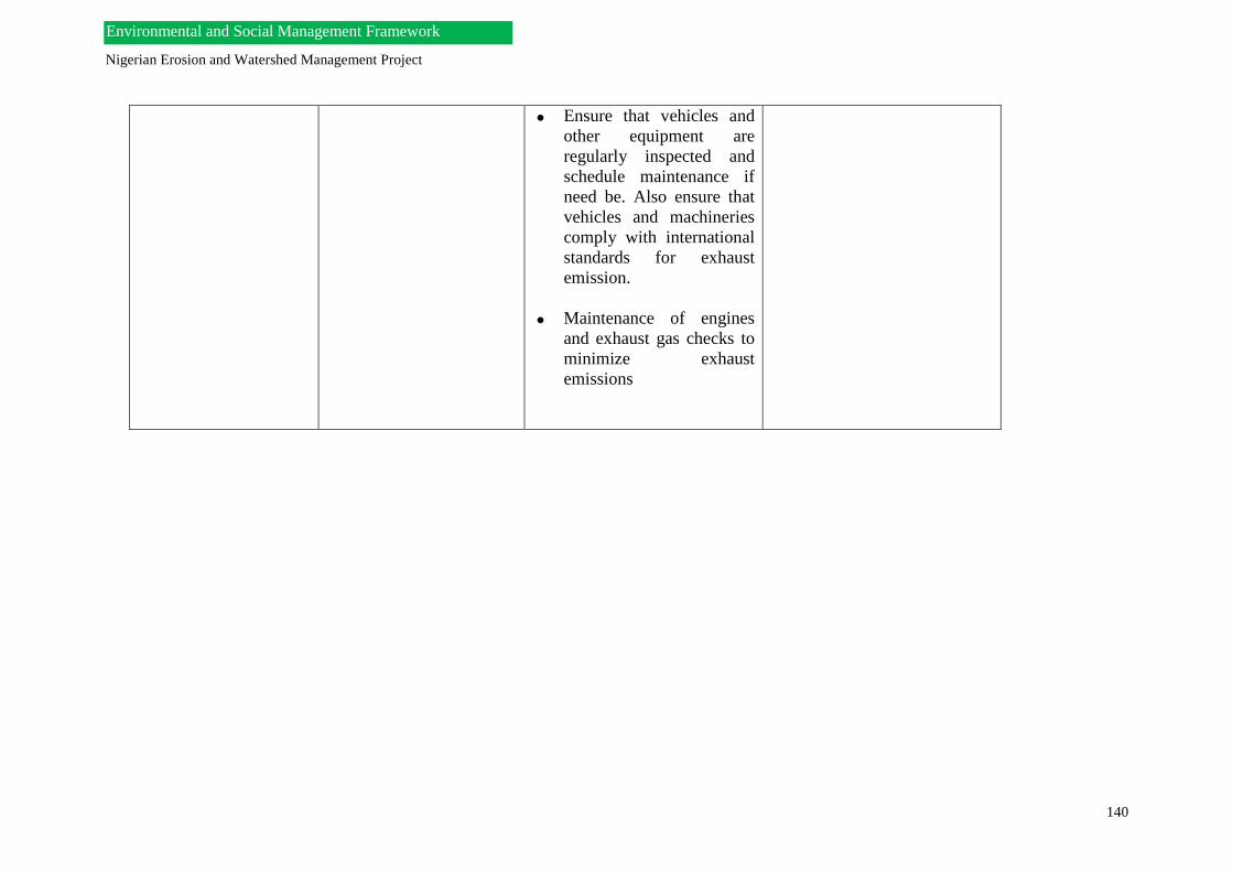
Nigerian Erosion and Watershed Management Project
140
Environmental and Social Management Framework
Ensure that vehicles and
other equipment are
regularly inspected and
schedule maintenance if
need be. Also ensure that
vehicles and machineries
comply with international
standards for exhaust
emission.
Maintenance of engines
and exhaust gas checks to
minimize exhaust
emissions

Nigerian Erosion and Watershed Management Project
141
Environmental and Social Management Framework
Increased sedimentation
and runoff
This impact is site-specific
and will be of concern to
project sites close to water
streams. Sediments can
significantly impact surface
waters and wetlands with
silts and pollutants such as
heavy metals, hydrocarbons
and toxic substances.
Runoff from rainfall can
further lead to erosion of the
road. Drainage channels
from the roads to nearby
watercourses are receptors
of soils eroded from the
road surfaces. These eroded
sediments can adversely
affect the aquatic ecosystem
and can even increase the
risk of flooding and
eutrophication.
Regular inspection of the
project sites will be
needed.
Construction like dykes,
sediments basins should be
considered in order to
divert the flow of
sediments.
Define watershed
boundaries and pollutants
of concern, and conduct
resource inventory and
information analysis.
Identify sensitive areas in
order to protect surface
water and prevent non-
point source pollution.
FNEWMAP-PMU,
SNEWMAP-PMU, FME,
Ministry of Works,
Ministry of Agriculture
and Rural Development,
NESREA
Water Quality
The water quality will be
impacted by wastewater
discharges from
construction activities and
behavioural practices of
workers associated with
• Mobile toilet facilities,
which will be provided for
the workforce be
maintained, emptied daily
and disposed of at
approved sites.
• SNEWMAP-PMU
Environmental Safeguard
Officer, FME, SMOE,
NESREA

Nigerian Erosion and Watershed Management Project
142
Environmental and Social Management Framework
the NEWMAP. This could
lead to increase in turbidity
and siltation affecting use
by man, land mammals and
aquatic organisms.
• Sewage can be composted
in compost bin (mixtures
of sewage, straws and
hays), which can be feed
to soils as source of
manure for the
community. Thus
recycling of sewage waste.
• The Contractor should
ensure that proper storage
facilities are provided at
worksites. They should be
leak proof and fitted round
with bunds to prevent
leakage into the water
streams.
• Development and
implementation of proper
Waste Management Plans
(WMPs) by the Contractor
(s).
Construction Phase
Biological Impact
Impact on flora and
fauna Clearing of vegetation.
Biodiversity will be
affected as a result of the
civil activities from the
construction phase.
Vegetation/vegetative
covers will be destroyed in
the course of
Identify any Site of
Special Scientific Interest.
Co-operate with relevant
MDAs such as the Federal
Department of Livestock,
Privately owned wildlife
conservation parks, Zoos
and Zoological
departments of
FNEWMAP-PMU and
SNEWMAP-PMU
Environmental Safeguard
Officer, Natural Resources
Officers

Nigerian Erosion and Watershed Management Project
143
Environmental and Social Management Framework
implementing civil works
and establishment of
construction campsites.
Exposure of the plant
surfaces to dust
particularly during the
transportation of materials
will destroy them
(impairment of
photosynthesis). Most
faunas, which may have
created niches for
themselves, will be
disturbed especially
borrowing mammals,
reptiles, amphibians and
insects.
Weed
invasion/proliferation of
opportunist species (weeds
& pests).
Universities, for the
housing of possible
animals that may be
relocated as a result of the
construction.
Ensure that affected flora
species are transferred and
raised in available
nurseries.

Nigerian Erosion and Watershed Management Project
144
Environmental and Social Management Framework
Impact on Wildlife during Land clearing,
Civil works,
Deforestation, Hunting
activities.
• Ensure that the necessary
safeguards policies such
the OP 4.04 on Natural
Habitats and OP 4.36
Forests and relevant
legislatives are used in
addressing the issue of
wildlife.
• Liaise with Zoos
Management Authorities
in the affected States and
Universities to provide
temporary habitats for
accommodating animal
species until new habitats
are provided.
• Afforestation practices
should be encouraged.
• FNEWMAP-PMU and
SNEWMAP, Natural
Resources Officers,
Ministry of Agriculture
and Rural Development
Use of Pesticides Encourage and ensure the
embrace of Integrated Pest
Management (IPM) See
Annex 006
Ensure the following in the
selection and use of
pesticides:
They must have
negligible adverse
human health effects;
They must be shown to
be effective against the
target species;
FNEWMAP-PMU,
SNEWMAP-PMU,
Environmental Safeguard
Officers, MOH, Ministry
of Agriculture, FME.

Nigerian Erosion and Watershed Management Project
145
Environmental and Social Management Framework
They must have
minimal effect on non-
target species and the
natural environment.
The methods, timing,
and frequency of
pesticide application
must be aimed to
minimize damage to
natural enemies; and,
Their use must take
into account the need
to prevent the
development of
resistance in pests.
Pesticides to be used
should comply with
permissible
environmental
standards (FAO,
UNEP)
FAO’s Pesticide
storage and stock
control manual,
Revised guidelines on
good labelling practice
for pesticides,
Guidelines for the
management of small
quantities of unwanted
and obsolete
pesticides, Guidelines

Nigerian Erosion and Watershed Management Project
146
Environmental and Social Management Framework
on Management
Options for Empty
Pesticide Containers,
and Guidelines on
personal protection
when using pesticides
in hot climates would
serve as guide.
Consistent with World
Bank OP 4.07,
NEWMAP financing
will not be used for
formulated products
that fall in WHO
classes IA and IB, or
formulations of
products in Class II, if
they are likely to be
used by, or be
accessible to, lay
personnel, farmers, or
others without
training, equipment,
and facilities to
handle, store, and
apply these products
properly.
Transportation & Traffic
impact:
Existing travel patterns
will be heavily impacted
during the construction
A good traffic management
plan should be developed
which will specify; safety
rules on speed limits while
driving, trainings to enable
FNEWMAP-PMU,
Environmental Safeguard
Officers, SNEWMAP-
PMU, Ministry of Works,

Nigerian Erosion and Watershed Management Project
147
Environmental and Social Management Framework
phase of the project in the
states.
drivers to be responsive to
local conditions,
procedures for dealing with
accidents involving injury
to local people and
livestock and restriction of
heavy vehicle movements
to specific access roads.
Carefully site stock piling
areas, work depots and
work sites in good
locations, which will
alleviate possible traffic
congestions.
Information on road
closure should be made
publicly on local radio
stations and television.
Signage advising on
closures and detours
should be strategically
placed along the roadsides.
Ensuring that all road signs
are put in place and detours
made possible to divert
traffic.

Nigerian Erosion and Watershed Management Project
148
Environmental and Social Management Framework
Ensure alternative
footpaths are provided for
local residents.
Relevant Federal
Government Agencies
such as the Federal Road
Safety Commission will be
engaged by the contractor
all through the construction
period to ensure that safety
is maintained throughout
the construction phase.
Construction Phase
Socio-economic Impact
Accident
Accidents are bound to
occur during the
construction phase as a
result of movement of
materials, equipment,
pedestrians and livestock.
Ensure that workers are
provided with health and
safety equipment such as
High visibility vest, helmets,
earplugs, safety glasses, and
safety boots and, stress on
the need to use them always.
Ensure that proper signs and
barriers are put up within the
project location sites.
Applying Standard
Operating Procedure (SOP)
during the project activities
to all workers.
Managing the working hours
based on the laws
FNEWMAP-PMU,
SNEWMAP-PMU, MDAs
(Ministry of Works,
Ministry of Labour

Nigerian Erosion and Watershed Management Project
149
Environmental and Social Management Framework
Implement generic dam
safety measures for small
dams.
Migration
Nomads and indigenous
people will be
predominately affected
during movements of
equipment into the project
areas by construction
companies implementing
sub-projects.
Source: Movement of
heavy equipment., Civil
work activities.
Implement RAP
Environmental and Social
Officers of the
FNEWMAP-PMU and
SNEWMAP-PMU (RPF
Consultant/RAP
Consultant)
Employment
The construction phase of
the sub project and main
project are bound to bring
in both positive and
negative impacts in the
project areas. Employment
will be on the increase as
local artisans and labourers
will be sort for as part of
the workforce. Migrants
will be expected to flood
into the areas as well. This
impact will have an
indirect influence in the
increase in crime rate,
Ensure that individuals
from project affected
communities are employed
as labourers and artisans.
Public consultation will be
implemented to address
any situation of wrong
notion created by members
of the communities.
The campsite for workers
should be located remotely
away for the community.
Contractors and Project
managers should ensure
that the workers are
prohibited from
FNEWMAP-PMU,
SNEWMAP-PMU,
Ministry of labour,
Ministry of Works.

Nigerian Erosion and Watershed Management Project
150
Environmental and Social Management Framework
traffic, and hike in rents,
prostitution and spread of
diseases.
patronising prostitutes and
the use of alcohol and
drugs within the site areas.
Human Displacement
Impact Source: Civil
activities, re-vegetative
activities, watershed
management
Resettlement Plan (RAP)
activities should be
considered in the affected
areas.
World Bank OP 4.12
addressing involuntary
resettlement will be applied
for this impact in the
affected communities.
Compensatory activities
should be established based
on replacement value or
market value and affected
person could be employed
based on experience and
qualification.
Social and Natural
Resources Officers of the
SNEWMAP-PMU and
FNEWMAP-PMU, Ministry
of Finance
Archeological & Cultural
loss
Impact Source:
Excavation/earth works,
deforestation activities and
other engineering activities
e.g water channelling
• The Social Officer needs to
ensure that thorough
discussions are carried out
during the Focus Group
meeting addressing issues on
Archaeology and cultural.
• The World Bank Operational
Policies relevant to this
situation such as OP 4.11
• Environmental, Social and
Natural Resources Officers of
the SNEWMAP-PMU and
FNEWMAP-PMU, Ministry
of Finance

Nigerian Erosion and Watershed Management Project
151
Environmental and Social Management Framework
Physical and Cultural
Resources will be applied to
enable the Social Officer
administer the right tool to
avoid cases of conflicts in the
communities.
Social stress & disruption
Impact Source:
• Civil work activities.
• Human
•Governance. (Corrupt
practices)
Root causes should be
identified and addressed.
• Address governance and
mobilize communities.
• Engage the private sector,
and possibly introduce a
market-based solution to take
advantage of good Nigerian
entrepreneurship and
creativity.
Social Officers of the
SNEWMAP-PMU and
FNEWMAP-PMU, Ministry
of Finance
Aesthetics
Impact Source:
Construction works
Proper use engineering best
practice;
Employ an aesthetics expert
to the contractor team.
Environmental Officers of
the SNEWMAP-PMU and
FNEWMAP-PMU,

Nigerian Erosion and Watershed Management Project
152
Environmental and Social Management Framework
Construction Phase
Public Health
HIV/AIDS and STDs
Impact Sources
Influx of non-local
workforce.
Low living standards of
members of the host
community which will
increases likelihood of
social vices such as
prostitution, robbery,
etc.
Effort will be made to
enlighten the employees on
HIV/AIDS and STD
awareness programme in
each of the project areas.
Other activities will include
treating other sexually
transmitted diseases,
distributing condoms, and
providing counseling,
screening, and support
services for employees.
Medical examinations
should be performed on new
employee and repeated
regularly throughout the
term of employment.
Each contractor should have
operating procedures that
control unsafe behaviours
amongst personnel
especially considering the
fact that there will huge
influxes of workers and the
likely spread of STD’s due
to possible sexual
interactions between
workers and members of the
Environmental and Social
Officers of the SNEWMAP-
PMU and FNEWMAP-PMU,
SMOE
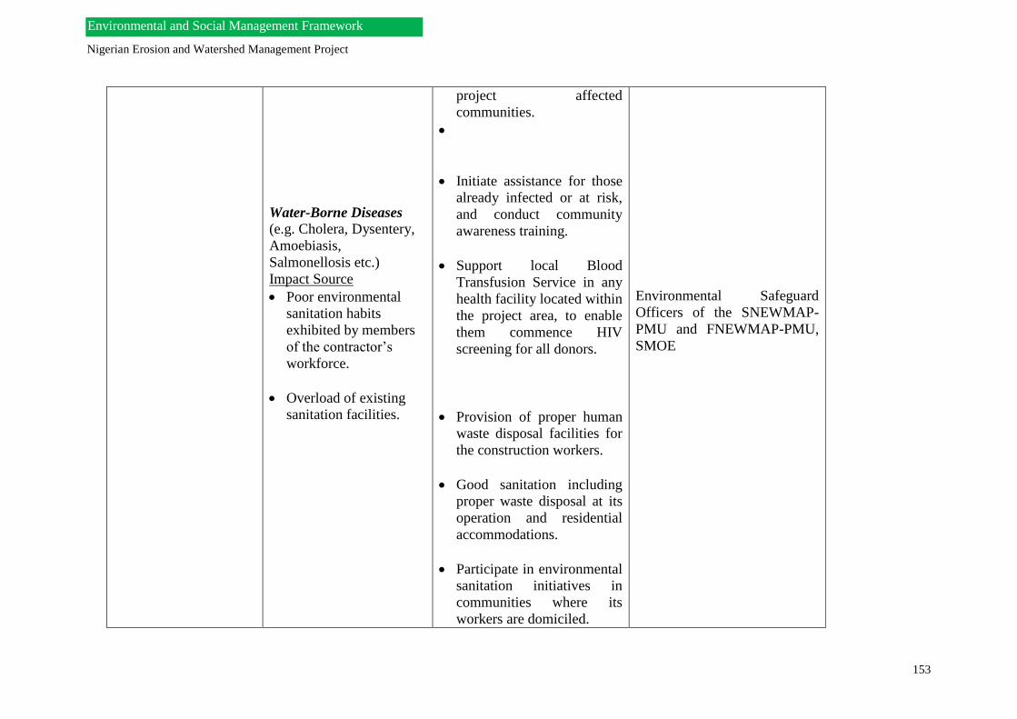
Nigerian Erosion and Watershed Management Project
153
Environmental and Social Management Framework
Water-Borne Diseases (e.g. Cholera, Dysentery,
Amoebiasis,
Salmonellosis etc.)
Impact Source
Poor environmental
sanitation habits
exhibited by members
of the contractor’s
workforce.
Overload of existing
sanitation facilities.
project affected
communities.
Initiate assistance for those
already infected or at risk,
and conduct community
awareness training.
Support local Blood
Transfusion Service in any
health facility located within
the project area, to enable
them commence HIV
screening for all donors.
Provision of proper human
waste disposal facilities for
the construction workers.
Good sanitation including
proper waste disposal at its
operation and residential
accommodations.
Participate in environmental
sanitation initiatives in
communities where its
workers are domiciled.
Environmental Safeguard
Officers of the SNEWMAP-
PMU and FNEWMAP-PMU,
SMOE

Nigerian Erosion and Watershed Management Project
154
Environmental and Social Management Framework
Malaria
During construction
activity through
creation of pools of
stagnant water.
Poor environmental
sanitation habits by
members of the
contractor’s workforce.
Movement of waste into
the watershed
Avoid any deterioration in
public health and
environmental sanitation as
a result of the project.
Participate on improvement
of community sanitation and
public health through the
community development
programs.
Involvement of NGOs and
civil societies in waste
management and healthcare
activities.
Maintenance of good
drainage at construction
areas to avoid creation of
stagnant water bodies.
Proper reservoir operation,
engage in disease
surveillance and insecticide
sprays to prevent the
proliferation of the disease

Nigerian Erosion and Watershed Management Project
155
Environmental and Social Management Framework
vector; conduct routine
medical check-ups and
development of medical
facilities.
Government programs to
improve existing medical
and health services in the
local communities should be
supported as much as
possible by the Project. This
includes Mosquito control
programs such as the
distribution of insecticide
treated nets to affected
community members.
Provision of good sanitation
including proper waste
disposal at its operation and
residential accommodations.
Participate in environmental
sanitation initiatives in
communities where its
workers are domiciled.

Nigerian Erosion and Watershed Management Project
156
Environmental and Social Management Framework
Occupational Health &
Safety
a.PPEs
b.Emergency Response
& First Aids
• The contractor will ensure
that Personal Protective
Equipment (PPE) are made
available to all workers.
• The Contractor should ensure
that necessary measures to
avoid and minimize the
negative health and safety
impacts such as trainings for
employees be established.
• Contractors should develop
Occupational Health and
Safety Systems (OHSMSs),
which will include policies,
plans, procedures, processes
and programs.
• Contractors should posses
operating practices for the
following: Accident investigation
and control
Hazards investigation and
analysis
Hazard communication
programme
Work place violence
Work stress risk
assessment/ work stress
management plans
Ergonomics
Heavy equipment safety
SNEWMAP-PMU and
FNEWMAP-PMU, Ministry of
Works, Ministry of Labour
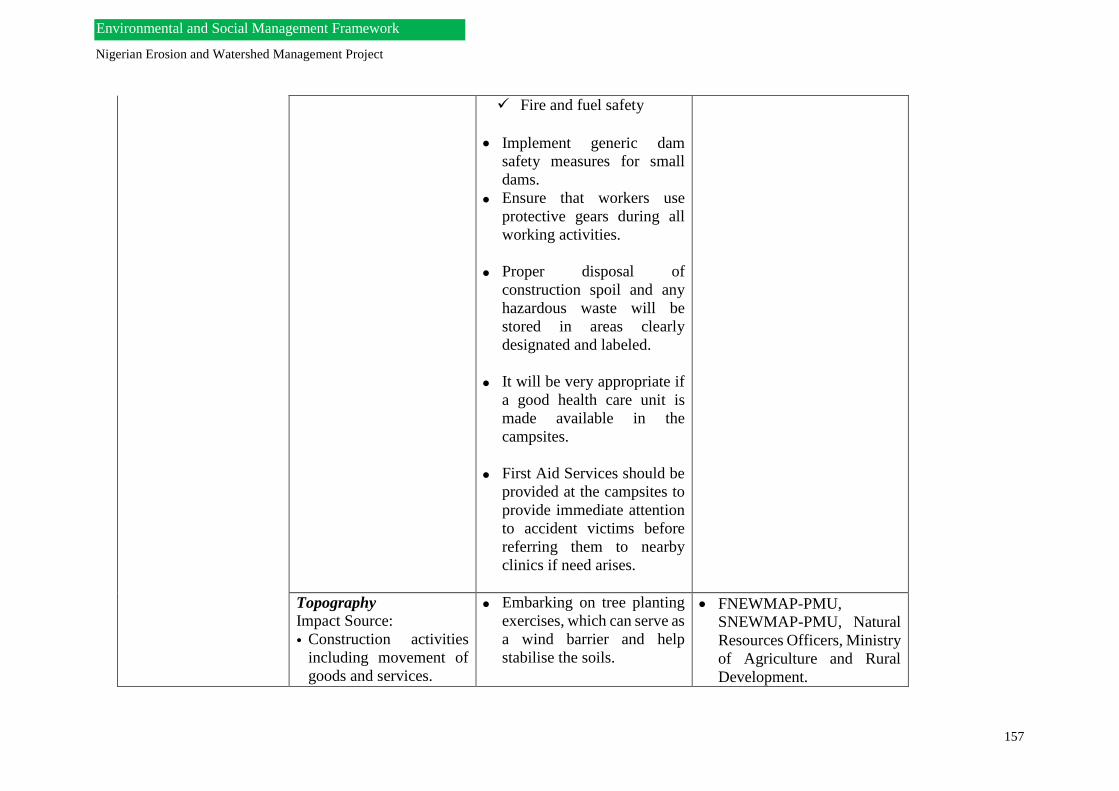
Nigerian Erosion and Watershed Management Project
157
Environmental and Social Management Framework
Fire and fuel safety
Implement generic dam
safety measures for small
dams.
Ensure that workers use
protective gears during all
working activities.
Proper disposal of
construction spoil and any
hazardous waste will be
stored in areas clearly
designated and labeled.
It will be very appropriate if
a good health care unit is
made available in the
campsites.
First Aid Services should be
provided at the campsites to
provide immediate attention
to accident victims before
referring them to nearby
clinics if need arises.
Topography
Impact Source:
• Construction activities
including movement of
goods and services.
Embarking on tree planting
exercises, which can serve as
a wind barrier and help
stabilise the soils.
FNEWMAP-PMU,
SNEWMAP-PMU, Natural
Resources Officers, Ministry
of Agriculture and Rural
Development.

Nigerian Erosion and Watershed Management Project
158
Environmental and Social Management Framework
• Agricultural activities.
Training activities targeted
at local farmers to improve
awareness.
The affected population
identified will participate in
the planning and/or decision
making process for the
alternative livelihood
options and the process and
agreement will be in line
with relevant operational
policies.
Good engineering practices
to be included in contract
documents and contractor’s
performance will be
monitored and reported.
Land use Impact Source:
• Civil works.
• Farming practices. • Livestock including
overgrazing.
• Encouragement of early and
on-going consultation within
the local community.
• Providing complimentary
livelihood (promoting
alternative means of income
(which is sustainable and
adaptable for each
community).
• Improve roles of NGOs and
Civil Society.
• Environmental, Social and
Natural Resources Officers of
the FNEWMAP-PMU and
SNEWMAP-PMU

Nigerian Erosion and Watershed Management Project
159
Environmental and Social Management Framework
• Ensures these exercises are
conducted in environmental
sustainable manners
• If land acquisition and/or land
donation is involved,
resettlement policy
framework will be applied
• Good engineering practices to
be included in contract
documents and contractor’s
performance will be
monitored and reported.
Air Quality
Once the NEWMAP
projects are completed for
the entire seven (7) states,
the roads are bound to be
really busy and this will
adversely affect the
members of the
community
Impact Source: Increase in
the number of vehicles that
ply the route of the seven
(7) project areas.
Ensure that the air quality
levels are constantly
monitored which can be
obtained from relevant local
air pollution control
agencies/ metrology units in
the states.
Surrounding the roadsides
with vegetation will be
encouraged as the trees will
serve as windbreaks and
keep dust from spreading
long distances.
Environmental Officers of the
FNEWMAP –PMU and
SNEWMAP-PMU, NESREA,
Ministry of Agriculture and
Rural Development
Noise and Vibration
Impact Source: The traffic management
plan should be used to
address movement of
Environmental Officers
FNEWMAP-PMU,

Nigerian Erosion and Watershed Management Project
160
Environmental and Social Management Framework
Increase in number of
vehicles plying the road
vehicles during the early
hours of the morning
when members of the
community are still
asleep.
Keeping proper records
of complaints in the
complaints register.
SNEWMAP-PMU,
NESREA
Water Quality
Impact Source:
Roadway runoff, wastes
(municipal solid wastes,
agricultural wastes,
effluent, hazardous wastes
e.t.c)
Development of proper
Waste Management plans by
the Contractor (s).
Roadway runoff will not be
placed directly into
watercourses but allowed to
flow over grassed or
pervious pavements in order
to permit the settling out of
fine materials.
Divert the flow of surface
water around the site to
prevent contamination from
storm water (by pollutants,
soil or any other material
from the site).
It is also important to
develop a site drainage plan
to reduce storm water flow
Environmental Safeguard
Officers FNEWMAP-PMU,
SNEWMAP-PMU, FME,

Nigerian Erosion and Watershed Management Project
161
Environmental and Social Management Framework
and sediment load before
storm water is discharged
from the site.
Traffic and
Transportation
Impact Source:
Increase in traffic
within the roads and
access roads of the
project areas in the
NEWMAP states.
Increase in economic
growth.
Increase in migration
Ensure that all road signs are
completed with speed limits
zones and traffic signs in
place.
Provide pedestrian pathways
within the settlements of the
communities.
Measure suggested for the
construction phase should be
carried forward to the
operational stage.
FNEWMAP-PMU,
SNEWMAP-PMU, NESREA

Nigerian Erosion and Watershed Management Project
162
Environmental and Social Management Framework
Employment, Working
Opportunities
Impact Source:
• Demobilisation of the
workforce.
• Improved accessibility
• Improved economic
growth Impact Indicator:
• Presence of new small
business enterprises
• Improving economics of
families
Conducting a persuasive
approach of community
involvement, and
proactively providing
guidance to help maintain
the road and bridges.
Co-operating with the
relevant departments to help
in building economic centres
such as market places.
Requesting the state and
local governments to build
feeder roads to connect the
settlement areas with the
road.
Environmental Safeguard
Officers, FONGO,
FNEWMAP-PMU,
SNEWMAP-PMU, Ministry
of labour.
Occupational Health &
Safety
a. PPEs
b. Emergency Response
& First Aids
Impact Source:
Exposure of workers to
accidents, working in
potential weather
extremes, contact with
natural hazards such as
animals, insects, and
poisonous plants.
Development of inspection
and maintenance
programmes.
Clearly mark road signs and
hazards symbols within the
location to minimise road
accidents.
FNEWMAP-PMU,
SNEWMAP-PMU,
Environmental Safeguard
Officers, Natural Resources
Officers,NESREA, Ministry
of Labour, Ministry of
Health
Nigerian Erosion and Watershed Management Project
163
Environmental and Social Management Framework

Nigerian Erosion and Watershed Management Project
164
Environmental and Social Management Framework
CHAPTER NINE
PUBLIC CONSULTATION AND STAKEHOLDER INVOLVEMENTS
9.0 Public Consultation
Public consultation for the NEWMAP entails the process of informing the communities on the
need to carry out the Erosion and Watershed management sub-projects in (1) their environment,
(2) the scope and the (3) need for the community to own and safeguard the project as
beneficiaries and stakeholders.
Public consultation is very important because it will give the communities and the potentially
Project Affected Person(s) the opportunity to contribute input and feedback information, aimed
at strengthening the development project and avoiding negative impacts or mitigating them
where they cannot be avoided. It also reduces the possibilities of conflicts between and among
the APs and PMU. The rural communities will mostly be the beneficiaries of this project.
Therefore, effective and close consultation with them is a pre-requisite for the successful
running and execution of the NEWMAP. In recognition of this, efforts will be made to carry
out the public consultation in the new states with potentially affected individuals/households
when resettlement and compensation concerns are involved.
Public consultation should take place at the inception of the planning stages when the potential
Erosion and watershed sites are being investigated.
Public consultation would be an on-going activity taking place throughout the entire project
process. Public participation and consultation would take place through meetings, radio
programs, requests for written proposals/comments, filling in of questionnaires, explanations
of project to the locals, making public documents available at the federal, state and local levels.
At the local level, suitable locations will include the Village squares, churches halls, residences
of traditional or recognized leaders. These measures would take into account the low literacy
levels prevalent in these rural communities by allowing enough time for responses and
feedback. Notwithstanding, the best guarantors for public interest are the chiefs and other
religious leaders who are responsible members of their local communities and can
inadvertently be part of the potentially displaced (economically or physically)
individuals/households either in part or in whole.
The Resettlement Consultant, the Social Officer of the PMU and nominated leaders from the
community, will facilitate the monitoring of the public consultation process.
9.1 Stakeholder Focused Group Discussion and Interpretation
This section describes the findings and information analysis obtained during stakeholder
consultation within the seven (7) mover States while arrangement would be made for the new/
newer states of the NEWMAP, although, the project took advatage second MTR in December,
2018 where a reasonable number stakeholders were present had consultations with
stakeholders. Stakeholders present in all interactions comprised of Commissioners, Permanent
Secretaries, NEWMAP State Coordinators (where present), Directors, HODs of host state
ministries of environment, other line ministries (MDAs), Community Based Organizations
(CBOs), Non-Governmental Organizations (NGOs), Representatives/Leadership of at risk
communities, and Heads of community households.

Nigerian Erosion and Watershed Management Project
165
Environmental and Social Management Framework
Consultations were implemented using the methodology described in Chapter 1 for Focus
Group Discussions by the utilization of semi-structured questionnaires and field visitation to
priority sites and at risk communities.
Information in this section is completely based on responses from (i) stakeholders, (ii)
documented reports in state holdings and (iii) by physical site observations.
9.2 Consultations with the first mover states as at 2011 (phase I)
The stakeholder consultations process for the states visited can be found in Annex 009.
9.2.1 Situation Report- Enugu State
State NEWMAP-PMU Status-The ESMF and RPF consultants visited the state on the 25th of
July, 2011. Informal interactive sessions with the State Commissioner of Environment and
Solid Minerals and State Permanent Secretary for Environment and Solid Minerals revealed
that actions are in progress towards instituting a competent state NEWMAP-PMU. The
consultant team was briefed on the issue that the State Ministry of Environment (SME) had
conducted interviews for a Coordinator of the State NEWMAP-PMU and is awaiting the
outcome. On the 26th of July, 10.00am prompt, a formal interactive session was held in the
office of the Commissioner. Focus Group Discussions (FGDs) were held at the State, MDA,
CBO, NGO and Community Leadership levels. This session provided insight to the state
legislations and laws on ‘Land Use’, indigenous or traditional methods of erosion and
watershed management, state government methods for engaging local communities and
achieving participation in implementation projects.
Other needs of importance for information gathering included;
a. Process for land acquisition within the state
b. List of priority erosion sites
c. List of major watershed/ water catchment areas in the states
d. Indigenous communities in proximity to erosion sites
e. Major language groups
f. Estimated at risk populations size
g. Major kinds of business in at risk communities
h. Peripheral vegetation description
i. Traditional and Political structure within at risk communities
Present at the interactive stakeholder consultation sessions were:
Host Ministry (Ministry of Environment and Solid Minerals)
1. Honourable Commissioner
2. Honourable Permanent Secretary
3. Director, Planning
4. Director, Pollution Control
5. Director, Finance and Administration
6. Director of Forestry
7. HOD, Environmental Conservation
8. HOD, Ecology and Mineral Resources
9. HOD, Environmental Health
10. PRO

Nigerian Erosion and Watershed Management Project
166
Environmental and Social Management Framework
Other Line Ministries
1. Ministry of Agriculture
2. Ministry of Works
3. Ministry of Information
4. Ministry of Lands
5. Ministry of Water Resources
6. Ministry of Human Capital Development (Honourable Commissioner Ministry of
Human Capital Development
CBOs and NGOs
1. CIDJAC
2. Voice of Children
3. ASERNGO (Association of Enugu State Resident) NGOs
Duties and functions of the Ministry of Environment and Solid Minerals Enugu State are
enumerated in the ministry’s regulations under section 5 sub-sections 2 of law No. 8, 2004.
9.2.2 Situation Report- Imo State
State NEWMAP-PMU Status-The ESMF and RPF consultants visited the state on the 27th of
July 2011. A formal interactive session was held with the State Commissioner for Petroleum
and Environment, and the State Permanent Secretary of the Ministry of Petroleum and
Environment prior the consultation forum with expected stakeholders. A formal stakeholder
consultation and interactive session was held in the conference room of the Ministry of
Petroleum and Environment at 2.00pm prompt on the 27th of July 2011 and 10.00am prompt
on the 28th of July 2011 during which Focus Group Discussions (FGDs) were held at the State,
MDA, CBO, NGO and Community Leadership levels. This session laid the foundation for
introductory information on the NEWMAP and further insight to the state issues and processes
on ‘Land Use’, the current erosion and watershed management status in the state and state
government methods for engaging local communities and achieving participation in
implementation projects.
Other needs of importance for information gathering included;
a. Process for land acquisition within the state
b. List of priority erosion sites
c. List of major watershed/ water catchment areas in the states
d. Indigenous communities in proximity to erosion sites
e. Major language groups
f. Estimated at risk populations size
g. Major kinds of business in at risk communities
h. Peripheral vegetation description
i. Traditional and Political structure within at risk communities
Present at the interactive stakeholder consultation sessions were:
Host Ministry (Ministry of Petroleum and Environment)
1. Honourable Commissioner
2. Honourable Permanent Secretary
3. Director, Administration
4. Director, Finance

Nigerian Erosion and Watershed Management Project
167
Environmental and Social Management Framework
5. Ag Director, Petroleum
6. Ag Director of Forestry
7. Ag Director Environment and Ecology
8. Scientific Officer II
Other Line Ministries
1. Ministry of Agriculture
2. Ministry of Information
3. Ministry of Works
4. Ministry of Lands, Survey and Urban Planning
5. Ministry of Public Utilities and Rural Development
6. Ministry of Women Affairs
7. Ministry of Works, Housing and Transport
8. Ministry of Human Development
9. Local Government Service Commission
CBOs and NGOs
1. Ihioma Network
2. OBS
3. DDI (Diversity Disaster Initiative)
Private Sector
1. Oil Resources and Allied Investors Limited
9.2.3 Situation Report- Abia State
State NEWMAP-PMU Status-The state was visited on the 28th of July, 2011. A formal
interactive session was held with the Permanent Secretary of the Ministry of
Environment/Nature Resource, Abia State. A formal stakeholder consultation and interactive
session was held in the office of the Permanent Secretary at 2.00pm prompt. Focus Group
Discussions (FGDs) were held at the State, MDA, CBO, NGO and Community Leadership
levels.
Other needs of importance for information gathering included;
a. Process for land acquisition within the state
b. List of priority erosion sites
c. List of major watershed/ water catchment areas in the states
d. Indigenous communities in proximity to erosion sites
e. Major language groups
f. Estimated at risk populations size
g. Major kinds of business in at risk communities
h. Peripheral vegetation description
i. Traditional and Political structure within at risk communities
Present at the interactive stakeholder consultation sessions were:
Host Ministry (Ministry of Environment/Nature Resource)
1. Honourable Permanent Secretary

Nigerian Erosion and Watershed Management Project
168
Environmental and Social Management Framework
2. Director, Environment
3. Director, Flood/Erosion Control
4. Director, Administration
5. Director, Finance
6. Health Director
7. Director, Forestry
8. Director, Solid Minerals
9. Ag Director, Conservations
10. Ag Director, Research and Planning
Other Line Ministries
1. Ministry of Agriculture
2. Ministry of Information
3. Ministry of Works
4. Ministry of Lands
5. Ministry of Public Utilities
6. Ministry of Commerce and Industry
7. Ministry of Health
8. Strategic Controls
CBOs and NGOs
1. SEMA (Safe Environment Movement for Abia)
Private Sector
1. Petroleum Services Limited
9.2.4 Situation Report- Cross River State
State NEWMAP-PMU Status-The state was visited on the 29th and 30th of July, 2011. A
formal interactive session was held with the Commissioner for and Permanent Secretary of
the Ministry of Environment, Cross River State. A formal stakeholder consultation and
interactive session was held in the office of the Permanent Secretary at 12.00pm prompt.
Focus Group Discussions (FGDs) were held at the State, MDA, CBO, NGO and Community
Leadership levels.
Other needs of importance for information gathering included;
a. Process for land acquisition within the state
b. List of priority erosion sites
c. List of major watershed/ water catchment areas in the states
d. Indigenous communities in proximity to erosion sites
e. Major language groups
f. Estimated at risk populations size
g. Major kinds of business in at risk communities
h. Peripheral vegetation description
i. Traditional and Political structure within at risk communities
Present at the interactive stakeholder consultation sessions were:
Host Ministry (Ministry of Environment/Nature Resource)

Nigerian Erosion and Watershed Management Project
169
Environmental and Social Management Framework
1. Honourable Commissioner, Environment
2. State Co-ordinator NEWMAP
3. Director, Environment
4. Director, Flood/Erosion Control
5. Director, Environmental Health and Pollution Control
6. Director, Finance
7. Ag Director Coastal Zone Management
8. Ag Director, Urban Centre Development
9. Research and Planning Officers
Other Line Ministries
1. Ministry of Social Welfare and Community Development
2. Ministry of Agriculture
3. Ministry of Lands and Housing
4. Ministry of Works
5. Ministry of Local Government Affairs
6. Forestry Commission
7. Calabar Urban Development Authority (CUDA)
CBOs and NGOs
1. Achu Foundation
2. Concern Universal
3. Department of International Donor Support
4. Green Concern for Development (GREENCODE)
5. Rural Women and Youth Development Initiative (RWAYDI)
9.2.5 Situation Report- Anambra State
State NEWMAP-PMU Status-The state was visited on the 1st of August 2011. A formal
interactive session was held with the Commissioner for Environment, Permanent Secretary of
the Ministry of Environment, Anambra State. A formal stakeholder consultation and interactive
session was held in the office of the Permanent Secretary at 10.00am prompt. Focus Group
Discussions (FGDs) were held at the State, MDA, CBO, NGO and Community Leadership
levels.
Other needs of importance for information gathering included;
a. Process for land acquisition within the state
b. List of priority erosion sites
c. List of major watershed/ water catchment areas in the states
d. Indigenous communities in proximity to erosion sites
e. Major language groups
f. Estimated at risk populations size
g. Major kinds of business in at risk communities
h. Peripheral vegetation description
i. Traditional and Political structure within at risk communities
Present at the interactive stakeholder consultation sessions were:
Host Ministry (Ministry of Environment)

Nigerian Erosion and Watershed Management Project
170
Environmental and Social Management Framework
1. Honourable Permanent Secretary
2. Rep. Honourable Permanent Secretary Youth and Sports
3. Director, Environment and Ecology
4. Director, Flood/Erosion Control
5. Director, Administration
6. Director, Finance
7. Director PRS
8. Director, Forestry
9. Director, Solid Minerals
Other Line Ministries
1. Ministry of Agriculture
2. Ministry of Information
3. Ministry of Works
4. Ministry of Lands
5. Ministry of Public Utilities
6. Ministry of Health
CBOs and NGOs
6. Thomas Aquinas Church
7. Anambra State Urban Development Board (ASUDEB)
Private Sector
1. Environmental and Human Resources Ltd
2. N.S.C Bullock
9.2.6 Situation Report- Edo State
State NEWMAP-PMU Status-The ESMF and RPF consultants visited the state on the 4th of
August, 2011. Informal interactive sessions with the State Permanent Secretary for
Environment and Public Utilities further consultations were held at the State, MDA, CBO,
NGO and Community Leadership levels.
Other needs of importance for information gathering included;
j. Process for land acquisition within the state
k. List of priority erosion sites
l. List of major watershed/ water catchment areas in the states
m. Indigenous communities in proximity to erosion sites
n. Major language groups
o. Estimated at risk populations size
p. Major kinds of business in at risk communities
q. Peripheral vegetation description
r. Traditional and Political structure within at risk communities
Present at the interactive stakeholder consultation sessions were:
Host Ministry (Ministry of Environment and Public Utilities)

Nigerian Erosion and Watershed Management Project
171
Environmental and Social Management Framework
1. Permanent Secretary
2. Director, Environment
3. Director, Flood/Erosion Control
4. Director, Public Utilities
5. Director, Finance
6. Health Director
7. Director, Forestry
8. Director, Solid Minerals
9. Ag Director, Conservations
10. Ag Director, Research and Planning
Other Line Ministries
1. Ministry of Agriculture
2. Ministry of Information
3. Ministry of Works
4. Ministry of Lands
5. Ministry of Health
CBOs and NGOs
1. CPED (Centre for Population and Environment Development)
2. Land-lord Association (Benin City)
9.3 Responses to Concerns Raised with the fisrt mover states:
The general responses made by all stakeholders consulted were not directed towards negative
perceptions but rather positive perception on the NEWMAP capacity to solve erosion in the
project affected states. From the tables above, respondents provided information on their
current knowledge of the erosion problems within their localities and showed good
expectations that NEWMAP sub-projects will rather raise more positive impacts than negative
impacts. A summary of major concerns raised is listed below.
Land use management and land use – High priority concern
Road drainage pattern – High priority concern
Flood damages to homes, businesses and schools- High priority concern
Effect on production systems- Moderate priority concern
Involuntary resettlement – Moderate-low priority concern
Project effect on cultural heritage and others – Low priority concern
Note: Priority sites were selected using the screening format in annex of this document.
General benchmarks used included:
Site proximity to affected communities
Degree of erosion at sites
Level of complaints raised by communities
Geomorphology of the surveyed sites
Degree of risks
If sites were located on major access routes

Nigerian Erosion and Watershed Management Project
172
Environmental and Social Management Framework
9.4 Consultations in the new/newer states as at 2017 (phaseII)
Below is the summary of consultation with the new/newer states, this will be updated as some
of the states are in the process of identifying their key stakeholders.
Nigerian Erosion and Watershed Management Project
173
Environmental and Social Management Framework
9.4.1 Stakeholders Issues
Community participation is considered to be a fundamental tool for managing a two-way
communication between the SPMU and the public, aimed at building and improving decision
making by actively involving relevant stakeholders. Basically, the stated needs of the
stakeholders can be grouped into several main issues including improved road networks to
assist the transport of people and goods, educational facilities and training opportunities both
in the formal and informal sectors, up-grading of health care services and facilities, job
opportunities from government, enhanced economic activities through market facilities and
access to capital. Youth groups are more concerned with employment and training since they
are largely the ones with limited alternatives. Also, women are more concerned with
trading/markets due to their roles and responsibilities as mothers and homemakers.
Fears and Expectations
The fears expressed by community members are many and varied and include the following:
The main fear expressed by the people was about a possible delay in the commencement
of construction works due to the onset of rainy season.
Another concern expressed by the people was predicated on their previous experience
with some Construction Companies in the past which came to fix the erosion problem
but abandoned it at a worse condition than they met it. Thus, they expressed some
apprehension, but were optimistic that NEWMAP will act differently.
Fears were also expressed on ensuring timely payment of compensation for project
affected houses and economic trees.
Most of the community members expressed concern over the environmental and social
hazards (e.g. road obstruction, noise and dust, etc.) that might be associated with project
works, but noted that such temporary difficulties do not bother them because the project
benefits far out-weigh them.
Expectations
The people have certain expectations from the State and Federal Government of Nigeria and
the World Bank. The under-listed were generally considered the priority needs in the project
communities:
Construction of a Health Centre project Communities in the states
Asphalting of internal roads within the community
Provision of pipe-borne water for the people
Up-grading of the public schools in the communities
Provision of street lights in the project communities
The people were looking forward to the issue of compensation for land taken up by
project
They have great expectations concerning the prospect of youth employment during
intervention works at the gully site
Scholarships for children
Formation of erosion site committees with membership drawn from the communities.

Nigerian Erosion and Watershed Management Project
174
Environmental and Social Management Framework
The NEWMAP erosion control project is a development that the people are enthusiastically
waiting for and they are very expectant of the benefits that the project will bring to the people.
The project is expected to rescue many structures that are at the tipping point of being
swallowed, and they include houses, economic trees, useful land, lives and property. This
project therefore is expected to have both short and long-term benefits to the host communities
in the states and the Nigerian nation at large.

Nigerian Erosion and Watershed Management Project
175
Environmental and Social Management Framework
CHAPTER TEN
PREPARATION OF SITE SPECIFIC ESIA and ESMP
10.1 Introduction
This chapter provides a brief on the ESIA process required before the implementation of sub-
projects for which the screening process has determined that an ESIA is necessary. The ESIA
will identify and evaluate potential environmental and social impacts that NEWMAP sub-
projects activities may pose. The preparation of the ESIA will be done in consultation with
stakeholders, including PAPs. Public consultations are critical in preparing proposals for sub-
project activities likely to have impacts on the environment and populations within project
states. The public consultations should identify key issues and determine how concerns of all
stakeholders will be addressed in ESIA. Major processes under the ESIA process are provided
below.
10.2 Scoping
Scoping is the process of determining the most critical issues to study and will involve
community participation to some degree. It is at this early stage that ESIA can most strongly
influence the outline proposal.
For successful implementation of sub-project activities requiring ESIA under the NEWMAP-
AF, scoping will occur early in the project cycle, as is consistent with international best
practices including World Bank OP/BP 4.01 and the Nigerian EIA Law. It will begin at the
same time as outline planning and pre-feasibility studies. The scoping process will aid in the
identification of the key environmental and social issues and is perhaps the most important step
in an ESIA. The scoping process under the NEWMAP-AF will involve participation from
several stakeholder groups, particularly decision makers (Federal and State governments),
MDAs, CBOs, NGOs, the project affected communities and the scientific community. All these
groups will have an interest in helping to deliberate the issues, which should be considered
(scoping is designed to canvass their views).
Scoping is important for two reasons. Firstly, so that problems can be pinpointed early allowing
mitigating design changes to be made before expensive detailed work is carried out. Secondly,
scoping is done to ensure that detailed prediction work is only carried out for important issues.
It is not the purpose of an ESIA to carry out exhaustive studies on all environmental impacts
for all projects. If key issues are identified and a full scale ESIA considered necessary, then the
scoping should include terms of reference for these further studies. At this stage the option
exists for cancelling or drastically revising the project should major environmental problems
be identified. Equally the need for the ESIA process may be terminated should the impacts be
found to be insignificant. Once this stage has passed, the opportunity for major changes to the
project is restricted.
10.3 Baseline Data Information
Baseline data information is an important reference point for conducting ESIA. The term
"baseline" refers to the collection of background information on the biophysical, social and
economic settings of the proposed project area. Normally, information is obtained from
secondary sources when there exists facility of database, or the acquisition of new information

Nigerian Erosion and Watershed Management Project
176
Environmental and Social Management Framework
through field samplings. The task of collecting baseline data starts right from the period of
project inception however; a majority of this task may be undertaken during scoping.
Objectives of Baseline Data Collection
To provide a description of the status and trends of environmental factors or variables
(e.g., gully size, soil, vegetative cover, topography, geomorphology, drainage system¸
water quality, suspended particulate, sediment transport and waste management etc.)
against which predicted changes can be compared and evaluated in terms of importance,
and
To provide a means of detecting actual change by monitoring once a project has been
initiated.
The ESMF requirements for ESIAs maintain that for each site-specific ESIA, baseline data on
the original environmental, socio-economic (demographic structure, settlement pattern,
occupation, social networks) and health conditions around the NEWMAP-AF prioritized
erosion and watershed sites within the project states be described and reported in project ESIA
documents. This process will help establishments responsible for ESMF implementation
(FNEWMAP-PMU, SNEWMAP-PMU etc.) understand the baseline conditions of project
areas before civil work activities begin, and as well provide a platform to monitor changes that
may occur in the physical, biological and social environments due to developmental works. In
particular, results of the documentation and analysis of the baseline conditions will inform the
engineering designs and point to potential livelihood options subsequently.
The NEWMAP as a whole is geared towards maximization of positive impacts. The gathering
of baseline data information will aid in the development of indicators to demonstrate the effect
of civil work activities on all baseline conditions. Information on general baseline conditions
of some of the States benefiting from the NEWMAP-AF is found in this ESMF document
(Chapter 4), however precise baseline information on gully sizes especially for prioritized sites
will be provided during and after the conduct of site-specific ESIAs.
10.4 Public Consultation
Public consultation is very important because it will give the communities and the potentially
Project Affected Person(s) the opportunity to contribute input and feedback information, aimed
at strengthening the development project and avoiding negative impacts or mitigating them
where they cannot be avoided. The following below are very important for consultation under
ESIA.
10.4.1 Venue
A suitable venue must be selected for in-depth public consultation, especially at the community
level. Venues can range from town halls to open fields used by the communities for meetings.
10.4.2 People Required for Public Consultation
Public consultation is a very delicate process and most comprise individuals other than the
party who is organizing the consultation. At the level of the NEWMAP-AF, public consultation
will involve the following groups of people:
Independent Consultants

Nigerian Erosion and Watershed Management Project
177
Environmental and Social Management Framework
Federal and State NEWMAP-PMU
MDAs, CBOs, NGOs and Civil Societies
Member of project affected communities.
10.4.3 Public Consultation Gender Selection Strategy
Consultation should be based on gender separation. This is viewed to be very important as
both genders (male and female) may have different views on the impacts of the project. In
some communities, female opinions may be viewed to be insignificant and of no importance.
For good and proper consultation, views/comments from all genders is very important
especially, to inform the project implementation bodies on the gender-specific perceptions of
inhabitants within project affected states.
10.4.4 What should be recorded?
All comments made by Project Affected Persons must be recorded. This is important in order
to understand or know the perceptions of the communities and further proffer appropriate
sustainable solutions. It is expected that the following be recorded:
What are the concerns of the communities; what do they like and/or don’t like
about the project?
What are their suggestions for project success?
How did team respond to these comments, and how will the ESIA and NEWMAP
as a whole address these issues?
10.5 ESIA Preparation and Evaluation
Here, the steps that will be taken in preparing site-specific ESIA in accordance with World
Bank Safeguards Policy OP/BP 4.01 and the EIA Act of Nigeria are provided. The ESIA
process will start with:
1. Preparation of the TOR in consultation with the EIA department of the FME, and
key stakeholders within a given watershed.
2. The draft TOR will be sent to the World Bank for review.
3. Screening and Scoping.
4. The report of the screening and scoping exercise will be sent to the FME and World
Bank for evaluation and concurrence.
5. Depending on the outcome of the screening and scoping exercise, the TOR may be
adjusted accordingly.
6. Execution of the ESIA study including collection of baseline data and elaborate
consultation with key stakeholders especially potential PAPs within a given
watershed where the intervention is taking place.
7. The draft report will be shared with the communities in a format of town hall
meeting or stakeholder workshop.
8. The draft report would be sent to the World Bank and the FME for review.
Depending on the feedback from the workshop, the draft ESIA report will be
reviewed and forwarded to the World Bank and the FME for evaluation.
9. Upon being cleared, the ESIA will be disclosed publicly and at the World Bank
website.
10. The ESIA will contain a dedicated section on Environment and Social Management
Plan (ESMP). The ESMP will be implemented by the client under the supervision
of the Environment and Social Safeguards Officer(s) or official of NEWMAPM –

Nigerian Erosion and Watershed Management Project
178
Environmental and Social Management Framework
PMU specifically; contractors would be required to adopt the ESMP as site-specific
contractors ESMP with a dedicated officer usually the site environmental engineer
responsible and accountable for its faithful implementation. The World Bank and
the Federal and State EIA department will carry out supervision missions to ensure
compliance.
10.6 Waste Management and the NEWMAP
During the field visits, the contribution of poorly managed or complete absence of waste
management system in initiating and worsening erosion problem was evident. This is especially
prominent in urban and peri-urban areas where the existing drains are clogged. The ESIA will
provide detailed information on waste management including the amount and type of wastes
generated, the sources, the existing waste management practices in the concerned watershed
and proffer mitigation measures which will involve: (a) community sensitization and
mobilization on the adverse consequences of poor waste management. In addition, the ESIA
will detail how wastes that will be generated at construction sites would be managed in an
environmentally sustainable and socially acceptable manner. To be practical and effective in
handling of wastes, (Solid, liquid and hazardous) the ESIA would follow the fundamental
principles of waste management:
Minimize the production of waste that must be treated or eliminated.
Identify and classify the type of waste generated. If hazardous wastes are generated,
proper procedures must be taken regarding their storage, collection, transportation and
disposal.
Identify and demarcate disposal areas clearly indicating the specific materials that can
be deposited in each.
Control placement of all construction waste to approved disposal sites (>300 m from
rivers, streams, lakes, or wetlands). Dispose in authorized areas all of waste, metals,
used oils, and excess material generated during construction, incorporating recycling
systems and the separation of materials.
Identify and demarcate equipment maintenance areas (>15m from rivers, streams,
lakes or wetlands).
Ensure that all equipment maintenance activities, including oil changes, are conducted
within demarcated maintenance areas; never dispose spent oils on the ground, in water
courses, drainage channels.
Identify, demarcate and enforce the use of within-site access routes to limit impact to
site vegetation.
Install and maintain an adequate drainage system to prevent erosion on the site during
and after construction.
Erect erosion control barriers around perimeter of cuts, disposal pits, and roadways.
Spray water on dirt roads and stockpiled soil to reduce wind-induced erosion, as
needed.
Maintain vehicle speeds at or below 10kph within work area at all times.
Identify and demarcate locations for stockpiles and borrow pits, ensuring that they are
15 meters away from critical areas such as steep slopes, erosion-prone soils, and areas
that drain directly into sensitive water bodies.
Limit extraction of material to approved and demarcated borrows pits.
Establish and enforce daily site clean-up procedures, including maintenance of
adequate disposal facilities for construction debris.

Nigerian Erosion and Watershed Management Project
179
Environmental and Social Management Framework

Nigerian Erosion and Watershed Management Project
180
Environmental and Social Management Framework
CHAPTER ELEVEN
ESMF IMPLEMENTATION AND MANAGEMENT
11.0 Introduction
The successful implementation of the ESMF depends on the commitment of the sector and
related institutions, and the capacity within the institutions to apply or use the framework
effectively, and the appropriate and functional institutional arrangements, among others. This
section addresses the key ESMF areas relevant to its successful implementation:
Implementing the ESMF;
Institutional arrangements;
Capacity building;
Grievance Redress Mechanism;
Monitoring and Evaluation
Environment and Social Audit;
Health Impact Assessment
Disclosure of the Safeguard Policies
11.1 Implementing the ESMF
For effective implementation of the ESMF, environmental and social planning is relevant. The
environmental and social planning covers the environmental and social impact assessment
(ESIA) and the pre-project/project planning process. It is a process that identifies and assesses
the potential concerns and implications that may arise with the implementation of a project, in
order to influence the design and other engineering feasibility options and decisions, for
informed and sustainable project development.
Key stages of the EISA include proposal screening, Scoping, EIA and mitigation measures,
while the pre-project/planning process involves project concept, identification, design and
appraisal (See Annex 006).
11.2 Institutional Arrangements
The NEWMAP will be implemented and monitored by the Technical Steering Committee
(Board) made up of relevant stakeholders from relevant institutions with the PMUs managing
every day affairs of the entire project in each State. The individual implementing agencies will
constitute their Project Implementing Units (PIUs). The PMU has the responsibilities to:
Co-ordinate the NEWMAP-AF programmes and actions in the various States
Plan, coordinate, manage and develop the various sub-project activities
Prepare plans for NEWMAP-AF management and development.
The PMU shall liaise with the various levels of government and other identified stakeholders,
namely relevant Federal MDAs, State MDAS, Federal Local Government Council Offices, the
communities, NGOs/CSOs, Traditional Rulers; Trade Unions/Local social and professional
groups e.g., farmers, fisher folk, market women, road transport workers and the General Public
The roles and responsibilities of these levels of institutions have already been defined in chapter
5 of this ESMF.
Nigerian Erosion and Watershed Management Project
181
Environmental and Social Management Framework
11.3 Capacity Building
For effective implementation of the ESMF, there will be need for technical capacity in the
human resource base of implementing institutions as well as logistical facilitation.
Implementers need to identify and understand the social and environmental issues
Appropriate understanding of the mechanisms for implementing the ESMF will need to be
provided to the various stakeholders implementing NEWMAP-AF. This will be important in
other to support the NEWMAP-PMU and SNEWMAP.
To enhance the respective roles and collaboration of the relevant stakeholders, the following
broad areas (not limited to) for capacity building have been identified as deserving of attention
for effective implementation of the ESMF:
1. Project Management
2. Watershed management
3. Erosion Control
4. Urban drainage management
5. Environmental Impact Assessment (EIA);
6. Occupational Health and Safety
7. Environmental Management Planning;
8. Monitoring and Environmental Audit;
9. Annual Environmental Report preparation and other reporting requirements;
10. Public participation techniques Public Hearing Procedure;
11. Public awareness creation / educational techniques (on environmental, social and health
issues).
Capacity building efforts are needed at three different levels to enable taking specific
responsibilities in the promotion of erosion control and watershed management programs at
Federal, state and local levels. It has to be ensured that all authorities, institutions and
organizations involved integrate their activities within appropriate co- coordinating
mechanisms in order to give consistent signals for the management of erosion and watershed.
Capacity Building at Federal Level
At the federal level, capacity building needs to build upon the already existing ministerial
institutions. They are primarily concerned with development and promotion of institutions and
organizations that deal with policymaking and legislation. Already there is an existing unit in
the Federal Ministry of Environment responsible for Erosion and Flood control managements;
Department of Erosion and Flood Control.
The NEWMAP PMU, which has already been established, consists of a multidisciplinary
interdepartmental (inter-ministerial) committee for erosion control and watershed management
and exchange of related expertise. The committee should consist of the major ministries
concerned, such as Ministries of Agriculture, Environment, Forestry, Water Resources, and
others, as appropriate.
Capacity Building at State Level
Capacity building at the state level provides the link for the two- way feedback process between
federal and local level activities. The state level will require more detailed integrated planning
and management capacity building.

Nigerian Erosion and Watershed Management Project
182
Environmental and Social Management Framework
Capacity building is a continuous process and for proper implementation at the state level the
following stages may be considered:
Motivation stage: Using mass education techniques to create awareness of the
NEWMAP to the people in their various communities and to promote participation in the
program.
Technical assistance stage: Training on actual planning, design, layout and physical or
biological engineering interventions.
Follow-up stage: assistance to selected target groups by the extension agency in
obtaining loans for farming inputs and in marketing their produce; and by the responsible
government institutions in the maintenance of conservation structures and practices.
Capacity Building at Local Level
Detailed planning, development and implementation take place at the local level. A necessary
precondition for sustainable adoption of solutions is that the changes must be profitable and
provide tangible benefits to the land users. Mechanisms need to be developed to influence the
behaviour of land users in such a way as to motivate them to adopt the desired measures.
Capacity building efforts for erosion control and watershed management will mainly involve
generation of scientific, technological and administrative knowledge, policy integration,
creating of public awareness and making available material and human resources, as well as
promoting strong responsible organizations and institutions based upon the existing
institutional set-up.
Capacity development for community facilitators, GRC and field-level staff will be
implemented because they are the organs that will reach out to the communities, and it becomes
necessary for these staff and representatives to be well grounded with adequate information on
the project. They will be able to communicate effectively in the local languages, understanding
community dynamics and processes, negotiation and conflict resolution, and empathizing with
communities and their needs. Building trust and maintaining good rapport with the people in
the Project areas by providing relevant information on the project and responding effectively
to their needs and concerns will help solve issues before they even become grievances. It is
also important that the community facilitators, GRC and field-level staff provide feedback to
the PMU.
The Tables below (11.0,11.1,11.2) highlights specific areas for effective institutional capacity
needs. Training programs are scheduled for Environmental and social accountability, Health
Impact Assessment (HIA), table and Occupational health and safety management plan
(OHSMP)

Nigerian Erosion and Watershed Management Project
183
Environmental and Social Management Framework
Table 11.0: Training Programs (Environmental and Social Accountability)
Training Required Who to
train
When Training to be
conducted by
who
Institutional
Responsibility to
organize training
Training
type
Training
Costs USD
($)
WB Safeguards Awareness NEWMAP-
PMU
(Federal),
NEWMAP-
PMU
(States),
FME, project
affiliated
MDAs
During project
preparatory
stage
World Bank World Bank All relevant
cadre
Not inclusive
in costs
WB Social accountability system NEWMAP-
PMU
(Federal),
NEWMAP-
PMU
(States),
FME, project
affiliated
MDAs
During project
preparatory
stage
World Bank World Bank All relevant
cadre
Nigerian Environmental
Guidelines
NEWMAP-
PMU
(Federal),
NEWMAP-
PMU
(States),
FME, project
affiliated
MDAs
During project
preparatory
stage
ESIA
Consultant
FME/NEWMAP-
PMU (Federal),
All relevant
cadre
400,000

Nigerian Erosion and Watershed Management Project
184
Environmental and Social Management Framework
Training Required Who to
train
When Training to be
conducted by
who
Institutional
Responsibility to
organize training
Training
type
Training
Costs USD
($)
Project Screening and Scoping NEWMAP-
PMU
(Federal),
NEWMAP-
PMU
(States),
FME, project
affiliated
MDAs
During project
preparatory
stage
ESIA
Consultant
FME/NEWMAP-
PMU (Federal),
Training of
Trainers
Preparation of ESIA, EA and
EMP Term of
Reference/Implementation
NEWMAP-
PMU
(Federal),
NEWMAP-
PMU
(States),
FME, project
affiliated
MDAs
During project
preparatory
stage
ESIA
Consultant
FME/NEWMAP-
PMU (Federal),
Training of
Trainers
Preparation and administration of
questionnaires and stakeholders
consultation/FDG
NEWMAP-
PMU
(Federal),
NEWMAP-
PMU
(States),
FME, project
affiliated
MDAs
During project
preparatory
stage
ESIA
Consultant
FME/NEWMAP-
PMU (Federal),
Training of
Trainers

Nigerian Erosion and Watershed Management Project
185
Environmental and Social Management Framework
Training Required Who to
train
When Training to be
conducted by
who
Institutional
Responsibility to
organize training
Training
type
Training
Costs USD
($)
Project Management (scope,
implementation, time, budget,
costs, resource, quality,
procurement, monitoring and
evaluation)
NEWMAP-
PMU
(Federal),
NEWMAP-
PMU
(States),
FME, project
affiliated
MDAs
During project
preparatory
stage
Project
Management
Consultant
FME/NEWMAP-
PMU (Federal),
Training of
Trainers
Environmental and Watershed
management systems
Environmental and Social Audits NEWMAP-
PMU
(Federal),
NEWMAP-
PMU
(States),
FME, project
affiliated
MDAs
During project
preparatory
stage
ESIA
Consultant
FME/NEWMAP-
PMU (Federal),
Training of
Trainers
GPS/GIS Interpretation NEWMAP-
PMU
(Federal),
NEWMAP-
PMU
During project
preparatory
stage
ESIA
Consultant
FME/NEWMAP-
PMU (Federal),
Training of
Trainers

Nigerian Erosion and Watershed Management Project
186
Environmental and Social Management Framework
Training Required Who to
train
When Training to be
conducted by
who
Institutional
Responsibility to
organize training
Training
type
Training
Costs USD
($)
(States),
FME, project
affiliated
MDAs
Geo-morphology and climate
change
NEWMAP-
PMU
(Federal),
NEWMAP-
PMU
(States)
FME, project
affiliated
MDAs
During project
preparatory
stage
ESIA
Consultant
FME/NEWMAP-
PMU (Federal),
Training of
Trainers
Grievance redress NEWMAP-
PMU
(Federal),
NEWMAP-
PMU
(States),
FME, project
affiliated
MDAs
During project
preparatory
stage
ESIA
Consultant
FME/NEWMAP-
PMU (Federal),
Training of
Trainers
Logistic and planning NEWMAP-
PMU
(Federal),
NEWMAP-
PMU
(States),
FME, project
During project
preparatory
stage
Project
Management
Consultant
FME/NEWMAP-
PMU (Federal),
Training of
Trainers

Nigerian Erosion and Watershed Management Project
187
Environmental and Social Management Framework
Training Required Who to
train
When Training to be
conducted by
who
Institutional
Responsibility to
organize training
Training
type
Training
Costs USD
($)
affiliated
MDAs
Table 11.1: Training Programs (Health Impact Assessment) HIA
Training
Required
Who to train When Training to
be conducted
by who
Institutional
Responsibility to
organize training
Training type Training Costs
USD
Overview of
HIA
NEWMAP-PMU
(Federal),
NEWMAP-PMU
(State), FME,
project affiliated
MDAs
During project
preparatory
stage
HIA
Consultant
FME/NEWMAP-PMU
(Federal),
Training of
Trainers
100,000
Screening—
How to Decide
Whether to
Conduct an HIA
NEWMAP-PMU
(Federal),
NEWMAP-PMU
(State), FME,
project affiliated
MDAs
During project
preparatory
stage
HIA
Consultant
FME/NEWMAP-PMU
(Federal),
Training of
Trainers
Environmental
Health Areas
NEWMAP-PMU
(Federal),
NEWMAP-PMU
(State), FME,
project affiliated
MDAs
During project
preparatory
stage
HIA
Consultant
FME/NEWMAP-PMU
(Federal),
Training of
Trainers
Scoping—How
Comprehensive
NEWMAP-PMU
(Federal),
NEWMAP-PMU
During project
preparatory
stage
HIA
Consultant
FME/NEWMAP-PMU
(Federal),
Training of
Trainers

Nigerian Erosion and Watershed Management Project
188
Environmental and Social Management Framework
Training
Required
Who to train When Training to
be conducted
by who
Institutional
Responsibility to
organize training
Training type Training Costs
USD
Should the HIA
Be
(State), FME,
project affiliated
MDAs
Baseline Data—
What, When,
and How
Much?
NEWMAP-PMU
(Federal),
NEWMAP-PMU
(State), FME,
project affiliated
MDAs
During project
preparatory
stage
HIA
Consultant
FME/NEWMAP-PMU
(Federal),
Training of
Trainers
Risk
Assessment—
Assessing and
Ranking
Impacts
NEWMAP-PMU
(Federal),
NEWMAP-PMU
(State), FME,
project affiliated
MDAs
During project
preparatory
stage
HIA
Consultant
FME/NEWMAP-PMU
(Federal),
Training of
Trainers
Health Action
Plan
NEWMAP-PMU
(Federal),
NEWMAP-PMU
(State), FME,
project affiliated
MDAs
During project
preparatory
stage
HIA
Consultant
FME/NEWMAP-PMU
(Federal),
Training of
Trainers
Monitoring and
Verification
NEWMAP-PMU
(Federal),
NEWMAP-PMU
(State), FME,
project affiliated
MDAs
During project
preparatory
stage
HIA
Consultant
FME/NEWMAP-PMU
(Federal),
Training of
Trainers

Nigerian Erosion and Watershed Management Project
189
Environmental and Social Management Framework
Training
Required
Who to train When Training to
be conducted
by who
Institutional
Responsibility to
organize training
Training type Training Costs
USD
Resourcing NEWMAP-PMU
(Federal),
NEWMAP-PMU
(State), FME,
project affiliated
MDAs
During project
preparatory
stage
HIA
Consultant
FME/NEWMAP-PMU
(Federal),
Training of
Trainers
Table 11.2 Training Programs [Occupational Health and Safety Management Plan (OHSMP)
Training
Required
Who to train When Training to
be conducted
by who
Institutional
Responsibility to
organize training
Training type Training Costs
USD
Occupational
Health and
Safety
Leadership
Management
NEWMAP-PMU
(Federal),
NEWMAP-PMU
(State), FME,
project affiliated
MDAs, Contractors,
Project affected
Community
representatives
During project
initiation stage
(Before
commencement
of civil works)
OHS
Consultant
FME/NEWMAP-PMU
(Federal),
Training of
Trainers
150,000
Safety
performance
assessment
NEWMAP-PMU
(Federal),
NEWMAP-PMU
(State), FME,
project affiliated
MDAs, Contractors
During project
initiation stage
(Before
commencement
of civil works)
OHS
Consultant
FME/NEWMAP-PMU
(Federal),
Training of
Trainers
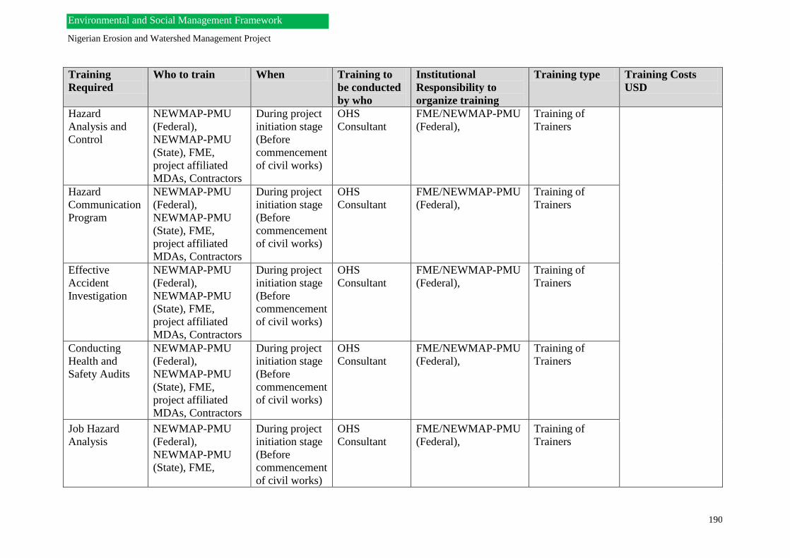
Nigerian Erosion and Watershed Management Project
190
Environmental and Social Management Framework
Training
Required
Who to train When Training to
be conducted
by who
Institutional
Responsibility to
organize training
Training type Training Costs
USD
Hazard
Analysis and
Control
NEWMAP-PMU
(Federal),
NEWMAP-PMU
(State), FME,
project affiliated
MDAs, Contractors
During project
initiation stage
(Before
commencement
of civil works)
OHS
Consultant
FME/NEWMAP-PMU
(Federal),
Training of
Trainers
Hazard
Communication
Program
NEWMAP-PMU
(Federal),
NEWMAP-PMU
(State), FME,
project affiliated
MDAs, Contractors
During project
initiation stage
(Before
commencement
of civil works)
OHS
Consultant
FME/NEWMAP-PMU
(Federal),
Training of
Trainers
Effective
Accident
Investigation
NEWMAP-PMU
(Federal),
NEWMAP-PMU
(State), FME,
project affiliated
MDAs, Contractors
During project
initiation stage
(Before
commencement
of civil works)
OHS
Consultant
FME/NEWMAP-PMU
(Federal),
Training of
Trainers
Conducting
Health and
Safety Audits
NEWMAP-PMU
(Federal),
NEWMAP-PMU
(State), FME,
project affiliated
MDAs, Contractors
During project
initiation stage
(Before
commencement
of civil works)
OHS
Consultant
FME/NEWMAP-PMU
(Federal),
Training of
Trainers
Job Hazard
Analysis
NEWMAP-PMU
(Federal),
NEWMAP-PMU
(State), FME,
During project
initiation stage
(Before
commencement
of civil works)
OHS
Consultant
FME/NEWMAP-PMU
(Federal),
Training of
Trainers
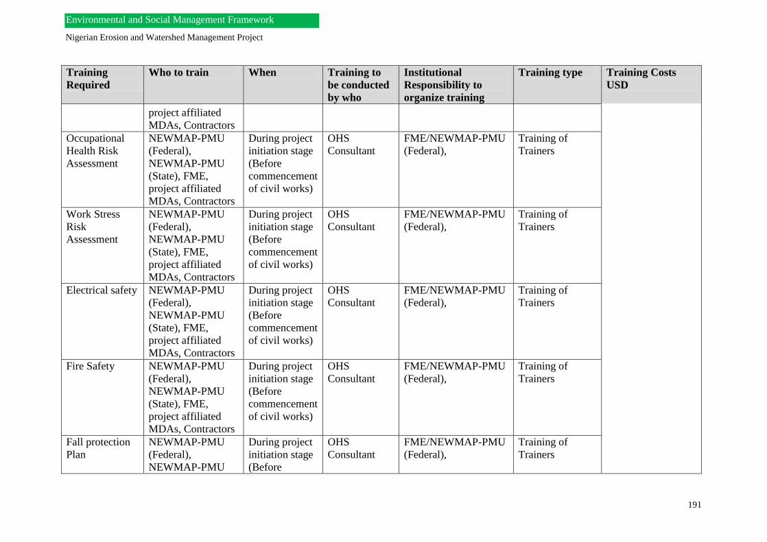
Nigerian Erosion and Watershed Management Project
191
Environmental and Social Management Framework
Training
Required
Who to train When Training to
be conducted
by who
Institutional
Responsibility to
organize training
Training type Training Costs
USD
project affiliated
MDAs, Contractors
Occupational
Health Risk
Assessment
NEWMAP-PMU
(Federal),
NEWMAP-PMU
(State), FME,
project affiliated
MDAs, Contractors
During project
initiation stage
(Before
commencement
of civil works)
OHS
Consultant
FME/NEWMAP-PMU
(Federal),
Training of
Trainers
Work Stress
Risk
Assessment
NEWMAP-PMU
(Federal),
NEWMAP-PMU
(State), FME,
project affiliated
MDAs, Contractors
During project
initiation stage
(Before
commencement
of civil works)
OHS
Consultant
FME/NEWMAP-PMU
(Federal),
Training of
Trainers
Electrical safety NEWMAP-PMU
(Federal),
NEWMAP-PMU
(State), FME,
project affiliated
MDAs, Contractors
During project
initiation stage
(Before
commencement
of civil works)
OHS
Consultant
FME/NEWMAP-PMU
(Federal),
Training of
Trainers
Fire Safety NEWMAP-PMU
(Federal),
NEWMAP-PMU
(State), FME,
project affiliated
MDAs, Contractors
During project
initiation stage
(Before
commencement
of civil works)
OHS
Consultant
FME/NEWMAP-PMU
(Federal),
Training of
Trainers
Fall protection
Plan
NEWMAP-PMU
(Federal),
NEWMAP-PMU
During project
initiation stage
(Before
OHS
Consultant
FME/NEWMAP-PMU
(Federal),
Training of
Trainers

Nigerian Erosion and Watershed Management Project
192
Environmental and Social Management Framework
Training
Required
Who to train When Training to
be conducted
by who
Institutional
Responsibility to
organize training
Training type Training Costs
USD
(State), FME,
project affiliated
MDAs, Contractors
commencement
of civil works)
Fleet Safety
Management
NEWMAP-PMU
(Federal),
NEWMAP-PMU
(State), FME,
project affiliated
MDAs, Contractors
During project
initiation stage
(Before
commencement
of civil works)
OHS
Consultant
FME/NEWMAP-PMU
(Federal),
Training of
Trainers
Disaster
Management
and Emergency
Planning
NEWMAP-PMU
(Federal),
NEWMAP-PMU
(State), FME,
project affiliated
MDAs, Contractors
During project
initiation stage
(Before
commencement
of civil works)
OHS
Consultant
FME/NEWMAP-PMU
(Federal),
Training of
Trainers
Note:
Trainings will be conducted by International and Local Consultants

193
11.4 Grievance Redress Mechanism
The PMU will establish a grievance redress mechanisms (GRM) that will allow general public
in the project area, affected IP communities or individuals, and PAPs to file complaints and to
receive responses in a timely manner. The system will also record and consolidate complaints
and their follow-up. This system will be designed for handling complaints perceived to be
generated by the project or its personnel. It may also include disagreements about
compensation and other related matters. The PMU will assign a specific staff member to
oversee that this is functioning properly. The consultants should review any existing GRM
systems (government/traditional) that are operative in the area and propose ways that the GRM
may fit within these systems. Ideally the GRM should have second and third levels of appeal
(including the court system, if appropriate, for legitimate claims that cannot be resolved at
lower levels). The functioning of the GRM system, how to register complaints (written, by
phone, or in person), where to go and hours of service, all should be clearly explained in local
language during initial public consultations on the project. Local language brochures should
be provided reiterating the functioning of the GRM.
Purpose of Grievance Redress Mechanism
The people affected by the NEWMAP will raise their grievances about actual or perceived
impacts in order to find a satisfactory solution. This is an important aspect in this NEWMAP
because land acquisition is indispensable through the course of the project.
These grievances, influenced by their physical, situational (e.g., employment), and/or social
losses, can surface at different stages of the project cycle. Some grievances may arise during
the project design and planning stage, while others may come up during project
implementation. Not only should affected persons (AP’s) be able to raise their grievances and
be given an adequate hearing, but also satisfactory solutions should be found that mutually
benefit both the APs and the NEWMAP PMU. It is equally important that APs have access to
legitimate, reliable, transparent, and efficient institutional mechanisms that are responsive to
their complaints.
Members of the Grievance Redress Committees (GRC)
The Grievance Redress Committees, GRC, will be mandated to deal with all types of
grievances arising at the community level due to the NEWMAP and its sub-projects. The GRC
members will comprise of qualified, experienced, and competent personnel who will be able
to interact and gain the trust of the AP’s in their communities. The GRC should consist of both
male and female representatives. They should be able to accept complaints, provide relevant
information on the process, discuss the complainants’ situations with AP’s, and explore
possible approaches for resolution.
The committee will include the following members:
• The Resettlement Policy Framework Consultant
• Social officer of the PMU;
• A representative of women residing the affected Project study area;
• A representative from the Private sector (if a private company is located within the
affected area);
• A representative of a voluntary organization, NGOs;
• Members of Local Government area included in the affected area;
• A representative appointed by the Community head.

194
The Grievance Redress Committee will be responsible for:
Communicating with the Affected persons (AP’s) and evaluate if the are entitled to
recompense;
to publicize within the Communities, the list of affected persons and the functioning of
the established grievance redressal procedure;
to recommend to the Social Officer of the PMU solutions to such grievances from
affected persons;
to communicate the decisions to the AP’s; to acknowledge appeals from persons, households or groups who rightfully will not be
affected by the NEWMAP and its sub-projects, but claim to be, and to recommend to
the PMU whether such persons should be recognized as AP’s, and to communicate back
the decisions to the Claimants.
Summary of the Community Grievance Procedure
● Many grievances arise due to failure to provide sufficient and timely information
to communities. Accurate and adequate information about a project and its activities, and
approximate implementation schedule, will be communicated to the communities, especially
AP’s, regularly throughout the NEWMAP process.
● Stakeholders from the community and PMU in the state and local level will be involved
in the grievance mechanism design. The PMU will engage community representatives to
identify key issues such as the types of disputes that could arise during the project activities,
how people in the community actually want to raise concerns, the effectiveness of current
NEWMAP PMU procedures for resolving complaints, and the availability of local resources
to resolve conflicts. This will assist in shaping both the design and future improvements.
● All grievances related to resettlement will be managed though the Grievance
Redress Committee (GRC). The objective of the Community Grievance Procedure is to
receive, respond and address any grievances made to the Project. Grievances will be responded
to as quickly and efficiently as possible, avoiding escalation of the issue, reducing negative
impacts on the local population and maintaining a positive attitude towards the Project amongst
stakeholders.
● The Grievance Procedure will be available to local populace residing in the Project
areas and other stakeholders directly affected by the Project (which may include landowners
residing in urban centers). The Grievance Redress Committee representatives serving, as focal
points are most effective if they are trustworthy, trained, knowledgeable, and approachable
regardless of the ethnicity, gender, or religion of the complainant. Therefore, efforts will be
made to ensure this. Local populations residing in the Project areas and other stakeholders
directly affected by the Project will be informed about the grievance process transparency and
credibility of the process and they will be provided with both verbal (through regular
Stakeholder meetings) and written forms (such as newsletters).
● Other channels of presenting complaints could include presentation of complaints via
third parties (e.g., village elites, community‐ based organizations, lawyers, NGOs etc.);
community meetings; suggestion boxes (maybe placed in churches, village and market squares)
allowing for anonymity; face‐ to‐ face meetings; written complaints etc. This will be

195
accessible to all especially more vulnerable groups such as women and youth. Confidentiality
and privacy for complainants should be granted.
● The grievance mechanism will be open to a wide range of concerns both those
based in factual data and those arising from perceptions or misperceptions. Perceived concerns
can be as critical to address as actual hazards. The mechanism should also be able to address
multi-party and multi-issue complaints.
● Community consultations and dialogue for the project will be implemented.
Efforts will be made to provide community members with opportunities to express their
concerns, clarifying and respond to their issues and to find out their views. Receiving these
feedbacks will benefit the community members, GRC and the NEWMAP PMU in all levels.
● Capacity development for community facilitators, GRC and field-level staff
will be implemented because they are the organs that will reach out to the communities, and it
becomes necessary for these staff and representatives to be well grounded with adequate
information on the project. They will be able to communicate effectively in the local languages,
understanding community dynamics and processes, negotiation and conflict resolution, and
empathizing with communities and their needs. Building trust and maintaining good rapport
with the people in the Project areas by providing relevant information on the project and
responding effectively to their needs and concerns will help solve issues before they even
become grievances. It is also important that the community facilitators, GRC and field-level
staff provide feedback to the PMU.
● The design and operation of the grievance mechanism will consider cultural
differences, such as communities’ preferences for direct or indirect negotiation; attitudes
toward competition, cooperation, and conflict; the desire to preserve relationships among
complainants; authority, social rank, and status; ways of understanding and interpreting the
world; concepts of time management; attitudes toward third parties; and the broader social and
institutional environment.
● The GRC will make efforts to provide regular feedback to relevant
stakeholders in order to clarify expectations about what the mechanism does and does not do;
to encourage people to use the mechanism; to present results; and to gather feedback to improve
the grievance system.
Scope of Grievances
Using the information gathered through the assessment of the situation in the community, the
GRC will endeavor to review the type of grievances that are likely to arise. Generally,
grievance mechanisms should be open to a wide range of concerns: both those based in factual
data and those arising from perceptions or misperceptions. Perceived concerns can be as critical
to address as actual hazards. They often arise when people do not have adequate information.
The mechanism should also be able to address multiparty and multi-issue complaints. The
members of the GRC have to establish the types of complaints that the mechanism will
primarily target.
Community Expectations When Grievances Arise

196
The members of the community will expect that their grievances will be addressed by the
NEWMAP PMU especially at the local level, which we will aim to achieve through the GRC.
When local people present a grievance, they generally expect to receive one or more of the
following:
• A concession in recognition of their problem
• An honest response to questions about NEWMAP activities
• An apology
• Compensation when applicable
• Modification of the activities that caused the grievance
• Some other fair remedy.
Steps in carrying out a Grievance Redress Mechanism
There is no ideal method of approach to grievance resolution however; the best solutions to
conflicts are generally achieved through localized mechanisms that take account of the specific
issues, cultural context, local customs, and the project state and its magnitude.
The Grievance Redress Committees of the NEWMAP will endeavor to be holding meetings
with the aggrieved person(s) or groups within a maximum of 3 weeks from the time of receiving
the complaint.
The following steps will be followed throughout the Grievance Redress Mechanism process in
the various Communities.

197
Fig: Likely steps in carrying out a Grievance Redress Mechanism
Methods that can be used to receive, & Register, Screen,
Assess, and Respond to Grievance
To Receive and Register a Complaint
The channels for receiving and registering complaints is a simple process where local people
can inform the GRC about concerns directly and, if necessary, anonymously or via third parties.
Reception procedures are most effective if they are convenient, culturally appropriate, simple
to understand, and easy to use.
Multiple channels should be available to gather and forward the AP’s concerns. At least one
member of the committee should be independent of the Project team. The GRC will accept
No Yes
Reject complaint
Refer as appropriate
Define approach
Implement approach
Track and Evaluate
Process feedback and learn
Not resolved? Revise choice or execution of approach
Formulate a response
Screen (for Eligibility of complaint) and Assess
Receive and register grievance

198
complaints, whether written or oral, record them on a simple form, to deal with the issue or if
need be, forwarded to the focal point of contact at the NEWMAP PMU for further action.
Diverse methods that are culturally appropriate should be used, including self-identified,
confidential, or anonymous procedures (letters, suggestion boxes).
A member of the GRC should be available to receive complaints and log them into a central
register.
Screening for Eligibility of Complaints
This process determines whether a complaint is eligible for inclusion in the grievance
mechanism. The GRC should develop a screening procedure based upon few simple eligibility
criteria that do not involve judging the substantive merit of the complaint.
Eligible complaints may include those where:
● The complaint is related to the project.
● The issues raised in the complaint fall within the scope of issues the grievance mechanism
is authorized to address.
● The complainant has standing to file.
Ineligible complaints may include those where:
• The complaint is not related to the NEWMAP project;
• The nature of the issue is outside the mandate of the grievance mechanism;
• The complainant has no standing to file;
• Other community procedures are more appropriate to address the issue;
If the complaint is rejected, the complainant is informed of the decision and the reasons for the
rejection. If eligible, the complainant will be notified, and the grievance will be processed and
the next stage, which implies that assessment, will follow.
The GRC will ensure that that all grievances are truly understood before they are responded. It
must be established that all complaints received from the AP’s receive a favorable judgment
before rejecting.

199
*
Assessment procedures (who conducts the assessment and how is the assessment
conducted)
*
Procedures to identify appropriate people in to whom a specific concern should be
forwarded
*
Procedures to determine the appropriate resolution process (in consultation with
complainant)
*
Procedures for making decisions on proposed settlements
*
Appropriate time frames for each step in the grievance resolution process
(including screening, assessment, and resolution)
*
Notification procedures to the complainant about eligibility, assessment results,
proposed settlement, and the like.
Assess the Grievance
At this stage the GRC will gathers information about the case and the key issues of concerns
which will help to determine whether and how the complaint might be resolved.
Procedures for Assessing Grievance are as follows:
• Determine who will conduct the assessment. A Complaints Coordinator will be
appointed to perform this task or directs it to an appropriate person(s) for assessment
(production, procurement, environment, community relations, human resources).
• A representative from the GRC will endeavor to engage directly with the complainants
to gain understanding of the nature of the complaint.
• Clarify the parties, issues, views, and options involved which includes:
✓Identify the parties involved
✓ Clarify issues and concerns raised by the complaint.
✓ Gather views of other stakeholders, including those in the GRC and PMU.
A Checklist of Grievance Handling Procedures

200
✓ Determine initial options that parties have considered and explore various approaches for settlement.
• Classify the complaint in terms of its seriousness (high, medium, or low). Using this
category, seriousness, will measure the potential to impact the community. The factors
to consider will include: the gravity of the allegation, the potential impact on an
individual’s or a group’s welfare and safety, or the public profile of the issue.
• Engage more directly with the complainant in the assessment process, and involve the
complainant in influencing the resolution process to be selected, and settlement options.
Formulate a Response
Procedures to formulate responses are as follow:
• The Complaint Coordinator will be responsible for preparing the response that will
consider the complainants’ views about the process for settlement as well as provide a
specific remedy. The response may suggest an approach on how to settle the issues, or it
may offer a preliminary settlement.
• Meeting may be coordinated which will serve as a forum for the complainant to present
the person’s complaints; discussion amongst the complainant, the Complaint
Coordinator, member(s) of the GRC will follow. If a direct meeting is not possible,
consider meeting with a neutral third party serving as facilitator. The group would also
discuss appropriate next steps during this meeting. If the proposal is a settlement offer
and it is accepted, the complaint is resolved successfully and there is no need to proceed
to the next step of selecting a resolution approach. If the complainant is not happy with
the response about a resolution process or substance, the group should try to reach an
agreement that would be mutually acceptable.
• If the case is complex and a resolution time frame cannot be met, provide an interim
response facilitated through oral or written communication (best to the complainants
preference) that informs the person of the delay, explains the reasons, and offers a revised
date for next steps.
Process of Selecting Grievance Resolution Approaches
A variety of Grievance Resolution Approach will be incorporated which will
accommodate differences in personal and cultural preferences. The grievance mechanism
will offer a variety of grievance resolution approaches and the complainant should have
influence over which approach to select. The approaches include the following:
Scenario 1: Where the GRC proposes a solution
This should be conducted as an Informal approach that will involve direct involvement of the
GRC or a representative with the complaint. The GRC will propose a solution and offers it to
the complainant. The GRC and community would jointly decide if the solution is acceptable
and, hence, share decision-making authority. This process can be facilitated if the GRC
conducts an initial assessment, and then make a settlement proposal that they hope the
complainant will accept. The proposal should be based on consistent standards and criteria so
that similar complaints receive similar remedies.

201
The following measures can help increase the acceptability of responses:
There should be a rationale for the decision and presentation of any data that will be
used to reach a conclusion (for example, value of land, crop, or animals; costs to
repair a road).
There should be an opportunity for the complainant to verbally present his, her, or their
case to a GRC or representative. The representative should listen to and acknowledge
the complainant’s statement to help reach emotional closure and restore positive
relations between the complainant and the PMU.
Timely delivery of a response and rapid restitution once a decision has been made.
Delivery of the GRC’s response in writing and, when appropriate, a visit by a
representative to explain the decision in person.
If the complainant rejects the proposal, Scenario 2 may be used.
Scenario 2: Where the Community and the GRC decides to make the decision together.
This option involves the GRC representatives and complainants sharing the decision-making
and jointly engaging in a problem-solving approach to reach a resolution of the grievance by
themselves. The process may involve only the GRC and complainant, or may be facilitated by
a neutral third party without decision-making authority, such as a mediator.
This approach is likened to be the most accessible, natural, and unthreatening ways for
communities and Project team to resolve differences. With the potential to resolve perhaps 90
percent of all grievances, “decide together” should be the center of any grievance mechanism’s
resolution options. The complaints and the GRC representative however need to furnish
themselves in their communication skills, dialoguing and negotiating skills for ease in relating
with the people.
Scenario 3: Formal independent redress approach, such as arbitration using a neutral
third party.
This approach can be used when the GRC and the complainants are unable to resolve a
complaint themselves. The decision-making will lean on the independent, neutral party. The
neutral party may be a trusted individual or a group in the community, a respected technical
expert, or an independent arbitrator. In a typical arbitration case, the parties engaging in the
process would decide if the decision is binding (the parties promise at the beginning of the
process to implement the intermediary’s decision) or non-binding (the intermediary’s decision
is a recommendation to the GRC and the community, and can be appealed in court or to some
higher authority).
Scenario 4: The GRC and community engage traditional and customary practices
Rights-based approach based on legal, contractual, local and customary ways of grievance
resolution, which will be evaluated and incorporated into the system. All societies have internal
ways of handling their differences. The local people may decide to find succor in resolving the
disputes from their traditional or religious leaders. Therefore the GRC will inventory
traditional, religious and customary approaches for solving conflicts and consider how to adapt

202
traditional, religious and customary dispute- resolution mechanisms to deal with community-
GRC grievances. For this scenario, observers, testifiers, witnesses can be employed to verify
the fairness, and assure that agreements comply with widely accepted community values and
norms. Advisors and mediators can also be used which may include respected people in their
communities. Members of traditional communities often seek advice from respected or wise
members on how their differences can best be resolved. Disputants often ask for
recommendations that comply with community norms and restore harmonious relationships.
11.5 Environmental and Social Management Plans (ESMPs)
ESMPs will be very important aspects and useful implementation tools for the management
and mitigation of identified environmental and social impacts under the NEWMAP-AF. a
generic, yet project related ESMP is provided below.
11.5.1 Monitoring and Evaluation
The objectives of monitoring and evaluation for the ESMF are as follows:
To alert the PMU by providing timely information about the success or otherwise of
the environmental management process outlined in the ESMF. This will ensure
continuous improvement in the environmental and social management process of the
NEWMAP even after the project is concluded.
To make a final evaluation in order to determine whether the mitigation measures
incorporated in the technical designs and the EMP have been successful.
This section sets out requirements for the monitoring of the environmental and social impacts
of the NEWMAP activities. Monitoring of environmental and social indicators will be
mainstreamed into the overall monitoring and evaluation system for the project.
Monitoring will be used to measure the success rate of the project; it will also be used to
determine whether the established mitigation measures have resulted in dealing with the
negative impacts associated with the project. It will be used to establish whether further
monitoring is to be extended in some areas.
The key issues to be considered in the NEWMAP-AF subprojects include construction
activities, monitoring of water quality, agricultural production, land use and acquisition,
income generation and population influx.
Monitoring and surveillance of subprojects should take place on a “spot checks” basis, which
means that the investigation should be carried out at random or limited to a few instances.
Indicators for monitoring the participation process
The following are indicators for monitoring of the participation process involved in the project
activities.
Number and percentage of affected households consulted during the planning stage;
Levels of decision-making of affected people;
Level of understanding of project impacts and mitigation;
Effectiveness of local authorities to make decisions;
Frequency and quality of public meetings;
203
Level of involvement of women and youth or disadvantaged groups in discussions;
Evaluation of Results
The evaluation of results of environmental and social mitigation can be carried out by
comparing baseline data collected in the planning phase with targets and post project situations.
Monitoring of ESMF Implementation
In addition to the project reports required, the Independent Consultant will prepare a quarterly
audit on ESMF implementation, which will be delivered to NEWMAP-PMU. In addition, each
subproject required in the various States that may require an EIA study (or RAP etc) will also
be required to produce an annual audit report for delivery to the NEWMAP-PMU.
The table 11.3 below describes the Monitoring and Evaluation framework for the EMP.

204
Environmental and Social Management Plan Framework for NEWMAP (Generic)
Activity Threat or Impact Mitigation Responsibility Costs
USD
Performance
Indicator
Pre-construction
phase
Social Impacts
Community
resources e.g.
Land
Community
perception
Assessment of all possible social
impacts and threats with respect to
the NEWMAP as a basis for defining
social protection, putting in place
measures and procedures for
enforcing social protection and social
accountability, and setting up
monitoring mechanisms to ensure
adherence to measures proffered.
Establishment of Grievance-address
systems and Indigenous Peoples
Planning Frameworks.
Conduct ESIA.
Baseline elemental Studies (water,
air, soil quality).
Conduct Health Impact Assessment
(HIA) and subsequent Health Action
Plan (HAP)/Health Management Plan
(HMP).
NEWMAP-PMU (Federal)
NEWMAP-PMU (State)
World Bank Task Team
Independent Consultant
NEWMAP-PMU
(Federal)
NEWMAP-PMU (State)
NEWMAP-PMU (Federal)
NEWMAP-PMU (State)
Independent Consultant
NEWMAP-PMU (Federal)
NEWMAP-PMU (State)
310,000
500,000
Have studies been
carried out and
plans prepared?
Have environmental
and social
monitoring
mechanisms been
established?
Have Grievance
Address
Mechanisms been
established?
Is there effective
feedback from
project affected
persons?
Have environmental,
social, health and
broader impacts
been identified and
mitigation measures
designed.
Has HIA been
conducted, and
impacts identified
Table 11.3. Environmental and Social Management Plan- ESMP

205
Independent Consultant (health, social,
environmental
Activity Threat or Impact Mitigation Responsibility Costs
USD
Performance
Indicator
Construction
phase
Physical Impacts
• Land degradation
& Subsidence
• Geomorphology &
Hydrology
• Topography
• Land use etc.
Integration of community driven
interventions (legal, scientific and
social) for achieving community
participation and acceptance of
project objectives amongst project
affected persons.
Good practice in the utilization of
physical and biological engineering
techniques for erosion sites
rehabilitation and management,
including dam safety measures.
World Bank Task Team
NEWMAP-PMU (State)
NEWMAP-PMU (Federal)
NEWMAP-PMU (State)
CONTRACTOR
160,000
1,000,000
500,000
Is there
community driven
approach in-
use/how are
community
reaction
Have standard
operating
procedures for best
environmental
Table 11.3. Environmental and Social Management Plan- ESMP

206
Impacts Identification and ESMP
implementation.
Institute a Noise Hazard
Communication Program
(HAZCOM) for workers and project
affected communities,
Continued/sustainable afforestation
program.
Establishment of safe-work
procedures for operations and
activities
Disaster/Emergency planning
framework.
NEWMAP-PMU (State)
NEWMAP-PMU (Federal)
NEWMAP-PMU (State)
NEWMAP-PMU (State)
CONTRACTOR/INDEPENDENT
CONSULTANT
NEWMAP-PMU (State)
CONTRACTOR/INDEPENDENT
CONSULTANT
4,000,000
80,000
50,000
practices been
established?
Does the contractor
have a HAZCOM
program?
Are there Material
Safety Data Sheets
(MSDS)
Is a sustainable
afforestation
program in
progress?
Does the contractor
have
a safe-works
procedure?
Is there an
emergency planning
framework?
Biological Impact
Flora and Fauna
Wildlife
Routine (baseline-checks)
biodiversity studies/Baseline
ecological assessments
50,000 ESIA Reports,
Feasibility Study
Reports

207
Socio-economic
Impacts
Transportation &
Traffic impact
Accidents
Migration
Community
Perception-
Employment
Human
Displacement
Archaeological
& Cultural loss
Social stress &
disruption
Institute traffic management plan.
Reduce road congestion in project
areas and access routes.
Trainings to enable community
motorists to be responsive to changes
as per civil works.
Institute a Resettlement Action Plan
(RAP), Mechanism for the
preservation of cultural heritage and
Indigenous Peoples Planning
Framework (IPPF).
NEWMAP-PMU (State)
INDEPENDENT CONSULTANT
World Bank Task Team
NEWMAP-PMU (Federal)
NEWMAP-PMU (State)
INDEPENDENT CONSULTANT
20,000
50,000
500,000
Has a traffic
management plan
been made?
Are government
related agencies
(Federal Road
Safety Corps and
Department of
Road Transport
Services) part of
implementation of
the traffic
management plan?
Public Health
Impacts
HIV/AIDS and
STDs
Water-Borne
Diseases (e.g.
Cholera,
Dysentery,
Amoebiasis,
Salmonellosis
etc.)
Conduct trainings on Occupational
diseases and awareness campaigns on
Sexually Transmitted Infections and
other infectious Diseases.
Conduct health screening
World Bank Task Team
NEWMAP-PMU (Federal)
NEWMAP-PMU (State)
INDEPENDENT CONSULTANT
50,000
50,000
Have health
disease trainings
been conducted?
Have subsequent
health screenings
been conducted in
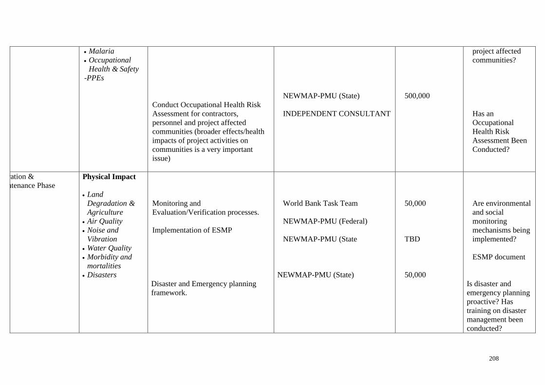
208
Malaria
Occupational
Health & Safety
-PPEs
Conduct Occupational Health Risk
Assessment for contractors,
personnel and project affected
communities (broader effects/health
impacts of project activities on
communities is a very important
issue)
NEWMAP-PMU (State)
INDEPENDENT CONSULTANT
500,000
project affected
communities?
Has an
Occupational
Health Risk
Assessment Been
Conducted?
Operation &
Maintenance Phase
Physical Impact
Land
Degradation &
Agriculture
Air Quality
Noise and
Vibration
Water Quality
Morbidity and
mortalities
Disasters
Monitoring and
Evaluation/Verification processes.
Implementation of ESMP
Disaster and Emergency planning
framework.
World Bank Task Team
NEWMAP-PMU (Federal)
NEWMAP-PMU (State
NEWMAP-PMU (State)
50,000
TBD
50,000
Are environmental
and social
monitoring
mechanisms being
implemented?
ESMP document
Is disaster and
emergency planning
proactive? Has
training on disaster
management been
conducted?

209
Social Impact
Traffic and
Transportation
Monitoring and
Evaluation/Verification processes.
Implementation of ESMP
Disaster and Emergency planning
framework.
World Bank Task Team
NEWMAP-PMU (Federal)
NEWMAP-PMU (Federal
NEWMAP-PMU (State
NEWMAP-PMU (State
100,000
100,000
Is the traffic
management plan
being
implemented? who
is responsible and
why?
Is the ESMP being
implemented?
Success in
mitigation
measures.
Is disaster
management in-
place.
No of land slides
No of casualties.
Complaints from
communities

210
Table 11.3 Monitoring & Evaluation Framework for the ESMP
Phase Being Monitored Institution Responsible Performance Indicator Period to be
conducted
Costs
(US$)
1. Pre-construction phase)
NEWMAP-PMU (Federal)
NEWMAP-PMU (State)
World Bank Task Team
Independent Consultant
6 Have environmental and social accountability
trainings been conducted
7 Have studies been carried out and plans prepared?
8 Have environmental and social monitoring
mechanisms been established?
9 Have Grievance redress Mechanisms been
established?
10 Is there effective feedback from project affected
persons?
11 Have environmental, social, health and broader
impacts been identified and mitigation measures
designed
Before
initiation of
civil works
100,000
2. Construction phase
World Bank Task Team
NEWMAP-PMU (Federal)
NEWMAP-PMU (State)
CONTRACTOR/INDEPENDENT
CONSULTANT
5 Is there community driven approach in- use/how
are community reaction
6 Is the Grievance redress mechanism effective
7 Have standard operating procedures for best
environmental practices been established?
8 Does the contractor have a HAZCOM program?
9 Are there Material Safety Data Sheets (MSDS)
In the course of
civil works
implementation
80,000

211
10 Is a sustainable afforestation program in progress?
11 Does the contractor have a safe-works procedure?
12 Is there an emergency planning framework?
Phase Being Monitored Institution Responsible Performance Indicator Period to be
conducted
Costs
(US$)
3. Operation & Maintenance
Phase
World Bank Task Team
NEWMAP-PMU (Federal)
NEWMAP-PMU (State
• Are environmental and social monitoring
mechanisms being implemented?
• EMP document
• Is disaster and emergency planning proactive? Has
training on disaster management been conducted?
• Is the traffic management plan being implemented?
who is responsible and why?
• Is the EMP being implemented?
• Success in mitigation measures.
• Is disaster management in-place.
• No of land slides
Operational
stage to project
closure
80,000

212
• No of casualties.
• Complaints from communities

Nigerian Erosion and Watershed Management Project
213
Environmental and Social Management Framework
11.6 Environmental and Social Auditing
Auditing refers to the examination and assessment of a certain type of performance. In the case
of the NEWMAP, an audit will assess the actual environmental and social impacts of sub-
projects, their accuracy of prediction, the effectiveness of impact mitigation measures, and the
functioning of monitoring mechanisms. The audit should be undertaken upon a sub-project run
in operation, for some time, and it must be performed once or twice in the entire sub-project
cycle.
Types of Audit
Decision Point Audit - examines the effectiveness of ESIA as a decision-making tool.
Implementation Audit - ensures that approved conditions have been met.
Performance Audit - examines the responses of stakeholders/agencies concerned with
project management.
Project Impact Audit - examines environmental changes arising from project
implementation.
Predictive Technique Audit - examines the accuracy and utility of predictive techniques
by comparing actual against predicted environmental effects
EIA Procedures Audit - critically examines the methods and approach adopted during
the EIA study
Not all the audit types mentioned above are required to be implemented in the NEWMAP ESIA
process. However, at the sub-project approval stage, both project proponent and authorizing
agency should consider whether an application of a particular audit technique is likely to result
in new information or an improvement in management practices. Particular attention should be
given to the project cost-effectiveness of any proposed audit and to technical difficulties likely
to be encountered.
Since the ESIA concept is relatively recent, the use of environmental audits will play a
significant role in the success of the NEWMAP. In addition, environmental and social auditing
should compare monitoring results with information generated during the pre-project period.
Comparisons can be made with similar sub-projects or against standard norms.
Relating actual impacts with predicted impacts will help in evaluating the accuracy and
adequacy of ESIA predictions.
Environmental Auditing Plan
Environmental Audit should be carried out upon the completion of project construction and
after 3 years of project operation in order to obtain information on:
the condition of natural/social/economical resources prior to sub-project
implementation and after the sub-project construction is completed,

Nigerian Erosion and Watershed Management Project
214
Environmental and Social Management Framework
whether or not, all the mitigation measures implemented are effective to control adverse
impact, or enhance beneficial impacts,
whether or not all degraded landscape due to sub-project implementation have been
restored into original condition,
what are the impacts of boom-bust scenario among the workforce involved in the sub-
project implementation and the local economy, and
The effect on the local economy of project implementation.
In Summary, Information from monitoring output should also be utilized for carrying out
environmental audit.
11.7 HEALTH IMPACT ASSESSMENT (HIA)
Purpose
This document is intended to provide good practice guidance for conducting a Health Impact
Assessment (HIA) to determine potential impacts on community health as a result of project
development.
This document has three objectives:
To present methodological approaches to assess and address potential community
health impacts that might typically be encountered in the development or review of
future sub-projects.
To assist in the development of the terms of reference (TOR) that may be needed to
conduct the HIA
To help ensure inclusion of health impact aspects in the social and environmental
impact assessment process or in the conduct of independent HIAs for sub-projects.
Key Characteristics
Consultants should possess the experience and expertise in the identification of major
characteristics, which define HIAs. These will include, to a minimum, the following:
Predicting the consequences of project-related actions
Providing information that can help decision makers prioritizes prevention and control
strategies throughout the project lifecycle.
Major Processes in Identifying the Need for HIA
Screening - Preliminary evaluation to determine whether a proposed project is likely to pose
any significant health questions. Specialists should generally assume that projects requiring
environmental or social impact assessments are also likely to have potential health impacts.
During the screening step, the need for an HIA can be determined. The NEWMAP-PMU and
relevant stakeholders should handle this.

Nigerian Erosion and Watershed Management Project
215
Environmental and Social Management Framework
Scoping – This is a process for outlining the range and types of hazards and beneficial impacts.
The overall types and categories of questions that should be addressed are defined at this stage
of the HIA. The input of key stakeholders and the relevant host- country health authorities is
critical, so that the HIA adequately addresses a realistic range of health concerns. This stage
also is the time to develop the TOR for the scoping. The HIA effort should be “fit to purpose,”
and it should adequately and realistically match the complexity of the project. The NEWMAP-
PMU and relevant stakeholders should handle this.
Risk Assessment- This should address activities to investigate, appraise, and qualitatively or
quantitatively rank the impacts the project is likely to have, on the health of the defined
communities. The spectrum of potential impacts—their relative importance and at what level
they are expected to occur is determined in this step.
Health Action Plan (HAP) - Considers the rankings developed in the risk assessment and
develops a written health action plan (HAP). The HAP, also known as a health management
plan, it should establish the proposed actions needed to mitigate identified impacts and promote
health opportunities in the project. HIA consultants should include information on mitigation.
Mitigation is a systematic process by which to avoid, reduce, remedy, or even compensate for
potentially negative impacts. Review and analysis by key stakeholders, including host-country
health authorities, is should be a critical aspect of HIAs to be conducted under the NEWMAP
sub-projects.
Implementation and Monitoring – This should occur after the Health Action Plan(s) for sub-
projects have been developed. At this point it is necessary to decide how the mitigation actions
will be implemented and monitored, and to establish the roles and responsibilities of the
NEWMAP-PMU and key stakeholders. During this process, the project should establish action
frameworks and allocation of resources, and it should design monitoring systems to ensure that
mitigation progress is satisfactory. In addition, the monitoring system should be designed to
capture unanticipated effects or provide an early-warning system to alert that problems are
occurring at the community level. The monitoring plan should define appropriate key
performance indicators.
Evaluation and Verification of Performance and Effectiveness- HIA documents for the
project should include a system for determining that implementation has been accomplished
and is achieving the intended results.
Types of HIAs
When gathering new field data for the HIA, the project will encounter different levels of effort
and needs. The key descriptive terms for these cases “comprehensive” and “rapid appraisal”
indicate the different depths of analysis and consultation required, and whether the
performance of the HIA involves collecting new field data. In many situations, a rapid appraisal
HIA will be sufficient; however, this assessment may uncover significant data gaps and trigger
the need for a more comprehensive HIA, that is, new data collection.
Comprehensive HIA
A comprehensive HIA includes screening, scoping, stakeholder consultation, risk assessment,
appraisal, implementation and monitoring, and verification. Stakeholder communication and
consultation should take place at all stages—from screening through implementation and

Nigerian Erosion and Watershed Management Project
216
Environmental and Social Management Framework
monitoring. During the project concept and feasibility studies and project planning phases, the
project also will perform a limited level of local community stakeholder consultation.
A comprehensive HIA is more likely to be considered for large, complex projects, particularly
if resettlement or relocation of existing communities is involved or if a significant influx of
persons is expected, regardless of whether it is a new-project or new-location situation or a
significant expansion of an existing facility. An essential element of the comprehensive HIA
is the need for some type of new data collection in potentially affected communities, and for
helping to predict changes in health determinants, the associated risks, and health outcomes.
This data collection typically consists of health-questionnaire surveys.
Rapid Appraisal HIA
These assessments require less-intensive efforts; however, in-country investigation may be
triggered. Typically, rapid appraisal HIAs are subdivided into desktop HIAs and limited in-
country HIAs.
Desk Top HIA
It is a qualitative review of potential health impacts and is used to internally inform and
comment on the proposed design of the project. It is also useful for determining whether a more
detailed review is needed.
Limited in- Country HIA
This uses information that is already available or easily accessible. Thus, no specific new data
collection is required. Data sources may include peer-reviewed scientific literature and ‘grey
literature,” that is, health department data. Workshops or discussions with key internal and
external stakeholders, which are usually planned in the context of other social and
environmental assessment efforts, also can provide useful health-related information. The
overall results are typically incorporated into the social and environmental impact assessment,
although the limited in-country HIA may also be issued as a stand-alone report. Limited in-
country HIAs are appropriate for many expansion scenarios where new data collection is not
needed. In some situations, large health databases are available, sufficient for documenting
current baseline community conditions, making new field collection efforts unnecessary.
11.8 Integrated Pest Management Plan (IPMP)
See Annex 008 for IPMP format
11.9 Forestry Development Plan
The anticipated impacts of NEWMAP on the forest resources of Nigeria would be positive.
The project objectives include protection of the pristine forest and buffer zones in the project
area, as well as on the ground investments in afforestation and re-grassing and strengthening
of the institutions that protect forests in the project area. Furthermore, the preparation of the
Forestry Development Plan will be a prerequisite for subprojects to be financed in the forest
areas. The Plans will also be disclosed in specific locations at forest communities or at the
Department of Forestry at Federal, state and local government levels. The Forestry
commissions in some of the states have the capacity to monitor and follow up on the Plans.
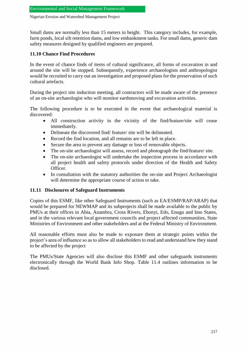
Nigerian Erosion and Watershed Management Project
217
Environmental and Social Management Framework
Small dams are normally less than 15 meters in height. This category includes, for example,
farm ponds, local silt retention dams, and low embankment tanks. For small dams, generic dam
safety measures designed by qualified engineers are prepared.
11.10 Chance Find Procedures
In the event of chance finds of items of cultural significance, all forms of excavation in and
around the site will be stopped. Subsequently, experience archaeologists and anthropologist
would be recruited to carry out an investigation and proposed plans for the preservation of such
cultural artefacts.
During the project site induction meeting, all contractors will be made aware of the presence
of an on-site archaeologist who will monitor earthmoving and excavation activities.
The following procedure is to be executed in the event that archaeological material is
discovered:
All construction activity in the vicinity of the find/feature/site will cease
immediately.
Delineate the discovered find/ feature/ site will be delineated.
Record the find location, and all remains are to be left in place.
Secure the area to prevent any damage or loss of removable objects.
The on-site archaeologist will assess, record and photograph the find/feature/ site.
The on-site archaeologist will undertake the inspection process in accordance with
all project health and safety protocols under direction of the Health and Safety
Officer.
In consultation with the statutory authorities the on-site and Project Archaeologist
will determine the appropriate course of action to take.
11.11 Disclosures of Safeguard Instruments
Copies of this ESMF, like other Safeguard Instruments (such as EA/ESMP/RAP/ARAP) that
would be prepared for NEWMAP and its subprojects shall be made available to the public by
PMUs at their offices in Abia, Anambra, Cross Rivers, Ebonyi, Edo, Enugu and Imo States,
and in the various relevant local government councils and project affected communities, State
Ministries of Environment and other stakeholders and at the Federal Ministry of Environment.
All reasonable efforts must also be made to exposure them at strategic points within the
project’s area of influence so as to allow all stakeholders to read and understand how they stand
to be affected by the project
The PMUs/State Agencies will also disclose this ESMF and other safeguards instruments
electronically through the World Bank Info Shop. Table 11.4 outlines information to be
disclosed.

Nigerian Erosion and Watershed Management Project
218
Environmental and Social Management Framework
Table 11.4: Some information to be disclosed
Topic Documents to be
disclosed
Frequency Media
Public
Consultation
Minutes of Formal Public
Consultation Meetings
Within two weeks of
Meeting
Implementation agency’s website.
Ministry of Environment
Project Management Unit & Project
Implementation Units (PIU)
Local government Secretariat
Environment
Management
ESMF, Environment
Assessment
Report & Environment
Management Plans
Prior to awarding works and
to remain on website
World Bank’s Infoshop.
Implementation agency’s website.
Ministry of Environment
Project Management Unit & Project
Implementation Units (PIU)
Local government Secretariat
Resettlement,
Rehabilitation
and Land
Acquisition
RPF, Resettlement Action
Plan
(RAP)
Once in the entire project cycle. But
to remain on the website and other
disclosure locations throughout
the project period.
World Bank’s Infoshop.
Implementation agency’s website.
Ministry of Environment
Project Management Unit & Project
Implementation Units (PIU)
Local government Secretariat
Information regarding
impacts and their
entitlements
Once at the start of the
project and as and when
demanded by the PAPs.
Through one-to-one contact with PAPs.
Community consultation
List of PAPs with impacts and entitlements to be
pasted in the PMU offices
R&R and LA monthly
progress report.
10th day of every month MDAs / Implementation agency’s website.
Project Management Unit & Project
Implementation Units (PIU)
RAP Impact Assessment
Report
After substantial
completion
of each phase
Implementation agency’s website.

Nigerian Erosion and Watershed Management Project
219
Environmental and Social Management Framework
Land Acquisition
Notifications
After substantial
completion
of each phase
Implementation agency’s website.
Grievance redressal
process.
Continuous process
throughout the project
cycle.
Implementation agency’s website.
Ministry of Environment
Project Management Unit & Project
Implementation Units (PIU)
Local government Secretariat
Project Management Unit & Project
Implementation Units (PIU)
One to one contact with PAPs.

Nigerian Erosion and Watershed Management Project
220
Environmental and Social Management Framework
REFERENCES
Abia State Portal (2009) Physical Setting [online] Available at
<http://abiastategovt.com/physical_setting.htm>[15 May 2011]
Asian Development Bank (2002) Handbook for Preparing Resettlement: A Guide to Good
Practice [online] Available at
<http://www.adb.org/documents/handbooks/resettlement/appendix01.asp> [2 July 2011]
Cernea, M.M. (1998) Involuntary Resettlement in Development Projects Policy Guidelines in
World Bank-Financed Projects.World Bank Technical Paper Number 80 [online] Available at
<http://rru.worldbank.org/documents/toolkits/highways/pdf/91.pdf> [2 July 2011]
Environmental Management Plan for the Lake Victoria Environmental Management Project
Phase II, Final Report. (November, 2008 and updated March, 2011)
International Finance Corporation- Environment and Social Development Department (2002)
Handbook for Preparing a Resettlement Action Plan [online] Available at<
http://www.ifc.org/ifcext/enviro.nsf/AttachmentsByTitle/p_resettle/$FILE/ResettlementHand
book.PDF> [18 July 2011]
International Research and Training Centre on Erosion and Sedimentation (2010)
International Sediment Initiative [online] Available at
<http://www.irtces.org/isi/WebNews_View-en2.asp?WebNewsID=625> [09 May 2011]
National Population commission (2006) 2006 Census Priority Tables [online] Available at <
www.population.gov.ng> [15 May 2011]
Nigeria Daily News (2010) Erosion in Abia State [online] Available at
<http://ndn.nigeriadailynews.com/templates/?a=29191> [15 May, 2011)
Republic of Kenya Ministry of Environment and Mineral Resource (2008) Environmental
and Social Management Framework for the Lake Victoria Environmental Management
Project Phase II
Technical Report of the Technical Committee on the Ecological Problems of the South
Eastern States (2009) - The Presidency, Nigeria.
The Government of Tanzania (2006) Environment and Social Management Framework for
the Agricultural Sector Development Program (ASDP)
World Bank (2002) Guidelines: Selection and Employment of Consultants by World Bank
Borrowers [online] Available at
<http://siteresources.worldbank.org/INTPROCUREMENT/Resources/ConGuid-10-06-
RevMay10-ev2.pdf > [10 August 2011]

Nigerian Erosion and Watershed Management Project
221
Environmental and Social Management Framework
Annexures

Nigerian Erosion and Watershed Management Project
222
Environmental and Social Management Framework
ANNEX 001: FEDERAL GUIDELINES FOR EIA PROCESS
The process for undertaking EIA and other forms of environmental assessment in Nigeria is
presented in the EIA Decree No. 86 of 1992. The Federal Government of Nigeria enacted the
Environmental Impact Assessment (EIA) No. 86 of 1992 as a demonstration of her
commitment to Rio declaration. Prior to the enactment of EIA act in Nigeria, project appraisals
were limited predominantly to feasibility studies and economic – cost – benefits analysis. Most
of these appraisals did not account for environmental costs, public opinion, and social and
environmental impacts of development projects.
EIA ACT No.86 of 1992
The EIA Act gave the Federal Ministry of Environment the implementing mandate and requires
that the process of EIA be mandatory applied in all major development projects right from the
planning stage to ensure that likely environmental problems, including appropriate mitigation
measures to address the inevitable consequences of development are anticipated prior to project
implementation and addressed throughout the project cycle.
The EIA Act stipulates that all Agencies, Institutions (whether public or private) except
exempted by the Act, shall, before embarking on proposed projects, apply in writing to The
Federal Ministry of Environment so that subject activities can be quickly identified and allow
for the conduct of environmental assessment(s) as the activities are being planned. The Act
made provision for all stakeholders (agencies, public, experts, NGOs, communities, etc) to be
notified, consulted and or given the opportunity to make comments on the EIA of a project
prior to approval or disapproval.
The objectives of the EIA Act of 1992 among others include:
The establishment of the environmental effects of proposed activities before a
decision is taken to embark upon them.
Promotion of the implementation of appropriate policy in all Federal land, states, and
Local Government Area consistent with all laws and decision making process through
which these goals in (1) above may be reached.
It encourages the development of procedures for information exchange, notification and
constitution between organs and persons when proposed activities are likely to have
significant effects on boundary or trans – state or on the environment bordering towns
and villages.
Minimum content of an EIA study
Section 4 of the EIA Act specifies the minimum content of an EIA to include the following;
A description of the proposed activities,
A description of the potential affected environment, including detailed information
necessary to identify and assess the environmental effects of the proposed activities,
A description of the practical activities,
An assessment of the likely or potential environmental impacts of the proposed activity
and the alternatives, including the direct or indirect, cumulative, short-term and long-
term effects,
Nigerian Erosion and Watershed Management Project
223
Environmental and Social Management Framework
An identification and description of measures available to mitigate adverse environmental
impacts of the proposed activity and assessment of those measures,
An indication of gaps in knowledge and uncertainty, which may be encountered in
computing the required information
An indication of whether the environment of any state or local government areas outside
Nigeria is likely to be affected by the proposed activity or its alternatives, and
A brief and non-technical summary of the information provided under the above listed
paragraphs.
EIA procedural guideline in Nigeria
After the dissemination of the EIA Act 86 in 1992, the Federal Ministry of Environment
(formally called FEPA) came up with the EIA Procedural Guideline and Sectoral Guidelines
for some Nigerian Economic sub-sectors. The EIA Procedural Guideline contains a list of steps
which when carefully followed shall result in better project planning and a streamlined decision
making process. These steps include, brief descriptions of the project environment and process,
legal framework, identified impacts etc. These steps are;
Project proposal
Initial environmental examination (IEE) / preliminary assessment
Screening
Scoping
EIA study
Review
Decision making
Monitoring, and Auditing
EIA Sectoral guideline in Nigeria
The sectoral Guidelines provide sector-specific guide for preparation of EIA reports. Sectoral
guidelines have been developed for the following sectors.
1. Oil and Gas, including petroleum refining, petrochemical industry pipelines, on-shore,
offshore exploration and drilling etc.
2. Infrastructures – including airports, construction, harbours, construction and expansion,
railways highways, etc
3. Industries – including all other manufacturing industries, besides those in the oil and gas
sector.
4. Agriculture - all agricultural practices including land clearing, afforestation projects, etc.
5. Mining – including solid minerals prospecting and exploration.
In practice, sectoral guidelines:
are most useful in the early stages of an environmental assessment when TOR for the
EIA are unavailable or are being prepared;

Nigerian Erosion and Watershed Management Project
224
Environmental and Social Management Framework
help with impact identification and in the development of detailed TOR for
conducting an EIA;
provide guidance on how to present information in the proper format to aid in review;
and
provides useful information against which to evaluate the actual results of the EIA.
EIA Studies / Report Preparation
EIA studies and report preparation are the responsibilities of the Project Proponent. In the
course of preparing an EIA Report of a proposed sub-project, all stakeholders should be
consulted. The objective of such consultation is to identify early in the EIA process, the worries
of stakeholders regarding the impacts of the proposed sub-project in order to address such
issues during the actual study and to reflect such comments in the sub-project’s EIA report.
EIA Review Process
To establish the type of review to be adopted, a draft EIA Report should be submitted to The
Federal Ministry of Environment by a proponent for evaluation by the Ministry. There are
different forms of reviews, depending on the nature, scope, anticipated impact, risks, etc that
may arise in project planning and implementation, and an EIA report may be subject to any or
a combination of these reviews. The various types of review are an in-house review, public
review, panel review and mediation.
In – House Review
In order to assess how far issues raised in the Terms of Reference (TOR) have been addressed
and to determine if the draft EIA reports are suitable for public review (if necessary), all draft
EIA reports forwarded to the Ministry are reviewed in-house. If the in-house review finds that
the issues in the report do not merit putting it on public display, the review process may be
terminated at the in-house review stage. Some projects (e.g. those that fall under Category III
of the EIA Act) may be recommended for approval by the Ministry’s In-House Panel of
Experts.
Public Review (Public Display)
The provisions of Section 25 of the EIA Act states that, ‘interested members of the public are
given the opportunity to participate in the EIA review process through comments on project
reports that are put on display’. Displays are usually done for a 21 working day period at
strategic locations. Notices of such venues of display are usually published in the National and
relevant State daily newspapers and information about such display are complemented with
further announcements on the relevant state electronic media. Often times, the venues of
displays include the Local Government Headquarters, where a project is located, the State
Ministry of Environment or Environmental Protection Agency(s), The Federal Ministry of
Environment’s zonal Offices. Comments received from the display venues are forwarded to
the Federal Ministry of Environment Headquarters for collation and evaluation preparatory to
the Review Panel meeting for the project.
Review Panel

Nigerian Erosion and Watershed Management Project
225
Environmental and Social Management Framework
After the public display exercise, The Federal Ministry of Environment may decide to set up a
review panel to review the draft EIA report depending on the sensitivity or significance of the
comments received.
The review panel meetings are held in the public so that stakeholders can utilize this
opportunity to put forward their views and concerns for consideration. The choice of members
of the review panel depends on the type of project, its scope as well as the ecosystem to be
affected. However, the Chairman of the affected Local Government(s) and the Commissioner
of Environment of the project location are always included in the Panel.
Mediation
Projects that are likely to cause significant adverse effects that are immitigable, or of public
concerns are referred to Federal Ministry of Environment Ministerial council for subsequent
referral to mediation. For a mediation to be set up, Ministerial Council would have been
convinced that the parties involved are willing to participate in the mediation and to abide by
its decisions.
EIA Approval
After the submission of a satisfactory Final EIA report, the Federal Ministry of Environment
could decide to set a number of conditions for the approval of the implementation of the project.
Such conditions usually include a statement that mitigation measures highlighted in the projects
EIA report shall be complied with.
Impact Mitigation Monitoring (IMM)
The following are the objectives of an EIA Impact mitigation monitoring:
Check that mitigation measures are implemented as appropriate.
Determine whether environmental changes are as a result of project developments
and/or natural variation.
Monitor emissions and discharges at all stages of project development for compliance
with regulatory standards.
Compare effluent quality/quantity with design specifications and statutory standards.
Determine the effectiveness of Environmental Management Plans, Environmental
Monitoring Plans and especially the mitigation measures to predicted impacts and to
also act as a feedback mechanism towards the improvement of the EIA Evaluation and
Approval process.
Determine duration of identified impacts.
Create a data bank for future development of predictive tools.
The Legal requirements for Impact Mitigation Monitoring in the EIA process are specified in
Sections 16 (c), 17 (2) (c), 37 (c), (1), 40 (1) (a) (2), 41(1) and 41 (2) of the EIA Act as well as
Section 11 of the EIA procedural guideline

Nigerian Erosion and Watershed Management Project
226
Environmental and Social Management Framework
Environmental Impact Monitoring is designed to monitor the Environmental Management Plan
(EMP), and concerns during project operations. It is also designed to ascertain the extent to
which commitments contained in EIA reports are reflected during the various phases of project
development and operations.
Impact Mitigation Monitoring (IMM) exercises are conducted to assess the degree and
effectiveness of the mitigation measures offered in an EIA report. Hence, relevant documents,
in-house monitoring records as they affect the project, the project implementation schedule, as
well as all other documents to support the environmental good housekeeping of the project are
scrutinized and verified.
In a typical Impact Mitigation Monitoring exercise, the following statutory actions are carried
out,
Facility inspection
Interactive session with project managers on the Mitigation Checklist for the EIA of
that sub-project.
Interview and interaction with the action party responsible for ensuring full
implementation of a particular action
Inspection and Verification of the parameters that shall be monitored to ensure effective
implementation of that action
Check the timing for the implementation of the action to ensure that the objectives of
mitigation are fully met.
Interact with project Engineers and Technicians on mitigation measures that are not
applicable, or not enforceable or still not practicable in line with good environmental
principles with a view to finding out practical alternatives.
At the conclusion of an IMM exercise, a report should be written for the Minister/Head of
Department’s approval, after which, necessary suggested corrective measures would be
communicated to proponents.
ANNEX 002: TERMS OF REFERENCE FOR THE ESIA
TERMS OF REFERENCE

Nigerian Erosion and Watershed Management Project
227
Environmental and Social Management Framework
Environmental and Social Impact Assessment (ESIA) for the Nigeria Erosion and Watershed
Management Project (NEWMAP)
1.0 INTRODUCTION
1.1 The Purpose of the ESIA
There is need to carry out an Environmental and Social Impact Assessment (ESIA), which will
have to comply with the environmental procedures of the Federal Republic of Nigeria and with
the environmental guidelines of the financing institutions, World Bank.
2.0 Objectives of the ESIA
The objectives of the ESIA are to:
Thoroughly document baseline conditions of the seven (7) study area and the
socio-economic conditions of the affected communities.
Place the ecological baseline conditions of the concession area in the context of
the surrounding region.
Inform, obtain and address contributions from stakeholders including relevant
authorities and the public.
Assess in detail, the environmental and social impact that would result from the
project
Identify mitigation measures that would reduce the significance of predicted
negative impacts or enhanced predicted benefits of the proposed mining
projects.
Develop an appropriate Monitoring Plan for the proposed NEWMAP project
Meet the requirements of the National environmental regulatory agencies in
Nigeria as well as international best practice for project of this nature.
The ESIA will identify the potential impacts associated with the development and then provide
the measures that will be required to manage those impacts, which will be in-corporated into
an Environmental Management and Monitoring Plan. A multi-disciplinary team of experts will
conduct the ESIA with the stages identified as follows:
3.0 Phase Description
Screening/Scoping- Identification of key issues and concern that are to be addressed by the
specialist studies
Nigerian Erosion and Watershed Management Project
228
Environmental and Social Management Framework
Baseline -Characterize current broadly defined environmental conditions on and near the site
to serve as a basis against which impacts can be measured and monitored.
Assessment and Mitigation - Identification of positive and adverse impacts. The potential
spatial extent, severity, duration and probability of impacts are described along with mitigation
actions.
Integration - Collation of specialist studies and assessments and the compilation of the ESIA
Report.
Review - The ESIA Report is reviewed by EPA, EAB, sector agencies and stakeholders
The ESIA process will be guided by the Federal Guidelines for EIA process as stipulated in
Annex 1 and international best practice guidelines for projects of this nature such as the World
Bank.
4.0 Tasks
In the conduct of the ESIA the consultant team will undertake the following tasks:
Assemble relevant baseline information on the project area including its geology, soils,
hydrology, climate, surface water quality, noise, air quality and terrestrial and aquatic flora and
fauna.
Collect Information on the socio-economic background of the project areas
Provide a detailed description of the projects
Identify the relevant laws, guidelines, regulations and standards that would define the
operating framework of the project.
Identify, as far as is possible, and assess the physical, biological, socio-economic as well
as cumulative impacts of the project which will include the transport and processing
components of the project.
Describe alternatives examined in developing the project, and identify other alternatives
that would achieve the same objectives. This will include alternative methods for
Erosion and Watershed management, and the rationale for the preferred choice.
Prepare an Environmental Management Plan that recommends measures to address
those adverse impacts that can be avoided, or reduced to acceptable levels including a
plan for monitoring during project implementation. The Management Plan will include
a Mitigation Plan, Emergency Response Plan, Monitoring Plan and provisions for
Environmental Auditing.
5.0 Specific Issues to be addresses by the ESIA
The consultant team will address the full range of issues as it pertains to the proposed project.
Specific issues include:
A detailed description of the project areas including maps showing the boundaries of

Nigerian Erosion and Watershed Management Project
229
Environmental and Social Management Framework
the Project areas, layout of current land uses of the surrounding areas and network of
drainage systems.
Current water quality data from surrounding streams, rivers which include pH, TSS or
turbidity, conductivity, TDS, ammonia and sulphates and the establishment of fixed
stations for continuous monitoring.
Dust and noise management in particular from haul roads, crushing plant and
Stockpiles
Impacts to aquatic and terrestrial flora and fauna
Water Use and effluent management
Waste management
Land use
Cultural and archaeological resources
Occupational Health and Safety
Social and economic impacts to the local communities including direct benefits such
as jobs.
Cumulative Impacts of the project
Presentation of the proposed NEWMAP plan with all relevant information concerning
potential impacts on the environment and develop mitigation strategies to reduce the
identified impacts.
Presentation of a Sediment Control Plan as part of the NEWMAP Plan
A Monitoring Plan with focus on reclamation efforts and on discharge and receiving
water quality limits with provisions for effluent discharge monitoring. This will be base
on the results of the ESIA and the management plan.
A Detailed Emergency Response Plan to respond to environmental emergencies and
issues with respect to worker’s safety as well as residents. The Plan will consider
identification of emergencies, response mechanisms, personnel responsibilities and
equipment and training requirements.
6.0 Site Visit and Scoping
The NEWMAP will cover the cost of site visits associated with the conduct of the ESIA, public
notices and other costs associated the ESIA.
7.0 ESIA Report
Outline for an Environmental and Social Impact Assessment Report
An Environmental and Social Impact Assessment process should not exclusively be perceived
as a matter of preparing a report and obtaining approval only, instead the use of the ESIA
should help ensure that the environmental and social concerns of local communities and other
stakeholders are taken into account throughout the life of the NEWMAP. The ESIA should be
tailored to the specific sub-project and to the legal requirements, environmental and social
conditions where it is situated. The coverage of the ESIA report itself will therefore depend on
local circumstances.
To describe and agree on the extent and boundaries of the proposed sub-projects, a system map
may be useful. The Identification of relevant stakeholders would be part of this mapping

Nigerian Erosion and Watershed Management Project
230
Environmental and Social Management Framework
exercise, and these stakeholders can then be involved in the mapping process, which can help
everyone understand the complex flow of impacts and feedback loops more easily.
The following outline for a typical ESIA report is offered on the basis that identified issues will
not necessarily have the same degree of relevance for all sub-projects in the NEWMAP.
I. Executive summary / non-technical summary - The summary should be written in
non-technical language and be accessible and understandable to the relevant stakeholders
and/or affected communities.
II. Methods and Key issues – This provides the opportunity to clarify some basic
information about the ESIA including what difficulties have been encountered and the
limitation of the assessment.
III. Legislative Framework – The legislative framework should include the relevant
legislation and requirements of the country and region where the project is situated. It is also
important to include a statement that commits the project to compliance.
IV. Consultation Process – Should contain the step by step approach and views expressed.
If clear recommendations resulting from the consultation process were not followed, the
reasons for those decisions should be provided.
V. Description of the existing Social and Environmental Baseline – should describe
information collected on the past, present and future context for the NEWMAP in order to
provide a picture of existing trends resulting from natural events or human activities, the
current state of the environment, the current socio-economic conditions in the region, and any
potential future changes which may occur as a result of planned developments.
VI. Consideration of Alternatives – this section should present the results of a well
thought-out process that has ensured that reasonable alternatives of different types have been
considered.
VII. Description of the proposed development – this section should cover the objectives
and scope of the sub-projects, an overview of the sub-project and its location, a detailed
description and layout, the site preparation and construction, and the nature of the process,
resources and technologies to be used.
VIII. Prediction and Evaluation of significant social and environmental impacts – this
should emphasize the most important impacts, who or what these will affect, and how
significant the effect will be.
IX. Mitigation / offset measures – this section should provide an assessment of the
hierarchy of impacts and whether mitigation measures proposed to alleviate the impacts and
residual and/or cumulative effects. Proposed methodology to reduce negative impacts should
also be included.
X. Environmental and Social management and monitoring plans – This section should
provide a framework for managing and monitoring impacts (implementation costs inclusive)
for the duration of the sub-projects and also ascertain the necessity of introducing corrective
measures. It should be designed to ensure that the commitments made in the ESIA, and in any
subsequent assessment reports, together with any license approval or similar conditions are
implemented.
XI. Bibliography – A list of all references cited should be included in the report.
Roles and Responsibilities

Nigerian Erosion and Watershed Management Project
231
Environmental and Social Management Framework
In undertaking an ESIA, it is important that the roles, responsibilities, rights and involvements
of all stakeholders in the process are clearly defined and agreed before commencement.
The level of involvement of stakeholders in the NEWMAP ESIA will depend (not limited) on
the following factors;
Location of the sub-project
Legislation
Source for financing of the sub-project
Public profile of the sub-project.
Stakeholders in the ESIA process may include, but are not limited to the following groups:
The project proponent and / or developer
Teams of specialists (possibly including independent consultants)
External reviewers
Relevant local public authorities, government departments and government agencies.
Financial institutions
Local residents and communities
NGOs and community interest groups/project affected persons
Other institutional bodies, such as regional development forums and resource management
organizations.
8.0 The Technical team for the ESIA will be procured by the NEWMAP PMU.
9. 0 Management of the ESIA process
The consultant will manage the overall ESIA process and will be responsible for the
compilation and presentation of the ESIA Report. The consultant will plan, coordinate and
execute all activities of the ESIA process and will assist NEWMAP PMU in the planning and
execution of the public scoping meeting and public hearing if required. The consultant will
provide updates to all relevant agencies on the ESIA process.
10. Duration
This will be discussed with the NEWMAP PMU
11. ESIA Submission
This will be discussed with the NEWMAP PMU

Nigerian Erosion and Watershed Management Project
232
Environmental and Social Management Framework
ANNEX 003: ENVIRONMENTAL AND SOCIAL SCREENING CHECKLIST
The Environmental and Social Screening (ESSC) checklist has been designed using the World
Bank Environmental and Social safeguards, and Nigerian EIA guidelines as checklist
benchmarks to assist in the evaluation of proposed sub-projects under the NEWMAP. The
checklist is designed to place information in the hands of reviewers so that mitigation measures,
if any, can be identified and/or that requirements for further environmental analysis be
determined. The ESSC also identifies potential socioeconomic impacts that will require
mitigation measures.
This report is to be kept short and concise.
Issues Site Sensitivity Responsibilities
Low Medium High
Natural
Habitats
No natural
habitats
present of any
kind
No critical
natural
habitats; other
natural
habitats occur
Critical
natural
habitats
present
FPMU, SPMU,
Independent
Consultants
Water
quality
and water
resource
availability
and use
Water flows
exceed
any existing
demand;
low intensity of
water
use; potential
water
use conflicts
expected
to be low; no
potential
water quality
issues
Medium intensity
of
water use;
multiple
water users;
water
quality issues are
important
Intensive
water use;
multiple water
users;
potential for
conflicts is
high;
water quality
issues
are important
FPMU, SPMU,
Independent
Consultants
Natural
hazards
vulnerability,
floods, soil
stability/
erosion
Flat terrain; no
potential
stability/erosion
problems; no
known
volcanic/seismic/
flood risks
Medium slopes;
some
erosion potential;
medium risks
from
volcanic/seismic/
flood/ hurricanes
Mountainous
terrain; steep
slopes;
unstable soils;
high
erosion
potential;
volcanic,
seismic, or
flood risks
FPMU, SPMU,
Independent
Consultants
Cultural
Property
No known or
suspected
cultural
heritage sites
Suspected
cultural
heritage sites;
known
heritage sites in
broader
area of influence
Known
heritage
sites in project
are
FPMU, SPMU,
Independent
Consultants

Nigerian Erosion and Watershed Management Project
233
Environmental and Social Management Framework
1. Site Selection:
When considering the location of a sub-project, rate the sensitivity of the proposed site in the
following table according to the given criteria. Higher ratings do not necessarily mean that a
site is unsuitable. They do indicate a real risk of causing undesirable adverse environmental
and social effects, and that more substantial environmental and/or social planning may be
required to adequately avoid, mitigate, or manage potential effects
2. Checklist questions:
Physical data:
Yes/No answers
and
bullet lists
preferred
except where
descriptive detail is
essential.
Site area in ha
Extension of or changes to existing alignment
Any existing property to transfer to sub-project
Any plans for new construction
Preliminary Environmental Information:
Yes/No answers
and
bullet lists
preferred except
where descriptive
detail is essential.
State the source of information available at this stage (i.e.,
proponent’s report, EIA, or other environmental study)
Has there been litigation or complaints of any environmental
Involuntary
resettlement
Low population
density;
dispersed
population; legal
tenure is well-
defined;
well-defined
water
rights
Medium
population
density; mixed
ownership and
land
tenure; well-
defined
water rights
Land issues,
High
population
density; major
towns and
villages;
low-income
families
and/or illegal
ownership of
land;
communal
properties;
unclear
water rights
FPMU, SPMU,
Independent
Consultants

Nigerian Erosion and Watershed Management Project
234
Environmental and Social Management Framework
nature directed against the proponent or sub-project?
Identify type of activities and likely environmental impacts:
Yes/No answers
and bullet lists
preferred except
where descriptive
detail is essential.
What are the likely environmental impacts, opportunities, risks
and liabilities associated with the sub-project?
Determine environmental screening category: Yes/No answers
and
bullet lists
preferred
except where
descriptive detail is
essential.
After compiling the above, determine which category the subproject
falls under based on the environmental categories A, B, and
C.
Mitigation of Potential Pollution: Yes No
Does the sub-project have the potential to pollute the environment or
contravene any environmental laws and regulations?
Will the sub-project require pesticide use?
If so, then the proposal must detail the methodology and
equipment incorporated in the design to constrain pollution within
the laws and regulations and address pesticide use, storage, and
handling
Does the design adequately detail mitigating measures?
Environmental Assessment Report or environmental studies
required:
Yes/No answers
and bullet lists
preferred except
where descriptive
detail is essential.
If screening identifies environmental issues that require an EIA or a
study, does the proposal include the EIA or study?

Nigerian Erosion and Watershed Management Project
235
Environmental and Social Management Framework
Indicate the scope and time frame of any outstanding environmental
study.
Required Environmental Monitoring Plan:
If the screening identifies environmental issues that require long
term or intermittent monitoring (e.g., effluent, gaseous discharges,
water quality, soil quality, air quality, noise), does the proposal
detail adequate monitoring requirements?
Public participation/information requirements: Yes/No answers
and
bullet lists
preferred
except where
descriptive detail is
essential.
Does the proposal require, under national or local laws, the public to
be informed, consulted, or involved?
Has consultation been completed?
Indicate the time frame of any outstanding consultation process
Land and resettlement: Yes/No answers
and bullet lists
preferred except
where descriptive
detail is essential.
What is the likelihood of land purchase for the sub-project?
How will the proponent go about land purchase?
What level or type of compensation is planned?
Who will monitor actual payments?
Actions:
List outstanding actions to be cleared before sub-project appraisal
Approval/rejection Yes/No answers
and bullet lists
preferred except
where descriptive
detail is essential.
If proposal is rejected for environmental reasons, should the
subproject
be reconsidered? What additional data would be required for re-
consideration?

Nigerian Erosion and Watershed Management Project
236
Environmental and Social Management Framework
ANNEX 004: GENERIC GUIDELINES FOR PREPARING AND IMPLEMENTING A
PLAN FOR AN ESIA
The idea of involving the community is not for the sole purpose of finding an answer to a
problem, but to also engage the community in the sub-project so that they can share ownership
and to give them the opportunity to be part of the design process. Furthermore, community
involvement will also give the community the comfort of knowing early on in the process the
mechanism through which affected individuals/households will be treated. In developing a
strategy for public involvement there are a number of key issues that must be considered:
Secure commitment to effective implementation
Define goals clearly
Plan consultation timing and phasing
Provide adequate resources
Be aware of the historical context
Be aware of site specific sensitivities
Recognize the interest of developers/operators
Be prepared to hear different views.
When planning the process of a public involvement program, the following principles
must be followed:
Identify all stakeholder groups (typically integrated with social assessment). Who will
be affected directly and indirectly? Who else might have an interest or feel that they are
affected?
Identify the key issues around which public involvement will be required (scoping).
These key issues would include:
• Environmental and social issues or decisions at stake
• Key organizations and interested parties involved
• Local authorities and the agencies involved
• Size of the issue or importance of the decision
• Urgency and time frame
• Understand the decision making process
• Identification of parties making the decisions
• Where in the project cycle decisions are made
Determine the necessary level of involvement. Meaningful public involvement takes place at
three levels:
conveying information to the public
listening to the opinions and preferences of the public
Involving the public in making decisions

Nigerian Erosion and Watershed Management Project
237
Environmental and Social Management Framework
The nature and size of the project, combined with both the nature and number of
stakeholders and the status of national legislation, will largely define when, where, and at
what level public involvement is required for an EA and the Environmental Management
Plan.
Identify key points to be included in the public involvement process.
Timely disclosure of information is important and it may be useful to
develop systems to ensure that stakeholders receive information on time and
in an accessible format. Whilst it is important that consultation take place
before major decision points, the aim should be to facilitate consultation
throughout the preparation and implementation phases. This implies that
consultation will often be necessary as part of the research effort of the EA
and in the development of mitigation measures during the analysis phase of
the study.
Select most effective involvement techniques to be used
Define a communication methodology
Develop a budget

Nigerian Erosion and Watershed Management Project
238
Environmental and Social Management Framework
ANNEX 005. Environmental and Social Management Plan Outline
This annex provides a framework for preparing an Environmental and Social Management plan
(ESMP). Where applicable, the contractors for the sub-projects should adopt this ESMP in
achieving and demonstrating sound environmental performance.
Benefits of Environmental Management Plan
Establishing an ESMP would be able to help the NEWMAP in ensuring legal compliance and
effective implementation of control mechanisms and/or mitigation measures. In addition, the
ESMP will also help improve environmental management efficiencies and performance.
ESMP Contents usually are:
1. Description of adverse impacts: The anticipated impacts are identified and
summarized.
2. Description of Mitigation Measure: Each measure is described with reference to the
effects it is intended to deal with. As needed, detailed plans, designs, equipment
description, and operating procedures are described.
3. Description of monitoring program: Monitoring provides information on the
occurrence of impacts. It helps identify how well mitigation measures are working, and
where better mitigation may be needed. The monitoring program should identify what
information will be collected, how, where and how often. It should also indicate at what
level of effect there will be a need for further mitigation. How environmental impacts
are monitored is discussed below.
4. Responsibilities: The people, groups, or organizations that will carry out the mitigation
and monitoring activities are defined, as well as to whom they report and are
responsible. There may be a need to train people to carry out these responsibilities, and
to provide them with equipment and supplies.
5. Cost Estimates and Source of Funds: These are specified for the initial sub project
investment and for the mitigation and monitoring activities as a sub project is
implemented.

Nigerian Erosion and Watershed Management Project
239
Environmental and Social Management Framework
ANNEX 006: GENERIC GUIDELINES FOR THE DEVELOPMENT OF TERMS OF
REFERENCE (TORS) FOR AN ENVIRONMENTAL AND SOCIAL MANAGEMENT
FRAMEWORK (ESMF)
This annex provides guidelines on the preparation of Terms of Reference (TORs) for an
Environmental and Social Management Framework (ESMF). The resulting TORs developed
will in turn guide the preparation of an ESMF, in relation to the specific Bank safeguard
policies that are triggered by a project. Each ESMF prepared will take on a different form
depending on the safeguard policies that apply and the particular country circumstances
involved.
The ESMF should be prepared as a stand-alone document “as early as possible” in the project’s
preparation phase. However, note that if an ESMF is prepared too far upstream, especially in
cases where the participant country is interested only in pursuing legal, regulatory, and/or
policy reforms rather than discrete activities having site-specific impacts, then the resulting
Framework might not provide a suitable basis for public consultations. In fact, attempts to
consult on such a Framework too far upstream under these circumstances could prove
misleading for the public. Therefore, this Guidelines assumes that preparation of the initial
draft of the ESMF “as early as possible” means that said preparation will take place during the
preparation phase but only after decisions stemming from an inclusive public dialogue are
taken, and the project begins to take concrete shape on the basis of these decisions.
I. INTRODUCTORY SECTION
Overall this section should state the purpose of the TOR and describe the context for the
development of the ESMF, outline the general principles and specific objectives of the ESMF,
and explain the institutional arrangements for preparing the ESMF.
1. Background Information
This sub-section should provide pertinent background for preparing the ESMF, relating its
preparation to the other activities underway as part of the project’s process in the country in
question. This would include a brief history of this process, a description of activities to be
funded by the donor, the interactions between/among the various implementing entities
involved, and a description of:
The main risks to the natural environment or to human communities (environmental
and social) associated with the pursuit of project options; and
The list of World Bank safeguards policies most likely to apply, which serves as a
confirmation of the initial determination of these triggers that was made during the
project Formulation phase.
2. Principles and Objectives
This sub-section should describe the general principles upon which the ESMF is based, as well
as its specific objectives, taking into account the following points:
The ESMF ensures compliance with World Bank’s safeguard policies during both
project preparation and implementation. It provides for an examination of the risks and
potential impacts associated with one or more project(s), activity(-ies), or policy(-

Nigerian Erosion and Watershed Management Project
240
Environmental and Social Management Framework
ies)/regulation(s) that may occur in the future as part of project implementation. The
ESMF sets out the principles, guidelines, and procedures to assess environmental and
social risks, and proposes measures to reduce, mitigate, and/or offset potential adverse
environmental and social impacts and enhance positive impacts and opportunities of
said project(s), activity(-ies), or policy(ies)/regulation(s).
The ESMF provides procedures for: (i) consultations with concerned stakeholder
groups; (ii) capacity building measures; and (iii) environmental and social impact
screening, assessment, and monitoring. The ESMF also specifies the inter-institutional
arrangements for the preparation of time-bound action plans for managing and
mitigating adverse impacts related to the future project(s), activity(-ies), or policy(-
ies)/regulation(s).
By doing the above, the output in an ESMF that is compliant with applicable World
Bank safeguard policies at the time of the assessment of the project development
objectives, while also providing the overall framework for addressing social and
environmental risk management issues.
II. MIDDLE SECTION
Overall this section should describe the tasks needed to prepare the ESMF in (i) initial draft
form; and (ii) final draft form.
3. Scope of Work
The TOR should make clear that preparation of an initial draft ESMF suitable for disclosure
and public consultations would involve the following minimum tasks:
A description of the indicative project option(s), its main social and environmental
considerations, and the various risks involved in its implementation.
An outline of the legislative, regulatory, and policy regime in relation to forest resources
management, land use, etc.
A description of the potential future impacts, both positive and negative, deriving from
the project(s), activity (-ies), or policy(-ies)/regulation(s) associated with the
implementation of strategies, and the geographic/spatial distribution of these impacts;
A description of the arrangements for implementing the specific project(s), activity (-
ies), or policy (-ies)/regulation(s) that are finally decided on, with a focus on the
procedures for (i) screening and assessment of site-specific environmental and social
impacts; (ii) the preparation of time-bound action plans for reducing, mitigating, and/or
off-setting any adverse impacts; (iii) the monitoring of the implementation of the action
plans, including arrangements for public participation in such monitoring.
An analysis of the particular institutional needs within the National Management
Arrangements for implementing the ESMF. This should include a review of the
authority and capability of institutions at different administrative levels (e.g. local,
district, provincial/regional, and national), and their capacity to manage and monitor
ESMF implementation.
An outline of recommended capacity building actions for the entities responsible for
implementing the ESMF.
Requirements for technical assistance to public- and private-sector institutions,
communities, and service providers to support implementation of the ESMF.
An outline of the budget for implementing the ESMF.

Nigerian Erosion and Watershed Management Project
241
Environmental and Social Management Framework
III. ENDING SECTION
Overall this section should specify the conditions (relating to budget, timeframe, deliverables,
etc.) under which the Consultant(s) selected will be expected to develop the ESMF.
4. Schedule and Deliverables
The TOR should specify the consultancy deliverables (e.g. detailed work-plan, initial draft
ESMF, final draft ESMF), the schedule for delivery (e.g. detailed work-plan within 2 weeks,
initial draft ESMF within 2 months, and final draft ESMF within 6 months of contract
signature), and the overall duration of the consultancy (e.g. 6 months from contract signature).
5. Budget and Payments
The TOR should indicate if there is a budget ceiling for the consultancy. It should also specify
the payment schedule (e.g. 10% on contract signature, 10% on delivery of detailed work-plan
and inception report, 40% on delivery of initial draft ESMF, 40% on delivery of final draft
ESMF).
6. Consultant Qualifications and Expected Level of Effort
The TOR should convey that the ESMF preparation team will have to be capable of addressing
all of the safeguard policies triggered by the project(s), activity (-ies), or policy (-
ies)/regulation(s) that may occur in the future from the implementation of the emerging
project(s), and of carrying out all the tasks outlined in the Scope of Work above. Where
multiple safeguard policies need to be addressed in an ESMF, the Framework would ideally be
prepared by a multi-disciplinary team reflecting the necessary ecological and socio-cultural
expertise. The TOR should furthermore state that the team will be expected to manage the
preparation of both the overall ESMF and each of its separate sections or “chapters”
(corresponding to the EMF, RPF, etc.). This can be accomplished by calling for a Team Leader
and Lead Specialists, with accompanying qualifications (training and experience) requirement.
7. Services, Facilities, and Materials to be provided
The TOR should specify what services, facilities, and materials will be provided to the
Consultant by the World Bank and the Participant Country. The TOR should also outline the
actions to be taken by the Government to facilitate the work of the Consultant by providing
access to government authorities, key stakeholders, and potential project sites

Nigerian Erosion and Watershed Management Project
242
Environmental and Social Management Framework
ANNEX 007: GENERIC ENVIRONMENTAL AND SOCIAL MITIGATION
MEASURES CHECKLIST
Upon completion of the screening form, which would have identified potential sub-project
adverse impacts, the NEWMAP-PMU or Stakeholders at various levels may use the checklist
below to identify the corresponding mitigation measures to successfully manage these impacts.
Land
Degradation
Water Bio-diversity,
Natural Habitats
and Wetlands
People
Planning Soil Erosion:
(i) Training of
Subsistence
and Cash Crop
Farmers and
Pastoralists on
soil
conservation
methods.
(ii)
Rehabilitate
anti-erosion
infrastructure
such as, micro-
basins, micro
dams, hill side
terracing, soil
bunds etc.
(iii) Construct
new anti-
erosion
infrastructure
as listed in (ii)
above.
(iv) Introduce
crop rotation
management,
use of
fertilizers, tree
planting and
soil drainage
(v) Control
bush burning
and fires.
vi) Protection
of roadsides
by planting of
vegetation.
i) Promote
potable water
and sanitation
sub projects.
ii) Promote
environmental
health
measures and
public health
education.
iii) Improve
management of
household and
solid waste,
including
infrastructure
for collection
and treatment
of liquid waste
and waste
water.
iv) Review,
update and
enforce
pollution
control
legislation.
v) Strengthen
enforcement
capacity.
vi) Develop
and implement
rural
water supply
and sanitation
policy.
vii) Locate sub
projects at
far/safe
distances from
i) Consideration
of alternative
locations/siting
of sub projects.
ii) Reduce
biomass use
through
provision of
alternative
energy sources
and construction
materials
(cooking stoves,
photovoltaics).
iii) Strengthen
natural resource
management
capacities
iv) Develop
alternatives to
slash
and burning
clearing,
decrease
overgrazing.
v) Promote agro
forestry.
vi) Wetlands
management
and
small irrigation
development.
vii) Protect
sensitive
ecosystems
such as forests
and wetlands,
prevent further
encroachment in
protected areas.
i) No involuntary
settlement
allowed due to
land acquisition,
denial or
restriction of
access to
economic
resources such as
trees, buildings
etc., used by
members of
communities.
ii) Provide social
services in areas
of
Primary
education
Primary health
care
Water supply
Micro-finance
Feeder roads
Soil
conservation and
natural resources
management.
Basic and
required training
at State and local
community
levels.
Ensure that these
services are
equitably
distributed
throughout the
districts and that
access is open to
all ethnic groups

Nigerian Erosion and Watershed Management Project
243
Environmental and Social Management Framework
Land
Degradation
Water Bio-diversity,
Natural Habitats
and Wetlands
People
vii) Protection
of outlet of
drainage
canals and
culverts to
avoid gully
forming
downstream of
the canal or
culvert.
viii) Prepare
an effective
and
sustainable
maintenance
plan.
water points
and sources.
viii) Increase
public
awareness.
viii) Enforce
existing laws.
ix) Locate sub
projects
appropriately.
x) Training of
communities of
sustainable uses
of resources.
xi) Identify
certain species
of trees and
animals that
must be
protected.
xii) Exclude
ecosystems that
provided and
important
habitat for
protected
species.
xiii)Establish
buffer zones
around
protected
parksand
wetlands
irrespective of
status.
iii) Ensure that
vulnerable
groups in sub
project areas are
included in
project activities
and benefit from
decision-making
and
implementation.
iv) Provide
employment
opportunities
during
contracting of
Civil works e.t.c
Construction
• Construction in dry season. Protection of soil surfaces during
construction.
• Adequate protection from livestock entry by fencing the site
perimeters.
• Employ all unskilled labour from local community and semi-
skilled labour first from local community when available therein.
• Source goods and services from local districts first, when
available.
• Control and daily cleaning at construction sites.
• Provision of adequate waste disposal services including proper
disposal of chemicals and other hazardous materials.
• Dust control by water, appropriate design and siting, restrict
construction to certain times.
• Appropriate and suitable storage of building materials on site.
• Siting of Latrines at safe distances from wells and other water
points and using closed systems for sewage drainage.
• Restrict construction to certain hours

Nigerian Erosion and Watershed Management Project
244
Environmental and Social Management Framework
Land
Degradation
Water Bio-diversity,
Natural Habitats
and Wetlands
People
• Minimize loss of natural vegetation during construction;
alternative sites; various special measures for sensitive species
• Restoration of vegetation; cleanup of construction sites.
• Safety designs (signage)
• Ensure availability of clean potable water for use in latrines,
canteens and for drinking.
Use of appropriate building materials. No asbestos etc
Day to Day
Operations
i) Use facilities/infrastructure as designed and as intended.
ii) Employ trained staff to man and secure facilities.
iii) Log and report any damages done and repairs needed.
iv) Perform periodic monitoring of all aspects as contained in the sub
project Environmental and Social Monitoring Plan.
Maintenance
i) Prepare and adopt suitable maintenance plan.
ii) Maintain appropriate budget necessary to implement maintenance plan.
iii) Implement maintenance plan in two stages: for activities requiring
day-to-to maintenance such as repairs to damages done, regular
inspections etc and longer/periodic term maintenance.
iv) Have suitably trained staff to carry out maintenance and access to
materials/goods/equipment.

245
ANNEX 008: INTEGRATED PEST MANAGEMENT PLAN
Introduction
An IPMP is a comprehensive plan, developed when there are significant pest management
issues such as (a) new land-use development or changed cultivation practices in an area, (b)
significant expansion into new areas, (c) diversification into new crops in agriculture (d)
intensification of existing low-technology systems, (e) proposed procurement of relatively
hazardous pest control products or methods, or (f) specific environmental or health concerns
(e.g. proximity of protected areas or important aquatic resources; worker safety). An IPMP is
also developed when proposed financing of pest control products represents a large component
of the project. A pest management plan reflects the policies set out in OP 4.09, Pest
Management. The plan is designed to minimize potential adverse impacts on human health and
the environment and to advance ecologically based IPM.
The importance of the World Bank safeguard policy on Pest Management (OP 4.09) is to
promote the use of biological or environmental control methods and reduce reliance on
synthetic chemical pesticides and ensure that health and environmental hazards associated with
pesticides are minimized. A major provision of the Safeguard Policy is the preparation of a
comprehensive Pest Management Plan, or PMP, that will outline the various elements of and
actions needed to be taken to adequately address these concerns during project implementation.
Pest populations are to be controlled through Integrated Pest Management (IPM) approaches
such as biological control, cultural practices, and the development and use of crop varieties
that are resistant or tolerant to the pest.
Note: The Bank may finance the purchase of pesticides when their use is justified under an
IPM approach and following some criteria concerning selection of pesticides:
(a) They must have negligible adverse human health effects.
(b) They must be shown to be effective against the target species.
(c) They must have minimal effect on non-target species and the natural environment. The
methods, timing, and frequency of pesticide application are aimed to minimize damage to
natural enemies. Pesticides used in public health programs must be demonstrated to be safe
for inhabitants and domestic animals in the treated areas, as well as for personnel applying
them.
(d) Their use must take into account the need to prevent the development of resistance in
pests.
Executive Summary
The IPMP must contain a non-technical Executive Summary which will precede the Chapter
on Introduction

246
Introduction
The IPMP Chapter on ‘Introduction’, should describe the NEWMAP and its components and
sub-projects, its areas of focus, vegetation and crops of economic and social importance,
livelihood and general demographics of the project states.
Objective
Objectives of the Integrated Pest Management Plan: The plan is designed to minimize
potential adverse impacts on human health and the environment and to advance ecologically
based Integrated Pest Management (IPM). The plan is based on on-site evaluations of local
conditions conducted by appropriate technical specialists with experience in participatory
IPM."
Rationale for an IPMP
An IPMP addresses the project concerns about pests. It stresses the need to monitor and
mitigate negative environmental and social impacts of the project and promote ecosystem
management. It also limits hazards associated with the use of pesticides on human health,
environment and crops. Pesticides can lead to acute poisoning in human and animal health,
contamination of drinking and ground water in the environment and pesticide resistance in the
case of crops
Contents of the Integrated Pest Management Plan: The four major issues addressed by the
IPM are: i). Pest management approaches; ii) Pesticide use and management; iii) Policy,
regulatory Framework and institutional capacity, and iv) Monitoring and evaluation. In
addition, this integrated pest management plan specifies procedures for screening pest control
products
Policy, regulatory framework and institutional capacity: The IPMP must assess the
government policies on pest management (crop protection and vector control) and their
consistency with IPMP approaches. Evaluate if there are direct or indirect subsidies for
pesticides, donated pesticides that distort market prices, or other factors that may increase
reliance on (unnecessary) pesticide use.
Recommended Actions in an IPMP FOR NEWMAP
1. Diagnose pest problems affecting crops and livestock production within project states so as
to develop a shared vision on priority needs and IPM opportunities.
2. Develop the capacity of PAPs (especially the farmers) to understand and manage pest
problems through farmer participatory learning approaches with complementary participatory
research on feedback issues emanating from farmers’ field experiences.
3. Introduce and promote microbial pesticides and botanicals as alternatives to harmful
pesticide regimes and thereby reduce environmental, social and health risks.
4. Establish biodiversity monitoring schemes for early warning on changes in pest and vector
status, natural enemy complexes, pollinators, and detect migratory pests and introduction of
alien invasive species
5. Develop/update a national IPM policy including national legislations (where not existent)
governing the manufacture, registration, importation, distribution and use of pesticides in order
247
to promote NEWMAP compliance with the World Bank’s safeguard Policies, OP 4.09 and BP
4.01, and other international conventions and guidelines on pesticide use
BUDGET
Provision of a budget for implementing the IPMP will be required to effectively implement
proposed activities for pest management under the NEWMAP over the 8 years period of the
project. The budget should cater for capacity building, advisory services, environmental
management, social accountability and sensitization, and monitoring and evaluation.
Stakeholders’ consultation: This is a very important step in IPMP development and
implementation. Stakeholder consultations need to be conducted and opinion from MDAs,
CBOs, PAPs and other stakeholders should be documented and addressed.
Conclusion: The chapter on conclusion should provide detailed guidance on implementation.
Integrated Pest Management Plan (IMP).
Critical Aspects to Consider
Record Keeping and Annual Reporting
It is standard and good practice for the NEWMAP to prepare, maintain and keep pest
management and pesticide application records
Environmental and social compliance is very necessary. Pesticides used must be
environmentally safe and as well not disrupt production systems and livelihood.
Records of the amount of pesticides used, and information such as date and location of
use, and the target pests should be provided.
A periodic pesticide use report should be prepared by the contractor.
List of personnel trained during the year.
The report will be reviewed by the FNEWMAP-PMU and the World Bank.
Public Outreach
The NEWMAP will use appropriate opportunities to communicate with the public about IPM
strategies and their benefits. Public outreach will include:
• IPM information provided to schools, residents, and businesses via special events, IPM
workshops,
• Information on chosen and in-use Pesticide disposal options:

248
Capacity building issues
The success of IPMP depends largely on developing and sustaining institutional and human
capacity to facilitate informed decision by the stakeholder agencies and local farmers in the
communities.
Institutional Arrangements
The World Bank will serve as the principal donor for the implementation of the IPMP. The
Federal Ministry of Environment, Federal ministry of Agriculture, Federal Ministry of Health,
Research Institutions and Universities will collaborate with the project by contributing to the
field staff to be trained as IPM Trainers. They will also organize members of their various
ministries into farmer groups for training and promotion of IPM practices.
Other tasks will include preparation and production of field guides and relevant IPM
information materials, provision of policy guidance/oversight for implementation of the IPMP,
monitoring, supervision and coordination of IPM activities, and documentation of user
compliance on pesticide use.
Consulting
The NEWMAP will procure a Consultant to provide technical and other support for
implementation of the IPMP.
Monitoring and Evaluation
Monitoring and evaluation: The IPMP should contain description of activities that require
local monitoring during implementation and during supervision missions. Specifically, the
IPMP should describe these activities and propose realistic performance indicators that can be
used to evaluate progress towards the implementation of sustainable pest management,
effectiveness of measures to mitigate pesticide risks, progress in strengthening regulatory
framework and institutional capacity, etc. It should also contain a detailed monitoring and
supervision plan that would be adopted during project supervisory missions. For example, in
the plan include the types of expertise required at different stages of project implementation,
actual monitoring activities and detailed budget.
The following monitoring indicators will be incorporated into a participatory monitoring and
evaluation plan.
Area Indicator
Training and Awareness creation Types and number of participatory
learning modules (PLM) delivered;
Category and number of extension agents
and farmers trained and reached with each
PLM; Category and number of
participants reached beyond baseline
figures; Practical skills/techniques most
frequently demanded by extension agents
and farmers; and Crop/livestock

249
Area Indicator
management practices preferred by
farmers.
Technology acceptance/ field application Level of pest damage and losses; Rate of
adoption of IPM practices; Impact of the
adoption of IPM on production
performance of farmers
Project direct benefits Increase in crop/livestock production;
Increase in farm revenue; Social benefits:
e.g., improvement in the health status of
farmers; Level of reduction of pesticide
purchase

Nigerian Erosion and Watershed Management Project
250
Environmental and Social Management Framework
IPMP Terms of Reference (TOR)
The IPMP shall complement the Environmental and Social Management Framework (ESMF)
and other safeguards instruments of the project.
Scope of Work
(A) The consultant is expected to prepare the pest management plan taking into
consideration the activities of the NEWMAP and institutional arrangements for
implementing the IPMP.
Specifically, the focus will be on:
(a) Project description
(b) Project components and associated activities
(c) Institutional and Implementation Arrangement
(d) Applicable Laws, Regulations and Policies (including list of Ban ingredients, Active
ingredients with restriction/tolerable limits, List of pesticides that are acceptable
(e) Existing Pest and Pest management Activities and practices
(f) Potential Impacts of Pest and management Activities
(g) Mitigation Measures
(h) Institutional capacity strengthening needs should be outlined.
(i) Integrated Pest management plan
(j) Monitoring and Evaluation
(B): Review of Local Regulations
The consultant is expected to undertake the review of local regulations:
Specifically, the focus will be on:
Review of existing laws and regulations that relate to pest management at
national levels as well as relates to the World Bank policies
Review of the risks (heavy pesticide use, number of IPM policy etc)
Review of local capacity, especially whether enforcement capacity is in place
Recommendation on mitigation of expected risks
Government Ownership
Project design, costing indicators
Country’s pest management policy
Pest management procedures/plan
Responsibilities
Reporting format
(C). PMP Policy and Regulatory Framework
The Consultant will analyze the existing PMP policies, laws, regulations on pest
management in the country. In particular, the PMP should assess whether
environmental and health risk issues are sufficiently identified and covered by current
practices.

Nigerian Erosion and Watershed Management Project
251
Environmental and Social Management Framework
Determine the PMP Issues applicable to the project and identify appropriate strategies
to control or avoid environmental harm.
Design modifications and mitigation measures to be developed consultatively to
address identified environmental impacts
When needed selecting and applying pesticides, in a way that minimizes adverse effects
and beneficial organisms, human and environment.
Promote environmentally sound and sustainable pest management
Minimize the environmental and health hazards related to pesticide usage
Ensure that pest management activities follow an integrated pest management approach
Develop national capacity to implement IPM based on crop protection and pesticide
regulation
Integration of the various regulations pursuance to the project
(D). Baseline Data
Baseline information is very important in documenting the prevailing situation that can serve
as a yardstick for measuring project impact as well as the success or failure of the mitigation
measures put in place. Therefore, the consultant shall collect, collate analyze and report
existing data in an objective way. Baseline data shall cover such areas as:
Current insect pest/diseases problems and management approaches
Current situation of Agriculture production in project areas
Current situation of agriculture production in project area
Current situation of pest management in project area
Pesticide input in agriculture production in project area
Health problem caused by chemical pesticide
Prevalence of chemical pesticides related diseases in the project area
Prevalence of other pest and diseases in the project area
(E). Development of Management Plan to Mitigate Negative Impacts
The IPMP shall identify and describe the key environmental issues and impacts; and
recommend practical and cost-effective actions to prevent or reduce significant impacts to
tolerable levels. Estimate the impacts and costs of mitigation measures, as well as the
institutional and personnel capacity building needs to implement them. Prepare IPMP
including proposed work programs, budget estimates, schedules, staffing and training
requirements, and other necessary support services to implement the mitigating measures.
(F). Institutional Capacity and Strengthening
Implementation of the mitigation measures, indeed the entire IPMP depends largely on the
ability of the PIU to plan, control and fulfill their commitments in these areas. The Institutional
arrangements for participation and project management capacity and strengthening needs
should be outlined. In addition, the consultant shall propose means for strengthening of
implementing institutions to be able to predict and control the environmental impacts of the
project and its sub-components. To this end, the IPMP will address institutional tasks and cover
every stage of the project process (from the initiation and reviews to the monitoring of the
implementation of environmental mitigation plans). The PMP should also assess the capacity
of the implementing agency to handle the preparation, implementation and supervision of
comprehensive environmental assessment of the proposed project.

Nigerian Erosion and Watershed Management Project
252
Environmental and Social Management Framework
(G). Training Needs
Based on the study’s findings, the consultant should describe how to develop an EA training
program for the Project staff, and other government and non-government partners and
facilitators to ensure adequate monitoring and enforcement of environmental standards. It
should also identify the training needs of farmers and the most effective means and methods of
training these farmers to effectively implement the IPMP.
(H). Public Consultation
Public consultation with key stakeholders all through the process of developing the IPMP is
vital. It is important to understand local concern and acceptance of proposed mitigation
measures. The consultant shall discuss and interact with national NGOs, community opinion
leaders, scientific experts, relevant government agencies and the private sector.
(I) Monitoring and Evaluations:
The IPMP should outline appropriate monitoring program. To this end, the consultant should
describe a monitoring regime that will be established, prioritizing those elements that must be
in place prior to allow a baseline to be established against which changes during
implementation can be assessed. Specifically, the IPMP should also describe monitoring
programs, which should be designed to:
Ensure safeguards are being applied effectively
Identify any unpredicted impacts requiring remedial measures
Measure and differences between predicted and actual impacts; and provide for
periodic review of the management plan itself
Identification of who is responsible for M & E.
(J) Expected Outcome:
Baseline information that can be tracked for monitoring the impact of the project
Institutional Arrangement for participation and project management
Pest management plan
PMP Monitoring Framework
(K) Required Profile
Special considerations will be given to individuals that have knowledge, experience and
expertise in the execution World Bank projects, and compliance of project activities to
environmental and social safeguards of the Bank.
Duration of task
The PMP should be completed in 20 days

Nigerian Erosion and Watershed Management Project
253
Environmental and Social Management Framework
ANNEX 009: STAKEHOLDERS CONSULTATION IN THE STATES VISITED
Situation Report Enugu State
View of the erosion sites at the express way by Onyeama mine en-route Ngwo
Representatives of CBOs and NGOs after an interactive session at the office of the Ministry of Environment and Solid
Minerals, Enugu State.

Nigerian Erosion and Watershed Management Project
254
Environmental and Social Management Framework
Site Information – List of Priority Sites Enugu State
S/No
S/N
Priotized sites Likely at risk
communities
Estimated
Population
Occupation of
likely project
affected
persons
Vulnerable
Groups
Nature of
Vegetation
Social
Structure
1 Express way by
Onyeama mine
Ngwo, Abor, TBD Farming and
Trading and
Civil Service
General
Community
populace and
private
occupational
groups
(construction
companies and
poultry farms
Cashew, Palm
trees, Mango,
Orange
Traditional
Ruler, Town
Union, Age
Grade, Women
group,
Vigilante,
CBOs
2 Ajalli Owa Waterworks
Erosion site
Imezi - Owa, Nsude,
Ngwo
TBD Farming and
Trading
General
Community
populace and
private
occupational
groups
(construction
companies and
poultry farms
Cashew,
Mango, Palm
trees, Orange,
Local pear,
Banana
Traditional
Ruler, Town
Union, Age
Grade, Women
group,
Vigilante,
CBOs
3 Ozalla Gully erosion Ozalla, Udi, TBD Farming and
Trading
General
Community
populace and
private
occupational
groups
(construction
Cashew,
Mango, Palm
tree, Coconut,
Traditional
Ruler, Town
Union, Age
Grade, Women
group,
Vigilante,
CBOs
Picture of the Ekulu River- Largest river in Enugu State with a huge catchment area. It runs through a number of communities such as Ndiaga Akpugu, Akpugo, Ndiaguowo,
Oruku, Ngine e.t.c and the Akanu Ibiam International Airport Enugu.

Nigerian Erosion and Watershed Management Project
255
Environmental and Social Management Framework
Questionnaire Analysis
companies and
poultry farms
S/N Priotized sites Likely at risk
communities
Estimated
Population
Occupation of
likely project
affected person
Vulnerable
Groups
Nature of
Vegetation
Social
Structure
4 Aku/Nkpologwu gully
erosion
Nkpologwu, Aku,
Akpugo-Ezedike
TBD Farming and
Trading
General
Community
populace and
private
occupational
groups
(construction
companies and
poultry farms
Cashew,
Mango, Palm
trees, Orange
Traditional
Ruler, Town
Union, Age
Grade, Women
group,
Vigilante,
CBOs
5 Ebe Gully Erosion Ebe, Eke, Egede, Ukana TBD Farming and
Trading
General
Community
populace and
private
occupational
groups
(construction
companies and
poultry farms
Cashew,
Mango, Palm
trees, Orange
Traditional
Ruler, Town
Union, Age
Grade,
Women
group,
Vigilante,
CBOs
S/N List of rivers and water catchment areas Nature of vegetation
1. Adada River Melina
2. Ogwurugu River Teak, Melina, Eucalyptus
3. Duu River Palms
4. Ebonyi River TBD
5. Nyaba River Shrubs

Nigerian Erosion and Watershed Management Project
256
Environmental and Social Management Framework
Stakeholders at the State and Organizational Levels- MDAs, CBOs and NGOs Responses
6. Ekulu River Nauclea dedrichii, Erythrophlium microphlum (multipurpose trees, Culturtal
significance)
7. Oji River Palm, Melina, Bamboo, Rafia
8. Ava River TBD
Knowledge on the NEWMAP
Rating
1 2 3
Very good Satisfactory Low
Project understanding and
perception
Cumulative Average Rating
1 2 3
General priority concerns of
the NEWMAP on
environmental and socio-
economic sensitivities
High priority Moderate
priority
Low priority
Soil quality
Water quality

Nigerian Erosion and Watershed Management Project
257
Environmental and Social Management Framework
Air quality
Solid waste disposal
Civil and earth works
Land use management and land
use controls
Brush/Forests/Vegetation
Visual quality
Quality and diversity of wildlife
Quality and diversity of aquatic
life
River-based recreation
Road drainage patterns
Invasive agricultural practices
Reservoir operations/lake levels
Flood damages to homes,
businesses, schools e.t.c
Floodplain management
Availability of safe drinking
water
Involuntary resettlement
Effect on production systems
Effect on social wellbeing
Cultural heritage
Effect on indigenous peoples
Renewable energy sources
Public and Environmental health
Politics

Nigerian Erosion and Watershed Management Project
258
Environmental and Social Management Framework
Stakeholders at the Community Level- Community Leadership and Community Household
Responses
Knowledge on the NEWMAP
Rating
1 2 3
Very good Satisfactory low
Project understanding
and perception
Cumulative Average
Rating
1 2 3
Land use/land
degradation and soil
erosion
High Moderate low
Community co-operation in
giving out land for sub-project
Awareness level on erosion and
watershed issues
Water Pollution Occurrence of eutrophication in
community utility water bodies
Decline in number of freshwater
fish
Afforestation and
Deforestation
Deforestation activities
Afforestation activities
Overexploitation of
wetlands
Level of indigenous agricultural
activities taking place on
wetlands
Level of waste disposal on
wetlands
General perception of activities
on wetlands contributing to
erosion
Anthropogenic
activities
General perception that human
activities have led to erosion in
the area
Level of mining, excavation and
other earth work activities in the
area
Labour Issues and
socio-economics
Perception on the NEWMAP
potential to create jobs for
indigenous people
Possibility of influx of work
migrants
Level of erosion effects on
agricultural practices
Perception that the NEWMAP
will successfully manage erosion
and watershed issues

Nigerian Erosion and Watershed Management Project
259
Environmental and Social Management Framework
Situation Report- Imo State
Perception that NEWMAP civil
activities may affect
communities (infrastructure and
businesses) negatively
Perception that the NEWMAP
may result in involuntary
resettlement issues
Possibility in gaining co-
operation and participation from
communities for the
implementation of NEWMAP
activities
Public
Health/Infectious
diseases
Perception that influx of sub-
projects workforce may increase
spread of STIs
Information in the table is based on frequency of responses by respondents to the parameters listed above. 3
parameters where indicated under each column (high priority, moderate priority and low priority) to display
cumulative concerns as perceived by respondents.
View of the erosion sites at the Urualla and Umuchima Ideato South LGA, Imo State
Representatives of erosion affected communities after an
interactive session at the office of the Ministry of
Petroleum and Environment, Imo State.
Representatives from CBOs and NGOs at the stakeholder
interactive consultation session in the conference room of
the Ministry of Petroleum and Environment, Imo State.

Nigerian Erosion and Watershed Management Project
260
Environmental and Social Management Framework
Site Information – List of Priority Sites Imo state
S/N
o
S/N
Priotized sites Likely at risk
communities
Estimated
Population
Occupation of
likely project
affected
persons
Vulnerable
Groups
Nature of
Vegetation
Social Structure
1. Umuchima-obiohia Rd
Ideato South
Okoroduruaku village,
Obinugwu village
Umudurunwaneri
villageUmualla village
Umuokwaraoke village
TBD Teaching, petty
trading, artisans
Old people, petty
traders, churches
and mad people
Palm trees,
local pear,
raffia palm,
shrubs.
Eze, Town
Union, Youth
Organizations,
NGO
2. Umueshi Ideato South TBD Teaching, petty
trading, artisans
Schools, old
people
Palm trees,
local pear,
shrubs
3. Umuomeji –Umuturu –
Ezemeazu (Urualla)
Eziokwu, Ikpa, Uzuakoli,
Umuwnaro, (Ozuomee),
Ofeoria, Okorobi, Ikpa,
Umuomeji, Umutur,
Ezemeazu (Uruala)
3,000 – 5,000 Farming, petty
trading, okada
riding
Women farmers Palm trees,
local pear,
orange, shrubs
Eze Urualla, Eze
in Council
(Ekwedasike)
Palace chievies,
Village Heads,
Family Heads
4. Ugwuonumiri
/Ogbaeruru, Rd, Ihioma,
Orlu LGA, Iyiuzo Rd
Ihioma Orlu LGA
Ihioma TBD Teaching, petty
trading, artisans
Old people, petty
traders, churches
and mad people
Palm trees,
local pear,
shrubs
Chief
Executive(Direct
or General),
Kindred of
village unions,
Community

Nigerian Erosion and Watershed Management Project
261
Environmental and Social Management Framework
Iyiuzo stream, Onumirir
spring, Ekpeowerre
stream, Iyingodo stream.
5. Umunumu ibeafor and
Ehime Mbano
Okwabala,
Umuezennachi, Isiokwu
5,000; 4,000;
3,300
Farming,
Trading,
Artisans
Old people, petty
traders, churches
and mad people
Raffia palm,
Palm tree, Oil
bean tree,
Bambo
Eze, Town
Union, Youth
Organizations,
NGO (Ihioma
Network)
S/N List of major rivers and water catchment areas Nature of vegetation
1. Imo River Oil palm, rain forest vegetation
2. Otamiri River Rain forest vegetation
3. Njaba River Iroko, mahogany, obeche, gmelina, bamboo, rubber and oil palm
4. Ezeama River Iroko, mahogany, obeche, gmelina, bamboo, rubber and oil palm
5. Ulasi River Iroko, mahogany, obeche, gmelina, bamboo, rubber and oil palm

Nigerian Erosion and Watershed Management Project
262
Environmental and Social Management Framework
Questionnaire Analysis
Stakeholders at the State and Organizational Levels- MDAs, CBOs and NGOs Responses
Knowledge on the NEWMAP
Rating
1 2 3
Very good Satisfactory Low
Project understanding and
perception
Cumulative Average Rating
1 2 3
General priority concerns of
the NEWMAP on
environmental and socio-
economic sensitivities
High priority Moderate
priority
Low priority
Soil quality
Water quality
Air quality
Solid waste disposal
Civil and earth works
Land use management and land
use controls
Brush/Forests/Vegetation
Visual quality
Quality and diversity of wildlife
Quality and diversity of aquatic
life
River-based recreation
Road drainage patterns
Picture of a section of the Imo River- The largest River in Imo State with a huge catchment area. It runs through Imo, Abia and Rivers States.

Nigerian Erosion and Watershed Management Project
263
Environmental and Social Management Framework
Invasive agricultural practices
Reservoir operations/lake levels
Flood damages to homes,
businesses, schools e.t.c
Floodplain management
Availability of safe drinking
water
Involuntary resettlement
Effect on production systems
Effect on social wellbeing
Cultural heritage
Effect on indigenous peoples
Renewable energy sources
Public and Environmental health
politics

Nigerian Erosion and Watershed Management Project
264
Environmental and Social Management Framework
Stakeholders at the Community Level- Community Leadership and Community Household
Responses
Knowledge on the NEWMAP
Rating
1 2 3
Very good Satisfactory low
Project understanding
and perception
Cumulative Average
Rating
1 2 3
Land use/land
degradation and soil
erosion
High Moderate low
Community co-operation in
giving out land for sub-project
Awareness level on erosion and
watershed issues
Water Pollution Occurrence of eutrophication in
community utility water bodies
Decline in number of freshwater
fish
Afforestation and
Deforestation
Deforestation activities
Afforestation activities
Overexploitation of
wetlands
Level of indigenous agricultural
activities taking place on
wetlands
Level of waste disposal on
wetlands
General perception of activities
on wetlands contributing to
erosion
Anthropogenic
activities
General perception that human
activities have led to erosion in
the area
Level of mining, excavation and
other earth work activities in the
area
Labour Issues and
socio-economics
Perception on the NEWMAP
potential to create jobs for
indigenous people
Possibility of influx of work
migrants
Level of erosion effects on
agricultural practices
Perception that the NEWMAP
will successfully manage erosion
and watershed issues

Nigerian Erosion and Watershed Management Project
265
Environmental and Social Management Framework
Situation Report- Abia State
Perception that NEWMAP civil
activities may affect
communities (infrastructure and
businesses) negatively
Perception that the NEWMAP
may result in involuntary
resettlement issues
Possibility in gaining co-
operation and participation from
communities for the
implementation of NEWMAP
activities
Public
Health/Infectious
diseases
Perception that influx of sub-
projects workforce may increase
spread of STIs
Information in the table is based on frequency of responses by respondents to the parameters listed above. 3
parameters where indicated under each column (high priority, moderate priority and low priority) to display
cumulative concerns as perceived by respondents.
View of the erosion sites at Amafor Umuahia South LGA, Abia State
Representatives of erosion affected communities after an
interactive session. Bende LGA, Abia State.
Team with a representativs from the State Government,
Abia State.

Nigerian Erosion and Watershed Management Project
266
Environmental and Social Management Framework
Site Information – List of Priority Sites Abia state
S/N
o
S/N
Priotized sites Likely at risk
communities
Estimated
Population
Occupation of
likely project
affected
persons
Vulnerable
Groups
Nature of
Vegetation
Social Structure
1. TBD TBD TBD TBD TBD TBD TBD
2. TBD TBD TBD TBD TBD TBD TBD
3. TBD TBD TBD TBD TBD TBD TBD
4. TBD TBD TBD TBD TBD TBD TBD
4. TBD TBD TBD TBD TBD TBD TBD

Nigerian Erosion and Watershed Management Project
267
Environmental and Social Management Framework
S/N List of major rivers and water catchment areas Nature of vegetation
1. Imo River Rain forest vegetation
2. Aba River Rain forest vegetation
Picture of a section of the Aba River- One of the major rivers in Abia State alongside the Imo River.

Nigerian Erosion and Watershed Management Project
268
Environmental and Social Management Framework
Questionnaire Analysis
Stakeholders at the State and Organizational Levels- MDAs, CBOs and NGOs Responses
Knowledge on the NEWMAP
Rating
1 2 3
Very good Satisfactory low
Project understanding and
perception
Cumulative Average Rating
1 2 3
General priority concerns of
the NEWMAP on
environmental and socio-
economic sensitivities
High priority Moderate
priority
Low priority
Soil quality
Water quality
Air quality
Solid waste disposal
Civil and earth works
Land use management and land
use controls
Brush/Forests/Vegetation
Visual quality
Quality and diversity of wildlife
Quality and diversity of aquatic
life
River-based recreation
Road drainage patterns
Invasive agricultural practices
Reservoir operations/lake levels
Flood damages to homes,
businesses, schools e.t.c
Floodplain management
Availability of safe drinking
water
Involuntary resettlement
Effect on production systems
Information in the table is based on frequency of responses by respondents to the parameters listed above. 3 parameters where indicated under
each column (high priority, moderate priority and low priority) to display cumulative concerns as perceived by respondents.

Nigerian Erosion and Watershed Management Project
269
Environmental and Social Management Framework
Effect on social wellbeing
Cultural heritage
Effect on indigenous peoples
Renewable energy sources
Public and Environmental health
politics
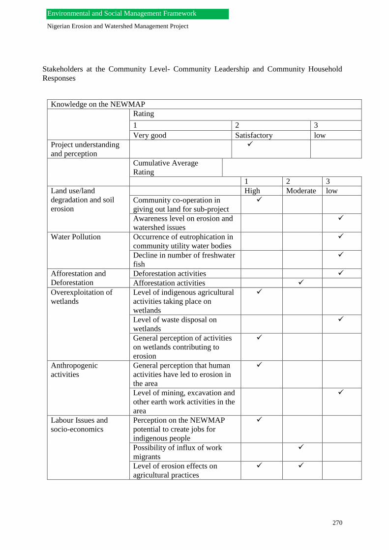
Nigerian Erosion and Watershed Management Project
270
Environmental and Social Management Framework
Stakeholders at the Community Level- Community Leadership and Community Household
Responses
Knowledge on the NEWMAP
Rating
1 2 3
Very good Satisfactory low
Project understanding
and perception
Cumulative Average
Rating
1 2 3
Land use/land
degradation and soil
erosion
High Moderate low
Community co-operation in
giving out land for sub-project
Awareness level on erosion and
watershed issues
Water Pollution Occurrence of eutrophication in
community utility water bodies
Decline in number of freshwater
fish
Afforestation and
Deforestation
Deforestation activities
Afforestation activities
Overexploitation of
wetlands
Level of indigenous agricultural
activities taking place on
wetlands
Level of waste disposal on
wetlands
General perception of activities
on wetlands contributing to
erosion
Anthropogenic
activities
General perception that human
activities have led to erosion in
the area
Level of mining, excavation and
other earth work activities in the
area
Labour Issues and
socio-economics
Perception on the NEWMAP
potential to create jobs for
indigenous people
Possibility of influx of work
migrants
Level of erosion effects on
agricultural practices

Nigerian Erosion and Watershed Management Project
271
Environmental and Social Management Framework
Situation Report- Cross River State
Perception that the NEWMAP
will successfully manage erosion
and watershed issues
Perception that NEWMAP civil
activities may affect
communities (infrastructure and
businesses) negatively
Perception that the NEWMAP
may result in involuntary
resettlement issues
Possibility in gaining co-
operation and participation from
communities for the
implementation of NEWMAP
activities
Public
Health/Infectious
diseases
Perception that influx of sub-
projects workforce may increase
spread of STIs
Information in the table is based on frequency of responses by respondents to the parameters listed above. 3
parameters where indicated under each column (high priority, moderate priority and low priority) to display
cumulative concerns as perceived by respondents.
View of the erosion sites at Etim Otop and Ikot Awatim (respectively), Calabar, Cross River State
Nyaghessan gully erosion site. Stakeholders interactive session at the Ministry of
Environment in Calabar.

Nigerian Erosion and Watershed Management Project
272
Environmental and Social Management Framework
Site Information – List of Priority Sites Cross Rivers state
S/No
S/N
Priotized sites Likely at risk
communities
Estimated
Population
Occupation of
likely project
affected
persons
Vulnerable
Groups
Nature of
Vegetation
Social Structure
1. Ikot Awatim Ikot Awatim
communities
TBD Civil servants,
traders and
artisans
Community
populace
Palm trees,
coconut, black
pear, bamboo,
shrubs.
Clan head, Village
head, Village council,
Family head, Youth
council, Women
groups, NGOs
2. Etim Otop Etim Otop and Satellite
town
TBD Civil servants,
traders, artisan,
Businesses
Community
populace
Palm trees,
coconut, black
pear, bamboo,
shrubs.
Clan head, Village
head, Village council,
Family head, Youth
council, Women
groups, NGOs
3. Watt Market
Watt market, Business
area and University
Teaching Hospital
TBD Banks, private
companies,
traders
Community
populace
Palm trees,
coconut, black
pear, bamboo,
shrubs.
Clan head, Village
head, Village council,
Family head, Youth
council, Women
groups, NGOs
4. Nyaghessan Gully I Nyaghessan communities TBD Civil servants,
traders and
artisans
Community
populace
Palm trees,
coconut, black
pear, bamboo,
shrubs.
Clan head, Village
head, Village council,
Family head, Youth
council, Women
groups, NGOs

Nigerian Erosion and Watershed Management Project
273
Environmental and Social Management Framework
Questionnaire Analysis
Stakeholders at the State and Organizational Levels- MDAs, CBOs and NGOs Responses
5. Nyaghessan Gully II Nyaghessan communities TBD Civil servants,
traders and
artisans
Community
populace
Palm trees,
coconut, black
pear, bamboo,
shrubs.
Clan head, Village
head, Village council,
Family head, Youth
council, Women
groups, NGOs
S/N List of major rivers and water catchment areas Nature of vegetation
1. Cross River Rain forest vegetation
2. Asi River Rain forest vegetation
Picture of a section of the Cross River (also called the Oyono River by natives)- One of the major rivers in Cross River.

Nigerian Erosion and Watershed Management Project
274
Environmental and Social Management Framework
Knowledge on the NEWMAP
Rating
1 2 3
Very good Satisfactory low
Project understanding and
perception
Cumulative Average Rating
1 2 3
General priority concerns of
the NEWMAP on
environmental and socio-
economic sensitivities
High priority Moderate
priority
Low priority
Soil quality
Water quality
Air quality
Solid waste disposal
Civil and earth works
Land use management and land
use controls
Brush/Forests/Vegetation
Visual quality
Quality and diversity of wildlife
Quality and diversity of aquatic
life
River-based recreation
Road drainage patterns
Invasive agricultural practices
Reservoir operations/lake levels
Flood damages to homes,
businesses, schools e.t.c
Floodplain management
Availability of safe drinking
water
Involuntary resettlement
Effect on production systems
Effect on social wellbeing
Information in the table is based on frequency of responses by respondents to the parameters listed above. 3 parameters where indicated
under each column (high priority, moderate priority and low priority) to display cumulative concerns as perceived by respondents.

Nigerian Erosion and Watershed Management Project
275
Environmental and Social Management Framework
Cultural heritage
Effect on indigenous peoples
Renewable energy sources
Public and Environmental health
politics

Nigerian Erosion and Watershed Management Project
276
Environmental and Social Management Framework
Stakeholders at the Community Level- Community Leadership and Community Household
Responses
Knowledge on the NEWMAP
Rating
1 2 3
Very good Satisfactory low
Project understanding
and perception
Cumulative Average
Rating
1 2 3
Land use/land
degradation and soil
erosion
High Moderate low
Community co-operation in
giving out land for sub-project
Awareness level on erosion and
watershed issues
Water Pollution Occurrence of eutrophication in
community utility water bodies
Decline in number of freshwater
fish
Afforestation and
Deforestation
Deforestation activities
Afforestation activities
Overexploitation of
wetlands
Level of indigenous agricultural
activities taking place on
wetlands
Level of waste disposal on
wetlands
General perception of activities
on wetlands contributing to
erosion
Anthropogenic
activities
General perception that human
activities have led to erosion in
the area
Level of mining, excavation and
other earth work activities in the
area
Labour Issues and
socio-economics
Perception on the NEWMAP
potential to create jobs for
indigenous people
Possibility of influx of work
migrants
Level of erosion effects on
agricultural practices
Information in the table is based on frequency of responses by respondents to the parameters listed above. 3
parameters where indicated under each column (high priority, moderate priority and low priority) to display
cumulative concerns as perceived by respondents.

Nigerian Erosion and Watershed Management Project
277
Environmental and Social Management Framework
Perception that the NEWMAP
will successfully manage erosion
and watershed issues
Perception that NEWMAP civil
activities may affect
communities (infrastructure and
businesses) negatively
Perception that the NEWMAP
may result in involuntary
resettlement issues
Possibility in gaining co-
operation and participation from
communities for the
implementation of NEWMAP
activities
Public
Health/Infectious
diseases
Perception that influx of sub-
projects workforce may increase
spread of STIs

Nigerian Erosion and Watershed Management Project
278
Environmental and Social Management Framework
Situation Report- Anambra State
New Heritage 2 Omaga 1&2 Onitsha, Onitsha North
LGA, Anambra State
Neros Plaza 1&2 Ifite Awka, Awka South LGA, Anambra
State. Director Admin and Director Environment and Ecology,
Ministry of Environment, Awka Anambra State at a
consultative session for the ESMF.
By Central school, Ndikelionwu Orumba North LGA,
Anambra State

Nigerian Erosion and Watershed Management Project
279
Environmental and Social Management Framework
Site Information – List of Priority Sites Anambra state
S/No
S/N
Priotized sites Likely at risk
communities
Estimated
Population
Occupation of
likely project
affected
persons
Vulnerable
Groups
Nature of
Vegetation
Social Structure
1. Madonna church
Agulu Anaocha
LGA
Nanka, Mbakwu,
Obeleudu,
80,000 Civil, servant,
business and
farming
Women, children,
migrants
Trees and
shrubs
Igwe, Onowu
(Prime minister),
Igwe’s cabinet,
Town crier,
Family heads,
Youth grade
2. By Central school
Ndikelionwu
Orumba North
Ufuma, Mgbowo, Enugu-
Abo,
60,000 Cicil servants,
business
Women, children,
migrants
Trees and
shrubs
Igwe, Onowu
(Prime minister),
Igwe’s cabinet,
Town crier,
Family heads,
Youth grade
3. NEROS plaza 1&2
Ifite Awka, Awka
South LGA
Awka South communities 64,000 Business, Civil
servants
Women, children,
migrants
Trees and
shrubs
Igwe, Onowu
(Prime minister),
Igwe’s cabinet,
Town crier,
Family heads,
Youth grade
4. Umudunu village
Abagana near
Egbum Family
house
Orofia, Etiti, Eziachala,
Amenye, Ifitedunu,
Ukpor, Eziowelle,
Abacha, Enugu- Ukwu.
TBD Business,
Agriculture
Women, children,
migrants
Trees and
shrubs
Igwe, Onowu
(Prime minister),
Igwe’s cabinet,
Town crier,
Family heads,
Youth grade

Nigerian Erosion and Watershed Management Project
280
Environmental and Social Management Framework
5. New Heritage 2
Omagba 1&2
Onitsha, Onitsha
North LGA.
Nkpor, Nkwuelezunaka,
Onitsha,
30,000 Business, Trade,
Civil servants
and agricultrure
Women, children,
migrants
Trees and
shrubs
Igwe, Onowu
(Prime minister),
Igwe’s cabinet,
Town crier,
Family heads,
Youth grade
S/N List of major rivers and water catchment areas Nature of vegetation
1. Imo River Kola nut, Oil palm, raffia palm, local pear, bamboo
2. Aba River Kola nut, Oil palm, raffia palm, local pear, bamboo
3. Nkisi River Kola nut, Oil palm, raffia palm, local pear, bamboo
4. Elechi River Kola nut, Oil palm, raffia palm, local pear, bamboo
5. Orashi River Kola nut, Oil palm, raffia palm, local pear, bamboo
6. Idemili River Kola nut, Oil palm, raffia palm, local pear, bamboo
7. Odo River Kola nut, Oil palm, raffia palm, local pear, bamboo
8. Anambra River Kola nut, Oil palm, raffia palm, local pear, bamboo
9. River Niger Kola nut, Oil palm, raffia palm, local pear, bamboo
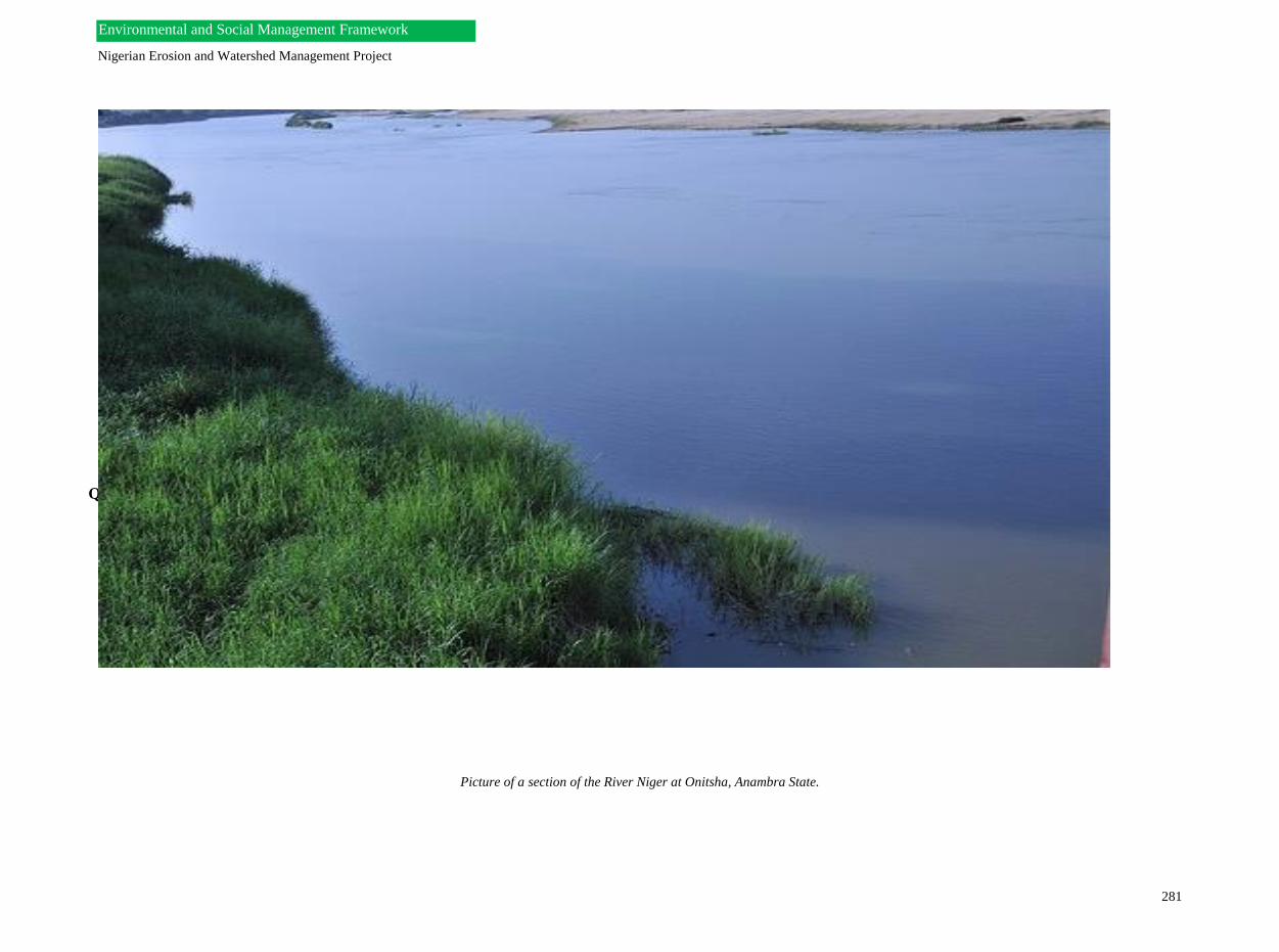
Nigerian Erosion and Watershed Management Project
281
Environmental and Social Management Framework
Questionnaire Analysis
Stakeholders at the State and Organizational Levels- MDAs, CBOs and NGOs Responses
Picture of a section of the River Niger at Onitsha, Anambra State.
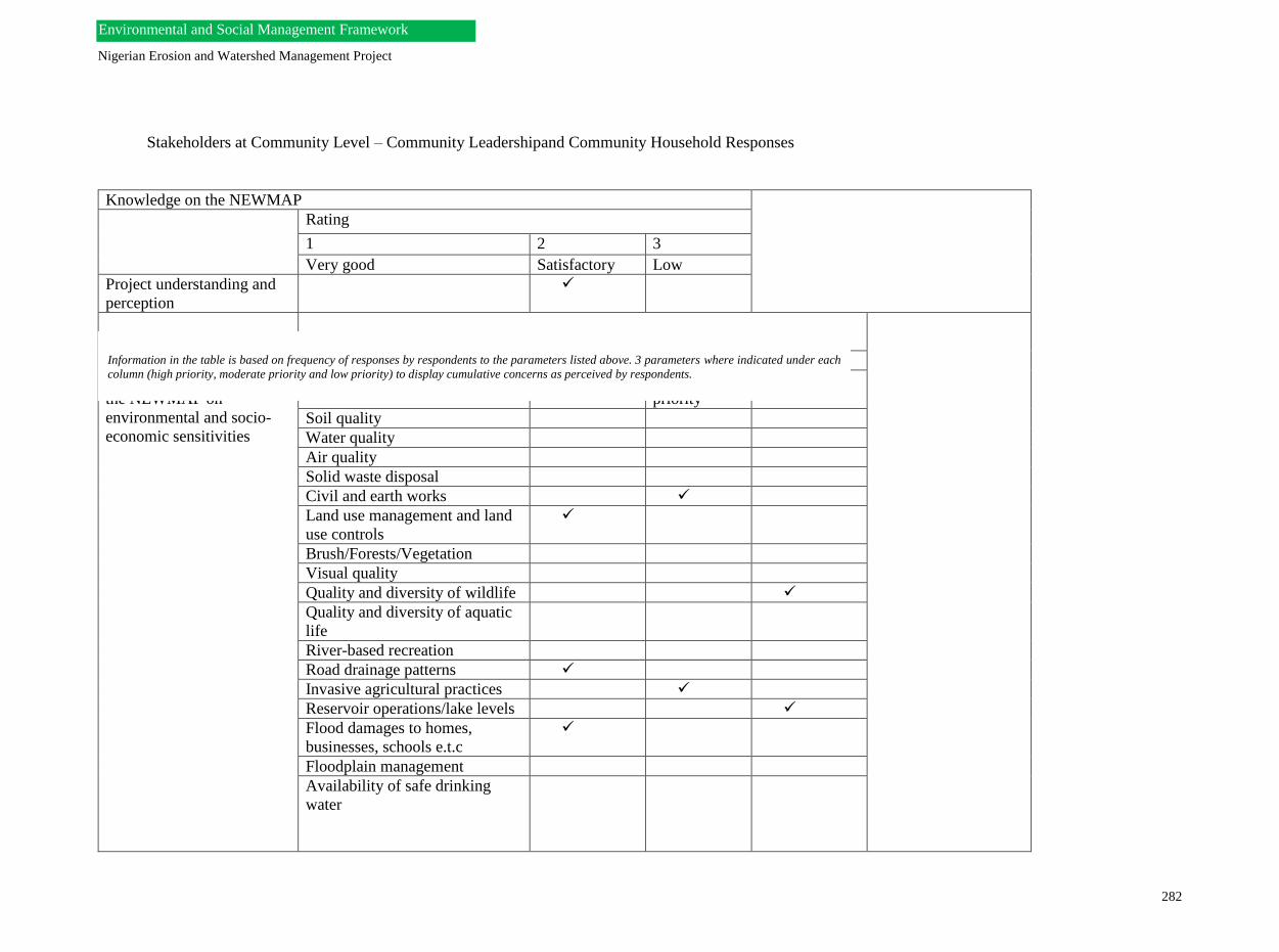
Nigerian Erosion and Watershed Management Project
282
Environmental and Social Management Framework
Stakeholders at Community Level – Community Leadershipand Community Household Responses
Knowledge on the NEWMAP
Rating
1 2 3
Very good Satisfactory Low
Project understanding and
perception
Cumulative Average Rating
1 2 3
General priority concerns of
the NEWMAP on
environmental and socio-
economic sensitivities
High priority Moderate
priority
Low priority
Soil quality
Water quality
Air quality
Solid waste disposal
Civil and earth works
Land use management and land
use controls
Brush/Forests/Vegetation
Visual quality
Quality and diversity of wildlife
Quality and diversity of aquatic
life
River-based recreation
Road drainage patterns
Invasive agricultural practices
Reservoir operations/lake levels
Flood damages to homes,
businesses, schools e.t.c
Floodplain management
Availability of safe drinking
water
Information in the table is based on frequency of responses by respondents to the parameters listed above. 3 parameters where indicated under each
column (high priority, moderate priority and low priority) to display cumulative concerns as perceived by respondents.

Nigerian Erosion and Watershed Management Project
283
Environmental and Social Management Framework
Involuntary resettlement
Effect on production systems
Effect on social wellbeing
Cultural heritage
Effect on indigenous peoples
Renewable energy sources
Public and Environmental health
Politics
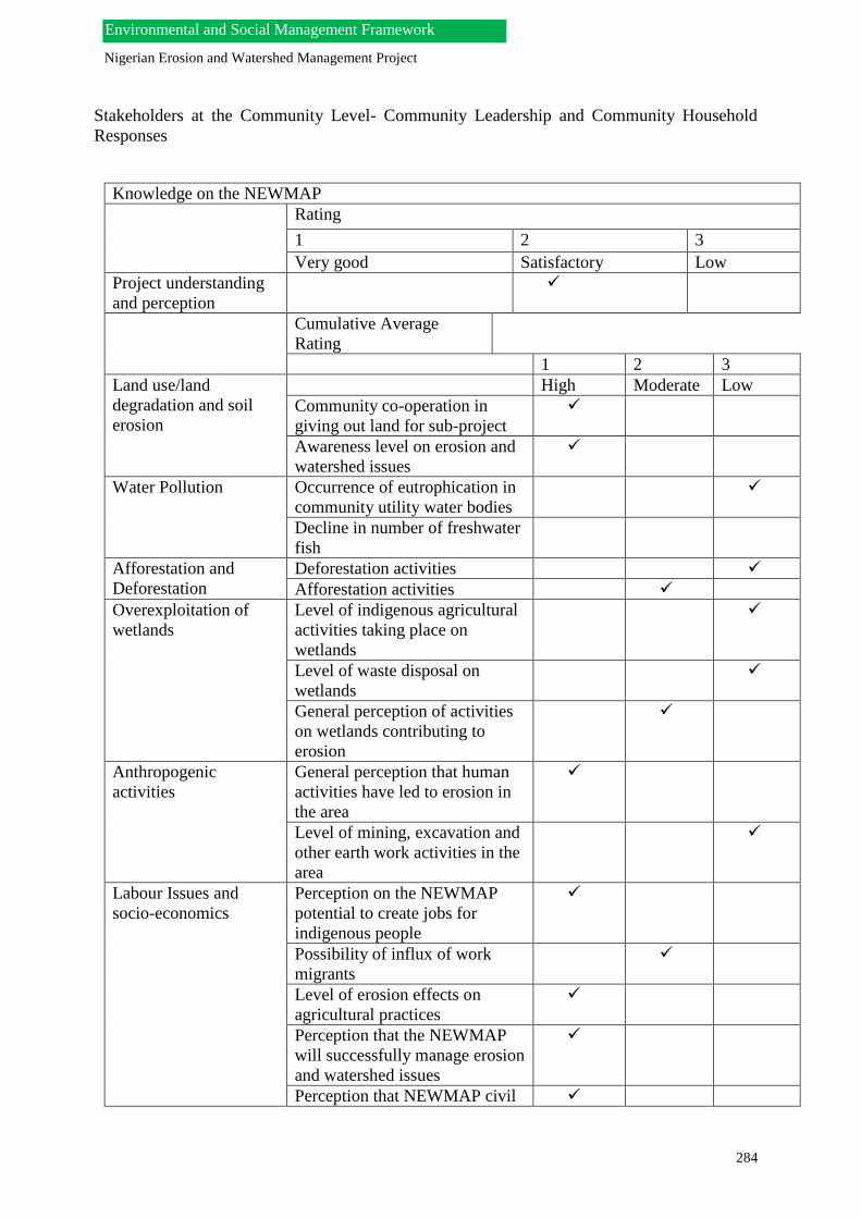
Nigerian Erosion and Watershed Management Project
284
Environmental and Social Management Framework
Stakeholders at the Community Level- Community Leadership and Community Household
Responses
Knowledge on the NEWMAP
Rating
1 2 3
Very good Satisfactory Low
Project understanding
and perception
Cumulative Average
Rating
1 2 3
Land use/land
degradation and soil
erosion
High Moderate Low
Community co-operation in
giving out land for sub-project
Awareness level on erosion and
watershed issues
Water Pollution Occurrence of eutrophication in
community utility water bodies
Decline in number of freshwater
fish
Afforestation and
Deforestation
Deforestation activities
Afforestation activities
Overexploitation of
wetlands
Level of indigenous agricultural
activities taking place on
wetlands
Level of waste disposal on
wetlands
General perception of activities
on wetlands contributing to
erosion
Anthropogenic
activities
General perception that human
activities have led to erosion in
the area
Level of mining, excavation and
other earth work activities in the
area
Labour Issues and
socio-economics
Perception on the NEWMAP
potential to create jobs for
indigenous people
Possibility of influx of work
migrants
Level of erosion effects on
agricultural practices
Perception that the NEWMAP
will successfully manage erosion
and watershed issues
Perception that NEWMAP civil

Nigerian Erosion and Watershed Management Project
285
Environmental and Social Management Framework
activities may affect
communities (infrastructure and
businesses) negatively
Perception that the NEWMAP
may result in involuntary
resettlement issues
Possibility in gaining co-
operation and participation from
communities for the
implementation of NEWMAP
activities
Public
Health/Infectious
diseases
Perception that influx of sub-
projects workforce may increase
spread of STIs
Information in the table is based on frequency of responses by respondents to the parameters listed above. 3
parameters where indicated under each column (high priority, moderate priority and low priority) to display
cumulative concerns as perceived by respondents.

Nigerian Erosion and Watershed Management Project
286
Environmental and Social Management Framework
Situation Report- Edo State
View of the erosion site at Auchi-Abuja express way,
Auch, Edo State
Representatives of erosion affected communities after an
interactive session. Bende LGA, Abia State.
Team with a representativs from the State Government,
Abia State.
View of the erosion site at Queen Ede, Benin City, Edo
State.

Nigerian Erosion and Watershed Management Project
287
Environmental and Social Management Framework
Site Information – List of Priority Sites Edo state
S/No
S/N
Priotized sites Likely at risk
communities
Estimated
Population
Occupation of
likely project
affected
persons
Vulnerable
Groups
Nature of
Vegetation
Social Structure
1. Oshobugie Plain
Gully Erosion
TBD TBD TBD TBD TBD TBD
2. Queen Ede
secondary school Rd
TBD TBD TBD TBD TBD TBD
3. Uwellu Flood
catchment East &
West
TBD TBD TBD TBD TBD TBD
4. Moat Flood
catchment
TBD TBD TBD TBD TBD TBD
5. Okhoro Float
Catchment
TBD TBD TBD TBD TBD TBD

Nigerian Erosion and Watershed Management Project
288
Environmental and Social Management Framework
S/N List of major rivers and water catchment areas Nature of vegetation
1. Anegbeche River Rain forest vegetation
2. Mushi River Rain forest vegetation
Picture of a section of the Anegbeche River with Fulani migrants by the river bank. This very enormous river drains into the River Niger.

Nigerian Erosion and Watershed Management Project
289
Environmental and Social Management Framework
Questionnaire Analysis
Stakeholders at the State and Organizational Levels- MDAs, CBOs and NGOs Responses
Knowledge on the NEWMAP
Rating
1 2 3
Very good Satisfactory Low
Project understanding and
perception
Cumulative Average Rating
1 2 3
General priority concerns of
the NEWMAP on
environmental and socio-
economic sensitivities
High priority Moderate
priority
Low priority
Soil quality
Water quality
Air quality
Solid waste disposal
Civil and earth works
Land use management and land
use controls
Brush/Forests/Vegetation
Visual quality
Quality and diversity of wildlife
Quality and diversity of aquatic
life
River-based recreation
Road drainage patterns
Invasive agricultural practices
Reservoir operations/lake levels
Flood damages to homes,
businesses, schools e.t.c
Floodplain management
Availability of safe drinking
water
Information in the table is based on frequency of responses by respondents to the parameters listed above. 3 parameters
where indicated under each column (high priority, moderate priority and low priority) to display cumulative concerns as
perceived by respondents.
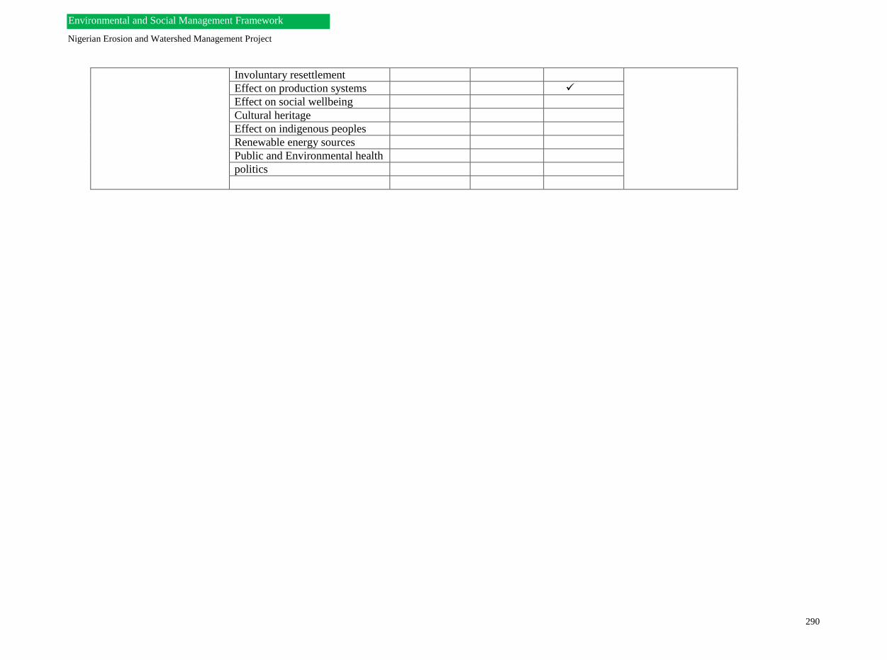
Nigerian Erosion and Watershed Management Project
290
Environmental and Social Management Framework
Involuntary resettlement
Effect on production systems
Effect on social wellbeing
Cultural heritage
Effect on indigenous peoples
Renewable energy sources
Public and Environmental health
politics

291
Stakeholders at the Community Level- Community Leadership and Community Household
Responses
Knowledge on the NEWMAP
Rating
1 2 3
Very good Satisfactory low
Project understanding
and perception
Cumulative Average
Rating
1 2 3
Land use/land
degradation and soil
erosion
High Moderate low
Community co-operation in
giving out land for sub-project
Awareness level on erosion and
watershed issues
Water Pollution Occurrence of eutrophication in
community utility water bodies
Decline in number of freshwater
fish
Afforestation and
Deforestation
Deforestation activities
Afforestation activities
Overexploitation of
wetlands
Level of indigenous agricultural
activities taking place on
wetlands
Level of waste disposal on
wetlands
General perception of activities
on wetlands contributing to
erosion
Anthropogenic
activities
General perception that human
activities have led to erosion in
the area
Level of mining, excavation and
other earth work activities in the
area
Labour Issues and
socio-economics
Perception on the NEWMAP
potential to create jobs for
indigenous people
Possibility of influx of work
migrants

292
Level of erosion effects on
agricultural practices
Perception that the NEWMAP
will successfully manage erosion
and watershed issues
Perception that NEWMAP civil
activities may affect
communities (infrastructure and
businesses) negatively
Perception that the NEWMAP
may result in involuntary
resettlement issues
Possibility in gaining co-
operation and participation from
communities for the
implementation of NEWMAP
activities
Public
Health/Infectious
diseases
Perception that influx of sub-
projects workforce may increase
spread of STIs
Information in the table is based on frequency of responses by respondents to the parameters listed above. 3
parameters where indicated under each column (high priority, moderate priority and low priority) to display
cumulative concerns as perceived by respondents.

293
ANNEX 0010: STAKEHOLDERS ATTENDANCE SHEET
NEWMAP’s Stakeholders Interactive Session (Attendance List for Enugu State)
S/N NAME
ESTABLISHMEN
T
POSITION PHONE NO. E-MAIL
1 Ozoani Victor World Bank
Consultant.
Asst.Prog. 08066907070 [email protected]
om
2 Udenwani G.I Ministry of
Finance
Director 08037112633 geofryudenwani
@yahoo.com
3 Ezeh Tessy Ministry of
Environment
PRO 0803708944
4 Engr. Evans
Ugwu
MOEMR Head(Ecolo
gy& MR)
08033403216 Evansugwu2000
@yahoo.co.uk
5 Patrick W.I
Okenwa
MOEMR Director 08033509431 p.okenwa@yahoo
.com.uk
6 Barr.A.O
Onaga
MRD P.S 08035517649
7 Nwangwu
A.U
MOEMR Head
(Environme
ntal
Conservatio
n
07035019177
8 Okolo
Johnpaul
CIDJAP Project
Officer
(Environment
)
08038844985 okolochuoli@yah
oo.com

294
S/N NAME
ESTABLISHMEN
T
POSITION PHONE NO. E-MAIL
9 Udejiofor
Emmanuel
Ministry of
Water Resources
Geologist 080-38662918 emmalexassociate
@yahoo.com
10 Nwodoani
Ejike
Ministry of
Water Resources
Geologist 08037350196 ejikechibuzor@g
mail.com
11 Crodu J.U Forestry(MOEM
R) Enugu
Director of
Forestry
08034718819 Jupo4director@y
ahoo.com
12 Chinonye
Okegbe
MOEMR Director
(F&A)
08033419543 Daconsinokegbe
@yahoo.com
13 Onwuegbuna
Guy. C
MOEMR Director
Pollution
Control
08037789391 guyonwuuegbuna@
yahoo.com
14 E.C. Asadu MOEMR Director of
Planning
08067968555
15 Godwin C.
Ogenyi
MHD&PR Hon.
Commissione
r
08062666448 [email protected]
om
16 Chioma
Obasi
17 Eugene Hua World Bank
Consultant
18 Ogbonna
Chime
Min. Of Lands Deputy
Director
08033196104

295
S/N NAME
ESTABLISHMEN
T
POSITION PHONE NO. E-MAIL
19 Okonkwo
B.C
Min. Of
Environment
HOD
Env/Health
08052420293
20 Engr.J.N.
Okafor
Min. Of Works Deputy
Director
08052540748
21 Okenwa B.I Min. Of Agric Chief Admin
Officer
08037444906
22 Paul .N.P SSA to Gov. SSA 08033114595
23 Madu P.C MHD PR Chief
Statistician
07065664138
24 Okafor
Simon I (JP)
MHDPR Director of
Coops
08068577171
25 Igwe
Chibuike
ASBESOC/ASE
RSO
CEO/Presiden
t
08037143455 infoasbesoc@gmail
.co
26 Nwangene
Christian
Voci/Asernso V.President 08063457452 christianwangene@
yahoo.com
27 Alintah
Festus
KEMCA ED 08035511807
28 Engr. F.C.
Okonkwo
Min. Of Rural Dev. Director 07031116138 Fred.okonkwo@ya
hoo.com

296
NEWMAP’S STAKEHOLDERS INTERACTIVE SEASSION (ATTENDANCE LIST FOR
EDO STATE)
QUEEN EDE/ OGBESON COMMUNITY
S/N NAME POSITION PHONE No.
1 Pa Daniel Ediagbonya Odionwere 07025655938
2 Ichiore Alexandre Landlords Association Secretary 08135450605
3 Mrs. P. Ediagbonya Odiowere’s wife 08033443409
4 Mrs. S Amadi Landlady 08023528607
5 Mrs. P. Obasogie Landlady 08023594468
6 Mrs. Friday Ikponmwosa Jesus Daily Ministry 08055407356
7 Sir. Charles A. Anoje St. Thomas Aquinas Catholic
Church.
08037771925
8 Comrade F.O. Idahosa Jesus Daily Ministry 08055964003
9 Mrs. A. Igbinosun Leader, Association of Women
Forum
08050676204
10 Mrs. M.A. Ihiehie Leader, Women Forum, Ogbeson 08051079922
11 Mrs. S.O.Ogie Landlady’s Secretary 08134999595
12 Mrs. Ajayi Tina Landlady’s Secretary 08026239337

297
S/N NAME POSITION PHONE No.
13 Chief Foster Aghahowa
Odigie
Asst. Sec. Gen 07055722888
14 P.E
15 Evbuotubu Community Asst. Sec. Gen. 07060470000
16 Christopher.O.
Igbineweka
Engr. 08037190092
NGO
S/N Name of officer Name of NGO Phone No.
1 Johnson
E. Dudu
CPED, Benin city, (Centre for
Population and Environmental
Development)
08052837422
AUCHI COMMUNITY
S/N Name Position Phone
No
1 HRH. Alhaji
H.A. Momoh
Otaru of Auchi
2 Chief Alhaji
J.M. Garuba
Daudu of Usogu 08059866315
3 Mallam
Dirisu Yayah
PA (Otaru of Auchi) 08050516381

298
PMU-NEWMAP/FME/CONSULTANTS/WORLD BANK
S/N Name of Officer Name of Institution Phone No
1 A.H. Ikhelona PS, MEPU 08034036512
2 Tom Obaseki Min. Of Environment, Edo State, PMU-
NEWMAP(Proc. Specials)
08023071085
3 Tawa Woghireh PMU-NEWMAP-Fin. Expert 08037267317
4 Edwin .A. Ero Min. Of Env. Edo State, PMU-NEWMAP (E&S) 08036179689
5 Oyebankole
Agbelusi
Hospitalia Consultaire 08023468195
6 Dr. Victor C.
Nwachukwu
Hospitalia Consultaire 07032921700
7 Ozoani Victor Multi Dev. Consultant(World Bank) 08066907676
8 Obasi Chioma Multi Dev. Consultant(World Bank) 08062392974
9 Eugene Itua World Bank Consultant 08030610235
10 Engr. R.E.
Aghayesho
Consultant (CEXEM),MEPU 08056724203
11 Engr.(Dcn) G.M.
Ejemai
Director,Env. M.E.P.U 08058767896
12 P.E. Otoighile (Mrs) Director, Admin and Supply, Min. Of Env. &
Public Utility.
08023389323
13 A.I. Omoruyi Director (Forestry), Min. Of Environment. 08023343648

299
ANNEX 011 RESETTLEMENT POLICY FRAMEWORKS
RESETTLEMENT POLICY FRAMEWORK TEMPLATE: NIGERIA

300
PART I: BASIC INFORMATION
1. Country and Project Name:
2. Project Development Objectives:
3. Project Outcomes:
4. Expected Project Benefits:
5. Identified Project Social Risks:
Recipient:
Responsible Government/Country Agency for RPF Implementation:
Total Project Cost (USD million):
IDA/IBRD (USD million):
Government (USD million):
Other-Co-financing (USD million):
Total Cost of RPF (USD million):
Project preparation (USD million):
Government (USD million):

301
Name/Contacts of Consultant/Consulting Firm who prepared RPF:
Date RPF Prepared:
Date RPF Disclosed:
Country: Social Safeguards Specialist:
Country Manager:
Country Director:
Task Team Leader:
SDN Sector Leader:
Project ID:
Environment Category:
Date ISDS prepared:
Date ISDS disclosed:
Year of project appraisal:
Year of project closing:
Is this a transferred project?
[ ] Yes [ ] No

302
Is RPF applied to financial intermediary or intermediaries financing sub-
projects?
[ ] Yes [ ] No
Is RPF applied because zone of impact of sub-projects cannot be
determined at this stage?
[ ] Yes [ ] No
Is the RPF applied because the zone of impact is known but the site
(location) alignments are not yet well established?
[ ] Yes [ ] No
Is this community driven development (CDD) project?
[ ] Yes [ ] No
Is this a sector-wide project with national coverage?
[ ] Yes [ ] No
Is this a regional operation, with national/sub-national coverage?
[ ] Yes [ ] No
Safeguard policies triggered? Applicable
Environmental Assessment (OP/BP 4.01) [ ] Yes [ ] No
Natural Habitats (OP/GP 4.04) [ ] Yes [ ] No
Forestry (OP 4.36) [ ] Yes [ ] No
Pest Management (OP 4.09) [ ] Yes [ ] No
Cultural Property (OP 4.11) [ ] Yes [ ] No
Indigenous Peoples (OP 4.10) [ ] Yes [ ] No

303
Involuntary Resettlement (OP 4.12) [ X ] Yes [ ] No
Safety of Dams (OP/BP 4.37) [ ] Yes [ ] No
Projects in Disputed Areas (OP/BP 7.60) [ ] Yes [ ] No
Projects on International Waterways (OP/BP 7.50) [ ] Yes [ ] No
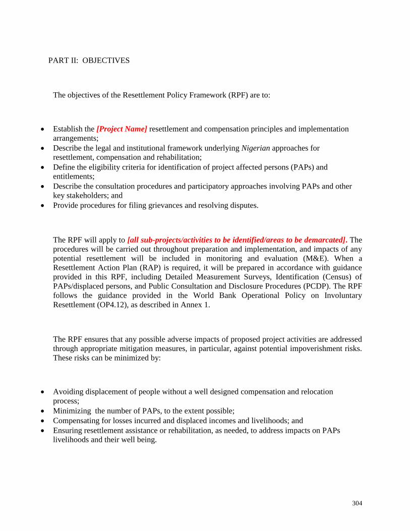
304
PART II: OBJECTIVES
The objectives of the Resettlement Policy Framework (RPF) are to:
Establish the [Project Name] resettlement and compensation principles and implementation
arrangements;
Describe the legal and institutional framework underlying Nigerian approaches for
resettlement, compensation and rehabilitation;
Define the eligibility criteria for identification of project affected persons (PAPs) and
entitlements;
Describe the consultation procedures and participatory approaches involving PAPs and other
key stakeholders; and
Provide procedures for filing grievances and resolving disputes.
The RPF will apply to [all sub-projects/activities to be identified/areas to be demarcated]. The
procedures will be carried out throughout preparation and implementation, and impacts of any
potential resettlement will be included in monitoring and evaluation (M&E). When a
Resettlement Action Plan (RAP) is required, it will be prepared in accordance with guidance
provided in this RPF, including Detailed Measurement Surveys, Identification (Census) of
PAPs/displaced persons, and Public Consultation and Disclosure Procedures (PCDP). The RPF
follows the guidance provided in the World Bank Operational Policy on Involuntary
Resettlement (OP4.12), as described in Annex 1.
The RPF ensures that any possible adverse impacts of proposed project activities are addressed
through appropriate mitigation measures, in particular, against potential impoverishment risks.
These risks can be minimized by:
Avoiding displacement of people without a well designed compensation and relocation
process;
Minimizing the number of PAPs, to the extent possible;
Compensating for losses incurred and displaced incomes and livelihoods; and
Ensuring resettlement assistance or rehabilitation, as needed, to address impacts on PAPs
livelihoods and their well being.

305
PART III: PROJECT DESCRIPTION AND RATIONALE FOR RPF
Description of project activities where the RPF will be applied:
Land acquisition and resettlement impacts [Describe the activities that may require land
take or acquiring land and other assets; relocation or displacement of persons occupying
or using these lands and other assets]:

306
PART IV: LEGAL AND INSTITUTIONAL FRAMEWORK
This RPF will apply the laws, legislation, regulations, and local rules governing the use of land
and other assets in Nigeria. This legal and institutional framework is presented in five sections: (i)
Political economy and governance in Nigeria; (ii) Property and land rights, as defined by Nigerian
law and customary practice; (iii) Acquisition of land and other assets, including regulations over
the buying and selling of these assets; (iv) Human rights and compensation, in particular, the
accepted norms influencing peoples’ basic rights to livelihood and social services; (v) Dispute
resolution and grievance mechanisms, specifically the legal and institutional arrangements for
filing grievances or complaints and how those grievances are addressed through formal and
informal systems of dispute resolution; and (vi) Comparison with World Bank OP4.12, using
equivalence and acceptability standards.
i) POLITICAL ECONOMY AND GOVERNANCE IN NIGERIA
The political and legal context for the application of Resettlement Policy Frameworks (RPFs) is
mainly governed by The Land Use Act of 1978 as modified in 1990 and The Constitution of
Nigeria, 1999. It is important to note that there is no private ownership of land, as all land is vested
in the authority of the government.
ii) PROPERTY AND LAND RIGHTS IN NIGERIA
The Constitution of Nigeria, 1999 provides that every citizen has the right to acquire and own
immovable property in Nigeria. However, there is no private land in Nigeria, as all land is under
the authority of government
In Nigeria, as in much of Africa, there are overlapping systems of land rights. Nigeria has both
customary land rights and statutory land rights, the latter of which is based in English common
law. Customary land rights generally apply to ethnic communities, where individuals and families
received land rights by virtue of land being assigned to them (or their ancestors) by the community
leader, usually the Chief. Statutory land rights are generally found in urban areas, where
institutions and business have established rights to land through common law channels.
The Land Use Act of 1978 vests all land in the authority of the Governor of that state. This land
is “to be held in trust and administered for the use and common benefit of all Nigerians.” (Land
Use Act, Section 1). The Land Use Act distinguishes between urban land, which is under direct
control of the Governor and non-urban land which is under the control of the local government
in that area (Land Use Act, Section 2).
The Governor has the power to grant occupancy rights to any person for any purpose on both urban
and non-urban land (Land Use Act, Section 5). The Local Government can grant occupancy rights

307
to any person or urbanization on non-urban land in its jurisdiction, where that land will be used for
“agricultural, residential or other purposes.” The Local Government can also grant these rights for
grazing purposes “as may be customary in the Local Government Area concerned” (Land Use Act,
Section 6).
Additionally, the Constitution states that “control of all minerals, mineral oils and natural gas in,
under or upon any land in Nigeria or in, under or upon the territorial waters and the Exclusive
Economic Zone of Nigeria” is under control of the federal government of Nigeria.
iii) ACQUISITION AND VALUATION OF LAND AND OTHER ASSETS
Land Acquisition
The Land Use Act entitles the Government of Nigeria to revoke the occupancy right to a piece of
land “for overriding public interest. (Land Use Act, Section 2)” Additionally, the local
government has the right to enter onto, use, and occupy any land in its jurisdiction, and also to
revoke occupancy right to the land if necessary for the purpose above (Land Use Act, Section 6).
The Act defines overriding public interest as when the land is required by either the federal, state,
or local government for public purposes or if the land is required for mining or oil pipelines (Land
Use Act, Section 2). However, the Constitution of Nigeria requires that adequate compensation be
paid if either movable or immovable property is compulsorily acquired by the government (Section
V). The Land Use Act specifies details on how compensation is to be paid.
If the government determines that it needs to compulsorily acquire land, and thus revoke a person’s
occupancy right, the Governor on behalf to the “Head of the Federal Military Government” shall
issues a notice to such effect. The notice shall take effect as soon as the occupier receives the
notice, or at a later date if so specified on the notice (Land Use Act, Section 28).
Right of Way
The 1996 Electricity Supply Regulations of 1966 give clear Right of Way (RoW) allowances for
high voltage power lines. Specifically it requires a clearance off 6 meters for 330 kV lines, 4
meters for 132kV lines, 3 meters for 33 kV lines, and 2.4 meters for lines that carry 11kV or less.
The Highway Act defines the right of way for highways as 50 meters to either side of the median
line. In other words, the total right way is 100 meters. This land is federally owned and managed,
and the government holds the right to dispose of or use this land.
Valuation
The Land Use Act states that compensation will be for the value of their “unexhausted
improvements” as at the date that the revocation takes place (Land Use Act, Section 6 and Section
29). Specifically, it states that compensation shall cover the amount equal to the rent paid in the
year the land was acquired (assuming that any rent is paid). Compensation must also cover the
cost of replacing any buildings, installations, or improvements minus any depreciation.
Additionally, the Act specifies that interest must be paid ‘at the bank rate’ for any delay in payment

308
of compensation. Finally, crops must be compensated at the value of the crops ‘as determined by
the appropriate officer’ (Land Use Act, Section 29).
iv) HUMAN RIGHTS AND COMPENSATION
The Constitution of Nigeria requires that, if a person’s property is compulsorily acquired, that
person must be adequately compensated (Section V). According to the Land Use Act, if the
occupier of the land is a community, the compensation can be paid directly to the community, to
the chief to distribute to the community according to customary law, or place in a fund to use to
benefit the community (Land Use Act, Section 29). Under the Land Use Act, if compulsorily
acquired land was used for agriculture, the person shall be given an alternative piece of land to use
for the same purpose (Land Use Act, Section 6). If the land houses a residential building, the
government may choose to resettle the persons affected in another “reasonable alternative
accommodation.” However, if the value of the alternate accommodation is higher than the
compensation owed to the displaced persons, the difference will be treated as a loan that the
recipients must replay to the government (Land use Act, Section 33).
v) DISPUTE RESOLUTION AND GRIEVANCE MECHANISMS
The Land Use Act provides that if a person is dissatisfied with the amount of compensation offered
to him, the case must be taken to the appropriate Land Use and Allocation Committee (Land Use
Act, Section 2). The High Court is the only body that can make the determination on who should
receive compensation if there is any question on that matter (Land Use Act, Section 39). However,
the Land Use Act also states that “no court shall have jurisdiction to inquire into any question
concerning or pertaining to the amount or adequacy of any compensation paid or to be paid” (Land
Use Act, Section 47).
vi) COMPARISON TO WORLD BANK OP 4.12
There are a number of serious discrepancies between Nigerian laws and regulations and the
requirements for resettlement as laid out in OP 4.12. Although the Nigerian Constitution
requires that adequate compensation be paid to those displaced by projects, this is not on par with
OP 4.12, which requires that compensation be paid prior to the start of the project. Additionally,
it is not clear how the determination of compensation for crops as well as buildings and other
structures will be made under Nigerian law. The World Bank’s policies require that people be
reimbursed at full replacement value. Nigerian law does not make any specific accommodation for
squatters or illegal settlers, and reimbursement is based on legal occupancy. OP 4.12 requires that
affected communities are consulted, and should be given the opportunity to participate, implement,
and monitor resettlement. However, Nigerian law does not require any public consultations, and
land can be seized for public purpose as soon as the occupier receives the notice of intent to do so.
Additionally, there are no specific accommodations for potentially vulnerable groups such as
women, children, the elderly, ethnic minorities, indigenous people, the landless, and those living
under the poverty line. These groups are at highest risk to be negatively affected by resettlement,
and should thus be given special consideration during the preparation of a resettlement policy
framework to assure that they can maintain at least the same living standard after displacement
takes place.

309
Finally, there is also no provision in the law that the state should attempt to minimize involuntary
resettlement.

310
Table I: Comparison of Nigerian and World Bank Policies on Resettlement and Compensation
Types of Affected Persons/
Lost Assets
Nigerian Law World Bank OP4.12
Comparison/Gaps
Section I: Property and land rights
Land Owners The Land Use Act of 1978 vests
all land in the authority of the
Governor of that state. This
land is “to be held in trust and
administered for the use and
common benefit of all
Nigerians.” (Land Use Act,
Section 1).
Through census and socio-
economic surveys of the
affected population, identify,
assess, and address the
potential economic and social
impacts of the project that are
caused by involuntary taking of
land (e.g., relocation or loss of
shelter, loss of assets or access
to assets, loss of income
sources or means of livelihood,
whether or not the affected
person must move to another
location) or involuntary
restriction of access to legally
designated parks and protected
areas
Land-for-land exchange is the
preferred option; compensation
The legal right to resettlement
is applicable only to those with
proprietary interest in the
affected land

311
Table I: Comparison of Nigerian and World Bank Policies on Resettlement and Compensation
Types of Affected Persons/
Lost Assets
Nigerian Law World Bank OP4.12
Comparison/Gaps
is to be based on replacement
cost.
Land Tenants/Squatters The Land Use Act entitles the
Government of Nigeria to
revoke the occupancy right to
a piece of land “for overriding
public interest. (Land Use
Act, Section 2)”
Additionally, the local
government has the right to
enter onto, use, and occupy
any land in its jurisdiction,
and also to revoke occupancy
right to the land if necessary
for the purpose above (Land
Use Act, Section 6). The Act
defines overriding public
interest as when the land is
required by either the federal,
state, or local government for
public purposes or if the land
For those without formal legal
rights to lands or claims to
such land that could be
recognized under the laws of
the country, the government
should provide resettlement
assistance in lieu of
compensation for land, to help
improve or at least restore
those affected persons’
livelihoods
Nigerian law does not make
any specific accommodation
for squatters or illegal settlers,
and reimbursement is based
on legal occupancy.
There is no equivalence on the
specific requirement of non-
discrimination or the
requirement that particular
attention be paid to the needs
of vulnerable groups among
the displaced.

312
Table I: Comparison of Nigerian and World Bank Policies on Resettlement and Compensation
Types of Affected Persons/
Lost Assets
Nigerian Law World Bank OP4.12
Comparison/Gaps
is required for mining or oil
pipelines (Land Use Act,
Section 2)
Land Users Under the Land Use Act, if
compulsorily acquired land
was used for agriculture, the
person shall be given an
alternative piece of land to use
for the same purpose (Land
Use Act, Section 6). If the
land houses a residential
building, the government may
choose to resettle the persons
affected in another
“reasonable alternative
accommodation.” However,
if the value of the alternate
accommodation is higher than
the compensation owed to the
displaced persons, the
difference will be treated as a
loan that the recipients must
replay to the government
(Land use Act, Section 33).
Identify and address impacts
also if they result from other
activities that are: (a) directly
and significantly related to the
proposed project, (b)
necessary to achieve its
objectives, and (c) carried out
or planned to be carried out
contemporaneously with the
project.
No equivalence between
Bank and Nigerian systems
for identifying and addressing
impacts resulting from project
related activities.

313
Table I: Comparison of Nigerian and World Bank Policies on Resettlement and Compensation
Types of Affected Persons/
Lost Assets
Nigerian Law World Bank OP4.12
Comparison/Gaps
Owners of non-permanent
buildings
The Land Use Act states that
compensation will be for the
value of their “unexhausted
improvements” as at the date
that the revocation takes place
(Land Use Act, Section 6 and
Section 29). Specifically, it
states that compensation shall
cover the amount equal to the
rent paid in the year the land
was acquired (assuming that
any rent is paid).
Compensation must also
cover the cost of replacing any
buildings, installations, or
improvements minus any
depreciation. (Land Use Act,
Section 29).
For those without formal legal
rights to lands or claims to
such land or assets that could
be recognized under the laws
of the country, Bank policy
provides for resettlement
assistance in lieu of
compensation for land, to help
improve or at least restore
their livelihoods.
Those without formal legal
rights or claims to such lands
and/or semi-permanent
structures are not entitled to
resettlement assistance or
compensation. This is
inconsistent with Bank policy
Owners of permanent
buildings
Entitled to in-kind
compensation or cash
compensation at full
replacement cost including
labor and relocation expenses,
prior to displacement
Nigerian law requires the
affected persons receive
compensation on the basis of
replacement value when
permanent structures are
affected. Although the law
can be interpreted to include
labor and relocation expenses,
these are not explicitly

314
Table I: Comparison of Nigerian and World Bank Policies on Resettlement and Compensation
Types of Affected Persons/
Lost Assets
Nigerian Law World Bank OP4.12
Comparison/Gaps
enumerated under Nigerian
law.
Section II: Resettlement and Compensation Process
Timing of compensation
payments
The Land Use Act (Section
29) specifies that interest must
be paid ‘at the bank rate’ for
any delay in payment of
compensation. Finally, crops
must be compensated at the
value of the crops ‘as
determined by the appropriate
officer’
Implement all relevant
resettlement plans before
project completion and provide
resettlement entitlements
before displacement or
restriction of access. For
projects involving restrictions
of access, impose the
restrictions in accordance with
the timetable in the plan of
actions.
There is no equivalence on
implementing all relevant
resettlement plans before
project completion or on
providing resettlement
entitlements before
displacement or restriction of
access.
Calculation of compensation
and valuation
Under the Land Use Act, if
compulsorily acquired land
was used for agriculture, the
person shall be given an
alternative piece of land to use
for the same purpose (Land
Use Act, Section 6). If the
Bank policy requires: (a)
prompt compensation at full
replacement cost for loss of
assets attributable to the
project; (b) if there is
relocation, assistance during
Although the Nigerian
Constitution requires that
adequate compensation be
paid to those displaced by
projects, this is not on par
with OP 4.12, which requires
that compensation be paid

315
Table I: Comparison of Nigerian and World Bank Policies on Resettlement and Compensation
Types of Affected Persons/
Lost Assets
Nigerian Law World Bank OP4.12
Comparison/Gaps
land houses a residential
building, the government may
choose to resettle the persons
affected in another
“reasonable alternative
accommodation.” However,
if the value of the alternate
accommodation is higher than
the compensation owed to the
displaced persons, the
difference will be treated as a
loan that the recipients must
replay to the government
(Land use Act, Section 33).
relocation, and residential
housing, or housing sites, or
agricultural sites of equivalent
productive potential, as
required; (c) transitional
support and development
assistance, such as land
preparation, credit facilities,
training or job opportunities
as required, in addition to
compensation measures; (d)
cash compensation for land
when the impact of land
acquisition on livelihoods is
minor; and (e) provision of
civic infrastructure and
community services as
required.
prior to the start of the project.
Additionally, it is not clear
how the determination of
compensation for crops as
well as buildings and other
structures will be made under
Nigerian law. The World
Bank’s policies require that
people be reimbursed at full
replacement value.
Relocation and resettlement The Governor has the power
to grant occupancy rights to
any person for any purpose on
both urban and non-urban
land (Land Use Act, Section
To avoid or minimize
involuntary resettlement and,
where this is not feasible, to
assist displaced persons in
There is no equivalence on
implementing all relevant
resettlement plans before
project completion or on
providing resettlement

316
Table I: Comparison of Nigerian and World Bank Policies on Resettlement and Compensation
Types of Affected Persons/
Lost Assets
Nigerian Law World Bank OP4.12
Comparison/Gaps
5). The Local Government
can grant occupancy rights to
any person or urbanization on
non-urban land in its
jurisdiction, where that land
will be used for “agricultural,
residential or other purposes.”
The Local Government can
also grant these rights for
grazing purposes “as may be
customary in the Local
Government Area concerned”
(Land Use Act, Section 6).
improving or at least restoring
their livelihoods and
standards of living in real
terms relative to pre-
displacement levels or to
levels prevailing prior to the
beginning of project
implementation, whichever is
higher
entitlements before
displacement or restriction of
access.
Completion of resettlement
and compensation
The Land Use Act states that
compensation will be for the
value of their “unexhausted
improvements” as at the date
that the revocation takes place
(Land Use Act, Section 6 and
Section 29). Specifically, it
states that compensation shall
Implement all relevant
resettlement plans before
project completion and provide
resettlement entitlements
before displacement or
restriction of access. For
projects involving restrictions
of access, impose the
There is no equivalence
between Nigerian law and
World Bank policies on
implementing relevant
resettlement plans before
project completion or on
providing resettlement
entitlements before

317
Table I: Comparison of Nigerian and World Bank Policies on Resettlement and Compensation
Types of Affected Persons/
Lost Assets
Nigerian Law World Bank OP4.12
Comparison/Gaps
cover the amount equal to the
rent paid in the year the land
was acquired (assuming that
any rent is paid).
Compensation must also
cover the cost of replacing any
buildings, installations, or
improvements minus any
depreciation. Additionally,
the Act specifies that interest
must be paid ‘at the bank rate’
for any delay in payment of
compensation. Finally, crops
must be compensated at the
value of the crops ‘as
determined by the appropriate
officer’ (Land Use Act,
Section 29).
restrictions in accordance with
the timetable in the plan of
actions.
displacement or restriction of
access.

318
Table I: Comparison of Nigerian and World Bank Policies on Resettlement and Compensation
Types of Affected Persons/
Lost Assets
Nigerian Law World Bank OP4.12
Comparison/Gaps
Livelihood restoration and
assistance
Under the Land Use Act, if
compulsorily acquired land
was used for agriculture, the
person shall be given an
alternative piece of land to use
for the same purpose (Land
Use Act, Section 6). If the
land houses a residential
building, the government may
choose to resettle the persons
affected in another
“reasonable alternative
accommodation.” However,
if the value of the alternate
accommodation is higher than
the compensation owed to the
displaced persons, the
difference will be treated as a
loan that the recipients must
replay to the government
(Land use Act, Section 33).
Livelihoods and living
standards are to be restored in
real terms to pre-displacement
levels or better
Nigerian policy and
legislation would need to be
aligned with Bank policy to
effectively guarantee rights of
all affected persons of
involuntary resettlement.

319
Table I: Comparison of Nigerian and World Bank Policies on Resettlement and Compensation
Types of Affected Persons/
Lost Assets
Nigerian Law World Bank OP4.12
Comparison/Gaps
Consultation and disclosure Consult project-affected
persons, host communities and
local NGOs, as appropriate.
Provide them opportunities to
participate in the planning,
implementation, and
monitoring of the resettlement
program, especially in the
process of developing and
implementing the procedures
for determining eligibility for
compensation benefits and
development assistance (as
documented in a resettlement
plan), and for establishing
appropriate and accessible
grievance mechanisms.
OP 4.12 requires that affected
communities are consulted,
and should be given the
opportunity to participate,
implement, and monitor
resettlement. However,
Nigerian law does not require
any public consultations, and
land can be seized for public
purpose as soon as the
occupier receives the notice of
intent to do so.

320
Table I: Comparison of Nigerian and World Bank Policies on Resettlement and Compensation
Types of Affected Persons/
Lost Assets
Nigerian Law World Bank OP4.12
Comparison/Gaps
Section III: Dispute Resolution
Grievance mechanism and
dispute resolution
The Land Use Act provides
that if a person is dissatisfied
with the amount of
compensation offered to him,
the case must be taken to the
appropriate Land Use and
Allocation Committee (Land
Use Act, Section 2).
Establish appropriate and
accessible grievance
mechanisms

321
PART V: COMPENSATION FOR LAND AND OTHER ASSETS
The RPF guidelines apply to all components under the [Project], whether or not they are directly
funded in whole or in part by the [Project]. The RPF applies to activities in sub-projects (or
components) affecting those who would be physically displaced or who would lose some or all
access to resources, and regardless of the total number affected, the severity of impact, and their
legal status (e.g. the RPF guidelines apply also to those with ill-defined or no title to the land).
The RPF provides special attention to the needs of vulnerable groups among the PAPs, especially
households with incomes below the national poverty line, including the landless, elderly and
disabled, women and children, indigenous groups and ethnic minorities, and other historically
disadvantaged.
The activities in the [Project] that are expected to have some land acquisition or restriction of
access include the following:
Describe the Project components that may involve, for example: land acquisition for
construction of structures; road building or access ways; workers camps; etc.
Although the exact nature and locations of sub-projects are unknown, the following categories of
PAPs will be used in identifying groups of PAPs for the purpose of determining impacts.
Project affected persons (PAPs) are individuals whose assets may be lost, including land, property,
other assets, and/or access to natural and/or economic resources as a result of activities related to
sub-project(s).
Project affected households are groups of PAPs in one household and where one or more of its
members are directly affected by the [Project]. These include members like the head of household,
male, and female members, dependent relatives, tenants, etc.
Vulnerable groups of people. From these households the [Project] will separately identify the
vulnerable members, such as those who are too old or too ill; children; those stricken with
HIV/AIDS; women; unemployed youth; etc. Households headed by women that depend on sons,
brothers, and others for support are especially vulnerable. Similarly, households with elderly or
seriously ill persons are eligible for additional support.
322
During implementation of this [Project], a social assessment will be carried out to identify the
areas or sites expected resettlement impacts due to land acquisition or restriction of access to
resources. At that stage, OP 4.12 calls for the preparation of separate stand-alone Resettlement
Action Plans (RAPs) consistent with the guidelines provided in this RPF. The following procedural
guidelines will apply when it is determined that a RAP would be developed.
(i) All potential PAPs should be identified (through a scoping exercise) and informed about
their options and rights pertaining to compensation for land and assets to be acquired by
the sub-project(s);
(ii) PAPs must be consulted about land acquisition and compensation and offered technical
and financial options, including the most economically feasible alternatives; and
(iii) PAPs should receive reasonable compensation at full replacement cost for losses of assets
and access attributable to the sub-project.
Screening. This process would lead to the creation of a list of the number and types of infrastructure
(including buildings or other structures) that sub-projects will construct that may potentially
involve resettlement issues. This list will be presented to affected communities using a
sensitization and consultation process. These consultations will be documented for each site (sub-
project).
RAP Preparation. As soon as the list (sub-projects) is approved by the responsible agency
implementing the [Project], a consultative and participatory process for preparing a RAP will be
started, as follows:
(i) A socio-economic survey will be completed to determine scope and nature of
resettlement impacts.
(ii) The socio-economic study will be carried out to collect data in the selected sub-project
sites.
(iii) The socio-economic assessment will focus on the potential affected communities,
including some demographic data, description of the area, livelihoods, the local
participation process, and establishing baseline information on livelihoods and income,
landholding, etc.
Annex 2 describes the requirements for the RAP in detail. In general, the RAP contains the
following information:
(i) Baseline Census;
(ii) Socio-Economic Survey;
(iii) Specific Compensation Rates and Standards;
(iv) Entitlements related to any additional impacts;
(v) Site Description;
(vi) Programs to Improve or Restore Livelihoods and Standards of Living;
(vii) Detailed cost estimates and Implementation Schedule.

323
The RAP will be prepared by the [Name of Agency].
The following guidelines are used when a RAP is developed.
(i) Consultation and participatory approaches. A participatory approach is adopted to initiate the
compensation process. The consultations must start during the planning stages when the
technical designs are being developed, and at the land selection/screening stage. The process
therefore seeks the involvement of PAPs throughout the census for identifying eligible PAPs
and throughout the RAP preparation process.
(ii) Disclosure and notification. All eligible PAPs are informed about the [Project] and the RAP
process. A cut-off date is established as part of determining PAPs eligibility. In special cases
where there are no clearly identifiable owners or users of the land or asset, the RAP team must
notify the respective local authorities and leaders. A “triangulation” of information – affected
persons; community leaders and representatives; and an independent agent (e.g. local
organization or NGO; other government agency; land valuer) – may help to identify eligible
PAPs. The RAP must notify PAPs about the established cut-off date and its significance.
PAPs must be notified both in writing and by verbal notification delivered in the presence of
all the relevant stakeholders.
(iii) Documentation and verification of land and other assets. The government authorities at both
national and local levels; community elders and leaders; representatives from the [Project
Agency] will arrange meetings with PAPs to discuss the compensation and valuation process.
For each individual or household affected by the sub-project, the RAP preparation team will
complete a Compensation Report containing necessary personal information on the PAPs and
their household members; their total land holdings; inventory of assets affected; and
demographic and socio-economic information for monitoring of impacts. This information
will be documented in a Report, and ideally should be “witnessed” by an independent or
locally acceptable body (e.g. Resettlement Committee). The Reports will be regularly updated
and monitored.
(iv) Compensation and valuation. All types of compensation will be clearly explained to the
individual and households involved. These refer especially to the basis for valuing the land
and other assets. Once such valuation is established, the [Project Agency] will produce a
Contract or Agreement that lists all property and assets being acquired by the sub-project and
the types of compensation selected. Table II below provides a sample of entitlements that are
eligible for compensation. These options include in-kind (e.g. replacement housing) and cash
compensation. All compensation should occur in the presence of the affected persons and the
community local leaders.

324
Table II: Entitlement Matrix
Land and
Assets
Types of Impact Person(s)
Affected
Compensation/Entitlement/Benefits
Agricultural
land
Cash compensation for
affected land equivalent
to market value
Less than 20% of land
holding affected
Land remains
economically viable.
Farmer/ title
holder
Cash compensation for affected land equivalent to
replacement value
Tenant/ lease
holder
Cash compensation for the harvest or product from the
affected land or asset, equivalent to average market
value of last 3 years, or market value of the crop for
the remaining period of tenancy/ lease agreement,
whichever is greater.
Greater than 20% of land
holding lost
Land does not become
economically viable.
Farmer/ Title
holder
Land for land replacement where feasible, or
compensation in cash for the entire landholding
according to PAP’s choice.
Land for land replacement will be in terms of a new
parcel of land of equivalent size and productivity with
a secure tenure status at an available location which is
acceptable to PAPs. Transfer of the land to PAPs shall
be free of taxes, registration, and other costs.

325
Table II: Entitlement Matrix
Land and
Assets
Types of Impact Person(s)
Affected
Compensation/Entitlement/Benefits
Relocation assistance (costs of shifting + assistance in
re-establishing economic trees + allowance up to a
maximum of 12 months while short- term crops
mature )
Relocation assistance (costs of shifting + assistance in
re-establishing economic trees + allowance up to a
maximum of 12 months while short- term crops
mature )
Tenant/Lease
holder
Cash compensation equivalent to average of last 3
years’ market value for the mature and harvested crop,
or market value of the crop for the remaining period
of tenancy/ lease agreement, whichever is greater.
Relocation assistance (costs of shifting + assistance in
re-establishing economic trees + allowance up to a
maximum of 12 months while short- term crops
mature

326
Table II: Entitlement Matrix
Land and
Assets
Types of Impact Person(s)
Affected
Compensation/Entitlement/Benefits
Relocation assistance (costs of shifting + assistance in
re-establishing economic trees + allowance up to a
maximum of 12 months while short- term crops
mature)
Relocation assistance (costs of shifting + allowance).
Commercial
Land
Land used for business
partially affected
Limited loss
Title holder/
business owner
Cash compensation for affected land
Opportunity cost compensation equivalent to 5% of
net annual income based on tax records for previous
year (or tax records from comparable business, or
estimates where such records do not exist).
Business owner
is lease holder
Opportunity cost compensation equivalent to 10% of
net annual income based on tax records for previous
year (or tax records from comparable business, or
estimates where such records do not exist)

327
Table II: Entitlement Matrix
Land and
Assets
Types of Impact Person(s)
Affected
Compensation/Entitlement/Benefits
Assets used for business
severely affected
If partially affected, the
remaining assets become
insufficient for business
purposes
Title
holder/business
owner
Land for land replacement or compensation in cash
according to PAP’s choice. Land for land replacement
will be provided in terms of a new parcel of land of
equivalent size and market potential with a secured
tenure status at an available location which is
acceptable to the PAP.
Transfer of the land to the PAP shall be free of taxes,
registration, and other costs.
Relocation assistance (costs of shifting + allowance)
Opportunity cost compensation equivalent to 2
months net income based on tax records for previous
year (or tax records from comparable business, or
estimates)
Business person
is lease holder
Opportunity cost compensation equivalent to 2
months net income based on tax records for previous
year (or tax records from comparable business, or
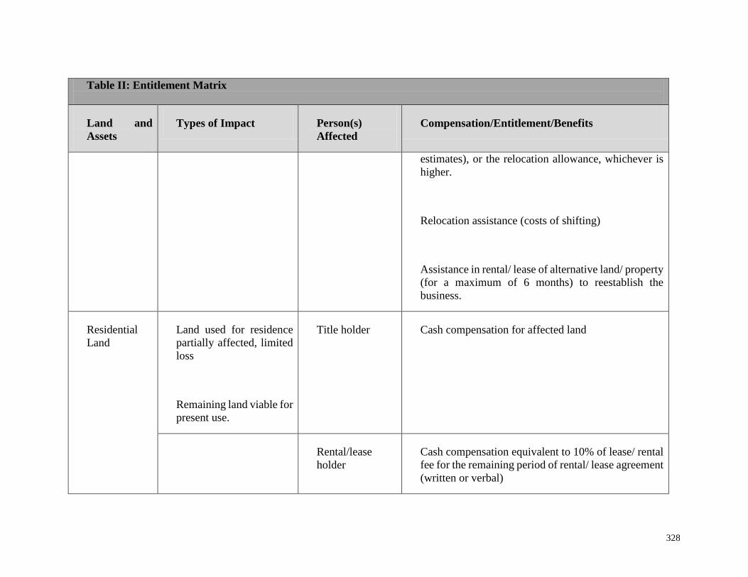
328
Table II: Entitlement Matrix
Land and
Assets
Types of Impact Person(s)
Affected
Compensation/Entitlement/Benefits
estimates), or the relocation allowance, whichever is
higher.
Relocation assistance (costs of shifting)
Assistance in rental/ lease of alternative land/ property
(for a maximum of 6 months) to reestablish the
business.
Residential
Land
Land used for residence
partially affected, limited
loss
Remaining land viable for
present use.
Title holder Cash compensation for affected land
Rental/lease
holder
Cash compensation equivalent to 10% of lease/ rental
fee for the remaining period of rental/ lease agreement
(written or verbal)

329
Table II: Entitlement Matrix
Land and
Assets
Types of Impact Person(s)
Affected
Compensation/Entitlement/Benefits
Title holder Land for land replacement or compensation in cash
according to PAP’s choice.
Land for land replacement shall be of minimum plot
of acceptable size under the zoning law/ s or a plot of
equivalent size, whichever is larger, in either the
community or a nearby resettlement area with
adequate physical and social infrastructure systems as
well as secured tenure status.
When the affected holding is larger than the relocation
plot, cash compensation to cover the difference in
value.
Transfer of the land to the PAP shall be free of taxes,
registration, and other costs.
Relocation assistance (costs of shifting + allowance)

330
Table II: Entitlement Matrix
Land and
Assets
Types of Impact Person(s)
Affected
Compensation/Entitlement/Benefits
Land and assets used for
residence severely
affected
Remaining area
insufficient for continued
use or becomes smaller
than minimally accepted
under zoning laws
Rental/lease
holder
Refund of any lease/ rental fees paid for time/ use after
date of removal
Cash compensation equivalent to 3 months of lease/
rental fee
Assistance in rental/ lease of alternative land/ property
Relocation assistance (costs of shifting + allowance)
Buildings and
structures
Structures are partially
affected
Remaining structures
viable for continued use
Owner Cash compensation for affected building and other
fixed assets
Cash assistance to cover costs of restoration of the
remaining structure

331
Table II: Entitlement Matrix
Land and
Assets
Types of Impact Person(s)
Affected
Compensation/Entitlement/Benefits
Rental/lease
holder
Cash compensation for affected assets (verifiable
improvements to the property by the tenant).
Disturbance compensation equivalent to two months
rental costs
Entire structures are
affected or partially
affected
Remaining structures not
suitable for continued use
Owner Cash compensation for entire structure and other fixed
assets without depreciation, or alternative structure of
equal or better size and quality in an available location
which is acceptable to the PAP.
Right to salvage materials without deduction from
compensation
Relocation assistance (costs of shifting + allowance)
Rehabilitation assistance if required (assistance with
job placement, skills training)

332
Table II: Entitlement Matrix
Land and
Assets
Types of Impact Person(s)
Affected
Compensation/Entitlement/Benefits
Rental/lease
holder
Cash compensation for affected assets (verifiable
improvements to the property by the tenant)
Relocation assistance (costs of shifting + allowance
equivalent to four months rental costs)
Assistance to help find alternative rental arrangements
Rehabilitation assistance if required (assistance with
job placement, skills training)
Squatter/informal
dweller
Cash compensation for affected structure without
depreciation
Right to salvage materials without deduction from
compensation
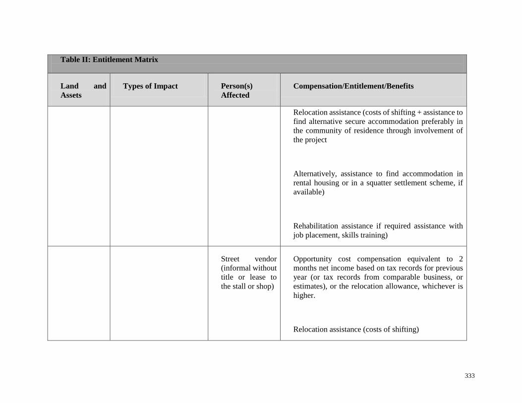
333
Table II: Entitlement Matrix
Land and
Assets
Types of Impact Person(s)
Affected
Compensation/Entitlement/Benefits
Relocation assistance (costs of shifting + assistance to
find alternative secure accommodation preferably in
the community of residence through involvement of
the project
Alternatively, assistance to find accommodation in
rental housing or in a squatter settlement scheme, if
available)
Rehabilitation assistance if required assistance with
job placement, skills training)
Street vendor
(informal without
title or lease to
the stall or shop)
Opportunity cost compensation equivalent to 2
months net income based on tax records for previous
year (or tax records from comparable business, or
estimates), or the relocation allowance, whichever is
higher.
Relocation assistance (costs of shifting)

334
Table II: Entitlement Matrix
Land and
Assets
Types of Impact Person(s)
Affected
Compensation/Entitlement/Benefits
Assistance to obtain alternative site to re- establish the
business.
Standing
crops
Crops affected by land
acquisition or temporary
acquisition or easement
PAP (whether
owner, tenant, or
squatter)
Cash compensation equivalent to average of last 3
years market value for the mature and harvested crop.
Trees Trees lost Title holder Cash compensation based on type, age and productive
value of affected trees plus 10% premium
Temporary
Acquisition
Temporary acquisition PAP (whether
owner, tenant, or
squatter)
Cash compensation for any assets affected (e. g.
boundary wall demolished, trees removed)

Nigerian Erosion and Watershed Management Project
335
Environmental and Social Management Framework
(v) Community payments. Although most sub-projects do not normally take land and other
assets belonging to a community, such as a community center, school, or sacred site, if
this occurs in a sub-project, the community (as a whole) will be compensated. This
compensation will be in the form of reconstruction of the facility (in case of damages) or
replacement at least the same standard or equivalent or better standard required by local
planning regulation. Examples of community compensation expansion of grazing
grounds; rehabilitation of school buildings, public toilets, health facilities; installation of
wells or pumps; creation of market places; and reconstruction of community roads.
(vi) Grievance mechanism. The sub-project RAP team will establish an independent grievance
mechanism. This may be set up through Local Authorities, including a Resettlement or
Land Committee and through community leaders. All PAPs will be informed about how
to register grievances or complaints, including specific concerns about compensation and
relocation. The PAPs should also be informed about the dispute resolution process,
specifically about how the disputes will be resolved in an impartial and timely manner.
The RAP Team will produce a Report containing a summary of all grievances. If needed,
the dispute resolution process should include Nigerian Courts of Law, but traditional
institutions can be an effective first step in both receiving and resolving grievances.

Nigerian Erosion and Watershed Management Project
336
Environmental and Social Management Framework
PART VI: IMPLEMENTATION SCHEDULE AND COSTS
Since the specific sites and sub-projects are not yet determined, this RPF refers only to an
estimated number of PAPs. Because costs of resettlement and compensation are based on
technical designs and results of scoping, it is not possible to produce a detailed budget for RAP
implementation. Once a budget is finalized, it will be subject to approval by the World Bank.
An indicative RAP budget outline can be found in Table III below.
Table III: Indicative Outline of a RAP Budget
Asset acquisition Amount
or
number
Total
estimated
cost
Agency responsible
Land
Structure
Crops and economic tress
Community infrastructure
Land Acquisition and
Preparation
Land
Structures
Crops areas and others
Community infrastructure
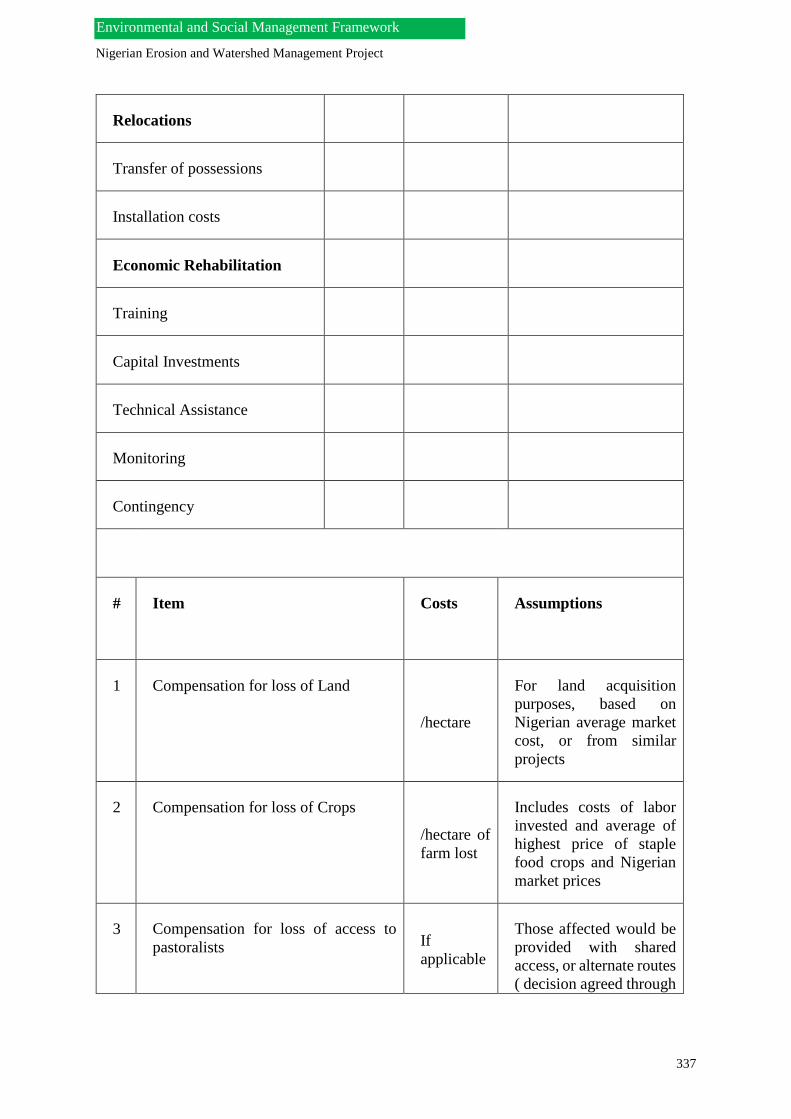
Nigerian Erosion and Watershed Management Project
337
Environmental and Social Management Framework
Relocations
Transfer of possessions
Installation costs
Economic Rehabilitation
Training
Capital Investments
Technical Assistance
Monitoring
Contingency
# Item Costs Assumptions
1 Compensation for loss of Land
/hectare
For land acquisition
purposes, based on
Nigerian average market
cost, or from similar
projects
2 Compensation for loss of Crops
/hectare of
farm lost
Includes costs of labor
invested and average of
highest price of staple
food crops and Nigerian
market prices
3 Compensation for loss of access to
pastoralists If
applicable
Those affected would be
provided with shared
access, or alternate routes
( decision agreed through

Nigerian Erosion and Watershed Management Project
338
Environmental and Social Management Framework
consultation and
participation of all)
4 Compensation for loss of access to
fishing resources. If
applicable
Data provided from the
revised socio-economic
study will determine
market values of catch,
fish products etc.
5 Compensation for Buildings and
Structures
If
applicable
This compensation may
be in-kind or cash. Costs
for basic housing needs
should include ventilated
pit latrines, outside
kitchen, and storage.
6 Compensation for Trees
/year/tree
Includes costs of labor
invested and average of
highest price of trees
(and tree products) and
Nigerian market prices
7 Cost of Relocation
Assistance/Expenses
/household
This cost reflects the
moving and
transportation allowance
8 Cost of Restoration of Individual
Income
Assumed to be higher
than the GDP/capita in
Nigeria
9 Cost of Restoration of Household
Income
These costs reflect the
livelihood restoration
program of the RAP
10 Cost of Training Farmers, pastoralists
and other PAPs
This is a mitigation
measure involving
capacity building and
involves PAPs and
affected communities
The PIU will determine an appropriate Resettlement Budget. It is usually financed in-country
through the administrative and financial management rules and manuals issued by the
Government of Nigeria.
Nigerian Erosion and Watershed Management Project
339
Environmental and Social Management Framework
PART VII: PUBLIC CONSULTATION AND DISCLOSURE PLAN
Public consultations in relation to the RAP occur at all stages, starting with inception and
planning when the potential lands and alternative sites are being considered. A participatory
approach is adopted as an on-going strategy throughout the entire project cycle.
Public participation and consultations take place through individual, group, or community
meetings. Additionally, radio programs and other media forms may be used to further
disseminate information. PAPs are consulted in the survey process; public notices where
explanations of the sub-project are made; RAP implementation of activities; and during the
monitoring and evaluation process. Selection of ways to consult, and expand participation by
PAPs and other stakeholders, will take into consideration literacy levels prevalent in affected
communities; ethnicity and cultural aspects; and practical conditions (like distance).
The role of traditional political and cultural leaders, including the community elders, in the
participation strategy will be important. The RAP team should ensure that these leaders and
local representatives of PAPs are fully involved in designing the public consultation
procedures.
Data collecting phase. Consultations during preparation, in particular, the collection of
background information, and the social survey or social assessment, are critical for successful
data collection. The levels of consultation will vary from households to community groups,
based on the particular context of the sub-project(s). The RAP team will design the
questionnaires but it will be the households, organizations, and institutions that will validate
their effectiveness through feedback. Focus group meetings with women, farmers’
associations, individuals who own farms, fishing boats, etc, as well as primary and/or
secondary schools, health centers, and agricultural cooperative unions are usually good sources
for establishing the community baseline situation.
Implementation phase. During implementation, PAPs will be informed about their rights and
options. The grievance mechanism will continue to operate and all grievances will be recorded.
The participation of local leaders and PAPs in disseminating information and resolving
disputes will be important once RAP implementation starts. A dynamic participatory approach
involves PAPs in decision making about livelihood and community development programs.
Monitoring and evaluation phase. PAPs representatives will participate in the sub-project
workshops at mid-term and at the end of RAP implementation. To the extent possible, the RAP
should include social accountability tools like citizen report cards to assess the quality of RAP
implementation, and in some cases, assist the RAP team in tracking expenditures. The latter
would be significant in helping PAPs with money management and restoring their livelihoods.
PAPs will be able to suggest corrective measures, as needed, to improve RAP implementation
in the sub-project(s). Prior to closing the RAP, PAPs will participate in a feedback survey as
part of the RAP’s independent impact evaluation exercise.

Nigerian Erosion and Watershed Management Project
340
Environmental and Social Management Framework
PART VIII: MONITORING AND EVALUATION OF IMPACTS
The RAP team will be expected to develop and implement a Monitoring and Evaluation Plan
(MEP). The main indicators that the MEP will measure include: (i) impacts on affected
individuals, households, and communities to be maintained at their pre-project standard of
living, and better; (ii) improvement of communities affected by the project; and (iii)
management of disputes or conflicts. In order to measure these impacts, the RAP identifies the
specific indicators to be monitored; define how they will be measured on a regular basis; and
identify key monitoring milestones (e.g. at mid-point of the RAP implementation process).
The PIU will establish a reporting system for the sub-project RAP that will:
(i) Provide timely information to the project about all resettlement and compensation
issues arising as a result of RAP related activities;
(ii) Identify any grievances, especially those that have not yet been resolved at the local
level and which may require resolution at the higher levels (e.g. by the PIU);
(iii) Document completion of project resettlement and compensation that are still pending,
including for all permanent and temporary losses;
(iv) Evaluate whether all PAPs have been compensated in accordance with the requirements
of this RPF and that PAPs have better living conditions and livelihoods; and
(v) Identify mitigation measures, as necessity, when there are significant changes in the
indicators that may require strategic interventions (e.g. vulnerable groups are not
receiving sufficient support from the sub-project).
The independent impact evaluation will determine:
(i) If compensation payments have been completed in a satisfactory manner; and
(ii) If there are improvements in livelihoods and well-being of PAPs.
Several indicators are used to measure these impacts. These include, among others, a
comparison of income levels before-and-after; access to livelihoods and employment; changes
in standards of housing and living conditions; and improvements in level of participation in
sub-project activities. There are measures to verify these basic indicators, such as number of
children in-school (compared to pre-RAP levels); changes in health standards; and changes in
access to markets or roads – all of which may reflect overall improvements in standards of
living.
The following methods will be used for measuring impacts:
(i) Questionnaires with data stored in a database for comparative analysis (before-
after and with-without);
(ii) Documentation and recording of PAPs situation, including subsequent uses of
assets/improvements;
(iii) Relocation/resettlement and Compensation Reports, including status of land
impacts; percentage of individuals selecting cash or a combination of cash and in-
kind compensation; proposed use of payments;
(iv) Number of grievances and time and quality of resolution; and
(v) Ability of individuals and families to re-establish their pre-resettlement activities,
in terms of improvements in land and crop production, and/or presence of other
alternative incomes.
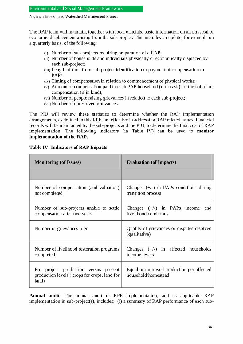
Nigerian Erosion and Watershed Management Project
341
Environmental and Social Management Framework
The RAP team will maintain, together with local officials, basic information on all physical or
economic displacement arising from the sub-project. This includes an update, for example on
a quarterly basis, of the following:
(i) Number of sub-projects requiring preparation of a RAP;
(ii) Number of households and individuals physically or economically displaced by
each sub-project;
(iii) Length of time from sub-project identification to payment of compensation to
PAPs;
(iv) Timing of compensation in relation to commencement of physical works;
(v) Amount of compensation paid to each PAP household (if in cash), or the nature of
compensation (if in kind);
(vi) Number of people raising grievances in relation to each sub-project;
(vii) Number of unresolved grievances.
The PIU will review these statistics to determine whether the RAP implementation
arrangements, as defined in this RPF, are effective in addressing RAP related issues. Financial
records will be maintained by the sub-projects and the PIU, to determine the final cost of RAP
implementation. The following indicators (in Table IV) can be used to monitor
implementation of the RAP.
Table IV: Indicators of RAP Impacts
Monitoring (of Issues) Evaluation (of Impacts)
Number of compensation (and valuation)
not completed
Changes (+/-) in PAPs conditions during
transition process
Number of sub-projects unable to settle
compensation after two years
Changes (+/-) in PAPs income and
livelihood conditions
Number of grievances filed Quality of grievances or disputes resolved
(qualitative)
Number of livelihood restoration programs
completed
Changes (+/-) in affected households
income levels
Pre project production versus present
production levels ( crops for crops, land for
land)
Equal or improved production per affected
household/homestead
Annual audit. The annual audit of RPF implementation, and as applicable RAP
implementation in sub-project(s), includes: (i) a summary of RAP performance of each sub-

Nigerian Erosion and Watershed Management Project
342
Environmental and Social Management Framework
project; (ii) a compliance review of RAP implementation process; and (iii) a progress report on
the quality of RAP implementation in terms of application of guidelines provided in this RPF.
The audit will verify results of monitoring of RAP implementation indicators, and assess
whether the project achieved the resettlement objectives. A specific measure of whether
livelihood and living standards have been restored or enhanced will be completed. The audit
will also assess the efficiency, effectiveness, impact, and sustainability of RAP sub-project
activities. The aim is to learn lessons for application to future sub-projects or other projects in
the sector and in the country. Finally, the audit will ascertain whether the resettlement
entitlements were appropriate, as defined in the RPF guidelines.
Socio-Economic assessment. The purpose of socio-economic assessment, which is part of the
evaluation process, is to ensure that PAPs livelihood and well being have improved, and have
not worsened as a result of the sub-project. An assessment will be undertaken on payment of
compensation, restoration of income and livelihoods, and provision of sufficient community
development activities. Monitoring of living standards will continue after resettlement.
Additionally a reasonable period (usually two years) must be established for monitoring post-
resettlement impacts. A number of indicators will be used for measuring status of affected
people.
Most socio-economic assessments use surveys, focus group meetings, and participatory
appraisal tools for measuring impacts. A separate assessment must be made for each sub-
project. Additionally, since a baseline household survey was completed during RAP
preparation, the end-RAP assessment can measure changes from this baseline.

Nigerian Erosion and Watershed Management Project
343
Environmental and Social Management Framework
List of Annexes
Annex 1 World Bank Resettlement Policy Framework (Excerpt from
World Bank Operational Policy 4.12, Involuntary Resettlement)
Annex 2 Annotated Outline for Preparing a Resettlement Action Plan
(RAP)
Annex 3 Sample Grievance and Resolution Form
Annex 4 Sample Table of Contents for Consultation Reports
Annex 5 Glossary of Terms
Annex 6 Relevant Laws

Nigerian Erosion and Watershed Management Project
344
Environmental and Social Management Framework
ANNEX 1: World Bank Resettlement Policy Framework (RPF)
[Excerpt from the World Bank OP4.12 Involuntary Resettlement, Revised April 2004]
These policies were prepared for use by World Bank staff and are not necessarily a complete
treatment of the subject. OP 4.12 (Revised April 2004) applies only to projects that are
governed by OP / BP 6.00, Bank Financing - that is, those in countries with approved country
financing parameters. Other operational policy statements governing Bank financing that have
been amended to reflect OP/BP 6.00 also apply to these projects.
Projects in countries without approved country financing parameters continue to be subject
to other operational policy statements governing Bank financing.
Resettlement Policy Framework
For sector investment operations that may involve involuntary resettlement, the Bank requires
that the project implementing agency screen subprojects to be financed by the Bank to ensure
their consistency with this OP. For these operations, the borrower submits, prior to appraisal,
a resettlement policy framework that conforms to this policy (see Annex A, paragraphs 23-25).
The framework also estimates, to the extent feasible, the total population to be displaced, and
the overall resettlement costs.
For financial intermediary operations that may involve involuntary resettlement, the Bank
requires that the financial intermediary (FI) screen subprojects to be financed by the Bank to
ensure their consistency with this OP. For these operations, the Bank requires that before
appraisal the borrower or the FI submit to the Bank a resettlement policy framework
conforming to this policy (see Annex A, paragraphs 23-25). In addition, the framework
includes an assessment of the institutional capacity and procedures of each of the FIs that will
be responsible for subproject financing. When, in the assessment of the Bank, no resettlement
is envisaged in the subprojects to be financed by the FI, a resettlement policy framework is not
required. Instead, the legal agreements specify the obligation of the FIs to obtain from the
potential sub-borrowers a resettlement plan consistent with this policy if a subproject gives rise
to resettlement. For all subprojects involving resettlement, the resettlement plan is provided to
the Bank for approval before the subproject is accepted for Bank financing.
For other Bank-assisted project with multiple subprojects26 that may involve involuntary
resettlement, the Bank requires that a draft resettlement plan conforming to this policy be
submitted to the Bank before appraisal of the project unless, because of the nature and design
of the project or of a specific subproject or subprojects (a) the zone of impact of subprojects
cannot be determined, or (b) the zone of impact is known but precise sitting alignments cannot
be determined. In such cases, the borrower submits a resettlement policy framework consistent
with this policy prior to appraisal (see Annex A, paragraphs 23-25). For other subprojects that
do not fall within the above criteria, a resettlement plan conforming to this policy is required
prior to appraisal.
For each subproject included in a project described in paragraphs 26, 27, or 28 that may involve
resettlement, the Bank requires that a satisfactory resettlement plan or an abbreviated
resettlement plan that is consistent with the provisions of the policy framework be submitted
to the Bank for approval before the subproject is accepted for Bank financing.

Nigerian Erosion and Watershed Management Project
345
Environmental and Social Management Framework
For projects described in paragraphs 26-28 above, the Bank may agree, in writing, that sub-
project resettlement plans may be approved by the project implementing agency or a
responsible government agency or financial intermediary without prior Bank review, if that
agency has demonstrated adequate institutional capacity to review resettlement plans and
ensure their consistency with this policy. Any such delegation, and appropriate remedies for
the entity’s approval of resettlement plans found not to comply with Bank policy, is provided
for in the legal agreements for the project. In all such cases, implementation of the resettlement
plans is subject to ex post review by the Bank.

Nigerian Erosion and Watershed Management Project
346
Environmental and Social Management Framework
ANNEX 2: Annotated Outline for Preparing a Resettlement Action Plan (RAP)
This template is extracted from OP 4.12 Annex A. Its full description can be found in the World
Bank external website [INSERT LINK].
The scope and level of detail of the RAP will vary depending on the magnitude and complexity
of resettlement or displacement. The RAP is prepared based on the most recent and accurate
information on the: (i) proposed resettlement and its impacts on displaced persons and other
adversely affected groups; and (ii) legal issues affecting resettlement. The RAP covers
elements that are specific to the project context.
A broad outline of the RAP, as applied to sub-projects covered under a RPF includes, but is
not limited to, the following:
Description of the sub-project: General description of the sub-project and identification of sub-
project area or areas.
Potential Impacts: Identification of the: (i) the sub-project components or activities that require
resettlement or restriction of access; (ii) zone of impact of components or activities; (iii)
alternatives considered to avoid or minimize resettlement or restricted access; and (iv)
mechanisms established to minimize resettlement, displacement, and restricted access, to the
extent possible, during project implementation.
Objectives: The main objectives of the resettlement program as these apply to the sub-projects.
Socio-economic studies: The findings of socio-economic studies to be conducted in the early
stages of project preparation, and with the involvement of potentially affected people will be
needed. These generally include the results of a census of the affected populations covering:
(i) Current occupants of the affected area as a basis for design of the RAP and to clearly
set a cut-off date, the purpose of which is to exclude subsequent inflows of people from
eligibility for compensation and resettlement assistance;
(ii) Standard characteristics of displaced households, including a description of production
systems, labor, and household organization; and baseline information on livelihoods
(including, as relevant, production levels and income derived from both formal and
informal economic activities) and standards of living (including health status) of the
displaced population;
(iii) Magnitude of the expected loss, total or partial, of assets, and the extent of
displacement, physical or economic;
(iv) Information on vulnerable groups or persons, for whom special provisions may have to
be made; and
(v) Provisions to update information on the displaced people’s livelihoods and standards
of living at regular intervals so that the latest information is available at the time of their
displacement, and to measure impacts (or changes) in their livelihood and living
conditions.
There may be other studies that the RAP can draw upon, such as those describing the following:

Nigerian Erosion and Watershed Management Project
347
Environmental and Social Management Framework
(i) Land tenure, property, and transfer systems, including an inventory of common
property natural resources from which people derive their livelihoods and sustenance,
non-title-based usufruct systems (including fishing, grazing, or use of forest areas)
governed by local recognized land allocation mechanisms, and any issues raised by
different tenure systems in the sub project area;
(ii) Patterns of social interaction in the affected communities, including social support
systems, and how they will be affected by the sub-project;
(iii) Public infrastructure and social services that will be affected; and
(iv) Social and cultural characteristics of displaced communities, and their host
communities, including a description of formal and informal institutions. These may
cover, for example, community organizations; cultural, social or ritual groups; and non-
governmental organizations (NGOs) that may be relevant to the consultation strategy
and to designing and implementing the resettlement activities.
Legal Framework: The analysis of the legal and institutional framework should cover the
following:
(i) Scope of existing land and property laws governing resources, including state-owned lands
under eminent domain and the nature of compensation associated with valuation
methodologies; land market; mode and timing of payments, etc;
(ii) Applicable legal and administrative procedures, including a description of the grievance
procedures and remedies available to PAPs in the judicial process and the execution of
these procedures, including any available alternative dispute resolution mechanisms that
may be relevant to implementation of the RAP for the sub-project;
(iii) Relevant laws ( including customary and traditional law) governing land tenure, valuation
of assets and losses, compensation, and natural resource usage rights, customary personal
law; communal laws, etc related to displacement and resettlement, and environmental laws
and social welfare legislation;
(iv) Laws and regulations relating to the agencies responsible for implementing resettlement
activities in the sub-projects;
(v) Gaps, if any, between local laws covering resettlement and the Bank’s resettlement policy,
and the mechanisms for addressing such gaps; and
(vi) Legal steps necessary to ensure the effective implementation of RAP activities in the sub-
projects, including, as appropriate, a process for recognizing claims to legal rights to land,
including claims that derive from customary and traditional usage, etc and which are
specific to the sub-projects.
The institutional framework governing RAP implementation generally covers:
(i) Agencies and offices responsible for resettlement activities and civil society groups like
NGOs that may have a role in RAP implementation;
(ii) Institutional capacities of these agencies, offices, and civil society groups in carrying out
RAP implementation, monitoring, and evaluation; and
(iii) Activities for enhancing the institutional capacities of agencies, offices, and civil society
groups, especially in the consultation and monitoring processes.
Eligibility: Definition of displaced persons or PAPS and criteria for determining their eligibility
for compensation and other resettlement assistance, including relevant cut-off dates.

Nigerian Erosion and Watershed Management Project
348
Environmental and Social Management Framework
Valuation of and compensation for losses: The methodology to be used for valuing losses, or
damages, for the purpose of determining their replacement costs; and a description of the
proposed types and levels of compensation consistent with national and local laws and
measures, as necessary, to ensure that these are based on acceptable values (e.g. market rates).
Resettlement Measures: A description of the compensation and other resettlement measures
that will assist each category of eligible PAPs to achieve the objectives of OP 4.12. Aside from
compensation, these measures should include programs for livelihood restoration, grievance
mechanisms, consultations, and disclosure of information.
Site selection, site preparation, and relocation: Alternative relocation sites should be described
and cover the following:
(i) Institutional and technical arrangements for identifying and preparing relocation sites,
whether rural or urban, for which a combination of productive potential, location
advantages, and other factors is at least comparable to the advantages of the old sites, with
an estimate of the time needed to acquire and transfer land and ancillary resources;
(ii) Any measures necessary to prevent land speculation or influx of eligible persons at the
selected sites;
(iii) Procedures for physical relocation under the project, including timetables for site
preparation and transfer; and
(iv) Legal arrangements for recognizing (or regularizing) tenure and transferring titles to those
being resettled.
Housing, infrastructure, and social services: Plans to provide (or to finance provision of)
housing, infrastructure (e.g. water supply, feeder roads), and social services to host populations;
and any other necessary site development, engineering, and architectural designs for these
facilities should be described.
Environmental protection and management. A description of the boundaries of the relocation
area is needed. This description includes an assessment of the environmental impacts of the
proposed resettlement and measures to mitigate and manage these impacts (coordinated as
appropriate with the environmental assessment of the main investment requiring the
resettlement).
Community Participation: Consistent with the World Bank’s policy on consultation and
disclosure, a strategy for consultation with, and participation of, PAPs and host communities,
should include:
(i) Description of the strategy for consultation with and participation of PAPs and hosts in the
design and implementation of resettlement activities;
(ii) Summary of the consultations and how PAPs’ views were taken into account in preparing
the resettlement plan; and
(iii) Review of resettlement alternatives presented and the choices made by PAPs regarding
options available to them, including choices related to forms of compensation and
resettlement assistance, to relocating as individual families or as parts of pre-existing
communities or kinship groups, to sustaining existing patterns of group organization, and
to retaining access to cultural property (e.g. places of worship, pilgrimage centers,
cemeteries); and

Nigerian Erosion and Watershed Management Project
349
Environmental and Social Management Framework
(iv) Arrangements on how PAPs can communicate their concerns to project authorities
throughout planning and implementation, and measures to ensure that vulnerable groups
(including indigenous peoples, ethnic minorities, landless, children and youth, and women)
are adequately represented.
The consultations should cover measures to mitigate the impact of resettlement on any host
communities, including:
(i) Consultations with host communities and local governments;
(ii) Arrangements for prompt tendering of any payment due the hosts for land or other assets
provided to PAPs;
(iii) Conflict resolution involving PAPs and host communities; and
(iv) Additional services (e.g. education, water, health, and production services) in host
communities to make them at least comparable to services available to PAPs.
Grievance procedures: The RAP should provide mechanisms for ensuring that an affordable
and accessible procedure is in place for third-party settlement of disputes arising from
resettlement. These mechanisms should take into account the availability of judicial and legal
services, as well as community and traditional dispute settlement mechanisms.
RAP implementation responsibilities: The RAP should be clear about the implementation
responsibilities of various agencies, offices, and local representatives. These responsibilities
should cover (i) delivery of RAP compensation and rehabilitation measures and provision of
services; (ii) appropriate coordination between agencies and jurisdictions involved in RAP
implementation; and (iii) measures (including technical assistance) needed to strengthen the
implementing agencies’ capacities of responsibility for managing facilities and services
provided under the project and for transferring to PAPs some responsibilities related to RAP
components (e.g. community-based livelihood restoration; participatory monitoring; etc).
Implementation Schedule: An implementation schedule covering all RAP activities from
preparation, implementation, and monitoring and evaluation should be included. These should
identify the target dates for delivery of benefits to the resettled population and the hosts, as
well as clearly defining a closing date. The schedule should indicate how the RAP activities
are linked to the implementation of the overall project.
Costs and budget: The RAP for the specific sub-projects should provide detailed (itemized)
cost estimates for all RAP activities, including allowances for inflation, population growth, and
other contingencies; timetable for expenditures; sources of funds; and arrangements for timely
flow of funds. These should include other fiduciary arrangements consistent with the rest of
the project governing financial management and procurement.
Monitoring and evaluation: Arrangements for monitoring of RAP activities by the
implementing agency, and the independent monitoring of these activities, should be included
in the RAP section on monitoring and evaluation. The final evaluation should be done by an
independent monitor or agency to measure RAP outcomes and impacts on PAPs’ livelihood
and living conditions. The World Bank has examples of performance monitoring indicators to
measure inputs, outputs, and outcomes for RAP activities; involvement of PAPS in the
monitoring process; evaluation of the impact of RAP activities over a reasonable period after
resettlement and compensation, and using the results of RAP impact monitoring to guide
subsequent implementation.

Nigerian Erosion and Watershed Management Project
350
Environmental and Social Management Framework

Nigerian Erosion and Watershed Management Project
351
Environmental and Social Management Framework
ANNEX 3: Sample Grievance and Resolution Form
Name (Filer of Complaint): __________________________________
ID Number: __________________________________ (PAPs ID number)
Contact Information : __________________________________ (Village ; mobile
phone)
Nature of Grievance or Complaint:
___________________________________________________________________________
___________________________________________________________________________
____________________
Date Individuals Contacted Summary of Discussion
____________ __________________ ___________________________
Signature_______________________ Date: ____________
Signed (Filer of Complaint): ______________________________________
Name of Person Filing Complaint: __________________________(if different from Filer)
Position or Relationship to Filer: __________________________________
Review/Resolution
Date of Conciliation Session: ______________________________________
Was Filer Present: Yes No
Was field verification of complaint conducted? Yes No
Findings of field investigation:
___________________________________________________________________________
___________________________________________________________________________
____________________
Summary of Conciliation Session
Discussion: ________________________________________________________________
___________________________________________________________________________
_______________________________
Issues _______________-
______________________________________________________________
Was agreement reached on the issues? Yes No
If agreement was reached, detail the agreement below:
If agreement was not reached, specify the points of disagreement below:
___________________________________________________________________________
_________
Signed (Conciliator): ___________________________ Signed (Filer):
________________
Signed: ___________________________
Independent Observer
Date: ___________________________

Nigerian Erosion and Watershed Management Project
352
Environmental and Social Management Framework
ANNEX 4: Sample Table of Contents for Consultation Reports
1.0 Introduction.
1.1 Project Description
1.2 Applicable Laws, Regulations, and Policies to Public Engagement
1.3 Project Lenders
2.0 Stakeholder Analysis
2.1 Areas of Influence/Stakeholders
2.2 Description of Stakeholders
3.0 Stakeholder Engagement
3.1 Previous Consultation Activities
3.2 Implemented Community Engagement Activities
3.3 Project Sponsor’s Community Engagement Plan
3.3.1 Phase 1 – Initial Stakeholder Consultation
3.3.2 Phase 2 – Release of the SEA Terms of Reference and Draft PCDP
3.3.3 Phase 3 – Release of SEA Consultation Summary Report
4.0 Summary of Key Issues
5.0 Future Consultation Events
5.1 Phase 4 – Release of the SEA Report and Action Plans
5.2 Phase 5 – RCDAP Planning Consultation
5.3 Phase 6 - Ongoing Project Communication
6.0 Disclosure Plan

Nigerian Erosion and Watershed Management Project
353
Environmental and Social Management Framework
Tables
Table 2.1: Consultation Activity Summary
Table 3.1: Initial Government Agency Consultations
Table 3.2: Summary of NGO Meetings
Table 3.3: Sub-County Committee Composition
Table 3.4: Summary of Community Discussions
Table 3.5: Local Community Comments
Table 4.1: Summary of Key Issues and Responses
Table 5.1: Summary of Future Consultation Activities per Stakeholder Group
TEMPLATE Table on Consultation Activity Summary
Location and
Communities
Represented
Meeting
Dates
Attendees Discussion Summary
Example:

Nigerian Erosion and Watershed Management Project
354
Environmental and Social Management Framework
ANNEX 5: Glossary of Terms
Census A field survey carried out to identify and determine the number of Project
Affected Persons (PAPs) or Displaced Persons (DPs) as a result of land
acquisition and related impacts. The census provides the basic information
necessary for determining eligibility for compensation, resettlement, and other
measures emanating from consultations with affected communities and the local
government institutions.
Compensation The payment in kind, cash or other assets given in exchange for the acquisition of
land including fixed assets, is called compensation. These include other impacts
resulting from activities to rehabilitate or cushion the impacts from displacement.
Cutoff Date The cut-off date is the date of commencement of the census of PAPs or DPs within
the EASP program area boundaries. This is the date on and beyond which any
person whose land is occupied for EASP program, will not be eligible for
compensation.
Grievance
Mechanism
The RPF contains a grievance mechanism based on policies and procedures that
are designed to ensure that the complaints or disputes about any aspect of the land
acquisition, compensation, resettlement, and rehabilitation process, etc. are being
addressed. This mechanism includes a procedure for filing of complaints and a
process for dispute resolution within an acceptable time period.
Implementation
Schedule
The RPF contains an implementation schedule that outlines the time frame for
planning, implementation, and monitoring and evaluation of the RAPs for sub-
projects, if applicable.
Land Land refers to all types of agricultural and/or non-agricultural land and any
structures thereon whether temporary or permanent and which may be acquired
by the project.

Nigerian Erosion and Watershed Management Project
355
Environmental and Social Management Framework
Land
Acquisition
Land acquisition means the possession of or alienation of land, buildings, or other
assets thereon for purposes of the project.
Project
Affected
Persons (PAPs)
or Displaced
Persons (DPs)
Project affected persons (PAPs) or Displaced Persons (DPs) are persons affected
by land and other assets loss as a result of EASP activities. These person(s) are
affected because they may lose, be denied, or be restricted access to economic
assets; lose shelter, income sources, or means of livelihood. These persons are
affected whether or not they will move to another location. Most often, the term
DPs applies to those who are physically relocated. These people may have their:
standard of living adversely affected, whether or not the Displaced Person will
move to another location ; lose right, title, interest in any houses, land (including
premises, agricultural and grazing land) or any other fixed or movable assets
acquired or possessed, lose access to productive assets or any means of livelihood.
Project Impacts
Impacts on the people living and working in the affected areas of the project,
including the surrounding and host communities are assessed as part of the overall
evaluation of the project.
Project
Implementing
Unit (PIU)
Some projects make use of project implementing units (PIUs), which are
generally separate units within the project recipient’s agency. The PIU is often
composed of full time staff devoted to implementing the project, and have been
encouraged to have separate teams with environment and social specialists who
can carry out the activities, for example, as outlined in the RPF or RAP.
Rehabilitation
Assistance
Rehabilitation assistance is the provision of development assistance in addition to
compensation such as livelihood support, credit facilities, training, or job
opportunities, needed to assist PAPs or DPs restore their livelihoods.
Replacement
Cost
Replacement cost refers to the amount sufficient to cover full recovery of lost
assets and related transaction costs.
Resettlement
Action Plan
(RAP)
The RAP is a resettlement instrument (document) to be prepared when sub-project
locations are identified. In such cases, land acquisition leads to physical
displacement of persons, and/or loss of shelter, and /or loss of livelihoods and/or
loss, denial or restriction of access to economic resources. RAPs are prepared by

Nigerian Erosion and Watershed Management Project
356
Environmental and Social Management Framework
the implementing agency and contain specific and legal binding requirements to
resettle and compensate the affected people before project implementation.
Resettlement
Assistance
Resettlement assistance refers to activities that are usually provided during, and
immediately after, relocation, such as moving allowances, residential housing, or
rentals or other assistance to make the transition smoother for affected
households.
Resettlement
Policy
Framework
(RPF)
The RPF is an instrument to be used throughout the project’s implementation. The
RPF sets out the objectives and principles, organizational arrangements, and
funding mechanisms for any resettlement, that may be necessary during
implementation. The RPF guides the preparation of Resettlement Action Plans
(RAPs), as needed, for sub-projects.
Rights and
Entitlements
Rights and entitlements are defined for PAPs and DPs (with the cut-off date) and
cover those losing businesses, jobs, and income. These include options for land-
for-land or cash compensation. Options regarding community and individual
resettlement, and provisions and entitlements to be provided for each affected
community or household will be determined and explained, usually in an
entitlement matrix.
Witness NGO
or Independent
Monitor
Some RPFs refer to a witness NGO or an independent monitor that can be
contracted to observe the compensation process and provide an independent
assessment of the quality of the process. These are usually NGOs or other
agencies that are not directly involved in the project and have a reputation for
independence and integrity.

Nigerian Erosion and Watershed Management Project
357
Environmental and Social Management Framework
ANNEX 6: Relevant Laws
Property Rights and Land Rights Law /
Regulation
Subject to the provisions of this Act, all land comprised in the territory
of each State in the Federation are hereby vested in the Governor of
each state and such land shall be held in trust and administered for the
use and common benefit of all Nigerians in accordance with the
provisions of this Act.
Land Use Act
1978, Section 1
All land in urban areas shall be under the control and management of
the Governor of each State; and all other land shall be under the
control and management of local government within the area of
jurisdiction in which the land is situated.
Land Use Act
1978, Section
2(a)
It shall be lawful for the Governor in respect of land, whether or not in
an urban area to grant statutory rights off occupancy to any person for
all purposes.
Land Use Act
1978, Section
5(1)
It shall be lawful for a Local Government in respect of land not in an
urban area , to grant customary rights of occupancy to any person or
organization for the use of land in the Local Government Area for
agricultural, residential and other purposes; to grant customary rights
of occupancy to any person or organization for use of land for grazing
purposes as may be customary in the Local Government Area
concerned.
Land Use Act
1978, Section
6(1)
For agricultural purposes, no single customary right of occupancy
shall exceed 500 hectares.
Land Use Act
1978
Land can be classified according to the following broad categories:
Community land, or land commonly referred to as ancestral land, is
owned by all the people.
Communal land consists mostly of under-developed forests and is
owned by nobody. Those who clear it first claim ownership.
Clan or family land is owned by clans and families, as the name
suggests.
Institutional land: land allocated to traditional institutions such as
traditional authorities and chiefs.
Individual land: land acquired by an individual, which may be
inherited by the immediate family, depending on customary practices
None Cited7
Simultaneously operating are two levels of land law, a customary
system that varies by ethnic group and family type around the country,
and a “statutory” system based in English common law established
during the colonial period which operates in many urban areas and
selected other areas around the country, usually where institutions of
the modern society and economy have established rights under this
None Cited
7 Located source of quote: Ali-Akpajiak, Sofo C.A. and Toni Pyke, Measuring Poverty in Nigeria, Oxford:
Oxfam GB, 2003. This source attributes it to the Land Use Act of 1978, but I cannot locate this information in
the Act.

Nigerian Erosion and Watershed Management Project
358
Environmental and Social Management Framework
latter system. Individuals and families hold heritable rights in land
assigned to them or their ancestors under customary systems – and
grazing rights, rights to economic trees, and cropping rights may
overlap physically on a given piece of land. Individuals and corporate
entities hold lease rights acquired within the statutory system or
adjudicated by registration from customary tenure into the statutory
system.
ANNEX 012: Environmental and Social Guidelines for Contractors
The following guidelines should be included in the contractor’s agreements:
sensitive areas.
allowed and not allowed on work sites)
the works to avoid hindrance to traffic
and discharge of any type of pollutants on soils, in surface or groundwaters, in sewers,
drainage ditches or into the sea.
areas of activity.
dation/demolition of private properties: inform and raise the awareness of the
populations before any activity of degradation of gods. Compensate beneficiaries
before any demolition.
ompensation planting in case of deforestation or tree felling

Nigerian Erosion and Watershed Management Project
359
Environmental and Social Management Framework
population and schedule construction activities accordingly;
-vegetate or physically stabilize
erodible surfaces;
id
potential contamination of the water table and the development of a habitat for disease-
carrying insects;
t by using water or through other means;
sensitive
areas;

Nigerian Erosion and Watershed Management Project
360
Environmental and Social Management Framework
Annex 013 Gully Erosion Control & Slope Stabilization in Southeast Nigeria
Good Practice Guidance Note (GPGN)
Overview
This GPGN is written for consulting engineers preparing erosion control designs for
NEWMAP and the State Ministry of Environment engineers responsible for reviewing their
work. The causes of gullies and ravines in Southeast Nigeria are generally understood and the
major role of road development and inadequate urban stormwater drainage in gully formation
is recognized. However, gully reclamation efforts have not been successful due to financial
constraints, lack of adequate professional experience of effective practices for gully prevention
and reclamation and, institutional deficiencies in quality assurance of reclamation works. This
Note is intended to serve as: (i) an awareness creation and sensitization document; and (ii) a
convenient primer of required good practices and a source of access to the useful detailed
technical information required for design and construction remedial works.
The presentation approach provides a systematic review works design practices with internet
links to recognized manuals and guidelines of such practices that may be downloaded for
detailed study to broaden professional horizons and knowledge for preparation of designs. This
Note is not a list of “recipes” as each gully situation is unique to a local situation and remedies
depend on detailed surveys, available budget and, most of all, the experience and ingenuity of
the selected designer to cope with the field conditions. Finally, even if the design is good,
competent supervision of the contractor will determine its effectiveness while post-
construction field monitoring and maintenance will ensure its sustainability.
Section A reviews “Gully Formation Causes and Propagation Processes in Southeastern
Nigeria” because engineers should understand the area’s erosion-prone environment’s gully
formation processes and mechanisms when analyzing a location’s gully problems. This is
based on a summary of key Nigerian studies. The conclusions of past reviews of the causes of
gullying caused by roads and inadequate urban stormwater infrastructure are described for
“sensitization”.
Section B describes “Gully Control Principles and Practices”. It covers practices related to: (a)
phases of gully control; (ii) factors to be considered in selecting treatment options; (iii) gully
stabilization considerations; and (iv) gully control structure design for head-cutting control and
gully bed and bank stabilization. The emphasis is on porous check dams made of natural
materials from wood, rock and rock-filled gabions. Deep gullies and ravines incised below a
groundwater table are weakened by seepage: thus reclamation efforts for gullies deeper than
15-20 m are bound to fail. Thus gullies caused by poor road and stormwater drainage should
be effectively treated as a budget priority after they develop to prevent future major damages
and an almost irreversible situation.
Section C describes “Slope Stabilization and Ravine Control covering: (i) well known
engineering structures and materials for slope stabilization and an example of expensive urban
ravine control using these methods; and (ii) erosion control and slope stabilization using

Nigerian Erosion and Watershed Management Project
361
Environmental and Social Management Framework
accepted soil bioengineering practices. The multipurpose Vetiver Grass system--now used in
over 120 countries--is described along with an example of its use in controlling an urban gully.
Section D describes “Road and Stormwater Drainage Erosion Control Practices”. While the
design principles are known, the Note emphasizes some key erosion control principles and
refers to manuals for detailed practices.
Theodore Herman Ph.D (email: [email protected])
A. Gully Formation Causes and Propagation Processes in Southeastern Nigeria
1. The Southeast Nigeria Problem Scope.
1. Gullying is a serious form of soil degradation involving loss of land. While being
subordinate to sheet and rill erosion in terms of topsoil removal in a given locality, it poses a
critical threat by lowering the base level in a natural catchment’s drainage system. This exposes
the area to potential removal of all material within the basin above this level. Thus a long
narrow gully may represent the removal of only a few thousand hectare-meters of soil, but
potentially it sets the stage for removal of hundreds of thousands with major adverse impacts
on both the socio-economic and natural environment.
2. A Remote Sensing (RS) and Geographic Information System (GIS) mapping study of
gully erosion in 5 Southeastern Nigeria States (Abia, Anambra, Ebonyi, Enugu and Imo) was
undertaken by Igbokwe et al was published 20088. The study mentions that, in about 2004,
there were over 2,350 sizeable gullies in these States discernable by various RS methods: this
number has no doubt increased by 2011. While Ebonyi has mostly minor gullies, Anambra &
Imo had both active and inactive gullies and that no control measures had hitherto proven
successful in these two States. Of these five states, Anambra has the highest concentration of
active gully sites. Using map overlays--but ignoring very small gullies--each State’s areas with
larger gullies were classified into mildly, moderately and severely gullied areas. The
classification of the state territories in terms of mildly gullied areas, moderately gullied areas
and severely gullied areas as shown in Table 1 below.
Table 1: Severity of gully affected areas in five Southeast Nigeria States (circa 2004/5)
State Mildly Gullied Moderately Gullied Severely Gullied
Area
(km2)
(% of
State)
Area (km2) (% of State Area
(km2)
(% of
State)
Abia 3322.61 79.4 864.45 20.6 0 0
Anambra 1661.38 35.1 1316.58 27.8 1758.0 37.1
Ebonyi 2447.0 47.4 2712.06 52.6 0 0
Enugu 6252.08 80.8 1481.41 19.2 0 0
8 Igbokwe J.I., J.O. Akinyede, B. Dang, T. Alaga, M.N. Ono, V.C. Nnodu & L.O. Anike (2008):
“Mapping and monitoring of the impact of gully erosion in southeastern Nigeria with satellite remote sensing
and geographic information system”; The International Archives of the Photogrammetry, Remote Sensing and
Spatial Information Sciences. Vol. XXXVII. Part B8. Beijing 2008. Download at
http://www.isprs.org/proceedings/XXXVII/congress/8_pdf/9_WG-VIII-9/03.pdf
Nigerian Erosion and Watershed Management Project
362
Environmental and Social Management Framework
Imo 4694.67 88.1 634.50 11.9 0 0
Total
Area
18,377.74 7,009.00 1,758.0
Source: Igbokwe J.I. et al, 2008
2. Southeast Nigeria Gully Formation Processes and Mechanisms
3. Gullying. Once rills are large enough to restrict vehicular access they are referred to as
gullies or gully erosion. Major concentrations of high-velocity run-off water in these larger rills
remove vast amounts of soil. This results in deeply incised gullies occurring along depressions
and drainage lines. Removal of topsoil and subsoil by fast-flowing surface water creates abrupt
deep and wide gullies, of two different kinds: scour gullies and headward erosion. In scour
gullies, run-off water concentrated in rills or depressions removes soil particles through
sluicing - the washing effect of running water on loose grains. Material commonly moved is
the size of fine to medium sand or may be derived from slaking, when large aggregates
disintegrate upon wetting. Scour gullies are often associated with gently undulating
landscapes. In headward erosion, the gully extends upstream as a result of waterfall
undercutting and gravitational slumping of the gully head. It is often associated with (although
not confined to) steeper landscapes. In both cases gullies may widen through lateral erosion,
where water undercutting causes subsequent slumping of the gully sides.
4. Once a gully has formed, the processes whereby it lengthens and widens are much better
understood. The upper end of a gully is marked by a headwall, a vertical scarp, separating the
un-gullied portion of the valley floor from the gully below. Water flows over the headwall
during runoff and falls into a plunge pool at the base of the headwall. The water then erodes
the base and sides of the pool, undercutting the headwall. When undercutting reaches an
advanced stage, the headwall fails and topples into the gully, thereby lengthening the trench.
This process is repeated many times as a gully advances up the drainage way. When first
formed, most gullies are quite narrow and have vertical sidewalls. If enough water is flowing
through the gully to carry away the slumped material, additional slumping can occur through
undercutting of the gully sidewall toes. This causes the gully to widen. Widening also occurs
when upper portions of gully walls separate and topple into the gully. If water intermittently
flowing through the gully continues to clean out debris derived from the headwall and
sidewalls, the gully continues to grow. When more debris accumulates than is transported
away, the gully stabilizes and begins to fill.
5. A useful description (with photos) of gully erosion and its causes is given in an
Australian erosion control organization’s Fact Sheet9. The Fact sheet describes the various
causes and the related gullying mechanisms (land clearing, urbanization, exposure of weak
subsoil, lateral bank erosion, culvert construction and construction of unstable drainage
channels). One of the most notable aspects is that a newly formed gully bed (thalweg) has a
slope significantly flatter than the original gradient of the overland flow. Thus, the further the
gully migrates up the valley, the higher and less stable the gully banks become. This can result
in various forms of bank erosion including undercutting, slumping, lateral bank erosion and
dry-cracking. Gully erosion can be a stormwater problem, a vegetation problem or any
9 Catchments & Creeks Pty Ltd: “Gully Erosion – Part 1, Gully erosion and its causes”; April 2010. See
http://www.catchmentsandcreeks.com.au/docs/Gully1-1.pdf

Nigerian Erosion and Watershed Management Project
363
Environmental and Social Management Framework
combination of these. Soil properties may vary significantly in the soil profile-and can be a
major factor in the choice of treatment option and how the option is designed.
6. Gully Formation in the Anambra-Imo Basin. Gully processes are localized in the fine-
to medium- grained Coastal Plain Sands (Pliocene to Recent) and Nanka Sands (Eocene) and
the medium- to coarse-grained Nsukka Sandstone and Ajali Sandstone (Cretaceous) of the
Anambra-Imo basin region. The most active and dangerous spots occur at Agulu, Nanka, Alor,
Oraukwu, Oko and parts of Udi, Enugu and Ukehe in Anambra and Enugu States. Other
catastrophic gullies occur at Amucha, Isuikwuato, Ohafia, Abriba and Arochukwu in Imo and
Abia States, and in parts of Uyo and Calabar in Cross River State. In all these places, with
similar stratigraphic sequences of thick cohesionless sand strata overlain by a red clayey sand
stratum and surface earth of either sandy loam or silty loam, intense gullying involving sudden
and often catastrophic movements of large earth masses, has sent villages packing, wrecked
homes, swept crops and washed roads away. The major gully formation processes derive
mainly from anthropogenic (Man-induced) causes exacerbated by local geomorphology, the
high annual rainfall (maximum of about 1950 mm/year), very high rainfall intensity and fragile
soils. This is particularly true in Anambra State which has the highest average population
density in Africa and the most fragile lithology conducive to gully major formation. As
population grew from the 1850s, the tuber-maize shifting cultivation fallow period reduced
from 11-12 years to about 3 years as land trees were felled and bush cleared for agriculture.
This caused increased runoff, rill erosion and gully formation in the fine- to coarse-grained
sands and sandstones of the Anambra-Imo basin region. The gullies became wide ravines
several km long and over 75 m deep.
7. The Agulu-Nanka region of Anambra State10 is the worst affected and most problematic
area and has been extensively studied. The landscape is a cuesta within the Awka-Orlu uplands
formed by the Nanka formation and the Imo Shale formation. Both the geological,
hydrogeological, geotechnical and hydrogeochemical characteristics of the area and human
activity have contributed to gully development and growth. Major aquifers and aquitards form
multi-aquifer systems and heavy rainfall causes a rise in the water table. The increase in
hydraulic head produces rapid flow rates that enhance the gullying process. The depth to the
water table varies spatially. In areas that remain unaffected by gullying, the water table may
be as deep as 60 m. In areas where the overlying lateritized soils have been eroded exposing
cohesionless sands, the water table is shallower and may outcrop as effluent seepages, springs,
ponds or streams. A considerable rise in the water table occurs during the rainy season, despite
the thick unsaturated zone. This is due to the high vertical hydraulic conductivity of the freely
draining medium- to coarse-grained soil overlying the multi-aquifer system. The depth to
water table in aquifer in the escarpment area varies between 10 to170m during the rainy season
and 80 to 260m in the dry season in a transect from Igboukwu to Awka11.
8. Deep natural gullies (>15m deep) which are generally located on either the scarp face
or dip slopes of the highlands result from the continuous incision of the highlands by the
headwaters of the main river systems (Imo, Orashi, Njaba, etc) and their tributaries. This is a
10 Egboka B.C.E. & E.I Okpoko (1984): “Gully erosion in the Agulu-Nanka region of Anambra State,
Nigeria”: Challenges in African Hydrology and Water Resources (Proceedings of the Harare Symposium, July
1984), IAHS Publ. No. 144. Download from http://iahs.info/redbooks/a144/iahs_144_0335.pdf .
11 Okoro E.I, Egboka B.C.E, Anike O.L, Enekwechi E.K (2010): “Evaluation of Groundwater Potentials
in parts of the escarpment areas of southeastern Nigeria”; International Journal of Geomatics and Geosciences,
Vol. 1, No. 3, 2010 (see Fig 4). Download at http://ipublishing.co.in/jggsvol1no12010/EIJGGS2021.pdf

Nigerian Erosion and Watershed Management Project
364
Environmental and Social Management Framework
natural geologic process which is accelerated and/or exacerbated by human activities and the
properties of the underlying rocks. Generally, most gullies begin as a rill and the erosion
progress downwards by cutting near vertical walls in the partially cemented lateritic soils
and/or formations. One rainy season is sufficient to initiate a severe gully and once initiated,
the gullies are difficult to control or stop. When the gully reaches the unconsolidated, loose,
sand formation (Coastal Plain Sands or Benin Formation), the erosion process accelerates by
lateral undercutting resulting in massive slumping (mainly rotational & block slumping). The
localized removal of soils, sediments and poorly consolidated sedimentary rocks by running
water is augmented by processes of mass movement to form steep-sided ravines. The gully-
forming processes ultimately yield a degraded “badlands” terrain, comprising knife-edge
ridges, separated by deep ravines, and no longer amenable to agricultural use.
9. The expansion of the gully complexes results from the high pore water pressures in the
aquifer complex, particularly during the peak recharge times of the rainy season. These high
pore water pressures reduce the effective strength of the unconsolidated coarse sands along the
seepage faces on the gully walls. The sands are gradually loosened and eroded. The less
permeable clay layers are lubricated and saturated with water. The clays subsequently expand
and lose their shear strength. Caving-in, piping, slumping and landslides are common. These
erosion-causing activities occur in a cyclic manner and result in step-like features that are
displayed all over the affected areas The high hydrostatic pressure in the aquifers produces a
reduction in the effective strength of the unconsolidated coarse sands in the walls of the gullies
leading to intense erosion. The erosion is followed by mass movements and sediment removal
by flood flows within the gully. This is most pronounced during the rainy season.
10. Expansion and contraction of the clays and shales in the rainy and dry seasons
respectively lead to slumping and landslides. The behavior of the inter-bedded shales, which
undergo large changes in volume as a result of alternate wetting and drying, enhance the
gullying. The shales increase in volume when wet and become sticky and plastic during the
rains. They form a caked dry mass during the dry season. Drying causes contraction of the
clay and shale, resulting in the formation of extensive tension cracks or pressure release
fractures. The cracks are also transferred to the sandstone units. They are observed
horizontally at the ground surface and vertically and transversely on gully walls, extending for
a distance or height of many meters. The tension cracks at the ground surface occur about 1.5
m from the edge of the gully, and they maintain this almost uniformly for a distance of about
50-100 m, until they terminate at angles of about 45° to the edge of the gully. The cracks widen
with time. During the rains, they serve as channels for vertical flow of water to the underlying
sand/shale boundaries.
11. As a result of the shales being thoroughly saturated after many days of rainfall, the clay
minerals swell and develop a tendency to slide. Large masses of sand underlain by the plastic
shale slide down dip into the gully, with the shale acting as a lubricant. Trees and homes are
carried by the sliding mass into the gully. Quicksand also occurs in some places since the gully
serves as a regional interceptor drain drawing groundwater drainage towards the gully wall toe
and gully bed. After heavy rains, the water table rises and the pore water pressure increases.
This creates conditions that are unable to withstand any imposed stress.
12. The hydro-geochemical characteristics of the area are important factors in the
generation and growth of the gullies through chemical reactions. The surface water and
groundwater are slightly acidic, thereby facilitating the decomposition of the cements binding
particles together and loosening them for erosion. The deposits of amorphous sulphur indicate
highly reducing conditions and consequently an anaerobic environment. Oxidation-reduction

Nigerian Erosion and Watershed Management Project
365
Environmental and Social Management Framework
(redox) reactions are possibly occurring along the water flow system. All these processes
contribute to soil disaggregation and erosion.
13. Types of Gully Formation & Propagation by Natural Processes in Southeast Nigeria.
The concept of gullying is generally linked to runoff processes and control of runoff is
advocated as the most effective means of controlling gullying. However, the processes
described above, particularly in the Nanka and Imo Shale formations are very complex and
not wholly related surface runoff making a generalized approach to gully control and
reclamation very difficult. Ezechi and Okagbue12 (1989) undertook a field study of gully
genesis and processes in the Agulu-Nanka- Oraukwu gully complex flowing east from the
escarpment towards the Imo-Shale formation drained by the Mamu River and the Alor-Nnobi
gullies draining into the Idemili River, a Niger River tributary. Aside of gullies formed by
concentrated runoff due to road construction, storm water drainage and other human
interference in the environment, three generic types of gullies arise from natural phenomena.
These are: Base level, Scarp and Fracture gullies.
a) Base Level Gullies. These gullies originate at the base level streams/rivers and are
brought about by the combined effect of seepage forces, flowing soil and bank erosion
with groundwater as the main causative factor. These gullies emanate at locations along
a stream bank where groundwater outflow causes quick’ conditions and bank slumping
and sliding. This causes upslope movement and gully formation propagated by
progressive liquefaction of fallen debris, subterranean erosion and tension fracturing of
the bank. This process continues to higher elevations with large increase in depth and
rate of advancement and many gully prongs develop in response to local runoff
channels or depressions. Some sections of the Agulu-Nanka gullies belong to this
category.
b) Scarp Gullies. These gullies are initiated and propagated by runoff at boundaries of
vulnerable slope sections where exposed cohesionless sands are overlain by resistant
strata. At the peak of the rainy season when soils are saturated and runoff rate and
volume is maximal. The runoff opens an erosion channel and, as it flows from the
resistant top stratum, it floods the underlying loose sands reducing their cohesion and
transporting them further downslope. Scour pools form as the loose sands are removed
giving rise to local scarps. Further flooding and erosion of the sand bed leads to
undermining of the upper resistant layer which then fails by tension and a gully starts
propagating. An example is a scarp gully near a road to Oraukwu.
c) Fracture Gullies. These gullies form at locations that show excessive desiccation
fracturing where there is sparse vegetation and thin cohesive top soils. The deep
fractures extend into the underlying weak sands and runoff infiltration of the fracture
zone cracks make deep incisions into the subsurface. Erosion of the sands below
gradually undermines the top cohesive strata and causes its collapse. Further internal
erosion leads to further collapsing as the channel deepens and widens. Increase in
rainfall intensity after an August dry spell favors formation of fracture gullies.
14. Gully propagation of the above three gully types occurs by sliding and slumping, block
failure and sometimes through toppling as follows:
12 Ezechi J.I. and C.O. Okagbue (1989): “ A genetic classification of gullies in Eastern Nigeria and its
implications on control measures”; Journal of African Earth Sciences, Vol. 9, No.3/4, pp 711-718, 1989. No
free article download available.

Nigerian Erosion and Watershed Management Project
366
Environmental and Social Management Framework
i. Sliding. At most sites, slope failure by sliding and slumping takes place after the slope
has been undermined leading to tension fracturing behind the crest of the gully slope.
The downslope movement of the earth mass mostly moves along a curvilinear failure
surface and may reach the gully bottom undisturbed. In some cases, the materials are
pulverised before reaching the gully floor as screes. Where large quantities of material
are already accumulated at the gully slope toe, the movement of the intact earth may
stop halfway as foundation support is derived from the soil debris below giving rise to
terrace features on the gully face.
ii. Block Failures. These occur where parallel tension fractures are found in the advance
direction of the gully front. Cross fractures or joints often form roughly orthogonal to
the tension fractures so that small bodies of earth get detached and slide down as intact
blocks into the gully bed. Block failures were observed to be restricted to the cohesive
top-stratum and to be common in areas where this stratum is relatively thin with little
or no vegetative cover.
iii. Toppling Failure. This is not a common feature and was only observed in a few
locations (e.g. at the Oraukwu/Alor gully site) where the geological cross-section is
made up of discontinuous lenses of sandstone beds or laterized shaly beds of cohesive
soil underlain by cohesionless white sands. Initially, the slope toe is undermined by
overland flow and infiltrating rainwater and sliding of the sands progresses upslope
until a competent top layer of rocky sandstone or laterized shaly bed is left projecting
into the gully. The overhang is gradually weakened by alternate wetting and drying
until tension fracture develops and the overhang breaks and topples into the gully in a
cascade of earth rubble. Unless carried away by the runoff into and in the gully, the
rubble remains and helps stabilize the slopes.
Base-level and scarp gullies commonly advance by slope undermining, sliding and slumping
except that scarp gullies are also affected by toppling. Fracture gullies advance by collapsing
and also block failure. Gullies formed by runoff concentration by runoff concentration (e.g.
from road and drainage culverts) and exposure of erodible soils generally propagate by sliding
and slumping.
15. Characteristics of Soils Vulnerable to Gully Erosion. In the late 1990s, geotechnical
studies were carried out in nine different gully-prone formations13. Gradation analyses,
Atterberg limits, dry buld density and moisture contents were determined from soil samples of
gully systems and, also along the gully walls to ascertain changes in soil properties with depth.
Gradation analysis revealed that the coastal sands are very uniform and the combined
percentage sieve passing or size distribution curves were very similar. The Coefficient of
Uniformity (CU)--defined as d60/d10--indicates a minor variation in the size distribution and
CU among the soils of the geological formations (coastal, Nanka, Ajali and Nsukka) and are
indicative of a uniform fine to medium-grained sand. It was found that since the origin of the
lateritic sand is relatively pure quartz sand, variations in bulk density are likely due to
differences in packing and, more significantly, the degree and amount of oxide cementation.
13 Hudec P.P., Simpson F., Akpokje E., Umenweke M. and Onrasik M.: “Gully erosion of coastal plan
sediments of Nigeria”; 8th International IAEG Congress, 1988 Balkema, Rotterdam. Download from
http://web2.uwindsor.ca/courses/earth_science/hudec/publications/gullyerosion.pdf

Nigerian Erosion and Watershed Management Project
367
Environmental and Social Management Framework
16. The nature and type of soil cement correlates significantly with soil dispersion time (a
measure of time taken for a cohesive sample to dissociate into sand grains in water by
deflocculation) and gully advance. CaO, MgO, MnO, Na2O, and K2O have the most significant
negative correlations; i.e. indicating that the less of these oxides present, the greater the gully
increase. The oxides are cements normally contributed by pore water: therefore, the degree of
cementation by these oxide cements governs the cohesion and resistance to erosion. Generally,
dispersion occurs when fresh water enters earth pores and monovalent Na ions have replaced
divalent cations such as Ca and Mg on the exchange complex of clays. Deposits that exhibit
rapid dispersion are susceptible to erosion and gullying under hydraulic action. The iron
cement of the laterite in the sands sampled, although not significantly correlated, showed a
reverse trend, i.e. the more iron cement, the greater the rate of gully advance.
17. Soil dispersivity does have a significant effect on erosion potential and thus on gully
development. As indicated above, in the poorly consolidated fine- to medium-grained sands
and sandstones containing subordinate shales of the Nanka sands, leaching of sporadically
distributed cement in the sandstones and dispersion of clays in the interbedded, argillaceous
layers were seen as the main factors giving rise to gully formation. Similarly, the expanding
clays of the underlying Imo Shale were assumed to likely exhibit strong dispersion affects: this
would speed the propagation of gullies initiated at the higher levels in the ridge-forming Nanka
Sand, especially in the Awka-Orlu uplands. The Nsukka Sandstone comprises medium- to
coarse-grained sandstones with subordinate carbonaceous shales, sandy shales and coal seams.
The underlying Ajali Sandstone is extensively cross-bedded and consists of medium- to cosrse-
grained sandstones, poorly consolidated often with subordinate shales. These to units exhibited
the shortest dispersion times of the four investigated: therefore dispersion is a significant factor
in gully development in these units and render deposits disaggregated and erosion susceptible.
The study found that, as the proportion of the finer sizes (,0.15 mm and <0.075 mm) increases,
so does the dispersion time in a range of about 50-130 seconds: i.e. the `cleaner’ (less fines)
and more uniform the sand is, the more prone it is to erosion (see Figure 11 of the paper in
footnote 6).
18. It was also found--in the 1994 study--that the proportion of particles smaller than 1 mm
(range 86-97 %) is related to gully advance in all three directions: length, breadth and depth.
The more coarse sand present, the greater the gully advance rate. Three regression equations
were derived for annual length, width and depth increase for the sample gullies as a function
of the cumulative percentage if grains passing the 1 mm sieve. These equations are indicative
of gullying rates. However, it is necessary to study the rate of advance and the grain size
distribution of each gully system in order to establish predictive equations for each. In addition
to grain size analysis, a dispersion or slaking test of gully head and wall samples is also
desirable in planning interventions to prevent and/or control gullying.
19. A 2005 study by FUT, Owerri investigated the pedology of soils near gully sites in Imo
and Abia States on Coastal Plain sands (Benin formation), shale (Bende-Ameki formation),
upper coal measures (Nsukka formation) and false-beddded sandstones at six sites (Mbaise,
Umuahia, Bende, Okigwe, Orlu and Owerri14. It was found that soils were sandy with a low
Silt-Clay Ratio but were eroding. Exchangeable Sodium Perecentage (ESP), carbon content,
silt, clay and Calcium-Magnesium Ratio (CMR) tended to influence soil erodability and
correlated significantly with Dispersion Ratio (p< 0.05). ESP was higher in pedons near gully
14 Onweremadu E.U: “Pedology of near-gully sites and its implications on the erodability of soils in
central southeastern Nigeria”; Research Journal of Environmental Sciences 1 (2), pp 71-76, 2007. Download at
http://docsdrive.com/pdfs/academicjournals/rjes/2007/71-76.pdf
Nigerian Erosion and Watershed Management Project
368
Environmental and Social Management Framework
sites (ESP = 1.4 – 5.1) compared with non-gully sites (ESP 0.1 – 0.3). CMR was narrow (0.3-
3.0), organic matter was < 11% and, Cation Exchange Capacity (CEC) was lower at sites
affected by gullying (3.5- 7.0). A low base saturation (<40%) shows very strong leaching of
basic cations in the study area. The importance of rainfall to the initiation and rapid growth of
gullies is demonstrated by the fact that major landslides and slumping which are responsible
for the rapid growth of gullies generally occur after heavy rains. The high intensity tropical
rainfall in the area produces high volume of overland flow and run-off that possess high erosive
energy. This combines with the high erodability (dispersion) properties of the sandy soil to
produce the numerous severe complex gullies. The study concluded that the soils are sandy
and would seem to resist erosion but have a chemical nature predisposing them to erosion (as
found by Hudec et al) and that non-soil factors like climate promote the inability of these soils
to resist erosion.
3. Road & Drainage Infrastructure Causes of Gully Erosion.
20. Road Design & Construction. Previous studies on gully in southern Nigeria showed
that a gully is often initiated by rainfall events on surfaces whose vegetation cover has been
removed for agricultural purposes and sites of uneven compaction of surface soils by human
and animal feet, wheeled traffic, in off-road locations. It also takes place, where soils and
sediments surround artificial materials, such as poorly designed road culverts and roadside
gutters (Hudec et al., 2006). Gullies not associated with paved roads may begin as rills over
bare soil which may rise from local unpaved access roads and other civil engineering
constructions. The response of the lithologies to the post construction events determine the
magnitude of the ensuring gullies. In road construction, the routes cut across both sandstones
and shales consequent engineering and geological problems. The clearing process
concentrates the runoff along the lowlands. The concentrated runoff with its sediment traction
loads gather momentum down slope. The acquired energy is dissipated in the scouring and
erosion of the cohensionless sands. With appreciable topographic slope, the devastation of the
sandy layer occurs. Often the roads are destroyed before their completion. Ancient gullies are
reactivated when runoff is directed into their thalwegs. Roadcuts, seasonal scraping to grade
and poorly completed drainage channels cause roadside and urban gully erosion especially
where the cohesionless sands are exposed. When effluent seepage occurs at the foot of cut-
slopes, erosional processes choke the roads with sediments. The minor Awka-Orlu uplands, in
Anambra State are replete with such gullies which are traceable to roadworks. Estate
developers are also in the habit of channeling household runoff into public roads, thus
contributing to roadside erosion processes. The majority of the structures associated with
accelerated infrastructural development of the rural areas are often not properly planned and
undertaken without adequate erosion control/prevention provisions.
21. The connection between gully erosion and the increased runoff, associated with the
clearing of woodland and road-building in 1951. Nearly forty years later, a FAO Nigeria Land
Resources Management Study (1990) concluded that most of the gully erosion in southeastern
Nigeria is caused by badly designed roads and the clearance of vegetation from building sites.
A major 1992-2000 IDRC/CRDI Erosion Project study by a Canadian & two Nigerian
universities conducted Abia, Anambra, Enugu and Imo States concluded that the performance
of road culverts and roadside gutters revealed major flaws in the design of highway drainage
throughout the four states15. Gullies tend to form, where the concrete-lined drains and culverts
15 Hudec P.P., Simpson F., Akopodje E.G. and Umenweke M.O (2006): “Termination of Gully Processes,
Southeastern Nigeria”; Proceedings of the Eighth Federal Interagency Sedimentation Conference (8thFISC),
April2-6, 2006, Reno, Nevada.

Nigerian Erosion and Watershed Management Project
369
Environmental and Social Management Framework
are too small to accommodate peak surface runoff, are not terminated at base of-slope locations
and, are allowed to decay and become clogged with debris. The overflowing water erodes
beneath the roadside gutter or culvert, which eventually falls away to provide a site of localized
erosion. The Study concluded that “Highway development and construction projects account
for the erosion of up to 90 percent of the gully systems in southeastern Nigeria”.
22. A review of past Nigerian studies of gully erosion their causes and mitigation measures-
-mainly for roads--was published in March 201016 and included descriptions of a 2009 revisit
some of the road gully sites examined in 1994 by the IDRC/CRDI Erosion Project. The paper
describes (with photos from 1995 and 2009) one road in Imo State and 3 roads in Abia State.
The study confirmed that the initiation and development of road erosion gullies is facilitated
by natural processes (rainfall, topography engineering-geological properties of soils, especially
texture, etc) and the activities of poor road design, construction and remedial works. Large
gullies had formed along major federal highways as well as State and LGA roads. The major
roads were generally constructed with box-shaped concrete-line drains and gullies often
developed where the concrete drains were:
, or are too small to accommodate peak overland flow and
surface run-off, thereby causing the water to over-top them and undermine/undercut drains;
-off; and
t the middle of a slope or are not taken to a safe outlet at the valley bottom.
Gullies are also initiated by poor or improperly constructed and/or maintained road culverts
especially where: (i) culverts are too small to accommodate peak run-off and where their outlets
are not taken to a safe point at the bottom of the valley; and (ii) the culvert components were
joined with weak mortar that allows inflow of water into the soil thereby undermining the
culvert and ultimately resulting in its collapse. In summary, most of the road gully erosion
causes and remediation works reviewed were either partially successful or unsuccessful
because of the following major reasons: a) poor design and quality assurance of construction;
(b) inadequate roadside drains and lack of proper/safe termination of drain and culvert at the
valley bottom; c) inadequate or lack of effective measures to protect slope surfaces; and d)
lack of adequate road maintenance.
23. Unplanned Urbanization and Inadequate Stormwater Drainage. Hudec et al’s 90%
figure for infrastructure-related gully causes probably did not include large urban gullies and
ravines caused by flawed municipal stormwater and road drainage of inadequate capacity
together with uncontrolled housing development in Calabar and Onitsha, as well as Auchi,
Benin City and small towns in south-central Nigeria’s Edo State. A study of 14 gully erosion
sites by Obafemi Awolowo University, Ile-Ife was undertaken in four settlements (Ode – Irele,
Akotogbo, Ajagba and Lipanu) in Irele LGA of Edo State17. It was found that the inappropriate
construction of drains along urban streets and concrete channels enhanced the formation of
16 Enuvie G., Akpokodje et al: “Gully erosion geohazards in southeastern Nigeria and management
implications”. See http://scientia-africana.uniportjournal.info/v9n1/pdfvol9no1/3%20PROF%20AKPOKOJE-
erosion%20paper1-format2.pdf . 17 Ibitoye, M. O., Ekanade, O.1, Jeje, L. K. , O. O. Awotoye and Eludoyin, A. O: “Characterisation of
gully formed in built up area in southwestern Nigeria”: Journal of Geography and Regional Planning Vol. 1(9),
pp. 164-171, December, 2008. Download at:
http://www.academicjournals.org/JGRP/PDF/Pdf2008/Dec/Ibitoye%20et%20al.pdf”

Nigerian Erosion and Watershed Management Project
370
Environmental and Social Management Framework
gullies. The termination half way (before getting to the natural drainage channel) of the
construction work of the erosion channels constructed previously by the local government
constituted the main factors that triggered the gully formation erosion observed. This could
suggest a severe flooding and gully erosion impact of growing, unplanned and uncontrolled
urbanization in most administrative headquarters and cities in southcentral & southeastern
Nigeria if improved stormwater drainage systems are not carried out.
24. Within the Niger Delta region, erosion gullies are formed primarily by surface run-off
from high intensity rainfall events on the fine-to coarse grained sand of the Benin formation.
The gully forming process yield a degraded terrain in which deep and wide gullies are formed
within some states such as Edo, Delta and Cross River states. The Niger Delta Development
Commission (NDDC) recently commissioned research consultants to carry out research profile
on flood and erosion in the region18. Measurements carried out by the authors for monitoring
and control of flooding and erosion in some Niger delta states with a focus on Edo State and
Benin City in particular (with its thus far intractable Queen Ede School and University gully
sites) are discussed in this paper. This included using satellite imageries along with GPS and
total station instruments for watershed, flood basins and erosion gullies sites to determine their
spatial extent, acquisition of baseline data for monitoring of bank slumping and sliding in
erosion gullies and hill slopes. The results of the measurements in combination with
meteorological data, hydrology, hydrogeology, geology, geomorphology, soils, etc were used
for erosion and flood risk sensitivity and vulnerability analysis. They also form a data base for
severity ratings of the flood and erosion sites for mitigation and management purposes.
25. Inadequate Watershed/Basin Focus in Infrastructure Planning. Corrective measures for
gully erosion caused by poor infrastructure planning, design in Southeast Nigeria require a
coordinated strategic management approach based on watershed or drainage basin scale
taking cognizance of the causative factors and the engineering geological properties of the
soils and geomorphology of the region. The need for a watershed approach to road
development is well illustrated by the construction of the Opi-Ugwogo-Abakpa Nike Road in
Anambra State during the 1980s. In 1975 a cut and fill road link between Opi and Abakpa
Nike through Ugwogo was planned. This road was to cut across the 250km long north-south
trending Arochukwu-Ohafia-Awgu-Udi-Nsukka cuesta, near Opi based on fillings of
depressions and cuts of elevated areas. The alignment of the road near Opi was very close to
the Ora River and followed the river’s flow direction and a section of the road that became
badly gullied lies almost within the floodplain19.
26. Given the rugged topography, several small ephemeral and perennial tributaries
naturally flow into the river. The road design and construction interfered with some and
completely blocked others. Consequently, during heavy rainstorms, the runoff that would
hitherto have been channeled to the Ora River, carved alternative drainage paths since no
18 Ehiorobo J.O. and Osadolor C. Izinyon: “Measurements and Documentation for Flood and Erosion
Monitoring and Control in the Niger Delta States of Nigeria”; FIG Working Week 2011, Bridging the Gap
between Cultures, Marrakech, Morocco, 18-22 May 2011 Download at
http://77.243.131.160/pub/fig2011/papers/ts07e/ts07e_ehiorobo_izinyon_5126.pdf
19 Okagbue C.O. & Agbo J.U.: “Gully erosion resulting from anthropogenic-hydrological modifications:
case of the Opi-Ugwogo-Abakpa Nike Road, Anambra State, Nigeria”; Hydrology in Mountainous Regions. II -
Artificial Reservoirs; Water and Slopes (Proceedings of two Lausanne Symposia, August 1990). IAHS
Publication No. 194, 1990. Download at http://iahs.info/redbooks/a194/iahs_194_0407.pdf

Nigerian Erosion and Watershed Management Project
371
Environmental and Social Management Framework
artificial drainage was provided and initiated severe erosion. The erosion was most severe near
the toes of the cut slopes which are underlain by the friable and easily gullied Ajali Sandstone
Formation which also forms the grade on which the road was constructed. The erosion led to
not only led to cut slope undermining but also to the undermining of the road pavement. Such
undermining led to slumping/sliding along the cut slopes as well as the collapse of the
undermined sections of the pavement. In these sections, the entire pavement was completely
washed away and the road became a drainage way during storms.
27. The fill sections of the road were similarly attacked as the embankment toes become
undermined by runoff. In these road sections, gullies as deep as the height of the cut slopes
were generated. Investigation revealed that the grading or leveling of the ground created
landslide susceptible conditions. In the fill sections, failure planes developed on the former
ground surface where vegetation was not properly cleared prior to regarding. In the rainy
season, increased soil saturation resulted where surface and subsurface drainage was destroyed
by re-grading. The fills, though compacted, lost strength during rainy periods and became
subject to mass movement.
28. To remedy the problem, the paper considers alternatives of: (i) wide reinforced concrete
drainage channel on both sides of the road from Opi town down to the banks of the Ora River;
and (ii) considerable flattening the of the cuts and embankments. This option was very
expensive as the present gullies have to be first filled before any construction could be
undertaken be undertaken. To minimize cost and regeneration of gullies, a complete a
complete realignment and relocation section of the road, slightly to the south, away from the
Ora River floodplains was proposed as a better alternative solution. This, however, would still
require the provision of drainages not close to the Ora River as the cuesta would have to be
bisected by the diversion.
B. Gully Control Principles & Practices
1. Principles and Practices of Gully Erosion Control
29. Identifying sound general gully control principles and good practices in textbooks and
professional literature for large gullies/ravines like those found in the Anambra –Imo basin is
difficult because the focus is generally on shallow gully control in agricultural areas by
agronomic land management and agricultural engineering practices developed by the USDA’s
Soil Conservation Service for large farms in the semi-arid, temperate and sub-tropical USA
and Australia through the Catchments & Creeks organization. At the other extreme, control of
rocky debris transported by mountain torrents by means of concrete check dams is well covered
in European and Japanese technical literature but not relevant to SE Nigeria conditions. Good
practices for control of gullies caused by poor road and municipal stormwater drainage under
the lithology conditions of SE Nigeria is not found as a subject in drainage design manuals as
it is assumed that if the correct drainage design practices are followed, gullying should not
occur. Nevertheless, this Note will attempt to list some relevant good practice principles from
materials available in professional engineering literature. Applications to sub-tropical and
tropical climates in Africa, Asia and South America agriculture were developed by FAO and

Nigerian Erosion and Watershed Management Project
372
Environmental and Social Management Framework
published in a series of field guides and bulletins20,21,22,23. Australian principles & treatment
practices are summarized in a useful Catchment & Creeks Fact Sheet24 replete with diagrams
and illustrative photos.
1.1 Factors Determining Treatment Options
30. Runoff Control Needs. Generally, gullies are formed and enlarged by an increase in
surface run-off. Therefore, minimizing surface run-off into the gully is essential in gully
control. Watersheds deteriorate because of: (a) misuse of agricultural land, urbanization built-
up areas reducing rainfall infiltration and infrastructure drainage concentrating runoff from
large catchment areas; (b) accelerated runoff on steep slopes increasingly affected by the
aforementioned land-use factors, especially of easily eroded soils; and (c) short intensive
rainstorms and/or prolonged rains of moderate intensity. There is a relationship between
rainfall intensity, rate of run-off, density of vegetative cover, and the size of a catchment area.
In tropical countries, after the soil is completely saturated, almost all of the rainfall turns into
run-off during the wettest months. It rains intensively for two or three days without stopping
and the increased run-off causes increased gullying.
31. A gully develops in three distinct stages; waterfall erosion; channel erosion along the
gully bed; and landslide erosion on gully banks. Appropriate gully control measures must be
determined according to these development stages. A gully head often develops where flowing
water plunges from the upstream segment to the bottom of the gully. A gully head often
develops where flowing water plunges from the upstream segment to the bottom of the gully
and the gully head starts carving a hollow at the bottom of the gully by direct action. When
the excavation has become too deep, the steep gully-head wall collapses and the process is
repeated again and again, so that the gully head progresses backwards to the upper end of the
watershed. The process is called gully-head advancement or head-cutting (see Fig. 2 below).
As the gully head advances backwards and crosses lateral drainage ways caused by waterfall
erosion, new gully branches develop. Branching of the gully may continue until a gully
network or multiple-gully systems cover the entire watershed.
32. Channel erosion along a gully bed is a scouring away of the soil from the bottom and
sides of the gully by flowing water. The length of the gully channel increases as waterfall
erosion causes the gully head to advance backwards. At the same time, the gully becomes
deeper and wider because of channel erosion. In some cases, a main gully channel may become
as long as one kilometer or longer depending of the rates and runoff volume into the gully.
Channel erosion along gully beds is the main cause of land slides on gully banks. During the
rainy season, when the soil becomes saturated, and the gully banks are undermined and scoured
20 FAO: “Guidelines for Watershed Management”; FAO Conservation Guide No.1, Rome 1977. Chapter
12 deals with gully erosion control practices in USA hilly & mountainous areas. Download from
http://www.fao.org/DOCREP/006/AD071E/AD071e00.htm 21 Geyik M.B.: FAO Watershed Management Field Manual – Gully Control”; FAO Conservation Guide
13/2, Rome 1986. Download at http://www.fao.org/docrep/006/ad082e/AD082e00.htm#cont 22 Roose E.: “Land Husbandry- Components & Strategy”; FAO Soils Bulletin 70, Rome 1996. chapter 6
deals with gully erosion. Download at http://www.fao.org/docrep/T1765E/t1765e00.htm 23 Chapman J.: “Methods and Materials in Soil Conservation – A Manual”; FAO, Rome 2005. Covers
gullies and other forms of erosion, methods and materials for their control, including use of geotextiles
(Chapter 5) and vegetation (Chapter 6). Download at ftp://ftp.fao.org/agl/agll/docs/mmsoilc.pdf 24 Catchments & Creeks Pty Ltd: “Gully Erosion – Part 2, Assessment of Treatment Option”; Brisbane,
April 2010. Download at http://www.catchmentsandcreeks.com.au/docs/Gully2-1.pdf

Nigerian Erosion and Watershed Management Project
373
Environmental and Social Management Framework
by channel erosion, big soil blocks start sliding down the banks and are washed away through
the gully channel.
33. Gully Classification for Selecting Treatment Options. Gullies are generally classified
by depth and catchment size as follows: (i) small gullies - 1 m depth and < 2 ha of drainage
area (A) contributing runoff; (ii) medium gullies – 1-5 m depth and drainage are of 2 to 20 ha;
and (iii) large gully – depth > 5 m and drainage area > 20 ha. For gully control engineering
designs for small watersheds (up to 500-1000 ha), peak runoff rates are generally computed by
the well-known semi-empirical “Rational Formula”. For gully control engineering designs for
small watersheds (up to 500-1000 ha), peak runoff rates are generally computed by the well-
known semi-empirical “Rational Formula”. The method uses a design rainfall intensity
(mm/hour) equal to the catchment Time of Concentration (Tc) or time taken for runoff to reach
the inflow point from the most distant watershed boundary (a function, inter alia of slope and
catchment shape). If the gully has lateral inflow from smaller gullies, or a convex topography
carrying runoff towards the gully walls (e.g. as in Irele LGA in Edo State25), discharge within
the gully increases in a downstream direction. Thus determination of the gully catchment area
and computation of the Design Discharge by the Rational Formula for gully reclamation check
dams along the gully needs to take this into account.
34. Gully treatment options are influenced by the shape of gully cross-sections (Fig. 3
below):
(a) U-Shaped gullies are formed where both the topsoil and subsoil have the same
resistance against erosion. Because the subsoil is eroded as easily as the topsoil nearly
vertical walls are developed on each side of the gully. One or two storms per year are
enough to carry away all particles accumulated in the gully bottom during the year, and for
the solid load in the runoff to abrade the valley bottom. During intermediate seasons, the
fine matter accumulated on the slopes as the rock weathers slides down to the bottom of
the gully, partly as a result of the impact of raindrops, partly through formation of small
secondary rills, but most often through the mass sloughing of water-saturated particles.
Since slope equilibrium has been far exceeded, no vegetation can take root. Erosion control
must therefore concentrate on preventing further excavation of the bottom of the gully and
re-establishing equilibrium.
(b) V-Shaped gullies develop where the subsoil has more resistance than topsoil against
erosion. This is the most common gully form. The base may be made up of very resistant
material, in which case the channel will broaden as the sides cave in during exceptional
flows. If, on the other hand, the resistant layer is found on the surface, runoff will cut deep
into the sub-soil material until it reaches a temporary or permanent water table, which will
exercise lateral pressure on the base of the slope until it caves in and undermines the gully
banks. Here again, the gully bottom must be stabilized and the sediment retained until the
slopes attain equilibrium.
(c) Trapezoidal gullies can be formed where the gully bottom is made of more resistant
material than the topsoil. Large gullies of this type are conducive to reclamation using
25 Adediji A., Ibitoye M.O. and Ekanade O.; “Generation of digital elevation models (DEMS) for gullies
in Irele local government area of Ondo State, Nigeria”; African Journal of Environmental Science and
Technology Vol. 3 (3), pp. 067-077, March, 2009. Download at
http://www.academicjournals.org/AJEST/PDF/pdf%202009/Mar/Adediji%20et%20al.pdf

Nigerian Erosion and Watershed Management Project
374
Environmental and Social Management Framework
gabion and masonry check dams because the resistant material (firm soil or weathered
rock) forms a good foundation for such dams.
(d) Gullies whose head-cutting is caused by “tunneling” are difficult to treat. Tunneling
can develop on gentle slopes, in material with surface cracks, on soil rich in swelling clay
(vertisols, tropical brown soils, etc.) or on marl rich in gypsum or other soluble minerals
causing soil dispersion. During end-of-dry-season rainstorms, the water penetrates these
cracked soils down to the weathered rock, percolating through the cracks to the bottom of
the slope. As runoff pours into cracks in the soil, internal erosion takes place and the cracks
will gradually erode to become tunnels. In due course, the tunnel cracks cave in, forming
headward-cutting gullies that can advance by several dozen meters during major
rainstorms. Dry tillage (sub-soil ripping) is one way of blocking these cracks and forcing
the water to wet the whole soil mass instead of soaking primarily into the megapores
created by the cracks.

Nigerian Erosion and Watershed Management Project
375
Environmental and Social Management Framework
35. Gully Control Phases. The following three methods must be applied in the following
order:
(1) Improvement of gully catchments to reduce and regulate the run-off rates (peak flows).
This is usually done with agronomic measures to reduce sheet erosion and maintain soil
fertility. The agronomic measures depend on the prevailing farming system (e.g. cereal-
livestock). To reduce runoff on sloping lands, graded terraces drained by grassed waterways
(on large farms) or dug contour bunds on small farms in Africa and Asia. Measures suited to
SE Nigeria will be discussed later in this Note.
(2) Diversion of surface runoff above the gully head area. The basic aim of diversions is to
reduce the surface water entering into the gully through gully heads and along gully edges, and
to protect critical planted areas from being washed away. The normal practice is to construct
grassed diversion ditches on slopes < 0.5%. However, if there is a permanent plant cover in
the channel, the gradient may be as high as two to three percent. The protective vegetation
must be maintained during the entire rainy season, or these steeper gradients will cause channel
erosion. Diversion ditches should be large enough to carry all the water that is discharged from
the gully catchment area during periods of maximum run-off. These are high maintenance
structures and usually applied successfully on large farms under good management. On steeper
slopes, such drains have to be lined to prevent erosion damage. Road drainage and large urban
drains carrying concentrated runoff, such drains are constructed concrete or masonry-lined.
(3) Stabilization by structural measures and accompanying revegetation. When the first and/or
second methods are applied in some regions with temperate climates, small or incipient gullies
may be stabilized without having to use the third measure. On the other hand, in tropical and
subtropical countries which have heavy rains (monsoons), all three methods must be carried
out for successful gully control. This Note focuses mainly on the structural practices since
there are three critical components, namely: (i) bed stabilization; (ii) gully head-cutting control
and stabilization; and (iii) gully bank/wall stabilization. Revegetation should follow gully bed
stabilization and plays an important role in completing gully bank stabilization. Check dams
are constructed across the gully bed to stop channel and lateral erosion. By reducing the
original gradient of the gully channel, check dams diminish the velocity and the erosive power
of non-diverted run-off entering the gully head. Thus gully heads have also to be protected
against the erosive power of runoff.
36. Criteria for Selecting Gully Network Control Priorities. Treatment and treatment
priorities also depends on whether there is a single discontinuous gully or continuous gullies
forming a gully network. Continuous gullies consist of many branch gullies. A continuous
gully has a main gully channel and many mature or immature branch gullies. A gully network
(gully system) is made up of many continuous gullies. A multiple-gully system may be
composed of several gully networks. Discontinuous or independent gullies may develop on
hillsides after landslides or below a road culvert discharging at erosive velocities. At the
beginning of its development, a discontinuous gully does not have a distinct junction with the
main gully or stream channel. After some time, it may reach a main gully channel or stream.
Independent gullies may be scattered between the branches of a continuous gully, or they may
occupy a whole area without there being any continuous gullies.
37. In deteriorated watersheds, each continuous gully in a gully network usually has a
distinct catchment and a main gully channel, but it may or may not have a fan at is outlet (see
Fig. 4 below). The main gully channel of each continuous gully is about one kilometer long

Nigerian Erosion and Watershed Management Project
376
Environmental and Social Management Framework
and its catchment area is not usually more than 20 hectares. In general, there is no vegetative
cover in a gully system. A torrent catchment usually comprises several gully systems; forest
and rangelands destroyed or in good condition; hillside farming areas; low croplands; and urban
areas (villages, towns). Therefore, the catchment area of a torrent may spread over more than
1,000 ha and be 2 km long or larger. In order to control a gully torrent, all the gullies throughout
the entire catchment area must be stabilized. Each continuous gully in a gully system should
be regarded as a basic treatment unit, and all the control measures in that unit should be
finished before the rainy season. In addition, vegetative measures such as the planting of tree
seedlings, and shrub and grass cuttings cannot begin until structural work is complete.
38. Analysis of gully networks and subsequent ranking of the network gullies for treatment
priority leads to highest benefits for least cost as found by B.H. Heede of the Rocky Mountain
Forest & Range Experiment Station, Arizona26. Ranking of gullies is suggested as a stepwise
process consisting of determining stream order, number of tributaries, and stages of gully
development. Networks can be differentiated by the type of their gullies: continuous,
discontinuous, or mixtures of both. This network classification points to the main critical
26 Heede B.H. (1981): “Analysis and Guidelines for Watershed Rehabilitation”. Download at
http://www.waterboards.ca.gov/water_issues/programs/tmdl/records/region_1/2003/ref1134.pdf (see pp 108-
116 of the paper). A detailed published version entitled “Gully Control: Determining Treatment Priorities for
Gullies in a Network” was published in “Environmental Management”, Vol. 6, No. 5, pp 441-451, 1982.

Nigerian Erosion and Watershed Management Project
377
Environmental and Social Management Framework
erosion locations within the individual gullies that must be recognized for control. For
treatment selection, gully networks must be further described by stream order, number of
tributaries, and stage of gully development (young, mature, etc.). Establishment of treatment
priorities can be summarized in general terms as follows:
First priority: discontinuous gullies;
main-stem gully;
tributary gullies with largest number of tributaries of their own.
Second priority: tributary gullies controlling smaller numbers of tributaries.
Third priority: tributary gullies with excessive erosion rates.
1.2 Gully Stabilization Considerations
39. Gully Bed Stabilization. Backfilling of gullies can only be economically justified for
shallow gullies < 2 m deep if there is a cheap source of good or similar soil whose excavation
will not cause gully problems elsewhere. Stabilization normally begins with gully bed
stabilization. When the bed is stable, the leading head-cut is addressed followed finally by the
gully banks. Stabilizing the gully head before the gully bed is stabilized increases the risk that
future lowering of the bed will undermine the gully head stabilization measures and cause their
failure (see Footnote 17- Gully Erosion Part 2 Fact Sheet Sections 3.3 & 3.4 diagrams).
Technically, it may be possible to stabilize a gully head before the gully bed has achieved
stability, but only if it is possible to predict the ultimate stable profile (i.e. elevations of the
gully bed). In such cases, the stabilization works need to be designed in a manner compatible
with existing and future bed levels. The first step in determining the gradient and elevation of
a stable gully bed is to observe any existing `stable’ gully beds in the local area or, possibly, a
section of stable gully bed located towards the lower end of the gully. A failed gully head
control structure (rock chute in Australian practice) can be expensive to repair, and if not
repaired promptly can lead to continued head-cutting and upstream migration of the gully head.
If the gully head is to be stopped before gully bed is stable (or even immediately), the gully
head protection design must allow for potential lowering of the gully head at its toe. This
usually means recessing the toe of the inlet structure (e.g. chute) well below the existing bed
level and creating a temporary plunge pool (see Fig. 9 of Fact Sheet Part 2).
40. To obtain satisfactory results from structural measures, a series of check dams should
be constructed for each portion of the gully bed. Because they are less likely to fail, low check
dams are more desirable than high ones. After the low dams silt up, vegetation can control the
low overfalls much more easily than on high dams. Check dams are not necessary on those
gully portions which are protected from channel and lateral erosion by continuous rock
outcrops along their gully beds. Over time, sediment should collect behind the porous check
dams helping to raise and stabilize the gully bed. Additional check dams or grade stabilization
structures can be constructed at the midpoint between successive weirs taking care that its
foundation is on stable soil. As soon as adequate sediment has been accumulated, planting of
hardy grasses with a ground fall at each grass barrier limited to a maximum height of 1 m
otherwise additional mid-barriers will be needed. Depending on the depth of the gully and the

Nigerian Erosion and Watershed Management Project
378
Environmental and Social Management Framework
sediment quantity passing through the system, check dam weirs can be added till the gully
backfills to the desired elevation.
41. Current practice recommended by FAO in Conservation Guide 13/2 (footnote 14) is
that the number of check dams (N) for each portion of the main gully channel can be calculated
by using the equation: N = (a –b)/H where:
`a’ = The total vertical distance is calculated according to the average gully channel gradient
and the horizontal distance between the first and last check dam in that portion of the
gully bed;
`b’ = The total vertical distance is calculated according to the compensation gradient and
horizontal distance between the first and last check dam in that portion of the gully bed;
and
`H’ = The average effective height of the check dams, excluding foundation, to be constructed
in that portion of the gully bed.
42. The spaces between check dams can be determined according to the “compensation
gradient” and the effective height selected for the check dams. The Compensation Gradient is
the gradient between the top of the lower check dam and the bottom of the upper one (i.e. the
future or final gradient of the gully channel). It is formed when material carried by flowing
water fills the check dams to spillway level. Field experience has demonstrated that the
compensation gradient of gullies is not more than 3 percent. The first check dam weir should
be designed with a spillway crest at an elevation about equal to that of the toe of the gully head
stabilization works. the compensation gradient selected (i.e. 2-3%), the crest-toe elevation
rule should be followed for all intermediate check dams. This will tend to ensure that water
and material stored behind the lower structure is level with the toe of the upper structure: thus,
water will spill over the crest of the upper structure into the pool behind the lower structure.
43. If a greater separation is employed sediment will not accumulate to the necessary extent
and erosion will work back to undermine the next dam upstream. Eventually successive dams
will be undermined until the gully head protective works are destroyed. It should be
remembered that as check dams effectively decrease the velocity over the length through which
they have been constructed, the velocity will increase further downstream and may cause extra
erosion in that area. Ideally, the natural gully gradient below the lowest check dam should be
equal to or less than the gradient between the top of the lowest check dam and the base of the
next check dam up gully. If this is not the case, erosion will occur immediately below the
lowest check dam and eventually undermine it.
44. possible, the first check dam should be constructed on a stable point in the gully (such
as a rock outcrop, the junction point of the gully to a road, the main stream or river). If there
is no such stable point, a counter-dam must be constructed. The distance between the first dam
and the counter-dam must be at least two times the effective height of the first check dam. The
points where the ensuing check dams are to be built are determined according to the
compensation gradient and the effective height of the check dams. Spacing of check dams,
should give preference to the narrowest parts of the gully in order to reduce construction costs.
In this case, to establish the compensation gradient between the proposed check dams,
proportionately increase the foundation depth of the upper check dam when the space between

Nigerian Erosion and Watershed Management Project
379
Environmental and Social Management Framework
the lower and upper check dam is extended. When the space is shortened, decrease the
foundation depth. As the foundation depth is increased, the total height of the check dam
(effective height plus foundation depth) should not exceed the permissible, maximum total
height.
45. Gully Head and Intermediate Head-Cut Stabilization. Gully head stabilization
measures include hard engineering practices (e.g. drop boxes, concrete chutes, grouted boulder
chutes, culvert outlet concrete energy dissipaters) and semi-hard structures (e.g. rock chutes,
soil cement grade control structure with energy dissipation pool). Rock chutes seem to be the
preferred practice for medium gullies in Australia for cases where natural materials can be
used: a detailed Fact Sheet about design, material specifications and construction method is
available from Catchments & Creeks Pty Ltd27. Rock chute failure is commonly a result either
poor construction practices, water passing around or under the rocks and, use of inadequately
sized rock. Thus, the for a computed inflow discharge, the Fact Sheet focuses on design of: (i)
control of flow entry into the chute crest and its alignment; (ii) determination of appropriate
rock size; (iii) the chute backing material or geotextile filter layer; and (iv) energy dissipation
measures at the chute base to prevent its undermining and damage to the gully banks. If a chute
is to be placed on dispersive soils, a layer non-dispersive soil must be laid prior to placing the
filter cloth or aggregate filter layer upon which rocks are placed. The thickness of the cover
layer should be a minimum of 100mm on a gentle slope, 200 mm & 300 mm for steep (2:1)
and steep high risk slopes (1.5:1) respectively28.
46. The head gully stabilization measures can also be used to control well-defined head
cuts that form at intermediate locations along the gully. If the head of the gully contains at
least two distinctive gully heads, then one head is isolated by surrounding it with a temporary
control flow bund while the rock chute is being built. Once this chute is vegetated and reaches
its full strength, it is brought back on line while the second head is isolated and its chute is
built.
47. Heede proposes a basic head- cut stabilization structure design for porous dams check
dams based on elimination of the pressure of heavy foundation pressures of masonry or
concrete structures (see Footnote 22). The structure is based on an inverted filter backfill with
the coarser fill behind the dam so that the porous dam is not clogged. The inverted filter is
obtained by sloughing the head wall cut to an angle whereby material can be placed in layers
from of increasing particle size from coarse to fine sand onto fine and coarse gravel. Geotextile
sheets are also recommended to minimize fines transport into the check dam. A diagram of
the structure complete with spillway apron is shown below.
27 Catchments & Creeks Pty Ltd.: “Gully Erosion – Part 3, Design of Rock Chutes for Gully
Stabilization”; Brisbane, April 2010. Download at http://www.catchmentsandcreeks.com.au/docs/Gully3-1.pdf 28 Figures 16 to 19 on page 22 of the Gully Erosion Fact Sheet – Part 2 (Footnote 17) gives diagrams for
turfing, rock, gabion or concrete cover of the non-dispersive soil cover.

Nigerian Erosion and Watershed Management Project
380
Environmental and Social Management Framework
Legend: a = original gully bottom; b = excavated area of head cut wall; c = spillway; d = crest
of freeboard;
E = excavation for bed key; f = excavation for apron; g = end sill; h = coarse soil or
rock backfill.
48. Gully Bank Stabilization. Following gully floor and head stabilization, the gully banks
should be stabilized against damage from runoff not diverted from the gully head: failure to do
this could result in a new gully head being formed which can migrate around the stable gully
head. Bank stabilization involves: (a) stabilizing any lateral inflow points with some type of
chute; and (b) vegetating the gully banks after they have achieved a stable batter slope by
natural erosion (or by mechanical means for shallow gullies). Typically, the best locations are
identified where it is desirable for lateral inflows to enter the gully. When stable inflow chutes
have been established for these locations, flow diversion bunds may need to be established
parallel to the gully banks for directing runoff away from the unstable banks to the stable chute
drop structures. This will control erosion while bank vegetation is being established. If the
gully is not too deep and the gully bank toes are stable (i.e. only subject to erosion by gully bed
runoff and not also instability from groundwater seepage), the banks can be stabilized with
gabion retaining walls or synthetic, jute or coir erosion control mats. These ideal practices are
expensive and practically suited to shallow or medium depth gullies.
1.3 Gully Control Structures
49. Gully Stabilization Structure Selection Criteria. General standards for selecting control
measures for each portion of a continuous gully are given in Table 2 below.

Nigerian Erosion and Watershed Management Project
381
Environmental and Social Management Framework
The required structural measures for each portion of a main gully channel are shown in the last
column of the table. The criteria used for selecting gully control measures in Table 2 are to be
used for continuous gullies, gully networks, or multiple-gully systems located in deteriorated
watersheds.
50. For a continuous gully, the main criteria for selecting structural control measures are
based on the size of the gully catchment area, the depth, gradient and length of the gully
channel. Overall, “leaky weirs” or porous check dams (grade control structures) are preferred
to masonry or concrete structures, especially for stabilizing head-cuts as they are flexible and
subject to less hydrostatic pressure: “hard” head-cut and check dam structures are easily
undercut and tend to fail especially where a consolidated foundation soil is not available. The
various portions of the main gully channel and branch gullies are stabilized by brush fills; earth
plugs; brushwood, log, loose-stone and gabion check dams. The lower parts are treated with
loose stone, boulder or gabion check dams (see Figure on the next page). Smaller and shallow
tributary gullies draining 2 ha can also be stabilized stiff-grass barriers such as Vetiver Grass
planted across the gully cross-section: this utilizes the dense quick-growing Vetiver hedge to
trap sediment by forming a natural bund serving as a check dam.

Nigerian Erosion and Watershed Management Project
382
Environmental and Social Management Framework
51. Check Dam Design. The first guideline on gully erosion control structures was a paper
on gully control structures and systems by B.H. Heede29. This paper focused on empirical
design and construction of cost-effective check dams used for shallow to medium gullies in
Colorado. The dams were constructed from: (a) loose rocks or wire-bound loose rocks; (b) a
wire mesh fence fastened to steel posts with a loose rock fill piled upstream to the fence; or (c)
gabion structures. The importance of this paper is that, although based on local Colorado
experience, it developed analytical relationships for: (i) dam spacing as a function of the
sediment gradients accumulating behind the dams and dam effective height (measured from
gully bottom to spillway crest); (ii) structural stability by “keying” the structure into the gully
walls and gully bed; (iii) dam height and rock volume in relation to volume of sediment
accumulation; (iv) spillway crest length and shape in relation of overflow volume, energy
dissipation needs, apron length and prevention of gully bank toe undercutting; and (v)
sediment-dam cost ratios for each check dam type as a function of gully slope. The maximum
height of check dams used in Colorado was about 1.8 m.-2 m. As a general recommendation,
where gully walls are of soft soil, the check dams should be `keyed’ into the wall at a depth of
1.2 – 1.8 m, while the bed key should be at least 0.6 m deep.
52. Designs for porous check dams are shown in Chapter 4 (“Specific Treatment
Measures”) of FAO Conservation Guide No. 13/2 (Footnote 14). In humid regions, brushwood
or loose stone check dams, are preferred to brush fills or brush plugs for very small gullies on
slopes < 10%. Woven-wire check dams are used in gullies with moderate slopes (not more than
10 percent) and small drainage areas that do not have flood flows which carry rocks and
boulders. Log check dams are used to stabilize incipient, small and branch gullies generally
not longer than 100 m. and with catchment areas of less than two hectares.
53. Loose stone check dams are used to stabilize the incipient and small gullies and the
branch gullies of a continuous gully or gully network. The length of the gully channel should
be not more than 100 m and the gully catchment area is two ha or less. The maximum effective
height of the dam is 1.0 m and its foundation depth is at least 0.5 m. The thickness of the dam
at spillway level is 0.5 to 0.7 m and the inclination of its downstream face is 20 percent (1•1/5
ratio); the thickness of the base is computed accordingly. The upstream face of the dam is
generally vertical. The foundation of the dam is dug so that the length of the foundation will
be more than the length of the spillway. The foundation of the wings should be dug in such a
manner that the wings will enter at least 50 cm into each side of the gully. The wings of the
dam should be protected against flash water by wing walls. The angle between the wing wall
and the wing is 30 to 45 degrees. The wing wall's height must be equal to the depth of the
spillway.
29 Heede B.H.: “Gully Control Structures and Systems”; chapter XII in”, FAO Conservation Guide No. 1
(see Footnote 13). Download at http://www.fao.org/DOCREP/006/AD071E/AD071E00.HTM
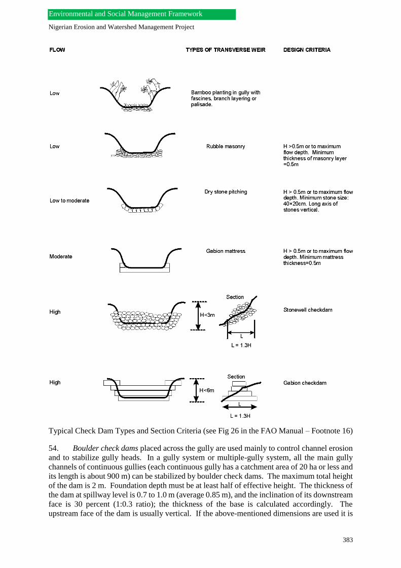
Nigerian Erosion and Watershed Management Project
383
Environmental and Social Management Framework
Typical Check Dam Types and Section Criteria (see Fig 26 in the FAO Manual – Footnote 16)
54. Boulder check dams placed across the gully are used mainly to control channel erosion
and to stabilize gully heads. In a gully system or multiple-gully system, all the main gully
channels of continuous gullies (each continuous gully has a catchment area of 20 ha or less and
its length is about 900 m) can be stabilized by boulder check dams. The maximum total height
of the dam is 2 m. Foundation depth must be at least half of effective height. The thickness of
the dam at spillway level is 0.7 to 1.0 m (average 0.85 m), and the inclination of its downstream
face is 30 percent (1:0.3 ratio); the thickness of the base is calculated accordingly. The
upstream face of the dam is usually vertical. If the above-mentioned dimensions are used it is

Nigerian Erosion and Watershed Management Project
384
Environmental and Social Management Framework
not necessary to test the stability of the dam against overturning, collapsing and sliding.
However,, the dimensions of the spillway should be computed according to the maximum
discharge of the gully catchment area and the form of the spillway is generally trapezoidal (see
Figs. 17A to 17 C in Conservation Guide 13/2).
55. Gabion Check Dams. Gabion check dams may be constructed from wire box gabions
of dimensions 1 x 1 x 2 m, or 0.85 x 0.85 x 2 m, or 0.75 x 1.5 x 3 m. If the catchment area of
a gully is 20 ha or less and the length of the gully is about 1,000 m, channel erosion will be
controlled by boulder check dams, but the first check dam and its counter-dam should be
constructed as gabions. If the gully crosses a road, gabion check dams may be built above and
below the road at the junction points. In addition, gabion check dams combined with gabion
retaining walls can be used to stabilize landslides in the upper portions of the gully. Generally,
it is neither necessary, nor economical to build a series of gabion check dams to control
channel erosion along the gully beds.
56. The Gabion check dam design proposed by the FAO (shown in Figs. 18A -18C of
Conservation Guide 13/2) is built from 0.85 m x 2.0 m gabions and is composed of a main
structure followed by a counter-dam downstream which serves as a sill for a rock apron. If the
total height (H) (i.e. effective height plus foundation depth) of the gabion check dam described
is 3 m or less it is not necessary to compute the dimensions of the dam (thickness of. crest and
base) according to hydrostatic principles or empirical formulas. This is because the box
gabions design stabilizes the dams against overturning, collapsing, sliding and breaking. If the
total height (H) the gabion check dams is 3-5 m, stability against overturning, collapsing and
sliding is enabled by the following dimensions: (i) the thickness of the dam’s crest at spillway
level should be 0.4H; and (ii) the thickness of the dam’s base should 0.6H. The depth of the
foundation should be equal to one-half of the effective height of the dam, which means that the
foundation depth is one-third of the dam's total height and the foundation is longer than the
spillway. The apron length from main dam toe to the end of the downstream counter-dam is
given a 2H. Depending on the soil type, wings should enter at least 50- 120 cm into each side
of the gully and they should be protected against flash water by wing walls. The angle between
the wing and wing wall is 0 to 45 degrees. The height of a wing wall is equal to the depth of
the spillway. Conservation Guide 13/2 provides an example computing the volume of
excavation and volume of rock-filled gabions.
57. The FAO Guide 13/2, does not mention placing the gabions on geotextile sheet to
prevent gabion clogging. Where bed soils are loose sand, the use of rocks for the stilling basin
apron may not be sustainable because of scouring: this Note’s Author would recommend a
Reno Mattress gabion apron. The designs shown in FAO Guide 13/2 would seem to be only
suited for shallow gullies < 10 m wide. This Note advises that for wider gullies, a gabion weir
design be properly checked for stability, seepage control and adequate energy dissipation based
on Section 3 of report entitled “Use of gabions for small hydraulic works“30. The report’s
Section 4 entitled “Methods of construction and control”31 is also very useful and practical.
The references also provide designs for various gabion weirs and side slope stabilization as
well as geotextile use to prevent gabion clogging. The stepped gabion weir configuration
option may be used as a head-cut control structure in medium depth gullies.
30 Tricoli Dario (2004): “Use of gabions for small hydraulic works, Section 3, Gabion structure design for
dam spillway”. Download at http://www.tricardi.it/idro/gabionspdf/gabions_ch3.pdf 31 Tricoli Dario (2004): “Use of gabions for small hydraulic works, Section 4, Methods of construction
and control”. Download at http://www.tricardi.it/idro/gabionspdf/gabions_ch4.pdf

Nigerian Erosion and Watershed Management Project
385
Environmental and Social Management Framework
58. USA Masonry/Concrete Head-Cut Control Structure Practice. The USDA-NRCS
Engineering Field Handbook (EFH) favors well known hard spillway structures supported by
vegetative measures for gully control such as: (i) drop spillways, straight and box inlet drop
spillways; and (ii) chute spillways32. The reference contains structure sketches inclusive of
inlet and outlet energy dissipation options. These structures are also used as spillways for small
earth dams. Masonry or concrete structures are not recommended because they are
impermeable and resist flow and the mortar inevitably breaks up after a few years. They are
also rigid and crack with erosion around the front of the apron. Gabions are highly permeable
and break up dissipate the flow. hey are also flexible and deform to take up the erosion at the
toe of the apron. Therefore these structures are not generally recommended for soft erosive
soils such as those in southeast Nigeria. Figure 6-4 on Page 6-7 of the EFH chapter has a useful
table for structure selection according to the range of heads and discharges for which each
structure type is appropriate.
59. Gully Control Practice in Southeast Nigeria. Okagbue & Uma published a paper in
1987 critically assessing the performance of gully erosion control measures used in Southeast
Nigeria33. To reduce the erosive capacity of the flood water, two types of protection measures
have been adopted. The first involves the construction of hydraulic works that integrate a
drainage network with storage ponds to cut off upstream flood runoff and lower hydraulic loads
of interceptor canals. The interceptor canals or drains, which are commonly located at the head
of the advancing gully channels, drain runoff from areas adjacent to the gullies into artificial
reservoirs (ponds) constructed where deep infiltration can occur. When the upstream
catchment is too large for one set of interceptor canals--where possible--it is broken up into
smaller catchment units whose runoff can be separately drained (see the paper’s Figure 2).
60. Stabilization works include check dams on the main channels of gullies and revetments
and hedges at the inner gully walls. The check dams used are generally a series of check dams
constructed of wood/timbers firmly affixed in the gully bed at close spacing and connected by
fairly strong horizontal wood members or planks. Sometimes the wooden poles are driven into
the ground across the gully to form a two-sided framework resembling crib dams. The two
sides are interconnected by cross members and braces and the intervening space is filled with
compacted earth. The framework is held together with iron wire or rope. The revetments are
in the form of wicker-work fences used as stabilization work to reduce surface flows on the
inner slopes of gully walls. The fences (see Fig.4 of paper) are formed by stakes about 10 cm
thick driven into the ground close together (about 0.5 m - 1.0 m apart) and interwoven with
braces and the like. The wicker-work fences are sometimes accompanied by cashew tree and
bamboo planting to help strengthen the soil.
61. Varied degrees of success have been achieved with these remedial measures. In some
areas, gullying had apparently stabilized after two years of the construction of the remedial
measures, in some the gullying has continued but at a reduced rate, while at others gullying has
continued unabated despite the measures. In the successful areas the gullies were still shallow
(i.e. less than 15 m deep) and have not cut into the cohesionless and very permeable white
32 USDA-NCRS: “Engineering Field Handbook, Chapter 6 – Structures”. Download at ftp://ftp-
fc.sc.egov.usda.gov/NHQ/pub/outgoing/jbernard/CED-Directives/efh/EFH-Ch06.pdf 33 Okagbue C.O. and K.O. Uma: “Performance of gully erosion control measures in southeast Nigeria”;
Forest Hydrology & Watershed Management – Proceedings of the Vancouver Symposium, IAHS – AISH, Publ.
No. 167, 1987. Download at http://iahs.info/redbooks/a167/167016.pdf

Nigerian Erosion and Watershed Management Project
386
Environmental and Social Management Framework
sands. The groundwater table is also far beyond the gully bottom as no springs or seepages are
seen on the gully walls. Apparently, the effect of groundwater on gully advancement is
minimal. No recent gully activity was observed during the study and vegetation had started
thriving on the gully slopes.
62. In the areas of partial success which include some upslope gully spots around Nanka
and Oko, gully activities were significantly reduced. Erosion seemed confined to surficial
removal of grains and small chunks of soil at the upslope side of the check dams and at the
banks of the main gully trunks. Intense gully sliding appeared to have subsided as indicated
by the absence of large volumes of recent debris at the gully bed in those areas. These partially
stabilized gullies have cut into the cohesionless and very permeable sands but the groundwater
level rises above the gully bottom only during the rainy season. The treated areas were classed
as partially successful because they appear to work well only during periods of non-saturation
of the sandy horizon.
63. the most dangerous spots around Agulu, Nanka, Oko and Amucha where the gullies
had cut deep into the cohesionless sand and the sand horizon remains perpetually saturated, the
control measures appear to have totally failed to stop the development and advancement of the
gullies. Sliding and slumping have continued despite the control measures which were
destroyed. In these areas, gully walls are indented with springs and seepage faces; boiling spots
depicting quick conditions are wide spread, all showing effects of groundwater in undermining
the gully walls. Internal erosion and piping results from uncontrolled seepage of groundwater
to the extent that soil particles migrate to an escape exit and cause piping and erosional failure
lower part of gully walls.
64. Also affecting success/failure of the concrete channel structures is the termination point
of such channels. In areas where the channels have been terminated into the gullies,
undercutting arising from channel deepening and scouring has led to the failure of the measure.
Channels terminated at the local base level of rivers tend to be free from this type of failure.
Tree planting as a stabilizing measure has been effective only on minor gullies i.e. those that
have not reached considerable depths (less than 5 m). In the deep gullies whose slopes are
constantly undermined by flood and internal erosion, the trees close to the gully edge usually
uprooted as soon as the slope is undermined. Also the vegetation species (Cashew and
Bamboo) used on the gully floors have failed to thrive on saturated and sometimes running
sand found on the floors of the deep gullies. Thus, in addition to gully thalweg and plan survey
as well as soil sampling, seasonal groundwater depth must be ascertained for gullies generally
deeper than 15 m. This will determine the success of gully control: for deep gullies incised
below the water table since the gully walls are likely to remain unstable due to internal erosion
even if all runoff is diverted from the gully.

Nigerian Erosion and Watershed Management Project
387
Environmental and Social Management Framework
C. Slope Stabilization and Ravine Control
1. Engineering Slope Stabilization
65. Gravity Retaining Structures. The use of civil engineering structures such as various
types of gravity retaining structures (including gabion, masonry and reinforced earth retaining
walls) are well known practices. A useful overview is given in Chapter 4 of the FAO
publication “Methods and Materials in Soil Conservation – A Manual” (see Footnote 16).
Reinforced earth structures [see examples under (d) in the Figure below] are of particular
interest in ravine stabilization as will be shown in the next section. Reinforced earth comprises
a series of compacted soil layers separated by sheets or strips of a reinforcing medium, which
may be a sheet geotextile, a sheet of woven gabion wire, a timber grid, or metal strips. A sub-
vertical structure with face slope angle greater than about 700, is generally referred to as a
reinforced earth retaining wall and can be built from reinforced soil if facing units are used to
hold the soil in place. Slopes with an angle of less than 700, it is possible to use ‘soft’ facings,
such as soil filled jute bags, to form the face of the slope and the natural soil is compacted
behind this face. For slopes of less than about 450, no special facing is necessary but vegetation
should be established soon after construction.
66. The most effective use of reinforced earth is to use reinforcement to enable a slope to
be built at a steeper slope angle than can be achieved without such reinforcement. In areas
where the potential for landslides is to be avoided or mitigated, particularly where new
construction in steep ground has to be carried out, or where a landslip has to be repaired then
reinforced earth is an effective and economic construction technique. Without reinforcement,
soil has a low tensile strength. When it is surcharged it flattens and widens, undergoing lateral
tensile strain. With reinforcement in place the lateral movement will only take place if the
shear strength of the interface between the soil and the reinforcement is exceeded (so that there
is slippage between the soil and the reinforcement) or if the reinforcement ruptures. The system
therefore relies on the frictional strength between the soil and the reinforcement. The detailed
design procedures depend on the material used for the reinforcement and each manufacturer
provides design notes or offers a design service for his particular product.
67. Geotextiles. In soil conservation engineering, geotextiles have three main roles,
namely:
They can be used in slope protection. This may be by acting as temporary protection for
vegetation on steep slopes, and degrading as the vegetation develops and establishes itself.
Alternatively, they may provide a more permanent key to allow the placement of a soil
layer on the slope face into which vegetation can be planted.
They can be used as separators to prevent mixing of one soil type with another. This is
usually achieved by providing a barrier to migration of particles between two soils of
differing grain-size while allowing free movement of water. An application in this respect
may be use as a separator between a gabion or rock boulder scour protection layer and the
underlying natural soil.
They can be used for soil reinforcement to allow soils to carry a greater shear loading than
they would otherwise be able to. By incorporating geotextile layers into a compacted fill
the resulting reinforced soil structure may act as a retaining wall to mitigate against slope

Nigerian Erosion and Watershed Management Project
388
Environmental and Social Management Framework
instability, may effect a repair to a previously slipped area, or may allow the initial
construction of a steeper slope than would otherwise be possible.
The use of geotextiles in the applications above allows the re-use of local soils readily available
at the site. Transport and material costs (with the exception of the geotextile itself) are therefore
reduced. It should be emphasized that geotextiles only improve the mass stability of a slope
when they are used as part of a reinforced soil structure. When used as separators or in surface
protection they have no influence on the mass stability of the slope and this must be separately
considered and ensured if cost and effort inherent in their use is not to be wasted.
68. A wealth of proprietary brands of geotextiles are available and they can be classified
on the basis of their material type and process of manufacture. They can be classified into two
main types on the basis of their composition; natural fibers and plastics. Natural fibres have
the tendency to rot, particularly under moist conditions, and this biodegradability can be used
to advantage when such materials are used as a temporary minor strengthening or protective
measure until natural vegetation has grown to take over the role. Plastics are increasingly used
where the strength or function of the geotextile is required to be sustained over a long period.
Synthetic geotextiles are manufactured from thermoplastic polymers which can be softened
and rehardened, making them an ideal base material from which to fabricate a range of
products. The polymers are generally formed into one of three basic component types: (a) a
continuous filament, of circular cross-
continuous flat tape sheet
or film a fraction of a millimeter (film) to several millimetres (sheet) thick and several meters
wide. The components are used to manufacture the finished geotextile product.

Nigerian Erosion and Watershed Management Project
389
Environmental and Social Management Framework
69. Geotextile products tend to group into the following categories: (i) woven geotextiles
in the form of sheets typically about one mm thick and displaying a mesh of reasonably single
sized regular pore openings; (ii) non-woven geotextiles in the form of sheets or three-
dimensional mats of variable pore size; and (iii) geomeshes, geonets and geogrids have large
pore sizes in comparison to the dimensions of the material. Technical design and installation
details for of these geotextile types in their various roles are given in Chapter 6 of the FAO
manual “Methods & Materials in Soil Conservation” (Footnote 16).

Nigerian Erosion and Watershed Management Project
390
Environmental and Social Management Framework
70. Geotextiles for Slope Protection. For slope protection, slopes and banks without a
protective vegetation cover are open to the scouring effects of water, particularly if the exposed
soil is sandy in composition. If the mass stability is satisfactory then aesthetic remediation
using vegetation is preferable to man-made protection structures such as stone pitching, gabion
revetments, etc. as it can be extremely difficult for natural vegetation to re-establish itself. The
use of geotextiles in conjunction with vegetation can provide early protection as the vegetation
establishes itself.
71. Geomeshes (two-dimensional) and Geomats or Geomatrixes (three-dimensional) are
used to interact with young seedlings by providing a stable surface through which seedlings
can take root and grow to provide a vegetative ground cover. Those made from natural fibres
such as jute, coir and hemp are in the form of a mesh that allows the seedlings to be planted
through it. They are biodegradable and their stabilizing influence diminishes as the ability of
the rooted vegetation to take over the protective role increases. Such biodegradable natural
materials should only be used where slopes are stable in terms of mass stability and sufficiently
shallow to ensure that the re-establishing vegetation will be secure in the long term.
72. Where slopes are stable in terms of mass stability but too steep to guarantee the long-
term security of a soil and vegetation cover synthetic geomats and geomeshes can contribute
to the longer term protection of the soil surface and vegetation layer. Geomats are
threedimensional random open-knit structures with a thickness of up to 20 mm. They are rolled
out and pegged down onto the slope and then seeded and filled with topsoil, which is held in
the mat. The mat remains under the vegetation providing continuing reinforcement in the root
zone. Many proprietary brands exist and the many derivatives include those with flat bases, or
composites incorporating a reinforcing grid, or impregnated with stone and bitumen, or
supplied complete with a pre-grown grass turf.
73. As an alternative, in cases where slopes are so steep that soil is difficult to maintain in
place and where, even if established, roots are not strong enough to adequately resist the
downslope forces, geocells can be used to retain the surface soil on the slope. Geocells are
threedimensional honeycomb structures which provide a network of interconnected cells
typically 150 mm to 300 mm square and from 75 mm to 150 mm high. The geocells are
typically supplied in panels and each geocell panel is laid onto the slope surface and pegged in
place on the top of the slope. Further pins are added and adjacent panels are stapled together.
The cells are then filled with soil. It is important that hydraulic continuity is provided between
the cells so that runoff does not accumulate and saturate each cell thereby adding weight to the
layer.
74. Woven textiles are strong and work well in steep slope applications and in landslip
remediation. Their flexibility makes them particularly suitable if a wrapped face is required.
If a permanent rigid facing is used then geogrids should be used because a better fixing with
the facing is possible. Their greater surface area allows the development of an excellent bond
with the soil. Geogrid type products and meshes which have a physical junction between the
cross members and the longitudinal members, rather than having been formed from one sheet,
need careful consideration because the junctions represent a potential point of weakness which
would reduce the bond.

Nigerian Erosion and Watershed Management Project
391
Environmental and Social Management Framework
2. Ravine Control with Earthfill “Terramesh” Gabion Baskets.
75. Head-cutting by deep ravines (e.g. the Nanka gullies) are very difficult and expensive
to stabilize. Nevertheless, earthfilled gabions have been used with apparent success. An
example is the use of the Maccaferi “Terramesh” system designed by a consulting firm for the
Selemboa Ravine in Kinshasa in the Democratic Republic of Congo34. Kinshasa is built on
sandy-clay soil with about 4.5 million inhabitants settled in a plain and about 1.5 million settled
on a hilly “amphitheatre above the main city. Villas occupy the high parts of the hills which
tower above 600 m with a gentle slope. Some more rudimentary dwellings have swept little
by little across the slopes in an unplanned manner since Independence in 1960. On one of these
hills is the highly eroded area of Selembao which has a residential area at an elevation of 500
m and where telecommunication antennas have been installed. The area suffers from severe
erosion problems due to the bad drainage of the surface run-off which has a flow of about 16
m³/sec for a Return Period of 50 years and an annual flow of about 8 m³/sec.
76. Erosion was caused by: destruction of an existing collector due to, for example,
maintenance problems, cultivation in the slopes and pedestrians paths parallel along the steep
slopes, deforestation, chaotic urbanization without proper stormwater drainage systems, etc.
This caused rills which developed into a massive ravine with a length of around 1,300 meters,
a width around 60 to 70 meters and a 120 m height difference between the top and bottom of
the ravine. Thus a natural catastrophe was created with dwelling and infrastructure (sewers &
electricity) destruction and an immediate intervention became necessary by 2004. On the site,
there are remnants of small stilling basins--closed by an earth barrier on the ravine side--
allowed for the accumulation of the run-off and enabled water seepage into the ground.
Unfortunately, without spillways, these rudimentary structures ere destroyed. The basins were
not very effective: infiltration became slower and slower because of the alternation of the first
layers of sand with thin clay horizons.
77. The remedial strategy was the following:
• Restore stable slopes: the slopes will be limited at 27° corresponding to the natural ground
slope. In case where steeper slopes must be considered, the soil will be reinforced by retaining
structures.
• Support embankments by retaining structures: this solution is locally essential when the
ground around an important construction (a building) or around a substructure (a road) has to
be supported. Support works with a wire mesh reinforced soil system was preferred: it is a
flexible structure which does not require imported granular materials, and avoids additional
earthmoving and the opening of borrow pits.
• Re-profiling of the banks: the ravines are partially backfilled, to create platforms and
reconstruction of stable profiles. This requires massive earthmoving operations.
34 De Roeck Jean-Pierre: “Anti-Erosive measures on the Selemboa Ravine”; Construction World Special
Awards issue, December 2005. Download at http://www.maccaferri.co.za/files/editorials/ZAF-ED-059-
Selembao-Rev02.pdf

Nigerian Erosion and Watershed Management Project
392
Environmental and Social Management Framework
• To put in place an effective vegetated protection cover adapted to the area and soils.
78. The works include two parts: the control of the flows which are to be conveyed to the
bottom of the embankments, and the stabilization of the embankments. First, runoff control is
achieved by a main collector drain 5 m wide and 2.4 m high fed by secondary collector drains
that convey stormwater to the main collector. The collected runoff is conveyed through a
succession of energy dissipating drops generally 3 m high. At the end of the slope, a last basin
allows the final dissipation of the water energy via a spillway that spreads the outflow in a wide
channel, made up of PVC coated, flexible gabions and of PVC coated Reno mattresses. At the
channel exit, where the gradient is virtually zero, the water is returned to the natural ground at
a non-erosive velocity
79. Second, the unstable slopes are remodeled according to the natural slope of the ground,
between 27 and 29 degrees. In the high part of the site, this reshaping is not possible, and it has
been foreseen that the use of vegetated soil reinforced walls will be required, in order to
compensate the differences in terms of ground elevation. Since recreation of the embankments,
according to the natural slope angle, would have required an excessive volume of fill, Green
Terramesh35 reinforced walls allow for reconstruction of stable slopes by minimizing the
material required. The Green Terramesh™ walls--an environmentally friendly modular system
used for soil reinforcement in mechanically stabilized slopes and embankments--were
preferred for a number of technical advantages. The sandy terrain of the site shows qualities
that allow it to be used as granular fill behind the facing of the Green Terramesh: i.e. soil instead
of rocks are used in the wire cage. Therefore not necessary to bring in quarry materials, thus
reducing the total cost and, avoiding the need for borrow pit areas. The general Terramesh
system of slope stabilization for weak soils is described in a Maccafferi brochure36.
80. The Terramesh wall’s flexible structure allows for the take up of the differential
settlements - unavoidable in huge embankment reconstitutions without cracking. Finally, the
biodegradable mat behind the Green Terramesh façade allows establishing vegetation. The
hydro-seeding method, carried out by a specialized firm, was selected as the best option. The
stabilizing reinforcement structures include (see downloaded paper for photos and a cross-
section diagram): (i) a wall length of 345m with a height between 5.40 and 6.00m; and a wall
length of 200 m with a variable height between 7.80m and 8.55m. The walls are built on a first
filtering layer with a 0.60m thickness. The compacted fill is separated and kept dry by a
geocomposite37 (MACDRAIN 2L), positioned in front of the excavated soil, which drains the
seeping water through perforated pipes. The works were funded by the World Bank Group
(IDA) at a cost of about USD8.62 million and completed in two years (January 2004 and
January 2006.
3. Soil Bioengineering- Vetiver Grass for Slope & Ravine Head-Cut Stabilization
3.1 Soil Bioengineering.
35 Maccaferri (Southern Africa): “Green Terramesh – Galfan & PVC Coated - Technical Data Sheet”;
October 2010. Download at http://www.maccaferri.co.za/files/techdata/ZAF-TDS-GTMGalfan-Eng-Rev05.pdf 36 Maccaferri NZ: “Maccaferri solutions for soil reinforcement works”. Download at
http://www.maccaferri.com.au/webfiles/MaccaferriAu/files/Soil_Reinforcement_Brochure-AUS.pdf 37 Macaferri (Southern Africa): “MACDRAIN 2L – Geocomposite for Drainage - Technical Data Sheet”;
November 2007. Download at http://www.maccaferri.co.za/files/techdata/ZAF-TDS-MD2L-Eng-Rev03.pdf

Nigerian Erosion and Watershed Management Project
393
Environmental and Social Management Framework
81. Soil Bioengineering Practices. Soil bioengineering is an accepted cost-effective “best
management practice” (BMP) used in gully control and slope stabilization and is described in
the USDA-NRCS Engineering Field Handbook38. The manual is based on a combination of
vegetative and structural components and gives design bioengineering principles, designs,
construction technology and recommended vegetative materials. The techniques described in
terms of applications, construction and installation include: live stakes, live fascines, brush
layers, brush packs, live cribwalls, vegetated rock walls, vegetated rock gabions, and vegetated
riprap. Unfortunately, although the manual is a very useful reference document for gully and
slope stabilization, its vegetation recommendations are for the main regions of the USA. Thus,
its application in southeast Nigeria will require the assistance of a plant biologist to select
appropriate equivalent vegetation for many of the abovementioned techniques.
82. Gully control requires the integration of structures and vegetation: for example,
vegetated gabions and vegetated riprap for rock chutes (see Footnotes 17 & 20). The long-
term goal is to establish and maintain a vegetative cover that prevents further erosion. This
goal is seldom realized unless the severe gully conditions can be altered immediately.
Vegetation alone (except for Vetiver Grass described below) will rarely stabilize gully headcuts
because of the concentrated water inflow and other pervasive forces that promote gully
enlargement in an unstable channel system. Initially, the vegetation and the structure work
together in an integrated fashion. The ultimate function of gully structures, however, is to help
in establishing vegetation that will provide long-term protection.
83. Vetiver Grass Applications in Soil Conservation. Few existing plants have the unique
attributes of multiple uses, environmentally friendly, effective and simple to use as Vetiver
grass. It has a dense root system 2-3 m deep giving it the capacity to create a living wall, a
living filter strip and “live soil nail” reinforcement. When Vetiver grass is grown in the form
of a narrow self-sustaining hedgerow it exhibits special characteristics that are essential to
many of the different applications that comprise the Vetiver System. The Vetiver System (VS)
is based on the use of Vetiver grass (Vetiveria zizanioides L. Nash), which was first developed
by the World Bank for soil and water conservation in India in the 1980s. In addition to this
very important application in agricultural lands, scientific research conducted in the last 15
years has clearly demonstrated that VS has much wider applications for soil bioengineering.
This is due to its unique morphological, physiological and ecological characteristics that permit
it to adapt to a wide range of climatic and soil conditions.
84. Because its remarkable characteristics permit it to survive where other plants cannot,
vetiver grass often acts as a pioneer plant establishing itself in hostile conditions and creating
micro-climates that permit a variety of other indigenous plants to prosper. Current applications
include soil and water conservation in agricultural lands, steep slope stabilization, mine,
contaminated and saline lands rehabilitation and recently wastewater treatment. VS is now
increasingly being used for these purposes in over 120 countries39. A technical manual
38 USDA Natural Resources Conservation Service (1995): “Engineering Field Handbook, Part 650,
Chapter 18 – Soil Bioengineering for upland slope Protection and Erosion Reduction”. Download at ftp://ftp-
fc.sc.egov.usda.gov/NHQ/pub/outgoing/jbernard/CED-Directives/efh/EFH-Ch18.pdf 39 Truong P.N.V. and Loch R.: “Vetiver System for Erosion and Sediment Control”; ISCO 2004 - 13th
International Soil Conservation Organisation Conference – Brisbane, Australia;July 2004. Download at
http://www.vetiver.org/AUS_Sediment.pdf

Nigerian Erosion and Watershed Management Project
394
Environmental and Social Management Framework
describes the various applications in five separate Parts including a description of the plant and
its propagation methods (using nurseries) in Parts 1 & 2 respectively40.
85. A review conducted for the World Bank comparing the effectiveness and practicality
of different soil and water conservation systems found that constructed measures must be site
specific and require detailed and accurate engineering and design. Furthermore, all structured
systems require regular maintenance. Most of the evidence also suggests that constructed soil
conservation works reduce soil losses, but do not reduce runoff significantly and in some cases
have a negative impact on soil moisture. Plant species to be used as barriers for effective
erosion and sediment control should have the following features:
• Form an erect, stiff and uniformly dense hedge so as to offer high resistance to overland water
flow and have extensive and deep roots, which bind soil to prevent rilling and scouring near
the barrier;
• Ability to survive moisture and nutrient stress and to re-establish top growth quickly after
rain;
• Minimum loss of crop yield implying that the barrier should not proliferate as a weed, not
compete for moisture, nutrients and light and not be a host for pests and diseases; and
• Preferably require only a narrow width to be effective and supply products of economic value
to farmers.
Vetiver grass exhibits all these characteristics and it is unique in that it can thrive in arid and
humid conditions, growing under some extreme soil conditions and survives wide temperature
ranges.
86. Since the Vetiver barriers only filter the runoff and do not convey it, water seeps
through the dense vetiver hedge reaching the bottom of the slope at lower velocity without
causing any erosion and without being concentrated in any particular area. This is known as
the “flow- through system” as shown below. This is in sharp contrast with the contour
terrace/waterway system in which runoff water is collected by the terraces and diverted as
quickly as possible from the field to reduce its erosive potential.
40 Truong P.N.V, Tran Tan Van and Pinners E.: “Vetiver System Applications –A Technical Reference
Manual”; The Vetiver Network Intenational (TVNI), 2008. Download at http://www.vetiver.org/TVN-
Manual_Vf.pdf
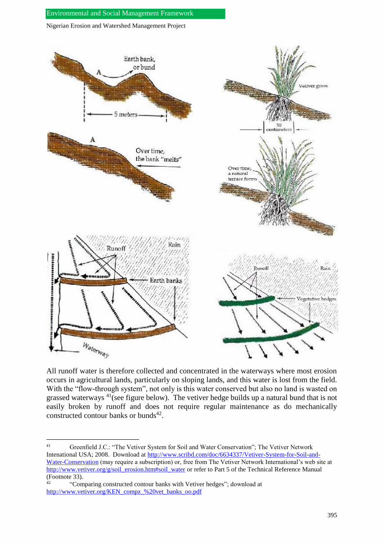
Nigerian Erosion and Watershed Management Project
395
Environmental and Social Management Framework
All runoff water is therefore collected and concentrated in the waterways where most erosion
occurs in agricultural lands, particularly on sloping lands, and this water is lost from the field.
With the “flow-through system”, not only is this water conserved but also no land is wasted on
grassed waterways 41(see figure below). The vetiver hedge builds up a natural bund that is not
easily broken by runoff and does not require regular maintenance as do mechanically
constructed contour banks or bunds42.
41 Greenfield J.C.: “The Vetiver System for Soil and Water Conservation”; The Vetiver Network
Intenational USA; 2008. Download at http://www.scribd.com/doc/6634337/Vetiver-System-for-Soil-and-
Water-Conservation (may require a subscription) or, free from The Vetiver Network International’s web site at
http://www.vetiver.org/g/soil_erosion.htm#soil_water or refer to Part 5 of the Technical Reference Manual
(Footnote 33). 42 “Comparing constructed contour banks with Vetiver hedges”; download at
http://www.vetiver.org/KEN_compz_%20vet_banks_oo.pdf

Nigerian Erosion and Watershed Management Project
396
Environmental and Social Management Framework
3.2 Vetiver Grass for Steep Slope Stabilization
87. Presently Vetiver grass has also been widely used for erosion and sediment control on
steep slopes around the world: including Africa, Asia, central and south America, southern
Europe and Australia where it has been used successfully to stabilize steep batters of road and
railway in north, central and south east Queensland. In China, the Vetiver System has been
used for erosion and sediment control on more than 150,000 km of railway, highway and road
batters by 2004. Part 3 of the Vetiver Technical Reference Manual (Footnote 33) explains the
basis of Vetiver’s efficacy for slope stabilization and its various applications43.
88. vegetative cover provided by grass seeding, hydro-seeding or hydro-mulching
normally is quite effective against sheet erosion and small rill erosion, and deep-rooted plants
such as trees and shrubs can provide some structural reinforcement for the ground. However,
on newly-constructed slopes, the surface layer is often not well consolidated, so even well-
vegetated slopes cannot prevent rill and gully erosion. Deep-rooted trees grow slowly and are
often difficult to establish in such hostile territory. In these cases, because of the inefficiency
of the vegetative cover, engineers opt for structural reinforcement. In short, traditional slope
surface protection provided by local grasses and trees cannot, in many cases, ensure the needed
stability. Taking cue from the agricultural sector and exploring the possibility of introducing
vetiver as a new vegetative candidate for bioengineering slope stabilization work, a study of
the tensile root strength properties of vetiver in its resistance to shallow mass stability and
surficial erosion was undertaken in 1996. It emerged that the tensile strength of vetiver roots
is as strong as, or even stronger, that of many hardwoods. In fact, because of its long (2-3.5
m) and massive root networks which are very fast-growing (already functionable in only 4-6
months), it is better than many types of trees which normally take 2-3 years to be effective.
89. Slips or slides on slopes fall into 2 categories: deep seated and shallow seated. The
deep-seated problem is geotechnical or geological in nature. It can only be addressed taking
into account slope geometry, soil strength, climatic condition, groundwater characteristics, etc.
and can be ascertained by slope stability analysis. For shallow-seated slip or shallow mass
movement, the problem is somewhat difficult to quantify. Shallow slips of 1.0-1.5 m, on the
other hand, comprise the majority of problems faced after slope formation, especially in regions
with prolonged and high rainfall. This problem still arises despite the fact that slope analysis
might have shown a slope to have adequate overall factor of safety. To tackle this problem,
engineers conventionally rely on the use of ‘hard’ or ‘inert’ material such as mortared riprap,
shotcrete or the like to seal off the slope to prevent water infiltration that is deemed to be the
cause of the slippage in the first place. However, this does not always succeed.
90. An alternative solution is to resort to vegetation, in this case vetiver, to help strengthen
the surficial 1.0-1.5 m layer that is prone to slippage (see Fig 1 on page 44 in Part 3 of the
Technical Manual). When vetiver roots interact with the soil in which it is grown, a new
composite material comprising roots with high tensile strength and adhesion embedded in a
matrix of lower tensile strength is formed. Vetiver roots reinforce a soil by transfer of shear
stress in the soil matrix to tensile inclusions. In other words, the shear strength of the soil is
enhanced by the root matrix. Vetiver root systems are about 3 times stronger than all other
43 This chapter is updated and available as an engineer’s handbook. Download from
http://www.scribd.com/doc/6634318/Vetiver-System-for-Slope-Stabilization or from the TVNI slope
stabilization portal at http://www.vetiver.org/g/slope_protection.htm

Nigerian Erosion and Watershed Management Project
397
Environmental and Social Management Framework
grasses with high mean tensile strength of 75-85 MPa, or approximately one sixth the strength
of mild steel. When the dense and massive root networks act in unison, they resemble the
behavior of `soil nails’ normally used in civil engineering works. With its innate power to
penetrate through hardpans or rocky layers, the action of vetiver roots is analogically likened
to ‘living soil nails’.
91. Thus, vetiver can increase soil shear strength by a factor of about 40 and, when planted
on slopes, vetiver will also reduce slope pore pressures through the removal of water by
transpiration. On steep (300 - 600) slopes, the space between Vetiver rows is very close and
has a Vertical Interval of about 1m. Therefore, moisture depletion would be greater and further
improve the slope stabilisation process. However, to reduce this potentially harmful effect of
Vetiver on steep slopes in very high rainfall areas, as a precautionary measure, Vetiver hedges
could be planted on a gradient as Vetiver hedges could be planted on a gradient of about 0.5%
as in graded contour terraces to divert the extra water to stable drainage outlets.
92. Application of Vetiver Grass for Urban Ravine Control. The above Vetiver System
principles were successfully applied to stabilizing the head of a ravine in Kikiwit city in the
Democratic Republic of Congo by a USAID-supported NGO and community participation44.
The town of Kikwit extends over 92km2 and neighborhoods have been built in the valleys or
between stream beds of the Kwilu River as well as on the slopes and beds of this same river.
Slopes of 25 degrees are common in the region. Kikwit’s climate is tropical and humid having
an average annual rainfall of 1,500 mm within 8 months of rainy season and 4 months of dry
season. There is a great variation in the soil of Kikwit: the superficial cover is often of a sandy
nature and at the deeper level one finds gray and red clay as well as argillites. The vegetative
coverage varies with grassy savannas on the plateau, forested savannas on the slopes and forests
in the valleys.
93. For years, there were no efforts by the national or regional governments or the local
municipality to prevent soil erosion in the valleys surrounding the town. Soil erosion and mud
slides developed rapidly year after year with the abundant rainfall and increased construction
for which there was no urban planning. With defective and/or lack of appropriate drainage
systems, rushing water flowed through small ravines, down the slopes, carrying stones, bricks,
large amounts of mud and debris and, unearthing trees and bushes. With time, the ravines
become much greater in size and progressively entered the town, tearing down hundreds of
houses, schools, roads and other used community infrastructures. The Kikwit ravines generally
have a mobile bed, due to the frequent interventions that change their shape and direction.
These sites have become so denuded and precarious that the entire population of neighborhoods
had no other choice than to leave and the town is now divided into isolated patches.
94. The Malawi Ravine was selected as a demonstration site for the project with the purpose
of show the local community new anti-erosion techniques with Vetiver Grass (Vetiver
Zizanioides) and organizing them to participate in controlling the gully head. Previously
named Malawi Ravine, its three heads have already reached the neighborhood bearing the same
name and have caused the disappearance of houses. The progression of these three heads of
the ITPK ravine is menacing the only professional technical school of the town (ITPK), the
general hospital, the central market, the cathedral and the biggest paved road of the town. Its
44 Ndona A. & P. Truong: “Community mobilization for the control of ravine erosion with Vetiver
technology”. See http://www.vetiver.org/ICV4pdfs/DC04.pdf . A Power Point presentation of this application
is given at http://www.vetiver.org/ICV4-ppt/DC04-PP.pdf

Nigerian Erosion and Watershed Management Project
398
Environmental and Social Management Framework
depth has reached around 5-7 m at the level of these structures and 15-20 m at the bottom of
the ravine.
95. With the support the NGO, the participatory process began with vetiver information &
training workshops. As a result, certain local associations became actively involved by
establishing their own vetiver nurseries to meet the plant quantity requirements for the 1.5 ha
demonstration plot. This plant multiplication phase took 12 months, from October 2004 until
September 2005. Local community participation in multiplying vetiver had a double
advantage; not only did it allowed the population to amass vegetative materials for their
individual needs, it also offered them a new source of income through the sale of the vetiver
shoots.
96. Implementation of the Vetiver System was done in three phases (see photos in the
downloaded paper) as follows.
a) Re-profiling the ravine through with slope terracing. The vetiver system consists of
planting one or several hedges along the slope’s contour lines If the area to be protected is
very steep, one must initially readjust the profile the ravine prior to planting the hedges.
However, since ravine slopes are steeper than 45º, the slopes are not stable and are often
subject to landslides and collapse until reaching an equilibrium profile. It is therefore
difficult and nearly impossible to plant a hedge of vetiver along contour lines in this case.
Thus successive narrow bench terracing along the slope was undertaken to facilitate the
planting and to create a more stable slope profile to prevent further collapses or landslides.
These terraces have variable height and width depending on soil texture. Cuts are easy to
make on loam and sandy loam soils but creating terraces on sandy soil is more difficult due
to the fragility of the soil. Thus tree branch posts were sunk in places to secure particles of
the fragile soil. Terraces of this type were generally 50 to 100 cm in width and height. The
floor of the ravine was also transformed into water retention basins to reduce runoff
velocity.
b) Vetiver Planting (hedge placing). The successive vetiver hedges were planted on terraces
contour lines established during the re-profiling of the ravines. The distance between two
hedgerows were set between 50-100cm and the vetiver splits (composed of three tillers)
were planted 10 cm apart in order to quickly form a dense hedge (usually after a few
months).
c) Maintenance. After planting, regular maintenance visits were made during the first 4
months. These maintenance visits consisted primarily of watering right after replanting to
assure good establishment. Three weeks after the initial planting, a few plants had not
survived, and these were replaced with new ones in order to avoid gaps between plants and
to assure hedge density. According to need, areas were hoed and fertilizer was applied
(NPK: 17-17-17 and Urea) to reduce weeds and to permit good vetiver plant growth.
97. In the first 30days, one could not observe the forming of the dense hedgerows as they
relate or depend on the level of development of the plants. However, the extension of the
ravine heads and landslides had been stopped, not because of the Vetiver, but mostly because
of the re-profiling which gave the slopes a profile of equilibrium. The water retention basins
also stopped the progress of the heads as they limited the water run-off on the ravine before
the vetiver hedges had reached an optimum development height capable of stabilizing the site.

Nigerian Erosion and Watershed Management Project
399
Environmental and Social Management Framework
However, 60 days after planting the plants had reached their average growth level, leaves
started to reach normal heights and the new tillers had grown from the base. Consequently,
hedges density was also average, that is, one could still see space and distinguish between the
plants in the hedgerows.
98. After 120 days, one could see that the vetiver plants started to reach a good level of
growth by observing the height of its leaves and the growth of new and more tillers. Growth
was reaching a point were plants in the hedgerows began close in on each other. No further
landslides were observed. At 240 days after the start of the demonstration plot, plants had
reached their maximum height at approximately 1.5 to 2m providing healthy and dense
hedgerows. Thus Vetiver hedge development on the site transformed the landscape into a form
of savanna, allowing the growth of other new and indigenous grasses. The vetiver technology
showed to be an effective and appropriate solution to stopping the progression of urban erosion:
the three heads of the ITPK ravine and its slopes have totally stabilized by the dense savanna
of vetiver.
99. Similar problems exist in Brazzaville. Conventional ravine and slope stabilization
structures are very expensive and not sustainable, including the use of cheaper soil-filled
sandbags. Messrs. Truong and Ndona who were responsible for the Kikiwit demonstration,
came up with the idea of growing vetiver in the sandbags to anchor them, reduce soil saturation
and reduce seepage pressures and. form hedges to slow runoff. A Powerpoint presentation may
be downloaded to see the concept.45 No update is currently available on the Vetiver Network
International’s website as to the demonstration’s outcome and viability.
D. Road and Stormwater Drainage Erosion Control Practices
1. Road & Stormwater Drainage Erosion Control Approach for Southeast Nigeria
100. The review in this Note’s Section A.3 above of gully formation and damage causes due
inadequate road and urban stormwater drainage practices led to the following strategic
conclusions:
a) Roads requiring reconstruction because of gully erosion damage. Most of the road gully
erosion causes and the remediation works were either partially successful or unsuccessful
because of the following major reasons: a) poor design and quality assurance of
construction; (b) inadequate roadside drains and lack of proper/safe termination of drains
and culverts at the valley bottom; c) inadequate or lack of effective measures to protect
slope surfaces; and d) lack of road maintenance. These lacunae have to be addressed in
priority road repair works together with the threatening gully’s headcutting control and
45 Ndona A, and P.Truong: “ Ravine Rehabilitation in Brazzaville, Congo”. Download at
http://www.vetiver.org/CON-Ravines%20Brazzaville.pdf

Nigerian Erosion and Watershed Management Project
400
Environmental and Social Management Framework
bed stabilization as the first priority phase of the remedial works. For example--based on
this Author’s review of a road design for a road cut by a large active gully--it is not good
sustainable practice to rebuild the damaged road to cross the gully using an expensive
concrete bridge supported by piles and earthfill over large box culvert placed in the gully.
If the gully has not been stabilized, erosion will block the culvert and/or erode the culvert
inlet/outlet foundations leading to collapse of the cross-drainage structure. Approval of
feasilibity reports based on survey, investigations and preliminary as well as detailed
designs and bid documents must be based on vetting by experienced road engineers for
quality assurance to ascertain that the above deficiencies do not reappear.
b) Urban stormwater drainage and gully erosion. Growing, unplanned and uncontrolled
urbanization in most towns and cities in southcentral and southeastern Nigeria will surely
result in increasingly severe flooding and gully erosion damage unless stormwater drainage
systems are installed and/or improved on a priority basis within a rolling medium-term
master plan framework. Priority stormwater drainage plans and designs in gully affected
urban areas, while addressing viable diversion and disposal of gully creating runoff must
also address viable gully head-cutting control and gully stabilization as a single package.
Designs need to be vetting by experienced road and drainage engineers. New housing
estates, large industrial and public utility facilities should only be approved on the basis of
a viable erosion & sedimentation control plan whose drainage is based on safe disposal
without adversely affecting downstream areas. Appropriate State regulations & guidelines
modeled on similar erosion and sedimentation regulations elsewhere (e.g. USA, Australia,
Malaysia) should be issued to enforce this requirement
c) Rerouting of damaged roads and basin-wide road network gully threats. Corrective
measures roads irreparably destroyed by gully erosion needing unavoidable priority road
diversions require a strategic management approach based on a catchment/drainage basin
scale. The diversion plan should be cognizant of erosion inducing causative factors of the
proposed rerouting such as the engineering geological properties of the soils, basin
geomorphology and gully erosion potential. In parallel, a survey is required to identify
other roads in the area threatened by advancing gullies and medium-term treatment
priorities determined based on the proximity of these gullies to the roads, important
infrastructure and valuable properties and, the likely time left prior to road and asset
damage. If possible, the survey should be GIS-based using a base map of existing roads.
In the loner term, the survey should be extended to the whole state so that it can be easily
updated from time to time as new gully threats arise. Where gullies are still shallow and
easy to stabilize in a cost-effective manner should also be prioritized and budgeted. The
potential damage that may be caused by drainage outlets of proposed road diversion should
also be reviewed using these considerations.
d) Professional Sensitization. Southeast Nigeria is a ‘sensitive” area for road and stormwater
drainage infrastructure to which the civil engineering profession is inadequately
“sensitized” and lacking in guidance regulatory and/or professional guidelines for design
and construction. Designs are probably undertaken in a textbook manner and according to
the Federal Highway Manual which does not differentiate the specific drainage good

Nigerian Erosion and Watershed Management Project
401
Environmental and Social Management Framework
practices requirements for southeast Nigeria. NEWMAP should support the preparation
for SE Nigeria of: (i) updated rainfall intensity-duration- frequency curves for hydrological
design of road & stormwater drainage as well as gully reclamation; and (ii) road and urban
stormwater design & construction good practice guidelines adapted to erosive soil
conditions. An experienced consulting firm consortium (international & national) should
be tasked with preparation of draft road and stormwater drainage guidelines material for
the prevention of gully erosion for review by an expert committee appointed by FMoE and
the Federal highways agency. As part of its duties, the consortium should conduct
workshops to sensitize the engineering profession and incorporate workshop feedback
received into its draft guidelines. NEWMAP should also support a National Panel to
develop practical guidelines for SE Nigeria gully control practices. The Panel should be
composed of engineers and academics with gully control experience and be supported by
one or two very experienced international experts. In the interim, an updateable roster
should be established of prequalified national consulting firms with proven experience and
performance in road and stormwater drainage design and construction supervision for both
Federal and State projects.
1.2 Good Road Drainage Practices
101. Key Drainage Design Practices. The design key issues that should be addressed in a
rural and urban road drainage design include:
a) Hydrological Design Criteria. Drainage of main highways and secondary or urban roads
are based on runoff estimates derived by the “Rational Formula” using storm intensities
with an Average Recurrence Interval (ARI) of about 50-100 years and 25 years
respectively. Unpaved rural roads are usually based on an AVI of 10-15 years. Similarly,
if data exists for streams/rivers that the road has to cross, the same should apply: if not,
cross-drainage and bridges would be also sized by catchment characteristics, area and storm
frequency as above. The resultant runoff estimates are used for design sizing of road
surface drainage ditches (inclusive of the contribution of steep slopes abutting the road),
tailwater height at cross-drainage culvert entrances and design water level above grated
catchpits (especially in road valleys where drain discharge is contributed from both sides).
The ARI therefore determines the cost of road components depending on its importance
and traffic volume and usually the less important the road, the lower the ARI used as a cost-
saving measure. In urban areas, a higher ARI is used since backwater from culverts and
catchpits that are undersized cause flooding of properties and are a road safety hazard.
However, for southeast Nigeria with its erodible soils, gully formation hazards and poor
road maintenance culture, this Author recommends an ARI of at least 50 years for
secondary roads and 25 years-50 years for unpaved roads (depending on location and
topography). It is better to overdesign and “gully proof” a road than to end up with the
later economic damages and expensive gully repair investments: left too long a deep gully
that cut a road can become irreparable and an even more expensive road diversion is
needed.

Nigerian Erosion and Watershed Management Project
402
Environmental and Social Management Framework
b) Drainage Structure Alignment & Energy Dissipation. Given their computed design
discharges and estimated inlet conditions, drainage ditches, culverts, grated catchpits and
cross-drainage structures need to be appropriately aligned and sized ensuring that inlet and
exit drainage exit velocities are minimized to a non-erosive velocity with appropriate
energy dissipation designs including riprap of the outlet area soil. In particular, culverts
should not flow full at design discharge and tailwater head: otherwise any subsequent
increase in head will result in “orifice flow” and less discharge capacity. A larger diameter
also provides less chance of orifice flow due to blockages from sediment, debris and
garbage (the latter is a common problem in urban areas). Trash racks are desirable to enable
easy removal of debris and large garbage.
c) Drainage Discharge Disposal. Drainage channels must be appropriately terminated at safe
outlet disposal locations and the alternative routes to such outlets fully surveyed. For
culvert and catchpit outlet locations, topographical survey and soil conditions should
extend at least 300-500 m depending on location conditions. For roads being rehabilitated,
the conditions at existing outlets need to be surveyed and where erosion is found, or gully
erosion has been caused, redesign is essential and gully stabilization is essential as a first
priority.
d) Slope Stabilization of Cuts and Fills. Repair of roads affected by gullies often involves a
new road section alignment and pavement in either cut or fill or both. A full soil survey of
soil and drainage conditions (including groundwater) in the potential cut areas must be
undertaken to determine the appropriate slope stabilization designs and methods required.
If cut embankments and fill sections in the existing road sections elsewhere show signs of
instability or slips that can block these road sections or cause their culverts and other
drainage structures to fail, these sections need also to be addressed in order of hazard
priority. In fill road sections, care should be taken that: (i) fills are protected and not
scoured by high tailwater inlet velocity; and (ii) culvert alignment and design provides for
safe conveyance of high velocity flow down to the energy dissipation outlet and pool
without creating a danger of fill erosion.
102. Technical Guidelines for Road Management Practices. There are no specific guidelines
available for good road drainage and erosion control practices in sensitive erosive sandy soil
areas in tropical rainfall areas. Causes of erosion may include: removal or reduction of
protective cover, destruction or impairment of natural soil structure and fertility, increased
slope gradients created by construction of cut and fill slopes, decreased infiltration rates on
parts of the road, interception of subsurface flow by the road cut slopes, decreased shear
strength, increased shear stress, or both, on cut and fill slopes, and concentration of generated
and intercepted water. The closest are best management practices (BMPs) suited to “sensitive”
watersheds in upland forest areas. Two such manuals are: (i) FAO Conservation Guide 13/5
entitled “Road Design & Construction in Sensitive Watersheds” based on international
practices46; and (ii) “Best Management Practices Field Guide” based on USDA Forest Service
practices47.
46 Anonymous: “Watershed Management Field Manual - “Road Design & Construction in Sensitive
Watersheds”; FAO Conservation Guide 13/5, FAO, Rome 1998. 47 Keller G. and J. Sherar; “Low Volume Roads Engineering Best Management Practices Field Guide”;
USAID, July 2003. Individual chapter download is recommended because they are each large (3-12 MB) due to

Nigerian Erosion and Watershed Management Project
403
Environmental and Social Management Framework
103. The objective of FAO Conservation Guide 13/5 is to assist professionals concerned
with the planning and implementation of watershed management activities by providing
practical information supported by examples from a wide variety of situations. It was written
as a guide to reducing environmental impacts of forest roads in mountain watersheds. Its
purpose is to (a) identify potential threats to water quality from the construction and
maintenance of roads, and (b) recommend procedures, practices, or methods suitable for
preventing, minimizing, or correcting erosion problems. It discusses proper planning,
reconnaissance, road standard development, erosion control, slope stabilization, drainage
design, and maintenance techniques as well as cost analysis procedures that can be applied in
the design, construction, and maintenance of forest roads. Specific questions relating to road
design procedures, general layout and construction methods are left to be found elsewhere.
Causes of erosion considered may include: (i) removal or reduction of protective cover; (ii)
destruction or impairment of natural soil structure and fertility; (iii) increased slope gradients
created by construction of cut and fill slopes; (iv) decreased infiltration rates on parts of the
road; (v) interception of subsurface flow by the road cut slopes; (vi) decreased shear strength,
increased shear stress, or both, on cut and fill slopes; and (vii) concentration of generated and
intercepted water. It has seven chapters including: Road Planning & Reconnaissance, Road
Design, Drainage Design and Surface & Slope Protection Measures.
104. Low Volume Roads BMPs Field Guide is an excellent reader friendly collection of Fact
Sheet type chapters with excellent sketches and photos describing the BMPs for roads in
sensitive watersheds. It is intended to provide an overview of the key planning, location,
design, construction, and maintenance aspects of roads that can cause adverse environmental
impacts and to list key ways to prevent those impacts. The BMPs are general techniques or
design practices that, when applied and adapted to fit site specific conditions, will prevent or
reduce, inter alia erosion and sedimentation impacts. Most of these impacts are preventable
with good engineering and management practices and roads that are not well planned or
located, not properly designed or constructed, not well maintained or, not made with durable
materials often have negative effects on water quality and the environment. Fortunately, most
of these BMPs are also sound engineering practices and ones that are cost-effective by
preventing failures. This guide tries to address most basic roads issues in as simple a manner
as possible. Complex issues should be addressed by experienced engineers and specialists.
Included are key “DO’s” (RECOMMENDED PRACTICES) and “DON’Ts” (PRACTICES
TO AVOID) in low-volume roads activities, along with some relevant basic design
information. These fundamental practices apply to roads worldwide and for a wide range of
road uses and standards. Often recommended practices have to be adapted to fit local
conditions and available materials. Additional information on how to do the work is found in
other references and upon local laws and regulations. The topics covered in this manner are
similar to those of FAO Conservation Guide 13/5 but has separate chapters on bridges, erosion
control and stabilization of gullies.
colored photos and allow the reader to select topics of direct interest from the Table of Contents. Download at
http://ntl.bts.gov/lib/24000/24600/24650/Index_BMP_Field_Guide.htm. .

Nigerian Erosion and Watershed Management Project
404
Environmental and Social Management Framework
105. Useful Road Drainage Hydraulics Design Manuals. Aside of the BMPs, road drainage
design requires a knowledge of hydrology and hydraulics applied to the various road drainage
components, especially culverts and energy dissipation. An excellent design guideline on the
complex topic of culvert design for highway and urban roads for tropical conditions similar to
those of Southeast Nigeria is the Malaysia “Guideline for Road Drainage Design -Vol 2-
Hydraulic Design of Culverts” issued by the Road Engineering Association of Malaysia48. It
applies to both highways and urban roads and covers: (i) general criteria (including culvert
location); (ii) culvert type selection; and (iii) factors to be considered in hydraulic design of
culverts. However the most useful design manual based on all hydrological and hydraulic
aspects of road drainage components (inclusive of risk issues and economic analysis) replete
with design examples for all topics covered is the 5th edition of the South African National
Roads Agency’s “Drainage Manual”49. The complete manual is 34 MB pdf but its worth the
time to download and is an asset in any road design office.
106. Urban Stormwater BMP and Drainage Management & Design Guidelines. For southeast
Nigeria, the most useful document is the Malaysia Urban Stormwater Manual. This manual
has forty-eight chapters and is divided into eleven parts. The first three parts contain
background information on environmental process and stormwater management,
administration aspects and planning processes. The remaining parts contain detailed
information on hydrology and hydraulics, runoff quantity control and conveyance, structural
and non-structural water quality controls, water quality controls during construction, vegetation
and watercourse management and special stormwater applications. Worked examples are
given for all design aspects. It has to be downloaded by individual chapters according to the
reader’s interest from the ToC at the download website50.
107. Erosion & Sedimentation Control BMPs for Construction Sites. The US States,
Australia and Malaysia have Erosion & Sediment Control (ESC) regulations for which Fact-
Sheet type BMPs and drawings are available for downloading. The most appropriate for
southeast Nigeria is probably the Malaysian BMP document51 and the Australian ESC Guide
for Site Managers52. Standard drawings for BMP facilities Australia can also be downloaded.
48 Anonymous: “Guideline for Road Drainage Design -Vol 2- Hydraulic Design of Culverts”; Road
Engineering Association of Malaysia. .http://www.scribd.com/doc/62214894/Hydraulic-Design-of-Culverts-v2 49 Anonymous: “Drainage Manual”; African National Roads Agency Ltd, Pretoria 2006. Download at
http://www.nra.co.za/live/content.php?Category_ID=148 50 “Malaysia “Urban Stormwater Manual”; Dept of Irrigation & Drainage, Min. of Natural Resources &
Environment. Kuala Lumpur. Download individual chapters of interest at http://www.water.gov.my/urban-
stormwater-mainmenu-564/188?task=view&lang=en 51 Anon.: “Guideline for Soil Erosion & Sediment Control in Malaysia”; Dept of Irrigation & Drainage, ,
Min. of Natural Resources & Environment, Kuala Lumpur ,October 2010. Download ESC Guidelines at
http://www.doe.gov.my/portal/intranet-for-jas-staff/intranet-guideline-directive/guideline-for-soil-erosion-and-
sediment-control-in-malaysia/ . This site does not include Appendix E with sample drawings. 52 Catchments & Creeks: “Erosion and Sedimentation guide for Field Managers, Version 2”. Download
the monitor quality version (4.4 MB instead of 52.1 MB quality) at
http://www.catchmentsandcreeks.com.au/esc_field_guide.html

Nigerian Erosion and Watershed Management Project
405
Environmental and Social Management Framework

Nigerian Erosion and Watershed Management Project
406
Environmental and Social Management Framework
www.hospitaliaconsultaire.com September 2011