La moschea sotterranea di Sultan Seyyid
19
O PERA I POGEA 1 / 2014 Rivista della Società Speleologica Italiana Commissione Nazionale Cavità Artificiali ISSN 1970-9692 Journal of Speleology in Artificial Cavities Estratto da:
-
Upload
independent -
Category
Documents
-
view
1 -
download
0
Transcript of La moschea sotterranea di Sultan Seyyid
OPERA IPOGEA1 / 2014
Rivista della Società Speleologica Italiana Commissione Nazionale Cavità Artificiali
ISS
N 1
970-
9692
Journal of Speleology in Artificial Cavities
Estratto da:
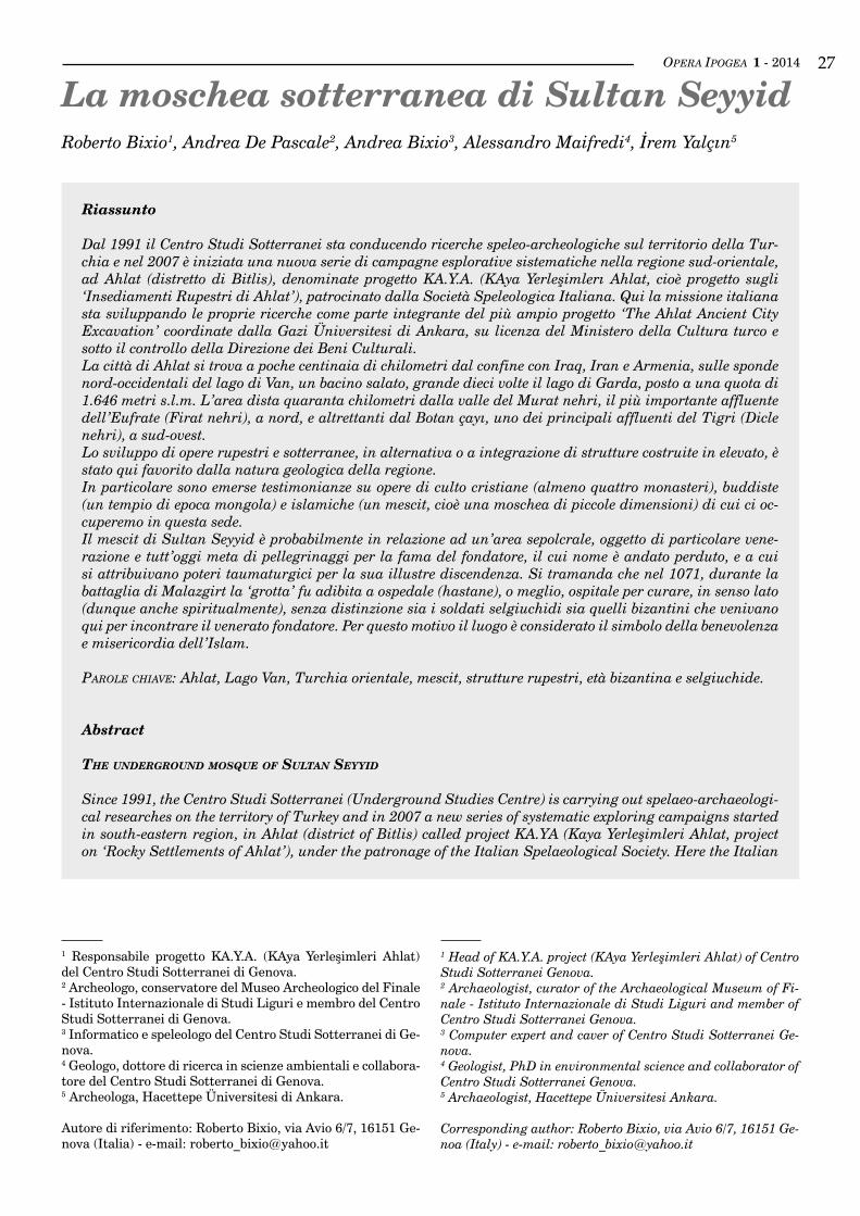
OPERA IPOGEA 1 - 2014 27
Riassunto
Dal 1991 il Centro Studi Sotterranei sta conducendo ricerche speleo-archeologiche sul territorio della Tur-chia e nel 2007 è iniziata una nuova serie di campagne esplorative sistematiche nella regione sud-orientale, ad Ahlat (distretto di Bitlis), denominate progetto KA.Y.A. (KAya Yerleşimlerı Ahlat, cioè progetto sugli ‘Insediamenti Rupestri di Ahlat’), patrocinato dalla Società Speleologica Italiana. Qui la missione italiana sta sviluppando le proprie ricerche come parte integrante del più ampio progetto ‘The Ahlat Ancient City Excavation’ coordinate dalla Gazi Üniversitesi di Ankara, su licenza del Ministero della Cultura turco e sotto il controllo della Direzione dei Beni Culturali.La città di Ahlat si trova a poche centinaia di chilometri dal confine con Iraq, Iran e Armenia, sulle sponde nord-occidentali del lago di Van, un bacino salato, grande dieci volte il lago di Garda, posto a una quota di 1.646 metri s.l.m. L’area dista quaranta chilometri dalla valle del Murat nehri, il più importante affluente dell’Eufrate (Firat nehri), a nord, e altrettanti dal Botan çayı, uno dei principali affluenti del Tigri (Dicle nehri), a sud-ovest. Lo sviluppo di opere rupestri e sotterranee, in alternativa o a integrazione di strutture costruite in elevato, è stato qui favorito dalla natura geologica della regione.In particolare sono emerse testimonianze su opere di culto cristiane (almeno quattro monasteri), buddiste (un tempio di epoca mongola) e islamiche (un mescit, cioè una moschea di piccole dimensioni) di cui ci oc-cuperemo in questa sede. Il mescit di Sultan Seyyid è probabilmente in relazione ad un’area sepolcrale, oggetto di particolare vene-razione e tutt’oggi meta di pellegrinaggi per la fama del fondatore, il cui nome è andato perduto, e a cui si attribuivano poteri taumaturgici per la sua illustre discendenza. Si tramanda che nel 1071, durante la battaglia di Malazgirt la ‘grotta’ fu adibita a ospedale (hastane), o meglio, ospitale per curare, in senso lato (dunque anche spiritualmente), senza distinzione sia i soldati selgiuchidi sia quelli bizantini che venivano qui per incontrare il venerato fondatore. Per questo motivo il luogo è considerato il simbolo della benevolenza e misericordia dell’Islam.
Parole chiave: Ahlat, Lago Van, Turchia orientale, mescit, strutture rupestri, età bizantina e selgiuchide.
Abstract
The underground mosque of sulTan seyyid
Since 1991, the Centro Studi Sotterranei (Underground Studies Centre) is carrying out spelaeo-archaeologi-cal researches on the territory of Turkey and in 2007 a new series of systematic exploring campaigns started in south-eastern region, in Ahlat (district of Bitlis) called project KA.YA (Kaya Yerleşimleri Ahlat, project on ‘Rocky Settlements of Ahlat’), under the patronage of the Italian Spelaeological Society. Here the Italian
La moschea sotterranea di Sultan SeyyidRoberto Bixio1, Andrea De Pascale2, Andrea Bixio3, Alessandro Maifredi4, İrem Yalçın5
1 Responsabile progetto KA.Y.A. (KAya Yerleşimleri Ahlat) del Centro Studi Sotterranei di Genova.2 Archeologo, conservatore del Museo Archeologico del Finale - Istituto Internazionale di Studi Liguri e membro del Centro Studi Sotterranei di Genova.3 Informatico e speleologo del Centro Studi Sotterranei di Ge-nova.4 Geologo, dottore di ricerca in scienze ambientali e collabora-tore del Centro Studi Sotterranei di Genova.5 Archeologa, Hacettepe Üniversitesi di Ankara.
Autore di riferimento: Roberto Bixio, via Avio 6/7, 16151 Ge-nova (Italia) - e-mail: [email protected]
1 Head of KA.Y.A. project (KAya Yerleşimleri Ahlat) of Centro Studi Sotterranei Genova.2 Archaeologist, curator of the Archaeological Museum of Fi-nale - Istituto Internazionale di Studi Liguri and member of Centro Studi Sotterranei Genova.3 Computer expert and caver of Centro Studi Sotterranei Ge-nova.4 Geologist, PhD in environmental science and collaborator of Centro Studi Sotterranei Genova.5 Archaeologist, Hacettepe Üniversitesi Ankara.
Corresponding author: Roberto Bixio, via Avio 6/7, 16151 Ge-noa (Italy) - e-mail: [email protected]
OPERA IPOGEA 1 - 201428
Il progetto KA.Y.A.
Dal 1991 il Centro Studi Sotterranei sta conducendo ri-cerche speleo-archeologiche sul territorio della Turchia, operando in molti siti, principalmente in Cappadocia (Altopiano centrale anatolico) e ad Ani, nel distretto di Kars (Bixio & De Pascale, 2009). Nel 2007 è iniziata una nuova serie di campagne esplorative sistematiche nel-la Turchia sud-orientale, ad Ahlat (distretto di Bitlis), denominate progetto KA.Y.A. (KAya Yerleşimlerı Ahlat, cioè progetto sugli ‘Insediamenti Rupestri di Ahlat’), patrocinato dalla Società Speleologica Italiana. Qui la missione italiana sta sviluppando le proprie ricerche co-me parte integrante del più ampio progetto ‘The Ahlat Ancient City Excavation’, su invito della sua direttrice, prof. Nakış Karamağaralı, docente di Storia dell’Arte e Archeologia presso la Gazi Üniversitesi di Ankara, su licenza del Ministero della Cultura turco e sotto il con-trollo della Direzione dei Beni Culturali (Karamağaralı, 2011).Scopo delle indagini è la realizzazione di una ‘carta del sottosuolo’ attraverso la localizzazione, l’esplorazione e la documentazione degli estesi fenomeni antropici rupestri e sotterranei del sito archeologico della antica città di Ahlat (Eski Ahlat) e del territorio ad esso limi-trofo. Nell’ambito di tali ricerche (Bixio R. et al. 2009, 2013; Bixio A. et al. 2009; Bixio & De Pascale, 2010, 2011; De Pascale & Bixio, 2011) sono state individua-te opere scavate nella roccia, diversificate per tipolo-gia (residenziali, idriche, di transito…) e attribuibili a più civiltà che qui si sono succedute e/o sovrapposte. In particolare sono emerse testimonianze su opere di cul-to cristiane (almeno quattro monasteri), buddiste (un tempio di epoca mongola) e islamiche (un mescit, cioè una moschea di piccole dimensioni). Ci occuperemo qui di quest’ultima struttura dopo aver dato alcune notizie generali sul sito.
The Ka.y.a. projecT
Since 1991, the Centro Studi Sotterranei (Underground Studies Centre) is carrying out spelaeo-archaeological researches on the territory of Turkey, working on many sites, mainly in Cappadocia (central Anatolian plateau) and Ani, in the district of Kars (Bixio & De Pascale, 2009). In 2007 a new series of systematic exploring cam-paigns started in south-eastern Turkey, in Ahlat (di-strict of Bitlis) called project KA.YA (Kaya Yerleşimleri Ahlat, project on ‘Rocky Settlements of Ahlat’), under the patronage of the Italian Spelaeological Society. Here the Italian mission is developing its own research as an integral part of the larger project ‘The Ahlat Ancient City Excavation’, at the invitation of its director, Nakış Karamağaralı, Professor of Art History and Archaeology at Gazi Üniversitesi of Ankara, licensed by the Turkish Ministry of Culture and under the control of the Directorate of Cultural Heritage (Karamağaralı, 2011).Purpose of the investigation is the realization of a ‘map of the subsoil’ through localization, exploration and documentation of the extensive rupestrian and under-ground anthropogenic phenomena of the archaeological site of the ancient city of Ahlat (Eski Ahlat) and of the territory adjacent to it. As part of this research (Bixio R. et al. 2009, 2013; Bixio A. et al. 2009; Bixio & De Pascale, 2010, 2011; De Pascale & Bixio, 2011) works excavated in the rock have been identified, diversified by type (residential, water, transit ...) and attributable to several civilizations that have occurred here and / or overlapped. In particular, we found evidences about works of Christian worship (at least four monasteries), Buddhist (a temple dating back to Mongol) and Muslim (a mescit, a small mosque). We will engage in the latter structure after giving some general information on the site.
mission is developing its own research as an integral part of the larger project ‘The Ahlat Ancient City Exca-vation’, carried out by Gazi Üniversitesi of Ankara, licensed by the Turkish Ministry of Culture and under the control of the Directorate of Cultural Heritage.The city of Ahlat is located a few hundred kilometres from the border with Iraq, Iran and Armenia, on the north-western shores of Lake Van, a salt basin, ten times bigger than Lake Garda, situated at an altitude of 1,646 meters above sea level. The area is forty kilometres from the valley of the Murat nehri, the most im-portant tributary of the Euphrates (Firat nehri) to the north, and as many from Botan çayı, one of the main tributaries of the Tigris (Dicle nehri), south-west.The development of rock and underground works, as an alternative or in addition to structures built in high, has been favoured here by the geological nature of the region.In particular, we found evidences about works of Christian worship (at least four monasteries), Buddhist (a temple dating back to Mongol) and Muslim (a mescit, a small mosque) that we will discuss in this work.The mescit of Sultan Seyyid is probably related to some burials, object of special veneration and still a place of pilgrimage for the fame of the founder, whose name has been lost, and attributed with thaumaturgical powers owing to his illustrious origins. It is said that in 1071, during the Battle of Malazgirt the ‘cave’ was used as a hospital (hastane), or better, hospice to treat, in a broad sense (therefore, spiritually too), without distinction both Byzantine and Seljuk soldiers and those who came here to meet the revered founder. For this reason the site is considered the symbol of benevolence and mercy of Islam.
Key worDs: Ahlat, Van Lake, East Turkey, mescit, rock-cut structures, Byzantine and Seljuk ages.
OPERA IPOGEA 1 - 2014 29
TerriTory and geology
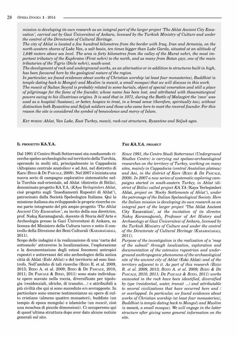
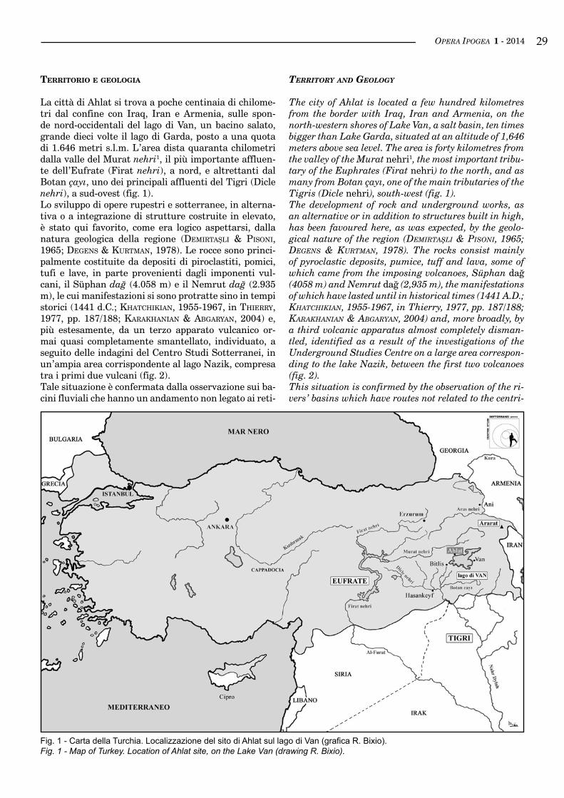
The city of Ahlat is located a few hundred kilometres from the border with Iraq, Iran and Armenia, on the north-western shores of Lake Van, a salt basin, ten times bigger than Lake Garda, situated at an altitude of 1,646 meters above sea level. The area is forty kilometres from the valley of the Murat nehri1, the most important tribu-tary of the Euphrates (Firat nehri) to the north, and as many from Botan çayı, one of the main tributaries of the Tigris (Dicle nehri), south-west (fig. 1).The development of rock and underground works, as an alternative or in addition to structures built in high, has been favoured here, as was expected, by the geolo-gical nature of the region (Demırtaşlı & Pısonı, 1965; Degens & Kurtman, 1978). The rocks consist mainly of pyroclastic deposits, pumice, tuff and lava, some of which came from the imposing volcanoes, Süphan dağ (4058 m) and Nemrut dağ (2,935 m), the manifestations of which have lasted until in historical times (1441 A.D.; KhatchıKıan, 1955-1967, in Thierry, 1977, pp. 187/188; KaraKhanıan & abgaryan, 2004) and, more broadly, by a third volcanic apparatus almost completely disman-tled, identified as a result of the investigations of the Underground Studies Centre on a large area correspon-ding to the lake Nazik, between the first two volcanoes (fig. 2).This situation is confirmed by the observation of the ri-vers’ basins which have routes not related to the centri-
terrItorIo e geologIA
La città di Ahlat si trova a poche centinaia di chilome-tri dal confine con Iraq, Iran e Armenia, sulle spon-de nord-occidentali del lago di Van, un bacino salato, grande dieci volte il lago di Garda, posto a una quota di 1.646 metri s.l.m. L’area dista quaranta chilometri dalla valle del Murat nehri1, il più importante affluen-te dell’Eufrate (Firat nehri), a nord, e altrettanti dal Botan çayı, uno dei principali affluenti del Tigri (Dicle nehri), a sud-ovest (fig. 1).Lo sviluppo di opere rupestri e sotterranee, in alterna-tiva o a integrazione di strutture costruite in elevato, è stato qui favorito, come era logico aspettarsi, dalla natura geologica della regione (Demırtaşlı & Pısonı, 1965; Degens & Kurtman, 1978). Le rocce sono princi-palmente costituite da depositi di piroclastiti, pomici, tufi e lave, in parte provenienti dagli imponenti vul-cani, il Süphan dağ (4.058 m) e il Nemrut dağ (2.935 m), le cui manifestazioni si sono protratte sino in tempi storici (1441 d.C.; KhatchıKıan, 1955-1967, in Thierry, 1977, pp. 187/188; KaraKhanıan & abgaryan, 2004) e, più estesamente, da un terzo apparato vulcanico or-mai quasi completamente smantellato, individuato, a seguito delle indagini del Centro Studi Sotterranei, in un’ampia area corrispondente al lago Nazik, compresa tra i primi due vulcani (fig. 2).Tale situazione è confermata dalla osservazione sui ba-cini fluviali che hanno un andamento non legato ai reti-
Fig. 1 - Carta della Turchia. Localizzazione del sito di Ahlat sul lago di Van (grafica R. Bixio).Fig. 1 - Map of Turkey. Location of Ahlat site, on the Lake Van (drawing R. Bixio).
OPERA IPOGEA 1 - 201430
coli centrifughi che insistono sui coni del Nemrut e del Süphan. Lo stesso lago di Van è un bacino endoreico, formatosi a seguito di una antica esplosione della calde-ra del Nemrut. Le oscillazioni del livello del lago hanno originato uno zoccolo da cui le ricche acque torrenti-zie, in erosione regressiva, hanno prodotto una serie di incisioni vallive, con sezione trasversale a terrazzi, ad altitudini che oscillano tra i 1.700 m e i 2.150 m. Dove la roccia è più tenera si hanno forme dolci e pendenze modeste; nelle rocce più resistenti le morfologie sono aspre e le pareti verticali. Le strutture rupestri sono localizzate soprattutto in queste ultime, dove le rocce sono comunque facilmente scavabili a mano, ma abba-stanza compatte da sostenere sale sotterranee anche di grandi dimensioni. Purtroppo, tali rocce sono anche molto fragili, suddivise in giganteschi prismi che ten-dono a scollarsi per gravità portandosi via parte degli insediamenti prossimi alla superficie.
InquAdrAmento storIco
Questa regione conserva importanti resti delle diverse culture che in migliaia di anni la attraversarono. Dalla protostoria all’età bizantina, dal medioevo ai giorni no-stri, il Lago di Van è sempre stato un luogo di incontro fondamentale - e spesso anche di scontro - tra Occidente e Oriente, tra culture, popoli e religioni diversi.In questa area si sviluppò una delle più antiche civiltà prossime alla Mesopotamia, il regno Urartu (IX - ini-zi VI sec. a.C.), che contese questi territori ad Assiri, Cimmeri, Sciti e Medi. A far data almeno dal 520 a.C. si sa che alla civiltà urartea si sovrappose quella de-gli Armeni, apparentati da Erodoto ai Frigi. Nel 400 a.C. Senofonte, che qui transitò con la sua armata in ritirata, riferisce di scontri con Carduchi e Armeni sul Botan cay, un affluente del Tigri a sud del lago di Van. Gli Armeni, che nel 314 d.C. assunsero il cristianesimo come religione di stato, abitarono ininterrottamente la regione sino a inizio del XX secolo, con alterne vicissitu-dini: ora titolari di un fiorente regno, ora invasi e sotto-messi da Persiani, Romani, Bizantini, Arabi. Nel 1071 d.C., presso Malazgirt, l’antica Manzicerta, a 40 km da
fugal nets who develop from the cones of Nemrut and Süphan. The same Lake Van is an endorheic basin, formed as a result of an ancient explosion of the cal-dera of Nemrut. The fluctuations of the lake level ha-ve formed a basic belt from which the rich torrential waters, by regressive erosion, have produced a series of carved valleys, with terraced cross-section, at altitudes ranging from 1,700 m and 2,150 m. Where the rock is softer we can see sweet morphologies and modest slopes; in the more resistant rocks the morphologies are rug-ged and the walls are vertical. The rock-cut structures are located mostly in the latter, where, in any case, is possible to easily excavate the rocks by hand, but they are compact enough to support even large underground halls. Unfortunately, these rocks are also very fragile, divided into gigantic prisms that tend to come unstuck by gravity taking away part of the settlements close to the surface.
hisTorical frameworK
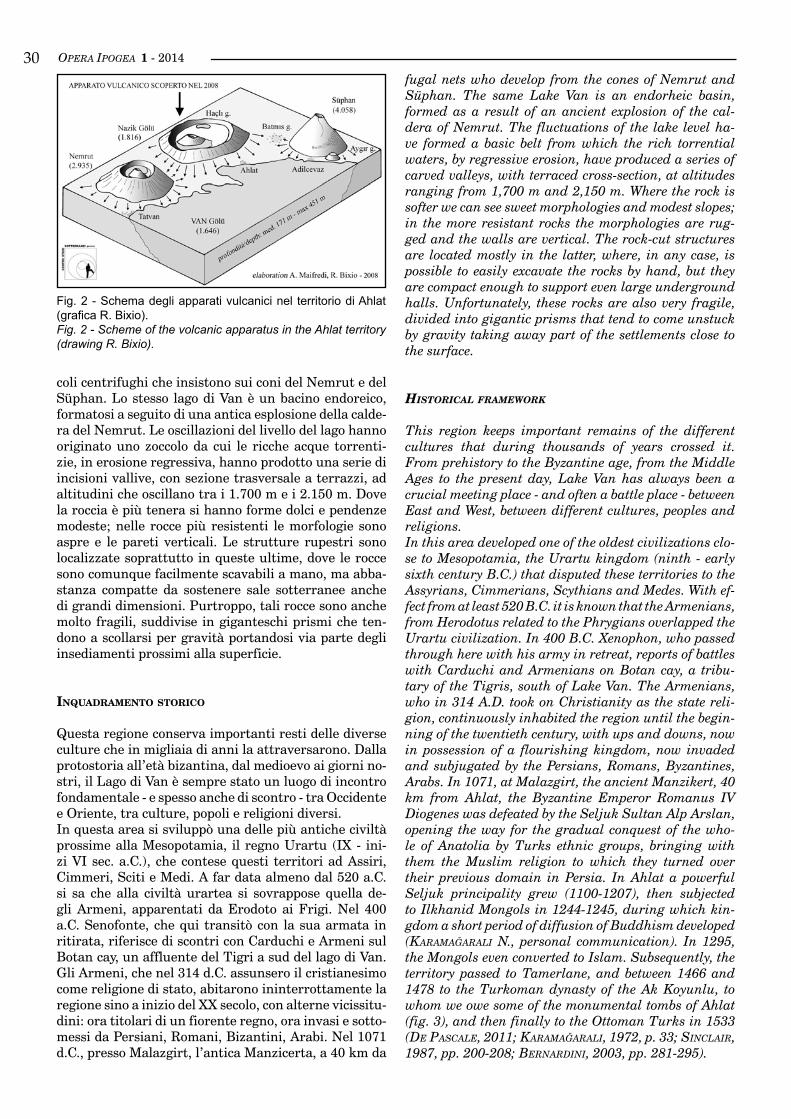
This region keeps important remains of the different cultures that during thousands of years crossed it. From prehistory to the Byzantine age, from the Middle Ages to the present day, Lake Van has always been a crucial meeting place - and often a battle place - between East and West, between different cultures, peoples and religions.In this area developed one of the oldest civilizations clo-se to Mesopotamia, the Urartu kingdom (ninth - early sixth century B.C.) that disputed these territories to the Assyrians, Cimmerians, Scythians and Medes. With ef-fect from at least 520 B.C. it is known that the Armenians, from Herodotus related to the Phrygians overlapped the Urartu civilization. In 400 B.C. Xenophon, who passed through here with his army in retreat, reports of battles with Carduchi and Armenians on Botan cay, a tribu-tary of the Tigris, south of Lake Van. The Armenians, who in 314 A.D. took on Christianity as the state reli-gion, continuously inhabited the region until the begin-ning of the twentieth century, with ups and downs, now in possession of a flourishing kingdom, now invaded and subjugated by the Persians, Romans, Byzantines, Arabs. In 1071, at Malazgirt, the ancient Manzikert, 40 km from Ahlat, the Byzantine Emperor Romanus IV Diogenes was defeated by the Seljuk Sultan Alp Arslan, opening the way for the gradual conquest of the who-le of Anatolia by Turks ethnic groups, bringing with them the Muslim religion to which they turned over their previous domain in Persia. In Ahlat a powerful Seljuk principality grew (1100-1207), then subjected to Ilkhanid Mongols in 1244-1245, during which kin-gdom a short period of diffusion of Buddhism developed (Karamağaralı N., personal communication). In 1295, the Mongols even converted to Islam. Subsequently, the territory passed to Tamerlane, and between 1466 and 1478 to the Turkoman dynasty of the Ak Koyunlu, to whom we owe some of the monumental tombs of Ahlat (fig. 3), and then finally to the Ottoman Turks in 1533 (De Pascale, 2011; Karamağaralı, 1972, p. 33; sınclaır, 1987, pp. 200-208; bernarDını, 2003, pp. 281-295).
Fig. 2 - Schema degli apparati vulcanici nel territorio di Ahlat (grafica R. Bixio).Fig. 2 - Scheme of the volcanic apparatus in the Ahlat territory (drawing R. Bixio).
OPERA IPOGEA 1 - 2014 31Ahlat, l’imperatore bizantino Romano IV Diogene fu sconfitto dai Selgiuchidi del sultano Alp Arslan, apren-do la via alla progressiva conquista di tutta l’Anatolia da parte dei gruppi etnici turchi, portando con sé la religione musulmana alla quale si erano convertiti du-rante il loro precedente dominio in Persia. Ad Ahlat si formò un potente principato selgiuchide (1100-1207), poi sottomesso ai Mongoli Ilkhanidi nel 1244-1245, a cui si deve un breve periodo di diffusione del buddismo (Karamağaralı N., com. pers.). Nel 1295 anche i Mongoli si convertirono all’Islam. Successivamente il territorio passò a Tamerlano e tra il 1466 e il 1478 alla dinastia turcomanna degli Ak Koyunlu, a cui si devono alcune delle tombe monumentali di Ahlat (fig. 3) e poi defi-nitivamente ai turchi Ottomani nel 1533 (De Pascale, 2011; Karamağaralı, 1972, p. 33; sınclaır, 1987, pp. 200-208; bernarDını, 2003, pp. 281-295).
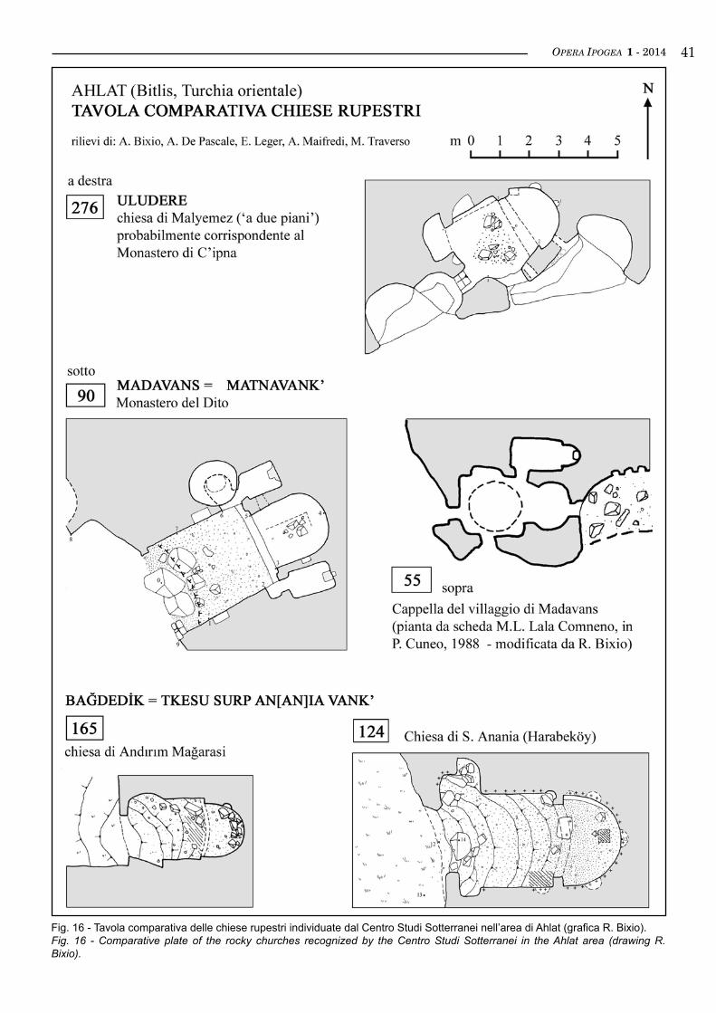
lA zonA AH4 - sultAn seYYId
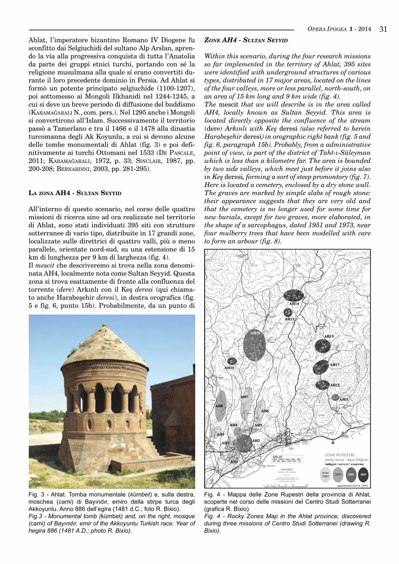
All’interno di questo scenario, nel corso delle quattro missioni di ricerca sino ad ora realizzate nel territorio di Ahlat, sono stati individuati 395 siti con strutture sotterranee di vario tipo, distribuite in 17 grandi zone, localizzate sulle direttrici di quattro valli, più o meno parallele, orientate nord-sud, su una estensione di 15 km di lunghezza per 9 km di larghezza (fig. 4).Il mescit che descriveremo si trova nella zona denomi-nata AH4, localmente nota come Sultan Seyyid. Questa zona si trova esattamente di fronte alla confluenza del torrente (dere) Arkınlı con il Keş deresi (qui chiama-to anche Harabeşehir deresi), in destra orografica (fig. 5 e fig. 6, punto 15b). Probabilmente, da un punto di
Zone ah4 - sulTan seyyid
Within this scenario, during the four research missions so far implemented in the territory of Ahlat, 395 sites were identified with underground structures of various types, distributed in 17 major areas, located on the lines of the four valleys, more or less parallel, north-south, on an area of 15 km long and 9 km wide (fig. 4).The mescit that we will describe is in the area called AH4, locally known as Sultan Seyyid. This area is located directly opposite the confluence of the stream (dere) Arkınlı with Keş deresi (also referred to herein Harabeşehir deresi) in orographic right bank (fig. 5 and fig. 6, paragraph 15b). Probably, from a administrative point of view, is part of the district of Taht-ı-Süleyman which is less than a kilometre far. The area is bounded by two side valleys, which meet just before it joins also in Keş deresi, forming a sort of steep promontory (fig. 7).Here is located a cemetery, enclosed by a dry stone wall. The graves are marked by simple slabs of rough stone: their appearance suggests that they are very old and that the cemetery is no longer used for some time for new burials, except for two graves, more elaborated, in the shape of a sarcophagus, dated 1951 and 1973, near four mulberry trees that have been modelled with care to form an arbour (fig. 8).
Fig. 3 - Ahlat. Tomba monumentale (kümbet) e, sulla destra, moschea (cami) di Bayındır, emiro della stirpe turca degli Akkoyunlu. Anno 886 dell’egira (1481 d.C.; foto R. Bixio).Fig.3 - Monumental tomb (kümbet) and, on the right, mosque (cami) of Bayındır, emir of the Akkoyunlu Turkish race. Year of hegira 886 (1481 A.D.; photo R. Bixio).
Fig. 4 - Mappa delle Zone Rupestri della provincia di Ahlat, scoperte nel corso delle missioni del Centro Studi Sotterranei (grafica R. Bixio)Fig. 4 - Rocky Zones Map in the Ahlat province, discovered during three missions of Centro Studi Sotterranei (drawing R. Bixio).
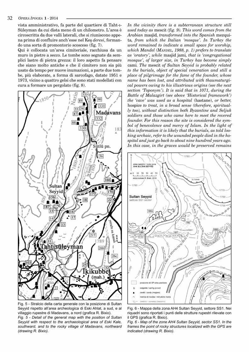
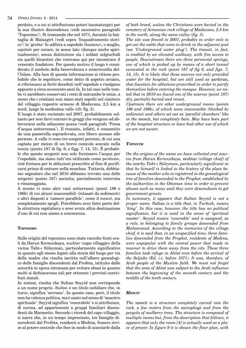
OPERA IPOGEA 1 - 201432vista amministrativo, fa parte del quartiere di Taht-ı-Süleyman da cui dista meno di un chilometro. L’area è circoscritta da due valli laterali, che si riuniscono appe-na prima di confluire anch’esse nel Keş deresi, forman-do una sorta di promontorio scosceso (fig. 7).Qui è collocata un’area cimiteriale, racchiusa da un muro in pietre a secco. Le tombe sono segnate da sem-plici lastre di pietra grezza: il loro aspetto fa pensare che siano molto antiche e che il cimitero non sia più usato da tempo per nuove inumazioni, a parte due tom-be, più elaborate, a forma di sarcofago, datate 1951 e 1973, vicino a quattro gelsi che sono stati modellati con cura a formare un pergolato (fig. 8).
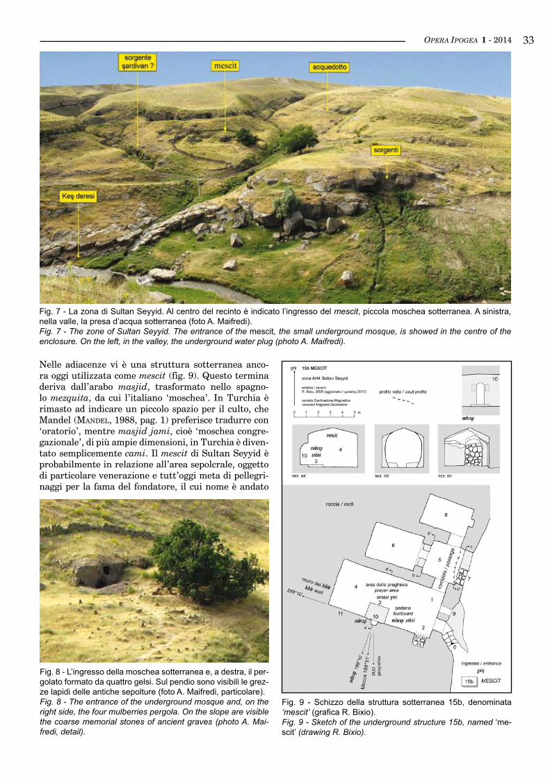
In the vicinity there is a subterranean structure still used today as mescit (fig. 9). This word comes from the Arabian masjid, transformed into the Spanish mezqui-ta, from which the Italian ‘mosque’. In Turkey the word remained to indicate a small space for worship, which Mandel (manDel, 1988, p. 1) prefers to translate as ‘oratory’, while masjid jami, that is ‘congregational mosque’, of larger size, in Turkey has become simply cami. The mescit of Sultan Seyyid is probably related to the burials, object of special veneration and still a place of pilgrimage for the fame of the founder, whose name has been lost, and attributed with thaumaturgi-cal powers owing to his illustrious origins (see the next section ‘Toponym’). It is said that in 1071, during the Battle of Malazgirt (see above ‘Historical framework’) the ‘cave’ was used as a hospital (hastane), or better, hospice to treat, in a broad sense (therefore, spiritual-ly too), without distinction both Byzantine and Seljuk soldiers and those who came here to meet the revered founder. For this reason the site is considered the sym-bol of benevolence and mercy of Islam. In the light of this information it is likely that the burials, as told loo-king archaic, refer to the wounded people died in the ho-spital and just go back to about nine hundred years ago. In this case, in the graves would be preserved remains
Fig. 5 - Stralcio della carta generale con la posizione di Sultan Seyyid rispetto all’area archeologica di Eski Ahlat, a sud, e al villaggio rupestre di Madavans, a nord (grafica R. Bixio).Fig. 5 - Detail of the general map with the position of Sultan Seyyid with respect to the archaeological area of Eski Kale, southward, and to the rocky village of Madavans, northward (drawing R. Bixio).
Fig. 6 - Mappa della zona AH4 Sultan Seyyid, settore SS1. Nei riquadri sono riportati i punti delle strutture rupestri rilevate con il GPS (grafica R. Bixio).Fig. 6 - Map of the zone AH4 Sultan Seyyid, sector SS1. In the frames the point of rocky structures localized with the GPS are indicated (drawing R. Bixio).
OPERA IPOGEA 1 - 2014 33
Nelle adiacenze vi è una struttura sotterranea anco-ra oggi utilizzata come mescit (fig. 9). Questo termina deriva dall’arabo masjid, trasformato nello spagno-lo mezquita, da cui l’italiano ‘moschea’. In Turchia è rimasto ad indicare un piccolo spazio per il culto, che Mandel (manDel, 1988, pag. 1) preferisce tradurre con ‘oratorio’, mentre masjid jami, cioè ‘moschea congre-gazionale’, di più ampie dimensioni, in Turchia è diven-tato semplicemente cami. Il mescit di Sultan Seyyid è probabilmente in relazione all’area sepolcrale, oggetto di particolare venerazione e tutt’oggi meta di pellegri-naggi per la fama del fondatore, il cui nome è andato
Fig. 7 - La zona di Sultan Seyyid. Al centro del recinto è indicato l’ingresso del mescit, piccola moschea sotterranea. A sinistra, nella valle, la presa d’acqua sotterranea (foto A. Maifredi).Fig. 7 - The zone of Sultan Seyyid. The entrance of the mescit, the small underground mosque, is showed in the centre of the enclosure. On the left, in the valley, the underground water plug (photo A. Maifredi).
Fig. 9 - Schizzo della struttura sotterranea 15b, denominata ‘mescit’ (grafica R. Bixio).Fig. 9 - Sketch of the underground structure 15b, named ‘me-scit’ (drawing R. Bixio).
Fig. 8 - L’ingresso della moschea sotterranea e, a destra, il per-golato formato da quattro gelsi. Sul pendio sono visibili le grez-ze lapidi delle antiche sepolture (foto A. Maifredi, particolare).Fig. 8 - The entrance of the underground mosque and, on the right side, the four mulberries pergola. On the slope are visible the coarse memorial stones of ancient graves (photo A. Mai-fredi, detail).
OPERA IPOGEA 1 - 201434of both breed, unless the Christians were buried in the cemetery of Armenian rock village of Madavans, 2.5 km to the north, along the same valley (fig. 5).The site was fenced in 2007, probably in order only to get out the cattle that come to drink in the adjacent pool (see ‘Underground water plug’). The transit, in fact, is enabled by an elevated walkway, with free access to people. Downstream there are three perennial springs, one of which is picked up by means of a short tunnel excavated in the rock (point 187 of fig 6, and figs. 7, 14, 15). It is likely that these sources not only provided water for the hospital, but are still used as şardıvan, that fountain for ablutions prescribed in order to purify themselves before entering the mosque. However, we no-ted that in 2010 we found one of the sources (point 187) dry, partially buried and recast.Upstream there are other underground rooms (points 186 and 186b), of which some inaccessible (blocked by sediment) and others set out as ‘parallel chambers’ like in the mescit, but completely bare. May have been part of the hospital structure or have had other use of which we are not aware.
Toponym
On the origins of the name we have collected oral sour-ces from Harun Kırmızıkaya, muhtar (village chief) of the nearby Taht-ı Süleyman, particularly significant in that he himself is linked to the history of the place be-cause of the mother who is registered in the genealogical tree of families descended to the Prophet, established by the authorities in the Ottoman time in order to prevent abuses such as many said they were descendants to get government grants.In summary, it appears that Sultan Seyyid is not a proper name. Sultan is a title that, in Turkish, means ‘king’. In this case, however, the title has no political significance, but it is used in the sense of ‘spiritual master’. Seyyid means ‘venerable’ and is assigned, as a rule, to belonging to family groups descended from Muhammad. According to the memories of the village chief, it is said that, in an unspecified time, three fami-lies descended from the Prophet, residents of Medina, were unpopular with the central power that made in manner to drive them away from the city. These three families took refuge in Ahlat even before the arrival of the Seljuks (Ed, i.e. before 1071). It was, therefore, of Arab people of the Muslim faith. We must not forget that the area of Ahlat was subject to the Arab influence between the beginning of the seventh century and the middle of the tenth century.
mesciT
The mescit is a structure completely carved into the rock, a few meters from the sarcophagi and from the pergola of mulberry trees. The structure is composed of multiple rooms but, from the description that follows, it appears that only the room [4] is actually used as a pla-ce of prayer. In figure 9 it is shown the floor plan, with
perduto, e a cui si attribuivano poteri taumaturgici per la sua illustre discendenza (vedi successivo paragrafo ‘Toponimo’). Si tramanda che nel 1071, durante la bat-taglia di Malazgirt (vedi sopra ‘Inquadramento stori-co’) la ‘grotta’ fu adibita a ospedale (hastane), o meglio, ospitale per curare, in senso lato (dunque anche spiri-tualmente), senza distinzione sia i soldati selgiuchidi sia quelli bizantini che venivano qui per incontrare il venerato fondatore. Per questo motivo il luogo è consi-derato il simbolo della benevolenza e misericordia del-l’Islam. Alla luce di questa informazione si ritiene pro-babile che le sepolture, come detto di aspetto arcaico, si riferiscano ai feriti deceduti nell’ospedale e risalgano appunto a circa novecento anni fa. In tal caso nelle tom-be vi sarebbero conservati i resti di entrambe le etnie, a meno che i cristiani non siano stati sepolti nel cimitero del villaggio rupestre armeno di Madavans, 2,5 km a nord, lungo la medesima valle (cfr. fig. 5).Il luogo è stato recintato nel 2007, probabilmente sol-tanto per non farvi entrare le greggi che vengono ad ab-beverarsi nella adiacente pozza (vedi paragrafo ‘Presa d’acqua sotterranea’). Il transito, infatti, è consentito da una passerella sopraelevata, con libero accesso alle persone. A valle vi sono tre sorgenti perenni, di cui una captata per mezzo di un breve cunicolo scavato nella roccia (punto 187 di fig. 6, e figg. 7, 14, 15). È probabi-le che queste sorgenti non solo fornissero l’acqua per l’ospedale, ma siano tutt’ora utilizzate come şardıvan, cioè fontana per le abluzioni prescritte al fine di purifi-carsi prima di entrare nella moschea. Tuttavia, dobbia-mo segnalare che nel 2010 abbiamo trovato una delle sorgenti (punto 187) asciutta, parzialmente interrata e rimaneggiata.A monte vi sono altri vani sotterranei (punti 186 e 186b) di cui alcuni inaccessibili (intasati da sedimenti) e altri disposti a ‘camere parallele’, come il mescit, ma completamente spogli. Potrebbero aver fatto parte del-la struttura ospitaliera o aver avuto altra destinazione d’uso di cui non siamo a conoscenza.
toponImo
Sulle origini del toponimo sono state raccolte fonti ora-li da Harun Kırmızıkaya, muhtar (capo villaggio) della vicina Taht-ı Süleyman, particolarmente significative in quanto egli stesso legato alla storia del luogo per via della madre che risulta iscritta nell’albero genealogi-co delle famiglie discendenti dal Profeta, istituito dalle autorità in epoca ottomana per evitare abusi in quanto molti si dichiaravano tali per ottenere i previsti contri-buti statali.In sintesi, risulta che Sultan Seyyid non corrisponde a un nome proprio. Sultan è un titolo nobiliare che, in turco, significa ‘sovrano’. In questo caso, però, il titolo non ha valenza politica, ma è usato nel senso di ‘maestro spirituale’. Seyyid significa ‘venerabile’ e si attribuisce, di norma, ad appartenenti a gruppi familiari discen-denti da Maometto. Secondo i ricordi del capo villaggio, si narra che, in un tempo imprecisato, tre famiglie di-scendenti dal Profeta, residenti a Medina, fossero invi-se al potere centrale che fece in modo di scacciarle dalla
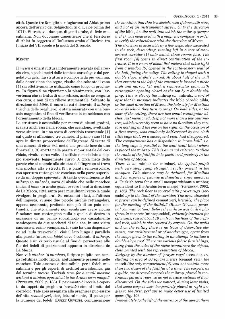
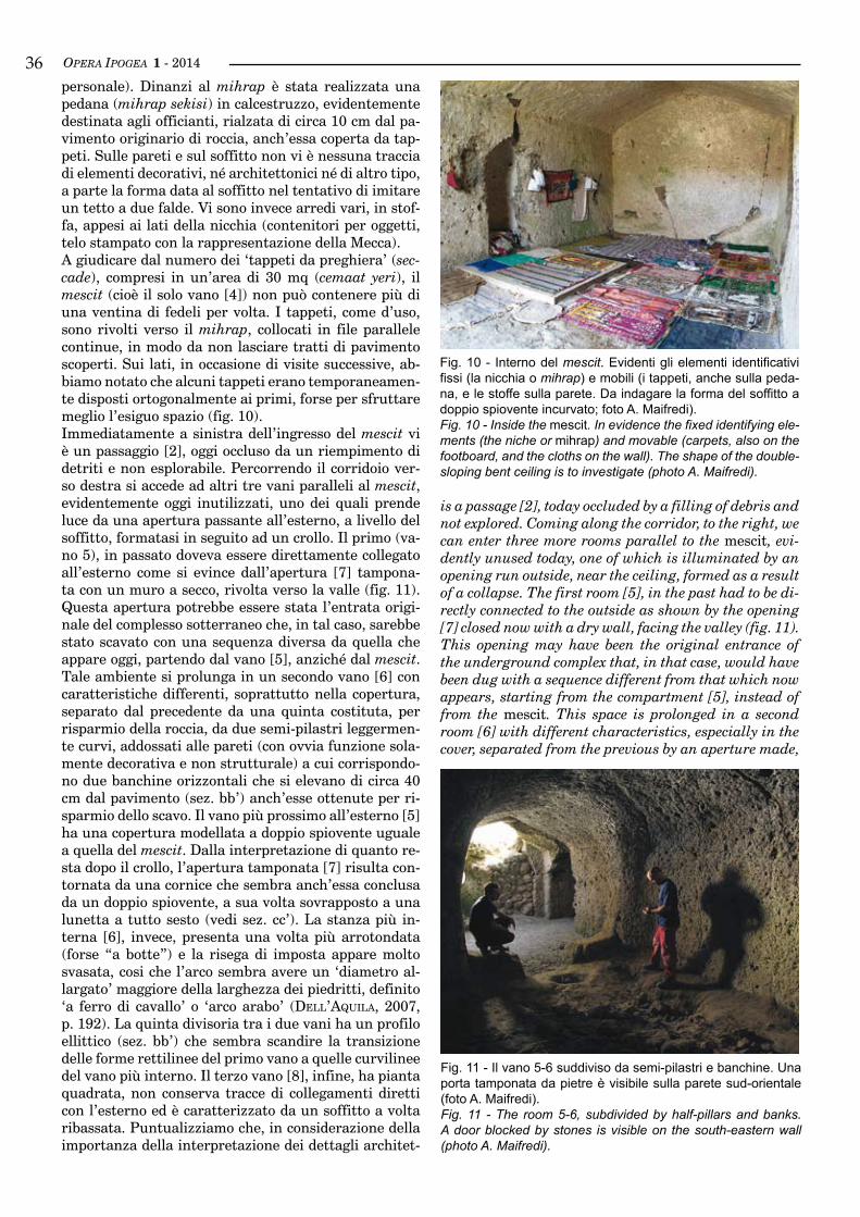
OPERA IPOGEA 1 - 2014 35the monition that this is a sketch, even if done with care, and not of an instrumental survey. Only the direction of the kible, i.e. the wall into which the mihrap (prayer niche), was measured with a magnetic compass in order to verify the coincidence with the direction of Mecca.The structure is accessible by a few steps, also excavated in the rock, descending, turning left in a sort of tran-sversal corridor [1] onto which three rooms face. The first room [4] opens in direct continuation of the en-trance. It is a room of about 9x4 meters that takes light from a window [9] opened in the south-eastern wall of the hall, facing the valley. The ceiling is shaped with a double slope, slightly curved. At about half of the wall that extends to the left of the entrance is located a niche high and narrow [3], with a semi-circular plan, with rectangular opening closed at the top by a double slo-ping. This is clearly the mihrap (or mihrab), a sort of apse that in mosques indicates the kıble (Arabic qibla, or the exact direction of Mecca, the holy city for Muslims towards which they turn to pray). On both sides, at the base of the ceiling, there are two small rectangular ni-ches, just mentioned, deep not more than a few centime-tres, which currently seem to have no function: they con-tain nothing and the one on the right, on the occasion of a first survey, was randomly half-covered by two cloth little bags that, on a subsequent visit, had disappeared. The compartment has a disposition to ‘cross-hall’, i.e. the long edge is parallel to the wall (wall kıble) where is placed the mihrap. This is an usual criterion to allow the ranks of the faithful to be positioned precisely in the direction of Mecca.There is no minbar (or mimbar), the typical pulpit with very steep ramp straight, usually present in the mosques. This absence may be deduced, for Muslims and for experts of Islamic architecture, since mescit is a ‘Turkish term for a small mosque without a minbar, equivalent to the Arabic term masjid’ (Petersen, 2002, p. 186). The rock floor is covered with prayer rugs (sec-cade) up to the limit of the corridor. The area allocated to prayer can be defined cemaat yeri, literally, ‘the place for the meeting of the faithful’ (buKet güvenDı, perso-nal communication). Before the mihrap was built a pla-tform in concrete (mihrap sekisi), evidently intended for officiants, raised about 10 cm from the floor of the origi-nal rock, which is also covered by carpets. On the walls and on the ceiling there is no trace of decorative ele-ments, nor architectural or of another type, apart from the shape given to the ceiling in an attempt to imitate a double-slope roof. There are various fabric furnishings, hung from the sides of the niche (containers for objects, cloth printed with the representation of Mecca).Judging by the number of ‘prayer rugs’ (seccade), in-cluding an area of 30 square meters (cemaat yeri), the mescit (the only compartment [4]) can not contain more than two dozen of the faithful at a time. The carpets, as a guide, are directed towards the mihrap, placed in con-tinuous parallel rows, so as not to leave sections of floor discovered. On the sides we noticed, during later visits, that some carpets were temporarily placed at right an-gles to the first, perhaps to make better use of limited space (fig. 10).Immediately to the left of the entrance of the mescit there
città. Queste tre famiglie si rifugiarono ad Ahlat prima ancora dell’arrivo dei Selgiuchidi (n.d.r., cioè prima del 1071). Si trattava, dunque, di genti arabe, di fede mu-sulmana. Non dobbiamo dimenticare che il territorio di Ahlat fu soggetto all’influenza araba all’incirca tra l’inizio del VII secolo e la metà del X secolo.
mescIt
Il mescit è una struttura interamente scavata nella roc-cia viva, a pochi metri dalle tombe a sarcofago e dal per-golato di gelsi. La struttura è composta da più vani ma, dalla descrizione che segue, risulta che soltanto il vano [4] sia effettivamente utilizzato come luogo di preghie-ra. In figura 9 ne riportiamo la planimetria, con l’av-vertenza che si tratta di uno schizzo, anche se eseguito con cura, e non di un rilievo strumentale. Soltanto la direzione del kible, il muro in cui è ricavato il mihrap (nicchia delle preghiere), è stata misurata con una bus-sola magnetica al fine di verificarne la coincidenza con l’orientamento della Mecca.La struttura è accessibile per mezzo di alcuni gradini, scavati anch’essi nella roccia, che scendono, svoltando verso sinistra, in una sorta di corridoio trasversale [1] sul quale si affacciano tre camere. Il primo vano [4] si apre in diretta prosecuzione dell’ingresso. Si tratta di una camera di circa 9x4 metri che prende luce da una finestrella [9] aperta nella parete sud-orientale del cor-ridoio, rivolta verso valle. Il soffitto è modellato a dop-pio spiovente, leggermente curvo. A circa metà della parete che si estende alla sinistra dell’ingresso si trova una nicchia alta e stretta [3], a pianta semi-circolare, con apertura rettangolare conclusa nella parte superio-re da un doppio spiovente. Si tratta evidentemente del mihrap (o mihrab), sorta di abside che nelle moschee indica il kıble (in arabo qibla, ovvero l’esatta direzione de La Mecca, città santa per i musulmani verso la quale rivolgere la preghiera). Su entrambi i lati, all’altezza dell’imposta, vi sono due piccole nicchie rettangolari, appena accennate, profonde non più di un paio cen-timetri, che attualmente non sembrano avere alcuna funzione: non contengono nulla e quella di destra in occasione di un primo sopralluogo era casualmente semicoperta da due sacchetti di tela che, in una visita successiva, erano scomparsi. Il vano ha una disposizio-ne ad ‘aula trasversale’, cioè il lato lungo è parallelo alla parete (muro del kıble) dove è collocato il mihrap. Questo è un criterio usuale al fine di permettere alle file dei fedeli di posizionarsi appunto in direzione de La Mecca.Non vi è minbar (o mimbar), il tipico pulpito con ram-pa rettilinea molto ripida, abitualmente presente nelle moschee. Tale assenza è desumibile, per i fedeli mu-sulmani e per gli esperti di architettura islamica, già dal termine mescit ‘Turkish term for a small mosque without a minbar, equivalent to the Arabic term masjid’ (Petersen, 2002, p. 186). Il pavimento di roccia è coper-to da tappeti da preghiera (seccade) sino al limite del corridoio. Tale area assegnata alla preghiera può essere definita cemaat yeri, cioè, letteralmente, ‘il posto per la riunione dei fedeli’ (buKet güvenDı, comunicazione
OPERA IPOGEA 1 - 201436
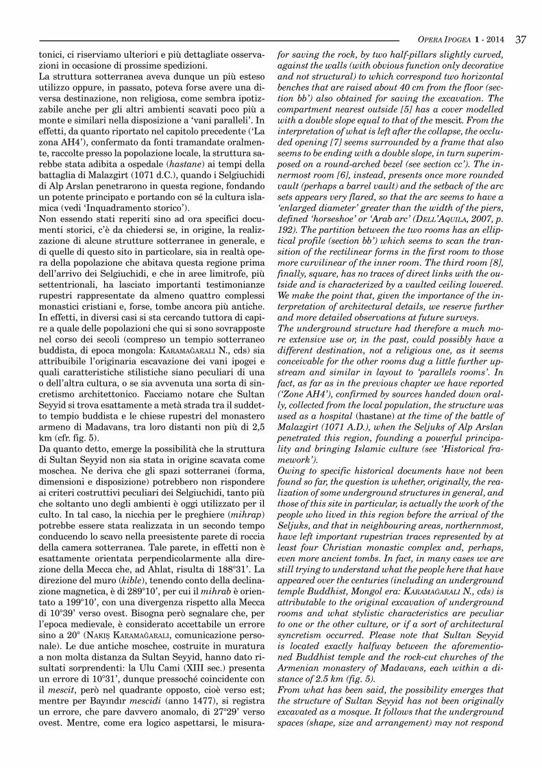
is a passage [2], today occluded by a filling of debris and not explored. Coming along the corridor, to the right, we can enter three more rooms parallel to the mescit, evi-dently unused today, one of which is illuminated by an opening run outside, near the ceiling, formed as a result of a collapse. The first room [5], in the past had to be di-rectly connected to the outside as shown by the opening [7] closed now with a dry wall, facing the valley (fig. 11). This opening may have been the original entrance of the underground complex that, in that case, would have been dug with a sequence different from that which now appears, starting from the compartment [5], instead of from the mescit. This space is prolonged in a second room [6] with different characteristics, especially in the cover, separated from the previous by an aperture made,
personale). Dinanzi al mihrap è stata realizzata una pedana (mihrap sekisi) in calcestruzzo, evidentemente destinata agli officianti, rialzata di circa 10 cm dal pa-vimento originario di roccia, anch’essa coperta da tap-peti. Sulle pareti e sul soffitto non vi è nessuna traccia di elementi decorativi, né architettonici né di altro tipo, a parte la forma data al soffitto nel tentativo di imitare un tetto a due falde. Vi sono invece arredi vari, in stof-fa, appesi ai lati della nicchia (contenitori per oggetti, telo stampato con la rappresentazione della Mecca).A giudicare dal numero dei ‘tappeti da preghiera’ (sec-cade), compresi in un’area di 30 mq (cemaat yeri), il mescit (cioè il solo vano [4]) non può contenere più di una ventina di fedeli per volta. I tappeti, come d’uso, sono rivolti verso il mihrap, collocati in file parallele continue, in modo da non lasciare tratti di pavimento scoperti. Sui lati, in occasione di visite successive, ab-biamo notato che alcuni tappeti erano temporaneamen-te disposti ortogonalmente ai primi, forse per sfruttare meglio l’esiguo spazio (fig. 10).Immediatamente a sinistra dell’ingresso del mescit vi è un passaggio [2], oggi occluso da un riempimento di detriti e non esplorabile. Percorrendo il corridoio ver-so destra si accede ad altri tre vani paralleli al mescit, evidentemente oggi inutilizzati, uno dei quali prende luce da una apertura passante all’esterno, a livello del soffitto, formatasi in seguito ad un crollo. Il primo (va-no 5), in passato doveva essere direttamente collegato all’esterno come si evince dall’apertura [7] tampona-ta con un muro a secco, rivolta verso la valle (fig. 11). Questa apertura potrebbe essere stata l’entrata origi-nale del complesso sotterraneo che, in tal caso, sarebbe stato scavato con una sequenza diversa da quella che appare oggi, partendo dal vano [5], anziché dal mescit. Tale ambiente si prolunga in un secondo vano [6] con caratteristiche differenti, soprattutto nella copertura, separato dal precedente da una quinta costituta, per risparmio della roccia, da due semi-pilastri leggermen-te curvi, addossati alle pareti (con ovvia funzione sola-mente decorativa e non strutturale) a cui corrispondo-no due banchine orizzontali che si elevano di circa 40 cm dal pavimento (sez. bb’) anch’esse ottenute per ri-sparmio dello scavo. Il vano più prossimo all’esterno [5] ha una copertura modellata a doppio spiovente uguale a quella del mescit. Dalla interpretazione di quanto re-sta dopo il crollo, l’apertura tamponata [7] risulta con-tornata da una cornice che sembra anch’essa conclusa da un doppio spiovente, a sua volta sovrapposto a una lunetta a tutto sesto (vedi sez. cc’). La stanza più in-terna [6], invece, presenta una volta più arrotondata (forse “a botte”) e la risega di imposta appare molto svasata, cosi che l’arco sembra avere un ‘diametro al-largato’ maggiore della larghezza dei piedritti, definito ‘a ferro di cavallo’ o ‘arco arabo’ (Dell’aquıla, 2007, p. 192). La quinta divisoria tra i due vani ha un profilo ellittico (sez. bb’) che sembra scandire la transizione delle forme rettilinee del primo vano a quelle curvilinee del vano più interno. Il terzo vano [8], infine, ha pianta quadrata, non conserva tracce di collegamenti diretti con l’esterno ed è caratterizzato da un soffitto a volta ribassata. Puntualizziamo che, in considerazione della importanza della interpretazione dei dettagli architet-
Fig. 10 - Interno del mescit. Evidenti gli elementi identificativi fissi (la nicchia o mihrap) e mobili (i tappeti, anche sulla peda-na, e le stoffe sulla parete. Da indagare la forma del soffitto a doppio spiovente incurvato; foto A. Maifredi).Fig. 10 - Inside the mescit. In evidence the fixed identifying ele-ments (the niche or mihrap) and movable (carpets, also on the footboard, and the cloths on the wall). The shape of the double-sloping bent ceiling is to investigate (photo A. Maifredi).
Fig. 11 - Il vano 5-6 suddiviso da semi-pilastri e banchine. Una porta tamponata da pietre è visibile sulla parete sud-orientale (foto A. Maifredi).Fig. 11 - The room 5-6, subdivided by half-pillars and banks. A door blocked by stones is visible on the south-eastern wall (photo A. Maifredi).
OPERA IPOGEA 1 - 2014 37for saving the rock, by two half-pillars slightly curved, against the walls (with obvious function only decorative and not structural) to which correspond two horizontal benches that are raised about 40 cm from the floor (sec-tion bb’) also obtained for saving the excavation. The compartment nearest outside [5] has a cover modelled with a double slope equal to that of the mescit. From the interpretation of what is left after the collapse, the occlu-ded opening [7] seems surrounded by a frame that also seems to be ending with a double slope, in turn superim-posed on a round-arched bezel (see section cc’). The in-nermost room [6], instead, presents once more rounded vault (perhaps a barrel vault) and the setback of the arc sets appears very flared, so that the arc seems to have a ‘enlarged diameter’ greater than the width of the piers, defined ‘horseshoe’ or ‘Arab arc’ (Dell’aquıla, 2007, p. 192). The partition between the two rooms has an ellip-tical profile (section bb’) which seems to scan the tran-sition of the rectilinear forms in the first room to those more curvilinear of the inner room. The third room [8], finally, square, has no traces of direct links with the ou-tside and is characterized by a vaulted ceiling lowered. We make the point that, given the importance of the in-terpretation of architectural details, we reserve further and more detailed observations at future surveys.The underground structure had therefore a much mo-re extensive use or, in the past, could possibly have a different destination, not a religious one, as it seems conceivable for the other rooms dug a little further up-stream and similar in layout to ‘parallels rooms’. In fact, as far as in the previous chapter we have reported (‘Zone AH4’), confirmed by sources handed down oral-ly, collected from the local population, the structure was used as a hospital (hastane) at the time of the battle of Malazgirt (1071 A.D.), when the Seljuks of Alp Arslan penetrated this region, founding a powerful principa-lity and bringing Islamic culture (see ‘Historical fra-mework’).Owing to specific historical documents have not been found so far, the question is whether, originally, the rea-lization of some underground structures in general, and those of this site in particular, is actually the work of the people who lived in this region before the arrival of the Seljuks, and that in neighbouring areas, northernmost, have left important rupestrian traces represented by at least four Christian monastic complex and, perhaps, even more ancient tombs. In fact, in many cases we are still trying to understand what the people here that have appeared over the centuries (including an underground temple Buddhist, Mongol era: Karamağaralı N., cds) is attributable to the original excavation of underground rooms and what stylistic characteristics are peculiar to one or the other culture, or if a sort of architectural syncretism occurred. Please note that Sultan Seyyid is located exactly halfway between the aforementio-ned Buddhist temple and the rock-cut churches of the Armenian monastery of Madavans, each within a di-stance of 2.5 km (fig. 5).From what has been said, the possibility emerges that the structure of Sultan Seyyid has not been originally excavated as a mosque. It follows that the underground spaces (shape, size and arrangement) may not respond
tonici, ci riserviamo ulteriori e più dettagliate osserva-zioni in occasione di prossime spedizioni.La struttura sotterranea aveva dunque un più esteso utilizzo oppure, in passato, poteva forse avere una di-versa destinazione, non religiosa, come sembra ipotiz-zabile anche per gli altri ambienti scavati poco più a monte e similari nella disposizione a ‘vani paralleli’. In effetti, da quanto riportato nel capitolo precedente (‘La zona AH4’), confermato da fonti tramandate oralmen-te, raccolte presso la popolazione locale, la struttura sa-rebbe stata adibita a ospedale (hastane) ai tempi della battaglia di Malazgirt (1071 d.C.), quando i Selgiuchidi di Alp Arslan penetrarono in questa regione, fondando un potente principato e portando con sé la cultura isla-mica (vedi ‘Inquadramento storico’).Non essendo stati reperiti sino ad ora specifici docu-menti storici, c’è da chiedersi se, in origine, la realiz-zazione di alcune strutture sotterranee in generale, e di quelle di questo sito in particolare, sia in realtà ope-ra della popolazione che abitava questa regione prima dell’arrivo dei Selgiuchidi, e che in aree limitrofe, più settentrionali, ha lasciato importanti testimonianze rupestri rappresentate da almeno quattro complessi monastici cristiani e, forse, tombe ancora più antiche. In effetti, in diversi casi si sta cercando tuttora di capi-re a quale delle popolazioni che qui si sono sovrapposte nel corso dei secoli (compreso un tempio sotterraneo buddista, di epoca mongola: Karamağaralı N., cds) sia attribuibile l’originaria escavazione dei vani ipogei e quali caratteristiche stilistiche siano peculiari di una o dell’altra cultura, o se sia avvenuta una sorta di sin-cretismo architettonico. Facciamo notare che Sultan Seyyid si trova esattamente a metà strada tra il suddet-to tempio buddista e le chiese rupestri del monastero armeno di Madavans, tra loro distanti non più di 2,5 km (cfr. fig. 5).Da quanto detto, emerge la possibilità che la struttura di Sultan Seyyid non sia stata in origine scavata come moschea. Ne deriva che gli spazi sotterranei (forma, dimensioni e disposizione) potrebbero non rispondere ai criteri costruttivi peculiari dei Selgiuchidi, tanto più che soltanto uno degli ambienti è oggi utilizzato per il culto. In tal caso, la nicchia per le preghiere (mihrap) potrebbe essere stata realizzata in un secondo tempo conducendo lo scavo nella preesistente parete di roccia della camera sotterranea. Tale parete, in effetti non è esattamente orientata perpendicolarmente alla dire-zione della Mecca che, ad Ahlat, risulta di 188°31’. La direzione del muro (kible), tenendo conto della declina-zione magnetica, è di 289°10’, per cui il mihrab è orien-tato a 199°10’, con una divergenza rispetto alla Mecca di 10°39’ verso ovest. Bisogna però segnalare che, per l’epoca medievale, è considerato accettabile un errore sino a 20° (naKış Karamağaralı, comunicazione perso-nale). Le due antiche moschee, costruite in muratura a non molta distanza da Sultan Seyyid, hanno dato ri-sultati sorprendenti: la Ulu Cami (XIII sec.) presenta un errore di 10°31’, dunque pressoché coincidente con il mescit, però nel quadrante opposto, cioè verso est; mentre per Bayındır mescidi (anno 1477), si registra un errore, che pare davvero anomalo, di 27°29’ verso ovest. Mentre, come era logico aspettarsi, le misura-
OPERA IPOGEA 1 - 201438to specific building criteria of the Seljuks, especially since only one of the rooms is used today for worship. In this case, the niche for the prayers (mihrap) may have been formed in a second time conducting the excava-tion in the pre-existing rock wall of the underground chamber. This wall, in fact it is not exactly perpendicu-lar to the direction of Mecca that, to Ahlat, is of 188° 31’. The direction of the wall (kible), taking into account the magnetic declination, is 289° 10’, so the mihrab is oriented to 199° 10’, with a divergence from the Mecca of 10° 39’ west. But we must mention that, for the Middle Ages, is considered an acceptable error up to 20° (naKış Karamağaralı, personal communication). The two oldest mosques, built in masonry, not far away from Sultan Seyyid, gave surprising results: the Ulu Cami (XIII c.) has an error of 10° 31’, then almost coinciding with the mescit, but in the opposite quadrant, that is, to the east, while for Bayındır mescidi (year 1477), there was an error, which seems really anomalous, 27° 29’ west. While, as was expected, the measurements carried out on two nearby modern mosques gave negligible dif-ferences, between one and two degrees (fig. 12).Apart from the fact that a difference of 10° 39’ on the orientation of mescid of Sultan Seyyid can be conside-red irrelevant or not, we must bear in mind that a su-bsequent adjustment would very probably resulted in a discrepancy in the orientation of the wall of the kible respect to the direction of the other walls of the room. Instead, the walls seem all consistent with each other, i.e., parallel and / or orthogonal. Would therefore be very reliably the hypothesis that the organization of the un-derground spaces took into account, since to its origins, the correct orientation of the kible and, consequently, that the excavation of mescit, indeed, may be conducted simultaneously with the realization of the entire com-plex. In this regard, we should remember some exam-ples very different in which mosques were obtained in buildings previously used for another purpose, such as the Hagia Sophia in Istanbul, founded as a Christian basilica in 1453 and converted into a mosque after the conquest of Constantinople by Sultan Mehmet II, where it is clear the placement of kible and mihrab off-axis to the original central apse (fig. 13).However, other considerations conversely push to think that the transformation into a mosque of Sultan Seyyid could have occurred in relatively recent times, for exam-ple at the beginning of the twentieth century. In fact, apart from the concrete platform that is definitely mo-dern, Henry Finnis Blosse Lynch, traveller, geographer and member of the British parliament, who stayed here for a long time in the nineteenth century (lynch, 1901), illustrating in detail the numerous Seljuk and Ottoman monuments (tombs, mosques, fortifications), does not speak of the underground mosque of Sultan Seyyid. Yet he left a detailed description of the places visited in person, including the Armenian rock-cut village of Madavans, a kilometre north of Sultan Seyyid. From his chronicle we read - among other things - that ‘the village of caves’ (Madavans ed), at that time, was still regularly inhabited, and he refers of the meeting with the priest of the annex Christian monastery ‘sunk into the rock’, now in ruins.
zioni effettuate su due vicine moschee moderne hanno dato scostamenti trascurabili, compresi tra uno e due gradi (fig. 12).A prescindere dal fatto che una differenza di 10°39’ dell’orientamento del mescid di Sultan Seyyid possa essere considerata o meno irrilevante, dobbiamo tener presente che un adattamento successivo avrebbe molto probabilmente comportato una difformità nell’orienta-mento del muro del kible rispetto alla direzione delle altre pareti del vano. Invece i muri sembrano tutti coe-renti tra loro, cioè paralleli e/o ortogonali. Risulterebbe dunque molto attendibile l’ipotesi che l’organizzazione degli spazi sotterranei tenesse conto, sin dall’origine, del corretto orientamento del kible e, di conseguenza, che lo scavo del mescit, effettivamente, possa essere stato condotto contestualmente alla realizzazione del-l’intero complesso. A tale proposito possiamo ricordare
Fig. 12 - Tavola degli orientamenti delle moschee nell’area del-l’antica Ahlat (grafica R. Bixio).Fig. 12 - Plate of the directions of the mosques in the area of the ancient Ahlat (drawing R. Bixio).
OPERA IPOGEA 1 - 2014 39
Thus, at the present state of research, doubts remain, in a way or another, on the actual chronological sequen-ce of digging and on the extent of use of the different rooms: doubts nourished by the fact that, in this regard, not only written documents appear inexistent, but also oral sources are still vague on this issue.
underground waTer plug
We mention briefly an underground water intake, iden-tified and inspected in 2008, located in the point 187 (fig. 6) to propose a suggestive hypothesis.The water plug is located in the most downstream part of the canyon, in the left orographic bank, near the small metal bridge that allows access to the cemetery, going through the existing fence. The plug consists of a short corridor (fig. 14, point 1) that penetrates two meters perpendicular to the wall of rock to merge in the middle of an orthogonal tunnel (2), slightly cur-ved, blind at both ends, where a trickle of water flows. Upstream, after three meters the tunnel captures the vein that flows from the rock (point 3). Downstream the water disappears against the rock (point 4) to re-emerge on the outside, a few meters ahead, in a pool (point 5) where, taking into account the marks on the edges, it follows that the flocks come here to drink. The average dimensions of the tunnel are 70 cm wide by 170 cm of height (fig. 15).In a later expedition (2010) we found that the tunnel was dry and partially buried. It showed signs of an intervention to re-dig the soil accumulated. We do not know why: it is possible that the chamber has been bu-ried by a flood of spring (the entrance is into the bed of a stream) and that efforts were in progress to restore it.Apparently this water plug is without logical expla-nation because the pool for the watering would still be powered by water filtering through cracks in the rock.
che ben diversi sono alcuni esempi nei quali le moschee vennero ricavate in edifici precedentemente destinati ad altro uso, come nel caso di Santa Sofia, a Istanbul, nata come basilica cristiana e trasformata in moschea nel 1453 a seguito della conquista di Costantinopoli da parte del Sultano Maometto II, dove è palese la colloca-zione di kible e mihrab fuori asse rispetto all’originaria abside centrale (fig. 13).Tuttavia, altre considerazioni fanno viceversa pensare che la trasformazione in moschea di Sultan Seyyid po-trebbe essere avvenuta in tempi relativamente recenti, per esempio a inizio Novecento. Infatti, a parte la peda-na in calcestruzzo che è sicuramente moderna, Henry Finnis Blosse Lynch, viaggiatore, geografo e membro del parlamento britannico, che qui soggiornò a lungo a fine Ottocento (lynch, 1901), illustrando con dovizia di particolari i numerosissimi monumenti selgiuchidi e ottomani (tombe, moschee, fortificazioni), non parla affatto della moschea ipogea di Sultan Seyyid. Eppure egli ha lasciato una dettagliata descrizione dei luoghi visitati di persona, compreso il villaggio rupestre arme-no di Madavans, un chilometro a nord di Sultan Seyyid. Dalla sua cronaca risulta - tra l’altro - che ‘the village of caves’ (Madavans n.d.r.), a quel tempo, era ancora regolarmente abitato, e riporta l’incontro con il prete dell’annesso monastero cristiano ‘sunk into the rock’, oggi in completa rovina.Dunque, allo stato attuale delle ricerche, i dubbi per-mangono, in un senso e nell’altro, sulla effettiva se-quenza cronologica delle operazioni di scavo e sulla at-tribuzione d’uso dei diversi vani: dubbi alimentati dal fatto che, in proposito, non solo non risultano esistere documenti scritti, ma pure le fonti orali sono comun-que vaghe su questo aspetto.
presA d’AcquA sotterrAneA
Accenniamo brevemente ad un’opera sotterranea di presa d’acqua, individuata ed ispezionata nel 2008, ubi-cata nel punto 187 (cfr. fig. 6), per proporre una sugge-stiva ipotesi.La presa si trova nella parte più a valle del canyon, in orografica sinistra, presso il ponticello metallico che permette l’accesso al cimitero, attraversandone l’at-tuale recinzione. È costituita da un breve corridoio (fig. 14, punto 1) che si inoltra per due metri perpendico-larmente alla parete di roccia per immettersi a metà di un cunicolo ortogonale (2), leggermente curvo, cieco a entrambe le estremità e percorso da un rivolo d’acqua. A monte, dopo tre metri il cunicolo capta la vena che sgorga dalla roccia (punto 3). A valle l’acqua sparisce contro la roccia (punto 4) per riemergere all’esterno, pochi metri più avanti, in una pozza (punto 5) dove, dalle tracce visibili sui bordi, si deduce che vengano le greggi ad abbeverarsi. Le dimensioni medie del cunicolo sono 70 cm di larghezza per 170 cm di altezza (fig. 15).In una spedizione successiva (2010) abbiamo constata-to che il cunicolo era asciutto e parzialmente interrato. Esso presentava tracce di un intervento per scavare nuovamente il terreno accumulatosi. Non ne sappiamo i motivi: è possibile che il vano sia stato interrato da una
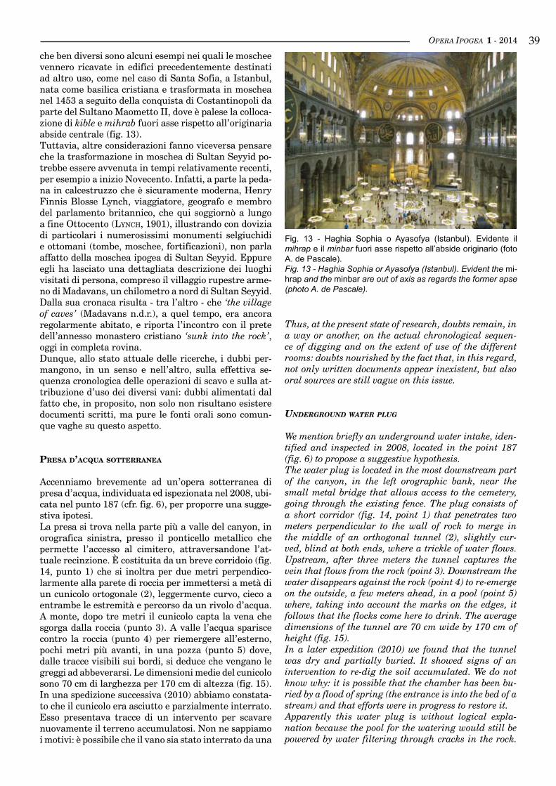
Fig. 13 - Haghia Sophia o Ayasofya (Istanbul). Evidente il mihrap e il minbar fuori asse rispetto all’abside originario (foto A. de Pascale).Fig. 13 - Haghia Sophia or Ayasofya (Istanbul). Evident the mi-hrap and the minbar are out of axis as regards the former apse (photo A. de Pascale).
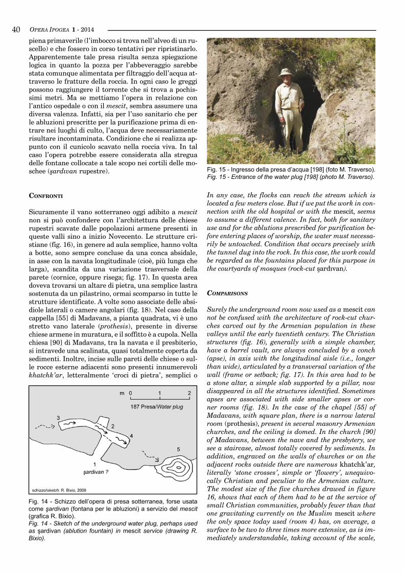
OPERA IPOGEA 1 - 201440piena primaverile (l’imbocco si trova nell’alveo di un ru-scello) e che fossero in corso tentativi per ripristinarlo.Apparentemente tale presa risulta senza spiegazione logica in quanto la pozza per l’abbeveraggio sarebbe stata comunque alimentata per filtraggio dell’acqua at-traverso le fratture della roccia. In ogni caso le greggi possono raggiungere il torrente che si trova a pochis-simi metri. Ma se mettiamo l’opera in relazione con l’antico ospedale o con il mescit, sembra assumere una diversa valenza. Infatti, sia per l’uso sanitario che per le abluzioni prescritte per la purificazione prima di en-trare nei luoghi di culto, l’acqua deve necessariamente risultare incontaminata. Condizione che si realizza ap-punto con il cunicolo scavato nella roccia viva. In tal caso l’opera potrebbe essere considerata alla stregua delle fontane collocate a tale scopo nei cortili delle mo-schee (şardıvan rupestre).
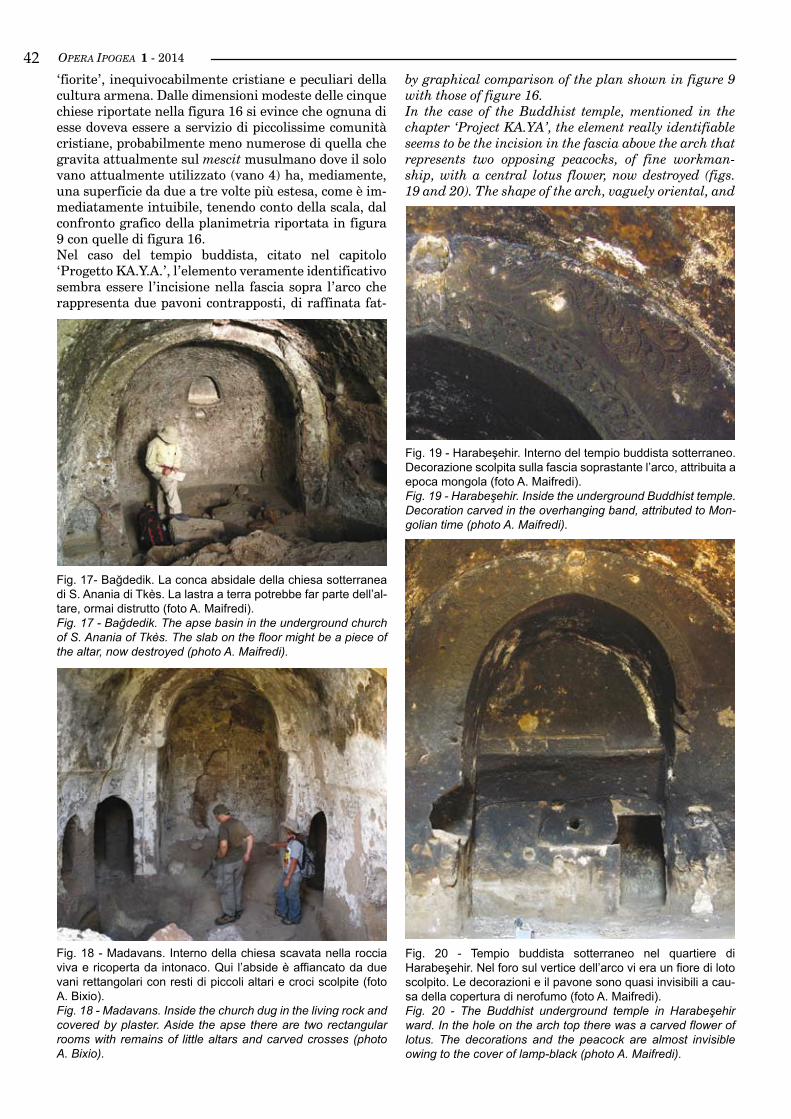
confrontI
Sicuramente il vano sotterraneo oggi adibito a mescit non si può confondere con l’architettura delle chiese rupestri scavate dalle popolazioni armene presenti in queste valli sino a inizio Novecento. Le strutture cri-stiane (fig. 16), in genere ad aula semplice, hanno volta a botte, sono sempre concluse da una conca absidale, in asse con la navata longitudinale (cioè, più lunga che larga), scandita da una variazione trasversale della parete (cornice, oppure risega; fig. 17). In questa area doveva trovarsi un altare di pietra, una semplice lastra sostenuta da un pilastrino, ormai scomparso in tutte le strutture identificate. A volte sono associate delle absi-diole laterali o camere angolari (fig. 18). Nel caso della cappella [55] di Madavans, a pianta quadrata, vi è uno stretto vano laterale (prothesis), presente in diverse chiese armene in muratura, e il soffitto è a cupola. Nella chiesa [90] di Madavans, tra la navata e il presbiterio, si intravede una scalinata, quasi totalmente coperta da sedimenti. Inoltre, incise sulle pareti delle chiese o sul-le rocce esterne adiacenti sono presenti innumerevoli khatchk’ar, letteralmente ‘croci di pietra’, semplici o
In any case, the flocks can reach the stream which is located a few meters close. But if we put the work in con-nection with the old hospital or with the mescit, seems to assume a different valence. In fact, both for sanitary use and for the ablutions prescribed for purification be-fore entering places of worship, the water must necessa-rily be untouched. Condition that occurs precisely with the tunnel dug into the rock. In this case, the work could be regarded as the fountains placed for this purpose in the courtyards of mosques (rock-cut şardıvan).
comparisons
Surely the underground room now used as a mescit can not be confused with the architecture of rock-cut chur-ches carved out by the Armenian population in these valleys until the early twentieth century. The Christian structures (fig. 16), generally with a simple chamber, have a barrel vault, are always concluded by a conch (apse), in axis with the longitudinal aisle (i.e., longer than wide), articulated by a transversal variation of the wall (frame or setback; fig. 17). In this area had to be a stone altar, a simple slab supported by a pillar, now disappeared in all the structures identified. Sometimes apses are associated with side smaller apses or cor-ner rooms (fig. 18). In the case of the chapel [55] of Madavans, with square plan, there is a narrow lateral room (prothesis), present in several masonry Armenian churches, and the ceiling is domed. In the church [90] of Madavans, between the nave and the presbytery, we see a staircase, almost totally covered by sediments. In addition, engraved on the walls of churches or on the adjacent rocks outside there are numerous khatchk’ar, literally ‘stone crosses’, simple or ‘flowery’, unequivo-cally Christian and peculiar to the Armenian culture. The modest size of the five churches drawed in figure 16, shows that each of them had to be at the service of small Christian communities, probably fewer than that one gravitating currently on the Muslim mescit where the only space today used (room 4) has, on average, a surface to be two to three times more extensive, as is im-mediately understandable, taking account of the scale,
Fig. 15 - Ingresso della presa d’acqua [198] (foto M. Traverso).Fig. 15 - Entrance of the water plug [198] (photo M. Traverso).
Fig. 14 - Schizzo dell’opera di presa sotterranea, forse usata come şardivan (fontana per le abluzioni) a servizio del mescit (grafica R. Bixio).Fig. 14 - Sketch of the underground water plug, perhaps used as şardivan (ablution fountain) in mescit service (drawing R. Bixio).
OPERA IPOGEA 1 - 2014 41
Fig. 16 - Tavola comparativa delle chiese rupestri individuate dal Centro Studi Sotterranei nell’area di Ahlat (grafica R. Bixio).Fig. 16 - Comparative plate of the rocky churches recognized by the Centro Studi Sotterranei in the Ahlat area (drawing R. Bixio).
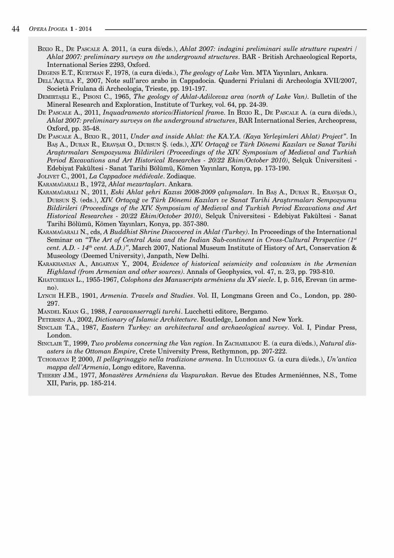
OPERA IPOGEA 1 - 201442by graphical comparison of the plan shown in figure 9 with those of figure 16.In the case of the Buddhist temple, mentioned in the chapter ‘Project KA.YA’, the element really identifiable seems to be the incision in the fascia above the arch that represents two opposing peacocks, of fine workman-ship, with a central lotus flower, now destroyed (figs. 19 and 20). The shape of the arch, vaguely oriental, and
Fig. 18 - Madavans. Interno della chiesa scavata nella roccia viva e ricoperta da intonaco. Qui l’abside è affiancato da due vani rettangolari con resti di piccoli altari e croci scolpite (foto A. Bixio).Fig. 18 - Madavans. Inside the church dug in the living rock and covered by plaster. Aside the apse there are two rectangular rooms with remains of little altars and carved crosses (photo A. Bixio).
Fig. 19 - Harabeşehir. Interno del tempio buddista sotterraneo. Decorazione scolpita sulla fascia soprastante l’arco, attribuita a epoca mongola (foto A. Maifredi).Fig. 19 - Harabeşehir. Inside the underground Buddhist temple. Decoration carved in the overhanging band, attributed to Mon-golian time (photo A. Maifredi).
Fig. 20 - Tempio buddista sotterraneo nel quartiere di Harabeşehir. Nel foro sul vertice dell’arco vi era un fiore di loto scolpito. Le decorazioni e il pavone sono quasi invisibili a cau-sa della copertura di nerofumo (foto A. Maifredi).Fig. 20 - The Buddhist underground temple in Harabeşehir ward. In the hole on the arch top there was a carved flower of lotus. The decorations and the peacock are almost invisible owing to the cover of lamp-black (photo A. Maifredi).
‘fiorite’, inequivocabilmente cristiane e peculiari della cultura armena. Dalle dimensioni modeste delle cinque chiese riportate nella figura 16 si evince che ognuna di esse doveva essere a servizio di piccolissime comunità cristiane, probabilmente meno numerose di quella che gravita attualmente sul mescit musulmano dove il solo vano attualmente utilizzato (vano 4) ha, mediamente, una superficie da due a tre volte più estesa, come è im-mediatamente intuibile, tenendo conto della scala, dal confronto grafico della planimetria riportata in figura 9 con quelle di figura 16.Nel caso del tempio buddista, citato nel capitolo ‘Progetto KA.Y.A.’, l’elemento veramente identificativo sembra essere l’incisione nella fascia sopra l’arco che rappresenta due pavoni contrapposti, di raffinata fat-
Fig. 17- Bağdedik. La conca absidale della chiesa sotterranea di S. Anania di Tkès. La lastra a terra potrebbe far parte dell’al-tare, ormai distrutto (foto A. Maifredi).Fig. 17 - Bağdedik. The apse basin in the underground church of S. Anania of Tkès. The slab on the floor might be a piece of the altar, now destroyed (photo A. Maifredi).

OPERA IPOGEA 1 - 2014 43
Bibliografia / Bibliography
bernarDını M., 2003, Storia del mondo islamico (VII-XVI secolo). Il mondo iranico e turco. Einaudi, Torino.
Bixio a., Bixio r., De Pascale a., leger e., MaifreDi A., 2009, Ahlat 2009: third campaign of surveys on the underground structures (report of expedition 2009). Centro Studi Sotterranei, Genova.
bıxıo r., castellanı v., caloı v., succhıarellı C., et al., 2002, Cappadocia. Le città sotterranee. Istituto Poligrafico e Zecca dello Stato, Roma.
bıxıo r., De Pascale a., Karamağaralı N., 2013, (a cura di), Ahlat 2008: seconda campagna di indagini sulle strutture rupestri / Ahlat 2008: second campaign of surveys on the underground structures”. BAR - British Archaeological Reports International Series 2560, Oxford.
bıxıo r., De Pascale a., maıfreDı a., traverso m., 2008, Ahlat (Turchia): prime osservazioni sui sistemi idrici rupestri. Atti VI Convegno Nazionale di Speleologia in Cavità Artificiali (Napoli 30 maggio - 2 giugno 2008), Opera Ipogea 1/2 - 2008, pp. 11-20.
bıxıo r., De Pascale a., maıfreDı a., traverso m., 2009, Ahlat 2007. Una nuova area di insediamenti sot-terranei nella Turchia orientale. Opera Ipogea, 1/2009, pp. 43-48.
Bixio r., De Pascale A., 2009, Archeologia delle cavità artificiali: le ricerche del Centro Studi Sotterranei di Genova in Turchia. Archeologia Medievale, XXXVI, Ed. All’Insegna del Giglio, pp. 129-154.
Bixio r., De Pascale A., 2010, Ahlat Underground Settlements Research Project 2007-2008-2009. In PeKtaş K., cırtıl s., cırtıl s.Ö., ÖztaşKın g.K., ÖzDemır h., aKtuğ e., uyKur r. (eds.), XIII. Ortaçağ ve Türk Dönemi Kazıları ve Sanat Tarihi Araştırmaları Sempozyumu Bildirileri (Proceedings of the XIII Symposium of Medieval and Turkish Period Excavations and Art Historical Researches - 14/16 Ekim/October 2009), Pamukkale Üniversitesi - Fen Edebiyat Fakültesi - Sanat Tarihi Bölümü Yayınları No: 1, Ege Yayınları - Zero Books, Istanbul, pp.123-130.
tura, con al centro un fiore di loto, oggi distrutto (figg. 19 e 20). La forma dell’arco, vagamente orientaleggian-te, e la disposizione dei vani è ancora oggetto di valuta-zioni (Karamağaralı N., cds).Per quanto riguarda il mescit come abbiamo visto, di-versamente dalle chiese cristiane rupestri documen-tate ad Ahlat, la navata è trasversale rispetto all’area equivalente all’altare, cioè al mihrap. Non dobbiamo però dimenticare che questo tipo di disposizione (tra-sversale) è sovente attestato nella Mesopotamia setten-trionale e lo ritroviamo in diverse strutture monastiche rupestri della Cappadocia (Anatolia centrale; Jolıvet, 2001, p. 26 e figure a p. 51).Dunque, l’unico elemento architettonico veramen-te identificativo sembra essere proprio la nicchia del mihrap. Per il resto dobbiamo dire che il locale si pre-senta poco caratterizzato. Se non fosse per gli arredi moderni in esso contenuti (tappeti, stoffe stampate e contenitori di tela), sarebbe stato difficile riconoscerlo come moschea. Probabilmente lo stesso mihrap sareb-be passato inosservato, considerato alla stregua delle nicchie presenti in tante altre strutture sotterranee della zona.Allo stato attuale delle indagini non abbiamo sufficien-ti elementi di comparazione (per esempio sulla forma del soffitto) per proporre ulteriori identificazioni su eventuali altre peculiarità architettoniche.
notA1 Nella carta di Sinclair il fiume Murat è chiamato an-che Lower Euphrates (sınclaır, 1999, carta a p. 221). tchobayan (2000, p. 31) lo indica con il nome di Eufrate orientale.
the arrangement of the rooms is still under evaluation (Karamağaralı N., personal communication).As regards the mescit as we have seen, unlike the rock-cut Christian churches documented in Ahlat, the aisle is transverse with respect to the area equivalent to the altar, i.e. to the mihrap. But we must not forget that this type of arrangement (transverse) is often attested in northern Mesopotamia and we find him in different rupestrian monastic structure in Cappadocia (central Anatolia; Jolivet, 2001, p. 26 and figures in p. 51).So, the only architectural element really distinctive seems to be the niche of the mihrap. For the rest, we must say that the room is poorly characterized. If it were not for modern furniture in it (carpets, printed fabrics and canvas containers), it would be hard to recognize as a mosque. Probably the same mihrap would go un-noticed, considered as the niches in many other under-ground structures in the area.At the present state of the investigations we do not have enough elements of comparison (for example the shape of the ceiling) to propose further identifications of any other architectural features.
noTe1 In the map by Sinclair the Murat river is also cal-led Lower Euphrates (sınclaır, 1999, map at p. 221). tchobayan (2000, p. 31) indicates it with the name of Eastern Euphrates.
OPERA IPOGEA 1 - 201444
Bixio r., De Pascale A. 2011, (a cura di/eds.), Ahlat 2007: indagini preliminari sulle strutture rupestri / Ahlat 2007: preliminary surveys on the underground structures. BAR - British Archaeological Reports, International Series 2293, Oxford.
Degens e.t., Kurtman F., 1978, (a cura di/eds.), The geology of Lake Van. MTA Yayınları, Ankara.Dell’aquıla f., 2007, Note sull’arco arabo in Cappadocia. Quaderni Friulani di Archeologia XVII/2007,
Società Friulana di Archeologia, Trieste, pp. 191-197.Demırtaşlı e., Pısonı C., 1965, The geology of Ahlat-Adilcevaz area (north of Lake Van). Bulletin of the
Mineral Research and Exploration, Institute of Turkey, vol. 64, pp. 24-39.De Pascale A., 2011, Inquadramento storico/Historical frame. In Bixio r., De Pascale A. (a cura di/eds.),
Ahlat 2007: preliminary surveys on the underground structures, BAR International Series, Archeopress, Oxford, pp. 35-48.
De Pascale a., Bixio r., 2011, Under and inside Ahlat: the KA.Y.A. (Kaya Yerleşimleri Ahlat) Project”. In baş a., Duran r., eravşar o., Dursun ş. (eds.), XIV. Ortaçağ ve Türk Dönemi Kazıları ve Sanat Tarihi Araştırmaları Sempozyumu Bildirileri (Proceedings of the XIV. Symposium of Medieval and Turkish Period Excavations and Art Historical Researches - 20/22 Ekim/October 2010), Selçuk Üniversitesi - Edebiyat Fakültesi - Sanat Tarihi Bölümü, Kömen Yayınları, Konya, pp. 173-190.
Jolıvet C., 2001, La Cappadoce médiévale. Zodiaque.Karamağaralı B., 1972, Ahlat mezartaşları. Ankara.Karamağaralı N., 2011, Eski Ahlat şehri Kazısı 2008-2009 çalışmaları. In baş a., Duran r., eravşar o.,
Dursun Ş. (eds.), XIV. Ortaçağ ve Türk Dönemi Kazıları ve Sanat Tarihi Araştırmaları Sempozyumu Bildirileri (Proceedings of the XIV. Symposium of Medieval and Turkish Period Excavations and Art Historical Researches - 20/22 Ekim/October 2010), Selçuk Üniversitesi - Edebiyat Fakültesi - Sanat Tarihi Bölümü, Kömen Yayınları, Konya, pp. 357-380.
Karamağaralı N., cds, A Buddhist Shrine Discovered in Ahlat (Turkey). In Proceedings of the International Seminar on “The Art of Central Asia and the Indian Sub-continent in Cross-Cultural Perspective (1st cent. A.D. - 14th cent. A.D.)”, March 2007, National Museum Institute of History of Art, Conservation & Museology (Deemed University), Janpath, New Delhi.
KaraKhanıan a., abgaryan Y., 2004, Evidence of historical seismicity and volcanism in the Armenian Highland (from Armenian and other sources). Annals of Geophysics, vol. 47, n. 2/3, pp. 793-810.
KhatchıKıan L., 1955-1967, Colophons des Manuscripts arméniens du XV siecle. I, p. 516, Erevan (in arme-no).
lynch H.F.B., 1901, Armenia. Travels and Studies. Vol. II, Longmans Green and Co., London, pp. 280-297.
manDel Khan G., 1988, I caravanserragli turchi. Lucchetti editore, Bergamo.Petersen A., 2002, Dictionary of Islamic Architecture. Routledge, London and New York.sınclaır T.A., 1987, Eastern Turkey: an architectural and archaeological survey. Vol. I, Pindar Press,
London.sınclaır T., 1999, Two problems concerning the Van region. In zacharıaDou E. (a cura di/eds.), Natural dis-
asters in the Ottoman Empire, Crete University Press, Rethymnon, pp. 207-222.tchobayan P, 2000, Il pellegrinaggio nella tradizione armena. In uluhogıan G. (a cura di/eds.), Un’antica
mappa dell’Armenia, Longo editore, Ravenna.Thierry J.M., 1977, Monastères Arméniens du Vaspurakan. Revue des Etudes Armeniénnes, N.S., Tome
XII, Paris, pp. 185-214.