Ocean Emission Effects on Aerosol-Cloud Interactions: Insights from Two Case Studies
Upload
khangminh22Category
view
1download
0
TRANSCRIPTIONS OF IN-FLIGHT
COMMENTS AND AIRCREW DEBRffiFINGS
FOR RESEARCH FLIGHTS TO STUDY THESMOKE FROM THE 1991 KUWAIT OIL FIRES
Assembled by
Peter V. Hobbs
March 1992

TABLE OF CONTENTS
1. INTRODUCTORY REMARKS2. MAY 16, 1991 FLIGHT
2.1 Individually Written Debriefs2.2 Transcripts of In-Right Recording
3. MAY 18, 1991 FLIGHT3.1 Individually Written Debriefs3.2 Transcripts of In-Flight Recording
4. MAY 21, 1991 FLIGHT4.1 Individually Written Debriefs4.2 Transcripts of In-Flight Recording
5. MAY 22, 1991 FLIGHT5.1 Individually Written Debriefs5.2 Transcripts of In-Right Recording
6. MAY 27, 1991 FLIGHT6.1 Individually Written Debriefs6.2 Transcripts of In-Flight Recording
7. MAY 28, 1991 FLIGHT7.1 Individually Written Debriefs7.2 Transcripts of In-Flight Recording
8. MAY 29, 1991 FLIGHT8.1 Individually Written Debriefs8.2 Transcripts of In-Right Recording8.3 Post-Right Debriefing
9. MAY 31, 1991 FLIGHT9.1 Individually Written Debriefs9.2 Transcripts of In-Right Recording9.3 Post-Right Debriefing
10. JUNE 2, 1991 FLIGHT10.1 Individually Written Debriefs10.2 Transcripts of In-Right Recording10.3 Post-Right Debriefing

TABLE OF CONTENTS (Continued)
1 1. JUNE 3. 1991 FLIGHT11.1 Individually Written Debriefs
11.2 Transcripts of In-Flight Recording
11.3 Post-Flight Debriefing
12. JUNE 5, 1991 FLIGHT
12.1 Individually Written Debriefs
12.2 Transcripts of In-Flight Recording
12.3 Post-Flight Debriefing
13. JUNE 8, 1991 FLIGHT
13.1 Individually Written Debriefs
13.2 Transcripts of In-Flight Recording
13.3 Post-Flight Debriefing
14. JUNE 9, 1991 FLIGHT
14.1 Individually Written Debriefs
14.2 Transcripts of In-Flight Recording
14.3 Post-Flight Debriefing
15. JUNE 11, 1991 FLIGHT
15.1 Individually Written Debriefs
15.2 Transcripts of In-Flight Recording
15.3 Post-Right Debriefing
16. JUNE 12, 1991 FLIGHT
16.1 Individually Written Debriefs
16.2 Transcripts of In-Flight Recording
16.3 Post-Flight Debriefing

1 INTRODUCTORY REMARKS

INTRODUCTORY REMARKS
The following contains transcriptions of verbal and written impressions and summariesby University of Washington (UW) team members involved in flights of the UWConvair C-131A aircraft to study the smoke from the Kuwait Oil Fires during theperiod 16 May through 12 June 1991. For each flight the following elements areprovided:
I. Individual Written Debriefs
a) Flight Scientist
b) Flight Observer
c) Chemist
d) Optical Scientist
e) Aerosol Scientist
f) Cloud Absorption Radiometer Scientist
g) Radiometer Scientist
h) CCN Scientist
II. Voice Transcriptions of Airborne Tape Recordings
III. Transcriptions of Post-flight Verbal Debriefings of Aircrew (when available)
The following initials are used:
RJF Ronald J. FerekPVH Peter V. HobbsMK Michael D. KingKL Krista Lam-senKM Kenneth McMillen (pilot)DN David NancePP Peter PilewskaeAR Arthur RangnoJR Jack RussellRS Rod Sorensen (co-pilot)DS Donald SpurgeonHT Hap TerryFV Francisco ValeroRW Ray Weiss

2 MAY 1 6, 199 1 FLIGHT

UNIVERSITY OF WASHINGTON FLIGHT #1477,0552-1152 UTC, MAY 16, 1991, FOR STUDY OF
SMOKE FROM KUWAIT OIL FIRES
I. INDIVIDUAL WRITTEN DEBRffiFINGS
(a) Flight Scientist: Peter V. Hobbs (from Flight Scientist Manual)
(Note: IstU. S. aircraft here for studying smoke from Kuwait fires.)
Summary of Surface Meteorology andVisual Observations at Take Off:Widespread haze (dust) and smoke (?)Temp ~90T.Minimum air traffic control problems. Free access to Kuwait.
Experimental Observations:Climbed to 14,000 ft. Headed north to Kuwait. Widespread smoke and haze (dust)from -3,000-10,000 ft. No distinct, visible plume. Above 10,000 ft. remarkablyuniform and clean air (CN, S02, bsb steady). Few oil fires seen on ground in Kuwait.Difficult to track plumes visibly in overall pall of smoke. Did cross-sectionmeasurements off Kuwait shore (in southern group of fires-Al Burqan fire). Intendedto do measurements at 8,000, 7,000, 5,000 and 3,000 ft., but abandoned during 5,000ft cross-section due to computer problem. Data system turned off, therefore nomeasurements on return to Bahrain.
6^r<..
<- r \ f s. e<j

UNIVERSITY OF WASHINGTON FLIGHT #1477,0552-1152 UTC, MAY 16, 1991, FOR STUDY OF
SMOKE FROM KUWAIT OIL FIRES
I. INDIVIDUAL WRITTEN DEBRIEFINGS
(b) Flight Observer: Arthur Rangno
The route to Kuwait from Manama was over the Gulf 40-80miles offshore At "29 deg. N we turned west to interceptthe plume. Flight level was 16, 500 ft ( 5 km) above sealevel Surprisingly, there were no vertical columns ofsmoke seen in the overflight Tops of smoke difficult todiscern and estimate the height of because of excessive hazeup to 15, 000 ft ( 4 6 km) The top of the smoke waseventually seen from an altitude between 13, 000 and 14, 000ft ( ~4 km) From here, the smoke gave the appearance ofblack stratocumulus Thick haze and thin overcast cirri formclouds made light very diffuse so that whole scene wasblurry with little contrast
Eventually, the top of the smoke was found at 10, 500 ft( 3 2 km) This was at a location south of the Kuwaitairport during some of our west to east and east to westpasses We found little smoke at this level however, asmost of the smoke was at 9, 000 ft (2 7 km) and below. Thebase of the smoke plume was nearly level, though it dipped
to 3, 000 ft ( "I km) in more active fire regions and rose to5 000 ft ( 1 5 km) offshore. The appearance of the plumeunderneath was similar to that of a stratocumulus ornimbostratus cloud with some of the heavier (more dense)portions of the plume appearing as though they wereprecipitating (oil droplets) There were a few oil-drizzledrops encountered in brief, finite bursts, but no generalcontinuous drizzle.
A surprising aspect of the haze in which smoke wasembedded was its size distribution. There were steadycounts in FSSP channels 1 and 2 indicating the presence ofparticles 3-5 microns in diameter.
2

UNIVERSITY OF WASHINGTON FLIGHT #1477,0552.1152 UTC, MAY 16, 1991, FOR STUDY OF
SMOKE FROM KUWAIT OIL FIRES
I. INDIVIDUAL WRITTEN DEBRffiFINGS
(b~) Flight Observer: Arthur Rangno (cont.)
"/^ o^ ^/)z^- ^^T ^-<s A- /^’^ ^/^^/^, o^ ^^/^ -’^^ ^-".f-^----^ ^-^^--^
w= /-//iz/-:’
Pr^V-v """*^V- :^W.
fc) Chemist: Ronald J. Ferek
Chemical Measurements:Except for insufficient warm-up time for NOx, CO and COs, all instruments workedwell. During samples above and in the smoke 7 pairs of 37 mm filters were exposed (1above, 3 near top of plume, and 3 at lower altitudes). The below plume sample wasaborted by a short-circuit in computer. HzS, grids and cans (2 of each) were collectedat 2 points in the smoke but, due to some confusion, these were not well coordinatedwith the general pattern of sampling.

UNIVERSITY OF WASHINGTON FLIGHT #1477,0552-1152 UTC, MAY 16, 1991, FOR STUDY OF
SMOKE FROM KUWAIT OIL FIRES
I. INDIVIDUAL WRITTEN DEBRIEFINGS
(c) Chemist: Ronald J. Ferek (cont.)
General Observations:C02 was generally -50 ppm above background in the plume we were sampling.CO only a few tens of ppb above background.NOx only -10 ppb (never above lowest range).S02 about 80 ppb; only -1% of the COz, which was somewhat surprising given ourexpectations of high sulfur contentNo smell of H2S obvious, again somewhat surprising after reports of many ppm fromprevious information.Max S02 observed over the fires (in thicker smoke than we were working) was about500 ppb.37mm filters were quite black indicating sufficient sample.
(d) Optical Measurements: Ray E. Weiss
OEC Optical Extinction Cell, bcxt, single scattering albedo @ 538 run3W Nephelometer bsp <2’ 445, 538, 665 nm with auto pressure and temp correctionA3 Aerosol Asymmetry Analyzer, non-spherical aerosol propertiesAethelometer Aerosol optical absorption, bap <Q> 525 nm using integrated plate
filter method in nearly real time.
General Observations:
This flight was useful to test all four instruments. Each instrument is either newlyconstructed or modified for use in the Kuwaiti fire smoke and had not been flight tested.
Each instrument worked suprisingly well considering the heat, although theaethclomcter was operated only for the first 20 minutes of flight because of aircraft powerlimitations.
The first lag of the flight, above the haze layer, provided limited useful informationregarding this instrumentation other than operational testing. Lower detection limits for theOEC and A3 are concentrations of about 30 or 40 ug/m3; the A3 is sensitive to large particleswandering through the laser beam. Within the smoke, however, measurements of bsp andsingle scattering albedo indicated it is quite possible to determine that you are in the firesmoke as compared with blowing dust or virtual nothing. The diffuse appearance of thesmoke and background make it difficult to determine your location relative to the smokeboundaries. The instruments, however determine your location quite reliably and the plumesappear to be quite well defined.
OEC-Neph:
Testing during the initial phases of the flight indicated that there is still a small lenseffect with large temperature gradients. The effect was most apparent at higher altitudes. I
4

UNIVERSITY OF WASHINGTON FLIGHT #1477,0552-1152 UTC, MAY 16, 1991, FOR STUDY OF
SMOKE FROM KUWAIT OIL FIRES
I. INDIVIDUAL WRITTEN DEBRIEFINGS
(d) Optical Measurements: Rav E. Weiss (cont.)
found that I could moderate the problem by modulating the flow rate between filtered andambient air. Insulating the inlets may eliminate the problem. In cither case, we should be ableto get excellent data with careful attention.
During the initial over-flight of the smoke the scattering extinction (for particles)ranged between 2xl0-3 m-1 and 5xl0-3 m’1; this level of extinction is below the detection limit of
the OEC. In the smoke, bsp ranged up to about 5xl&4 m-1, OEC determined single particlescattering albedo varied between 0.5 and 0.8 with 0.5 being more characteristic of the smokenear Kuwait. It appeared that blowing large particles can be a significant component at times.
A3
The asymmetry analyzer worked well at extinction coefficients above about 1&* m-1.Typical enhancement of scattering due to electric field alignmentin the smoke was about 25 percent. There was no apparentpermenant electric dipole associated with the particles whichwhould be expected for very fresh aggragates. I havent analyzedthe decay curves to estimate the aspect ratio of the particles. Eachflight generates about 7 mbytes of data.
Aethdometer
The instrument was only operated long enough to see that it was working correctly. Wewere to limited in power to operate it continuously. The power problem will be reduced bysubstituting the aircraft nephelometer with the multiwavelength.
(e) Aerosol Scientist: Donald Spureeon
This flight was characterized by a veryhomogenous set of aerosol distributionswith very little difference from one sampleto the next. The only exceptions werewhen we hit a plume or concentratedsmoke area.
.0^ 10 h^ ^ \0 /^
The distributions that looked differentwere one plume episode that had twogaussian peaks of different sizes that hadvirtually identical mass volumes. (See sketch. But see data tapes for confirmation.)
The other plume episode which was closer to (I believe) and lower had a distinctivebimodal distribution in the size-vs-number plot.

UNIVERSITY OF WASHINGTON FLIGHT #1477,0552-1152 UTC, MAY 16, 1991, FOR STUDY OF
SMOKE FROM KUWAIT OIL FIRES
I. INDIVIDUAL WRITTEN DEBRffiFINGS
(e) Aerosol Scientist: Donald Spurgeon (cont.)
The other plume incidents were variantshowing either a high concentration insmall (-10’2 urn) particles or a higherthan usual number in the large (~10 to101 HIT!) particle range. - 10^ ^10 ^AK-CNC Concentrations (highest observed) (See data tapes for confirmation)CNCI: -30,000/ccCNCn: -8,000/ccCNCm: ~ll,000"12,000/cc (Note: This is an overflow condition for CNC ffl)
(f) Cloud Absorption Radiometer: Michael D. King
Performance of Instruments:CAR worked perfectly throughout mission. For first 2 hours or more, the exabyterecorder failed. I suspected the data system, as this happened on one Barrow flight.Jack Russell was struggling with Nd:YAG lidar which was not working. Eventuallyhe determined that changing the tape solved the problem-perhaps the header was notwritten correctly on the first tape, and thus the data system or tape drive error checking
6

UNIVERSITY OF WASHINGTON FLIGHT #1477,0552-1152 UTC, MAY 16, 1991, FOR STUDY OF
SMOKE FROM KUWAIT OIL FIRES
I. INDIVIDUAL WRITTEN DEBRIEFINGS
(f) Cloud Absorption Radiometer: Michael D. King (cont.)
stopped the tape. The CAR then ran fine and recorded data for ~2 hours in smoke overKuwait City and the Persian Gulf. As soon as the CAR began to record data properly,the TDDR overheated and failed. The onboard computer unceremoniously crashed ~5hours into the flight and thus no more radiation data were recorded. The computer didcome back on line for return leg back down the Gulf-total flight-5:59.
Science:The smoke layer looked like a dark marine stratocumulus cloud layer. It was quiteplane-parallel, with flat tops at -10,500 ft. and flat bases at -3,000 ft. The layer wasnot sufficiently black to attenuate all sunlight. There was plenty of signal to measureeven in transmission. In reflection, smoke looked like aerosol backscattering phasefunction, including glory. In transmission, the transmitted component of the scanlooked like the forward part of the phase function. Inside the layer, the radiation fieldwas relatively smooth, looking more like the single scattering phase function than themultiple scattering diffusion pattern (cosine).
S Q^^AA $3Qq n ^ o f C^ g. _:.
^R-e ^L<^
-r
< c^tec a^XM^.a ,0-A 6^f -^jr>ZX*e^
<"0 <\ Snr\\-<0lff\
-j-ar-uocM, d S-Co-Xt^u^,(pl^d^l_t -puvtcC^
^ d<X^tt. Afl -P&JCLC+l <?v\
^ -T=te^<nos> QwtJL. ^,or>\

UNIVERSITY OF WASHINGTON FLIGHT #1477,0552-1152 UTC, MAY 16, 1991, FOR STUDY OF
SMOKE FROM KUWAIT OIL FIRES
I. INDIVIDUAL WRITTEN DEBRIEFINGS
(f) Letter from Mike King to T. Nakajima:
Dear Ten,We had our first research flight yesterday-6 hours in duration. We flew up the
Persian Gulf and then east-west flight legs, over Kuwait. The smoke yesterday washorizontally plane-parallel, good for radiation. The top of the layer was at 10,500 ft.and the base at 3,000 ft. It looks like dark (blackish) marine stratocumulus clouds.The conditions of the flight were difficult-we had 2 more people on the aircraft thanever before, the cabin was extremely hot and we had numerous instrument failures:from overheating (Valero’s TDDR), from a bad exabyte tape (CAR), and from amisaligned lidar. Thus the flight was both invigorating, tiring, and interesting. Wesaw roads, cars, the airport, and condominiums in Kuwait City. We saw cargo ships,battleships and an oil derrick in the Gulf.
You may be interested in the following findings:1. The single scattering albedo of the smoke is -0.5-0.55.2. The aerosol is well mixed, with the volume size distribution having 2 distinct
modes of equal magnitude.3. The aerosols are non-spherical, since the extinction changed as the electric field
changed such as to align the particles.
The smoke was nevertoo black to permitradiation measurements.Even in transmission I hadplenty of measurablesignals. In reflection mymeasurements lookedsomething like:
-^OfiAJO^ d iSroTta^-naphflAt -fv^ZXj^
bria^tt’ -Viori-tovsb&aatt>. plor^-poAAAiLi^.Sr^ofce baA_
^ cLuJi^ raj-l-a&tor^tlQy’^^::^s\o^ Qiiul-f
In transmission:
o>A->oao(-a ^ Cx/^i_**o dLo d^-
-si------- fc) OkC^^Co-CtlAt,^,t6Q p^ttAA -^jr>CC.o3,

UNIVERSITY OF WASHINGTON FLIGHT #1477,0552-1152 UTC, MAY 16, 1991, FOR STUDY OF
SMOKE FROM KUWAIT OIL FIRES
I. INDIVIDUAL WRITTEN DEBRIEFINGS
(f) Letter from Mike King to T. Nakajima (cont.):
Internal radiation field: Smooth and more like a single scattering phase function (sincecoo 0.5) than like diffusion domain field.
I heard yesterday that a German group is going to Iran-largely for chemistrymeasurements. My source (Russ Schnell) thinks they are going to Tehran.
Finally, I am enclosing some model runs that are being sent to Peter Hobbs daily fromJim Ellis (Lawrence Livermore National Laboratory). These models arc valid for 3:00am, 9:00 am, and 3:00 pm local time and arc transmitted to us at 7:30 pm each eveningand then updated and retransmitted at midnight. It is all model, but uses winds fromthe model and sources of the wells to predict movement. Samples are enclosed.Because of a strong front with westerly winds we expect a dust storm (shamal) toarrive today from Saudi Arabia. It is this predicted wind movement which is likelycausing the LLNL model to show dust flowing to Iran today.
I will be acquiring Landsat scans for the 22 and 31 May.
Michael King
(^ NASA Ames Radiometers: Warren Gore
Although we encountered problems which affected the performance of the system, weacquired some high quality data from both of our sensors during the early pan of theflight. Specifically, the problems were as follows:
1. Degradation of the image on our computer monitor-it was traced to AC powersource from aircraft Switching to another outlet solved the problem.
2. Noise (appears to come from AC power source) false-triggering the communicationbetween our system controller and the data logging computer. This problem has yetto be solved. We would like to know who is sharing the same AC power sourceduring the flight. We would try to solve this problem by filtering the AC line.
3. Heat (both ambient and generated by equipment) may have caused somedegradation in the electronics during the last part of the flight.
We request that some aircraft down-rime be made for trouble shooting at the earliestconvenience.
9

n. VOICE TRANSCRIPTIONS OF AIRBORNE TAPE RECORDING FROM UW FLIGHT1477 ON MAY 16, 1991
6:00 AM
KM: Everybody ready in the back?
6:07 AM
RJF: Yeah, we’re ready back here.
MK: We’re climbing out of Manama, we’re flying in this close sequential plane. Can seethe solar aureole, edge of the solar aureole even at one quarter gain. I’m saturatingfrom the sun.
6:16 AM
MK: The CAR scan, we can see the reflectance from the sun glitter below the aircraft
6:17 AM
MK: Filter wheel channels aren’t working at all. Most channels are saturated.
Can see the scattering towards the horizon. Getting brighter above and somewhatof a thinnish solar aureole. Not saturating because of the haze layer that’s aboveus.
Extremely smooth scattered signal above the horizon on the right-hand side of theaircraft with the solar aureole from the haze layer.
6:25 AM
MK: Channel 13 seems saturated. Other filter wheel channels seem OK. See some solaraureole in the principal plane. Aircraft clocks seem to be set for Greenwich MeanTime.
Some glitter pattern is still apparent on the right wing towards the horizon on thestarboard side of the aircraft.
Scattering around the sun now is due to the intrusion of cirrus clouds above.
6:26 AM
MK: Climb over the Persian Gulf. Flying with the 45 azimuth plane, principal planenow. Still quite a bit of scattering, but it’s off of cirrus clouds.
Haze layer still visible off the right-hand side of the aircraft.
6:27 AM
PVH: OK, this is our first flight in the Kuwait Fires. We’re climbing out through a hazeheading out towards the middle of the Gulf off of Bahrain.

RJF: Radio test. Do you hear me there?
Hear anything, Peter?
How’s it coming through now?
KM: The cockpit reads you if you’re call them.
(No audible reply from PVH.)
6:28 AM
RJF: Say something. Ken?
PVH: Can you hear me, Ron? Are you hearing OK?
RJF: Just say like, 1, 2, 3, 4. Count.
PVH: 1. 2, 3, 4, 1, 2, 3, 4, testing;
RJF: OK, I got you now.
PVH: Yeah, I can hear you now.
6:29 AM
PVH: We’re picking up little tar balls on the wind screen and on the PMS 2-D.
6:34 AM
KM: OK, we’re at 10,000 feet and the oxygen is being turned on if anyone wants it.
6:45 AM
KM: We’re going to be shifting our blowers so you’ll hear a little thump here as we doit.
6:46 AM
PVH: Son of on top of... (cut off).
6:50 AM
PVH: Nephelometer about 10 to the minus 6.
And we’re heading down center of the Gulf, down towards to Kuwait, see if wecan see any plumes.
We’re losing some power intermittently here. The chemist station and Mike King’sstation’s going on and off. Jack’s working on it. We’re pretty clean air here abovethe top of the haze layer.

6:52 AM
RJF: OK, Peter? In about 10 seconds give us the call for a bag sample.
7:04 AM
PVH: They just took an air sample above the haze below. This is, we’re in very uniformconditions. Everything is sort of rock steady as we head towards Kuwait. Still nosign of any identifiable plume ahead of us, so this was son of a background sampleat this altitude.
7:06 AM
PVH: OK, we’re approaching 15,000 and we decided, we’re east of Kuwait, and we’vedecided to head over Kuwait, see if we can see anything resembling a plumepopping up. Jack’s still having trouble getting the lidar to work and Mike King’sstation is out. Everything else seems to be working. Ray Weiss is getting goodmeasurements. We’re getting chemical and aerosol samples up here. This is prettyclean up here, on top of everything.
7:10 AM
RJF: Say, Ken?
KM: Yeah?
RJF: Ron here. We’re reading something minus 1 degree outside and it’s still really hotback here.
KM: Up here in the front, which is an independent system, I’m reading 1 degree. So wemight be, might be a couple of degrees just for skin friction here.
7:14 AM
PVH: Just took a sample at 16,500 feet, 30 miles east of Kuwait, heading towardsKuwait. Winds coming out of the west.
7:25 AM
PVH: 50 or 60 miles out from Kuwait, heading west. All counts are very low at 16,000odd feet And everything seems very uniform and low at this altitude. Still can’tsee any visible plumes over Kuwait.
7:35 AM
MK: Thick haze below us. Still over the Persian Gulf. Brighter towards the horizon;nice cirrus clouds above. Exabyte recorder isn’t working at all. Look at the displayof the data, it’s limb brightening from nadir towards the horizon a little bit but wecan’t record.
7:40 AM
MK: Outstanding looking reflectance measurements. Extremely smooth from nadir tothe horizon. Unable to record.
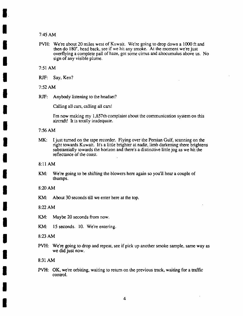
7:45 AM
PVH: We’re about 20 miles west of Kuwait. We’re going to drop down a 1000 ft andthen do 180, head back, see if we hit any smoke. At the moment we’re justoverflying a complete pall of haze, got some cirrus and altocumulus above us. Nosign of any visible plume.
7:51 AM
RJF: Say, Ken?
7:52 AM
RJF: Anybody listening to the headset?
Calling all cars, calling all cars!
I’m now making my 1,857th complaint about the communication system on thisaircraft! It is totally inadequate.
7:56 AM
MK: I just turned on the tape recorder. Flying over the Persian Gulf, scanning on theright towards Kuwait. It’s a little brighter at nadir, limb darkening there brightenssubstantially towards the horizon and there’s a distinctive little jog as we hit thereflectance of the coast.
8:11 AM
KM: We’re going to be shifting the blowers here again so you’ll hear a couple ofthumps.
8:20 AM
KM: About 30 seconds till we enter here at the top.
8:22 AM
KM: Maybe 20 seconds from now.
KM: 15 seconds. 10. We’re entering.
8:23 AM
PVH: We’re going to drop and repeat, see if pick up another smoke sample, same way aswe did just now.
8:31 AM
PVH: OK, we’re orbiting, waiting to return on the previous track, waiting for a trafficcontrol.
4
PVH: We just hit a couple of little plumes. CN counter responded. Not the nephelometerand not the SOs. Then we hit a couple of small plumes where the S02 respondedbut nothing else.
8:39 AM
PVH: About to descend and return.
8:41 AM
MK: Top of the smoke, we’re at 10,000 feet. CAR data tape is out. We haven’t beenrecording. Quite extensive smoke. The radiation field upwelling is very, verysmooth. Slight limb brightening.
As we go down into it almost developing a diffusion domain type characteristic.
8:48 AM
PVH: OK, that was a big broad plume. S02 and CN, nephelometer. Ray got some verygood and interesting results on the optics. We’re going to do a 180, go throughthat same plume again and try to get more in the middle of it; our last sample wassort of at the edge of it.
8:52 AM
PVH: Heading back east to go through the same plume at 9000 feet.
8:58 AM
PVH: Just emerged, sample here again. 10,000 feet. We’re going to 9000 feet. We’regoing to drop down another thousand feet and go backwards and forwards acrossthis particular plume again at 8000 feet.
9:04 AM
MK: Jack changed the tapes in the data logging system for the CAR and seemed to besomething wrong with the tape. It’s working now. We’ve turned it on. We’reover Kuwait, the top layers of the big smoke.
9:05 AM
MK: Limb brightening from nadir to zenith, nadir to the horizon, excuse me. Cirrusclouds above.
9:06 AM
PVH: This line we’ve been working at 9000 feet was just south of Kuwait. The westernedge of the line being the Arabian shore and the easternmost point of the line beingin the center Gulf.
9:07 AM
MK: Changed gains from a quarter to 1.

9:08 AM
MK: We’re over the Gulf. Channel 13 seems saturated. See a little brightening towardnadir. Maybe backscaner from the aerosol, then darkening a little bit, thenbrightening towards the horizon. Almost looks like a phase function. If there’senough absorption, there might be.
9:09 AM
MK: Almost like it’s almost straight overhead. We may be getting some of the gloryeffect from the aerosol that I saw in the commercial aircraft coming across the SaudiDesert on my way to Bahrain.
9:10 AM
MK: The reflectance signal is so smooth it’s unbelievable. Looks like 20 parallel,because there’s enough absorption, not a lot of scattering. Almost looks like aphase function.
9:11 AM
MK: ...5 micron doesn’t seem to be recording anything. It’s zero. At 2 point 3 the lastchannel is saturated. Other filter wheel channels have extreme backscaner,dramatic.
9:19 AM
MK: As we descend into this cloud the radiation field becomes extremely interesting.I’ve never seen anything like it. Still slight backscaner, 10th amplification towardszenith almost diffusion domain with a lot of absorption, even in the visible channel.No coastline at all.
9:20 AM
MK: Channel 4, point 87 microns seems to have some electronic noise.
9:22 AM
MK: Enhanced backscaner and nadir seems to have disappeared and the visiblewavelength, but still seems to be somewhat apparent at 1 point 22 microns.
As we head eastbound the smoke seems to be thinning. The upper layers of thesmoke still smooth signal and reflection, a little brightening towards the horizon andthen we’re saturated towards zenith with cirrus clouds and the solar aureole. Sun’salmost overhead.
9:33 AM
MK: Ray Weiss says that the zenith scattering albedo on the smoke we went through wasabout point 5 to point 55. Had strong phase function effects.
6

9:36 AM
MK: Even though the pyranometer show the albedo of the smoke to be 6%, I have plentyof radiation signal with the CAR, gain 4. I’m almost saturated all the channels,there’s plenty of reflectance signal, the sun’s so high.
MK: Heading west over Kuwait. Smoke is thickening. Flying level flight leg, we’regoing into it.
9:37 AM
MK: Signal I am measuring inside these clouds looks more like single scattering phasefunction than diffusion domain. It may very well be if the albedo is low as point 5.May be measuring single scattering.
9:42 AM
MK: Detecting over 5000 particles per cc outside the aircraft now.
9:44 AM
MK: As we move east over the Gulf the clouds thin, the sun’s almost straight overhead,we’re saturated the area solar aureole, even at l/4th gain.
9:47 AM
MK: We’re now quite an extensive haze layer now. (Unintelligible.)
9:56 AM
MK: Slight brightening towards the horizon. Saturated the zenith at gain 1. Amazing!The first of the filter wheel channels only.
There are pieces of oil slick on the water.
9:57 AM
MK: Presently flying over the Gulf.
The transmission from above this thick cloud looks more like a phase functioneffect than multiple scattering escape function.
9:59 AM
MK: We’re going underneath an incredibly thick, black cloud. Bright spike towards thehorizon as we’re underneath it, just underneath the stratus. Dark reflectance of thewater and transmission flow.
Solar disk is barely discemable through the smoke from above, ...in Bahrain,although this is thicker.
10:01 AM
KM: You can start seeing the fires off to the left now, about 10:00 o’clock.

3 MAY 1 8, 1991 FLIGHT

UNIVERSITY OF WASHINGTON FLIGHT #1478,0407--0955 UTC, MAY 18, 1991, FOR STUDY OF
SMOKE FROM KUWAIT OIL FIRES
I. INDIVIDUAL WRITTEN DEBRIEFINGS
(a) Flight Scientist: Arthur Rangno (from Flight Scientist Manual)
Summary of Surface Meteorology and Visual Observations at Take Off:In midst of Shamal with north winds 20-30 knots over water, and increasing dust.(1 cyclone in and one out on the 37 mm filters for all Desert Storm flights)Planned as a "Radiation Flight"Smoke Cloud tops rose from 5,300 ft. in north Saudi Arabia to 7,000 ft. north ofManama
Experimental Observations:Top of dust layer at Manama -2,000 ft., thin smoke layer above. Aircraft climbedthrough weak smoke layer to top of haze layer at 12,000 ft. then additional haze layerintercepted between 12,000 and 15,500 ft. As with previous flight, layers increased indepth northward, but as in leaves or shelves. Top of dust layer vicinity of southKuwait 6,000 ft., with undulations at top. Gulf haze top -2,000 ft. to 3,000 ft. withclear space between that top and smoke layer. 2nd clear space between top of.smokeand dust tops and deep haze layer between 7,000-8,000 ft. to 15,500 ft.
Did not intercept plume until near 28.5’ N or at Kuwait border. Therefore plan alteredto fly down stream in center of plume for Michael King radiation experiment. Did "twominute turns" circles twice before.proceeding upstream to -15 minutes width point.Lidar failed by this dme and width of plume had to be eye-balled by Flight Scientist
Two plumes were in close proximity, one just east of the coast from north Kuwait andthat one from the Al Burqan major fires southwest of Kuwait city.
<.^ K
^L’LFc^j-7-l- <o ^N^
Overflights of smoke and highest haze layers took place at 16,500 ft., followed by1,000 ft. a minute descent to 2,500 ft., where base estimated (from previous flight).No base found, not unexpectedly, considering 20-25 knot surface winds. Smokeappeared to go to near ground level. Climbed to mid-point of smoke (-4,000 ft. ASL)for two penetrations, followed by a penetration at 3,000 ft No further experimentspossible as flight time ran out.

UNIVERSITY OF WASHINGTON FLIGHT #1478,0407-0955 UTC, MAY 18, 1991, FOR STUDY OF
SMOKE FROM KUWAIT OIL FIRES
I. INDIVIDUAL WRITTEN DEBRIEFINGS
(b) Flight Observer: Arthur Rangno
Initial ly, the fl ight track after take-off was over Saudicoastal waters to about 28 deg. N We had not interceptedthe plume nor could it be seen due to everpresent haze) sowe turned westward in search for smoke Soon we found smokethat was barely distinguishable through the haze whichextended up to 15 500 ft 4 7 km) For our radiationexperiment we then flew down the centerline of the plume,away from the source, at 16, 500 ft 5 km) clearing the topof the haze layer by 500 or 1000 ft ~250 m) At the end of5 minutes we performed 2 2-minute turn circles for MikeKing
Fol lowing this maneuver, we flew toward the source untilthe width of the plume and our nearness to source presentedoptimum conditions estimated by Art ) for perpendicularoverflights to establ ish plume widths via lidar. The l idarmalfunctioned, so the western and eastern limits of theplume had to be visual ly estimated. The western edge wasclearly delineated even with the near obscuration of surfacedetai l by dust and blowing dust due to a change from a darkappearance below the aircraft to a bright appearance. Theeastern edge was less clearly defined since it was morediffuse l ike the downwind edge of a cumulus cloud) andbecause it was over the Gulf which had the effect ofdiminishing the contrast between the plume and thebackground dark background below) A further compl icationwas that the eastern edge of the plume over the Gulforiginated from the smal l N Kuwait oi l fires A thin spotin smoke density presented itself in lower penetrations toseparate the two. The thin spot was only a few seconds induration though. There was no discernable base of the plumeon this windy day Kuwait reported NNW wind to 20-25 knotsduring the flight
Fuel considerations caused a truncation of the plannedpenetrations, but this was not deemed particularly harmfulin view of the surprisingly modest smoke top of 6, 500 ft 2km) We also found a dust top at this level over the firen a thin, clear layer ~500 ft thick and second haze layer
-,-r: top extending to 15 500 ft 4 7 km) The dust top nearManama was below 3 000 ft 1 km) with a thin smoke layerabove

UNIVERSITY OF WASHINGTON FLIGHT #1478,0407--0955 UTC, MAY 18, 1991, FOR STUDY OF
SMOKE FROM KUWAIT OIL FIRES
I. INDIVIDUAL WRITTEN DEBRIEFINGS
(b) Flight Observer: Arthur Rangno (corn.’)
Nr’- n3 ^ "?oc’ C >~
f&.’o.^-i >_’v>- f-i;-c,-\ ’i*-.? (*n.c\-\^.cjC Tt- \\ ^<-i-A^K-.; rcC (,o<x"’ \
Y ^ ^ ^

UNIVERSITY OF WASHINGTON FLIGHT #1478,0407-0955 UTC, MAY 18, 1991, FOR STUDY OF
SMOKE FROM KUWAIT OIL FIRES
I. INDIVIDUAL WRITTEN DEBRffiFINGS
(c) Chemist: Ronald J. Ferek
SC-E-^^’O ^- ^A-^I^T’O^ FL.16-HT ^^71 /g /K-V ?/
^/’% \^\|A3iriA^_ -na-Ac-h. (_I-OOC>A/O- tiaujM) ^_
L ^-
4
^ ^!^:’^^6S - E-^-^^^5 ^is Ar PE^TUEES OF ^rSAE<^’^ ^^ ^. f^ wnr r^.^^ ,’.. -.c- r^u c^LT^EAtfC f^K^tl.trt. To ^L3, r-.-^,r 5; ,^^5
<4/-stf Hrr Ses^ rt-uwE ov. .^-^^ cs^-c ..-~i-- 5^^/i,--’PEZ-^cc- c^ o.r,,.^^^’0^’t:k-- rc t),^.r,a >c-^,4fti<^

UNIVERSITY OF WASHINGTON FLIGHT #1478,0407--0955 UTC, MAY 18, 1991, FOR STUDY OF
SMOKE FROM KUWAIT OIL FIRES
I. INDIVIDUAL WRITTEN DEBRffiFINGS
(d) Optical Measurements: Rav E. Weiss
OEC3W NephelomcterA3Acthclometer
Optical Extinction Cell. bext, single scattering albedo @ 538 runbsp 0 445, 538, 665 run with auto pressure and temp correctionAerosol Asymmetry Analyzer, non-spherical aerosol propertiesAerosol optical absorption, bap @ 525 run using integrated platefilter method in nearly real time.
General Observations:The flight was similar to the lidar mapping flight on May 16. The main difference with
regard to this instrumentation was the extreme concentrations of coarse particles (presumablyblowing dust). For traverses above and below the smoke as well as the pass in the lower smokethe coarse mode was dominant. Integrating nephelometers under determine the scatteringcoefficient for large due to forward angle truncation. The 4,000 ft pass through the smoke,however, provided very good data.
OEC-Neph:The pass above the smoke was below the detection limit of the OEC, the aerosol during
the lower smoke pass at 3000 ft was dominated by coarse particles and provided unrealisticmeasurements of single scattering albcdo do to low ncphclomctcr measurements. The pass at4000 ft, however, indicated single scattering albcdo of about 0.5 that became noticeably darkernear the middle. The A3 also responded to the darker aerosol differently from the edges,
A3Coarse particles are a problem for the A3 because they have very large electro-optical
(EO) effects and wander in and out of the laser beam. swamping the response of the smokeparticles. The EO effect in the darker area of the 4000 ft passsuggested that chain aggregates with permanent electric dipolesmay have been present. Permanent moments are indicated by aincrease (or decrease) in the EO effect when the electric field isreversed. This effect was not apparent during the previous flight.IF, in fact, these electric moments are sensitive to particle growth,then the evolution flight should be very interesting if we get the
right smoke conditions.
AethdometerThe aethelometer was operated for the entire flight. The instrument worked well. Very
little response was detected except in the smoke passes as would be expected. The instrumentwill be calibrated using the QBC and ^ep^etometer when we get smoke conditions with outsignificant dust nxmi iljj^i
UNIVERSITY OF WASHINGTON FLIGHT #1478,0407.-0955 UTC, MAY 18, 1991, FOR STUDY OF
SMOKE FROM KUWAIT OIL FIRES
I. INDIVIDUAL WRITTEN DEBRIEFINGS
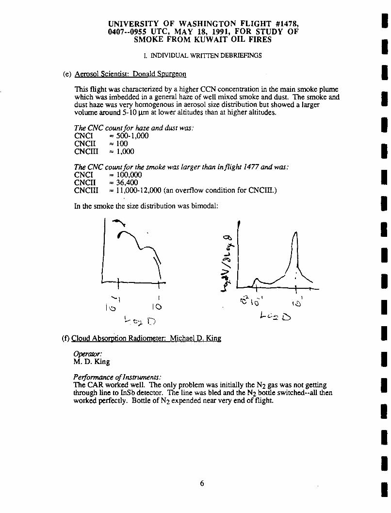
(e) Aerosol Scientist: Donald Spurgeon
This flight was characterized by a higher CCN concentration in the main smoke plumewhich was imbedded in a general haze of well mixed smoke and dust. The smoke anddust haze was very homogenous in aerosol size distribution but showed a largervolume around 5-10 (im at lower altitudes than at higher altitudes.
The CNC count for haze and dust was:CNCI 500-1,000CNCII 100CNCffl 1,000
The CNC count for the smoke was larger than in/light 1477 and was:CNCI 100,000CNCII 36,400CNCIII 11,000-12,000 (an overflow condition for CNCIH.)
In the smoke the size distribution was bimodal:
’O 0
^ 0l-c.^ ^
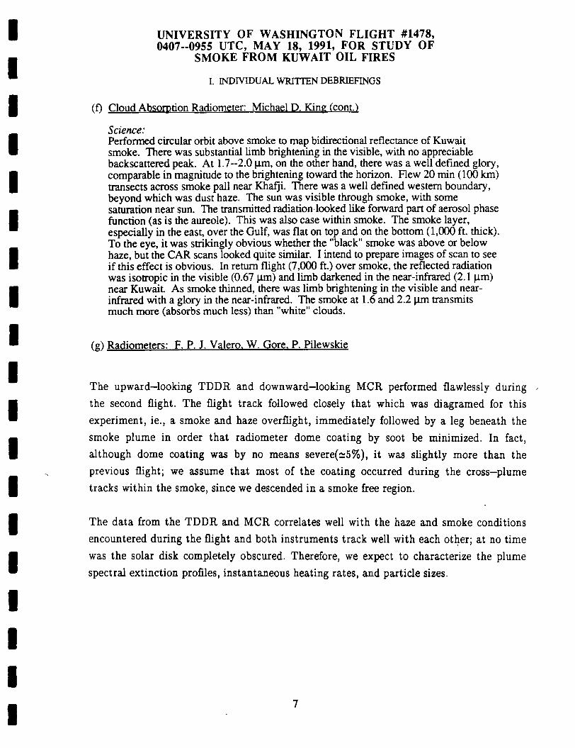
(f) Cloud Absorption Radiometer Michael D. King
Operator:M. D. King
Performance of Instruments:The CAR worked well. The only problem was initially the N2 gas was not gettingthrough line to InSb detector. The line was bled and the N3 bottle switched-all thenworked perfectly. Bottle of N2 expended near very end of flight.
6
UNIVERSITY OF WASHINGTON FLIGHT #1478,0407--0955 UTC, MAY 18, 1991, FOR STUDY OF
SMOKE FROM KUWAIT OIL FIRES
I. INDIVIDUAL WRITTEN DEBRIEFINGS
(f) Cloud Absorption Radiometer: Michael D. King (cont.)
Science:Performed circular orbit above smoke to map bidirectional reflectance of Kuwaitsmoke. There was substantial limb brightening in the visible, with no appreciablebackscattered peak. At 1.7-2.0 p.m, on the other hand, there was a well defined glory,comparable in magnitude to the brightening toward the horizon. Flew 20 min (100 km)transects across smoke pall near Khafji. There was a well defmed western boundary,beyond which was dust haze. The sun was visible through smoke, with somesaturation near sun. The transmitted radiation looked like forward part of aerosol phasefunction (as is the aureole). This was also case within smoke. The smoke layer,especially in the east, over the Gulf, was flat on top and on the bottom (1,000 ft. thick).To the eye, it was strikingly obvious whether the "black" smoke was above or belowhaze, but the CAR scans looked quite similar. I intend to prepare images of scan to seeif this effect is obvious. In return flight (7,000 ft.) over smoke, the reflected radiationwas isotropic in the visible (0.67 |j.m) and limb darkened in the near-infrared (2.1 p.m)near Kuwait As smoke thinned, there was limb brightening in the visible and near-infrared with a glory in the near-infrared. The smoke at 1.6 and 2.2 (im transmitsmuch more (absorbs much less) than "white" clouds.
(s-) Radiometers: F. P. J. Valero. W. Gore. P. Pilewskie
The upward-looking TDDR and downward-looking MCR performed flawlessly duringthe second flight. The flight track followed closely that which was diagramed for this
experiment, ie., a smoke and haze overflight, immediately followed by a leg beneath thesmoke plume in order that radiometer dome coating by soot be minimized. In fact,although dome coating was by no means severer%), it was slightly more than the
previous flight; we assume that most of the coating occurred during the cross-plume
tracks within the smoke, since we descended in a smoke free region.
The data from the TDDR and MCR correlates well with the haze and smoke conditions
encountered during the flight and both instruments track well with each other; at no time
was the solar disk completely obscured. Therefore, we expect to characterize the plumespectral extinction profiles, instantaneous heating rates, and particle sizes.

n- v01^^S^TOFAIRBORNE TAPE RECORDING^UW FLIGHT
6:47 AM
AR: Just then went through a thin spot apparently representing a break between theplume in northern Kuwait and the Burqan oil field plumes. At 065S we seem to benow coming over the Burqan oil field.1 Thin spot’s gone. The groundTnas^tvisible for about two minutes. There are whitish black, I guess^ocum^s-like^/r.i!5’ probably agaln about’ ^"g out w^ I guess, maybe n 000Looks like the west edge coming up. Brightening westward
KM: I am still headed westbound for Bravo.
6:55 AM
RW?: How long till we get to Bravo?
KM: I guess about 4 minutes.
RW?: Smoke below us.
6:56 AM
MK: Just past the edges of smoke. It’s 6:59 GMT. Now we’re over dark haze.6:59 AM
KM: ...Starting down.
RS: OK, you can see the edge of the smoke pretty clearly, couldn’t you.RW?: That’s good then. We’ll want to avoid this smoke all the way down.RS: This must be dust, huh? Pretty thick, too. We can now see the ground below usand we couldn’t below the smoke.
7:01 AM
AR; ^tAe I^l^?/""’’’?""’11; one,’lunte "S0. 0700:00 well defined on the westw"%h^T "I’511""^ of a "umulus cloud, perhaps because there area^S^’po^S""1 we re seeing the rise- ’""’d been " 2S 48 and
^tuwai^nT^rcpo^1’1’ (lusl moving around’ winds 340 ^l^5 a’
7:02 AM
AR: 0703:03 ground not visible due to dust. That was 25, 0703:25.

7:03 AM
AR: Ground barely visible through dust and blowing dust.
7:04 AM
KM: ...out here, things are quite distinct now out ahead of us.
7:09 AM
KM: We’ve got 3000 ft, that what you want?
7:13 AM
RJF: Ken do you think we’re below the smoke at this level?
KM: It’s hard to say from here. Let us level out and take a spec.
RJF: OK.
7:14 AM
KM: OK, we’re about 5 Bravo and we’re turning to the east for our pass under.
7:18 AM
RW?: Are we at point D now?
7:19 AM
AR: We’re entering a plume at 2500 feet, 0720:50. Heading eastbound.
?: Are we at point D? Heading east?
KM: Affirmative. We’re by subCharlie or point D about 2 miles ago.
RW?: Pretty impressive down here, huh?
7:21 AM
AR: Sky darkening. Horizontal visibility decreasing. barely visible dead aheadabout 20 degrees angle downward.
7:22 AM
MK: We’re now flying below the dark plume. The sun is still visible through it, gettingspikes but quite a tremendous darkening. We’re flying low, and yet we seem to besomewhat in it.
7:23 AM
AR; Occasional oil particle on 2-D data here at 0723:40. 2 6 1 7 thin spot or layeringahead. Possibly smoke layer on the ground. Coastline coming up.
2
7:26 AM
AR: We appear to be between layers at this point. It’s separated much like stratiformstorms often do on the backside where the upper, there’s an upper layer that’sdiverging, moving away from the lower layer. Getting out here away from theplume now, it’s all above us.
7:27 AM
AR: Half a mile west of the coast now. East. More smoke ahead now. This isprobably the plume, the second plume coming down from northern Kuwait.Entering here.
MK: Just crossed the coast, now we’re over the Persian Gulf.
Even at 25% gain we’re saturating straight up towards the sun even at 2.2, 2.3microns. Underneath this black, over the Persian Gulf, we’ve left the black smokeand now we’re under dust haze and we’re saturating. But not in the first sevenchannels.
7:30 AM
MK: We’re out over the Gulf midway between point D and point E. The cloud above usis very homogeneous.
7:31 AM
RJF: Mike, you on the headphone?
MK: What did you say, Ron?
RJF: Mike, here’s what we’re going to do in order to conserve fuel. We just reached E,we’re going to eliminate the return to D and right now we’re going to climb to 4500and then head back in for 2 passes through the smoke at that level.
MK: Sounds fme. We’ll be effectively at point I? Or are we going to do three levels ofsmoke? I have no sense of how thick it was.
RJF: An doesn’t think it was too thick. It was like 7000 top, 4500 midpoint andsomewhere where we just flew around the base. So that will be point I at 4500.
KM: Gentlemen, we’re at Echo at this time so we’re commencing 8260 for the reversaland a climb to 4 point 5.
MK: What’s the level we flew at the bottom there. Ken?
KM: Say again?
MK: What was the level we flew at the bottom there Ken?
KM: Say again?
MK: What was the level we flew underneath? How high were we?
KM: We Hew this last dme?
MK: D to E.
KM: We went, from Echo we were at 2 point 5. Now we’re going to climb to 4 point 5for the reversal from, would amount to I guess "I" to H.
MK: Thank you.
7:37 AM
AR: Looking down, looks like 20 to 30 knots on the water judging by the numerouswhite caps, some large. We’re flying between layers, horizontal visibility here.
7:38 AM
KM: We’re about 50 ahead of the Hotel at 1225.
7:45 AM
AR: Cloud tops ahead looked a little lower than 7. We’re descending to 4000 for thissupposed midpoint of the smoke.
7:46 AM
AR: We’re hitting some smoke from one of the more northern Kuwait oil fieldsmomentarily, but that won’t be the main bang from the Burqan field.
7:47 AM
AR: A significant east edge plume intercepted about 0748:00 to 3 0. Ground not visiblenow flying 4000 at 0750:08. Sun’s bright above. visible below, so we’reprobably sdll in the north Kuwait oil field bum. Looks like heavier smoke ahead.This should be the Burqan oil field bum, looking for the coastline here coming up.
7:50 AM
AR: Not much wind down there. No white cap visible in this pan of the Gulf.
MK: Even inside this dark smoke I have to run at a quarter, 25%. (superimposed by AR)
AR: Heavier smoke ahead. Coastline here, dead ahead, sky darkening.
MK: Just now crossing the coastline of the Persian Gulf to land at 0751.
7:51 AM
MK: Picking up some reflectance features of the land below us now, which we can see.
AR: (Superimposed) darkening ahead. We’re just on the side of a wishy-washy eastedge of this at 0752:30. Ground sdll visible here inland from the coast about 2miles.
4

7:52 AM
MK: The ground is darker than the smoke at the horizon, considerably. Eventually(superimposed by AR). Continues to speak unintelligible.
AR: Crossing over a divided highway. And we have three large trucks down below,that’s triple width.
MK: We’ve recorded being brighter than the land, but in the near infrared that’s not thecase.
AR: And the ground becoming more diffuse as we enter the heavier smoke.
7:53 AM
AR: Ground barely visible. This appears to be the thickest part. Now the ground ishardly visible. It’s less than barely visible if there is such a thing. Bag samplehere. Large particles, 2-D we got a particle about 700 microns in diameter.Drizzle.
7:55 AM
AR: This is definitely the thickest part so far right here at 0756:16. Bag sample mighthave been 10, 15 seconds premature.
7:56 AM
AR: Sky seems to be brightening at 0756:48.
KM: OK, we’re 3 miles from Hotel (point H), looks like we’re coming out on the westside of the plume.
7:59 AM
AR: South of west edge about 0759:00. Nothing but dust, pretty visible at 4000 feetThere’s obscuration in the dust, at least awfully close to the top. Let’s see, maybe Ishould check the instruments here.
8:00 AM
?: CNC-2 is now rather small, but when we were in it I saw it to 20,000.
8:01 AM
RS: Are we located over Kuwait or Saudi Arabia, Ken?
8:02 AM
KM: Unintelligible.
AR; West edge of smoke pall at 0804:07.
5

8:04 AM
AR; Some kind of farms down there, I can’t see what they are. Little squares withsubrectangles. Small rectangles within the larger rectangles and squares.
MK: We’re heading back eastbound and it’s not as visible on my scan. (Superimposedby AR)...principal plane where before we were not.
AR: 2-D panicles.
Occasional particles.
8:07 AM
AR: Thickest portion of plume was about 1 to 2 minutes ago. That would be 0806,0807.
8:08 AM
MK: Just crossed the coast line into the Persian Gulf once again going eastbound.
8:10 AM
KM: OK, we’re beginning our reversal and dropping down to 3000 feet for the pass toHotel.
8:19 AM
RJF: OK, Ken, for nomenclature purposes we’re calling this 3000 foot point out herepoint F and heading to Gulf.
KM: OK. Gulf.
8:20 AM
AR: Return at 3000 now at the behest of Ron. This is our last pass before returning toManama.
8:25 AM
AR; Beginning at 0831:00, surface now gradually disappearing. This seems to befurther east than what we had seen thickening do before. Flight level 3000.
8:31 AM
AR: Not yet reached the coastline on our westbound heading. Does that look likethey’re about 10 to 15 knots, judging by whitecaps?
Coastline coming into view. Crossing coasting line. Definitely thin spot here.
8:33 AM
AR; Crossing over curved portion of divided highway. 0830:04.
6

8:34 AM
RJF: Sample here.
8:36 AM
?: Looks like the thickest part, Ron.
8:37 AM
AR: Thickest part at 4792, definitely sun dimming here. Ground barely visible from3000 feet. Dark below. Probably like dusk.
8:38 AM
AR: Exiting west edge at 0838:53. west.
8:39 AM
RJF: Say, Ken.
KM: Yeah?
RJF: Where are we?
KM: OK, we just came up on a point. We turned to go home.
RJF: OK.
8:41 AM
AR: We did not quite exit the west end of it, it was very, very close. Probably withinless than a kilometer certainly. We dipped down a little below 2500 for the sake ofthe boys in the back, there, but we just haven’t got any more dme left to doanything. Ken has indicated that we must go and that’s what we’re doing now at0842:42.
8:42 AM
MK: Climbed out of the smoke and on our way home.
8:46 AM
AR: Smoke top 5300. Haze smoke layer above, but apparently it’s a regional haze dustlayer, not having to do with the Kuwait oil fires.
8:49 AM
MK: Flying back home. The cloud black smoke was at 5300 feet. We popped out ontop. We’re flying back on the gain 1. The reflectance on the black cloud is veryisotropic. I’m saturating the sun above but the reflectance of cloud is isotropic.
7

8:50 AM
AR; Smoke top now at 7000. Now hitting some of the higher little bubbles. Smokeabout a minute 1/2 ago, time 0851:08.
8:55 AM
AR: Smoke top higher ahead yet, maybe another 300 feet. We’re in and out at 7000.
9:00 AM
MK: On our return the cloud seems to be lifting a little bit as it goes toward Bahrain. Itwas 5300 when we pulled out of Kuwait. It’s about 7000 now at the top. We’recruising right now at 7000 and we’re just clipping the top.
AR: The tops appear to be stabilized at above 7000, between 7 and 8000. Not anyfurther rise since the time that they reached to 7000. Time 0808:56.
9:10 AM
AR: Eight one.
9:14 AM
MK: We’re over smoke the whole way back towards Bahrain. It looks very black stillbut when you look through it, now it’s thinning sufficiently, or diffusing laterallyso that we’re able to see through it now to see the Persian Gulf below.
It shows up in the CAR data as limb brightening and darker like the water downbelow us. Before when it was optically thicker and black it was more isotropicbelow but now we can see through it and it’s limb brightened.
9:17 AM
AR: It looks now that the dust layer aloft, haze dust layer aloft is merging with thesmoke layer. 0818:10. (Assume he means 0918:10).
9:18 AM
AR: We’ve got an island going by now off the right wing. Runs about half a kilometerwide. 0818:30.
9:35 AM
MK: On the way in we just crossed into greenish-blue water, shallow water off ofManama.
RS: Probably 9 to 10 minutes until touchdown. Thank you.
9:37 AM
AR; Looks like we’re coming between layers here. Top of the lower layer over the Gulfand below a smoke layer. Not in it yet. The clear layer in between, but we soonwill be.
9:40 AM
AR: OK, we’re dropping into the lowest boundary layer over the Gulf. Horizontalvisibility only a couple of miles at this level, although the ocean is clearly visiblebelow. We’re at 1700 and descending. 26 point 8. I think there’s an estimatedstable layer here. We’re certainly below the top of that now.
9:43 AM
AR: White caps below. Looks like the wind is at least 20 knots down there.
9

UNIVERSITY OF WASHINGTON FLIGHT #1478,0407-0955 UTC, MAY 18, 1991, FOR STUDY OF
SMOKE FROM KUWAIT OIL FIRES
in. POST-FLIGHT DEBRIEFING
Overview:1. Plume intercepted by flying westward; flew downwind and performed circles for
CAR.2. Plume top found at (-10,000 ft.); haze went up to -16,000-17,000 ft.3. Plume not as wide or black as previous news broadcasts showed.
Chemistry:Displays at stations good (flight tracks, etc)Communications better by virtue of headset useLegs longer to get from end to end (20 minutes)Concentrations lower than previous flight:
S02 max. -200 ppb (50-100 ppb on each traverse)CO and CC>2 similar to previous flight, as was NOx
Good case for fluxes, given that traverses covered plume downwind of bulk of fires
ExtinctionBlowing dust is complicating measurementsAethelometer giving good data
Aerosol:Haze uniformHigher CN count in smoke than previously foundGreat deal of dust (coarse particle mode evident, often dominant)
Radiation:Instruments worked well; flew on top; performed 2 counter-clockwise paths overplume for CAR.Flew east-west twice over plumeProceeded down; flew underneath at altitude of 2,500 ft.Next went up to 4,500 ft.flew home at 7,000 ft. to catch tailwindDomes coated slightly more than last time.A lot of N2 used by CAR instrument.
Lidar:"Ovenemp" light keeps coming on on the crate; could be a serious problem if coolingmechanism isn’t found.Lidar computer also did not work properly due to heat.

4 MAY 21 199 1 FLIGHT

UNIVERSITY OF WASHINGTON FLIGHT #1479,0458--0742 UTC, MAY 21, 1991, FOR STUDY OF
SMOKE FROM KUWAIT OIL FIRES
I. INDIVIDUAL WRITTEN DEBRTEFINGS
(a) Flight Scientist: Peter V. Hobbs (from Flight Scientist Manual)
Summary of Surface Meteorology andVisual Observations at Take Off:Smoke over Bahrain (looking just like stratus). Some blue sky overhead. Sun’s discclear. Would probably be good day for measurements, but must go to Sharjah for fuel.
Experimental Observations:No systematic measurements on this transit flight for fuel, due to need to fly as quicklyas possible to Sharjah to refuel and do research flight on same day. (This did nothappen because refuel took all afternoon and evening-hand pump! Therefore, spentnight in Sharjah.) On landing in Sharjah, smoke plume was apparent. Also, thatevening at Beach Hotel in Sharjah could see smoke layer-but sun set with no color(sun’s radiation absorbed by smoke or dust).
(b) Flight Observer: Arthur Rangno
The sky was overcast in a stratocumulus-l ike smoke layerPuffs of smoke were seen moving rapidly from the NW.Shortly after takeoff we intercepted a wel l defined smokebase at 1 900 ft 600 m) subsequently encountered the topbetween 6 000 and 7, 000 ft (at about 2 km) Air trafficcontrol problems resulted in delays and orbiting near Manamaat 13, 000 ft ( 4 km) There was an additional diversionaround Qatar We were on top of regional haze unti l we wereeast of Qatar when the haze top gradual ly rose to fl ightlevel the smoke top was below) We landed at Sharjah,finding a thin smoke layer at 2 000 ft -200 ft thickembedded in the regional haze
The sky was the bluest at Sharjah that we have seen thusfar during the midday/afternoon hours As eveningapproached, there was a thickening smoke layer to the S SW,and W, and by dusk, to the NW. Surface winds were form theSW.

UNIVERSITY OF WASHINGTON FLIGHT #1479,0458-0742 UTC, MAY 21, 1991, FOR STUDY OF
SMOKE FROM KUWAIT OIL FIRES
I. INDIVIDUAL WRITTEN DEBRIEFINGS
(b) Right Observer: Arthur Rangno (cont.’)
C^oJr ^ 5*cT,cl^tsf
UNIVERSITY OF WASHINGTON FLIGHT #1479,0458--0742 UTC, MAY 21, 1991, FOR STUDY OF
SMOKE FROM KUWAIT OIL FIRES
I. INDIVIDUAL WRITTEN DEBRffiFINGS
(d) Optical Measurements: Rav E. Weiss
OEC Optical Extinction Cell, bext, single scattering albedo <> 538 nm3W Nephelometer bsp (R) 445, 538. 665 nm with auto pressure and temp correctionA3 Aerosol Asymmetry Analyzer, non-spherical aerosol propertiesAethclomctcr Aerosol optical absorption, bap (R) 525 nm using integrated plate
filter method in nearly real time.General Objervtioos:
Ferry flight for fuel from Bahrain to Sharja, In general, aerosol concentrations werebelow the detection limit of the OEC and A3. I used the flight to test the newly installedinsulation of the inlet system. Seemed to work pretty well. Still a problem with the multiwavenephelometer on the aircraft data system; not sure what the problem is but the voltages on thechart recorder dont seem right.OEC-Neph:
Bsp was typically a few time Wm-1; the OEC was below its usable detection limit formost of the flight.A3
The A3 is sensitive to the relative concentration of coarse and fine aerosol. Largeparticles that drift through the laser beam have large electro-optical effects and completelymask the effects of smoke when smoke is at low concentrations.
Aethdomrter
The acthelomctcr worked well. However, at these low concentrations of smoke therewas very little change in the output for most of the flight low black carbon concentrations.

UNIVERSITY OF WASHINGTON FLIGHT #1479,0458--0742 UTC, MAY 21, 1991, FOR STUDY OF
SMOKE FROM KUWAIT OIL FIRES
I. INDIVIDUAL WRITTEN DEBRffiFINGS
(e) Aerosol Scientist: J. David Nance
This fl ight was between Bahrain and Sharjhah, U A E Wehad original ly intended to fly to Sharjhah to fi l l up onfuel for an afternoon fl ight toward the Kuwaiti oi l firesRefuel ing lasted wel l into the evening, however, since thefuel had to be pumped by hand from barrels into the wing.So we spent the night and resumed flying the next day.
Upon takeoff from Bahrain, there were several problems withthe aerosol instrument rack The EAA had become unpluggedand its pump switch in front of the fl ight scientist hadbeen turned off Furthermore, a breaker for the di lutionpump had been thrown and had to be reset and the hose tothe dilution pump mass flow meter was disconnected. It tooka whi le to isolate and correct these problems, but once thiswas done, the instruments seemed to perform wel l Only afew samples were col lected in the dust/smoke (hard to tellwhat we were in over the Gulf between Sharjhah and QatarWe flew at high altitudes that probably were above themajority of smoke and dust in the lower part of theatmospere CNC2 was indicating concentrations of 100/cc orless at altitudes of about 13, 000 ft
4

H. VOICE TRANSCRIPTIONS OF AIRBORNE TAPE RECORDING FROM UW FLIGHT1479 ON MAY 21, 1991
6:40 AM
PVH: Beginning to descend into the smoke at about 9,800 feet.
7:01 AM
PVH: Descending into haze or smoke getting a red track on the automatic output. Started3 minutes ago at an altitude of about 7000 feet.
7:08 AM
PVH: As we come through 3000 feet or so to land and looking to the west we think wecan see the smoke plume.
7:17 AM
PVH: Getting a bit bumpy here as we come into land at Dabai. Just desert beneath us.
7:19 AM
KM: Everyone ready in the back?
7:21 AM
AR: Ready back here.

5 MAY 22, 199 1 FLIGHT

UNIVERSITY OF WASHINGTON FLIGHT #1480,0602-1151 UTC, MAY 22, 1991, FOR STUDY OF
SMOKE FROM KUWAIT OIL FIRES
I. INDIVIDUAL WRITTEN DEBRTEFINGS
(a) Flight Scientist: Peter V. Hobbs (from Flight Scientist Manual^
Summary of Surface Meteorology and Visual Observations at Take Off:No smoke apparent. Some blue sky overhead. Visibility -10 miles. (Intent was tocarry out plume evolution study.)
Experimental Observations:Based on coordinates of smoke plume seen on satellite at Bahrain Met Office(transmitted to us by phone) we headed to point over Saudi desert. Thick dust-nosmoke plume apparent visually. Picked up patches of smoke at various locations andaltitudes (could have been due to "flaming" gas sources in Saudi). Headed north,searching for plume, without success. Encountered plume near Kuwait border. Set upsequence of points for "evolution" study along axis heading south. BUT, kicked out ofarea by Kuwait Air Traffic Control. Obtained 3 sampling points while heading back toBahrain. These 3 points were separated by -15 minutes and full chemistrymeasurements were obtained. However, may not have been in center of plume (notenough fuel left to search). Also obtained aerosol, extinction cell, A3 measurements inclear air, dust and smoke. (Later found that smoke plume had moved east over Gulfduring flight. Electra also searched in vain over Saudi.)
Pre-flieht Plan

UNIVERSITY OF WASHINGTON FLIGHT #1480,0602--1151 UTC, MAY 22, 1991, FOR STUDY OF
SMOKE FROM KUWAIT OIL FIRES
I. INDIVIDUAL WRITTEN DEBRIEFINGS
(a) Flight Scientist: Peter V. Hobbs
(T
^(’
fT
r
^-i.
\^

UNIVERSITY OF WASHINGTON FLIGHT #1480,0602-1151 UTC, MAY 22, 1991, FOR STUDY OF
SMOKE FROM KUWAIT OIL FIRES
I. INDIVIDUAL WRITTEN DEBRffiFINGS
(h) Right Observer: Arthur Rangno
There was no sign of any smoke layer right after takeoff,though the haze was increased from the previous day.Enroute to Saudi (Dhahran) there were some diversionsrequired by air traffic control
We found only puffs of smoke while searching for theplume between 3, 000 and 6, 000 ft (betweem 1 and 2 km)Finally, we hit heavy plume as the ceiling of the smokelowered near the Kuwait-Saudi border. Visibility below the
aircraft was severely restricted by a dust storm. Smokelayers could not be visually distinguished from the greynessproduced by the sand/haze combination which extended to atleast 6 000 ft ( 2 km)
We could not track plume back because to Kuwaiti air
traffic control ordered us to proceed to an airway off thecoast A heavy smoke overcast persisted, though, as weproceeded eastbound.
u^5f<-T LTP- <rJhT ^W 6^ TIr^i ^sGi^ SY U. ^. ^T- ^WLW.S

UNIVERSITY OF WASHINGTON FLIGHT #1480,0602--1151 UTC, MAY 22, 1991, FOR STUDY OF
SMOKE FROM KUWAIT OIL FIRES
I. INDIVIDUAL WRITTEN DEBRffiFTNGS
(c) Chemist: Ronald J. Ferek
Summary of Chemical Measurements:At 0719, shortly after Sharjah takeoff, we encountered aged smoke (S0’y=5 ppb,CN-550) and sampled a bag for TEM grids only-should give morphology of agedsmoke/dust mixture to see if dust scavenges smoke particles.
AT 1019 (Point "A") 3,500 ft, some smoke, may not have been main plume but aremnant of earlier plume (S02=l 10 ppb, COi =381 ppm, CO-0.2 ppm, NOx 10ppb). 37 mm filters and can sample collected.
AT 1032, 5,000 ft. over Kuwait (C02 =380 ppm, S02 =100 ppb) good smoke sampleat source (can, 37’s, grid collected).
At 1053, 4,700 ft. over Gulf, trace of plume with can, 37’s and grid exposed.
At 1124, 4,000 ft. over Gulf, non-smoke background sample (COs 356 ppm, lowS02). Can, 37’s exposed.
Summary:Confused situation due to shifting plume. No good flux measurements but at least 2good grab samples for emission factors and a good regional background sample.
4

UNIVERSITY OF WASHINGTON FLIGHT #1480,0602--1151 UTC, MAY 22, 1991, FOR STUDY OF
SMOKE FROM KUWAIT OIL FIRES
I. INDIVIDUAL WRITTEN DEBRIEFINGS
(d) Optical Measurement: Rav E. Weiss
OEC Optical Extinction Oil, bext, single scattering albedo Q 538 run3W Nephelometer bsp Q 445, 538, 665 run with auto pressure and temp correctionA3 Aerosol Asymmetry Analyzer, non-spherical aerosol propertiesAethelometer Aerosol optical absorption, bap @ 525 run using integrated plate
filter method in nearly real time.
General Observations:Changed alpha to blue linear bsp on strip chart. Still doesnt look right. Found out later
that the aircraft data system appears to be clipping the output of the nephelometer. After this
flight I’ll reconnect the aircraft nephelometer and disconnect the multiwavc to ensure goodOEC/neph data.
When we were able to find some smoke the oec/neph and A3 systems worked well.however, it may be difficult to provide evolution data since we were not able to successfullyfollow the plume axis. Dust was dominant so I think I’ll try to make a switchable impactor to
try and remove the dust; we might be able to separate the two modes optically. It would be
interesting to sec if any of the soot coats the dust.
OEC-Nqih:Unable to make measurements in the dust only environments. Near Kuwait, single
scattering albedos were about 0.5 0.55; on the trip back to Bahrain the albedo rose to around0.7. Some neph data was lost in the high concentrations near Kuwait because of clipping by the
aircraft data system. This problem has now been resolved by removing the multiwavenephelometer from the aircraft data system.
A3The electro-optical effect was very pronounced near Kuwait with
an extremely long relaxation time. Presumably caused by the highdust concentrations. It will be interesting how removal of the dustfrom the sample stream will affect the decay time.
AethdometerThe aethelometer worked well. Very little attenuation in the dust but a quite rapid
increase in the smoke indicating, as expected, the presence of black carbon.

UNIVERSITY OF WASHINGTON FLIGHT #1480,0602--1151 UTC, MAY 22, 1991, FOR STUDY OF
SMOKE FROM KUWAIT OIL FIRES
I. INDIVIDUAL WRITTEN DEBRffiFINGS
(e) Aerosol Scientist: J. David Nance
Thi s was a very confusing fl ight as far as the aerosolmeasurements were concerned We started heading northwestout of Sharjhah, U A E with the intention of picking up adense part of the plume somewhere over eastern Saudi Arabia
some 100 or so mi les south of Kuwait We were to then flyupwind toward Kuwait and sample at regular intervals to tryand gain some information about the evolution of the smokeparticle size distributions Unfortunately, the atmosphere
was extremely dusty up to at least 7000 ft and the plumewas almost impossible to spot by eye unti l we were in it
We flew to a spot where we thought the plume would be
coordinates given by Pat from University of Wisconsin basedon Mcidas satel lite data) but could only find traces of theplume detected primari ly by surges in S02 concentration)
that were very difficult to relocate We never found thick
smoke unti l we were directly over Kuwait I bel ieve 3 or 4good samples were obtained in the thick smoke The restwere obtained in very dusty but not very smokey stuff Theinstruments seemed to perform alright as near as I can tel l
There were some concerns
1 After the first few samples, I began to notice a rift
or discontinuity in the number distributions at about theboundary between the ASASP and LAS measurements, thoughthis is difficult to tel l using the acplot program aboardthe aircraft Running the data through qckpit on a Sparewi l l tel l us for sure Just what this means is difficult
to say The rift seemed to disappear when the di lution
pump was used
2 The LAS "OFF SCALE" light was on for the entire
fl ight whether the LAS was drawing off of the nobag ornot
3 The mass monitor was cleaned, but the display on the
instrument (whatever it measures ) read much higher than
4000 as the notes for the aerosol scientist indicate it
should read It was cleaned prior to fl ight but it
started out at "6500 at the beginning and increasedthroughout the fl ight to over 8000 prior to landing.
Except for the rift mentioned in 1 above, the numberdi stributions showed a reasonably smooth fal loff from smal l
diameters to large diameters The accumulation mode peak
was around 0 2 or 0 3 urn diamter The nucleation mode wasgeneral ly weak or nonexistent but occasional ly it wasprominent The volume distrubutions were normal ly bimodal
with a large but sloppy lots of scatter peak in the coarsemode between 1 and 5 um.
6

H. VOICE TRANSCRIPTIONS OF AIRBORNE TAPE RECORDING FROM UW FLIGHT1480 ON MAY 22, 1991
PVH: Flight 1480, 22nd of May. Taking off from Sharjah in the UAE. Passing throughwhat appears to be a smoke layer at about 2000 feet or so. We’re going to head outtowards Bahrain and perhaps over Saudi to see if we can pick up the southern edgeof the plume as indicated by the satellite photograph.
6:19 AM
PVH: We have a problem bringing up the computer at the moment. Hap’s working on it.Sdll climbing out of Sharjah.
6:24 AM
PVH: Hap tried to get the lidar working but without success. It looks as if the lidarneeds, the mirrors need cleaning. The alignment seems to be OK. We’ll have towork on that on the ground.
6:25 AM
PVH: Can you read me, Ron?
RJF: Yes, loud and clear.
PVH: OK. good.
6:53 AM
PVH: Can you hear me. Ken?
6:54 AM
PVH: Can you hear me. Ken?
KM: Yeah, I can hear you. I’m trying to turn the squelch down. Count to ten and backagain.
PVH: OK, I can hear you.
KM: Would you count up to 10 and then back down to 1 so I can maybe adjust this?
PVH: OK, testing. I give you a count 1, 2, 3, 4, 5, 6. 7, 8, 9, 10. 10, 9, 8, 7, 6, 5, 4,3, 2, 1.
6:55 AM
KM: (Unintelligible). 2. 3, 4, 5, 6, 7, 8, 9, 10. 10, 9. 8, 7, 6, 5. 4, 3, 2, 1.
6:57 AM
KM: OK, An, we’re down to 6000.

6:58 AM
RJF: Ken, did you call somebody?
KM: I’m telling Art we’ve cleared from 8000 down to 6000.
RJF: OK.
6:59 AM
RJF: OK, Ken, go ahead and descend to 6 when you feel like it.
PVH: OK, so far we’ve been flying in fairly clear air, not getting much signal. So we’regoing to descend to 6000, see if we pick up more of a signal.
7:20 AM
PVH: OK, we’re still in transit as we climb from 8000 to 9000. Signal’s are slowlydecreasing as we climb out towards the top.
7:38 AM
PVH: We’re going to head out to the point over Saudi south of Kuwait. 26 degrees 15minutes north 48 degrees 25 degrees east. That is, 48 degrees, 25 minutes east.Almost south of Kuwait, about 60 miles or so. We’ll see if we can pick up theplume from there.
7:39 AM
PVH: We’re just west of Bahrain, heading for our starting point about 30 miles or so intoSaudi. We’re going to descend in order to maximize our chances of seeing theplume. If we intercept the plume we’ll turn to the north and proceed to Kuwait.
7:56 AM
PVH: At this altitude of about 6000 feet we’re not seeing anything. SOz is pretty muchzero, CN count is about 300 per cc and the nephs are steady and low. So we’recertainly above any smoke or haze at this altitude.
7:58 AM
RJF: We’re starring to hit smoke. Starting to get some smoke.
KM: Roger, copy.
PVH: Repeat that. Ken?
KM: Someone called me. We’re starting to get some smoke and I was just saying,acknowledging we got that information
8:01 AM
KM: OK we’re going to 3 point 5, 3500. We’re at 35.3 right now.

8:11 AM
PVH: The smoke we were in the past half an hour or so, which has now fallen off, mayhave been dust. It’s not clear that it was smoke.
8:32 AM
PVH: The plan now is to head to a point about 30 miles south of Kuwait over Saudi,latitude 27 degrees 11 minutes, longitude 48 degrees 24 east. That’s point A.We’ll then fly north about 30 miles to point B to put us south of the Kuwait border.We’ll then try to reverse track and fly due south, hopefully in the plume, obtainingour sample points. That’s the plan as of 0833.
8:33 AM
PVH: We just, Ron, just gone in.
PVH: Do you see that peak, Ron?
RJF: Yeah, I just changed the range so it’s not really a peak, it’s sdll going up.
8:41 AM
KM: OK, Art up here would like to go up 500 feet so we’re going up from 3.5 to 4000.OK?
PVH: We’re at 8 minutes to point A.
RJF: OK, we’re ready.
8:43 AM
KM: Going back down to 3500.
8:44 AM
PVH: Five minutes to point A.
8:45 AM
PVH: We’re heading for point A, but we may be overshot the plume. We’re proceedingin this direction for a little while and see if we hit anything.
8:47 AM
PVH: Few minutes to point A.
8:48 AM
RJF: Ken, this is Ron. I think we already passed through point A or we got on the westside of it, but we’re trying to convince Peter of that. So I guess we may want youto do a 180 and redefine point A.
KM: OK.

8:49 AM
KM: Looks like we might be getting back in it again. It’s a little darker up here.
8:50 AM
KM: We are at point A. Point A.
PVH: We’re going to head east to 3500 feet, see if we cross the plume again. We seem tohave gone too far west.
8:52 AM
PVH: We seem to have overshot the plume, so we’re going to head due east 3500 feet andsee if we cross the plume again. We’ll I guess that peak is the middle of the plume.Pretty sharp.
8:54 AM
PVH: In about 3 minutes we should cross the same area.
8:56 AM
PVH: We’ll try to pick the peak out and do a sample A at that point.
Looks as if we’re missing it again.
8:59 AM
PVH: We’re getting a response now. Be ready to take a sample when it peaks out here.
9:00 AM
PVH: We’re not getting as much response as we did last dme so we’ll just proceed east ofit more, dll we’re absolutely sure we’ve missed it and then well do 180 and changealtitude. See if we can pick up the peak that we did before.
9:03 AM
PVH: CAR’S picking up there because we’re climbing.
9:06 AM
PVH: OK, we’re climbing up to 4500 and above and it’s rising. We’ve seen a number ofpeaks at different altitudes here. We’re trying to get the altitude of maximum peak.So this peak is a little bit higher than the one below us, but it’s falling off again nowas we go to 47.
9:10 AM
PVH: We’re going out of the top of it again.
4

9:13 AM
PVH: We’re going to try one more height, by Pandu. If we don’t hit it there we’ll comeback down and hit one of these peaks, call that point A and then hiad north towardsthe fire.
9:14 AM
KM: We’re at 3800.
9:23 AM
PVH: OK, we’re too far east now, so we’re turning more to the west. We may hit theplume again in about 5 minutes.
9:24 AM
PVH: We’re still looking for this plume. We’ve now got a signal on the BSCAT with asmall particle mode, maybe smoke. On the other hand the S02 is not responding atall. We’re going to head back west and back to 3600, see if we can hit the plume.
9:28 AM
PVH: OK, we’ve had a little peak here in the CN. Just a small one. It’s gone back downagain.
9:32 AM
PVH: Ken, can you go to 3600?
KM: OK, 3600.
9:34 AM
PVH: Can we go to 3000?
KM: OK, 3.
9:38 AM
PVH: OK, we’re hitting it again on the CN.
9:40 AM
PVH: We had a little blip on the CN at 3200 feet, but it’s gone down again.
KM: You want to go back to 32?
PVH: OK, we’re going to stop fooling around here, we can’t find it So we’re going tostay at this altitude, 3200, and head due north up to the Kuwait bonier.
9:41 AM
PVH: Ken, can you stay at 3000.

KM: OK.
9:55 AM
PVH: Still searching for the plume, doing a zigzag up towards the Kuwait border,changing altitude, occasionally seeing little slithers of it, but still really haven’t hitit Very frustrating. We’re sort of flying in a haze, getting some images on the2-D.
9:59 AM
PVH: We just hit a little blip on the CN. Second blip.
10:00 AM
KM: OK, it looks like we right about at the Kuwaiti border at this time, so maybe we’dbetter check ourselves here.
PVH: OK, let’s check if we can go across the, border and descend to the fires. They maythrow us out. Let’s just check.
10:01 AM
PVH: It’s falling off again. Wait a minute. Maybe if it picks up again we’ll take one.
10:11 AM
PVH: The CN’s fallen down back to baseline. Picking up again now. Falling off again.
10:12 AM
PVH: It’s gone back down to zero again.
10:13 AM
PVH: We’re going in and out of plume structure here, but since we’re over Kuwait now,3000 feet, we’re not really seeing anything that’s suggestive of big emissions. Justa lot of son of small structure. No real big plume.
10:15 AM
KM: Peter, these people are asking us for our overflight clearance number again. Itdoesn’t appear anywhere on our stuff. He’s checking. We gave an action numberat the top of this thing but that’s probably a State Department number, so wonder ifsomeone dropped the ball and not passed on our overflight clearance number.
10:17 AM
PVH: OK, the next time this peaks we’re going to take our sample A, and then we’ll takesamples heading on a 180. Let’s wait until it peaks again.
6

10:18 AM
PVH: OK, I’ll give you a countdown to 10. OK? 1, 2, 3, 4, 5, 6, 7, 8, 9, 10. Sample.
10:19 AM
PVH: We’re coming up to another big peak here.
10:20 AM
PVH: We took a gas sample, will be our point A at 10:19 heading north towards KuwaitCity.
KM: OK, Kuwait just told us to head back, so we’ll do a 180 at this point if you want toget a sample.
Kuwait just said we had to go back. Do you want to sample here before we turnaround?
10:25 AM
PVH: OK, do you want to do one, Ron?
KM: We have to turn around and we’re turning at this dme. This is as far north as wecan go.
PVH: OK, countdown. 10, OK, hold it.
10:26 AM
PVH: Ron, instead of doing one hear, we’ll return to our point A. So take your dme.
KM: We must climb to 5000 feet. We’ve got to go out of 3 to 5000.
10:27 AM
PVH: OK, we’ve been told by Kuwait to turn around and go out at 5000. So we maymiss the plume on the way up. We were just getting set up towards this plume.
10:28 AM
PVH: Are ready to sample, Ron?
OK, when I see it rise again I’m going to give you a countdown from 10. But takethat as our point B.
RJF: Hey, Peter, that 10 is unnecessary. During your 10 count last time we completelypassed the peak.
PVH: Say again, I couldn’t hear you.
RJF: Your 10 count takes too long. The last time you gave us a 10 count we missed thepeak. So why don’t you just say, "Ready, sample."

PVH: OK, will do.
10:31 AM
PVH: Ready, go!
10:32 AM
PVH: Point A was sampled at 10:19 Z and point B was sampled at 10:32 Z on the wayback. This has all been a bit of a mess because we were turned around and made toincrease our altitude by Kuwait Air Traffic Control, so we weren’t able to do aproper experiment.
10:41 AM
KM: OK, we’re going down to 4.5.
10:43 AM
PVH: Coming into another sample here.
It’s falling off again. Hold on.
RJF: Peter, that’s a range change.
PVH: Ron, how many samples have you taken since the one at 10:19, the first one. 2 or3?
10:45 AM
RJF: Did you call me, Peter?
PVH: Yes, how many samples have you taken since the first one at 10:19? 2 samples or3 samples?
RJF: We have one at 10:19 and one at 10:32.
PVH: OK, thank you.
10:45 AM
RJF: Peter.
10:47 AM
RJF: Hey Peter!
PVH: Ron. He’s had to go out to the east and we’re just not in the plume. I’ve askedhim to climb a bit. We may hit it again, so just be on the lookout. When somethingpicks up here I’ll give you a sample.
RJF: OK.

10:50 AM
RJF: Peter, we’re in a little something here.
10:52 AM
PVH: Well we’re beginning to pick up something here as we gain altitude. Do you wantto take a sample, Ron?
RJF: Yeah, I’ll do it here.
Let me watch the CN, it’s sdll going up.
PVH: You want to take a sample, Ron?
RJF: OK, why don’t we just do it now?
PVH: OK, take one.
10:53 AM
PVH: As we gain altitude here there’s S02 picking up, steadily.
10:54 AM
PVH: I think we may be doing allright here. If we keep plugging on as long as we can,we’re in some sort of plume here. So give me the word, Ron, when you’re readyto go.
RJF: OK, you’ve got to give us about 10 minutes between samples.
10:58 AM
KM: We’re at 5 to 6. Do you want to stop at 5.5?
10:59 AM
PVH: Ron, we’re down to background again, so just hang in there.
11:04 AM
PVH: We’re heading back from Kuwait, which we got kicked out of again and had tofollow southwest track back to Bahrain running short of fuel. However, we haveso far got 3 samples with full gas chemistry. Sample A at 10:19 Z at 4000 feetSample B at 10:32 Z at 4500 feet and Sample C at 10:53 Z at 4800 feet. At 4000,correction, at 3800 feet probably almost back in Bahrain now, the counts have goneback to background. So it looks as if we’ve only got 3 chemistry samples here.
9

11:12 AM
PVH: Of course, we’ve also got numerous aerosol samples and extinction cell and A3,lidar worked partially. It’s been a long, frustrating two days picking up fuel inSharjah yesterday and then finally getting out this morning with a long 6-hour ride,looking for the plume most of the time and ending up with only partial evolutionchemistry and aerosol. However, we’ve learned a lot on this flight and tomorrowwe have to reassess our position and regroup and see what we can sort out and dobetter the next time.
11:27 AM
PVH: As we come into Bahrain at 4000 feet we’re just like air pollution, not very black,out of the smoke.
11:34 AM
KM: Everybody ready in the back?
10

6 MAY 27, 199 1 FLIGHT

UNIVERSITY OF WASHINGTON FLIGHT #1481,0554-1144 UTC, MAY 27, 1991, FOR STUDY OF
SMOKE FROM KUWAIT OIL FIRES
I. INDIVIDUAL WRITTEN DEBRIEFINGS
(a) Flight Scientist: Peter V. Hobbs (from Right Scientist Manual)
Summary of Surface Meteorology andVisual Observations at Take Off:Plenty of blue sky, but smoke apparent in patches and to north.("Evolution and Flux" Study)Original plan was to fly along axis of plume to 30 miles south of Southern Oil Field.Do 1st cross section there, fly back along axis and do cross-sections at Seleg and againabout 50 miles north of Manama (see PVH’s original sketch).
Experimental Observations:Satellite coordinates of plume: 28.15 N/4_._, 26.4751.0", 25.5752.4. Afterclimbing out and looking for axis of plume, we obtained 1st chemical sample nearSeleg at 0703 UTC, 8,000 ft. (point "C" on original sketch). No Point D chemicalsample on way out. Point E chemical sample at 0739 UTC, 4,000 ft. and 28.7748.3(-30 miles south ofAl Burqan fire). Note Point E to west of plume center.
Chemical samples at F (0755 UTC, 4,200 ft. 28.7748.7)G (0814 UTC, 4,200 ft. 28.7748.66)Missed samples at high elevations.
H (0915 UTC, 2,500 ft-aerosol sample not at peak wherechemical sample was). Reestablished point E but no chemical sample. Then soughtto remain in axis going south.Chemical samples at D (0943 UTC, 4.000 ft, 28.3749.9)
C (1011 UTC. 8,900 ft., 27.3749)Aerosol missed peak chemical sample.
B (1031 UTC, 11,700 ft., 26.7750.7)A (1046 UTC, 11,700 ft., 26.7751.1)
Wandered around in altitude before getting X (1118 UTC, 11.600 ft, 26.4751.5 onthe nail!) on way back. Weiss has good measurements of aerosol and our aerosol andCCN and Valero’s radiometer.

UNIVERSITY OF WASHINGTON FLIGHT #1481,0554--1144 UTC, MAY 27, 1991, FOR STUDY OF
SMOKE FROM KUWAIT OIL FIRES
2

UNIVERSITY OF WASHINGTON FLIGHT #1481,0554--1144 UTC, MAY 27, 1991, FOR STUDY OF
SMOKE FROM KUWAIT OIL FIRES
I. INDIVIDUAL WRITTEN DEBRIEFINGS
fbt Flight Observer: Arthur Rangno
This flight was on a pre-shamal day, with light northwestflow at the surface and brisk northwesterly flow aloft At850 mb, the flow was from 310 deg. at 20-25 knots At 700mb, the flow was from 290-300 deg. at 35-45 knots over theGulf Satellite imagery showed the plume to be near theSaudi coast extending in a straight line from Kuwait
We passed through the surface inversion at "500 ft 150 m)The first layer of smoke was between 3, 600 and 4, 200 ft
1 100 to 1 280 m) and the second at 4, 300 to 4, 600 ft1 310 to 1 400 m) enroute to point A. However, point A, at
7, 000 ft 2, 100 m) was between smoke layers, with a greysmoke layer above We instigated a climb to find themaximum altitude of the smoke and abandoned the intermediatesampl ing points between the source and point A since thecl imb covered most of the remaining distance to the sourceInstead, our first action was to attempt a cross-section at"30 miles downwind of the source in southeast Kuwait As in
previous flights, there was a sharp west-southwest plume
edge and a diffuse, ill-defined east-northeast edge over the
Gulf
Two plumes were evident a sharp, narrow plume and a secondbroader plume, perhaps representing a more distant and/orweaker, broader source Maximum darkness was found atapproximately 3, 000 ft (900 m) near the western boundary ofthe smoke in the narrow plume
The downwind evolution scenario began well but the
spl intering and sloping aspects of the plume causedproblems A planned steady climb in reality was executedmore in steps until we eventually reached 12, 000 ft 3. 700m) at 150 miles 240 km) downwind of the source. Smoketops in the vicinity of "point X" were at "12 500 ft 3, 800m)
Prior to reaching point X, we momentarily exited the plume
on the southwest side at 10 miles north of Bahrain. Wethen altered the flight plan to re-enter the plume andobtain our final sample at point X

UNIVERSITY OF WASHINGTON FLIGHT #1481,0554.-1144 UTC, MAY 27, 1991, FOR STUDY OF
SMOKE FROM KUWAIT OIL FIRES
I. INDIVIDUAL WRITTEN DEBRffiFINGS
(b) Flight Observer: Arthur Rangno (cont.)~r0
y.r?
\ u^
..^
1i
^ 4i. ^$^"^^L
<30
C. ^-l-.^0
^ ^
^J
"^ ^\3 VT,? <L-’
<u
^
r-J
(\flI
^^
\ v
1
^^J
1 < ? K c^----------------------t-2 ’T ^
\ \1 ^\ ^\ ^1 ^ ^i- ^ }
\ \
., \ [
\ \\
\ {
\ \\I{.
Y
’>,
’^;’
’’--
1Jt’f
^\
\
\ \\
^’),
\
} -L\
\\
\.
{\)
\\
"^/
-^^
z
i
^ ^
\ ^ ’^
^\ii
=>i ci
.\ |y
ri
>j
0 ^Q IL ^\
1
\
y I\
i,
i11 ’^/
\ J
^ ^\ \^V\
\
i?c
1 ’:\
J \\i
\. I-\i f
^^
n*
scO^)
^’^30
4

UNIVERSITY OF WASHINGTON FLIGHT #1481,0554--1144 UTC, MAY 27, 1991, FOR STUDY OF
SMOKE FROM KUWAIT OIL FIRES
I. INDIVIDUAL WRITTEN DEBRffiFINGS
(b) Flight Observer: Arthur Rangno (cont.)
^t:"’<-<
>/ ^./ ^^{ ^"’""> ^^-6 ajp ri* k c?> r. cc i
C n~ ^ o s<-^v<’<7 r^ r\<"i-s>n ^3> rfl HV&. S <’( ’>*>< ^a^ ^ i^a ’t’ ^ k o^

UNIVERSITY OF WASHINGTON FLIGHT #14810554-1144 UTC, MAY 27, 1991, FOR STUDY OFSMOKE FROM KUWAIT OIL FIRES
I. INDIVIDUAL WRITTEN DEBRffiFTNGS
(c) Chemist: Ronald J. Fercic
Summary of Chemical Measurements:Cross section at Kuwait border-pretty good for fluxes and emission factors.
Bag SampleTime0738
0755
~OST4
0914
Altitude
4.000 ft.
4,000 ft.
2,500 ft
Location
Point E
Point F
Point G
Point H
Grab Samples
37’s, Can
37’s, H2S
Can, Grid,Quartz, H2S37’s, Can
Comments
SU2-130 ppb, NOx -10ppb, C02 390 pom
S02~130 ppb,C02-390 ppmS02~100ppb,C02-385 ppmS02~100ppb
Evolution Samples: should be a good set.
Time070309431011103110451118
Altitude8,000 ft.4,000 ft.9,000 ft.12,000 ft.12,000 ft.1 1.500 ft.
LocationPoint CPoint DPoint CPoint BPoint APoint X
Samples37 s, Gnd, Can37’s, Grid37’s, H2S37’s. Grid37’s, Gnd37 s. Can
CommentsSU2-SO ppb ,CO?-366 ppm
SU2-15 ppb
Summary:Decent sets for flux/emission factors and evolution. Evidence for two different plumesmerged together during cross-section. Did not get organics (quartz) filters since we d^dnot hit evolution point during inward leg.
w^*"^ niters since we did
6

UNIVERSITY OF WASHINGTON FLIGHT #1481,0554-1144 UTC, MAY 27, 1991, FOR STUDY OF
SMOKE FROM KUWAIT OIL FIRES
I. INDIVIDUAL WRITTEN DEBRIEFINGS
(d) Optical Measurements: Ray E. Weiss
OEC3WNephclometerA3Acthclomctcr
Optical Extinction Cell, bcxt. single scattering albedo @ 538 nmbsp <& 445, 538, 665 nm with auto pressure and temp correctionAerosol Asymmetry Analyzer, non-spherical aerosol propertiesAerosol optical absorption, bap (R) 525 nm using integrated platefilter method in nearly real time.
General Observations:In general, pretty good measurements along axis and in cross section about 40 milesfrom Kuwait. Little, if any. measureable difference in single scattering albedo with distance
^om ^ .f. smce the du8t was minimal the relaxation time of the particles in the A3 was theshortest it has been for any of the flights. I hope to attempt to remove the dust particles fromthe sample air stream under the next dusty conditions in hopes of measuring the opticalproperties of the smoke only.
OEC-Ncph:
- The f^n* worked well, however, there was some temperature sensitivity at highaltitudes. Smgle scattering albedoe were in the range of 0.5 to 0.6 again for mortofthe axismeasurement. The smoke measured slightly darker near Kuwait, at the center of the plumenear 4000 ft. Tested zero system during the clear air portions of the flight.
A3
f ^Thc^t0^81 cffcct was^ Pronounced near Kuwait with the shortest relaxationhme observed to this time. Presumably the result of low to moderate high dust concentrationsHopeiulLwe can test the dust hypothesis.<"u.auons.
,----^________
AethelometerThe aethelometer worked well. Very little attenuation in the dust but a quite rapid
increase in the smoke indicating, as expected, the presence of black carbon. I used four filtersin the instrument as compared with 1 or 2 on previous flights.

UNIVERSITY OF WASHINGTON FLIGHT #1481,0554-1144 UTC, MAY 27, 1991, FOR STUDY OF
SMOKE FROM KUWAIT OIL FIRES
I. INDIVIDUAL WRITTEN DEBREFINGS
(e) Aerosol Scientist: Krista Laursen
In general, all of the instruments functioned properly during the flight. The onlytechnical problem was with the dilution pump to the ASAS. Twice during the flight thehose to the pump became disconnected, disrupting flow. However, this was easilyfixed both dmes and for most of the flight the pump operated properly.
Interesting size distributions were obtained throughout this flight. In addition to theaccumulation mode, a coarse particle mode was evident in a great number of thesamples. This latter mode-although somewhat small-was most apparent in the plotsofdV/d(logD) vs. logD. This is sketched below:
A
J3
^2^/~\0
?
^^
X
^<rct-)f<c’i-><"noNMore
^o^R*^^-^ p^Rr’fi-fc
,’’ i^ioce
;O^ D lo^ D(^ W
One interesting occurrence was the presence of an "outlying" point in many (if not all)of the dV/d(logD) vs. logD plots. This is denoted by point X in figure (b) above.Although this point often shifted around in location, it was always quite a bit higherthan the other data points. I suspect these points were extreme values that emergedfrom each sample.
The CNC values during the course of this flight were quite variable, ranging fromapproximately 1,000/cc to 8,000/cc in sections of the plume downwind of the fires.During passes through the plume close to the oil fires, the CNC measurements wereconsistently on the order of 11,000/cc.
A total of 62 aerosol records were taken during this flight. Samples were taken at allpoints possible along the plume axis and were also taken in the background air. Theserecords should thus provide a representative picture of the plume and surroundingatmosphere that was studied during flight 1481.

UNIVERSITY OF WASHINGTON FLIGHT #1481,0554-1144 UTC, MAY 27, 1991, FOR STUDY OF
SMOKE FROM KUWAIT OIL FIRES
I. INDIVIDUAL WRITTEN DEBREFINGS
(0 CCN Summary: Donald Spureeon
The CCN seemed to work quite well through half the flight and showed a count ofabout 600 in each channel. During the second half of the flight the cabin temperaturewas high enough so that the refrigeration unit could not keep the temperature differencebetween the two plates large enough to maintain a satisfactory supersaturation for thefour channels.
The next CCN flight I will use a dilution system to make a CCN spectrum show.
PVH comments "No saturated-no dilution"
(g) Radiometers: Francisco Valero and Peter Pilewskie
Both TDDR and MCR performed flawlessly again on this flight and the data from bothinstruments appears to be of high quality. The main difference between this flight andflight 2 (a radiation flight) is that this data will be more difficult to interpret since theflight tracks (for chem. flux and evolution measurements) involved frequent turns andaltitude changes. Most of the measurements were made within plume and only littlerepresents the stacked legs desired for heating rate calculations. Furthermore, our sensorsindicated that we never ascended entirely above the plume. However, given that aircraftpitch angle can be retrieved (still in question: preliminary analysis shows it still quitenoisy) we should be able to derive optical depths for most of the flight. Of particularinterest is a 15 minute stretch (0933-0948) of extremely dense dark cloud above from2500 feet; these optical thicknesses will probably define the sensitivity of our instruments.Dome coating again does not appear to be critical, with just some minor spotting from thedirection of flow.
9

H. VOICE TRANSCRIPTIONS OF AIRBORNE TAPE RECORDING FROM UW FLIGHT1481 ON MAY 27, 1991
6:04 AM
PVH: Can you hear me?
KM: Yeah, we hear you loud and clear.
RJF: Can you hear me?
PVH: I’ll turn the volume down a bit.
KM: I guess this GPS System is nice and quiet today.
RJF: Volume control’s on yours, Peter. Is that any better?
PVH: That’s better. I have no volume control.
RJF: How’s that?
PVH: Very good.
6:05 AM
KM: The GPS System is beautifully quiet today.
Everybody ready in the back?
6:08 AM
PVH: OK, just taken off from Manama, on Flight 1481. It’s an evolution study flight.Going to fly down the axis of the plume heading towards Kuwait dll we climb to2,400 feet. Looking to the east we can see brown haze of the plume, probably.
6:17 AM
PVH: At 5000 we seem to have the smoke below us.
6:26 AM
PVH: It looks as if there may be several layers here, 2 or 3 layers. We’re climbing to seeif we can see them with the lidar.
6:34 AM
PVH: Ron, we’re climbing to get on top of here but it means that we’re going to go waynorth of our point A. But I think we want to see what the depth of it is here. If youlike, we can then turn around and go back to point A. OK? Or do you think weshould still head north and go to our 2nd cross section?
RJF: Which cross section was supposed to be first? Kuwait?
PVH: We’re somewhere between the 3rd cross section and the 2nd cross section.Somewhere between. We’re probably about point B or so.
RJF: Why don’t we spiral up above A?
PVH: It would require turning back.
RJF: You want to be up at E at a specific dme?
PVH: No, I think what we’ll do is to climb and head north. We’ll see where we come outon top, it maybe above point C somewhere. And then we’ll decide if we want to goback or descend to that point. OK?
RJF: OK.
6:41 AM
KM: Peter, do you want to climb higher? We’re at 7000 ft, our assigned altitude. Atthis dme, do you want to go up?
PVH: I think we’ll try to get on top of it. It may be 10,000 ft or so, then we’ll look downon it. Then we’ll decide on what level we’re going to try to do the axis.
KM: OK. We’re in it pretty good right now.
KM: Peter, did you say you wanted to go to 9000 ft?
PVH: Yes, I think so, to get on top and look down on it. Let’s go to 9.
KM: OK, we’ll request 9.
6:42 AM
RJF: Peter.
6:45 AM
PVH: Ron, we just got new coordinates from the satellite. The center of the plume ismore to our east. So the plane is still climbing and it’s going out a bit towards theeast.
RJF: OK.
6:48 AM
PVH: Did you change scales on the S02?
RJF: Yeah, you’re now on about 200 parts per billion range.
PVH: Ron, we’ve got to make a choice now. We’re still climbing, the smoke is stillabove us, but I don’t want to spend too much time climbing. It looks as we’vepassed through the peak of this S02, right? So what it may be best to do is, insteadof climbing to 12, we’re at 9 now, is to turn around, go down until we hit a peakconcentration and then head north.

RJF: Yeah, that sounds good. Will we be at somewhere like about 3?
6:50 AM
PVH: Yeah, probably.
RJF: OK, so we can skip the A and B samples on the way in and start at C on the wayin.
PVH: Yeah, roughly. Let me find out where Seleg is with respect to us at the moment.
6:54 AM
KM: Right now, Seleg is 14 miles to our left. On about 10 o’clock.
PVH: Ron?
RJF: Yeah?
AR: Art seems to think we may be at the peak level here, at 9000 ft
RJF: Well, that’s just by looking at it, but we’re certainly lower on most of the chemicalmeasurements.
PVH: Say that again? I couldn’t hear.
RJF: We are certainly lower on all of the chemical measurements than we were on theway up here.
PVH: Yeah, but I wonder if that’s patchiness. We’ve been at 9000 for a little while.
RJF: Well, if we’re at the peak I’d expect it to be getting greater as we head north.
I’d say, why don’t we descend to 8 and see if it goes up and then start our, call thatpoint C.
PVH: OK.
6:56 AM
PVH: Ron, Ken wants to go direct to Seleg at this altitude because he can’t communicatewith air traffic control at this point.
RJF: OK.
KM: That’s negative. We just got hold of Kuwait and we’re asking for 8000 at thistime, but we’re turning also west to Seleg.
PVH: OK, good. Ken.
RJF: Things are picking up a bit here, too.

6:58 AM
PVH: So we hit some high concentrations at about 8000. They’ve lowered as we’ve goneto 9000, so we’re now...
KM: OK, we’re out of 9000 or 8000?
PVH: I’d prefer 8000.
KM: We’re out of 9000 for 8000.
PVH: And we’re heading down to 8000 and establishing Seleg at point C.
RTF: Are you ready for a sample C in a short time, then?
KM: This is the pilot. We’re descending to 8700. Do you want us to level for thesample or can you take it in the descent?
RJF: I was trying to get ahold of Peter.
PVH: Can you descend to 8000, Ken, or not?
KM: Yes, we are out of 9000 for 8000 at this time. We’re due 8600, descending.
PVH: OK, Ron, I think we’ll go to 8000 as planned and see if we peak out there.
6:59 AM
PVH: That last local peak was at 8400.
7:00 AM
RJF: I think we’re at pretty good stuff around here. I don’t think we want to waste a lotof time trying to find a maximum. (Unintelligible).
7:01 AM
PVH: Ken, as soon as we hit 8000 we’ll start heading north. As soon as we hit 8000we’ll start heading north to our point C, D, E.
KM: OK, we should probably hit 8000 at the same dme we hit Seleg.
PVH: Good. How long will that be before we hit Seleg?
KM: One minute.
7:02 AM
PVH: Do you want to do that in 1 minute, Ron?
OK, about 30 seconds.
KM: We’re at Seleg at this time. 8000.
4

PVH: OK, you ready to go? Go.
7:03 AM
PVH: OK, Ken, just keep heading north at this altitude to point B.
7:04 AM
PVH: Our first sampling point was what we called C initially on our diagram, but it’sSeleg at 8000. Looks as if we’re in pretty plume here and we’re heading due northtowards the source, which should be the Al Burqan oil field heading for point D.
7:06 AM
PVH: OK, Ron, let’s huddle here and reestablish the, do you require exactly 15 minutesfor sampling?
RJF: I need about 2 more minutes on this sample and then a couple minutes of change.So if he circles here, I’ll be ready in 5.
PVH: OK, fine, that will be less than 15 then, more like 10 or 11.
RJF: I’ll be ready for the next sample in 5 minutes.
PVH: Yeah, I understand that. But that means, instead of 15 minutes between samples, itwould be about 11 or 12.
7:12 AM
PVH: We’ll be coming up to point D soon. Our second sampling point
7:14 AM
PVH: Big bump on the S02 here.
KM: OK, we’re commencing an orbit to the right here. Like about 5 minutes completed.
PVH: About a few minutes ago we were in the high point of the plume. If you circlearound back to that point we should hit it again. That’s where we’ll take oursample D. It’s picking up again already.
7:15 AM
KM: Alright, Peter.
7:16 AM
KM: Alright, Peter, you were cut out.
PVH: OK, about 3 or 4 minutes ago we were in the peak of the S02. It’s now falling off.If you can circle around and go back to that point we should establish our point D.
KM: OK, we’re presently about one quarter of the way through a nice 360 turn, so ifyou like we’ll just continue this 360 turn here and head back for it.

PVH: OK, yeah. The signal’s fallen right off at this point.
RJF: I just changed the S02 to the highest range.
PVH: Ron, turn around and see my position? You see where we’re circling? In a fewminutes we should be back in that position.
7:18 AM
PVH: The S02 is picking up slowly.
7:19 AM
KM: At this dme we’re rolling out of that right hand orbit onto our original track and atthis time pointed inbound towards Kuwait again.
PVH: OK, good. Ron, we’re just waiting for the S02 to show some signal now.
7:20 AM
PVH: I don’t want to go too far norm here while we’re in too close. We’ll get anotherpoint in.
KM: Right now we’re 74 miles out of the Kuwait VOR. That’s 35 miles from pointEcho, assuming point Echo is 30 miles downwind of the most southerly oil fire.
PVH: Right, I’m with you. Ken. Unfortunately we haven’t hit the peak of the plume aswe did before at about this position here.
7:21 AM
PVH: What do you think, Ron? Do you want to take a sample here?
RJF: Well, we were just in a huge puff of it and now we’re almost back to background.We’re totally out of that spot we hit a few minutes ago.
PVH: Right. We’ve got to get back in it before we can get our sample at D.
OK, we’re heading northwest and we’ll just wait undl we pick up here and thenwe’ll take our sample, wherever it is.
RJF: Yeah, it’s OK if we aren’t ready for E because we’ll be doing cross sections thereand we’ll get back to it.
7:22 AM
KM: Right now we’re about 20 miles from point Echo.
PVH: OK, Ken, but we are not in very dense plume here at the moment But keepheading there.
6

7:24 AM
PVH: Ron says we’re not hitting it here. We’re going to go lower down to see if we canget in it.
7:25 AM
KM: We’re out of 8000 for 4000. Out of 8000 for 4000.
7:26 AM
PVH: Art thinks that we’re going to have to go pretty low to get back into it again, maybedown to 4000.
KM: We’re working on getting 4.
PVH: OK. Ken.
7:27 AM
JR: Peter, Mike King’s instrument is dead.
PVH: Say again?
RJF: Jack says Mike King’s instrument is dead.
PVH: OK.
7:28 AM
KM: My nose tells me we’re getting into it again.
PVH: Yeah, the S02 has picked up a little bit.
RJF: Our next point will be E.
PVH: E did you say? OK. when this out, make our next point E, when the SC>2 peaksout.
KM: And right now E’s about 10 miles dead ahead if we’re still going to do it 30 milesdownwind from the southerly plume.
PVH: It doesn’t have to be exactly 30 miles. Well keep heading on this heading, changealtitude and when we peak out, that will be our point E.
7:29 AM
PVH: Had a little bump in the S02 but it’s fallen off again.
If we don’t hit a peak on the way down here, I think we’re going to have to do across section and find out during the course of that cross section where the axis is.

7:31 AM
PVH: Still on the highest S02 range, Ron?
We’re picking up a little bit again, here. The heavier stuff may still be downanother 1000 feet, so we’re going to go down to 4.
7:33 AM
PVH: How far out are we from the oil field, now Ken?
KM: About, I guess 30 miles out.
PVH: OK, so we’re about at our point E.
KM: Yeah, we’re about 3 or 4 miles from point E.
7:34 AM
PVH: The nephelometer has picked up pretty well here. The Neph-20. The SO; is risingslowly.
RJF: Which direction do you want to turn in when we get the E here?
PVH: I’ve shown on our first section where we’ll turn to the west, to point 1.
KM: OK, well it’s not there now. We’re slightly inside 30 miles Do you want usto turn on west at this time?
PVH: No we still haven’t got our sample at point E yet. Can we,
RJF: Peter, why don’t we mm west and then as soon as we get a peak, I’ll take it. AndE won’t be right where it’s in the center of the box, but it’ll be in a peakconcentration.
PVH: OK, let’s go west to point 1 and then we’ll do a cross section later to 2
KM: Roger, turning west.
7:36 AM
RJF: It looks like to me it’s pretty dark in that direction, so we’re bound to pick up apeak.
PVH: Keep our fingers crossed.
We didn’t get a sample at D. We’re in E, the first cross section plane at E. We hadpeaked out on the S02’s so we’re heading to point 1 on our diagram, which isheading west to see if we can get our second full chemistry sample.
Everything’s heading down at the moment.

7:37 AM
KM: Looks like we’re coming up on the shoreline at this dme.
7:38 AM
RJF: This looks pretty good to me, Peter.
PVH: OK, if you want to take a sample I give you 3 countdown.
1, Krista’s not ready.
7:38 AM
PVH: Ready, steady, go, now!
7:39 AM
PVH: We just took a sample there. That will be our point E.
KM: Kind of breaking out into a light area here, so we’re just slightly under it
7:40 AM
PVH: If you can adjust your altitude. Ken, to sort of keep in it and we want to go out toour point E and try to break out on the west side. We can’t take our next sample forabout another 15 minutes anyway.
It looks as if we’re zeroing out here. When you think we’ve broken out of therethat will be our point 1. We’ll then climb up to point 2 and,
KM: What altitude do you want point 2?
PVH: I want to modify the diagram a little bit. When we break out of it, we’ll do areciprocal, come back in it and then climb up in it and then when we see it peak outagain we’ll then do our horizontal leg from what will be our new point 2 to point 3and 4.
KM: OK, we’re breaking out of it at this rime into blue skies above us and it looks like alot of haze ahead. So, I understand that you want us to reverse at this rime and thenyou’ll tell me when to climb, is that correct?
PVH: Yes, that’s correct.
7:43 AM
PVH: We’ve broken out of the western edge on our first section. Our point E was justwest of the shore. We then got a full chemistry there, which is our secondchemistry sample, point D having been missed out. We are now doing a reciprocal.We’ll come back to point E and then we’ll climb and then we’ll do anotherhorizontal leg across the plume out to the east side.
9

7:45 AM
PVH: Mike King’s instrument went out a half an hour or so ago.
7:46 AM
PVH: OK, Ron, we’re now heading back towards, we’re north at the moment, going toturn around and head back towards the east. So, we’re heading from point 1 at themoment back towards E. When we get some signal there we might take ameasurement there before we start to climb out.
7:48 AM
KM: Just about at point E at this time.
7:49 AM
PVH: Let me know when you’re ready, Ron.
OK, let’s take a sample. Ready, steady, go!
RJF: Wait a minute, we’re not in anything here.
It looks pretty good on the Neph-20. The S02 was sort of a local peak. Did youtake one there or not?
RJF: No.
PVH: OK.
RJF: Just about the dme I reached for the sample the neph dropped.
PVH: OK.
RJF: We....in something much heavier after the first one.
PVH: Yeah, I was waiting for you to tell me you were ready to go, because 15 minuteswasn’t up. 15 minutes is up at 54.
RJF: Right.
PVH: So if you’re ready before that time, always let me know.
RJF: Right.
7:51 AM
RJF: I was assuming we would get back into something heavier, because after we tookthe first sample we got into higher concentrations.
PVH: Yeah, we’re at a different altitude. Oh no. the same altitude. I don’t know, justpatchy.
10

RJF: I think we’re going back through that feature that the second degree peak you seethere. And now we should go through a minimum and start to rise again.
PVH: If think what we’ll do, we’ll punch out of the other side if we can if it’s not too farout to the east. We’re on our line 1 to E at the moment. When we peak out alongthis line we’ll take a sample.
7:52 AM
PVH: Ken, keep on heading on this line east until we punch out on the other side.
7:53 AM
PVH: The SOi is picking up again.
7:54 AM
RJF: Looking really good here.
PVH: Do you want me, Ron? OK, I’ll give you a ready, steady, go.
Ready, steady, go!
7:55 AM
PVH: OK, at 0755 we got our 3rd sample which I’m calling point F. Let’s keepproceeding east at this altitude at least for 10 minutes and see if we break out.
7:57 AM
PVH: I’m going to call that point we just sampled point F.
It was taken at 0755 at 4200 feet.
RJF: Where is it in relation to E?
PVH: It is someway east of E on the same altitude. We’re going to keep heading east, seeif we can break on the eastern side. And after that we’ll come back in, we’ll climbup to point 4 which will be inside the plume.
8:00 AM
PVH: We took our third sample called point F at 4200 feet, 0755. Point F was to the eastof point E and at the same altitude.
Let me know up front. Ken, when you think you’ve broken out of the east side.
KM: Yeah, looks like we’re getting close. It’s wider here and looks like there might besomething slightly, I don’t know, I can see clouds up above us. I think it would bemuch clearer to the east at this time.
11

8:01 AM
PVH: OK, let’s make sure we break out.
OK, let’s do a reciprocal here. Ken, head back on the same altitude. When we getin the plume again, we’ll climb about 1500 feet.
8:02 AM
PVH: We’re going to head back to point E and then take a sample there and then we’llclimb 1500 feet.
8:09 AM
PVH: Ron, we’re heading back west again. We’ll hit our point E probably in about 10minutes, we’ll take a sample there and then we’re going to climb.
8:11 AM
PVH: I think we’re coming back to our point F here.
RJF: Fm going to get a Nucleopore organic at this point and a can.
PVH: OK.
RJF: Sample at this point.
PVH: Just passed that point F, I think.
8:12 AM
PVH: Ron, would you prefer to take a sampling point here and climb or go to E?
RJF: HI take one here and climb.
PVH: Fair enough. Are you ready to go?
8:13 AM
PVH: We’re just waiting on Krista.
Krista needs one minute.
RJF: We’ll probably be out of this peak by then.
PVH: OK, let’s take it without Krista. Ready, steady, go!
8:16AM
PVH: I’m going to call that point G, taken at 0814 at 4200 feet. Point G.
We’re now going to climb 1500 feet and we’ll do another cross section there.
12

8:17 AM
KM: OK, we’ve climbed 1500 feet. What heading would you like us to take up?
PVH: Let’s head out towards the west at this altitude.
8:22 AM
PVH: We’re going to level out here, Ron, at 5500 and head west. Let me know whenyou’re ready for your next sample and we’ll take it when things peak out.
8:24 AM
RJF: Where are we on the diagram?
8:25 AM
KM: I think roughly we’re between points 3 and 2.
RJF: OK.
PVH: Things are beginning to pick up again.
8:26 AM
KM: We’re coming up on the shore line and its quite bright up ahead of us, as thoughwe’ll be coming into the clear here shortly.
PVH: Ready to take a sample, Ron?
It’s fallen off again.
8:27 AM
RJF: Hey Peter, what else are we going to do at this cross section?
PVH: OK, basically we’re on this line that I originally numbered 2, 3. 4 now. And we’reson of coming out of it at point 2, but we haven’t got any measurements at thisaltitude yet. So I think we’ll do a reciprocal and head back through point 3 to point4 and get some measurements along there.
8:28 AM
RJF: Five minutes.
PVH: OK, and let’s do a reciprocal now and head back and in about 5 minutes, Ron, weshould hit that peak we just passed, which was our original point E, but higher up.
8:29 AM
KM: OK, into the intersect of the sunshine and haze here now. Do you want a reciprocalat this rime, or wait?
PVH: Can we do a reciprocal at this altitude? Go back again?
13

KM: Sure can.
PVH: Let’s do it.
We’ve climbed to 5500 feet. We’ve broken out of the west side. We’re doing areciprocal and we’ll head east at this level and get some chem samples.
8:31 AM
PVH: We’re coming round to northeast now. When we start heading back east, shouldn’tbe too long before we get back to that last little signal we saw on the strip charts.
8:32 AM
PVH: OK, I think we’re coming round to that point again.
RJF: Let’s get it quick.
PVH: OK, it’s a pretty sharp point, so I think we should take it now.
Krista’s not ready. Hold on a minute.
8:35 AM
PVH: Waiting for Krista.
Can’t wait for Krista anymore. Take a sample, Ron.
RJF: Too late, we missed it.
8:36 AM
PVH: Because Krista’s not on the headphone set, she’s not in sync with us, so she was inthe middle of a sample.
Next time I’m not going to wait for her, we’ll just take it.
I’m going to call that point H.
RJF: I don’t have a sample at point H. By the rime it was ready, set, go we were all theway out of it.
8:37 AM
PVH: Say again. Ron?
RJF: I don’t have a sample at point H.
PVH: Oh, I thought you took one.
RJF: No, you see, that’s when.......it was that steep drop?
PVH: Yeah.
14

RJF: Just about the time you called for the sample we were halfway down that drop. Wewere out of that peak already.
PVH: OK.
RJF: I’ll be ready for the next peak.
PVH: OK, we’ll keep looking for it.
RJF: It will just be the mirror image of what you see already on your screen. It’s goingto go through a minima here and start climbing, son of a broad band.
PVH: Yeah, that’s the broader one.
8:38 AM
PVH: I think Krista’s out of business at the moment.
8:39 AM
RJF: I just changed the range on the S02, the 200 PPB.
PVH: OK. My strip chart readout’s pretty useless. I’m just looking at the same readoutthat you are on.
RJF: I think you’re running it too fast. Everything’s just spread out too far.
8:40 AM
PVH It won’t be too long before we hit our next peak.
The SOs is beginning to pick up. Take this sample whether Krista’s ready or notJack’s working on that.
8:41 AM
PVH: Art says we’re son of on top the max here, so we may change our altitude a bit, getdown into it a bit.
RJF: So, are we going to do 7, 8 and 9?
PVH: Yeah, that comes later.
RJF: Why don’t we get one more sample there?
PVH: We haven’t got a sample at this altitude here. We’ve got to get one sample up here.
RJF: Peter, I’ll tell you, we had 3 samples scheduled for this cross section and I’vealready gotten 5. If I repeat this I’m going to be out of filters before we getanything else.
15

PVH: Well let’s try to, we’ve got to get some son of cross section here, even if we don’tget any further down. I think we’ll do our best to get a cross section here ofvarious altitudes and then we’ll head out down the axis of the plume.
RJF: What measurements do you need for the cross section? We’re doing all thecontinuous gases.
PVH: I think you should get your chemistry on wherever we get these peakconcentrations.
KM: Out of 5500 for 4500. On orbit.
PVH: OK.
RJF: So I guess on my map, I don’t see any difference between point F and G. We gottwo samples there and that’s not substantially different from point E. I feel like wegot 3 samples in the same spot already, but nothing else like 3 or 8 where we weresupposed to get the other 2 samples.
PVH: Point E was much further to the west that I’ve got it in that diagram.
(Side 1 ends, changed to side 2. Break in conversation.)
Time?
RJF: I’d rather be more systematic with the 37.
PVH: OK, so that means I think we could do 2 on this lower leg that we’re going to headfor now, 2500, and then we could do 5 on the evolution on the way back.
RJF: Are we doing no more cross sections then?
PVH: I would like to, but I don’t think we should spend time doing them now. We getthe evolution down the axis of the plume. If there’s time left at the end we mighttry to do a cross section of what I called the third section there.
RJF: OK.
8:53 AM
PVH: If we do more than that, you haven’t got enough filters to do the evolution, haveyou?
RJF: I figure 7 more samples on the 37, so I’d do one more at the bottom of this crosssection and then try to head from 4 points back, that’ll be 5, and then we’ll have 2left if we do another cross section.
PVH: OK, so that would have to be my third cross section.
RJF: Right. In between there I want to collect a few organic filters and that may involvedelaying a bit at C or if we do some cross sections at A I could collect thosebetween the 37.
16

PVH: OK, I leave that up to you. Just let me know how much rime you need betweensamples.
RJF: Try to keep aware of how much flight time we have left as we get down to about 2hours or less.
8:54 AM
PVH: We’ve been going about 3 hours now. Say this next cross section takes us maybehalf an hour.
We should have time. All going well.
KM: We’re at 2500 at this time. Somewhere just inside the eastern edge. Do you wantus to proceed towards the point below Echo now?
8:55 AM
KM: (Unintelligible)...! can’t say whether inside or outside. If I had to bet we might beslightly outside.
PVH: Yeah, that’s what I think. So, let’s head due west at this altitude. My originalpoints 8 and 7.
8:56 AM
PVH: Ron. As an alternative to doing another cross section at the 3rd section, we couldjust, think we’re getting good evolution measurements, just proceed on south.Would you prefer that?
RJF: Yeah, as long as we’re at (unintelligible).
PVH: We’ll make that decision when we’re at about point B.
RJF: OK.
8:57 AM
PVH: Ken, where are we with respect to my points 9, 8 and 7?
KM: We’re headed inbound at point 8 and it’s about 28 miles ahead of us. 11 minutesaway.
PVH: OK, thank you.
9:02 AM
PVH: Looks pretty flat here, Ron.
9:03 AM
RJF: I think we’re still well west of the plume.
17

9:04 AM
PVH: On our upper leg of this first cross section we didn’t get any chemistry samples.There was a small, narrow peak, but we didn’t take a sample. So we’re headedback down. We’ve gone down to 2400 feet, 2500 feet and we’re going outtowards the, CN’s picking up.
9:08 AM
PVH: We’re trying to get a measurement of chemistry on the lower leg of 2500 feet as wehead towards point 8 on my original diagram.
Ron, the CN’s picked up. If you want to get a CCN count or sample here?
RJF: OK.
9:10 AM
PVH: An thinks it’s 3 minutes to the point below E. Should be about 2 minutes to thepoint that will put us below the original point E.
9:11 AM
PVH: There’s 1 minute to the point E and it’ll probably be a very narrow plume.
RJF: Could be a one. Starting to look good. Krista ready in a minute?
PVH: Krista’s all ready.
9:12 AM
PVH: Not seeing any response on the S02 here. Neph’s beginning to pick up.
SOi beginning to register now.
9:13 AM
PVH: S02 is sdll rising.
Sample now!
RJF: I think we’ve just begun, Peter. Do you want me to dump it, go for the peak?
PVH: If you can, if you’ve got, hold it there, we’ll go for the peak. SOi is peaking outnow. If you want to take your sample, it’s still rising.
RJF: Watch the neph. That’s the fastest response.
PVH: OK.
9:14 AM
RJF: Start sampling now.
18

PVH: OK. Sample, sample!
9:16AM
KM: Looks like we’re coming up the west side now. What would you like?
9:17 AM
KM: From 2500 to 3000.
9:20 AM
PVH: Ken.
KM: Yeah.
PVH: OK, so we’re going to turn around and go back east, hit the axis of the plume.We’ll try to pick that out. Probably be a little bit above this altitude. And thenwhen we hit that point, we’re going to head south right down the axis of the plume.
KM: OK. You’ll tell us when to fly down the plume, or we’ll do it from just about point9 or Echo?
PVH: Between An and myself we’ll try to pick out the point that’s somewhere near Ethat’s the point on the axis of the plume. Then we’ll turn south of that point.
KM: OK.
PVH: Ron, that last point you sampled I called point H. That’s taken at 0915 at 2500feet.
RJF: I thought H was point 8.
PVH: Yeah, OK, if you want to stick to that, I’ve been numbering your sampling pointsby letters, rather than by numbers.
RJF: At some point we ought to be using the same symbols, if you want to call it, if youwant to mark down the dme at those points then I can figure it out later.
PVH: Yeah, there’s no problem. I’ve got them all time marked. We can son all that out.
9:26 AM
PVH: Beginning to get a little S02 here.
9:28 AM
PVH: SOs is coming up again.
9:29 AM
PVH: Same scale as before on the SOz, Ron?
RJF: I’m on the middle scale. The 200 pans per billion.
19
PVH: The same one that I see the peak on the left?
RJF: Yeah.
PVH: OK, we’re coming up to a sampling point here, Ron.
RJF: Which one?
PVH: This would be just below point E. The first point of our evolution study before weturn south.
RJF: Wait a minute. I’ve already got 3 samples in this vicinity of E.
PVH: OK, if you want to take one, good.
RJF: No, let’s go to D.
9:30 AM
PVH: OK, Ken, we can head south to point D on my original chart.
KM: We’re headed south.
9:31 AM
PVH: Ron, do you want to pick up at point D at about 10 minutes from now?
RJF: That’d be fine.
9:32 AM
PVH: OK, we established the point of the axis fairly well at my original point E. We arenow heading south. Since we had several chemical samples at point E on the wayout, Ron didn’t take a sample. Krista got an aerosol sample at a good peak in thatcurve at point E. We’re now heading south along the axis of the plume and we’llbe doing an evolution study.
9:33 AM
PVH: Ron, it looks as if got a pretty good axis here now, so whenever you’re ready, letme know.
RJF: I’m ready any dme.
PVH: Is Krista ready?
RJF: Fall again.
PVH; It’s falling off at the moment so we’ll just wait rill it picks up a bit.
9:36 AM
PVH: Try to guide it back in again.
20

9:37 AM
PVH: We should still be north of our point B.
9:38 AM
PVH: I’m sdll waiting for it to peak out a bit. I think we can do a bit better than this.
9:40 AM
PVH: Seeing some splitting of the plume here, so we’re going to try to go up or down toget into the peak.
KM: We’re out of 3200 for 4000 ft.
PVH: We’re still 3 minutes off of being 15 minutes south of our point E.
9:42 AM
PVH: OK, be prepared. We’re coming up to what’s probably the maximum we’re goingto get at this distance.
9:43 AM
PVH: Still rising. OK, sample here.
I’m going to call that point D on the way back. It was at 0943 and 4000 feet
9:44 AM
PVH: Just sampled our first point on the evolution study of point D on the way back at0943, 4000 feet. Latitude 28 point 3, longitude 49 point 9. Sorry, other wayaround. Latitude 28 point 3, longitude 49 point 9, point D on the way back. Fullchemistry sample and aerosol, right on the nose.
9:46 AM
PVH: We’re flying right down an airway here, so we should have no problem continuingthis track.
9:48 AM
KM: Well, that’s not quite right. We’re on the airway now, but we’re slashing across it,so we’ll have to turning here before too long.
9:48 AM
KM: 4000 ft for point 5.
21

9:49 AM
PVH: We’re trying to get back in the plume again. I think we had to think here a bitbecause we’re getting into Ron’s, Art’s working with the pilot to get us back inagain.
9:58 AM
PVH: We’re having trouble finding the plume again. Art thinks it’s above us, so we’regoing to climb a bit.
KM: We at the maximum of our airspace and we’re trying to get some control to letus up.
And it’s 6 for 10,000.
10:02 AM
RJF: I just changed the S02 range to the less sensitive scale.
PVH: Well, after sampling point D and being in a nice plume, we’ve had trouble for thelast 15 minutes getting back into the plume as we travel downwind. We’ve beenincreasing altitude because An thinks it’s above us, but so far we haven’t got in it.
10:03 AM
PVH: Ron, if we don’t get enough points on the way back here, we’ll have to turn aroundand head north again.
The SOz is beginning to pick up now.
10:09 AM
PVH: Yeah, it’s really climbing now.
Be ready to sample.
RJF: It’s high out here.
PVH: OK. Sample!
10:10 AM
RJF: What do you want to call that point? Oh hey, let’s dump that and get this!
PVH: Krista can’t revise that quickly, to take one, Ron.
That’s the highest I’ve seen today.
RJF: That’s because you’re on the most sensitive range.
PVH: OK, you keep fooling me with that.
22

10:11 AM
PVH: Did you scrap that first one? We’ll call this one C. Taken about 10:11.
RJF: Exchange on S02. What altitude was that?
PVH: 8900 ft.
10:12 AM
RJF: Say, Peter.
10:15 AM
KM: Unintelligible.
10:24 AM
PVH: OK, we’ve overshot it on the west side, so we’re going to be veering back to theeast. If you look out the window you’ll see thicker out to the east and we’ve beenchanging altitude as well, to see if we can maximize our height.
10:25 AM
PVH: OK, it’s beginning to do it again.
10:27 AM
PVH: OK. sample.
Ken, would you do another turn back to the west. We missed that sample. Wewentthrough the peak and we’re out the eastern side of it again.
10:28 AM
PVH: OK, stay about on this track and this altitude. Just hold it in about this wedge.
10:29 AM
PVH: OK, we need to tune this just a little bit. We’ve overshot a bit in this direction.Just come back and we’ll hit the peak again.
KM: Do you want another reversal?
Peter, we’re headed west now. Do you want me to turn around and go east again?
PVH: Yeah, do a little zigzag out to the east again. I think we’ll peak out there.
10:29 AM
PVH: Starting to pick up again now.
23

10:30 AM
PVH: You ready, Ron?
OK, sample.
10:31 AM
PVH: I’m calling that point B at 10:31, 10,700 feet.
10:32 AM
KM: We’ve got 12,000 feet up here.
PVH: Sorry, that’s 1 1,700.
KM: OK, we’re still headed essentially eastbound.
10:33 AM
KM: Peter, our heading is still about 060 headed east-noitheast. Is that your desire?
PVH: Please repeat
KM: OK, we’re still headed 060, that’s essentially east-northeast. Is that what youwant?
10:35 AM
PVH: I think we want to head a bit more to the east, yes.
KM: OK.
PVH: How much more flight time do we have. Ken?
KM: Almost an hour from this point.
10:36 AM
PVH: Ron, can you give the CCN counter some samples?
RJF: In the middle of a set of filters and I can’t be measuring CCN.
PVH: OK.
10:38 AM
PVH: Still on that light scale on the S02?RJF: The lower strength.
24

PVH: OK, we’re getting some good evolution sampling points here. We had to climb to11,000 or so and meander a bit and then we hit the plume just east of, just north ofBahrain. That was our point B, where we got full chemistry and aerosol sample atan altitude of 11,700 feet at 10:31 Zulu. Latitude 26 point 7, longitude 50 point 7.We’re now heading east to go more in the center of the plume and a bit furtherdownwind.
10:39 AM
PVH: Ron, we’re orbiting here until you give us the word for the next sample.
10:40 AM
RJF: Ought to be in about 5 minutes. Where are we, at point A?
PVH: It’s what I called point A for the sake of laboring these points. But point A on themap is about 50 miles due north of Bahrain.
Let’s just clarify that, Ron. Last sampling point was point B and that’s about 30miles due north of Bahrain.
10:42 AM
PVH: Are you ready, Ron, now?
RJF: 3 more minutes.
10:45 AM
RJF: Ready any time for that sample.
PVH: OK. we’ll do a set, go, OK?
Get ready, get set, go!
I’m calling that sample point A, 0746,11,700 feet.
10:47 AM
PVH: We’re now doing a son of zigzag down the plume.
10:50 AM
PVH: I’ll call our next sampling point, point X.
RJF: Where’s it going to be?
10:51 AM
PVH: It’ll be on the axis of the plume, it will be pretty much due east of the Manama.
DS: Peter, are we still at 11,700?
RJF: Thereabouts.
25

PVH: Looks as if on satellite coordinates we’re bang on the center of the plume.We’ve only got 15 minutes more to fly out, so the next the point will be the lastpoint out and we’ll have to head back down.
10:53 AM
PVH: Today we got a good sample at point A at 1046, 11,700 feet., chemistry andaerosol measurements. We’re now heading for our last point which we’re going tocall X down the plume. Satellite photograph shows us to be pretty much in thecenter of the plume.
10:55 AM
PVH: Let us know when you’re ready, Ron, because as soon as we get that sample we’vegot to turn around and head back.
10:56 AM
KM: Peter, if we’re playing around out here, we could go another 30 minutes.
PVH: Yeah, we’re just getting set up to do our last sample here. Ken, then I’ll give youthe word to turn around.
KM: OK, we’re only 41 miles out of Bahrain, so we’ve got another 30 minutes if youwant to play here.
PVH: OK. Could we get another 15 minutes after this one going south?
KM: Yeah, I think so.
PVH: OK, we’ll try to squeeze that one in.
RJF: I’ll be ready in about 3 minutes.
10:57 AM
PVH: OK, last 2 minutes we’ve fallen off a bit. Let’s see if we can fme tune this a littlebit more.
10:59 AM
PVH: We’re going to climb a bit, because we’ve gone between layers here. We’ll see ifwe can peak out a bit more before we take that point X.
11:01 AM
KM: Gonna be shifting blowers here.
11:02 AM
PVH: OK, bit of a gamble here, but we’re going to try to climb up to the higher layersince we got out of the lower layer.
26
11:03 AM
PVH: Ron, we’re going to have to make a decision here. We’ve climbed up to this higherlayer and it’s beginning to pick up a bit, but I think the thicker layer is below us.So we either take a sample when it peaks out here or we delay taking that sampleand get it on the way back as we go down. What do you want to do?
RJF: I say go back to that nice spot we just passed through about 5 minutes ago.
11:04 AM
KM: You’re going to have to give me some indication of how to get back to that nicespot.
PVH: OK, I agree. We’re going to leave this layer, we’ll head back down, try to get backto the thick of it on the way in.
KM: OK, in effect we’ll be heading towards Bahrain then, descending?
PVH: Yeah, that’s correct.
RJF: Just go straight to point X.
KM: We didn’t get a mark on point X up here, whatever that is.
PVH: Yeah, right I think the best thing to do. Ken, you had point A. I think the bestthing to do is to descend fairly steeply and that will put us back in the plume prettyclose to point X. So you go into Bahrain. Art can fine tune it.
KM: OK, we’ll request and we’ll descend down about 3000.
11:06 AM
RJF: Say Ken, can you let me know when there’s 10 minutes before landing?
KM: Yeah, I will.
11:07 AM
PVH: The SOz is starting to pick up again.
11:09 AM
PVH: May be descending too quickly.
11:10 AM
PVH: We’ll see if we can get up into it again. Overshot it.
1L11 AM
PVH: Still on the same scale, Ron, on the S02?
27

11:13 AM
PVH: Well we’ve gone up and down and still haven’t found it. Ah, first sign there.
11:17 AM
PVH: OK, it’s picking up. Get ready.
Hold it. Still rising. Sdll rising. Still rising. Get ready to sample on command.Sdll rising. Still rising. Holding steady. Sample!
11:18AM
PVH: OK, Ken, you can head back at your leisure.
11:20 AM
PVH: OK, we finally got point X, hit a very good value though it rose a bit more a littledme afterwards, but we hit a saddle point and point X was at 11,600 feet at 11:18Z. 26 point 4 north, 51 point 5 east.
Ron, Fm calling that point X at 1118. 1 1,600 feet.
11:23 AM
PVH: OK, this was a pretty good evolution flight. We should have had 4, 5, maybe 6chemistry samples from about 30 miles from the southern oil field smoke out tosome 200 miles or so south of, southeast of Bahrain. We also tried cross sectionmeasurements. The plume seemed to be pretty narrow, pretty thin in terms ofaltitude, so the only good chemical measurements we got there were along thehorizontal center line. Should have comprehensive aerosol measurements, CCNconcentration seemed to very low according to Don, only 500 or so, but we’ll haveto check that out. No dilution was used on the CCN. I haven’t spoken to RayWeiss, but I assume he got some good measurements. We’re coming into landnow.
11:31 AM
KM: Everybody ready in the back?
28

7 MAY 28, 199 1 FLIGHT

UNIVERSITY OF WASHINGTON FLIGHT #1482,0949--1552 UTC, MAY 28, 1991, FOR STUDY OF
SMOKE FROM KUWAIT OIL FIRES
I. INDIVIDUAL WRITTEN DEBRIEFINGS
(a) Flight Scientist: Arthur Rangno (from Flight Scientist ManuaT)
Summary of Surface Meteorology and Visual Observations at Take Off:Post-shamal peak, dust decreasingSky partially obscured by dustCross-section flux measurements at Seleg.
Experimental Observations:Cross section. Climbed to 12,000 ft. and to a point west of satellite-derived west edgeof plume, 27.5^/48.3^. Turned north-eastward to do level passes at 12,000 ft. ontop. Some soft convective tops to near flight level. Extremely sharp demarcation oftops with sky dark blue above. Northeast side of plume displayed multiple layeringthat merged into a solid plume downwind of the Al Burqan field when samplingconducted in 8.3 E plume.
Decided to start with 2,000 ft. increment to 10,000 ft. Above Sea Level (ASL). Datalooked good with nice central plume, so continued to 4,000 ASL in 2,000 ftincrements. Final leg at 1,500 ft. ASL so to be in marine boundary layer in case smoketrapped there (there was a sharp visual top of this layer over gulf so wanted to dip intoit).
Outstanding characteristic of this flight is that the edges were within the flight plan andmany levels could be sampled. (See below.)
Peak concentrations shifted southwestward as we sampled lower levels in keeping withdirectional wind shear with height.
rcL^

UNIVERSITY OF WASHINGTON FLIGHT #1482,0949-1552 UTC, MAY 28, 1991, FOR STUDY OF
SMOKE FROM KUWAIT OIL FIRES
I. INDIVIDUAL WRITTEN DEBRIEFTNGS
(a) Flight Scientist: Arthur Rangno (cont.)

UNIVERSITY OF WASHINGTON FLIGHT #1482,0949--1552 UTC, MAY 28, 1991, FOR STUDY OF
SMOKE FROM KUWAIT OIL FIRES
I. INDIVIDUAL WRITTEN DEBRIEFINGS
(b) Flight Observer: Arthur Rangno
The objective of this research flight was to do a cross-section in the vicinity of the Seleg airway intersection.the winds were north-northwest to northwest at the sufaceveering to west-northwest at 700 mb 35 to 40 knots 850 mbwinds were from the northwest at 15 to 25 knots
Convective plume tops peaked within a few hundred feet of12 000 ft which was the altitude of our first pass acrossthe plume Thereafter we stepped down in 2 000 ftintervals to 4 000 ft along the same southwest-northeastl ine across Seleg Some of the main features of interestincluded the splintering of the plumes into thin layers onthe northest side, the solid inner core near the center ofthe plume s width, and less layering on the southwest sideAlso, maximum concentrations shifted’ southwestward as thefl ight level decreased in keeping with the veering of thewinds with height
The final pass increment was 2 500 ft lower at 1 500 ft toavoid being in the clean air above the wel l-defined marineboundary layer as we were initial ly at 2 000 ft Even at1 500 ft we were probably not as far down into it as wewould have l iked, but we were concerned about air safety atlower altitudes over the Gulf (we did not ask for a lowerflight level The reason for dipping into the marineboundary layer was to see if any smoke was trapped thereunder the main lofted core We did not find any.
Two or three appreciable serendipities made this anexceptionally efficient fl ight First our guess at the topof the smoke was correct prior to takeoff Thus, there wasno need for additional reconnaisance after arriving atSeleg Secondly, the plume had wel l-defined outer edges onthe southwest and northeast sides, especially on thenortheast side where visibil ity was superb all the way tothe sea surface Finally, the plume was completelycontained within "flyable" airspace i e. we did not driftover into Tehran FIR)
The last leg at 1 500 ft hit the absolute lowest point ofthe lofted sol id plume above, so there was no guesswork onthe top or bottom heights of the plume on this day.

UNIVERSITY OF WASHINGTON FLIGHT #1482,0949--1552 UTC, MAY 28, 1991, FOR STUDY OF
SMOKE FROM KUWAIT OIL FIRES
I. INDIVIDUAL WRITTEN DEBRIEFINGS
(b) Hight Observer: Arthur Raneno (cont.^
-T^is’
(c) Chemist: Krista Laursen
(Cross-section at Seleg.)General Comments on Instruments:Only two problems occurred during the course of the flight and both were small innature. First, the SOz monitor had to be adjusted about half hour into the flight tocompensate for a negative zero reading (i.e., when the monitor was switched to "zero"the meter needle went below 0). However, this was easily fixed by adjusting the zeroknob, and the instrument worked well for the remainder of the flight. The secondproblem occurred toward the end of the flight: with the span gases turned on, the C02monitor would not zero properly. An attempt to fix this problem by turning up the gasvolume did not yield better results. Ron Ferek agreed to check out this issue during theflight on 5/29/91.
Notes on the Chemical Measurements:The cross-section consisted of six legs through the plume. The first leg actuallyconsisted of a pass over the plume which made it possible to collect ambient samples inboth a Ras can and cycloned and uncycloned filter holders. The remaining five legswere flown at intervals of 2,000 ft. (Moving downward from the first leg), with thelast leg occurring at a height of 1,500 ft Filters were exposed on each leg, and Rascans were filled on all legs except the last At each level, bag samples were taken at a"hot spot"-where the S02 reached its peak concentration-and were correlated withaerosol bag samples. Communication between the aerosol scientist and the chemistwas good, and both sets of samples should prove useful in studying fluxes in theplume. The maximum SOz concentration measured in the plume was -140 ppb. OtherSO^ concentrations recorded in the plume ranged from 30-50 ppb. NOx concentrationsin the plume were never substantially above ambient (~0 ppb). The highest in-plumevalue recorded was ~7 ppb. CO; and CO values measured in the plume were also notvery high. The CO appeared to be only approximately 0.2-0.3 ppm above ambient,and the CO; was only about 40-60 ppm above ambient.
4

UNIVERSITY OF WASHINGTON FLIGHT #1482,0949-1552 UTC, MAY 28, 1991, FOR STUDY OF
SMOKE FROM KUWAIT OIL FIRES
I. INDIVIDUAL WRITTEN DEBRIEFINGS
(c} Chemist: Krista Laursen fcont.)
One interesting occurrence I noted was that the ozone values in plume appeared to belower than the ozone value in ambient air. I only noted this on one occasion, and thiscould be substantiated by examining the strip charts for the flight in detail. However, Iwould like to comment that Ron Ferek has noted on previous flights that the NOx inplume is almost entirely NOz. This could be due to a chemical reaction between NOand 03 which produces N02. Such a chemical reaction would also explain an in-plumedepletion of 03. A similar sequence of reactions is also believed to take place in theplumes from some biomass fires.
In summary, I believe this flight enabled us to gather several good aerosol and chemicalsamples that, upon analysis, should enable us to assess the flux of various substancesin the plume.
(d) Optical Measurements: Ray E. Weiss
OEC3W NephdometerA3Aethdometer
Optical Extinction Cell, bext, single scattering albedo 0 538 nmtop 0 445. 538, 665 nm wtth auto pressure and temp correctionAerosol Asymmetry Analyzer, non-spherical aerosol propertiesAerosol optical absorption, bap 0 525 nm using integrated platefitter method In nearly real time.
General Obeervtione:Smoke concentrations were pretty low, however, we seem to have gotten a
pretty good cross section. Dust concentrations were lower than ever. Seem to besome variation in the single scattering albedo of the plume with the darkest areas verynear the plume center. On the return trip, over Saudi, the smoke was considerablyless absorbing, possibly do to flare fires ?
OEC-Neph:The impactor valve designed to remove dust from the inlet failed during the flight
so testing the feasibility of separating fine and coarse partide optical properties willhave wait until the next flight The most variation in single scattering albedo of any ofthe flights was observed. don’t know whether the variation resulted fromtransformations within the fire smoke or from a mixture of sources; suspect a mixtureof sources.A3
The smoke exhibited an electro-optical enhancement from about 15 to 22percent which is similar to other flights. The relaxation time (the time for partidesbecome randomly oriented) was very short, just a few milliseconds. The decay time
may be masked by dust. but presumably that can beextracted with proper filtering of the data.

UNIVERSITY OF WASHINGTON FLIGHT #1482,0949" 1552 UTC, MAY 28, 1991, FOR STUDY OF
SMOKE FROM KUWAIT OIL FIRES
I. INDIVIDUAL WRITTEN DEBRffiFINGS
(d) Optical Measurements: Rav E. Weiss fcont.)
AethdometerThe aethelometer worked well. Very little attenuation in the dust but a quite
rapid increase in the smoke indicating, as expected, the presence of black carbon.used four filters in the instrument as compared with 1 or 2 on previous flights.
(e) Aerosol Scientist: J. David Nance
On this fl ight we took extensive measurements for a detai ledcross-section of the plume near Seleg, Saudi Arabiaapproximately 100 miles south of Kuwait The top of theplume was found at approximately 10, 000 ft with some of thehighest reaching undulations reaching above to approximately11 000 ft A dusty haze reached up to at least this levelthough it was not very thick relatively low concentrationsand grew less dense with altitude Paricle sizedistributions in the haze were marked by a very smallaccumulation mode relative to the coarse mode whichdominated the volume distributions Samples collected inthe smoke showed a distinct increase in the accumulationmode in both the number and volume distributions Volumedistributions obtained in the smoke were generally bimodalwith the accumulation mode peak representing the smokecomponent and the coarse mode peak representing the dustcomponent The nucleation mode was generally weak or non-existent. but sometimes it was very prominent I was unableto discern any pattern associated with its appearance, thusI have no clue as to its source or cause.
We flew a total of 6 legs across the plume starting at12, 000 ft ( 1 000 to 2, 000 ft above the plume) and descending2 000 ft after each leg to 4, 000 ft From here we descended2 500 ft to 1 500 ft for our final leg.
Several aerosol samples were obtained throughout the plumefor varying concentrations of smoke particles, and in the"ambient" air (essentially pure dust/haze) at the endpointsof each leg. The data should be very useful for seperatingthe smoke signal from the dust signal Samples were alsocollected simultaneously between the bag and nobag at thecenterpoint of the smoke plume during each leg.Coordination was very smooth with essentially no troublesencountered in the execution.
6

UNIVERSITY OF WASHINGTON FLIGHT #1482,0949-1552 UTC, MAY 28, 1991, FOR STUDY OF
SMOKE FROM KUWAIT OIL FIRES
I. INDIVIDUAL WRITTEN DEBRIEFINGS
(e} Aerosol Scientist: J. David Nance (cont.)
The instruments all seemed to function properly after theinitial warm-up phase of the flight I did notice, however,that the aerosol flow to the EAA was not set properly whenthe instruments were turned on. The flow should always beset to a displayed value of 1 6 The only time it everneeds to be adjusted is when someone inadvertently bumpsinto the knob on the front of the EAA. This could havehappened at any time by anyone during the previous flight orwhile the airplane was on the ground.
(0 Cloud Absorption Radiometer: Michael D. King
Performance of Instruments:TDDR and CAR worked perfectly. Russell found a bad capacitor in one of the circuitboards after the previous flight that had been shorted and had caused 2 fuses to blowand for a power supply to bum out All worked nicely on this flight.
Science:In the climb out of Manama, we penetrated a low-lying dust layer from overnightshamal and entered smoke at 3,800 ft. Flew along Saudi coast and flew cross sectionsat 12,000 ft. (above smoke), 10,000 ft., 8.000 ft., 6,000 ft., 4,000 ft., 1,500 ft. Theatmosphere above the smoke was nearly Rayleigh with very little diffuse radiation. Weflew a circular orbit over the Saudi desert with dust-filled atmosphere (10,000 ft.).Smoke reflectance was somewhat brighter than Persian Gulf. There was a blackshadow of the plane on smoke but no glory (back-scattering). This was also evidentinside smoke with overhead sun. There was no backscattering peak. Did a circularorbit over Persian Gulf measuring reflectance pattern of water, including sun glitter. Ineastern portion of cross sections the smoke thinned such that there was blue sky above,Persian Gulf below, and smoke layer on horizon. Both the Gulf and the sky exhibitedlimb brightening, as expected. The smoke was dark in the visible but brighter thanlimb brightened signal in near-infrared. Saudi desert reflectance was quite isotropic.When sun was low, late in the flight, we measured reflectance pattern over Gulf. Sunglint was brighter because sun was low-saturating the CAR even at lowest gainsetting.

UNIVERSITY OF WASHINGTON FLIGHT #1482,0949-1552 UTC, MAY 28, 1991, FOR STUDY OF
SMOKE FROM KUWAIT OIL FIRES
I. INDIVIDUAL WRITTEN DEBRffiFINGS
(g) Radiometers: Francisco Valero and Peter Pilewskie
We again consider this flight to be a success; instruments did not fail despite very highcabin temperatures. At altitudes above plume, scattering was much less than in previous
flights, and some channels, especially those at the longer wavelengths (>500 nm.)approached Mauna Loa levels, i.e., mostly Rayleigh. This afforded a good measurement of
smoke spectral albedo during our first cross-section at 12000 ft. We also recorded our
highest albedoes yet seen over the Saudi desert, 50 to 70% in some narrow-band channels.
Both eastern and western boundaries of plume were diffuse, especially compared to the
flight 2 case (18 May); TDDR and MCR data bears this out. Good optical depths and
heating rates expected down to 6000 ft. since our legs were stacked and level. By the time
we did the 2 and 4000 ft. legs the sun was getting low. Again, dome coating was not too
bad.
(h) CCN Scientist: Donald Spurgeon
This flight I ran the CCN with a dilution of 30:1 (which should be checked by someson of calibration).The supersaturations remained quite stable during this flight, however channel 1remained low for most of the flight. This is probably due to the warm conditions in theaircraft cabin.The highest CCN count was achieved in the plume at a supersaturation of 32% with acount of 730 and at a supersaturation of 135%, a count of 680, in channels 2 and 3,respectively. With a dilution of 30:1 this gives counts of 21,900 for channel 2 and20.400 for channel 3.NOTE: Channel 4 seemed to beoverwhelmed in the higher concentrationsmokes and missed many counts. I A /\ A/} n /)Ayichecked this by hooking a scope to J ^ [f\_____[\/’ f__channel 4 and saw that the pulses seemedto be higher than the count shown, butlooked to be groups of pulses that werenot discreet, looking like this:

n. VOICE TRANSCRIPTIONS OF AIRBORNE TAPE RECORDING FROM UW FLIGHT1482 ON MAY 28, 1991
AR: Meteorological Center. And they were able to be copied here on the aircraft on therunway about 5 by 5 loud and clear. On take off now for a point west of Selig.
9:57 AM
KM: Everybody ready?
MK: We’re ready.
?: Just a second.
9:59 AM
?: Standing up. Ready in the back.
Marked discrepancy between Art’s clock and transcription tape clock
AR: ...at 0847 and looks like we’ve come up on top of one layer. Bright spot and thenanother dark layer above that. Very, just a sliver, maybe only 100, 200 feetdistance between those two.
10:03 AM
AR: Whitecaps have increased drastically here, just in the last minute or two. We’renow looking at probably 25 knot winds out there. Down below the aircraft at0847:40.
KM: Say An, do you want us to proceed directly to this point if we can and at that pointthe western edge of the plume?
10:08 AM
MK: Climbing out of Manama. Haze and dust layer below, smoke above.
10:09 AM
AR: Looks like we’re coming into the base of the smoke layer here. Reached the firstlayer at about 3200, now we’re 3300.
10:10AM
MK: CAR’S working perfectly.
AR: Picked up the base of the smoke layer about 3200 feet and we’re seeing someincreased condensation nuclei and the nephelometer increases. However, we don’tsee any buffered oxide at this point. The dme 0855:50.
10:12 AM

AR: First layer smoke top, 5500. Sky becoming increasingly blue. Dark line near flightlevel out toward the horizon.
10:17 AM
KM: Say An, Smoke Zero One is over inland, over Alzer intersection we worked a fewdays ago if you want to talk to them.
10:20 AM
AR: We exited the top of what appears to be all the smoke layers at about 6300 to 6500feet and there appears to be no further smoke layers aloft. We’re about 8 north ofDhahran, the time 1006:30. Expect smoke tops to increase eastward.
10:22 AM
AR: Looks like some smoke ahead.
10:25 AM
MK: Flying along the coast of Saudi Arabia and the Persian Gulf. Saudi Arabia belowus. Radiation fields from the nadir to maybe the edge of the Persian Gulf, all theway isotropic till we hit the Gulf, then it gets darker for the water and a little limbbrightening for the horizon. Haze has been quite clear above us. No cirrus cloudsat all.
10:30 AM
AR: 1014:30 and a little before that we’ve entered the regional, thin haze layer at about8000 climbing to 9000. And CN increased considerably along with a simultaneousdrop in sulfur content, indicating that these are possibly sulfur eatingmicroorganisms in the haze.
10:31 AM
AR: Top of regional haze layer at 9500, 1017:08. Sky almost blue to all horizons, allquadrants.
10:33 AM
MK: Art?
AR: Unintelligible.
MK: What parameters do you have displayed on your strip charts? On the computermonitor?
AR: I’ve got sulfur dioxide, condensation nuclei, nephelometer and radiometer on thebottom.
MK: Which nephelometer? Nephelometer-20?
AR: Roger.

10:34
AR: I’ll come back there for a second, Mike?
MK: Radiometer is working fme except for the filter wheel channels are getting nonitrogen, cooling temperatures, but the signal looks pretty interesting.
10:35 AM
MK: Your strip chart for the card channel 2, you ought to be able to see the variable hazereflectance, this desert we’re going over.
AR: Ken, what’s our ETA for the first point?
KM: Say again?
AR: What’s our ETA to the first point? 12 K?
KM: About 42 minutes.
10:38 AM
KM: 11,000. The oxygen is on.
AR: Roger.
10:39 AM
KM: To 11 5 for (unintelligible) 12,000. Do you want to continue to climb or what?
AR: Let’s level out at 12, Ken.
10:42 AM
AR: Looking downward, I’ve seen no sign of the plume undl this point and now theterrain below seems to darken toward the east and northeast of our flight track, butonly ever so slightly. It’s a little too thin to call it a plume, yet, but it does appear tomatch the satellite position.
10:46 AM
AR: Test, 3, 2, 1. Come in, Peter. Peter come in.
MK: Getting nice reflectance measurements over the desert and limb brightening at thehorizon.
10:49 AM
MK: Pyranometer indicating 20% reflectance of the desert which seems a little low tome.
10:50 AM
MK: The sun is very high in the sky.

MK: The edge of the coastline is noticeable on the CAR data. We have bright desert andget the scan up to maybe 60 degrees from the nadir you see a drop in the bucket asyou go through the edge of the desert to the Persian Gulf.
10:58 AM
AR: Mike, do you copy?
MK: I hear you fine.
AR: We’re coming up on a point southwest of Selig airway intersection in about maybe7, 9 minutes, something like that, which will execute a right turn to a0 5 00 40heading to go perpendicular to plume on top.
MK: Sounds good. We’re going to fly on top first?
AR: That’s the plan, if we don’t get any surprises out there.
MK: Measurements look great right now.
AR: Looks like a little bit of the smoke down there. Some of the lower boundary levelsort of smoke. It looks a little dark to me. What do you think?
MK: I can’t be sure. The lidar doesn’t seem to be working. Definitely hazier below.There’s a blackish look to the eye.
AR: Roger.
10:59 AM
AR: Mike, we’ll be turning a little bit more westbound to actually get clear of anypossible edge here and the point dictated by the satellite imagery, so I suspect thisprobably is some smoke down there, looking at satellite picture here.
MK: Roger. What’s our altitude. Art?
AR: We’re level at 11 8.
MK: Roger.
AR: Let me confirm that with the altimeter up front, sometimes there’s a differential hereof 100 feet or so if they’re not set exactly.
MK: OK.
11:00 AM
AR: OK, Mike, We’ll go by the pilot’s altimeter since that was set at takeoff and it’s 12K. We’ve been level here at 12 K for probably 20 minutes.
MK: Thank you.
KM: The cockpit altimeter is set on 2992, so we’re level of 12,000.
4

11:01 AM
RJF: Mike, do you copy?
MK: Yes.
RJF: Would you give me a holler if the lidar comes on or looks strong? Otherwise I’llassume it’s down and is of no use.
MK: OK.
11:03 AM
MK: It’s still ringing.
The lidar at 25 microns has a hint of the layer about 1 kilometer below the aircraft.The primary 106 areas still ringing (unintelligible).
AR: Roger. That might mark the top of the haze layer. We should be well west of theplume, now, so we can turn here shortly to the cross plume and on top.
MK: OK.
11:04 AM
AR: Visibility below aircraft is moderately good. You can see out ahead of the aircraftprobably 3 miles today, regional haze and dust. No indication of blowing dust onthe ground, however.
11:07 AM
MK: An, you hear me?
11:08 AM
KM: We’re 2 minutes to our turn point.
MK: Art, are you there?
1:09 AM
AR: Ken, go ahead.
KM: Yeah, a little over a minute to our turn point.
AR: OK, Roger. Do you copy back there? About one minute to our turn point to goacross plume and along top.
11:10AM
AR: Mike, you were saying?
MK: Make sure. It looks like it’s dust, not smoke to me.

AR: Right. That’s where we should be and then as we turn here in about a minute,should see some darkness in the dust down there, developing maybe 3 to 5 minuteson this heading, I guess.
MK: (Unintelligible) to work on my instrument, channels, taken this long into the flightbefore anything works.
1L10AM
KM: OK. We’re at our turn point. We’re beginning our turn to the east.
11:11 AM
AR: Did you copy that?
MK: Is this going to be point A?
AR: We could call it point A or west edge, W and E.
MK: OK. We’re still 12,000 feet?
AR: Affirmative. We plan to stay level at 12,000 until we get to the Dhahran FIR.
MK: (Unintelligible) the nitrogen started to work and the CAR instrument (superimposedby AR).
AR: Mike, how’s the lidar doing now?
MK: Lidar able to detect the ground.
AR: You say it’s able to detect the ground?
MK: Yeah. It told the altitude of the aircraft. That’s about it.
AR: No evidence of plume, even as haze layer?
MK: No, but I’ll watch it as we start to cross it, see if I pick it up.
AR: I hope this (unintelligible) be the dark edge. It’s characteristically been the sharpone on almost all of our flights, I hope it maintains that characteristic and we can atleast nail it by eyeball.
MK: I’ll watch it too.
11:13 AM
AR: OK, we’ve completed our turn here at 1058 approximately, heading northeastbound, heading for the Selig cross section, looking for the west edge of the plumeand the haze seems to darken eastward or northeastward, rather gradually.
Go ahead, Mike.

MK: I just changed the gain on the CAR, so if you watch channel 2 it’s very bright atnadir, the top line and if we go over dark smoke it should drop. Looks like thelidar (unintelligible).
AR: Roger. I’m estimating now, probably not more than 5 nautical miles ahead. It’sdefinitely darkening there.
1L16 AM
AR: In fact now, it looks like it’s only a mile or two ahead. There’s darkening, hopeyou guys see it down there.
MK: The lidar’s picking up increasing concentration now, do a little averaging to pull outa signal from it.
AR: Roger, looking down I see the downward visibility decreasing and some darkeninghas occurred in here, but I don’t know if you expect it or not. It’s pretty slight. I’dsay it’s there.
MK: See the CAR radiometer trace starting to decrease.
AR: OK, now it looks quite a bit darker than it did. Maybe a shade or two. I’m goingto call this a visual edge.
11:17 AM
AR: Visual edge at 27 6 and 48 5. Also, if you can see anything on the lidar we mayvery well see those tops, plume tops start coming up here. Looks like the haze islifting just a bit eastward on our track.
11:18 AM
AR: Do it now. The ground is barely visible.
MK: Hap just turned the lidar off. It’s just running program right now.
11:19 AM
MK: Art, I just did the gain change on the CAR because I was saturating infraredchannels. That’s why there’s a steady change in time series in CAR channels.
11:20 AM
KL: Hey Art, this is Krista. How we doing? Are we getting pretty close to center?
AR: I just calculated here. It’s probably another 10 minutes, but I will give you anumber in just about 2 minutes.
KL: Oh.
KM: We’re looking at about 21 minutes to that eastern edge.
AR: Yeah, thanks. Ken. Our plume center line will be in the middle of that, what centerline there is that is, with all these twisting layers.
11:20 AM
AR: 1104:59.
KM: (Superimposed) The lidar is picking up at point 5 9 9. It looks like it’s abouta little over 1, maybe 1 and 1/2 kilometers below us, 40% of (fades out).
Roger, it looks a little thinner here now. I see the terrain much better, but still alittle darkish.
AR: Thanks, Ken, on that end point. Passed that along.
11:21 AM
MK: Lidar is losing it now. Not getting strong.
AR: Looks thicker again here, about 3 to 5 nautical miles ahead. There’s a nicestratiform top out there too, which might have more defmition because of thethickness of some plume out there.
MK: Could be kind of tenuous if we’re flying over the desert here.
AR: We’ll be making landfall here, coastline that is here, in just a couple of minutes.
11:22 AM
AR: In fact, the coastline is less than a mile ahead now. Even though it’s dark ahead,the plume thinned to the coastline and perhaps right on the coastline it’s darkenedup just a bit. Time 1107:25.
11:23 AM
AR: Krista, you copy?
KL: Yeah, I got you An, what’s up?
AR: Estimating about 5 nautical miles, excuse me, 5 minutes to the center line overflight.
KL: OK, sounds good. Why don’t you give me a high sign if you think of it whenyou’re ready to go.
AR: OK, synchronizing our watches. 23 up.
11:24 AM
MK: Flying right over the dark part. The lidar’s picking it up.
11:27 AM
MK: Smoke below us is noticeable to the eye, noticeable up front by the forward lookingvideo and outside a black stratus. Lidar is picking it up very well.

11:29 AM
AR: OK, Krista, I’d say we’re over the thickest portion. Nice little stratocumulus likeblacktop below us.
KL: OK, then, we’ll go ahead and fill it here.
AR: This is about the predicted point too. I think we’ll be safe enough.
And I’ll just call this point C if you like it better. Center. It looks ugly down therebecause there’s no sign of the sea surface at all and it’d be interesting to see if thosetops do rise toward the east, kind of expecting.
11:30 AM
AR: Everybody thought this was the center? Ken, did you mark this point?
KM: I’ve already done it.
AR: Does everybody copy? Do we seem to be over the center of the expected plume.
KL: Yeah, we got a good sample, I think.
AR: OK, we marked a point C as the center line at 1115:00 plus or minus 30 secondsfor the broad center. Note on the right wing here is a puff coming up to near flightlevel, some kind of a little defective turret. Coming up about 2 o’clock.
11:32 AM
AR: Mike, you see the turret out there off the right? Little mound of smoke coming upon the right wing?
MK: Yes, I do.
KM: Airplane is doing a little lifting action here, too.
AR: Ken, can you give me a ETA on that eastern-most, northeastern-most point? Over.
KM: Roger. We’re showing 7 minutes.
AR: Say again?
KM: 7 minutes. 7 minutes.
AR: Did everybody copy that? About 7 minutes to the Dhahran FIR and we’ll have toturn and descend there at that point?
11:34 AM
MK: Got it.
KL: That’s good.
KM: 2 minutes to the eastern point.
9

11:39 AM
MK: I told An.
See through it a little bit to the Gulf below, but there’s still quite a bit of smoke offto the starboard.
11:40 AM
MK: Our dme series is extremely stable. It’s a little bit darker as we see the sea surfacebelow, over close to the earlier transect when we were seeing smoke over the sea,which was slightly brighter.
AR: Can somebody get a few more pictures back there. If they have their own camera.This is a spectacular northeast edge here. Really lucky today because it didn’tfrizzle away like it did the other days, but it’s really sharp. Nice layers, too.
11:43 AM
AR: Ken, this is good, anytime you want to descend and do the reciprocal. Over.
I think I’ll step away and try to get another picture of this. Ken, so you(unintelligible).
KM: Let me know when you get your picture, then I’ll start my turn.
AR: I missed that. Ken. I was just taking my headset off.
KM: I’ll start my turn when you fmish your picture. You set?
AR: Roger. That’s affirmative.
11:44 AM
AR: Mike, this turn OK?
MK: Fine.
KM: Or would you rather have the turn to the right?
AR: Mike says OK. I forgot to ask him whether he wanted a right or left turn, but hesaid OK. Is that correct, Mike?
MK: It’s OK here.
KM: Pilots will always turn to the left unless otherwise directed.
AR: OK. thanks for that info. Ken.
MK: Pyro on the left-hand side has a bias.
AR: It’s a bit liberal!
10

11:45 AM
KM: I think horses have the same preference. They go around the track to the left, too.
AR: Roger. Reciprocal to the same end point.
MK: Are we going back on top, Art, or are we descending?
11:48 AM
KM: OK, we’re about 30 seconds from the pan where we broke into the core out hereand orbited down to 10,000.
MK: Roger.
11:49 AM
MK: That’s perfect. Ken.
Art’s back here in the back, at the moment.
KM: And 17 minutes to the center point.
11:50 AM
AR: OK, Ken, I’m back with the FSSP position here and I heard your message thatwe’ll level at 10 headed back.
KM: Yeah, we’re 16 minutes from the center point.
AR: 16 minutes. Copy.
And Krista, that point C appeared to be, I’m pretty sure, quite sure, 90% sure, thatthat is over the Burqan major oil (fades out).
11:51 AM
AR: Do you copy now?
Do you copy? OK, there, it’s a little louder. OK, point C is going to be, was, ontop of the Burqan fire, the major fire. What we’re going to be flying over here firstwill be the fire plume from northern Kuwait that seems to merge with that. Youmight look for a thin spot between the two. I didn’t see one, but over the Burqanfire you’ll notice it because you’ll pick up just a bit of turbulence and we should bein it, if I’ve made an accurate guess here.
KL: Sounds good. Art. Let me know when you’re ready for the next sample and I’llready here.
AR: Roger. How much lead time would you like on point C?
KL: All you need to do is give me about a minute so I can get may hand on the switch.
MK: Good communicator. Art.
11

AR: Thanks.
11:52 AM
AR: You might want to pass this along to Peter Pilewski. It looks like the leading edgehere is maybe 3 minutes away, 2, 3 minutes to the northeast edge.
MK: Roger, I’ll tell him.
AR: Done one traverse on top which was actually at top for some mounds, probablyoriginating with the Burqan oil field. Again, a little stratiform, a little wispy on theeast end here, but visually quite evident.
11:53 AM
AR: Might have been a little slow. Looks like we’re getting into a little bit of that hazeright now below us.
KL: OK, sounds good. Art. Could you give me an estimate to what time we mightarrive at the sample point?
AR: Point C about 10 minutes, I think.
KL: Sounds good.
AR: Ken, since you’ve marked point C, could you tell me when we’re about 5 minutesout?
KM: Yeah, sure will. It’ll be about 5 after when we’re there.
AR: Say again?
KM: OK I will, and it will be about 5 minutes after.
KL: An, we’re definitely in something. Take a look at your SOz up on your monitor.
AR: Roger, Krista, got it. Scan also shows it.
11:54 AM
AR: Ken, how’s the volume up there, back here?
KM: Good.
AR: I had to mm it up a little bit because some of the folks through the back couldn’thear at the current setting and I was afraid I was blasting you, over.
KM: Nope, not at all.
MK: Lidar is picking up a layer very clearly.
12

AR: Roger. Looks like there’s another layer sliver, you can see it out the right wingthere just above us. It’s like again, a sliver on top or at flight level, maybe a sliverbelow us. Anybody get a picture of that on the right wing?
MK: Didn’t. No, I’m too much of the gook to take a picture.
AR: And it looks like smog dead ahead.
11:55 AM
MK: on the rise.
11:56 AM
KL: Art, we starting to move into a definite peak with the S02, 40 parts per billion here.
AR: OK, say again, Krista. You’re changing the scale?
KL: The scale stays the same where it is right now. It might change in a minute though.
11:57 AM
AR: Ken, what’s our ETA to point C?
KM: 10 minutes, 10 minutes.
AR: About 10 minutes to point C.
KM: Good.
MK: Lidar is picking up increased scattering.
11:57 AM
AR: Mike. We might be watching for a double plume structure here. It’s difficult totell, but this could be the plume from the northern point fire. And if so, there maybe a thin spot between here and C and then a real bump at C.
MK: The S02 hasn’t peaked. Just looked at the lidar and it’s out of it again.
AR: I noticed there seemed to be a saddle in the height of the haze top. Look back andsee it looks a little higher than right now. Looks like it’s coming into another littlebump ahead. Might be little wavelets.
KL: S02 picking up again, here.
11:58 AM
AR: The ocean surface is sdll clearly visible, so when we get into the main bank(unintelligible) black.
11:59 AM
AR: Now sea surface barely visible at 1143:20.
13

AR: Well, just after I said that the sea surface became barely visible. But it should bethicker yet when we get to the Burqan field. Should be about 6, 7 minutes away.
Estimate smoke top no higher than 500 feet at this elevation.
12:00 AM
AR: Might look out the right wing now and see a little puff. Very small, probably aquarter of a kilometer wide going off the right wing now.
12:01 PM
AR: Krista, we don’t seem to have quite enough dme to do 2 bag samples in this width.Is that correct, or do you think that maybe we could do 2 bag samples in each ofthese plumes? Over.
KL: I think we only need to do 1 sample when we get to each point. That should be fmewith me.
AR: OK, it looks like the spacing, I noticed there’s a big peak in sulfur just went by, Iwas thinking, wondering if we could get two bag samples, but I guess they’re alittle too close together.
KL: I need about 15 minutes to process each one.
AR: Yeah, that’s right. We’re coming up on 5 now.
12:02 PM
AR: The ocean surface is no longer visible here.
12:03 PM
KM: 5 minutes to center line.
KL: S02 really going up now.
AR: Did you copy that, Krista? 5 minutes to center line?
KL: Yeah. Take a look at your SOs, it’s really going up.
AR: Roger, no doubt center line it’ll probably drop off, right?! That will be the thingthat will happen.
KL: You know how Murphy’s Law works. An!
12:03 PM
AR: I’m getting a little queasy here, Krista. Maybe we should go for it. Things lookpretty level here and I’m not sure we can pump much over 4 out of this. We’repretty close to C. Why don’t we just go for it anytime in here.
14

KL: OK. Sounds good to me. I’ll just go ahead and fill and I’ll give David the nod, allright?
AR: Roger that, getting cold feet here.
12:05 PM
KM: Let us know when you want to mark this point. Art.
AR: OK, Ken, we’re going to make a bag sample here, if you want to mark this point asa new point C. I’m kind of losing my nerve. I’m afraid we’re up, ourmeasurements look real good and I’m just a little concerned we will put out of thatpuff at C and find we’ve missed something. So things have been stable so we’regoing to go for it here. Do you want to mark this?
KM: We’ll call this CS for sample.
AR: Yeah, because C was a visual estimate of the center line. I think our measurementsare going to support a better, maybe a good spot here close by.
12:06 PM
AR: I notice we’re picking up a little bit of, few bumps here too. That would kind of gowith the cumuliform tops that we saw, we passed overhead.
12:06 PM
MK: Thermals below that are quite visible to the eye are also visible as thermal variabilityin the lidar. Boundary layer.
AR: Sounds like things are looking pretty good. Also. I think the tops are falling awayhere as we go eastbound. I think we’ll be getting out of this stuff pretty quick. Ifyou look back, you can see some of that convecdve structure.
MK: Correct. The layer below us seems to be separating from the one we have in thelidar. We can see that second level.
KM: 22 minutes from the western edge.
AR: Roger. Copy 22 minutes from the western edge. Over.
MK: As we’re flying through at 10,000 feet we seem to have passed out of cloud, themiddle. Just 20 minutes from the western edge. You can see turbulence andthermals below, leading to variability in the lidar.
12:09 AM
MK: Appear to have popped out on top, but yet the S02 remains high.
AR: Looks like we must be in just the very top sliver. I actually guessed that we wereout, but I see sdll getting a little bit of sulfur, actually not a little bit but a fairamount.
15

MK: I can make the same comment Radiation measurements also showing somescattering above us which I’m perplexed by, so seeing something.
12:10 PM
KM: Art, we just got word that the airspace below 15,000 from the shoreline west willbe closed here in another ten minutes or so, so we can only go to the shorelinebefore we turn.
AR: Roger. Copy, Ken. That was pretty near the western edge, so we might luck outthere. Any reason for that? I guess we don’t want to ask!
KM: They didn’t say.
AR: Roger. And now, what’s our ETA to the shoreline?
KM: Be about 15 minutes.
AR: Copy. 15 minutes to the shoreline at which we have to do a reciprocal and we’lldescend at that dme and I’ll look at the lidar data and give you a number on that.Over.
KM: OK.
12:11 PM
AR: I really don’t understand why sulfur is so high, Krista. Do you think that’s realhere? The CN has dropped off. Sulfur seems to be peaking along a plateau.
Ah, I see that Krista is not there. I’m talking to no one.
MK: The lidar is still picking up stuff.
12:12 PM
MK: 2,000 feet below us is a peak layer. We’ve actually just passed it.
KM: Art, they made a mistake. We’ve got undl, we’ve got 45 minutes, so we’ll be ableto go back to that original point on the western edge.
MK: An is standing beside me, but I’ll tell him. Thanks.
12:13 PM
AR: Ken, I copied that we have a little more dme now?
KM: Yeah, we’ve got dll 2:05. We should be at the point in 17 minutes, so we’ll be ableto get in and out again.
AR: OK, I think I’d like to truncate that point west. Save a Utde more dme. Can wemove that up more coastward, say maybe 3 minutes?
KM: OK, we’re just going over the coast right now, so let me know where you want tomake this point.
16

AR: Roger. OK, so it’ll be within the next 5 minutes if that’s enough leeway. Whatwe’re looking for is this west edge and as soon as I see it I’ll ask for a descent.Let’s descend 2,000 again to level 8,000 on a reciprocal heading. Once we get toeight reciprocal. Over.
KM: OK, yeah. Just let us know when you want to mark it and we’ll start down.
12:15 PM
AR: Mike, do you see anything in the lidar back there.
MK: Yeah, I can see a little bit of the dust layer, a little over 1 kilometer, 3,000 feetbelow the plane.
AR: Roger. Do you have some way of detecting whether that’s smoke or dust at thispoint? Looks like it’s just a little dark if you can see down coming up off the rightwing.
12:17 PM
MK: Not for sure. I would guess dust.
AR: Seems to me like it’s quite a noticeable shade anyway, of brightening when we’reout over the dust and I’m kind of counting on that when we get out to that end we’lldo our descent over the dust between, beyond the west edge and then we’ll go backlevel at 8. Over.
MK: OK, I read you.
What happened to the SC>2? Don’t have it on the instrument?
AR: Well, it did drop off. Doesn’t match anything else. The CN dropped probably 10minutes, 8 minutes prior to the drop-off in sulfur dioxide, but it’s 0 now. Notindicating any plume.
MK: Sounds like the JW’s been reserved.
AR: Down there now it’s picking up a little bit over that highway down below us. Stillit doesn’t look quite like dust but, I’ll tell you, out here you can sure get fooled.Over.
12:18 PM
AR: Ken, can you pick up a surface report at Kuwait Airport at this dme? Over?
KM: We’ll give it a try.
12:20 PM
MK: There’s intensification of the lidar signal at below the aircraft.
17

AR: Roger. Intensification of the lidar signal below the aircraft. Does it have a plumestructure or does it look well mixed to the ground, how to say, does it lookstratiform or well mixed? Over.
MK: Boundary across the aircraft is quite uniform, it kind of attenuates away. I can’t seethrough to the surface.
AR: OK, looking ahead now at about a 45 degree angle out ahead, it looks like it isbrightening up again and this is according to our lat-long, almost exactly the sameposition as before. Which of course makes it a little suspicious, but it seems likeit’s brightening ahead. Would the radiation guys be able to, I hope they’d be ableto, if they see anything let me know.
MK: Roger.
12:22 PM
KM: Kuwait surface runs are 330 at 22.
AR: Copy. 330 at 22 at Kuwait airport. Thank you.
KM: We’re now 9 minutes away from our western edge point.
AR: Ken, are you sure it’s that far? I don’t have anything quite that far out to the west.Oh wait, no, OK, I see where you are saying. OK, we’ll probably truncate that assoon as we get a clear sign that we’re beyond the west edge. Stand by.
KL: OK, Art, just a general word. I’m all set up for the next sample whenever you’reready to go.
AR: What I’ll do. Ken, is we’ll look at the lidar and consult and at that point, what I’lldo is I’ll ask you to orbit descent to 8 and then level on the reciprocal.
KL: Sounds good.
MK: Lidar is showing more scattering close to the aircraft. I think it’s just lofting stuffto our level.
12:25 PM
AR: QK, Ken, we’re ready to stop on a dime and turn and descend here. Over.
KL: Sounds good. Art.
AR: Can you turn to the right?
KM: Sure can.
12:26 PM
KM: Waiting for clearance for this descent, so we’re just in an orbit
MK?: No problem, I like orbits.
18

AR: OK, Ken, copy. For one thing, I think there’s a little more dust out here than thethought was doing at FIR, and I think that 20 knots at Kuwait Airport was morethan anticipated. At least from what I understood from the briefing this morning,over.
12:27 PM
AR: Ken, while we’re orbiting, how many more passes do you think we can do beforewe have to return to Bahrain.
KM: Stand by.
12:28 PM
KM: OK, go ahead. Art?
AR: I was saying, you have amount of research dme before we have to return toManama? Over.
KM: About 3 hours.
12:29 PM
MK: It’s a lot better than just a fuel bum. Looks like we’ll be getting good data.
AR: Seems like nature has helped us out a little bit here with a good east edge and agood west edge, it’s pretty hard to do too many things wrong, at least yet.
MK: That’s because you’re good luck. Art.
KM: You ever thought of playing the horses?
12:29 PM
AR: Roger, yeah. What was that horse that Jimmie Durante always referred to?
12:30 PM
AR: The horse that was always trailing?
Ground’s fairly, well moderately visible. Not barely visible.
?: Beetle Bomb.
That’s it. Beetle Bomb. (name of horse)
MK: Are we descending, Ken?
KM: Yeah. we’ve got about 700 feet to go.
AR: Had to hold up there for air traffic considerations, so we’re on our way now.Descend to 8 and then we’ll be leveling out doing a reciprocal.
19

12:30 PM
AR: We’re cutting it a little bit closer on the west edge 2, that’s west edge at 10 K. Theboys in the back, the rad boys and the lidar boys say that we’re not getting muchplume indication anyway, and appeared to be some brightening although thatpicture has changed while orbiting here. Seems like there’s been more dust and it’slooking just half a shade darker than it was over the same point. We’re circlingsome kind of oasis.
Note straight below us there’s some kind of oasis with roads to anywhere,something like with all the radials scratched on it. Must be some son ofoasis.
MK: Left-hand side or right-hand side?
AR: -Mike it’s behind the tail now on the right-hand side.
12:32 PM
MK: Down to 8000 now?
AR: That’s a negative. Coming up on 8 about right now and our heading is 3 0 7.
Also note the layered structure out there. That’s probably the reason the haze layer,you can see it off the right wing, the blue strip. Higher haze.
KM: OK, we’re over the western point turning towards the center point. We should bethere in 19 minutes.
AR: Copy. 19 minutes to center point.
12:33 PM
AR: Do you copy, Krista?
KL: Got that. Sound good. We’re all set here.
AR: Roger. Now, if these winds are turning as they were indicated the center point at8000 is going to be westward or encountered sooner than the point at 10,000 feet.So, I anticipate that maybe a 1 minute or so in advance of where we called it beforeI’ll probably be screaming out So watch for that to happen. Maybe 2 minutesbefore C-10, but the center line should slope southwestward. Over.
KL: OK. What’s that last part. Art? You going to give me about 2 minutes warningbefore a sample?
AR: I was saying that the center point at 8000 should be shifted southwestward in spacefrom the one at 10,000 because of the way the winds were turning with height andso I’ll probably call the center point a little earlier then where you would think itwould be, just from the plot alone. Over.
KL: OK, I’m all set here. If you could also kind of give David a clue when we’regetting ready to go, that’d be great.
20

AR: OK, how much notice does he need? We’re about 18, 17 minutes from the pointnow.
KL: Good. Just a second.
12:34 PM
KL: Hey, An? David said he needs about 1 minute before off the sample. Is thatOK?
AR: Roger, OK. One minute, thank you.
KL: OK, I’ll just keep an eye on you, then.
12:35 PM
AR: Ken, could you let me know when I’m about 5 minutes out from point C at 10,000.The C prime. Over.
Ken, did you copy that last transmission about C prime? Over.
KM: No, I guess I didn’t. Say it again, please.
AR: It should be that the winds, the way they were turning with height that C primewould be a little bit to the east of where we want to sample at this level. So, if youcould give me about 5 minutes advance warning on C prime, I’ll probably tell folksto sample maybe a minute ahead of that or so. Over.
KM: OK, I copy that, yeah. We’re 12 minutes from C prime now.
AR: OK, we’re about 10, 11 minutes from sample point. Over.
KL: OK, sounds good. Art.
12:37 PM
AR: There may be a bit of a problem as we come up on the coastline. May look forsome enhancement in the lidar for the next 60 seconds. Over.
12:38 PM
AR: Probably down where we’ve been seeing that other layer. I guess it was around5,000. Over.
We’re coming up on the coastline in about 60 seconds. Coastline in about 60seconds. Over.
12:39 PM
AR: Mike, you might tell Peter (Pilewski) that the coastline is coming up here in about aminute. Over.
MK: Roger, I told him.
21

12:40 PM
AR: And, I’m going to say there’s some smoke down there. Over.
MK: I think that’s a good call. Roger. Picking up more stuff too.
KL: The S02 is not really doing anything quite yet, still pretty level.
AR: Yeah, we’re still on top. That’s maybe, Krista, but it’ll be coming here probably inthe next 2, 3, minutes. Start to see something happening.
KL: All right.
AR: (Unintelligible) ...I can still see the ocean surface down there, but it looks likesomething heavy in the next minute or two.
12:42 PM
MK: See a black glory on the airplane, on the right-hand side of the airplane.
AR: I’ll be darned. Yeah. Got a little turbulence there and with the turbulence comesour first chemistry indication, so we’re getting into the plume now.
KL: Roger. SOz starting to creep up just a little bit.
12:43 PM
AR: What is the time to C-l now. Ken?
KM: Oh, about 5 and a half minutes.
AR: Everybody copy? It’s about 5 and a half minutes to C-l which will be a little eastof where we probably sampled. Maybe just a minute or so. Probably sample about4 minutes from now.
KL: Make sure I got that right. Sample 4 minutes from now?
AR: Roger.
KL: Sounds good.
AR: I’ll be looking at the instruments too and if 4 minutes doesn’t look good we may beon hold, but we should be ready at that time. Over.
KL: I’m sorry. An. Watching the S02. It’s going up again.
AR: Roger.
12:44 PM
AR: I would think we’d pick up quite a bit of smog. Don’t have too much doubt thatwe’re in the thick of this.
22

AR: About 10 seconds to a turret top here. Should feel a little turbulence and somethick, high chem measurements.
12:45 PM
AR: Ken, how far are we from C-l now?
KM: A little over, we’re 3 minutes right now.
MK: ___shooting up. See the black shadow of the plane on the right?
AR: Roger, I see it down there.
KL: An, make a note here. I’m bumping up the range on the S02 monitor.
12:46 PM
AR: OK. Let’s sample in here. You can get, it looks like we’re coming into a turrethere. So, Krista, if you see sulfur come up, looks like a pretty good spot to me.
KL: OK, sounds good. Do you want me to do one here?
AR: I’m indicating we’re in a valley, but is that an artificial valley caused by the scale orwhat?
KL: Yeah, I bumped the scale up one notch on the SOz monitor.
AR: Could you turn it back the other way so I can have a reference point, just for amoment?
KL: Yeah, sure. That’d be fine with me. Hang on. OK, there you go.
AR: Let’s sample in here, then. This looks like center line.
12:47 PM
AR: Ken, can you mark this point here as C double prime or C-8, for 8000?
KM: Yeah, we’ve got CS28.
12:48 PM
AR: Our FSSP(?) measurements are a little bit higher yet, here.
KL: I still think we got a good sample though. Art
12:49 PM
AR: Some visibility at the surface now, there’s a shift about 2 o’clock on the right side.
12:53 PM
AR: Ken, what’s our ETA to that northeast point? Over.
23

KM: 8 minutes. 8 minutes.
AR: OK, thank you. And we may shave it just a little bit. I’ll let you know when wecome out that edge again. Over.
KM: We’re 5 minutes from the eastern turn point.
AR: OK, we can see white caps now down on the surface.
12:57 PM
AR: How’s the lidar look back there? Very much underneath us now? Over.
Lots of white caps visible back here. Do you copy, Mike. Do we have much onthe lidar below us now? Over.
12:58 PM
MK: We sure seem to be out of it here, again. The S02 seems high.
KM: We’re 3 minutes to the eastern edge point.
AR: Copy that we are at the eastern edge. Over.
KM: Negative. 3 minutes to the eastern edge point.
AR: OK, copy 3 minutes to the eastern edge point. Do you copy back there?
12:59 PM
AR: Mike, do you copy back there? Over.
Mike, do you copy now.
MK: Put my headset on. What did you say?
AR: 3 minutes to the east end point Probably about 2 now. Over.
MK: OK. What’s the plan now? To go down 2000 and go back?
1:00 PM
AR: Say again, Mike? I didn’t copy.
MK: What’s the plan? To go down 2000 feet, then return?
AR: That’s affirmative. Seems like the right thing to do. What do you think.
MK: I agree that’s right. Do you think it’s useful to do a circle here for a few seconds.
AR: If you want it, I think we have the time, Mike.
Do you want to do an orbit here?
24

AR: Do you want to do the orbit at 8 or at 6?
MK: It doesn’t matter. Probably at 6. This isn’t useful, this stuff over the desert. Soit’s not that critical to me.
AR: OK. You want a single orbit?
MK: Single one’s good.
KM: You want some altitude orbit or can we do it while we’re descending?
MK: Can do it while you’re descending.
KM: OK.
1:01 PM
KM: We are at the point.
MK: I just told Art. He’s going up to his headset.
1:02 PM
AR: OK, Ken, I copy the eastern end point. We’ll be descending to 6 and doing a rightcircle for Mr. King back there, excuse me, Dr. King back there. Over.
KM: OK. We’re in a right orbit. We haven’t got our clearance for descent yet, so mightbe a minute or so.
AR: Looks good.
KM: We’re out of 8 to 6.
1:03 PM
AR: OK, we’re going to do a 360 here for Mike King while descending to 6000. At thenortheast edge. The time 1247:24.
Left my position here for a couple of minutes here. Ken. We’re eastbound nowheaded back on the reciprocal, right?
KM: We’re just about to come up on our most easterly point headed westbound.
1:08 PM
AR: And Ken, if you could estimate, will we be able to do 2 more legs after this one, orwill be have to make a decision on the number of legs here? I realize we’re gettingdown on research time. Over.
KM: We’re pretty close. I think we might be able to 2 more after this one.
AR: Say again? Say how many more after completion of this one? Over.
KM: I think we can get 2 more in. I’ll know a little bit better about another 20 minutes.
25

AR: Roger. Sorry, sometimes your transmissions break up. Over.
KM: OK, we’ll (side one ends).
Time gap
1:18 PM
KL: OK, sounds good.
AR: The layer stuck here off the right wing, there. Pretty interesting.
MK: Really impressive layering going on out here.
AR: I’d hate to do a numerical model, like this, pretty tough.
MK: You could model anything. Nobody could validate it.
1:20 PM
AR: Time. 1305:34. In between smoke layers. The higher layer is thickening now.Lower layer about the same. Ocean surface visible. Faint sun glint on the water,largely diffused though.
KM: 5 minutes from the center sampling point.
AR: Copy. 5 minutes to center sampling point. Over.
1:22 PM
KL: OK, An, about 5 minutes away from another sample, here?
AR: That’s correct, Krista. About 5 minutes and again it should slope toward thesouthwest from that point. Ill be looking at the measurements. I’ll probably try tocall it, well well look at the measurements, but I think it will be just displaced alittle southwest, so we’ll be slightly longer than 5 minutes before we see these bigpeaks again. But we’ll check it. Over.
KL: OK, give me about 1 or 2 minutes notice before sample so I can let David know.
AR: Roger.
1:22 PM
AR: Ken, could you let me know when we’re about a minute, say 1 to 2 minutes frompoint, that next point, C28? Over.
KM: OK. We’re four minutes now.
1:23 PM
KM: We’re 2 minutes out.
26

AR: Copy. 2 minutes out. Thank you.
1:25 PM
AR: OK, Krista, it does look like it’s going to be shifted to the west. You can see a risehere. We were well into this by this point last dme so I think can probably hold upon exactly calling the center point dll we see those sulfur readings go up a bit.
KL: I agree. The sulfur is kind of sitting there. So why don’t we wait for about aminute or 2, it’s going up a little bit but let’s just keep an eye on it for a minute orso.
KM: One minute from that point.
AR: OK, thanks Ken.
Copy, one minute to the earlier point.
1:26 PM
AR: Picking up a little more sulfur here. Looks like almost a thick spot here thoughwith a little heavier
KL: Come again? It looks thinner here?
AR: Roger. It’s starting to get thicker now with the visibility below decreasing.
KM: 30 seconds.
AR: Copy 30 seconds to C28.
KL: OK.
1:27 PM
KM: And mark. We’re there.
AR: OK, we passed point C28 at 8000. A peak, but it looks like there’s more aheadhere. So hang on just a bit more.
KL: OK Art, if you could alert David that we might be coming up on a sample hereprobably about a minute or two.
AR: That’s affirmative.
KL: OK Art, starting to peak up out here. Do you want to grab it pretty soon?
AR: I’m hanging on just a bit longer. I see something ahead there. Looks like someshadows on the ocean surface which may indicate some thicker puffs just ahead.
KL: OK.
AR: Say we’re about a minute 30 seconds ahead. So you might tell Dave, get ready.
27

1:28 PM
AR: I’m ready to do it anytime in here. The next 30 seconds would be fine.
KL: OK. Sounds good. Going to have to bump the SC>2 monitor up.
AR: All right. OK. Going off scale.
I’m psychologically prepared for it this time.
1:29 PM
AR: Ken, could you mark this point as C6?
KM: Roger. Mark.
KL: (Unintelligible.) I had to bump the SC>2 up again.
1:30 PM
KM: They cancelled the exercise that was restricting us to the beach line, so we could goback to where we were last time.
AR: OK Ken, thank you for that information. And if you could tell me how many morepasses, I’d like to get 2 more out of this but you’re boss on that score. Over.
KM: Yeah. It looks we can get 2 more out of it.
1:32 PM
AR: Well, we’ll make those 4 and 2 then so you have plenty of advance notice here.We’ll just do it 4, 2.
1:33 PM
AR: OK Mike. you might mention to Peter that we crossed the coastline.
1:35 PM
MK: I told him.
KM: 5 minutes from the western edge point.
AR: Copy. 5 minutes from the western edge point. Over.
1:41 PM
MK: Very nice limb darkening signal over the desert as we’re flying at 6000 feet.
Art, do you think this is dust below us or smoke?
28

AR: Well, I’ll tell you. I think it’s a combination of both. Now I’m just guessing, but itseems to me like there’s, it’s going to be a little brighter out ahead here. I hope I’mnot getting too old, but I think we’ll bear on this course for another couple ofminutes until we do hit our previous west edge. Over.
KM: One minute out of west reference point.
AR: OK, copied one minute out.
1:42 PM
MK: I think that’s just dust.
AR: I’d hate to make much of a wager on it, myself. The only thing I would say here isthat our, we revised our west point after the very first west point when we made aturn at 12,000 and we revised it closer to the coast. Where we revised it was on thesatellite edge, so I’m intending to return to that same satellite west edge, althoughno doubt that position has changed. And that west edge is directly in line with the330 and 20 knots at the Kuwait Airport at the present time. Frequently we’ve seenpart of the plume track along with that surface wind and 330 puts that right at theparticular west edge. So I think we’re kind of on the west edge. I guess that’swhat I’m getting to. Over.
KM: We are at the point at this dme and we’re cleared to 4000.
AR: OK, why don’t we bear out there another minute and then descend out to 4 outthere and then go back. OK?
KM: It’s 1 minute.
1:44 PM
AR: I don’t know. Does it look to you like it’s brightening out ahead on the grounddown there. Ken?
KM: It does.
AR: That’s my impression too. There may be just a hint of smoke down, right below usnow, but maybe nothing just ahead a half a mile or so.
MK: Peter (Pilewski) says the albedo of the surface is 70%. Can’t be black smokebelow us.
AR: What’d he say? If the albedo is greater than 70 you cannot? Over.
MK: No. It’s as high as 70%. You can’t have absorbing carbon. Can’t be black downthere, it’s got to be bright.
AR; We’re going to make our turn, descent and head eastbound at this point
KM: OK. This is our new point. Headed down.
29

1:45 PM
AR: I would think Mike, this time if there is any smoke out there, getting down to 4000above the surface we ought to see some of that. So this will be a little interesting tosee if there is a hint.
MK: OK. Glad the turn’s are one the right.
KL: What did you say. An?
AR: You know, I’m thinking DQ.
KL: Sounds really good to me.
AR: Couple of 2-D particles here. Dust particles I guess.
1:47 PM
AR: By golly, it looks like some tents down there! Are those camels? Off the rightwing and below?
MK: I’m looking.
AR: Are those camels coming down the right wing?
MK: Get out my binoculars. Looking.
1:48 PM
MK: Can’t do it now, though. Have to check the gains-of my instrument.
AR: OK, we’re coming on level at 4000, heading eastbound.
Call those a herd of something down there on the right wing.
1:49 PM
AR: Ken, could you give me an ETA to the last marked point Over.
KM: One 4 minutes. One 4 minutes.
AR: Copy. 14 minutes. 14 over.
How about in here. Looked like there was a smoke edge, but I don’t see any signof it right now.
1:50 PM
KL: OK An, just so you don’t panic. I’ve knocked the SOs down a couple morenotches but it shouldn’t affect what you see on your screen.
AR: OK, Krista, is there any, could we go back to the original scale that we had? I’mnot sure this peak is going to be as high as the ones we just hit at 6000. I’mguessing it will be similar or lower, kind of a gut feeling here, over.
30

KL: Roger. I put it back on the original setting.
AR: OK. Thank you.
KM: 12 minutes from the center line, sub S 6.
AR: Copy, 6 minutes from the previous center line at 6000. Over.
KM: 12 minutes. 12 minutes.
AR: Correction, 12 minutes.
1:51 PM
KL: Art, I’ve lost my bearings a little bit. Are we in the in-plume or sub-plume on thisone?
AR: Krista, we’ll be in the plume but probably below the peak that we got on the lastsample. I’m just guessing that we’ll be just somewhat under the peak.
KL: OK, that sounds good.
AR: He’s indicating about 11 minutes from right now we would be underneath the pointat 6 and again it’ll probably be shifted westward or will occur sooner than the peakat 6. So we’ll probably have you crank up here in about say, 9 minutes. Over.
1:52 PM
MK: The lidar is picking up more attenuation close to the point.
1:57 PM
AR: Might tell Peter that the coastline is about 1 minute away.
MK: OK.
KM: We’re 5 minutes out of CS sub3 6000.
AR: OK, 4 to 5 minutes. Copy. Did you copy that, Krista?
KL: Yes I did. I’m ready whenever you give the high sign.
AR: OK, it will be probably, say 2 minutes after we see our sulfur begin to take off.That might have worked pretty well on the last one, maybe 2 or 3 minutes after wesee the stuff come up. I’ll be chatting with you back there.
KL: Sounds groovy.
1:58 PM
AR: Plume thickening ahead.
MK: Seems choppy here in the water and the plume seems confined largely to the water.
31

AR: Yeah, it seems to be, I think that’s right, Mike.
KL: The S02 is really starting to shoot up here.
AR: OK, we’re starting to get some plume.
KL: Art, I said the SC>2 is really starting to shoot up.
1:59 PM
KL: I think we’re coming up on it here. You might want to give David a warning thatwe’re getting ready to go.
AR: I gave him a warning earlier, about a minute ago. He’s getting ready.
2:00 PM
KL: I think probably about now, Art.
AR: I’m not indicating any sort of sulfur dioxide on here except on the strip chart. Iwould agree that this is probably about as high as it’s going to get, so any time.
KL: OK, let’s do it.
AR: For curiosity, why am I not seeing anything on the strip chart up here?
MK: Oil streaks in the Gulf below us on the right-hand side.
AR: Roger. I do see streaks down there. By golly.
MK: 4000 feet, is that correct?
AR: Roger. Ken, could you mark this point here?
KM: Marked.
2:01 PM
AR: Krista.
KL: What’s the word?
2:03 PM
AR: Krista, I’m not seeing lot on that one because Mike King came up to see me to gethis channel, and when he did that interrupted the flow of the strip chart and I hadn’trealized it. So I was sitting here on the same clean air spot that we’d been on for 15minutes and didn’t realize. So it was a good thing you said something then becauseI might of let that peak go by. Good job.
KL: No problem. I think we got a really good sample.
32

2:04 PM
MK: See the streaks on the right? In the water?
AR: Yeah, I sure do. Do you think those are oil slicks or just changes in bottomstructure? Over.
MK: I don’t know. ships disturbing the surface. It’s hard to tell.
AR: Yeah, it’s sure interesting.
2:05 PM
AR: Seem to be breaking out in between after the big max at 4000.
2:06 PM
AR: Looks like maybe a little secondary plume here.
Possible secondary plume at 1350:40. Split and layers disappeared within the last 5seconds. Prior to that there was a definite split between an upper layer and a lowerlayer at this flight level 4000. Time 1351:03 now.
2:07 PM
KM: 15 minutes from the eastern edge point.
AR: That was 15 minutes? That correct?
KM: Roger. One 5 minutes.
AR: Ken, is this still the same day?
KM: I’m not really sure. Sun disappeared a couple times.
AR: I think so.
2:08 PM
AR: OK, it looks to me like we’re on a smoke sandwich here. Smoke aloft and maybe atrace below. What do you think, Ken?
KM: Looks like smoke above. I wouldn’t know about below.
AR: More doubtful down there, that’s for sure.
2:11 PM
MK: Over on the eastern horizon it looks very dark towards the horizon with my eyesand with the individual channels ofmy instrument, but it’s very bright and intensenear infrared.
33

AR: That’s an interesting feature all right. You can sure get turned around once you’relooking at whether it’s a top or a bottom, what that line represents. So a clear spotoff the plume 100 miles away or more.
MK: But at 1.6 micron my eye can’t see, that would be a bright line instead of dark.
2:12 PM
AR: I’m glad to have a radiation specialist on board, that’s for sure.
Ken, on this last leg when we do descend, I’d like to descend into that lower hazelayer. I think 2 K will make it, but it might be just a bit high, and if it is a little highI’d like to descend maybe 500 feet below the haze top there in case there’s somesmoke trapped in that near the coastline. Over.
KM: OK. Fine.
AR: Mike, look how that horizon line is brightening now. Really great. Look at thesharp edges here.
MK: Yeah, it is very bright. In the near infrared it’s at least that bright. (Unintelligible)to the right, right now.
2:13 PM
AR: I’m going to step away from my position for a second. Ken. Try and get a picture.I’ll be gone for about 2 minutes.
KM: 5 minutes from the eastern reference point
2:17 PM
MK: Art is back in the back.
AR: OK, Ken, I copied 5 minutes to the east reference point, thank you.
2:18 PM
KM: Eastern reference point
2:21 PM
AR: Ken, we can turn around any time here.
KM: OK/
2:22 PM
AR: OK, we’re turning and descending for the final leg at 2000. 2 K.
KM: We’re sdll waiting to get our clearance to descend.
MK: Clockwise turn, then.
34

KM: Say again.
MK: A clockwise turn, then.
KM: OK, we’ll turn right.
2:23 PM
AR: (Unintelligible) a view.
2:24 PM
KM: Art, when we’re flying down below 4000 feet we got the local altimeter setting in.This altitude is 2992. Does this make any difference to you?
MK: Coming up to headset right now.
AR: OK Ken, I’m back.
KM: OK. When we’re down below 3000 feet, fly the local altimeter setting. We’re up 4and above we had 2992 setting. Pressure altitude. Is this going to make anydifference to you?
AR: No, I don’t think it will make much difference. The error should be quite slight.
KM: OK. Probably about 300 feet. Let me check here.
2:25 PM
KM: Yeah, it’s about 250 feet difference.
KM: 21 minutes to the center point.
2:27 PM
AR: Ken, I think we need to go a little lower. Could you drop 500 feet Do you feelcomfortable with that?
2:28 PM
AR: Thanks, Ken.
2:29 PM
AR: (Unintelligible) just went by.
2:33 PM
MK: Low leg over the water. The limb brightening towards the eastern horizon. Right-hand side of the airplane.
2:35 PM
KM: 14 minutes from mid-point.
35

2:36 PM
AR: Lidar shut off at 1420:02 as it became intermittent and the belief that it wasoverheating.
2:37 PM
AR: Sun looks pretty smoky up there off the right wing.
KM: 10 minutes from center line.
2:40 PM
AR: Ken, I had the headset off. Did you say something just then? Over.
KM: Yeah. We’ve got 10 minutes to the center line.
AR: Copy, 10 minutes.
Copy, Krista, 10 minutes to center line point.
KL: Yeah, I got that. Does that make it look like we’re about 10 minutes to our sample?
AR: That would be correct. Maybe 11 minutes. It would be I think a little further westagain, so make that 11 minutes.
KL: OK, sounds good.
2:44 PM
KM: 5 minutes from center point.
AR: Sorry Ken, I stepped away.
KM: 5 minutes from center point.
AR: Sorry Ken, I overspoke on your transmission.
KM: 5 minutes from the center point.
AR: Copy that Krista? 5 minutes?
KL: I got that. Is the computer completely dead, or what’s up?
AR: That’s what Hap told me. The computer’s completely dead. I just assumed foranother 10 minutes we’ll plow ahead and fmish this leg off and get whatever wecan. As far as the readings go. we’re just going to have to go by the position andwhatever we can get off these charts here in front of the computer. I’ll just glanceat the peak and look outside and we’ll go for it.
KL: Sounds good. So we’re 5 minutes away from sample or 10 minutes?
36

AR: 5 minutes. And that would be 5 plus 1, so a little further west than the previoustime.
KL; OK, could you give me about 1 minute’s notice and give Dave about 1 minute’snotice as well.
AR: Roger.
2:45 PM
AR: You can see that sunspot out here again on the right center.
MK: Repeat that?
AR: You can see the sunspot on the sun out there off the right wing.
2:46 PM
MK: Streaks in the water down here? Wonder what those are?
AR: I don’t see it right now, oh yeah, I see. Up ahead there’s one.
Maybe something blowing in the bottom that’s not too deep, I guess. I don’tknow, looks like it’s on the top, doesn’t it. Can’t tell now.
2:47 PM
KM: 2 minutes out.
AR: Looks like we’re going to be underneath, doesn’t it Ken?
KM: Yeah, it does. One minute.
2:49 PM
AR: Got about 1 minute, Krista. Do you copy that?
KL: About 1 minute to sample. Art?
AR: We’ll hold off until we get some. Looks like the base is coming down a little bit.
KM: And mark our time here.
AR: We’re going to hang on a little bit longer. It may be that the really low stuff is fairamount of distance west of here because of that turning of the wind with height.So, a little closer to the coasdine. Is that the coastline I see coming up here?
KM: Yeah, I think so.
2:50 PM
KM: Looks like we’re passed the thickest of it because we can see the sun again.
37

AR; Roger, that. What I’m thinking is some of this heavy stuff that we did sample andstays aloft but the weak plumes that stay low are probably closer to the coastline.So, even if we took a bag sample here, there wouldn’t be anything.
2:51 PM
KM: That’s just dust line up here.
KL: OK, Art. The needle on the S02 meter is starting to creep up just a little bit.
AR: I was just thinking maybe we should get the bottom of this anyway and take a bagsample, here, because this is about as low as it’s going to get. Low as the base isgoing to get, so why don’t be just go ahead.
KL: OK, why don’t you give David the go-ahead.
KM: is my western reference point.
2:54 PM
AR: Ken, how far are we from the western reference point?
KM: 5 minutes. 5 minutes.
AR: We’re still indicating some chemicals here, you might say. As soon as we pop outof this, we will turn south down to Manama.
KM: Yeah, we’ll do something of a reversal to get out close to the line beforeproceeding direct, so we won’t be going over Dharhan area.
2:56 PM
AR: I just saw a drop-off in sulfur here. Did you notice that, Krista?
KL: Yeah. Actually what I did there is I switched it over to the bag to get a reading onwhat we had in the bag. so now it’s dropping off to the manifold. Sorry, I forgotto tell you.
AR: That’s OK.
MK: Art, optically the indication is (unintelligible). I don’t see any sure sign (fades out).
AR: OK. I think it’s turn to mm off and head for Manama.
Ken, it looks like we’re beyond any plume far enough, so let’s head out.
KM: Roger.
2:58 PM
KM: We’re going to go up to 2000.
MK: Just saw a herd of animals on the right-hand side. Wonder what they were.
38

KM: Those were sheep.
AR: I missed them.
KM: A lot of camels on the left side.
3:OO PM
MK: See the letters in the sand on the right?
AR: Yeah, what are they?
MK: I thought they were in Arabic, though.
AR: Do you suppose it’s one of those things set up for space ships?
MK: Bored soldiers.
AR: I think we should tell Eric Dennican about this?
KM: Some lost Iraqi trying to surrender.
AR: That’s right. I suppose we could see some gun implacements, line of death and allthat son of stuff. I suppose it’s in here somewhere.
3:01 PM
AR: Doesn’t look like much, though, does it.
I don’t see any potholes in the highway either. Bomb craters.
What flight level are we going to climb to. Ken?
KM: Right here at 2000.
AR: OK, I think if we had to climb left it might help our instruments to get some coolerair. Over.
3:03 PM
KM: We’re going up to 7000.
3:04 PM
MK: Can you give me an estimated time when we’ll touch down?
KM: About 55 minutes.
AR: Some tire tracks down there below over the right wing.
I’m going to move away from the mike. It’s all yours.
39

3:09 PM
AR: We’re on top of smoke haze layers at 5000. Smoke top approximately 3500 to4000. Some regional haze above, but no defined layers. Smoke from the fires islargely east of the aircraft and we should not be penetrating any at the flight level of7000 or we will probably turn the computers off to save our electronics.
3:11 PM
AR: Ken?
KM: Yeah.
AR: Bahrain or Saudi ATC?
KM: Say again?
AR: Who were we talking to ATC on this experiment? Bahrain and Saudi or just one?
KM: Both of them.
3:25 PM
MK: (Unintelligible)
3:28 PM
MK: (Unintelligible)
Tape warping. Becoming unintelligible.
AR: (Unintelligible)
3:37 PM
AR: I’ll tell you one thing, Mike. This airplane is looking pretty sad out there rightnow.
MK: It could be worse.
AR: It could be. How black the tail section is!
MK: Downwind of the exhaust is where we’re getting the whole brunt of it.
Unintelligible.
AR: Is that Bahrain coming up there, Ken or is that something else?
KM: Should be Bahrain. Off to our right.
3:39 PM
MK: Cabin lights. An, but it’s cooler back here.
40

AR: It must be over 90 where I’m at.
MK: Dhahran off on our right?
AR: I thought he said it was Bahrain, but maybe he did say Dhahran.
KM: That should be Bahrain.
AR: It is Bahrain.
3:40 PM
AR: Nice white caps sdll down there. (Unintelligible.)
3:42 PM
AR: I bet it’s going to be nice down there. I bet the temperature isn’t over 90.
41

^n^?51^ OF WASHINGTON FLIGHT #1482,0949-1552 UTC. MAY 28, 1991, FOR STUDY OFSMOKE FROM KUWAIT OIL FIRES
in. POSTFLIGHT DEBRIEFINGOverview;Began with overflight of plume at 12,000 ft.
SwnTo^OOoT85’500110" consisted of flying "legs" across P111"^ everv 2,000 ft.,Final pass was made at 1,500 ft.. in marine boundary layer.
Chemistry:Chemistry and aerosol samples were well coordinated.
Extinction:Ray Weiss commented that his aerosol measurements were amazingly similar to thosetrom previous samples; only concentrations varied.
Aerosol:CCN peaked at approximately 29.100/cc and appeared to work well.
Radiation:Radiation measurements proved very useful. Very low optical depths were obtainedduring pass above plume. Michael King was able to study scattering properties of dust
Y versus those of the smoke. Peter Pilewskie added that the atmosphere was quite cleanabove smoke. Information on upward and downward fluxes was obtained
**Note that data logging clock was 15 minutes slow for this flight. This will have tobe taken into account in data records.
^S?.^T""^ar end of flight due to ^"eating. Cabin temperature was ashigh as 115 F in Ray Weiss work area.
8 MAY 29, 199 1 FLIGHT

UNIVERSITY OF WASHINGTON FLIGHT #1483,0714-1250 UTC, MAY 29, 1991, FOR STUDY OF
SMOKE FROM KUWAIT OIL FIRES
I. INDIVIDUAL WRITTEN DEBRIEFINGS
(a) Flight Scientist: Peter V. Hobbs (from Flight Scientist Manual}
Summary of Surface Meteorology andVisual Observations at Take Off:Sunny and clear. Smoke plume apparent from ground. Not much dust or haze.Joint radiation and intercomparison of measurements with Electra.Excellent radiation data for budget study of smoke.
Experimental Observations:Intercomparison with NCAR ElectraTime clock check: hrs min sec
Electra: 08 52 00Convair systron: 08 52 01Convair video: 08 51 58
NCAR passed Convair at -0830-0835 UTC
Radiation study (joint with Electra-which has long-wave radiation).See attached plan for study. Below gives actual flight track for Convair.
Bag samples for chemistry at (XQ at 0941 UTC(X2) at 1029 UTC(Y") at 1046 UTC
Descent to 1500 ft. (Y’)At C at 1109 UTC, turnedsouth head to C-z(C to Ci" 75 miles)
/ / ^ / ^__/ / /^ss^zz^ff______gf^-y^.^>
Anticipated chemical samplealong X2"-Y2", butcontinued west to shorelinewithout interceptingsignificant smoke at 7,000ft.
NOTE:1) Electra did coordinatedradiation flight below cloudon out trip to C. Followedby cross-section at Seleg.
^<? ^r
2) German aircraft may alsohave done some crosssections on this day.
There is a tape recording ofdebrief for this flight-thesound is poor, but shouldbe typed up for the record

UNIVERSITY OF WASHINGTON FLIGHT #1483,0714--1250 UTC, MAY 29, 1991, FOR STUDY OF
SMOKE FROM KUWAIT OIL FIRES
I. INDIVIDUAL WRITTEN DEBRffiFINGS
(a) Flight Scientist: Peter V. Hobbs fcont.-)
Sc^Aftio j.s cc^B’Meo i^oiA-no^ tsvourn<w, ^TERCO^P^^ ^Pee^E/nrc- i3 ^ cLain5A sAA<e TRATOTW (.ecJ7^’s ui>^ a^- c-i3 oi>n^ r^ws0^ TDP FLI./+T. ^’M&.,IU^G ^3 |^ee&Q>.
source
Tcp \/i6^/
Nl
K x,.
4 p ^~,---- a-TA(P
m^5
^^ ^
c
-->-^
^ .^^l /
, ’J^’^
^T*1.-^.^h
f

UNIVERSITY OF WASHINGTON FLIGHT #1483,0714--1250 UTC, MAY 29, 1991, FOR STUDY OF
SMOKE FROM KUWAIT OIL FIRES
I. INDIVIDUAL WRITTEN DEBRIEFINGS
(b) Flight Observer Rodney Sorensen
Met up with NCAR Electra at 12,000 ft. at Seleg (C-l)
Fix
X-l
C-l
Y-l
Y-l
GPS off line for about 20 minutes/track Y-1 to X-1 1,500 ft.
20 miles south of Y-l, on track by X-l
GPS back on between C-l and X-l
X-l
X-l
Y-l
Y-l
C-l
C-2
X-2
X-2
X-2
Y-2
C-l
X-l
Y-l
C-2
X-2
Y-2
Time (local)
11:47
11:57
12:13
12:28
12:57
13:19
13:45
13:53
14:09
14:33
14:47
15:02
15:09
15:23
28*01.5’ N
28’14.0’ N
27*40.0’ N
26*57.6’ N
27-16.8’ N
26’48.5’ N
Altitude
12,000
12,000
12.0001,500
1,500
7,000
7,000
1,500
1,500
1,500
1,500
7.000Descend to 6,000
6,000
4922.2’ E
49’50.0’ E48’45.0’ E
50’09.0’ E
50*42.5’ E
49-52.5’ E

^^y^y OF WASHINGTON FLIGHT #1483,0714-1250 UTC, MAY 29, 1991, FOR STUDY OFSMOKE FROM KUWAIT OIL FIRES
I. INDIVIDUAL WRITTEN DEBRIEFINGS
(c) Chemist: Ronairi y, F^i-Swmnary of Chemical Measurements:S""-^^P"1"^ a radiation^intercomparison flight with the Electra, not manychenucal grab samples were coUected. During the cross-section at Selee one erab^sample was collected below the plume (S02, C02. NO, were at Ae baclgroun^evels)m one of the most dust-free conditions yet encountered Another bag^afSSec 5during the midylume traverse at 7,000 ft. (S02 40 ppb. CO 440 pom CO LO 3ppm) The grab samples scheduled for the cross-secdon 60 miles ruZ^ouA wereabandoned due to difficulties locating the plume and lack of fuel.
Continuous measurements worked well and will be good to imercompare with theElectra measurements during the 7,000 ft. traverse at Seleg.
(d) Optical Measurements: Ray F., Wpi^
OECSWNephetometefA3Aathetomrter
^SS^^^^^-b^o 538 nm
0-iwl ObMrmtlon*:vw. S^^T.^^^r^S’SMro8<)l OPcal "’"r".ntpntthe flight for m. was tha^^^^*^^’’’*1,- 7h- "’"’t"" aspact ofonly in tet to a limittd period ^swte^^ "??’0’"^’"- ’"w’Sh we wer.a change in albedo with and wS>o3KpSS ^k and was able to detect
OEONapn:
andreL^S^W^W.^nw< t)eweOT-’^^^^^s^,^^^’^^A3
^^WK^^s^"""" to oltw s^s w"""^plume,nowwer, there was little to no measurable effects outside the
AatfMiometer
rapid in^e^S^i^!’; vwy ""’ attonuaton in ’" *"< but a quite
^^^^^^^^^1^^^^^^4

UNIVERSITY OF WASHINGTON FLIGHT #1483,0714--1250 UTC, MAY 29, 1991, FOR STUDY OF
SMOKE FROM KUWAIT OIL FIRES
I. INDIVIDUAL WRITTEN DEBRIEFINGS
(e) Aerosol Scientist: Donald Spureeon
Below the plume I saw concentrations of particles that were as follows:CCNImax -10,000CCNU max 5.500CCNUI max 5,000
Above the plume the concentration of panicles had a maximum count ofCCNI max (did not get this measurement)CCNn max 400CCNffl max 380
In the plume the maximum counts were:CCNI max -30,000CCNH max -10,000CCNm max -11,800 (overflow condition)
The size distributions showed the typical bimodal characteristic in all three levels with ahigher coarse particle count at the below plume level. This is probably due to the finedust or sand that was still settling out of the atmosphere.
(f) Cloud Absorption Radiometer Michael D. King
Coordinated intercomparison mission with NCAR Electra after refueling in SaudiArabia.
Performance of CAR:The CAR was unstable initially but settled down after 20 minutes. Worked extremelywell except for 1 other -5 minute interval at time ofNCAR wingtip coordination at(11:35" 11:40, 8:35-8:40 UTC)
Science:Flew long legs above smoke layer, which exhibited limb brightening toward horizon atall wavelengths. In the visible the smoke failed to produce any glory, but in the near-infrared it had a distinct glory. This suggests that the absorption by the smoke isgreater in the visible than in the near-infrared. When the smoke thinned and the PersianGulf was visible through it, a glory started to appear in the visible. Over the Saudidesert the surface was isotropic in the visible with limb darkening in near-infrared. Aswe descended to lower altitude, the desert was isotropic at all wavelengths. The smokewas extremely plane-parallel. When beneath in a bright horizon beneath dark smokewas cleariy visible both to the eye and to the CAR. The transmission looks like anaerosol phase function. Inside the smoke the sun was still visible but an angular scanof the CAR indicated a diffusion domain like that for a strongly absorbing medium.Many repeatable transmission measurements were made by flying south to secondcross-section. Smoke is brighter than Gulf in reflection. Transmission signal also wasquite sensitive to the presence of smoke above

UNIVERSITY OF WASHINGTON FLIGHT ^1483,0714--1250 UTC, MAY 29, 1991, FOR STUDY OF
SMOKE FROM KUWAIT OIL FIRES
I. INDIVIDUAL WRITTEN DEBRIEFINGS
(e} Radiometers: F. P. Valero and Peter Pilewslde
This flight was a dedicated radiation flight: 2 simple cross-sections, perpendicular to
plume axis, with above and below-plume legs parallel to plume aids. The flight wasconsidered to be quite successful, in view of the well-defined plume boundaries in thevertical. Similar to the 28 May case, the eastern and western boundaries were ratherdiffuse with the radiometer signals showing gradual changes from smoke to smoke-freeconditions. The highest level legs at 12000 feet again indicated that there were fewscatterers above the smoke. Over water, the smoke raised albedo, implying that this
particular plume was not as strongly absorbing as some seen earlier. The stacked andlevel legs done at high sun elevation will aid in determining accurate heating rates andoptical depths. One the more interesting characteristics of this data is the difference in
time series of along plume vs. cross plume signals under the smoke (1500 feet). Along axis
radiative fluxes show a somewhat repeatable variability while cross-axis signals are muchsteadier. To aid in our determination of heating rates, we coordinated with the NCARElectra during the first cross-section of this flight and obtained data from their longwaveEppleys; the signal over smoke appears to be quite steady with time. TDDR and MCRdome coating was about the same as in previous flights.
6
H. VOICE TRANSCRIPTIONS OF AIRBORNE TAPE RECORDING FROM UW FLIGHT1483 ON MAY 29, 1991
7:20 AM
MK: Going out of Dhahran. Turn on the CAR and now recording reflectance,saturating, scanning right into the sun. Bright solar aureole saturated quarter gain.Reflectance the desert below us.
7:25 AM
KM: Smoke One, Smoke One, Husky One.
7:30 AM
KM: Right now we’re still in 43 minutes to point Charlie and our rendezvous with theElectra.
MK: (Too faint.)
7:32 AM
KM: I’m getting it.
7:33 AM
MK: (Too faint.) Superimposed by scratchy noise.
7:36 AM
MK: As above.
7:40 AM
?: Test, 1, 2, 3. 4.
MK: Going north over the Persian Gulf. Maintain a glory pattern, backscatter(superimposed by PVH). (They seem unaware of each other’s conversation.)
PVH: This smoke’s excellent. We’ve got a very well-defined smoke plume below us.Doesn’t seem to be much dust around today. Pretty much blue sky above us,flying at 8,700 feet. The lidar is seeing the smoke below us, showing a lot ofstructure. This is certainly the best defined day that we’ve flown in terms of smokewithout the complication of dust.
7:54 AM
PVH: Ken.
KM: Yeah?
PVH: Are you in contact with the Electra?

KM: Yeah, we are. Picked them up just about 15 minutes ago. They’re probably about50 miles from us.
PVH: 50 miles ahead of us or behind us?
KM: Behind us.
7:55 AM
PVH: Ken, I’m going to see if I can talk the Electra into my radio here.
KM: What frequency are you going to use? I’ll tell them to monitor it.
PVH: I’ve got 1 2 3 point zero 5.
KM: Roger. 123.05
7:56 AM
PVH: I’m on standby.
KM: I told them to monitor that frequency.
PVH: Thank you. This is Husky One calling Smoke One. Do you read me?
7:57 AM
KM: I’m going to be shifting the supercharges here, so you’ll hear a little noise and athump.
7:59 AM
KM: We’re to 10,000 and the oxygen’s on if anyone wants it.
8:01 AM
KM: Peter, were you going to try Smoke One again on the 123.05? We’re talking tothem on that frequency now.
PVH: I’ll give it a try in a minute. Ken.
8:04 AM
KM: We’re probably about 20 minutes from rendezvous with the Electra.
8:05 AM
MK: Flying a level on top of the smoke enroute to Seleg. We’re about 5 minutes out ofSeleg looking for a rendezvous with the Electra. The broadband pyranometer andthe albedo is about 5%.
8:06 AM
MK: Reached Seleg at 8:10 UTC.
2

8:10 AM
MK: CAR data continues to look very, very stable. Very nice signal. Considerableglory. Almost as bright as the horizon limb brightening at 2 point 2 microns. Lessdistinct glory in the visible point 67 microns.
PVH: Ken, where’s the Electra now?
8:13 AM
PVH: Sdll about 13 to 15 minutes away.
8:13 AM
PVH: We’re at Seleg now, right? We’re sdll a couple of minutes from Seleg.
KM: Smoke Zero One (unintelligible).
8:16AM
MK: Extremely flat black stratus.
8:19 AM
PVH: Ron, when we get this first cross section done we’ll be able to go up and do thesecond cross section and do some fuller chemistry there.
8:22 AM
KM: The Electra should be showing up in about 5 minutes.
RJF: Ken, what side is he going to come up on.
KM: Right side. The right side.
OK, Smoke One is at our 12 o’clock.
8:23 AM
KM: We’ve got Smoke One at 12 o’clock high.
8:24 AM
KM: You take about a 90 degree change of the heading to the right, briefly, you’llprobably put yourself on our right wing.
OK, and I’m taking my turn to get inside of you and you’ll pick us up off your leftwing in a little bit.
8:25 AM
KM: OK, now start a slight turn to the left
Smoke One is on our right side at this time. Slowly closing.

8:26 AM
KM: (Unintelligible)...we’re up about 153 indicated.
8:27 AM
PVH: Ken, when they pass us, would you lower your right wing?
KM: I will. (Unintelligible)
8:29 AM
KM: Say again?
8:30 AM
KM: Unintelligible.
8:31 AM
PVH: Behind us on the right side.
8:32 AM
MK: All of a sudden CAR lost it’s signal. About the time we were doing theintercomparison with the NCAR Electra at 8:30 UTC. All of a sudden we lostsignal from the CAR in all channels.
8:34 AM
MK: All right. Channel 4 seems to be getting the right kind of sector shape. The signalis much reduced from what we’ve been getting. All the other channels seem to belosing everything.
8:36 AM
MK: Scan 7900 came back to life, fine for all the channels. I don’t know what happenedat all.
8:37 AM
KM: It looks like that’s as close as he’s going to be able to get to us. Are you, have youtaken your measurements or whatever you require so he can get back?
8:38 AM
KM: Peter? Anyone read me back there?
PVH: Can hear you in the back here.
KM: OK. He can’t, he said he’s about to take off. That’s about all he could give us.He’s got to start his transecdon here. Has everyone taken their readings?
4

8:39 AM
PP: Ken, are we not heading for point C or have we already past point C?
KM: We’ve passed point C. We’re out at point X-ray.
PP: OK.
KM: He’s going to do a 270 back to X-ray and start his top speed west and we’re goingto go away a little bit and return to X-ray and follow him.
PP: OK, sounds good.
8:40 AM
PVH: OK, the Electra just passed us, we got a lot of good photographs. We’re now atpoint X on our top view for this flight and we’re going to proceed west to point Yabove the slope.
MK: 840 UTC. The CAR radiometer (superimposed by PVH).
PVH: Altitude 11.900.
MK: We’re starting our climb out, banking to the left. The Electra banked to the right.
8:41 AM
MK: Limb brightening quite noticeable at the horizon.
8:43 AM
MK: The CAR is still periodically acting up. I’m losing signals. Scans are notpredictable.
8:44 AM
KM: Do you want a time check back there from the other aircraft to synchronize the datasystem?
PVH: Yes, let’s get a time check.
KM: OK, you want to tune in 12345 and get it from them, then?
PVH: I’ll read down when we’re 0845:55. I’ll start reading down in 1 second and hit on0846.
KM: OK, why don’t you give that to them on 12345 because I’m having to relay itthrough the pilot.
PVH: OK, I’ll try it but I don’t here them very well.
MK: Some scans are still working, some are zero.

KM: Peter, they’ve already taken their dme. If you want, they’ll give it to us and I’llrelay it back to you.
8:46 AM
KM: 0846:29, 30. 36 right now.
Did you get that?
MK: Horizontal flight on top of the smoke from point X to point Y.
KM: OK.
MK: When the system works it looks perfect. Occasionally it’s sdll dropping out.
8:47 AM
MK: The smoke seems to be thinning. We can see the sea surface below which accountsfor why we’re getting a glory peak now even in the visible. It’s not the smoke, it’sthe water.
PVH: Ken, can you talk to me now?
KM: Yeah, loud and clear.
PVH: I missed the segments on that last dme check. So, I’d like another reading now,my second, the next minute if they can give us that So you just tell me when theygive us 08 say, 51:00
KM: OK. Stand by.
8:48 AM
KM: OK, we’re one minute way from 0850.
8:49 AM
KM: Do you copy, Peter?
Peter, do you copy?
PVH: I can read you.
KM: OK, at about 30 seconds it’ll be 0850. I’ll start giving you a count down here inabout 15 seconds.
Peter, do you copy?
PVH: Yes I do.
KM: OK, I have to go back to the other frequency, when they start coundng I’ll startcounting on this one.
PVH: OK.
6

KM: 3 seconds, 2 seconds, 1 second. Mark.
8:50 AM
PVH: OK, I’m here again.
KM: OK.
8:51 AM
KM: 6 seconds to go, 5 seconds. Mark.
8:52 AM
PVH: Got it.
MK: Smoke thickens, we lose the glory in the backscatter, point 67 microns that isevident when we’re over more open water.
8:52 AM
PP?: Ken, how long dll we’re back over Seleg?
8:53 AM
KM: Probably a few minutes here, stand by.
We’re 4 minutes from Seleg.
PP: Thank you.
MK: 9600 we’re sdll, we’re completely over smoke going westbound toward Seleg.
8:54 AM
PP: Did you hear me? The smoke cloud has a higher albedo over water than the waterdoes itself.
8:57 AM
PP: Pretty impressive. I was looking for the albedo to drop as we cross back oversmoke, but it actually rose. That’s an indication of the lighter (wider?) increase ofalbedo.
Here me. Jack?
8:58 AM
MK: Pilewsld reports that the smoke has a higher albedo than the open water of thePersian Gulf. It is consistent with what I observed yesterday with the CAR data,where it got a little brighter when we were over smoke versus the Persian Gulfitself.
8:59 AM\
MK: The CAR data and my eye tells me that it’s a little limb brightened even in thesmoke towards the horizon.
9:01 AM
PP: Mike, my guess is that the optical thickness is increasing as we go in this direction,because the albedo keeps increasing.
9:02 AM
KM: We’re 10 minutes from point Yankee, 10 minutes from our westerly point beforestarting our spiral down.
9:04 AM
PP: Ken, can you tell if that’s going to be in clear air?
KM: Can’t tell from here.
Hopefully they had selected a point that was west of the plume.
PP: Yeah, that’s with the Electra, right?
KM: That’s right.
PP: So presumably they’ve done the clear air. Thanks.
MK: Rying over smoke over the Gulf going west between Seleg and point Y. Theradiation instrument is very, very stable, extreme backscatter. starting to pick up alittle bit of glory in the visible and I just looked down and I can see some of thePersian Gulf below us.
9:06 AM
PP: We have a problem, the data recorder stopped.
9:07 AM
KM: We’re 5 minutes out of Yankee.
9:08 AM
PVH: Data recording system has stopped at 0808 (0908?). We’re just heading from up topoint Y.
MK: We’re about to cross over land. You see some of the land spike through thereflectance signal from the CAR, looking a little bit of peninsula and islands of theGulf and the Saudi coast.
9:09 AM
MK: Scan 11.100.

PVH: Ken, how long is the X Y leg going to take, total dme?
KM: Take 3 more minutes.
PVH: What was the duration of the X Y leg? Would you give me that when you reach Y?
9:10 AM
KM: Stand by.
Looks like about 26 minutes.
PVH: 26?
KM: Right. 2 6 minutes.
Peter, who was going to determine the altitude at which we came back to the plumefrom X-ray to Yankee?
9:11 AM
PVH: The altitude of what? We have different lettering systems here. Let me come upand give you my lettering system.
9:12 AM
KM: 60 seconds from Yankee at this dme.
MK: After getting completely over the desert of Saudi Arabia the reflectance becomescompletely isotropic from the desert in the visible with a little bit of limb darkeningat 1 point 6 and 2 microns. A little brighter in nadir than it is in the horizon. Thevisible is quite isotropic.
KM: OK, we’re going out at 12,000 down to 1500 this spiral.
9:13 AM
KM: We’re going to be descending at about 1000 feet a minute. If anyone’s ears startgiving them problems, let us know and well level off.
9:14 AM
PVH: 7 minutes ago we started our descent from Y to Y-dash on the first cross section.
9:17 AM
PVH: OK, as we descend to 6000, 5,700, 1 can see the ground below through orangecolored smoke. As I look out towards the horizon, or if I look straight down it’sorange colored, of course there’s desert below and as I look up towards the horizonit becomes progressively gray color.
9:21 AM
9

PVH: What’s your base altitude going to be. Ken?
KM: 1500.
PVH: Thank you.
9:24 AM
PVH: OK, I got a bit confused there. We’re descending Y to Y-dash in the clear air westof the smoke. That’s probably the reason I could see the ground below us, andlooking out to the horizon I could see the smoke on the horizon.
As we descended from Y to Y-dash, the aerosol CN count was increasedsignificantly from what it was above the smoke. The altitude is now about 2000feet CN has jumped up. The sulfur has just jumped up as well. We probably hita bit of a plume here, smoke plume, or maybe it’s boundary layer stuff. Neph haspicked up.
9:26 AM
PVH: The CAR channel 2 nadir readings are dropping out every now and again, jumpingaround and the zenith reading is also fluctuating, but showing more, I don’t thinkit’s dropping out it’s just varying.
Ken, let me know when you hit the point below Y and you start to level out.
KM: OK, we’re at 1500 and we’re headed for Yankee now.
PVH: OK. So you’ve hit the point below Y and you’re now going towards the pointbelow X, is that correct?
KM: Negative. We haven’t arrived at the point below Y yet
PVH: OK.
KM: We’re inbound to it headed eastbound, so we should pick it up here in a minute ortwo.
9:28 AM
KM: OK. GPS is down temporarily. Probably a satellite. I would say Yankee aboutnow.
PVH: Thank you.
Ken, I estimate we’ll hit the halfway point towards X-dash at 0941. Does thatagree roughly with your calculation?
KM: Probably pretty rough. I’ll have something better here in a minute.
9:29 AM
PVH: Proceeding to Y-dash to X-dash under the smoke. S02 is up and the CN is up.
10

MK: Very homogeneous desert surface in Saudi Arabia we’re going over right now.Actually looks quite isotropic on all my wavelengths.
9:30 AM
PVH: Ron. When do you think we should do that second cross section? Closer in orfarther out? We can’t go right into Kuwait but we might try to go a little way or wecould try one farther out.
RJF: What do the radiation guy’s want? I’m indifferent.
PVH: Since it’s an evolution flight we should go back towards Bahrain.
RJF: That’s all right with me.
PVH: OK, we’ll try to do one, maybe just north of Bahrain for the second cross section.I estimate that we’re going to hit the point halfway towards X-dash at 0941. That’sbe your bag sample, Ron, roughly.
9:32 AM
RJF: In 10 minutes?
PVH: Yeah, about 10 minutes.
9:33 AM
MK: Climb beneath smoke. We have to cross from Saudi Arabia into the Persian Gulf.
9:34 AM
RJF: Hey Peter, how do you like this for a background sample?
PP: Yeah, I think it’s pretty good. I think we’re actually over a boundary layer though.Surface, smoke layer.
9:36 AM
PP: Certainly isn’t the thickest smoke cloud we’ve seen yet, either.
RJF: Yeah, I can see the white caps underneath all the while we were above it.
PVH: Ken, have they given you an altitude for your next climb, yet?
KM: They use 7000.
PVH: Say that again?
KM: 7000. 7000.
PVH: OK.
11

9:38 AM
PVH: Nice responses from the CAR channel 2 on the zenith and the nadir as we cross thecoast from the desert out over the water, with the nadir reading going down quitesharply as we cross the coast and the zenith steadily decreasing.
RJF: Flight Chemist calling Flight Scientist
9:39 AM
RJF: How about a background sample in here somewhere?
PVH: Yeah, it’s got 11 minutes to go. Let’s get the aerosols first. I’ll get the aerosolstation set up.
RJF: OK.
9:40 AM
PVH: Are you ready, Ron?
RJF: OK.*
PVH: I’ll give you a 5 countdown, OK. That’ll be at 0941.
RJF: OK.
PVH: 1, 2, 3, 4, 5. go.
9:41 AM
RJF: Hey Rod, I need that vacuum switch up there.
KM: You got it.
PVH: Looking straight up through the smoke the sun is apparent, in fact it’s very bright.
9:43 AM
PVH: The ocean below is barely smooth I don’t see much sign of whitecaps.
Ken.
9:45 AM
PVH: Ken?
KM: Yeah.
PVH: Would you ask the Electra if that 7000 feet is their best estimate of the middle of thesmoke?
KM: OK.
12

KM: They called it pretty much of a wag.
PVH: What was that?
KM: They called it pretty much of a wag.
PVH: OK.
9:46 AM
PVH: Ken, what’s the maximum length of the flight today?
KM: I’m trying to work it out now. We’ll have to climb to 7000 before we start ourreversal.
PVH: OK.
What’s that little blob of S02 we hit back there, Ron.
RJF: It’s a little blob of S02. It’s real.
PP: Unintelligible.
9:47 AM
PVH: The CN is tracking the SOz much better today.
9:48 AM
PP: Mike King says it was yesterday, also.
MK: Standing transmission run below the clouds. Very much like the scattering phasefunction. The sun is still visible so even though we’re below the smoke I’ve gotmy gain at one quarter to avoid saturating the sun. Makes the reflectance off of thewater very small but that’s not the prime interest here. You can see the zenith dmeseries of the CAR steadily decreasing as we’re getting thicker and thicker smoke.Sun is still visible, however.
9:49 AM
MK: There’s a horizon spike of clear sky which you can see beneath the smoke off at adistance.
9:50 AM
PVH: I noticed then some radio noise put a blip onto the CAR-2 channel, zenith.
9:51 AM
KM: 6 minutes out of X-ray at this dme.
PP: Mike, it appears that the eastern boundary is the thick boundary.
MK: Unintelligible.
13

9:52 AM
MK: The eastern boundary of this smoke seems thicker today than the westernboundary. I just increased the gain to 1 as we’re going east.
9:53 AM
PP: Mike, I think we just passed the thickest region and we’re going to thin outgradually now to the point Y, point X.
9:54 AM
PVH: We’re over the Gulf now and we’re approaching the point X-dash which will beour easterly point on the low-level leg through the first cross section. Everything isgoing very well. Everything is (superimposed by KM).
KM: One minute out of point X-ray.
PVH: Everything is plane parallel here. Ocean and the smoke above us, which is fairlypancake shaped and fairly thin at this level or at this point above us.
KM: OK, we’re at X-ray and we’re out of 1500 for 7000 to start the next traverse.
9:57 AM
PVH: So X-dash at 0957, we’re starting our climb up to X-double dash. Still some thinsmoke above us, so we haven’t quite cleared the eastern edge, although it’s verythin. As I look back towards the west it thickens. That is, the smoke above usthickens. Just an occasional lime white cap here over the water, though prettysmooth.
9:58 AM
PVH: A little blip on the CN and on the S02 was our own track. We crossed our owntrack.
9:59 AM
MK: We’re climbing out over the Persian Gulf, rising from point X-prime to point X-double prime, do a clockwise orbit which we’re going to go through the sun glitterpattern over the Gulf which transition from the smoke above.
PVH: The CAR channel 2 zenith measurement is climbing. Now suddenly fallen off aswe climb. Maybe Mike’s playing around with it
10:00 AM
PVH: At this level the CN has fallen to the concentration that we had 12,000 feet abovethe smoke.
14
10:01 AM
PVH: At the point where the Electra passed us at the same level as we were well do across calibration of our measurements of that point
10:02 AM
PVH: I may not have noted the exact dme that occurred because I was busy takingphotographs. I assume that someone on the Electra recorded that dme and wecompared clocks earlier.
10:03 AM
PVH: The comparison of clocks, by the way, showed almost exact agreement within themargin of error. When the Electra recorded 0852:00, we recorded 0852:01 on theSystran. Our video camera on the other hand is about 3 seconds behind theSystron on the Convair.
The sun is quite bright above us, though there may still be a trace of smoke aboveus. We’re now at 4,300 feet.
10:07 AM
PVH: CN has fallen off again at this altitude.
10:09 AM
KM: Peter, by the time we’ve finished this evolution, we’re just about to level off at7000 and head from X-ray to Yankee. By the time we get from Yankee, descenddown underneath and get back to the center at Charlie, we will have about 1 plus 30hours of fuel left The Electra is about completed and they’re at 1500 feet underand they’re going to head north about 35 miles and do some cross sections. Wewon’t have the fuel to do anything like that.
PVH: How long left at C when we finish this cross section?
KM: One hour and 30 minutes.
PVH: OK.
10:12 AM
PVH: Will that allow us to do any of the second cross section. No, it would take muchtoo long, right?
KM: We could go downwind under it, 1500, maybe make one swath, and back throughthe middle of it That’d be about it.
PVH: OK. Let me think about that for a bit
KM: The whole problem is complicated by the fact that there’s a restricted area at thesouth of us and we’re going to have to skirt that slightly to the west and Iunderstand from the Electra that the plume extends down south of that restrictedarea almost clear over to Iran.
15

PVH: OK, Ken.
10:14 AM
KM: We’re about 10 minutes from X-ray headed westbound.
10:17 AM
PVH: Did you just start the westbound leg. I missed that. Ken.
KM: Yeah, we’re about probably a minute and a half from X-ray, headed towards X-raywestbound.
PVH: OK, thank you.
KM: OK, we’re at X-ray, headed for Yankee.
10:19 AM
MK: Climbed to point X-double prime at 1:19 PM local Bahrain dme. Heading west,scan 18,000. Bright spot on the horizon evident to the eye and once again with theCAR radiometer at all channels.
10:21 AM
PP: Unintelligible.
10:23 AM
KM: Stand by.
At 5 1 niner, 1 niner.
Copy?
PP: Thank you.
MK: Entering the smoke at scan 18,600.
10:24 AM
MK: Sea surface disappearing.
PVH: Ken, would it about 6 minutes or so to our halfway point across the plume?
KM: Stand by.
We’re about 6 minutes from Seleg, assuming that’s the halfway point.
PP: Mike says not sure on land, definitely in the middle of something.
PVH: At 7000 feet we seem to be in pretty good middle of the smoke. I can’t see thesurface below.
16

10:24AM
MK: Diffusion domain...(superimposed by PVH).
PVH: I can see the sun quite clearly above, but there’s obviously smoke above us. Not abad altitude to be at
10:25 AM
RJF: We could just sample any time here.
PVH: Might as well. We’re at the midpoint.
RJF: OK.
PVH: Makes it nice and neat.
KM: We’re about 6 minutes from the halfway point.
PVH: Two minutes to go for a sample.
?: Countdown as before.
RJF: Why don’t we just sample the next good looking peak in here?
PVH: Unintelligible.
10:28 AM
PVH: OK, I’m going to sample the next peak.
OK, sample.
10:29 AM
MK: Flying somewhat within the plume, concentration decreasing as we go westward.There were two spikes within the plume, can see blue sky above me but it’s a littlediffuse, so I know we’re not above sharp boundaries. Flying 7000 feet. Thehorizon is nevertheless quite bright, somewhat like the overflight of the plume.
10:33 AM
PVH: OK, at this point most of the smoke seems to be, I can see the water now and notmuch smoke above us, so we seem to have broken out on the eastern side.
10:34 AM
PVH: On the other hand, looking east, still looks pretty murky. See if things brighten upwhen we hit our point Y double dash on the east side, still at 7000 feet, west to easttraverse across the width of the plume. Across the width of the plume throughSeleg.
17

10:35 AM
PVH: Yeah, looks as if on the S02 trace we’ve pretty much come out of it.10:36 AM
PVH: Ron, not a bad approximation to a gaussian plume.
RJF: No, looks pretty good.
PVH: ^^rs"^^^^^^^^the dip in the middle of the calcium plume.
10:39 AM
KM: Five minutes from Yankee, five minutes from Yankee.10:40AM
MK: Picking up land at scan 20,450. Going over coast.
10:42 AM
KM: And we’re coming up on the shoreline.
We’re coming to Yankee and we’re descending to 1600 feet?: Unintelligible.
10:46 AM
KM: Wre Yankee, headed eastbound.
10:52 AM
MK: Flying south on the Saudi desert, the reflectance of the Saudi Arabian peninsula k
Sume^’ welre about to turn east to do our second ^sTc^nSeath10:53 AM
RJF: Peter, that’s a range change on S02 to a more sensitive range.10:54 AM
PVH: That’s a range change on the S02 to a more sensitive range.KM: OK, we’re by Yankee at this time, headed for X-ray. 23 minutes out.
PP?: Headed for Charlie?
18

10:53 AM
KM: You’re right! We’re headed for Charlie in the direction of X-ray, but headed forCharlie.
PVH: Right. Charlie dash, then Charlie one, two.
10: 54 AM
MK: Scan 21,740 we cross a big body of water, the edge of the Persian Gulf, which iswhy the signal is starting to change the CAR data. There’s also a spike with a littleisland peninsula off to the side.
10:55 AM
MK: Heading out over the Gulf for another cross section.
KM: OK, we’re 15 minutes to Charlie.
MK: We’re over the Gulf, the water shoals and underground (superimposed byPVH)...showing clearly in the reflectance pattern. (Superimposed)
PVH: Ron? We should get as many chemical samples as we can in this next crosssection. NCAR’s gone north of Seleg to do a cross section and I suspect theGerman’s are up close to Kuwait doing cross sections today. I’ll just let you takethem when you want to as it peaks, and I’ll try to coincide the aerosol.
10:56 AM
PVH: When you take your measurements, just give me a shout on the headphone and I’llalert Don.
10:57 AM
PVH: As we traverse at about 1600 feet from Y dash to C dash, we’re picking up some ofthe plume. The S02 is rising, CN.
11:00 AM
PVH: We’re hitting the plume again down here, Ron. Why don’t you get a sample?
It’s falling off again.
Yes, so we hit some more of the plume here as we proceed from Y dash to C dash.It’s now fallen off again. Unfortunately Ron didn’t get a sample there.
11:01 AM
PVH: Heading back to the east over the water. 1500 feet. Good continuous smoke layerabove us, looking back to the west point right on the horizon and looking to theeast, can see the sharp demarcation of the base of the smoke layer.
19

11:03 AM
PP: Cloud seems optically thick this time around.
PVH: My photograph number 9 was taken looking to the southeast, showing the smokelayer above and the water below. May be another, ah, the water below. Earlierphotographs I took on this flight were of the Electra passing us 12,000 feet wherewe did our calibration and some others of the smoke layer at various points. Noteson those photographs will be in my hardcover field notebook.
11:05 AM
KM: One minute from our center point, Seleg, before I turn to the south.
11:07 AM
KM Seleg and the center point and turning to the south.
Peter, looks like the best place to do our cross section to the south is 75 milesinstead of 60. There’s a Tiger Base on the line, going quit near.
PVH: That’s ok.
KM: And if you get a chance. I misplaced that diagram you made. Draw out what flightpath you would like when we do get there.
PVH: Will do.
11:09 AM
MK: Scan 23,300 going south underneath. We seem to be scanning close enough toprincipal plane that I’m seeing the solar aureole. I had to run at quarter gain toavoid saturation and still saturated some of the near IR channels. This cloud issaturating quite a bit, more than water clouds in the near infrared.
11:11 AM
MK: We’ll get to Charlie two in about 21 minutes.
11:12 AM
(sound stops, tape turned over)
?AM
PP: Neph seems to be something to the cycling distinction pattern. Persistent for about10 minutes.
PVH: That’s good. Something symmetrical is always nice.
PP: Right.
20

11:21 AM
PVH: Heading south from point C dash to C two dash. We’ll start our partial secondcross section. Not enough flight time to finish it. Everything is very uniform here.Nice calm sea, just a very few little tiny whitecaps. Looking out the right-hand sideof the aircraft, see the smoke above stretching to the, almost to the horizon,apparently. Of course it doesn’t really, but that’s what it looks like. Looking out tothe east is a much clearer demarcation to the edge of the plume, that is, the easternedge of the plume. I’ll take a photograph of it now. That will be my photographnumber 9. Will be taken at about, probably about 10:25.
11:23 AM
KM: About 8 minutes from Charlie one, here.
11:25 AM
PVH: I took my photographs 9 and 10 taken at about 10:25. (PVH said 10:25 althoughtape computer voice says 11:25.) Both looking east, showing a very sharpdemarcation of the edge of the plume and the photograph number 10 should have avery nice little island in the foreground.
PVH: Ken, when is point C two dash?
KM: In 4 minutes, 4 minutes.
PVH: Thank you.
11:30 AM
KM: One minute to our turn to the east
11:32 AM
PVH: Looking around a 360’ view. Pretty much the same in all directions. The pall ofsmoke like a hemispherical dome with the rim of the dome just above the horizon,so you’ve got sort of a blue, thin blue border around the bottom of the dome andthen below that, the sea, or the Gulf, waters. So at this point we can’t see a cleareast and west edge and looking south, sort of see smoke to infinity. Maybe this issome sort of optical illusion.
11:36 AM
PVH: Where we at now. Ken?
KM: We’re headed eastbound.
PVH: OK, so we hit point C two dash about a minute ago?
KM: About 6 1/2 minutes ago. I called it out, apparently you were off the headset.
PVH: OK, fine.
21

11:39 AM
pp: ^^<^^^^^^PVH: WelJ, well see how far it is. Can’t go on indefinitely. I hope we can clear the
Sound very low. Unintelligible.
PVH: We’re now heading east from C two dash to X two dash We can see the e^e nfAe plume ahead, so that previous optical illusion I was referSng^oTas now^rt ofK^S^^the^e on the --S.Sn-^w^11:43 AM
PVH: 5^^^^%%^%’^^^^^meter long, maybe about 400 mteons wide. As’I say,,%^Aer1^ ’a sea11:44AM
PVH: ^mid^frG^hSg^ much- but a few^^as - ^ad out into
KM: ^mrnu^from0^ miles before we get to Iranian air^P^ably about 2
PP: From the radiation standpoint we can call time just about any time now.PVH: OK, Ken, just another mile or so, then start climbing.KM: OK.
11:46 AM
KM: OK, we’ll mark this as X sub two and we’re out of 1500 for 7000.11:47 AM
RJF: How high are we going here?
KM: I assumed it was 7000. same as before, isn’t it?
RJF: OK, we’ll keep an eye on things and let you know.7 unless we hear otherwise.
PVH: We thought we’d go to the same altitude, see if that puts us into smoke aeain TfS^samp^s^y
22

RJF: I’m going to try to do 2 or 3 across the length of the plume.
11:48 AM
PVH: So, we’re now climbing from C two dash to X two dash, that is from about 1700feet up to 7000, where we hope we’re, bring bring us back to the smoke level andthen well head west.
11:52 AM
MK: Doing a spiraling ascent to 7000 feet to point X two going up to X two prime in themiddle of the cloud. Spiraling counterclockwise going to the different azimuthangles. There’s sdll smoke above us, but it’s a little thin.
11:53 AM
PVH: Photos 11 and 12 were from the National Geographic photographer. Cissy. She’staken a lot of photographs. We’ll get to see all of those. And Number 13 was aPeter Pilewski from NASA Ames, Number 14 was Mike King from NASAGoddard.
11:56 AM
PVH: Just coming back into the plume again, getting increase in SOz (fading in and out).That was at 5000 feet.
11:57 AM
KM: From X-ray westbound.
12:01 PM
PP: We missed that in the back. Could you please repeat that?
KM: Less than a minute from X-ray westbound.
PVH: 7000 feet here at X two double dash.
KM: Here mark X-ray.
PVH: I can see the ocean below me and the sun above me. We’re obviously on the edgeof the plume as we knew we were. We’re now going to turn 90, turn round andhead back westbound and we should then hit the right altitude here, go back into thesmoke.
12:02 PM
Unintelligible. 9
12:06 PM
PVH: Peter, would you have any objection if we went down a bit lower? We’re sort ofskimming the tops.
23

PP: No, not at all.
PVH: OK, Ken, could you go down a bit lower? We seem to be skimming the tops a bitJust try to use yourjudgment and get in the thick of the smoke.
KM: OK.
12:08 PM
PVH: S02 is picking up.
RJF: Don ready?
12:09 PM
PVH: Don is ready.
RJF: We’re at about 20 ppb right now.
PVH: Hold that, I think it will pick up. It just went down one.
Went down another one.
KM: I’ll ease it down another 100 feet then.
KM: I think somebody has the mike key depressed.
12:10 PM
KM: How’s this altitude looking, Peter?
PVH: Go down a bit more. Ken, see if we can pick up some more.
KM: This any better?
PVH: No, it fell off. Just have you go back where you were.
12:11 PM
KM: Any improvement?
PVH: No, it hasn’t picked up yet.
12:12 PM
PVH: Go up to 6 8.
Now we seem to have lost it at the moment
24

12:13 PM
PVH: As we make this X two double dash, Y two double dash traverse, we’re notpicking up much SO;, son of went up a bit, now it’s gone down again. Ron hasn’tbeen taking any samples. He hasn’t taken any samples since the last one we took,since the last cross section.
12:14 PM
Too faint
12:15 PM
RJF: Maybe we have some "selfde-lofdng".
PVH: Yeah, we got much more on the climb up.
12:16 PM
KM: And we’ll try the center point this rime. ? sub two.
12:17 PM
PVH: Descending slowly.
12:18 PM
KM: We’ve got to go down to 5000.
OK, we’re going to go down to 5000 because of traffic.
12:19 PM
PVH: Nothing here either.
This leg X two double dash to Y two double dash, between 5 and 7000 is ratherdisappointing. We haven’t picked up very much. We got some (unintelligible)
PP: (Superimposed unintelligible)...this return trip.
PVH: We got some sulfur dioxide and CN on the climb up, we’re not getting it out hereon the west side.
KM: Shoreline.
12:21 PM
MK: Just crossed the Saudi coast at scan 30,400. Flight (unintelligible) increasedreflectance at nadir.
12:21 PM
PVH: OK, we’re giving up on it, we’re heading home.
25

PP: About how long till we’re there?
12:23 PM
PVH: How long dll touchdown. Ken?
12:24 PM
MK: Haze over the desert of Saudi Arabia on our return leg home. Desert is not ashomogeneous here, because there’s a lot of buildings and roads and inlets andwaterways.
12:25 PM
MK: As we go along the more homogeneous part of the Saudi desert, the radiationbecome isotropic again as it was before.
Scan 30,900. We’re on our way home to Bahrain.
12:26 PM
KM: Peter, we got a hold of Smoke One. We might be able to talk to Kuwait control.What was the message?
12:31 PM
PVH: I didn’t have my headset on. Ken. Repeat.
KM: We got a hold of Smoke. You might be able to relay. What was the message?
PVH: That we would like to go into Kuwait airspace on Friday morning.
KM: Roger, Friday morning and would you say a dme of about 9:30?
PVH: Yeah, between 9 and midday.
KM: OK.
12:31 PM
KM: We lost Smoke. Sorry.
12:32 PM
KM: Unintelligible.
12:41 PM
RJF: What did you say. Ken?
KM: I guess you’re done with the vacuum, right?
RJF: Oh, right!
26

12:41 PM
KM: Everybody ready in the back?
PVH: We’re ready.

UNIVERSITY OF WASHINGTON FLIGHT #1483,0714-1250 UTC, MAY 29, 1991, FOR STUDY OF
SMOKE FROM KUWAIT OIL FIRES
in. POSTFLIGHT DEBRIEFING
Overview:Flight went as planned, with plume quite visibleFlew on top of plume (at 12,000 ft.) to first point; signal on CAR was very stableDescended to 1,500 ft. (underneath plume) and then went up again to 7,000 ft.
Radiation:Michael King noted that smoke appears to not have a backscattering peakPeter Pilewskie noted there was more dust present than yesterday; clean levels were notpresent undl 12,000 ft. CN levels appeared to be the same as in boundary layer.First cross-section appeared to be good (semi-gaussian in shape); second section couldnot be completed (appeared slightly more diffuse). S02 peak hard to locate.S02 peak was hit near landing, at approximately 2,500 ftFrancisco Valero flew on Electra. Lots of infrared data was collected and appears to begood. Valero hopes to take radiometers off Electra to check their calibrations.1,500 ft leg under plume (along axis) was interesting in terms of radiationmeasurements.
PVH: Alright, I don’t think there’s too much to say about the flight today. I think it wentvery well, as planned. Nice day for the experiment. Plumes were very visible,easy to fly. Radiation experiments are easier anyway, much easier than chasingplumes. Why don’t the radiation people just summarize briefly what they saw.
MK: Extremely stable. We flew, for those who weren’t there, flew on top for half houror so up to a point, let’s see.
AR: What was the top today out of curiosity?
MK: We flew at twelve thousand seven, thirteen hundred, I don’t know what the actualheight.
PVH: I would guess it was a couple thousand feet below that.
MK: (Voice too faint) most of the time it steady as a rock and very level (voice too faint),over towards air space. How long were our (voice too faint)
KM?: About 30 minutes, I think.
PVH: 26 minutes.
MK: Top leg, we came down to 1500 underneath it, transmission was also rock steady,seven thousand zero, we saw smoke the same thing as before, in a lot of ways.The smoke is highly absorbing, the transmission looks like scattered absorbingparticles, backscattering, can see water clouds, (mumbling).
?: I’m not sure how absorbing it is though, because there’s not albedo increasing, theupward flux increasing over the ocean which was a pretty low albedo surface,

increasing once you get over the cloud. Water clouds do that, but you might notexpect it from, if you get a really strong (unintelligible several people speaking atthe same time). I think that’s what we see. But I don’t think we have a singlescattering albedo, point three (unintelligible).
Is there any estimate? What’s your estimate?
I don’t know. Ray Weiss measuring half. We haven’t, right now what I can telllooks like it has no backscatter peak that’s typical of a non, of a spherical particlewithout absorption. Except the near infrared which is the way they did not havemeasurements, more (mumbling) transmitted below the smoke is much higher andmore saturation probably than the infrared, (mumbling), pretty broad. Pretty flat.You see this horizontal line.
Was there much dust around?
There was some, more than yesterday I think. At 12,000 feet it seemed like whatwe were seeing far above was almost identical. But till we got to that level therewas definitely more scattering, more Not much more. But a little, butmaybe we’re moving back to the dust getting up higher. I don’t know about theratios but I’m pretty familiar with the levels you get from the sun, lot of____.(mumbling) Until we got to 12,000 feet, that’s when we reached the real
levels like yesterday. We were seeing that at almost 8 to 10,000 feetyesterday. Lots more above the smoke...yesterday.
10,000 feet. About the same as they were in the boundary layer.
Camera...wanted to make sure you were-looked like you were busy. Camera....
She’s going to provide copies of all the photographs she’s taken on this.Thousands.
Tell us where we can contact.
The first cross section we did was pretty good. Nice. Second one though we onlydid part of was a bit of a disappointment. Didn’t get into much
Transmission-wise it looked pretty good when we went out east and came back up.It almost disappeared, didn’t see very much at all. Coming back at 7,000 it seemedlike we were under, 7,000 feet it was blue sky above and dark below.
I definitely think there was something there. By the time we got up in that time,which was 5, 10 minutes...
As we climbed we went through less a peak, I thought we were going to get into itnicely when we leveled off. When we leveled off and went in we didn’t get it at7,000, we went down to try to find it, to 5 and then to...
We still didn’t I should have noted the height of which we got the peak on the wayup, but I didn’t.
When we were coming in landing, about 2 minutes out, that’s when we hit it.
Yeah, we hit it again there. 25 miles?
RF: I’ve got a theory about this, was observing this. Self T lofting (?).
MK: As we came in I’d say we can see it more from the Saudi side, we could see it onthe horizon.

9 MAY 3 1 , 199 1 FLIGHT

UNIVERSITY OF WASHINGTON FLIGHT #1484,0605--1227 UTC, MAY 31, 1991, FOR STUDY OF
SMOKE FROM KUWAIT OIL FIRES
I. INDIVIDUAL WRITTEN DEBRIEFINGS
(a) Flight Scientist: Peter V. Hobbs (from Flight Scientist Manual)
Summary of Surface Meteorology and Visual Observations at Take Off:Clear, sunny, hot.Apart from the quick "look see" that we did on flight 1477 (5/16/91) this was the firstclose look at the individual fires and composite plume from the Southern Al Burqan oilfield.Emission factor measurements for several individual plumes and composite Al Burqanplume.
Excellent data.
Experimental Observations:NOTE: Prior to individual smoke plumes described below, we traversed the combinedplume from Al Burqan field at -10 miles downwind. Confusion in cabin due todarkness and bumpiness, therefore no chemical samples.
Individual Plumes in Al Burqan areaPlume 1) Isolated black (or dark grey). Penetrated at 0812 UTC. Small sharp signal.Across width.Plume 2) White. Sampled at 0813 UTC across width. Repenetradon of plume 1 alongaxis. -0816 UTC. Point A weak. Point B stronger signal. Black. Repeat penetrationof plume 1 along axis, obtained first chemical bag samples at 0829 UTC (Sample C).Looks as if C consisted of several portions (plumes?). Repenetrated C and obtainedsecond chemical bag sample (called C’) at 0843 UTC.
Responses on computerplot for C.
(Using GPS to mark points).
The next plume was definitely isolated (unlike above) and from one fire (well).Penetrated once (D) at 0908. Second penetration (D’=D) at 0920 UTC obtained goodthird chemical bag sample. Repenetrated at 093228 (D"=D’=D). This was a blackplume.
The next plume was white. First penetration (E) at 0944 UTC, aerosol bag only (didwe get it? Narrow plume).
Tried penetrating white plume two more times to obtain (E’) chemical bag sample,missed, therefore both samples aborted.Tried a third time on white plume and got chemical bag sample at 1007 UTC (E"=E).This was the fifth chemical bag sample analyzed so far.
Composite plume from Al Burqan (at 15-20 miles downwind from line whereindividual plumes were sampled.)

UNIVERSITY OF WASHINGTON FLIGHT #1484,0605-1227 UTC, MAY 31, 1991, FOR STUDY OF
SMOKE FROM KUWAIT OIL FIRES
I. INDIVIDUAL WRITTEN DEBRDEFINGS
(a) Flight Scientist: Peter V. Hobbs (corn.)
First pass near base of smoke -1,500 ft. (no bag chemical on this pass through widthsince signals were weak.)
Second pass at 3,500 ft. acrosswidth. At point F (1038 UTC)obtained chemical bag sample for 10min. filters. Turned 180" and backalong same line. Second chemicalbag sample and aerosol at F’ (=F) at105325 UTC (good hit!).
(Reasonably Gaussian)
Climbed to 5,000 ft. Chemical bag sample at G at 1111 UTC.
Should be good data for emissionfactors.
Plenty of good photos and video showing individual fires and plumes from upwind ofAl Burqan.
2

UNIVERSITY OF WASHINGTON FLIGHT #1484,0605-1227 UTC, MAY 31, 1991, FOR STUDY OF
SMOKE FROM KUWAIT OIL FIRES
I. INDIVIDUAL WRITTEN DEBRDEFINGS
(b) Flight Plan: Rodney Sorensen
Fix
A
B
C
C-
C"
D
D-
D-
E
E-
E-
F
F
F
Time
(local)
11:17
11:18
11:19
11:28
11:40-11:43
12:09
12:20
12:32
12:41
12:44
12:59
13:06
13:37
13:53
14:12
Altitude
(ft.)
1,500
1,500
1,500
1,500
1,500
1,500
1,500
1,500
1,500
1,500
1,500
3,500
3,500
3.500
Notes
GPS out of commission
GPS back on -12:41
white
white
white
westbound
eastbound
westbound
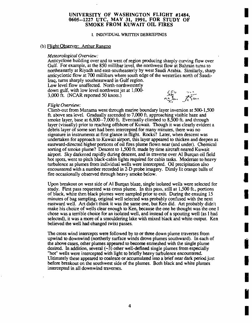
UNIVERSITY OF WASHINGTON FLIGHT #1484,0605-1227 UTC, MAY 31, 1991, FOR STUDY OF
SMOKE FROM KUWAIT OIL FIRES
I. INDIVIDUAL WRITTEN DEBRDEFINGS
(h) Flight Observer: Arthur Rangno
Meteorological Overview:Anticyclone building over and to west of region producing sharply curving flow overGulf. For example, at the 850 millibar level, the northwest flow at Bahrain turns tonortheasterly at Riyadh and east-southeasterly by west Saudi Arabia. Similarly, sharpanricyclonic flow at 700 millibars where south edge of the westerlies north of Saudi-Iraq, turns sharply southeastward in Gulf region.Low level flow unaffected. North-northwesterlydown gulf, with low level northwest jet at 1,000- /-^3,000 ft. (NCAR reported 50 knots.) ^ ^y^
s^Jia^ A Y6’’"f-IY
Flight Overview:Climb-out from Manama went through marine boundary layer inversion at 500-1,500ft. above sea level. Gradually ascended to 7,000 ft. approaching visible haze andsmoke layer, base at 6,800-7,000 ft. Eventually climbed to 8,500 ft. and throughlayer (visually) prior to reaching offshore of Kuwait. Though it was clearly evident adebris layer of some son had been intercepted for many minutes, there was nosignature in instruments at first glance in flight. Rocks? Later, when descent wasundertaken for approach to Kuwait airport, this layer appeared to thicken and deepen aseastward-directed higher portions of oil fires plume flown near (and under). Chemicalsorting of smoke plume? Descent to 1,500 ft made by rime aircraft neared Kuwaitairport. Sky darkened rapidly during descent, and in traverse over Al Burqan oil fieldhot spots, went to pitch black-cabin lights required for cabin tasks. Moderate to heavyturbulence as plumes from individual wells were intercepted. Oil precipitation alsoencountered with a number recorded in 2-D probe imagery. Dimly lit orange balls offire occasionally observed through heavy smoke below.
Upon breakout on west side of Al Burqan blaze, single isolated wells were selected forstudy. First pass requested was cross plume. In this pass, still at 1,500 ft, portionsof black, white then black plumes were sampled prior to exit. During the ensuing 15minutes of bag sampling, original well selected was probably confused with the nexteastward well. Art didn’t think it was the same one, but Ken did. Art probably didn’tmake his choice of wells clear enough to Ken, because the one he thought was the one Ichose was a terrible choice for an isolated well, and instead of a spouting well (as I hadselected), it was a more of a smouldering lake with mixed black and white output. Kenbelieved the well had changed twixt passes.
The cross wind intercepts were followed by to or three down plume traverses fromupwind to downwind (northerly surface winds drove plumes southward). In each ofthe above cases, other plumes appeared to become enmeshed with the single plumedesired. In addition, several (~3) other well-defined single plumes from especially"hot" wells were intercepted with light to briefly heavy turbulence encountered.Ultimately these appeared to coalesce or accumulated into a brief near dark period justbefore breakout on the southwest side of the plumes. Both black and white plumesintercepted in all downwind traverses.
4
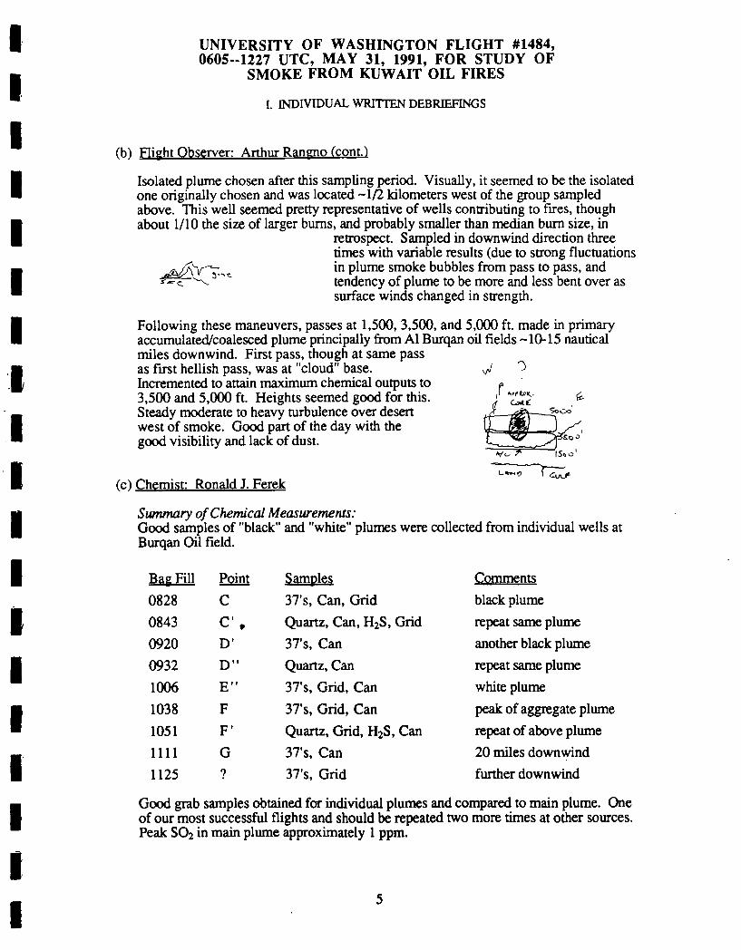
UNIVERSITY OF WASHINGTON FLIGHT #1484,0605-1227 UTC, MAY 31, 1991, FOR STUDY OF
SMOKE FROM KUWAIT OIL FIRES
I. INDIVIDUAL WRITTEN DEBRffiFTNGS
(b) Flight Observer: Arthur Rangno (cont.)
Isolated plume chosen after this sampling period. Visually, it seemed to be the isolatedone originally chosen and was located -1/2 kilometers west of the group sampledabove. This well seemed pretty representative of wells contributing to fires, thoughabout 1/10 the size of larger bums, and probably smaller than median bum size, in
retrospect. Sampled in downwind direction threetimes with variable results (due to strong fluctuations
.jjsJ^T^,^ ln plu"^ smoke bubbles from pass to pass, ands--^. ^-’’ tendency of plume to be more and less bent over as
surface winds changed in strength.
Following these maneuvers, passes at 1,500, 3,500, and 5,000 ft. made in primaryaccumulated/coalesced plume principally from Al Burqan oil fields -10-15 nauticalmiles downwind. First pass, though at same passas first hellish pass, was at "cloud" base. ^ ")
Incremented to attain maximum chemical outputs to3,500 and 5,000 ft. Heights seemed good for this.Steady moderate to heavy turbulence over desertwest of smoke. Good part of the day with thegood visibility and lack of dust.
Vt- 7~ IStO’
’-"’’ .vJ-(c) Chemist: Ronald J. Ferek
Swnmary of Chemical Measurements:Good samples of "black" and "white" plumes were collected from individual wells atBurqan Oil field.
Bag Fill Point Samples Comments
0828 C 37’s, Can, Grid black plume
repeat same plumeanother black plume
repeat same plumewhite plume
peak of aggregate plume
0843 C’ Quartz, Can, HzS, Grid
0920 D’ 37’s, Can
0932 D" Quartz, Can1006 E" 37’s, Grid. Can
1038 F 37’s, Grid, Can1051 F’ Quartz, Grid, HaS, Can repeat of above plume
1111 G 37’s, Can 20 miles downwind
1125 ? 37’s, Grid further downwind
Good grab samples obtained for individual plumes and compared to main plume. Oneof our most successful flights and should be repeated two more times at other sources.Peak SO; in main plume approximately 1 ppm.

UNIVERSITY OF WASHINGTON FLIGHT #1484,0605.-1227 UTC, MAY 31, 1991, FOR STUDY OF
SMOKE FROM KUWAIT OIL FIRES
I. INDIVIDUAL WRITTEN DEBRIEFINGS
Crn Optical Measurements: Ray E. Weiss
oec3W NephdometerA3Aethetometef
Optical Extinction Cell. bext, single scattering albedo 0 538 nmbop 0 445. 538, 665 nm wrth auto pressure and temp correctionAerosol Asymmetry Analyzer, non-spherical aeroool propertiesAerosol optical absorption, bap 0 525 nm using integrated platefitter method in neany real time.
General Obeorvatione:This was an excellent flight from the perspective of the OEC and A3. In contrast
to the measurements downwind, there was remarkable diversity to the opticalproperties of the individual fires. The appearance of the fires varied from very white tovery dark as did the albedo measurements, ranging from about 0.9 to 0.35. The darkersmoke contained aggregate chains while the white emissions did not. Theelecto-optical enhancement in the black smoke near the source, however, was smallerthan that observed further from the source.
OEC-Neph:Very good results, but sometimes it was difficult to know exactly which type of
smoke was being sampled. The single scattering albedo varied from about 0.35 to 0.9depending on white or dark smoke. These numbers will probably be adjusted aftercareful correction of the reference brightness.A3
Until this flight the results have been relatively constant when sampling in smoke.The individual sources, however, are quite different. The black smoke exhibited theusual scattering enhancement when subjected to an aligning electric field but themagnitude of enhancement was less and no minimum was observed when the polarityof the field was reversed. The white smoke displayed almost no enhancement thoughat times there may have been some contamination from other smoke. The responsefor the white smoke was similar to biomass combustion.
ABthuonrtBrThe aethelometer worked well. Very littie attenuation in the dust but a quite
rapid increase in the smoke indicating, as expected, the presence of black carbon.used several filters in the instrument as compared with other flights.
6

UNIVERSITY OF WASHINGTON FLIGHT #1484,0605-1227 UTC, MAY 31, 1991, FOR STUDY OF
SMOKE FROM KUWAIT OIL FIRES
I. INDIVIDUAL WRITTEN DEBRIEFINGS
fet Aerosol Scientist: J. David Nance
This fl ight was designed to measure emission factors bysampl ing close in to the source After leaving Bahrain, weflew to Dhahran for fuel ing From there, we flew NNW overthe western Gulf toward Kuwait Our peak cruising altitudefor the trip to Kuwait was at 8 000 ft The ai r at lowaltitudes seemed unusual ly clean with CNC2 readings between50 and 200 per cc Also, the visibi l ity was very good hereBetween 7 000 and 10 000 ft approximately, was a layer ofhaze that seemed to have some smoke in it CNC2 wasindicating concentrations of about 400 per cc at 8, 000 ftHowever, we did not pick up the plume unti l we were almostto Kuwait as the satell ite pictures had the plume moving SWover Saudi Arabia. Thus the origin of the smoke componentof the haze layer if there was one is uncertain It mayhave been old smoke from the plume that had been carriedback into the region, or it may have been urban pollutionI am disinclined to believe that there was no smokecomponent for several reasons 1 there seemed to be a darkgreyish hue to the haze unl ike the brownish tan hue of thedust 2 unless there was very significant shearing of thewind below 7 000 ft I see no reason why a layer of dustshould accumulate between 7 000 and 10 000 ft withoutextending al l the way to the surface; and 3 the volumedistributions were showing an accumulation mode As wemoved into denser smoke, it was the accumulation mode that
grew while the coarse mode seemed to stay more or less thesame
As we approached the coast of Kuwait, we descended to analtitude of 1 500 ft and flew in right over the burning oil
field I forget its name, but I believe it was the onefurther south) Visibility dropped to essential ly zerobefore we cleared the upwind edge of the field. From here,
we made several penetrations of the upwind edge of the oil
field and col lected and analysed several smoke samplesWe tried as much as possible to sample smoke that could be
traced to a single well A few of the wells emitted smokethat appeared very light-greyish almost white) in color andstood in stark contrast to the normal charcoal- grey orblack color of the smoke I believe we got at least two goodsamples of the white smoke and several samples of the darker
smoke There were also several samples taken in therelatively clean air upwind of the field.

UNIVERSITY OF WASHINGTON FLIGHT #1484,0605-.1227 UTC, MAY 31, 1991, FOR STUDY OF
SMOKE FROM KUWAIT OIL FIRES
I. INDIVIDUAL WRITTEN DEBRSFINGS
(e) Aerosol Scientist: J. David Nance (corn.’)
After about two and a half hours in the region upwind of theoi l field, we cl imbed to about 5 000 ft to col lect samplesof smoke directly above the oi l field The smoke here was amixture of smoke from several wel l fires Several sampleswere col lected before heading back to Bahrain Theinstruments seemed to perform generally well There was aproblem with the di lution pump for the ASASP however On acouple of occasions the pump suddenly weakened before
fai l ing altogether This problem seemed to be related tothe heat and some period of time would have to pass beforethe pump could be restarted. Also, I have been unable todetect any pattern behind the intermittent appearance anddisappearance of the nucleation mode Thus, I am unable todismiss the possibi lity that the absence of a nucleationmode in some of the measurements is the result of a failureon the part of the Electrical Aerosol Analyzer
(f) CCN Summary: Donald Spureeon
The CCN worked for about 1/4 of the flight and showed CCN of -500 at 0.38supersaturadon. After the 1/4 mark the aircraft became so warm that the CCNrefrigeration unit could no longer cool the plate adequately to keep the CCNfunctioning. The dilution on the CCN was 30:1.

H. VOICE TRANSCRIPTIONS OF AIRBORNE TAPE RECORDING FROM UW FLIGHT1484 ON MAY 31, 1991
6:24 AM
KM: Unintelligible.
6:38 AM
PVH: OK, we’re just setting out on Flight 1484 to go up towards Kuwait and do someemission factor studies. Had a long delay in Dhahran. The Flight 1483a was ourtransit flight from Bahrain to Dhahran. No data was collected. At the momentwe’re having trouble getting my computer displays up and Hap’s working on that.
6:39 AM
PVH: Hap tells me we’re not recording on the tape. We will be recording periodically onthe printer and we do have our displays, so he’s trying to fix it, but we’ll carry onanyway and we’ll do what we can.
6:46 AM
PVH: Hap thinks the data recorder’s OK now.
6:49 AM
PVH: Bases 6500 feet just coming into the smoke layer based on Art’s visualobservations. I see the S02 picking up now on the very sensitive scale of point 5.CN seems steady.
6:50 AM
PVH: We are on our trip to Seleg and onto Kuwait. We’ve been going about 7000 feet,maybe in the base of the smoke. We’re going to try rising up a little bit and see ifwe pick up a bit more smoke.
6:59 AM
PVH: No radiometer measurements on this flight. That is no King or Valero probe, justtheir up and downward pointing.
7:00 AM
Unintelligible.
7:07 AM
PVH: I don’t think we’re hitting any smoke on the transit up to Kuwait. On the S02, onthe chart record, on the sensitive scale of 500 millivolts, full scale, we’re sdll notgetting a great deal. Only the CN is fairly rock steady.
We probably went into some haze, though, as we climb from 7 to 8000, but notsmoke. The S02 is starting to rise a little bit on this sensitive scale.

7:12 AM
Unintelligible.
7:18 AM
Unintelligible.
PVH: Still coming in very blurred to me.
RJF: Unintelligible.
PVH: I can’t hear you.
RJF: Are your switches in the right place?
PVH: That sounded better then. Yeah, the switches are fine.
Ken, have you had any updates on the plume position from the ATC?
KM: No, not at all.
7:35 AM
PVH: Art has some doubt about whether the wind direction is correct. They’re indicatingwinds out of the west, but we think they may be more from the north.
7:42 AM
PVH: I see the water below us which is calm, no whitecaps and the sun above us is just ahaze, very thin, no smoke at this point. Time 0745, altitude decreasing, 5300,decreasing down to 5000.
7:45 AM
PVH: Unintelligible.
KM: They’re clearing us down to 2000 feet.
PVH: Good.
7:47 AM
KM: We’re just a little bit (east?), headed west, looking for (fields?).
7:50 AM
KM: Obviously, we ended up slightly downwind of where we’d want to be. We’llswing to the north here and see if we can pick up one of the wells.
7:55 AM
PVH: Was that a big one we went through then. Ken, or what?
2

KM: It was big! I was never able to see the size of the smoke.
PVH: Everything went off scale for me. I’ve got to get calibrated here.
7:56 AM
KM: We’ve got some fires right about 1:00 this time as we come around.
PVH: We’re not ready yet. Ken. Can you just circle around a bit so we can getorganized.
KM: Let us know when you’re ready back there. Apparently Art’s got one picked outhere about 2 o’clock.
7:58 AM
PVH: Ken, just give us, just circle around and give us time to take a few photographs andget settled in. In the meantime, you might pick a smaller plume to take a look at.
7:59 AM
RJF: Is Hap back there anywhere?
Tell Hap the computer died.
PVH: OK, we’ll wait until the computer comes back.
SWAM
PVH: I still haven’t got my computer plots, Ron, that’s what I’m waiting for.
RJF: ...get it going here.
8:07 AM
PVH: Try it now.
8:08 AM
PVH: OK, Ken, why don’t you head for that plume and give us a countdown as weapproach it. Just a look see as we go through it.
PVH: Confusion for awhile. We broke out of very heavy smoke that made the wholecabin black and then we broke out into the desert. We had a wonderful view of allthe fires.
8:09 AM
PVH: So then we got set up to go through an isolated plume when our computer wentout. So it took a few minutes to bring that back up. We’re now going to take alook at the first isolated plume.
KM: OK, now about a minute out of it.

8:10 AM
KM: We’ve got a white one just on the other side of it.
PVH: Come into a black one first, then we go to a white one. Just take a look see.
8:11 AM
KM: Wasn’t much for that one, but you got another little dark one we’ll go through panof and then the white one. And what do you want after the white one? Make a leftturn upwind to clear the field again?
PVH: Yeah, sounds pretty good, we got the signal, it’s reasonably strong.
KM: OK, we’re about less than a minute away from a white one ahead of us here.
8:12 AM
KM: Black stuff here.
8:13 AM
KM: About 20 seconds from a white one. Ten seconds to a white one. Five. We’rethrough the white and we’re starting a circle to the left.
PVH: S02 working all right?
RJF: Sure is. It’s on the highest range.
8:14 AM
PVH: OK. I didn’t pick out anything on my SOz. Change the range.
OK, Ron, let’s call the black plume Plume Number 1 and the white plume I’mgoing to call Number 2. It’s a pretty sharp signal there. I think we’ll ask Ken tocount down as he goes in it and you’re on your own.
RJF: We want to leave run parallel to the plume axis instead ofjust going downwind.
PVH: OK, that may be better.
KM: How do you want it now?
PVH: Stand by a moment. Ken. Art’s talking to me.
RJF: Ken, I think we want to run along with the plume axis parallel with the wind speedand just catch it lengthwise.
KM: You want in effect to go to the fire running downwind?
RJF: Or else try to then right beyond the fire and try to go downwind with it. We’ll be init longer that way.
KM: Which one do you want?
4

PVH: Ken, let’s take Number 1. That’s the first one we went through. I’m going to callthat Number 1 and let’s go down the axis of it for awhile and we’ll get ourmeasurement that way.
8:16AM
KM: We’re about 15 seconds off the plume now.
OK, another 10 seconds going downwind.
8:17 AM
KM: Out.
We’re about to get some more here.
PVH: Ken, we’re still getting it in small globs.
RJF: I took a bag sample there, Peter, and I’m measuring out of the bag now and it’s notmuch.
8:18 AM
KM: You may want me to break out to the west, again.
8:19 AM
PVH: You can break out now.
PVH: We’re getting a much bigger signal now, it’s really going up. Best marking isPoint B-10
Ron, we’ll take a sample when you’re ready, in about 10 minutes or so at Point B.
RJF: I’m ready now.
PVH: OK, Ken would you return to Point B.
KM: Do you want to run down Point B from A again, or just straight to it on a cross cut?
PVH: Just go to upwind a little bit and then go downwind to Point B, downwind.
KM: OK.
8:21 AM
PVH: Give us some warning so that we know when we’re creeping up on it.
KM: Say again?
PVH: Give us some warning so that we know when we’re creeping up on it.
KM: OK, it will be about another four or five minutes; four minutes I would guess.

PVH: Did you scrap that last bag, Ron?
RJF: No/yes?
PVH: OK.
8:22 AM
PVH: (Unintelligible)
KM: About two minutes.
8:24 AM
KM: About another minute.
PVH: OK, let’s ....plume...and then going to fly downwind.
8:25 AM
KM: This one we went down before is all laid down here, now.
8:26 AM
KM: Standby. Mark!
8:26 AM
KM: Two minutes to Point Bravo.
8:27 AM
KM: One minute to Bravo.
8:28 AM
PVH: Hold it a minute...(Ron?).. falling off again at the moment.
PVH: OK, sample!
PVH: We can pull out again. Ken.
RJF: I need you back here for a quick check in the cockpit.
Anon: Do you want the (vacuum?) on or off?
Anon: Off.
8:29 AM
PVH: I think we pulled that nicely. And I’m calling that Sample C. That’s Plume One,Sample C.
6

8:30 AM
RJF: I don’t think that was one individual plume.
PVH: Yeah, that was one plume, but we’re flying down the....
RJF: Peter, there was no way that was one plume. Not when the bag was open fortwenty seconds.
PVH: There’s only one plume there, Ron, it’s got a lot of structure to it.
PVH: Do you want to do that again, Point C, or do you want to go to another plume?
8:31 AM
KM: We’ve got one over at 10 o’clock that Art’s picked out, and let me know whenyou’re ready; if we went directly now it would be about three minutes or so.
PVH: No, we’re not ready yet. Ken. It takes about ten minutes between samples, here.Tool around and enjoy the view.
8:32 AM
PVH: Ron, do you want to hit Point C again, or head for another plume?
RJF: Point C again is fine with me.
PVH: Now you were right, when consulting with An he said that there had been someinterference from another plume. But we hit something at C and if you want tolook at it again, we’ll do it, or we can go for something that is more isolated.
RJF: No, let’s go back to C in about six minutes.
PVH: OK, did you read that, Ken....
RJF: I take that back, make that about...yeah, six minutes.
PVH: Ken, OK for Point C. Let’s say in about seven or eight minutes.
KM: OK!
8:33 AM
PVH: Ron, when we go through a plume again, well give it a dash. So the next samplewill be called "C dash".
8:34 AM
KM: We’re about 10 minutes to........will you be ready then?
PVH: Yes, we will.
8:38 AM

KM: It’s about a minute out.
8:40 AM
KM: Thirty seconds.
PVH: OK, Ken, we want that Point C again.
KM: OK, we’re going to go from A to Bravo, which is where you took sample Charlie.
PVH: Give me a count down to Point C.
KM: OK.
PVH: But Ron, you go on my (?)
8:41 AM
KM: Two minutes to Bravo.
KM: One minute.
8:42 AM
PVH: Sample!
8:43 AM
KM: Charlie.
KM: The only one we can cut off to the west.
PVH: Cut off now.
PVH: Ron, do you want to do that point again, or should we do more isolated plumes?
8:46 AM
RJF: I’ve got the full set for that plume, so if you want to try to figure out somethingelse. I’m going to need about twenty minutes to pull on these filters.
PVH: OK, how much more flight time do we have. Ken, in this area?
KM: About two and a half hours.
PVH: The next one will be one of the nice isolated plumes, which I think Art has alreadypicked out for us. We’ll do the same thing; we’ll hit it once, and then circle aroundto give Ron time, seven minutes or so, and then we’ll hit it again.
PVH: I’m going to call that one D. The one coming up will be Point D. For Dog.
8:47 AM

PVH: We’re getting a series of measurements of isolated plumes. The first chemicalsample was taken, which is sample C, was taken eight twenty nine, in a blackishplume. There may have been more than one plume there. We then repeated Cagain, a point called "C dash". We went through that at 0843, and that was thesecond chemical sample. We’re now going for another more definitely isolatedplume.
8:52 AM
PVH: Hap, can you read me back there? Can you read me, Hap?
PVH: How many more minutes, Ron?
RJF: About eight.
PVH: Ron, let’s first discuss the big black plume and how we’re going to handle that.
RJF: What’s that you need?
PVH: The big black plume. It’s probably going to be difficult to relocate the points inthere.
8:57 AM
PVH: Ron, do you read me?
RJF: Yeah.
PVH: How do you think we’re going to handle the big black plume?
RJF: Which big black one are you talking about?
PVH: I’m talking about the one when we first came in, when we lost all our light in here,very black and dark. That’s the big (supply?) plume.
RJF: You want to go in there?
PVH: Yes, eventually, that’s the composite from the Burgan Field, I assume.
RJF: Well, it doesn’t seem like we can do it, Peter. I don’t know what the question is.
PVH: The question is, how do we sample it? I suggest we just go in and take a sample inthere, tell Ken and Rod to position, and then we go back through it.
RJF: Sounds good to me.
PVH: We’re not going to do that now. Next we’re going to pick out a real isolated plumeand hit that one when you’re ready.
8:59 AM
KM: OK, say when you’re ready!
PVH: We’re not ready yet.
9

9:04 AM
RS: OK, Peter, I’ve got a headset on, now.
RS: Peter, do you copy?
PVH: Yes, I do.
PVH: The big, black plume we came in at the beginning, when all the cabin went dark, Iassume that’s the ensemble of the Burgan plume, do you agree?
RS: That’s affirmative, Peter. Probably the combination of the whole area, there is twohot spots within there, we were either on one or the other one, but generally, that’sright, the whole thing.
PVH: How far downwind were we when we went through it?
RS: I would say we were right over it, it was certainly less than five miles. I would saywe were right in the source, that’s the best I could come up with, because there aremany, many sources adding together.
PVH: Well, so we’re going to sample that. I think we may do better to back off a littlebit, to maybe 10 miles, so we can get a little more uniform, because we can only getone chemical sample in it.
RS: It was fairly narrow, although it was extremely intense, that’s right.
Were we going to do the isolated well?
PVH: Oh yes, we’re going to do that next, I’m just looking ahead.
RJF: Ready for the next one.
PVH: OK, Ken, we’re ready for the next one, which I’m going to call Point D. Give us aten count down. Let’s go along the axis, again, so go into it and then turndownwind. And we’ll get our Point D somewhere in there.
KM: OK. We already have one Point D. Do you want us to erase that and make anotherPoint D.
PVH: No, sorry. The last point we’re calling "C dash" because it was the same as C.
9:06 AM
PVH: This next one will be the one and only Point D.
9:07 AM
PVH: Ron, as we go along the axis of the plume, we’ll pick a point and get your firstchemical sample there, then we’ll come out and do it again.
RJF: OK, Peter.
9:08 AM
10
KM: We’re about one minute out from the beginning of the plume.
KM: Thirty seconds.
KM: Fifteen seconds.
9:09 AM
KM: We’ll be over the fire, and the smoke, in about five seconds.
KM: (Unintelligible)
PVH: Arc we going along the axis?
KM: Sort of, but it’s just kind of petering out.
PVH: No, we didn’t see very much.
9:10 AM
PVH: Let’s just keep going for a little while, try to keep going down, and see if we getanything else.
PVH: Ron, I think it’s not worth worrying about; I didn’t get any reading on the Nephpointing-Oh yes, I got a little reading on the Neph pointing but it can’t be pickedup on my large....(scale, probably)
PVH: Can you set the S02 on a more sensitive scale, Ron?
9:11 AM
KM: I think that’s about the end of it. It looks like up here we’re starting to get smokefrom fires that arc to the east.
9:12 AM
PVH: Ron, do you want to do that one again, or not?
RJF: I didn’t see much in it
PVH: I didn’t; I don’t think it’s worthwhile.
9:13 AM
(Unintelligible)
PVH: Ron, although that was small, I think it is well representative of the single plume,so I think we should go through and see if we can’t get one chemical sample there.
RJF: OK.
PVH: So Ken, we’re ready to go back into that plume. Give us a careful markdown,because it’s so small that Ron has got to get his sample within a minute or so. Youmay be able to call it as well as I can.
11
PVH: Ken, try to pick out the biggest pan and turn downwind into it, and we’ll try tograb a sample.
9:17 AM
KM: We’re about two and a half minutes out of it, I would guess.
9:18 AM
KM: About a minute.
9:19 AM
KM: Thirty seconds.
KM: Fifteen. Ten. ....Mark.
9:20 AM
PVH: Sample!
RJF: That wasn’t too bad. What arc we going to call that?
PVH: I’m going to call that "D dash".
Let’s turn out of it. Ken.
9:21 AM
PVH: Ken, I want to do that one more dme, so we can get the full chemistry of oneplume; but it will be a while, yet.
PVH: OK, Ron, so we’ll do that one more dme so that you can get your full chemistry onit, or do you need more than one more to get it?
RJF: One more is plenty.
PVH: OK, then we’ll tackle the biggie!
9:24 AM
PVH: Ken, in about ten minutes or so we’ll be repeating that and that same point, myPoint D, my Point "D dash", and it will be "D double dash", for the next teniterations (?). After that, we’re going to tackle the big plume again, the one wewent through on the way here, the black one. I think we were about five milesdownwind of the source, let’s try it about 10 miles downwind, if you can getclearance for that.
9:26 AM
KM: Yeah, I don’t think it should be a problem.
PVH: We don’t seem to be disturbing anyone, out here.
12

RJF: OK, I’m ready when you are, Peter.
9:30 AM
PVH: OK, Ken, let’s do our "D"-"D dash"-"D double dash" again. Give us a countdownas before.
KM: It’s about one minute.
9:31 AM
KM: About thirty five seconds, Peter.
KM: Fifteen seconds.
9:32 AM
KM: Ten. Standby.......Mark!
PVH: Sample!
PVH: Ron, I’m just beginning to learn how to do this. I’ve got to get each as it starts toclimb, rather than when it reaches its peak. Do you want to try that one again, ornot?
RJF: I think we did fine on that.
PVH: OK, I think probably you just missed the peak, but you should have got something.Ray wants to do a white plume again, so we’ll pick one isolated white plume beforewe go to the big black one.
9:34 AM
PVH: Ken, will you tell Rod to come down here?
PVH: OK, when are you going to be ready, Ron?
9:39 AM
RJF: Did you call me?
PVH: Yes, how long before you’re ready?
RJF: About fourteen minutes.
PVH: OK, we’ll take a nap.
9:40 AM
PVH: OK, Ken, instead ofjust waiting for Ron, let’s go into that white plume and getsome idea of what it looks like.
9:41 AM
13

PVH: Give us a two minute and then a one minute.
KM: About two minutes.
9:42 AM
PVH: Could you yell out mark point, here when we go in o it.
KM: About a minute.
KM: Thirty seconds.
9:43 AM
KM: Fifteen seconds. Ten seconds. Ready, standby. Mark.
KM: Some more, here.
9:44 AM
PVH: OK, that first point you marked, call that E. You can go out of it, now. Ken.
9:45 AM
PVH: We’re into some thick stuff, here. That was a bit more than I expected. Ken.
9:47 AM
PVH: It looks as if we had about four plumes, there. Ron, that was about as much as Iwant to go into. Do you want to try that one again, for chemistry?
RJF: There used to be, from what I can see on the screen, that we hit two white plumesin a row, and if we try that again, to turn out of it sooner would be better.
PVH: OK, so you do want to try that again, do you?
RJF: Sure, we ought to try to get one of these white ones. That was two white ones in arow, from what I could see.
PVH: Looks like three, actually.
RJF: What are you looking at?
PVH: Fm looking at my Neph-20 on the chart recorder. Three, and then followed by ablack one.
RJF: The third one was the big black one, and if we had turned out after the second whiteone we would have made it.....
9:49 AM
RJF: What I’ll do is when we hit the white one, I’ll tell you as soon as the bag is full andthen we can mm right out of it
14

PVH: OK, good idea. I didn’t like that ride very much.
RJF: Yeah, that was all unnecessary.
PVH: Yes, but it’s given us a view of what we’re up against, so we have to do it.
9:49 AM
PVH: Are you ready to go, Ron?
9:50 AM
PVH: Ken, so we’re going to do that again, when Ron is ready. Mark that point E thatyou marked for me, give me a little warning when we’re coming up to that andwe’ll try to get a sample then and when I say "turn out" you can turn out. We don’thave to go right through that heavy stuff again.
KM: OK, how long before you’re ready, Ron?
9:51 AM
PVH: I don’t think he’s got his headset on. Ron is sdll doing his slides and things. Heshould be about one or two minutes.
9:54 AM
PVH: Can you sdll see out of that windscreen. Ken?
KM: Well, I can see a litde bit up here. Not too bad.
9:55 AM
KM: How long dll we’re ready?
PVH: He’s not ready yet.
9:56 AM
RJF: We’re about ready to get that white one.
PVH: OK, Ken, so do the same as you did before. Give me a countdown to point E, and111 tell you when you can turn out of it.
9:57 AM
KM: About two minutes out
9:58 AM
KM: A minute and a half.
KM: A minute.
15

9:59 AM
KM: Twenty seconds.
KM: Fifteen seconds.
PVH: Sample! (At same dme as Ken said "Fifteen seconds")
PVH: No, abort that one!
KM: Ten seconds.
PVH: Abort that one.
KM: OK, you’ve got to abort.
PVH: Sample!
RJF: You said...
10:00 AM
PVH: OK, you can turn out now.
RJF: That wasn’t that great Do you want me to collect these filters, or try again?
PVH: Did you get the second one?
RJF: Yeah, but not very much.
PVH: OK, we’ll try it again.
RJF: Peter, you’ve got to be a little more decisive when you’re trying to decide whetheror not to sample. I suggest you stick your head out the dome and watch when theplane actually hits the white smoke.
PVH: That’s not my best indicator. The Neph-20 is, and I’ve just got to get it as it startsup. It just gave a little start and
RJF: I think you’re wrong. I think your visual look at it is the best way to see when youget in the smoke.
PVH: OK, ril try it that way and we’ll see if it’s any better.
RJF: The first time around Ken just gave it visually from the cockpit and that wasperfect.
PVH: Alright, we’ll try it.
KM: How long before you’re ready?
PVH: We’re ready now. Give us a countdown.
KM: OK, it will be about three or four minutes, then.
16

10:02 AM
PVH: OK, Ken, we’re going to try it with you giving the countdown, now, becausethere’s a little delay before my instrument responds.
RJF: Hey Ken, what worked best for me was when you just said "We’re in it" becauseyou see from the cock pit when you hit the white stuff.
AR: Ken, do you copy?
KM: Yes, loud and clear. Did you say something?
AR: Yeah, Td like to get a better picture of this white plume than I’ve been able to get.Can you angle this one so I can get a shot out the starboard side, here, as we comeup on it and then turn into it?
KM: OK, that’s what I thought I did last time.
AR: I couldn’t quite get it. We were a little too much aimed right at it, and there was toomuch wing in the way. Over?
PVH: Ron, we’ll call that last record "E dash" and the next one, the third trial, will be "Edouble dash".
10:04 AM
PVH: When we’re at the same point, we’re going to call it the same letter, so this is allPoint E, and we’ll just give them dashes for each attempt we make.
RJF: Why don’t you just call it E plus #1 or #2 or #3?
PVH: Well, I’m not going to change my system now.
RJF: Well I think the dashes get confusing.
KM: Two minutes out.
10:05 AM
KM: A minute out. Thirty seconds. Fifteen seconds.
10:06 AM
KM: Another fifteen seconds.
KM: Standby. Mark!
KM: And we’re out of it and coming up on another
RJF: Well that was a little better.
PVH: Did you take the first one, Ron, or the second one?
17

RJF: Both.
PVH: OK, we got the aerosol sample as well on the first one.
10:07 AM
PVH: OK, Ken, then let’s head back to the big black one that we first came throughbecause it gave us a bit of a shock. Instead of going about five miles down, let’sgo ten or fifteen miles down and go through its width.
10:08 AM
KM: We’re about five or ten miles from our turn-in point.
RJF: Let’s delay before you turn in, for about three minutes.
10:13 AM
KM: Say when you’re ready.
10:15 AM
RJF: About three, two more minutes.
10:16 AM
RJF: OK, we’re ready here.
10:17 AM
KM: OK, we’re heading to probably come to the edge of it in another minute and a half.
10:19 AM
PVH: We’re going to go across the big one, further downwind than before. It may getdark again. Ron, I think you should take a sample in here. It should be prettybroad, so well try to get into it before we do a sample.
RJF: OK.
10:20 AM
PVH: Give us waming,Ken, when we’re going to go in.
KM: OK. We’re sdU going along the edge here.
10:21 AM
KM: A little darker. We might be a little low. Looks like I could see a lime more lightup ahead, here; maybe we’re not going to get the worst of it
PVH: Alright, let’s keep going until we clear it, and then we’ll go up a little higher, andthen come back along the same path.
18

10:23 AM
PVH: Yes, that’s the base of it. Let’s go up into the middle of it on the 180 degree.
KM: Say again?
PVH: Let’s do one hundred and eight degrees when we get out of it on the other side andthen we’ll go up through the middle of it.
KM: OK. How far up? A thousand feet?
PVH: Yeah, that’s a good guess.
10:24 AM\
PVH: What’s our distance downwind of the source?
RS: Twenty four miles.
10:27 AM
KM: We begin our climb here.
PVH: .Ron, we’ve only got about forty-five more minutes left. Maybe three or fourpasses, we’ll try to pick the middle of the plume, and repeat the same point onconsecutive passes. OK?
RJF: Sounds good. I’ll do the ten minute check first and then the twenty minute (?) onthe pass back.
10:30 AM
PVH: We’re going to keep climbing undl we think we’re in the middle of it. We’ll thentry to climb outside of it
10:31 AM
PVH: Well, we sampled a number of individual plumes, some black ones and some whiteones, and got chemistry on them. We’re now headed twenty five miles downwindof the source, the Burgan source, where all these plumes join together, and we’regoing to go through the big plume and do some full chemistry. God willing.
10:33 AM
PVH: OK, we’re going to start to go across now, and the......(muffled out)
10:34 AM
PVH: Some heavy smoke coming up ahead.
10:38 AM
PVH: -OK, let’s take our sample now. Now! Mark the point if you can.
19

RJF: I think we need to go back in.
KM: OK.
PVH: Did you say you’re ready, Ron?
RJF: Yeah.
PVH: OK, Ken so let’s do a one-eighty and go back, at the same altitude, and give us awarning when we’re approaching our mark, mark F Point.
10:48 AM
KM: ....now at the turning edge point.
PVH: Say that again.
KM: (Unintelligible. Something about turning.)
PVH: OK, we’re going to be going back in the reverse direction, right?
KM: Yep, we’re on that heading right now. We’re about three minutes from the samplepoint.
PVH: OK.
10:50 AM
RS: One minute to F.
10:52 AM
RS: Thirty seconds to F.
RS: Ten seconds to F.
RS: And there’s F.
PVH: Sample!
10:53 AM
RJF: That was a good one.
10:54 AM
KM: We’re on the return point.
10:58 AM
RJF: Hey, Peter?
PVH: Yep?
20

RJF: How much dme we got left?
PVH: Two more passes.
RTF: What do you think you want to do?
PVH: Have you done all you want to do on Point F?
Was that yes?
RJF: Yes.
PVH: OK, remembering our diagram, why don’t we go back along the same line and pickout not the maximum, but some point of the max.
RJF: Well, let’s see. Looking at the Neph, there, it looks like Gaussian distribution. Doyou want to go about halfway in? I think it may be better to try a thousand feethigher.
PVH: Yes. Let’s do two more levels, a bit higher up.
RJF: OK.
11:00 AM
PVH: OK, Ken, we’re going to go up 1500 feet and do two more passes, and then headfor home.
KM: OK. It’s going to be halfway close, but you want to go at what altitude?
PVH: Five thousand?
KM: OK. Do you want to go up now? You ready?
PVH: Yep. Right now.
RJF: I don’t want to be back in then center of the plume for about another fourteenminutes, yet.
KM: I’m afraid that’s going to cut us too close.
PVH: OK, then we’ll do one sample then, one pass.
RJF: These current ones sdll won’t be finished for fourteen minutes.
KM: How about we just go halfway on this next one?
RJF: Right About five thousand feet above F in thirteen minutes.
11:01 AM
KM: Now, are you going to be ready in seven minutes?
RJF: I’d like about nine.
21

11:04 AM
KM: Are you going to be ready in six minutes, Ron?
11:06 AM
PVH: He’s not on the headset, but I think it’ll be about six minutes.
KM: OK, I’ll start in, then.
KM: About five minutes to the last sample point.
11:07 AM
KM: Hey Ron, are you going to be ready in about four minutes?
PVH: Ready in about four minutes?
RJF: Actually, about five, but I can be ready in four if I have to be.
PVH: OK, we’re running a bit short of fuel.
RJF: Tell, me when we’re a minute away.
11:09 AM
KM: Two minutes out.
KM: One minute out
11:10AM
KM: Mark.
PVH: OK, sample!
11:11 AM
PVH: Did you get that, Ron?
KM: Can we head for home, now?
RJF: Yeah, got it
11:12 AM
PVH: What was the distance downwind. Ken?
KM: We were fifteen from that point that we crossed on the way in. Twenty miles fromthe white plume that we were working up there.
11:13 AM
22

PVH: I’m calling that last sample Point G, Ron. G.
H:18AM
PVH: Ron, we’ll head home down the plume, maybe you can get some samples on theway back. Do you have any left?
RJF: Sure do.
PVH: OK. So Ken, can we head home down the axis of the plume?
KM: Well, .....it will be pretty hard to find a plume axis.
PVH: OK, we’ll leave you to do the best you can, and we’ll take what we can get.
11:20 AM
PVH: Ken?
KM: Yeah?
PVH: Better watch out for the Electra on the way home, they were doing cross-secdons atSeleg.
KM: Oh, OK!
11:28 AM
PVH: We got very good chemical samples and aerosol for the emission factorcalculations. About twenty odd miles down from the source we got a couple ofsamples at 3500 and one at 5000. I think we pretty much hit the nail on the headwith those samples. We’re now heading back home, probably five thousand feetNot picking up much at the moment Signal is falling off, we’re probably not in thesmoke, although we’re trying to head down the axis. That’s just pilot’s judgement,since we’re running short of fuel, and are heading home. Very good flight, shouldbe excellent for source characterization of the emission factors, both for single oilwell fires, black plumes, white plumes, and then the composite plumes from theBurgan oil field. We met the monster face to face, and we’ve taken his measure.
11:31 AM
23

UNIVERSITY OF WASHINGTON FLIGHT #1484,0605--1227 UTC, MAY 31, 1991, FOR STUDY OF
SMOKE FROM KUWAIT OIL FIRES
ID. POSTFLIGHT DEBRIEFING
The fight was successful and full chemistry and aerosol samples were obtained in boththe white and dark plumes from the Al Burqan oil fires and composite Al Burqanplume.When sampling in individual plumes, Ken’s calls for sampling worked better thanwatching strip chart signals.Final samples passes were done at ~15 miles downwind from initial sample passes.Started at 1,500 ft. and then moved up to 3,000 ft. and got three samples at thataltitude. Final sample pass was done at 5,000 ft.All in all, sampling worked well and we should get a good chemical speciation fromtoday’s flight. (Emission factors)

1 0 JUNE 2, 199 1 FLIGHT

UNIVERSITY OF WASHINGTON FLIGHT #1485,0353--0927 UTC, JUNE 2, 1991, FOR STUDY OF
SMOKE FROM KUWAIT OIL FIRES
I. INDIVIDUAL WRITTEN DEBREFINGS
(a) Flight Scientist: Arthur Rangno (from Flight Scientists Manual)
Summary of Surface Meteorology and Visual Observations at Take Off:Pre-shamal "surge" day, light north-northwesterly flow at surface and aloft locally,veering to west-northwesterly in the north Gulf. Good visibility (>7 nautical miles) atsurface with no sign of smoke aloft at take-off in Bahrain or Dhaharan.
Experimental Observations:First experiment of the day dedicated to radiation measurements, requiring climb toabove haze layer top. Haze top elevated this day to 16,000 ft., so climb out consumedmuch fuel and time.Plume below extremely difficult to see due to great depth of haze layer. Lidarattenuated as well, so of little use. Nevertheless, some stratocumulus-like black topscould be seen south of Kuwait, west of Seleg, and those overflown as presumedcenterline.However, when doing radiation cross-section, no west or east boundaries of plumeevident (visually) over -80 nautical mile stretch bounded by 47’E and 49E, a distancefar greater than model (Livermore) output had indicated plume would be (near 28.3Nlatitude). Consultations with radiation folks brought experiment to end after 1/2 leg offull leg over the long expanse noted above.Performed "Mike King Circle" at 47’E, west edge as per request, at 16,000 ft., butclearly over smoke below, ground barely visible.
First guess at smoke top 9,000 ft., followedConvair Smoke by descent to 8,000 ft. shortly after turning
eastbound on first leg of cross-section.
^^ __r^_ ^^t^. c^iAi. Tops nipped at 8,000 ft. but intercepted:--" ~^-> smoke region very broad. Black
stratocumulus tops below several pointsunderneath, i.e., south of Al Burqan, andon coastline. Return trip at 8,000 ft. sampledbulges in top that were >1,000 ft. above
Smoke Convair flight level with strong chemical signal.
-^ac
Amazing change!Since obtained two bag samples-different locations-different plumes-in two runs
due to excessive width-no clear edges visible below 8,000 ft.Descent at west end revealed how bad this flight was going to end up. Descended
into smoke and strong chemical signal at supposed west end beginning -7,500 ft. andthis situation continued to designated middle-center of plume height guesstimated at5,500 ft. Could only perform 1 1/2 legs this level due to a) huge climb to 16,000 ft.,b) excessive width of radiation overflights and the 8,000 ft top and near-top legs. Noedges encountered at 5,500 ft. and many apparent plumes leaving total confusion.

UNIVERSITY OF WASHINGTON FLIGHT #1485,0353-0927 UTC, JUNE 2, 1991, FOR STUDY OF
SMOKE FROM KUWAIT OIL FIRES
I. INDIVIDUAL WRITTEN DEBREFINGS
(h) Flijjht Observer: Arthur Ranpno
Weather Background:Shallow north-northwesterly flow topped by light, variable winds between -4,000 and8,000 ft., with westerly flow above this layer. Small sub-synoptic scale vortexapparent in smoke circulation and at 850 millibars in north Gulf region. "Blow-back"smoke from previous days amalgamated with new plume material in north Gulf region.
Only "satisfactory" portion of this flight (according to radiation scientists) was in theclimb to 16,000 ft. and the overflight of plume toward source above apparentcenterline-deduced visually from barely discemable stratocumulus-like black topsbelow, followed by overflight believed (based on Livermore model output) to beperpendicular to flow at a point -30 nautical miles downwind from Al Burqan fires.These legs revealed a problem that compromised the cross-section passes later! Nowest or east edge could be visually determined between 47’E and 49E longitude.(at-28.3’N latitude) though broad, ground obstructing core visible in blackstratocumulus-like tops. "Mike King Circle" performed at 16,000 ft. near west end.
First pass in upper portion of plume guessdmated at 9,000 ft, but quickly lowered to8,000 ft. when initial minutes at 9,000 ft appeared too high. Even then, the first 8,000ft. pass appeared to only nip a broad top extending south-southwest to southeast ofAlBurqan field. The second pass westbound, at 8,000 ft. found quite different scene.Bulges in smoke tops, perhaps 1,000 ft. higher were intercepted with strong chemicalsignals. Good example of transient nature of plume at same place. First pass musthave been "saddle" region between cumulifonn-like turrets.
Descent from 8,000 ft. to mid-plume pass height of 5,500 ft. at west end (no west edgevisually apparent here, but visual thinning had occurred) resulted in strong chemicalsignals below -7,500 ft. continuing to 5,500 ft. Insufficient time to further pursuewest edge, so went eastbound ~49E longitude, hitting plumes intermittently the wholeway. Thus, no east edge apparent either, and with research time running out, bustnature of cross-section phase of flight all too apparent. Worst of all, variable winddirections displayed by computer and limited flight area (no Kuwait airspace available)left no alternative but to reverse course (to westbound), go to south ofAl Burqan, andturn home. Exited plume before a "downstream" bag sample could be taken, so"evolution" part not executed either. Doubtful trajectories of plume anyway.
2

UNIVERSITY OF WASHINGTON FLIGHT #1485,0353-.0927 UTC, JUNE 2, 1991, FOR STUDY OF
SMOKE FROM KUWAIT OIL FIRES
I. INDIVIDUAL WRITTEN DEBREFINGS
(b) Flight Observer: Arthur Rangno fcont.)
^7 . ’^ooo
<?s
(c) Chemist: Krista Laursen
The initial portion of this flight was dedicated to radiation measurement. However, thetime during which radiation data were being collected provided a good opportunity toperform zero checks on the CO, CO; and SO; instruments. The CO and CO;instruments were also spanned during this time period. Both the zero settings andspans for all three instruments looked good during the course of the flight, and all ofthe chemical instruments appeared to perform well.
The meteorological conditions (i.e.,, the vertical wind profile) on 6/2/91 rendered itimpossible to perform a cross-section study of the plume. Therefore, the decision wasmade to attempt to sample at two "hot spots" on each of two legs through the plume.The first sample on each leg was processed through two 37 mm (Teflon) filters. Thesecond sample was processed through a quartz filter (for collecting organic species) anda Ras can. A total of four 37-mm filters, two quartz filters and two Ras cans wereexposed during the two legs through the plume.
The first sample pass occurred at 8,000 ft. At the second sample point at this altitudethe instruments were switched from "manifold" to "bag" to obtain measurements fromthe sample being processed. Readings were as follows:
CO- 0.2 ppmSO; 25 ppbCC>2 389 ppmNO, ppb

UNIVERSITY OF WASHINGTON FLIGHT #1485,0353--0927 UTC, JUNE 2, 1991, FOR STUDY OF
SMOKE FROM KUWAIT OIL FIRES
I. INDIVIDUAL WRITTEN DEBRIEFINGS
(c) Fhemist: Krista Laursen (cont.)
The second sample pass occurred at 5,600 ft. At this altitude, it was not possible toidentify either the western or the eastern boundary of the plume. The winds furthercomplicated the situation by making it virtually impossible to determine if the aircraftwas in fact moving perpendicular to the wind. (Hence, a true cross-section study of theplume could not be performed.) Nevertheless, the SO; signal remained strong all thetime during this pass, with several very sharp peaks appearing on the SO; strip chart.On the reverse course at 5,600 ft., a bag sample was taken at one of the most prominentpeaks and was processed through a quartz filter and a Ras can. "Bag" measurementsfor this sample were as follows:
CO- 0.0 ppmS02 200 ppbCO;- 413 ppmNO,- 10 ppb
This SO; concentration is in agreement with values obtained during other flights atsimilar distances downwind. Interestingly, this SO; value is also similar to readingsobtained during flight 1484 (the source characterization study over the southern oilfires). During flight 1484, recorded SO; values ranged from 30-250 ppb. Thus, itdoes not appear that SO; concentrations in the plume vary tremendously (if at all) fromthe source to downwind points.
From the standpoint of a cross-section study, this flight was a disappointment. Also,time and fuel restraints only made it possible to collect four bag samples. However, thefilters and cans processed should-upon analysis-contribute to the pool of availableknowledge on the chemical composition of the plume.
(d) Optical Measurements: Rav E. Weiss
OEC Optical Extinction Cell, bxt, single scattering albedo 0 538 nm3W Nephdometer tap 0 445. 538. 665 nm wtth auto pressure and temp correctionA3 Aeroeol Asymmetry Analyzer. non-spherical aerosol propertiesAethdometer Aeroeol optical absorption, bap 0 525 nm using Integrated plate
filter method in neerty real time.
General Ob-rvatiorr:The first part of the flight was devoted to flying above the smoke. This used a
large fraction of time in order to dimb to 16,000 ft. Few aerosol optical measurementscould be taken on this portion of the flight because of low concentration. Reasonablesmoke observations were taken at 8.000 and 5500 ft. Some of the previous OEC, A3data could be verified for downwind measurements. Because of the confused nature ofthe smoke, it was very difficult to tell the source or age of the smoke.
OEONeph:During adequate smoke concentrations the single scattering albedo was that of
other downwind smoke measurements, about 0.55. There wasn’t any observabledependence on altitude.
4

UNIVERSITY OF WASHINGTON FLIGHT #1485,0353-0927 UTC, JUNE 2, 1991, FOR STUDY OF
SMOKE FROM KUWAIT OIL FIRES
I. INDIVIDUAL WRITTEN DEBREFINGS
(d) Optical Measurements: Rav E. Weiss (cont)
A3Good electro-optical response in smoke. A significantty larger enhancement
than very dose to the fires. Partides displayed some permanent dipde interaction.Previously, thought had seen this response, but believe it was confirmed by thisflight.
AethelometerThe instrument seemed to work well. can not immediately convert the voltage
output the instrument to black carbon or absorption coeffident without calibrating fromthe OEC data.
(e) Aerosol Scientist: J. David Nance
This fl ight was an intended cross-section of the plume justa few mi les downwind of Kuwait with an emphasis on radiationmeasurements However, the struture of the plume was verydisorganized and widely spread, and we were not able to findthe edges
We cl imbed to 15 000 ft to get above the plume and dust toget radiometer measurements and to find the boundaries ofthe plume Subsequently we dropped to 8 000 ft and flewinside the plume without ever emerging from either side ofthe plume during the traverses There were several peaks inconcentrations of CNC, S02 etc. that seemed to be almostrandomly spaced. Samples were col lected in most of thesepeaks This was repeated at ~2000 ft before returning toBahrain. As a secondary objective, we were to try to obtainmeasurements coming down the plume which might give insightinto the evolution of the particle size distributions, butthe plume was too disorganized to accompl ish thiseffectively
The instruments seemed to perform wel l there were problemstrying to get the dilution pump for the ASASP to switch on)but I felt that the measurements were more or less token andnot very interesting.

UNIVERSITY OF WASHINGTON FLIGHT #1485,0353--0927 UTC, JUNE 2, 1991, FOR STUDY OF
SMOKE FROM KUWAIT OIL FIRES
I. INDIVIDUAL WRITTEN DEBRffiFINGS
(f) CCN Scientist: Donald Spurgeon
During the early pan of the flight while we were at 16,000 ft., the dilution was offsince the concentrations were low.
At 16,000 ft.:
supersaturationCCN concentration
.2125
.4059
1.6456
2.0491
The dilution was turned on at 6:58 and maintained throughout the rest of the flight at a30:1 dilution rate. The plume or a smoke puff that we sampled gave a CCN spectrumas follows:
supersaturationCCN concentration
.223,000
.447,280
1.5411,550
2.496,890
The last channel was probably swamped and so failed to count the correct number ofCCN.
(g) Radiometers: Francisco Valero and Peter Pilewskie
The early flight with climb to elevation 16,000 ft. was successful in that it helpedcharacterize the optical properties of the "background" haze/dust, but not in the senseanticipated: a calibration check was unsuccessful due to the level of dust at highaltitudes. The cross-section at ground and 5,500 ft. will provide optical thicknesses atthese levels. Certainly not the best radiation flight, but not a bust, either.
6

H. VOICE TRANSCRIPTIONS OF AIRBORNE TAPE RECORDING FROM UW FLIGHT1485 ON JUNE 2, 1991
3:58 AM
AR: ...inversion in the first five hundred feet appeared and I’m (not?) sure we had the(Davidson?) on at that time. We appear to be approaching the bottom of a deephaze layer now, no confirmation in the chemistry at this point, but visually,anyway. It appeared that way. Flight level about two thousand, six hundred.Time 041155.
4:12 AM
AR: ....and looking down on the beach here there’s no sign of any heavy oil damagehere which is good because of the large spill in the Gulf during the war. Thebeaches appear to be white all the way to the water.
4:14 AM
AR: It seems were at the thick of it here at thirty four hundred and I think the hazevisibility horizontal looks like it would be maybe less than three kilometers.
Time 041540.
4:16 AM
AR: At four thousand, three hundred looking out away from the sun looks like there’s adark line, a very faint dark line so we’ve come through on layer thicker haze but nodefinite top yet. Sky only very gradually increasing in blueness overhead.
4:19 AM
AR: OK, back a few minutes ago at about five thousand feet we passed on top of a welldefined haze smoke layer, our nephelometer has now dropped to about half ofprevious values, according to the dial up front here.
4:27 AM
AR: However, we still have a diffuse haze layer. On top the sky is still not a good blueuntil almost directly overhead, whitish all around the periphery up to about a thirtythree degree angle. Time 042756.
4:28 AM
AR: There is a second haze layer at eight thousand, two hundred. Actually, probablycloser to eight thousand (nine?). 043445.
4:34 AM
AR: We’re probably a little east of where this plume would be underneath us. Is thereany problem in, say, going to the west at this point?
KM: Standby. We’re talking to Bulldog here.

4:36 AM
KM: OK, what was that again. An?
We’re tracking just somewhat east of where we would probably be on top of theplume and I’m wondering if we could go westward at this point. We have a twoniner zero heading to about 27.8 and 48.5.
KM: OK, we’ll ask if we can do it.
4:37 AM
AR: (Unintelligible)
4:42 AM
We’re going ship super charges, here, so you’ll hear a couple of thumps.
4:45 AM
AR: Turning westbound to be more over the plume we’re a little bit to the east andheading westbound we expect to see the smoke increasing almost any minute, here.044610.
4:46 AM
AR: Sea surface sdll visible, you can see some pollution spots down Acre, they’re kindof brownish. No evidence of whitecaps.
AR: (Unintelligible)...on?
KM: It’s on.
4:48 AM
AR: Passing through eleven thousand, still in the haze. No indication the top isimmediately going to be intercepted. 044837.
AR: ..wind to the .....we want to make a right turn down the middle to determine that,and head on about a 330 heading.
KM: Tell me when.
4:51 AM
AR: Francisco, do you copy?
KM: We’re coming up on twelve, we’ll continue our climb to one four thousand.
2

4:53 AM
AR: Ground is still visible about a mile or two inland from the coastline. It does appearto be thickening ahead to two miles ahead you can barely see more than about twomiles ahead. Haze layer estimated about two thousand feet more to be well above itand we’re coming up on flight level one-one thousand eight hundred.
AR: That’s certainly right, Peter. We’re coming up on twelve thousand, we’re at eleventhousand nine hundred right now. I hate to say that we have about another twothousand feet to go to be well on top of the haze layer.
PP: (Unintelligible)
AR: That’s right. We’ll keep going. Would you rather fly an orbit because it looks likeby the time we get up to fourteen thousand or fifteen thousand feet we’re going tobe running into the Kuwait border where the plume is going to be pretty narrow.What do you think about that? Over?
PP: Well, it sounds OK, I don’t know what kind of accommodation the
4:55 AM
AR: It looks like we’re going to need about fourteen thousand to really get on top of thisstuff, clear spots on top of the haze. Where do you think we’ll be if we continueclimbing and take a little jog here within say, three or four minutes? Over?
KM: (Unintelligible).
AR: We’re taking a westbound job to intercept the plume centeriine and then we’ll makea right turn on a three-three-zero three-four-zero heading and it looks like we’ll haveto climb to about fourteen thousand. Over?
KM: We’re looking at about twenty miles south of the border.
AR: Roger. Thank you.
4:56 AM
PP: Do what you want to do. I don’t think it matters......(muffled out)
AR: OK. I could just barely copy your transmission. I’m not sure why. You mighthave to funnel your voice into it a little bit with your hands or put the microphoneright up to your soundtrack cord. There’s so much noise up here forward by thecockpit that it’s just a little piece off. You were saying just proceed, we climb up tofourteen thousand and we’ll be taking our heading from two-seven zero/two-eightzero to about three-three zero when we get over the plume. Probably by the timewe get to fourteen Ken advises that we’ll be about twenty miles south of theArabian border. At that dme we’ll certainly have to orbit for a bit because we don’twant to bother the Kuwaiti folks today. Over?
PP: (Unintelligible)
AR: Yeah, that was a little bit better. Sdll a little weak for some reason, but that wasimproved by a lot. (No it wasn’t, says diana)

4:57 AM
AR: It’s beginning to turn a little darker blue up there, outside, I think we must begetting close to that top. Must be within a thousand or fifteen hundred feet by thelook...
4:58 AM
AR: Ground features are not very visible, only the brightest features are showing up,due to the regional haze which looks like it’s going to crop out at about thirteen tothineen-five.
AR: Ken, what do we have blocked, right now?
KM: We’re cleared to fourteen thousand.
AR: OK, we might think about either blocking a little, higher, maybe fifteen thousand,because we want a clear space above the exact top. It looks like the top will bethirteen, thineen-five. We probably want a thousand feet on top of that. So wemay have to go to fourteen-five, and I’ll let you know if we get any closer, butthat’s what I’m thinking right now. Over.
KM: Are you........on this?
AR: I don’t really see the plume, yet, but I presume it’s still heading, let me check, it’sstill heading pretty much westbound? Over.
KM: Yeah...
4:59 AM
AR: Fd say that it’s beginning to look a little darker ahead, I see a little blue regions
KM: Maybe, maybe. ^5:01 AM
AR: .......contrast position on the lidar.....(too muffled)
5:07 AM
AR; The centerline should be in the makes of one to two minutes so we want to belooking downward and the centerline at this location should be marked bysomething that looks like black stratocumulus tops or bubbles on the tops, thatshould be the hotspot, downwind of the hotspot, which will mark the centerline.That’s what we’re looking for down below.
5:08 AM
AR: OK, Ken, so I think we’ll need another thousand feet, to be really clear of this hazetop, can we push for that? Over.
KM: Yeah, we’re doing it now.
4

AR: We’re not getting any help from the lidar.so the centerline has got to be eyeballed,here, so we need everybody’s eyes.
AR: I think this is going to be like the first flight, where we were flying on top andcouldn’t see the smoke layer so we had to keep (?) to see it. Over?
5:09 AM
AR: We’re going to continue climbing to one-five thousand to get on top of the hazelayer.
AR: Ken, we’re starting to pick up some black stratocumulus tops below. Can we turnaround now immediately to correct the three-six-zero....(?)
AR: (Unintelligible)
5:11 AM
AR: Francisco, do you copy? We’re turning northbound, now. We believe we’veintercepted the plume centerline and we’re heading toward the Burgan oil field atthis time. Over.
5:12 AM
AR: Francisco, do you copy?
5:13 AM
KM: We’re coming up on fifteen, do you want to try to continue higher?
PP: Ken, repeat that. Art’s just getting his set on now.
KM: We’re coming up onto fifteen, do you want to try to continue higher?
PP: Let me check the friendliness of the aerosol at this time.
PP: We’re still seeing a bit of it back here, I sure wouldn’t hate to get a little higher.
AR: Ken, higher would be better, say fifteen five?
KM: Is this here number six or seven coming up?
AR: Sorry, Ken, I didn’t catch that, I’ve been going to get oxygen every while.
KM: Is this here number six or seven that’s coming up?
5:14 AM
AR: seem to be getting oxygen back here so I’m going to do a nose check.
5:17 AM
KM: Say again, ?

AR: I was just saying be sure to get some oxygen because Fd forgotten all about it andjust started to notice something happening here.
5:17 AM
AR: Climbing to, we’re going to try sixteen here, we can’t seem to get out of this stuff.It’s one of those days.
AR: The results of having to continue climbing, Peter, is that we may have to make aright turn here, prematurely, while still trying to fly out of the haze, because we’regetting too close to the Kuwaiti airspace. Over?
PP: That’s quite alright.
AR: We’ll continue climbing and come back, and if we have to repeat a leg becausewe’re still enroute to above haze top, why we’ll do it.
PP: I think we wanted to.......that ought to be fine.
5:18 AM
PP: Jack, if your headset is on, my point five micron channel is not working all of asudden.
KM: Which one of the tracks do you want to cross this plume, we’re turning now attwenty miles south of the border.
AR: Take a right turn.
KM: I understand, but what do you want, ninety degrees, to three-five zero, or what?
AR: Make it ninety degrees, we’re doing a pretty goodjob of staying on top, as best aswe can eyeball it here, so let’s do a ninety degree turn to the right.
KM: OK, so we’re at sixteen, and this will do you?
AR: Yeah, we can continue climbing to sixteen, that’s affirmative.
KM: We are coming up on sixteen, right now.
AR: Roger. I was just noticing that we have a couple of hundred feet to go. What doesyour altimeter read, HI set mine.
KM: Fifteen thousand, nine hundred and sixty five.
AR: OK, you’re closer to sixteen than I thought. OK, thank you. How much flying dowe have left, by the way?
KM: Well, you know, we reach a point where we just kind of bum off fuel as we go up.When we climb of a hundred foot a minute or something like that, we’re justsucking up fuel.
6
AR: Roger. Let’s hold it at sixteen, we seem to be breaking out the top, we’ve got apretty good dome of blue sky here on top, and I’ll check with the boys in the backand see what they say. Peter, do you copy?
5:21 AM
AR: Peter, do you copy back there? Over.
5:22 AM
AR: Ken, I’m going to have to step away here for a second to chat with the boys in theback, but I think sixteen, you’re right, in the interest of time, let’s not go higher.
5:23 AM
AR: How’s the volume, up there. Ken? I’m not blasting you, am I?
KM: No, it’s good.
AR: We seem on track and we’ll try to eyeball the east edge here, at that point we’ll wantto reciprocal back across the whole plume and breaking out on the west side. Over.
KM: What are the winds supposed to be, up there?
AR: We’re indicating winds out of about two-ninety-five at thirty five knots. Over.
5:24 AM
AR: East-bound now, looking for east edge. Heavy smoke below. Ground not visible.Spots of little stratocumulus-like tops still very difficult to make out due to theintervening haze at flight level sixteen thousand we seem to still be in just the verytip-top of the haze. However from previous experience I would guess that it wouldbe another thousand feet to truly clear the regional haze tops. The time 052710.
5:27 AM
AR: Still no sign of the east edge.
5:28 AM
RS: You think we’ll see the west, correction, east edge here perhaps in just one to threeminutes, just an estimate.
5:29 AM
PP: (Unintelligible).....! see some thinning of the plume at this point, the ground is justbeginning to come into view here.
5:31 AM
AR: Peter, we’re just out over the Gulf, and how about, say about three more minutesof equal altitude will be pretty well? Over.
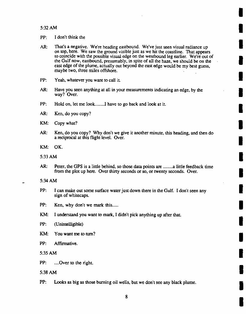
5:32 AM
PP: I don’t think the
AR: That’s a negative. We’re heading eastbound. We’ve just seen visual radiance upon top, here. We saw the ground visible just as we hit the coastline. That appearsto coincide with the possible visual edge on the westbound leg earlier. We’re out ofthe Gulf now, eastbound, presumably, in spite of all the haze, we should be on theeast edge of the plume, actually out beyond the east edge would be my best guess,maybe two, three miles offshore.
PP: Yeah, whatever you want to call it
AR: Have you seen anything at all in your measurements indicating an edge, by theway? Over.
PP: Hold on, let me look........I have to go back and look at it.
AR: Ken, do you copy?
KM: Copy what?
AR: Ken, do you copy? Why don’t we give it another minute, this heading, and then doa reciprocal at this flight level. Over.
KM: OK.
5:33 AM
AR: Peter, the GPS is a little behind, so those data points are ........a little feedback dmefrom the plot up here. Over thirty seconds or so, or twenty seconds. Over.
5:34 AM
PP: I can make out some surface water just down there in the Gulf. I don’t seen anysign of whitecaps.
PP: Ken, why don’t we mark this.....
KM: I understand you want to mark, I didn’t pick anything up after that.
PP: (Unintelligible)
KM: You want me to turn?
PP: Affirmative.
5:35 AM
PP: ....Over to the right.
5:38 AM
PP: Looks as big as those burning oil wells, but we don’t see any black plume.

AR: Peter, I’m going to make the west end point of this leg at 48.4, our present latitude,and the longitude 47.25 or so, or forty seven, fifteen minutes.
5:39 AM
AR: There’s a white plume coming from another flare below the first one, just below onthe right.
5:40 AM
AR: Peter, did you copy that west point I gave a while back?
5:42 AM
AR: About one minute ago the ground disappeared. I think we’re having a briefcomputer problem. We’re actually a degree west of the coastline, now? Over.
KM: Zappa.
5:47 AM
AR: I see some heavier smoke down there, looks like some modest bubble tops downbelow, so it’s clear we’re coming over the centerline, or close to it.
KM: We’re right at the coast line, now.
AR: Thanks, Ken, we’ve got a bit to go to the centerline, maybe a couple of minutes.
5:48 AM
KM: This track is taking us close to the border, we’re about six miles from it now.
5:49 AM
AR: OK, we’re about six (thousand?) miles from the Kuwait border? Over.
KM: Yeah, the point you gave us on this track will take us close to the border.
AR: OK, perhaps I misspoke. I meant to say twenty seven point four, the same latitudewe’re at now, forty seven point two five or forty seven, fifteen minutes. Over?Cloud have been about a two seven zero heading.
AR: Ken, I’ll get this straight. I said twenty seven four just then but I meant twentyeight four, just the reciprocal heading that we did on the first leg, and I beg yourpardon, there. It should be about the same latitude heading for the forty eight,fifteen minutes.
5:51 AM
KM: We obviously have some wind, in here. We were flying at two six zero and it’sclosing us on the border. ......point for point that we thought you wanted. Sowe’re turning south now, to get back to it.
9

AR: I should have just said take the reciprocal heading after we got that leg, but I wastrying to be clever and give you a dot at the west end of the reciprocal heading.
KM: OK, how about giving us a dot at that west end?
AR: You broke up a little bit on that, say again?
KM: We’d still like a dot at that west end so that we know what we have here.
AR: Roger. Forty seven, fifteen, I may have misspoken on that one and confused fortyseven and forty eight. Fourty seven, fifteen minutes at the present latitude.
5:52 AM
KM: Now, if you want this latitude we’re going to set up here pretty much the way wewere before.
AR: I’m going to come up with a map, here.
KM: OK.
AR: We’re about over what we thought was the centerline before, back there, Peter orFrancisco. We should be coming up on the west edge here, maybe anywherebetween two and four minutes.
6:02 AM
KM: A minute from the center point We weren’t on the western edge when we startedour turn. We about thirty two miles after that point you gave us on the westernedge.
AR: Ken, we want to be well west of that west edge, and estimating where we’ll be,maybe ten miles, maybe fifteen miles, it’s rather diffuse today because the air is sostagnant. The other thing is, once we do break out of the west edge, we want to doa Mike King circle right, and then descend to make these cross-sectional passes intothe plume. Would you like that height estimate now on that first pass across theplume?
KM: Yes. It will give me an idea of ........descending once we get turned.
AR: Let me turn the volume down a little bit, you’re breaking up, I’m going to turn itdown and see what happens. Could you say that again? Sorry.
KM: Yes. I will need the altitude that you want to do it at so that we can get clearance atthat altitude.
AR: Yes, give me a minute or two here, and I’ll ponder and get back to you.
KM: OK. I understand that you’re going to let us know once we get to the westernedge, we’ll mark that point, and descend at that point, and proceed eastbound whenwe’re level at our new altitude.
10

AR: That’s affirmative. We’ll do the Mike King circle at our present altitude, and thatwill take about five minutes or so, and then we’ll descend outside of the west edgeand head eastbound along the reciprocal heading. Over.
KM: OK. If you don’t give me a reciprocal heading we’ll head to that point where westarted in from the eastbound edge.
AR: I understand.
6:04 AM
AR: OK... it looks like it is brightening ahead maybe two, three miles maybe ahead of(.....) you can see a reasonable degree of brightening. Over.
6:06 AM
PP: Art can you repeat that last thing again.
AR: I was saying that from above here it looks like there is some brightening ahead andI thought I could see some ground, but now that we had to move ourselves a littlebit we don’t see that... what I thought was ground didn’t seem to be ground
PP: Yes we have no indication of that on the computer.
AR: It would have been right about now too but I was expecting to see some brightningbut it looked like it was one minute or so ahead but it did span out so I got fooledhere.
PP: I’ll give the go..(unintelligible)
AR: Roger. Dave and I are looking ahead and down for some kind of gradient. Over
6:07 AM
AR: This plume is similar to the others we’ve studied we flew the west edge would bemaybe one to two minutes ahead by our previous flight (delay?)
6:08 AM
AR: Ken why don’t we try our first pass at nine thousand to get an eventual first passacross the plume. Over.
6:09 AM
AR: I would suggest that today we do nine, six and three at three levels. Over.
KM: Is everybody warm enough in the back?
AR: I got real air-conditioning in the back here today.
6:10 AM
AR: Can you tell me when we are two minutes from the west end point Over.
11

KM: We are at three right now.
AR: Okay, I haven’t seen any thinning down there, I still can’t see the ground it stilldark down it looks like we will have to proceed beyond that point can you reviewthose points, forty-seven zero zero. Over.
6:11 AM
RS: Test one two three.
6:12 AM
RS: Test one two three.
6:13 AM
I got some brightening taking place below now, I can just make out some grounddetails... well let’s continue that last point anyway...(Superimposed by scratchynoise)
6:16 AM
AR: Peter do you copy back there?Do you copy me? Do you hear me?... OK try it again.
Negative copy, I’ll walk back there. Continue on this heading Ken, and it doesn’tlook like there may be a west edge today on account of that puff of smoke that wasout here wondering around here yesterday. So HI contact the group and decidewhat to do. Over.
PP: An do you copy now?
AR: Yes, I copy. Is that you Peter?
PP: Yeah, we show a slightly increasing cloud albedo or ground albedo, cloud, groundalbedo. I can get an indication of whether it jumped up a lot higher as we go furtheraway.
AR: Roger, you remember that satellite picture showing if there really may not be a westedge today because of an old puff rotating up this way. It’s not on that printout andI was told that what we were getting into, as we’re certainly well beyond where weshould have seen the west edge is stuff maybe still two or three days old. I’d liketo know whether you want to quit at some point or whether we continue headingacross the desert here, westward? I’d like to make sure you guys got what youneed. What or where would that be right now, Over?
I don’t think for our purposes, I don’t think it makes any matter whether wedescend or not in the cloud, but it might hurt Mike’s chances of getting what hewanted if we circle over clean dust, or over clean sand, but if we keep going furtherwest I think we might interfere with what the Chemistry people want and we haveto make a decision pretty quickly.
12

AR: You’re exactly right, we arc just going to have to make a circle here at the westendpoint because we don’t want to do too much westerly gravel here because wearc going to use up too much dme. Do you copy Ken?
KM: Yeah we are pretty stuck on the last point that you gave us.
AR: OK. If we could execute our Mike King right turn and after we have done that oncedescend to nine thousand. Go for it.
KM: OK let us know when Mike’s ready.
6:19 AM
KM: For some reason we are breaking up here so let us know, I’m sorry I missed it.
AR: OK, let us know when Mike King is ready so we can start down.
KM: Roger.
PP: Art if you want to hang for a couple minutes now. it looks like we might beapproaching some more clearing. We got a strongly increasing signal, particularlyfrom below. That’s because we started the circle is that right?
AR: That’s affirmative, it would be kinda tough to generate such...
PP: No, that’s OK.
AR: I do see what you mean. There is some brightness although I can just barely makeout the ground details for example there is just barely visible road down there belowthe aircraft.
MK: That’s OK, we’d see the same thing from below if we’d taken the turn. I didn’trealize we’d already started the turn.
6:20 AM
RS: Test, one two three.
AR: Peter, do you copy?
PP: Yes I do.
AR: You know it’s nice you only get one tiny cirrus cloud at a dme, they’re off theright wing and behind about four o’clock there’s the single filament of a cirruscloud in the sky.
6:22 AM
PP: I see it.
AR: It’s not very often that you get skies with one cloud at a time. We’ll be climbing tonine thousand, and we’ll get our first ride across the upper portion of the plume.
13

6:32 AM
AR: ? count is gradually increasing as we pass through twelve thousand at zero six threethree. They have approximately increased by fifty percent in the last minute, twominutes.
6:33 AM
AR: No sign of layering yet. Passing through eleven thousand, two hundred. Groundsdll not visible or barely visible. And we appear to be in something that is dark andyellowish or browning as a haze-dust layer might be.
6:34 AM
AR: Correction: ground barely visible.
6:35 AM
AR: Krista, do you copy?
6:37 AM
AR: First we’re starting out at a nine thousand foot run here and just turning eastboundtoward the plume, and it will probably be a good ten minutes before we get there.
KL: OK, let me make sure I got that right. It will be about ten minutes till we get to theedge of the plume? Over.
AR: I’m estimating that it will be that long to the, let’s say five to ten minutes, I’ll be alittle more conservative, to the edge of the plume. Probably fifteen minutes to thecenter.
KL: OK, it sounds good.
KM: Yeah, we’re thirty minutes from the other side.
AR: Thanks, Ken, for that additional endpoint. We really couldn’t see any west edge,that’s part of the problem here. I’m just estimating here based on what the lowerlevels might contain, but at sixteen, I couldn’t see anything down below us thatmarked the west edge; the east edge, it was also pretty diffuse. Over.
6:39 AM
AR: Ken, if you talk with Bahrain, you might ask them ifHap has been able to passalong any, or has been able to receive any satellite positions. Over.
6:42 AM
AR: There seems to be some thickening below, just then within the last fifteen seconds.Did you notice anything?
14

6:43 AM
PP: Not really. I think we’re showing a pretty low albedo, almost the entire westernstretch. I think we’ve got cloud underneath us, since we descended.
6:44 AM
AR: I’m having some second thoughts, here, on our flight level. Can we drop to eight?Looks like we’re on top of something, here. Maybe it’s not getting as high as inprevious flights.
KM: You want to drop to eight, now?
AR: Yes. Is it possible to drop to eight? We haven’t dome in to it yet, but maybebecause we’re a little on top. Maybe the highest turrets might get this high, but weprobably want more than just skimming the tops. If it’s no problem, I’d like todescend to eight.
AR: Yes, we’re certainly on top, there’s a plume down there, below us. I think we’lljust hit these higher puffs, up ahead, where they are, even at eighty-eight.
6:46 AM
KL: Yeah, we’re starting to get a little wiggle in the N02 needle, so we might be gettinginto something. It would be better if we could go a little bit lower.
AR: Yeah, thanks, Krista. I think at nine we’ll hit something, we would have hitsomething down there, but it probably just would have been the top of the plumethat just peaked, I think we need to get a better sample.
6:47 AM
AR: Krista, estimating the centerline of the higher puffs that we get into, we’re abouttwo to four minutes ahead, over.
KL: OK, you’re saying two to four minutes dll the first sample pass?
AR: Yeah, do you want to take the bags ..........in about two to four minutes.
KL: OK, I’ll be ready then.
6:49 AM
KM: OK, we’ve got some but it’s not clear where the plume is.
AR: Roger, it’s certainly below us at this dme, definitely there’s heavy stratocumulustops, I think we’ll be coming into something, it looks to me now, looking out thebubble here, there’s some higher clouds ahead within the next minute to twominutes. Except we’ll need a little bit on the high side....the whole plume.
6:50 AM
KL: OK, An, we’re heading into something here, if you look at the SOz on yourmonitor-
15

AR: Yeah, I see it creeping up. I’m going to check our position here.
6:51 AM
AR: OK, what we were looking at those tops before turned upwind is coming up in thenext one minute and I’m looking out of the window here and it looks like the topsare rising. .1 don’t see any cumuliform tops like you’ve seen before but it looks likea frizzy, gradual top that probably indicates the chemicals will go up gradually.
KM: Yeah that sounds right.
AR: Superimposed by scratchy noise
6:52 AM
AR: Are you ready Krista?
KL: Yeah ready any time.
6:53 AM
KL: You want to take it here Art?
AR: Yeah, I’m thinking that ahead I can’t see because there’s a little bit of a puff but Ithink we may only see a gradual increase, that’s my guess at this point.
AR: Hang on for another two seconds, here.
6:54 AM
AR: I think we can sample any time, Krista, any puff is going to be a littleunrepresentative, anyway, of the whole schmear.
KL: OK, let’s"sample now. Why don’t you give Dave the word.
6:55 AM
AR: Can you mark this point, please? Thank you.
KM: (Unintelligible blurb)
KL: An, I’m taking a look at the S02 here and it looks like going up again so on thesecond pass we may want to hit it a little bit later. Over.
6:57 AM
AR: Yeah, I did notice that, too, Krista, on this chart. There’s just a bit of a peak nowcoming out of the chart that seems to reflect the peak you were talking about
KL: Yeah, I think either way we’ll probably be OK, at either point.
KM: An, be advised: We’ve only got about an hour an forty five minutes of science timeleft up here.
16

AR: We won’t be going as far west on the reverse leg. Ken, and we’ll try to trim thiseast leg as well.
AR: We’ve got a little peak here, Krista, in the S02 for about ten seconds.
7:03 AM
AR: (Unintelligible)
We’ll be coming up on our eastern endpoint here, previously viewed from sixthousand. I’d like to revise that level since we ended up in the center at nine...
KM: Could you say that again, please? You’re coming in a little weak and doubled.
AR: OK. I wanted to, when we reach our western endpoint, here, I’d like to descend tofifty-five hundred instead of six thousand. Over.
KM: OK. We’re about five minutes out, and you want to go down to five point five atthe eastern endpoint.
AR: That’s correct.
7:04 AM
KM: Next time somebody comes to us, could they bring us up a cup of water?
AR: There’s very strange winds, here. I’m indicating zero six zero at fifteen knots.Over.
KM: We’ll check.
7:05 AM
AR: It’s not too surprising, it certainly could be that way today, as it looked sort ofvariable higher up, today.
AR: What we’re probably seeing is a lot of chemicals still, in fact this is a bit higher thanour peak that we took back there, at the west edge, correction east edge, a littlenebulous here. How long to the east edge point?
KM: About two minutes. Three minutes.
AR: OK. I’ll keep you informed. It looks like we may have to do a little beyond that tocapture this, all of a sudden it will be light and variable winds, up here, and I’mbeginning to wonder how our cross section is going to be characterized. Whatwind direction will we use? Because we’re indicating still northeasterly winds atabout ten to fifteen knots, at the present time. Over.
7:06 AM
KM: Winds are east at
AR: You’re indicating two forty winds from the southwest at about nine knots. Over?
17

KM: Yeah. Which is just the reciprocal of what you got, but the velocity is vastlydifferent.
AR: Yeah, it’s coming back now around to three twenty at about ten. We’ll, I don’tknow what to make of it. We’re not seeing any end to the chemicals here, that’span of the problem, we’re not going through a plume that would be defined verywell by, say a northwest to a southeast wind. That’s part of the problem here. Ithink as soon as we get to the edge, we’ll drop down to fifty five and do areciprocal because lower down the winds should be out of the northwest with somegusto.
7:08 AM
AR: Let’s call this our eastern edge point. Let’s descend to fifty five hundred and do alevel pass at that height. Over.
KM: We’re marking the point and we’re out at (?) fifty five hundred.
KL: Wait a minutes. Art, we need to do two samples at this level, we’ve got a secondset of filters I’ve got to run. We’ve got to turn around and go back through thislevel.
AR: Did you copy that. Ken?
KM: I understand you want to stay here and just reverse right now?
KL: An, remember I told you I need to do two samples at this altitude. I’ve got to dothe second set of filters.
AR: OK, Krista, go ahead, shoot.
KL: Here, or go back?
AR: Krista, you were turning to go back--Thank you, the brain has just kicked in.Uh, we want to stay at this level. Ken. I’m sorry, we want to do a reverse courseat this level. I got confused, I got a leg ahead.
KM: OK, we’ll turn around and go back to a point where you sampled.
AR: Roger.
KL: Come on. Art I think your brain is at Dairy Queen.
7:09 AM
AR: Ken, I’ve been conferring with the aerosol scientist. Dr. Laursen, and I think we’lljust make two passes at this level, remember we had three in mind, but it took us solong that she’ll be able to get her second bag sample without an intermediate pass.We’ll take our second bag sample on this pass in about five minutes or so, sixminutes, and continue to the west end point, for which HI give you a revisedheading, and then drop to fifty five. So that’s one more pass through this plumeand then descend to fifty five hundred. Over.
18

KM: OK. Yeah, let us know when you want us to go down to fifty five hundred.Thank you.
7:14 AM
AR: OK, Krista, we’re coming into that stuff now, looks like there’s a puff here,anyway, just a little further along than I had, while we were chatting, we got just alittle further ahead. This region is about three or four minutes wide and you couldprobably just pop it yourself when you see one of these peaks come along, in awide, convecdve turrets, little puffs, probably a dip after you get a peak.
KL: Well, we really hit something, here. I may go ahead and try to grab this one.
AR: Krista, I think that’s good.
KL: OK, could you give me the hand sign ’till I’m going here?(?)
AR: It’s going!
7:15 AM
AR: Did you fire, Krista?
KL: Yeah, I got it.
AR: I would just guess that this is just a puff that has come to this location in the tenminutes that we were out there on the east end. This is something new that’scoming down with the wind.
7:16AM
AR: Krista, looks like you got that one pretty well.
KL: Yeah, I think we got a really good sample. Art, it’s going to take me twentyminutes to process this sample, so I’m not going to be able to do anything else forabout twenty five minutes, OK?
AR: (Too muffled)
KL: OK, great. Thanks.
7:17 AM
AR: There’s another puff coming through.......(too muffled)
7:18AM
AR: We definitely got jipped on our first pass, that’s for sure.
7:26 AM
AR: Ken, does it look like smoke out there, to you? Looks to me like smoke, but Idon’t see much on the chemistry, here.
19

KM: Yeah, it looks like we’re fairly near the top of the plume.
AR: Off the right wing, about two o’clock, it looks like there’s a that sticks up, butwe’re not getting any of it.
7:28 AM
AR: I can see the top going by up here, so it’s up there, about another thousand feet, Iguess it’s just veering off to the east. Now we’re starting to see some smoke. (?)
7:29 AM
AR: Krista, we’re seeing another huge peak here, but this is in the area where we barelyhad the little peak but we took the sample in the first time........(unintelligible)
7:30 AM
KL: OK, Art, you might want to make a just switch the SOz to one range, it went offscale.
7:31 AM
AR: What we may be seeing is two plumes, here, the first one looks like it flows from apoint northwest, corresponding to the north Kuwait oil field, and this one looks likea north flow from the Burqan oil field.
....stay at the same level.
OK, Ken, I want to make sure you understand me, one more minute at this headingand then descend to fifty five. OK?
KM: Roger.
7:33 AM
AR: Ken, make that two minutes.
KM: OK. Two minutes. And at the end of two minutes, do you want to circle downand do a reversal, or keep going westbound?
AR: Descend to fifty five, and do a reverse course, back through at fifty five, and weshould be ready for chemistry then.
KM: OK.
7:34 AM
AR: Krista, we’re going to continue westbound about another two minutes and then doour descent to fifty five hundred, and that will be about another, well, we have totake the plume point at that time, do you want to take the last peak that we got, orthe one before that, it would be about ten or fifteen minutes to the original peak thatyou sampled, and less than that for the latest peak that you see on the chart there.Over.
20

KL: Yeah, why don’t we aim for this latest peak, I think that will give me enough time.My one sample, and Tm about ready to take the filter out, so I might be able to getthat latest one, but give me about five minutes.
AR: Ken, we’re also getting another spike here, it looks like we might be at the mostwestern oil field, and Krista needs a little bit more dme, I think, so can we continueon here, just a bit longer, and then I’ll get back with Krista and we’ll call out at thesame dme then?
KM: OK. Just let me know.
7:35 AM
AR: Are you about ready to go back?
KL: Yeah, you can go ahead and turn around and go back. When I said five minutes, itjust means I need five minutes to get this filter out and the new ones in.
AR: OK. Ken, did you copy that? We can go ahead and descend and go back to fiftyfive. Thanks.
7:37 AM
AR: We’ve got lots of sulfur back here, as we spin down to fifty five, so we didn’t getthe west edge, but we’ll pick it up on the way back, I hope. I think the key phrasefor today is ’light winds and big plume’.
KL: Yeah, sounds good. I think if we sample anywhere along here it’s going to be fine.
AR: I’m just determining what is the prospect when the winds are all over the ball parkup there. I see northeasterly and southwesterly, and northwesterly. It becomes aquestion at these higher levels what are we going perpendicular to? Perhapsit’ll................
(tape ran out and had to be turned over)
.......have a nice good sample of the core, anyway, if we can’t do that bottom up.
KL: OK, Art, make a note that I switched the S02 up one range, so it’s going to look alittle bizarre on your system.
7:43 AM
KL: ............still going up.
AR: Roger.
7:45 AM
KL: I think in the interest of time, I’m going to go ahead and shoot it off here. Does thatsound good to you?
21

AR: Sorry, Krista, I’m having trouble with my microphone here. I’m indicating it’s abit ahead, but I think I would hold off for another thirty seconds.
KL: Okey-doke.
AR: It looks a little thicker ahead, we’re coming up underneath that other big spike, soalthough there is admittedly a bit of chaos in the winds, today, it may be just a bitmore ahead.
7:46 AM
AR: OK. It looks like this would be it, Krista.
KL: OK. Let’s do it. Give Dave the word.
AR: Krista, I’d say on that one it looked like the cumuliform turrets there mushy, butalmost we were in a saddle area, had a peak, but it probably wasn’t in the peak inthe same level as it would have been, say, three minutes earlier.
7:47 AM
AR: It looks like another bump up ahead, here.
KL: Well, I think we still got a pretty good sample, though.
AR: Right, this had a double structure before, at least there were puffs through this area,probably pumping like pistons, if you could just stand at this level and watch,you’d see these puffs come up and go by.
AR: I’d certainly say that that computer model which showed a nice thin plume comingout of Kuwait has not concept of reality.
KL: That’s for sure. I guess that’s why they call them models.
7:48 AM
AR: That plume on the coasdine should be coming up in another minute or two. Thatone looks like it may be coming from the northward area.
7:50 AM
AR: We’re coming in the coasdine plume-
7:52 AM
AR: Ken, what are you indicating for winds? They acting a little bit strange again.
KM: One of them sees with two seven zero at forty five, and we’ll see what the other....
7:54 AM
AR: I have a feeling this is going to be a real mess because if the winds are two seventyat thirty five, why is this smoke here?
22

KM: The other one says two forty at eleven.
AR: That also means there shouldn’t be any smoke here.
7:55 AM
AR: Any receipt from the ATC on the satellite plume? Over.
KM: The last we heard was that it was undefined, unidentifiable.
7:56 AM
KM: Three minutes from the eastern point.
7:57 AM
KM: We’re three minutes from the center point that we sampled going in the otherdirection.
AR: Three minutes from the center point, you say?
KM: Yeah, the westbound sample point.
And we’re one minute from that sample point westbound.
AR: My heading says eastbound.
KM: We’re eastbound, but this is where we took the sample when we were goingwestbound before.
7:59 AM
KL: OK, Art, whenever you’re ready, I’m ready to turn around and do the west half atthis altitude.
8:00 AM
AR: Roger, Krista. We’re just passing through that easternmost plume, it may be theone coming down from northern Kuwait, although frankly, there’s so much goingon here, it’s difficult to see that there is a particular plume, but this is the locationthat we had originally taken one sample right on the coastline.
KL: What was that last part, could you repeat it?
AR: This is the easternmost plume that we had taken a sample in some dme ago andwe’re finishing the first leg at fifty five hundred and as you can see it’s takentwenty five minutes, here, and we have yet to come out of it. Well, I guess we’recoming out of it now.
KL: OK, well I’ve flipped up the S02 one notch, so don’t be deceived by that.
23

AR: I’ve already been deceived. Anyway, we did get to the west end, I’m afraid we’reworking on a gigantic bust here on doing a cross section because things just aren’tworking out. The plume shouldn’t be over this gigantic of an area this close in, andI think it has something to do with the light winds, but our own winds arefluctuating from anywhere from ten to fifty knots, depending on what time youglance up at it.
KL: OK, so what’s your call? Do you want to turn around. I need one more sample atthis altitude. Do you want to turn around to get it?
AR: Right. It looks to me like we’re popping out at this level on my chart here, but isthat only because of the scale change?
KL: Yeah, I’m actually going to bump it down a notch, now.
AR: I think that’s about all we’re going to have time for, and I’ll check with Ken onthat Ken, how much research time do we have here, presuming we pop out of theeast end here in the next five minutes? Over.
KM: Well, we probably have about thirty, thirty five minutes, I would guess.
AR: That’s only about one more leg across this whole thing.
KL: OK, Art, it it’s OK with you, why don’t we turn around to get one sample at thisaltitude again so I can get the full chemistry at this altitude.
AR: OK, do you care that we haven’t come out of the edge, yet?
KL: It doesn’t matter to me, as long as we just turn around and try to grab one of thosepeaks, that would be fine.
AR: OK, Ken, we’ll follow the chemical person today, and we can go ahead and do areverse course at this level.
8:03 AM
KM: OK, Art, we’re about eleven minutes from that earlier midpoint where we took thesamples westbound before.
AR: Copy, eleven minutes to the midpoint on this pass earlier.
8:06 AM
AR; Krista, on this particular pass there are a number of peaks. Did you want to repeatat a particular point, or did you want to sample one of the big peaks along the way?Because we had a big peak hear the coastline, and I know you hadn’t sampled thereon this pass. Over.
KL: I would say the idea of doing a cross section is kind of blown, due to the winds.Why don’t we just try to grab that big peak toward the coastline, so I can hopefullyget some really good gas measurements out of it
Did you copy that. An?
24

8:07 AM
AR: Roger, Krista. Ken, we’re going to try to get a measurements in that big peak wehit just coming across the coastline. We may have had that marked from someprevious pass, there, the one at eight thousand. If you could give me a roughestimate of maybe one or two minutes ahead of that point.
KM: OK, that was the western edge.we’re looking at about thirty six minutes, and I’mnot sure we’re going to have fuel to go that far.
KL: OK, then let’s just wait for a peak to come along here, and then we’ll grab it
AR: I’ll say again. Ken, I meant the one on the coastline, we’re coming up on thecoastline and we’ll be there in about three or four minutes, and there was a big peakthere. I believe we took a peak there at eight thousand, I may be misrememberingthere. But anyway there is a peak there and that is the one that we are concernedabout. I guess it’s coming up at about 2, 3, 4, minutes. Right?
KM: OK. We’ve got one point coming up here in another 8 minutes and the eastern endpoint, the western end point is about 35 minutes away which is too far.
AR: Roger.
8:08 AM
AR: Here comes, looks like this may be spike coming up here.
KK: I’m ready whenever you are.
AR: OK, you got it.
KK: Give the word to grab a sample.
AR: Continue bearing west till we get beyond the edges of the plume, that should be alittle farther west than we started out. I realize you may be running out of fuel.
8:11 AM
KM: We’ve got about 25 minutes here, is what we have.
8:12 AM
KM: Sdll about 32 minutes from what I guess marks the edge of the plume, so we’re notgoing to make it.
AR; We’ll ponder here in the back for a moment and see what our strategy will be.
KM: Roger. Ponder.
25

8:13 AM
KM: ^ToSL^n^ ^wise here- Going to take us a little bit to^ up.tomSr?ow m^n^ et- we ve got to save a llttle bit to get over to Dhahran
AR: Roger. Ken, you’re the boss there so do what’s necessary. Over.KM: OK. we’ll turn left for home. Do you want us to stay 5.5 for awhile or start up to
AR: priced5’5 as long as you can’ when you feel like you have to climb out’ then
KM: OK.
8:16 AM
KM: It’s getting darker.
AR: Krista, sulfur’s on the high scale?
KM: Coming out of it now.
AR: Sl’iSXib^^nS:^"1" 0"0^’^1’ ^- Climbing ,o 7,(XX)
8:17 AM
KM: Did you want to stay up 5.5 or go to 7. Get a little cooler.
8:22 AM
KM: An, do you want to go to 7 or stay at 5.5?
8:23 AM
AR: ^"nl^"^ now- Th! wi^ "^^"g 3 3 0 at about 10 knots. Just under10 knots here. Heavy smoke plumes, 5,500 feet. Time 0826:07.8:26 AM
KM: Unintelligible.
8:30 AM
KK: OK, Art, I’m ready for the next sample whenever.
AR: Dld rS/011^ the sc^ on me here’ Krista’ or are we J"^ out of plume rightnow? We’re apparently out of plume.
KK: do^ t^^n"^ it fTOmrange l "P to ""ge 5 parts per million. Now ifs backU^Tsn^n’ e
probably golng to h""1? n down another ""teh. so it wUl look a
26

8:31 AM
AR: Ken, approximately how long from Manama.
KM: Oh, about 50 minutes.
AR: Thank you. That’s about 5 0 minutes to Manama and looks like we’ve come out ofit here, I’d say. We may not hit any more spots. We’ll see.
8:31 AM
AR: This is an odd area here, but these winds from the northwest tend to be rathershallow. You’re looking into a tail wind that actually might be lower if the windsdie out at height here, as a rule, out of the northwest anyway. They might be lowerthan higher. The case today.
KM: Yeah, probably what we’d gain on the winds we’d loose on the __feed here.Probably pick up another 4, 5 degrees of temperature.
AR: Started noticing some heat buildup here, all of a sudden which I hadn’t noticedbefore either. I’m indicating winds, goodness, now they’re 0 6 0 at 15 meters,correction 15 knots.
8:34 AM
PP: Bit unusual. There’s no whitecaps visible. Almost entire over water portion of tripon the way here to Manama.
8:57 AM
AR: Indicated winds at 0 3 6 at 46 knots.
9:03 AM
AR: Flight level 5,500. There’s not a single whitecap visible in the Gulf below.
A few whitecaps begin to appear at 0 8 4 0 down below. We are descending toManama. Correction, 4,600. Diffusional haze layer here (unintelligible) furtherinto it.
9:09 AM
AR: Winds at 0 2 8 at 45 knots. Level 3,700.
9:11 AM
AR; Our temperature is almost 100 degrees outside. At 3,400 feet.
9:12 AM
AR: Whitecaps increasing below. Niner 1 3 3 0. At 2,300 feet. Wind 0 2 2 at 46knots.
27

9:13 AM
AR: These are ludicrous winds.
Prepare for landing.
9:19 AM
AR: 102 degrees outside at 1300 feet.
Descending in for landing at the marine boundary layer here at 1000 feet.
9:21 AM
AR: 1000, little change in temperature.
9:22 AM
AR: Things are dropping off beginning at 900 feet
About 5 degrees almost instantaneously.
28

UNIVERSITY OF WASHINGTON FLIGHT #1485,0353--0927 UTC, JUNE 2, 1991, FOR STUDY OF
SMOKE FROM KUWAIT OIL FIRES
III. POSTFLIGHT DEBRIEFING
General Overview:Not very successful except for first 1-2 hours of radiation measurements.Descended to 8,000 ft. to look for plume; looked good initially to do two passes atsame point. Two samples obtained at 8,000 ft.Western edge of plume never located and neither was eastern edge-plume was quitemixed up and not well-defined. Plume too wide to traverse completely at 5,600 ft.Two samples obtained at this altitude.
Chemistry:Total of four chemical samples obtained; could not do cross-section, but managed tograb samples at four "hot spots" total.
Radiation:Optical depths obtained at 10,000 ft. Not a loss, but not as good as on previous days.
PVH: OK, let’s have a debrief of today’s flight, first of all. That’s Flight 1485.
AR: I don’t think it was particularly successful, except maybe the first hour or twohours when the radiation folks where doing their experiment. One of the things thatcaused us to use up a lot of fuel was the top the haze layer, which we needed to beabove, was 16,000 today. One of the higher ones that we encountered, notexceptional.
PVH: That put you on top?
AR: We were on top far as I could tell at that point. You guys probably know betterthan I do, but I couldn’t see any...
?: 8000 a week ago.
AR: That was about as high as we could go, Peter. Our climb ranges about 100 feet aminute at that point and so, we’re at the point of diminishing returns.
AR: And then.
PVH: OK, what did you do after that?
AR: We descended to 8000 to look for the top of the plume following the LawrenceLivermore model and we did something across the top there. At first it lookedpretty good. We went back the second time to 8000 and hit tremendous surges ofsulfur at that point along that same track at the same height, which spoke well ofgoing back over the same place twice, because obviously we were seeing transientbubbles going across to 8000 and at that point tracking, well who knows where itwas tracking, but anyway at that same point we intercepted much more in the way

of chemistry you might say from these fliers than we had at that first pass. It wasdeeper.
PVH: Where was this transaction?
AR: It was near, maybe, 24 on the east-west line, essentially north, maybe a little northof Selig.
?: I would say it’s inside the 20 mile border, maybe a little bit closer.
PVH: How far from Selig.
?: Selig, 50 miles?
PVH: 50 miles north of Selig?
?: That’s a guess. I’ve got the lat-longitude.
PVH: That’s good enough. About 50 miles north of Selig.
AR: One of the problems was, became apparent at that point, Peter, we continued tobear westbound on top there looking for the west edge, we kept going and goingand going nil finally, if we kept going the whole day would be shot and we nevercame to a west edge. Essentially that pool of smoke that was out there yesterday onthe satellite picture,
PVH: Yeah, the swirl.
AR: Pulled itself eastward and essentially we didn’t come to the west edge. We did notsee a east edge, 47 east, that’s longitude 47 east. I don’t know how many milesthat was.
PVH: You didn’t break out on the east side either.
AR: We couldn’t see it on the east side. I couldn’t see it on the lidar and visually itsover the water, can’t find an edge, nothing on the east side but continue to plowahead because as we made that east-west track at 8000 you could clearly seebubbles down below that indicated at least to me that the plume was tracking towardthe south, or south-southeast as the model had indicated. And when we dropped to5500 to the middle of the plume, essentially they had no end.
PVH: Had no what?
AR: Essentially we kept flying and flying and flying.
PVH: Oh. no end.
AR: Because no edges.
PVH: Same as 8000.
AR: Except at 8000 we got on top, but looking down there was no edge. On top at8000 we did have edges. When you measured it, just looking down below, Peter,there was no west edge to break out into the sharp west edge that we’ve seen.

Many conversations.
MK: It’s actually more like 49.
AR: At the second pass at 8000 you may remember we had those turrets began to comeup to that level. And we had tremendous chemistry on that 8000 one, after justskimming the top it appeared the first time, coming back it appeared...
PVH: Anyway we got some chemistry?
AR: Yah.
?: We got four samples...mumbling
PVH: Was the CCN working as far as you can tell?
JR: Don says yeah.
Mumbling
PVH: OK, anything to say more about that flight?
AR: In the middle point we made too passes, in the middle point, and we ran out
?: Well we only went down to 5500.
AR: That’s what I mean, the middle, 5500.
PVH: Would you get the flight scientist book from the
AR: Yeah, I need to do.
PVH: How many hours was the flight, do you remember?
AR: 6 hours and 5 minutes, it was 31 minutes on the first flight.
PVH: Including the first flight?
AR: That’s including the first flight. It was 31 minutes on the first one, what thedifference is on the second one, 6 0 4 or 6 0 5. Oh wait, I’ve got it right here.
PVH: Well it’s close enough. I spoke briefly to Larry and he said they had the sameexperience today. It was very confused. They went in close and even in close theywere getting winds from one direction, one place and another.
AR: We could see that coming yesterday, though, right? I mean that wasn’t too much ofa surprise. I just wonder, I hope the radiation people got something out of this,because other than that, we’re in trouble.
I felt terrible. I think if I had had another 3 hours I still couldn’t have figured outwhere that stuff was going. It was just a mess.
PVH: Well now,

AR: In fact, Peter, this is interesting because the satellite pictures make it look to be apool of smoke organized into something that looks like an occluding cyclone. It’sgot a comma cloud.
PVH: Have you one later one? The one we were looking at this morning, couldn’t makeout what was going on.
AR: Yeah, sure. I thought this was kind of interesting because of the analogy with theoccluding cyclone. And there is a vortex at 850 that shows up. I think you can seethe son of wrap around there, pattern developing. That’s 10 and this one is noon.
See, its coming around. If you look at the loop you can see this curling around.Here’s the advancing frontal bed, this black thing down there. And you can seethat kind-of open up, blossoming as the upper short wave went by and the littlevortex at, here’s 700 millibars, the open wave and then notice here the north windand the south wind at Keetsama, south. And this guy was tracking across thatarea.
4

1 1 JUNE 3, 199 1 FLIGHT
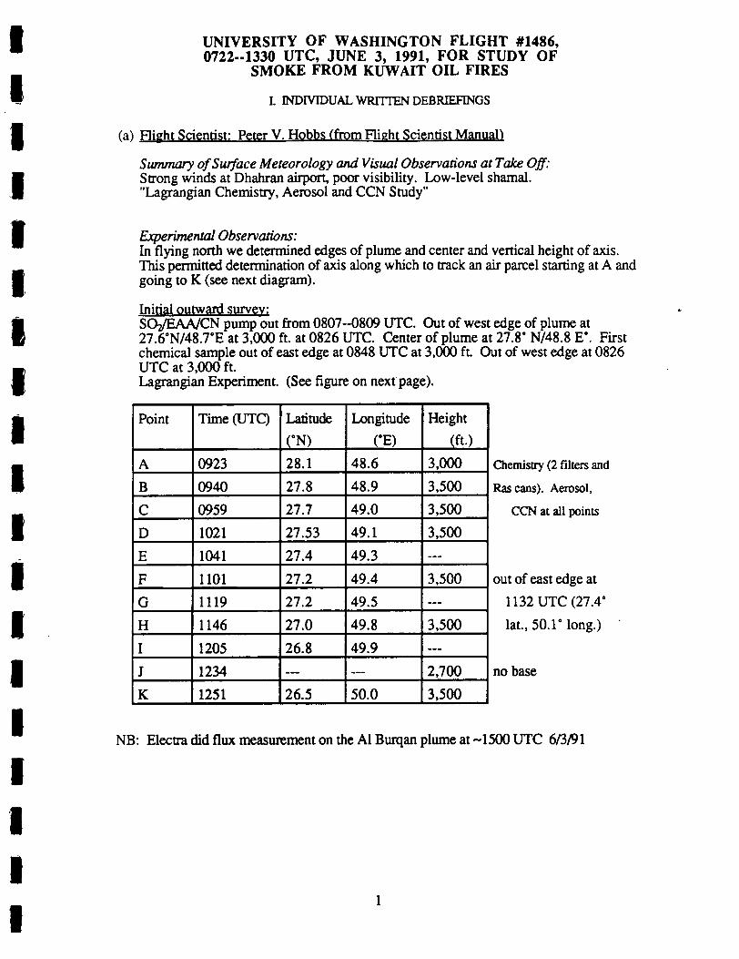
UNIVERSITY OF WASHINGTON FLIGHT #1486,0722--1330 UTC, JUNE 3, 1991, FOR STUDY OF
SMOKE FROM KUWAIT OIL FIRES
I. INDIVIDUAL WRITTEN DEBRIEFINGS
(a) Flight Scientist: Peter V. Hobbs (from Flight Scientist Manual
Summary of Surface Meteorology andVisual Observations at Take Off:Strong winds at Dhahran airport, poor visibility. Low-level shamal."Lagrangian Chemistry, Aerosol and CCN Study"
Experimental Observations:In Hying north we determined edges of plume and center and vertical height of axis.This permitted determination of axis along which to track an air parcel starting at A andgoing to K (see next diagram).
Initial outward survey:
SOz/EAA/CN pump out from 0807-0809 UTC. Out of west edge of plume at
IP^’N^TE at 3,000 ft. at 0826 UTC. Center of plume at 27.8 N/48.8 E". Firstchemical sample out of east edge at 0848 UTC at 3,000 ft Out of west edge at 0826UTC at 3,000 ft.Lagrangian Experiment. (See figure on next page).
Point
A
B
C
D
E
F
G
H
I
J
K
Time (UTC)
0923
0940
0959
1021
1041
1101
1119
1146
1205
1234
1251
Latitude
(N)
28.1
27.8
27.7
27.53
27.4
27.2
27.2
27.0
26.8
26.5
Longitude
(E)
48.6
48.9
49.0
49.1
49.3
49.4
49.5
49.8
49.9
50.0
Height
(ft.)
3,000
3,500
3,500
3.500
3,500
3,500
2,700
3,500
Chemistry (2 filters and
Rascans). Aerosol,
CCN at all points
out of east edge at
1132 UTC (27.4
lat., 50.1’ long.)
no base
NB: Electra did flux measurement on the Al Burqan plume at 1500 UTC 6/3/91

UNIVERSITY OF WASHINGTON FLIGHT #1486,0722-1330 UTC, JUNE 3, 1991, FOR STUDY OF
SMOKE FROM KUWAIT OIL FIRES
I. INDIVIDUAL WRITTEN DEBRIEFINGS
(^ Flight Scenario: Peter V. Hobbs (cont.)
.Jot-J T iCi Aj <2i ^ ^ /vAO K
_^ L-( \ ^ ? G
C^ / 0^?A ^^^ ;_
A
2

UNIVERSITY OF WASHINGTON FLIGHT #1486,0722-1330 UTC, JUNE 3, 1991, FOR STUDY OF
SMOKE FROM KUWAIT OIL FIRES
I. INDIVIDUAL WRITTEN DEBRIEFINGS
(b) Flight Observer: Arthur Rangno
Weather background: Moderate "shamal" in progress with northwesterly surface winds20-35 knots. Increasing to 35-45 knots at the 3,000 and 4,000 ft. levels. Extensiveregions of blowing dust with visibilities less than 1 km in dust and smoke in easternSaudi. Rope-like plume from Al Burqan fire extended parallel but -20 nautical milesinland from coast on 0430 UTC visible satellite imagery to west of Dhahran.
Dhahran weather at take off: Sky partially obscured in dust and blowing dust, visibility~2 km, wind from 340’, 30 knots with gusts 35-40 knots.
Flight Summary: After departure from Dhahran, we climbed to 3,000 ft., taking aheading to point 0 (determined in pre-flight discussions at Dhahran) to locate west edgeof plume. Thereafter northeast heading to define the east edge to Point P, noting hotspots along the way. Final northwest heading to Point "Q" to define plume width atnorthernmost sample point. Once the west edge was determined, a perpendicular passwas made to determine hot spot originating with Al Burqan fires, approximately 60nautical miles downwind from bum. Hot spot determined for 3,000 ft, but sincedenser smoke appeared to be at higher levels, the second pass was at 3,500 ft. Thesecond hot spot intercept began during the portion of the flight marked "A".Reintercepted plume hot spots on numerous occasions while drifting downwind-reminiscent of our cloud seeding "plume" studies. East and west edges of plumegenerally determined by these crosswind passes (see details below). Seemed like anicely executed study. Plume base "J" at hot spot estimated at 300 ft. lower sdll,sloping upward to E.
Note: complicating factor was that higher portions of plume (i.e., above ~4,000 ft.)did not follow the same trajectory, but one progressively eastward with the higherheights producing a fan-like effect aloft

4
IIII

UNIVERSITY OF WASHINGTON FLIGHT #1486,0722-.1330 UTC, JUNE 3, 1991, FOR STUDY OF
SMOKE FROM KUWAIT OIL FIRES
I. INDIVIDUAL WRITTEN DEBRIEFINGS
(c) Chemist: Ronald J. Ferek
Lagrangian Evolution StudySuccessfully sampled the same plume parcel 11 dmes in 3 1/2 hours during -150 miletransit from Point A. Concentrated on 37 mm filters, cans and grids. Should result ingood characterization of SO; oxidation rate, organic gases decay rate, and evolution ofparticle morphology. My theory is that conversion of SO; to HzSC^ with subsequentdeposition to soot nuclei causes chain aggregates to condense into spherical, sulfatecoated particles.
3,000 ft.BagfulOS4209230939095910211040110111 1911461205123412511312
Locationnear AABCDEFGHIJKbackground
SamplesQuartz, can37’s, can, grid37’s, can37’s, can, grid37’s, can37’s, can, grid37’s, can37’s, can, grid37’s, canQuartz, can, grid37’s, grid37 s, can37’s, can
S02 (ppb)10022013012010070806546603249<2
C02 (ppm)440440430444432426443415419429400413355
(d) Optical Measurements: Rav E. Weiss
100 miles from A.
background sample
oecSWNephetometerA3Aethelomotar
Optical Extinction CeU. bxl. single scattering albedo 0 538 nmbsp Q 445, 538, 665 nmwtth auto pressure and temp correctionAerosol Asymmetry Analyzer, non-spherical aeroeol propertiesAerosol optical absorption, bap 0 525 nm using integrated platefitter method h neariy real time.
General Ob-rvations:instrumentation worked very well. good measurements at all sampling
intercepts. Very little evolution in the optical properties were noted. Careful analysis ofreferences and calibrations may reveal some variation in optical properties with age.suspect, however, that the significant changes occur very near the source or at longdistances from the fires that exceed are sampting capabilities. K is the polar propertiesof the particles that would be interesting to study at long distances.OEONaph:
Single scattering albedo was very similar to other down wind measurements.about 0.55. During high dust periods, the impactor satisfactorily removed dust Bextand bsp decreased significantly with the impactor. however, the ratio did not appear tovary dramatically. It would be interesting to study the role of dust in removing soot.

UNIVERSITY OF WASHINGTON FLIGHT #1486,0722.-1330 UTC, JUNE 3, 1991, FOR STUDY OF
SMOKE FROM KUWAIT OIL FIRES
I. INDIVIDUAL WRITTEN DEBRIEFINGS
fd) Optical Measurements: Rav E. Weiss (cont.’)
A3Significant electro-optical response of about 20 percent Occasional indication of
polar partides.
AaAMOMderGood response during cross sections, used three filters during the mission
which is a pretty good indication that we spent a lot of time in smoke.
(e) Aerosol Scientist: J. David Nance
Fl ight 1485 was a lagrangian experiment in which we tookmeasurements in a parcel of ai r in the plume from Kuwaitover a period of about 5 hours After fuel ing the ai rcraftin Dhahran, we flew north to a spot just south of theSaudi /Kuwait border Here we bagan to criss-cross the plumealong a fl ight vector that was always perpendicular to theaxis of the plume or the prevai l ing mean wind directionThus we were able to drift downwind with the plume andobtain samples within a broadly defined ai r parcel over aperiod of about 5 hours or a downwind travel di tance ofabout 150 m.i les
Sampl ing was executed at an altitude of 3 500 ft throughoutthe course of the fl ight Coordinated samples werecol lected in a dense region of the plume on its- westernedge Several other samples were col lected in smoke thatwas less dense and in the dust suspended outside of theboundaries of the plume This dust was very thick thewinds in Dhahran were very strong and wi l l be a verysignificant component of the plume samples The plumesamples presented bimodal size distributions with anintermittent nucleation mode that almost never seemed toappear in the densest part of the plume where thecoordinated lagrangian parcel samples were collectedThough smal l a nucleation mode was often observed in thedust samples
6

UNIVERSITY OF WASHINGTON FLIGHT #1486,0722-1330 UTC, JUNE 3, 1991, FOR STUDY OF
SMOKE FROM KUWAIT OIL FIRES
I. INDIVIDUAL WRITTEN DEBRIEFINGS
(f) CCN Scientist: Donald Spurgeon
The CCN worked the entire flight and gave concentrations in the smoke plume of-14,000/cc in the plume.
Note: the CCN seems to work better when we start out high and then work down.

H. VOICE TRANSCRIPTIONS OF AIRBORNE TAPE RECORDING FROM UW FLIGHT1486 ON JUNE 3, 1991
7:24 AM
PVH: Ron, can you read me?
RJF: Yeah, go ahead.
7:27 AM
PVH: We’re going to do a zigzag as we go north, see if we can get the edges of theplume. Probably about 3500 feet.
RJF: Sounds good.
PVH: Now when we are drifting backwards south, I think Ken’s going to call his endpoint, he’s going to put a W onto the A and B when we’re between A and B andwest, when we’re between B and C on east.
7:28 AM
KM: Everybody ready in the back?
PVH: We’re ready.
7:33 AM
PVH: This is Flight 1486.
7:38 AM
PVH: On June 3rd, taking off from Bahran having refueled. This is a Lagrangianevolution study. On the way heading north we will zigzag across the plume, try toestablish the edges and the center line of the plume. On the way back, we will tryto do a Lagrangian experiment with the aircraft drifting, heading east-west anddrifting with the winds towards the south. And we’ll attempt to get chemicalsamples in Lagrangian parcels down the axis of the plume.
7:39 AM
PVH: After we’ve got out of the Bahran area, we want to be at about 3500 feet and do azigzag as we head north.
KM: I understand you want to do your zigzag at 3.5.
PVH: Yeah. Ill give you a couple of points, a couple of lat-long scale which should takeus from the west side of the plume across to the east side and back again.
7:44 AM
PVH: You ready for the lat-longs?
KM: Go ahead.

PVH: OK, the first point will be at 27.4 north, 48.4 east. Then the second point, whichwill take us back toward the east will be a 28.0 north, 49.0 east.
7:45 AM
PVH: And the third point, which will take us back into the center of the plume will be at28.4 north, 47.1 east.
KM: I copy.
PVH: The visibility is pretty poor today, so we’re going to have to find the plume throughour in situ measurements.
7:49 AM
RJF: Hey, Peter!
PVH: Yes.
RJF: S02 is down for awhile.
PVH: OK.
7:54 AM
PVH: S02 is off for awhile here.
The pump that feeds the SOi and the EAA seems to be out Hap is trying to fix it
7:56 AM
PVH: The Neph-20 just went shooting up, just then. Probably as we come into thedenser smoke.
8:02 AM
PVH: Ron, it looks as if the sulfur is coming back on.
8:04 AM
PVH: We might hit a heavier patch here in a few minutes. Do you think the sulfur isworking OK Ron?
8:05 AM
KM: OK, we’re out of 4.5 for 4000.
PVH: The S02 and the EAA should be OK now. They were fixed at about 0809. Circuitbreaker problem that Hap found. We must have much better documentation of allthe circuits on this plane.
8:10 AM
KM: Out of 4000 for 3000.
2

8:12 AM
PVH: Sdll seem to be going in and out of the tops at 3000 feet.
DS: ...fixed Peter.
PVH: OK, very good.
RJF: Don, do you want a fresh bag for it?
DS: Yes, please.
8:18 AM
RJF: Hey, Don.
DS: Yeah.
RJF: I just took your bag sample.
DS: OK, thank you.
PVH: Ken, do you have contact with the Electra?
KM: No, I haven’t tried in awhile. I’ll give them a call, though.
PVH: Better know where they are.
8:19 AM
DS: Did you get your pump working again, Ron?
RJF: I didn’t do anything.
DS: Hap doesn’t seem to be working on something. Maybe it got done.
RJF: I guess he did.
KM: The Electra’s about 100 miles north of us.
8:20 AM
PVH: Ken, puU off. It’s mainly dust here. Not much S02. I think we’re out of thewestern edge probably.
DS: There’s the edges of smoke.
RJF: Hey Don, you want a headset?
8:34 AM
KM: Yeah, I copy.

PVH: So we’ve come back into the western edge of the plume at 27.6 and 48.7 degreeseast roughly. We’re now heading north to cut out of the eastern edge.
8:35 AM
DS: Ron, you running any filters or anything right now?
8:37 AM
PVH: We’re in the smoke plume again, Don, if you want to run any CCN.
DS: OK.
8:38 AM
DS: Ron, if you’re not in the middle of something would you grab another bag please?
PVH: OK, he’s going to do it now.
DS: Thank you.
RJF: Hey Don, I’m just waiting for a good peak here.
DS: OK, I’ll wait.
PVH: I think this thing is pretty well mixed and steady here, Ron. Let’s give him a CCNsample.
RJF: OK, here you go, Don.
DS: Thank you.
8:39 AM
RJF: Don, do you have enough on that bag?
DS: Sure do, if you have another one you want to grab, go for it.
8:41 AM
PVH: At 3000 feet here we seem to be in, first of all, a fairly steady smoke plume, SOzhas just picked up and is rising. We’re coming maybe to the center of the plume.
8:42 AM
RJF: Unintelligible.
PVH: I think that was likely the center of the plume that we went through there, or we’rein it now.
Ron, did you get a Neph sample __?
RJF: Yeah, I’m doing organics on that one.
4

8:44 AM
PVH: You take your first sample did you?
8:47 AM
KM: Disregard.
8:48 AM
PVH: Ken.
KM: Yes?
PVH: As we come back here we’ll give you a marker when we hit the center of the plume,and that will be point A on your diagram you got this morning.
KM: Would you say that again please? You were cut out
PVH: As we’re heading back here I’ll give you a marker when we hit the center of theplume and that will be your point A on the drift diagram which you got before wetook off.
KM: OK.
RJF: I’m not ready for point A yet.
PVH: No, I know, but we’ll mark it. We’ll go out to the west, then we’ll come backagain and then we’ll get set up, OK?
RJF: Sounds good.
8:49 AM
PVH: Ron, we’re coming back west across the plume again, so if you take some sampleshere and then 111 give you some warning when the center of the plume is comingup and you get set up for that
RJF: Peter, I’m collecting a sample out of this bag.
PVH: OK, when you finish that.
8:52 AM
PVH: OK, we’re picking up on the CN and the Neph.
8:53 AM
PVH: Don, you’re going to have to wait dll the return eastern trip to get that point whenRon’s ready.
DS: OK.

8:53 AM
DS: CCN dilution is 34.
8:54 AM
PVH: Ken, shut off back here and I’ll tell him what we’re doing.
8:54 AM
PVH: Ron.
RJF: Go ahead.
PVH: We’re heading west now and we may have just crossed the center of the plume andwe’ll head out dll we hit the western edge. Then we’ll turn around and come backand set you up.
RJF: OK, give me about a 2 minute warning when you’re ready for point A.
9:04 AM
PVH: Are you giving Don some samples now?
RJF: Unintelligible.
PVH: OK.
9:05 AM
PVH: Ken, know where Electra is?
KM: They’ve been to the north of us and I’m talking to Bulldog and they’re keepingtrack of them.
PVH: OK.
RJF: Here’s a bag for you, Don.
DS: OK. Thank you much.
9:06 AM
PVH: On the return leg we’re going to climb a little bit, because we think we’ve gonethrough the center here.
Ken, I think we’ve broken through the western edge again, so let’s do a 180 andhead back along the line we just came out on.
KM: OK.
6

9:12AM
PVH: OK, heading across the plume once from west to east and detected a nice peak at0843 and 2000 feet. We then broke out at the eastern edge. We turned around andwe came back heading almost due west We hit a smaller peak at 3000 feet and webroke out of the western edge at about 0904. We’re now doing a reciprocal andwe’re flying a few thousand feet to see if we can get a bigger peak in the center andestablish our point A for the drift experiment
9:13 AM
PVH: Ron, if we hit the peak again as we did before it should be about 8 or 9 minutes off.
RJF: OK. Ready.
PVH: Going to adjust our altitude a bit to see if we can pick up a bigger peak.
9:14 AM
PVH: Ron, coming back into something.
9:18 AM
PVH: I think this may even be the center we’re going through here. So I’ll give you afew minutes warning.
OK, you ready to sample, Ron?
RJF: Peter, what makes you think you’re in the center?
PVH: The timing of the rime it took us to...
RJF: But it’s not the mirror image yet of the peak we went through about 20 minutesago.
PVH: Yeah, I think this is it, Ron.
RJF: I disagree. Look at the nephelometer track for about 20 minutes ago.
PVH: OK, we’ll wait here. We’re at a different altitude. We’re flying 500 feet. We’llgive it a few minutes and see if the neph picks up.
RJF: Peter, look at the SOz. There’s sort of that low, broad peak and there’s this shortsharper one that corresponds with the high peak on the neph.
PVH: Yes, it’s not the same. Well hold off here.
9:20 AM
PVH: I reckon it ’U be about one more minute.
OK, the Neph is beginning to rise on my dial here.

9:21 AM
PVH: It’s beginning to pick up now.
9:23 AM
PVH: OK, let’s take our sample here.
I think we hit it right on. That’s our point A. Mark that point A, Ken.
You didn’t change the scale on me there, did you Ron?
RJF: Sure did.
PVH: Aw, you’re fooling me again!
RJF: Peter, when the thing rises and hits the top bar and drops immediately, it can onlybe a range change. You know when it gets up to full scale, that’s when you changeranges.
PVH: I sdll think we hit it on the head there.
RJF: Yeah, we’re very close to it.
9:25 AM
PVH: OK, we’ve established our point A for the drift experiment at 28.1 north, 48.6 eastat 0923. That was a chemical sample for A. Should be a CCN and an aerosolsample as well.
9:26 AM
PVH: Ron. When we go back to that point A we get another sample and then be ready todrift to B.
9:30 AM
PVH: Then we want to drift down to B and try to be back there in about 3 or 4 minutes.
KM: Art was just saying that you wanted to do the wind drift at this dme. OK, and thatwill give us B which is downstream from A. OK, we’ve got it.
PVH: As we long as we hit the dot sooner than about 4 minutes.
KM: We don’t have to worry about that.
9:32 AM
PVH: Ken, from now on we’re in the drift experiment, so just let it go across, not applyany power.
9:33 AM
PVH: It looks as if things are beginning to take off again a bit, here.

9:37 AM
PVH: The Neph is climbing quite rapidly. Better be ready, Ron.KM: Guessing about a minute and a half to Bravo.
9:38 AM
KM: Less than a minute.
9:39 AM
PVH: OK, the Neph’s gone up. I think we’ll sample here, Ron.RJF: OK, sample.
PVH: Mark that point B.
RJF: That’s a range change on S02.9:41 AM
PVH: OIC’ Km^e arc contlnl^ng our drift experiment to C, but we need about 10minutes before we reach there.
9:42 AM
PVH: poTm^ ve come out of the western edge so welre tuming around and drifting to
9:48 AM
PVH: Slow it down a bit. Ken. I don’t think Ron’s ready.
KM: We’ve got another, oh, three minutes to pull out of this turn.
PVH: OK.
9:49 AM
PVH: ^T^from point A to polnt B- we headed out to the western edge of theF1 /i ^"cj^wmmg around to complete our turn. We’ll now be heading outtowards the east and drifting to point C. At these points. A, B. C, Ron’s takingRasmussen cans we re getting our aerosol samples and hopefully our CCN aswell. Plus Ray .Weiss is doing his optical measurements.
9:53 AM
PVH: How long to point C, Ken?
KM: Stand by. I’ll calculate it.
9

9:54 AM
KM: I’d say at least 10 minutes.
PVH: Wejust entered the edge of the plume.
PVH: No, just went through the west edge of the plume.
9:55 AM
PVH: Ken, would you confirm the dme to C?
9:56 AM
KM: Yeah, it looks like about 8 minutes. The only thing I have to go by here is abearing change to point A. I’ll let you know when we start getting closer.
9:56 AM
PVH: Yeah, we think the center’s going to be a bit closer than that, maybe 2 or 3 minutes.
9:58 AM
KM: Looks like about 2 minutes to point Charlie.
PVH: Yeah, the Neph’s starting to rise now on the dial.
KM: It looks like about 30 seconds from now.
PVH: OK, get ready. Sample. Mark point C.
9:59 AM
PVH: Just took sample C. Should be a good one. Nice peak at 1059. Chemistry,aerosol, CCN, latitude 27.7, longitude 49.0. We’re now well into our driftexperiment heading east
10:09 AM
PVH: Are you ready Ron?
RJF: No, I need about 5 more minutes.
PVH: OK. We think that little bump that you see there may be the plume from the northKuwait oil field.
PVH: The little bump we got there between 1007 and 1009 may be from the north Kuwaitoil field. We’re now turning around and we’ll be heading back west to our nextsampling point B in this Lagrangian drift experiment.
10:11 AM
PVH: Ray.
10

10:16 AM
PVH: About another 4 minutes to point D.
Ken, give us a 2 minute warning when we come up to D.
KM: OK.
10:18 AM
PVH: The Neph’s beginning to climb.
10:19 AM
KM: About a minute and a half out
10:20 AM
KM: Copy. About a minute out now.
PVH: I got you.
Did you get that Ron?
Alright, it’s climbing. Climbing. OK, sample.
10:21 AM
PVH: That was our sample D.
10:23 AM
PVH: We’ve sampled now our point D at 1021. 27.5 degrees north, 49.1 degrees east.Chemistry, aerosol, CCN. CCN counter may be getting a bit warm now andhaving trouble holding its temperature, but we’ll continue to take measurementswith it. We’re now turned back towards the east and we’ll be heading to our pointE.
10:32 AM
PVH: How long to point E, Ken?
KM: I’d say about 8 minutes, but it will take us, we’ll have to wait dll the needle starts toswing a little bit on our bearings.
PVH: OK.
10:35 AM
PVH: We have about 2 hours more flight time?
KM: Fortunately, maybe a little bit more than that
11

PVH: OK, good.
KM: Probably 2 and a half, maybe 3 hours. We’re going to end up in the vicinity ofBahrain, so we won’t have so far to go home.
PVH: OK, we’ll keep drifting as long as we get a signal here.
10:36 AM
KM: About 5 minutes out it looks like.
10:37 AM
PVH: How many more minutes. Ken?
One more minute.
KM: Hopefully about 2 and a half.
PVH: OK.
10:39 AM
KM: A litde over a minute.
10:40 AM
PVH: OK, stand by.
KM: About 20 seconds.
10:41 AM
PVH: Sample.
RJF: Bull’s eye!
PVH: Mark that point E, Ken.
Because of the small military area to our east, well turn a little bit earlier this dme,head back west.
10:48 AM
PVH: OK, we’ve got our Lagrangian point E at 1041 Z. Chemistry and aerosol, CCNmaybe. Latitude 27.4 north, longitude 49.3 east We’re going to have to turn backto the west before we get beyond the edge of the plume because of the military areato our east So, we’re beginning our turn to the north back to the west now andwe’ll be heading for Lagrangian point F.
10;49 AM
KM: We’re turning now.
12

10:50AM
PVH: Ken.
KM: Yo?
PVH: In anticipation of possible problems as we approach Dhahran and Bahrain, couldyou talk to air traffic control ahead of time and see if there’s any chance of usdrifting through their area.
KM: We’ll be doing that.
RJF: How far from our next sample are we?
10:52 AM
PVH: How long to point F, Ken?
KM: Stand by. I’m guessing 6 or 7 minutes here. We’ll work that a little more closelyin a minute.
10:53 AM
KM: About 6 minutes till we get there.
10:54AM
PVH: OK, about 2 minutes.
10:57 AM
RJF: Our pump off.
PVH: What?
RJF: Our pump has stopped, our CN pump.
PVH: We’ve just lost our CN. Stand by for sample.
KM: We’ve got about 3 minutes here I think till the further, the other, point
10:58 AM
PVH: The CN is on.
Stand by.
KM: We’ve still got a minute and a half.
10:59 AM
PVH: About 45 seconds.
KM: Is this a sample?
13

11:00 AM
RTF: Not yet.
KM: OK, about 35 to 40 seconds.
PVH: Stand by.
11:01 AM
PVH: Sample. Mark E. Sorry, F.
Sample F taken at 1101. Latitude 27.2 north. Longitude 49.4 east. 3500 feet.
Sample F.
11:03 AM
PVH: Unintelligible-Sample F. The CN counter went out for a few minutes, but Hapthinks the circuit in it was back in by the time we sampled F.
11:07 AM
PVH: We have a cabin temperature of 106 and a half again today. This is not onlyexhausting for the crew but of course it puts all of our instruments under greatstress and that’s probably why these circuits are popping. Also the CCN countercan’t refrigerate its top, so we’ve got to get a refrigeration, air conditioning unit forthe plane.
11:08 AM
PVH: We’ve broken out of the west side and we’re making our turn to head back east topoint G, our sampling point G.
1L10AM
PVH: Doing a 360 to give Ron a few more minutes here.
Doing a 360 here to use up a bit of time.
11:11 AM
RJF: Are we almost at our sampling point?
PVH: Ray says we’re picking up a lot of dust here.
11:13 AM
PVH: Ray is doing a good job of being able to distinguish between the dust and thesmoke.
About 3 minutes to go.
14

11:16AM
KM: Sdll slightly over 3 minutes to go.
11:17 AM
PVH: We can see the smoke center ahead. Just looks like a dull stratus.
Went over our own tail there doing a 360. You can see the leap on the CN.11:18 AM
KM: Sdll about a minute and a half.
PVH: Neph’s picking up.
KM: Sdll about 5 or 10 seconds.
11:19 AM
PVH: Falling off. Hold on a minute here. It’s rising again. Rising.11:19 AM
PVH: OK, sample.
Mark that G.
11:20 AM
PVH: We hit sample G on the head at 1119, 27.2 degrees north, 49.5 degrees east.11:21 AM
PVH: That was sample G for George.
K^s:^^"s’^rsr’’<Mfta b" fimher han we did
11:23 AM
PVH: We want to punch out the east side this dme.
KM: ^eaSfde^ south ofthe restricted arca and should be able to flv tiu ^ P""^ on
11:23 AM
AR: ^^^"^^^^^^^^^^^^"^"^ Ais time. 11 2
15

11:29 AM
PVH: Very strong winds on the surface here, about 30 knots, sort of a low level jetShamal. Ray Weiss is picking up periodic regions of dust which he can distinguishfrom the smoke. At this location as I look down from 35001 can see the oceanquite clearly. Quite a few white caps. And looking up sort of see the sky, bluishsky above. So fairly thin layer of smoke today.
11:30 AM
PVH: Something we’ve noticed on today’s flight and on previous flights. The westernedge of the plume as indicated by the particle and SO; measurements falls off muchsteeper than the eastern edge which trails off.
11:31 AM
PVH: Part of that effect that I mentioned on that trailing off to the east, for this leg anywaymay be that we, instead of going directly across the width of the plume, we went abit of an angle, which would increase the distance to the edge. It looks as if we justhave broken out of the edge now on the east side at 27.4 north and 50.1 east at1132 Z.
11:33 AM
PVH: We’re now turning back to head west to our Lagrangian point H.
11:34 AM
PVH: OK, we’ve made our turn back and now heading west to our sampling point H.
How long to point H, Ken?
KM: Stand by.
11:38 AM
KM: 5 and a half minutes to go.
PVH: 11 and a half?
KM: 5 and a half.
11:39 AM.
PVH: Probably about 2 or 3 minutes to go.
11:41 AM
PVH: About a minute to go.
11:43 AM
KM: OK, about 2 and a half minutes to go here.
16

11:44 AM
PVH: Stand by.
KM: We’ve still go over a minute here.
11:45 AM
PVH: OK, starting to rise.
Sample.
Mark H.
11:46 AM
PVH: We took sample H at 11:46 and about 30 seconds at 27 degrees north, 49.8 degreeseast, 3500 feet. Still picking up a signal but diminished.
Tape cut off here. Turned tape over to side B. Large time gap indicates that some timemay have passed before tape was turned over on the flight (RH).
12:30 PM
KM: Unintelligible. Go down yet? Or up, I should say.
If you want us at 3500 we better climb very shortly.
PVH: OK, we’ll take it at this altitude and then the next point we’ll go back to 3500.
RJF: Sorry Ken, nobody tells me anything.
PVH: Misunderstanding between Art and myself. He thought I wanted the base and Iwanted 3500. But we’ll take the altitude we’re at.
12:31 PM
KM: About 2 minutes to it.
PVH: Yeah, we’re going to be near the base here, but we may collect some.
12:32 PM
PVH: Probably about a minute ahead, we’ll hit something here.
KM: Little over a minute.
12:33 PM
PVH: OK, it’s going up.
17

12:34PM
KM: About 20 seconds to go yet.
PVH: Sample.
Mark J dash because it was below our previous line.
A bit of a misunderstanding between An and myself there. The consequence wasthat we crossed point J at 2700 instead of our previous 3500, so we’re going to callthat point J dash. We did do our chemical samples there. We’re now going to gofor point K and we’ll do that back at 3500 feet.
12:36 PM
PVH: Ron, how much dme do you need?
We’re heading out towards the western edge and then we’ll climb and get our 3500before we come back to the east to our point K.
12:39 PM
PVH: OK, we’ve got our point K at 3500. We shouldn’t get there in less than 4 minutes.
12:42 PM
PVH: How long to K?
KM: Stand by.
12:44PM
KM: We didn’t get the mark on that last point, but we’ll give you the bearing every 10degrees as we progress onto it and I’ll tell you how many degrees to go. We thinkit’s about 4 and a half minutes.
12:45 PM
PVH: What’s that? 4 and a half minutes?
KM: About that. Ill call out the bearing change for you so youll have some warning.
OK, we have 30 degrees bearing change to go.
12:46 PM
KM: 25 degrees to go.
PVH: Probably about 2 minutes to the edge.
KM: OK. Closer to 3. 20 degrees to go.
18

12:47 PM
KM: 15 to go.
12:48 PM
KM: 10 degrees to go.
PVH: OK, about a minute to the edge.
12:49 PM
KM: 5 degrees.
12:50PM
KM: 4 degrees. 3 degrees. 2 degrees. 1 degree.
PVH: Going in. Let’s see if it increases here. Still increasing. Still going up.
12:51 PM
PVH: OK, sample.
Mark that K.
OK, we’ll go to the eastern edge and that will be the end of our research time, buton the way back we might just pick up another point
RJF: I want to get a background sample out of the smoke.
PVH: OK, Ken, so try to clear the eastern edge so we can get a background sample downthere. We just took our chemical sample at K, 3500 feet, 1251, 26.5 degreesnorth, 50 degrees east. We’re heading east, try to clear the edge and we’ll get abackground sample, then we’re heading for the stable.
12:54 PM
PVH: Very nice constant reading here of CN, nephelometer and C02. SOz, that is, aswe head out towards the east, looking for the eastern boundary.
1:00 PM
PVH: Ken, we seem to be starting to come of it a bit?
1:03 PM
PVH: Had a little fall off, but still sort of steady. We’re not out of the plume yet.
1:05 PM
PVH: We can only go about another 4 minutes to the east here. We’re still not out of it.We’ll go as far as we can.
19

1:06 PM
PVH: As we head east, looking for the eastern edge, can see the Gulf waters clearlybelow me, lots of white caps today. We seem to be in the middle of the smoke.Looking straight up I can see some blue sky above. Looking out to the south,pretty poor visibility as I look through along the axis of the smoke to the south.We’re going to see if we can punch out of the east here, but it may be that we’llhave to turn around before we do that.
1:08 PM
PVH: The fact that it’s taking us so long to punch out of the east shows that our samplingpoints F, G, H, I, J dash, K, etc. have been quite skewed towards the west side.
1:09 PM
KM: We’re up against the Iranian FIR.
PVH: OK, turn then. Ken and maybe as we descend get below the base of it and Ron canget his sample there.
KM: Is that a 3.5 or 2.5?
1:10 PM
PVH: Ron, it’s just falling off now.
1:11 PM
PVH: OK, we just hit the edge of it and Ron will get his background sample here.
Unintelligible.
PVH: Looks like that sudden decrease to 0 there was because the pump went off. It’s justbeen put back on again by Hap.
1:13 PM
PVH: The pump’s going on and off because we’re just too hot in here, so we’ll justswitch things on as soon as we can.
1:15 PM
PVH: OK, we’re heading home now and the pump for the CCN and the SO; keepspopping on and off. Everything is probably overheated. We’re going to headdown in altitude which should cool us off a bit and we’ll switch things off as soonas Ron’s finished.
1:17 PM
PVH: OK, all pumps off at 118 or 1318.
20

1:18 PM
PVH: OK Ken, we’ve switched everything off back here. It’s getting too hot, so you canjust head straight back.
KM: We’re doing that.
21

UNIVERSITY OF WASHINGTON FLIGHT #1486,0722--1330 UTC, JUNE 3, 1991, FOR STUDY OF
SMOKE FROM KUWAIT OIL FIRES
in. POSTFLIGHT DEBRIEFING
Overview:The flight went very well; did a good Lagrangian experiment.Plume went straight down coast.Mapped out boundaries of plume on flight south; first pass at (9:00 am) at 3,000 ft atPoint A and criss-crossed moving south. Collected aerosol, chemical and CCNsamples at successive points up to Point K.Western edge of plume almost exactly at coastline; eastern edge more diffuse.
Chemistry Summary:14 pairs of filters and several cans were shot off; EM grids and quartz filters also taken.Chemistry results should be good; COs/SO; ratio appeared to increase downwind
Optical Measurement Summary:Not much change detected in single-scattering albedoAble to pick out sand from smoke
Aerosol Summary:Several samples taken in dust; should be well characterizedLevel flight made taking samples straightforward-flows did not have to be adjustedNo easily detectable changed in distributions as flew downwindNuclearion mode only present in less dense pans of plume
CCN Summary:Concentrations not as high todaySeveral valuable measurements recorded
In general: A SUCCESS!
PVH: Debrief on our flight today, which was Flight 1486. It went very well, I think. Itwas almost as planned. Good Langranian experiment, we were favored by verystrong wind which took the plume pretty much down the coastline, the westerncoastline of the Gulf. Winds about, what 40 knots. An? So that gave us a goodchance. On the way out we mapped out the boundaries of the plume roughly andwere the maximum was in terms of height, so by the time we got to our northerlypoint, point A, that we were going to stan the experiment at, we got a very nicesignal. That was at about 0900 Z. I’ve got down here. An, 3000 feet, but was it infact 3500? Did we change our reading?
AR: We changed it It started...
PVH: Yeah. It staned at 3000 then it became 3500 afterwards.
AR: Picked up a little more along there.

PVH: Yeah, so we started at 0900 at 3000 feet at point A and then we criss-crossed theplume, drifting south with the wind and Ken and Rod did a very good job there andthey were able to call out the points and they coincided almost within, sometimeswithin a half a minute or so when we saw the peaks in the signal, so we were ableto...(phone call interrupted)
so at those points we got chemical samples and aerosol and CCN. And wecontinued that for the next three and a half, four hours or so?
KM: Five hours.
PVH: The last one was at, when was K, I’ve got it in my notes here. "I" was at 12:05and K was sometime after that.
KM: Claud has those notes.
PVH: My notes somewhere. I brought them with me and can’t find them. Here they are.K was at 12:51; that was our last sampling point. Then we tried to, so we didsampling points A, B, all the way down to K. Then we tried to head out and breakout on the east side, but we never did actually break out. We got into the Iranian airspace and we had to start turning. We thought we had broken out right at the pointwhere we thought the edge was, but in fact it was a circuit breaker had gone.Things were getting really hot.
AR: A reminder...horizontal.
PVH: We must have been right on it. Because I had this marked on it and I thought, "Wemust be right on the edge now" and suddenly everything went to zero and I calledRon and said, "We hit it!", but the circuit breaker had gone. Actually in replotdngwhat we did, we were not in the center of the plume geometrically. The westernedge, we were much closer to the western edge than the eastern edge. And thewestern edge was a very sharp falloff which we’ve seen before associated I thinkwith the land there and Hap pointed out it was almost directly above the coast linethat the edge of the smoke was found. But the eastern edge was a much moregradual falloff. So we were much closer to the western edge.
OK, let’s just briefly go round and state what measurements were obtained at thesesampling points, A through K. Ron?
RJF: I thought this was a really good flight and I got a lot of, I think I got 14 filters, 12cans, (mumbling)...
PVH: Should be a perfect experiment.
RJF: I took a couple of quarts ...marginal background...
PVH: You seemed to do them much quicker today. Why was that? Weren’t you doingthe longer ones?
RJF: No, I only did a couple of those.
PVH: What are the longer ones?

RJF: Quarts for organic aerosols. You have to sample at a slow pace or else the otherones will neutralize the stuff.
PVH: So what chemical samples do you get?
RJF: Harrison filters.
PVH: What do they cover in terms of chemistry?
RJF: Whatever you want to do on them. You can extract (mumbling)...good foranything.
PVH: Everything except for organics.
OK, Ray, what did you do?
RW: Everything worked just great. I mean that kind of flying low, just level, at the samealtitude was just perfect for me. Not a lot of turning, it was good. There wereperiods where there were a lot of course particles, periods were there weren’t. Iwas able to separate the samples.
PVH: You had a to pick out the sand from the slide?
RW: Yeah, I did. What I did was I switched in the impactor at the inlet, sort of at 30second interval when it looked like there was course particles and I’d look around atthe size. I could tell, and I’d look around and sure enough, the size (mumbling).
PVH: But not much change in the symmetry.
RW: Not much change in the single scattering albedo or the alpha properties, thoughthere may be subtle changes, but that takes careful analysis.
FV: Did you measure point 5?
RW: Yeah, point 5 or point 6. It may have crept up a little bit the farther away we got,but it was, that you’d really have to go back and carefully look at the baseline andthe calibrations.
There’s no dramatic changes. All the dramatic changes happen right near the firesand those are dramatic.
PVH: Good. And the aerosol, Dave?
DN: I thought it went really well because there was, we flew at 3500 feet the wholetime, it was very, you just had to set the instruments and let them go. (too faint)
RW?: I zipped through the whole size distribution record a couple of times and it wasincredible that on the dust there was no accumulation mode. And in the smokethere was just two very distinct. I guess the dust was about 3 to 5 microns.
?: Yeah, but it varied. The first part there was a lot of dust and near the end there wasa lot of dust and in the middle there was almost no dust at all.
RW?: The dust was a little variable, but
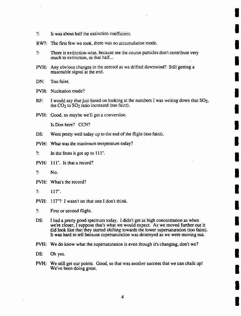
?: It was about half the extinction coefficient.
RW?: The first few we took, there was no accumulation mode.
?: There is extinction-wise, because see the course particles don’t contribute verymuch to extinction, to that half...
PVH: Any obvious changes in the aerosol as we drifted downwind? Still getting areasonable signal at the end.
DN: Too faint.
PVH: Nucleation mode?
RF: I would say that just based on looking at the numbers I was writing down that SC>2,the C02 to SC>2 ratio increased (too faint).
PVH: Good, so maybe we’ll get a conversion.
Is Don here? CCN?
DS: Went pretty well today up to the end of the flight (too faint).
PVH: What was the maximum temperature today?
?: In the front it got up to 111’.
PVH: 111. Is that a record?
?: No.
PVH: What’s the record?
?: 117".
PVH: 117’? I wasn’t on that one I don’t think.
?: First or second flight.
DS: I had a pretty good spectrum today. I didn’t get as high concentration as whenwe’re closer, I suppose that’s what we would expect. As we moved further out itdid look like that they started shifting towards the lower supersaturadon (too faint).It was hard to tell because supersaturarion was destroyed as we were moving out.
PVH: We do know what the supersaturarion is even though it’s changing, don’t we?
DS: Oh yes.
PVH: We srill get our points. Good, so that was another success that we can chalk up!We’ve been doing great.
4

1 2 JUNE 5, 199 1 FLIGHT

UNIVERSITY OF WASHINGTON FLIGHT #1487,0540-1020 UTC, JUNE 5, 1991, FOR STUDY OF
SMOKE FROM KUWAIT OIL FIRES
I. INDIVIDUAL WRITTEN DEBRIEFINGS
(a) Flight Scientist: Arthur Ranmo (from Flight Scientist Manual)
Summary of Surface Meteorology andVisual Observations atTake Off:Sky partially obscured by blowing dust. Visibility 3 kilometers. Upon landing atBahrain at 1020 UTC, visibility had decreased.Bahrain forecast: improving visibility during the afternoon at Bahrain and Dhahran.CCN measurements. Some cross-sectional data (incomplete) on northern plume. Musttry again.
Experimental Observations:Attempt to track centerline from Dhahran to Kuwait foiled. First Air Traffic Controlwould not allow flight track other than airway, and then only at 6,000 ft., at 1,000 ft.above tops. West turn there to centerline intended, but Art called for turn -1-2 nauticalmiles east of centerline from Al Burqan plume. Thus only got -1/2 way distance intoplume required to get centerline. No further maneuvers possible. The abovemaneuvers were carried out at 5,000 ft When it appeared back edge reached called forclimb to 6,000 ft. only to see yet more plume rise to 6,000 ft., thus missed chance forsample over the northeast portion of the Al Burqan field just at last minute. However,all was not lost Extremely clean on top conditions (Colorado sky) at 6,000 ft. allowedfantastic overview and locations ofAl Burqan hot spots. Spectacular mix of black andwhite plumes at cloud top (-6,000 ft.) in nice, soft Cumulus-looking tops. No watercloud seen. White cloud was smoke.
Thereafter turned to northeast with further climb to clear northern oil field plume by2,000 ft. as requested by Ronald Ferek. Leveled off at 9,000 ft. and then made return
trip across same level for lidar depiction. Lidar view good, but plume, due to excessivedust, barely detectable.
Subsequently descended to west of northern oil burn to 1,500 ft., but quickly (-10minutes) found visibility so low no plumes could be traced. Pilot felt 2,500 ft as lowas aircraft should go for safety considerations.
Thus initiated first cross-section at 2,500 ft -25 nautical miles downwind of thenorthern oil burn. After three passes at 2,500 ft., climbed to 4,000 ft for one passwhereupon a first engine generator malfunction caused us to shut down data system.General shut down due to overheating. Return to Manama begun thereafter (-0900UTC).
(h) Right Observer: Arthur Ran^no
Weather Background:Gusty northwest winds at surface, visibility at Manama -3 kilometers, at Dhahran 2kilometers. Bahrain meteorology service forecast: improving visibility during day.Northwest flow at 850 mb (35 knots) and at 700 mb (25 knots) with little veering of thewind with height through 700 mb. Thus, no "fanning" effect in plume expected.

UNIVERSITY OF WASHINGTON FLIGHT #1487,0540--1020 UTC, JUNE 5, 1991, FOR STUDY OF
SMOKE FROM KUWAIT OIL FIRES
I. INDIVIDUAL WRITTEN DEBRIEFINGS
(h) Flight Observer: Arthur Rangno (cont.)
Flight Summary:Appeared to be an ideal day for accomplishing the four planned goals: 1) track plumesto source upwind and downwind; 2) overfly northern oil field fires for lidar cross-secdon, 3) sample individual plumes in northern field fires (white and black, ifpossible); and 4) execute cross-sections of northern field fires. Instead, it turned intomajor disappointment. First, planned direct flight to Kuwait (most direct route) notallowed by Air Traffic Control, thus tracking plume upwind from Dhahran notpossible. Further, after climb out to 6,000 ft., and above smoke layer located between4,000 ft. and 6,000 ft., we were then not allowed to deviate from that height undlreaching airway intersection at Seleg.
At Seleg we turned westbound to intercept plume while descending to 5,000 ft, andinto smoke. Called for turn northbound to Al Burqan oil field approximately 1 minutetoo soon, so only east portion of Al Burqan smoke sampled at 5,000 ft. Broke outover sloping (upward to south) tops of "Al Burqan East" fires and then called forfurther climb to 9,000 ft., to overfly northern oil field plume with 2,000 ft. to spare asrequired for lidar cross-section. Cross-sections executed but thick dust (tops -4,000ft.-4,500 ft.) made smoke plume virtually indistinguishable on two overpasses.
Quick descent from 8,000 ft to 1,500 ft. to southwest of northern oil field to findsingle plumes disclosed severe visibility problem in northern Kuwait, significantlyworse than was the case at Kuwait International Airport during an overflight there.
Almost no forward visibility and visibility below aircraftlimited to a cone of only about 30-45* from vertical. After
c^^ but a few minutes pilot determined that conditions were too^ hazardous for continued flight at that level. No plumes
could be discerned from the several fires observed later dueto dust.
Next tried cross-sections -10-15 nautical miles downwind beginning with three passesat 2,500 ft. Second leg at 4,000 ft terminated and data systems shut down due to leftengine generator failure. Paralleled smoke plume on return to Manama. Little plumerise seen until halfway back when dramatic upward slide began from -7,000 ft toestimated >10,000 ft. south of Manama. Looked like something similar to "synopticupglide". Smoke aloft then spread eastward over aircraft due to veering of upperwinds.
Fi.0i^> )--I ; <’=>
F(l-*w^’<^^’ 3^^
-5 l-’t-^M.
’t^<\. go 9*M13on<M
2

UNIVERSITY OF WASHINGTON FLIGHT #1487,0540--1020 UTC, JUNE 5, 1991, FOR STUDY OF
SMOKE FROM KUWAIT OIL FIRES
I. INDIVIDUAL WRITTEN DEBRIEFINGS
(c) Chemist: Ronald J. Ferek
Northern field cross-section.Flight was cut short due to failure of generator and loss of research power. On flightnorth, four bags were sampled for CCN measurements. Lidar proved ineffective at
defining cross-section of plume. Three passes through plume were completed beforegenerator failed and about half of the cross-section was completed. Prior to this,attempts at sampling individual wells were aborted due to poor visibility (-400 meters)in the dust.
(d) Optical Measurements: Rav E. Weiss
oec3W NapnalomatarA3AathatonrMter
Optical Extinction CaN. bexl, aingta acattaring albado 0 538 nmbap (R) 445, 538, 665 nm w(th auto praasuraand tamp corracttonAaroaotAaymmatryAnatyzar, non-apharical aaroaol propartiaaAaroaoi optical abaorption. bap 0 525 nm using integrated pistefIRar matnod in naany raal time.
Qenoral Obaarvationa:ExtraorcKnarity high dust conoantrations. Unable to see individual plumes. We
decided to do a cross section of the northern field instead. We were able to make twocross sections at 2.500 ft. The plume is only a few minutes wide which aids in makingrapid measurements. Generator faded during the first filter sample pass at 4.000 ft.
OEC-Naph:
was able to make some measurements separating the smoke and dust. Whileover flying the southern fields you could see large separate areas of white and blacksmoke. It would be interesting to measure the optical properties of these distinctlayers. The few measurements that we were able to make indicated a smoke aibedo ofbetween .5 and .6. Occasionally, however, the abedo seemed to be significantlyhigher. wifl have to oarefulty analyze those periods later to see if indeed this weretrue.A3
Dust added significant noise to this measurement There were a few periodsbefore generator failure where good measurements were obtained.
AthdometerNot much signal change because of the short research mission in the smoke.

UNIVERSITY OF WASHINGTON FLIGHT #1487,0540.-1020 UTC, JUNE 5, 1991, FOR STUDY OF
SMOKE FROM KUWAIT OIL FIRES
I. INDIVIDUAL WRITTEN DEBRIEFINGS
(e) Aerosol Scientist: J. David Nance
Fl ight 1487 was a fl ight to the north oi l field of Kuwait
The winds in Dhahran were much l ighter than they were for
the previous fl ight yet there was sti l l very much dust to
the north in Kuwait We took off from Dhahran in the plume
and flew out over the Gulf just off the eastern edge of the
plume The eastern edge was very distinct and the plume had
a fairly hard cei l ing at about 5 000 ft Above this
altitude the air was very clean with nothing but blue sky
overhead Several samples were col lected in this clean air
Air traffic control kept us at 6 000 ft out of the plume
unti l we reached Seleg From here, we were able to descend
to 5 000 ft and veer to the west into the plume A few
samples were col lected here, but as we approached Kuwait we
began to climb eventual ly reaching 9 000 ft passing the
northern edge of the field, unti l we reached a point (maybe
20 miles south of the north oil field where we turned east
for a lidar overfl ight of the plume from the north field
After making two overpasses we descended to 1 500 ft and
subsequently climbed to 2 500 ft to make several
penetrations across the plume about 10 miles downwind of the
source Only a few samples could be collected before one of
the main power generators for the instruments blew causing
the flight to be aborted. The size distributions observedwere very reminiscient of those described previously for
other flights
(f) CCN Scientist: Donald Soureeon
During this flight I got very little CCN data, but before the generator went up in smokethe CCN showed concentrations of ~600 outside the plume and -16,000 to -18,000 inthe dust and smoke plume at the North oil fields.
4

n. VOICE TRANSCRIPTIONS OF AIRBORNE TAPE RECORDING FROM UW FLIGHT1487 ON JUNE 5. 1991
5:47 AM
AR: Flying at 5,800 climbing to 6. Due to ATC absolutely flat topped, the haze withimmaculately blue sky above, the first rime we have seen a sky this blue this low.Off to the west there are undulated tops like stratocumulus tops. Approximately 5to 10 nautical miles off the left wing and we’ll be angling over that direction,because that should represent the center line, so we should intercept it here in thenext 10 minutes.
6:08 AM
AR: Two smoke layers. The marine boundary layer smoke layer, which has risen to2500 feet by the rime we took off and the second smoke layer are well presented inthe sulfur and, particularly the sulfur trace at this time.
6:08 AM
AR: Off the west through northwest horizons plume center line marked by elevated topsprobably 2000 to 4000 feet higher than the present flight level. However, our planat this rime is, once we can correction, 2000 to 4000 higher than 5000 feetwe’re now at 6000 feet. Our present plan, as soon as we can be released fromATCs to move into the center line descending to 5000 and move up the center line at5000 feet until we pass out the north end of the Al Burgan oil field fire. Then thatwill be followed by a lidar cross section of the north Sabriya oil field fire. Lidarcross section onto of the Sabriya.
6:24 AM
DS: Using the 30 to 1 dilution on the CCN.
6:25 AM
KM: Unintelligible.
6:32 AM
KM: Unintelligible.
6:43 AM
AR: We’re heading westbound now and descending to 5000 toward the center line
6:44 AM
RJF: Hey Don.
DS: Yeah.
RJF: About ready for a new bag?

DS: I’ve got all I need.
RJF: OK. About to get into smoke.
DS: OK, go ahead and dump it.
RJF: OK, there we go.
DS: Ready.
6:46 AM
KM: Do you want us to mark this point?
AR: Negative. Looking for the center line now. Believe we’ll get higher values yetprobably one minute ahead or so.
6:47 AM
AR: Thinking this might be coming up here, this next bank. So I’ll be watchinginstruments and we’ll see if we give you a turn there.
6:49 AM
AR: Saddle region there. Visibility is beginning to decrease below again, so we shouldsee some smoke come in.
Unintelligible.
AR: So it looks like we’re coming into merging layers here. A top layer merging into alower layer after that first peak. I hope that’s a correct interpretation. Be about aminute, try a minute again here.
6:52 AM
AR: May have been the north oil field plume that we hit here on the outside of this.Looks like it’s going to be the main bang, you might say.
RJF: Don, you ready for another one?
DS: Sure am!
6:53 AM
AR: Well defined east edge here. Now the ground is becoming obscured directly belowthe aircraft, maybe half a mile ahead.
Ken, why don’t you start making your right turn in here? By the dme we comearound we’ll be in the center to about the 3 4 0 degree heading.
6:54 AM
RJF: Say Don.
2

6:57 AM
RJF: Hey Don. when do you want another bag?
6:58 AM
RJF: Hey Don.
DS: Yeah Ron?
RJF: When do you want another bag?
DS: When you are ready I’ve got a couple I need.
RJF: Tell me when you’re finished.
DS: I’m finished now.
7:00 AM
DS: I’ve got enough of that sample to characterize it now, Ron.
7:03 AM
AR: I can gradually (unintelligible). Landfall now.
7:06 AM
KM: Can you hear me. An?
7:07 AM
KM: Out of 5000 for 6000.
7:11 AM
AR: Ground visible at 0715:20, flight level 6000.
7:21 AM
AR: Looks like we’re directly over Kuwait International Airport. Is that correct?
KM: We’re out 6 for 8000.
AR: 0732:55 directly over Kuwait International Airport. Ground visible through heavydust. Dust top about 4 K. Estimating 4 K on the dust top. No evidence of smokein Kuwait Airport. Smoke plume dead ahead north through east, southeast and theBurgan field we have passed on the west side. It’s now to the southwest of us.
7:24 AM
KM: This altitude at 9. Do you want us to level here if we can get it?

7:34 AM
AR: Hey Ken, it looks like we’ve cleared the east edge of this northern plume, if youcould give me about one more minute this heading before turning left to make thesecond cross plume traverse.
KM: OK, we’re at 9 right now climbing to 10. If we can get 9 do you want that?
AR; 9 looks pretty good. Ken. I thought that was excellent. If we don’t have to climbto 10 this is definitely better.
KM: OK, let me know when you want to turn.
AR: Just give me about 30 seconds and then go ahead.
KM: OK, and I understand you just want to turn around the approximate edge of theplume.
AR: Roger. Left turn and the heading will be something like (unintelligible) to completethe turn. What we want to do is go across perpendicular to the rim. We just aboutdid on that one. Almost the reciprocal.
KM: OK. Wind is pretty much out of the north and we’re looking at a header that’s outwest.
AR: Roger.
KM: You want to make this downwind of the source of the plume, is that correct?
AR: Affirmative.
KM: OK and we’ll turn now.
7:36 AM
KM: Passing the western edge at this time and we’re starting down.
7:43 AM
RW: The ground is not visible through the dust
AR: Heck of a lot of dust here. Gee, I can’t see the ground. Oh, there’s somethingdown there now, I can see it.
RW: Did see those cirrus clouds, didn’t you?
KM: Gentlemen, we’re going up. We can’t see beans down here.
8:00 AM
AR: Turning southbound and we’ll be taking a course heading of approximately 2 niner0 to go across the Sabriya oil field at 2500 feet on the first leg of this cross section.
4

8:06 AM
RJF: Say Art, this will just be a first pass for a look see. Then we’ll want to repeat ittwice. Sampling at the same point for 10 minutes on the first one and 20 minuteson the second one.
SW AM ^KM: One minute, we’ll turn inbound.
8:08 AM
AR; Unintelligible.
8:09 AM
AR: To the edge of the plume.
8:10 AM
AR: Edge along pick up the plume chemicals and should have a peak within 30 secondsto a minute.
KM: Mark the peak so we can note the point.
AR: Let’s call this the peak here. I think this is about it.
8:11 AM
RJF: OK Art, are you on the headphone?
AR; No.
RJF: OK, it looks like we’re in and out of this in 3 minutes. You saw where the peakwas so why don’t we, soon as we get out we’ll turn around and go back and hitthat peak again for our first filter sample.
AR; Roger.
KM: Are you out yet?
AR; We’re out now. We’re going to turn right now. Ken, did you copy that? We’reout ofplume and we can return along the reciprocal heading over that same groundplot Whatever that takes. Over.
KM: OK.
8:13 AM
AR: Ron, Ken marked the point probably 5 seconds after you ran. Will that make muchof a difference?
RJF: No, because when I come up here 111 tell you when I’m taking the bag.

8:14 AM
RJF: Hey Art
AR: Yes.
RJF: When I sample, you signal Nance to take a sample.
AR; Think you can give us about a minute warning or so?
8:15 AM
RJF: Dave says he can hear when the bag goes so maybe I don’t need to yell at him.
AR: OK, that’d be fme.
KM: OK, we’re headed back.
8:16 AM
KM: Two minutes.
8:17 AM
KM: One minute.
Less than a minute. Pretty close.
8:18 AM
AR: I think we’ve hit the edge now.
The point I gave you would have come up a lime sooner.
KM: Gone over its
RJF: OK, I’m sampling now.
AR: Roger. Looks good. Ken.
Ken, we have 6 minutes before we want to be back in that plume center line. Itlooks like not quite enough to go all the way through it, so I think we’ll just pop outon the west edge here in 2 minutes, say, and then we can head back at the samepoint.
KM: To repeat, a total of 10 minutes from the dme we took the last sample, is that it?OK, we’ll go out here another 3 minutes. 4, 5 then.
8:20 AM
Unintelligible.
6

8:21 AM
RJF: Yes.
AR: Did you copy. Ken?
KM: OK, we’re 3 minutes from sample point.
8:28 AM
KM: 2 minutes from sample point.
Minute and a half to go.
8:29 AM
KM: Plume.
8:30 AM
KM: Make that 30 seconds.
AR: We’re sampling here. Ken.
Looking down underneath these plumes, the ground is always visible. The plumeis barely detectable amid the dust, just a gradual darkening. No clear smokeoutlines. And then a brightening as we come out of the plume. The time 0 8 31.This is the third pass through this plume at 2500 feet with two bag samples on thelast two. Time 0831:50.
RJF: Hey Art
AR: Go ahead.
RJF: OK, we’re going to pull on these filters for 20 minutes so we want to descend orascend to the next altitude for our, and do our preliminary pass. So what do youthink the top is here?
AR: Looks like we’re 7500 to 8000. Ken, what do you think?
KM: About 7000. A little bit lower. What did we level at before? If it was 8000 1 thinkwe’re pretty much above it aren’t we?
AR: I think at that last batch we climbed at 9 because 8 was a lime too close to the top.So I wouldn’t quibble with 7000. 7500 at all. So 7500, 7000 Ron?
RJF: Let’s figure that our top one will be about 6500 then or maybe 500 to 1000 feetfrom the top. What’s the middle one then between these two?
AR: About 4000? 3500 to4000?
RJF: Yeah, let’s go to 4.

8:33 AM
AR; Ken, I guess you copied that. In about 20 minutes we could be climbing to 4000anytime.
RJF: Negative, Art. We can climb to 4 now and make a pass through to see what itlooks like and then we want to make our second pass 20 minutes after that lastsample.
AR: That’s right, Ron. Sorry. Did you get that Ken? We can climb to 4.
KM: Yeah, I got it.
8:33 AM
RJF: Hey, Don.
8:39 AM
KM: Sdll have got 3 minutes to the sample point
8:42 AM
RJF: I think that was the peak.
8:43 AM
KM: A minute here yet
RJF: You’re right, it’s going up again.
KM: How much time do you want to kill out here?
RJF: We’re sdll in it, so let’s keep going dll we get out the edge.
8:45 AM
RJF: OK, we’re about out of it here, if you want to reverse course, we’ll need to be on asampling point in about 4 min.
KM: I understand. OK. In 4 minutes if you’re ready, yeah?
RJF: Right.
Sound stops here.

UNIVERSITY OF WASHINGTON FLIGHT #1487,0540-1020 UTC, JUNE 5, 1991, FOR STUDY OF
SMOKE FROM KUWAIT OIL FIRES
in. POSTFLIGHT DEBRIEFING
Overview:First leg of study (down plume) did not work-had to fly down airway to Seleg instead.Were not able to fly in close to oil wells due to very poor visibility.Continued trying to perform cross-section study (downwind of north field) and twobag samples were taken before generator blew out. (Chemist notes say "Fourbags were sampled")Partial information was obtained on the plume, however, before generator went.Observed that plumes from northern and southern field were distinct in the morning;however, the situation became much more confused in the afternoon.
PVH: Flight of Wednesday, 5th of June.
AR: Well I can give a brief overview. We had three components, track the plume to thesource, find the low level plumes and do the cross section. On the first portion, theevolution pan, the first leg of that didn’t work out too well because we weredirected down the airway to Selig instead of along the plume, so also couldn’t getout of 6000 feet. Once we were over 6000 and when we were able to veer left andgo into the plume I made a mental error and we turned too soon and grazed thecenter line, so we didn’t get back to the source. And then we went down to look atthe low level plumes and it was a visual snowstorm down there, sand at 1500 feet.Couldn’t see anything. So we climbed to do the cross section and the generatorfailed!
PVH: This is the northern field you’re looking at.
AR: Right.
Yeah, the first evolution though was up the main (too faint). Since it was overDaharan, we were under the impression, I was under the impression we couldsimply take off and once out of ATC control, 10 minutes out of Daharan, veerwestward and go track wherever it was before and track it right up. Perfect case forit But we weren’t able to do that undl Selig.
PVH: That’s unusual isn’t it Ken?
KM: Not really. Problem is we were passed off to Kuwait control who has no radar.They usually want people to arrive on an airway so that they can control better, sothe people we were talking to in Bahrain, from Bahrain to Kuwait, said, "You’llhave to get that clearance from Kuwait when you switch." When you switch wecan’t pick them up till we get...
PVH: Was any science done?
RF: We did OK. On the way up we got a bunch of bags for CCN.

In the main plume?
Yeah. Then we did two cross sections just downwind of the north field from thelidar. It worked a little bit. It was kind of by the dust.
It’s hard to tell the dust from smoke.
Very subtle signal. If you were sitting here watching it, probably see a littlesomething, but if you were scanning the place you would never see it. I think thelidar would have been good if the dust wasn’t so thick and it may pay off to try thatwhen we have a low dust. Then we were set up to do a cross section on the, whatwere we, about 10 miles south of the northern field?
About that
It was a good 3 minute traverse across the plume, nice peak in the middle and wedid 3 passes in the bottom and started the middle, did one pass across the middleand we were coming back for second one to take the first bag sample. Justbefore...
Three passes at the top?
At the bottom. And one in the middle. So that’s partial information. I think it willbe an easy plume to work if we get the same kind of conditions again and I think ittakes about 3 to 5 minutes to get across the whole thing so we can work that prettyfast. I think an hour would really be good. Maybe an hour and twenty minutes.
Get 2 or 3 cross sections at different distances. Good flights.
The other thing I was going to say about yesterday’s flight, on the way up, thingslooks fairly straightforward. The plumes were separated, there was a definite topand it was all well contained below that top at about 6000 feet, 5500 feet. Youcould really see embedded in the dust the two plumes coming out it.
Great radiation experiment today. Distinct white.
The thing that happened was on the way back, when we were coming back downthe coast, the stuff over the land son of lifted up and was blowing all over and thestuff below in the northern field and pan of the southern field was moving out overthe Gulf and we were in this clear zone that was surrounded on three sides bysmoke. And the stuff above us, by the time we got to Bahrain, was moving all theway out to the east So that was a fairly complicated situation. If we tried to dothis experiment in the afternoon, we wouldn’t have had a chance of knowing whatplume was what or what the smoke was doing. There was a fairly narrow windowin there, the earlier the better to try to do something while it’s still somewhat stable.
I had a pretty good view, both in the morning and in the afternoon coming out inthe King Air, flying at 20,000. The tops were about, in the afternoon anyway,were about (dust top) 4500 or so, the bases were 1500 and the whole sky belowus, the whole area below us was uniform dust. And then you could see the blacksmoke, over the northern field, coming up, truly black, and then son of breakingwaves downwind. Very clear.
Fascinating the domes of smoke, valleys, domes, waves.

MK: Turrets popping through.
PVH: I think the message is clear, here. That we’ve got to pick clearer days in theremaining flights. And we got a lot of interest yesterday in Kuwait, our individualplume studies were very important.
AR: Peter, on that note, the weather maps indicated about the same gradient today asyesterday, wind platform nearest Kuwait indicated 20 to 25 mile in that area. (toofaint).
PVH: The Germans (several conversations).
AR: And it was 2 kilometers yesterday at this time, still...

1 3 JUNE 8, 199 1 FLIGHT

UNIVERSITY OF WASHINGTON FLIGHT #1488,0200-0808 UTC, JUNE 8, 1991, FOR STUDY OF
SMOKE FROM KUWAIT OIL FIRES
I. INDIVIDUAL WRITTEN DEBRIEFINGS
(a) Flight Scientist: Peter V. Hobbs (from Flight Scientist Manual)
Summary of Surface Meteorology and Visual Observations at Take Off:Sunny. Light wind at surface (~8 knots).Smoke apparent aloft.Excellent plume characterization and cross-section of northern field (Sabiriyah).Strong low-level jet in Bahrain area on take-off:
35 knots at 1,800 ft.40 knots at 3,300 ft.
Experimental Observations:Individual plumes in Sabirivah field (north of Kuwait)Plume A: Isolated black plume. Three initial passes (photo #20); followed by firstchemical sample at 0413 UTC (aerosol at 0416 UTC). Second chemical sample andaerosol of plume A at 0424 UTC.Plume B: White plume. (Black behind.) First pass for aerosol at 0434 UTC.Chemical and aerosol sample #1 at 0445 UTC.(Plume X: for aerosol sample only, was a zebra: white and black, at 0453 UTC)Plume B: White, with black portion just behind. Chemical and aerosol sample #2 at0457 UTC (latitude 29.92, long: 47.70 )
Cross-section of Composite Northern Plume:At ~20 nautical miles from upwind edge of fires).Sample C: Upper level of plume. First pass going east clipped tops-no sample.Going west at same altitude, aerosol sample at 0516 UTC. First chemical and aerosolsample going east at 0524 UTC at 3,200 ft. (indicated).Sample D: Middle level of plume. Chemical and aerosol sample at 0541 UTC at 2,500ft (photo #22 on PVH’s camera shows composite northern plume). Second chemicaland aerosol sample-heading east- at 0553 UTC.Sample E: Lower portion of plume. Aerosol sample (late?) at 0612 UTC headingwest. First chemical sample (heading east) and aerosol at 0620 UTC at 2,000 ft. infirst peak (in black part of plume). Second chemical sample (in lower portion of plumeheading west) and aerosol at 0637 UTC, again went for black (according to Ray)portion of plume.On the way back to Kuwait City at the Kuwait border attempted (only partiallysuccessfully) to remain in northern plume-diverted around Kuwait City, then hadtrouble picking plume up.[See voice transcript of debrief of flight and PVH’s field notes.]

UNIVERSITY OF WASHINGTON FLIGHT #1488,0200-0808 UTC, JUNE 8, 1991, FOR STUDY OF
SMOKE FROM KUWAIT OIL FIRES
I. INDIVIDUAL WRITTEN DEBRSFINGS
(b} Flight Track: Rodney Sorensen
Plume
A
B
X
Well Location
2955.37’ N/47’42.74’ E
2952.95’ N/47’42.39’ E
Not Applicable
Sample Location
29"56.12’ N/47’42.29’ E
2953.20’ N/47’42.30’ E
2955.33’ N/47’44.62’ E
Aldtude
600 ft.
600 ft.
600 ft.
Times(local)07060713071607240734074507570754
Cross-SectionsLatitude
2933.50’ N2935.38’ N2934.13’ N29"35.19’ N2934.53’ N29’34.66’ N29-33.98- N29-33.98- N29*34.10’ N
Longitude
4750.40’ E48*04.20- E47*54.88- E47’58.80’ E47’55.20- E47-55.59- E4752.12’ E4752.12’ E47-55.73- E
Time(local)080608100816082508410853091209200931
Altitude(ft.)3,0003,0003.0003,0002,2002,2001.8001,8001,800
Remarks
west edgeeast edge
Sample "C" westboundSample eastbound
Sample "D" westboundeastbound
Sample westboundSample "E" eastboundSample westbound
2

UNIVERSITY OF WASHINGTON FLIGHT #1488,0200-0808 UTC, JUNE 8, 1991, FOR STUDY OF
SMOKE FROM KUWAIT OIL FIRES
I. INDIVIDUAL WRITTEN DEBRffiFINGS
(b) Flight Observer: Arthur Raneno
Weather Background:"Relaxed" shamal pressure gradients. Surface winds 10-20 knots in and along theGulf. Shamal jet 30-40 knots, though, from 1,000-4,000 ft. Above Sea Level. 850mb winds 330, 35 knots, 700 mb 015", 15 knots at Dhahran. Little change expectedduring day.
Flight Summary:Light northwesterly winds at take off, visibility >5 kilometers, smoke layer aloft,estimated above 9,000 ft. Flight went directly to northern field with no attempt to trackdownwind outgoing plume. (Plume was mainly well inland from west Gulf coastanyway). Flight level to Kuwait too low to take advantage of decreasing head windsabove 5,000-6,000 ft. Above Sea Level. Whether the climb to 8,000-10,000 ft.would have been an advantage is not known. (Fuel use increase vs. lower headwinds.)
Marine boundary layer top <1,000 ft., between this haze layer and smoke layer aloft.Dark line of smoke soon evident to west (within 20 nautical miles of northbound leg ofKuwait). Climbed to top of "Regional haze" layer (base ill-defined) at 6,000 ft Darksmoke line gradually receded from view as flight track directed through Seleg airwaycrossing. Haze tops gradually rose to flight level near Kuwait border.
Overflew approximate centerline of north plume at 3,000 ft. and further descent to2,700 ft resulted in nipping some smoke tops prior to reaching northern edge. Goodvisibility (>15 kilometers) allowed descent to 500-600 ft. for plume samples. Thislower altitude than previous samples for single plume resulted in tighter, more compactplume structure in nearly all bag samples than has been previously obtained.
All plume samples, black and white, seemed well-timed for bag samplesin densest portions of plume.
Lastly, executed cross-section ~18 nautical miles downwind from Sabiriyah-Roudatainbums. Uppermost pass ^300 ft. from highest tops, lowest about same from lowestbases. Seemed well-executed. Flight to Manama, tried to stay in plume, but it wassplitting and the inland track of plume over Saudi precluded good evolution study.

UNIVERSITY OF WASHINGTON FLIGHT #1488,0200--0808 UTC, JUNE 8, 1991, FOR STUDY OF
SMOKE FROM KUWAIT OIL FIRES
I. INDIVIDUAL WRITTEN DEBRffiFINGS
(h} Flight Observer: Arthur Rangno (cont.)
^ ^^’"--SGcTpoM
T^v,N
^^"Ail^
4

UNIVERSITY OF WASHINGTON FLIGHT #1488,0200-0808 UTC, JUNE 8, 1991, FOR STUDY OF
SMOKE FROM KUWAIT OIL FIRES
I. INDIVIDUAL WRITTEN DEBRIEFINGS
(c) Chemist: Ronald J. Ferek
Northfie Id sources and cross-section.Two wells (one black, one white) were sampled in the north field. A good cross-secdon was also obtained 20 miles downwind of the northern field.
Bag fill(UTC)04130424044504570524054105550620063707170736
Location
Black plume (A1)Black plume (A2)White plume (Bl)White plume (B2)Upper pass (c)Mid-plume (Dl)Mid-plume (D2)Lower pass (El)Lower pass (E2)BackgroundBackground
Samples
37’s, can, gridQuartz, H2, can37’s, can, gridQuartz, can, H^S37 s. can37’s, can, gridQuartz, can, HzS37’s, canQuartz, can, grid37’s, can37’s, can
S02(Ppb)200ISO265230401701304055<DL<DL
CO;(ppm)rfo-40743^4505725%5%572569554353
Good source characterization of north field and good cross-secdon for fluxcalculadons.
(d) Optical Measurements: Rav E. Weiss
OEC3WNDnlomalrA3AotrxtocriBtw
Optical Extinction CU. bcod. single scattering Ibedo C 638 nmbap (R) 445, 538. 665 nmwithal pressure and temp correctionAeroeot Asymmetry Analyzer, non-spherical aerosol propertiesAeroaol optical absorption, bep 0 525 nm usipg integrated ptatefitter method in neeriy rel ttme.
Qenefl Ob-rvtiom:Low dust good visibility in northern fiotds. We were able to get exoeflent
measurements on both black and white plumes. Some measurements were also madeon zebra plumes. The streaks of white and black in some of the plumes made itdifficult at times to know exactly where the samples were taken. Oec should be usefulin separating the different cases. Smoke downwind of Kuwart (northern plume)appeared to be sfightty less absorbing (optically) than the southern field.
OEC-Neph:Average scattering albedos for the bteok plumes were less than 0.4 while the
white plumes were greater than 0.6. Several of the plumes from the different sourceswere merged but not mixed. The change in dbedo and A3 data could quite easNydetermine which type of plume was being sampled.

UNIVERSITY OF WASHINGTON FLIGHT ^14880200-0808 UTC, JUNE 8, 1991. FOR STUDY OFSMOKE FROM KUWAIT OIL FIRES
I. INDIVIDUAL WRITTEN DEBREFINGS
(d) Optical Measurements: Rav E. Wei^ (^nr )
A3The A3 worked realty wed in this low dust environment. was able to get an^S ^^0^93?10" of ftlect^o-OPtica’ enhancements as we flew through the variouswhrte and black plume mixtures. was able to review some of the results from this
^iffio^^^^^^ to noise rabo shouM provide good rotary diffusion
AethetometefWorked well as usual; significant signal increase when in the smoke. We should haveofdatatocalibrate the Integrating Plate filter absorption method for these aggregates
using the OEC. ^^
(e) Aerosol Scientist- J David Nance
Fl ight 1488 was to the fi res in the north oi l fi ^i n ^^ ^ ^ :^^^^ T f-S"1"^n^^r^.^^j??^?-^6^1^^0" ? - "^6-?^/^ j^^ ^-i ^-"-couple of plume samples were lost due tn n.^^
y’ a
p^^.^- ^.s^^ ? ^^^^^^P^^.^^eL00^^3 - ^^ ? ?6 ----distinguishing features in any of the tyPes""s^oke^^er ? l^’??^ SE’t samPun^ individual plumes down low4^00 5^d^v;derdoSnewLdha.outs?orc:?lero^sombLddts a^
^^^^^^^^SS1^^ .-eS^Ss^-r^^L-^o-^l ^/e^^S^^^^^e?^^ ^ SS?P1?S contained ^oke that was primar^y oreither the black or the white variety,
"’ctrny or
6

UNIVERSITY OF WASHINGTON FLIGHT #1488,0200-0808 UTC, JUNE 8, 1991, FOR STUDY OF
SMOKE FROM KUWAIT OIL FIRES
I. INDIVIDUAL WRITTEN DEBRIEFINGS
fe) Aerosol Scientist: J. David Nance (cont.)
From here, we proceeded back toward Bahrain, trying to- staywithin the plume as much as possible I col lected severalsamples during the trip back that may be helpful in tryingto isolate an evolutionary pattern to the particle size
distributions
Once again, the size distribution modes seemed to fol low thefami l iar pattern The nucieation mode was intermittentWhether this is real or an instrument artifact I do notknow The coarse mode stayed pretty much constantregardless of the concentration of the smoke This seems tosuggest that the coarse mode is dominated by the backgrounddust and the smoke contributes little to the coarse modeOn the other hand, tha accumulation mode went up an down in
di rect proportion to the smoke concentration
(fi CCN Scientist: Donald Spureeon
On this flight the CCN showed CCN concentrations of -600 to -900 max out of thesmoke plume and CCN of -15,000 in the plume near the north oil field fires.
Towards the end of the flight the cabin got too warm and the CCN had to be turned off.

H. VOICE TRANSCRIPTIONS OF AIRBORNE TAPE RECORDING FROM UW FLIGHT1488 ON JUNE 8, 1991
2:20 AM
PVH: OK. this is Flight 1488 on the 8th of June. We’ve just taken off from Manama.Time 0221:30 sec Z. The purpose of this flight is to head out to the northern field,take a look at some individual sources out there and try to do some good crosssections of the northern plume. Conditions are fairly good. We don’t have toomuch sand today. Smoke is apparent from the ground at Manama. Althoughwinds were light at the ground as we have a low level jet 35 knots about 1700 feetand winds have picked up to 20 meters per second. 3300 feet. The smoke may begoing fairly high today. That’s what the model is predicting but we’ll have to seewhat the measurement Two days ago we tried to look at the northern field and wedid so partially because of a lot of dust and generator problems. So this is oursecond try.
2:22 AM
PVH: Looking out to the east as we fly over the Gulf, I can see some high level smokeand above us I can see some high level cirrus.
2:25 AM
PVH: That white looking cirrus cloud above us may be indeed the smoke. It looks brownon the horizon looking to the east and looks whitish higher up above us, showingsome undulata structure.
2:28 AM
KM: Unintelligible...We’re leveling at 6000.
2:31 AM
PVH: Nice pleasant 88 degrees in the cabin at the moment. This was our earliest takeoffat about 0500 local time.
3:28 AM
PVH: Ken?
KM: Yoh?
PVH: Are we stuck at this altitude or can we go lower?
KM: No we’re not. What would you like?
2:42 AM
PVH: We got about 45 knot headwinds here. We go down a few thousand feet and theymay get a bit lighter, though still fairly strong starting about 1500. Why don’t wegel down to about 3000.

KM: OK. You probably have to wait a few minutes and request it from Kuwait. We’renot in radio contact with them yet.
3:01 AM
KM: OK, we’re out 6000 for 3000.
3:07 AM
PVH: At this point the winds 6000 have fallen off to about 9 meters per second. Neph-20has picked up as we pass through 5500.
3:09 AM
PVH: There’s a flare off our left wing.
3:17 AM
PVH: Off our left wing is a flare from a Saudi well on an island in the Gulf at about 28.3,48.9.
RW?: Hey Art, can I see it?
3:40 AM
DS: Yoh, Ron.
RJF: Yeah.
DS: I’m done with this bag unless you’re in the middle of something.
3:41 AM
KM: Over by, overhead Kuwait. Visibility down there is 400 to 500 meters.
3:44 AM
PVH: Ron?
RJF: Yeah.
PVH: Just went through some sort of plume there.
RJF: See it
3:53 AM
PVH: We just hit for the first dme the plume from the northern field just north of KuwaitIt’s flowing almost due south.
OK, we’re going to take a pass through across the width of that black one we seesort of isolated off the left wing, removed somewhat from the rest of them. Passthrough that across the width and then we’ll turn around, come back and go alongthe length and get some chemical samples.

4:02 AM
PVH: When you go through this one. Ken, mark the lat-long when you re in the middleot it. Uive us a little bit of warning when we’re coming up to it.
4:04 AM
PVH: OK, I got a clear view of the black plume, there’s no white.
KM: OK, this guy is probably about two minutes ahead of us.
PVH: Two minutes ahead of us, pure black plume, fumigating somewhat. Can’t see anywhite to it from this vantage point.
4:05 AM
KM: 30 seconds, 15. 10. Ended up hitting a thin spot on that one. I’ll go back and hitit 3-^Hin.
RJF: The S02 and CN count is dead again.
4:06 AM
PVH: Unintelligible.
PVH: Should be back on.
4:07 AM
PVH: Does it look alright, Ron?
Just hold on a bit Ken till we get this problem fixed.
4:08 AM
PVH: Are you ready, Krista?
KK: Yeah. I think we’re all set.
PVH: Is the SC>2 working?
KK: Yeah, I fixed it.
PVH: OK, let’s do another penetration across the width of that same plume. Ken.4:09 AM
KM: About a minute out. 30 seconds. 15 seconds. 10 seconds. Mark.
4:10 AM
PVH: OK, Krista, are you ready for a sample?

4:11 AM
PVH: You ready for a proper sample now?
Ron, you ready for a proper sample now?
RJF: Sure.
PVH: OK, let’s hit that same plume again. Ken, and as you go into it turn down its lengthand we’ll mark a position where we take down chemical samples.
KM: OK, but by the time I come down the length we’re going to be through it, yourealize.
PVH: OK, well then just try going through the width of it and you call it for Ron.
KM: OK. We’ll go through the width of it again. We can do a circle around to the rightand then run down the length of it a ways, if you like.
PVH: OK, try that as well.
RJF: Peter, what’s the point of trying to sample through the width?
PVH: As you heard what Ken said, that we’re going to go upstream a bit and come backalong the length.
KM: If you like, we could just hit it and go downwind in it.
PVH: Right, go downwind and then come up towards the source.
KM: We’re not going to be able to find that plume if we’re downwind. But we can hit itfrom the top and go downwind a ways and then turn out away from it.
PVH: OK.
KM: OK, in about 1 minute we’ll be passing over it going downwind. What do youwant, about 30 seconds before we turn out, before we get into the main field.
RJF: 15 seconds. I’ll tell you when the bag is full and then you can turn.
KM: Well, about 1 minute out. Less than that, 40 seconds.
4:13 AM
KM: 10 seconds. Stand by.
Enter.
PVH: OK, let’s call that Plume A, sample 1.
4:14 AM
PVH: Ron, I’m calling that Plume A, sample 1.
4

4:15 AM
PVH: Ken, let’s do the same thing again. We just want to get an aerosol sample, so ifyou give me a few seconds warning I can tell Dave.
KM: 30 seconds out.
4:16 AM
KM: 15 seconds out. 10 seconds. Stand by. Mark.
And turning out.
4:17 AM
PVH: We did 3 passes through the black Plume A just to take a look at it on the stripchan, then we did a chemical sample of black Plume A at 0413 followed by anaerosol sample at 0416. We’re going to do, in about 3 or 4 minutes, a secondchemical sample of Plume A.
Ken, when we hit this Plume A again we want to do the same as we did before andat that point we mark it A.
KM: Unintelligible.
4:21 AM
PVH: So be ready in minute.
4:22 AM
KM: About a minute out.
4:23 AM
KM: 20 seconds. 15 seconds.
4:24 AM
KM: 5. Stand by. Enter.
RJF: Bag filled.
PVH: That’s Plume A. sample 2.
KM: How long before you’re ready for the white one?
RJF: 20 minutes.
PVH: We’ll take a look at it before then, but I just want to spy this black pool of oil that’ssmoking. I’ll come up, Ron.

4:25 AM
PVH: OK, Ken, let’s take a pass through that white one, get an aerosol sample.
KM: About 4 minutes till we get around to it.
4:29 AM
KM: OK, (unintelligible) will be cross wind, short way?
4:31 AM
KM: Off our left wing. We’ll be there in about 3 and a half minutes.
4:32 AM
KM: 2 minutes.
4:33 AM
KM: 30 seconds. 15 seconds. Stand by. Mark.
PVH: Mark B.
4:34 AM
PVH: Is the sulfur working, Ron? There was no sulfur indication in that plume.
RJF: We were not in it long enough for the S02 to respond.
4:35 AM
PVH: Ken, when we do that same plume again we’re going to have to try to stay in it alittle bit longer.
KM: If we run downwind we immediately merge with black stuff, looks like both sides.
PVH: OK, Ron’s going to have to grab it as best he can from your call.
KM: How long before you’re ready to hit it again.
PVH: Alright, he’s up working his filters. Should be about 2 minutes I think.
4:37 AM
PVH: We’re still waiting on Ron.
4:40 AM
PVH: These roads serve as good runways. Ken.
KM: Say again.
PVH: The roads should be good runways.
6

KM: Yeah, I would think so.
4:42 AM
PVH: We’re circling at 800 feet above the desert upwind of the fires waiting to make ourfirst, what will be our penetration of Plume B, a white plume in order to get achemistry sample. We previously got an aerosol sample in it.
RJF: OK, we’re ready for another sample of the white plume.
KM: About 2 and a half minutes here.
4:43 AM
PVH: Ron, tell me when you sample so I can get the aerosol.
RJF: What did you say?
PVH: Tell me when you take your sample so I can get the aerosol sample at the sametime.
RJF: Can you hear the bag when it opens?
4:43 AM
RJF: Dave usually listens for the bag and just samples at that time.
PVH: He doesn’t seem to hear that.
RJF: OK.
KM: more minute.
4:44 AM
KM: 30 seconds. Stand by. Mark.
RJF: Bag open.
4:45 AM
KM: Tell me when we can break.
PVH: Alright.
Well call that Plume B. Chemical sample number 1. Those are black plumes.
4:46 AM
PVH: Taking a lot of oil on these passes. We just have got chemical sample number 1 inPlume B, plus an aerosol at 0445. As we passed out through the white plume wehit a black plume.
4:47 AM
PVH: Ron?
RJF: Yes.
PVH: OK, we’ll do that one again for you when you’re ready and then we’ve got a blackone and a white one. I don’t see any other main types out here. We’ve got about 2hours left, so I think that we’ll then turn our attention to the cross sections.
RJF: Sounds good. Why don’t we do 3 levels, at least 2 passes each.
PVH: Yeah. In close it may not need 3 levels because the tops are only here 2700, thebases are probably near the surface somewhere, so me may get away with 2 levelson the first cross section.
RJF: OK, that sounds good. but I’ll need at least 10 minutes after the first pass and 20minutes after the second one.
PVH: Yeah, I understand.
RJF: You may want to go through once, just have a look. So do it 3 times, so we can hitthe peak on the second one.
PVH: Ken, while we’re waiting here, why don’t we take a pass through one of thezebras, the black and white ones, and get an aerosol.
KM: OK, we’ll find one here.
4:51 AM
PVH: Can you pick out a good zebra, Ron?
KM: I don’t know how good, but we’ve got one up there, oh at 11:00 o’clock.
PVH: OK, we’ll call this Plume X so as not to interrupt our ABC sequence.
4:52 AM
KM: Got about a minute and a half here. It looks like the white stuff is going low andthe black stuff a little higher. We’ll see when we get closer.
PVH: OK, if you give a description of it as we pass, it will go in the recording.
KM: Looks like we might be coming out of a puddle of a lake here, and the white mightbe just off the surface and the black out of the well itself.
4:53 AM
KM: 30 seconds. It’s not very thick. White smoke staying a little bit lower than theblack smoke. 15 seconds. Stand by.
PVH: Aerosol sample. Call that Plume X because we’re only going to look at the aerosolin that.

4:53 AM
RJF: OK, we’re ready again for the white one.
PVH: OK Ken, we want to return to the white one, the point we marked B.
4:55 AM
KM: A minute and a half out. Minute out.
4:56 AM
KM: 30 seconds. Stand by. Mark.
Tell me when your sample’s done.
4:57 AM
RJF: Bag full.
KM: OK, what altitude do you want for the cross sections now downwind?
PVH: Yes. We can move in that direction now.
KM: What altitude do you want?
PVH: Let’s start at the top, probably 3000? Probably just below that.
KM: OK.
PVH: Calling that Plume B, chemical sample number 2.
4:58 AM
PVH: So we’ve finished our sampling of the individual plumes. There were black, whiteand zebras. We first of all sampled Plume A and did a few passes just to look at thecontinuous measurements, then we got our first chemical sample number 1 inPlume A at 0413 and an aerosol at 0416. We then looked at Plume A again, gotchemical sample number 2 plus an aerosol at 0424 Z at 800 feet altitude. Myphotograph number 21. We then sampled Plume B, a white smoke plume. Firstpass for aerosol at 0434, second pass for chemical sample number 1 in Plume B,plus aerosol at 0445. We then took a brief aerosol sample in Plume X which was awhite plus a black zebra. No chemistry. We then returned to Plume B, our whiteplume, for chemical sample number 2 plus aerosol. Latitude 29.92, longitude47.70 east at 0457 Z. Behind the white plume, almost immediately we crossed acouple of black plumes. We’re now going to head to do our cross sections downthe northern plume.
5:00 AM
RJF: Hey Peter.
9

PVH: Photograph number 21 on my role shows a portion of the composite plume fromthe northern field. This northern field is called the Sabriya. Something like s u b ry a (Changed latter to Sabriya. RH).
5:03 AM
RJF: Hey Peter.
5:04 AM
PVH: Note the ozone depletion in these plumes close up.
KM: Level 3000 and turning towards the plume.
PVH: Say again. Ken.
KM: We’re level 3000 and turning towards the plume.
PVH: don’t think Ron’s ready yet, but we can take a pass and take a look at it, so let’sgo say about, 3 or 400 feet below the tops.
KM: Probably where we will hit it now.
5:05 AM
KM: In about 15 seconds from entering the edge of it.
5:06 AM
PVH: Just to be an aerosol sample in this composite plume which I’m calling C. Are wein and out of it. Ken?
KM: We’re just clipping the tops of it. Just slightly below the tops.
5:07 AM
PVH: OK Ken, if we’re out of it, we’ll turn around and do that again because I didn’t getan aerosol sample, but I thought we were going to hit something more. Just do thesame altitude again.
KM: We’re not really out the eastern side yet.
PVH: OK, then. Let’s penetrate the eastern side.
5:08 AM
PVH: Just flown through composite plume C. Just skimming the tops at about 3200.
5:10 AM
PVH: OK, looks as if we’re out now. Ken, so let’s turn around and go back the samealtitude.
KM: Eastern edge, heading for the western edge.
10

5:13 AM
PVH: OK. Sample.
5:16 AM
PVH: Mark that point C, Ken.
KM: We’re clearing to the west.
5:17 AM
PVH: OK, when Ron’s ready we’ll do a 180 and we’ll go back the same altitude and tryto capture point C again.
5:18 AM
RJF: Ready in about a minute for the next sample.
KM: Going to take us about 2 and a half or 3 to get to the westerly edge.
5:19 AM
PVH: Ron, we’re going to call this sample C in the upper level. Ken, tell us when we’reat the point C that you marked, then I’ll give the call for the bag sample.
KM: OK, we’re 1 minute from the western edge, giving us about 2 minutes from pointC, the sampling area.
5:21 AM
KM: We’re 2 minutes out of C.
minute out.
5:22 AM
KM: OK, we’re at 57 seconds out.
30 seconds out. About 15. About here.
5:23 AM
PVH: OK, sample.
Can you exhaust that one and take one now, Ron?
RJF: Take about 40 seconds to dump the bag.
PVH: OK, try doing it. It’s holding high at the moment.
11

5:24 AM
PVH: Falling off. Sdll higher than before.
RJF: OK, sampling now.
PVH: OK, sample. That’s point C, first chemical sample.
5:25 AM
PVH: Be about a 10 minute wait now before Ron is ready to go again. Since we hit thisone twice I don’t see that we need to hit it again before he’s ready. But just carryon, penetrate out the other side.
KM: Do you want to stay at the same altitude.
PVH: Yes, we do.
RJF: Actually Peter. I’m thinking that probably only take 1 organic sample here andthat’s 20 minutes. We’ll do that in the thickest pan of the middle.
PVH: So you’ve finished with this one or you want to do it again?
RJF: No, this is fine. Why don’t we descend to our next level and make one passthrough while this one is pulling.
PVH: OK Ken, so we’ve got to pick now a lower level. But I’ll try to pick the middle ofthe plume. There’s still going to be 10 minutes before Ron’s ready to sample there.But we can take a pass through it and take a look at it.
KM: Out of 3 for 2500.
5:26 AM
KM: Ron, what time do you want?
RJF: About 2 minutes. Make it 3 minutes.
KM: OK.
5:31 AM
PVH: What was that. Ken?
KM: I was wondering how much maneuvering to do out here. We’ll get what amountsto about a 4 minute turn here.
OK, about 1 hour to go.
5:32 AM’
KM: Flight level 2,200.
12

5:36 AM
KM: OK, the eastern edge is about 1 minute away.
PVH: Are you ready, Ron?
RJF: Ready.
5:37 AM
KM: High eastern edge and the center is about 2 minutes out.
2 minute out.
5:38 AM
KM: minute out.
PVH: We’ll probably hit 2 or 3 plumes here. I think the second one will probably be thebiggest.
5:38 AM
KM: Half mile. Quarter mile. Mark here.
PVH: There’s one plume there. We’ll go for the next one I think.
5:39 AM
PVH: OK, let’s take the sample here.
5:41 AM
PVH: I’m calling that sample D.
5:42 AM
KM: OK, we’re out the western edge.
PVH: You’ll want to get a second sample of that, won’t you Ron?
RJF: 10 minutes.
PVH: Our middle level is this composite plume, contains 2 broad peaks, 2 well-definedpeaks. Ray thinks the first one was a mixture of white and black.
4:45 AM
PVH: Notice also the 2 NOx plumes here and the depression of the ozone, morepronounced than the second component of the composite plume when we wereheading, that is, in that last sample D.
13

5:46 AM
KM: About 2 minutes from the western edge. Will that be enough time for you?
RJF: No, give me about 5 minutes.
KM: OK, 5.
5:47 AM
RJF: We’re ready for our next one.
5:50 AM
KM: Western edge, about minute from sampling point.
5:51 AM
RJF: Peter, are you watching this?
KM: 55 seconds.
5:52 AM
KM: 30 seconds.
PVH: Unintelligible.
OK, sample.
5:53 AM
PVH: I’m calling that C, second chemical sample.
RJF: The last one was D.
PVH: Sorry, D, second chemical sample.
5:54 AM
PVH: You finished with that level, Ron?
RJF: Yeah.
PVH: OK, let’s go down and get a portion of the lower, the lower portion of the plume.We’ll need about 20 minutes here. We’ll do a pass through to get the aerosol, takea look at it.
5:55 AM
PVH: So let’s break out the edge before we do that. Ken.
Ken, what’s out distance now from the source.
14

KM: Distance to what?
PVH: Distance from the source.
KM: We’re about 20 downwind.
5:56 AM
PVH: OK, we took our sample E, second chemical sample. Sorry, correction, sample D,D for dog, was our second chemical sample and our aerosol sample in the middle ofthe plume at 0553, about 20 nautical miles downwind. We’re now coming out ofthe eastern edge of the plume. Ray thinks that the first portion of the plume, theone where we took that chemical sample is black and the second component showsup clearly on the tracers as white.
5:58 AM
PVH: Note that the ozone is more compressed in the second component of the plume.
5:59 AM
PVH: The cross section that we’re doing here is almost at the same location as this bridgethat crosses the river. This bridge that appears to have been, portions destroyed ateither end, but those two portions at either end, for which there is no bridge, maybe draw spans, they look so symmetrical. I’m not sure from the air. No sign ofhabitation below except for the occasional deserted concrete complexes.
6:03 AM
PVH: What altitude are we heading for. Ken?
KM: We’re level at 2.2. haven’t heard of any other altitude that was desired.
6:03 AM
RJF: Peter, why don’t you make a pass at some other altitude?
PVH: OK, let’s make a pass at this altitude, take a look at the aerosol.
KM: OK.
RJF: Is this still 2.2?
KM: Yes, on 2.2.
RJF: Peter, why don’t we climb up a bit? It seems like we missed most of it when wecame out from under it at this pass.
6:04 AM
KM: OK, Ken. Art’s going to adjust the altitude to put us in a good pan of the lowerportion of the plume. We finished the middle portion.
PVH: OK, it looks as if it’s going to be 1800.
15

6:05 AM
KM: Level 1.8.
PVH: See we’re going to hit two portions again and I want to get the second portion.
KM: Running from the eastern edge.
6:09 AM
KM: OK, I’m sorry. One minute from sampling.
PVH: Yeah, that will be the first portion. I want to get the second one.
6:10 AM
KM: 30 seconds.
PVH: We just hit the first portion, which is the white portion and maybe we’ll hit thesecond one which will be a black one.
6:11 AM
PVH: OK, take an aerosol sample there.
6:12 AM
RJF: Ken, HI be ready to get back to that point in about 5 minutes.
6:13 AM
PVH: Ron, I think on this one we want to hit the black portion again, which is the portionwe’ve been hitting higher up. So that’s going to be the first peak that we hit.
6:16 AM
KM: Three minutes from the western edge.
6:18 AM
KM: 2 minutes away from where we sampled last time.
6:19 AM
KM: 1 minute.
30 seconds.
6:20 AM
PVH: OK, it’s starting to rise.
Sample.
16

RJF: What pan is that, Peter?
PVH: That’s point E, first chemical sample.
KM: About 15 minutes here, on station.
6:23 AM
PVH: Just took a second chemical sample. Sorry, correction. That’s an aerosol samplein the white portion of this plume in our lower cross section. Earlier on in the firstcomponent of it we took, which was the black component, we took both the firstchemical sample and the aerosol sample.
Ron, we’re going to wait 10 minutes for the next chemical sample on this E.Another one at this altitude and have to climb up again.
RJF: OK, where are we going next?
PVH: That will be your second chemical sample on E, what I’m calling the lower portionof the plume. That previous point we just sampled will be your second sample.
RJF: So we’ll be ready for that in about 5 minutes.
DS: Peter.
PVH: Yes.
DS: The CCN has lost supcrsat(uradon) to the point where it is no longer operatingcorrectly.
PVH: OK, might as well switch it off in that case.
DS: OK.
PVH: CCN has been operating OK on the channels 3 and 4 but finally the temperatureswent out, so we’re going to switch it off now. Not getting any good readings.
6:26 AM
PVH: How much more flight time after this next pass. Ken?
KM: The next pass will just about do it.
PVH: OK.
RJF: How far out from point E are we?
KM: From the eastern edge, about a minute.
Five minutes from the center point, or where we sampled the last time, although ittook a little less time than that to figure to the east
PVH: Don’t rush it Ron. Get all the time you want
17

6:29 AM
PVH: This dme around that we’ll be climbing next, the second portion of the plume inorder to collect sample.
Ken, we’ll be returning to our point E again when Ron’s ready.
KM: The first portion of that plume was on the eastern edge, so that would be before wearrived at the earlier sample point.
PVH: OK.
6:30 AM
PVH: When we finish this cross section. Ken, on the way back, would you just drift withthe wind down the plume?
KM: You mean, fly down the plume?
PVH: No, I mean heading across it, drifting with it, or would that take too long.
KM: We cross in about 3 minutes. You’re not going to get much drift in 3 minutes.
PVH: No, I mean doing the same thing that we did a couple of flights back in which youjust let the wind drift you for a while.
KM: Oh, no. We won’t have fuel for that.
PVH: OK, in that case, could you just fly back down the length of the plume on the wayback?
KM: We’ll try that if we can get approval by Kuwait control.
How long before you’re ready, Ron?
RJF: Now.
KM: OK, we’re headed for it.
6:31 AM
KM: About 5 minutes to the last sample point.
6:33 AM
PVH: OK, that’s our first component. We’re going to go for the second.
6:35 AM
PVH: We’ve got another one here, but I don’t think that’s quite it yet.
That’s all pan of the first component. That’s the white plume.
18

6:36 AM
PVH: OK. let’s sample this now.
KM: Let me know when you’ve got the sample taken so we can make a left turn and wego a little quicker if we can get around Kuwait.
PVH: Got it.
KM: OK.
6:37 AM
PVH: That was point E, second chemical sample.
6:38 AM
PVH: OK, Ken. So you’re going to head down towards Kuwait at this altitude, is thatcorrect?
KM: No, I was saying about 3000 and we’ve got to go around Kuwait first and then wecan drift back, hopefully, to the plume.
PVH: OK.
6:38 AM
PVH: We’ve completed our cross section at about 20 miles downwind with 2 chemicalsamples and aerosol samples at point E in the lower portion of the plume. So wedid the upper portion, the middle portion and the lower portion. We’re nowheading south, but we’re going to have to divert around Kuwait and then we’ll tryto come back in to the plume on the way home south of Kuwait.
6:40 AM
PVH: Ken, can you dip the right wing and I’ll get a picture of Kuwait.
6:42 AM
PVH: OK, at 0648 we’ve passed Kuwait and we’ve got back into the plume. We’retraveling south in the plume at about 3,200.
6:48 AM
PVH: Ken, since we’re in the plume here, you might want to wear your mask.
KM: Say again?
PVH: Since we’re in the plume, you might want to wear your mask.
19

6:52 AM
PVH: As we fly at 3200 feet down the plume, actually we just seem to have emerged fromit a bit, maybe just going above us. The S02 has fallen off. But below me I cansee the Gulf, no whitecaps at all.
And we seem to be pretty much in this northern plume. Looking straight up I cansee blue sky, but looking out to the east, sorry, out to the west, it’s clear that we’rein the plume.
6:54 AM
KM: OK, we’re entering right now.
PVH: Ron, surely we should come back into the northern plume once things pick upagain. We might then overcorrect and hit the bigger Burgan plume, but I’m goingto try to stay in the northern plume.
RJF: OK.
6:59 AM
PVH: We’re trying to get back into the northern plume as we head south, but we haven’tdone so yet.
7:04 AM
PVH: Passing a flare on a headland just to the south of where a river comes out.
Looking outside it’s hard to believe we’re not in smoke.
7:05 AM
PVH: Out of 2000, 4000.
7:10 AM
AR: Ken, do you copy?
KM: Say again?
AR: I was just asking if you copied. At 5 K we had sdll not entered the smoke layer uphere. Do you want to flip coins, or roll dice? Over?
KM: Looks like it’s still above us. Do you want to try 6?
AR: Yeah, I guess we’ll just keep going. Beats me here.
7:15 AM
KM: I’m going to have to level here all we get clearance.
AR: I didn’t catch that. Ken.
20

KM: We haven’t got clearance to go to 6 yet.
7:16AM
RJF: Is it going to take a while to get clearance?
KM: I don’t know. We’ve asked.
RJF: OK, I’m going to collect a background sample. I won’t be ready again for about 10minutes.
KM: OK, we’re cleared up to 6. Is it OK to start climbing now?
7:17 AM
KM: Out of 5 to 6000.
7:19 AM
PVH: We’ve finally hit the plume again after climbing to about 6200.
7:21 AM
PVH: We’ve been in the northern plume for the last 10 minutes or so. Seem to be gettingout of it a bit now. Looking out to the west we can see the Burgan plume.
7:27 AM
PVH: Visually we can’t see any more of the northern plume ahead, so we may not get intoit again without deviating a great deal, which we can’t do.
7:28 AM
RW? Are you done with the vacuum driven pump?
7:40 AM
DS: I’m not at my station for a moment. Be back in a few minutes.
7:41 AM
PVH: At 0749 Z. Just about 15 minutes out of landing in Manama. Didn’t pick up muchof the plume on the way back portion of it that I mentioned earlier on south atKuwait City, and then we lost it We had seen the southern Burgan plume from offto the west and we’ve been flying in son of hazy conditions, but not the smoke.
7:49 AM
PVH: So to summarize, a pretty successful flight We characterized...
RW?: Turned the vacuum pump off.
PVH: We characterized the good black plume and the good white plume in the northern oilfield and then we did a good cross section about 10 miles of the combined northern
21
plume. Full chemical samples at the upper, middle and lower portions of that crosssection. Didn’t have as much time on station as I had hoped. I was hoping I coulddo two cross sections, but the extra traverse from Kuwait City up to the northernfield and back, plus the fact that we have to have fuel to take off from Bahrain andland in Dhahran tomorrow to refuel, cut our dme on sight to only about 2 and a halfhours.
22

UNIVERSITY OF WASHINGTON FLIGHT #1488,0200--0808 UTC, JUNE 8, 1991, FOR STUDY OF
SMOKE FROM KUWAIT OIL FIRES
m. POSTFLIGHT DEBRIEFING
Overview:Went up to northern field to do source characterization. Flew through both white andblack plumes and obtained chemistry and aerosol samples.Moved 20 nautical miles downwind and did 3-level cross-section of north field.Attempted to fly down plume on way home, but were re-routed around Kuwait Cityinstead.
Flight Observer’s Comments:Cross-section appeared to be quite well-done. Plume easy to define from top tobottom, although bottom of plume harder to delineate.
Aerosol Notes:Sizes of accumulation and coarse modes varied in size according to location in plume.Nuclearion mode appeared intermittently
Chemistry Notes:Offhand, do not appear to be any striking differences between white and black plume
CCN Comments:In plume concentrations (white and black) were --15,000/cc and up
Optical Measurement Notes:Good Measurements. Measurements in white and black plume not significantlydifferent from south field.From A^-large asymmetry close-in to source, which disappeared downwind.Evolution of scattering and extinction coefficients evident with passages throughplumes.
PVH: OK, the 8th of June, one week from the end of the project, and let’s do a debrieffirst of all on today’s flight, 1488.
So what we did today was to go up to the northern field and do some aerosolcharacterization. We looked first of all at a black plume and did full chemistry onthat, aerosols. Then we looked at a white plume, did the same there. I think thatwhite plume was followed by a little element, wasn’t it? Caught the black in theaerosol as well. Then we did, while we were waiting for the chemistry to finish upwe did some aerosol sampling on, what I call a zebra plume, a black and a whitemixture. Then we moved downwind, about 20 nautical miles, and we did a goodcross section, three levels, upper level, middle and lower level of the wholecompass of the northern plume. We got good chemistry (too faint). That wasabout it. We had to then go back, try to go down the plume on the way back,partially successful. We had to divert around Kuwait City, picked it up a bit southof Kuwait City, but then lost it again. So I think we achieved our objectives today.I plan that we don’t look again at the northern plume, I think we can tick that onoff. So let’s just go round and get any highlights of today’s measurements anyonenoted. Art?

AR: I thought we did a pretty good job of a cross section, because at the top, we werejust a few hundred feet at the top and at the bottom, lucked out, final passes that wehad it seemed to me were about the same distance from the bottom. Come to thequestion of what the bottom is, as we’ve all seen now, the bottom tends to go likethis at the heavy core and slope up on either side so the bottom can be a little peak, a30 second blip down underneath the heavier plume or it can be a portion above thatpoint, because the tendency of the base to slope upward either side of the maincore.
PVH: Why do you think that is?
AR: I think there’s some tendency for it to be stratified on either side of that main plume,less turbulence, and it tends to get trapped in the stable air and tends to look like astratiform cloud on either side and it appears to rise, generally. I thought today wasa day where it appeared to be rising rather steadily downwind.
PVH: Downwind. Yeah. You were saying across the plume, weren’t you that it had...
AR: Yeah, we were going across, then we turned downwind it was also lifting out awayfrom us, also more inland, that was one of the reasons why we couldn’t stay in it.
PVH: Do you think it could be that we’re seeing the equivalent of virga in the middle ofthe plume that’s making the base lower?
AR: I don’t think it’s virga, it seems to be more smoke than virga, although there is oilvirga coming out of the plumes in close, certainly. We had our 2 2 2 11 pointeddown and could definitely see fall streaks without doubt. But it does, in trying tocharacterize the base, I’m not sure exactly what you want to finish off that formalpoint, or what is the best point scientifically to know what the lowest..
PVH: No, I don’t think so. When I say the lowest of the plume, I don’t reallymean that little extremity, but just the bottom of...
AR: I thought we did a good job at that particular level. I thought that was about exactlythe right level, so I thought in turns of cross section it seemed to be just about right.
PVH: Dave, did you see anything?
DN: Looks like same...
RW: What were the relative fine and course ratios? I presume the fine was large.
DN: Where at?
RW: Most places.
DN: Talking about dust or smoke or?
RW: Course panicles. I don’t care what they are.
DN: If you’re in dust it’s almost all small particles.

RW: No, no, no. I mean the size distributions. You’re taking and you’re looking atwhat was the typical rado of mass distribution fine and course?
DN: It depends on where you are in the plume, because the dust seems to be mostlycourse mode particles and the smoke seems to be mostly accumulation particles.
RW: Yeah, but what were the ratios of those two particles.
DN: In turns of numbers?
RW: Yeah, you can just sort of look at them and sometimes you say equal mode highand sometimes it’s all fine.
DN: If you’re down close to the source it’s a huge ratio from fine to course. If you’redownwind and it’s mostly dust it’s a huge ratio from course to fine.
RW: Did you see that today?
PVH: Was there any nucleation mode today?
DN: (Too faint.)
PVH: Anything resolve very well in the nucleation mode (too faint).
DN: I’m not sure. I don’t know if the nucleation mode when it appears and disappears,it that’s real or that’s an instrument problem. On the display that comes up, thediffusion battery going through it’s cycle...
(Too faint).
PVH: OK, Ron?
RF: I just thought it was a good flight. I guess the plume was over a little bit to the westof where we would have liked it to be on the way up. If it’s anywhere going downthe coast we should try to pick that up, that’s the only time the CCN is goingto...it’s too hot later to get it on the way back. So, the only modification I wouldmake is that conditions allowing us to pick up the plume wherever we can on theway out.
PVH: On this flight, I think it turned out to be a good decision, I wanted to just go straightup there and not waste any time. As it was, we barely had time to complete ourmission. Say a bit more about that later on.
Any interesting chemistry you noticed, Ron?
RF: I made some notes (too faint).
PVH: Any obvious differences between the white and the black?
RF: Off hand, no. In terms of S02 and C02 nothing.
PVH: OK, Don.
DS: CCN typically showed (too faint).
PVH: Do you know what the size limit is. Jack, CCN?
JR: No.
DS: My calibration, start seeing full spectrum (too faint). 01 start to get very few Bellcurve, start to see clearly 05, 06, Channel 4.
PVH: Krista, do you have any comments?
KL: In chemistry? No, not in addition, (too faint).
RW: What was the difference between the white one and the black one? I missed that.
RF: One was white and one was black!
PVH: And we have some zebras as well!
RF: That’s really about it. SC>2 was just as high in the northern field as it was in thesouthern field.
PVH: I sdll don’t think there’s any evidence that it’s water.
RF: No. Can’t be water.
PVH: I noticed in one of those big black ones when we were starting out, black wascoming from the main flame, but there were 3 little white plumes coming, not fromthe flame, but from some surface.
Conversation too faint.
PVH: Ray?
RW: I got wonderful measurements. Measurements of the white plumes separately fromthe black plumes appear similar from the southern view as the northern view,however, when they mixed together, didn’t really mix all that well. When we didtheir cross section we could see, I could measure the single scattering albedo whenwe went through, there’d be black, white, black and there’d be very significantfeatures, but the single scattering albedo of the sort of mixture was higher than itwas in the southern field. At least so it appeared to be. I don’t know what thatmeans.
But also, also measuring the asymmetry of the particles, that seemed to go thewrong way. Very close to the fires, very large and they got smaller up above. Itshould have been just the opposite. So I don’t know what that means.
PVH: Were you close in to the source?
RW: It was large, which means you are going to aggregates very quickly. But when wegot up in the plume, but then that could be a function of the fact that these things aremixing together. White stuff, which is spherical particles mixed in, just could becontention between that stuff. That will take some careful looking at
4

PVH: It was neat that even when we were flying a single plume, what we thought was asingle plume, you could see
RW: I’ve never seen that before. It was very stratified as we went through. I couldmeasure extinction coefficient, scattering coefficient. Scattering albedo going likethis, then they’d go, boomp, very close together, (too faint). That was for me, atleast, better data.
(Too faint).
PVH: Any more comments on this flight?
AR: too faint.
PVH: Good forecast.
Clearance worked pretty well today.
1 4 JUNE 9, 199 1 FLIGHT

UNIVERSITY OF WASHINGTON FLIGHT #1489,0438-0912 UTC, JUNE 9, 1991, FOR STUDY OF
SMOKE FROM KUWAIT OIL FIRES
I. INDIVIDUAL WRITTEN DEBRBEFINGS
(a) Flight Scientist: Arthur Rangno (from Flight Scientist Manual)
Summary of Surface Meteorology and Visual Observations at Take Off:Smokey in Dhahran, visibility <3 kilometers. Wind northwesterly 10 knots. Smokeheavier to the west-northwest.
Experimental Observations:Proceeded directly to Managish wells 6-7 (nm?) from Dhahran. Generally overflyingAl Burqan and northern field plume at 6,000 ft.
After ~10 minute search, pinned down well as non-plume producing; heat, visible as aschilieren, was the only "plume" produced. At this point. Flight Chemist decided to
select a representative black plume-producing well. Got two bag samples in this nearbywell, -0.30 magnitude output of all wells viewed. Flight level 1,000 ft
Next we went to wells "1 and 2" west of Kuwait City only to find one was completelyextinguished, and number 2 was being sprayed with water. Subsequently selectedwhite plume bum -1/2 mile southwest of#l and 2. Two bag samples obtained at
1,000 ft. flight level. Though overall plume output as great or greater than that of whiteplumes sampled on flight 1488, higher flight level here resulted in wispier plumesamples.
Lastly went to large black plume on east side of UrnGadir bum. Last bag sample in decreased plume, -1/3of first pass, looked like different well bum. Should bedouble checked for position.
On return trip direct to Dhahran collected multiple bagsamples in and near centerline, though plume origin indoubt. Was most likely from northern Kuwait.Sabiriyah-Roudatain main portion of plume well to westby the time aircraft reached Dhahran.
fb) Flight Track: Rodney Sorensen
Sample
112233
Latitude
29-03.46- N
29’08.04’ N
28-53.26’ N
Longitude
47-33.19- E
47’57.99’ E
47^.83- E
Time(local)0935094610101024
-035-1046
Altitude(ft.)1,5001,6009009001,1001,100
(no bag)

UNIVERSITY OF WASHINGTON FLIGHT #1489,0438--0912 UTC, JUNE 9, 1991, FOR STUDY OF
SMOKE FROM KUWAIT OIL FIRES
I. INDIVIDUAL WRITTEN DEBRIEFINGS
fb) Flight Observer Arthur Rangno
Weather Background:Continuing lull in "40 day shamal" winds. Shamaljet 35-40 knots, 1,000-4,000 ft.,winds at 700 mb now 320" at 35 knots, up 20 knots from yesterday. Perhaps clearestday yet at Manama with visibility >15 kilometers. No sign of smoke plume.
Flight Summary:(Take off from Dhahran.) Visibility 3 kilometers in smoke at Dhahran. Portion ofplume apparently trapped in marine boundary layer. Climb out revealed smoke toponly 500 ft. with higher smoke layer aloft. Dark line visible southwest-west-northwest(a la yesterday). Base higher for the haze layer, at 4,000 ft. Still in haze layer at 6,000ft. with top estimated at 2,000-3,000 ft higher. Enroute to Al Burqan-Um Gadir oilfields via coastline. Gradually overflew heavier smoke beginning about 50 nauticalmiles north-northwest of Dhahran. Stratocumulus-like black tops overflown(presumably plume centerline) about halfway to Kuwait border. Eventually, softcumulus-like tops encountered at 6,000 ft. (No interest in flying lower and in heavyplume by Flight Chemist.
Failure of MCAB unit noted enroute to Kuwait. However, Flight Chemist believedflight still "viable" scientifically so continued to Kuwait to execute the original plan.
Broke out on the backside (northwest side) of the Al Burqan bum at 6,000 ft.Excellent visibility (>10 kilometers) made individual wells clear. Proceeded to well #6(via GPS and latitude-longitude coordinates). According to these, #6 was all flame, novisible plume. (About 10 minutes was used to determine this well since the density ofwells is high in this area.) Once located, though, well abandoned in favor of blackplume spouting well nearby (well output estimated to be ~30% of mean plume outputs).Two bag samples obtained on this well. Higher flight level (1,000 ft) and smallishplume meant much less dense puffs sampled than on previous flight.
Due to time limit in Kuwait airspace, resulting from King Fahd’s visit, next was tonorth end ofAl Burqan fields and examination of wells "1 and 2". Overflight foundone of these completely out, and other being sprayed by crews. Chemist decided betterto sample adjacent, white-plume-spewing well nearby. Got two bag samples beforetime constraint forced move back to Urn Gadir oil field. Two bag samples obtained in alarge surface area bum. Amount of smoke from this well was diminished, though,during final bag pass.
Return to Dhahran "direct" allowed long flight track in and near centerline of whatappeared to be a northern oil field burn. Best part of flight was when, on the wayback, we exited plume and then Flight Chemist asked for-begged, really-for moresmoke. I looked up and down from side bubble, noting splitting plume. It was atough call whether we should climb or descend from 4,500 ft to get more smoke.Finally, Art said "I think we should descend to 3,850 ft (3,800 to 3,900 ft.). Smokeincreased sharply and next to last bag sample obtained.
2

UNIVERSITY OF WASHINGTON FLIGHT #1489,0438--0912 UTC, JUNE 9, 1991, FOR STUDY OF
SMOKE FROM KUWAIT OIL FIRES
I. INDIVIDUAL WRITTEN DEBREFINGS
fb) Flight Observer: Arthur Rangno (cont.)
/RoaftOLy iM-^iiuw
a^r wr^r v TIYA.T-our&iMt ?ujr AM|’UU ^ens_ us, ^ p,,-,^ ^^CUi-f
Note: Investigate plume compositionfrom pre-flight determined well, somehaving surface measurements.
(^ rhemist: Ronald J. Ferek
Source Study.Due to limited available time in Kuwait air space (due to King Fahd’s visit) only threewells were studied: one each in Managish, and the Urn Gadir fields. On flight northfrom Dhahran we were in smoke for about 30 minutes and collected 13 bags for CCNmeasurements. On return flight 3 bag samples were collected downwind in the mainplume for evolution studies.
Bag fill
0635-0645
0710
0723
0747075908160842
Location
ManagishManagish
Managish
Managish
Urn GadirS ofAl BurqanS of Al BurqanS ofAl Burqan
Plume type
Black (A)Black
(same plume)largest white plume (B)
same white plume
largest black plume (C)main plumemain plumemain plume
Samples
37’s, can, gridQuartz, HzS, can,
nucleopore37’s, can, gridnucleopore
HzS, quartz, can,grid, nucleopore37’s, can, grid37’s, can, gridQuartz, can37’s, grid
SC>2(Ppb)105210
52
-230~
160240120
~~90
COi(ppm)385398
-383"
410
380409378378
Samples on nucleopores in both black and white plumes should be suitable for singleparticle analysis and give a clue to the composition of the white plume particles.

UNIVERSITY OF WASHINGTON FLIGHT #14890438-0912 UTC, JUNE 9, 1991, FOR STUDY OFSMOKE FROM KUWAIT OIL FIRES
I. INDIVIDUAL WRITTEN DEBRIEFINGS
fd) Optical Measurements: Rav E. Weiss
oec3WNphtonrM(erA3Athtometr
G^Mnf Obwrvdom:
.0^"WJX^^s^^\^.^^diffeient black OKI taite pnlcialaw^^^- -^"^’ It " ancle*1KWthw
^^^^s^^^^r^T.^^OEC-Ncph:
t"A]&^SS"??S"A"-s^^ss^’^^"^-"’^^’;^""
^"SSSs^^^^-ssr-ilomfttorWccked wu aa usual; significant signal increase when in the nnoke.
4

UNIVERSITY OF WASHINGTON FLIGHT #1489,0438-0912 UTC, JUNE 9, 1991, FOR STUDY OF
SMOKE FROM KUWAIT OIL FIRES
I. INDIVIDUAL WRITTEN DEBRIEFINGS
(e) Aerosol Scientist J. David Nance
Fl ight 1489 was to the southern fields in Kuwait Afterstopping in Dhahran for fuel we flew northwest to a pointover eastern Saudi Arabia where we intercepted the plumeFrom here we proceeded up the plume to the source in
southern Kuwait Part of our mission was to sample fromseveral plumes that were predetermined by groundmeasurements to be sources of high H^S concentrations Wetook samples from a smal l field very near the larger Burganfield whether both of these fields are considered to bepart of the Burgan field I do not know which wascharacterized by its seemingly relatively low smokeproduction Several wel l -fires in this area produced novisible smoke at al l and it occurred to me that this couldbe the result of natural gas burning At least one of thewel l-fi res gave off visible smoke only on an intermittentbasis
Despite the good visibi l ity and exceptional potential forobtaining good aerosol measurements this fl ight was nearlya complete fai lure as far as the col lection of aerosol datawas concerned The aerosol data col lection systemspecifical ly, Hap referred to it as the MCAB, possibly
standing for something l ike the Multi -Channel AerosolBuffer malfuntioned severely as we were sti l l approachingthe oi l fields For a period of approximately half an hour,the aerosol data was nonsensical The first few lowaltitude plume samples at the sources fell into this timeperiod. Subsequently, the size distribution data lookednormal on the display monitor, but I m told that none ofthis data was recorded on digital tape It was, however,printed out numerical ly by the printer onboard the aircraftso it was not entirely lost The reduction of this datawi l l be tricky and time-consuming though, since thestandard reduction software is inapplicable
n. VOICE TRANSCRIPTIONS OF AIRBORNE TAPE RECORDING FROM UW FLIGHT1489 ON JUNE 9, 1991
5:10AM
Unintelligible.
5:32 AM
AR: Ground increasingly difficult to see. 0535:10
5:35 AM
RJF: Hey Don.
DS: Yeah Ron.
RJF: Ready for another bag?
DS: Ready whenever you are.
RJF: Just tell me when you’re ready and then I’ll give you one.
DS: Getting ready to do a chemistry. I’m ready right now.
5:36 AM
DS: Hey Ron?
5:37 AM
AR: 2-D particles. Hap picked up some last few minutes.
5:38 AM
DS: OK, Ron, I’ve got that bag characterized.
5:39 AM
AR; Breaking on top here at 6000.
5:40 AM
AR: Thank you. Got top below aircraft and they look like some stratocumulus-type topswe’ve seen before. Estimating the center line past 3000 feet below aircraft judgingby the of the tops relative to the aircraft. 0544:45 time Zulu.
5:45 AM
AR: Hap Terry has just reported that the NCAP is not recording a battery of instrumentsincluding the Royco. Ron Ferek indicated they are not critical, so we will continuewith the emissions. At 0545:30.
RJF: Don, you ready for a bag?

DS: Yeah, I am.
5:46 AM
DS: Hey Ron.
KM: Art. The Kuwait’s have got something about moving in. We’ve got to vacateKuwaiti air space in 2 hours and 15 minutes.
5:49 AM
AR: Have 2 hours and 15 minutes in Kuwaiti air space, over?
KM: 2 hours and 15 minutes from now.
AR: 2 hours and 5 0 minutes? Over.
KM: Negative. 2 plus 1 5.
AR: Ron, we seem to be at the top of the center line. You can see on your monitorthere. Do you care to dip into it or is this fine?
RJF: About right. We’ll just do a bag and CCN.
Sounds to me if we only have about 2 15 we’re going to have enough for about 3sorties. So let’s try to pick 3 that have something unusual about them.
Art, my feeling is we son of did that Burgan field already, so let’s pick some otherone.
AR: Plan to go to wells number 6 and 7 in the Minagish. Unintelligible. How’s thatsound?
RJF: That sounds good. I’m going to come over there and look at the map.
AR: Supposed to have the high hydrogen sulfide content
RJF: Yeah, that sounds pretty good.
5:50 AM
AR: Art to Krista.
5:51
AR: (Unintelligible)-Uke turrets, very soft in formation but light turbulence here.0552:55. 2-D particles as well.
5:53 AM
AR: (Unintelligible) altitude smoke tops. 0556. Approximately west Number 20 and21.

5:59 AM
RJF: Don, you ready for another bag?
DS: Affirmative.
RJF: Why aren’t you calling me when you’re ready.
DS: Was just about to.
RJF: OK.
6:00 AM
DS: Ready for the next bag, Ron.
6:03 AM
DS: Ready for another bag.
AR: Unintelligible...west side.
KM: Looks like the west side of the east plume.
6:08 AM
KM: OK, we’re about to start down out of 6000 feet for, oh, 1000 or so.
RJF: Ken, did you call?
KM: We’re about to start down. We’re between the oil flows now.
RJF: OK.
6:09 AM
KM: We’re out of 6000.
6:11 AM
KM: Is (Francisco)? sdll awake back there?
RJF: Say again?
KM: Is awake back there?
DS: He appears to be.
KM: Trying to get him on the (intercom. Didn’t want him to sleep through this.
DS: He’s back there looking out the window. Looks like he’s getting ready to takesome pictures.
KM: Are his eyes open?

DS: They’re open. He’s shooting a picture.
6:12 AM
AR: The way that plume there, out furthest northwest, kind of a lone ranger of the onewe sampled the other day kind of ended up on this particular field.
Started out with one further in, but the last dme we came out here, that was the one.
We lost some power here for a minute.
6:13 AM
DS: Ron, if you’re there, I got a bag characterized.
6:24 AM
AR: We’re coming around on one of the wells here that we have punched in their GPSand take an upstream, downwind pass and I presume you’re ready to go.
RJF: Just tell me when.
AR: You wanted to get a bag on this first one. I suppose you’re ready for a bag. Ken,did you hear that? He’s ready for a bag, so do you want to call it on the one youbelieve it is on the GPS.
6:27 AM
KM: Quiet now. I’m sorry I was yacldng on the wrong frequency here. Let me get backand hit that again from the upwind side.
6:28 AM
KM: We’ll be around here in about 3 minutes to get it this dme. We’ve got it prettymuch marked. Not a heck of a lot of smoke coming out of it.
6:29 AM
KM: About a minute out of it.
6:30 AM
KM: 20 seconds. Unintelligible. Into the heat. Now over it.
6:31 AM
RJF: That looked like a lot of nothing.
KM: OK, we might have got his next door neighbor. We’ll go back and hit it here.Hold on.
RJF: Hey Art.
4

6:32 AM
RJF: An, I think this is a bad idea, trying to hit a specific well. Why don’t we just pickone of the bigger ones and hit that.
AR: Unintelligible. There’s nothing coming out of this. It’s pretty interesting. It lookslike one of those natural gas type of flares. Heat shimmering, that waviness abovethe top but no plume whatever.
RJF: Yeah, we’re kind of wasting some dme and we don’t have much it, so I would say,let’s pick one of these bigger ones in the front row and start with that.
I think we’re going to have to climb a little bit for that big one in the front row. Thesecond one on the left, there.
KM: You want to go up about 500 feet?
RJF: Yeah, it looks to me it’s above us, where it sort of spreads out a bit.
6:33 AM
RJF: See that second one on our left?
KM: Yeah.
RJF: Son of a big, black plume. Let’s try that one.
KM: How soon are you ready to hit this one?
RJF: Soon as you get me there.
KM: OK.
6:34 AM
KM: 40 seconds here.
6:35 AM
KM: 15 seconds. 10 seconds. 5. Mark. Unintelligible.
RJF: Bag full
Art.
DS: Yeah.
RJF: Fall on that one.
DS: Let me get Art. He’s back taking pictures at the moment
RJF: Tell him to pay attention. We got work to do here.

6:36 AM
RJF: Art, what are we calling that one?
AR: How about Able?
Rod, can you get a position check on Able?
6:37 AM
KM: We’ve got about an hour and 20 minutes and we have to be out of Kuwaiti airspace.
6:38 AM
AR: 5 Ken. 5 more minutes.
6:39 AM
RJF: Hey Ken, we’ll be ready in about 2 and a half minutes.
KM: OK.
6:43 AM
RJF: OK, we’re ready.
KM: OK, we’ll do a 180 degree turn and we’ll be into it, probably about 2 and a half, 2minutes away.
6:44 AM
KM: About 40 seconds.
6:45 AM
KM: 15 seconds. Stand by.
6:46 AM
KM: Stand by. Entering.
RJF: Got it.
Hey, Art.
6:51 AM
AR: Tried calling you___, Don’s position was. It’s not working.
RJF: Apparently not
Ray would like to know what we’re doing.
6

AR Su^ST^?next field as you desired herc- The one towa^ the
6:52 AM
DS: Testing. Is that audible now, Ron?
RJF: Yeah.
DS: Thank you.
AR: On these 1 and 2. Apparently can’t pinpoint the well. In fact that other one u/p hadjustpinpointed when we went to something different. There was SomeSconfusion but do you want to try pinpointing or do you want to^Se^e?orarea along the road and go for whatever we can get?RJF: ? would I""1 1? me the weu we P"1?01"^ wasn’t much of anything and we madel^n Arough therc and didnlt rcally have any idea which one o?mcSe we werego^ng to sample, so at some point you’ve got to say. get something and ge^ouTo?AR: iook’at^Th^ no ^sible plume ^hich made it difficult You ha^ to kind ofn^1 / ^er’ the wavlness Trough it, to find out where it was. Absolutelyno trace of any plume. So maybe that’s why. I thought it was interesrinp hmTthink you’re right We’d have a futile dme trying ^^^a?’^RJF: pSme^ uttle signal on anything here that made me think we even ^"t through a
6:54 AM
RJF: There’s a great one there on the way.
6:56 AM
RJF: 231^’ rve s? about 10 morc minutes on this fllter so you can start ovine tofind that particular row you want to hit. - g
AR: That’s what we’re about to do here. Do you copy that. Ken?KM: I think we’ve got it up here to 1 o’clock if my guess is right.AR; That white one?
6:57 AM
AR: I see a jet of water going on the white one down there.KM: Straight ahead it looks like they’ve got one out.
AR i^u?1^ ^’. through that weu that you think il is- we wonlt ^e a sample onroX^preJ^^^on u while we" waidng the restofths^

KM: I think they might have put that one out, but the one we’re trying to find here.
AR; Think we may have got the one that they targeted out?
KM: There’s a lot of activity around it and it wasn’t burning.
AR; Hang on. I’ll consult with Ron. How about the other one, it’s a little furtherdownwind?
KM: We’re punching now.
AR: Did you copy that, Ron?
DS: He’s heading to the back of the plane.
AR; Ken says it looks like that one that they had sampled is now out Lot of equipmentaround it and we’re going to try and find number 2. If not, I guess we’ll just lookfor something typical.
DS: I’ll tell that to Ron when he gets back up from the back of the plane.
6:59 AM
AR: Do you see it. Ken? Can you tell which one. Ken, is number 2?
KM: Looks like the right one here that’s coming up, oh, at our 3 o’clock right now.And it looks like they are working on it down there, so you probably going to getsome artificial readings, some poured water on it.
AR: Ron, look out the right side of the aircraft. You can see this well. There’s a jet ofwater going on. Do you want to still go with that one?
RJF: Let’s take another white one that they’re not working on.
AR; How about this one up at 1 o’clock.
KM: That’s good.
AR; The white one coming up here on the right side of the aircraft, ahead about a quarterof a mile, I guess. We’re going to go around and get that one.
KM: There’s a clearer one straight ahead and we won’t have to go through any blackstuff first to get through.
AR: I think that’s a better idea. Ken. As we got closer I can see that upper plume kindof mixing in there, so that’s not a good idea. Take the other one.
7:01 AM
KM: OK, it’s a white one that will just show up maybe passing under our left wing.Looks like a pretty good candidate.
AR; OK, Ron?

RJF: Looks good to me. Could we set up on it in about 5 minutes?
KM: 5 minutes.
AR: Another one on the right wing they’re squirting water on.
KM: This is where all the work is happening.
7:02 AM
AR; Looks like we’ve got to plan working north to south just to stay upwind.Unintelligible.
KM: Got another 40 minutes here before we have to clear the air space.
7:03 AM
AR: Are these B52 craters out here. Ken?
KM: Say again?
AR: Are these B52 craters off the right wing?
KM: I don’t think so, no. Will come in straight rows. That looks like a quarry, somekind.
7:04 AM
AR: Black plume, 0705:07.
7:05 AM
KM: What altitude are you going to want when you go through this one?
RJF: Whatever keeps us in there the longest, so we can get a full bag.
AR; That’s it coming up on the right wing, there. Ken?
KM: Not the front one, they are working on that It’s a little back a ways.
AR; Oh yeah, right I see water.
7:06 AM
KM: How long till we’re ready.
7:07 AM
KL: Ready any time.
KM: I understand you’re ready any time, Ron?
KL: We’re ready.
9

KM: I’ll do a left 270 to get on it.
KM: We’re a minute out.
7:09 AM
KL: Art.
KM: About 35 seconds out.
About 20 seconds out. 10 seconds out.
7:10 AM
KM: Stand by. Mark.
AR: First pass through the white plume at 0712 approximately. Voice tape for Ken’scall. This is not the selected wells by the FSSP people. This is another wellbecause the first well was out and the second well is being sprayed heavily withwater. We selected another plume, a white plume, and we’re making a set up herefor the second pass.
7:14 AM
KM: 30 minutes before we have to leave the area.
RJF: 4 0 ?
KM: 3 0 minutes. 3 0.
7:15 AM
RJF: OK. We’ll want to get back into that plume in about 6 minutes.
7:16AM
RJF: Hey Art.
AR: Go ahead Ron.
RJF: About 4 more minutes we’ll be able to hit this plume again and then well collectour 20 minute filters. So in that 20 minutes you want to put us into position for thenext one so we can get at least one more point before we have to get out of here.
AR: OK, and we’ll just select a black plume in this area. The first one was out, thesecond they were working on, we selected. Do you want to go to one of thealternates further south or select one in this field?
RJF: I don’t know. What is it about this field? They’re giving high priority to it?
AR; They had made some ground measurements around those particular ones. I say theparticular validity is not there anymore because obviously the ones we had to go toare not ones they’ve made specific measurements around. I suppose they could doso later. What do you think?
10

RJF: I don’t know. The first field was supposed to be high H2S?AR: That’s right.
RJF: I almost think we should try another field.
AR: OK, we can do that after this next pass on this white one over here in a couple ofminutes, now.
RJF: What about that one that was south of the first field we tried? That was sort of westof thatBurgan field.
AR: Do you want to go back to that field over there, get one of the large ones?
RJF: There was one. The hugest individual plume I’ve seen was in that plume.
AR: That’s right It sure was. We didn’t pick that particular one but we could easily goback now. It’s probably 5, 6, 7 minutes of air travel.
RJF: That’s OK. We’ve got 20 minutes to fool around with, plus we working our wayout of the air space.
AR: In some ways it’s a good, nice, big one that’s isolated. We get in the muck there,we’d have quite a mixed up story, I think.
RJF: Right.
7:19 AM
AR: Did you copy that there. Ken? That after this pass on the white one here we want togo back to that original oil field, the Minagish field?
KM: Right. OK.
7:20 AM
AR: I may have mis-spoke on the name of the field, but anyway, the first field where wehad that great big plume off the left wing when we first went by.
KM: OK. How many minutes before you’re ready?
RJF: Try to give me 3 minutes, OK?
KM: 3 minutes. OK.
Ready in a minute.
RJF: Yes.
KM: OK, we’re turning in. Little over a minute.
11
7:23 AM
KM: 30 seconds. 15 seconds. 10 seconds. Stand by. Mark.
7:24 AM
KM: Unintelligible.
AR: We can head over to that other field we started with.
KM: That’s where we’re going.
RJF: Ken, how much dme till we’re there yet?
KM: 15. One five minutes.
RJF: Do we have to be out of their air space in that time, or just leave it?
KM: Well, I don’t know. They weren’t making it too clear. As long as we’re headedsouth, we’re not that far from the border. I don’t know if they’re referring to FIRairspace of Kuwaiti territorial air space. So we’ll play whatever way we want, butwe should be headed out, anyway.
RJF: OK. One we saw coming by has pretty much laid down right now. It’s off to theleft at about 10 o’clock.
7:32 AM
RJF: Yeah, looks pretty good.
Hey Ray, are you on the headset?
KM: He should be in a second here.
7:33 AM
RJF: Hey Ken, you can get positioned and go through a bunch of flights before I’mready to sample. Ray can get some useful data out of that.
KM: Oh, OK.
AR: Are we ready for the big one, Ron?
RJF: We can pass through it once or twice for Ray, but I’m not ready to fill the bag yet.
AR: Did you copy that Ken? Do we have time for a couple of passes undl Ron’scompletely ready.
KM: Yeah, we’ve got enough good dme, but we sdll have to get out of here in about 13minutes.
RJF: m be ready for a bag in about 10 to 12, so that will probably be the last thing wecan do.
12

7:34 AM
KM: OK, well be hitting the thing in a little over a minute here.
AR: I thought it was the one off the right wing now.
KM: No, the one over here. It’s just about 11 o’clock. Laid down more than it waswhen we flew by before.
7:35 AM
KM: 15 seconds. Stand by. Mark.
RJF: How’d you like that. Ray?
7:36 AM
AR: Got a helicopter underneath, about 300 feet off the ground, passing northbound.
KM: What do you mean, passing northbound. He’s passing us is he, or is he slowerthan us.
AR: He was coming underneath from your nose and passed out underneath the tail onhis way back that way. I guess it’s northwest.
KM: OK. Just say from 12 to 6 o’clock.
AR: What is straight down?
KM: Below, beneath, under.
7:39 AM
AR: Just passing underneath, sorry.
RJF: Hey Don.
DS: How long before you’re ready?
RJF: About 5 minutes.
7:40 AM
KM: How long till you’re ready.
RJF: 3 minutes. Are you in a hurry to get out of here?
KM: We’re running up against the deadline here.
RJF: OK, I’ll be ready in 3, 2 and a half.
7:42 AM
AR: Got a helicopter about 2 o’clock over the airbase.
13

RJF: We’re ready to go in.
KM: OK.
7:45 AM
AR: We’re on a large isolated plume in the Minagish field.
RJF: What’s the name of this oil field?
AR: Minagish.
RJF: This isn’t the Minagish. It’s the one south of the Minagish.
AR: After Ken and I had talked about it, the one that we had seen that we had pointed to,we agreed that, we all agreed that that was the one we had pointed out
KM: Mark it in and fmd out later if we’re in any doubt about it. We’re about 20 secondsout of this one.
RJF: OK.
7:46 AM
KM: 15 seconds. 10 seconds. Kind of leaky now.
RJF: Sure that’s the right one?
KM: Stand by. Mark!
RJF: Good enough.
KM: We’re still in it.
7:47 AM
KM: Through it
We’re going to depart the area. What would you like to do next?
RJF: You mean, on the way home?
KM: Yeah.
RJF: Could we just drift with the wind?
KM: Yeah, sure can. Not all the way, but part way.
AR: Will we be able to fly directly to Bahrain, or will we have to take an airway?
KM: No, we should be to. What do you mean, the airway is the direct way.
14

AR; We were in the center line most of the way up here, actually a little on top of it,beginning just a little north of Bial. Is it possible to go back down that way?
KM: Yeah, well try to get clearance down that way to west of points to Bial, and thenBahrain.
RJF: If you’d just try to pick up a few points on the way, you know, whatever.
Is the aerosol system up?
7:49 AM
DS: The CCN has about had it.
RJF: OK.
DS: I could fry an egg on top of it right now.
AR: Ken, why don’t we climb to 5000. Do you have any particular altitude they wouldlike on the way back? Do you want to be in the smoke or above smoke?
KM: No, there’s no hurry, so I guess it’s your call.
AR: Why don’t we try 5, Ken. I think that will put us in the stuff. It will be ratherobnoxious but why don’t we try 5 on the way back and see what happens.
KM: To 5. Proceeding direct to go to the intersection and it should put us in it. Afterthat to Jobaio and I don’t know how much we can get past that.
7:50 AM
DS; The CCN stopped counting so I’m going to go ahead and shut it down now.
AR: Plume now, 0757:00 approximately. We’ve climbed to 5000 and we expect to do aconsiderable amount of the center line on the way down to Dhahran and then theturn to Bahrain.
7:58 AM
RJF: Hey Art
AR: Go ahead.
RJF: Can you find me a good blob of smoke?
AR; I couldn’t quite make that out
RJF: Can you find me a good blob of smoke?
AR: I’d say maybe 500, 1000 feet lower might be heavier. Want to go down?
RJF: Yeah. Let’s try it.
AR: Ken, did you copy that? Descend, let’s say, a 1000.
15
8:11 AM
AR: Ken, did you copy?
Unintelligible.
RJF: Hey Ken?
KM: Yeah, we’re going. We’re requesting for a 1000 at this time. Do you read?
8:12 AM
RJF: I guess I’m unclear. An asked if we could descend a 1000 feet and what did yousay, Ken?
KM: Unintelligible.
RJF: You’re cutting out on me here. Didn’t catch...
KM: Yeah, we’re requesting 1000.
AR: Looks like we’re getting into areas of the plume and separating a bit. It could goeither way. May be a little more a 1000 lower or may be another layer up there,maybe 2 or 3000 feet above us. Tough call.
RJF: Let’s see. To my eye you go through on the right than on the left.
AR: Yeah, and I don’t know about up or down. Plume center is definitely off to theright wing. We haven’t much flexibility to fiddle around with our flight time. Doyou want me to check?
8:14 AM
RJF: I’m sure Peter, if he were here, would say, "I knew we should have had thatsatellite photo before we left."
AR: It’s off the right wing, there’s no doubt about that Maybe 2 or 3 miles. I believewell find more lower down here, although some of it is also aloft, but I think theheavier part is below us. You can see some structure passing by under the wings.
KM: We’re between areas of control right now and I haven’t been able to get a hold ofanybody for descent, so we’ll sneak down to 4.5.
RJF: Krista’s got pay dirt
AR: I think we’re going to thin out pretty steadily here ahead, at this time. Looks likethe darkness is definitely shifting off to the right further and further over Saudi.
RJF: Well, I just collected a sample for our 20 minute filter so I won’t want to doanything for awhile.
16

8:17 AM
AR: We’re having to descend just to stay in the smoke. The top lower at this dme.
RJF: It’s "self-delofting."
8:18 AM
AR: In about 20 minutes Ron will be ready to go back down into the smoke, but for thetime being we could stay at this flight level.
8:21 AM
AR: Looks like a hump dead ahead of smoke that we’re going to get into here
KM: We’re coming up overhead to the mile. Anyone have any ideas what we want todo?
RJF: Yeah, I’m still pulling on the last filter and I’d like to get into some smoke in about6 or 7 minutes.
8:31 AM
AR: Looks like we’re right at the tops, probably wouldn’t be more than 500 feet,(unintelligible) in this stuff again.
KM: When do you want to go down?
AR: Ron’s got about 6 more minutes on his filter, so, you can go down between nowand then.
KM: OK.
RJF: You can go down now and start trying to find it Turn around.
KM: OK, that was 4.5. Let us know when you hit some. We can go down as low as 3.
AR: Descend to 3800 now, 3900.
KM: OK.
8:33 AM
AR: Looks like it’s lower yet, doesn’t it. Ken?
KM: Do you want us to keep going down?
AR: Affirmative, yes, thanks. FU give a holler when it looks like we’ve peaked, or theground gets a little clearer.
8:35 AM
RJF: This is looking pretty good. Art
17

AR: This looks pretty good right here. Ken. I think Ron’s got a place where he cansample.
RJF: Hey Art, we’re kind of getting back out of it here. Maybe picking it up again.
AR: We’re just between bubbles. I would steer ahead just a little bit longer.
8:38 AM
RJF: I think that’s as good a spot as any for me.
8:39 AM
AR: Looks like another top forming.
RJF: We just topped out I’m not going to sample.
KM: The plane’s and headed more or less to Bahrain. In fact, we’re only 60out We’ve got a contact. What would you like me to tell them, that we’re justgoing waver around out here or proceed direct?
RJF: Tell you what We went through a good peak about 5 minutes ago. I’d like to goback and grab that and then head home.
KM: OK.
AR: Also, a below us, if you want to sample that. Turn lower again.
8:40 AM
AR: If we turn right Ron, I think we’ll head into more.
8:41 AM
RJF: An you can see up there on your strip charts the peak I’m talking about on top.
This is pretty good here. I’m just going to grab a sample now.
8:42 AM
RJF: OK, I’ve got my bag. I guess we could resume the turn to Bahrain.
8:43 AM
AR: Straight down, it’s another one of those splits, Ron. You’ve got a bright horizontowards Bahrain, smoke aloft and smoke below.
8:45 AM
AR: Just passed over Dhahran heading toward Bahrain. Looking down out of the Gulf,no whitecaps and we’re in between layers. The marine boundary layer seems tohave some smoke and there’s a smoke layer aloft, estimated 5000 and overcastTune 0854:40.
18

8:54 AM
KM: Unintelligible.
9:01 AM
AR: Can’t read.
KM: Are you finished with the vacuum?
AR: Stand by. Are you through with the vacuum?
We’re through with the vacuum.
9:02 AM
AR: Rising, scattered whitecaps on approach to Manama at flight level 1800. Estimateabout 15, 17 knots.
9:07 AM
19

UNIVERSITY OF WASHINGTON FLIGHT #1489,0438.-0912 UTC, JUNE 9, 1991, FOR STUDY OF
SMOKE FROM KUWAIT OIL FIRES
ID. POSTFLIGHT DEBRIEFING
Overview:In field west of Al Burqan field, there appeared to be more white plumes than black.Flew in on plume centerline and obtained samples at a couple spots.Main problem is that aerosol records are only recorded for first few minutes of flight(part of data recording system went out).Three individual plumes were sampled today in this order: 1) black plume; 2) whiteplume; 3) black plume. We were "kicked out" of Kuwait after a certain predetermineddme limit elapsed.
Chemistry Summary:Obtained 13 bags for CCN on way to south field.Appeared to be more S02 in plume sampled today, especially in black plume sampled atMinagish-supposedly a well rich in HzS
CCN Summary:Samples obtained on way in and in out of plumes. Due to heat, CCN instrument had tobe shut down on way home.]Cannot fly again until data recording system is fixed.
PVH: This is Flight 1489 on June 8th (actually the 9th). Just summarize. An, what youdid.
AR: We went to the Minagish field for the number 6 and 7 wells that had beenpinpointed for us and we had a little difficulty at first, but when we found the onethat they apparently had targeted, it was a huge ball of fire but no plume. Zeroplume.
PVH: Which one was that? 6or7?
AR: Let me check my notes. Pretty sure it’s 6.
PVH: Fire but no smoke.
AR: Absolutely nothing. In fact, the only thing you could see is the slurring caused bythe heat, the waves above it. After 2 tries at that we decided mutually to abandonthat and find something visible and we went for what we thought was a typicalplume, a white and a black one.
PVH: What about number 7? What did you do with number 7?
AR: We decided. Well, we spent enough time on that one, we decided we’d just picksomething out that was representative-
Many conversations.
PVH: So you did look at 7.

AR: No, we didn’t look at 7.
We simply picked something out that looked representative from that field which isdescribed to being similar in type of field.
RW: Wasn’t that about the dme we were told we were limited air space dme?
KM: Yeah, we had an hour and 40 minutes.
RW: So we didn’t want to spend too much time looking.
JR: You say they had water on it?
KM:: They were fighting it, trying to put it out! So they had a water hose going on it.
PVH: You didn’t look at that. May have been interesting, actually, something they’reputting water on.
HT: Sea water too.
RF: That would have screwed us up.
PVH: Yeah, but that might have dismissed one hypothesis.
AR: Then we picked a white plume.
PVH: On the same field?
AR: It was a black one. Got a couple bag samples in that (too faint). Wells 1 and 2 wefound. Rod found, 1 was completely out and Number 2 was having a heavy sprayof water on it. It’s the field closest to Kuwait City.
(too faint).
PVH: Anyone got this list that we’re supposed to be working on? Can’t do anything.
RW: It’s on that other map that Ron has. Number 1 and 2.
AR: Number 1 and 2 if you want if for your notes.
AR: Smaller field that’s north,...
PVH: Number 1 was out. Number 2, what was that?
AR: It was being put out
(too faint)
AR: Time running out by the rime that was finishing up, we took one (too faint)
...looked at one of the larger plumes, black plumes coming from that and that wasthe end of our research time. Passes through that. We then flew down the center

line pretty much, oh, perhaps 70 nautical miles, pretty close to the center line at5000 feet, we got a couple bag samples on the way down.
PVH: So going back in the main southern pan, got a few samples in the southern pan.
RF: That second plume we did. That was the whitest and the biggest white plume I’veseen. That field was really full of white plumes.
PVH: We’re talking about the Bergen field.
RF: No, this is the little field just nonh of Bergen.
AR: Son of attached to it. I said Berqone because I’m thinking of that whole area.There’s a another name on it.
RF: That was a predominance of white plumes.
HT: Did you see any sign of fire fighters around that big one?
RF: Not that one, but other ones around there.
HT: Not the big one, though.
PVH: What was the son of percentage of white plumes to black in that field?
RF: I would say it was more than half of whitish. Four or five in a row of these bigwhite ones.
PVH: So is that all you’ve got. An? So is that all you’re going to say about it?
AR: We got some tops on the way in, mentioned that On the way in we went down tocenter line, tops at 6000, low tops.
PVH: Now when did the aerosol go out? At what point?
AR: Early on.
HT: Yeah, right after we left Bahrain.
PVH: So you got no aerosol data at all.
DN: 8 samples, probably half of those were outside of the plume and half were inside ofthe plume.
PVH: Before you got to the site? Before you did the individual plumes?
DN: Before we had the data problem.
PVH: Yeah, but before you got to the individual plumes?
DN: Right.
PVH: So there’s some aerosol data recorded. But you say it’s not the complete spectrumof information?

JR: Crapped out someplace along the line.
DN: Once we got to where we went down to (superimposed conversations).
PVH: Jack, what is recorded when that data system goes out? What do we have on thestrip chart?
JR: From the strip chart?
PVH: Yes.
JR: There’s no aerosol data on the strip chart.
PVH: Not the strip chart, the hard data. We have something. What do we have?
JR: The printer.
PVH: Yeah. What do we have?
JR: Well, there’s aerosol data on that. All the spectrum there?
JR: Yeah, but you can’t review....
PVH: When you say there’s aerosol data on it, what do you mean? Is it intelligible? Justnumbers?
DN: Outline of the spectrum there and then there were other things with it.
JR: SdU get EAA data.
DN: Yeah, that seemed to be working OK and the Royco seemed...
(many conversations)
JR: Other than that there’s nothing of the aerosol data that’s on the tape. Need the tapein order to...
DN: When we went down low I only missed about the first 3 or so plume passes andthen after that I got several (too faint)...came back.
PVH: Oh, it came back again.
HT: I worked on it for awhile.
PVH: OK, what point did it come back in this sequence.
DN: I can’t say exactly for sure when it did go. Seems like I got close to a half a dozensamples down the row with the sources.
PVH: So we should say intermittent aerosol data was obtained on the tape.
JR: Intermittent is not the right word either.
4

PVH: That’s what I’m using. Some people saying it was in, some say it was out.
JR: If it’s not on the tape, Peter, you can’t reduce it. It’s good you have a display of it.Doesn’t mean that you can use it.
PVH: Hap, when you said it came back, did it come back on the tape?
HT: Dave said that. It comes back on the display.
DN: You can tell on the display when things are messed up because it looksunintelligible. Basing what saw on the display for about the first 3 or so plumesamples was garbage and after that I couldn’t seem to get it fixed. But it sdll wasrecording.
DS: (Too faint.)
PVH: OK. Ron what did you get on chemistry?
RF: We did pretty well on the 3 plumes we sampled. Also, on the way up we got 13sample bags for CCN. I would say the only thing I notice is that some of theseplumes seem to have more S02 based on the COi increase. Some of these werepretty sulfur ridden. Mainly the one in the Minagish field, the black one. Secondsample in that white plume.
PVH: The one black plume you looked at in the Minagish. Was that supposed to be theH2S one?
RF: The black one.
JR: Did you smell it?
?: I smelled something.
RF: There was one there that was just spewing white, it wasn’t burning. Shooting upin the air.
PVH: Did you do two passes?
RF: Two on all of them but the last one. (too faint).
PVH: You got kicked out of the Kuwait area today because King Fal was out therevisidng.
CCN?
DS: CCN upgrading. 20 samples, (too faint).
PVH: But you got 13 samples on the way in and then...
DS: I got most of the plumes.
PVH: Oh, you got most of the plumes as well?
DS: (Too faint.)
PVH: Anything more we should record in this flight?
Alright, there’s not much point in having a flight until we get the data system upagain.
6

1 5 JUNE 1 1 199 1 FLIGHT

UNIVERSITY OF WASHINGTON FLIGHT #1490,0425-1022 UTC, JUNE 11, 1991, FOR STUDY OF
SMOKE FROM KUWAIT OIL FIRES
I. INDIVIDUAL WRITTEN DEBRIEFINGS
(a) Flight Scientist: Peter V. Hobbs (from Flight Scientist Manual)
Summary of Surface Meteorology and Visual Observations at Take Off:Smoke layers (striadons) clearly visible to east and west from groundLagrangian drift experiment with chemistry, aerosol and CCN
Experimental Observations:Peak smoke at 3,000 ft. climbing out of Dhahran. Obtained CCN/CN/Aerosolspectrum in and out of tops of smoke at: 0456 UTC at 6,000 ft., at 0458 UTC, at 0503UTC at 5.000 ft., at 0510 UTC at 5,000 ft., at 0511 UTC at 5.000 ft.. at 0524 UTC at
5.800 ft., 0529 UTC at 7.000 ft., at 0535 UTC at 5,700 ft. Background chemicalsample (and CCN) at 0540 UTC beyond west edge of smoke.Lagrangian Measurements:Initially tried 4,000 ft. Obtained a chemical sample at (B) 0607 UTC, but signal wasnot strong. Therefore, started again at A (=Pt. 1) at 4,500 ft., obtained points 1-10as follows (all at 4.500 ft.):
Point
1
234
56
78910
Time(UTC)0621
064107030729
07510806
0827084109030927
Latitude
28.2228.2128.09
27.95
27.8827.80
27.64
Longitude
48.2448.3848.38
48.47
48.5148.59
48.78
Comments
-20-30 nautical miles fromSouthern source
Missed first dme, got second dmegoing west-east
Signal falling off and plumebroadening
CCN no good after this
~126 naudcal miles from Bahrain.
Obtained chemical, aerosol, some CCN at above pans. Drifted for ~3 hours, traveled60 naudcal miles. See voice debriefs of flight and PVH’s in-flight notebook.

UNIVERSITY OF WASHINGTON FLIGHT #1490,0425-1022 UTC, JUNE 11, 1991, FOR STUDY OF
SMOKE FROM KUWAIT OIL FIRES
I. INDIVIDUAL WRITTEN DEBRIEFINGS
(a) Flight Scientist: Peter V. Hobbs fcont.)
.JOL- J T O AJ <^ ^ AAO (^ ^ PA- ^L^^3
2

UNIVERSITY OF WASHINGTON FLIGHT #1490,0425--1022 UTC, JUNE 11, 1991, FOR STUDY OF
SMOKE FROM KUWAIT OIL FIRES
L INDIVIDUAL WRITTEN DEBRIEFINGS
(h) Flight Observer: Arthur Rangno
Weather Summary:Dhahran winds northwesterly, 20-35 knots from 1,000 ft. through 10,000 ft. Shamalcirculation pattern, i.e., high pressure to northwest of Gulf, low pressure to the east
and south over Iran and the Saudi Arabian peninsula, producing nearly continuous
period of northwest winds (early June-mid July).
Flight Summary:"Fanning" plume day-"drift" experiment. Wind above 5,000 ft. backed fromnorthwesterly to west-northwesterly, while the winds at 5,000 ft. and below continuedfrom the northwest during period of flight. The result was an expansive Gulf plume(see figure).
Flight began from Dhahran. Climbout found top of marine boundary layer at 500 ft.,and base of widespread smoke layer overhead at 2,700 ft, amazingly, higher than togsfound enroute to Dhahran from Bahrain 2 hours earlier. Climbout continued to 6,000ft. (Air Traffic Control designated). Tops estimated at 6,500-7,000 ft. Descent to
5,000 ft. ~60 nautical miles southeast of Kuwait. Started out in and out of smoke at
that level, but within a few minutes found lots of smoke. Brief climb to 5,800 ft. to getnear top for initial cross-plume search for good flight level to start drift. After 5,800ft., 4,500 ft., and 4,000 ft. passes, selected 4,500 ft. This level worked well, andwind was northwesterly at unexpectedly light 15 knots, was able to stay in drift pattern.Outstanding traits of this period were consistency of plume characteristics from west to
east, sharp edge, cumuliform with splitting zone just east of bag samples, and"stratiform" conditions there. Stratiform smoke plumes over land, as in this case,indicate that in this instance, the heavy smoke "put the fire out" so to speak, created asurface temperature drop that eliminated or at least vastly diminished the planetaryboundary layer. The west edge being cumuliform may reflect a non-perturbed solarradiation situation. SdU think that location ofAl Burqan hot spots may be a contributorto this pattern, though.

UNIVERSITY OF WASHINGTON FLIGHT #1490,0425-1022 UTC, JUNE 11, 1991, FOR STUDY OF
SMOKE FROM KUWAIT OIL FIRES
I. INDIVIDUAL WRITTEN DEBRIEFINGS
fhl Flight Observer: Arthur Ran^no (cont.)
Rather sharp jump in top heights-Art believes this was fromhotter bums in the Al Burqan field.
4

UNIVERSITY OF WASHINGTON FLIGHT #1490,0425--1022 UTC, JUNE 11, 1991, FOR STUDY OF
SMOKE FROM KUWAIT OIL FIRES
I. INDIVIDUAL WRITTEN DEBRIEFDMGS
(c) Chemist: Ronald J. Ferek
Another good evolution study was performed on a portion of the main plume whichwas followed for over 3 hours. On the flight north, 11 bags were collected for CCN inthe smoke. Ten samples were collected in the same smoke parcel for the evolutionstudy, with alternate samples for teflon and quartz filter.
Bag fultime054006010621064007040729075108060826084009030927
Location
backgroundB12345678910
Samples
37’s, can, HzS37’s, can, HzS, grid37’s, can, HzS, grid
Quartz, can, H^S, grid37 s, can
Quartz, can, grid37’s
Quartz, can, grid37’s
Quartz, can, grid37’s
Quartz, can, grid
S02(Ppb)<DL14015020010070657038182020
CO;(ppm)
(d} Optical Measurements: Rav E. Weiss
someproblemwith CO;
measurementsfrom the bag.
Thecontinuous
measurementsare OK
OEC3W NephdometerA3Aetheiometer
Optical Extinction CeH, bext, single scattering aibedo 0 538 nmbsp O 445, 538, 665 nm with auto pressure and temp correctionAerosol Asymmetry Analyzer, non-spherical aerosol propertiesAeroeol optical absorption, bap 0 525 nm using integrated platetitter method in nearly real time.
General Obervation:The experiment went well. but not as well as previous drift experiment. Lower
winds and concentrations decreased signal to noise ratio in the OEC and A3. Sensibledata was obtained through sampling point 8 only. may have detected an increase insingle scattering aibedo with time.
OEONeph:OEC was a bit noisier than usual, probably because of heat and turbuienoe?
Early measurements indicated an aibedo of 0.55 at a bsp-12e-4m-1. Smoke seemedto get progressively less absorbing ( a<bedo0.65). but it will take a bit of work todetermine if this is real. Ifs possible to have a systematic shift in the referencebrightness, particularly as the signal decreases with smaller concentration. Any changein the reference wNI skew the results. Its not too important at high extinction levels, butat lower levels it can be.

UNIVERSITY OF WASHINGTON FLIGHT #1490, |0425-.1022 UTC, JUNE 11, 1991, FOR STUDY OF
SMOKE FROM KUWAIT OIL FIRES
I. INDIVIDUAL WRITTEN DEBRIEFINGS "(d) Optical Measurements: Ray E. Weiss (cont.) J
A3As with the OEC the A3 requires adequate extinction levels for a sensible result. I
Each measurement is only 20 msec and that does provide very many photons for Bsignal. We obtained good results for approximatety the first 80 percent of the samptingpoints. The electro-optical enhancement was substantial, around 20 percent. |
ActholoniffterTwo filters were used because of the substantial time spent in smoke. |
6

n. VOICE TRANSCRIPTIONS OF AIRBORNE TAPE RECORDING FROM UW FLIGHT1490 ON JUNE 11, 1991
PVH: Flight 1490 taking off from Dhahran. We just had a long stopover in Dhahran torefuel, 2 hours this time. Breaks the record! But now we’re off heading north.This is designed as an evolution flight, Lagrangian type drift experiment off themain Burgan plume. The seven plume, that is.
On take off smoke was clearly apparent, stratus-like, broken up streaks both to theeast and to the west of us.
4:29 AM
PVH: The day is June 11 and I’ll be recording Z time on this flight as we’ve done on allthe previous desert smoke flights.
4:30 AM
PVH: When we took off from Bahrain on the first leg of this trip, smoke was pretty low,below about, I forget what it was, but it was pretty low. After sitting around on theground at Dhahran for 2 hours, now finding that the smoke is increased in height.Still above us, or we’re in it actually, here at 2700. That is, at 2700 feet we’repicking up the S02.
4:36 AM
DS: Ron, are you on the horn?
4:41 AM
DS: Ron, are you on the horn?
PVH: OK, he’s there now.
DS: Hey, Ron, I’m ready for a bag whenever.
RJF: OK.
4:42 AM
PVH We’re going to go in and out of the tops, here, so you’ve got a bag when we go inthe tops.
RJF: You ready for a bag, Don?
PVH: I think we’re out at the moment.
RJF: Hey, Don.
4:46 AM
PVH: At our cruising altitude of 6000 feet, we’re going tip, to go in and out of the tops to
get some CN, get some CCN as we tip in and out of the tops.

RJF: Are you going to call me when you want me to take one, Peter?
PVH: I can’t do it You can look on the S02 on here. It’s going to be sort of dipping inand out again.
4:47 AM
PVH: Tell you what. I’ll call it so I can get an aerosol at the same time.
Ken, let’s try to sort of dip in and out of the tops, if we can.
KM: We’re kind of stuck at this altitude for awhile. Haven’t been able to get anythingelse.
4:48 AM
DS: Could you grab me a bag, Ron?
RJF: Peter’s going to tell me when.
DS: Okeedokee. I’ll be standing by.
PVH: As you heard, we’re sort of stuck at this altitude, but we skim the topsoccasionally. We’ll try to get some samples there.
Have you got a background sample, Don?
4:49 AM
RJF: In some smoke now.
PVH: OK, why don’t you give him one now?
You ready for another sample, Don?
4:51 AM
PVH: Don, you reading me? You ready for another sample, Don?
DS: Yes I am.
PVH: OK, give him one now, Ron.
RJF: I have to do this one first.
4:52 AM
PVH: We’ll try to take aerosol samples at the same time as we take the CCNmeasurements as we go in and out of the tops.
Let’s prepare to take another sample.
4:55 AM

PVH: OK, we ready?
RJF: Not quite. OK.
PVH: OK. sample.
4:56 AM
PVH: Any chance of getting any lower, Ken?
KM: I can try. How low would you like to go?
PVH: Let’s try 5000.
4:57 AM
PVH: Let’s prepare for another sample.
KM: We’ve got clearance to go to 5. Do you want us to wait to after you take yoursample.
PVH: Just hold for a moment, Ken. You ready Ron?
RJF: Not yet. OK, ready now.
PVH: OK, sample.
4:58 AM
PVH: OK, change now. Ken.
KM: We’re out of 6000 to 5000.
4:59 AM
PVH: Let’s prepare for a sample.
5:01 AM
PVH: Are you ready? OK, sample.
5:05 AM
PVH: Getting some SOi signal here as we go in and out of the tops, and in those we’regetting some CCN aerosol combined measurements. Not much signature from theCN or the Neph or the NOx or the ozone.
5:06 AM
PVH: Ken, could we try to get down to 4 now?
I see the Gulf waters below, quite smooth. No whitecaps. Wind from, windmeasurements seem strange. I don’t think they’re that reliable. NOx measurementssuddenly picking up here. Nothing else is going with it, though.

PVH: That a little NOx signal, Ron?
RJF: Not really, just turned the ozone on. It usually goes up a little bit then settlesdown.
PVH: Has the ozone been off?
RJF: It’s been on since takeoff. It’s the ozone switch on the NOx.
PVH: OK, so the NOx was effected by the ozone being switched on.
RJF: Hey Don, do you want another bag?
DS: Yeah, I’m ready for another bag now.
PVH: Hold on, let’s coordinate with that other CN measurement. OK, let’s sample.
RJF: The bag’s not empty yet.
5:09 AM
PVH: Probably coming into some smoke.
5:10 AM
PVH: Do you want your sample Don? Ready for another one?
DS: One more dme please?
PVH: Are you ready for another sample?
DS: Yeah.
PVH: OK, create a bag, Ron.
5:11 AM
RJF: Ready.
PVH: OK, sample.
Is that a scale change on the S02?
RJF: What did you say?
PVH: Did you change the S02 on the scale?
RJF: No.
5:13 AM
RJF: That was a scale change.
4

5:14 AM
PVH: Ken, when we get to our cross section up here at the border of Kuwait, we’regoing to want to come down to about 3 or 4000 and go across the plume to find itsedges.
KM: OK. We’re right now about, oh, 56 miles from Kuwait and I would suppose westarted about 40 south of Kuwait.
PVH: OK.
RJF: So Peter, I’d like to collect a background sample first but maybe we could, if we’reout to the west, punch out the west side. I’ll collect the sample. And then whilewe’re trying to determine point A can sample on that.
PVH: OK, hear that Ken?
KM: Yeah. We’ll turn west at 40.
5:17 AM
PVH: We seem to be in-between layers here.
5:18 AM
PVH: We’re in-between layers here. There’s clearly a smoke layer above and a smokelayer below.
5:19 AM
PVH: We’re going to have to decide whether to take the smoke layer above us or thesmoke layer below us for our drift.
RJF: think I vote for above.
PVH: Yeah, that’s what An just said to me, looks heaviest above. Probably 1000 or1500 feet above.
Ken, I think we’re going to have to climb again.
KM: I understand you want to climb. To what altitude, and when do you want to climb?
PVH: OK. You see that smoke layer above us? It’s probably 1000 to 1500. Want to tryto get into that and we can start straight away and then we’ll be turning to the west
as we get up into it.
5:20 AM
PVH: Ken.
KM: Yeah?

PVH: think the first thing is, we climb and try to get on top so we get a look down on itWe’ll be able to see where the center line is by the upward bulge and then we candescend down into it.
KM: We’re out of 5 for 7000 or thereabouts.
PVH: OK, let’s try that.
5:21 AM
PVH: At 5000 we were between layers, so we’re going to climb to 7000, see if we canlook down on top of the smoke plume, get an idea what its center line is. And thenwe’ll set up our first, we’ll then go out to the west to get a boundary, come backthrough it to get our point A.
5:22 AM
PVH: Let’s prepare for a sample.
RJF: Ready.
5:23 AM
PVH: OK, stand by for a sample. Sample.
5:24 AM
PVH: When we get to 7000 we’ll get a background sample there as well.
5:26 AM
PVH: think the heaviest smoke is to our west, so what I think we’ll do is, we’reapproaching our first cross section point. We’ll then drop down into the smoke.We’ll then go out to the west, break out on the west side, get a background samplethere. Then we’ll do one complete traverse of the plume, find out where the eastern
edge is and what the plume bough looks like. Then we’ll start our actual driftexperiment bearing, heading west.
KM: OK. We’re going to do this at 60 miles south of Kuwait which puts us about 10miles south of the most southerly of the fields. We’re about exactly 5 miles fromour westerly turn point and we’ll drop the level at 7000. Is that a good altitude foryou?
PVH: No, 7000 is too high. We’re going to need to be down between 5 and 6. Say 5.
KM: Understand. So you want to go down now?
PVH: Not right now. Let’s, are we at our cross section point yet?
KM: We’re 3 miles from it.
PVH: OK, Ron. Let’s just get a sample at this altitude and then we can start droppingdown. Are we ready for another sample?
6

DS: I’m ready.
5:29 AM
RJF: OK, ready.
PVH: OK, sample.
KM: We’ve turned and we’re headed west.
5:30 AM
KM: Let us know when it peaks out because we can mark the center. If you get severalpeaks give each one of them to us here, so then you can select the one you want forthe center, so we can tell when we reach that point again on the return.
PVH: Yeah OK. We think this upper layer of smoke we’ve been looking at is just belowus. It may be from the northern field and the layer that we want from the southernis the layer below that. Then there’s a clear air region at about 5 or 6000. think to
get into that lower layer from the southern field we’re going to need to go down to
about 4000.
KM: We can go down anytime you’re ready.
PVH: OK. Let’s go down then.
5:31 AM
KM: We’re out of 7 for 4.5.
5:32 AM
PVH: On this descent. Ken, it would be good if we could go right through the lowerlayer, break out of the base, so we can see exactly where it is. What its height is.
5:34 AM
PVH: Ready for a sample?
DS: Yes, I’m ready.
PVH: Ready, Ron? OK, sample.
RJF: S02.
5:35 AM
PVH: Yeah, I think we’ve broken out of the west edge. Keep going for a little while,Ken. We’ll get a sample out here. Let’s prepare to take a background sample.
5:38 AM
KM: Unintelligible.

5:39 AM
PVH: Are we ready for a background?
DS: Ready.
RJF: Not yet.
PVH: OK, hold on.
KM: We’re at 3.3 Do you want us to level at 3000 before we reverse?
PVH: On our return to the east think we’re going to pick about, hold on, let me justcheck on this.
KM: OK, I’ll talk right now, 3 to 5. So we’ll level at 3000 till we hear otherwise.
RJF: I’m going to take a background now.
5:40 AM
PVH: OK, Ken, you can start to head back to the east. If we go for 4500 we think wemight hit the maximum concentrations. And we go right out to the eastern edge.
KM: OK, so you want us to climb at this time to 4500.
PVH: Yes, that’s correct.
KM: Out of 3 for 4.5.
RJF: Hey Rod, need that vacuum switch up front.
5:41 AM
PVH: OK, we broke out of the west edge. We’re now climbing up to 4500 feet which isour guess at where we’ll encounter the max in the plume. We’ll then head fromwest to east to get a look at the profile across the plume.
5:44 AM
PVH: Notice on that last profile, not profile, but as we came down in altitude through theplume, we got a good S02 signal and sloping CN, not dramatic. A good Neph-20signal and a good NOx signal. Nothing much on the ozone.
5:45 AM
KM: Level at 4.5.
5:46 AM
PVH: This first cross section from west to east is a look-see, Ron. You don’t have tosample this one.
5:47 AM
KM: Peter, even though you’re not going to sample on this pass, it might be worthwhilefor us to mark your center line so that we can tell when we come upon it again.
PVH: Ken, if we’re at the right altitude and we pick up a good signal I’ll give you a markpoint.
Just a short distance off from the west edge. OK, we just hit the west edge.
5:48 AM
PVH: Mark that point A, Ken.
5:50 AM
PVH: At 4500 feet we’re picking up a pretty good signal on all the measurements goingwest to east.
5:51 AM
PVH: Ken, on the reverse trip, when we break out of the east side and return to the west,
think we’ll hit a bit more smoke if we drop about 500 feet. And when you’ve gotyour heading to the west. that’s when we start drifting.
5:52 AM
KM: You going to let me know when we can turn here?
PVH: Yeah, it looks as if we’re breaking out, but let’s just keep on a little ways to makesure. Ron, how long for your sample?
RJF: I’ll be ready in about 3 minutes.
PVH: think we can turn around now, Ken.
5:54 AM
KM: OK, did you want to go down 500 feet now, Peter?
PVH: Yes, down 500.
KM: At 4.5 for 4.
PVH: The eastern edge of the plume today is a bit inland of the western edge of the Gulf.In other words, over the land.
5:55 AM
KM: Level 4.
PVH: OK, we think that we’re hitting some good smoke at this altitude and as soon aswe’re pointing west we’ll start our drift experiment and our first sampling we’ll callB.
9
5:56 AM
KM: We’re headed westbound.
PVH: Don, you still in business back there?
DS: appear to be. The supersats and stuff are doing fine.
5:57 AM
PVH: Ken, give me some warning when you think you’re coming up to the mark point.
5:59 AM
PVH: Everyone ready?
DS: Ready.
6:00 AM
KM: Are you sampling now?
PVH: Not yet. OK, sample.
6:01 AM
PVH: OK, that’s sample B.
KM: Say again?
6:02 AM
PVH: I’m calling that point, where I said sample, sample B. That’s our point B. Looksas if it’s still going up here, maybe.
6:03 AM
PVH: Ken, did you mark that point B when I said sample?
6:04 AM
PVH: OK, Ron. As you see we missed the actual very sharp peak there on the Neph, butthink it’s better that we keep sampling as close as we can to the point that I called
B.
RJF: think we were really underneath the heaviest part of the plume on that one.
PVH: The question is whether we want to adjust the latitude, go back and start again orstay with this parcel?
RJF: I think we’re going to have to adjust anyway because it will probably rise withrime, but you know it’s just going to dilute as we go further down. We might aswell be working the highest concentration we can find.
10

PVH: OK. Ken, on the return trip think we need to be a bit high on this. Say, 4.5.
KM: OK, understand 4.5. Do you want us to swing back and hit point A or B again?
PVH: Yeah, let’s try for point A again and we’ll make that our first sampling point, butwe’ve got to give Ron a bit of time here. Were you going to abort that one, Ron?
RJF: No, I’ll collect it. Give me about 8 more minutes.
PVH: OK, hear that Ken?
KM: Yeah. And when do you want us to climb?
PVH: You can climb now.
6:06 AM
KM: Level 4.5.
PVH: OK. Just to summarize what we are going to do now, we’re going to start theexperiment again and we’re going to go from west to east through our original pointA and we’ll start the drift experiment. Ken, when we start to head to the east.
6:07 AMPVH: Ron, so we don’t confuse the original A and B points that we’ve gone through, I
think I’ll number them 1, 2, 3 instead of A, B, C.
6:08 AM
PVH: So Ken, when we start heading east in a while, when we get to what was indicatedas A on this chart, we’ll call it instead and I’ll call B 2, etc.
6:09 AM
PVH: Ron, do want a pass through each point once or twice?
RJF: Just once.
PVH: OK, how long before you’re ready?
RJF: Ready now.
PVH: OK, we can start heading east then.
KM: Heading east. It’ll be about 6 or 7 minutes.
6:14 AM
KM: Unintelligible.
PVH: Yeah, we’re just going in to the western edge.
11
6:20 AM
PVH: OK, let’s sample now.
6:21 AM
PVH: OK, that was sample at 0621.
6:22 AM
PVH: You going to need 10 minutes between samples, Ron?
RJF: About 12.
PVH: That was 12, was it?
6:24 AM
KM: OK, we’re coming out, headed westbound again. We’re about 9 minutes till we’reat the the point 1.
6:31 AM
PVH: How many minutes?
KM: 9. Niner.
PVH: OK, we can turn back and head west now. We don’t have to come quite as far outof the plume. Ken, since Ron needs about 12 minutes or so between samples. Wecan already be heading back in on the next time around.
KM: Yeah, I’ll try to plan the run for the west and the turn and everything back so he gothis whole 12 minutes.
6:32 AM
RJF: Hey Peter.
PVH: Yup.
RJF: I’d would like to have this to be a 20 minute sample.
PVH: OK, Ken, you hear that?
KM: Yeah, how many more minutes do you need then?
RJF: I’m ready for the next one.
KM: You’re ready for the next one, and then it will be 20 minutes from the next one tillthe third, huh?
RJF: Right.
PVH: OK.
12

6:33 AM
PVH: Give us a little warning Ken, when you think we’re coming up to our point.
KM: We’re looking at about 3 minutes, think. And Ron, let us know when you wantto start that 20 minute clock, so we can tell where to move around.
RJF: That will be as soon as take this bag sample.
KM: You say mark at this sample so we can start our clock.
RJF: Yeah.
6:37 AM
PVH: Stand by for sampling.
KM: Still have a little time here left.
PVH: Yeah.
6:38 AM
KM: It’s about a minute.
6:40 AM
KM: 20 seconds. Stand by.
PVH: Sample. Mark point 2.
Ken, we can make our turn around point about 11 minutes from where we markedpoint 2. That will bring us back where we want about the time that Ron’s ready.
6:42 AM
PVH: Ken, our starring point 1. Wasn’t that 50 miles down from the source?
KM: That’s correct.
6:46 AM
KM: Negative. Not from the source. That is from the Kuwait DOR, which is about 20miles north of the source.
PVH: In other words, about 30 miles from the source?
KM: That’s about right.
6:47 AM
KM: Stand by. It’s about 20 miles south of the center-most portion of the center-mostfield.
13

PVH: That was a bit garbled. Would you repeat it again please?
KM: At about 20 miles south of the center-most portion of the center-most field.
6:48 AM
KM: But I guess maybe that southwest field isn’t burning, so we’re looking at about 35south of the Burgan field.
OK, we’re headed eastbound again and we’re about 10 minutes out.
6:53 AM
KM: We’ve about 5 minutes to go.
6:57 AM
PVH: After this one Ron, you need 12 minutes?
7:03 AM
PVH: Ron?
RJF: Yes.
PVH: Do you need 12 minutes after the next one?
RJF: Yeah.
KM: About a minute out.
RJF: Maybe we should take a little longer, we’re not drifting very much.
KM: We’re doing very little drift up here.
PVH: OK, we can get ready for sampling.
KM: We have 10 seconds.
PVH: Sample.
RJF: Which point is that?
PVH: We’re marking that point 3.
7:04 AM
PVH: Turn around in about 7 minutes from now. Ken.
7:05 AM
PVH: Unexpected sharp peak after we sampled on that point 3. I think we hit the rightspot compared to previous sampling, but an extra high blip on the Neph there.
14

7:06 AM
PVH: We think that little hot spot that we got there that was unexpected was some littlesub-element from some source that we, wasn’t in our previous sample.
7:08 AM
KM: 10 minutes.
PVH: How many minutes?
KM: Roughly 8.
PVH: That was only supposed to be a 12 minute sample there.
KM: Reversed it to 7 as you said and that’s going to put us up about 15 total.
7:14 AM
PVH: OK, allow a few minutes.
7:15 AM
PVH: How you doing back there, Don?
DS: I’m doing OK. Channel 3 and 4 still operating. Channel and 2 probably are not
any longer.
PVH: OK.
7:16AM
PVH: Ready Ron?
RJF: Yeah. Let’s make this a 20 minute filter.
7:17 AM
KM: About 12 minutes now.
7:19 AM
PVH: Ron, you see that big spike in the middle of the Neph of the last sample? I thoughtafter that one I marked the plateau that follows that.
RJF: Alright. What about it now?
PVH: You see that big spike?
RJF: Yeah, right here.
PVH: After that one, after the plateau which on this leg will follow that spike.
15

RJF: Right.
7:20 AM
RJF: This is kind of weird out here today. Things must not be mixing very much withthis light wind and seeing a lot of inhomogeneity.
PVH: That’s right. I think we’re picking up separate (unintelligible).
KM: minute.
7:21 AM
PVH: That’s our first little spike.
KM: 2 minutes.
7:22 AM
PVH: That’s the second spike.
KM: About a minute to go.
7:23 AM
KM: Stand by.
We’re at the end of the point.
PVH: Hope things are going to pick up again here. We may have missed it, though.
KM: Coming out it looks like. up here.
7:24 AM
PVH: Looks as if we missed it. We didn’t hit that big spike.
7:25 AM
RJF: Why don’t we turn around right away and go back?
PVH: Yeah, let’s mm around, still drift. Ken.
Looks as if we’re going to run out of signal pretty soon again.
7:26 AM
PVH: Stand by.
7:29 AM
PVH: OK, sample. Sample 4 at 0729. Mark point 4.
16

KM: How many minutes to the next one?
RJF: 20.
7:30 AM
RJF: Ken, how much flight time do you think we have left?
KM: Couple hours.
PVH: OK, Ken, let’s go on this setting until 0740.
7:32 AM
KM: I’d say about 7 more minutes, give us about 21 minutes back to the point.
7:33 AM
PVH: (Unintelligible) off to our right. On that pass 4 which was originally from east towest, .we didn’t take a sample because we were fooled by the signal. So weimmediately turned back and went west to east, still drifting and finally got oursample which we still call point 4. So we got it on the second attempt going west toeast. The signal seems to be falling off fairly rapidly today, so I don’t know howmuch further we’re going to be able to track it.
7:38 AM
KM: About 8 minutes.
7:42 AM
KM: About 5 minutes out.
7:46 AM
KM: About 3 minutes.
7:48 AM
KM: 2 minutes.
7:49 AM
PVH: You ready Ron?
RJF: Ready.
KM: I’d say about a minute out.
7:50 AM
KM: Stand by. ...the point.
17

7:51 AM
PVH: OK, sample. Mark point 5.
KM: How much time do you need till the next one?
RJF: 12 minutes.
7:52 AM
KM: Headed eastbound at about 5 minutes out.
7:59 AM
KM: About 2 minutes.
8:04 AM
PVH: Stand by.
KM: Still about 2 minutes yet.
RJF: This will be a 20 minute sample.
KM: 30 seconds.
8:05 AM
KM: Mark.
PVH: Sample. Mark point 6.
8:06 AM
PVH: What was the next one? 20 minutes, Ron?
RJF: Right.
8:08 AM
DS: The CCN has wanned up too much to I’m going to shut it down.
8:16 AM
PVH: We’re coming up to sampling point number 7 now. CCN has just about had it.Got too warm in here. Chemistry and aerosol will carry on.
DS: How much field do we have left. Ken?
KM: Almost an hour and a half.
DS: OK, thank you.
18
8:17 AM’
KM: Headed westbound again about 10 minutes out.
8:18 AM
KM: 5 minutes out.
RJF: Ken, did you just give us the time?
KM: Roughly 5 minutes out.
RJF: Thanks.
8:22 AM
KM: 2 or 3 minutes to go.
8:25 AM
KM: About a minute to go.
8:26 AM
KM: 20 seconds. Stand by.
PVH: Sample. That’s sample 7 at 0827.
8:27 AM
KM: How long till the next sample?
RJF: 12 minutes.
PVH: Just picked up a bit of another plume. It’s not our plume.
8:35 AM
PVH: Picked up a piece of another plume there.
KM: About 5 minutes.
We’ve got about 1 hour to go.
8:36 AM
KM: Roughly 3 minutes.
8:37 AM
PVH: Hit another stray plume back there. We’ve hit 2 stray plumes.
KM: About 2 minutes.
19

8:38 AM
KM: 1 more minute.
8:39 AM
PVH: Stand by.
KM: About 30 seconds.
8:40 AM
PVH: Sample. Mark point 8.
8:41 AM
KM: How much rime for the next one?
RJF: 20 minutes.
KM: Is that 2 0 minutes?
RJF: Roger. Yeah, that’s right, 20.
PVH: We’re almost out of signature here now, Ron.
KM: We’ve got about 3 minutes left.
8:44 AM
PVH: Ken?
KM: Yeah?
PVH: We didn’t quite get out of the plume on the last one. We’ve got to make sure wedon’t cut it short because it makes it very confusing to see when we’re out andwhen we’re coming back in.
8:48 AM
KM: About 10 minutes out
8:53 AM
KM: 7 minutes out.
8:55 AM
KM: Unintelligible.
9:OOAM
KM: 2 more minutes.
20

9:01 AM
KM: 60 seconds.
9:03 AM
PVH: Sample. Sample number 9, 0903.
Ron, do you want to do any more? There’s one other signal here.
RJF: want to do this again in 10 minutes.
PVH: Same point?
RJF: No, just continue your drift.
PVH: OK.
9:04 AM
KM: About 15 minutes to go.
9:08 AM
PVH: Our last sample was sample number 9 taken at 0903. Seeing a much broader plumehere in the sulfur dioxide, CN and the Neph. NOx is pretty constant. Ozone isconstant out here. Not too much signal to pick up on the Neph. Analog readingthat I use, but it’s clearly a big, broad plume here.
9:13 AM
KM: The western edge again, we’re reversing.
PVH: Just beginning to go out of the western edge there and now we’re reversing, so wejust clipped the western edge and now we’re going back in.
9:14 AM
PVH: Very dramatic western edge looking down here. See the sand in the clear region tothe west and can’t see it when you look down through the plume.
9:15 AM
PVH: We might as well take sample 10 when Ken calls it, because it’s such a broadplume now that his call is as good as anyone’s.
9:16 AM
RJF: How far away do you think we are there. Ken?
KM: 5 to 10 minutes.
21

9:17 AM
KM: Possibly 3 minutes.
OK, 3 minutes from now.
9:24 AM
KM: Run at 3 minutes.
9:25 AM
Unintelligible.
9:26 AM
KM: 25 seconds.
9:27 AM
KM: 10 seconds.
Sample.
PVH: That’s our sample 10.
KM: Is the sample complete?
RJF: Yeah.
9:28 AM
RJF: Hey, Don.
DS: need you to check the bag tomorrow morning for the lead.
9:29 AM
PVH: What rime do you need for the next sample, Ron?
RJF: This is a 20 minute sample.
KM: We’re headed for home. Are you going to have another sample enroute? Is that it?
RJF: I might see something worth sampling.
KM: OK. I thought maybe you thought we were headed west again.
RJF: Negative.
9:30 AM
RJF: How far out of Bahrain are we?
22

KM: 126 and a half miles.
RJF: OK.
PVH: We completed our sample number 11, taken at. No, we completed our samplenumber 10 taken at 0927. We’re now heading back to land.
Sample 10 was about 126 miles from Bahrain.
9:31 AM
PVH: Notice in this drift experiment we only drifted about 60 miles in 3 hours. Shouldbe a good series of 10 measurements, however in Lagrangian framework. Wedidn’t drift really as much as we did on the first drift Lagrangian experiment inwhich we had much stronger winds.
23

UNIVERSITY OF WASHINGTON FLIGHT #1490,0425--1022 UTC, JUNE 11, 1991, FOR STUDY OF
SMOKE FROM KUWAIT OIL FIRES
m. POSTFLIGHT DEBRIEFING
General:All equipment up and runningFlew out at 6,000 ft. and obtained aerosol and CCN measurementsPerformed Lagrangian experiment. Due to light winds, only covered 60 miles in ~4hours.
Observer’s Summary:Meteorological conditions complex, caused plume to fan out. Winds fluctuated greatlyin speed and direction.Smoke was evident all around the plane, yet measurements were indicative of clear air.
Chemistry Summary:Managed to sample same spot consistently, so was successful from that standpoint.obtained 10 samples.
Optical Measurements Summary:Data almost same as last time-appears to be reliable.
Aerosol Summary:All data appeared to be recordedNo outstanding data; spectra appeared reasonable
PVH: Tuesday, 11th of June, we’ll have a debrief of today’s flight which I think wentfairly well as the equipment was up and running. We did pretty much as we hadplanned. On the way out we were clipping the tops of the smoke and getting someaerosol and CCN measurements. What was the height on the way out? 6000?Pretty low, smoke today. And then we sent off for a cross section about 20, 30miles downwind of the southern oil field, Bergen Field, then proceeded to do adrift, a Lagrangian experiment in fairly light winds, lighter than the first experimentof that kind we had done. It went fairly well, I think. Constant altitude, 4500 feet,which put us in near the middle of the lower region of the smoke and we drifted forabout 3 hours and covered a distance of about, only about 60 miles in that period of3 hours, but we got 10 samples during that period. I think all the aerosol and theCCN, at least up undl the end, CCN, and the chemistry was doing (not clear). Sothat’s the summary. Any highlights, Ron?
RF: 60 miles sounds like not much difference but time is the variable of importance. Ithought we hit the same spot repeatedly so I thought we did real good on that. Ithink both of these two evolution were probably as successful as any as far as(too faint). I got 10 or 11 samples that were pretty good.
PVH: The signal wasn’t as strong as last time for as long.

The only thing I thought about it was that we were just in a portion of a fairlycomplicated path in there. I think to hit the same spot over and over again is what’simportant, not whether it’s the peak of the main plume or (too faint?)
The concentrations...
Well we did get, I think we were working a fairly small sliver of the plume. Therewas that gap above us which I have no explanation... There was a ton of stuffabove us as far as we could see in all directions.
I don’t think it bothers you very much, but when we signaled (too faint).
Once you pick a spot, that’s pretty much, and we spent a lot of time trying to find adecent piece to...
We stopped with that. We could have moved out to something maybe bigger butthat would have defeated the purpose of the experiment. Once we chose our lob wetried to stick with it. An, what was your view?
It was a complex day, I think that was true. (Too faint) model projection, it lookedto me like it probably went all the way across the Gulf at the east end. There justwas no end to this thing. Caught up in the flow probably about 290, see it, therewas a lull over Turkey, and a ridge line just coming on to the west coast of the Gulfand a lull here at Keesama is 260, and then turning the comer down the Gulf, theupper pan of the plume is caught in that dome out over the Gulf and the pan wewere in was in the, 5000 flow, 850 millibars this morning, it’s just a straightshot getting here about 30 knots at Daharan at 5000 at 3 AM this morning. We’remeasuring something lighter than that, probably on the order of 20 knots, althoughour winds were erratic, they were not always very reliable and I don’t know why.That is a major problem, because when you’re trying to work with this stuff as wedo on the slide and you’re on the run when you’re up there, you’ve got to havereliable wind data. I’m not sure why it’s fluctuating around. We had like 1 knotindicated at times.
There’s still some more evidence to come in here. The 3 PM maps (too faint) rightnow it isn’t very good and they weren’t good for planning. Do you have anythoughts on that?
We thought at one time that the up-level plume may be in the nonhem field. Didyou change your mind on that?
I don’t think the highest one, when I said the nonhem one I meant the nonhem panof Burgan.
Oh. I misunderstood you.
We had a really good chance to see it, almost by accident the other day on the top.You could see right where the hot spots were. There were 2 very hot plumes,evidenced by black turrets at the nonh pan of that field, then one’s based downmaybe about 2, 3 miles. And I would guess that heavier plume that we saw at leastin the early stages was from that very hot northern pan of the Bergen field that gotup a little higher, went off a little more to the southeast, rather than down the pikeand we were probably seeing the other burn, more isolated burn, didn’t pump up

quite so high and was attracted down the coast. Just a guess. I think the northernfield burn would be further out.
PVH: Very sharp western edge again to the plume. This rime over the land, not along thecoastline. In fact, the whole that we followed was over the land.
RF: What surprised me on this flight, was you could look in all directions and seeplume above, below, left and right and we were in clean air according to all themeasurements. We were at rimes in this pocket in between.
We would have been in deep trouble if we had tried to get across it.
PVH: When you see smoke all around you, that shows you’re, as you say, that you’re inthe center of the smoke.
AR: Measuring, it was all aloft essentially. That was the higher outflow heading east,southeast. Southeast (not clear) heading more south than southeast in the lowerlevel. Unfortunately, these models have this darned 700 millibar trough just sittinghere, doesn’t progress, (not clear) and tomorrow’s flows supposed to be 270, 260at 10,000 feet, interpolating down that means a fanning plume situation. Maybe300 at 8,000 and 330 or 320 at 5,000, so you’re getting that separating, the lowerplume heading down the coast, the upper plume heading out off shore (not clear).You get the components going down and the components going out.
PVH: We’ll worry about it tomorrow.
(too faint)
PVH: Dave, anything unusual in the aerosol?
DN: (too faint)
RW: I scanned it a couple of rimes.
PVH: Any system problems to be solved for the time being?
JR: The next time it comes up, I guess.
RW: I got pretty good data up until about 1-D concentrations.
PVH: That’s when I lost it and gave it over to Ken to call.
RW: Other than that, it was, it didn’t seem quite the quality of the previous tripexperiment for me, but the data was very similar and looked good. In fact, I mayhave seen some progression in the albedo, (too faint).
RF: I think even though the concentrations got low, the pattern was repeatable from onetask to the other. I was confident that we were hitring the same spot.
PVH: Just diminishing concentrations.
RW: How much air were you pulling through the filters on the 37’s downwind. 300,400, 500?

RF: 400 to 500.
PVH: OK, that’s probably all that needs to be said about that flight. I think it was asuccess and we have one more flight left which presumably will be tomorrow.
4

1 6 JUNE 1 2, 199 1 FLIGHT

UNIVERSITY OF WASHINGTON FLIGHT #1491,0332--0919 UTC, JUNE 12, 1991, FOR STUDY OF
SMOKE FROM KUWAIT OIL FIRES
I. INDIVIDUAL WRITTEN DEBRIEFINGS
(a) Flight Scientist: Arthur Ranmo (from Flight Scientist Manual)
Summary of Surface Meteorology and Visual Observations at Take Off:Smoke layer overhead -10,000 ft, no structure. Visibility >10 kilometers.
Experimental Observations:Stg SO; sig, Ba ~1,500, peak near top of smoke layer ~2,700 ft., during take off fromDhahran. No higher smoke layers visible. Smoke top continued to increasenorthbound, top near 4,000 ft., 20 nautical miles north of Dhahran. Climb to 8,000ft.-sdil at top, 60 nautical miles north of Dhahran. Tops remained at 8,000 ft. untildescending ~20 nautical miles downwind from Al Burqan-Al Maqnah bum.
Did lidar cross-sections (2) at 10,000 ft-^ followed by in plume cross-sections -15
nautical miles downwind at 6,500 ft., 5,500ic. ft., 4,500 ft., 3,500 ft., 2,500 ft., and 1.500^-- ^. <r- ^y .’ ft. Typical pattern observed, stratiform cloud
to the east, convective clouds to the west,lower bases on the west half, higher bases onthe east half.
Following cross-section, went to well #6 in Managish "pool of fire" and found little inway of bum. Chose different "pool of fire". Two good bags at 900 ft. above surface.Looked for white plume this field, but since only white one seen had mediocre output,went to Al Maqnah to sample second "pool of fire." Bag samples, particularly thesecond, got lot of air rather than smoke.
Returned from Al Maqnah in smoke all the way to Bahrain.(See tape debrief and notes.)
(b) Flight Observer: Arthur Ranmo
Weather SummaryNorthwesterly winds from the surface to 7,000 ft., backing to westerly by 700 mb (atQuysamah). This is considered to be within the so-called "40 day shamal" regime bythe Bahrain meteorological office. No blowing dust expected.
Ferry to Dhahran leg: Top of smoke layer 2,500 ft. 2,700 ft., cirrus on thesouthwest horizon! Smoke producing thin overcast at Manama and Dhahran.
Flight Summary: Rew near top of smoke layer, and most of the way at centerline(Dhahran-Kuwait). Tops climbed from 4,000 ft. to 8,000 ft. by Kuwait border (inirregular shelves or rolls), then decreased in height to about 7,000 ft ~10 milesdownwind of Al Maqnah-Al Burqan burns.
First attempted cross-section via lidar to 10,000 ft., northeast-southwest, but AirTraffic Control caused restart of first cross-section when directed aircraft to turn whenat mid-point Quickly able to regroup and perform cross-section after delay of <5minutes. Fair lidar signal-visual and lidar centerline estimates matched independently.
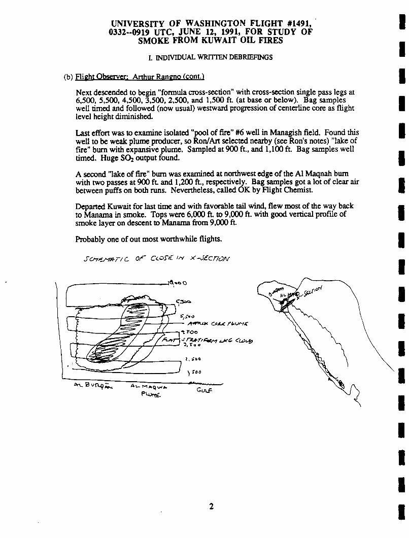
UNIVERSITY OF WASHINGTON FLIGHT #1491,0332--0919 UTC, JUNE 12, 1991, FOR STUDY OF
SMOKE FROM KUWAIT OIL FIRES
I. INDIVIDUAL WRITTEN DEBRIEFINGS
(h) Flight Observer: Arthur Rangno fcont.)
Next descended to begin "formula cross-secdon" with cross-section single pass legs at6,500. 5,500, 4.500, 3,500, 2,500, and 1,500 ft. (at base or below). Bag sampleswell dmed and followed (now usual) westward progression of center-line core as flightlevel height diminished.
Last effort was to examine isolated "pool of fire" #6 well in Managish field. Found thiswell to be weak plume producer, so Ron/Art selected nearby (see Ron’s notes) "lake offire" bum with expansive plume. Sampled at 900 ft., and 1,100 ft. Bag samples welldmed. Huge SO; output found.
A second "lake of fire" bum was examined at northwest edge of the Al Maqnah bumwith two passes at 900 ft and 1,200 ft., respecdvely. Bag samples got a lot of clear airbetween puffs on both runs. Nevertheless, called OK by Flight Chemist.
Departed Kuwait for last dme and with favorable tail wind, flew most of the way backto Manama in smoke. Tops were 6,000 ft. to 9,000 ft. with good vertical profile ofsmoke layer on descent to Manama from 9,000 ft.
Probably one of out most worthwhile flights.
Sof/e^n-r/ c <y Cc.c>s’fC <^ x’-Jcr/c)A/
2

UNIVERSITY OF WASHINGTON FLIGHT #1491,0332--0919 UTC, JUNE 12, 1991, FOR STUDY OF
SMOKE FROM KUWAIT OIL FIRES
I. INDIVIDUAL WRITTEN DEBRffiFINGS
(c) Chemist: Ronald Ferek
Cross-section ofAl Burqan/Al Maqnah and sources in Managish and Al Maqnah.
Excellent results obtained on the combined Al Burqan/Al Maqnah plumes during cross-section measurements. Seven traverses of the plume above, below, and in the plume.Two pool fires with black plumes were then studied in Managish and Al Maqnah field.Sissy got good pictures too. Also, lidar worked well during pass above main plumeand should provide good estimate of plume arc. Overall-a perfect flight. Thirteenbags for CCN on the flight north.
Bag fill
0536
0549
0604
0616
0629
0642
0707
0717
0747
0757
0823
0828
Location
6,500 ft.,Al Burqan/Al Maqnah
5,500 ft.Al Burqan/Al Maqnah
4.500 ft.Al Burqan/Al Maqnah
3.500 ft.Al Burqan/Al Maqnah
2.500 ft.Al Burqan/Al Maqnah1,500 ft Background
below plumeManagishpool fire
same plume
Maqnahpool fire
same plume
10,000 ft.old smoke10.000 ft.old smoke
Samples
37’s, grid, can, HsS
37’s, grid, can, H;S
37’s, grid, can, H2S
37’s, grid, can, H;S
37’s, can
37’s, can
37’s, grid, HaS
Quartz, HzS, can, grid
37’s, H2S, grid
Quartz, can, grid, H;S
grid
grid, 37’s
S02(PPb)210
220
240
780
640
<DL
>1,000
440
130
110
120
80
C02(ppm)387
392
390
455
441
-350
490
380
365
364
?
--?--

UNIVERSITY OF WASHINGTON FLIGHT #1491,0332-.0919 UTC, JUNE 12, 1991, FOR STUDY OF
SMOKE FROM KUWAIT OIL FIRES
L INDIVIDUAL WRITTEN DEBRffiFINGS
(d) Optical Measurement Rav E. Weiss
OEC3W NephdometerA3Aethelometer
Optical Extinction Cell. twd, single scattering albedo 0 538 nmbsp C 445, 538, 665 nm with auto pressure and temp correctionAeroaol Asymmetry Analyzer, non-spherical aerosol propertiesAeroaol optical abeorptton, bap 0 525 nm using Integrated platetitter method in nearly real time.
Qenoral Obervtion:Best flight yet. Excellent cross sections and good source samples from two
plumes: both of which were poo) fires producing very black smoke. For the first timewas able to see the initial formation of the aggregate soot chains from measurementsin the pool fires. The chains form very quickly.
My samples with the A3 have only 4 sec resolution. The first sample directiy over thefires indicated unmeasurable chain formation; 4 sec later the soot had fully developedchains. This was confirmed in both pool fires with 2 passes through each fire. Unlessthere is a process don’t understand, these fires don’t scale well to chamber studies.
OEC-Neph:Excellent measurements on all cross sections. The average single scattering
albedo detected was about 0.5; there may be a small effect with distance. Very doseto the source albedos+ were about 0.35. If you think about it, a futty developed sootchain should probably have an albedo of 0.5 since half the light witt be diffracted and allthe light entering the partide will be absorbed.
A3The big surprise, of course, was detecting initial chain aggregate formation. .It
happens so quickly that may not have noticed it before. Ill go back and kndflt someof the other source measurements.
AotholomoterThree filters were used because of the substantial time spent in blade nii-f
4

H. VOICE TRANSCRIPTIONS OF AIRBORNE TAPE RECORDING FROM UW FLIGHT1491 ON JUNE 12, 1991
Voices start abruptly after long silence on side A.
KM: 2.5 or 1.5?
RJF: 1.5.
6:36 AM
RJF: We’re ready to go back at it.
AR: After this pass do you want to head for Minagish?
RJF: Affirmative.
AR: Do you copy that Ken?
KM: Say again?
AR: After this pass to the west we want to head to the Minagish oil field. We’ll pick outa black plume there to begin with.
KM: To Minagish.
RJF: We want that number 6 pool fire over there, don’t we An?
KM: Do I understand number 6?
RJF: Guess so. Does Rod still have the coordinates?
KM: Affirm.
6:37 AM
KM: 3 minutes.
6:39 AM
KM: About a minute to go.
6:41 AM
KM: 5 0 seconds.
6:42 AM
AR: Looks like we’re going to hit that fleece ahead, there Ken?
KM: I don’t think so.
RJF: Good, I’ll make this my background sample.

KM: You want us to head straight for the western edge point or straight for the oil field?
RJF: Wait dll we punch out from under the other side and then we’ll go to Minagish.
AR: Look for the west end because there was isolated wells burning in that area, wemay hit a plume or two at this level.
6:43 AM
RJF: Hey Art. I don’t know about you, but I thought that was perfect.
AR: It was well boxed and you got all the measurements, so well, let’s see how we canfinish up this last flight.
6:45 AM
KM: Over the west point now. Do you want us to proceed to the field?
RJF: Somebody call?
KM: Yeah. We’re over the west point now. Do you want us to proceed to the field?
RJF: Yes sir.
6:46 AM
RJF: How much rime we got left?
KM: Oh, about an hour and 45 minutes.
RJF: 4 5 ?
KM: Right.
RJF: Hey Art.
AR: Yoh.
RJF: I think the plan here will be to do three wells. Then we’ll do the 10 minute and the20 minute samples so that we can be looking for the next well after the second bag.And we’ll start with that well number 6, that pool fire over here at Minagish. Afterwe finish that one we’ll look for a white one over here and then we’ll go over toMagwa and get a big black one there.
AR: Do you copy that. Rod? That’s the one you had punched in still, that pool firenumber 6.
KM: That’s a number 6, then a white one and then we’re over to Magwa and whatever?
AR: That’s the area we worked before. We had a couple of wells out the north side, theBurgan area.
6:49 AM

AR: Lot of destruction down there.
Unintelligible.
6:51 AM
AR: What’s our ETA to the "pool fire"?
KM: Oh, about 6 minutes.
6:56 AM
AR: Johnny Cash do that song? "Pool of Fire"?
6:57 AM
AR: Ken, how low can we go today? How low are you comfortable with out here?
KM: Oh well, as long as the visibility is good we can get down to 2 or 300 feet
AR: I think our samples were better that day that we were down around 600, 700 feet.The plumes were a little tighter together there and if we can get down in the 1000 to600, as long as we don’t see any helicopters, why, that’d probably be the best.
KM: Yeah, it’s going to depend on the visibility. It looks pretty good. As long as wecan identify and isolate these wells, should be easy to pick our way through it at alow altitude.
7:00 AM
AR: Curiosity, Ken. These helicopters that we see out here, are they communicating ona frequency that you know about?
KM: Not likely.
7:01 AM
AR: We should keep our eyes peeled here.
KM: Yes.
AR: Visual on the pool fire?
KM: Not yet.
7:02 AM
RJF: You guys think it was not that pool fire?
KM: No, don’t think it was at all.
RJF: What did it look like?
KM: Looked like a pretty weak little well, to me.

RJF: I’m for going back and hitdng that pool that was near it. That was pretty big.
We’re ready for a sample if you want to head into it.
Tape side A ends. Turned over.
KM: How long before you’re ready.
RJF: About 2 minutes.
7:37 AM
KM: What altitude are you going to want? It’s coming up ahead of us here at about 11o’clock and I’ll go by it.
RJF: OK.
7:38 AM
AR: Ron, on the altitude. Does it make much difference?
RJF: Just trying to keep me in it for 15 seconds.
Is it that one below the left wing?
KM: Yeah, that nearest one to us.
RJF: That looks pretty good. It’s a pool fire.
KM: Do you want to go down about 200 feet?
RJF: I don’t know, what do you think?
KM: Me? I think you’d get a little bit more at 1000 instead of 1200.
RJF: OK.
7:39 AM
RJF: Keep me out of the flame broiler there on your turn out, right?
KM: Which one’s that?
AR: Note the fake tank turrets below, on the right now, back behind us.
KM: About a minute out
7:41 AM
KM: 25 seconds.
4

7:42 AM
KM: 10 seconds. Stand by.
7:43 AM
RJF: Full.
KM: Do you want to bag that one again?
RJF: Yeah, in 10 minutes. Ken, I think we missed that. Let’s try it again right away.
KM: OK.
7:44 AM
KM: 1 minute.
7:46 AM
KM: 20 seconds. It’s laying down a little bit more this time.
AR: Palls of black this dme.
KM: Unintelligible.
7:47 AM
KM: Stand by.
RJF: Full. Much better that dme.
7:48 AM
RJF: OK, give us about 10 minutes and try it again.
AR; Is that it for this one or are we doing another pass?
RJF: One more pass in about 9 minutes.
7:49 AM
AR: Flight level.
RJF: For what, our return?
AR: Yeah, does it have to be the same or, it looks like maybe it’s lofdng upward andkind of leveling out, maybe a little bit higher than that flight level we just passedthrough.
RJF: OK, whatever gets me in the fairly thick stuff for about 10 more seconds.
AR: Yeah, Ken, what did you think about say, 200 feet higher or so. Do you thinkthere’d be more at leveling out at that height? Something like 1200, 1300?

7:50 AM
RJF: Yeah, we’re ready to hit it again in about 2 minutes.
KM: Two minutes.
7:54 AM
AR: Fake tank turrets down below again. Quite a few of them.
RJF: Did you say, fake?
AR: Yeah, there just some kind of can with a sdck on the end, or something. You seethat’s all there is when you get close.
RJF: Gee, I bet that really fooled our pilots!
AR: Not one of them is blown up I guess.
7:55 AM
KM: Be ready in a minute?
RJF: Yes. Hey, can somebody get a good picture of this plume for us?
DS: Got it.
AR: Really laying down there now, isn’t it Ken? We can hit further downwind.
KM: I see it is laying down. It’s starting to rise again though. Want to go a lime lower?
AR: I think we’ll hit greater duration this time downwind, though, further beyond theactual bum, he says.
7:56 AM
KM: Stand by.
Some more here.
7:57 AM
RJF: Got it We’re all done here then. Ken.
KM: We could give you another 10 minutes at the most here.
RJF: I’ll have to retire to the back and put my contact lens back in.
KM: OK, so we climb and head for home, is that what you want?
RJF: Yeah, let’s do it.
6

8:00 AM
DS: CCN has gotten too warm. I’m going to go ahead and shut it off, now.
AR: Ron, do you want a run on the way back or just go straight back?
RJF: I’m open to suggestions.
AR: We could fly in smoke I suppose as long as we want.
RJF: I was thinking of more like 10,000 feet where it’s cool. What were you thinking,Ken?
KM: 7000.
RJF: Might hit the tops of it there, but I think the CCN has probably had it by now.
8:06 AM
AR: Probably some at the Magwa or Burgan complex, smoke, we’ll be coming into,Ron.
8:08 AM
RJF: That’s nice Art.
AR: Good enough. FSSP probe turned off at 0811:21 and being switched to number 1only because of the previous counting problem in the precip probe.
8:11 AM
AR: Where we flying to?
KM: 10,000.
8:17 AM
AR: Increasingly light as we head southbound, 2000 feet higher aircraft at 082:40.
8:22 AM
AR: obscured below at 0824:24. Picking up a few 2-D particles.
8:24 AM
AR: Sea surface visible at 0825:36.
8:25 AM
AR: Correction on flight level back there when I said 8600, was actually Thealtimeter in the back had to be reset, so flight level was incorrect on the dial here infront of the flight scientist. Hying at 9000 now at 0829. Coming to cloud,correction, smoke top. Smoke tops back there at 1 to 2000 feet higher than flightlevel. Now it seems to be diminishing some.

8:29 AM
AR: These saddle tops appear to be increasing from 500 to 1000 at 0832:05.
8:32 AM
AR: At 0840 tops have descended to 1 to 2000 feet below aircraft.
8:40 AM
AR: At 0842:30 tops have a hump here at, let’s see, this would be about 27.4, 49.6.
8:42 AM
Sound stops.

UNIVERSITY OF WASHINGTON FLIGHT #1491,0332-0919 UTC, JUNE 12, 1991, FOR STUDY OF
SMOKE FROM KUWAIT OIL FIRES
in. POSTFLIGHT DEBRIEFING
RF: First thing we’ll have is a debriefing from Flight 1491. And where is Art? Art isnot present. In summary, we had a perfect flight. Cross section of the combinedBurgan, Magwah fields and 2 pool fires, one each in the Minagish and Maqwah oilfields. So, outside of that, Krista, why don’t you give us a summary of thechemical measurements?
KL: (too faint) has the notebook.
RF: Oh, then why don’t I do it for you?
Perfect flight. Good cross section, 5 levels in the plume, 1 above, 1 below andthen 2 samples each in Minagish and Magwah oil fires. Both black plumes, bothpool fires which we haven’t sampled before and then 2 samples for old smoke onthe way back and 13 bags for CCN on the way up. And the lidar worked quite wellduring the cross section above the main plume, so, Dave, do you want to give us asummary on the aerosol measurements?
Dave said the aerosol system worked great and he got a lot of good measurements.
Art, you want to give a quick overview of what you observed today as FlightObserver?
AR: I wanted to give.a quick overview. I’ll have to get my notes. Looked like thewinds produced more fanning today, by going in close I think we solved thatproblem and on satellite pictures about 30 miles further south this thing went into aspray pattern, so it was only focused for only a short length. We climbed up on topand did a lidar cross section. We got temporally eased out of the center line there atthe first path, we came back and included that, did some visuals on the edges. I’mnot sure how it corresponds to the lidar edges. Pretty sharp on both sides, washelpful, wasn’t going to fizzle away on both sides, or one of the sides as we’veseen before. Then we did cross section passes at 65, 55, 45, 35, 25 and 15 andthey seemed to be all competent. Our bag samples were in the peak every time andoffset as the hot spot shifted to the west downward. We were getting on Magwah aplume in the first couple passes, (superimposed conversations)...then as we shifteddownward, we were getting into the western portion of the plume which was morefrom the Berquan field. Those who were the lowest bases were also observed,there wasn’t much difference in the height of the bases in the west half but on theeast half we saw that typical lifting, compacting, lifting into like blackstratocumulus. Then we went off to Minagish and picked out a lake of fire.
We got some excellent passes on (superimposed conversations) Magwah to pickout another lake of fire and got some excellent bag passes. I thought maybe on thesecond lake of fire we hit some turrets with clear air spaces in the bags and that wasthe only thing I thought was a negative aspect here. Very dense portions for abouthalf a second and then maybe 5 seconds of air.

RF: That’s qualitative information.
AR: Anyway, good visibility, focused plume. I think everything fell into our lap todaybecause we didn’t have problems with the ATC, no helicopters around. And thenon the way back we were in the plume all the way to Manama till we starteddescending out of 7,000, 6000. Made some sense, there’s some evolution for thespreading of plume, for the vastly spreading plume, (too faint).
RF: Weiss did good. Sissy got great pictures, lidar worked, CCN worked, aerosolsworked.
Copyright © 2022 FDOKUMEN