Kom Gir report MSA
18
1 Report on the 2014 Season of the Regional Survey in the Governorate of Kafr esh-Sheikh by Robert Schiestl, Andreas Ginau and Daniela Rosenow 1. Introduction: The 2014 season of the Regional Survey in the governorate of Kafr esh-Sheikh was undertaken under the auspices of the German Archaeological Institute Cairo from April 8 until April 23 and from October 1 until October 28. We were kindly supported by the authorities of the Ministry of Antiquities. In particular we wish to thank the Director of Antiquities in Kafr esh-Sheikh Mr Gamal Salem and our inspectors Ms Noha Mohammed Shokry Ali Mansour (spring 2014) and Mr Ali Sekhmaui (autumn 2014). Members of the mission this year were Robert Schiestl (field director), Daniela Rosenow and Thilo Rehren (glass specialists), Jürgen Wunderlich and Andreas Ginau (geographers), and Stephanie Bruck (Egyptologist). The spring season was dedicated to the study of pottery and in particular glass finds from the surface of the site of Kom el-Gir. The autumn season was a field season focusing on the reconstruction of the ancient landscape in the area north-east of Buto (Tell el-Farain). R. Schiestl 2. Studies on pottery and glass: The documentation and analysis of surface finds from previous seasons and from a visit to the site in April 2014 was the focus of the season of spring 2014. A special emphasis was laid on the analysis of glass finds from the surface of Kom el-Gir.
Transcript of Kom Gir report MSA

1
Report on the 2014 Season
of the
Regional Survey in the Governorate of Kafr esh-Sheikh
by
Robert Schiestl, Andreas Ginau and Daniela Rosenow
1. Introduction:
The 2014 season of the Regional Survey in the governorate of Kafr esh-Sheikh was
undertaken under the auspices of the German Archaeological Institute Cairo from April 8
until April 23 and from October 1 until October 28. We were kindly supported by the
authorities of the Ministry of Antiquities. In particular we wish to thank the Director of
Antiquities in Kafr esh-Sheikh Mr Gamal Salem and our inspectors Ms Noha Mohammed
Shokry Ali Mansour (spring 2014) and Mr Ali Sekhmaui (autumn 2014).
Members of the mission this year were Robert Schiestl (field director), Daniela Rosenow
and Thilo Rehren (glass specialists), Jürgen Wunderlich and Andreas Ginau (geographers),
and Stephanie Bruck (Egyptologist).
The spring season was dedicated to the study of pottery and in particular glass finds from
the surface of the site of Kom el-Gir. The autumn season was a field season focusing on the
reconstruction of the ancient landscape in the area north-east of Buto (Tell el-Farain).
R. Schiestl
2. Studies on pottery and glass:
The documentation and analysis of surface finds from previous seasons and from a
visit to the site in April 2014 was the focus of the season of spring 2014. A special emphasis
was laid on the analysis of glass finds from the surface of Kom el-Gir.

2
2.1. The pottery:
Small finds and pottery collected during the surface surveys of the past seasons at the
following sites were studied and drawn in the excavation house: Kom el-Asfar, Kom el-Gir,
Kom Saleh, Shabasia (Kom el-Ahmar) and Kom Abu Khubeza.i In earlier field surveying a
substantial group of pottery from the surface at Kom el-Gir had been collected and
documented.ii An assemblage of pottery shapes not previously documented for this site was
collected in this season and is shown on table 1 and figs. 1-2.
Inv. No. Shape Fabric Size Fig. No.
KG 14/19 Mortar Import, unknown source Medium to coarse, light reddish yellow (5 YR 7/6-6/6) Numerous particles of hard stone intentionally added to fabric
rd c. 40 cm; bd 24 cm; h 14.9 – 15 cm
Fig. 1.1-1.3
KG 14/20 Bowl with pinched rim Nile, medium - coarse, very hard; red coated outside, heavy sooting on inside-
rd 18 cm; h 5.7 cm + x
Fig. 2.1
KG 14/22 Jar, with two wide handles
Nile, fine - medium (body), medium-coarse (handle), hard; white cream coloured painted decoration on shoulder (2.5 YR 7/6 light red - 5 YR 8/4 pink)
rd 22 cm; h 11.5 cm + x
Fig. 1.4
KG 14/23 Terracotta head of Apis bull
Nile, fine-medium, hard; plain
h 7.7 cm + x, width (snout) 5.1 cm; neck width 3.6 cm
Fig. 2.4
KG 14/24 Jar Nile, fine-medium, very hard; plain
rd 14 cm; h 5 cm + x
Fig. 1.5
KG 14/25 Amphora, ‘AE 3’ Nile, fine - medium, hard; plain; Fabric: body: fine, limestone particles, some organic tempering; Handle: medium, larger and more organic particles
rd 11 cm; h 14.2 cm + x
Fig. 2.2
KG 14/26 Amphora, ‘Late Roman 1’
Import rd 10-10.7 cm; h 12.5 cm + x
Fig. 2.3
Table 1: List of Pottery from Kom el-Gir, shown on figures 1-2 (abbreviations: h - height; rd - rim diameter, bd - base diameter)

3
A large and heavy bowl with a broad rim and a wide flat base is a mortar (KG 14/19,
Fig. 1.1-3). This shape can be placed in the Roman to Late Roman period. Parallels, possibly
made of the same or similar fabric, were found at Mons Claudianus, dating to the late 1st c
AD iii and at Kellia, dating to the Late Roman period.iv The fabric is an import of unknown
source. Onto the vessel’s interior surface numerous large grains of sand and hard stone were
added in order to create a rough surface for grinding (Fig. 1.3). In the lower part of the vessel,
where grinding using the greatest force took place, these stones have been mostly lost due to
use. It is only on the upper part of the vessel’s interior that they still are extant.
The jar KG 14/22 (Fig. 1.4) has a short neck and a tall rim with three horizontal ribs.
Two wide strap-handles with three parallel ridges are placed on the wide shoulders. The
shoulder area is decorated with painted curved elements in a light red to pink color. Traces of
more decorations below are also visiblev. Jars with similar necks and rims can be cited for the
Late Roman Periodvi. A piece from Elephantine is dated to the second half of the 5th or 6th c
AD vii. A Late Roman date is suggested for this piece.
The jar KG 14/24 (Fig. 1.5) has a medium length wide neck, which bulges out in the
upper half before forming a rim slanted downwards towards the interior. The body below the
neck shows pronounced ribbing. A similarly shaped neck and rim is found on a Late Roman
piece from Elephantine.viii A Late Roman date is likely.
A bowl with an elaborately pinched rim (KG 14/20, Fig. 2.1) shows strong signs of burning
on the interior. Both Late Roman bowls and cooking pots display similar rimsix. The dark soot
on the interior might suggest the use as a lid.
The amphora KG 14/25 (Fig. 2.2) has a slightly flaring neck with a flanged rim. This type had
been found at Kom el-Gir beforex and represents the very common Roman Nile amphora
classified as “Amphore Egyptien 3” xi. The body of the vessel is made of fine Nile fabric,
whereas the handles are somewhat coarser, displaying more organic tempering. A recent
study has further subdivided this class and our piece would fall into group AE 3.4.xii The date
provided for this group is the late 1st c AD – 3rd c AD,xiii whereas it has also been suggested
that in some parts of Egypt a variant of this shape continues into the 5th c AD.xiv
The amphora KG 14/26 (fig. 2.3) belongs to the family of imported ‘Late Roman 1’
amphorae. This vessel is among the most common finds in the survey region and was widely
distributed in the delta in Late Roman times.xv Examples have been found at Belshasha, Kom
el-Haweid, Kom Abu el-Khobeza (el-Nahas), Mustagidda, Nashart, Kom el-Roka, Shabas
Umayyir, Shabasia (Kom el-Ahmar), Senhur el-Medina and Shinnu. This piece is, however,
4
the first example from the site of Kom el-Gir. The ‘Late Roman 1’ amphora was produced in
the Eastern Mediterranean, with production sites located on Cyprus, the southern Anatolian
coast and Rhodes. It dates from the late 4th c – 7th c AD, with imports to Egypt breaking off
abruptly.xvi
A fragment of a terracotta figurine (KG 14/23, Fig. 2.4) depicts the head of an Apis
bull with a sun disc between his horns. A very close parallel from Athribis is dated to the 1st c
AD.xvii The neck of the animal shows three parallel horizontally incised lines, which represent
bands or necklaces.
R. Schiestl
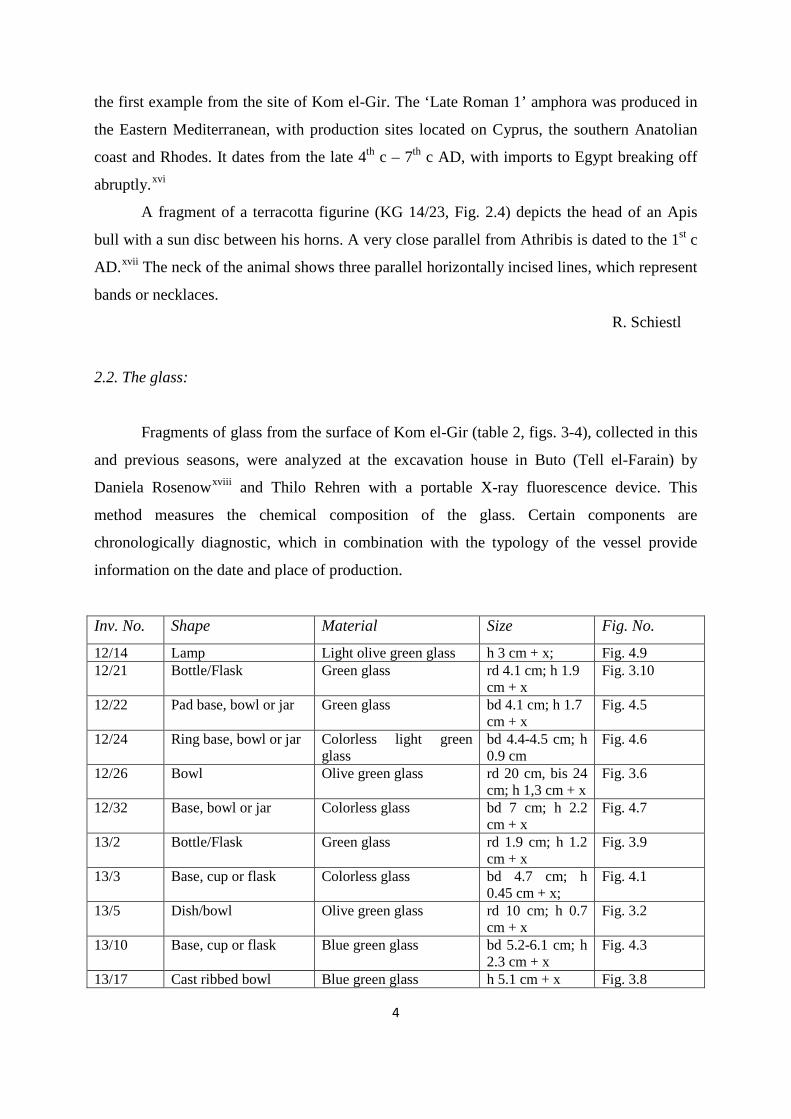
2.2. The glass:
Fragments of glass from the surface of Kom el-Gir (table 2, figs. 3-4), collected in this
and previous seasons, were analyzed at the excavation house in Buto (Tell el-Farain) by
Daniela Rosenowxviii and Thilo Rehren with a portable X-ray fluorescence device. This
method measures the chemical composition of the glass. Certain components are
chronologically diagnostic, which in combination with the typology of the vessel provide
information on the date and place of production.
Inv. No. Shape Material Size Fig. No.
12/14 Lamp Light olive green glass h 3 cm + x; Fig. 4.9 12/21 Bottle/Flask Green glass rd 4.1 cm; h 1.9
cm + x Fig. 3.10
12/22 Pad base, bowl or jar Green glass bd 4.1 cm; h 1.7 cm + x
Fig. 4.5
12/24 Ring base, bowl or jar Colorless light green glass
bd 4.4-4.5 cm; h 0.9 cm
Fig. 4.6
12/26 Bowl Olive green glass rd 20 cm, bis 24 cm; h 1,3 cm + x
Fig. 3.6
12/32 Base, bowl or jar Colorless glass bd 7 cm; h 2.2 cm + x
Fig. 4.7
13/2 Bottle/Flask Green glass rd 1.9 cm; h 1.2 cm + x
Fig. 3.9
13/3 Base, cup or flask Colorless glass bd 4.7 cm; h 0.45 cm + x;
Fig. 4.1
13/5 Dish/bowl Olive green glass rd 10 cm; h 0.7 cm + x
Fig. 3.2
13/10 Base, cup or flask Blue green glass bd 5.2-6.1 cm; h 2.3 cm + x
Fig. 4.3
13/17 Cast ribbed bowl Blue green glass h 5.1 cm + x Fig. 3.8

5
14/1 Dish/bowl Olive glass rd 11 cm; h 1.1 cm + x
Fig. 3.3
14/2 Dish/bowl Green glass rd 17 cm; h 1.1 cm + x
Fig. 3.5
14/3 Dish/bowl Light olive green glass rd c. 34 cm; h 1.4 cm + x
Fig. 3.7
14/5 Dish/bowl Light yellowish-brown glass
rd 13 cm; h 1.2 cm + x
Fig. 3.4
14/6 Dish/bowl Olive glass rd 6.5 cm; h 1.6 cm + x
Fig. 3.1
14/8 Pad base, bowl or jar Light brown glass bd 5.6 cm; h 1.1 cm + x
Fig. 4.4
14/13 Base, cup of flask Colorless glass bd 4-4.4 cm; h 0.9 cm + x
Fig. 4.2
14/17 Lamp Olive green glass, dark blue blobs
rd c. 9 cm; h 1 cm + x
Fig. 4.8
Table 2: List of glass from Kom el-Gir, shown on figures 3-4 (abbreviations: h - height; rd - rim diameter, bd - base diameter)
The types of vessels represented are dishes and bowls (Fig. 3, nos. 1-8), bottles and
flasks (Fig. 23, nos. 9-10), the bases of cups or flasks (Fig. 4, nos. 1-3) the bases of bowls or
jars (Fig. 4, nos. 4-7) and lamps (Fig. 4, nos. 8-9).
Most glass has a green color, occasionally with a blue green hue. Other colors are
yellowish-brown and brown. Blobs of dark-blue are found as decoration on a lamp (Fig. 4.8).
A few pieces are almost colorless (Fig. 4.1-2, 6-7). Based on a preliminary dating, all samples
of glass date to the 1st c AD to 6th c AD, that is the Roman and Late Roman periods.
The earliest piece is a wall fragment of a cast ribbed bowl, a vessel type dating
between the middle of the 1st c BC to the late 1st c AD (Fig. 3.8)xix. Some fragments have
been intentionally de-coloured by the addition of antimony. This compositional raw glass
group seems to have been favoured in Roman Egypt and has been discovered in late 1st to 3rd
c AD contexts elsewhere in the country. Most pieces can be placed in the Late Roman period
(4th-6th c AD). A large group is composed of the so-called HITM xx glass (Fig. 3.1, 3–7, 10;
fig. 4.2, 8 and possibly 5), which was not produced before the Late Roman period.
R. Schiestl, D. Rosenow

6
3. Investigation of the landscape northeast of Buto (Tell el-Farain):
The goal of the field season in autumn of 2014 was the investigation of the ancient
landscape in the region between Buto (Tell el-Farain) and Kom el-Gir by means of auger core
drilling. Two transects of auger cores were made in this areaxxi(tables 3-4, Figs. 5-9). Two
further drillings were made in the fields adjacent to the site of Kom el-Gir in order to see
whether the site continues buried under the current surface.
The first transect consisted of five auger cores G 10, 11, 12, 13 and 14 (table 3, Fig. 9), in
a line running roughly southwest to northeast, starting in fields northeast of Buto (Tell el-
Farain) and reaching just southeast of Kom el-Gir.
Number of auger core
coordinates Description of placement depth
G 10 31 12 13.0 N 30 45 31.4 E
In field northeast of Buto, just west of Masraf Firawun
10 m
G 11 31 12 34.0 N 30 45 30.5 E
In field northeast of Buto, northeast of G 10 9 m
G 12 31 12 45.8 N 30 45 35.4 E
In field northeast of Buto, east of Masraf Firawun
10 m
G 13 31 13 09.9 N 30 45 45.1 E
In field northeast of Buto, between Masraf Firawun and Tirat Karadwa
9 m
G 14 31 13 18.6 N 30 46 15.1 E
In field southwest of Kom el-Gir, between Tirat Karadwa and Masraf Mandurah
7 m
Table 3: List of auger cores of transect running roughly north-south
The second transect (G 15 – G 20, table 4) ran approximately east-west and was placed across
the slight depression in which the modern Masraf Bahr Nashart and the Masraf Nashart flow
roughly parallel today (Fig. 9). The question is whether these two modern waterways reflect
an ancient branch of the Nile, possibly a minor branch of the Thermutic branch of the Nile.
Number of auger core
coordinates Description of placement depth
G 15 31 13 30.2 N 30 47 11.3 E
In field east of Kom el-Gir, between Tirat Shaba and Masraf el-Aguzein
11 m
G 16 31 13 30.4 N 30 47 22.0 E
East of G 15, in field, between Masraf el-Aguzein and Masraf Bahr Nashart
8 m
G 17 and G 17 cl
31 13 33.6 N 30 47 29.8 E
East of G 16, in field east of Masraf Nashart, south of Masraf Mukhtar
9 m (G 17) 8 m (G 17 cl)
G 18 31 13 30.0 N 30 47 49.7 E
East of G 17, in field south of Masraf Mukhtar and southwest of Ezbet Omda
9 m
G 19 31 13 31.7 N East of G 18, in field south of Ezbet Omda 10 m

7
30 48 03.2 E G 20 31 13 39.6 N
30 48 19.4 E Northeast of G 19, in field, north of Masraf Mukhtar and east of Ezbet Omda
12 m
Table 4: List of auger cores of transect running roughly east-west
The watercourse is suggested both by the contour lines of the modern surface and by
ancient settlement remains (tells) aligned left and right of the proposed branch. These
settlements were investigated in the past seasons by the Regional Survey in the governorate of
Kafr esh-Shaikh.xxii Based on collections of surface pottery and auger core drillings these
settlements predominantly date to the Roman and Late Roman periods (late 1st c BC – 7th c
AD).
Corings G 10 to G 12 show thick layers of Nile mud deposited over layers of fine sand
or medium sand that occurred in depths greater than 6 to 7 meters. The work of Jürgen
Wunderlichxxiii classified the underlying sandy layers as part of the former Pleistocene
surface. North of coring G 13 peat layers occurred above these Pleistocene sediments that
drastically increase in thickness with a movement to the east along the transect G 10 to G 18.
Fig. 8 shows the auger head probes of coring G 17. Between 500 and 900 cm a sequence
starting with organic rich clays, leading over thick peat layers and fine intercalations of peat
and clay layers has been revealed. This bears witness to a dynamically changing environment
situated at the boundary between aquatic and terrestrial environments showing long phases of
peat development under aquatic conditions. Coring G 18 on the other hand more or less lacks
the sequence of thick clayey layers and is composed of an intercalation (quick succession of
different layers) of fine to medium sands that start in a depth of about 2 m below the surface
and reach down to 8 m below the surface. Additionally, gravel layers and rounded stones
appear in sequences within the sand layers.
This provides evidence for the existence of a former Nile branch that incised itself in the
former sediment sequences and deposited coarser sediments in its channel revealing the
higher transport capacity of a river. Additionally, with increasing distance to a river branch
sediments tend to get finer. During the Nile flood coarser material was deposited closer to the
river branch whereas fine material was transported further away. The sediment profiles of the
different corings within the transect also revealed that with the movement to the northeast
more fine sandy material occurred especially in the upper 4 meters of the corings G 14 to G
17.

8
Finally, the area just north of Kom el-Gir was investigated by two corings. The
question was to see whether the tell continues under the current horizon of the fields and what
the immediate surroundings of the settlement looked like in antiquity. Coring G 21 (31 13
33.8 N/30 46 34.2 E) was placed in a field about 100 m north the northern edge of the tell of
Kom el-Gir. It was drilled to a depth of 11 m. Despite being close to the ancient settlement, no
intact settlement layers were preserved. At a depth of 4.25 m – 5.40 m below the surface
numerous pottery sherds were found, embedded in loamy fine sand. More sherds were found
at a depth of 7.30 m below the surface. This material had most likely been washed down from
the settlement and re-deposited by alluvial activity. Coring G 22 (31 13 33.8 N/30 46 31.3 E)
was placed closer to the tell, about 15 m to its north. Its depth was 8 m. While the layer with
settlement material was thicker than in coring G 21, reaching over 2 m thickness and
containing many remains of coarse pottery or burnt brick, it is unlikely that these layers are
undisturbed. Most likely they were also re-deposited from higher up on the tell. The layers of
fine sandy alluvial deposits were reached at a higher level than in G 22, indicating a slope
towards the north.
Preliminary Conclusions on the auger core drillings:
The first preliminary results from the field show the existence of different environmental
milieus and landscape units such as river arms and aquatic environments. Laboratory analyses
and geostatistical evaluation of the results obtained in the field and the laboratory are required
to further differentiate and characterize these former environmental units. For example, it is of
great interest to know under which conditions the peat layers developed and which processes
where responsible for the frequent changes in the deposition of the peat and clayey layers.
Also the dating of the former Pleistocene surface or the sandy sediments of coring G18 by
means of optically stimulated luminescence (OSL) would be of great importance to
understand the chronology of events incorporated in the sediments Buto and the transects G
10 to 14 and G 15 to 20.
A. Ginau

9
4. Documentation of fields for comparison with satellite images:
On October 20-22 a tour of fields in the region was taken to document them by photos. On
these days pre-ordered Rapid Eye satellite images were being taken of the region. The point is
to compare the satellite images with the information on the ground – on the same date or as
close to that date as possible – and see in what way ground features are represented on the
satellite images. For example, we are asking the question whether fields in areas of former
watercourses have particular characteristics which set them apart. All in all, 43 open fields,
mostly dry, were visited and documented. The first two days a representative group of fields
distributed over the region was visited. The third day a specific group of fields were visited
where formerly four tells had been. The question is whether the fields in the area of former
tells showed specific signatures reflecting the conversion of ancient tells to fields. The
comparative analysis of the data will be undertaken in Germany.
A. Ginau
5. Digital elevation model of Kom el-Gir:
Based on measurements taken with a differential GPS a digital elevation model for Kom
el-Gir was created. This map could be completed in one day and provides the first reliable
absolute elevations of the site and the first detailed elevation model (Fig. 10). Combining the
information on the relief of the site with the subsurface information gained by the
investigations by magnetometryxxiv and the auger core drillings, some further observations on
the structure and development of the site can be made. The low lying and flat area in the
northern part of the site represents the zone of the temple enclosure. This area is surrounded
on three sides by a roughly crescent shaped area forming the highest parts of the site. In the
west and the south, this is the settlement area of the site, which eventually reached a much
higher elevation than the temple area. In the southeast, the adjoining area is the site of the
Roman camp, which also rose to a higher level. The phenomenon of settlements layers
accreting to levels high above those of the adjacent temple enclosure can frequently be
observed in ancient Egyptian settlements. The site of Buto (Tell el-Farain) itself is a good
example, where the Roman settlement layers reached the crown of the temple enclosure walls,
towering over the area of the temple building below.
R. Schiestl, A. Ginau

10

11

12

13

14
Fig. 5: Drilling auger core G 10. Fig. 6: Extracting auger core G 10.
Fig. 7: Preparation of the core for analysis.

15
Fig. 8: Photograph of coring G 17 reaching a depth of 900 cm

16
Fig. 9: Map of area investigated with auger core drillings in autumn 2014

17
Fig. 10: Digital elevation model of Kom el-Gir

18
i For further information on these sites see previous reports; Kom el-Asfar: First Report Spring 2010; Kom el-Gir: First Report Spring 2010, Second Report Autumn 2010; Reports 2011, 2012, 2013; Kom Saleh: First Report Spring 2010; Shabasia (Kom el-Ahmar): Second Report 2010; Kom Abu Khobesa (Abu Nahas): Second Report 2010. ii See Kom el-Gir: First Report Spring 2010, Second Report Autumn 2010; Reports 2011, 2012, 2013; iii R. TOMBER, The Pottery, in: V. MAXFIELD and D.P.S. PEACOCK, Mons Claudianus III. Ceramic Vessels and Related Objects, FIFAO 54, Cairo 2006, 133, fig. 1.51, nos. 137-138. iv M. EGLOFF, Kellia. La poterie copte. Quatre siècles d’artisanat et d’échanges en Basse-Égypte, Recherches Suisses d’Archéologie Copte III, Genève 1977, vol. 1, 143-151, vol. 2, pl. 80, 1-3, 6. v For a painted cooking pots see M. EGLOFF 1977, vol. 2, pl. 48.3; R.D. GEMPELER, Elephantine X. Die Keramik römischer bis früharabischer Zeit, AV 43, Mainz 1992, Abb. 92.12-15, 93.10-11, 97.9-10, 108.7-10, 109.2, 4, 6-7, 13, 110.1, 111.3-5, 7. vi J. FAIERS, Late Roman pottery at Amarna and related studies, EES Excavation Memoir 72, London 2005, 125, fig. 2.34, no. 259. vii GEMPELER 1992, 172-173, Abb. 105, Nr. 1. viii GEMPELER 1992, 178, Abb. 110, Nr. 12, K 469. ix M. EGLOFF, Kellia. La poterie copte. Quatre siècles d’artisanat et d’échanges en Basse-Égypte, Recherches Suisses d’Archéologie Copte III, Genève 1977, vol. 2, pl. 54, no. 3, pl. 76, no. 4. x See SCHIESTL, Third Report, Autumn 2011, fig. 1.6. xi J.-Y. EMPEREUR and M. PICON, Les ateliers d’amphores du lac Mariout, in: J.-Y. EMPEREUR (ed.), Commerce et artisanat dans l’Alexandrie hellénistique et romaine. Actes du colloque d’Athènes, organisé par le CNRS, le Laboratoire de céramologie de Lyon et l’École française d’Athènes, 11-12 décembre 1988, BCEH Suppl. 33, Paris 1998, fig. 4. xii D. DIXNEUF, Amphores égyptiennes. Production, typologie, contenu et diffusion (IIIe siècle avant J.-C. – IXe siècle après J.-C.), Études Alexandrines 22, 2011, 120-121, fig. 103-105. xiii DXINEUF 2011, 121. xiv D.M. BAILEY , A Form of Amphores Égyptiennes 3 from the South-West Fayum, CCE 8, 2007, 228. xv Compare also the numerous examples in P. WILSON and D. GRIGOROPOULOS, The West Delta Regional Survey, Beheira and Kafr esh-Sheikh Provinces, EES EM 86, Oxford 2009, figs. 106, 110, 112, 117-118, 125, 132, 139-141, 148, 151, 153, 156, 163, 172, 174. xvi C. VOGT, Les céramiques ommeyades et abbassides d’Istabl Antar-Fostat: Traditions méditerranéennes et influences orientales, in: G.D. D’A RCHIMBAUD (ed.), La céramique medievale en Méditerranée. Actes du Vie congrès de l’AIECM, Aix en-Provence, 13-18 novembre 1995, Aix en-Provence 1997, 257. xvii H. SZYMANSKA , Terres cuites d’Athribis, Monographies Reine Élisabeth 12, Turnhout 2005, 245, pl. XXX, No. 250. xviii University College London. xix Cf. D.B. HARDEN, Roman Glass from Karanis. Found by the University of Michigan Archaeological Expedition in Egypt, 1924-1929. University of Michigan Humanistic Series vol. 41, Ann Arbor, Michigan 1936, pl. XIV, 310; D. BAILEY , The glass vessels. In D. PEACOCK and V. MAXFIELD (eds), The Roman imperial quarries. Survey and excavation at Mons Porphyrites 1994-1998. Volume 2: the excavations, EES Excavation Memoir 82, London 2007, 233-266, 235, fig. 8.1. xx HIMT=High in Iron, Manganese and Titanium. xxi The drillings were conducted with a Wacker-Neuson percussion hammer, using a drill probe of 8 cm diameter for the first meter, followed by probes with 6 cm diameter for the next meters. Alternatively, after a few meters a smaller probe with 5 cm diameter was used. xxii See Fig. 1 in R. Schiestl, Field Boundaries and Ancient Settlement Sites: Observations from the Regional Survey around Buto, Western Delta, in: MDAIK 68, 2012, 175-190. xxiii J. WUNDERLICH, Untersuchungen zur Entwicklung des westlichen Nildeltas im Holozän, Marburger Geographische Schriften 114, 1989. xxiv See Report Autumn 2011, Report 2012 and Report 2013.