Quantitative integration of geophysical methods for archaeological prospection

E-JOURNAL • 2015 SPRING www.magyarregeszet.hu
LARGE SCALE GEOMAGNETIC PROSPECTION ON NEOLITHIC SITES IN HUNGARY I
Knut Rassmann1 – CaRsten misChKa2 – maRtin FuRholt2 – René ohlRau2 – Kai RadloFF1 – Kay WinKelmann3 – GáboR seRleGi4 – tiboR maRton4 – anett osztás4 – KRisztián oRoss4 – eszteR bánFFy1
In 2011, 2013 and 2014 our team engaged in geomagnetic prospections on Hungarian multi-period settlements. Our study began with fieldwork at the Tolna-Mözs and Alsónyék–Bátaszék sites in 2011. In 2013, we continued the survey on both sites, enlarging the program on the tell settlement of Fajsz-Kovácshalom and on other sites in eastern Hungary.5 Our main goal is to discuss the combination of excavation and geomagnetics which provides a great opportunity to estimate the size of the settlements as well as to study their internal structures. The results will be published in two parts. This first report focuses on the Alsó-nyék–Bátaszék site where numerous settlement remains and a large number of Late Neolithic burials were unearthed. Excellent prerequisites for prospection campaigns include rich comparative excavation data which are useful for understanding and interpreting geomagnetic anomalies from the unexcavated areas.
In 2011, the Romano-Germanic Commission (hereinafter referred as RGK) began its cooperation with the Institute of Archaeology, Research Centre for the Humanities of the Hungarian Academy of Sciences in conducting geomagnetic prospections in Transdanubia and on the adjacent left bank of the Danube. These studies were founded in the RGK’s long-standing programme of settlement research. The latter began in 2008 with large scale prospection of Neolithic and Early Bronze Age sites in Central and Eastern Europe.6
The initial point of the prospection involved large-scale rescue excavations in southwest Hungary, such as at Tolna-Mözs and Alsónyék–Bátaszék. These revealed extended areas of multiperiod Prehistoric sites, which provided an opportunity to combine the rich datasets from large and well-excavated sites with geomagnetic prospection results. This unique circumstance allows for the comparison of specific
1 Deutsches Archäologisches Institut, Römisch-Germanische Kommission, Frankfurt am Main2 Institut für Ur- und Frühgeschichte, Christian-Albrechts-Universität zu Kiel3 consulting engineer, Berlin4 Institute of Archaeology, Research Centre for the Humanities, Hungarian Academy of Sciences, Budapest5 Although the geomagnetic prospections focused on Alsónyék-Bátaszék, Tolna-Mözs and Fajsz-Kovácshalom, other smaller
prospections were also realized in eastern Hungary (at Hajdúnánás-Büdöshalom, Hajdúnánás-Vereshalom, Nádudvar-Tökhalom, Berettyóújfalu-Szilhalom – Fig. 1)
6 Rassmann, Knut – Ohlrau, René – Hofmann, Robert – Mischka, Carsten – Burdo, Nataliia – Videjko, Michail Yu. – Müller, Johannes: High Precision Tripolye Settlement Plans, Demographic Estimations and Settlement Organization. Journal of Neolithic Archaeology 16 (2014), 96–134.
HUNGARIAN ARCHAEOLOGY
Fig. 1: Overview on the geomagnetic prospections conducted by the RGK in Hungary between 2011–2014. 1 Balatonszárszó-Kis-erdei-dűlő, 2 Tolna-Mözs, 3 Fajsz-Kovácshalom, 4 Alsónyék-Bátaszék, 5 Hajdúnánás-Büdöshalom, 6 Hajdúnánás-Vereshalom, 7 Nádudvar-
Tökhalom, 8 Berettyóújfalu-Szilhalom

HUNGARIAN ARCHAEOLOGY E-JOURNAL • 2015 SPRINGKnut Rassmann et al. • Large Scale Geomagnetic Prospection on Neolithic Sites in Hungary I
2
geomagnetic anomalies with excavated structures across a huge area. The integration of settlement features and the anomalies offers the possibility to make estimations on the size and the spatial organization of complete settlements. The application of the new generations of geomagnetic instruments enables us not only to prospect an archaeological site itself, but also to integrate the surroundings of a settlement into our prospection, along with some further promising areas within the landscape around. In this way, integrating both kinds of datasets gives an insight into a dynamic settlement pattern and the changes in the landscape in the 6th and 5th Millennia BC.
The patterns revealed are particularly valuable, not only in terms of specific regional conditions, but especially concerning the construction of comparative perspectives with the RGK’s other ongoing research projects in Slovakia, Moravia and the Central Balkans.
TECHNICAL EQUIPMENT AND DATA PROCESSINGOur prospection was conducted by means of two systems from Sensys Gmbh, Bad Saarow, Germany. In large areas, a 16-channel magnetometer (SENSYS MAGNETO®-MX ARCH) was employed, whereas a 5-channel magnetometer (SENSYS MAGNETO®-MX ARCH) was used for smaller, more targeted prospecting.
The 16-channel magnetometer is mounted on a vehicle-drawn cart (Fig. 2). The gradiometers were set 0.25 m intervals on a 4 m wide sensor frame, itself set at right angles to a 6 m long tow bar. With speeds of approximately 12–16 kph and a sample rate of 20 readings per second, the system provided xyz- data on a mesh of 0.25 m by approximately 0.3 m.
The 5-channel magnetometer was mounted on a hand-propelled fibreglass carriage (Fig. 3). The gradiometers were set at of 0.25 or 0.5 m intervals. A walking pace of c. 4–5 km/h yielded a mesh of 0.25 m/0.50m by approximately 0.06 m–0.08 m.
Fig. 2: The 16-channel magnetometer (SENSYS MAGNETO®-MX ARCH) at Tolna-Mözs
(Photo: Kay Winkelmann)
2 -
0248
0
0
24
A
B
C
Fig. 4: Magnetic modelling of a pit and a fireplace via Potent 4.13 (Geophysical Software Solutions Pty. Ltd., Gunfhalin Australia). A Section of the nT-values, B Sections of both
objects in a depth of 0.4 m and C Isolines of the nT values in a generalized geomagnetic map.
Fig. 3: The 5-channel magnetometer (SENSYS MAGNETO®-MX ARCH) in use (with Gábor Serlegi) at Alsónyék-Bátaszék.
Sensors are placed at 50 cm intervals. (Photo: Knut Rassmann)
HUNGARIAN ARCHAEOLOGY E-JOURNAL • 2015 SPRINGKnut Rassmann et al. • Large Scale Geomagnetic Prospection on Neolithic Sites in Hungary I
3
Both multichannel magnetometer systems used in the survey included 16 FGM-650B tension band fluxgate vertical gradiometers with 650 mm sensor separation, a ±3000 nT measurement range and 0.1nT sensitivity.
MAGNETO®-MXcompact 16-channel data acquisition electronics with 20 Hz sampling frequency were used for data acquisition with Trimble RTK-DGPS georeferencing (base/rover combination). The DGPS of 5-channel-system was based on a Leica DGPS (GX 1000). Data acquisition was accomplished with RTK fix and RTK float positional accuracy (±0.02/±0.02m).
DATA ACQUISITION, PROCESSING AND ANALYSIS The SENSYS MonMX, DLMGPS and MAGNETO®- ARCH software package was used for data acquisition, primary data processing, interpolation and export. Each track contains the measurements of the 5 or 16-channels and the DGPS date and was saved separately (e.g. in Tolna-Mözs 240 tracks). Post-processing, however, was completed with Oasis montage 8. To effectuate the changeover, the results were exported as surfer 7 file (this can be easily imported in GIS). The maps presented here were produced with Quantum GIS 2.6.
The use of surfer 7 files enables the user to modify threshold and colour scale. Each digitized anomaly was assigned an ID-number for further analytical steps. This last was especially important when features were added on a different layer (e.g. electromagnetic data, aerial photography) to the specific ID.
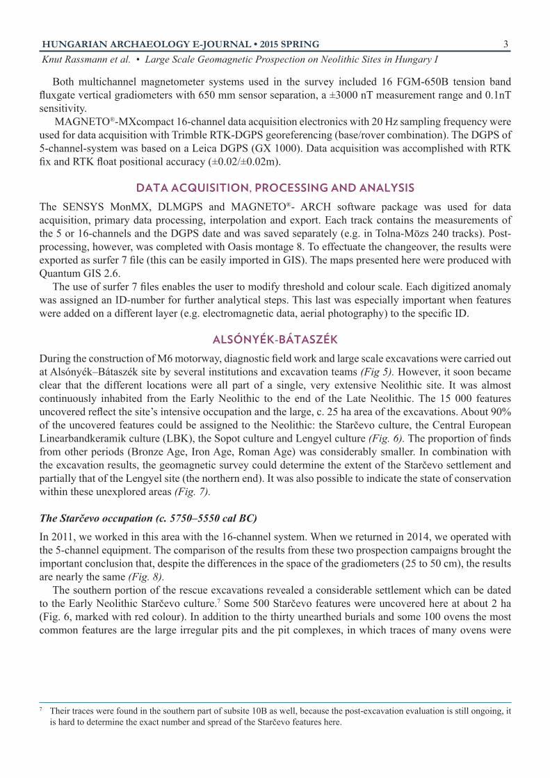
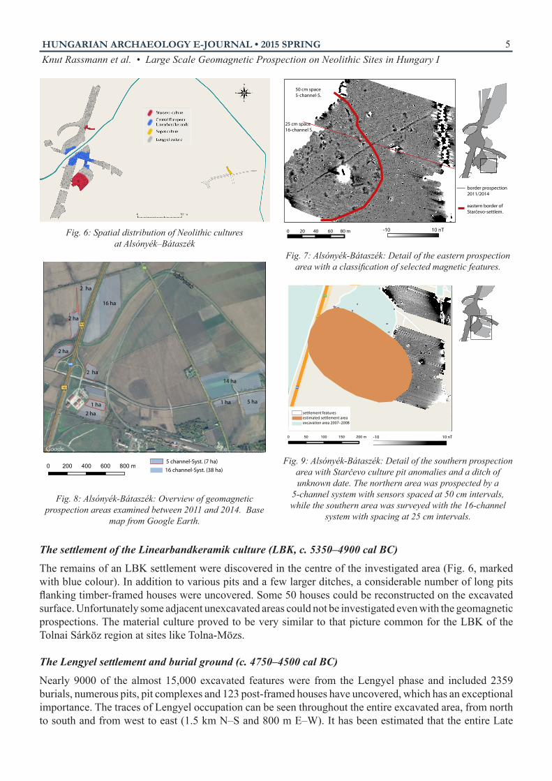
ALSÓNYÉK-BÁTASZÉKDuring the construction of M6 motorway, diagnostic field work and large scale excavations were carried out at Alsónyék–Bátaszék site by several institutions and excavation teams (Fig 5). However, it soon became clear that the different locations were all part of a single, very extensive Neolithic site. It was almost continuously inhabited from the Early Neolithic to the end of the Late Neolithic. The 15 000 features uncovered reflect the site’s intensive occupation and the large, c. 25 ha area of the excavations. About 90% of the uncovered features could be assigned to the Neolithic: the Starčevo culture, the Central European Linearbandkeramik culture (LBK), the Sopot culture and Lengyel culture (Fig. 6). The proportion of finds from other periods (Bronze Age, Iron Age, Roman Age) was considerably smaller. In combination with the excavation results, the geomagnetic survey could determine the extent of the Starčevo settlement and partially that of the Lengyel site (the northern end). It was also possible to indicate the state of conservation within these unexplored areas (Fig. 7).
The Starčevo occupation (c. 5750–5550 cal BC)
In 2011, we worked in this area with the 16-channel system. When we returned in 2014, we operated with the 5-channel equipment. The comparison of the results from these two prospection campaigns brought the important conclusion that, despite the differences in the space of the gradiometers (25 to 50 cm), the results are nearly the same (Fig. 8).
The southern portion of the rescue excavations revealed a considerable settlement which can be dated to the Early Neolithic Starčevo culture.7 Some 500 Starčevo features were uncovered here at about 2 ha (Fig. 6, marked with red colour). In addition to the thirty unearthed burials and some 100 ovens the most common features are the large irregular pits and the pit complexes, in which traces of many ovens were
7 Their traces were found in the southern part of subsite 10B as well, because the post-excavation evaluation is still ongoing, it is hard to determine the exact number and spread of the Starčevo features here.

HUNGARIAN ARCHAEOLOGY E-JOURNAL • 2015 SPRINGKnut Rassmann et al. • Large Scale Geomagnetic Prospection on Neolithic Sites in Hungary I
4
found. These appear to have been used for various open-air manufacturing and other economic activities.8
In this area, our prospections covered approximately 4 ha within this area of interest. The magnetogram shows results similar to the plan of the excavated surface, which contained a series of large pit-complexes. Their nT-values vary between 0 and 6 nT. However, they are surprisingly infrequent. The prospection allowed the resconstruction of the overall extent of the settlement to the east in which zone the settlement pits cover an area of approximately 1.5 ha. The settlement area may then have plausibly stretched over 5 ha of the site (Fig. 9).8 Bánffy, Eszter – Marton, Tibor – Osztás Anett: Early Neolithic Settlement and Burials at Alsónyék-Bátaszék. First Report.
In: Neolithisation of the Carpathian Basin: Northernmost Distribution of the Starčevo/Körös Culture, eds Kozlowski, Janusz K. – Raczky, Pál (Kraków–Budapest: Polish Academy of Arts and Sciences, 2010), 37–51.Osztás, Anett – Zalai-Gaál, István – Bánffy, Eszter: Alsónyék-Bátaszék: a new chapter in the research of Lengyel culture. Documenta Praehistorica 39 (2012), 377–396.
Fig. 5: Alsónyék-Bátaszék. Plan of the excavations between 2006 and 20091. subsite M6 TO 10/B, Alsónyék-Kanizsa-dűlő. Excavated by the Institute of Archaeology of the Hungarian Academy of
Sciences and Archeosztráda Ltd. between 2006 and 2008, excavation conducted by Anett Osztás and István Zalai-Gaál. Excavated area: 42 076 m2
2. subsite M6 TO 10/B, Alsónyék-Kanizsa-dűlő. Excavated by Ásatárs Ltd. in 2006–2007, excavation conducted by Zsolt Gallina. Excavated area: 47 038 m2
3. subsite M6 TO 046, Lajvérpuszta. Excavated by the Field Service for Cultural Heritage in 2008–2009, excavation conducted by Vera Majerik. Excavated area: 6799 m2
4. subsite M6 TO 11, Bátaszék-Malomrét-dűlő. Excavated by Ásatárs Ltd. in 2006–2007, excavation conducted by Péter Hornok and Zsolt Gallina. Excavated area: 67 095 m2
5. subsite M6 TO 11, Magtár. Excavated by the Field Service for Cultural Heritage in 2008, excavation conducted by Vera Majerik. Excavated area: 16 253 m2
6. subsite M6 TO 5603/1, Bátaszék-Mérnökségi Telep and Bátaszék-56-os út. Excavated by the Institute of Archaeology of the Hungarian Academy of Sciences and Archeosztráda Ltd. in 2008–2009, excavation conducted by Anett Osztás. Excavated area: 63 488 m2
7. subsite M6 TO 5603/2, Alsónyék-Hosszú-dűlő, Excavated by Wosinsky Mór County Museum in 2008-2009, excavation conducted by János Gábor Ódor, Excavated area: 11238 m²
HUNGARIAN ARCHAEOLOGY E-JOURNAL • 2015 SPRINGKnut Rassmann et al. • Large Scale Geomagnetic Prospection on Neolithic Sites in Hungary I
5
The settlement of the Linearbandkeramik culture (LBK, c. 5350–4900 cal BC)
The remains of an LBK settlement were discovered in the centre of the investigated area (Fig. 6, marked with blue colour). In addition to various pits and a few larger ditches, a considerable number of long pits flanking timber-framed houses were uncovered. Some 50 houses could be reconstructed on the excavated surface. Unfortunately some adjacent unexcavated areas could not be investigated even with the geomagnetic prospections. The material culture proved to be very similar to that picture common for the LBK of the Tolnai Sárköz region at sites like Tolna-Mözs.
The Lengyel settlement and burial ground (c. 4750–4500 cal BC)
Nearly 9000 of the almost 15,000 excavated features were from the Lengyel phase and included 2359 burials, numerous pits, pit complexes and 123 post-framed houses have uncovered, which has an exceptional importance. The traces of Lengyel occupation can be seen throughout the entire excavated area, from north to south and from west to east (1.5 km N–S and 800 m E–W). It has been estimated that the entire Late
0 20 40 60 80 m
border prospection 2011/2014
eastern border ofStarčevo-settlem.
50 cm space5-channel-S.
25 cm space16-channel S.
-10 10 nT
0 200 400 600 800 m
16 ha
2 ha
2 ha
1 ha2 ha
2 ha14 ha
1 ha 5 ha
2 ha
5 channel-Syst. (7 ha)16 channel-Syst. (38 ha)
-10 10 nT
settlement featuresestimated settlement areaexcavation area 2007–2008
Fig. 6: Spatial distribution of Neolithic cultures at Alsónyék–Bátaszék
Fig. 7: Alsónyék-Bátaszék: Detail of the eastern prospection area with a classification of selected magnetic features.
Fig. 8: Alsónyék-Bátaszék: Overview of geomagnetic prospection areas examined between 2011 and 2014. Base
map from Google Earth.
Fig. 9: Alsónyék-Bátaszék: Detail of the southern prospection area with Starčevo culture pit anomalies and a ditch of unknown date. The northern area was prospected by a
5-channel system with sensors spaced at 50 cm intervals, while the southern area was surveyed with the 16-channel
system with spacing at 25 cm intervals.
HUNGARIAN ARCHAEOLOGY E-JOURNAL • 2015 SPRINGKnut Rassmann et al. • Large Scale Geomagnetic Prospection on Neolithic Sites in Hungary I
6
Neolithic settlement probably covered as many as 80 ha. Lengyel features are scarce only in the southern portion of the excavation where there was the above mentioned Starčevo occupation, and in the middle part of the area, where the LBK settlement can be found.
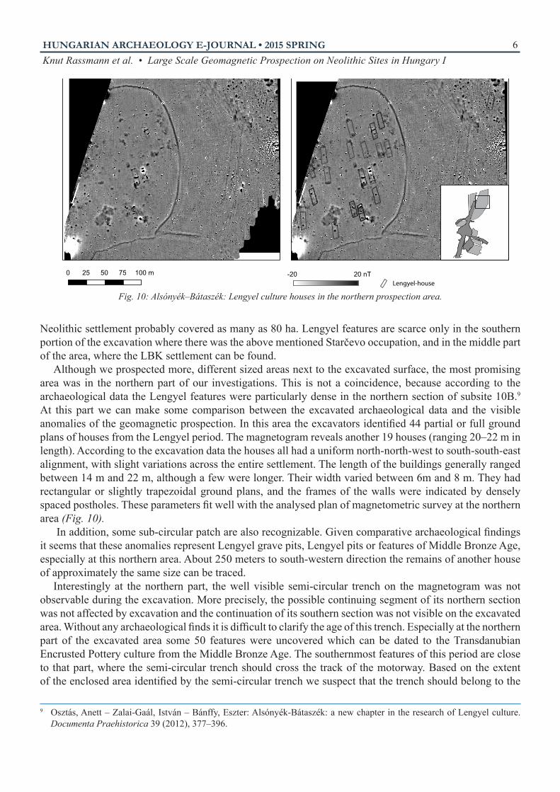
Although we prospected more, different sized areas next to the excavated surface, the most promising area was in the northern part of our investigations. This is not a coincidence, because according to the archaeological data the Lengyel features were particularly dense in the northern section of subsite 10B.9 At this part we can make some comparison between the excavated archaeological data and the visible anomalies of the geomagnetic prospection. In this area the excavators identified 44 partial or full ground plans of houses from the Lengyel period. The magnetogram reveals another 19 houses (ranging 20–22 m in length). According to the excavation data the houses all had a uniform north-north-west to south-south-east alignment, with slight variations across the entire settlement. The length of the buildings generally ranged between 14 m and 22 m, although a few were longer. Their width varied between 6m and 8 m. They had rectangular or slightly trapezoidal ground plans, and the frames of the walls were indicated by densely spaced postholes. These parameters fit well with the analysed plan of magnetometric survey at the northern area (Fig. 10).
In addition, some sub-circular patch are also recognizable. Given comparative archaeological findings it seems that these anomalies represent Lengyel grave pits, Lengyel pits or features of Middle Bronze Age, especially at this northern area. About 250 meters to south-western direction the remains of another house of approximately the same size can be traced.
Interestingly at the northern part, the well visible semi-circular trench on the magnetogram was not observable during the excavation. More precisely, the possible continuing segment of its northern section was not affected by excavation and the continuation of its southern section was not visible on the excavated area. Without any archaeological finds it is difficult to clarify the age of this trench. Especially at the northern part of the excavated area some 50 features were uncovered which can be dated to the Transdanubian Encrusted Pottery culture from the Middle Bronze Age. The southernmost features of this period are close to that part, where the semi-circular trench should cross the track of the motorway. Based on the extent of the enclosed area identified by the semi-circular trench we suspect that the trench should belong to the
9 Osztás, Anett – Zalai-Gaál, István – Bánffy, Eszter: Alsónyék-Bátaszék: a new chapter in the research of Lengyel culture. Documenta Praehistorica 39 (2012), 377–396.
0 25 50 75 100 mLengyel-house
-20 20 nT
Fig. 10: Alsónyék–Bátaszék: Lengyel culture houses in the northern prospection area.

HUNGARIAN ARCHAEOLOGY E-JOURNAL • 2015 SPRINGKnut Rassmann et al. • Large Scale Geomagnetic Prospection on Neolithic Sites in Hungary I
7
period of Middle Bronze Age. This assumption is confirmed by some anomalies on the magnetogram, which are the same size and shape as the already excavated Middle Bronze Age features. Yet further to the south, the magnetogram reveals the telltale contours of a double trench. Unfortunately, the visibility of the archaeological findings is limited by numerous metal objects (the latter probably the result of waste produced during the construction of the motorway) and further to east because of the track of a gas pipeline.
The northeastern zone of the prospection area is archaeologically characterized by the presence of a number of pits of different sizes (of which the largest extends some 5 m in diameter). These anomalies likely represent storage pits and are delimited by double ditches to the north and southwest. The chronological classification of these features is uncertain.
The Sopot occupation (c. 5050–4800 cal BC)
In 2008 and 2009, some 1–1.5 km to the east of the area just described, settlement features and a burial ground of the Sopot culture were excavated by archaeologists of the Wosinsky Mór Museum in Szekszárd (Fig. 6, marked with yellow colour). Features of different phases, mainly from the early medieval Avar period, surrounded those of the Sopot occupation. Most of these were found in the northern segment of the excavated area, on a fairly small surface (c. 20 m by 80 m). Some ten large, pit complexes (2–7 m in diameter), eighteen graves with the remains of twenty individuals and small sections of four more or less parallel ditches were investigated. In spite of the relatively few features, a very rich and important assemblage of Sopot material culture was found. Approximately 30 hectares of farmland were prospected as an extension of prospections along this area. The magnetogram shows five burial mounds measuring 8–17 m in diameter. The magnetogram also showed small anomalies within the trenches, with diameters of between 0.5–1 m. It is possible that some of these represent post-holes. Within the circular ditches, different structures possibly indicate grave pits.
Four houses could be identified within the prospection area on the basis of the post structures. Interestingly, each of these houses was oriented differently. The largest one can be estimated to be 20 m long and 8 m wide.
To the east, a cluster of pits of different sizes (diameters ranging between 2–4 m) was also detected. The house area were surrounded by two overlapping double ditches, the inner surface of which extended over 250 x 300 m. Between the two northern endpoints of this double trench lies a former natural riverbed of the River Sárvíz which was probably bounded the Sopot settlement from
0 75 150 225 300 m -20 20 nT
Fig. 11: Alsónyék-Bátaszék: Overview of the eastern prospection areas showing Sopot culture settlement features
and barrows of uncertain age. Base map from Open Street Map.
-20 20 nT
Fig. 12: Alsónyék-Bátaszék: Detail of the eastern prospection areas showing Sopot Culture settlement features and barrows
of uncertain age. Base map from Open Street Map.
HUNGARIAN ARCHAEOLOGY E-JOURNAL • 2015 SPRINGKnut Rassmann et al. • Large Scale Geomagnetic Prospection on Neolithic Sites in Hungary I
8
this direction. The western boundary of this region is marked by a crescent-shaped trench, stretching along for more than some 300 m. South of this trench yet another ditch could be detected. Unfortunately, questions involving chronological positions of burial mounds, the houses and pits cannot be answered on the basis of geomagnetic data alone.
According to our present knowledge we can outline, that the area bounded by the doubled trench and the former riverbed was inhabited during the Sopot period. Presumably the identified house traces can belong to this period but the detailed structure of the settlement cannot be reconstructed on the base of the magnetogram because of the several later archaeological period which were settled in the investigated area.
Recommended liteRatuRe
Bánffy, eszteR – maRton, tiBoR – osztás, anett
Early Neolithic Settlement and Burials at Alsónyék-Bátaszék. In: Neolithization of the Carpathian Basin: Northernmost Distribution of the Starčevo/Körös Culture, ed. Kozlowski, Janusz K. – Raczky, Pál, 37–51. Papers presented on the symposium organized by The EU Project FEPRE, The Formation of Europe: Prehistoric Population Dynamics and the Roots of Socio-Cultural Diversity. Kraków–Budapest: Polish Academy of Arts and Sciences, 2010.
Rassmann, Knut – ohlRau, René – hofmann, RoBeRt – mischKa, caRsten – BuRdo, nataliia – VidejKo, michail yu. – mülleR, johannes
High Precision Tripolye Settlement Plans, Demographic Estimations and Settlement Organization. Journal of Neolithic Archaeology 16 (2014), 96–134.
seRlegi, gáBoR – Rassmann, Knut – osztás, anett – mischKa, caRsten – fuRholt, maRtin – ohlRau, René – WinKelmann, Kay – Bánffy, eszteR
Large-Surface Magnetometer Survey of Neolithic Sites in the Kalocsa and Tolna Sárköz. Hungarian Archaeology e-journal, 2013 Spring.
tite, michael s. – mullins, chRis
Enhancement of the Magnetic Susceptibility of Soils on Archaeological Sites. Archaeometry 13 (1971)/2, 209–219.
osztás, anett – zalai-gaál, istVán – Bánffy, eszteR
Alsónyék-Bátaszék: a new chapter in the research of Lengyel culture. Documenta Praehistorica 39 (2012), 377–396.
Copyright © 2022 FDOKUMEN