Mango Spraying for the Control of Fruit Flies in Khartoum State

United Nations Human Settlements Programme
Regional Office for Africa and the Arab States
KHARTOUM PRO-POOR:
FROM POlicy Design TO PilOT iMPleMenTATiOn PROjecTs
United nations Human settlements Programme
Regional Office for Africa and the Arab States2
© United Nations Human Settlements Programme (UN-HABITAT), 2010
International Guidelines on Decentralization and Access to Basic Services for all
All rights reserved
UNITED NATIONS HUMAN SETTLEMENT PROGRAMME
P.O.BOX 30030, GPO, Nairobi, 00100, Kenya.
Tel.: +254 (20) 762 3120
Fax: +254 (20) 762 4266/4267/4264/3477/4060
E-mail: [email protected]
www.unhabitat.org
DISCLAIMER
The designation employed and the presentation of material in this publication do not imply the expression of any opinion whatsoever on the part of the Secretariat of the United Nations concerning the legal status of any country, territory, city or area of its authorities, or concerning the delimitation of its frontiers or boundaries or regarding its economic system or degree of development. The analysis, conclusions and recommendations of this publication do not necessarily reflect the view of the United Nations Human Settlements Programme (UN-HABITAT), the Governing council of UN- HABITAT or its Member States. Excerpts may be reproduced without authorization, on condition that the source is indicated.
ISBN Number:
Primary authors: Fernando Murillo, Mathias Spaliviero and Abdel Rahman Mustafa.
Photographs: Fernando Murillo and Abdel Rahman Mustafa
Sketches: Fernando Murillo
Editor: Julia Helena Tabbita
Layout: Florence Kuria
Sponsors: European Commission (EC) - Cooperazione Italiana
Printing:
For further information regarding this publication please contact:
FROM POLICY DESIGN TO PILOT IMPLEMENTATION PROJECTS 3
KH
AR
TOU
M P
RO
PO
OR
TAble Of cOnTenTs
1. sUMMARy 7
2. inTRODUcTiOn 8
2.1 BAcKgROUnD 8
2.2 HisTORicAl ReFeRences 14
2.3 PROjecT OBjecTiVes 17
2.4 MeTHODOlOgy 17
2.4.1 setting up the project 17
2.4.2 stakeholders 18
2.4.3 Recruitment of staff 18
3. AcHieVeMenTs 19
3.1 TRAining AnD cAPAciTy BUilDing 19
3.1.1 Training in stabilized soil block (ssB) production and construction 19
3.1.2 Training in alternative low cost sanitary system for urban poor 21
3.1.3 Training in flood-resistant housing and land tenure legal access 22
3.1.4 Training in model housing and multistory building design and construction 23
3.1.5 Training in participatory design and planning 25
3.1.6 Training in strategic planning 25
3.1.7 Training in data entry and geographic information system (gis) 29
3.1.8 Action plan for capacity building (cB) 30
3.2 PilOT PROjecTs 31
3.2.1 Brief description 34
3.2.2 Major components of the pilot projects 38
3.2.3 Mansura 40
3.2.4 Mayo-Mandela 41
3.2.5 Rasheed 41
3.3 FORMUlATiOn OF sTRATegic PlAns FOR VillAges AnD TOWns 44
3.3.1 selection of villages and towns 44
3.3.2 lodging villages 45
3.3.3 Rural-urban linkages 46
4. DiFFicUlTies FAceD AnD cOnTingency PlAns 49
5. lessOns leARnT 50
6. THe WAy FORWARD: “KHARTOUM WiTHOUT slUMs” 57
7. FinAl ReMARKs 62
Annex: RUsPs QUesTiOnnAiRe 67
United nations Human settlements Programme
Regional Office for Africa and the Arab States4
lisT OF TABles
Table i. comparison between strategic and traditional planning
Table ii. Brief description of the three pilot projects
Table iii. Major components of pilot projects
lisT OF FigURes
Figure 1. Map of Khartoum state showing villages and the metropolis
Figure 2. From informal settlement to low density neighbourhoods
Figure 3. Village landscape
Figure 4. Poverty map
Figure 5. land prices map
Figure 6. RUsPs session
Figure 7. ssB production in Mansura
Figure 8. ssB making machines in jebel Awlia
Figure 9. Popular neighbourhood in Omdurman
Figure 10. Un-Habitat approach in Khartoum
Figure 11. entrance of Khartoum University
Figure 12. View of Mahdi tomb
Figure 13. Khartoum historical maps
Figure 14. Map and view of Dar Al salam projects
Figure 15. Khartoum aerial view
Figure 16. Training in ssB
Figure 17. experimental construction in stabilized soil block (ssB) by the Training and Research institute (TRi)
Figure 18. ssB hand pressing machines
Figure 19. Testing and dry mixing soil
Figure 20. Training in innovative construction techniques.
Figure 21. cluster for ssB production and construction in Mansura
Figure 22. Use of forbidden digging machines that contaminate the groundwater.
Figure 23. Training in alternative sanitation technology
Figure 24. Map of areas liable to flooding in Khartoum and flood scene in Mayo
Figure 25. Flooding resistance strategies incorporated in model housing design
Figure 26. A family living in temporary conditions before self-building a model house
Figure 27. image of the model house built by the family presented in figure 26.
Figure 28. ground floor, first and second floor plan and perspective of a proposed design for multistory low income housing.
Figure 29. Major components of strategic planning proposed for Khartoum structural Plan (KsP)
Figure 30. Prioritization exercise in a community consultation meeting
Figure 31. Participation of women in a consultative meeting
Figure 32. strategic planning methodology for small cities and villages
Figure 33. example of digitalized map of jewel Awlia
Figure 34. land use map and location of social services in jebel Awlia.
FROM POLICY DESIGN TO PILOT IMPLEMENTATION PROJECTS 5
KH
AR
TOU
M P
RO
PO
OR
Figure 35. gis map showing flooding-prone areas
Figure 36. Discussion and agreement between communities and government representatives
Figure 37. Mansura
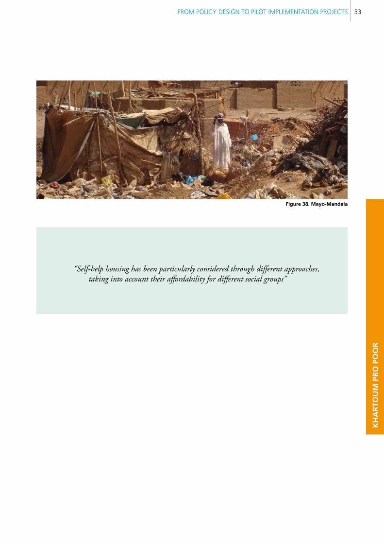
Figure 38. Mayo-Mandela
Figure 39. Rasheed in jebel Awlia
Figure 40. location of pilot projects
Figure 41. Mansura urban pattern and layout plan
Figure 42. Urban pattern of Mayo-Mandela camp
Figure 43. Rasheed in jebel Awlia.
Figure 44. self-help construction in jebel Awlia
Figure 45. Women’s centre in Mansura, before the implementation of the project
Figure 46. Rebuilt women’s centre in Mansura
Figure 47. Production of ssB in Mayo-Mandela
Figure 48. Model houses in el Rasheed.
Figure 49. interior of a model house
Figure 50. Typical village scene
Figure 51. scene in el Fateh
Figure 52. Map showing lodging villages
Figure 53. Fertile rural areas attractive for tourism
Figure 54. conceptual diagram of the applied methodology to assess rural-urban linkages
Figure 55. low income group participating in the initial steps of RUsPs
Figure 56. sketch representing technical discussion
Figure 57. sketch representing community participation
Figure 58. strategic location of Mansura, close to the urban fabric: Between land speculation and pro-poor policies
Figure 59. Public utilities carried out through community work
Figure 60. contrast between ssB construction and mud buildings
Figure 61. Agreeing on priority development projects for the city and villages
Figure 62. Discussion on urban trends at a local observatory
Figure 63. Tourism infrastructure near villages surrounding Khartoum.
Figure 64. Proposed institutional structure for “Khartoum without slums” programme
Figure 65. components of “Khartoum without slums” programme
Figure 66. Blueprint for implementing “Khartoum without slums” programme
Figure 67. Multistory buildings contribute to increasing density and diversity in popular neighbourhoods.
Figure 68. Mosque in Mayo-Mandela
United nations Human settlements Programme
Regional Office for Africa and the Arab States6
CBO community based organization
GIS geographic information system
IDP internally displaced person
ILO International Labour Organization
KSP Khartoum Strategic Plan
KWS Khartoum without Slums
LED local economic development
MPPPU Ministry of Physical Planning and Public Utilities
MP&UD Ministry of Planning and Urban Development
NGO non-governmental organization
OJT on the job training
PDB pilot demonstration building
PDP pilot demonstration project
RUSPS Rapid Urban Study Profile for Sustainability
SDF Social Development Foundation
SSB stabilized soil block
TRI Training Research Institute
TOT training of trainers
UN United Nations
UNCHS United Nations Centre for Human Settlements
UNDP United Nations Development Programme
UNEP United Nations Environmental Programme
UNESCO United Nations Educational, Scientific and Cultural Organization
UN-HABITAT United Nations Human Settlements Programme
UNHCR United Nations High Commissioner for Refugees
UNRISD United Nations Research Institute for Social Development
UNIDO United Nations Industrial Development Organization
WHO World Health Organization
AcROnYMs

FROM POLICY DESIGN TO PILOT IMPLEMENTATION PROJECTS 7
KH
AR
TOU
M P
RO
PO
OR
This publication summarizes the projects carried out by UN-Habitat in Khartoum between 2008 and 2010. It is a follow up to the already published “Urban Sector Studies and Capacity Building for Khartoum State”. The work involves more than forty professionals from different disciplines working collaboratively with their governmental counterparts to assess the major problems faced by the poor. The slum upgrading exercise links pro-poor policies with pilot demonstration projects, including housing and public utilities construction. These activities were carried out by training individuals and developing capacity for governmental and non- governmental organizations (NGOs). It is estimated that 2450 individuals were directly benefitted by training, and 1800 people participated in different consultations carried out using the Rapid Urban Studies Profile (RUSPS) approach. In addition, 900 households got direct support to self-build their houses, benefiting poor populations and their host communities.
This publication shares lessons learnt with colleagues from different fields and organizations involved in rapid urbanization in Sudan. These lessons cover a broad range of topics and stages, from early ideas for IDP (internally displaced person) reintegration to community mobilization and neighbourhood regularization. The publication seeks to contribute to developing a way forward based on community consensus rather than imposition.
Over the last decade an extremely complex combination of real estate speculation, tribal misunderstandings, and political tension has pushed the government to systematic eviction of squatter settlements, causing serious incidents of violence and civil unrest. In recent times, the Ministry of Planning and Urban Development (MPUD) -formerly the Ministry of Physical Planning and Public Utilities (MPPPU)- as well as localities have tested many more participatory, strategic and pro-poor planning approaches, discussing with target populations alternatives for informal settlement upgrading, in the framework of an integrated plan including voluntary relocation. The development of comprehensive alternatives, including land, housing, basic urban services, livelihoods and local economic development has shaped new approaches which respond to specific identified categories of the poor, according
to the area where they reside. Such alternatives, discussed and prioritized by communities through RUSPS, are crucial to implementing the “Guiding Principles for Relocation”, an official agreement signed by the Wali (Governor of Khartoum) and Head of UN Agencies, which protects the rights of displaced populations. Dissemination of the “Guiding Principles” and alternatives for pro-poor urbanization and resettlement enhance popular and governmental understanding of the rights and possibilities of the poor to access land, housing and basic services.
In the creation of alternatives it is important to match approaches to realities. Passing from policy making to implementation of pilot projects means more lessons are learnt based on concrete results. The implementation of three pilot projects provides a valid sample of scenarios for intervention: Mansura, at the edge of the consolidated city; Mayo-Mandela camp, in the first belt; and Rasheed, in Jebel Awlia locality, on the extreme outskirts. The introduction of an environmentally friendly technology such as stabilized soil block (SSB), affordable for low income households, serves to replace traditional fired bricks. With some training, SSB hand press machines have been shown to be effective in empowering low income communities. The pilot projects demonstrate promising results in terms of community ownership and governmental commitment. Strategic planning for villages and towns enhances rural-urban linkages, the key to tackle poverty in metropolitan Khartoum. Lessons learnt are summarized at the end, offering a way forward to further implementation of pro-poor policies, combining a regulatory framework, public works and self-help incentives. “Khartoum without slums” is a systematic slum upgrading programme proposed as the way forward.
1. sUMMARY
United nations Human settlements Programme
Regional Office for Africa and the Arab States8
2. InTRODUcTIOn
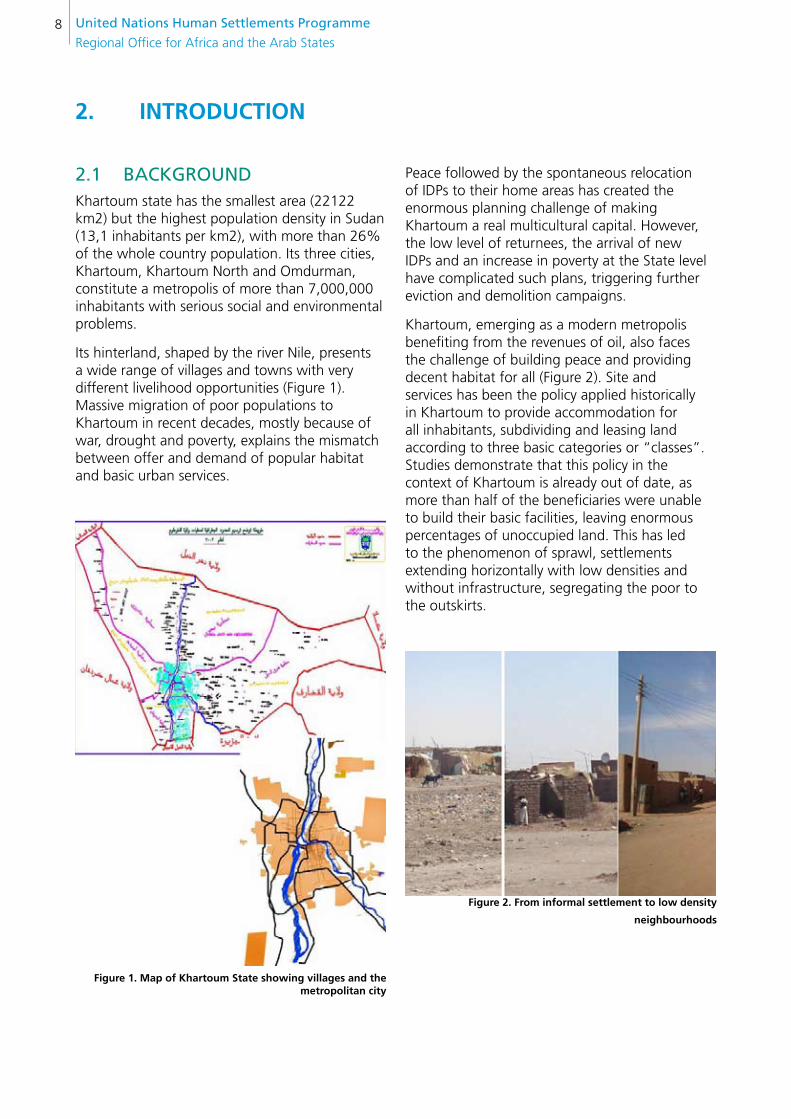
2.1 BAcKgROUnDKhartoum state has the smallest area (22122 km2) but the highest population density in Sudan (13,1 inhabitants per km2), with more than 26% of the whole country population. Its three cities, Khartoum, Khartoum North and Omdurman, constitute a metropolis of more than 7,000,000 inhabitants with serious social and environmental problems.
Its hinterland, shaped by the river Nile, presents a wide range of villages and towns with very different livelihood opportunities (Figure 1). Massive migration of poor populations to Khartoum in recent decades, mostly because of war, drought and poverty, explains the mismatch between offer and demand of popular habitat and basic urban services.
figure 1. Map of Khartoum state showing villages and the metropolitan city
Peace followed by the spontaneous relocation of IDPs to their home areas has created the enormous planning challenge of making Khartoum a real multicultural capital. However, the low level of returnees, the arrival of new IDPs and an increase in poverty at the State level have complicated such plans, triggering further eviction and demolition campaigns.
Khartoum, emerging as a modern metropolis benefiting from the revenues of oil, also faces the challenge of building peace and providing decent habitat for all (Figure 2). Site and services has been the policy applied historically in Khartoum to provide accommodation for all inhabitants, subdividing and leasing land according to three basic categories or “classes”. Studies demonstrate that this policy in the context of Khartoum is already out of date, as more than half of the beneficiaries were unable to build their basic facilities, leaving enormous percentages of unoccupied land. This has led to the phenomenon of sprawl, settlements extending horizontally with low densities and without infrastructure, segregating the poor to the outskirts.
figure 2. from informal settlement to low density
neighbourhoods
FROM POLICY DESIGN TO PILOT IMPLEMENTATION PROJECTS 9
KH
AR
TOU
M P
RO
PO
OR
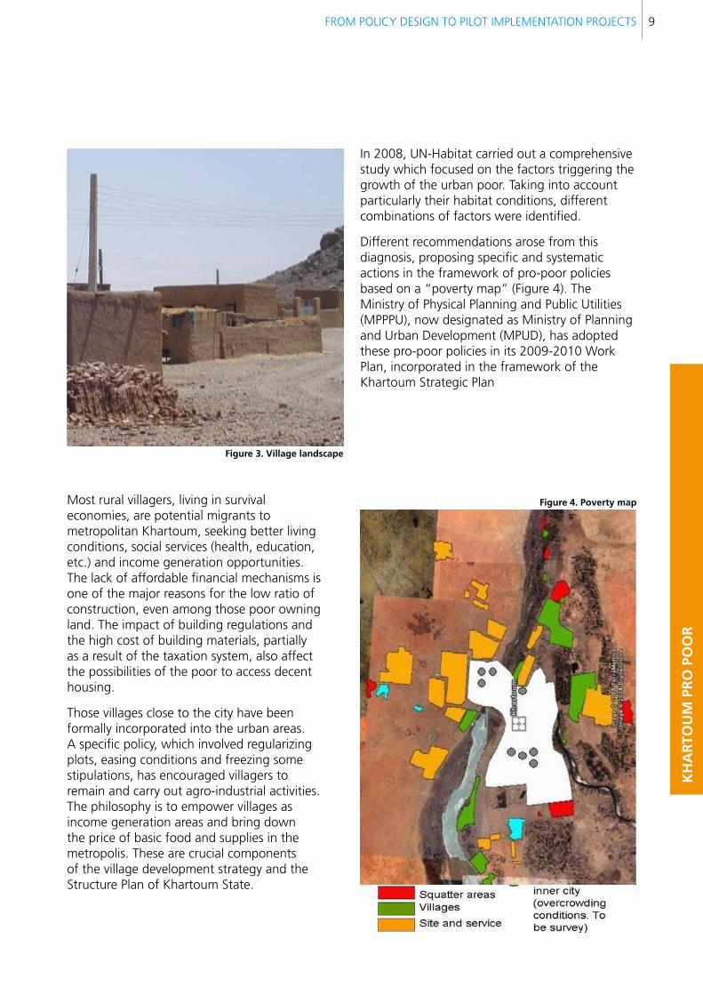
Most rural villagers, living in survival economies, are potential migrants to metropolitan Khartoum, seeking better living conditions, social services (health, education, etc.) and income generation opportunities. The lack of affordable financial mechanisms is one of the major reasons for the low ratio of construction, even among those poor owning land. The impact of building regulations and the high cost of building materials, partially as a result of the taxation system, also affect the possibilities of the poor to access decent housing.
Those villages close to the city have been formally incorporated into the urban areas. A specific policy, which involved regularizing plots, easing conditions and freezing some stipulations, has encouraged villagers to remain and carry out agro-industrial activities. The philosophy is to empower villages as income generation areas and bring down the price of basic food and supplies in the metropolis. These are crucial components of the village development strategy and the Structure Plan of Khartoum State.
figure 3. Village landscape
In 2008, UN-Habitat carried out a comprehensive study which focused on the factors triggering the growth of the urban poor. Taking into account particularly their habitat conditions, different combinations of factors were identified.
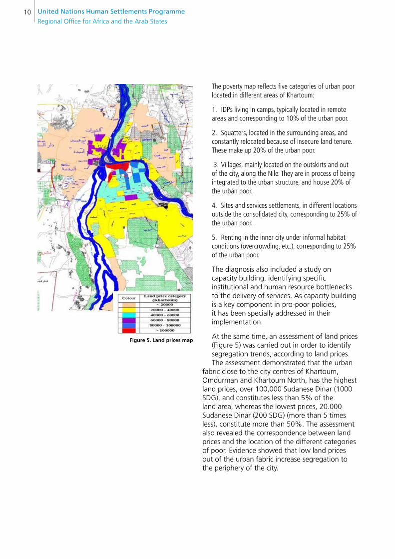
Different recommendations arose from this diagnosis, proposing specific and systematic actions in the framework of pro-poor policies based on a “poverty map” (Figure 4). The Ministry of Physical Planning and Public Utilities (MPPPU), now designated as Ministry of Planning and Urban Development (MPUD), has adopted these pro-poor policies in its 2009-2010 Work Plan, incorporated in the framework of the Khartoum Strategic Plan
figure 4. Poverty map
United nations Human settlements Programme
Regional Office for Africa and the Arab States10
The poverty map reflects five categories of urban poor located in different areas of Khartoum:
1. IDPs living in camps, typically located in remote areas and corresponding to 10% of the urban poor.
2. Squatters, located in the surrounding areas, and constantly relocated because of insecure land tenure. These make up 20% of the urban poor.
3. Villages, mainly located on the outskirts and out of the city, along the Nile. They are in process of being integrated to the urban structure, and house 20% of the urban poor.
4. Sites and services settlements, in different locations outside the consolidated city, corresponding to 25% of the urban poor.
5. Renting in the inner city under informal habitat conditions (overcrowding, etc.), corresponding to 25% of the urban poor.
The diagnosis also included a study on capacity building, identifying specific institutional and human resource bottlenecks to the delivery of services. As capacity building is a key component in pro-poor policies, it has been specially addressed in their implementation.
At the same time, an assessment of land prices (Figure 5) was carried out in order to identify segregation trends, according to land prices. The assessment demonstrated that the urban
fabric close to the city centres of Khartoum, Omdurman and Khartoum North, has the highest land prices, over 100,000 Sudanese Dinar (1000 SDG), and constitutes less than 5% of the land area, whereas the lowest prices, 20.000 Sudanese Dinar (200 SDG) (more than 5 times less), constitute more than 50%. The assessment also revealed the correspondence between land prices and the location of the different categories of poor. Evidence showed that low land prices out of the urban fabric increase segregation to the periphery of the city.
figure 5. land prices map

FROM POLICY DESIGN TO PILOT IMPLEMENTATION PROJECTS 11
KH
AR
TOU
M P
RO
PO
OR
With these critical insights, four community consultations and participatory planning exercises (Figure 6) were conducted in the form of a Rapid Urban Sector Profile for Sustainability (RUSPS). This is a methodology for project development based on consensus building used by UN-Habitat worldwide. It is promoted as a crucial tool for participatory planning, introduced in the MPUD and localities structures as part of the capacity building action plan. RUSPS was applied selectively to poor neighbourhoods representing the different categories of the urban poor. Bringing together community leaders and public officials to agree on priorities for interventions has been a crucial achievement coming out of the pilot projects.
Once active participation and engagement of local residents were achieved, specific actions to upgrade areas were identified, taking into account agreed priorities. The introduction of appropriate technologies, such as stabilized soil block (SSB), and the supply of SSB hand pressing machines, cement and training, have been shown to be an effective way to mobilize communities in order to implement action plans (Figure 7).
figure 6. RUsPs session
figure 7. ssb production in Mansura
United nations Human settlements Programme
Regional Office for Africa and the Arab States12
Progress in pro-poor policies and capacity building contributes to creating effective legal frameworks orientated to human rights. Pilot projects, targeted at villages and reception zones in the surroundings of Khartoum, included the construction of social services, shelter and livelihood facilities.
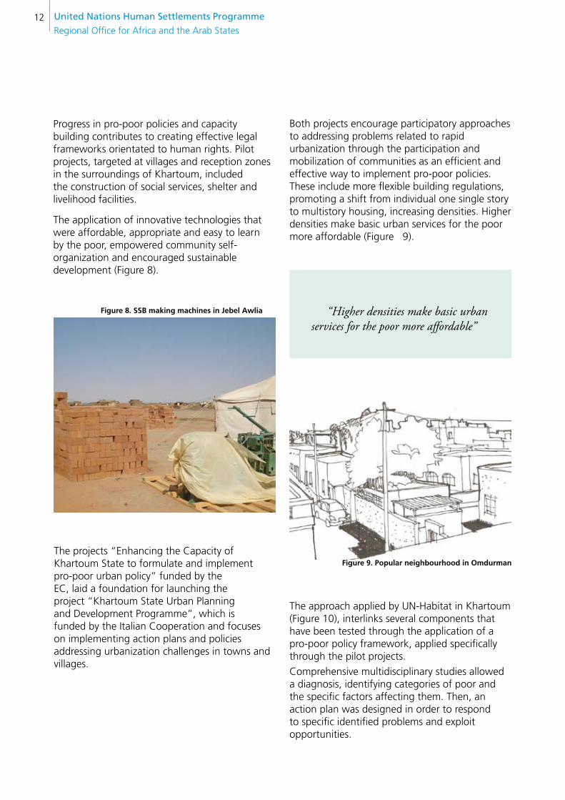
The application of innovative technologies that were affordable, appropriate and easy to learn by the poor, empowered community self- organization and encouraged sustainable development (Figure 8).
figure 8. ssb making machines in Jebel Awlia
The projects “Enhancing the Capacity of Khartoum State to formulate and implement pro-poor urban policy” funded by the EC, laid a foundation for launching the project “Khartoum State Urban Planning and Development Programme”, which is funded by the Italian Cooperation and focuses on implementing action plans and policies addressing urbanization challenges in towns and villages.
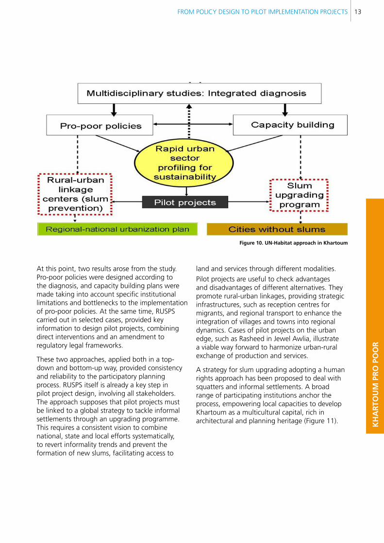
Both projects encourage participatory approaches to addressing problems related to rapid urbanization through the participation and mobilization of communities as an efficient and effective way to implement pro-poor policies. These include more flexible building regulations, promoting a shift from individual one single story to multistory housing, increasing densities. Higher densities make basic urban services for the poor more affordable (Figure 9).
“Higher densities make basic urban services for the poor more affordable”
figure 9. Popular neighbourhood in Omdurman
The approach applied by UN-Habitat in Khartoum (Figure 10), interlinks several components that have been tested through the application of a pro-poor policy framework, applied specifically through the pilot projects.
Comprehensive multidisciplinary studies allowed a diagnosis, identifying categories of poor and the specific factors affecting them. Then, an action plan was designed in order to respond to specific identified problems and exploit opportunities.
FROM POLICY DESIGN TO PILOT IMPLEMENTATION PROJECTS 13
KH
AR
TOU
M P
RO
PO
OR
figure 10. Un-Habitat approach in Khartoum
At this point, two results arose from the study. Pro-poor policies were designed according to the diagnosis, and capacity building plans were made taking into account specific institutional limitations and bottlenecks to the implementation of pro-poor policies. At the same time, RUSPS carried out in selected cases, provided key information to design pilot projects, combining direct interventions and an amendment to regulatory legal frameworks.
These two approaches, applied both in a top-down and bottom-up way, provided consistency and reliability to the participatory planning process. RUSPS itself is already a key step in pilot project design, involving all stakeholders. The approach supposes that pilot projects must be linked to a global strategy to tackle informal settlements through an upgrading programme. This requires a consistent vision to combine national, state and local efforts systematically, to revert informality trends and prevent the formation of new slums, facilitating access to
land and services through different modalities.
Pilot projects are useful to check advantages and disadvantages of different alternatives. They promote rural-urban linkages, providing strategic infrastructures, such as reception centres for migrants, and regional transport to enhance the integration of villages and towns into regional dynamics. Cases of pilot projects on the urban edge, such as Rasheed in Jewel Awlia, illustrate a viable way forward to harmonize urban-rural exchange of production and services.
A strategy for slum upgrading adopting a human rights approach has been proposed to deal with squatters and informal settlements. A broad range of participating institutions anchor the process, empowering local capacities to develop Khartoum as a multicultural capital, rich in architectural and planning heritage (Figure 11).
United nations Human settlements Programme
Regional Office for Africa and the Arab States14
figure 11. entrance of Khartoum University
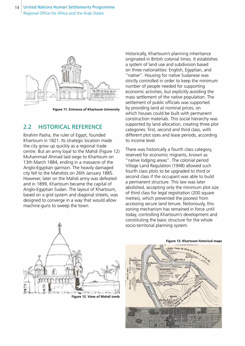
2.2 HisTORicAl ReFeRence Ibrahim Pasha, the ruler of Egypt, founded Khartoum in 1821. Its strategic location made the city grow up quickly as a regional trade centre. But an army loyal to the Mahdi (Figure 12) Muhammad Ahmad laid siege to Khartoum on 13th March 1884, ending in a massacre of the Anglo-Egyptian garrison. The heavily damaged city fell to the Mahdists on 26th January 1885. However, later on the Mahdi army was defeated and in 1899, Khartoum became the capital of Anglo-Egyptian Sudan. The layout of Khartoum, based on a grid system and diagonal streets, was designed to converge in a way that would allow machine-guns to sweep the town.
figure 12. View of Mahdi tomb
Historically, Khartoum’s planning inheritance originated in British colonial times. It establishes a system of land use and subdivision based on three nationalities: English, Egyptian, and “native”. Housing for native Sudanese was strictly controlled in order to keep the minimum number of people needed for supporting economic activities, but explicitly avoiding the mass settlement of the native population. The settlement of public officials was supported by providing land at nominal prices, on which houses could be built with permanent construction materials. This social hierarchy was supported by land allocation, creating three plot categories: first, second and third class, with different plot sizes and lease periods, according to income level.
There was historically a fourth class category, reserved for economic migrants, known as “native lodging areas”. The colonial period Village Land Regulation (1948) allowed such fourth class plots to be upgraded to third or second class if the occupant was able to build a permanent structure. This law was later abolished, accepting only the minimum plot size of third class for legal registration (200 square metres), which prevented the poorest from accessing secure land tenure. Notoriously, this zoning mechanism has remained in force until today, controlling Khartoum’s development and constituting the basic structure for the whole socio-territorial planning system.
figure 13. Khartoum historical maps
FROM POLICY DESIGN TO PILOT IMPLEMENTATION PROJECTS 15
KH
AR
TOU
M P
RO
PO
OR
The planning approach involves the control of land allocation, minimizing the occupation of agricultural land for urban uses. In addition, the plan seeks to keep most available land under governmental control. The key to such control has lain in only allowing land ownership for those minorities associated with the government bureaucracy, and the practice of permanent demolition and relocation of communities to regulate the growth of the three towns.
In 1908, Mc Lean implemented a “master plan” that defined an urban boundary to avoid urban sprawl, and remained unchanged for 40 years. The master plan exercise targeted a population of 100.000 inhabitants in a total area of 11, 5 km2, with a gross density of 87 persons per hectare. The urban plan consisted of a strong definition of the urban boundary through a surrounding wall, in the current Khartoum city. This master plan marked the “golden era” of Sudan’s urbanism because it included the design of an urban pattern that matched the most modern landscape and architectural concepts of that time, shaping Khartoum into a “civilized” colonial centre. The pride of the citizens at that time would endure throughout the 20th century, serving as a reference model to compare with the future decline of the city.
In line with previous measures, the Land Regulation Act of 1925 sought the strict and effective use of land, preventing speculation.
On Sudan’s achieving independence in 1956, Khartoum became the capital of the new country. Throughout the 1970s and 1980s, Khartoum was the destination for hundreds of thousands of refugees fleeing from conflicts in neighboring nations such as Chad, Eritrea, Ethiopia and Uganda. The Eritrean and Ethiopian refugees assimilated into society whereas some of the other refugees settled in large slums on the outskirts of the city. From the mid-1980s onwards, large numbers of South Sudanese and Darfuri, internally displaced by the violence of the Second Sudanese Civil War and Darfur conflict, have settled around Khartoum. In the framework of traditional “replanning” exercises, informal settlements were targeted by a violent demolition campaign. Integrated into the successive master plans, four mechanisms were historically applied
to manage the problem of squatter housing in Greater Khartoum:
eradication: 1. It was practiced from 1927 until the late 1970s. This only led to changing the location of squatter areas and increasing urban land speculation.
land price control:2. It consisted of defining prices for residential land, charging high fees for land exchange. That resulted in an unprecedented increase in land prices and speculation.
Rent control: 3. Several acts were issued in the 1970s to control rents. This discouraged developers and owners from producing housing for the market; consequently, demand and speculation increased.
The Green belt: 4. A huge green belt was developed south of Khartoum in the 1970s to stop the mushrooming of squatter settlements. However, it failed because the squatters built new settlements beyond it. Other bounding concepts, designed to circumscribe the urban area with huge agricultural projects, suffered a similar fate.
In 1991, the Village Regulation Administration, and in 2000, the Urban Development Administration, both introduced amendments to the policy towards squatters. The new package of policies included different solutions for different types of squatters.
The main policy concepts for dealing with squatter settlements in the 1990s can be summarized in three major groups:
I. Official cancellation of the 4th class areas: This measure upgraded 4th class areas to 3rd class. One of the more prominent examples was the relocation of “Ishash Falata” neighbourhood to “Al Ingaz”. With the same number of residential plots and population, the plot size was reduced (from 350-300 square metres to 100 square metres) and the total required area was decreased by 133 hectares (two-thirds). This increased the density from 167 persons per hectare to 455 persons per hectare (nearly 2.5 times).
United nations Human settlements Programme
Regional Office for Africa and the Arab States16
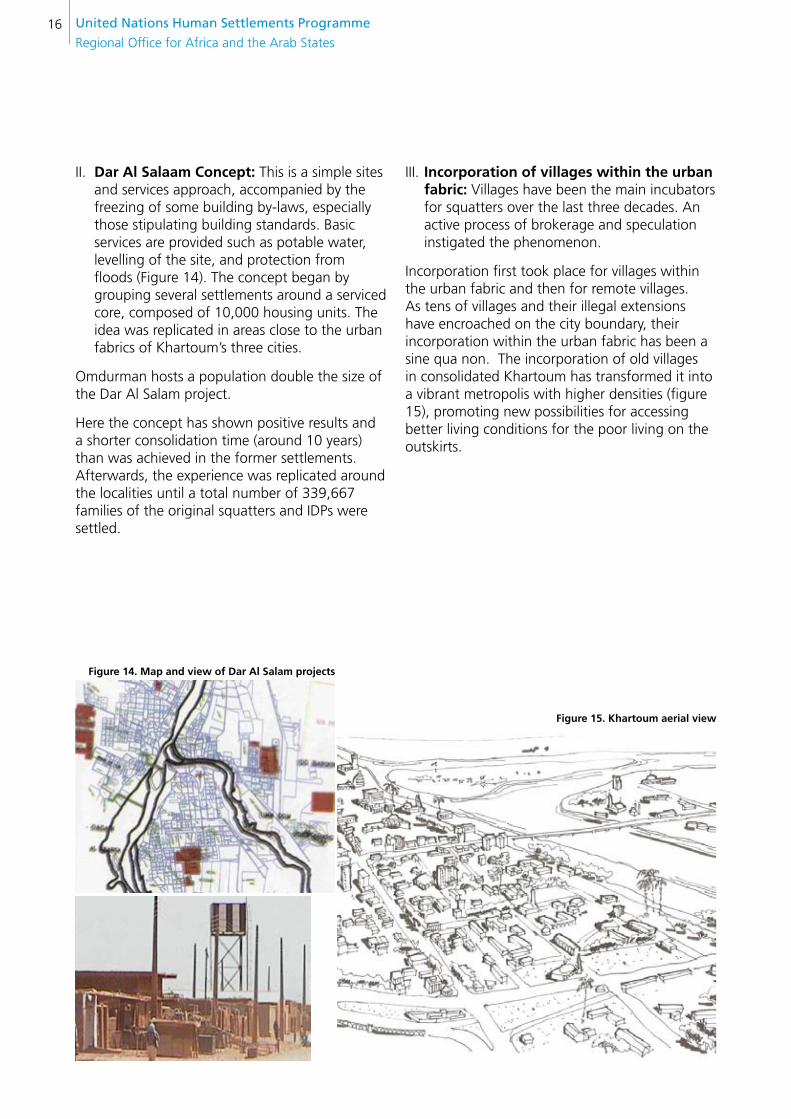
II. Dar Al salaam concept: This is a simple sites and services approach, accompanied by the freezing of some building by-laws, especially those stipulating building standards. Basic services are provided such as potable water, levelling of the site, and protection from floods (Figure 14). The concept began by grouping several settlements around a serviced core, composed of 10,000 housing units. The idea was replicated in areas close to the urban fabrics of Khartoum’s three cities.
Omdurman hosts a population double the size of the Dar Al Salam project.
Here the concept has shown positive results and a shorter consolidation time (around 10 years) than was achieved in the former settlements. Afterwards, the experience was replicated around the localities until a total number of 339,667 families of the original squatters and IDPs were settled.
figure 14. Map and view of Dar Al salam projects
figure 15. Khartoum aerial view
III. Incorporation of villages within the urban fabric: Villages have been the main incubators for squatters over the last three decades. An active process of brokerage and speculation instigated the phenomenon.
Incorporation first took place for villages within the urban fabric and then for remote villages. As tens of villages and their illegal extensions have encroached on the city boundary, their incorporation within the urban fabric has been a sine qua non. The incorporation of old villages in consolidated Khartoum has transformed it into a vibrant metropolis with higher densities (figure 15), promoting new possibilities for accessing better living conditions for the poor living on the outskirts.

FROM POLICY DESIGN TO PILOT IMPLEMENTATION PROJECTS 17
KH
AR
TOU
M P
RO
PO
OR
2.3 PROjecT OBjecTiVes The projects “enhancing capacity of Khartoum state to formulate and implement pro-poor urban policy” (2008-2010) and “Khartoum state Urban Planning and Development Programme” (2009-2011) support the broad objective of contributing to urban poverty reduction in Khartoum State as well as identifying specific targets for development:
To guide the state and local authorities to •achieve a shared vision of the settlements future by introducing Strategic plans for three towns and nine villages within Khartoum state.
To assist Khartoum State in developing •priority actions identified in the strategic plan into fully prepared technical assistance projects and "bankable" investment packages.
To strengthen local capacity for coordinated •planning and management of urban development and growth.
To cumulatively attain the overarching development objective and achieve specific objectives, the project has broadly undertaken the following tasks:
To prepare Strategic plans for three towns •and nine villages and formulate a basis for a strategic approach which can be replicated in other locations
To formulate city and village priority •development projects, promoting local economic development (LED) in the form of an investment action plan that targets strategic works and encourages potential development activities
To prepare training manuals for strategic and •action planning
To demonstrate visible actions (self-help •housing construction using SSB technology), exploring alternatives for roofing, sanitation and multistory buildings by means of pilot demonstration buildings (PDBs). Such PDBs are crucial to introduce more sustainable urban patterns, encouraging higher densities and a better distribution of facilities. These are keys to sustainable urbanization, based on assessment incorporated in the Khartoum Structural Plan (KSP)
To prepare local indicators of land use and •basic urban services for the State
2.4 MeTHODOlOgy
2.4.1 SETTING UP THE PROJECT
The project carried out a broad consultation with different stakeholders involved in previous RUSPS exercises to agree on the way forward for implementation. The government, represented by different ministries, made a commitment to delivering priority services, monitoring and supervision, as guided by communities. RUSPS was adapted to MPUD legal framework, conducting training and capacity building activities within the daily routine of the MPUD and the communities.
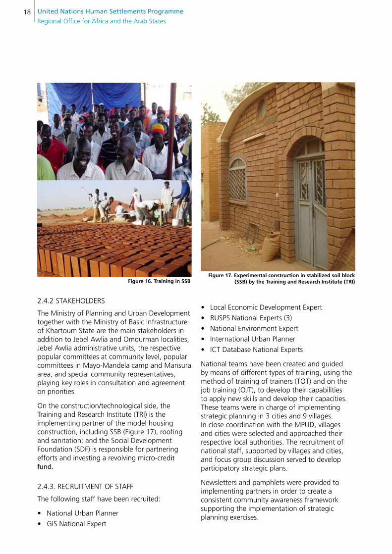
UN-Habitat has coordinated all activities, creating a technical team to carry out strategic planning for villages and towns, providing training and identifying institutional gaps to focus on capacity building. Several implementing partners, like academic institutions, were identified to carry out construction, signing agreements of cooperation (Figure 16).
United nations Human settlements Programme
Regional Office for Africa and the Arab States18
2.4.2 STAKEHOLDERS
The Ministry of Planning and Urban Development together with the Ministry of Basic Infrastructure of Khartoum State are the main stakeholders in addition to Jebel Awlia and Omdurman localities, Jebel Awlia administrative units, the respective popular committees at community level, popular committees in Mayo-Mandela camp and Mansura area, and special community representatives, playing key roles in consultation and agreement on priorities.
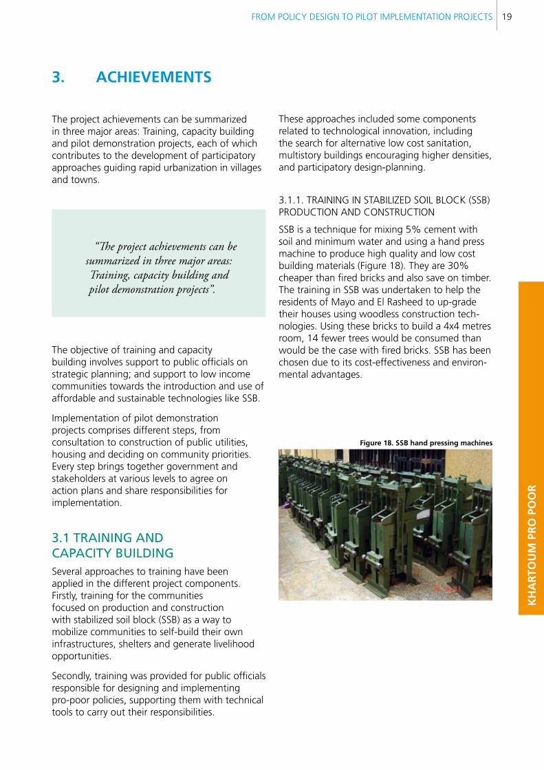
On the construction/technological side, the Training and Research Institute (TRI) is the implementing partner of the model housing construction, including SSB (Figure 17), roofing and sanitation; and the Social Development Foundation (SDF) is responsible for partnering efforts and investing a revolving micro-credit fund.
2.4.3. RECRUITMENT OF STAFF
The following staff have been recruited:
National Urban Planner•
GIS National Expert•
figure 16. Training in ssb
Local Economic Development Expert•
RUSPS National Experts (3)•
National Environment Expert•
International Urban Planner •
ICT Database National Experts •
National teams have been created and guided by means of different types of training, using the method of training of trainers (TOT) and on the job training (OJT), to develop their capabilities to apply new skills and develop their capacities. These teams were in charge of implementing strategic planning in 3 cities and 9 villages. In close coordination with the MPUD, villages and cities were selected and approached their respective local authorities. The recruitment of national staff, supported by villages and cities, and focus group discussion served to develop participatory strategic plans.
Newsletters and pamphlets were provided to implementing partners in order to create a consistent community awareness framework supporting the implementation of strategic planning exercises.
figure 17. experimental construction in stabilized soil block (ssb) by the Training and Research Institute (TRI)
FROM POLICY DESIGN TO PILOT IMPLEMENTATION PROJECTS 19
KH
AR
TOU
M P
RO
PO
OR
3. AcHIeVeMenTs
The project achievements can be summarized in three major areas: Training, capacity building and pilot demonstration projects, each of which contributes to the development of participatory approaches guiding rapid urbanization in villages and towns.
“The project achievements can be summarized in three major areas: Training, capacity building and pilot demonstration projects”.
The objective of training and capacity building involves support to public officials on strategic planning; and support to low income communities towards the introduction and use of affordable and sustainable technologies like SSB.
Implementation of pilot demonstration projects comprises different steps, from consultation to construction of public utilities, housing and deciding on community priorities. Every step brings together government and stakeholders at various levels to agree on action plans and share responsibilities for implementation.
3.1 TRAining AnD cAPAciTy BUilDing Several approaches to training have been applied in the different project components. Firstly, training for the communities focused on production and construction with stabilized soil block (SSB) as a way to mobilize communities to self-build their own infrastructures, shelters and generate livelihood opportunities.
Secondly, training was provided for public officials responsible for designing and implementing pro-poor policies, supporting them with technical tools to carry out their responsibilities.
These approaches included some components related to technological innovation, including the search for alternative low cost sanitation, multistory buildings encouraging higher densities, and participatory design-planning.
3.1.1. TRAINING IN STABILIZED SOIL BLOCK (SSB) PRODUCTION AND CONSTRUCTION
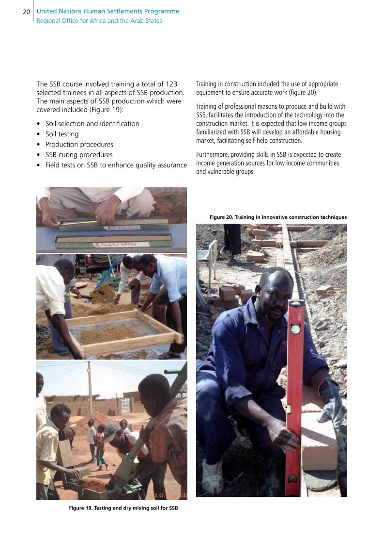
SSB is a technique for mixing 5% cement with soil and minimum water and using a hand press machine to produce high quality and low cost building materials (Figure 18). They are 30% cheaper than fired bricks and also save on timber. The training in SSB was undertaken to help the residents of Mayo and El Rasheed to up-grade their houses using woodless construction tech-nologies. Using these bricks to build a 4x4 metres room, 14 fewer trees would be consumed than would be the case with fired bricks. SSB has been chosen due to its cost-effectiveness and environ-mental advantages.
figure 18. ssb hand pressing machines
United nations Human settlements Programme
Regional Office for Africa and the Arab States20
The SSB course involved training a total of 123 selected trainees in all aspects of SSB production. The main aspects of SSB production which were covered included (Figure 19):
Soil selection and identification•
Soil testing•
Production procedures•
SSB curing procedures •
Field tests on SSB to enhance quality assurance•
figure 19. Testing and dry mixing soil for ssb
Training in construction included the use of appropriate equipment to ensure accurate work (figure 20).
Training of professional masons to produce and build with SSB, facilitates the introduction of the technology into the construction market. It is expected that low income groups familiarized with SSB will develop an affordable housing market, facilitating self-help construction.
Furthermore, providing skills in SSB is expected to create income generation sources for low income communities and vulnerable groups.
figure 20. Training in innovative construction techniques

FROM POLICY DESIGN TO PILOT IMPLEMENTATION PROJECTS 21
KH
AR
TOU
M P
RO
PO
OR
Families were organized in clusters selected by communities to be eligible for training in construction, and received a hand press SSB machine and cement for self-building their model houses and public utilities.
The training also included using alternative construction for roofing and plastering. Figure 21 shows SSB production and construction in Mansura
figure 21. cluster for ssb production and construction in Mansura
3.1.2. TRAINING IN ALTERNATIVE LOW COST SANITARY SYSTEM FOR URBAN POOR
Sanitation services were established in Khartoum in 1953-54 with a total network of 146 kilometres and 13 pumping stations to serve 80,000 people. Since 1971 no major development has been implemented to meet population growth. The sanitation network covers less than 15% of Khartoum state. Recently, German and Turkish companies have completed two treatment stations in Soba, working on the activated treatment plant system. Their daily capacity is 40,000 m³.
Although available technologies are affordable for those urban poor owning land, they have some disadvantages: the use of pit latrines and septic tanks in certain areas is unsafe for ground water, especially when forbidden drilling machinery is used (Figure 22).
figure 22. Use of forbidden digging machines that contaminate the ground water
United nations Human settlements Programme
Regional Office for Africa and the Arab States22
While the lack of available funds hampers the extension of the sewer network, it is also the case that in one sense the poor may be disadvantaged by its extension, because of the direct costs of treatments and their effect on land prices. The most affected group is the squatters, who are densely concentrated in areas with scarce services where people drink contaminated groundwater.
The project introduces a pilot low cost sewage waste and water treatment system, serving a considerable number of the urban poor. The aim of this pilot project is demonstration, on the job training in the new technology, feedback, assessment, and ultimately scale up.
Research on alternative designs and technologies has been done considering different social, financial and maintenance aspects, recommending technical specifications appropriate to the different low income groups being assisted.
In parallel, training for masons and specialists in construction has been conducted, guiding them on how to make slabs for pit latrines that use less material, particularly cement and iron, and that can be industrialized to be transported or produced “in situ” (Figure 23).
figure 23. Training in alternative sanitation technology
3.1.3. TRAINING IN FLOOD RESISTANT HOUSING AND LAND TENURE LEGAL ACCESS.
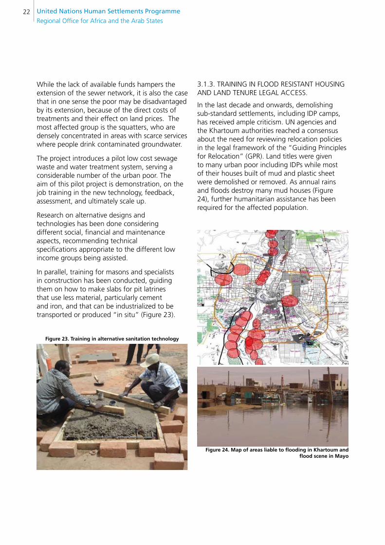
In the last decade and onwards, demolishing sub-standard settlements, including IDP camps, has received ample criticism. UN agencies and the Khartoum authorities reached a consensus about the need for reviewing relocation policies in the legal framework of the “Guiding Principles for Relocation” (GPR). Land titles were given to many urban poor including IDPs while most of their houses built of mud and plastic sheet were demolished or removed. As annual rains and floods destroy many mud houses (Figure 24), further humanitarian assistance has been required for the affected population.
figure 24. Map of areas liable to flooding in Khartoum and flood scene in Mayo

FROM POLICY DESIGN TO PILOT IMPLEMENTATION PROJECTS 23
KH
AR
TOU
M P
RO
PO
OR
The high cost of construction materials and lack of affordable financial mechanisms make it difficult for poor families to afford the traditional self-building process. Consequently, the average length of time to build even a single room is four years.
The project aims at improving poor people’s access to decent habitat in a participatory manner. It involves the development of alternative housing schemes for land owners as well as explanations on procedures to access secure land tenure following legal registration, and provision of low cost sanitary systems. Self-help housing initiatives from poor families were supported by the project, creating neighbourhood clusters sharing SSB hand press machines, cement and construction tools managed by a trained CBO and local organizations.
In addition the project provided technical advice on house layout, introducing familiar expansion perspectives related to the construction of additional rooms.
Special consideration was given to flood resistance strategies (Figure 25), such as elevated floor and concrete foundations, in order to minimize and delay the damage produced by flooding and the risk of collapse.
figure 25. flooding resistance strategies incorporated in model housing design
3.1.4. TRAINING IN MODEL HOUSING AND MULTISTORY BUILDING DESIGN AND CONSTRUCTION
Alternatives for building a sample of model houses have been explored. Families living in temporary shelters (Figure 26) were identified to build housing prototypes consisting of two rooms, a kitchen, latrine and a veranda (figure 27). A prototype of reinforced slabs and external staircases (Figure 28) for low income groups living in multistory buildings was also included.
figure 26. A family living in temporary conditions before self-building a model house

United nations Human settlements Programme
Regional Office for Africa and the Arab States24
It is assumed that densification of low income neighbourhoods will happen anyway. As it is not possible for the urban poor to expand their houses vertically, they do so horizontally; either occupying all the plot without leaving space for income generation activities or building badly ventilated and overcrowded rooms. Figure 26 and 27 show living conditions, before and after the upgrading of a house, from one made of temporary materials to one built of durable affordable materials (SSB).
Participatory design assists in finding tailor-made solutions to the specific needs, preferences and financial possibilities of the targeted groups.
figure 27. Image of the model house built by the family presented in figure 26
figure 28. Proposed design for multistory low income housing: Ground floor, first and second floor plan and perspective of a multistory model house
FROM POLICY DESIGN TO PILOT IMPLEMENTATION PROJECTS 25
KH
AR
TOU
M P
RO
PO
OR
3.1.5. TRAINING IN PARTICIPATORY PLANNING AND DESIGN
After applying RUSPS (Rapid Urban Sector Profile for Sustainability), the project provides mechanisms for the continuing involvement of the community in designing and planning to build their basic infrastructure and facilities.
This requires a systematic approach to participatory planning and design at the community level, coordinated with the rest of the metropolis.
Support for design and planning is required, including technical backstopping on construction of model houses, sanitation, etc.
3.1.6. TRAINING IN STRATEGIC PLANNING
Strategic planning is an innovation globally, but is particularly new in the context of Sudan. For decades urban and regional planning has followed a traditional system of subdividing land according to three categories: First, second and third class. As was explained earlier, this system was applied during colonial times to separate the inhabitants: First class corresponded to the English, second class to the Egyptians, and the third class to those local Sudanese who cooperated with the colonial power.
This system, still ongoing, links parcel size and location with income level and lease periods. Those inhabitants with higher incomes access bigger plots in more centralized areas for longer periods, while the poorest hardly access smaller plots for shorter periods on the periphery of the city.
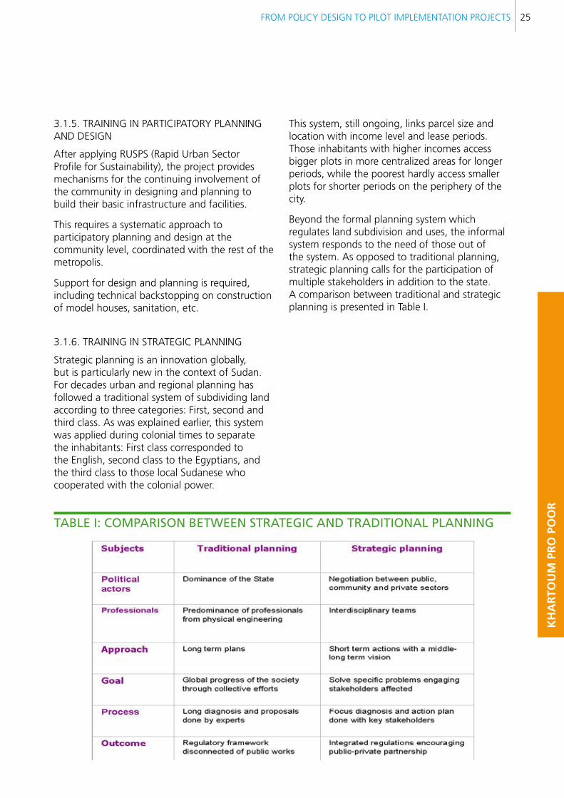
Beyond the formal planning system which regulates land subdivision and uses, the informal system responds to the need of those out of the system. As opposed to traditional planning, strategic planning calls for the participation of multiple stakeholders in addition to the state. A comparison between traditional and strategic planning is presented in Table I.
TABle i: cOMPARisOn BeTWeen sTRATegic AnD TRADiTiOnAl PlAnning
United nations Human settlements Programme
Regional Office for Africa and the Arab States26
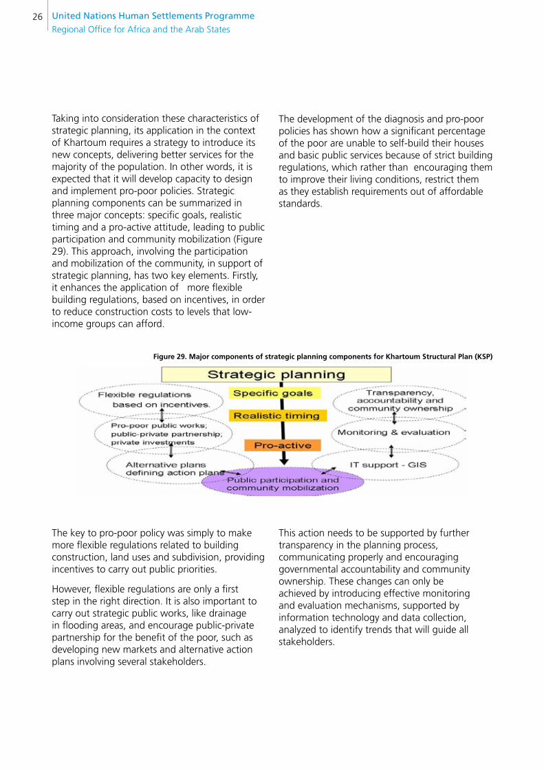
Taking into consideration these characteristics of strategic planning, its application in the context of Khartoum requires a strategy to introduce its new concepts, delivering better services for the majority of the population. In other words, it is expected that it will develop capacity to design and implement pro-poor policies. Strategic planning components can be summarized in three major concepts: specific goals, realistic timing and a pro-active attitude, leading to public participation and community mobilization (Figure 29). This approach, involving the participation and mobilization of the community, in support of strategic planning, has two key elements. Firstly, it enhances the application of more flexible building regulations, based on incentives, in order to reduce construction costs to levels that low-income groups can afford.
The development of the diagnosis and pro-poor policies has shown how a significant percentage of the poor are unable to self-build their houses and basic public services because of strict building regulations, which rather than encouraging them to improve their living conditions, restrict them as they establish requirements out of affordable standards.
figure 29. Major components of strategic planning components for Khartoum structural Plan (KsP)
The key to pro-poor policy was simply to make more flexible regulations related to building construction, land uses and subdivision, providing incentives to carry out public priorities.
However, flexible regulations are only a first step in the right direction. It is also important to carry out strategic public works, like drainage in flooding areas, and encourage public-private partnership for the benefit of the poor, such as developing new markets and alternative action plans involving several stakeholders.
This action needs to be supported by further transparency in the planning process, communicating properly and encouraging governmental accountability and community ownership. These changes can only be achieved by introducing effective monitoring and evaluation mechanisms, supported by information technology and data collection, analyzed to identify trends that will guide all stakeholders.
FROM POLICY DESIGN TO PILOT IMPLEMENTATION PROJECTS 27
KH
AR
TOU
M P
RO
PO
OR
figure 30. Prioritization exercise in a community consultation meeting
“The participation of minorities and ordinary people, giving them a voice and a vote, equal to that of powerful
stakeholders, is a crucial aspect to take into account in the context of Sudan”.
The participatory exercise, keeping records of all opinions and promoting discussions on priorities, laid the foundation for social agreement and commitment to implementing action plans (Figure 30). Agreement on priorities establishes the starting point to demonstrate through concrete actions the advantage of participatory planning over traditional modalities. Agreement also provides the necessary basis to make action feasible, minimizing conflicts that can arise from conflicting interests.
The participation of minorities and ordinary people, giving them a voice and a vote, equal to that of powerful stakeholders, is a crucial aspect to take into account in the context of Sudan.
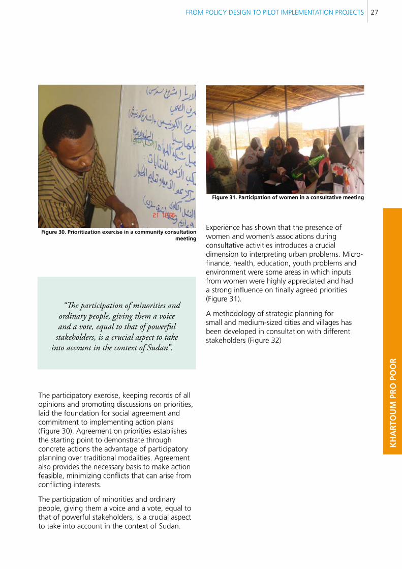
figure 31. Participation of women in a consultative meeting
Experience has shown that the presence of women and women’s associations during consultative activities introduces a crucial dimension to interpreting urban problems. Micro-finance, health, education, youth problems and environment were some areas in which inputs from women were highly appreciated and had a strong influence on finally agreed priorities (Figure 31).
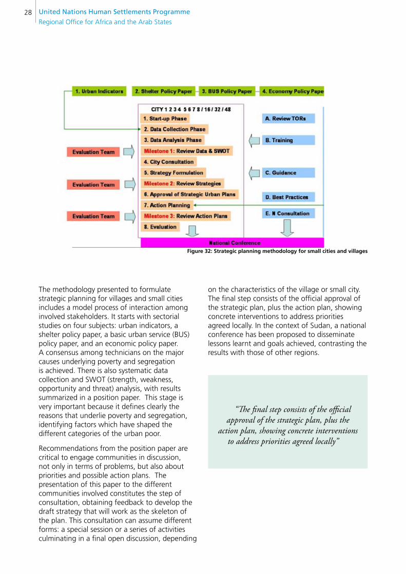
A methodology of strategic planning for small and medium-sized cities and villages has been developed in consultation with different stakeholders (Figure 32)
United nations Human settlements Programme
Regional Office for Africa and the Arab States28
figure 32: strategic planning methodology for small cities and villages
The methodology presented to formulate strategic planning for villages and small cities includes a model process of interaction among involved stakeholders. It starts with sectorial studies on four subjects: urban indicators, a shelter policy paper, a basic urban service (BUS) policy paper, and an economic policy paper. A consensus among technicians on the major causes underlying poverty and segregation is achieved. There is also systematic data collection and SWOT (strength, weakness, opportunity and threat) analysis, with results summarized in a position paper. This stage is very important because it defines clearly the reasons that underlie poverty and segregation, identifying factors which have shaped the different categories of the urban poor.
Recommendations from the position paper are critical to engage communities in discussion, not only in terms of problems, but also about priorities and possible action plans. The presentation of this paper to the different communities involved constitutes the step of consultation, obtaining feedback to develop the draft strategy that will work as the skeleton of the plan. This consultation can assume different forms: a special session or a series of activities culminating in a final open discussion, depending
on the characteristics of the village or small city. The final step consists of the official approval of the strategic plan, plus the action plan, showing concrete interventions to address priorities agreed locally. In the context of Sudan, a national conference has been proposed to disseminate lessons learnt and goals achieved, contrasting the results with those of other regions.
“The final step consists of the official approval of the strategic plan, plus the
action plan, showing concrete interventions to address priorities agreed locally”
FROM POLICY DESIGN TO PILOT IMPLEMENTATION PROJECTS 29
KH
AR
TOU
M P
RO
PO
OR
3.1.7. TRAINING IN DATA ENTRY AND GEOGRAPHY INFORMATION SYSTEM (GIS)
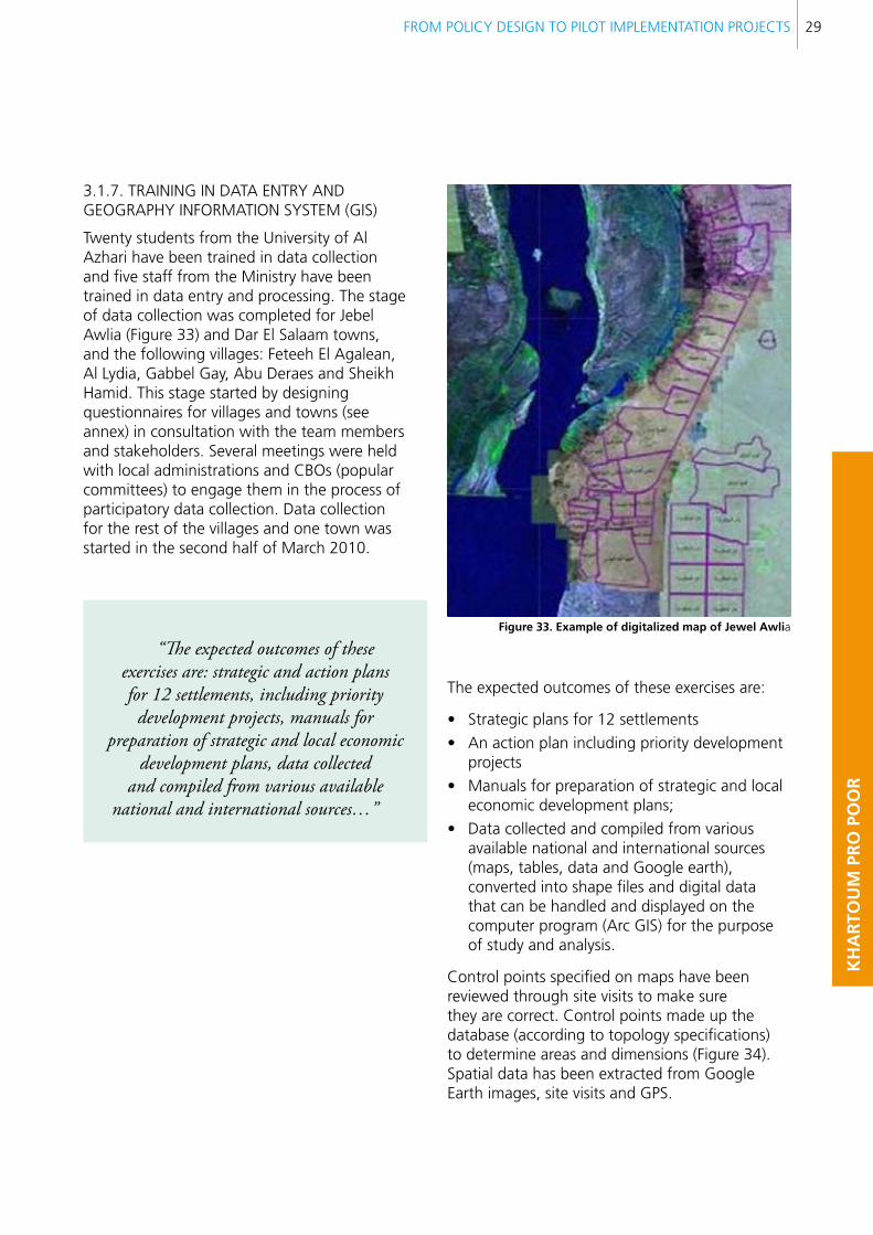
Twenty students from the University of Al Azhari have been trained in data collection and five staff from the Ministry have been trained in data entry and processing. The stage of data collection was completed for Jebel Awlia (Figure 33) and Dar El Salaam towns, and the following villages: Feteeh El Agalean, Al Lydia, Gabbel Gay, Abu Deraes and Sheikh Hamid. This stage started by designing questionnaires for villages and towns (see annex) in consultation with the team members and stakeholders. Several meetings were held with local administrations and CBOs (popular committees) to engage them in the process of participatory data collection. Data collection for the rest of the villages and one town was started in the second half of March 2010.
“The expected outcomes of these exercises are: strategic and action plans for 12 settlements, including priority
development projects, manuals for preparation of strategic and local economic
development plans, data collected and compiled from various available
national and international sources…”
figure 33. example of digitalized map of Jewel Awlia
The expected outcomes of these exercises are:
Strategic plans for 12 settlements•
An action plan including priority development •projects
Manuals for preparation of strategic and local •economic development plans;
Data collected and compiled from various •available national and international sources (maps, tables, data and Google earth), converted into shape files and digital data that can be handled and displayed on the computer program (Arc GIS) for the purpose of study and analysis.
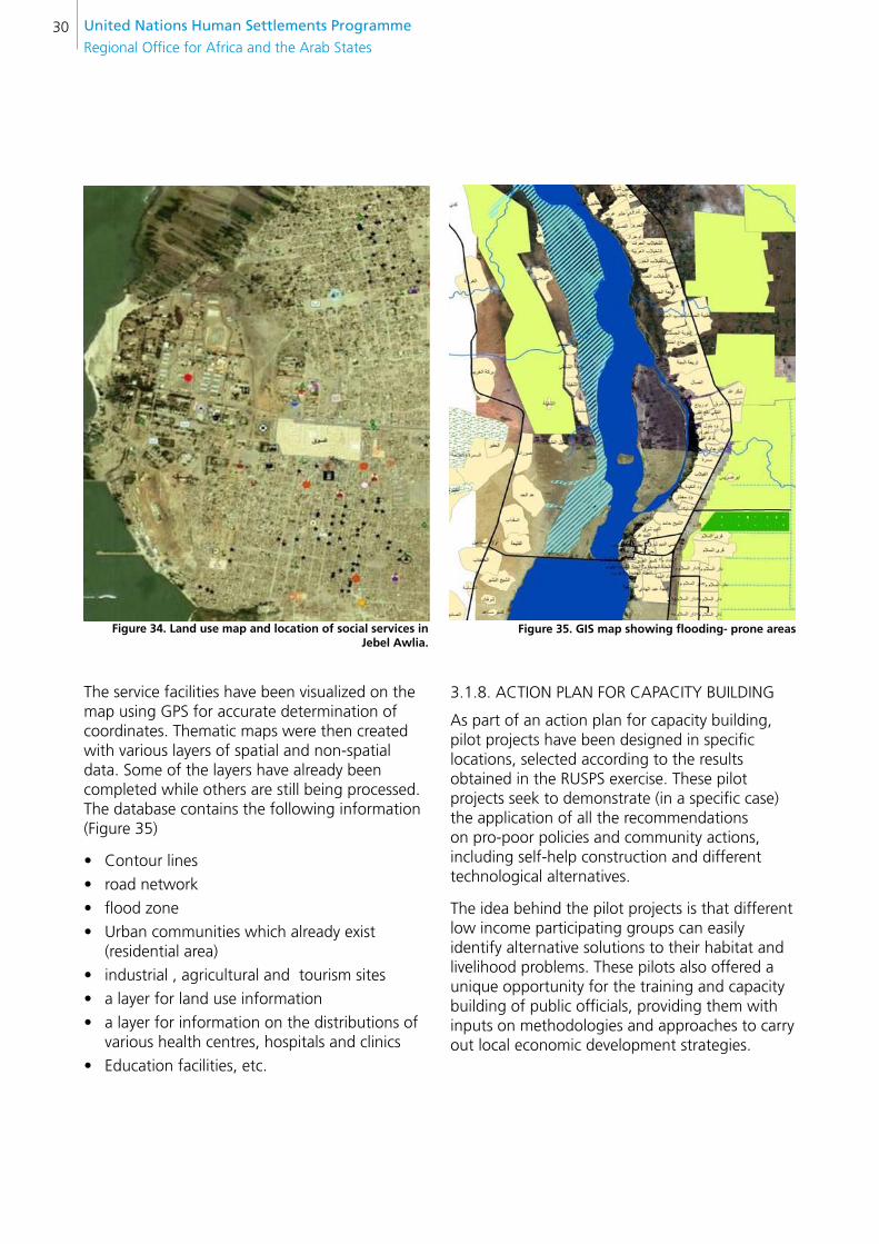
Control points specified on maps have been reviewed through site visits to make sure they are correct. Control points made up the database (according to topology specifications) to determine areas and dimensions (Figure 34). Spatial data has been extracted from Google Earth images, site visits and GPS.
United nations Human settlements Programme
Regional Office for Africa and the Arab States30
figure 34. land use map and location of social services in Jebel Awlia.
The service facilities have been visualized on the map using GPS for accurate determination of coordinates. Thematic maps were then created with various layers of spatial and non-spatial data. Some of the layers have already been completed while others are still being processed. The database contains the following information (Figure 35)
Contour lines•
road network•
flood zone•
Urban communities which already exist •(residential area)
industrial , agricultural and tourism sites•
a layer for land use information•
a layer for information on the distributions of •various health centres, hospitals and clinics
Education facilities, etc.•
figure 35. GIs map showing flooding- prone areas
3.1.8. ACTION PLAN FOR CAPACITY BUILDING
As part of an action plan for capacity building, pilot projects have been designed in specific locations, selected according to the results obtained in the RUSPS exercise. These pilot projects seek to demonstrate (in a specific case) the application of all the recommendations on pro-poor policies and community actions, including self-help construction and different technological alternatives.
The idea behind the pilot projects is that different low income participating groups can easily identify alternative solutions to their habitat and livelihood problems. These pilots also offered a unique opportunity for the training and capacity building of public officials, providing them with inputs on methodologies and approaches to carry out local economic development strategies.

FROM POLICY DESIGN TO PILOT IMPLEMENTATION PROJECTS 31
KH
AR
TOU
M P
RO
PO
OR
“The idea behind the pilot projects is that different low income
participating groups can easily identify alternative solutions to their habitat and livelihood problems”
A manual for development of strategic planning exercises in the context of Sudan in general, and Khartoum in particular, has been prepared. This manual is used in the interactive workshops, giving to the participants the chance to consider their experiences and elaborate alternatives in order to move forward in local development plans.
The integration of the most vulnerable and disadvantaged groups is highlighted as the cornerstone of the plans, making use of traditional community mechanisms (Figure 36) of identification and support, seeking to empower communities to find self-help solutions to their different problems.
figure 36. Discussion and agreement between communities and government representatives
3.2. PILOT PROJECTS
The comprehensive upgrading of informal settlements by UN-Habitat has involved the development of pro-poor policies, training in capacity building for the Ministry of Planning and Urban Development (MPUD), and the implementation of RUSPS in selected informal settlement areas.
The purpose is to understand their socio-territorial dynamics so as to set up participatory mechanisms for development. Taking into account the outcomes of the sector studies carried out at State and local levels, specific issues blocking the delivery of urban services for the poor have been identified, relating to spatial planning, land management, social housing, basic urban services, environmental problems and weak local economic development.
Approaches to spatial planning and land management have been tested by the pilot projects, taking into account the spatial limits to the development of the social fabric, considering particularly their locations. Land management problems have been addressed through a follow-up land registration and titling process, ensuring that beneficiaries enjoy secure land tenure, preventing further evictions.
“Land management problems have been addressed through a follow- up land registration and titling process, ensuring
that beneficiaries enjoy secure land tenure”
United nations Human settlements Programme
Regional Office for Africa and the Arab States32
In addition, self-help housing has been particularly considered through different approaches, taking into account their affordability for different social groups:
A. The supply of subsidies for the most vulnerable households.
B. A middle term solution called “The three block approach” which targets those households without permanent employment but with capacity to work. This allows them to pay the cost of the lease of the SSB making machines and cement by providing blocks for the construction of public utilities. Every third block they make, they can sell it in the market as an income generation source.
C. Credits provided in partnership with the Social Development Foundation (SDF), targeting those households able to pay back in cash instalments.
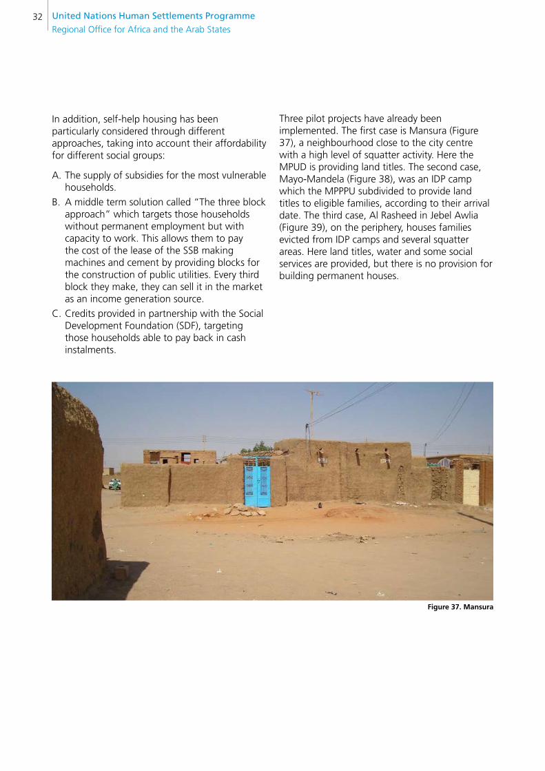
Three pilot projects have already been implemented. The first case is Mansura (Figure 37), a neighbourhood close to the city centre with a high level of squatter activity. Here the MPUD is providing land titles. The second case, Mayo-Mandela (Figure 38), was an IDP camp which the MPPPU subdivided to provide land titles to eligible families, according to their arrival date. The third case, Al Rasheed in Jebel Awlia (Figure 39), on the periphery, houses families evicted from IDP camps and several squatter areas. Here land titles, water and some social services are provided, but there is no provision for building permanent houses.
figure 37. Mansura
FROM POLICY DESIGN TO PILOT IMPLEMENTATION PROJECTS 33
KH
AR
TOU
M P
RO
PO
OR
“Self-help housing has been particularly considered through different approaches, taking into account their affordability for different social groups”
figure 38. Mayo-Mandela

United nations Human settlements Programme
Regional Office for Africa and the Arab States34
figure 39. Rasheed in Jebel Awlia
3.2.1 BRIEF DESCRIPTION
RUSPS was applied in three locations (Al Bashir, Fitehap and Jebel Awlia), including a survey of slums that provided key socio-territorial data for developing an upgrade strategy.
Based on RUSPS exercises and monitoring the “Guiding Principles for Relocation”, SSB was introduced to support communities so they could afford basic services and self-build housing. The location of the different pilot projects is presented in Figure 40: Mansura, close to the city centre; Mayo-Mandela, on the edge of the city; and Jebel Awlia, on the extreme periphery.
figure 40. location of pilot projects
A summary of the different pilot projects is presented in table II.
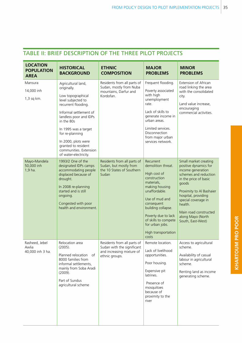
FROM POLICY DESIGN TO PILOT IMPLEMENTATION PROJECTS 35
KH
AR
TOU
M P
RO
PO
OR
lOcATIOn POPUlATIOnAReA
HIsTORIcAl bAcKGROUnD
eTHnIc cOMPOsITIOn
MAJOR PRObleMs
MInOR PRObleMs
Mansura
14,000 inh
1,3 sq km.
Agricultural land, originally.
Low topographical level subjected to recurrent flooding.
Informal settlement of landless poor and IDPs in the 80s
In 1995 was a target for re-planning
In 2000, plots were granted to resident communities. Extension of water-electricity.
Residents from all parts of Sudan, mostly from Nuba mountains, Darfur and Kordofan.
Frequent flooding.
Poverty associated with high unemployment rate.
Lack of skills to generate income in urban areas.
Limited services. Disconnection from major urban services network.
Extension of African road linking the area with the consolidated city.
Land value increase, encouraging commercial activities.
Mayo-Mandela50,000 inh1,9 ha.
1993/2 One of the designated IDPs camps accommodating people displaced because of drought.
In 2008 re-planning started and is still ongoing.
Congested with poor health and environment.
Residents from all parts of Sudan, but mostly from the 10 States of Southern Sudan
Recurrent demolition threat.
High cost of construction materials, making housing unaffordable.
Use of mud and consequent building collapse.
Poverty due to lack of skills to compete for urban jobs.
High transportation costs
Small market creating positive dynamics for income generation schemes and reduction in the price of basic goods
Proximity to Al Bashaier hospital, providing special coverage in health.
Main road constructed along Mayo (North South, East-West)
Rasheed, Jebel Awlia40,000 inh 3 ha.
Relocation area(2005).
Planned relocation of 8000 families from informal settlements, mainly from Soba Aradi (2009).
Part of Sundus agricultural scheme
Residents from all parts of Sudan with the significant and increasing mixture of ethnic groups.
Remote location.
Lack of livelihood opportunities.
Poor housing.
Expensive pit latrines.
Presence of mosquitoes because of proximity to the river
Access to agricultural scheme.
Availability of casual labour in agricultural scheme.
Renting land as income generating scheme.
TABle ii: BRieF DescRiPTiOn OF THe THRee PilOT PROjecTs
United nations Human settlements Programme
Regional Office for Africa and the Arab States36
Table II presents a brief historical background to clarify how the combination of different factors has led to current problems and opportunities. According to their different location within the metropolitan structure, the three pilot projects have different advantages and disadvantages as regards integrating their residents into the network of opportunities provided by the city.
Mansura, a low-lying area, was originally used for agriculture, benefiting from recurrent flooding. However, during the 80s, as a result of the massive migration of IDPs to Khartoum from all regions of Sudan, and particularly from the Nuba Mountains and Kordofan, the area was populated informally. This original pattern of informal settlement has turned the area into a marginal one.
The strategic location of Mansura, close to the urban framework (Figure 41), has attracted significant waves of IDPs and landless poor leading to rapid growth, congestion and overcrowding. There is, in addition, the risk of housing collapse as houses are made of mud, seriously damaged during flooding periods. In 1995, Mansura was officially declared a re-planning area, initiating a process of eviction and upgrading. In 2000, some plots were granted free of charge, and water and electricity services were provided, significantly improving living conditions in the area.
This process was a step forward, formalizing the urbanization process by integrating the area into the urban fabric, although it still faces flooding problems. Poverty in this neighbourhood is mostly associated with unemployment and residents’ lack of skills to get jobs in urban areas. Despite these difficulties, the area is actually going through a revitalization process associated with the extension of the African highway that facilitates its link with the city centre.
The location of residential complexes for high income groups near the zone evidences an increasing real estate trend, with potential for land speculation that might drive the poor out of the area.
figure 41. Mansura urban pattern and layout plan
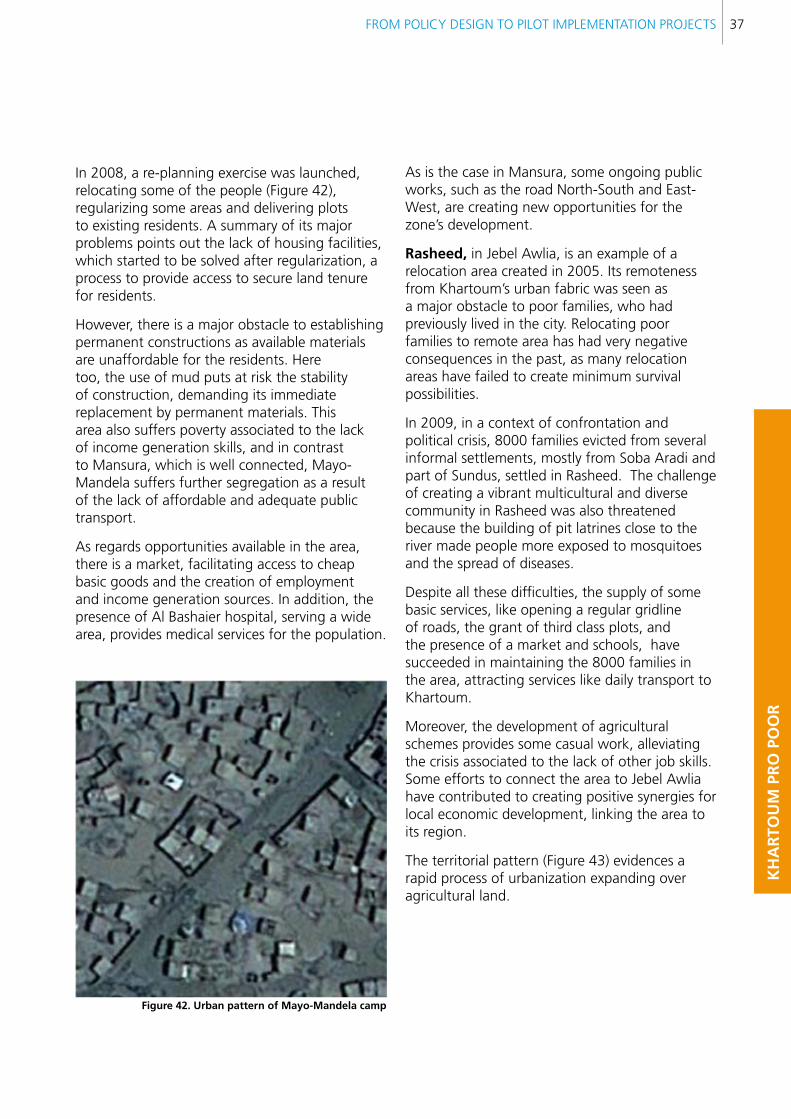
Mayo-Mandela was an official IDP camp in 1992-3 intended to accommodate displaced populations from all parts of Sudan, but particularly Southern Sudan. This has shaped the area as a well organized and delimited territory where the poor can stay temporarily, receiving social services such as education, health and food. However, as happens with camps, there are restrictions on building permanent constructions and the poor supply of urban services and infrastructure make the area particularly vulnerable. With the passing of time, Mayo-Mandela has become congested and unhealthy, and there has also been growing confrontation between different ethnic groups living in the area, and with the rest of the city.
FROM POLICY DESIGN TO PILOT IMPLEMENTATION PROJECTS 37
KH
AR
TOU
M P
RO
PO
OR
In 2008, a re-planning exercise was launched, relocating some of the people (Figure 42), regularizing some areas and delivering plots to existing residents. A summary of its major problems points out the lack of housing facilities, which started to be solved after regularization, a process to provide access to secure land tenure for residents.
However, there is a major obstacle to establishing permanent constructions as available materials are unaffordable for the residents. Here too, the use of mud puts at risk the stability of construction, demanding its immediate replacement by permanent materials. This area also suffers poverty associated to the lack of income generation skills, and in contrast to Mansura, which is well connected, Mayo-Mandela suffers further segregation as a result of the lack of affordable and adequate public transport.
As regards opportunities available in the area, there is a market, facilitating access to cheap basic goods and the creation of employment and income generation sources. In addition, the presence of Al Bashaier hospital, serving a wide area, provides medical services for the population.
figure 42. Urban pattern of Mayo-Mandela camp
As is the case in Mansura, some ongoing public works, such as the road North-South and East-West, are creating new opportunities for the zone’s development.
Rasheed, in Jebel Awlia, is an example of a relocation area created in 2005. Its remoteness from Khartoum’s urban fabric was seen as a major obstacle to poor families, who had previously lived in the city. Relocating poor families to remote area has had very negative consequences in the past, as many relocation areas have failed to create minimum survival possibilities.
In 2009, in a context of confrontation and political crisis, 8000 families evicted from several informal settlements, mostly from Soba Aradi and part of Sundus, settled in Rasheed. The challenge of creating a vibrant multicultural and diverse community in Rasheed was also threatened because the building of pit latrines close to the river made people more exposed to mosquitoes and the spread of diseases.
Despite all these difficulties, the supply of some basic services, like opening a regular gridline of roads, the grant of third class plots, and the presence of a market and schools, have succeeded in maintaining the 8000 families in the area, attracting services like daily transport to Khartoum.
Moreover, the development of agricultural schemes provides some casual work, alleviating the crisis associated to the lack of other job skills. Some efforts to connect the area to Jebel Awlia have contributed to creating positive synergies for local economic development, linking the area to its region.
The territorial pattern (Figure 43) evidences a rapid process of urbanization expanding over agricultural land.
United nations Human settlements Programme
Regional Office for Africa and the Arab States38
3.2.2. MAJOR COMPONENTS OF THE PILOT PROJECTS
The pilot cases were selected precisely because they represent a very typical scenario of problems and opportunities for the reintegration of the poor into the development process. Location plays a crucial role as it provides the necessary subsidized resources to encourage self-help work at individual and community basis. The key factor underlying the rationale of the pilots is identifying the most effective ways of guiding collective efforts towards the sustainable progress of the areas.
In the case of Mansura, regularization and re-urbanization have been enough to initiate a positive transformation. The main problem is that due to its advantageous location it is favorable to property speculation. There is pressure on real estate prices and this is driving the poor out of the neighbourhood. This demands a clear pro-poor policy, linking land, infrastructure, livelihoods, environment and an inter-ethnic understanding. In such a context the pilot exercise is particularly valuable allowing the validity of its approach to be tested under specific circumstances.
Mayo-Mandela has an intermediate location, not too close, not too far from the city. However, its history as a former IDP camp, and the dramatic experience of recurrent eviction very much affects its prospects for positive transformation. The regularization of some plots has raised the community’s hopes that the neighbourhood will be formalized. The process of re-urbanization, providing some urban services, has already led to impressive progress compared to the previous scenario of isolation and poverty.
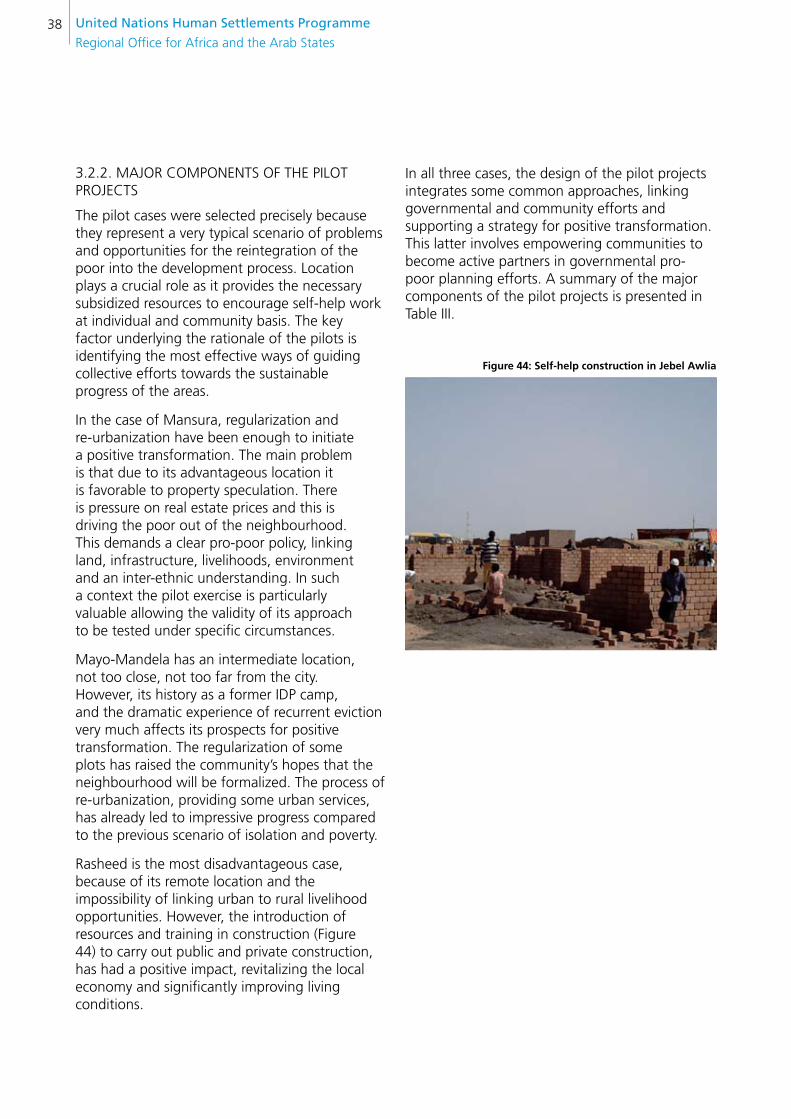
Rasheed is the most disadvantageous case, because of its remote location and the impossibility of linking urban to rural livelihood opportunities. However, the introduction of resources and training in construction (Figure 44) to carry out public and private construction, has had a positive impact, revitalizing the local economy and significantly improving living conditions.
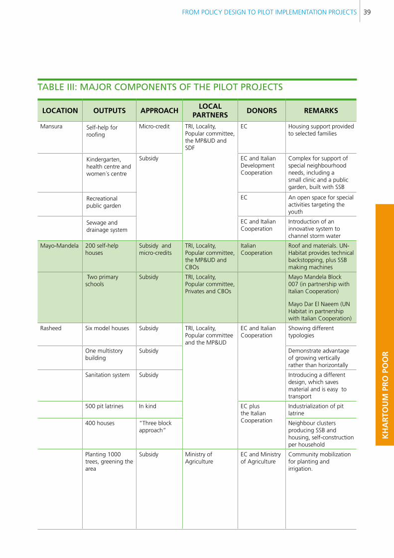
In all three cases, the design of the pilot projects integrates some common approaches, linking governmental and community efforts and supporting a strategy for positive transformation. This latter involves empowering communities to become active partners in governmental pro-poor planning efforts. A summary of the major components of the pilot projects is presented in Table III.
figure 44: self-help construction in Jebel Awlia
FROM POLICY DESIGN TO PILOT IMPLEMENTATION PROJECTS 39
KH
AR
TOU
M P
RO
PO
OR
lOcATIOn OUTPUTs APPROAcHlOcAl
PARTneRsDOnORs ReMARKs
Mansura Self-help for roofing
Micro-credit TRI, Locality, Popular committee, the MP&UD and SDF
EC Housing support provided to selected families
Kindergarten, health centre and women´s centre
Subsidy EC and Italian Development Cooperation
Complex for support of special neighbourhood needs, including a small clinic and a public garden, built with SSB
Recreational public garden
EC An open space for special activities targeting the youth
Sewage and drainage system
EC and Italian Cooperation
Introduction of an innovative system to channel storm water
Mayo-Mandela 200 self-help houses
Subsidy and micro-credits
TRI, Locality, Popular committee, the MP&UD and CBOs
Italian Cooperation
Roof and materials. UN-Habitat provides technical backstopping, plus SSB making machines
Two primary schools
Subsidy TRI, Locality, Popular committee, Privates and CBOs
Mayo Mandela Block 007 (in partnership with Italian Cooperation)
Mayo Dar El Naeem (UN Habitat in partnership with Italian Cooperation)
Rasheed Six model houses Subsidy TRI, Locality, Popular committee and the MP&UD
EC and Italian Cooperation
Showing different typologies
One multistory building
Subsidy Demonstrate advantage of growing vertically rather than horizontally
Sanitation system Subsidy Introducing a different design, which saves material and is easy to transport
500 pit latrines In kind EC plus the Italian Cooperation
Industrialization of pit latrine
400 houses “Three block approach”
Neighbour clusters producing SSB and housing, self-construction per household
Planting 1000 trees, greening the area
Subsidy Ministry ofAgriculture
EC and Ministry of Agriculture
Community mobilization for planting and irrigation.
TABle iii: MAjOR cOMPOnenTs OF THe PilOT PROjecTs
United nations Human settlements Programme
Regional Office for Africa and the Arab States40
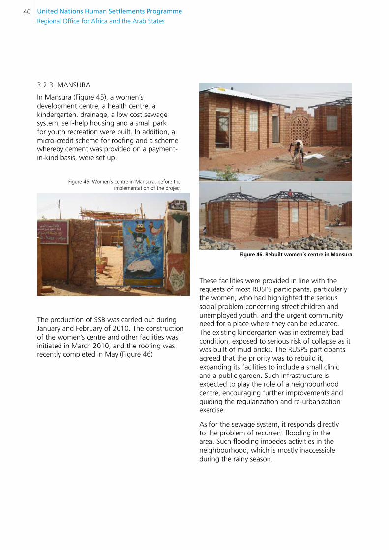
3.2.3. MANSURA
In Mansura (Figure 45), a women´s development centre, a health centre, a kindergarten, drainage, a low cost sewage system, self-help housing and a small park for youth recreation were built. In addition, a micro-credit scheme for roofing and a scheme whereby cement was provided on a payment-in-kind basis, were set up.
Figure 45. Women´s centre in Mansura, before the implementation of the project
The production of SSB was carried out during January and February of 2010. The construction of the women’s centre and other facilities was initiated in March 2010, and the roofing was recently completed in May (Figure 46)
figure 46. Rebuilt women´s centre in Mansura
These facilities were provided in line with the requests of most RUSPS participants, particularly the women, who had highlighted the serious social problem concerning street children and unemployed youth, and the urgent community need for a place where they can be educated. The existing kindergarten was in extremely bad condition, exposed to serious risk of collapse as it was built of mud bricks. The RUSPS participants agreed that the priority was to rebuild it, expanding its facilities to include a small clinic and a public garden. Such infrastructure is expected to play the role of a neighbourhood centre, encouraging further improvements and guiding the regularization and re-urbanization exercise.
As for the sewage system, it responds directly to the problem of recurrent flooding in the area. Such flooding impedes activities in the neighbourhood, which is mostly inaccessible during the rainy season.
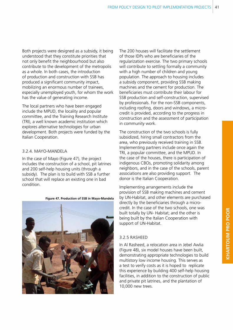
FROM POLICY DESIGN TO PILOT IMPLEMENTATION PROJECTS 41
KH
AR
TOU
M P
RO
PO
OR
Both projects were designed as a subsidy, it being understood that they constitute priorities that not only benefit the neighbourhood but also contribute to the development of the metropolis as a whole. In both cases, the introduction of production and construction with SSB has produced a significant community impact, mobilizing an enormous number of trainees, especially unemployed youth, for whom the work has the value of generating income.
The local partners who have been engaged include the MPUD, the locality and popular committee, and the Training Research Institute (TRI), a well known academic institution which explores alternative technologies for urban development. Both projects were funded by the Italian Cooperation.
3.2.4. MAYO-MANDELA
In the case of Mayo (Figure 47), the project includes the construction of a school, pit latrines and 200 self-help housing units (through a subsidy). The plan is to build with SSB a further school that will replace an existing one in bad condition.
figure 47. Production of ssb in Mayo-Mandela
The 200 houses will facilitate the settlement of those IDPs who are beneficiaries of the regularization exercise. The two primary schools will contribute to settling formally a community with a high number of children and young population. The approach to housing includes a subsidy component, providing SSB making machines and the cement for production. The beneficiaries must contribute their labour for SSB production and self-construction, supervised by professionals. For the non-SSB components, including roofing, doors and windows, a micro-credit is provided, according to the progress in construction and the assessment of participation in community work.
The construction of the two schools is fully subsidized, hiring small contractors from the area, who previously received training in SSB. Implementing partners include once again the TRI, a popular committee, and the MPUD. In the case of the houses, there is participation of indigenous CBOs, promoting solidarity among neighbors, and in the case of the schools, parent associations are also providing support. The donor is the Italian Cooperation.
Implementing arrangements include the provision of SSB making machines and cement by UN-Habitat, and other elements are purchased directly by the beneficiaries through a micro-credit. In the case of the two schools, one was built totally by UN- Habitat; and the other is being built by the Italian Cooperation with support of UN-Habitat.
3.2.5 RASHEED
In Al Rasheed, a relocation area in Jebel Awlia (Figure 48), six model houses have been built, demonstrating appropriate technologies to build multistory low income housing. This serves as a test to verify costs as it is hoped to replicate this experience by building 400 self-help housing facilities, in addition to the construction of public and private pit latrines, and the plantation of 10,000 new trees.
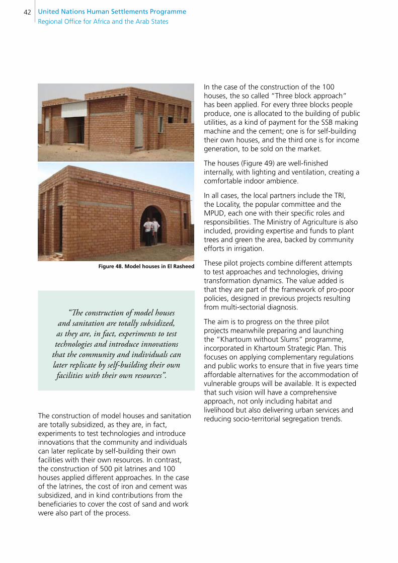
United nations Human settlements Programme
Regional Office for Africa and the Arab States42
figure 48. Model houses in el Rasheed
“The construction of model houses and sanitation are totally subsidized, as they are, in fact, experiments to test technologies and introduce innovations
that the community and individuals can later replicate by self-building their own facilities with their own resources”.
The construction of model houses and sanitation are totally subsidized, as they are, in fact, experiments to test technologies and introduce innovations that the community and individuals can later replicate by self-building their own facilities with their own resources. In contrast, the construction of 500 pit latrines and 100 houses applied different approaches. In the case of the latrines, the cost of iron and cement was subsidized, and in kind contributions from the beneficiaries to cover the cost of sand and work were also part of the process.
In the case of the construction of the 100 houses, the so called “Three block approach” has been applied. For every three blocks people produce, one is allocated to the building of public utilities, as a kind of payment for the SSB making machine and the cement; one is for self-building their own houses, and the third one is for income generation, to be sold on the market.
The houses (Figure 49) are well-finished internally, with lighting and ventilation, creating a comfortable indoor ambience.
In all cases, the local partners include the TRI, the Locality, the popular committee and the MPUD, each one with their specific roles and responsibilities. The Ministry of Agriculture is also included, providing expertise and funds to plant trees and green the area, backed by community efforts in irrigation.
These pilot projects combine different attempts to test approaches and technologies, driving transformation dynamics. The value added is that they are part of the framework of pro-poor policies, designed in previous projects resulting from multi-sectorial diagnosis.
The aim is to progress on the three pilot projects meanwhile preparing and launching the “Khartoum without Slums” programme, incorporated in Khartoum Strategic Plan. This focuses on applying complementary regulations and public works to ensure that in five years time affordable alternatives for the accommodation of vulnerable groups will be available. It is expected that such vision will have a comprehensive approach, not only including habitat and livelihood but also delivering urban services and reducing socio-territorial segregation trends.
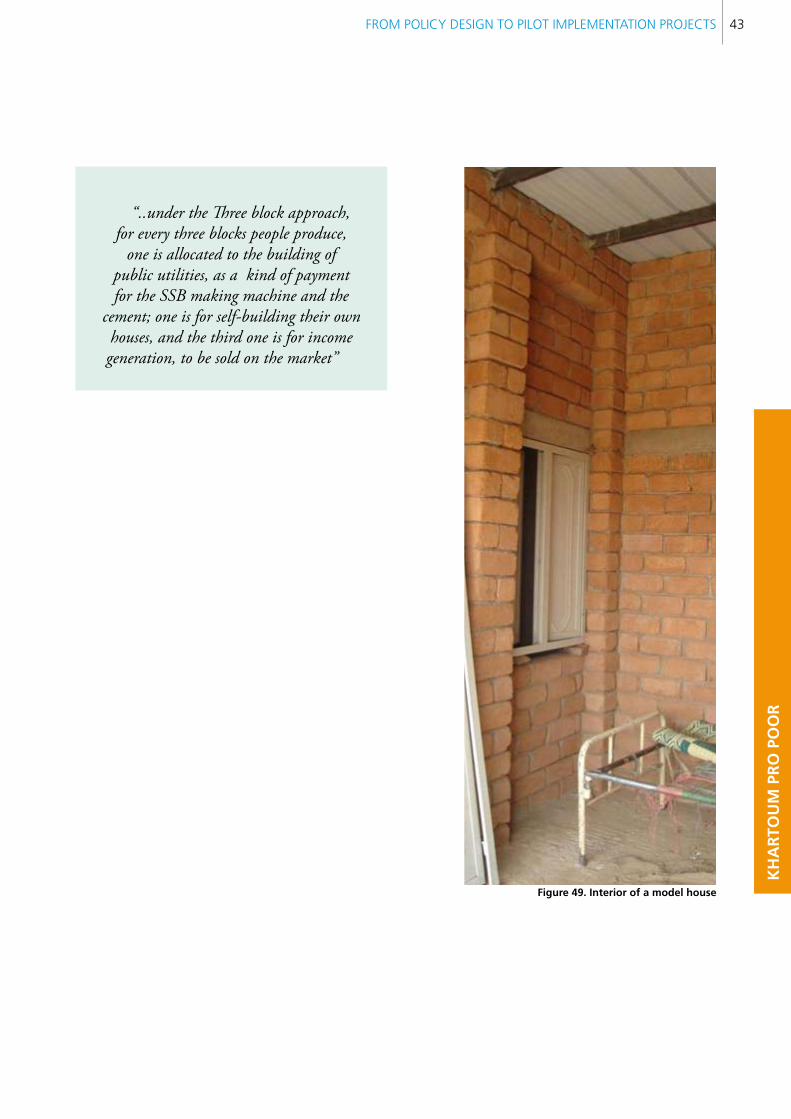
FROM POLICY DESIGN TO PILOT IMPLEMENTATION PROJECTS 43
KH
AR
TOU
M P
RO
PO
OR
“..under the Three block approach, for every three blocks people produce,
one is allocated to the building of public utilities, as a kind of payment for the SSB making machine and the
cement; one is for self-building their own houses, and the third one is for income generation, to be sold on the market”
figure 49. Interior of a model house
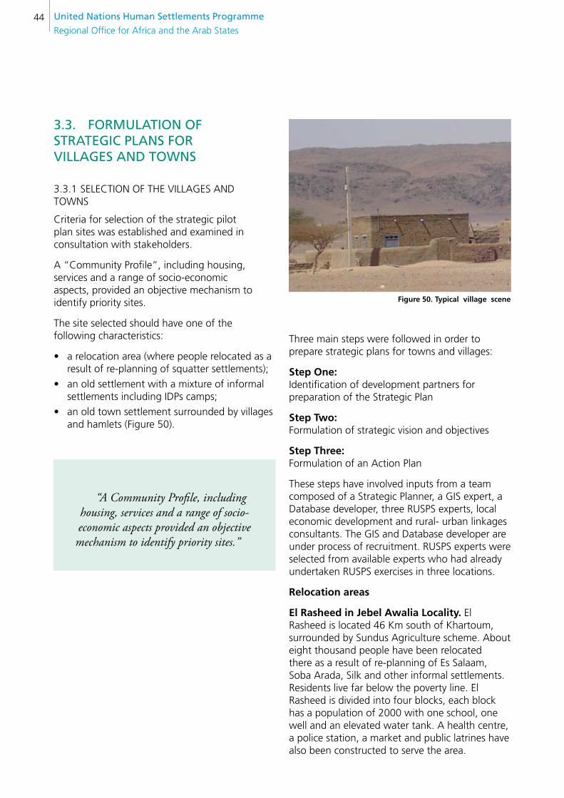
United nations Human settlements Programme
Regional Office for Africa and the Arab States44
3.3. FORMUlATiOn OF sTRATegic PlAns FOR VillAges AnD TOWns
3.3.1 SELECTION OF THE VILLAGES AND TOWNS
Criteria for selection of the strategic pilot plan sites was established and examined in consultation with stakeholders.
A “Community Profile”, including housing, services and a range of socio-economic aspects, provided an objective mechanism to identify priority sites.
The site selected should have one of the following characteristics:
a relocation area (where people relocated as a •result of re-planning of squatter settlements);
an old settlement with a mixture of informal •settlements including IDPs camps;
an old town settlement surrounded by villages •and hamlets (Figure 50).
“A Community Profile, including housing, services and a range of socio-economic aspects provided an objective mechanism to identify priority sites.”
figure 50. Typical village scene
Three main steps were followed in order to prepare strategic plans for towns and villages:
step One: Identification of development partners for preparation of the Strategic Plan
step Two: Formulation of strategic vision and objectives
step Three: Formulation of an Action Plan
These steps have involved inputs from a team composed of a Strategic Planner, a GIS expert, a Database developer, three RUSPS experts, local economic development and rural- urban linkages consultants. The GIS and Database developer are under process of recruitment. RUSPS experts were selected from available experts who had already undertaken RUSPS exercises in three locations.
Relocation areas
el Rasheed in Jebel Awalia locality. El Rasheed is located 46 Km south of Khartoum, surrounded by Sundus Agriculture scheme. About eight thousand people have been relocated there as a result of re-planning of Es Salaam, Soba Arada, Silk and other informal settlements. Residents live far below the poverty line. El Rasheed is divided into four blocks, each block has a population of 2000 with one school, one well and an elevated water tank. A health centre, a police station, a market and public latrines have also been constructed to serve the area.
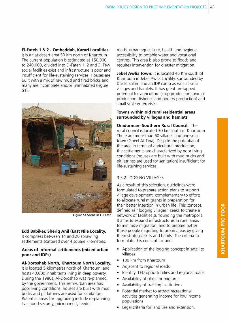
FROM POLICY DESIGN TO PILOT IMPLEMENTATION PROJECTS 45
KH
AR
TOU
M P
RO
PO
OR
el-fateh 1 & 2 - Ombaddah, Karari localities. It is a flat desert area 50 km north of Khartoum. The current population is estimated at 150,000 to 240,000, divided into El-Fateh 1, 2 and 3. Few social facilities exist and infrastructure is poor and insufficient for life-sustaining services. Houses are built with a mix of raw mud and fired bricks and many are incomplete and/or uninhabited (Figure 51).
figure 51 scene in el fateh
edd babiker, sheriq Anil (east nile locality.It comprises between 14 and 20 sprawling settlements scattered over 4 square kilometres.
Areas of informal settlements (mixed urban poor and IDPs)
Al-Doroshab north, Khartoum north locality. It is located 5 kilometres north of Khartoum, and hosts 40,000 inhabitants living in deep poverty. During the 1980s, Al-Doroshab was re-planned by the government. This semi-urban area has poor living conditions: houses are built with mud bricks and pit latrines are used for sanitation. Potential areas for upgrading include re-planning, livelihood security, micro-credit, feeder
roads, urban agriculture, health and hygiene, accessibility to potable water and vocational centres. This area is also prone to floods and requires intervention for disaster mitigation.
Jebel Awlia town. It is located 45 Km south of Khartoum in Jebel Awlia Locality, surrounded by Dar El Salam and an IDP camp as well as small villages and hamlets. It has great un-tapped potential for agriculture (crop production, animal production, fisheries and poultry production) and small scale enterprises.
Towns within old rural residential areas surrounded by villages and hamlets
Omdurman- southern Rural council. The rural council is located 30 km south of Khartoum. There are more than 60 villages and one small town (Gbeel At Tina). Despite the potential of the area in terms of agricultural production, the settlements are characterized by poor living conditions (houses are built with mud bricks and pit latrines are used for sanitation) insufficient for life-sustaining services.
3.3.2. LODGING VILLAGES
As a result of this selection, guidelines were formulated to prepare action plans to support village development, complementary to efforts to allocate rural migrants in preparation for their better insertion in urban life. This concept, defined as “lodging villages” seeks to create a network of facilities surrounding the metropolis. It aims to expand infrastructures in rural areas to minimize migration, and to prepare better those people migrating to urban areas by giving them strategic skills and habits. The criteria to formulate this concept include:
Application of the lodging concept in satellite •villages
100 km from Khartoum •
Adjacent to regional roads•
Identify LED opportunities and regional roads•
Availability of plots for migrants •
Availability of training institutions•
Potential market to attract recreational •activities generating income for low income populations
Legal criteria for land use and extension.•
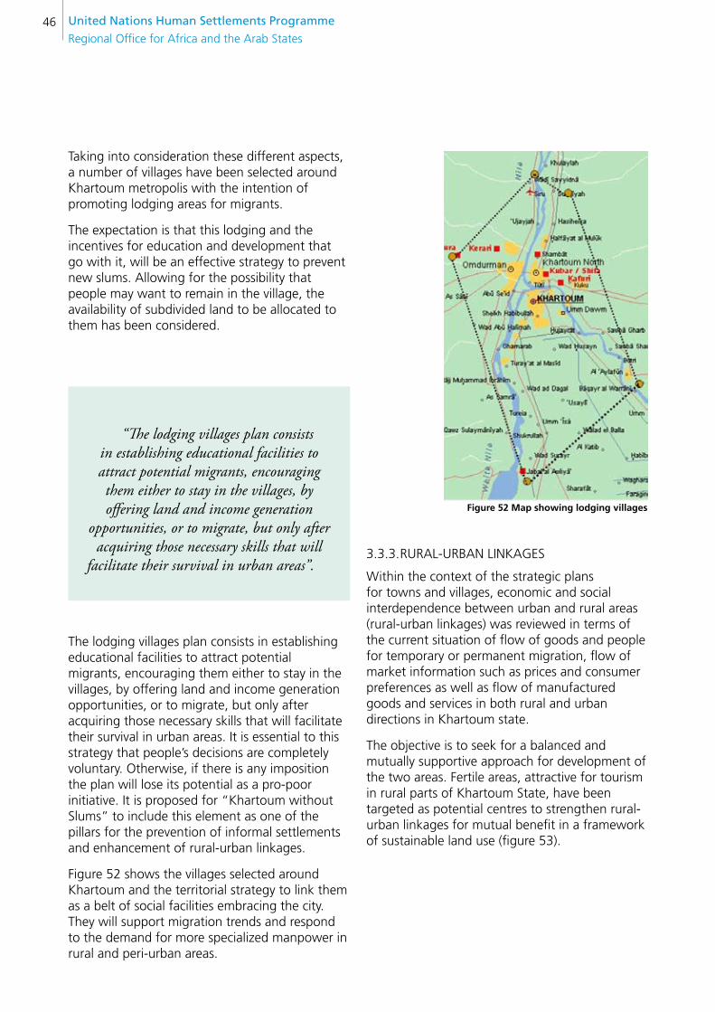
United nations Human settlements Programme
Regional Office for Africa and the Arab States46
Taking into consideration these different aspects, a number of villages have been selected around Khartoum metropolis with the intention of promoting lodging areas for migrants.
The expectation is that this lodging and the incentives for education and development that go with it, will be an effective strategy to prevent new slums. Allowing for the possibility that people may want to remain in the village, the availability of subdivided land to be allocated to them has been considered.
“The lodging villages plan consists in establishing educational facilities to attract potential migrants, encouraging them either to stay in the villages, by offering land and income generation
opportunities, or to migrate, but only after acquiring those necessary skills that will
facilitate their survival in urban areas”.
The lodging villages plan consists in establishing educational facilities to attract potential migrants, encouraging them either to stay in the villages, by offering land and income generation opportunities, or to migrate, but only after acquiring those necessary skills that will facilitate their survival in urban areas. It is essential to this strategy that people’s decisions are completely voluntary. Otherwise, if there is any imposition the plan will lose its potential as a pro-poor initiative. It is proposed for “Khartoum without Slums” to include this element as one of the pillars for the prevention of informal settlements and enhancement of rural-urban linkages.
Figure 52 shows the villages selected around Khartoum and the territorial strategy to link them as a belt of social facilities embracing the city. They will support migration trends and respond to the demand for more specialized manpower in rural and peri-urban areas.
figure 52 Map showing lodging villages
3.3.3. RURAL-URBAN LINKAGES
Within the context of the strategic plans for towns and villages, economic and social interdependence between urban and rural areas (rural-urban linkages) was reviewed in terms of the current situation of flow of goods and people for temporary or permanent migration, flow of market information such as prices and consumer preferences as well as flow of manufactured goods and services in both rural and urban directions in Khartoum state.
The objective is to seek for a balanced and mutually supportive approach for development of the two areas. Fertile areas, attractive for tourism in rural parts of Khartoum State, have been targeted as potential centres to strengthen rural-urban linkages for mutual benefit in a framework of sustainable land use (figure 53).
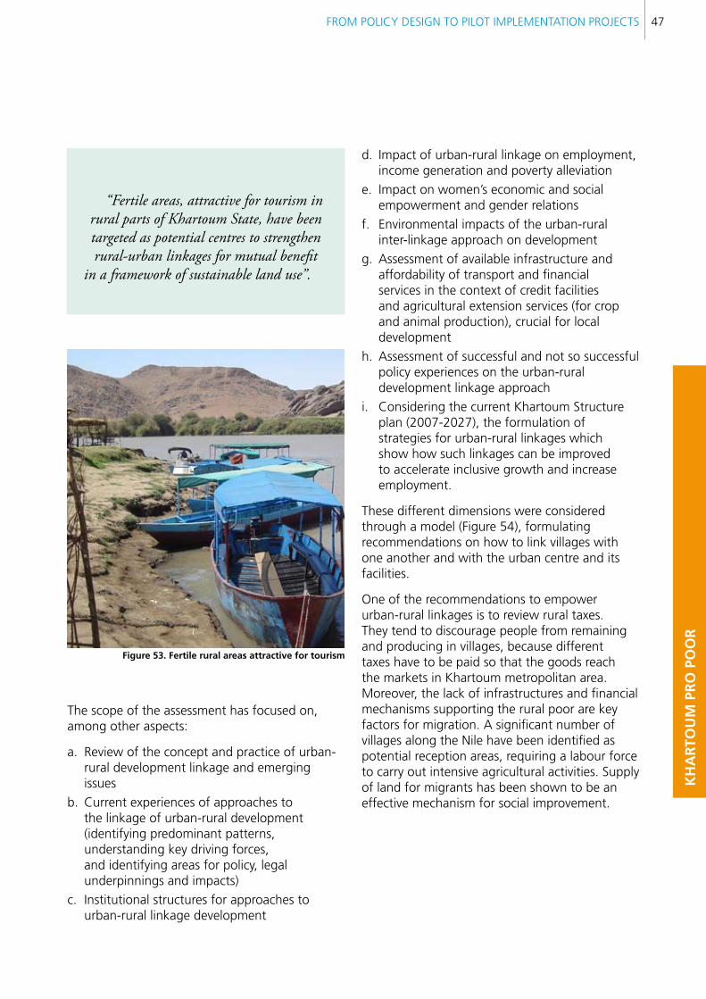
FROM POLICY DESIGN TO PILOT IMPLEMENTATION PROJECTS 47
KH
AR
TOU
M P
RO
PO
OR
“Fertile areas, attractive for tourism in rural parts of Khartoum State, have been targeted as potential centres to strengthen rural-urban linkages for mutual benefit
in a framework of sustainable land use”.
figure 53. fertile rural areas attractive for tourism
The scope of the assessment has focused on, among other aspects:
a. Review of the concept and practice of urban-rural development linkage and emerging issues
b. Current experiences of approaches to the linkage of urban-rural development (identifying predominant patterns, understanding key driving forces, and identifying areas for policy, legal underpinnings and impacts)
c. Institutional structures for approaches to urban-rural linkage development
d. Impact of urban-rural linkage on employment, income generation and poverty alleviation
e. Impact on women’s economic and social empowerment and gender relations
f. Environmental impacts of the urban-rural inter-linkage approach on development
g. Assessment of available infrastructure and affordability of transport and financial services in the context of credit facilities and agricultural extension services (for crop and animal production), crucial for local development
h. Assessment of successful and not so successful policy experiences on the urban-rural development linkage approach
i. Considering the current Khartoum Structure plan (2007-2027), the formulation of strategies for urban-rural linkages which show how such linkages can be improved to accelerate inclusive growth and increase employment.
These different dimensions were considered through a model (Figure 54), formulating recommendations on how to link villages with one another and with the urban centre and its facilities.
One of the recommendations to empower urban-rural linkages is to review rural taxes. They tend to discourage people from remaining and producing in villages, because different taxes have to be paid so that the goods reach the markets in Khartoum metropolitan area. Moreover, the lack of infrastructures and financial mechanisms supporting the rural poor are key factors for migration. A significant number of villages along the Nile have been identified as potential reception areas, requiring a labour force to carry out intensive agricultural activities. Supply of land for migrants has been shown to be an effective mechanism for social improvement.
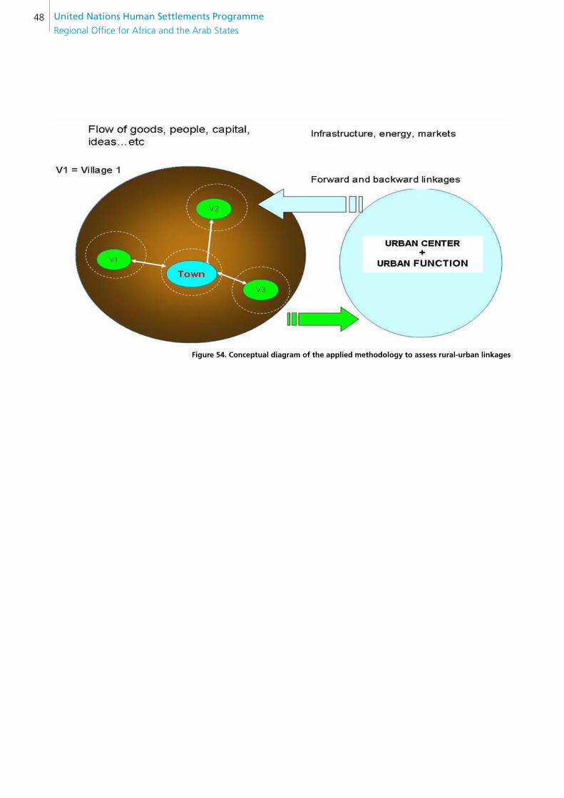
United nations Human settlements Programme
Regional Office for Africa and the Arab States48
figure 54. conceptual diagram of the applied methodology to assess rural-urban linkages
FROM POLICY DESIGN TO PILOT IMPLEMENTATION PROJECTS 49
KH
AR
TOU
M P
RO
PO
OR
4. DIffIcUlTIes fAceD AnD cOnTInGencY PlAns
During the report period, there have been delays in realizing the project for different reasons. One of the reasons is the very nature of the project itself which involves bottom up approaches and on the job training. Getting community consensus is highly time consuming, particularly during pre-electoral periods. In the issue of rural-urban linkages, delays in the implementation agenda are also due to difficulties faced in accessing reliable information and to changes of the authorities in charge that affect the delivery schedule.
Contingency plans deployed include agreements with suppliers in order to avoid delays, and moving forward with construction activities even without funds allocation. This strategy, based on good faith and trust in suppliers, was effective in sorting out administrative bottlenecks.

United nations Human settlements Programme
Regional Office for Africa and the Arab States50
5. lessOns leARnT
The different activities implemented in this project provide significant recommendations and lessons that need to be taken into account. Such lessons learnt can be divided into general observations, representing recurrent issues, that derive from different components of the projects, and specific observations related to each project component.
The input provided by pilot projects on community views and interpretation reveals how problems affect specifically each typology of poor and vulnerable populations, and block their possibilities for development. Even more important, the input provides clues as to how this population would like to address their problems and take advantage of their opportunities. This opens the door to the mobilization of the best people to act: namely those suffering the problems and therefore the most interested in finding the right solutions.
figure 55. low income groups participating in the initial steps of RUsPs
From this perspective, a first and strong lesson learnt is to encourage further community participation through different steps of discussion and agreement among different stakeholders, starting with those low income groups (Figure 55) normally segregated from the decision-making process.
At the same time, it is important to highlight the different roles played by technical discussion and community debate.
The former (Figure 56) involves experts and professionals, who need to agree on the reliability of the data obtained, its interpretation and the standards to be targeted.

FROM POLICY DESIGN TO PILOT IMPLEMENTATION PROJECTS 51
KH
AR
TOU
M P
RO
PO
OR
figure 56. sketch representing technical discussion
Community debate is more open and inclusive (figure 57), involving all those affected by the problems which the projects seek to address. It is important that the results of these two types of discussion are both taken into account when seeking alternative and viable solutions. Otherwise participation can easily become politicized and distorted with respect to the original goals.
figure 57. sketch representing community participation
A second lesson that must be highlighted is the contribution of pilot demonstration projects to the assessment of urban planning decisions like choice of location, appropriate densities, degree of socio-territorial segregation, etc. The experience acquired through the implementation of pilot projects contributes a broad range of alternatives for taking action.
The possible alternatives for upgrading of settlements depend very much on the location of the pilot projects. Those close to the urban fabric access cheaper basic urban services and livelihood opportunities.
“The possible alternatives for upgrading of settlements depend very much on the
location of the pilot projects. Those close to the urban fabric access cheaper basic urban services and livelihood opportunities”.
However, as the case of Mansura (Figure 58) demonstrates, proximity to the urban fabric and ongoing construction of highways, like the extension of the African Road, although it contributes to improving the whole zone, also encourages real estate speculation driving out the poor. Such segregation has already happened so it will not be surprising if it happens again in Mansura. What can make the difference is the capacity of the recently launched pro-poor policies to stop it.
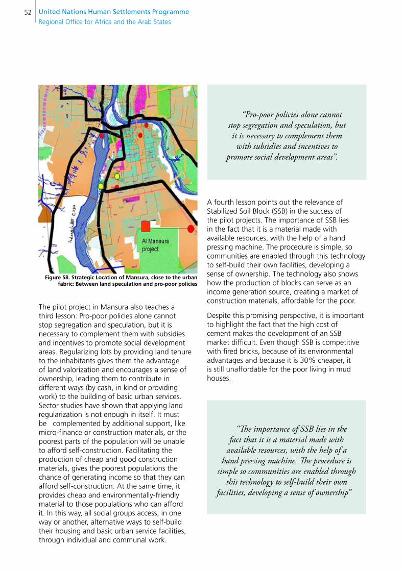
United nations Human settlements Programme
Regional Office for Africa and the Arab States52
figure 58. strategic location of Mansura, close to the urban fabric: between land speculation and pro-poor policies
The pilot project in Mansura also teaches a third lesson: Pro-poor policies alone cannot stop segregation and speculation, but it is necessary to complement them with subsidies and incentives to promote social development areas. Regularizing lots by providing land tenure to the inhabitants gives them the advantage of land valorization and encourages a sense of ownership, leading them to contribute in different ways (by cash, in kind or providing work) to the building of basic urban services. Sector studies have shown that applying land regularization is not enough in itself. It must be complemented by additional support, like micro-finance or construction materials, or the poorest parts of the population will be unable to afford self-construction. Facilitating the production of cheap and good construction materials, gives the poorest populations the chance of generating income so that they can afford self-construction. At the same time, it provides cheap and environmentally-friendly material to those populations who can afford it. In this way, all social groups access, in one way or another, alternative ways to self-build their housing and basic urban service facilities, through individual and communal work.
A fourth lesson points out the relevance of Stabilized Soil Block (SSB) in the success of the pilot projects. The importance of SSB lies in the fact that it is a material made with available resources, with the help of a hand pressing machine. The procedure is simple, so communities are enabled through this technology to self-build their own facilities, developing a sense of ownership. The technology also shows how the production of blocks can serve as an income generation source, creating a market of construction materials, affordable for the poor.
Despite this promising perspective, it is important to highlight the fact that the high cost of cement makes the development of an SSB market difficult. Even though SSB is competitive with fired bricks, because of its environmental advantages and because it is 30% cheaper, it is still unaffordable for the poor living in mud houses.
“Pro-poor policies alone cannot stop segregation and speculation, but it is necessary to complement them with subsidies and incentives to
promote social development areas”.
“The importance of SSB lies in the fact that it is a material made with
available resources, with the help of a hand pressing machine. The procedure is
simple so communities are enabled through this technology to self-build their own
facilities, developing a sense of ownership”
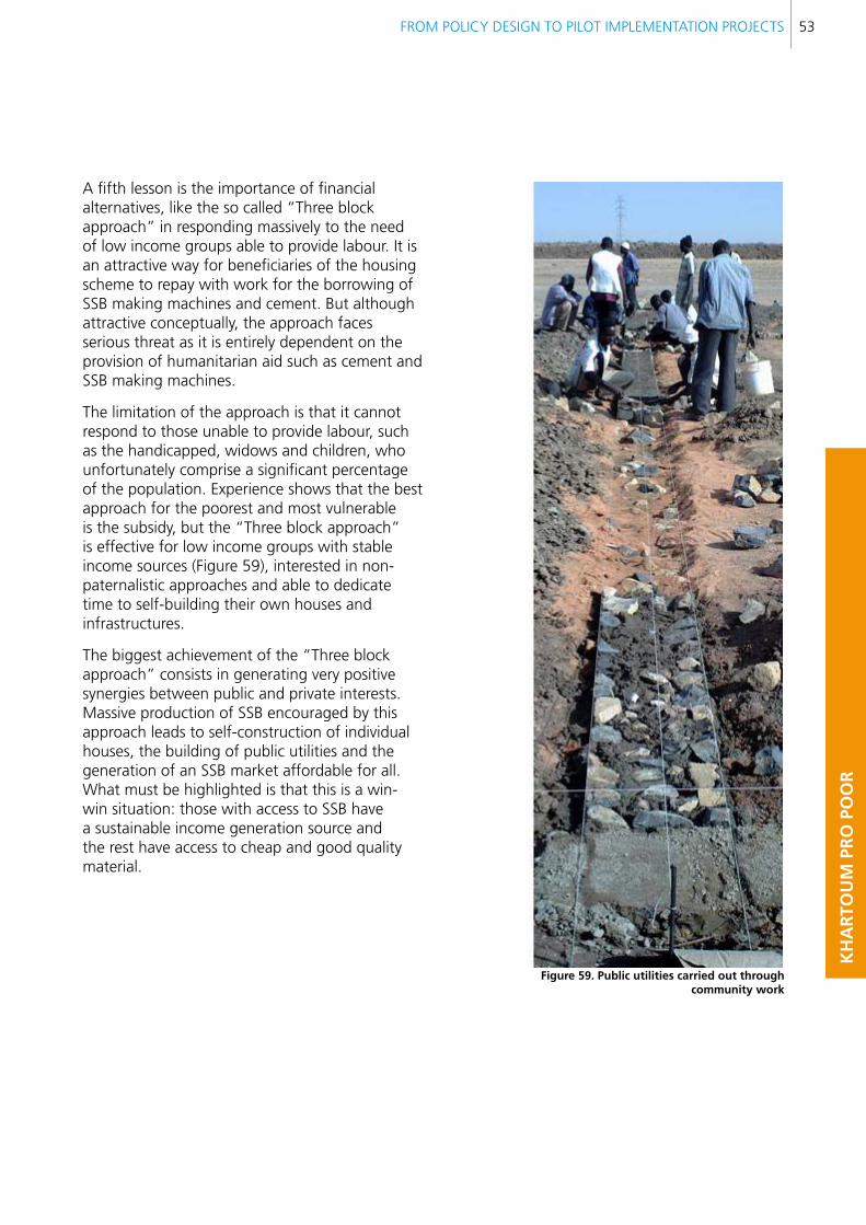
FROM POLICY DESIGN TO PILOT IMPLEMENTATION PROJECTS 53
KH
AR
TOU
M P
RO
PO
OR
A fifth lesson is the importance of financial alternatives, like the so called “Three block approach” in responding massively to the need of low income groups able to provide labour. It is an attractive way for beneficiaries of the housing scheme to repay with work for the borrowing of SSB making machines and cement. But although attractive conceptually, the approach faces serious threat as it is entirely dependent on the provision of humanitarian aid such as cement and SSB making machines.
The limitation of the approach is that it cannot respond to those unable to provide labour, such as the handicapped, widows and children, who unfortunately comprise a significant percentage of the population. Experience shows that the best approach for the poorest and most vulnerable is the subsidy, but the “Three block approach” is effective for low income groups with stable income sources (Figure 59), interested in non-paternalistic approaches and able to dedicate time to self-building their own houses and infrastructures.
The biggest achievement of the “Three block approach” consists in generating very positive synergies between public and private interests. Massive production of SSB encouraged by this approach leads to self-construction of individual houses, the building of public utilities and the generation of an SSB market affordable for all. What must be highlighted is that this is a win-win situation: those with access to SSB have a sustainable income generation source and the rest have access to cheap and good quality material.
figure 59. Public utilities carried out through community work
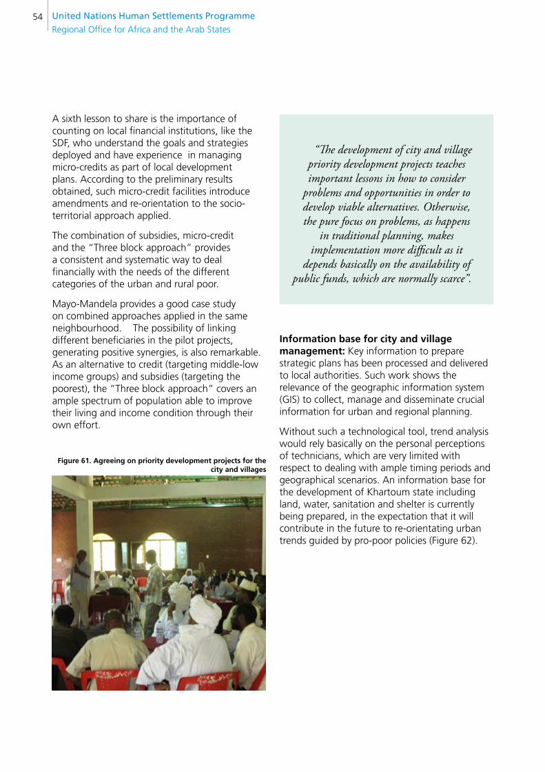
United nations Human settlements Programme
Regional Office for Africa and the Arab States54
A sixth lesson to share is the importance of counting on local financial institutions, like the SDF, who understand the goals and strategies deployed and have experience in managing micro-credits as part of local development plans. According to the preliminary results obtained, such micro-credit facilities introduce amendments and re-orientation to the socio-territorial approach applied.
The combination of subsidies, micro-credit and the “Three block approach” provides a consistent and systematic way to deal financially with the needs of the different categories of the urban and rural poor.
Mayo-Mandela provides a good case study on combined approaches applied in the same neighbourhood. The possibility of linking different beneficiaries in the pilot projects, generating positive synergies, is also remarkable. As an alternative to credit (targeting middle-low income groups) and subsidies (targeting the poorest), the “Three block approach” covers an ample spectrum of population able to improve their living and income condition through their own effort.
figure 61. Agreeing on priority development projects for the city and villages
“The development of city and village priority development projects teaches important lessons in how to consider
problems and opportunities in order to develop viable alternatives. Otherwise, the pure focus on problems, as happens
in traditional planning, makes implementation more difficult as it
depends basically on the availability of public funds, which are normally scarce”.
Information base for city and village management: Key information to prepare strategic plans has been processed and delivered to local authorities. Such work shows the relevance of the geographic information system (GIS) to collect, manage and disseminate crucial information for urban and regional planning.
Without such a technological tool, trend analysis would rely basically on the personal perceptions of technicians, which are very limited with respect to dealing with ample timing periods and geographical scenarios. An information base for the development of Khartoum state including land, water, sanitation and shelter is currently being prepared, in the expectation that it will contribute in the future to re-orientating urban trends guided by pro-poor policies (Figure 62).

FROM POLICY DESIGN TO PILOT IMPLEMENTATION PROJECTS 55
KH
AR
TOU
M P
RO
PO
OR
figure 62. Discussion on urban trends at a local observatory
Review and preparation of recommendations for settlement hierarchy criteria in support of rural-urban linkages: This is an important contribution highlighting the importance of having specific indicators and variables to measure urbanization trends.
Training manuals for strategic planning, action planning and local economic development: These manuals have been designed with the rationale of helping public officials to link territorial planning decisions with local economic development opportunities.
The manuals increase the understanding among public officials and communities on the need to create new “geographies of opportunities” to integrate the urban poor into urban and regional socio-development networks.
Part of the “on-the-job” training in strategic planning results in the introduction and development of new ideas to promote the poor, shaping their areas to attract public and private investments encouraged by a pro-poor policy framework
local indicators for state land, basic urban services, shelter policies and settlement management: The creation of local observatories was carried out successfully, developing new indicators and disseminating results among governmental
and academic institutions and guiding them on urbanization decisions. Local indicators and observatories contribute by generating evidence on urbanization trends which influence the decision making process. Experience in Khartoum highlights the importance of generating a critical mass of information from discussion and interpretation of the results obtained, otherwise the data per se does not contain a clear message with respect to what, where and how serious the problems are. Moreover, the excess of information without agreement on its interpretation can produce unnecessary damage to the planning process. The lesson learnt is that local indicators and observatories are critical for strategic planning, but demand a dynamic, flexible and participatory approach for producing the data, and a multidisciplinary perspective for discussing the results.
“The manuals increase the understanding among public officials
and communities on the need to create new “geographies of opportunities” to
integrate the urban poor into urban and regional socio-development networks”
“local indicators and observatories are critical for strategic planning,
but demand a dynamic, flexible and participatory approach for producing
the data, and a multidisciplinary perspective for discussing the results”.
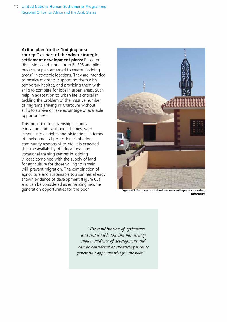
United nations Human settlements Programme
Regional Office for Africa and the Arab States56
Action plan for the “lodging area concept” as part of the wider strategic settlement development plans: Based on discussions and inputs from RUSPS and pilot projects, a plan emerged to create “lodging areas” in strategic locations. They are intended to receive migrants, supporting them with temporary habitat, and providing them with skills to compete for jobs in urban areas. Such help in adaptation to urban life is critical in tackling the problem of the massive number of migrants arriving in Khartoum without skills to survive or take advantage of available opportunities.
This induction to citizenship includes education and livelihood schemes, with lessons in civic rights and obligations in terms of environmental protection, sanitation, community responsibility, etc. It is expected that the availability of educational and vocational training centres in lodging villages combined with the supply of land for agriculture for those willing to remain, will prevent migration. The combination of agriculture and sustainable tourism has already shown evidence of development (Figure 63) and can be considered as enhancing income generation opportunities for the poor. figure 63. Tourism infrastructure near villages surrounding
Khartoum
“The combination of agriculture and sustainable tourism has already shown evidence of development and
can be considered as enhancing income generation opportunities for the poor”
FROM POLICY DESIGN TO PILOT IMPLEMENTATION PROJECTS 57
KH
AR
TOU
M P
RO
PO
OR
The lessons learnt reveal a set of factors necessary in dealing with the structural causes of problems and marginalization. But systematic interventions on all these factors require an operational strategy in the framework of a programme. The results of the pilot projects highlight the strengths and weaknesses of pro-poor policies, suggesting the major components of a programme specifically dedicated to achieve “Khartoum without Slums”.
Taking into consideration the history of eviction and demolition in Khartoum, it is important to clarify that “Khartoum without Slums” refers to the very opposite of this. This is an important clarification, as many efforts in the past sought to “upgrade” the city by evicting informal settlements and applying a sites and services approach, creating new subdivision schemes on the city outskirts. The failure of these policies is demonstrated in many reports, but also the success of other initiatives, such as the already mentioned “Dar El Salaam” approach, illustrates viable ways forward to reintegrate the poor providing basic services. Such achievements have inspired the design of the pilot projects.
The transition from pilot projects to a systematic slum upgrading programme, requires simultaneous interventions in urban and rural areas and systematization of action plans, with the identification of specific territories for intervention and for implementation partners. A combined approach to slum prevention and upgrading of the existing settlements is critical. Prevention of new slums can be achieved by improving living conditions in villages strategically located, with capacity to attract population and avoid massive migration to the metropolis. It is also necessary to intervene in existing slums, providing affordable and appropriate alternatives to moving out. This goal constitutes an enormous challenge for capacity building, exceeding by far the current possibilities of the MPUD. The involvement of external actors partnering governmental efforts, like the community and private sectors, UN agencies and international donors, is critical.
6. THe wAY fORwARD: “KHARTOUM wITHOUT slUMs”
“The transition from pilot projects to a systematic slum upgrading
programme, requires simultaneous interventions in urban and rural areas
and systematization of action plans, with the identification of specific territories
for intervention and for implementation partners. A combined approach to slum prevention and upgrading of
the existing settlements is critical”
The foreseen institutional setting involves a relationship where stakeholders play complementary roles (Figure 64): academic institutions, like training research institutes, back community associations working to implement specific projects; UN agencies provide technical backstopping, facilitation and support on specific issues; and the MPUD is in charge of coordination, monitoring, evaluation and updating of plans and standards; in order to ensure progress in systematic slum upgrading by implementing pro-poor policies, targeting specific disadvantaged social groups.

United nations Human settlements Programme
Regional Office for Africa and the Arab States58
figure 64. Proposed institutional structure for “Khartoum without slums” programme
Based on this institutional setting, “Khartoum without Slums” has three major components (see figure 65).
The first component integrates pro-poor policies and capacity building for the MPUD. This component includes the role of UN agencies introducing new techniques and approaches, with the necessary resources to test their results through pilot experiences.
Its effectiveness once proved, it can be incorporated as a pro-poor policy, receiving adequate training and institutional adjustments to ensure that the planning machinery is really prepared for policy implementation and coordination of action plans. The second component refers to systematic slum upgrading measures, including as a subcomponent, production and construction with SSB and roofing, both associated to sustainable sanitation and public services. The third component completes the vision, introducing prevention of new informal settlements, treating lodging villages as satellite towns and developing rural-urban linkages by including basic infrastructure, such as roads, and incentives for certain products through taxes and special facilities.
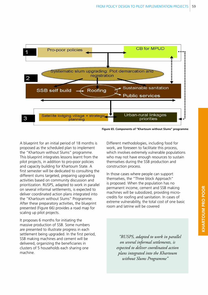
FROM POLICY DESIGN TO PILOT IMPLEMENTATION PROJECTS 59
KH
AR
TOU
M P
RO
PO
OR
figure 65. components of “Khartoum without slums” programme
A blueprint for an initial period of 18 months is proposed as the scheduled plan to implement the “Khartoum without Slums” programme. This blueprint integrates lessons learnt from the pilot projects, in addition to pro-poor policies and capacity building for Khartoum State. A first semester will be dedicated to consulting the different slums targeted, preparing upgrading activities based on community discussion and prioritization. RUSPS, adapted to work in parallel on several informal settlements, is expected to deliver coordinated action plans integrated into the “Khartoum without Slums” Programme. After these preparatory activities, the blueprint presented (Figure 66) provides a road map for scaling up pilot projects.
It proposes 6 months for initiating the massive production of SSB. Some numbers are presented to illustrate progress in each settlement being upgraded. In the first period, SSB making machines and cement will be delivered, organizing the beneficiaries in clusters of 5 households each sharing one machine.
Different methodologies, including food for work, are foreseen to facilitate this process, which involves extremely vulnerable populations who may not have enough resources to sustain themselves during the SSB production and construction process.
In those cases where people can support themselves, the “Three block Approach” is proposed. When the population has no permanent income, cement and SSB making machines will be subsidized, providing micro-credits for roofing and sanitation. In cases of extreme vulnerability, the total cost of one basic room and latrine will be covered
“RUSPS, adapted to work in parallel on several informal settlements, is
expected to deliver coordinated action plans integrated into the Khartoum
without Slums Programme”
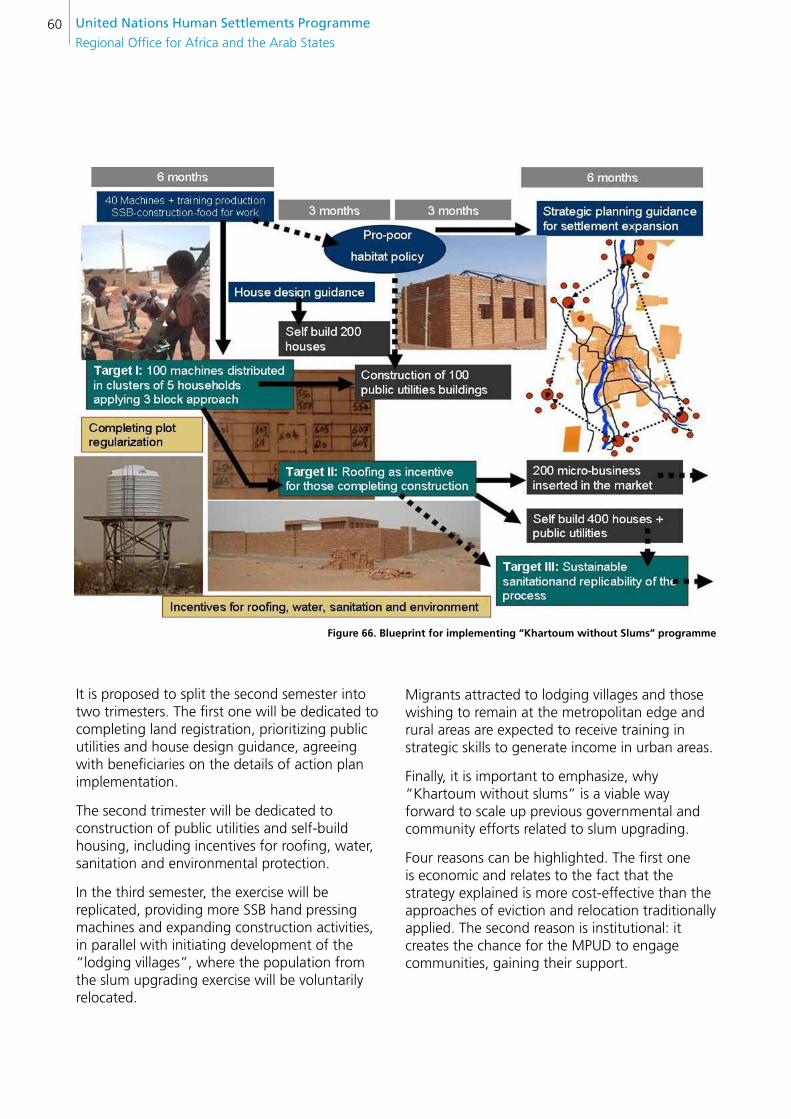
United nations Human settlements Programme
Regional Office for Africa and the Arab States60
figure 66. blueprint for implementing “Khartoum without slums” programme
It is proposed to split the second semester into two trimesters. The first one will be dedicated to completing land registration, prioritizing public utilities and house design guidance, agreeing with beneficiaries on the details of action plan implementation.
The second trimester will be dedicated to construction of public utilities and self-build housing, including incentives for roofing, water, sanitation and environmental protection.
In the third semester, the exercise will be replicated, providing more SSB hand pressing machines and expanding construction activities, in parallel with initiating development of the “lodging villages”, where the population from the slum upgrading exercise will be voluntarily relocated.
Migrants attracted to lodging villages and those wishing to remain at the metropolitan edge and rural areas are expected to receive training in strategic skills to generate income in urban areas.
Finally, it is important to emphasize, why “Khartoum without slums” is a viable way forward to scale up previous governmental and community efforts related to slum upgrading.
Four reasons can be highlighted. The first one is economic and relates to the fact that the strategy explained is more cost-effective than the approaches of eviction and relocation traditionally applied. The second reason is institutional: it creates the chance for the MPUD to engage communities, gaining their support.
FROM POLICY DESIGN TO PILOT IMPLEMENTATION PROJECTS 61
KH
AR
TOU
M P
RO
PO
OR
Thirdly, it introduces a rationale for supporting humanitarian efforts shifting from pure assistance to systematic interventions with a recovery perspective, developing local institutional leadership and ownership. Finally, “Khartoum without Slums” facilitates the transition from emergency to early recovery and from early recovery to development, consolidating pro-poor policies.
“Khartoum without Slums facilitates the transition from
emergency to early recovery and from early recovery to development, consolidating pro-poor policies”.
United nations Human settlements Programme
Regional Office for Africa and the Arab States62
7. fInAl ReMARKs
Throughout the different chapters of this publication, different issues arise concerning the challenges of designing and implementing pro-poor policies.
A first issue to highlight is interpreting the roots of poverty in different territorial locations and social profiles. The three pilots show how specific locations in urban areas and their particular insertion in the metropolitan structures affect their living conditions and local economic perspectives. In rural areas, the need to better understand rural-urban linkages is facilitated by pilot projects on the city outskirts.
Mansura and Jebel Awlia represent both poverty associated to urban segregation, and remoteness at the outskirts of the city. Interventions in Mayo-Mandela camp illustrate ways to reintegrate displaced populations and IDPs.
It should be noted that better understanding acquired through the pilots helps to explain those factors behind poverty associated with urbanization trends, and helps to clarify the different alternatives that can minimize its negative consequences. The three pilots illustrate different approaches to supporting urbanization trends, with particular constraints and potentials related closely to their geographic and social fabrics.
A second issue to be addressed relates to the transition from policy making to pilot demonstration projects. Policy making works through regulatory frameworks with a systematic and general approach, essential in tackling the causes of poverty. Such policy may easily be misguided if it does not match particular circumstances.
Pilot projects update pro-poor policies, providing a concrete feedback on their impact, extension and also failures. Adjustment of pro-poor policies and strategies through lessons learnt are an effective tool for any planning review.
Critical analysis of the capacity to reintegrate relocation areas emphasizes the importance of an enabling environment through which populations, according to their specific profile, contribute resources or labour to implement community priority projects. It is clear that without such an enabling component, it can not be expected that the pro-poor framework will work. On the contrary, it could even promote segregation.
“Critical analysis of the capacity to reintegrate relocation areas emphasizes the importance of an enabling environment through which populations, according
to their specific profile, contribute resources or labour to implement community priority projects”.
This observation introduces a third issue for discussion. It is clear that Khartoum State, as the heartland of the country, plays a major role in attracting low income populations from other regions. It is expected that future national political turbulence will have a direct impact on the increase of informal settlements. Pro-poor policy recommends integration of vulnerable groups into the urban fabric, providing land, subsidizing public works, introducing flexible building regulations and facilitating mass production of affordable building materials.
FROM POLICY DESIGN TO PILOT IMPLEMENTATION PROJECTS 63
KH
AR
TOU
M P
RO
PO
OR
The strategic planning vision sees coordinated and simultaneous work on urban and rural areas as crucial. In rural areas, empowering rural-urban linkages by developing “lodging villages” gets to the root of the problems of squattering and poverty. Intervening in urban areas by upgrading slums in line with the “Khartoum without Slums” programme, supports the State planning system, and involves community and private stakeholders. It is necessary to develop the legal framework so that every stakeholder involved in slum upgrading exercises can operate with clear rules. Participatory mechanisms facilitate the process whereby stakeholders can agree on fair rules. Beneficiaries need to realize the importance of making their own efforts both in self-building their basic housing facilities and in self-organizing to mobilize resources for community works. The private sector must also assume its role, encouraging local economic development trends in a professional manner, delivering the best services with prices that low income groups can afford. Last but not least, through the participatory exercise the government assumes its role as facilitator and enabler of pro-poor policies, implemented in partnership with communities and the private sector.
A third issue relates to capacity building. Strategic planning demands a team adequately prepared to deliver strategic action plans for towns and villages, consolidating previously drafted pro-poor policies and capacity building recommendations.
The lodging area concept explores alternatives to facilitate the integration of low income populations in certain villages, locating training centres where such populations can adjust to the demands of urban life. Training centres provide skills necessary to finding work, strategies for survival in towns and key information on how to get involved in solidarity and social promotion networks.
The introduction of multistory design and construction techniques in low income neighbourhoods is a valuable element in encouraging densification. Multistory buildings with low cost technologies allow the urban poor to keep part of their plots free to carry out income generation activities, typically commercial activities or micro-industrial workshops on the ground floors. Diversity and flexibility in popular neighbourhoods is an efficient and attractive way of satisfying physical, social and psychological needs for low income communities.
“The strategic planning vision sees coordinated and simultaneous work
on urban and rural areas as crucial”
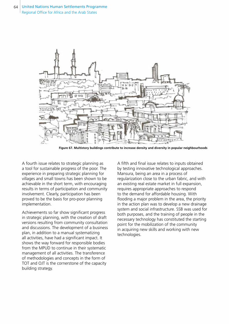
United nations Human settlements Programme
Regional Office for Africa and the Arab States64
figure 67. Multistory buildings contribute to increase density and diversity in popular neighbourhoods
A fourth issue relates to strategic planning as a tool for sustainable progress of the poor. The experience in preparing strategic planning for villages and small towns has been shown to be achievable in the short term, with encouraging results in terms of participation and community involvement. Clearly, participation has been proved to be the basis for pro-poor planning implementation.
Achievements so far show significant progress in strategic planning, with the creation of draft versions resulting from community consultation and discussions. The development of a business plan, in addition to a manual systematizing all activities, have had a significant impact. It shows the way forward for responsible bodies from the MPUD to continue in their systematic management of all activities. The transference of methodologies and concepts in the form of TOT and OJT is the cornerstone of the capacity building strategy.
A fifth and final issue relates to inputs obtained by testing innovative technological approaches. Mansura, being an area in a process of regularization close to the urban fabric, and with an existing real estate market in full expansion, requires appropriate approaches to respond to the demand for affordable housing. With flooding a major problem in the area, the priority in the action plan was to develop a new drainage system and social infrastructure. SSB was used for both purposes, and the training of people in the necessary technology has constituted the starting point for the mobilization of the community in acquiring new skills and working with new technologies.
FROM POLICY DESIGN TO PILOT IMPLEMENTATION PROJECTS 65
KH
AR
TOU
M P
RO
PO
OR
“The transference of methodologies and concepts in the format of TOT and OJT is the cornerstone of the
capacity building strategy”
The increasing involvement of the TRI as a technical partner, identifying lessons learnt and disseminating them to communities and to the market, has been the foundation which sustains the whole process. It is important to note how multistory typologies can increase density and diversity, making all basic urban services more affordable for the urban poor (Figure 67).
The construction of model houses demonstrates the feasibility of introducing innovation in construction technologies with respect to costs and constraints. The cost of cement constitutes a major difficulty for SSB technology.
A combination of technologies and approaches is recommended to enlarge the social target of the plans and it is vital to develop the technical capacity to respond to different requirements. Particular attention has been given to finding new and more effective sanitation designs, building alternative slabs and seeking affordable solutions that can be mass produced. Alternative roofing has also been explored, with the use of ferro-cement and pre-cast slabs.
A third component of technological innovation involves the development of multistory building prototypes, using pre-cast concrete slabs and external staircases for low income housing. One of the model houses has been built as multistory, seeking to respond to the need to increase densities and minimizing infrastructure costs. Based on innovative design and technology, pilot demonstration building seeks to achieve several goals: Allocating five housing units in a small parcel; minimizing construction costs by using common walls and reducing room sizes; and eliminating redundant spaces like corridors, replacing them by common areas that can be intensively used as semi-private areas. These technological innovations are crucial to encourage denser urban development, minimizing urban expansion.
“A combination of technologies and approaches is recommended to enlarge the social target of the plans and it is vital to
develop the technical capacity to respond to different requirements. Particular attention
has been given to finding new and more effective sanitation designs, building
alternative slabs, and seeking affordable solutions that can be mass produced”.
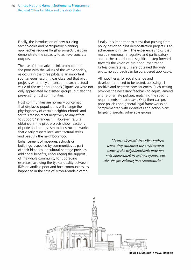
United nations Human settlements Programme
Regional Office for Africa and the Arab States66
Finally, the introduction of new building technologies and participatory planning approaches requires flagship projects that can demonstrate the capacity to achieve concrete outputs.
The use of landmarks to link promotion of the poor with the values of the whole society, as occurs in the three pilots, is an important spontaneous result. It was observed that pilot projects when they enhanced the architectural value of the neighbourhoods (Figure 68) were not only appreciated by assisted groups, but also the pre-existing host communities.
Host communities are normally concerned that displaced populations will change the physiognomy of certain neighbourhoods and for this reason react negatively to any effort to support “strangers”. However, results obtained in the pilot projects show reactions of pride and enthusiasm to construction works that clearly respect local architectural styles and beautify the neighbourhood.
Enhancement of mosques, schools or buildings respected by communities as part of their historical or cultural heritage provides additional benefits, encouraging the support of the whole community for upgrading exercises, avoiding the typical duality between IDPs or landless poor and host communities, as happened in the case of Mayo-Mandela camp.
“It was observed that pilot projects when they enhanced the architectural value of the neighbourhoods were not
only appreciated by assisted groups, but also the pre-existing host communities”
Finally, it is important to stress that passing from policy design to pilot demonstration projects is an achievement in itself. The experience shows that multidimensional, integrative and participatory approaches contribute a significant step forward towards the vision of pro-poor urbanization. Unless concrete results are obtained through pilots, no approach can be considered applicable.
All hypotheses for social change and development need to be tested, assessing all positive and negative consequences. Such testing provides the necessary feedback to adjust, amend and re-orientate policies, matching the specific requirements of each case. Only then can pro-poor policies and general legal frameworks be complemented with incentives and action plans targeting specific vulnerable groups.
figure 68. Mosque in Mayo-Mandela
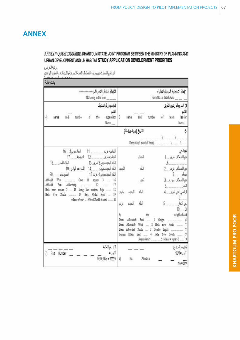
FROM POLICY DESIGN TO PILOT IMPLEMENTATION PROJECTS 67
KH
AR
TOU
M P
RO
PO
OR
AnneX
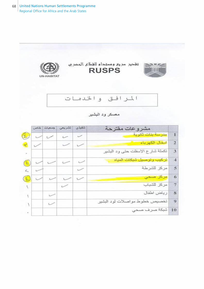
United nations Human settlements Programme
Regional Office for Africa and the Arab States68

FROM POLICY DESIGN TO PILOT IMPLEMENTATION PROJECTS 69
KH
AR
TOU
M P
RO
PO
OR
bIblIOGRAPHY
ABU SIN, M. E. and DAVES, H. R. J., 1991. The Future of Sudan's Capital Region: A Study in Development and Change, Khartoum University Press, Khartoum.
AHMAD, ADIL and ATA EL HASSAN EL BATTAM, 1995. “Poverty in Khartoum”. Environment and Urbanization. Vol. 7. No. 2, 195.
ALI, A. A., 1984. Some Aspects of the Sudan Economy. University of Khartoum. Faculty of Economics. DSRC. K.U.P. Khartoum.
AL SAHAFA (an Arabic language daily newspaper published in Khartoum), Issue No. 5296 of 2008 and the Issue of 15 February 2008.
ARNSTEIN, 1969. Participatory Planning. Elsevier. London. UK
BUSHRA BABIKER, 1997. Khartoum: Past, Present and the Prospect for the Future. Durham Middle East Papers. Sir William Luce Publication Series.
BUSHRA and HIJAZI, N., 1991. “The Impact of Greater Khartoum on the Rest of Sudan”. In Abu Sin, M. E. and Davis (Ed.). The Future of Sudan’s Capital: A Study on Development and Change. Khartoum. Khartoum University
BUSRA AND OTHERS, 1998. Optimum Utilization of Governmental Land and Real Estate in Khartoum. Study financed by the Ministry of Physical Planning and Public Utilities. Khartoum.
CAINCROSS. and KINNEAR J., 2002. Elasticity of Water Prices in Khartoum, Sudan.
CENTRAL BANK OF SUDAN, “Microfinance Programme: An Assessment of the Current Status of the Industry”. Paper for the First National Consultative Forum on Microfinance, November 2007.
CENTRAL BANK OF SUDAN, 46th Annual Report, 2006.
CENTRAL BUREAU OF STATISTICS, Sudan in Figures, Khartoum 2002‒2007.
CENTRAL BUREAU OF STATISTICS, GDP Structure and Per Capita Income Sheets, Khartoum 2002‒2006.
CLAYTON, A., OACKLEY P. and TAYLOR J., 2000. Civil Society Organizations and Service Provision. Programme on Civil Society and Social Movements. Paper No. 2. UNRISD Geneve.
COHRE, December 2006. Global Survey on Forced Evictions/Violations of Human Rights.
DE GEOFFREY, Agnes, 2005. IDPs and Urban Planning in Khartoum. Internet publication.
DE GEOFFREY, Agnes, 2007. “From Internal to International Displaced in Sudan”. Paper presented for Forced Migrations and Refugee Studies Programme, the American University of Cairo.pp 22.
DELHASS, Rick, 2006. Forgotten and Marginalized, Displaced Persons in Khartoum: One Year after the Peace Agreement. Interchurch Organization for Development Co-operation, Khartoum/Amsterdam.
EL GHAZALI, Burhan, 2006. Urban Intensification in Metropolitan Khartoum. Doctoral thesis, KTH Royal Institute of Technology, Stockholm, Sweden.
FARAH, E. A., 1999. “Groundwater Quality and Hydrogeology Conditions in the Khartoum Area, Sudan”. Journal of Geosciences, Osaka University, Japan. Vol. 42 pp. 45–53.
GALAL ELDIN ELTAYEB, 2005. “The Case of Khartoum”. Interim National Constitution of the Republic of the Sudan,
HAFAZALLAH, A. A., 2006. “Housing Policy and Supply in Khartoum: the Role of the Public Sector in the Supply Process”. Unpublished PhD thesis, University of Newcastle, UK.
HAFAZALLAH, Abdul, 2007. Overview of housing policy in Khartoum: Challenges and Future Prospects. Internet publication.
HOUSING AND DEVELOPMENT FUND, 2008. The Housing and Development Fund. Official statistics.
ILO, 1987. “Employment and Economic Reform: Towards a Strategy for the Sudan”. Report of a mission financed by the UNDP and organized by ILO on jobs and skills progress for Africa. ILO Khartoum.
JACOBSEN, 2008. Internal Displacement to Urban Areas. Tufts-IDMC profiling study. Khartoum. The Feinstein International Study Centre. Tufts University in collaboration with International Displacement Monitoring Centre, Geneve.
JACOBSEN, Karen, LAUTZE, and OSMAN, 2001. “The Sudan: The Unique Challenge of Displacement in Khartoum”. In Caught Between Borders: Response Strategies of the Internally Displaced. Edited by M. Vicent and Lorensen. Pluto Press.
KAMAL EL DIN, Salih, 2000. Description of Migrant Settlement in Greater Khartoum. Swedish University of Agriculture Science, Department of Rural Development Studies.
United nations Human settlements Programme
Regional Office for Africa and the Arab States70
MALIK, E., AHMED, ELKhalifa, Hussein, and Suleiman, 2003. “Stratification of Khartoum Urban Area by the Risk of Malaria Transmission”. Eastern Mediterranean Health Journal. Vol. 6, No. 4.
MCLEANS, 1912. “Plan of Khartoum”. Sudan Gazette. Khartoum.
MINISTRY OF GENERAL EDUCATION (Sudan), Directorate General of Vocational Education, Annual Statistical Report 2006–2007 (in Arabic).
MINISTRY OF INDUSTRY, Industrial Survey Report (of Sudan) 2005.
MULTIPLE INDICATOR CLUSTER, 2000. Multiple Indicator Cluster Survey, Sudan. Final report. Retrieved October 20, 2004, from: http://www.childinfo.org/MICS2/newreports/sudan1/FianalMICSSudan.pdf
Retrieved from the internet on 3/12/1428, loner calendar, 12/12/2007 from: http://www.alnilin.com/news/modules.php?name=News&file=article&sid=27178
NATIONAL MIGRATION AND LABOUR SURVEY, 1996.
ORCHARD, Phil, 2006. “The Flip Side of the Coin: Human Security of the Displaced in Camps and Cities”. Paper prepared for the Department of Foreign Affairs and International Trade. Canadian Consortium on Human Security Conference.
OSMAN S. M., 1992. “Evaluation of Site and Services Approach in Greater Khartoum: Ramification on Land Market and Housing Production”. Unpublished data, PhD thesis, Middle East Technical University. Ankara, Turkey.
OSMAN S. M., 1993. “Towards a Positive Policy to House the Blue Collars”. Paper presented to the Housing and Health Security Seminar sponsored by Sudan Labour Union, 27‒29 December 1993. Khartoum.
OSMAN S. M., 2001, “Site and Services in Sudan: High Time to Paradigm Shift”. Paper presented to the 5th Scientific Conference on Housing and Development in Sudan. April 2001. Khartoum.
OSMAN, S. M., 2002. “Refocusing Financing Housing in Sudan”. Paper presented to the 2nd Conference of the Building Material Society. Khartoum.
OXFAM GB, September 2002. Evaluation of Oxfam GB Livelihood Projects in Khartoum.
SAVINGS AND SOCIAL DEVELOPMENT BANK, November 2007. Survey of Microfinance Market in Three Khartoum State Localities.
SIRAJ SAIT and HILARY LIM, 2006. Land, Law and Islam. UN-HABITAT and Zed Books.
SOCIAL DEVELOPMENT FOUNDATION, Annual Reports 1000, 2001 and 2002.
SOCIAL DEVELOPMENT FOUNDATION, 2006. Strategic Plan Presentation Document.
Sudan Millennium Development Goals: Interim Unified Report. December, 2004.
SULEIMAN, Mohammed, 2007. Will Khartoum Overcome NCP Monopoly and Become an Inclusive National Capital? sudanjem.com/en/uploads/NCP%20Monopoly.html - 12k –
TAHANI KARRAR, 2007. “Sudan’s Oil Wealth Making Life Harder”. Sudan Tribune. 3 September 2007. www.sudantribune.com/spip.php?article24566
TISDALL, Simon, 2008. “Khartoum’s Boom”. The Guardian Weekly. http://www.guardian.co.uk/commentisfree/2008/mar/11/khartoumsboom
UNCHS, 1996. An Urbanizing World: Global Report on Human Settlements.
UNDP. Human Development Report 2007 / 2008.
UN HABITAT, 2009. Urban Sector Studies and capacity building for Khartoum State. ISBN number: 978-92-1-132181-4
UN HABITAT, 2009. Darfur Early Recovery, Stabilized Soil Blocks for Sustainable Urban Growth. ISBN number: 978-92-1-132219-4
WESTENDORFF, David, 2006. Inclusive Cities. UNRISD.
WIDATAALA Magdi, 1999. Urban Groundwater Database: Khartoum, Sudan. Graduate Studies Department of Geology, Earth Science Centre, University of Toronto, 22 Russell Street, Toronto , Ontario, M5S 3B1 CANADA.
WORLD BANK, 1988. “Opportunities and Risks in Managing the World Economy”. World Bank. World Development Report 1988. Oxford University Press. Oxford.
WORLD HEALTH ORGANIZATION 2004, Costs and Benefits of Water and Sanitation Improvements at the Global Level. Document No. WHO/SDE/WSH/04.04. Retrieved from the web site on 1/4/2008 from: http://esa.un.org/iys/economic.shtml
ZAKARIA, Mustafa and Mohamed Ahmed Ajab Aldour, 2003. The Role of the Social Development Foundation in Fighting Poverty in Khartoum State. University of Khartoum Institute of Development Studies.
ZAKAT Fund, 2007. Zakat Disbursements Report. Khartoum State, East Nile Locality.
FROM POLICY DESIGN TO PILOT IMPLEMENTATION PROJECTS 71
KH
AR
TOU
M P
RO
PO
OR
Websites consulted:
www.sudanmfa.org
www.unsudanig.org

United nations Human settlements Programme
Regional Office for Africa and the Arab States
Copyright © 2022 FDOKUMEN