Khami period in the Mapungubwe landscape
18
Journal of African Archaeology Vol. 9 (2), 2011, pp. 189–206 189 KHAMI AND THE VENDA IN THE MAPUNGUBWE LANDSCAPE Thomas N. Huffman & Justin du Piesanie Abstract In the Mapungubwe landscape, the Khami phase grades into the historic Venda period. Khami occupation, however, differs markedly from recent Venda settlement. Among the differences, rainfall was more consistent in the 15 th and 16 th centuries, and the Limpopo Valley supported several thousand people living on cattle posts and in agricultural villages. In contrast, 19 th century Venda capitals virtually housed the en- tire chiefdom, totalling only some 350 people. A slow process of acculturation led the Venda-speaking Machete chiefdom to become Sotho. When Mapungubwe was discovered in the early 1930s, the chiefdom had already disintegrated, and the people spoke Sotho. Résumé Dans le paysage de Mapungubwe, la phase Khami se gradue dans la période historique Venda. L’occupation Khami, ce- pendant, diffère nettement des communautés Venda récentes. Parmi les différences figurent les pluies qui étaient plus ré- gulières dans les XVe et XVIe siècles, et la vallée de Limpopo soutenait plusieurs milliers de personnes vivant sur des postes de bovins et dans des villages agricoles. En revanche, les capitales Venda du XIXe siècle abritaient pratiquement l’entièreté de la chefferie, comprenant seulement un total de quelques 350 personnes. Au cours d’un lent processus d‘ac- culturation, la chefferie Machete parlant la langue Venda est devenue Sotho. Quand Mapungubwe a été découvert dans les années 1930, la chefferie avait déjà désintégrée et le peuple parlait le Sotho. Keywords: Historical archaeology, Khami phase, Mapungubwe landscape, oral tradition, South Africa, Venda period DOI 10.3213/2191-5784-10197 Published online November 2, 2011 © Africa Magna Verlag, Frankfurt M. Thomas N. Huffman 8 [email protected] / Justin du Piesanie 8 [email protected] * School of Geography, Archaeology & Environmental Sciences, University of the Witwatersrand, Johannesburg, Private Bag 3, Wits 2050, South Africa
Transcript of Khami period in the Mapungubwe landscape
Journal of African Archaeology Vol. 9 (2), 2011, pp. 189–206 189
Khami and the Venda in the mapungubwe Landscape
Thomas N. Huffman & Justin du Piesanie
Abstract
In the Mapungubwe landscape, the Khami phase grades into the historic Venda period. Khami occupation, however, differs markedly from recent Venda settlement. Among the differences, rainfall was more consistent in the 15th and 16th centuries, and the Limpopo Valley supported several thousand people living on cattle posts and in agricultural villages. In contrast, 19th century Venda capitals virtually housed the en-tire chiefdom, totalling only some 350 people. A slow process of acculturation led the Venda-speaking Machete chiefdom to become Sotho. When Mapungubwe was discovered in the early 1930s, the chiefdom had already disintegrated, and the people spoke Sotho.
Résumé
Dans le paysage de Mapungubwe, la phase Khami se gradue dans la période historique Venda. L’occupation Khami, ce-pendant, diffère nettement des communautés Venda récentes. Parmi les différences figurent les pluies qui étaient plus ré-gulières dans les XVe et XVIe siècles, et la vallée de Limpopo soutenait plusieurs milliers de personnes vivant sur des postes de bovins et dans des villages agricoles. En revanche, les capitales Venda du XIXe siècle abritaient pratiquement l’entièreté de la chefferie, comprenant seulement un total de quelques 350 personnes. Au cours d’un lent processus d‘ac-culturation, la chefferie Machete parlant la langue Venda est devenue Sotho. Quand Mapungubwe a été découvert dans les années 1930, la chefferie avait déjà désintégrée et le peuple parlait le Sotho.
Keywords: Historical archaeology, Khami phase, Mapungubwe landscape, oral tradition, South Africa, Venda period
DOI 10.3213/2191-5784-10197 Published online November 2, 2011 © Africa Magna Verlag, Frankfurt M.
Thomas N. Huffman 8 [email protected] / Justin du Piesanie 8 [email protected]* School of Geography, Archaeology & Environmental Sciences, University of the Witwatersrand, Johannesburg, Private Bag 3, Wits 2050, South Africa

T.N. Huffman & J. du Piesanie
Journal of African Archaeology Vol. 9 (2), 2011190
Introduction
The Mapungubwe National Park is one of South Africa’s newest World Heritage listings. It has received this inter-national recognition because Mapungubwe itself was the capital of the first indigenous state in southern Africa, and it laid the foundations for Great Zimbabwe.
Since the 1990s, members of the ‘Origins of Ma-pungubwe Project’ have systematically surveyed the Ma-pungubwe landscape in South Africa. As a result, over 1100 Iron Age sites are now on record, stretching from the Early Iron Age to the 20th century. Our interest first focused on various aspects of the Middle Iron Age (e.g., huffman 2000, 2009; wood 2000, 2005; smith 2005; murimbiKa 2006; schoeman 2006a, 2006b; caLabrese 2007; smith et al. 2007; du piesanie 2008; father-Ley 2009; smith et al. 2010; Mashimbye manuscript in preparation [1]). Now we consider the later Khami phase and its transition to the Historic Venda period.
Today, various Venda groups claim a large portion of the Mapungubwe landscape. The oral traditions of the most important claimants ― the Tshiv-hula and Machete communities ― ex-tend back to the Khami phase; and so, the Khami phase provides a necessary background to the traditions. These tra-ditions in turn provide a framework for presenting the archaeological data.
For present purposes our discus-sion of the older Khami period is rela-tively comprehensive. Our summary of historic data, however, serves only as a foundation for further research. It nevertheless illustrates an important principle: historical archaeology is not conceptually different from traditional approaches to the Iron Age. We begin with a brief summary of the main oral traditions.
Oral traditions
The Tshivhula are recognised today as the senior dynasty of the Twamamba, a western Venda group established in the Limpopo Province before the 17th century arrival of the Singo, the present royalty. The Machete line, on the other hand, is a minor division of the Tshiv-hula community. Van warmeLo (1940) recorded Twamamba and Machete tra-ditions in 1939 because of their poten-
tial association with the newly-discovered deposits on Mapungubwe Hill. According to these traditions, the Tshivhula headquarters in the 18th and 19th centuries was located near the saltpan at the west end of the Soutpans-berg (Fig. 1). A son of chief Tshivhula, called Raletaupe, was sent to the Limpopo as a district leader sometime in the 1830s. He found a Birwa headman (Bolana), under a Kalanga chief (Thaha), living at Leokwe Hill, a well-known site excavated by caLabrese (2007).
Raletaupe was named Machete, ‘Mr be quiet’, because he was supposed to guard the northern frontier and not cause trouble. He reigned as a district chief from Leokwe Hill for some years and then, on his death, his son Rantshana (Machete II) became chief. Rantshana had not ruled for long before he was killed by a leop-ard. This unusual death was blamed on witchcraft, and his younger brother and uncle were found guilty and ultimately slain. Leokwe Hill was then abandoned. This abandonment probably dates to the 1860s.
Fig. 1. Location of the project area and other places mentioned in the text.
Khami and the Venda in the Mapungubwe Landscape
Journal of African Archaeology Vol. 9 (2), 2011 191
By 1908, the reigning Machete was most probably living on the flat fluvial terraces near the Limpopo (treVor & meLLor 1908). By the 1930s and the first Mapungubwe expeditions, the area had been owned by Europeans for some 60 years and the Machete chieftain-cy had disintegrated. At this time, more Sotho-Tswana lived in the area than Venda (Van warmeLo 1935), and the Machete dynasty was no longer Venda.
To understand these traditions, we first need to consider the cultural background of the Khami phase and the nature of the Zimbabwe culture.
Cultural background
The Zimbabwe culture is the archaeological name for societies in southern Africa that were based on class divisions and sacred leadership. In contrast, social rank-ing and hereditary leadership characterised other socie-ties. With social ranking, status is based on a person’s kinship relation to the reigning chief, so that if the chiefly dynasty changes, so does one’s status. The next chief should, ideally, be the chief’s son by a specially designated woman. In class-based societies, however, one is born a royal or a commoner independent of the reigning dynasty. Sacred leadership itself refers to a mystical association between the leader and the land, and a related link between the leader, his ancestors and God. Furthermore, God, working through the ances-tors, is said to choose the next leader, and he could be any one of a number of royal sons of the former leader (stayt 1931; Van warmeLo 1932; for a debate on this topic see chiriKure & piKirayi 2008 and huffman 2010b). In southern Africa this type of society devel-oped first at Mapungubwe.
As we now know, the transformation of ranked societies at the site of K2 into class-based society at Mapungubwe caused changes in the spatial organisation of settlements. Changes in rainmaking paralleled the changes in settlement pattern, and they were also part of the development of social complexity in the Mapun-gubwe landscape. We briefly summarise both aspects.
Many ranked-based societies used some variation of the Central Cattle Pattern (hereafter the CCP) to or-ganise their settlements. In this system of organisation, the centre of the settlement was the domain of men: it encompassed sunken grain pits for long-term storage, an assembly area where men resolved disputes and made political decisions, a blacksmith’s area and cattle kraals where men related by blood and other important people were buried (for a recent debate on the centrality of cattle see badenhorst 2009 and huffman 2010a). The outer zone, the domain of women, incorporated the households of individual wives with their private
sleeping houses, kitchens, grain bins, graves and pits for short-term storage (huffman 1982; Kuper 1982). This kind of organisation characterised commoner sites throughout the Iron Age in the Mapungubwe landscape (e.g. manyanga 2007: 105).
A second organisational model, the Zimbabwe Pattern (huffman 1982, 1996), is also important to the Mapungubwe sequence. Each capital, regardless of size, needed five components to function. In the first place, sacred leaders had to remain aloof, and so they lived secluded in a private and sacred stonewalled palace. Ideally, this palace should be placed above, be-hind and east of the public and secular area allocated to followers. The court, on the other hand, was predomi-nately a male area located to the side of the palace, on a separate status axis, opposed to the compound for the king’s wives. Lastly, the palace and then town should be protected from physical and supernatural danger by concentric rings of guards and medicine. Outside the capitals, everyone else organised their homesteads according to the principles of the CCP. This dual set-tlement system is further evidence for formal social classes in the Mapungubwe landscape.
Because the control of rain was an essential aspect of political power in both the CCP and Zimbabwe Pat-tern, these two patterns are associated with two differ-ent systems of rainmaking. Recent ethno-archaeological (murimbiKa 2006) and archaeological research (schoe-man 2006a, 2006b) clarifies these two systems. Among people with the CCP, rainmaking activities are part of the normal agricultural cycle. Throughout this cycle, rainmakers are busy working their medicines, calling the rain and combating enemies who try to keep it dry. They perform this work in a special area called a ‘rain kraal’ located at the back, or just behind their home-steads. These locations are part of the front-secular/back-sacred dichotomy inherent in the CCP.
The normal rainmaking system is adequate most of the time. But when normal rituals and medicines consist-ently fail, and droughts persist, rainmakers go up special steep-sided hills. According to the ethnography, the hills represent mountains that are the source of streams; natural cisterns represent pools, while artificial cupules received ritual beer to propitiate various spirits. Finally, these hilltop rainmaking places stand outside the settlement, in the terrain of supernatural forces. Both Leokwe and Mapungubwe had been rainmaking hills of this type.
A second type of rainmaking is associated with the elite Zimbabwe Pattern. As opposed to the CCP, the rainmaking area is at the back of the palace, and thus in the settlement. Furthermore, the back of the palace is a permanent ritual area with permanent structures. In this elite pattern, the sacred leader is the rainmaker, praying
T.N. Huffman & J. du Piesanie
Journal of African Archaeology Vol. 9 (2), 2011192
to God through his ancestors. Rather than various medi-cines and multiple rituals, the senior leader performs his duties only once (involving sorghum beer and the sacrifice of a black bull) before lesser chiefs pray the same way in their own areas. Later still, other rainmakers continue with the older pattern among the commoners.
This new pattern first evolved at Mapungubwe. After this time, Zimbabwe culture leaders regularly placed their palaces on top of old rainmaking hills. Great Zimbabwe is the most famous example.
The Mapungubwe landscape was more-or-less abandoned at about 1300 AD when Great Zimbabwe out-competed Mapungubwe. Archaeological evidence suggests that the people at Mapungubwe had probably spoken an early form of Kalanga, that is, Western Sho-na, while the people in the Great Zimbabwe area spoke proto-Karanga (huffman 2007: 397). Linguistically, then, they were closely related but not the same.
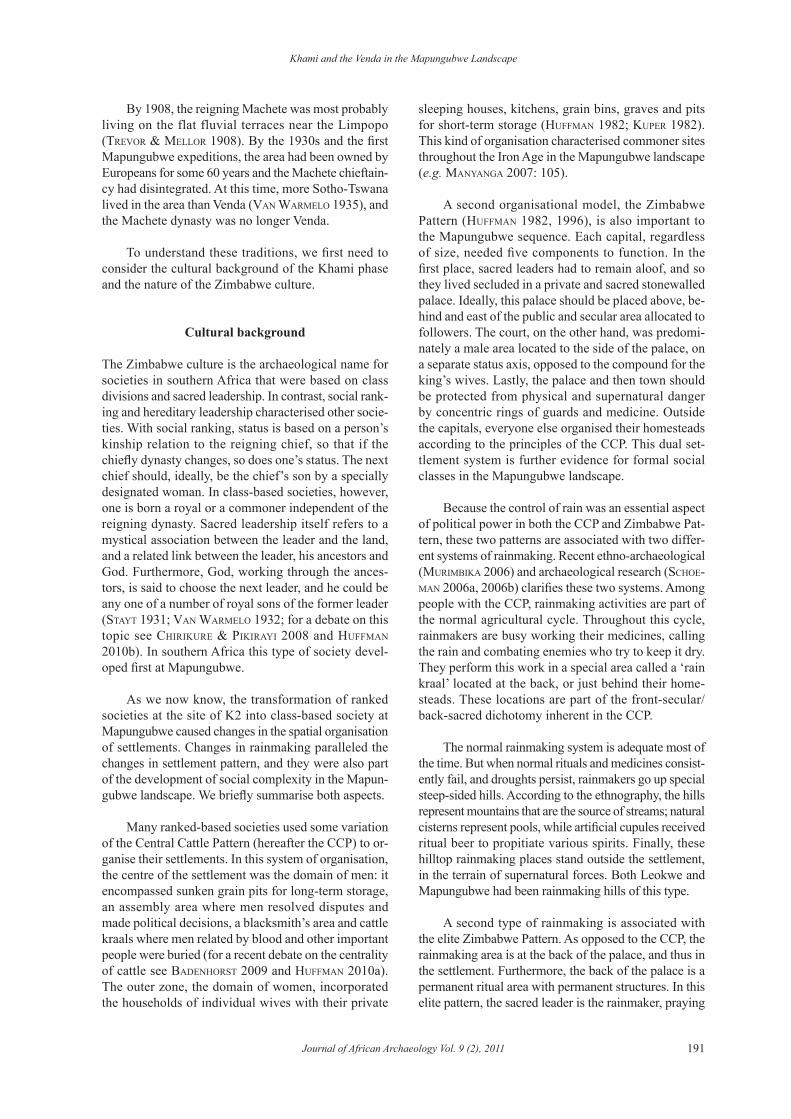
At about 1350 AD, some of the earliest Sotho-Tswana people moved into the Mapungubwe area. They are recognised by their distinctive pottery, known after the farm Icon where the pottery was first found (hanisch 1979). By about 1400 AD, Zimbabwe culture people of the Khami phase moved into the Limpopo Valley from the north. These two movements have a direct bearing on the origins of the Venda as well as the oral traditions.
The Khami phase (1400–1600 AD)
A few physical features distinguish Khami muzinda (plural = mizinda, the Shona word for a chief’s place) from Zimbabwe centres. For example, Khami palaces often bear check patterns, and the pottery usually in-corporates black and red motifs on globular vessels and tall-necked jars. The distribution of Khami markers and the linguistic history of the Zimbabwe culture area show that the Khami phase marks the distribution of Kalanga-speaking polities.
Radiocarbon dates from Khami itself (huffman 2007: 258–259), the name site (robinson 1959) for the phase and the largest capital (second only to Great Zimbabwe), suggest an early 15th century beginning. At about the same time, Kalanga groups began to move southwards. The Letsibogo district of Botswana (camp-beLL et al. 1996; huffman & Kinahan 2002/2003) provides one example.
Khami settlements first appear in the Mapungubwe landscape at this same time (Fig. 2). So far, there are some 255 commoner homesteads (Level 1 ― Family Head) on record. These homesteads probably housed some 50 people at any one time, 20–30 being children (following huffman 1986). There are 10 other hilltop sites with stonewalled palaces. These royal centres are all the same size (Level 3 ― Petty Chief), supporting about 350 people each, and each represents the head-
Fig. 2. Khami-period sites in the Mapungubwe landscape.
Khami and the Venda in the Mapungubwe Landscape
Journal of African Archaeology Vol. 9 (2), 2011 193
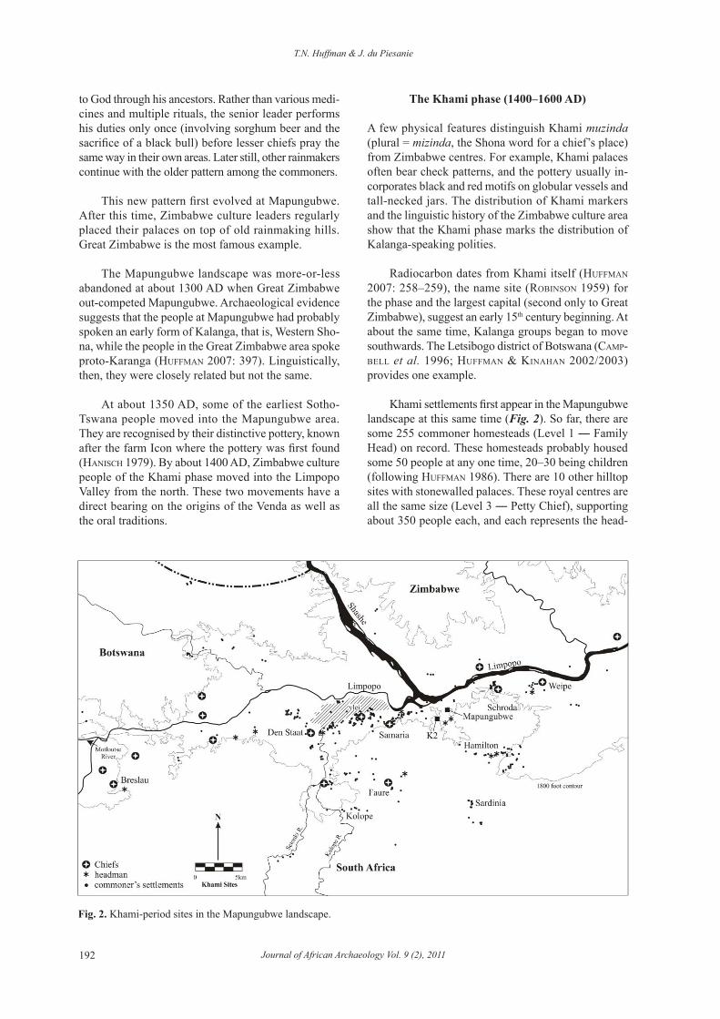
quarters of a small chiefdom (Fig. 3). Although each is somewhat different, each palace contained a minimum of three structures: a private audience chamber, a public messenger’s office and another office for the traditional doctor. As Figure 2 shows, there are too many Level-3 centres and too many commoner homesteads for them to have all been contemporaneous.
Radiocarbon dates (Tab. 1) and associated ceram-ics indicate there were two phases of occupation. The first dates to the early 15th century and the second to the mid 16th century. Presumably, climatic conditions contributed to the hiatus. The Mapungubwe landscape is only about 600 metres above sea level and therefore lies within a rainfall trough. The present-day average of 320–350 mm per year is not sufficiently reliable for the traditional cultivation of sorghums and mil-lets. If the valley was unsuitable for agriculture in the late 15th century, the people probably moved north
and returned only when the climate improved. Even within the second phase, however, some sites probably represent shifting settlements of the same chieftaincy.
To mark political boundaries, Shona and Venda people regularly use natural features such as rivers and mountain ranges (beach 1978; T. Murinye, pers. comm. 1989). If this principle held in the past, the Shashe and Limpopo rivers sepa-rated different districts, and there would have been at least three Level-3 mizinda around the conflu-ence at the same time: one in the Tuli Block of Botswana, one in the Maramani area of Zimbabwe and one near Mapungubwe.
As another principle, it is the boundaries of chiefdoms that are disputed, not the centre. Among other things, the capital is an ad-ministrative headquarters, allocat-ing agricultural land and providing a forum for legal disputes. Stray cattle in the fields, for example, are a ma-jor concern during the agricultural cycle. Such services need to be eas-ily accessible; otherwise the people may change their allegiance. This is why so many Level-3 centres are located near rivers, the source of the best agricultural lands.
Furthermore, chiefs send head-men to distant boundaries to provide essential services in the absence of a senior court. Chiefs are also anxious to maintain good relations with each other, and so they sometimes place one of their headmen near another chief’s capital (M. Murimbika, pers. comm. 2010).
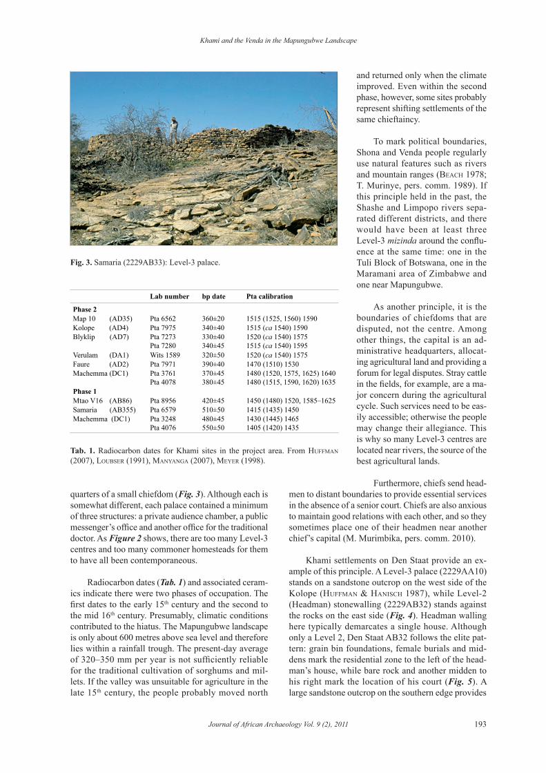
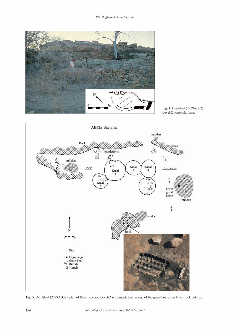
Khami settlements on Den Staat provide an ex-ample of this principle. A Level-3 palace (2229AA10) stands on a sandstone outcrop on the west side of the Kolope (huffman & hanisch 1987), while Level-2 (Headman) stonewalling (2229AB32) stands against the rocks on the east side (Fig. 4). Headman walling here typically demarcates a single house. Although only a Level 2, Den Staat AB32 follows the elite pat-tern: grain bin foundations, female burials and mid-dens mark the residential zone to the left of the head-man’s house, while bare rock and another midden to his right mark the location of his court (Fig. 5). A large sandstone outcrop on the southern edge provides
Fig. 3. Samaria (2229AB33): Level-3 palace.
Lab number bp date Pta calibration
Phase 2Map 10 (AD35) Pta 6562 360±20 1515 (1525, 1560) 1590Kolope (AD4) Pta 7975 340±40 1515 (ca 1540) 1590Blyklip (AD7) Pta 7273
Pta 7280330±40340±45
1520 (ca 1540) 15751515 (ca 1540) 1595
Verulam (DA1) Wits 1589 320±50 1520 (ca 1540) 1575Faure (AD2) Pta 7971 390±40 1470 (1510) 1530Machemma (DC1) Pta 3761
Pta 4078370±45380±45
1480 (1520, 1575, 1625) 16401480 (1515, 1590, 1620) 1635
Phase 1Mtao V16 (AB86) Pta 8956 420±45 1450 (1480) 1520, 1585–1625Samaria (AB355) Pta 6579 510±50 1415 (1435) 1450Machemma (DC1) Pta 3248
Pta 4076480±45550±50
1430 (1445) 14651405 (1420) 1435
Tab. 1. Radiocarbon dates for Khami sites in the project area. From huffman (2007), Loubser (1991), manyanga (2007), meyer (1998).
T.N. Huffman & J. du Piesanie
Journal of African Archaeology Vol. 9 (2), 2011194
Fig. 4. Den Staat (2229AB32): Level-2 house platform.
Fig. 5. Den Staat (2229AB32): plan of Khami-period Level-2 settlement. Inset is one of the game boards on lower rock outcrop.
Khami and the Venda in the Mapungubwe Landscape
Journal of African Archaeology Vol. 9 (2), 2011 195
further evidence for an important court. Numerous board games (mankala, tsoro) have been pecked into the surface, along with metal and cereal grinding hol-lows. The board games were played by men, often in and near the court, but the number here exceeds that expected for a normal homestead. Because a chief is also the headman for his own district, this headman’s court would have been an affront to the authority of the chief at AA10 ― if it was inside the same jurisdiction. Consequently, the Kolope River most likely formed another boundary, and there were two chiefdoms south of the confluence, bringing the total to four in the confluence area.
In the case of Den Staat, this proximity was prob-ably necessary because the Kolope delta formed part of the large vlei near the confluence that was a particularly rich agricultural zone. For this reason, many common-ers lived around the edge, and so a headman would be needed to provide the necessary services.
Another pair of elite walling (2229AB35 and 98) stands on either side of the small stream that flows past Mapungubwe Hill. gardner (1963: 70) identi-fied these as stone mounds associated with a Hottentot (Khoe) deity. Instead, the date and associated ceramics (meyer 1998: 178, 212) show they are both Level-2 hut platforms for Khami-period headmen. They prob-ably mark the boundary between two neighbourhoods. Elsewhere, Level-3 palaces on Schroda (2229AB8) and Weipe (2229AB34) probably belonged to the same chiefdom. Perhaps one was the capital while the head-man occupied Den Staat AB32, on the opposite side of the chieftaincy.
For present purposes, we are most concerned with the chieftaincy south of the confluence, stretching from the Kolope to Weipe. If it extended upstream to the rough country near the present Venetia diamond mine, this chiefdom covered about 400-450 km2. If the population number was similar to Level-3 chiefdoms in historic times, such as the Tlokwa (schapera 1943), then this area serviced some 1800–2000 people, about 650 of whom were adults at any one time. Overall, rainfall was sufficiently consistent during the second Khami phase for the cultivation of alluvial soils along the streams and vlei margin, and the Mapungubwe landscape supported a relatively high population through cereal agriculture.
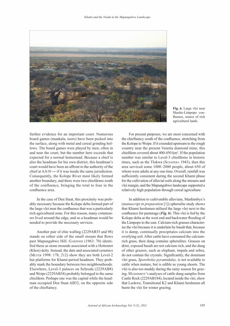
In addition to cultivatable alluvium, Mashimbye’s (manuscript in preparation [1]) spherulite study shows that Khami herdsmen utilised the large vlei next to the confluence for pasturage (Fig. 6). This vlei is fed by the Kolope delta at the west end and backwater flooding of the Limpopo to the east. Calcium-rich grasses character-ise the vlei because it is underlain by basalt that, because it is damp, continually precipitates calcium into the overlying soil. After cattle have consumed the calcium-rich grass, their dung contains spherulites. Grasses on drier, exposed basalt are not calcium rich, and the dung of other grazers, such as elephant, impala and zebra, do not contain the crystals. Significantly, the dominant vlei grass, Sporobolus pyramidalus, is not available to cattle when mature, but is edible as young shoots. The vlei is also too muddy during the rainy season for graz-ing. mashimbye’s analyses of cattle dung samples from Castle Rock (2229ab184), located inside the vlei, show that Leokwe, Transitional K2 and Khami herdsmen all burnt the vlei for winter grazing.
Fig. 6. Large vlei near Shashe-Limpopo con-fluence, source of rich agricultural lands.
T.N. Huffman & J. du Piesanie
Journal of African Archaeology Vol. 9 (2), 2011196
What is more, Khami society separated cattle posts from agriculturally-oriented homesteads. In contrast to homesteads, cattle posts were located some distance from cultivatable soil, and they contained few grain bins. The plateau to the south of Mapungubwe,
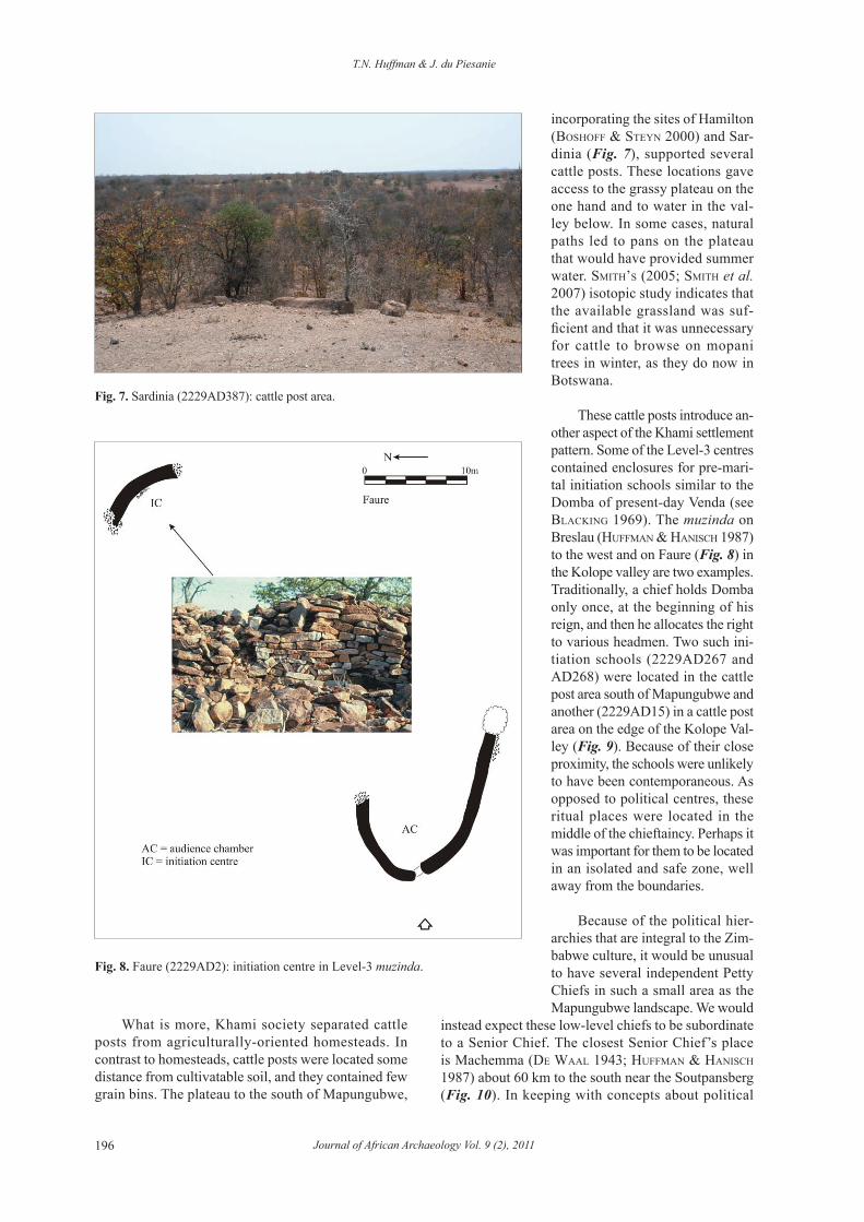
incorporating the sites of Hamilton (boshoff & steyn 2000) and Sar-dinia (Fig. 7), supported several cattle posts. These locations gave access to the grassy plateau on the one hand and to water in the val-ley below. In some cases, natural paths led to pans on the plateau that would have provided summer water. smith’s (2005; smith et al. 2007) isotopic study indicates that the available grassland was suf-ficient and that it was unnecessary for cattle to browse on mopani trees in winter, as they do now in Botswana.
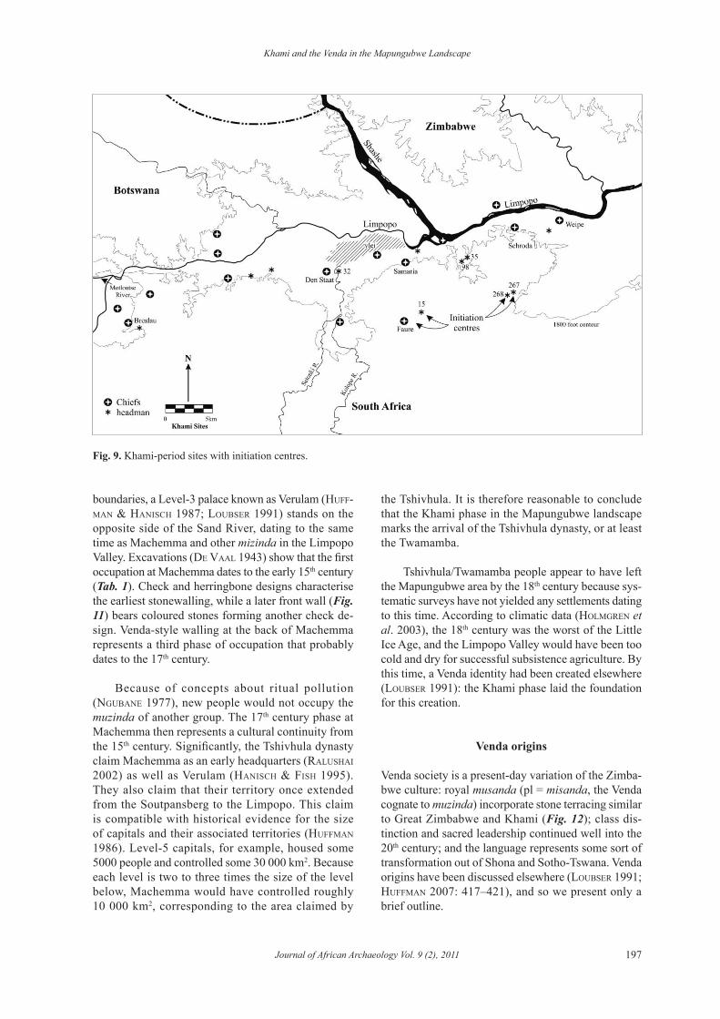
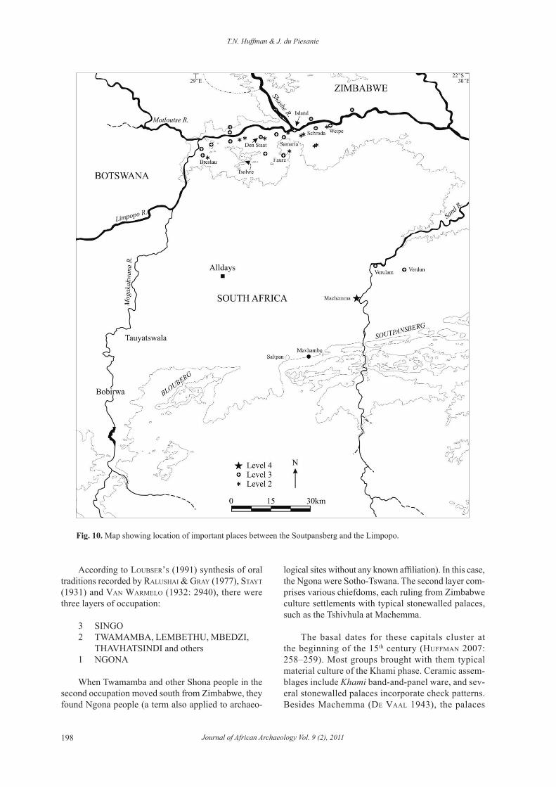
These cattle posts introduce an-other aspect of the Khami settlement pattern. Some of the Level-3 centres contained enclosures for pre-mari-tal initiation schools similar to the Domba of present-day Venda (see bLacKing 1969). The muzinda on Breslau (huffman & hanisch 1987) to the west and on Faure (Fig. 8) in the Kolope valley are two examples. Traditionally, a chief holds Domba only once, at the beginning of his reign, and then he allocates the right to various headmen. Two such ini-tiation schools (2229AD267 and AD268) were located in the cattle post area south of Mapungubwe and another (2229AD15) in a cattle post area on the edge of the Kolope Val-ley (Fig. 9). Because of their close proximity, the schools were unlikely to have been contemporaneous. As opposed to political centres, these ritual places were located in the middle of the chieftaincy. Perhaps it was important for them to be located in an isolated and safe zone, well away from the boundaries.
Because of the political hier-archies that are integral to the Zim-babwe culture, it would be unusual to have several independent Petty Chiefs in such a small area as the Mapungubwe landscape. We would
instead expect these low-level chiefs to be subordinate to a Senior Chief. The closest Senior Chief’s place is Machemma (de waaL 1943; huffman & hanisch 1987) about 60 km to the south near the Soutpansberg (Fig. 10). In keeping with concepts about political
Fig. 7. Sardinia (2229AD387): cattle post area.
Fig. 8. Faure (2229AD2): initiation centre in Level-3 muzinda.
Khami and the Venda in the Mapungubwe Landscape
Journal of African Archaeology Vol. 9 (2), 2011 197
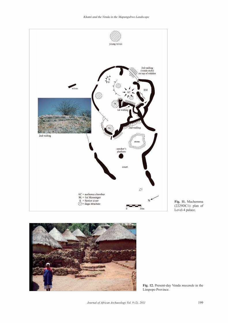
boundaries, a Level-3 palace known as Verulam (huff-man & hanisch 1987; Loubser 1991) stands on the opposite side of the Sand River, dating to the same time as Machemma and other mizinda in the Limpopo Valley. Excavations (de VaaL 1943) show that the first occupation at Machemma dates to the early 15th century (Tab. 1). Check and herringbone designs characterise the earliest stonewalling, while a later front wall (Fig. 11) bears coloured stones forming another check de-sign. Venda-style walling at the back of Machemma represents a third phase of occupation that probably dates to the 17th century.
Because of concepts about ritual pollution (ngubane 1977), new people would not occupy the muzinda of another group. The 17th century phase at Machemma then represents a cultural continuity from the 15th century. Significantly, the Tshivhula dynasty claim Machemma as an early headquarters (raLushai 2002) as well as Verulam (hanisch & fish 1995). They also claim that their territory once extended from the Soutpansberg to the Limpopo. This claim is compatible with historical evidence for the size of capitals and their associated territories (huffman 1986). Level-5 capitals, for example, housed some 5000 people and controlled some 30 000 km2. Because each level is two to three times the size of the level below, Machemma would have controlled roughly 10 000 km2, corresponding to the area claimed by
the Tshivhula. It is therefore reasonable to conclude that the Khami phase in the Mapungubwe landscape marks the arrival of the Tshivhula dynasty, or at least the Twamamba.
Tshivhula/Twamamba people appear to have left
the Mapungubwe area by the 18th century because sys-tematic surveys have not yielded any settlements dating to this time. According to climatic data (hoLmgren et al. 2003), the 18th century was the worst of the Little Ice Age, and the Limpopo Valley would have been too cold and dry for successful subsistence agriculture. By this time, a Venda identity had been created elsewhere (Loubser 1991): the Khami phase laid the foundation for this creation.
Venda origins
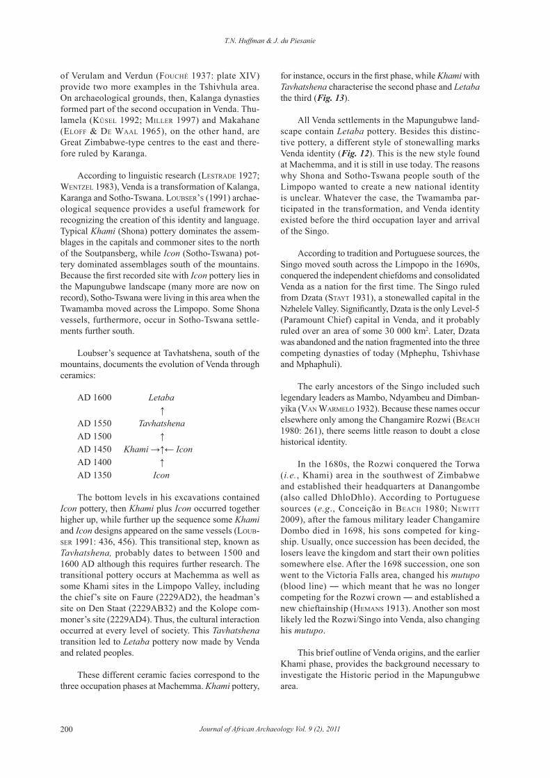
Venda society is a present-day variation of the Zimba-bwe culture: royal musanda (pl = misanda, the Venda cognate to muzinda) incorporate stone terracing similar to Great Zimbabwe and Khami (Fig. 12); class dis-tinction and sacred leadership continued well into the 20th century; and the language represents some sort of transformation out of Shona and Sotho-Tswana. Venda origins have been discussed elsewhere (Loubser 1991; huffman 2007: 417–421), and so we present only a brief outline.
Fig. 9. Khami-period sites with initiation centres.
T.N. Huffman & J. du Piesanie
Journal of African Archaeology Vol. 9 (2), 2011198
According to Loubser’s (1991) synthesis of oral traditions recorded by raLushai & gray (1977), stayt (1931) and Van warmeLo (1932: 2940), there were three layers of occupation:
3 SINGO2 TWAMAMBA, LEMBETHU, MBEDZI,
THAVHATSINDI and others1 NGONA
When Twamamba and other Shona people in the second occupation moved south from Zimbabwe, they found Ngona people (a term also applied to archaeo-
Fig. 10. Map showing location of important places between the Soutpansberg and the Limpopo.
logical sites without any known affiliation). In this case, the Ngona were Sotho-Tswana. The second layer com-prises various chiefdoms, each ruling from Zimbabwe culture settlements with typical stonewalled palaces, such as the Tshivhula at Machemma.
The basal dates for these capitals cluster at the beginning of the 15th century (huffman 2007: 258–259). Most groups brought with them typical material culture of the Khami phase. Ceramic assem-blages include Khami band-and-panel ware, and sev-eral stonewalled palaces incorporate check patterns. Besides Machemma (de VaaL 1943), the palaces
Khami and the Venda in the Mapungubwe Landscape
Journal of African Archaeology Vol. 9 (2), 2011 199
Fig. 11. Machemma (2229DC1): plan of Level-4 palace.
Fig. 12. Present-day Venda musanda in the Limpopo Province.
T.N. Huffman & J. du Piesanie
Journal of African Archaeology Vol. 9 (2), 2011200
of Verulam and Verdun (fouché 1937: plate XIV) provide two more examples in the Tshivhula area. On archaeological grounds, then, Kalanga dynasties formed part of the second occupation in Venda. Thu-lamela (KüseL 1992; miLLer 1997) and Makahane (eLoff & de waaL 1965), on the other hand, are Great Zimbabwe-type centres to the east and there-fore ruled by Karanga.
According to linguistic research (Lestrade 1927; wentzeL 1983), Venda is a transformation of Kalanga, Karanga and Sotho-Tswana. Loubser’s (1991) archae-ological sequence provides a useful framework for recognizing the creation of this identity and language. Typical Khami (Shona) pottery dominates the assem-blages in the capitals and commoner sites to the north of the Soutpansberg, while Icon (Sotho-Tswana) pot-tery dominated assemblages south of the mountains. Because the first recorded site with Icon pottery lies in the Mapungubwe landscape (many more are now on record), Sotho-Tswana were living in this area when the Twamamba moved across the Limpopo. Some Shona vessels, furthermore, occur in Sotho-Tswana settle-ments further south.
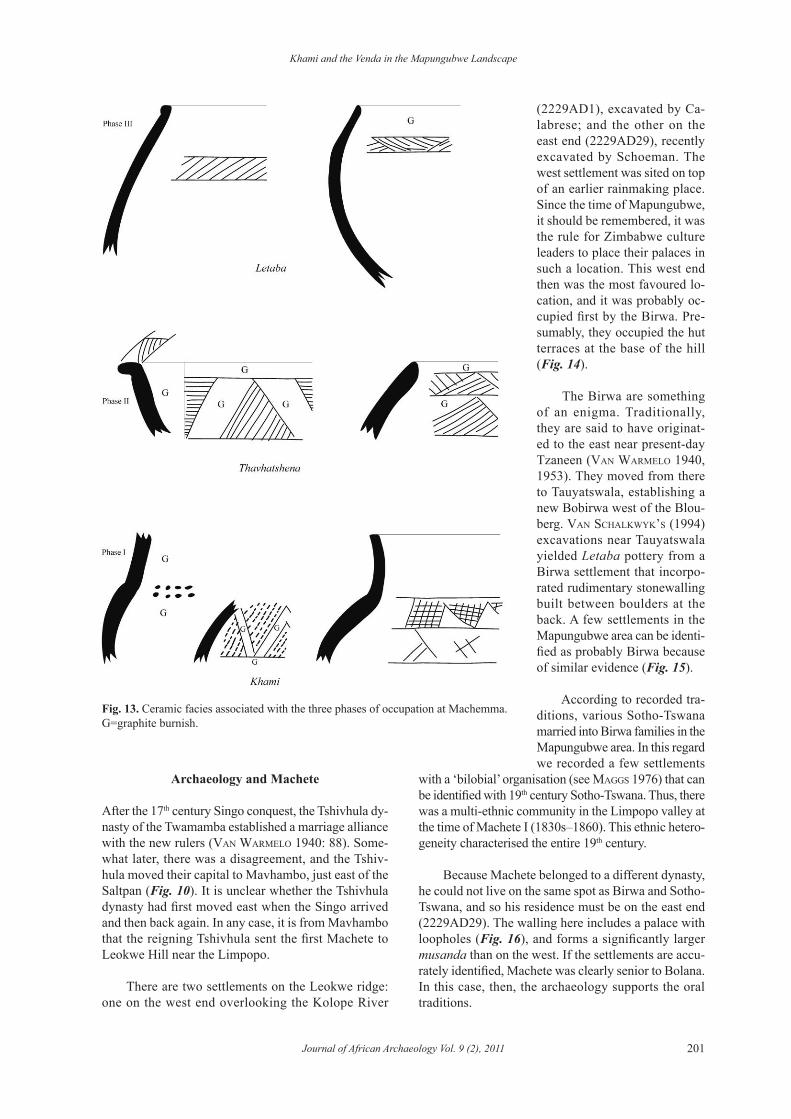
Loubser’s sequence at Tavhatshena, south of the mountains, documents the evolution of Venda through ceramics:
AD 1600 Letaba ↑AD 1550 TavhatshenaAD 1500 ↑AD 1450 Khami →↑← IconAD 1400 ↑AD 1350 Icon
The bottom levels in his excavations contained Icon pottery, then Khami plus Icon occurred together higher up, while further up the sequence some Khami and Icon designs appeared on the same vessels (Loub-ser 1991: 436, 456). This transitional step, known as Tavhatshena, probably dates to between 1500 and 1600 AD although this requires further research. The transitional pottery occurs at Machemma as well as some Khami sites in the Limpopo Valley, including the chief’s site on Faure (2229AD2), the headman’s site on Den Staat (2229AB32) and the Kolope com-moner’s site (2229AD4). Thus, the cultural interaction occurred at every level of society. This Tavhatshena transition led to Letaba pottery now made by Venda and related peoples.
These different ceramic facies correspond to the three occupation phases at Machemma. Khami pottery,
for instance, occurs in the first phase, while Khami with Tavhatshena characterise the second phase and Letaba the third (Fig. 13).
All Venda settlements in the Mapungubwe land-scape contain Letaba pottery. Besides this distinc-tive pottery, a different style of stonewalling marks Venda identity (Fig. 12). This is the new style found at Machemma, and it is still in use today. The reasons why Shona and Sotho-Tswana people south of the Limpopo wanted to create a new national identity is unclear. Whatever the case, the Twamamba par-ticipated in the transformation, and Venda identity existed before the third occupation layer and arrival of the Singo.
According to tradition and Portuguese sources, the Singo moved south across the Limpopo in the 1690s, conquered the independent chiefdoms and consolidated Venda as a nation for the first time. The Singo ruled from Dzata (stayt 1931), a stonewalled capital in the Nzhelele Valley. Significantly, Dzata is the only Level-5 (Paramount Chief) capital in Venda, and it probably ruled over an area of some 30 000 km2. Later, Dzata was abandoned and the nation fragmented into the three competing dynasties of today (Mphephu, Tshivhase and Mphaphuli).
The early ancestors of the Singo included such legendary leaders as Mambo, Ndyambeu and Dimban-yika (Van warmeLo 1932). Because these names occur elsewhere only among the Changamire Rozwi (beach 1980: 261), there seems little reason to doubt a close historical identity.
In the 1680s, the Rozwi conquered the Torwa (i.e., Khami) area in the southwest of Zimbabwe and established their headquarters at Danangombe (also called DhloDhlo). According to Portuguese sources (e.g., Conceição in beach 1980; newitt 2009), after the famous military leader Changamire Dombo died in 1698, his sons competed for king-ship. Usually, once succession has been decided, the losers leave the kingdom and start their own polities somewhere else. After the 1698 succession, one son went to the Victoria Falls area, changed his mutupo (blood line) ― which meant that he was no longer competing for the Rozwi crown ― and established a new chieftainship (hemans 1913). Another son most likely led the Rozwi/Singo into Venda, also changing his mutupo.
This brief outline of Venda origins, and the earlier Khami phase, provides the background necessary to investigate the Historic period in the Mapungubwe area.
Khami and the Venda in the Mapungubwe Landscape
Journal of African Archaeology Vol. 9 (2), 2011 201
Archaeology and Machete
After the 17th century Singo conquest, the Tshivhula dy-nasty of the Twamamba established a marriage alliance with the new rulers (Van warmeLo 1940: 88). Some-what later, there was a disagreement, and the Tshiv-hula moved their capital to Mavhambo, just east of the Saltpan (Fig. 10). It is unclear whether the Tshivhula dynasty had first moved east when the Singo arrived and then back again. In any case, it is from Mavhambo that the reigning Tshivhula sent the first Machete to Leokwe Hill near the Limpopo.
There are two settlements on the Leokwe ridge: one on the west end overlooking the Kolope River
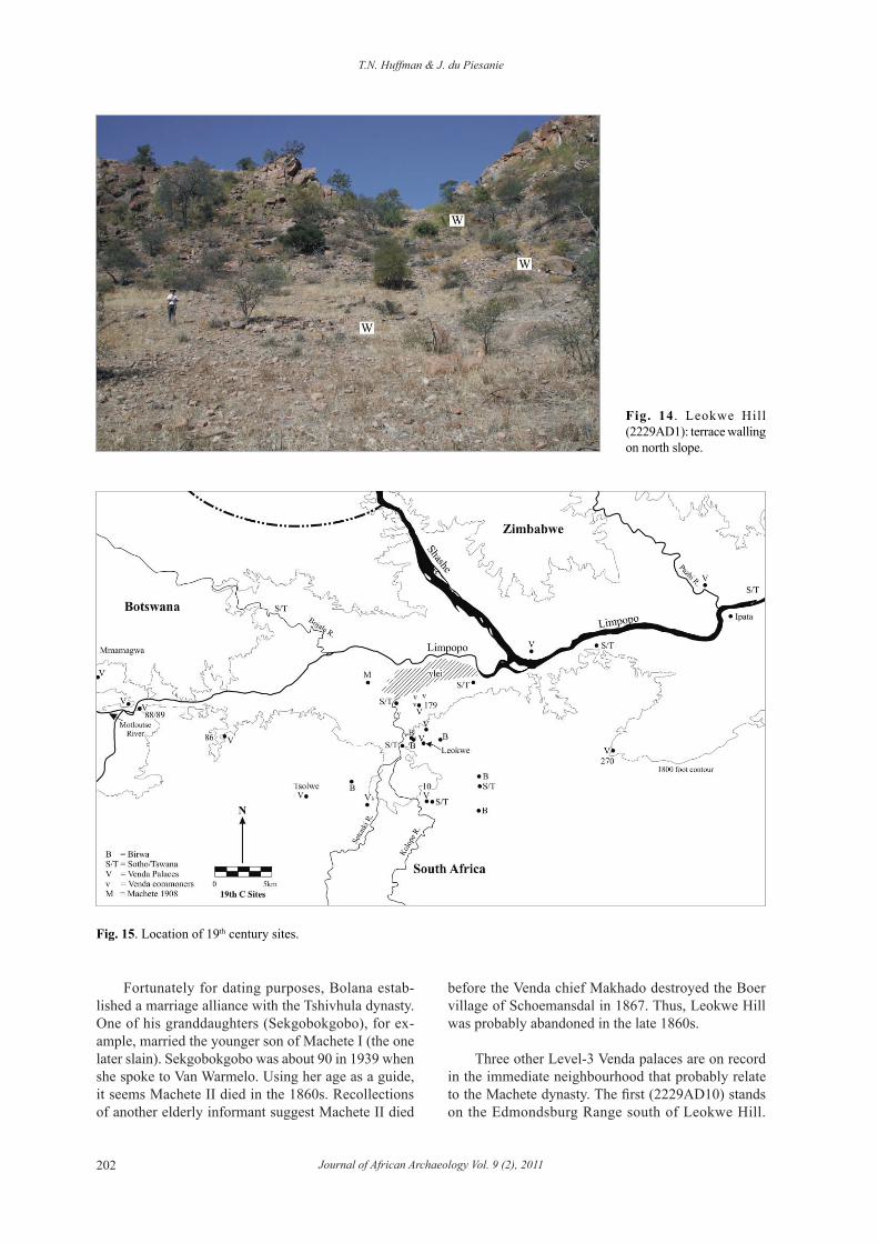
(2229AD1), excavated by Ca-labrese; and the other on the east end (2229AD29), recently excavated by Schoeman. The west settlement was sited on top of an earlier rainmaking place. Since the time of Mapungubwe, it should be remembered, it was the rule for Zimbabwe culture leaders to place their palaces in such a location. This west end then was the most favoured lo-cation, and it was probably oc-cupied first by the Birwa. Pre-sumably, they occupied the hut terraces at the base of the hill (Fig. 14).
The Birwa are something of an enigma. Traditionally, they are said to have originat-ed to the east near present-day Tzaneen (Van warmeLo 1940, 1953). They moved from there to Tauyatswala, establishing a new Bobirwa west of the Blou-berg. Van schaLKwyK’s (1994) excavations near Tauyatswala yielded Letaba pottery from a Birwa settlement that incorpo-rated rudimentary stonewalling built between boulders at the back. A few settlements in the Mapungubwe area can be identi-fied as probably Birwa because of similar evidence (Fig. 15).
According to recorded tra-ditions, various Sotho-Tswana married into Birwa families in the Mapungubwe area. In this regard we recorded a few settlements
with a ‘bilobial’ organisation (see maggs 1976) that can be identified with 19th century Sotho-Tswana. Thus, there was a multi-ethnic community in the Limpopo valley at the time of Machete I (1830s–1860). This ethnic hetero-geneity characterised the entire 19th century.
Because Machete belonged to a different dynasty, he could not live on the same spot as Birwa and Sotho-Tswana, and so his residence must be on the east end (2229AD29). The walling here includes a palace with loopholes (Fig. 16), and forms a significantly larger musanda than on the west. If the settlements are accu-rately identified, Machete was clearly senior to Bolana. In this case, then, the archaeology supports the oral traditions.
Fig. 13. Ceramic facies associated with the three phases of occupation at Machemma. G=graphite burnish.
T.N. Huffman & J. du Piesanie
Journal of African Archaeology Vol. 9 (2), 2011202
Fortunately for dating purposes, Bolana estab-lished a marriage alliance with the Tshivhula dynasty. One of his granddaughters (Sekgobokgobo), for ex-ample, married the younger son of Machete I (the one later slain). Sekgobokgobo was about 90 in 1939 when she spoke to Van Warmelo. Using her age as a guide, it seems Machete II died in the 1860s. Recollections of another elderly informant suggest Machete II died
Fig. 14 . Leokwe Hill (2229AD1): terrace walling on north slope.
Fig. 15. Location of 19th century sites.
before the Venda chief Makhado destroyed the Boer village of Schoemansdal in 1867. Thus, Leokwe Hill was probably abandoned in the late 1860s.
Three other Level-3 Venda palaces are on record in the immediate neighbourhood that probably relate to the Machete dynasty. The first (2229AD10) stands on the Edmondsburg Range south of Leokwe Hill.

Khami and the Venda in the Mapungubwe Landscape
Journal of African Archaeology Vol. 9 (2), 2011 203
This capital includes a cattle kraal and evidence for a commoner population. A second palace (2229AD270) is located on Kilsyth; and the third (2229AB179) over-looks the large vlei on Den Staat. The last two have yielded blue hexagonal glass beads that first appear in the region in the 1860s or 70s (wood 2005). Further, AB179 has yielded Martini-Henry cartridges that also date to the late 19th century, prior to the Anglo-Boer War. Because Leokwe west was abandoned after the unusual death of Machete II, one of these other three misanda would have been the next capital.
The Limpopo, it should be noted, still formed a po-litical boundary. Other Venda misanda on the north side of the river, for example, date to about the same time. The best known stands on Mmamagwa Hill (2229AA4) near the Motloutse and Limpopo confluence. A second stands on the sandstone ridge at the confluence itself, opposite another musanda (2229AA88/89) inside South Africa. A fourth (2229AA86) overlooks a stream a few kilometres away. In all four, roughly-coursed walls incorporate loopholes and the residential areas have yielded Letaba pottery, maize grindstones and 19th century glass, such as blue hexagonal and blue annular beads (fouché 1937: 49). If this distribution followed the known Venda pattern, Mmamagwa would have been the capital of a dynasty in Botswana separate from the three inside South Africa, and all were separate from Machete. Other Venda misanda were built near the Limpopo in Zimbabwe, and they too must belong to separate chiefdoms. Because populations were lower than in the Khami period, it is unclear whether Venda territories in the Limpopo Valley were smaller. What-ever the size, because they followed the same logic, the distributions of Khami mizinda and Venda misanda are remarkably similar.
Unfortunately, after the unusual death of Machete II, the Machete chieftaincy disappears from the oral record. The chieftaincy, we know, had disappeared politically by the 1930s and the time of the Mapun-gubwe expeditions. A variety of factors contributed to its decline and eventual disappearance. Climatically, the Mapungubwe landscape was not as productive in the 19th century as it had been in the Khami phase. Nineteenth-century climate instead appears to have been similar to the present, which is dry, with marked variability between wet and dry years and a tendency for severe summer thunderstorms (tyson & preston-whyte 2000). Birwa and Venda settlements reflect these poor conditions. In contrast to the Khami phase, there are few (perhaps only three) commoner Venda settlements on record: the remainder are all capitals. Perhaps some Birwa and Sotho-Tswana settlements were contemporaneous, but there were few of them. This is not a sampling problem because the present project area has been extensively covered.
The relatively large number of Venda capitals for such a short period (about 60 years) suggests that resources were quickly exhausted, and people had to shift to better ground. Most settlements associated with Machete cluster near the Kolope, suggesting it was the most reliable source of water and culti-vatable soil. The one chiefdom-one capital pattern at this time shows that only some 500–600 people were living on the same land that had previously supported 2000. Clearly, the landscape could only support small numbers of subsistence farmers in the 19th century.
Various other factors further contributed to the disintegration of the Machete chiefdom. European
Fig. 16. Leokwe Hill (2229AD29): loophole in front wall of the palace of Machete I and II.
T.N. Huffman & J. du Piesanie
Journal of African Archaeology Vol. 9 (2), 2011204
occupation began in the early 1870s, for example, followed by the Rinderpest epidemic in 1896–1898 and the Anglo Boer War from 1899 to 1902. Moreo-ver, the power of Sotho-Tswana chiefdoms elsewhere (Loubser 1991) helped to cause a change in language and cultural identity.
treVor & meLLor’ s (1908) geological tour of the Limpopo Valley establishes the probable location of Machete after the Anglo Boer War. Their route across the fluvial flats passes Machete’s village which matches our site 2229AA46 (M on Fig. 15). What-ever the correct location, it is significant that no set-tlement in this flat zone has a stonewalled palace or even terracing. Because stonewalling is a defining characteristic of Venda misanda, the Machete chief-dom by this time was no longer Venda. Indeed, since at least the 1930s, the Tshivula dynasty has been known as Sebola, their Sotho name (Van warmeLo 1935, 1940).
Considerably more investigation is needed to un-derstand the decline of the Machete chiefdom. From a theoretical perspective, the relationship between lan-guage and material culture change is worthy of further consideration. We do not yet know, for example, what happened to the material culture of the Machete com-munity as it changed from Venda to Sotho. To address this issue, 19th century African material culture needs to be better known.
As the present case study shows, historical ar-chaeology and Iron Age research are not conceptually different. Despite differences in detail, the same princi-ples apply to both Khami and Venda settlements ― in particular those concerned with political boundaries, pollution and leadership. Moreover, not only does the Khami phase grade into the Historic period, the nature of the Zimbabwe culture provides a necessary back-ground to the Khami phase, which, in turn, lays the foundation for understanding Venda origins. All were essential to the historical archaeology of the Mapun-gubwe landscape.
Acknowledgements
We thank Jan Boeyens, Leon Jacobson, David Lewis-Williams and Gavin Whitelaw for comments on the manuscript. Wendy Voorvelt prepared the illustrations. Our research has been sponsored by De Beers, South African National Parks and the South African National Research Foundation.
References
Badenhorst, S. 2009. The central cattle pattern during the Iron Age of southern Africa: a critique of its spatial features. South African Archaeological Bulletin 64, 148–155.
Beach, D.N. 1978. Shona settlement around the Buhwa Range. Occasional Papers of the National Museums of Rhodesia, Series A, Human Sciences 4, 106–111.
Beach, D.N. 1980. The Shona and Zimbabwe 900–1850. Mambo Press, Gwelo [Gweru].
Blacking, J. 1969. Songs, dances, mimes and symbolism of Venda girls’ initiation schools. Part 1: Vhusha. Part 2: Milayo. Part 3: Domba. Part 4: The great Domba song. African Studies 28, 28–35, 69–18, 149–199, 215–266.
Boshoff, W. & Steyn, M. 2000. A human grave from the Farm Ha-milton in the Limpopo River Valley (South Africa). Southern African Field Archaeology 9, 68–74.
Campbell, A.C., Kinahan, J. & Van Waarden, C. 1996. Archae-ological sites at Letsibogo Dam. Botswana Notes & Record 28, 47–53.
Calabrese, J.A. 2007. The Emergence of Social and Political Complexity in the Shashi-Limpopo Valley of Southern Africa, AD 900 to 1300. Ethnicity, Class, and Polity. BAR Inter-national Series 1617. Cambridge Monographs in African Archaeology 69. Archaeopress, Oxford.
Chirikure, S. & Pikirayi, I. 2008. Inside and outside the dry stone walls: revisiting the material culture of Great Zimbabwe. Antiquity 82, 976–993.
De Waal, J.B. 1943. ‘n Soutpansbergse Zimbabwe. South African Journal of Science 40, 303–327.
Du Piesanie, J. 2008. Understanding the Socio-Political Status of Le-okwe Society during the Middle Iron Age in the Shashe-Limpopo Basin through a Landscape Approach. Unpublished Masters Thesis, University of the Witwatersrand, Johannesburg.
Eloff, J.F. & De Vaal, J.B. 1965. Makahane. Koedoe 8, 68–74.
Fatherley, K. 2009. Sociopolitical Status of Leokwe People in the Shashi-Limpopo Basin during the Middle Iron Age through Faunal Analysis. Unpublished Masters Thesis, University of the Witwatersrand, Johannesburg.
Fouché, L. (ed.) 1937. Mapungubwe: Ancient Bantu Civilization on the Limpopo. Cambridge University Press, Cambridge.
Gardner, G.A. 1963. Mapungubwe: Volume II. J.L. Van Schaik, Pretoria.
Hanisch, E.O.M. 1979. Excavations at Icon, northern Transvaal. In: Van der Merwe, N.J. & Huffman, T.N. (eds.), Iron Age Studies in Southern Africa. South African Archaeological Society Goodwin Series 3, pp. 72–79.
Hanisch, E. & Fish, W. 1995. The Venetia-Limpopo Nature Re-serve. Its History and Archaeological Potential. University of Venda and Schoemansdal Museum.
Khami and the Venda in the Mapungubwe Landscape
Journal of African Archaeology Vol. 9 (2), 2011 205
Hemans, H.N. 1913. The history, the sociology, and the folklore and religion of the Abenanzwa Tribe. Proceedings of the Rhodesian Scientific Association 12, 85–112.
Holmgren, K., Lee-Thorp, J.A., Cooper, G.R., Lundblad, K., Partridge, T.C., Scott, L., Sithaldeen, R., Talma, A.S. & Tyson, P.D. 2003. Persistent millennial-scale climatic variability over the last 25,000 years in Southern Africa. Quaternary Science Reviews 22, 2311–2326.
Huffman, T.N. 1982. Archaeology and ethnohistory of the African Iron Age. Annual Review of Anthropology 11, 133–150.
Huffman, T.N. 1986. Archaeological evidence and conventional explanations of Southern Bantu settlement patterns. Africa 56 (3), 280–298.
Huffman, T.N. 1996. Snakes & Crocodiles: Power and Symbo-lism in Ancient Zimbabwe. Witwatersrand University Press, Johannesburg.
Huffman, T.N. 2000. Mapungubwe and the origins of the Zimb-abwe culture. In: Leslie, M. & Maggs, T. (eds.), African Nais-sance: The Limpopo Valley 1 000 Years Ago. South African Archaeological Society Goodwin Series 8, pp. 14–29.
Huffman, T.N. 2007. Handbook to the Iron Age: The Archaeology of Pre-Colonial Farming Societies in Southern Africa. Uni-versity of KwaZulu-Natal Press, Pietermaritzburg.
Huffman, T.N. 2009. A cultural proxy for drought: ritual burning in the Iron Age of southern Africa. Journal of Archaeological Science 36 (4), 991–1005.
Huffman, T.N. 2010a. Debating the central cattle pattern: a reply to Badenhorst. South African Archaeological Bulletin 65, 164–174.
Huffman, T.N. 2010b. Revisiting Great Zimbabwe: a reply to Chirikure & Pikirayi. Azania 45 (3), 321–328.
Huffman, T.N. & Hanisch, E.O.M. 1987. Settlement hierarchies in the northern Transvaal: Zimbabwe ruins and Venda history. African Studies 46 (1), 79–116.
Huffman, T.N. & Kinahan, J. 2002/2003. Archaeological mitiga-tion of the Letsibogo Dam: agropastoralism in southeast Bots-wana. Southern African Field Archaeology 11/12, 4–63.
Kuper, A. 1982. Wives for Cattle: Bridewealth and Marriage in Southern Africa. Routledge and Kegan Paul London.
Küsel, M. 1992. A preliminary report on settlement layout and gold mining at Thula Mela, a Late Iron Age site in the Kruger National Park. Koedoe 35 (1), 55–64.
Lestrade, G.P. 1927. Some notes on the ethnic history of the Ba-Venda and their Rhodesian affinities. South African Journal of Science 24, 486–495.
Loubser, J.H.N. 1991. The Ethnoarchaeology of Venda-Speakers in Southern Africa. Navorsinge van die Nasionale Museum Bloemfontein 7 (8), 145–464.
Maggs, T.M. 1976. Iron Age Communities of the Southern Highveld. Occasional Publication 2. Natal Museum, Pieter-maritzberg.
Manyanga, M. 2007. Resilient Landscapes: Socio-environmental Dynamics in the Shashi-Limpopo Basin, Southern Zimbabwe c. AD 800 to the Present. Studies in Global Archaeology 11. Department of Archaeology and Ancient History, Uppsala University, Uppsala.
Meyer, A. 1998. The Archaeological Sites of Greefswald: Stratigraphy and Chronology of the Sites and a History of Investigations. University of Pretoria, Pretoria.
Miller, S.M. 1997. Gold Fields Thulamela Project. Unpublis-hed manuscript, on file. South African National Parks, Pretoria.
Murimbika, M.T. 2006. Sacred Powers and Rituals of Trans-formation: An Ethnoarchaeological Study of Rainmaking Rituals and Agricultural Productivity during the Evolution of the Mapungubwe State, AD 1000 to AD 1300. Unpu-blished Ph.D. Thesis, University of the Witwatersrand, Johannesburg.
Newitt, M. 2009. Treatise on the Rivers of Cuama (Tratado dos Rios de Cuama) by António da Conceição. Sources of African History 9. OUP for The British Academy, Oxford.
Ngubane, H. 1977. Body and Mind in Zulu Medicine. Academic Press, London.
Ralushai, N.M.N. 2002. A Preliminary Report on the Oral History of Mapungubwe. Department of Environmental Affairs & Tourism, Sibasa.
Ralushai, N.M.N. & Gray, J.R. 1977. Ruins and traditions of the Ngona and the Mbedzi among the Venda of the northern Transvaal. Rhodesian History 8, 1–11.
Robinson, K.R. 1959. Khami Ruins. Cambridge University Press, Cambridge.
Schapera, I. 1943. Native Land Tenure in the Bechuanaland Protectorate. Lovedale Press, Alice.
Schoeman, M.H. 2006a. Clouding Power? Rain Control Space, Landscapes and Ideology in Shashe-Limpopo State Formati-on. Unpublished Ph.D. Thesis, University of the Witwaters-rand, Johannesburg.
Schoeman, M.H. 2006b. Imagining rain-places: rain-control and changing ritual landscapes in the Shashe-Limpopo confluence area, South Africa. South African Archaeological Bulletin 61, 152–165.
Smith, J. 2005. Climate Change and Agropastoral Sustaina-bility in the Shashe-Limpopo River Basin from AD 900. Unpublished Ph.D. Thesis, University of the Witwatersrand, Johannesburg.
Smith, J., Lee-Thorp, J. & Hall, S. 2007. Climate change and agropastoralist settlement in the Shashe-Limpopo River Basin, southern Africa: AD 880 to 1700. South African Archaeological Bulletin 62, 115–125.
Smith, J., Lee-Thorp, J., Prevec, S., Hall, S. & Späth, A. 2010. Pre-Colonial herding strategies in the Shashi-Limpopo Basin, southern Africa, based on strontium isotope analysis of domestic fauna. Journal of African Archaeology 8 (1), 83–98.
T.N. Huffman & J. du Piesanie
Journal of African Archaeology Vol. 9 (2), 2011206
Stayt, H.A. 1931. The Bavenda. Oxford University Press for the International African Institute, Oxford.
Trevor, T.G. & Mellor, E.T. 1908. Report on the Reconnaissance of the North-western Zoutpansberg District. Transvaal Mines Department. Government Printer, Pretoria.
Tyson, P.D. & Preston-Whyte, R.A. 2000. The Weather and Cli-mate of Southern Africa. Oxford University Press Southern Africa (Second Edition), Cape Town.
Van Schalkwyk, J.A. 1994. Randjies: report on excavations of a Late Iron Age site on the Mogalakwena River, northwestern Transvaal. Research by the National Cultural History Museum 3, 100–118.
Van Warmelo, N.J. 1932. Contributions towards Venda History, Religion and Tribal Ritual. Ethnological Publication 3. Go-vernment Printer, Pretoria.
Van Warmelo, N.J. 1935. A Preliminary Survey of the Bantu Tribes of South Africa. Ethnological Publication 5. Govern-ment Printer, Pretoria.
Van Warmelo, N.J. 1940. The Copper Miners of Musina and the Early History of the Zoutpansberg. Ethnological Publication 8. Government Printer, Pretoria.
Van Warmelo, N.J. 1953. Die Tlokwa en Birwa van Noord-Transvval. Ethnological Publication 29. Government Printer, Pretoria.
Wentzel, P.J. 1983. The Relationship between Venda and Western Shona (vol. 3). University of South Africa, Pre-toria.
Wood, M. 2000. Making connections: relationships between international trade and glass beads from the Shashe-Limpopo area. In: Leslie, M. & Maggs, T. (eds.), African Naissance: The Limpopo Valley 1 000 Years Ago. South African Archaeological Society Goodwin Series 8, pp. 78–90.
Wood, M. 2005. Glass Beads and Pre-European Trade in the Shashe-Limpopo Region. Unpublished Masters Thesis, University of the Witwatersrand, Johannesburg.
Manuscript in preparation
[1] Mashimbye, P.M. Spherulites as Evidence for Herding Stra-tegies in the Mapungubwe Cultural Landscape. MSc Thesis, University of the Witwatersrand, Johannesburg.