Understanding the linkages: Climate Change and biodiversity in the Kangchenjunga Landscape
Upload
khangminh22Category
view
2download
0

Linkages in the LandscapeLinkages in the Landscape

IUCN’S FOREST CONSERVATION PROGRAMME
IUCN’s Forest Conservation Programme coordinates and supports the activities of the IUCNSecretariat and members working with forest ecosystems. The goal of forest conservation isachieved through promoting protection, restoration and sustainable use of forest resources, sothat forests provide the full potential range of goods and services.
The programme makes contributions to policy at various levels and uses field projects toderive lessons to feed into the policy debate. The principles of Caring for the Earth, publishedjointly by IUCN, WWF and UNEP in 1991, are applied to these projects, which combine theneeds of conservation and those of local communities. One major activity is to developcoherent and informed policies on forest conservation in order to advocate the translation ofpolicies into effective actions. IUCN frequently advises major development institutions onforest issues, to ensure that conservation priorities are adequately addressed in their projectsand programmes. The Forest Conservation Programme receives generous financial supportfrom the Government of the Netherlands.

The IUCN Forest Conservation Programme
Linkages in the Landscape
The Role of Corridors and Connectivityin Wildlife Conservation
Andrew F. Bennett
School of Ecology and EnvironmentDeakin University – Melbourne Campus,
Burwood, Victoria 3125, Australia
IUCN – The World Conservation Union2003

The designation of geographical entities in this book, and the presentation of the material, donot imply the expression of any opinion whatsoever on the part of IUCN or EnvironmentAustralia concerning the legal status of any country, territory, or area, or of its authorities, orconcerning the delimitation of its frontiers or boundaries.
The views expressed in this publication do not necessarily reflect those of IUCN orEnvironment Australia.
This publication has been made possible in part by funding from Environment Australia.
Published by: IUCN, Gland, Switzerland and Cambridge, UK
Copyright: © 1999, 2003 International Union for Conservation of Nature and NaturalResources
First published 1999Second edition 2003
Reproduction of this publication for educational or other non-commercialpurposes is authorized without prior written permission from the copyrightholder provided the source is fully acknowledged.
Reproduction of this publication for resale or other commercial purposes isprohibited without prior written permission of the copyright holder.
Citation: Bennett, A.F. (1998, 2003). Linkages in the Landscape: The Role of
Corridors and Connectivity in Wildlife Conservation. IUCN, Gland,Switzerland and Cambridge, UK. xiv + 254 pp.
ISBN: 2-8317-0744-7
Cover design by: Patricia Halladay and IUCN Publications Services Unit, from an originaldesign by McHale Ward Associates, Hertfordshire
Cover photo: Tony Stone Images, London
Layout by: Bookcraft Ltd, Stroud, UK
Produced by: IUCN Publications Services Unit, UK
Printed by: Thanet Press Ltd, Margate, UK
Available from: IUCN Publications Services Unit219c Huntingdon Road, Cambridge CB3 0DL, UKTel: +44 1223 277894, Fax: +44 1223 277175E-mail: [email protected]/bookstore
A catalogue of IUCN publications is also available
The text of this book is printed on 90gsm Fineblade Extra made from low-chlorine pulp
Biodiversity Group

CONTENTS
Foreword . . . . . . . . . . . . . . . . . . . . . . . . . . . . . . . . . . . . . . . . . . ixPreface to the first edition . . . . . . . . . . . . . . . . . . . . . . . . . . . . . . . . xiii
PART 1 DEFINING THE ISSUES
1 Responding to an Issue of Global Concern . . . . . . . . . . . . . . . . . . . . . . 3Habitat change in human-dominated landscapes . . . . . . . . . . . . . . . . . . . . 3Corridors and controversy . . . . . . . . . . . . . . . . . . . . . . . . . . . . . . . 5Connectivity . . . . . . . . . . . . . . . . . . . . . . . . . . . . . . . . . . . . . . . 8Scope of this book . . . . . . . . . . . . . . . . . . . . . . . . . . . . . . . . . . . . 9
2 Habitat Fragmentation and the Consequences for Wildlife . . . . . . . . . . . . . 13Fragmentation and changes to landscape pattern . . . . . . . . . . . . . . . . . . . 13Effects of fragmentation on wildlife . . . . . . . . . . . . . . . . . . . . . . . . . . 20Is isolation of habitats important? . . . . . . . . . . . . . . . . . . . . . . . . . . . 32
3 Approaches to Understanding the Benefits of Connectivity. . . . . . . . . . . . . 37Natural history and wildlife management . . . . . . . . . . . . . . . . . . . . . . . 37Equilibrium theory of island biogeography . . . . . . . . . . . . . . . . . . . . . . 38Dynamics of subdivided populations . . . . . . . . . . . . . . . . . . . . . . . . . . 40Landscape ecology . . . . . . . . . . . . . . . . . . . . . . . . . . . . . . . . . . . 43
PART 2 VALUES OF LINKAGES
4 Connectivity and Wildlife Conservation . . . . . . . . . . . . . . . . . . . . . . . 49Corridors, stepping stones and other habitat configurations to enhance connectivity . 49Connectivity at different scales . . . . . . . . . . . . . . . . . . . . . . . . . . . . . 57Advantages and disadvantages of linkages. . . . . . . . . . . . . . . . . . . . . . . 61
5 Movements of Animals Through Linkages. . . . . . . . . . . . . . . . . . . . . . 67Types of movements assisted by linkages . . . . . . . . . . . . . . . . . . . . . . . . 67Tunnels and underpasses to assist movement across local barriers . . . . . . . . . . 79Experimental investigations of the values of linkages . . . . . . . . . . . . . . . . . 83Evidence for the value of connectivity from predictive models . . . . . . . . . . . . . 87Simulation models and empirical data on the values of connectivity . . . . . . . . . . 91
6 Linkages as Ecological Elements in the Landscape . . . . . . . . . . . . . . . . . 97Landscape linkages . . . . . . . . . . . . . . . . . . . . . . . . . . . . . . . . . . 97Riparian vegetation . . . . . . . . . . . . . . . . . . . . . . . . . . . . . . . . . . 104Hedgerows and fencerows . . . . . . . . . . . . . . . . . . . . . . . . . . . . . . 110Roadside vegetation . . . . . . . . . . . . . . . . . . . . . . . . . . . . . . . . . 113Forest linkages . . . . . . . . . . . . . . . . . . . . . . . . . . . . . . . . . . . . 120
v

PART 3 LINKAGES AND CONSERVATION STRATEGY
7 Design and Management of Linkages for Conservation . . . . . . . . . . . . . . 125Biological issues in design and management . . . . . . . . . . . . . . . . . . . . . 126Socio-political issues in design and management . . . . . . . . . . . . . . . . . . . 142
8 Connectivity and Conservation Strategy . . . . . . . . . . . . . . . . . . . . . . 153Role of connectivity in conservation strategy . . . . . . . . . . . . . . . . . . . . . 153Linkages and an integrated landscape approach to conservation . . . . . . . . . . 157Which linkages warrant highest priority?. . . . . . . . . . . . . . . . . . . . . . . 168Checklist of issues for planning linkages . . . . . . . . . . . . . . . . . . . . . . . 174
9 Case Studies of Linkages in Land-use Planning and Conservation . . . . . . . . 177Landscape linkages between reserves or large natural areas . . . . . . . . . . . . . 177Linked systems of habitat at the regional scale . . . . . . . . . . . . . . . . . . . . 185Linkages in forest conservation and management . . . . . . . . . . . . . . . . . . 190Linkages for the conservation of large mammals . . . . . . . . . . . . . . . . . . . 195Local networks of linear habitats . . . . . . . . . . . . . . . . . . . . . . . . . . . 201
References . . . . . . . . . . . . . . . . . . . . . . . . . . . . . . . . . . . . . . . . 205
Appendix 1 Common and Scientific Names of Species Cited in the Text . . . . . . 241
Index . . . . . . . . . . . . . . . . . . . . . . . . . . . . . . . . . . . . . . . . . . . 249
vi
Linkages in the Landscape

LIST OF BOXES
Box 1–1 Corridors or connectivity: what is the real issue?. . . . . . . . . . . . . . . . . 7
Box 1–2 Corridors, linkages and other terminology . . . . . . . . . . . . . . . . . . . 10
Box 2–1 Forest fragmentation in south-western Victoria, Australia . . . . . . . . . . . 16
Box 2–2 Loss of breeding birds from an isolated Javan woodland, Indonesia . . . . . . 24
Box 2–3 Area requirements of rainforest raptors in French Guiana . . . . . . . . . . . 28
Box 2–4 Nest predation and its relationship with landscape pattern in Sweden. . . . . . 30
Box 2–5 Effects of isolation on the recovery of a rare butterfly in Britain . . . . . . . . 35
Box 3–1 Threats to the persistence of small populations . . . . . . . . . . . . . . . . . 41
Box 4–1 Birds in a variegated habitat, New England Tablelands, Australia . . . . . . . 52
Box 4–2 How do animals move through linkages? . . . . . . . . . . . . . . . . . . . . 58
Box 5–1 Flight paths of insectivorous bats in the Netherlands . . . . . . . . . . . . . . 68
Box 5–2 Impacts of variation in ‘stopover’ habitat quality for Rufous Hummingbirdsalong a migration corridor in western USA . . . . . . . . . . . . . . . . . . . 75
Box 5–3 Stepping stone fragments for the dispersal of White-crowned Pigeons inFlorida, USA . . . . . . . . . . . . . . . . . . . . . . . . . . . . . . . . . . 76
Box 5–4 Underpasses to assist seasonal migration of Mule Deer in western USA . . . . 80
Box 5–5 Rock-scree corridor and tunnel for the Mountain Pygmy-possum inAustralia . . . . . . . . . . . . . . . . . . . . . . . . . . . . . . . . . . . . 81
Box 5–6 Dispersal of American Robins between farmland shelterbelts, NorthDakota, USA . . . . . . . . . . . . . . . . . . . . . . . . . . . . . . . . . . 86
Box 5–7 Possums and Tree Kangaroos in tropical rainforest remnants, NorthQueensland, Australia . . . . . . . . . . . . . . . . . . . . . . . . . . . . . 88
Box 5–8 Distribution of the Dormouse in ancient woods in Britain . . . . . . . . . . . 89
Box 5–9 Chipmunks and fencerows in eastern Canada. . . . . . . . . . . . . . . . . . 90
Box 5–10 The White-footed Mouse in farm landscapes of Ontario, Canada. . . . . . . . 92
Box 5–11 Cougars and habitat corridors in an urban–wildlands interface, California,USA . . . . . . . . . . . . . . . . . . . . . . . . . . . . . . . . . . . . . . 93
Box 6–1 Rainforest insects inhabiting streamside strips in north Queensland,Australia . . . . . . . . . . . . . . . . . . . . . . . . . . . . . . . . . . . 101
vii

Box 6–2 La Selva–Braulio Carrillo corridor, Costa Rica . . . . . . . . . . . . . . . . 102
Box 6–3 Gallery forests and the diversity of non-flying mammals in the Braziliancerrado . . . . . . . . . . . . . . . . . . . . . . . . . . . . . . . . . . . . 107
Box 6–4 Roadside habitat for butterflies in the United Kingdom . . . . . . . . . . . . 115
Box 6–5 Forested roadsides as linkages for native mammals in Victoria, Australia . . . 116
Box 6–6 Retained forest strips as habitat for wildlife in montane ash forests ofsouth-eastern Australia . . . . . . . . . . . . . . . . . . . . . . . . . . . . 118
Box 7–1 Forest patches as stepping stones for Brown Kiwi in New Zealand . . . . . . 130
Box 7–2 Edge disturbance and the width of habitat corridors in tropical forests . . . . 138
Box 7–3 The Talamanca–Caribbean corridor, Costa Rica: involving the communityin corridor development . . . . . . . . . . . . . . . . . . . . . . . . . . . . 144
Box 8–1 Climate change and the role of linkages . . . . . . . . . . . . . . . . . . . . 158
Box 8–2 Migration pattern of the Resplendent Quetzal in Central America:implications for reserve design and conservation . . . . . . . . . . . . . . . 162
Box 8–3 The Wildlands Project: networks of habitat at the continental scale in NorthAmerica . . . . . . . . . . . . . . . . . . . . . . . . . . . . . . . . . . . . 164
Box 8–4 Paseo Pantera: developing an international linkage in Central America . . . . 170
Box 8–5 Preventing isolation of Mt Kilimanjaro National Park and Forest Reserve,Tanzania . . . . . . . . . . . . . . . . . . . . . . . . . . . . . . . . . . . 172
viii
Linkages in the Landscape

FOREWORD
Produced on the occasion of the Vth World Parks CongressDurban, South Africa, September 2003.
When this volume was produced four years ago the title was prescient indeed – as the VthWorld Parks Congress has selected more or less the same title for its first workshop stream(“more or less” because the workshop title is “Linkages in the landscape/seascape)”. In fact,we are better thinking of the term “earthscape”, which can be defined as a group ofinterconnected ecological systems. Earthscape also avoids the linguistic complications oftrying to translate landscape into the common parlance of European, let alone globallanguages.
The Secretariat of the linkages stream for the Vth World Parks Congress, together with theIUCN Commission on Ecosystem Management, and with the full agreement of the IUCNForest Conservation Programme, decided that the information in this volume was still veryrelevant and deserved to be released to the protected area community on the occasion of theParks Congress.
Achieving global sustainable human development will depend on how well Earth’secosystems are managed and maintained. Ecosystems are complex open systems, inter-weaving biological diversity with ecological processes to produce a host of services for theplanetary biosphere and human society. Yet few of the Earth’s ecosystems are beingeffectively managed or maintained. Global fisheries are depleted, forests undervalued andclear-cut, soils eroded, biodiversity threatened and vital ecosystem processes disrupted.Protected areas have an important role to play in countering these processes. Although theyare the cornerstone of biodiversity conservation efforts, they are insufficient in scale andnumber – either on the land or in the sea – to significantly address this gap in humanmanagement of landscapes and the processes and life they contain. Linkages are the vehiclefor benefits to be provided beyond park boundaries.
Formerly, each protected area was seen as a unique investment in conservation, but nowthe focus is on the development of networks and systems of protected areas, so that theconservation of biodiversity and ecosystem functions can be secured at the bioregional scale.Fifty years ago, protected areas were almost entirely a national responsibility; now many areseen as a concern at many levels of jurisdiction, from local to international. Historically,protected areas were only concerned with protection; now there is also a need to focus onconservation, sustainable use and ecological restoration. And where previously most pro-tected areas were strictly and legally protected as national parks or nature reserves, now parkplanners argue that they should be complemented by other kinds of protected areas ormanaged land/seascapes in which people live, biodiversity flourishes, and natural and culturalresources are used sustainably.
Protected areas are often seen as hermetically sealed “bubbles,” designed to be out of reachof human development and environmental destruction. This concept was the basis of the rashof protected area designations 50 years ago. Simply put, governments facing the magnitude of
ix

the environmental crisis had to find a way to ensure the protection of “ecosystems of priorityimportance”. The first protected area designations were made to ensure that, whatever humandevelopment might occur, some places would remain untouched. In other words, protectedareas have been designed, at least during the last 50 years, to be “islands of conservation in anocean of destruction”.
Whether on land, at the coastal edge, or on the high seas, if the concept of protected area asfortress conservation was acceptable in the 20th century, we can see now that it is eco-logically, and even logically unviable. Protected areas cannot be “untouchable islands”,isolated from the rest of the world. Like every other part of the biosphere, protected areas aspart of a global matrix, depend on a wide variety of factors for their survival. Protected areasmust be connected with the global land and seascape, and interact with it, so as to ensurecorrect ecosystem functioning, as well as species distribution and survival. It would be foolishto think that a national park (as the most well-known type of protected area) won’t be affectedby impacts in its surrounding landscape or, vice versa, that the presence of a protected areawon’t affect or influence the surrounding ecosystems.
Protected areas need to be connected – or reconnected – to the surrounding landscape. It issaid that protected areas are a key part of achieving sustainable development. But sustainabledevelopment means harnessing ecosystem services, and managing and maintaining eco-systems to produce those services for the biosphere. This intrinsic definition of sustainabledevelopment implies a partnership between development and conservation, and not a pro-tection of conservation against development.
More and more international initiatives recognize the importance of integration betweenconservation and ecologically sensitive development. People, through economics, culture andother human-induced factors, are part of any viable conservation scheme. Here UNESCO’sWorld Network of Biosphere Reserves provides a series of practical examples of howprotected areas (in this case the biosphere reserve cores), linked by buffer zones and atransitional area to the wider land or seascape, can promote conservation as part of sustainablehuman development. Similarly, the Wetlands of International Importance, listed under theRamsar Convention, are based on ensuring conservation through wise use, or wise practice.Initially based on the conservation of waterfowl, the Ramsar Convention has evolved tomatch sustainable development principles, including integrating human, social, cultural andeconomic parameters with the conservation imperatives.
The aim to link protected areas with surrounding ecosystems is precisely in line with the“Benefits beyond boundaries” theme of the Vth World Parks Congress. Discussions on thistheme are intended to produce the following outcome:
Better awareness amongst protected area managers, and protected areaagencies, of the need to establish, understand and manage protected areas in thecontext of the surrounding landscape/seascape matrix.
Underlying the achievement of this outcome, there are four key areas of linkages: eco-logical, economic, institutional and cultural. But questions continue to be raised on theunderlying theme of the effectiveness of linkages in promoting better protected areas. Thediscussion of corridors in this volume, as well as the recent studies published in the literature(e.g., the inefficiency of corridors in conserving birds in Canadian forests; Hannon and
x
Linkages in the Landscape

Schmiegelow, 2002 – Ecological Applications, 12), draw attention to the uncertainty of howeffective linkages really are, and that there is rarely one perfect or instant solution.
Critical to an understanding of linkages is a good science basis, coupled with an under-standing of the bio-cultural nature of Earth systems. Talking about linkages in the landscapeand seascape will bring to a wider public the need to set protected areas in context, and makesure that everyone clearly understands that protection alone is not enough. To take a culturallyrelated example, what would be the meaning of a Romanic church inscribed on the WorldHeritage list if its surroundings were destroyed by inappropriate buildings, highways, tunnelsand bridges?
For these protected areas to survive, it is vital to understand that they are not untouchableislands – they are affected by changes in the surrounding landscape. The critical link that willhelp us to survive is the simple understanding that protected areas, as they have beendesigned, are part of the solution to human and other species survival, but certainly not THE(only) solution.
Peter Bridgewater
Secretary General of the Ramsar Convention on Wetlands
Sebastià Semene Guitart
Director, Centre for Biodiversity – IEA (Andorra)Coordinator of the Secretariat of the Linkages Stream for the Vth WPC 2003
xi
Foreword

PREFACE TO THE FIRST EDITION
In June 1994, our family camped for a week in Brachina Gorge in the Flinders RangesNational Park in South Australia. In this isolated rocky valley, with a colony of the beautiful,but endangered, Yellow-footed Rock Wallaby less than 200 metres from our camp site, Istarted browsing through recent literature on the theme of corridors, landscape connectivityand wildlife conservation. It was only five years since I had previously reviewed the availableliterature to prepare a small booklet on this theme, with particular application to natureconservation in south-eastern Australia (Bennett 1990a). Now, the goal was to update thatreview and include international examples, in response to a request from the IUCN ForestConservation Programme for a book that would provide information and guidelines on thissubject.
Indicative of the intense interest and activity in this area of conservation biology, there hasbeen a wealth of new material over the last decade. This includes several publishedconference proceedings, critical reviews, and a variety of papers reporting field studies,computer simulations and application of conceptual principles to land-use planning. There isalso a rapidly growing number of situations in which ‘corridors’ of various types are beingincorporated into conservation strategies and land uses. Consequently, what set out to be ashort project turned into a much larger undertaking and resulted in the present volume.
Two particular challenges were evident while reviewing literature and writing themanuscript. First, those reading this book will approach the topic from a number ofviewpoints. Those that might be described as having a primarily scientific perspective arelikely to be most interested in a theoretical understanding of the role of corridors in thedynamics of species populations in heterogeneous environments, and in the scientificevidence in support of their function. Others, whose perspective is primarily that ofconservation, may have greater interest in the conservation values of linkages and informationpertaining to practical issues of design, management and land-use planning. The structure andcontent of the book have been planned to encompass both theoretical and applied aspects ofthis topic, but with particular emphasis given to the role of linkages in the conservation ofbiodiversity.
A second challenge relates to the differing spatial scales at which linkages are incorporatedin conservation plans. In intensively-developed landscapes, attention is often directed to localnetworks of habitat corridors that link small natural areas. In other situations, the focus ofthose involved in conservation planning is on major links between conservation reserves andon the maintenance of connectivity within large geographic areas. At a broader scale, othersare concerned with protecting national and continental networks for conservation.Recognizing these diverse levels of application, I have selected examples and case studies toillustrate the role of linkages at both local and broad spatial scales, and have sought to identifyprinciples that are relevant across a range of spatial scales.
A goal in writing this book has been to provide an international perspective by usingexamples from throughout the world. Inevitably, the content is biased by the geographicexperience of the author (and mine is limited primarily to Australian and Canadian
xiii

ecosystems), the predominance of the scientific literature from western ‘developed’countries, and my limitation to information published in English. However, a number ofpeople provided information or reprints, responded to letters, or discussed ideas at varioustimes – thus broadening my perspective. In this regard I am grateful to: Roy Bhima (Malawi);Christine Dranzoa (Uganda); Debra Roberts (South Africa); Alan Tye (Tanzania); A.Johnsingh (India); Lenore Fahrig, Susan Hannon, Kringen Henein, Gray Merriam andMarc-André Villard (Canada); Paul Beier, Randy Curtis, Richard Forman, LawrenceHamilton and William Newmark (USA); Francoise Burel (France); Richard Ferris-Kaan andNigel Leader-Williams (UK); Jana Novakova (Czech Republic); Jakub Szacki (Poland); DonGilmour (Switzerland); Colin O’Donnell (New Zealand); Jocelyn Bentley, Peter Brown,Sharon Downes, Patricia Gowdie, David Lindenmayer, Lindy Lumsden, Ralph MacNally,Doug Robinson, Denis Saunders, Lee Thomas, Kathy Tracy, Rodney van der Ree, Paul Ryan,Rob Wallis and Grahame Wells (Australia).
Don Gilmour, Co-ordinator of the IUCN Forest Conservation Programme, has beensupportive throughout the project, and I greatly appreciate his patience in waiting for the finalmanuscript. For helpful comments on draft manuscripts, I am grateful to Ralph MacNally,David Lindenmayer, Denis Saunders, Nigel Leader-Williams, Doug Robinson, Kathy Tracy,Mary Bennett, Rodney van der Ree, Ken Atkins and Grahame Wells. Thanks also to GeoffBarrett, Simon Bennett, Lindy Lumsden, Ian Mansergh and Charles Silveira who generouslyallowed the use of their photographs. Production of the book was ably facilitated by ElaineShaughnessy and Simon Rietbergen (IUCN).
Last, but certainly not least, I owe a great debt of appreciation to my family for theirsustained support, encouragement and assistance in many ways. They have been remarkablypatient and tolerant of the time I have spent on this project, frequently at the expense of familyactivities. Thanks Rilda, Mark and Graham.
Andrew BennettJuly 1997, Melbourne
xiv
Linkages in the Landscape

PART 1
DEFINING THE ISSUES

1 RESPONDING TO AN ISSUEOF GLOBAL CONCERN
Responding to an Issue of Global Concern
In south-eastern Costa Rica, biologists work with indigenous landholders to developsustainable forest management along a broad gradient of tropical rainforest, from the coastallowlands to the mountain range. In the wet beech forests of New Zealand, ornithologistssurvey the density of endemic forest birds in unlogged tracts of forest between two mountainranges. Among intensive farmland in the Netherlands, landscape ecologists measure thelength of hedgerows that connect small farm woods where bird populations have beencensused. In the rangelands of Tanzania, wildlife managers document the pathways followedby herds of Wildebeest and Zebra during seasonal migratory movements. Across ruraldistricts of southern Australia, community volunteers drive along country roads to assess andmap the quality of remnant strips of roadside vegetation.
What do these activities have in common? Is there a common thread among these diverseactions in different countries across several continents? The examples noted above eachillustrate a way in which scientists, planners, local communities or concerned individuals arepromoting measures to assist the movements of animals or to maintain the continuity ofspecies populations and ecological processes in the face of habitat change. Their efforts arepart of a practical response to the global issue of habitat destruction, fragmentation andisolation in human-dominated landscapes.
Habitat change in human-dominated landscapes
The Earth is presently experiencing changes to its natural environments that areunprecedented in historic times. Destruction and degradation of natural habitats arewidespread and profound and their implications for the conservation of biological diversityand the sustainability of natural resources are of global significance. Humankind isresponsible for an episode of species’ decline, endangerment and extinction of enormousproportions, and widespread deterioration in the quality of air, water and soils – the basicresources on which all of life depends. Such degradation of the natural environment is not anew phenomenon, but it is the rapidity and global scale at which change is now taking placethat causes great alarm (Brown 1981; Myers 1986; Lunney 1991; Houghton 1994). Muchcurrent attention, for example, is centred on the massive decline in tropical forests and the lossof biodiversity that this entails for these biologically rich environments. A recent estimateplaced the rate of deforestation of tropical closed forest at 10.7 million ha per year (Houghton1994), an area more than twice that of Switzerland or Costa Rica, or three times the size of theNetherlands, being cleared every year. However, it is not only tropical countries that areexperiencing deforestation and habitat loss; similar change is occurring in many countries,including those where extensive clearing has already taken place. In Australia, for example,the rate of clearing of native vegetation over the decade 1983–1993 was estimated to be500,000ha per year (Department of the Environment, Sport and Territories 1995).
3

Closely coupled with the issue of broadscale loss of natural habitats is the challenge ofmaintaining and conserving biodiversity in landscapes now dominated by human land use. Inmany such landscapes, large natural tracts are becoming scarce or no longer exist. Remnantsof the natural environment increasingly occur as a mosaic of large and small patches,survivors of environments that have been carved up to develop new forms of productive landuse for humans. These natural fragments range from large blocks that may be set aside asnature reserves, to tiny remnants surrounded by intensive land use. Together they provide thehabitats upon which the conservation of much of the flora and fauna in developed landscapesultimately depends. Throughout the world, reserved areas dedicated to conservation arerelatively few in number and scattered in location. Success in conserving Earth’s biodiversitywill largely depend on the capacity of plants and animals to survive in fragmented landscapesdominated by humans.
Understanding the consequences of habitat change, and developing effective strategies tomaintain biodiversity in developed and disturbed landscapes, is a major challenge to bothscientists and land managers. In the scientific community there has been strong growth in therelatively new discipline of conservation biology. Although there is substantial overlap withother areas such as wildlife management, forestry, landscape ecology, population geneticsand much of traditional population and community ecology, a key element in conservationbiology is its fundamental focus on reversing the decline in biodiversity and extinction ofspecies on Earth. To be effective it must integrate scientific skills with applied managementand policy in order to achieve practical outcomes that have long-term benefits for species andbiological communities. Issues addressed in conservation biology encompass broad themessuch as the status, management and recovery of threatened species, the viability of smallpopulations, the impacts of habitat loss and disturbance on plants and animals, the design ofprotected area systems, and the dynamics of threatening processes on populations andcommunities.
For land managers, the challenge is to design and implement land-use strategies that willensure the conservation of natural resources in the face of competing demands for land use.This is especially important for government agencies responsible for the administration andmanagement of large areas of land, but also relevant to community groups and individualsmanaging small parcels of land in fragmented landscapes subject to a wide range of land uses.
Linking habitats to enhance wildlife conservation
One of the earliest practical recommendations for land use to arise from studies of habitatfragmentation was the proposal that fragments that are linked by a corridor of similar suitablehabitat are likely to have greater conservation value than isolated fragments of similar size(Diamond 1975; Wilson and Willis 1975). This initial recommendation was based entirely ontheoretical considerations, primarily stemming from island biogeographic theory.Subsequently, protection or provision of continuous corridors of habitat to link isolates suchas nature reserves, woodlands or patches of old-growth forest have been widelyrecommended as conservation measures to counter the impacts of habitat reduction andfragmentation.
The concept of corridors as a conservation measure has been highly successful in catchingthe attention of planners, land managers and the community and a wide range of ‘wildlife
4
Linkages in the Landscape

corridors’, ‘landscape linkages’, ‘dispersal corridors’, ‘green belts’, ‘greenways’ and otherforms of connecting features have been proposed, drawn into conservation plans, or are nowunder active construction or management. These encompass a range of spatial scales and avariety of levels of sophistication – from artificial tunnels and underpasses that assist animalsto move across local barriers such as roads and railway lines, to major tracts of undisturbednatural forest that link reserves at high and low elevations.
In many ways, the acceptance of corridors as a concept for biodiversity conservation hasoutpaced scientific understanding and the collection of empirical data (especiallyexperimental data) on the requirements of species and communities and their potential use oflinkages. The implementation of linkages of various types has proceeded with little practicalinformation to guide their design, location and management. At the most basic level, ourknowledge of the scale of movements of many animal species, their habitat requirements,tolerance of disturbance processes and factors that constrain or enhance their movementthrough human-dominated landscapes, is limited. There is even less understanding of the rolethat linkages might play in the conservation of plant species and communities.
Why has there been such widespread interest in corridors as a conservation measure? First,the concept is intuitively appealing as a practical measure that responds directly to theisolating effects of habitat fragmentation (i.e. if isolation of habitats is the problem, thenlinking them together is the solution). In this sense it is also a visible solution to a visibleproblem. Habitat fragmentation is generally a strikingly obvious process, especially whenviewed from the air or from an aerial photograph (Fig. 1–1). Equally, habitat corridors are avisible sign of efforts to ‘mend’ the fragmented landscape (‘bandages for a wounded naturallandscape’, Soulé and Gilpin 1991). Second, the concept of providing linkages forconservation can be applied at several scales: it is relevant both to local conservation effortsand to regional or national strategies. In local environments, habitat links can be protected,managed or restored at the level at which individuals or community groups are able to carryout conservation works. It is feasible for local communities to actually ‘do something about’managing linkages in their local environment and to see visible environmental change as aresult. Other global environmental issues such as greenhouse warming, population growth,loss of tropical forests and desertification of arid lands, often seem outside the scope ofindividual or community action.
Corridors and controversy
The explosion of interest in corridors has not been without scepticism, criticism and debate(Noss 1987; Simberloff and Cox 1987; Harris and Gallagher 1989; Harris and Scheck 1991;Nicholls and Margules 1991; Stolzenburg 1991; Hobbs 1992; Simberloff et al. 1992;Andrews 1993; Bonner 1994; Hess 1994), and the conservation benefits potentially gainedfrom corridors have become a contentious issue. Criticisms have centred around three points(see Chapter 4 for further discussion):
• whether sufficient scientific evidence is available to demonstrate the potentialconservation benefits of corridors;
• whether the potential negative effects of corridors may outweigh any conservationvalue;
5
Responding to an Issue of Global Concern

• whether corridors are a cost-effective option in comparison with other ways of usingscarce conservation resources.
There is now an intense scientific interest in this topic that is proceeding on several fronts.Several scientific symposia have addressed the theme of corridors and linkages (Hudson1991; Saunders and Hobbs 1991); reviews have been published (Bennett 1990a; Thomas1991; Hobbs 1992; Noss 1993; Lindenmayer 1994; Wilson and Lindenmayer 1995); andthere is a growing stream of scientific literature presenting new data from computer modelling(Henein and Merriam 1990; Soulé and Gilpin 1991; Baur and Baur 1992; Burkey 1995) andfield studies (Beier 1993, 1995; Lindenmayer and Nix 1993; Bennett et al. 1994; Dunning et
al. 1995; Haas 1995; Hill 1995; Machtans et al. 1996; Sutcliffe and Thomas 1996). Otherscientists have emphasized the need for experimental studies to provide conclusive evidenceof the value of corridors (Nicholls and Margules 1991; Inglis and Underwood 1992).
But have the criticisms and the scientific debate about corridors addressed the fundamentalissues? Several points are relevant here. First, much of the debate has had a narrow focus on aparticular type of linkage (i.e. continuous corridors) and on a particular type of movement(direct dispersal of animals between two fragments). The scope of the topic must bebroadened to the more useful issue of maintaining connectivity in developed landscapes (Box1–1). Second, most studies of animal movements and their use of habitat linkages are at thelocal scale – the level of fencerows, roadsides and hedgerows – dealing with small popula-tions that are generally separated by distances of a kilometre or less. It is at this scale that muchof the evidence for the use and benefits of linkages has been obtained and, likewise,knowledge of the factors influencing design and management of linkages. Even at this scale,experimental studies pose extraordinary difficulties (Nicholls and Margules 1991) and a long
6
Linkages in the Landscape
Fig. 1–1 Fragments of forest vegetation retained amongst farmland at Naringal East, south-
western Victoria, Australia. (Photo: S. Bennett).
time scale is required to obtain meaningful results. However, from a conservation perspective,many important opportunities to protect and manage linkages are at the landscape or regionalscale, such as major links between conservation reserves to assist their long term viability. It isimpossible to carry out experimental studies at this scale and the time frame over which thebenefits of connectivity to conservation reserves must be assessed is decades and centuries,not years.
Meanwhile, interest and onground activities by land managers around the world havecontinued apace. The design and development of new linkages continues in a multitude ofways, from small revegetation projects by local communities to ambitious continent-wideschemes that aim to redesign the way that humans live in and use the land. The need forecological linkages is now recognized as a fundamental principle in land-use planning andland management in developed landscapes (Smith and Hellmund 1993; Forman 1995;
7
Responding to an Issue of Global Concern
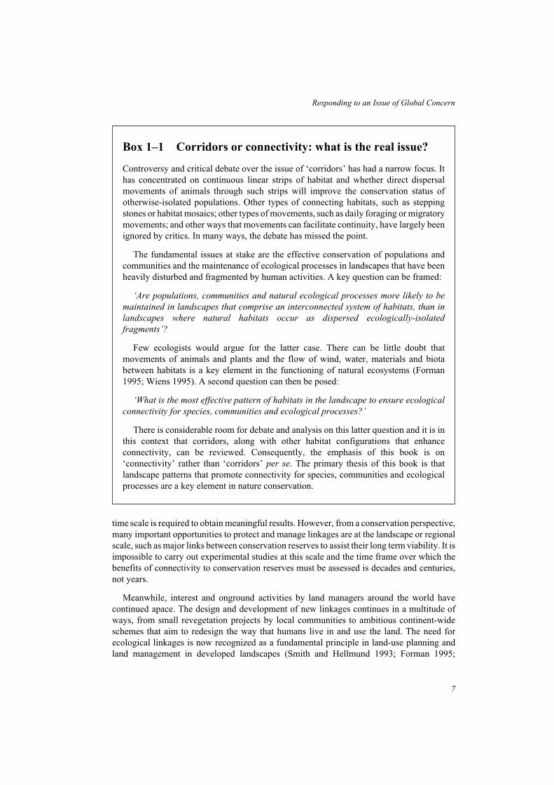
Box 1–1 Corridors or connectivity: what is the real issue?
Controversy and critical debate over the issue of ‘corridors’ has had a narrow focus. Ithas concentrated on continuous linear strips of habitat and whether direct dispersalmovements of animals through such strips will improve the conservation status ofotherwise-isolated populations. Other types of connecting habitats, such as steppingstones or habitat mosaics; other types of movements, such as daily foraging or migratorymovements; and other ways that movements can facilitate continuity, have largely beenignored by critics. In many ways, the debate has missed the point.
The fundamental issues at stake are the effective conservation of populations andcommunities and the maintenance of ecological processes in landscapes that have beenheavily disturbed and fragmented by human activities. A key question can be framed:
‘Are populations, communities and natural ecological processes more likely to be
maintained in landscapes that comprise an interconnected system of habitats, than in
landscapes where natural habitats occur as dispersed ecologically-isolated
fragments’?
Few ecologists would argue for the latter case. There can be little doubt thatmovements of animals and plants and the flow of wind, water, materials and biotabetween habitats is a key element in the functioning of natural ecosystems (Forman1995; Wiens 1995). A second question can then be posed:
‘What is the most effective pattern of habitats in the landscape to ensure ecological
connectivity for species, communities and ecological processes?’
There is considerable room for debate and analysis on this latter question and it is inthis context that corridors, along with other habitat configurations that enhanceconnectivity, can be reviewed. Consequently, the emphasis of this book is on‘connectivity’ rather than ‘corridors’ per se. The primary thesis of this book is thatlandscape patterns that promote connectivity for species, communities and ecologicalprocesses are a key element in nature conservation.

Jongman 1995; Dramstad et al. 1996). However, many land managers are desperately seekinginformation and the best available advice on how to design, implement and manage habitatlinkages that will be effective in conserving biodiversity in their environment. They mustmake decisions now concerning future land use, before options are limited or foreclosed byfurther development (Hobbs 1992).
Connectivity
The emphasis of this book is on the value of ‘connectivity’ rather than the merits of corridorsper se (Box 1–1) The primary thesis is that landscape patterns that promote connectivity forspecies, communities and ecological processes are a key element of nature conservation inenvironments modified by human impacts. Accordingly, it is useful at this stage to discusswhat is meant by ‘connectivity’. This theme is developed further in Chapter 4.
The concept of connectivity is used to describe how the spatial arrangement and the qualityof elements in the landscape affect the movement of organisms among habitat patches(Merriam 1984, 1991; Taylor et al.1993; Forman 1995). At the landscape scale, connectivityhas been defined as ‘the degree to which the landscape facilitates or impedes movementamong resource patches’ (Taylor et al. 1993). It is critical to recognize that a landscape isperceived differently by different species and so the level of connectivity varies betweenspecies and between communities. A landscape or local area with high connectivity is one inwhich individuals of a particular species can move freely between suitable habitats, such asfavoured types of vegetation for foraging, or different habitats required for foraging andshelter. Alternatively, a landscape with low connectivity is one in which individuals areseverely constrained from moving between selected habitats (Fig. 1–2). A particular land-scape or region may, at the same time, provide high connectivity for some organisms, such asmobile wide-ranging birds, and low connectivity for others such as snails or small sedentaryreptiles.
8
Linkages in the Landscape
Fig. 1–2 A patchy landscape may, at the same time, offer a high level of connectivity for one
species (a), and a low level of connectivity for another species (b) that has difficulty
moving amongst habitats.

There are two main components that influence potential connectivity for a particularspecies, community or ecological process – a structural component and a behaviouralcomponent (Bennett 1990a). The structural component of connectivity is determined by thespatial arrangement of different types of habitats in the landscape. It is influenced by factorssuch as the continuity of suitable habitat, the extent and length of gaps, the distance to betraversed, and the presence of alternative pathways or network properties. It refers to themappable, spatial arrangement of habitats for which a number of quantitative indices havebeen proposed (e.g. measures of circuitry, mesh size, fractal dimension) (Forman and Godron1986; Forman 1995).
The behavioural component of connectivity relates to the behavioural response of indi-viduals and species to the physical structure of the landscape. It is influenced by factors suchas the scale at which a species perceives and moves within the environment, its habitatrequirements and degree of habitat specialization, its tolerance of disturbed habitats, the lifestage and timing of dispersal movements, and the species’response to predators and com-petitors. Consequently, even though living in the same landscape, species with contrastingbehavioural responses (to habitat disturbance for example) will experience differing levels ofconnectivity.
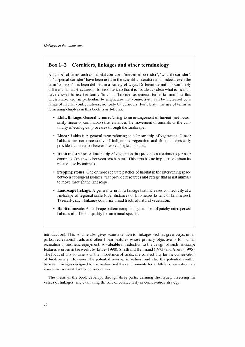
Throughout this book, the terms ‘link’ and ‘linkage’, rather than corridor, are used to referto arrangements of habitat that enhance connectivity for species, communities or ecologicalprocesses (Box 1–2). The term ‘corridor’ has been used in a variety of ways and can have anumber of different interpretations. Further, it is important to emphasize throughout thatconnectivity can be increased by a range of habitat patterns, not only by continuous corridorsof habitat. For clarity, a number of terms used in this book are set out in Box 1–2.
Scope of this book
First and foremost, this volume is intended to be an information source for practitioners – forthose scientists, planners, land managers, conservation agencies, community groups, studentsor individuals who are grappling with the question of how wildlife can be conserved withindeveloped landscapes; and who ask what role linkages might play. Its goal is to furnishpractitioners with an understanding of why measures that enhance landscape connectivity areimportant, how such linkages can benefit the conservation status of wildlife species, and theimportant issues that need to be considered in incorporating and implementing these conceptsinto conservation strategies. To this end, a large number of examples and case studies arefeatured, drawn from many countries throughout the world. They are intended to place theseissues in the reality of wildlife conservation in diverse environments that are facing an array ofdifferent circumstances and challenges. The text is extensively referenced throughout toprovide readers with access to the source literature for examples and case studies, and as anentry into this growing field in conservation biology.
The material in the book is biased towards animal populations and assemblages, and theuse of the term ‘wildlife’ refers in this context primarily to indigenous species of vertebrateand invertebrate animals. Although there is substantial evidence for the value of linearfeatures and other linkages as habitat for plants, there is limited evidence of their role orimportance in the dispersal of plants through the landscape (see Pollard et al. 1974; Helliwell1975; Forman 1991, 1995; McDowell et al. 1991; Fritz and Merriam 1993 for an
9
Responding to an Issue of Global Concern
introduction). This volume also gives scant attention to linkages such as greenways, urbanparks, recreational trails and other linear features whose primary objective is for humanrecreation or aesthetic enjoyment. A valuable introduction to the design of such landscapefeatures is given in the works by Little (1990), Smith and Hellmund (1993) and Ahern (1995).The focus of this volume is on the importance of landscape connectivity for the conservationof biodiversity. However, the potential overlap in values, and also the potential conflictbetween linkages designed for recreation and the requirements for wildlife conservation, areissues that warrant further consideration.
The thesis of the book develops through three parts: defining the issues, assessing thevalues of linkages, and evaluating the role of connectivity in conservation strategy.
10
Linkages in the Landscape
Box 1–2 Corridors, linkages and other terminology
A number of terms such as ‘habitat corridor’, ‘movement corridor’, ‘wildlife corridor’,or ‘dispersal corridor’ have been used in the scientific literature and, indeed, even theterm ‘corridor’ has been defined in a variety of ways. Different definitions can implydifferent habitat structures or forms of use, so that it is not always clear what is meant. Ihave chosen to use the terms ‘link’ or ‘linkage’ as general terms to minimize thisuncertainty, and, in particular, to emphasize that connectivity can be increased by arange of habitat configurations, not only by corridors. For clarity, the use of terms inremaining chapters in this book is as follows.
• Link, linkage: General terms referring to an arrangement of habitat (not neces-sarily linear or continuous) that enhances the movement of animals or the con-tinuity of ecological processes through the landscape.
• Linear habitat: A general term referring to a linear strip of vegetation. Linearhabitats are not necessarily of indigenous vegetation and do not necessarilyprovide a connection between two ecological isolates.
• Habitat corridor: A linear strip of vegetation that provides a continuous (or nearcontinuous) pathway between two habitats. This term has no implications about itsrelative use by animals.
• Stepping stones: One or more separate patches of habitat in the intervening spacebetween ecological isolates, that provide resources and refuge that assist animalsto move through the landscape.
• Landscape linkage: A general term for a linkage that increases connectivity at alandscape or regional scale (over distances of kilometres to tens of kilometres).Typically, such linkages comprise broad tracts of natural vegetation.
• Habitat mosaic: A landscape pattern comprising a number of patchy interspersedhabitats of different quality for an animal species.

Defining the issues
The dynamic process of habitat loss and fragmentation has profound implications for theconservation of flora and fauna throughout the world. Major consequences for wildlife are aloss of species from fragments and entire landscapes, changes to the composition of faunalassemblages, and changes to ecological processes involving animal species (Chapter 2).Isolation of habitats, a fundamental consequence of the process of fragmentation, alsoinfluences the status of animal populations and communities in developed landscapes.Minimizing the effects of isolation by enhancing landscape connectivity is one way to counterthe adverse effects of fragmentation. Pragmatic and theoretical approaches that address thestatus and conservation of wildlife in heterogeneous environments (Chapter 3) each implicitlyrecognize the importance of maintaining habitat patterns that allow animals to move throughmodified landscapes.
Values of linkages
Landscape connectivity may be achieved by several main types of habitat configurations thatfunction as linkages for species, communities or ecological processes. The spatial andtemporal scales over which animals require connectivity is also an important consideration.Proposed advantages and disadvantages of linkages are summarized and attention is given tothe concerns that have been raised with regard to habitat corridors (Chapter 4). Linkages areused as pathways by animals undertaking a range of movements, including daily or regularmovements, seasonal and migratory movements, dispersal movements, and range expansion.Studies of the use of linkages are reviewed to evaluate the ways in which they enhance theconservation of animal species and communities (Chapter 5). Linkages also contribute toother ecological functions in the landscape and, in particular, have an important role inproviding habitat for plants and animals in human-dominated environments (Chapter 6).
Connectivity and conservation strategy
The final section considers how the concept of landscape connectivity can be most effectivelyincorporated into conservation strategy and actions. The value of habitat linkages can bemaximized by addressing biological issues relating to location and dimensions, compositionand quality of habitats, and behavioural ecology of the species that will use the link.Socio-political issues that affect the management of linkages must also be considered in thedevelopment and implementation of practical actions (Chapter 7). The role of linkages inconservation strategies is then explored in the context of an integrated landscape approach toconservation. Attention is also given to criteria for assigning values and priorities to linkages(Chapter 8). Finally, a range of case studies are presented (Chapter 9) to complementexamples throughout the text, and to illustrate the diverse ways in which land managers areplanning, implementing, or presently managing linkages for conservation.
Summary
The loss and fragmentation of natural environments and their implications for the
conservation of flora and fauna are of global significance. The provision of ‘corridors’ to link
otherwise-isolated habitats was one of the earliest practical recommendations arising from
11
Responding to an Issue of Global Concern

studies of habitat fragmentation. The concept has proved attractive to planners, land
managers and the community, but the merits of corridors have become a subject of debate.
This book addresses the broader theme of landscape connectivity and its role in nature
conservation. The primary thesis is that landscape patterns that promote connectivity for
species, biological communities and ecological processes are a key element in nature
conservation in environments modified by human impacts.
12
Linkages in the Landscape

2 HABITAT FRAGMENTATION AND THECONSEQUENCES FOR WILDLIFE
Habitat Fragmentation and the Consequences for Wildlife
Habitat loss and fragmentation have been recognized throughout the world as a key issuefacing the conservation of biological diversity (IUCN 1980). As the global populationincreases, less and less of Earth’s surface remains free from human interference. Humanactivities have modified the environment to the extent that the most common landscapepatterns are mosaics of human settlements, farmland and scattered fragments of naturalecosystems. Most conservation reserves, even large reserves, are becoming increasinglysurrounded by intensively modified environments and in the long term appear destined tofunction as isolated natural ecosystems.
Before considering the theoretical basis and practical evidence for the importance oflandscape connectivity in conservation, it is necessary to review the issue of habitat loss andfragmentation as the underlying problem to be addressed. Changes in the status of wildlifepopulations and communities resulting from the destruction and fragmentation of theirhabitats has been the primary stimulus to land managers to take practical action to maintain orrestore connectivity of habitats in developed landscapes. The objective of this review is toprovide a basis for understanding and evaluating the potential role of landscape connectivityin the conservation of biota. This chapter briefly considers in turn:
• changes to landscape patterns arising from fragmentation;
• the effects of fragmentation on wildlife populations and communities;
• the implications of isolation for species and communities.
Fragmentation and changes to landscape pattern
Habitat fragmentation is a dynamic process that results in marked changes to the pattern ofhabitat in a landscape through time. The term ‘fragmentation’ is generally used to describechanges that occur when large blocks of vegetation are incompletely cleared leaving multiplesmaller blocks that are separated from each other. The process of fragmentation has threerecognizable components (Fig. 2–1):
• an overall loss of habitat in the landscape (habitat loss)
• reduction in the size of blocks of habitat that remain following subdivision and clearing(habitat reduction); and
• increased isolation of habitats as new land uses occupy the intervening environment(habitat isolation).
We may wish to identify the consequences of each component separately to fullyunderstand the impacts of fragmentation, but it is important to recognize that they are eachclosely linked as part of the process of habitat change (Box 2–1). The dynamic nature of
13

fragmentation is most strikingly observed where a series of ‘snapshot’ views of landscapepattern are available for successive intervals (Box 2–1) (see also Curtis 1956; Webb andHaskins 1980; Saunders et al. 1993).
Changes to landscape patterns arising from fragmentation can be readily identified anddescribed by measuring attributes such as the total area of remaining natural habitat, thesize-frequency distribution of fragments, the shapes of fragments, the mean distance betweenfragments, and the level of contrast between habitats and adjacent land uses. These changes inspatial pattern and arrangement of habitats also set in train a series of other changes asecological processes are modified in response to the changing habitat geometry. Suchecological changes can have far-reaching effects on the flora and fauna, the soil and waterresources, and on human ecology (Forman and Godron 1986; Saunders et al. 1987, 1991;Forman 1995). The consequences of changes in landscape pattern on ecosystem processes is afertile field for research that has direct relevance to conservation management (e.g. Lovejoy et
al. 1984; Hobbs 1993a).
Total amount of habitat
Unless accompanied by active replacement or regeneration, habitat fragmentation invariablyinvolves an overall loss of habitat on a landscape scale. The pattern of habitat loss andreduction is most visibly obvious where there is a sharp contrast between the vegetationstructure of the fragments and the altered landscape, such as for woodland vegetation ingrassy farmland.
However, habitat fragmentation is not always obvious: in some situations, habitat loss,reduction and isolation may be significant in extent but not visibly apparent. For speciesdependent on old-growth forests, ongoing timber harvesting results in increasingly fewerareas of old undisturbed forest. However, because there is usually subsequent forest regenera-tion, the decline in areas with ‘old-growth’ features such as large old trees, large logs and deepmoist litter, may not be readily perceived by the untrained eye within the continuous expanse
14
Linkages in the Landscape
Fig. 2–1 The process of habitat fragmentation has three components: (a) an overall loss of
habitat; (b) a reduction in the size of remaining habitats; and (c) an increased isolation
of habitats.
of forest. Likewise, fragmentation and replacement of native grasslands by swards of exoticpasture grasses may not greatly change the appearance of a grassy plain, but has majorecological effects.
In a typical example of fragmentation, the landscape is initially dominated by naturalvegetation with disturbance from human land use creating small clearings or inroads alongedges. As the disturbance proceeds, the number and size of clearings increases, the naturalvegetation becomes subdivided and isolated and the total area of natural habitat declines. Acritical point is reached when the disturbed land, rather than natural vegetation, becomes thedominant feature in the landscape and the fragments are increasingly isolated. As the totalarea of natural vegetation declines, a change occurs in the balance of ecological processes thatshape the structure and function of biotic communities in fragments. Processes arising fromsurrounding land uses become increasingly more important than internal processes as thedriving influence on the status of the flora and fauna (Saunders et al. 1991; Haila et al. 1993b).
The hydrologic cycle is one example of an ecosystem process that is strongly influenced bythe total amount of natural habitat in the landscape. Rainfall patterns, soil infiltration rates,runoff and flooding are all sensitive to the amount and nature of the regional vegetation cover.In south-western Western Australia, for example, a major effect of land clearing for agri-culture has been a documented rise in the levels of water tables resulting from a reduction inevapotranspiration by trees and shrubs (Hobbs 1993a). The rising water table brings salt to thesoil surface and an estimated 62,500ha of land is going out of agricultural production eachyear (Hobbs 1993a). Nature reserves and woodland fragments are also vulnerable to thisdegradation.
Sizes of habitat patches
Fragmentation, by definition, implies a reduction in the size of remaining blocks of habitat. Atfirst, extensive tracts may be subdivided into a few large parcels. As the process continues, themean and modal size of remaining fragments decline. Typically, the size-frequencydistribution of remnants in fragmented landscapes is strongly skewed towards small blocks.For example, on the Fleurieu Peninsula of South Australia where only 9% of the 1500km2
region now supports natural vegetation (Williams and Goodwin 1988), 67% of the remaining544 forest patches are less than 10ha and only three are larger than 500ha (Fig. 2–2). The sameskewed distribution is found generally for the sizes of national parks and nature reserves thatincreasingly are becoming isolates surrounded by developed land (Hopkins and Saunders1987; Shafer 1990). Of a total of 1270 nature reserves in the Netherlands in 1982, only nine(less than 1%) were larger than 4000ha whereas 275 (22%) were less than 40ha (van derMaarel 1982 cited in Shafer 1990).
Large tracts of habitat are a scarce and precious resource. It is easy to produce many smallpatches, but large tracts are essentially irreplaceable and have many intrinsic ecologicalvalues. Among those attributes positively correlated with size of habitat tract are the diversityof vegetation types, the likelihood of occurrence of rare or specialized habitats, the richness ofplant and animal species, the size of populations and the sustainability of natural disturbanceregimes. In particular, the maintenance of natural patch-dynamic processes in fragmentedlandscapes is critically dependent on there being tracts of sufficient size to sustain a mosaic ofhabitats that correspond to different states. The presence of a natural mosaic of fire-inducedvegetation classes, for example, is dependent on a fragment being sufficiently large that a
15
Habitat Fragmentation and the Consequences for Wildlife

16
Linkages in the Landscape
Box 2–1 Forest fragmentation in south-western Victoria,
Australia
A study of land use, forest fragmentation and historical change to the mammalian faunain a 20,000 ha study area in south-western Victoria, Australia, provides an example ofthe process of habitat loss and fragmentation (Bennett 1990c). Prior to Europeansettlement, commencing in the 1840s, the area was heavily forested and used seasonallyor infrequently by Aboriginal people. The dense forest vegetation and infertile soilswere not favoured for subsequent pastoral settlement, and forest clearing was initiallyslow. Most forest loss has occurred during the 20th century, particularly after 1940.
The process of forest fragmentation has had three components: an overall loss offorest, a progressive fragmentation of surviving forest stands into smaller blocks, and anincreasing spatial isolation of fragments through time. In 1942, about 51% of the arearemained forested; by 1971 forest cover had been reduced to 12%; and by 1980 it wasapproximately 9% of the study area. The forest vegetation has been replaced byfarmland used mainly for dairy farming and beef cattle production. In 1942, most forestcover was interconnected, but by 1980 forest cover comprised many small and isolatedfragments, of which 92% were less than 20 ha and none was larger than 100 ha (Bennett1990c). Remnant forested strips along roadsides and streams (not shown in the diagram)connect many fragments and ameliorate the isolating effect of intervening farmland(Bennett 1988; 1990c).
Changes associated with habitat loss and fragmentation not only relate to the spatialpattern of the vegetation. The structure and composition of the vegetation are alsoaffected by land uses associated with forest clearing. Almost all remaining forestvegetation is privately owned and most has been greatly modified by altered fireregimes, extensive felling of trees for fuel wood, grazing by domestic stock, and weedinvasion. Forest patches subject to sustained grazing by domestic stock progressivelylose their native understorey leaving the tree layer as the main natural elementremaining. In 1983, most of the study area was burned by a severe wildfire thatconsumed almost all forest vegetation in its path, and also resulted in nine humanfatalities, the death of 19,000 stock and loss of 157 houses.
At least 33 species of native mammals are known to have occurred in this area, ofwhich six species are no longer present and several others are now rare. Several nativespecies have partially adapted to the modified farmland environment, but most nowdepend on the mosaic of remnant forest vegetation for their continued persistence in thearea. Six species of introduced mammals have established feral populations in the area,including new predators (Red Fox, Cat) and competitors (Black Rat, House Mouse,European Rabbit) for native species. None of the remaining patches are of sufficient sizeto maintain viable populations of native mammals in the long term. Persistence of thenative mammal fauna in this rural landscape depends on the extent to which the forestfragments can function as an integrated system of natural habitat (Bennett 1990c).

17
Habitat Fragmentation and the Consequences for Wildlife
Box 2–1 (cont.)
Change in forest cover at Naringal, south-western Victoria, Australia, illustrating the
process of habitat loss and fragmentation in a rural environment. The study area is
approximately 20,000ha in size. From Bennett (1990c) with permission, CSIRO Publishers,
Australia.

single fire does not reduce all of its vegetation to the same stage. The maintenance of naturaldisturbance regimes is particularly important for the long-term viability of national parks andconservation reserves (Pickett and Thompson 1978; Baker 1992).
Isolation of habitat patches
Isolation of fragments is also a fundamental consequence of fragmentation. Patches ofwoodland become isolated by cleared farmland; urban forests are separated by streets, housesand roads; old-growth forests are surrounded by regenerating forest; heathland remnantsdisappear among pastures; and nature reserves are surrounded by zones of intensive humanactivity.
How can we measure isolation of fragments? In a spatial sense, isolation can be measuredby a variety of indices such as the distance to the nearest larger habitat fragment, the amount ofsuitable habitat within a defined radius, or the presence of linking habitats in the interveningspace (Forman and Godron 1986; Askins et al. 1987; Forman 1995). It is essential thatisolation is also understood in a functional sense by relating it to the particular species orecosystem process under consideration. A fragment that is effectively isolated for a smallwoodland rodent may easily be reached by migratory birds or forest bats.
Ecosystem processes that are most sensitive to isolation effects are those that depend onsome vector for transmission through the landscape. Seed dispersal, pollination of plants,predator-prey relationships, and the dispersal of parasites and disease, are examples ofprocesses that may be greatly disrupted by isolation if their animal vectors can not readilymove through the landscape.
18
Linkages in the Landscape
Fig. 2–2 Size-frequency distribution for remnant patches of natural vegetation on the Fleurieu
Peninsula, South Australia. The bias towards small habitats (even with a logarithmic
scale) is characteristic of fragmented landscapes. Data from Williams and Goodwin
(1988).

Composition of habitats
Fragmentation and loss of habitats in developed landscapes is not a random process. Clearing,cultivation and pastoral land use are biased toward those areas that have the most fertile soilsor are most accessible, such as plains and fertile river valleys. Conversely, national parks,nature reserves and other patches of retained natural vegetation frequently are located onsteep or rocky areas, infertile soils, or swamps and floodplains, because such areas are moredifficult to develop and least valuable for productive uses (Leader-Williams et al. 1990;Pressey 1995). These trends in land use mean that some vegetation communities are often‘missing’ or poorly represented in reserve systems, whereas others are proportionatelyover-represented. For depleted communities, small fragments in developed landscapes areparticularly important because often they are the only remaining examples of the vegetation,and they may be repositories of rare plants and animals (McDowell et al. 1991; Prober andThiele 1993; Shafer 1995).
Changes to shapes of habitats
The shapes of natural patches, such as lakes and wetlands, rocky outcrops, treefall openingsand heathlands are usually curved or irregular. In contrast, fragments, regenerated patches,tree plantations and nature reserves arising from human land uses, generally have straightboundaries and are often rectilinear in shape (Forman and Godron 1986; see Box 2–1).
The aspect of fragment shape that has greatest impact on ecological and environmentalprocesses is the ratio of the perimeter length to area, and hence of exposure to ‘edge effects’(Forman and Godron 1986; Yahner 1988; Angelstam 1992; Murcia 1995). An increase inperimeter to area ratio means that a greater proportion of the natural environment is close tothe edge and therefore is exposed to ecological changes that occur there (Fig. 2–3). Inintensively-developed landscapes, linear habitats and small fragments with high edge ratiosoften form the bulk of remaining natural habitats.
19
Habitat Fragmentation and the Consequences for Wildlife
Fig. 2–3 Small fragments with a high ratio of perimeter to area are more vulnerable to edge
disturbance processes than are large fragments. In small fragments, the disturbed
zone (stippled) may extend throughout most or all of the fragment leaving little habitat
free of influences arising from edge effects.

A growing number of studies have documented a variety of changes, both to physicalprocesses and biological processes, that occur at edges. These include changes inmicroclimatic conditions (wind speed, temperature, humidity, solar radiation), changes to soilnutrient status and other soil properties, invasion and competition from organisms insurrounding lands, elevated levels of predation and parasitism, and human incursion anddisturbance (Lovejoy et al. 1986; Angelstam 1992; Hobbs 1993a; Scougall et al. 1993;Young and Mitchell 1994). Edge effects are considered further in Chapter 7 as an importantissue in the design and management of linkages.
Sharpness and contrast across habitat boundaries
The sharpness of habitat edges and the contrast between adjacent habitats are generallyaccentuated in developed landscapes. There is usually a marked contrast in the structure andfloristic composition of vegetation at the interface between natural areas and developed land,such as forest-farmland ecotones (Fig. 2–4). The term ‘hard edge’ has been used to describesuch situations in which the level of contrast between two habitats inhibits many organismsfrom readily moving across the edge (Wiens et al. 1985). Alternatively, natural boundaries areoften ‘soft edges’ across which animals may readily move. Streamside vegetation, forexample, is usually distinct from that on adjacent slopes in temperate forests, but there is agradual rather than abrupt transition between forest types. Similarly, the transition betweensuccessional age classes in forests are relatively soft edges.
Effects of fragmentation on wildlife
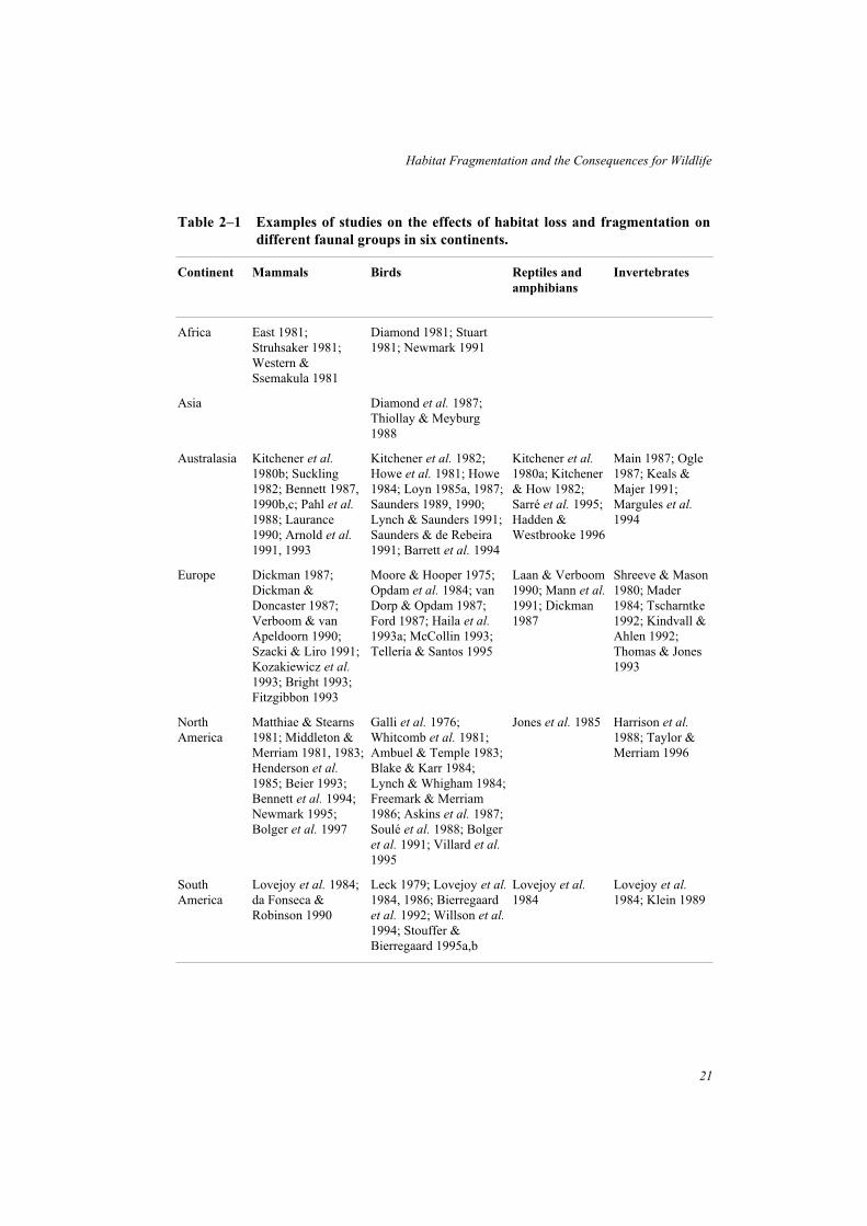
Throughout the world, concern about the effects of habitat fragmentation and isolation onnative fauna has stimulated a large number of studies on animal species or assemblages infragmented landscapes. For an introduction to this field, Table 2–1 provides examples ofstudies of mammals, birds, reptiles and amphibians, and invertebrates from six continents.
20
Linkages in the Landscape
Fig. 2–4 The contrast in habitat structure at the interface between (a) natural vegetation and
cleared land such as farmland is usually much greater than that between (b) two
adjacent natural habitats.
21
Habitat Fragmentation and the Consequences for Wildlife
Table 2–1 Examples of studies on the effects of habitat loss and fragmentation on
different faunal groups in six continents.
Continent Mammals Birds Reptiles and
amphibians
Invertebrates
Africa East 1981;Struhsaker 1981;Western &Ssemakula 1981
Diamond 1981; Stuart1981; Newmark 1991
Asia Diamond et al. 1987;Thiollay & Meyburg1988
Australasia Kitchener et al.
1980b; Suckling1982; Bennett 1987,1990b,c; Pahl et al.
1988; Laurance1990; Arnold et al.
1991, 1993
Kitchener et al. 1982;Howe et al. 1981; Howe1984; Loyn 1985a, 1987;Saunders 1989, 1990;Lynch & Saunders 1991;Saunders & de Rebeira1991; Barrett et al. 1994
Kitchener et al.
1980a; Kitchener& How 1982;Sarré et al. 1995;Hadden &Westbrooke 1996
Main 1987; Ogle1987; Keals &Majer 1991;Margules et al.
1994
Europe Dickman 1987;Dickman &Doncaster 1987;Verboom & vanApeldoorn 1990;Szacki & Liro 1991;Kozakiewicz et al.
1993; Bright 1993;Fitzgibbon 1993
Moore & Hooper 1975;Opdam et al. 1984; vanDorp & Opdam 1987;Ford 1987; Haila et al.
1993a; McCollin 1993;Tellería & Santos 1995
Laan & Verboom1990; Mann et al.
1991; Dickman1987
Shreeve & Mason1980; Mader1984; Tscharntke1992; Kindvall &Ahlen 1992;Thomas & Jones1993
NorthAmerica
Matthiae & Stearns1981; Middleton &Merriam 1981, 1983;Henderson et al.
1985; Beier 1993;Bennett et al. 1994;Newmark 1995;Bolger et al. 1997
Galli et al. 1976;Whitcomb et al. 1981;Ambuel & Temple 1983;Blake & Karr 1984;Lynch & Whigham 1984;Freemark & Merriam1986; Askins et al. 1987;Soulé et al. 1988; Bolgeret al. 1991; Villard et al.
1995
Jones et al. 1985 Harrison et al.
1988; Taylor &Merriam 1996
SouthAmerica
Lovejoy et al. 1984;da Fonseca &Robinson 1990
Leck 1979; Lovejoy et al.
1984, 1986; Bierregaardet al. 1992; Willson et al.
1994; Stouffer &Bierregaard 1995a,b
Lovejoy et al.
1984Lovejoy et al.
1984; Klein 1989

The ecological consequences of habitat fragmentation are diverse and a variety of authorshave reviewed this topic from different perspectives (Saunders et al. 1991; Bierregaard et al.
1992; Haila et al. 1993b; Hobbs 1993a; Fahrig and Merriam 1994; Wiens 1994). Here, theprocess of fragmentation is recognized as having three main types of impacts on the fauna ofremnant habitats:
• loss of species in fragments;
• changes to the composition of faunal assemblages;
• changes to ecological processes that involve animal species.
Loss of species
Fragmentation sets in train a process of species loss at a local (habitat fragment) and landscapelevel. Such loss of species can occur in response to each of the three types of changeassociated with the process of fragmentation: overall loss of habitat, reduction in size offragments, and increased isolation of fragments.
There is clear evidence of species loss on a landscape and regional scale in areas whereclearing and fragmentation have removed much of the natural vegetation (Matthiae andStearns 1981; Saunders 1989; Bennett 1990b; Bennett and Ford 1997). However, it is oftendifficult to directly attribute species losses to an overall decline in habitat because of otherpotentially contributing factors (such as hunting, persecution as pests, introduction of diseaseand new predators, habitat modification) that are also associated with human land use.Clearly, though, regional species loss is a process that occurs over time as separatedpopulations dwindle, decline, and disappear one by one. It is of critical importance torecognize that there is a time lag between changes to habitats and the time when the fullimplications of those changes are experienced by animal communities.
The most common evidence of species loss accompanying landscape fragmentation relatesto the reduction in size of fragments when larger tracts are subdivided into two or moresmaller isolated blocks. The resultant fragments are each smaller and together comprise lessarea than the original tract because intervening vegetation has been cleared. There is now awealth of evidence that shows that smaller areas generally support fewer species than largerareas of the same vegetation type. A highly significant relationship between the number ofspecies present and the size of habitat fragments has been demonstrated for many taxa,including forest and woodland birds (Galli et al. 1976; Opdam et al 1984; Ambuel andTemple 1983; Blake and Karr 1984; Mc Collin 1993); mammals (Kitchener et al. 1982;Suckling 1982; Bennett 1987; Laurance 1990); reptiles and amphibians (Kitchener et al.
1980a; Caughley and Gall 1985; Kitchener and How 1982; Laan and Verboom 1990); andinvertebrates (Shreeve and Mason 1980).
Three explanations have been proposed for this widely observed species-area relationship(Connor and McCoy 1979):
• a small fragment contains a smaller ‘sample’ of the original habitat, and consequently itis likely to have sampled a more limited range of the fauna than a larger area;
22
Linkages in the Landscape

• with decreasing area there is usually a reduced diversity of habitats for animals tooccupy and consequently the number of species may reflect the habitat diversityavailable;
• smaller areas generally support smaller population sizes and therefore fewer species areable to maintain viable populations than in a large tract.
Most of these studies have compared patches of varying size at a single point in time. Morelimited are data sets from experimental studies in which observations were collected beforefragmentation followed by subsequent monitoring after the event (Lovejoy et al. 1984, 1986;Margules et al. 1994), or from studies where comparison is made between fragments and‘control’ areas of similar size and habitat within larger tracts (Howe 1984; Bolger et al. 1991;Newmark 1991). These latter studies have shown that not only is there a loss of species due tochanges in size, but that the isolating effect of fragmentation can result in further loss. In urbanSan Diego, California, USA, birds dependent on chaparral shrubland were censused in smallisolated canyons of varying size (0.3–68ha of chaparral habitat) and the number of species inthese remnants was compared with a species-area relationship derived from sample plots inlarge continuous tracts of chaparral (Bolger et al. 1991). The results clearly demonstrated thatthe isolated fragments, especially those less than 10ha in size (80% of those studied), wereimpoverished in comparison with similar plots in continuous habitat. Further, the length oftime that each canyon had been isolated was also an important predictor of the number ofspecies expected to occur. Thus, not only does isolation result in a loss of species, but furtherspecies can be expected to disappear as the years go by.
Species loss in fragments is not immediate upon isolation. The ongoing decline ofpopulations and species numbers in remnants following isolation has been termed ‘faunalrelaxation’ and is directly comparable to the gradual loss of species that has occurred onlandbridge islands following isolation by rising sea levels (Wilcox 1980; Diamond 1984).The dynamic nature of species loss has been most clearly shown by studies in which remnantshave been censused at two or more intervals following isolation, with a demonstrated loss ofspecies during the intervening period (Butcher et al. 1981; Diamond et al. 1987; Leck 1979;Saunders 1989; Recher and Serventy 1991). They clearly demonstrate that the number ofspecies present immediately following isolation is greater than that which can be sustained inthe long term (Box 2–2).
For example, an 87ha remnant of wet tropical forest in Ecuador, the Rio Palenque FieldStation, was increasingly isolated from surrounding forest during the 1970s. Of 170 species offorest-dependent birds recorded in the reserve from previous ornithological studies, 44species (26%) disappeared in the six years between 1973–1978, and a further 15 species werein such low numbers in 1978 that they are also likely to disappear (Leck 1979). Thesepopulation declines refer to forest-dependent species; many birds of open areas, forest edgesand regrowth remain common and may even be increasing as forests in the region are clearedand isolated (Leck 1979). Similar rapid loss of bird species has been reported from King’sPark, an isolated bushland reserve of less than 300ha in the city of Perth, Western Australia(Recher and Serventy 1991). Over the 60 year period from 1928 to 1986, 20% of bird specieshave become locally extinct and a further 11% have declined in abundance.
Species loss following fragmentation and isolation is not limited to small fragments only. Ithas also been documented from mountain ranges, large reserves and national parks (Picton
23
Habitat Fragmentation and the Consequences for Wildlife

24
Linkages in the Landscape
Box 2–2 Loss of breeding birds from an isolated Javan
woodland, Indonesia
The Bogor Botanical Gardens on the Indonesian island of Java is an 86ha woodlandcomprising both native and exotic tree species. The gardens were isolated whensurrounding woodlands were destroyed around 1936, and the nearest habitats for forestbirds are now at least 5–10km distant. A total of 62 species of birds was recordedbreeding in the gardens during the period from 1932–1952, and this provided a basis forcomparison with bird species recorded from 1980–1985 (Diamond et al. 1987). Twentyspecies formerly present now no longer breed in the gardens, four are close toextinction, five more have declined substantially and about half (33 species) havemaintained their populations. As a consequence of the isolation of the gardens fromnearby habitats, small populations of woodland birds have declined and disappearedwith little opportunity for immigrants to halt the decline. Those that have survived areprimarily species that are able to live in the intensively-used countryside that surroundsthe gardens (Diamond et al. 1987). The selective loss of species means that thiswoodland fragment now supports an impoverished community that ‘mirrors’ thesurrounding land use, rather than providing an effective refuge for forest-dependentspecies.
Change in the status of breeding bird species in the Bogor Botanical Gardens, Java,
Indonesia between 1932–52 and 1980–85. The diagram illustrates the status in 1980–85 of
62 species recorded breeding in 1932–52. Data from Diamond et al. (1987).

1979; Newmark 1987; Newmark et al. 1991). For example, comparison of historical recordswith recent sightings of three orders of mammals (Lagomorpha, Carnivora, Artiodactyla) in14 national parks in western North America showed that the number of extinctions has greatlyexceeded the number of colonizations since park establishment (Newmark 1995). At least 15of the 38 species (39%) in these orders have experienced local extinction in at least onenational park. Further, the rate of extinction was inversely correlated with park area; smallerparks have experienced a higher rate of extinction of mammal populations sinceestablishment than have large parks.
A natural experiment that has demonstrated loss of species occurred with the flooding ofLake Gatun during the construction of the Panama Canal in the 1920s, when many formerhilltops were converted into islands in the lake. Among these was the now well-studied BarroColorado Island (Willis 1974; Karr 1982a,b). Of approximately 108 breeding speciesrecorded on the island, about 45 species have disappeared following this ‘natural isolationexperiment’. Some of these losses, but not all, can be attributed to habitat changes on theisland. However, it is likely that many other species may have disappeared unnoticed becauseintensive studies on Barro Colorado began long after it was transformed from a hilltop into anisland (Diamond 1984).
Changes to the composition of faunal assemblages
Different species of animals respond to habitat destruction and fragmentation in differentways. Differences in home range area, body size, food resources and foraging patterns,nesting and shelter requirements, as well as tolerance to habitat disturbance and sensitivity toaltered microclimates, each influence the idiosyncratic response of each species tofragmentation. The outcome is that after isolation the composition of faunal assemblages infragments differs from that in large intact habitats. Is it possible to predict the outcomes ofchanges to animal assemblages in remnants? An important goal for conservation biologistsand wildlife managers is to understand what types of species are most prone to extinction inremnant habitats and why they are sensitive, so that management for conservation can bemore effectively directed (MacNally and Bennett 1997).
When biologists first examined the occurrence of species in remnants it quickly becameapparent that the composition of small species-poor remnants was not a random selectionfrom the pool of species available in extensive habitats. In particular, studies of birds inwoodland and forest remnants suggested that fragment size has a strong influence on theidentity of the species that occur. For many species, the frequency of occurrence (also knownas the incidence function) increases with increasing size class of habitat patches (Moore andHooper 1975; Lynch 1987; Ogle 1987). For example, an extensive survey of 433 woods inGreat Britain, ranging across six orders of magnitude in size (from 0.001 to 100ha), examinedthe frequency of occurrence of bird species in each size class. Birds such as the Blackbird,Song Thrush and Wood Pigeon occurred in all size classes, though occurring in a greaterproportion of larger woods. In contrast, species such as the Great Spotted Woodpecker,Tawny Owl and Marsh Tit were essentially found only in large woods (Fig. 2–5) (Moore andHooper 1975).
The hypothesis that there may be a relatively predictable sequence of occurrence of speciesin fragments was further supported by examination of the pattern of occurrence of birds,mammals and reptiles on true islands and on naturally insular habitats such as mountain tops.
25
Habitat Fragmentation and the Consequences for Wildlife

These isolates have had a longer time for the full effects of isolation to be experienced. Thereis a consistent tendency for the assemblage of species on species-poor isolates to be a subset ofthat present on larger, species-rich isolates (Jones et al. 1985; Patterson 1987; Cutler 1991).Patterson (1987) coined the term ‘nested subset’ to describe this pattern (Fig. 2–6). Limiteddata from habitat fragments suggest a similar pattern. Assemblages of birds in rural woodlotsin Idaho, USA (Blake 1991), in small rainforest isolates in New South Wales, Australia(Howe et al. 1981), in oak forest fragments in Spain (Tellería and Santos 1995) andchaparral-dependent birds in urban canyons in San Diego, USA (Bolger et al. 1991) have alsoshown a nested pattern of occurrence.
Although alternative explanations are possible for this phenomenon, a gradient inproneness to extinction has generally been thought to be the most likely mechanism for thenested subsets pattern, with species ‘dropping out’ in a relatively ordered sequence. This viewis supported by observations that distributional patterns of reptiles and non-flying mammals,which generally have lower dispersal abilities than birds, show a better ‘fit’ to a nested patternthan do birds (Jones et al. 1985; Cutler 1991).
26
Linkages in the Landscape
Fig. 2–5 Frequency of occurrence of three species of birds in relation to the size of woodland
patches in Britain. The Blackbird (�) occurs with increasing frequency as woodland
size increases, the Great Spotted Woodpecker (�) is primarily found in large woods,
whereas the occurrence of the House Sparrow (�) is not clearly related to the size of
the wood. Data from Moore and Hooper (1975).

Isolated chaparral habitats in San Diego, USA, have experienced a rapid loss of speciessince isolation, with the greatest loss being of those birds that naturally occur at low density(Bolger et al. 1991). Because the probability of dispersal and recolonization of isolatedhabitats by these birds is low, it appears that vulnerability to extinction based on lowpopulation density (and hence number present in small patches) has the strongest influence oncommunity structure (Bolger et al. 1991). In contrast, the mobility of woodland birds in Idahois relatively high (many are neotropical migrants) and here the nested pattern of occurrencewas attributed to differential ability to breed successfully in woods of different sizes (Blake1991). It seems that while the pattern of occurrence of many species in fragments isnon-random, there may be a number of biological processes operating.
A different approach to developing generalisations about the composition of assemblagesin fragments has been to compare ecological characteristics of species that are vulnerable to,or tolerant of, habitat reduction and isolation. Several trends are discussed below but there isstill much to learn before reliable predictions can be made. In particular, there is a need todevelop a better understanding of the relationship between patterns arising from area-basedstochastic processes and those driven by external influences in the environment.
First, habitat generalists and species that favour or tolerate disturbed habitats (such asedges) are likely to be common in small remnants. Numerous studies in eastern NorthAmerica (Galli et al. 1976; Ambuel and Temple 1983; Lynch and Whigham 1984; Blake andKarr 1984) have highlighted the occurrence in small woods of ‘edge species’ of birds such asthe Common Grackle, Gray Catbird, Indigo Bunting, Starling, House Wren andBrown-headed Cowbird. Conversely, ‘forest interior’ species such as the Wood Thrush,Ovenbird, Scarlet Tanager, Black and White Warbler and White-breasted Nuthatch are morelikely to occur in larger tracts. Similar trends were found for nature reserves (ranging from34–5000ha in size) surrounded by farmland in Western Australia (Humphreys and Kitchener1982). The percentage of birds, mammals and reptiles that regularly use disturbedenvironments (such as farmland, disturbed woodland and roadsides), was disproportionately
27
Habitat Fragmentation and the Consequences for Wildlife
Fig. 2–6 Diagrammatic representation of a nested subset. Species-poor fragments generally
contain a nested subset of species that are present in richer fragments. (A-H represent
animal species).

high in smaller nature reserves. Conversely, species that require natural habitat comprised agreater proportion of the assemblage in the largest reserves.
Second, there is a growing body of evidence to suggest that the species that are mostsensitive to habitat fragmentation are those that occur naturally at low densities, or that havesome innate dependence on interior habitats (Terborgh and Winter 1980; Diamond 1984;Soulé et al. 1988; Laurance 1990). These may include:
• large-bodied animals that have large area requirements;
• species that are high in the food chain, such as owls, diurnal raptors, snakes and largecarnivorous mammals;
• species that have specialized food or habitat requirements, such as seasonally varying orpatchily distributed foods.
Because of their low population density, small fragments may support only a fewindividuals or breeding pairs, or for some species the available area may be insufficient foreven a single breeding pair (Box 2–3). These tiny isolated populations are vulnerable to
28
Linkages in the Landscape
Box 2–3 Area requirements of rainforest raptors in
French Guiana
If nature reserves and protected areas are to preserve the full complement of species, it isessential to know the requirements of those that are most vulnerable to insularisation.Quantitative data relevant to the design of natural reserves in tropical rainforests ofSouth America comes from a study of one such group – rainforest raptors, includingvultures, kites, eagles, falcons, hawks and other birds of prey (Thiollay 1989). Thedistribution and density of these forest-dependent birds of prey were assessed in a seriesof large plots, of 2500ha and 10,000ha, in primary undisturbed rainforest in FrenchGuiana.
Twenty-seven species of raptors (of a total of 54 species recorded from the country)normally occur in primary rainforest in French Guiana. From 14–21 species wererecorded in plots of 2500 ha but only 12–16 of these species had at least one resident pairwith most of its home range included in the study plot. In the 10,000ha plot, 23 specieswere recorded, of which 21 were represented by only one to eight pairs.
The patchy distribution of raptor home ranges, even in this extensive undisturbedrainforest, and the large area required by pairs of many species means that a vast areawill be required to adequately protect an entire assemblage of forest raptors. Based onthis distributional data, a rainforest reserve of at least 1 million ha (10,000km2) will beneeded to protect the complete raptor community (Thiollay 1989). The extent ofunbroken rainforest in French Guiana, with 70,000km2 uninhabited, means that such anopportunity is still possible. These data also confirm that Manu National Park, a largeprotected area of 1,600,000ha in Peru, is of the right order of magnitude to conserveentire assemblages of rainforest animals.

stochastic processes, including random fluctuations in environmental, demographic andgenetic processes, and may rapidly disappear (see Box 3–1).
An array of external influences (such as changing land use in the surrounding environment,introduced predators) and internal changes within remnants (such as vegetation succession)can also have a strong influence on the vulnerability of species to local extinction.Consequently, the relative composition of faunal assemblages in fragments may changesubstantially over time, even though the size of the habitat isolate remains unchanged(Butcher et al. 1981; Diamond et al. 1987; Recher and Serventy 1991). Bird censuses wereundertaken in a 23ha section of the Connecticut Arboretum, New London, Connecticut, USA,during 11 breeding seasons between 1953 and 1985 (Butcher et al. 1981; Askins et al. 1987).The composition of the avifauna of this hardwood forest displayed substantial variation overthis period. Between 1953 and 1976, eight species of forest birds disappeared or declined andthere was a significant decline in the abundance of long-distance migrants. At the same timethe occurrence and abundance of species characteristic of suburban environments increased,in parallel with extensive suburban development and forest destruction in the vicinity(Butcher et al. 1981). Subsequently, from 1976 to 1985, the downward trend forlong-distance migrants was reversed. An increased abundance of these species was attributedto nearby reafforestation and increased use of the maturing forest (Askins et al. 1987).
Changes to ecological processes in fragments
Ecological processes that form part of the natural functioning of ecosystems (includingpredator-prey relationships, competitive interactions, seed dispersal, plant pollination,nutrient cycling, maintenance of successional mosaics by disturbance), are frequentlydisrupted or modified by fragmentation. These changes can be driven by influences fromwithin fragments or by influences from environments surrounding the fragment. To date, ourknowledge of how fragmentation has affected ecological processes is limited but it is throughsuch changes to the way that natural communities operate that habitat fragmentation will haveits greatest impact on biodiversity conservation. It is likely, for example, that we willincreasingly become aware of secondary extinctions of plants and animals in fragments as thefull implications of ecological changes take effect over time. The following examplesillustrate some of the diverse ways in which changes to ecological processes potentially haveprofound implications for the conservation of the flora and fauna of fragmented landscapes.
Seed dispersal
The term ‘keystone species’ is used to describe species whose loss would have widespreadecological effects. For example, the loss in fragmented environments of animals that have akey role in pollination or seed dispersal will have negative effects on the status of numerousplant species and their decline, in turn, may have diverse ecosystem effects across the entireecosystem.
The Southern Cassowary, a large (up to 80 kg) flightless bird of the tropical rainforests ofnorthern Australia and Papua New Guinea, is one example of a keystone species that has animportant role in seed dispersal in tropical forests. This frugivore consumes several hundredspecies of fleshy fruits of the rainforest community (Marchant and Higgins 1990; Crome andBentrupperbaumer 1993). In the wet tropics of northern Australia, the Southern Cassowary isthe only known dispersal vector for over 100 species of rainforest plants that bear large fruits
29
Habitat Fragmentation and the Consequences for Wildlife

with big seeds. The seeds are voided intact as the animal moves throughout its extensive homerange, thus spreading them through the forest landscape.
The distribution of the Southern Cassowary is becoming fragmented and isolated astropical forests in the coastal lowlands are cleared and land development increases. It is alsosubject to other direct threats such as road kills, hunting, and predation by feral pigs (Cromeand Bentrupperbaumer 1993). The loss of this frugivore and its seed dispersal function fromtropical forest fragments has potentially widespread and long-term effects on forestcomposition and vegetation dynamics. It is now the focus of an integrated conservation andrecovery program in at least one locality, with the goal of restoring its habitat and enhancingits conservation status (Crome and Bentrupperbaumer 1993).
Predator-prey relationships
The loss of large predators from fragments, and the consequent changes in the abundance andecological impacts of prey species, have been identified as having potentially major effects onthe structure of plant and animal communities in isolates (Terborgh and Winter 1980; Soulé et
al. 1988). In the USA, Soulé et al.(1988) used the term ‘meso-predator release’ to describe theincreased abundance of smaller omnivores and predators in the absence of large dominant
30
Linkages in the Landscape
Box 2–4 Nest predation and its relationship with landscape
pattern in Sweden
Much attention has recently been given to the question of whether animal populations infragments are subject to higher levels of predation than comparable populations in largecontinuous habitats. Evidence has been presented to show that in some situations,particularly for small fragments in farmland, levels of predation on the nests ofwoodland birds are elevated close to woodland edges (Wilcove 1985; Angelstam 1986;Andrén and Angelstam 1988). This has been attributed to generalist predators that livein the surrounding farmland matrix also preying on nests close to the woodland edge.
In Sweden, predation by corvids on eggs in artificial nests was studied in a series oflandscapes along a gradient in forest cover ranging from mainly forest to mainlyagricultural land (Andrén 1992). Both the density of corvids and the intensity of nestpredation increased as the proportion of agricultural land in the landscape increased.However, the identity of the nest predators on artificial nests placed in forest vegetationvaried greatly in relation to the landscape pattern. The two forest-living corvids, theCommon Raven and European Jay, mainly preyed on nests in large forest fragments.The Jackdaw and Black-billed Magpie mainly preyed on nests placed in clearedagricultural land, while the Hooded Crow, a habitat generalist, preyed on nests in bothforest and agricultural land.
The density of Hooded Crows was highest in landscapes with a mixture of bothagricultural land and forest. It was this generalist species that was identified as the mostimportant member of the corvid family causing increased predation pressure close toforest edges and in small forest fragments (Andrén 1992).

predators. Meso-predators such as the Raccoon, Gray Fox and Cats are often common insmall isolated habitats, especially in near-urban environments, and have been associated withincreased mortality of ground-living and ground-nesting birds in isolates (Matthiae andStearns 1981; Soulé et al. 1988; Harris and Gallagher 1989).
Similar observations on the ‘release’ of prey species in the absence of large predators havebeen noted for Barro Colorado Island, Panama (Terborgh and Winter 1980), where it wassuggested that high densities of Collared Peccaries and Coatis may be associated with highlevels of nest predation. An experimental test of this hypothesis, based on the loss of eggsfrom artificial nests, showed that predation of nests on Barro Colorado Island wassignificantly greater than in adjacent mainland forest, especially for those nests placed atground level (Loiselle and Hoppes 1983).
Nutrient cycling
Dung beetles and carrion beetles of the family Scarabidae are specialist feeders in dung andcarrion. They bury nutrient-rich dung and carrion as food for their offspring and in doing sothey incidentally increase the rate of soil nutrient cycling. In tropical Amazonian forest inBrazil, fewer species of beetles, lower population densities and smaller individuals wererecorded in small fragments than in comparable control sites in adjacent intact forest(Klein 1989). Experimental studies revealed a lower rate of dung decomposition in thesmallest (1ha) fragments compared with intact forest, a result that was consistent with theobserved changes in beetle numbers.
The beetles’ activities also influence other ecological processes in the tropical forest, sothat changes in beetle numbers in fragments may have further secondary effects (Klein 1989).For example, by eating and burying dung the beetles kill nematode larvae and othergastrointestinal parasites of vertebrate animals. In addition, burial of seeds within dung mayprevent them being preyed upon by small rodents and could assist in seed survival anddispersal (Klein 1989).
Nest parasitism
Increased levels of nest parasitism of bird populations in wooded fragments has beenassociated with an increased abundance of the Brown-headed Cowbird, a nest parasite ofsmall woodland birds, following a dramatic expansion of its range in eastern USA thiscentury. The clearing of forests for agricultural land has provided additional habitat for thisopen-country bird, and an enhanced winter food supply from grain crops and artificial feedershas allowed its numbers to increase. Parasitism of nests close to forest edges byBrown-headed Cowbirds has been advanced as a potential cause of the decline anddisappearance of forest-interior birds in small fragments (Ambuel and Temple 1983;Brittingham and Temple 1983; Terborgh 1989). At least one rare species, Kirtland’s Warbler,would now be extinct from nest parasitism were it not for an annual campaign to remove theBrown-headed Cowbird from its breeding habitat in Michigan, USA. During the 1960s,before management intervention, cowbirds were parasitizing 70% of nests, with the result thatannual breeding success of the warblers was insufficient to offset natural mortality (Terborgh1989).
31
Habitat Fragmentation and the Consequences for Wildlife

High levels of nest parasitism have also been reported for other woodland species. In astudy in Wisconsin, 65% of all nests found along the edge of woodlands were parasitized(Brittingham and Temple 1983). It is feared that the reduced breeding success of parasitizedspecies in fragments, in conjunction with other stresses such as increased nest predation, maytip the balance for many species and contribute to regional declines in fragmented landscapes(Wilcove 1985; Terborgh 1989). The situation is exacerbated because a number of parasitizedspecies, such as Hooded Warbler and Worm-eating Warbler, were not historical hosts ofcowbirds, but have come into contact in recent times due to the range expansion of thecowbird.
Nest parasites themselves can suffer extinction following the decline of their host species –an example of a secondary extinction or ‘trophic cascade’ (i.e. the effects of ecological changeflowing on to influence other levels of ecological organisation). The Brush Cuckoo, a nestparasite of forest birds, has disappeared from the Bogor area in Indonesia along with two of itslikely host species, the Pied Fantail and Hill Blue Flycatcher (Diamond et al. 1987) (Box 2–2).
Is isolation of habitats important?
Isolation of remnant habitats is a fundamental consequence of habitat fragmentation.However, the nature of the isolation of habitat fragments differs from that of true islandssurrounded by water, with which fragments have often been compared. When large tracts aresubdivided, the remaining small fragments are isolated by a new form of land use. Differingforms of land use act as variable filters on the movements of animals through the landscape.Some land uses pose little resistance to movement, while others can be an effective barrier toall interchange. Intensively-managed crop lands, for example, may have a stronger isolatingeffect on a small rodent than does a similar expanse of abandoned farmland with scatteredtrees and regenerating woody shrubs. Similarly, an urban housing development is likely tohave a more severe isolating effect for woodland butterflies than a lightly-wooded golfcourse. The extent to which animal populations in fragments are isolated from those in nearbyhabitats varies greatly in relation to land use and the biology of the species of concern.
How important is isolation in the conservation of wildlife in fragmented landscapes? Thisis a key question of both theoretical and practical interest and of immediate relevance to landmanagement for conservation. If populations have a high probability of survival in isolatedfragments, or if they have a high capacity to move through the surrounding modified matrix,then the spatial arrangement of habitats in the landscape is of little importance. In suchcircumstances, habitat links will be of limited value because population continuity is nothindered by land use. On the other hand, if there is a distinct risk that isolated populations will
decline and species movement is restricted by surrounding land use, then spatial arrangementof habitats is of great importance. In these circumstances, habitat links that promotemovement of animals and continuity of populations through the landscape will be of benefit topopulation persistence. Priority in conservation strategy must then be given to preserving andmanaging systems of habitat with a spatial pattern that will maximize the opportunity formovement and interchange.
How many species and situations correspond with the positions outlined above? There isno simple answer. It is clear that animal species and assemblages respond in a variety of waysto isolation, and to different levels of isolation; and that a particular form of land use poses
32
Linkages in the Landscape

differing levels of isolation to different species. Evidence from studies of a range of animalgroups show that isolation has negative effects on the distribution and occurrence of many(but not necessarily all) species.
First, convincing evidence of the detrimental effects of isolation is shown by experimentalstudies that compare the fauna of remnant habitats before and after their isolation from anextensive area of habitat (Stouffer and Bierregaard 1995a,b), or compare communities inisolated fragments with those in matched ‘control’ areas of similar size in extensive habitatblocks (Howe 1984; Bolger et al. 1991, 1997; Newmark 1991). The loss of birds from isolatedchaparral fragments in California was discussed above, and similar losses were demonstratedfor native rodents in the same fragments (Bolger et al. 1997). Another example comes fromTanzania, where forest understorey birds were found to be sensitive to isolation of tropicalforest fragments (Newmark 1991). All but the largest of nine isolated fragments hadsignificantly fewer species present than was recorded from comparable census effort inextensive tropical forest (Fig. 2–7). Further, the number of species in the fragments was alsoinfluenced by the degree of isolation: after controlling for forest size, the number ofunderstorey species decreased with increasing distance from extensive forest.
There are numerous other examples that illustrate how the degree of isolation, frequentlymeasured as the spatial distance from other populations or habitats, also affects variousanimal species.
33
Habitat Fragmentation and the Consequences for Wildlife
Fig. 2–7 Effect of isolation of tropical forest fragments on the richness of understorey birds in
the East Usambara Mountains, Tanzania. The number of species captured in nine
fragments of tropical forest (open bars) was significantly less than the mean number of
species captured with equivalent sampling effort in extensive forest (closed bars),
except for fragment 7. Data from Newmark (1991).

• Spruce Grouse in the Adirondack Mountains of New York, USA, were more likely tooccur in coniferous bog patches close to occupied patches than in similar, but moredistant, patches (Fritz 1979).
• Rocky outcrops (mine tailings) in the Sierra Nevada, USA, that were close to otheroutcrops were more likely to be occupied by Pikas (a rabbit-like mammal) than werethose more isolated (Fig. 2–8) (Smith 1974).
• In Switzerland, the occurrence of the Middle Spotted Woodpecker in remnants of oakwoodland was related to the size of the woods and distance to the nearest wood largerthan 40ha. Those that were isolated by more than 9km were not occupied (Muller 1982cited in Opdam 1991).
• The rare Bay Checkerspot Butterfly was more likely to occur on remnant serpentinegrasslands close to a large source area, than on distant remnants of similar suitablehabitat (Harrison et al. 1988).
• In managed pine forests of South Carolina, USA, Bachman’s Sparrows were more likelyto colonize forest clear-cut close to known source populations than those that weredistant from the source (Dunning et al. 1995).
• In the Netherlands, the abundance of female Bank Voles in farmland woods wassignificantly influenced by the distance from a woodland source greater than 25ha insize (van Apeldoorn et al. 1992).
34
Linkages in the Landscape
Fig. 2–8 Frequency of occupation of rocky outcrops by Pikas in the Sierra Nevada, USA, in
relation to distance from nearby habitats. Data from Smith (1974).

35
Habitat Fragmentation and the Consequences for Wildlife
Box 2–5 Effects of isolation on the recovery of a rare
butterfly in Britain
In Britain, the Silver-spotted Skipper inhabits heavily grazed calcareous grasslands.When rabbits were killed by myxomatosis in the 1950s, patches of suitable grasslandbecame overgrown and the distribution of the Silver-spotted Skipper declined to fewerthan 46 localities in 10 refuge regions (Thomas et al. 1986). Re-introduction ofdomestic stock to graze these grasslands, and the recovery of rabbit populations, led toimproved habitat quality for the butterfly and slow recolonization of patches of suitablegrassland.
Between 1982 and 1991, there was a 30% increase in the number of occupiedpatches, involving at least 29 colonizations and 10 patch extinctions (Thomas and Jones1993). The probability of colonization during this period increased with patch size anddecreased with isolation from the nearest populated patch. That is, the grassland patchesmost likely to be colonized by butterflies were those that were large or those close to anearby butterfly population. Spatial isolation from a neighbouring population was themost important influence. Many grassland patches of suitable size and habitat wereavailable, but none further than 10km from an occupied patch were colonized.Conversely, the probability of extinction between 1982 and 1991 decreased with patchsize and increased with isolation from the nearest patch population (Thomas and Jones1993). Extinctions were more frequent on those patches that supported smallpopulations in 1982 (i.e. less than 225 individuals); there were no extinctions on patcheswith initially larger populations in 1982 (225–800 or 800–3000 individuals).
The conservation and recovery of this rare butterfly depends on the availability ofsystems of suitable grassland patches. Its capacity to recover further and to occupy moreof the vacant patches of suitable grassland (more than 100 vacant patches exist),depends on its ability to disperse via ‘stepping stone’ patches that are separated by lessthan 10km (preferably much less). Thus, isolation from source populations has a majorcontrolling influence on the spatial dynamics of the Silver-spotted Skipper.
Frequency of colonization of vacant grassland patches by the Silver-spotted Skipper
between 1982 and 1991 in relation to their distance from a nearby butterfly population.
Data from Thomas and Jones (1993).

The influence of degree of spatial isolation has also been highlighted by studies that haveshown significant relationships between species richness in isolates and the proximity tonearby habitat. A number (but not all) studies of the birds of forest and woodland remnantshave reported that some measure of isolation, together with fragment area, provides a betterprediction of species richness than does area alone (Howe et al. 1981; Whitcomb et al. 1981;Howe 1984; Opdam et al. 1984; Askins et al. 1987; van Dorp and Opdam 1987; Newmark1991; McCollin 1993). For example, fragment area was the best single predictor of thenumber of woodland birds in 36 fragments in the Rhine Valley in the Netherlands (Opdam et
al. 1984), but three different measures of isolation were also significant predictors in amultiple regression model. Distance to the nearest wood greater than 25ha, distance to thenearest large forest tract, and the total area of woodland within a radius of 3km, eachaccounted for further variation in the number of bird species over and above that attributed towoodland size. In other words, for woods of a given size those that are close to other woodsare likely to support more species of woodland birds.
Why does isolation affect populations and communities of animals?
The underlying interpretation of the effect of degree of spatial isolation on species infragmented or insular habitats is that changes have occurred because animals have beenrestricted or prevented from dispersing between isolates. Indeed, it has been stated that forfragmented populations, dispersal is the ‘key to survival’ (Opdam 1990). The reduced abilityof animals to move through the landscape has a number of major consequences; it limits theircapacity to supplement declining populations, to recolonize habitats where extinctions haveoccurred, or to colonize newly suitable habitats. Empirical evidence in support of thishypothesis has been clearly provided for a range of species (birds, butterflies, crickets) by thedemonstration of significant negative relationships between the rate of recolonization offragments and their isolation from nearby habitat (Verboom et al. in Opdam 1991; Thomasand Jones 1993; Kindvall and Ahlen 1992). In each case, the rate at which animalsrecolonized unoccupied fragments was higher for those closer to source areas (Box 2–5).
There is also strong theoretical support for the contention that the capacity of animals tomove through the landscape is fundamental to conservation of natural ecosystems. The majortheoretical and conceptual bases for understanding the status of populations and communitiesin patchy environments each recognize, either implicitly or explicitly, the importance ofanimal movements. This is the theme of the next chapter.
Summary
Habitat fragmentation is a dynamic process that has three main components: an overall loss
of habitat in the landscape, reduction in the size of remaining blocks, and increased isolation
by new forms of land use. Changes to the pattern of habitats in the landscape result in changes
to ecological processes that in turn affect the status of the flora and fauna. Effects of habitat
fragmentation on wildlife include: loss of species in fragments, changes to the composition of
faunal assemblages, and changes to ecological processes that involve animals. Isolation of
habitats is a fundamental consequence of fragmentation. A range of evidence shows that
isolation, and the degree of spatial isolation, have negative impacts on many populations and
communities. The negative effects of isolation are attributed to the decreased opportunity for
movement of animals to and from other habitats.
36
Linkages in the Landscape

3 APPROACHES TO UNDERSTANDINGTHE BENEFITS OF CONNECTIVITY
Approaches to Understanding the Benefits of Connectivity
Why is connectivity beneficial? Why have many scientists and land managers, from aroundthe world, concluded that managing habitats and linkages to reduce the isolation of wildlifepopulations has benefits for nature conservation? It is pertinent to review four approaches(not mutually exclusive) that recognize, either implicitly or explicitly, that the capacity ofanimals to move through the landscape is fundamental to biodiversity conservation. The firstapproach is pragmatic – based on knowledge of the natural history of species andcommunities and from practical experience in wildlife management. The other three are majorconceptual bases associated with scientific understanding of how organisms live in patchyenvironments; namely, the equilibrium theory of island biogeography (MacArthur andWilson 1967; Diamond 1975), models of the dynamics of subdivided populations (Hanski1989; Gilpin and Hanski 1991; Opdam 1991), and principles of landscape ecology (Formanand Godron 1986; Noss and Harris 1986; Turner 1989; Forman 1995; Hansson et al. 1995).
In briefly reviewing these approaches, the goal is not a critical assessment of theirtheoretical merits or validity for conservation biology. Rather, it is to highlight that the bestefforts that ecologists have made to understand how animals live in fragmented environmentsemphasize the necessity for movements of individuals and species between fragments foreffective long-term conservation to be achieved. The potential benefits of such movements(and hence of connectivity) suggested by each approach are noted below. They are alsosummarized in Chapter 4 (Table 4–2) where the question of the relative advantages anddisadvantages of linkages is treated in greater detail.
Natural history and wildlife management
Field biologists who spend much time observing, studying and managing animal populationsin the wild gain a wealth of practical knowledge and understanding of the species andcommunities they observe. Such pragmatic knowledge, derived from experience, has greatinfluence in shaping the principles upon which land management is based and in manysituations is a more powerful influence on land managers than scientific theories and models.
Several different types of observations have convinced many field biologists of the need toenhance landscape connectivity by incorporating linkages of various kinds. First, knowledgeof the migratory movements of many species, especially waterfowl and large mammals, hasstimulated national and international efforts to protect migratory pathways. This managementmay take the form of identifying and protecting critical stopover points, or ensuring thatintensive land use does not pose an ecological barrier to movement along traditional routes.
Second, observations of the impacts of local barriers (such as highways, oil pipelines,railway lines and canals) on the movements and mortality of animals have been a strongstimulus to managers to implement and evaluate artificial measures such as tunnels,underpasses or bridges to assist movements across the barrier (Harris and Gallagher 1989;
37

Langton 1989; Bennett 1991; Forman and Hersperger 1996). Movements that are restricted orblocked may be seasonal migrations, or movements by wide-ranging animals within a largehome range.
Third, knowledge of the natural history of animals that move between different habitats ona daily or regular basis to obtain necessary resources (such as birds that feed and roost indifferent areas) points to the need for adequate landscape connectivity for them to meet theirdaily requirements and to survive in environments modified by human land uses (Saundersand Ingram 1987; Wauters et al. 1994).
Finally, observations that local populations of game species (such as Fox Squirrels andWild Turkeys in USA), could recolonize after being ‘shot out’ in small habitats led gamebiologists to recognize the importance of ‘travel lanes’ as a principle in wildlife management(Harris and Gallagher 1989).
Such knowledge of natural history and the insights gained from practical managementexperience highlight the potential conservation benefits to be gained from linkages in termsof:
• assisting animals to cross local barriers, and to maintain local movements throughenvironments that are ecologically inhospitable;
• assisting species to maintain traditional migratory movements between differentgeographic areas;
• allowing species to recolonize habitats by increasing dispersal and immigration.
Equilibrium theory of island biogeography
The equilibrium theory of island biogeography was developed by MacArthur and Wilson(1963, 1967) in response to observations that islands contained fewer species than mainlandareas of comparable size. The equilibrium theory proposed that the number of speciesoccurring on an island tends towards an equilibrium level determined by a dynamic balancebetween the rate of colonization of new species and the rate of extinction of species residenton the island. The rate of colonization is determined primarily by the degree of isolation of theisland from mainland source areas, while the rate of extinction is determined primarily byisland area. The number of species on the island should remain approximately constant (i.e. anequilibrium number), but the composition of the faunal assemblage should change, or show‘turnover’, with time.
It was quickly realized that isolates of habitat on the mainland, such as mountain tops,lakes, forest fragments and nature reserves, might also be viewed as ‘islands’ surrounded by a‘sea’ of unfavourable habitat. Thus, the equilibrium theory became the first theoreticalframework for interpreting the distribution and dynamics of fauna in remnants of habitat. Ithas stimulated a large body of research into the consequences of habitat fragmentation andisolation for animals (for reviews see Simberloff 1974; Gilbert 1980; Shafer 1990).
The potential importance of isolation in determining the number of species that an isolateor remnant might support at equilibrium suggested that measures to reduce isolation andincrease the rate of colonization would have a significant conservation benefit. Accordingly,
38
Linkages in the Landscape

stepping stones or preferably continuous corridors of habitat to facilitate movements ofanimals between isolates were recommended in design strategies for nature conservation(Diamond 1975; Wilson and Willis 1975). Further, the presence of corridors to facilitatecolonization of animals might also supplement declining populations before they actuallyreached extinction, in this way slowing down the rate of species extinction. This has beentermed the ‘rescue effect’ (Brown and Kodric-Brown 1977).
Thus, island biogeographic theory predicts that increased movement of animals betweenfragments will enhance the conservation status of fragments by maintaining a higher level ofspecies richness at equilibrium (Fig. 3–1). This is achieved by:
• increasing the rate of colonization of species to the isolate, and
• supplementing declining populations, thus slowing the rate of species’ extinctions.
The theory of island biogeography has lost favour among conservation biologists, largelybecause natural isolates and habitat fragments differ fundamentally from true islands in theway that they are isolated. In contrast to lakes or oceans that surround true islands, thedeveloped land that surrounds habitat isolates supports a modified flora and fauna and hasland uses that interact with the biota within the fragment (Saunders et al. 1991; Wiens 1995).Thus, while colonization and extinction dynamics (based on area and isolation) may remain asimportant influences, a more comprehensive framework is required that also recognizes therole of ecological processes and impacts arising from the surrounding matrix in shaping theassemblage within habitat fragments.
39
Approaches to Understanding the Benefits of Connectivity
Fig. 3–1 The contribution of linkages to the species richness of an habitat isolate as predicted by
the equilibrium theory of island biogeography. The number of species at equilibrium
(n) is a balance between the rate of colonization of species to the isolate and the rate of
species extinctions. The presence of a habitat link increases the species richness at
equilibrium (nl) in two ways: (a) by increasing the rate of colonization and (b) by
decreasing the rate of extinction. Redrawn from Bennett (1990a).

Dynamics of subdivided populations
Natural environments are not homogeneous but rather are composed of habitats that varyspatially and temporally in their quality and suitability for animal species (Wiens 1976, 1989;den Boer 1981; Dunning et al. 1992). A species may occur naturally as a series of ‘localpopulations’ (sensu Hanski and Gilpin 1991) that occupy patches of suitable habitat that areseparated from similar populations by areas of poorer quality. Similarly, in fragmentedlandscapes a species may occur as a series of local populations in remnant habitat patches thatare isolated by surrounding unsuitable land. Together such a set of local populations forms aregional population. Small populations are particularly sensitive to disturbance and stochastic(or random) variation (see Box 3–1), and consequently each local population is potentiallyvulnerable to extinction. However, as long as there is sufficient movement between localpopulations to supplement declining populations before they disappear, to add new genes, orso that the rate of recolonization exceeds the rate of extinction of local populations, theregional population can persist. This general concept of a set of subdivided populationsinteracting at a landscape or regional scale has been outlined using a variety of models andterminology (Fahrig and Merriam 1994), but it is most commonly referred to as a‘metapopulation’ or ‘population of populations’ (Harrison et al. 1988; Hanski 1989; Hanskiand Gilpin 1991; Merriam 1991; Opdam 1991; Verboom et al. 1991).
Two main forms of metapopulation models are most relevant to the conservation of animalspecies in fragmented landscapes (Fig. 3–2).
• The ‘island-mainland’ or ‘core-satellite’ model is based on the presence of a largemainland population that provides a source of colonists for the surrounding localpopulations of varying size and degree of isolation (Harrison et al. 1988). In this model,the mainland is rarely likely to experience extinction but local extinction andrecolonization may regularly occur on surrounding isolates.
40
Linkages in the Landscape
Fig. 3–2 Diagrammatic representation of two metapopulation models. (a) The island-mainland
model in which a large tract of habitat acts as a source of colonists for local populations
in small habitat patches. Local extinctions and recolonizations are assumed to occur in
small habitat patches but not in the mainland. (b) The patchy population model based
on a diverse set of local populations that all may experience extinction and
recolonization. Shading represents occupied patches, clear are unoccupied patches,
and arrows indicate movements.

41
Approaches to Understanding the Benefits of Connectivity
Box 3–1 Threats to the persistence of small populations
The primary impacts of habitat loss and fragmentation on wildlife populations are areduction in population size and increased isolation from other populations. Small andisolated populations are more vulnerable to decline than are large populations.Documented examples of species’ extinctions have frequently shown an initial patternof major range reduction and fragmentation followed by successive extinctions of localpopulations until none are left (e.g. Petterson 1985).
Why are small populations vulnerable to decline and extinction? First, both small andlarge populations are subject to on-going disturbance processes in the landscape, such ascontinued habitat loss and fragmentation, increased predation from introducedpredators, degradation of habitats, and altered food supply. A large population size anda widespread distribution are likely to provide a better buffer against these deterministicprocesses.
Second, small populations are more sensitive than large populations to at least foursources of chance variation (Shaffer 1981; Soulé 1986; Simberloff 1988; Caughley1994).
• Demographic stochasticity refers to random variation in population parameterssuch as birth rate, death rate and sex ratio. For example, if a small population of ashort-lived species experiences, by chance, a low birth rate in two successiveyears, the immediate probability of survival of the population may be greatlyreduced.
• Genetic stochasticity refers to random genetic processes that can lead to a loss ofgenetic variation and a reduced capacity for a population to resist recessive lethalalleles, or to respond to changing environmental conditions. Inbreedingdepression, genetic drift and a founder effect can all contribute to a loss of geneticvariation in small populations.
• Environmental stochasticity is the random variation in environmental processesthat can affect a population, such as fluctuations in temperature, rainfall, foodresources, and populations of predators and competitors.
• Natural catastrophes such as floods, fire, drought, hurricanes and earthquakes,occur at irregular intervals and can have a major effect on population survival.Wildfire, for example, is a natural but irregular event in many forest ecosystems.Localized populations of animals may be eliminated but in extensive tracts offorest there are always small refuges that are not burned. However, in fragmentedenvironments, small isolated remnants can be totally burned and the localpopulation of a species eliminated.
• The ‘patchy population’ model does not assume the presence of a mainland populationbut is based on a set of isolated local populations that each have a finite probability ofextinction (Harrison 1991; Merriam 1991; Opdam 1991). The size of each localpopulation and the spatial arrangement within the set of such populations are the maindeterminants of colonization and extinction, and therefore of the dynamic distributionand status of the species at the regional scale. Depending on the level of dispersalbetween local populations, such patchy populations will vary along a gradient between a‘typical’ metapopulation and what is, in effect, a single dynamic population.
The essential elements of a metapopulation are a set of distinct local populations that areconnected by movements of animals. Extinctions and colonization occur within the localpopulations, resulting in a pattern of distribution that changes over time (Opdam 1991; Villardet al. 1992). However, movement of animals between local populations can not occur unlessthe animals have some way of actually getting there. The ability of animals to move throughthe landscape is crucial to the way a metapopulation functions (Hansson 1991; Taylor et al.
1993). If local populations are isolated and movement between them is limited, the likelihoodof recolonisation following local extinction events will be low. Alternatively, if localpopulations are connected allowing more frequent movements, extinctions should be lessfrequent and recolonization more rapid, thus tending to increase the stability of the totalpopulation at the regional level (Fahrig and Merriam 1994). Consequently, habitatconfigurations that assist movements of animals through the landscape will have benefits forthe overall persistence of the species.
In the real world, patches of habitat vary greatly in the resources they provide for animalsand in the disturbance they experience. Consequently, some populations can be regarded as‘sources’ that produce a nett surplus of animals that are available as potential colonists toother habitat patches. On the other hand, ‘sinks’ are those populations in which mortalityexceeds natality and the persistence of the population depends on a regular influx ofimmigrants (Pulliam 1988; Pulliam and Danielson 1991; Dunning et al. 1992). There are, asyet, limited data on the relative frequency of sources and sinks in natural environments buttheoretical models suggest that the relative proportions of each and the level of dispersalbetween them, may have a significant influence on regional population dynamics and speciesconservation.
The metapopulation concept has largely replaced island biogeography as a theoretical basisfor understanding the dynamics of animal populations in fragmented environments. While ithas value as a conceptual framework, there is limited evidence of its practical value andpredictive ability in wildlife management and conservation biology (but see Harms andOpdam 1990; Opdam et al. 1995). Particular challenges include the need for models thatincorporate real-world variation in patch size, quality and the dispersal ability of speciesthrough the landscape (Fahrig and Merriam 1994). There is also a need to carefully definewhat constitutes extinction and colonization (see Haila et al. 1993a) and to gain a betterappreciation of the actual likelihood of species turnover at scales that are relevant toconservation in a particular region. Colonization and extinction events may regularly occur invery small fragments in farmland (Fahrig and Merriam 1994) but this is unlikely to be true (orpossible) for nature reserves that form the core of a national conservation network.
The metapopulation approach, therefore, recognizes the importance of movements ofanimals among patches of habitat and disjunct populations in order to:
42
Linkages in the Landscape

• supplement local populations that are declining;
• recolonize habitats where populations have become locally extinct;
• colonize new habitats as they become available.
This is a species-level approach and the benefits of connectivity are measured in terms ofthe persistence of viable populations of the target species in the landscape or region.
Landscape ecology
Landscape ecology is an emerging discipline that seeks to develop an integrated, holisticunderstanding of environments at the scale of whole landscapes. It recognizes that alllandscapes, those largely natural in form as well as those heavily modified by humans, aremosaics of different types of habitats. The focus is on spatial patterns within such landscapemosaics, how spatial patterns influence ecological processes and how the landscape mosaicchanges through time (Forman and Godron 1986; Merriam 1988; Turner 1989; Hansson andAngelstam 1991; Forman 1995; Hansson et al. 1995). Thus, landscape ecology provides abroad framework for exploring the ecological function of habitat fragments in developedenvironments and the benefits of connectivity and interchange between fragments insustaining local and regional population dynamics (Noss 1983, 1987; Forman and Godron1981, 1986; Harris and Gallagher 1989; Forman 1991, 1995).
Movements of animals, water and wind through landscape mosaics, and the flow ofmaterials, energy and nutrients that are transported in this way, are central to how the overalllandscape functions and to its ecological sustainability (Hobbs 1993a; Forman 1995). Theseflows through the landscape are clearly influenced by the spatial pattern and composition ofdifferent habitats. Consequently, changes in landscape patterns by clearing andfragmentation, by increased isolation or the imposition of artificial barriers, or by restorationand revegetation, have strong influences on movement patterns – not only of animals but alsoon the flow of other biotic and abiotic components such as plants, weeds, seeds, fertilizer,snow, dust, salt and so on.
The flow of species and materials through the landscape occurs in a variety of ways. Insome situations movements may be direct, crossing any boundaries that are encountered. Afox moving through farmland, for example, may move directly across open fields, throughcropland and into a woodland, readily crossing the boundary between each habitat type.However, in many situations movements of animals, water and wind tend to follow the sametype of habitat or landscape element, and minimize the crossing of boundaries. Consequently,by virtue of their homogeneity and their high structural connectivity, continuous linearhabitats potentially have a key role as conduits for the flow of species and materials throughthe environment (Cantwell and Forman 1994). Stream systems are a good example. They arecontinuous linear habitats that effectively channel the movement of water, sediments andaquatic invertebrates for large distances in a downstream direction through the landscape,while the active movements of fish and aquatic mammals allow these animals to moveupstream also, against the current.
It is important to note that linear habitats and other connecting habitats (or linkages) in thelandscape, have broader ecological roles than just assisting the transport of animals and
43
Approaches to Understanding the Benefits of Connectivity

materials through the environment. They are an integral part of the landscape and contributeto its structure and function in other ways also (Fig. 3–3) (Forman 1991, 1995).
• Habitat for plants and animals. There is abundant evidence that linkages such asriparian vegetation, hedgerows and broad forested strips between reserves providehabitat for a wide range of plants and animals. Numerous examples are discussed inChapter 6.
• Filters or barriers to the movement of certain species. Naturally-linear features such asstreams can form a boundary to animal home ranges, to populations and even totaxonomic units (subspecies or species) when there is effective isolation of populationson either side. There are striking examples of major rivers, such as the Amazon in SouthAmerica, that form boundaries between subspecies of animals (Ayres andClutton-Brock 1992). Isolation by natural barriers is a part of natural landscapeprocesses. In contrast, disturbance corridors of human origin (such as highways, canals,pipelines, railway lines, transmission clearings) are imposing an ever-growing networkof partial or complete barriers through the landscape (Klein 1971; Oxley et al. 1974;Singer 1975; Campbell 1981; Mader 1984, 1988; Bennett 1991; Askins 1994). Theisolating effect on wildlife populations that results from these linear disturbance strips isa major conservation concern.
• Sources and sinks for environmental and biotic effects. Linear habitats and otherlinkages interact in numerous ways with their surrounding environment. They mayprovide shelter, nesting sites or refuge for species that live in the surroundingenvironment (and thereby act as a sink); or animals within the linear habitat may moveout to forage in adjacent habitats (and thereby they act as a source). Road systems, forexample, are a source of chemical and physical pollutants from cars and they mayintroduce invasive plants and animals into environments that the road passes through(Bennett 1991). Conversely, riparian vegetation is well known as a buffer or sink that
44
Linkages in the Landscape
Fig. 3–3 Diagrammatic representation of a stream illustrating four main functions of a linkage
in the landscape. The riparian and aquatic zones: (i) provide a habitat for plants and
animals; (ii) provide a pathway for movement of animals through the surrounding
environment; (iii) pose a barrier or filter to the movements of certain animals; and (iv)
are a source and sink for interactions with the surrounding environment. From
Bennett (1990a).

limits the flow of chemicals, nutrients and particulate matter into streams (Binford andBucheneau 1993).
Landscape ecology is based on the premise that both natural environments and developedenvironments are mosaics, and that if we wish to conserve species and communities we mustunderstand their capacity to live within and move through such mosaics. In relatively naturallandscapes the capacity of animals to move influences not only the status of populations indifferent habitat patches but, because animals are also vectors for the flow of energy, nutrientsand other biota (such as parasites, seeds and spores), their movements also influenceecological processes in the environment. It can be expected, therefore, that inhuman-dominated landscapes the ability of animals to move among habitat patches also has astrong influence on sustainability of populations and ecological processes.
Summary
The major conceptual approaches that underpin present understanding of how animals live in
fragmented landscapes, each implicitly recognize the necessity for animals to be able to move
between habitat and resource patches if their effective long-term conservation is to be
achieved. Pragmatic observations by field biologists recognize that in certain circumstances
animals must be assisted to traverse inhospitable environments and to cross ecological
barriers on daily, regular or migratory movements. The equilibrium theory of island
biogeography predicts that increased movements of animals will sustain a greater species
richness in isolates by enhancing the rate of species colonisation and reducing the rate of
species extinctions. Metapopulation models take a species-level approach and advocate the
importance of movements between habitat patches to supplement local populations that are
declining, to recolonize habitats where local populations have disappeared, and to colonize
new habitats as they become available. Landscape ecology seeks to understand how land
mosaics are structured, how they function and how they change over time. The flow of energy,
nutrients, biota and abiotic matter through the mosaic depends on three primary vectors;
wind, water and animals. Movement of animals, therefore, is not only critical to the survival
of local populations, but also to the ecological function of the wider landscape.
45
Approaches to Understanding the Benefits of Connectivity

PART 2
VALUES OF LINKAGES

4 CONNECTIVITY ANDWILDLIFE CONSERVATION
Connectivity and Wildlife Conservation
The first part of this book has addressed the issues and theoretical considerations that have ledmany people – scientists, planners and land managers – to recognize the importance ofmaintaining connectivity for species, communities and ecological processes within developedlandscapes. The theme of this second part is the values of linkages that achieve suchconnectivity. Attention is given to different types of linkages that promote landscapeconnectivity, to the benefits of linkages in assisting movements of animals, and to the role oflinkages as ecological elements in the landscape.
This chapter considers how connectivity can be achieved in the landscape by differenttypes of habitat configurations and emphasizes the importance of considering both the spatialand temporal scales at which connectivity is required. It concludes by summarising anddiscussing the proposed advantages and disadvantages of linkages.
Corridors, stepping stones and other habitat configurations to
enhance connectivity
How can landscape connectivity be maintained most effectively for a particular species orcommunity? Are there certain arrangements or configurations of habitats that are moreeffective than others? Do all species require specific linkages to move through developedlandscapes?
Animal species vary greatly in their level of habitat specialisation and their tolerance tohabitat disturbance and change. These attributes are important influences on how theyperceive a particular landscape and the level of connectivity that it affords. Some species aretolerant of human land use and are able to live in, and freely move through, a patchwork ofdegraded natural habitats and anthropogenic environments. Such species generally do notrequire special structures or arrangements of habitat to maintain connectivity. For example,Cabbage White Butterflies readily move through disturbed environments, and evenhighly-developed landscapes may not be hostile to their dispersal (Fahrig and Paloheimo1988). In contrast, there are many organisms that are sensitive to habitat change anddegradation and whose survival and movements are limited in heavily-disturbed landscapes.Bird species dependent on the tropical forest understorey are an example of those with limitedtolerance, that find cleared land an almost impenetrable barrier (Newmark 1991). For thesespecies, survival and maintenance of connectivity in disturbed landscapes depends on theprovision of suitable habitat.
A primary distinction can be drawn, therefore, between species that require no particulartype or pattern of habitat to maintain landscape connectivity and those that do require sometype and arrangement of suitable habitat. Few species fall into the former category: those thatdo are unlikely to be of concern from a conservation perspective because of their widetolerance of disturbed environments. Subsequent discussion in this book relates primarily to
49

species in the latter category, that are not ubiquitous in disturbed landscapes. These speciescan be envisaged as occurring along a gradient of tolerance to habitat disturbance.
Landscape connectivity can be achieved for animal species in two main ways (Fig. 4–1): bymanaging the whole landscape mosaic to promote movement and population continuity, or bymanaging specific habitats within the landscape to achieve this purpose. Clearly, the mostdesirable alternative is for the whole landscape to be managed in a way that maintainsconnectivity for species, communities and ecological processes. This approach is especiallysuitable for species that perceive the landscape as a mosaic of habitats of varying suitability,none of which are hostile. These animals may not live or reproduce in all parts of the mosaicbut are able to move among most habitats to obtain access to resources such as food andshelter, or to move between local populations.
Alternatively, for species that perceive the landscape as comprised of suitable patches ofhabitat set within a matrix of generally unsuitable or hostile environments, landscapeconnectivity depends on the availability and arrangement of suitable habitats. Eithercontinuous habitat corridors or discrete stepping stones of favoured habitat may assistindividuals to move through the inhospitable matrix. This approach depends on identifyingand managing specific habitats for wildlife.
Habitat mosaics
In some situations, such as the sustainable use of rangelands for pastoral activities or forestsused for timber production, human land use results in modification, rather than total removaland loss, of natural habitats. Frequently, the result is a habitat mosaic in which the boundariesbetween undisturbed vegetation and the modified states may be poorly defined and occur asmosaics or gradients rather than as sharp discontinuities (Fig. 4–1a). A primary distinctionbetween ‘suitable’ and ‘unsuitable’ habitats in the landscape is not obvious; rather, manyspecies use a range of habitats, at least to a limited extent. This type of habitat mosaic has alsobeen termed a ‘variegated habitat’ (McIntyre and Barrett 1992; McIntyre 1994), as analternative to the more common concept of fragmented habitats (Box 4–1).
Connectivity in such landscapes depends on species using the mosaic of natural andmodified vegetation to move between resources or local populations. Movement is notdependent on an arrangement of strips or patches of favoured habitat, but on use of the wholemosaic. Parts of the mosaic will be suitable for a particular species to live in, other parts maybe unsuitable to live within but do not inhibit movements, while some parts may be relativelyinhospitable.
Management of the whole landscape as a habitat mosaic is likely to be an effective way toprovide connectivity in situations where:
• a large part of the landscape will remain in a natural or semi-natural form;
• the species or communities of concern have a high level of tolerance to existing landuses;
• the goal is to protect wide-ranging species that require large areas of habitat.
50
Linkages in the Landscape

51
Connectivity and Wildlife Conservation
Fig. 4–1 Landscape connectivity may be achieved in two main ways: (a) by managing the entire
landscape mosaic to facilitate movement; or (b) and (c) by maintaining specific
habitats that assist movement through an inhospitable environment. These patterns of
habitat may be in the form of (b) stepping stones of various sizes and spacing, or (c)
habitat corridors that provide a continuous connection of favoured habitat.

52
Linkages in the Landscape
Box 4–1 Birds in a variegated habitat, New England
Tablelands, Australia
In the New England tablelands of New South Wales, Australia, the agriculturallandscape does not conform to the ‘isolates of habitat in a sea of developed land’ model,typical of many other rural regions of Australia where less than 10% of the naturalvegetation remains. Rather, much of the farmland retains a scattering of sparse treecover and native grassland amongst forest and woodland patches of varying size,disturbance and management history (McIntyre and Barrett 1992; Barrett et al. 1994;McIntyre 1994). In total, about 50% of the tablelands retains tree cover in various forms,together comprising what has been termed a ‘variegated habitat’ for the flora and fauna.
Of a total of 137 species of land birds known from the region, about half (68 species)are regarded as common within the rural habitat mosaic. Others have declined in status,some have become locally extinct, while others are believed never to have beencommon in this area. Barrett et al. (1994) suggested that an important priority forconservation of the avifauna is to maintain a mosaic of semi-natural habitats within thefarmland environment, rather than directing attention to securing a few large reserves.Only 17 species are believed to be especially dependent on large blocks of greater than400ha and many of these have distributions that are marginal to the region. The majorityof the present avifauna can be conserved by working with landholders to maximize thehealth of the woodland patches, many of which are greatly disturbed and degraded fromgrazing by stock and dieback of trees. Patches of woodland larger than 20ha areparticularly valuable. Landscape connectivity for most birds can be achieved bymaintaining the diffuse mosaic of forest, open woodland and scattered trees (Barrett et
al. 1994).
An outlook across a variegated landscape in the New England Tablelands region, New
South Wales, Australia. Tree cover occurs as a mosaic rather than as distinct patches and
strips. (Photo: G. Barrett).

It is a less effective or unsuitable approach in landscapes that have been substantiallymodified, especially for species intolerant of disturbance or for maintaining connectivity forcommunities and processes (Table 4–1).
The concept of a landscape habitat mosaic is a promising framework for understanding thedispersion of animals in forests used sustainably for timber production (Franklin 1989, 1992;Simberloff 1993). Timber harvesting typically results in a spatial mosaic ofrecently-harvested coupes, patches of young and old regeneration, strips of unharvested forestalong streams and on steep slopes, and some remnants of intact older forest. Although muchof the forest is modified into different states, it is not completely cleared and replaced with aninhospitable matrix as occurs in agricultural croplands or suburban environments. Eventhough regenerating forests may not provide all of the resources that a particular species needsto survive (such as large hollow-bearing trees), they may pose little resistance to themovement of many animals between protected areas of forest where these resources areavailable. The whole mosaic can be managed to maintain connectivity for wildlife whilepermitting a level of resource harvest.
Table 4–1 Summary of the potential effectiveness of different types of linkages in
landscapes that have experienced differing levels of environmental
disturbance.
Symbols indicate that the linkage is likely to be: *** an effective approach; * somewhat effective; or– unlikely to be an effective approach.
Type of use Type of linkage
Habitat mosaic Specific habitats
Stepping stones Habitat corridors
A. Less-disturbed landscapes
Species tolerant of habitat disturbance *** *** –
Species intolerant of habitat disturbance * * ***
Wide-ranging and mobile species *** *** *
Communities and ecological processes *** * ***
B. Greatly-disturbed landscapes
Species tolerant of habitat disturbance * *** *
Species intolerant of habitat disturbance – * ***
Wide-ranging and mobile species * *** *
Communities and ecological processes – – ***
53
Connectivity and Wildlife Conservation

Habitat corridors
An effective habitat corridor provides a continuous, or near continuous, link of suitablehabitat through an inhospitable environment. Such corridors have been variously termed‘wildlife corridors’, ‘dispersal corridors’, or ‘movement corridors’ where they are known tobe used by animals for movement (Harris and Scheck 1991; Newmark 1991; Simberloff et al.
1992; Noss 1993).
Habitat corridors are likely to be a more effective means of promoting landscapeconnectivity (Table 4–1):
• where a large part of the landscape is modified and inhospitable to native species;
• for species that are habitat specialists or have obligate dependence on undisturbedhabitats;
• for species that have a limited scale of movement in relation the distance to be traversed.In these situations, the habitat corridor must provide resources to sustain residentindividuals or a population;
• where the goal is to maintain continuity of populations between habitats, rather thansimply fostering infrequent movements of individuals;
• where the goal is the continuity of entire faunal communities;
• where maintenance of ecosystem processes requires continuous habitat for theirfunction.
There are many everyday examples of habitat corridors that link fragments of naturalvegetation at the local scale in developed landscapes. Linear features such as hedgerows,fencerows, plantations, remnant roadside vegetation, streamside strips and unlogged strips offorest can all function as linkages. Similarly, broad tracts of natural vegetation that link naturereserves or other large natural areas at the landscape, regional, or even continental scales, alsofunction as habitat corridors (they are here termed landscape linkages).
A distinction between different types of habitat corridors based on their origin (Forman andGodron 1986) is useful because it indicates the likely composition and quality of the habitatfor wildlife. Corridors of different origin also differ in the type of ongoing management thatthey require.
Natural habitat corridors, such as streams and their associated riparian vegetation (Fig.4–2), usually follow topographic or environmental contours and are the result of naturalenvironmental processes.
Remnant habitat corridors, such as strips of unlogged forest within clear-cuts, naturalwoodland along roadsides, or natural habitats retained as links between nature reserves, arethe result of clearing, alteration or disturbance to the surrounding environment.
Regenerated habitat corridors occur as the result of regrowth of a strip of vegetation thatwas formerly cleared or disturbed. Fencerows and hedges composed of plants that originatefrom rootstocks, soil-stored seed, or seeds dispersed by wind or birds, are examples.
54
Linkages in the Landscape

Planted habitat corridors, such as farm plantations, windbreaks or shelterbelts, manyhedgerows and some urban greenbelts have been established by humans. They frequently arecomposed of non-indigenous plant species, or exotic plants.
Disturbance habitat corridors include railway lines, roads, cleared transmission lines andother features that result from sustained disturbance within a linear strip. The connectingfeature is a line of disturbed land that differs from the surroundings. Many disturbancecorridors, such as powerline easements (Fig. 4–3), have detrimental consequences for naturalenvironments (Rich et al. 1994).
55
Connectivity and Wildlife Conservation
Fig. 4–2 Streams and their associated riparian vegetation are examples of natural habitat
corridors that result from natural environmental processes. (Photo: A. Bennett).

Stepping stones
Stepping stones of suitable habitat enhance connectivity in developed landscapes for speciesable to make short movements through disturbed environments (Fig. 4–1b). Connectivity isachieved by a sequence of short movements or ‘hops’ from stepping stone to stepping stonealong the length of the linkage, or by the combined dispersal movements of numerousindividuals moving between populations resident within a chain of stepping stone habitats(Box 4–2).
56
Linkages in the Landscape
Fig. 4–3 Transmission line clearings are examples of disturbance corridors that are maintained
by continued human intervention. Near Ottawa, southern Ontario, Canada. (Photo:
A. Bennett).
Stepping stones are likely to be an effective approach to maintaining landscapeconnectivity:
• for species that regularly move between different resource patches in the landscape(such as temporally varying food sources, or spatially separated nesting and foraginghabitat);
• for species that are relatively mobile and able to move substantial distances in relation tothe intervening distance between fragments;
• for species that are tolerant of disturbed landscapes, although not necessarily able to livewithin the modified zone;
• where the objective is to maintain continuity of ecological processes that depend onanimal movements and the animal vectors are capable of movement across gaps.
In the same manner as habitat corridors, stepping stone habitats have different origins.They may be natural patches, such as a chain of wetlands across a region or patches of moistrainforest within surrounding drier forests. Small remnant patches of vegetation orincomplete sections of remnant linear habitats can also function as stepping stones.Alternatively, stepping stone habitats may be of human origin, such as plantations, artificialponds or a sequence of urban parks across a metropolitan area.
Connectivity at different scales
Spatial scale
The natural world is complex with a host of ecological processes operating at different spatialand temporal scales. If the goal of biodiversity conservation is to preserve viable naturalcommunities and the integrity of ecological processes, then conservation strategies indeveloped landscapes must ensure that effective connectivity is maintained at a wide range ofspatial scales (Noss and Harris 1986; Noss 1991).
At the simplest level, it is obvious that different groups of animals display markedlydifferent levels of mobility and operate in the environment at different spatial scales. Birds,bats and flying insects have greater mobility than non-flying species such as geckos,centipedes or terrestrial rodents. Large-bodied animals tend to move further on a regular basisthan do smaller species, and carnivores generally forage over a wider range than sedentaryherbivores. These different scales of movement mean that there is a need for suitable linkagesbetween resources at a scale relevant to each species.
Even within similar groups of species, closer examination reveals a range of differentmovement patterns at a range of scales. Within a community of forest birds, for example,whether in Africa, South America or Asia, there are likely to be species that correspond to thefollowing categories:
• resident species that are relatively sedentary, living within the same habitat year-round;
• residents that move regularly between several habitats to obtain different resources(food, shelter);
57
Connectivity and Wildlife Conservation

• species that display irregular movements between habitats to exploit seasonally-varyingresources such as fruits and nectar;
• species that undertake annual migrations, either to nearby areas (e.g. altitudinalmigrants) or to different geographic regions.
In addition, the life-history requirements of many species of animals mean that individualsmove at different spatial scales during different stages of their life. Frogs generally spend thefirst part of life as a tadpole in water, then disperse to terrestrial habitats and later may migratebetween terrestrial and aquatic environments for breeding. Migratory species undertake longdistance migrations at regular periods during their lives. Most species of birds and mammalshave a phase when individuals disperse from the natal range, typically moving several ordersof magnitude farther than daily movements.
58
Linkages in the Landscape
Box 4–2 How do animals move through linkages?
Animals undertake several types of movements through linkages, each of which mayenhance continuity between populations and contribute to maintenance of ecologicalprocesses in patchy environments (Bennett 1990a).
First, individual animals may undertake single direct movements between resourcepatches, using linkages to pass through inhospitable environments. Such directmovements along the entire length of a link are likely to be made by large animals, orthose that regularly move at a greater spatial scale than the dimensions of the linkage. Amammalian predator foraging within an agricultural landscape, for example, may movethrough a habitat corridor in a few minutes. Animals using tunnels to cross localbarriers, or moving daily between nesting and foraging habitats, also undertake directmovements.
Second, movements through linkages may be punctuated by one or more pauses.Individuals that forage as they move may pause several hours, while migratory birds ormammals may pause for days or weeks, using the link as ‘stopover’ to forage or restbefore continuing the journey (see Boxes 5–2, 5–3). However, the same individualmoves the entire distance through the link.
Third, where a species is resident within a linkage, numerous short movements ofindividuals to and from, and within the link, can achieve effective population continuity.The combined effects of numerous movements results in demographic exchange andgene flow between patch populations connected in this way. Reproduction within thelinkage habitats provides an additional source of dispersing animals and adds to overallpopulation size. For linkages of sufficient size and habitat quality to support residentpopulations (especially broad landscape links), this form of movement is the mosteffective way that the link can function. It is the only way that linkages can functioneffectively where the scale of movement of organisms is small in relation to theintervening distance, or where the goal is the continuity of entire plant and animalcommunities.

59
Connectivity and Wildlife Conservation
Diagrammatic representation of three main ways in which linkages facilitate continuity
between populations: (a) direct movement by single individuals; (b) movement by a single
animal punctuated by pauses of various lengths within the link; and, (c) gene flow through a
population resident within the linkage, resulting from the combined movements of a
number of individuals.
Box 4–2 (cont.)

The essential point is that for animal species and communities to thrive in landscapesheavily modified by people, connectivity within the landscape must be sufficient forindividuals to move to obtain the resources they need at different stages of life. There is nogeneral solution for a linkage that will meet the requirements of all species. A link that iseffective for one species may be ineffective for others that move at different scales. Differenttypes of ecological linkages are needed for movements spanning different scales. The type,quality and scale of the linkage must match the needs and scale of movement of the targetspecies.
In Table 4–2, examples are presented of different forms of habitat configuration that canenhance connectivity across three main scales: the local scale (less than 1km); the landscapescale (from 1–10s of kms); and the regional or biogeographic scale (100s – 1000s of kms). Atthe local scale, for example, a range of linear habitats such as hedgerows, roadside vegetation,or forest corridors may assist animals to move from metres to kilometres through modifiedlands. This is the scale at which movements through linkages have most frequently beenobserved (Chapter 5). To maintain connectivity for animal species and ecological processes atthe landscape scale, perhaps between conservation reserves, an appropriate habitat corridormay be a river with wide riparian vegetation or a broad strip of natural vegetation deliberatelyreserved for this purpose. At the biogeographic scale, natural features such as major riversystems or mountain ranges can provide continuity of habitat (Bridgewater 1987).
Table 4–2 Landscape configurations to enhance connectivity for animal
populations at different spatial scales.
Landscape
configuration
Local scale
( 1 km)
Landscape scale
(1 – 10s kms)
Regional or
biogeographic scale
(100 – 1000s kms)
Habitat corridor hedgerows; fencerows;streams; roadsides; forestcorridors; underpasses
rivers and associatedriparian vegetation;broad links betweenreserves
major river systems;mountain ranges; isthmusbetween land masses
Stepping stones patches of plants; smallwoods; plantations;chains of small wetlands
series of small reserves;woodland patches infarmland; urban parks
chains of islands in anarchipelago; wetlandsalong waterfowl flightpaths; alpine habitatsalong a mountain chain
Habitat mosaics patchily clearedvegetation in farmland;mosaic of gardens andparks in cities
mosaics of regeneratingand old-growth forest inforest blocks
regional soil mosaicssupporting differentvegetation communities
There is a clear need to develop a better understanding of the use of linkages at differentscales by different species. Most documented examples have been at the local scale whereanimals have been observed using habitat corridors or stepping stones to move short distancesthrough cleared land, generally in agricultural settings. Yet it is at the landscape, regional andcontinental scales that connectivity is particularly important in conservation strategy. It is atthis scale that many proposals for land management are being made – linkages between
60
Linkages in the Landscape

conservation reserves, or the development of regional conservation networks (Harris andScheck 1991; Ahern 1995; Jongman 1995; Kube� 1996) (see Chapter 9 for examples).
Temporal scale
The temporal scale is also important in planning for landscape connectivity. Naturalenvironments are not fixed, but change through time – although this is not always recognizedin management programmes. Changes to habitats may result from natural processes as part ofvegetation succession (such as changes in understorey structure in response to fire), or fromdisturbance regimes arising in the surrounding environment. The latter changes, such as weedinvasion, overgrazing by domestic animals, and harvesting of natural resources, areincreasingly important in heavily modified landscapes.
These changes mean that particular habitat patches or types of resources change insuitability over time for animal species, so that some populations will fluctuate in density ordisappear. For individuals and populations to make full use of resources at the appropriatetime there must be adequate connectivity to allow them access to those resource patches.Populations must be able to ‘track’ the shifting pattern of suitable habitats through time(Thomas 1994). For some invertebrates, such as butterflies, habitat suitability may changequickly over a few years; while for vertebrates dependent on old trees in forests, changingsuitability of habitats may extend over several centuries. Long-term planning is required toensure that adequate connectivity is incorporated into land management in developedlandscapes.
Habitats within linkages are also dynamic and change in quality through time. This meansthat the ability of a linkage to fulfil its role changes and that active management may beneeded to sustain its function over time. Stepping-stone patches of grassland, for example,that provide a pathway for butterflies to recolonize a shifting habitat mosaic (see Box 2–5)may themselves become unsuitable and limit movements of individuals to other patches.Active management to maintain habitat quality or to provide alternative stepping-stonepathways must be developed.
Advantages and disadvantages of linkages
Practical measures to promote connectivity of habitats in disturbed landscapes are beingwidely adopted in land management, but the concept is not without criticism and debate. Asoutlined in Chapter 1, concerns have centred on three main points (these have beenparticularly directed at ‘corridors’):
• there is insufficient scientific evidence to demonstrate the benefits of corridors;
• corridors and other linkages may have negative effects that outweigh any benefits;
• corridors may not be a cost-effective option in comparison with other ways of usingscarce conservation resources.
It is important that these points are considered. They are each addressed below, althoughfrom the broader perspective of evaluating landscape connectivity, rather than habitatcorridors per se.
61
Connectivity and Wildlife Conservation

Inadequate scientific evidence
The proposed advantages and disadvantages of linkages have been canvassed by numerousauthors (Ambuel and Temple 1983; Noss 1987; Simberloff and Cox 1987; Bennett 1990a;Henein and Merriam 1990; Soulé 1991; Soulé and Gilpin 1991; Hobbs 1992; Simberloff et al.
1992; Newmark 1993; Lindenmayer 1994; Wilson and Lindenmayer 1995). The main pointson each side, from the perspective of biodiversity conservation, are summarized in Table 4–3(adapted from Noss 1987). The potential benefits of linkages for human recreation andlandscape aesthetics, for example, are not included here (see Forman 1991; Ahern 1995).
Table 4–3 Reported advantages and disadvantages of linkages for biodiversity
conservation.
Reported advantages Reported disadvantages
1 Assist the movement of individuals throughdisturbed landscapes, including:
• wide-ranging species that move betweenhabitats on a regular basis;
• nomadic or migratory species that movebetween irregular or seasonally-varyingresources;
• species that move between habitats atdifferent stages of their life-cycle.
2 Increase immigration rates to habitat isolateswhich could:
• maintain a higher species richness anddiversity;
• supplement declining populations, thusreducing their risk of extinction;
• allow re-establishment following localextinction;
• enhance genetic variation and reduce therisk of inbreeding depression.
3 Facilitate the continuity of naturalecological processes in developedlandscapes.
4 Provide habitat for many species including:
• refuge and shelter for animals movingthrough the landscape;
• plants and animals living within linkages.
5 Provide ecosystem services such asmaintenance of water quality, reduction oferosion, and stability of hydrologic cycles.
1 Increase immigration rates to habitat isolateswhich could:
• facilitate the spread of unwanted speciessuch as pests, weeds and exotic species;
• facilitate the spread of disease;
• introduce new genes which could disruptlocal adaptations and co-adapted genecomplexes (outbreeding depression), andpromote hybridization between previouslydisjunct taxonomic forms (races,sub-species).
2 Increase exposure of animals to:
• predators, hunting or poaching by humans,or other sources of mortality (e.g. roadkills);
• competitors or parasites.
3 Act as ‘sink habitats’ in which mortalityexceeds reproduction, and thus functions as
a‘drain’ on the regional population.
4 Facilitate the spread of fire or other abioticdisturbances.
5 Establishment and management costs couldreduce the resources available for moreeffective conservation measures, such as thepurchase of habitats for endangered species.
62
Linkages in the Landscape

Evidence in support of the proposed benefits of linkages is the theme of the next twochapters. In Chapter 5, examples are presented of the way in which linkages may assist themovements of animals through disturbed landscapes. This is followed by examples of studiesthat illustrate the types of conservation benefits gained from such movements. Subsequently,in Chapter 6 the benefits of linkages as habitats for species and communities are reviewed, asis their wider role in the ecosystem.
While it is essential that the benefits of linkages be scientifically demonstrated as a basisfor their use in land management, it is also appropriate to approach this issue from a differentperspective. We can also ask ‘Is there sufficient scientific evidence to demonstrate that theloss of ecological linkages has no detrimental effect on the conservation of species andcommunities in fragmented landscapes?’ This question is equally relevant because in mostproposals to conserve linkages, decisions must be made about the management priority andresources to be given to habitats that already exist. That is, in most situations the linkinghabitat already exists but is not designated or managed as a link. The issue then relates to howsuch linking habitats should be managed in the future. Acceptance of the view that linkageshave no merit because their scientific value has not been adequately demonstrated could,unfortunately, lead to loss of existing natural vegetation by neglect or lack of concern. Apaucity of scientific data is not evidence against linkages, but a case for pursuing further andbetter studies to resolve the issue (Hobbs 1992). Several further points warrant consideration.
• Habitat connectivity is a characteristic feature of natural environments. Protection andrestoration of connectivity is not an artificial change to the landscape: rather, it is the lossof connectivity and the isolation of natural environments that is an artefact of humanland use (Noss 1991);
• The ‘precautionary principle’ demands that where knowledge is limited, the prudentalternative is to retain existing natural linkages in case they are beneficial (Hobbs 1992);
• The weight of evidence shows that isolation of populations and communities, throughloss of intervening habitat, has a detrimental effect (Chapter 2).
Disadvantages may outweigh the advantages
A number of potential problems associated with habitat corridors have been identified (Table4–3), which several workers suggest may outweigh the proposed benefits (Ambuel andTemple 1983; Simberloff and Cox 1987). These are important issues. They range from thepossible spread of weeds, pests and disease, to the question of linkages acting as sink habitatsin which high levels of mortality ‘drain’ the overall population. Several points are relevant.
• Environmental problems are most likely to accrue for linkages of human origin,especially if they attempt to link areas not naturally connected. Disturbance corridors,such as cleared powerline easements through natural forest, are examples where theremay be significant negative effects (Rich et al. 1994).
• There is little evidence, as yet, in support of some concerns such as increased mortalityin linkages or spread of disease. This does not mean these issues should be dismissed;
63
Connectivity and Wildlife Conservation

rather, empirical studies and monitoring of existing linkages are required to evaluatethese concerns.
• It is difficult to assess whether problems associated with linkages may compromise all,or only some, of the functions of a linkage. Weed invasion for example, is a problemtypical of linear habitats (Loney and Hobbs 1991), but it may have little effect on the useof a linear habitat by canopy birds. Alternatively, a particular group of species may begreatly disadvantaged by poaching or hunting in a landscape link, but this may not affectits use by other organisms.
• The relative importance of these issues varies between linkages of different forms,dimensions and management history. Many concerns can be adressed throughmanagement, and by the location and dimensions of habitats protected as linkages(Chapter 7).
Linkages may not be a cost-effective option
This issue is difficult to address in general terms because it requires a case-by-case approachto assessing costs and benefits for particular situations. Clearly, examples do arise where thisconcern is valid, where proposed linkages are likely to have limited value for natureconservation in comparison with alternative uses of conservation resources. Several pointscan be made in relation to this issue.
• Use of conservation resources on linkages that have limited biological value can beminimized by carefully evaluating proposals prior to committing resources. A numberof criteria for assessing the relative conservation priority of different linkages areoutlined in Chapter 8, and a checklist of issues to be considered is also presented.
• Situations where linkages may not be cost-effective are likely to arise when habitatsmust be entirely re-established because the natural connecting vegetation has beendestroyed. In such circumstances, not only is there the cost of revegetation, but alsouncertainty as to whether the natural ecosystem can be effectively restored.
• The outcome of a cost-benefit analysis depends on the attributes included in theassessment. To assess the benefits of linkages only in terms of their ability to facilitatedirect movements of individual animals (Simberloff et al. 1992) is to ignore other waysin which they enhance connectivity for wildlife species (Box 4–2). It also overlookstheir contribution as habitat and in maintaining ecosystem function in the localenvironment. These other ‘non-movement’ values are great for broad landscapelinkages or for major riparian corridors, for example; or where connectivity is achievedthrough managing a mosaic of habitats across the landscape. Assessment of costs andbenefits must take into account a range of such functions. In situations where vegetatedlinks already exist, but are not designated as such, the cost relates to maintaining theirecological function in the longer term. This may be in the form of ongoing managementor the cost of land purchase if current land uses are incompatible. However, there is anecological loss if such existing vegetation, whether managed as a linkage or not, isdestroyed or degraded. The cost of not managing the area as a linkage and having itsubsequently degraded must also be included in the evaluation.
64
Linkages in the Landscape

• Alternatives to linkages, such as deliberate translocation of animals (Simberloff and Cox1987), must also be assessed for their relative cost and effectiveness as a wildlifeconservation measure.
Summary
Landscape connectivity can be achieved for wildlife species and communities by managing
the entire landscape mosaic, or by managing specific patterns of suitable habitat such as
stepping stones or habitat corridors. The most suitable approach depends upon the extent of
habitat modification in the landscape and on the species concerned, especially their tolerance
of modified habitats. The most attractive option for maintaining connectivity is to manage
entire habitat mosaics, but this is likely to be effective only where there is largely natural
vegetative cover, or for species tolerant of habitat modification. Organisms move at a range
of spatial scales, from metres to hundreds of kilometres. Conservation of biodiversity in
developed environments requires measures that will maintain connectivity for species,
communities and ecological processes at multiple scales. Maintenance of connectivity must
also be addressed in the temporal scale, to allow species to ‘track’ changes in resource
availability and habitat quality through time. The proposed benefits of enhanced connectivity
result from an increased capacity of animals to move through disturbed landscapes, greater
opportunities for dispersal to isolated habitats and populations, and greater likelihood of the
continuity of ecological processes in patchy environments. Linkages that promote landscape
connectivity may have substantial value as habitats for plants and animals, and also make an
important contribution to other ecological processes in the landscape. Proposed
disadvantages of linkages include their potential to spread pest species, disease or abiotic
disturbance; the increased exposure of animals to predators, competitors or parasites; and
the risk that assigning resources to maintenance of linkages will be less cost-effective than
undertaking other conservation measures.
65
Connectivity and Wildlife Conservation

5 MOVEMENTS OF ANIMALSTHROUGH LINKAGES
Movements of Animals Through Linkages
The purpose of this chapter is to examine the use of linkages as pathways for the movement ofanimals through inhospitable environments. First, examples are given to illustrate thedifferent types of animal movements that can be assisted by linkages. These examples arebased on data ranging from anecdotal observations through to detailed studies usingradiotelemetry. It is important to note that in most cases the studies were not designed todirectly examine the use of linkages. Second, a range of studies are reviewed that presentevidence of the conservation benefits gained from enhanced connectivity in developedlandscapes. These include experimental studies, inference from statistical models, simulationstudies and associated field data, and studies of the use of tunnels and underpasses by animals.
Types of movements assisted by linkages
Movements on a daily or regular basis
The use of linkages on a daily or regular basis typically occurs when an animal shelters orbreeds in one habitat and forages in other types of habitat that are separated by developed land(Box 5–1). Regular movements along habitat corridors have been reported for a number ofspecies of cockatoos and parrots in Australia (Table 5–1). For example, the Regent Parrotnests in large tree hollows in mesic woodlands along the Murray River and feeds in nearby‘mallee’ shrublands in the semi-arid environment of north-western Victoria, Australia(Burbidge 1985). During the breeding season birds commute daily between nesting habitatand foraging areas, their flight path generally above or alongside remnant roadsidevegetation. The level of spatial separation between breeding habitat and blocks of foraginghabitat appears to be important for this threatened species: the birds no longer nest alongsections of the Murray River where clearing of mallee shrubland for farmland has resulted inseparation of more than 10km between potential nesting and feeding areas (Burbidge 1985).
In Ontario, Canada, Blue Jays were observed closely following fencerows on flights of upto 4km, while carrying beech nuts from the forest to their winter caches (Johnson andAdkisson 1985). Of the birds observed, 91% followed the fencerows closely and only 9%flew over fields. The fencerows provide a travel pathway along which shelter from avianpredators can be readily obtained. In Poland, movements of passerine birds between a pineforest and a lake littoral zone were found to be greater where a corridor of shrubs connectedthe two habitats than at a nearby site where they were separated by an expanse of grassymeadow (Dmowski and Kozakiewicz 1990). Birds were not prevented from moving to feed inthe littoral zone by the absence of a connection but the shrub corridor increased the rate ofmovements that were undertaken, as measured by mist net captures.
Regular movements using linkages are made by wide-ranging species when their homerange spans several areas of remnant vegetation, or a mosaic of habitat. Two species oflarge kangaroo, the Western Grey Kangaroo and Euro, include a number of patches of
67

68
Linkages in the Landscape
Box 5–1 Flight paths of insectivorous bats in the Netherlands
Day shelters (roost sites) and nocturnal foraging areas for bats are often located farapart. In the Netherlands, observation and mapping of daily flight paths of 11 species ofmicrochiropteran bats showed that flight paths were closely associated with linearhabitats such as forest edges, paths, lanes, hedgerows and canals (Limpens and Kapteyn1989; Verboom and Huitema 1997). Flight paths adjacent to tall wooded vegetationwere those most frequently traversed throughout the summer activity period. Theselinear habitats were used by bats either as a direct flight path to a foraging area, as aflight path with associated foraging en route to feeding areas, or as an importantforaging source in their own right.
Smaller species of bats, such as the Pipistrelle, which generally use a high frequencyfor echolocation and have a short sonar range, closely followed linear elements.Pipistrelles were rarely recorded in open areas such as fields. Larger species that uselower frequencies and have a longer sonar range, such as the Serotine Bat, appeared tobe less restricted to linear habitats and more able to cross open spaces. Serotines wererecorded from a similar proportion of sites close to linear habitats and in open field(Verboom and Huitema 1997).
Qualitative and quantitative comparisons between landscapes with different patternsof habitat have revealed differences in their use by bats. A dense network of flight pathsand a larger number of bats were observed in a landscape where there was awell-developed system of linear habitats, and a much reduced extent of flight paths wasobserved where there were few connecting landscape elements (Limpens and Kapteyn1989).
Relationship between linear landscape structure (a) and the flight paths of bats (b) in a
landscape in the Netherlands with a dense network of linear habitats. Landscape structure
in (a) is shown as: hatching = linear habitats with trees, stippling = woodland, and shaded =
built up areas. Redrawn from Limpens and Kapteyn (1989) with permission, Vereniging
voor Zoogdierkunde en Zoogdierbescherming.
remnant woodland or shrubland within their range in farmland in Western Australia(Arnold et al. 1991, 1993). Movements between fragments mainly follow strips of vegetationalong roadsides or fencelines, or involve rapid transit across short gaps in farmland. Longerdistance movements across farmland generally occur where fencelines with native vegetationand patches of trees provide stepping stones of cover. Broad stretches of cleared farmland thatare too wide for animals to readily traverse set the boundaries for local populations (Arnold et
al. 1993).
Radiotelemetry studies of Red Squirrels in Belgium (Wauters et al. 1994) found that adultsquirrels used hedgerows to move between small woods within their home range to exploitfood resources. The daily movements of the Copper Butterfly in farmland in Norway closelyfollow linear field boundaries, grassy banks and hedgerows, and rarely cross open fields (Fryand Main 1993).
Clearly, not all animals that regularly move between patchy resources need habitat links tofacilitate their movements. Species that are tolerant of disturbed habitat or individuals thatcross only short gaps in their habitat may do so readily. For example, Tawny Owls living inmainly cleared farmland in Britain were able to incorporate several small woods within theirhome range, apparently readily moving short distances across open land between woods(Redpath 1995).
Regular movements are also made by animals that live or forage within linear habitats.Aquatic animals such as River Otters and Platypus have elongated linear home ranges andregularly traverse up and down stream systems (Serena 1994).
Seasonal and migratory movements
Migratory movements are undertaken by a wide range of animals, primarily in response toenvironmental conditions that result in seasonal changes to the quality or abundance of theirfood resources. Migration can be defined as a ‘round trip’ movement within the lifespan of anindividual, but typically it involves an annual departure from, and return to, a breeding area(Sinclair 1983). Other types of movement in response to fluctuating resources, that do notinvolve a return trip, have been termed emigration or nomadism.
Migratory movements occur at scales ranging from local movements of less than akilometre between different vegetation types or altitudinal zones, to intercontinentalmovements such as those of many Palearctic and Nearctic waders that annually migratebetween the northern and southern hemispheres. Neotropical migratory birds that movebetween summer breeding habitats in the forests of Canada and USA and overwinteringhabitats in central and southern America are a particularly well studied group (Keast andMorton 1980; Terborgh 1989). Altitudinal migration between habitats at higher and lowerelevations is also common among some groups of animals. For example, at least 75 species ofsome 500 species of birds in the La Selva – Braulio Carillo region of Costa Rica undertakeregular movements between montane and lowland forests (Loiselle and Blake 1992). Athigher elevations in this region (1500–2000m) an even greater percentage of the birdcommunity (40–45%) undertake such migration.
How important are linkages for migratory species? Many migratory animals are capable ofmoving through a range of vegetation types and generally do not require continuous corridors
69
Movements of Animals Through Linkages

of favoured habitat for their journey. However, migration is not haphazard – most speciesfollow well-defined routes, and linking habitats of various forms are used (Elphick 1995;Bildstein et al. 1995). The destruction of key elements of such linkages can have criticaldetrimental consequences for the species concerned (Box 5–2). Migratory shorebirds andwaterfowl, for example, use a limited number of ‘stopovers’ along migration paths for feedingand shelter before continuing their journey. At these times a large proportion of the populationcan be concentrated in a relatively restricted area. Consequently, degradation or destruction ofstopover wetland habitats, or excessive hunting at these points, can have a severe impact onmigration and on overall population numbers and conservation status. Thus, game managersin North America, for example, have extensively mapped the migratory flyways of waterfowland protection of major stopover points is a high priority (Peek 1986). Similarly, many birdsof prey undertake annual north-south migrations in Europe, North America, South America,Africa and other areas, using established flight paths. Concentrations of birds occur atparticular features, such as mountain ridges and passes, narrow coastal plains, isthmuses andpeninsulas (Bildstein et al. 1995). The migrating birds are particularly vulnerable to hunters atthese sites, and large numbers are deliberately killed. In these types of migratory movements,connectivity is enhanced at a broad spatial scale by protecting the strategic stopover points(stepping stones) along these continental and intercontinental migration pathways.
For large terrestrial herbivores in Africa, North America and Europe, human settlementsand other developments that block traditional pathways are major impediments to migratorymovements. Artificial linkages such as tunnels and highway underpasses have been employedby wildlife managers to overcome such barriers (see below). Maintenance of traditionalmigratory pathways for large mammals has been a primary reason for the establishment of anumber of landscape linkages, especially in Africa (Baranga 1991; Mwalyosi 1991) (seeexamples in Chapter 9). Expansion of human settlements and agricultural croplands acrossmigratory pathways, together with hunting and destruction of wild animals that feed incroplands, increasingly pose barriers to migration and the number of migrating animalsdwindles and eventually ceases (Borner 1985; Baranga 1991). In the Tarangire National Parkin Tanzania, large herds of ungulates, such as Zebra, Wildebeest, Hartebeest, Eland and Oryx,occur along the Tarangire River during the dry season but during the wet season they leave thepark and disperse widely over the extensive surrounding grassy plains. Traditional migratorypaths to the north are becoming blocked by large farms, other agricultural developments andhuman settlements, causing the movement of animals to be greatly reduced or stopped.Pathways to the east still remain open and are vital links between dry season and wet seasonhabitats for about 55,000 migrating animals (Borner 1985). If the remaining migrationpathways are eventually blocked it must inevitably decimate the herds of these speciesbecause the park, on its own, is inadequate to sustain this number of animals year-round.
Seasonal nomadic movements by species whose food resources vary in a relativelyunpredictable manner may likewise be assisted by habitat corridors or stepping stonelinkages. For example, frugivorous pigeons that feed mainly in rainforest patches in easternAustralia are adapted to using a resource that occurs naturally in insular patches amongsclerophyll forest (Date et al. 1991). Remnants of rainforest and sclerophyll forest as well aspatches of Camphor Laurel, an introduced fruiting tree, are used by pigeons and may providestepping stones through farmland between the major tracts of rainforest remaining at coastaland high elevations (Date et al. 1991).
70
Linkages in the Landscape

Tab
le5–1
Exam
ple
sof
an
imal
movem
ents
usi
ng
hab
itat
lin
kages
.
Sp
ecie
sor
gro
up
Con
nec
tin
gfe
atu
reD
escr
ipti
on
of
use
Cou
ntr
yR
efer
ence
1D
ail
yor
regu
lar
movem
ents
Whi
te-f
oote
dM
ouse
fenc
erow
sm
ovem
entt
hrou
ghfa
rmla
ndC
anad
aM
erri
am&
Lan
oue
(199
0)
Red
Squ
irre
ltr
eero
ws,
hedg
erow
sm
ovem
ents
betw
een
feed
ing
patc
hes
wit
hin
rang
eB
elgi
umW
aute
rset
al.
(199
4)
Eas
tern
Chi
pmun
kfe
ncer
ows
mov
emen
tsw
ithi
nho
me
rang
eC
anad
aB
enne
ttet
al.
(199
4)
Cou
gar
cany
onw
ith
degr
aded
vege
tati
onre
gula
rm
ovem
entb
etw
een
two
mou
ntai
nra
nges
US
AB
eier
(199
3)
Mic
roch
irop
tera
nba
tshe
dges
,hed
gero
ws,
lane
s,pa
ths
dail
yfl
ight
betw
een
roos
tsan
dfo
ragi
ngar
eas
Net
herl
ands
Lim
pens
etal.
(198
9)
Mou
ntai
nG
oat
high
way
unde
rpas
sre
gula
rm
ovem
ents
toan
dfr
oma
natu
ral
min
eral
lick
US
AS
inge
ret
al.
(198
5)
Eur
o,W
este
rnG
rey
Kan
garo
oro
adsi
deve
geta
tion
,sm
all
woo
dlan
dpa
tche
sm
ovem
entw
ithi
nsu
b-po
pula
tion
rang
e,en
com
pass
ing
mul
tipl
ere
mna
nts
infa
rmla
nd
Aus
tral
iaA
rnol
det
al.
(199
1,19
93)
Reg
entP
arro
tro
adsi
desh
rubl
and
flig
htbe
twee
nne
stin
gan
dfo
ragi
ngha
bita
tsA
ustr
alia
A.B
enne
tt(p
ers.
obse
rv.)
Sup
erb
Par
rot
road
side
woo
dlan
dfl
ight
betw
een
nest
ing
and
fora
ging
habi
tats
Aus
tral
iaW
ebst
er&
Ahe
rn(1
992)
Whi
te-t
aile
dB
lack
Coc
kato
ore
mna
ntve
geta
tion
alon
gro
adsi
dean
dra
illi
nefo
ragi
ngre
sour
ce,m
ovem
entb
etw
een
nest
ing
and
feed
ing
habi
tats
Aus
tral
iaS
aund
ers
(198
0)
Pin
kC
ocka
too
tree
s,pa
tche
sof
tree
sfl
ight
from
feed
ing
floc
ksto
nest
ing
site
sA
ustr
alia
Row
ley
&C
hapm
an(1
991)
Blu
eJa
yfe
ncer
ows
flig
htpa
ths
toca
rry
food
tow
inte
rca
ches
Can
ada
John
son
&A
dkis
son
(198
5)
Bro
wn
Kiw
ism
allf
ores
trem
nant
sm
ovem
entb
etw
een
habi
tats
thro
ugh
clea
red
farm
land
New
Zea
land
Pot
ter
(199
0)
71
Movements of Animals through Linkages

Tab
le5–1
Exam
ple
sof
an
imal
movem
ents
usi
ng
hab
itat
lin
kages
.
Sp
ecie
sor
gro
up
Con
nec
tin
gfe
atu
reD
escr
ipti
on
of
use
Cou
ntr
yR
efer
ence
Pas
seri
nebi
rds
stri
pof
shru
bsm
ovem
ents
betw
een
api
nefo
rest
and
lake
side
habi
tats
Pol
and
Dm
owsk
i&K
ozak
iew
icz
(199
0)
Cop
per
But
terf
lygr
assy
bank
san
dfi
eld
mar
gins
,w
oode
dst
rips
,she
lter
belt
sfe
edin
gan
dm
ovem
enta
roun
dfa
rmfi
elds
Nor
way
Fry
&M
ain
(199
3)
2S
easo
nal
or
mig
rato
rym
ovem
ents
Mul
eD
eer
high
way
unde
rpas
ses
mov
emen
tbet
wee
nw
inte
ran
dsu
mm
erra
nges
US
AR
eed
etal.
(197
5),W
ard
(198
2)
Indi
anE
leph
ant
fore
sted
stri
pan
dri
ver
cros
sing
mov
emen
tbet
wee
nse
ctio
nsof
Nat
iona
lP
ark
Indi
aJo
hnsi
ngh
etal.
(199
0)
Afr
ican
Ele
phan
tbr
oad
trac
tof
uncu
ltiv
ated
land
mov
emen
tsbe
twee
nN
atio
nalP
arks
Tan
zani
aN
ewm
ark
etal.
(199
1)
Mou
ntai
nP
ygm
y-po
ssum
rock
-scr
eeco
rrid
oran
dtu
nnel
mov
emen
tof
mal
esto
and
from
bree
ding
habi
tat,
disp
ersa
lof
youn
gA
ustr
alia
Man
serg
h&
Sco
tts
(198
9)
Whi
te-n
aped
Hon
eyea
ter
road
side
woo
dlan
dse
ason
alm
igra
tion
offl
ocks
Aus
tral
iaM
iddl
eton
(198
0)
Vip
erhe
dges
mov
emen
tbet
wee
nhi
bern
atio
nan
dsu
mm
erac
tivi
tyar
eas
UK
Pre
sst(
1971
)
Am
phib
ians
tunn
els
unde
rro
ads
mov
emen
tacr
oss
road
sto
bree
ding
pond
sE
urop
eL
angt
on(1
989)
3D
isp
ersa
lm
ovem
ents
Red
Squ
irre
lhe
dger
ows,
tree
row
sdi
sper
salo
fju
veni
les
betw
een
woo
dlot
sB
elgi
umW
aute
rset
al.
(199
4)
Sug
arG
lide
rfo
rest
edro
adsi
deve
geta
tion
disp
ersa
lof
juve
nile
sbe
twee
nfo
rest
frag
men
tsA
ustr
alia
Suc
klin
g(1
984)
Lon
g-no
sed
Pot
oroo
,B
ush
Rat
fore
sted
road
side
vege
tati
ondi
sper
salb
etw
een
fore
stfr
agm
ents
infa
rmla
ndA
ustr
alia
Ben
nett
(199
0b)
(con
t.)
Linkages in the Landscape
72

Tab
le5–1
Exam
ple
sof
an
imal
movem
ents
usi
ng
hab
itat
lin
kages
.
Sp
ecie
sor
gro
up
Con
nec
tin
gfe
atu
reD
escr
ipti
on
of
use
Cou
ntr
yR
efer
ence
Col
umbi
anG
roun
dS
quir
rel
trai
ls,d
rain
age
line
sdi
sper
salb
etw
een
colo
nies
,thr
ough
fore
stha
bita
tC
anad
aW
igge
tt&
Boa
g(1
989)
Koa
law
oodl
and
rem
nant
s,pl
anta
tion
s,ro
adsi
deve
geta
tion
,sin
gle
tree
sdi
sper
salo
ftr
ansl
ocat
edan
imal
sA
ustr
alia
Pre
vett
(199
1)
Eas
tern
Chi
pmun
kfe
ncer
ows
disp
ersa
lof
suba
dult
sbe
twee
nw
oods
,re
colo
nisa
tion
ofw
oods
Can
ada
Hen
ders
onet
al.
(198
5)
Sho
rt-b
eake
dE
chid
naro
adsi
deve
geta
tion
disp
ersa
lof
juve
nile
sfr
omna
talr
ange
Aus
tral
iaA
bens
berg
-Tra
un(1
991)
Cou
gar
stre
amch
anne
ls,r
idge
line
s,ro
ads
disp
ersa
lof
juve
nile
sbe
twee
nm
ount
ain
rang
esU
SA
Bei
er(1
995)
Riv
erO
tter
ditc
hes,
stre
ams,
rive
rsdi
sper
salb
etw
een
stre
amsy
stem
sU
SA
For
man
&G
odro
n(1
986)
Ban
kV
ole
shru
bby
corr
idor
disp
ersa
lbet
wee
nre
mna
ntpi
nefo
rest
sP
olan
dS
zack
i(19
87)
Whi
te-c
row
ned
Pig
eon
frag
men
tsof
deci
duou
sfo
rest
post
-fle
dgin
gdi
sper
salo
fbi
rds
tola
rge
area
sof
fore
stU
SA
Str
ong
&B
ancr
oft(
1994
)
Wes
tern
Yel
low
Rob
inro
adsi
deve
geta
tion
mov
emen
tbet
wee
nre
mna
ntve
geta
tion
Aus
tral
iaS
aund
ers
&de
Reb
eira
(199
1)M
erri
am&
Sau
nder
s(1
993)
Ruf
ous
Whi
stle
rro
adsi
deve
geta
tion
disp
ersa
lto
larg
ere
mna
ntof
nati
veve
geta
tion
Aus
tral
iaL
ynch
etal.
(199
5)
Red
-cap
ped
Rob
inro
adsi
deve
geta
tion
mov
emen
tbet
wee
nre
mna
ntbu
shla
ndA
ustr
alia
Cal
e(1
990)
Am
eric
anR
obin
woo
ded
drai
nage
line
sbr
eedi
ngdi
sper
salb
etw
een
woo
ded
shel
terb
elts
US
AH
aas
(199
5)
(con
t.)
73
Movements of Animals through Linkages
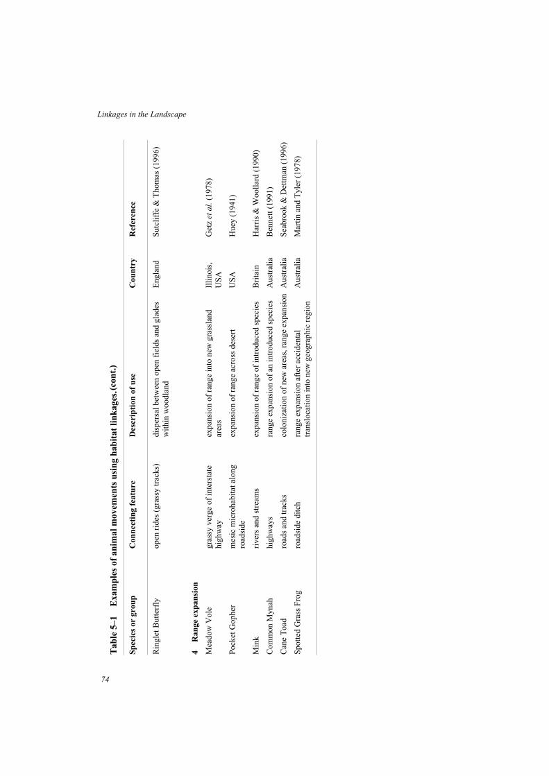
Tab
le5–1
Exam
ple
sof
an
imal
movem
ents
usi
ng
hab
itat
lin
kages
.
Sp
ecie
sor
gro
up
Con
nec
tin
gfe
atu
reD
escr
ipti
on
of
use
Cou
ntr
yR
efer
ence
Rin
glet
But
terf
lyop
enri
des
(gra
ssy
trac
ks)
disp
ersa
lbet
wee
nop
enfi
elds
and
glad
esw
ithi
nw
oodl
and
Eng
land
Sut
clif
fe&
Tho
mas
(199
6)
4R
an
ge
exp
an
sion
Mea
dow
Vol
egr
assy
verg
eof
inte
rsta
tehi
ghw
ayex
pans
ion
ofra
nge
into
new
gras
slan
dar
eas
Illi
nois
,U
SA
Get
zet
al.
(197
8)
Poc
ketG
ophe
rm
esic
mic
roha
bita
talo
ngro
adsi
deex
pans
ion
ofra
nge
acro
ssde
sert
US
AH
uey
(194
1)
Min
kri
vers
and
stre
ams
expa
nsio
nof
rang
eof
intr
oduc
edsp
ecie
sB
rita
inH
arri
s&
Woo
llar
d(1
990)
Com
mon
Myn
ahhi
ghw
ays
rang
eex
pans
ion
ofan
intr
oduc
edsp
ecie
sA
ustr
alia
Ben
nett
(199
1)
Can
eT
oad
road
san
dtr
acks
colo
niza
tion
ofne
war
eas,
rang
eex
pans
ion
Aus
tral
iaS
eabr
ook
&D
ettm
an(1
996)
Spo
tted
Gra
ssF
rog
road
side
ditc
hra
nge
expa
nsio
naf
ter
acci
dent
altr
ansl
ocat
ion
into
new
geog
raph
icre
gion
Aus
tral
iaM
arti
nan
dT
yler
(197
8)
(con
t.)
Linkages in the Landscape
74

Dispersal movements
Dispersal can be described as the one-way movement of an individual away from a homerange or territory to a new area. For example, a young hopping-mouse, squirrel, or wallabyleaves its maternal home range and disperses to a new area where it establishes its own range.The use of linkages to assist dispersal of animals between otherwise-isolated patches ofhabitat is an important way in which they can enhance species’ conservation. Immigration ofnew individuals can supplement a declining population to prevent its disappearance,introduce new genes to an isolated population, or allow colonization of new habitats as theybecome suitable.
75
Movements of Animals Through Linkages
Box 5–2 Impacts of variation in ‘stopover’ habitat quality
for Rufous Hummingbirds along a migration
corridor in western USA
The Rufous Hummingbird is one of many species of migratory land birds that breed innorthern areas and undertake seasonal migration to the Neotropics where they spend thewinter months. This species breeds in north-western North America and in late summermigrates south along the Cascade-Sierra Nevada and Rocky Mountain Ranges to itswintering grounds in Mexico. Individual birds require several stopovers to ‘refuel’before continuing their migration. These stopovers occur in mountain meadows whereindividuals establish temporary territories based around patches of flowers and feed onnectar for periods of three days to several weeks to gain sufficient energy (body fat) forcontinued migration.
Detailed observations of Rufous Hummingbird territories, stopover durations andfood resources were made at a study site in California during the southward migrationover a seven year period (Russell et al. 1994). The quality of the stopover habitat,measured in terms of the density of flowers that provide nectar for the hummingbirds,varied widely between years. In years of low food abundance, the body mass ofincoming birds was reduced and stopover durations were longer. Further, in years ofpoor habitat quality the overall rate of migration tended to be less, suggestingpopulation-wide impacts (Russell et al. 1994).
What are the implications of variation in quality of stopover habitats? First, longerstopovers in poor years delays migration and increases the risk that birds will notcomplete migration within the limited flowering period of their food plants.Late-travelling birds may also be caught by storms and poor weather along themigration route. Second, in most years food is limited at stopover points and birds oflow body weight unable to obtain territories are at risk of dying of starvation beforerefueling. Third, observations suggested that in years with poor flowering thepopulation as a whole may decline (Russell et al. 1994). These observations show thathigh-quality stopover habitats are critical links along migratory corridors for some landbirds. If natural variation in habitat quality has such an appreciable effect on thesurvival of migrating birds, then degradation or complete destruction of criticalstopover points must be a cause for great concern.

What evidence is there that dispersing animals use linkages? Dispersal movements areoften difficult to observe or follow unless animals are individually marked or haveradio-transmitters attached. Even so, it can still be difficult to determine the actual pathwaytaken by the moving animal. However, a range of examples are available that illustrate howhabitat links facilitate the movements of dispersing animals, especially for mammals (Table5–1) (Box 5–3).
Arboreal mammals live above ground in the shrub or canopy tree layer and generally aredependent on networks of trees or shrubs to move through cleared land. The use of treerowsand hedgerows by squirrels is well documented (see below). The Sugar Glider, a smallarboreal marsupial of eastern Australia, also uses forested habitat corridors for dispersal.Studies of a population of Sugar Gliders living in fragments of eucalypt forest amongstfarmland in southern Victoria showed that both males and females dispersed from their natalrange at about 12 months of age (Suckling 1984). Sugar Gliders move by gliding betweentrees over distances of at least 50m. All of the known dispersal movements of young glidersinvolved movement along a forested roadside strip for distances up to 1.9km, although thisalso included movements of up to 200m across treeless gaps by some individuals. Four otherarboreal marsupials, the Common Ringtail Possum, Common Brushtail Possum, Koala, andFeathertail Glider were also recorded in the roadside strip and probably also use it as apathway for dispersal through cleared farmland. Large expanses of cleared farmland limit orprevent the movement of tree-dwelling mammals.
76
Linkages in the Landscape
Box 5–3 Stepping stone fragments for the dispersal of
White-crowned Pigeons in Florida, USA
The White-crowned Pigeon is an obligate frugivore and an important seed disperser inthe seasonal deciduous forests of south Florida, USA (Strong and Bancroft 1994). It is ahighly mobile species that feeds on fruits of at least 37 species of trees and shrubs. In theupper Florida Keys area, it nests colonially or semi-colonially, mainly on islands inFlorida Bay. Consequently, post-fledging dispersal by young pigeons involves anover-water flight of several kilometres, followed by further flight to locate habitats withsuitable food resources.
Immature birds that dispersed to the mainland fed almost exclusively within theEverglades National Park or an adjacent wildlife management area. However, birdsdispersing to the Mainline Keys are not able to reach large areas of protected forestwithin the first 72 hours of dispersal, but must pass through the heavily fragmentedsouthern area where they preferentially selected the larger fragments (5–20ha) ofseasonal deciduous forest (Strong and Bancroft 1994). These fragments appear tofunction as important stepping stones for immature pigeons during the first stage ofdispersal to the north where large blocks of habitat are protected in reserves. Thepreference for larger stepping stones en route may be that they provide feeding areaswith adequate cover from predators for inexperienced birds (Strong and Bancroft 1994).

In another study in southern Australia, radio-telemetry was used to observe the movementsof Koalas that were translocated into natural forest habitat on the outer urban fringe ofBallarat, Victoria, after being found in hazardous situations on highways, or at risk from dogs(Prevett 1991). Koalas used a series of habitat corridors, remnant patches of trees and singletrees as stepping stones in their extensive movement through the landscape beforeestablishing in a new home range (Fig. 5–1).
Linkages may be used for dispersal not only in disturbed environments, but also in naturalenvironments. At a study site in Alberta, Canada, where Columbian Ground Squirrels live incolonies in grassy meadows surrounded by forest or bog habitats, animals that dispersed fromtheir colony followed trails, drainage lines and topographic features, to create ‘squirrelhighways’ between colonies (Wiggett and Boag 1989). Movement along these linear featuresis a good strategy for locating new colonies because most suitable meadow habitat is adjacentto waterways and tracks along valley floors.
77
Movements of Animals Through Linkages
Fig. 5–1(a) Movement path of an adult male Koala in the urban-rural fringe of Ballarat,
Victoria, Australia, after the animal was translocated from an urban situation where
it was harassed by dogs. Numbers represent sequential locations of the individual by
radiotelemetry. From Prevett (1991) with permission, Surrey Beatty & Sons,
Publishers.

Stream systems also form natural corridors for dispersal. Dispersal movements of RiverOtters in Idaho, USA, involved extensive travel along streams and river systems. Shortmovements overland were necessary to cross between stream systems, but such traverseswere assisted by ditches and low-order streams (Melquist and Hornocker 1983; Forman andGodron 1986). In south-west Western Australia, dense vegetation along stream banks is afocus for habitat management to assist dispersal of the endangered Noisy Scrubbird. Thiscryptic species occupies dense low shrubby vegetation and seldom flies. Recent populationexpansion appears to have been assisted by dispersal along stream systems with densevegetation (Danks 1991).
78
Linkages in the Landscape
Fig. 5–1 (b) Koala (Photo: L. Lumsden).
Range extension
A number of instances have been reported in which linear habitats have assisted the rangeexpansion of animal species into areas not formerly occupied. An interesting example is thespread of the Meadow Vole, a grassland rodent, near Champagne-Urbana in Illinois, USA.Grassland vegetation adjacent to interstate highways has served as a pathway for the MeadowVole to expand its distribution by 100km, over a six-year period, into new grassland habitatformerly isolated by forest (Getz et al. 1978). In most cases, however, these instances ofrange expansion involve the spread of introduced species, often a pest species, which has anecologically detrimental effect. In Australia, the distribution of the Common Mynah hasexpanded in a radial fashion from the urban centres of Melbourne and Sydney. Thisintroduced bird is common along the disturbed edges of main highways which haveundoubtedly been the pathway for its spread (Bennett 1991). Similarly, roads and tracksenhance opportunities for introduced Cane Toads to colonize new habitats and expand theirrange in northern Australia (Seabrook and Dettman 1996). Mink, an introduced species inBritain, has spread rapidly in the wild. The expansion of its range occurs by dispersal alongriver corridors, with the initial rate estimated to have been 20km per year (Harris andWoollard 1990).
Tunnels and underpasses to assist movement across
local barriers
The increasing number of hazards and barriers to wildlife in developed landscapes causesdisruption to the regular or seasonal movement patterns of many animals. Railway lines,power line easements, canals, pipelines, culverts, fences and roads, hinder or prevent naturalmovements. Roads, in particular, pose a barrier to wildlife movements due to the expanse ofcleared and altered habitat; the noise, movements and flashing lights from passing traffic; andthe risk of death from passing vehicles (Bennett 1991). The extent of road systems isenormous, throughout almost all environments.
Tunnels and underpasses are a distinctive type of link that are short, direct and have thespecific goal of facilitating local movements of wildlife across potential barriers (Box 5–4).The most obvious benefit from underpasses under roads, for example, is a reduction in thenumber of animals killed by vehicles while attempting to cross. A mounting toll of deadanimals has often been the visual stimulus that has prompted action. Other conservationbenefits from assisting movements across local impediments are less readily observed. Theseinclude reduced disruption to social organization (Box 5–5), maintenance of normalmovement patterns, and reduced mortality during the dispersal phase in a species life-history.
Highway underpasses are now regularly used for the management of large game speciessuch as Elk, Mule Deer and Mountain Goat in North America (Reed et al. 1975; Reed 1981;Ward 1982; Singer et al.1985; Harris 1988b). They have proved effective in assisting animalsto cross highways at migration pathways, or where busy highways bisect their habitats, thusalso reducing vehicle damage and human fatalities (Fig. 5–2). In Glacier National Park inMontana, USA, where a highway crossed the pathway of Mountain Goats travelling to anatural saltlick, the animals were inhibited, but not prevented, from crossing the road (Singer1975). However, the effects of the road traffic included increased stress for the animals, the
79
Movements of Animals Through Linkages

risk of separation of mother and young, and increased mortality from road kills. When anunderpass was subsequently constructed, less stress was observed in animals crossing and thenumber and seasonal duration of visits to the saltlick increased (Singer et al. 1985).
Experience in California and Florida, USA, has shown that underpasses assist movementsof large wide-ranging species such as Cougars or Panthers (Cougar, Panther or Puma aredifferent names for the taxon Felis concolor). In southern Florida, a series of 24 underpasses,each approximately 20m long and 2m high, have been specially constructed along a 64kmsection of interstate highway 75 where it runs through a major habitat of the Florida Panther(Smith 1993; Foster and Humphrey 1995). Thirteen bridges are also being extended to allowland crossings adjacent to wet areas. The siting of the underpasses was based on knownmovements and the location of previous road kills of Florida Panthers. Highway fencing hasbeen erected to keep animals off the road and funnel them into the underpasses. Monitoring ofanimal movements through four underpasses over periods of up to 16 months recorded 837crossings of 20 species, including Florida Panther, Black Bear, Bobcat and large numbers ofWhite-tailed Deer (Foster and Humphrey 1995). Radio-tracking data for Panthers andBobcats showed that individuals used the underpasses mainly to travel to portions of theirhome ranges separated by the highway.
Underpasses or tunnels have also been used to facilitate movements, or to reduce the roadtoll, for species as diverse as Badgers in Britain and the Netherlands (Forman and Hersperger1996), Mountain Pygmy-possum in Australia (Box 5–5), and Common Toads and otheramphibians in numerous countries in Europe (van Leeuwen 1982; Langton 1989).
80
Linkages in the Landscape
Box 5–4 Underpasses to assist seasonal migration of Mule
Deer in western USA
An early trial of a highway underpass for a large mammal species was made in 1970 inwest-central Colorado, USA, where a regular migration pathway of Mule Deer movingbetween summer and winter ranges crossed interstate highway 70 (Reed et al. 1975). Aconcrete box underpass (3m x 3m x 30m), combined with highway fencing, wasinstalled and monitored for use over four years. Most deer successfully used theunderpass (an estimated 61% of the local population), with the number of individualscrossing the highway increasing by 33% per year over the four-year period (Reed et al.
1975).
Wider and taller ‘machinery’ underpasses (9m x 4.5m x 61m) were used togetherwith a series of box underpasses on a section of interstate highway 80 in Wyoming,USA, where the highway bisected a migration path of about 1,000 Mule Deer (Ward1982). Highway fencing and one-way gates, to allow deer trapped inside the fence toexit, were also installed. Deer were reluctant to use the underpasses in the first year andfood baits were used to attract them to the passageways. Increased use in subsequentyears, as in Colorado, suggested a learning pattern. The underpasses were successful inassisting the migration of Mule Deer, while also reducing road kills by 90% frommonitored levels before intervention (Ward 1982).

81
Movements of Animals Through Linkages
Box 5–5 Rock-scree corridor and tunnel for the Mountain
Pygmy-possum in Australia
The alpine habitat of the endangered Mountain Pygmy-possum is limited to less than12km2 in south-eastern Australia, where this small mammal inhabits rock screes andboulder fields that have suitable sub-alpine heathland vegetation. About 40% of the totalpopulation of some 2,500 individuals occurs in the Mt Higginbotham area, Victoria,which is bisected by a ski resort (Mansergh and Scotts 1989). At this site, femalesoccupy high-quality habitats at higher elevations and males move to and from thesehabitats for the breeding season (Mansergh and Scotts 1990). A road and recentdevelopments on an adjacent slope were believed to be inhibiting the seasonalmovement of males and disrupting the social organization of the population. Theseconclusions were based on a comparison of the population demography with that of apopulation on a nearby undeveloped slope.
A funnel-shaped habitat corridor, 60m in length, was constructed of rocks andboulders leading to two tunnels under the road, thus restoring continuity of rock screehabitat across the development zone. A remote-sensing camera within the tunnelphotographed animals using the habitat corridor within two weeks of tunnelconstruction. Continued monitoring revealed a significant seasonal difference in thedirection of movement of animals through the tunnel. In the season followingconstruction of the rocky habitat corridor, dispersal of males at the end of the breedingperiod greatly increased and overwinter survival of females increased to a levelcomparable to that on undisturbed slopes (Mansergh and Scotts 1989). The tunnel hashad a high public profile and is known colloquially as the ‘tunnel of love’ (Steer 1987).
Rock-scree corridor and tunnel for the
Mountain Pigmy-possum in Australia
Mountain Pygmy-possum
(Photo: I. Mansergh).

82
Linkages in the Landscape
Fig. 5–2 (a) Highway underpasses combined with roadside fencing have greatly reduced the
number of Elk killed on the trans-Canada highway in Banff National Park, Canada.
(Photo: A. Bennett).
Fig. 5–2 (b) Elk (Photo: A. Bennett).

Amphibians that cross roads to ponds or wetlands during the breeding season can be killed inlarge numbers. The mortality of Common Toads crossing a highway to their breeding pondsin the Netherlands was estimated to be 30% of females (van Gelder 1973). On a 3.2km stretchof road in Britain, regularly monitored throughout the year, 40% of the annual road kill ofCommon Frogs was recorded in a single week during the breeding season (Hodson 1960).While estimates of natural mortality are required to assess the significance of such road kills,measures that reduce direct mortality will help to alleviate one of the many pressures onamphibians surviving in developed landscapes. Tunnels and culverts for wildlife are also usedunder railway lines (Hunt et al. 1987; Yanes et al. 1995) and, in Alaska, oil pipelines havebeen elevated above the ground to provide underpasses for Caribou populations (Klein 1971;Curatolo and Murphy 1986).
It must be stressed that successful use of tunnels and underpasses by some species does not
mean that roads and freeways can be carved through natural habitats with minimal impact onwildlife. Road systems have a host of direct and indirect detrimental effects on naturalcommunities (Harris and Gallagher 1989; Bennett 1991; Forman and Hersperger 1996) andfurther dissection of natural areas must be resisted and prevented.
Experimental investigations of the values of linkages
Experimental studies provide the strongest grounds for testing hypotheses and confirmingcausal relationships in scientific investigations. Therefore, the most convincing evidence forthe conservation benefits of linkages will come from carefully designed, manipulative fieldexperiments. Nicholls and Margules (1991) discussed various designs to test the hypothesisthat ‘recolonisation will be greater in remnants that are connected to source areas by corridorsthan in unconnected remnants’. A suitable study design would involve clearing a continuousarea of intact habitat to leave a series of equal-sized remnants, half of which (randomlyassigned) are isolated and half linked by habitat corridors of equal length and width. For eachof these groups of remnants, half would be subject to an experimental extinction of the targetspecies, while the remaining remnants would serve as controls (Fig. 5–3a). The ability of thetarget species to recolonize remnants in each treatment would then be monitored. In alandscape already fragmented, an alternative design could involve a series of replicateremnants, half of which are connected and half isolated from a large mainland habitat (Fig.5–3b).
While the design of such experiments may seem straightforward, the practical difficultiesinvolved in clearing natural habitats to create remnants and habitat corridors of suitable size,or in locating suitable remnants to carry out such a study in fragmented landscapes areenormous. After examining combinations of remnants and habitat corridors and theassociated covariates of remnant size and corridor length amongst a mosaic of many hundredsof remnants in the wheatbelt of Western Australia, Nicholls and Margules (1991) concludedthat it was not possible to find suitable sites to adequately perform the experiment. It is evenless likely that such an experimental approach can be applied to assessing the conservationvalue of broad landscape linkages that facilitate movements of individuals and the continuityof entire assemblages at the landscape scale. Such major links between reserves or largenatural areas usually have a sample size of one, and consequently the benefits of connectivitycan not be analyzed statistically (Beier and Loe 1992).
83
Movements of Animals Through Linkages

84
Linkages in the Landscape
Fig. 5–3 Representation of an idealized design to test the hypothesis that ‘recolonization will be
greater for remnants connected to source areas by corridors than for unconnected
areas’. (a) Design based on the creation of an experimental protocol from a single large
habitat. The central part of the habitat has been cleared leaving a series of connected
and unconnected habitat remnants for experimental manipulation. (b) Design
based on a landscape already fragmented in which it is possible to locate a series of
remnant habitats that are either linked or isolated from a nearby larger habitat. In
each case, closed circles represent remnant habitats from which the organism under
study has been driven to local extinction and open circles represent the controls.
Redrawn from Nicholls and Margules (1991) with permission, Surrey Beatty & Sons,
Publishers.

Some limited experimental data have come from a large field project on the effects ofclearing rainforests in the Brazilian Amazon (Lovejoy et al. 1984; Bierregaard et al. 1992).This has included a study of ‘army-ant followers’, a guild of forest birds that obligatorily feedon insects disturbed by swarming Army Ants. Army-ant followers are sensitive tofragmentation and disappeared immediately when 1ha and 10ha fragments were isolated(colonies of Army Ants use about 30ha of forest) (Bierregaard et al. 1992). In one 100hareserve that remained connected by a riparian corridor, 2km in length and 100–300m wide,the structure of the understorey bird community was not distinguishable in the first year fromthat in control plots in continuous forest. However, when a 250m break was cleared in thecorridor (1.6km distant from the fragment) a year later, the three obligate ant-followingspecies rapidly disappeared from the reserve (Bierregaard et al. 1992). After a year ofregeneration in the corridor, it was reported that one of the species was beginning torecolonize (Harper in Simberloff and Cox 1987).
Systematic monitoring of understorey birds in the same fragments before and afterisolation revealed a dramatic decline in both abundance and richness of insectivorous speciesfollowing experimental isolation (Stouffer and Bierregaard 1995a). In the years followingisolation, growth of secondary vegetation around the fragments provided increasing coverand connectivity for understorey birds, assisting them to move through the disturbed mosaicand recolonize fragments. Mixed flocks of 13 common species reassembled in 10ha (but notin 1ha) fragments by 6–9 years after isolation, but terrestrial insectivores had not recolonized(Stouffer and Bierregaard 1995a). In contrast to these insectivorous birds that were isolatedby forest clearing of only 70–650m, the species composition and abundance of nectarivoroushummingbirds showed little change (Stouffer and Bierregaard 1995b). The scale ofmovement normally undertaken by hummingbirds, together with their habitat tolerance,allowed them to move freely through the mosaic of fragments, open areas, young secondgrowth and intact forest to continue their use of fragment habitats.
An experimental protocol creating both isolated and linked fragments has beenimplemented in boreal forests of Alberta, Canada, in conjunction with timber harvestingoperations (Schmiegelow and Hannan 1993; Machtans et al. 1996). Numbers of forest birdswere monitored in two riparian buffers (100m wide) that linked forest fragments left afterharvesting, and in matched control sites within larger forest. Observations were also made ofmovements by birds across clear-cuts that isolated the fragments. Movement rates of forestbirds across open clear-cuts were significantly lower than capture rates in the forest,indicating that forest birds were inhibited by open habitat. When forested buffer strips werecompared with forest controls, the corridors were found to enhance the movements ofjuveniles (probably dispersing individuals) and maintain (but not increase) movements ofadults (Machtans et al. 1996). A further test of the values of these corridors will come whencomparison is made between the composition of forest bird communities in linked versusisolated forest blocks.
Several attempts have been made to design experimental sets of connected and isolatedhabitat patches to assess the role of linkages (La Polla and Barrett 1993; Lorenz and Barrett1990). Small patches of grassland habitat (20m x 20m) were linked by wide (5m) grassyhabitat corridors, narrow (1m) corridors or no corridors (10m gap of mown grass) to examinethe effects of habitat corridor width and presence on population dynamics and home range useof the Meadow Vole (La Polla and Barrett 1993). Treatments with habitat corridors supported
85
Movements of Animals Through Linkages

86
Linkages in the Landscape
Box 5–6 Dispersal of American Robins between farmland
shelterbelts, North Dakota, USA
Shelterbelts of trees, planted as windbreaks on farms, are used as breeding sites bytree-nesting birds in the open plains of North Dakota, USA. In a study area of some8000ha, Haas (1995) individually marked breeding American Robins, Brown Thrashersand Loggerhead Shrikes in each of 16 clusters of shelterbelts (1–7 shelterbelts percluster) in farmland. The only other habitats with trees in the study area were narrowlines of native woodland, ‘woody draws’, along creek beds or moist zones.
Movement of birds between breeding sites, both within a year and among years, weremostly within the same shelterbelt or between shelterbelts in the same cluster. However,in each year some longer breeding dispersal movements were detected. These involvedbirds moving from shelterbelt clusters to nest in woody draws or to nest in anothercluster (Haas 1995). Movements between clusters were more likely to occur betweenthose linked by woody draws than between isolated clusters. Although not essential fordispersal, woody draws appear to function as stepping stones that significantly increasethe movement of birds through the landscape (Haas 1995). These results are particularlyinteresting because American Robins are regarded as open-country birds and might beexpected to be much less dependent on habitat links than forest-dependent species.
Comparison of the number of dispersal events per pair of shelterbelt clusters for American
Robins: (a) between clusters linked by woody draws and (b) between those not linked. Data
from Haas (1995).

significantly higher densities of voles than controls, and significantly more males dispersedbetween connected patches than between patches without habitat corridors. However, eachpatch was smaller than the home range of a single male and individuals were found to haveequally moved between patches across treatments (3m of tilled ground) as within treatments.
Experimental approaches have also been used to assess the preference of animals formovement through habitat corridors of different types or quality, based on translocatinganimals to different situations and then monitoring their performance (Merriam and Lanoue1990; Ruefenacht and Knight 1995). The White-footed Mouse is a common small rodent ineastern Ontario, Canada. It favours woodland vegetation but occurs widely through farmlandscapes, including wooded and shrubby fencerows, farm buildings and occasionallycroplands. When resident individuals and translocated individuals (to simulate dispersersunfamiliar with the landscape) were released into fencerows in Ontario, animals from bothgroups used fencerow vegetation for movement in preference to adjacent fields (Merriam andLanoue 1990). Both types of animals showed a significantly greater use of fencerows withcomplex vegetation structure for movement than they did for simple fencerows (mainlynarrow grassy strips). This preference was most pronounced for the translocated animals thatwere unfamiliar with the environment, suggesting a behavioural preference for habitat thatprovides shelter and refuge during movement.
Evidence for the value of connectivity from predictive models
Predictive models have frequently been used to describe the pattern of occurrence of animalspecies or the richness of faunal assemblages in remnant habitats. Typically these take theform of multiple regression models that include one or more variables each ‘explaining’ asignificant portion of the variation in the response variable. The inclusion of measures ofconnectivity (such as length of adjoining linear habitats) or of isolation (such as the distance tonearby larger habitat, or the total amount of habitat within a defined radius) as significantexplanatory variables in regression models indicates the importance of landscape pattern inthe distribution of the species.
While the relationships revealed by such models are not necessarily causal they presentstrong inferential evidence of the value of landscape connectivity, especially when they arecombined with practical insights into the biology of the species concerned (Boxes 5–7, 5–8and 5–9). For example, separate field studies were made of the occurrence of the Red Squirrelin woodlands amongst agricultural areas in the Netherlands (Verboom and van Apeldoorn1990) and of the Grey Squirrel (Fig. 5–4) in woods in rural East Anglia, England (Fitzgibbon1993). Statistical models of these data sets predicted independently for each situation thatsquirrels were more likely to occur in woods that:
• were larger;
• contained suitable tree species;
• were close to a larger wood;
• were surrounded by a high density of hedgerows.
87
Movements of Animals Through Linkages

88
Linkages in the Landscape
Box 5–7 Possums and Tree Kangaroos in tropical rainforest
remnants, North Queensland, Australia
Arboreal marsupials in tropical rainforest in Queensland, Australia, show markedvariation in their sensitivity to extinction following fragmentation of rainforest habitats(Pahl et al. 1988; Laurance 1990). One species, the Lemuroid Ringtail, was virtuallyabsent from remnants; two species, the Herbert River Ringtail Possum and Lumholtz’sTree Kangaroo, showed a negative response to fragmentation compared with theiroccurrence in control sites in extensive rainforest; and for the remaining two species, theCoppery Brushtail Possum and Green Ringtail, the frequency of occurrence in remnantsdid not differ from control sites.
The sensitivity of these marsupials to extinction was negatively correlated with theirability to use secondary regrowth and riparian vegetation along the stream systems thatlinked most rainforest remnants. Those species most tolerant of fragmentation werefrequently recorded in riparian strips. Conversely, the Lemuroid Ringtail, which wasnot recorded in regrowth vegetation along streams, was least able to persist in remnantsdespite being common in nearby extensive rainforest (Laurance 1990). These results areconsistent with the hypothesis that dispersal along riparian habitat corridors is importantin maintaining isolated rainforest populations of some species, by allowing patchpopulations to be supplemented or recolonized should extinction occur.
This hypothesis was further supported by analyses of a larger range of 16 non-flyingmammals, including the arboreal marsupials, in the same study area on the AthertonTablelands (Laurance 1991a). In general, the ability of species to use the habitat matrixsurrounding rainforest fragments (such as regrowth forest, riparian strips, pastures) wasthe best predictor of their sensitivity to fragmentation. Species able to use the disturbedhabitats in the matrix are likely to be those most able to disperse along linkages betweenremnants and bolster isolated populations. These results indicate that both the structuralconnectivity provided by riparian habitat corridors, and the behavioural tolerance ofanimals to these habitats, are key influences on the conservation status of mammals inrainforest fragments.
The Coppery Brushtail, an arboreal mammal
relatively tolerant of forest fragmentation, was
frequently recorded in streamside strips of
vegetation that linked rainforest fragments.
(Photo: A. Bennett).

For arboreal mammals such as squirrels, woodlands surrounded by expanses of treelessfarmland are relatively insular habitats. Hedgerows, fencerows and other woodland strips andpatches that cross the intervening farmland greatly assist the movements of squirrels throughthe landscape. Further insights into how squirrels use hedgerows were gained byradiotelemetry studies of the home range and movements of individual Red Squirrels infragmented woodlands in Belgium (Wauters et al. 1994). Adult males used tree rows andhedgerows as both foraging habitat and pathways to move between parts of their home range,which often encompassed more than one small wood. Juveniles used these habitat corridors todisperse from one wood to another to establish a new home range.
89
Movements of Animals Through Linkages
Box 5–8 Distribution of the Dormouse in ancient woods in
Britain
The Dormouse, a small mammal (up to 40g bodyweight) with specialized habitatrequirements, has disappeared from approximately half of its range in Britain thiscentury (Hurrell and McIntosh 1984). A survey of the distribution of the Dormouse in238 woodlands in Herefordshire (Bright et al. 1994) found that it favoured ancientwoodlands and was scarce in recent woodland. Ancient woodlands are those of a naturalor semi-natural growth form that occur on sites thought to have supported woodlandsince 1600 AD. Ecological attributes of the Dormouse, such as low population densityand a low and highly variable reproductive rate, suggest that it is likely to be vulnerableto extinction of local populations, a view consistent with its observed scarcity in smallisolated woods (Bright and Morris 1990; Bright et al. 1994).
Analysis of survey data showed that the occurrence of the Dormouse in ancientwoodland was significantly related to the size of the wood, the amount of surroundingancient woodland, and the density of boundaries (mainly hedgerows) radiating out fromthe wood. Thus, the model predicts that Dormice are most likely to occur in largerancient woodlands that are linked to similar nearby woodlands by hedgerows. Theinclusion of hedgerow boundaries as a significant predictor suggests that dispersalbetween woods along hedgerow networks is important for the local persistence ofwoodland populations, and that enhancing dispersal is a key to the management andlocal conservation of this rare species (Bright and Morris 1990, 1991; Bright et al.
1994).
Dormice have little likelihood of dispersing through farmland where there are nohedgerows. Radiotelemetry studies have shown that individuals are sedentary inwoodlands and are entirely arboreal in their activity. They move through the woodlandcanopy layer and repeatedly detour to avoid crossing open ground to reach food or otherresources (Bright and Morris 1991). Habitat management now underway in woodlandsincludes measures such as developing networks of hazel trees as arboreal links toenhance connectivity and assist dispersal (Anon. 1993). Trial re-introductions are alsoplanned to improve the conservation status of this species (Bright et al. 1994).

90
Linkages in the Landscape
Box 5–9 Chipmunks and fencerows in eastern Canada
The Eastern Chipmunk is a common woodland animal in eastern North America. InOntario, Canada, chipmunks occupy farm woodlots but rarely occur in crops or grassyfields. Fencerows of woody vegetation, some having large mature trees, provide anetwork of habitat that greatly reduces the isolation of woods within the farmlandmosaic (Wegner and Merriam 1979; Henderson et al. 1985). Populations in farm woodsvary in size and the occasional loss of local populations in small woods over the harshwinter period is likely. Experimental ‘extinctions’, induced by removal of animals fromtwo woods, were followed by rapid recolonisation by individuals moving from adjacentfencerows and nearby woods through the fencerow system (Henderson et al. 1985).
Further studies in relation to the continuity and habitat quality of fencerows showedthere was marked variation in the way that fencerows were used (Bennett et al. 1994).Grassy fencerows that lack wooded cover were seldom or never used but, within thenetwork of wooded fencerows, there were frequent movements of animals betweendifferent fencerows, between fencerows and woods, and between woods. Someindividuals were transients, apparently using the fencerow for direct movementsthrough the landscape. The continuity of fencerows between woods (i.e. lack of gaps),together with fencerow structure, were significant predictors of the number oftransients. Other individuals were resident within fencerows and known to breed there.The number of resident chipmunks was greatest in wide fencerows with maturewoodland structure (Bennett et al. 1994).
The wooded fencerow system provides a high level of connectivity for chipmunksthrough the inhospitable farmland environment, so that they operate as a single dynamicpopulation rather than a number of isolated populations each prone to local extinction.
A high quality fencerow used both by resident and transient Eastern Chipmunks in
farmland near Ottawa, Canada. (Photo: A. Bennett).

Simulation models and empirical data on the
values of connectivity
Computer simulation models are useful tools to explore the potential fate of animalpopulations under a range of circumstances. The viability of populations in habitat patches ofvarying size, in various spatial configurations and systems of patches, or with varying levelsand quality of connectivity can be modelled (Fahrig and Merriam 1985; Fahrig and Paloheimo
91
Movements of Animals Through Linkages
Fig. 5–4 In East Anglia, Britain, Grey Squirrels were more likely to occur in woods that were
larger, contained suitable tree species, were close to a large wood, and were
surrounded by a high density of hedgerows. (Photo: A. Bennett).

92
Linkages in the Landscape
Box 5–10 The White-footed Mouse in farm landscapes of
Ontario, Canada
The spatial dynamics of the White-footed Mouse have been extensively studied bysimulation models and field studies in farm landscapes of Ontario, Canada (Wegner andMerriam 1979, 1990; Middleton and Merriam 1981; Merriam and Lanoue 1990; Fahrigand Merriam 1985; Merriam et al. 1989). Overwinter mortality of this species is high inthis region (80–90% of individuals) and consequently entire populations in small woodsare occasionally eliminated during this severe period, or they may begin the springbreeding season with small numbers. A simulation model was used to examine whetherpopulation survival in woodland patches was related to the level of isolation orconnectivity. The model predicted that populations in isolated woods would have alower population growth rate over summer than those in connected woods and,consequently, would have a higher probability of local extinction over winter.
Field data supported this prediction. Populations in woods connected by fencerowshad significantly higher growth rates than those isolated in farmland, a result attributedto enhanced dispersal into the connected patch populations (Fahrig and Merriam 1985).Other field studies demonstrated how dispersal occurs for this species. Followingexperimental removal of the population in a small wood, numerous dispersingindividuals entered over the following spring and summer (Middleton and Merriam1981 ). White-footed Mice use a range of habitats for movement through the landscapebut wooded fencerows are clearly favoured (Merriam and Lanoue 1990).
In this environment, where severe winters impose high mortality, isolatedpopulations with lower growth rates and a smaller over-wintering population are morelikely to experience local extinction. Re-establishment is also likely to be slower inisolated populations than connected ones. When this pattern is extrapolated to thelandscape or regional scale, a population inhabiting a system of connected patches has ahigher chance of regional persistence than subpopulations in a set of isolated patches.
Configurations of four-patch metapopulations of White-footed Mice with differing levels of
inter-patch connections. Configurations are arranged in order of increasing likelihood of
survival (left to right) as predicted by the model of Fahrig and Merriam (1985). Redrawn
from Merriam (1991) with permission, Surrey Beatty & Sons, Publishers.
93
Movements of Animals Through Linkages
Box 5–11 Cougars and habitat corridors in an
urban-wildlands interface, California, USA
Cougars are a species of particular concern in North America because they havedisappeared from much of their former range and, like other large predators, their arearequirements mean they will have difficulty persisting even in some of the largestreserves (Beier 1993). This taxon has been a focal species in efforts to retain andpromote linkages between large natural areas in the USA (Noss and Harris 1986; Harrisand Gallagher 1989; Beier 1993).
A simulation model of the population dynamics of Cougars in the Santa AnaMountain Range in California, together with field data on population density, homeranges and dispersal movements, has presented a strong case for maintaining habitatlinks if the species is to have a long-term future in this expanding urban area (Beier1993, 1995). Computer simulations of hypothetical populations of Cougars predictedthat without immigration an area of some 2200 km2 was required to ensure a low risk ofextinction over 100 years, depending on the demographic parameters used. Immigrationof as few as 1–4 dispersing animals per decade would markedly increase the probabilityof persistence of Cougars, even in smaller areas of 600–1600 km2.
Field studies supported this model (Beier 1993). They revealed that the Santa AnaMountain Range of 2070 km2 has a population of about 20 adults which isdemographically unstable (Beier 1993). Cougars recently became extinct in the adjacentSan Joaquin Hills (75 km2) when it was isolated by urban development and extinction islikely in the Chino Hills, an area of 150 km2, if development plans block a critical habitatcorridor through which Cougars move to and from the Santa Ana Range (Beier 1993,1995). Continued development in the region could reduce the overall habitat to the1,114 km2 of protected lands, thus adding further pressure to the regional population.The only potential source of immigrants into the Santa Ana population is via a linkagefrom the Palomar Range to the south, but it is already gravely threatened by disturbanceand development.
Radio-telemetry of the movements of adults and dispersing subadults has clearlyshown that Cougars use habitat corridors to move between large tracts of habitat (Beier1995). Movements by males through a 1.5 km degraded corridor has sustained theotherwise-isolated Chino Hill population by allowing continued breeding with itsresident females. Young dispersing animals also find and use habitat corridors. All ninesubadults that were monitored moved extensively during dispersal: five of the ninefound and successfully used habitat corridors and seven explored to the tips of habitatpeninsulas up to 7 km in length (Beier 1995).
Given the large area of about 2000 km2 required to support even a small population ofthis species, and the increasing isolation and subdivision of such tracts, the futurepersistence of this large predator and other such area-dependent species will depend ontheir ability to maintain effective connectivity between a number of blocks of habitat,each of which alone is insufficient. There is ample evidence that Cougars can find

1988; Burkey 1989; Henein and Merriam 1990; Soulé and Gilpin 1991; Verboom et al. 1991;Beier 1993; Andersen and Mahato 1995; Lindenmayer and Lacy 1995; Lindenmayer andPossingham 1996). The strength of this approach is its capacity to rapidly simulate a range ofhypothetical conditions, to test ‘what if’ scenarios, and to identify the potential sensitivity ofspecies to different parameters.
It is also important to be aware of the limitations of this approach. Simulation models arecritically dependent on the input values used for model parameters such as age-specific birthand death rates, longevity, genetic effects of inbreeding, levels of interpopulation dispersal,and so on (Lacy 1993; Lindenmayer et al. 1995). Of particular relevance in this context is thesimulation of dispersal between (sub)populations to assess the value of habitat corridors, orhabitat mosaic patterns, in sustaining species in patchy environments. In general, littlequantitative data is available on animal dispersal, such as the frequency and length ofdispersal movements and survival of dispersing individuals. Consequently, when usingsimulation models to evaluate spatial configurations of habitats, values for some of the keyparameters in the model must be estimated (or guessed). For example, computer simulationsof the potential survival of two high-profile forest-dependent species, Leadbeater’s Possum inAustralia (Lindenmayer and Possingham 1996) and the Spotted Owl in North America(Lamberson et al. 1994; Andersen and Mahato 1995), in relation to the spatial arrangement ofsuitable habitat patches, showed for both species that model outcomes were particularlysensitive to the values used for parameters representing dispersal of animals through thelandscape. In both cases, the need for quantitative field data on dispersal has been identified asa high priority.
Simulation studies have greatest value when computer models can be coupled with fieldstudies, both to calibrate model parameters and to test or confirm model predictions. Twoexamples are presented here in which simulation models and field studies have been usedtogether to evaluate the importance of connectivity for species conservation. Theseinvestigations illustrate the co-ordinated use of simulation models and field investigations attwo spatial levels: for a small woodland rodent within a farm landscape (Box 5–10), and for alarge carnivore within a broad geographic region (Box 5–11).
94
Linkages in the Landscape
habitat corridors and will use them to move between blocks of habitat. Field studieshave shown that natural travel routes such as stream channels, ridgelines and unsealedroads can be identified so that they can be protected for this purpose (Beier 1995).Cougars in this region tolerate moderate levels of disturbance within such linkages andthere is evidence that effective crossings, even of busy freeways, can be managed tomaintain connectivity for this species, for example by bridged underpasses at riverscombined with roadside fencing.
Box 5–11 (cont.)

Summary
There are many documented examples of animals using various types of linkages as pathways
for movement. Movement on a daily or regular basis, seasonal and migratory movements,
dispersal movements, and range expansion, all may be facilitated by habitat links. Four kinds
of studies have revealed the range of benefits that may accrue from an increased capacity for
animals to move through modified environments. Studies of the use of tunnels and
underpasses by animals show that such direct links across local barriers reduce the level of
mortality amongst moving animals, allow continued access to habitat resources, and may
restore disrupted social structures. Experimental studies that investigate the consequences of
differing levels of connectivity are difficult to undertake. Limited results provide evidence that
linkages enhance the movement of animals to ecological isolates, thus improving the status of
populations in isolated habitats. Predictive models based on the pattern of occurrence of
animal species in patchy environments indicate that habitats with high connectivity are more
likely to be occupied than those that are isolated. Thus, species able to use linkages have a
greater capacity to persist in fragmented habitats. The use of computer simulation models
coupled with field data for selected species provides evidence that landscape connectivity is
an influential factor in determining the risk of extinction for small and otherwise-isolated
populations. Overall, these studies consistently infer that high levels of habitat connectivity
are associated with a greater occurrence and persistence of populations in isolated habitats.
95
Movements of Animals Through Linkages
6 LINKAGES AS ECOLOGICALELEMENTS IN THE LANDSCAPE
Linkages as Ecological Elements in the Landscape
From a conservation perspective, most interest in linkages has been in their role as pathwaysfor the movement of animals (and plants) through inhospitable environments. Littleconsideration has been given to their wider ecological role in the landscape and to otherconservation benefits they may provide while enhancing connectivity. Forman (1991)outlined six broad categories of public policy issues that are addressed by linkage networks inthe landscape: biological diversity, water resources, agriculture and wood production,recreation, community and cultural cohesion, and climate change (Table 6–1). The range offunctions encompassed by these categories suggests that a focus only on animal movementslimits our appreciation of the potential benefits that linkage networks may provide. Whetherin the form of habitat corridors, stepping stone patches or habitat mosaics, all linkages are partof the landscape and contribute to its structure and function. To illustrate the wider role ofthese links in the landscape, this chapter reviews ecological values of five common types oflinkages – landscape links, riparian vegetation, hedges and fencerows, roadside vegetationand forest linkages.
Particular attention in the following sections is given to the value of linkages as habitat forplants and animals. By providing additional habitat for species living in modifiedenvironments, linkages make a direct contribution to the conservation of biodiversity. Theymay substantially increase the total amount of suitable habitat and, in some cases, provide themajority of remaining habitat for wildlife (Feinsinger 1994) (Fig. 6–1). Habitat links may alsobe important refuges for rare and threatened species, especially in landscapes where naturalvegetation has been all but removed, or where linkages are the last remnants of vegetationtypes that have been selectively cleared (Table 6–2) (McDowell et al. 1991).
Information on the pattern of occurrence of animal species in linkage habitats also providesinferential evidence of their value in maintaining connectivity through the landscape. If it canbe demonstrated that a species that is reliant on natural habitats occurs within linkages in agreater frequency than in the surrounding altered landscape (where it may not occur at all),then it is reasonable to infer that these links increase its capacity for movement and populationcontinuity through the landscape. There are many such examples of species that occur inlinkages, but seldom in the surrounding lands (Box 6–1, and following sections). In mostinstances, however, data on actual movements of individuals or of gene flow betweenpopulations connected in this way, is not available.
Landscape linkages
Landscape linkages include a wide range of habitats that provide major links through theenvironment at the landscape or regional scale. They are usually substantial areas of habitatwhose dimensions are measured in kilometres, and they connect across distances ofkilometres to tens of kilometres or more. Examples include broad tracts of natural habitat
97

Table 6–1 Examples of issues in six areas of public policy (after Forman 1991) that are
significantly influenced by various types of linkages and linkage networks.
Public policy areaLandscape
links
Riparian
vegetation
Hedgerows &
fencerows
Roadside
vegetation
Forest
linkages
1 Biological diversity
• Habitat for plant and animalpopulations
• Refuge for populations in harshenvironments
• Conservation of rare species
• Movement for wide-rangingspecies
• Dispersal between isolatedpopulations
• Maintenance of ecologicalprocesses
+
+
+
+
+
+
+
+
+
+
+
+
+
+
+
+
+
+
+
+
+
+
+
+
+
+
+
2 Water resources
• Surface drainage patterns
• Ground water accession
• Flood mitigation and control
• Sedimentation and holdingcapacity of dams and reservoirs
• Water quality and temperature
• Nutrient levels andeutrophication
+
+
+
+
+
+
+
+
+
+
+
+
+
+
+
+
+
3 Agriculture and
timber production
• Soil erosion by wind and water
• Windbreaks for crops, pastureand livestock
• Ground water levels andcondition
• Timber production
• Firewood
• Fruits, berries and other naturalproduce
+
+
+
+
+
+
+
+
+
+
+
+
+
+
+
+
+
+
+
+
98
Linkages in the Landscape

4 Recreation and aesthetics
• Wildlife observation
• Hunting and fishing
• Hiking, camping andrecreational use
• Landscape aesthetics
+
+
+
+
+
+
+
+
+
+
+
+ +
5 Community and cultural
cohesion
• Cultural identity of rural orsuburban landscapes
• Links with historical land use
• Property boundaries
• Privacy
6 Climate change
• Pathway for re-distribution ofpopulations
• Habitat for species with limiteddispersal ability
+
+
+
+
+
+
+
+
+
+
+
+
+
+
99
Linkages as Ecological Elements in the Landscape
Fig. 6–1 Aerial view of a rural landscape near Euroa, Victoria, Australia. Here, almost all
remnant eucalypt woodland not cleared for farmland occurs as linear strips along
roadsides (straight lines) and creek systems. This linked network provides important
habitat for at least three threatened vertebrate species. (Photo: A. Bennett).
Public policy areaLandscape Riparian Hedgerows & Roadside Forest

Table 6–2 Occurrence of rare species in linear habitats, as illustrated by the
distribution of known populations of rare and endangered species of plants
in different land categories in the Wheatbelt region of Western Australia.
Road and rail reserves in this region are linear habitats that usually support remnant nativevegetation. Data from Hobbs et al. 1993.
Land category Number of known populations
Nature reserve 79
Road reserve (Shire) 130
Road reserve (Main Roads Department) 5
Railway reserve 8
Private land 53
Vacant Crown land 30
Water reserve 20
Recreation reserve 3
Other reserves 7
Pastoral lease 1
Unknown 12
Total populations
Percentage on linear reserves
348
41%
between conservation reserves, major river systems and associated riparian vegetation, tractsof forest or forest mosaics designed to minimize logging impacts in managed forests, andhabitats that provide food and refuge for species along their migratory pathways. A number ofexamples of landscape links between reserves, in forest management, and for the conservationof large mammals, are presented in Chapter 9.
Landscape links often encompass large areas of land, so that in addition to their role inenhancing connectivity at broad scales, they have great value in their own right as habitat forplants and animals. In many situations they support entire communities of plants and animals,including those characteristic of ‘interior’ habitats (Box 6–2, see also Chapter 9). Indeed, theyfunction most effectively as linkages when they allow the continuity of plant and animalcommunities along their full length. These links may themselves be conservation reserves, orincorporated within reserves. In Malawi, for example, an extension was made to the LiwondeNational Park in the form of a broad landscape link, approximately 6km wide and 10km inlength, to connect the park with the Mangochi Forest Reserve (Bhima 1993). The link isdesigned to allow free movement of African Elephant between the two reserves. It alsoprovides additional habitat (7000ha) for many other wildlife species, including largemammals such as Sable Antelope, Bushbuck, Kudu, Wart Hog, Lion and Leopard (R. Bhima,pers. comm. 1995), and consolidates a single protected area of almost 100,000ha.
100
Linkages in the Landscape

101
Linkages as Ecological Elements in the Landscape
Box 6–1 Rainforest insects inhabiting streamside strips in
north Queensland, Australia
In the Atherton region of north Queensland, Australia, strips of rainforest vegetationalong streams serve as habitat corridors between fragments of rainforest isolated byarable land. To investigate the potential conservation value of these streamside links inenhancing connectivity for invertebrates, comparison was made between the speciesoccurring in different habitats in the landscape. Surveys for ants, dung beetles andbutterflies were carried out at comparative sites in extensive rainforest vegetation, inrainforest edges, in remnant rainforest strips along streams, and in arable land (Hill1995).
Analysis of the data collected was limited to the four species in each taxonomic groupthat were most abundant at the rainforest interior sites. All four of the most abundantspecies of ants in the rainforest interior, three of the butterflies and one of the dungbeetle species were present in the streamside rainforest strips. Further, two of the speciesrecorded from the riparian habitat corridors, a butterfly and a dung beetle, were clearlydemonstrated to be rainforest ‘interior’ species that were significantly more abundant inthe interior than the edge of extensive rainforest habitat (Hill 1995). With the exceptionof two butterfly species, recorded in low abundance, these examples of abundantrainforest invertebrates were not detected in the surrounding arable land, mostlycultivated for sugar cane.
These results provide evidence that streamside habitat corridors of rainforestvegetation in this area have the potential to facilitate dispersal and maintain connectivitythrough a largely inhospitable environment for a wide range of rainforest insects,including some dependent on rainforest-interior habitat.
Occurrence in rainforest, streamside corridors and arable land of four species of
butterflies, ants and dung beetles that were the most abundant in each taxonomic group at
sites in the rainforest interior in north Queensland, Australia. The shaded portion
represents species that show a significant preference for rainforest ‘interior’ habitat. Data
are from Hill (1995).

102
Linkages in the Landscape
Box 6–2 La Selva-Braulio Carrillo corridor, Costa Rica
Acquisition of land by a consortium of conservation agencies (including the NatureConservancy, USA, National Parks Service of Costa Rica, National Parks Foundationof Costa Rica, Organisation of Tropical Studies, and World Wildlife Fund) providedinitial protection for a broad landscape link between two important reserves in CostaRica. The La Selva Protection Zone (as it was first known) is a broad band of tropicalforest, 3–6 km in width, that extends for about 18km along an altitudinal gradient fromthe La Selva Biological Station at low elevation (30m) to the mid-upper elevationBraulio Carrillo National Park (2900m at highest point) (Pringle et al. 1984).Subsequently this landscape link was incorporated within the national park.
La Selva Biological Station, a 1336ha area of moist forest in the Atlantic lowlands, isa species-rich reserve used for scientific research and scientific tourism. Protection ofthe landscape link means that La Selva will maintain continuity of habitat with theBraulio Carrillo National Park, a large protected area of 44,000ha. About 73% of thelink is primary forest with the remainder as secondary forest or young second growth,pasture and crops (Pringle et al. 1984). Almost the entire catchments of two rivers, thePeje and Guacimo, are within the corridor and adjacent forest reserve. The river gorgesare relatively unaffected by deforestation, thus maintaining a continuous connection ofprimary forest despite some clearing for pasture and crops.
The protection of intact forest along an elevational gradient from 36m to 2900m,maintains the opportunity for altitudinal migration of many animal species. At least 75species of birds within the La Selva-Braulio Carrillo region are known to be migrantsthat move altitudinally between breeding and non-breeding habitats (Loiselle and Blake1992). Species such as the Emerald Toucanet, Bare-throated Umbrella Bird, GreenHermit, Three-wattled Bellbird and Silver-throated Tanager use the habitat link duringtheir seasonal migration between mid-elevation forests and lowland forests (Pringle et
al. 1984). Because these migrants spend several months in the lowlands, clearing offorests would threaten their survival.
The landscape link protects more than 7000 ha of tropical forest habitat that supportsa high diversity of flora and fauna. There are four distinctive ‘life zones’ and it isestimated to contain 650 species of trees and 450 species of birds. A biologicalexpedition in 1983 recorded numerous rare species of plants (including new species),birds, reptiles, mammals and butterflies (Pringle et al. 1984). The creation of anenlarged protected area also supports larger populations of animals and enhances theirlong-term viability. If the La Selva Biological Station was isolated by pasture (extensiveclearing of tropical forest still continues) more than 90 species of birds dependent on theprimary forest-interior could eventually be lost (Stiles in Pringle et al. 1984). Theenlarged area is also important for predators. Jaguars are among more than 100 speciesof predatory mammals, birds and snakes known from the La Selva Biological Reservethat feed largely, or entirely, on vertebrates (Pringle et al. 1984).
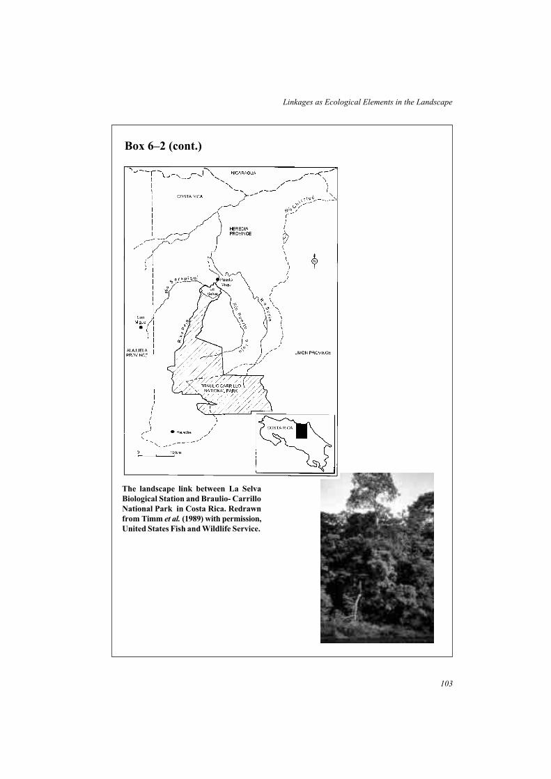
103
Linkages as Ecological Elements in the Landscape
The landscape link between La Selva
Biological Station and Braulio- Carrillo
National Park in Costa Rica. Redrawn
from Timm et al. (1989) with permission,
United States Fish and Wildlife Service.
Box 6–2 (cont.)

Major river systems and their associated vegetation have great value as habitat linkagesacross landscapes and regions. In Western Australia, as part of a review of nature reserves inthe south coast region, four river systems were identified as having particularly highconservation values and were recommended for protection as ‘corridor reserves’ (Watson1991). These riparian habitat corridors range from about 25km to more than 70km in length,and the associated natural vegetation varies up to several kilometres in width. All four linkimportant conservation reserves. Vegetation along the Fitzgerald River, for example, links thecoastal Fitzgerald River National Park, a major reserve (320,000ha) of outstanding botanicalrichness and endemism, with the inland Lake Magenta Nature Reserve (107,600ha) (Watson1991). In the semi-arid north-west of Victoria, the Murray River and its associated riparianvegetation and floodplain forests function as a major biogeographic link. Many species ofanimals, such as the Feather-tailed Glider, Yellow Rosella, Blue-faced Honeyeater, TreeGoanna and Peron’s Tree Frog, are almost entirely restricted to the mesic riverine habitats(Land Conservation Council 1987). It has clearly been the the pathway along which they haveextended and maintained their ranges in the semi-arid environment.
Many tracts of habitat that currently fill the role of landscape links, enhancing theconnectivity of the natural environment and ecological processes across broad areas, are notnecessarily recognized as such. There is now growing attention to identifying such areas andrecognizing their importance as part of a strategic approach to conservation at the regionalscale. There are different approaches to their management. Some such links are managedprimarily for conservation (Box 6–2); while others are managed on the basis that local peopleare able to continue harvesting natural resources at an intensity that will not compromise thefunction of the link (see Boxes 7–4 and 8–5 for examples).
Riparian vegetation
Riparian vegetation along streams forms an hierarchical system of natural linear habitatsthrough the landscape, from intermittent drainage lines to minor streams to major rivers. Themesic streamside environment supports a zone of vegetation that usually is structurally andfloristically distinct from adjacent habitats with which it intergrades. Riparian vegetation isgenerally readily recognized and mapped (from aerial photographs, for example), even withincontinuous natural habitats, and is especially distinct from its surroundings in semi-arid orarid environments and in cleared developed landscapes.
Habitat for wildlife
Riparian vegetation is well known as a rich habitat for fauna (Fig. 6–2) (Stauffer and Best1980; Emmerich and Vohs 1982; Harris 1984, 1988c; Redford and de Fonseca 1986;Decamps et al. 1987; Coles et al. 1989; Doyle 1990; Strong and Bock 1990; Dunham 1994;Bentley and Catterall 1997; but see Murray and Stauffer 1995). Several factors are associatedwith this richness.
• Riparian vegetation is at the interface between aquatic and terrestrial environmentswhere the local diversity of habitats is frequently high. Stream edge habitats, flood plainhabitats, old stream channels, and successional patterns of vegetation associated withfluctuating water levels and isolated pools, all add to the habitat diversity and array of
104
Linkages in the Landscape

105
Linkages as Ecological Elements in the Landscape
Fig. 6–2 Occurrence of bird species in winter in riparian habitats near Brisbane, Queensland,
Australia. (a) Comparison of mean species richness between sites in dryland bushland,
riparian bushland, remnant riparian strips in pastoral areas and remnant riparian
strips in urban areas. (b) Mean percentage of individuals at each site that are forest
species (stippled), generalists (vertical lines), and cleared country species (unshaded).
Data from Bentley and Catterall (1997).
opportunities for fauna. There may also be a distinct ecotone between the riparianvegetation and adjacent upland vegetation, further increasing local habitat diversity.
• The adjacency of aquatic and terrestrial environments is important for species thatrequire both environments for their life-cycle; for example, amphibians such as frogsand salamanders, and aquatic insects such as dragonflies, damselflies and mayflies. Theinterface between aquatic and terrestrial zones is also favoured by wetland birds, such asherons, egrets, and kingfishers, that forage in aquatic environments but shelter interrestrial vegetation.
• Riparian ecosystems frequently support species adapted to streamside habitats, whichrarely occur in adjacent habitats. These may be species that favour the band offloristically or structurally-distinct vegetation, such as forest birds associated with mesicenvironments (Murray and Stauffer 1995). Alternatively, there are species that usespecialized habitats along streams, such as the Large-footed Myotis, an insectivorous batthat forages above the surface of the water and is rarely found away from streams(Lumsden and Menkhorst 1995).
• Fertile alluvial soils and a greater amount and seasonal availability of moisture inriparian zones contribute to a higher and more sustained productivity than in adjacenthabitats. This productivity may be expressed in a number of ways. A greater structuraldiversity and volume of vegetation than in adjacent habitats may provide an increasedrange of foraging niches and microhabitats for animals (a greater number of vegetationlayers, for example), and hence greater species diversity. In seasonally-drierenvironments, the availability of water may extend the growing season and hence theabundance, reliability and duration of food supplies for populations. It has beenproposed that greater productivity and stability in riparian zones may allow thesehabitats to function as ‘source’ populations from which individuals disperse intosurrounding areas (Doyle 1990).
Although linear and limited in overall extent, riparian habitats can have a major effect onregional biological diversity (Box 6–3). In dry regions, the moist productive environmentalong stream systems has a critical role in the regional ecology. Riparian and associatedfloodplain habitats support a range of species not able to survive in adjacent dry habitats, andalso serve as a seasonal environment or refuge during extreme conditions for the fauna ofadjacent habitats. Alluvial woodlands along the Zambezi River in Zimbabwe, for example,support higher densities of large herbivores (such as Waterbuck, Kudu, Eland, Zebra, Impalaand Buffalo) during the dry season than the wet season (Dunham 1994), with particularly highdensities of some species (Impala and Zebra) during drought. In Arizona, USA, riparianwoodlands comprise less than 0.5% of the land area, but support a rich variety and abundanceof birds (Strong and Bock 1990; Szaro 1991). Habitats dominated by Cottonwood trees werereported to have the greatest richness of birds. Indeed, it has been reported thatCottonwood-dominated riparian vegetation in the south-west (including Arizona) has thehighest density of breeding birds in North America, and that destruction of these threatenedhabitats could result in the loss of 47% of breeding bird species in the region (Johnson et al.
1977 in Strong and Bock 1990).
Throughout the world, riparian vegetation often persists as remnant linear habitats orhabitat corridors in heavily disturbed environments such as farmland, urban areas and among
106
Linkages in the Landscape

plantations of exotic tree species (Emmerich and Vohs 1982; Brooker 1983; Faanes 1984;Balát 1985; Fowler and Howe 1987; Recher et al. 1987; Coles et al. 1989; Rushton et al.
1994). Streamside strips make a large and valuable contribution to maintaining indigenousspecies in such modified landscapes, although habitat generalists are usually more likely topersist than habitat specialists or rare species. The occurrence of songbirds in riparianwoodlands, or ‘arroyo’ vegetation, in Mexico provides a pertinent example (Warkentin et al.
1995). In the Chiapas region of eastern Mexico, strips of trees and shrubs, or of regrowthvegetation, mostly 5–25m in width, are retained along many streams amongst farmlandcleared for cattle pasture. Censuses of birds in the arroyo vegetation revealed a high diversityand abundance, especially of Nearctic migrants (about 25% of species and 40% ofindividuals). However, in comparison with extensive nearby forest, resident species in thearroyo avifauna were mainly generalists and forest edge species, with only a small number of
107
Linkages as Ecological Elements in the Landscape
Box 6–3 Gallery forests and the diversity of non-flying
mammals in the Brazilian cerrado
‘Cerrado’ is the name given to the second-largest vegetation formation in Brazil, an arealarger than 1.4 million km2 (approximately 25% of the country) composed mainly of dryforests, scrubland, open savannahs and grassland. Although mean annual rainfall isrelatively high (greater than 1000mm per annum), there is a pronounced dry season andthe vegetation is primarily adapted to dry conditions. Threading through the cerrado arenarrow strips of evergreen gallery forests along watercourses. Only a few hundredmetres wide, and occupying less than a tenth of the area, they form a distinctive linearsystem of moister woodland and forest habitat through the landscape (Redford 1985;Redford and De Fonseca 1986).
The gallery forests are the key to the diversity and composition of the mammalianfauna of the cerrado. Only 14% of the 65 genera (100 species) of non-flying mammalsknown from the cerrado are not associated with the gallery forests – the remaining 86%are either obligate residents or opportunistically use the mesic linear habitat (Redfordand de Fonseca 1986). Overall, the majority of the fauna from the cerrado vegetationformation also occur in the more mesic Atlantic or Amazon forest regions. The galleryforests increase the diversity of the mammal fauna in the cerrado in two ways: byserving as a system of mesic habitat corridors that allow forest-dwelling mammals (suchas Woolly Opossum, Kinkajou, and Howler Monkeys) to extend their range into thecerrado region; and by providing food, water and refuge for species not limited toforests (such as Maned Wolves, Nine-banded Armadillos and Brocket Deer) (Redfordand de Fonseca 1986). Protection of these natural linkages is a key to maintaining thediversity of the flora and fauna in this vast region. In principle the gallery forests areprotected by legislation because of their important role in conserving headwaters,controlling erosion and functioning as buffer areas (Felfili 1997). However, they areoften cleared for subsistence cultivation, horticulture, and for cattle. Protection fromfires, often deliberately set by people, is particularly important (Redford 1985). Fire is anatural feature of dry cerrado vegetation, but too-frequent and intense fires graduallyencroach into, and destroy, the moist gallery forests.

forest specialists (Warkentin et al. 1995). Arroyo vegetation does not support a pristineavifauna, but has a valuable role in maintaining a wide range of species through the farmlandmosaic. In its absence, the fauna would be greatly depleted.
Hydrologic regulation and water quality
Streamside vegetation has other important ecological roles in the landscape. It is the interfacebetween aquatic and terrestrial ecosystems and contributes to the function and dynamics ofboth. Importantly, it forms a buffer zone for the stream and mediates the exchange of water,nutrients, sediments and energy between the two ecosystems. All interactions between theterrestrial and aquatic environments involve the streamside vegetation in some way. Anumber of the functions of streamside vegetation in hydrologic regulation and in maintainingwater quality and stream integrity are outlined below (Forman and Godron 1986; Binford andBuchenau 1993; Ward and Stanford 1995).
Hydrologic regulation
Rainfall pattern and climate are major determinants of the quantity and timing of streamflows, but streamside vegetation modifies these processes in several ways.
• Vegetation slows runoff into streams and increases the rate at which water infiltratessoil. Litter and soil associated with riparian vegetation act as a sponge to hold water,which is later slowly released, adding stability to the water supply to the stream.
• Floodplain forests and riparian wetlands adjacent to streams moderate flood levels byproviding floodwater storage. The lateral spread of floodwaters slows the movement ofwater and exposes a greater area of soil for infiltration and subsequent release.Vegetation (shrubs, trees, trunks) also physically slows the movement of flood waters.
• Vegetation in the riparian zone transpires water to the atmosphere. In temperate zonesthis may have little influence on water flow in streams but in arid environmentstranspiration may substantially influence the quantity and duration of stream flow.
The scale of these hydrologic impacts is directly related to the amount of vegetation, andtherefore the width of the riparian strip. Wide vegetated strips have a greater regulatoryinfluence (Table 6–3) (Binford and Buchenau 1993).
Table 6–3 Attributes of riparian vegetation that enhance the protection of
water quality.
Continuous strip of vegetation with few gaps
Increased width of streamside vegetation
Gentle slope of streamside bank
Dense ground layer vegetation and litter cover
Extensive root systems to bind the soil of stream banks
108
Linkages in the Landscape

Filter for sediments and nutrients
Influx of excess sediments and nutrients from surrounding land is one of the main threats tothe integrity of aquatic systems. Sediments, such as clay, sand and silt can blanket rocky andgravelly stream beds, thus destroying breeding areas for fish and aquatic habitats forinvertebrates. Sediments increase turbidity in water and change the flow characteristics ofstreams by depositing sandbanks. The loss of storage capacity in reservoirs and large dams asa result of sedimentation is of great economic importance (McNeely 1987).
Excess runoff of nutrients, especially nitrogen and phosphorus, from fertilizers and humanor animal waste causes artificial enrichment (eutrophication) of water bodies: this results inchanges to aquatic plant and animal communities and decreased water quality. It poses healthproblems to humans and domestic animals. Runoff from pesticides, insecticides andherbicides from adjacent land uses has even more severe pollutant effects on aquaticecosystems. Streamside vegetation traps and filters sediments and nutrients before they reachthe stream, thus limiting their negative impacts. Filtration efficiency of riparian vegetation isgreatest for gentle slopes, wide streamside vegetation, and a high density of vegetation andlitter cover at ground level (Binford and Buchenau 1993).
Stabilize stream banks and beds
Erosion from stream banks and scouring of the stream channel are important sources oferosion and sedimentation when the stream channel is unstable. Streamside vegetation plays amajor role in stabilising stream channels. Root systems bind and hold soil along stream banks,while foliage, trunks and debris reduce the flow velocity and alter flow patterns.
Regulate water temperature
Increased water temperature reduces the level of dissolved oxgen, which in turn reduces therate of decomposition of organic material and the capacity to support aquatic organisms(Binford and Buchenau 1993). Riparian vegetation buffers water against changes intemperature by shading the stream surface, especially in summer months. The shading effectis greatest for shallow streams with low water volume where solar radiation causes thegreatest changes in water temperature.
Aquatic habitats and productivity
Streamside vegetation and the resulting fallen trees and branches, root systems andoverhanging vegetation contribute to the diversity of structural habitats and flow regimes(pools, riffles, waterfalls) in streams. In turn, these provide a wider range of microhabitats thatsupport a greater diversity of fish and other aquatic organisms. Streamside vegetation is alsoan important source of energy for aquatic ecosystems. Herbaceous vegetation is rapidlyconsumed after falling into streams, whereas trunks and logs are a long term source ofnutrients for aquatic food webs.
Retaining and protecting streamside vegetation is not a universal solution to problems ofstream degradation. It has little influence on point sources of pollution, such as effluent pipes,sewers and drains. However, it does have a significant role in maintaining a healthy aquaticecosystem. Vegetation along lower order streams is likely to have the greatest regulatory andenvironmental benefits because these constitute the greatest proportion of stream length and
109
Linkages as Ecological Elements in the Landscape

greatest length of interface between aquatic and terrestrial environment (Binford andBuchenau 1993; Forman 1995).
Hedgerows and fencerows
Hedgerows and fencerows are part of a diverse group of linear vegetated habitats that occur inrural environments throughout the world. They display great variation in origin, floristiccomposition and structure, but there are several common features (Forman and Baudry 1984;Burel 1996):
• they are linear in shape and usually form rectilinear networks of habitat;
• they frequently provide links between remaining natural and semi-natural habitats inrural environments;
• they are closely associated with agricultural land and their composition and structure arestrongly influenced by past and present agricultural land management;
• their presence, dimensions and vegetation composition are not stable, but changethrough time in response to prevailing land uses and management of surrounding land.
Hedgerows are linear strips of shrubs, small trees and sometimes large trees, that have beenplanted by humans along the boundaries of fields (Fig. 6–3). They are widespread in GreatBritain, France and other European countries, and there is a long cultural history of hedgerowsproviding boundaries to farmland and a barrier to the movement of stock between fields(Pollard et al. 1974; Forman and Baudry 1984; Dowdeswell 1987; Burel 1996). Manyhedgerows are dominated by a single species or a small number of woody plant species,
110
Linkages in the Landscape
Fig. 6–3 A network of hedgerows and woodland in a rural landscape in Surrey, Great Britain.
(Photo: C. Silveira).

although grasses and herbaceous species of the ground layer and associated structures (suchas ditches and raised banks) add to the floristic diversity. In many regions there are extensivenetworks of hedgerows amongst farmland, forming links between woods and forests retainedwithin the rural environment.
Fencerows are characteristic of farmland in the eastern United States and southern Canada,where they also form extensive networks amongst farmland and between woodland patches.Generally, fencerows have not been deliberately planted but are narrow strips (usually lessthan 10m) that have developed by the regeneration and dispersal of plants in a neglected stripof land between fields. Fencerow vegetation ranges from that dominated by grasses and herbs,to narrow lines of shrubs, to broad strips with mature woodland trees (see Box 5–9). Woodyplant species in fencerows are primarily those with wind or animal dispersed seeds, but widerfencerows may support species characteristic of the woodland interior (Forman and Godron1986; Fritz and Merriam 1994).
Shelterbelts, windbreaks, tree rows and plantations are other terms for linear strips ofvegetation, generally trees, that have been deliberately planted by humans for a variety ofpurposes, including: shelter from wind, to reduce soil erosion, as a source of timber, aswildlife habitat, and for aesthetic qualities (Forman and Baudry 1984; Bird et al. 1992). Theirstructure and composition vary greatly. They may comprise a monoculture of a singlenon-indigenous tree species, or a mixture of indigenous trees and shrubs that mimics naturalvegetation.
Habitat for wildlife
The ecology of hedgerows has been much studied, especially in Great Britain and France(Forman and Baudry 1984; Burel 1989, 1996; Burel and Baudry 1990), and they are wellknown as a habitat for wildlife in rural environments (Lewis 1969; Pollard and Relton 1970;Eldridge 1971; Pollard et al. 1974; Osborne 1984; Rands 1986; Lack l988). The persistenceand abundance of many animals traditionally present in European farm landscapes dependsupon the availability of hedgerows to provide shelter, breeding sites, refuge and foraginghabitat. Almost all British mammals make use of hedgerows at varying times: some smallmammals rely on hedgerow habitats for persistence in farmland (Bank Vole), others (such asWood Mice and Field Voles) also occur in agricultural fields, and predators forage or movealong hedgerows (Harris and Woollard 1990).
Much attention has been given to the use of hedgerows as a habitat for birds, particularly inGreat Britain (Arnold 1983; Osborne 1984; Lack 1988; Green et al. 1994; Parish et al. 1994,1995), and this has provided insights into their value for wildlife.
• The presence of hedgerows significantly increases the diversity of birds, especiallywoodland species, in farmland. Sites with hedges, ditches or linear woods have morespecies than comparable areas of arable land.
• The occurrence and richness of bird species is related to the dimensions and structure ofthe hedgerows. Species respond to different aspects of hedge structure, but in general‘bird rich’ hedgerows are those that are tall and wide, have many trees and species oftrees, dead timber, and a diverse structure.
111
Linkages as Ecological Elements in the Landscape

• Habitats associated with hedgerows along field boundaries, such as ditches and widegrassy margins, also enhance the overall boundary strip for birds.
• Hedge intersections are favoured by many breeding birds in comparison with straightsections, probably because a greater area of habitat is available within a specifieddistance.
• Land use surrounding hedges is an influential factor on their use as a habitat. There is agreater species richness in hedgerows where permanent pasture occurs on either side, incomparison with those with adjacent arable lands.
Fencerow networks in North America are also used by a wide range of animal species andhave a role in maintaining wildlife, albeit mostly common species, within the farmland mosaic(Petrides 1942; Dambach 1945; Wegner and Merriam 1979; Best 1983; Asher and Thomas1985; Shalaway 1985; Henderson et al. 1985). Small terrestrial mammals such as shrews,voles and chipmunks live within suitable fencerow vegetation, while medium-sized mammalssuch as the Striped Skunk, Woodchuck, Red Fox and Raccoon use fencerows for foraging,refuge and movement. Fencerows are used as nesting habitat by forest-edge and farmlandbirds, but many other species use them for shelter, temporary refuge, or foraging habitat. Forexample, in New York State, USA, 93 species were noted from fencerows (Petrides 1942),while in Iowa, USA, 62 species were reported to use fencerows in various ways (Best 1983).
The establishment of plantations and shelterbelts, and the regrowth of brushy fencerows infarmland were advocated by early wildlife managers in North America as a strategy toincrease wildlife, especially game species, in rural areas (Davison 1941; Dambach 1945).Recent studies have documented the variety of wildlife that use such planted habitats (Martin1980; Emmerich and Vohs 1982; Yahner 1983a,b; Schroeder et al. 1992). For example,during two breeding seasons in southern Minnesota, USA, 87 species of birds were observedin linear shelterbelts (Yahner 1983a). To maximize their value for the avifauna, shelterbeltswere recommended to be large in size, at least eight rows in width, have a diversity of tree andshrub species, not be mowed or cultivated, and that dead trees be retained as nesting andforaging sites.
Hedgerows, fencerows and plantations are seldom likely to support sustainablepopulations of rare or threatened species of animals, but by forming networks together withremnant natural habitats, they have a significant role in sustaining a broad range of wildlifespecies and enhancing biodiversity within rural environments. Consequently, the decline andloss of these networks associated with changing rural land use, particularly increasedmechanization and a trend toward larger field sizes, is of great concern (Conyers 1986; Barr et
al. 1986; Burel 1996). In Great Britain, a total of 28,000km of hedgerows was removed in thesix-year period between 1978 to 1984, while only 3500km of new hedge was established(Barr et al. 1986).
Other ecological functions
Recent studies of the ecology of hedgerows and fencerows have emphasized their contextwithin the landscape and their relationship with other landscape components through the flowof wind, water, nutrients, energy and biota (Forman and Baudry 1984; Burel and Baudry1990; Fritz and Merriam 1993; Burel 1996). The importance of a landscape perspective was
112
Linkages in the Landscape

starkly realized in France when extensive clearing of hedgerow networks in the 1940s–60s, aspart of the rationalisation of farmland boundaries, led to widespread ecological problems –soil erosion, flooding, wind damage and crop diseases (Baudry and Burel 1984). Recognitionof these problems led to one of the first major multidisciplinary studies of hedgerow ecology(INRA 1976).
By influencing microclimatic conditions, hedgerows, fencerows and tree plantations exerta major modifying influence on the rural environment (Forman and Baudry 1984; Forman andGodron 1986; Bird et al. 1992; Forman 1995). Relative to open areas, wind speed andevaporation are reduced downwind of the shelter, while daytime temperatures, soil moistureand atmospheric moisture are increased. Shading occurs in a narrow band next to thevegetation. Evaporation is reduced downwind for distances of up to 16 times the height of thevegetation, while for wind speed the effect extends to about 28 times the height. Reducedwind speeds greatly reduce the potential for wind-based soil erosion in adjoining farmland.Hedgerows and fencerows also intercept snow and other airborne particles such as dust andaerosols: over time, an increased deposition or terracing occurs at the hedgerow.
Hedgerow and fencerow networks intercept and slow the surface runoff and subsurfaceflow of water across agricultural land, and so reduce the potential for soil erosion. Deep rootsystems assist infiltration of water into deeper ground layers, while active transpiration by thefoliage of trees and shrubs pumps moisture from the ground to the atmosphere. Ditches andbanks associated with many hedgerows further increase their capacity to influence movementof water.
Ecological interactions with surrounding environments also occurs through the exchangeof biota, which may have either positive or negative effects. In Europe, attention is beinggiven to the role of field margins and hedgerows as refuges for ‘beneficial’ predatoryinvertebrates, such as beetles and spiders, that prey upon agricultural pests (Thomas et al.
1991; Dennis et al. 1994).
In these and other ways, hedgerows, fencerows and plantations have ecological impactsthat extend across large areas, far beyond the immediate environment of the linear vegetation.These properties can be manipulated for ecological and agricultural benefits in ruralenvironments by careful location, orientation and spacing of vegetation, and management ofthe vegetation (Bird et al. 1992; Forman 1995).
Roadside vegetation
Road systems are transport corridors imposed on the environment by humans for themovement of people and their goods and materials. The length of road systems and the areathey occupy throughout the world is immense. In mainland Great Britain, for example, roadreserves were estimated to occupy 212,000ha or 0.9% of the land area (Way 1977), while inthe United States the 6.3 million km of roads occupy at least 8.1 million ha (Adams and Geis1983). Clearly, they are one of the largest and most extensive functioning systems of linearhabitats on Earth. The vast network structure of road systems, their pervasive spreadthroughout many different environments, and the large area that they occupy, are indicative ofa significant ecological effect. There is much concern about the detrimental effects of roadsystems, particularly their role as ecological barriers, as a source of mortality for wildlife, and
113
Linkages as Ecological Elements in the Landscape

as a source of disturbance to adjacent habitats and the wider landscape (Bennett 1991; Formanand Hersperger 1996). However, the extent of road systems and their high level of structuralconnectivity suggests that there may be advantages for species that are able to use theassociated roadside habitats. Roadside vegetation, the strip of vegetation between the roadsurface and the boundary of the road reserve, is the focus of this discussion.
The type and quality of habitats on roadsides varies greatly, both within and betweencountries. In Australia, in particular, road systems are distinctive in that many roadsidessupport strips of remnant natural vegetation such as eucalypt forest and woodland, shrublandand grassland (Walling 1985; Arnold et al. 1987; Bennett 1988; Hibberd and Soutberg 1991;Hussey 1991). In rural regions of southern Australia, roadside vegetation contributessubstantially to natural habitat in the landscape, and is important for the conservation of someplant species (Table 6–2). In the Kellerberrin area of Western Australia, for example, 380km(63%) of the 602km of roads in the district have strips of native vegetation from 2–30m inwidth on either side of the road (Arnold et al. 1991), together comprising about 10% ofremnant native vegetation in the district. In other districts in Western Australia, strips ofnative vegetation up to 200m wide were deliberately retained adjacent to roads to preserveareas for wildflower conservation (Hussey 1991). One road, from Wubin to Mullewa, has acontinuous strip of native vegetation from 5–30m in width extending for 222km andconnecting small vegetated reserves at 15km intervals (Keals and Majer 1991). In contrast, inmany countries in Europe, North America and Asia, roadside vegetation is mainly of grassesand herbs, managed to maintain a low grassy or shrub cover (Niering and Goodwin 1974;Way 1977; Laursen 1981; Parr and Way 1988).
Birds are usually the most conspicuous species of wildlife on roadsides and consequentlythere are numerous reports from around the world of birds using roadside vegetation as ahabitat: from India (Dhindsa et al. 1988), United States (Oetting and Cassell 1971; Clark andKarr 1979; Ferris 1979; Warner 1992; Camp and Best 1993); the United Kingdom (Way1977); Denmark (Laursen 1981); Netherlands (Reijnen and Foppen 1994), Czechoslovakia(Havlin 1987); and Australia (Newbey and Newbey 1987; Middleton 1980; Arnold andWeeldenburg 1990; Leach and Recher 1993).
Detailed studies of the use of roadside vegetation by birds in the Wheatbelt region ofWestern Australia have shown that more than 80% of land birds in local districts use nativevegetation on roadsides as a habitat (Arnold and Weeldenburg 1990; Cale 1990; Saunders andde Rebeira 1991; Lynch et al. 1995). The roadside avifauna includes a wide range of species,but numbers tend to be dominated by common species. In the Kellerberrin district, all of the‘very common’ species, 96% of ‘common’ species, 96% of ‘uncommon’ species and 54% of‘rare’ species were recorded using roadside vegetation (Cale 1990). The composition of theavifauna varies in relation to the vegetation type (woodland or shrubland) and the structure ofthe understorey. Wide (40–50m), densely vegetated roadside strips support an avifauna that iscomparable to that in large remnants. Some species are resident year-round in the roadsidevegetation, while others move to and from the roadside as a short-term or seasonal habitat.Red-capped Robins are seldom observed on roadsides during the breeding season, but theirnumbers increase during the non-breeding season consistent with the use of roadsides as adispersal pathway by young birds (Arnold and Weeldenburg 1990; Cale 1990). Theabundance of nectar-feeding birds peaks when there is the greatest availability of flowers inroadside trees and shrubs.
114
Linkages in the Landscape

In south-western Victoria, Australia, a network of forested roadside strips from 5–40m inwidth was found to be used as habitat by 18 species of non-flying mammals (78% of the localfauna) and at least seven species (70%) of bats (Bennett 1988, 1990c). The remnant foreststrips on the roadsides (Fig. 6–4) link many of the forest patches remaining amongst farmland(see Box 2–1). Small native mammals such as the Long-nosed Potoroo, Bush Rat and SwampRat, are resident and breed within suitable roadside vegetation. They do not occur in grassyopen farmland, but use the roadside vegetation to move between forest fragments. Arborealspecies also live within roadside forests, while bats use both the road and roadside as aforaging resource. Other studies in Victoria have also shown that forested roadside vegetationis an important habitat for arboreal marsupials that depend on tree cover (Suckling 1984;Downes et al. 1997) (Box 6–5).
There is limited knowledge of the invertebrate fauna of roadside vegetation (Port andThompson 1980; Baur and Baur 1992; Munguira and Thomas 1992; Vermeulen 1994). In onestudy in Western Australia, ants were censused on 16 roadside sites and compared with thosein habitat fragments and adjacent farmland (Keals and Majer 1991). Almost all of the 93species recorded during the study were detected from roadside vegetation, although therichness and composition was related to the quality of the vegetation. The widest strips ofnatural vegetation (greater than 20m) supported an ant fauna comparable to that in fragments
115
Linkages as Ecological Elements in the Landscape
Box 6–4 Roadside habitat for butterflies in the United
Kingdom
Twenty-seven species of butterflies, representing 47% of the butterfly fauna currentlyfound in the United Kingdom, and two burnet moths (Zygaenidae) were recorded duringsearches on short transects beside 12 main roads in Dorset and Hampshire in the UK(Munguira and Thomas 1992). There was an average of nine species per site, but at onesite 23 species (40% of the fauna) were recorded. Most of the butterflies were commonspecies of grasslands, although several rare species were also present.
The range of breeding habitats at each site was found to be the best predictor ofspecies richness. Other variables such as roadside width, nectar sources, or adjacentland use could not add to the model. Most of the species detected live in ‘closed’populations and were partly or wholly supported by the roadside vegetation (Munguiraand Thomas 1992). Road traffic was estimated to kill up to 7% of populations, but thissource of mortality is insignificant compared with that from natural factors. Busy roadswere no barrier to the movements of species with open mobile populations, but slightlyimpeded those with closed populations. However, roads could not be considered abarrier to gene flow in any of the species studied.
The density and richness of butterflies on these roadsides, representing a range ofwidths, traffic, topography and vegetation structure, was considered high by Britishstandards and indicates that roadsides are a valuable habitat for these species. Activemanagement could enhance the habitat even further in many situations, by a number ofactions to provide a greater range of breeding habitats and larval food plants (Munguiraand Thomas 1992).

116
Linkages in the Landscape
Box 6–5 Forested roadsides as linkages for native mammals
in Victoria, Australia
In the Strathbogie Ranges of north-eastern Victoria, Australia, a replicated experimentaldesign was used to examine the value of remnant strips of forest along roadsides ashabitat for native mammals (Downes et al. 1997). Transects were surveyed formammals in four types of situations, each replicated six times: remnant patches of forest20–80ha in size; ‘near’ roadside strips located 300m from a forest patch to which thestrip was connected; ‘distant’ roadside strips located 1500m from a forest patch; and‘pasture’ in the cleared agricultural land surrounding forest patches.
All fourteen species of native mammals recorded during the study were present inremnant forested strips (15–32m wide) along roadsides, and one species, the CommonBrushtail Possum, was detected in roadside vegetation but not in forests. The meanspecies richness per site did not differ significantly between forests and near roadsides,but distant roadsides had a lower species richness than either of the former. The maindifference was due to fewer terrestrial mammals in distant roadsides. Each type of sitehad a similar richness of arboreal mammals (except farmland, where there were none),but there was a greater abundance of these species in forested roadside habitats than inforest patches (Downes et al. 1997). The few native mammals that were detected in openfarmland were large herbivores that venture out from forest margins, such as the EasternGrey Kangaroo, Black Wallaby and Common Wombat.
These results demonstrate that forested strips along roadsides are a valuable habitatfor a wide range of native mammals in this area. In contrast to cleared farmland in whichfew species occur, most native mammals are resident in roadside vegetation and occurover distances of at least 1.5km from forest patches. By providing a continuous strip ofhabitat that is occupied by native mammals, these forested roadsides maintaincontinuity of populations between forest patches, facilitate dispersal movements ofindividuals, and enhance landscape connectivity in this modified environment. Clearly,populations of native mammals in forest patches linked in this way are more likely tomaintain an interchange of individuals and genes than are populations in those forestpatches surrounded by farmland.
Mean species richness of native
arboreal mammals (shaded) and
terrestrial mammals (clear) for
sites in forest patches, near
roadsides, distant roadsides, and
pasture in farmland. Data from
Downes et al. (1997).

of native vegetation. Narrower strips had a reduced fauna, while cleared roadsides and farmpaddocks both had a low diversity of ants per site. If ants are reliable indicators of otherinvertebrate taxa, this suggests that roadsides with broad strips of suitable habitat have avaluable conservation role for invertebrates.
117
Linkages as Ecological Elements in the Landscape
Fig. 6–4 Remnant roadside vegetation at Naringal, Victoria, Australia, used as linkages
between forest patches in farmland. (Photo: A. Bennett).

118
Linkages in the Landscape
Box 6–6 Retained forest strips as habitat for wildlife in
montane ash forests of south-eastern Australia
Montane ash forests in the Central Highlands of Victoria, Australia, are dominated bymonotypic stands of the eucalypt trees, Mountain Ash, Alpine Ash and Shining Gum.These species grow rapidly, have diameters greater than 3 metres at maturity, and mayreach canopy heights of 70m or more. These highly productive forests are the resourcebase for a major hardwood timber industry in central Victoria. They are also animportant habitat for forest wildlife and, consequently, there has been considerabledebate about the adequacy of measures to conserve wildlife in the ash forests (Loyn1985b; Lindenmayer et al. 1990; Milledge et al. 1991; Smith 1991; Land ConservationCouncil 1994; Lindenmayer 1996). Central to this debate is the conservation of speciesdependent on characteristics of old-growth forest, especially tree hollows that generallydo not develop in these trees until at least 100 years of age (there are no primaryexcavators such as woodpeckers in Australia). Large forest owls, cockatoos, parrots andother birds require tree hollows for breeding, while a diverse range of arborealmarsupials depend on tree hollows for diurnal shelter and breeding sites. Included in thelatter group is the endangered Leadbeater’s Possum, a species endemic to this region ofsouth-eastern Australia (Lindenmayer 1996).
The code of forest practice for timber production in Victoria (Department ofConservation, Forests and Lands 1989) specifies areas of forest to be retained fromharvesting, such as forests on steep slopes, forest strips adjacent to streams, and areas setaside for flora and fauna conservation including, in some situations, ‘wildlife corridors’.To examine the value of retained strips as potential habitat corridors for wildlife, a studywas undertaken of the occurrence of native mammals in a range of forest strips withinthe montane ash forests (Lindenmayer and Nix 1993; Lindenmayer et al. 1993, 1994a,b;Lindenmayer 1996). A total of 49 strips was selected, varying in mean width from 37 to264m, each surrounded on either side by recently felled and regenerating forests agedfive years or less. Strips varied in length from 125 to 762m; they included buffers alongstreams and also forested strips extending across topographic gradients, from gullies tomidslopes or ridges.
Surveys for arboreal marsupials were carried out by ‘stagwatching’, the carefulobservation of hollow-bearing trees to detect arboreal marsupials emerging at dusk fromtheir daytime shelter in a tree hollow. All of the species of arboreal marsupial in thestudy area were recorded from forest strips, and most species occurred at frequenciescomparable to that expected from predictions based on studies in extensive forest ofsimilar age and structure (see figure below). The marked exception was Leadbeater’sPossum. Based on habitat models from continuous forest, Leadbeater’s Possum waspredicted to occur in at least 16 strips but was detected in only one. Its absence fromstrips with apparently suitable habitat was attributed to the complex social organisationof the species and its foraging requirements (Lindenmayer et al. 1993).

119
Linkages as Ecological Elements in the Landscape
Comparison of the occurrence of arboreal marsupials in retained linear habitats with that
predicted from models based on comparable continuous ash forest. Squares indicate the
number of linear strips from which each species was actually observed, while vertical lines
indicate the 95% confidence interval of the number of strips predicted to be occupied.
Predictions were not available for several species. MB Mountain Brushtail Possum, GG
Greater Glider, CR Common Ringtail Possum, YBG Yellow-bellied Glider, LP
Leadbeater’s Possum, SG Sugar Glider, FG Feathertail Glider. Data from Lindenmayer
and Nix (1993).
Box 6–6 (cont.)
Although all arboreal marsupials used the forested strips as habitat, the richness andtotal abundance of these species per linear strip were less than that expected from modelpredictions. The occurrence of arboreal marsupials in forest strips was stronglyassociated with the presence and abundance of hollow-bearing trees, a limiting resourcefor animals in the ash forests. The occupancy of hollow-bearing trees in strips wasapproximately half that recorded in comparable continuous forest. Of concern was theobservation that felling of surrounding forests exposed the retained strips to wind,resulting in the blow down of many hollow-bearing trees. Collapse of these trees isoccurring at a faster rate than in continuous forest, and has serious implications for thelong term suitability of the strips as habitat for hollow-dependent animals.
These studies and associated work on ground-dwelling mammals (Lindenmayer et
al. 1993) show that retained unlogged strips do provide habitat and refuge for nativemammals in the managed forest mosaic. However, they do not necessarily support afauna comparable in richness and abundance to that in continuous forest – at least duringthe early stages of surrounding forest regrowth. Their value and function may change asthe surrounding forest regenerates.

Forest linkages
In response to the potentially detrimental effects of timber harvesting practices on forestwildlife, especially species associated with old-growth habitats, forest ecologists throughoutthe world have advocated the need for special measures to maintain populations of sensitivespecies within production forests. The retention of unlogged areas of forest as ‘wildlife
120
Linkages in the Landscape
Tall Mountain Ash forest in the O’Shannassy catchment, Victoria, typical of mature forest
occupied by Leadbeater’s Possum. (Photo: A. Bennett).
Box 6–6 (cont.)

corridors’, ‘retained systems of habitat’, ‘habitat strips’, ‘leave strips’, ‘streamside zones’ andso on, are included among these measures with the purpose of enhancing the status andconnectivity of forest-dependent species in the logged mosaic (Recher et al. 1980, 1987;Harris 1984; Laitin 1987; O’Donnell 1991; Taylor 1991; Lindenmayer 1994; Mladenoff et al.
1994; Dickson et al. 1995).
The nature of the forest landscape means that there are fundamental differences betweenlinkages in managed forests and habitat linkages retained within agricultural landscapes, forexample. Unlike cleared farmland, an inhospitable environment that poses formidableconstraints on the free movement of many native animals, a forest mosaic of stands of varyingages of regrowth will potentially return to a suitable successional stage for most species.‘Edge effects’ between retained stands and felled stands will also decline as regrowthproceeds (Lindenmayer 1994). Young regrowth forests may be suboptimal habitat fornumerous species, but it is unlikely that many forest-dependent animals are strongly inhibitedfrom dispersing through the forest mosaic. Consequently, evaluation of the role of linkages inenhancing connectivity in managed forests places greater emphasis on their importance asretained habitats, rather than as pathways for channelling movements (Taylor 1991;Lindenmayer 1994). Retained habitats can enhance forest connectivity in several ways:
• by maintaining continuity of resident populations in linked strips of suitable habitatamong sub-optimal regrowth stands;
• by providing a source population for rapid recolonisation of regrowth habitats as thevegetation becomes suitable;
• by providing resources (such as shelter and breeding sites) for species able to forage, butnot live, within regrowth habitats;
• by enhancing movements and dispersal of species that are inhibited from movingthrough regrowth forests.
In many situations, these retained areas coincide with buffer strips for the protection ofstreams and water quality (Dobbyns and Ryan 1983; Recher et al. 1987; Darveau et al. 1995;Machtans et al. 1996). However, in some countries increasing attention is being given todesignation of retained habitats in additional topographic locations that complementstreamside strips (Taylor 1991; Claridge and Lindenmayer 1994). These may include linksbetween adjacent catchments.
Studies of the ecological values of forest linkages for wildlife have mainly concentrated ontheir role as a habitat within the logged mosaic. A number have compared retained strips withsimilar areas of undisturbed forest, or have made comparison between retained strips ofvarying width or management history (Box 6–6) (Dickson and Huntley 1987; Recher et al.
1987; Lindenmayer and Nix 1993; Darveau et al. 1995; Huntley et al. 1995; Murray andStauffer 1995; Machtans et al. 1996). In general, these studies have shown that forest stripsprovide habitat for many forest species, but do not necessarily support a species complementidentical to that in undisturbed forest. For example, a study of the use of streamside strips bybirds in production forests in Quebec, Canada, compared retained strips of 20, 40 and 60mwidth and control areas of unlogged streamside forest (Darveau et al. 1995). In the first yearafter felling and partial isolation of these streamside strips (continuous forest remained on theother side of the stream), there was an increase of 30–70% in bird density in all strips,
121
Linkages as Ecological Elements in the Landscape

compared with pre-harvest levels. The highest density was found in the narrowest strips (20and 40m strips). In years two and three, bird density subsequently decreased with the fastestdecline in the narrow strips. All strips provided habitat for a range of forest birds, but, overtime, wider strips were more likely to retain an avifauna of forest-dependent species (Darveauet al. 1995). The longer-term suitability of retained strips as habitat for forest birds in thisstudy was also influenced by exposure to wind; since clear-felling, 23% of trees in strips hadbeen killed by windfall compared with 8% in control areas.
Connectivity for wildlife in production forests can also be achieved by managing the entireforest mosaic. With careful planning, the spatial interrelationships of recently felled, regrowthand old-growth forest stands can be maintained through time to provide sufficient areas ofsuitable habitat and to allow dispersal movements. Forest management prescriptions forconservation of the Spotted Owl in forests of north-western USA are based around managinga forest mosaic that includes patches of unlogged forest spaced at intervals that allow readydispersal by young owls (Wilcove 1994). In this type of approach, the habitats that enhanceconnectivity also function as an integral part of the forest habitat mosaic for the entire forestfauna.
Retained areas of forest along streams, that also function as streamside buffer strips, have akey ecological role in maintaining hydrological processes, protecting water quality andprotecting and enriching aquatic habitats (see Riparian Vegetation above). In the context ofmanaged forests, these buffer strips have a critical role in filtering and preventing sedimentsfrom entering streams (Clinnick 1985; Binford and Buchenau 1993; Barling and Moore1994). Exposed areas of soil on logging sites and unsealed forest roads are major sources ofsediments that are washed downslope with rain. If allowed to enter streams they may haveseverely detrimental effects on the aquatic ecosystem.
Summary
Most interest in linkages has concerned their potential role in assisting the movements of
animals through inhospitable environments. Little consideration has been given to other
ecological roles and conservation benefits they may provide. A review of literature and
examples for five common types of linkages – landscape links, riparian vegetation, hedgerows
and fencerows, roadside vegetation, and forest linkages – shows that they have a wide range
of ecological functions in developed landscapes. Of particular importance is their value as a
habitat for plants and animals in fragmented landscapes. They may comprise a substantial
amount of the remaining habitat available to wildlife, support resident individuals or
populations of animals, and play a key role in maintaining the diversity of wildlife and
continuity of ecological processes in heavily modified environments.
122
Linkages in the Landscape

PART 3
LINKAGES ANDCONSERVATION STRATEGY

7 DESIGN AND MANAGEMENT OFLINKAGES FOR CONSERVATION
Design and Management of Linkages for Conservation
Throughout the world, habitat corridors and other linkages are being established for a diverserange of purposes. They may be intended to benefit single species or whole faunalassemblages, or they may be intended to provide benefits to wildlife while also deliveringother environmental, recreational and social advantages. Similarly, the operational scalevaries greatly, from underpasses and short habitat corridors bridging localized obstacles andgaps, to major landscape links extending many kilometres across elevational gradients orbetween reserves. The size and shape of these linkages and the issues involved in their designand management vary enormously.
In this context it is neither possible nor desirable to provide specific uniform guidelines forthe design and management of habitat links because they will depend on the proposed scaleand function of a particular linkage. A more useful approach in this chapter is to discussbiological issues that have a strong influence on the way in which linkages function and ontheir effectiveness (Table 7–1). These issues should be considered and evaluated forparticular situations, in relation to the identified function of the proposed link. The followingdiscussion relates most directly to the management of habitat corridors or stepping stones, butthese principles are also of general relevance to the management of broader habitat mosaics toenhance landscape connectivity.
Management for landscape connectivity occurs within a social and political context and,although not always recognized by biologists, local factors and socio-political considerationsare often as important as ecological theory and field research in the design and effectivenessof linkages (Newmark 1993). Every link is unique in terms of the social and community issuesthat are faced. There is a vast difference, for example, between the issues involved in theretention and management of natural corridors in suburban areas of California, USA, and inrural Tanzania or Costa Rica. Consequently, it is also useful to discuss a number ofsocio-political issues that are potentially important influences on the successful outcome ofsuch projects (Table 7–1).
It is important to recognize that in the real world there is rarely an opportunity to design an‘ideal’ system of habitats to maintain landscape connectivity. The all-too-frequent reality isthe challenge of how to:
• best manage remnant linkages that have survived in heavily disturbed landscapes;
• maximize landscape connectivity by using habitats retained primarily for otherpurposes;
• restore connectivity between the vestiges of natural habitats that remain afterdevelopment.
125

Table 7–1 Considerations in the design and management of linkages for conservation.
Biological issues Socio-political issues
Biological purpose of the linkage Status and tenure of the land
Ecology and behaviour of species Management responsibility and adequacy of resources
Structural connectivity Support from local communities
Quality of habitat Integration with other programmes in sustainable landmanagement
Edge effects Community education and awareness
Width Strategic approach to planning
Location
Monitoring the use of linkages
Biological issues in design and management
Eight main issues relevant to the design and management of linkages have been identified fordiscussion: the biological purpose of the linkage, ecology and behaviour of animal species,structural connectivity of the link, quality of habitat, edge effects, width and location of thelink, and monitoring of the function of the linkage.
Biological purpose of the linkage
Clear identification of the purpose of a particular link, in terms of how it is intended to providebenefits to the flora and fauna, is an important first step and an essential basis for evaluatingdesign and management requirements. Purposes commonly recognized include to:
• assist movement of wide-ranging or migrating animals through developed landscapes;
• facilitate dispersal of individual animals between otherwise-isolated habitats orpopulations;
• promote effective continuity and gene flow between populations in two areas bysupporting a resident population within the linkage;
• promote the natural continuity of habitats, communities and ecological processesbetween large areas such as national parks and conservation reserves;
• provide the opportunity for populations to shift in response to change and naturalcatastrophes;
• provide habitat and continuity for wildlife in conjunction with other environmental andsocial benefits.
126
Linkages in the Landscape

Having clearly identified the purpose(s) of a particular link, the suitability of existing plansor parcels of land can be evaluated, and biological and social issues relevant to design andmanagement can be considered in relation to that purpose (Beier and Loe 1992).
The need to clearly identify a biological purpose is paramount given the widespreadacceptance of the ‘greenway’ concept in landscape planning (Smith and Hellmund 1993;Ahern 1995). The primary theoretical justification for proposing greenways as linked systemsof open space or natural environment in planning strategies comes from conservation ofbiodiversity. Yet the actual implementation of such greenways may be influenced more byaesthetic, recreational or cultural considerations than biological values. There is a danger thatwhile the perceived benefits for biodiversity conservation will be the justification fordevelopment of greenways, a desire to ensure multipurpose outcomes for humans (such asrecreational trails and scenery) will result in the actual benefits for wildlife beingcompromised or never achieved.
Claims such as ‘wildlife corridor’ or ‘animal movement corridors’ should not be includedor accepted in planning strategies unless consideration is given to the specific biologicalpurpose of the linkage and how its design, dimensions and management will be directed tomeet that goal. The risk of a loose acceptance of what constitutes a ‘wildlife corridor’ istwofold: it is wasteful of land and resources if the objective has little chance of beingachieved, and it devalues the concept and legitimate need for landscape connectivity inconservation.
Ecology and behaviour of species
A basic knowledge of the ecology of the species or assemblage for which connectivity is thegoal is an important foundation for managing habitats to achieve this purpose. Knowledge ofthe spatial scale of a species’ movements is of particular value. How large is the home range orterritory? How far do animals regularly move? Do they undertake seasonal or nomadicmovements? Clearly, the need for a linkage, its optimum dimensions and the way it is usedwill differ between species whose scale of movements can be measured in metres (such asspiders, frogs or beetles) and larger animals that regularly move hundreds of metres orkilometres.
Information concerning habitat requirements, diet, and other necessary resources willassist in managing habitats within linkages. Other behavioural and ecological attributes, suchas the ability to cross gaps, the level of tolerance of disturbed habitats, the role of dispersal inthe life-history, the age and sex of dispersing individuals, and dispersal behaviour (random ordirected), also determine the most effective type of linkage (continuous corridor, steppingstones, or managed habitat mosaic) and the ability of species to effectively use such links(Harrison 1992).
Social organisation and behavioural spacing mechanisms within populations are alsoimportant. Species that live in groups or colonies generally require greater habitat area than dosimilar solitary-living species and, therefore, may require broader habitat links to meet thesedemands for living space (Recher et al. 1987; Lindenmayer and Nix 1993). Animals also varybehaviourally in their sensitivity to human presence or disturbance. For example, vegetativecover to buffer human presence is necessary for landscape corridors to be effective for severallarge African mammals, such as Eland and Greater Kudu (Newmark 1993).
127
Design and Management of Linkages for Conservation

Landscape scale links, such as those between conservation reserves, are generally intendedto maintain connectivity for entire assemblages rather than individual species. To achieve thisgoal, particular attention should be given to the requirements of species that are rare and thosethat have specialized habitat and foraging requirements. Linkages that encompass therequirements of the most ‘extinction prone’ species will, in most cases, also be effective forthe majority of more common species. For linkages to be effective in maintaining continuityof ecological processes, the requirements of the key species involved in such processes mustbe met. To maintain natural dispersal of seeds of fruiting shrubs and trees, for example, thelandscape must be suitable for seed-dispersing animals to move through.
Structural connectivity
Variables influencing structural connectivity of linkages include: the number and length ofgaps, the presence of alternative pathways or networks between suitable habitats, and thepresence of ‘nodes’ of favoured habitat in the system (Fig. 7–1) (Forman 1983; Forman andGodron 1986; Noss and Harris 1986; Baudry and Merriam 1988; Bennett 1990a).
Gaps in suitable habitat can severely disrupt animal movements and the continuity ofresident populations. What constitutes a gap and how effective it is as a barrier depends uponthe type of linkage, the behaviour of animal species, and their habitat specificity and scale ofmovements. For forest-dependent animals, a gap in a forested corridor might be posed by abroad expanse of cleared grassy vegetation, a recently burned patch of forest, or adiscontinuity in the canopy. But these will have different effects on different species. Clearedland that forms an effective barrier to forest-dependent beetles is unlikely to inhibit themovements of most forest birds (Box 7–1). Lengthy gaps in the tree canopy of a forest mosaicmay inhibit the movement of an arboreal mammal, but not a terrestrial mammal that movesthrough the ground vegetation.
The ‘barrier effect’ of a gap also depends upon the extent of contrast between the habitatfavoured by the animal species and that present in the gap. A narrow gap of unsuitable orhostile habitat may more effectively limit animal movements than a broad expanse of lowquality habitat. Roads and highways that divide landscape linkages and animal pathways are aparticular problem (Fig. 7–2). Not only is there a gap in the natural habitat imposed by two ormore lanes of paved roadway, but traffic sounds, lights, chemical emissions and the potentialdeath or injury by vehicles, impose a complex hazard for animals attempting to cross (Harrisand Gallagher 1989; Bennett 1991).
There is little empirical information on the effects of gaps on the movement of animals,especially at the landscape scale. Studies of the effects of roads that divide the habitats ofsmall terrestrial mammals indicate that gaps as narrow as 10m can inhibit, but not necessarilyprevent, their movement (Kozel and Fleharty 1979; Wilkins 1982; Mader 1984; Merriam et
al. 1989; Burnett 1992) (and see Box 5–5). Wider roads are even less frequently crossed(Oxley et al. 1974). For spiders, beetles and other invertebrates, gaps of the order of 20m canpose an almost total barrier (Mader 1984, 1988; Klein 1989). In Canada, grassy gaps inwooded fencerows had a negative influence on the use of the fencerow network by woodlandmammals such as the Eastern Chipmunk (Bennett et al. 1994); while a similar negative effecton the occurrence of the Brown Antechinus (a small terrestrial marsupial) in retained foreststrips in Australia was attributed to roads and tracks creating gaps in the forest strip(Lindenmayer et al. 1994b).
128
Linkages in the Landscape

129
Design and Management of Linkages for Conservation
Fig. 7–1 Structural connectivity provided by linkages is influenced by a number of factors
including (a, b) the number and length of gaps, (c) the presence of a network or
multiple pathways, and (d) the presence of nodes or patches of habitat associated with
the link. (e) A linkage that provides continuity, multiple pathways and has associated
nodes of habitat is likely to be the most effective way of maintaining connectivity for
animal populations. Redrawn from Bennett (1990a).

Birds are generally more mobile than non-flying animals but behavioural avoidance, ratherthan a physical inability to traverse distances, is probably the reason that many forest-interiorbirds are inhibited by forest gaps. Approximately 20% of tropical forest birds at diverse sitesin southern Brazil and eastern Tanzania are reported to be incapable of crossing gaps widerthan several hundred metres (Newmark 1993; Stouffer and Bierregaard 1995a). Clearly,forest corridors that have large gaps will be ineffective for wildlife conservation in these
130
Linkages in the Landscape
Box 7–1 Forest patches as stepping stones for Brown Kiwi in
New Zealand
For species able to move between stepping stone habitats, key elements of connectivityinclude the distance between ‘steps’, the number of alternative steps available, and theland use and quality of habitat in the surrounding matrix. The gaps between steps mustbe within the range that animals will normally cross.
The Brown Kiwi is a flightless bird endemic to New Zealand. Individuals aresedentary and occupy home ranges of about 20–40ha, usually in forest or regeneratingscrub with a dense understory. They forage for soil invertebrates at night and shelterduring the day mainly in natural cavities at ground level (Marchant and Higgins 1990).At Paerata Reserve in the North Island of New Zealand, kiwis venture outside thereserve into surrounding farmland in which small forest remnants survive (Potter 1990).Radiotelemetry was used to identify the distribution and track movements of these birds.
Kiwis from the reserve made extensive use of forest fragments in farmland forforaging at night and also for daytime shelter. They crossed gaps between forestpatches, often moving quickly across the open ground. Few individuals crossed gaps ofmore than 120m of pasture, with access to distant remnants occurring by birds usingcloser remnants as stepping stones (Potter 1990). Most birds were recorded in forestremnants up to 280m from the reserve boundary, and one pair occasionally travelled upto 1200m from the reserve by moving through three intermediate remnants to reach afourth. All forest remnants isolated from the reserve or from other forest by less than80m of pasture were used by Brown Kiwis, but only three of nine remnants isolated bymore than 80m were used (Potter 1990).
These observations of movement patterns were recorded from resident Brown Kiwis.They suggest that stepping stone patches of forest must be at intervals of approximately100m or less to ensure functional connectivity of habitat for kiwis living and foraging inthis fragmented landscape. Gaps in excess of 300m appear to effectively isolateotherwise-suitable forest remnants from use by these birds. It is not known, though, howfar kiwis may move during the dispersal phase of their life-history.
Knowledge of the scale of movements undertaken by Brown Kiwis can be used in apractical way to restore and increase habitats for this species. By protecting or restoringforest patches at appropriate intervals, there is potential to reconnect and expand thearea of habitat available to the Brown Kiwi, and thus to extend the conservationpotential of reserves in fragmented landscapes.

tropical habitats. Even birds that readily survive in heavily developed landscapes prefer tomove through vegetated linkages, where available, rather than cross open country gaps(Johnson and Adkisson 1985; Haas 1995).
The length of a linkage influences its effectiveness in several ways. With increasingdistance there is a reduced likelihood of single animals, particularly small ground-dwellinganimals, travelling the full length, and an increased reliance on animals resident within thelinkage to provide population continuity. Thus, the greater the distance to be connected, themore important it is that the linkage provides habitat and food requirements for key species.Increased length also exposes resident or moving animals to a greater cumulative disturbancefrom adjacent habitats (such as risk of predation), and there is a greater vulnerability to suddendisturbance or catastrophe, such as fire and illegal clearing, that can cut the link. Severalmeasures to reduce risks associated with length include the provision of duplicate links or anetwork of connecting habitats to provide alternative pathways (Fig. 7–1), and maximisingthe width of linkages to provide the largest possible habitat area and minimize externaldisturbance.
131
Design and Management of Linkages for Conservation
Location records for a female Brown Kiwi at Paerata Wildlife Management Reserve
illustrating the use of a number of stepping stone remnants outside the reserve boundary.
From Potter (1990) with permission, New Zealand Ecological Society.
Box 7–1 (cont.)

Incorporation of nodes of favoured habitat as part of a link can increase its effectiveness byproviding additional habitat in which animals may take refuge or forage during lengthymovements. Habitat nodes may also maintain larger breeding populations within the linkage,thus introducing more dispersers into the system. Examples of nodes include (Fig. 7–3):
• nature reserves associated with a major landscape link (Noss and Harris 1986).
• floodplain expansions along riparian corridors (Dobbyns and Ryan 1983; Recher et al.
1987);
• additional vegetation at T and cross (+) junctions along hedgerow and fencerownetworks (Forman and Godron 1986; Lack 1988);
• small forest patches adjacent to roadside corridors.
Intuitively, it is evident that landscape connectivity will be greatest when there is a highlevel of structural connectivity created by a combination of alternative and network pathways,nodes along linkages, and few gaps or breaks (Fig. 7–1).
Quality of habitat
Animals do not recognize a habitat linkage as such or its functional role as a pathway formovement – animals simply recognize whether the habitat within a linkage is suitable or not(Newmark 1993). Consequently, the availability and reliability of resources such as food,
132
Linkages in the Landscape
Fig. 7–2 A narrow gap of unsuitable or hostile habitat, such as a busy highway, may more
effectively limit animal movements than a broad expanse of low quality habitat.
(Photo: A. Bennett).

shelter, refuge from predators and nest sites are critical if animals are to be able to live inlinkages and use them as pathways for movement. A variety of studies have shownrelationships between the occurrence and abundance of animals in connecting habitats and theavailability of certain habitat components (Pollard et al. 1974; Yahner 1983a, b; Arnold 1983;Osborne 1984; Recher et al. 1987; Lindenmayer et al. 1993, 1994b; Bennett et al. 1994). Theprovision of high quality habitat raises several important issues in the design and managementof linkages.
First, habitat quality is a critical issue for landscape linkages that form part of an integratedconservation network at the regional scale (Harrison 1992). Landscape links that maintainresident populations and communities must provide year-round resources for feeding, shelterand breeding. Similarly, stepping stone links, such as those that provide short-term ‘stopover’points for migratory birds, must provide rich food resources at critical times of the year.Habitat quality is also important at the scale of local networks. Typically, linkages in whichanimals are resident must provide a greater range and specificity of resources (food, shelter,breeding sites) than those used only for brief movement (Bennett et al. 1994; Lindenmayer et
al. 1994a, b; Lynch et al. 1995). Animals undertaking direct movement may simply needadequate cover or refuge for the brief duration of the movement, and may use linkages nototherwise suitable to live in (see Box 4–2).
Second, to provide effective continuity between large reserves that encompass severalcontrasting habitats (such as ridges and gullies in mountainous forest, dunes and swales inarid environments), landscape links must be sufficiently diverse to provide for species thatoccur in each habitat. This can be achieved by a broad connecting tract that itself encompassesthe range of topography and habitats, or by duplication to provide links of different vegetationtypes (Bennett 1990a; Claridge and Lindenmayer 1994).
133
Design and Management of Linkages for Conservation
Fig. 7–3 Nodes of habitat incorporated as part of a linkage provide additional habitat in which
animals may live or take refuge during movements. Examples of nodes include: (a)
vegetation at junctions of linear habitats such as hedgerows, and (b) vegetation
expansion at floodplains or across bends in streams and rivers.

Third, wherever possible, linkages should be based on existing natural vegetation ratherthan on degraded or reconstructed vegetation. A high-quality habitat for wildlife requires thefull diversity of natural vegetation, maintained by natural ecological processes. Resources inforests and woodlands, such as leaf litter, tree hollows, large dead trees, hypogeal fungi anddiverse invertebrate communities, cannot be created simply by planting trees and shrubs inrows. An urgent task, therefore, is to identify, retain and protect natural links that are stillpresent in the landscape before they are lost. Where it is necessary to re-establish vegetatedlinks, priority should be given to restoration that mimics the natural environment. Restorationof existing semi-natural vegetation or revegetation directly adjacent to natural vegetation islikely to enhance the re-establishment of natural processes in new habitats (Hobbs 1993b).
Fourth, wildlife habitats are not static but change with time. Some resources, such as largetrees, natural tree hollows and large decaying logs, only develop after long periods of time;whereas other resources may occur only in early successional stages. Animal species showdifferent patterns of occurrence in relation to vegetation age and so the seral stage of thehabitat can be a determining influence on its value as a link. In tropical forests in Queensland,Australia, the scarcity of several arboreal mammals in forest remnants was attributed to theirinability to use corridors of secondary regrowth forest (Laurance 1990). The LemuroidRingtail, although common in primary rainforest, did not occur in secondary forest habitats.Consequently, although potential habitat corridors were present and were used by otherspecies, the nature of the habitat apparently precluded this species from using the links. In thelonger term it will be necessary to actively manage vegetation in many conservation networksto ensure that key habitat resources are maintained.
Last, linear habitats are particularly vulnerable to edge effects (see below), andconsequently a greater level of management is required to maintain the integrity of vegetationin linkages than for comparable areas within extensive natural environments.
Edge effects
The linear shape of habitat corridors and the relatively small size of stepping stones means thatthe ratio of edge to area is often high in linkages (Fig. 7–4). Consequently, linkages areparticularly vulnerable to what has been termed ‘edge effects’. A growing body of researchshows that a range of physical and biological effects occur along edges that can affect wildlifeeither directly or indirectly through changes to habitats (Harris 1988a; Yahner 1988;Bierregard et al. 1992; Angelstam 1992; Murcia 1995). In human-dominated landscapes,processes and impacts arising from outside remnant habitats are likely to be as important, ormore important, than processes within the habitat in determining conditions for the fauna(Janzen 1986; Saunders et al. 1991). The main types of edge effects are summarized below.
Microclimatic changes that occur at the edge of habitats include changes in solar radiation,incident light, humidity, temperature and wind speed (Forman and Godron 1986; Lovejoy et
al. 1986; Young and Mitchell 1994). Consequently, changes can be expected at newly creatededges following exposure from clearing. For example, blow-down and uprooting of trees as aresult of increased exposure to wind has been reported from retained forest strips in managedforests in several countries (Esseen 1994; Darveau et al. 1995; Lindenmayer et al. 1997) (seeBox 6–6).
134
Linkages in the Landscape

Changes in the composition and structure of plant communities occur at the edge of ahabitat, so that edges are characteristically different from the interior (Ranney et al. 1981;Laurance 1991b; Malcolm 1994). These changes arise from the responses of plant species toaltered micro-climatic conditions, and from the invasion and establishment of plant speciesfrom adjacent habitats. Where remnants and habitat corridors border disturbed and clearedenvironments there is usually a large array of weedy and pioneer plant species available tocolonize, displace native plants and alter the habitat.
Changes to plant communities mean altered habitats for animals – of benefit to somespecies and a disadvantage to others. For example, dense shrubby vegetation close to forestedges, where increased light penetration allows increased growth of shrubs or small trees,may provide increased foraging and nesting sites for understorey birds (Gates and Gysel1978). This is not necessarily to their advantage because nests close to edges may experiencereduced fledging success due to predation and parasitism (see below). Vegetation changesthat affect animals may also be subtle. In coniferous forests of north-western USA,Red-backed Voles are extremely scarce in clear-cut forest but persist in small remnants ofold-growth forest (Mills 1995). Trapping studies in the remnants found that the abundance ofvoles was lowest close to the clearcut edge and highest near the centre of the remnant. Volesare often associated with large logs and other woody debris, but woody debris showed theopposite trend being more abundant near the edges. In this case, the mechanism influencingthe ‘edge effect’ shown by voles appears to be the availability of underground fungi (truffles)which comprise a large part of the voles diet. Truffles were virtually absent from regeneratingclearcuts and the edges of remnants, but were present within the old-growth interior (Mills1995).
Wildlife species that are edge specialists or are typical of disturbed lands can invadelinkages and become predators, competitors, or parasites of ‘interior’ species (Yahner 1988).
135
Design and Management of Linkages for Conservation
Fig. 7–4 The linear shape of habitat corridors and relatively small size of stepping stone
habitats means that the ratio of edge to area is high. There may be little ‘interior’
undisturbed habitat in many linkages (a), unless they are wide in relation to edge
disturbance processes in that environment (b).

• In habitats close to edges the original suite of predators may be supplemented by thosefrom adjacent disturbed land. Experimental and observational studies of predation onbirds’ nests have shown that a significantly greater level of predation may occur in edgehabitats close to disturbed land compared with the forest interior (Gates and Gysel 1978;Wilcove 1985; Andrén and Angelstam 1988; Yahner and Scott 1988).
• Edge species may compete with interior species for food and other resources. Forexample, the Noisy Miner favours open woodlands in south-eastern Australia anddisplays a high level of interspecific aggression to other small insectivorous birds. Siteswhere Noisy Miners are present have fewer bird species than comparable habitats wherethey are absent (Loyn 1987; Barrett et al. 1994). Noisy Miners are common in remnantwoodland along roadsides and may greatly affect the use of roadside habitat networks byother birds, by actively displacing them.
• Habitat changes at edges may result in changes to relationships between parasites andhosts (Brittingham and Temple 1983; Taylor and Merriam 1996). In North America, theBrown-headed Cowbird has been found to significantly reduce the breeding success offorest birds close to edges as a result of nest parasitism. In woodlands in Wisconsin,USA, 65% of nests found along the edge of woodlands were parasitized. Close to edgesthere was an average of 1.1 cowbird eggs per nest while at locations more than 300mfrom the forest edge the average was 0.23 eggs per nest (Brittingham and Temple 1983).
Edge habitats are prone to a range of disturbance processes, often the result of activities inadjacent developed land. These include the drift of fertilizers and chemicals from farmland,trampling and grazing by domestic stock, fires escaping into forest edges or riparian bufferzones, the placement of access tracks and control burns along edges, and recreationaldisturbance and littering. In rural environments simple management measures such as fencingto exclude domestic stock (Scougall et al. 1993) can greatly reduce the amount of disturbanceto streamside vegetation, fencerows, hedgerows, and stepping stone habitat patches thatmaintain connectivity through the rural landscape.
How far do edge effects extend? How wide is an edge? How wide must landscape links,local habitat corridors or stepping stones be to minimize the impact of edge disturbance andinclude high quality habitat? These are difficult questions of direct relevance to wildlifeconservation. The solutions must be considered in relation to a particular process or parameter(Box 7–2). For example, a study in the USA showed that in terms of vegetation structure thewidth of a forest edge was less than 13m but, based upon the distribution of birds’ nests, thefunctional width of the edge ranged from 9–64m for three sites studied (Gates and Mosher1981). In Sweden, higher levels of predation on birds’ nests at the forest-farmland edgedeclined with increasing distance into the forest, but at distances of 100m they were stillhigher than at 200–500m into the forest (Andrén and Angelstam 1988). Changes to themicroclimate in forest patches adjacent to cleared farmland in New Zealand extended from30m to more than 100m into the forest, depending on the aspect of the edge (Young andMitchell 1994). Disturbances such as grazing by domestic stock, fires, and fertilizer drift, canalso extend many metres inside the apparent forest edge.
The impact of edge disturbance processes is greatest where there is a sharp contrastbetween two types of habitat, such as forest and farmland. They are less marked at interfacesbetween two forest types, or different age classes within continuous forest (Rudnicky and
136
Linkages in the Landscape

Hunter 1993). Narrow habitat corridors within rural environments, such as streamside strips,hedgerows, and roadside vegetation may effectively be entirely edge habitat. Withinextensive forest, in contrast, a strip of mature forest surrounded by earlier successional stagesof the same forest type is more likely to have an interior habitat and support animal speciesdependent on the forest interior environment.
Clearly, careful consideration of the type and intensity of potential edge effects is animportant issue in designing and managing linkage networks. It is equally relevant to locallinkage networks and to major landscape links in regional and national conservationstrategies. Active management to minimize edge effects will be necessary in many situations.
Width of linkages
The width of linkages is a particularly important issue because width influences most aspectsof how linkages function. Maximising width is one of the most effective options that landmanagers can exercise to increase the effectiveness of linkages for wildlife conservation.There are at least three main benefits of increased width of connecting habitats.
First, reduction of edge effects can be most effectively countered by increasing the width orsize of the habitat. Wider linkages are more likely to maintain some habitat little disturbed byedge effects. For this reason, it is imperative that linkages between nature reserves or largenatural areas that aim to preserve continuity for whole communities of animals are as large aspossible. Continuity of populations depends on the quality and integrity of the habitat beingmaintained so that communities are able to live throughout the length of the linkage.
Second, for a linkage of given length, increased width incorporates a larger area and thepotential for a greater diversity of habitats and a greater abundance and diversity of wildlife.This is simply an application of the well known species-area relationship: larger areas tend tosupport more species than smaller areas. A number of studies have shown positiverelationships between species richness of birds and width of linear habitats such as riparianvegetation (Stauffer and Best 1980; Recher et al. 1987), roadsides (Arnold et al. 1987;Saunders and de Rebeira 1991) and hedgerows (Parish et al. 1994). For example, censuses ofstreamside vegetation in Iowa, USA, showed that the number of species of breeding birdsincreased from 10–15 species in wooded strips about 15m in width, to 25–30 species in stripsgreater than 150m wide (Stauffer and Best 1980).
Last, greater width increases the likelihood that a linkage will provide for species withrequirements for large amounts of space or specialized feeding and habitat requirements.Thus, the relative composition of faunal assemblages in wide habitat corridors differs fromthat in narrow strips. Recher et al. (1987) used optimal foraging theory to predict that arborealmammals with small home ranges were more likely to occur in streamside corridors ofeucalypt forest among pine plantations in New South Wales, Australia, than were species thatoccupied larger home ranges. In accordance with these predictions, the Greater Glider waspresent in all corridors surveyed, but the Yellow-bellied Glider was present only in the widestreserve. The Greater Glider is a solitary folivorous marsupial that occupies a home range of1–2ha, whereas the Yellow-bellied Glider is social, has specialized feeding requirements, andfamily groups occupy a large home range of 20–60ha (see also Box 6–6). Similarly, widerstreamside habitats (50–95m) retained amongst pine plantations in eastern Texas, USA, were
137
Design and Management of Linkages for Conservation

138
Linkages in the Landscape
Box 7–2 Edge disturbance and the width of habitat
corridors in tropical forests
Tropical forests are under intense pressure in many countries. Given the inevitability offurther clearing, biologists have been encouraged to find ways to ‘creatively fragment’ alandscape (Laurance and Gascon 1987). Retention of habitat corridors as part of aninterconnected network of remnant tropical forest is one relevant principle. But howwide should such linkages be? Recent studies of edge effects provide some guidance forthe design of tropical forest corridors.
Changes associated with forest edges have been recorded as part of the BiologicalDynamics of Forest Fragments study in the Brazilian Amazon (Lovejoy et al. 1986;Bierregaard et al. 1992; Malcolm 1994). Compared with the core of a 100ha forestreserve, temperatures and vapour pressure deficit were elevated for up to 40m inwardsfrom the forest edge and soil moisture was lower in the 20m closest to the edge. Deathsand damage to trees was greater close to edges, with the incidence of trees damaged bywind and other trees greatest in the first 60m. Significant changes in seedlingrecruitment were documented up to 25m from the edge with a non-significant trend overgreater distances (Bierregaard et al. 1992). There were significant changes in birdcommunities within 50m of forest edges, and even 50m from the edge commonforest-interior species were rare (Lovejoy et al. 1986). ‘Light-loving’ butterfliescommon to openings and second growth became more prominent following forestfragmentation and it was estimated that these species penetrate 200–300m into the forest(Lovejoy et al. 1986).
In north Queensland, Australia, a group of disturbance-adapted plants was surveyedin tropical rainforest fragments and in continuous rainforest at varying distances fromthe forest edge (Laurance 1991). Elevated levels of forest disturbance were evident forup to 500m from edges, but ‘striking’ ecological changes were apparent up to about200m from the edge, including high levels of canopy damage and an increasedfrequency of occurrence of lianas and rattans.
Studies of the effects of tropical forest fragmentation on forest understorey birds inTanzania (Newmark 1991) yielded information on distribution in relation to the forestedge. Birds were captured in nets extending inwards from the edge of a large forest. Thedistance from the edge at which understorey birds were captured provides a measure oftheir response to altered conditions near the edge. For the species encountered furthestfrom the edge (Northern Olive Thrush), the median distance was 266m.
These studies from three continents show that ecological changes associated withtropical forest edges have marked effects within at least the first 50m and haveimplications for ecological processes over distances of at least 200m or more. To retaintropical forest linkages that have a core of relatively undisturbed vegetation for speciesdependent on the forest interior, they will need to be at least 400–600m in width, andpreferably wider in order to buffer and protect the core vegetation.
found to support a greater representation of forest-dependent birds than did narrow strips(15–25m) (Dickson et al. 1995).
How wide should a linkage be? This question is frequently asked of ecologists, to whichthe most common response is ‘the wider the better’. The simple answer is that a linkage iswide enough when it effectively maintains connectivity for the species or assemblage ofanimals for which it is intended. Thus, the optimum width depends upon the purpose andfunction of the linkage, the behavioural ecology and movements of the key species, and thenature of the surrounding land use. Long-term changes in the integrity of the habitat and theintensity of edge effects on fauna must also be considered. There is no single uniform answer.Systematic study of the ecology of wildlife in existing linkages of varying types and widths isthe first step to a solution.
In the absence of empirical information on the requirements of particular species orcommunities, the most useful measure for determining an optimum width appears to be thedistance over which edge disturbances are likely to affect the function of the linkage. Toensure that the link maintains some portion relatively free of disturbance, the width must bemore than twice that over which edge disturbances influence ecological processes. Thismeasurement must be based on the circumstances of a particular link and the disturbance towhich it is subject. Examples of various methods suggested (Janzen 1986; Laurance 1991b ;Newmark 1991; Harrison 1992; Noss 1993) include the distance over which:
• altered microclimatic conditions extend and influence plant composition;
• invasion of alien weed species and edge species penetrate and alter habitats;
• elevated rates of predation occur;
• there is an elevated rate of tree blowdowns;
• elevated levels of nest parasitism extend;
• forest-interior animal species avoid forest edges;
• recreational disturbance extends and affects natural communities.
Harris and Scheck (1991) incorporated many of these considerations in proposing a ‘ruleof thumb’ guide relating the width of a corridor to its function and the time scale over which itmust operate:
‘for the movement of individual animals where much is known of their behaviour and
the corridor is intended to function over weeks or months, the appropriate width can be
measured in metres;
for the movement of a species, when much is known of its biology and when the corridor
is expected to function over years, the width should be measured in 100’s of metres;
when the movement of entire assemblages is considered and/or when little is known of
the biology of the species concerned, and/or the corridor is intended to function over
decades, the appropriate width must be measured in kilometres.’ (Harris and Scheck1991).
139
Design and Management of Linkages for Conservation

In the light of the suggestions above, determining a suitable width for a linkage may seem adaunting task, particularly in situations where there is little detailed knowledge of the fauna orthe local ecosystem, and there are competing demands for land use. In such circumstances,those planning linkages should:
• clearly identify the purpose of the link;
• use all available knowledge about the fauna;
• apply the precepts ‘the wider the better’ and ‘as wide as possible’;
• keep in mind that most existing and planned linkages are likely to be much less (ratherthan more) than the optimum width for long-term ecological function.
Location of linkages
In heavily disturbed landscapes there may be no choice as to where linkages can be located.The challenge is to implement the best management practices to maintain connectivity ofexisting linkages, or to maximize connectivity based around existing vegetation patterns. Inother situations, such as extensive forested regions, options still remain as to where linkagescan be most effectively placed to maintain natural connectivity. Location is also an importantissue in landscapes where plans are underway to regenerate or establish new linkages.
The primary function of linkages is to maintain connectivity for populations and habitatsthat were naturally continuous. Habitat corridors should not be established to link populationsor habitats separated by some form of natural environmental barrier: for instance, it isinappropriate to establish wooded linkages across a natural grassland plain. Care should alsobe taken when re-establishing habitat continuity to ensure that it does not facilitate the spreadof diseases that may have established in isolated populations. Although these concerns havebeen raised as criticisms of habitat corridors, they are of limited relevance because they applyprimarily to situations where linkages are being deliberately re-established. The protection ofexisting tracts of natural vegetation is simply maintaining natural ecological connections.
Linkages will be most effective when they protect known pathways taken by animals, suchas seasonal migratory routes of large mammals, stopover points of migratory waterfowl, dailyforaging or movement routes of large animals, or habitats typically used by individualsdispersing between populations (Harrison 1992). Clearly, preliminary observations of actualmovements, or information from ecologists or knowledgeable local people will beparticularly useful. For example, radiotelemetry observations were invaluable in identifyingnatural travel paths for Cougars in California (see Box 5–11); often along topographicfeatures such as ridgetops, canyons, and stream systems.
In general, linkages should be located along, rather than across, environmental ortopographic contours to ensure continuity of habitats for animals. Exceptions to this principleinclude some habitat corridors deliberately designed to cross ecological contours. Forexample, forest corridors may be located to extend across ridges to connect adjacent forestedcatchments (Claridge and Lindenmayer 1994). Similarly, some landscape links are locatedalong elevational gradients to maintain natural continuity between habitats at lower andhigher elevations and to assist the altitudinal migration of birds and other species (Loiselleand Blake 1992).
140
Linkages in the Landscape

Whenever possible, linkages should be located away from known sources of humandisturbance, or the disturbance should be moved from the designated linkage. Wheredisturbance is unavoidable, its impact will be reduced if it is located to one side, rather thancentrally within a link. Disturbance to natural environments from two key sources –encroaching human settlements and road systems – are a major challenge to the managementof landscape linkages. For example, the presence of an army camp and expanding villagesettlements across the remaining link used by Indian Elephants between sections of RajajiNational Park in India; the encroachment by thousands of people into the Kibale Forest Gamecorridor in Uganda; and the threat from forest harvesting, grazing and human settlements inremaining linkages between areas occupied by Giant Pandas in China (see Chapter 9 forfurther details of these examples), illustrate the threat and severity of human disturbance to thefunction of landscape linkages throughout the world.
The designation of buffer zones or the deliberate establishment of buffer vegetation mayhelp to protect sensitive habitats within linkages (Noss and Harris 1986; Noss 1992). Thismay take several forms. To protect broad landscape links, a system of land zoning can be usedto permit limited use of natural resources or limited recreational use in an outer buffer zone,while excluding such activities from the core of the linkage. The use of buffer zones in thisway has been widely advocated to protect tropical reserves (Sayer 1991) and is a key elementin the planning strategy for Biosphere Reserves under the Man and the Biosphere Programmeof UNESCO (see also Box 8–3). Another form of buffering is to use strips of natural orplanted vegetation adjacent to linkages to protect them from environmental change and otherdisturbance. Such narrow buffers can also serve as a clear marker of the boundary of thelinkage, to limit incremental encroachment or clearing. Obviously, if buffer strips areestablished adjacent to habitat corridors care must be taken to ensure that they are ofindigenous vegetation, not of species that will invade and degrade the linkage.
When compatible with maintaining ecological values, linkages for wildlife conservationshould be located to complement and enhance other resource conservation strategies. Forinstance, in addition to maintaining connectivity for wildlife, linkages contribute to theprotection of water quality, the reduction of soil erosion, the conservation of rare plant speciesand communities, the retention of indigenous plant stock and seed sources, and so on (seeChapter 6).
Monitoring the use of linkages
Monitoring programmes to assess whether linkages or networks of linkages are achievingtheir objectives are frequently a missing element in conservation plans. There is little pointsetting aside, or acquiring, land and carrying out expensive management activities if it is notknown whether the goal is likely to be achieved. Monitoring programmes can be carried out atthree levels.
First, there is a need for basic survey and inventory associated with the establishment oflandscape linkages or networks, to ensure an informed basis for their location andimplementation. For instance, in situations where a regional network of linkages is planned(Examples 5–11 in Chapter 9), it is usually based on qualitative principles rather than onquantitative knowledge of that environment. It will rarely be possible to survey every linkage,but it is important to have representative data from the types of linkages that are incorporated:
141
Design and Management of Linkages for Conservation

for example, the species of animals able to use 200m wide linear reserves in forests (Example10), revegetated links along streams (Example 7), or hedgerows between woods (Example 5).
Second, there is an urgent need for monitoring programmes that assess the effectiveness oflinkages, to determine whether they are achieving their goals. Such research programmes arenot easy to design or implement, and require long-term commitment to be of greatest value.They may take several forms:
• regular monitoring of the occurrence and status of the fauna within linkages (eitherliving there or passing through) to provide information on how the link is being used andthe identity of species for which it facilitates connectivity;
• monitoring of individual animals within the linked system (by radiotelemetry forexample) to obtain data on the extent, frequency, direction and type of movements madethrough particular linkages;
• monitoring of the status of populations and communities in habitats connected by linksto assess changes in response to enhanced connectivity.
Third, monitoring of the use of linkages by animals is an important way of providingfeedback concerning the most suitable design, dimensions and management practices. Forexample, management of linear ‘rides’ used by butterflies and birds in British forests has beenimproved as a result of forest managers and scientists co-operatively testing differentmanagement techniques (such as width, shape and orientation of rides) to develop optimumhabitat conditions (Ferris-Kaan 1991, 1995). Such knowledge from monitoring programmes,even if only for single examples of linkages, can benefit the future design and management ofother links operating in similar situations (Beier and Loe 1992).
Socio-political issues in design and management
Not surprisingly, conservation biologists and wildlife managers tend to focus on biologicalissues when addressing the reservation of natural areas, the management of threatenedspecies, and similar topics. The same is true when considering the role of linkages forconservation. However, successful conservation requires more than just biologicalknowledge. The achievement of conservation outcomes requires an understanding of peopleand their aspirations, an awareness of the political and economic climate, and skills ineffective implementation of programmes. Thus, achieving conservation goals requires asound understanding of both the biological and socio-political dimensions in wildlifeconservation and land-use planning (McNeely 1987; Clark et al. 1994; Grumbine 1994;Yaffee 1997).
What are the issues that need to be addressed to effectively implement biological plans forlinkages and to ensure that they are successful in the long term? The following points are notan exhaustive treatment of social and political issues, but are intended to serve as a startingpoint for further discussion. The proceedings of a symposium addressing the complementaryroles of networks of people and networks of vegetation for nature conservation (Saunders et
al. 1995) provides many relevant examples. Case studies and examples outlined in Chapter 9of different types of linkages and linkage networks, also illustrate some of the practical issuesthat arise in their development and management.
142
Linkages in the Landscape

Status and tenure of the land
Habitat corridors, stepping stones and other linkages require land. For them to operateeffectively the land must be managed in a way that ensures that conditions are suitable foranimals to continue using the link. Thus, land tenure and the ability to effectively manage thatland to achieve desired outcomes are critical considerations. The land required to maintain orestablish linkages may be in private ownership, public (government) ownership, or it maycomprise multiple parcels with a diverse range of owners including private individuals,companies, government agencies or authorities, and community or conservation groups.Ideally, a secure long-term arrangement with the responsible land managers is required toensure that there is an ongoing commitment to the objectives of the linkage.
Where a number of options are available for the location of linkages, land tenure is animportant criterion. In most developed countries there is a greater capacity (throughcommunity input and statutory planning processes) to have land owned by governmentsmanaged in an environmentally sensitive manner. However, in many cases there may be onlya single option for the location of a linkage and a commitment to sympathetic management ofthe land can be a major challenge to the implementation of an otherwise ecologically soundplan.
Securing commitment to sympathetic land management may be achieved in a number ofways, including: purchase or acquisition of land by governments or conservationconsortiums, co-operative management agreements, statutory covenants on land use,planning controls on permitted uses of land, or by informal agreements among localcommunities. Creativity and innovation are required. In some situations compromise will berequired to meet the needs of land managers or indigenous peoples. For example, a broadlandscape link between upland and lowland areas of Mt. Kilimanjaro in Tanzania (see Box8–5) will be administered under district bylaws that allow the Masai people to continuetraditional pastoral practices (Newmark 1993). In a different context, networks of remnantvegetation along roadsides in southern Australia are a valuable conservation resource (seeChapter 6), but their management must recognize the legitimate need to maintain a safetravelling environment and to minimize the risk of wildfire. This might require land managers(local governments in most cases) to remove trees close to the road surface and occasionally toreduce the fire hazard of the vegetation.
In areas where there is intense pressure for further development and future changes in landuse are likely, obtaining a commitment to the use of land for an ecological linkage is difficult.Negotiations with a number of land managers may be required. The seemingly simple step ofensuring that the location and full extent of the area to be managed as an ecological link isclearly marked on appropriate maps, planning documents and land-use strategies, is critical tothe long-term maintenance of the land’s status and its effective function as a linkage (Beier1993).
Management responsibility and adequacy of resources
Improved conservation outcomes are not necessarily assured once land is committed to alinkage. Ongoing management is required to maintain ecological values and to evaluatewhether the linkage is achieving its objectives. The level of management required variesdepending on the function, location, and surrounding land use. Passive management may be
143
Design and Management of Linkages for Conservation

144
Linkages in the Landscape
Box 7–3 The Talamanca-Caribbean corridor, Costa Rica:
involving the community in corridor development
Encompassing an area of 31,500 ha (plus an additional 5000 ha of marine areas andcorralline reefs), the Talamanca-Carribbean Biological Corridor in southern Costa Ricaextends from the high-elevation La Amistad International Park to the Carribbean coast.Included within this major landscape link are several reserves with various levels ofenvironmental protection (part or all of Hitoy-Cevere Biological Reserve; theTalamanca Cabecar, Talamanca Poribri and Kekoldi-Cocles Indigenous Reserves; andthe Gandoca/Manzanillo Wildlife Refuge), but 46% of the area is privately owned withno existing formal protection (Talamanca-Carribbean Biological Corridor Commission1993).
The major objective of the link is to protect biodiversity along an elevational gradientof continuous forest through the involvement of (and to the benefit of) the communitiesof the region. The entire linkage is located within the La Amistad Biosphere Reservethat extends across the border between Costa Rica and Panama, a region of outstandingbiological diversity with a large number of endemic plants, reptiles, amphibians andbirds (TCBCC 1993). This region is also an ethnically and culturally diverse area and ishome to 65% of Costa Rica’s indigenous population.
Potential biological benefits of the linkage include:
• protection of natural ecosystems with high diversity. The corridor includes nine ofthe 12 ‘life zones’ in Costa Rica and interconnects areas of high endemism withinthe biosphere reserve;
• opportunities for movement of species that undertake altitudinal migrations,including frugivorous and nectarivorous birds with ecological roles in pollinationand seed dispersal;
• maintenance of regional populations of animal species (such as large predators)that require large areas of habitat.
The project is being developed by the Talamanca-Carribbean Biological CorridorCommission, which has wide representation (11 member organisations) to ensure thatall community groups participate actively in setting policy and making decisions. Themajor challenges are to co-ordinate conservation measures across different landtenures and amongst many groups, and to limit activities that degrade the naturalenvironment. Degradation is occurring in many forms: from land encroachment andclearing by squatters, by exploitative logging on private and public lands, by clearingof private land for agriculture and plantations, from mining concessions, throughuncontrolled tourism developments, from expansion of banana plantations, and fromillegal hunting.
sufficient to maintain the integrity of linkages in some situations, such as broad undisturbedlandscape links between reserves, or retained systems of unlogged habitat within managedforests. In other situations, active management and continual vigilance is required if theecological function of the linkage is not to be compromised and ultimately destroyed.Maintaining semi-natural corridors for Cougars in the Santa Ana Range, California (see Box5–11) (Beier 1993), requires conservation biologists to regularly monitor (and be willing totake legal action) the decisions and plans of five county governments, 17 municipalgovernments, two transport authorities and a major water authority!
Most linkages are intrinsically difficult to manage because their shape (high edge to arearatio) makes them particularly prone to disturbance, and because they frequently spanmultiple parcels of land that have different land managers and land uses. There are a numberof important issues to consider for their effective management.
It is essential that there is a clear understanding of where responsibility for managementlies, or how responsibility is to be shared among the parties involved. In the absence of suchunderstanding, loss of ecological function may easily occur without any of the parties takingaction to remedy the problem. It is also necessary to have agreement concerning the goals ofmanagement among those charged with this responsibility. This may be by formalmanagement plan, or an informal agreement on measures required to maintain the status of theland and the quality of the habitat.
Skills in project management are required to ensure that planning and implementation arecarried out effectively. A high level of skill is needed in situations where a number oflandholders and competing land management objectives are involved, or where negotiation isrequired to purchase or acquire land for the linkage. Linked systems of habitat at the regionalscale that involve co-ordination amongst private landholders, land developers and multiplepublic authorities, are a major challenge (Reid and Murphy 1995; see Chapter 9). Important
145
Design and Management of Linkages for Conservation
A series of project activities are being implemented (TCBCC 1993), based on theneed to:
• promote the protection and management of biodiversity, especially to stopdeforestation and develop systems of sustainable forest use;
• support communal action, such as community participation in the use andresponsible management of natural resources;
• contribute to economic and social development of the community.
Evaluation of the success of these activities is included within the life cycle of theproject, with proposed indicators including: the extent of forest cover compared withthat at the start of project, the number and quality of land aquisition projects, the resultsfrom biological monitoring to track reduction in threats, and the level of effort shown bylocal organisations in carrying out project goals.
Box 7–3 (cont.)

components include clearly defining goals and objectives, identifying the sequence of actionsto be undertaken, identifying milestones to monitor progress, and ensuring effectiveco-ordination and liaison among all concerned.
Adequate resources (human and financial) must be available to achieve the managementobjectives. Clearly, the resources required depend on the scale of the linkage and thecomplexity of land-use issues involved. At a local scale, many links and networks can bemaintained by the voluntary contributions of landholders or community groups; whereas themanagement of landscape linkages frequently requires dedicated personnel and largeoperating budgets. For major projects, management agencies require personnel with a rangeof complementary skills, including biological expertise, project management skills, landmanagement skills and sociological experience (such as community workers). Developmentof the Talamanca-Caribbean corridor in Costa Rica (Box 7–3) involves co-ordination amongmany local community groups, national organisations and international agencies; and the staffof the Commission includes an anthropologist, two lawyers, a geographer, a forest engineerand a biologist (Talamanca-Caribbean Corridor Commission 1993). Financial resources arerequired at all stages of such major projects, but especially during the development phase(often involving land acquisition) and initial implementation.
A further challenge for management is to anticipate the nature of future land use within oradjacent to a particular linkage that may compromise its function: changes such as new roadsor housing developments, demands for access to natural resources, and the introduction ofinvasive plants and animals.
Support from local communities
Community support and involvement is a key element in community development work andconservation (Sayer 1991; Blyth et al. 1995; Saunders et al. 1995). The same principle is truefor the maintenance and protection of systems of ecological linkages. In most situations,unless key stakeholders, management agencies and community groups are sympathetic, it willbe difficult to achieve the planned goals of the linkage. Several points are relevant.
First, land ownership or management authority for a particular linkage may lie partly, orwholly, within the community rather than with governments. Unless these people support, orat least do not oppose, the objectives of the linkage it will have little chance of success. At alocal level, for instance, linear networks of fencerows, hedgerows or streamside vegetationproviding connectivity within rural environments are largely owned by farmers and otherprivate landholders, and depend for their future on the land-use practices of these people.
The capacity of governments and local authorities to administer and enforce laws toprevent disturbance to linkages, such as that from grazing by domestic stock, poaching ofnative animals, tree felling or incremental clearing, is limited. Pressure from, and theexpectations of, local communities that have an active involvement in land conservation is amore effective form of protection at local levels than judicial authority.
Governments allocate limited funds for nature conservation. Involvement of thecommunity may greatly increase the resources available for land management, as well as tapinto a large store of local knowledge and experience (Bradby 1991; Siepen et al. 1995).Individuals and community groups can be involved in restoration of habitats, ongoing
146
Linkages in the Landscape

management of disturbance, and monitoring of wildlife. The harnessing of the skills andenthusiasm of volunteer observers has been a major source of wildlife inventory throughschemes such as the Christmas Bird Count in North America (Root 1988) and the AustralianBird Atlas (Blakers et al. 1984).
Land uses adjacent to linkages have a profound effect on their viability and themaintenance of their ecological function. Support and sympathetic management by adjoininglandholders can greatly reduce disturbance across edges. Adjacent landholders may alsoprotect and enhance linkages by maintaining buffer habitats on their property or by protectingadjoining nodes of habitat.
The support and active involvement of local communities requires additional commitmentsbeyond the immediate biological goals of a particular linkage. Issues that are of primaryimportance to the local community, such as potential loss of access to natural resources(firewood, native fruits and other forest produce), problems arising from native animalsdamaging crops or killing stock in farmland, or the threat of weed infestations, must beconsidered sympathetically to prevent community opposition.
Integration with other programmes in sustainable land management
One of the most effective ways to obtain broad support for biological linkages is to integratetheir planning and management with other programmes that deliver benefits in sustainableland management (such as protection of water resources or sustainable use of naturalproducts). The challenge is to find ways to achieve both goals without compromisingconservation objectives. Indeed, in many situations it is the protection of soil and waterresources, or provision of recreational benefits, that are the primary reason for conservationmeasures gaining support. The retention of linked systems of natural vegetation along riversand streams is the most promising opportunity to integrate linkages for wildlife withsustainable land management in developed landscapes. Streams are usually the template forretained systems of habitat in managed forests because they provide a rich habitat for wildlifewhile also acting as buffers to minimize sedimentation and protect water quality in streams(Harris 1984; Recher et al. 1987; Darveau et al. 1995; Dickson et al. 1995). Similarly, streamsystems are the focus of many urban conservation links (Adams and Dove 1989; Little 1990;Smith 1993; Roberts 1994). Protection of urban streamside habitats provides recreationalopportunities and improves water quality; and, where the streamside habitats are broad andwell-managed, they also maintain wildlife in the developed suburban landscape and providecontinuity between urban and outer-urban nature reserves.
Opportunities to maintain landscape connectivity by integrating linkages with other goalsin sustainable land management are critical because in most developed landscapes historicalpatterns of clearing and land use have resulted in the loss of most natural areas. This is true ofmany European countries, where there is a long cultural history of intensive land use (Aggerand Brandt 1988; Gulinck et al. 1991). Designing an optimum conservation network is nolonger possible in most heavily populated regions, but as ever-intensifying land use makes thelandscape more and more inhospitable for most plant and animal species, the effectiveintegration of efforts to improve connectivity with other programmes in sustainable landmanagement needs priority attention.
147
Design and Management of Linkages for Conservation

Table 7–2 Summary of measures that may be taken to enhance the value of linkages
for wildlife conservation.
Issue Measures to enhance the conservation value of linkages
Purpose of the linkage • Clearly define the purpose of the link as a basis for managementactions and goals
Ecology and behaviour ofspecies
• Match the type and dimensions of the linkage with the ecology andmovement patterns of the target species
• Plan landscape links to provide habitat and resources for entire faunalassemblages, with particular attention to species having specializedrequirements
Structural connectivity • Manage habitats to minimize gaps in linkages
• Monitor external disturbances that potentially may damage sections oflinks
• Develop networks of links to provide alternatives in case ofunforeseen disaster
• Incorporate nodes along linkages to provide additional habitat
Quality of habitat • Manage habitats to ensure appropriate resources (food, shelter, refuge,breeding sites) are present for all species using the link
• Establish new linkages based on existing areas of natural orsemi-natural vegetation rather than disturbed land
• Recognize the need to manage linkages and their habitat resourcesover time
Edge effects • Evaluate likely edge effects and their potential impacts on wildlife
• Maximize the width of linkages to minimize edge effects
• Seek ways to reduce disturbance close to or within linkages, or movethe sources of disturbance
• Incorporate buffer zones along edges to limit impacts of externaldisturbance sources
148
Linkages in the Landscape
Width • Match the width of the linkage to its biological purpose. Measure thewidth of landscape linkages in kilometres
• Assess the area requirements of key species using the link
• Maximize the width of linkages wherever possible to increase the totalsize and diversity of habitats for fauna
• Ensure that width is sufficient to counter severe edge disturbances
Location • Use knowledge of animal pathways to locate linkages
• Avoid establishing linkages across natural ecological barriers
• Locate linkages along environmental contours to maximize continuityof homogeneous habitat (unless the goal is to deliberately link acrosscontours)
• Locate linkages to complement other resource conservation strategies
Monitoring • Include monitoring as an integral part of the management of linkages
• Design monitoring procedures to assess the effectiveness of linkagesfor fauna
• Use the results of monitoring to improve ongoing management
Land tenure • Ensure security of land status and tenure for linkages to avoid futuredetrimental changes in land use
• Ensure that the location and extent of the linkage are clearly markedon maps, planning documents and land-use strategies
Management responsibility • Specify responsibility for management
• Ensure agreement on management goals among all responsible landmanagers
• Ensure adequate financial and human resources, and land managementskills are available
• Anticipate likely changes in land use that could affect the link
Support from localcommunities
• Involve local communities in decisions, management and monitoring
• Encourage sympathetic management of adjacent lands
• Be aware of the wider concerns of local people
Integration with otherprogrammes in sustainableland management
• Investigate ways to integrate ecological linkages with otherprogrammes in natural resource management
• Identify and communicate the wider ecological and social benefits oflinkages
Community education andawareness
• Ensure that communication and sharing of information is an integralpart of management
• Determine the most effective means for providing information to allgroups involved
• Encourage the involvement of local people and community group
149
Design and Management of Linkages for Conservation
Table 7.2 (cont.)

Strategic approach toplanning
• Plan for connectivity at broad spatial scales (landscape, region) andwith a long-term perspective
• Identify future needs for connectivity before opportunities areforeclosed by changed land use
Community education and awareness
The exchange and provision of information is an essential part of the process of establishingand managing linkages. This includes effective communication between scientists and landmanagers, with those involved in making decisions about land use (including politicians), andwith the community. This may seem self evident, but typically scientists are not skilled incommunicating with the wider community and have limited knowledge of how to bring aboutchanges in land use. Community education and awareness involves issues of what to
communicate, the most appropriate form in which to communicate, and how to involve people
in the process.
The message to be communicated has several parts. First, the purpose and need for thelinkage, or network of linkages, must be clearly presented. This includes information aboutthe animal species concerned and their habitat requirements, and how the linkage will assisttheir conservation. Second, the value of maps (preferably in colour) that clearly show thelocation and dimensions of the linkage and the habitats to be connected, can not beoverestimated. Third, people need to know how the proposal will affect them and their regularactivities, or the new opportunities it will provide them.
There can easily be a mismatch in the forms of communication between those involved,especially between scientists, land managers and members of local communities. Scientificcommunication is usually in written form, but few land managers and political decisionmakers read scientific journals. Information must be in a form that is readily assimilated by theperson for whom it is intended. The most sophisticated conservation plans are of little value ifthe bulldozer driver does not know where to stop! Visual and spoken communication areimportant, particularly on-site demonstrations and discussion where possible. Making time todiscuss issues with those involved and sharing personal experience of wildlife and theirconservation requirements can be very effective. The interest, enthusiasm and commitment ofthose advocating conservation measures carries much weight and is an essential complementto scientific data and reasoned analysis.
The most effective form of community education and communication of information is toinvolve people in the activities associated with the project. This may be through activeparticipation in decision making and planning, assisting with surveys and monitoring of floraand fauna, or involvement in restoration of habitats. For example, management plans fornetworks of roadside vegetation in southern Australia have depended largely on volunteercommunity involvement to assess roadside values (Example 17, Chapter 9); while volunteersfrom groups such as Earthwatch have contributed to surveys of the birds that occur in roadsidenetworks (Saunders and de Rebeira 1991; Lynch et al. 1995).
150
Linkages in the Landscape

Strategic approach to planning linkages
Planning, negotiation, reservation and protection of linkages takes time, and it is easy forcritical sections of habitat to be lost in the meantime. This is particularly true when linkagesare being established in a reactive sense, in an urgent response to development proposals thatinvolve destruction and isolation of natural environments. There is an urgent need forstrategic forward planning for conservation in those areas where continued pressure will beexerted on the natural environment. What do we want the landscape to look like in 20, 50, or100 years time? Can we identify the critical habitats and linkages needed to maintainlandscape connectivity in advance of developmental pressures that will destroy them?
It is simpler, more cost-efficient and ecologically far more effective to protect habitatsbefore they are lost, than to attempt to restore landscape connectivity afterwards. It isreasonable to expect that planning processes for new conservation reserves should considerboth the present and future context of the reserve, and how the future connectivity of naturalenvironments will be achieved. Incorporation of connectivity as an element of conservationstrategy is discussed further as the theme of the next chapter.
Summary
Linkages are established for a wide range of purposes and consequently there is no uniform
set of guidelines for their design and management. For a particular situation, the most
effective type of linkage and its optimum dimensions depend on the animal species or
ecological processes concerned and their requirements for landscape connectivity. The most
appropriate management for a particular link depends on its geographic and social context.
To determine the most suitable design and management for linkages, it is necessary to
understand both the biological issues and socio-political issues that may influence
effectiveness in the particular situation. Biological issues include: the biological purpose of
the link; the ecology and behaviour of the animal species concerned; the structural
connectivity and quality of habitats of the proposed link; and its proposed location, width and
potential vulnerability to edge effects. Socio-political issues that influence the
implementation, future management and function of a particular link include: the status and
tenure of the land, management responsibilities and resources, the level of support and
involvement by the local community, and the degree of integration with other resource
management programmes.Design and Management of Linkages for Conservation
151
Design and Management of Linkages for Conservation

8 CONNECTIVITY ANDCONSERVATION STRATEGY
Connectivity and Conservation Strategy
Strategic conservation planning that operates at the scale of landscapes or regions and has aforward time span of decades is a critical priority in developed areas and in those areas wherefurther environmental change is imminent. Effective conservation of natural environmentsand their wildlife can not be achieved by short-term reactions to an ongoing series of crises inland management and land-use planning – the tyranny of ‘case by case’ decision making. Astrategic approach is especially required for the concept of connectivity to be fullyincorporated in conservation planning. Many of the examples of linkages presented earlier inthis book are situations where ‘corridors’ or other connecting habitats have been retained bydefault, rather than by careful planning. Similarly, many linkages currently being developedaround the world are localized responses to the threat of habitat loss or intensive land use. Thisis not to imply that these attempts are necessarily ill-founded: rather, it emphasizes the needfor strategic planning.
The main thesis of this chapter is that a primary goal of conservation planning in developedregions should be the delineation of linked systems of habitat within the broader context of anintegrated landscape approach to conservation. A network of linked habitats that maintainseffective connectivity for populations and ecological processes is unlikely to be achieved byad hoc reservation or restoration of linkages in response to an ongoing series of developmentproposals. It is essential that forward planning is carried out to maximize opportunities for themost efficient use of land before options are foreclosed by further habitat change ordestruction.
The purpose of this chapter is to discuss the role of connectivity in conservation strategies.The first issue to consider concerns the role of linkages as a conservation measure comparedwith other types of actions to counter the impacts of habitat loss and fragmentation. Otherrelevant issues include how and when to incorporate linkages in the development ofconservation strategies and practical conservation actions. The following discussion respondsto these issues by addressing three main questions.
• What is the role of connectivity in conservation planning and strategy?
• How can linkages be incorporated in an integrated approach to landscape management?
• Which linkages warrant the highest priority?
The chapter concludes by presenting a checklist of points for consideration by thoseplanning linkages, or restoring or managing existing connections.
Role of connectivity in conservation strategy
Problems arising from the loss and fragmentation of habitats in developed landscapes wereexplored in Chapter 2. To counter these problems, there are essentially four general
153

approaches that can be incorporated in land-use planning and land management. Planners andland managers can implement measures to: expand the area of protected habitats, maximizethe quality of existing habitats, minimize impacts from surrounding land uses, and promoteconnectivity of natural habitats to counter the effects of isolation (Fig. 8–1). These fourmeasures can be undertaken at a range of spatial scales – from the development ofconservation plans for individual properties, to the planning and implementation of regionaland national conservation strategies.
Expand the area of protected natural habitats
The protection and management of natural habitats, whether as conservation reserves orthrough other means, is the fundamental and essential basis for nature conservation. Measuresthat prevent further destruction or fragmentation of habitats, that increase the total amount ofhabitat managed for conservation, or that expand the overall area of habitat available towildlife, are each ways of responding to problems associated with area-based changes inanimal populations and communities. Large tracts of habitat are more likely than smaller areasto support self-sustaining populations of plants and animals, especially for large animals thatrequire extensive areas of land. Increased habitat size also enhances the capacity for an area toretain a greater richness of species, to support entire communities, and to maintain naturalecological processes (Forman 1995).
154
Linkages in the Landscape
Fig. 8–1 Diagrammatic representation of four types of measures that can be undertaken to
counter the effects of habitat fragmentation.
Throughout the world, this objective is being addressed in a variety of ways:
• by including additional areas of habitat in nature reserves to increase the size of existingreserves or to add to the overall reserve system;
• by implementing statutory provisions or community programmes to protect natural areasand to minimize further clearing and fragmentation of habitats outside the reserve system.This may apply to lands held by private individuals or communities, by companies, or togovernment-owned land not within the reserve system. The largest tracts of naturalenvironment in each district or region should receive particular attention for protection;
• by undertaking programmes to deliberately regenerate or revegetate land adjacent toexisting habitats to expand the size and total extent of natural areas;
• by recommending and requiring that where habitats are cleared, they are subsequentlyregenerated or that comparable new areas are revegetated to minimize the overall loss ofhabitat.
Maximize the quality of existing habitats
Within the constraints of the existing size and spatial pattern of habitats in the landscape, thevalue of each area of habitat is increased when it is managed to enhance resources essential forthe native fauna. Management activities can be directed toward, for example:
• minimizing and controlling land uses that degrade the natural environment and reduceits sustainability, such as intensive grazing by domestic stock that leads to alteredvegetation structure and lack of plant regeneration;
• managing the harvesting of natural resources such as timber, fruits and wildlife, toensure their long-term sustainability and to minimize adverse effects of harvesting onwildlife habitats;
• maintaining natural disturbance regimes that promote vegetation succession andtemporally-varying habitats and resources.
Management to maintain the quality of habitats is particularly relevant in those areasdesignated for multiple use, where the goals of nature conservation must be weighed againstother land-use objectives. Forests used for timber production, for example, make aninvaluable contribution to wildlife conservation, but there is also the ever-present threat thatlogging activities may remove critical habitat components and result in the loss of animalpopulations.
Minimize the impacts from surrounding land uses
There is growing evidence that in heavily fragmented landscapes, processes arising outsidefragments are a major influence on populations and communities within fragments (Saunderset al. 1991; Hobbs 1993a). Invasion by pest species of plants and animals, altered climatic andphysical conditions along boundaries, and human incursion and development, all reduce theconservation potential of remnant natural areas. Large natural areas, including naturereserves, are also vulnerable to external disturbance (Janzen 1986).
155
Connectivity and Conservation Strategy

The effects of external disturbance can be countered by a range of actions including:
• zoning of land uses and the prohibition of certain forms of land use close to importantnatural areas;
• the use of buffer zones around conservation areas to minimize the impact of externalinfluences on the natural environment;
• management programmes to control the numbers and impacts of pest species of plants(introduced species, invasive weeds) and animals (predators, competitors, parasites).
Promote connectivity of natural habitats to counter the effects of
isolation
The promotion of habitat configurations that enhance connectivity within fragmentedlandscapes directly counters the detrimental effects of isolation. Linkages have a number ofmajor benefits (Table 4–3). They assist the movement of individual animals through otherwiseinhospitable environments, including wide-ranging animals, migratory species and dispersingindividuals. Dispersal movements between fragments can benefit declining populations bysupplementing small populations before they disappear; or they allow opportunities for habitatsto be recolonized should local extinction occur. Linkages also assist in the continuity andmaintenance of ecological processes, especially those that depend on animal vectors, such aspollination, seed dispersal and predation. Different types of habitat configurations that promotelandscape connectivity have been described in Chapter 4, and various forms of land use thatfunction as connecting habitats were reviewed in Chapters 5 and 6.
These four general responses set the context in which connectivity has a role in theconservation of wildlife in fragmented landscapes. Promoting landscape connectivity is butone of a number of general measures that can be taken to enhance nature conservation.Clearly, linkages that restore landscape connectivity are not a universal panacea or uniquesolution to ecological problems arising from habitat loss and fragmentation. In practice,conservation strategies often employ all four measures, with particular attention given toretaining and expanding the area of protected natural habitats. Indeed, a strategy primarilybased around developing linkages which does not also address the need to maximize the areaof protected habitat, to manage the quality of habitats and to minimize external disturbances,is deficient.
Promoting landscape connectivity does, however, have a distinctive role; it allows afundamentally different approach to nature conservation in developed landscapes. The firstthree measures outlined above are each based on improving the conservation potential ofindividual areas of habitat. However, where there is effective connectivity, there is theopportunity to achieve conservation goals through linked systems of habitat. Multiple tracts ofhabitat that function together as an interacting system are a more effective means ofconservation than a similar set of isolated tracts (Fig. 8–2). Thus, the distinctive role ofconnectivity in a conservation strategy is to ‘tie together’ habitats into a linked system torestore the natural flow and interchange of plants and animals across the landscape. Theconcept of linked systems of habitat for nature conservation is developed further in thecontext of an integrated landscape approach to conservation.
156
Linkages in the Landscape

Linkages and an integrated landscape approach to conservation
The traditional approach to nature conservation has been based on selecting and managingareas as reserves of one form or another. These are usually national parks or similar reservecategories in which nature conservation is given high priority; or, in some cases, other types ofreserves in which conservation goals must be balanced with other forms of land use. Thetypical pattern of reserves is that of a set of separate parcels of land, scattered in locationacross a particular region or country, and representing a range of different ecosystems. Agrowing view among conservation biologists is that a reserve-based approach, on its own, willnot be adequate to ensure the long-term conservation requirements of the native flora andfauna. Substantially increasing the number and extent of reserves is an important step, buteven this (if it can be achieved) will not be sufficient in many regions.
There is widespread recognition that in many regions it is necessary to extend thereserve-based approach and find ways to enhance nature conservation through managementof the whole landscape. The concept of an integrated landscape approach to conservation hasbeen advocated by workers in a range of different contexts and in relation to different types ofdeveloped landscapes. This includes discussion of conservation planning at regional andnational scales (Noss 1983, 1992; Noss and Harris 1986; Grumbine 1994; Forman 1995);conservation in landscapes dominated by forest production (Harris 1984; Bissonette et al.
1991; Norton and Lindenmayer 1991; Franklin 1992; Mladenoff et al. 1994); natureconservation in extensive agricultural landscapes (Hobbs and Saunders 1991; Hobbs et al.
1993; McIntyre 1994); and conservation of biodiversity in intensively-managed culturallandscapes (Harms and Opdam 1990; Jongman 1995; Kube� 1996). An integrated landscapeapproach to conservation is also important in the context of potential future change in theglobal climate in response to changing levels of CO2 and other ‘greenhouse’ gases (seeBox 8–1).
157
Connectivity and Conservation Strategy
Fig. 8–2 Isolated reserves or habitats (a) may have limited potential for long-term conservation
of populations and communities on their own, but this may be greatly enhanced if
they function as part of an integrated system (b).

158
Linkages in the Landscape
Box 8–1 Climate change and the role of linkages
There is increasing concern that anthropogenic changes to the composition ofatmospheric gases may have significant impacts on the global climate. The presence ofcarbon dioxide (CO2) in the atmosphere contributes to a natural ‘greenhouse’ effect, dueto the atmosphere absorbing some of the energy radiated from Earth’s surface, thusmaintaining warmer conditions than if this energy all escaped. However, increasedlevels of CO2 and other ‘greenhouse gases’ (such as methane and chlorofluorocarbons)resulting from the burning of fossil fuels, deforestation and other activities, arepredicted to enhance the greenhouse effect and warm the Earth’s surface over futuredecades (Peters and Darling 1985). Such global warming is likely to cause a range ofsecondary effects, including changes in precipitation, winds, sea levels and oceancurrents.
There is much uncertainty about the likely rate and magnitude of greenhouse-inducedclimate changes, especially at regional levels, but it is clear that there is the potential forsignificant impact on the status of flora and fauna throughout the world (Peters andDarling 1985; Brereton et al. 1995; Hobbs and Hopkins 1991). Analyses of the climaticprofiles presently occupied by plant and animal species, compared with future climaticconditions under various scenarios, suggest that the present geographic distributions ofmany species will be climatically unsuitable within a relatively short time (e.g. Breretonet al. 1995). If such changes eventuate, survival of species will depend upon their abilityto adapt to new climatic conditions, or their capacity to shift their geographicdistribution to track suitable climates. Those groups likely to be most affected includegeographically localized taxa, peripheral or disjunct populations, specialized species,poor dispersers, genetically impoverished species, and montane and alpine species(Peters and Darling 1985).
It has been suggested that linkages may have an important conservation role inresponse to climate change (Harris and Scheck 1991; Hobbs and Hopkins 1991; Noss1993). First, in some situations linkages may assist plant and animal species to extendtheir geographic range to track suitable climatic conditions. However, great caution iswarranted before concluding that linkages will fulfil this role.
• For most species, especially plants, the rate of range expansion required to respondto projected climate change is much greater than that known to have occurredhistorically or revealed by paleoecological analyses (Hobbs and Hopkins 1991;Noss 1993).
• Range expansion may be limited by ecological or anthropogenic factors despitethe maintenance of seemingly-suitable linkages. For example, climatic conditionsmay become more suitable in adjacent areas, but differing geological substratesand soil nutrient levels may be unsuitable for the plant species concerned.
• Many species are dependent on complex ecological interrelationships with otherplants and animals, and consequently an effective range shift would requiremigration of assemblages of co-adapted plants and animals.

Before discussing further the elements of an integrated landscape approach, it isappropriate to outline some of the limitations of a conservation strategy primarily dependenton dedicated conservation reserves.
Reserves do not represent all natural communities
Nature reserves rarely provide a balanced representation of biological communities within aregion or country. Areas set aside for nature conservation are often those on the leastproductive soils, on steep slopes and mountain ranges, or in areas such as wetlands where it isdifficult to use the land for agriculture or other economic production (Leader-Williams et al.
1990; Pressey 1994; Pressey and Tully 1994). Biological communities on the most fertile andaccessible parts of the landscape usually have been greatly transformed and are poorly, or notat all, reserved. This lack of (or limited) representation means that there are many plant andanimal species whose populations occur mainly or wholly outside reserves.
To incorporate poorly reserved communities in a regional reserve system may pose greatdifficulty because of financial costs, because the land is committed to other uses, or because
159
Connectivity and Conservation Strategy
• The geographic location and necessary dimensions of linkages for such bioticmigrations are not known, but it is likely that vast tracts of continuous naturalhabitat would be required.
Linkages across elevational gradients are those most likely to facilitate effectiverange shifts because the geographic displacement needed to track climate change ismuch less than at uniform elevations.
Second, linkages have a potentially important role in countering climate change bymaintaining the continuity of species’ populations throughout their present geographic
range, thus maximizing a species’ ability to persist within those parts of its range whereclimatic conditions may remain suitable. Redistribution within an existing range is morefeasible than range shifts to new areas.
Third, linkages also have a role in countering climate change by interconnectingexisting reserves and protected areas in order to maximize the resilience of the presentconservation network. Those linkages that maintain large contiguous habitats or thatmaintain continuity of several reserves along an environmental gradient are likely to bemost valuable in this regard. Large populations and those that span environmentallydiverse areas are likely to have greater demographic and genetic capacity to respond tochanging conditions.
In the light of present uncertainty about the nature and magnitude of future climatechange and its potential impacts, it appears that maintaining and restoring linkages areprudent measures that have conservation benefits regardless of the exact nature ofimpending climate change.
Box 8–1 (cont.)

the nature of the habitat (such as numerous small fragments amongst farmland) does not fitwithin appropriate reserve definitions and regulations.
Most reserves are too small to sustain viable populations and natural
ecological processes
Reserves vary greatly in size. Some well known reserves such as Yellowstone National Park,USA, Gir Sanctuary in India, and Serengeti National Park in Tanzania, are relatively large(greater than 100,000ha), but this is not typical of most reserves. Few nature reserves are ofsufficient size to support viable populations of all of their indigenous species of wildlife in thelong term. Large predators are a particular test case, but species with specialized foraging orhabitat requirements may also require large areas to sustain viable populations. Estimates ofthe area requirements for viable populations of predators such as Grizzly Bears, Wolves,Cougars, or large forest raptors, suggest that even the largest reserves in some countries areunlikely to be sufficient in their own right (Sullivan and Shaffer 1975; Thiollay and Meyburg1988; Beier 1993). Already there is evidence of the loss of species in major reserves in NorthAmerica, even though not yet fully isolated (Newmark 1987, 1995). Predictive models, suchas those for some African reserves (East 1981; Western and Ssemakula 1981), suggest furtherspecies will be lost simply due to insufficient size, regardless of additional pressures such aspoaching or habitat degradation. If large reserves cannot meet the challenge of maintainingviable populations of all species, there is little likelihood that the majority of smaller parks,reserves and protected areas will be sufficient.
Further, for reserves to conserve entire faunal assemblages, they must be of sufficient sizeto allow natural disturbance regimes, such as fire, windthrow and flooding, to continuewithout eliminating species. A ‘minimum dynamic area’ is defined as the smallest area with anatural disturbance regime that maintains internal recolonization sources (Pickett andThompson 1978). Wildfire, for example, may burn a large portion of a reserve, but if thereserve is sufficiently large there will always be unburnt areas to act as sources forrecolonization. In contrast, small reserves may be entirely burned and populations eliminated(Fig. 8–3). In addition, some species depend on particular stages of vegetation successionfollowing disturbance, so reserves must be adequate to maintain an array of habitat patches ofdifferent successional stages. The area required to meet this goal depends on the context of thereserve and the type and source of natural disturbances (Pickett and Thompson 1978; Baker1992; Forman 1995). Typically, the minimum dynamic area must be large in relation to themaximum disturbance size.
Other disturbance processes of human origin, such as acid rain, rising saline groundwater,wildlife epidemics and the spread of pest plants and animals, all operate at scales greater thanmost conservation reserves and potentially can disrupt natural functions over entire reserves.
Movement patterns of animals frequently cross reserve boundaries
The movement patterns of many animals regularly cross the boundaries of nature reserves. Ifthe habitats they use and the resources they obtain outside of a reserve are ultimately lostthrough lack of suitable management or protection, the effectiveness of the reserve is greatlydiminished (Box 8–2).
160
Linkages in the Landscape

• Some species regularly use feeding, sheltering or breeding resources that occur inmarkedly different habitats. Common Bent-wing Bats, for example, occur in caves orabandoned mines in a number of conservation reserves in Victoria, Australia, but do notbreed there. Reproduction of this species in Victoria is known from only two sites,neither within conservation reserves, where there are caves with suitable microclimaticconditions (Menkhorst and Lumsden 1995).
• Many species undertake annual migrations between altitudinal zones or geographiclocations, from several kilometres to thousands of kilometres apart (Chapter 4). Areserve may protect representative breeding habitat for such species, but non-breedinghabitats in other locations may lack any protection.
• Other species undertake irregular seasonal movements to exploit resources that arepatchy in space or time. Animals that feed on nectar, fruits, or seeds move in response tothe phenologies of the host plants and the variability in fruiting and seed set betweenyears. Nomadic waterbirds in dry regions move in response to rainfall and floodingpatterns. In environments with unpredictable climates, such as arid and tropicalAustralia, these movements may be highly variable and result in massive populationmovements across reserve boundaries (Woinarski et al. 1992).
• For species that occupy short-lived or rapidly changing habitats, such as early seralstages in vegetation succession, whole populations may shift in response to the changingquality of habitats through time (Thomas 1994). Movements to ‘track’ new areas ofsuitable habitat may take populations into and out of reserves, depending on the dynamicnature of the habitat.
161
Connectivity and Conservation Strategy
Fig. 8–3 For the long-term conservation of flora and fauna, reserves must be sufficiently large
to withstand major disturbances and to maintain internal sources of recolonization.
Smaller reserves or patches of habitat may be entirely disturbed.

Reserves are not isolated from surrounding land uses
Conservation reserves are frequently portrayed as ‘islands of natural habitat within a sea ofdeveloped land’. While this analogy has some illustrative value, unfortunately it has afundamental weakness (Wiens 1995). Unlike true islands surrounded by water – aninhospitable environment to terrestrial plants and animals – reserves are surrounded bymodified and varied land uses, stocked with their own flora and fauna. Thus, reserves are notisolated by an ecologically neutral matrix; they are subject to a host of pressures from theirsurrounding environments because movements of animals, wind and water do not stop at
162
Linkages in the Landscape
Box 8–2 Migration pattern of the Resplendent Quetzal in
Central America: implications for reserve design
and conservation
The Resplendent Quetzal is a large fruit-eating bird of the montane tropical forests ofCentral America, that has a complex pattern of seasonal migration between low and highelevation forests. To identify forest habitats important for the survival of quetzals, and toassess the adequacy of existing conservation reserves, movements of individual birdswere monitored by radio-telemetry throughout their annual cycle in montane forests ofCosta Rica (Powell and Bjork 1995).
Quetzals were found to nest at elevations of 1500–1800m on both the Pacific andAtlantic slopes of the montane forests of Costa Rica, largely within reserved areasassociated with the Monteverde Park. After breeding, individuals moved to the westdown the Pacific slope where they remained outside the reserve system for 3–4 months,feeding in fruiting trees in small forest fragments. Subsequently, they moved across therange to forests on the Atlantic slope, also mostly outside the reserve system, where theyforaged for 2–3 months before returning to their breeding area. The reserve complex,although relatively large (greater than 20,000ha) and encompassing their knownbreeding habitat, was not sufficiently extensive to encompass all altitudinal zones usedby the birds during their complex migration (Powell and Bjork 1995).
Following this research, extensions were made to the reserve system on the Atlanticslope to incorporate forests used there by the Resplendent Quetzal. On the Pacific slope,protection of habitats by reservation is difficult because almost all land is in privateownership, mostly small dairy farms, and the forests are heavily fragmented. Given thisdifficulty, Powell and Bjork (1995) recommended that efforts be made to secure apatchwork of interconnected forest fragments along streams and steeper slopes thattogether could function as a system of suitable habitat.
The complex migration pattern of the Resplendent Quetzal, a ‘flagship’ species forconservation in the region, clearly illustrates the need for reserve systems to encompassthe full range of habitats required throughout the life cycle. Where this is not possible,such as in the Pacific slope forests at lower elevations, the reserve system must becomplemented by ecologically linked habitats to allow animals to maintain access toseasonally-critical habitat resources.

reserve boundaries. Reserve management, however, frequently does stop at the reserveboundary, because reserve managers have little or no authority to influence land uses andmanagement practices on adjacent lands. This means that reserve managers have little capacityto counteract ecological processes outside the reserve, that may ultimately determine the fate ofecological systems within the reserve. Reserves can not remain as pristine, self-sustainingenvironments when they are surrounded by degrading or unsustainable land uses.
An integrated landscape approach to conservation
The underlying premise of an integrated landscape approach to conservation is that the focusfor conservation planning and management must extend beyond the boundaries of naturereserves to encompass the whole landscape. Long term conservation of native flora and faunaand the maintenance of natural ecological processes, can not be assured by depending solelyon lands dedicated to nature conservation. We must find creative ways to develop networks ofhabitat across ‘reserved’ and ‘off-reserve’ lands, that together can function as integratedsystems of habitat for conservation of biodiversity.
This is not to downplay the value and significance of conservation reserves. Far from it! Anintegrated approach is not a substitute for national parks and other protected areas in whichnature conservation is the primary management priority. Reserved areas, representative of allnatural ecosystems and committed to the conservation of native biota and the maintenance ofnatural ecological processes, are a critical component of strategies. Rather, this approachbuilds upon and extends from the reserve system to include other parts of the landscape.
An integrated landscape approach is relevant in a range of situations where conservationreserves are few, sparsely distributed or inadequate for effective long-term conservation. Forexample, in countries with an increasing human population, where land use is dominated byagricultural and urban developments, and there is intense pressure on dwindling naturalenvironments, conservation will largely depend on the capacity to conserve species withincultural and agricultural environments. It is also relevant in sparsely populated regionsdominated by cleared agricultural lands or intensive production forestry, with few or noconservation reserves. Here, the challenge is to integrate conservation of biodiversity withsustainable management of land for food and timber resources for the human population.
The concept of an integrated landscape approach to conservation can be applied at a rangeof scales, from local conservation plans to regional or national conservation strategies (Box8–3). It is useful to identify a number of common elements in this approach (Table 8–1).
Table 8–1 Common elements in an integrated landscape approach to conservation.
Plan at broad spatial scales
Protect key areas of natural habitat
Maximize conservation values across a variety of land tenures
Maintain and restore connectivity
Integrate conservation with surrounding land uses
163
Connectivity and Conservation Strategy

164
Linkages in the Landscape
Box 8–3 The Wildlands Project: networks of habitat at the
continental scale in North America
The Wildlands Project is an ambitious conservation initiative that seeks atransformation of the North American continent over the next century and beyond. Itarises from concern over the failure of existing conservation reserves to adequatelyprotect the biodiversity of the continent, the continued decline and endangerment ofmany species, and the loss of wilderness (Foreman et al. 1992). The mission of theproject is to ‘help protect and restore the ecological richness and native biodiversity ofNorth America through the establishment of a connected system of reserves’, and thiswill require ‘the recovery of whole ecosystems and landscapes in every region of NorthAmerica’ (Foreman et al. 1992).
The conceptual basis of the wilderness recovery strategy advocated by the WildlandsProject is a continent-wide, interconnected system of ‘core reserves’ surrounded by‘buffer zones’ and linked together to maintain functional connectivity of populationsand ecological processes (Noss 1992). Core reserves are envisaged as large areas,strictly protected for nature conservation, that together encompass the range ofecological communities and habitats in each region. Buffer zones are areas surroundingcore reserves in which human activities consistent with the maintenance of biodiversityare allowed. Linkages are required at multiple spatial scales to connect the reserves andbuffers into a functional system. These links may range from local connections betweencore areas to regional linkages hundreds of kilometres in length that tie regional reservesystems into a continental network (Noss 1992).
The extent of the area recommended for inclusion in the wilderness recovery networkis enormous. It is suggested, for example, that 50% of the land area of the USA shouldeventually be incorporated in core reserves and inner zones of linkages (Noss 1992).Estimates of the sizes of core reserves are mainly based on the area required to sustainviable populations of large carnivores such as the Grizzly Bear, Gray Wolf, Wolverineand Cougar – species with the greatest area requirements for conservation.
At present the Wildlands Project is largely a vision rather than a firm strategy,although preliminary proposals have been advanced for wilderness networks in regionssuch as the state of Florida, the Adirondack Mountains, the southern Rocky Mountains,and the southern Appalachians in USA (Medeioros 1992; Newman et al. 1992; Noss1992; Soulé 1995). It is intended that regional strategies be developed by local groups aspart of a ‘bottom up’ approach, and gradually amalgamated into a continental strategy.The time frame for the project is centuries.

Plan at broad spatial scales
‘Planning’ implies a forward looking, strategic approach to conservation, rather than areactive or ad hoc response to changing land uses. Planning is an essential part of anintegrated landscape approach because the primary objective is to achieve conservation goalswithin a mosaic of multiple land uses.
The ‘landscape scale’ aspect of the approach is necessary to ensure that the planningframework is large in relation to the units of land being managed. A broad perspective isnecessary so that the planning process takes into account the wider ecological and socialprocessses that shape and modify the natural environment in the particular study area. Forexample, management of bushland reserves or remnants of native vegetation on farmland inthe Wheatbelt region of Western Australia will be severely limited (however well planned)unless there is recognition of the broader regional context in which rising saline groundwater
165
Connectivity and Conservation Strategy
Fig. 8–4 Diagrammatic representation of the concept of core reserve, buffer zone and linkage,
that forms the basic template for the Wildlands strategy. This concept can be applied
at varying spatial scales. Adapted from Noss and Harris (1986) and Noss (1992).

is killing vegetation in low-lying areas and removing agricultural land from production(Hobbs 1993a; Hobbs et al. 1993). A broad planning perspective for conservation is alsonecessary to ensure that a particular system or network of habitat ‘ties in’ with that inneighbouring areas and that, in turn, it complements conservation strategies at a broader scale.
Planning at broad spatial scales poses a challenge, because the broader the planning scalethe greater the range of land managers and types of land tenure that must be co-ordinated toachieve the overall goal. In contrast to planning, management activities generally occur at thelevel of individual parcels of land. To achieve effective outcomes, therefore, each landmanager must understand and play their part in the broader overall plan.
Protect key areas of natural habitat
Protection of representative areas of natural habitat for which a high priority is given to natureconservation, is the essential ‘backbone’ of an integrated conservation strategy. Such areasact as reservoirs for the conservation of plant and animal populations and for the maintenanceof ecological processes within the overall system. Certainly, other habitats within thelandscape mosaic must also be part of the linked system, such as areas managed for multiplepurposes or for harvesting natural resources; but these can not guarantee the same level ofsecurity for the conservation of wildlife and their habitats. Frequently, the key areas of habitatare likely to be national parks or other conservation reserves, but it is the level of habitatprotection that is important, rather than the name. Hence, many other types of protected areascan also form the core of an integrated system of habitats.
Key areas of habitat should be as large as possible, preferably the largest, most intactblocks of habitat remaining within the planning zone. These are the areas most likely tosupport diverse habitats, intact faunal assemblages, and to maintain natural disturbanceregimes. The actual size depends on the scale of the system under consideration. At a local orlandscape scale, these areas may be habitat blocks of tens or hundreds of hectares in size. At aregional or continental scale, major nature reserves and wilderness areas least disturbed byhuman development, are important key habitats. The wildlands project in North America, forexample (Box 8–3), proposes that major mountain ranges, such as the Rockies, Adirondacksand Appalachians, should form ‘core reserves’ in a continental-scale habitat network.
Maximize conservation values across a variety of land tenures
The idea of an integrated system of habitat based entirely on areas protected and managed fornature conservation is rarely possible in heavily developed landscapes. In such landscapes,the co-ordination of integrated systems of habitat will necessarily involve a range of landtenures and uses, including for example, conservation reserves, public lands designated formultiple uses, natural and semi-natural habitats on privately managed land, and habitats onlands managed by companies and community groups. Where conservation reserves are scarceor absent, it may only be possible to develop a system of habitats based around ‘off-reserve’habitats of varying quality. In managed forests committed to timber production, a system ofhabitats might include three main components: scattered conservation reserves; sitesexempted from logging for various reasons (such as sites inaccessible or uneconomic toharvest, riparian buffer strips, fauna protection zones); and the forest matrix of regeneratingstands of different ages.
166
Linkages in the Landscape

The planning process can also ensure that different land tenures and uses are employed in acomplementary fashion. For example, semi-natural areas or areas available for limitedresource extraction, may be retained adjacent to key areas of natural habitat to function asbuffers to minimize disturbance from intensively developed areas.
Maintain and restore connectivity
Landscape connectivity is an essential feature of an integrated approach to conservation. It isonly when connectivity is sufficient to enable interchange of individuals and genes betweendifferent landscape components, that it functions as a ‘linked system’ rather than a set ofisolated habitats. The most appropriate form and dimensions of linkages to maintainlandscape connectivity depends on the scale of the planning area and habitats to be linked,surrounding land uses, and the animal species or ecological processes concerned (Chapter 7).A hierarchy of linkages will usually be appropriate. An integrated conservation strategy in apredominantly agricultural region, for example, may include broad landscape links betweenconservation reserves and other large natural areas, combined with a network of habitatcorridors (such as streamside vegetation) connecting smaller areas of habitat throughout theagricultural lands.
It is also important to identify ways in which systems of habitat within a particular planningarea can be integrated with those in other areas. Major river systems are particularly valuablein this regard because they connect habitats within a region as well as linking between regions.
Integrate conservation with surrounding land use
In regions of heavy human impact, the remaining natural areas are inextricably associatedwith surrounding modified lands. There is a constant interchange of plants and animals,nutrients, and other materials across their shared boundaries. Consequently, activemanagement of the interactions between the conservation system and surrounding land uses isa challenging element of an integrated approach to landscape management. Indeed,recognition of the importance of managing processes within the surrounding land mosaic, notonly within protected areas, is a distinguishing feature of this approach. Managementintervention is required for two main types of interactions.
• Where processes associated with surrounding land uses threaten to degrade theconservation potential of natural or semi-natural habitats. Fluxes of toxic chemicals orexcess nutrients, spread of invasive plants and animals, degradation of water sources,and introduction of exotic predators, are examples of disturbance processes that demandactive management. To be effective, such management must deal with the source of theproblem, usually outside the conservation network, rather than treat the effects withinconservation areas.
• Where processes associated with natural habitats impinge on the viability and use ofsurrounding lands by local people. For example, creative solutions are required whennative animals (such as large predators and herbivores) threaten human safety, orlivestock and crops in lands adjacent to natural habitats.
There is also enormous potential to develop complementarity between conservation andproductive use functions in the landscape through a common commitment to sustainability ofnatural resources. This may take many forms in different parts of the world, depending on the
167
Connectivity and Conservation Strategy

local situation. It is based on managing lands committed to production (i.e. not areas protectedprimarily for nature conservation) in ways that use the land and its natural resources foreconomic gain, while maintaining the sustainability of the natural resource base. Examplesinclude (see Meffe and Carrol 1994; Saunders et al. 1995):
• protection or restoration of native vegetation on agricultural land to increase thesustainability of soil and water resources;
• farming and harvesting of wildlife in a sustainable manner on productive lands;
• development of ecological tourism programmes that involve and support localcommunities;
• sustainable harvest of forest products.
It is one thing to describe the elements of an integrated landscape approach to conservation,but the reality of developing and implementing such systems in an effective manner is quiteanother matter. There are many potential constraints, often relating to human attitudes –antipathy to conservation, lack of shared goals by individuals or agencies, unwillingness tochange traditional land uses, inequitable division of economic costs and benefits, lack ofpolitical will, and so on.
There are a growing number of proposals for an integrated landscape approach toconservation (see examples in Chapter 9), but as yet few demonstrated examples of effectiveimplementation are apparent. The form and effectiveness of linkages within such systems isone of the issues that require further monitoring and investigation. This type of approach toconservation is likely to be most effectively implemented in the following circumstances:
• where there is community-wide recognition of the need to respond to a particularenvironmental issue;
• where a centralized approach to land-use planning is traditional or generally accepted(see examples 5, 8 in Chapter 9);
• where the land concerned is managed primarily by a single agency (such as forestsmanaged by governments; see examples 10, 11 in Chapter 9).
Which linkages warrant highest priority?
Implementing a conservation strategy requires decisions about priorities for action and for theuse of available resources. Not all goals can be achieved immediately. There is always morethat needs to be done than there are resources available for implementation. The effectivenessand efficient use of conservation resources is enhanced when activities are based onsystematic priorities rather than ad hoc decisions. Can this approach be applied to thedevelopment of linkages for conservation? How do we determine which are the mostimportant linkages to fund? Clearly, it is not feasible nor desirable to prescribe rigid rulesbecause every situation has a different set of circumstances.
The most useful approach is to identify criteria against which proposals can be gauged toevaluate their relative importance. In the first instance, criteria for evaluating priorities among
168
Linkages in the Landscape

linkages must be based on biological values. Ultimately, policy decisions by governments orcommunity organisations include other considerations, but it is important that biologicalvalues and priorities can be distinguished from non-biological criteria that influence whetheror not resources are made available. Other criteria that influence priorities include:
• the financial costs and other resources required;
• the complexity of administrative and management issues involved;
• the time required to implement and achieve results;
• the level of community support and acceptance;
• the cultural costs and benefits;
• the educational and publicity value to be achieved.
The following criteria (Table 8–2) provide a framework for evaluating relativeconservation priorities among different proposals. The issue here is how priorities should bedetermined, not whether a particular proposal will function effectively in a biological sense.For the purpose of this exercise it is assumed that a proposed linkage will function as intended.
Table 8–2 Criteria to evaluate the relative conservation priority of linkages from a
biological perspective.
Criterion Highest priority
1 Spatial scale at which the linkage maintainsecological processes
Linkages that maintain natural ecologicalprocesses and the continuity of speciesdistributions at the biogeographic and regionalscale
2 Level of replaceability (redundancy) of thelinkage and the connected system of habitats
Linkages and systems of habitat that are uniqueand essentially irreplaceable
3 Degree of threat to species or communities inthe habitats to be linked
Linkages that benefit species and communities ofthreatened conservation status
4 Present condition of the linkage (e.g.composition of the vegetation, width, sourcesof disturbance)
Linkages where broad continuous tracts of naturalundisturbed vegetation are still present
5 Range of species that the linkage will benefit Linkages that provide continuity for entireassemblages of species
6 Capacity of the linkage to provide otherecological and environmental benefits
Linkages that provide multiple environmentalbenefits without compromising their value forfauna conservation
169
Connectivity and Conservation Strategy

Spatial scale at which the linkage maintains ecological processes
Linkages that maintain the integrity of ecological processes and continuity of biologicalcommunities at the biogeographic or regional scale have a more significant role than thoseoperating at localized levels. Effective linkages at these scales have a key role in themaintenance of biodiversity at the national level, or at an international level where linkagescross borders between several countries (Box 8–4). Examples of such linkages include majorriver and riparian systems, forested mountain chains, and critical stepping stones such aswetlands and forest blocks for migratory birds. Regional or biogeographic linkages aredifficult or impossible to reconstruct, and consequently high priority must be given to their
170
Linkages in the Landscape
Box 8–4 Paseo Pantera – developing an international
linkage in Central America
Paseo Pantera, or ‘Path of the Panther’, is an international project that aims to reconnect,restore and manage the fragments of the formerly continuous natural environment alongthe length of the Central American isthmus between North America and South America(Marynowski 1992). The project, being implemented by Wildlife ConservationInternational and the Caribbean Conservation Corporation with the backing of the USAgency for International Development, envisages an interconnected chain of naturereserves extending the length of Central America to restore the former biogeographiclink between the two American continents. The project derives its name from thePanther (or Pantera in Spanish), which formerly occurred along the length of theisthmus and throughout the Americas, from Patagonia in the south to the Yukon in thenorth.
The goals of Paseo Pantera are being pursued in several ways (Marynowski 1992).By working with governments and non-governmental organizations, support is given tobetter protection and management of existing reserves, to the design and establishmentof new reserves, and to the review of regional conservation strategies. A key element ofthe project is to contribute to sustainable socio-economic development of the region. Aneco-tourism component is based on the principle that carefully planned tourism canprovide funds for the acquisition and management of protected areas; enhance theeconomies of local communities, and have a significant role in environmental educationfor visitors. Paseo Pantera also aims to promote international co-operation amongstcountries along the isthmus, particularly in relation to reservation and management ofprotected areas that span national borders. The seven nation Central American Councilfor Environment and Development has prepared a regional agreement for theconservation of biodiversity, which recognizes the concept of a ‘Central AmericanBiological Corridor’ (Marynowski 1992).
Paseo Pantera is an ambitious undertaking. If successful in meeting its goals it willrepresent a major achievement in international co-operation for conservation, and willhave substantial benefits for biodiversity conservation. However, even if a continuouslink is not feasible in the short term, greater protection for a chain of reserves and

identification, protection and maintenance before their ecological function is lost and majorchanges occur in patterns of biodiversity.
Linkages at the regional and biogeographic scale also have benefits at finer scales in thespatial hierarchy. A major river system with its associated riparian vegetation, for example,provides valuable habitat and continuity within landscapes and local areas through which itpasses. However, for local linkages the benefits do not extend to broader spatial scales in thesame way. A local linkage, such as a forested connection between two fragments, makes onlya limited contribution to maintaining biodiversity at the regional scale.
The importance of spatial scale in setting priorities for conservation must also be addressedin relation to the level of responsibility of the organisation or government agency concerned.For example, the relative conservation priority for committing resources to a natural ripariancorridor between urban parks in a regional city will be assessed differently by differentagencies. To a national conservation agency, whose primary focus is the conservation of biotaat the national scale, this proposal will rank as of lower priority than potential linkages at thebiogeographic scale or across national boundaries. However, to an urban conservationauthority this link may be a high priority because it links the two major parks within theauthority’s charter. Organisations should give higher priority to linkages that will function atthe greatest spatial scale within that organisation’s operating area.
Level of redundancy of the linkage and associated habitats
Key questions to be addressed in relation to this criterion include:
• are there alternative ways of maintaining connectivity in this situation?
• is the link replaceable? What would happen if it is lost?
• are other linked systems of habitat already achieving the goals of this proposal?
The highest priority for conservation must be given to those situations where there are nofeasible alternatives for maintaining connectivity, where the loss of existing linkages wouldbe essentially irreplaceable, or where no other habitat systems conserve this particularcommunity of animals. Lower priority (but not ‘no priority’) is appropriate in situations wherealternatives exist. Where a linkage forms part of an existing network, the network may stillfunction effectively even if one component is not fully developed.
Based on this criterion, several examples of linkages that warrant high priority forconservation are proposed forest links to maintain connectivity of tropical forests in theEastern Usambara Mountains of Tanzania (Example 2, Chapter 9); and the remaining strip ofundeveloped land that facilitates migratory movements of large mammals to and from Mt.Kilimanjaro, also in Tanzania (Box 8–5).
Degree of threat to species or communities in the habitats to be linked
Reserves or fragments known to support threatened species or communities warrant specialconsideration. Because of scarcity or restricted distribution, such species are more prone tothe risk of decline or local extinction in isolated habitats. However, protection of habitat
171
Connectivity and Conservation Strategy

linkages to improve connectivity is not always a straightforward conservation solution andcareful consideration must be given to several issues.
• Is there reasonable evidence that provision of effective links will counteract the causesof rarity and threatened status? There is little justification, for example, in giving highpriority to linking populations of a threatened species when its decline is clearly due tohunting, poaching or other direct causes, and not related to isolation and fragmentationof its habitat.
172
Linkages in the Landscape
Box 8–5 Preventing isolation of Mt Kilimanjaro National
Park and Forest Reserve, Tanzania
A rapidly increasing human population and the spread of agricultural developmentaround the lower slopes of Mt. Kilimanjaro in eastern Tanzania, are progressivelyisolating the fauna of the Mt Kilimanjaro National Park and Forest Reserve. All but an 8km strip of land on the north-western side of the mountain is now under cultivation. Theconsequence is a reduction in the total area available to the wildlife and disruption to themovements of large mammals between the mountain and the grassland/savannahhabitats of the surrounding plains (Newmark et al. 1991; Newmark 1993). The localextinction of two large mammals in the national park in the last 50 years, theKlipspringer and Mountain Reedbuck, can be attributed in part to the isolation of uplandhabitats preventing occasional movements of animals from the lowlands where they aremore common (Newmark et al. 1991).
Protection of the remaining natural corridor between upland grassland/moorlandhabitats and lowland grassland and savannah habitats is a high priority for the regionalconservation of the large mammal fauna (Newmark et al. 1991). If effective isolationoccurs, further extinctions can be expected amongst moorland species which have smallpopulations. This landscape link also helps maintain connectivity for large mammalsbetween the montane forests of Kilimanjaro and the nearest protected area, AmboseliNational Park, about 20km to the north. African Elephant move annually fromKilimanjaro into Amboseli National Park, and Eland, Buffalo and African Wild Dogshave also been observed moving in and out of the montane forest (Newmark et al.
1991).
Cultivation and intensive settlement have not occurred in this remaining strip of landbecause it has been used exclusively by the Maasai people for traditional pastoralactivities. At the request of the Maasai, who wish to continue using the land, the corridorhas been given protected area status under Monduli District bye-laws (W. Newmark,pers. comm.). Cultivation has been banned but traditional Maasai uses, such as thecollection of firewood and grazing of livestock, are currently permitted. The historicaland current seasonal use of the corridor by wildlife suggests that these traditionalpractices are compatible with the conservation goals (Newmark 1993). The greatestchallenge to the management and maintenance of this landscape link will be to ensurethat further cultivation and settlement do not incrementally erode and sever thisremaining connection.

• Will the proposed linkage be effective in promoting movements or re-establishingpopulation continuity? By virtue of its rarity, it is likely that such a threatened speciesmay have specialized food or habitat requirements, or may be sensitive to the presence ofother species.
• Is existing knowledge of the distribution of the species sufficient to determine the mosteffective location for linkages to other populations or to suitable habitats?
On a positive note, the presence of one or more threatened species (especially high profilemammals) is likely to attract additional funding to that available from existing conservationbudgets.
Present condition of the linkage
Tracts of natural vegetation have greater conservation potential as linkages than comparableareas of land that require partial or major restoration of their vegetation. Restoration ofhabitats requires time for vegetation communities to develop, it is resource-intensive andcostly, and may not fully restore all components of the habitat to a natural condition. Highpriority should be given to broad tracts of existing natural vegetation, especially those havingminimal disturbance along the edges or within the tract.
In determining priorities among alternatives it is valuable to assess:
• the degree of current vegetation cover and naturalness;
• the representativeness of the current vegetation in relation to other habitats in the linkedsystem;
• the requirements for habitat restoration and the timescale involved for habitats tomature;
• the relative width of vegetation and the number and location of potential sources ofdisturbance.
Range of species that the linkage will benefit
This criterion assesses the relative priority for conservation based on the range of species thatthe linkage benefits. In general, linkages that enhance the conservation status of groups ofspecies (such as woodland-dependent birds or arboreal mammals), or entire communities ofanimals should receive higher priority than those that function for one, or only a few, species.Clearly, this criterion must also be considered in conjunction with that evaluating theconservation status of target species.
Linkages that are effective in providing connectivity for whole assemblages of specieshave numerous additional benefits. Such connecting habitats are usually broad landscapelinks, comprise natural vegetation, encompass a range of habitat types and have limiteddisturbance (see Chapter 9). These tracts generally have great value as habitats in their ownright and fulfil other roles in the ecosystem. Linkages that function for entire communities arealso more likely to facilitate continuity of ecological processes among systems of habitats.
173
Connectivity and Conservation Strategy
Capacity of the linkage to provide other ecological and
environmental benefits
Linkages that provide a range of environmental benefits, without compromising their role ofensuring connectivity for wildlife, must attract a higher priority than those that have a singlepurpose. Streamside corridors are particularly important in this regard, although other typesof links also have numerous benefits (Chapter 6). Additional benefits to be gained while alsoassisting wildlife include:
• provision of habitat for plant species and communities;
• reduction in soil erosion due to reduced wind speeds, binding of soils by vegetation, andmodification of water flows;
• maintenance of stable hydrological cycles through groundwater transpiration,modification of flows of water across the ground surface, and infiltration of water intothe soil;
• maintenance of water quality by buffering inputs of nutrients, particles and chemicals tostreams; provision of nutrients into streams to contribute to aquatic food webs.
By contributing to an integrated approach to environmental management, such linkagesalso have benefits in terms of efficiency in land management and the use of conservationresources. They are also likely to attract support from a wider section of the community and abroader range of land management agencies, and are open to more diverse sources of funding.Community groups and management authorities that do not have a direct interest in wildlifeconservation may support such initiatives because of the other environmental benefits thatthey recognize (e.g. McNeely 1987).
Checklist of issues for planning linkages
The following points summarize a number of the issues discussed previously concerning thedesign and management of linkages and their inclusion in conservation planning. The list mayat first seem daunting, and in most situations answers will not be readily available to manyquestions. Nevertheless, the purpose of the checklist is to stimulate a deeper consideration ofrelevant issues by land managers who are developing plans to protect, manage, or restorelinkages. These points refer most directly to a proposal for a habitat corridor, but are equallyrelevant to other habitat configurations intended to achieve connectivity.
What is the purpose of the proposed linkage?
• How would you describe the purpose of the link and its likely benefits?
• What is the size and conservation value of the habitats being linked? Are they activelymanaged for conservation? Are they secure from future clearing or disturbance?
174
Linkages in the Landscape

What is the current status and tenure of the linkage?
• Is there existing natural vegetation, sections of vegetation, or is reconstruction of thevegetation required?
• What is the tenure of the land and the current management objectives? Are the landowners or management authorities likely to be sympathetic?
• Is it a single link between two areas of habitat or part of a network? Are there alternativelinkages or a single option?
• What are the proposed dimensions and shape of the linkage? Is the width sufficient tocounteract edge disturbances?
Which species is the linkage intended to benefit?
• Is the linkage primarily intended for a single species or for a group of species? Can youlist the species that are expected to benefit?
• Do these species presently occur in the habitat areas connected in this way? Are theysecure populations? Do they presently occur within, or use the habitat in the linkage?
• Will the species concerned primarily use the linkage as a habitat to live in, or as apathway for movement? What types of movements is it likely to be used for – daily,seasonal or annual movements?
What are the species’ requirements and how do they relate to use
of the linkage?
For species that live within the link:
• Are their requirements for food, shelter and breeding presently available within thelinkage?
• What are their requirements for space and how does this relate to the proposed width?
• Are they vulnerable to particular kinds of disturbance?
For species that move through the link:
• Are their requirements for refuge and food during movement available?
• Will they find and enter the linkage?
What is required to make the linkage functional?
• What actions are required to establish secure land status for the linkage?
• Has the scope of the work, the cost and the effort required been estimated?
• Does management of the linkage complement other land-use strategies or conservationstrategies?
175
Connectivity and Conservation Strategy

• What management and restoration is required to make the linkage functional?
What management is required for long-term maintenance
of the linkage?
• Who is responsible for ongoing management?
• Are there adequate resources (people with relevant skills, finances) for ongoingmanagement?
• Are there any land uses or pressures that will result in disturbance and degradation of thevegetation and habitats?
• Is there a need for management of introduced plants and animals?
How will monitoring be carried out?
• How will the success of the linkage be evaluated? What are the criteria for success?
• Has a monitoring program been planned? Who will carry it out?
• What is the time scale over which monitoring will be carried out and the linkageevaluated?
What lessons have been learned that can help others?
• Were there any unexpected outcomes?
• What were the greatest challenges in carrying out the work and how were they resolved?
Summary
Promoting habitat configurations that enhance connectivity within developed landscapes is
one of four general measures that can be taken to counter the effects of habitat fragmentation
and isolation on wildlife. The distinctive aspect of this measure is that it provides the
opportunity to achieve conservation goals through managing linked systems of habitat,
rather than single blocks. Limitations of a reserve-based approach to conservation suggest
that such linked systems should extend beyond reserve boundaries and encompass habitats
throughout the landscape. An integrated landscape approach to nature conservation requires
planning at broad spatial scales, protection of key areas of habitat, co-ordination of
conservation values across land tenures, maintenance and restoration of landscape
connectivity, and integration of conservation with surrounding land uses. Decisions about the
relative priority to give to linkages are facilitated by evaluating criteria concerning the
ecological context and proposed function of the link. A checklist is provided as a reminder of
the many issues involved in successful planning and management of linkages to maintain
landscape connectivity for wildlife.
176
Linkages in the Landscape

9 CASE STUDIES OF LINKAGES INLAND-USE PLANNING ANDCONSERVATION
Case Studies of Linkages in Land-use Planning and Conservation
Around the world there are many situations where projects to protect and manage linkages areunderway, or where links and networks of linkages have been proposed as part ofconservation strategies. A number of such examples have been presented in previouschapters. This chapter presents further case studies to illustrate the way in which theprotection and management of linkages to enhance landscape connectivity is moving from theconceptual stage to that of practical implementation in conservation strategies. The followingexamples have been selected to show the diverse range of situations in which linkages andsystems of linkages have been proposed, the purposes for which they have been advocated,and their potential benefits for conservation. They are grouped into five categories:
• landscape linkages between reserves or large natural areas;
• linked systems of habitat at the regional scale;
• linkages in forest conservation and management;
• linkages for the conservation of large mammals;
• local networks of linear habitats.
Those presented have not been deliberately selected as ‘successful’ examples of linkages.They represent a variety of situations in which linkages are presently operating, are in theprocess of implementation, or are only at the proposal stage. They are based primarily onpublished information and so can not portray all of the complexities of management andimplementation. However, information available for some examples makes it possible todiscuss the types of challenges and issues involved in their development and implementation.
Landscape linkages between reserves or large natural areas
There are an increasing number of situations where linkages are being established betweenconservation reserves or large natural areas. In effect, most of these links already exist. Theyseldom involve the re-creation of habitat, but rather an official recognition and designation(and sometimes acquisition) of already-existing habitat as a link. Protecting landscape linksbetween reserves is a logical, valuable and effective way of increasing the conservation valueof reserves that may otherwise become ecologically isolated. The goal is a single, integratedconservation area – not two separate reserves with a narrow strip running between. Hence,such landscape links must be expansive and encompass large areas of habitat. Typically, theirwidth is measured in kilometres and they have great value as a habitat in their own right;justification for their protection is not dependent solely on a capacity to enhance connectivity(Chapter 6). The challenge to land-use planners and governments in all countries is to identifyand evaluate opportunities to protect such already-present links before they are lost andreserves become truly isolated.
177

1 National parks and reserves in the Central Highlands,
Victoria, Australia
Recommendations for conservation reserves in Victoria, Australia, over the last two decadeshave generally incorporated the principle of protecting contiguous areas of habitat, orretaining links between reserved areas, wherever possible (e.g. Land Conservation Council1989, 1994). Such proposals are made by the Environment Conservation Council (ECC), anagency whose primary function is to carry out investigations and make recommendations togovernment with respect to the balanced use of public land in Victoria. The process ofdetermining land use for a particular study area has three main steps.
• The ECC prepares and publishes a descriptive report for the study area that includesdetailed information on physical and biological resources (soils, climate, waterresources, vegetation, fauna) and current land uses (recreation, nature conservation,forest production, mineral production etc).
• Following an opportunity for submissions on future land use, from individuals,community groups, government departments and other organisations, the ECC preparesProposed Recommendations. These also are published and available for public scrutiny,and comment is invited.
• After considering submissions on the proposed recommendations, FinalRecommendations are prepared for the use of public land, including various categoriesof conservation reserves, resource production areas, educational and other land uses. Ingeneral, the recommendations are accepted and implemented by government.
Following deliberations on the use of public land in the Melbourne 2 Study Area,recommendations for conservation included several examples of linked reserve systems(ECC 1994).
Ash Ranges National Park
The Ash Ranges National Park is a major conservation reserve encompassing 75,900ha offorest in the Central Highlands of Victoria (Fig. 9–1). It contains some of the best examples inthe state of mature wet forests and cool temperate rainforests. The park is based on three mainforest blocks, formerly protected as closed water catchments (Maroondah, O’Shannassy,Upper Yarra catchments), that are linked together to form a contiguous area of highconservation value for flora and fauna. A major consideration in the reserve design was thenecessity to protect a range of forest types and ages to maintain a large contiguous area ofhabitat for the endangered Leadbeater’s Possum and other species requiring older-agedforests (ECC 1994). The National Park encompasses more than 20% of the known globaldistribution of Leadbeater’s Possum. Forested links between the major blocks are relativelyshort and never less than 1km wide. Further, they are embedded within and buffered byextensive surrounding forests used for timber production.
Dandenong Ranges National Park
This newly-designated park consolidates smaller reserves in the Dandenong Ranges (on thesouth-eastern outskirts of the city of Melbourne) into a single national park encompassing
178
Linkages in the Landscape

3400ha (LCC 1994). It incorporates four natural areas of high visitor use, linked by a series ofsmaller blocks of native vegetation on public land. A number of the linking blocks resultedfrom a land acquisition programme by government for this purpose. They are areas of natureconservation value and also provide opportunities for improving recreational access.
Warrandyte-Kinglake Nature Conservation Link
The main purpose of this link is to maintain continuity of native forest along a topographicgradient between the Yarra Valley (on the north-eastern margins of Melbourne) and KinglakeNational Park (LCC 1994). This recommendation proposes that a number of different parcelsof public land be managed co-operatively by government agencies, to maintain forestvegetation between two conservation reserves, a water catchment and a major riparian habitatcorridor. The conservation link extends for 10km comprising blocks of land of irregular shapethat together total more than 1400ha of habitat.
These reserve recommendations have several common features. Each reserve system isbased on public land, managed by government. Each involves consolidation of three or more
179
Case Studies of Linkages in Land-use Planning and Conservation
Fig. 9–1 The Ash Ranges National Park in the Central Highlands of Victoria, Australia,
encompasses the former Maroondah, O’Shannassy and Upper Yarra water
catchments in a single contiguous conservation reserve.
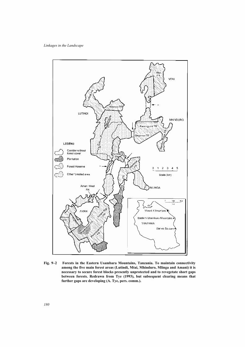
180
Linkages in the Landscape
Fig. 9–2 Forests in the Eastern Usambara Mountains, Tanzania. To maintain connectivity
among the five main forest areas (Lutindi, Mtai, Mhinduro, Mlinga and Amani) it is
necessary to secure forest blocks presently unprotected and to revegetate short gaps
between forests. Redrawn from Tye (1993), but subsequent clearing means that
further gaps are developing (A. Tye, pers. comm.).

existing reserves or protected areas into a larger contiguous habitat for the flora and fauna.Finally, in each case, the linkages are blocks of land of varying size (cf narrow habitatcorridors), that already existed as native vegetation of conservation value.
2 Conservation in the Eastern Usambara Mountains, Tanzania
The Eastern Usambara Mountains in Tanzania are an area of high biological diversity andendemism in eastern Africa. At least 2855 species of indigenous plants are known from theUsambaras, of which approximately 25% are endemic (Newmark 1993). There are alsorelatively high levels of endemism among various groups of invertebrates, amphibians,reptiles and birds. The most biologically rich habitats are those at higher elevations(800–1200m); lowland forests, although less diverse, also have many rare and endemicspecies.
Rapid clearing and loss of forest poses a critical and increasing threat to conservation ofbiodiversity in this region. Much of the remaining tropical forest occurs at higher elevationson the five major mountain blocks (Fig. 9–2), all of which were formerly connected bylowland forests. Severe depletion of lowland forests (less than 15% of forest remains below600m) is leading to isolation of the montane forests and fragmentation of the overallecosystem. In total, there is only about 23,000ha of forest above 600m elevation (Newmark1992). Forest loss also has severe ecological and economic implications because of theimportance of the forests as a water catchment (Newmark 1992; Tye 1993).
Part of the forest in each mountain block is protected as a Forest Reserve, but long termconservation of the flora and fauna of the Eastern Usambara Mountains requires protection ofall remaining forests as an interconnected system. Many species of birds (one of the beststudied groups) occur in low densities, especially globally-threatened species such as theUsambara Eagle Owl, Dappled Mountain Robin, Amani Sunbird, Long-billed Apalis andTanzanian Mountain Weaver (Newmark 1992). Individual forest reserves, once isolated, willnot be adequate to sustain viable populations of all resident species in the long term. Loss offorest-dependent understorey birds has already occurred in forest fragments, with the level ofspecies decline dependent on fragment size and degree of isolation (Newmark 1991). Manyforest birds are unable to cross cleared gaps of several hundred metres, and those able to do sodisperse across inhospitable environments rarely. As forest clearing proceeds, more and morespecies will effectively become isolated.
Protection of the Eastern Usambara forests as an interconnected system of tropical foresthas been recommended, and international efforts are underway to support the Tanzaniangovernment toward this goal (Newmark 1992; Tye 1993; A. Tye, pers. comm.). Integral tothis proposal is the protection and restoration of forested links between the five mountainblocks so that they function as a contiguous habitat for the forest fauna. This involves twostages:
• reservation of remaining unprotected forests that function both as habitat and as strategiclinks – an urgent priority because forest clearing continues;
• restoration of specific linkages where forest clearing has resulted in gaps between forestblocks. These are short sections, mostly less than one kilometre in length, that requirereafforestation.
181
Case Studies of Linkages in Land-use Planning and Conservation

Empirical data on habitat use by forest-dependent birds has provided guidelines for thedimensions of linkages. Based on a value of twice the median distance of capture from theforest edge for the understorey species (Dappled Mountain Robin) captured furthest from theedge, linkages of at least 600m width are required to maintain connectivity of suitable habitat(Newmark 1993). A recommended width of one kilometre would provide for a buffer zonearound a core area of less-disturbed forest.
There are a number of major challenges to implementing recommendations for aninterconnected forest system (Tye 1993; A. Tye, pers. comm. 1995):
• the need to gain local support from all levels of the community, and to consult with localpeople about the most appropriate management of the forest reserves and linkages that iscompatible with biological conservation;
• the need to obtain necessary governmental support, both internationally in the form ofsufficient funding (for land acquisition and other costs), and nationally to ensure thatplans are expedited and implemented;
• the methodological challenge of reafforestation to restore a ‘natural’ tropical forest inthe linking sections that have been cleared;
• the need to develop long-term management strategies for all protected forests.
3 Pinhook Swamp corridor, Florida, USA
The Okefenokee National Wildlife Refuge, spanning 162,000ha across the border of thestates of Georgia and Florida in the USA, is the largest wildlife refuge in the eastern UnitedStates (Harris and Gallagher 1989). Sixteen kilometres further south, the Osceola NationalForest of 65,000ha encompasses wetlands, swamps and pine-dominated uplands (Fig. 9–3).Historically, these areas functioned as an integrated swampland ecosystem. In 1988, theNature Conservancy and the US Forest Service commenced acquisition of land to protectPinhook Swamp, a tract of approximately 24,000ha that spans the distance between the tworeserved areas (Smith 1993). To date some 12,000ha of land, the core of a linkage roughly8km wide between the reserves, has been purchased by the Nature Conservancy and resold tothe Forest Service as an addition to Osceola National Forest.
On its own, the Osceola National Forest is not large enough to support viable populationsof Red-cockaded Woodpeckers, Black Bears, or other endangered species (Harris 1988b).Consolidation of these lands through purchase and management of the Pinhook Swamp linkprotects a contiguous area of habitat in excess of 250,000ha and provides a greater capacity tosustain large populations of threatened species. In addition, the Pinhook Swamp link hasvalue as habitat for wildlife in its own right, and also serves as the headwaters for theSuwannee and Saint Mary’s Rivers (Smith 1993).
The Okefenokee-Pinhook-Osceola system has further potential for incorporation into awider habitat network in north Florida, linked by riparian corridors along the Suwannee,Santa Fe and other rivers (Noss and Harris 1986; Harris and Scheck 1991; Smith 1993).Extensive land purchase and management to protect important habitats, to maintain waterquality, and as a natural flood storage, has already commenced along the Suwannee River.
182
Linkages in the Landscape

4 Jungle corridors and reserves in the Mahaweli area, Sri Lanka
The Mahaweli River Development Scheme is a major development programme in Sri Lanka.The building of four new dams in the upper catchments of the Mahaweli River has theobjective of greatly expanding the area available for irrigation farming (by more than100,000ha) and more than doubling the capacity for electricity generation (McNeely 1987).Because such a large development has major environmental impacts, environmentalassessment was carried out as part of international support for the project by the US Agencyfor International Development.
183
Case Studies of Linkages in Land-use Planning and Conservation
Fig. 9–3 The acquisition and protection of Pinhook Swamp in Florida maintains a natural link
between the Okefenokee National Wildlife Refuge and the Osceola National Forest.
Redrawn from Smith (1993) with permission, University of Minnesota Press.
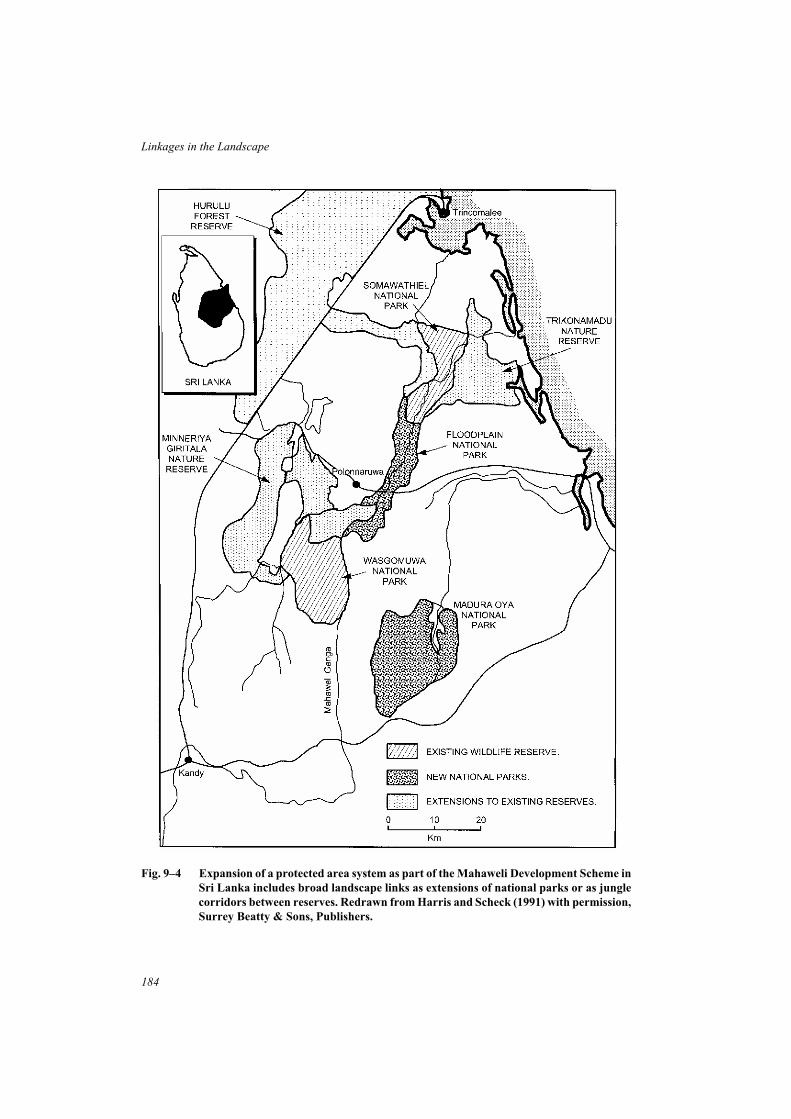
184
Linkages in the Landscape
Fig. 9–4 Expansion of a protected area system as part of the Mahaweli Development Scheme in
Sri Lanka includes broad landscape links as extensions of national parks or as jungle
corridors between reserves. Redrawn from Harris and Scheck (1991) with permission,
Surrey Beatty & Sons, Publishers.

The Mahaweli basin was identified as a biologically rich region with at least 90 endemicspecies of plants and animals and substantial populations of large mammals, including IndianElephants. Intensive agricultural development and human settlement proposed for the areapotentially threatened wildlife habitats as well as the hydrological integrity of the catchments.Consequently, the reserve system was expanded and upgraded to protect wildlife habitats andthe catchments of the new reservoirs. Plans for the system of protected areas included broadlandscape linkages approximately 5km wide as extensions of existing National Parks andreserves or as ‘jungle corridors’ between reserves (Fig. 9–4). The aim was to develop anintegrated reserve system that allowed the continuity of ecological and evolutionaryprocesses, including the migration routes of elephants (McNeely 1987).
This project was designed as an example of how development could proceed in a mannercompatible with the effective conservation of natural resources. Indeed, the retention ofnatural areas to protect watersheds and control sedimentation is an essential part of thedevelopment. The establishment of the reserve system encountered difficulties and illustratesthe importance of social and political factors in the implementation of ecological concepts andplans (Chapter 7). Difficulties with project administration and with liaison between nationaland international agencies, shortages of trained personnel, national political tensions andarmed conflict, and entrenched views within management agencies, have all contributed to adelay in the implementation and effective operation of the reserve system (McNeely 1987).
Linked systems of habitat at the regional scale
Planning an integrated network of habitat across regions or entire countries extends furtherthe concept of linking nature reserves and other important conservation areas. In thisapproach, the habitats linked as part of the integrated network include reserves and alsooff-reserve habitats within developed landscapes. This type of regional approach is welldeveloped in European countries, especially those with a strong tradition of integratedland-use planning, with ecological networks recognized as an important part of the natureconservation strategy (Jongman 1995; Brandt 1996; Kube� 1996). A diverse group ofexamples are presented here to illustrate this regional approach. It is notable that each is in theearly stages of implementation and that each attempts to integrate ecological objectives withsocial, recreational, or agricultural objectives.
Several issues require further attention as these types of regional plans are developed andimplemented. First, there is an urgent need to incorporate research and monitoringprogrammes in these conservation strategies to assess the values of proposed linkages and theextent to which they achieve ecological goals. In this way planning can move from aqualitative basis derived from theoretical principles, to a more quantitative understanding ofthe value of different forms of linkages and how they can be managed to enhance theirfunction and that of the overall network. Second, a cautious attitude is warranted to proposalsinvolving extensive re-establishment of linkages where natural habitats have been cleared.There are questions concerning the capacity to successfully ‘create’ habitat for wildlife, therelative priority and resources to be allocated to such tasks compared with other conservationgoals, and whether existing barriers that inhibit ecological flows across the landscape can besurmounted. Third, continued scrutiny must be given to the relationship betweenconservation objectives and those for human recreation or productive land use, in designing
185
Case Studies of Linkages in Land-use Planning and Conservation

regional networks. These objectives are not necessarily compatible – provision of a ‘greenlink’ of some form does not automatically confer a conservation benefit.
5 Landscape planning in the Netherlands
The Netherlands has a three-tiered planning system, with national, provincial and municipallevels. In 1991, the national government introduced the National Nature Conservation PolicyScheme, in which a conservation strategy was developed that includes a National EcologicalNetwork (Opdam et al.1995). The aim of the ecological network is to reduce the impact of themajor causes of biodiversity decline, one of which is recognized as habitat fragmentation.There are three main components of the network (Ahern 1995; Opdam et al. 1995):
• core nature areas – large areas which are significant landscapes or wildlife habitat;
• nature development areas – farmland areas in which natural environments are to berestored;
• corridor zones – linkages between the core areas and development areas.
The spatial strategy for the National Ecological Network is to protect, buffer and link thecore areas and nature development areas for the entire Netherlands, including linkages acrossnational borders with similar areas in Germany and Belgium (Ahern 1995). The provinciallevel of planning sets out the ecological network in greater detail, and also co-ordinatesmunicipal level plans to ensure consistency with each other and with the national plan.
Ecologists are using predictions and results from metapopulation models of species infragmented landscapes to provide input into planning processes (Harms and Knaapen 1988;Harms and Opdam 1990; Opdam et al. 1995). For example, in the Randstad region of westernNetherlands which encompasses the four largest cities (Amsterdam, The Hague, Rotterdam,Utrecht), an urban reafforestation plan involves the development of about 10,000ha of forestsand recreation areas over a 15 year period (Harms and Knaapen 1988). A computer spatialmodel was developed to predict the probability of colonisation and persistence of species inforest patches of varying size located in different parts of the Randstad. The model was basedon:
• knowledge of the availability of ‘source’ forests (deciduous forests larger than 50ha);
• estimates of ‘landscape resistance’ to animal dispersal, posed by open farmland, roads,urban developments and other ecological barriers;
• statistical relationships for various species between population occurrence and size ofhabitat patches, derived from field studies (Opdam et al. 1984, 1985).
The computer model was used to asess the likelihood that new forests at proposed locationsin the Randstad would be accessible to target species, such as woodland dependent birds, andbe suitable for their persistence (Harms and Opdam 1990). Different scenarios were tested,such as the likelihood of new forests being suitable given the presence of one or more corridorzones.
A major challenge facing implementation of the National Ecological Network, still in itsearly stages, involves the extent to which changes in agricultural land will be required
186
Linkages in the Landscape

(Jongman 1995). Land must be allocated to nature development areas and to corridor zones,and this requires a reduction in farmland. There is also a need for further ecological data,especially relating to the capacity of fauna to disperse through various landscape patterns.
6 A greenways network for Maryland, USA
The State of Maryland, centred around the vast estuarine Chesapeake Bay in eastern USA, hasmade a commitment to developing a statewide network of ‘greenways’ as a communityconservation initiative (State of Maryland 1990). A diverse range of linear habitats andnatural linkages are envisaged – along stream valleys, coastlines, tidal wetlands, barrierislands, ridgetops, urban and suburban open spaces, and utility rights-of-way – togetherforming a statewide network. The purpose of the network is broad: to provide habitat andpathways for wildlife, to provide recreational opportunities and open space for people, tobuffer waterways and protect the wetlands and water quality of Chesapeake Bay, and toenhance the aesthetics of urban environments. The vision is of a programme that will attractwide involvement and support by the community. Local government and community groupsare encouraged to initiate projects within the context of the statewide plan.
Protection of the environmental quality of the biologically productive Chesapeake Bay isan integral part of the plan and in 1984 legislation was passed to establish a resourceprotection program (Critical Area Program) for the bay. The Chesapeake Bay Critical Areawas defined as all waters and lands of the bay and its tidal tributaries and all lands within 305mof the mean high tide (Therres et al. 1988). Within this area, encompassing nearly 10% of thestate, regulations are designed to protect shorelines, water quality, wetlands and criticalhabitats of species. These include several provisions directly relating to the establishment of aconnected habitat network (Therres et al. 1988).
• A minimum 30m buffer zone from mean high tide along shorelines, stream banks, andwetlands is to be protected to minimize the effects of human activities on these habitats,to maintain a transitional zone between aquatic and upland communities, to maintain thenatural environment of streams, and to protect riparian wildlife habitat.
• ‘Wildlife corridor’ systems are to be incorporated into development sites. Theselinkages must connect the largest undeveloped or most vegetated tracts to similar tractson adjacent areas of land.
• Protection from new shoreline developments for waterfowl staging points andconcentration areas (Chesapeake Bay is famous for its wintering waterfowlpopulations).
• Riparian forests adjacent to streams, wetlands or the bay shoreline, that are at least 91min width or at least 40ha in size, are to be protected and conserved (for example as habitatfor migratory birds and other forest-dependent species).
The state has already identified a number of major greenways, mostly along river systems.A challenging aspect of this statewide initiative is the extent to which wildlife conservationand recreational goals are compatible and can be integrated in the overall strategy.
187
Case Studies of Linkages in Land-use Planning and Conservation

7 National Corridors of Green project, Australia
The National Corridors of Green project in Australia involves community groups,landholders, local government and other organisations in activities to manage and restore‘vegetation corridors’ (Greening Australia 1994a). The project is part of a national responseto the loss and degradation of natural ecosystems and the consequent ecological problems(such as salinization, soil erosion and loss) and loss of productive capacity of agriculturalland. While many individuals and local groups are already involved in activities to protect orenhance habitat corridors in rural Australia, the National Corridors of Green project isdesigned to bring groups together to carry out these works in a strategic manner in areas whereenvironmental restoration is a high priority.
The objective is to promote linear habitats and habitat corridors that have multipleenvironmental, economic and social benefits, in the context of an integrated regionalapproach to land management. Revegetation of selected areas is a key part of the project andthese habitat corridors may (McCaughey 1995):
• link existing stands of remnant vegetation;
• be located to reduce soil and and water degradation;
• provide for biodiversity conservation and wildlife movements;
• be part of shelterbelts linked across farm boundaries;
• be developed for recreational and tourism activities;
• be a symbolic focus for community and government support.
188
Linkages in the Landscape
Fig. 9–5 An example of revegetation along a degraded gully in farmland in southern Victoria,
Australia. (Photo: A. Bennett).

The projects are centred on Australia’s river systems and their associated catchments. Thefirst major project was the River Murray Corridors of Green which commenced in 1993. Inthe first year, 17 Community Incentive Contracts were awarded to groups located in eightgeographic regions along the 2500km length of the river (Greening Australia 1994b). Eachcontract involved community groups carrying out a planned revegetation program within50km of the Murray River.
For example, the Mt Pilot-Ovens Multipurpose Corridor Network is a project undertakenby a group of farmers in north-eastern Victoria. They mapped remnant native vegetation intheir district and then identified eroding drainage lines and gaps in streamside vegetation forrestoration. Revegetation of these sites will assist in restoring continuity to riparianvegetation, reducing erosion of stream banks and gullies, and add to the sparse network ofnative vegetation critical to the conservation of wildlife (including threatened species) inthese landscapes. The social and community benefits gained by a group of landholdersworking together to improve the environmental sustainability of their farmland is alsorecognized as an outcome of these types of projects.
Following this initial trial, the National Corridors of Green Project is being expanded todevelop similar projects in eight further regions encompassing all states of Australia. Acharacteristic of this project is its focus on involvement by local communities in identifyingsuitable projects to undertake. There are not, as yet, clearly defined regional plans orconservation strategies to guide and co-ordinate local projects in a strategic manner.
8 The ‘territorial system of ecological stability’ in the Czech Republic
The concept of ‘territorial systems of ecological stability’ (TSES) was developed inCzechoslovakia in the 1980s as a compromise between social demands for land in intensivelydeveloped landscapes and ecological requirements for nature conservation (Kube� 1996). Thegoal is to maintain ecological function within the human-dominated environment by linkingtogether the remaining natural elements or ‘biocentres’ within a designated area. This conceptgained official support from national authorities in 1990 and subsequently there has beenextensive activity in designing TSES throughout the Czech Republic (Jongman 1995; Kube�1996).
The territorial systems are arranged within a hierarchy. Local TSES are the basis of theconservation system. They consist of a dense network of local ‘corridors’ of 10–20mminimum width, connecting local biocentres of 0.5 to 5ha in size. For example, in theChomutovka river valley a local TSES encompassed an area of about 200ha, and designatedlocal biocentres were based on small oak forests, floodplain forest and meadows, linked bylines of trees and shrubs (Kube� 1996). The aim is for all natural vegetation types in theplanning area to be represented in local biocentres.
Regional biocentres consist of natural or semi-natural habitats of 10–50ha, connected byregional links at least 40m wide, and selected to maintain biodiversity at the next level in theplanning hierarchy. At the supra-regional level, large biocentres of more than 1000ha areincluded and the associated supra-regional links may be zones along the valleys of large rivers(Jongman 1995; Kube� 1996). Locations of regional and supra-regional corridors havealready been established for the entire Czech republic (Kube� 1996).
189
Case Studies of Linkages in Land-use Planning and Conservation

The conceptual basis for the TSES draws heavily from the ‘patch-corridor-matrix’paradigm in landscape ecology (Forman and Godron 1986) and applies it at several spatialscales. Biocentres (and potential biocentres) are selected as important habitats for plants andanimals in the landscape, and ‘corridors’ are intended to link biocentres into a network ofhabitat. Intensive land use in most areas means that most biocentres are semi-natural orcultural, rather than natural habitats; and, at the local level, few natural habitats may beavailable upon which to base reconstruction of vegetation (Kube� 1996). There appears to belittle specific knowledge of the conservation values of various types of biocentres, or of howwell such a system functions for nature conservation. Further biological data is needed toassess the effectiveness of the TSES for nature conservation, particularly the recommendeddimensions of biocentres and corridors (Kube� 1996).
Linkages in forest conservation and management
In many countries, forests managed for timber production are some of the largest remainingnatural areas and consequently have great value for conservation of the flora and fauna.However, there is widespread concern at the detrimental effects on some groups offorest-dependent species of management practices associated with timber production. Forspecies that have difficulty persisting in various stages of younger regrowth, timberharvesting across large areas of forest may result in a marked decline in their distribution andabundance and the relative isolation of populations in the scattered areas of suitable habitatthat remain. In some countries, increasing attention is being given to ways in which forestscan be managed for economic production of timber and other forest products, while alsomaintaining the values of the forest as a habitat for wildlife populations. The followingexamples provide a perspective from several different forest types on ways in which forestecologists and managers are implementing measures to maintain habitat quality andconnectivity for wildlife populations in production forests.
9 Temperate rainforest corridors for forest birds, North Westland,
New Zealand
In response to a scheme for the extensive harvesting of beech forests for timber in NorthWestland, New Zealand, a major ‘wildlife corridor’ was proposed to maintain the potentialfor temperate rainforest birds to move between reserves (O’Donnell 1991). This forested linkwas designed to follow topographic features that could be readily identified, and to havesufficient width to withstand windthrow of trees and other natural disasters. The minimumwidth is at least 2km (generally greater than 6km) and in total it requires the protection of10,200ha of forest originally scheduled for logging.
The link may be seen to function at two spatial levels (Fig. 9–6). At the regional scale, itprovides a broad forested link between the forests of the Paparoa Range (greater than150,000ha) and the Southern Alps. The Paparoa Range would otherwise be ecologicallyisolated by cleared river valleys and logged forests. In this context the aims of the link are to(O’Donnell 1991):
• enhance gene flow and maintain genetic variation in populations in large forest blocks;
• assist movements of obligate forest-dwelling birds over large geographic areas;
190
Linkages in the Landscape

• maintain species that require large areas of unmodified habitat.
At a more localized scale, the forest link connects eight Ecological Areas that wouldotherwise be isolated by logged regenerating forest. Here the linkage may:
• permit seasonal movements of wildlife between high and low altitude reserves;
• maintain species diversity in core areas, especially forest birds that are less mobile orintolerant of habitat modification;
• aid the dispersal of young birds;
• provide additional habitat for rare species and a potential source of colonists foradjoining areas should they be subject to catastrophe.
Six criteria were used to assess forest birds known to occur within the area for which theforest link might be important: distribution status, dependence on forest habitats, degree ofmobility across open habitat, habitat specialisation, response to logging, and conservationstatus (O’Donnell 1991). This analysis identified eight species (26% of forest birds knownfrom the link) that are most likely to benefit from protection of the forest corridor. Three of
191
Case Studies of Linkages in Land-use Planning and Conservation
Fig. 9–6 Two models to illustrate the way in which the North Westland forest corridor
functions. (a) Regional model: a link between forests of the Paparoa Range and
similar forests of the Southern Alps. (b) Reserve model: the forest corridor connects
a series of Ecological Reserves via lowland forest links. From O’Donnell (1991) with
permission, Surrey Beatty & Sons, Publishers.

these in particular, Kaka, Yellow-crowned Parakeet, and Yellowhead are threatened, obligateforest-dwelling species that have very large home ranges (O’Donnell 1991).
Following completion of a five-year research programme on the fauna of the NorthWestland forest corridor (Overmars et al. 1992), a formal recommendation that it be reservedfor conservation was accepted by the New Zealand government (C. O’Donnell pers. comm.1995).
10 Forest management planning in East Gippsland, Victoria, Australia
Major changes have occurred over the last two decades in the management of hardwoodeucalypt forests in south-eastern Australia. Increased community concern for protection offlora and fauna and a greater knowledge of the status and habitat requirements offorest-dependent wildlife, have contributed to changes in management practices in order toreduce detrimental impacts of logging on wildlife populations (Loyn et al. 1980; Recher et al.
1980, 1987; Dobbyns and Ryan 1983; Taylor 1991; Lindenmayer 1994). In Victoria,government policy requires that forest management be economically viable, environmentallysensitive, and sustainable for all forest values.
In East Gippsland, Victoria, publicly-owned forests occur as a large contiguous tract ofapproximately one million hectares, part of the extensive forests along the Great DividingRange in south-eastern Australia. The forest management plan for the East Gippsland ForestManagement Area (Department of Conservation and Natural Resources 1995) incorporates anumber of new measures in a strategy for forest management in this region. State Forests (theforest area available for timber harvesting) within the East Gippsland FMA have been dividedinto three zones:
• Special Protection Zone – to be managed for conservation and from which timberharvesting is excluded;
• Special Management Zone – to be managed to conserve specific features, allowingtimber production under certain conditions;
• General Management Zone – in which timber production has high priority.
The Special Protection Zone (SPZ) encompasses 16% of the East Gippsland FMA and isdesigned to complement conservation reserves in the region by retaining a linked network ofimportant forest habitats throughout the managed forest (Fig 9–7). The main components ofthe SPZ are representative areas of vegetation types and old growth forests that are poorlyreserved in the reserve system, and forest areas set aside for the conservation of threatenedforest-dependent animals. These areas are linked to each other and to conservation reserves bylinear reserves, natural features zones along streams and rivers, streamside and rainforestbuffers, and other protected zones.
Guidelines for the network of linear reserves (Department of Conservation and NaturalResources 1995) state that they will provide a number of alternative links betweenconservation reserves and large areas within the SPZ, be an average of 200m wide, spanaltitudinal and latitudinal gradients, generally comprise old forest of high quality habitat, andcomplement existing natural features zones and buffers along stream systems. The designatedpurpose of the linear reserves is to:
192
Linkages in the Landscape

• maintain resident populations of most sensitive species of animals and thereby facilitaterecolonisation of areas that are harvested or burnt by wildfire;
• provide some of the habitat requirements of wider-ranging species (such as large forestowls);
193
Case Studies of Linkages in Land-use Planning and Conservation
Fig. 9–7 A section of the East Gippsland Forest Management Plan, Victoria, illustrating the
linked network of special protection zones within State Forest used for timber
production.
• help prevent genetic isolation of sensitive forest species;
• guard against possible impacts of climate change.
The Forest Management Plan provides a comprehensive approach to the conservation offlora and fauna in this region, based on retaining throughout the forest a linked network ofunlogged habitat that is integrated with the conservation reserve system.
11 Managing systems of open ‘rides’ in British forests
After centuries of deforestation and loss of the ancient semi-natural woodlands in Britain,reafforestation during the 20th century has greatly increased the extent of woodland coverfrom 4% in 1920 to about 11% at present (Ferris-Kaan 1995). Much of the increase has beenby the establishment of plantations, often of non-indigenous tree species such as conifers. Thedense cover and scarcity of open areas amongst many plantations is an important issuebecause open areas and shrubby edges have been a feature of managed woodlands in Britainfor many centuries and the survival of many plants and animals depends on open habitats andearly successional stages of vegetation (Ferris-Kaan 1991, 1995; Warren and Fuller 1993).Historically, open areas resulted mainly from the practice of coppicing, in which sections ofwoodland were cut on a short rotation, often 5–20 year cycles, resulting in a shifting pattern ofyoung regenerating forests of varying successional stages (Ferris-Kaan 1995).
Networks of ‘rides’, linear strips of grassy vegetation maintained mainly for timberextraction, are one source of open habitats within forests. There is much evidence that suchhabitats are of great value for plants and animals that require open sunny conditions or favouredge habitats between woodland and grassland (Warren and Fuller 1993; Ferris-Kaan 1991).In conifer plantations, the margins of rides and open glades are often the only place wheredeciduous trees and shrubs and their associated wildlife occur. Hence, management of rides ashabitat for the conservation of plants and animals has assumed great importance, andconsiderable attention has been given to the design (orientation, width, shape) andmanagement practices (such as timing and frequency of mowing and slashing) needed tomaintain habitats of a suitable successional stage (Ferris-Kaan 1991, 1995).
Butterflies are a well-studied group of animals for which conservation and management ofwoodland rides is particularly important. Butterflies are scarce within heavily-shadedwoodlands, favouring a mosaic of open grassland glades, woodland edges and trees, wherethere are sunlit open spaces and suitable food plants (Porter 1993; Warren and Fuller 1993).The network structure and high level of connectivity of woodland rides provides species suchas the Ringlet Butterfly with pathways for movement between fields and grassy glades withinwoodlands (Sutcliffe and Thomas 1996).
Bernwood Forest in Oxfordshire, a Forest Nature Reserve of national importance forbutterfly conservation, is managed for both timber and wildlife. A network of interconnectingrides and glades (Fig. 9–8), together forming 1% of the forest area, is managed to maintainhabitat for butterflies and moths (Warren and Fuller 1993; Ferris-Kaan 1995). The networkincludes major rides greater than 15m width, and minor rides, as well as open glades or ‘boxjunctions’ at many intersections. A management strategy specifies particular vegetationconditions to be maintained along rides as habitat for wildlife.
194
Linkages in the Landscape

Active management to maintain a system of open habitats and edges throughout largeforest blocks is surprising to biologists in other countries where such open disturbance stripsare generally detrimental to the native fauna (Askins 1994; Rich et al. 1994; May and Norton1996). It is a salient reminder that ecological situations differ between countries – in this casethe long history of intensive management of woodlands has led to a quite different context forforest conservation.
Linkages for the conservation of large mammals
Large mammals have been the focus of efforts to identify and protect linkages in manycountries. These species have received particular attention for several reasons.
• Large mammals, especially predators, require large areas of land for each individual andmuch greater tracts for self-sustaining populations. In many regions, maintenance of
195
Case Studies of Linkages in Land-use Planning and Conservation
Fig. 9–8 A network of open ‘rides’ are managed for wildlife conservation in Bernwood Forest,
Oxfordshire, UK. From Ferris–Kaan (1995) with permission, Surrey Beatty & Sons,
Publishers.

such populations depends on several reserves or large natural areas in close proximitythat together provide sufficient habitat for a population.
• Some species must undertake seasonal migration between different geographic areas foryear-round access to food and other resources.
• Large mammals can be used as ‘flagship’ species – they attract public attention andsympathy, and there is a strong likelihood that linkages designed for these species willalso benefit a wide range of other species.
Because they are wide ranging and occupy a variety of habitats, most large mammals donot require specialized habitat, or even continuous habitat, for movement through thelandscape. However, experience demonstrates (see examples below) that protection ofmovement paths is essential if connectivity is to be maintained in the long term. Where linksare not protected, their functional role is inevitably lost because the incremental effects ofhuman land use (such as clearing, cultivation and housing developments) eventually becomebarriers to free movement. Protection along movement paths from direct disturbance bypoaching or hunting is also necessary in many situations.
12 Kibale Forest Game Corridor, Uganda
The Kibale Forest Game Corridor was gazetted in 1926 to allow for the movement of largegame animals, particularly African Elephant. This linkage, encompassing 34,000ha in area, isa large tract of medium-altitude forest and elephant-grass habitat extending along the westernside of Kibale Forest and providing a broad link, approximately 15 kms wide, between theQueen Elizabeth National Park and the Kibale Forest (Fig. 9–9) (Baranga 1991).
Although legally gazetted, failure to manage and protect the Game Corridor led to almosttotal loss of its function by 1990. Its biological value was severely eroded by humanencroachment, settlement and clearing of natural habitats. Encroachment commenced about1970 and continued without check during a period of political turmoil. The protected habitatin the linkage diminished and it was estimated that by 1990 more than 90% of the link and10% of the forest reserve had been claimed, with much of these areas under cultivation from apopulation of about 40,000 people (Baranga 1991). Records of the Uganda National Parksand Game Department indicate that Elephant, Uganda Kob, Waterbuck and Buffalo wereusing the corridor up to the early 1970s, but this movement ceased (Baranga 1991). Elephantare present in both the Kibale Forest Reserve and the Queen Elizabeth National Park, but theirnumbers declined from about 3000 in 1973 to 500 by 1989, and they altered their migrationpatterns.
In March 1992, following concern over the future of the Game Corridor, the UgandanGovernment directed encroachers to leave and subsequently evicted 30,000 people from thereserve (C. Dranzoa, pers. comm. 1995). The following year, 1993, both Kibale Forest GameCorridor and the Kibale Forest Reserve were declared a national park, known as the KibaleForest National Park. There is now an extensive and continuous protected area from theKibale Forest, which has one of the richest forest faunas in East Africa (Struhsaker 1981;Baranga 1991), to the savannas of Queen Elizabeth National Park. This offers greatlyenhanced protection of habitat for a wide range of species and a protected migratory route forlarge mammals, especially Elephant and Buffalo (C. Dranzoa, pers. comm. 1995).
196
Linkages in the Landscape

13 Wildlife corridors and buffer zones, Lake Manyara National Park,
Tanzania
Lake Manyara National Park is relatively small (11,000ha) and is not considered viable as an‘island’ park (Mwalyosi 1991). Historically, there has been regular seasonal migration of
197
Case Studies of Linkages in Land-use Planning and Conservation
Fig. 9–9 The former Kibale Forest Game Corridor between Kibale Forest and Queen
Elizabeth National Park is now incorporated as part of Kibale Forest National Park.
Redrawn from Baranga (1991) with permission, Surrey Beatty & Sons, Publishers.

large mammals, especially of Wildebeest and Zebra, across the park boundaries. A migrationpathway from Tarangire National Park to the northern border of Lake Manyara National Parkis one of the major dispersal routes during the wet season for up to 10,000 Wildebeest and 100– 800 Zebra within the wider Tarangire-Simanjaro ecosystem (Borner 1985; Mwalyosi 1991).However, increasing agricultural settlement, a rapidly increasing human population, andmining activities, are gradually blocking the traditional migration route. Crop destruction bydomestic livestock and migrating wild animals as they move through settled areas createsfurther conflicts between pastoralists, conservation authorities and local farmers.
In anticipation of further increase in the human population and in intensive land use, aproposal was made for a buffer zone around the park to minimize conflict across boundariesbetween the park and adjacent villages, and for a landscape link between Lake ManyaraNational Park and Tarangire National Park to maintain connectivity between populations oflarge mammals in the two reserves (Mwalyosi 1991). Three potential linkages were identifiedand each was evaluated in relation to topography and natural vegetation, current and potentialland use, human population, accessibility for animals, and present use by game animals. Thegrazing capacity in each link, based on the quality and quantity of fodder for moving animals,was also considered. The most suitable link extends about 60km from the northern end ofLake Manyara along the eastern side of the lake and east to Tarangire National Park(Mwalyosi 1991). This route is currently used intensively by large mammals. Further fieldwork is required to map patterns of animal usage and to identify the most suitable alignmentand boundaries. A broad link at least 1km in width was recommended, based on the need foradequate fodder for migrating animals.
Establishment of the link will require changes in land use. It is proposed that only fuelwoodcollection and livestock grazing would be allowed within the boundary of the link, and thatpeople currently settled there (approximately 1500 people in three villages) should berelocated and compensated (Mwalyosi 1991).
14 Designing protected areas for conservation of the Giant Panda
in China
The Giant Panda is well known as one of the most threatened species in the world. It nowoccurs only within the central Chinese provinces of Gansu, Shaanxi and Sichuan, where itlives in montane forests with dense stands of bamboo, generally at elevations of 2700–3700m.Bamboo shoots and roots are the major food items, although other plants, fish and smallrodents are also taken.
In recent decades, the plight of the Giant Panda has deteriorated (Schaller 1993). Mappingof forest cover from satellite imagery has shown that the area of suitable habitat for GiantPandas in Sichuan Province, the main stronghold, has approximately halved, shrinking fromover 20,000km2 in 1974 to 10,000km2 in 1989 (McKinnon and De Wulf 1994). The decliningconservation status has been further compounded by the mass flowering and subsequent deathof large areas of Arrow Bamboo on several occasions. The bamboo flowers at 40–60 yearintervals and takes 15–20 years to regenerate to a suitable size for the Giant Panda. Althoughmany starving animals were seen and deaths occurred following the mass flowering, theflowering phenology of bamboo is not the primary cause of concern. Mass flowering and
198
Linkages in the Landscape

dieback of bamboo is a natural phenomenon and Giant Pandas survived, albeit in lownumbers, in every area that was affected (McKinnon and De Wulf 1994).
The main cause of decline is continued loss of habitat, human encroachment on remaininghabitats, fragmentation of populations and deaths of animals at the interface with humansettlements (from poaching and trapping). When satellite imagery was coupled with resultsfrom ground surveys in 1974–1986/88, changes in the distribution of the species could berelated to landscape pattern. Giant Pandas had disappeared from several areas that were eithersmall and isolated, at the edge of the species’ range, or where habitats had been destroyed(McKinnon and De Wulf 1994). It was also evident that other populations were at risk ofbecoming fragmented and isolated from nearby populations by continued clearing of forests.
199
Case Studies of Linkages in Land-use Planning and Conservation
Fig. 9–10 The distribution of the Giant Panda in the Minshan area of China, with arrows
indicating critical corridors needed to maintain continuity of the regional population.
Redrawn from McKinnon and de Wulf (1994) with permission, Chapman and Hall
Publishers.

Being a large animal (75–150kg) that occurs at low densities (e.g. an estimated 145 GiantPandas inhabit the 2000km2 Wolong Nature Reserve), it is extremely vulnerable tofragmentation of its forest habitat.
A strategic plan to manage the species and its habitats involves:
• extending and redesigning the existing reserve system to better protect key populations;
• identification and protection of critical habitat links between reserves;
• management of habitats and people within reserves.
Fifteen habitat links have been identified as critical for maintaining connections betweenreserves (Fig. 9–10) to allow movements of animals between small populations. Theselinkages are designed to consolidate the distribution of the Giant Panda in extant reserves.Seven links will require revegetation with suitable habitat (native trees and bamboo species).They are recommended to be at least 1km wide and located to bridge the narrowest gap andflattest terrain between existing blocks (McKinnon and De Wulf 1994). Those links that arepresently forested require strict protection from forest harvesting, grazing and humanencroachment.
Assessing and mapping of forest habitats using satellite imagery has formed the basis forthe species management plan and allowed a critical appraisal of existing reserves and the needfor linkages. However, past experience (Schaller 1993) suggests that the political and socialdimensions of the conservation and management of Giant Pandas are likely to have thegreatest influence on the future status of this species.
15 Linkages for Elephants in India
Two examples from India of loss and disturbance to migration paths of Indian Elephantshighlight the need for identification and protection of movement paths if populations of largemammals are not to become isolated.
In southern India, elephants have stopped using the Ariankavu Pass between the AshambuHills and the Idduki-Periyar Hills (Johnsingh et al. 1991). The Ashambu Hills have about 200elephants, mostly in the Kalakudu-Mundanthurai Tiger Reserve (900 km2) and severalsmaller reserves, while the Iddukki-Periyar Hills population is estimated as 800–1000individuals, largely confined to the Periyar Tiger Reserve (777 km2) and the Grizzled GiantSquirrel Sanctuary (400 km2) (Johnsingh et al. 1991). The Ariankuvu Pass is divided by aroad and railway line, and human settlements have developed along the road. A survey in1988 found no evidence of elephants, and local people reported that the area had not beenused by elephants for 30–40 years. The isolated population must also contend with poachingfor ivory. Large scale poaching in the Periyar population has contributed to a sex ratio of 1male:23 females (Johnsingh et al. 1991).
In northern India, the Rajaji-Corbett National Parks area includes protected reserves andadjacent forest areas that together encompass about 2500 km2. This extensive area has apopulation of about 750 Indian Elephants and 140 Tigers and forms the north-western rangelimit for both species (Johnsingh et al. 1990). Four important links for the movement of largeanimals between major tracts in this area have been identified. Two of these are bottlenecks in
200
Linkages in the Landscape

a zone between Laldhang Forest Area and Sonandi Sanctuary, which extend for 6km freefrom human settlement and cattle camps. The terrain is rugged, there are few places forelephants to move through this region, and few crossings are now believed to occur. However,these links are not an impediment for movement of other large mammals such as Sambar andTiger.
There are two linkages across the Ganges River between the Chila and Motichur sectionsof Rajaji National Park. At one site, Binj rau, there is now complete loss of forest cover on thewest bank of the river and little evidence from dung counts of its use by elephants. In contrast,the Chila-Motichur link is still used by adult males during summer and is crucial tomaintaining any interchange between the two sections of the park. However, this remaininglink (approximately 3km long and 1km wide) is threatened by habitat degradation and lack oftree regeneration; by the presence of an army camp, village and plantation; and by the need foranimals to cross a bridge over a power channel. Proposals have been developed by the ForestDepartment to maintain the link by selective acquisition and protection of forest habitat, butthe long-term outlook is pessimistic in the face of likely destruction of remaining habitatarising from the pressure of human settlement (A. Johnsingh pers. comm. 1995).
Local networks of linear habitats
Networks of linear vegetation are a characteristic feature of many agricultural landscapes.Frequently, such linear strips are the product of intensive use of the environment by people,and include vegetation associated with hedgerows, fencerows, shelterbelts, ditches,embankments, canals, irrigation channels, railway lines and roads. Although such vegetationis often of human origin, remnant natural vegetation may also occur in local networks,including vegetation along stream systems and native vegetation along roadsides in Australia(see below). In regions of heavy human impact where natural areas are small and scattered,networks of linear habitats are recognized as having an important role in maintainingconnectivity in the landscape, and there is growing awareness of the need for ecologicalvalues to be recognized in their management (Agger and Brandt 1988; Gulinck et al. 1991;Kaule 1995; Burel 1996; Kube� 1996).
The maintenance of these networks and their ecological function faces a number ofdifficulties:
• lack of recognition of the ecological values of these features and of their context in thebroader landscape;
• lack of co-ordinated management because they may extend across many land parcelsand have many land owners;
• incremental clearing and loss resulting in gaps and breaks in the network;
• degradation of habitats due to edge effects and adjacent land uses.
Two examples are presented below of ways in which a co-ordinated approach has beenundertaken to manage local networks of such linear habitats.
201
Case Studies of Linkages in Land-use Planning and Conservation

16 Hedgerow networks and landscape consolidation in France
In parts of rural France, restructuring of farm properties (‘remembrement’) is being carriedout to rationalize the distribution of the land that each farmer owns (Baudry and Burel 1984).Over a number of generations, inheritance customs have resulted in many farms becoming ascatter of fields that may be up to five kilometres apart. Restructuring is done on amunicipality basis and at the request of the majority of owners. In those landscapes withextensive hedge networks (‘bocages’ landscapes), initial attempts at re-distribution involveddestruction of hedges; both to increase field sizes and because hedges were no longer neededas property boundaries. This led to numerous environmental problems. Subsequently, muchresearch was carried out to evaluate the microclimatic, biological and agronomic values ofhedgerows and the effects of their removal (INRA 1976; Forman and Baudry 1984 ; Burel andBaudry 1990). Since 1978, an impact study has been required before each ‘remembrement’proceeds.
Ecological studies of the role of hedgerows in the rural landscape recognized their role aswindbreaks, barriers against erosion, habitat for flora and fauna, and pools of genetic diversityamidst an increasingly monocultural landscape (Baudry and Burel 1984). In proposing plansto maintain these functions in the restructured rural landscape (Fig. 9–11), ecologists havesuggested that hedges should be:
• primarily located across slopes;
• retained or re-connected in a network;
• have complex structure and high species diversity to provide habitats for birds, insects,small mammals and reptiles.
These recommendations, together with other constraints such as ownership patterns, areused to develop a final land-use plan. The ecological reconmendations are not necessarilyadopted in their entirety but they do have an important role in the process of landscapeconsolidation. Further understanding of the agro-ecological effects of hedgerows and ditchesand the provision of such information to local farmers and landowners will assist in therecognition of their values (Baudry and Burel 1984). For example, the retention ofhedgerows, and their location and orientation in relation to soil types and topography, isknown to influence water flow, drainage and erosion in farmland, and hence the use andproductivity of the rural landscape (Burel and Baudry 1990).
17 Conservation of roadside vegetation in southern Australia
Strips of remnant forest, woodland or shrubland along roadsides form extensive networks oflinear habitats through many agricultural areas of southern Australia. There is abundantevidence of the value of roadside vegetation as habitat for flora and fauna (Chapter 6), andgrowing understanding of how it fosters animal movements and maintains connectivity ofpopulations in rural landscapes (Suckling 1984; Bennett 1990b; Saunders and de Rebeira1991; Lynch et al. 1995; Downes et al. 1997).
In many regions, protection and management of roadside vegetation to maintainconservation values has been limited or non-existent, and an array of disturbance processesincrementally erode the extent and value of this network of natural vegetation. Clearing of
202
Linkages in the Landscape

203
Case Studies of Linkages in Land-use Planning and Conservation
Fig. 9–11 Diagrams of a hedgerow network in Campénéac, France, (a) before “remembrement”
and (b) the design that ecologists recommended for retention. Redrawn from Baudry
and Burel (1984) with permission, Elsevier Science-NL.

vegetation often occurs during road widening or reconstruction; roadsides are used aseasements for powerlines, telephone cables and other services; and fire prevention works suchas regular burning or the ploughing of strips of bare earth (and thereby encouraging weeds)are also carried out on roadsides. They are also subject to weed invasion and nutrientenrichment from adjacent farmland, and intermittent grazing by domestic stock.
In the last decade, an increasing awareness of the environmental and community values ofroadsides has led to a more sympathetic approach to management by many responsibleauthorities (usually local governments) and the development of roadside management plansin some areas (Lewis 1991; Loney and Hobbs 1991; Stone 1991; Lamont and Blyth 1995).Involvement of local communities of people in assessing the values of roadsides in theirlocality has been a key element. By direct involvement the community becomes more awareof the values of the roadside network and gain a sense of stewardship over roadsides in theirlocal area.
Roadside assessment is typically carried out by teams of volunteer observers drivingslowly along selected roads and recording attributes of the roadside vegetation, such as widthand continuity of the vegetation, diversity of native plants, occurrence of weed species,presence of habitat features for animals and extent of disturbance by utilities (Hussey 1991).Each roadside section is ‘scored’ for conservation value, and maps are then prepared showingthe distribution of roadsides of ‘high’, ‘medium’ and ‘low’ conservation value. The final stepinvolves preparation of a written management plan by the roadside management authority,that specifies conservation measures and appropriate management practices for roadsides ofhigh quality. Implementation of the management plan may involve modification of particularmanagement practices, the use of roadside signs to clearly mark sections of high conservationvalue, and training courses for those that carry out roadside management in the field.
Summary
Recognition of the role of landscape connectivity in biodiversity conservation within
human-dominated landscapes, has moved from the conceptual stage to that of practical
implementation of this principle in conservation strategies. Throughout the world, a diverse
range of linkages are now being protected, managed or restored to enhance the continuity of
animal populations and to maintain ecological processes in fragmented ecosystems. These
include specific landscape links between conservation reserves or for the conservation of
large mammals; and networks of links in local areas, in managed forests and as part of
regional land management strategies. This phase of implementation is in an early stage and
there is much to learn. There is an urgent need for research and monitoring programmes to
assess the effectiveness of these measures and resolve issues involved in their implementation.
Such knowledge should provide the basis for ongoing improvements in the location, design
and management of linkages, so that we can more effectively maintain and restore natural
landscape connectivity in modified environments.
204
Linkages in the Landscape

REFERENCES
References
Abensberg-Traun, M., 1991. A study of the home range, movements and shelter use in adultand juvenile Echidnas Tachyglossus aculeatus (Monotremata: Tachyglossidae), inWestern Australian wheatbelt reserves. Australian Mammalogy 14: 13–21.
Adams, L.W. and Dove, L.E., 1989. Wildlife Reserves and Corridors in the UrbanEnvironment. A Guide to Ecological Landscape Planning and Resource Conservation.(National Institute for Urban Wildlife: Columbia).
Adams, L.W. and Geis, A.D., 1983. Effects of roads on small mammals. Journal of Applied
Ecology 20: 403–15.
Agger, P. and Brandt, J., 1988. Dynamics of small biotopes in Danish agricultural landscapes.Landscape Ecology 1: 227–40.
Ahern, J., 1995. Greenways as a planning strategy. Landscape and Urban Planning 33:131–55.
Ambuel, B. and Temple, S.A., 1983. Area dependent changes in bird communities andvegetation of southern Wisconsin forests. Ecology 64: 1057–68.
Andersen, M.C. and Mahato, D., 1995. Demographic models and reserve designs for theCalifornia Spotted Owl. Ecological Applications 5: 639–47.
Andrén, H., 1992. Corvid density and nest predation in relation to forest fragmentation: alandscape perspective. Ecology 73: 794–804.
Andrén, H. and Angelstam, P., 1988. Elevated predation rates as an edge effect in habitatislands: experimental evidence. Ecology 69: 544–47.
Andrews, J., 1993. The reality and management of wildlife corridors. British Wildlife 5: 1–7.
Angelstam, P., 1986. Predation in ground-nesting birds nests in relation to predator densitiesand habitat edge. Oikos 47: 365–73.
Angelstam, P., 1992. Conservation of communities – the importance of edges, surroundingsand landscape mosaic structure. pp. 9–70 in Ecological Principles of Nature Conservation:Applications in Temperate and Boreal Environments. (Ed. L. Hansson). (Elsevier:London).
Anonymous, 1993. Road plan to save dwindling dormice. New Scientist 139 (1883): 6.
Arnold, G.W., 1983. The influence of ditch and hedgerow structure, length of hedgerows, andarea of woodland and garden on bird numbers on farmland. Journal of Applied Ecology
20: 731–50.
Arnold, G.W., Algar, D., Hobbs, R.J. and Atkins, L., 1987. A survey of vegetation and itsrelationship to vertebrate fauna present in winter on road verges in the Kellerberrin
205

District, W.A. Department of Conservation and Land Management Western Australia,
Technical Report 18.
Arnold, G.W., Steven, D.E. and Weeldenburg, J.R., 1993. Influences of remnant size, spacingpattern and connectivity on population boundaries and demography in Euros Macropus
robustus living in a fragmented landscape. Biological Conservation 64: 219–30.
Arnold, G.W. and Weeldenburg, J.R., 1990. Factors determining the number and species ofbirds in road verges in the wheatbelt of Western Australia. Biological Conservation 53:295–315.
Arnold, G.W., Weeldenburg, J.R. and Steven, D.E., 1991. Distribution and abundance of twospecies of kangaroo in remnants of native vegetation in the central wheatbelt of WesternAustralia and the role of native vegetation along road verges and fencelines as linkages.pp. 273–80 in Nature Conservation 2: The Role of Corridors. (Eds. D.A. Saunders andR.J. Hobbs). (Surrey Beatty & Sons: Chipping Norton, New South Wales).
Asher, S.C. and Thomas, V.G., 1985. Analysis of temporal variation in the diversity of a smallmammal community. Canadian Journal of Zoology 63: 1106–10.
Askins, R.A., 1994. Open corridors in a heavily forested landscape: impact on shrubland andforest-interior birds. Wildlife Society Bulletin 22: 339–47.
Askins, R.A., Philbrick, M.J. and Sugeno, D.S., 1987. Relationship between regionalabundance of forest and the composition of forest bird communities. Biological
Conservation 39: 129–52.
Ayres, J.M. and Clutton-Brock, T.H., 1992. River boundaries and species range size inAmazonian primates. American Naturalist 140: 531–37.
Baker, W.L., 1992. The landscape ecology of large disturbances in the design andmanagement of nature reserves. Landscape Ecology 7: 181–94.
Balát, F., 1985. Birds of narrow belts of vegetation along water channels and ditches in thefield landscape of southern Moravia. Folia Zoologica 34: 245–54.
Baranga, J., 1991. Kibale Forest game corridor: man or wildlife? pp. 371–75 in NatureConservation 2: The Role of Corridors. (Eds. D.A. Saunders and R.J. Hobbs). (SurreyBeatty & Sons: Chipping Norton, New South Wales).
Barling, R.D and Moore, I.D., 1994. Role of buffer strips in management of waterwaypollution: a review. Environmental Management 18: 543–58.
Barr, C., Benefield, C., Bunce, B., Ridsdale, H. and Whittaker, M., 1986. Landscape Changesin Britain. (Institute of Terrestrial Ecology: Huntingdon).
Barrett, G.W., Ford, H.A. and Recher, H.F., 1994. Conservation of woodland birds in afragmented rural landscape. Pacific Conservation Biology 1: 245–56.
Baudry, J. and Burel, F., 1984. Landscape project ‘remembrement’: landscape consolidationin France. Landscape Planning 11: 235–41.
206
Linkages in the Landscape

Baudry, J. and Merriam, G., 1988. Connectivity and connectedness: functional vs structuralpatterns in landscapes. in ‘Proceedings of the 2nd Seminar of the InternationalAssociation for Landscape Ecology. (Ed. K.F. Schreiber). (Munster).
Baumgartner, L., 1943. Fox squirrels in Ohio. Journal of Wildlife Management 7: 193–202.
Baur, A. and Baur, B., 1992. Effect of corridor width on animal dispersal: a simulation study.Global Ecology and Biogeography Letters 2: 52–56.
Beier, P., 1993. Determining minimum habitat areas and habitat corridors for cougars.Conservation Biology 7: 94–108.
Beier, P., 1995. Dispersal of juvenile cougars in fragmented habitat. Journal of Wildlife
Management 59: 228–37.
Beier, P. and Loe, S., 1992. A checklist for evaluating impacts to wildlife movementcorridors. Wildlife Society Bulletin 20: 434–40.
Bennett, A.F., 1987. Conservation of mammals within a fragmented forest environment: thecontributions of insular biogeography and autecology. pp. 41–52 in Nature Conservation:The Role of Remnants of Native Vegetation. (Eds. D.A. Saunders, G.W. Arnold, A.A.Burbidge, and A.J.M. Hopkins). (Surrey Beatty & Sons: Chipping Norton, New SouthWales).
Bennett, A.F., 1988. Roadside vegetation: a habitat for mammals at Naringal, south-westernVictoria. Victorian Naturalist 105: 106–13.
Bennett, A.F., 1990a. Habitat Corridors: Their Role in Wildlife Management andConservation. (Department of Conservation and Environment: Melbourne).
Bennett, A.F., 1990b. Habitat corridors and the conservation of small mammals in afragmented forest environment. Landscape Ecology 4: 109–22.
Bennett, A.F., 1990c. Land use, forest fragmentation and the mammalian fauna at Naringal,south-western Victoria. Australian Wildlife Research 17: 325–47.
Bennett, A.F., 1991. Roads, roadsides and wildlife conservation: a review. pp. 99–117 in
Nature Conservation 2: The Role of Corridors. (Eds. D.A. Saunders and R.J. Hobbs).(Surrey Beatty & Sons: Chipping Norton, New South Wales).
Bennett, A.F. and Ford, L.A., 1997. Land use, habitat change and the conservation of birds infragmented rural environments: a landscape perspective from the Northern Plains,Victoria, Australia. Pacific Conservation Biology 3: 244–61..
Bennett, A.F., Henein, K. and Merriam, G., 1994. Corridor use and the elements of corridorquality: chipmunks and fencerows in a farmland mosaic. Biological Conservation 68:155–65.
Bentley, J. and Catterall, C. (1997). The use of bushland, corridors, and linear remnants bybirds in southeastern Queensland, Australia. Conservation Biology 11: 1173–89.
207
References

Best, L.B., 1983. Bird use of fencerows: implications of contemporary fencerow managementpractices. Wildlife Society Bulletin 11: 343–47.
Bhima, R., 1993. Elephant activity in the Liwonde National Park extension: is there anymovement to and from Mangochi Forest Reserve? Nyala 16: 45–54.
Bierregaard, R.O., Lovejoy, T.E., Kapos, V., dos Santos, A.A. and Hutchings, R.W., 1992.The biological dynamics of tropical rainforest fragments. Bioscience 42: 859–66.
Bildstein, K.L., Brett, J.J., Goodrich, L.J. and Viverette, C., 1995. Hawks Aloft Worldwide: anetwork to protect the world’s migrating birds of prey and the habitats essential to theirmigration. pp. 504–16 in Nature Conservation 4. The Role of Networks. (Eds. D.A.Saunders, J.L. Craig and E.M. Mattiske). (Surrey Beatty and Sons: Chipping Norton, NewSouth Wales).
Binford, M. and Buchenau, M.J., 1993. Riparian greenways and water resources. pp. 69–104in Ecology of Greenways. (Eds. D.S. Smith and P.C. Hellmund). (University ofMinnesota Press: Minneapolis).
Bird, P.R., Bicknell, D., Bulman, P.A., Burke, S.J.A., Leys, J.F., Parker, J.N., van derSommen, F.J. and Voller, P., 1992. The role of shelter in Australia for protecting soils,plants and livestock. Agroforestry Systems 20: 59–86.
Bissonette, J.A., Frederickson, R.J. and Tucker, B.J., 1991. American marten: a case forlandscape-level management. pp. 115–34 in Wildlife and Habitats in ManagedLandscapes. (Eds. J.E. Rodiek and E.G. Bolen). (Island Press: Washington DC).
Blake, J.G., 1991. Nested subsets and the distribution of birds in isolated woodlots.Conservation Biology 5: 58–66.
Blake, J.G. and Karr, J.R., 1984. Species composition of bird communities and theconservation benefit of large versus small forests. Biological Conservation 30: 173–88.
Blakers, M., Davies, S.J.J.F. and Reilly, P.N., 1984. The Atlas of Australian Birds.(Melbourne University Press: Melbourne).
Blyth, J.D., Burbidge, A.A. and Brown, A.P., 1995. Achieving co-operation betweengovernment agencies and the community for nature conservation, with examples from therecovery of threatened species and ecological communities. pp. 343–67 in NatureConservation 4. The Role of Networks. (Eds. D.A. Saunders, J.L. Craig and E.M.Mattiske). (Surrey Beatty and Sons: Chipping Norton, New South Wales).
Bolger, D.T., Alberts, A.C., Sauvajot, R.M., Potenza, P., McCalvin, C., Tran, D., Mazzoni, S.and Soulé, M.E., 1997. Response of rodents to habitat fragmentation in coastal southernCalifornia. Ecological Applications 7: 552–63.
Bolger, D.T., Alberts, A.C. and Soulé, M.E., 1991. Occurrence patterns of bird species inhabitat fragments: sampling, extinction and nested species subsets. American Naturalist
137: 155–66.
Bonner, J., 1994. Wildlife’s roads to nowhere? New Scientist 143 (1939) : 30–34.
208
Linkages in the Landscape

Borner, M., 1985. The increasing isolation of Tarangire National Park. Oryx 19: 91–96.
Bradby, K., 1991. A data bank is never enough: the local approach to landcare. pp. 377–85 in
Nature Conservation 2: The Role of Corridors. (Eds. D.A. Saunders and R.J. Hobbs).(Surrey Beatty & Sons: Chipping Norton, New South Wales).
Brandt, J., 1996. Dispersal corridors in Danish regional planning. Ekólogia 15: 79–85.
Brereton, R., Bennett, S., and Mansergh, I. 1995. Enhanced greenhouse climate change andits potential effect on selected fauna of south-eastern Australia: a trend analysis.Biological Conservation 72: 339–54.
Bridgewater, P.B., 1987. Connectivity: an Australian perspective. pp. 195–200 in NatureConservation: The Role of Remnants of Native Vegetation. (Eds. D.A. Saunders, G.W.Arnold, A.A. Burbidge, and A.J.M. Hopkins). (Surrey Beatty & Sons: Chipping Norton,New South Wales).
Bright, P.W., 1993. Habitat fragmentation – problems and predictions for British mammals.Mammal Review 23: 101–11.
Bright, P.W., Mitchell, P. and Morris, P.A., 1994. Dormouse distribution: survey techniques,insular ecology and selection of sites for conservation. Journal of Applied Ecology 31:329–39.
Bright, P.W. and Morris, P.A., 1990. Habitat requirements of dormice in relation to woodlandmanagement in south-west England. Biological Conservation 54: 307–26.
Bright, P.W. and Morris, P.A., 1991. Ranging and nesting behaviour of the dormouse,Muscardinus avellanarius in diverse low growing woodland. Journal of Zoology, London
224: 177–90.
Brittingham, M. and Temple, S., 1983. Have cowbirds caused forest songbirds to decline?Bioscience 33: 31–35.
Brooker, M., 1983. Conservation of wildlife in river corridors. Nature in Wales 2: 11–20
Brown, L.H., 1981. The conservation of forest islands in areas of high human density. African
Journal of Ecology 19: 27–32.
Brown, J.H. and Kodric-Brown, A., 1977. Turnover rates in insular biogeography: effect ofimmigration on extinction. Ecology 58: 445–49.
Burbidge, A., 1985. The Regent Parrot. A report on the breeding distribution and habitatrequirements along the Murray River in south-eastern Australia. Australian National
Parks and Wildlife Service, Report Series No. 4.
Burel, F., 1989. Landscape structure effects on carabid beetle spatial patterns in westernFrance. Landscape Ecology 2: 215–26.
Burel, F., 1996. Hedgerows and their role in agricultural landscapes. Critical Reviews in Plant
Sciences 15: 169–90.
209
References

Burel, F. and Baudry, J., 1990. Hedgerow network patterns and processes in France. pp.99–120 in Changing Landscapes: An Ecological Perspective. (Eds. I.S. Zonneveld andR.T.T. Forman). (Springer-Verlag: New York).
Burnett, S.E., 1992. Effects of a rainforest road on movements of small mammals:mechanisms and implications. Wildlife Research 19: 95–104.
Burkey, T.V., 1989. Extinction in nature reserves: the effects of fragmentation and theimportance of migration between reserve fragments. Oikos 55: 75–81.
Burkey, T.V. 1995. Extinction rates in archipelagoes: implications for populations infragmented habitats. Conservation Biology 9: 527–41.
Butcher, G.S., Niering, W.A., Barry, W.T. and Goodwin, R.H., 1981. Equilibriumbiogeography and the size of nature reserves: an avian case study. Oecologia 49: 29–37.
Cale, P. 1990. The value of road reserves to the avifauna of the central wheatbelt of WesternAustralia. Proceedings of the Ecological Society of Australia 16: 359–67.
Camp, M. and Best, L.B., 1993. Bird abundance and species richness in roadsides adjacent toIowa rowcrop fields. Wildlife Society Bulletin 21: 315–25.
Campbell, B.H., 1981. An aquaduct as a potential barrier to the movements of smallmammals. Southwestern Naturalist 26: 84–5.
Cantwell, M.D. and Forman, R.T.T., 1994. Landscape graphs: ecological modeling withgraph theory to detect configurations common to diverse landscapes. Landscape Ecology
8: 239–55.
Caughley, G., 1994. Directions in conservation biology. Journal of Animal Ecology 63:215–44.
Caughley, J. and Gall, B., 1985. Relevance of zoogeographical transition to conservation offauna: amphibians and reptiles in the southwestern slopes of New South Wales.Australian Zoologist 21: 513–29.
Claridge, A.W. and Lindenmayer, D.B., 1994. The need for a more sophisticated approachtoward wildlife corridor design in the multiple-use forests of south-eastern Australia: thecase for mammals. Pacific Conservation Biology 1: 301–7.
Clark, T.W., Reading, R.P. and Clarke, A.L. (eds) 1994. Endangered Species Recovery:Finding the Lessons, Improving the Process. (Island Press: Washington DC).
Clinnick, P.F., 1985. Buffer strip management in forest operations: a review. Australian
Forestry 48: 34–45.
Coles, T.F., Southey, J.M., Forbes, I. and Clough, T., 1989. River wildlife data bases and theirvalue for sensitive environmental management. Regulated Rivers 4: 179–89.
Connor, E.F. and McCoy, E.D., 1979. The statistics and biology of the species-arearelationship. American Naturalist 113: 791–833.
210
Linkages in the Landscape

Conyers, T., 1986. Hedgerow and ditch removal in south east Essex, England, 1838–1984.Biological Conservation 38: 233–42.
Crome, F.H.J. and Bentrupperbaumer, J., 1993. Special people, a special animal and a specialvision: the first steps to restoring a fragmented tropical landscape. pp. 267–79 in NatureConservation 3. The Reconstruction of Fragmented Ecosystems. (Eds. D.A. Saunders,R.J. Hobbs and P.R. Ehrlich). (Surrey Beatty & Sons: Chipping Norton, New SouthWales).
Curatolo, J.A. and Murphy, S.M., 1986. The effects of pipelines, roads, and traffic on themovements of Caribou, Rangifer tarandus. Canadian Field Naturalist 100: 218–24.
Curtis, J.T., 1956. The modification of mid-latitude grasslands and forests by man. pp.721–36 in Man’s Role in Changing the Face of the Earth. (Ed. W.L. Thomas). (Universityof Chicago Press: Chicago).
Cutler, A., 1991. Nested faunas and extinction in fragmented habitats. Conservation Biology
5: 496–505.
da Fonseca, G.A.B. and Robinson, J.G., 1990. Forest size and structure: competitive andpredatory effects on small mammal communities. Biological Conservation 53: 265–94.
Dambach, C., 1945. Some biologic and economic aspects of field border management.Transactions of the North American Wildlife Conference 10: 169–84.
Danks, A., 1991. The role of corridors in the management of an endangered species. pp.291–96 in Nature Conservation 2: The Role of Corridors. (Eds. D.A. Saunders and R.J.Hobbs). (Surrey Beatty & Sons: Chipping Norton, New South Wales).
Darveau, M., Beauchesnes, P., Bélanger, L., Huot, J. and Larue, P., 1995. Riparian foreststrips as habitat for breeding birds in boreal forest. Journal of Wildlife Management 59:67–78.
Date, E.M., Ford, H.A. and Recher, H.F., 1991. Frugivorous pigeons, stepping stones andweeds in northern New South Wales. pp. 241–45 in Nature Conservation 2: The Role ofCorridors. (Eds. D.A. Saunders and R.J. Hobbs). (Surrey Beatty & Sons: ChippingNorton, New South Wales).
Davison, V., 1941. Wildlife borders – an innovation in farm management. Journal of Wildlife
Management 5: 390–94.
den Boer, P.J., 1981. On the survival of populations in a heterogeneous and variableenvironment. Oecologia 50: 39–53.
Decamps, H., Joachim, J. and Lauga, J., 1987. The importance for birds of the riparianwoodlands within the alluvial corridor of the River Garonne, S.W. France. Regulated
Rivers: Research and Management 1: 301–16.
Dennis, P., Thomas, M.B. and Sotherton, N.W., 1994. Structural features of field boundarieswhich influence the overwintering densities of beneficial arthropod predators. Journal of
Applied Ecology 31: 361–70.
211
References

Department of Conservation, Forests and Lands, 1989. Code of Practice. Code of ForestPractices for Timber Production. Revision No. 1, May 1989. (Department ofConservation, Forests and Lands, Victoria: Melbourne).
Department of Conservation and Natural Resources, 1995. Forest Management Plan for theEast Gippsland Forest Management Area. (Department of Conservation and NaturalResources, Victoria: Melbourne).
Department of the Environment, Sport and Territories, 1995. Native Vegetation Clearance,Habitat Loss and Biodiversity Decline. Biodiversity Series, Paper No. 6. (BiodiversityUnit, Department of the Environment, Sport and Territories: Canberra).
Dhindsa, M.S., Sandhu, J.S., Sandhu, P.S. and Toor, H.S., 1988. Roadside birds in Punjab(India): relation to mortality from vehicles. Environmental Conservation 15: 303–10.
Diamond, A.W., 1981. The continuum of insularity: the relevance of equilibrium theory to theconservation of ecological islands. African Journal of Ecology 19: 209–12.
Diamond, J.M., 1975. The island dilemma: lessons of modern biogeographic studies for thedesign of natural reserves. Biological Conservation 7: 129–46.
Diamond, J.M., 1984. ‘Normal’ extinctions of isolated populations. pp. 191–246 in
‘Extinctions’. (Ed. M.H. Nitecki). (University of Chicago Press: Chicago).
Diamond, J.M., Bishop, K.D. and Van Balen, S., 1987. Bird survival in an isolated Javanwoodland: island or mirror? Conservation Biology 1: 132–42.
Dickman, C.R., 1987. Habitat fragmentation and vertebrate species richness in an urbanenvironment. Journal of Applied Ecology 24: 337–51.
Dickman, C.R. and Doncaster, C.P., 1987. The ecology of small mammals in urban habitats. IPopulations in a patchy environment. Journal of Animal Ecology 56: 629–40.
Dickson, J.G. and Huntley, J.C., 1987. Riparian zones and wildlife in southern forests: theproblem and squirrel relationships. pp. 37–39 in Managing Southern Forests for Wildlifeand Fish. (U.S.D.A. Southern Forest Experiment Station Gen. Tech. Rep. S0–65).
Dickson, J.E., Williamson, J.H., Conner, R.N. and Ortego, B., 1995. Streamside zones andbreeding birds in eastern Texas. Wildlife Society Bulletin 23: 750–55.
Dmowski, K. and Kozakiewicz, M., 1990. Influence of a shrub corridor on movements ofpasserine birds to a lake littoral zone. Landscape Ecology 4: 99–108.
Dobbyns, R. and Ryan, D., 1983. Birds, glider possums and monkey gums. The wildlifereserve system in the Eden district. Forest and Timber 19: 12–15.
Dowdeswell, W.H., 1987. Hedgerows and Verges. (Allen and Unwin: London).
Downes, S.J., Handasyde, K.A. and Elgar, M.A., 1997. The use of corridors by mammals infragmented Australian eucalypt forests. Conservation Biology 11: 718–26.
Doyle, A.T., 1990. Use of riparian and upland habitats by small mammals. Journal of
Mammalogy 71: 14–23.
212
Linkages in the Landscape

Dramstad, W.E., Olson, J.D. and Forman, R.T.T., 1996. Landscape Ecology Principles inLandscape Architecture and Land-Use Planning. (Harvard University Graduate School ofDesign, Island Press and the American Society of Landscape Architects).
Dunham, K.M., 1994. The effect of drought on the large mammal populations of Zambeziriverine woodlands. Journal of Zoology, London 234: 489–526.
Dunning, J.B., Danielson, J.B. and Pulliam, H.R., 1992. Ecological processes that affectpopulations in complex landscapes. Oikos 65: 169–75.
Dunning, J.B., Borgella, R., Clements, K. and Meffe, G.K., 1995. Patch isolation, corridoreffects, and colonization by a resident sparrow in a managed pine woodland. Conservation
Biology 9: 542–50.
East, R., 1981. Species-area curves and populations of large mammals in African savannahreserves. Biological Conservation 21: 111–26.
Eldridge, J., 1971. Some observations on the dispersal of small mammals in hedgerows.Journal of Zoology 165: 530–34.
Emmerich, J.M. and Vohs, P.A., 1982. Comparative use of four woodland habitats by birds.Journal of Wildlife Management 46: 43–49.
Elphick, J., 1995. The Atlas of Bird Migration. (RD Press: Surrey Hills, New South Wales).
Esseen, P-A., 1994. Tree mortality patterns after experimental fragmentation of anold-growth conifer forest. Biological Conservation 68: 19–28.
Faanes, C.A., 1984. Wooded islands in a sea of prairie. American Birds 38: 3–6.
Fahrig, L. and Merriam, G., 1985. Habitat patch connectivity and population survival.Ecology 66: 1762–68.
Fahrig, L. and Merriam, G., 1994. Conservation of fragmented populations. Conservation
Biology 8: 50–59.
Fahrig, L. and Paloheimo, J., 1988. Effect of spatial arrangement of habitat patches on localpopulation size. Ecology 69: 468–75.
Feinsinger, P., 1994. Habitat ‘shredding’. pp. 258–60 in Principles of Conservation Biology(Eds. G.K. Meffe and C.R. Carroll). (Sinauer Associates: Sunderland).
Felfili, J.M., 1997. Dynamics of natural regeneration in the Gama gallery forest in centralBrazil. Forest Ecology and Management 91: 235–45.
Ferris, C.R., 1979. Effects of Interstate 95 on breeding birds in northern Maine. Journal of
Wildlife Management 43: 421–27.
Ferris-Kaan, R., 1991. Edge Management in Woodlands. Forestry Commission Occasional
Paper 28. (Forestry Commission: Edinburgh).
213
References

Ferris-Kaan, R., 1995. Management of linear habitats for wildlife in British forests. pp. 67–77in Nature Conservation 4: The Role of Networks. (Eds. D.A. Saunders, J.L. Craig andE.M. Mattiske). (Surrey Beatty & Sons: Chipping Norton, New South Wales).
Fitzgibbon, C.D., 1993. The distribution of grey squirrel dreys in farm woodland: theinfluence of wood area, isolation and management. Journal of Applied Ecology 30:736–42.
Ford, H.A., 1987. Bird communities on habitat islands in England. Bird Study 34: 205–18.
Forman, R.T.T., 1983. Corridors in a landscape: their ecological structure and function.Ekologia (CSSR) 2: 375–87.
Forman, R.T.T., 1991. Landscape corridors: from theoretical foundations to public policy. pp.71–84 in Nature Conservation 2: The Role of Corridors. (Eds. D.A. Saunders and R.J.Hobbs). (Surrey Beatty & Sons: Chipping Norton, New South Wales).
Forman, R.T.T., 1995. Land Mosaics. The Ecology of Landscapes and Regions. (CambridgeUniversity Press: Cambridge).
Forman, R.T.T. and Baudry, J., 1984. Hedgerows and hedgerow networks in landscapeecology. Environmental Management 8: 495–510.
Forman, R.T.T. and Godron, M., 1981. Patches and structural components for a landscapeecology. Bioscience 31: 733–40.
Forman, R.T.T. and Godron, M., 1986. Landscape Ecology. (John Wiley and Sons: NewYork).
Forman, R.T.T. and Hersperger, A.M., 1996. Road ecology and road density in differentlandscapes, with international planning and mitigation solutions. pp. 1–22 in Trends inAddressing Transportation-Related Wildlife Mortality. (Eds. G.L. Evink, P. Garrett, D.Zeigler and J. Berry). (Florida Department of Transportation: Tallahassee, Florida).
Foster, M.L. and Humphrey, S.R., 1995. Use of highway underpasses by Florida panthers andother wildlife. Wildlife Society Bulletin 23: 95–100.
Fowler, N.E. and Howe, R.W., 1987. Birds of remnant riparian forests in northeasternWisconsin. Western Birds 18: 77–83.
Franklin, J.F., 1989. Toward a new forestry. American Forests, Nov – Dec: 37–44.
Franklin, J.F., 1992. Scientific basis for new perspectives in forests and streams. pp. 25–72 in
Watershed Management: Balancing Sustainability and Environmental Change. (Ed. R.J.Naiman). (Springer-Verlag).
Freemark, K.E. and Merriam, H.G., 1986. Importance of area and habitat heterogeneity tobird assemblages in temperate forest fragments. Biological Conservation 36: 115–41.
Fritz, R.S., 1979. Consequences of insular population structure: distribution and extinction ofspruce grouse populations. Oecologia 42: 57–65.
214
Linkages in the Landscape

Fritz, R. and Merriam, G., 1993. Fencerow habitats for plants moving between farmlandforests. Biological Conservation 64: 141–48.
Fritz, R. and Merriam, G., 1994. Fencerow and forest edge vegetation structure in easternOntario farmland. Ecoscience 1: 160–72.
Fry, G. and Main, A.R., 1993. Restoring seemingly natural communities on agricultural land.pp. 225–41 in Nature Conservation 3. The Reconstruction of Fragmented Ecosystems.(Eds. D.A. Saunders, R.J. Hobbs and P.R. Ehrlich). (Surrey Beatty & Sons: ChippingNorton, New South Wales).
Galli, A.E., Leck, C.F. and Forman, R.T.T., 1976. Avian distribution patterns in forest islandsof different sizes in central New Jersey. Auk 93: 356–64.
Gates, J.E. and Gysel, L.W., 1978. Avian nest dispersion and fledging success in field forestecotones. Ecology 59: 871–83.
Gates, J.E. and Mosher, J.A., 1981. A functional approach to estimating habitat edge width forbirds. American Midland Naturalist 105: 189–92.
Getz L.L., Cole, F.R. and Gates, D.L., 1978. Interstate roadsides as dispersal routes forMicrotus pensylvannicus. Journal of Mammalogy 59: 208–12.
Gilbert, F.S., 1980. The equilibrium theory of island biogeography: fact or fiction. Journal of
Biogeography 7: 209–35.
Gilpin, M.E. and Hanski, I., 1991. Metapopulation Dynamics: Empirical and TheoreticalInvestigations. (Academic Press: London).
Green, R.E., Osborne, P.E. and Sears, E.J., 1994. The distribution of passerine birds inhedgerows during the breeding season in relation to characteristics of the hedgerow andadjacent farmland. Journal of Applied Ecology 31: 677–92.
Greening Australia, 1994a. Towards Corridors of Green. Defining the Role of a NationalCorridors of Green Program. (Unpublished Background Paper) (Greening Australia:Canberra).
Greening Australia, 1994b. River Murray Corridors of Green. Phase III Program 1994–1995.(Greening Australia: Canberra).
Grumbine, R.E., 1994. What is ecosystem management? Conservation Biology 8: 27–38.
Gulinck, H., Walpot, O., Janssens, P. and Dries, I., 1991. The visualisation of corridors in thelandscape using SPOT data. pp. 9–17 in Nature Conservation 2: The Role of Corridors.(Eds. D.A. Saunders and R.J. Hobbs). (Surrey Beatty & Sons: Chipping Norton, NewSouth Wales).
Haas, C.A., 1995. Dispersal and use of corridors by birds in wooded patches on anagricultural landscape. Conservation Biology 9: 845–54.
215
References

Hadden, S.A. and Westbrooke, M.E., 1996. Habitat relationships of the herpetofauna ofremnant buloke woodlands of the Wimmera Plains, Victoria. Wildlife Research 23:363–72.
Haila, Y., Hanski, I.K. and Raivio, S., 1993a. Turnover of breeding birds in small forestfragments: the ‘sampling’ colonization hypothesis corroborated. Ecology 74: 714–25.
Haila, Y., Saunders, D.A. and Hobbs, R.J., 1993b. What do we presently understand aboutecosystem fragmentation? pp. 45–55 in Nature Conservation 3. The Reconstruction ofFragmented Ecosystems. (Eds. D.A. Saunders, R.J. Hobbs and P.R. Ehrlich). (SurreyBeatty & Sons: Chipping Norton, New South Wales).
Hanski, I., 1989. Metapopulation dynamics: does it help to have more of the same? Trends in
Ecology and Evolution 4: 113–14.
Hanski, I. and Gilpin, M., 1991. Metapopulation dynamics: brief history and conceptualdomain. Biological Journal of the Linnean Society 42: 3–16.
Hansson, L., 1991. Dispersal and connectivity in metapopulations. Biological Journal of the
Linnean Society 42: 89–103.
Hansson, L. and Angelstam, P., 1991. Landscape ecology as a theoretical basis for natureconservation. Landscape Ecology 5: 191–201.
Hansson, L., Fahrig, L. and Merriam, G., (Eds), 1995. Mosaic Landscapes and EcologicalProcesses. (Chapman and Hall: London).
Harms, W.B. and Knaapen, J.P., 1988. Landscape planning and ecological infrastructure: theRandstad study. pp. 163–67 in Connectivity in Landscape Ecology. (Ed. K-F. Schreiber).(Munstersche Geographische Arbeiten: Munster).
Harms, W.B. and Opdam, P., 1990. Woods as habitat patches for birds: application inlandscape planning in the Netherlands. pp. 73–97 in Changing Landscapes: An EcologicalPerspective. (Eds. I. Zonneveld and R.T.T. Forman). (Springer-Verlag: New York).
Harris, L.D., 1984. The Fragmented Forest. Island Biogeographic Theory and thePreservation of Biotic Diversity. (Chicago University Press: Chicago.)
Harris, L.D., 1988a. Edge effects and the conservation of biotic diversity. Conservation
Biology 2: 330–32.
Harris, L.D., 1988b. Landscape linkages: the dispersal corridor approach to wildlifeconservation. Transactions of the North American Wildlife and Natural Resources
Conference 53: 595–607.
Harris, L.D., 1988c. The nature of cumulative impacts on biotic diversity of wetlandvertebrates. Environmental Management 12: 675–93.
Harris, L.D. and Gallagher, P.B., 1989. New initiatives for wildlife conservation. The needfor movement corridors. pp. 11–34 in In Defense of Wildlife: Preserving Communitiesand Corridors. (Ed. G. Mackintosh). (Defenders of Wildlife: Washington).
216
Linkages in the Landscape

Harris, L.D. and Scheck, J., 1991. From implications to applications: the dispersal corridorprinciple applied to the conservation of biological diversity. pp. 189–220 in NatureConservation 2: The Role of Corridors. (Eds. D.A. Saunders and R.J. Hobbs). (SurreyBeatty & Sons: Chipping Norton, New South Wales).
Harris, S. and Woollard, T., 1990. The dispersal of mammals in agricultural habitats inBritain. pp. 159–188 in Species Dispersal in Agricultural Habitats. (Eds. R.G.H. Bunceand D.C. Howard). (Belhaven Press: London).
Harrison, R.L., 1992. Toward a theory of inter-refuge corridor design. Conservation Biology
6: 293–95.
Harrison, S., 1991. Local extinction in a metapopulation context: an empirical evaluation.
Biological Journal of the Linnean Society 42: 73–88.
Harrison, S., Murphy, D.D. and Ehrlich, P.R., 1988. Distribution of the bay checkerspotbutterfly, Euphydryas editha bayensis: evidence for a metapopulation model. American
Naturalist 132: 360–82.
Havlin, J., 1987. Motorways and birds. Folia Zoologica 36: 137–53.
Helliwell, D.R., 1975. The distribution of woodland plant species in some Shropshirehedgerows. Biological Conservation 7: 61–72.
Henderson, M.T., Merriam, G. and Wegner, J., 1985. Patchy environments and speciessurvival: chipmunks in an agricultural mosaic. Biological Conservation 31: 95–105.
Henein, K. and Merriam, G., 1990. The elements of connectivity where corridor quality isvariable. Landscape Ecology 4: 157–170.
Hess, G.R., 1994. Conservation corridors and contagious disease: a cautionary note.Conservation Biology 8: 256–62.
Hibberd, J.K. and Soutberg, T.L., 1991. Roadside reserve condition 1977–89 in the SouthernTablelands of New South Wales. pp. 177–86 in Nature Conservation 2: The Role ofCorridors. (Eds. D.A. Saunders and R.J. Hobbs). (Surrey Beatty & Sons: ChippingNorton, New South Wales).
Hill, C.J., 1995. Linear strips of rainforest vegetation as potential dispersal corridors forrainforest insects. Conservation Biology 9: 1559–66.
Hobbs, R.J., 1992. The role of corridors in conservation: solution or bandwagon? Trends in
Ecology and Evolution 7: 389–91.
Hobbs, R.J., 1993a. Effects of landscape fragmentation on ecosystem processes in theWestern Australian wheatbelt. Biological Conservation 64: 193–201.
Hobbs, R.J., 1993b. Can revegetation assist in the conservation of biodiversity in agriculturalareas? Pacific Conservation Biology 1: 29–38.
217
References

Hobbs, R.J. and Hopkins, A.J.M., 1991. The role of conservation corridors in a changingenvironment. pp. 281–90 in Nature Conservation 2: The Role of Corridors. (Eds. D.A.Saunders and R.J. Hobbs). (Surrey Beatty & Sons: Chipping Norton, New South Wales).
Hobbs, R.J. and Saunders, D.A., 1991. Re-integrating fragmented landscapes – a preliminaryframework for the Western Australian wheatbelt. Journal of Environmental Management
33: 161–67.
Hobbs, R.J., Saunders, D.A. and Arnold, G.W., 1993. Integrated landscape ecology: aWestern Australian perspective. Biological Conservation 64: 231–38.
Hodson, N.L., 1960. A survey of vertebrate road mortality 1959. Bird Study 7: 224–31.
Hopkins, A.J.M. and Saunders, D.A. 1987. Ecological studies as the basis for management.pp. 15–28 in Nature Conservation: The Role of Remnants of Native Vegetation. (Eds.D.A. Saunders, G.W. Arnold, A.A. Burbidge, and A.J.M. Hopkins). (Surrey Beatty &Sons: Chipping Norton, New South Wales).
Houghton, R.A., 1994. The worldwide extent of land-use change. Bioscience 44: 305–13.
Howe, R.W., 1984. Local dynamics of bird assemblages in small forest habitat islands inAustralia and North America. Ecology 65: 1585–1601.
Howe, R.W., Howe, T.D. and Ford, H.A., 1981. Bird distributions on small rainforestremnants in New South Wales. Australian Wildlife Research 8: 637–51.
Hudson, W.E., 1991. Landscape Linkages and Biodiversity. (Island Press: Washington, DC).
Huey, L.M., 1941. Mammalian invasion via the highway. Journal of Mammalogy 22: 383–85.
Humphreys, W.F. and Kitchener, D.J., 1982. The effect of habitat utilization on species-areacurves: implications for optimal reserve area. Journal of Biogeography 9: 391–96.
Hunt, A., Dickens, H.J. and Whelan, R.J., 1987. Movement of mammals through tunnelsunder railway lines. Australian Zoologist 24: 89–93.
Hurrell, E. and McIntosh, G., 1984. Mammal Society dormouse survey, January 1975–April1979. Mammal Review 14: 1–18.
Hussey, B.M.J., 1991. The flora roads survey – volunteer recording of roadside vegetation inWestern Australia. pp. 41–48 in Nature Conservation 2: The Role of Corridors. (Eds. D.A.Saunders and R.J. Hobbs). (Surrey Beatty & Sons: Chipping Norton, New South Wales).
Inglis, G. and Underwood, A.J., 1992. Comments on some designs proposed for experimentson the biological importance of corridors. Conservation Biology 6: 581–86.
INRA Université de Rennes, 1976. Les Bocages: Histoire, Écologie, Économie. (EditionsINRA, Rennes).
IUCN, 1980. The World Conservation Strategy. (IUCN, UNEP, WWF: Gland).
Janzen, D.H., 1986. The eternal external threat. pp. 286–303 in Conservation Biology: TheScience of Scarcity and Diversity. (Ed. M.E. Soulé). (Sinauer Associates: Sunderland).
218
Linkages in the Landscape

Johnsingh, A.J.T., Prasad, S.N. and Goyal, S.P., 1990. Conservation status of theChila-Motichur corridor for elephant movement in Rajaji-Corbett National Parks area,India. Biological Conservation 51: 125–38.
Johnsingh, A.J.T., Sathyakumar, S. and Sunderraj, S.F.W., 1991. Ariankava Pass, a lostelephant corridor in south India. Environmental Conservation 18: 368.
Johnson, W.C and Adkisson, C.S., 1985. Dispersal of beech nuts by Blue Jays in fragmentedlandscapes. American Midland Naturalist 113: 319–24.
Jones, K.B., Kepner, L.P. and Martin, T.E., 1985. Species of reptiles occupying habitatislands in western Arizona: a deterministic assemblage. Oecologia 66: 595–601.
Jongman, R.H.G., 1995. Nature conservation planning in Europe: developing ecologicalnetworks. Landscape and Urban Planning 32: 169–83.
Karr, J.R., 1982a. Population variability and extinction in a tropical land-bridge island.Ecology 63: 1975–78.
Karr, J.A., 1982b. Avian extinction on Barro Colorado Island, Panama: a re-assessment.American Naturalist 119: 220–39.
Kaule, G., 1995. Protection and rehabilitation of habitat networks in predominantlyagricultural landscapes of southwestern Germany: the need for greater integration ofresearch into redefining European Economic Community agricultural policy. pp. 271–81in Nature Conservation 4. The Role of Networks. (Eds. D.A. Saunders, J.L. Craig andE.M. Mattiske). (Surrey Beatty & Sons: Chipping Norton, New South Wales).
Keals, N. and Majer, J.D., 1991. The conservation status of ant communities along the Wubin– Perenjori corridor. pp. 387–93 in Nature Conservation 2: The Role of Corridors. (Eds.D.A. Saunders and R.J. Hobbs). (Surrey Beatty & Sons: Chipping Norton, New SouthWales).
Keast, A. and Morton, E.S. (Eds), 1980. Migrant Birds in the Neotropics: Ecology,Behaviour, Distribution and Conservation. (Smithsonian Institution Press: WashingtonDC).
Kindvall, O. and Ahlen, I., 1992. Geometrical factors and metapopulation dynamics of thebush cricket, Metrioptera bicolor Philippi (Orthoptera: Tettigoniidae). Conservation
Biology 6: 520–29.
Kitchener, D.J., Chapman, A., Dell, J., Muir, B.G. and Palmer, M., 1980a. Lizard assemblageand reserve size and structure in the Western Australian wheatbelt – some implications forconservation. Biological Conservation 17: 25–62.
Kitchener, D.J., Chapman, A., Muir, B.G. and Palmer, M., 1980b. The conservation value formammals of reserves in the Western Australian wheatbelt. Biological Conservation 18:179–207.
Kitchener, D.J., Dell, J., Muir, B.G. and Palmer, M., 1982. Birds in Western Australianwheatbelt reserves – implications for conservation. Biological Conservation 22: 127–63.
219
References

Kitchener, D.J. and How, R.A., 1982. Lizard species in small mainland habitat isolates andislands of south-western Western Australia. Australian Wildlife Research 9: 357–63.
Klein, B.C., 1989. Effects of forest fragmentation on dung and carrion beetle communities inCentral Amazonia. Ecology 70: 1715–25.
Klein, D.R., 1971. Reaction of reindeer to obstructions and disturbances. Science 173:393–98.
Kozakiewicz, M., Kozakiewicz, A., Lukowski, A. and Gortat, P., 1993. Use of space by bankvoles (Clethrionomys glareolus) in a Polish farm landscape. Landscape Ecology 8: 19–24.
Kozel, R.M. and Fleharty, E.D., 1979. Movements of rodents across roads. Southwestern
Naturalist 24: 239–48.
Kube�, J., 1996. Biocentres and corridors in a cultural landscape. A critical assessment of the‘territorial system of ecological stability’. Landscape and Urban Planning 35: 231–40.
Laan, R, and Verboom, B., 1990. Effects of pool size and isolation on amphibiancommunities. Biological Conservation 54: 251–62.
Lack, P.C., 1988. Hedge intersections and breeding bird distributions in farmland. Bird Study
35: 133–36.
Lacy, R.C., 1993. VORTEX – a model for use in population viability analysis. Wildlife
Research 20: 45–65.
Laitin, J., 1987. Corridors for wildlife. American Forests Sep–Oct: 47–49.
Lamberson, R.H., Noon, B.R., Voss, C. and McKelvey, K.S., 1994. Reserve design forterritorial species: the effects of patch size and spacing on the viability of the NorthernSpotted Owl. Conservation Biology 8: 185–95.
Lamont, D.A. and Blyth, J.D., 1995. Roadside corridors and community networks. pp.425–35 in Nature Conservation 4. The Role of Networks. (Eds. D.A. Saunders, J.L. Craigand E.M. Mattiske). (Surrey Beatty & Sons: Chipping Norton, New South Wales).
Langton, T.E.S., (Ed.) 1989. Amphibians and Roads. (ACO Polymer Products Ltd.: Shefford,Bedfordshire, England).
Land Conservation Council, 1987. Report on the Mallee Area Review. (Land ConservationCouncil, Victoria: Melbourne).
Land Conservation Council, 1989. Mallee Area Review Final Recommendations. (LandConservation Council, Victoria: Melbourne).
Land Conservation Council, 1994. Melbourne Area District 2 Review. FinalRecommendations. (Land Conservation Council, Victoria: Melbourne).
La Polla, V.N. and Barrett, G.W., 1993. Effects of corridor width and presence on thepopulation dynamics of the meadow vole (Microtus pennsylvanicus). Landscape Ecology
8: 25–37.
220
Linkages in the Landscape

Laurance, W.F., 1990. Comparative responses of five arboreal marsupials to tropical forestfragmentation. Journal of Mammalogy 71: 641–53.
Laurance, W.F., 1991a. Ecological correlates of extinction proneness in Australian tropicalrainforest mammals. Conservation Biology 5: 79–89.
Laurance, W.F., 1991b. Edge effects in tropical forest fragments: application of a model forthe design of nature reserves. Biological Conservation 59: 205–19.
Laurance, W.F. and Gascon, C., 1997. How to creatively fragment a landscape. Conservation
Biology 11: 577–79.
Laursen, K., 1981. Birds on roadside verges and the effect of mowing on the frequency anddistribution. Biological Conservation 20: 59–68.
Leach, G.J. and Recher, H.F., 1993. Use of roadside remnants of softwood scrub vegetationby birds in south-eastern Queensland. Wildlife Research 20: 233–49.
Leader-Williams, N., Harrison, J. and Green, M.J.B., 1990. Designing protected areas toconserve natural resources. Scientific Progress Oxford 74: 189–204.
Leck, C.F., 1979. Avian extinctions in an isolated tropical wet-forest preserve, Ecuador. Auk
96: 343–52.
Lewis, S.A., 1991. The conservation and management of roadside vegetation in SouthAustralia. pp. 313–18 in Nature Conservation 2: The Role of Corridors. (Eds. D.A.Saunders and R.J. Hobbs). (Surrey Beatty & Sons: Chipping Norton, New South Wales).
Lewis, T., 1969. The diversity of the insect fauna in a hedgerow and neighbouring fields.Journal of Applied Ecology 6: 453–58.
Limpens, H.J.G.A. and Kapteyn, K., 1989. Bats, their behaviour and linear landscapeelements. Myotis 29: 63–71.
Lindenmayer, D.B., 1994. Wildlife corridors and the mitigation of logging impacts on faunain wood-production forests in south-eastern Australia: a review. Wildlife Research 21:323–40.
Lindenmayer, D.B., 1996. Wildlife and Woodchips: Leadbeater’s Possum as a Test Case forSustainable Forestry. (University of New South Wales Press: Sydney).
Lindenmayer, D.B., Tanton, M.T. and Norton, T.W. 1990. Leadbeater’s Possum – a test casefor integrated forestry. Search 21: 156–59.
Lindenmayer, D.B., Cunningham, R.B. and Donelly, C.F., 1993. The conservation ofarboreal mammals in the montane ash forests of the Central Highlands of Victoria,south-east Australia. IV The distribution and abundance of arboreal marsupials in retainedlinear strips (wildlife corridors) in timber production forests. Biological Conservation 66:207–21.
221
References

Lindenmayer, D.B., Cunningham, R.B. and Donnelly, C.F., 1997. Decay and collapse of treeswith hollows in eastern Australian forests: impacts on arboreal marsupials. Ecological
Applications 7: 625–41.
Lindenmayer, D.B., Cunningham, R.B., Donnelly, C.F., Triggs, B.J. and Belvedere, M.,1994a. The conservation of arboreal marsupials in the montane ash forests of the centralhighlands of Victoria, south-east Australia. V. Patterns of use and the microhabitatrequirements of the mountain brushtail possum Trichosurus caninus Ogilby in retainedlinear strips (wildlife corridors). Biological Conservation 68: 43–51.
Lindenmayer, D.B., Cunningham, R.B, Donnelly, C.F., Triggs, B.J. and Belvedere, M.,1994b. Factors influencing the occurrence of mammals in retained linear strips (wildlifecorridors) and contiguous stands of montane ash forests in the central highlands ofVictoria. Forest Ecology and Management 67: 113–33.
Lindenmayer, D.B., Burgman, M.A., Akcakaya, H.R. and Lacy, R.C., 1995. A review of thegeneric computer programs ALEX, RAMAS/space and VORTEX for modelling theviability of wildlife metapopulations. Ecological Modelling 82: 161–74.
Lindenmayer, D.B. and Lacy, R.C., 1995. Using Population Viability Analysis (PVA) toexplore the impacts of population subdivision on the Mountain Brushtail Possum,Trichosurus caninus, Ogilby (Phalangeridae: Marsupialia) in south-eastern Australia. 1.Demographic stability and population persistence. Biological Conservation 73: 119–29.
Lindenmayer, D.B. and Nix, H.A., 1993. Ecological principles for the design of wildlifecorridors. Conservation Biology 7: 627–30.
Lindenmayer, D.B. and Possingham, H.P., 1996. Modelling the inter-relationships betweenhabitat patchiness, dispersal capability and metapopulation persistence of the endangeredspecies, Leadbeater’s possum, in south-eastern Australia. Landscape Ecology 11: 79–105.
Little, C.E., 1990. Greenways for America. (The John Hopkins University Press: Baltimore).
Loiselle, B.A. and Blake, J.G., 1992. Population variation in a tropical bird community.Bioscience 42: 838–45.
Loiselle, B.A. and Hoppes, W.G., 1983. Nest predation in insular and mainland lowlandrainforest in Panama. Condor 85: 93–95.
Loney, B. and Hobbs, R.J., 1991. Management of vegetation corridors: maintenance,rehabilitation and establishment. pp. 299–311 in Nature Conservation 2: The Role ofCorridors. (Eds. D.A. Saunders and R.J. Hobbs). (Surrey Beatty & Sons: ChippingNorton, New South Wales).
Lorenz, G.C. and Barrett, G.W., 1990. Influence of simulated landscape corridors on housemouse (Mus musculus) dispersal. American Midland Naturalist 123: 348–56.
Lovejoy, T.E., Bierregaard, R.O., Rylands, A.B., Malcolm, J.R., Quintela, C.E., Harper, L.H.,Brown, K.S., Powell, A.H., Powell, G.V.N., Schubart, H.O.R. and Hays, M.B., 1986.Edge and other effects of isolation on Amazon forest fragments. pp. 257–85 in
222

Conservation Biology. The Science of Scarcity and Diversity. (Ed. M.E. Soulé). (SinaeurAssociates: Sunderland).
Lovejoy, T.E., Rankin, J.M., Bierregaard, R.O., Brown, K.S., Emmons, L.H. and Van derVoort, M.E., 1984. Ecosystem decay of Amazon forest remnants. pp. 295–325 in
Extinctions. (Ed. M.H. Nitecki). (University of Chicago Press: Chicago).
Loyn, R.H., 1985a. Birds in fragmented forests in Gippland, Victoria. pp. 323–31 in Birds ofEucalypt Forests and Woodlands: Ecology, Conservation, Management. (Eds. A. Keast,H.F. Recher, H. Ford, and D. Saunders). (Surrey Beatty & Sons: Chipping Norton, NewSouth Wales).
Loyn, R.H., 1985b. Bird populations in successional forests of Mountain Ash Eucalyptus
regnans in central Victoria. Emu 85: 213–30.
Loyn, R.H., 1987. Effects of patch area and habitat on bird abundances, species numbers andtree health in fragmented Victorian forests. pp. 65–77 in Nature Conservation: The Role ofRemnants of Native Vegetation. (Eds. D.A. Saunders, G.W. Arnold, A.A. Burbidge andA.J.M. Hopkins). (Surrey Beatty & Sons: Chipping Norton, New South Wales).
Loyn, R.H., Macfarlane, M.A., Chesterfield, E.A. and Harris, J.A., 1980. Forest utilisationand the flora and fauna in Boola Boola State Forest. Forests Commission Victoria,
Bulletin No 28.
Lumsden, L.F. and Menkhorst, P.W., 1995. Large-footed Myotis Myotis adversus. pp.182–83 in Mammals of Victoria: Distribution, Ecology and Conservation. (Ed. P.W.Menkhorst). (Oxford University Press: Melbourne).
Lunney, D. 1991. The future of Australia’s forest fauna. pp. 1–24 in Conservation ofAustralia’s Forest Fauna. (Ed. D. Lunney). (Royal Zoological Society of New SouthWales: Sydney).
Lynch, J.F., 1987. Responses of breeding bird communities to forest fragmentation. pp.123–40 in Nature Conservation: The Role of Remnants of Native Vegetation. (Eds. D.A.Saunders, G.W. Arnold, A.A. Burbidge and A.J.M. Hopkins). (Surrey Beatty & Sons:Chipping Norton, New South Wales).
Lynch, J.F., Carmen, W.J., Saunders, D.A. and Cale, P., 1995. Use of vegetated road vergesand habitat patches by four bird species in the central wheatbelt of Western Australia. pp.34–42 in Nature Conservation 4. The Role of Networks. (Eds. D.A. Saunders, J.L. Craigand E.M. Mattiske). (Surrey Beatty & Sons: Chipping Norton, New South Wales).
Lynch, J.F. and Saunders, D.A., 1991. Responses of bird species to habitat fragmentation inthe wheatbelt of Western Australia: interiors, edges and corridors. pp. 143–58 in NatureConservation 2: The Role of Corridors. (Eds. D.A. Saunders and R.J. Hobbs). (SurreyBeatty & Sons: Chipping Norton, New South Wales).
Lynch, J.F. and Whigham, D.F., 1984. Effects of forest fragmentation on breeding birdcommunities in Maryland, USA. Biological Conservation 28: 287–324.
223
References

MacArthur, R.H. and Wilson, E.O., 1963. An equilibrium theory of insular zoogeography.Evolution 17: 373–87.
MacArthur, R.H. and Wilson, E.O., 1967. The Theory of Island Biogeography. (PrincetonUniversity Press: Princeton).
Machtans, C.S., Villard, M-A. and Hannon, S.J., 1996. Use of riparian buffer strips asmovement corridors by forest birds. Conservation Biology 10: 1366–77.
MacNally, R. and Bennett, A.F., 1997. Species-specific predictions of the impact of habitatfragmentation: local extinction of birds in the Box-Ironbark forests of central Victoria,Australia. Biological Conservation 82: 147–55.
Mader, H.J., 1984. Animal habitat isolation by roads and agricultural fields. Biological
Conservation 29: 81–96.
Mader, H.J., 1988. Corridors and barriers in agro-ecosystems. pp. 139–46. in Proceedings ofthe VIIIth International Symposium on Problems in Landscape Ecological Research.(Eds. M. Ruzicka, T. Hrnciarova and L. Miklos). (Institute for Experimental Biology andEcology: Czechoslovakia).
Main, B.Y., 1987. Persistence of invertebrates in small areas: case studies of trapdoor spidersin Western Australia. pp. 29–39 in Nature Conservation: The Role of Remnants of NativeVegetation. (Eds. D.A. Saunders, G.W. Arnold, A.A. Burbidge, and A.J.M. Hopkins).(Surrey Beatty & Sons: Chipping Norton, New South Wales).
Malcolm, J.R., 1994. Edge effects in central Amazonian forest fragments. Ecology 75:2438–45.
Mann, W., Dorn, P. and Brandl, R., 1991. Local distribution of amphibians: the importance ofhabitat fragmentation. Global Ecology and Biogeography Letters 1: 36–41.
Mansergh, I.M. and Scotts, D.J., 1989. Habitat continuity and social organisation of themountain pygmy-possum restored by tunnel. Journal of Wildlife Management 53: 701–7.
Mansergh, I.M. and Scotts, D.J., 1990. Aspects of the life history and breeding biology of theMountain Pygmy-possum, Burramys parvus (Marsupialia: Burramyidae) in alpineVictoria. Australian Mammalogy 13: 179–91.
Marchant, S. and Higgins, P.J., 1990. Handbook of Australian, New Zealand and AntarcticBirds. Volume 1. Ratites to Ducks. (Oxford University Press: Melbourne).
Margules, C.R., Milkovits, G.A. and Smith, G.T., 1994. Contrasting effects of habitatfragmentation on the scorpion Cercophonius squama and an amphipod. Ecology 75:2033–42.
Marynowski, S. 1992. Paseo Pantera. The great American biotic interchange. Wild Earth
(Special Issue) 71–74.
Martin, A.A. and Tyler, M.J., 1978. The introduction into Western Australia of the frogLimnodynastes tasmaniensis. Australian Zoologist 19: 320–44.
224
Linkages in the Landscape

Martin, T.E., 1980. Diversity and abundance of spring migratory birds using habitat islands ofthe Great Plains. Condor 82: 430–39.
Matthiae, P.E. and Stearns, F., 1981. Mammals in forest islands in southeastern Wisconsin.pp. 55–66 in Forest Island Dynamics in Man-Dominated Landscapes. (Eds. R.L. Burgessand D.M. Sharpe). (Springer-Verlag: New York).
May, S.A. and Norton, T.W., 1996. Influence of fragmentation and disturbance on thepotential impact of feral predators on native fauna in Australian forest ecosystems.Wildlife Research 23: 387–400.
McCaughey, W., 1994. An Australian network of corridors of green. Unpublishedmanuscript, (Greening Australia Ltd: Canberra).
McCollin, D., 1993. Avian distribution patterns in a fragmented wooded landscape (NorthHumberside, UK): the role of between-patch and within-patch structure. Global Ecology
and Biogeography Letters 3: 48–62.
McDowell, C.R., Low, A.B. and McKenzie, B., 1991. Natural remnants and corridors inGreater Cape Town: their role in threatened plant conservation. pp. 27–39 in NatureConservation 2: The Role of Corridors. (Eds. D.A. Saunders and R.J. Hobbs). (SurreyBeatty & Sons: Chipping Norton, New South Wales).
McIntyre, S., 1994. Integrating agricultural land-use and management for conservation of anative grassland flora in a variegated landscape. Pacific Conservation Biology 1: 236–44.
McIntyre, S. and Barrett, G.W., 1992. Habitat variegation, an alternative to fragmentation.Conservation Biology 6: 146–7.
McKinnon, J. and De Wulf, R., 1994. Designing protected areas for giant pandas in China. pp.128–42 in Mapping the Diversity of Nature. (Ed. R.I. Miller). (Chapman and Hall:London).
McNeely, J.A., 1987. How dams and wildlife can coexist: natural habitats, agriculture andmajor water resource development projects. Conservation Biology 1: 228–38.
Medeiros, P., 1992. A proposal for an Adirondack primeval. Wild Earth (Special Issue)32–42.
Meffe, G.K. and Carroll, C.R., 1994. Principles of Conservation Biology. (SinauerAssociates, Inc.: Sunderland).
Melquist, W.E. and Hornocker, M.G., 1983. Ecology of river otters in west central Idaho.Wildlife Monographs 83: 5–60.
Menkhorst, P.W. and Lumsden, L.F. 1995. Common Bent-wing Bat Miniopterus
schreibersii. pp. 180–81 in Mammals of Victoria. Distribution, Ecology andConservation. (Ed. P.W. Menkhorst). (Oxford University Press: Melbourne).
Merriam, G., 1984. Connectivity: a fundamental ecological characteristic of landscapepattern. pp. 5–15 in Proceedings of the First International Seminar on Methodology in
225
References

Landscape Ecological Research and Planning. (Eds. M. Ruzicka, T. Hrnciarova and LMiklos). (International Association for Landscape Ecology: Roskilde, Denmark).
Merriam, G., 1988. Landscape dynamics in farmland. Trends in Ecology and Evolution 3:16–20.
Merriam, G., 1990. Ecological processes in the time and space of farmland mosaics. pp.121–33 in Changing Landscapes: An Ecological Perspective. (Eds. I.S. Zonneveld andR.T.T. Forman). (Springer-Verlag: New York).
Merriam, G., 1991. Corridors and connectivity: animal populations in heterogeneousenvironments. pp. 133–42 in Nature Conservation 2: The Role of Corridors. (Eds. D.A.Saunders and R.J. Hobbs). (Surrey Beatty & Sons: Chipping Norton, New South Wales).
Merriam, G., Kozakiewicz, M., Tsuchiya, E. and Hawley, K., 1989. Barriers as boundaries formetapopulations and demes of Peromyscus leucopus in farm landscapes. Landscape
Ecology 2: 227–35.
Merriam, G. and Lanoue, A., 1990. Corridor use by small mammals: field measurements forthree experimental types of Peromyscus leucopus. Landscape Ecology 4: 123–31.
Merriam, G. and Saunders, D.A., 1991. Corridors in restoration of fragmented landscapes. pp.71–87 in Nature Conservation 3. The Reconstruction of Fragmented Ecosystems. (Eds.D.A. Saunders, R.J. Hobbs and P.R. Ehrlich). (Surrey Beatty & Sons: Chipping Norton,New South Wales).
Middleton, J. and Merriam, G., 1981. Woodland mice in a farmland mosaic. Journal of
Applied Ecology 18: 703–10.
Middleton, J. and Merriam, G., 1983. Distribution of woodland species in farmland woods.Journal of Applied Ecology 20: 625–44.
Middleton, W.G.P., 1980. Roadside vegetation, a habitat for wildlife. in Roadsides of Todayand Tomorrow. (Roadside Conservation Committee: Victoria).
Milledge, D., Palmer, C. and Nelson, J., 1991. ‘Barometers of change’: the distribution oflarge owls and gliders in Mountain Ash forests of the Victorian Central Highlands andtheir potential as management indicators. pp. 53–65 in Conservation of Australia’s ForestFauna. (Ed. D.Lunney) (Royal Zoological Society of New South Wales: Sydney).
Mills, L.S., 1995. Edge effects and isolation: red-backed voles on forest remnants.
Conservation Biology 9: 395–403.
Mladenoff, D.J., White, M.A., Crow, T.R. and Pastor, J., 1994. Applying principles oflandscape design and management to integrate old-growth forest enhancement andcommodity use. Conservation Biology 8: 752–62.
Moore, N.W. and Hooper, M.D., 1975. On the number of bird species in British woods.Biological Conservation 8: 239–50.
226
Linkages in the Landscape

Munguira, M.L. and Thomas, J.A., 1992. Use of road verges by butterfly and burnetpopulations and the effect of roads on adult dispersal and mortality. Journal of Applied
Ecology 29: 316–29.
Murcia, C., 1995. Edge effects in fragmented forests: implications for conservation. Trends in
Ecology and Evolution 10: 58–62.
Murray, N.L. and Stauffer, D.F., 1995. Nongame bird use of habitat in Central Appalachianriparian forests. Journal of Wildlife Management 59: 78–88.
Mwalyosi, R.B.B., 1991. Ecological evaluation for wildlife corridors and buffer zones forLake Manyara National Park, Tanzania, and its immediate environment. Biological
Conservation 57: 171–86.
Myers, N., 1986. Tropical deforestation and a mega-extinction spasm. pp. 394–409 in
Conservation Biology: The Science of Scarcity and Diversity. (Ed. M E. Soulé). (SinauerAssociates: Sunderland).
Newbey, B.J and Newbey, K.R., 1987. Bird dynamics of Foster Road Reserve, near Ongerup,Western Australia. pp. 341–43 in Nature Conservation: The Role of Remnants of NativeVegetation. (Eds. D.A. Saunders, G.W. Arnold, A.A. Burbidge and A.J.M. Hopkins).(Surrey Beatty & Sons: Chipping Norton, New South Wales).
Newman, B., Irwin, H., Lowe, K., Mostwill, A., Smith, S., Jones, J., 1992. SouthernAppalachian wildlands proposal. Wild Earth (Special Issue): 46–60.
Newmark, W.D., 1987. Mammalian extinctions in western North American parks: aland-bridge island perspective. Nature 325: 430–32.
Newmark, W.D., 1991. Tropical forest fragmentation and the local extinction of understoreybirds in the Eastern Usambara Mountains, Tanzania. Conservation Biology 5: 67–78.
Newmark, W.D., 1992. Recommendations for wildlife corridors and the extension andmanagement of forest resources in the Eastern Usambara Mountains, Tanzania. East
Usambara Catchment Forest Project Technical Paper No. 4. (Helsinki, Finland).
Newmark, W.D., 1993. The role and design of wildlife corridors with examples fromTanzania. Ambio 22: 500–504.
Newmark, W.D., 1995. Extinction of mammal populations in western North Americannational parks. Conservation Biology 9: 512–26.
Newmark, W.D., Foley, C.A.H., Grimshaw, J.M., Chambegga, O.R. and Rutazaa, A.G.,1991. Local extinctions of large mammals within Kilimanjaro National Park and ForestReserve and implications of increasing isolation and forest conversion. pp. 35–46 in TheConservation of Mount Kilimanjaro. (Ed. W.D. Newmark). (IUCN: Gland).
Nicholls, A.O. and Margules, C.R., 1991. The design of studies to demonstrate the biologicalimportance of corridors. pp. 49–61 in Nature Conservation 2: The Role of Corridors. (Eds.D.A. Saunders and R.J. Hobbs). (Surrey Beatty & Sons: Chipping Norton, New SouthWales).
227
References

Niering, W.A. and Goodwin, R.H., 1974. Creation of relatively stable shrublands withherbicides: arresting ‘succession’ on rights-of-way and pasture land. Ecology 55: 784–95.
Norton, T.W. and Lindenmayer, D.B., 1991. Integrated management of forest wildlife:towards a coherent strategy across state borders and land tenures. pp. 237–44 in
Conservation of Australia’s Forest Fauna. (Ed. D. Lunney). (Royal Zoological Society ofNew South Wales: Mosman).
Noss, R.F., 1983. A regional landscape approach to maintain diversity. Bioscience 33:700–706.
Noss, R.F., 1987. Corridors in real landscapes: a reply to Simberloff and Cox. Conservation
Biology 1: 159–64.
Noss, R.F., 1991. Landscape connectivity: different functions at different scales. pp. 27–39 in
Landscape Linkages and Biodiversity. (Ed. W.E. Hudson). (Island Press: WashingtonDC).
Noss, R.F., 1992. The Wildlands Project: land conservation strategy. Wild Earth (SpecialIssue): 10–25.
Noss, R.F., 1993. Wildlife corridors. pp. 43–68 in Ecology of Greenways. (Eds. D.S. Smithand P.C. Hellmund). (University of Minnesota Press: Minneapolis, USA).
Noss, R.F and Harris, L.D., 1986. Nodes, networks and MUMS: preserving diversity at allscales. Environmental Management 10: 299–309.
O’Donnell, C.F.J., 1991. Application of the wildlife corridors concept to temperate rainforestsites, North Westland, New Zealand. pp. 85–98 in Nature Conservation 2: The Role ofCorridors. (Eds. D.A. Saunders and R.J. Hobbs). (Surrey Beatty & Sons: ChippingNorton, New South Wales).
Oetting, R.B. and Cassel, J.F., 1971. Waterfowl nesting on interstate highway right-of-way inNorth Dakota. Journal of Wildlife Management 35: 774–81.
Ogilvie, R.T. and Furman, T., 1959. Effect of vegetational cover of fencerows on smallmammal populations. Ecology 40: 140–41.
Ogle, C.C., 1987. The incidence and conservation of animal and plant species in remnants ofnative vegetation within New Zealand. pp. 79–87 in Nature Conservation: The Role ofRemnants of Native Vegetation. (Eds. D.A. Saunders, G.W. Arnold, A.A. Burbidge, andA.J.M. Hopkins). (Surrey Beatty & Sons: Chipping Norton, New South Wales).
Opdam, P., 1990. Dispersal in fragmented populations: the key to survival. pp. 3–17 in
Species Dispersal in Agricultural Habitats. (Eds. R.G.H. Bunce and D.C. Howard).(Belhaven Press: London).
Opdam, P., 1991. Metapopulation theory and habitat fragmentation: a review of holarcticbreeding bird studies. Landscape Ecology 5: 93–106.
228
Linkages in the Landscape

Opdam, P., Foppen, R., Reiknen, R. and Schotman, A., 1995. The landscape ecologicalapproach in bird conservation: integrating the metapopulation concept into spatialplanning. Ibis 137: S139–S146.
Opdam, P., Rijsdijk, G. and Hustings, F., 1985. Bird communities in small woods in anagricultural landscape: effects of area and isolation. Biological Conservation 34: 333–52.
Opdam, P., van Dorp, D. and ter Braak, C.J.F., 1984. The effect of isolation on the number ofwoodland birds in small woods in the Netherlands. Journal of Biogeography 11: 473–78.
Osborne, P., 1984. Bird numbers and habitat characteristics in farmland hedgerows. Journal
of Applied Ecology 21: 63–82.
Overmars, F.B., Norton, D.A., Miskelly, C.M., O’Donnell, C.F.J. and Buckman, I.W., 1992.North Westland Wildlife Corridors Research Programme: Report to the Minister forConservation. West Coast Conservancy Technical Report Series No. 1. (Department ofConservation: Hokitika, New Zealand).
Oxley, D.J., Fenton, M.B. and Carmody, G.R., 1974. The effects of roads on populations ofsmall mammals. Journal of Applied Ecology 11: 51–59.
Pahl, L.I., Winter, J.W. and Heinsohn, G., 1988. Variation in responses of arboreal marsupialsto fragmentation of tropical rainforest in north eastern Australia. Biological Conservation
46: 71–82.
Parish, T., Lakhani, K.H. and Sparks, T.H., 1994. Modelling the relationship between birdpopulation variables and hedgerows, and other field margin attributes. I. Species richnessof winter, summer and breeding birds. Journal of Applied Ecology 31: 764–75.
Parish, T., Lakhani, K.H. and Sparks, T.H., 1995. Modelling the relationship between birdpopulation variables and hedgerows, and other field margin attributes. II. Abundance ofindividual species and groups of similar species. Journal of Applied Ecology 32: 362–71.
Parr, T.W. and Way, J.M., 1988. Management of roadside vegetation: the long–term effectsof cutting. Journal of Applied Ecology 25: 1073–87.
Patterson, B.D., 1987. The principle of nested subsets and its implications for biologicalconservation. Conservation Biology 1: 323–34.
Peek, J.M., 1986. A Review of Wildlife Management. (Prentice-Hall: New Jersey).
Peters, R.L. and Darling, J.D.S., 1985. The greenhouse effect and nature reserves. Bioscience
35: 707–17.
Petrides, G., 1942. Relation of hedgerows in winter to wildlife in central New York. Journal
of Wildlife Management 6: 261–80.
Petterson, B., 1985. Extinction of an isolated population of the middle spotted woodpeckerDendrocopos medius (L) in Sweden and its relation to general theories on extinction.Biological Conservation 32: 335–53.
229
References

Pickett, S.T.A. and Thompson J.N., 1978. Patch dynamics and the design of nature reserves.Biological Conservation 13: 27–37.
Picton, H.D., 1979. The application of insular biogeographic theory to the conservation oflarge mammals in the Northern Rocky Mountains. Biological Conservation 15: 73–79.
Pollard, E., Hooper, M.D. and Moore, N.W., 1974. Hedges. (Collins: London).
Pollard, E. and Relton, J., 1970. Hedges. V. A study of small mammals in hedges andcultivated fields. Journal of Applied Ecology 7: 549–57.
Port, G.R. and Thompson, J.R., 1980. Outbreaks of insect herbivores on plants alongmotorways in the United Kingdom. Journal of Applied Ecology 17: 949–56.
Porter, K., 1993. Wide rides for butterflies. Enact 1: 17–19.
Potter, M.A., 1990. Movement of North Island Brown Kiwi (Apteryx australis mantelli)between forest remnants. New Zealand Journal of Ecology 14: 17–24.
Powell, G.V.N. and Bjork, R., 1995. Implications of intratropical migration in reserve design:a case study using Pharomachrus moccino. Conservation Biology 9: 354–62.
Pressey, R.L., 1994. Ad Hoc reservations: forward or backward steps in developingrepresentative reserve systems. Conservation Biology 8: 662–68.
Pressey, R.L. and Tully, S.L., 1994. The cost of ad hoc reservation: a case study in westernNew South Wales. Australian Journal of Ecology 19: 375–84.
Presst, I., 1971. An ecological study of the viper in southern Britain. Journal of Zoology,
London 164: 373–418.
Prevett, P.T., 1991. Movement paths of koalas in the urban-rural fringes of Ballarat, Victoria:implications for management. pp. 259–72 in Nature Conservation 2: The Role ofCorridors. (Eds. D.A. Saunders and R.J. Hobbs). (Surrey Beatty & Sons: ChippingNorton, New South Wales).
Pringle, C., Chacón, I., Grayum, M., Greene, H., Hartshorn, G., Schatz, G., Stiles, G., Gómez,C. and Rodríguez, M., 1984. Natural history observations and ecological evaluation of theLa Selva Protection Zone, Costa Rica. Brenesia 22: 189–206.
Prober, S.M. and Thiéle, K.R., 1993. The ecology and genetics of remnant grassy White Boxwoodlands in relation to their conservation. Victorian Naturalist 110: 30–36.
Pulliam, H.R., 1988. Sources, sinks and population regulation. American Naturalist 132:652–61.
Pulliam, H.R. and Danielson, B.J., 1991. Sources, sinks and habitat selection: a landscapeperspective on population dynamics. American Naturalist 137: 50–66.
Rands, M.R.W., 1986. Effect of hedgerow characteristics on partridge breeding densities.Journal of Applied Ecology 23: 479–87.
230
Linkages in the Landscape
Ranney, J.W., Bruner, M.C. and Levenson, J.B., 1981. The importance of edge in thestructure and dynamics of forest islands. pp. 67–96 in Forest Island Dynamics inMan-Dominated Landscapes. (Eds. R.L. Burgess and D.M. Sharpe). (Springer-Verlag:New York).
Recher, H.F., Rohan-Jones, W. and Smith, P., 1980. Effects of the Eden woodchip industry onterrestrial vertebrates with recommendations for management. Forests Commission New
South Wales, Research Note No. 42.
Recher, H.F. and Serventy, D.L., 1991. Long term changes in the relative abundance of birdsin Kings Park, Perth, Western Australia. Conservation Biology 5: 90–102.
Recher, H.F., Shields, J., Kavanagh, R. and Webb, G., 1987. Retaining remnant mature forestfor nature conservation at Eden, New South Wales: a review of theory and practice. pp.177–94 in Nature Conservation: The Role of Remnants of Native Vegetation. (Eds. D.A.Saunders, G.W. Arnold, A.A. Burbidge and A.J.M. Hopkins). (Surrey Beatty & Sons:Chipping Norton, New South Wales).
Redford, K.H., 1985. Emas National Park and the plight of the Brazilian cerrados. Oryx 19:210–14.
Redford, K. and de Fonseca, G., 1986. The role of gallery forests in the zoogeography of theCerrado’s non-volant mammal fauna. Biotropica 18: 126–35.
Redpath, S.M., 1995. Habitat fragmentation and the individual: tawny owls Strix aluco inwoodland patches. Journal of Animal Ecology 64: 652–61.
Reed, D.F., 1981. Mule deer behaviour at a highway underpass exit. Journal of Wildlife
Management 45: 542–43.
Reed, D.F., Woodard, T.N. and Pojar, T.M., 1975. Behavioural response of Mule Deer to ahighway underpass. Journal of Wildlife Management 39: 361–67.
Reid, T.S. and Murphy, D.D., 1995. Providing a regional context for local conservationaction. Bioscience Supplement: S84–S90.
Reijnen, R. and Foppen, R., 1994. The effects of car traffic on breeding bird populations inwoodland. I. Evidence of reduced habitat quality for willow warblers (Phylloscopus
trochilus) breeding close to a highway. Journal of Applied Ecology 31: 85–94.
Rich, A.C., Dobkin, D.S. and Niles, L.J., 1994. Defining forest fragmentation by corridorwidth: the influence of narrow forest-dividing corridors on forest nesting birds in southernNew Jersey. Conservation Biology 8: 1109–1121.
Roberts, D.C., 1994. The design of an urban open-space network for the city of Durban(South Africa). Environmental Conservation 21: 11–17.
Root, T., 1988. Atlas of Wintering North American Birds. (University of Chicago Press:Chicago).
Rowley, I. and Chapman, G., 1991. The breeding biology, food, social organisation,demography and conservation of the Major Mitchell or Pink Cockatoo, Cacatua
231
References

leadbeateri, on the margin of the Western Australian Wheatbelt. Australian Journal of
Zoology 39: 211–61.
Rudnicky, T.C. and Hunter, M.L., 1993. Avian nest predation in clearcuts, forests, and edgesin a forest-dominated landscape. Journal of Wildlife Management 57: 358–64.
Ruefenacht, B. and Knight, R.L., 1995. Influences of corridor continuity and width onsurvival and movement of deermice. Biological Conservation 71: 269–74.
Rushton, S.P., Hill, D. and Carter, S.P., 1994. The abundance of river corridor birds inrelation to their habitats: a modelling approach. Journal of Applied Ecology 31: 313–28.
Russell, R.W., Carpenter, F.L., Hixon, M.A. and Paton, D.C., 1994. The impact of variation instopover habitat quality on migrant rufous hummingbirds. Conservation Biology 8:483–90.
Sarré, S., Smith, G.T. and Myers, J.A., 1995. Persistence of two species of gecko (Oedura
reticulata and Gehyra variegata) in remnant habitat. Biological Conservation 71: 25–33.
Saunders, D.A., 1980. Food and movements of the short-billed form of the white-tailed blackcockatoo. Australian Wildlife Research 7: 257–69.
Saunders, D.A., 1989. Changes in the avifauna of a region, district and remnant as a result offragmentation of native vegetation: the wheatbelt of Western Australia. A case study.Biological Conservation 50: 99–135.
Saunders, D.A., 1990. Problems of survival in an extensively cultivated landscape: the case ofCarnaby’s Cockatoo Calyptorhynchus funereus latirostris. Biological Conservation 54:277–90.
Saunders, D.A., Arnold, G.W., Burbidge, A.A. and Hopkins, A.J.M. (Eds.), 1987. NatureConservation: The Role of Remnants of Native Vegetation. (Surrey Beatty & Sons:Chipping Norton, New South Wales).
Saunders, D.A., Craig, J.L., and Mattiske, E.M. (Eds), 1995. Nature Conservation 4: The Roleof Networks. (Surrey Beatty & Sons: Chipping Norton, New South Wales).
Saunders, D.A. and de Rebeira, P., 1991. Values of corridors to avian populations in afragmented landscape. pp. 221–40 in Nature Conservation 2: The Role of Corridors. (Eds.D.A. Saunders and R.J. Hobbs). (Surrey Beatty & Sons: Chipping Norton, New SouthWales).
Saunders, D.A. and Hobbs, R. (Eds.), 1991. Nature Conservation 2: The Role of Corridors.(Surrey Beatty & Sons: Chipping Norton, New South Wales).
Saunders, D.A., Hobbs, R.J. and Arnold, G.W., 1993. The Kellerberrin project on fragmentedlandscapes: a review of current information. Biological Conservation 64: 185–92.
Saunders, D.A., Hobbs, R.J. and Margules, C.R., 1991. Biological consequences ofecosystem fragmentation: a review. Conservation Biology 5: 18–32.
232
Linkages in the Landscape

Saunders, D.A. and Ingram, J.A., 1987. Factors affecting survival of breeding populations ofCarnaby’s Cockatoo in remnants of native vegetation. pp. 249–58 in Nature Conservation:The Role of Remnants of Native Vegetation. (Eds. D.A. Saunders, G.W. Arnold, A.A.Burbidge and A.J.M. Hopkins). (Surrey Beatty & Sons: Chipping Norton, New SouthWales).
Sayer, J., 1991. Rainforest Buffer Zones. Guidelines for Protected Area Managers.(International Union for the Conservation of Nature: Gland).
Schaller, G.B., 1993. The Last Panda. (University of Chicago Press: Chicago).
Schmiegelow, F.K.A. and Hannon, S.J., 1993. Adaptive management, adaptive science andthe effects of forest fragmentation on boreal birds in northern Alberta. Transactions of the
North American Wildlife and Natural Resources Conference 58: 584–98.
Schroeder, R.L., Cable, T.T. and Haire, S.L., 1992. Wildlife species richness in shelterbelts:test of a habitat model. Wildlife Society Bulletin 20: 264–73.
Scougall, S.A., Majer, J.D. and Hobbs, R.J., 1993. Edge effects in grazed and ungrazedWestern Australian wheatbelt remnants in relation to ecosystem reconstruction. pp.163–78 in Nature Conservation 3. The Reconstruction of Fragmented Ecosystems. (Eds.D.A. Saunders, R.J. Hobbs and P.R. Ehrlich). (Surrey Beatty & Sons: Chipping Norton,New South Wales).
Seabrook, W.A. and Dettman, E.B., 1996. Roads as activity corridors for cane toads inAustralia. Journal of Wildlife Management 60: 363–68.
Serena, M., 1994. Use of time and space by Platypus (Ornithorhynchus anatinus:Monotremata) along a Victorian stream. Journal of Zoology, London 232: 117–31.
Shafer, C.L., 1990. Nature Reserves. Island Theory and Conservation Practice. (SmithsonianInstitution Press: Washington).
Shafer, C.L., 1995. Values and shortcomings of small reserves. Bioscience 45: 80–88.
Shaffer, M.L., 1981. Minimum population sizes for species conservation. Bioscience 31:131–34.
Shalaway, S.D., 1985. Fencerow management for nesting birds in Michigan. Wildlife Society
Bulletin 13: 302–6.
Shreeve, T.G. and Mason, C.F., 1980. The number of butterfly species in woodlands.Oecologia 45: 414–18.
Siepen, G., Gynther, I. and Horler, E., 1995. Nature Search 2001: community natureconservation in action. pp. 436–42 in Nature Conservation 4. The Role of Networks. (Eds.D.A. Saunders, J.L. Craig and E.M. Mattiske). (Surrey Beatty & Sons: Chipping Norton,New South Wales).
Simberloff, D.S., 1974. Equilibrium theory of island biogeography; and ecology. Annual
Review of Ecology and Systematics 5:161–82.
233
References

Simberloff, D.S., 1988. The contribution of population and community biology toconservation science. Annual Review of Ecology and Systematics 19:473–511.
Simberloff, D., 1993. Effects of fragmentation on some Florida ecosystems, and how toredress them. pp. 179–87 in Nature Conservation 3. The Reconstruction of FragmentedEcosystems. (Eds. D.A. Saunders, R.J. Hobbs and P.R. Ehrlich). (Surrey Beatty & Sons:Chipping Norton, New South Wales).
Simberloff, D.S. and Cox, J., 1987. Consequences and costs of conservation corridors.Conservation Biology 1: 63–71.
Simberloff, D.S., Farr, J.A., Cox, J. and Mehlman, D.W., 1992. Movement corridors:conservation bargains or poor investments? Conservation Biology 6: 493–504.
Singer, F., 1975. Behaviour of mountain goats in relation to US Highway 2, Glacier NationalPark, Montana. Journal of Wildlife Management 42: 591–97.
Sinclair, A.R.E., 1983. The function of distance movements in vertebrates. pp. 240–58 in TheEcology of Animal Movements. (Eds. P.J. Greenwood and I.R. Swingland). (ClarendonPress).
Singer, F.I., Langhte, W.L. and Samuelson, E.C., 1985. Design and construction of highwayunderpass used by mountain goats. Transportation Research Record 1016: 6–10.
Smith, A.T., 1974. The distribution and dispersal of pikas: consequences of insularpopulation structure. Ecology 55: 1112–19.
Smith, A., 1991. Forest policy: fostering environmental conflict in the Australian timberindustry. pp. 301–14 in Conservation of Australia’s Forest Fauna. (Ed. D.Lunney). (RoyalZoological Society of New South Wales: Sydney).
Smith, D.S., 1993. Greenway case studies. pp. 161–208 in Ecology of Greenways. (Eds. D.S.Smith and P.C. Hellmund). (University of Minnesota Press: Minneapolis).
Smith, D.S. and Hellmund, P.C. (Eds), 1993. Ecology of Greenways. (University ofMinnesota Press: Minneapolis).
Soulé, M.E. (Ed.), 1986. Conservation Biology. The Science of Scarcity and Diversity.(Sinauer Associates: Sunderland, Massachusetts).
Soulé, M.E., 1991. Theory and strategy. pp. 91–104 in Landscape Linkages and Biodiversity.(Ed. W.E. Hudson). (Island Press: Washington DC).
Soulé, M.E., 1995. An unflinching vision: networks of people defending networks of lands.pp. 1–8 in Nature Conservation 4. The Role of Networks. (Eds. D.A. Saunders, J.L. Craigand E.M. Mattiske). (Surrey Beatty & Sons: Chipping Norton, New South Wales).
Soulé, M.E., Bolger, D.T., Alberts, A.C., Wright, J., Sorice, M. and Hills, S., 1988.Reconstructed dynamics of rapid extinctions of chaparral requiring birds in urban habitatislands. Conservation Biology 2: 75–92.
234
Linkages in the Landscape

Soulé, M.E. and Gilpin, M., 1991. The theory of wildlife corridor capability. pp. 3–8 in NatureConservation 2: The Role of Corridors. (Surrey Beatty & Sons: Chipping Norton, NewSouth Wales).
State of Maryland, 1990. Greenways ... a bold idea for today, a promise for tomorrow. (Stateof Maryland, Department of Natural Resources).
Stauffer, D.F. and Best, L.B., 1980. Habitat selection by birds of riparian communities:evaluating effects of habitat alterations. Journal of Wildlife Management 41: 1–15.
Steer, G., 1987. Tunnel of love. Australian Geographic 5: 21–22.
Stolzenburg, W., 1991. The fragment connection. Nature Conservancy 41: 18–25.
Stone, G., 1991. Roadside management plans in the Roads Corporation, Victoria. pp. 319–25in Nature Conservation 2: The Role of Corridors. (Surrey Beatty & Sons: ChippingNorton, New South Wales).
Stouffer, P.C. and Bierregaard, R.O., 1995a. Use of Amazonian forest fragments byunderstorey insectivorous birds. Ecology 76: 2429–45.
Stouffer, P.C. and Bierregaard, R.O., 1995b. Effects of forest fragmentation on understoreyhummingbirds in Amazonian Brazil. Conservation Biology 9: 1085–94.
Strong, A.M. and Bancroft, G.T., 1994. Post-fledging dispersal of white-crowned pigeons:implications for conservation of deciduous seasonal forests in the Florida Keys.Conservation Biology 8: 770–79.
Strong, T.R. and Bock, C.E., 1990. Bird species distribution patterns in riparian habitats insoutheastern Arizona. The Condor 92: 866–85.
Struhsaker, T.T., 1981. Forest and primate conservation in East Africa. African Journal of
Ecology 19: 99–114.
Stuart, S.N., 1981. A comparison of avifaunas of seven East African forest islands. African
Journal of Ecology 19: 133–51.
Suckling, G.C., 1982. Value of preserved habitat for mammal conservation in plantations.Australian Forestry 45: 19–27.
Suckling, G.C., 1984. Population ecology of the sugar glider Petaurus breviceps in a systemof fragmented habitats. Australian Wildlife Research 11: 49–75.
Sullivan, A. and Shaffer, M.L., 1975. Biogeography of the megazoo. Science 189: 13–17.
Sutcliffe, O.L. and Thomas, C.D., 1996. Open corridors appear to facilitate dispersal byringlet butterflies (Aphantopus hyperantus) between woodland clearings. Conservation
Biology 10: 1359–65.
Szacki, J., 1987. Ecological corridor as a factor determining the structure and organization ofa Bank Vole population. Acta Theriologica 32: 31–44.
235
References

Szacki, J. and Liro, A., 1991. Movements of small mammals in the heterogeneous landscape.Landscape Ecology 5: 219–24.
Szaro, R.C., 1991. Wildlife communities of southwestern riparian ecosystems. pp. 173–201in Wildlife and Habitats in Managed Landscapes. (Eds. J.E. Rodiek and E.G. Bolen).(Island Press: Washington DC).
Talamanca-Carribbean Biological Corridor Commission, 1993. The Talamanca-CaribbeanBiological Corridor Project. (Talamanca-Caribbean Biological Corridor Commission:Talamanca-Limon, Costa Rica).
Taylor, P.D., Fahrig, L., Henein, K. and Merriam, G., 1993. Connectivity is a vital element oflandscape structure. Oikos 68: 571–73.
Taylor, P.D. and Merriam, G., 1996. Habitat fragmentation and parasitism of a forestdamselfly. Landscape Ecology 11: 181–89.
Taylor, R., 1991. The role of retained strips for fauna conservation in production forests inTasmania. pp. 265–70 in Conservation of Australia’s Forest Fauna. (Ed. D. Lunney).(Royal Zoological Society of New South Wales: Sydney).
Tellería, J.L. and Santos, T., 1995. Effects of forest fragmentation on a guild of winteringpasserines: the role of habitat selection. Biological Conservation 71: 61–67.
Terborgh, J., 1989. Where Have All the Birds Gone? (Princeton University Press: Princeton).
Terborgh, J. and Winter, B., 1980. Some causes of extinction. pp. 119–133 in ConservationBiology: An Evolutionary-Ecological Perspective. (Eds. M.E. Soule and B.A. Wilcox).(Sinauer Associates: Sunderland, Massachusetts).
Therres, G.D., McKegg, J.S. and Miller, R.L., 1988. Maryland’s Chesapeake Bay CriticalArea Program: implications for wildlife. Transactions of the North American Wildlife and
Natural Resources Conference 53: 391–400.
Thiollay, J.M., 1989. Area requirements for the conservation of rain forest raptor and gamebirds in French Guiana. Conservation Biology 3: 128–37.
Thiollay, J-M. and Meyburg, B.U., 1988. Forest fragmentation and the conservation ofraptors: a survey on the island of Java. Biological Conservation 44: 229–50.
Thomas, C.D., 1991. Ecological corridors: an assessment. Science and Research Series No.
34 (Department of Conservation: Wellington, New Zealand).
Thomas, C.D., 1994. Extinction, colonization and metapopulations: environmental trackingby rare species. Conservation Biology 8: 373–78.
Thomas, C.D. and Jones, T.M., 1993. Partial recovery of a skipper butterfly (Hesperia
comma) from population refuges: lessons for conservation in a fragmented landscape.Journal of Animal Ecology 62: 472–81.
236
Linkages in the Landscape

Thomas, J.A., Thomas, C.D., Simcox, D.J. and Clarke, R.T., 1986. Ecology and decliningstatus of the silver-spotted skipper butterfly (Hesperia comma) in Britain. Journal of
Applied Ecology 23: 365–80.
Thomas, M.B., Wratten, S.D. and Sotherton, N.W., 1991. Creation of ‘island’ habitats infarmland to manipulate populations of beneficial arthropods: predator densities andemigration. Journal of Applied Ecology 28: 906–17.
Timm, R.M., Wilson, D.E., Clauson, B.L., LaVal, R.K. and Vaughan, C.S., 1989. Mammalsof the La Selva-Braullio Carillo complex, Costa Rica. (United States Department of theInterior, Fish and Wildlife Service: Washington DC.).
Tscharntke, T., 1992. Fragmentation of Phragmites habitats, minimum viable populationsize, habitat suitability, and local extinction of moths, midges, flies, aphids and birds.Conservation Biology 6: 530–36.
Turner, M.G., 1989. Landscape ecology: the effect of pattern on process. Annual Review of
Ecology and Systematics 20: 171–97.
Tye, A., 1993. Establishment of Forest Corridors and Other Protected Forest Areas in EastUsambara. Unpublished Report to East Usambara Conservation and DevelopmentProject.
van Apeldoorn, R.C., Oostenbrink, W.T., van Winden, A. and van der Zee, F.F., 1992. Effectsof habitat fragmentation on the bank vole, Clethrionomys glareolus, in agriculturallandscapes. Oikos 65: 265–74.
van Dorp, D. and Opdam, P.F.M., 1987. Effects of patch size, isolation and regionalabundance on forest bird communities. Landscape Ecology 1: 59–73.
van Gelder, J.J., 1973. A quantitative approach to the mortality resulting from traffic in apopulation of Bufo bufo L. Oecologia 13: 93–95.
van Leeuwen, B.H., 1982. Protection of migrating Common Toad (Bufo bufo) against cartraffic in the Netherlands. Environmental Conservation 9: 34.
Verboom, B. and Huitema, H., 1997. The importance of linear landscape elements for thepipistrelle Pipistrellus pipistrellus and the serotine bat Eptesicus serotinus. Landscape
Ecology 12: 117–25.
Verboom, B. and van Apeldoorn, R., 1990. Effects of habitat fragmentation on the redsquirrel, Sciurus vulgaris L. Landscape Ecology 4: 171–76.
Verboom, J., Lankester, K. and Metz, J.A.J., 1991. Linking local and regional dynamics instochastic metapopulation models. Biological Journal of the Linnean Society 42: 39–55.
Vermeulen, H.J.W., 1994. Corridor function of a road verge for dispersal of stenotopicheathland ground beetles Carabidae. Biological Conservation 69: 339–49.
Villard, M-A., Freemark, K. and Merriam, G., 1992. Metapopulation theory and Neotropicalmigrant birds in temperate forests: an empirical investigation. pp. 474–82 in Ecology and
237
References

Conservation of Neotropical Migrant Landbirds. (Eds. J.M. Hagan III and D.W.Johnston). (Smithsonian Institution Press: Washington DC).
Villard, M-A., Merriam, G. and Maurer, B.A., 1995. Dynamics in subdivided populations ofNeotropical migratory birds in a fragmented temperate forest. Ecology 76: 27–40.
Walling, E., 1985. Country Roads. The Australian Roadside. (1985 edition, Pioneer DesignStudios: Lilydale, Victoria). (First published 1952, Oxford University Press).
Ward, A.L., 1982. Mule deer behaviour in relation to fencing and underpasses on Interstate 80in Wyoming. Transportation Research Record 859: 8–13.
Ward, J.V. and Stanford, J.A., 1995. Ecological connectivity in alluvial river ecosystems andits disruption by flow regulation. Regulated Rivers: Research and Management 11:105–19.
Warkentin, I.G., Greenberg, R. and Ortiz, J.S., 1995. Songbird use of gallery woodlands inrecently cleared and older settled landscapes of the Selva Lacandona, Chiapas, Mexico.Conservation Biology 9: 1095–1106.
Warner, R.E., 1992. Nest ecology of grassland passerines on road rights-of-way in centralIllinois. Biological Conservation 59: 1–7.
Warren, M.S. and Fuller, R.J., 1993. Woodland Rides and Glades: Their Management forWildlife. (Joint Nature Conservation Committee: Peterborough, UK).
Watson, J.R., 1991. The identification of river foreshore corridors for nature conservation inthe South-Coast region of Western Australia. pp. 63–68 in Nature Conservation 2: TheRole of Corridors. (Eds. D.A. Saunders and R.J. Hobbs). (Surrey Beatty & Sons: ChippingNorton, New South Wales).
Wauters, L., Casale, P. and Dhondt, A., 1994. Space use and dispersal of red squirrels infragmented habitats. Oikos 69: 140–46.
Way, J.M., 1977. Roadside verges and conservation in Britain: a review. Biological
Conservation 12: 65–74.
Webb, N.R. and Haskins, L.E., 1980. An ecological survey of heathlands in the Poole Basin,Dorset, England, in 1978. Biological Conservation 17: 281–96.
Webster, R. and Ahern, L., 1992. Management for Conservation of the Superb ParrotPolytelis swainsonii in New South Wales and Victoria. (Department of Conservation andNatural Resources, Victoria: Melbourne).
Wegner, J.F. and Merriam, G., 1979. Movements by birds and small mammals between awood and adjoining farmland habitat. Journal of Applied Ecology 16: 349–57.
Wegner, J.F. and Merriam, G., 1990. Use of spatial elements in a farmland mosaic by awoodland rodent. Biological Conservation 54: 263–76.
Whitcomb, R.F., Robbins, C.S., Lynch, J.F., Whitcomb, B.I., Klimkiewicz, M.K. andBystrak, D., 1981. Effects of forest fragmentation on avifauna of the eastern deciduous
238
Linkages in the Landscape

forest. pp. 125–206 in Forest Island Dynamics in Man-Dominated Landscapes. (Eds. R.L.Burgess and D.M. Sharpe). (Springer Verlag: New York).
Wiens, J.A., 1976. Population responses to patchy environments. Annual Review of Ecology
and Systematics 7: 81–120.
Wiens, J.A., 1989. Spatial scaling in ecology. Functional Ecology 3: 383–97.
Wiens, J.A., 1994. Habitat fragmentation: island v landscape perspectives on birdconservation. Ibis 137: S97–S104.
Wiens, J.A., 1995. Landscape mosaics and ecological theory. pp. 1–26 in Mosaic Landscapesand Ecological Processes. (Eds. L. Hansson, L. Fahrig and G. Merriam). (Chapman andHall: London).
Wiens, J.A., Crawford, C.S. and Gosz, J.R., 1985. Boundary dynamics: a conceptualframework for studying landscape ecosystems. Oikos 45: 421–27.
Wiggett, D.R. and Boag, D.A., 1989. Intercolony natal dispersal in the Columbian groundsquirrel. Canadian Journal of Zoology 67: 42–50.
Wilcove, D.S., 1985. Nest predation in forest tracts and the decline of migratory songbirds.Ecology 66: 1211–14.
Wilcove, D.S., 1994. Turning conservation goals into tangible results: the case of the SpottedOwl and old-growth forests. pp. 313–29 in Large Scale Ecology and ConservationBiology. (Eds. P.J. Edwards, R.M. May and N.R. Webb). (Blackwell ScientificPublications: Oxford).
Wilcox, B.A., 1980. Insular ecology and conservation. pp. 95–117 in Conservation Biology:An Evolutionary – Ecological Perspective. (Eds. M.E. Soulé and B.A. Wilcox). (SinauerAssociates: Massachusetts).
Wilkins, K.T., 1982. Highways as barriers to rodent dispersal. Southwestern Naturalist 27:459–60.
Williams, M. and Goodwin, D., 1988. Conservation of biological diversity on the FleurieuPerinsula. South Australian Naturalist 63: 24–39.
Willis, E.O., 1974. Populations and local extinctions of birds on Barro Colorado Island,Panama. Ecological Monographs 44: 153–69.
Willson, M.F., de Santo, T.L., Sabag, C. and Armesto, J.J., 1994. Avian communities offragmented south-temperate rainforests in Chile. Conservation Biology 8: 508–20.
Wilson, A-M. and Lindenmayer, D.B., 1995. Wildlife Corridors and the Conservation ofBiodiversity. A Review. (Centre for Resource and Environmental Studies, AustralianNational University; and Australian Nature Conservation Agency: Canberra).
Wilson, E.O. and Willis, E.O., 1975. Applied biogeography. pp. 522–34 in Ecology andEvolution of Communities. (Eds. M.L. Cody and J.M. Diamond). (Belknap Press:Cambridge, Massachusetts).
239
References

Woinarski, J.C.Z., Whitehead, P.J., Bowman, D.M.J.S. and Russell-Smith, J., 1992.Conservation of mobile species in a variable environment: the problem of reserve designin the Northern Territory, Australia. Global Ecology and Biogeography Letters 2: 1–10.
Yaffee, S.L., 1997. Why environmental policy nightmares recur. Conservation Biology 11:328–37.
Yahner, R.H., 1983a. Seasonal dynamics, habitat relationships and management of avifaunain farmstead shelterbelts. Journal of Wildlife Management 47: 85–104.
Yahner, R.H., 1983b. Population dynamics of small mammals in farmstead shelterbelts.
Journal of Mammalogy 64: 380–86.
Yahner, R.H., 1988. Changes in wildlife communities near edges. Conservation Biology 2:333–39.
Yahner, R.H. and Scott, P.P., 1988. Effects of forest fragmentation on depredation of artificialnests. Journal of Wildlife Management 52: 158–61.
Yanes, M., Velasco, J.M. and Suárez, F., 1995. Permeability of roads and railways tovertebrates: the importance of culverts. Biological Conservation 71: 217–22.
Young, A. and Mitchell, N., 1994. Microclimate and vegetation edge effects in a fragmentedpodocarp broadleaf forest in New Zealand. Biological Conservation 67: 63–72.
240
Linkages in the Landscape

APPENDIX 1 COMMON AND SCIENTIFICNAMES OF SPECIES CITED IN THE TEXT
Common and Scientific Names of Species Cited in the Text
Species are grouped into categories representing the geographic area from which they arereferred to in the text.
Mammals
Geographic area Common name Scientific name
Africa African Elephant Loxodonta africana
African Wild Dog Lycaon pictus
Buffalo Syncerus caffer
Bushbuck Tragelaphus scriptus
Eland Taurotragus oryx
Greater Kudu Tragelaphus strepsiceros
Hartebeest Alcelaphus buselaphus
Impala Aepyceros melampus
Klipspringer Oreotragus oreotragus
Leopard Panthera pardus
Lion Panthera leo
Mountain Reedbuck Redunca fulvorufula
Oryx Oryx gazella
Sable Antelope Hippotragus niger
Uganda Kob Kobus kob
Wart Hog Phacochoerus aethiopicus
Waterbuck Kobus ellipsiprymnus
Wildebeest Connochaetes taurinus
Zebra Equus burchelli
Asia Giant Panda Ailuropoda melanoleuca
Indian Elephant Elephas maximus
Sambar Cervus unicolor
Tiger Panthera tigris
241

Australasia Brown Antechinus Antechinus stuartii
Bush Rat Rattus fuscipes
Common Bent-wing Bat Miniopterus schreibersii
Common Brushtail Possum Trichosurus vulpecula
Common Ringtail Possum Pseudocheirus peregrinus
Coppery Brushtail Possum Trichosurus vulpecula
Euro Macropus robustus
Feathertail Glider Acrobates pygmaeus
Greater Glider Petauroides volans
Green Ringtail Possum Pseudocheirus archeri
Herbert River Ringtail Possum Pseudocheirus herbertensis
Koala Phascolarctos cinereus
Large-footed Myotis Myotis adversus
Leadbeater’s Possum Gymnobelideus leadbeateri
Lemuroid Ringtail Hemibelideus lemuroides
Long-nosed Potoroo Potorous tridactylus
Lumholtz’s Tree Kangaroo Dendrolagus lumholtzi
Mountain Brushtail Possum Trichosurus caninus
Mountain Pygmy-possum Burramys parvus
Platypus Ornithorhynchus anatinus
Short-beaked Echidna Tachyglossus aculeatus
Sugar Glider Petaurus breviceps
Swamp Rat Rattus lutreolus
Western Grey Kangaroo Macropus fuliginosus
Yellow-bellied Glider Petaurus australis
Europe Badger Meles meles
Bank Vole Clethrionomys glareolus
Dormouse Muscardinus avellanarius
Field Vole Microtus agrestis
Grey Squirrel Sciurus carolinensis
Mink Mustela vison
Pipistrelle Pipistrellus pipistrellus
Red Squirrel Sciurus vulgaris
Serotine Bat Eptesicus serotinus
Wood Mouse Apodemus sylvaticus
242
Linkages in the Landscape

North America Black Bear Ursus americanus
Bobcat Lynx rufus
Caribou Rangifer tarandus
Cat Felis catus
Columbian Ground Squirrel Spermophilus columbianus
Cougar Felis concolor
Eastern Chipmunk Tamias striatus
Elk Cervus elaphus
Florida Panther Felis concolor coryi
Fox Squirrel Sciurus niger
Gray Fox Urocyon cineroargentus
Grey Squirrel Sciurus carolinensis
Grizzly Bear Ursus arctos
Meadow Vole Microtus pennsylvanicus
Mountain Goat Oreamnos americanus
Mule Deer Odocoileus hemionus
Pika Ochotona princeps
Pocket Gopher Thomomys sp.
Raccoon Procyon lotor
Red Fox Vulpes vulpes
Red-backed Vole Clethrionomys californicus
River Otter Lutra canadensis
Striped Skunk Mephitis mephitis
White-footed Mouse Peromyscus leucopus
White-tailed Deer Odocoileus virginianus
Wolf Canis lupus
Woodchuck Marmota monax
South/Central Brocket Deer Mazama americana
America Coati Nasua nasua
Collared Peccary Tajassu tajuca
Howler Monkey Alouatta caraya
Jaguar Felis onca
Kinkajou Potos flavus
Maned Wolf Chrysocyon brachyurus
Nine-banded Armadillo Dasypus novemcinctus
Woolly Opossum Caluromys philander
243
Common and Scientific Names of Species Cited in the Text

Birds
Geographic area Common name Scientific name
Africa Amani Sunbird Anthreptes pallidigaster
Dappled Mountain Robin Modulatrix orostruthus
Long-billed Apalis Apalis moreaui
Tanzanian Mountain Weaver Ploceus nicolli
Usambara Eagle Owl Bubo vosseleri
Asia Brush Cuckoo Cacomantus variolosus
Hell Blue Flycatcher Cyornis banyumas
Pied Fantail Rhipidura javanica
Australasia Blue-faced Honeyeater Entomyzon cyanotis
Brown Kiwi Apteryx australis
Common Mynah Acridotheres tristis
Kaka Nestor meridionalis
Noisy Miner Manorina melanocephala
Noisy Scrubbird Atrichornus clamosus
Pink Cockatoo Cacatua leadbeateri
Red-capped Robin Petroica goodenorii
Regent Parrot Polytelis anthopeplus
Rufous Whistler Pachycephalus rufiventris
Southern Cassowary Casuarius casuarius
Superb Parrot Polytelis swainsonii
Western Yellow Robin Eopsaltria griseogularis
White-naped Honeyeater Melithreptus lunatus
White-tailed Black Cockatoo Calyptorhynchus funereus
latirostris
Yellow Rosella Platycercus elegans flaveolus
Yellow-crowned Parakeet Cyanoramphus auriceps
Yellowhead Mohoua ochrocephala
Europe Black-billed Magpie Pica pica
Blackbird Turdus merula
Common Raven Corvus corax
European Jay Garrulus glandarius
244
Linkages in the Landscape

Great-spotted Woodpecker Dendrocopos major
Hooded Crow Corvus corone
Jackdaw Corvus monedula
Marsh Tit Parus palustris
Middle Spotted Woodpecker Dendrocopos medius
Song Thrush Turdus philomelis
Tawny Owl Strix aluco
Wood Pigeon Columba palumbas
North America American Robin Turdus migratorius
Bachman’s Sparrow Aimophila aestrialis
Black and White Warbler Miniotilta varia
Blue Jay Cyanocitta cristata
Brown Thrasher Toxostoma rufum
Brown-headed Cowbird Molothrus ater
Common Grackle Quiscalus quiscula
Gray Catbird Dumatella carolinensis
Hooded Warbler Wilsonia citrina
House Wren Troglodytes aeden
Indigo Bunting Passerina cyanea
Kirtland’s Warbler Dendroica kirtlandi
Loggerhead Shrike Lanius ludovicianus
Ovenbird Seirus aurocapillus
Red-cockaded Woodpecker Picoides borealis
Rufous Hummingbird Selasphorus rufus
Scarlet Tanager Piranga olivacea
Spotted Owl Strix occidentalis
Spruce Grouse Canachites canadensis
Starling Sturnis vulgaris
White-breasted Nuthatch Sitta carolinensis
White-crowned Pigeon Columba leucocephala
Wild Turkey Meleagris gallopavo
Wood Thrush Hylocichla mustelina
Worm-eating Warbler Helmitheros vermivorus
South/Central America Bare-throated Umbrella Bird Cephalopterus glabricollis
Emerald Toucanet Aulocorhynchus prasinus
Green Hermit Phaethornis guy
245
Common and Scientific Names of Species Cited in the Text

Resplendent Quetzal Pharomachrus macinno
Silver-throated Tanager Tangara icterocephala
Three-wattled Bellbird Procnias tricarunculata
Reptiles and Amphibians
Geographic area Common name Scientific name
Australasia Cane Toad Bufo marinus
Peron’s Tree Frog Litoria peroni
Spotted Grass Frog Limnodynastes tasmaniensis
Tree Goanna Varanus varius
Europe Common Frog Rana temporaris
Common Toad Bufo bufo
Viper Viperus berus
Invertebrates
Geographic area Common name Scientific name
Europe Copper Butterfly Hoides virgaureae
Ringlet Butterfly Aphantopus hyperantus
Silver-spotted Skipper Hesperia comma
South/Central America Bay Checkerspot Butterfly Euphdryas editha bayensis
Army Ants Eciton burchelli
246
Linkages in the Landscape

Plants
Geographic area Common name Scientific name
Asia Arrow Bamboo Pseudosasa japonica
Australasia Alpine Ash Eucalyptus delegatensis
Mountain Ash Eucalyptus regnans
Shining Gum Eucalyptus nitens
North America Cottonwood Populus fremonti
247
Common and Scientific Names of Species Cited in the Text


INDEX
Index
AAfrican Elephant, 72, 100, 172, 196African Wild Dog, 172Alberta, Canada, 85altitudinal migration, 69, 102, 144Amani Bird, 181American Robin, 73, 86ancient woodlands, 89arboreal mammals, 88–89, 116, 118Arizona, USA, 106Army Ant, 85Australia, 71, 73–74, 79–81, 114, 136, 143,
161, 188
BBachman’s Sparrow, 34Badger, 80Bank Vole, 34, 73, 111Bare-throated Umbrellabird, 102barriers, 37, 44, 79, 81, 115, 128Barro Colorado Island, 25, 31bats, 68Bay Checkerspot Butterfly, 34Belgium, 69, 71, 89biological issues, 126Black and White Warbler, 27Black Bear, 80, 182Black Rat, 16Black Wallaby, 116Black-billed Magpie, 30Blackbird, 25–6Blue Jay, 67, 71Blue-faced Honeyeater, 104Bobcat, 80Brazil, 31, 85, 107, 138Brocket Deer, 107Brown Antechinus, 128Brown Kiwi, 71, 130Brown Thrasher, 86Brown-headed Cowbird, 27, 31, 136Brush Cuckoo, 32Buffalo, 106, 172, 196
buffer strips, 121–2buffer zones, 141, 164, 198Bush Rat, 72, 115Bushbuck, 100butterflies, 115, 194
CCabbage White Butterfly, 49California, USA, 23, 33, 93, 140, 145Canada, 71, 73, 77, 82, 111, 128Cane Toad, 74, 79Caribou, 83cats, 16, 31Central America, 162, 170China, 141, 198climate change, 99, 158Coati, 31Collared Peccary, 31Colombian Ground Squirrel, 73, 77colonization, 35, 38, 42Colorado, USA, 80Common Bent-wing Bat, 161Common Brushtail Possum, 76, 116Common Frog, 83Common Grackle, 27Common Mynah, 74, 79Common Raven, 30Common Ringtail Possum, 76, 119Common Toad, 80, 83Common Wombat, 116communication 150community education, 150community support, 145–6computer models, 94Connecticut, USA, 29connectivity, 6–7connectivity, benefits of, 37, 39, 43, 45, 62,
83, 91, 156connectivity, components of, 9connectivity, concept of, 8connectivity, conservation strategy, 153,
156connectivity, ecological processes, 8, 62,
170
249

connectivity, spatial scale, 49, 57–8, 60connectivity, temporal scale, 49, 61conservation biology, 4, 37conservation strategy, 153–4, 157,
164–166, 168–9, 171, 177, 185, 200Copper Butterfly, 69, 72Coppery Brushtail Possum, 88corridors, as conservation measure, 5corridors, concept of, 4, 7corridors, conservation benefits, 5corridors, controversy, 5corridors, cost-benefit, 64corridors, criticism of, 5–7, 62–4corridors, terminology, 10Costa Rica, 3, 69, 102, 144–5, 162Cougar, 71, 73, 80, 93, 140, 145, 160Czech Republic, 114, 189
DDappled Mountain Robin, 181–2deforestation, 3Denmark, 114dispersal, 76, 78, 89dispersal corridors, 54dispersal movements, 72–75disturbance processes, 136, 138, 160Dormouse, 89
EEastern Chipmunk, 71, 73, 90, 128Eastern Grey Kangaroo, 116Eastern Usambara Mountains, 33, 181ecological processes, 29, 31ecosystem processes, 18Ecuador, 23edge effects, 19–20, 134–8edge species, 27Eland, 70, 106, 127, 172Elk, 79, 82Emerald Toucanet, 102England, 87Euro, 67, 71Europe, 80, 113European Jay, 30European Rabbit, 16experimental design, 83experimental linkages, 83
experimental studies, 85, 87external disturbance, 20, 134, 155, 167extinction, 35, 38, 41–2, 88, 93, 90
Ffarm landscapes, 87, 92, 110, 130, 201–2farmland, 111–12, 115faunal relaxation, 23Feather-tailed Glider, 76, 104, 119fencerows, 54, 60, 87, 90, 92, 98, 110–13,
201Field Voles, 111flight path, 68, 70Florida Panther, 80Florida, USA, 76, 80, 182forest fragmentation, 16forest interior species, 27forest linkages, 98, 118, 120–2, 140, 190–2,
194forest management, 192forests, old growth, 14, 118, 122Fox Squirrels, 38France, 110–111, 113, 202French Guiana, 28
Ggallery forests, 107gaps, 128–130, 189Giant Panda, 141, 198Gray Catbird, 27Gray Fox, 31Great Britain, 25, 35, 69, 74, 83, 89,
110–13, 194Great Spotted Woodpecker, 25–26Greater Glider, 119, 137Greater Kudu, 127Green Hermit, 102Green Ringtail, 88greenhouse, 158greenways, 4, 10, 127, 187Grey Squirrel, 87, 91Grizzly Bear, 160
Hhabitat change, 3habitat configuration, 92
250
Linkages in the Landscape

habitat corridor, 10, 50–1, 53–4, 60, 77, 81,85, 93, 138, 188–9
habitat edges, 20habitat fragmentation, 5, 13habitat fragmentation, change to ecological
processes, 29, 30habitat fragmentation, change to faunal
assemblages, 25habitat fragmentation, change to landscape
pattern, 13–14habitat fragmentation, effects on wildlife,
20, 22–3, 28, 41, 88habitat fragmentation, process, 13–16, 22habitat fragmentation, species loss, 22habitat fragmentation studies, Africa, 21habitat fragmentation studies, Australasia,
21habitat fragmentation studies, Europe, 21habitat fragmentation studies, North
America, 21habitat fragmentation studies, South
America, 21habitat loss, 13, 16–17habitat mosaic, 7, 10, 50, 52–53, 60habitat patches, boundaries, 20habitat patches, large, 15habitat patches, shape, 19habitat patches, size, 15, 25, 166habitat quality, 155habitat, types of, 54Hartebeest, 70hedgerows, 54, 60, 89, 98, 110–12, 201–2hedgerow networks, 113Herbert River Ringtail Possum, 88Hill Blue Flycatcher, 32Hooded Crow, 30Hooded Warbler, 32House Mouse, 16House Wren, 27Howler Monkeys, 107
IIdaho, USA, 27, 78Illinois, USA, 79immigration, 62, 93Impala, 106India, 72, 114, 141, 160, 200
Indian Elephant, 72, 141, 185, 200Indigo Bunting, 27Indonesia, 24, 32integrated landscape approach, 158, 163,
167–8integrated landscape reserves, 157integration of goals, 146, 167, 174invertebrates, 101, 115Iowa, USA, 112, 137island biogeography, 37–9, 42island biographic theory, 4isolation, and ecosystem processes, 18isolation, degree of, 33, 36isolation, effect on species, 23–4, 26, 32–6,
130isolation, functional, 18isolation, of habitats, 13, 18, 23, 32isolation, of populations, 63, 92isolation, spatial, 34–6
JJackdaw, 30Jaguar, 102Java, 24
KKaka, 192keystone species, 29Kibale Forest Game Corridor, 196Kinkajou, 107Kirtland’s Warbler, 31Klipspringer, 172Koala, 73, 76–8Kudu, 100, 106
Lland tenure, 143, 166landscape connectivity, 9, 37, 49–50, 54,
61, 125, 156, 167, 177landscape ecology, 37, 43, 190landscape linkage, 4, 10, 54, 70, 83, 97–8,
100, 102, 133, 144, 172, 177–8, 181–2,185, 190, 196
landscape pattern, 14, 32, 43, 60, 68, 92landscape planning, 186Large-footed Myotis, 106Leadbeater’s Possum, 94, 118–19, 177
251
Index

Lemeroid Ringtail, 88, 134Leopard, 100linear habitat, 43–4, 68, 100, 104, 107, 188linear strips, 201link, 9–10linkage, 9–10linkages, benefits of, 53, 62–3, 83, 97–9,
104, 125, 158, 191, 193linkages, biogeographic, 144, 164, 170linkages, biological issues in design, 126linkages, biological purpose, 126linkages, checklist for planning, 174–6linkages, design, 125, 134, 136–9, 141–2,
146, 194, 198, 200linkages, disadvantages, 61–4linkages, dispersal of plants, 9linkages, ecological elements in landscape,
97linkages, ecology and behaviour of species,
127linkages, guidelines, 146linkages, habitat for animals, 44, 97, 100,
104–5, 107, 111, 114linkages, habitat for plants, 9, 100linkages, habitat quality, 132–4, 173linkages, land tenure, 143linkages, large mammals, 195linkages, length, 131linkages, location, 140linkages, management, 134, 143–6, 172,
176, 196linkages, monitoring, 141–2, 176linkages, movements through, 58–9, 71–4linkages, networks, 110, 164, 194, 201–2linkages, planning, 150linkages, priorities, 168–9linkages, priority, 171linkages, public policy issues, 97linkages, redundancy, 171linkages, socio-political issues, 142linkages, sources and sinks, 44linkages, structural connectivity, 128linkages, types of, 49–50, 53–4, 56linkages, width, 137–9, 182linked systems of habitat, 153, 156Lion, 100local networks, 201
Long-billed Apalis, 181Long-nosed Potoroo, 72, 115Lumholtz’s Tree Kangaroo, 88
MMahaweli River Development Scheme, 183Malawi, 100Maned Wolves, 107Marsh Tit, 25Maryland, USA, 187Meadow Vole, 74, 79, 85metapopulation, 40, 42, 186metapopulation models, 40, 42Mexico, 75, 107Michigan, USA, 31Middle Spotted Woodpecker, 34migratory pathways, 37, 79, 140Mink, 74, 79Minnesota, USA, 112monitoring programmes, 141Montana, USA, 79Mountain Brushtail Possum, 119Mountain Goat, 71, 79Mountain Pygmy-possum, 72, 80–1Mountain Reedbuck, 172movements, across reserve boundaries, 160movements, dispersal, 38, 56, 72–3, 75–8,
81, 86, 93–4, 116, 200movements, in landscape mosaics, 43movements, local, 38movements, migration, 38, 69–70, 72,
79–80, 102, 161–2, 196, 198movements, range expansion, 74, 79movements, regular, 67–8, 71movements, seasonal, 69–70, 72, 161movements, types of, 57–8, 67, 71Mule Deer, 72, 79–80
Nnature reserves, 154, 159, 163, 178nature reserves, limitations, 159, 161–2nature reserves, size, 15, 28, 160nature reserves, species requirements, 28nest parasitism, 31–2nest predation, 30nested subset, 26–7
252
Linkages in the Landscape

Netherlands, 3, 15, 34, 36, 68, 80, 83, 87,114, 186
network pathways, 132networks, 112, 131, 142, 153, 166, 192New South Wales, Australia, 26, 52, 137New York, USA, 34New Zealand, 3, 71, 130, 136Nine-banded Armadillo, 107nodes of habitat, 129, 132–3Noisy Miner, 136Noisy Scrubbird, 78North Dakota, USA, 86Northern Olive Thrush, 138Norway, 69, 72nutrient cycling, 31
Oold-growth forest, 118, 122Ontario, Canada, 67, 87, 90, 92Oryx, 70Ovenbird, 27
PPanama, 25, 31Panther, 80, 170Papua New Guinea, 29Paseo Pantera, 170Peron’s Tree Frog, 104Peru, 28Pied Fantail, 32Pikas, 34Pinhook Swamp corridor, 182Pink Cockatoo, 71Pipistrelle, 68planning, 165Platypus, 69Pocket Gopher, 74Poland, 67, 72–3pollination, 29population continuity, 116, 133predator-prey relationships, 30predictive models, 87, 89, 119
QQuebec, Canada, 121Queensland, Australia, 88, 101, 105, 138
RRacoon, 31, 112rainforest, 28, 88, 101range expansion, 79rare species, 100recolonisation, 90Red Fox, 16, 112Red Squirrel, 69, 71–2, 87, 89Red-backed Vole, 135Red-capped Robin, 73, 114Red-cockaded Woodpecker, 182Regent Parrot, 67, 71regional networks of habitat, 185–9rescue effect, 39Resplendent Quetzal, 162Ringlet Butterfly, 74, 194riparian vegetation, 55, 98, 100–1, 104–7,
171, 187riparian vegetation, ecological values,
108–9River Otter, 69, 73, 78road systems, 79, 113–14roads, barrier effect, 128roads, ecological effects, 44roadside vegetation, 54, 98, 113–16, 202, 204Rufous Hummingbird, 75Rufous Whistler, 73
SSable Antelope, 100Sambar, 201San Diego, USA, 26Scarlet Tanager, 27seed dispersal, 29Serotine Bat, 68shelterbelts, 86, 111Short-beaked Echidna, 73Sierra Nevada, USA, 34Silver-spotted Skipper, 35Silver-throated Tanager, 102simulation models, 91–4small populations, vulnerability, 41socio-political issues, 126, 142Song Thrush, 25South America, 44South Australia, 15, 18South Carolina, USA, 34
253
Index

Southern Cassowary, 29–30Spain, 26spatial scale, 60, 169–70, 190species loss, 22–4, 27species richness, 62species-area relationship, 22–3Spotted Grass Frog, 74Spotted Owl, 94, 122Spruce Grouse, 34Sri Lanka, 183Starling, 27stepping stones, 7, 10, 35, 39, 50–1, 53,
56–7, 60, 70, 76–7, 86, 130stepping stones, types of, 57stopover points, 37, 58, 70, 75stream systems, 43–4, 60, 78, 88, 146, 201streamside corridor, 101streamside strips, 54streamside vegetation, 20, 55, 101, 105,
107–9, 121, 137, 189Striped Skunk, 112structural connectivity, 128–9, 132subdivided populations, 37, 40Sugar Glider, 72, 76, 119Superb Parrot, 71Swamp Rat, 115Sweden, 30, 136Switzerland, 3, 34systems of habitat, 35
TTanzania, 3, 33, 70, 72, 138, 143, 160,
171–2, 181, 197Tawny Owl, 25, 69temporal scale, 61terminology, 10Three-wattled Bellbird, 102Tiger, 200–1timber harvesting, 53, 85, 120, 190, 192Tree Goanna, 104tropical forest, 138, 162, 181tunnels, 37, 79, 81, 83
UUganda, 141, 196Uganda Kob, 196underpasses, 37, 60, 79–80, 82–3, 94
United Kingdom, 114–15USA, 71–3, 111, 114, 135, 160Usambara Eagle Owl, 181
Vvariegated habitat, 50, 52Victoria, Australia, 16, 67, 76, 115, 118,
161, 178, 192Viper, 72
WWart Hog, 100Waterbuck, 106, 196Western Australia, 15, 23, 27, 69, 78, 104,
114, 165Western Grey Kangaroo, 67, 71Western Yellow Robin, 73White-breasted Nuthatch, 27White-crowned Pigeon, 73, 76White-footed Mouse, 71, 87, 92White-naped Honeyeater, 72White-tailed Black Cockatoo, 71White-tailed Deer, 80width of linkages, 137Wild Turkeys, 38Wildebeest, 3, 70, 198Wildlands project, 164wildlife corridor, 4, 10, 54, 118, 127, 197windbreaks, 111Wolves, 160Wood Mouse, 111Wood Pigeon, 25Wood Thrush, 27Woodchuck, 112Woolly Opossum, 107Worm-eating Warbler, 32Wyoming, USA, 80
YYellow Rosella, 104Yellow-bellied Glider, 119, 137Yellow-crowned Parakeet, 192Yellowhead, 192
ZZebra, 3, 70, 106, 198Zimbabwe, 106
254
Linkages in the Landscape
Copyright © 2022 FDOKUMEN