
Key Challenges in Agent-Based Modelling for Geo-spatial Simulation
14
Key challenges in agent-based modelling for geo-spatial simulation Andrew Crooks * , Christian Castle, Michael Batty Centre for Advanced Spatial Analysis (CASA), University College London, 1-19 Torrington Place, London WC1E 6BT, United Kingdom article info Keywords: Agent-based modelling (ABM) Theory Validation Pedestrian models Residential segregation Land use models abstract Agent-based modelling (ABM) is becoming the dominant paradigm in social simulation due primarily to a worldview that suggests that complex systems emerge from the bottom-up, are highly decentralised, and are composed of a multitude of heterogeneous objects called agents. These agents act with some purpose and their interaction, usually through time and space, generates emergent order, often at higher levels than those at which such agents operate. ABM however raises as many challenges as it seeks to resolve. It is the purpose of this paper to catalogue these challenges and to illustrate them using three somewhat different agent-based models applied to city systems. The seven challenges we pose involve: the purpose for which the model is built, the extent to which the model is rooted in independent theory, the extent to which the model can be replicated, the ways the model might be verified, calibrated and validated, the way model dynamics are represented in terms of agent interactions, the extent to which the model is operational, and the way the model can be communicated and shared with others. Once catalogued, we then illustrate these challenges with a pedestrian model for emergency evacuation in central London, a hypothetical model of residential segregation model tuned to London data, and an agent-based residen- tial location model, for Greater London. The ambiguities posed by this new style of modelling are drawn out as conclusions, and the relative arbitrariness of such modelling highlighted. Ó 2008 Elsevier Ltd. All rights reserved. 1. Introduction Cities are constantly changing and evolving through time and across geographical scales where activities and features change from split second decisions involving local movements such as people walking, the development of land over months and years, the migration of peoples over decades, to the rise and fall of cul- tures and civilizations over eons. These sorts of problems which in- volve location and mobility have recently been articulated in much more disaggregate terms than hitherto with their system compo- nents or ‘objects’ being conceived of as agents where their move- ment takes place in an environment composed of points, areas and networks. Past generations of models of cities have focused on representing such systems as aggregations of populations, ra- tional aggregate behaviour and so on. However the heterogeneous nature of cities makes it difficult to generalise localised problems from that of city-wide problems. To understand urban problems such as sprawl, congestion and segregation, researchers have re- cently focused on a bottom-up approach to urban systems, specif- ically researching the reasoning on which individual decisions are made. One such approach is agent-based modelling (ABM) which al- lows one to simulate the individual actions of diverse agents, mea- suring the resulting system behaviour and outcomes over time. The big difference between these new approaches and the more aggregate, static conceptions and representations that they seek to complement, if not replace, is that they facilitate the exploration of system processes at the level of their constituent elements. The development of ABM is not without its problems and this paper will seek to identify these, posing them as key challenges to be ad- dressed in fashioning these models to make them scientifically rel- evant and policy applicable (Axelrod, 2007). We begin by posing seven key challenges which range across the spectrum of theory to practice, hypothesis to application and then illustrating how these challenges can be addressed with three agent-based models, loosely coupled to geographic information systems (GIS) which we are currently working on. Castle (2007a) has been working with a pedestrian model of evacuation dynamics at Kings-Cross/St. Pancras in central London. Crooks (2007) has been working with a hypothetical Schelling-type residential segre- gation model at a coarser spatial scale tuned to London data which deals with processes of residential mobility over longer time peri- ods. Batty has been working with a land use transportation model of Greater London built along traditional spatial interaction princi- ples with many large zones at the census tract scale but general- ised to treat each trip maker as an individual agent. The scale is greater than the first two but the dynamics is more like that of 0198-9715/$ - see front matter Ó 2008 Elsevier Ltd. All rights reserved. doi:10.1016/j.compenvurbsys.2008.09.004 * Corresponding author. Tel.: +44 (0) 207 679 1782; fax: +44 (0) 207 813 2843. E-mail addresses: [email protected] (A. Crooks), [email protected] (C. Castle), [email protected] (M. Batty). Computers, Environment and Urban Systems 32 (2008) 417–430 Contents lists available at ScienceDirect Computers, Environment and Urban Systems journal homepage: www.elsevier.com/locate/compenvurbsys
Transcript of Key Challenges in Agent-Based Modelling for Geo-spatial Simulation
Computers, Environment and Urban Systems 32 (2008) 417–430
Contents lists available at ScienceDirect
Computers, Environment and Urban Systems
journal homepage: www.elsevier .com/locate /compenvurbsys
Key challenges in agent-based modelling for geo-spatial simulation
Andrew Crooks *, Christian Castle, Michael BattyCentre for Advanced Spatial Analysis (CASA), University College London, 1-19 Torrington Place, London WC1E 6BT, United Kingdom
a r t i c l e i n f o
Keywords:Agent-based modelling (ABM)TheoryValidationPedestrian modelsResidential segregationLand use models
0198-9715/$ - see front matter � 2008 Elsevier Ltd. Adoi:10.1016/j.compenvurbsys.2008.09.004
* Corresponding author. Tel.: +44 (0) 207 679 1782E-mail addresses: [email protected] (A. C
Castle), [email protected] (M. Batty).
a b s t r a c t
Agent-based modelling (ABM) is becoming the dominant paradigm in social simulation due primarily to aworldview that suggests that complex systems emerge from the bottom-up, are highly decentralised, andare composed of a multitude of heterogeneous objects called agents. These agents act with some purposeand their interaction, usually through time and space, generates emergent order, often at higher levelsthan those at which such agents operate. ABM however raises as many challenges as it seeks to resolve.It is the purpose of this paper to catalogue these challenges and to illustrate them using three somewhatdifferent agent-based models applied to city systems. The seven challenges we pose involve: the purposefor which the model is built, the extent to which the model is rooted in independent theory, the extent towhich the model can be replicated, the ways the model might be verified, calibrated and validated, theway model dynamics are represented in terms of agent interactions, the extent to which the model isoperational, and the way the model can be communicated and shared with others. Once catalogued,we then illustrate these challenges with a pedestrian model for emergency evacuation in central London,a hypothetical model of residential segregation model tuned to London data, and an agent-based residen-tial location model, for Greater London. The ambiguities posed by this new style of modelling are drawnout as conclusions, and the relative arbitrariness of such modelling highlighted.
� 2008 Elsevier Ltd. All rights reserved.
1. Introduction
Cities are constantly changing and evolving through time andacross geographical scales where activities and features changefrom split second decisions involving local movements such aspeople walking, the development of land over months and years,the migration of peoples over decades, to the rise and fall of cul-tures and civilizations over eons. These sorts of problems which in-volve location and mobility have recently been articulated in muchmore disaggregate terms than hitherto with their system compo-nents or ‘objects’ being conceived of as agents where their move-ment takes place in an environment composed of points, areasand networks. Past generations of models of cities have focusedon representing such systems as aggregations of populations, ra-tional aggregate behaviour and so on. However the heterogeneousnature of cities makes it difficult to generalise localised problemsfrom that of city-wide problems. To understand urban problemssuch as sprawl, congestion and segregation, researchers have re-cently focused on a bottom-up approach to urban systems, specif-ically researching the reasoning on which individual decisions aremade.
ll rights reserved.
; fax: +44 (0) 207 813 2843.rooks), [email protected] (C.
One such approach is agent-based modelling (ABM) which al-lows one to simulate the individual actions of diverse agents, mea-suring the resulting system behaviour and outcomes over time.The big difference between these new approaches and the moreaggregate, static conceptions and representations that they seekto complement, if not replace, is that they facilitate the explorationof system processes at the level of their constituent elements. Thedevelopment of ABM is not without its problems and this paperwill seek to identify these, posing them as key challenges to be ad-dressed in fashioning these models to make them scientifically rel-evant and policy applicable (Axelrod, 2007).
We begin by posing seven key challenges which range acrossthe spectrum of theory to practice, hypothesis to application andthen illustrating how these challenges can be addressed with threeagent-based models, loosely coupled to geographic informationsystems (GIS) which we are currently working on. Castle (2007a)has been working with a pedestrian model of evacuation dynamicsat Kings-Cross/St. Pancras in central London. Crooks (2007) hasbeen working with a hypothetical Schelling-type residential segre-gation model at a coarser spatial scale tuned to London data whichdeals with processes of residential mobility over longer time peri-ods. Batty has been working with a land use transportation modelof Greater London built along traditional spatial interaction princi-ples with many large zones at the census tract scale but general-ised to treat each trip maker as an individual agent. The scale isgreater than the first two but the dynamics is more like that of
418 A. Crooks et al. / Computers, Environment and Urban Systems 32 (2008) 417–430
the pedestrian model dealing with movements that take place overshort periods of time. While there are many agent-based modelswe could have chosen to demonstrate how these challenges arebeing addressed, these applications were chosen for several rea-sons. Firstly, they highlight the current state of ABM and GIS inte-gration. Secondly, they illustrate how agent-based models can bedeveloped through the use of toolkits or built up from scratch,and thirdly the ways in which different representations of space(vector, raster, networks) and scales of geography can be used.Thirdly, they show different application domains and the difficultyin addressing all the challenges posed in a single modellingendeavour.
The principles and concepts of ABM are well known and havebeen used in a diverse range of applications (see, Castle & Crooks,2006, for a review). But unlike earlier mathematical models of ur-ban phenomena (Batty, 1976), these models are much more gener-ic, fashioned according to ABM principles. Despite their manyadvantages, as a tool for simulating micro-diversity, emergentproperties, and process dynamics, ABM did not begin to featureprominently in social simulation and geographical information sci-ence until Epstein and Axtell (1996) demonstrated that the notionof modelling individuals making up an idealised society in spacecould be extended to growing entire artificial cities. The use ofABM for experimenting and exploring geographical phenomenahowever is still in its infancy (see, Benenson & Torrens, 2004;Brown, Riolo, Robinson, North, & Rand, 2005; Parker, 2005 for sam-ple applications) and thus our focus here is on identifying key chal-lenges to the development of such models. This makes theirapplicability somewhat different to the previous generations of ur-ban model, in that modellers need to explicitly consider these chal-lenges before they embark on such simulations.
2. Key challenges
The seven challenges that we see as important to the develop-ment of agent-based models involve the following: the purposefor which the model is built, the extent to which the model isrooted in independent theory, the extent to which the model canbe replicated, the way the model might be verified, calibratedand validated, the way model dynamics are represented in termsof agent interactions, the extent to which the model is operational,and the way the model can be communicated and shared with oth-ers. We do not consider this to be an exhaustive list but it is abeginning (and more general challenges for creating spatially ex-plicit agent-based models are illustrated in Section 3). Such chal-lenges have been identified before (see particularly Axelrod,2007), but here we will address them in turn, identifying each ma-jor issue and demonstrating them, where appropriate, with actualapplications.1 While these challenges are reflected within all mod-elling endeavours and experienced model builders consider themas quite basic, this paper seeks to comprehensively synthesiseand reflect on these issues, making them specific to agent-basedmodellers, and thus alerting them to the pitfalls of past generationsof model. Our purpose is to pose the critique and to foster discus-sion on potential ways to meet these challenges.
2.1. The purpose of the model
When computer models were first constructed for urban sys-tems, they were built for testing the impacts of urban plans andpolicies rather than for scientific understanding per se (Batty,
1 Why seven challenges? We have taken our cue from Axelrod (2007) who definedfive such challenges. We consider the seven we have defined to be a useful andmanageable shorthand for the problems facing the field of ABM.
2008). The argument being: given a good theory, a model wouldbe constructed which would then be validated and if acceptable,used in policy making (Batty, 1976). This argument has been re-laxed in the last two decades and now models are built to exploreall stages of the theory–practice continuum. This has occurred be-cause the certainty of science has come under fire. The idea thatthe computer represents the scientist’s laboratory is an attractivenotion but when it comes to control of inputs and parameters,most social systems cannot be represented in a form that guaran-tees any measure of closure. The difficulties and failures of earliergenerations of urban model, for example, demonstrate that how-ever good the fit of the model is to reality and to theory, there al-ways seem to be features that are missing.
ABM relaxes all these assumptions and most social science sim-ulations do not focus on policy applications. It is more generic,more of a style of modelling than a type of model and is largelyindependent of theory and practice (North & Macal, 2007). Thusthe purpose of any particular model type will depend on issuesthat are often beyond its generic principles. In fact, whether ornot ABM is appropriate for the theory, its applications, the policiesinvolved or the design of systems that the model might be built toinform, cannot be guessed in advance. Thus only when we broachparticular problems and develop particular models, do these issuesbecome clear. We cannot anticipate how good a model will be untilit is specified and implemented and thus the quality of a model isindependent of the style of modelling adopted.
Frequently in ABM, the actual purpose and position in this sci-entific process is unclear largely due to the changing conceptionsof how to do science and the fact that agent-based models dealwith systems that are complex, open-ended, hence emergent andthus exhibit novelty and surprise. However, a model is only as use-ful as the purpose for which it was constructed and for agent-basedmodels, this needs to be clear. A model has to be built at the rightlevel of description for every phenomenon, using the right amountof detail for the model to serve its purpose (Couclelis, 2002). Thisremains more art than a science (Axelrod, 2007) but this is usingthe term science in its narrow sense for there is as much art in sci-ence as science in art. The purpose of agent-based models rangefrom the explanatory to the predictive (see, Castle & Crooks,2006) with prescriptive and design models of increasing impor-tance. There is less focus on policy and prescription with this styleof simulation than in previous, more aggregate modelling.
2.2. Theory and model
Models should be based on theory and the traditional role of amodel in the social sciences is a translation of theory into a formwhereby it can be tested and refined. In this sense, a computermodel provides a computer laboratory for virtual experimenta-tion, and hence a vehicle for refining theory through ‘what if’style experiments and sensitivity testing. In fact as scientificmethod has blurred from this classical tradition, models areincreasingly being used to develop theory. In fact, the term the-ory has fallen out of favour in many contexts as models them-selves contain theories. Our concern here however is that thetheoretical implications of many agent-based models remain im-plicit and hidden, often covered by a thick veil of ad hoc assump-tions about structure and process as well as a veneer of softwareinterfacing. In many models, it is hard to figure out what they arefor as they are simply additional applications of some simplestructure which is tweaked for the local context and application.Domain knowledge is often lacking. Increasingly ABM is consid-ered generic, independent of any particular field or application,and hence subject to use for any purpose that arises. In short,the scientific standards of the past are often buried in ad hocmodel development.
A. Crooks et al. / Computers, Environment and Urban Systems 32 (2008) 417–430 419
We do not believe that ‘theory’ should necessarily be indepen-dent of ‘model’ for we are well aware that new styles of modelnow embrace theory in quite a different manner from those hith-erto. But we do consider that in developing good models, thereneeds to be recognition that many styles of theorising and thinkingmust be brought to bear on model construction. For example, inour understanding of urban spatial structure, there is a longheritage of location theory in the urban and regional economicsdomain with this theory being reflected in the equilibriummicro-economics of the individual and the firm. This theory hasproduced many important insights and in any agent model ofresidential development, say, we might expect such issues to be re-flected. In short, what we are saying is that the domain of modeland theory is now considerably wider than at any time in the pastand ABM must respond to such complexity.
2.3. Replication and experiment
It is a canon of scientific inquiry that a theory that withstandsthe test of time is more likely to inform our understanding thanone that can be easily refuted. This inductive hypothesis suggeststhat the more confirming instances of a theory, the stronger it be-comes. This is the quest for generalisation in that a theory thatworks for one set of circumstances must work for any other andas long as the theory is not refuted, it remains ‘true’. Of course,all this has been turned on its head by the notion that theories can-not be confirmed but only falsified and that even a theory thatwithstands many confirmatory instances and applications has nogreater probability of being true than any other. It only takes onefalsification to sink it.
Nevertheless, our intuition suggests no matter how wrong thismight be, our confidence in a model (or its theory) always in-creases the more confirming instances we have of its successfulapplication. To pursue this, we need to replicate the model inindependent situations. This is rarely done in the social scienceslargely because of the difficulties in controlling all the variablesthat pertain to a particular situation, thus making it almostimpossible to ensure comparability in terms of applications2. Amore limited quest which we discuss below is to make sure thatthe model can be verified in different laboratory situations, withdifferent software for example, rather than different data. This isa much lesser quest than full validation against data. A reverseform of replication involves testing different kinds of models or dif-ferent variants of the same model, for example, in different soft-ware systems, on a standard data base. This is a process referredto as ‘docking’ (Axtell, Axelrod, Epstein, & Cohen, 1996) as we havegreater control over the model than the data; hence keeping thedata fixed and varying the model gives some insight into therobustness of each model. In cases where similar models have beencompared on standard data sets as in the case of urban land usetransportation models it was found that many idiosyncratic deci-sions made by the modellers with respect to their different modelsand in terms of the way the data was configured and defined in dif-ferent places, made comparisons almost impossible (Webster, Bly,& Paulley, 1988). This rather dismaying conclusion was for parsi-monious models of a rather narrow genus where applications werequite standard in terms of the data required, rather than the muchmore speculative and pedagogic models that are beginning to char-acterise the field of ABM.
2 However it is worth noting that this challenge is being met by slow, painful butprogressive attempts at devising ontologies and protocols for model comparison suchas the ODD (overview, design concepts, details) protocol proposed by Grimm et al.(2006). A worked example using three land use and cover change agent-based modelscan be seen in Polhill, Parker, Brown, and Grimm (2008).
2.4. Verification, calibration, and validation
‘‘Verification is the process of making sure that an implementedmodel matches its design. Validation is the process of making surethat an implemented model matches the real-world.” (North &Macal, 2007, pp. 30–31). Verification is thus as much a matter of test-ing the logic of the model through its computer programme as test-ing its formal logic. It involves checking that the model behaves asexpected which is something that is often taken for granted. It issometimes referred to as testing the ‘inner validity’ of the model(Brown, 2006) but we will not use this phraseology here as it tendsto confuse verification (which does not involve any external data)with validation. Validation relates to the extent to which the modeladequately represents the system being modelled (Casti, 1997) andin this sense, it involves the goodness of fit of the model to data. How-ever, the validity of a model should not be thought of as binary event(i.e. a model cannot simply be classified as valid or invalid); a modelcan have a certain degree of validity which of course is encapsulatedby various measures of fit (Law & Kelton, 1991).
Validity can thus be ascertained by comparing the output of themodel with comparable data collected from a real-world systemusing various statistics over which there is usually quite intensedebate. The question of what best statistics to use in model fittingis something that has dominated the literature on models of landuse and land cover, for example (Pontius & Malanson, 2005). Thereare also qualitative evaluations of model validity that might bemade. Mandelbrot (1983) argues that good models which generatespatial or physical predictions that can be mapped or visualisedmust ‘look right’. Axelrod (2007) suggests that to understand theoutput of an agent-based model, it is often necessary to evaluatethe details of a specific simulation ‘history’ and this too is usuallya qualitative matter.
In contrast, calibration involves fine-tuning the model to a par-ticular context and this means establishing a unique set of param-eters that dimension the model to its data. This is not validation perse but calibration can often involve validation because the param-eters are often chosen so that performance of the model related todata is optimal in some way, in terms of some criterion of goodnessof fit, for example. This is a large subject area and suffice it to say,many if not most agent-based models suffer from a lack of unique-ness in parameter estimation due to the fact that their assumptionsand processes tend to outweigh the data available for a completeassessment of their goodness of fit.
Concerns have been raised pertaining to verification and valida-tion by numerous researchers. Batty and Torrens (2005) write thatwith respect to developing traditional models, two rules have beentaken as central to the process of developing good models in thesocial sciences. The first is the rule of parsimony – Occam’s razor –which suggests that a better model is one which can explain thesame phenomena with a lesser number of intellectual constructs.The second principle relates to independence in validation. A the-ory which is induced using one set of data needs to be validatedagainst another independent set, and this relates to our earlier dis-cussion about replication. While it is sometimes possible toachieve this with traditional models, this is not the case for modelsdeveloped using ABM principles, particularly where this involveshuman systems which evolve over time. Modellers are embracingincreasingly diverse and richer model structures containing largenumbers of parameters. Often with traditional models, parsimonyis reflected in the linkage of dependent and independent variableswhile agent-based models have multiple causes which display het-erogeneity of processes that are impossible to observe in their en-tirety (Batty & Torrens, 2005). Thus these new model structures arenever likely to be validated in any complete sense against data;they are too rich and data needed to test them too poor (Batty,Steadman, & Xie, 2006).
420 A. Crooks et al. / Computers, Environment and Urban Systems 32 (2008) 417–430
2.5. Agent representation, aggregation and dynamics
In spatial systems, what constitutes an agent is a critical issue inthat the term can be applied to any aggregation of objects at anyspatial scale and across different time horizons. Moreover it neednot be restricted to human objects but might pertain to any objectthat exists in space and/or time (Batty, 2005). Some of these issuesof representation are clarified in the examples that we introducebelow, particularly in the way we represent their applicationsand outcomes using various forms of graphic. The scale of agentsis also an issue as the finer the scale, the less ambiguous the defi-nition, although we appreciate that this is contentious. This meansthat there are greater difficulties in specifying rules for definingagents which are aggregations of lower level units, i.e. groupswithin a human population, or defining abstracted agents such asa forest or a farmer or a city which pertain to models that in them-selves are generic. In particular as we aggregate, we can unwit-tingly change the kinds of processes that agents enable, themobility intrinsic to their location, and the scale at which they ex-ist. It is thus more and more difficult to define relevant processes asthese too are aggregations of lower level routines and behaviours.Aggregation can thus confuse our identification of coherent pat-terns that make sense in terms of basic human decision-making.
Another issue involves the sheer number of agents and thesheer number of attributes and processes that they are engagedwith. Like all systems that deal with interactions and networks,the size of the computation usually rises as the square of the num-ber of agents, if not faster, and there are always limits on our abil-ity to deal with such exponentiation. Sampling is often a favouritestrategy to deal with multitudes but we must be cautious aboutproposing models that seek to represent behaviour at its most ele-mental level and then simplifying this back through taking sam-ples. Sampling is not a well-developed art in ABM as yet.Moreover choices are necessary in terms of the number of agentsand processes which are reflected in the software used, the compu-tation time involved, and of course the ability to get data thatmatches the specification of the model. In general, most agent-based models are tested against a fraction of data that could be ap-plied to them in that many implicit and explicit assumptions aboutbehaviours cannot be observed as data does not exist. This reflectsissues about validation and calibration which we have alreadynoted above as our fourth challenge.
2.6. Operational modelling
Making agent-based models operational means moving them tothe point where they are configured as simulation models and run-ning them so that they might produce outcomes. In the past, mostmodels have been programmed from scratch and although thiskeeps the application in touch with theory, it makes the abilityto generalise the model to other situations, to replicate the modelthat is, difficult as the study previously referred to by Webster et al.(1988) indicated. What has happened with ABM is that becausethis implies a generic approach, various software are now evolvingthat like GIS, are being used to enable such generic applications. Asalways, the extent to which generic software can be well-tuned tospecific situations will vary according to the application and itscomplexity, but besides the advantages of consistency and modu-larity that such software enables, it is always limited in itsapplicability.
In terms of ABM as in other areas of simulation and representa-tion, such software enables modellers to adapt it to their problemcontext, implementing their model through high level scripting, forexample, which the software usually allows. This opens up modelsto a wider community of scholars than hitherto but it also forcesmodellers without the skills or resources to develop their own
models from scratch to meet constraints posed by the software.This can be a key problem when limits posed by the software onthe numbers and representation of agents occur. Nevertheless,the development of geo-spatial agent-based models can be greatlyfacilitated through the use of simulation/modelling systems suchas Swarm, Repast, NetLogo, etc. (Castle & Crooks, 2006). They pro-vide reliable templates for the design, implementation and visual-isation of agent-based models, allowing modellers to focus onresearch (i.e. building models), rather than building fundamentaltools necessary to run a computer simulation (Railsback, Lytinen,& Jackson, 2006; Tobias & Hofmann, 2004).
2.7. Sharing and dissemination of the model
The last challenge involves how we might communicate andshare agent-based models with all those who we seek to influenceand whom we believe that such modelling will inform. In the pastbefore the development of intensive and all pervasive computa-tion, communicating models was mainly through discussion, sim-plification and visualisation, through pedagogy in all its variousforms. Clearly visualisation is one of the keys to such sharing inthat with digital models, their structure is easily amenable to visu-alisation. Of course spatial outcomes can be mapped and this is akey medium for dissemination as well as for validation and otheraspects of the simulation process. But model structures can be de-scribed visually while the process of running the model, calibratingit, and examining its inputs and outputs can be presented visuallyeven while the model is running.
A good example of the power of such sharing is embodied inthe current model-building capability within the GIS softwareArcGIS (Maguire, 2005) which offers an interesting way of involv-ing those who are not expert in simulation model construction.In fact much of the software that is now being evolved not onlycommunicates and shares the modelling process and its out-comes with various non-expert participants but also enablesnon-experts to participate in the actual model construction. Theother face of this revolution is the development of proceduresfor disseminating this kind of visualisation and model-buildingprocess to whoever has an internet connection. The developmentof online laboratories – collaboratories for example – wheremodel building and users engage in mutual and shared develop-ment activities although their infancy are very much on the hori-zon. The MOSES model at Leeds is a good example of thepotential of this kind of activity (Birkin, Turner, & Wu, 2006).The development of web sites where many users developagent-based models such as NewTies (Gilbert et al., 2006) is an-other example of how this field is developing into a more sharingmode where collaboratories hold out great promise for new ad-vances in social simulation.
3. More general challenges
To conclude our catalogue of challenges, we will briefly focus onmore general issues in creating spatially explicit agent-based mod-els before presenting various examples. While GIS is a particularlyuseful medium for representing model input and output of a geo-spatial nature, GIS are not well suited to dynamic modelling(Maguire, 2005) such as ABM. In particular, there are problems ofrepresenting time (Langran, 1992; Peuquet, 2005) and changewithin GIS (Longley, Goodchild, Maguire, & Rind, 2005). To addressthese problems, numerous authors have explored linking (throughcoupling or integration/embedding) a GIS with a simulation/mod-elling system purposely built, and therefore better suited to sup-porting the requirements of ABM (e.g. Brown et al., 2005;Westervelt, 2002).
A. Crooks et al. / Computers, Environment and Urban Systems 32 (2008) 417–430 421
ABM focuses on individual objects or categories, and thus theprogress currently being made in the use of disaggregate data isan essential determinant of their applicability (e.g. Benenson,Omer, & Hatna, 2002). Increased computer power and storagecapacity has made individual-level modelling more practical witha good example seen in the evolution of pedestrian modelling(see, Galea & Gwynne, 2006) where there has been a concertedmovement from aggregate to individual-level modelling. However,limitations still remain when modelling large systems. For exam-ple, large and refined datasets of high-resolution informationnow exist for initialising agent-based models for urban simula-tions. GIS are capable of encoding these datasets into forms thatprovide the foundations for such simulations along with providingspatial methods for relating these objects based on their proximity,intersection, adjacency or visibility to each other.
One major stumbling block is that there is potentially too muchdetail in these data for the current generation of computers to dealwith when application to entire cities rather than just small areasare made. Thus agent-based models can suffer from similar limita-tions to those of the first generation of urban models developed inthe 1960s (Lee, 1973). However, this might be overcome by consid-ering the level of abstraction needed to examine the phenomena ofinterest for all the available detail is rarely needed while a series ofsmaller models could be created by examining specific aspects ofthe system. Second there is the lack of personal individualised datafor the present and the past. Sometimes access to more personaldata can be obtained from commercial sources (see, Benensonet al., 2002) or synthetic populations can be generated through mi-cro-simulation techniques (Birkin et al., 2006) but dynamic, indi-vidualised data is in general a major problem which willcontinue to influence the development of such models in the fore-seeable future.
4. Applications
In the following section, we demonstrate three very differentoperational agent-based models in terms of dynamics (from sec-onds to years), scale (from micro to macro) and application do-mains. Each of these applications is currently under developmentand to an extent they demonstrate how we are trying to addressthe challenges outlined above. It is impossible for us to give a de-tailed, replicable description of each model in the confines of thispaper. However we identify where further information about eachmodel can be found and for each application we give a brief intro-duction and description relating to the challenges whereappropriate.
4.1. A pedestrian model for emergency evacuation
The first of our models is based on simulating pedestrians exit-ing the King’s Cross/St. Pancras underground station. In 1987, thestation was devastated by a major fire with considerable loss of lifeand the current redevelopment is still taking into account the pastsafety recommendations. In addition, the station must cope withthe projected increase in future passenger demand from the newEurostar terminal and the projected 1,05,000 people who will usethe station during the morning peak (7–10 am) during the 2012Olympics. The model that was built is part of the appraisal by Cam-den Primary Health Care Trust who are responsible for the alloca-tion and positioning of key emergency functions and facilities (e.g.ambulance loading point(s), casualty clearing station(s) to whichthe injured can be taken, etc.) in the event of future emergencyincidents within the underground station complex. The purposeof the model is to predict the likely evacuation dynamic (i.e. totalevacuation time (in seconds)), usage of evacuation routes, and
the conditions experienced by passengers (e.g. crowd density) gi-ven evacuation scenarios, future travel demand, and fluctuationsin passenger use at different times of the day and week.
With this well defined policy context, the model (which we re-fer to as the King’s Cross Pedestrian Evacuation Model – KXPEM) isbuilt on a theory of movement associated with evacuation (Castle,2007b). Models such as this have been built by several researchersand are quite widely applied. They are the closest of all agent-based models to traditional scientific models which are testableagainst data and are capable of being replicated in different situa-tions (see, Castle(2007a) for further details). This is largely becauseof the simplified behaviour of the agents (who optimise their util-ity associated with least cost movement paths), although the con-text of the problem is such that cultural and institutionaldifferences, differences in geometric construction of facilities, andthe standard emergency practice makes each application unique.Sharing the model is essential and although the application is stillin desktop form, several groups involved in the Kings Cross evacu-ation scenarios, are involved in the model design and use. In short,this is typical of the best examples of ABM tuned to a real problemas currently exists.
The model was programmed in Java which is used in relation tothe agent-based simulation/modelling toolkit Repast rather thanusing off-the-shelf packages such as Legion, buildingExodus, etc.(Castle & Longley, 2008). The conceptual model of KXPEM wasbased on the theory and principles of pedestrian evacuation mod-elling identified by Castle (2007b) which focus on issues such asgeometric enclosure representation, occupant and enclosure per-spective, speed and direction of occupant movement, and thebehavioural perspective of pedestrians, all critical factors thatinfluence its design. As pedestrian movement involves represent-ing a relatively well-behaved but heterogeneous population ofoccupants, the enclosure representation is based on a regular(50 cm � 50 cm) lattice representation.
With regard to agent representation, each pedestrian is definedas a movable object, each agent is aggregated into a group, groupsare definable in terms of age, gender, and passenger type, and allthis permits a heterogeneous population of passengers. Further-more, KXPEM permits either a global or individual perspective ofthe station layout as pedestrians are defined as either occasionalor regular passengers. The calculation of a regular passenger’s exitroute-choice is based on the assumption of prior knowledge of thestation layout, and habitual use. Conversely, occasional passengersare programmed with limited knowledge of the station layout.Their exit route-choice is calculated based on the assumption theywill follow emergency signage to exit the station. The speed atwhich a pedestrian can walk is dependent upon their availablespace (i.e. density of pedestrians within a local area), conditionsof their local environment (e.g. surface terrain) and characteristicsof the individual (e.g. age and gender). Four secondary data sourcesfor pedestrian walking speed, have been incorporated into themodel to explore their effect on simulation outcomes: these comefrom Hankin and Wright (1958), Ando, Ota, and Oki (1988), Fruin(1971) and Predtechenskii and Milinskii (1978). Exit route-choiceand way-finding are defined by cost surfaces, akin to many otherpedestrian evacuation models that adopt a regular lattice approachto enclosure representation. Based on the assessment criteria ofpedestrian evacuation models, KXPEM adopts a rule-based ap-proach to simulate occupant behaviour. The rules that determinethe response of each pedestrian when confronted with a decisionare a combination of deterministic and stochastic responses basedon information derived from the literature (Castle, 2007a).
The validation and calibration of KXPEM was an intensive pro-cess. Floor plans from computer aided design (CAD) of the stationwere used to ground the model with respect to the accuracy ofenclosure’s layout and therefore its capacity. In line with the
3 For interpretation of color in Figs. 2 and 5 the reader is referred to the web versionof this article.
422 A. Crooks et al. / Computers, Environment and Urban Systems 32 (2008) 417–430
model’s purpose, cost surfaces were developed to explore threeevacuation scenarios. Two scenarios are defined by the UK Healthand Safety Executive (HSE, 1996) to assist in the design and analy-sis of escape capacity from railway stations. These are, a train onfire at a platform, and second, a fire within a station. The third sce-nario permits the simulation of pedestrians from the station with-out incident. In particular, periods of observation were made ofpedestrian movement at the station in order to calibrate the costsurfaces used to specify direction of pedestrian movement androute-choice. In addition, surveys at the station were used to deter-mine passenger volume and characteristics (e.g. age, gender andpassenger type at different times of the day and week), in orderto specify these parameters within the model. In terms of enablingthe model to be built and used, an advisory panel of key stakehold-ers to Kings Cross redevelopment was set up to facilitate its devel-opment, in particular to gain access to necessary information, oftennot in the public domain (survey data and CAD floor plans, for in-stance), and to advise on the development and calibration of themodel. Once developed, predictions were disseminated amongstthis group, but more general dissemination to a wider audienceis restricted due to security issues.
Typical of most ABM and the other two models presented be-low, the development of KXPEM involved an iterative processwhere model verification was based on many iterations of the sys-tem. Each version represented a major progression and backuppoint. A descriptive log of each programming progression was keptin case the author needed to reverse any changes. Unit testing wasundertaken after every adjustment to the programming code. Asthe model became more complex, small and quick changes to thecode took several hours to verify. Unit testing was achievedthrough Eclipse integrated development environment (IDE) debugmode, print lines, and by visual analysis of the model. Followingthis meticulous regime of verification, confidence was gained inthe model, specifically in terms of model processes taking placeat the right time, and each process occurring in the manner inwhich it was intended. KXPEM was designed and developed forpredictive purposes but information regarding past evacuationdrills at the station and detailed empirical data on passenger flowwas largely absent. In this sense, the model was not fully validatedin the traditional manner against real-world data, and thus it isbetter suited for exploratory purposes at present. The visualisa-tions in Fig. 1 not only reveal the process of building and testingthe model but the kind of outputs that non-expert users can relateto.
4.2. A model of residential segregation
Our second application involves an extension to Schelling’s,(1971) classic model in which individuals with very mild prefer-ences to live amongst their own kind generate highly segregateddistricts when they move in response to any mismatch betweentheir preferences and the configuration of their own and differenttypes in their immediate neighbourhood. The purpose of this mod-el is to explore the impact of space and geometry on such a processand is simply a pedagogic demonstration, of how individuals reactto one another with respect to their preferences. As far as the mod-el is grounded in theory, it is the notion that individual action doesnot lead to any collective welfare, quite the opposite. It shows howunfettered and uncoordinated actions at the individual level leadto unexpected outcomes that are collectively undesirable, mildpreferences revealing what are often quite wrongly judged to beextreme preferences. Its theoretical basis is commonsense, andthe model is uncluttered with additional variables that might affectsegregation – for example, how economic factors may contributeto racial segregation based on systematic income differencesacross.
The model departs from other models which either explore orextend Schelling’s original insights (e.g. Benenson et al., 2002;Bruch & Mare, 2005; O’Sullivan et al., 2003) which are all basedon the regular partitioning of space (e.g. cells or polygons) to rep-resent the location of households. The focus here is on how differ-ent conceptions of spatial organisation affect the process ofsegregation with the model allowing agents to move anywherewithin the urban environment (i.e. movement is not restricted todiscrete cells or areas as the model uses a continuous representa-tion of space – vector rather than raster space). The model exploreshow segregation emerges as agents move to new locations, andhow segregated areas grow and decline over time. In this sense,it makes Schelling’s model much more explicitly geographical thanany other applications to date but it is easy to replicate and is anideal basis for experimentation. Its pedagogic quality and the easewith which it can be shared acts as a demonstration of how com-plex, unexpected, and surprising patterns emerge from simplefoundations. However, as with other segregation models the timeframe within the model is hypothetical but could be consideredas being configured in yearly intervals.
In GIS terms, the model comprised two vector layers – the ur-ban environment represented as a series of polygons, and fourtypes of agents (red, blue, green and white) represented as points.It is the information held within fields of the environment layerthat is used to create the agents. The distribution of four types(representing ethnic groups, say) of agent as observed throughaggregate census population counts form the initial starting condi-tions of the model. Fig. 2A represents four wards in the City ofLondon each with their own attribute information stored in a datatable where each row relates to a specific ward (e.g. ward 1 has apopulation of ten red3, five blue, four green and two white agents).The model reads this data and creates an environment polygon foreach ward and for the desired agent population based on data heldin the fields as in Fig. 2B. Note that the underlying colour of thepolygon (ward) always represents the predominant social groupin the area. This model is designed to work on many different geo-graphical scales (e.g. boroughs and OS MasterMap TOIDs) withoutthe need for model reconfiguration as we show in Fig. 3. This func-tionality was created so that the model could be easily replicatedin other areas in the quest to allow the modeller to see if the samerules can be applied to different areas and at different scales. Rep-licability is one of the key challenges we identify above and usingmodular software such as Repast in which the model is scripted,enables such flexibility in application.
In this model, agents only move if they find themselves in aminority which we have set as being less than a certain percent-age of the same kind in their area (neighbourhood). WhileSchelling’s original segregation model is an excellent exampleexplaining residential dynamics, there are limitations. First, real-ity is much more complex and for this reason, the model has beenextended in several ways, particularly in defining more than twogroups. For example, within London, there are numerous types ofethnic or socioeconomic group and thus this extension exploresthe impact of four different types of agents (although the modelcan permit any number). Each agent has a preference related toresidential contact (co-residence) with members of each othergroup. Not only are we interested in how patterns of segregationevolve over time but how this pattern changes with the introduc-tion of new agents and the death of older agents. Thus the modelallows for the addition and removal of agents which has animportant effect on the pattern of segregation seen within urbanareas.
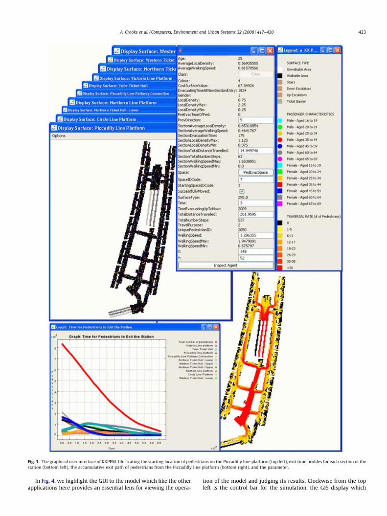
Fig. 1. The graphical user interface of KXPEM. Illustrating the starting location of pedestrians on the Piccadilly line platform (top left), exit time profiles for each section of thestation (bottom left), the accumulative exit path of pedestrians from the Piccadilly line platform (bottom right), and the parameter.
A. Crooks et al. / Computers, Environment and Urban Systems 32 (2008) 417–430 423
In Fig. 4, we highlight the GUI to the model which like the otherapplications here provides an essential lens for viewing the opera-
tion of the model and judging its results. Clockwise from the topleft is the control bar for the simulation, the GIS display which
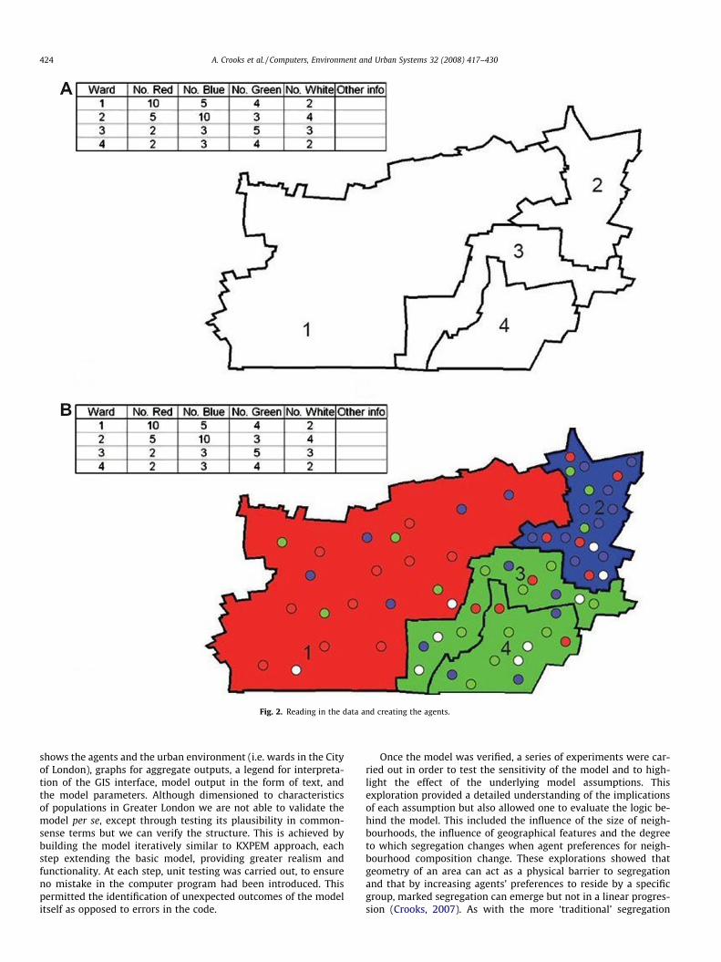
Fig. 2. Reading in the data and creating the agents.
424 A. Crooks et al. / Computers, Environment and Urban Systems 32 (2008) 417–430
shows the agents and the urban environment (i.e. wards in the Cityof London), graphs for aggregate outputs, a legend for interpreta-tion of the GIS interface, model output in the form of text, andthe model parameters. Although dimensioned to characteristicsof populations in Greater London we are not able to validate themodel per se, except through testing its plausibility in common-sense terms but we can verify the structure. This is achieved bybuilding the model iteratively similar to KXPEM approach, eachstep extending the basic model, providing greater realism andfunctionality. At each step, unit testing was carried out, to ensureno mistake in the computer program had been introduced. Thispermitted the identification of unexpected outcomes of the modelitself as opposed to errors in the code.
Once the model was verified, a series of experiments were car-ried out in order to test the sensitivity of the model and to high-light the effect of the underlying model assumptions. Thisexploration provided a detailed understanding of the implicationsof each assumption but also allowed one to evaluate the logic be-hind the model. This included the influence of the size of neigh-bourhoods, the influence of geographical features and the degreeto which segregation changes when agent preferences for neigh-bourhood composition change. These explorations showed thatgeometry of an area can act as a physical barrier to segregationand that by increasing agents’ preferences to reside by a specificgroup, marked segregation can emerge but not in a linear progres-sion (Crooks, 2007). As with the more ‘traditional’ segregation
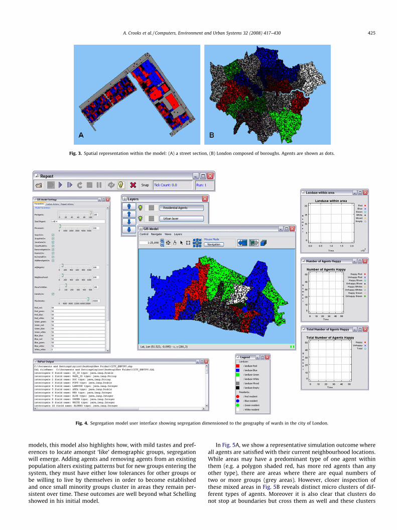
Fig. 3. Spatial representation within the model: (A) a street section, (B) London composed of boroughs. Agents are shown as dots.
Fig. 4. Segregation model user interface showing segregation dimensioned to the geography of wards in the city of London.
A. Crooks et al. / Computers, Environment and Urban Systems 32 (2008) 417–430 425
models, this model also highlights how, with mild tastes and pref-erences to locate amongst ‘like’ demographic groups, segregationwill emerge. Adding agents and removing agents from an existingpopulation alters existing patterns but for new groups entering thesystem, they must have either low tolerances for other groups orbe willing to live by themselves in order to become establishedand once small minority groups cluster in areas they remain per-sistent over time. These outcomes are well beyond what Schellingshowed in his initial model.
In Fig. 5A, we show a representative simulation outcome whereall agents are satisfied with their current neighbourhood locations.While areas may have a predominant type of one agent withinthem (e.g. a polygon shaded red, has more red agents than anyother type), there are areas where there are equal numbers oftwo or more groups (grey areas). However, closer inspection ofthese mixed areas in Fig. 5B reveals distinct micro clusters of dif-ferent types of agents. Moreover it is also clear that clusters donot stop at boundaries but cross them as well and these clusters
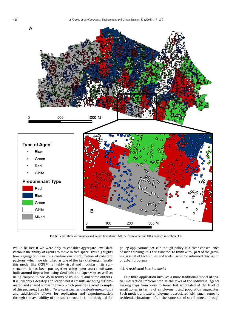
Fig. 5. Segregation within areas and across boundaries: (A) the entire area, and (B) a zoomed in section of A.
426 A. Crooks et al. / Computers, Environment and Urban Systems 32 (2008) 417–430
would be lost if we were only to consider aggregate level datawithout the ability of agents to move in free space. This highlightshow aggregation can thus confuse our identification of coherentpatterns, which we identified as one of the key challenges. Finallythis model like KXPEM, is highly visual and modular in its con-struction. It has been put together using open source software,built around Repast but using GeoTools and OpenMap as well asbeing coupled to ArcGIS in terms of its inputs and some outputs.It is still only a desktop application but its results are being dissem-inated and shared across the web which provides a good exampleof this pedagogy (see http://www.casa.ucl.ac.uk/abm/segregation/)and additionally allows for replication and experimentationthrough the availability of the source code. It is not designed for
policy applications per se although policy is a clear consequenceof such thinking. It is a ‘classic tool to think with’, part of the grow-ing arsenal of techniques and tools useful for informed discussionof urban problems.
4.3. A residential location model
Our third application involves a more traditional model of spa-tial interaction implemented at the level of the individual agentsmaking trips from work to home but articulated at the level ofsmall zones in terms of employment and population aggregates.Such models allocate employment associated with small zones toresidential locations, often the same set of small zones, through
A. Crooks et al. / Computers, Environment and Urban Systems 32 (2008) 417–430 427
simulating interactions, in this specific case, in the form of thejourney to work. The logic of interaction is based on the well-established gravitational hypotheses where the flow from employ-ment site to residential location is inversely proportional to somemeasure of the impedance – distance or travel cost between theseorigins and destinations, and directly proportional to some mea-sure of attraction or size of each two locations (Batty, 1976). Themodel is part of an integrated assessment of climate change im-pacts on the Greater London area. Designed to provide small scalepopulation estimates for long term (2050 and 2100 scenarios)interfacing between higher scale climate predictions and regionalemployment and population estimates from an environmental in-put–output model and lower scale models related primarily toflooding and environmental risk (Dawson et al., 2007). The modelis also designed to predict trips in four modes of transport – car,bus, rail and tube – which each have a considerable impact onhow the pattern of residential population might adjust in termsof the way people might travel in the future.
The purpose of this model is clear and the theory on which it isbased is classical social physics. It is also has strong links with ur-ban economic theory and the operation of land markets throughthe trade-off between accessibility and the attraction of differentlocations. This sort of model has been replicated many times andbecause it is comparatively parsimonious, it can be fitted at theaggregate level to available data. Flow matrices for each mode oftravel represent the key data for validation and calibration isaccomplished through tuning the model to reproduce the knowntrip lengths for each mode. The key problems with such models re-late to the fact that the heterogeneity of location is not representedother than in the distinctions between the small zones used in pre-dicting aggregate trips. Although there are over 600 zones defined
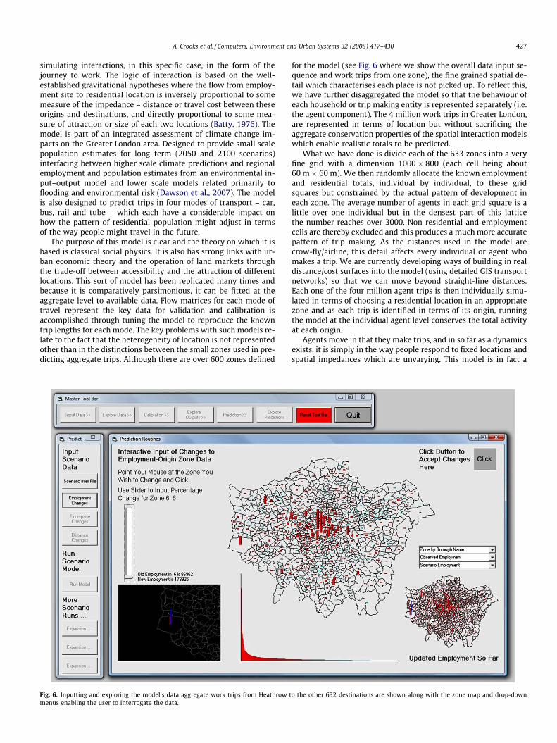
Fig. 6. Inputting and exploring the model’s data aggregate work trips from Heathrow tmenus enabling the user to interrogate the data.
for the model (see Fig. 6 where we show the overall data input se-quence and work trips from one zone), the fine grained spatial de-tail which characterises each place is not picked up. To reflect this,we have further disaggregated the model so that the behaviour ofeach household or trip making entity is represented separately (i.e.the agent component). The 4 million work trips in Greater London,are represented in terms of location but without sacrificing theaggregate conservation properties of the spatial interaction modelswhich enable realistic totals to be predicted.
What we have done is divide each of the 633 zones into a veryfine grid with a dimension 1000 � 800 (each cell being about60 m � 60 m). We then randomly allocate the known employmentand residential totals, individual by individual, to these gridsquares but constrained by the actual pattern of development ineach zone. The average number of agents in each grid square is alittle over one individual but in the densest part of this latticethe number reaches over 3000. Non-residential and employmentcells are thereby excluded and this produces a much more accuratepattern of trip making. As the distances used in the model arecrow-fly/airline, this detail affects every individual or agent whomakes a trip. We are currently developing ways of building in realdistance/cost surfaces into the model (using detailed GIS transportnetworks) so that we can move beyond straight-line distances.Each one of the four million agent trips is then individually simu-lated in terms of choosing a residential location in an appropriatezone and as each trip is identified in terms of its origin, runningthe model at the individual agent level conserves the total activityat each origin.
Agents move in that they make trips, and in so far as a dynamicsexists, it is simply in the way people respond to fixed locations andspatial impedances which are unvarying. This model is in fact a
o the other 632 destinations are shown along with the zone map and drop-down
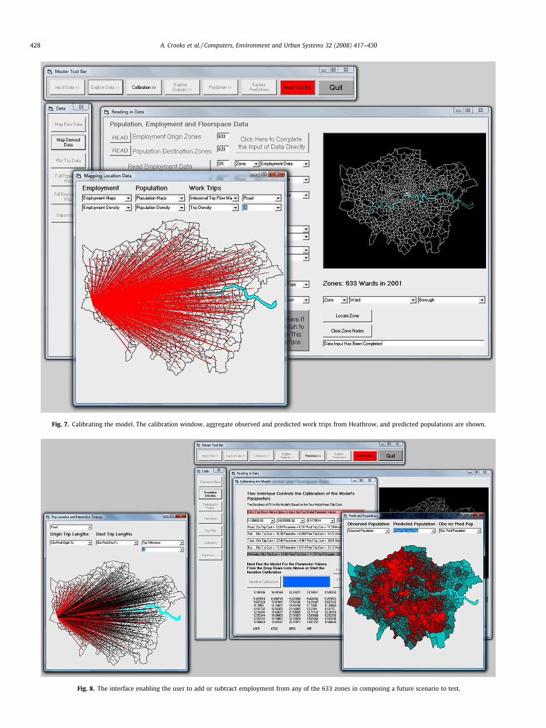
Fig. 7. Calibrating the model. The calibration window, aggregate observed and predicted work trips from Heathrow, and predicted populations are shown.
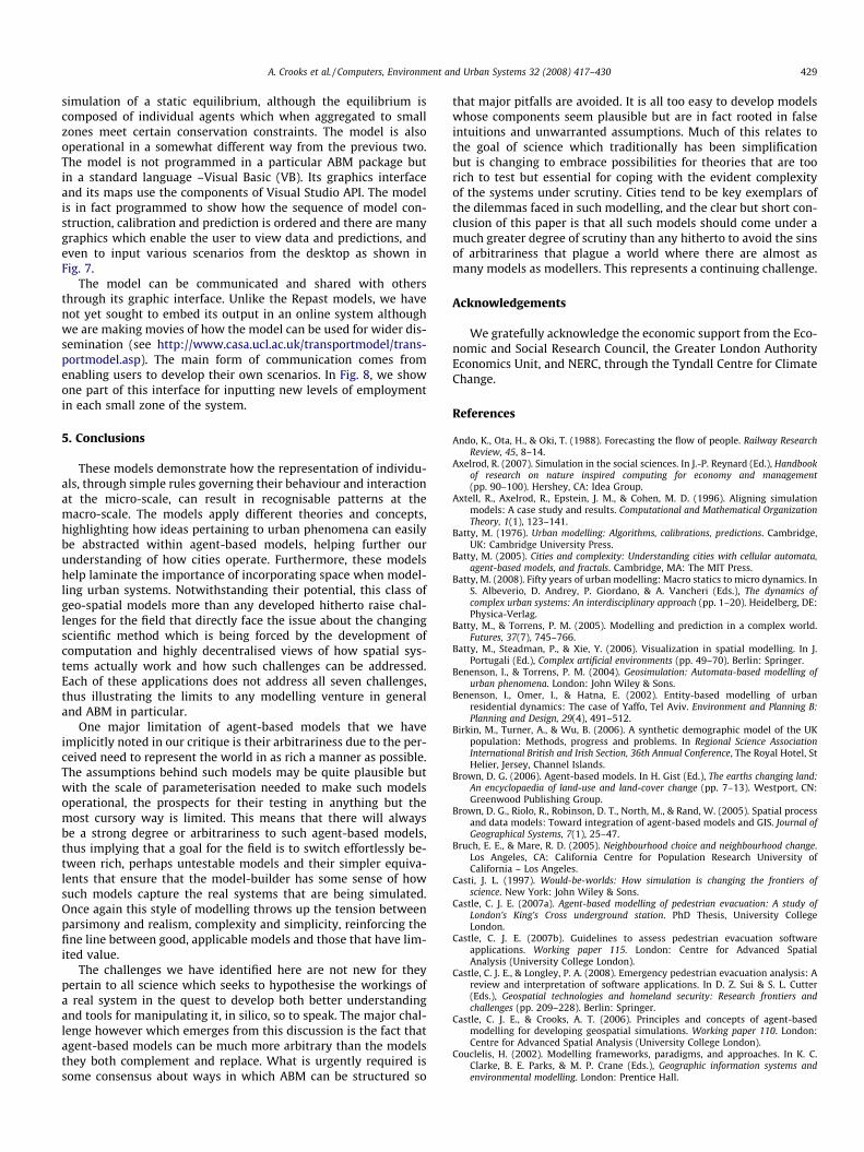
Fig. 8. The interface enabling the user to add or subtract employment from any of the 633 zones in composing a future scenario to test.
428 A. Crooks et al. / Computers, Environment and Urban Systems 32 (2008) 417–430
A. Crooks et al. / Computers, Environment and Urban Systems 32 (2008) 417–430 429
simulation of a static equilibrium, although the equilibrium iscomposed of individual agents which when aggregated to smallzones meet certain conservation constraints. The model is alsooperational in a somewhat different way from the previous two.The model is not programmed in a particular ABM package butin a standard language –Visual Basic (VB). Its graphics interfaceand its maps use the components of Visual Studio API. The modelis in fact programmed to show how the sequence of model con-struction, calibration and prediction is ordered and there are manygraphics which enable the user to view data and predictions, andeven to input various scenarios from the desktop as shown inFig. 7.
The model can be communicated and shared with othersthrough its graphic interface. Unlike the Repast models, we havenot yet sought to embed its output in an online system althoughwe are making movies of how the model can be used for wider dis-semination (see http://www.casa.ucl.ac.uk/transportmodel/trans-portmodel.asp). The main form of communication comes fromenabling users to develop their own scenarios. In Fig. 8, we showone part of this interface for inputting new levels of employmentin each small zone of the system.
5. Conclusions
These models demonstrate how the representation of individu-als, through simple rules governing their behaviour and interactionat the micro-scale, can result in recognisable patterns at themacro-scale. The models apply different theories and concepts,highlighting how ideas pertaining to urban phenomena can easilybe abstracted within agent-based models, helping further ourunderstanding of how cities operate. Furthermore, these modelshelp laminate the importance of incorporating space when model-ling urban systems. Notwithstanding their potential, this class ofgeo-spatial models more than any developed hitherto raise chal-lenges for the field that directly face the issue about the changingscientific method which is being forced by the development ofcomputation and highly decentralised views of how spatial sys-tems actually work and how such challenges can be addressed.Each of these applications does not address all seven challenges,thus illustrating the limits to any modelling venture in generaland ABM in particular.
One major limitation of agent-based models that we haveimplicitly noted in our critique is their arbitrariness due to the per-ceived need to represent the world in as rich a manner as possible.The assumptions behind such models may be quite plausible butwith the scale of parameterisation needed to make such modelsoperational, the prospects for their testing in anything but themost cursory way is limited. This means that there will alwaysbe a strong degree or arbitrariness to such agent-based models,thus implying that a goal for the field is to switch effortlessly be-tween rich, perhaps untestable models and their simpler equiva-lents that ensure that the model-builder has some sense of howsuch models capture the real systems that are being simulated.Once again this style of modelling throws up the tension betweenparsimony and realism, complexity and simplicity, reinforcing thefine line between good, applicable models and those that have lim-ited value.
The challenges we have identified here are not new for theypertain to all science which seeks to hypothesise the workings ofa real system in the quest to develop both better understandingand tools for manipulating it, in silico, so to speak. The major chal-lenge however which emerges from this discussion is the fact thatagent-based models can be much more arbitrary than the modelsthey both complement and replace. What is urgently required issome consensus about ways in which ABM can be structured so
that major pitfalls are avoided. It is all too easy to develop modelswhose components seem plausible but are in fact rooted in falseintuitions and unwarranted assumptions. Much of this relates tothe goal of science which traditionally has been simplificationbut is changing to embrace possibilities for theories that are toorich to test but essential for coping with the evident complexityof the systems under scrutiny. Cities tend to be key exemplars ofthe dilemmas faced in such modelling, and the clear but short con-clusion of this paper is that all such models should come under amuch greater degree of scrutiny than any hitherto to avoid the sinsof arbitrariness that plague a world where there are almost asmany models as modellers. This represents a continuing challenge.
Acknowledgements
We gratefully acknowledge the economic support from the Eco-nomic and Social Research Council, the Greater London AuthorityEconomics Unit, and NERC, through the Tyndall Centre for ClimateChange.
References
Ando, K., Ota, H., & Oki, T. (1988). Forecasting the flow of people. Railway ResearchReview, 45, 8–14.
Axelrod, R. (2007). Simulation in the social sciences. In J.-P. Reynard (Ed.), Handbookof research on nature inspired computing for economy and management(pp. 90–100). Hershey, CA: Idea Group.
Axtell, R., Axelrod, R., Epstein, J. M., & Cohen, M. D. (1996). Aligning simulationmodels: A case study and results. Computational and Mathematical OrganizationTheory, 1(1), 123–141.
Batty, M. (1976). Urban modelling: Algorithms, calibrations, predictions. Cambridge,UK: Cambridge University Press.
Batty, M. (2005). Cities and complexity: Understanding cities with cellular automata,agent-based models, and fractals. Cambridge, MA: The MIT Press.
Batty, M. (2008). Fifty years of urban modelling: Macro statics to micro dynamics. InS. Albeverio, D. Andrey, P. Giordano, & A. Vancheri (Eds.), The dynamics ofcomplex urban systems: An interdisciplinary approach (pp. 1–20). Heidelberg, DE:Physica-Verlag.
Batty, M., & Torrens, P. M. (2005). Modelling and prediction in a complex world.Futures, 37(7), 745–766.
Batty, M., Steadman, P., & Xie, Y. (2006). Visualization in spatial modelling. In J.Portugali (Ed.), Complex artificial environments (pp. 49–70). Berlin: Springer.
Benenson, I., & Torrens, P. M. (2004). Geosimulation: Automata-based modelling ofurban phenomena. London: John Wiley & Sons.
Benenson, I., Omer, I., & Hatna, E. (2002). Entity-based modelling of urbanresidential dynamics: The case of Yaffo, Tel Aviv. Environment and Planning B:Planning and Design, 29(4), 491–512.
Birkin, M., Turner, A., & Wu, B. (2006). A synthetic demographic model of the UKpopulation: Methods, progress and problems. In Regional Science AssociationInternational British and Irish Section, 36th Annual Conference, The Royal Hotel, StHelier, Jersey, Channel Islands.
Brown, D. G. (2006). Agent-based models. In H. Gist (Ed.), The earths changing land:An encyclopaedia of land-use and land-cover change (pp. 7–13). Westport, CN:Greenwood Publishing Group.
Brown, D. G., Riolo, R., Robinson, D. T., North, M., & Rand, W. (2005). Spatial processand data models: Toward integration of agent-based models and GIS. Journal ofGeographical Systems, 7(1), 25–47.
Bruch, E. E., & Mare, R. D. (2005). Neighbourhood choice and neighbourhood change.Los Angeles, CA: California Centre for Population Research University ofCalifornia – Los Angeles.
Casti, J. L. (1997). Would-be-worlds: How simulation is changing the frontiers ofscience. New York: John Wiley & Sons.
Castle, C. J. E. (2007a). Agent-based modelling of pedestrian evacuation: A study ofLondon’s King’s Cross underground station. PhD Thesis, University CollegeLondon.
Castle, C. J. E. (2007b). Guidelines to assess pedestrian evacuation softwareapplications. Working paper 115. London: Centre for Advanced SpatialAnalysis (University College London).
Castle, C. J. E., & Longley, P. A. (2008). Emergency pedestrian evacuation analysis: Areview and interpretation of software applications. In D. Z. Sui & S. L. Cutter(Eds.), Geospatial technologies and homeland security: Research frontiers andchallenges (pp. 209–228). Berlin: Springer.
Castle, C. J. E., & Crooks, A. T. (2006). Principles and concepts of agent-basedmodelling for developing geospatial simulations. Working paper 110. London:Centre for Advanced Spatial Analysis (University College London).
Couclelis, H. (2002). Modelling frameworks, paradigms, and approaches. In K. C.Clarke, B. E. Parks, & M. P. Crane (Eds.), Geographic information systems andenvironmental modelling. London: Prentice Hall.

430 A. Crooks et al. / Computers, Environment and Urban Systems 32 (2008) 417–430
Crooks, A. T. (2007). Experimenting with cities: Utilizing agent-based models and GIS toexplore urban dynamics. PhD Thesis, University College London.
Dawson, R. J., Hall, J. W., Barr, S., Batty, M., Bristow, A., & Carney, S., et al. (2007). Ablueprint for the integrated assessment of climate change in cities. TyndallCentre Working paper 104. UK: University of East Anglia, Norwich. Available athttp://www.tyndall.ac.uk/publications/working_papers/twp104.pdf.
Epstein, J. M., & Axtell, R. (1996). Growing artificial societies: Social science from thebottom up. Cambridge, MA: MIT Press.
Fruin, J. J. (1971). Pedestrian planning and design. New York: MetropolitanAssociation of Urban Designers and Environmental Planners.
Galea, E. R., & Gwynne, S. (2006). Principles and practice of evacuation modelling (7thed.). London: Fire Safety Engineering Group – University of Greenwich.
Gilbert, N., den Besten, M., Bontovics, A., Craenen, B. G. W., Divina, F., Eiben, A. E.,et al. (2006). Emerging artificial societies through learning. Journal of ArtificialSocieties and Social Simulation, 9(2), 9.
Grimm, V., Berger, U., Bastiansen, F., Eliassen, S., Ginot, V., Giske, J., et al. (2006). Astandard protocol for describing individual-based and agent-based models.Ecological Modelling, 198, 115–126.
Hankin, B. D., & Wright, R. A. (1958). Passenger flow in subways. OperationalResearch Quarterly, 9(2), 81–88.
HSE (1996). Railway safety principles and guidance: Part 2 – Section B – Guidanceon stations. London: Health & Safety Executive.
Langran, G. (1992). Time in geographic information systems. London: Taylor andFrancis.
Law, A. M., & Kelton, D. (1991). Simulation modelling and analysis (2nd ed.). NewYork: McGraw-Hill.
Lee, D. B. (1973). Requiem for large-scale models. Journal of the American Institute ofPlanners(39), 163–178.
Longley, P. A., Goodchild, M. F., Maguire, D. J., & Rind, D. W. (2005). Geographicalinformation systems and science. New York: John Wiley & Sons.
Maguire, D. J. (2005). Towards a GIS platform for spatial analysis and modelling. InD. J. Maguire, M. Batty, & M. F. Goodchild (Eds.), GIS, spatial analysis andmodelling (pp. 19–39). California, CA: ESRI Press, Redlands.
Mandelbrot, B. B. (1983). The fractal geometry of nature. New York: W.H. Freeman.North, M. J., & Macal, C. M. (2007). Managing business complexity: Discovering
strategic solutions with agent-based modeling and simulation. New York: OxfordUniversity Press.
O’Sullivan, D., MacGill, J., & Yu, C. (2003) Agent-based residential segregation: Ahierarchically structured spatial model. In Proceedings of agent 2003 conferenceon challenges in social simulation, The University of Chicago, Chicago, IL, pp. 493–507.
Parker, D. C. (2005). Integration of geographic information systems and agent-basedmodels of land use: Challenges and prospects. In D. J. Maguire, M. Batty, & M. F.Goodchild (Eds.), GIS, spatial analysis and modelling (pp. 403–422). Redlands, CA:ESRI Press.
Peuquet, D. J. (2005). Time in GIS and geographical databases. In P. A. Longley, M. F.Goodchild, D. J. Maguire, & D. W. Rhind (Eds.), Geographical information systems:Principles, techniques, management and applications (Abridged Edition). NewYork: John Wiley & Sons.
Polhill, J. G., Parker, D., Brown, D., & Grimm, V. (2008). Using the ODD protocol fordescribing three agent-based social simulation models of land-use change.Journal of Artificial Societies and Social Simulation, 11(2), 3 http://jasss.soc.surrey.ac.uk/11/2/3.html.
Pontius, R. G., & Malanson, J. (2005). Comparison of the structure and accuracy oftwo land change models. International Journal of Geographical InformationScience, 19, 243–265.
Predtechenskii, V. M., & Milinskii, A. I. (1978). Planning for foot traffic flow inbuildings. New Delhi: Amerind.
Railsback, S. F., Lytinen, S. L., & Jackson, S. K. (2006). Agent-based simulationplatforms: review and development recommendations. Simulation, 82(9),609–623.
Schelling, T. C. (1971). Dynamic models of segregation. Journal of MathematicalSociology, 1, 143–186.
Tobias, R., & Hofmann, C. (2004). Evaluation of free Java-libraries for social-scientificagent based simulation. Journal of Artificial Societies and Social Simulation, 7(1),10.
Webster, F. V., Bly, P. H., & Paulley, N. J. (Eds.). (1988). Urban land-use and transportinteraction: Policies and models. Report of the International Study Group onLand-Use/Transport Interaction (ISGLUTI), Avebury, Aldershot, UK.
Westervelt, J. D. (2002). Geographic information systems and agent-basedmodelling. In H. R. Gimblett (Ed.), Integrating geographic information systemsand agent-based modelling techniques for simulating social and ecological processes(pp. 83–104). Oxford, UK: Oxford University Press.