Retrograde Coronary Sinus Perfusion for Myocardial Protection during Cardiopulmonary Bypass
Upload
independentCategory
view
1download
0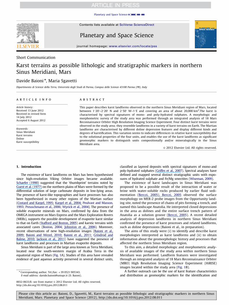
Planetary and Space Science ] (]]]]) ]]]–]]]
Contents lists available at SciVerse ScienceDirect
Planetary and Space Science
0032-06
http://d
n Corr
E-m
PleasMeri
journal homepage: www.elsevier.com/locate/pss
Short Communication
Karst terrains as possible lithologic and stratigraphic markers in northernSinus Meridiani, Mars
Davide Baioni n, Maria Sgavetti
Dipartimento di Scienze della Terra, Universit�a degli Studi di Parma, Campus delle Scienze 43100 Parma (PR), Italy
a r t i c l e i n f o
Article history:
Received 13 June 2012
Received in revised form
14 July 2012
Accepted 6 August 2012
Keywords:
Sinus Meridiani
Karst terrains
Doline
Karst susceptibility
33/$ - see front matter & 2012 Elsevier Ltd. A
x.doi.org/10.1016/j.pss.2012.08.011
esponding author. Tel./fax: þ39 0521 905343
ail address: [email protected] (D. Baion
e cite this article as: Baioni, D., Sgadiani, Mars. Planetary and Space Sci
a b s t r a c t
This paper describes karst landforms observed in the northern Sinus Meridiani region of Mars, located
between 11200–21200 N and 21500 W–11E and covering an area of about 20,000 km2.The karst is
characterised by spectral signatures of mono- and poly-hydrated sulphates. A morphologic and
morphometric survey of the study area was performed through an integrated analysis of 18 Mars
Reconnaissance Orbiter High Resolution Imaging Science Experiment. Four distinct karst terrains were
observed in the study area; they resemble landforms in a variety of karst terrains on Earth. The Martian
landforms are characterised by different doline depression features and display different kinds and
degrees of karstification. This variation seems to indicate differences in relative karst susceptibility due
to the solutional properties of the four units, and enables the use of the karst landforms as significant
geomorphic markers to distinguish units compositionally and/or mineralogically in the Sinus
Meridiani area.
& 2012 Elsevier Ltd. All rights reserved.
1. Introduction
The existence of karst landforms on Mars has been hypothesisedsince high-resolution Viking Orbiter images became available.Schaefer (1990) suggested that the ‘thumbprint’ terrains noted byGuest et al. (1977) on the northern plains of Mars were formed by thedifferential solution of large carbonate deposits in low-lying areas.The presence of karst-like topographies and karst processes has alsobeen hypothesised in many other regions of the Martian surface(Costard and Kargel, 1995; Kargel et al., 2004; Peulvast and Masson,1993; Preuschmann et al., 2006; Wyrick et al., 2004). The presence ofsoluble evaporite minerals on Mars, confirmed by data from theOMEGA instrument on Mars Express and the Mars Exploration Rovers(MERs), supports the possible development of evaporite karst similarto that on Earth (Stafford and Boston, 2005) and karstic terrains withassociated caves (Boston, 2004; Johnston et al., 2006). Moreover,recent observations of new high-resolution images (Baioni et al.,2009; Baioni and Wezel, 2010; Baioni et al., 2011; Grindrod andBalme, 2010; Jackson et al., 2011) have suggested the presence ofkarst landforms and processes in Martian evaporite deposits.
Sinus Meridiani is part of the large area known as Terra Meridiani,located near the south-western margin of Arabia Terra in theequatorial region of Mars (Fig. 1A). Studies of this area have revealedevidence of past aqueous activity preserved in several distinct units,
ll rights reserved.
.
i).
vetti, M., Karst terrains asence (2012), http://dx.doi.o
classified as layered deposits with spectral signatures of mono-andpoly-hydrated sulphates (Griffes et al., 2007). Spectral analyses havedefined and mapped several distinct stratigraphic units with expo-sures of hydrated sulphate and Fe/Mg smectites (Wiseman, 2009).
The existence of karst landscapes in Sinus Meridiani wasproposed to be a possible result of the interaction of water orbrine with water-soluble rocks produced by earlier fluid sedi-mentation (Berczi, 2005). Berczi, 2005 observed the surfacemorphology on MER-2 probe images from the Opportunity land-ing site, noted the presence of chains of pits forming a trench, andnamed this landscape Anatolia. He interpreted closed depressionsin the area as dolines and the entire surface trench pattern ofAnatolia as a solution groove (Berczi, 2005). A recent detailedanalysis of depression landforms in northern Sinus Meridianiconfirmed the presence of karst processes and related landforms,such as doline depressions (Baioni et al., in preparation).
The aims of this study were (i) to identify and describe karstmorphologies interpreted as karst landforms and (ii) to obtaininformation about the geomorphologic history and processes thataffected the northern Sinus Meridiani region.
To this aim, a detailed morphologic and morphometric analy-sis of available images of the study area within northern SinusMeridiani was performed. Landform features were investigatedthrough an integrated analysis of 18 Mars Reconnaissance Orbiter(MRO) High Resolution Imaging Science Experiment (HiRISE)images located within the study area (Fig. 1B).
A further outreach can be the use of karst feature characteristicsand distribution as geomorphic markers for the identification and
possible lithologic and stratigraphic markers in northern Sinusrg/10.1016/j.pss.2012.08.011
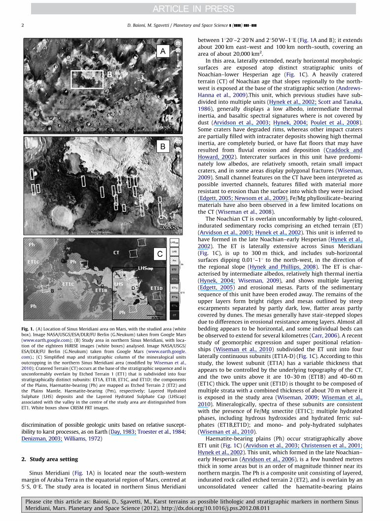
Fig. 1. (A) Location of Sinus Meridiani area on Mars, with the studied area (white
box). Image NASA/USGS/ESA/DLR/FU Berlin (G.Neukum) taken from Google Mars
(www.earth.google.com); (B) Study area in northern Sinus Meridiani, with loca-
tion of the eighteen HiRISE images (white boxes) analysed. Image NASA/USGS/
ESA/DLR/FU Berlin (G.Neukum) taken from Google Mars (www.earth.google.
com).; (C) Simplified map and stratigraphic column of the mineralogical units
outcropping in the northern Sinus Meridiani area (modified by Wiseman et al.,
2010); Cratered Terrain (CT) occurs at the base of the stratigraphic sequence and is
unconformably overlain by Etched Terrain 1 (ET1) that is subdivided into four
stratigraphically distinct subunits: ET1A, ET1B, ET1C, and ET1D; the components
of the Plains, Haematite-bearing (Ph) are mapped as Etched Terrain 2 (ET2) and
the Plains Mantle, Haematite-bearing (Pm), respectively; Layered Hydrated
Sulphate (LHS) deposits and the Layered Hydrated Sulphate Cap (LHScap)
associated with the valley in the centre of the study area are distinguished from
ET1. White boxes show CRISM FRT images.
D. Baioni, M. Sgavetti / Planetary and Space Science ] (]]]]) ]]]–]]]2
discrimination of possible geologic units based on relative suscept-ibility to karst processes, as on Earth (Day, 1983; Troester et al., 1984;Denizman, 2003; Williams, 1972)
2. Study area setting
Sinus Meridiani (Fig. 1A) is located near the south-westernmargin of Arabia Terra in the equatorial region of Mars, centred at51S, 01E. The study area is located in northern Sinus Meridiani
Please cite this article as: Baioni, D., Sgavetti, M., Karst terrains asMeridiani, Mars. Planetary and Space Science (2012), http://dx.doi.o
between 11200–21200N and 21500W–11E (Fig. 1A and B); it extendsabout 200 km east–west and 100 km north–south, covering anarea of about 20,000 km2.
In this area, laterally extended, nearly horizontal morphologicsurfaces are exposed atop distinct stratigraphic units ofNoachian–lower Hesperian age (Fig. 1C). A heavily crateredterrain (CT) of Noachian age that slopes regionally to the north-west is exposed at the base of the stratigraphic section (Andrews-Hanna et al., 2009).This unit, which previous studies have sub-divided into multiple units (Hynek et al., 2002; Scott and Tanaka,1986), generally displays a low albedo, intermediate thermalinertia, and basaltic spectral signatures where is not covered bydust (Arvidson et al., 2003; Hynek, 2004; Poulet et al., 2008).Some craters have degraded rims, whereas other impact cratersare partially filled with intracrater deposits showing high thermalinertia, are completely buried, or have flat floors that may haveresulted from fluvial erosion and deposition (Craddock andHoward, 2002). Intercrater surfaces in this unit have predomi-nately low albedos, are relatively smooth, retain small impactcraters, and in some areas display polygonal fractures (Wiseman,2009). Small channel features on the CT have been interpreted aspossible inverted channels, features filled with material moreresistant to erosion than the surface into which they were incised(Edgett, 2005; Newsom et al., 2009). Fe/Mg phyllosilicate–bearingmaterials have also been observed in a few limited locations onthe CT (Wiseman et al., 2008).
The Noachian CT is overlain unconformably by light-coloured,indurated sedimentary rocks comprising an etched terrain (ET)(Arvidson et al., 2003; Hynek et al., 2002). This unit is inferred tohave formed in the late Noachian–early Hesperian (Hynek et al.,2002). The ET is laterally extensive across Sinus Meridiani(Fig. 1C), is up to 300 m thick, and includes sub-horizontalsurfaces dipping 0.011–11 to the north-west, in the direction ofthe regional slope (Hynek and Phillips, 2008). The ET is char-acterised by intermediate albedos, relatively high thermal inertia(Hynek, 2004; Wiseman, 2009), and shows multiple layering(Edgett, 2005) and erosional mesas. Parts of the sedimentarysequence of this unit have been eroded away. The remains of theupper layers form bright ridges and mesas outlined by steepescarpments separated by partly dark, low, flatter areas partlycovered by dunes. The mesas generally have stair-stepped slopesdue to differences in erosional resistance among layers. Almost allbedding appears to be horizontal, and some individual beds canbe observed to extend for several kilometres (Carr, 2006). A recentstudy of geomorphic expression and super positional relation-ships (Wiseman et al., 2010) subdivided the ET unit into fourlaterally continuous subunits (ET1A-D) (Fig. 1C). According to thisstudy, the lowest subunit (ET1A) has a variable thickness thatappears to be controlled by the underlying topography of the CT,and the two units above it are 10–30 m (ET1B) and 40–60 m(ET1C) thick. The upper unit (ET1D) is thought to be composed ofmultiple strata with a combined thickness of about 70 m where itis exposed in the study area (Wiseman, 2009; Wiseman et al.,2010). Mineralogically, spectra of these subunits are consistentwith the presence of Fe/Mg smectite (ET1C); multiple hydratedphases, including hydrous hydroxides and hydrated ferric sul-phates (ET1B,ET1D); and mono- and poly-hydrated sulphates(Wiseman et al., 2010).
Haematite-bearing plains (Ph) occur stratigraphically aboveET1 unit (Fig. 1C) (Arvidson et al., 2003; Christensen et al., 2001;Hynek et al., 2002). This unit, which formed in the late Noachian–early Hesperian (Arvidson et al., 2006), is a few hundred metresthick in some areas but is an order of magnitude thinner near itsnorthern margin. The Ph is a composite unit consisting of layered,indurated rock called etched terrain 2 (ET2), and is overlain by anunconsolidated veneer called the haematite-bearing plains
possible lithologic and stratigraphic markers in northern Sinusrg/10.1016/j.pss.2012.08.011
D. Baioni, M. Sgavetti / Planetary and Space Science ] (]]]]) ]]]–]]] 3
mantle (Pm) (Wiseman et al., 2010). In situ investigations by theMER Opportunity revealed that the bedrock component of the Ph,ET2, contains about 20 wt% SO3 and 10 wt% jarosite (Klingelhoferet al., 2004; Morris et al., 2006), where as the bulk of the Pm iscomposed of low-albedo basaltic sand (Christensen et al., 2000).The haematite signature of the Ph results from hematitic concre-tions that have weathered out of the bedrock and been concen-trated at the surface by aeolian processes (Arvidson et al., 2006;Chan et al., 2004; Morris et al., 2006; Squyres et al., 2004). Datacollected by the Opportunity rover along its traverse revealed thatthe ET2 is chemically homogenous (Rieder et al., 2004) andrelatively smooth (Wiseman et al., 2008). The ET2 unit is almostcompletely covered by the Pm, which protects the surface andslows deflation (Sullivan et al., 2005). Counts of small (o250-mdiameter) craters suggest a Late Amazonian crater retention agefor the Pm (Lane et al., 2003; Wiseman, 2009).
A northwest–southeast-trending valley is present in the centre ofthe study area. Layered deposits with hydrated sulphate spectralsignatures are exposed and mapped in this valley as layered hydratedsulphate (LHS–LHScap) deposits (Fig. 1C) (Wiseman et al., 2010).These deposits are about 50 m thick near their north-western marginand about 150 m thick near their north-eastern margin. They aretexturally and spectrally distinct from the sulphate-and haematite-rich unit, exhibit spectra indicative of mono- and poly-hydratedsulphates (LHS) or hydrate ferric sulphates (LHScap), and showerosional pits and grooves at small–intermediate spatial scales(Wiseman et al., 2010). The LHS deposits are considered to be theyoungest stratigraphic unit exposed in northern Sinus Meridiani.
3. Karst terrains
Landforms in the study area appear to be closed, rimless depres-sions of different shapes and sizes that are surrounded entirely byunbroken plains. These morphologic features, interpreted as dolinesof polygenetic origin (Ford and Williams, 2007), highlight thesignificant contribution of karst processes, as they lack evidence ofwind action and erosional features associated with the evolution ofimpact craters. Moreover, morphologies throughout the study areastrongly resemble karst morphologies on Earth and those previouslyidentified and described in other regions of Mars (Baioni et al., 2009;Baioni and Wezel, 2010; Baioni et al., 2011).
Four distinct karst terrains (KTs) are exposed at differentstratigraphic levels throughout the study area, and are charac-terised by a variety of doline depression features with differentkinds and degrees of karstification. From top to base, theseterrains are referred to as the upper (UKT), middle-upper (MUKT),middle-lower (MLKT), and lower karst terrain (LKT). As the focusof this study, these terrains are described in detail below.
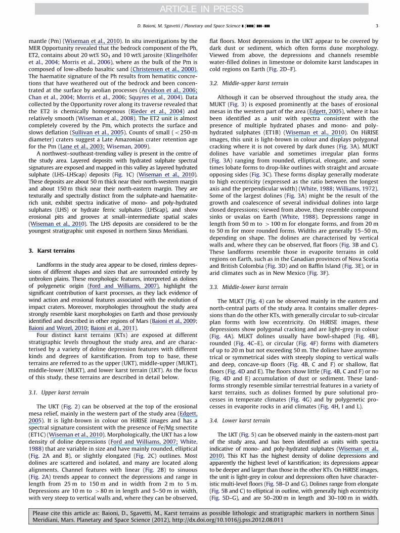
3.1. Upper karst terrain
The UKT (Fig. 2) can be observed at the top of the erosionalmesa relief, mainly in the western part of the study area (Edgett,2005). It is light-brown in colour on HiRISE images and has aspectral signature consistent with the presence of Fe/Mg smectite(ET1C) (Wiseman et al., 2010). Morphologically, the UKT has a lowdensity of doline depressions (Ford and Williams, 2007; White,1988) that are variable in size and have mainly rounded, elliptical(Fig. 2A and B), or slightly elongated (Fig. 2C) outlines. Mostdolines are scattered and isolated, and many are located alongalignments. Channel features with linear (Fig. 2B) to sinuous(Fig. 2A) trends appear to connect the depressions and range inlength from 25 m to 150 m and in width from 2 m to 5 m.Depressions are 10 m to 480 m in length and 5–50 m in width,with very steep to vertical walls and, where they can be observed,
Please cite this article as: Baioni, D., Sgavetti, M., Karst terrains asMeridiani, Mars. Planetary and Space Science (2012), http://dx.doi.o
flat floors. Most depressions in the UKT appear to be covered bydark dust or sediment, which often forms dune morphology.Viewed from above, the depressions and channels resemblewater-filled dolines in limestone or dolomite karst landscapes incold regions on Earth (Fig. 2D–F).
3.2. Middle-upper karst terrain
Although it can be observed throughout the study area, theMUKT (Fig. 3) is exposed prominently at the bases of erosionalmesas in the western part of the area (Edgett, 2005), where it hasbeen identified as a unit with spectra consistent with thepresence of multiple hydrated phases and mono- and poly-hydrated sulphates (ET1B) (Wiseman et al., 2010). On HiRISEimages, this unit is light-brown in colour and displays polygonalcracking where it is not covered by dark dunes (Fig. 3A). MUKTdolines have variable and sometimes irregular plan forms(Fig. 3A) ranging from rounded, elliptical, elongate, and some-times lobate forms to drop-like outlines with straight and arcuateopposing sides (Fig. 3C). These forms display generally moderateto high eccentricity (expressed as the ratio between the longestaxis and the perpendicular width) (White, 1988; Williams, 1972).Some of the largest dolines (Fig. 3A) might be the result of thegrowth and coalescence of several individual dolines into largeclosed depressions; viewed from above, they resemble compoundsinks or uvalas on Earth (White, 1988). Depressions range inlength from 50 m to 4100 m for elongate forms, and from 20 mto 50 m for more rounded forms. Widths are generally 15–50 m,depending on shape. The dolines are characterised by verticalwalls and, where they can be observed, flat floors (Fig. 3B and C).These landforms resemble those in evaporite terrains in coldregions on Earth, such as in the Canadian provinces of Nova Scotiaand British Colombia (Fig. 3D) and on Baffin Island (Fig. 3E), or inarid climates such as in New Mexico (Fig. 3F).
3.3. Middle-lower karst terrain
The MLKT (Fig. 4) can be observed mainly in the eastern andnorth-central parts of the study area. It contains smaller depres-sions than do the other KTs, with generally circular to sub-circularplan forms with low eccentricity. On HiRISE images, thesedepressions show polygonal cracking and are light-grey in colour(Fig. 4A). MLKT dolines usually have bowl-shaped (Fig. 4B),rounded (Fig. 4C–E), or circular (Fig. 4F) forms with diametersof up to 20 m but not exceeding 50 m. The dolines have asymme-trical or symmetrical sides with steeply sloping to vertical wallsand deep, concave-up floors (Fig. 4B, C and F) or shallow, flatfloors (Fig. 4D and E). The floors show little (Fig. 4B, C and F) or no(Fig. 4D and E) accumulation of dust or sediment. These land-forms strongly resemble similar terrestrial features in a variety ofkarst terrains, such as dolines formed by pure solutional pro-cesses in temperate climates (Fig. 4G) and by polygenetic pro-cesses in evaporite rocks in arid climates (Fig. 4H, I and L).
3.4. Lower karst terrain
The LKT (Fig. 5) can be observed mainly in the eastern-most partof the study area, and has been identified as units with spectraindicative of mono- and poly-hydrated sulphates (Wiseman et al.,2010). This KT has the highest density of doline depressions andapparently the highest level of karstification; its depressions appearto be deeper and larger than those in the other KTs. On HiRISE images,the unit is light-grey in colour and depressions often have character-istic multi-level floors (Fig. 5B–D and G). Dolines range from elongate(Fig. 5B and C) to elliptical in outline, with generally high eccentricity(Fig. 5D–G), and are 50–200 m in length and 30–100 m in width.
possible lithologic and stratigraphic markers in northern Sinusrg/10.1016/j.pss.2012.08.011
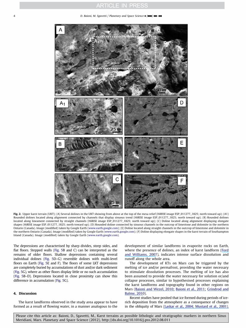
Fig. 2. Upper karst terrain (UKT); (A) Several dolines in the UKT showing from above at the top of the mesa relief (HiRISE image ESP_011277_1825; north toward up); (A1)
Rounded dolines located along alignment connected by channels that display sinuous trend (HiRISE image ESP_011277_1825; north toward up); (B) Rounded dolines
located along lineament connected by straight channels (HiRISE image ESP_011277_1825; north toward up); (C) Doline located along alignment displaying elongate
shapes (HiRISE image ESP_011277_1825; north toward up); (D) Rounded doline connected by sinuous channels in the outcrop of limestone and dolomite in the northern
Ontario (Canada). Image (modified) taken by Google Earth (www.earth.google.com); (E) Doline located along straight channels in the outcrop of limestone and dolomite in
the northern Ontario (Canada). Image (modified) taken by Google Earth (www.earth.google.com); (F) Doline displaying elongate shapes in the karst terrain of Southampton
Island (Canada). Image (modified) taken by Google Earth (www.earth.google.com).
D. Baioni, M. Sgavetti / Planetary and Space Science ] (]]]]) ]]]–]]]4
The depressions are characterised by sharp divides, steep sides, andflat floors. Stepped walls (Fig. 5B and C) can be interpreted as theremains of older floors. Shallow depressions containing severalindividual dolines (Fig. 5D–G) resemble dolines with multi-levelfloors on Earth (Fig. 5E and F). The floors of some LKT depressionsare completely buried by accumulations of dust and/or dark sediment(Fig. 5G), where as other floors display little or no such accumulation(Fig. 5B–D). Depressions located in close proximity can show thisdifference in accumulation (Fig. 5G).
4. Discussion
The karst landforms observed in the study area appear to haveformed as a result of flowing water, in a manner analogous to the
Please cite this article as: Baioni, D., Sgavetti, M., Karst terrains asMeridiani, Mars. Planetary and Space Science (2012), http://dx.doi.o
development of similar landforms in evaporite rocks on Earth,where the presence of dolines, an index of karst landform (Fordand Williams, 2007), indicates intense surface dissolution andrunoff along the whole area.
The development of KTs on Mars can be triggered by themelting of ice and/or permafrost, providing the water necessaryto stimulate dissolution processes. The melting of ice has alsobeen assumed to provide the water necessary for solution or/andcollapse processes, similar to hypothesised processes explainingthe karst landforms and topography found in other regions onMars (Baioni and Wezel, 2010; Baioni et al., 2011; Grindrod andBalme, 2010).
Recent studies have posited that ice formed during periods of ice-rich deposition from the atmosphere as a consequence of changesin the obliquity of Mars (Laskar et al., 2004; Mustard et al., 2001).
possible lithologic and stratigraphic markers in northern Sinusrg/10.1016/j.pss.2012.08.011
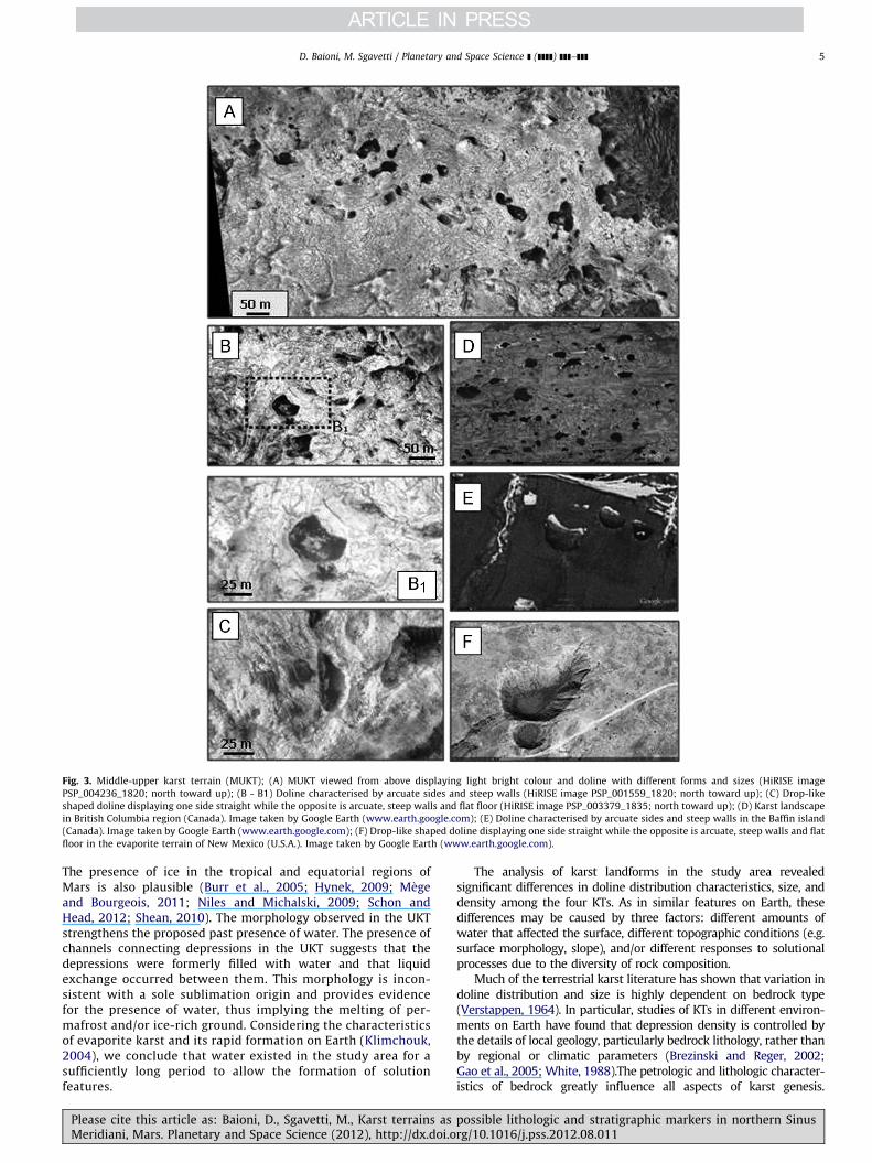
Fig. 3. Middle-upper karst terrain (MUKT); (A) MUKT viewed from above displaying light bright colour and doline with different forms and sizes (HiRISE image
PSP_004236_1820; north toward up); (B - B1) Doline characterised by arcuate sides and steep walls (HiRISE image PSP_001559_1820; north toward up); (C) Drop-like
shaped doline displaying one side straight while the opposite is arcuate, steep walls and flat floor (HiRISE image PSP_003379_1835; north toward up); (D) Karst landscape
in British Columbia region (Canada). Image taken by Google Earth (www.earth.google.com); (E) Doline characterised by arcuate sides and steep walls in the Baffin island
(Canada). Image taken by Google Earth (www.earth.google.com); (F) Drop-like shaped doline displaying one side straight while the opposite is arcuate, steep walls and flat
floor in the evaporite terrain of New Mexico (U.S.A.). Image taken by Google Earth (www.earth.google.com).
D. Baioni, M. Sgavetti / Planetary and Space Science ] (]]]]) ]]]–]]] 5
The presence of ice in the tropical and equatorial regions ofMars is also plausible (Burr et al., 2005; Hynek, 2009; M�egeand Bourgeois, 2011; Niles and Michalski, 2009; Schon andHead, 2012; Shean, 2010). The morphology observed in the UKTstrengthens the proposed past presence of water. The presence ofchannels connecting depressions in the UKT suggests that thedepressions were formerly filled with water and that liquidexchange occurred between them. This morphology is incon-sistent with a sole sublimation origin and provides evidencefor the presence of water, thus implying the melting of per-mafrost and/or ice-rich ground. Considering the characteristicsof evaporite karst and its rapid formation on Earth (Klimchouk,2004), we conclude that water existed in the study area for asufficiently long period to allow the formation of solutionfeatures.
Please cite this article as: Baioni, D., Sgavetti, M., Karst terrains asMeridiani, Mars. Planetary and Space Science (2012), http://dx.doi.o
The analysis of karst landforms in the study area revealedsignificant differences in doline distribution characteristics, size, anddensity among the four KTs. As in similar features on Earth, thesedifferences may be caused by three factors: different amounts ofwater that affected the surface, different topographic conditions (e.g.surface morphology, slope), and/or different responses to solutionalprocesses due to the diversity of rock composition.
Much of the terrestrial karst literature has shown that variation indoline distribution and size is highly dependent on bedrock type(Verstappen, 1964). In particular, studies of KTs in different environ-ments on Earth have found that depression density is controlled bythe details of local geology, particularly bedrock lithology, rather thanby regional or climatic parameters (Brezinski and Reger, 2002;Gao et al., 2005; White, 1988).The petrologic and lithologic character-istics of bedrock greatly influence all aspects of karst genesis.
possible lithologic and stratigraphic markers in northern Sinusrg/10.1016/j.pss.2012.08.011
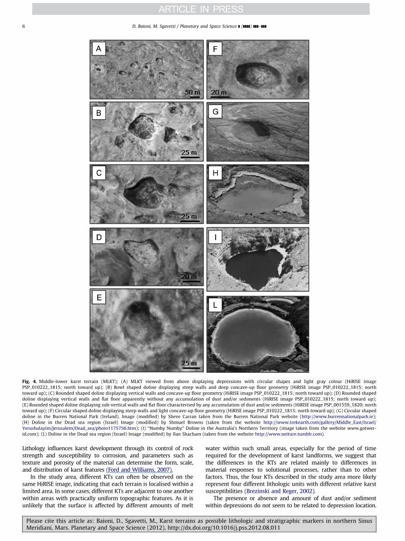
Fig. 4. Middle-lower karst terrain (MLKT); (A) MLKT viewed from above displaying depressions with circular shapes and light gray colour (HiRISE image
PSP_010222_1815; north toward up); (B) Bowl shaped doline displaying steep walls and deep concave-up floor geometry (HiRISE image PSP_010222_1815; north
toward up); (C) Rounded shaped doline displaying vertical walls and concave-up floor geometry (HiRISE image PSP_010222_1815; north toward up); (D) Rounded shaped
doline displaying vertical walls and flat floor apparently without any accumulation of dust and/or sediments (HiRISE image PSP_010222_1815; north toward up);
(E) Rounded shaped doline displaying sub-vertical walls and flat floor characterised by any accumulation of dust and/or sediments (HiRISE image PSP_001559_1820; north
toward up); (F) Circular shaped doline displaying steep walls and light concave-up floor geometry (HiRISE image PSP_010222_1815; north toward up); (G) Circular shaped
doline in the Burren National Park (Ireland). Image (modified) by Slieve Carran taken from the Burren National Park website (http://www.burrennationalpark.ie);
(H) Doline in the Dead sea region (Israel) Image (modified) by Shmuel Browns (taken from the website http://www.trekearth.com/gallery/Middle_East/Israel/
Yerushalayim/Jerusalem/Dead_sea/photo1175756.htm); (I) ‘‘Numby Numby’’ Doline in the Australia’s Northern Territory (image taken from the website www.gotwer-
id.com); (L) Doline in the Dead sea region (Israel) Image (modified) by Ilan Shacham (taken from the website http://www.neiture.tumblr.com).
D. Baioni, M. Sgavetti / Planetary and Space Science ] (]]]]) ]]]–]]]6
Lithology influences karst development through its control of rockstrength and susceptibility to corrosion, and parameters such astexture and porosity of the material can determine the form, scale,and distribution of karst features (Ford and Williams, 2007).
In the study area, different KTs can often be observed on thesame HiRISE image, indicating that each terrain is localised within alimited area. In some cases, different KTs are adjacent to one anotherwithin areas with practically uniform topographic features. As it isunlikely that the surface is affected by different amounts of melt
Please cite this article as: Baioni, D., Sgavetti, M., Karst terrains asMeridiani, Mars. Planetary and Space Science (2012), http://dx.doi.o
water within such small areas, especially for the period of timerequired for the development of karst landforms, we suggest thatthe differences in the KTs are related mainly to differences inmaterial responses to solutional processes, rather than to otherfactors. Thus, the four KTs described in the study area more likelyrepresent four different lithologic units with different relative karstsusceptibilities (Brezinski and Reger, 2002).
The presence or absence and amount of dust and/or sedimentwithin depressions do not seem to be related to depression location.
possible lithologic and stratigraphic markers in northern Sinusrg/10.1016/j.pss.2012.08.011
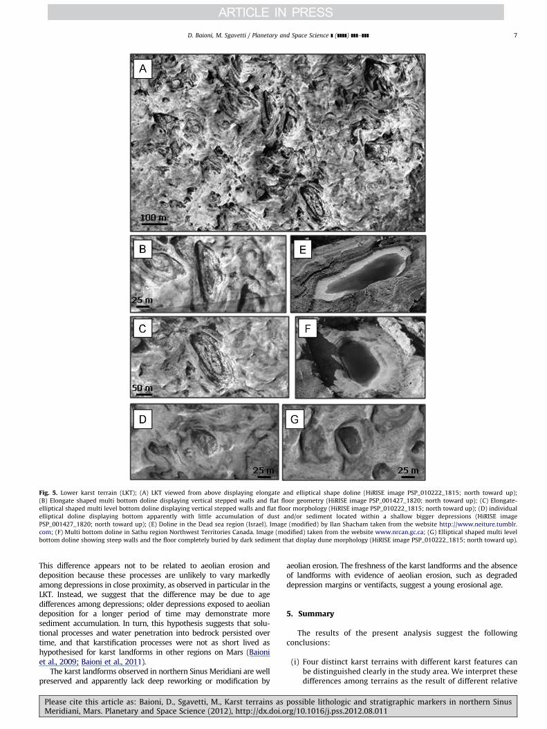
Fig. 5. Lower karst terrain (LKT); (A) LKT viewed from above displaying elongate and elliptical shape doline (HiRISE image PSP_010222_1815; north toward up);
(B) Elongate shaped multi bottom doline displaying vertical stepped walls and flat floor geometry (HiRISE image PSP_001427_1820; north toward up); (C) Elongate-
elliptical shaped multi level bottom doline displaying vertical stepped walls and flat floor morphology (HiRISE image PSP_010222_1815; north toward up); (D) individual
elliptical doline displaying bottom apparently with little accumulation of dust and/or sediment located within a shallow bigger depressions (HiRISE image
PSP_001427_1820; north toward up); (E) Doline in the Dead sea region (Israel). Image (modified) by Ilan Shacham taken from the website http://www.neiture.tumblr.
com; (F) Multi bottom doline in Sathu region Northwest Territories Canada. Image (modified) taken from the website www.nrcan.gc.ca; (G) Elliptical shaped multi level
bottom doline showing steep walls and the floor completely buried by dark sediment that display dune morphology (HiRISE image PSP_010222_1815; north toward up).
D. Baioni, M. Sgavetti / Planetary and Space Science ] (]]]]) ]]]–]]] 7
This difference appears not to be related to aeolian erosion anddeposition because these processes are unlikely to vary markedlyamong depressions in close proximity, as observed in particular in theLKT. Instead, we suggest that the difference may be due to agedifferences among depressions; older depressions exposed to aeoliandeposition for a longer period of time may demonstrate moresediment accumulation. In turn, this hypothesis suggests that solu-tional processes and water penetration into bedrock persisted overtime, and that karstification processes were not as short lived ashypothesised for karst landforms in other regions on Mars (Baioniet al., 2009; Baioni et al., 2011).
The karst landforms observed in northern Sinus Meridiani are wellpreserved and apparently lack deep reworking or modification by
Please cite this article as: Baioni, D., Sgavetti, M., Karst terrains asMeridiani, Mars. Planetary and Space Science (2012), http://dx.doi.o
aeolian erosion. The freshness of the karst landforms and the absenceof landforms with evidence of aeolian erosion, such as degradeddepression margins or ventifacts, suggest a young erosional age.
5. Summary
The results of the present analysis suggest the followingconclusions:
(i)
possrg/1
Four distinct karst terrains with different karst features canbe distinguished clearly in the study area. We interpret thesedifferences among terrains as the result of different relative
ible lithologic and stratigraphic markers in northern Sinus0.1016/j.pss.2012.08.011
D. Baioni, M. Sgavetti / Planetary and Space Science ] (]]]]) ]]]–]]]8
PleMe
karst susceptibility among units due to solutional properties(e.g. lithologic and/or mineralogic composition and/or sedi-mentary texture and architecture).
(ii)
Evaporite karst on the Earth because their high solubilityform in a very short time and are rapidly destroyed bysubsequent watery episodes (Klimchouk, 2004). The land-form characteristics and erosional ages of the karst terrainson Mars suggest that they have been affected by a singlegeologic ‘wet episode’, characterised by a period of sufficientwater availability due to the melting of ice, followed by dryclimate conditions.(iii)
The karst landforms also suggest a response to climatologicchange, requiring the presence of sufficient water for theirdevelopment. The environmental conditions on Mars weremuch different in the past than they are today. Climaticchanges occurred in the equatorial region, confirming thepresence of ice at this latitude, probably in the early Ama-zonian period.(iv)
The karst landforms can be used as significant geomorphicmarkers to distinguish units in Sinus Meridiani composition-ally and/or mineralogically.Acknowledgements
We are grateful to Dr. Nadia Zupan Hajna of the Kart ResearchInstitute ZCR SAZU, Postojna, Slovenia, for useful discussions thatgreatly helped to improve this paper. We thank Goro Komatsu ofInternational Research School of Planetary Science University‘‘G. D’Annunzio’’ Pescara, Italy for his useful review that improvedthis paper.
References
Andrews-Hanna, J.C., Zuber, M.T., Banerdt, W.B., 2009. The Borealis basin and theorigin of the Martian dichotomy. Nature 453, 1212–1215.
Arvidson, R.E., Seelos IV, F.P., Deal, K., Koeppen, W., Snider, N., Kieniewicz, J.,Hynek, B.M., Mellon, M., Garvin, J., 2003. Mantled and exhumed terrains inTerra Meridiani, Mars. Journal of Geophysical Research 108 (E12), 8073, http://dx.doi.org/10.1029/2002JE001982.
Arvidson, R.E., Poulet, F., Morris, R.V., Bibring, J.P., Bell, J.F., Squyres, S.W.,Christensen, P.R., Bellucci, G., Gondet, B., Ehlmann, B.L., Farrand, W.H.,Fergason, R.L., Golombek, M., Griffes, J.L., Grotzinger, J., Guinness, E.A.,Herkenhoff, K.E., Johnson, J.R., Klingelhofer, G., Langevin, Y., Ming, D., Seelos, K.,Sullivan, R.J., Ward, J.G., Wiseman, S.M., Wolff, M., 2006. Nature and origin of thehematitebearing plains of Terra Meridiani based on analysis of orbital and MarsExploration Rover data sets. Journal of Geophysical Research 111, E12S08, http://dx.doi.org/10.1029/2006JE002728.
Baioni, D., Wezel, F.C., 2010. Morphology and origin of an evaporite dome inTithonium chasma, Mars. Planetary and Space Science 58, 847–857.
Baioni, D., Zupan Hajna, N., Wezel, F.C., 2009. Karst landforms in a Martianevaporitic dome. Acta Carsologica 38(1), 9–18.
Baioni, D., Zupan Hajna, N., Wezel, F.C., 2011. Karst landforms in an interiorlayered deposit within the Coprates chasma, Mars. Acta Carsologica 40(3),473–481.
Berczi S., 2005. Possibility of karst morphology on the Martian surface at theMeridiani Landing site from comparison with terrestrial analogs. In: Proceed-ings of the 36th Lunar and Planetary Science Conference, Paper no. 1051.
Boston, P., 2004. Extraterrestrial caves. In: Gunn, J. (Ed.), Encyclopedia of Caves andKarst Science. Fitzroy Dearborn, New York, London, pp. 355–357.
Brezinski, D.K., Reger, J.P., 2002. Stratigraphy-karst relationship in the Frederickvalley of Maryland. In: Kuniansky, E.L. (Ed.), U.S. Geological Survey KarstInterest Group Proceedings. Shepherdstown, Virginia, U.S.A, pp. 59–65.
Burr, D.M., Soare, R.J., Wan Bun Tseung, J.M., Emery, J.P., 2005. Young (lateAmazonian), near-surface, ground ice features near the equator, AthabascaValles, Mars. ICARUS 178, 56–73.
Carr, M.H., 2006. The Surface of Mars. Cambridge University Press, New York307 pp.
Chan, M.A., Beiitler, B., Parry, W.T., Ormo, J., Komatsu, G., 2004. A possibleterrestrial analogue for haematite concretions on Mars. Nature 429, 731–734.
Christensen, P.R., Bandfield, J.L., Clark, R.N., Edgett, K.S., Hmilton, V.E., Hoefen, T.,Kieffer, H.H., Kuzmin, R.O., Lane, M.D., Malin, M.C., Morris, R.V., Pearl, J.C., Pearson,J.C., Roush, T.L., Ruff, S.W., Smith, M.D., 2000. Detection of crystalline haematitemineralization on Mars by the Thermal Emission Spectrometer: evidence for near
ase cite this article as: Baioni, D., Sgavetti, M., Karst terrains asridiani, Mars. Planetary and Space Science (2012), http://dx.doi.o
surface water. Journal of Geophysical Research 105, 9623–9642, http://dx.doi.org/10.1029/1999JE001093.
Christensen, P., Morris, R., Lane, M., Bandfield, J., Malin, M., 2001. Global mappingof Martian haematite mineral deposits: remnants of water-driven processeson early Mars. Journal of Geophysical Research 106, 23873–23885, http://dx.doi.org/10.1029/2000JE001415.
Costard, F.M., Kargel, J.S., 1995. Outwash plains and thermokarst on Mars. ICARUS114 (1), 93–112.
Craddock, R.A., Howard, A.D., 2002. The case for rainfall on a warm, wet earlyMars. Journal of Geophysical Research 107 (E11), 5111, http://dx.doi.org/10.1029/2001JE001505.
Day, M.J., 1983. Doline morphology and development in Barbados. Annals of theAssociation of American Geographers 73, 206–219.
Denizman, C., 2003. Morphometric and spatial distribution parameters of karsticdepressions, lower Suwannee river basin, Florida. Journal of Cave and KarstStudies 65 (1), 29–35.
Edgett, K.S., 2005. The sedimentary rocks of Sinus Meridiani: five key observationsfrom data acquired by the Mars Global Surveyor and Mars Odyssey orbiters.MARS 1, 5–58, http://dx.doi.org/10.1555/mars.2005.0002.
Ford, D.C., Williams, P., 2007. Karst Hydrogeology and Geomorphology. Wiley &Sons Ltd, West Sussex, England 562 pp.
Gao, Y., Alexander Jr., E.C., Tipping, R.G., 2005. Karst database developmentin Minnesota: design and data assembly. Environmental Geology 47,1072–1082.
Griffes, J.L., Arvidson, R.E., Poulet, F., Gendrin, A., 2007. Geologic and spectralmapping of etched terrain deposits in northern Meridiani Planum. Journal ofGeophysical Research 112, E08S09, http://dx.doi.org/10.1029/2006JE002811.
Grindrod, P.M., Balme, M.R., 2010. Groundwater processes in Hebes Chasma,Mars. Geophysical Research Letters 37, L13202, http://dx.doi.org/10.1029/2010GL044122.
Guest, J.E., Butterwhorth, P.S., Greeley, R., 1977. Geologic observation in theCydonia region of Mars. Journal of Geophysical Research 82, 4111–4120.
Hynek, B.M., 2004. Implications for hydrologic processes on Mars from extensivebedrock outcrops throughout Terra Meridiani. Nature 431, 156–159.
Hynek, B.M., 2009. Ancient equatorial ice on Mars? Nature Geoscience 2, 169–170.Hynek, B.M., Phillips, R.J., 2008. The stratigraphy of Meridiani Planum, Mars, and
implications for the layered deposits’ origin. Earth and Planetary ScienceLetters 274, 214–220, http://dx.doi.org/10.1016/j.epsl.2008.07.025.
Hynek, B.M., Arvidson, R.E., Phillips, R.J., 2002. Geologic setting and origin of TerraMeridiani haematite deposit on Mars. Journal of Geophysical Research 107(E10), 5088, http://dx.doi.org/10.1029/2002JE001891.
Jackson, M.P.A., Adams, J.B., Dooley, A.R., Montgomery, D.R., 2011. Modeling thecollapse of Hebes Chasma, Valles Marineris, Mars. GSA Bulletin 123 (7–8),1596–1627.
Johnston, J.G., Boston, P.J., Stafford, K.W., 2006. Assessment of karst landformpotential on Mars. In: Proceedings of the 37th Lunar and Planetary ScienceConference, Paper no. 1980.
Kargel, J.S., Dougherty, A., Feldman, W., Hogenboom, D., Marion, G., McCarthy, C.,Prieto-Ballesteros, O., 2004. Hydrated salts: dehydration, dissolution, andincongruent melting in terrestrial evaporites and at Meridiani Planum, Mars.American Geophysical Union, Fall Meeting, abstract P21A-0205.
Klimchouk, A., 2004. Evaporite karst. In: Gunn, J. (Ed.), Encyclopedia of Caves andKarst Science. Fitzroy Dearborn, New York, London, pp. 343–347.
Klingelhofer, G., Morris, R.V., Bernhardt, B., Schroder, C., Rodionov, D.S., De SouzaJr., P.A., Yen, A., Gellert, R., Evlanov, E.N., Zubkov, B., Foh, J., Bonnes, U.,Kankeleit, E., Gutlich, P., Ming, D.W., Renz, F., Wdowiak, T., Squyres, S.W.,Arvidson, R.E., 2004. Jarosite and haematite at Meridiani Planum fromOpportunity’s Mossbauer Spectrometer. Science 306, 1740–1745.
Lane, M.D., Christensen, P.R., Hartmann, W.K., 2003. Utilization of the THEMISvisible and infrared imaging data for crater population studies of the MeridianiPlanum landing site. Geophysical Research Letters 30 (14), 1770, http://dx.doi.org/10.1029/2003GL017183.
Laskar, J., Correia, A.C.M., Gastineau, M., Joutel, F., Levrard, B., Robutel, P., 2004.Long term evolution and chaotic diffusion of the insolation quantities of Mars.ICARUS 170, 343–364.
M�ege, D., Bourgeois, O., 2011. Equatorial glaciations on Mars revealed by gravita-tional collapse of Valles Marineris wall slope. Earth and Planetary ScienceLetters 310, 182–191.
Morris, R.V., Klingelhofer, G., Schroder, C., Rodionov, D.S., Yen, A., Ming, D.W.,de Souza Jr., P.A., Wdowiak, T., Fleischer, I., Gellert, R., Bernhardt, B., Bonnes, U.,Cohen, B.A., Evlanov, E.N., Foh, J., Gutlich, P., Kankeleit, E., McCoy, T.,Mittlefehldt, D.W., Renz, F., Schmidt, M.E., Zubkov, B., Squyres, S.W., Arvidson,R.E., 2006. Mossbauer mineralogy of rock, soil, and dust at Meridiani Planum,Mars: Opportunity’s journey across sulfaterich outcrops, basaltic sand anddust, and haematite lag deposits. Journal of Geophysical Research 111, E12S15,http://dx.doi.org/10.1029/2006JE002791.
Mustard, J.F., Cooper, C.D., Rifkin, M.K., 2001. Evidence for recent climate changeon Mars from the identification of youthful near surface ground ice. Nature412, 411–414.
Newsom, H.E., Lanza, N.L., Ollila, A.M., Wiseman, S.M., Roush, T.L., Marzo, G.A.,Tornabene, L.L., Crumpler, L.S., Okubo, C.H., Osterloo, M.M., Hamilton, V.E.,2009. Inverted channels on the floor of Miyamoto crater, Mars, viewed by theHiRISE camera. In: Proceedings of the 40th Lunar and Planetary ScienceConference, Paper no. 1396.
Niles, P., Michalski, J., 2009. Meridiani Planum sediments on Mars formed throughweathering in massive ice deposits. Nature Geoscience 2, 215–220.
possible lithologic and stratigraphic markers in northern Sinusrg/10.1016/j.pss.2012.08.011

D. Baioni, M. Sgavetti / Planetary and Space Science ] (]]]]) ]]]–]]] 9
Peulvast, J.P., Masson, P.L., 1993. Erosion and tectonics in central Valles Marineris(Mars): a new morphostructural model. Earth, Moon, and Planets 61, 191–217,http://dx.doi.org/10.1007/BF00572245.
Poulet, F., Arvidson, R.E., Gomez, C., Morris, R.V., Bibring, J.P., Langevin, Y., Gondet,B., Griffes, J., 2008. Mineralogy of Terra Meridiani and western Arabia Terrafrom OMEGA/MEx and implications for their formation. ICARUS 195, 106–130,http://dx.doi.org/10.1016/j.icarus.2007.11.031.
Preuschmann, S., Benkkert, D., Wagner, R., Neukum, G., 2006. the HRSC Co-Investigator Team, 2006. Karst-like topography within the Ganges Chasmaregion. Geophysical Research Abstract 8, 09383.
Rieder, R., Gellert, R., Anderson, R.C., Bruckner, J., Clark, B.C., Dreibus, G.,Economou, T., Klingelhofer, G., Lugmair, G.W., Ming, D.W., Squyres, S.W.,D’Uston, C., Wanke, H., Yen, A., Zipfel, J., 2004. Chemistry of rocks and soilsat Meridiani Planum from Alpha Particle X-ray Spectrometer. Science 306,1746–1749, http://dx.doi.org/10.1126/science.1104358.
Schaefer, M.W., 1990. Karst on Mars? the thumbprint terrain. ICARUS 83, 244–247.Shean, D.E., 2010. Candidate ice-rich material within equatorial craters on Mars.
Geophysical Research Letters 37, L24202, http://dx.doi.org/10.1029/2010GL045181.
Schon, C.S., Head, J.W., 2012. Decameter-scale pedestral craters in the tropic ofMars: evidence for the recent presence of very young regional ice deposits inTharsis. Earth and Planetary Science Letters 317–318, 68–75.
Scott, D.H., Tanaka, K.L., 1986. Geologic map of the western equatorial region ofMars. US Geological Survey Miscellaneous Investigations Map I-1802-A.
Squyres, S.W., Grotzinger, J.P., Arvidson, R.E., Bell III, J.F., Calvin, W., Christensen,P.R., Clark, B.C., Crisp, J.A., Farrand, W.H., Herkenhoff, K.E., Johnson, J.R.,Klingelhofer, G., Knoll, A.H., McLennan, S.M., McSween Jr., H.Y., Morris, R.V.,Rice Jr., J.W., Rieder, R., Soderblom, L.A., 2004. In situ evidence for an ancientaqueous environment at Meridiani Planum, Mars. Science 306, 1709–1714,http://dx.doi.org/10.1126/science.1104559.
Stafford, K.W., Boston, P.J., 2005. Theoretical evaporite karst development on Mars.In: Proceedings of the 36th Lunar and Planetary Science Conference, Paper no.2291.
Sullivan, R., Banfield, D., Bell III, J.F., Calvin, W., Fike, D., Golombek, M., Greeley, R.,Grotzinger, J., Herkenhoff, K., Jerolmack, D., Malin, M., Ming, D., Soderblom, L.A.,
Please cite this article as: Baioni, D., Sgavetti, M., Karst terrains asMeridiani, Mars. Planetary and Space Science (2012), http://dx.doi.o
Squyres, A., Thompson, S., Watters, W.A., Weitz, C.M., Yen, A., 2005. Aeolianprocesses at the Mars Exploration Rover Meridiani Planum landing site. Nature436, 58–61.
Troester, J.W., White, E.L., White, W.B., 1984. A comparison of sinkhole depthfrequency distributions in temperate and tropical karst regions. In: Beck, B.F.(Ed.), Sinkholes: Their Geology, Engineering, and Environmental Impact.Balkema, Rotterdam, pp. 65–73.
Verstappen, H.T., 1964. Karst morphology of the Star Mountains (central NewGuinea) and its relation to lithology and climate. Zeitschrift fur Geomorpho-logie 8, 40–49.
White, W.B., 1988. Geomorphology and Hydrology of Karst Terrain. OxfordUniversity Press, New York.
Williams, P.W., 1972. The analysis of spatial characteristics of karst terrains. In:Chorley, R.J. (Ed.), Spatial Analysis in Geomorphology. Methuen, London,pp. 135–163.
Wiseman, S.M., 2009. Retrieval of Atmospherically Corrected Hyperspectral CRISMSurface Reflectance Spectra Using DISORT Radiative Transfer Modeling:Comparison to the Empirical Volcano Scan Correction Method, in Spectraland Stratigraphic Mapping of Hydrated Sulphate and Phyllosilicate BearingDeposits: Implications for the Aqueous History of Sinus Meridiani, Mars. Ph.D.Dissertation, pp. 5–50, Washington University in St. Louis, St. Louis, Mo.
Wiseman, S.M., Arvidson, R.E., Andrews-Hanna, J.C., Clark, R.N., Lanza, N.L., Marais,D.D., Marzo, G.A., Morris, R.V., Murchie, S.L., Newsom, H.E., Dobrea, E.Z.N.,Ollila, A.M., Poulet, F., Roush, T.L., Seelos, F.P., Swayze, G.A., 2008. Phyllosilicateand sulphate-haematite deposits within Miyamoto crater in southern SinusMeridiani, Mars. Geophysical Research Letters 35 (19), L19204.
Wiseman, S.M., Arvidson, R.E., Morris, R.V., Poulet, F., Andrews-Hanna, J.C., Bishop,J.L., Murchie, S.L., Seelos, F.P., Des Marais, D., Griffes, J.L., 2010. Spectral andstratigraphic mapping of hydrated sulphate and phyllosilicatebearing depositsin northern Sinus Meridiani, Mars. Journal of Geophysical Research 115,E00D18, http://dx.doi.org/10.1029/2009JE003354.
Wyrick, D., Ferril, D.A., Morris, A.P., Colton, S.L., Sims, D.W., 2004. Distribution,morphology, and origin of Martian pit crates chains. Journal of GeophysicalResearch 109, E06005, http://dx.doi.org/10.1029/2004JE002240.
possible lithologic and stratigraphic markers in northern Sinusrg/10.1016/j.pss.2012.08.011
Copyright © 2022 FDOKUMEN