June 2019 Board Packet - Ramsey-Washington Metro ...
226
June 2019 Board Packet
-
Upload
khangminh22 -
Category
Documents
-
view
0 -
download
0
Transcript of June 2019 Board Packet - Ramsey-Washington Metro ...

June 2019 Board Packet

************ Agenda
************

*Items in bold signify that an action needs to be taken by the Board.
Regular Board Meeting Agenda Wednesday, June 5, 2019
6:30 P.M. District Office Board Room
2665 Noel Drive, Little Canada, MN
1. Call to Order – 6:30 PM
2. Approval of Agenda
3. Consent Agenda
A. Approval of Minutes May 1, 2019
4. Treasurer’s Report and Bill List
5. Visitor Comments (limited to 4 minutes each)
6. Permit Program
A. Applications
i. 19-19 Roseville Middle School Addition (Little Canada) ii. 19-20 Buerkle Road Drainage Improvements (Vadnais Heights)
iii. 19-21 Meadowood Berm (Woodbury) iv. 19-22 Sterling Street Bridge Replacement (Maplewood) v. 19-23 Granada Access Road Maintenance (Oakdale)
vi. 19-24 Woodbury Middle School Parking Lot (Woodbury) vii. 19-25 Indian Mounds Regional Park Trail (St. Paul)
viii. 19-26 Aldrich Arena Stormwater Retrofit (Maplewood) ix. 19-27 Shoreview Commons (Shoreview) x. 19-28 Maplewood Moose Lodge (Maplewood)
xi. 19-29 North Owasso Boulevard (Shoreview)
B. Enforcement Action Report
7. Stewardship Grant Program
A. Applications
i. 19-10 CS Concordia Arms, 4 rain gardens ii. 19-11 CS Reynen, 2 rain gardens
iii. 19-12 CS 2019 Lake Phalen Aquatic Vegetation Harvesting iv. 19-13 CS City of Woodbury Stormwater Maintenance Project, habitat
restoration
B. Budget Status Update
8. Technical Memo, Presentation, and Discussion: District Flooding Concerns

*Items in bold signify that an action needs to be taken by the Board.
9. Action Items
A. Stormwater Pollution Prevention Plan Annual Report
B. 2019 Rule Amendment Approval – Resolution 19-01
10. Administrator’s Report
A. Meetings Attended
B. Upcoming Meetings and Dates
C. Joint Meeting with Vadnais Lake Area Watershed Management Organization
D. District 2018 Water Quality Summary
E. MAWD Summer Tour Reminder
11. Project and Program Status Reports
A. Ongoing Project and Program Updates
i. Flood Risk Response Planning
ii. Owasso Park Stormwater Master Plan
iii. Beltline Resiliency Study
iv. FEMA Flood Mapping
v. West Vadnais Lake Outlet Permitting
vi. 500-Year Atlas 14 Modeling
vii. Wetland Restoration Site Search
viii. Auto Lake Monitoring Systems
ix. Maplewood Mall Monitoring
x. Spent-lime Pond Research Project
xi. Kohlman Basin Test Weirs
xii. Wakefield Park/Frost Avenue Project
xiii. Targeted Retrofit Projects
xiv. Willow Pond CMAC
xv. Cottage Place Wetland Restoration
xvi. Aldrich Arena Site Design
xvii. CIP Maintenance and Repair 2019 Project
xviii. New Technology Review – EnviroDIY
xix. Natural Resources Program
xx. Education Program
12. Informational Items
13. Report of Managers
14. Adjourn

************ Consent Agenda
************

Page 1 May 1, 2019, RWMWD Minutes Regular Board Meeting
Ramsey-Washington Metro Watershed District Minutes of Regular Board Meeting
May 1, 2019 The Regular Meeting of May 1, 2019, was held at the District Office Board Room, 2665 Noel Drive, Little Canada, Minnesota, at 6:30 p.m. PRESENT: ABSENT: Marj Ebensteiner, President Cliff Aichinger, Vice President Dianne Ward, Treasurer (arrived at 6:46 p.m.) Dr. Pam Skinner, Secretary Lawrence Swope, Manager ALSO PRESENT: Tina Carstens, District Administrator Paige Ahlborg, Project Manager Amanda Staple, Recording Secretary Viet-Hanh Winchell, Attorney for District Brad Lindaman, Barr Engineering Nicole Soderholm, Permit Inspector Bill Bartodziej, Natural Resource Specialist Kyle Kubitza, Water Quality Intern Mary Fitzgerald, Inspection Intern Dave Vlasin, Water Quality Technician Bruce Copley, Crestview resident Matt Gray, Crestview resident Greg Windsperger, Crestview resident Ken Otto, Crestview resident Steve Laberge, Crestview resident Sarah Turensky, resident Laurann Kirschner, Galowitz Olson, PLLC Ben Meyer, Minnesota Board of Water and Soil Resources 1. CALL TO ORDER The meeting was called to order by President Ebensteiner at 6:35 p.m. 2. APPROVAL OF AGENDA Lawrence Swope requested to move Spring Flooding Concerns (10C) to follow the Visitor Presentations and become Item 6C. Motion: Dr. Pam Skinner moved, Cliff Aichinger seconded, to approve the agenda as amended. Motion carried unanimously. 3. CONSENT AGENDA A. Approval of Minutes from April 3, 2019 Tina Carstens noted that under Item 7, Permit #19-10, it should state, “…project but noted that the District is the sole permitting authority for this.that overlaps watersheds and South Washington has waived permitting

Page 2 May 1, 2019, RWMWD Minutes Regular Board Meeting
authority.” Under the New Technology Review, the second to last sentence, it should state, “Nicole Soderholm noted that often underground treatment options are coming forward and therefore that measure would be redundant the designs include redundant pretreatment.” Viet-Hanh Winchell noted that under those present, it should state, “Lauren Laurann Kirschner, Galowitz and Olsen Galowitz Olson ”. Motion: Cliff Aichinger moved, Lawrence Swope seconded, to approve the consent agenda as amended. Motion carried unanimously. 4. TREASURER’S REPORT AND BILL LIST Motion: Cliff Aichinger moved, Lawrence Swope seconded, to approve the May 1, 2019, bill list as submitted. Motion carried unanimously. 5. VISITOR PRESENTATIONS Bruce Copley thanked the District for the work it is doing to keep the Crestview addition as dry as it can be. He stated that the residents in that area are still on high alert because of the rising water. He recognized the concern from Shoreview residents regarding the flooding of parks, trails and roads. He stated that in spite of the emergency measures that have been taken, sump pumps are kicking on and there are concerns. He noted that numerous requests have been made in the past to look at the higher frequency events rather than the storms the models are based on. He stated that they would like to see model design and construction based on the more frequent events going forward. He recognized that possible options have been discussed but have not yet moved forward. He believed that lowering West Vadnais is critical and should be escalated to a high priority. He stated that there is not enough, and should be more, downstream capacity developed. Matt Gray echoed the comments of Mr. Copley and thanked the Board for the efforts that have been put forth thus far. He stated that his family deeply appreciates the efforts of the District. He stated that in 2016 his family was severely impacted by high groundwater coming up through their basement floor, which persisted from late 2016 to mid-2017. He stated that since that time he has done everything possible to try to remediate the issue as best as he can. He stated that it has been a lot of work and he feels like they are back in the same position with Snail Lake being too high and the beach and trails unusable. He explained that he is afraid the same issues will once again arise. He asked the District to find a way to move forward with long-term remediation. Dianne Ward arrived. Lawrence Swope stated that the comments are reflecting comments from the residents in the Crestview addition. He explained that those residents are waiting for something to happen that will change the situation and the lack of usability of the amenities (parks and trails) in that area. He stated that the Rice Street closure impacts those residents as well. Dr. Pam Skinner stated that the District only controls some elements. She explained that the parks and open spaces are controlled by the City and County and hoped that the comments are being directed to the appropriate parties. 6. ADMINISTRATOR’S REPORT (Previously Item 10) C. Spring Flooding Concerns Brad Lindaman stated that District staff was out monitoring water levels today and provided the elevations for the Grass Lake area, comparing those to the elevations over the past two years. He explained the District’s role in attempting to prevent water from entering the lowest elevation of a home. He agreed that the beach is not usable, and the water level will most likely remain high for some time. He stated that the District is working with Ramsey County Parks to provide them with information to make a decision on what they would like to do with that park

Page 3 May 1, 2019, RWMWD Minutes Regular Board Meeting
property. He provided additional information on the Grass Lake overflow monitoring points and the projects that have been completed or are still scheduled. He noted that the first two points have overflowed but the remaining three points have not. He provided additional data on the Grass Lake overflow, which began on April 11, 2019 and compared that to the data from the past two years. He reviewed the challenges with keeping water out of the tunnel north of Gramsie Pond and some of the reasons that contributed to the sand bag berms failing. He noted that the overflow water levels are decreasing and the pumps are now managing water levels in North Gramsie Ponds. President Ebensteiner asked if the worst is past. Brad Lindaman stated that the water is ever so slightly receding and they are awaiting the arrival of the stoplogs, which will help. He noted that the city is looking at an upgrade to the pump system for Suzanne Pond and is also looking at connecting North Gramsie Pond to Suzanne Pond with a valve, which would assist in allowing water to drain. He stated that point there has not been overflow, from Grass Lake to Wetland A. He provided data from the piezometer levels from 2017 through present noting that the current levels are comparable to the levels in June and July of 2017. Cliff Aichinger asked and confirmed that the higher groundwater levels are a regional issue and not specific to the area of flooding near Gramsie Road. He explained that this is not just a surface water issue and is also a groundwater issue. He explained that groundwater is influenced by many factors outside of surface water. Dianne Ward stated that she has noticed in the north part of Wetland A, that remains open in the winter. She asked if the water in Wetland A has an impact on Snail Lake. Brad Lindaman explained that Snail Lake has been high for some time while Wetland A has been lower, therefore there is not much influence there. He noted that the general flow is north to south. He provided information on the elevation of West Vadnais Lake. He reported that Rice Street flooded beginning April 17, 2019 and remains closed. He stated that the District has been in communication with the County. Tina Carstens stated that in her communications with the County public works staff, they are investigating options that could allow traffic to travel through that area. She noted that one option being investigated was to add a milled layer to the roadway but noted that there are restrictions because of the railroad bridge. Brad Lindaman provided information on the 15-inch outlet pipe and potentially lowering that elevation. He explained that the District is in conversation with VLAWMO and the permitting issues as that pipe drains into that watershed. He noted that in the most recent conversations with VLAWMO they are asking for an EAW to assess the environmental impacts that could occur if the outlet is lowered. He explained the desired impact from the lowering of the outlet, which could provide additional storage when the conditions dry further. He stated that staff continue to look at different variations to increase the flow of water downstream but there are also concerns with additional flooding impacts downstream that must be considered. Tina Carstens stated that the EAW can be completed in conjunction with other tasks in attempt to move that process forward more quickly. She noted that the water levels would need to decrease below 881.8 in order for a lowered outlet to be helpful, noting that the elevation has not reached that low elevation in the last two years of monitoring. Sarah Turenskyasked if there is a way to get all the parties into one room to assist in these discussions. Tina Carstens confirmed that would be an option and she could talk to VLAWMO staff about coordinating that type of meeting.

Page 4 May 1, 2019, RWMWD Minutes Regular Board Meeting
Dianne Ward asked if she heard appropriately that there is a fall timeline for this outlet discussion. Brad Lindaman confirmed that the timing of the EAW should be completed by that time. He noted that if issues arise in the EAW, that could prolong that process. Tina Carstens noted that she will attempt to work with the DNR on those elements as well during this time the EAW is being completed. Dr. Pam Skinner noted that the District has come a long way in regard to the Grass Lake area and perhaps it would be helpful to share that timeline and data online for people that have not closely followed the issue. She noted that some elements, such as lowering the outlet, take time. Brad Lindaman stated that the District can give local municipalities an idea of where issues may arise. He explained that the District is the technical resource for those organizations and shares its data, but the roadways and flood protection fall to the municipalities and County. He stated that historically the role of the District is to look at things on a regional basis and share that with the municipalities. He explained that the District has identified some homes that could be impacted by local flooding and then developed and shared an emergency response plan for the cities to use. He explained that the District assists with data and modeling but the action falls to the city. He stated that the District has received concerns from residents about rising water levels in Twin Lake, which does not have an outlet. He provided details on the additional monitoring that will be installed this year and noted that the monitoring data that will be gathered will continue to be used to calibrate the models. He asked Matt Gray to continue to send his pumping levels to staff and appreciated his cooperation. Tina Carstens suggested moving Item 8 to follow this item. 7. PRESENTATION: WETLANDS, WCA, AND THE REVIEW PROCESS (Previously Item 8) Tina Carstens noted that the Board has had a lot of discussion about WCA, the value of wetlands and restoration and therefore staff asked Ben Meyer to come and provide information to the Board. Ben Meyer, Minnesota Board of Water and Soil Resources, reviewed the definition of a wetland and provided examples of both commonly recognized wetlands and less recognized wetlands. He provided details on the process for a delineation and the three elements that must be included to be considered a wetland. He reviewed the value that wetlands provide including flood storage, water quality protection, shoreline protection, groundwater recharge, wildlife habitat, food/commercial uses, forestry, tourism, aesthetics, and many more. He provided a comparison estimating the wetlands that existed in the 1860’s compared to the 1980’s, noting approximately a 50 percent loss of wetlands during that time period. He provided background information on the Wetland Conservation Act (WCA) which was enacted in 1991 and the activities which are regulated under WCA. He noted that the administration of the WCA is the local government unit (LGU) and could be a County, City, Watershed District, or SWCD. He advised that the others involved would be the Board of Water and Soil Resources, the DNR, the landowner/applicant, and private consultants that assist applicants. He reviewed the WCA process as well as the different determinations that can be made which include no loss, exemption, and wetland replacement. He provided examples of avoidance, minimization, and replacement. Tina Carstens stated that the District prefers to have no net loss of wetland within the District and would like replacement to occur within the District. She noted that BWSR prefers to have the replacement through credits purchased through BWSR and asked for input on the difference in preference. Ben Meyer stated that he has heard that concern from other LGU’s as well. He noted that BWSR is following the rules in statute on that item. He explained that the Army Corps of Engineers does not even look at the minor or major watershed and begins their review at the bank service area (BSA) level. He noted that BWSR is going through
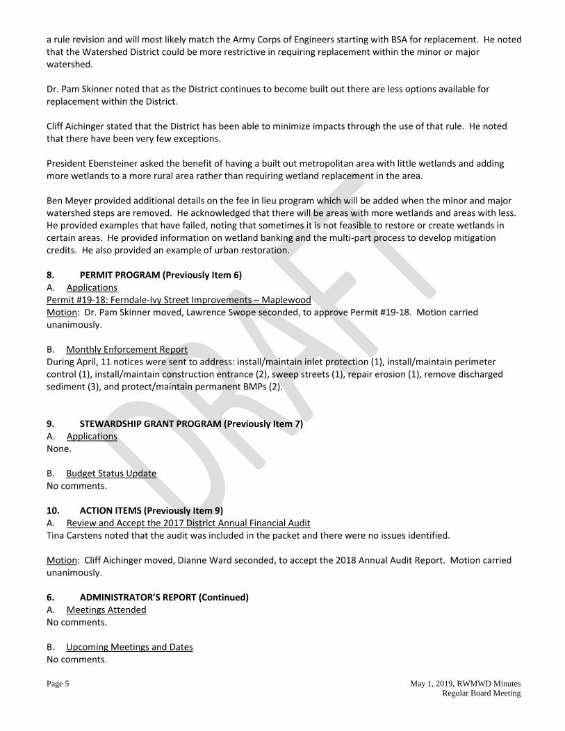
Page 5 May 1, 2019, RWMWD Minutes Regular Board Meeting
a rule revision and will most likely match the Army Corps of Engineers starting with BSA for replacement. He noted that the Watershed District could be more restrictive in requiring replacement within the minor or major watershed. Dr. Pam Skinner noted that as the District continues to become built out there are less options available for replacement within the District. Cliff Aichinger stated that the District has been able to minimize impacts through the use of that rule. He noted that there have been very few exceptions. President Ebensteiner asked the benefit of having a built out metropolitan area with little wetlands and adding more wetlands to a more rural area rather than requiring wetland replacement in the area. Ben Meyer provided additional details on the fee in lieu program which will be added when the minor and major watershed steps are removed. He acknowledged that there will be areas with more wetlands and areas with less. He provided examples that have failed, noting that sometimes it is not feasible to restore or create wetlands in certain areas. He provided information on wetland banking and the multi-part process to develop mitigation credits. He also provided an example of urban restoration. 8. PERMIT PROGRAM (Previously Item 6) A. Applications Permit #19-18: Ferndale-Ivy Street Improvements – Maplewood Motion: Dr. Pam Skinner moved, Lawrence Swope seconded, to approve Permit #19-18. Motion carried unanimously. B. Monthly Enforcement Report During April, 11 notices were sent to address: install/maintain inlet protection (1), install/maintain perimeter control (1), install/maintain construction entrance (2), sweep streets (1), repair erosion (1), remove discharged sediment (3), and protect/maintain permanent BMPs (2). 9. STEWARDSHIP GRANT PROGRAM (Previously Item 7) A. Applications None. B. Budget Status Update No comments. 10. ACTION ITEMS (Previously Item 9) A. Review and Accept the 2017 District Annual Financial Audit Tina Carstens noted that the audit was included in the packet and there were no issues identified. Motion: Cliff Aichinger moved, Dianne Ward seconded, to accept the 2018 Annual Audit Report. Motion carried unanimously. 6. ADMINISTRATOR’S REPORT (Continued) A. Meetings Attended No comments. B. Upcoming Meetings and Dates No comments.

Page 6 May 1, 2019, RWMWD Minutes Regular Board Meeting
C. Spring Flooding Concerns D. CAC Meeting Update No comments. E. MAWD Summer Tour Tina Carstens noted the dates for the summer tour in June.
11. PROJECT AND PROGRAM STATUS REPORTS A. Ongoing Project and Program Updates
i. Flood Risk Response Planning ii. Owasso Park Stormwater Master Plan
iii. Beltline Resiliency Study iv. FEMA Flood Mapping v. West Vadnais Lake Outlet Permitting
vi. 500-Year Atlas 14 Modeling vii. Wetland Restoration Site Search
Dr. Pam Skinner stated that she would be interested in opportunities to create wetlands that could be used for banking as well, along with the prioritization of retrofit projects and identified future sites.
viii. Auto Lake Monitoring Systems ix. Maplewood Mall Monitoring x. Wakefield Park/Frost Avenue Project
xi. Targeted Retrofit Projects xii. Roseville High School Campus Project
xiii. Willow Pond CMAC xiv. Cottage Place Wetland Restoration xv. Aldrich Arena Site Design
Paige Ahlborg stated that the County has started the bid process and Barr is finalizing the stormwater plans. She confirmed that there will be plants along White Bear Avenue.
Cliff Aichinger asked if the County has provided an agreement that they will do future phases, including the public art.
Paige Ahlborg confirmed that there is a Joint Powers Agreement (JPA) that includes those elements.
Lawrence Swope expressed confusion on the process and amount approved for the project.
Tina Carstens provided additional details on the approval process from the Board and how targeted retrofit projects move forward.
xvi. CIP Maintenance and Repair 2019 Project xvii. New Technology Review – StormBrixx
xviii. Natural Resources Program xix. Education Program
12. INFORMATIONAL ITEMS No comments.

Page 7 May 1, 2019, RWMWD Minutes Regular Board Meeting
13. REPORTS OF MANAGERS Lawrence Swope asked for an update on communications hiring. Tina Carstens provided an update on the new communications intern that was hired. 14. ADJOURN Motion: Dianne Ward moved, Dr. Pam Skinner seconded, to adjourn the meeting at 9:14 p.m. Motion carried unanimously. Respectfully submitted, Dr. Pam Skinner, Secretary

************ Bill List
************

RWMWD BUDGET STATUS REPORTAdministrative & Program BudgetFiscal Year 20195/31/2019
Current CurrentAccount Original Budget Month Year-to-Date Budget Percent
Budget Category Budget Item Number Budget Transfers Expenses Expenses Balance of BudgetManager Per diems 4355 $6,500.00 - 515.00 1,955.00 $4,545.00 30.08%
Manager expenses 4360 3,500.00 - - - 3,500.00 0.00%Committees Committee/Bd Mtg. Exp. 4365 3,500.00 - 356.34 1,564.09 1,935.91 44.69%Employees Staff salary/taxes/benefits 4010 1,385,000.00 - 150,464.79 546,342.28 838,657.72 39.45%
Employee expenses 4020 10,000.00 - 1,028.12 2,164.69 7,835.31 21.65%District training & education 4350 25,000.00 - 1,045.16 9,271.60 15,728.40 37.09%
Administration/ GIS system maint. & equip. 4170 15,000.00 - 81.50 1,853.52 13,146.48 12.36% Office Data Base/GIS Maintenance 4171 5,000.00 - 2,210.00 2,210.00 2,790.00 44.20% Equipment maintenance 4305 3,000.00 - - - 3,000.00 0.00% Telephone 4310 8,000.00 - 663.40 1,795.82 6,204.18 22.45%
Office supplies 4320 5,000.00 - 290.76 1,547.98 3,452.02 30.96%IT/Internet/Web Site/Software Lic. 4325 45,000.00 - 5,082.20 16,543.85 28,456.15 36.76%Postage 4330 10,000.00 - - 142.47 9,857.53 1.42%Printing/copying 4335 8,000.00 - 294.00 2,383.73 5,616.27 29.80%Dues & publications 4338 11,000.00 - 64.00 7,784.00 3,216.00 70.76%Janitorial/Trash Service 4341 17,000.00 - 550.00 5,652.18 11,347.82 33.25%Utilities/Bldg.Contracts 4342 20,000.00 - 1,493.70 8,041.48 11,958.52 40.21%Bldg/Site Maintenance 4343 300,000.00 - 4,566.44 65,644.36 234,355.64 21.88%Miscellaneous 4390 5,000.00 - 500.00 500.00 4,500.00 10.00%Insurance 4480 35,000.00 - - 30,384.00 4,616.00 86.81%Office equipment 4703 40,000.00 - - 28,863.73 11,136.27 72.16%Vehicle lease, maintenance 4810-40 43,000.00 - 1,249.72 1,664.66 41,335.34 3.87%
Consultants/ Auditor/Accounting 4110 55,000.00 - 2,279.83 34,118.54 20,881.46 62.03%Outside Services Engineering-administration 4121 93,000.00 - 6,626.92 29,700.64 63,299.36 31.94%
Engineering-permit I&E 4122 10,000.00 - - 63.00 9,937.00 0.63%Engineering-eng. review 4123 55,000.00 - 6,036.50 27,293.16 27,706.84 49.62%Engineering-permit review 4124 55,000.00 - 4,400.00 15,448.50 39,551.50 28.09%Project Feasibility Studies 4129 790,000.00 - 41,714.94 130,156.94 659,843.06 16.48%Attorney-permits 4130 10,000.00 - - - 10,000.00 0.00%Attorney-general 4131 40,000.00 - 1,120.00 9,505.00 30,495.00 23.76%Outside Consulting Services 4160 40,000.00 - - - 40,000.00 0.00%
Programs Educational programming 4370 60,000.00 - 4,431.66 11,647.85 48,352.15 19.41%Communications & Marketing 4371 25,000.00 25.00 3,358.80 21,641.20 13.44%Events 4372 50,000.00 - 9,827.42 16,726.45 33,273.55 33.45%Water QM-Engineering 4520-30 300,000.00 - 10,586.73 26,182.37 273,817.63 8.73%Project operations 4650 160,000.00 - 5,249.60 8,589.58 151,410.42 5.37%SLMP/TMDL Studies 4661 68,000.00 - 2,171.00 3,234.00 64,766.00 4.76%Natural Resources/Keller Creek 4670-72 115,000.00 - 17,673.65 51,630.20 63,369.80 44.90%Outside Prog.Support/Weed Mgmt. 4683-84 67,000.00 - 1,148.08 33,217.55 33,782.45 49.58%Research Projects 4695 115,000.00 - 5,631.62 30,878.52 84,121.48 26.85%Health and Safety Program 4697 3,000.00 - 24.30 24.30 2,975.70 0.81%NPDES Phase II 4698 10,000.00 - - - 10,000.00 0.00%
GENERAL FUND TOTAL $4,124,500.00 $0.00 $289,402.38 $1,168,084.84 $2,956,415.16 28.32%CIP's CIP Project Repair & Maintenance 516 1,120,000.00 - 52,380.30 478,431.73 641,568.27 42.72%
Targeted Retrofit Projects 518 978,760.00 - 67,502.59 153,298.29 825,461.71 15.66%District Office Building Solar Energy Retrofit 519 - - - - - ---Flood Damage Reduction Fund 520 2,500,000.00 - 17,664.36 25,114.36 2,474,885.64 1.00%Debt Services-96-97 Beltline/MM/Battle Creek 526 399,113.00 - - 274,856.15 124,256.85 68.87%Stewardship Grant Program Fund 528-529 1,250,000.00 - 10,146.00 104,251.00 1,145,749.00 8.34%Impervious Surface Volume Reduction Opportunity 531 1,500,000.00 - - - 1,500,000.00 0.00%Beltline & Battle Creek Tunnel Repair 549 - - - - - ---Frost/Kennard Enhanced WQ BMP 550 - - - - - ---Markham Pond Dredging & Aeration 551 65,000.00 - 640.00 1,535.00 63,465.00 2.36%Wakefield Park Project 553 1,100,000.00 - 7,393.64 45,444.64 1,054,555.36 4.13%Willow Pond CMAC 554 300,000.00 7,951.72 9,738.91 290,261.09 3.25%District Office Bond Payment 585 194,885.00 - - 193,453.76 1,431.24 99.27%
CIP BUDGET TOTAL $9,407,758.00 - $163,678.61 $1,286,123.84 $8,121,634.16 13.67%TOTAL BUDGET $13,532,258.00 $0.00 $453,080.99 $2,454,208.68 $11,078,049.32 18.14%
Current Fund Balances:
Beginning Fund Fund Year to date Current Month Year to Date Fund BalanceFund: Balance @ 12/31/18 Transfers Revenue Expenses Expense @ 05/31/19
$4,464,553.28 - 372,805.68 289,402.38 1,168,084.84 3,669,274.12 516 - CIP Project Repair & Maintenance 951,963.00 - - 52,380.30 478,431.73 473,531.27 518 - Targeted Retrofit Projects 994,725.00 - - 67,502.59 153,298.29 841,426.71 519 - District Office Building Solar Energy Retrofit 32,805.00 - - - - 32,805.00 520 - Flood Damage Reduction Fund 1,823,918.00 - 31,529.41 17,664.36 25,114.36 1,830,333.05 526 - Debt Services-96-97 Beltline/MM/Beltline-Battle Creek Tunnel Repair 381,949.00 - - - 274,856.15 107,092.85 528/529 - Stewardship Grant Program Fund 389,152.00 - - 10,146.00 104,251.00 284,901.00 531 - Impervious Surface Volume Reduction Opportunity 1,484,215.00 - - - - 1,484,215.00 549 - Beltline & Battle Creek Tunnel Repair 863,674.00 - - - - 863,674.00 550 - Frost/Kennard Enhanced WQ BMP 70,017.00 - - - - 70,017.00 551 - Markham Pond Dredging & Aeration 110,379.00 - - 640.00 1,535.00 108,844.00 553 - Wakefield Park Project 1,049,286.00 - - 7,393.64 45,444.64 1,003,841.36 554 - Willow Pond CMAC (44,588.00) - - 7,951.72 9,738.91 (54,326.91) 580 - Contingency Fund 598,985.00 - - - - 598,985.00 585 - Certificates of Participation 131,513.00 - - - 193,453.76 (61,940.76) Total District Fund Balance $13,302,546.28 - 404,335.09$ 453,080.99$ $2,454,208.68 $11,252,672.69

Ramsey Washington Metro Watershed Dist. Check Register
For the Period From May 1, 2019 to May 31, 2019
5/30/2019 at 10:06 AM Page: 1
Check # Date Payee ID Payee Cash Account Amount
EFT 05/01/19 met008 May 2019 MetLife-Group Benefits Employee Benefits $1,784.78EFT 05/12/19 hea002 June 2019 HealthPartners Employee Benefits 12,256.0970712 05/08/19 att002 287256653401X04252019 AT & T Mobility - ROC IT/Website/Software 43.2270713 05/08/19 aws001 S1335957-050119 AWS Service Center Utilities/Bldg. Contracts 229.7770714 05/08/19 bfg001 120789-00 BFG Supply Co. Educational Program 84.4770715 05/08/19 bro001 13217996-00 Brock White Company LLC Natural Resources 660.8470716 05/08/19 fit002 May 7, 2019 Mary Fitzgerald Employee Reimbursement 29.8170717 05/08/19 fle001 75745 Flemings Auto Service Vehicle Expense 54.9070718 05/08/19 gru001 May 7, 2019 Gruber's Power Equipment Natural Resources 3,200.0070719 05/08/19 hej001 306383 Hejny Rental Natural Resources 91.8070720 05/08/19 hom001 04/28/19 Home Depot Credit Services Maint.Repair/Water QM 619.3070721 05/08/19 int003 156783 Intereum, Inc. Bldg./Site Maintenance 2,128.1670722 05/08/19 jad001 February 28, 2019 Anita Jader Photography Events 586.7570723 05/08/19 kor001 04/11/19 Eric Korte Employee Reimbursement 463.0670724 05/08/19 mid001 6586455 Quicksilver Express Courier Employee Benefits 26.6270725 05/08/19 mid003 519305 Roseville Midway Ford Vehicle Expense 116.7870726 05/08/19 ncp001 05/2019 NCPERS Group Life Ins. Employee Benefits 16.0070727 05/08/19 nei001 May 7, 2019 Linda Neilson Educational Program 39.3570728 05/08/19 nsp001 635068159 Xcel Energy Proj.Operations/Utilities 1,364.9670729 05/08/19 pre003 316835846 Premium Waters, Inc. Utilities/Bldg. Contracts 22.0070730 05/08/19 red004 2058 Red Rock Fire Natural Resources 5,475.0070731 05/08/19 sup004 574 Superior Minerals Company Water QM Staff 48.9670732 05/08/19 tes001 S291900-IN The Tessman Company Natural Resources 38.4570733 05/08/19 usb005 384033668 US Bank Equipment Finance Printing Expense 294.0070734 05/08/19 vik001 3163527 Viking Industrial Center Health & Safety 24.3070735 05/08/19 voy001 869293423917 US Bank Voyager Fleet Sys. Vehicle Expense 482.0570736 05/08/19 wil009 May 6, 2019 Wildlife Science Center Training & Education 130.00
70737V 05/28/19 --- --- VOID VOID - 70738 05/28/19 all004 16142295 allstream Water QM Staff 64.8570739 05/28/19 att002 287256653401X05252019 AT & T Mobility - ROC Water QM/IT/Website 66.7070740 05/28/19 bar001 April 13-May 17, 2019 Barr Engineering April/May Engineering Expense 186,442.4370741 05/28/19 bar002 02/23-05/21/19 Bill Bartodziej Employee Reimbursement 627.3270742 05/28/19 bar004 05/06/19 Deborah Barnes Employee Reimbursement 110.3070743 05/28/19 bar009 05/01/19 Seth Bartodziej Employee Reimbursement 42.3470744 05/28/19 blo001 05/01/19 Simba Blood Employee Reimbursement 746.5370745 05/28/19 bur002 19-06 Tom Burns Consulting, LLC Data Base/GIS Maintenance 2,210.0070746 05/28/19 car007 RWMWD_4_4_19 Carp Solutions, LLC Natural Resources 3,270.0070747 05/28/19 cit009 February 28, 2019 City of St. Paul Events 1,125.0070748 05/28/19 cit011 225983 City of Roseville Telephone/IT/Website 5,508.0070749 05/28/19 con005 57660 Contree Sprayer & Equip. Co., LLC Natural Resources 362.5070750 05/28/19 cro001 38751416 Nutrien Ag Solutions, Inc. Natural Resources 116.9770751 05/28/19 don001 May, 2019 Matthew Doneux Employee Reimbursement 260.2970752 05/28/19 fit002 May, 2019 Mary Fitzgerald Employee Reimbursement 35.2670753 05/28/19 gal001 May 23, 2019 Galowitz Olson, PLLC May Legal Fees 1,120.0070754 05/28/19 geo002 10967 George's Contracted Services, Inc. Bldg./Site Maintenance 150.0070755 05/28/19 inn002 IN2497892 Innovative Office Solutions LLC Office Supplies 149.1070756 05/28/19 inn003 4470 Innovational Concepts, Inc. Bldg./Site Maintenance 206.7570757 05/28/19 int001 W19040512 Office of MN, IT Services Telephone Expense 55.4070758 05/28/19 kub001 04/15/19-5/24/19 Kyle W. Kubitza Employee Reimbursement 23.2070759 05/28/19 lar002 05/01/19 Andrew S. Larson Employee Reimbursement 29.0070760 05/28/19 map008 05/01/19 The Maplewood Moose Lodge Miscellaneous Expense 500.0070761 05/28/19 mbc001 1047 MB Consulting Events 4,844.9870762 05/28/19 mel001 April-May, 2019 Michelle L. Melser Employee Reimbursement 448.6970763 05/28/19 ncp001 March 13, 2019 NCPERS Group Life Ins. Employee Benefits 16.0070764 05/28/19 new002 05/23/19 Kyra L. Newburg Employee Reimbursement 74.24

Ramsey Washington Metro Watershed Dist. Check Register
For the Period From May 1, 2019 to May 31, 2019
5/30/2019 at 10:06 AM Page: 2
Check # Date Payee ID Payee Cash Account Amount
70765 05/28/19 nor013 36906 Northern Dewatering, Inc. Construction-Flood Damage 17,664.3670766 05/28/19 nsp001 638837683 Xcel Energy Willow Pond/Utilities/Proj.Op. 533.2070767 05/28/19 out001 19-032 Outdoor Lab Landscape Design, Inc. Construction-Maint. & Repair 30,935.7270768 05/28/19 pac001 1912006116 Pace Analytical Services, Inc. Water QM Staff 2,743.0070769 05/28/19 pas002 May, 2019 Sage Passi Employee Reimbursement 526.2670770 05/28/19 pet001 Progress #4 Peterson Companies, Inc. Construction-Willow Pond-#4 7,193.4070771 05/28/19 pra001 1913606700 Prairie Moon Nursery, Inc. Natural Resources 2,114.0070772 05/28/19 qwe001 May 10, 2019 CenturyLink Project Operations 228.1970773 05/28/19 red002 150446507 Redpath & Company, Ltd April Accounting 2,279.8370774 05/28/19 red004 2069 Red Rock Fire Natural Resources 1,200.0070775 05/28/19 sel001 1454 Tim Melser Bldg./Site Maintenance 525.0070776 05/28/19 sod001 May, 2019 Nicole Soderholm Employee Reimbursement 132.6270777 05/28/19 stu001 2564 Studio Lola Events 1,902.5070778 05/28/19 tim002 M24739 Timesaver Off-Site Secretarial, Inc. Committee/Board Meeting Exp. 285.0070779 05/28/19 tro002 19-03 Cathy Troendle Educational Program 3,882.1170780 05/28/19 tru003 925420 True Cleaning Services, LLC Bldg./Site Maintenance 1,100.0070781 05/28/19 usb002 May 2019 U.S. Bank Monthly Credit Card Expense 1,972.7570782 05/28/19 van001 65867 Vanguard Cleaning Systems of Minnesota Janitorial Trash Service 550.0070783 05/28/19 voy001 869293423921 US Bank Voyager Fleet Sys. Vehicle Expense 595.9970784 05/28/19 was002 4498 Washington Conservation District Educational Program 112.2170785 05/28/19 wil007 May, 2019 Patrick Williamson Employee Reimbursement 67.2870786 05/28/19 ada002 2781416 Adam's Pest Control Bldg./Site Maintenance 79.0070787 05/28/19 bar003 05/29/19 Pamela Barragan Events 250.0070788 05/28/19 han002 05/29/19 Dean Hansen Events 250.00
Total Accounts Payable $316,039.69
Dir.Dep. 05/03/19 --- Payroll Expense-Net May 3rd Payroll 4010-101-000 25,776.39EFT 05/03/19 int002 Internal Rev.Serv. May 3rd Federal Withholding 2001-101-000 8,742.54EFT 05/03/19 mnd001 MN Revenue May 3rd State Withholding 2003-101-000 1,665.57EFT 05/03/19 per001 PERA May 3rd PERA Contribution 2011-101-000 5,204.40EFT 05/03/19 emp002 Empower Retirement Employee Def.Comp. Contributions 2016-101-000 2,625.00EFT 05/03/19 emp002 Empower Retirement Employee IRA Contributions 2018-101-000 375.00
Dir.Dep. 05/17/19 --- Payroll Expense-Net May 17th Payroll 4010-101-000 26,991.61EFT 05/17/19 int002 Internal Rev.Serv. May 17th Federal Withholding 2001-101-000 8,995.30EFT 05/17/19 mnd001 MN Revenue May 17th State Withholding 2003-101-000 1,690.00EFT 05/17/19 per001 PERA May 17th PERA 2011-101-000 5,171.64EFT 05/17/19 emp002 Empower Retirement Employee Def.Comp. Contributions 2016-101-000 2,625.00EFT 05/17/19 emp002 Empower Retirement Employee IRA Contributions 2018-101-000 375.00
Dir.Dep. 05/31/19 --- Payroll Expense-Net May 31st Payroll 4010-101-000 24,977.56EFT 05/31/19 int002 Internal Rev.Serv. May 31st Federal Withholding 2001-101-000 8,621.74EFT 05/31/19 mnd001 MN Revenue May 31st State Withholding 2003-101-000 1,632.11EFT 05/31/19 per001 PERA May 31st PERA 2011-101-000 4,934.28EFT 05/31/19 emp002 Empower Retirement Employee Def.Comp. Contributions 2016-101-000 2,625.00EFT 05/31/19 emp002 Empower Retirement Employee IRA Contributions 2018-101-000 375.00
Payroll/Benefits 133,403.14$
Total Accounts Payable/Payroll/Benefits: 449,442.83$

Ramsey Washington Metro Watershed Dist.Cash Disbursements Journal
For the Period From May 1, 2019 - May 31, 2019
Date Check # Vendor ID Name Account ID Account Description Amount Check Detail
05/01/19 EFT met003 MetLife 1,784.784040-101-000 Employee Benefits-General 1,566.402015-101-000 Employee Health-General 218.38
05/12/19 EFT hea002 HealthPartners 12,256.094040-101-000 Employee Benefits-General 10,297.252015-101-000 Employee Health-General 1,958.84
05/08/19 70712 att002 AT & T Mobility - ROC 4325-101-000 IT/Website/Software 43.2205/08/19 70713 aws001 AWS Service Center 4342-101-000 Utilities/Building Contracts 229.7705/08/19 70714 bfg001 BFG Supply Co. 4370-101-000 Educational Program-General 84.4705/08/19 70715 bro001 Brock White Company, LLC 4670-101-000 Natural Resources Project-General 660.8405/08/19 70716 fit002 Mary Fitzgerald 4020-101-000 Employee Expenses-General 29.81 05/08/19 70717 fle001 Flemings Auto Service 4820-101-000 Vehicle Maintenance-General 54.9005/08/19 70718 gru001 Gruber's Power Equipment 4670-101-000 Natural Resources Project-General 3,200.00 05/08/19 70719 hej001 Hejny Rental 4670-101-000 Natural Resources Project-General 91.8005/08/19 70720 hom001 Home Depot Credit Services 619.30
4670-101-000 Natural Resources Project-General 482.504630-516-000 Construction Imp.-Maint. & Repair 61.884530-101-000 Water QM Staff-General 74.92
05/08/19 70721 int003 Intereum, Inc. 4343-101-000 Bldg./Site Maintenance 2,128.1605/08/19 70722 jad001 Anita Jadar Photography 4372-101-000 Events 586.7505/08/19 70723 kor001 Eric Korte 463.06
4350-101-000 Training & Education-General 280.564040-101-000 Employee Benefits-General 160.004020-101-000 Employee Expenses-General 22.50
05/08/19 70724 mid001 Quicksilver Express Courier 4040-101-000 Employee Benefits-General 26.6205/08/19 70725 mid003 Roseville Midway Ford 4820-101-000 Vehicle Maintenance-General 116.78 05/08/19 70726 ncp001 NCPERS Group Life Ins. 2015-101-000 Employee Health-General 16.0005/08/19 70727 nei001 Linda Neilson 4370-101-000 Educational Program-General 39.3505/08/19 70728 nsp001 Xcel Energy 1,364.96
4650-101-000 Project Operations-General 497.854342-101-000 Utilities/Building Contracts 867.11
05/08/19 70729 pre003 Premium Waters, Inc. 4342-101-000 Utilities/Building Contracts 22.0005/08/19 70730 red004 Red Rock Fire 4670-101-000 Natural Resources Project-General 5,475.0005/08/19 70731 sup004 Superior Minerals Company 4530-101-000 Water QM Staff-General 48.9605/08/19 70732 tes001 The Tessman Company 4670-101-000 Natural Resources Project-General 38.4505/08/19 70733 usb005 US Bank Equipment Finance 4335-101-000 Printing-General 294.0005/08/19 70734 vik001 Viking Industrial Center 4697-101-000 Health & Safety Program 24.3005/08/19 70735 voy001 US Bank Voyager Fleet Sys. 4830-101-000 Vehicle Fuel-General 482.0505/08/19 70736 wil009 Wildlife Science Center 4350-101-000 Training & Education-General 130.0005/28/19 70737V --- VOID --- VOID - 05/28/19 70738 all004 allstream 4530-101-000 Water QM Staff-General 64.8505/28/19 70739 att002 AT & T Mobility - ROC 66.70
4325-101-000 IT/Website/Software 43.224530-101-000 Water QM Staff-General 23.48

Ramsey Washington Metro Watershed Dist.Cash Disbursements Journal
For the Period From May 1, 2019 - May 31, 2019
Date Check # Vendor ID Name Account ID Account Description Amount Check Detail
05/28/19 70740 bar001 Barr Engineering 186,442.434121-101-000 Engineering Admin-General Fund 6,626.924123-101-000 Engineering-Review 6,036.504129-101-000 Project Feasability-General 1,579.704129-101-000 Project Feasability-General 18,560.124129-101-000 Project Feasability-General 2,346.504129-101-000 Project Feasability-General 5,351.004129-101-000 Project Feasability-General 5,657.504170-101-000 GIS System Maint. & Equipment 81.504520-101-000 Water QM-Engineering 1,875.004520-101-000 Water QM-Engineering 5,716.524124-101-000 Engineering-Permit Review 4,400.004661-101-000 SLMP/TMDL Studies 345.004661-101-000 SLMP/TMDL Studies 1,826.004129-101-000 Project Feasability-General 8,220.124695-101-000 Research Projects-General 2,587.504695-101-000 Research Projects-General 3,018.624695-101-000 Research Projects-General 25.504650-101-000 Project Operations-General 4,376.504128-553-000 Engineering-Wakefield 7,393.644128-518-000 Engineering-School/Commer Retrofit 386.504128-518-000 Engineering-School/Commer Retrofit 271.504128-518-000 Engineering-School/Commer Retrofit 283.004128-518-000 Engineering-School/Commer Retrofit 348.004682-559-000 Stewardship Grant Program 10,146.004128-518-000 Engineering-School/Commer Retrofit 6,709.954128-551-000 Engineering-Markham 640.004128-518-000 Engineering-School/Commer Retrofit 59,503.644128-554-000 Engineering-Willow Pond 747.004128-516-000 Engineering-Maint. & Repair 11,495.724128-516-000 Engineering-Maint. & Repair 9,886.98
05/28/19 70741 bar002 Bill Bartodziej 627.324040-101-000 Employee Benefits-General 320.004020-101-000 Employee Expenses-General 276.664670-101-000 Natural Resources Project-General 30.66
05/28/19 70742 bar004 Deborah Barnes 110.304020-101-000 Employee Expenses-General 20.304040-101-000 Employee Benefits-General 90.00
05/28/19 70743 bar009 Seth Bartodziej 4020-101-000 Employee Expenses-General 42.3405/28/19 70744 blo001 Simba Blood 746.53
4040-101-000 Employee Benefits-General 79.004020-101-000 Employee Expenses-General 76.914530-101-000 Water QM Staff-General 40.004670-101-000 Natural Resources Project-General 550.62

Ramsey Washington Metro Watershed Dist.Cash Disbursements Journal
For the Period From May 1, 2019 - May 31, 2019
Date Check # Vendor ID Name Account ID Account Description Amount Check Detail
05/28/19 70745 bur002 Tom Burns Consulting, LLC 4171-101-000 Data Base/GIS Maintenance 2,210.0005/28/19 70746 car007 Carp Solutions, LLC 4670-101-000 Natural Resources Project-General 3,270.0005/28/19 70747 cit009 City of St. Paul 4372-101-000 Events 1,125.0005/28/19 70748 cit011 City of Roseville 5,508.00
4310-101-000 Telephone-General 304.004325-101-000 IT/Website/Software 2,424.004310-101-000 Telephone-General 304.004325-101-000 IT/Website/Software 2,424.004325-101-000 IT/Website/Software 52.00
05/28/19 70749 con005 Contree Sprayer & Equip. Co., LLC 4670-101-000 Natural Resources Project-General 362.5005/28/19 70750 cro001 Nutrien Ag Solutions, Inc. 4670-101-000 Natural Resources Project-General 116.9705/28/19 70751 don001 Matthew Doneux 260.29
4040-101-000 Employee Benefits-General 179.984670-101-000 Natural Resources Project-General 80.31
05/28/19 70752 fit002 Mary Fitzgerald 4020-101-000 Employee Expenses-General 35.2605/28/19 70753 gal001 Galowitz Olson, PLLC 4131-101-000 Atty General-General Fund 1,120.0005/28/19 70754 geo002 George's Contracted Services, Inc. 4343-101-000 Bldg./Site Maintenance 150.0005/28/19 70755 inn002 Innovative Office Solutions, LLC 4320-101-000 Office Supplies-General 149.1005/28/19 70756 inn003 Innovational Concepts, Inc. 4343-101-000 Bldg./Site Maintenance 206.7505/28/19 70757 int001 Office of MN, IT Services 4310-101-000 Telephone-General 55.4005/28/19 70758 kib001 Kyle W. Kubitza 4020-101-000 Employee Expenses-General 23.2005/28/19 70759 lar002 Andrew S. Larson 4020-101-000 Employee Expenses-General 29.0005/28/19 70760 map008 The Maplewood Moose Lodge 4390-101-000 Miscellaneous Expense-General 500.0005/28/19 70761 mbc001 MB Consulting 4372-101-000 Events 4,844.9805/28/19 70762 mel001 Michelle L. Melser 448.69
4040-101-000 Employee Benefits-General 40.004020-101-000 Employee Expenses-General 103.364343-101-000 Bldg./Site Maintenance 305.33
05/28/19 70763 ncp001 NCPERS Group Life Ins. 2015-101-000 Employee Health-General 16.0005/28/19 70764 new002 Kyra I. Newburg 4020-101-000 Employee Expenses-General 74.2405/28/19 70765 nor013 Northern Dewatering, Inc. 4630-520-000 Construction-Flood Damage 17,664.3605/28/19 70766 nsp001 Xcel Energy 533.20
4630-554-000 Construction Imp.-Willow Pond 11.324342-101-000 Utilities/Building Contracts 374.824650-101-000 Project Operations-General 147.06
05/28/19 70767 out001 Outdoor Lab Landscape Design, Inc. 4630-516-000 Construction Imp.-Maint. & Repair 30,935.7205/28/19 70768 pac001 Pace Analytical Services, Inc. 2,743.00
4530-101-000 Water QM Staff-General 510.004530-101-000 Water QM Staff-General 229.004530-101-000 Water QM Staff-General 510.004530-101-000 Water QM Staff-General 169.004530-101-000 Water QM Staff-General 221.004530-101-000 Water QM Staff-General 99.004530-101-000 Water QM Staff-General 408.004530-101-000 Water QM Staff-General 408.004530-101-000 Water QM Staff-General 189.00

Ramsey Washington Metro Watershed Dist.Cash Disbursements Journal
For the Period From May 1, 2019 - May 31, 2019
Date Check # Vendor ID Name Account ID Account Description Amount Check Detail
05/28/19 70769 pas002 Sage Passi 526.264020-101-000 Employee Expenses-General 134.644370-101-000 Educational Program-General 313.52
4040-101-000 Employee Benefits-General 78.1005/28/19 70770 pet001 Peterson Companies, Inc. 4630-554-000 Construction Imp.-Willow Pond 7,193.4005/28/19 70771 pra001 Prairie Moon Nursery, Inc. 4670-101-000 Natural Resources Project-General 2,114.0005/28/19 70772 qwe001 CenturyLink 4650-101-000 Project Operations-General 228.1905/28/19 70773 red002 Redpath & Company, Ltd. 4110-101-000 Auditor/Accounting 2,279.8305/28/19 70774 red004 Red Rock Fire 4670-101-000 Natural Resources Project-General 1,200.0005/28/19 70775 sel001 Tim Melser 4343-101-000 Bldg./Site Maintenance 525.0005/28/19 70776 sod001 Nichole Soderholm 132.62
4040-101-000 Employee Benefits-General 40.004020-101-000 Employee Expenses-General 92.62
05/28/19 70777 stu001 Studio Lola 4372-101-000 Events 1,902.5005/28/19 70778 tim002 Timesaver Off-Site Secretarial, Inc. 4365-101-000 Committee/Board Meeting Expense 285.0005/28/19 70779 tro002 Cathy Troendle 4370-101-000 Educational Program-General 3,882.1105/28/19 70780 tru003 True Cleaning Services, LLC 4343-101-000 Bldg./Site Maintenance 1,100.0005/28/19 70781 usb002 U.S. Bancorp 1,972.75
4343-101-000 Bldg./Site Maintenance 17.304372-101-000 Events 293.754372-101-000 Events 100.884325-101-000 IT/Website/Software 95.764320-101-000 Office Supplies-General 23.454320-101-000 Office Supplies-General (31.62)4320-101-000 Office Supplies-General (63.18)4350-101-000 Training & Education-General 136.034343-101-000 Bldg./Site Maintenance 54.904320-101-000 Office Supplies-General 63.184320-101-000 Office Supplies-General 5.374320-101-000 Office Supplies-General 64.794320-101-000 Office Supplies-General 21.704350-101-000 Training & Education-General 133.574350-101-000 Training & Education-General 205.004338-101-000 Dues & Publications 64.004350-101-000 Training & Education-General 160.004320-101-000 Office Supplies-General 13.494320-101-000 Office Supplies-General 20.164320-101-000 Office Supplies-General 18.524320-101-000 Office Supplies-General 5.804365-101-000 Committee/Board Meeting Expense 71.344372-101-000 Events 312.504371-101-000 Communications & Marketing 25.004372-101-000 Events 161.06
05/28/19 70782 van001 Vanguard Cleaning Systems of Minnesota 4341-101-000 Janitorial/Trash Service 550.0005/28/19 70783 voy001 US Bank Voyager Fleet Sys. 4830-101-000 Vehicle Fuel-General 595.99

Ramsey Washington Metro Watershed Dist.Cash Disbursements Journal
For the Period From May 1, 2019 - May 31, 2019
Date Check # Vendor ID Name Account ID Account Description Amount Check Detail
05/28/19 70784 was002 Washington Conservation District 4370-101-000 Educational Program-General 112.2105/28/19 70785 wil007 Patrick Williamson 4020-101-000 Employee Expenses-General 67.2805/28/19 70786 ada002 Adam's Pest Control 4343-101-000 Bldg./Site Maintenance 79.0005/28/19 70787 bar003 Pamela Barragan 4372-101-000 Events 250.0005/28/19 70788 han002 Dean Hansen 4372-101-000 Events 250.00
Accounts Payable Total: $316,039.69
05/03/19 Dir.Dep. --- Payroll Expense-Net 4010-101-000 May 3rd Payroll 25,776.3905/03/19 EFT int002 Internal Rev.Serv. 2001-101-000 May 3rd Federal Withholding 8,742.5405/03/19 EFT mnd001 MN Revenue 2003-101-000 May 3rd State Withholding 1,665.5705/03/19 EFT per001 PERA 2011-101-000 May 3rd PERA Contribution 5,204.4005/03/19 EFT emp002 Empower Retirement 2016-101-000 Employee Def.Comp. Contributions 2,625.0005/03/19 EFT emp002 Empower Retirement 2018-101-000 Employee IRA Contributions 375.0005/17/19 Dir.Dep. --- Payroll Expense-Net 4010-101-000 May 17th Payroll 26,991.6105/17/19 EFT int002 Internal Rev.Serv. 2001-101-000 May 17th Federal Withholding 8,995.3005/17/19 EFT mnd001 MN Revenue 2003-101-000 May 17th State Withholding 1,690.0005/17/19 EFT per001 PERA 2011-101-000 May 17th PERA 5,171.6405/17/19 EFT emp002 Empower Retirement 2016-101-000 Employee Def.Comp. Contributions 2,625.0005/17/19 EFT emp002 Empower Retirement 2018-101-000 Employee IRA Contributions 375.0005/31/19 Dir.Dep. --- Payroll Expense-Net 4010-101-000 May 31st Payroll 24,977.5605/31/19 EFT int002 Internal Rev.Serv. 2001-101-000 May 31st Federal Withholding 8,621.7405/31/19 EFT mnd001 MN Revenue 2003-101-000 May 31st State Withholding 1,632.1105/31/19 EFT per001 PERA 2011-101-000 May 31st PERA 4,934.2805/31/19 EFT emp002 Empower Retirement 2016-101-000 Employee Def.Comp. Contributions 2,625.0005/31/19 EFT emp002 Empower Retirement 2018-101-000 Employee IRA Contributions 375.00
Payroll/Benefits Total: $133,403.14
TOTAL: $449,442.83

Total Engineering Budget(2019)
Total Fees to Date
(2019)
Budget Balance(2019)
Fees During Period
District Accounting
Code
Plan ImplementationTask Number
Engineering Administration
General Engineering Administration $76,000.00 $35,124.14 $40,875.86 $6,626.92 4121-101 DW-13RWMWD Health and Safety/ERTK Program $2,000.00 $0.00 $2,000.00 4697-101 DW-13Educational Program/Educational Forum Assistance $20,000.00 $12,393.00 $7,607.00 4129-101 DW-11
Engineering ReviewEngineering Review $55,000.00 $35,879.16 $19,120.84 $6,036.50 4123-101 DW-13
Project Feasibility Studies
Owasso County Park Stormwater Master Plan and Detailed Design: Phase 1 and Phase 2 $50,000.00 $4,928.70 $45,071.30 $1,579.70 4129-101 DW-6
Beltline Resiliency and Phalen Chain Water Level Management Study $217,000.00 $52,071.62 $164,928.38 $18,560.12 4129-101 BELT-3Interim emergency response plan funds for top priority District flooding areas (such as Owasso Basin, Willow Creek, PCU Pond, etc) $50,000.00 $648.00 $49,352.00 4129-101 DW-19
FEMA Flood Mapping Update $90,000.00 $38,340.50 $51,659.50 $2,346.50 4129-101 DW-9Snail, Grass, and West Vadnais outlet permitting with the MnDNR $100,000.00 $7,376.50 $92,623.50 $5,351.00 4129-101 DW-9Modeling of 500-year event Atlas 14 District-wide (Climate Change Scenario) and Generation of Flood Maps for Future Outreach Efforts $70,000.00 $1,258.00 $68,742.00 4129-101 DW-9
Climate Adaption Workshops with Member Cities $100,000.00 $170.00 $99,830.00 4129-101 DW-9Hillcrest Golf Course (multi-use) $25,000.00 $0.00 $25,000.00 4129-101 DW-6Wetland Restoration site search. BWSR criteria needed to help guide this idea. $25,000.00 $14,387.50 $10,612.50 $5,657.50 4129-101 DW-1, DW-8Gold BRT planning $20,000.00 $0.00 $20,000.00 4129-101 DW-6Priority Pond Assessment (WQ Monitor/Dredge/Treat/Leave As-Is) $20,000.00 $0.00 $20,000.00 4129-101 DW-5Contingency* $20,000.00 $3,233.00 $16,767.00 4129-101
GIS MaintenanceGIS Maintenance $5,000.00 $166.50 $4,833.50 $81.50 4170-101 DW-13
Monitoring Water Quality/Project MonitoringLake Water Quality Monitoring (Misc QA/QC) $10,000.00 $340.00 $9,660.00 4520-101 DW-2Auto lake monitoring system for Grass Lake $20,000.00 $0.00 $20,000.00 4520-101 DW-18Auto lake monitoring system for Owasso Lake $20,000.00 $4,158.50 $15,841.50 $1,875.00 4520-101 DW-18Auto lake monitoring system for Phalen Lake $20,000.00 $4,799.50 $15,200.50 4520-101 DW-18Auto lake monitoring system for Snail Lake $20,000.00 $0.00 $20,000.00 4520-101 DW-18Auto lake monitoring system for Wabasso Lake $20,000.00 $3,211.00 $16,789.00 4520-101 DW-18Special Project BMP Monitoring (Maplewood Mall, Frost Kennard Spent Lime Filter, Willow Pond CMAC) $25,000.00 $8,194.52 $16,805.48 $5,716.52 4520-101 DW-12
Permit Processing, Inspection and EnforcementPermit Application Inspection and Enforcement $10,000.00 $63.00 $9,937.00 4122-101 DW-7Permit Application Review $55,000.00 $20,349.50 $34,650.50 $4,400.00 4124-101 DW-7
Lake Studies/WRPPs/TMDL Reports2019 Grant Applications $30,000.00 $144.00 $29,856.00 4661-101 --Tanners Flood Response Tool Model Update $3,000.00 $1,545.00 $1,455.00 $345.00 4661-101 TaL-1
Internal Load Management Discussions $10,000.00 $1,826.00 $8,174.00 $1,826.00 4661-101 KL-2, GC-2, WL-3, BL-3, BCL-2, LE-4, BeL-3, LO-5
Twin Lake Public Meeting $20,000.00 $14,522.12 $5,477.88 $8,220.12 4129-101 DW-19Contingency for Lake Studies $5,000.00 $0.00 $5,000.00 4661-101
Research ProjectsNew Technology Mini Case Studies (average 6 per year) $12,000.00 $5,842.00 $6,158.00 $2,587.50 4695-101 DW-12Kohlman Permeable Weir Test System - Implement Monitoring Plan $15,000.00 $8,512.60 $6,487.40 $3,018.62 4695-101 DW-12Iron aggregate pond application research project $20,000.00 $187.00 $19,813.00 $25.50 4695-101 DW-12
Project Operations2018 Tanners Alum Facility Monitoring $15,000.00 $4,849.00 $10,151.00 $4,376.50 4650-101 TaL-3
Capital ImprovementsWakefield Park/Frost Avenue Stormwater Project $175,000.00 $56,417.64 $118,582.36 $7,393.64 4128-553 WL-1Commercial Sites Retrofit Projects 2018 (Targeted Retrofits) $55,000.00 $5,236.20 $49,763.80 $386.50 4128-518 DW-6School Sites Retrofit Projects 2018 (Targeted Retrofits) $55,000.00 $16,377.00 $38,623.00 $271.50 4128-518 DW-6Church Sites Retrofit Projects 2018 (Targeted Retrofit) $55,000.00 $11,791.00 $43,209.00 $283.00 4128-518 DW-6Roseville High School Campus Stormwater Retrofit (Bennett Lake Subwatershed) $125,000.00 $23,026.52 $101,973.48 $348.00 4128-518 BeL-4
BMP Incentive Fund: Gen'l BMP Design Assistance and Review (cases where Dist is approached by landowner, or landowner is not commercial, school, church). $50,000.00 $27,191.00 $22,809.00 $10,146.00 4682-529 DW-6
Lowering West Vadnais Lake Outlet $50,000.00 $0.00 $50,000.00 4128-520 DW-9Cottage Place Wetland Restoration $100,000.00 $27,266.69 $72,733.31 $6,709.95 4128-518 DW-1, DW-8Markham Pond Aeration Project and Grant Reporting $1,000.00 $1,695.00 -$695.00 $640.00 4128-551 KC-1Aldrich Arena Plans and Specifications $125,000.00 $96,336.14 $28,663.86 $59,503.64 4128-518 DW-6Willow Pond CMAC Implementation $100,000.00 $128,641.61 -$28,641.61 $747.00 4128-554 BeL-4CIP Project Repair & MaintenanceKohlman Lake Macrophyte Mgmt $5,000.00 $0.00 $5,000.00 4128-516 KL-3Routine CIP Inspection and Unplanned Maintenance Identification $75,000.00 $45,820.42 $29,179.58 $11,495.72 4128-516 DW-52019 CIP Maintenance and Repairs $150,000.00 $78,820.69 $71,179.31 $9,886.98 4128-516 DW-52020 CIP Maintenance and Repairs $150,000.00 $0.00 $150,000.00 4128-516 DW-5
Subtotal $186,442.43
TOTAL PAYABLE FOR PERIOD 04/13/2019 - 05/17/2019 $186,442.43 Barr declares under the penalties of Law that this Account,
Claim, or Demand is just and that no part has been paid.
Bradley J. Lindaman, Vice President
Summary of Professional Engineering Services During the PeriodApril 13, 2019 through May 17, 2019
*Final edits to Beaver, Owasso and Battle Creek Lakes Subwatershed Feasibility Studies per Board comments at the 1/2/19 meeting.

Page 1 of 3
1.0 $300,696.32
2.0 $293,124.32
3.0 $7,572.00
4.0 $14,656.22
5.0 $378.60
6.0 $15,034.82
7.0 $0.00
8.0 $15,034.82
9.0 $278,468.10
10.0 $7,193.40
Name: Jake Sikora Date:
Title: Project Manager
Contractor: Peterson Companies, Inc.
Signature:
Name: Brad Lindaman Date:
Title: District Engineer
Engineer: Barr Engineering Company
Signature:
Name: Marj Ebensteiner Date:
Title: President
Owner: Ramsey-Washington Metro Watershed District
Signature:
Note 1: At rate of 5%.
CMAC FILTRATION BMP AT WILLOW POND Progress Payment Number 4
Total Completed Through This Period:
Total Completed Previously Completed:
Total Completed This Period:
Amount Previously Retained:
Amount Retained This Period (See Note 1):
Total Amount Retained (See Note 2):
Retainage Released Through This Period:
Total Retainage Remaining:
Amounts Previously Paid:
Amount Due This Estimate:
Note 2: Maximum amount is 5% of current Contract Price ($279,049.00)
SUBMITTED BY:
RECOMMENDED BY:
5/24/2019
APPROVED BY:
5/24/19

2 \\barr.com\projects\Mpls\23 MN\62\23621247 CMAC Project at Willow Pond\WorkFiles\11 - Construction Admin\Pay Applications\Pay App #4\Payment_Application_#4_RWMWD_CMAC_FILTRATION_BMP-WILLOW_POND_v.1.xlsx
(1) Total Completed (2) Total Completed (3) Total CompletedThrough This Period Previous Period This Period
Item Description UnitEstimated Quantity Unit Price Extension Quantity Amount Quantity Amount Quantity Amount
A Mobilization/Demobilization L.S. 1 37,080.09 37,080.09 1 $37,080.09 1.00 $37,080.09 0.00 $0.00B Erosion Control Construction Entrance Each 1 2,500.00 2,500.00 1 $2,500.00 1 $2,500.00 0 $0.00C Erosion Control Silt Fence L.F. 884 4.00 3,536.00 640 $2,560.00 640 $2,560.00 0 $0.00D Double Row Floatation Silt Curtain L.F. 164 11.74 1,925.36 164 $1,925.36 164 $1,925.36 0 $0.00E Inlet Protection Each 1 125.00 125.00 1 $125.00 1 $125.00 0 $0.00F Erosion Control Blanket S.Y. 90 3.50 315.00 2048 $7,168.00 2048 $7,168.00 0 $0.00G Traffic Control L.S. 1 2,000.00 2,000.00 1 $2,000.00 1 $2,000.00 0 $0.00H Control of Water L.S. 1 23,666.12 23,666.12 1 $23,666.12 1 $23,666.12 0 $0.00I Tree Removal (8" diameter or greater) Each 6 375.81 2,254.86 21 $7,892.01 21 $7,892.01 0 $0.00J Clear and Grub S.Y. 1,003 6.17 6,188.51 1,003 $6,188.51 1,003 $6,188.51 0 $0.00K Remove & Salvage Topsoil (P) S.Y. 673 4.14 2,786.22 673 $2,786.22 673 $2,786.22 0 $0.00L Remove and Dispose of 12" RCP L.F. 9 48.67 438.03 9 $438.03 9 $438.03 0 $0.00M Sawcut, Remove and Dispose of Asphalt Trail S.Y. 40 8.65 346.00 40 $346.00 40 $346.00 0 $0.00N 60 inch Precast Manhole with Access Door Each 1 10,041.00 10,041.00 1 $10,041.00 1 $10,041.00 0 $0.00O Precast Concrete Weir and FRP Stop Log L.S. 1 8,291.00 8,291.00 1 $8,291.00 1 $8,291.00 0 $0.00P 48 inch Precast Manholes with Casting and Frame (Neenah R-1537) Each 2 4,570.50 9,141.00 2 $9,141.00 2 $9,141.00 0 $0.00Q 48-inch Precast Manhole with Access Door Each 1 6,386.00 6,386.00 1 $6,386.00 1 $6,386.00 0 $0.00
R12 inch Corrugated Polyethylene Pipe (CPEP) Dual-Wall (Smooth Interior)
L.F. 17632.74 5,762.24 179 $5,860.46 179 $5,860.46 0 $0.00
S 12" CMP FES Each 1 760.00 760.00 2 $1,520.00 2 $1,520.00 0 $0.00T Trash Guard for 12" CMP FES Each 1 66.00 66.00 1 $66.00 1 $66.00 0 $0.00U 12 inch Ductile Iron Pipe (DIP) L.F. 71 73.03 5,185.13 75 $5,477.25 75 $5,477.25 0 $0.00V 12 inch Cast Iron Plug Valve with Epoxy Lining & Coating w/Box ASM Each 1 4,896.00 4,896.00 1 $4,896.00 1 $4,896.00 0 $0.00
WInstall 12 inch Butterfly Valve and Electrical Actuator (provided by others)
L.S. 11,576.00 1,576.00 1 $1,576.00 0 $0.00 1 $1,576.00
X Existing Pipe Connection Each 1 1,314.00 1,314.00 1 $1,314.00 1 $1,314.00 0 $0.00Y Stormwater Filter Piping and Fittings, All Complete L.S. 1 11,011.00 11,011.00 1 $11,011.00 1 $11,011.00 0 $0.00Z Insulate Existing Sanitary Sewer Each 1 599.00 599.00 1 $599.00 1 $599.00 0 $0.00
AA Common Excavation for Filter (P) C.Y. 376 64.72 24,334.72 376 $24,334.72 376 $24,334.72 0 $0.00AB Off-site Disposal of Excavated Material (P) C.Y. 284 16.27 4,620.68 284 $4,620.68 284 $4,620.68 0 $0.00AC Geosynthetic Clay Liner (P) S.Y. 662 43.12 28,545.44 662 $28,545.44 662 $28,545.44 0 $0.00AD Drain Filter Ton 93 60.18 5,596.74 95 $5,717.10 95 $5,717.10 0 $0.00AE Plastic Netting S.Y. 275 3.11 855.25 275 $855.25 275 $855.25 0 $0.00AF Spent Lime L.S. 1 7,206.00 7,206.00 1 $7,206.00 1 $7,206.00 0 $0.00AG Class III Riprap Ton 5 302.99 1,514.95 18.5 $5,605.32 18.5 $5,605.32 0 $0.00AH Asphalt Trail Paving S.Y. 40 78.00 3,120.00 40 $3,120.00 40 $3,120.00 0 $0.00AI Electrical installation L.S. 1 12,500.00 12,500.00 1 $12,500.00 1 $12,500.00 0 $0.00AJ Instrumentation Installation and Controls L.S. 1 5,144.00 5,144.00 0.75 $3,858.00 0 $0.00 0.75 $3,858.00
Summary of Work Completed Through May 22, 2019 for Progress Payment Number 4RAMSEY-WASHINGTON METRO WATERSHED DISTRICT
CMAC FILTRATION BMP AT WILLOW POND

3 \\barr.com\projects\Mpls\23 MN\62\23621247 CMAC Project at Willow Pond\WorkFiles\11 - Construction Admin\Pay Applications\Pay App #4\Payment_Application_#4_RWMWD_CMAC_FILTRATION_BMP-WILLOW_POND_v.1.xlsx
(1) Total Completed (2) Total Completed (3) Total CompletedThrough This Period Previous Period This Period
Item Description UnitEstimated Quantity Unit Price Extension Quantity Amount Quantity Amount Quantity Amount
Summary of Work Completed Through May 22, 2019 for Progress Payment Number 4RAMSEY-WASHINGTON METRO WATERSHED DISTRICT
CMAC FILTRATION BMP AT WILLOW POND
AK Helical Piles with Void Filling Material L.S. 1 8,127.00 8,127.00 1 $8,127.00 1 $8,127.00 0 $0.00AL Import Common Topsoil Borrow C.Y. 45 23.94 1,077.30 0 $0.00 0 $0.00 0 $0.00AM Shoreline Seed Mix (Furnish & Install) S.Y. 41 19.00 779.00 41 $779.00 41 $779.00 0 $0.00AN Woodland Seed Mix (Furnish & Install) S.Y. 1,355 3.00 4,065.00 2007 $6,021.00 2007 $6,021.00 0 $0.00AO Tree with Trunk Protection, #20 Container Each 4 585.00 2,340.00 7 $4,095.00 7 $4,095.00 0 $0.00AP #2 Container Shrub Each 30 65.00 1,950.00 60 $3,900.00 60 $3,900.00 0 $0.00AQ Shrub Protection Fencing LF 320 5.40 1,728.00 506 $2,732.40 506 $2,732.40 0 $0.00AR 12 inch Backflow Preventer Each 1 2,138.00 2,138.00 1 $2,138.00 0 $0.00 1 $2,138.00AS Sedimentation Log LF 60 5.00 300.00 154 $770.00 154 $770.00 0 $0.00AT Trail Protection L.S. 1 13,830.36 13,830.36 1 $13,830.36 1 $13,830.36 0 $0.00AU 15” CMP FES Each 1 1,087.00 1,087.00 1 $1,087.00 1 $1,087.00 0 $0.00
279,049.00 TOTAL EXT. = $300,696.32 $293,124.32 $7,572.00TOTAL BASE BID


************ Permit
Program
************

Permit Application Coversheet
Date June 05, 2019
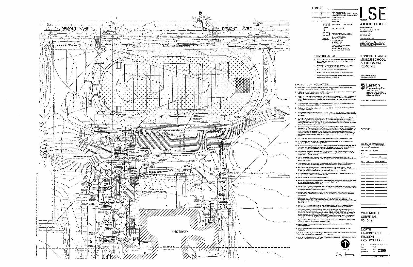
Project Name Roseville Middle School Addition Project Number 19-19
Applicant Name Todd Lieser, Roseville Area Schools ISD 623
This project is located at Roseville Area Middle School on County Road B2 in the City of Little Canada. The total site area is 8 acres. The applicant is proposing to construct two building additions and a loading dock with associated sidewalk and bituminous areas. A filtration basin will be constructed to meet stormwater treatment requirements. Filtration is being proposed due to poor soils. Pretreatment will include a sump structure.
Wetlands
Stormwater Management
Erosion and Sediment Control
The proposed stormwater management plan is sufficient to handle the runoff from the site.
The proposed erosion and sediment control plan is sufficient to protect downstream water resources during construction.
The proposed stormwater management plan is sufficient to protect the long term quality of downstream water resources.
Staff recommends approval of this permit with the special provisions.
Watershed District Policies or Standards Involved:
Water Quantity Considerations
Water Quality Considerations
Short Term
Long Term
Staff Recommendation
Property Description
Type of Development Institutional
Floodplain
Project Location Map
Project Grading Plan
Attachments:

#*
£¤36
§̈¦35ESY
LVAN
ST
COUNTY ROAD B E
WOOD
BRID
GE ST
SIERR
A LN
COUNTY ROAD C E
LAKE
SHOR
E AVE
ROSE
WOOD
DR
WOODBRIDGE CIR
MISS
ISSIPP
I ST N
RICE S
T
HIGHWAY 36 WVIKING DR E
DEMONT AVE E DEMONT AVE EPA
RK ST
PARK
ST
STARK
ST
RUTH
ST E
SAVA
GE LN
COUNTY ROAD B2 E
LILLEHEI PLZ
COUNTY ROAD B2 W
COUNTY ROAD C W
SPRU
CE ST
JACK
SON
STJA
CKSO
N ST
SYLV
AN ST
SYLV
AN ST
DEMONT AVE W
WEWERS RD
TRANSIT AVE
LAKE ST E
ROSE PL EID
A AV
E N
PRIVATE RD
PRIVATE RDPRIVATE RD
MINNESOTA AVE W
WOODBRIDGE ST
WOOD
BRID
GE ST
WOOD
BRID
GE ST
GRANDVIEW AVE W
MARIO
N ST
CANABURY CT
OLD COUNTY ROAD C EOLD COUNTY ROAD C E
LAKE
SHOR
E AVELA
KE SH
ORE A
VE
SIERR
A LN
WOODBRIDGE CIR
ROSE
WOOD
DR
Roseville MS
Gervais CreekSubwatershed
West Savage Lake
East Savage Lake
Lake OwassoSubwatershed
Gervais LakeSubwatershed
Gervais LakeSubwatershed
Copyright nearmap 2015
Wetlands
Manage A
Manage B
Manage C
Lake
Sediment Pond
Not Assessed $0 0.20.1Miles
0 1,000500Feet
Highlighted Areas Represent Active Permit
Note: Shaded area is outside RWMWD
#* Schools
Flow ArrowsMajor Flow ArrowsSubwatershedsCreeksPermitsRamsey Co Parcels
C a p i t o l C a p i t o l R e g i o n R e g i o n
W a t e r s h e d W a t e r s h e d D i s t r i c tD i s t r i c t
#19-19 Roseville Middle School Addition

Special Provisions
19-19
1. The applicant shall submit a revised narrative that includes a discussion for the infiltration rate used of 1.6 in/hr, or revise design to be consistent with the District's design infiltration rate of 0.8 in/hr.
2. The applicant shall submit a final, signed copy of the construction plans.
3. The applicant shall submit a revised Stormwater Pollution Prevention Plan (SWPPP) that includes a map of receiving waters within 1 mile of the project.
4. The applicant shall submit contact information for the trained erosion control coordinator responsible for implementing the SWPPP.
5. The applicant shall submit a copy of the Minnesota Pollution Control Agency's NPDES Construction Permit for the project.
Thursday, May 23, 2019 Page 1 of 1

Permit Application Coversheet
Date June 05, 2019
Project Name Buerkle Road Drainage Improvements Project Number 19-20
Applicant Name Jesse Farrell, City of Vadnais Heights
This project is located east of Highway 61 & Buerkle Road in the City of Vadnais Heights. To alleviate existing drainage problems, the city is proposing to install two new catch basins in conjunction with a mill and overlay of Buerkle Road. The total disturbance area is 0.37 acre. The catch basins will require a storm sewer pipe running north that will connect directly into the District's existing MS4, triggering District Rule G. The proposed design shows no documented increase in runoff rates or water surface elevations downstream. The applicant has submitted an erosion and sediment control plan to meet the standards of District Rule F.
Wetlands
Stormwater Management
Erosion and Sediment Control
The proposed design is sufficient to handle the runoff from the site.
The proposed erosion and sediment control plan is sufficient to protect downstream water resources during construction.
There are no long term water quality considerations.
Staff recommends approval of the permit with the special provisions.
Watershed District Policies or Standards Involved:
Water Quantity Considerations
Water Quality Considerations
Short Term
Long Term
Staff Recommendation
Property Description
Type of Development Drainage
Floodplain
Project Location Map
Project Grading Plan
Attachments:

W
illow
Creek
Willow CreekSubwatershed
HIGHW
AY 61
HIGHW
AY 61
BUERKLE RD
ELM ST
FANU
M RD
BUERKLE CIR
FAIR OAKS DR
SAVA
NNAH
AVE
FAIR
OAKS
CT
Copyright nearmap 2015
Wetlands
Manage A
Manage B
Manage C
Lake
Sediment Pond
Not Assessed $0 0.10.05Miles
0 550275Feet
Highlighted Areas Represent Active Permit
Flow ArrowsMajor Flow ArrowsSubwatershedsCreeksPermitsRamsey Co Parcels
#19-20 Buerkle Road Drainage Improvements

Special Provisions
19-20
1. The applicant shall add a note to the plans to notify Nicole Soderholm, Ramsey-Washington Metro Watershed District, at 651-792-7976 prior to beginning any and all construction activity.
2. The applicant shall submit a final, signed copy of the construction plans.
Thursday, May 23, 2019 Page 1 of 1


Permit Application Coversheet
Date June 05, 2019
Project Name Meadowood Berm Project Number 19-21
Applicant Name Tony Kutzke, City of Woodbury
This project is located south of Meadowood Drive & Poplar Drive in the City of Woodbury. The applicant is proposing to construct a berm on the north side of an existing wetland to alleviate flooding of residential properties further north. The berm will redirect the outlet flow route to a storm sewer structure to the west, bypassing the properties water currently flows through. The total site area is 0.11 acre. The project will result in fill within the floodplain triggering District Rule D, however the berm placement is outside of the wetland's active storage area and will not result in a loss of floodplain storage. An increase of 0.07 ft in the wetland's water surface elevation has been modeled. The low adjacent habitable structures have greater than 5 feet of freeboard which meets the District's requirements. The applicant received Wetland Conservation Act (WCA) approval under the de minimis exemption on 5/8/19 (#19-07 WCA) for 490 square feet of wetland impact.
Wetlands
Stormwater Management
Erosion and Sediment Control
There are no water quantity considerations.
The proposed erosion and sediment control plan is sufficient to protect downstream water resources during construction.
There are no long term water quality considerations.
Staff recommends approval of the permit.
Watershed District Policies or Standards Involved:
Water Quantity Considerations
Water Quality Considerations
Short Term
Long Term
Staff Recommendation
Property Description
Type of Development Flood Control
Floodplain
Project Location Map
Project Grading Plan
Attachments:

Battle CreekSubwatershed
MEAD
OW LN
CENT
URY A
VE S
CENT
URY A
VE S
POPLAR DR
MEADO
WOOD DR
ASPEN CT
WILLO
W LN
Copyright nearmap 2015
Wetlands
Manage A
Manage B
Manage C
Lake
Sediment Pond
Not Assessed $0 0.0550.0275Miles
0 300150Feet
Highlighted Areas Represent Active Permit
Flow ArrowsMajor Flow ArrowsSubwatershedsCreeksPermitsRamsey Co Parcels
#19-21 Meadowood Berm

Special Provisions
19-21
None
Thursday, May 23, 2019 Page 1 of 1


Permit Application Coversheet
Date June 05, 2019
Project Name Sterling Street Bridge Replacement Project Number 19-22
Applicant Name Steve Love, City of Maplewood
This project is located at the existing Sterling Street bridge over Fish Creek in the City of Maplewood. The applicant is proposing to replace the deteriorating bridge. The total site area is 0.6 acre. The project would result in placement of 1,038 cubic yards of fill in the floodplain and is greater than 1,000 square feet of disturbance immediately adjacent to a water body, thus triggering District Rules D and F. Due to limited right of way and county-owned parkland, the applicant is requesting a variance from the compensatory storage requirement. Peak outflow in the 100-year event is modeled to increase by 0.55 cubic feet per second, and peak stage elevation is modeled to increase by 0.11 ft. There are no existing habitable structures at risk in the floodplain as identified by the District and FEMA. A site investigation and subsequent Wetland Conservation Act (WCA) approval on 8/21/17 determined there are no wetlands on the site within the creek's fringe areas (#17-11 WCA).
Wetlands
Stormwater Management
Erosion and Sediment Control
There are no water quantity considerations.
The proposed erosion and sediment control plan is sufficient to protect downstream water resources during construction.
There are no long term water quality considerations.
Staff recommends approval of the permit with the special provisions and variance request.
Watershed District Policies or Standards Involved:
Water Quantity Considerations
Water Quality Considerations
Short Term
Long Term
Staff Recommendation
Property Description
Type of Development Linear
Floodplain
Project Location Map
Project Grading Plan
Attachments:

§̈¦494
FishC
reek
Fish CreekSubwatershed
STERL
ING
ST S
INTER
STATE
494
INTER
STATE
494
Copyright nearmap 2015
Wetlands
Manage A
Manage B
Manage C
Lake
Sediment Pond
Not Assessed $0 0.030.015Miles
0 15075Feet
Highlighted Areas Represent Active Permit
SubwatershedsCreeksPermitsRamsey Co Parcels
#19-22 Sterling Street Bridge Replacement

Special Provisions
19-22
1. The applicant shall submit a Stormwater Pollution Prevention Plan (SWPPP).
2. The applicant shall add notes to the plans: A. Notify Nicole Soderholm, Ramsey-Washington Metro Watershed District, at 651-792-7976 prior to beginning any and all construction activity in order to schedule an initial SWPPP inspection. B. The specified erosion and sediment control practices are the minimum. Additional practices may be required during the course of construction.
3. The applicant shall add erosion control symbology and legend to Sheet 33.
4. The applicant shall submit a final, signed copy of the construction plans.
Thursday, May 23, 2019 Page 1 of 1


H:\MPWD\T43112735\5_Permits\Variance Request Memo Sterling Street South at Fish Creek May 14 2019.docx
M E M O R A N D U M
Date: May 14, 2019
To: Nicole Soderholm.
From: Brent Johnson, P.E.
Subject: Variance Request for Sterling Street S. Bridge Replacement over Fish Creek
City of Maplewood
Project No.: T43.112735
The City of Maplewood hereby requests a variance of the Rule D Flood Control requirement from the
Ramsey Washington Metro Watershed District.
Introduction:
The City of Maplewood is planning to replace the existing structurally deficient timber bridge over Fish
Creek on Sterling Street South. The Maplewood Sterling Street Bridge is located between Carver Avenue
and Baily Road. The existing bridge is a three-span timber pile bridge with timber caps and braces. At
approximately 22 feet wide the existing bridge creates a geometric restriction in the roadway. The
existing bridge is in poor condition and must be replaced. Appendix A includes photos of the existing
bridge and photos of the downstream culvert (I-494 drop inlet structure) and upstream culvert (corrugated
metal culvert at Carver Lake Road).
The City of Maplewood proposes to replace the timber bridge with a reinforced concrete box culvert. The
proposed culvert crossing will include 1 line of 16’ span x 10’ rise RC Box. The roadway is proposed to
be widened to 34 feet to include adequate shouldering and a future bike trail on the east side of the bridge.
The bike trail also fits into future regional trail connections planned by Ramsey County Parks.
Rule D: Flood Control
The project will include placement of 1,038 cubic yards of fill into the 100-year floodplain of Fish Creek.
Rule D indicates that filling in the floodplain is prohibited unless compensatory storage is provided. The
following paragraph is a copy of the rule:
3. CRITERIA.
(a) Placement of fill within the 100-year floodplain is prohibited unless compensatory storage is provided.
Compensatory storage must be provided on the development or immediately adjacent to the development within the
affected floodplain.
(1) Compensatory storage shall result in the creation of floodplain storage to fully offset the loss of floodplain
storage. Compensatory storage shall be created prior to or concurrently to the permitted floodplain filling.
As a result of early coordination between the City and the Watershed District, the original bridge
replacement plans for the crossing have been modified to reduce the floodplain fill as much as possible.
Since reducing the floodplain fill further is not feasible and constructing compensatory storage on or
adjacent to the project site is not feasible, a Variance of Rule D is requested by the City of Maplewood.

Nicole Soderholm
May 14, 2019
Page: 2
Hardship
• Doing Nothing is not feasible because the existing bridge must be replaced.
• Replacing the timber bridge with a new bridge is not feasible. A new bridge would need to be
wider and longer than the existing timber bridge to meet the project needs and design
requirements. Additionally, the construction/presence of a new bridge will adversely impact the
surrounding environment in ways that a box culvert will not. The rural feel including the existing
structure and surrounding vegetation and tree cover would be significantly altered with the
placement of a new bridge. In addition, both the initial and long-term maintenance costs of a
bridge are significantly greater than those of a box culvert.
• A Variance has also been requested from MN DOT to exempt several road design standards in
order to reduce the proposed embankment volumes and associated floodplain fill. In meeting
State Aid design requirements for the roadway, 5,400 cubic yards of floodplain fill was initially
proposed. Following early coordination between the City and the Watershed District, a design
exemption has been requested from MN/DOT to allow a greater vertical curve in order to reduce
floodplain fill. This modification will also reduce design sight distances and reduce design
speeds (posted speeds will be reduced from 35 mph to 20 mph).
• Placement of fill in the floodplain is required in order to remove the bridge, construct the road
embankment and install the box culvert. Although the proposed embankment volumes have been
significantly reduced, a net increase in floodplain fill of 1,038 cubic yards are required.
• Compensatory excavation to mitigate for the required floodplain fill is not feasible. Sterling
Street S. has limited existing right of way (ROW) and the land immediately upstream and
downstream from the Sterling Street bridge crossing is within a Ramsey County Park. The
stream corridor and riparian zone is a high quality wooded area. Planned uses of the County Park
include open spaces and regional trail connections incorporating the existing wooded stream
corridor. Ramsey County Parks is opposed to providing additional right of way for the City to
clear the high quality wooded stream corridor habitat and construct compensatory excavation
within the floodplain to mitigate the required floodplain fill.
• A restrictive culvert and drop inlet is in place at I-494 downstream from the Sterling Street bridge
site. This I-494 culvert backs up water to a depth of about 26 feet in a 100-year event. If a bridge
or larger culvert was in place within I-494, the floodplain would be much lower and floodplain
fill much less of an issue.
Project Conditions and Impacts
FEMA Zone A Floodplain
The Fish Creek floodplain is mapped as a FEMA Zone A floodplain. The MN/DNR provides the
following guidance for changes in stage due to bridge and culvert replacements in Zone A floodplains: If
the stage increase for the proposed structure is equal to or less than for existing structure, no submission
to FEMA is required, and the Community must keep the hydraulic data on file.1 In a Zone A the
Community can decide whether the floodplain maps should be revised to reflect any changes due to
bridge and culvert modifications.2
1 Bridges & Culverts—Floodplain Requirements in A Zones, MN DNR Waters – 03/26/2009 Revision
https://files.dnr.state.mn.us/waters/watermgmt_section/floodplain/LOMRs_and_bridge-culvert_flowchart-A_Zone-03-26-
2009.pdf accessed 3/6//2019 2 Personal communication, Suzanne Jiwani, MN/DNR Floodplain Mapping Engineer, 651-259-5681 March 22, 2019

Nicole Soderholm
May 14, 2019
Page: 3
The flood insurance study limited detail study hydraulic model includes a peak flow of 709 cfs. The
Flood Insurance Study (FIS) HEC-RAS limited detail model does not include bridge or culvert crossings
on Fish Creek. The FIS model was modified near the Sterling Street S bridge to simulate the existing
bridge and the proposed box culvert. Tailwater in the modified FIS model was set to match the FEMA
FIS model at the cross section just upstream from highway I-494 (elevation 879.94). The HEC-RAS
model is a FEMA approved model and the steady state hydraulic modeling approach is consistent with
FEMA approved methods.
Table 1 provides a comparison of existing and proposed conditions HEC-RAS water surface elevations at
FEMA flood insurance study 100-year peak flow rates in Fish Creek. This comparison shows that the
proposed condition with the 16’ by 10’ box culvert results in lower water surface elevations than the
existing bridge for a 709 cfs steady state peak flow of the FEMA Flood Insurance Study.
Table 1 Existing and Proposed Water Surface Elevations at Sterling Street Bridge Crossing
River
Station
Event Condition Peak Flow (cfs) Water Surface
Elevation (feet)
11518 100-Year FEMA Base Flood Existing 709 881.52
11518 100-Year FEMA Base Flood Proposed 709 880.73
11330 100-Year FEMA Base Flood Existing 709 880.46
11330 100-Year FEMA Base Flood Proposed 709 880.46
Figure 1 in Appendix B is a map showing the low adjacent grade elevations (based on LiDAR data) of
the existing homes and accessory structures near the Fish Creek floodplain. No existing structures are
below the 100-year floodplain elevation near the Sterling Street bridge. Existing structures are well above
the 100-year floodplain elevations identified by both FEMA and the RWMWD.
Fish Creek H&H Analysis Using RWMWD Modeling Information
Fish Creek flows from Carver Lake to Eagle Lake and the Mississippi River. The drainage area at the
outlet of Carver Lake is 3.6 square miles. The drainage area just downstream of Sterling Street is 4.2
square miles, and the drainage area is 4.6 square miles at the outlet of Fish Creek to Eagle Lake.
Several design event flow hydrographs from the Ramsey Washington Metro Watershed District’s H&H
model of Fish Creek were provided by Watershed District Engineer Brandon Barnes. A stage-storage-
discharge rating table for the I-494 culvert was also provided by Mr. Barnes. The stage-storage curve was
modified to include a proposed volume of 1,114 cubic yards of floodplain fill. The hydrographs and the
stage-storage-discharge rating curves were incorporated into several HydroCAD models to simulate the
effect of the floodplain fill on the peak flow and stage at the bridge site. Please note that the floodplain
fill volume estimate has recently been further reduced to 1,038 cubic yards, but the HydroCAD modeling
has not been updated since the 7% reduction in floodplain fill is not likely to have much of an effect upon
the computed peak water levels. Table 2 provides a summary of results for the 2-year, 10-year and 100-
year simulated events. No floodplain effect is simulated in the 2-year event, and only a 0.01-foot
reduction in stage is simulated in the 10-year event. Peak outflow in the 100-year event is simulated to
increase by 0.55 cfs and peak stage is simulated to increase 0.11 feet.

Nicole Soderholm
May 14, 2019
Page: 4
Table 2. HydroCAD Model Summary (Proposed Condition With 1,114 CY Floodplain Fill)
Storm Event
Inflow
(cfs)
Outflow
(cfs)
Peak Stage
(feet)
2-year Existing 50.23 47.57 862.94
Proposed 50.23 47.57 862.94
Difference 0 0 0
10-year Existing 167.34 166.9 868.33
Proposed 167.34 166.9 868.32
Difference 0 0 -0.01
100-year Existing 639.55 269.4 885.88
Proposed 639.55 269.95 885.99
Difference 0 0.55 0.11
Short Cut Calculation of Floodplain Depth Increase
Table 3. provides a short cut estimate of the potential increase in flood depths due to the
floodplain fill. This method was suggested by RWMWD Engineer Brandon Barnes. This
calculation divides the floodplain fill volume (1,038 cubic yards or 0.64 acre-feet) by the surface
area at peak flood depth to estimate the potential increase in flood elevation. The short-cut results
of 0.12 feet closely match the HydroCAD analyses results of 0.11 feet increase in flood depth due
to fill.
Table 3. Short Cut Calculation of Floodplain Depth Increase Due to Fill Event Existing Peak Stage
(HydroCAD) Existing Peak Surface Area (HydroCAD)
Short Cut Estimate of Impact of Floodplain Fill
100-year 885.88 feet 5.23 acre (0.64 ac. ft.) / (5.23 acres) = 0.12 feet
Other Applicable RWMWD Rules
If the requested variance is given for the Rule D Flood Control provisions, the Rule F Erosion and
Sediment Control provisions will also apply to the project. The project is exempt from Rule C
Stormwater Management and Rule E Wetland Management does not apply since there are no wetlands in
the project area.
Rule C: Stormwater Management
The proposed project includes an area of disturbance of 24,700 square feet (0.57 acres). The proposed
Sterling Street Bridge replacement project does not require a Rule C Stormwater Management permit
since the project does not disturb an acre or more of land. In addition, District rules state that bridge
projects are exempt from Rule C and its requirements. The following paragraph is a copy of the rule:
“Exceptions.

Nicole Soderholm
May 14, 2019
Page: 5
(b) Rule C and its requirements shall not apply to development less than 1 acre in size for all land uses
unless part of a common plan of development or sale that will ultimately exceed one acre in size.
(d) Rule C and its requirements shall not apply to bridges.”
Rule E: Wetland Management
The project area was investigated for wetlands on July 7, 2017. Wetlands are not present. The no-wetland
determination was reviewed and approved by the RWMWD on 8/21/2017. The Corps of Engineers
concurred with the findings on 9/05/17.
Rule F: Erosion and Sediment Control
The proposed Sterling Street Bridge project includes an area of disturbance of 0.57 acres. The proposed
project requires a Rule F Erosion and Sediment Control permit since the project disturbs more and 1,000
square feet and is within the 100-year floodplain (as per Rule F.5.a). Erosion and sediment control
measures and schedules are shown in the attached plans.
Several erosion control features are being considered for the box culvert. These include a rock
riprap basin, a broken-back pipe profile, and use of energy dissipation baffle blocks within the box
culvert. Final design will be completed if a floodplain fill variance is awarded.

Nicole Soderholm
May 14, 2019
Page: 6
APPENDIX A
Photographs

Nicole Soderholm
May 14, 2019
Page: 7
Highway I-494 Drop Inlet Culvert on Fish Creek
Carver Lake Road Culvert on Fish Creek

Nicole Soderholm
May 14, 2019
Page: 8
Sterling Street S Timber Bridge
Sterling Street S Timber Bridge

Nicole Soderholm
May 14, 2019
Page: 9
APPENDIX B
Low Adjacent Grade Elevation of Structure
Near the Fish Creek Floodplain

H:\MPWD\T43112735\5_Permits\Variance Request Memo Sterling Street South at Fish Creek May 14 2019.docx

H:\MPWD\T43112735\5_Permits\Variance Request Memo Sterling Street South at Fish Creek May 14 2019.docx

BITUMINOUS
BITUMINOUS
BITUMINOUS
BRIDGE
5
bmi.tbl
H:\
MP
WD\
T43112735\
CA
D\
MS\fig
ures\
Varia
nce
Exhibit.d
gn
10:1
2:3
2
AM
pdf-color.plt
cf
gtriciala
3/22/2019
STERLING ST. (MAPLEWOOD)
ST
ER
LI
NG
ST.
60
SCALE IN FEET
VARIANCE EXHIBIT
BR. NO. 92252 REPLACEMENTFIS
H CREE
K
TH 494
TOTAL FILL VOLUME BELOW FLOOD EL. 886.6: 1038 CU YD
TOTAL FILL VOLUME: 2447 CU YD
AREA: 0.57 ACRE
TOTAL FILL VOLUME BELOW FLOOD EL. 886.6: 1838 CU YD
TOTAL FILL VOLUME: 5403 CU YD
AREA: 0.80 ACRE
LEGEND
35 MPH VERTICAL CURVE
20 MPH VERTICAL CURVE

Permit Application Coversheet
Date June 05, 2019
Project Name Granada Access Road Maintenance Project Number 19-23
Applicant Name Chris Buntjer, City of Oakdale
This project is located at an existing sanitary sewer access road west of Granada Avenue North in the City of Oakdale. The applicant is proposing to repair and regrade the existing gravel road back to its original contours to facilitate future inspection and maintenance of sanitary sewer manholes. The total site area is 0.63 acre. The existing access road is located in the 100-year floodplain of the adjacent wetland, thus triggering District Rule D. 264 cubic yards of fill are proposed below the 100-year elevation. Due to the wetland on either side of the road, the applicant is requesting a variance from the compensatory storage requirement. The 100-year floodplain elevation is modeled to increase 0.03 inch as a result of this project. District freeboard requirements are met with the proposed project for existing habitable structures adjacent to the wetland.
Wetlands
Stormwater Management
Erosion and Sediment Control
There are no water quantity considerations.
The proposed erosion and sediment control plan is sufficient to protect downstream water resources during construction.
There are no long term water quality considerations.
Staff recommends approval of the permit with the special provisions and variance request.
Watershed District Policies or Standards Involved:
Water Quantity Considerations
Water Quality Considerations
Short Term
Long Term
Staff Recommendation
Property Description
Type of Development Maintenance
Floodplain
Project Location Map
Project Grading Plan
Attachments:

Tanners LakeSubwatershed
GRANADA AVE N
GOPHER BLVD N
GRAN
ITE A
VE N
UPPER 20TH ST N
20TH ST N
GOOD
VIEW
AVE
N
GOODVIEW AVE N
15TH
STRE
ET PL
N
15TH
STRE
ET C
IR N
Beaver LakeSubwatershed
Copyright nearmap 2015
Wetlands
Manage A
Manage B
Manage C
Lake
Sediment Pond
Not Assessed $0 0.10.05Miles
0 500250Feet
Highlighted Areas Represent Active Permit
Flow ArrowsMajor Flow ArrowsSubwatershedsCreeksPermitsRamsey Co Parcels
#19-23 Granada Access Road Maintenance

Special Provisions
19-23
None
Wednesday, May 29, 2019 Page 1 of 1


Permit Application Coversheet
Date June 05, 2019
Project Name Woodbury Middle School Parking Lot Project Number 19-24
Applicant Name , South Washington County Schools ISD 833
This project is located at Woodbury Middle School near I-494 and Valley Creek Road. The applicant is proposing reconstruct a portion of the parking lot. The remainder of the lot will be reclaiming existing asphalt. The total site area is 4.05 acres. Porous pavers will be added to the parking lot to meet stormwater treatment requirements.
Wetlands
Stormwater Management
Erosion and Sediment Control
The proposed stormwater management plan is sufficient to handle the runoff from the site.
The proposed erosion and sediment control plan is sufficient to protect downstream water resources during construction.
The proposed stormwater management plan is sufficient to protect the long term quality of downstream water resources.
Staff recommends approval of the permit with the special provisions.
Watershed District Policies or Standards Involved:
Water Quantity Considerations
Water Quality Considerations
Short Term
Long Term
Staff Recommendation
Property Description
Type of Development Parking Lot
Floodplain
Project Location Map
Project Grading Plan
Attachments:

#*
#*
SCHOOL DR
WEIR DR
WOOD
HILL D
R
VALLEY CREEK RDVALLEY CREEK RD
PINEW
OOD D
R
UPPER AFTON RD
HILLC
REST D
R
BASSWOOD RD
WOODHILL CT
PINEW
OOD
CT
WOODHILL CIR
HILLCREST CT
WB VAL
LEY CREE
K RD T
O SB I49
4
BIRCHWOOD RD
Woodbury ES
Woodbury MS
Carver LakeSubwatershed
Battle Creek LakeSubwatershed
Battle Creek LakeSubwatershed
Battle CreekSubwatershed
Copyright nearmap 2015
Wetlands
Manage A
Manage B
Manage C
Lake
Sediment Pond
Not Assessed $0 0.0750.0375Miles
0 400200Feet
Highlighted Areas Represent Active Permit
#* Schools
Flow ArrowsMajor Flow ArrowsSubwatershedsCreeksPermits
#19-24 Woodbury Middle School Parking Lot

Special Provisions
19-24
1. The applicant shall submit the executed stormwater maintenance agreement for the proposed BMPs.
2. The applicant shall submit a final, signed copy of the construction plans.
3. The applicant shall submit contact information for the trained erosion control coordinator responsible for implementing the Stormwater Pollution Prevention Plan (SWPPP).
4. The applicant shall submit a copy of the approved Minnesota Pollution Control Agency's NPDES Permit for the project.
Friday, May 24, 2019 Page 1 of 1


Permit Application Coversheet
Date June 05, 2019
Project Name Indian Mounds Regional Park Trail Project Number 19-25
Applicant Name Brett Hussong, City of St. Paul
This project is located at Indian Mounds Regional Park in St. Paul near the Mississippi River. The applicant is proposing to replace and realign existing trail and replace pedestrian ramps to meet ADA requirements. Some of the trail will be fully reconstructed, but most will be pavement rehabilitation. The project received input from various stakeholders due to the cultural sensitivity of the project area. The city is planning to remove 0.5 acre of existing trail due to proximity to American Indian burial mounds. There is an overall proposed decrease in impervious area of 0.75 acre. Two infiltration basins will be constructed to partially meet the District's stormwater treatment requirements. Due to limited impervious area and the unique cultural and historical sensitivity of the site, the applicant is requesting to pay $10,574 into the District's Stormwater Impact Fund to make up for the remaining untreated area. The project overlaps two watershed districts. Capitol Region Watershed District has waived permitting authority for the project.
Wetlands
Stormwater Management
Erosion and Sediment Control
The proposed stormwater management plan is sufficient to handle the runoff from the site.
The proposed erosion and sediment control plan is sufficient to protect downstream water resources during construction.
The proposed stormwater management plan is sufficient to protect the long term quality of downstream water resources.
Staff recommends approval of the permit with the special provisions.
Watershed District Policies or Standards Involved:
Water Quantity Considerations
Water Quality Considerations
Short Term
Long Term
Staff Recommendation
Property Description
Type of Development Trail
Floodplain
Project Location Map
Project Grading Plan
Attachments:

BURNS AVE
§̈¦94
WARNER RD
EARL
ST
JOHN
SON
PKWY
CHILDS RD
ETNA
STETN
A ST
MCLEAN AVE
£¤61
MARGARET ST MARGARET STHANCOCK ST
SHOP RD
MOUNDS BLVD
HUDSON RD
BEECH ST BEECH STBEECH ST
THORN ST
PIGSEYE LAKE RD
UPPER AFTON RD
CLAR
ENCE
STCL
AREN
CE ST
FREMONT AVE FREMONT AVE
FISH HATCHERY RD
HAZE
LWOO
D ST
BIRMI
NGHA
M ST
FRAN
K ST
MINNEHAHA AVE E
WILSON AVEPOINT DOUGLAS RD N
JOHNSO
N PKWY
ENGL
ISH ST
BARC
LAY S
T
RESE
RVE S
T
Mississippi River BottomlandsSubwatershed
Mississippi River
Little Pig's Eye Lake
Battle
Creek
St. Paul BeltlineSubwatershed
St. Paul BeltlineSubwatershed
Copyright nearmap 2015
Wetlands
Manage A
Manage B
Manage C
Lake
Sediment Pond
Not Assessed $0 0.40.2Miles
0 1,800900Feet
Highlighted Areas Represent Active Permit
Note: Shaded area is outside RWMWD
Flow ArrowsMajor Flow ArrowsSubwatershedsCreeksPermits
C a p i t o l C a p i t o l R e g i o n R e g i o n
W a t e r s h e d W a t e r s h e d D i s t r i c tD i s t r i c t
#19-25 Indian Mounds Regional Park Trail

Special Provisions
19-25
1.The applicant shall submit a payment into the Stormwater Impact Fund of $10,574.
2.The applicant shall submit contact information for the trained erosion control coordinator responsible for implementing the Stormwater Pollution Prevention Plan (SWPPP).
3.The applicant shall submit a copy of the approved Minnesota Pollution Control Agency's NPDES Permit for the project.
4.The applicant shall submit a final, signed copy of the construction plans.
Wednesday, May 29, 2019 Page 1 of 1

Permit Application Coversheet
Date June 05, 2019
Project Name Aldrich Arena Stormwater Retrofit Project Number 19-26
Applicant Name Gus Blumer, Ramsey County Parks & Recreation
This project is located at Aldrich Arena in the City of Maplewood. This is a collaborative project between the District and Ramsey County Parks & Recreation to implement stormwater BMPs on a largely impervious site within the impaired Wakefield Lake subwatershed. The county is proposing to make improvements to the arena including a mill and overlay of the existing parking lot. The District has agreed to design and fund 14 rain gardens, native vegetation restoration, and tree plantings. This permit is erosion and sediment control (Rule F) only because there is no reconstructed impervious area that trigger stormwater treatment requirements. The project will result in an overall reduction of 1.11 acres of impervious area.
Wetlands
Stormwater Management
Erosion and Sediment Control
There are no water quantity considerations.
The proposed erosion and sediment control plan is sufficient to protect downstream water resources during construction.
The proposed stormwater design is sufficient to protect the long term quality of downstream water resources.
Staff recommends approval of the permit with the special provisions.
Watershed District Policies or Standards Involved:
Water Quantity Considerations
Water Quality Considerations
Short Term
Long Term
Staff Recommendation
Property Description
Type of Development Park/Green Space/BMP
Floodplain
Project Location Map
Project Grading Plan
Attachments:

GoodrichGolf Course
Wakefield LakeSubwatershed
FLAND
RAU S
T
WHITE
BEAR
AVE
VAN
DYKE
ST
VAN
DYKE
ST
NORTH SAINT PAUL RD
RIPLEY AVERIPLEY AVE
HAZE
L ST
FROST AVE
KINGSTON AVE
Copyright nearmap 2015
Wetlands
Manage A
Manage B
Manage C
Lake
Sediment Pond
Not Assessed $0 0.10.05Miles
0 500250Feet
Highlighted Areas Represent Active Permit
Flow ArrowsMajor Flow ArrowsSubwatershedsCreeksPermits
#19-26 Aldrich Arena Stormwater Retrofit

Special Provisions
19-26
1. The applicant shall add notes to the plans: A. Notify Nicole Soderholm, Ramsey-Washington Metro Watershed District, at 651-792-7976 prior to beginning any and all construction activity in order to schedule an initial SWPPP inspection. B. The specified erosion and sediment control practices are the minimum. Additional practices may be required during the course of construction.
2. The applicant shall submit a final, signed copy of the construction plans.
3. The applicant shall submit a copy of the approved Minnesota Pollution Control Agency's NPDES Permit for the project.
Friday, May 24, 2019 Page 1 of 1


Permit Application Coversheet
Date June 05, 2019
Project Name Shoreview Commons Project Number 19-27
Applicant Name Terry Schwerm, City of Shoreview
This project is located around Shoreview Community Center at 4600 Victoria Street North. The applicant is proposing to redevelop the area in two phases. This permit application represents Phase 1 and will include a fountain, outdoor event space, skate park, nature play areas, pickleball courts, trails, gardens, landscaping, and parking lot improvements. The total site area is 9 acres. Stormwater will be treated through construction of an iron-enhanced filtration basin and stormwater reuse pond for irrigation. Filtration is being proposed due to poor soils and high groundwater. Pretreatment will include vegetated filter strips. The project will result in fill below the floodplain elevation of Brennan's Pond. Compensatory storage is provided to ensure no net loss of floodplain storage. Brennan's Pond is a DNR Public Water wetland. Installation of an outlet pipe will result in temporary wetland buffer disturbance within the 25' minimum. The applicant has requested a variance for this temporary disturbance. Disturbed areas will be restored to pre-project conditions. The project overlaps two watershed districts. Rice Creek Watershed District (RCWD) has waived permitting authority for this phase of the project. A future Phase 2 of this project is expected to be solely located within and permitted by RCWD, however RWMWD staff will be able to review the design to ensure no adverse impacts to the Snail Lake subwatershed.
Wetlands
Stormwater Management
Erosion and Sediment Control
The proposed stormwater management plan is sufficient to handle the runoff from the site.
The proposed erosion and sediment control plan is sufficient to protect downstream water resources during construction.
The proposed stormwater management plan is sufficient to protect the long term quality of downstream water resources.
Staff recommends approval of the permit with the special provisions and variance request.
Watershed District Policies or Standards Involved:
Water Quantity Considerations
Water Quality Considerations
Short Term
Long Term
Staff Recommendation
Property Description
Type of Development Park/Green Space/BMP
Floodplain
Project Location Map
Attachments:

Project Grading Plan

")96
Snail Lake
Snail LakeSubwatershed
DALE
ST N
MOUND AVE
KEVI
N LN
DEBR
A LN
COUNTY ROAD 96 WCOUNTY ROAD 96 W
LARS
ON RD
LORIN
DA D
R
DALE CT S
DALE CT N
DEBRA CT
ARNER AVE
TOMLYN AVE
VICT
ORIA
ST N
LARSON CT
Copyright nearmap 2015
Wetlands
Manage A
Manage B
Manage C
Lake
Sediment Pond
Not Assessed $0 0.10.05Miles
0 500250Feet
Highlighted Areas Represent Active Permit
Note: Shaded area is outside RWMWD
RWMWD BoundaryFlow ArrowsMajor Flow ArrowsSubwatershedsCreeksPermitsRamsey Co Parcels
#19-27 Shoreview Commons
R i c eR i c eC r e e k C r e e k
W a t e r s h e d W a t e r s h e d D i s t r i c tD i s t r i c t

Special Provisions
19-27
1. The applicant shall submit contact information for the trained erosion control coordinator responsible for implementing the Stormwater Pollution Prevention Plan (SWPPP).
2. The applicant shall submit a final, signed copy of the construction plans.
3. The applicant shall submit the approved Minnesota Pollution Control Agency's NPDES Construction Permit for the project.
Wednesday, May 29, 2019 Page 1 of 1


Memorandum
DATE: May 9th, 2019 TO: Ramsey-Washington Metro Watershed District
Nicole Soderholm, Permit Coordinator FROM: LHB Inc. Heidi Bringman, Wetland Specialist RE: Variance Request for Temporary Disturbances within Wetland Buffer Shoreview Commons Stormwater Permit
This memo serves as a request for a variance from the Wetland Management – RWMWD Rule E regarding temporary disturbances within a wetland buffer for wetland classification Manage B. The District’s rule for buffer requirements for wetland management B classification, is a minimum “no disturbance” buffer of 25 feet with an average buffer of 50 feet.
As part of the Shoreview Commons park improvements project, the City of Shoreview is proposing to install an outfall pipe from the compensatory floodplain storage area which will outlet near Brennans Pond, a MnDNR designated Public Water 62-63W. The installation of the stormpipe will temporarily disturb a total of 507 square feet of land, of which approximately 250 square feet is within the 25-foot “no disturbance” wetland buffer.
The reason that this work is necessary is due to the need to provide an outlet from the stormwater filtration basin and compensatory flood storage area that are being constructed to meet the stormwater management requirements for the site development. Existing site elevations and lack of storm sewer infrastructure in the area result in the inability to outlet the overflows for this area anywhere else on site.
The temporary impacts within the wetland buffer zone will consist of placement of a double row of silt fence at the construction limits, clearing and grubbing of existing vegetation for a 10’ wide work corridor (running approximately 50 feet in length), excavation for the utility trench, and installation of a 12” dia. HDPE pipe with backfilling up to 3” below existing grade. At the pipe outlet, riprap will be installed to prevent erosion of soil. All areas temporarily disturbed by this work will be restored back to pre-project conditions. Salvaged topsoil will be put back in place to match existing grades and will be seeded with a native seed mix. If the area exceeds a 4:1 slope, erosion control blanket will also be installed.
Please see the attached exhibit W100 for location of the work. If the District requires any further information regarding this request for a variance, please feel free to contact Heidi Bringman at (218) 279-2429.
c: LHB File O:\18Proj\180265\300 Communication\303 Memos\180265 Shoreview Wet Buffer Variance Request.docx

PICKLEBALL COURTS
PLAYGROUND
XX
XX
XX
X
XX
XX
XX
X
X X X X X X X X X X X X
X
X
X
XX
XX
XX
X
25 FT. "NO DISTURBANCE" BUFFER
(FROM ONSITE WETLAND)50 FT. AVERAGE BUFFER25'
25'
BRENNANS PONDMnDNR PUBLIC WATER 62-63W
TEMPORARY WETLAND BUFFERDISTURBANCE FOR OUTFALL PIPE = TOTAL 507 SF.
VEGETATION TO BE CLEARED IN 10' WIDE CORRIDOR TOACCOMODATE 50 LF OF STORMPIPE TRENCH .
EROSION CONTROL WILL INCLUDE:DOUBLE ROW OF SILT FENCE & RIPRAP AT PIPE OUTLET.
RESTORATION WILL INCLUDE:BACKFILL TRENCH AND & GRADE BACK TO PRE-DISTURBED
CONDITIONS. SEED WITH A NATIVE SHORELINE MIX &COVER WITH EROSION CONTROL BLANKET.
SEE ATTACHED VARIANCE REQUEST MEMO FORADDITIONAL INFORMATION. 10
'
W A T E R ' S E D G E (S u r v e y e d 1 1 - 0 7 - 1 8)
CONSTRUCTION LIMITS
SILT FENCE
OUTLET ELEVATION894.44
SHOREVIEW, MN 55126
SHOREVIEW COMMONS
NO DATE REVISION
DRAWING TITLE:
PROJECT NAME:
DRAWN BY:CHECKED BY:
FILE:
DRAWING NO:PROJ. NO:
..\180265\600 Drawings\C\Exhibits\180265 Wetland Buffer Exhibit.dwg
701 Washington Ave. N, Ste 200 | Minneapolis, MN 55401 | 612.338.2029
COPYRIGHT 2019 BY LHB, INC. ALL RIGHTS RESERVED.
W100180265
4600 VICTORIA ST, N.SHOREVIEW, MN 55126
CITY OF SHOREVIEWSHOREVIEW, MN
CLIENT:
4600 VICTORIA ST. N.
NO DATE ISSUED FOR
THIS SQUARE APPEARS 1/2" x 1/2" ONFULL SIZE SHEETS.
1 05/03/2019 BID SET
WETLAND BUFFER EXHIBIT FOR MANAGE "B"CLASSIFICATION
HSBMWW
10' 20' 40'
AutoCAD SHX Text
C
AutoCAD SHX Text
O
AutoCAD SHX Text
C
AutoCAD SHX Text
O
AutoCAD SHX Text
C
AutoCAD SHX Text
O
AutoCAD SHX Text
C
AutoCAD SHX Text
O
AutoCAD SHX Text
C
AutoCAD SHX Text
O
AutoCAD SHX Text
C
AutoCAD SHX Text
O
AutoCAD SHX Text
C
AutoCAD SHX Text
O
AutoCAD SHX Text
C
AutoCAD SHX Text
O
AutoCAD SHX Text
C
AutoCAD SHX Text
O
AutoCAD SHX Text
ST
AutoCAD SHX Text
C
AutoCAD SHX Text
O
AutoCAD SHX Text
C
AutoCAD SHX Text
O
AutoCAD SHX Text
C
AutoCAD SHX Text
O
AutoCAD SHX Text
C
AutoCAD SHX Text
O
AutoCAD SHX Text
C
AutoCAD SHX Text
O
AutoCAD SHX Text
15" PVC
AutoCAD SHX Text
IE=894.30
AutoCAD SHX Text
15" PVC
AutoCAD SHX Text
48" RCP
AutoCAD SHX Text
IE=893.03
AutoCAD SHX Text
FES
AutoCAD SHX Text
15" PVC
AutoCAD SHX Text
IE=894.30
AutoCAD SHX Text
15" PVC
AutoCAD SHX Text
48" RCP
AutoCAD SHX Text
IE=893.03
AutoCAD SHX Text
FES
AutoCAD SHX Text
0

Permit Application Coversheet
Date June 05, 2019
Project Name Maplewood Moose Lodge Project Number 19-28
Applicant Name Gary Lenart, Maplewood Moose Lodge
This project is located at County Road D and Hazelwood Street in the City of Maplewood. The applicant is proposing to construct a commercial building, horseshoe pit, and associated parking. The total site area is 1.3 acres. Stormwater will be treated through construction of an infiltration basin.
Wetlands
Stormwater Management
Erosion and Sediment Control
The proposed stormwater management plan is sufficient to handle the runoff from the site.
The proposed erosion and sediment control plan is sufficient to protect downstream water resources during construction.
The proposed stormwater management plan is sufficient to protect the long term quality of downstream water resources.
Staff recommends approval of the permit with the special provisions.
Watershed District Policies or Standards Involved:
Water Quantity Considerations
Water Quality Considerations
Short Term
Long Term
Staff Recommendation
Property Description
Type of Development Commercial/Retail
Floodplain
Project Location Map
Project Grading Plan
Attachments:

§̈¦694
COUN
TY RO
AD D
E
HAZE
LWOO
D ST
COUNTY ROAD D CT
WOODLYNN AVE ECOTTA
GE LN
NCO
TTAGE
LN N
LEGACY PKWY
GERM
AIN
ST N
CHAM
BERL
AIN
ST N
COTTAGE LN
COUN
TRY V
IEW D
R
Willow CreekSubwatershed
Kohlman LakeSubwatershed
Kohlman CreekSubwatershedCopyright nearmap 2015
Wetlands
Manage A
Manage B
Manage C
Lake
Sediment Pond
Not Assessed $0 0.0950.0475Miles
0 400200Feet
Highlighted Areas Represent Active Permit
RWMWD BoundaryFlow ArrowsMajor Flow ArrowsSubwatershedsCreeksPermitsRamsey Co Parcels
#19-28 Maplewood Moose Lodge

Special Provisions
19-28
1. The applicant shall clarify how pretreatment will be provided upstream of the infiltration basin.
2. The applicant shall add notes to the plans: A. Infiltration basin must be free of compaction and protected from construction activity and runoff until all contributing areas are restored. B. Notify Nicole Soderholm, Ramsey-Washington Metro Watershed District, at 651-792-7976 prior to beginning any and all construction activity in order to schedule an initial SWPPP inspection. C. Notify Nicole Soderholm, Ramsey-Washington Metro Watershed District, at 651-792-7976 at least 48 hours prior to construction of the infiltration basin. D. The specified erosion and sediment control practices are the minimum. Additional practices may be required during the course of construction. E. The contractor shall excavate in the location of the infiltration basin until soils are reached that are suitable for infiltration.
3. The applicant shall remove the Normal Water Level label on the infiltration basin.
4. The applicant shall submit a final, signed copy of the construction plans.
5. The applicant shall submit an executed stormwater joint maintenance agreement with the City of Maplewood.
6. The applicant shall submit a draft, site-specific BMP Operations & Maintenance Plan.
7. The applicant shall submit contact information for the trained erosion control coordinator responsible for implementing the Stormwater Pollution Prevention Plan (SWPPP).
8. The applicant shall submit a copy of the approved Minnesota Pollution Control Agency's NPDES Construction Permit for the project.
Wednesday, May 29, 2019 Page 1 of 1


Permit Application Coversheet
Date June 05, 2019
Project Name North Owasso Boulevard Project Number 19-29
Applicant Name Tom Wesolowski, City of Shoreview
This project is located on North Owasso Boulevard from Victoria Street to Soo Street in the City of Shoreview. The applicant is proposing to reconstruct the roadway and implement parking and stormwater improvements at Owasso Park. The work within the park is considered Phase 2 of a collaborative stormwater master plan that began in 2017. District and Barr staff have been working with the City of Shoreview and Ramsey County Parks throughout both phases of the project to create a "Living Streets" approach that improves accessibility, safety, and stormwater treatment in this area. Permeable pavement was installed north of Owasso Boulevard in the Wabasso parking lot as part of Phase 1 (Permit #17-18), but the majority of the permanent stormwater treatment was deferred to this project in order to more efficiently incorporate the major stormwater elements when the roadway is reconstructed. The applicant is proposing permeable pavement on Owasso Blvd and within the Owasso parking lot. A filtration basin will be constructed between the permeable pavements to provide additional treatment. An additional rate control BMP will be constructed on the west side of the project in the Lake Emily subwatershed. Pretreatment will include sumped manholes with SAFL baffles. The applicant has met the stormwater treatment requirements by exceeding the linear cost cap. The project will result in an overall decrease of impervious area by 0.67 acre.
Wetlands
Stormwater Management
Erosion and Sediment Control
The proposed stormwater management plan is sufficient to handle the runoff from the site.
The proposed erosion and sediment control plan is sufficient to protect downstream water resources during construction.
The proposed stormwater management plan is sufficient to protect the long term quality of downstream water resources.
Staff recommends approval of the permit with the special provisions.
Watershed District Policies or Standards Involved:
Water Quantity Considerations
Water Quality Considerations
Short Term
Long Term
Staff Recommendation
Property Description
Type of Development Linear
Floodplain
Attachments:

Project Location Map
Project Grading Plan

§̈¦694
ARBOGAST ST
Lake Owasso
OWASSO BLVD N
HARRIET AVE
COUNTY ROAD E
VICTO
RIA ST
N
OWAS
SO BL
VD W
CARDIGAN RD
RUST
IC PL
RUST
IC PL
KENT
ST
DALE
ST N
CHAN
DLER
RD
WOOD
BRID
GE ST
WOODBRIDGE ST
TIMBER LN
GRAND AVE
OWAS
SO HE
IGHT
S RD
KENT LN
COTTAGE PLCOTTAGE PL
SOUTH OWASSO BLVD W
HORS
ESHO
E DR E
SAINT MARIE ST
SHOREVIEW PARK RD
Lake Owasso
Lake Wabasso
Lake OwassoSubwatershed
Grass LakeSubwatershed
Lake WabassoSubwatershed
Lake Emily
Lake Owasso
Lake EmilySubwatershed
Shoreview PondSubwatershed
Gervais CreekSubwatershed
Copyright nearmap 2015
Wetlands
Manage A
Manage B
Manage C
Lake
Sediment Pond
Not Assessed $0 0.250.125Miles
0 1,000500Feet
Highlighted Areas Represent Active Permit
RWMWD BoundaryFlow ArrowsMajor Flow ArrowsSubwatershedsCreeksPermitsRamsey Co Parcels
#19-29 North Owasso Boulevard

Special Provisions
19-29
1. The applicant shall submit a unit cost estimate for BMP construction.
2, The applicant shall add notes to the plans: A. Notify Nicole Soderholm, Ramsey-Washington Metro Watershed District, at 651-792-7976 prior to beginning any and all construction to schedule an initial SWPPP inspection. B. Notify Nicole Soderholm, Ramsey-Washington Metro Watershed District, at 651-792-7976 at least 48 hours prior to construction of the filtration basin. 3. The applicant shall label the filtration basin 100-year High Water Level on Sheet 53.
4. The applicant shall submit contact information for the trained erosion control coordinator responsible for implementing the Stormwater Pollution Prevention Plan (SWPPP).
5. The applicant shall submit a final, signed copy of the construction plans.
6. The applicant shall submit a copy of the approved Minnesota Pollution Control Agency's NPDES Construction Permit for the project.
Wednesday, May 29, 2019 Page 1 of 1

SECTION A-A’
PLAN
PHASE 2 PROPOSED NOVEMBER 14, 2018 OPEN HOUSE
N
SECTION B-B’
LAKE WABASSO LAKE OWASSOBOAT RAMP PARKING LOT AOWASSO BLVD PARKING LOT DRAIN GARDEN
SHELTER/RESTROOM
OWASSO BLVD. (PAVEDRAIN)OVERFLOW STRUCTURE
TRAILRAIN GARDENSTORM WATER MANAGEMENT
FILTERED WATERFLOW TO LAKES
PHASE 1 2017-2018
A
A’
BB’
PHASE 2 2019 + PROPOSED
TRAILPARKING LOT D (PERMEABLE ASPHALT)
TO LAKE OWASSOAND BEACH
UNDERGROUND WATERTREATMENT/STORAGE

MEMORANDUM Date: June 5, 2019 To: Board of Managers and Staff From: Nicole Soderholm, Permit Coordinator Subject: May Enforcement Action Report During May 2019: Number of Violations: 14 Install/Maintain Perimeter Control 5 Install/Maintain Construction Entrance 3 Stabilize Exposed Soils 2 Contain Liquid/Solid Wastes 2 Protect/Maintain Permanent BMPs 1 Install/Maintain Energy Dissipation 1 Activities: Permitting assistance to private developers and public entities, permit review with Barr Engineering, miscellaneous inquiries, site inspections and reporting, WCA administration/procedures, permit enforcement, BioClean information session, permit rule revisions process, 2019 Water Summit, preconstruction meetings, Red Rock Rail stakeholder meeting, Confined Space Entry training Project Updates: Permit #19-15 Spooner Park Improvements, Little Canada Construction activity began in May for the Spooner Park project. District staff met with the contractor onsite to discuss erosion control on May 22nd. Infiltrometer tests completed in the location of the excavated stormwater treatment basin confirmed that drain tile will need to be installed. The permit was approved as filtration, but the lack of soil borings submitted led District staff to require an infiltrometer test in case the soils could support infiltration. Permit #18-03 Suite Living North St. Paul

Work continues at the new senior living facility in North St. Paul. Staff inspected the site on May 13th and May 28th and noted maintenance needed for items such as inlet protection, perimeter control, and anti-sediment tracking. Staff will continue to inspect the site on a regular basis to ensure maintenance is completed during this rainy season. Permit #18-11 Whistler Pines, Shoreview The Whistler Pines residential development off Hodgson Road is gearing to start back up again after remaining inactive over the winter. Last year the contractor completed some tree removal, grading, and temporary stabilization of the site in preparation for construction of homes this year. District staff attended a preconstruction meeting with the contractor and City of Shoreview on May 14th. The District will routinely inspect the site during active construction this year. Thus far the site has been in compliance. Permit #18-19 Roseville Area High School Remodel Work continues at Roseville High School. District staff completed site inspections on May 16th and May 28th. The site has been in compliance. Routine maintenance items were noted such as perimeter control, street sweeping, and soil stabilization. An underground filtration system has been constructed and remains offline temporarily to prevent clogging from sediment. The project will result in a total of two underground filtration systems and an above-ground filtration basin to permanently treat stormwater on the site. Permit #14-20 Roseville Garden Station District staff are working with the City of Roseville to initiate final punchlist items on the Roseville Garden Station townhome site prior to permit closure. Concerns by both organizations have been expressed to the contractor regarding two of the rain gardens constructed. The city is requiring the contractor to complete a controlled flood test of the rain gardens to time their complete drawdown. The contractor will be required to schedule this test such that city and District staff can observe. Some of the townhome residents have expressed interest in taking responsibility for vegetation establishment in the basins, but the contractor is required per the active permits to complete establishment. A final decision on this is to be determined and will likely involve a formal agreement between all parties. Permit #18-04 Suite Living Little Canada Work continues on the new senior living facility off Rice Street in Little Canada. Staff have completed numerous site visits and a meeting with the contractor this month in response to complaints received by adjacent townhome residents who maintain that the site is causing turbidity in their existing stormwater pond (#03-36-A). After significant effort on the part of District staff, the contractor has implemented some necessary temporary soil stabilization. With frequent rain events, it has been difficult to contain the water runoff from the site despite the fact that perimeter control is holding back the sediment. According to the contractor, final restoration and landscaping is expected in June. Staff will continue to visit the site and monitor the situation. Permits Closed in May 2019: 18-09 Keller Golf Course Practice Range Improvements (Phase 1), Maplewood

************ Stewardship
Grant Program
************

Stewardship Grant Application Summary
Rain Garden(4)
$61,000.00
Staff recommends approval of this application.
This project is located off Lydia Ave E and White Bear Ave in Maplewood. The applicant is proposing to install a series of four rain gardens to capture roof and sidewalk runoff to help alleviate erosion and drainage issues they have in the center of their property. The rain gardens will be located in their plaza area which is highly used by residents for a walking and resting area. The applicant is interested in reducing turf and replacing with native, pollinator friendly plants. The applicant will be working with the contractor to perform maintenance for at least two years.This project is located in a priority area and is eligible for 100% funding up to $100,000.
Subwatershed:
Kohlman Creek
BMP type(s):
Grant Request:
Recommendation:
Project Name: Concordia Arms Application Number 19-10 CS
Residential Commercial/Government
Project Overview:
Location Maps:
Applicant Name: Raeanne Tossey
Board Meeting Date: 6/5/2019
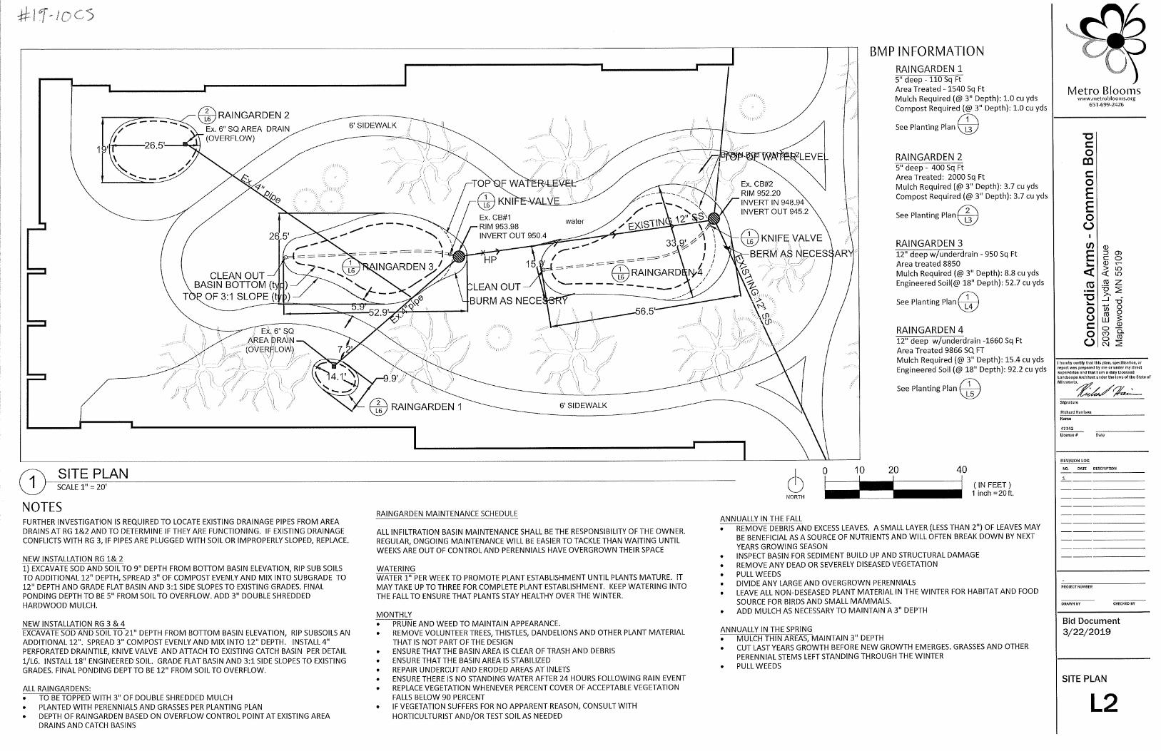

Stewardship Grant Application Summary
Rain Garden(2)
$7,500.00
Staff recommends approval of this application.
This project is located at a home on Lake Emily in Shoreview. The applicant is looking to collect runoff in a series of two rain gardens. The property is situated on a low point in the neighborhood and receives runoff from the surrounding homes, streets, and driveways. The rain gardens will infiltrate and filter the runoff before it runs into Lake Emily. The native plants will increase pollinator habitat around the lake and decrease their need for mowing. The applicant plans to hire the contractor to complete 3-5 years of maintenance after the project is complete. This project is eligible for 75% funding up to $15,000.
Subwatershed:
Lake Emily
BMP type(s):
Grant Request:
Recommendation:
Project Name: Reynen Application Number 19-11 CS
Residential Commercial/Government
Project Overview:
Location Maps:
Applicant Name: Thomas Reynen
Board Meeting Date: 6/5/2019


Stewardship Grant Application Summary
Aquatic Vegetation Harvesting(1)
$8,500.00
Staff recommends approval of this application.
As part of the 2018 Stewardship Grant Program, RWMWD offered 50% cost share funding up to $15,000 for materials and labor associated with harvesting aquatic plants. The City of St. Paul will be contracting mechanical lake weed harvesting services for Eurasian watermilfoil on Lake Phalen. Harvesting will be performed to remove organically-bound phosphorous within the plants and will also enhance recreational access at the boat launch, swimming beach, and fishing access points. Harvesting will occur mid-June and will take one week to complete. The applicant has received an Invasive Aquatic Plant Management Permit from the MnDNR.
Subwatershed:
Lake Phalen
BMP type(s):
Grant Request:
Recommendation:
Project Name: 2019 Lake Phalen Aquatic Vegetation Harvesting Application Number 19-12 CS
Residential Commercial/Government
Project Overview:
Location Maps:
Applicant Name: Adam Robbins
Board Meeting Date: 6/5/2019

(approximately 25 acres)
Lake Phalen2019 Eurasian Watermilfoil Harvest Locations
² 0 1,000 2,000500 Feet

Stewardship Grant Application Summary
Native Habitat Restoration(3)
$8,700.00
Staff recommends approval of this application.
The City of Woodbury is proposing to improve the quality of its native vegetation around stormwater basins located in three parks through ecological restoration and management activities. Restoration of these areas through the addition of native plants will provide benefits such as stabilization of eroding banks, improved water quality, increased pollinator and other wildlife habitat, and increased visual appeal for park users. The contractor will conduct 5 years of maintenance once the initial restoration work is complete.This project is eligible for 50% funding up to $15,000.
Subwatershed:
Carver Lake
BMP type(s):
Grant Request:
Recommendation:
Project Name: Woodbury Stormwater Maintenance Project Application Number 19-13 CS
Residential Commercial/Government
Project Overview:
Location Maps:
Applicant Name: Kristin Seaman
Board Meeting Date: 6/5/2019

Stewardship Grant Program Budget Status Update
June 5, 2019
Commercial, School,
Government, Church, Associations, etc.
Coverage Number of Projects Funds Allocated
Habitat Restoration
50% Cost Share $15,000 Max 2 $8,700
Shoreland Restoration (below 100-year flood elevation
w/actively eroding banks)
100% Cost Share $100,000 Max 1 $200,000
Priority Area Projects
100% Cost Share $100,000 Max
2 $280,000
Non-Priority Area Projects
75% Cost Share $50,000 Max 0 $0
Public Art 50% Cost Share 1 $6,000
Aquatic Veg Harvest 50% Cost Share $15,000 Max 0 $0
Maintenance
50% Cost Share $5,000 Max for 5 Years 14 $13,700
Consultant Fees $187,400
Total Allocated
$718,350
2019 Stewardship Grant Program Budget
Budget $1,250,000 Total Funds Allocated $718,350
Total Available Funds $531,650
Homeowner
Coverage Number of Projects Funds Allocated
Habitat Restoration and rain garden w/o hard surface
drainage
50% Cost Share $15,000 Max 1 $575
Rain garden w/hard surface drainage, pervious pavement,
green roof
75% Cost Share $15,000 Max 1 $2,475
Master Water Steward Project 100% Cost Share $15,000 Max 1 $7,500
Shoreland Restoration 100% Cost Share $15,000 Max 1 $12,000

************ Technical
Memo************

Memorandum
To: Board of Managers and Staff
From: Tina Carstens and Brad Lindaman and Erin Anderson Wenz
Subject: Current Water Levels and Flood Concerns
Date: May 31, 2019
As you know, over the last several years, high water levels have been of great concern to this board and to the district. Increased precipitation trends over the last decade have led to higher groundwater levels and higher surface water levels throughout the District. District staff have been working with the City of Little Canada over the last year to address resident concerns on Twin Lake. As we will describe in the memo below, a sharp increase in water levels at the start of 2019 has continued to elevate those concerns. District staff has spent a considerable amount of time on this issue. Our goal with this memo is to get you all up to speed on the current high water situation, the requests from residents to address the high water levels in a manner different than we have being doing, and talk through the role of the District and how we work with our cities, counties, and neighboring watersheds to address these concerns. I also think it is important for the board to be looking at this from a big picture perspective so we are walking through this topic from the Grass Lake subwatershed to Gervias Lake and ultimately the Mississippi River.
Background
“Landlocked” waterbodies or lakes refer to basins that do not have a piped outlet and where historic water levels have remained below the overflow elevation. Over the past several decades, the water balances for landlocked lakes in RWMWD have either stayed in a relative state of equilibrium where the runoff from the subwatersheds is generally equal to the seepage to groundwater and evaporation to the atmosphere (Twin Lake, West Vadnais Lake) or have been able to fluctuate without affecting homes (Grass Lake). Another water body, Suzanne Pond, is actively controlled by pumping and has been for many years (Shoreview operates a continuous pump station to keep water levels below the low homes adjacent to Suzanne Pond). Snail Lake, also landlocked, has actually been augmented during periods of low water levels. The past several years, however, have tested the upper limit for our “landlocked” waterbodies- according to Minnesota’s State Climatologist Kenny Blumenfeld, the 2010 decade (2010 through 2019) is tracking to be the wettest in Minnesota’s recorded history, and that has certainly affected lake levels in these historically landlocked waterbodies.
As such, conversations about new outlets in all of these areas have occurred regularly over the past few years. The District has carefully considered modifications to landlocked waterbodies, since changes would move more water from upstream areas to downstream areas that are already at risk of flooding habitable structures. Recently, staff have implemented temporary pumping measures in some areas

To: Board of Managers and Staff From: Tina Carstens and Brad Lindaman and Erin Anderson Wenz Subject: Current Water Levels and Flood Concerns Date: May 31, 2019 Page 2
(Wetland A, North Gramsie Pond) and built berms and other conveyance structures to keep Grass Lake and Snail Lake from flooding habitable structures near Suzanne Pond, but these measures have optimized the use of floodplain storage rather than moving more water downstream into known flood prone areas.
This spring, however, West Vadnais Lake levels are continuing to rise and starting to overflow into new areas via drainage paths that have not been used for any significant length of time during RWMWD’s history as a watershed district. In anticipation of this, District staff have been studying the topography between West Vadnais Lake and Twin Lake, in the area near the “triangle” south of Vadnais Boulevard as well as the topography between West Vadnais Lake and East Vadnais Lake.
What is happening?
West Vadnais Lake and Grass Lake are now at higher levels than they have ever been in the past, as a result of another record breaking spring of precipitation (both snow and rain) and the preceding wet years. As the water levels rise, we have been focusing on identifying overflow paths, as these “landlocked” or highly restricted areas are no longer landlocked (or not quite so restricted). Our attention over the last month has been focused on three overflow areas stepping from upstream to downstream: shown in Figure 1 and 2, below.
1. Suzanne Pond (an area that has been of concern for some time now as the lowest inhabited spot in the City of Shoreview),
2. SPRWS property, near their pump station, on a narrow strip of land between West Vadnais Lake and East Vadnais Lake.
3. East of the “triangle” of West Vadnais Lake south of South Vadnais Boulevard. The area is along the border of the western edge of the West Vadnais Lake subwatershed and the Twin Lake Subwatershed.
More detail on all of these areas, and especially in area #3, are covered in greater detail in the sections that follow. All of this information will also be covered at a presentation at the June board meeting to

To: Board of Managers and Staff From: Tina Carstens and Brad Lindaman and Erin Anderson Wenz Subject: Current Water Levels and Flood Concerns Date: May 31, 2019 Page 3
help the managers direct next steps.
Figure 1: Map showing a potential overflow location for Grass Lake into Suzanne Pond, which is surrounded by the Crestview Addition development.
1
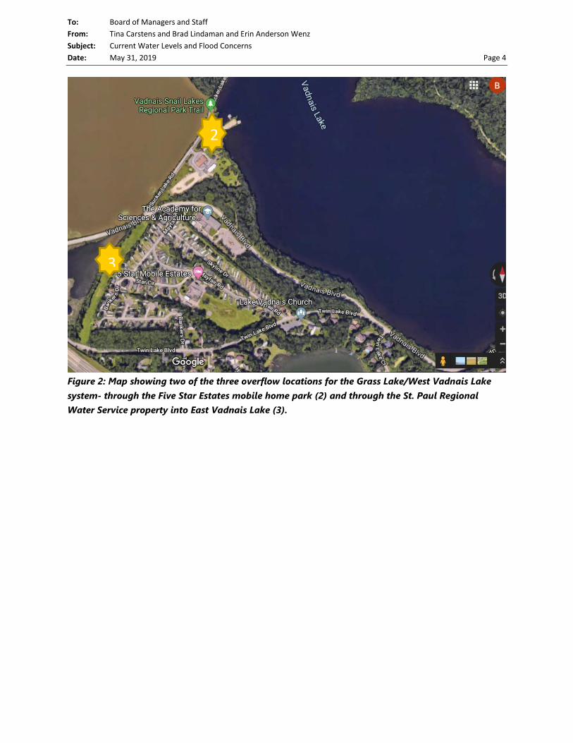
To: Board of Managers and Staff From: Tina Carstens and Brad Lindaman and Erin Anderson Wenz Subject: Current Water Levels and Flood Concerns Date: May 31, 2019 Page 4
Figure 2: Map showing two of the three overflow locations for the Grass Lake/West Vadnais Lake system- through the Five Star Estates mobile home park (2) and through the St. Paul Regional Water Service property into East Vadnais Lake (3).
2
3

To: Board of Managers and Staff From: Tina Carstens and Brad Lindaman and Erin Anderson Wenz Subject: Current Water Levels and Flood Concerns Date: May 31, 2019 Page 5
Figure 3: Map showing the overflow location for Twin Lake, where water from the lake would overflow into the MnDOT storrmwater system at an elevation of 877.0
AREA 1 - Grass Lake to Suzanne Pond area overflow area
Water levels in the Suzanne Pond area are controlled by a pump station that the City of Shoreview monitors regularly. In addition, the City has launched a study to determine whether the pump station should be upgraded given that it is operating under higher water conditions in the surrounding waterbodies than designed for. Also, the City has recently surveyed the topography along Gramsie Road near Suzanne Pond, to better understand if improvements are needed to keep Grass Lake water from traveling across Gramsie Road. Lastly, this period, RWMWD’s contractor completed the rerouting of potential future overflow from Snail Lake (which is not imminent at this time) to flow to Wetland A before it would flow through the “backdoor route” and into the Crestview Addition. All of this work will help to keep the homes in the Crestview Addition protected in the event of even higher Grass Lake levels.
Lastly, we are continuing to pursue the lowering of the 15” outlet pipe under Hwy 694 as a way to build more resiliency in the system for future years by providing more “live” storage in West Vadnais Lake. An EAW for that project is underway in partnership with VLAWMO, as described in the project status report of this month’s board packet.
All of these actions have increased and will continue to increase this resilience of the Suzanne Pond area, even if Grass Lake levels continue to rise. Also, as described in greater detail below, the existence of other
4

To: Board of Managers and Staff From: Tina Carstens and Brad Lindaman and Erin Anderson Wenz Subject: Current Water Levels and Flood Concerns Date: May 31, 2019 Page 6
West Vadnais Lake overflow points will limit just how much higher Grass Lake can rise, as West Vadnais Lake overflows into other waterbodies- Twin Lake and East Vadnais Lake.
AREA 2 - West Vadnais Lake to East Vadnais Lake overflow area
This area was surveyed on May 17. There is an overflow point from West Vadnais Lake to East Vadnais Lake at elevation approximately 885. The District has reached out to SPRWS to ask about this connection and the SPRWS intentions for it going forward.
AREA 3 - West Vadnais Lake to Twin Lake overflow area
District staff sent surveyors to the area on Friday, May 17 to determine the elevation at which West Vadnais Lake would start to overflow into the Twin Lake Subwatershed via a low lying area through the Five Star Estates Mobile Home Park. During the survey, technicians discovered what appeared to be a waterway leading toward the Five Star Estates mobile home park and into a pipe. The survey collected elevations in the SPRWS parcel, the waterway alignment, the invert of a24-inch pipe that collects some of that water, and elevations on roadways within the Five Star Estates development and along Vadnais Boulevard. Staff followed up immediately with questions to the Cities of Little Canada, Vadnais Heights, and SPRWS. The City of Little Canada was able to provide a drawing of a 24-inch pipe likely intended to drain the low-lying SPRWS land west of the mobile home park, keeping water from affecting the homes along the western edge of Five Star Estates. In past years, when West Vadnais Lake’s level has been lower, this pipe drains only the SPRWS land west of the mobile home park that carries local flows from that the mobile home park. In addition, this 24” pipe is connected to the outflows from a lift station in the mobile home park that carries flow from the low area of the mobile home park. Since April of this year, West Vadnais Lake has been at levels higher than the berm, allowing the lake to overflow into the SPRWS parcel, and into the 24-inch pipe which is functioning as a secondary outlet from West Vadnais Lake (West Vadnais Lake water is still also flowing out of the 15” outlet below Hwy 694 and into Gervais Creek).
Water flowing into the 24” pipe from the low lying SPRWS land west of Five Star Estates mobile home park in Vadnais Heights (photo taken by David Vlasin, RWMWD, on Thursday, May 23, 2019).

To: Board of Managers and Staff From: Tina Carstens and Brad Lindaman and Erin Anderson Wenz Subject: Current Water Levels and Flood Concerns Date: May 31, 2019 Page 7
The survey results described below indicate the following important aspects of this area:
Figure *: Aerial photo and map of key features from May 17, 2019 survey.
1. There is a 24” RCP pipe (invert elevation 880.9) that appears to be intended to carry local drainage
from low lying areas on the SPRWS property (yellow star) along the eastern edge of West Vadnais Lake (within the Twin Lake Subwatershed, as we know it) under Five Star Estates and into Twin Lake. This pipe is connected to the small pump station that is in the low lying area (blue star) in the southeastern portion of the mobile home park property. Under more historically typical conditions, this pipe would not convey water from West Vadnais Lake into Twin Lake. Water in West Vadnais Lake has to rise above an elevation of about 884 and overtop a berm on the east side of the lake before entering the low lying areas on SPRWS property. This year, the elevation of West Vadnais Lake has been above 884 since early April. Last year, it never got that high, and in 2017, it only reached that elevation for a short period of time, approximately May 31 – June 13. Only this year has West Vadnais Lake been high enough for long enough to make an appreciable difference in the levels of Twin Lake. Prior to this time, the model results demonstrate that the rise in Twin Lake levels were attributable to runoff from the Twin Lake subwatershed. This year, since early April, the contribution from West Vadnais Lake has added to the rise in Twin Lake levels.

To: Board of Managers and Staff From: Tina Carstens and Brad Lindaman and Erin Anderson Wenz Subject: Current Water Levels and Flood Concerns Date: May 31, 2019 Page 8
This figure shows how the past levels of Twin Lake correspond to the modeled water surface that we estimate for the lake that does not include inflows from West Vadnais Lake. The red dots show measured Twin Lake water surfaces in 2019 that began to sharply increase in April and May, 2019 as a result of the inflow from West Vadnais Lake.
2. If the pipe did not exist, there is still an overflow between West Vadnais Lake and Twin Lake. The May 17, 2019 topographic survey indicates that the overflow elevation is approximately 884.8. As of May 29, 2019 (the time of this writing), the elevation of West Vadnais Lake is 884.4 and water is approaching some of the mobile homes along the western edge of Five Star Estates (though the 24” inch pipe is moving some of that water to Twin Lake, and West Vadnais Lake and the low lying SPRWS area has not yet equilibrated). The City of Vadnais Heights has been notified about this area.

To: Board of Managers and Staff From: Tina Carstens and Brad Lindaman and Erin Anderson Wenz Subject: Current Water Levels and Flood Concerns Date: May 31, 2019 Page 9
Photo showing that water from West Vadnais Lake is close to some of the trailer homes in the Five Star Estates mobile home park, located in Vadnais Heights (photo taken by David Vlasin, RWMWD, on Thursday, May 23, 2019).
3. Our assessment of flood risk to homes in the Twin Lake Subwatershed has changed. In assessing where homes may be low enough to be affected by surficial flooding, we reference LIDAR (Light Detection and Ranging) topographic information. LIDAR is not as accurate as surveying, but is an effective screening tool and is widely available. Homes that are identified as “close” are surveyed. If other homes are requested to be surveyed by the city or home owners, we survey those homes as well. In past screenings of Twin Lake homes (and past follow ups to homes in response to resident concerns), we determined that the lowest entry elevation around the lake (on its north side) was at an elevation of 878. As the water levels continued to rise on May 22, another low lying home was identified as potentially being lower. Survey crews were sent to survey the home on May 24, and determined that the low entry elevation at the house was 876.0 (a foot below the overflow elevation). This information was communicated to the City of Little Canada on Friday, May 24. Sandbagging at the house in anticipation of rising lake levels began on Saturday, May 25 with materials provided by the City of Little Canada. This response is consistent with RWMWD’s approach of helping to guide emergency response activities that member cities initiate.

To: Board of Managers and Staff From: Tina Carstens and Brad Lindaman and Erin Anderson Wenz Subject: Current Water Levels and Flood Concerns Date: May 31, 2019 Page 10
Photo showing where residents and city staff placed ~1,900 sandbags at 154 Twin Lake Boulevard and 253 Twin Lake Trail on Saturday, May 25, 2019 and Tuesday, May 28, 2019. On Friday, May 24, 2019 154 Twin Lake Boulevard was surveyed by RWMWD staff and found to be the home around Twin Lake with the lowest entry elevation of 886.0 (1 foot below the overflow in the MnDOT berm at elevation 887.0). The City of Little Canada provided the materials and placement guidance to the residents.
In addition to the low home at 154 Twin Lake Boulevard, other lake residents (with homes whose low entries are above the overflow elevation 877.0) are very concerned about the prolonged high water levels or water entering basements from waves. However, the RWMWD’s emergency response plans are typically based in comparison to the static water level in the waterbody and do not account for freeboard (space between the low entry and the flood elevation), and they do not address flooding from groundwater.

To: Board of Managers and Staff From: Tina Carstens and Brad Lindaman and Erin Anderson Wenz Subject: Current Water Levels and Flood Concerns Date: May 31, 2019 Page 11
Figure *: 2018 and 2019 water surface elevations in Twin Lake relative to the lowest home entry elevation around the lake. The sharp increase in 2019 is attributable to inflows from West Vadnais Lake from the 24” pipe that carries water under the Five Star Estates Mobile Home Park.

To: Board of Managers and Staff From: Tina Carstens and Brad Lindaman and Erin Anderson Wenz Subject: Current Water Levels and Flood Concerns Date: May 31, 2019 Page 12
Figure *: West Vadnais Lake water surface elevation from 2008-2019 showing that starting in April, 2019, water levels have been consistently high enough to flow over portion of the berm between West Vadnais Lake and the low lying SPRWS property, and into the 24-inch pipe under the Five Star mobile home park.
AREA 4 – Twin Lake Overflow to MnDOT Pond and Gervais Creek System
Twin Lake is already on a path to overtop the MnDOT berm, so staff have been communicating the change in flow to downstream cities (particularly Little Canada). At this point, if West Vadnais Lake reaches an elevation of 884.8 it could start to flow overland through the Five Star Estates Mobile home park. Under this scenario, Twin Lake would continue to receive flow from West Vadnais Lake until West Vadnais Lake level’s recede to below 884 (below the berm between West Vadnais Lake and the low-lying SPRWS property). Twin Lake’s elevation would sit at 877.0 for the foreseeable future, until groundwater levels recede and allow more seepage from the lake to the groundwater. During storm events, Twin Lake would temporarily bounce above 877.0.
History of the Twin Lake Overflow Area
There are a couple documents with information on the elevation of the historic control elevation for Twin Lake. A 1966 plan sheet that was provided by Frank Frattalone, and a 1975 report that Barr prepared for Ramsey County, and a 1993 Hydrologic Study of Twin Lake that Barr Engineering for RWMWD.
The 1966 plan sheet and the 1975 report indicate that before there was the MnDOT berm, according to the report the control elevation for Twin Lake was at or near elevation 874, caused by a high point in County Ditch 16 between Twin Lake and Interstate 694. The 1993 report acknowledges a control

To: Board of Managers and Staff From: Tina Carstens and Brad Lindaman and Erin Anderson Wenz Subject: Current Water Levels and Flood Concerns Date: May 31, 2019 Page 13
elevation of 876.9 (close in elevation to the one we have surveyed for the MnDOT berm in 2019). The control elevation appears to have been changed from 874 to 877 sometime between 1975 and 1993. To date, we have not found a record of the reasons for this change.
The 1975 and the 1993 reports do suggest lowering Twin Lake’s control elevation via an outlet. However, the 2005 Unweave the Weave project changed the outflow path and some of the lake outflow’s control elevations downstream of the MnDOT berm, rendering some of the reports’ recommendations incompatible with current conditions and with more recent hydrologic modeling using Atlas 14 data. The 1993 report did note that any outlet from Twin Lake should include a backflow preventer so that flow from the highway does not backflow into Twin Lake. This recommendation still applies to the current system.
This option, in conjunction with adding compensatory storage in the Phalen chain and an operations plan around Owasso Basin, is being evaluated. Flood risks to those areas are being outlined and consequences and additional risks to those areas are being considered and will be offered for consideration when complete.
What does the RWMWD Watershed Management Plan say about this area?
Section 2.4.3 of the RWMWD’s Watershed Management Plan says the following about Twin Lake (in italics below): In 2015, the District updated their hydrologic and hydraulic models District-wide to reflect updated design precipitation levels published through NOAA’s Atlas 14, as well as more up-to-date topographic information provided through LiDAR. The results of this effort in the Twin Lake subwatershed are the new 100-year flood elevations shown in Figure 2.4-5. The new inundation extents that have been modeled throughout the District are currently being evaluated to determine the level of future flooding risk. During the lifespan of this Watershed Management Plan, the District will be communicating with its member cities about these areas, and in some cases, working to implement flood control projects to mitigate the flooding from future 100-year storm events. Under normal hydrologic conditions, Twin Lake remains landlocked. The predicted 100-year flood level for Twin Lake is 873.8 feet. If regular discharge from Vadnais Lake is expected in the future, the District may consider installing an additional culvert through an existing dike that guards the entrance to the I-694 culvert to allow increased capacity from Twin Lake at a lower elevation. Another option may be to pump water from Twin Lake to lower the risk of potential flooding. A permit from MNDOT would be required before an additional culvert could be placed. If RWMWD should decide to proceed with installing an additional culvert, the District will discuss the work with MNDOT before applying for a permit. It should be noted that since the 2017 plan was published, recent statistical work performed to update the 100-year flood level on Twin Lake sets the historical 100-year elevation slightly higher than 873.8 feet. Also, it should be noted that the Plan also mentions the importance of evaluating the impacts of any potential Twin Lake changes on the Gervais Creek system (which includes the areas of flooding concern described above).

To: Board of Managers and Staff From: Tina Carstens and Brad Lindaman and Erin Anderson Wenz Subject: Current Water Levels and Flood Concerns Date: May 31, 2019 Page 14
Downstream flooding concerns
Residents have understandably been asking for a release of water from Twin Lake to ease their flooding concerns. However, there are existing downstream flooding concerns that warrant reflection before taking any action at Twin Lake.
Northstar Estates, shown below, has a history of flooding under intense rainfall events even without additional flow from Twin Lake. Staff have resisted requests to allow more water through West Vadnais Lake’s 15” pipe under Hwy 694 for years for this very reason. (note- this request has also been denied in the past because no habitable structures have been at imminent risk of flooding in the Grass Lake area and there have been other means to protect low lying residential areas in the short term).
Photo of Owasso basin. The photo is taken from the North Star Estates development looking north towards Owasso Basin. Photograph was taken after the July 16, 2011 rainfall event.

To: Board of Managers and Staff From: Tina Carstens and Brad Lindaman and Erin Anderson Wenz Subject: Current Water Levels and Flood Concerns Date: May 31, 2019 Page 15
Figure *: Potentially affected homes within the North Star Estates mobile home park across a range of modeled storm events (without the influence of any future outflows from Twin Lake).

To: Board of Managers and Staff From: Tina Carstens and Brad Lindaman and Erin Anderson Wenz Subject: Current Water Levels and Flood Concerns Date: May 31, 2019 Page 16
When studying the figure above, note that the impacted structures are additive. For example, that the homes marked in dark blue are also affected during the 10-year, 5.03 inch storm along with the homes marked in yellow. This figure shows that any hastened or changed outflows from Twin Lake would need to be accompanied by an operations plan that would allow those flows to be shut off in the event of an incoming storm event. This would be necessary to allow storms to pass through the Owasso Basin area without the competition for capacity from Twin Lake outflows. The outflow would need to be closed before the storm event, and then opened after the storm event passes through Owasso Basin. If not, our actions could make flood conditions worse in this already flood prone area. Note that the elevations estimated for these homes was taken from LiDAR data, and not survey data.
In a meeting with the City of Little Canada on Thursday, May 30, this figure was shared with Little Canada staff to help them plan for any mitigation measures for the North Star Estates going forward, either with or without additional flows from Twin Lake. District staff will be in close communication with the City in the coming months and will continue to provide informational assistance as needed.
We refer to the North Star Estates area’s flooding problem as one that is “rate driven”, meaning that flooding in this area is driven by short, but intense storm events, that can’t leave the basin fast enough, as opposed to being driven by large volumes that accumulate and pool for long periods of time.
Further downstream, however, in Gervais Lake, there is a “volume driven” flooding problem as runoff from thousands of acres of land drain through the Phalen Chain of Lakes and ultimately to the Mississippi River. There are four homes that have been identified as being at risk of flooding along the shoreline of Gervais Lake. The location of these homes is shown in the figure below.

To: Board of Managers and Staff From: Tina Carstens and Brad Lindaman and Erin Anderson Wenz Subject: Current Water Levels and Flood Concerns Date: May 31, 2019 Page 17
Figure *: Location of flood prone homes on Gervais Lake. RWMWD has prepared an emergency response plan that advises the City of Little Canada on what could be done in the event of a flood emergency on Gervais Lake.

To: Board of Managers and Staff From: Tina Carstens and Brad Lindaman and Erin Anderson Wenz Subject: Current Water Levels and Flood Concerns Date: May 31, 2019 Page 18
Figure * shows recent (March 1 through May 29, 2019 water elevations at the Keller Lake weir (which reflects elevations in Gervais Lake). During this period, water has always been above the weir elevation of 858. The homes and elevations shown in the figure are those for which the District has prepared an emergency response plan because the low entry elevation of each home (shown in the figure) is below the 100-year, 96-hour storm peak elevation in Gervais Lake.
What has RWMWD staff been doing in response to all of this?
Staff has been actively providing information to the Cities of Little Canada (homes surrounding Twin Lake), Vadnais Heights (Five Star Mobile Home Park), the St. Paul Regional Water Service (connection point between West and East Vadnais Lakes) as well asMnDOT (overflow berm on Twin Lake) to help guide sandbagging and other property protection strategies. This information includes: model results that estimate future lake levels, low home and critical area surveys in requested areas and lake level monitoring multiple times per week. Staff have made it clear to all of these entities that RWMWD can be leveraged as a resource for this information into the future. This is consistent with how District staff have been directed to approach emergency response situations in the past.

To: Board of Managers and Staff From: Tina Carstens and Brad Lindaman and Erin Anderson Wenz Subject: Current Water Levels and Flood Concerns Date: May 31, 2019 Page 19
In addition, staff are concerned that a potential overflow from Twin Lake may erode the crest, cutting down the berm to a lower elevation and carrying sediment downstream. District staff will be meeting with MnDOT staff on Friday, May 31 to discuss their thoughts on how to allow water overflowing from Twin Lake to flow safely over the berm without significantly eroding it.
Flood Management Considerations for Landlocked Areas
We have not made recommendations that change the system to convey more water towards flood-prone areas downstream since that would increase the risk to those homes that are already in the 100-year flood plain and subject to an emergency response measures should a large storm event occur. However, water levels in some areas have now reached historic highs and are now defining new overflow paths that are likely to convey flood waters downstream even without changes to the system.
In the past, the Board’s approach to emergency response plan efforts in non-landlocked areas (Gervais, Tanners and Owasso Lakes), has been to keep the District’s role as one of an advisor, providing information and guidance to cities who implement emergency responses.
There is, perhaps, something inherently different about emergency response planning in non land-locked lakes. In Gervais Lake, Lake Owasso and Tanners Lake (three of the other lakes in the RWMWD with emergency response plans) the 100-year, 96-hour storm event (the design event that the RWMWD uses to assess risk) poses a flood risk to several homes on a temporary basis. Water in these areas will rise up during the storm event, and then will recede. Sometimes that recession will take days, sometimes weeks, but it is reasonable to expect that they system will recover in a relatively short time period. In Twin Lake however, once water reaches the 877 elevation, we cannot rely on seepage to groundwater to draw the water back down, and lake levels would remain high for an extended period. 2019 is our third year of greatly reduced seepage rates in this area, and though we expect that to change at some point, we can’t necessarily expect that to happen soon.
If the low home’s low entry elevation was above the overflow elevation plus the 100-year, 96-hour storm peak (as we thought until recently), we could advise residents to simply coordinate with the City of Little Canada to sandbag against wave action, monitor their sump pumps (or install some if there didn’t have them already), and wait for the lake to recede. The recent realization that the low home’s low entry elevation is below the overflow elevation, potentially changes the approach. In a relatively short time, water will overflow Twin Lake’s MnDOT berm, and the water level will be above the low home elevation of 876.
How does the Beltline Resiliency Study fit in? The purpose of the Beltline Resiliency Study currently underway is to evaluate the feasibility of actively managing outlet structures and/or modifying the stormwater system (e.g., culvert diameter, overflow elevation, etc.) to reduce flood risk in flood-prone areas during the 100-year 4-day rainfall event. This project will allow the RWMWD to identify potential system-wide strategies for mitigating flood-risk within the portion of the District tributary to the Beltline. This is a long term strategy that may be able to

To: Board of Managers and Staff From: Tina Carstens and Brad Lindaman and Erin Anderson Wenz Subject: Current Water Levels and Flood Concerns Date: May 31, 2019 Page 20
accommodate some changes to the Twin Lake outflow as long as a management strategy for flood protection of Owasso Basin is included, and compensatory storage is provided downstream on the Phalen Chain of Lakes so as not to increase flood risk on Gervais Lake. However, this is not an approach that can be pursued in the short term to alleviate current high water levels. Rather, this study aims to manage flood issues in many areas of the RWMWD:
• Owasso Basin and Gervais Creek • Willow Lake and Kohlman Creek • Keller Lake and Lake Phalen • Lake Owasso • Beaver Lake • Beltline Storm Sewer
Other management options:
Many other options have been suggested, and staff have been working to evaluate many of them. While there is currently a very strong request to let water out of Twin Lake to relieve high water levels, intervening in the situation has potential consequences (including legal ones) that cannot be overlooked and must be understood and discussed before any action is taken. In the meantime, staff are diligently watching the situation, communicating with its partners, and trying to predict various what-if scenarios concerning various management strategies both in the short and long term.
At the June Board meeting, staff will present the options that have been considered and will explain why options that increase rate and/or volume downstream, increasing the flood risk to existing flood prone properties must be approached with extreme caution and with official approval from the affected cities and MnDOT.

************ Action Items
************

Request for Board Action
Board Meeting Date: June 5, 2019 Agenda Item No.: 9A Preparer: Tina Carstens, Administrator Nicole Soderholm, Permit Coordinator Item Description: Accept the submittal of the 2018 MS4 Storm Water Pollution Prevention
Plan (SWPPP) Annual Report and receive public comments. Background: All MS4s are required to complete an annual report and submit to the MPCA, by June 30 of each year, which details the implementation status of their approved MS4 permit program. The District SWPPP and the Annual Report are available on the District web site. I have also attached the annual report to this memo for your review. The MS4 permit requires that we give the public an opportunity to comment on the annual report and SWPPP program. A notice about the opportunity to comment at this meeting was posted at the District office and on the website. At the June 5th Board meeting, any members of the public that wish to comment on the SWPPP may during this agenda item. Applicable District Goal and Action Item: Goal: Manage organization effectively – Operate in a manner that achieves the District’s mission while adhering to its core principles.
Action Items: Follow all legal requirements applicable to watershed districts.
Staff Recommendation: Accept the 2018 MS4 Annual Report. Financial Implications: None. Board Action Requested: Accept the 2018 MS4 Annual Report and authorize District Administrator to submit the report to the MPCA.

https://www.pca.state.mn.us • 651-296-6300 • 800-657-3864 • Use your preferred relay service • Available in alternative formats wq-strm4-06a • 1/30/19 Page 1 of 10
MS4 question worksheet for 2018 annual report
Municipal Separate Storm Sewer Systems (MS4s) Reporting period January 1, 2018 to December 31, 2018
Due June 30, 2019
Copy of questions – Not for submittal
Instructions: This form is for your personal use only. Complete the online Annual Report to provide a summary of your activities under the 2013 MS4 Permit (Permit) between January 1, 2018, and December 31, 2018. The online Annual Report and additional information can be found on the Minnesota Pollution Control Agency (MPCA) website at: https://stormwater.pca.state.mn.us/index.php?title=MS4_Annual_Report.
Questions: Contact Cole Landgraf ([email protected], 651-757-2880)
Contact information
MS4 General contact information
Full name: Tina Carstens Title: Administrator
Mailing address: 2665 Noel Drive
City: Little Canada State: MN Zip code: 55117
Phone: 651-792-7960 Email: [email protected]
Preparer contact information (if different from the MS4 General contact)
Full name: Nicole Soderholm Title: Permit Coordinator
Mailing address: 2665 Noel Drive
City: Little Canada State: MN Zip code: 55117
Phone: 651-792-7976 Email: [email protected]
Minimum Control Measure (MCM) 1: Public education and outreach
The following questions refer to Part III.D.1. of the Permit.
2. Did you select a stormwater-related issue of high priority to be emphasized during this Permit term? [Part III.D.1.a.(1)]
Yes No
3. If ‘Yes’ in Q2, what is your stormwater-related issue(s)? Check all that apply. Total Maximum Daily Loads (TMDLs) Local businesses Residential best management practices (BMPs) Pet waste Yard waste Deicing materials Household chemicals Construction activities Post-construction activities
Other (describe): Storm drain pollution
4. Have you distributed educational materials or equivalent outreach to the public focused on illicit discharge recognition and reporting? [Part III.D.1.a.(2)]
Yes No
5. Do you have an implementation plan as required by the Permit? [Part III.D.1.b.] Yes No

https://www.pca.state.mn.us • 651-296-6300 • 800-657-3864 • Use your preferred relay service • Available in alternative formats wq-strm4-06a • 1/30/19 Page 2 of 10
6. How did you distribute educational materials or equivalent outreach? [Part III.D.1.a.] Check all that apply in table below.
7. For the items checked in Q6 below, who is the intended audience? Check all that apply in table below.
8. For the items checked in Q6 below, enter the total circulation/audience in table below (if unknown, use best estimate).
Q6. How did you distribute educational materials? (Check all that apply):
Q7. Intended audience? (Check all that apply.) Q8. Total circulation /audience: Residents
Local businesses Developers Students Employees Other
Brochure 600 Newsletter
1,995 (subscribers)
Utility bill insert Newspaper ad Radio ad Television ad Cable access channel Stormwater-related event 3,500
School presentation or project 1,500
Website 52,000 Other (1): describe Facebook
729 (followers)
Other (2): describe Instagram
331 (followers)
Other (3): describe Twitter
952 (followers)
For Q9 and Q10, provide a brief description of each activity related to public education and outreach (e.g., rain garden workshop, school presentation, public works open house) held and the date each activity was held from January 1, 2018, to December 31, 2018. [Part III.D.1.c.(4)]
9. Date of activity in table below 10. Description of activity in table below
Q9. Date of activity Q10. Description of activity
1/9, 1/18, 1/23, 2/12, 2/20, 2/28, 3/20, 10/9, 10/13
Master Water Stewards: classes, tours, education, community outreach, capstone projects related to stormwater management, BMPs, water quality, conservation
Throughout 2018
73 school field trips and outdoor lessons, 78 school presentations at 17 schools with 34 teachers and 73 classes
2/13 Phalen Freeze Fest: outreach about smart salting and WaterFest promotion
5/1 Adopt-a-Drain outreach campaign: students and Master Water Stewards distributed 1,600 doorhangers to residents in the Beaver Lake neighborhood, St. Paul
Additional dates/activities:
Feb-Apr: Adopt-a-Drain planning meetings, St. Paul Feb-Jul: Stonecrest HOA rain garden trainings and tours, Woodbury 5/8: Alternative Turf and Bee Lawn training for 50 Master Gardeners and Master Water Stewards Jun: Storm drain clean-up in Beaver Lake neighborhood, St. Paul: 80 4th graders and Master Water Stewards 4/11: Level 2 Smart Salting training for city/county staff and private contractors 10/11: Level 1 Smart Salting training for city/county staff 3/6: Snail Lake Improvement District meeting, Shoreview 5/22: Roseville Public Works, Environment, and Transportation Commission meeting: Bennett Lake TMDL 4/28: Invasive species management at Tamarack Nature Preserve, Woodbury 6/2: WaterFest event at Lake Phalen 6/12: East Side Area Business Association (ESABA) meeting: BMP opportunities, St. Paul 6/14: ESABA monthly meeting: RWMWD Stewardship Grant Program, St. Paul 6/27: District 2 community outreach potluck: BMPs, St. Paul

https://www.pca.state.mn.us • 651-296-6300 • 800-657-3864 • Use your preferred relay service • Available in alternative formats wq-strm4-06a • 1/30/19 Page 3 of 10
6/27: Willow Pond Spent Lime Project Open House, Roseville Aug-Sep: Minnesota State Fair Blue Thumb exhibit in Eco Experience building 10/15: Maplewood Environment and Natural Resource Commission meeting: Wakefield Park rain gardens 10/17: Maplewood Parks Commission meeting: Wakefield Park rain gardens 11/20: North Park HOA, St. Paul: rain gardens overview May: Clean Water Grant rain garden maintenance: Weaver Elementary, Woodbury Elementary, Maplewood Middle School, Harmony Learning Center, Roseville Middle School, Central Park Elementary (400 students total) 4/28: Tamarack Nature Preserve cleanup, Woodbury 12/2: Woodbury Winter Carnival: Smart Salting exhibit Throughout 2018: Newsletter/blog posts: Grass Lake/Snail Lake drainage improvements, Master Water Stewards program, Tamarack Preserve nature center, smart salting, Grass Lake berm construction, Wakefield spent lime filter, Willow Pond spent lime filter, WaterFest recap, common carp management on Owasso chain of lakes, Keller Creek habitat restoration, Shallow Lakes video, Twin Lake water levels, Stewardship Grant Program, Vadnais-Snail Lake habitat restoration Educational video premiere: "Getting to Know Shallow Lakes" Local press: Maplewood Living Connections, Shoreview Press, Lillie News, BWSR newsletter, MPR News
11. Between January 1, 2018, and December 31, 2018, did you modify your BMPs, measurable goals, or future plans for your public education and outreach program? [Part IV.B.]
Yes No
If ‘Yes,’ describe these modifications:
MCM 2: Public participation/involvement The following questions refer to Part III.D.2.a. of the Permit.
12. You must provide a minimum of one opportunity each year for the public to provide input on the adequacy of your Stormwater Pollution Prevention Program (SWPPP). Did you provide this opportunity between January 1, 2018, and December 31, 2018? [Part III.D.2.a.(1)]
Yes No
13. If ‘Yes’ in Q12, what was the opportunity that you provided? Check all that apply.
Public meeting Public event Other
Yes No
14. If ‘Public meeting’ in Q13, did you hold a stand-alone meeting or combine it with another event?
Stand-alone Combined
Enter the date of the public meeting: 6/6/18
Enter the number of citizens that attended and were informed about your SWPPP: 0
15. If ‘Public event’ in Q13, describe:
Enter the date (mm/dd/yyyy) of the public meeting:
Enter the number of citizens that attended and were informed about your SWPPP:
16. If ‘Other’ in Q13, describe:
Notices were posted on the District's website and public bulletin board at the District office regarding availability of the Annual Report for review.
Enter the date (mm/dd/yyyy) of the public meeting: N/A
Enter the number of citizens that attended and were informed about your SWPPP: Unknown
17. Between January 1, 2018, and December 31, 2018, did you receive any input regarding your SWPPP? Yes No

https://www.pca.state.mn.us • 651-296-6300 • 800-657-3864 • Use your preferred relay service • Available in alternative formats wq-strm4-06a • 1/30/19 Page 4 of 10
If ‘Yes,’ enter the total number of individuals or organizations that provided comments on your SWPPP.
18. If ‘Yes’ in Q17, did you modify your SWPPP as a result of written input received? [Part III.D.2.b.(2)]
If ‘Yes,’ describe those modifications.
Yes No
19. Between January 1, 2018, and December 31, 2018, did you modify your BMPs, measurable goals, or future plans for your public participation/involvement program? [Part IV.B.]
If ‘Yes,’ describe those modifications.
Yes No
MCM 3: Illicit discharge detection and elimination
The following questions refer to Part III.D.3. of the Permit.
20. Do you have a regulatory mechanism which prohibits non-stormwater discharges to your MS4? [Part III.D.3.b.]
Yes No
21. Did you identify any illicit discharges between January 1, 2018, and December 31, 2018? [Part III.D.3.h.(4)]
Yes No
22. If ‘Yes’ in Q21, enter the number of illicit discharges detected. 2
23. If ‘Yes’ in Q21, how did you discover these illicit discharges? Check all that apply and enter the number of illicit discharges discovered by each category.
Public complaint Staff
24. If ‘Public complaint’ in Q23, enter the number discovered by the public: 2
25. If ‘Staff’ in Q23, enter the number discovered by staff: 0
26. If ‘Yes’ in Q21, did any of the discovered illicit discharges result in an enforcement action (this includes verbal warnings)?
Yes No
27. If ‘Yes’ in Q26, what type of enforcement action(s) was taken and how many of each action were issued between January 1, 2018, and December 31, 2018? Check all that apply. For each of the below checked, enter the number that were issued.
Verbal warning: 1 Notice of violation: Fine: Criminal action: Civil penalty: Other: describe
Request for additional documentation: photos of spill and clean-up, map of spill location/extent, confirmation of duty officer notification, summary of corrective actions.
Yes No
28. If ‘Yes’ in Q26, did the enforcement action(s) taken sufficiently address the illicit discharge(s)? Yes No
29. If ‘No’ in Q28, why was the enforcement not sufficient to address the illicit discharge(s)?
30. Do you have written Enforcement Response Procedures (ERPs) to compel compliance with your illicit discharge regulatory mechanism(s)? [Part III.B.]
Yes No
31. Between January 1, 2018 and December 31, 2018, did you train all field staff in illicit discharge recognition (including conditions which could cause illicit discharges) and reporting illicit discharges for further investigations? [Part III.D.3.e.]
Yes No

https://www.pca.state.mn.us • 651-296-6300 • 800-657-3864 • Use your preferred relay service • Available in alternative formats wq-strm4-06a • 1/30/19 Page 5 of 10
32. If ‘Yes’ in Q31, how did you train your field staff? Check all that apply.
Email PowerPoint Presentation Video Field training Other: describe
The following questions refer to Part III.C.1. of the Permit.
33. Did you update your storm sewer system map between January 1, 2018, and December 31, 2018? [Part III.C.1.]
Yes No
34. Does your storm sewer map include all pipes 12 inches or greater in diameter and the direction of stormwater flow in those pipes? [Part III.C.1.a.]
Yes No
35. Does your storm sewer map include outfalls, including a unique identification (ID) number and an associated geographic coordinate? [Part III.C.1.b.]
Yes No
36. Does your storm sewer map include all structural stormwater BMPs that are part of your MS4? [Part III.C.1.c.]
Yes No
37. Does your storm sewer map include all receiving waters? [Part III.C.1.d.] Yes No
38. In what format is your storm sewer map available:
Hardcopy only GIS CAD Other: describe
39. Between January 1, 2018, and December 31, 2018, did you modify your BMPs, measurable goals, or future plans for your illicit discharge detection and elimination program? [Part IV.B.]
If ‘Yes,’ describe those modifications.
In the past, IDDE training has been completed in the field with specific personnel. In 2018, we also showed an educational video on IDDE for the entire staff, including seasonal employees, as part of the District's annual safety/ employee Right-to-Know training.
Yes No
MCM 4: Construction site stormwater runoff control
The following questions refer to Part III.D.4. of the Permit 40. Do you have a regulatory mechanism that is at least as stringent as the Agency’s general permit to
Discharge Stormwater Associated with Construction Activity (CSW Permit) No. Minn. R. 100001 (http://www.pca.state.mn.us/index.php/view-document.html?gid=18984) for erosion and sediment controls and waste controls? [Part III.D.4.a.] (Permit can be found on the MPCA website at https://www.pca.state.mn.us/water/construction-stormwater (titled ‘Minnesota NPDES/SDS Construction Stormwater General Permit’).
Yes No
41. Have you developed written procedures for site plan reviews as required by the Permit? [Part III.D.4.b.] Yes No
42. Have you documented each site plan review as required by the Permit? [Part III.D.4.f.] Yes No
43. Enter the number of site plan reviews conducted for sites an acre or greater between January 1, 2018, and December 31, 2018. 29
44. What types of enforcement actions do you have available to compel compliance with your regulatory mechanism? Check all that apply and enter the number of each used from January 1, 2018, to December 31, 2018.
Verbal warning, Number that were issued: 1 Notice of violation, Number that were issued: 64 Administrative order, Number that were issued: Stop-work order, Number that were issued: 0 Fine, Number that were issued: Forfeit of security of bond money: 26

https://www.pca.state.mn.us • 651-296-6300 • 800-657-3864 • Use your preferred relay service • Available in alternative formats wq-strm4-06a • 1/30/19 Page 6 of 10
Withholding of certificate of occupancy Criminal action, Number that were issued: Civil penalty, Number that were issued: 0 Other: describe. , Number that were issued:
45. Do you have written ERPs to compel compliance with your construction site stormwater runoff control regulatory mechanism(s)? [Part III.B.]
Yes No
46. Enter the number of active construction sites an acre or greater that were in your jurisdiction between January 1, 2018, and December 31, 2018: 51
47. Do you have written procedures for identifying priority sites? [Part III.D.4.d.(1)] Yes No
48. If ‘Yes,’ in Q47, How are sites prioritized? Check all that apply. Site topography Soil characteristics Types of receiving water(s) Stage of construction Compliance history Weather conditions Citizen complaints Project size Other: describe
49. Do you have a checklist or other written means to document site inspections when determining compliance? [Part III.D.4.d.(4)]
Yes No
50. Enter the number of site inspections conducted for sites an acre or greater between January 1, 2018, and December 31, 2018. 316
51.
Enter the frequency at which site inspections are conducted (e.g., daily, weekly, monthly). [Part III.D.4.d.(2)]
Weekly, monthly, or seasonally depending on project stage and priority
52. Enter the number of trained inspectors that were available for construction site inspections between January 1, 2018, and December 31, 2018. 3
53. Provide the contact information for the inspector(s) and/or organization that conducts construction stormwater inspections for your MS4. List your primary construction stormwater contact first if you have multiple inspectors.
(1) Inspector name: Organization: Nicole Soderholm, Ramsey-Washington Metro Watershed District Phone (office): 651-792-7976 Phone (work cell): Email: [email protected] Preferred contact method: Phone or e-mail
(2) Inspector name: Organization: Anna Beining, Ramsey-Washington Metro Watershed District Phone (office): Phone (work cell): Email: Preferred contact method: N/A (seasonal employee, no longer at RWMWD)
(3) Inspector name: Organization: Paige Ahlborg, Ramsey-Washington Metro Watershed District Phone (office): 651-792-7964 Phone (work cell): Email: [email protected]

https://www.pca.state.mn.us • 651-296-6300 • 800-657-3864 • Use your preferred relay service • Available in alternative formats wq-strm4-06a • 1/30/19 Page 7 of 10
Preferred contact method: Phone or e-mail
54. What training did inspectors receive? Check all that apply. University of Minnesota Erosion and Stormwater Management Certification Program Qualified Compliance Inspector of Stormwater (QCIS) Minnesota Laborers Training Center Stormwater Pollution Prevention Plan Installer or Supervisor Minnesota Utility Contractors Association Erosion Control Training Certified Professional in Erosion and Sediment Control (CPESC) Certified Professional in Stormwater Quality (CPSWQ) Certified Erosion Sediment and Storm Water Inspector (CESSWI) Other: describe
55. Between January 1, 2018, and December 31, 2018, did you modify your BMPs, measurable goals, or future plans for your construction site stormwater runoff control program? [Part IV.B.]
If ‘Yes,’ describe those modifications:
We proposed draft permit rule changes: We updated definitions, permit procedural requirements, and added language regarding dewatering, temporary sediment basins, and construction waste storage/containment to achieve consistency with MS4 and CSW permits. Expected adoption of proposed rule changes will occur in 2019.
Yes No
MCM 5: Post-construction stormwater management in new development and redevelopment
The following questions refer to Part III.D.5. of the Permit. 56. Do you have a regulatory mechanism which meets all requirements as specified in Part III.D.5.a. of the
Permit? Yes No
57. What approach are you using to meet the performance standard for Volume, Total Suspended Solids (TSS), and Total Phosphorus (TP) as required by the permit? [Part III.D.5.a.(2)] Check all that apply. Refer to the Technical Support Document at http://www.pca.state.mn.us/index.php/view-document.html?gid=17815 for guidance on stormwater management approaches. The TSD can be found on the MPCA website at https://www.pca.state.mn.us/water/municipal-stormwater-ms4 (refer to the Post Construction Stormwater Management section under the ‘Guidance and BMPs’ tab).
Retain a runoff volume equal to one inch times the area of the proposed increase of impervious surfaces on-site Retain the post-construction runoff volume on site for the 95th percentile storm Match the pre-development runoff conditions Adopt the Minimal Impact Design Standards An approach has not been selected Other method (Must be technically defensible - e.g., based on modeling, research and acceptable engineering practices)
If ‘Other method,’ describe: Retain a volume of 1.1" times the area of the new and reconstructed impervious surfaces onsite. All stormwater BMPs require pretreatment method(s) for TSS removal.
58. Do you have written ERPs to compel compliance with your post-construction stormwater management regulatory mechanism(s)? [Part III.B.]
Yes No
59. Between January 1, 2018, and December 31, 2018, did you modify your BMPs, measurable goals, or future plans for your post-construction stormwater management program? [Part IV.B.]
If ‘Yes,’ describe those modifications.
We proposed draft permit rule changes: We updated definitions and revised language for clarification regarding freeboard and drawdown requirements. We increased the runoff cap to a BMP to 2.5", prohibited infiltration where there are specific physical limitations to be consistent with CSW permit, added BMP O&M submittal requirements, and increased fees for volume reduction alternative compliance. Expected adoption of proposed rule changes will occur in 2019 and 2020.
Yes No
MCM 6: Pollution prevention/good housekeeping for municipal operations
The following questions refer to Part III.D.6. of the Permit.
60. Enter the total number of structural stormwater BMPs, outfalls (excluding underground outfalls), and

https://www.pca.state.mn.us • 651-296-6300 • 800-657-3864 • Use your preferred relay service • Available in alternative formats wq-strm4-06a • 1/30/19 Page 8 of 10
ponds within your MS4 (exclude privately owned). Enter the number for each category below:
Structural stormwater BMPs: 10
Outfalls: 16
Ponds: 20
61. Enter the total number of structural stormwater BMPs, outfalls (excluding underground outfalls), and ponds that were inspected from January 1, 2018 to December 31, 2018 within your MS4 (exclude privately owned) [Part III.D.6.e.]. Enter the number for each category below:
Structural stormwater BMPs: 10
Outfalls: 16
Ponds: 20
62. Have you developed an alternative inspection frequency for any structural stormwater BMPs, as allowed in Part III.D.6.e.(1) of the Permit?
Yes No
63. Based on inspection findings, did you conduct any maintenance on any structural stormwater BMPs? [Part III.D.6.e.(1)]
Yes No
64. If ‘Yes’ in Q63, briefly describe the maintenance that was conducted:
Removed 15 cubic yards (cy) of sediment from 57 sumps at Maplewood Mall, removed 1 cy of sediment from Battle Creek sump, removed 1 cy of sediment from Owasso low flow sump, removed 1 cy of sediment from Tanners Lake alum plant, removed 1 cy of sediment from ABI Pond sump, removed 1 cy of sediment from PCU Target Pond sump, removed 75 cy of sediment from Lower Afton Road sediment trap, removed 150 cy of sediment from Tanners Lake Boat Ramp Pond, removed 145 cy of sediment from 5th Street wetlands, removed 55 cy of sediment and cleaned pavers at PFS Basins, removed 90 cy of sediment from Owasso/County Drive, removed debris from Battle Creek Ravine pipe, removed 6,700 cy of sediment from Grass Lake wetland, cleaned 580 ft of permeable weirs at Tanners wetland/Horseshoe Park, cleaned 120 ft of permeable weirs at 5th Street wetlands, cleaned 630 ft of drain tile at Hills and Dales, repaired Maplewood Mall South catch basin and curb, unblocked pipe at Battle Creek Lower Ravine stormwater inlet
65. Do you own or operate any stockpiles, and/or storage and material handling areas? [Part III.D.6.e.(3)] Yes No
66. If ‘Yes’ in Q65, did you inspect all stockpiles and storage and material handling areas quarterly? [Part III.D.6.e.(3)]
Yes No
67. If ‘Yes’ in Q66, based on inspection findings, did you conduct maintenance at any of the stockpiles and/or storage and material handling areas?
Yes No
68. If ‘Yes’ in Q67, briefly describe the maintenance that was conducted:
69. Between January 1, 2018, and December 31, 2018, did you modify your BMPs, measurable goals, or future plans for your pollution prevention/good housekeeping for municipal operations program? [Part IV.B.]
If ‘Yes,’ describe those modifications:
Yes No
Discharges to impaired waters with a EPA-approved TMDL that includes an applicable WLA If you have been assigned a Waste Load Allocation (WLA) in a TMDL that was approved by the U.S. Environmental Protection Agency (EPA) prior to August 1, 2013, and were not meeting WLA(s) at the time of your permit application, you must complete the TMDL Annual Report Form, available on the MPCA website at: https://stormwater.pca.state.mn.us/index.php?title=Download_page_with_TMDL_forms. Attach your completed TMDL Annual Report Form to the actual Annual Report as instructed within that document. [Part III.E.]
71. [question left blank for you to attach a file]
Alum or Ferric Chloride Phosphorus Treatment Systems The following questions refer to Part III.F.3.a. of the Permit. Provide the information below as it pertains to your alum or ferric chloride phosphorus treatment system.
72. Date(s) of operation:

https://www.pca.state.mn.us • 651-296-6300 • 800-657-3864 • Use your preferred relay service • Available in alternative formats wq-strm4-06a • 1/30/19 Page 9 of 10
Month Date(s) of operation (mm/dd/yyyy – mm/dd/yyyy)
January N/A
February N/A
March N/A
April 04/24/2018-04/30/2018
May 05/01/2018-05/31/2018
June 06/01/2018-06/30/2018
July 07/01/2018-07/13/2018
August N/A
September N/A
October N/A
November N/A
December N/A
Month
Q73 Chemical(s) used for treatment
Q74 Gallons of alum or ferric chloride treatment
Q75 Gallons of water treated
Q76 Calculated pounds of phosphorus removed
January None 0 0 0
February None 0 0 0
March None 0 0 0
April Alum 1,840 12,949,900 7.56
May Alum 3,500 25,678,100 48.52
June Alum 2,010 29,479,400 49.02
July Alum 260 10,352,200 19.22
August None 0 0 0
September None 0 0 0
October None 0 0 0
November None 0 0 0
December None 0 0 0
77. Any performance issues and corrective action(s), including date(s) when corrective action(s) were taken, between January 1, 2018, and December 31, 2018:
On 6/18/18, the pH probe at the outlet of the floc pond lost calibration and shut down the plant. Staff attempted to recalibrate the probe in Jun-Jul of 2018 but problems persisted. On 7/13/18 the plant was shut down for the remainder of the year until a new pH probe could be installed. The predicted installation date is 6/1/19..
Partnerships
78. Did you rely on any other regulated MS4s to satisfy one or more permit requirements? Yes No
79. If ‘Yes’ in Q78, describe the agreements you have with other regulated MS4s and which permit requirements the other regulated MS4s help satisfy: [Part IV.B.6.]
Additional information If you would like to provide any additional files to accompany your Annual Report, use the space below to upload those files. For each space, you may attach one file.

https://www.pca.state.mn.us • 651-296-6300 • 800-657-3864 • Use your preferred relay service • Available in alternative formats wq-strm4-06a • 1/30/19 Page 10 of 10
80. [Optional space for you to attach a file] 81. [Optional space for you to attach a file] 82. [Optional space for you to attach a file] 83. Optional, describe the file(s) uploaded: A final alum plant data report compiled by Barr Engineering will be included in the final MS4 annual report submittal.
Owner or Operator Certification
The person with overall administrative responsibility for SWPPP implementation and permit compliance must certify this MS4 Annual Report. This person must be duly authorized and should be either a principal executive (i.e., Director of Public Works, City Administrator) or ranking elected official (i.e., Mayor, Township Supervisor).
Yes - I certify under penalty of law that this document and all attachments were prepared under my direction or supervision in accordance with a system designed to assure that qualified personnel properly gathered and evaluated the information submitted. Based on my inquiry of the person or persons who manage the system, or those persons directly responsible for gathering the information, the information submitted is, to the best of my knowledge and belief, true, accurate, and complete (Minn. R. 7001.0070). I am aware that there are significant penalties for submitting false information, including the possibility of fine and imprisonment (Minn. R. 7001.0540).
By typing my name in the following space, I certify the above statements to be true and correct, to the best of my knowledge, and that information can be used for the purpose of processing my MS4 Annual Report.
Name of certifying official: The certifying official must electronically sign the online Annual Report form. .
Title: Administrator Date: (mm/dd/yyyy)
Note: In the online form, you will be prompted to provide the email(s) of the individual(s) you would like to receive the MS4 Annual Report for 2018 submittal confirmation email from the MPCA. After you submit the form, please allow up to three business days to receive this confirmation email.
Email (1) [email protected]
Email (2) [email protected]
Email (3)

Annual Report Prepared for the Ramsey Washington Metro Watershed District for Submittal to the Minnesota Pollution Control Agency to Fulfill the Reporting Requirements for the Tanners Alum Treatment Facility permitted under the General NPDES/SDS Permit for Municipal Separate Storm Sewer Systems, Permit MNR040000 Barr Engineering Co. May 2019

1
1.0 Report Overview
Discharge from the Tanner’s Lake Alum Treatment Facility is permitted under the Ramsey Washington Metro Watershed District (RWMWD) Municipal Separate Storm Sewer Systems (MS4) permit which is covered by the Minnesota Pollution Control Agency (MPCA) Small MS4 General Permit MNR040000. Submission of an annual report is required by the MS4 permit. Included in this 2018 annual report are:
• Operation details including volume of water treated, gallons of alum used, and average alum dose.
• Summaries of data collected from the inflow to the facility and outflow from the facility (i.e., floc pond discharge),
• Phosphorus load removed by the alum treatment facility, estimated from FLUX modeling,
• Lake data from Tanner’s Lake, and
• Summary of 2018 sludge management activities (none in 2018).
2.0 Operation in 2018
In 2018, the Tanner’s alum treatment facility operated for a total of 69 days (April 24 through June 18, June 20 through July 2, and July 11 through July 13). The alum treatment facility began operation on April 24, but was shut down on June 18 due to a low pH measurement (i.e., low pH measurement triggered an automatic shutdown of the treatment facility). An assessment of the pH probe for the alum treatment facility determined that the pH probe was malfunctioning. Hence, the pH probe was changed and calibrated on June 20. The alum treatment facility was then turned back on. Continued problems with the facility pH measurements were documented during June 20 through July 2 including a very high pH that seemed unreasonable, fluctuating pH during a period when a stable pH was expected, a stable pH during a storm when pH changes were expected due to the pH impacts of storm runoff, and differences between manual pH measurements at the treatment facility outlet and pH measurements by the alum treatment facility pH probe. The alum treatment facility was shut down on July 2 to resolve these documented pH issues. Actions taken on July 3 included cleaning wires and installing new waterproof caps. The treatment facility remained shut down for a week while pH measurements were observed to verify they were reliable. Because all measurements during this observation period seemed reliable, the treatment facility was turned back on July 11. On July 13, the treatment facility automatically shut down because of a low pH measurement. To fully resolve the pH issues at the alum treatment facility, RWMWD sought the assistance of a contractor. Unfortunately, the contractors contacted by RWMWD did not have availability to complete the work in 2018 causing the alum treatment facility to remain shut down for the rest of the 2018 treatment season.

2
Total water flows treated by the Tanners alum treatment facility in 2018 were 78,459,600 gallons. Total alum application in 2018 was 7,610 gallons. The average aluminum dose applied in 2018 was 5.63 mg/L Al.
3.0 Tabular Summary of 2018 In-Stream Data
Data collected from permitted monitoring points SW001 (upstream of treatment plant), and SD002 (discharge from floc pond) during April 24 through July 13, 2018 are summarized in Tables 1 and 2.
The 2018 data collected from permitted monitoring points SW001 and SD002 have been electronically submitted to the MPCA in EQUIS format.
Table 1 Water Quality Data Summary: Upstream Inflow to the Alum Treatment Facility (SW001)
Date Sample
Aluminum (µg/L) Phosphorus (mg/L)
pH (SU) Chloride (mg/L) Total Dissolved Total Dissolved Ortho
4/27/2018 Grab 59.6 <10 0.097 0.0085 7.48
5/3/2018 Grab 146 19.2 0.16 0.0099 7.57
5/10/2018 Storm 31.6 0.61 0.0078 7.95 212
5/15/2018 Grab 19.1 <10 0.13 0.014 7.55
5/23/2018 Grab 263 <10 0.27 0.0095 7.80
5/30/2018 Grab 164 <10 0.21 0.039 0.072 7.72
6/5/2018 Grab 48.1 10.6 0.23 0.011 0.028 7.75
6/13/2018 Grab 10.0* 0.25 0.017 0.029 8.00
6/22/2018 Grab 25.9 0.40 0.086 0.039 7.74
6/29/2018 Grab 19.7* 0.23 0.062 0.036 7.99
7/2/2018 Storm 22.3 0.32 0.03 0.024 7.95
7/12/2018 Grab 180 10.4* 0.24 0.036 0.036 7.64
*Estimated concentration above the adjusted method detection limit and below the adjusted reporting limit.

1
Table 2 Water Quality Data Summary: Discharge from Floc Removal Basin (SD002)
Date Sample
Aluminum (µg/L) Phosphorus (mg/L)
pH (SU)
Total Suspended
Solids (mg/L)
Chloride (mg/L) Total Dissolved Total Dissolved
Ortho
4/27/2018 Grab 2,010 28.8 0.027 0.0025* 6.88
5/3/2018 Grab 1,900 52.8 0.033 <0.002 7.33
5/10/2018 Storm 72.1 0.039 0.0028 7.71 11.1 206
5/15/2018 Grab 906 72.8 0.025 0.0057 7.31
5/23/2018 Grab 1,200 82.5 0.031 <0.005 7.43
5/30/2018 Grab 2,710 89.9 0.12 0.0053 0.0065 7.22
6/5/2018 Grab 1,170 68.2 0.046 <0.005 0.04 7.44
6/13/2018 Grab 63.1 0.038 <0.005 <0.002 7.50 7.5
6/22/2018 Grab 34.1 0.18 0.072 0.027 7.98
6/29/2018 Grab 78.8 0.049 <0.005 <0.01 7.45
7/2/2018 Storm 86.9 0.055 <0.005 0.0051 7.54
7/12/2018 Grab 814 157 0.06 0.0065 0.0076 7.60
* Estimated concentration above the adjusted method detection limit and below the adjusted reporting limit.

2
4.0 Graphical Summary of 2018 In-Stream Data and Compare 2018 Data with Previous Years
Figures 1 through 7 present 2018 data in graphical format and compare it with data collected in previous years. The data collection location for the outflow has varied between the floc pond outflow (1998-2003 and 2007-2018) and the 7th Street wetland outflow (2004-2006). The historical graphs in this report only present the outflow data from the floc pond, the outflow specified in the MS4 permit. Inflow and outflow total aluminum data are presented in Figure 1. Inflow and outflow dissolved aluminum data are presented in Figure 2. Inflow and outflow total phosphorus data are presented in Figure 3. Inflow and outflow dissolved phosphorus data are presented in Figure 4. Dissolved phosphorus during 2008 through 2017 was measured as ortho phosphorus. During 2018, dissolved phosphorus was measured as ortho phosphorus during May 3 and May 10 and as dissolved phosphorus during all other 2018 monitoring events. Inflow and outflow pH data are presented in Figure 5. The MS4 permit does not require monitoring for total suspended solids or chlorides. However, on May 10, the outflow was monitored for total suspended solids and the inflow and outflow was monitored for chlorides. Outflow total suspended solids data are presented in Figure 6. Inflow and outflow chloride data are presented in Figure 7.
Figure 1. 1998-2018 Total Aluminum in Tanners Floc Pond Inflow and Outflow

3
Figure 2. 1998-2018 Dissolved Aluminum in Tanners Floc Pond Inflow and Outflow

4
Figure 3. 1998-2016 Total Phosphorus in Tanners Floc Pond Inflow and Outflow
Figure 3. 1998-2018 Total Phosphorus in Tanners Floc Pond Inflow and Outflow

5
Figure 4. 2008-2018 Dissolved Phosphorus in Tanners Floc Pond Inflow and Outflow

6
Figure 5. 2012-2018 pH of Tanners Floc Pond Inflow and Outflow

7
Figure 6. 2012-2018 Total Suspended Solids in Tanners Floc Pond Outflow

8
Figure 7. 2013-2018 Chloride in Tanners Floc Pond Inflow and Outflow
5.0 2018 Phosphorus Removal by Treatment Facility: FLUX Modeling
Total and dissolved phosphorus removal by the Tanner’s Alum Treatment Facility during 2018 were estimated from FLUX modeling of inflow and outflow phosphorus load during the period of facility operation (i.e., April 24 through July 13). Continuous flow data together with inflow and outflow total and dissolved phosphorus data were input into the FLUX model to determine phosphorus load. Model results are presented in Table 3. Table 3 also presents the FLUX model results for 2012 through 2017.
In 2018, the estimated inflow total phosphorus load during the period of facility operation was 182 pounds. The treatment facility removed an estimated 129 pounds of total phosphorus. Hence, on average, 71 percent of the total phosphorus load entering the treatment facility during the 2018 period of operation was removed by alum treatment.
The alum treatment facility operated for a shorter period of time than previous years and the 2018 inflow total phosphorus load (182 pounds) was lower than loads observed in 2014 through 2017 (350 to 514 pounds). Despite the short season of operation, the 2018 inflow total phosphorus load (182 pounds) was greater than loads estimated for 2012 and 2013 (151 to 158

9
pounds). The 2018 total phosphorus removal rate (71 percent) was near the low end of the range of removal rates observed during 2012 through 2017 (70 to 89 percent) (Table 3).
In 2018, the estimated inflow dissolved phosphorus load during the period of facility operation was 23 pounds and the treatment facility removed an estimated 13 pounds of dissolved phosphorus. Hence, on average, 59 percent of the dissolved phosphorus load entering the treatment facility was removed by alum treatment (Table 3). The 2018 dissolved phosphorus removal rate was the lowest observed to date and compares with removal rates of 70 percent to 92 percent in previous years (Table 3).
Monthly inflow and outflow total phosphorus loads estimated by FLUX are shown in Figure 8 and monthly inflow and outflow dissolved phosphorus loads are shown in Figure 9.
Table 3. Tanners Alum Treatment Facility: 2012-2018 Phosphorus Removal Estimated from FLUX Modeling
Year Parameter Inflow
Mass (lbs) Outflow
Mass (lbs)
Phosphorus Removed
(lbs)
Phosphorus Removal
(%)
2012 Total Phosphorus 151 21 130 86
Dissolved Phosphorus (Ortho) 13 2 11 82
2013 Total Phosphorus 158 43 115 73
Dissolved Phosphorus (Ortho) 35 4 32 89
2014 Total Phosphorus 350 106 244 70
Dissolved Phosphorus (Ortho) 34.6 8.3 26.3 76
2015 Total Phosphorus 514 77 437 85
Dissolved Phosphorus (Ortho) 19 6 13 70
2016 Total Phosphorus 509 57 452 89
Dissolved Phosphorus (Ortho) 34 5 29 85
2017 Total Phosphorus 405 51 354 87
Dissolved Phosphorus (Ortho) 25 2 23 92
2018
Total Phosphorus 182 52 129 71 Dissolved Phosphorus
(Dissolved and Ortho*)
23 9 13 59
*Ortho phosphorus was measured on 5/3/2018 and 5/10/2018 and dissolved phosphorus was measured on all other 2018 sample dates.
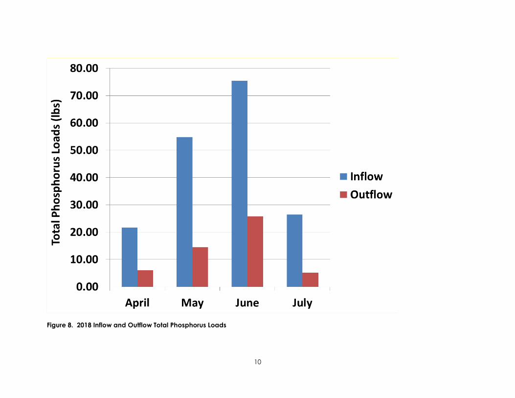
10
Figure 8. 2018 Inflow and Outflow Total Phosphorus Loads

11
Figure 9. 2018 Inflow and Outflow Dissolved Phosphorus Loads

12
A monthly summary of gallons of water treated, gallons of alum applied during treatment, and pounds of phosphorus removed during the April through July operation period for the Tanners alum treatment facility in 2018 is shown in Table 4.
Table 4. Tanners Alum Treatment Facility: Summary of Gallons of Water Treated, Gallons of Alum Applied during Treatment, and Calculated Pounds of Total and Dissolved Phosphorus Removed during the 2018 Operation Period*
Month
Q73 Chemical used for treatment
Q74 Gallons of
alum or ferric chloride
treatment
Q75 Gallons of water treated
Q76 Calculated pounds of total phosphorus removed
Calculated pounds of dissolved phosphorus removed
January * 0 0 0 0 February * 0 0 0 0 March * 0 0 0 0 April Alum 1,840 12,949,900 15.70 1.12 May Alum 3,500 25,678,100 40.20 3.87 June Alum 2,010 29,479,400 49.69 6.00 July Alum 260 10,352,200 21.23 2.57 August * 0 0 0 0 September * 0 0 0 0 October * 0 0 0 0 November * 0 0 0 0 December * 0 0 0 0
*The 2018 treatment facility operation period was April 24 through June 18, June 20 through July 2, and July 11 through July 13.
6.0 Compare 2018 Tanner’s Lake Data with Previous Years
The Tanner’s Lake alum treatment facility was constructed to remove phosphorus from the major inflow to Tanner’s Lake and improve the lake’s water quality. As shown in Figure 10, water quality in Tanner’s Lake has improved substantially since the alum treatment facility began operation in 1998. The data indicate phosphorus removed annually by the alum treatment facility maintains the improved water quality. In 1997, prior to alum treatment facility operation, the lake’s summer average (June through September) Secchi disc transparency, total phosphorus concentration, and chlorophyll a concentrations were 2.1 meters, 50 µg/L and 13.0 µg/L. In 2018, the lake’s summer average (June through September) Secchi disc transparency, total phosphorus concentration, and chlorophyll a concentration were 3.2 meters, 18 µg/L, and 6.2 µg/L, respectively. The data indicate that since 1997, the alum treatment facility operation has reduced Tanners Lake total phosphorus and chlorophyll a concentrations by more than half and increased Secchi disc transparency by 52 percent (Figure 10).

13
Figure 10. 1997-2018 Tanner’s Lake Average Summer (June-September) Total Phosphorus and Chlorophyll a Concentrations and Secchi Disc Transparency
In 2018, the alum treatment facility operated during April 24 through June 18, June 20 through July 2, and July 11 through July 13. Untreated water entered Tanners Lake when the alum treatment facility was not operating. Very little precipitation occurred during the latter half of July and precipitation in August was below normal (i.e., 2.83 inches of precipitation in August which was 1.47 inches below normal) (Figure 11). During this period, very little untreated water entered Tanners Lake and the water quality of the lake remained stable. September was a very wet month – 6.87 inches of rainfall (Figure 11) which was 3.79 inches above normal. The large volume of untreated water entering Tanners Lake in September caused lake water quality to decline. Epilimnetic total phosphorus concentration increased from 16 µg/L to 23 µg/L, epilimnetic chlorophyll a concentration increased from 4.0 µg/L to 12.4 µg/L and Secchi disc transparency declined from 3.4 meters to 2.2 meters (Figure 12). The September data show the lake is sensitive to increased phosphorus loading and accentuates the value of the phosphorus removal provided by the alum treatment facility when it is operating.

14
Figure 11. 2018 Monthly Precipitation Totals for Twin Cities during March through September (Data source: https://www.dnr.state.mn.us/climate/historical/lcd.html)

15
Figure 12. 2018 Tanner’s Lake Total Phosphorus and Chlorophyll a Concentrations and Secchi Disc Transparency
7.0 Sludge Removal Activities Occurring in 2018
Because the floc pond was cleaned out in the fall of 2017 and the alum treatment facility only operated for 69 days in 2018, there was no need for sludge removal in 2018.

Request for Board Action
Board Meeting Date: June 5, 2019 Agenda Item No.: 9B Preparer: Tina Carstens, Administrator Nicole Soderholm, Permit Coordinator Item Description: District Rule Amendment Approval Background: The District, in collaboration with Capitol Region Watershed District, has been going through the process of an amendment to the permit rules. The rule amendment process included a technical advisory meeting, an informal review period, an official comment period, and a public hearing held on April 3, 2019. No comments were received at the public hearing. During the official comment period, six comment letters were received and are summarized in the enclosed document. As a result of the formal comments, definitions were modified for clarification, and references to the Minnesota Stormwater Manual was added to the infiltration section of Rule C. None of the other comments resulted in changes to the rules. Attached you will find the proposed amended rules for your approval, most of which would be effective immediately. In order to provide budgeting flexibility, staff are proposing the increases in the Stormwater Impact Fund contribution and linear cost cap to go into effect Jan 1, 2020. Applicable District Goal and Action Item: Goal: Manage organization effectively – Operate in a manner that achieves the District’s mission while adhering to its core principles.
Action Item: Implement, track, and update the District’s permitting program, including periodic updates to the District’s rules, as necessary.
Staff Recommendation: Approve the attached rule revisions and resolution #19-01. Financial Implications: None. Board Action Requested: Approve the rule revision and resolution #19-01.

RESOLUTION 19-01
RESOLUTION ADOPTING WATERSHED MANAGEMENT RULES
WHEREAS, The Ramsey-Washington Metro Watershed District (hereinafter “District)” is a political subdivision of the State of Minnesota established under the Minnesota Watershed Law, Minnesota Statute 103D; and
WHEREAS, Minnesota Statute section 103D.341 mandates that the District adopt rules to accomplish the purposes of the Minnesota Watershed Law and to implement the powers of the Board of Managers; and WHEREAS, the District has submitted proposed rule revisions to the Board of Managers for review and comment; and
WHEREAS, the proposed rule revisions have been noticed for review and comment to all public transportation authorities as well as each municipality within the District for at least 45 days; and WHEREAS, the proposed rule revisions have been noticed for public comment and hearing in legal newspapers generally circulated within the District once a week for two successive weeks;
THEREFORE, BE IT RESOLVED by the Ramsey-Washington Metro Watershed District that the rules are adopted by the Board of Managers;
BE IT FURTHER RESOLVED that the adopted rules shall be filed with the county recorder of each county affected by the watershed district; BE IT FURTHER RESOLVED that the adopted rules shall be provided to public transportation authorities that have jurisdiction within the watershed district and to each municipality affected by the watershed district.
Adopted by the Board of Managers of the Ramsey-Washington Metro Watershed District this 5th day of June, 2019.
____________________________________ Marj Ebensteiner, President Attest: ________________________________ Dr. Pam Skinner, Secretary

RWMWD Rule 06/05/2019 1
Ramsey-Washington Metro Watershed District Rules
Adopted 09/06/2006 Revised 06/05/2019
Table of Contents Certification of Rules 2 General Policy Statement 2 Relationship to Municipalities 3 Rule A. Definitions 3 Rule B. Permit Procedural Requirements 10 Rule C. Stormwater Management 12 Rule D. Flood Control 20 Rule E. Wetland Management 23 Rule F. Erosion and Sediment Control 28 Rule G. Illicit Discharge and Connection 31 Rule H. Enforcement 36 Rule I. Variances 37 Rule J. Severability 38

RWMWD Rule 06/05/2019 2
Certification of Rules I, Pamela Skinner, Secretary of the Ramsey-Washington Metro Watershed District Board of Managers, certify that the attached is a true and correct copy of the Rules of the Ramsey-Washington Metro Watershed District having been properly adopted by the Board of Managers of the Ramsey-Washington Metro Watershed District. Dated: June 5, 2019
General Policy Statement The Ramsey-Washington Metro Watershed District (District) is a political subdivision of the State of Minnesota, established under the Minnesota Watershed Law, Minnesota State Statute 103d. The District is also a watershed management organization as defined under the Minnesota Metropolitan Water Management Program and is subject to its directives and authorizations. Under the Watershed Law and the Metropolitan Water Management Program, the District exercises a series of powers to accomplish its statutory purposes. The District's general statutory purpose as stated in 103d.201 is to conserve the natural resources of the state by land use planning, flood control, and other conservation projects by using sound scientific principles for the protection of the public health and welfare and the provident use of the natural resources.
As required under the Metropolitan Water Management Program, the District has adopted a Watershed Management Plan, which contains the framework and guiding principles for the District in carrying out its statutory purposes. It is the District's intent to implement the Plan's goals and policies in these rules. Land alteration affects the rate, volume, and quality of surface water runoff which ultimately must be accommodated by the existing surface water systems within the District. The watershed is 65 square miles and highly urbanized. Land alteration and urbanization has and can continue to degrade the quality of runoff entering the waterbodies of the District due to non-point source pollution. Sedimentation from ongoing erosion processes and construction activities can reduce the hydraulic capacity of waterbodies and degrade water quality. Water quality problems already exist in all the lakes and other water resources throughout the District. The Mississippi River is the principal receiving water for all runoff from the District and is listed by the Environmental Protection Agency (EPA) and Minnesota Pollution Control Agency (MPCA) as “impaired”. Projects that do not address the increased rate or volume of stormwater runoff from urban development can aggravate existing flooding and water quality problems and contribute to or create new ones. Projects which fill floodplain or wetland areas without compensatory storage can aggravate existing flooding by reducing flood storage and hydraulic capacity of waterbodies, and can degrade water quality by eliminating the filtering capacity of those areas. In these rules the District seeks to protect the public health and welfare and the natural resources of the District by providing reasonable regulation of the District's lands and waters: 1) to reduce the severity and frequency of flooding and high water; 2) to preserve floodplain and wetland storage capacity; 3) to improve the chemical, physical and

RWMWD Rule 06/05/2019 3
biological quality of surface water; 4) to reduce sedimentation; 5) to preserve waterbodies' hydraulic and navigational capacity; 6) to preserve natural wetland and shoreland features; and 7) to minimize future public expenditures to avoid or correct these problems.
Relationship of Ramsey-Washington Metro Watershed District to Municipalities The District recognizes that the primary control and determination of appropriate land use is the responsibility of the municipalities. Accordingly, the District will coordinate permit application reviews involving land development with the municipality where the land is located. The District intends to be active in the regulatory process to ensure that water resources are managed in accordance with District goals and policies. The District intends to begin implementing these rules effective June 5, 2019. All developments that do not have municipal approval on or before June 5, 2019 will require a District permit under these rules. Municipalities have the option of assuming a more active role in the permitting process after the adoption of a local water management plan approved by the District, and by adopting and implementing local ordinances consistent with the approved plan. The District will also review projects sponsored or undertaken by municipalities and other governmental units, and will require permits in accordance with these rules for governmental projects which have an impact on water resources of the District. These projects include but are not limited to: land development, road, trail, and utility construction and reconstruction. The District desires to serve as technical advisor to the municipalities in their preparation of local surface water management plans and the review of individual development proposals prior to investment of significant public or private funds. To promote a coordinated review process between the District and the municipalities, the District encourages the municipalities to involve the District early in the planning process.
Rule A: DEFINITIONS For the purposes of these rules, unless the context otherwise requires, the following words and terms have the meanings set forth below. References in these Rules to specific sections of the Minnesota Statutes or Rules include any amendments, revisions or recodification of such sections. References in these Rules to manuals, plans, rules, assessments, modeling methods, technical guidance or District policies shall include any revisions or amendments. The words “shall” and “must” are mandatory; the word “may” is permissive. Adjacent- An area of land that has a common boundary or edge with a water resource or development.

RWMWD Rule 06/05/2019 4
Alteration or Alter- When used in connection with public waters or wetlands, any activity that will change or diminish the course, current, or cross-section of public waters or wetlands. Applicant- Any person or political subdivision that submits an application to the District for a permit under these Rules. Atlas 14- National Oceanic and Atmospheric Administration’s (NOAA) precipitation event frequency and magnitude estimates (replaces TP-40). Banking Credits- Volume reduction in excess of the standard for use on subsequent projects unable to meet the standard onsite. Beltline Interceptor- That portion of the Beltline Storm Sewer that is owned and operated by the District. Best Management Practices (BMPs)- Measures taken to minimize negative effects on the environment including those documented in the Minnesota Stormwater Manual. Board or Board of Managers- The Board of Managers of the Ramsey-Washington Metro Watershed District. Clean Water Act- The Federal Water Pollution Control Act (33 U.S.C. § 1251 et seq.), and any subsequent amendments thereto. Common Plan of Development or Sale- A contiguous area where multiple separate and distinct land disturbing activities may be taking place at different times, on different schedules, but under one proposed plan. One plan is broadly defined to include design, permit application, advertisement or physical demarcation indicating that land disturbing activities may occur. Compensatory Storage- Excavated volume of material below the floodplain elevation required to offset floodplain fill. Criteria- Specific details, methods and specifications that apply to all permits and reviews and that guide implementation of the District's goals and policies. Critical Duration Storm Event- Storm duration that produces the largest peak discharge rates within a channel or storm sewer system and the highest water surface elevation within a water body. Development- Any land disturbance, redevelopment affecting land, or creation/replacement of impervious surface, including but not limited to, road and/or parking lot construction or reconstruction. District- The Ramsey-Washington Metro Watershed District established under the Minnesota Watershed Law, Minnesota Statutes Chapter 103D.

RWMWD Rule 06/05/2019 5
Drainage Way- All water conveyance systems including but not limited to storm sewers, ditches, culverts, and open channels. Erosion- The wearing away of the ground surface as a result of wind, flowing water, ice movement, or land disturbance. Erosion and Sediment Control Plan- A plan of BMPs or equivalent measures designed to control runoff and erosion and to retain or control sediment on land during the period of land disturbance in accordance with the standards set forth in these Rules. Excavation- The artificial displacement or removal of soil or other material. Fill- The deposit of soil or other earth materials by artificial means. Floodplain- The area adjoining a watercourse or natural or man-made water body, including the area around lakes, marshes, and lowlands, that is inundated during a 100-year flood. Freeboard- The vertical distance between the regulatory high water elevation calculated by hydrologic modeling and the regulatory elevation on a structure or roadway. Gross Pollutants- Larger particles of litter, vegetative debris, floatable debris, and coarse sediments in stormwater runoff. Habitable- Any enclosed space usable for living or business purposes, which includes but is not limited to: working, sleeping, eating, cooking, recreation, office, office storage, or any combination thereof. An area used only for storage incidental to a residential use is not included in the definition of "Habitable." Hazardous Materials- Any material, including any substance, waste, or combination thereof, which because of its quantity, concentration, or physical, chemical, or infectious characteristics may cause, or significantly contribute to, a substantial present or potential hazard to human health, safety, property, or the environment when improperly treated, stored, transported, disposed of, or otherwise managed. Illicit Connection- An illicit connection is defined as either of the following:
1. Any drain or conveyance, whether on the surface or subsurface, which allows an illegal discharge to enter the storm drain system, including but not limited to: any conveyances which allow any non-stormwater discharge including sewage, process wastewater, and wash water to enter the storm drain system and any connections to the storm drain system from indoor drains and sinks, regardless of whether said drain or connection had been previously allowed, permitted, or approved by a political subdivision; or
2. Any drain or conveyance connected from a commercial or industrial land use to the storm drain system that has not been documented in plans, maps, or equivalent records and approved by a political subdivision.
Illicit Discharge- Any direct or indirect non-stormwater discharge to the storm drain system, except as exempted in Paragraph 5 of Rule G in these Rules.

RWMWD Rule 06/05/2019 6
Impaired Waters- A waterbody that does not meet water quality standards and designated uses because of pollutant(s), pollution, or unknown causes of impairment. Impervious Surface- A surface compacted or covered with material so as to be highly resistant to infiltration by runoff. Impervious surface shall include roads, driveways and parking areas, sidewalks or trails greater than three feet wide, whether or not paved, patios, tennis and basketball courts, swimming pools, buildings with roofs, covered decks and other structures. Infiltration- A stormwater retention method for the purpose of reducing the volume of stormwater runoff by transmitting a flow of water into the ground through the earth’s surface. Infiltration Area- An area set aside or constructed where stormwater from impervious surface runoff is treated and disposed of into the soil by percolation and filtration, and includes but is not limited to: infiltration basins, infiltration trenches, dry wells, underground infiltration systems, and permeable pavement. Iron-Enhanced Sand- Any Best Management Practices (BMPs) that incorporate filtration media mixed with iron to remove dissolved phosphorus from stormwater. Land Disturbance- Any activity on a property that results in a change or alteration in the existing ground cover (both vegetative and non-vegetative) and/or the existing soil topography. Land disturbing activities include but are not limited to: development, redevelopment, demolition, construction, reconstruction, clearing, grading, filling, stockpiling, excavation, and borrow pits. Routine vegetation management and pavement milling/overlay activities that do not disturb the material beneath the pavement base will not be considered land disturbance (see example below). In addition, in-kind catch basin and pipe repair/replacement done in conjunction with a mill/overlay project shall not be considered land disturbance.
Pavement Example:
Linear Project- Roads, trails, and sidewalks that are not part of a common plan of development or sale.

RWMWD Rule 06/05/2019 7
Low Floor- The floor of the lowest enclosed area including the basement. An unfinished or flood-resistant enclosure, used solely for parking of vehicles, building access, or storage in an area other than a basement area shall not be considered a building’s lowest floor. Low Opening- The elevation of the lowest hydraulically connected entry point to a structure such as a door or window. Municipal Separate Storm Sewer System (MS4)- The conveyance or system of conveyances (including roads with drainage systems, municipal streets, catch basins, curbs, gutter, ditches, man-made channels, or storm drains):
1. Owned and operated by a state, city, town, borough, county, parish, district, association, or other public body (created by or pursuant to state law) having jurisdiction over disposal of sewage, industrial wastes, stormwater, or other wastes, including special districts under state law such as a sewer district, flood control district or drainage district, or similar entity, or an Indian tribe or an authorized Indian organization, or a designated and approved management Agency under section 208 of the Clean Water Act (33 U.S.C § 1288) that discharges to waters of the United States;
2. Designed or used for collecting or conveying stormwater; 3. Which is not a combined sewer; and 4. Which is not part of a Publicly Owned Treatment Works (POTW) as defined at 40
CFR § 122.2. Municipality- Any city wholly or partly within the Ramsey-Washington Metro Watershed District. National Pollutant Discharge Elimination System (NPDES) Stormwater Discharge Permit- A permit issued by the Minnesota Pollution Control Agency that authorizes the discharge of pollutants to waters of the State. Non-Point Source Pollution- Pollution that enters a water body from diffuse origins in the watershed and does not result from discernable, confined, or discrete conveyances. Non-Stormwater Discharge- Any discharge to the storm drain system that is not composed entirely of stormwater. NURP- Nationwide Urban Runoff Program developed by the EPA to study stormwater runoff from urban development. Ordinary High Water Level (OHW)- The elevation delineating the highest water level which has been maintained for a sufficient period of time to leave evidence upon the landscape. The ordinary high water level is commonly the point where the natural vegetation changes from predominantly aquatic to predominantly terrestrial. For watercourses, the OHW level is the elevation of the top of the bank of the channel. For Public Waters and Public Waters Wetlands, the Minnesota Department of Natural Resources (DNR) determines the OHW. Owner- A person or entity who has legal title to a parcel of land or a purchaser under a contract for deed.

RWMWD Rule 06/05/2019 8
Parcel- A parcel of land designated by plat, metes and bounds, registered land survey, auditor’s subdivision, or other acceptable means and separated from other parcels or portions by its designation. Permittee- The person or political subdivision in whose name a permit is issued pursuant to these Rules. Person- Any individual, trustee, partnership, unincorporated association, limited liability company or corporation. Political Subdivision- A municipality, county, or other political division, agency, or subdivision of the state. Pollutant- Anything which causes or contributes to pollution. Pollutants may include but are not limited to: paints, varnishes, and solvents; oil and other automotive fluids; non-hazardous liquid and solid wastes; yard wastes; refuse, rubbish, garbage, litter, or other discarded or abandoned objects, ordinances and accumulations; floatables; pesticides, herbicides, and fertilizers; hazardous substances and wastes; sewage, fecal coliform and pathogens; dissolved and particulate metals; animal wastes; wastes and residues that result from constructing a building or structure; and noxious or offensive matter of any kind. Potential Stormwater Hotspots (PSHs)- Commercial, industrial, institutional, municipal, or transportation-related operations that may produce higher levels of stormwater pollutants and/or present a higher potential risk for spills, leaks, or illicit discharges. PSHs may include, but are not limited to: gas stations, petroleum wholesalers, vehicle maintenance and repair facilities, auto recyclers, recycling centers and scrap yards, landfills, solid waste facilities, wastewater treatment plants, airports, railroad stations and associated maintenance facilities, and highway maintenance facilities. Public Waters- Any waters as defined in Minnesota Statutes Section 103G.005, Subdivision 15. Public Water Wetlands- Any wetlands as defined in Minnesota Statutes Section 103G.005, Subdivision 15a. River Dependent- An activity or land use that relies on direct access to or use of the Mississippi River. Runoff- Rainfall, snowmelt, or irrigation water flowing over the ground surface. Seasonal High Groundwater- The highest seasonal elevation in the ground that has soil voids that fill with water. Sediment- Soil or other surficial material transported by surface water as a product of erosion. Sedimentation- The process or action of depositing sediment.

RWMWD Rule 06/05/2019 9
Sequencing Flexibility- Deviation from the standard sequencing process as described in MN Rule 8420.0520, Subp. 7a. Sewage- Waste produced by, including but not limited to: toilets, bathing, laundry, culinary operations, or the floor drains associated with these sources. Standards- A preferred or desired level of quantity, quality, or value. Storm Drain System- Publicly-owned facilities by which stormwater is collected and/or conveyed, including but not limited to: roads with drainage systems, municipal streets, gutters, curbs, inlets, piped storm drains, pumping facilities, retention and detention basins, natural and human-made or altered drainage channels, reservoirs, and other drainage structures. Stormwater- Any surface flow, runoff, or drainage consisting entirely of water from any form of natural precipitation and resulting from such precipitation. Stormwater Management Plan- A plan for the permanent management and control of runoff prepared and implemented in accordance with the standards set forth in these Rules. Stormwater Pollution Prevention Plan (SWPPP)- A document which describes the best management practices and activities to be implemented by a permittee to identify sources of pollution or contamination at a site and the actions to eliminate or reduce pollutant discharges to stormwater, stormwater conveyance systems, and/or waterbodies to the maximum extent practicable. Structure- Anything manufactured, constructed, or erected which is normally attached to or positioned on land, including: portable structures, earthen structures, roads, water and storage systems, drainage facilities, and parking lots. Subdivision or Subdivide- The separation of an area, parcel, or tract of land under single ownership into two or more parcels, tracts, or lots. Wastewater- Any water or other liquid, other than uncontaminated stormwater, discharged from a facility. Water Basin- An enclosed natural or created depression with definable banks capable of containing water that may be partly filled with public waters. Waterbody- All water basins, watercourses, and wetlands as defined in these Rules. Watercourse- A natural or improved stream, river, creek, ditch, channel, culvert, drain, gully, swale, or wash in which waters flow continuously or intermittently in a defined direction. Watershed- Region draining to a specific watercourse or water basin.

RWMWD Rule 06/05/2019 10
Wetland- Land transitional between terrestrial and aquatic systems as defined in Minnesota Statutes Section 103G.005, Subdivision 19. Wetland Conservation Act (WCA)- Minnesota Wetland Conservation Act of 1991.
Rule B: PERMIT PROCEDURAL REQUIREMENTS 1. APPLICATION REQUIRED- Any person, or political subdivision undertaking an
activity for which a permit is required by these Rules shall, prior to commencing work, submit to the District a permit application, engineering design data, plans, specifications, and other applicable information and exhibits as may be required by these Rules. Permit applications shall be signed by the owner or the owner’s authorized agent, except for activities of a political subdivision which may be signed by either an authorized agent and submitted online via the District’s website.
2. FORMS. Permit applications must be submitted via the form provided by the
District. Applicants may obtain and submit these forms online at the District’s website: www.rwmwd.org.
3. TIME FOR APPLICATION. A complete permit application which includes all
required exhibits shall be received by the District at least 21 calendar days prior to a regularly scheduled meeting date of the Board of Managers. Late submittals or submittals with incomplete exhibits will be scheduled to a subsequent meeting date.
4. ACTION BY BOARD. The Board of Managers shall approve or deny an
application containing all required information, exhibits and fees, in accordance with Minnesota Statutes, Section 15.99, as amended.
5. ISSUANCE OF PERMITS. The Board of Managers shall issue a permit only after
the applicant has satisfied all requirements for the permit, has paid all required District fees, and the District has received any required surety. All activity under the permit shall be done in accordance with the approved plans and specifications unless modifications are approved by District staff as stated in Rule B.8 Modifications.
6. COMPLIANCE. Issuance of a permit based on plans, specifications, or other data
shall not prevent the District from thereafter requiring the correction of errors in the approved plans, specifications, and data, or from preventing any activity in violation of these Rules.
7. EXPIRATION. A permit shall expire and become null and void if the approved
activity is not commenced within one year from date of approval by the Board, or if the approved activity is suspended or abandoned for a period of one year, from the date the activity originally commenced. Before an activity delayed for one year or more can recommence, the permit must be renewed. An application for renewal of a permit must be in writing, and state the reasons for the renewal. Any plan changes and required fees must be included with the renewal request. There must be no unpaid fees or other outstanding violations of the permit being renewed. The Board shall consider the request for renewal on the basis of the Rules in effect on the date the application is being considered for renewal.

RWMWD Rule 06/05/2019 11
Any permittee may apply for an extension of time to commence the approved activity under an unexpired permit when the permittee is unable to commence the activity within the time required by these Rules. An application for an extension of a permit must be in writing and state the reasons for the extension. Any plan changes and required fees must be included with the extension request. There must be no unpaid fees or other outstanding violations of the permit being extended. The application must be received by the District at least 30 days prior to the permit’s expiration. The Board shall consider the application for an extension on the basis of the Rules in effect on the date the application is being considered. The Board may extend the time for commencing the approved activity for a period not exceeding one year upon finding that circumstances beyond the control of the permittee have prevented action from being taken.
8. MODIFICATIONS. The permittee shall not modify the approved activity or
deviate from the plans and specifications on file with the District without the prior approval of District staff. Significant modifications may require Board approval.
9. INSPECTION AND MONITORING. After issuance of a permit, the District may
perform such field inspections and monitoring of the approved activity as the District deems necessary to determine compliance with the conditions of the permit and these Rules. Any portion of the activity not in compliance shall be promptly corrected. In applying for a permit, the applicant consents to the District’s entry upon the land for field inspections and monitoring, or for performing any work necessary to bring the activity into compliance at the permittee’s expense.
10. SUSPENSION OR REVOCATION. The District may suspend or revoke a permit
issued under these Rules wherever the permit is issued in error or based on incorrect information supplied, or in violation of any provision of these Rules, or if the preliminary and final subdivision approval received from a municipality or county is not consistent with the conditions of the permit.
11. CERTIFICATION OF COMPLETION. The District shall certify completion of an activity for which a permit has been issued under these Rules and authorize the release of any required surety upon inspection and submittal of information verifying completion of the activity in accordance with the approved plans and conditions of the permit. Verification of stormwater practice functionality such as a flood test or other in-field test or observation shall be conducted in the presence of District staff or other authorized third party or documented in a report submitted to the District before completion can be certified and any surety released. Copies of documents, with evidence of recording where appropriate, that provide for maintenance of structures required by the permit shall be filed with the District before completion can be certified and any surety released. All temporary erosion prevention and sediment control BMPs must be removed following approval of a Certificate of Completion before any surety can be released. No activity may be certified as complete if there are any unpaid fees or other outstanding permit violations. If the District fails to make a determination as to compliance of an activity with the conditions of the permit within 60 days after submittal of the foregoing information verifying completion, the activity shall be deemed complete and any surety shall

RWMWD Rule 06/05/2019 12
thereupon be released, unless seasonal conditions prohibit verification of stormwater practice functionality.
12. PERMIT TRANSFERS. The District may allow the transfer of a permit. No permit shall be transferred if there are any unpaid fees or other outstanding permit violations. Transfer of a permit does not alter the requirements of the permit or extend the permit term. In the event that a permit is transferred, the original permittee shall remain liable for the permit requirements unless (1) the transferee and transferor submit a Permit Transfer Form to the District or (2) the District approves a new permit for the transferee.
13. PERMIT PROCESSING FEES. The District shall charge the permit processing
fees in accordance with a schedule adopted by written resolution of the Board of Managers and conforming to Minnesota Statutes 103D.345.
(a) Applicant must submit the required permit processing fee to the District at the
time it submits its permit application. (b) The processing fees described above shall not be charged to the federal
government, the State of Minnesota, or a political subdivision of the State of Minnesota.
(c) Any person or political subdivision performing an activity for which a permit
is required under these Rules without having first obtained a permit from the District, shall pay, in addition to such fines, court costs or other amounts as may be payable by law as a result of such violation, a field inspection fee equal to the actual cost to the District for field inspections, monitoring, and investigation of such activity, including services of engineering, legal and other consultants. The field inspection fee shall be payable within 10 calendar days after issuance of a statement by the District. No permit shall be issued for the activity if there are any unpaid field inspection fees or other outstanding violations of these Rules.
14. PERFORMANCE SURETY. To assure compliance with these Rules, the District
will require permit applicants to post a performance surety where the District determines that it is reasonable and necessary under the particular circumstances of any permit application filed with the District. The District shall determine the amount of any performance surety. A performance surety will not be required of the federal government, the State of Minnesota, or a political subdivision of the State of Minnesota.
15. OTHER PERMITS AND APPROVALS. The applicant shall promptly provide the
District with copies of all environmental permits and approvals required by other governmental entities, upon request.
Rule C: STORMWATER MANAGEMENT 1. POLICY. It is the policy of the Board of Managers to:

RWMWD Rule 06/05/2019 13
(a) Reduce runoff rates to levels that allow for stable conveyance of flow through
watersheds in the District. (b) Require rate control practices on development to preserve runoff rates at a
level that shall not cause the degradation of the watershed. (c) Limit runoff volumes by utilizing site designs that limit impervious surfaces
or incorporate volume control practices such as infiltration. (d) Minimize connectivity of impervious surfaces to the stormwater system. (e) Require the use of effective non-point source pollution reduction BMPs in
development projects. (f) Protect and maintain downstream drainage systems to provide permanent and
safe conveyance of stormwater. Reduce the frequency and/or duration of potential downstream flooding.
(g) Reduce the total volume of stormwater runoff to protect surface water quality
and provide recharge to groundwater. (h) Remove sediment, pollutants, and nutrients from stormwater to protect surface
water quality.
2. REGULATION. No person or political subdivision shall commence a land disturbing activity or the development of land one acre or greater, unless specifically exempted by Paragraph 5 below, without first obtaining a permit from the District that incorporates and approves a stormwater management plan for the activity or development. 3. CRITERIA. Stormwater management plans must comply with the following criteria:
(a) Hydrograph Method. A hydrograph method based on sound hydrologic theory shall be used to analyze runoff for the design or analysis of flows and water levels. Reservoir routing procedures and critical duration storm events shall be used for design of detention basins and outlets.
(b) Runoff Rate. Runoff rates for the proposed activity shall not exceed existing runoff rates for the 2-year, 10-year, and 100-year critical storm events using Atlas 14 precipitation depths and MSE3 storm distributions, or as approved by the District. Runoff rates may be restricted to less than the existing rates when the capacity of downstream conveyance systems is limited.
(c) Runoff Volume. Stormwater runoff shall be retained onsite in the amount
equivalent to 1.1 inches of runoff over the new and reconstructed impervious surfaces of the development. The required stormwater runoff volume shall be calculated as follows:

RWMWD Rule 06/05/2019 14
Required Stormwater Runoff Volume (ft3) = Impervious surfaces (ft2) x 1.1 (in) x 1/12 (ft/in)
(1) For infiltration of the required stormwater runoff volume, the
following requirements must be met:
(i) Infiltration volumes and facility sizes shall be calculated using the appropriate hydrologic soil group classification and design infiltration rate from the Minnesota Stormwater Manual. Select the design infiltration rate from the Minnesota Stormwater Manual based on the least permeable soil horizon within the first five feet below the bottom elevation of the proposed infiltration BMP.
(ii) The required stormwater runoff storage volume shall be provided below the invert of the low overflow outlet of the BMP.
(iii) Runoff infiltrated during a rain event will not be credited towards the volume reduction requirement.
(iv) Volume reduction credit shall not exceed the volume of 2.5
inches over the impervious surfaces of the drainage area to the BMP or the volume provided within the BMP, whichever is less.
(v) The applicant may complete double-ring infiltrometer testing to
the requirements of ASTM D3385 or other District approved infiltration test measurements at the proposed bottom elevation of the infiltration BMP. The measured infiltration rate shall be divided by the appropriate correction factor selected from the Minnesota Stormwater Manual. This test must be completed by a licensed soil scientist or engineer.
(vi) The infiltration area shall be capable of infiltrating all all
stormwater routed to the system through the uppermost soil surface or engineered media within 48 hours. for surface and subsurface BMPs. Additional flows that cannot infiltrate within the required 48 hours must be allowed to bypass the system through a stabilized discharge point.
(vii) Infiltration areas shall be limited to the horizontal areas subject
to prolonged wetting.
(viii) Areas of permanent pools tend to lose infiltration capacity over time and shall not be accepted as an infiltration practice.
(ix) Stormwater runoff must be pretreated to remove solids before
discharging to infiltration areas to maintain the long term viability of the infiltration areas. Additional information on sizing and approaches can be found in the Minnesota Stormwater Manual.

RWMWD Rule 06/05/2019 15
(x) Design and placement of infiltration BMPs shall be done in
accordance with the Minnesota Stormwater Manual guidance and requirements.
(xi) Specific site conditions may make infiltration difficult, undesirable, or impossible. Some of these conditions are listed in Table 2 and may qualify the applicant for Alternative Compliance Sequencing. The applicant may also submit a request to the District for Alternative Compliance Sequencing for site conditions not listed below. All requests shall indicate the specific site conditions present and a grading plan, utility plan, and the submittal requirement listed in the table below.
Table 1. Alternative Compliance Site Conditions* MPCA has limitations for constructing infiltration BMPs if it will receive discharges from or be constructed in these areas of concern. These conditions will apply to this permit.** Type Specific Site Conditions Infiltration
Requirements
Potential Contamination
Potential Stormwater Hotspots (PSHs)/Industrial Facilities
Prohibited
Contaminated Soils Prohibited
Vehicle Fueling and Maintenance Areas
Prohibited
Physical Limitations
Low Permeability (Type D Soils) Prohibited- Soil borings required
Bedrock within 3 vertical feet of bottom of infiltration area
Prohibited- Soil borings required
Seasonal High Groundwater within 3 vertical feet of bottom of infiltration area
Prohibited- Soil borings required
Type A soils with infiltration rates greater than 8.3 inches per hour
Restricted without soil amendments
Karst Areas Prohibited- Soil borings required
Land Use Limitations
Utility Locations Concerned- Site Map with detailed utility locations
Adjacent Wells Restricted- Well Locations
*Alternative Compliance is allowed for the volume reduction portion of Rule C only. **Reference the Minnesota Stormwater Manual for more information regarding the MPCA’s “contamination screening checklist” and “higher level of engineering review” for infiltration within a Drinking Water Supply Management Area (DWSMA).
(2) Stormwater reuse systems shall be allowed at an approved credit as calculated by the Stormwater Reuse Calculator found in the application guidance materials, or other approved calculator.

RWMWD Rule 06/05/2019 16
(3) Alternative Compliance Sequencing. To the maximum extent practicable, the volume reduction standard shall be fully met onsite. If it is not possible because of site conditions listed above, the following Alternative Compliance may be achieved by any combination of the sequence below but shall be explored in the order presented.
(i) First, the applicant shall comply or partially comply with the
volume reduction standard to the maximum extent practicable onsite through alternative volume reduction methods as listed below and in the application guidance materials or as approved by the District. If the applicant meets these requirements, the project is compliant, and no further sequencing steps are necessary.
• If filtration of the water quality volume is deemed necessary through alternative compliance sequencing, the “required stormwater runoff volume” shall be multiplied by 1.82 (i.e. 55% filtration credit), and the filtration BMP shall provide this storage volume below the invert of the low overflow outlet of the BMP (perforated drain pipes for filtration will not be considered the low overflow outlet).
• If filtration with iron-enhanced sand is used as a filtration media, the “required stormwater runoff volume to be infiltrated” shall be multiplied by 1.25 (i.e. 80% filtration credit), and the filtration BMP shall provide this storage volume below the invert of the low overflow outlet of the BMP (perforated drain pipes for filtration will not be considered the low overflow outlet).Iron-enhanced media shall include a minimum of 5% of iron filings by weight and shall be uniformly blended with filtration media.
• Other enhanced filtration media may be considered and credited at the sole discretion of the District.
(ii) Second, for the remaining volume reduction required to fully
meet the standard, the applicant shall comply or partially comply with the volume reduction standard at an offsite location or through the use of qualified banking credits as determined by Rule C – 3.c.4.
• Volume reduction may be accomplished at another site
outside of the project area or through the use of banked credits as long as it yields the same volume reduction benefit and is approved by the District prior to construction. When possible, offsite compliance and banking credits shall be achieved in the same drainage area or sub-watershed as the project site. Projects that propose to construct stormwater BMPs to achieve volume reduction credits may require District permit application, review and approval.

RWMWD Rule 06/05/2019 17
(iii) Third, as a last alternative, for the remaining volume reduction
required, the applicant shall pay into the District’s Stormwater Impact Fund to cover the cost of implementing equivalent volume reduction elsewhere in the watershed. The required amount to contribute to the Stormwater Impact Fund shall be set by resolution of the Board.
• Money contributed to the Stormwater Impact Fund
from a local government unit shall be spent within that local government unit’s jurisdiction to the extent possible.
• Money contributed to the Stormwater Impact Fund shall be allocated to volume reduction projects by the District according to the Stormwater Impact Fund Implementation Plan as approved by the District Board. The volume reduction achieved by these projects shall offset the volume reduction that was not achieved on with the permitted development.
(4) Regional Stormwater Treatment Facilities
(i) For projects within the drainage area of an existing or planned future regional stormwater facility, the sequencing requirements may be waived if it has been determined by RWMWD that the benefits are equivalent or greater than an onsite treatment practice.
(ii) Applicants must either utilize volume reduction credits or contribute to the Stormwater Impact Fund.
(5) Volume reduction provided in excess of the 1.1-inch requirement may
be banked for use on another project or used to compensate for under-treated drainage areas within the same project. Volume reduction credit shall not exceed the volume of 2.5 inches over the impervious surfaces of the drainage area to the BMP or the volume provided within the BMP, whichever is less.
(6) Transfer of banked volume credits between applicants is allowed.
Applicants shall submit a letter to the District outlining the conditions of the transfer and confirming the volume of the transfer. The District must review and approve all credit transfers.
(7) If an applicant determines during the course of planning, design or
construction of a project that the required volume reduction cannot be achieved onsite and the applicant does not possess sufficient excess volume reduction credits to offset the volume required, the District may allow the applicant to defer the construction of volume reduction BMPs to a future identified project that the applicant will complete within two years of the date of the permit application. Failure to provide the required volume reduction by that date would obligate the applicant to pay into the Stormwater Impact Fund at the rate applicable

RWMWD Rule 06/05/2019 18
at the time payment is made into the fund. If volume reduction is deferred, rate control requirements must still be met at any given time of the project.
(d) Water Quality. Developments shall incorporate effective non-point source
pollution reduction BMPs to achieve 90% total suspended solids (TSS) removal from the disturbed area of the project on an annual basis. Runoff volume reduction BMPs may be considered and included in the calculations towards compliance with achieving the 90% TSS removal requirement. Water quality calculations, documentation and/or water quality modeling may be requested to verify compliance with the standard. Documentation of 90% TSS removal is not required for projects that achieve compliance through Stormwater Impact Fund contributions.
(1) Drainage areas that directly discharge to a wetland, river, lake, or
stream shall meet the water quality standard onsite.
(e) Linear Projects. Costs specific to satisfying the volume reduction and water quality standards on linear projects need not exceed a cost cap which will be set by resolution of the Board. The cap shall apply to costs directly associated with the design, testing, land acquisition, and construction of the volume reduction and water quality stormwater BMPs only. Unit costs for construction shall be used to determine the cost of the volume reduction and water quality BMPs, and must be reviewed and approved by the District. The District may contribute an amount above the cap in order to meet the volume reduction and water quality standards or it may allow the applicant to partially comply with the standards when the cap is met. If volume reduction is partially achieved due to the cost cap, rate control requirements must still be met at any given time of the project.
(f) Maintenance. All stormwater water management structures and facilities,
including volume reduction BMPs, shall be maintained to assure that the structures and facilities function as originally designed. Applicants shall submit a site-specific plan, schedule and narrative for maintenance of the proposed stormwater management BMPs. The maintenance responsibilities must be assumed by either the municipality’s acceptance of the required easements dedicated to stormwater management purposes or by the applicant executing and recording a maintenance agreement acceptable to the District. Documentation of the recorded agreement must be submitted to the District prior to issuance of permit. Public developments shall require a maintenance agreement in the form of a Memorandum of Agreement or an approved Local Water Management Plan that details the methods, schedule, and responsible parties for maintenance of stormwater management facilities for permitted development. A single Memorandum of Agreement for each local government unit may be used to cover all stormwater management structures and facilities required herein, including volume reduction BMPs, within the LGU’s jurisdiction.
4. EXHIBITS. The following exhibits must accompany the online permit application in electronic .pdf format.

RWMWD Rule 06/05/2019 19
(a) Property lines and delineation of lands under ownership of the applicant. (b) Delineation of the drainage areas contributing runoff from off-site, proposed
and existing sub-watersheds onsite, emergency overflows, and drainage ways.
(c) Aerial photo showing the locations of water bodies downstream of the site.
(d) Proposed and existing stormwater facilities’ location, alignment, and elevation.
(e) Delineation of existing onsite wetlands, marshes, shoreland, and floodplain
areas.
(f) Identification of existing and proposed normal, ordinary high, and 100-year water elevations onsite.
(g) Identification of existing and proposed site contour elevations with at least a
2-foot contour interval including offsite contours where overflows are directed.
(h) Construction plans and specifications of all proposed stormwater management
facilities, including design details for outlet control structures.
(i) Stormwater runoff volume and rate analysis for the 2-year, 10-year, and 100-year critical storm events, existing and proposed.
(j) All hydrologic, water quality, and hydraulic computations completed to
design the proposed stormwater management facilities.
(k) Narrative addressing incorporation of stormwater BMPs, including individual BMP storage volumes and pretreatment method(s) used.
(l) For non-linear projects, a site-specific plan, schedule, and narrative for
ongoing maintenance of the proposed stormwater management BMPs. (m) Onsite soil borings indicating soil type for purposes of infiltration area
design.
(n) For applications proposing infiltration area(s), information shall include identification, description (soil group and texture), and field evaluation of soil permeability in accordance with ASTM 3385 procedure and delineation of site soils to determine existing and proposed conditions suitable for percolation of stormwater runoff from impervious areas.
(o) For applications proposing alternative compliance sequencing, the required
exhibits listed in Table 2.
(p) All plan sheets shall be signed by a Minnesota licensed professional appropriate for the project.

RWMWD Rule 06/05/2019 20
5. EXCEPTIONS.
(a) Rule C and its requirements shall not apply to land disturbing activity or the development of land that creates 100% pervious surfaces post-construction, unless the land disturbing activity or the development of land alters the drainage boundaries shown in the District’s Watershed Management Plan.
(b) Rule C and its requirements shall not apply to development less than 1 acre in
size for all land uses unless the development is part of a common plan of development or sale that will ultimately exceed one acre in size.
(c) Rule C and its requirements shall not apply to construction on individual lots
within a residential subdivision approved by the District, provided the activity complies with the original common plan of development.
(d) Rule C and its requirements shall not apply to bridges. (e) Rule C and its requirements shall not apply to annually cultivated land used
for farming, research, or horticulture.
Rule D: FLOOD CONTROL 1. POLICY. It is the policy of the Board of Managers to:
(a) Encourage water quantity controls to ensure no net increase in the impacts or potential for flooding on or off the site and encourage, where practical, controls to address existing flooding problems.
(b) Discourage floodplain filling for new non-river dependent developments.
(c) Only allow floodplain development in a manner that is compatible with the
dynamic nature of floodplains. 2. REGULATION. No person or political subdivision shall alter or fill land below
the 100-year flood elevation of any waterbody, public water, or public water wetland without first obtaining a permit from the District.
3. CRITERIA.
(a) Placement of fill within the 100-year floodplain is prohibited unless compensatory storage is provided. Compensatory storage must be provided on the development or immediately adjacent to the development within the affected floodplain.
(1) Compensatory storage shall result in the creation of floodplain storage
to fully offset the loss of floodplain storage. Compensatory storage shall be created prior to or concurrently to the permitted floodplain filling.

RWMWD Rule 06/05/2019 21
(b) All habitable buildings, roads, and underground parking structures on or
adjacent to a project site shall comply with the following flood control and freeboard requirements:
(1) See Table 3 below for freeboard requirements.
Table 2. Flood Control and Freeboard Requirements
Condition Waterbodies with Piped Outlets and Mississippi
River
Waterbodies without Piped Outlets Subsurface Stormwater Management BMPs
New Habitable Buildings
Low floor must be a minimum of 2 feet above the 100-year flood elevation.
Low floor must be a minimum of 5 feet above the 100-year flood elevation.
Low floor must be a minimum of 2 feet above the 100-year flood elevation or one foot above the emergency overflow elevation unless flood-proofing measures are constructed with the building. AND Low opening must be a minimum of 2 feet above the 100-year flood elevation or one foot above the emergency overflow elevation.
Existing Habitable Buildings- Adjacent to and Potentially Affected by Flood
Waters
Low opening must be a minimum of 2 feet above the 100-year flood elevation.
Low opening must be a minimum of 5 feet above the 100-year flood elevation.
Low floor must be a minimum of 2 feet above the 100-year flood elevation or one foot above the emergency overflow elevation unless flood proofing measures are constructed with the BMP. AND Low opening must be a minimum of 2 feet above the 100-year flood elevation or one foot above the emergency overflow elevation.
Underground Parking Structures
Low opening must be a minimum of 2 feet above the 100-year flood elevation.
Low opening must be a minimum of 2 feet above the 100-year flood elevation.
Low opening must be a minimum of 2 feet above the 100-year flood elevation or one foot above the emergency overflow elevation.
Public Roadway
Roadway shall not flood when adjacent to stormwater storage basin designed to store the 100-year storm event. Freeboard requirement set by road authority.

RWMWD Rule 06/05/2019 22
(2) For waterbodies without a piped outlet:
i. The normal water level of a waterbody without a piped outlet shall be determined by a qualified licensed geologist or hydrogeologist. A groundwater analysis using existing or installed monitoring wells on or near the site and soil conditions in the basin shall be used. Ideally, the peak groundwater elevation over a continuous three-year monitoring period shall be considered the normal water level of a basin without a piped outlet, provided soil conditions allow full drainage of recent storm event within 48 hours.
ii. For existing waterbodies without piped outlets, mottled soils
may be considered in establishing a waterbody’s normal water level in lieu of groundwater analysis.
iii. An emergency response plan shall be developed for addressing
potential flooding in homes below the overland emergency overflow swale around each waterbody without a piped outlet. The plans shall be adopted by the City and be included in a maintenance agreement for the development.
(3) For underground parking structures:
i. Underground parking structures shall be flood-protected to minimize impacts from high groundwater during flood events.
ii. All drainage structures within underground parking shall
include an anti-backflow device to prevent stormwater from surcharging into the area.
(4) Emergency overflow swales or areas shall be constructed to convey
the peak 100-year discharge from each waterbody to the next downstream waterbody and away from buildings.
4. EXHIBITS. The following exhibits must accompany the online permit
application in electronic .pdf format.
(a) Site plan showing the property lines, location, delineation of the work area, existing elevation contours of the work area, ordinary high water elevations, and 100-year flood elevation.
(b) Bench marks, including datum used, to establish vertical control. (c) Grading plan showing any proposed elevation changes including low floor
elevations of adjacent buildings and 100-year flood elevations resulting from proposed development.
(d) Utility plans and details.

RWMWD Rule 06/05/2019 23
(e) Roadway plans and details. (f) Preliminary plat of any proposed land development.
(g) Stormwater management plan showing all data and computations used in
estimating runoff, drainage areas, stormwater storage, and flood elevations for the 2-year, 10-year, and 100-year storm events for both existing conditions and post development conditions. The plan shall be prepared and signed by a qualified professional engineer licensed in the State of Minnesota or a qualified hydrologist. The plan shall include a figure of receiving waterbodies downstream of the site.
(h) Computation of change in flood storage capacity resulting from proposed
grading.
(i) Erosion control plan.
(j) All plan sheets shall be signed by a Minnesota licensed professional appropriate for the project.
Rule E: WETLAND MANAGEMENT 1. POLICY. It is the policy of the Board of Managers to:
(a) Manage wetlands to achieve no-net loss in the quantity, quality, and biological diversity of wetlands in the District.
(b) Increase the quantity, quality, and biological diversity of wetlands in the
District by restoring or enhancing diminished or drained wetlands. (c) Avoid impacts from activities that destroy or diminish the quantity, quality,
and biological diversity of District wetlands.
(d) Replace affected wetlands where avoidance is not feasible and prudent.
(e) Encourage natural vegetation around wetlands to maintain the water quality and ecological functions that wetlands provide.
2. REGULATION. The regulation of Rule E is as follows:
(a) AUTHORITY UNDER WETLAND CONSERVATION ACT. The Wetland Conservation Act, as amended, and its implementing rules as set forth in Minnesota Rules Chapter 8420, as amended, are incorporated as part of this rule and shall govern draining, filling, excavating, and other alteration of a wetland in all cases where the District is the local government unit under that Act. Wetland impacts shall be governed by the Wetland Conservation Act with the following exceptions:
(1) Sequencing flexibility shall not be allowed;

RWMWD Rule 06/05/2019 24
(2) Wetland replacement, where permitted, shall be in accordance with the
following prioritization for the location of the replacement wetland (both constructed and banked):
(i) Onsite replacement is most preferred;
(ii) Within the same subwatershed;
(iii) Within the District;
(iv) Outside of the District is the least preferred.
(b) AUTHORITY UNDER WATERSHED LAW. The criterion below relates
to wetland buffers and water quality and is adopted under the District’s watershed authority and applies whether or not the District is the Wetland Conservation Act local government unit (LGU) in the municipality where the wetland is located. No person or political subdivision shall commence a land disturbing activity or development of land one acre or greater adjacent to a waterbody, unless specifically exempted by Paragraph 5 below, without first obtaining a permit from the District.
3. CRITERIA.
(a) All stormwater must be treated to the water quality standard outlined in Rule
C.d.3 before discharged to a wetland. (b) Wetland delineations and other LGU decisions shall be completed and
submitted to the District on existing wetlands on the entire parcel for development.
(1) Data sheets shall be submitted with detailed information on field
indicators (soils, hydrology, and vegetation) and a summary report. (2) Wetland delineations shall be performed and submitted for review
during the normal growing season for this area of the State (May 1 – October 15). Delineations performed outside of this time frame may or may not be permitted by the District. Review and approval shall be dependent on potential wetland impact in relation to the entire development or project. This decision is at the sole discretion of the District.
(3) Wetland boundaries shall be staked in the field for review and
approval.
(4) Wetland delineations shall remain valid for five years from District approval. Field verification may be required after the initial approval and within those five years.

RWMWD Rule 06/05/2019 25
(c) Wetlands in the District have been classified using MnRAM 3.4 and are identified in the District’s Watershed Management Plan. The classifications are used for management of wetlands in the District and to establish required buffer widths. The following steps shall be followed for challenging of a wetland classification:
(1) The wetland shall be assessed by a qualified wetland specialist using
MnRAM version 3.4 or current version and between the dates of May 1 and October 15.
(2) MnRAM 3.4 or current version, data completed by the applicant and
narrative justification for classification change shall be submitted.
(3) District staff shall review the data and justification and provide a recommendation to the Board of Managers.
(4) The District Board of Managers shall approve or deny the
classification change request. (d) Wetland buffers shall be required for all developments adjacent to a wetland
whether or not the wetland is located on the same parcel as the proposed development.
(1) Table 4 outlines the classifications of wetlands and the corresponding
no-disturb buffer widths and minimums that must be met: Table 3. Wetland Buffer Widths
Wetland Classification Manage A Manage B Manage C
Average Buffer Width 75 feet 50 feet 25 feet
Minimum Buffer Width 37.5 feet 25 feet 12.5 feet
(2) New and existing ponds constructed for water quantity and quality
adjacent to new development shall maintain a 10-foot vegetative buffer from the normal water level.
(3) Stormwater management BMPs shall not be allowed to be constructed
in the buffer area. (4) Wetland replacement through mitigation shall be allowed in the buffer
area provided mitigation of buffer disturbance is also provided adjacent to wetland replacement.
(5) A permanent wetland buffer monument shall be installed at each lot
line where it crosses a wetland buffer, and where needed to indicate the contour of the buffer, with a maximum spacing of two hundred (200) feet of wetland edge.

RWMWD Rule 06/05/2019 26
(6) Where acceptable vegetation exists in buffer areas, the retention of such vegetation in an undisturbed state is required unless an applicant receives approval by the District to replace such vegetation. A buffer strip has acceptable vegetation if it:
(i) Has a continuous, dense layer of vegetation or
overstory of trees and/or shrubs that have been uncultivated or unbroken for at least five consecutive years, or
(ii) Is not composed of undesirable plant species
(including, but not limited to: reed canary grass, common buckthorn, purple loosestrife, leafy spurge, and noxious weeds), or
(iii) Does not have topography that tends to channelize
the flow of surface runoff.
(7) If the District determines the existing buffer to be unacceptable, the applicant shall maintain the minimum buffer in its undisturbed state but may disturb the remainder of the buffer area as long as the buffer area is re-planted with native species and maintained as a native habitat. The buffer planting must be identified on the permit application and the buffer landscaping shall comply with the following standards:
(i) Buffer areas shall be planted with a native seed mix
approved by the District, with the exception of a one-time planting with an annual nurse or cover crop such as oats or rye.
(ii) The revegetation project shall be performed by a
qualified contractor. All methods shall be approved by the District prior to planting or seeding.
(iii) The seed mix shall be broadcast according to the
specifications of the selected mix including date of application. The annual nurse or cover crop shall be applied at a minimum rate of 30 pounds per acre. The seed mix selected for permanent cover shall be appropriate for soil site conditions and yellow tag certified free of invasive species.
(iv) Native shrubs may be allowed to be substituted for
native forbs. All substitutions shall be approved by the District. Such shrubs may be bare root seedlings and shall be planted at eight foot spacing. Shrubs shall be distributed so as to provide a natural appearance and shall not be planted in rows.

RWMWD Rule 06/05/2019 27
(v) Any groundcover or shrub plantings installed within the buffer area are independent of any landscaping requirements required elsewhere by the municipality or county.
(vi) Compacted soils in the buffer area shall be loosened
to a depth of at least 5” prior to seeding.
(vii) No fertilizer shall be used in establishing new buffer areas, except on highly disturbed sites when necessary to establish acceptable buffer vegetation and then limited to amounts indicated by an accredited soil testing laboratory.
(viii) All seeded areas shall be mulched or blanketed
immediately in a method approved by the District.
(ix) Buffer areas (both natural and created) shall be protected by erosion and sediment control measures during construction in accordance with these Rules. The erosion and sediment control measures shall remain in place until the vegetation is established.
(x) Buffer vegetation shall be actively managed
throughout the three-year establishment period. This includes but is not limited to: mowing, overseeding, spot weed control, prescribed burning, and watering.
(xi) Buffer vegetation shall be established and
maintained in accordance with the requirements above. During the first three full growing seasons, the applicant or developer must replant any buffer vegetation that does not survive. The applicant or developer shall specify a method acceptable to the District for monitoring compliance and verifying establishment of the buffer at the end of the third full growing season.
4. EXHIBITS. The following exhibits must accompany the online permit application in electronic .pdf format.
(a) Site plan showing:
(1) Property lines, corners, and delineation of lands under ownership of the applicant.
(2) Existing and proposed elevation contours with at least a 2-foot contour
interval, including the existing run out elevation and flow capacity of

RWMWD Rule 06/05/2019 28
the wetland outlet, and spoil disposal areas. Some circumstances may require a 1-foot contour interval.
(3) Area of the wetland portion to be filled, drained, excavated, or
otherwise altered.
(b) Complete delineation of the existing wetland(s), supported by the following documentation:
(1) Identification of the delineation method used in accordance with the
1987 Army Corps of Engineers Manual. (2) Identification of presence or absence of normal circumstances or
problem conditions. (3) Basin classification using the Cowardin method and Circular 39.
(4) Wetland data sheets, or a report, for each sample site, referenced to the
location shown on the delineation map. In each data sheet/report, the applicant must provide the reasoning for satisfying, or not satisfying, each of the technical criteria and why the area is or is not a wetland.
(5) A delineation map showing the size, locations, configuration, and
boundaries of wetlands in relation to identifiable physical characteristics, such as: roads, fence lines, waterways, or other identifiable features.
(6) The location of all sample sites and stakes/flags must be accurately
shown on the delineation map. Delineations submitted by applicants shall normally be field-verified by District staff.
(c) A replacement plan, if required, outlining the steps followed for the
sequencing process and including documentation supporting the proposed mitigation plan.
(d) A wetland functions and values assessment comparison before and after the
project.
(e) Buffer vegetation management and monitoring plans if necessary.
(f) An Erosion Control Plan. 5. EXCEPTIONS. Rule E and its requirements shall not apply to annually cultivated land used for farming, research, or horticulture, unless the activity results in draining or filling the wetland.
Rule F: EROSION AND SEDIMENT CONTROL

RWMWD Rule 06/05/2019 29
1. POLICY. It is the policy of the Board of Managers to require the preparation and implementation of erosion and sediment control plans to control the export of sediment off site, which impacts surface water quality. 2. REGULATION. No person or political subdivision shall commence a land disturbing activity of the development of land one acre or greater, unless specifically exempted by this Rule, without first obtaining a permit from the District that incorporates and approves an erosion and sediment control plan for the activity or development. 3. CRITERIA. Erosion and sediment control plans shall comply with the following criteria:
(a) Erosion and sediment control measures shall be consistent with best
management practices, and shall be sufficient to retain sediment onsite as demonstrated in the Minnesota Stormwater Manual.
(b) Erosion and sediment control measures shall meet the standards for the
General Permit Authorization to Discharge Storm Water Associated With Construction Activity Under the National Pollutant Discharge Elimination System/State Disposal System Permit Program, Permit MN R100001 (NPDES General Construction Permit), issued by the Minnesota Pollution Control Agency, except where more specific requirements are required.
(c) The activity shall be phased when possible to minimize disturbed areas
subject to erosion at any one time.
(d) All construction site waste, such as discarded building materials, concrete washout, pavement or masonry cutting slurry, chemicals, litter, and sanitary and hazardous waste at the construction site shall be properly managed and disposed of so they shall not have an adverse impact on soil or water quality.
(e) All turbid or sediment-laden waters related to dewatering must be discharged
to a temporary sediment basin on the project site unless infeasible. Permittees must provide appropriate Best Management Practices (BMPs) to water discharged to a surface water such that the discharge does not adversely affect the receiving water or downstream properties. Permittees must continuously monitor discharge to any surface water to ensure adequate treatment has been achieved. Discharge points must be adequately protected from erosion and scour through accepted energy dissipation methods.
(f) Use of temporary sediment basins are required where 10 or more acres of
disturbed soil drain to a common location, or where 5 or more acres of disturbed soil are located within one mile of and discharge to a special or impaired water. Basin design and construction must comply with NPDES General Permit requirements.
(g) Erosion and sediment controls required at the beginning of the project shall be
installed before commencing the land disturbing activity, and shall not be

RWMWD Rule 06/05/2019 30
removed without District approval. Applicants may phase installation of erosion and sediment controls provided the phasing plan is included in the approved erosion and sediment control plan.
(h) The permittee shall be responsible for proper operation and maintenance of all
erosion and sediment controls, and soil stabilization measures, in conformance with the requirements of the NPDES General Construction Permit. The permittee is responsible for the operation and maintenance of temporary erosion prevention and sediment control BMPs at the site over all of the areas of the site that have not been fully stabilized until the District has transferred the permit to another permittee, or until the site has undergone final stabilization as reviewed and approved by the District.
4. EXHIBITS. The following exhibits must accompany the online permit application in electronic .pdf format.
(a) An existing and proposed topographic map which clearly shows contour elevations with at least 2-foot contour intervals on and adjacent to the land, property lines, all hydrologic features, the proposed land disturbing activities, and the locations of all runoff, erosion and sediment controls, and soil stabilization measures.
(b) Plans and specifications for all proposed runoff, erosion and sediment
controls, and temporary and permanent soil stabilization measures.
(1) Temporary erosion and sediment control measures, which shall remain in place until permanent vegetation is in place, shall be identified.
(2) Permanent erosion and sediment control measures such as emergency
overflow swales shall be identified.
(c) Detailed schedules for implementation of the land disturbing activity, the erosion and sediment controls, and soil stabilization measures.
(d) Plans and specifications for dewatering methods and outlet of stormwater. (e) Plans and specifications for management and containment of all solid and
liquid wastes, including hazardous wastes and concrete materials. (f) Plans, specifications, and maintenance thresholds for temporary sediment
basins if required by the permit.
(g) Detailed description of the methods to be employed for monitoring, maintaining, and removing the erosion and sediment controls, and soil stabilization measures. The name, address, and phone number of the person(s) responsible shall also be provided.
(h) For projects over one acre of disturbed area, documentation that the project
applicant has applied for a NPDES General Construction Permit shall be

RWMWD Rule 06/05/2019 31
submitted as well as the Stormwater Pollution Prevention Plan (SWPPP) prepared for the NPDES permit.
5. EXCEPTIONS.
(a) Rule F and its requirements shall not apply to development less than 1 acre in size for all land uses, unless such development is greater than 1,000 square feet and:
(1) Is within the 100-year floodplain; or (2) Is adjacent to a public water wetland, public water or wetland.
(b) Rule F and its requirements shall not apply to annually cultivated land used
for farming, research, or horticulture.
Rule G: ILLICIT DISCHARGE AND CONNECTION
1. POLICY. It is the policy of the Board of Managers to:
(a) Regulate the contribution of pollutants to the District’s municipal separate storm sewer system (MS4) by any user;
(b) Prohibit Illicit Connections and Discharges to the District’s MS4; (c) Establish legal authority to carry out all inspection, surveillance, and
monitoring procedures necessary to ensure compliance with this Rule; (d) Require a District permit for new direct connections, changes to existing
hydrology, and other impacts related to the proper function, access, and maintenance to the District’s MS4 or easements; and
(e) Prohibit new direct connections or other impacts to the Beltline Interceptor
or other components of the District’s MS4 if the connection shall cause or exacerbate water conveyance or structural problems in the system, including but not limited to surcharging and flooding.
2. REGULATION. This Rule shall apply to all water entering the storm drain
system of the District’s MS4 generated on any developed and undeveloped lands unless explicitly exempted by the District. A permit and stormwater management plan are required under this rule for new direct connections, replacement of existing connections, changes to existing hydrology, or other impacts to the Beltline Interceptor, or other components of the District’s MS4, or its easements.
3. CRITERIA.
(a) Connection to the District’s MS4 System.

RWMWD Rule 06/05/2019 32
(1) New direct connections and replacement of existing connections shall be completed using a method that is approved by the District.
(2) Peak flow rate, the total volume of flow, and the timing of the flow for
new connections must be managed to not cause new water conveyance problems or exacerbate existing water conveyance problems in the Beltline Interceptor. Enlargement of existing connections is considered a new connection.
(b) Discharge Prohibitions.
(1) Prohibition of Illegal Discharges. No person shall discharge or cause to be discharged into the municipal storm drain system or watercourses any materials, including but not limited to pollutants that cause or contribute to a violation of applicable water quality standards, other than stormwater.
(2) Prohibition of Illicit Connections. The construction, use, maintenance,
or continued existence of illicit connections to the storm drain system without a District permit is prohibited.
(i) This prohibition expressly includes, without limitation, illicit
connections made in the past, regardless of whether the connection was permissible under law or practices applicable or prevailing at the time of connection.
(ii) A person is considered to be in violation of this Rule if the
person connects a line conveying sewage to the District’s MS4, or allows such a connection to continue.
(c) Suspension of MS4 Access.
(1) Suspension due to Illicit Discharges in Emergency Situations. The
District may, without prior notice, suspend MS4 discharge access when such suspension is necessary to stop an actual or threatened discharge which presents or may present imminent and substantial danger to the environment, or to the health or welfare of persons, or to the District’s MS4 or Waters of the United States. If the violator fails to comply with a suspension order issued in an emergency, the District may take such steps as deemed necessary to prevent or minimize damage to the District’s MS4 or Waters of the United States, or to minimize danger to persons or the environment.
(2) Suspension due to the Detection of Illicit Discharge. Any person
discharging to the District’s MS4 in violation of this Rule may have their MS4 access terminated if such termination would abate or reduce an illicit discharge. The District shall notify a violator of the proposed termination of its MS4 access. The violator may petition the District for a reconsideration and hearing. A person commits an offense subject to

RWMWD Rule 06/05/2019 33
enforcement if the person reinstates MS4 access to facilities terminated pursuant to this Section, without the prior approval of the District.
(d) Monitoring of Discharges.
(1) Applicability. This section applies to all facilities that have stormwater discharges associated with industrial activity, including construction activity.
(2) Access to Facilities.
(i) The District shall be permitted to enter and inspect facilities
subject to regulation under this Rule as often as may be necessary to determine compliance with this Rule. The discharger shall make the necessary arrangements to allow access to representatives of the District.
(ii) Facility operators shall allow the District ready access to all parts
of the premises for the purposes of inspection, sampling, examination, and copying of records that must be kept under the conditions of an NPDES permit to discharge stormwater, and the performance of any additional duties as defined by state and federal law.
(iii) If the District has been refused access to any part of the premises
from which stormwater is discharged, the District may seek issuance of a search warrant from any court of competent jurisdiction.
(e) Requirement to Prevent, Control, and Reduce Stormwater Pollutants
by the Use of BMPs. The owner or operator of a commercial or industrial establishment shall provide, at their own expense, reasonable protection from accidental discharge of prohibited materials or other wastes into the municipal storm drain system or watercourses by these structural and non-structural BMPs. Any person responsible for a property or premise, which is, or may be, the source of an illicit discharge, may be required by the District to implement, at said person's expense, additional structural and non-structural BMPs to prevent the further discharge of pollutants to the municipal separate storm sewer system.
(f) Watercourse Protection. Every person owning property through which a
watercourse passes shall keep and maintain that part of the watercourse within the property free of trash, debris, and other obstacles that would pollute, contaminate, or significantly retard the flow of water through the watercourse. In addition, the owner or lessee shall maintain existing privately owned structures within or adjacent to a watercourse, so that such structures shall not become a hazard to the use, function, or physical integrity of the watercourse.

RWMWD Rule 06/05/2019 34
(g) Notification of Spills. Notwithstanding other requirements of law, as soon as any person responsible for a facility or operation, or responsible for emergency response for a facility or operation has information of any known or suspected release of materials which result or may result in illegal discharges or pollutants discharging into stormwater, the storm drain system, or water of the U.S., said person shall take all necessary steps to ensure the containment and cleanup of such release. In the event of such a release of hazardous materials, said person shall immediately notify emergency response agencies of the release. In the event of a release of non-hazardous materials, said person shall notify the District in person or by phone or facsimile no later than the next business day following discovery of the release.
(h) Enforcement.
(1) Notice of Violation. Whenever the District finds that a person has violated a prohibition or failed to meet a requirement of this Rule, the District may order compliance by written notice of violation to the responsible person. Such notice may require without limitation:
(i) The performance of monitoring, analyses, and reporting;
(ii) The elimination of illicit connections or discharges;
(iii) That violating discharges, practices, or operations shall cease and desist;
(iv) The abatement or remediation of stormwater pollution or contamination hazards and the restoration of any affected property;
(v) Payment of a fine to cover administrative and remediation costs; and/or
(vi) The implementation of source control or treatment BMPs.
(2) Abatement. If abatement of a violation and/or restoration of affected property is required, the notice shall set forth a deadline within which such remediation or restoration must be completed. Said notice shall further advise that, should the violator fail to remediate or restore within the established deadline, the work shall be done by a designated governmental agency or a contractor and the expense thereof shall be charged to the violator.
(3) Appeal of Notice of Violation. Any person receiving a Notice of
Violation may appeal the determination of the District. The notice of appeal must be received within 5 days from the date of the Notice of Violation. Hearing on the appeal before the District Board of Managers

RWMWD Rule 06/05/2019 35
shall take place within 15 days from the date of receipt of the notice of appeal. The decision of the District shall be final.
(4) Enforcement Measures after Appeal. If the violation has not been corrected pursuant to the requirements set forth in the Notice of Violation, or, in the event of an appeal, within 3 days of the decision of the District Board of Managers, then representatives of the District are authorized to take any and all measures necessary to abate the violation and/or restore the property. It shall be unlawful for any person, owner, agent or person in possession of any premises to refuse to allow the District or its agents to enter upon the premises for the purposes set forth above.
(5) Cost of Abatement. The District may assess costs for abatement. Within 30 days after abatement of the violation, the District shall notify the property owner of the cost of abatement, including administrative costs. The property owner may file a written protest objecting to the amount of the assessment within 10 days. If the amount due is not paid within a timely manner as determined by the decision of the municipal authority or by the expiration of the time in which to file an appeal, the charges shall become a special assessment against the property and shall constitute a lien on the property for the amount of the assessment.
(6) Injunctive Relief. It shall be unlawful for any person to violate any provision or fail to comply with any of the requirements of this Rule. If a person has violated or continues to violate the provisions of this Rule, the District may petition for a preliminary or permanent injunction restraining the person from activities which would create further violations or compelling the person to perform abatement or remediation of the violation.
(7) Violations Deemed a Public Nuisance. In addition to the enforcement processes and penalties provided, any condition caused or permitted to exist in violation of any of the provisions of this Rule is a threat to public health, safety, and welfare, and is declared and deemed a nuisance, and may be summarily abated or restored at the violator's expense, and/or a civil action to abate, enjoin, or otherwise compel the cessation of such nuisance may be taken.
(8) Relation to Other Rules. None of the enforcement provisions of this Rule shall abridge or alter the right of the District to seek remedies provided for under Rule H herein.
4. EXHIBITS. The following exhibits must accompany the online permit application in electronic .pdf format.
(a) Property lines and delineation of lands identifying ownership and
easements.

RWMWD Rule 06/05/2019 36
(b) Proposed and existing stormwater facilities’ location, alignment and elevation.
(c) Identification of existing and proposed site contour elevations with at least a
2-foot contour interval.
(d) Construction plans and specifications of the proposed connection, including design details, connection method, and timing of connection.
(e) Stormwater runoff volume and rate analysis for the 2-, 10-, and 100-year
critical events, existing and proposed conditions.
(f) Narrative addressing incorporation of stormwater BMPs.
(g) On-site soil boring indicating soil type.
(h) Construction dewatering plan and construction water control and treatment plan.
5. EXCEPTIONS.
(a) The following discharges are exempt from discharge prohibitions established by this Rule: water line flushing or other potable water sources, landscape irrigation or lawn watering, diverted stream flows, rising groundwater, groundwater infiltration to storm drains, uncontaminated pumped groundwater, foundation or footing drains (not including active groundwater dewatering systems), crawl space pumps, air conditioning condensation, springs, non-commercial washing of vehicles, natural riparian habitat or wetland flows, swimming pools (if dechlorinated - typically less than one PPM chlorine), street wash water, fire fighting activities, and any other water source not containing Pollutants.
(b) Discharges specified in writing by the District as being necessary to protect
public health and safety.
(c) Dye testing is an allowable discharge but requires a verbal notification to the District prior to the time of the test.
(d) Any non-stormwater discharge permitted under an NPDES permit, waiver,
or waste discharge order issued to the discharger and administered under the authority of the Federal Environmental Protection Agency, provided that the discharger is in full compliance with all requirements of the permit, waiver, or order and other applicable laws and regulations, and provided that written approval has been granted for any discharge to the storm drain system.
Rule H: ENFORCEMENT

RWMWD Rule 06/05/2019 37
1. MISDEMEANOR. A violation of these Rules, an order, or stipulation agreement made, or a permit issued by the District is a misdemeanor subject to penalties as provided by Minnesota law.
2. METHOD OF ENFORCEMENT. The District may exercise all powers
conferred upon it by Minnesota Statutes Chapter 103D. A rule, order, or stipulation agreement made or a permit issued by the District may be enforced by criminal prosecution, injunction, action to compel performance, restoration, abatement, and other appropriate action.
3. PERMIT REQUIREMENT. Pursuant to the terms of the permit, the District
may issue a cease and desist order when it finds that a proposed or initiated activity or project presents a serious threat of soil erosion, sedimentation, or an adverse effect upon water quality or quantity, or violates any rule of the District.
4. ATTORNEY FEES AND COSTS. In any civil action arising from or related
to these Rules, an order or stipulation agreement made or a permit issued or denied by the District, the court may award the District reasonable attorney fees
and costs. 5. ILLICIT DISCHARGE. In addition to the remedies provided for in this Rule,
the enforcement of Rule G shall be governed by Rule G(3)(h).
Rule I: VARIANCES 1. WHEN AUTHORIZED. The Board of Managers shall have the power to grant
variances from these Rules where they find that extraordinary and unnecessary hardships may result from strict compliance with these Rules; provided that such variances shall not have the effect of nullifying the intent and purpose of these Rules and the overall plan of the District as adopted.
2. PROCEDURE.
(a) A written request for a variance shall be submitted to the District at least 12 calendar days prior to a regularly scheduled meeting date of the Board of Managers stating the exceptional conditions and the peculiar difficulties claimed.
(b) The request shall be referred to the Board and they shall review the request
within 30 days of the date the request was filed with the District. (c) In considering requests for variances, the Board shall consider the effect of the
proposed variance upon the entire District and the anticipated effect of the proposed variance upon the overall plan of the District as adopted.
(d) If the Board determines that the special conditions which apply to the
structure or land in question are peculiar to such property, and do not apply generally to other land or structures in the District and that the granting of a variance shall not in any way impair or be contrary to the intent of these Rules

RWMWD Rule 06/05/2019 38
and the overall plan of the District as adopted, the Board may grant such variances and impose conditions and safeguards to ensure compliance with these Rules and to protect adjacent property.
(e) Variances may be denied by Motion of the Board and such Motion shall
constitute a finding and determination that the conditions required for approval do not exist. No application for a variance which has been denied wholly or in part shall be resubmitted for a period of six months from the date of said denial, except on grounds of new evidence or proof of change of conditions found to be valid by the District.
3. TERM. The term of a variance shall be concurrent with the associated permit. 4. VIOLATION. A violation of any condition set forth in a variance shall be a violation of the District rules and shall automatically terminate the variance.
Rule J: SEVERABILITY
If any provision of these Rules is adjudged unconstitutional or invalid by a court of competent jurisdiction, the remainder of these Rules shall not be affected thereby.

Reponse to Comments - CRWD and RWMWD Rules 45-Day Public Comment Period 04/01/2015Name Agency Comment Section Formal Response
1 Melissa King
BWSR Mitigation of Wildlife Hazards Near Airports – I ran into this when I was at Faribault and it may be something to be aware of. •Current FAA Guidance (FAA AC No: 150/5200-33B). A new draft is out (FAA AC No: 150/5200-33C).•Circulars contain guidance on general separation criteria and mitigation guidance for existing and new stormwater management facilities. It might be helpful to verify if any municipalities or Airport Boards/Districts have additional standards in place. Faribault had a fairly small airport that was managed by the City and Airport Board. Lake Elmo airport is not in RWMWD boundary, however, areas of the District may fall into the separation distances. I’m not sure how St. Paul Regional or MSP Airports are governed.
Alternative Compliance
No change proposed. Restrictions on open water features within runway approaches that may attract water fowl generally do not conflict with infiltration and filtration requirements. Projects that encounter this concern may request consideration for Alternative Compliance Sequencing.
2 Melissa King
BWSR Infiltration in DWSMAs (primarily pertains to RWMWD) – Revised Rules 3(c)(1)(x). •Suggest providing additional clarification regarding reference to MDH guidance and requirements. Is this the huge infiltrating in DWMSA flow chart? •New CSW permit includes specific prohibitions on infiltration in DWSMAs including: ‘…in an ERA within a DWSMA classified as moderate vulnerability unless a regulated MS4 Permittee performed or approved a higher level of engineering review sufficient to provide a functioning treatment system and to prevent adverse impacts to groundwater; or…’Within RWMWD there are a number of moderately vulnerable areas within DWSMA ERAs (see clipped map below). May want to verify if any of these municipalities have made any determinations from completion of the higher level of engineering review and/or consider incorporating restrictions on infiltration in these areas in the draft rules (and revised Table 1).
Revised Rules 3(c)(1)(x)
Proximity to wells is listed as a site condition eligible for Alternative Compliance Sequencing. Reference to the DWSMA Flow chart in the MN Stormwater Manual will be included in the alternative compliance table as well as included in guidance documents.
3 Emily Stephens (WSB)
City of St. Paul (Public Works/Streets) via WSB
Regarding the cost cap: a. Rules state, “The cap shall apply to costs directly associated with the design, testing, land acquisition, and construction of the volume reduction and water quality stormwater BMPs only.” Project ancillary costs such as mobilization, traffic control, pretreatment manholes structures (gross pollutants), additional storm sewer diversion or routing the BMP, and additional restoration required as a result of BMP installation are not included. Excluding these costs can significantly underestimate the total cost to implement volume reduction in an ultra-urban environment.
Linear Cost Cap No changes to current practice are proposed, cost cap shall include stormwater specific costs only and those that would not otherwise be incurred but for the installation of stormwater BMPs. Mobilization and traffic control costs are associated with a project regardless of stormwater BMP construction, and are not eligible for cost cap consideration. Cost for the other items listed may be eligible depending on the specifics of the project.
4 Emily Stephens (WSB)
City of St. Paul (Public Works/Streets) via WSB
When the City undertakes a volume reduction project for the purposes of banking credits, the volume reduction BMP construction cost ($/CF) often will exceed the construction cost cap defined annually by the Board. A watershed district subsidy or additional credit allocation, as discussed in Rule C - 3 (c) (2) (iii), is not taken into consideration in the rules.
Linear Cost Cap No change proposed. The cost cap is in place to accommodate BMPs implemented onsite for linear projects, recognizing limited right-of-way and utility constraints that are specific to street reconstruction. Additional credits will not be granted for offsite BMPs constructed for the purpose of banking credits that cost more per credit than the cost cap.
5 Emily Stephens (WSB)
City of St. Paul (Public Works/Streets) via WSB
Water quality items such as gross pollutant removals are not currently included in the cost cap or stormwater impact fund alternative. The City would like to request that the District consider including water quality and rate control requirements in the costs attributed to the cost cap for the following reasons: a. Volume reduction BMPs typically provide a majority of water quality treatment for a project site. Requiring water quality when volume reduction practices either meet the cost cap or are exempt due to payment to the SIF, ends up costing the City additional versus if they were to be able to provide the full volume reduction on-site. b. Sites where the full volume reduction is not feasible are typically sites where there is not adequate soil or space for volume reduction and therefore, not adequate space for water quality treatment devices or rate control basins.
Linear Cost Cap Gross Pollutant removal practices are the minimum infrastructure required on linear projects. If costs associated with removing trash and large particles from runoff were allowed consideration towards the cost cap compliance, the need for volume credits would be eliminated, and watershed wide treatment goals would not be met. This is not within the scope of the current proposed changes, but the Districts are open to continued discussion on costs assocaited with varying levels of treatment on linear projects. Due to increased flooding concerns within many subwatersheds within the District, RWMWD has added language to ensure rate control is provided as necessary in cases of off-site volume control compliance. This is not a rule change simply a clarification and re-statement of existing requirements.
6 Emily Stephens (WSB)
City of St. Paul (Public Works/Streets) via WSB
The definition of Impervious Surface excludes sidewalks and trails that are less than 3 feet wide. Typical sidewalks and trails associated with linear projects range from 5-6 feet and 8-10 feet in width, respectively. The City requests that the District consider the buffer space adjacent to the sidewalk or trail with intent to exempt those that have an adequate adjacent vegetative buffer or exempt all sidewalks and trails that are less than 10 feet wide for the following reasons: a. The MN Stormwater Manual identifies vegetative filter strips as a BMP that “slows runoff velocities and allows sediment in the runoff to settle or be filtered by the vegetation. By slowing runoff velocities, they help attenuate flow and create a longer time of concentration.” b. Vegetative strips are included in the MIDS calculator as a BMP option. c. The disconnected impervious of sidewalks and trails do not require the amount of treatment that runoff from a street would require, and the combination of the two impervious areas requires more treatment than necessary, given the two treatment considerations above.
Rule A No change proposed. Sidewalks adjacent to streets with driveway aprons and walk outs are hydraulically connected to the curb and gutter and will continue to require treatment. Impervious surfaces that drain to pervious areas that meet the conditions laid out in the MN Stormwater Manual for disconnected impervious may be considered treated and not require additional BMPs.
7 Emily Stephens (WSB)
City of St. Paul (Public Works/Streets) via WSB
The City would like to request that more credit be allowed for biofiltration. Studies have shown that biofiltration provides more TP removal than a sand-only filtration basin. Rice Creek Watershed District, Comfort Lake Forest Lake Watershed District, and many others are incorporating the following table into their rules to encourage the use of biofiltration over sand-only filtration basins. As the current RWMWD and CRWD rule stands, there is no incentive to maximize treatment through biofiltration. Additionally, having only an option between 55% credit for sand or 80% credit for iron-enhanced sand, applicants are more likely to design with iron-enhanced sand, which is not a preferred option for the City due to long-term aesthetics and maintenance.
Rule C: 3.(c)(3)(i) a. No change proposed. While the Districts see some benefit to incentivizing green infrastructure, the potential of biofiltration systems to leach dissolved phosphorus does not warrant additional credit at this time. Applicants may submit documentation to support greater than 55% removal credit for reviview as allowed under Rule C Criteria Part 2(i) "Other enhanced filtration media may be considered and credited at the sole discretion of the District."
8 Emily Stephens (WSB)
City of St. Paul (Public Works/Streets) via WSB
Water quality for 90% TSS removal from runoff generated by the 2.5-inch event was removed and replaced with 90% TSS removal from the site. Can the district provide additional detail and clarification on what event that should be ran to demonstrate compliance with 90% TSS “removal runoff from the site?” Is it on an annual basis?
Rule C: 3.(d) a. Language added to clarify the 90% TSS removal is calculated on an annual basis.
9 Beth Neuendorf
Mn/DOT Comment on the net new impervious was to first consider what the applicant had done to minimize or reduce impervious surfaces. If an applicant is able to reduce the amount of impervious surface in a part of their project, they should get credit for doing that. Take the amount of new impervious that they are adding with the project, subtract out the reduction in impervious surfaces and call that the net new impervious. Then add the amount of reconstructed impervious to that. On page 13 of the redlined draft Rules, Rule C: Stormwater Management, 3. Criteria (c) Runoff Volume, please change to: Stormwater runoff shall be retained onsite in the amount equivalent to 1.1 inches of runoff over the net new and reconstructed impervious surfaces of the development.
page 13 of the redlined draft Rules, Rule C: Stormwater Management, 3. Criteria (c) Runoff Volume
No change proposed. The Districts are interested in exploring how to incentivise impervious surface reduction but also recognize that this is not within the scope of the current revision. The specific mechanism and clearer terminology will need to be developed in the future to distinguish the requirement from the net increase in impervious surface that is required by the NDPES permit. The Districts' goals continues to be treatment for the impervious surface that will be on the land at project completion.
10 Beth Neuendorf
Mn/DOT The Land Disturbance definition, page 6 redlined version. The modifications proposed in the response to comments removes the “base” language. “Pavement base” needs to stay in the definition otherwise, it looks like anything below the pavement layer is soil material which it isn’t. Routine vegetation management and pavement milling/overlay activities that do not alter the natural, undisturbed soil material beneath the pavement base, will not be considered land disturbance. I would also recommend adding in “natural, undisturbed” to the soil material.
The Land Disturbance definition, page 6 redlined version
The definition will be adjusted to: "Routine vegetation management, and pavement milling/overlay activities that do not disturb the material beneath the pavement base will not be considered land disturbance." Pavement within the urban environment are often placed on top of fill, not natural, undisturbed soil.
11 Beth Neuendorf
Mn/DOT The Soil Material definition, page 8 redlined version. Modify the definition to: “Any natural, undisturbed soil below the existing roadway aggregate, subbase and select grading material in the content of the Land Disturbance Definition”.
The Soil Material definition, page 8 redlined version
The definition will be adjusted to: "Routine vegetation management, and pavement milling/overlay activities that do not disturb the material beneath the pavement base will not be considered land disturbance." Pavement within the urban environment are often placed on top of fill, not natural, undisturbed soil.
12 Beth Neuendorf
Mn/DOT Page 31, Rule F: Erosion and Sediment Control, 3. Criteria, (f): You may want to include that the requirement for a temporary sediment basin is 5 or more acres when the project/site is within one mile of and discharges to a Special or TMDL Impaired water.
Page 31, Rule F: Erosion and Sediment Control, 3. Criteria, (f)
The language will be adjusted to: "Use of temporary sediment basins are required where 10 or more acres of disturbed soil drain to a common location. Note that this requirement changes to 5 acres when a project/site is within one mile of and discharges to a special or impaired water."
13 Sean Murphy
Landform It seems the intent is to allow disturbance of the aggregate base (Class V typically) as part of pavement maintenance/replacement, but anything below would be considered disturbing soil material. If that’s the case, and the plan is to reference the MNDOT diagram, we would suggest making specific references to the diagram and removing the “non-aggregate” qualifier in the definition. Subbase is typically an aggregate material. We’d really like to see the soil disturbance start at sub grade as several other Watersheds currently have.
Rule A Soil Material definition has been removed
14 Morgan Dawley (WSB)
North St. Paul (via WSB)
Summary of Rule changes was included, only tems 1-a and 9-a are included for clarification response1. The linear cost cap has been increased from $30,000 to $75,000 per acre of impervious. a. It was added that if volume reduction is partially achieved due to the cost cap, rate control requirements must still be met at any given time of the project. 9. Construction of volume reduction BMPs may now be deferred for both linear and non-linear projects to a future identified project that the applicant will complete within two years of the permit application date. Previously this was only allowed for linear projects. a. It was added that if volume reduction is deferred, rate control requirements must still be met at any given time of the project.
Multiple Items 1.a. and 9.a: Rate control requirement for cost cap and deferment projects has been in place and is not substantively changing. . Due to increased flooding concerns within many subwatersheds within the District, RWMWD has added language to ensure rate control is provided as necessary in cases of off-site volume control compliance. This is not a rule change simply a clarification and re-statement of existing requirements
15 Morgan Dawley (WSB)
North St. Paul (via WSB)
1. Rule A: a. The definition of Impervious Surface excludes sidewalks and trails that are less than 3 feet wide. Typical sidewalks and trails associated with linear projects range from 5-6 feet and 8-10 feet in width, respectively. The City requests that the District consider the buffer space adjacent to the sidewalk or trail with intent to exempt those that have an adequate adjacent vegetative buffer or exempt all sidewalks and trails that are less than 10 feet wide for the following reasons: • The MN Stormwater Manual identifies vegetative filter strips as a BMP that “slows runoff velocities and allows sediment in the runoff to settle or be filtered by the vegetation. By slowing runoff velocities, they help attenuate flow and create a longer time of concentration.” • Vegetative strips are included in the MIDS calculator as a BMP option. • The disconnected impervious of sidewalks and trails do not require the amount of treatment that runoff from a street would require, and the combination of the two impervious areas requires more treatment than necessary, given the two treatment considerations above.
Rule A No change proposed. Sidewalks adjacent to streets with driveway aprons and walk outs are hydraulically connected to the curb and gutter and will continue to require treatment. Impervious surfaces that drain to pervious areas that meet the conditions laid out in the MN Stormwater Manual for disconnected impervious may be considered treated and not require additional BMPs.
16 Morgan Dawley (WSB)
North St. Paul (via WSB)
Rule C: 3.(e) : a. Rules state, “The cap shall apply to costs directly associated with the design, testing, land acquisition, and construction of the volume reduction and water quality stormwater BMPs only.” Project ancillary costs such as mobilization, traffic control, pretreatment manholes structures (gross pollutants), additional storm sewer diversion or routing the BMP, and additional restoration required as a result of BMP installation are not included. Excluding these costs can significantly underestimate the total cost to implement volume reduction in an ultra-urban environment. The City requests that ancillary costs as well as those costs that would not otherwise be incurred but for construction of the BMP be included in cap calculations.
Rule C: 3.(e) No changes to current practice are proposed, cost cap shall include stormwater specific costs only and those that would not otherwise be incurred but for the installation of stormwater BMPs. Mobilization and traffic control costs are associated with a project regardless of stormwater BMP construction, and are not eligible for cost cap consideration. Cost for the other items listed may be eligible depending on the specifics of the project.
17 Morgan Dawley (WSB)
North St. Paul (via WSB)
Rule C: 3.(c)(3)(i) a. The City requests that more credit be allowed for biofiltration. Studies have shown that biofiltration provides more TP removal than a sand-only filtration basin. Rice Creek Watershed District, Comfort Lake Forest Lake Watershed District, and many others are incorporating the following table into their rules to encourage the use of biofiltration over sand-only filtration basins. As the current RWMWD and CRWD rule stands, there is no incentive to maximize treatment through biofiltration. Additionally, having only an option between 55% credit for sand or 80% credit for iron-enhanced sand, applicants are more likely to design with iron-enhanced sand, which is not a preferred option for the City due to long-term aesthetics and maintenance.
Rule C: 3.(c)(3)(i) a. No change proposed. While the Districts see some benefit to incentivizing green infrastructure, the potential of biofiltration systems to leach dissolved phosphorus does not warrant additional credit at this time. Applicants may submit documentation to support greater than 55% removal credit for reviview as allowed under Rule C Criteria Part 2(i) "Other enhanced filtration media may be considered and credited at the sole discretion of the District."
18 Morgan Dawley (WSB)
North St. Paul (via WSB)
Rule C: 3.(d) a. Water quality for 90% TSS removal from runoff generated by the 2.5-inch event was removed and replaced with 90% TSS removal from the site. The City requests that the district provide additional detail and clarification on what event that should be considered to demonstrate compliance with 90% TSS “removal runoff from the site” or “removal runoff from the site disturbed area of the project.”
Rule C: 3.(d) a. Language added to clarify the 90% TSS removal is calculated on an annual basis.
19 Kristin Seaman
Woodbury The City requests that additional costs be considered on a case by case bases that would be predetermined by the watershed district through project preliminary permitting correspondence and/or meetings.
Linear Cost Cap No change proposed. This is current practice. The opportunity to meet ahead of permit submittal is encouraged and should include review of eligible components covered by the cost cap provision.
20 Kristin Seaman
Woodbury The City requestes that the Watershed publish clear definitions and descriptions of the SIF and the linear cost cap to better educate cities and developers on the system that is in place and how it affects redevelopment and linear projects.
Linear Cost Cap The Districts have drafted Stormwater Impact Fund Implementation Plans that will be updated and available once updated and adopted. The resolutions pertaining to the SIF and cost cap will go into effect in 2020..
21 Kristin Seaman
Woodbury The City requests that the Watershed communicate with Cities where and when BMPs have been installed with specific SIF contributions. Linear Cost Cap District staff track SIF payments by major subwatershed and can provide details on allocation upon request. SIF and linear cost cap fact sheets will be made available via the District websites.
22 Kristin Seaman
Woodbury The City requests that the District consider the buffer space adjacent to the sidewalk or trail with intent to exempt those that have an adequate adjacent vegetative buffer or exempt all sidewalks and trails that are less than 10 feet wide for the following reasons:• The MN Stormwater Manual identifies vegetative filter strips as a BMP that "slowsrunoff velocities and allows sediment in the runoff to settle or be filtered by thevegetation. By slowing runoff velocities, they help attenuate flow and create a longertime of concentration."• Vegetative strips are included in the MIDS calculator as a BMP option.• The disconnected impervious of sidewalks and trails do not require the amount oftreatment that runoff from a street would require, and the combination of the twoimpervious areas requires more treatment than necessary, given the two treatmentconsiderations above.
Rule B No change proposed. Sidewalks adjacent to streets with driveway aprons and walk outs are hydraulically connected to the curb and gutter and will continue to require treatment. Impervious surfaces that drain to pervious areas that meet the conditions laid out in the MN Stormwater Manual for disconnected impervious may be considered treated and not require additional BMPs.
23 Kristin Seaman
Woodbury Regarding section 3(c)(3)(i) -The City requests that more credit be allowed for biofiltration. Studies have shown that biofiltration provides more TP removal than a sand-only filtration basin. Rice Creek Watershed District, Comfort Lake Forest Lake Watershed District, and many others are incorporating the following table into their rules to encourage the use ofbiofiltration over sand-only filtration basins. As the current RWMWD rule stands, there is no incentive to maximize treatment through biofiltration. Additionally, having only an option between 55% credit for sand or 80% credit for iron-enhanced sand, applicants are more likely to design with iron-enhanced sand, which is a less desirable option due to long-term aesthetics andmaintenance.
Rule C.3(c)(3)(i) No change proposed. While the Districts see some benefit to incentivizing green infrastructure, the potential of biofiltration systems to leach dissolved phosphorus does not warrant additional credit at this time. Applicants may submit documentation to support greater than 55% removal credit for reviview as allowed under Rule C Criteria Part 2(i) "Other enhanced filtration media may be considered and credited at the sole discretion of the District."
24 Kristin Seaman
Woodbury Regarding Section 3(d) - Water quality for 90% TSS removal from runoff generated by the 2.5-inch event was removed and replaced with 9.0% TSS removal from the site. The City requests the district provide additional detail and clarification on what event that should be ran to demonstrate compliance with 90% TSS "removal runoff from the site?" Is it on an annual basis?
Rule C.3(d) Language added to clarify the 90% TSS removal is calculated on an annual basis.
25 Kristin Seaman
Woodbury Regarding section 3(d)(1) - What was referred to as a wetland, was changed to waterbody in the following requirement "Drainage areas that directly discharge to a waterbody shall meet the water quality standard onsite". The City requests clarification on the reasoning for the wording change. What is the significance of this change and what will be different from the previous rules with this update?
Rule C.3(d)(1) Language adjusted to "Drainage areas that directly discharge to a wetland, river, lake, or stream shall meet the water quality standard onsite."
26 Molly O'Rourke
Washington County Washington County supports the overall proposed rule revisions, as the proposed rules are consistent with MS4, NPDES, FEMA, MN Stormwater Manual, and Neighboring Watershed District rules and requirements. The proposed rule revisions will also reduce challenging Watershed District requirements, which leads to utilizing public funds on more efficient water quality treatment options.
All Thank you.

************ Administrator’s
Report
************

MEMO
TO: Board of Managers and Staff
FROM: Tina Carstens, Administrator
SUBJECT: June Administrator’s Report
DATE: May 30, 2019
A. Meetings Attended Tuesday, April 30 2:00 PM Metro-Inet Meeting Wednesday, May 1 6:30 PM Board Meeting Tuesday, May 7 12:00 PM Monitoring Season Meeting Wednesday, May 8 7:30 AM Equity Series Friday May 10 ALL DAY 2019 Water Summit Monday, May 13 10:30 AM Meet with BWSR Tuesday, May 14 10:00 AM Meet with City of Little Canada Thursday, May 16 2:00 PM Crestview Addition Cost Share Visit Monday, May 20 1:00 PM Ramsey County Meeting re: Rice Street Wednesday, May 22 2:00 PM Meet with City of Little Canada 7:30 PM Little Canada Council Meeting Tuesday, May 28 11:00 AM Administrator’s Meeting 2:00 PM Metro-Inet Meeting Thursday, May 30 1:00 PM Meet with City of Vadnais Heights Friday, May 31 10:00 AM Meet with MnDOT re: Twin Lake
B. Upcoming Meetings and Dates
CAC Meeting Tuesday, June 11, 2019 MAWD Summer Tour June 26 – June 28, 2019 July Board Meeting Wednesday, July 3, 2019 Metro MAWD Meeting Tuesday, July 23, 2019 August Board Meeting Wednesday, August 7, 2019

June 2019 Administrator’s Report Page 2
C. Joint Meeting with Vadnais Lake Area Watershed Management Organization (VLAWMO)
I have spoken with Stephanie McNamara, Administrator of the VLAWMO, regarding holding a joint meeting to talk about West Vadnais Lake boundary and management decisions. She is coordinating with her board president on the timing of that meeting but we could expect to plan this for June or July. I also have some information for you regarding watershed boundary changes. There are two sections of statutes that address the process for boundary changes; 103D.251 and 103B.215. The 103B.215 statute is part of the Metropolitan Surface Water Management Act and applies to watersheds in the metro area. The requirements of this statute are that a written statement of concurrence from each watershed entity and each impacted city accompany to the petition to the Board of Water and Soil Resources (BWSR). The BWSR board would then take action on the petition for boundary change. We are also able to use the 103D.251 process which is different in that the requirements for petition do not require concurrence from the watershed entities. This process is used most often in outstate areas that don’t have active watershed entities. Petition signatures must come from the county as well as city and resident property owners. BWSR staff indicated to me that it would be uncommon for a metro watershed to use this process when there are two active watersheds involved. Past guidance from the BWSR board is that they either want to see cooperative management of the area or agreement on the change in boundary.
D. 2018 District Water Quality Summary Presentation Typically Eric Korte would present to the board at the June meeting on a summary of water quality monitoring in the District. He was preparing to do that this month but I asked him to hold off as I reviewed the agenda of this meeting. It is likely to be a very full meeting. Eric and I will review his summary and decide if he is able to come to the July meeting to present or if we could put the summary as a report in the packet for you to review and comment on.
E. MAWD Summer Tour Just a reminder for those of you that plan to attend the MAWD Summer Tour that is coming up in the Red River Valley on June 26-28. You should have received your registration confirmations and hotel information via email from Shelly Melser. Let us know if you have any questions or if any of your plans change.

************ Project and
Program Status Reports
************

Memorandum
To: Board of Managers and Staff
From: Tina Carstens and Brad Lindaman
Subject: Project and Program Status Report – June 2019
Date: May 30, 2019
General
Flood-risk response planning communications: (Barr project managers: Brad Lindaman and Erin Anderson Wenz; RWMWD project manager: Tina Carstens)
This period, a significant amount of effort was spent tracking the changing flood levels in Grass Lake, West Vadnais Lake and Twin Lake. A complete review of findings and communications thereof to area stakeholders are included in this month’s Board packet in the form of a separate technical memorandum. In addition, a presentation will be given at the Board meeting to help the managers understand the changing conditions throughout the area.
Project feasibility studies
Owasso County Park stormwater master plan and detailed design: phases I and II (Barr project manager: Matt Metzger; RWMWD project manager: Paige Ahlborg)
The purpose of this study is to assist City of Shoreview Public Works and Ramsey County Parks with creating a holistic “living streets” retrofit design for North Owasso Road and best management practice (BMP) design for new parking lots in Owasso County Park.
As described last month, the City of Shoreview submitted the Owasso Boulevard roadway project feasibility study to the city council and started 100-percent design in March. Utility construction will begin this year, with the majority of roadway and stormwater management feature construction occurring in 2020. Barr and the RWMWD will be engaged in the construction portion of the project to verify that stormwater design implementation meets RWMWD standards and expectations. The City of Shoreview requested that Barr review the stormwater detailed design developed by the city’s consultant to check for consistency with the RWMWD’s Owasso County Park stormwater master plan, developed by Barr. Barr and the RWMWD are serving in an advisory role to the City of Shoreview and its roadway design consultant to review stormwater management designs for consistency with the RWMWD stormwater master plan for the park area.
System-wide evaluation of flood control options/Beltline resiliency study (Barr project manager: Brandon Barnes; RWMWD project manager: Tina Carstens)
The purpose of this study is to evaluate system-level flood-damage-reduction options, including real-time mechanical alteration of Lake Phalen and Keller Lake channel outlet structures, as well as other critical

To: Board of Managers and Staff From: Tina Carstens and Brad Lindaman Subject: Project and Program Status Report June 2019 Date: May 30, 2019 Page 2 system infrastructure, to actively manage stormwater runoff from flood-prone areas tributary to the Beltline storm sewer in an effort to reduce flood levels that would otherwise impact homes. The evaluation will use the RWMWD stormwater model to simulate system-level modifications to evaluate how adjustments to outlet structures during a flood event may be able to optimize the existing system performance to reduce flooding impacts to homes adjacent to RWMWD-managed water bodies.
This month, Barr continued working on the next phases of the study, which include evaluating possible scenarios of real-time operation of modified outlet structures on the Phalen chain of lakes and Beaver Lake, the potential for additional floodplain storage in the Beltline watershed, and the possibility of adding a new outlet from Lake Owasso to Gervais Creek. The concurrent evaluations are being conducted because the flows to the Beltline already exceed its capacity during storm event, and initial modeling simulations indicate that other modifications and real-time operation of the outlet structures, may offer additional reduction in flood risk for existing homes in flood prone areas.
Recently, we conducted initial simulations of a direct outlet from Lake Owasso to Owasso Basin and the Gervais Creek area as well as a number of simulations of a similar outlet scenarios through Lake Wabasso, Grass Lake, and through Twin Lake as an alternative. We also began evaluating the affects and feasibility of seasonal operation of various outlet structures in the Grass Lake watershed. The results of these simulations are being considered and will be part of the final report later this year.
In general, the study is phased so that flood-prone areas in the upstream portion of the watershed are addressed first, working downstream. If the study can show that improvements to and operations of the system can reduce flood impacts to structures, recommendations for actual field modifications will be offered for future capital improvement programming.
Federal Emergency Management Agency (FEMA) flood mapping updates (Barr project manager: Brandon Barnes; RWMWD project manager: Tina Carstens)
The purpose of this project is to apply Minnesota Department of Natural Resources (DNR) grant funding to use the RWMWD’s updated stormwater model to develop information required to update the FEMA floodplain maps.
In February, the RWMWD stormwater models were submitted to the Interagency Hydrology Review Committee (IAHRC) for review. The IAHRC reviews hydrologic models prior to them being used to update FEMA floodplain maps. As part of the review, the IAHRC will provide comments on the methodology used to calculate runoff from the subwatershed and review hydrologic input parameters and simulation results. We are still waiting on comments from the DNR and IAHRC.
Concurrent to IAHRC review, Barr completed an evaluation of flood levels in Twin Lake and Snail Lake. These are considered land-locked lakes, so runoff volume has a significant impact on the 100-year floodplain elevation. For these lakes, the RWMWD model was used to simulate 70 years of rainfall, and a statistical evaluation was completed to estimate the flood level. Barr prepared a memorandum summarizing the methodology and results. After we receive input from the RWMWD, the memorandum and calculations for Twin Lake and Snail Lake will be submitted to the DNR.

To: Board of Managers and Staff From: Tina Carstens and Brad Lindaman Subject: Project and Program Status Report June 2019 Date: May 30, 2019 Page 3 In addition, Barr developed preliminary floodplain delineations and is in the process of comparing the updated floodplain extents to the previous FEMA maps. The comparison will be used to identify changes from the previous flood plain maps issued by FEMA.
Barr will continue completing floodway analyses for the outlet of Lake Wabasso and channel upstream of PCU Pond, where the FEMA maps delineate a floodway. We will continue to communicate with the DNR regarding additional information to incorporate into the RWMWD’s model, including comments from the IAHRC review. The process for updating the FEMA floodplain maps is expected to continue through April 2020.
West Vadnais lakes outlet lowering (Barr project manager: Erin Anderson Wenz; RWMWD project manager: Tina Carstens)
The purpose of this project is to coordinate permitting efforts for the proposed Grass and West Vadnais lakes outlets with the DNR.
This period, and in partnership with the Vadnais Lakes Area Watershed Management Organization (VLAWMO) staff began work on an Environmental Assessment Worksheet that evaluates the impact of lowering the 15” outlet from West Vadnais Lake by 0.8’ to provide additional live storage during storm events. The scope of the EAW was carefully crafted with input from VLAWMO to address their potential concerns with the project. Because West Vadnais Lake is within VLAWMO (and not RWMWD), VLAWMO is considered to be the Responsible Governmental Unit (RGU) that decides whether or not the project can proceed and whether an Environmental Impact Statement is needed. The estimated timeline for the creation of the EAW is as follows:
Milestone Estimated
Completion Date
Task 1 – Bathymetry Survey Lake Transects (to be completed by Ramsey County)
Late June to early July, 2019
Task 1 – Bathymetry Survey of North Littoral Zone (to be completed by Barr)
Late June, 2019
Task 2 – Wetland Delineation Mid June, 2019
Task 3 – Draft EAW for RWMWD Review Mid July, 2019
After task 3, with RWMWD’s approval, staff will provide the draft EAW to the RGU (VLAWMO) for a completeness determination. Barr will also complete one round of document revisions based on the RGU’s review of the draft EAW.
After the RGU deems the EAW complete, the EAW public notification for comment process will commence. The RGU will be responsible for publishing the notice of document availability in the Environmental Quality Board (EQB) Monitor, publishing a notice in a local newspaper announcing document availability, and making the document publicly accessible (typically via a website).

To: Board of Managers and Staff From: Tina Carstens and Brad Lindaman Subject: Project and Program Status Report June 2019 Date: May 30, 2019 Page 4 At the conclusion of the 30-day public comment period, Barr may assist the RGU with responding to comments received and preparation of a Finding of Facts/Record of Decision (FoF/ROD) document. The FoF/ROD document will include responses to public comments and an EIS need determination (i.e. the record of decision). It is assumed that the RGU will lead these efforts, with staff assistance where desired.
The RGU must make the EIS need decision within 30 days of the end of the public comment period and must distribute the notice of decision within 5 days of the decision. The decision notice must be submitted to the EQB Monitor.
The lowering of the outlet of West Vadnais Lake will ultimately provide additional flood water storage in Grass Lake and West Vadnais Lake and thereby lower their flood levels. However, the benefits of the outlet lowering will only be realized once conditions in the lake draw down to the new outlet elevation. This will likely take months of drier than normal weather conditions after the lower outlet is installed.
Modeling of 500-year Atlas 14 district-wide (climate change scenario): flood map generation for future outreach efforts (Barr project manager: Brandon Barnes; RWMWD project manager: Tina Carstens)
The purpose of this project is to use measured water-surface elevations to verify and fine-tune water surface elevations calculated by the RWMWD stormwater model. Following validation, the model will be used to simulate larger rainfall events, including the 500-year rainfall depth. The confidence limit (or uncertainty) associated with the 500-year flood elevation will be used to develop inundation maps that will allow for evaluation of how future climate change may affect flood inundation areas within the RWMWD and will be used for discussion with stakeholders when evaluating future flood-risk reduction projects within the RWMWD.
Next month, the RWMWD’s model will be used to simulate rainfall events with different recurrence intervals, in order to update the FEMA floodplain maps. Model updates were substantially complete in February 2019. Currently, we are waiting for DNR comments to confirm that no changes are requested for the FEMA map updates. This effort will help us better understand how lesser storms, other than the 100-year and 500-year events, affect (or do not affect) low-lying structures, in order to prioritize projects in areas that flood during more frequent events.
Wetland restoration site search (Barr project manager: Karen Wold; RWMWD project manager: Paige Ahlborg)
The purpose of this project is to conduct a desktop review to identify potential wetland restoration sites throughout the RWMWD. This project was initiated because the Minnesota Wetland Conservation Act rules and statute are changing their focus to allow wetland replacement in areas outside of the RWMWD, there are no wetland banks within the RWMWD, and the RWMWD has a “no net loss” policy for wetlands within its boundaries.

To: Board of Managers and Staff From: Tina Carstens and Brad Lindaman Subject: Project and Program Status Report June 2019 Date: May 30, 2019 Page 5 As described last month, this period, Barr completed the initial review of district wide assessment data and desktop analysis and identified 143 potential wetland restoration areas which are located within each municipality within the District and in all of the District subwatersheds except for the St. Paul Beltline. Of the potential wetland restoration sites, 31 are larger than 5 acres and 6 are larger than 20 acres in size. We discussed an evaluation strategy and potential Wetland Conservation Act rule changes with Ben Meyer at the Minnesota Board of Water and Soil Resources. Work included an initial evaluation and discussion of the potential for wetland restoration adjacent to Twin Lake, which may help to alleviate flooding issues. Further analysis and review of potential restoration areas will be evaluated based on high priority areas, potential credits, ease of restoration, and land ownership.
Monitoring water quality/project monitoring
Automated lake-monitoring systems (Barr project manager: Chris Bonick; RWMWD project manager: Eric Korte)
The purpose of this project is to install an automated system to monitor lake levels throughout the RWMWD and allow real-time transfer of data to the RWMWD’s website for public consumption.
The subcontractors, Peterson Co. and Killmer Electric, are in the process of installing the shelters, cement pads, utilities, etc. Barr continues to set up, program, and bench test the equipment for the Phalen, Wabasso, and Owasso stations in preparation for installation after the subcontractor work is complete. Ramsey County Parks recently met with the RWMWD at Grass and Snail lakes to discuss station locations at these sites. We anticipate that these stations and their locations will be approved for installation on county property; however, approvals are not expected until later this spring or early summer. These monitoring stations will be used in conjunction with the emergency response plans to help guide cities in plan implementation to protect homes during floods.
Maplewood Mall monitoring (Barr project manager: Matt Kumka; RWMWD project manager: Paige Ahlborg)
The purpose of this project is to assess the functionality of the Maplewood Mall stormwater retrofit project as it enters its fifth year of total completion. Features that will be inspected include all stormwater infrastructure, plantings, and tree growth. The findings, including site improvement and maintenance recommendations, will be summarized and presented to the board.
Barr has completed development plans and specifications to replace the trees, as recommended to the board in February. Bidding documents will be made available to potential contractors in early June. A formal bidding process is not necessary for this effort as the expected cost is well below the threshold dollar value. Tree replacement activities are planned for September 2019.

To: Board of Managers and Staff From: Tina Carstens and Brad Lindaman Subject: Project and Program Status Report June 2019 Date: May 30, 2019 Page 6
Spent-lime pond application research project (Barr project manager: Greg Wilson; RWMWD project manager: Eric Korte)
This project is a partnership between Barr (funded through the Minnesota Stormwater Research Council), the RWMWD, City of Maplewood, St. Paul Regional Water Services (SPRWS), and VLAWMO. The project will consist of a pond application of spent lime to control internal phosphorus loading in Wakefield Pond, the small stormwater pond immediately south of Wakefield Lake and north of Larpenteur Avenue.
Recently, staff completed field reconnaissance for pond monitoring, collected spent lime slurry samples for laboratory dose testing and made arrangements for sediment core collection from the pond. Treatment is expected later this year.
Kohlman Basin weir test system (Barr project manager: Keith Pilgrim; RWMWD project manager: Bill Bartodziej)
The purpose of this project is to test new filtration media on a routine basis and share the data more broadly across the water resource management community.
As described in the annual plan for the test site, testing was completed in May 2019 using steel slag, spent lime, and hematite. Flows were very high and hence the contact time between the treatment media and water was very short. There was no meaningful phosphorus removal. A repeat of testing is planned for June or at a time when flows are lower and the contact time with the media would be longer and more “normal”.
Capital improvements
Wakefield Park/Frost Avenue stormwater project (Barr project managers: Michelle Kimble; RWMWD project manager: Paige Ahlborg)
The purpose of this project is to work with the City of Maplewood and its consultants to develop a site plan that involves stormwater management features with associated educational elements for the northern portion of Wakefield Park.
As you may recall, the board approved the permit for this project at its March 6 meeting. The City of Maplewood facilitated the bid opening on March 21, and contract was awarded to Veit on April 22 at the city council meeting. The RWMWD portion of the construction cost is approximately $550,000.
Veit has started construction. Two weekly construction meetings have taken place. The Wakefield Park portion of the project will not be constructed until July and August. Construction is planned to be complete by November 1, 2019.
Kohlman basin weir test in Maplewood

To: Board of Managers and Staff From: Tina Carstens and Brad Lindaman Subject: Project and Program Status Report June 2019 Date: May 30, 2019 Page 7
Targeted retrofit projects (Barr project manager: Matt Kumka; RWMWD project manager: Paige Ahlborg)
The purpose of this project is to design, provide bid assistance for, and oversee construction of BMP retrofits on previously identified commercial, school, and faith-based properties throughout the RWMWD.
Construction has yet to be scheduled at Redeemer Lutheran Church in White Bear Lake and Cornerstone Montessori in St. Paul. These projects include three rain gardens, a shoreline buffer installation, and an erosion-control repair at the school’s play yard. Outdoor Lab has through the construction season to determine its preferred three-week construction window for each site, with substantial completion required before November 1.
Willow Pond Continuous monitoring and adaptive control (CMAC) spent lime filter (Barr project manager: Erin Anderson Wenz; RWMWD project manager: Paige Ahlborg)
The purpose of this project is to design, provide bid assistance for, and oversee construction of a spent lime filter that takes intermittent flow from Willow Pond in Roseville through the use of CMAC technology. The completed project will remove dissolved and particulate phosphorus to benefit Bennett Lake.
Construction is substantially complete. Pressure transducers were exchanged and a backflow preventer was removed from the site. We plan to complete instrumentation installation, test the system, and put the filter online in early June. Barr expects that some system optimization will be necessary during this first season of use. The project will be closed out after a plant establishment inspection in late September or early October. The Board packet this month contains a change order for extension of the contract with Peterson Construction due to the delay in delivery of the exchanged pressure transducer.
Staff are also recommending the addition of a cedar split rail fence to the site, to protect the filtration from foot (and bike!) traffic and is in the process of navigating that possibility with the City of Roseville as well as Peterson Construction.
Cottage Place wetland restoration (Barr project manager: Fred Rozumalski; RWMWD project manager: Paige Ahlborg
The purpose of this project is to evaluate options for restoring the wetland south of the St. Odelia Church property and west of the Cottage Place cul-de-sac in Shoreview. A restored wetland could be used to offset wetland loss in other parts of the RWMWD.
City, RWMWD, and Barr staff members met on April 16th to discuss the potential for wetland restoration at this site. The site provides an excellent opportunity to restore habitat, improve water quality, and create an educational space. Conceptual wetland restoration plans will be developed after a survey is conducted in June.
The project’s phase I environmental site assessment is complete and plans for the phase II environmental investigation have been developed. The environmental contamination identified is limited to dumping of debris in the northeastern section of the site just off the cul-de-sac. It appears

To: Board of Managers and Staff From: Tina Carstens and Brad Lindaman Subject: Project and Program Status Report June 2019 Date: May 30, 2019 Page 8 that the piles are concrete and bituminous, and possibly other debris. The phase II investigation involves sampling to determine what materials have been placed on site, and will be conducted at the end of June.
Aldrich Arena site design (Barr project manager: Matt Metzger; RWMWD project manager: Paige Ahlborg)
The purpose of this project is to incorporate green-infrastructure stormwater management into the Aldrich Arena campus renovations. The parking lot will be milled and overlaid and/or full-depth reclaimed by Ramsey County, which would not trigger the need for a RWMWD permit. The partnership between the RWMWD and Ramsey County will achieve treatment of runoff from the parking lots where none currently exists.
Barr prepared and delivered plans and specifications for the implementation of twelve large filtration basins within and surrounding the parking lot as well as turf reduction via the installation of short grass prairie. The plans were delivered to the potential contractors through the developer’s (Loeffler) bidding process. Due to the tight timeline, the plans continued to be developed throughout the bidding period and addendum process. Attached to the PSR is the stormwater management plan for the project.
Bids were received on May 24th with Veit Construction the current apparent responsive low bidder for the stormwater BMP retrofit work (their bid was a lump sum of $907,900). Veit was the general contractor on the Maplewood Mall project and is the current contractor for the Wakefield Park rain garden project. Loeffler will commence contracting in the coming days as the arena work will begin shortly. The construction of the stormwater BMPs is set to begin just after the Ramsey County Fair wraps up in late July, with substantial completion set for this fall and plantings occurring in the spring 2020.
The Maplewood Planning Commission met on May 21 to discuss the project. They voted to support the project including the reduction of parking stalls to a 9 ft width to allow for more impervious surface reduction at the site. Next, the project will go to the Maplewood City council for approval on June 10.
CIP project repair and maintenance
CIP maintenance/repairs 2019 project (Barr project manager: Greg Nelson; RWMWD project manager: Dave Vlasin)
The purpose of this project is to maintain the existing systems and infrastructure owned and operated by the RWMWD and to assist and facilitate stormwater pond cleanouts to allow other public entities to meet their municipal separate storm-sewer system (MS4) requirements.
Work progress has been more difficult in recent weeks due to the high amount of rainfall over the remaining project areas. Last week, the Contractor made significant progress on work at the “back door” low point between Snail and Grass Lake and the pond overflow east to Wetland A. Bituminous pavement replacement remains to be completed at the Snail lake park trail and at the double driveway

To: Board of Managers and Staff From: Tina Carstens and Brad Lindaman Subject: Project and Program Status Report June 2019 Date: May 30, 2019 Page 9 pond near Carver Lake. We also heard back from the Contractor’s vendor about the anticipated ship date of the stop log system that needs to be installed inside the pedestrian tunnel under Gramsie Road. A “possible” ship date of June 14th has been given to Barr. Originally, June 28th was given as the ship date.
Weekly progress meetings are keeping parties informed. We anticipate that the remaining work to be substantially completed by June 12th as provided in the Contract. There was no request for payment from the contractor this month. A Contract extension request is included to accommodate the additional shipping time needed for the stop logs.
New technology review
Stroud Water Research Center: EnviroDIY – Mayfly Data Logger
Innovative Technology • The Mayfly Data Logger developed by the Stroud Water Research Center is an open-source hardware and software solution for water quality monitoring.
• Low-cost alternative to commercial data loggers and monitoring stations
• “Monitor My Watershed” to share real-time water quality monitoring data
Use • Record, save, and transmit real-time water quality monitoring data
Benefits of technology • Compatible with open-source Arduino IDE software. • Forums, blogs, and data sharing websites to share sketches (codes)
for various monitoring set-ups • Wide variety of commercially-available sensors can be directly
connected and programmed with the Mayfly Data Logger board • Documentation, manuals, and videos available from EnviroDIY and
associated forums to describe how to set-up and use your Mayfly Data Logger for various monitoring needs
• Workshops available from EnviroDIY to teach users how to use product
• The Mayfly Data Logger contains a STmega1284p processor, which is more powerful than the 328p chip found on most other Arduino boards. The Mayfly Data Logger also has four times more flash memory, 8 times more RAM, and almost twice as many input pins.
Drawbacks • Higher initial upfront cost to train staff members how to use system. However numerous forums, blogs, manuals, and workshops available to train users on product.

To: Board of Managers and Staff From: Tina Carstens and Brad Lindaman Subject: Project and Program Status Report June 2019 Date: May 30, 2019 Page 10
Case Studies/Applications • Water quality monitoring station – water temperature, depth, conductivity, turbidity
• Soil moisture monitoring station • Other uses: rain gages, dissolved oxygen, pH, chlorophyll-a,
humidity, carbon dioxide, oxidation/reduction, barometric pressure
Suppliers/Contacts • Stroud Water Research Center – EnviroDIY Register on EnviroDIY to access forums and blogs, otherwise Contact Shannon Hicks, [email protected]
• Mayfly Data Logger products can be purchased on Amazon
Conclusion: • Cost-effective alternative for developing water quality monitoring stations where real-time data can be shared with interested parties
Technology Description The Mayfly Data Logger offers a low-cost, open-source hardware solution for environmental monitoring by allowing
• The connection of environmental sensors to monitor physical processes • The recording of real-time measurements to a SD memory card • The transmittal of data wirelessly to a web server • The conservation of power by sleeping the processor, sensors, and other peripherals between
readings
The Mayfly Data logger was specifically designed by Stroud Water Research Center to be a simple, inexpensive, and extendable alternative for connecting and controlling environmental sensors.
The Mayfly Data Logger is a 3.7” x 2.6” microprocessor board that is compatible with open-source Arduino Integrated Development Environment (IDE) software. Arduino IDE software contains a graphical user interface (GUI) for writing and editing codes for the users’ specific monitoring needs and runs on Windows, Mac OS X, and Linux. While other software programs can be used with the data logger, the manual supplied by EnviroDIY provides instructions for use of the Arduino IDE. For additional information on Arduino, start by looking at these links:
• https://www.arduino.cc/en/Guide/Introduction • https://www.arduino.cc/en/Tutorial/Foundations • https://www.arduino.cc/en/Guide/Environment
One benefit of the Mayfly Data logger being Arduino IDE compatible is that a wide variety of sensors can be attached to the board as the programs can be user-specified. Each combination of sensors, measurements, and data management requires a unique program/code. Nevertheless, there are many programs written by Stroud Water Research Center that can be copied and pasted into an Arduino sketch and uploaded to the Mayfly Data Logger with no or minimal editing required. For programs that

To: Board of Managers and Staff From: Tina Carstens and Brad Lindaman Subject: Project and Program Status Report June 2019 Date: May 30, 2019 Page 11 can’t be found by Stroud Water Research Center, there is a data portal set-up where users can share codes and ask questions (github.com/envirodiy).
A wide variety of environmental sensors can be connected to and controlled by the Mayfly Data Logger. The only requirements for a sensor to be compatible with the Mayfly Data Logger are (1) that a sensor must have a known physical connection mechanism (i.e., labeled wires or a documented plug) and (2) a known communication protocol. A few examples of such sensors compatible with the Mayfly Data Logger include:
• Campbell Scientific OBS-3+ Sensor - Turbidity • Decagon Devices ES-2 - Conductivity • External I2C Rain Tipping Bucket Counter – Rainfall Totals • MaxBotix MaxSonar – Water Level • Maxim DS18 – Temperature • Measurement Specialties MS5803 – Pressure and Temperature • Yosemitech Water Quality Sensors – Optical DO, Optical Turbidity, Optical Chlorophyll,
Conductivity, Temperature, Digital pH • Zebra-Tech D-Opto: DO
Documentation and instructions for connecting these sensors as well as a wide variety of other sensors are available at https://github.com/EnviroDIY/ModularSensors. User forums (www.envirodiy.org/forums/) and blogs (www.envirodiy.org/blogs/) are also useful tools for learning how other users have connected and adjusted the Mayfly Data Logger software for different sensor uses. Figure 1 shows the various features of the Mayfly Data Logger microprocessor board and a description of the features can be found below.
Figure 1 EnviroDIY Mayfly Data Logger Features (https://www.envirodiy.org/mayfly/hardware/features/)

To: Board of Managers and Staff From: Tina Carstens and Brad Lindaman Subject: Project and Program Status Report June 2019 Date: May 30, 2019 Page 12
• The power switch turns the board on and off. • The MicroUSB Port can be used to program the board via a computer and once the board has
been programmed, the board can be powered with any microUSB cable or mobile phone charger that provides 5 volts DC. The board can also be powered through solar power (see below).
• The Bee Socket is compatible with any module that use the standard Bee connection footprint (i.e., Xbee radio modules, GPRSBee cell phone board, other modules for WiFi or Bluetooth communication)
• Via a standard FTDI interface board or programming cable, the 6-in header can also be used to program the board.
• The JST socket can be used to charge a standard 3.7 volt LiPo battery via any 6-volt solar panel. A yellow LED will light up whenever there is sufficient sunlight to charge the battery.
• A DS321 Real Time Clock chip can be installed and will need a small battery backup (CR1220 3-volt lithium battery) to keep the clock running when the board isn’t powered by the main 3.7 volt LiPo battery.
• Two 20-pin headers spaced 0.1” apart • A voltage boost circuit can be used to power the system on/off. • Grove connectors provide interfaces to 4 groups of digital pins and allow for easy connections
to sensors and devices • Standard micro SD memory cards can be inserted into the data card socket • The pushbutton function can be set by the user • The 2x4 header allows users to connect a custom Mayfly data logger microSD adaptor board to
the system in order to easily access the memory card when the Mayfly is mounted in an enclosure where the horizontal slot is inaccessible.
• The Analog pin header allows access to the board’s power, ground, analog pins, and the four auxiliary 16-bit analog-to-digital pins
• The I2C port can be used to connect any devices that use the I2C protocol
Mayfly Features Compared to Arduino The Mayfly Data Logger contains a STmega1284p processor, which is more powerful than the 328p chip found on most other Arduino boards. The Mayfly Data Logger also has four times more flash memory, 8 times more RAM, and almost twice as many input pins as the Arduino Uno brand (Table 1).

To: Board of Managers and Staff From: Tina Carstens and Brad Lindaman Subject: Project and Program Status Report June 2019 Date: May 30, 2019 Page 13 Table 1 Mayfly Data Logger features compared to Arduino Uno (https://www.envirodiy.org/mayfly/hardware/)
Features Mayfly Data Logger Arduino Uno
Flash Memory 128K 32K
RAM (Random-Access Memory) 16K (ATmega1284P) 2K (ATmega328P)
EEPROM (Electrically Erasable Programmable Read-Only Memory)
4K (ATmega1284P) 1K (ATmega 328P)
Digital Pins 24 14
Analog Inputs 8 + 4 6
ADC (Analog-to-Digital Converter) Resolution
8 and 16 8
MicroSD memory card socket 2 0
Solar Lipo Battery Charger Yes No
RealTimeClock (RTC) Yes No
Bee Socket (WiFi, Xbee, Cellular)
Yes No
Wiki Watershed – Monitor My Watershed Wiki Watershed is a web portal that Stroud Water Research Center and EnviroDIY uses to support citizens, conservation practitioners, municipal organizations, researchers, and students to collaborate knowledge and stewardship of environment-based monitoring practices. “Monitor my Watershed” is a page on this website where the EnviroDIY community can share real-time sensor data. The goal of “Monitor my Watershed” is to replicate the data availability that is provided by the USGS for streamflow monitoring by allowing greater access to water quality data. By creating a user-login, the user can deploy the Mayfly data logger, start collecting real-time data, and view the data on this webpage. Users can also view data collected from other Mayfly Data Loggers. Registered EnviroDIY monitoring datasets can be viewed at numerous locations across the United States, Puerto Rico, Costa Rica, ,and even one in the Netherlands. As of May 2019, there are 240 registered EnviroDIY monitoring stations across the globe and 35 registered EnviroDIY monitoring sites near the Twin Cities area (Figure 2). The user can click on any station that has real-time monitoring data and view plots of the most recent 72 hours of data collection (Figure 3). Through a time series analyst, longer periods of data collection can also be exported and reviewed. For Mayfly Data Logger monitoring stations that do not have the capability to connect to cell phone towers or have WiFi capabilities, real-time data can be stored on microSD memory cards and uploaded directly to the user’s computer. Use of the “Monitor My Watershed” portal page is not required, but an added benefit of the system.

To: Board of Managers and Staff From: Tina Carstens and Brad Lindaman Subject: Project and Program Status Report June 2019 Date: May 30, 2019 Page 14
Figure 2 Registered EnviroDIY Monitoring Stations near the Twin Cities on “Monitor My Watershed” (https://wikiwatershed.org/monitor/)
Figure 3 Viewing registered monitoring station real-time data on “Monitor My Watershed” (https://wikiwatershed.org/monitor/)

To: Board of Managers and Staff From: Tina Carstens and Brad Lindaman Subject: Project and Program Status Report June 2019 Date: May 30, 2019 Page 15 Mayfly Starter Kit A Mayfly Data Logger starter kit is available for purchase from Amazon and includes (Figure 4):
• EnviroDIY Mayfly Data Logger Board • Waterproof enclosure with clear lid (Model RP1095C). The data logger board was specifically
designed to fit inside this enclosure. The waterproof enclosure comes with a gasket for the lid and stainless steel screws.
• 0.5 watt solar panel with JST connector. The solar panel fits neatly inside the clear lid in order to create a self-contained solar-powered logging station.
• microUSB programming cable (1 meter long) • 2 Grove cables (20 cm long) • 4 GB microSD memory card with SCcard-size adapter • Mayfly microSD vertical adaptor board • 6-pin header adapter for FTDI (Future Technology Devices International) devices
Figure 4 EnviroDIY Mayfly Data Logger Starter Kit
(https://www.envirodiy.org/mayfly/hardware/starter-kit/) If the user would like to operate the Mayfly Data Logger board on battery power, a 3.7v LiPo battery with a JST connector will need to be purchased separately. Additionally, if the user plans to use a real time clock chip for timekeeping, the optimal battery to purchase is a CR1220 coin cell lithium battery. EnviroDIY Workshops EnviroDIY offers workshops to learn how to use the Mayfly Data Logger hardware and software, how to build the monitoring stations, discusses strategies for deployment, suggests quality assurance and control measures for the data collection, and introduces the details of the data management website. The workshop can be tailored to the specific interests of the group, but the general workshop has a duration of approximately 2.0 – 2.5 days. Case Studies

To: Board of Managers and Staff From: Tina Carstens and Brad Lindaman Subject: Project and Program Status Report June 2019 Date: May 30, 2019 Page 16
1) EnviroDIY Water Quality Monioring Sensor Station One application of the Mayfly Data Logger board is to develop an EnviroDIY Sensor Station to measure water quality features such as temperature, conducitivity, depth, and turbity. This is only one combination of sensors that can be used to develop a Sensor Station to measure surface water quality. The following equipment, as shown in Figure 5, is needed to develop such a monitoring station:
• A: Waterproof Box – Pelican Case ($24.10) • B: Lithium Ion Battery – 3.7 volt 2000 mAh with JST-PH connector ($12.50) • C: Mayfly Data Logger Starter Kit ($90.00) – See above for items included
o CR1220 12 mm Diameter 3 volt Lithium Coin Cell Battery for Real Time Clock ($0.95) o Hologram Global SIM Card ($5.00)
• D, F,G: A Series of sensors connected to the Mayfly Data Logger inside the waterproof box (Meter Hydros 21 CTD Sensor - Electrical Condutivity, Temperature and Depth ($475); OBS-3+ Turbidity Sensor ($1,311))
o Sensor Connections to Bottom of Stream/Lake (~$15.00) • E: 6 volt, 2 watt Solar Panel ($29.00)
o Six JST two-pin cables (for solar panel) ($0.75) o Power cable (for solar panel) ($4.00)
• A Cell Phone Modem and Antenna ($35.00) • Mounting Equipment (~60.00)
Figure 5 Using the Mayfly Data Logger in a Water Quality Sensor Station Set-up (https://www.envirodiy.org/mayfly-sensor-station-manual/)
The sensor monitoring station can be purchased for approximately $280, not including the sensors (approximate cost with the two example sensors is <$2,100). EnviroDIY provides a step-by-step instruction manual for setting up the sensor station. Step-by-step videos are also available at https://www.envirodiy.org/videos/ . Purchasing the components needed to construct the sensor
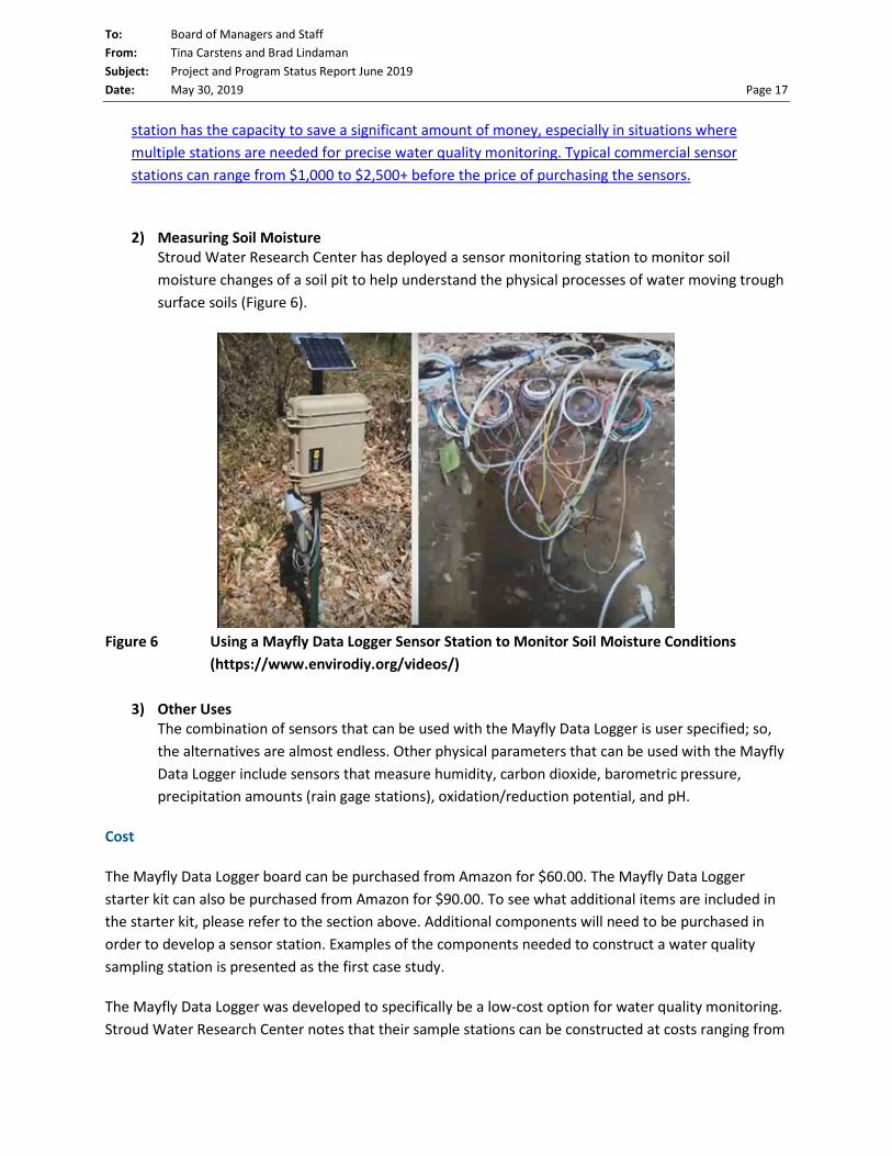
To: Board of Managers and Staff From: Tina Carstens and Brad Lindaman Subject: Project and Program Status Report June 2019 Date: May 30, 2019 Page 17
station has the capacity to save a significant amount of money, especially in situations where multiple stations are needed for precise water quality monitoring. Typical commercial sensor stations can range from $1,000 to $2,500+ before the price of purchasing the sensors.
2) Measuring Soil Moisture
Stroud Water Research Center has deployed a sensor monitoring station to monitor soil moisture changes of a soil pit to help understand the physical processes of water moving trough surface soils (Figure 6).
Figure 6 Using a Mayfly Data Logger Sensor Station to Monitor Soil Moisture Conditions
(https://www.envirodiy.org/videos/)
3) Other Uses The combination of sensors that can be used with the Mayfly Data Logger is user specified; so, the alternatives are almost endless. Other physical parameters that can be used with the Mayfly Data Logger include sensors that measure humidity, carbon dioxide, barometric pressure, precipitation amounts (rain gage stations), oxidation/reduction potential, and pH.
Cost
The Mayfly Data Logger board can be purchased from Amazon for $60.00. The Mayfly Data Logger starter kit can also be purchased from Amazon for $90.00. To see what additional items are included in the starter kit, please refer to the section above. Additional components will need to be purchased in order to develop a sensor station. Examples of the components needed to construct a water quality sampling station is presented as the first case study.
The Mayfly Data Logger was developed to specifically be a low-cost option for water quality monitoring. Stroud Water Research Center notes that their sample stations can be constructed at costs ranging from

To: Board of Managers and Staff From: Tina Carstens and Brad Lindaman Subject: Project and Program Status Report June 2019 Date: May 30, 2019 Page 18 $150 - $300 depending on the monitoring needs (before purchase of sensors). Commercial sensor stations can exceed $1,000 - $2,500 (before purchase of sensors).
While the materials of the Mayfly Data Logger sampling stations are advertised to be cheaper than general commercial versions, costs associated with training staff members will need to be considered. Switching to a new monitoring station set-up can have higher initial costs to train staff on how to use the Arduino software, how to construct the monitoring stations, and how to complete the data analysis. However, a workshop presented by EnviroDIY can help expedite the training process.
Conclusion
The Mayfly Data Logger offers users a cost-effective solution for developing water quality monitoring stations. Various sensors can be connected to the data logger offering numerous options for monitoring. Each combination of sensors, measurements, and data management requires a unique program/code. Nevertheless, there are many programs offered from Stroud Water Research Center or user data portals that can be copied and pasted into an Arduino sketch and uploaded to the Mayfly Data Logger with no or minimal editing required. Initial costs may be high to teach staff how to use the new hardware and software, but there are several manuals, user forums, and workshops offered through EnviroDIY to make the transition as seamless as possible. The option to share real-time monitoring data on the “Monitor My Watershed” webpage is another benefit.

To: Board of Managers and Staff From: Tina Carstens and Brad Lindaman Subject: Project and Program Status Report June 2019 Date: May 30, 2019 Page 19
Natural Resources Update – Bill Bartodziej and Simba Blood
Prescribed Burns Although we had an unusually high number of rain days this spring, we were able to conduct several prescribed burns on a variety of managed restoration areas. This natural disturbance stimulates native plant growth and suppresses a variety of invasive weed species. Our new “gator” vehicle, equipped with a large water tank and sprayer, was instrumental in improving the efficiency of the burns. Doing this work in-house provides a considerable cost savings. In addition, we are able to conduct the burns when the conditions are optimal for our sites. This equates to higher efficiency, more thorough burns, and better results. In total, we were able to burn 20 acres of restoration area this spring, including the rain gardens in front of the office.
A prairie buffer area carrying fire in Keller Golf Course.

To: Board of Managers and Staff From: Tina Carstens and Brad Lindaman Subject: Project and Program Status Report June 2019 Date: May 30, 2019 Page 20
The natural resources crew managing a burn with the new gator.
For the first time, fire is introduced to a restored buffer area on Keller Creek.

To: Board of Managers and Staff From: Tina Carstens and Brad Lindaman Subject: Project and Program Status Report June 2019 Date: May 30, 2019 Page 21
Public Involvement and Education Program – Sage Passi
Weaver’s Adopt-A-Drain Project Kicks Off the Month of May
May 2019 service-learning projects with our schools started with a large scale Adopt-A- Drain outreach campaign led by four fifth grade Weaver Elementary classes (100 students) who distributed 400 door hangers in the Wakefield Lake neighborhood on May 1 to encourage residents to clean their nearby storm drains. Maplewood Nature Center staff and Cathy Troendle, our education consultant worked together to combine that project with a fun field day in the park observing Wakefield wildlife and a lakeshore clean-up.
Students had the opportunity to observe the diverse bird populations that frequent the lake. One lucky team got to see an osprey dive into the lake to capture a fish. Birds in Migration, another engaging activity helped students simulate the obstacles that birds encounter during migration.
Another popular activity was searching for macroinvertebrates in the lake. Many large mussels were found along with invasive Chinese snails and other smaller invertebrates. The third activity drew a lot of attention too. Using “grabbers” to clean trash out of the lake was another popular option!

To: Board of Managers and Staff From: Tina Carstens and Brad Lindaman Subject: Project and Program Status Report June 2019 Date: May 30, 2019 Page 22
Lionsgate Academy in Shoreview Challenges the Status Quo - Creating a Resilient Schoolyard to Protect Water, Reduce Run-off and Support Pollinators
Lionsgate Academy science classrooms taught by Patrick Kosher and Sarah Nevin have been working all year to prepare students for involvement in a project that has taken over a year and half to reach completion. Thank you to Paige Ahlborg, Michael Schumann (Ramsey County) and Minnesota Native Landscapes for providing support along the way! Thank you to Master Gardeners, Linda Neilson, Don Vegoe, Cees Duijndam, Lynette Thompson, Anna Barker and Chris Kraft. A special thanks to Brian Beeman, the maintenance staff person for his support during the days of planting and his son, Alex who joined his teacher, Patrick Kosher in giving a presentation about this project at Ramsey County’s May Conservation Forum.
We began meeting with the administration in the winter of 2017 to develop a campus plan that involved large scale removal of asphalt and the creation of a rain garden, an area of alternative turf that will serve as an outdoor space and a perimeter of native plants to attract pollinators. Teachers stepped into action this fall at this school as we began introducing their students to the plant palette, the rain garden design, watershed issues, and the process of growing native plants to support pollinators through a variety of hands-on experiences. But the excitement came to the forefront on two days in mid-May this year when we gathered together with Master Gardeners, students, staff and teachers to put the plan into action! The weather cooperated, everyone seemed to be having a lot of fun and we got the project in the ground! We look forward to seeing this project mature.

To: Board of Managers and Staff From: Tina Carstens and Brad Lindaman Subject: Project and Program Status Report June 2019 Date: May 30, 2019 Page 23 Our Partnership with Master Gardeners Makes a Strong Impact at Lionsgate Academy Patrick Kosher, the science teacher who we have been working at Lionsgate Academy, a school for students on the autism spectrum, provided this positive feedback about our engagement of Ramsey County Master Gardeners who have been participating all year on this project. Here is what he had to share:
“During this past school year, we have worked with many Master Gardener volunteers, who helped our students with an on-site rain garden project. I wanted to share some of the experiences from parents and staff.” One parent wrote that her son, after having spent the day planting in the rain garden, came home and described everything he had done. Then he went on to give her suggestions on how she should plant her garden. Another student learned how to use
a shovel during the planting process-he had never used a shovel before. A third student makes her parents stop by the rain garden as they drive into school each day to observe the plants. Other students remarked how they enjoyed having the Master Gardeners in the classroom to help them with preparing flats, planting seeds and transplanting the seedlings. In Kosher’s own words, “From a teacher perspective, I thought the Master Gardeners did a splendid job of creating interest for the students and motivating them to jump right in and get their hands dirty. On the day of the planting outside, students of wide abilities were able to meaningfully take part and feel success. Thanks to all of the Master Gardener volunteers who made this project possible. Keep up the good work.”
Johnson High Jr AF ROTC Promotes Adopt-A-Drain in their Neighborhood
Ten Johnson High Jr ROTC cadets and their leaders Colonel Dwight Dorau and Sergeant Wendy Goetz distributed 306 door hangers in their school neighborhood near Lake Phalen with the help of Master

To: Board of Managers and Staff From: Tina Carstens and Brad Lindaman Subject: Project and Program Status Report June 2019 Date: May 30, 2019 Page 24 Water Stewards Stuart Knappmiller, Rachel Hanks, Bette Danielson and Watershed staff Sage Passi and Cathy Troendle on May 16. We look forward to their assistance with WaterFest on June 1st. They rock!
Snail Lake Regional Park Restoration Engages Youth, Master Gardeners and Audubon Society
Island Lake fifth graders plant upland prairie species on the slope.
Sixteen classes from seven schools in Shoreview, North St. Paul, St. Paul, Little Canada and Roseville were recruited to be involved in the Snail Lake Regional Park shoreline restoration project from mid-May to early June. Fifteen Master Gardeners signed up to assist RWMWD staff and interns with the project.
St. Peter Catholic School fourth graders study bird life at a wetland within Snail Lake Regional Park.
Chase Davies, a St. Paul Audubon volunteer assists Island Lake students with binoculars at Snail Regional Park during the restoration project. St. Paul Audubon volunteers taught eight classes how to use binoculars to study the birds in the park during the Snail Lake restoration project this spring. Classes alternated between planting and birding. A special highlight was witnessing a sandhill crane in flight up close. A pair nest in the park each year.

REVISION DESCRIPTIONDATEAPP.BYNO. CHK.TO/FOR
RELEASED
DATE RELEASED
Approved
Designed
Drawn
Checked
Date
Scale
DWG. No.
BARR PROJECT No.
CLIENT PROJECT No.
REV. No.
Minneapolis, Minnesota
Ph: 1-800-632-2277
Corporate Headquarters:
DATE LICENSE #
SIGNATURE
I HEREBY CERTIFY THAT THIS PLAN, SPECIFICATION, OR
REPORT WAS PREPARED BY ME OR UNDER MY DIRECT
SUPERVISION AND THAT I AM A DULY LICENSED
PROFESSIONAL ENGINEER UNDER THE LAWS OF THE
STATE OF MINNESOTA.
BARR ENGINEERING CO.
Project Office:
PRINTED NAME
AS SHOWN
01MAY2019
GGN/GWB
GGN
GGN
MRM
ALDRICH ARENA STORMWATER RETROFIT
MAPLEWOOD, MINNESOTA
COVER SHEET
AND DRAWING INDEX
23/62-1302.00
-
G-01 2
5/15/2019 47651
RELEASED FOR BID
MATTHEW R. METZGER
CA
DD
U
SE
R: G
areth W
. B
ecker F
ILE
: M
:\D
ES
IG
N\23621302.00\2362130200_ G
-01 C
OV
ER
.D
WG
P
LO
T S
CA
LE
: 1:2
P
LO
T D
AT
E: 5/15/2019 1:51 P
M
ggn M
:\D
esign\23621302.00\2362130200_ G
-01 C
over.dw
g P
lot at 50 03/29/2019 12:12:20
Im
ages in D
raw
ing - M
:\D
esign\23621302.00\2362130200_R
CP
R Logo.tif M
:\D
esign\23621274.00\R
WM
WD
B
W Logo.jpg
.
Suite 200
4300 MARKETPOINTE DRIVE
Fax: (952) 832-2601
www.barr.com
Ph: 1-800-632-2277
MINNEAPOLIS, MN 55435
CLIENT
BID
CONSTRUCTION
---5/1/195/9/195/15/19-
---5/1/195/9/195/15/19-
---5/1/195/9/195/15/19-
-------
-------
A B C 0 1 2 3
N
N
C-10
C-10
1
LIMITS OF SECTION CUT
SECTION REFERENCES
SECTION IDENTIFIER
C-10
DETAIL VIEW TITLE
DETAIL: GRAPHICS STANDARDS
DETAIL VIEW CALL OUT
DETAIL REFERENCES
SCALE: 1=1
SECTION VIEW CALL OUT
SECTION VIEW TITLE
SECTION: GRAPHICS STANDARDS
DETAIL IDENTIFIER
C-10
SCALE: 1=1
1
1
1
SECTION IDENTIFIER
(TYP.)
SECTION REFERENCES
(TYP.)
DETAIL IDENTIFIER
(TYP.)
DETAIL REFERENCES
(TYP.)
PROJECT COORDINATE SYSTEM
HORIZONTAL: MnDOT RAMSEY COUNTY, US FOOT, NAD83 DATUM
VERTICAL: NAVD88 DATUM
NOTE: NEARMAP ORTHOGRAPHIC IMAGE SHOWN DATED SE25PTEMBER 2018.
DRAWING INDEX
G-01 COVER SHEET AND DRAWING INDEX
G-02 STORMWATER MANAGEMENT ABBREVIATIONS
G-03
STORMWATER POLLUTION PREVENTION PLAN
(SWPPP)
G-04
CONSTRUCTION ACCESS, STAGING AND EROSION
CONTROL PLAN
G-05
CONSTRUCTION ACCESS, STAGING AND EROSION
CONTROL DETAILS
G-06
CONSTRUCTION ACCESS, STAGING AND EROSION
CONTROL DETAILS
G-07 GENERAL NOTES
C-01 EXISTING CONDITIONS
C-02 GENERAL PLAN
C-03 SITE STORMWATER & REMOVALS PLAN 1 OF 3
C-04 SITE STORMWATER & REMOVALS PLAN 2 OF 3
C-05 SITE STORMWATER & REMOVALS PLAN 3 OF 3
C-20 RAIN GARDEN 'A' GRADING AND DRAINAGE
C-21 RAIN GARDEN 'B' GRADING AND DRAINAGE
C-22 RAIN GARDEN 'C' GRADING AND DRAINAGE
C-23 RAIN GARDEN 'D' GRADING AND DRAINAGE
C-24 RAIN GARDEN 'E' GRADING AND DRAINAGE
C-25 RAIN GARDENS 'F1' & 'F2' GRADING AND DRAINAGE
C-26 RAIN GARDEN 'G' GRADING AND DRAINAGE
C-27 RAIN GARDENS 'H' & 'I' GRADING AND DRAINAGE
C-28 RAIN GARDEN 'J' GRADING AND DRAINAGE
C-29 RAIN GARDENS 'K' & 'L' GRADING AND DRAINAGE
C-30 RAIN GARDEN 'M' GRADING AND DRAINAGE
C-31 RAIN GARDEN 'N' GRADING AND DRAINAGE
C-40 TYPICAL SECTIONS AND DETAILS
C-41 TYPICAL SECTIONS AND DETAILS
C-42 TYPICAL SECTIONS AND DETAILS
C-43 TYPICAL SECTIONS AND DETAILS
C-44 TYPICAL SECTIONS AND DETAILS
L-01 RAIN GARDEN 'A' LANDSCAPE PLAN
L-02 RAIN GARDENS 'B' & 'C' LANDSCAPE PLAN
L-03 SURFACE GARDEN 'D' LANDSCAPE PLAN
L-04 RAIN GARDENS 'E' & 'F' LANDSCAPE PLAN
L-05 RAIN GARDEN 'G' & 'H' LANDSCAPE PLAN
L-06RAIN GARDENS 'I', 'J', & 'K' LANDSCAPE PLAN
L-07RAIN GARDENS 'L', 'M', & 'N' LANDSCAPE PLAN
L-08 PLAZA SITE PLAN AND DETAILS
L-09 PRAIRIE PLANTING AREA LANDSCAPE PLAN
L-10 LANDSCAPE DETAILS
PROJECT PARTNERS
ALDRICH ICE ARENA
MIDWEST
GOLF DOME
RAMSEY COUNTY
CARE CENTER
VA
N D
YK
E S
T
RIPLEY AVE
WH
IT
E B
EA
R A
VE
0 GWB MRM MRM 01MAY2019 RELEASED FOR BID
1 GWB MRM MRM 09MAY2019 ADDENDUM #1
PHASING AND DISCIPLINE COORDINATION NOTES:
TECHNICAL SPECIFICATIONS:
FOR ALL RWMWD STORMWATER MANAGEMENT DRAWINGS, REFER TO "SWM- " SERIES
TECHNICAL SPECIFICATIONS. THE CONTRACT DOCUMENTS APPLY TO ALL WORK ON
ALL DRAWINGS. THE "SWM- " SERIES TECHNICAL SPECIFICATIONS APPLY TO WORK
SHOWN ON THE RAMSEY WASHINGTON METRO WATERSHED DISTRICT STORMWATER
MANAGEMENT DRAWING SERIES.
PHASING : SEE OVERALL PHASING AND SEQUENCING PLAN BY LOEFFLER
CONSTRUCTION AND CONSULTING
CONTACTS
WATERSHED PROJECT MANAGER:
PAIGE AHLBORG
RAMSEY WASHINGTON METRO WATERSHED DISTRICT
PHONE: 651-792-7964
EMAIL: [email protected]
BARR PROJECT MANAGER / ENGINEER:
MATT METZGER
BARR ENGINEERING
PHONE: 952-832-2830
EMAIL: [email protected]
LANDSCAPE ARCHITECT:
MATT KUMKA
BARR ENGINEERING
PHONE: 952-832-2649
EMAIL: [email protected]
N
O
T
E
T
O
B
I
D
D
E
R
S
:
A
D
D
I
T
I
O
N
A
L
D
E
S
I
G
N
D
E
T
A
I
L
S
W
I
L
L
B
E
P
R
O
V
I
D
E
D
I
N
F
U
T
U
R
E
S
U
P
P
L
E
M
E
N
T
A
L
I
N
S
T
R
U
C
T
I
O
N
S
.
2 GWB MRM MRM 15MAY2019 ADDENDUM #2

971
970
9
6
9
968
967
966
965
EME
M
CHAIN LINK FENCE
EDGE OF BITUMINOUS
REVISION DESCRIPTIONDATEAPP.BYNO. CHK.TO/FOR
RELEASED
DATE RELEASED
Approved
Designed
Drawn
Checked
Date
Scale
DWG. No.
BARR PROJECT No.
CLIENT PROJECT No.
REV. No.
Minneapolis, Minnesota
Ph: 1-800-632-2277
Corporate Headquarters:
DATE LICENSE #
SIGNATURE
I HEREBY CERTIFY THAT THIS PLAN, SPECIFICATION, OR
REPORT WAS PREPARED BY ME OR UNDER MY DIRECT
SUPERVISION AND THAT I AM A DULY LICENSED
PROFESSIONAL ENGINEER UNDER THE LAWS OF THE
STATE OF MINNESOTA.
BARR ENGINEERING CO.
Project Office:
PRINTED NAME
AS SHOWN
01MAY2019
GGN/GWB
MRM/MEK2
GGN/MRM
MRM
RAMSEY-WASHINGTON
METRO WATERSHED DISTRICT
ALDRICH ARENA STORMWATER RETROFIT
MAPLEWOOD, MINNESOTA
GENERAL PLAN
23/62-1302.00
C-02 2
5/15/2019 47651
RELEASED FOR BID
MATTHEW R. METZGER
CA
DD
U
SE
R: G
areth W
. B
ecker F
ILE
: M
:\D
ES
IG
N\23621302.00\2362130200_ C
-02_G
EN
ER
ALP
LA
N.D
WG
P
LO
T S
CA
LE
: 1:2 P
LO
T D
AT
E: 5/15/2019 1:53 P
M
ggn M
:\D
esign\23621302.00\2362130200_C
3D
D
raw
ing C
-01.dw
g P
lot at 0 12/05/2018 09:09:27
.Xrefs in D
raw
ing - M
:\D
esign\23621302.00\2362130200_C
3D
S
urvey B
ase.dw
g M
:\D
esign\23621302.00\2362130200_C
3D
D
esign B
ase.dw
g M
:\D
esign\23621302.00\2362130200_R
am
seyM
N-F
Im
age B
ase.dw
g
CLIENT
BID
CONSTRUCTION
---5/1/195/9/195/15/19-
---5/1/195/9/195/15/19-
---5/1/195/9/195/15/19-
-------
-------
A B C 0 1 2 3
Suite 200
4300 MARKETPOINTE DRIVE
Fax: (952) 832-2601
www.barr.com
Ph: 1-800-632-2277
MINNEAPOLIS, MN 55435
1
-
PLAN: GENERAL PLAN
N
0 60 120
SCALE IN FEET
WHITE BEAR AVENUE
VAN DYKE STREET VAN DYKE STREET
ALDRICH ARENA
GOODRICH GOLF COURSE
RAMSEY COUNTY CARE CENTER
RAMSEY COUNTY FAMILY
SERVICES CENTER
0 GWB MRM MRM 01MAY2019 RELEASED FOR BID
SEE SHEET C-31
SEE SHEET C-20
SEE SHEET C-21
SEE SHEET C-22
SEE SHEET C-23
SEE SHEET C-24
SEE SHEET C-25
SEE SHEET C-27SEE SHEET C-28
SEE SHEET C-29SEE SHEET C-30
NOTE:
1. SEE GENERAL NOTES SHEET G-07
2. NEARMAP ORTHOGRAPHIC IMAGE SHOWN DATED SEPTEMBER 2018.
RAIN GARDEN - N
RAIN GARDEN - M
RAIN GARDEN - J
RAIN GARDEN - I
RAIN GARDEN - H
RAIN GARDEN - L
RAIN GARDEN - K
RAIN GARDEN - E
RA
IN
G
AR
DE
N - G
RA
IN
G
AR
DE
N - F
2
SU
RF
AC
E G
AR
DE
N - D
RA
IN
G
AR
DE
N - A
RAIN GARDEN - C
RAIN GARDEN - B
SHORT GRASS PRAIRIE SEEDING AREA
1 GWB MRM MRM 09MAY2019 ADDENDUM #1
RA
IN
G
AR
DE
N - F
1
SEE SHEET C-26
SITE ACCESS
SITE ACCESS
2 GWB MRM MRM 15MAY2019 ADDENDUM #2
N
O
T
E
T
O
B
I
D
D
E
R
S
:
A
D
D
I
T
I
O
N
A
L
D
E
S
I
G
N
D
E
T
A
I
L
S
W
I
L
L
B
E
P
R
O
V
I
D
E
D
I
N
F
U
T
U
R
E
S
U
P
P
L
E
M
E
N
T
A
L
I
N
S
T
R
U
C
T
I
O
N
S
.
LEGEND
PROPOSED RAINWATER/SURFACE GARDEN
PROPOSED PRAIRIE SEEDING AREA

************ Informational
Items
************

https://www.hometownsource.com/stillwater_gazette/column-many-helping-hands-make-a-strong-community/article_ed86a942-77f6-11e9-9b3e-d3a052bd6a67.html
Column: Many helping hands make a strong communityBy Angie Hong Featured Columnist May 18, 2019
When I was a boy and I would see scary things in the news, my mother would say to me, “Look forthe helpers. You will always �nd people who are helping.”
-Fred Rogers
Cole Williams was stationed at the historic Grant Town Hall for their annual community clean-up on
Saturday, May 4. As a newly certi�ed Master Water Steward, Williams brought information about
water-friendly yard care and upcoming community events, and also spent time helping local resident
You don’t have to be an adult to help out picking up litter. (Submitted photo)

Bob Hagstrom collect litter from roadside ditches. It was one of the city’s largest ever clean-up
events, with cars lined up along Kimbro Ave. throughout the morning, and at least three dump trucks
worth of refuse hauled away.
Down the road in Stillwater, two teams of volunteers were already hard at work that same day,
clearing away leaves and dead vegetation from raingardens around town. Kathy Warren led the
South Hill team, with volunteers from Lily Lake Lake Association, while Louise Watson headed up
the North Hill contingent, in partnership with Sustainable Stillwater. Together, the two groups
cleaned-up 12 raingardens along Wilkins St., Pine St., and in Washington Square Park. In addition,
volunteers were pleasantly surprised to �nd that many of the raingardens in town were already tidied
up for the spring. Community residents have adopted 54 raingardens in Stillwater since the launch
of the Adopt-a-Raingarden program last year (www.mnwcd.org/adoptaraingarden), and the impact
of their efforts can be seen all over town.
Down in Woodbury, Master Water Stewards Stephanie Wang and Anna Barker had rounded up their
own group of volunteers to work on a large raingarden at Trinity Presbyterian. The helpers pulled
weeds, cut down old vegetation, and put down fresh mulch in the garden. Trinity’s raingarden is just
one of a dozen church-led water projects that can be found around the county.
Indeed, helpers have been hard at work across the St. Croix Valley this spring. When the snow began
to melt, it took Community Thread less than a day to recruit hundreds of volunteers to �ll sand bags
and build a protective dike along the St. Croix River in Stillwater. When the volunteer spots were all
�lled, many would-be-helpers offered their support to Lake St. Croix Beach, Hudson, and other
nearby river communities instead.
It’s easy to get overwhelmed by the scale of environmental problems we face in our world, and I
think most of us have participated a volunteer planting event or Earth Day clean-up at some point in
our lives and wondered, “Is this really making any difference?” However, research from the �eld of
community-based social marketing has demonstrated that “doing something” actually changes your
internal perception of who you are. So, if you pick up litter, you start to think of yourself as the kind
of person who takes care of your neighborhood. After a while, helping out becomes a habitat
instead of a special event. When we volunteer with our children and youth, we also model the kinds
of behavior we want them to continue as they get older. They learn that people can work together to
�x problems in life and they feel proud to be part of the solution.

Last weekend, local mom Nicolette Gropel organized a community clean-up with families at Trinity
Lutheran Church. With bags in hand, the kids fanned out along 3rd and 4th streets to collect chip
bags, soda bottles, and hundreds of cigarette butts. “I think it’s so important for us to teach our
children an environmental ethic and model good behavior,” she said as the kids celebrated their hard
work with cookies at the end of the morning. The children piled their bags of litter on the playground
and posed proudly for a picture.
Look for the helpers in your community. If you can’t �nd them, then become one.
Angie Hong is an educator for East Metro Water - www.mnwcd.org/emwrep - which includesBrown’s Creek, Carnelian Marine - St. Croix, Comfort Lake – Forest Lake, Middle St. Croix, RamseyWashington-Metro, Rice Creek, South Washington and Valley Branch Watersheds, Cottage Grove,Dellwood, Forest Lake, Grant, Hugo, Lake Elmo, Newport, Oak Park Heights, Oakdale, Stillwater, St.Paul Park, West Lakeland, Willernie and Woodbury, Washington County and the WashingtonConservation District. Contact her at 651-330-8220 x.35 or [email protected].

NO HIDDEN FEE OIL CHANGE
NO HIDDEN FEE OIL CHANGE
for Semi Synthetic Oil Change(includes an Oil Filter and
up to 5 qts of oil)expires 2/28/19
for Full Synthetic Oil Change(includes an Oil Filter and
up to 5 qts of oil)expires 2/28/19
$2299 $4499+tax +tax
Shoreview Exxon • 3854 Lexington Ave. • Shoreview • 651-483-1219
Fantastic Auto Repair at Fantastic Prices!SHOREVIEWComplete Automotive Service Center
All repairs backed by our 3 Year 36,000 mile Warranty
Service Center Hours M-F 7-8 Sat 8-5
expires 6/30/19 expires 6/30/19
NEWS651-407-1235
ADVERTISING651-407-1200
CIRCULATION651-407-1234
CLASSIFIED651-407-1250
classifi [email protected]
PRODUCTION651-407-1239
TUESDAY, MAY 28, 2019VOL. 44 NO. 20 www.shoreviewpress.com $1.00
Press Publications4779 Bloom AvenueWhite Bear Lake, MN 55110
CHANGE SERVICE REQUESTED
PRESORTED STANDARD
U.S. POSTAGEPAID
PERMIT NO. 9CIRCLE PINES, MN
brausenauto.com
Arden Hills 1310 W County Rd. E
651-633-4100
Roseville2170 N. Dale St.
651-488-8800
JOE
• Nationwide Warranty• FREE loaner cars
• Family owned 3rd generation
Automotive
LEANNE PHINNEY | SUBMITTED
Conefl ower, butterfl y weed and spiderwort bloom in the community pollinator garden at Island Lake Elementary School.
Native plants the bee’s knees for pollinators, people
LEA
Students plant for the future of pollinatorsBY SARA MARIE MOORE
EDITOR
The next generation is learning how to take care of the earth.
Students from Island Lake Elementary School in Shoreview planted native grasses and fl owers in Vadnais - Snail Lakes Regional Park May 20.
The students are just some of the 90 across the northeast metro who will assist the Ramsey-Washington Metro Watershed District with a wetland restoration project through June, said Sage Passi, watershed education specialist. The native plants will grow in an area where invasive buckthorn previously grew.
The buckthorn was cut down over four months this winter with the assistance of a grant, said Simba Blood, natural resources technician. The students are planting prairie grasses and fl owers on the upper part of the wetland east of Snail Lake. Many are pollinator friendly. Native wetland plants will be planted further down the embankment in the future.
The restoration will be a two-year project, Passi said. It will restore 60 acres of forest and 4 acres of wetland buffer. The invasive species came in due to fl ooding that destroyed native plants. The restoration will benefi t wildlife, including
BY SARA MARIE MOOREEDITOR
In a home garden, native plants preferred by pollinators can go side-by-side with non-native plants.
“I’m gradually working in more
native plants,” said Leanne Phinney, Shoreview resident and pollinator gardener, showing off the fi rst May fl owers in her yard this spring — Min-nesota native trillium, ginger and Jacob’s ladder blooming along with Pacifi c Coast bleeding heart fl owers.
Phinney was an early adopter of native plants in her gardens; she began planting them in the early ’90s, long before it was trendy to save the bees. Now that the city of Shoreview
ANNE PHINNEY | SUBMITTED
y School.
ANNE PHINNEY | SUBMITTED
an early adopter ofn her gardens; sheg them in the early ’90s,was trendy to save the
the city of Shoreview
SEE POLLINATORS, PAGE 3
PAUL DOLS | PRESS PUBLICATIONS
A butterfl y seeks a taste of nectar from a fl ower at Tamarack Nature Center.
SEE STUDENTS, PAGE 2
SARA MARIE MOORE | PRESS PUBLICATIONS
Island Lake Elementary students plant native grasses and fl owers in Vadnais-Snail Lakes Regional Park May 20 with Ramsey-Washington Metro Watershed District staff . The area was previously overgrown with invasive buckthorn, which was removed this winter with a grant.
SARA MARIE MOORE | PRESS PUBLICATIONS
COMMONS: Skate park, pickleball courts coming PAGE 8FinancingFinancingfor your futurefor your future
SEE PAGE 9

2 SHOREVIEW PRESS MAY 28, 2019www.presspubs.com
TRUST AQUARIUS COOLING & HEATING
888.674.6509AquariusHS.com • KathHVAC.com
An AHS Company
CALL NOW! OFFERS EXPIRE 6/30/19
A/C TUNE-
UP*Gas forced air systems. Refrigerant not included.
$89OFFER EXPIRES 6/30/19
SAVE UP TO $1500 ON THE PURCHASE OF A
NEW COOLING/HEATING SYSTEM* (Gas Forced Air) Includes FREE BASIC INSTALLATION
$1500 OFF!UPTO
$1500 OFF!UPTO
FORYOUR
FREE IN-HOME NEW SYSTEM ESTIMATES
Ask about our
FREE Humidifier or
WiFi Thermostatwith qualifying purchase.*
* OFFERS EXPIRE 6/30/19. Some exclusions may apply. Not valid with other offers. One offer per customer. Offer valid for single family residential properties only. Gas forced air HVAC systems. We have convenient financing options OAC. NP2015
waterfowl, birds and turtles.The plants will also anchor the
wetland’s bank with their roots, said Ramsey County Master Gardener volunteer Chris Strong, who was instructing the students. She hopes that the area can be preserved for her grandchildren. She used to love to play among the lightning bugs when she was a child, but says she hasn’t seen one in years.
“I’ve been concerned about the loss of habitat, the loss of wildlife, the loss of insects we’ve seen,” she said.
The watershed district has worked with students for 20 years. They engage young people in park projects for educational purposes and offer assistance to those with school projects. This year, the district helped fund a rain garden at Lionsgate Academy in Shoreview. Ramsey County also received a Clean Water Fund grant for the project, noted Ann White Eagle of the Ramsey County Soil and Water Conservation Division. The charter school was built on a commercial site on Cardigan Road and staff
wanted to remove asphalt to create green space.
Students prepared seeds last fall and completed planting in May with the assistance of Passi and Ramsey County master gardener volunteers, said science teacher Patrick Kosher at a conservation forum hosted by Ramsey County Parks and Recreation May 17. Students enjoyed the experiential learning, he noted. The garden was designed by Michael Schumann of Ramsey-Washington Metro Watershed District. For more information on community stewardship grants, visit rwmwd.org/get-involved/stewardship-grants/.
STUDENTS: County, watershed district teach the power of plantsFROM PAGE 1
A family owned and operated company with over 40 years of experience allows us to provide superior service.
Langer’s provides only premium landscape mulches made from wood directly from the woods to your yard.
Tree RemovalStorm Damage SpecialistDiseased Tree RemovalEmerald Ash Borer TreatmentsPremium Mulches - Colored, Cedar, NaturalPremium Wood ChipsDelivery Available PETTING ZOO | BALLOON ARTIST
FREE SAMPLES | AND MORE!
SATURDAY, JUNE 1ST
11:00 AM-4:00 PM3845 Lexington Ave N, Arden Hills
When you need us, we are here to help.
*Servicing all brands *Servicing all brands
Read our reviews and check out our current promotions at www.krinkies.com
Licensed, Bonded, InsuredLicensed, Bonded, InsuredServing the St. Paul and Surrounding AreaServing the St. Paul and Surrounding Area
651-426-5220 651-426-5220
Free Estimate • 24/7 Emergency ServiceFree Estimate • 24/7 Emergency Service
FREE TRIP CHARGE With repair
$89 value!Expires 6/14/19
SARA MARIE MOORE | PRESS PUBLICATIONS
Island Lake Elementary fi fth grader Siri Whiting plants an onion in Vadnais-Snail Lakes Regional Park May 20.
SARA MARIE MOORE | PRESS PUBLICATIONS
“I’ve been concerned about the loss of habitat, the loss
of wildlife, the loss of insects we’ve seen.”
Chris Strong
Ramsey County Master Gardener