Jaarverslag 2012 Nederlandse Commissie voor Geodesie
92
Jaarverslag 2012 Nederlandse Commissie voor Geodesie NCG KNAW Nederlandse Commissie voor Geodesie
-
Upload
khangminh22 -
Category
Documents
-
view
1 -
download
0
Transcript of Jaarverslag 2012 Nederlandse Commissie voor Geodesie

Jaarverslag 2012 Nederlandse Commissie voor Geodesie
NCG KNAW
Nederlandse Commissie voor Geodesie
Jaarverslag 2012 Nederlandse C
omm
issie voor Geodesie

Jaarverslag 2012
Nederlandse Commissie voor Geodesie
NCG Nederlandse Commissie voor Geodesie
Delft, mei 2013

Jaarverslag 2012 Nederlandse Commissie voor Geodesie ISBN: 978 90 6132 342 6
Vormgeving en productie: Bureau Nederlandse Commissie voor Geodesie. Druk: Optima Grafische Communicatie, Rotterdam.Figuur omslag: Sander Oude Elberink (U Twente).
Digitale versie (pdf): ISBN 978 90 6132 343 3
Bureau van de Nederlandse Commissie voor GeodesieJaffalaan 9, 2628 BX DelftPostbus 5030, 2600 GA DelftTel.: 015 278 21 03E-mail: [email protected]: www.ncg.knaw.nl
De NCG is een onderdeel van de KNAW (Koninklijke Nederlandse Akademie van Weten-schappen).
iii
Voorwoord
De Nederlandse Commissie voor Geodesie (NCG) is het Nederlandse platform waar wetenschappers uit de geodesie en de geo-informatie een georganiseerd overleg voeren met vooraanstaande vertegenwoordigers van de praktijk. De NCG bevordert de kwaliteit en de belangen van deze wetenschappen en zij zet zich in voor een optimale bijdrage aan de maatschappij. De NCG is een onderdeel van de Koninklijke Nederlandse Akademie van Wetenschappen (KNAW). De Commissie kende in het verslagjaar zes subcommissies, die elk werkzaam zijn op een van haar wetenschappelijke deelterreinen. In dit jaarverslag vindt u een overzicht van de activiteiten en de werkzaamheden van de Commissie en haar subcommissies in het jaar 2012.
Dr.ir. C.H.J. Lemmen heeft tijdens het GIN Symposium op 15 november 2012 in Apeldoorn de Prof. J.M. Tienstra Onderzoeksprijs 2012 ontvangen. De Tienstra Onderzoeksprijs is in 1998 ingesteld met als doel het bevorderen en zichtbaar maken van het onderzoek in Nederland op het terrein van de geodesie en de geo-informatie. Het onderzoek 'Land Administration Domain Model' (LADM) van dr.ir. Lemmen heeft geleid tot een internationale ISO-standaard en wordt onder andere door de FAO (Food and Agriculture Organization of the United Nations) en UN-Habitat (United Nations Human Settlements Programme) als standaard gebruikt bij de ontwikkeling van landadministratiesystemen.
De NCG heeft in het GI-beraad aandacht gevraagd voor een geodetische infrastruc-tuur van Nederland van de hoogste kwaliteit, die onontbeerlijk is voor betrouw-bare geo-informatie. Deze geodetische infrastructuur biedt het raamwerk waarin alle ruimtelijke informatie gekoppeld kan worden. Het belang van de geodetische infrastructuur is door het GI-beraad onderkend en wordt in de totstandkoming van GIDEON 2.0 (Geografische Informatie en Dienstverlening ten behoeve van de E-Overheid in Nederland) nadrukkelijk meegenomen.
De voorzitter van de NCG heeft begin 2012 met prof.dr.-Ing. Chr. Heipke, presi-dent van de Deutsche Geodätische Kommission (DGK), informeel overleg gevoerd over de kwaliteit van de geodetische infrastructuur in beide landen. In vervolg hierop heeft de voorzitter met prof.dr.ir. M.G.Vosselman deelgenomen aan de Jaarvergadering van de DGK. Daar is besloten dat een werkgroep met Nederlandse, Duitse, Zwitserse en Oostenrijkse vertegenwoordigers de huidige borging van de situatie van de geodetische infrastructuur in die landen gaat analyseren en met adviezen komt.
De NCG is actief betrokken geweest bij de formulering van het programma Maps4Society, de opvolger van Maps4Science. Dit programma heeft ten doel om het gebruik van geo-informatie voor onderzoeksdoeleinden beter, efficiën-

iv
ter en eenvoudiger te maken door een gezamenlijke infrastructuur te realiseren. Hoofddoel van Maps4Society is de opschaling tot een nationale geo-informatie-onderzoeksinfrastructuur met Europese potentie en het bevorderen van ruimtelijke doorbraken in andere wetenschapsvelden. Inmiddels is bekend geworden dat STW het programma heeft goedgekeurd, waarmee 3 miljoen euro voor het programma beschikbaar is. De NCG is partner in het programma.
De NCG zal per 1 januari 2014 geen deel meer uitmaken van de organisatie van de KNAW. De Commissie heeft de intentie uitgesproken om het werk van de NCG buiten de KNAW voort te zetten. Hiertoe zijn in het verslagjaar voorbereidingen getroffen, die eind 2013 haar beslag gaan krijgen.
In het Jaarverslag zijn dit jaar twee artikelen opgenomen. Dr.ir. C.H.J. Lemmen, prof.dr.ir. P.J.M. van Oosterom en prof.ir. P. van der Molen presenteren het ont-werp voor het Domain Model for Land Administration, dat de formele International Standard ISO 19152 Geographic Information – Land Administration Domain Model (LADM) (ISO, 2012) is geworden.Dr.ir. S.J. Oude Elberink, dr. J.E. Stoter, dr. H. Ledoux en ir. T. Commandeur beschrijven de ontwikkeling van een nationaal virtueel driedimensionaal stads- en landschapsmodel voor Nederland.
Prof.dr.ir M. Molenaar,Voorzitter NCG

v
Nederlandse Commissie voor Geodesie
De Nederlandse Commissie voor Geodesie (NCG) is een onderdeel van de Konink-lijke Nederlandse Akademie van Wetenschappen (KNAW).
De taken van de Nederlandse Commissie voor Geodesie zijn:
– Het coördineren en sturen van het fundamenteel en strategisch onderzoek in de geodesie en de geo-informatie in Nederland.
– Het vormen van een denktank voor de geodesie en de geo-informatie in Neder-land.
– Het geven van adviezen over algemene beleidslijnen voor de geodesie en de geo-informatie rekening houdend met de maatschappelijke ontwikkelingen.
– Het coördineren van de vertegenwoordiging van Nederland in internationale wetenschappelijke organisaties op het gebied van de geodesie en de geo-infor-matie.
– Het adviseren van het hoger onderwijs in de geodesie en de geo-informatie vanuit een wetenschappelijk perspectief rekening houdend met de maatschappe-lijke behoeften.
– Het bijdragen aan de instandhouding en het up-to-date houden van de geodeti-sche infrastructuur in Nederland.
De Nederlandse Commissie voor Geodesie bestaat uit de Commissie, het Dagelijks Bestuur, subcommissies, eventueel ingestelde taakgroepen en het Bureau. De Com-missie is het ontmoetingspunt voor verantwoordelijke personen op strategisch en beleidsniveau. Onder de Commissie functioneren subcommissies; zij zijn het ont-moetingspunt op uitvoerend of werkniveau. Subcommissies bestrijken deelterreinen van het totale aandachtsveld van de Commissie. Een taakgroep wordt ingesteld om binnen een gestelde termijn een specifieke taak uit te voeren. Het Bureau onder-steunt de werkzaamheden van de Commissie, het Dagelijks Bestuur, de subcom-missies en de taakgroepen.
De Nederlandse Commissie voor Geodesie geeft publicaties uit in de reeksen Publi-cations on Geodesy en de Groene reeks.
De Nederlandse Commissie voor Geodesie is de opvolger van de Rijkscommissie voor Geodesie (1937 – 1989) en de Rijksommissie voor Graadmeting en Waterpas-sing (1879 – 1937).
Verdere informatie over de NCG: www.ncg.knaw.nl.


vii
Inhoudsopgave
Nederlandse Commissie voor Geodesie 1 Advies en onderzoek 1Symposia en workshops 4Commissie 5Publicaties 7
Subcommissies 9Subcommissie Bodembeweging en Zeespiegelvariatie 9Subcommissie Geodetische Infrastructuur en Referentiesystemen 10Subcommissie Geo-Informatie Infrastructuur 15Subcommissie Geovisualisatie 17Subcommissie Mariene Geodesie 19 Subcommissie Ruimtelijke Basisgegevens 22
A Domain Standard for Land Administration 25Dr.ir. Christiaan Lemmen, prof.dr.ir. Peter van Oosterom, prof.ir. Paul van der Molen
Generation of a National Virtual3D City and Landscape Model for the Netherlands 41Dr. Sander Oude Elberink, dr. Jantien Stoter, dr. Hugo Ledoux,ir. Tom Commandeur
Bijlagen 571. Samenstelling van de organen van de NCG 572. Internationale betrekkingen 623. Onderzoek 664. Publicaties 775. Bureau van de NCG 786. Afkortingen 79


1
Nederlandse Commissie voor Geodesie
De Nederlandse Commissie voor Geodesie (NCG), het Nederlandse platform van wetenschappers uit de geodesie en de geo-informatie met een georganiseerde band met de praktijk, heeft in het verslagjaar bijgedragen aan de bevordering van de kwaliteit en de belangen van de geodesie en de geo-informatie en heeft zich ingezet voor een optimale bijdrage aan de maatschappij. De NCG heeft dat onder andere gedaan door initiatieven, adviezen en steun op het gebied van het Neder-landse geo-informatiebeleid, de (inter)nationale geodetische infrastructuur en het geodetisch en geo-informatie onderzoek en het organiseren en steunen van studie-dagen en workshops.
Advies en onderzoekGIDEON 2.0Het GI-braad, het beraad voor de geo-informatie van de rijksoverheid, werkt aan een vervolg van de nota GIDEON (Geografische Informatie en Dienstverlening ten behoeve van de E-Overheid in Nederland) en heeft hiervoor de Memo GIDEON 2 uitgebracht. De NCG heeft op de Memo gereageerd door te pleiten voor een breed gedragen beleidsvisie vanuit drie invalshoeken: de overheid, het bedrijfsleven (GeoBusiness Nederland) en de wetenschappen (NCG). Inmiddels wordt in deze zin aan GIDEON 2.0 gewerkt.
De NCG heeft in het GI-beraad aandacht gevraagd voor een geodetische infrastruc-tuur van de hoogste kwaliteit, die onontbeerlijk is voor betrouwbare geo-informatie. Deze geodetische infrastructuur biedt het raamwerk waarin alle ruimtelijke informa-tie gekoppeld kan worden. De NCG heeft enige zorg over de toekomst, met name op het gebied van de instandhouding en de doorontwikkeling van geodetische referentiesystemen en op het gebied van de borging van de kwaliteit van deze refe-rentiesystemen en de geo-informatievoorziening. Het belang van de geodetische infrastructuur wordt in de totstandkoming van GIDEON 2.0 nadrukkelijk meegeno-men.
Geodetische infrastructuurMet prof.dr.-Ing. Chr. Heipke, president van de Deutsche Geodätische Kommission (DGK), is informeel overleg gevoerd over de kwaliteit van de geodetische infra-structuur in beide landen. Als vervolg is dit onderwerp op 9 november besproken in een drielandenoverleg van de DGK (Duitsland, Oostenrijk, Zwitserland), waar NCG-voorzitter prof.dr.ir. M. Molenaar een paper presenteerde. Besloten is dat een werkgroep met Nederlandse, Duitse, Zwitserse en Oostenrijkse vertegenwoordigers de huidige borging van de situatie van de geodetische infrastructuur in die landen gaat analyseren en met adviezen komt.

2
Maps4SocietyMaps4Society is de opvolger van Maps4Science; het plan om het gebruik van geo-informatie voor onderzoeksdoeleinden beter, efficiënter en eenvoudiger te maken door een gezamenlijke infrastructuur te realiseren. Hoofddoel van Maps4Society is de opschaling tot een nationale geo-informatie-onderzoeksinfrastructuur met Europese potentie en het bevorderen van ruimtelijke doorbraken in andere weten-schapsvelden. De ondersteuning om het voorstel verder te brengen vindt plaats vanuit het ICT Innovatieplatform Geo-informatie (IIP GEO), de NCG en Jacqueline Meerkerk Management. De Stichting voor de Technische Wetenschappen (STW) heeft 1,5 miljoen euro voor het project gereserveerd. Als de initiatiefnemers ook 1,5 miljoen euro middels partners opbrengen, dan is er 3 miljoen euro beschikbaar over een looptijd van 5 jaar voor ongeveer twaalf onderzoeksprojecten. De partners mogen de wetenschappelijke onderzoekvraag bepalen.
Open (Geo) Data Innovatie Netwerk De NCG steunt het initiatief van het ICT Innovatieplatform Geo-informatie (IIP Geo) om innovaties met open data op gang te brengen en te versnellen door de ontwik-keling van een Open (Geo) Data Innovatie Netwerk. Vanuit de NCG worden de Subcommissies Geo-Informatie Infrastructuur, Ruimtelijke Basisgegevens en Geovi-sualisatie bij dit initiatief betrokken. De Subcommissie Geo-Informatie Infrastructuur fungeert hierbij voor de NCG als penvoerder. Het gaat de NCG vooral om twee aspecten: wat zijn onderzoeksvragen op dit gebied en welke zijn de innovatiekan-sen voor het bedrijfsleven.
Prof. J.M. Tienstra Onderzoeksprijs 2012 en onderzoek NCGDr.ir. C.H.J. Lemmen heeft tijdens het GIN Symposium op 15 november 2012 in Apeldoorn de Prof. J.M. Tienstra Onderzoeksprijs 2012 ontvangen uit handen van
Dr.ir. C.H.J. Lemmen (rechts) ontvangt de Prof. J.M. Tienstra Onderzoeksprijs 2012 uit handen van juryvoorzitter dr.ir. M. Tienstra.

3
juryvoorzitter dr.ir. M. Tienstra. Het onderzoekswerk van dr.ir. Lemmen is door de jury van de prijs gewaardeerd als uitstekend van kwaliteit en origineel. Het onder-zoek 'Land Administration Domain Model' (LADM) heeft een sterke relatie tussen wetenschap en praktijk. Het LADM is op 1 november 2012 een internationale ISO-standaard geworden en wordt onder andere door de FAO (Food and Agricul-ture Organization of the United Nations) en UN-Habitat (United Nations Human Settlements Programme) als standaard gebruikt bij de ontwikkeling van landadmi-nistratiesystemen. Dr.ir. Lemmen heeft een krachtige rol van initiator gespeeld bij de realisering van zijn onderzoeksresultaten. De NCG heeft de Prof. J.M. Tienstra Onderzoeksprijs in 1998 ingesteld met als doel het bevorderen en zichtbaar maken van het onderzoek in Nederland op het terrein van de geodesie en de geo-informa-tie.
De Subcommissie Geo-Informatie Infrastructuur heeft haar Research plan gepu-bliceerd. In het in het Engels verwoorde plan komen de missie en taken van de Subcommissie, de huidige stand van het onderzoek op het gebied van de geo-informatie infrastructuur, de onderzoeksonderwerpen van de Subcommissie en de onderzoeksvragen aan bod. Onderzoeksvragen zijn geformuleerd op de thema's theorie en methoden, gebruik en bruikbaarheid, governance, infrastructuurtechniek, toepassing van standaarden en interoperabiliteit, verbinden met de informatie-infra-structuur en geo-sensor netwerken. Zie de Bijlage 3. Onderzoek voor het volledige Research plan.
De Subcommissie Mariene Geodesie heeft een update van haar Onderzoeksagenda gemaakt. Onderwerpen zijn: realisatie van verticale referenties op zee, optimalisa-tie van inwinstrategieën, kwaliteitsverbetering van inwintechnieken, ontwikkeling van methoden voor automatische dataverwerking, aansluiting van mariene data en terrestrische data, innovatie in de presentatie van geografische informatie en integratie van navigatiesystemen. Zie de Bijlage 3. Onderzoek voor de volledige Onderzoeksagenda.
De NCG geeft financiële ondersteuning aan het PhD-onderzoek 'Adding value to geodetic deformation measurements. A model to facilitate communication on geodetic deformation monitoring and analysis' door ir. H. Velsink (Hogeschool Utrecht). Het onderzoek richt zich op het beantwoorden van de vraag hoe de communicatie over geodetische deformatiemetingen kan worden verbeterd. Ir. Velsink wil daarbij een brug slaan tussen enerzijds de geodetische methoden en technieken en de staande praktijk van geodetische deformatiemetingen en ander-zijds de sociaal-organisatorische en sociaal-maatschappelijke omstandigheden en de verschillende belanghebbenden (industrie, overheid, burgers) in relatie tot het vaststellen van deformatie.
4
Symposia en workshopsProf. Baarda-lezing 2012 door prof.dr. P.M.G. ApersProf.dr. P.M.G. Apers (Universiteit Twente) gaf op 15 november de Prof. Baarda-lezing 2012 tijdens het GIN-symposium in Orpheus in Apeldoorn met als titel 'ICT-trends en hun impact op de Geo-wereld'. Trends in de ICT hebben een enorme impact op de samenleving en zetten veel tradities op hun kop. Nu reeds maken bijna alle apps op de iPhone of de iPad gebruik van de locatie waar men zich bevindt en verrijken de communicatie met de gebruikers met behulp van kaarten. Geo-informatie is een gemeengoed geworden, dat niet meer weg te denken is uit ons dagelijks leven. De vraag is welke invloed ICT heeft op de geo-wereld en met name op de bedrijfsmodellen.
PhD-programma op het GIN-symposiumVoor het GIN-symposium 2012 heeft de NCG een programma met PhD-lezingen en posterpresentaties georganiseerd, waaraan vijftien promovendi hebben deelge-nomen. Gepresenteerde onderwerpen zijn onder andere 3D geo-informatietech-nieken en toepassingen, de ontwikkeling van 5D ruimtelijke modellen voor GIS (Geografische Informatiesystemen), remote sensing technieken voor het milieu en het gebruik van 'Mobile Mapping Point Clouds' en visualisatietechnieken.
Workshop verkenning doorstart Maps4ScienceOp 17 september 2012 is bij de Wageningen Universiteit de workshop 'Verkenning doorstart Maps4Science' gehouden met circa 25 deelnemers vanuit een diversiteit aan organisaties (overheden, bedrijfsleven, kennisinstellingen). De workshop is georganiseerd door Maps4Science, IIP Geo en de NCG. Tijdens de workshop is geconcludeerd dat er veel behoefte is aan samenwerking rond onderzoek op de thema's van Maps4Science en dat er steun is voor de partnership-vorm. De focus van het onderzoeksprogramma zal uiteraard afhankelijk zijn van de partijen die hierin willen investeren. Een doorstart en vormgeving als partnership kan rekenen op steun vanuit de ministeries van EL&I, IenM en OCW.
3D Pilot Slotdag 'Van 2D naar 3D BGT'Op 20 november 2012 is de 3D Pilot Slotdag 'Van 2D naar 3D BGT. Zelf aan de slag met de derde dimensie' in het Provinciehuis Noord-Brabant in Den Bosch gehouden. De Slotdag is georganiseerd door het Kadaster, Geonovum, het ministe-rie van IenM en de NCG. Op initiatief van de NCG, het Kadaster, Geonovum, het voormalige ministerie van VROM is in 2010 de 3D Pilot NL gestart om te komen tot een uniforme aanpak voor 3D geo-informatievoorziening in Nederland. Het vervolgtraject van de 3D Pilot was gericht op het ondersteunen van de implementa-tie van 3D in Nederland met een focus op de implementatie van CityGML-IMGeo (City Geography Markup Language - Informatiemodel Grootschalige geografie). Tientallen organisaties hebben in het vervolgtraject samengewerkt, waarbij van 2D Basisregistratie Grootschalige Topografie (BGT) opgewerkt is naar verschillende 3D detailniveaus.

5
CommissiePresentatiesH. Westerbeek MSc, directeur van de Stichting Arbeidsmarkt Geo (SAGEO), heeft op vergadering van de Nederlandse Commissie voor Geodesie op 6 juni een pre-sentatie gegeven met de titel 'Overzicht stand van zaken SAGEO'. Toegelicht zijn onder andere de verbeterde instroom van studenten en de vernieuwingen in het geodesie- en geo-informatie-onderwijs.
Commissielid prof.dr.ir. A.K. Bregt (Wageningen Universiteit) gaf op 6 juni een presentatie met de titel 'Geo-informatievoorziening en open data' en leidde een discussie over dit onderwerp. Hij beschreef de geo-informatievoorziening als een complex adaptief systeem, waarin veranderen en sturen zeer lastig is, ieder land uniek is en er interne en externe processen zijn, die de situatie kunnen veranderen en waarvan het resultaat zeer slecht voorspelbaar is.
Op 19 december gaf dr.ir. C.J.M. Philippart (Nederlands Instituut voor Onderzoek der Zee – NIOZ, Waddenacademie) de presentatie 'Sensing marine life and liveli-hoods at the seashore. An integrated monitoring network for the Wadden Sea, a coastal UNESCO World Heritage site'.
LedenDe Nederlandse Commissie voor Geodesie heeft per 4 april drie nieuwe leden benoemd: dr. G. Nieuwpoort, directeur Netherlands Space Office (NSO); dr. M.J. van der Meulen, hoofd Geological Survey of the Netherlands (TNO), in plaats van dr. M.J. van Bracht (TNO) en ir. A. Versluis, directeur Data Rijkswaterstaat Data-ICT-Dienst (DID); in plaats van mw. G. Harteveld (voormalig Hoofdingenieur-Directeur Rijkswaterstaat DID).
Beeld uit de 3D Pilot NL (Bentley).

6
Voor een nieuwe termijn van vijf jaar zijn per 1 januari 2013 herbenoemd de Com-missieleden mw. drs. Th.A.J. Burmanje (voorzitter Raad van Bestuur van het Kadas-ter), dr.ir. F.J.J. Brouwer (hoofddirecteur KNMI) en prof.dr.ir. P.J.M. van Oosterom (TU Delft).
Prof.dr.ir. M. Molenaar is benoemd tot Fellow van de International Society of Pho-togrammetry and Remote Sensing (ISPRS).
Prof.dr.ir. P.J.G. Teunissen is Professor Honoris Causa geworden van het Geodesie en Geofysica Instituut van de Chinese Academie van Wetenschappen (CAS). Deze titel is hem toegekend vanwege zijn bijdragen aan de mathematische geodesie. Met het CAS doet prof. Teunissen onderzoek naar onder andere het in ontwikkeling zijnde Chinese satellietnavigatiesysteem.
Op 19 december 2012 is in Den Haag prof.ir. J.C. de Munck overleden. Prof. De Munck was van 22-3-1979 tot 31-12-1996 lid van de Rijkscommissie voor Geode-sie en de Nederlandse Commissie voor Geodesie.
NCG stelt Subcommissie Geovisualisatie in Tijdens haar vergadering op 6 juni 2012 heeft de Nederlandse Commissie voor Geodesie de Subcommissie Geovisualisatie ingesteld. De Subcommissie zal als platform dienen voor professionele kaartenmakers om de laatste ontwikkelingen te signaleren, te bediscussiëren en zelfs te creëren. Dit met name door hierin ook kaartenmakers van buiten de traditionele geo-beroepsgroep te betrekken. Op deze manier kan er een bijdrage geleverd worden aan innovatie en kennisontwikkeling op het gebied van de geovisualisatie.De Subcommissie staat onder voorzitterschap van prof.dr. M.J. Kraak (Universiteit Twente - ITC) en start met de leden: drs. N.J. Bakker (Kadaster), ing. R. Klooster (Advies- en Ingenieursbureau Oranjewoud), dr.ir. R.J.A. van Lammeren (Wagenin-gen University - GIMA) en prof.dr.ir. J.J. van Wijk (TU Eindhoven).
Toekomst NCGDe NCG zal naar verwachting vanaf begin 2014 financieel en personeel onafhan-kelijk van de KNAW gaan werken. Voor deze verandering zijn in het verslagjaar voorbereidingen getroffen.
Ir. S.R. Dijkstra (Kadaster) is sinds 1 november 2013 gedetacheerd bij de NCG en voert nu met F.H. Schröder het secretariaat van de NCG. Ir. Dijkstra gaat zijn werk voor de NCG uitvoeren vanuit het kantoor van Geonovum in Amersfoort.
ArchiefHet archief van de NCG, dat bestaat uit stukken vanaf de oprichting van de Rijk-sommissie voor Graadmeting en Waterpassing in 1879, is door het ministerie van OCW geschouwd. Vastgesteld is dat het om een uniek en bijzonder archief gaat, dat goed toegankelijk is. Op voorstel van het ministerie heeft het Nationaal Archief

7
besloten om het archief tot 1990 in zijn geheel over te brengen naar het Nationaal Archief. Hiervoor wordt een archiefbewerkingsplan opgesteld. Het archief vanaf 1990 wordt overgebracht naar de KNAW.
PublicatiesIn het verslagjaar zijn vijf publicaties verschenen.
In de serie Publications on Geodesy (Gele serie) verschenen:– A Domain Model for Land Administration, Christiaan Lemmen.– Development Methodology for an Integrated Legal Cadastre. Deriving Portu-
gal Country Model from the Land Administration Domain Model, João Paulo Hespanha.
In de Groene serie verschenen:– 3D Pilot. Eindrapport werkgroep 3D Testbed, Edward Verbree, Theo Tijssen,
Hugo Ledoux, Sisi Zlatanova.– 3D Pilot. Eindrapport werkgroep 3D Use cases, Mark Berntssen, Matthijs Danes,
Joris Goos, Rick Klooster, Jan Kooijman, Laris Noordegraaf, Jantien Stoter, Christian Veldhuis en George Vosselman
– Open data: van ideaal tot realiteit, Marèse Peters (interviews), Bastiaan van Loenen en Yvonne Verdonk (redactie).
Zie voor details bijlage 4.
De Stichting Arbeidsmarkt Geo (SAGEO) heeft het rapport Aansluiting onderwijs en arbeidsmarkt in geo-informatie uitgebracht. Deze kwalitatieve marktverkenning is tot stand gekomen in samenwerking met de NCG, het ITC (Universiteit Twente) en GeoBusiness Nederland.

8
9
Subcommissies
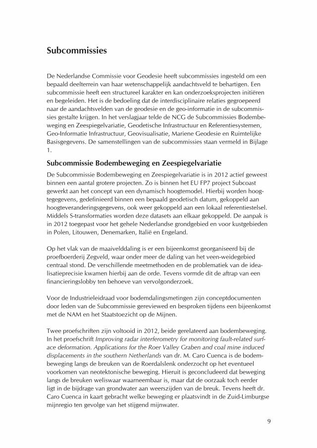
De Nederlandse Commissie voor Geodesie heeft subcommissies ingesteld om een bepaald deelterrein van haar wetenschappelijk aandachtsveld te behartigen. Een subcommissie heeft een structureel karakter en kan onderzoeksprojecten initiëren en begeleiden. Het is de bedoeling dat de interdisciplinaire relaties gegroepeerd naar de aandachtsvelden van de geodesie en de geo-informatie in de subcommis-sies gestalte krijgen. In het verslagjaar telde de NCG de Subcommissies Bodembe-weging en Zeespiegelvariatie, Geodetische Infrastructuur en Referentiesystemen, Geo-Informatie Infrastructuur, Geovisualisatie, Mariene Geodesie en Ruimtelijke Basisgegevens. De samenstellingen van de subcommissies staan vermeld in Bijlage 1.
Subcommissie Bodembeweging en ZeespiegelvariatieDe Subcommissie Bodembeweging en Zeespiegelvariatie is in 2012 actief geweest binnen een aantal grotere projecten. Zo is binnen het EU FP7 project Subcoast gewerkt aan het concept van een dynamisch hoogtemodel. Hierbij worden hoog-tegegevens, gedefinieerd binnen een bepaald geodetisch datum, gekoppeld aan hoogteveranderingsgegevens, ook weer gekoppeld aan een lokaal referentiestelsel. Middels S-transformaties worden deze datasets aan elkaar gekoppeld. De aanpak is in 2012 toegepast voor het gehele Nederlandse grondgebied en voor kustgebieden in Polen, Litouwen, Denemarken, Italië en Engeland.
Op het vlak van de maaivelddaling is er een bijeenkomst georganiseerd bij de proefboerderij Zegveld, waar onder meer de daling van het veen-weidegebied centraal stond. De verschillende meetmethoden en de problematiek van de idea-lisatieprecisie kwamen hierbij aan de orde. Tevens vormde dit de aftrap van een financieringslobby ten behoeve van vervolgonderzoek.
Voor de Industrieleidraad voor bodemdalingsmetingen zijn conceptdocumenten door leden van de Subcommissie gereviewed en besproken tijdens een bijeenkomst met de NAM en het Staatstoezicht op de Mijnen.
Twee proefschriften zijn voltooid in 2012, beide gerelateerd aan bodembeweging. In het proefschrift Improving radar interferometry for monitoring fault-related surf-ace deformation. Applications for the Roer Valley Graben and coal mine induced displacements in the southern Netherlands van dr. M. Caro Cuenca is de bodem-beweging langs de breuken van de Roerdalslenk onderzocht op het eventueel voorkomen van neotektonische beweging. Hieruit is geconcludeerd dat beweging langs de breuken weliswaar waarneembaar is, maar dat de oorzaak toch eerder ligt in de bijdrage van grondwater aan weerszijden van de breuk. Tevens heeft dr. Caro Cuenca in kaart gebracht welke beweging er plaatsvindt in de Zuid-Limburgse mijnregio ten gevolge van het stijgend mijnwater.

10
In het proefschrift Satellite radar interferometry: estimation of atmospheric delay van dr. S. Liu worden de foutenmarges van de bodembewegingsmetingen onder-zocht, in het bijzonder ten gevolge van waterdamp in de atmosfeer.
Subcommissie Geodetische Infrastructuur en Referentiesystemen Vergaderingen en samenstelling van de SubcommissieDe Subcommissie is in 2012 eenmaal bijeengeweest voor de 70e vergadering op 13 juni. De geplande vergadering van december 2012 is uitgesteld tot januari 2013.
In 2012 is secretaris van de Subcommissie ir. J. van Buren opgevolgd door ir. L. Huisman van het Kadaster. De samenstelling van de Subcommissie is opgenomen in Bijlage 1.
Werkgroep Geodetische infrastructuur van NederlandNaar aanleiding van het NCG-rapport Huidige organisatie en ontwikkelingsrichting van de geodetische infrastructuur in Nederland. Na vergelijking met onze buur-landen, ('rapport Van der Linde') is in 2011 een werkgroep van de uitvoerende diensten in het leven geroepen met ing. S.H. Oosterhof (Kadaster) als voorzitter. De werkgroep heeft in 2011 een rapport opgeleverd aan de directies van de uitvoe-rende diensten. Dit rapport van de werkgroep is in 2012 geagendeerd voor het GI-beraad van juni. De werkgroep van de uitvoerende diensten heeft een notitie voor het GI-beraad opgesteld met de voortgang van de werkgroep sinds 23 maart 2011. De op operationeel niveau benoemde knelpunten uit het rapport van de werkgroep zijn in 2011 en 2012 op ad-hoc basis opgepakt door specialisten bij de uitvoerende diensten. De samenwerking en de afstemming met betrekking tot operationele aspecten verloopt goed. Het GI-beraad van juni 2012 werd geannuleerd, waardoor het rapport en de voortgang sinds 2011 niet verder besproken zijn in het GI-beraad in 2012.
GNSS-infrastructuurIGS, EPN en AGRS.NLHet Actief GPS Referentie Systeem voor Nederland (AGRS.NL, of kortweg AGRS) is de basis van de geodetische infrastructuur van Nederland. AGRS.NL bestond eind 2012 uit negen stations (in alfabetische volgorde): Apeldoorn, Delft, Eijsden IJmuiden, Kootwijk, Terschelling, Vlieland, Vlissingen en Westerbork. De stations Delft, Eijsden, Terschelling, Westerbork en Kootwijk maken deel uit van het Euro-pean Permanent Network (EPN). Westerbork, Kootwijk en Delft maken ook deel uit van de International GNSS Service (IGS; Global Navigation Satellite System). Westerbork heeft in de IGS de status van IGS08 Core Reference Frame site voor de realisatie van het International Terrestrial Reference Frame (ITRF).
Bij de afdeling Geometrische Referentie Systemen (GRS) van het Kadaster worden van de AGRS.NL-stations de coördinaten per dag berekent ten opzichte van omlig-
11
gende IGS-stations. De berekeningen worden uitgevoerd volgens de richtlijnen van de EUREF-commissie (European Reference Frame) en met ondersteuning van de TU Delft. De gepubliceerde coördinaten van de AGRS-stations worden gewijzigd als het jaarlijks gemiddelde van een of meer stations significant afwijkt. Hoewel de afgesproken norm van driemaal de standaardafwijking voor de coördinaatverschil-len van de jaaroplossing 2012 is overschreden voor station Terschelling en station Vlissingen, worden de gepubliceerde coördinaten van de jaaroplossing 2010 gehandhaafd. Reden voor handhaving van de coördinaten van de jaaroplossing van 2010 is de minimale overschrijding van de norm, een onverklaard systema-tisch effect in de tijdreeksen van de stations en de voorgenomen wijziging voor de berekeningsstrategie in 2013, welke een nog onbekende invloed zal hebben op de coördinaten. Ook de geldende transformatie RDNAPTRANSTM2008 is gehand-haafd.
In 2012 is toestemming verleend door Staatsbosbeheer om in Radio Kootwijk een nieuw AGRS-station te realiseren. Het nieuwe station in Radio Kootwijk wordt in 2013 gerealiseerd en zal de internationale rol van het huidige station in Radio Kootwijk (KOSG) gaan overnemen. Station KOSG zal na een periode van paral-lelle operatie met het nieuwe station in Radio Kootwijk worden ontmanteld. In de periode van de parallelle operatie worden de excentriciteiten tussen het oude en het nieuwe station in Radio Kootwijk vastgelegd. Naar aanleiding van aanbevelin-gen uit het in 2011 opgestelde rapport Analyse Meerjarige AGRS Tijdseries - Trends in de coördinaten van de AGRS stations is in 2012 de koppeling tussen AGRS, NAP (Normaal Amsterdams Peil) en zwaartekrachtmetingen voor Radio Kootwijk gewaarborgd. De TU Delft heeft een nieuwe locatie bepaald voor zwaartekracht-metingen in Radio Kootwijk en Rijkswaterstaat heeft een ondergronds merk voor het NAP geplaatst nabij de locatie van het nieuwe station.
GPS-kernnetDe afdeling Geometrische Referentie Systemen (voorheen Rijksdriehoeksmeting) van het Kadaster heeft ook in 2012 de bijhouding verzorgd van 430 GPS-kernnet-punten door het uitvoeren van GNSS-metingen en waterpassingen. Voor 2013 is voorgenomen de frequentie en het aantal bij te houden punten te verminderen. Op basis van gegevens over de stabiliteit van de 430 kernnetpunten is een selectie gemaakt van 105 stabiele kernnetpunten welke vanaf 2013 worden bijgehouden. De meetfrequentie wordt één keer per vijf jaar, waardoor 21 punten per jaar zullen worden gecontroleerd. De controles worden vanaf 2013 uitgevoerd met behulp van multi-GNSS-ontvangers. In het vervolg wordt de naam GNSS-kernnet gehanteerd in plaats van GPS-kernnet.
NETPOSHet aantal mobiele GNSS-ontvangers dat gebruik maakt van de real-time Nether-lands Positioning Service (NETPOS), de real-time GNSS-dienstverlening van het Kadaster, was in 2012 met 368 gebruikers stabiel ten opzichte van voorgaande jaren. Gebruikers zijn het Kadaster en Rijkswaterstaat en hun aannemers. Het

12
Kadaster gebruikt voor 80% van de kadastrale metingen NETPOS, Rijkswaterstaat gebruikt NETPOS voornamelijk voor het uitvoeren van peilingen. Virtuele RINEX (Receiver Independent Exchange Format) dat op basis van NETPOS door het Kadas-ter wordt gebruikt voor de bijhouding van het GPS-kernnet, wordt door externen gebruikt die in opdracht van het Kadaster en Rijkswaterstaat beeldmateriaal en hoogtedata inwinnen. De TU Delft en de Hogeschool Utrecht maken gebruik van NETPOS voor onderzoek en onderwijs. Het KNMI gebruikt NETPOS-gegevens voor de schatting van waterdamp in de atmosfeer.
Het NETPOS-netwerk bestond eind 2012 uit 35 referentiestations. De AGRS-stati-ons die het Kadaster in beheer heeft (Apeldoorn, Eijsden, IJmuiden, Terschelling, Vlieland en Vlissingen) worden binnen NETPOS gemonitord. IJmuiden, Terschel-ling, Vlieland en Vlissingen maken tevens deel uit van het real-time netwerk.
De metingen van het NETPOS-netwerk (dagelijkse RINEX-bestanden met 30 secon-den intervaldata) worden sinds 2012 gearchiveerd door de TU Delft. In 2012 is de volledige dataset overgezet en is een procedure geschreven voor het automatisch archiveren van de data.
NAP-infrastructuurIn april 2012 heeft Rijkswaterstaat een klanttevredenheidsonderzoek gehouden over de informatie voorziening over het NAP. De enquête had een goede respons met de deelname van 419 personen die het NAP een 7,2 geven als overall rapport-cijfer. Er is vraag naar informatievoorziening via webservices en via smartphones en tablets. Ook is er vraag naar de beschikbaarstelling van historische of verouderde hoogtes van peilmerken en naar informatie over peilmerken van derden. De bijhouding van het NAP loopt volgens plan. In 2012 is het gebied Zuid-Oost Brabant en Limburg gemeten en gepubliceerd. Er is sprake van opvallende hoog-teveranderingen in de oude mijnstreek van Limburg. Deze worden mogelijk veroorzaakt door het volstromen van oude mijnen. Dit wordt in 2012 nog nader onderzocht. Hierbij wordt ook meegenomen de bijhoudingsfrequentie van het NAP lokaal aan te passen aan merkbare bodembeweging.
Zwaartekracht-infrastructuur en verticale referentiesystemenIn opdracht van de Data-ICT-Dienst (DID) van Rijkswaterstaat heeft de TU Delft de metingen van de absolute zwaartekracht in 2012 voortgezet. Een nieuw meetstation in Oudemirdum (Gaasterland, Friesland) is ingericht om een mogelijke kanteling van het NAP beter in kaart te kunnen brengen. Een relatieve-zwaartekrachtcam-pagne tussen de absolute-zwaartekrachtstations is uitgevoerd in april 2012. Een poging is gedaan om een nauwkeurigheid te verkrijgen vergelijkbaar met die van de metingen van de absolute zwaartekracht en tegen lagere kosten, maar dit bleek niet mogelijk met de huidige sensoren (Scintrex CG-3M en CG-5). Een campagne waarbij de absolute zwaartekracht is gemeten, is uitgevoerd ter controle van de verticale stabiliteit van het NAP-referentievlak. De metingen zijn verricht met het absolute-zwaartekrachtmeetinstrument FG-5 #234. De gemeten stations zijn:

13
Westerbork (gravimetriebunker), Zundert (brandweerkazerne), Wageningen (Oude GeoLab), Epen (seismisch station HGN van het KNMI) en Oudemirdum. De resul-taten zijn verwerkt in het rapport (Reudink & Klees, 2012) en zijn overhandigd aan de DID.
In het kader van het promotieonderzoek van ir. D.C. Slobbe, gestart mede op initi-atief van de Subcommissie, zijn drie artikelen gepubliceerd. De paper (Slobbe et al, 2012a) gaat over het verkrijgen van spectrale consistentie tussen een hoge resolutie Mean Sea Level (MSL) en een lage resolutie geoïde met behulp van Slepian basis-functies. Het artikel (Slobbe et al, 2012b) behandelt het vastleggen van het verticale referentievlak in een hydrodynamisch model met toepassing op het Dutch Conti-nental Shelf Model. Het artikel (Slobbe et al, 2012c) beschrijft het realiseren van het Lowest Astronomical Tide ten opzichte van de geoïde op de Noordzee en een nieuw dieptereferentievlak op de Noordzee, die puur probabilistisch is gedefinieerd en veel gemakkelijker te realiseren is dan LAT. Het onderzoek bevindt zich in de afrondingsfase.
In het kader van het hetzelfde promotieonderzoek is een nieuwe gravimetrische land/mariene geoïde (NLGEO2013) en een nieuw LAT-referentievlak (NLLAT2013) berekend. Uit onderzoek is gebleken dat NLGEO2013 veel beter past bij de GPS-waterpasmetingen dan de gravimetrische geoïde, die ten grondslag ligt aan de officiële geoïde, NLGEO2004: de RMS-afwijking (Root Mean Square) is geredu-ceerd van 7,3 cm naar slechts 1,3 cm. Daardoor hoeft er geen correctievlak meer te worden berekend. Dit is een gevolg van een betere modellering van de dyna-
De nieuwe gravimetrische land/mariene geoïde NLGEO2013 in het ETRS89/GRS80- referentiesysteem (zero-tide systeem).
14
mische zeetopografie in combinatie met een beter langgolvig zwaartekrachtmodel (DGM-1S. Een door de TU Delft puur op basis van GRACE- en GOCE-data (Gravity Recovery and Climate Experiment; Gravity field and steady-state Ocean Circulation Explorer) berekend mondiaal model volledig tot en met graad 250) en het opsporen c.q. corrigeren van een tot nu toe onbekende bias in de zwaartekrachtdata op het IJsselmeer en de Waddenzee, die in de jaren 1980 en 1990 zijn ingewonnen.
Internationale samenwerkingOp het EUREF2012 symposium van 6 - 8 juni in Saint Mandé, Frankrijk, is Neder-land vertegenwoordigd door ir. J. van Buren en ir. L. Huisman. Ir. Van Buren presenteerde het National Report of the Netherlands en ir. Huisman presenteerde een onderzoek naar het gebruik van ETRS89-satellietposities (European Terrestrial Reference System 1989) in Precise Point Positioning (PPP). De formele nationale vertegenwoordiger van Nederland in EUREF (European Reference Frame) is sinds eind 2010 ir.drs. A.J. Klijnjan (Kadaster).
De TU Delft neemt deel aan het Multi-GNSS Experiment (MGEX) van IGS (Internati-onal GNSS Service), dat tot doel heeft een wereldwijd netwerk van tracking-stations op te zetten voor alle GNSS-signalen (Global Navigation Satellite System) en de analyse daarvan. De TU Delft heeft daarvoor in Delft een nieuw station opgezet dat alle signalen van BeiDou, Galileo en QZSS traceert, samen met de gemoder-niseerde GPS- en GLONASS-satellieten en het 'space-based augmentation system' (SBAS). Met de Curtin University of Technology wordt gewerkt aan de analyse van de data. Nederland wordt binnen het Multi-GNSS Experiment vertegenwoordigd door dr.ir. H. van der Marel (TU Delft). In het kader hiervan heeft dr. Van der Marel op 18 en 19 Januari 2012 deelgenomen aan de GNSS Biases Workshop in Bern, Zwitserland en van 23 - 27 juli 2012 aan de 2012 IGS Workshop in Olsztyn, Polen. In Olsztyn zijn een aantal posters gepresenteerd met de eerste resultaten van de TUD/Curtin-groep.
Dr.ir. H. van der Marel was gedurende 2012 expert advisor van ESA (European Space Agency) en lid van ESA's Gallileo Science Advisory Committee (GSAC). De GSAC komt drie keer per jaar bijeen op het ESA-hoofdkantoor in Parijs en heeft tot doel ESA te adviseren over wetenschappelijke toepassingen van het Galileo-systeem.
INSPIREDe richtlijnen van de Infrastructure for Spatial Information in the European Commu-nity (INSPIRE) omvatten nadrukkelijk ook referentiestelsels en daarmee een belang-rijk deel van de geodetische infrastructuur. De ontwikkelingen bij INSPIRE zijn een vast agendapunt van de Subcommissie. De INSPIRE TWG (Technical Working Group) Elevation heeft de conceptversie van de Technical Guideline Elevation opgeleverd. Ing. R. Broekman is vertegenwoordi-ger geweest namens Rijkswaterstaat in de TWG. De conceptversie zal na beoorde-ling in april 2013 definitief worden vastgesteld en gepubliceerd.

15
Publicaties op het gebied van de geodetische infrastructuurL. Huisman en J. van Buren (2012), GPS meet beweging van Nederland, Geo-Info, 2012, 7, p. 24-30.R.H.C. Reudink and R. Klees (2012), Vertical control of NAP 2012 – results of the measurement campaigns 2012, TU Delft.D. C. Slobbe, F. J. Simons, and R. Klees (2012a), The spherical Slepian basis as a means to obtain spectral consistency between mean sea level and the geoid,
J. Geod., 86(8): 609-628, ISSN 0949-7714, 10.1007/s00190-012-0543-x. D. C. Slobbe, M. Verlaan, R. Klees, and H. Gerritsen (2012b), Obtaining instantane- ous water levels relative to a geoid with a 2D storm surge model, Continental
Shelf Research, 52: 172-189, ISSN 0278-4343, 10.1016/j.csr.2012.10.002.D.C. Slobbe, R. Klees, M. Verlaan, L.L. Dorst, and H. Gerritsen (2012c), Lowest Astronomical Tide in the North Sea derived from a vertically referenced shallow
water model, and an assessment of its suggested sense of safety, Marine Geo-desy, published on-line, ISSN 0149-0419, 10.1080/01490419.2012.743493.
Subcommissie Geo-Informatie InfrastructuurDe missie van de Subcommissie Geo-Informatie Infrastructuur is een bijdrage te leveren aan de lange termijn ontwikkeling van de geo-informatie infrastructuur. De Subcommissie geeft invulling aan haar missie door middel van regelmatig overleg en het opstellen en bijhouden van een onderzoeksagenda.
Vergaderingen van de SubcommissieDe Subcommissie heeft in het verslagjaar tweemaal vergaderd: op 20 maart en 25 september 2012. Tijdens de vergaderingen is informatie uitgewisseld over nieuwe ontwikkelingen in het veld en is aandacht besteed aan het strategiehouderschap kennis, innovatie en educatie van de NCG.
Bij de uitwisseling van informatie over de verschillende organisaties vallen vooral de volgende thema's op: Open Data, Basisregistratie Grootschalige Topografie (BGT), Basisregistratie Ondergrond (BRO), INSPIRE (Infrastructure for Spatial Infor-mation in the European Community) en het Satellietdataportaal.
Tijdens de septembervergadering hebben mw. ing. A. de Man en mw. M. Bevelan-der MSc de vergadering uitgebreid geïnformeerd over de taken en de rol van het Interprovinciaal Overleg (IPO). Een belangrijk onderdeel daarvan is het programma ProGideon, een provinciale verdieping van het landelijke Gideon-beleid. Het gaat hierbij om de ontwikkeling van de provinciale ruimtelijke informatievoorziening. Doelen van dit programma zijn: voldoen aan wettelijke verplichtingen; betere dienstverlening aan burgers en bedrijven; ketensamenwerking op kerntaken; proactieve ondersteuning primaire processen provincies en herkenbaarheid en rol provincies stimuleren.
16
Verder was er aandacht voor de GBO Provincies, de Gemeenschappelijke Beheer-organisatie van de Provincies, welke als doelstelling heeft het efficiënt beheren van de gezamenlijke toepassingen van de provincies. De provincies hebben ook een taak in INSPIRE en stemmen daarvoor bepaalde gegevenssets op elkaar af. Voorts is er aandacht besteed aan het provinciaal GeoRegister.
Een tweede presentatie is verzorgd door dr.ir. B. van Loenen (TU Delft) en betrof een uitgebreide toelichting op de GIMA-cursus. GIMA staat voor Geographical Information Management and Applications en wordt verzorgd door de medewer-kers van de universiteiten van Enschede, Wageningen, Utrecht en Delft. De studie leidt op tot een Master of Science graad in Geographical Sciences. Het advies van de Subcommissie was om niet te veel aan de huidige opleiding te veranderen. GIMA heeft een duidelijk eigen profiel en een niche in het landschap van geo-infor-matiekundige opleidingen in Nederland.
AdviesIn het kader van de ontwikkeling van Gideon 2 heeft de Subcommissie een advies opgesteld voor het GI-beraad. Het ministerie van Infrastructuur en Milieu werkt aan een nieuwe beleidsnota voor de geo-sector. Daarvoor is advies gevraagd aan de drie partijen van de zogeheten 'Gouden Driehoek': overheid, bedrijfsleven en wetenschap. Namens de wetenschap heeft de NCG een advies ingediend. De NCG heeft de volgende trends geïdentificeerd:
Algemene trends: groei van de wereldbevolking; toename van urbanisatie; toename van digitalisering en sterkere verbondenheid van (sociale) systemen.Specifieke geo-trends: van geo-data schaarste naar overvloed; van projectdata naar geo-informatie infrastructuur; van 2D naar 4D geo-informatie; sterke opkomst van het geo-bedrijfsleven en daarmee de veranderende rolverdeling tussen de private en publieke sector.
Op basis daarvan stelt de NCG voor de komende jaren te investeren in de volgende drie onderwerpen:
DynamiekBij het verzamelen, beheren en analyseren van geo-informatie is het 'kaartpara-digma' door de eeuwen heen de dominante manier van het denken over geo-informatie geweest. De NCG stelt voor om in de toekomst bij het denken over geo-informatie niet meer de toestand als denkraam te hanteren, maar uit te gaan van de dynamiek van de processen. Niet langer alleen de opslag van momentop-names, maar ook de permanente waarneming van onze omgeving en specifieke processen met sensornetwerken.
MeerschaligheidWe hebben maar één aarde, maar wel veel verschillende bestuurslagen die over hetzelfde stuk ruimte gaan. Zo hebben we in Nederland te maken met gemeenten,

17
provincies, waterschappen, Rijksoverheid en de EU. Al deze organisaties maken gebruik van geo-informatie voor het uitvoeren van hun taken. De NCG stelt voor dit vraagstuk in de nota als tweede speerpunt te benoemen. De problematiek van meerschaligheid speelt niet alleen op bestuurlijk niveau maar ook biofysische en sociale processen manifesteren zich op verschillende schaalniveaus.
Buiten − binnenPositiebepaling en verwerking van geo-informatie is tot nu toe vooral gericht op de buitenruimte. Echter door de toegenomen urbanisatie en de veranderingen van de werkzaamheden brengen mensen steeds meer tijd binnen door. De NCG stelt voor om het onderzoek en de toepassing naar de aansluiting van de buiten- en binnen-ruimte als derde speerpunt te kiezen.
OnderzoeksagendaDe Subcommissie Geo-Informatie Infrastructuur focust op zeven onderzoekthema's. De selectie van de thema's is het resultaat van intensieve interne discussies en een reflectie op internationale ontwikkelingen. De onderzoeksagenda is zodanig gefor-muleerd dat (a) het het geo-informatie infrastructuurveld afdekt, (b) de onderwerpen onderzoekwaardig zijn en (c) het herkenbare issues voor de buitenwereld zijn.
De volgende thema's zijn geformuleerd: 1. theorie & methoden; 2. gebruik en bruikbaarheid; 3. governance; 4. service architectuur; 5. toepassing van standaar-den en interoperabiliteit; 6. verbinding tot de informatie-infrastructuur; 7. sensornet-werken.
De Onderzoeksagenda van de Subcommissie is op genomen in de Bijlage 3. On-derzoek.
Onderzoek en studiebijeenkomstenHet proefschrift Variable-scale Geo-information van dr.ir. B.M. Meijers (TU Delft) is bij de NCG als pdf gepubliceerd.Het bij de NWO ingediende projectvoorstel Maps4Science is afgewezen. Inmiddels wordt gewerkt aan een kleiner, herzien projectvoorstel onder de naam Maps4Soci-ety, dat in 2013 bij STW wordt ingediend.
Subcommissie GeovisualisatieDe Subcommissie Geovisualisatie is op 6 juni 2012 ingesteld.
Potentiële doelstelling en taken– Monitoren / stimuleren / realiseren van nieuwe visualisatietrends, die toegepast
kunnen worden in de geo-wereld. Hierbij kan gedacht worden aan het beoordelen van toepassingsmogelijkheden van visualisatietechnieken die momenteel niet of nauwelijks in het geo-domein

18
worden gebruikt en afkomstig zijn uit andere visualisatiedomeinen zoals weten-schappelijke visualisatie en informatievisualisatie.
– Bestuderen / realiseren van nieuwe representaties in relatie tot 'nieuwe' gege-vensstromen (3D en tijd). Momenteel is er veel aandacht voor 3D gegevensinwinning en 3D modelleren voor onder andere 3D stadsmodellen, planningsprocessen en ontwikkelings-scenario's. Wat zijn hiervoor de meest geschikte visualisaties? Dezelfde vraag is van toepassing op het bestuderen van bewegende objecten, onder andere in de transport waar veel gegevens via GPS en GSM beschikbaar komen.
– Ontwikkelen van visualisaties ten behoeve van het GIScience-proces ('geovisual analytics'). Bij het oplossen van problemen via ruimtelijke analyse zijn steeds meer gege-vens uit verschillende bronnen van verschillende schaal en kwaliteit beschik-baar, terwijl bovendien de vraagstellingen discipline-overschrijdend zijn. Een visuele benadering kan hierbij verhelderend zijn.
– Inspelen op de behoefte van 'community mapping' (neogeography). De stormachtige ontwikkeling van sociale media (Hyves, LinkedIn, etc.) heeft ook een spin-off naar ons geo-domein. Veel informatie krijgt een tag (geo-grafische naam of coördinaat) en vaak maken mensen op basis van deze tags zelf kaarten gebruikmakend van bijvoorbeeld Open Street Map. Deze kaarten voldoen niet aan traditionele eisen, maar bevatten toch een schat aan 'informele' geo-informatie. De vraag is of deze bruikbaar is voor formele geo-processen.
– Webmapping technologie en ontwerp voor de Nationale Atlas. Er vinden momenteel veel ontwikkelingen plaats rond de ruimtelijke infrastruc-tuur. Ook hier liggen visualisatie-uitdagingen. Genoemd kan worden de inbed-ding van de Nationale Atlas in de infrastructuur. Dit roept vragen op op het gebied van organisatie, ontwerp en geo-services.
– Toepassen van proces(geo)visualisatie op het ruimtelijke gegevensverwerkings-proces. Een nog niet veel toegepast gebruik van visualisatie ligt op het gebied van het inzichtelijk maken van de gegevensverwerking. Het is een uitdaging om te bekij-ken of de methoden en technieken van de kartografie ook hier hun nut hebben.
– Bestuderen en toepassen van het gebruik en de gebruiksmogelijkheden van 'kaarten' in de hiervoor genoemde context. Daar alle visualisaties gemaakt zijn met een bepaald doel voor ogen, en meestal ook met een doelgroep voor ogen, blijft een belangrijke vraag: werkt het? Antwoord op deze vraag naar onder andere effectiviteit en efficiëntie is mede afhankelijk van de gebruiksomstandigheden, zoals op een mobieltje, achter een beeldscherm of op papier.
ActiviteitenHet stimuleren van onderzoek en de organisatie van studiedagen. De voorgestelde activiteiten kunnen niet los gezien worden van de door andere subcommissies van de NCG uitgevoerde activiteiten. Een band met de Subcommissies Geo-Informatie Infrastructuur en Ruimtelijke Basisgegevens ligt voor de hand, daar de voorloper

19
van beide subcommissies zich deels ook met visualisatie bezighield. Maar ook zijn er banden met de Subcommissies Geodetische Infrastructuur en Referentiesyste-men, Bodembeweging en Zeespiegelvariatie en Mariene Geodesie, zoals ook uit de bovenstaande figuur is af te leiden. Voorbeelden van voor de hand liggende samenwerking als het gaat om de ruimtelijke basisgegevens zijn de transitie van de traditionele topografische kaart naar nieuwe representatievormen (3D - tijd) en voor de geo-informatie infrastructuur de Nationale Atlas en webmapping technologie.
Voor 2013 zijn diverse bijeenkomsten gepland.
Subcommissie Mariene Geodesie ProcedureelIn 2012 is de Subcommissie Mariene Geodesie op 29 maart en op 18 oktober bijeengekomen. De eerste bijeenkomst vond plaats op het museumschip Mercuur, een voormalige mijnenveger in de haven van Scheveningen. Dit was de ook de eerste bijeenkomst onder voorzitterschap van kapitein-ter-zee N.P. Kortenoeven, die in 2011 kapitein-ter-zee F.P.J. de Haan verving als Chef der Hydrografie.
Tijdens de tweede bijeenkomst stond de Subcommissie stil bij het overlijden van ir. M.E.E. Haagmans, werkzaam voor Rijkswaterstaat en daarvoor bij de Dienst der Hydrografie. Ir. Haagmans was lid van de Subcommissie sinds 2007 en viel op door zijn vriendelijke karakter en pragmatische inbreng.
De Subcommissie heeft de informatie-uitwisseling met de Fédération Internationale des Géomètres (FIG) verbeterd door kapitein-luitenant-ter-zee b.d. J.C.P. Appelman voor te dragen bij Geo-Informatie Nederland (GIN) als Nederlandse vertegenwoor-
De bewegingen van forensen in Estland gebaseerd op de observaties van een passief mobieletelefoonregistratiesysteem.

20
diger in Commission 4 Hydrography van de FIG. Nadat het GIN deze voordracht over had genomen, is hij toegetreden tot de Subcommissie.
OnderzoekDe Subcommissie ondersteunt twee onderzoeksprojecten: 'Improved capabilities to predict dredging operations by high precision riverbed mapping in heavy shipping traffic regions' van mw. dr.ir. M. Snellen (TU Delft) en 'Simultaneous improvement of the mean sea level and marine geoid using a combination of hydrodynamic models, hydrographic data, marine gravity data and satellite altimetry data' van ir. D.C. Slobbe (TU Delft), mede ondersteund door Deltares. Beide projecten worden uitgevoerd door de TU Delft.
De presentatie tijdens de eerste bijeenkomst is verzorgd door mw. D. Vanman MSc van de Nederlandse Defensie Academie (NLDA) en de TU Delft en zij behandelde 'Terrain Referenced Navigation'. Deze techniek kan zowel onder water als op land worden toegepast, waarbij de kwaliteit van het digitale terreinmodel van groot belang is.Tijdens de tweede bijeenkomst verzorgde ir. T. Ligteringen (Dienst der Hydrogra-fie) een presentatie over het bijhouden van bestaande grenzen en zones op zee en de processen om tot nieuwe internationale zeegrenzen te komen. Ook Nederland heeft te maken met niet afgebakende delen van zijn zeegebied, zowel voor de Noordzee als de Caraïbische Zee.
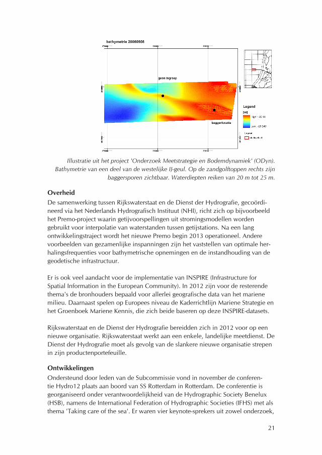
Deltares heeft in opdracht van Rijkswaterstaat het project 'Onderzoek Meetstrate-gie en Bodemdynamiek' (ODyn) uitgevoerd naar verbetering van heropnemings-frequenties van de bathymetrische opnemingen in de aanloopgebieden naar de havens van Amsterdam en Rotterdam en op de Waal. Voor 2013 is Rijkswaterstaat voornemens om het ODyn-project voort te zetten via financiering als een kennis-project voor primaire processen (KPP-project). CristalClear Consultancy adviseert Rijkswaterstaat en de Dienst der Hydrografie over de afstemming van hun initiatie-ven en de ontwikkelingen op de langere termijn om te komen tot risicobeheerste bepaling van heropnemingsfrequenties.
Helaas moet de Nederlandse Defensie Academie (NLDA) stevig bezuinigen, waar-door de financiering van onderzoeksprojecten vaak extern zal moeten geworven. Ongeveer een kwart van de arbeidsplaatsen zal verdwijnen.
OnderwijsDe Nederlandse Defensie Academie (NLDA) heeft de eerste academische bachelor-titels uitgereikt aan zijn studenten. Hiermee heeft een lang accreditatieproces tot het gewenste resultaat geleid. De TU Delft verhuist een deel van de geodetische kennis van de faculteit Luchtvaart- en Ruimtevaarttechniek naar de faculteit Civiele Techniek. De TU Delft werkt aan een nieuwe master Remote Sensing.
21
OverheidDe samenwerking tussen Rijkswaterstaat en de Dienst der Hydrografie, gecoördi-neerd via het Nederlands Hydrografisch Instituut (NHI), richt zich op bijvoorbeeld het Premo-project waarin getijvoorspellingen uit stromingsmodellen worden gebruikt voor interpolatie van waterstanden tussen getijstations. Na een lang ontwikkelingstraject wordt het nieuwe Premo begin 2013 operationeel. Andere voorbeelden van gezamenlijke inspanningen zijn het vaststellen van optimale her-halingsfrequenties voor bathymetrische opnemingen en de instandhouding van de geodetische infrastructuur. Er is ook veel aandacht voor de implementatie van INSPIRE (Infrastructure for Spatial Information in the European Community). In 2012 zijn voor de resterende thema's de bronhouders bepaald voor allerlei geografische data van het mariene milieu. Daarnaast spelen op Europees niveau de Kaderrichtlijn Mariene Strategie en het Groenboek Mariene Kennis, die zich beide baseren op deze INSPIRE-datasets.
Rijkswaterstaat en de Dienst der Hydrografie bereidden zich in 2012 voor op een nieuwe organisatie. Rijkswaterstaat werkt aan een enkele, landelijke meetdienst. De Dienst der Hydrografie moet als gevolg van de slankere nieuwe organisatie strepen in zijn productenportefeuille.
OntwikkelingenOndersteund door leden van de Subcommissie vond in november de conferen-tie Hydro12 plaats aan boord van SS Rotterdam in Rotterdam. De conferentie is georganiseerd onder verantwoordelijkheid van de Hydrographic Society Benelux (HSB), namens de International Federation of Hydrographic Societies (IFHS) met als thema 'Taking care of the sea'. Er waren vier keynote-sprekers uit zowel onderzoek,
Illustratie uit het project 'Onderzoek Meetstrategie en Bodemdynamiek' (ODyn). Bathymetrie van een deel van de westelijke IJ-geul. Op de zandgolftoppen rechts zijn
baggersporen zichtbaar. Waterdiepten reiken van 20 m tot 25 m.
22
overheid, als bedrijfsleven. De opening is verzorgd door kapitein R. Ward, in 2012 verkozen tot president van de International Hydrographic Organization (IHO). Zowel de kwaliteit van het programma als de bezoekersaantallen waren uitstekend.
Nederland heeft het voorzitterschap op zich genomen van de Resurvey Working Group van de North Sea Hydrographic Commission (NSHC). Dit geeft betere mogelijkheden om de internationale ontwikkelingen op het gebied van herhalings-frequenties van dieptemeten af te stemmen op de nationale ontwikkelingen.
Het Europese BLAST-project (Bringing Land And Sea Together) is in 2012 afge-rond. De TU Delft en Deltares maakten deel uit van het project. In werkpakket 3 is gewerkt aan het realiseren van verticale referenties voor een groot deel van de Noordzee. Voor de BLAST-partners is een eenvoudig softwarepakket beschikbaar voor transformaties. Een openbare set met verticale referenties van betere kwaliteit voor het gehele Noordzeegebied blijft nodig.
Subcommissie Ruimtelijke BasisgegevenDe Subcommissie Ruimtelijke Basisgegevens wil de beschikbaarheid en het gebruik van ruimtelijke basisgegevens bevorderen door:
– het afstemmen van onderzoek op het gebied van inwinning, representatie en gebruik van deze gegevens;
– het vastleggen en verspreiden van relevante kennis op dit gebied door middel van publicaties en studiedagen;
– het gevraagd en ongevraagd verstrekken van adviezen aan de NCG en andere betrokkenen;
– het initiëren van specialistisch onderzoek (NCG-promotieplaatsen);– het onderhouden van (inter)nationale wetenschappelijke contacten.
De Subcommissie, onder voorzitterschap van prof.dr.ir. M.G. Vosselman (Universi-teit Twente - ITC), telt acht leden werkzaam op het gebied van de geo-informatie bij universiteiten, overheid, diensten en bedrijven (zie Bijlage 1. Samenstelling van de organen van de NCG). De Nederlandse vertegenwoordigers in EuroSDR (European Spatial Data Research) zijn lid van de Subcommissie (zie Bijlage 2. Internationale betrekkingen).
De Subcommissie heeft in het verslagjaar vergaderd op 23 maart en 21 septem-ber. In deze vergaderingen is onder meer aandacht besteed aan de 3D Pilot NL, Maps4Science, EuroSDR en het organiseren van een studiedag over technische afstemming tussen basisregistraties en er is een presentatie gehouden over het Actu-eel Hoogtebestand Nederland (AHN).

23
3D Pilot NLDe tweede fase van de 3D Pilot NL is gericht op het ontwikkelen van instrumen-tarium om de implementatie van 3D in Nederland verder te ondersteunen. Aan het vervolg van de 3D Pilot werkten meer dan honderd organisaties mee. Er is gewerkt aan een 3D Informatie Model Grootschalige Geografie (IMGeo) op het testgebied Den Bosch met een afstemming met de bouwwereld. Internationaal is er veel belangstelling voor de 3D Pilot. Op 20 november is de 3D Pilot Slotdag 'Van 2D naar 3D BGT. Zelf aan de slag met de derde dimensie' in het Provinciehuis Noord-Brabant in Den Bosch gehouden. Tijdens de 3D Pilot slotdag zijn tools en documenten toegelicht en gedemonstreerd, die beschikbaar worden gesteld aan iedereen die er experimenteel of formeel mee aan de slag wil. Het plan is dat de 3D Pilot over gaat in de 3D Special Interest Group (3D SIG) als verankering van de 3D Pilot.
Presentatie 'Actueel Hoogtebestand Nederland'Tijdens de vergadering van 23 maart gaf ing. M. Arkestijn (Het Waterschapshuis) de presentatie 'Actueel Hoogtebestand Nederland. De waarde van hoogte in de Lage Landen!'. Het Actueel Hoogtebestand Nederland (AHN) is een landsdekkend bestand met hoogtegegevens van het maaiveld met een uniforme kwaliteit, dat tot stand komt op basis van een samenwerking tussen Rijkswaterstaat en de water-schappen. De hoogtegegevens worden ingewonnen met laser scanning in vliegtui-gen met een puntdichtheid van 8 - 10 punten per 1 m2. In de presentatie is onder andere aandacht besteed aan de eisen en de optimalisatie van het product, aan de toekomstige organisatie en het verbreden van de aandachtsgebieden.
Het Actueel Hoogtebestand Neder-land (AHN); landsdekkend bestand met hoogtegegevens van het maai-
veld met uniforme kwaliteit

24

25
A Domain Standard for Land Administration
Dr.Ir. Christiaan Lemmen, Prof.Dr.Ir. Peter van Oosterom and Prof.Ir. Paul van der Molen
AbstractThis paper presents the design of a Domain Model for Land Administration (LA). As a result a formal International Standard is available: ISO 19152 Geographic Infor-mation – Land Administration Domain Model (LADM) (ISO, 2012).
Domain specific standardisation is needed to capture the semantics of the land administration domain on top of the agreed foundation of basic standards for geometry, temporal aspects, metadata and also observations and measurements from the field. A standard is required for communication between professionals, for system design, system development and system implementation purposes and for purposes of data exchange and quality management of data. Such a standard will enable GIS (Geographic Information System) and DBMS (Data Base Management System) providers and/or open source communities to develop products and appli-cations for Land Administration purposes. And in turn this will enable land registry and cadastral organisations to use the components of the standard to develop, implement and maintain systems in an even more efficient way.
The research objective is to design a Land Administration Domain Model (LADM) for Land Administration System (LAS) development. Such a LADM has to be broadly accepted and it should be adaptable to local situations (Lemmen, 2012). It has to be usable to organise Land Administration data within a Spatial Data Infrastructure (SDI). The design is based on the common pattern of 'people – land' relationships. The model should be as simple as possible, it should cover the basic data related components of Land Administration (legal/administrative, mapping and surveying) and it should satisfy user requirements. The Domain Model in its imple-mentation is can be distributed over different organisations with different tasks and responsibilities.
The research does not focus on the legal, political, economic, institutional or financial aspects of Land Administration and Land Administration organisations; at least as far as those are not related to user requirements for the model. Taxation, valuation and land use are knowledge fields in itself and are not within the focus of research.In this paper first the motivation and background of the research are presented, followed by the formulation of goals of LADM. Then the model is introduced, followed by an evaluation. Conclusions are presented and attention is given to options for future work.

26
1. Motivation and backgroundMain political objectives such as poverty eradication, sustainable housing and agriculture, strengthening the role of vulnerable groups (e.g. indigenous people and women), are in many ways related to access to land, and to land-related opportuni-ties. How governments deal with the land issue, could be defined as land policy, and part of the governmental policy on promoting objectives including environ-ment sustainability, economic development, social justice and equity, and political stability (UN ECE, 1996). Having a policy is one thing, having the instruments to enforce this policy is another. Therefore governments need instruments like regula-tions concerning land tenure security, land market, land use planning and control, land taxation, and the management of natural resources. It is within this context that the function of LASs can be identified: a supporting tool to facilitate the implemen-tation of a proper land policy in the broadest sense.
Until today most countries (states or provinces) have developed their own LAS. Some countries operate a deed registration, while other operate a title registration. Some systems are centralised, and others decentralised. Some systems are based on a general boundaries approach, others on fixed boundaries approach. Some LASs have a fiscal background, others a legal one (Bogaerts and Zevenbergen, 2001; UN ECE 1996). However, organisational structures with distributed responsibilities and ever-changing system requirements make the separate implementation and mainte-nance of LASs neither cheap nor efficient. Furthermore, different implementations of LASs do not make meaningful communication very easy, e.g. in an international context such as within Europe or in a national context (for example in a less devel-oped country) where it may happen that different partners in development co-oper-ation design and provide different LASs without co-ordination.
Standardisation is supportive and helpful in design and (further) development of LASs. It is relevant to keep data and process models separated, this means that (inter-organisational) processes can be changed independent from the data sets to be maintained. The data model can be designed in such a way that transparency can be supported: this implies inclusion of source documents and inclusion of the names of persons with roles and responsibilities in the maintenance processes into the data model. The number of attributes should be minimal; during the design of the data model there may be lack of awareness that there is something like a 'mul-tiplier': depending on the number of objects and subjects each attribute can have millions of instances.
Standardisation is a well-known subject since the establishment of LASs. Stand-ardisation concerns identification of parcels, documents, persons, control points and many other issues. It concerns the organisation of tables in the registration and references from those tables to other components, e.g. source documents and maps; this includes efficient access to archives. It concerns coding and use of abbreviations, e.g. for administrative areas. It concerns workflows, etc. It should be observed that all this is valid for both paper based and for digital LASs. During

27
analogue to digital conversions (many) inconsistencies built up in a paper based system can appear: there can be parcels in the registry which are not on the map and the other way around. Such errors should be impossible, because a real right is always related to a person and to a piece of land in reality. The same is valid for the representation of this reality in a register and on a map. This type of inconsistencies should be impossible, but they exist. Measures have to be taken to avoid this in the future after computerisation.
The work described in this paper is the first successful attempt to create an accepted international standard (ISO 19152) in this domain.
A standard for the Land Administration Domain serves the following goals:
– Establishment of a shared ontology implied by the model. This allows enabling communication between involved persons (information managers, profession-als, and researchers) within one country and between different countries. This is relevant in the determination of required attributes and in setting responsibilities on maintenance of data sets in case of implementation of Land Administration in a distributed environment with different organisations involved. This is also in support of the development of LASs as core in SDI (or Geo Information Infra-structures – GII). One more issue is the globalisation; there are already ideas for and approaches to international transactions, e.g. within the European Union. Also in relation to carbon credits registration.
– Support to the development of the application software for LA. The data model is the core here. Support in the development of a LAS means provision of an extendable and adaptable fundament for efficient and effective LAS development based on a Model Driven Architecture (MDA). This approach offers automatic conversions from models to implementation, where local details can be added to the conceptual model first.
– Facilitation of cadastral data exchange with and from a distributed LAS. Within SDI (GII) combination of LA data with other data sources should be possible. For example legal data related to cadastral objects with data from other sources describing physical objects as roads, buildings or utilities. Exchange can be between cadastres, land registries and municipalities and between countries in a federal state or between countries; etc.
– Support to data quality management in LA. Use of standards contributes to the avoidance of inconsistencies between data maintained in different organisations because data duplication can be avoided as much as possible. It should be noted here that a standardised data model, which will be implemented, can be support-ive in the detection of existing inconsistencies. Quality labels are important for all attributes.

28
2. Research objectiveIn spite of the available basic standards (for modeling the Unified Modelling Lan-guage – UML), exchanging structured information (eXtended Markup Language: XML) and ISO generic geo-information standards, there is still one important aspect missing: a standard and accepted base model for the land administration domain.
There is a need for domain specific standardisation to capture the semantics of the land administration domain on top of the agreed foundation of basic standards for geometry, temporal aspects, metadata, and also observations and measure-ments from the field. This is required for communication between professionals, for system design, system development and system implementation purposes and for purposes of data exchange and data quality management. Such a standard will enable GIS and database providers and/or open source communities to develop products and applications. And in turn this will enable land registry and cadastral organisations to use these components to develop, implement and maintain systems in an even more efficient way.
The research objective is to design a Land Administration Domain Model (LADM). It should be possible to use this model as a basis for LAS development. Such a LADM has to be accepted and it should be adaptable to local situations. It has to be usable to organise LA data within a SDI. The design should be based on the pattern of 'people – land' relationships.
It should be noted that the LADM should be as simple as possible, in order to be useful in practice. And it should cover the basic data related components of land administration. This means a start from consolidated knowledge; a re-use of exist-ing, widely recognised and accepted knowledge in order to achieve generic results. For the LA domain much attention has been paid to the development of the rep-resentation of all possible relationships between people and land, not only formal relationships like ownership but also informal relationships as proposed in UN-HABITATs (UN-HABITAT is the United Nations Human Settlements Programme) continuum of land rights (UN-HABITAT, 2008). A similar continuum can be applied to the development of a range of parcels (spatial units, see also Fourie (1998) and Fourie and Nino-Fluck (2000)), persons and organisations (parties), and data acquisition methods, see also FIG (1996). See also the 'axes of variation' in Larsson (1991). Further the concepts of 'Cadastre 2014' of the FIG should be covered; see Kaufmann and Steudler (1998).
Given the research objective, and a design of a LADM, the following questions are formulated:
– What is the common pattern of 'people – land' relationships?– How can the model be used as a basis for LAS development?– Is the design usable within a Spatial Data Infrastructure?– Is the design accepted and supported by LA professionals and governments?

29
– Is the design adaptable to local situations?– Is the design implementable and applicable in a real life situation?
3. The LADMThe design of the LADM took place in an incremental approach, resulting in three main versions: A, B and C. For the Versions A and B this concerns input from workshops, personal experience, other expertise and improvements from reviews of publications and for the Version C of the LADM the development process for International Standards. After preparatory works of almost six years the LADM has been submitted to the ISO and parallel to CEN, this is the Comité Européen de Normalisation.
The Draft International Standard, published by ISO as ISO 19152, covers basic information related to components of land administration (including water and ele-ments above and below the earth's surface). It includes agreements on data about administrative and spatial units, land rights in a broad sense and source documents (e.g. deeds or surveys). The rights may include real and personal, formal rights as well as indigenous, customary and informal rights. All types of restrictions and responsibilities can be represented. The draft standard can be extended and adapted to local situations; in this way all people – land relationships may be represented. The UML class diagram is represented in Figure 1.
The three main packages of the LADM consist of the Party package, the Administra-tive package and the Spatial Unit package.
class Classes of LADM
LA_SpatialUnit
LA_Party
LA_RRR
LA_BAUnit
LA_GroupParty
LA_PartyMember
LA_Right
LA_Restriction LA_Responsibility
LA_Mortgage
LA_Administrativ eSource
LA_SpatialUnitGroupLA_LegalSpaceBuildingUnit
LA_LegalSpaceNetwork
LA_Lev el
LA_Source
LA_BoundaryFaceString
LA_BoundaryFace
LA_Point
LA_SpatialSource
Figure 1. The Land Administration Domain Model.

30
The main class of the party package of LADM is class LA_Party with its specialisa-tion LA_GroupParty. There is an optional association class LA_Party-Member. A Party is a person or organisation that plays a role in a rights transaction. An organi-sation can be a company, a municipality, the state, or a church community. A 'group party' is any number of parties, forming together a distinct entity. A 'party member' is a party registered and identified as a constituent of a group party. This allows documentation of information to membership.
The administrative package concerns the abstract class LA_RRR (with its three concrete subclasses LA_Right, LA_Restriction and LA_Responsibility), and class LA_BAUnit (Basic Administrative Unit). A 'right' is an action, activity or class of actions that a system participant may perform on or using an associated resource. Examples are: ownership right, tenancy right, possession, customary right or an informal right. A right can be an (informal) use right. Rights may be overlapping or may be in disagreement. A 'restriction' is a formal or informal entitlement to refrain from doing something; e.g. it is not allowed to build within 200 meters of a fuel station; or a servitude or a mortgage as a restriction to the ownership right. A 'responsibility' is a formal or informal obligation to do something; e.g. the responsibility to clean a ditch, to keep a snow-free pavement or to remove icicles from the roof during winter or to maintain a monument. A 'baunit' (an abbreviation for 'basic administra-tive unit') is an administrative entity consisting of zero or more spatial units (parcels) against which one or more unique and homogeneous rights (e.g. an ownership right or a land use right), responsibilities or restrictions are associated to the whole entity as included in the Land Administration System. An example of a 'baunit' is a basic property unit with two spatial units (e.g. an apartment or a garage). A 'basic admin-istrative unit' may play the role of a 'party' because it may hold a right of easement over another, usually neighboring, spatial unit.
The spatial unit package concerns the classes LA_SpatialUnit, LA_SpatialUnitGroup, LA_Level, LA_LegalSpaceNetwork, LA_LegalSpace-BuildingUnit and LA_Require-dRelationshipSpatialUnit. A 'spatial unit' can be represented as a text ("from this tree to that river"), a point (or multi-point), a line (or multi-line), representing a single area (or multiple areas) of land (or water) or, more specifically, a single volume of space (or multiple volumes of space). Single areas are the general case and multiple areas the exception. Spatial units are structured in a way to support the creation and management of basic administrative units. A 'spatial unit group' is a group of spatial units; e.g.: spatial units within an administrative zone (e.g. a section, a canton, a municipality, a department, a province or a country) or within a planning area. A 'level' is a collection of spatial units with a geometric and/or topologic and/or thematic coherence. The Spatial Unit Package has one Surveying and Spatial Representation Sub-package with classes such as LA_SpatialSource, LA_Point, LA_BoundaryFaceString and LA_BoundaryFace. Points can be acquired in the field by classical surveys or with images. A survey is documented with spatial sources. A set of measurements with observations (distances, bearings, etc.) of points, is an attribute of LA_SpatialSource. The individual points are instances of

31
class LA_Point, which is associated to LA_SpatialSource. 2D and 3D representations of spatial units use boundary face string (2D boundaries implying vertical faces forming a part of the outside of a spatial unit) and boundary faces (faces used in 3D representation of a boundary of a spatial unit). Co-ordinates themselves either come from points or are captured as linear geometry.
Implementation of the LADM can be performed in a flexible way; the draft standard can be extended and adapted to local situations. External links to other databases (supporting GII type of deployment), e.g. addresses, are included. Legal implica-tions that interfere with (national) land administration laws are outside the scope of the LADM.
The DIS has been developed on the basis of a set of user requirements derived from existing literature (Lemmen, 2012), from experience from practise, both personal and from experts from many different countries and earlier publications on LADM, including earlier versions published within ISO (ISO/TC211, 2008a, ISO/TC211, 2008b, ISO/TC211, 2009).
4. EvaluationThe design of the LADM took place in an incremental approach with a continuous expert reviewing from 2002 till 2006. The final construction took place with Enter-prise Architect software. Then the design and development process for International Standards has been followed as a methodology for LADM design from 2008 till 2012. In order to answer the research questions the following methodology is used:
1. What is this common pattern of 'people – land' relationships?To answer this question a literature review is performed on relevant papers related to this issue – with a lot of attention to informal people to land relationships. Documentation on land conflicts is included. Attention is paid to gender to land (shares in land). Social tenures are worked out in the Social Tenure Domain Model (STDM); this is a specialisation of the LADM. A prototype has been developed to process collected data from the field.
2. How can the model be used as a basis for LAS development?To answer this question a test has been performed in Honduras. A Model Driven Architecture (MDA) provides a platform independent functionality. Standards, as provided by international standardisation bodies like the Object Management Group and ISO are identified with regard to MDA.
3. Is the design usable within a Spatial Data Infrastructure?Domain models related to the LA domain do not yet exist. Related (future) domain models are considered to be "external", but can be linked in an information infra-structure. This is a design approach where well defined interfaces are recognised with an update mechanism to keep SDI consistent.

32
4. Is the design accepted and supported by LA professionals and governments?In their paper Van Oosterom and Lemmen (2002a) propose to join forces and start working on a standard and accepted cadastral base model. Such a model should be usable in (nearly) every country. The standardised cadastral domain model should be described in UML schemas and accepted by experts in LA modelling, by the proper international organisations and by software suppliers.
An early review was related to the publication of a pre-version of the LADM, called the Core Cadastral Domain Model (Van Oosterom and Lemmen, 2002b). LADM versions were not only discussed with LA professionals. Legal professionals, geod-esists, anthropologists, land reformers and ICT professionals were all involved in the discussions and reviews.
In the beginning of 2008, FIG submitted a proposal to develop an International Standard for the Land Administration (LA) domain to the ISO/TC 211 on Geo-graphic Information of the International Organization for Standardization (ISO/TC211, 2008a). The proposal received a positive vote from the TC 211 member countries on May 2, 2008, and a project team started to work on the development of the standard. Within TC 211, many issues and comments have been discussed during several meetings (in respectively May 2008, October 2008, December 2008, May 2009 and November 2009), held with a project team composed of 21 delegates from 17 countries. A significant contribution to the development of the standard has been provided by the research communities of the Faculty of Geo-Information Science and Earth Observation of the University of Twente (ITC) and Delft University of Technology, the Netherlands.
After positive results of voting on the so-called New Working Item Proposal (NWIP) in May 2008 (ISO/TC211, 2008a) and on the Committee Draft (CD) on October 12, 2009 (ISO/TC211, 2009) the Draft International Standard (DIS) received a positive vote on June 27, 2011 (ISO, 2011); see Table 1. A final voting round resulted in acceptance as International Standard on November, 6th, 2012. Each step in the developments within ISO includes reviews from countries involved in the develop-ment process.
Voting NWIP CD DIS IS
Approve 15 22 26 30Disapprove 6 3 2 0Abstain 4 4 4 3Not Voted 7 3 0 1
Table 1. Voting results at the various stages of ISO 19152.
During the development of the LADM many reviews have been performed resulting in new insights, improvements and proposals for extensions.

33
The standard has been developed by experts from all over the world: UN Habi-tat Land Tenure Section with its comprehensive knowledge on customary tenure systems, EU Joint Research Centre with a broad knowledge base on INSPIRE and LPIS, the United Nations School for Land Administration Studies and experts from Land Administration and Cadastral organisations, universities and normalisation institutes. See Figure 2.
5. Is the design adaptable to local situations?This is investigated in close co-operation with experts in modelling land adminis-trations from different countries: Cyprus and Honduras. Other cases are INSPIRE Cadastral Parcels and the Land Parcel Identification System (LPIS).
6. Is the design implementable and applicable in a real life situation?This is tested by the development of a prototype of the STDM.
The development of an International Standard within ISO is a comprehensive, extensive, formal process with a continuous review and a continuous, creative approach to find common denominators in land administration systems, includ-ing data sets. Many comments and observations have been processed to bring the LADM to the required quality level needed for international acceptance.
The International Standard, covers basic information related to components of land administration - land administration includes water and elements above and below the earth's surface (ISO, 2012). Those components concern: party related data; data on RRRs and the basic administrative units where RRRs apply to; data on spatial units and on surveying and topology/geometry. The data sets in those components are represented in UML packages and class diagrams in this thesis. All data in a
Figure 2. ISO 19152 Editorial Committee, Meeting in Molde, Norway, May 2009.

34
land administration are supposed to be documented in (authentic) source docu-ments. Those source documents are the basis for building up a trusted and reliable land administration, as basis for transactions and for the establishment of new land rights in a land administration.
Rights may include real and personal, rights as well as indigenous, customary and informal rights. All types of restrictions and responsibilities can be represented. Overlapping claims to land may be included.
The common denominator or the pattern that can be observed in land admini-stration systems is with a package of party/person/organisation data and RRR/legal/administrative data, spatial unit (parcel)/immovable object data. This can be derived from the existing work on Land Administration Domain Modelling, see (Lemmen, 2012). During the LADM design it became more and more clear that the Triple 'Subject – Right – Object' is insufficient to cover a group of exist-ing LASs which is not 'parcel or spatial unit based' but 'property based'. In those LASs all spatial units 'belonging' to the same basic property unit are seen as one single object. This implies the core classes Party, RRR and SpatialUnit have to be extended with one more class BAUnit: 'Basic Administrative Unit'. The innovation is in the availability of the LADM as a basis for structuring and organising of representations of people to land related information in databases in a generic way. Structuring and organising data may be in interaction with data in other databases. Databases can be implemented in a distributed environment in dif-ferent organisations with different responsibilities in Land Administration. The MDA approach can support in generating database schemas. Exchange formats (XML) between organisations – in case of a distributed environment for implementation – are not illustrated in this thesis. An application schema is needed for software development, but this can only be developed after the local demands are precisely known. The application schema can be built on the generic conceptual schema of the LADM combined with local needs. This is also demonstrated in FAO FLOSS SOLA (FAO, 2011).
Annex A of ISO 19152 provides an abstract test suite to check if a model is LADM compliant.
The LADM is usable within a Spatial Data Infrastructure. This concerns firstly the data exchange between organisations involved in land administration, packages have been introduced in LADM for a proper representation of tasks and responsi-bilities. Secondly LADM can be a basis for combining data from different LASs; e.g. LASs with datasets on formal and informal People to Land relationships. The Draft International Standard includes informative example cases with People to Land relationships demonstrating the flexibility of the draft standard in its Annex C. The LADM opens options now to bridge gaps between cultures where People to Land relationships are concerned, definitively not only in support of globalisation, but

35
also with a strong attention to bring support in the protection of land rights (tenure certainty) for all. Thirdly, for implementation in SDI the links to external classes in other registrations, are important, see Figure 3.
There is support from professions, e.g. within FIG (FIG submitted the NWIP to ISO, LADM is 'FIG Proof'), ISO/TC211 (an editorial committee with experts from about ten countries prepared the ISO 1952), UN-HABITAT (the development and implementation of STDM), EU (attention to LADM in relation to LPIS, INSPIRE), FAO (LADM as basis for FLOSS/SOLA) and countries, e.g. Cyprus, Portugal and Honduras, see (Lemmen, 2012). Bahrain, Canada, Indonesia, Montenegro, Uganda, Senegal and South Korea are adopting or interested.
The draft standard can be extended and adapted to local situations; in this way all People to Land relationships may be represented. This can be supportive in the development of software applications built on database technology. LADM describes the data contents of land administration in general. Implementation of the LADM can be performed in a flexible way; the standard can be extended and adapted to local situations.
Applications in real life situations can be concluded from: firstly the prototype based on STDM for processing of field work data for validation purposes. Secondly the case from Cyprus, thirdly the case from Honduras and fourthly the case from Portugal (see for those cases Lemmen, 2012).
class Figure K1. External LADM classes (without attributes, etc.)
LA_Party
LA_RRR
LA_BAUnit
LA_SpatialUnit
ExtTaxation
ExtLandUse
ExtValuation
ExtLandCov er
LA_LegalSpaceNetwork
ExtPhysicalNetwork
ExtParty
ExtAddress
ExtArchiv e
Figure 3. LADM and External classes.

36
In general it can be observed that standardisation is a comprehensive, extensive, formal process with continuous peer reviews and iterations based on experience of earlier implementations. For LADM this (creative) approach resulted in find-ing common denominators in land administration. A main effort was in finding agreement between experts from different countries and in provision of balanced reactions to comments and observations made by experts. The standard has been designed in such a way that it can easily be changed depending on local demands. Application of the standard is far away from 'dogmatic implementations' with fixed rules, on the contrary: the approach is as flexible as possible. It is a common lan-guage for LA enabling understanding each other. ISO has a standard update cycle for revisions of standards.
5. Conclusion The objective of this research has been achieved; the research questions have been answered. Validation has been performed. The fact that an international expert group has been involved in the LADM development – with a lot of experience in developments and implementations of LASs – is a solid basis. See Figure 1.
It can be concluded that the common pattern in Land Administration can be rep-resented in four core classes: Party, RRR, BAUnit and SpatialUnit. An application schema can be built on the generic conceptual schema of the LADM for implemen-tation in a distributed environment. The LADM is usable within SDI. Acceptance from within the international professional environment can be observed. LADM can be adapted to local situations.
The wide range of functionality of LADM is in support to:
– the continuum of land rights (management of different tenures in one environ-ment), the continuum of approaches, the continuum of recordation, the contin-uum of spatial units and subjects. The LADM opens options now to bridge gaps between cultures where People to Land relationships are concerned, definitively not only in support of globalisation, but also with a strong attention to bring sup-port in the protection of land rights (tenure certainty) for all,
– land administration system design and development with coverage of all tenure types. Those systems can operate in formal and informal environment ("self made land administration"). LADM describes the data contents of land adminis-tration in general. Implementation of the LADM can be performed in a flexible way; the standard can be extended and adapted to local situations. Alignment with ICT developments is possible (the LADM is available in a well known mod-eling language, model driven architectures can be developed on the basis of the standard,
– the quality upgrading of existing (not proper maintained) datasets (consistency building and validation),

37
– the management of a wide range of documentation options. This concerns evi-dence from the field and legal, transactional, and administrative documents,
– land administration development. Software and data base developers like stable (but extensible) standards as a starting point for developments. Both industrial software developers and open source software communities are enthusiastic. LADM allows a flexible, step by step approach in the development of a Land Administration based on the needs, priorities and requirements of users and society. This can be combined in a natural way with organizational development with a proper alignment to ICT development,
– the linking to workflow management. Processes are not integrated in LADM, linking is possible by role types, versioning, quality labels and exchange of data between involved organisations,
– structuring and organising data in interaction with data in other databases. Data-bases can be implemented in a distributed environment in different organisations with different responsibilities in Land Administration and population registra-tion. The LADM is usable within a Spatial Data Infrastructure. This concerns the data exchange between organisations involved in land administration. The LADM "packages" have been introduced for a proper representation of tasks and responsibilities (which can be in different organisations). LADM can be a basis for combining data from different LASs; e.g. LASs with datasets on formal and informal People to Land relationships. The International Standard includes informative example cases with People to Land relationships demonstrating the flexibility of the standard. For implementation in SDI the links to external classes in other registrations are important.
LADM will be maintained by ISO/TC211. Relevant existing international standards1
have been re-used in LADM. Those data standards are accepted in the world of the Geographical Information Systems and Data Base Management Systems – and maintained by ISO TC211. LADM is a conceptual model and is already is use as such (country profiles, integration in INSPIRE and the Land Parcel Identification System of the European Union, basis for software development initiatives at FAO and UN Habitat, etc, see Lemmen (2012), the next steps include elaborating (via a country profile) and realizing a technical model suitable for implementation: database schema (SQL DDL), exchange format (XML/GML), and user interface for edit and dissemination. A good option for this is the collaboration between FIG and OGC to standardize this technical model (with options such as CityGML or LandXML). When considering the complete development life cycle of rural and,
1. For example: ISO/IEC 13240:2001, Information technology – Document description and
processing languages – Interchange Standard for Multimedia Interactive Documents (ISMID); ISO
19107:2003, Geographic Information – Spatial schema; ISO 19108:2002, Geographic Information
– Temporal schema; ISO 19111:2007, Geographic Information – Spatial referencing by coordinate;
ISO 19115:2003, Geographic information – Metadata; ISO 19125-2:2004, Geographic information
– Simple feature access – Part 2: SQL option; ISO 19156:2011, Geographic information – Obser-
vations and measurements.

38
in particular, urban areas, many related activities should often also support 3D representations (and not just the cadastral registration of the 3D spatial units associ-ated with the correct RRRs and parties). The exact naming of these activities differs from country to country, and their order of execution may differ. However, in some form or another, the following steps performed by various public and private actors, which are all somehow related to cadastral registration, are recognized: develop and register zoning plans, design new spatial units/objects; acquire appropriate land/space; request and provide (after check) permits. Etc.
Several of the activities and their information flows need to be structurally upgraded from 2D to 3D representations. Because this chain of activities requires good information flows between the various actors, it is crucial that the meaning of this information is well defined – an important role for standardization. Important are ISO 19152 (LADM) and ISO 19156 (Observations and Measurements), and very related and partially overlapping is the scope of the new OGC's Land Development – Standards Working Group (LD-SWG), with more of a focus on civil engineering information, e.g., the planned revision of LandXML (to be aligned with LADM). This phenomenon is especially true for 3D cadastre registration because it is being tested and practiced in an increasing number of countries. For example, for build-ings (above/below/on the surface or constructions such as tunnels and bridges), and (utility) networks, this overlap is clear. LADM is focusing on the spatial/legal side, which could be complemented by civil engineering physical (model) extensions. It is important to reuse existing standards as a foundation and to continue from that point to ensure interoperability in the domain in our developing environment!
With the official status of the LADM as an International Standard approaching, the question arises: what's next? The answer is of course more implementation and use of the model in practice. Already several country profiles have been designed and other model usage is being conducted.
Future requirements concern (Uitermark et al, 2010): formalisation of current con-straints, standardisation of processes, new RRRs, mature information infrastructures to serve society; 3D, 4D that is, space and time integrated in Land Administration; applications of augmented reality; spatial design applications; semantic web tech-nologies; monitoring applications; and user dominance (this is a dynamic process model with acquisition/updating/participation by actors and community driven cadastral mapping – crowdsourcing). LADM is a requirement here from a modelling perspective.
Future maintenance within ISO TC211 includes (amongst others): further detaill-ing of the legal/administrative package, maintenance of code tables and the link to LandXML. This has to be organised in close co-operation with FIG and the Open GeoSpatial Consortium.

39
ReferencesBogaerts, T. and Zevenbergen, J.A., (2001). "Cadastral systems - alternatives." Computers, Environment and Urban Systems 25 (4-5): pp. 325 - 337. FAO, (2011). FAO FLOSS SOLA Data Dictionary for the SOLA Desktop Development Snap shot, version 1.0. Prepared by Elton Manoku, Matthew Boafo and Neil Pullar. Version
1.0, August 24, 2011.FIG, (1996). The Bogor declaration for cadastral reform. Inter-Regional Meeting of Experts on Cadastre, Bogor, Indonesia.Fourie, C., (1998). An integrated geo-information system with emphasis on cadastre and land information systems for decision makers in Africa, working document for the expert group
meeting held at United Nations Economic Commission for Africa, Addis Ababa, Ethiopia, 23 - 26 November 1998.
Fourie, C., and Nino-Fluck, O., (2000). Cadastre and Land Information Systems for Decision Makers in the Developing World, paper presented at the UN-FIG Conference on Land
Tenure and Cadastral Infrastructures for Sustainable Development, Melbourne, Australia, October 25-27, 1999. Paper published in Geomatica, 54 (2000): pp. 335 - 342.
ISO, (2011). ISO 19152, Draft International Standard (DIS), Geographic information - Land administration domain model (LADM). Lysaker, Norway: ISO: 118 p.ISO, (2012). ISO 19152:2012, Geographic Information – Land Administration Domain Model. Edition 1, 118 p. Geneva, Switzerland.ISO/TC 211, (2008a). ISO 19152 New work item proposal (NWIP), Geographic information – Land administration domain model (LADM). Lysaker, Norway.ISO/TC 211, (2008b). ISO 19152 Working Draft 3 (WD3), Geographic information – Land Administration Domain Model (LADM). Lysaker, Norway.ISO/TC 211, (2009). ISO 19152. Committee Draft (CD), Geographic information – Land Administration Domain Model (LADM). Lysaker, Norway.Kaufmann, J. and Steudler, D., (1998). Cadastre 2014. A vision for a future cadastral system. FIG XXI International Congress. Brighton, United Kingdom.Larsson, G., (1991). Land regsitration and cadastral systems. Tools for land information and management. Longman Scientific and Technical.Lemmen, C.H.J., (2012). A Domain Model for Land Administration. Publications on Geodesy 72. Netherlands Geodetic Commission. Delft, 2012. 244 p. ISBN: 978 90 6132 336 5.Uitermark, H.T., Van Oosterom, P.J.M., Zevenbergen, J.A. and Lemmen, C.H.J., (2010). From LADM/STDM to a spatially enabled society: a vision for 2025. The World Bank Annual
Bank Conference on Land Policy and Administration. Washington D.C.UN-HABITAT, (2008). Secure land rights for all. Nairobi, Kenya, United Nations Human Set- tlements Programme: 40 p.UN ECE, (1996). Land administration guidelines. With special reference to countries in transi- tion. Geneva, Switzerland, United Nations/Economic Commission for Europe: 112 p.Van Oosterom, P.J.M. and Lemmen, C.H.J., (2002a). Impact analysis of recent Geo-ICT devel- opments on cadastral systems. FIG XXII International Congress, Washington, D.C. USA,
FIG.Van Oosterom, P.J.M. and Lemmen, C.H.J., (2002b). Towards a standard for the cadastral domain: proposal to establish a core cadastral model. COST Action G9 workshop, Delft,
the Netherlands.

40
There is a LADM wiki available: http://isoladm.org

41
Dr. Sander Oude Elberink (U Twente), Dr. Jantien Stoter (TU Delft, Kadaster, Geonovum), Dr. Hugo Ledoux (TU Delft),Ir. Tom Commandeur (TU Delft, Hydrologic Research)
This work is originally published, in an extended version, by the American Society for Photogrammetry & Remote Sensing, Bethesda, Maryland, USA.
AbstractThis paper describes the generation of a national three-dimensional (3D) dataset representing the virtual and landscape model. The 3D model is produced automati-cally by fusing a two-dimensional (2D) national object-oriented database describ-ing the physical landscape and the national high-resolution height model of the Netherlands. Semantic constraints are introduced to correctly model 3D objects. Three areas from different regions in the Netherlands have been processed in order to develop, improve and test the automatic generation of a national 3D city and landscape model. Specific attention has been paid to exceptional cases that may occur in a nationwide dataset. Based on the test results, the Kadaster, the national agency in the Netherlands responsible for the production of nation wide geo-information, decided that it is feasible to produce a national 3D city and landscape model that fulfills the specifications that were defined as part of this study. Future research is identified to make the results further ready for practice.
1. IntroductionOver the past two years, a uniform approach for acquiring, storing and visualizing 3D geo-information has been explored in a pilot in the Netherlands. In this pilot, over 65 private, public and scientific organizations have collaborated to push the use of 3D information. The pilot project established the groundwork for a com-prehensive national 3D geo-information program. A major result was a proof of concept for a 3D spatial data infrastructure (SDI) covering issues on the acquisition, standardization, storage and use of 3D data (Stoter et al., 2011).
Besides the need for a national 3D standard realized as City Geography Markup Language (CityGML) implementation (OGC, 2008; 2012a) (see Van den Brink et al., 2013), the pilot showed the need for a nationwide 3D city and landscape model. This model can serve as a reference for (new) 3D information in a 3D virtual world, and as a basis for 3D planning and management of public space. The 3D base model can be further refined when a project develops.
Generation of a National Virtual 3D City and Landscape Model for the Netherlands
42
Many large municipalities have 3D data sets, but these are specifically required for the territory of the city and in various formats and resolutions. The pilot has shown promising results for generating a national 3D city and landscape model as a com-bination of 2D topography with high-resolution airborne Light Detection and Rang-ing (Lidar) data. This paper describes how those results are further developed to generate a national 3D topographic dataset covering the whole of the Netherlands.The work is collaboration between the University of Twente, the Delft University of Technology, and the Kadaster, the national agency in the Netherlands respon-sible for the production and provision of nation wide geo-information. Three areas from different regions in the Netherlands have been processed in order to develop, improve and test the automatic generation of a 3D dataset. The test areas include complex interchanges, buildings above roads, bridges, urban areas and forested areas.
This paper describes the applied methodology (including the choices that were made), the results, findings and remaining challenges to obtain a first version of the national 3D dataset in 2012. As our goal is to generate a nationwide 3D dataset, our procedure has to pay specific attention to manage large datasets and to handle any situation. It means that the design should fulfill five main conditions, i.e. our procedure should:
1. Be fully automatic;2. Deal with inaccuracies in both datasets;3. Create valid 3D geometries;4. Completely cover the country;5. Handle all – including special – situations.
In addition, since the dataset is intended as a foundation for the 3D Spatial Data Infrastructure (SDI), the interest is not only in the generation of the 3D data but also in the maintenance and dissemination of the 3D dataset.
The structure of the paper is as follows. After a description of related work (Section 2), Section 3 presents the specifications of the 3D dataset that represents the virtual city and landscape model. The proposed 3D reconstruction methodology covering the five conditions is presented in Section 4. Section 5 presents results, followed conclusions and identification of future research and developments in Section 6. In the extended version (Oude Elberink et al., 2013) published by ASPRS, more details on special situations and the dissemination of 3D models are described.
2. Related workThe research attention on automated generation of 3D information from a combina-tion of 2D topographic vector data and high resolution Lidar data is not new. Two main reasons justify this combinatorial approach. Firstly existing 2D datasets con-tain information about the types of object to generate (i.e. building, road, water etc.)

43
that increases the possibilities to automatically generate 3D information. Secondly the 2D topographic datasets often contain rich semantics, such as functionality of objects, which is difficult to obtain from automated acquisition techniques.
Previous research on this topic is reported in (Haala et al., 1998). They describe the combination of detailed Digital Surface Models (DSM) and 2D topographic objects to reconstruct urban objects such as buildings and trees. To enhance the boundary representation of objects, Koch and Heipke (2006) introduce semantic rules when fusing a DSM with 2D map data. These rules ensure a logical and consistent 2.5D representation (i.e. height surface representation) of the topographic objects. Oude Elberink and Vosselman (2009a) propose an extension of these semantic rules to real 3D, to ensure that actual 3D objects, such as bridges and interchanges can be represented realistically.
In recent years the density of point clouds, either generated from Lidar data or aerial imagery, has increased up to several points per square meter. The increasing point density is considered important in 3D reconstruction algorithms because it allows for a more detailed and reliable description of objects. Even more important for national mapping agencies is the national coverage of such datasets.
3. The 3D datasetThis section presents the two source datasets (Section 3.1 and 3.2) and explains the specifications of the 3D object-oriented topographic dataset that were defined as part of our study (Section 3.3).
3.1 Source data: the 2D topographic datasetIn the Netherlands, two 2D topographic vector data sets are candidates for exten-sion into 3D: the large-scale base dataset, modeled according to Information Model Geography (IMGeo) and the national topographic vector map at scale 1:10,000. The first data set is the object-oriented version of the large-scale base map of the Netherlands, with a scale of approximately 1:500 (1:1000 in rural areas). The new version of the model IMGeo has recently been established and nationwide cover-age of IMGeo data (in 2D) is expected to be ready in 2015. Providers of the IMGeo data are municipalities, provinces, agencies responsible for the railway and high way network infrastructure (Prorail and Rijkswaterstaat), and Kadaster. The second candidate source dataset for extension in 3D is an object oriented topographic data-set at scale 1:10,000 (called TOP10NL) available for the whole country since 2006 and maintained by the Dutch Kadaster.
Although IMGeo has been fully prepared for extension into 3D by integration of the information model with the OGC CityGML standard (Stoter et al 2011; Van den Brink et al, 2013), we selected TOP10NL as the most suitable candidate for a nationwide 3D base dataset. This has several reasons. Firstly TOP10NL data is available nationwide while 2D IMGeo data will only be generated in the coming

44
years. Secondly, TOP10NL is less detailed than IMGeo and therefore better suit-able for fully automatic 3D object reconstruction since fewer details are required (therefore less special cases). Despite fewer details, we are of the opinion that the resulting dataset generated from TOP10NL is appropriate for a nationwide data-set (i.e. acceptable performance for nationwide applications), and that it can be further refined when applied in future projects. Finally for an automated workflow it is essential that the data have been acquired in a standardized manner. Since TOP10NL has only one data provider, the data are homogenous for the whole country and the nice side effect is that the 3D result will be a consistent national 3D dataset. Consequently it was decided that for the moment, 3D TOP10NL is the best option to generate and disseminate a nationwide 3D base dataset.The main classes in TOP10NL (see Figure 1) are: Road, Land Use, Water, Railway, Layout Element, Registration Area, Building, Geographical Area, Functional Area, and Relief.
The land use, road and water objects that can be seen from above form a complete partition of the country, without any gaps or overlap. Consequently, buildings, and also functional and geographical areas, overlap with other objects. In addition infra-structure objects can cross (i.e. overlap in 2D). This is modeled using two attributes assigned to infrastructural classes with polygon geometry (Water and Road): a 'type of infrastructure' attribute, which models whether the infrastructure object is a con-nection or a crossing and the 'height level' attribute. This last attribute models the relative order of objects where a value of '0' indicates that the object is on top of a stack of two or more objects (i.e. visible from above). All objects at height level '0' constitute the planar partition.
3.2 Source data: the Lidar dataset3D TOP10NL is generated by combining the TOP10NL vector data with the national height model of the Netherlands (called AHN, see (AHN, 2012)), which is
Figure 1. TOP10NL data of the test area in Amersfoort.

45
acquired by airborne Lidar systems. The first version of AHN (with a density of at least one point per 16 square meters, and in forests one point per 36 square meters) was completed in 2003. In the period of 2009 – 2012, the second version of the data set is acquired with an average point density of 10 points per square meter. Currently a third version, possibly enriched with pulse count information, is being considered.
The AHN data set has been acquired, assessed, filtered and stored in a standardized manner, in terms of specifications on point densities, overlapping areas and quality reports. A useful property of the height model is the filtering step that separates points on ground and points on elevated objects such as trees and buildings, as shown in Figure 2. The companies that acquire the data also filtered the data and therefore the AHN point data is available as two products for any customer. In our procedure we use the second version of the AHN (i.e. AHN-2) data, which includes both the ground and non-ground points. Notice that the dataset is also available as a grid (different resolutions are available) but we use the original samples.
3.3 Specifications of the 3D TOP10NL datasetThe aim of 3D TOPNL is to have a 3D version of the 2D vector map covering the whole country. Consequently the map objects should still be available in the 3D model but now with the 2.5D (i.e. height-surface) and 3D (i.e. volumetric) repre-sentations. Not all TOP10NL classes are relevant or suitable for an extension to 3D, for instance functional land use (e.g. zoo, cemetery) and point based features (e.g. striking objects) are not. We therefore selected the most appropriate classes, which are road, water, geographic land use and buildings.
The type of 3D representation that is generated (i.e. 2.5D or 3D) depends on the class. Following the characteristics of the TOP10NL objects, we decided to obtain volumetric geometries (3D) for buildings and height surface geometries (2.5D) for
Figure 2. Lidar (AHN) data: ground points (left) ranging between 5 m (dark grey) and 22 m (white) above means sea level (MSL); and non-ground points (right) ranging from 5 to 48 meters above MSL. Black areas do not contain laser points because points are either
removed during the filtering or because these are areas with water.

46
the other objects (road, water and land use). Multi-level infrastructural crossings are represented through surface geometries that connect in space (Figure 3, left).
'Forest' (which is a type of geographic land use) is a specific case, since the AHN data contains two products at those locations: the point data at the terrain level and point data representing the heights of the trees. To represent both types of informa-tion in the resulting dataset, we create a height surface from the tree heights that we extrude downwards to the terrain level, see Figure 3, right. Both types of height (tree heights and terrain heights) are relevant information at those locations.
4. Methodology for the generation of a nationwide 3D datasetThis section presents the methodology and engineering choices to generate a nationwide 3D dataset. It is organized according to the five main conditions that we should fulfill, introduced in Section 1:
1. Fully automatic reconstruction (Section 4.1);2. Dealing with inaccuracies in both datasets (Section 4.2);3. Creation of valid 3D geometries (Section 4.3);4. Covering a large area, i.e. a complete coverage of the country (Section 4.4);5. Handling all -including special- situations (Section 4.5).
4.1 Automatic 3D generation processThe procedure to obtain the 2.5D and 3D representations from TOP10NL object builds on the work of Oude Elberink and Vosselman (2009a). The 3D generation of polygon boundaries is a two-step procedure: firstly heights are assigned to polygons following specific rules (section 4.1.1); secondly information on neighboring poly-gons is used to refine the height values (section 4.1.2).
4.1.1 Polygon based processingThe 2.5D and 3D representations are generated using the 2D geometry, the accu-rate 3D point-based surface description of the airborne Lidar data that fall within
Figure 3. Multi-level infrastructural crossings (left) and a urban scene including forest areas (right).

47
the object and specific characteristics of the TOP10NL object class identified by us, such as "roads are continuous surfaces", "water is flat", "terrain can have height variance within each polygon".
Per object polygon, Lidar points are selected and processed using the 3D modelling constraints of every object class, see Table 1. Ground points have been used for the generation of the classes 'Road', 'Terrain' and 'Water', whereas non-ground points are used to assign Lidar data to 'Building' and 'Forest' polygons. The surface description within the polygon depends on the object class. Water and road objects are constructed by producing a constrained TIN using the 3D coordi-nates of the boundary. In terrain polygons, Lidar points are added to allow a more detailed height description within the surface.
Class Lidar data taken from
3D Representa-tion type / Se-mantic constraint
Initial height of object points on boundary
Surface description
Water Ground Horizontal plane All object points are set to average height
Determined by triangu-lation of boundary object points
Roads Ground Locally planar Each object point is determined by height of local fitted plane
Determined by triangu-lation of boundary object points
Terrain Ground May vary locally Each object point is determined by height of local fitted plane
Lidar points are inserted inside polygon, followed by constrained triangulation
Buildings Non-ground Horizontal plane, LoD 1
All object points are set to average height
Determined by triangu-lation of boundary points
Forest Non-ground May vary locally Each object point is determined by height of local fitted plane
Lidar points are inserted inside polygon, followed by constrained triangulation
Table 1. Class based constraining of processing Lidar points within polygons.
In general, the basis of our approach is a series of point-in-polygon operation, meaning that all Lidar points within a polygon are assigned to that polygon. How-ever, for multiple reasons, some points may not be appropriate for further process-ing. One reason is a possible planimetric offset between map and Lidar data: the offset causes that object boundaries in TOP10NL do not correspond to the object structure of the Lidar points. In Figure 4 an example shows an offset of more than 2 meters between a bridge boundary in the topographic vector data and the cor-responding Lidar points. For a correct reconstruction of the bridge only the Lidar points on top of the bridge should be selected, thus excluding the points at the water surface level.
Theoretically, it could be decided to tolerate a maximum offset between the data-sets. However, our experiences show that offsets occur of up to 2 meters, specifi-cally since the 2D data set is acquired (and therefore generalized) at midscale (i.e.

48
1:10,000). Our automatic modelling approach is designed such that it can deal with these inaccuracies. The Lidar data is segmented into locally planar surface patches. Subsequently, the program checks the most frequent segment number in a radius of 5 meters. Those points are assigned to the polygon for further processing and others are excluded. In the example of Figure 4 only the points at the bridge are selected and the points at the water surface are excluded in the 3D generation of the bridge.
The unique ID number of the original topographic object is kept during the recon-struction process. It means that per topographic object, it is known which original Lidar points have been selected and how the further processing was performed.
4.1.2 Including neighborhood relationsThe next step in the 3D reconstruction procedure refines the initial heights that are assigned to the polygon boundaries using the 2D neighbor relationships. The final height of a boundary point depends on which height was determined for the neigh-boring polygon at the same location. Figure 5 shows that the planar partition in the 2D vector map assures that each object point connects to two or more polygons.
Figure 4. Discrepancy between bridge boundary in the topographic dataset and Lidar data, indicated by black arrow (left). Lidar points for further processing of the bridge polygon (right) are selected for further processing.
Figure 5. Initial height calculation based on single polygon processing (left). Final height calculation by considering neighbor relationships (right).

49
Depending on the classes of both neighboring object polygons, specific constraints (see Table 2) are applied and the final 3D boundaries are created accordingly, see Figure 6.
Table 2 lists the possible relationships and their constraints. Per object point the classes of the adjacent polygons are identified and heights are adjusted accordingly. For example object points that connect to water polygons will always keep the height of the water polygon. If terrain polygons are adjacent to this water polygon the corresponding boundary of the terrain will be 'pulled' to the water height. Verti-cal "walls" are added to objects from the classes 'building' and 'forest' (which is a specific type of land use). These "walls" extrude the polygons downwards to the height at the terrain, i.e. at the height of the Digital Terrain Model (DTM).
Water Road Terrain Building Forest
Water Both keep own height
Both own height, create additional polygon below road
Take water height
Both keep own height, create wall in-between
Both keep own height, create wall in-between
Road Average if close in height
Take road height
Both keep own height, create wall in-between
Both keep own height, create wall in-between
Terrain Take average of both heights
Both keep own height, create wall in-between
Both keep own height, create wall in-between
Building Both keep own height
Both keep own height
Forest Both keep own height
Table 2. Modeling constraints based on neighborhood relationships.
Figure 6. Schematic profile visualizing the initial height (top) and final height (bottom) depending on neighbor relationships from Table 2. Additional polygons are shown as
dotted lines.

50
The generated "walls" get the class label of the above ground objects, e.g. build-ing or forest. The lowest DTM height that is located below a building is taken as a constant height for the ground height of the building. Consequently, the floors of buildings built on a hillside are approximated. An extra floor polygon is added to the building, to make it a solid block object. These additional polygons are shown as dotted lines in Figure 6.
We have considered generating buildings with roof shapes instead of building blocks, based on large-scale 2D building geometries available in the building register (BAG, 2012) as proposed in (Oude Elberink and Vosselman, 2009b). But experience showed that this is not an appropriate solution. Firstly, because the 2D large-scale building objects of the building register do not fit with TOP10NL data. The geometrical differences between the two data sets is mainly caused by different acquisition methods: TOP10NL is obtained from aerial photographs and applies (little) generalization; while the building objects in the building register are obtained form terrestrial measurements. Another problem for generating the roof shapes is that this cannot be done fully automatically in all cases, which is an important prerequisite for a nationwide dataset. Finally, the high details of the roofs do not fit with a 1:10,000 representation of 3D data.
4.2 Revealing the inaccuracies in the resultTo be able to use the 3D data in a correct manner, it is important to provide accu-racy measures of the constructed data. Therefore at the end of the 3D generation procedure, the program calculates and analyzes the differences between heights of the original Lidar points and the 3D model (Figure 7), based on (Oude Elberink and Vosselman, 2011). Green Lidar points in Figure 7, right bottom are within 20
Figure 7. Overview of the complete workflow. Left: input data, Lidar data (top) and topographic data (bottom). Intermediate processing results (middle): Lidar points colored by class label (top) and object (bottom). Results (right): triangulated 3D model colored by class label (top), quality indicator (bottom), Lidar points within 20 cm to the 3D model are colored green; red points are further than 50 cm from the 3D model.

51
cm to the 3D model, the yellow points are between 20 cm and 50 cm (these hardly existing in this area), points that are further away are red. Any systematic behavior in residuals between the two is an indication that either the two data sets, AHN and TOP10NL, do not match or the assumptions do not hold for that particular object. Main reason for discrepancies is the time difference between production of the TOP10NL vector data and AHN data. To increase the accuracy, the user can select polygons with a certain percentage of Lidar points that show large residual values. If necessary, these polygons can be adjusted manually to obtain higher accurate data.
4.3. Reconstructing valid 3D geometriesOur methodology to reconstruct the 3D TOP10NL dataset ensures that the 3D volu-metric geometries generated for buildings and forests are geometrically valid. While different definitions of a valid 3D object are used in different disciplines, we focus on the definition given in the ISO 19107 standards (ISO, 2003) and implemented with Geography Markup Language (GML; OGC, 2007). A GML Solid is defined as follows: "The extent of a solid is defined by the boundary surfaces as specified in ISO 19107:2003. gml:exterior specifies the outer boundary, gml:interior the inner boundary of the solid" (OGC, 2007). In the case of the 3D TOP10NL dataset, no inner boundaries will be created (since extrusion is used), but a solid will be repre-sented by its boundary surfaces. The criteria for a valid 3D geometry are the follow-ing: (1) a solid should be 'watertight', i.e. there should be no gaps in its boundary; (2) it must be simple: no self-intersection of the surfaces is allowed; (3) each surface should be planar; (4) the normal of each boundary surface should point 'outwards'. These rules have been taken into account when developing the reconstruction algo-rithm, and the resulting solids are valid.
Ensuring valid solids has many advantages. First, it facilitates their use by others and their processing with other tools (such as the DataBase Management System Oracle Spatial 11g) as users will not face problems when importing them and converting them to other formats and representations. A tool to convert CityGML datasets to Keyhole Markup Language (KML) could for instance not function properly if the sur-faces of the buildings are not planar. Second, it permits users to use the 3D model for spatial analysis. While at this moment 3D models are mostly used only for visu-alisation, we believe that in the near future they will be used for analysis in different domains. CityGML already has Application Domain Extensions for noise modelling, flood simulation and for utility networks (OGC, 2012b). Other examples of 3D analyses are disaster management (Kolbe et al., 2008), urban planning (Yasumoto et al., 2011) and 3D cadastre (Stoter and van Oosterom, 2005). That is also why we aim at an object-based 3D model and not at a relief description of the terrain pos-sibly overlaid with a topographic map.
It should be noticed that in our current implementation each extruded building-footprint becomes a valid solid, but the buildings as a whole are not topologically consistent. Indeed, two adjacent buildings will have duplicated surfaces that might not have their vertices at the same location. The solution to that problem is to con-

52
sider topological relations in 2D when extruding (see Figure 8, Ledoux and Meijers, 2011), but we have not included that in the implementation yet.
4.4 Nationwide processingThe 2D version of TOP10NL is a seamless product, and that is also the goal for the 3D version. The developed procedure assigns height values to each polygon, also taking into account the information from the neighboring polygons. To make the procedure that uses the very large AHN point dataset possible and efficient, at this moment we resort to a simple solution: we split the input datasets into tiles of about 1kmX1km, and each tile is processed separately. The AHN dataset is already tiled in that way (it is stored this way), and we perform the tiling on the vector map of TOP10NL (notice that we are not splitting polygons, but we simply perform a selec-tion of the polygons intersecting the 1kmX1km tile).
4.5 Special casesApplying the procedure described in Section 4.1 to the different test areas identi-fied specific situations that needed to be solved. These situations including bridge buildings over roads, interchanges, lack of laser points and height variations within a building block, are discussed in detail in Oude Elberink et al (2013).
5. Experiments and resultsThree areas from different regions have been processed to refine and test the auto-matic generation of a 3D dataset of that area. In the test, datasets were copied to disk and the regions of interest were cropped. In Figure 9 part of an urban scene is
Figure 8. (a) Polygons in the plane. (b) Polyhedra obtained by extrusion of the polygons. (c) To be topologically consistent the front polygon of the polyhedron as extrusion of A should be modelled with two polygons. (Figure from Ledoux and Meijers, 2011).
Figure 9. 3D Model of an urban scene (left), including real 3D objects such as bridges (right).

53
presented to show the ability of the program to correctly reconstruct bridges, even in the case of a discrepancy between topographic data and Lidar data (as shown in Figure 4).
Overview of part of the cities of Middelburg and Amersfoort are shown in Figure 10. As the processing time depends on the number of polygons, number of neigh-bor relationships and complexity of the scene, it is of interest to analyze the differ-ences in processing time for each step per test area.
Processing has been done on a standard desktop computer, containing an Intel Core duo CPU, running at 3 GHz and 3GB of RAM memory. Table 3 shows that most time is spent on fusing the datasets, i.e. assigning polygon information to Lidar points and vice versa, and on the 3D boundary generation of ground objects. The latter step includes the checking of the height of the neighboring polygons, which is a time consuming step.
Size of datasets (number of polygons, number of Lidar points)
Fusing topo-graphic data and Lidar (minutes)
3D boundary generation (minutes)
3D surface reconstruc-tion (minutes)
Total processing time (in minutes), and minutes per object
Amersfoort (ground)
659, 5.3 Million 50 131 7 188, 0.29 per object
Amersfoort (non ground)
2707, 5.5 Million 70 11 1 82,0.03 per object
Middelburg (ground)
814, 4.8 Million 79 132 4 215,0.26 per object
Middelburg (non ground)
362, 2.9 Million(reduced by factor 3)
59 3 1 63,0.17 per object
The Hague (ground)
670, 6.9 Million 263 117 6 386, 0.57 per object
The Hague (non ground)
941, 2.5 Million (reduced by factor 3)
34 2 1 37, (0.04 per object)
Table 3. Performance in terms of processing time per step.
Figure 10. 3DTOP10NL of Middelburg (left) and Amersfoort (right).

54
To decrease processing time, we implemented a Lidar data reduction by factor 3 for non-ground objects, e.g. for producing the building blocks. Our argument is that for producing building blocks (i.e. one height for each building) it is not necessary to keep a point density of 10 points per square meter. Our experiences confirm this assumption. Further increase of processing performance is work in progress.
6. Conclusion and future workThis paper presents the work carried out by the University of Twente, the Nether-lands Kadaster and the Delft University of Technology to produce a nationwide 3D city and landscape model at midscale (approximately 1:10,000) based on TOP10NL vector data and high resolution Lidar data. The methodology is described as well as the choices that were made.
Regarding the specifications of the resulting 3D dataset (i.e. what should be its content?), it was decided that the 3D dataset contains a 2.5D representation of the terrain-, the water- and the road-objects, and a block-representation for the build-ings (volumetric objects). Complex interchanges such as viaducts and bridges are represented by a combination of several 2.5D representations of the particular infrastructure objects.
Based on the test results, the Kadaster has decided that it is feasible to produce a nationwide 3D city and landscape model that fulfills the specifications that were defined as part of this study. At the same time, the results of different projects have shown that a nationwide 3D dataset would foster different applications in 3D. The fact that TOP10NL data is, since the 1st of January 2012, open and freely available makes the urge to make it also available in 3D even bigger.
Therefore in a follow up research project the results for the three test areas are being applied to other areas to obtain a data set for the whole country. Specific attention is being paid to make the 3D reconstruction procedure efficient as well as to maintain and disseminate the 3D data. To get feedback on the 3D product early in the process, the current results have been made available for the wide public.Future research has been proposed and granted to enhance the quality of automati-cally generated 3D building models with roof shapes. As the 2D largescale build-ing objects (available for the whole country) are open data, the highly detailed 3D building data could be delivered as an additional product.
Another challenge is the management and the processing of the huge Lidar data set, which is estimated to contain around 200 billions elevation points. At this moment simple text files are managed, and that does not help applications such as ours to scale to the whole country. One solution is to store all the data in a database management system: Oracle Spatial 11g has support for point clouds (Finnegan and Smith, 2010) and we plan in the near future to use it (or an open-source alternative, if available).

55
For further research on automatic interpretation of Lidar data, it is of high interest to store and analyze this massive fusion process of 2D data and Lidar data. This can be used for obtaining knowledge on behavior of Lidar data in relation to specific classes, objects or complete regions, such as the differences between relief structure of terrain polygons in the west (clay area) and the east (sandy areas) of the Nether-lands. This knowledge could potentially improve the 3D reconstruction process, as it provides statistical input for optimizing parameter settings during the selection and further processing of Lidar data into 3D information.
ReferencesAHN, 2012, Homepage of Actueel Hoogtemodel Nederland (AHN), www.ahn.nl (last date accessed: 15 June 2012).BAG, 2012, Viewer of building and address register (BAG), bagviewer.geodan.nl/index.html (last date accessed: 15 June 2012).Finnegan, D. C., and M. Smith, 2010. Managing LiDAR Topography Using Oracle and Open Source Geospatial Software. Proceedings GeoWeb 2010, Vancouver, Canada.Haala, N., C. Brenner, and K.-H. Anders, 1998. 3D Urban GIS From Laser Altimeter and 2D Map Data, proceedings of ISPRS Commission III Symposium on Object Recognition
and Scene Classification from Multispectral and Multisensor Pixels, International Archives of Photogrammetry, Remote Sensing and Spatial Information Sciences, Columbus, Ohio, pp. 339-346.
ISO, 2003, ISO(TC211), ISO 19107:2003: Geographic information---Spatial schema, Interna- tional Organization for Standardization.Koch, A. and C. Heipke, 2006. Semantically correct 2.5D GIS data - The integration of a DTM and topographic vector data. ISPRS Journal of Photogrammetry and Remote Sens-
ing. 61(1): p. 23-32.Kolbe, T.H., G. Gröger, and L. Plümer, 2008. CityGML--3D city models and their potential for emergency response. Zlatanova, S. & Li, J. (ed.) Geospatial Information Technology for
Emergency Response, Taylor & Francis.Ledoux, H. and M. Meijers, 2011. Topologically consistent 3D city models obtained by extru- sion. International Journal of Geographical Information Science, 25, 557-574.OGC, 2007. OpenGIS® Geography Markup Language (GML) Encoding Standard. Version 3.2.1, doc # OGC 07-036 [online]. Available from http://portal.opengeospatial.org/
files/?artifact_id=20509.OGC, 2008. OpenGIS® City Geography Markup Language (CityGML) Encoding Standard, version 1.0.0, document # 08-007r1. http://portal.opengeospatial.org/files/?artifact_ id=28802. OGC, 2012a OpenGIS® City Geography Markup Language (CityGML) Encoding Standard, version 2.0, http://portal.opengeospatial.org/files/?artifact_id=28802.OGC, 2012b. CityGML Application Domain Extensions, Available at citygmlwiki.org/index. php/CityGML-ADEs.Oude Elberink, S.J. and G. Vosselman, 2009a. 3D information extraction from laser point clouds covering complex road junctions. The Photogrammetric Record. 24(125): 23-36.

56
Oude Elberink, S.J. and G. Vosselman, 2009b. Building reconstruction by target based graph matching on incomplete laser data: analysis and limitations. Sensors 9 (8), 6101–6118.Oude Elberink, S.J. and G. Vosselman, 2011. Quality analysis on 3D building models recon- structed from airborne laser scanning data. In: ISPRS Journal of Photogrammetry and
Remote Sensing, 66 (2): 157-165.Oude Elberink, S.J., Stoter, J.E., Ledoux, H. and Commandeur, T., 2013. Generation and dis- semination of a national virtual 3D city and landscape model for the Netherlands. In:
PE&RS = Photogrammetric Engineering and Remote Sensing, 79 - 2 pp. 147-158.Stoter, J.E., P.J.M. van Oosterom, 2005. Technological aspects of a full 3D cadastral registra- tion, International Journal of Geographical Information Science, 19(6): 669-696.Stoter, J. E., J. van Smaalen, R. Nijhuis, A. Dortland, J. Bulder, and B. Bruns, 2011. Fully automated generalisation of topographic data in current geo-information environments.
Urban and Regional Data Management (UDMS). Zlatanova, S., Ledoux, H., Fendel, E.M., and Rumor, M. (eds.).Taylor & Francis.
Stoter, J., G. Vosselman, J. Goos, S. Zlatanova, E. Verbree, R. Klooster, and M. Reuvers, 2011 Towards a National 3D Spatial Data Infrastructure: Case of The Netherlands. Photogram-
metrie, Fernerkundung, Geoinformation, 2011(6): 405-420.Van den Brink, L., J. Stoter, and S. Zlatanova, 2013. Establishing a national standard for 3D topographic data compliant to CityGML. International Journal of Geographical Informa-
tion Science. 2013, Vol. 27, Iss 1. Yasumoto, S., A.P. Jones, T. Nakaya and K. Yano, 2011. The use of a virtual city model for assessing equity in access to views. Computers, Environment and Urban Systems, 35,
464-473.
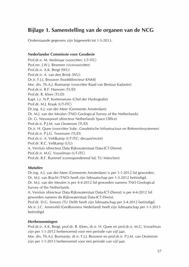
57
Bijlage 1. Samenstelling van de organen van de NCG
Onderstaande gegevens zijn bijgewerkt tot 1-5-2013.
Nederlandse Commissie voor GeodesieProf.dr.ir. M. Molenaar (voorzitter; UT-ITC)Prof.mr. J.W.J. Besemer (vicevoorzitter)Prof.dr.ir. A.K. Bregt (WU)Prof.dr.ir. A. van den Brink (WU)Dr.ir. F.J.J. Brouwer (hoofddirecteur KNMI)Mw. drs. Th.A.J. Burmanje (voorzitter Raad van Bestuur Kadaster)Prof.dr.ir. R.F. Hanssen (TUD) Prof.dr. R. Klees (TUD)Kapt. t.z. N.P. Kortenoeven (Chef der Hydrografie)Prof.dr. M.J. Kraak (UT-ITC)Dr.ing. A.J. van der Meer (Gemeente Amsterdam)Dr. M.J. van der Meulen (TNO Geological Survey of the Netherlands)Dr. G. Nieuwpoort (directeur Netherlands Space Office) Prof.dr.ir. P.J.M. van Oosterom (TUD)Dr.ir. H. Quee (voorzitter Subc. Geodetische Infrastructuur en Referentiesystemen)Prof.dr.ir. P.J.G. Teunissen (TUD)Prof.dr.ir. A. Veldkamp (UT-ITC; decaan/rector)Prof.dr. R.C. Veltkamp (UU)A. Versluis (directeur Data Rijkswaterstaat Data-ICT-Dienst) Prof.dr.ir. M.G. Vosselman (UT-ITC)Prof.dr. R.F. Rummel (corresponderend lid; TU München)
MutatiesDr.ing. A.J. van der Meer (Gemeente Amsterdam) is per 1-1-2012 lid geworden. Dr. M.J. van Bracht (TNO) heeft zijn lidmaatschap per 1-3-2012 beëindigd.Dr. M.J. van der Meulen is per 4-4-2012 lid geworden namens TNO Geological Survey of the Netherlands.A. Versluis (directeur Data Rijkswaterstaat Data-ICT-Dienst) is per 4-4-2012 lid geworden namens de Rijkswaterstaat Data-ICT-Dienst.Prof.dr. D.G. Simons (TU Delft) heeft zijn lidmaatschap per 5-4-2012 beëindigd.Mr.ir. J.C. Anneveld (GeoBusiness Nederland) heeft zijn lidmaatschap per 1-1-2013 beëindigd.
HerbenoemingenProf.dr.ir. A.K. Bregt, prof.dr. R. Klees, dr.ir. H. Quee en prof.dr.ir. M.G. Vosselman zijn per 1-1-2012 herbenoemd voor een periode van vijf jaar.Mw. drs. Th.A.J. Burmanje, dr.ir. F.J.J. Brouwer en prof.dr.ir. P.J.M. van Oosterom zijn per 1-1-2013 herbenoemd voor een periode van vijf jaar.

58
Dagelijks BestuurProf.dr.ir. M. Molenaar (voorzitter) Prof.mr. J.W.J. Besemer (vicevoorzitter)Prof.dr.ir. A.K. BregtMw. drs. Th.A.J. BurmanjeProf.dr.ir. R.F. Hanssen Prof.dr.ir. M.G. Vosselman
HerbenoemingenProf.dr.ir. A.K. Bregt en prof.dr.ir. M.G. Vosselman zijn per 1-1-2012 herbenoemd voor een periode van vijf jaar.
BureauIr. S.R. Dijkstra (ambtelijk secretaris) F.H. Schröder (ambtelijk secretaris)
MutatieMw. H.W.M. Verhoog-Krouwel (secretariaatsmedewerkster) is per 1-1-2012 met prepensioen gegaan.Ir. S.R. Dijkstra is per 1-11-2012 vanuit het Kadaster gedetacheerd bij de NCG.
Subcommissie Bodembeweging en ZeespiegelvariatieProf.dr.ir. R.F. Hanssen (voorzitter; TUD)Dr. B. Dost (KNMI)Dr. P.A. Fokker (TNO)Ir. P.J.A. Henry (GeoBusiness Nederland)Ir. A.P.E.M. HoutenbosMw. dr. C. Katsman (KNMI)Dr.ir. N.A. Kinneging (Rijkswaterstaat Waterdienst)Ir. A.J.M. Kösters (Rijkswaterstaat DID)Drs. G. de Lange (Deltares)Ing. R.A.J. van Lieshout (Staatstoezicht op de Mijnen)Ir. S.R. Dijkstra (ambtelijk secretaris; NCG)F.H. Schröder (ambtelijk secretaris; NCG)
Nieuw lidIr. P.J.A. Henry (GeoBusiness Nederland) per 13-2-2013.
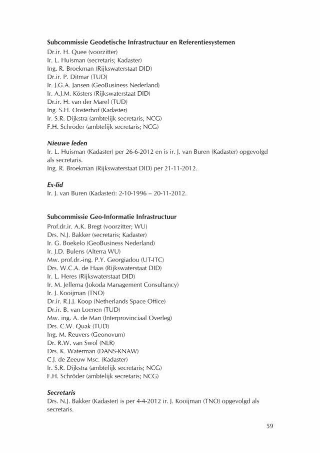
59
Subcommissie Geodetische Infrastructuur en ReferentiesystemenDr.ir. H. Quee (voorzitter)Ir. L. Huisman (secretaris; Kadaster)Ing. R. Broekman (Rijkswaterstaat DID) Dr.ir. P. Ditmar (TUD)Ir. J.G.A. Jansen (GeoBusiness Nederland)Ir. A.J.M. Kösters (Rijkswaterstaat DID)Dr.ir. H. van der Marel (TUD)Ing. S.H. Oosterhof (Kadaster)Ir. S.R. Dijkstra (ambtelijk secretaris; NCG) F.H. Schröder (ambtelijk secretaris; NCG)
Nieuwe ledenIr. L. Huisman (Kadaster) per 26-6-2012 en is ir. J. van Buren (Kadaster) opgevolgd als secretaris.Ing. R. Broekman (Rijkswaterstaat DID) per 21-11-2012.
Ex-lidIr. J. van Buren (Kadaster): 2-10-1996 – 20-11-2012.
Subcommissie Geo-Informatie InfrastructuurProf.dr.ir. A.K. Bregt (voorzitter; WU)Drs. N.J. Bakker (secretaris; Kadaster)Ir. G. Boekelo (GeoBusiness Nederland)Ir. J.D. Bulens (Alterra WU)Mw. prof.dr.-ing. P.Y. Georgiadou (UT-ITC)Drs. W.C.A. de Haas (Rijkswaterstaat DID) Ir. L. Heres (Rijkswaterstaat DID)Ir. M. Jellema (Jokoda Management Consultancy)Ir. J. Kooijman (TNO)Dr.ir. R.J.J. Koop (Netherlands Space Office) Dr.ir. B. van Loenen (TUD)Mw. ing. A. de Man (Interprovinciaal Overleg) Drs. C.W. Quak (TUD)Ing. M. Reuvers (Geonovum)Dr. R.W. van Swol (NLR)Drs. K. Waterman (DANS-KNAW) C.J. de Zeeuw Msc. (Kadaster)Ir. S.R. Dijkstra (ambtelijk secretaris; NCG) F.H. Schröder (ambtelijk secretaris; NCG)
SecretarisDrs. N.J. Bakker (Kadaster) is per 4-4-2012 ir. J. Kooijman (TNO) opgevolgd als secretaris.

60
Nieuwe ledenDrs. K. Waterman (DANS-KNAW) per 4-4-2012.Dr.ir. R.J.J. Koop (Netherlands Space Office) per 26-9-2012.
Subcommissie GeovisualisatieProf.dr. M.J. Kraak (voorzitter; UT-ITC) Drs. N.J. Bakker (Kadaster) Ing. R. Klooster (Advies- en Ingenieursbureau Oranjewoud) Dr.ir. M. Koutek (KNMI) Dr.ir. R.J.A. van Lammeren (WU) Prof.dr.ir. J.J. van Wijk (TUE) Ir. S.R. Dijkstra (ambtelijk secretaris; NCG)
De Subcommissie is per 6-6-2012 ingesteld.
Nieuw lidDr.ir. M. Koutek (KNMI) per 13-2-2013.
Subcommissie Mariene GeodesieKapt. t.z. N.P. Kortenoeven (voorzitter; Dienst der Hydrografie)Dr.ir. L.L. Dorst (secretaris; Dienst der Hydrografie)Kapt.Lt. t.z. b.d. J.C.P. AppelmanMw. dr. T.A.G.P. van Dijk (Deltares)Dr.ir. C.D. de Jong (Fugro-Intersite B.V.)Dr.ir. N.A. Kinneging (Rijkswaterstaat Waterdienst)Prof.dr.ir. P.J. Oonincx (NLDA-FMW)Ir. R.E. van Ree (Maritiem Instituut Willem Barentsz)Dr.ir. P.C. Roos (UT)Ing. C.A. Scheele (NLDA-KIM)Prof.dr. D.G. Simons (TUD)Ir. D.C. Slobbe (TUD)Mw. dr.ir. M. Snellen (TUD)Ir. S.R. Dijkstra (ambtelijk secretaris; NCG)F.H. Schröder (ambtelijk secretaris; NCG)
Nieuwe lidKapt.Lt. t.z. b.d. J.C.P. Appelman per 4-4-2012. Ir. D.C. Slobbe (TUD) per 17-4-2013.
Ex-lidIr. M.E.E. Haagmans (Rijkswaterstaat DID) is op 1-5-2012 overleden. Hij was lid vanaf 2-7-2007.

61
Subcommissie Ruimtelijke BasisgegevensProf.dr.ir. M.G. Vosselman (voorzitter; UT-ITC)Drs. R. van Essen (TomTom Automotive)Ir. L. Heres (Rijkswaterstaat DID)Ir.drs. A.J. Klijnjan (Kadaster)Ir. R.J.G.A. Kroon (Geodelta B.V.)Prof.dr.ir. P.J.M. van Oosterom (TUD)Ir. R.P.E. van Rossem (ministerie van Infrastructuur en Milieu)Mw. dr. J.E. Stoter (TUD, Kadaster, Geonovum)Ir. R. van der Velden (Het Waterschapshuis) Ir. S.R. Dijkstra (ambtelijk secretaris; NCG) F.H. Schröder (ambtelijk secretaris; NCG)
Nieuw lidIr. R. van der Velden (Het Waterschapshuis) per 21-11-2012.

62
De Nederlandse Commissie voor Geodesie (NCG) heeft mede tot taak het onder-houden van wetenschappelijke contacten met internationale organisaties op het gebied van de geodesie en de geo-informatie. De voornaamste lidmaatschappen van internationale wetenschappelijke organisaties op het gebied van de geodesie en de geo-informatie van leden van de Commissie en de subcommissies tijdens het verslagjaar staan hieronder vermeld.
European Spatial Data Research (EuroSDR)De NCG is sinds 2006 lid van de European Spatial Data Research. De NCG wijst de Nederlandse vertegenwoordigers in EuroSDR aan.
– Ir.drs. A.J. Klijnjan is Nederlands vertegenwoordiger in EuroSDR.– Drs. J.M. Nobbe is plaatsvervangend Nederlands vertegenwoordiger in EuroSDR.– Mw. dr. J.E. Stoter is Nederlands vertegenwoordiger (prime delegate) in EuroSDR
en voorzitter van de commissie Data Specifications.
Nederlands Comité voor de IUGGDe NCG is penvoerder van het Nederlands Comité voor de IUGG. Het Comité is als volgt samengesteld (d.d. 1-7-2012):
– Prof.dr.ir. R.F. Hanssen (voorzitter; TU Delft)– Prof.dr.ir. H.H.G. Savenije (International Association of Hydrological Sciences
(IAHS); TU Delft).– Dr. B. Dost (International Association of Seismology and Physics of the Earth's
Interior (IASPEI); KNMI).– Prof.dr. W.P. de Ruijter (International Association for the Physical Sciences of the
Oceans (IAPSO); UU).– Prof.dr.ir. P.J.G. Teunissen (International Association of Geodesy (IAG); TU
Delft).– Prof.dr. J.J.M. van den Hurk (International Association of Meteorology and
Atmospheric Sciences (IAMAS); KNMI).
MutatieProf.dr.ir. R.F. Hanssen is per 10-4-2012 prof.dr.ir. H.H.G. Savenije opgevolgd als voorzitter.
Bijlage 2. Internationale betrekkingen

63
International Association of Geodesy (IAG)De IAG is één van de zeven organisaties die samen de International Union of Geo-desy and Geophysics vormen.
– Dr.ir. P. Ditmar is Editor van de Journal of Geodesy.– Prof.dr. R. Klees is Fellow van de IAG en Editor-in-Chief van de Journal of Geo-
desy.– Ir. A.J.M. Kösters is lid van de Subcommission for Europe (EUREF).– Dr.ir. H. van der Marel is Fellow van de IAG en lid van de Working Group 4.5.2
Precise Point Positioning and Network RTK (Real Time Kinematic). – Prof.dr.ir. P.J.G. Teunissen is Fellow en National Representative van de IAG.
Diverse internationaal– Mr.ir. J.C. Anneveld is lid van de Council of European Geodetic Surveyors
(CLGE).– KLTZ b.d. J.C.P. Appelman vertgenwoordigt Nederland als national delegate in
Commission 4, Hydrography van de International Federation of Surveyors (FIG).– Drs. N.J. Bakker is Permanent Correspondent van EuroGeographics. – Prof.dr.ir. A.K. Bregt is lid van de Editorial Board van de International Journal of
Applied Earth Observation and Geoinformation.– Dr.ir. F.J.J. Brouwer is permanent vertegenwoordiger van Nederland in de World
Meteorological Organization (WMO), Deputy-principal namens Nederland in het GEO-initiatief (Group on Earth Observations), lid van de Raad van de Euro-pean Organisation for the Exploitation of Meteorological Satellites (EUMETSAT), lid van de Raad van het European Centre for Medium-Range Weather Forecasts (ECMWF), voorzitter van de Raad van het High Resolution Limited Area Model (HIRLAM) Consortium, lid van de Raad van de Economic Interest Grouping of the National Meteorological Services of the European Economic Area (ECOMET), voorzitter van de Informal Conference of Western European met Directors (ICWED) en voorzitter van de Raad van het Network of European National Mete-orological Services (EUMETNET).
– Dr.ir. L.L. Dorst is lid van de werkgroep Data Quality van de International Hydrographic Organization (IHO) en voorzitter van de werkgroep Resurvey van de North Sea Hydrographic Committee (NSHC).
– Dr. P.A. Fokker is lid van de UNESCO Working Group on Land Subsidence.– Ir. L. Heres is lid van het Committee on Location Referencing van de European
Road Transport Telematics Implementation Co-ordination (ERTICO) en lid van de TC 278 WG 7 Road Databases van het Comité Européen de Normalisation (CEN).
– Prof.dr. R. Klees is secretaris van de divisie Geodesie van de European Geo-sciences Union (EGU).
– Kapt. t.z. N.P. Kortenoeven vertegenwoordigt Nederland in de International Hydrographic Organization (IHO), in het International Centre for Electronic Navigational Charts (IC-ENC), in de Meso America and Caribbean Sea Hydro-

64
graphic Commission (MACHC) en in de North Sea Hydrographic Commission (NSHC).
– Prof.dr. M.J. Kraak is vicepresident van de International Cartographic Association (ICA), is lid van het Fonds Wetenschappelijk Onderzoek (FWO) Vlaanderen en is lid van de Editorial Board van de tijdschriften Cartographic Journal (UK), Carto-graphica (Canada), Cartography and Geographic Information Science (USA) en van de Journal of Maps (UK).
– Drs. G. de Lange is kernlid van het Joint Technical Committee 2 Representation of Geo-Engineering Data van de Federation of the International Geo-engineering Societies (FedIGS).
– Dr.ir. B. van Loenen is voorzitter van de Legal and Socio-Economic Committee van de Global Spatial Data Infrastructure Association (GSDI).
– Dr.ir. H. van der Marel is lid van het Galileo Science Advisory Committee (GSAC) van de ESA (European Space Agency), Associate Member van de Inter-national GNSS Service (IGS), lid van de IGS M-GEX Multi GNSS Working Group and Troposphere Working Group en lid van het University NAVSTAR Consor-tium (UNAVCO).
– Prof.dr.ir. M. Molenaar is corresponderend lid van de Deutsche Geodätische Kommission (DGK), president van de Technical Commission VI van de ISPRS (International Society for Photogrammetry and Remote Sensing), Fellow van de ISPRS, honorary professor aan de Wuhan University en lid van de Editorial Board van de International Journal of Applied Earth Observation and Geoinforma-tion, de Editorial Board van de ISPRS International Journal of Geo-Information, het Program Committee of the 15th International Symposium on Spatial Data Handling (SDH), het Scientific Committee - 7th 3D GeoInfo Conference 2012 - Quebec City en van de 13de International Conference on Computers in Urban Planning and Urban Management (CUPUM) 2013.
– Prof.dr.ir. P.J.M. van Oosterom is voorzitter van de Working Group on 3D-Cadastres van de International Federation of Surveyors (FIG), is lid van het EU INSPIRE (Infrastructure for Spatial Information in Europe) Core Drafting Team Data Specification and Harmonization, is lid van het ISO 19152 Land Adminis-tration Domain Model (LADM) project team, is associate editor van Computers & Geosciences (CAGEO), is lid van de editorial board van Transactions in GIS, is nationaal vertegenwoordiger van de Urban Data Management Society (UDMS) en is vertegenwoordiger van de TU Delft in het Open Geospatial Consortium (OGC).
– Ir. R.E. van Ree is bestuurslid en penningmeester van de Hydrographic Society Benelux (HSB) en directeur en bestuurslid van de International Federation of Hydrographic Societies.
– Ing. M. Reuvers is lid van het Technical Committee 287 Geographic Information van het Comité Européen de Normalisation (CEN), het Technical Committee 211 Geographic information/Geomatics van de International Organization for Standardization (ISO) en lid van het Open Geospatial Consortium (OGC).
– Mw. dr. J.E. Stoter is lid van de Commissie Generalisation and Multirepresenta-tion van de International Cartographic Association (ICA).

65
– Prof.dr.ir. P.J.G. Teunissen is corresponderend lid van de Deutsche Geodätische Kommission van de Bayerischen Akademie der Wissenschaften, Federation Fellow van de Australian Research Council, honorary professor van de Wuhan University (Wuhan), van de Tongji University (Shanghai), lid van het Institute of Navigation (USA), Fellow van de International Association of Geodesy en is editor van GPS Solutions, Optimization and Engineering, Journal of Global Positioning Systems, Journal of Cartography, Studia Geophysica et Geodaetica, International Journal of Geomathematics, Journal of Geodetic Science, Springer-Briefs in Geospatial Science en Journal of Navigation (RIN).
– Prof.dr. R.C. Veltkamp is lid van de Association for Computing Machinery (ACM), van de European Association for Computer Graphics (Eurographics), van de Editorial Board van de International Journal of Pattern Recognition and Arti-ficial Intelligence, van de Editorial Board van de International Journal on Shape Modeling, lid van het Steering Committe van Shape Modeling International Conference en van Steering Committee 3D Object Retrieval.
– Prof.dr.ir. M.G. Vosselman is nationaal vertegenwoordiger in de General Assemblee van de International Society for Photogrammetry and Remote Sensing (ISPRS), lid van de International Scientific Advisory Committee van de ISPRS, corresponderend lid van de Deutsche Geodätische Kommission van de Bayeri-schen Akademie der Wissenschaften en lid van het Wetenschappelijke Comité van het Belgische Nationaal Geografische Instituut.

66
Bijlage 3. Onderzoek
De Nederlandse Commissie voor Geodesie stimuleert en coördineert fundamenteel en strategisch onderzoek op het gebied van de geodesie en de geo-informatie in Nederland. De NCG voert in samenwerking met partners onderzoek uit dat zij van belang acht voor de ontwikkeling van de geodesie en de geo-informatie.
3D Pilot vervolgprojectOp initiatief van het Kadaster, Geonovum en het ministerie van IenM en met steun van de NCG is in het najaar van 2011 het 3D Pilot vervolgproject gestart, dat gericht is op het ontwikkelen van instrumentarium om de implementatie van 3D in Nederland verder te ondersteunen. Met de input van circa 120 deelnemers is in dit vervolgtraject brede ervaring opgedaan met de opbouw, het beheer en het gebruik van 3D data, waarbij er veel aandacht zal zijn voor de afstemming tussen de domeinen geo-informatie en bouw informatie modellen (BIM). Op 20 november 2012 is het vervolgproject afgerond met de 3D Pilot Slotdag 'Van 2D naar 3D BGT. Zelf aan de slag met de derde dimensie' in het Provinciehuis Noord-Brabant in Den Bosch. De Slotdag is georganiseerd door het Kadaster, Geon-ovum, het ministerie van IenM en de NCG. Het plan is dat de 3D Pilot over gaat in de 3D Special Interest Group (3D SIG) als verankering van de 3D Pilot.
Adding value to geodetic deformation measurementsDe NCG geeft financiële ondersteuning aan het PhD-onderzoek 'Adding value to geodetic deformation measurements. A model to facilitate communication on geodetic deformation monitoring and analysis' door ir. H. Velsink (Hogeschool Utrecht). Het onderzoek richt op het beantwoorden van de vraag hoe de commu-nicatie over geodetische deformatiemetingen kan worden verbeterd. Velsink wil daarbij een brug slaan tussen enerzijds de geodetische methoden en technieken en de staande praktijk van geodetische deformatiemetingen en anderzijds de sociaal-organisatorische en sociaal-maatschappelijke omstandigheden en de verschillende belanghebbenden (industrie, overheid, burgers) in relatie tot het vaststellen van deformatie.
Research plan Subcommissie Geo-Informatie InfrastructuurMission and tasks of the Subcommission Geo-Information InfrastructureMissionThe mission of the Subcommission Geo-Information Infrastructure (NCG-GII) is to contribute to the long term development of the Geo-Information Infrastructure (GII).

67
Positioning and interpretation The NCG-GII is a subcommission of the NCG (Nederlandse Commissie voor Geodesie - Netherlands Geodetic Commission) focussing on the geo-information infrastructure. Within this subject, the Subcommission has an independent position with a focus on initiation, coordination and evaluation of mid-term and long-term academic research and the research of non-academic parties.For an optimal contribution to society the Subcommission aims at a composition that consists of members coming from government, business parties and scientific organisations. With respect to the development of the GII the Subcommission aims at both techni-cal, organisational, political, legal, economical and user aspects of the GII.The Subcommission gives substance to its' mission by regular meetings, consulta-tion and by elaborating and maintaining a research agenda.
Tasks The following tasks of the Subcommission are defined:– Providing both asked as unasked advice;– Initiate, coordinate and evaluate research and ;– Propagate results of its’ advice and research.
Research settingState of the art in GI ScienceThe term geographical information science (GIScience) was introduced by Michael Goodchild in 1992 in his landmark article in the International Journal of Geographi-cal Information Systems 1. In this paper the scope and foundation of a scientific field that covers a broad range of topics such as spatial data capture, data structures, spatial statistics, data modelling and analysis, display and institutional issues was described. Since then the field has developed into a robust scientific discipline with specialized international conferences, scientific journals, research agendas and own chairs at universities world-wide. The central theme of the field is the hand-ing of spatial data in all aspects. This can be researched as a topic on its own or in combination with application domains. Since 1992 various research agenda's for geographical information science were formulated, both national as international. An early influential agenda was proposed by the NCGIA (National Center for Geo-graphic Information and Analysis) in the USA. Within this agenda various research challenges such as the theories of spatial data, spatial data quality, spatial cognition, data structures and spatial data modelling were formulated. Over the years research agendas and activities have changed. The following major trends can be observed.
From practice to theoryThe early GIScience questions were mainly derived from application domains and rather technical in nature, but over the years an own GI body of knowledge starts to
1. M.F. Goodchild, 1992. Geographical information science. Int. J. Geographical Information systems 6: 31-45.

68
develop. Current GI theoretical questions deal with spatial scaling, the space-time description of spatial phenomena and processes, spatial perception of humans, spatial ontology's, etc.
From GI application to geo-information infrastructure A few decades ago a GI-application was a combination of data and a software system for the support of a specific question. Since the beginning of this century a world-wide paradigm shift took place. Spatial data is increasingly organized in the form of local, national en international infrastructures (GII) that support many actual and potential applications. This has resulted in GII research 2 which focuses on spa-tial data and technical interoperability, standards, semantic interoperability, policy, organization issues, assessment frameworks, etc.
From spatial data structuring to meaningful spatial data integrationData structures and the efficient algorithms for storing and retrieving data was a key research activity in the eighties and the nineties of the previous century. Now the emphasis has shifted towards meaningful exchange and integration of spatial data. The concept of spatial data ontologies as a potential solution to this challenge is emerging research topic world-wide.
From mapping to dynamic real-time spatial data collection and visualizationThe 2D static map was and probably still is the dominant way of obtaining and pre-senting geo-information. Fast developments in sensor technology and visualization techniques induce a shift to dynamic real-time spatial data collection and the direct use of these data in process models and in visualizations. Research on how these new approaches can be used to obtain reliable information on spatial phenomena and how these data can be used by public, governments and business is still in its infancy 3.
From technological to socio-technicalOriginally GI research was quite technical in nature, however with the strong diffusion of the GI technology in society it is also becoming a research area for policy, organization and law researchers. Also the GII societal setting has become a research topic. From a mainly technical research field it has developed into a socio-technical research field. Appropriate scientific methods that can be applied for this new setting need to be developed and tested.
2. Y. Georgiadou, S. K. Puri and S. Sahay, 2005. Towards a potential research agenda to guide
the implementation of Spatial Data Infrastructures - A case study from India. Int. J. Geographical
Information science.19:1113-1130.
3. Max Craglia, Michael F. Goodchild, Alessandro Annoni, Gilberto Camara, Michael Gould,
Werner Kuhn, David Mark, Ian Masser, David Maguire, Steve Liang, Ed Parsons, 2008. Next-Gene-
ration Digital Earth: A position paper from the Vespucci Initiative for the Advancement of Geograp-
hic Information Science. International Journal of Spatial Data Infrastructures Research. 3: 146-167.

69
From a few application areas to many disciplines in societyOne of the major developments the last 20 years is probably the strong increase in disciplines where GI is used. The classical domains for GI are agriculture, spatial planning, environment, land registration and transportation. Now, GI has found its way into almost all disciplines in our society, ranging from history to medicine and banking and tourism. This has resulted is a strong demand for 'with GI' research. A key question is how can GI concepts and technologies be beneficial to the disci-pline.
In summary we can say that the research agenda on GIScience has strongly devel-oped over the last two decades with mainly unresolved questions and challenges ahead of us with a clear niche for GII research.
Scope of Subcommision GIIThe NCC Subcommission GII focuses on 7 research themes. The selection of the themes is the result of extensive internal discussions and a reflection on interna-tional developments. The research themes are formulated in such a way that they a. cover the GII field, b. are researchable topics and c. are recognizable as issues for the outside world. The following topics are formulated:
1. Theory & methods;2. Use & usability;3. Governance;4. Service Architecture; 5. Application of standards and interoperability; 6. Connecting to the information infrastructure (II);7. Sensor networks.
Theory & methodsThe last few years research on the development of Geo-Information Infrastructures (GII) has developed rapidly within the domain of GIScience. It is clear that within this emerging scientific area many new definitions are proposed and systems devel-oped. This new field needs accurate description regarding technical, organisational and political aspects. Also, there is a strong need for scientific elucidation on the design, development and use of GII's and its coherence.
Use & usabilityGII's have shown a strong development over the past 10 years from the 'supply' side. Local, regional, national and international GII's were established. Although most GII's are certainly used, there is still little insight in the nature of its use, the role they play in the application domains, and the satisfaction of the users with the offered services. For a healthy development of GII it is essential to have more insight in the use and usability aspects.

70
Governance The governance of information infrastructures for more than one organization is dependent on how individual organizations contribute or benefit from the infra-structure elements. Hence, governance should take into account how multiple organizations coordinate their activities, and which coordination instruments are effective or not. Given the different roles that public and private sector have in society, the coordination objectives and instruments are different in the public sector as compared to the private/corporate sector. As a result, the governance of GII's emerging within the public sector is likely to be different from those emerging through the private sector. More insight is needed in existing governance structures of GII and its effect on their functioning.
Service Architecture The supporting technologies and the associated services are the backbone of the GII development and implementation. Most (if not all) of the technologies are not designed in the Netherlands. We are just using what is internationally available. However for the implementation of the Dutch GII we still have a choice. Are we going to use or even stimulate a particular technology? In order to make the appro-priate decisions early experimentation and evaluation of emerging technologies is essential.
Application of standards and interoperability within GIIThe infrastructure perspective on GII emphasizes that the social and technical issues are not separable. Standards are inherently social/political. Interoperability is also a key issue in effective governance and the use of geo-information: it removes barri-ers in innovation processes and prevents customer lock-in, license issues, etc. The selection and maintenance of standards requires both a dialogue as practical experi-mentation. For the more technology oriented standards we are more in an evalu-ation and adaptation position, while for the more data and data-service oriented standards we also have a design role to play.
Connecting to the information infrastructureThe overall goal of this commission is to contribute to the long term development of the GII. However, the GII itself is an integrated part of an overall Information Infrastructure and, therefore, developments in both information infrastructures will strongly influence each other. The other way around, the development of the inter-net and publicly available mapping applications such as Google Earth or Bing Maps has had a tremendous impact on the geo-information society. After these years of mainly internal GII development it is now time to look externally and re-define the relationships between the GII and the rest of the world!
Sensor networksGII's are not static, but evolve over time both in their socio-technical aspects as in their data and service content. An interesting development is the amalgamation of GII's and sensor networks, including human sensors. Sensor networks are able

71
to capture spatial- and temporal phenomena real-time and allow organizations to react on events and take actions. Senor networks, both formal and informal, are present in a variety of technical implementations and user communities. A synergy between these is beneficial for both GII as well as (human) sensor network develop-ment.
Research questionsThe research questions for the selected themes are:
Theory & methods– What are the theoretical foundations of GII?– Are there existing theories that can support us to understand the nature of GII's?– Can theories help to forecast GII developments?– What is the influence of a theoretical notion of GII in its practical implementa-
tion?
Use & usability– How do we measure and assess the use of GII's?– What are stimulating and limiting factors for GII use?– Are there regional differences in the use of GII's and can these differences be
explained?– What are current and future user requirements for GII's?
Governance– What are the current governance models for GII's?– Can the existing governance models for GII's be explained from the specific
socio-technical conditions?– What are the pros and cons of the governance models in use?– How can we design and evaluate governance models to operationalise the GII as
a sustainable infrastructure?
Service architecture– What are important technological developments for GII?– What are the most promising technologies for the Dutch GII?– How can we apply semantic models (ontology) for spatial data integration? – How can we develop 'intelligent' GII services?
Application of standards and interoperability– Is functionality appropriate and/or missing in current interoperability standards? – What is the level of interoperability in current GII products and services?– What are the requirements of integrated geo-sensor networks towards standards
and are current standards for sensor networks applicable?– How can we implement standards and improve their acceptance by stakehold-How can we implement standards and improve their acceptance by stakehold-
ers?

72
Connecting to the Information Infrastructure (II)– What are the major connection points between the GII and the II (economic,
social, political)? – Are there generic problems which impede the GII to support and penetrate into
other domains of the overall II? – How can we use spatial data to more effectively disseminate and/or analyze
'non-spatial' data?– What current and future developments in information infrastructures will impact
the GII?
Geo-sensor networks– How can we design a geo-sensor networks for monitoring of spatial dynamic
processes?– How can we extract information from informal geo-sensor networks? – How can we integrate real-time sensor-data in the GII? – How to handle large sensor-based datasets?
Onderzoeksagenda Subcommissie Mariene Geodesie1. Realisatie van verticale referenties op zee De TU Delft rondt in 2013 een onderzoek af naar de ligging van Noordzeegeoïde in relatie tot de niveaus ellipsoïde, Mean Sea Level (MSL) en Lowest Astronomical Tide (LAT), van belang voor het nauwkeurig gebruik van hoogtes uit satellietnaviga-tie op zee en de verbetering van stromingsmodellen. Het project wordt financieel mede ondersteund door de NCG en het Europese project Bringing Land And Sea Together (BLAST). Diverse leden van de Subcommissie ondersteunen de STW-onderzoeksaanvraag NETREF voor een vervolgproject, dat voor een enkel geoïdeni-veau zal zorgen voor zowel te land als ter zee.
De levering van waterstanden ten opzichte van de verticale datums wordt verzorgd door Rijkswaterstaat en de Dienst der Hydrografie via Premo. Premo is een compu-terprogramma dat een geavanceerde interpolatiemethode gebruikt, waarbij zowel permanente getijstations als de nieuwste stromingsmodellen worden toegepast. Zodoende komen real-time waterstanden beschikbaar met een precisie van een decimeter. Beide organisaties trekken samen op als opdrachtgevers in dit project, dat wordt uitgevoerd door Deltares.
Nauwkeurige satellietnavigatiesystemen, zoals NETPOS (Netherlands Positioning Service) van het Kadaster en MARINESTAR van Fugro, zijn een alternatief voor Premo. NETPOS is al in gebruik bij Rijkswaterstaat voor de kustzone en de Dienst der Hydrografie introduceert MARINESTAR in 2013. Toekomstige integratie van Premo en GNSS-gebaseerde reductie kan voor optimale controle en precisie zorgen.

73
Werkzaamheden: coördineren; afstemmen met Subcommissie Geodetische Infra-structuur en Referentiesystemen.
2. Optimalisatie van inwinstrategieënKennis van de dynamiek van de zee- en rivierbodem maakt het mogelijk om een optimale inwinstrategie te bepalen; dus vaak meten waar de bathymetrie sterk variabel is en beperkt waar weinig dynamiek is. Binnen Nederland worden aan de Universiteit Twente geïdealiseerde modellen ontwikkeld om de eigenschappen van bodempatronen te voorspellen. De TU Delft ontwikkelt modellen waarmee stromingen en sedimenttransport voorspeld worden. Voor kustbeheer heeft Deltares een complex morfodynamisch model in gebruik dat in consultancy-projecten wordt toegepast.
Rijkswaterstaat en de Dienst der Hydrografie werken samen bij het begeleiden van Deltares-projecten op dit gebied. Doel daarbij is om binnen het samenwerkingsver-band Nederlands Hydrografisch Instituut (NHI) tot een gezamenlijk opnemingsbe-leidsplan te komen. Voor 2013 is Rijkswaterstaat voornemens om het ODyn-project voort te zetten via financiering als een kennisproject voor primaire processen (KPP-project). CristalClear Consultancy adviseert beide organisaties over de afstemming van hun initiatieven en de ontwikkelingen op de langere termijn.In Noordzeeverband worden de inspanningen afgestemd in de Resurvey Working Group van het North Sea Hydrographic Committee (NSHC), voorgezeten door de Dienst der Hydrografie. Het is van belang om de Noordzeewijde ontwikkelingen aan te laten sluiten op de nationale ontwikkelingen, bijvoorbeeld door het uitnodi-gen van leden van de Subcommissie als waarnemers bij de bijeenkomsten van de Working Group.
Werkzaamheden: coördineren; afstemmen met Subcommissie Bodembeweging en Zeespiegelvariatie.
3. Kwaliteitsverbetering van inwintechniekenDe multibeam echosounder (MBES) is het belangrijkste akoestische systeem. De voornaamste foutenbronnen die de meetprecisie beperken, betreffen nabij de kust de veranderingen in de geluidskarakteristiek van de waterkolom en verder uit de kust de reductie voor de waterstand. Op het eerste onderwerp wordt samengewerkt tussen Rijkswaterstaat en de TU Delft, het tweede valt onder agendapunt 1.
Daarnaast heeft de TU Delft methoden ontwikkeld om naast de waterdieptes ook informatie over de bodemsamenstelling te verkrijgen, voor zowel single-beam (SBES) als MBES-systemen. De meeste bestaande methodes voor classificatie op basis van de MBES-backscatter-metingen baseren zich op variaties in de geme-ten waarden in plaats van absolute waarden. Deze aanpak maakt de methoden ongevoelig voor ongecorrigeerde systeemeffecten op de backscatter-metingen. De aanwezigheid van de systeemeffecten op de backscatter-metingen is echter een hindernis voor de methoden die wel uitgaan van de absolute backscatter-metingen.

74
Alternatieven voor MBES worden gevormd door phase differencing bathymetric sonar (PDBS), lasersystemen en radarsystemen. Een PDBS meet diepten langs een brede strook (swath), net als bij MBES. De resolutie van PDBS langs de swath wordt echter niet slechter naar de uiteinden van de swath, wat metingen langs grotere openingshoeken mogelijk maakt. De werkelijk te behalen resolutie is echter ondui-delijk en dient onderzocht te worden. Nederland heeft relatief veel ondiep water, waarin dit systeem voor een aanzienlijke efficiëntiewinst kan zorgen. Kustradar en radarmetingen uit satellieten worden ingezet om de dynamiek van de zeebodem in kustgebieden te monitoren. Hierdoor worden onder andere veranderingen die veilige navigatie in gevaar brengen snel gedetecteerd.
Werkzaamheden: coördineren; stimuleren van onderzoek naar alternatieven voor MBES.
4. Ontwikkeling van methoden voor automatische dataverwerkingSamen met de Subcommissie Ruimtelijke Basisgegevens probeert de Subcommis-sie een antwoord te vinden op de vraag hoe verstandig omgegaan kan worden met zeer grote datasets met dieptegegevens. De grootste datasets worden geproduceerd via de techniek Water Column Imaging (WCI), die MBES-metingen kan verwerken tot een driedimensionale dataset in de waterkolom voor de kartering van objecten onder water. De Subcommissie volgt het WCI-onderzoek met het oog op toepas-singsmogelijkheden.
In 2009 hebben de beide Subcommissies gezamenlijk de workshop 'Management of massive points clouds' georganiseerd. Nieuwe onderzoeksresultaten maken het aantrekkelijk om opnieuw een workshop rondom dit thema te organiseren.
Werkzaamheden: coördineren; afstemmen met Subcommissie Ruimtelijke Basisge-gevens.
5. Aansluiting van mariene data en terrestrische dataNaadloze geografische informatie van de kustzone is van groot belang bij de bescherming tegen natuurrampen, de reactie op zeespiegelrijzing, recreatie en natuurbescherming. Het NETREF-project, genoemd onder 1, biedt de mogelijkheid tot een enkel referentieniveau te land en ter zee. Dit project biedt mogelijkheden om de kwaliteit van de aansluiting van de Waddeneilanden en offshore-platforms op het NAP te verbeteren en daarmee een bijdrage te leveren aan de studie van bodemdaling in het Waddengebied.
Werkzaamheden: coördineren; stimuleren van onderzoek naar de aansluiting van mariene en terrestrische geo-informatie; afstemmen met Subcommissie Bodembe-weging en Zeespiegelvariatie.

75
6. Innovatie in de presentatie van geografische informatieElektronische navigatie (E-navigation) op zee en het ergonomische gebruik daarvan vraagt nog veel onderzoek en regelgeving. Dit is momenteel een belangrijk onder-werp binnen de International Maritime Organisation (IMO). Voor de zeer ondiepe en dynamische Noordzee wordt de wijze van publiceren van de kwaliteit van de diepte-informatie als ontoereikend ervaren, voor zowel elektronische als papieren nautische producten. De Data Quality werkgroep van de International Hydrograp-hic Organization (IHO) zoekt hiervoor een oplossing, ondersteund door de Univer-sity of Southern Mississippi (USM).
Werkzaamheden: coördineren; afstemmen met de Subcommissie Geovisualisatie.
7. Integratie van navigatiesystemenNieuwe satellietnavigatiesystemen worden door steeds meer staten en internatio-nale organisaties ontwikkeld, wat ongekende mogelijkheden geeft voor precieze real-time positiebepaling. Echter, de betrouwbaarheid van deze posities tegen verstoringen is gering, terwijl de kans op opzettelijke of onopzettelijke fouten en falen groot is. Integratie met andere systemen vormt de oplossing: combinatie met inertiële navigatiesystemen, terrestrische plaatsbepalingssystemen zoals eLoran, en terreinreferentie zijn daarvoor mogelijke oplossingen. Ook onderwaternavigatie is niet mogelijk met GNSS (Global Navigation Satellite System), waardoor herhaalde-lijk aan de oppervlakte meten, gebruik van onderzeese bakens of terreinreferentie nodig is.
Het coördineren van ontwikkelingen op het gebied van satellietnavigatie gebeurt in Nederland door het Nederlands Instituut voor Navigatie (NIN) en Geo-informatie Nederland (GIN), met name in hun gezamenlijke werkgroep Verkenning van Plaats-bepaling en Navigatie (VPN). De Subcommissie stemt de aandacht voor integratie van navigatiesystemen af met deze werkgroep.
Werkzaamheden: coördineren; stimuleren van onderzoek naar integratie van syste-men.
Zie de tabel Agendapunten uit de onderzoeksagenda van de Subcommissie in rela-tie tot de Topsectoren van de Nederlandse overheid op de volgende pagina.

76
Tops
ecto
ren:
O
nder
zoek
sage
nda:
Wat
er
Them
a's:
Cre
atie
ve in
dust
rie
Hig
h-te
ch s
yste
men
en
mat
eria
len
Life
Sci
ence
s A
grar
isch
en
voed
sel
1. R
ealis
atie
van
ver
tical
e re
fere
ntie
s op
zee
1:
Win
nen
op z
ee
5: T
rans
port
ove
r w
ater
2. O
ptim
alis
atie
van
in
win
stra
tegi
eën
5: T
rans
port
ove
r w
ater
C
row
dsou
rcin
g al
s br
on v
oor
bode
m-
dyna
mie
k
4D-a
naly
se: b
odem
-dy
nam
iek
3. K
wal
iteits
verb
eter
ing
van
inw
inte
chni
eken
5:
Tra
nspo
rt o
ver
wat
er
Se
nsor
en:
betr
ouw
baar
der,
ho
gere
res
olut
ie,
hoge
re p
reci
sie,
ro
buus
ter
4. O
ntw
ikke
ling
van
met
hode
n vo
or a
utom
atis
che
data
verw
erki
ng
5: T
rans
port
ove
r w
ater
3D-a
naly
se: W
ater
C
olum
n Im
agin
g
5. A
ansl
uitin
g va
n m
arie
ne
data
en
terr
estr
isch
e da
ta
3: L
even
in d
elta
's
4: D
uurz
aam
heid
W
ater
man
agem
ent,
klim
atol
ogis
che
stud
ies,
ram
pen-
prev
entie
6. In
nova
tie v
an d
e pr
esen
tatie
van
geo
graf
isch
e in
form
atie
5: T
rans
port
ove
r w
ater
10
: Com
plex
e m
ariti
eme
syst
emen
7. In
tegr
atie
van
na
viga
tiesy
stem
en
2: W
inne
n op
zee
5:
Tra
nspo
rt o
ver
wat
er
10: C
ompl
exe
mar
itiem
e sy
stem
en
O
nder
wat
er
plaa
tsbe
palin
g
Trac
king
& tr
acin
g va
n sc
hepe
n, m
et n
ame
de
viss
erij
Age
ndap
unte
n ui
t de
onde
rzoe
ksag
enda
van
de
Subc
omm
issi
e M
arie
ne G
eode
sie
in re
latie
tot d
e To
psec
tore
n va
n de
Ned
erla
ndse
ove
rhei
d.
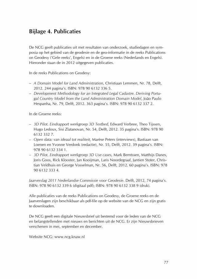
77
Bijlage 4. Publicaties
De NCG geeft publicaties uit met resultaten van onderzoek, studiedagen en sym-posia op het gebied van de geodesie en de geo-informatie in de reeks Publications on Geodesy ('Gele reeks', Engels) en in de Groene reeks (Nederlands en Engels). Hieronder staan de in 2012 uitgegeven publicaties.
In de reeks Publications on Geodesy:
– A Domain Model for Land Administration, Christiaan Lemmen, Nr. 78, Delft, 2012. 244 pagina's. ISBN: 978 90 6132 336 5.
– Development Methodology for an Integrated Legal Cadastre. Deriving Portu-gal Country Model from the Land Administration Domain Model, João Paulo Hespanha, Nr. 79, Delft, 2012. 363 pagina's. ISBN: 978 90 6132 337 2.
In de Groene reeks:
– 3D Pilot. Eindrapport werkgroep 3D Testbed, Edward Verbree, Theo Tijssen, Hugo Ledoux, Sisi Zlatanovan, Nr. 54, Delft, 2012. 35 pagina's. ISBN: 978 90 6132 332 7.
– Open data: van ideaal tot realiteit, Marèse Peters (interviews), Bastiaan van Loenen en Yvonne Verdonk (redactie), Nr. 55, Delft, 2012. 39 pagina's. ISBN: 978 90 6132 334 1.
– 3D Pilot. Eindrapport werkgroep 3D Use cases, Mark Berntssen, Matthijs Danes, Joris Goos, Rick Klooster, Jan Kooijman, Laris Noordegraaf, Jantien Stoter, Chris-tian Veldhuis en George Vosselman, Nr. 56, Delft, 2012. 60 pagina's. ISBN: 978 90 6132 333 4.
Jaarverslag 2011 Nederlandse Commissie voor Geodesie. Delft, 2012, 74 pagina's. ISBN: 978 90 6132 339 6 (digitaal pdf); ISBN: 978 90 6132 338 9 (druk).
Alle publicaties van de reeks Publications on Geodesy, de Groene reeks en de Jaarverslagen zijn beschikbaar als pdf-file op de website van de NCG en zijn gratis te downloaden.
De NCG geeft een digitale Nieuwsbrief uit bestemd voor de leden van de NCG en belangstellenden met nieuws en berichten uit de NCG. Er zijn Nieuwsbrieven verschenen in mei, september en december.
Website NCG: www.ncg.knaw.nl

78
Bijlage 5. Bureau van de NCG
Het Bureau van de NCG was in het verslagjaar gevestigd in het gebouw van het onderzoeksinstituut OTB van de TU Delft in Delft. Er is gebruik gemaakt van de plannen en de maatregelen op het gebied van bedrijfshulpverlening, risico-inventarisatie en van de Arbo-faciliteiten van het OTB en van telefoon-, netwerk- en computerfaciliteiten van de TU Delft.
Secretariaatsmedewerkster H.W.M. Verhoog-Krouwel is per 1 januari 2012 met prepensioen gegaan. Zij heeft vanaf 1 april 1989 voor de Rijkscommissie voor Geodesie en de NCG gewerkt. Ir. S.R. Dijkstra (Kadaster) is sinds 1 november 2012 gedetacheerd bij de NCG als ambtelijk-secretaris van de NCG en collega van F.H. Schröder.
Het Bureau voert de secretariaten van de Commissie, het Dagelijks Bestuur, de subcommissies van de NCG en het Nederlands Comité voor de IUGG. Het Bureau verzorgt de opmaak en de uitgave van publicaties van de NCG en onderhoudt de website van de NCG (www.ncg.knaw.nl).
Het Bureau heeft in het verslagjaar extra tijd besteed aan de toekomstige overdracht van het archief van de NCG, aan de toekomst van de NCG en het uitgeven van publicaties.
79
Bijlage 6. Afkortingen
2D tweedimensionaal3D driedimensionaal4D vierdimensionaal5D vijfdimensionaalACM Association for Computing MachineryAGRS.NL Actief GPS Referentie Systeem NederlandAHN Actueel Hoogtebestand NederlandASPRS American Society for Photogrammetry and Remote SensingBGT Basisregistratie Grootschalige Topografie (voorheen GBKN)BLAST Bringing Land And Sea TogetherBRO Basisregistratie OndergrondCAGEO Computers & GeosciencesCAS Chinese Academie van WetenschappenCEN Comité Européen de NormalisationCityGML City Geography Markup LanguageCLGE Council of European Geodetic SurveyorsCUPUM Computers in Urban Planning and Urban ManagementDANS Data Archiving and Networked ServicesDBMS DataBase Management SystemDGK Deutsche Geodätische KommissionDID Data-ICT-Dienst van RijkswaterstaatDID Draft International StandardDSM Digital Surface ModelsDTM Digitaal Terrein ModelECMWF European Centre for Medium-Range Weather ForecastsECOMET Economic Interest Grouping of the National Meteorological
Services of the European Economic AreaEGU European Geophysical UnionEL&I ministerie van Economische zaken, Landbouw en Innovatie.EPN European Permanent NetworkERTICO European Road Transport Telematics Implementation
Co-ordinationESA European Space AgencyETRS89 European Terrestrial Reference System 1989EU Europese UnieEUMETNET Network of European National Meteorological ServicesEUMETSAT European Organisation for the Exploitation of Meteorological
SatellitesEUREF European Reference FrameEuroGeographics Europese koepelorganisatie van (nationale) karterings- en kadas-
terinstellingen

80
EuroSDR European Spatial Data ResearchFAO Food and Agriculture Organization of the United NationsFIG Fédération Internationale des GéomètresFMW Faculteit Militaire WetenschappenFP7 Zevende Kaderprogramma voor Onderzoek en Technologische Ontwikkeling van de Europese UnieFWO Fonds Wetenschappelijk Onderzoek VlaanderenGEO Group on Earth ObservationsGI-beraad het beraad voor de Geo-informatie van de rijksoverheidGIDEON Geografische Informatie en Dienstverlening ten behoeve van de
E-Overheid in NederlandGII Geo Information InfrastructuresGII geo-informatie infrastructuurGIMA Geographical Information Management and ApplicationsGIN Geo-Informatie NederlandGIS Geografisch InformatiesysteemGLONASS Global Navigation Satellite SystemGML Geography Markup LanguageGNSS Global Navigation Satellite SystemGOCE Gravity field and steady-state Ocean Circulation ExplorerGPS Global Positioning SystemGRACE Gravity Recovery and Climate ExperimentGRS afdeling Geometrische Referentie Systemen (voorheen Rijksdrie-
hoeksmeting) van het KadasterGSAC Galileo Science Advisory CommitteeGSAC Gallileo Science Advisory CommitteeGSDI Global Spatial Data Infrastructure AssociationHIRLAM High Resolution Limited Area ModelHSB Hydrographic Society BeneluxIAG International Association of GeodesyIAHS International Association of Hydrological SciencesIAMAS International Association of Meteorology and Atmospheric
SciencesIAPSO International Association for the Physical Sciences of the OceansIASPEI International Association of Seismology and Physics of the Earth's
InteriorICA International Cartographic AssociationIC-ENC International Centre for Electronic Navigational ChartsICT informatie- en communicatietechnologieICWED Informal Conference of Western European met DirectorsIenM ministerie van Infrastructuur en MilieuIFHS International Federation of Hydrographic SocietiesIGS International GNSS ServiceIHO International Hydrographic OrganizationIIP GEO ICT Innovatieplatform Geo-informatie

81
IMGeo Informatiemodel Grootschalige geografieINSPIRE Infrastructure for Spatial Information in the European CommunityIPO Interprovinciaal OverlegISO International Organization for StandardizationISPRS International Society for Photogrammetry and Remote SensingITC International Institute for Geo-Information Science and Earth
ObservationITRF International Terrestrial Reference FrameIUGG International Union of Geodesy and GeophysicsKIM Koninklijk Instituut voor de MarineKML Keyhole Markup LanguageKNAW Koninklijke Nederlandse Akademie van WetenschappenKNMI Koninklijk Nederlands Meteorologisch InstituutLA Land AdministrationLADM Land Administration Domain ModelLAS Land Administration SystemLAT Lowest Astronomical TideLD-SWG Land Development – Standards Working GroupLIDAR LIght Detection And Ranging of Laser Imaging Detection And
RangingLPIS Land Parcel Identification SystemMACHC Meso America and Caribbean Sea Hydrographic CommitteeMDA Model Driven ArchitectureMGEX Multi-GNSS ExperimentNAP Normaal Amsterdams PeilNCG Nederlandse Commissie voor GeodesieNETPOS Netherlands Positioning ServiceNHI Nederlands Hydrografisch InstituutNIOZ Nederlands Instituut voor Onderzoek der ZeeNLDA Nederlandse Defensie AcademieNLGEO2004 Nederlandse Geoïde 2004NLGEO2013 Nederlandse Geoïde 2013NSHC North Sea Hydrographic CommissionNSO Netherlands Space OfficeNWIP New Working Item ProposalOCW ministerie van Onderwijs, Cultuur en WetenschapOGC Open Geospatial ConsortiumPPP Precise Point PositioningRDNAPTRANS Transformatie tussen ETRS89, RD en NAPRINEX Receiver Independent Exchange FormatRMS Root Mean SquareRTK Real Time KinematicSAGEO Stichting Arbeidsmarkt GeoSDH Spatial Data HandlingSDI Spatial Data Infrastructure

82
SIG Special Interest GroupSTDM Social Tenure Domain ModelSTW Stichting voor de Technische WetenschappenTNO Nederlandse Organisatie voor Toegepast Natuurwetenschappelijk
OnderzoekTOP10NL Topografisch vectorbestand 1:10.000; opvolger van TOP10vectorTU Technische UniversiteitTUD Technische Universiteit DelftTUE Technische Universiteit EindhovenTWG Technical Working GroupUDMS Urban Data Management SocietyUML Unified Modeling LanguageUNAVCO University NAVSTAR ConsortiumUNESCO United Nations Educational, Scientific and Cultural OrganizationUN-Habitat United Nations Human Settlements ProgrammeUT Universiteit TwenteUU Universiteit UtrechtVROM ministerie van Volkshuisvesting, Ruimtelijke Ordening en Milieu-
beheerWMO World Meteorological OrganisationWU Wageningen UniversiteitXML eXtended Markup Language