ITCZ and ENSO pacing on East Asian winter monsoon variation during the Holocene: Sedimentological...
20
RESEARCH ARTICLE 10.1002/2013JC009603 ITCZ and ENSO pacing on East Asian winter monsoon variation during the Holocene: Sedimentological evidence from the Okinawa Trough Xufeng Zheng 1,2 , Anchun Li 1 , Shiming Wan 1 , Fuqing Jiang 1 , Shuh Ji Kao 3 , and Cody Johnson 4 1 Key Laboratory of Marine Geology and Environment, Institute of Oceanology, Chinese Academy of Sciences, Qingdao, China, 2 Key Laboratory of Marginal Sea Geology, South China Sea Institute of Oceanology, Chinese Academy of Sciences, Guangzhou, China, 3 State Key Laboratory of Marine Environmental Science, Xiamen University, Xiamen, China, 4 Department of Civil and Environmental Engineering, Louisiana State University, USA Abstract Deep-sea fan sediments provide an excellent geological archive for paleoenvironment recon- struction. Grain size, clay mineral and elemental (Ti, Fe, Ca) compositions were measured for a core retrieved from a submarine fan in the Okinawa Trough. Varimax-rotated Principal Component Analysis (V-PCA) on time-evolution of grain size spectrum reveals that, since the Holocene, sediment was transported mainly by the benthic nepheloid layer (33%) and upper layers (33%) which is driven by the East Asian winter monsoon (EAWM). The intensification of the Kuroshio Current during the Holocene, masks the fluvial signal of the summer monsoon and obstructs clay minerals derived from the Yellow River, a major contributor prior to 12 ka BP. A new grain size index (GSI), which represents the EAWM well, exhibits a negative correlation with the d 18 O record in Dongge Cave, China during the Holocene when sea level was relatively steady. This anti- correlation suggests the southward migration of the Intertropical Convergence Zone (ITCZ). The consistency among our records and rainfall records in Peru, Ti counts in the Cariaco Basin, monsoon records in Oman and the averaged summer insolation pattern at 30 N further support the ITCZ’s impact on monsoon sys- tems globally. Cross-Correlation Analyses for GSI and log(Ti/Ca) against d 18 O record in Dongge Cave reveal a decoupling between the East Asian winter and summer monsoon during 5500–2500 cal yr BP, with greater complexity in the last 2500 years. This can be attributed to exacerbated ENSO mode fluctuations and possi- bly anthropogenic interference superimposed on insolation and ITCZ forcing. 1. Introduction Monsoon systems play a pivotal role in the global distribution of heat and moisture. Monsoons affect more than one-third of world’s population in numerous and varied ways, from agricultural irrigation to cata- strophic disasters on an enormous spatial scale, such as flood or draught [Maher and Hu, 2006]. Remote sensing and direct observations indicate that monsoons are the manifestation of the seasonal migration of the Intertropical Convergence Zone (ITCZ) [Gadgil, 2003]. Long-term changes in monsoon intensity, such as the East Asian monsoon, are intimately related with the latitudinal migration of the ITCZ. The migration of the ITCZ is governed by precession forcing, i.e., a variation in insolation, an external forcing to climatic systems [Shi et al., 2012; Wang, 2009]. The East Asian monsoon is characterized by a moist southwesterly summer monsoon and a strong north- westerly or northeasterly winter monsoon [Steinke et al., 2011]. The East Asian winter monsoon (EAWM) basically involves the atmospheric flow above Asia which is related to the cold air originating from a high- pressure cell over Siberia and Mongolia [Sone et al., 2013]. On the other hand, ITCZ northward migration may enhance the East Asia summer monsoon (EASM). The inverse relationship between EAWM and EASM is discernable over the glacial-interglacial scale for the past 140,000 years [Xiao et al., 1995]. However, there is currently a serious debate raging over the existence of this inverse relationship during the Holocene. Recent studies of EAWM Holocene history based on aeolian dust flux in loess-paleosol [An, 2000; Xiao et al., 1995], various proxies in lacustrine [Liu et al., 2009; Xiao et al., 1997], marine sediments [Tian et al., 2010; Xiao et al., 2006] and stalagmite [Sone et al., 2013] can offer no consensus in explaining the variation of the EAWM, while not providing satisfactory evidence or a working hypothesis to link EAWM to EASM. Yancheva et al. [2007] found that the EAWM weakened during the early Holocene and intensified in the late Holocene, as a Special Section: Pacific-Asian Marginal Seas Key Points: The newly proposed grain-size index reveals various transport mechanisms The intensity of East Asian winter monsoon was modulated by the ITCZ An intensified ENSO since 5 kyr weakens EAWM and EASM relationship Correspondence to: A. Li, acli@ qdio.ac.cn Citation: Zheng, X., A. Li, S. Wan, F. Jiang, S. J. Kao, and C. Johnson (2014), ITCZ and ENSO pacing on East Asian winter monsoon variation during the Holocene: Sedimentological evidence from the Okinawa Trough, J. Geophys. Res. Oceans, 119, doi:10.1002/ 2013JC009603. Received 15 NOV 2013 Accepted 24 JUN 2014 Accepted article online 27 JUN 2014 ZHENG ET AL. V C 2014. American Geophysical Union. All Rights Reserved. 1 Journal of Geophysical Research: Oceans PUBLICATIONS
Transcript of ITCZ and ENSO pacing on East Asian winter monsoon variation during the Holocene: Sedimentological...
RESEARCH ARTICLE10.1002/2013JC009603
ITCZ and ENSO pacing on East Asian winter monsoon variationduring the Holocene: Sedimentological evidence from theOkinawa TroughXufeng Zheng1,2, Anchun Li1, Shiming Wan1, Fuqing Jiang1, Shuh Ji Kao3, and Cody Johnson4
1Key Laboratory of Marine Geology and Environment, Institute of Oceanology, Chinese Academy of Sciences, Qingdao,China, 2Key Laboratory of Marginal Sea Geology, South China Sea Institute of Oceanology, Chinese Academy of Sciences,Guangzhou, China, 3State Key Laboratory of Marine Environmental Science, Xiamen University, Xiamen, China,4Department of Civil and Environmental Engineering, Louisiana State University, USA
Abstract Deep-sea fan sediments provide an excellent geological archive for paleoenvironment recon-struction. Grain size, clay mineral and elemental (Ti, Fe, Ca) compositions were measured for a core retrievedfrom a submarine fan in the Okinawa Trough. Varimax-rotated Principal Component Analysis (V-PCA) ontime-evolution of grain size spectrum reveals that, since the Holocene, sediment was transported mainly bythe benthic nepheloid layer (33%) and upper layers (33%) which is driven by the East Asian winter monsoon(EAWM). The intensification of the Kuroshio Current during the Holocene, masks the fluvial signal of thesummer monsoon and obstructs clay minerals derived from the Yellow River, a major contributor prior to12 ka BP. A new grain size index (GSI), which represents the EAWM well, exhibits a negative correlation withthe d18O record in Dongge Cave, China during the Holocene when sea level was relatively steady. This anti-correlation suggests the southward migration of the Intertropical Convergence Zone (ITCZ). The consistencyamong our records and rainfall records in Peru, Ti counts in the Cariaco Basin, monsoon records in Omanand the averaged summer insolation pattern at 30�N further support the ITCZ’s impact on monsoon sys-tems globally. Cross-Correlation Analyses for GSI and log(Ti/Ca) against d18O record in Dongge Cave reveal adecoupling between the East Asian winter and summer monsoon during 5500–2500 cal yr BP, with greatercomplexity in the last 2500 years. This can be attributed to exacerbated ENSO mode fluctuations and possi-bly anthropogenic interference superimposed on insolation and ITCZ forcing.
1. Introduction
Monsoon systems play a pivotal role in the global distribution of heat and moisture. Monsoons affect morethan one-third of world’s population in numerous and varied ways, from agricultural irrigation to cata-strophic disasters on an enormous spatial scale, such as flood or draught [Maher and Hu, 2006]. Remotesensing and direct observations indicate that monsoons are the manifestation of the seasonal migration ofthe Intertropical Convergence Zone (ITCZ) [Gadgil, 2003]. Long-term changes in monsoon intensity, such asthe East Asian monsoon, are intimately related with the latitudinal migration of the ITCZ. The migrationof the ITCZ is governed by precession forcing, i.e., a variation in insolation, an external forcing to climaticsystems [Shi et al., 2012; Wang, 2009].
The East Asian monsoon is characterized by a moist southwesterly summer monsoon and a strong north-westerly or northeasterly winter monsoon [Steinke et al., 2011]. The East Asian winter monsoon (EAWM)basically involves the atmospheric flow above Asia which is related to the cold air originating from a high-pressure cell over Siberia and Mongolia [Sone et al., 2013]. On the other hand, ITCZ northward migrationmay enhance the East Asia summer monsoon (EASM). The inverse relationship between EAWM and EASM isdiscernable over the glacial-interglacial scale for the past 140,000 years [Xiao et al., 1995]. However, there iscurrently a serious debate raging over the existence of this inverse relationship during the Holocene. Recentstudies of EAWM Holocene history based on aeolian dust flux in loess-paleosol [An, 2000; Xiao et al., 1995],various proxies in lacustrine [Liu et al., 2009; Xiao et al., 1997], marine sediments [Tian et al., 2010; Xiao et al.,2006] and stalagmite [Sone et al., 2013] can offer no consensus in explaining the variation of the EAWM,while not providing satisfactory evidence or a working hypothesis to link EAWM to EASM. Yancheva et al.[2007] found that the EAWM weakened during the early Holocene and intensified in the late Holocene, as a
Special Section:Pacific-Asian Marginal Seas
Key Points:� The newly proposed grain-size index
reveals various transport mechanisms� The intensity of East Asian winter
monsoon was modulated by the ITCZ� An intensified ENSO since 5 kyr
weakens EAWM and EASMrelationship
Correspondence to:A. Li,acli@ qdio.ac.cn
Citation:Zheng, X., A. Li, S. Wan, F. Jiang, S. J.Kao, and C. Johnson (2014), ITCZ andENSO pacing on East Asian wintermonsoon variation during theHolocene: Sedimentological evidencefrom the Okinawa Trough, J. Geophys.Res. Oceans, 119, doi:10.1002/2013JC009603.
Received 15 NOV 2013
Accepted 24 JUN 2014
Accepted article online 27 JUN 2014
ZHENG ET AL. VC 2014. American Geophysical Union. All Rights Reserved. 1
Journal of Geophysical Research: Oceans
PUBLICATIONS
response to the migration of the ITCZ which contemporaneously modulates the EASM. Such antiphase cor-relation was also further corroborated by a study in Tibet [Liu et al., 2009].
On the contrary, some studies based on temperature gradient, modeling efforts and diatom species abun-dance suggested in-phase or partially in-phase variation of the EAWM and EASM during the Holocene[Steinke et al., 2011; Wang et al., 2012; Zhou and Zhao, 2009]. These authors attributed the in-phase correla-tion to changes in seasonal insolation intensity since approximately 9000 cal yr BP [Berger and Loutre, 1991;Wanner et al., 2008], which leads to subsequent changes in sea-land contrast [Dyke and Prest, 1987; Kutzbachet al., 1998].
The most recent d18O research on stalagmites from Itoigawa, Japan revealed another instance of inversecorrelation again for period of 10,000–5500 cal yr BP [Sone et al., 2013]. Further, a more complex correlationbetween the EAWM and the EASM in the last 5500 cal yr BP is evident, during which there is an instance(5200–4400 cal yr BP) of covariation which is attributed to the transformation from a migration of the ITCZto a reduced seasonal insolation contrast as the dominate factor affecting the system [Sone et al., 2013]. Theambiguity of the relationships in the Holocene was also attributed to the low age resolution of the sampledcore and the proxies used [Steinke et al., 2011; Tian et al., 2010].
The ENSO cycle which acts as an internal forcing, has been closely associated with Earth’s climate since, atleast, 130,000 cal yr BP [Tudhope et al., 2001]. However, the frequency of ENSO mode fluctuations during thelast 5000 years is significantly higher than in the early to middle Holocene [Conroy et al., 2008; Rodbell et al.,1999]. The effect of ENSO has been identified as a source accountable for an out-of-phase EASM at the inter-annual and precession scales [Shi et al., 2012]. On the other hand, ENSO, since �5000 cal yr BP, has beenresponsible for the increased variability in summer monsoons recorded in d18O in Dongge Cave and in the flu-vial runoff proxy documented by Ti counts in the Cariaco Basin [Dykoski et al., 2005; Haug et al., 2001]. Besidepaleoclimate reconstructions using fossil corals, modeling has also revealed that there has been an increase inENSO activity since 5000 cal yr BP and that ENSO variability has increased since 3000 cal yr BP [Clement et al.,2000; Donders et al., 2008; Liu et al., 2000; Rodbell et al., 1999]. Nevertheless, the imprint of ENSO since 5000 calyr BP has not yet been adequately separated from the effects of ITCZ/insolation forcing and incorporated intoany discussions on the dynamic relations between the EAWM and the EASM.
With the intention of shedding light on the aforementioned questions, we collected a sediment core from adeep-sea fan in the middle of the Okinawa Trough, a depocenter of winnowed sediments derived from theEast China Sea which is located on the north edge of the ITCZ (Figure 1). The geographic and geomorpho-logical features of the core site may hopefully help us reconcile the inconsistencies among the proxies andsite-specific records which respond to the local or regional climate.
The purpose of this paper is to examine the evolution through time of sediment mineralogy and, thus, toinfer the variation of ocean circulation patterns from the changes in mineralogy. Based on grain size datasets and in-depth statistical analyses, a new index is proposed to reflect the intensity of the winter mon-soon. According to the index, we identify three transport mechanisms for particles of a specific grain size. Acomparison of our records with others located near to the ITCZ is made to further assist in verifying ourhypothesis of the ITCZ’s modulation on the East Asian monsoon system, in which the effect of insolationand ENSO forcing is detailed.
2. Regional Setting
The Okinawa Trough is a curved basin behind the Ryukyu Arc in the northwestern Pacific (Figure 1). As apassage linking China to the west Pacific Ocean, the Okinawa Trough may serve as a rich and sensitivereflection of the environmental transition between the ocean and continental settings. During the last gla-cial period, when global sea level was relatively low and the climate was cooler and drier [Clark et al., 2009;Lambeck and Chappell, 2001; Liu et al., 2004], a large area of the East China Sea continental shelf wasexposed and the coastline was progradational [Saito et al., 1998]. However, at that time, the OkinawaTrough remained submerged and sediments deposited there recorded the changing environment of theEast China Sea [Li et al., 2001].
The climate of our study area is currently influenced by the East Asian monsoon system, which impacts theregional temperature, humidity, and atmospheric circulation [Lee and Chao, 2003]. In summer, the low air
Journal of Geophysical Research: Oceans 10.1002/2013JC009603
ZHENG ET AL. VC 2014. American Geophysical Union. All Rights Reserved. 2
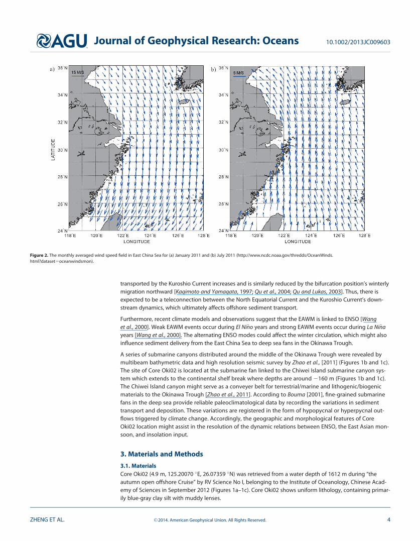
pressure above the central Eurasian continent causes southwesterly winds of approximately 5 m/s whichcarry warm and moist air from the Pacific Ocean toward Taiwan and Mainland China (Figure 2b). In winter,reversed pressure gradients favor northeasterly winds of approximately 12 m/s which bring cool and dry airfrom the Eurasian continent toward the Pacific Ocean, meanwhile, the ITCZ moves further south (Figures 1and 2a). The seasonal variation of the monsoon system results in a significant change in the hydrographicconditions of the East China Sea and in the magnitude versus the main direction of Kuroshio Current eastoff of Taiwan. These factors combine to alter the volume of ocean water transported into the OkinawaTrough [Diekmann et al., 2008; Lee and Chao, 2003; Yuan and Hsueh, 2010; Yuan et al., 2008].
It has previously been demonstrated that the offshore sediment transport, in the present day, primarilyoccurs during the winter, when sediment bearing currents are driven by a prevailing northeasterly wind[Iseki et al., 2003; Yanagi et al., 1996]. The Ekman effect triggers downwelling, which when coupled withwind-driven mixing and tidally induced resuspension, induces a seaward near-bottom transport; whereastransport is inhibited by the transverse circulation pattern attributable to the Kuroshio Current’s intrusionduring the summer months [Yanagi et al., 1996; Yang et al., 1992]. In the present day, due to a summertimesouthward migration of the bifurcation position of the North Equatorial Current, the volume of ocean water
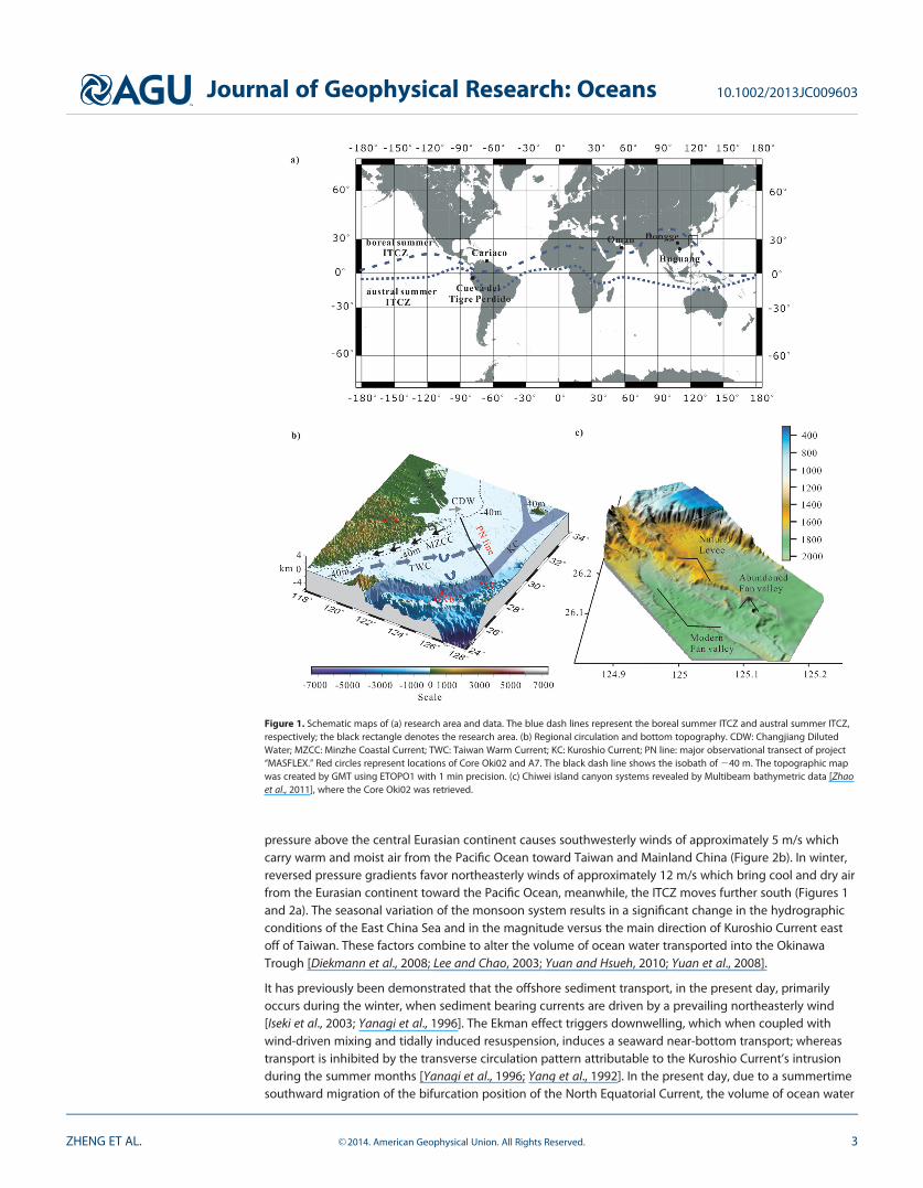
Figure 1. Schematic maps of (a) research area and data. The blue dash lines represent the boreal summer ITCZ and austral summer ITCZ,respectively; the black rectangle denotes the research area. (b) Regional circulation and bottom topography. CDW: Changjiang DilutedWater; MZCC: Minzhe Coastal Current; TWC: Taiwan Warm Current; KC: Kuroshio Current; PN line: major observational transect of project‘‘MASFLEX.’’ Red circles represent locations of Core Oki02 and A7. The black dash line shows the isobath of 240 m. The topographic mapwas created by GMT using ETOPO1 with 1 min precision. (c) Chiwei island canyon systems revealed by Multibeam bathymetric data [Zhaoet al., 2011], where the Core Oki02 was retrieved.
Journal of Geophysical Research: Oceans 10.1002/2013JC009603
ZHENG ET AL. VC 2014. American Geophysical Union. All Rights Reserved. 3
transported by the Kuroshio Current increases and is similarly reduced by the bifurcation position’s winterlymigration northward [Kagimoto and Yamagata, 1997; Qu et al., 2004; Qu and Lukas, 2003]. Thus, there isexpected to be a teleconnection between the North Equatorial Current and the Kuroshio Current’s down-stream dynamics, which ultimately affects offshore sediment transport.
Furthermore, recent climate models and observations suggest that the EAWM is linked to ENSO [Wanget al., 2000]. Weak EAWM events occur during El Ni~no years and strong EAWM events occur during La Ni~nayears [Wang et al., 2000]. The alternating ENSO modes could affect the winter circulation, which might alsoinfluence sediment delivery from the East China Sea to deep sea fans in the Okinawa Trough.
A series of submarine canyons distributed around the middle of the Okinawa Trough were revealed bymultibeam bathymetric data and high resolution seismic survey by Zhao et al., [2011] (Figures 1b and 1c).The site of Core Oki02 is located at the submarine fan linked to the Chiwei Island submarine canyon sys-tem which extends to the continental shelf break where depths are around 2160 m (Figures 1b and 1c).The Chiwei Island canyon might serve as a conveyer belt for terrestrial/marine and lithogenic/biogenicmaterials to the Okinawa Trough [Zhao et al., 2011]. According to Bouma [2001], fine-grained submarinefans in the deep sea provide reliable paleoclimatological data by recording the variations in sedimenttransport and deposition. These variations are registered in the form of hypopycnal or hyperpycnal out-flows triggered by climate change. Accordingly, the geographic and morphological features of CoreOki02 location might assist in the resolution of the dynamic relations between ENSO, the East Asian mon-soon, and insolation input.
3. Materials and Methods
3.1. MaterialsCore Oki02 (4.9 m, 125.20070 �E, 26.07359 �N) was retrieved from a water depth of 1612 m during ‘‘theautumn open offshore Cruise’’ by RV Science No I, belonging to the Institute of Oceanology, Chinese Acad-emy of Sciences in September 2012 (Figures 1a–1c). Core Oki02 shows uniform lithology, containing primar-ily blue-gray clay silt with muddy lenses.
Figure 2. The monthly averaged wind speed field in East China Sea for (a) January 2011 and (b) July 2011 (http://www.ncdc.noaa.gov/thredds/OceanWinds.html?dataset5oceanwindsmon).
Journal of Geophysical Research: Oceans 10.1002/2013JC009603
ZHENG ET AL. VC 2014. American Geophysical Union. All Rights Reserved. 4
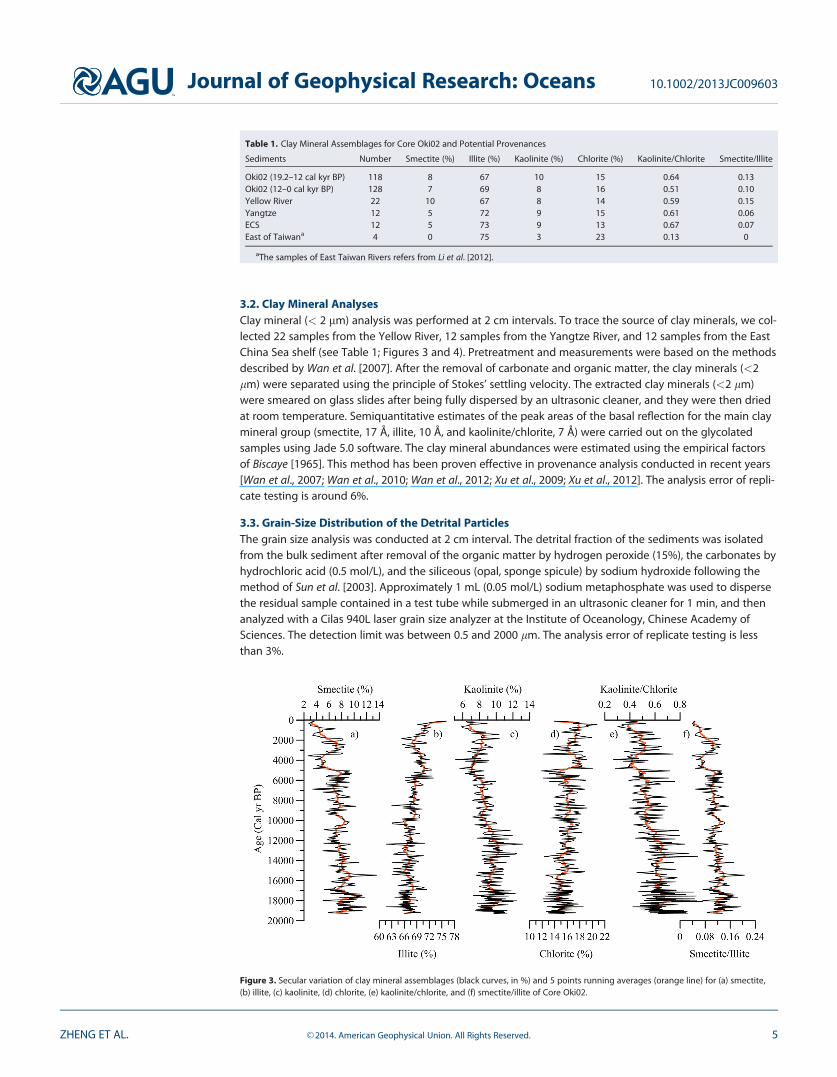
3.2. Clay Mineral AnalysesClay mineral (< 2 mm) analysis was performed at 2 cm intervals. To trace the source of clay minerals, we col-lected 22 samples from the Yellow River, 12 samples from the Yangtze River, and 12 samples from the EastChina Sea shelf (see Table 1; Figures 3 and 4). Pretreatment and measurements were based on the methodsdescribed by Wan et al. [2007]. After the removal of carbonate and organic matter, the clay minerals (<2lm) were separated using the principle of Stokes’ settling velocity. The extracted clay minerals (<2 lm)were smeared on glass slides after being fully dispersed by an ultrasonic cleaner, and they were then driedat room temperature. Semiquantitative estimates of the peak areas of the basal reflection for the main claymineral group (smectite, 17 Å, illite, 10 Å, and kaolinite/chlorite, 7 Å) were carried out on the glycolatedsamples using Jade 5.0 software. The clay mineral abundances were estimated using the empirical factorsof Biscaye [1965]. This method has been proven effective in provenance analysis conducted in recent years[Wan et al., 2007; Wan et al., 2010; Wan et al., 2012; Xu et al., 2009; Xu et al., 2012]. The analysis error of repli-cate testing is around 6%.
3.3. Grain-Size Distribution of the Detrital ParticlesThe grain size analysis was conducted at 2 cm interval. The detrital fraction of the sediments was isolatedfrom the bulk sediment after removal of the organic matter by hydrogen peroxide (15%), the carbonates byhydrochloric acid (0.5 mol/L), and the siliceous (opal, sponge spicule) by sodium hydroxide following themethod of Sun et al. [2003]. Approximately 1 mL (0.05 mol/L) sodium metaphosphate was used to dispersethe residual sample contained in a test tube while submerged in an ultrasonic cleaner for 1 min, and thenanalyzed with a Cilas 940L laser grain size analyzer at the Institute of Oceanology, Chinese Academy ofSciences. The detection limit was between 0.5 and 2000 lm. The analysis error of replicate testing is lessthan 3%.
Table 1. Clay Mineral Assemblages for Core Oki02 and Potential Provenances
Sediments Number Smectite (%) Illite (%) Kaolinite (%) Chlorite (%) Kaolinite/Chlorite Smectite/Illite
Oki02 (19.2–12 cal kyr BP) 118 8 67 10 15 0.64 0.13Oki02 (12–0 cal kyr BP) 128 7 69 8 16 0.51 0.10Yellow River 22 10 67 8 14 0.59 0.15Yangtze 12 5 72 9 15 0.61 0.06ECS 12 5 73 9 13 0.67 0.07East of Taiwana 4 0 75 3 23 0.13 0
aThe samples of East Taiwan Rivers refers from Li et al. [2012].
Figure 3. Secular variation of clay mineral assemblages (black curves, in %) and 5 points running averages (orange line) for (a) smectite,(b) illite, (c) kaolinite, (d) chlorite, (e) kaolinite/chlorite, and (f) smectite/illite of Core Oki02.
Journal of Geophysical Research: Oceans 10.1002/2013JC009603
ZHENG ET AL. VC 2014. American Geophysical Union. All Rights Reserved. 5
3.4. Core ScanningThe major elemental compositions were measured with an Itrax X-ray fluorescence (XRF) core scanner.Measurements were carried out at 30 kV and 40 mA at 1 cm intervals. The elemental composition acquiredby the XRF core scanner is given as count rates, which are based on the elemental intensity. Here we selectFe, Ti and Ca for discussion.
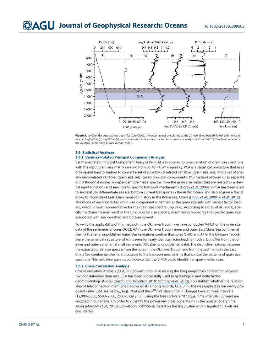
3.5. Age ModelThe age model for Core Oki02 was constructed by 10 AMS 14C dates. The AMS 14C age was measured at theAMS laboratory, Beta Analytic. Mixed planktonic foraminifera shells were selected from fine-grained layers(see Table 2). The calendar ages were acquired by using Calib 6.0 with a reservoir age of 400 years [Sunet al., 2005; Yoneda et al., 2007]. The date for surface sample (0–2 cm) is 100.6 pMC, which is not consistentwith the reservoir age. We suspect the foraminifera shells in surface sediments might contain bomb 14C sig-nal, yet, this would not influence our dates down core. The bottom layer of the sediment extends to approx-imately 19,200 cal yr BP (Figure 5).The sedimentation rates varied between 18 and 50 cm/cal kyr21 (Figure 5).The high sedimentation rates and 1 cm sampling interval yield a temporal resolution of 20–50 years per sam-ple, which is beneficial to climate change study at the centennial scale.
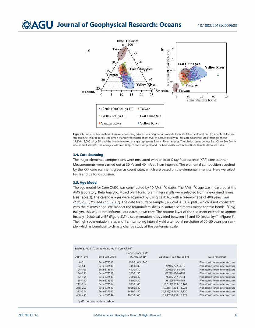
Figure 4. End member analysis of provenance using (a) a ternary diagram of smectite-kaolinite-(illite1chlorite) and (b) smectite/illite ver-sus kaolinite/chlorite ratios. The green triangle represents an interval of 12,000–0 cal yr BP for Core Oki02; the violet triangle shows19,200–12,000 cal yr BP; and the brown inverted triangle represents Taiwan River samples. The black crosses denote East China Sea Conti-nental shelf samples, the orange circles are Yangtze River samples, and the blue crosses are Yellow River samples (also see Table 1).
Table 2. AMS 14C Ages Measured in Core Oki02a
Depth (cm) Beta Lab CodeConventional AMS
14C Age (yr BP) Calendar Years (cal yr BP) Date Resources
0–2 Beta-373510 100.660.3 pMC Planktonic foraminifer mixture52–54 Beta-337538 3150630 (2891)2772–3012 Planktonic foraminifer mixture
104–106 Beta-373511 4920630 (5203)5048–5299 Planktonic foraminifer mixture134–136 Beta-373512 5830630 (6222)6120–6294 Planktonic foraminifer mixture162–164 Beta-337539 7200640 (7631)7547–7741 Planktonic foraminifer mixture188–190 Beta-373513 8300630 (8815)8649–8961 Planktonic foraminifer mixture212–214 Beta-373514 9230640 (10,011)9833–10,162 Planktonic foraminifer mixture248–250 Beta-337540 10560640 (11,731)11,404–11,933 Planktonic foraminifer mixture372–374 Beta-337541 14290650 (16,932)16,763–17,130 Planktonic foraminifer mixture488–450 Beta-337542 16530660 (19,230)18,938–19,429 Planktonic foraminifer mixture
apMC: percent modern carbon.
Journal of Geophysical Research: Oceans 10.1002/2013JC009603
ZHENG ET AL. VC 2014. American Geophysical Union. All Rights Reserved. 6
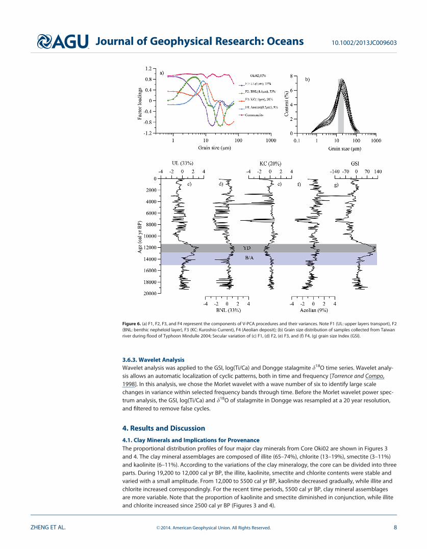
3.6. Statistical Analyses3.6.1. Varimax-Rotated Principal Component AnalysisVarimax-rotated Principal Component Analysis (V-PCA) was applied to time variation of grain size spectrumwith the input grain size matrix ranging from 0.5 to 71 lm (Figure 6). PCA is a statistical procedure that usesorthogonal transformation to convert a set of possibly correlated variables (grain size sets) into a set of line-arly uncorrelated variables (grain size sets) called principal components. This method allowed us to separateout orthogonal modes, independent grain-size spectra, from the grain size matrix that are related to poten-tial input functions and sensitive to specific transport mechanisms [Darby et al., 2009]. V-PCA has been usedto successfully differentiate sea ice, bottom current transports in the Arctic Ocean, and also acquire a fluvialproxy to reconstruct East Asian monsoon history in the Bohai Sea, China [Darby et al., 2009; Yi et al., 2012].The mode of each extracted grain size component is defined as the grain size sets with largest factor load-ing, which is most representative for the grain size spectra (Figure 6). According to Darby et al. [2009], spe-cific mechanisms may result in the unique grain size spectra, which are provided by the specific grain sizeassociated with sea ice-rafted and bottom current.
To verify the applicability of this method in the Okinawa Trough, we have conducted V-PCA on the grain sizedata of the sediments of cores Oki02, A7 in the Okinawa Trough, inner and outer East China Sea continentalshelf (X.F. Zheng, unpublished data). Our validations confirm that cores Oki02 and A7 in the Okinawa Troughshare the same data structure which is seen by nearly identical factor loading models, but differ from that ofinner and outer continental shelf sediments (X.F. Zheng, unpublished data). The distinctive features betweenthe extracted grain size spectra from the cores in the Okinawa Trough and from the sediments in the EastChina Sea continental shelf is attributable to the transport mechanisms that control the patterns of grain sizespectrum. This validation gave us confidence that the V-PCA could identify transport mechanisms.
3.6.2. Cross-Correlation AnalysisCross-Correlation Analysis (CCA) is a powerful tool in assessing the long range cross correlation betweentwo nonstationary data sets. CCA has been successfully used in hydrological and delta hydro-geomorphology studies [Hajian and Movahed, 2010; Marriner et al., 2012]. To establish whether the relation-ship of teleconnection mentioned above exists among records, CCA (P<0.05) was applied to our newly pro-posed index (GSI, see below), log(Ti/Ca) and the d18O of stalagmite in Dongge Cave at three intervals(12,000–5500, 5500–2500, 2500–0 cal yr BP) using the free software ‘‘R.’’ Equal time intervals (50 year) areadopted in our analysis in order to quantify the power-law cross correlations in the nonstationary timeseries [Marriner et al., 2012]. Correlation coefficients based on the lag 0 value within significant levels areconsidered.
Figure 5. (a) Calendar ages against depth for Core Oki02, the uncertainties are plotted at the 2d level (blue bar); (b) linear sedimentationrate; (c) log(Fe/Ca); (d) log(Ti/Ca), (e) Kuroshio Current indicators extracted from grain size analysis of Core Oki02; (f) Sea level variation inthe western Pacific since LGM [Liu et al., 2004].
Journal of Geophysical Research: Oceans 10.1002/2013JC009603
ZHENG ET AL. VC 2014. American Geophysical Union. All Rights Reserved. 7
3.6.3. Wavelet AnalysisWavelet analysis was applied to the GSI, log(Ti/Ca) and Dongge stalagmite d18O time series. Wavelet analy-sis allows an automatic localization of cyclic patterns, both in time and frequency [Torrence and Compo,1998]. In this analysis, we chose the Morlet wavelet with a wave number of six to identify large scalechanges in variance within selected frequency bands through time. Before the Morlet wavelet power spec-trum analysis, the GSI, log(Ti/Ca) and d18O of stalagmite in Dongge was resampled at a 20 year resolution,and filtered to remove false cycles.
4. Results and Discussion
4.1. Clay Minerals and Implications for ProvenanceThe proportional distribution profiles of four major clay minerals from Core Oki02 are shown in Figures 3and 4. The clay mineral assemblages are composed of illite (65–74%), chlorite (13–19%), smectite (3–11%)and kaolinite (6–11%). According to the variations of the clay mineralogy, the core can be divided into threeparts. During 19,200 to 12,000 cal yr BP, the illite, kaolinite, smectite and chlorite contents were stable andvaried with a small amplitude. From 12,000 to 5500 cal yr BP, kaolinite decreased gradually, while illite andchlorite increased correspondingly. For the recent time periods, 5500 cal yr BP, clay mineral assemblagesare more variable. Note that the proportion of kaolinite and smectite diminished in conjunction, while illiteand chlorite increased since 2500 cal yr BP (Figures 3 and 4).
Figure 6. (a) F1, F2, F3, and F4 represent the components of V-PCA procedures and their variances. Note F1 (UL: upper layers transport), F2(BNL: benthic nepheloid layer), F3 (KC: Kuroshio Current), F4 (Aeolian deposit); (b) Grain size distribution of samples collected from Taiwanriver during flood of Typhoon Mindulle 2004; Secular variation of (c) F1, (d) F2, (e) F3, and (f) F4, (g) grain size Index (GSI).
Journal of Geophysical Research: Oceans 10.1002/2013JC009603
ZHENG ET AL. VC 2014. American Geophysical Union. All Rights Reserved. 8
Based on clay mineralogy and biogeochemical/geochemical proxies previous studies indicated that terrige-nous clastic sediments deposited in the middle of the Okinawa Trough mainly originated from 1) YangtzeRiver, 2) Yellow River, 3) mountainous rivers in the east Taiwan and 4) the East China Sea continental shelfparticularly during low sea level stand [Hoshika et al., 2003; Diekmann et al., 2008; Dou et al., 2010; Dou et al.,2012; Iseki et al., 2003; Kao et al., 2008a, 2008b] and, also, that the fractional contributions from the 4 sourcesvaried through the glacial-interglacial cycle. The clay mineral assemblages in the Yangtze River predomi-nantly consist of illite (67–75%, averaging 72%) and chlorite (11–18%, averaging 15%), with lesser amountsof kaolinite (7–11%, averaging 9%) and smectite (3–8%, averaging 5%) (see Table 1 and Figure 4). The Yel-low River known for having the highest sediment load on earth (approximately 13109 t/yr), has also con-tributed tremendously to the study area since the late Quaternary [Milliman and Meade, 1983; Milliman andSyvitski, 1992]. The Yellow River mainly contains illite (58–71%, averaging 67%) and smectite (7–19%, aver-aging 10%), with lesser quantities of chlorite (11–17%, averaging 14%) and kaolinite (7–12%, averaging 8%)(see Table 1 and Figure 4). The clay mineral assemblages of the Yellow River sediments are comparable tothose of the Yangtze River, although the Yellow River samples have a higher smectite content and highermineral crystallinity [Yang et al., 2003]. As for the East China Sea continental shelf, the sediment is com-posed mainly of illite (68–78%, averaging 73%) and chlorite (10–16%, averaging 13%), with scarce smectite(4–7%, averaging 5%) and kaolinite (8–11%, averaging 9%) (see Table 1 and Figure 4). In Taiwan, strong tec-tonic activity, rapid uplift and frequent high energy storms result in one of the highest soil erosion rates inthe world [Li et al., 2012; Li, 1976]. Previous studies indicate that sediments exported to the Okinawa Troughare derived mainly from rivers in eastern Taiwan where they collectively discharge up to 150 Mt/yr [Die-kmann et al., 2008; Liu et al., 2008]. Sediments from Taiwan are transported northward by the Kuroshio Cur-rent situated on the east side of Taiwan [Diekmann et al., 2008; Dou et al., 2010]. The clay mineralassemblages for the eastern Taiwan rivers consist of illite (74%) and chlorite (22%) with an absence of smec-tite and kaolinite (4%) (see Table 1 and Figure 4) [Li et al., 2012].
Assuming that the clay mineral assemblages of the sediment provenances were essentially stable since thelast glacial period, we may distinguish the clay mineral sources in different time periods by using smectite/illite versus kaolinite/chlorite ratios and a ternary diagram of three components: smectite, kaolinite and (illi-te1chlorite) (Figures 4a and 4b). We found that during 12,000–0 cal yr BP most samples fall in the field closeto the East China Sea continental shelf and the Yangtze River provenance, but deviate from the composi-tions of the Taiwan and Yellow River sediments (Figures 4a and 4b). During 19,200–12,000 cal yr BP, the clayminerals were derived mainly from the Yellow River, the Yangtze River and the East China Sea continentalshelf with less contribution from Taiwan (Figures 4a and 4b). Accordingly, we conclude that the clay miner-als of Core Oki02 originated mainly from the rivers of the China’s mainland with lesser amounts comingfrom Taiwan throughout the last 19,000 years. The absence of clay components from the Yellow River in theHolocene period may be attributed to the enhanced Kuroshio Current and the formation of modern currentsystems (e.g., water barrier). Interestingly, although a remarkable sea-level change had occurred during theperiod from 15,000 to 12,000 cal yr BP [Liu et al., 2004], we do not observe a significant change in the claymineral assemblage for this specific time period. Thus, the effect of sea level may have played a secondaryrole in sediment transport to the middle Okinawa Trough (Figure 3). The relatively steady sea level duringthe Holocene minimizes its impact on East China Sea circulation patterns [Kao et al., 2006], thus, allowingmonsoons to more effectively force the delivery of sediment to deep sea fans.
On the other hand, since kaolinite is absent in the rivers of Taiwan, but found at relatively higher propor-tions in the rivers of mainland China [Li et al., 2012], the variation of kaolinite itself, to some extent, could beused to monitor the relative terrigenous contribution from mainland China in spite of the dilution effectsthat could influence the abundance of kaolinite [Wang et al., 2013].
4.2. Features of the Grain Size Spectrum and Transportation MechanismsFour components (F1, F2, F3, and F4) were identified to explain � 95% of the total amount of variance inCore Oki02 (Figure 6a).The first mode (F1) accounting for 33% of the variance has a positive broad peak at 1lm and an anticorrelated negative peak at 15 lm (Figure 6a); the second mode (F2) for 33% has a positivepeak at 4.6 lm and large anticorrelation at about 30 lm (Figure 6a). The third mode (F3) for 20% contains apeak at 11 lm and moderately strong negative loadings above 40 lm (Figure 6a). The fourth mode (F4) for9% has a positive peak at 8.5 lm (Figure 6a). As mentioned earlier, the Core A7 gave the same modes with
Journal of Geophysical Research: Oceans 10.1002/2013JC009603
ZHENG ET AL. VC 2014. American Geophysical Union. All Rights Reserved. 9
a consistent grain size structure, such consistency strongly indicates that there must be identifiable mecha-nisms to account for the four specific modes.
Terrigenous particles that settled in the marine environment are regarded as mixed materials that arederived from various sources and experience different transport processes, which may lead to distinctivegrain-size distributions [Darby et al., 2009]. According to previous research, five processes associated withvarious sediment sources dominate in the East China Sea. These are resuspended sediments carried by thebenthic nepheloid layer (BNL), fine sediments transported in the upper layers (UL) of the water column onshelf [Iseki et al., 2003], sediments from Taiwan and/or East China Sea continental shelf carried by KuroshioCurrent [Diekmann et al., 2008; Hsu and Hanes, 2004], turbidity currents triggered by submarine earthquakes[Huh et al., 2004], and volcanic eruptions [Machida, 1999].
F3 (11 lm) is interpreted as an indicator of the Kuroshio Current. This is due not only to grain size itself butalso because of its contribution to the variance in several cores (Figure 6a). The down-core variation of thefactor score of F3 agrees well with the patterns of sortable silt (10–63 lm) among Core Oki02, cores A7 andODP1202 (X.F. Zheng, unpublished data) (Figure 6e). According to McCave et al. [1995], the mean size andpercentage of sortable silt (10–63 lm) are good indicators of paleocurrent winnowing because its noncohe-sive property which allows it to be easily sorted or transported by currents [McCave et al., 1995]. The F3mode of 11 lm is close to the mean size (14 lm) of sortable silt (10–63 lm) [McCave et al., 1995]. In addi-tion, the secular variation of F3 in Core Oki02 is concordant with the percentage variation of P.obliquilocu-lata in Core A7, an indicator of the Kuroshio Current [Xiang et al., 2007] (Figure 6e). The transport mode of11 lm can be evaluated by the Rouse number. The Rouse number (R05Ws=jU�) is a nondimensionalparameter in fluid dynamic which is used to determine how sediment will be transported in a flowing fluid.R0 expresses the ratio of settling velocity to the shear velocity; Ws is the settling velocity of the grains, j isthe von Karman constant (0.4), and U� is the boundary shear velocity. R0 values >2.5 indicate bed loadtransport, a value between 2.5 and 1.2 indicates that 50% of sediment is transported in suspension, whilethe range 1.2 to 0.8 indicates 100% suspension, and a Rouse number less than 0.8 denotes a fully sus-pended wash load. The Rouse number indicates that the 11lm will be transported in the Kuroshio Currentby suspension (X.F. Zheng, unpublished data). The sediment discharge during the floods of the largest Tai-wan river is composed mainly of mud with a mean size of �10 lm [Kao et al., 2008a] (Figure 6b), whichmight act as a supplier for the 11 lm sediment carried by the Kuroshio Current. Thus all of these factorssuggest that F3 indicates the sediment transported by the Kuroshio Current.
The other two main mechanisms for sediment transport to the Okinawa Trough are the benthic nepheloidlayer and upper layers, which are controlled by winter monsoons [Hoshika et al., 2003; Bian et al., 2010; Isekiet al., 2003; Oguri et al., 2003]. Transport by BNL is a key process to export shelf material to deep sea [Isekiet al., 2003] and BNL are typically driven by northeasterly prevailing winds [Bian et al., 2010; Yanagi et al.,1996; Yang et al., 1992]. Sediments discharged from the Yangtze River during summer floods are confinedmainly to the subaqueous delta and inner shelf. A smaller portion is transported northeastward carried bythe Taiwan Warm Current mingled with intruding Kuroshio subsurface water, which becomes a ‘‘water bar-rier’’ for offshore transport [Bian et al., 2010; Yang et al., 1992]. The ‘‘water barrier’’ is weakened in the winteror even terminated by intensified northeasterly winds [Yang et al., 1992; Yuan et al., 2008]. The downwellingforcing, coupled with vigorous mixing driven by winter monsoon facilitate both BNL and UL transportationto the Okinawa Trough [Bian et al., 2010; Iseki et al., 2003; Oguri et al., 2003; Yanagi et al., 1996].
Here we infer that F1 (1 lm) and F2 (4.6 lm) are indicators for UL and BNL, respectively (Figure 6a). Accord-ing to clay mineral analysis, the clay minerals (<2 lm) of Core Oki02 are derived mainly from the YangtzeRiver, the Yellow River and the East China Sea continental shelf, with lesser amounts derived from TaiwanIsland (Figures 3 and 4). On the other hand, the mode of F2 (4.6 lm) is close to the reported medium grainsize (�6 lm) of BNL in East China Sea [Hoshika et al., 2003]. The secular variation of the factor score of F1 isin phase with that of F2, indicating that they are governed by the same forcing (Figures 6c and 6d).
Sediments in canyon systems follow two primary transport pathways, namely shallow plume (of approxi-mately 600 m) and near-bottom transport [Kineke et al., 2000; Liu et al., 2013]. These were observed in a can-yon study done in the southern Okinawa Trough [Hsu et al., 2006]. Our inference is also consistent with theobservations of a sediment trap and surface sediments collected from the middle of the Okinawa Troughalong the PN line (Figure 1) [Iseki et al., 2003; Oguri et al., 2000].
Journal of Geophysical Research: Oceans 10.1002/2013JC009603
ZHENG ET AL. VC 2014. American Geophysical Union. All Rights Reserved. 10
It is very probable that the F4 (8.5 lm) of Core Oki02 represents the aeolian dust derived from Asian conti-nental (Figure 6a). The mode and grain size spectra of F4 is close to that of aeolian dust (8lm), as revealedfrom a grain size analysis study of core MD01-2407 in the Japan sea and the aeolian dust sampled at Sap-poro, Hokkaido in March 2002 [Nagashima et al., 2007]. In addition, the average terrigenous mass accumula-tion rates of Core Oki02 since 19,200 cal yr BP is 220 g m22 annually. According to Hsu et al. [2009], theestimated dust deposition to East China Sea is 20 g m22 annually. Thus, the maximum aeolian contributionmay account for only 9% of the terrigenous flux in Core Oki02, which resembles the 8.9% variance contribu-tion of F4. Interestingly, the secular variation of F4 is in phase with F1 and F2 before the Holocene (Figure6), however, the covariance became insignificant in the Holocene. This Holocene disconnection is likely dueto the enhanced northward Kuroshio Current and the Taiwan warm current, which might influence the set-tling of aeolian dust to the sea floor and thus diminish the variation of F4 (Figure 6).
4.3. Environmental Controls on Transport and SedimentationThe down-core distribution of the iron/calcium (Fe/Ca) and titanium/calcium (Ti/Ca) ratios in the Core Oki02are displayed in Figure 5. Elemental ratios are more useful than single elements due to their insensitivity toclosure effects [Weltje and Tjallingii, 2008]. The ratios of Fe/Ca and Ti/Ca are commonly used to indicateinflux of terrigenous material in marine sediments and thus, to reconstruct paleoclimate [Arz et al., 1998; Arzet al., 1999]. To reduce the influence of sample geometry and physical properties such as effects of speci-men inhomogeneity, variable water interactions, grain-size distribution, and a general lack of control onmeasurement geometry, we utilized log(Ti/Ca) and log(Fe/Ca) as proxies. This provided interpretable dataof the relative changes in chemical composition and eliminated the constant-sum constraint [Weltje andTjallingii, 2008]. On the other hand, log(Ti/Ca) is positive correlated to log(Fe/Ca) suggests that Fe and Ti, asterrestrial elements, have same origin. As we can see from Figure 5, the linear sedimentation rate of CoreOki02 has been relatively constant since 16,000 cal yr BP. The marine material influx to the middle of theOkinawa Trough has also been stable since the beginning of the Holocene, as revealed by stable biogeniccomponents, including CaCO3 and opal contents, and the total organic carbon accumulation rate in thenearby Core DGKS9604, also located in the Okinawa Trough [Dou et al., 2011]. The stable accumulation ratemay imply a constant sum of terrigenous and marine materials and thus further support the credibility ofthe usage of log(Ti/Ca) and log(Fe/Ca) as indicators for the terrigenous influx (Figure 5).
Down-core variations of terrigenous influx as indicated by log(Ti/Ca) are shown in Figure 5. During 19,200–15,000 cal yr BP, the sea level was low and the paleochannel was situated closer to the Okinawa Trough,concurrently, the Kuroshio Current was relatively weak as is indicated by low F3, which provided favorableconditions for the export of fluvial sediments, and thus causes the higher log(Ti/Ca) and F2 (bottom nephe-loid layer transport) [Saito et al., 1998; Wellner and Bartek, 2003; Xu and Oda, 1999] (Figures 5 and 6). In thesame time period, lower F1 (upper layer transport) may be overwhelmed by sediments transported higherin the water as F2 (bottom nepheloid layer transport) due to the shorten distance from the estuary and thehigh turbid of fluvial sediment [Saito et al., 1998; Wellner and Bartek, 2003]. Between 15,000 and 12,000 calyr BP, rapid coastline retreat and submerging continental shelf, coupled with an immature Kuroshio Current,had created a better condition for BNL and UL transports, as indicated by the increase of F1 and F2; duringthe same time strong sediment reworking and erosion at the shelf edge since 15,000 cal yr BP was observedin the South and East China Sea [Dou et al., 2010; Steinke et al., 2008]. In this period, the increased distancefrom the estuary might diminish the fluvial supply resulting in marginal decrease of log (Ti/Ca) [Saito et al.,1998; Wellner and Bartek, 2003].
During the Holocene, the Kuroshio Current initially gained strength and then rapidly attained stability whichit maintained throughout the Holocene (X.F. Zheng, unpublished data) (Figure 7). According to numericalmodeling research, the flow path and volume of the Kuroshio Current resembled present condition sincethe beginning of the Holocene, when the sea level was above 240 m [Kao et al., 2006; Lee et al., 2013](Figure 1a). A shift in sediment provenance since the Holocene also suggests that the formation of amodern current system in East China Sea in response to an enhancement of the Kuroshio Current, which islinked to the Kuroshio Current branching out into the Japan Sea during the period from 11,500 to 8500 calyr BP [Xu and Oda, 1999] (Figures 3 and 4). Based on planktonic foraminiferal records, during the period of11,500–9000 cal yr BP, the coastal waters shift toward being dominated by the Kuroshio Current [Xu andOda, 1999]. A drastic decrease in log(Ti/Ca) located in this transitional period supports the ‘‘Kuroshio Currentwater barrier’’ theory (Figure 7). According to grain size and clay mineral analysis, the sources of the clay
Journal of Geophysical Research: Oceans 10.1002/2013JC009603
ZHENG ET AL. VC 2014. American Geophysical Union. All Rights Reserved. 11
minerals were the Yangtze River and the East China Sea continental shelf, with a lesser contribution comingfrom Taiwan (Figures 3 and 4). Hence, the variation of log(Ti/ca) may reflect the relative contribution of ter-rigenous influx from mainland China in the winter since the Holocene (Figure 7).
In order to examine the EAWM pattern in the Holocene, we combined F1 and F2 into a new series of grainsize index (GSI) based on their variance contributions (Figure 6f):
GSI5BNL3331UL333 (1)
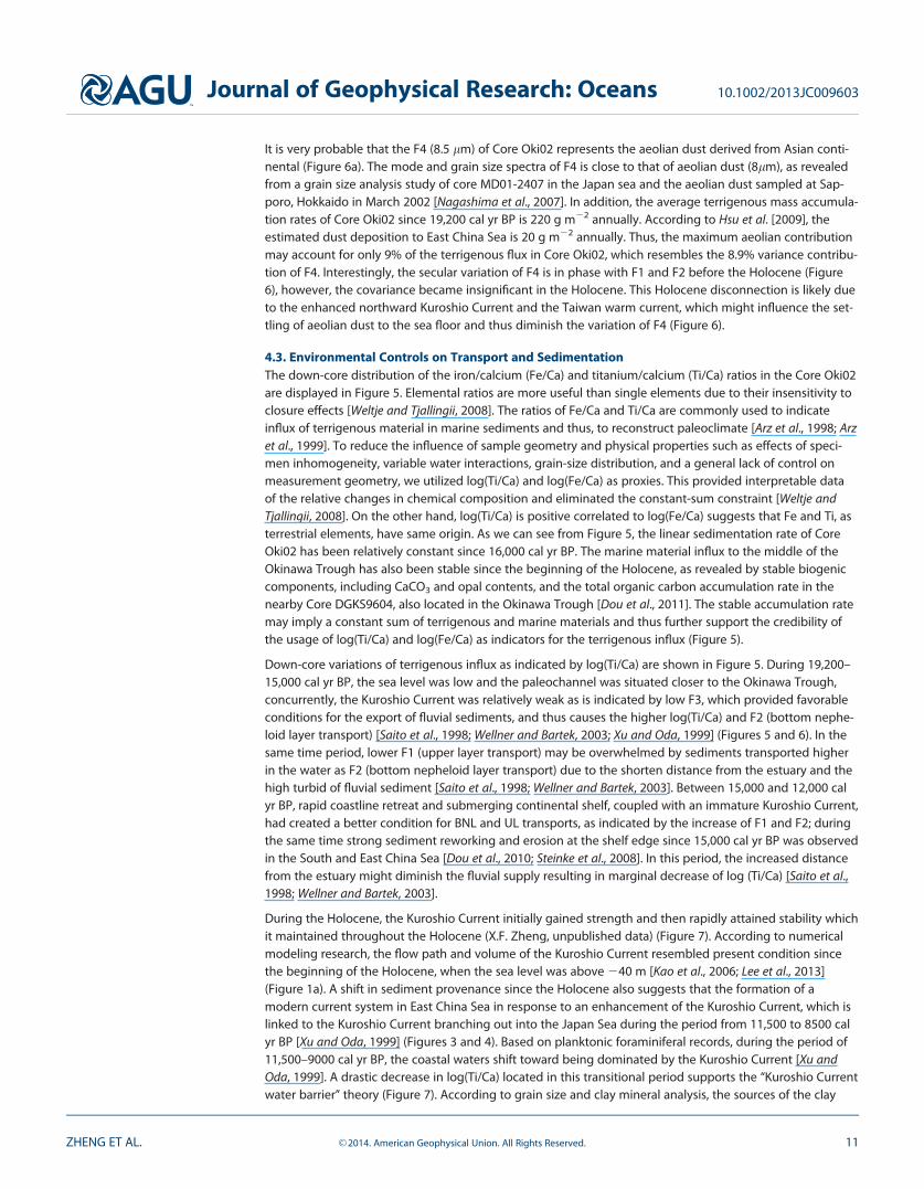
The temporal pattern of the GSI during the Holocene agrees well with various EAWM proxies, including pri-mary production in Sulu sea, median grain size of Duowa loess in western China and magnetic susceptibilityin Huguang Marr lake, Guangdong, China [de Garidel-Thoron et al., 2001; Maher and Hu, 2006; Yancheva et al.,2007] (Figure 7). These agreements further support the credibility of interpreting GSI as an indicator of EAWM.
The GSI diminishes greatly since the Holocene and reaches a minimum at � 11,000–9000 cal yr BP, indicat-ing that the BNL and UL transport were weakest (Figure 7). The GSI gradual decrease fully accords with thereported timing of northward shift and permanence of the ITCZ position in the winter [Haug et al., 2001;Yancheva et al., 2007] (Figure 7). The decreasing trend of log(Ti/Ca) since 12,000 cal yr BP further supportsthe gradually weakening of EAWN intensity in early Holocene (Figure 7). The decrease in percentage of kao-linite, which stands for the source material from mainland China, also supports an attenuation of the EAWM(Figure 3).
From 9000 to 5500 cal yr BP, a relatively low and steady GSI is concordant with a relatively low log(Ti/Ca),indicating a small terrigenous input, when the summer insolation in northern hemisphere was maximum[Berger and Loutre, 1991] (Figures 7, 8, and 9a). Mainland East China’s contribution of kaolinite was initiallysteady and then begins to decrease (Figure 3). On the other hand, a high GSI is coeval with an ascendinglog(Ti/Ca) between 5500 and 2000 cal yr BP, which indicates a simultaneous increase in terrigenous influxvia BNL and UL (Figure 7). The percentage of kaolinite also increased in this period (Figure 3). The concomi-tant variations in the GSI, log(Ti/Ca) and kaolinite nearly throughout the entire Holocene illustrate that thesediment dispersal was governed by the intensity of EAWM.
Since 2000 cal yr BP, the GSI has increased and scaled back in a short period, which is also evinced by syn-chronous variations in kaolinite (Figures 3 and 7). The log(Ti/Ca), however, shifted to a higher value andremained steady (Figure 7).
Based on the magnified variability in GSI and log(Ti/Ca) in the past 5500 cal yr BP, we inferred a largercentury-scale variation of the EAWM (Figures 7 and 8), especially between 4500 and 2500 cal yr BP, which
Figure 7. Temporal variations of (a) grain size Index (GSI), (b) log(Ti/Ca), and (c) Kuroshio Current (KC) indicator for Core Oki02. (d) Sea levelpattern in the western Pacific since LGM [Liu et al., 2004], (e) Median grain size of loess in Duowa, western China [Maher and Hu, 2006], (f)Primary production in the Sulu sea [de Garidel-Thoron et al., 2001], (g) Magnetic susceptibility of sediment core in the Huguang Marr lake,Zhanjiang, China [Yancheva et al., 2007].
Journal of Geophysical Research: Oceans 10.1002/2013JC009603
ZHENG ET AL. VC 2014. American Geophysical Union. All Rights Reserved. 12
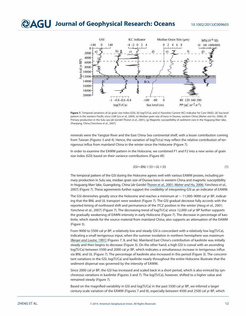
had been affected by the intensified ENSO activity (more El Ni~no) [Haug et al., 2001]. In fact, the southwardmigration of the ITCZ over the late Holocene was accompanied by the prevalence of El Ni~no because thenorthern hemisphere insolation became less seasonal while the southern hemisphere became seasonal[Haug et al., 2001].
A modeling study of contemporary conditions showed that the warm events (cold) in the eastern Pacificmay result in weak (strong) EAWM due to the formation of an anticyclonic (cyclonic) system in the PacificOcean [Wang et al., 2000], which results in high frequency variation of the EAWM. Thus warm events (ElNi~no) may result in a weaker winter circulation in the East China Sea (Figure 9b), while cold events (La Ni~na)result in a strong winter circulation (Figure 9c). The rapid alteration of ENSO modes will apparently alter thesedimentation processes in the East China Sea. Below, we attempt to separate the signals modulated by theITCZ and ENSO.
Figure 8. Records of (a) grain size Index (GSI), (b) log(Ti/Ca) of Core Oki02, (c) Insolation at 30� , averaged from June to August (JJA) [Berger and Loutre, 1991], (d) East Asian summer mon-soon as indicated by d18O of stalagmite in Dongge Cave [Dykoski et al., 2005], (e) Fluvial runoff as indicated by Ti counts in Cariaco basin [Haug et al., 2001], (f) Atlantic Meridional over-turning circulation as indicated by 231Pa/230Th in Bermuda rise [McManus et al., 2004], (g) Indian summer monsoon as indicated by d18O of stalagmite in Oman [Fleitmann et al., 2003], (h)Rainfall amounts as indicated by d18O of fossil drip water of stalagmite in Peru [Van Breukelen et al., 2008].
Figure 9. Scenarios of detrital sediment delivery conditions in the Okinawa Trough during (a) Insolation maximum, (b) El Ni~no, and (c) La Ni~na stages.
Journal of Geophysical Research: Oceans 10.1002/2013JC009603
ZHENG ET AL. VC 2014. American Geophysical Union. All Rights Reserved. 13
4.4. The Variation of East Asian Winter Monsoon: ITCZ Force and ENSO ModulationThe temporal variation of the GSI and log(Ti/Ca) of our marine sediment record, coupled with the HoloceneEASM record in Dongge Cave, which have a similar latitude on land, supports the anticorrelation hypothesisby Yancheva et al. [2007] (Figure 8). As shown in Figure 8, the temporal patterns of the GSI and log(Ti/Ca)reveals an increasing trend from the early Holocene toward the late Holocene, while the pattern of theEASM record in Dongge shows a decreasing trend.
The disagreement between the competing hypotheses, that of the land-sea thermal contrast and the ITCZ,is likely dependent on which mechanism drives the East Asian monsoon system, namely, whether it is aninternal or external forcing mechanism [Wang, 2009; Yi et al., 2012]. Internal forcing model suggest that theglobal ice volume exert a significant influence on the Asian monsoon by modulating the thermodynamiccontrast between the Asian continent and the Pacific Ocean [An et al., 1990]. Conversely, the external forc-ing of solar insolation regulates the monsoon by substantially driving the ITCZ away from the equator(more than 10�); it is also suggested that the existence of ITCZ is not dependent on the land-sea contrast,rather the land-sea contrast determines a favorable longitudinal location for the ITCZ [Chao and Chen, 2001;Yano and McBride, 1998].
Consistency among our records and other records located on the boundary of the ITCZ, including d18O ofstalagmite in Cave of Oman [Fleitmann et al., 2003], Ti counts in the Cariaco Basin [Haug et al., 2001], d18O offossil drip-water in Peru and insolation change at 30�N averaged from June to August [Berger and Loutre,1991; Van Breukelen et al., 2008], supports the global wide ITCZ modulation on monsoon systems, mostlikely as part of atmospheric adjustment in response to orbital forcing [Fleitmann et al., 2003; Haug et al.,2001] (Figure 8). These records collectively document a southward migration of the ITCZ since the early Hol-ocene. This is a response to summer insolation in the northern hemisphere which was subjected to orbitalprecession during the Holocene retreat of large boreal ice sheets [Arbuszewski et al., 2013].
In another words, the East Asian monsoon is likely controlled by both aforementioned internal and externalforcing [Wang, 2009]. At the millennial scale, we also identity the antiphase phenomenon between the GSIand d18O of stalagmite in Dongge Cave, particularly during the Young Dryas and B�lling-Aller�d (Figure 8);these periods are coincident with a change in 231Pa/230Th, a kinematic proxy for the Atlantic Meridionaloverturning circulation (AMOC) [Gherardi et al., 2005; McManus et al., 2004] (Figure 8). According to Sunet al. [2012], AMOC is the main driver of abrupt change in the East Asian winter and summer monsoon sys-tems, and the westerly acts as a mediator in transmitting this signal from North Atlantic to the Asian mon-soon regions. Furthermore, the average position of ITCZ is regulated by latitudinal gradients in sea surfacetemperature [Chiang and Bitz, 2005]. Therefore, the ITCZ migrates southward during cold periods in theNorth Atlantic when AMOC is reduced [Broccoli et al., 2006; Schmidt and Spero, 2011; Stouffer et al., 2006; Vel-linga and Wood, 2002; Vellinga and Wu, 2004] and thus causes the millennial variations of the EAWM. Thisfurther implies that the high latitudes have an influence on EAWM at the millennial scale and thus supportsthe idea that the East Asian monsoon is controlled by both internal and external forcing at different timescales [Wang, 2009].
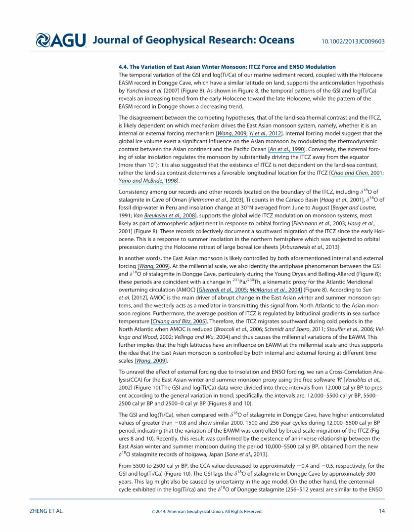
To unravel the effect of external forcing due to insolation and ENSO forcing, we ran a Cross-Correlation Ana-lysis(CCA) for the East Asian winter and summer monsoon proxy using the free software ‘R’ [Venables et al.,2002] (Figure 10).The GSI and log(Ti/Ca) data were divided into three intervals from 12,000 cal yr BP to pres-ent according to the general variation in trend; specifically, the intervals are: 12,000–5500 cal yr BP, 5500–2500 cal yr BP and 2500–0 cal yr BP (Figures 8 and 10).
The GSI and log(Ti/Ca), when compared with d18O of stalagmite in Dongge Cave, have higher anticorrelatedvalues of greater than 20.8 and show similar 2000, 1500 and 256 year cycles during 12,000–5500 cal yr BPperiod, indicating that the variation of the EAWM was controlled by broad-scale migration of the ITCZ (Fig-ures 8 and 10). Recently, this result was confirmed by the existence of an inverse relationship between theEast Asian winter and summer monsoon during the period 10,000–5500 cal yr BP, obtained from the newd18O stalagmite records of Itoigawa, Japan [Sone et al., 2013].
From 5500 to 2500 cal yr BP, the CCA value decreased to approximately 20.4 and 20.5, respectively, for theGSI and log(Ti/Ca) (Figure 10). The GSI lags the d18O of stalagmite in Dongge Cave by approximately 300years. This lag might also be caused by uncertainty in the age model. On the other hand, the centennialcycle exhibited in the log(Ti/ca) and the d18O of Dongge stalagmite (256–512 years) are similar to the ENSO
Journal of Geophysical Research: Oceans 10.1002/2013JC009603
ZHENG ET AL. VC 2014. American Geophysical Union. All Rights Reserved. 14
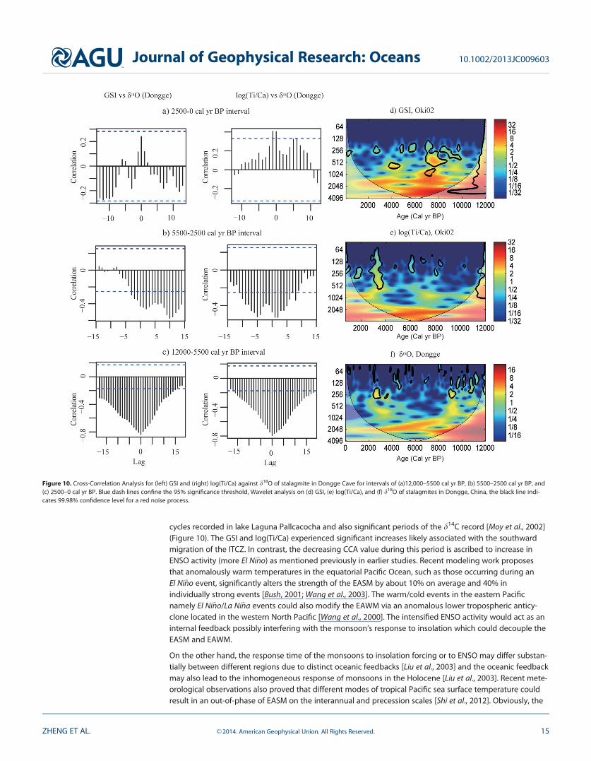
cycles recorded in lake Laguna Pallcacocha and also significant periods of the d14C record [Moy et al., 2002](Figure 10). The GSI and log(Ti/Ca) experienced significant increases likely associated with the southwardmigration of the ITCZ. In contrast, the decreasing CCA value during this period is ascribed to increase inENSO activity (more El Ni~no) as mentioned previously in earlier studies. Recent modeling work proposesthat anomalously warm temperatures in the equatorial Pacific Ocean, such as those occurring during anEl Ni~no event, significantly alters the strength of the EASM by about 10% on average and 40% inindividually strong events [Bush, 2001; Wang et al., 2003]. The warm/cold events in the eastern Pacificnamely El Ni~no/La Ni~na events could also modify the EAWM via an anomalous lower tropospheric anticy-clone located in the western North Pacific [Wang et al., 2000]. The intensified ENSO activity would act as aninternal feedback possibly interfering with the monsoon’s response to insolation which could decouple theEASM and EAWM.
On the other hand, the response time of the monsoons to insolation forcing or to ENSO may differ substan-tially between different regions due to distinct oceanic feedbacks [Liu et al., 2003] and the oceanic feedbackmay also lead to the inhomogeneous response of monsoons in the Holocene [Liu et al., 2003]. Recent mete-orological observations also proved that different modes of tropical Pacific sea surface temperature couldresult in an out-of-phase of EASM on the interannual and precession scales [Shi et al., 2012]. Obviously, the
Figure 10. Cross-Correlation Analysis for (left) GSI and (right) log(Ti/Ca) against d18O of stalagmite in Dongge Cave for intervals of (a)12,000–5500 cal yr BP, (b) 5500–2500 cal yr BP, and(c) 2500–0 cal yr BP. Blue dash lines confine the 95% significance threshold, Wavelet analysis on (d) GSI, (e) log(Ti/Ca), and (f) d18O of stalagmites in Dongge, China, the black line indi-cates 99.98% confidence level for a red noise process.
Journal of Geophysical Research: Oceans 10.1002/2013JC009603
ZHENG ET AL. VC 2014. American Geophysical Union. All Rights Reserved. 15
enhancement of ENSO may result in a decoupling or lagging between the East Asian winter and summermonsoon and, therefore, explain the CCA values (Figure 10).
In the most recent 2500 years, the CCA correlation value for log(Ti/Ca) shifted to positive, yet both the GSIand log(Ti/Ca) correlations are outside the range of our confidence (dashed line, p>0.05) (Figure 10). Thecentennial cycle was also identified in the GSI, log(Ti/Ca) and d18O of stalagmite for this period (Figure 10).The transition from negative to positive with a poor relationship among proxies suggests a weaker couplingrelationship between the East Asian winter and summer monsoon. The further enhancement of ENSO since3000 cal yr BP has been reported by modeling efforts and other proxies [Donders et al., 2008; Loubere et al.,2012; Moy et al., 2002; Woodroffe et al., 2003]. This interval relates to a much higher ENSO frequency thanpreceding period (5500–2500 cal yr BP), from initially less than 10 El Ni~no events to up to 31 El Ni~no eventsper century [Marriner et al., 2012; Moy et al., 2002]. Moreover, increased anthropogenic interference on theclimate and environment has had a significant impact since 2500 cal yr BP [Bayon et al., 2012; Ruddimanand Ellis, 2009; Ruddiman et al., 2011]. The intensification of human land-use was proposed to have causeda major change in vegetation from rainforest trees to savannas, and an intensified weathering in CentralAfrica since 3000 cal yr BP [Bayon et al., 2012]. Greater forest clearance by early agriculturalists could alsohave had a disproportionately large impact on CO2 emissions and the total forest clearance show fasterrises prior to 2000 years ago followed by a leveling out [Ruddiman and Ellis, 2009]. Recent modeling resultsshow that vegetation, soil moisture and CO2 acting as internal feedbacks might alter the monsoon’sresponse to external forcing [Kutzbach et al., 1996; Wang et al., 2005]. Thus, the intensified ENSO, coupledwith a greater anthropogenic interference, since approximately 2500 cal yr BP, might have had a greatimpact on the climate system, thus causing the complexity and nonlinear relationship between the EastAsian winter and summer monsoon.
5. Conclusion
High resolution sedimentary record retrieved from a deep sea fan in the Okinawa Trough allowed us toreconstruct the EAWM during the Holocene. Clay mineral analysis of bulk sediment shows that the materialwas derived primarily from mainland China, with minor amounts coming from Taiwan and the Yellow Riversince the Holocene. Sedimentation has been mainly controlled by the bottom nepheloid layer (33%) andthe upper layers transport (33%) dominates in the EAWM, but it has been influenced less by fluvial sourcesdue to the obstruction of the Kuroshio-induced current since the Holocene. From the comparison of thetemporal trends in the newly proposed grain size index (GSI) and log(Ti/Ca) with stalagmite record inDongge cave, we observed significant anticorrelation between the EAWM and the EASM in the Holocene,suggesting that the migration of ITCZ modulate the EAWM. The similarity in the behavior of our recordswith rainfall records in Peru, located in the southern hemisphere, as well as the inverse relationship seenwith the Ti counts in the Cariaco Basin, the monsoon records in Oman and averaged insolation changes at30�N from June to August, further support the theory of broad ITCZ modulation on monsoon systems glob-ally. Cross-Correlation Analysis at different time intervals of grain size index (GSI) and log(Ti/Ca) against thed18O of stalagmites in Dongge Cave suggests a decoupling and lagging relationship between the East Asianwinter and summer monsoon during 5500–2500 cal yr BP, and an even more complicated relationship dur-ing the period of 2500–0 cal yr BP which is attributable to enhanced ENSO activity and growing humaninterference.
ReferencesAn, Z. (2000), The history and variability of the East Asian paleomonsoon climate, Quat. Sci. Rev., 19(1–5), 171–187, doi:10.1016/S0277-
3791(99)00060-8.An, Z., L. Tunghseng, L. Yanchou, S. Porter, G. Kukla, W. Xihao, and H. Yingming (1990), The long-term paleomonsoon variation recorded by
the loess-paleosol sequence in central China, Quat. Int., 7, 91–95, doi:10.1016/1040-6182(90)90042-3.Arbuszewski, J. A., P. B. Demenocal, C. Cleroux, L. Bradtmiller, and A. Mix (2013), Meridional shifts of the Atlantic intertropical convergence
zone since the Last Glacial Maximum, Nat. Geosci., 6, 959–962, doi:10.1038/ngeo1961.Arz, H., J. P€atzold, and G. Wefer (1998), Correlated millennial-scale changes in surface hydrography and terrigenous sediment yield inferred
from last-glacial marine deposits off northeastern Brazil, Quat. Res., 50, QR981992, 157–166, doi:10.1006/qres.1998.1992.Arz, H., J. P€atzold, and G. Wefer (1999), Climatic changes during the last deglaciation recorded in sediment cores from the northeastern
Brazilian Continental Margin, Geo-Mar. Lett., 19(3), 209–218, doi:10.1007/s003670050111.Bayon, G., B. Dennielou, J. Etoubleau, E. Ponzevera, S. Toucanne, and S. Bermell (2012), Intensifying weathering and land use in Iron Age
Central Africa, Science, 335(6073), 1219–1222, doi:10.1126/science.1215400.
AcknowledgmentsOur work is supported by the NationalNatural Science Foundation of China(40776030, 41376057) and theStrategic Priority Research Program ofthe Chinese Academy of Sciences(XDA11030302). We thank ZhengquanYao for XRF measurements and HongliWang for grain size measurement. Weare grateful to Dennis Darby at OldDominion University and anonymousreviewers for providing valuableadvice on our manuscript.
Journal of Geophysical Research: Oceans 10.1002/2013JC009603
ZHENG ET AL. VC 2014. American Geophysical Union. All Rights Reserved. 16
Berger, A., and M.-F. Loutre (1991), Insolation values for the climate of the last 10 million years, Quat. Sci. Rev., 10(4), 297–317, doi:10.1016/0277–3791(91)90033-Q.
Bian, C. W., W. S. Jiang, and D. H. Song (2010), Terrigenous transportation to the Okinawa Trough and the influence of typhoons on sus-pended sediment concentration, Cont. Shelf Res., 30(10–11), 1189–1199, doi:10.1016/j.csr.2010.03.008.
Biscaye, P. E. (1965), Mineralogy and sedimentation of recent deep-sea clay in the Atlantic Ocean and adjacent seas and oceans, Geol. Soc.Am. Bull., 76(7), 803–832.
Bouma, A. (2001), Fine-grained submarine fans as possible recorders of long-and short-term climatic changes, Global Planet. Change, 28(1),85–91, doi:10.1016/S0921–8181(00)00066-7.
Broccoli, A. J., K. A. Dahl, and R. J. Stouffer (2006), Response of the ITCZ to Northern Hemisphere cooling, Geophys. Res. Lett., 33, L01702,doi:10.1029/2005GL024546.
Bush, A. B. G. (2001), Pacific sea surface temperature forcing dominates orbital forcing of the early Holocene monsoon, Quat. Res., 55(1),25–32, doi:10.1006/qres.2000.2198.
Chao, W. C., and B. Chen (2001), The origin of monsoons, J. Atmos. Sci., 58(22), 3497–3507, doi:10.1175/1520-0469(2001)058<3497:TOOM>2.0.CO;2.
Chiang, J. C., and C. M. Bitz (2005), Influence of high latitude ice cover on the marine Intertropical Convergence Zone, Clim. Dyn., 25(5),477–496, doi:10.1007/s00382-005-0040-5.
Clark, P., A. Dyke, J. Shakun, A. Carlson, J. Clark, B. Wohlfarth, J. Mitrovica, S. Hostetler, and A. McCabe (2009), The Last Glacial Maximum, Sci-ence, 325(5941), 710–714, doi:10.1126/science.1172873.
Clement, A. C., R. Seager, and M. A. Cane (2000), Suppression of El Ni~no during the Mid-Holocene by changes in the Earth’s orbit, Paleocea-nography, 15(6), 731–737, doi:10.1029/1999PA000466.
Conroy, J. L., J. T. Overpeck, J. E. Cole, T. M. Shanahan, and M. Steinitz-Kannan (2008), Holocene changes in eastern tropical Pacific climateinferred from a Gal�apagos lake sediment record, Quat. Sci. Rev., 27(11), 1166–1180, doi:10.1016/j.quascirev.2008.02.015.
Darby, D. A., J. Ortiz, L. Polyak, S. Lund, M. Jakobsson, and R. A. Woodgate (2009), The role of currents and sea ice in both slowly depositedcentral Arctic and rapidly deposited Chukchi-Alaskan margin sediments, Global Planet. Change, 68, 58–72, doi:10.1016/j.gloplacha.2009.02.007.
de Garidel-Thoron, T., L. Beaufort, B. K. Linsley, and S. Dannenmann (2001), Millennial-scale dynamics of the East Asian winter monsoonduring the last 200,000 years, Paleoceanography, 16(5), 491–502, doi:10.1029/2000PA000557.
Diekmann, B., J. Hofmann, R. Henrich, D. K. F€utterer, U. R€ohl, and K.-Y. Wei (2008), Detrital sediment supply in the southern Okinawa Troughand its relation to sea-level and Kuroshio dynamics during the late Quaternary, Mar. Geol., 255(1), 83–95, doi:10.1016/j.margeo.2008.08.001.
Donders, T. H., F. Wagner-Cremer, and H. Visscher (2008), Integration of proxy data and model scenarios for the mid-Holocene onset ofmodern ENSO variability, Quat. Sci. Rev., 27(5), 571–579, doi:10.1016/j.quascirev.2007.11.010.
Dou, Y., S. Yang, Z. Liu, P. D. Clift, H. Yu, S. Berne, and X. Shi (2010), Clay mineral evolution in the central Okinawa Trough since 28ka: Impli-cations for sediment provenance and paleoenvironmental change, Palaeogeogr. Palaeoclimatol. Palaeoecol., 288(1), 108–117, doi:j.palaeo.2010.01.040.
Dou, Y., S. Yang, M. Tang, Z. Liu, and H. Yu (2011), Using biogenic components to decipher the terrigenous input and paleoenvironmentalchanges over the last 28ka in the middle Okinawa Trough, Quat. Sci., 31(2), 236–243, doi:10.3969/j.issn.10017410.2011.02.0.
Dou, Y., S. Yang, Z. Liu, J. Li, X. Shi, H. Yu, and S. Berne (2012), Sr–Nd isotopic constraints on terrigenous sediment provenances andKuroshio Current variability in the Okinawa Trough during the late Quaternary, Palaeogeogr. Palaeoclimatol. Palaeoecol., 365, 38–47, doi:10.1016/j.palaeo.2012.09.003.
Dyke, A. S., and V. K. Prest (1987), Late Wisconsinan and Holocene history of the Laurentide ice sheet, Geogr. Phys. Quat., 41(2), 237–263.Dykoski, C. A., R. L. Edwards, H. Cheng, D. Yuan, Y. Cai, M. Zhang, Y. Lin, J. Qing, Z. An, and J. Revenaugh (2005), A high-resolution, absolute-dated
Holocene and deglacial Asian monsoon record from Dongge Cave, China, Earth Planet. Sci. Lett., 233(1), 71–86, doi:10.1016/j.epsl.2005.01.036.Fleitmann, D., S. J. Burns, M. Mudelsee, U. Neff, J. Kramers, A. Mangini, and A. Matter (2003), Holocene forcing of the Indian monsoon
recorded in a stalagmite from southern Oman, Science, 300(5626), 1737–1739, doi:10.1126/science.1083130.Gadgil, S. (2003), The Indian monsoon and its variability, Annu. Rev. Earth Planet. Sci., 31(1), 429–467, doi:10.1016/j.epsl.2005.09.061.Gherardi, J.-M., L. Labeyrie, J. McManus, R. Francois, L. Skinner, and E. Cortijo (2005), Evidence from the Northeastern Atlantic basin for vari-
ability in the rate of the meridional overturning circulation through the last deglaciation, Earth Planet. Sci. Lett., 240(3), 710–723, doi:10.1016/j.epsl.2005.09.061.
Hajian, S., and M. S. Movahed (2010), Multifractal detrended cross-correlation analysis of sunspot numbers and river flow fluctuations, Phys-ica A, 389(21), 4942–4957, doi:10.1016/j.physa.2010.06.025.
Haug, G. H., K. A. Hughen, D. M. Sigman, L. C. Peterson, and U. R€ohl (2001), Southward migration of the Intertropical Convergence Zonethrough the Holocene, Science, 293(5533), 1304–1308, doi:10.1126/science.1059725.
Hoshika, A., T. Tanimoto, Y. Mishima, K. Iseki, and K. Okamura (2003), Variation of turbidity and particle transport in the bottom layer of theEast China Sea, Deep Sea Res., Part II, 50, 443–455, doi:10.1016/S0967-0645(02)00462-9.
Hsu, S. C., S.-J. Kao, and W.-L. Jeng (2006), Quantitative links between fluvial sediment discharge, trapped terrigenous flux and sedimentaccumulation, and implications for temporal and spatial distributions of sediment fluxes, Deep Sea Res., Part I, 53(2), 241–252, doi:10.1016/j.dsr.2005.10.001.
Hsu, S. C., S. C. Liu, R. Arimoto, T. H. Liu, Y. T. Huang, F. Tsai, F. J. Lin, and S. J. Kao (2009), Dust deposition to the East China Sea and its bio-geochemical implications, J. Geophys. Res., 114, D15304, doi:10.1029/2008JD011223.
Hsu, T. J., and D. M. Hanes (2004), Effects of wave shape on sheet flow sediment transport, J. Geophys. Res., 109, C05025, doi:10.1029/2003JC002075.
Huh, C. A., C.-C. Su, W.-T. Liang, and C.-Y. Ling (2004), Linkages between turbidites in the southern Okinawa Trough and submarine earth-quakes, Geophys. Res. Lett., 31, L12304, doi:10.1029/2004GL019731.
Iseki, K., K. Okamura, and Y. Kiyomoto (2003), Seasonality and composition of downward particulate fluxes at the continental shelf and Oki-nawa Trough in the East China Sea, Deep Sea Res., Part II, 50(2), 457–473, doi:10.1016/S0967-0645(02)00468-X.
Kagimoto, T., and T. Yamagata (1997), Seasonal transport variations of the Kuroshio: An OGCM simulation, J. Phys. Oceanogr., 27(3), 403–418, doi:10.1175/1520-0485(1997)027<0403:STVOTK>2.0.CO;2.
Kao, S. J., C.-R. Wu, Y.C. Hsin, and M. Dai (2006), Effects of sea level change on the upstream Kuroshio Current through the Okinawa Trough.Geophys. Res. Lett., 33, L16604, doi:10.1029/2006GL026822.
Kao, S. J., J. Sen, S. C. Hsu, T. Y. Lee, and M. Dai (2008a), Sediment budget in the Taiwan Strait with high fluvial sediment inputs from moun-tainous rivers: New observations and synthesis, Terrestrial Atmos. Ocean Sci., 19, 525–546, doi:10.3319/TAO.2008.19.5.525(Oc).
Journal of Geophysical Research: Oceans 10.1002/2013JC009603
ZHENG ET AL. VC 2014. American Geophysical Union. All Rights Reserved. 17
Kao, S. J., M. H. Dai, K. Y. Wei, N. E. Blair, and W. B. Lyons (2008b), Enhanced supply of fossil organic carbon to the Okinawa Trough sincethe last deglaciation, Paleoceanography, 23, PA2207, doi:10.1029/2007PA001440.
Kineke, G., K. Woolfe, S. Kuehl, J. Milliman, T. Dellapenna, and R. Purdon (2000), Sediment export from the Sepik River, Papua New Guinea:Evidence for a divergent sediment plume, Cont. Shelf Res., 20(16), 2239–2266, doi:10.1016/S0278-4343(00)00069-8.
Kutzbach, J., G. Bonan, J. Foley, and S. P. Harrison (1996), Vegetation and soil feedbacks on the response of the African monsoon to orbitalforcing in the early to middle Holocene, Nature, 384, 623–626, doi:10.1038/384623a0.
Kutzbach, J., R. Gallimore, S. Harrison, P. Behling, R. Selin, and F. Laarif (1998), Climate and biome simulations for the past 21,000 years,Quat. Sci. Rev., 17, 473–506, doi:10.1016/S0277-3791(98)00009-2.
Lambeck, K., and J. Chappell (2001), Sea level change through the last glacial cycle, Science, 292(5517), 679–686, doi:10.1126/science.1059549.
Lee, H.-J., and S.-Y. Chao (2003), A climatological description of circulation in and around the East China Sea, Deep Sea Res., Part II, 50(6),1065–1084, doi:10.1016/S0967-0645(03)00010-9.
Lee, K. E., H. J. Lee, J. H. Park, Y. P. Chang, K. Ikehara, T. Itaki, and H. K. Kwon (2013), Stability of the Kuroshio path with respect to glacial sealevel lowering, Geophys. Res. Lett., 40, 392–396, doi:10.1012/grl.50102.
Li, C., X. Shi, S. Kao, M. Chen, Y. Liu, X. Fang, H. L€u, J. Zou, S. Liu, and S. Qiao (2012), Clay mineral composition and their sources for the flu-vial sediments of Taiwanese rivers, Chin. Sci. Bull., 57(6), 673–681, doi:10.1007/s11434-011-4824-1.
Li, T., Z. Liu, M. A. Hall, S. Berne, Y. Saito, S. Cang, and Z. Cheng (2001), Heinrich event imprints in the Okinawa Trough: Evidence fromoxygen isotope and planktonic foraminifera, Palaeogeogr. Palaeoclimatol. Palaeoecol., 176(1), 133–146, doi:10.1016/S0031–0182(01)00332-7.
Li, Y. H. (1976), Denudation of Taiwan island since the Pliocene epoch, Geology, 4(2), 105–107.Liu, J., C. Liu, K. Xu, J. Milliman, J. Chiu, S. Kao, and S. Lin (2008), Flux and fate of small mountainous rivers derived sediments into the Tai-
wan Strait, Mar. Geol., 256(1), 65–76, doi:10.1016/j.margeo.2008.09.007.Liu, J. P., J. D. Milliman, S. Gao, and P. Cheng (2004), Holocene development of the Yellow River’s subaqueous delta, North Yellow Sea, Mar.
Geol., 209(1), 45–67, doi:10.1016/j.margeo.2004.06.009.Liu, J. T., S.-J. Kao, C.-A. Huh, and C.-C. Hung (2013), Gravity flows associated with flood events and carbon burial: Taiwan as instructional
source area, Annu. Rev. Mar. Sci., 5, 47–68, doi:10.1146/annurev-marine-121211-172307.Liu, X., H. Dong, X. Yang, U. Herzschuh, E. Zhang, J.-B. W. Stuut, and Y. Wang (2009), Late Holocene forcing of the Asian winter and summer
monsoon as evidenced by proxy records from the northern Qinghai–Tibetan Plateau, Earth Planet. Sci. Lett., 280(1), 276–284, doi:10.1016/j.epsl.2009.01.041.
Liu, Z., J. Kutzbach, and L. Wu (2000), Modeling climate shift of El Ni~no variability in the Holocene, Geophys. Res. Lett., 27(15), 2265–2268,doi:10.1029/2000GL011452.
Liu, Z., B. Otto-Bliesner, J. Kutzbach, L. Li, and C. Shields (2003), Coupled climate simulation of the evolution of global monsoons in the Hol-ocene, J. Clim., 16, 2472–2490, doi:10.1175/1520-0442(2003)016<2472:CCSOTE>2.0.CO;2.
Loubere, P., W. Creamer, and J. Haas (2012), Evolution of the El Nino-Southern Oscillation in the late Holocene and insolation drivenchange in the tropical annual SST cycle, Global Planet. Change, 100, 129–144, doi:10.1016/j.gloplacha.2012.10.007.
Machida, H. (1999), The stratigraphy, chronology and distribution of distal marker-tephras in and around Japan, Global Planet. Change,21(1), 71–94, doi:10.1016/S0921–8181(99)00008–9.
Maher, B. A., and M. Hu (2006), A high-resolution record of Holocene rainfall variations from the western Chinese Loess Plateau: Antiphasebehaviour of the African/Indian and East Asian summer monsoons, Holocene, 16(3), 309–319, doi:10.1191/0959683606hl929rp.
Marriner, N., C. Flaux, D. Kaniewski, C. Morhange, G. Leduc, V. Moron, Z. Chen, F. Gasse, J.-Y. Empereur, and J.-D. Stanley (2012), ITCZ andENSO-like pacing of Nile delta hydro-geomorphology during the Holocene, Quat. Sci. Rev., 45, 73–84, doi:10.1016/j.quascirev.2012.04.022.
McCave, I., B. Manighetti, and S. Robinson (1995), Sortable silt and fine sediment size/composition slicing: Parameters for palaeocurrentspeed and palaeoceanography, Paleoceanography, 10(3), 593–610, doi:10.1029/94PA03039.
McManus, J., R. Francois, J.-M. Gherardi, L. Keigwin, and S. Brown-Leger (2004), Collapse and rapid resumption of Atlantic meridional circu-lation linked to deglacial climate changes, Nature, 428(6985), 834–837, doi:10.1038/nature02494.
Milliman, J. D., and R. H. Meade (1983), World-wide delivery of river sediment to the oceans, J. Geol., 91, 1–21.Milliman, J. D., and J. D. M. Syvitski (1992), Geomorphic/tectonic control of sediment discharge to the ocean: The importance of small
mountainous rivers, J. Geol., 100, 525–544.Moy, C. M., G. O. Seltzer, D. T. Rodbell, and D. M. Anderson (2002), Variability of El Ni~no/Southern Oscillation activity at millennial timescales
during the Holocene epoch, Nature, 420(6912), 162–165. doi:10.1038/nature01194.Nagashima, K., R. Tada, H. Matsui, T. Irino, A. Tani, and S. Toyoda (2007), Orbital-and millennial-scale variations in Asian dust transport path
to the Japan Sea, Palaeogeogr. Palaeoclimatol. Palaeoecol., 247(1), 144–161, doi:10.1016/j.palaeo.2006.11.027.Oguri, K., E. Matsumoto, Y. Saito, M. C. Honda, N. Harada, and M. Kusakabe (2000), Evidence of the offshore transport of terrestrial organic
matter due to the rise of sea level: The case of the East China Sea continental shelf, Geophys. Res. Lett., 27(23), 3893–3896, doi:10.1029/2000GL011690.
Oguri, K., E. Matsumoto, M. Yamada, Y. Saito, and K. Iseki (2003), Sediment accumulation rates and budgets of depositing particles of theEast China Sea, Deep Sea Res., Part II, 50(2), 513–528, doi:10.1016/S0967-0645(02)00465-4.
Qu, T., and R. Lukas (2003), The bifurcation of the North Equatorial Current in the Pacific, J. Phys. Oceanogr., 33(1), 5–18, doi:10.1175/1520-0485(2003)033<0005:TBOTNE>2.0.CO;2.
Qu, T., Y. Y. Kim, M. Yaremchuk, T. Tozuka, A. Ishida, and T. Yamagata (2004), Can Luzon Strait transport play a role in conveying the impactof ENSO to the South China Sea?, J. Clim., 17, 3644–3657, doi:10.1175/1520-0442(2004)017<3644:CLSTPA>2.0.CO;2.
Rodbell, D. T., G. O. Seltzer, D. M. Anderson, M. B. Abbott, D. B. Enfield, and J. H. Newman (1999), An� 15,000-year record of El Ni~no-drivenalluviation in southwestern Ecuador, Science, 283(5401), 516–520, doi:10.1126/science.283.5401.516.
Ruddiman, W. F., and E. C. Ellis (2009), Effect of per-capita land use changes on Holocene forest clearance and CO2 emissions, Quat. Sci.Rev., 28(27), 3011–3015, doi:10.1016/j.quascirev.2009.05.022.
Ruddiman, W. F., J. E. Kutzbach, and S. J. Vavrus (2011), Can natural or anthropogenic explanations of late-Holocene CO2 and CH4 increasesbe falsified?, Holocene, 21(5), 865–879, doi:10.1177/0959683610387172.
Saito, Y., H. Katayama, K. Ikehara, Y. Kato, E. Matsumoto, K. Oguri, M. Oda, and M. Yumoto (1998), Transgressive and highstand systemstracts and post-glacial transgression, the East China Sea, Sediment. Geol., 122(1), 217–232, doi:10.1016/S0037-0738(98)00107-9.
Schmidt, M. W., and H. J. Spero (2011), Meridional shifts in the marine ITCZ and the tropical hydrologic cycle over the last three glacialcycles, Paleoceanography, 26, PA1206, doi:10.1029/2010PA001976.
Journal of Geophysical Research: Oceans 10.1002/2013JC009603
ZHENG ET AL. VC 2014. American Geophysical Union. All Rights Reserved. 18
Shi, Z., X. Liu, and X. Cheng (2012), Anti-phased response of northern and southern East Asian summer precipitation to ENSO modulationof orbital forcing, Quat. Sci. Rev., 40, 30–38, doi:10.1016/j.quascirev.2012.02.019.
Sone, T., A. Kano, T. Okumura, K. Kashiwagi, M. Hori, X. Jiang, and C.-C. Shen (2013), Holocene stalagmite oxygen isotopic record from theJapan Sea side of the Japanese Islands, as a new proxy of the East Asian winter monsoon, Quat. Sci. Rev., 75, 150–160, doi:10.1016/j.quascirev.2013.06.019.
Steinke, S., T. J. Hanebuth, C. Vogt, and K. Stattegger (2008), Sea level induced variations in clay mineral composition in the southwesternSouth China Sea over the past 17,000 yrs, Mar. Geol., 250(3), 199–210, doi:10.1016/j.margeo.2008.01.005.
Steinke, S., C. Glatz, M. Mohtadi, J. Groeneveld, Q. Li, and Z. Jian (2011), Past dynamics of the East Asian monsoon: No inverse behaviourbetween the summer and winter monsoon during the Holocene, Global Planet. Change, 78(3), 170–177, doi:10.1016/j.gloplacha.2011.06.006.
Stouffer, R. J., J. Yin, J. Gregory, K. Dixon, M. Spelman, W. Hurlin, A. Weaver, M. Eby, G. Flato, and H. Hasumi (2006), Investigating the causesof the response of the thermohaline circulation to past and future climate changes, J. Clim., 19, 1365–1387. doi:10.1175/JCLI3689.1.
Sun, Y., S. Gao, and J. Li (2003), Preliminary analysis of grain-size populations with environmentally sensitive terrigenous components inmarginal sea setting, Chin. Sci. Bull., 48(2), 184–187, doi:10.1360/03tb9038.
Sun, Y., D. W. Oppo, R. Xiang, W. Liu, and S. Gao (2005), Last deglaciation in the Okinawa Trough: Subtropical northwest Pacific link toNorthern Hemisphere and tropical climate, Paleoceanography, 20, PA4005, doi:10.1029/2004PA001061.
Sun, Y., S. C. Clemens, C. Morrill, X. Lin, X. Wang, and Z. An (2012), Influence of Atlantic meridional overturning circulation on the East Asianwinter monsoon, Nat. Geosci., 5(1), 46–49, doi:10.1038/NGEO1326.
Tian, J., E. Huang, and D. K. Pak (2010), East Asian winter monsoon variability over the last glacial cycle: Insights from a latitudinal sea-surface temperature gradient across the South China Sea, Palaeogeogr. Palaeoclimatol. Palaeoecol., 292(1), 319–324, doi:10.1016/j.palaeo.2010.04.005.
Torrence, C., and G. P. Compo (1998), A practical guide to wavelet analysis, Bull. Am. Meteorol. Soc., 79(1), 61–78, doi:10.1175/1520-0477(1998)079<0061:APGTWA>2.0.CO;2.
Tudhope, A. W., C. P. Chilcott, M. T. McCulloch, E. R. Cook, J. Chappell, R. M. Ellam, D. W. Lea, J. M. Lough, and G. B. Shimmield (2001), Vari-ability in the El Ni~no-Southern Oscillation through a glacial-interglacial cycle, Science, 291(5508), 1511–1517, doi:10.1126/science.1057969.
Van Breukelen, M., H. Vonhof, J. Hellstrom, W. Wester, and D. Kroon (2008), Fossil dripwater in stalagmites reveals Holocene temperatureand rainfall variation in Amazonia, Earth Planet. Sci. Lett., 275(1), 54–60, doi:10.1016/j.epsl.2008.07.060.
Vellinga, M., and R. A. Wood (2002), Global climatic impacts of a collapse of the Atlantic thermohaline circulation, Clim. Change, 54(3), 251–267, doi:10.1023/A:1016168827653.
Vellinga, M., and P. Wu (2004), Low-latitude freshwater influence on centennial variability of the Atlantic thermohaline circulation, J. Clim.,17(23), doi:10.1175/3219.1.
Venables, W., D. Smith, and the R Development Core Team (2002), An Introduction to R, 2(1), pp. 1–90, Network Theory Ltd., Bristol, U. K.Wan, S., A. Li, P. D. Clift, and J.-B. W. Stuut (2007), Development of the East Asian monsoon: Mineralogical and sedimentologic records in
the northern South China Sea since 20 Ma, Palaeogeogr. Palaeoclimatol. Palaeoecol., 254(3), 561–582, doi:10.1016/j.palaeo.2007.07.009.Wan, S., J. Tian, S. Steinke, A. Li, and T. Li (2010), Evolution and variability of the East Asian summer monsoon during the Pliocene: Evidence
from clay mineral records of the South China Sea, Palaeogeogr. Palaeoclimatol. Palaeoecol., 293(1), 237–247, doi:10.1016/j.palaeo.2010.05.025.
Wan, S., Z. Yu, P. D. Clift, H. Sun, A. Li, and T. Li (2012), History of Asian eolian input to the West Philippine Sea over the last one millionyears, Palaeogeogr. Palaeoclimatol. Palaeoecol., 326, 152–159, doi:10.1016/j.palaeo.2012.02.015.
Wang, B., R. Wu, and X. Fu (2000), Pacific-East Asian teleconnection: How does ENSO affect East Asian climate?, J. Clim., 13(9), 1517–1536,doi:10.1175/1520-0442(2000)013<1517:PEATHD>2.0.CO;2.
Wang, B., S. C. Clemens, and P. Liu (2003), Contrasting the Indian and East Asian monsoons: Implications on geologic timescales, Mar. Geol.,201(1), 5–21, doi:10.1016/S0025–3227(03)00196-8.
Wang, J., A. Li, and J. Huang (2013), Sediment provenance and paleoenvironment records of the central Okinawa Trough for the 17000years [in Chinese with English abstract], Mar. Geol. Quat. Geol., 33(6), 105–114, doi:10.3724/Sp.J.1140.2013.06105.
Wang, L., J. Li, H. Lu, Z. Gu, P. Rioual, Q. Hao, A. W. Mackay, W. Jiang, B. Cai, and B. Xu (2012), The East Asian winter monsoon over the last15,000 years: Its links to high-latitudes and tropical climate systems and complex correlation to the summer monsoon, Quat. Sci. Rev.,32, 131–142, doi:10.1016/j.quascirev.2011.11.003.
Wang, P. (2009), Global monsoon in a geological perspective, Chin. Sci. Bull., 54(7), 1113–1136, doi:10.1007/s11434-009-0169-4.Wang, P., S. Clemens, L. Beaufort, P. Braconnot, G. Ganssen, Z. Jian, P. Kershaw, and M. Sarnthein (2005), Evolution and variability of the
Asian monsoon system: State of the art and outstanding issues, Quat. Sci. Rev., 24(5), 595–629, doi:10.1016/j.quascirev.2004.10.002.Wanner, H., J. Beer, J. B€utikofer, T. J. Crowley, U. Cubasch, J. Fl€uckiger, H. Goosse, M. Grosjean, F. Joos, and J. O. Kaplan (2008), Mid-to Late
Holocene climate change: An overview, Quat. Sci. Rev., 27(19), 1791–1828, doi:10.1016/j.quascirev.2008.06.013.Wellner, R. W., and L. R. Bartek (2003), The effect of sea level, climate, and shelf physiography on the development of incised-valley com-
plexes: A modern example from the East China Sea, J. Sediment. Res., 73(6), 926–940, doi:10.1306/041603730926.Weltje, G. J., and R. Tjallingii (2008), Calibration of XRF core scanners for quantitative geochemical logging of sediment cores: Theory and
application, Earth Planet. Sci. Lett., 274(3), 423–438, doi:10.1016/j.epsl.2008.07.054.Woodroffe, C. D., M. R. Beech, and M. K. Gagan (2003), Mid-late Holocene El Ni~no variability in the equatorial Pacific from coral microatolls,
Geophys. Res. Lett., 30(7), 1358, doi:10.1029/2002GL015868.Xiang, R., Y. Sun, T. Li, D. W. Oppo, M. Chen, and F. Zheng (2007), Paleoenvironmental change in the middle Okinawa Trough since the last
deglaciation: Evidence from the sedimentation rate and planktonic foraminiferal record, Palaeogeogr. Palaeoclimatol. Palaeoecol.,243(3), 378–393, doi:10.1016/j.palaeo.2006.
Xiao, J., S. C. Porter, Z. An, H. Kumai, and S. Yoshikawa (1995), Grain size of quartz as an indicator of winter monsoon strength on the LoessPlateau of central China during the last 130,000 yr, Quat. Res., 43(1), 22–29, doi:10.1006/qres.1995.1003.
Xiao, J., Y. Inouchi, H. Kumai, S. Yoshikawa, Y. Kondo, T. Liu, and Z. An (1997), Eolian quartz flux to Lake Biwa, central Japan, over the past145,000 years, Quat. Res., 48(1), 48–57, doi:10.1006/qres.1997.1893.
Xiao, S., A. Li, J. P. Liu, M. Chen, Q. Xie, F. Jiang, T. Li, R. Xiang, and Z. Chen (2006), Coherence between solar activity and the East Asian win-ter monsoon variability in the past 8000 years from Yangtze River-derived mud in the East China Sea, Palaeogeogr. Palaeoclimatol.Palaeoecol., 237(2), 293–304, doi:10.1016/j.palaeo.2005.12.003.
Xu, K., J. D. Milliman, A. Li, J. Paul Liu, S.-J. Kao, and S. Wan (2009), Yangtze-and Taiwan-derived sediments on the inner shelf of East ChinaSea, Cont. Shelf Res., 29(18), 2240–2256, doi:10.1016/j.csr.2009.08.017.
Journal of Geophysical Research: Oceans 10.1002/2013JC009603
ZHENG ET AL. VC 2014. American Geophysical Union. All Rights Reserved. 19
Xu, K., A. Li, J. P. Liu, J. D. Milliman, Z. Yang, C. Liu, S. Kao, S. Wan, and F. Xu (2012), Provenance, structure, and formation of the mud wedgealong inner continental shelf of the East China Sea: A synthesis of the Yangtze dispersal system, Mar. Geol., 291–294, 176–191, doi:10.1016/j.margeo.2011.06.003.
Xu, X., and M. Oda (1999), Surface-water evolution of the eastern East China Sea during the last 36,000 years, Mar. Geol., 156, 285–304, doi:10.1016/S0025-3227(98)00183-2.
Yanagi, T., S. Takahashi, A. Hoshika, and T. Tanimoto (1996), Seasonal variation in the transport of suspended matter in the East China Sea,J. Oceanogr., 52(5), 539–552,doi:10.1007/BF02238320.
Yancheva, G., N. R. Nowaczyk, J. Mingram, P. Dulski, G. Schettler, J. F. Negendank, J. Liu, D. M. Sigman, L. C. Peterson, and G. H. Haug (2007),Influence of the intertropical convergence zone on the East Asian monsoon, Nature, 445(7123), 74–77, doi:10.1038/nature05431.
Yang, S. Y., H. S. Jung, D. I. Lim, and C. X. Li (2003), A review on the provenance discrimination of sediments in the Yellow Sea, Earth Sci.Rev., 63(1), 93–120, doi:10.1016/S0012-8252(03)00033-3.
Yang, Z., Z. Guo, Z. Wang, J. Xu, and W. Gao (1992), Basic pattern of transport of suspended matter from the Yellow Sea and East China Seato the eastern deep seas, Acta Oceanolog. Sin., 14(2), 81–90.
Yano, J. I., and J. L. McBride (1998), An aquaplanet monsoon, J. Atmos. Sci., 55(8), 1373–1399, doi:10.1175/1520-0469(1998)055<1373:AAM>2.0.CO;2.
Yi, L., H.-J. Yu, J. D. Ortiz, X.-Y. Xu, S.-L. Chen, J.-Y. Ge, Q.-Z. Hao, J. Yao, X.-F. Shi, and S.-Z. Peng (2012), Late Quaternary linkage of sedimen-tary records to three astronomical rhythms and the Asian monsoon, inferred from a coastal borehole in the south Bohai Sea, China,Palaeogeogr. Palaeoclimatol. Palaeoecol., 329, 101–117, doi:10.1016/j.palaeo.2012.02.020.
Yoneda, M., H. Uno, Y. Shibata, R. Suzuki, Y. Kumamoto, K. Yoshida, T. Sasaki, A. Suzuki, and H. Kawahata (2007), Radiocarbon marine reser-voir ages in the western Pacific estimated by pre-bomb molluscan shells, Nucl. Instrum. Methods Phys., 259(1), 432–437, doi:10.1016/j.nimb.2007.01.184.
Yuan, D., and Y. Hsueh (2010), Dynamics of the cross-shelf circulation in the Yellow and East China Seas in winter, Deep Sea Res., Part II,57(19), 1745–1761, doi:10.1016/j.dsr2.2010.04.002.
Yuan, D., J. Zhu, C. Li, and D. Hu (2008), Cross-shelf circulation in the Yellow and East China Seas indicated by MODIS satellite observations,J. Mar. Syst., 70(1), 134–149, doi:10.1016/j.jmarsys.2007.04.002.
Zhao, Y., B. H. Liu, S. X. Li, A. J. Cui, G. Z. Han, Q. F. Hua, and G. H. Hu (2011), Sedimentary characters and material transportation of submar-ine canyon-fan systems in slope of the East China Sea [in Chinese with English abstract], J. Paleogeogr., 13(1), 8.
Zhou, B., and P. Zhao (2009), Inverse correlation between ancient winter and summer monsoons in East Asia?, Chin. Sci. Bull., 54(20),3760–3767, doi:10.1007/s11434-009-0583-7.
Journal of Geophysical Research: Oceans 10.1002/2013JC009603
ZHENG ET AL. VC 2014. American Geophysical Union. All Rights Reserved. 20