Istrian and Dalmatian fishtanks as sea-level markers
9
Istrian and Dalmatian fishtanks as sea-level markers Erica Florido a, * , Rita Auriemma a , Sanja Faivre b , Irena Radi c Rossi c , Fabrizio Antonioli d , Stefano Furlani e , Giorgio Spada f a Dipartimento di Beni Culturali, Università degli Studi del Salento, Italy b Department of Geography, Faculty of Science, University of Zagreb, Croatia c Department of Archaeology, University of Zadar, Croatia d ENEA, Roma, Italy e Dipartimento di Geoscienze, Università degli Studi di Trieste, Italy f Dipartimento di Matematica, Fisica e Informatica, Università di Urbino “Carlo Bo”, Italy article info Article history: Available online 15 September 2010 abstract Roman age fishponds along the Istrian and Dalmatian coast were studied with the aim of using the data as sea-level markers. Although the Adriatic fishponds do not display the architectural features (crep- idines, channels, etc.) that can be observed in the Tyrrhenian ones and serve as precise sea-level markers, their structural elements can be used to define the sea-level rise. Fishponds at S. Bartolomeo and Fisine in Slovenja, Kupanja, near Parenzo, and at Katoro, near Umago, in Croatia, were studied and measured. The pool investigated in the island of Svr sata Vela, on the Kornati Islands, represents a different feature. Located on the northwest coast of the island, adjacent to the southern part of the gulf, it is a single square pool, with dimensions clearly less than the Istrian fishtanks, similar to those associated with the Tyr- rhenian villae maritimae. These data (the altitude of archaeological markers below sea level) were corrected for tide and pressure and compared with predictions derived from the SELEN glacio-hydro- isostatic model. Comparison with the predicted sea level allows calculation of tectonic rates that range between 0.63 and 0.89 mm/year since Roman times. Ó 2010 Elsevier Ltd and INQUA. All rights reserved. 1. Introduction Recently, international projects on coastal landscape archae- ology, carried out along the Adriatic coastline (Trieste, Istria and Dalmatia), have determined typology and function of the Roman age structures, now completely submerged, identified with fish culture installations (Fig. 1). Five fishponds along the Istrian and Dalmatian coast were studied and measured: two in Slovenia, in the S. Bartolomeo/Jernejeva draga Bay, located close to the boundary between Italy and Slovenia, and at Fizine, between Piran and Portoro z; and three in Croatia, at Katoro (near Umag), at Kupanja (near Pore c) and on the island of Svr sata Vela, on the Kornati Islands. The latter pool is significantly different: it is situ- ated in the northwestern sector of the island, in the southern part of the bay. It is composed of a single square pool, whose dimensions are clearly less than Istrian fishtanks, similar to those of the Tyr- rhenian villae maritimae. The archaeological remains (piers, quays, breakwaters, fish- ponds, and walking surfaces) indicate a mean sea-level rise of 1.60 0.20 m from the Roman age in the area between Duino (Gulf of Trieste) and Pula (Antonioli et al., 2007, 2008). This paper studies the fishponds built during the Augustan age, or during the first century of the Roman Empire in the North Adriatic Sea, discusses measurements and functionality of the structures, compares the observed data with the predicted sea-level curve, and consequently calculates the tectonic rates of change. Segota and Filip ci c (1991), by means of geological and archaeological markers, calculated that the sea level during the Iron Age ranged between 3.1 and 1.96 m below present mean sea level. Archaeological data were related to the presence of a submerged notch along the whole Eastern Adriatic shore (Fouache et al., 2000). The notch, located at 0.5 and 0.6 m below m.s.l, was first reported by Pirazzoli (1980), who suggested submersion due to a co-seismic event. The occurrence of the notch was then reported by many authors, including Benac (1989, 1992) in the area of Rijeka Bay, where its depth varies from 0.5 to 1.1 m below m.s.l, and Fouache et al. (2000) on the western part of Istria, on the Mt. Velebit shoreline and on the islands of Pag and Rab, where a submerged notch was found between 0.5 and 0.7 m below m.s.l Faivre and * Corresponding author. E-mail address: ericafl[email protected] (E. Florido). Contents lists available at ScienceDirect Quaternary International journal homepage: www.elsevier.com/locate/quaint 1040-6182/$ e see front matter Ó 2010 Elsevier Ltd and INQUA. All rights reserved. doi:10.1016/j.quaint.2010.09.004 Quaternary International 232 (2011) 105e113
Transcript of Istrian and Dalmatian fishtanks as sea-level markers
lable at ScienceDirect
Quaternary International 232 (2011) 105e113
Contents lists avai
Quaternary International
journal homepage: www.elsevier .com/locate/quaint
Istrian and Dalmatian fishtanks as sea-level markers
Erica Florido a,*, Rita Auriemma a, Sanja Faivre b, Irena Radi�c Rossi c,Fabrizio Antonioli d, Stefano Furlani e, Giorgio Spada f
aDipartimento di Beni Culturali, Università degli Studi del Salento, ItalybDepartment of Geography, Faculty of Science, University of Zagreb, CroatiacDepartment of Archaeology, University of Zadar, Croatiad ENEA, Roma, ItalyeDipartimento di Geoscienze, Università degli Studi di Trieste, ItalyfDipartimento di Matematica, Fisica e Informatica, Università di Urbino “Carlo Bo”, Italy
a r t i c l e i n f o
Article history:Available online 15 September 2010
* Corresponding author.E-mail address: [email protected] (E. Florido
1040-6182/$ e see front matter � 2010 Elsevier Ltd adoi:10.1016/j.quaint.2010.09.004
a b s t r a c t
Roman age fishponds along the Istrian and Dalmatian coast were studied with the aim of using the dataas sea-level markers. Although the Adriatic fishponds do not display the architectural features (crep-idines, channels, etc.) that can be observed in the Tyrrhenian ones and serve as precise sea-level markers,their structural elements can be used to define the sea-level rise. Fishponds at S. Bartolomeo and Fisine inSlovenja, Kupanja, near Parenzo, and at Katoro, near Umago, in Croatia, were studied and measured. Thepool investigated in the island of Svr�sata Vela, on the Kornati Islands, represents a different feature.Located on the northwest coast of the island, adjacent to the southern part of the gulf, it is a single squarepool, with dimensions clearly less than the Istrian fishtanks, similar to those associated with the Tyr-rhenian villae maritimae. These data (the altitude of archaeological markers below sea level) werecorrected for tide and pressure and compared with predictions derived from the SELEN glacio-hydro-isostatic model. Comparison with the predicted sea level allows calculation of tectonic rates that rangebetween �0.63 and �0.89 mm/year since Roman times.
� 2010 Elsevier Ltd and INQUA. All rights reserved.
1. Introduction
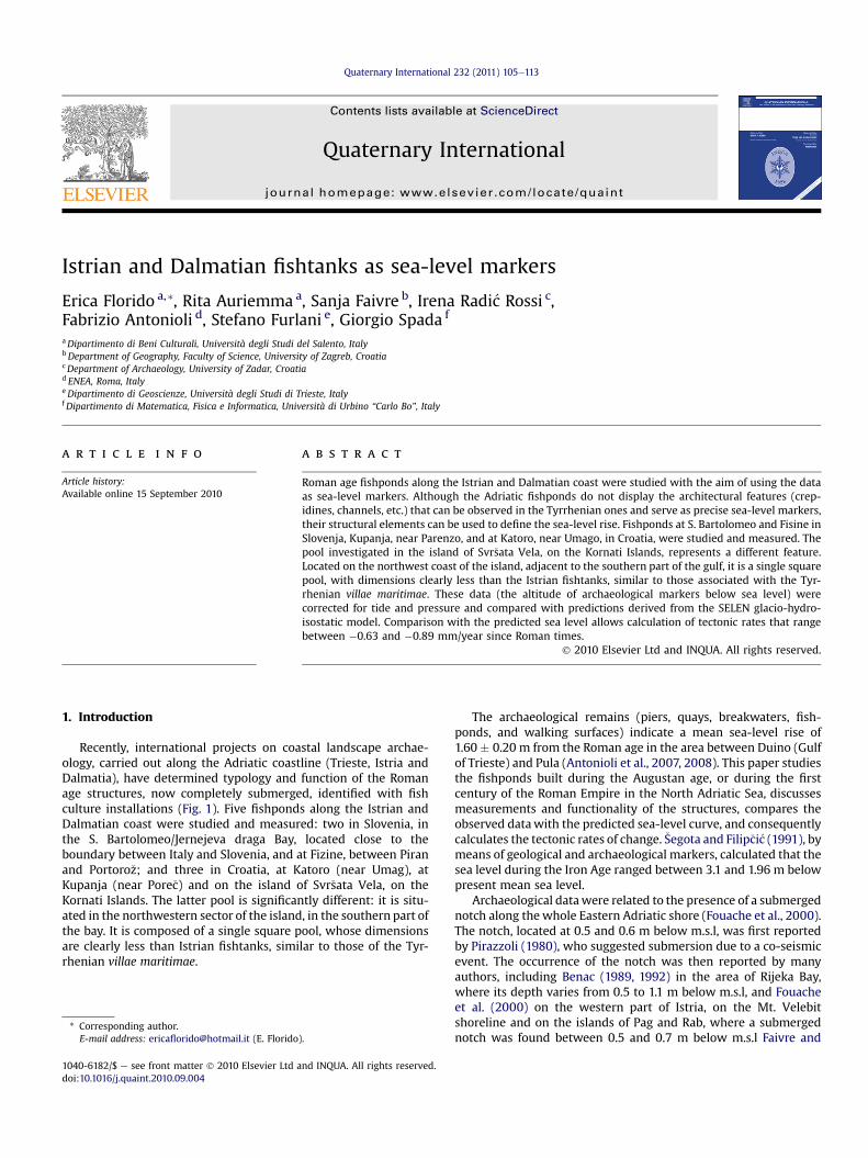
Recently, international projects on coastal landscape archae-ology, carried out along the Adriatic coastline (Trieste, Istria andDalmatia), have determined typology and function of the Romanage structures, now completely submerged, identified with fishculture installations (Fig. 1). Five fishponds along the Istrian andDalmatian coast were studied and measured: two in Slovenia, inthe S. Bartolomeo/Jernejeva draga Bay, located close to theboundary between Italy and Slovenia, and at Fizine, between Piranand Portoro�z; and three in Croatia, at Katoro (near Umag), atKupanja (near Pore�c) and on the island of Svr�sata Vela, on theKornati Islands. The latter pool is significantly different: it is situ-ated in the northwestern sector of the island, in the southern part ofthe bay. It is composed of a single square pool, whose dimensionsare clearly less than Istrian fishtanks, similar to those of the Tyr-rhenian villae maritimae.
).
nd INQUA. All rights reserved.
The archaeological remains (piers, quays, breakwaters, fish-ponds, and walking surfaces) indicate a mean sea-level rise of1.60 � 0.20 m from the Roman age in the area between Duino (Gulfof Trieste) and Pula (Antonioli et al., 2007, 2008). This paper studiesthe fishponds built during the Augustan age, or during the firstcentury of the Roman Empire in the North Adriatic Sea, discussesmeasurements and functionality of the structures, compares theobserved datawith the predicted sea-level curve, and consequentlycalculates the tectonic rates of change. �Segota and Filip�ci�c (1991), bymeans of geological and archaeological markers, calculated that thesea level during the Iron Age ranged between 3.1 and 1.96 m belowpresent mean sea level.
Archaeological datawere related to the presence of a submergednotch along the whole Eastern Adriatic shore (Fouache et al., 2000).The notch, located at 0.5 and 0.6 m below m.s.l, was first reportedby Pirazzoli (1980), who suggested submersion due to a co-seismicevent. The occurrence of the notch was then reported by manyauthors, including Benac (1989, 1992) in the area of Rijeka Bay,where its depth varies from 0.5 to 1.1 m below m.s.l, and Fouacheet al. (2000) on the western part of Istria, on the Mt. Velebitshoreline and on the islands of Pag and Rab, where a submergednotch was found between 0.5 and 0.7 m below m.s.l Faivre and
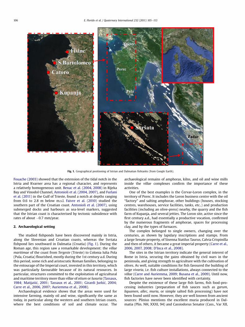
Fig. 1. Geographical positioning of Istrian and Dalmatian fishtanks (from Google Earth).
E. Florido et al. / Quaternary International 232 (2011) 105e113106
Fouache (2003) showed that the extension of the tidal notch in theIstria and Kvarner area has a regional character, and representsa relatively homogeneous unit. Benac et al. (2004, 2008) in RijekaBay and Vinodol Channel, Antonioli et al. (2004, 2007), and Furlaniet al. (2011) in the Gulf of Trieste, found a notch at depths rangingfrom 0.6 to 2.8 m below m.s.l. Faivre et al. (2010) studied thesouthern part of the Croatian coast. Antonioli et al. (2007), usingsubmerged docks and harbours as sea-level markers, suggestedthat the Istrian coast is characterised by tectonic subsidence withrates of about �0.7 mm/year.
2. Archaeological setting
The studied fishponds have been discovered mainly in Istria,along the Slovenian and Croatian coasts, whereas the Svr�satafishpond lies southward in Dalmatia (Croatia) (Fig. 1). During theRoman age, this region saw a remarkable development: the villaemaritimae of the coast from Tergeste (Trieste) to Colonia Iulia Pola(Pula, Croatia) flourished, mostly during the 1st century a.d. Duringthis period, some rich and aristocratic Roman families, belonging tothe entourage of the Imperial court, invested in this territory, whichwas particularly favourable because of its natural resources. Inparticular, structures committed to the exploitation of agriculturalandmaritime territorymore than villae of otium or luxuria (Tassaux,1984; Matija�si�c, 2001; Tassaux et al., 2001; Girardi Jurki�c, 2004;Carre et al., 2006, 2007; Auriemma et al., 2008).
Archaeological evidence shows that the areas were used forintensive farming, mainly oil and wine, significantly the same astoday, in particular along the western and southern Istrian coasts,where the best conditions of soil and climate occur. The
archaeological remains of amphoras, kilns, and oil and wine millsinside the villae complexes confirm the importance of theseactivities.
One of the best examples is the �Cervar-Loron complex, in theterritory of Porec. It includes the Loron business centre with the oil“factory” and salting amphorae, other buildings (houses, stockingcentres, warehouses, service facilities, tanks, etc..) and productionfacilities (including an olive-press) nearby, the quarry and the fishfarm of Kupanja, and several jetties. The Loron site, active since thefirst century a.d., had essentially a productive vocation, confirmedby the numerous fragments of amphorae, spaces for processingclay, and by the types of furnaces.
The complex belonged to single owners, changing over thecenturies, as shown by lapidary inscriptions and stamps. Froma large Senate property, of Sisenna Statilus Taurus, Calvia Crispinillaand then of others, it became a great imperial property (Carre et al.,2006, 2007, 2008; D’Inca et al., 2008).
The sites in the Istrian territory indicate the general interest ofRome in Istria, securing the gains obtained by civil wars in thepeninsula, and giving strength to agriculture with the cultivation ofolives. As well, suitable conditions for fish favoured the building oflarge vivaria, i.e. fish culture installations, always connected to thevillae (Carre and Auriemma, 2009; Busana et al., 2009). Until now,fish factories have never been identified with certainty.
Despite the existence of these large fish farms, fish food-pro-cessing industries (preparation of fish sauces such as garum,liquamen, allec, muria, or simple salted fish processing) have notbeen found until now. However, they are well known from ancientsources: Plinius mentions the excellent muria produced in Dal-matia (Plin. NH, XXXI, 94) and Cassiodorus Senator (Cass., Var XII,
Fig. 2. Table of comparison: Palaeosea level.
E. Florido et al. / Quaternary International 232 (2011) 105e113 107
22, 3e5) indicates numerous garismatia, factories where garumwasproduced, in the Istrian province during the sixth century a.d.(Auriemma, 2000).
A recent hypothesis against the presence of large fishpondsidentifies fish factories with some coastal fullonicae (tincture pla-ces), abundant along the Istrian shore (Mauro, 2004; Tassaux,2009). A large quantity of salt was needed for the production offish sauces and salting: along the Istrian coast every bay had salt-works. Nowadays, some probably exist from the Roman age, assubmerged wooden features, as found in Ka�stela Bay, Central Dal-matia (Radi�c Rossi, 2008). Additional interesting evidence is rep-resented by the Grado wreck’s cargo of fish products (Auriemma,2000; Auriemma and Pesavento Mattioli, 2009).
This microeconomy arose along medium- and short-range traderoutes. Moreover, coastal navigation involving all the shores of thenorthern and the central Adriatic developed, as the homogenousfinds suggest. The local traffic moved from the production areas tothe primary ones and then to the main distribution areas, such asAquileia (Matija�si�c, 2001).
3. Geomorphological setting
The eastern Adriatic region displays a thick carbonate succes-sion dating from the Middle Permian to Lower Eocene. Depositioncontinued during the Mid-Upper-Eocene with turbiditic flyschdeposits (Herak, 1986; Cucchi et al., 1989; Vlahovi�c et al., 2002,
2005). It can be considered as an ingressive karst coast, charac-terised by island chains and channels parallel to the general trendconstrained by geological structures (folds, faults, overthrusts).
Holocene sea-level rise submerged different sea-level indica-tors, both archaeological and geomorphological, such as Romanremains and notches. MIS 5.5 deposits do not crop out along theeastern coast of the Adriatic Sea. The equivalent markers, whichhave been observed in boreholes between �85 and �117 m a.s.l. inthe Po Plain, provide evidence of significant tectonic subsidenceduring the last 125 ka (Antonioli et al., 2009) until the Holocene.Antonioli et al. (2007) used some presently submerged archaeo-logical markers including docks or pavements in a similar coastalarea.
The northeast Adriatic (Italy, Slovenia and Croatia) is an area ofsubsidence, and the calibrated SELEN model results were used toseparate the isostatic from the tectonic contributions. This indicatesthat the Adriatic coast from the Gulf of Trieste to the southern endof Istria has tectonically subsided by 1.5 m since Roman times.Comparing the altitude of these markers with predicted sea-levelmarkers allowed calculation of the tectonic rates on the Istrian andDalmatian coasts.
4. Methods
Fishpond depth has been measured using the same methodrecently suggested by Antonioli et al. (2007) to study archaeological
E. Florido et al. / Quaternary International 232 (2011) 105e113108
remains in Sardinia and the Northeastern Adriatic. The surveyinginvolves more steps: measurement of the depth of the submergedfishpond with respect to the local sea level at the time of survey.
The reconstruction of sea-level change can be affected by inac-curacy (Lambeck et al., 2004a,b), so error bars for the elevations andage values of the archaeological markers have been provided. Theso-called “functional height”, the elevation of the structure abovethe palaeosea level considering the function of the archaeologicalstructure, has been evaluated on the basis of accurate archaeolog-ical interpretations (Fig. 2). Age errors have been estimated fromarchaeological considerations, while elevation errors have beenderived from measurements, corrections and estimation of thefunctional heights.
Elevation measurements were performed using optical (Sal-moiraghi Ertel automatic level) or mechanical methods (invar rod).All the measurements of the archaeological markers were collectedduring periods of low wave energy, and they were related to thesea-level position for that particular moment. As the investigatedfishponds were used year-round, it was assumed that the defininglevels correspond to the annual mean conditions at the time ofconstruction. The measurements have been consequently reducedto the mean sea level applying tidal corrections at the surveyedsites, using the data of the Trieste tide gauge. Tide amplitude isa crucial parameter, in particular in the northern Adriatic Sea,where tide amplitude is one of the largest in the whole Mediter-ranean basin (up to w2 m e Tidal Data Base of the Italian IstitutoIdrografico della Marina). Elevation measurements are given(Stravisi and Purga, 2005) with respect to the Italian referenceplane network of the Istituto GeograficoMilitare (GenovaMean SeaLevel, 1942; Gamboni, 1965).Values reported in Table 1 are themean values of multiple measurements with tide correction ofsurveyed data using the nearest tide gauge data collected at thetime of surveying,
Relative sea level (RSL) predictions computed in this study (seeTable 1) have been obtained by solving the Sea Level Equation (SLE)for a spherically symmetric, self-gravitating Earth. The SLE, whichaccounts for the effects of visco-elastic deformation and gravityvariations upon RSL (the physics of the SLE is described by Farrelland Clark, 1976), has been numerically solved by means of animproved version of the SELEN program, whose basic features arepresented in Spada and Stocchi (2007). The ICE-5G (VM2)model forthe late Pleistocene ice sheets (Peltier, 2004) was employed. For theMediterranean, predictions of present-day sea-level variationsobtained by ICE-5G have been recently discussed by Stocchi and
Table 1Data and measurements.
A B C D E F
Site name Survey date(yyyy/mm/dd, h)
Type andmeasuredheight (m)
Coordinates Archaeologicalage (yr BP)
Tid
1. Jernejeva dragaS. Bartolomeo
2005/11/10,h 15:10 GMT
Walkingsurface, �0.70
45.5930� 1900 � 100 �013.7151�
2. Fizine Fisine 2005/07/8,h 13:30 GMT
Walkingsurface, �0.80
45.514640� 1900 � 100 �0
13.580701�
3. Katoro Catoro 2007/07/12,h 10.00 GMT
Top ofthe blocks, �1.3
45.460447� 1900 � 100 �013.516530�
4. Kupanja 2004/07/29,h 15:00 GMT
Embankment-2.65 45.2829� 1900 � 100 �013.5923�
5. Svr�sata 2008/07/31,h 10:15 GMT
Embankment, 1.60 43.8624� 1900 � 100 �015.2704�
Spada (2009) and compared to those obtained using alternativeice sheets models.
Tectonic stability of the area is hypothesized at the sites wherethe elevations of the markers are in agreement with the predictedsea-level curve. In contrast, when the elevations of the markersdiffer from the predicted sea-level curve, the area is subjected totectonic subsidence or uplift.
For the Istrian sites (Table 1, and Fig. 1) observational data(corrected for tide, pressure and functional height, sea-levelchange, column I of Table 1) were compared with the geophysicalmodel (predicted values, column L of Table 1). The tectonic rates inmm/year are listed in column M.
5. Data
These structures are clearly fishponds, large installations withtwo or more basins for intensive fish culture, for storing, breedingand/or fattening of the fish destined for food processing (sauces andconserves) or eating/consumption (Carre and Auriemma, 2009).The Istrian fishponds belong to the category of “contiguous basins”,and they show an internal partition from two (S. Bartolomeo/Jer-nejeva draga and Fisine/Fizin) to four basins (Katoro and Kupanja).This internal subdivision contains different fish species or dividesthe young individuals from the adults, for their protractedconfinement, as Columella prescribes (De Re Rustica, 8, 17, 10e11).
The perimeter and internal walls have been built with thetechnique of “single rocks jetty” typical of the breakwaters(Auriemma, 2004; Felici, 2007; Auriemma and Solinas, 2009). Theyare characterised by pebbles and cobbles, assembled withoutmortar and with a trapezoidal cross-section, initially narrower thantoday and later enlarged because of the destructive action of thewaves. This sort of embankment lies on the bedrock that forms thebasin bottom, and includes, at the top, foundation alignments,probable remains of walking surfaces. The chronology ofconstruction of these manufacturing establishments is about thefirst century of the Roman Empire, as can be deduced from therelated close production and/or housing complexes which arealong the coast (villae/farms, figlinae/pottery kilns, officinae/fishingfactories, oil and wine installations, etc.) (Tassaux et al., 2001).
For example, the chronological position of the San Bartolomeostructure is confirmed by the discovery of bricks, clay, networkweights, bend walls and a 2e4 Dressel amphora during the firstsystematic research conducted in November 2005 under theCommunity Programme Interreg IIIA ItalyeSlovenia 2000e2006.
G H I L M N
e(m) Correctedheight (m)
Functionalheight (m)
S. l. change(m)
Predictedvaluesfrom Selenmodel
tectonicratemm\years
References
.10 �0.80 0.60 1.40 � 0.20 �0.21 �0.63 Antonioliet al. (2007)
.10 �0.90 0.60 1.50 � 0.20 �0.20 �0.68 Gaspariet al. (2006,2007),Stokinet al. (2008)This paper
.25 �1.55 0.60 1.75 � 0.20 0.23 �0.8 This paper
.00 �2.65 0.60 1.40 � 0.20 �0.25 �0.61 This paper
.10 �1.70 0.60 1.50 � 0.2 �0.58 �0.48 This paper
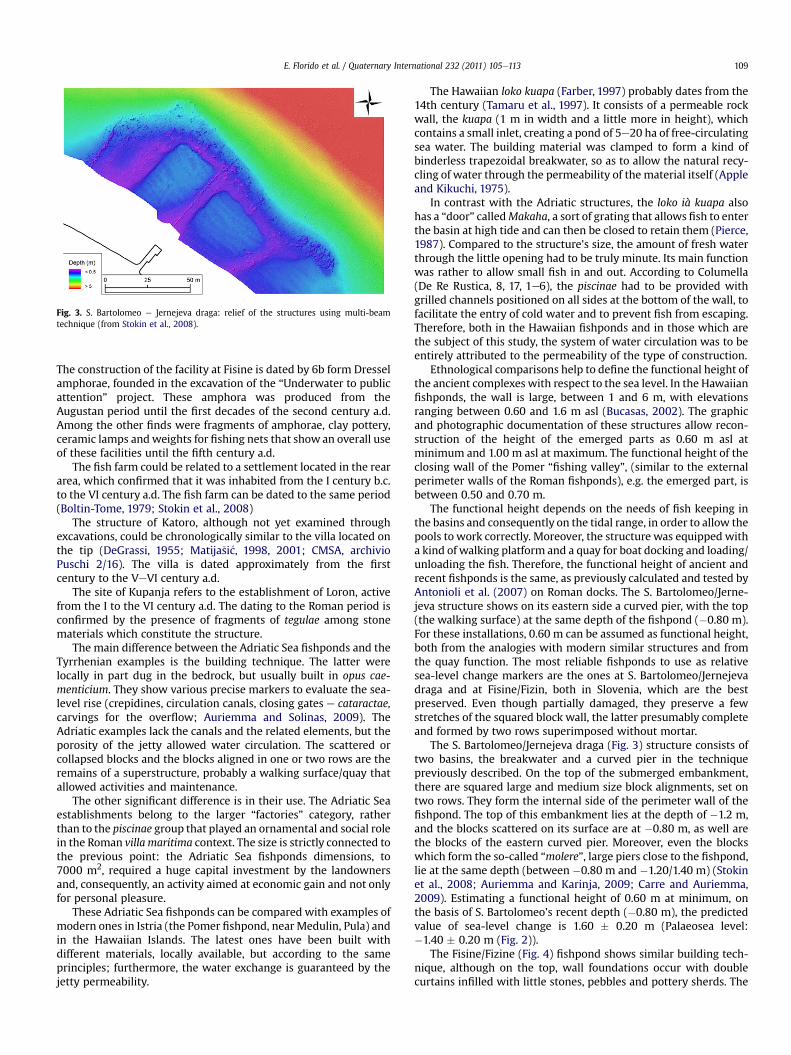
Fig. 3. S. Bartolomeo e Jernejeva draga: relief of the structures using multi-beamtechnique (from Stokin et al., 2008).
E. Florido et al. / Quaternary International 232 (2011) 105e113 109
The construction of the facility at Fisine is dated by 6b form Dresselamphorae, founded in the excavation of the “Underwater to publicattention” project. These amphora was produced from theAugustan period until the first decades of the second century a.d.Among the other finds were fragments of amphorae, clay pottery,ceramic lamps andweights for fishing nets that show an overall useof these facilities until the fifth century a.d.
The fish farm could be related to a settlement located in the reararea, which confirmed that it was inhabited from the I century b.c.to the VI century a.d. The fish farm can be dated to the same period(Boltin-Tome, 1979; Stokin et al., 2008)
The structure of Katoro, although not yet examined throughexcavations, could be chronologically similar to the villa located onthe tip (DeGrassi, 1955; Matija�si�c, 1998, 2001; CMSA, archivioPuschi 2/16). The villa is dated approximately from the firstcentury to the VeVI century a.d.
The site of Kupanja refers to the establishment of Loron, activefrom the I to the VI century a.d. The dating to the Roman period isconfirmed by the presence of fragments of tegulae among stonematerials which constitute the structure.
The main difference between the Adriatic Sea fishponds and theTyrrhenian examples is the building technique. The latter werelocally in part dug in the bedrock, but usually built in opus cae-menticium. They show various precise markers to evaluate the sea-level rise (crepidines, circulation canals, closing gates e cataractae,carvings for the overflow; Auriemma and Solinas, 2009). TheAdriatic examples lack the canals and the related elements, but theporosity of the jetty allowed water circulation. The scattered orcollapsed blocks and the blocks aligned in one or two rows are theremains of a superstructure, probably a walking surface/quay thatallowed activities and maintenance.
The other significant difference is in their use. The Adriatic Seaestablishments belong to the larger “factories” category, ratherthan to the piscinae group that played an ornamental and social rolein the Roman villa maritima context. The size is strictly connected tothe previous point: the Adriatic Sea fishponds dimensions, to7000 m2, required a huge capital investment by the landownersand, consequently, an activity aimed at economic gain and not onlyfor personal pleasure.
These Adriatic Sea fishponds can be compared with examples ofmodern ones in Istria (the Pomer fishpond, near Medulin, Pula) andin the Hawaiian Islands. The latest ones have been built withdifferent materials, locally available, but according to the sameprinciples; furthermore, the water exchange is guaranteed by thejetty permeability.
The Hawaiian loko kuapa (Farber, 1997) probably dates from the14th century (Tamaru et al., 1997). It consists of a permeable rockwall, the kuapa (1 m in width and a little more in height), whichcontains a small inlet, creating a pond of 5e20 ha of free-circulatingsea water. The building material was clamped to form a kind ofbinderless trapezoidal breakwater, so as to allow the natural recy-cling of water through the permeability of the material itself (Appleand Kikuchi, 1975).
In contrast with the Adriatic structures, the loko ià kuapa alsohas a “door” calledMakaha, a sort of grating that allows fish to enterthe basin at high tide and can then be closed to retain them (Pierce,1987). Compared to the structure’s size, the amount of fresh waterthrough the little opening had to be truly minute. Its main functionwas rather to allow small fish in and out. According to Columella(De Re Rustica, 8, 17, 1e6), the piscinae had to be provided withgrilled channels positioned on all sides at the bottom of the wall, tofacilitate the entry of cold water and to prevent fish from escaping.Therefore, both in the Hawaiian fishponds and in those which arethe subject of this study, the system of water circulation was to beentirely attributed to the permeability of the type of construction.
Ethnological comparisons help to define the functional height ofthe ancient complexes with respect to the sea level. In the Hawaiianfishponds, the wall is large, between 1 and 6 m, with elevationsranging between 0.60 and 1.6 m asl (Bucasas, 2002). The graphicand photographic documentation of these structures allow recon-struction of the height of the emerged parts as 0.60 m asl atminimum and 1.00 m asl at maximum. The functional height of theclosing wall of the Pomer “fishing valley”, (similar to the externalperimeter walls of the Roman fishponds), e.g. the emerged part, isbetween 0.50 and 0.70 m.
The functional height depends on the needs of fish keeping inthe basins and consequently on the tidal range, in order to allow thepools to work correctly. Moreover, the structure was equipped witha kind of walking platform and a quay for boat docking and loading/unloading the fish. Therefore, the functional height of ancient andrecent fishponds is the same, as previously calculated and tested byAntonioli et al. (2007) on Roman docks. The S. Bartolomeo/Jerne-jeva structure shows on its eastern side a curved pier, with the top(the walking surface) at the same depth of the fishpond (�0.80 m).For these installations, 0.60 m can be assumed as functional height,both from the analogies with modern similar structures and fromthe quay function. The most reliable fishponds to use as relativesea-level change markers are the ones at S. Bartolomeo/Jernejevadraga and at Fisine/Fizin, both in Slovenia, which are the bestpreserved. Even though partially damaged, they preserve a fewstretches of the squared block wall, the latter presumably completeand formed by two rows superimposed without mortar.
The S. Bartolomeo/Jernejeva draga (Fig. 3) structure consists oftwo basins, the breakwater and a curved pier in the techniquepreviously described. On the top of the submerged embankment,there are squared large and medium size block alignments, set ontwo rows. They form the internal side of the perimeter wall of thefishpond. The top of this embankment lies at the depth of �1.2 m,and the blocks scattered on its surface are at �0.80 m, as well arethe blocks of the eastern curved pier. Moreover, even the blockswhich form the so-called “molere”, large piers close to the fishpond,lie at the same depth (between �0.80 m and �1.20/1.40 m) (Stokinet al., 2008; Auriemma and Karinja, 2009; Carre and Auriemma,2009). Estimating a functional height of 0.60 m at minimum, onthe basis of S. Bartolomeo’s recent depth (�0.80 m), the predictedvalue of sea-level change is 1.60 � 0.20 m (Palaeosea level:�1.40 � 0.20 m (Fig. 2)).
The Fisine/Fizine (Fig. 4) fishpond shows similar building tech-nique, although on the top, wall foundations occur with doublecurtains infilled with little stones, pebbles and pottery sherds. The
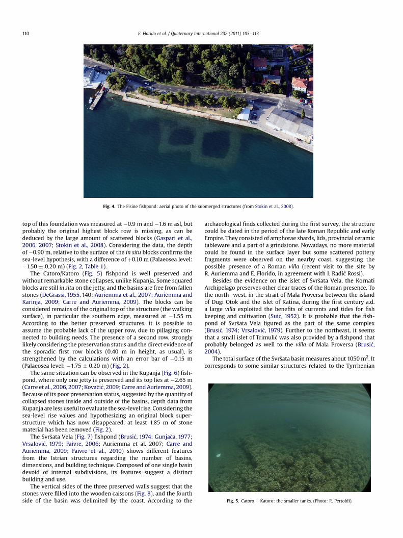
Fig. 4. The Fisine fishpond: aerial photo of the submerged structures (from Stokin et al., 2008).
Fig. 5. Catoro e Katoro: the smaller tanks. (Photo: R. Pertoldi).
E. Florido et al. / Quaternary International 232 (2011) 105e113110
top of this foundation was measured at �0.9 m and �1.6 m asl, butprobably the original highest block row is missing, as can bededuced by the large amount of scattered blocks (Gaspari et al.,2006, 2007; Stokin et al., 2008). Considering the data, the depthof �0.90 m, relative to the surface of the in situ blocks confirms thesea-level hypothesis, with a difference of þ0.10 m (Palaeosea level:�1.50 � 0.20 m) (Fig. 2, Table 1).
The Catoro/Katoro (Fig. 5) fishpond is well preserved andwithout remarkable stone collapses, unlike Kupanja. Some squaredblocks are still in situ on the jetty, and the basins are free from fallenstones (DeGrassi, 1955, 140; Auriemma et al., 2007; Auriemma andKarinja, 2009; Carre and Auriemma, 2009). The blocks can beconsidered remains of the original top of the structure (the walkingsurface), in particular the southern edge, measured at �1.55 m.According to the better preserved structures, it is possible toassume the probable lack of the upper row, due to pillaging con-nected to building needs. The presence of a second row, stronglylikely considering the preservation status and the direct evidence ofthe sporadic first row blocks (0.40 m in height, as usual), isstrengthened by the calculations with an error bar of �0.15 m(Palaeosea level: �1.75 � 0.20 m) (Fig. 2).
The same situation can be observed in the Kupanja (Fig. 6) fish-pond, where only one jetty is preserved and its top lies at �2.65 m(Carre et al., 2006, 2007; Kova�ci�c, 2009; Carre andAuriemma, 2009).Because of its poor preservation status, suggested by the quantity ofcollapsed stones inside and outside of the basins, depth data fromKupanja are less useful to evaluate the sea-level rise. Considering thesea-level rise values and hypothesizing an original block super-structure which has now disappeared, at least 1.85 m of stonematerial has been removed (Fig. 2).
The Svr�sata Vela (Fig. 7) fishpond (Brusi�c, 1974; Gunja�ca, 1977;Vrsalovi�c, 1979; Faivre, 2006; Auriemma et al. 2007; Carre andAuriemma, 2009; Faivre et al., 2010) shows different featuresfrom the Istrian structures regarding the number of basins,dimensions, and building technique. Composed of one single basindevoid of internal subdivisions, its features suggest a distinctbuilding and use.
The vertical sides of the three preserved walls suggest that thestones were filled into the wooden caissons (Fig. 8), and the fourthside of the basin was delimited by the coast. According to the
archaeological finds collected during the first survey, the structurecould be dated in the period of the late Roman Republic and earlyEmpire. They consisted of amphorae shards, lids, provincial ceramictableware and a part of a grindstone. Nowadays, no more materialcould be found in the surface layer but some scattered potteryfragments were observed on the nearby coast, suggesting thepossible presence of a Roman villa (recent visit to the site byR. Auriemma and E. Florido, in agreement with I. Radi�c Rossi).
Besides the evidence on the islet of Svr�sata Vela, the KornatiArchipelago preserves other clear traces of the Roman presence. Tothe northewest, in the strait of Mala Proversa between the islandof Dugi Otok and the islet of Katina, during the first century a.d.a large villa exploited the benefits of currents and tides for fishkeeping and cultivation (Sui�c, 1952). It is probable that the fish-pond of Svr�sata Vela figured as the part of the same complex(Brusi�c, 1974; Vrsalovi�c, 1979). Further to the northeast, it seemsthat a small islet of Trimuli�c was also provided by a fishpond thatprobably belonged as well to the villa of Mala Proversa (Brusi�c,2004).
The total surface of the Svr�sata basin measures about 1050m2. Itcorresponds to some similar structures related to the Tyrrhenian
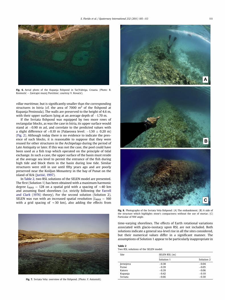
Fig. 6. Aerial photo of the Kupanja fishpond in Tar/Vabriga, Croazia. (Photo: R.Kosino�zi�c e Zavi�cajni muzej Pore�stine; courtesy V. Kova�ci�c).
E. Florido et al. / Quaternary International 232 (2011) 105e113 111
villae maritimae, but is significantly smaller than the correspondingstructures in Istria (cf. the area of 7000 m2 of the fishpond atKupanja Peninsula). The walls are preserved to the height of 4.6 m,with their upper surfaces lying at an average depth of �1.70 m.
If the Svr�sata fishpond was equipped by two more rows ofrectangular blocks, as was the case in Istria, its upper surface wouldstand at �0.90 m asl, and correlate to the predicted values witha slight difference of þ0.10 m (Palaeosea level: �1.50 � 0.20 m)(Fig. 2). Although today there is no evidence to indicate the pres-ence of such blocks, it is reasonable to suppose that they werereused for other structures in the Archipelago during the period ofLate Antiquity or later. If this was not the case, the pool could havebeen used as a fish trap which operated on the principle of tidalexchange. In such a case, the upper surface of the basin must resideat the average sea level to permit the entrance of the fish duringhigh tide and block them in the basin during low tide. Similarstructures were still in use until fifty years ago and are poorlypreserved near the Ko�sljun Monastery in the bay of Punat on theisland of Krk (Juri�si�c, 1997).
In Table 2, two RSL solutions of the SELEN model are presented.The first (Solution 1) has been obtained with a maximum harmonicdegree LMAX ¼ 128 on a spatial grid with a spacing of w40 kmand assuming fixed shorelines (i.e. strictly following the Farrelland Clark (1976) theory). For the second solution (Solution 2),SELEN was run with an increased spatial resolution (LMAX ¼ 160with a grid spacing of w30 km), also adding the effects from
Fig. 7. Svr�sata Vela: overview of the fishpond. (Photo: F. Antonioli).
Fig. 8. Photographs of the Svr�sata Vela fishpond: (A) The embankment; (B) A side ofthe structure which highlights stone’s compactness without the use of mortar; (C)Particular of NW angle.
time-varying shorelines. The effects of Earth rotational variationsassociated with glacio-isostacy upon RSL are not included. Bothsolutions indicate a general sea-level rise in all the sites considered,but their numerical values differ in a significant manner. Theassumptions of Solution 1 appear to be particularly inappropriate in
Table 2Two RSL solutions of the SELEN model.
Site SELEN RSL (m)
Solution 1 Solution 2
Jernejeva �0.38 �0.04Fizine �0.39 �0.05Katoro �0.39 �0.06Kupanja �0.42 �0.10Svr�sata �0.66 �0.30
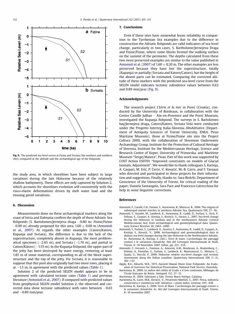
Fig. 9. The predicted sea-level curves at Fizine and Svr�sata (the northern and southernsites) compared at the altitude and the archaeological age of the fishponds.
E. Florido et al. / Quaternary International 232 (2011) 105e113112
the study area, in which shorelines have been subject to largevariations during the late Holocene because of the relativelyshallow bathymetry. These effects are only captured by Solution 2,which accounts for shorelines evolution self-consistently with thevisco-elastic deformations driven by melt water load and theensuing geoid variations.
6. Discussion
Measurements done on these archaeological markers along thecoast of Istria and Dalmatia confirm the depth of these Adriatic Seafishponds (S. Bartolomeo/Jernejeva draga �0.80 m; Fisine/Fizine�0.90 m) already proposed for this area, 1.60 � 0.60 m (Antonioliet al., 2007). As regards the other examples (Catoro/Katoro,Kupanja and Svr�sata), the difference is due to the lack of thesuperstructure, completely absent in Kupanja, the most problem-atical specimen (�2.65 m), and Svr�sata (�1.70 m), and partial inCatoro/Katoro (�1.55m). In the Kupanja fishpond, the upper part ofthe jetty has been destroyed by wave energy, removing at least1.85 m of stone material, corresponding to all of the block super-structure and the top of the jetty. For Svr�sata, it is reasonable tosuppose that this pool also originally had two more rows, placing itat �1.5 m, in agreement with the predicted values (Table 1).
Solution 2 of the predicted SELEN model appears to be inagreement with calculated tectonic rates (Table 1) and previousliterature (Antonioli et al., 2007). If comparedwith predicted valuesfrom geophysical SELEN model Solution 2, the observed and cor-rected data show tectonic subsidence with rates between �0.63and �0.89 mm/year.
7. Conclusions
Even if these sites have somewhat lesser reliability in compar-ison to the Tyrrhenian Sea examples due to the difference inconstruction the Adriatic fishponds are valid indicators of sea-levelchange, particularly in two cases, S. Bartholome/Jernejeva Dragaand Fizine/Fisine, where some blocks formed the walking surfaceon the summit of the perimeter. The depths calculated from thesetwo more preserved examples are similar to the value published inAntonioli et al. (2007) of 1.60� 0.20 m. The other examples are lesspreserved because they have lost the superstructure, totally(Kupanja) or partially (Svr�sata and Katoro/Catoro), but the height ofthe absent parts can be estimated. Comparing the corrected alti-tude of these markers with the predicted sea-level curve from theSELEN model indicates tectonic subsidence values between 0.63and 0.89 mm/year (Fig. 9).
Acknowledgments
The research project L’Istrie et la mer in Pore�c (Croatia), con-ducted by the University of Bordeaux, in collaboration with theCentre Camille Jullian e Aix-en-Provence and the Pore�c Museum,investigated the Kupanja fishpond. The surveys in S. Bartolomeobay/Jernejeva draga, Catoro/Katoro, Svr�sata Vela were conductedunder the Progetto Interreg Italia-Slovenia AltoAdriatico (Depart-ment of Antiquity Sciences of Trieste University, ENEA, PiranMaritime Museum); those at Fizine/Fisine site into the ProjectCultura 2000, with the collaboration of Slovenian UnderwaterArchaeology Group, Institute for the Protection of Cultural Heritageof Slovenia, Institute for the Mediterranean Heritage, Science andResearch Centre of Koper, University of Primorska, and MaritimeMuseum “Sergej Ma�sera”, Piran. Part of this work was supported byCOST Action ES0701 “Improved constraints on models of GlacialIsostatic Adjustment”. Wewould like to thank colleagues S. Karinja,A. Gaspari, M. Eri�c, P. �Cer�ce, V. Kova�ci�c, M.-B. Carre, and F. Tassauxwho directed and participated in these projects for their informa-tion and suggestions. Finally, thanks to: Sara Biolchi, Department ofGeoscience of the University of Trieste, for critical reading of thepaper; Daniela Santangelo, Sara Pace and Francesco Latrecchina forhelp in some linguistic corrections.
References
Antonioli, F., Carulli, G.B., Furlani, S., Auriemma, R., Marocco, R., 2004. The enigma ofsubmerged marine notches in northern Adriatic Sea. Quaternaria VIII, 27e36.
Antonioli, F., Anzidei, M., Lambeck, K., Auriemma, R., Gaddi, D., Furlani, S., Orrù, P.,Solinas, E., Gaspari, A., Karinja, S., Kovacic, V., Surace, L., 2007. Sea-level changeduring the Holocene in Sardinia and in the northeastern Adriatic (centralMediterranean Sea) from archaeological and geomorphological data. Quater-nary Science Reviews 26, 2463e2486.
Antonioli, F., Furlani, S., Lambeck, K., Stravisi, F., Auriemma, R., Gaddi, D., Gaspari, A.,Karinja, S., Kova�ci�c, V., 2008. Archaeological and geomorphological data todeduce sea level changes during the late Holocene in the Northeastern Adriatic.In: Auriemma, R., Karinja, S. (Eds.), Terre di mare. L’archeologia dei paesaggicostieri e le variazioni climatiche, Atti del Convegno Internazionale di Studi,Trieste, 8e10 Novembre 2007, Udine, pp. 221e234.
Antonioli, F., Ferranti, L., Fontana, A., Amorosi, A.M., Bondesan, A., Braitenberg, C.,Dutton, A., Fontolan, G., Furlani, S., Lambeck, K., Mastronuzzi, G., Monaco, C.,Spada, G., Stocchi, P., 2009. Holocene relative sea-level changes and tectonicmovements along the Italian coastline. Quaternary International 206 (1e2),102e133.
Apple, R.A., Kikuchi, W.K., 1975. Ancient Hawaii Shore Zone Fishponds: An Evalu-ation of Survivors for Historical Preservation. National Park Service, Honolulu.
Auriemma, R., 2000. Le anfore del relitto di Grado e il loro contenuto, Mélanges del’école francaise de Rome. Antiquité 112, 27e51.
Auriemma, R., 2004. Salentum a Salo. Forma Maris Antiqui, Galatina.Auriemma, R., Carre, M.B., Kova�ci�c, V., Pesavento Mattioli, S., 2007. Pesca, industria
conserviera e commercio nell’ Adriatico: i primi indizi. Cetariae, 435e438.Auriemma, R., Karinja, S., 2009. Terre di Mare. L’archeologia dei paesaggi costieri e
le variazioni climatiche. In: Atti del Convegno Internazionale di Studi, Trieste,8e10 novembre 2007.

E. Florido et al. / Quaternary International 232 (2011) 105e113 113
Auriemma, R., Pesavento Mattioli, S., 2009. I tituli picti delle anfore di Grado. In:Pesavento Mattioli, S., Carre, M.-B. (Eds.), Olio e pesce in epoca romana: pro-duzione e commercio nelle regioni dell’Alto Adriatico, Atti del Convegno(Padova, 16.02.2007). Padova, pp. 83e100.
Auriemma, R., Solinas, E., 2009. Archaeological remains as sea level changemarkers: a review. Quaternary International 206, 134e146.
Auriemma, R., Degrassi, V., Gaddi, D., Mauro, S., Oriolo, F., Riccobono, D., 2008. Terredi mare: paesaggi costieri dal Timavo alla penisola muggesana. In:Auriemma, R., Karinja, S. (Eds.), Terre di mare. L’archeologia dei paesaggi cos-tieri e le variazioni climatiche, Atti del Convegno Internazionale di Studi,Trieste, 8e10 novembre 2007, Udine, pp. 75e211.
Benac, �C., 1989. Morphogenesis of very steep and vertical coast in the area ofKvarner. Pomorski Zbornik 27, 485e495.
Benac, �C., 1992. Recentni geomorfolo�ski procesi i oblici u podru�cju Rije�ckog zaljeva.Geografski Glasnik 54, 1e18.
Benac, �C., Jura�ci�c, M., Bakran-Petricioli, T., 2004. Submerged tidal notches in theRijeka Bay NE Adriatic Sea: indicators of relative sea-level change and of recenttectonic movements. Marine Geology 212 (1e4), 21e33.
Benac, �C., Jura�ci�c, M., Bla�skovi�c, I., 2008. Tidal notches in Vinodol channel and Bakarbay, NE Adriatic Sea: indicators of recent tectonics. Marine Geology 248 (3e4),151e160.
Boltin-Tome, E., 1979. Slovenska Istra v antiki in njen gospodarski vzpon, Slovenskomorje in zaledje, 2e3.
Brusi�c, Z., 1974. Rezultati podmorskih istra�zivanja u zadarskom arhipelagu. ZbornikZadarsko Oto�cje 1, 65e69.
Brusi�c, Z., 2004. Arheolo�ski spemenici otoka Murtera i Kornatskog oto�cja. MurterskiGodi�snjak 2, 91e100.
Bucasas, S., 2002. Hawai’ian Fishponds. Kapiolani Community College, Horizons.Busana, M.S., D’Incà, C., Forti, S., 2009. Olio e pesce in epoca romana nell’alto
e medio Adriatico. In: Pesavento Mattioli, S., Carre, M.-B. (Eds.), Olio e pesce inepoca romana: produzione e commercio nelle regioni dell’Alto Adriatico, Attidel Convegno (Padova, 16.02.2007). Padova, pp. 36e81.
Carre, M.-B., Kova�ci�c, V., Marchiori, A., Rosada, G., Tassaux, F., Zabeo, M., 2006.Loron-Lorun, Parenzo-Pore�c, Istria. Una villa maritima nell’agro parentino: lacampagna di ricerca 2005. Histria Antiqua 14, 261e281.
Carre, M.B., Kova�ci�c, V., Tassaux, F., 2008. Quatre ans de recherches sur le littoralparentin, in Terre di mare. In: Auriemma, R., Karinja, S. (Eds.), L’archeologia deipaesaggi costieri e le variazioni climatiche, Atti del Convegno Internazionale diStudi (Trieste, 8e10 novembre 2007) Trieste-Piran.
Carre, M.B., Auriemma, R., 2009. Piscinae e vivaria nell’Adriatico settentrionale:tipologie e funzioni. In: Pesavento Mattioli, S., Carre, M.-B. (Eds.), Olio e pesce inepoca romana: produzione e commercio nelle regioni dell’Alto Adriatico, Attidel Convegno (Padova, 16.02.2007). Padova, pp. 83e100.
Carre, M.-B., D’Inca, C., Kova�ci�c, V., Marchiori, A., Tassaux, F., Zabeo, M., 2007. Loron-Lorun, Parenzo-Pore�c, Istria. Una villa maritima nell’agro parentino: la campa-gna di ricerca 2006. Histria Antiqua 15, 479e500.
CMSA, Schizzo delle evidenze di Punta Katoro, Civici Musei di Storia e Arte diTrieste, Archivio Puschi 2/16.
Cucchi, F., Pirini Radrizzani, C., Pugliese, N., 1989. The carbonate stratigraphicsequence of the Karst of Trieste (Italy). Memorie della Società Geologica Italiana40, 35e44.
D’Inca, C., Kova�ci�c, V., Marchiori, A., Marion, Y., Rousse, C., Tassaux, F., Zabeo, M.,2008. Loron-Lorun, Parenzo-Pore�c, Istria. Una villa maritima nell’agro paren-tino: la campagna di ricerca 2007. Histria Antiqua 16, 147e160.
DeGrassi, A., 1955. I porti romani dell’Istria, “Anthemon”, Firenze 1955, pp.119e169 ¼ “AttiMemIstria”, V (LVII), 1957, pp. 24e81 ¼ “Scritti vari di Anti-chità”, II, 1962.
Faivre, S., 2006. Geomorphological and archaeological indicators of sea level changeover the last 2 000 years on the Croatian shoreline between Pore�c and Split. In:Menichetti, M., Mencucci, D. (Eds.), Adria 2006 International GeologicalCongress on the Adriatic Area, Field Trip Guide. Instituito di Science della Terra,Universita di Urbino, Urbino, Italy, pp. 69e72.
Faivre, S., Fouache, E., 2003. Some tectonic influences on the Croatian shorelineevolution in the last 2000 years. Zeitschrift für Geomorphologie. N.F. 47 (4),521e537.
Faivre, S., Fouache, E., Kova�ci�c, V., Glu�s�cevi�c, S., 2010. Some geomorphological andarchaeological indicators of Croatian shoreline evolution over the last twothousand years. Geology of the Adriatic area, GeoActa Special Publication 3,125e133.
Farber, J.M., 1997. Ancient Hawaiian Fishponds: Can Restoration Succeed on Molo-kai? Neptune House, Encinitas, Calif.
Farrell, W.E., Clark, J.A., 1976. On postglacial sea level. Geophysical Journal, RoyalAstronomical Society 46, 647e667.
Felici, E., 2007.Ricerchesulle tecnichecostruttivedeiporti romani.Notepreliminari sulporto di Astura (Latina). In: Atti del V Congresso di Topografia Antica. I porti delMediterraneo in eta` classica, Roma, 5e6 ottobre 2004. II, vol. 16. JAT, pp. 59e84.
Fouache, E., Faivre, S., Dufaure, J.-J., Kova�ci�c, V., Tassaux, F., 2000. New observationson the evolution of the Croatian shoreline between Pore�c and Zadar over thepast 2000 years. Zeitschrift für Geomorphologie Suppl.-Bd 122, 33e46.
Furlani, S., Cucchi, F., Biolchi, S., Odorico, R., 2011. Notches in the Northern AdriaticSea: genesis and development. Quaternary International 232, 158e168.
Gamboni, E., 1965. Sul caposaldo fondamentale di riferimento della nuova retealtimetrica di alta precisione. Bollettino di Geodesia e Scienze Affini 1, 155e165.
Gaspari, A., Karinja, S., Eri�c, M., Poglajen, S., �Cer�ce, P., 2006. Rimski pristani�skiobjekt z ribogojnico v Fizinah pri Portoro�zu: poro�cilo o raziskava podmorskega
najdi�s�ca v letih 2004 in 2005. Annales, Series Historia et Sociologia 16 (2),421e442.
Gaspari, A., Vidrih Perko, V., �Strajhar, M., Lazar, I., 2007. Anti�cni pristani�ski kompleksv Fizinah pri Portoro�zu e za�s�citne raziskave leta 1998 (The Roman port complexat Fizine near Portoro�z. Rescue excavations in 1998). Arheolo�ski Vestnik 58,167e218.
Girardi Jurki�c, V., 2004. Istria on the crossroads of the economic and trading routesin the north Adriatic area. Histria Antiqua 12, 11e23.
Gunja�ca, Z., 1977. Arheolo�ski spomenici �sibenskog podmorja/ArchaeologicalMonuments of the �Sibenik Undersea Area/Die archäologischen Denkmale desMeeresgrundes um �Sibenik, katalog izlo�zbe. Muzej grada �Sibenika, �Sibenik.
Herak, M., 1986. A new concept of geotectonic of the Dinarides. Acta Geologica 16,1e42.
Juri�si�c, M., 1997. Anti�cki ribnjak u uvali Verige na Brijunima; Prilog poznavanjuanti�ckih ribnjaka i srodnih objekata na Jadranu. Izdanja Hrvatskog arheolo�skogdru�stva 18. Zagreb: Hrvatsko arheolo�sko dru�stvo, pp. 399e470.
Kova�ci�c, V., 2009. Anti�cki ribnjaci uzdu�z zapadne Istarske obale. In: Beki�c, L.,Miholjek, I., Meder, F. (Eds.), Juri�si�cev zbornik. Zbornik radova u znak sje�canjana Marija Juri�si�ca. Zagreb, pp. 240e245.
Lambeck, K., Antonioli, F., Purcell, A., Silenzi, S., 2004a. Sea level change along theItalian coastfor the past 10,000 yrs. Quaternary Science Reviews 23,1567e1598.
Lambeck, K., Anzidei, M., Antonioli, F., Benini, A., Esposito, E., 2004b. Sea level inRoman time in the Central Mediterranean and implications for modern sealevel rise. Earth and Planetary Science Letter 224, 563e575.
Matija�si�c, R., 1998. Gospodarstvo anti�che Istre. Arheoloski ostaci kao izvori zapoznavanje drustveno-gospodarskih odnosa u Istri u antici (I. st. pr.Kr.-III. St.posl. Kr, Pula).
Matija�si�c, R., 2001. Le ville rustiche istriane (bilancio storico-archeologico). In:Verzàr-Bass, M. (Ed.), Abitare in Cisalpina. L’edilizia privata nelle città e nelterritorio di età romana. Antichità Altoadriatiche, vol. 49, pp. 693e711. 2.
Mauro, S., 2004. Archeologia del paesaggio costiero nell’Alto Adriatico:il contributodella ricerca subacquea. Tesi di Specializzazione, Università di Trieste.
Peltier, W.R., 2004. Global glacial Isostasy and the surface of the ice-age Earth: theICEe5G(VM2) model and GRACE. Annual Reviews of Earth and PlanetarySciences 32, 111e149.
Pierce, B.A., 1987. Aquaculture in ancient Hawaii. Bioscience 37 (5), 320e331.Pirazzoli, P.A., 1980. Formes de corrosion marine et vestiges archeologiques
submerges: interpretation neotectonique de quelques exemples en Grece et enYougoslavie. Annales de l’Institut Oceanographique 56, 101e111.
Radi�c Rossi, I., 2008. Recenti scoperte sottomarine nella Baia di Ka�stela. In:Auriemma, R., Karinja, S. (Eds.), Terre di mare. L’archeologia dei paesaggi cos-tieri e le variazioni climatiche. Il Progetto Interreg Italia-Slovenia AltoAdriatico.Atti del Convegno Internazionale di Studi, Trieste, 8e10 novembre 2007, Udine,pp. 285e298.
�Segota, T., Filip�ci�c, A., 1991. Archaeologic and geologic proofs for Holocene sea levelposition on the East Adriatic littoral. Rad Hrvatske Akademije Znanosti IUmjetnosti 458 (25), 149e172. Zagreb.
Spada, G., Stocchi, P., 2007. SELEN: a Fortran 90 program for solving the “Sea levelEquation”. Computers and Geosciences 33 (4), 538e562. doi:10.1016/j.cageo.2006.08.006.
Stocchi, P., Spada, G., 2009. Influence of glacial isostatic adjustment upon currentsea level variations in the Mediterranean. Tectonophysics. doi:10.1016/j.tecto.2009.01.003.
Stokin, M., Gaspari, A., Karinja, S., Eri�c, M., 2008. Archaeological research of mari-time infrastructure of Roman settlements on the Slovenian coast in Istria(1993e2007). In: Auriemma, R., Karinja, S. (Eds.), Terre di mare. L’archeologiadei paesaggi costieri e le variazioni climatiche (Trieste, 8e10 novembre 2007).Atti del Convegno internazionale di Studi, Udine, pp. 56e74.
Stravisi, F., Purga, N., 2005. Il livello del mare a Trieste: piani di riferimento e sta-tistiche, vol. 122. University of Trieste, Dipartimentoi di Scienze della Terra,Rapport Oceanografica Meteorologica, p. 10.
Sui�c, M., 1952. Iskapanje rimske vile u Maloj Proversi. Vjesnik Za ArheologijuI Historiju Dalmatinsku 54, 174e187.
Tamaru, C.S., Carlstrom-Trick, C., Helsley, C., 1997. Aquaculture in Hawaii-Past,Present and Future. In: Helsley, C.E. (Ed.), Open Ocean Aquaculture ’97:Charting the Future of Ocean Farming: Proceedings of an InternationalConference. University of Hawaii-Sea Grant College Program, Honolulu,pp. 257e280.
Tassaux, F., 1984. L’implantation territoriale des grandes familles d’Istrie sous leHaut-Empire romain. AttiMusTrieste 13 (2), 193e229.
Tassaux, F., Matija�si�c, R., Kova�ci�c, V., 2001. Loron (Croatie), Bordeaux.Tassaux, F., 2009. Fullonicae, huileries ou ateliers de salaisons? Interrogations sur
quelques sites istriens. In: Pesavento Mattioli, S., Carre, M.-B. (Eds.), Olio e pescein epoca romana: produzione e commercio nelle regioni dell’Alto Adriatico, Attidel Convegno (Padova, 16.02.2007). Padova, pp. 101e108.
Vlahovi�c, I., Ti�sljar, J., Veli�c, I., Mati�cec, D., 2002. The karst Dinarides are composedof relics of a single Mesozoic platform: facts and consequences. Geologia Cro-atica 55 (2), 171e183.
Vlahovi�c, I., Ti�sljar, J., Veli�c, I., Mati�cec, D., 2005. Evolution of the Adriatic carbonateplatform: palaeogeography, main events and depositional dynamics. Palae-ogeography, Palaeoclimatology, Palaeoecology 220, 333e360.
Vrsalovi�c, D., 1979. Arheolo�ska istra�zivanja u podmorju isto�cnog Jadrana, Prilogpoznavanju trgova�ckih plovnih putova i privrednih prilika na Jadranu u antici.Ph.D. thesis, Zagreb, pp. 208e209.