ISTANBUL TRANSPORT ANNUAL REPORT - tuhim
150
İstanbul Transport Annual Report 2016 1 Public transport ISTANBUL TRANSPORT ANNUAL REPORT 2016
-
Upload
khangminh22 -
Category
Documents
-
view
3 -
download
0
Transcript of ISTANBUL TRANSPORT ANNUAL REPORT - tuhim

İstanbul Transport Annual Report 2016 1
Public transport
ISTANBULTRANSPORT
ANNUALREPORT
2016

2 İstanbul Transport Annual Report 2016
Public transport

ISTANBUL TRANSPORT ANNUAL REPORT
2016March, 2017
4 İstanbul Transport Annual Report 2016
Contents
Message from the Mayor 8
Interview with Mr. Muzaffer Hacimustafaoğlu, Deputy Secretary General for Transport 12
18
2226
324044465053
Our journey along the key mobility events of 2016
İstanbul: A city on the move
Public transport: Enhancing integration and reach
Fundamental mobility transformation during the last two decades
Rail: A modern network expanding day by dayMarmaray: Our train under the seaMetrobüs: A corridor serving more than one million trips per dayPublic buses: Reaching every neighbourhood of our cityMinibus services, dolmus and taxi services: Flexible transport for İstanbulSea services: Traditional transport service fitting İstanbul’s unique topography
3.53.6
3.43.33.2
2.2
3.1
2.1The future of İstanbul’s mobility shaped by İMM’s strategy
3
2
1
B
A

İstanbul Transport Annual Report 2016 5
586270
8078
84
90
14513096
Private transport: Better connected and more intelligent
Active transport: Preserving our traditional choices
Our ticketing system integrates all modes
Our commitment to inclusion in mobility
Our plans for mobility in İstanbul by 2023
Road network: Bold achievements in 2016
Walking: A dominant way to move around İstanbul
İstanbul’s rail network will be five times longer by 2023
Cycling: Striving to enhance the potential of cycling for transport
İstanbul’s road infrastructure is enhanced continuouslyStrategies and plans for enhanced mobility
5.2
4.24.3
8.28.3
5.1
4.1
8.1
Traffic management: Making İstanbul’s roads intelligentParking: Facilities strategically located around İstanbul
5
6
7
8
4

6 İstanbul Transport Annual Report 2016
Public transport

İstanbul Transport Annual Report 2016 7
Public transport
Message from the Mayor

8 İstanbul Transport Annual Report 2016
Message from the Mayor
We, in İstanbul Metropolitan Municipality, have been working uninterruptedly for 13 years for faster, more comfortable and safer public transport. As a world metropolis, we consider rail systems, public transport, as well as roads, intersections, tunnels and parking areas, all parts of an integrated urban mobility system. To provide the people of İstanbul with the opportunity to access faster and more comfortable transport, we are launching projects that are both new and pioneering in their respective categories.
Since 2000, we have been witnessing İstanbul entering a period of rapid urbanization doubling its population. At the same time, 15,800 new vehicles are being added to the city roads each month. We are addressing this challenge by developing critical elements of our sustainable and successful transportation system, while ensuring that more than one transport choices are available to meet passenger demand.
Our priority is to ensure that the citizens of İstanbul reach their destinations faster, more safely and more comfortably. In this context, since 2004 when we first assumed duty, we have invested tens of billions of liras to upgrade İstanbul’s transport infrastructure. Over the period 2004 – 2016, we delivered to İstanbulites investments in transport of TRY44.4 billion, representing 45.2 percent of the total municipality investment budget.
We accelerated our metro investments in line with our target of “metro everywhere” Specifically, during the period 2004 – 2016 we extended İstanbul’s rail system from 45.1 kilometres to 149.95 kilometres. Through the highest metro investment in the history of our Republic, we connected Kadıköy and Kartal. In 2016 we extended this metro line to Kaynarca. The project of the century, Marmaray, turned a 153-year-old dream into reality. Marmaray integrates all rail systems in the city’s European and Asian sides. We inaugurated the Yenikapı metro station to serve passenger transfers between metro, sea services and Marmaray. Thus, we have taken a significant step towards full integration in transportation.
Together with our government and other transport stakeholders we are currently working to construct new rail systems of 196.60 kilometres in total. Considering the projects under construction and those in the tender process, our target is to deliver a rail network of 495.35 kilometres in 2019, reaching a total length of 710.95 kilometres in 2023. We will make our İstanbul to host the world’s second largest metro network after New York. Our ultimate goal for the rail network is to reach a total length of 1,000.15 kilometres.
We are turning Kabataş, one of İstanbul’s most prominent city centers, into a massive transfer hub with capacity for one million passengers. We are currently working on bringing 18 new tunnel projects to İstanbul, of 94.65 kilometres total length. We are also planning to expand the current 103 kilometres of cycle paths to 303 kilometres by 2019.
İstanbul Transport Annual Report 2016 9
Message from the Mayor
Year 2016 was a period of extraordinary activity and achievements in terms of transport in İstanbul. With the inauguration of the Yavuz Sultan Selim bridge and of the Eurasia tunnel, both connecting the two sides of İstanbul, our citizens now enjoy increased options when commuting between Europe and Asia.
In line with our efforts to always follow up the state of the art of constantly changing technologies, we are striving to transform İstanbul into a “smart city”. For example, we are analysing millions of real time traffic data in order to reduce delays in İstanbul traffic. Furthermore, in addition to the implementation of smart bus stops around the city, İETT’s bus management centre is now operating 24/7. Our İstanbulkart transport card, in addition to facilitating travel via public transport, provides valuable support to planning through the data obtained from its extensive use. We are currently working to make İstanbulkart valid on more transport systems as well as in non-transport applications.
Our 2016 Transport Annual Report, the first such report delivered by İstanbul Metropolitan Municipality, presents our activities and initiatives across all transport systems, as well as significant management efforts undertaken in 2016. This report intends to serve as a guide in conceptualising the present status and visualising the dynamic future of mobility in our city.
I take great pride in the opportunity to present this report to all transport stakeholders, and especially to the esteemed citizens of İstanbul. For this, I thank all my colleagues who took part in this project.
Rest assured that we will continue to invest and serve İstanbul and the people of İstanbul.
We believed in it, we planned it and we are now implementing it!
Dr. Kadir Topbaş

10 İstanbul Transport Annual Report 2016
Public transport
İstanbul Transport Annual Report 2016 11
Public transport
Interview with the Deputy Secretary
General for transport
12 İstanbul Transport Annual Report 2016
Interview with the Deputy Secretary General for transport
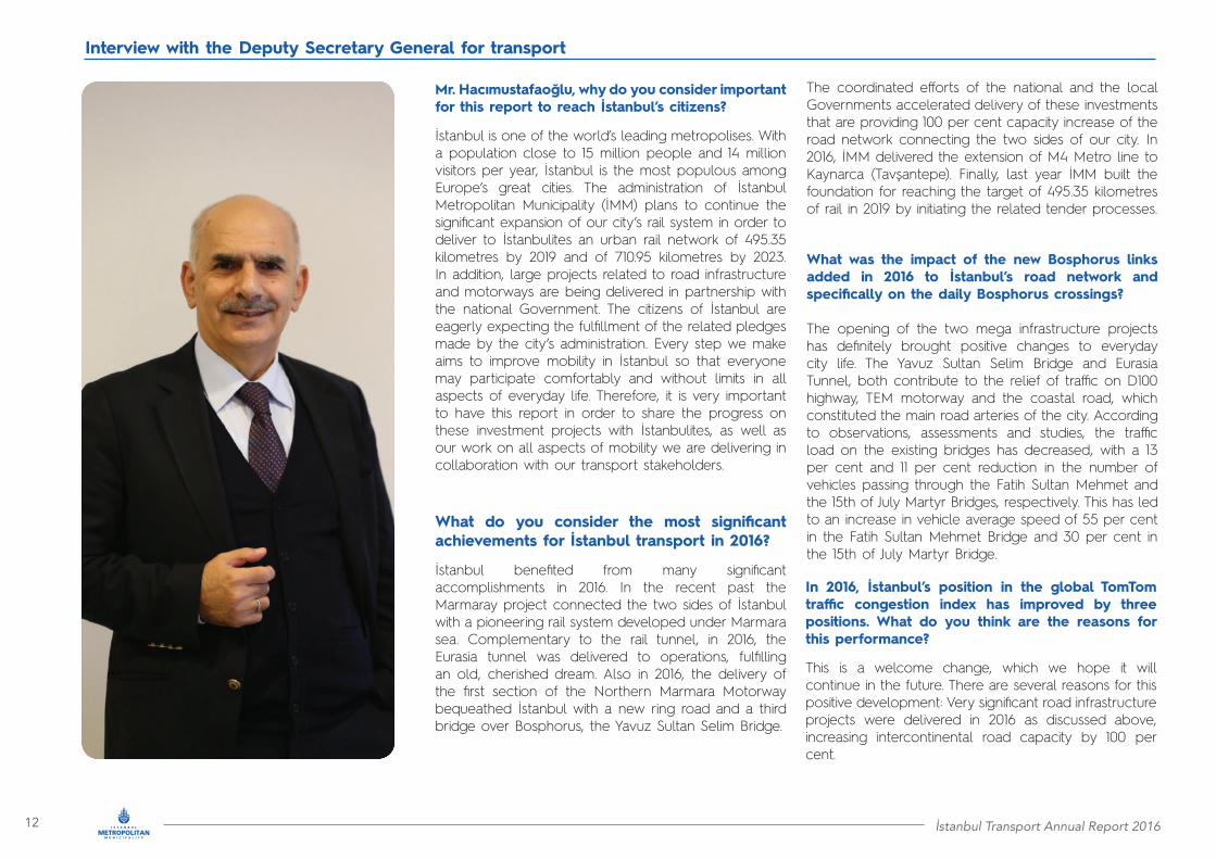
The coordinated efforts of the national and the local Governments accelerated delivery of these investments that are providing 100 per cent capacity increase of the road network connecting the two sides of our city. In 2016, İMM delivered the extension of M4 Metro line to Kaynarca (Tavşantepe). Finally, last year İMM built the foundation for reaching the target of 495.35 kilometres of rail in 2019 by initiating the related tender processes.
What was the impact of the new Bosphorus links added in 2016 to İstanbul’s road network and specifically on the daily Bosphorus crossings?
The opening of the two mega infrastructure projects has definitely brought positive changes to everyday city life. The Yavuz Sultan Selim Bridge and Eurasia Tunnel, both contribute to the relief of traffic on D100 highway, TEM motorway and the coastal road, which constituted the main road arteries of the city. According to observations, assessments and studies, the traffic load on the existing bridges has decreased, with a 13 per cent and 11 per cent reduction in the number of vehicles passing through the Fatih Sultan Mehmet and the 15th of July Martyr Bridges, respectively. This has led to an increase in vehicle average speed of 55 per cent in the Fatih Sultan Mehmet Bridge and 30 per cent in the 15th of July Martyr Bridge.
In 2016, İstanbul’s position in the global TomTom traffic congestion index has improved by three positions. What do you think are the reasons for this performance?
This is a welcome change, which we hope it will continue in the future. There are several reasons for this positive development: Very significant road infrastructure projects were delivered in 2016 as discussed above, increasing intercontinental road capacity by 100 per cent.
Mr. Hacımustafaoğlu, why do you consider important for this report to reach İstanbul’s citizens?
İstanbul is one of the world’s leading metropolises. With a population close to 15 million people and 14 million visitors per year, İstanbul is the most populous among Europe’s great cities. The administration of İstanbul Metropolitan Municipality (İMM) plans to continue the significant expansion of our city’s rail system in order to deliver to İstanbulites an urban rail network of 495.35 kilometres by 2019 and of 710.95 kilometres by 2023. In addition, large projects related to road infrastructure and motorways are being delivered in partnership with the national Government. The citizens of İstanbul are eagerly expecting the fulfillment of the related pledges made by the city’s administration. Every step we make aims to improve mobility in İstanbul so that everyone may participate comfortably and without limits in all aspects of everyday life. Therefore, it is very important to have this report in order to share the progress on these investment projects with İstanbulites, as well as our work on all aspects of mobility we are delivering in collaboration with our transport stakeholders.
What do you consider the most significant achievements for İstanbul transport in 2016?
İstanbul benefited from many significant accomplishments in 2016. In the recent past the Marmaray project connected the two sides of İstanbul with a pioneering rail system developed under Marmara sea. Complementary to the rail tunnel, in 2016, the Eurasia tunnel was delivered to operations, fulfilling an old, cherished dream. Also in 2016, the delivery of the first section of the Northern Marmara Motorway bequeathed İstanbul with a new ring road and a third bridge over Bosphorus, the Yavuz Sultan Selim Bridge.

İstanbul Transport Annual Report 2016 13
Interview with the Deputy Secretary General for transport
In addition, important new rail systems were put in service. Finally, we are continuously working to make our traffic and transport systems more intelligent and provide valuable real time information to our citizens. In partnership with the national Government, we will continue these efforts in 2017 and beyond as outlined in the annual report you have in your hands. We strongly believe that the result will greatly benefit İstanbul’s mobility and the life of our citizens.
İMM intends to overcome these challenges by developing innovative cycling solutions in collaboration with civil society organisations. Already we have delivered over 100 kilometres of cycling ways, and we plan to add 200 kilometres by 2019 with the aim to create an integrated cycling network of more than 1,000 kilometres by 2023. We have also developed İSBIKE, İstanbul’s smart bicycle sharing system, which will be expanded to 1,500 bicycles in 2017 in order to better serve our citizens and visitors.
off peak hours in order to promote trip re-timing to ease peak demand, but at the same time, make public transport more attractive and affordable. We are also testing flexible working hours for large public agencies or corporations. For example İSBAK A.Ş., one of İMM’s affiliated companies, uses a flexible work schedule between 07:30 – 16:30 starting before the morning peak and ending before the evening peak. We are also considering other Travel Demand Management (TDM) options.
On which tasks you are working with stakeholders in order to strengthen security of public transport systems and urban spaces in İstanbul?
All rail systems in İstanbul are equipped with CCTV systems. Security services are also provided to our citizens by special security staff working throughout our public transport network. For example, consider our public bus network, in which we provide our citizens with full security services via real time tracking and security cameras in all buses. In 2017, the CCTV systems will be expanded to taxis, minibuses and dolmuş covering all modes of road-based public transport. In addition, in our newly constructed rail lines, we are providing new safety features, such as automated platform doors. We will continue to expand our efforts in collaboration with all related public and private stakeholders in the area of transport safety and security.
What is your vision for the expansion of the cycling network in İstanbul?
We are investing to establish cycling as a significant mode of transport not only for recreation, but also for trips related to work, school, shopping, or entertainment. This despite the intrinsic challenges cycling faces due to our city’s topography.
Are there any plans/initiatives of İMM to reduce the number of trips taking place at peak times and to divert road users to public transport?
Following up from my previous point, we are now in a position to apply such initiatives, due to the mobility options we are delivering. We are considering establishing a dynamic pricing scheme for public transport, whereby ticket prices will be reduced during
Do you think that a system similar to the congestion charging scheme implemented in London and other cities would have a positive impact on İstanbul mobility?
Congestion charging, or alternative schemes to ease traffic congestion, have always been considered by İMM for certain areas of our city. We believe that we are rapidly fulfilling the prerequisites for implementing such a scheme. This is because our large investments in public transport are being delivered. Thus, İstanbulites from every area of İstanbul may use a high capacity public transport system to reach their place of work, education, entertainment and shopping without using their cars. As a result, a congestion reduction scheme will not impede mobility, but it will enhance it significantly, especially in the city’s central areas where traffic is currently heavier and parking is scarce.
What are your plans for the truck circulation and the daily deliveries in İstanbul?
City logistics contributes significantly to traffic congestion, parking demand, and greenhouse gas (GHG) emissions in every large metropolis. In order to address these issues for İstanbul we are currently investing heavily in both planning and implementation solutions. We are developing a comprehensive Logistics Master Plan in order to fully understand the logistics demand for our city and the generated traffic loads along our highways, major arterials and city streets. Based on this understanding, we will develop our city logistics strategies and the City Logistics Coordination Centre (CLCC). Our strategies will promote full truck loading, establishment of logistics hubs and urban consolidation centres, freight restrictions, late night deliveries, and other measures. CLCC will monitor city logistics and manage unplanned incidents. We firmly believe that with the support of the logistics industry, İstanbul will establish a modern and robust city logistics system and will minimise adverse impacts on city operations and the environment.

14 İstanbul Transport Annual Report 2016
Interview with the Deputy Secretary General for transport
How much do you value citizens’ input in İMM?
The citizens of İstanbul provide their input to all transport-related decisions. Under the national legislation concerning Metropolitan Municipalities, all such decisions are issued by our Transport Coordination Centre (UKOME). During the UKOME proceedings both public and non-governmental organizations can intervene and express their views on the related decisions. İstanbul citizens may also directly communicate their views, recommendations and requests via our Alo153 Beyaz Masa call center service, which is available 24 hours a day.
What are your thoughts for the future state of transport governance in İstanbul?
In striving to improve mobility for İstanbul’s citizens, we in İMM we recognise that streamlining transport governance is a significant weapon. Although we have made great strides towards this end, optimising governance is a continuous process. I will mention two examples. Our Integrated Urban Transportation Master Plan (İUAP) has guided our transport infrastructure plans since its approval in 2011. Due to the dynamic growth of our city and the increasing mobility requirements of our citizens, we are currently updating İUAP to adapt to these changes and better reflect İstanbul’s present transport needs. The updated master plan will be used both to plan and assess future infrastructure developments, as well as to develop initiatives and measures that will benefit İstanbulites’ everyday lives. The second example concerns out ongoing discussions to establish an integrated Public Transport Authority. This Authority will support integration of all our transport stakeholders in order to attain more effective planning, implementation, monitoring and development of mobility solutions for our citizens.
What is the next big thing for İstanbul transport in 2017?
Further to the 196.60 kilometres of rail projects currently under construction in İstanbul, we aspire to start construction of additional 148.70 kilometres in 2017. Thus, considering the existing 150.05 kilometres of the rail network, we will achieve our 2019 target. Also in 2017, İMM will deliver to İstanbulites M5 Metro line Üsküdar – Çekmeköy, which serves three important districts of the Asian side, it is 20 kilometre long and includes 16 stations. In M5 Metro line, we will use fully driverless trains, while all platforms will be equipped with the automated door system providing increased safety. In terms of innovation in passenger experience, in 2017, the smart transport assistant application will be available to our citizens. The system, which will be accessed through the İMM Navi application, will provide multiple services such as public transport journey planning and guidance to nearby parking facilities.
Mr. Hacımustafaoğlu was born in 1955 in Trabzon where he completed his primary and secondary school education. He graduated from the Department of Geophysics Engineering of İstanbul University. He held various managerial positions in the private sector before starting his career in Municipal Government assuming key roles in Bakırköy Municipality. He also served as a Director of Science Affairs in Bağcılar Municipality. Subsequently, he served as a member of the Project Evaluation and Coordination and Monitoring Board of İstanbul Metropolitan Municipality and as Head of İMM’s Transportation Department. He is currently the Deputy Secretary General for Transport.
Muzaffer HACIMUSTAFAOĞLU
Istanbul Metropolitan MunicipalityDeputy Secretary General for Transport

İstanbul Transport Annual Report 2016 15
Interview with the Deputy Secretary General for transport

16 İstanbul Transport Annual Report 2016
Public transport

İstanbul Transport Annual Report 2016 17
Public transport
Our journey along the key mobility events of 2016
1
18 İstanbul Transport Annual Report 2016
Key mobility events of 2016
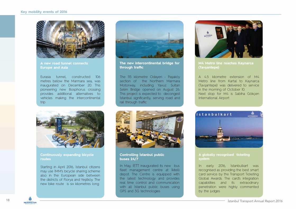
A new road tunnel connects Europe and Asia
Continuously expanding bicycle routes
The new intercontinental bridge for through traffic
Controlling İstanbul public buses 24/7
M4 Metro line reaches Kaynarca (Tavşantepe)
A globally recognised ticketing system
Eurasia tunnel, constructed 106 metres below the Marmara sea, was inaugurated on December 20. This pioneering new Bosphorus crossing provides additional alternatives to vehicles making the intercontinental trip
Starting in April 2016, İstanbul citizens may use İMM’s bicycle sharing scheme also in the European side between the districts of Florya and Yeşilköy. The new bike route is six kilometres long
The 115 kilometre Odayeri - Paşaköy section of the Northern Marmara Motorway, including Yavuz Sultan Selim Bridge opened on August 26. This project is expected to decongest İstanbul significantly, serving road and rail through traffic
In May, İETT inaugurated its new bus fleet management centre at İkitelli depot. The Centre is equipped with the latest technology and provides real time control and communication with all İstanbul public buses using GPS and 3G technologies
A 4.5 kilometre extension of M4 Metro line from Kartal to Kaynarca (Tavşantepe) was delivered to service in the morning of October 10.Next stop for M4 is Sabiha Gökçen International Airport
In early 2016, İstanbulkart was recognised as providing the best smart card service by the Transport Ticketing Global Awards. The card’s integration capabilities and its extraodinary penetration were highly commented by the judges
İstanbul Transport Annual Report 2016 19
Key mobility events of 2016
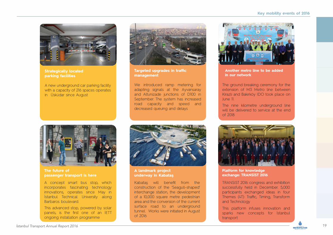
Strategically located parking facilities
Targeted upgrades in traffic management
A landmark projectunderway in Kabataş
Another metro line to be added in our network
Platform for knowledgeexchange: TRANSİST 2016
A new underground car parking facility with a capacity of 216 spaces operates in Üsküdar since August
We introduced ramp metering for adapting signals at the Ayvansaray and Altunizade junctions of D100 in September. The system has increased road capacity and speed and decreased queuing and delays
Kabataş will benefit from the construction of the ‘Seagull–shaped’ interchange station, the development of a 10,000 square metre pedestrian area and the conversion of the current surface road to an underground tunnel. Works were initiated in August of 2016
The ground breaking ceremony for the extension of M3 Metro line between Kirazli and Bakırköy IDO took place on June 11.
The nine kilometre underground line will be delivered to service at the end of 2018
TRANSIST 2016 congress and exhibition successfully held in December. 5,000 participants exchanged ideas in four Themes (4T): Traffic, Timing, Transform and Technology
This platform infuses innovation and sparks new concepts for İstanbul transport
The future ofpassenger transport is here
A concept smart bus stop, which incorporates fascinating technology innovations, operates since May in İstanbul Technical University along Barbaros boulevard.
This advanced stop, powered by solar panels, is the first one of an İETT ongoing installation programme

20 İstanbul Transport Annual Report 2016
Public transport
İstanbul Transport Annual Report 2016 21
Public transport
İstanbul mobility: A city in move
2
22 İstanbul Transport Annual Report 2016
İstanbul: A city on the move
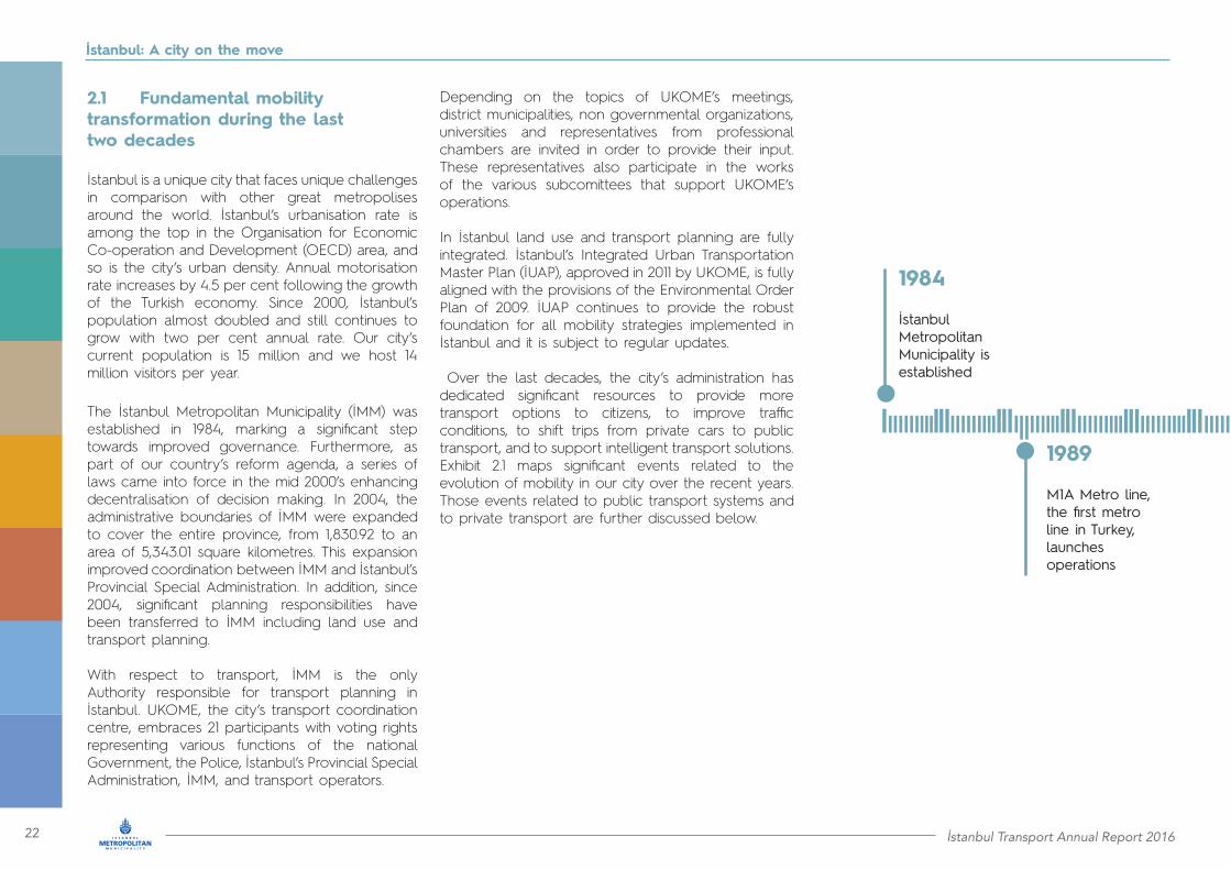
2.1 Fundamental mobility transformation during the last two decades
İstanbul is a unique city that faces unique challenges in comparison with other great metropolises around the world. İstanbul’s urbanisation rate is among the top in the Organisation for Economic Co-operation and Development (OECD) area, and so is the city’s urban density. Annual motorisation rate increases by 4.5 per cent following the growth of the Turkish economy. Since 2000, İstanbul’s population almost doubled and still continues to grow with two per cent annual rate. Our city’s current population is 15 million and we host 14 million visitors per year.
The İstanbul Metropolitan Municipality (İMM) was established in 1984, marking a significant step towards improved governance. Furthermore, as part of our country’s reform agenda, a series of laws came into force in the mid 2000’s enhancing decentralisation of decision making. In 2004, the administrative boundaries of İMM were expanded to cover the entire province, from 1,830.92 to an area of 5,343.01 square kilometres. This expansion improved coordination between İMM and İstanbul’s Provincial Special Administration. In addition, since 2004, significant planning responsibilities have been transferred to İMM including land use and transport planning.
With respect to transport, İMM is the only Authority responsible for transport planning in İstanbul. UKOME, the city’s transport coordination centre, embraces 21 participants with voting rights representing various functions of the national Government, the Police, İstanbul’s Provincial Special Administration, İMM, and transport operators.
Depending on the topics of UKOME’s meetings, district municipalities, non governmental organizations, universities and representatives from professional chambers are invited in order to provide their input. These representatives also participate in the works of the various subcomittees that support UKOME’s operations.
In İstanbul land use and transport planning are fully integrated. İstanbul’s Integrated Urban Transportation Master Plan (İUAP), approved in 2011 by UKOME, is fully aligned with the provisions of the Environmental Order Plan of 2009. İUAP continues to provide the robust foundation for all mobility strategies implemented in İstanbul and it is subject to regular updates.
Over the last decades, the city’s administration has dedicated significant resources to provide more transport options to citizens, to improve traffic conditions, to shift trips from private cars to public transport, and to support intelligent transport solutions. Exhibit 2.1 maps significant events related to the evolution of mobility in our city over the recent years. Those events related to public transport systems and to private transport are further discussed below.
1984
İstanbulMetropolitanMunicipality isestablished
1989
M1A Metro line,the first metroline in Turkey,launches operations

İstanbul Transport Annual Report 2016 23
İstanbul: A city on the move
1992
T1 Tram lineopens to public
2000
M2 Metro lineenters into service
2007
. T2 Tram line opens to public
. Metrobüs system,the first Bus Rapid Transit (BRT) system in Turkey, becomes operational
2004
. IMM boundarias are extended to include the entire province
. İMM becomes the sole Authority responsible for transport planinnigin Istanbul
. İMM’s Traffic Control Centre is established
2009İstanbulkart, a pioneering smart card for fare payment, is introduced
2010
. İstanbul Şehir Hatları A.Ş. becomes an İMM affiliate company. Dolmabahçe - Bomonti road tunnel opens to public
2011
. Integrated Urban Transportation Master Plan (İUAP) is approved by UKOME
. İDO is privastised
. İstanbul Otobüs A.Ş is founded
2016
Two new road Bosphorus crossings, Yavuz Selim Bridge and Eurasia tunnel, are inaugurated
2013
. M1B and M3 Metro lines start operations
. Marmaray line starts operations
. İETT buys 1,705 new buses
2012
. M4 Metro line, the first on the Asian side, opens to public
. Metrobüs reaches its current length of 52 kilometres
2014
. Integration of M1A M1B, M2 and Marmaray lines at Yenikapı

24 İstanbul Transport Annual Report 2016
İstanbul: A city on the move
Our transport strategy gives significant value to integration among transport modes to ensure uninterrupted and comfortable commuting. To this end, the Yenikapi interchange, the largest transfer station in Turkey, currently enables smooth transfers between M1A, M1B, M2 Metro lines and the Marmaray line. This integration was achieved gradually, first with the launch of Marmaray service in 2013, followed by the M2 Metro line extension from Şişhane to Yenikapı in 2014 and subsequently by M1A and M1B sections delivered to service later in the same year. This unprecedented connectivity has led to the increase of the M1 and M2 boardings by 34 per cent and 36 per cent, respectively, and added 190,000 daily Bosphorus crossings by Marmaray.
Among the latest additions to the metro network is the M6 Metro line which opened to the public on April 19, 2015. In October 2016, a 4.5 kilometre long extension of the M4 Metro line to Kaynarca (Tavşantepe) was delivered to service.
The T1 Tram line began operating in 1992 and it is İstanbul’s longest and busiest tram line. It connects the Bağcılar district in the west to the Kabataş district in the east. The second significant tram line is T4, which started operating in 2007 between Şehitlik and Mescid-i Selam. The line reached its current length after commissioning the Edirnekapı – Topkapı phase in 2009. In addition to the T1 and T4 Tram lines, two heritage lines are currently operating in the city, underlying the richness of our transport history. The T2 nostalgic Tram line runs between Taksim and Tünel on the European side and reopened to the public in 1990. On the Asian side, citizens and tourists can have a unique experience of riding the T3 nostalgic Tram line, which reopened on 2003 and runs on a circular route from Kadikoy to Moda.
The Taksim – Kabataş funicular line opened in 2006, while the underground funicular between Karaköy and Beyoğlu (Tünel) operates uninterruptedly since the 19th century.
Key public transport events
One of the top priorities of the city’s administration has always been the development of the rail network. The oldest metro line in İstanbul and in Turkey is M1, which consists of two separate rail services, M1A and M1B, using partially the same infrastructure. The oldest service is M1A, which commenced operations in 1989 between Aksaray and Kocatepe. Since 1989, the line has expanded successively. It reached the Atatürk International Airport in 2002, while the very significant extension to Yenikapi interchange station was inaugurated in November 2014. The M1B service runs on the same track between Yenikapi and Otogar and then it follows the new extension from Esenler to Kirazli, which opened in June 2013.
The M2 Metro line entered into service in 2000. A 3.55 kilometre southern extension of the line from Şişhane to the Yenikapı interchange station, including the metro bridge over Golden Horn and the landmark metro station, opened on February 15, 2014. The M3 Metro line, serving the northwest area of the city, started operations on June 14, 2013. The first metro line on the Asian side is M4, which commenced operations in 2012 between Kadıköy and Kartal.
On October 29, 2013, the 90th anniversary of the Turkish Republic, the most complex part of the new Marmaray line was delivered to operations. The 13.6 kilometre underground system between Kazlıçeşme and Ayrılıkçeşmesi includes the world’s deepest sea immersed tube tunnel (1.4 kilometres) under the Bosphorus. At the same time, the Ayrılık Çeşmesi station was delivered to service enabling passengers to transfer between the M4 Metro line and the Marmaray line.
İstanbul Transport Annual Report 2016 25
İstanbul: A city on the move
In 2007, we delivered the Metrobüs system, Turkey’s first Bus Rapid Transit (BRT) system. Initially service was provided between Avcilar and Topkapi on the European side. In the second phase, we constructed an extension of the system to the east from Topkapı to Zincirlikuyu. The third phase included the expansion of the Metrobüs system to Söğütlüçeşme on the Asian side through the first Bosphorus Bridge. The construction of the fourth phase was completed in 2012. Metrobüs reached Beylikdüzü in the west and its current length is 52 kilometres.
The use of buses for transport in İstanbul dates back to 1926, while the General Directorate of İstanbul Electric Tramway and Tunnel (İETT) was established in 1939. Over the last three decades, significant efforts were made in order to enhance integration, service reach, passenger comfort, and sustainability of operations. In 1985 private buses were permitted to operate public bus routes under the supervision of İETT. In order to support bus operations in Istanbul, İstanbul Otobüs A.Ş. was founded in 2011 as an İMM affiliate company. In 2013, 1,705 new buses were added to the İETT fleet.
Even though the city currently offers multiple options for intercontinental travel, sea transport is still perceived as the most enjoyable way to travel between Europe and Asia. Our sea service operators have a long history of serving everyday commuting of İstanbulites. İDO was founded by İMM in 1987 with the aim to strengthen sea services exclusively provided by TDİ (Turkish Maritime Organisation) until that time. In June 2011, İDO was privatised.
İstanbul Şehir Hatları Turizm San. Tic. A.Ş. (İstanbul Şehir Hatları A.Ş.) is a corporation with a strong brand value in maritime transport that dates back to the 19th century.
In its multiyear presence İstanbul Şehir Hatları A.Ş. changed multiple administrations. In 2005, it was transferred to İDO, while in 2010, it was transformed to an affiliate company of İMM and obtained its current name.
Finally, for the benefit of İstanbulites, İMM invested in an innovative system that utterly changed the way we pay for transport services. On March 23, 2009, we introduced İstanbulkart, a contactless smart card for fare payment on multiple modes of public transport.
Key private transport events
Improving road connectivity in İstanbul forms a significant pillar of our strategy. In this context, we launched the “7 Hills, 7 Tunnels” initiative in 2007, which included the construction of multiple road tunnels across İstanbul. In 2009 we opened the Piyalepaşa – Kağıthane road tunnel and in 2010 the Dolmabahçe – Bomonti tunnel. This initiative progressed further with the official opening of the Sarıyer – Çayırbaşı road tunnel in September 2012.
In 2016, two very significant intercontinental road links were delivered to operations:
• the Eurasia tunnel, a 14.6 kilometre road project that connects Kennedy Street on the European side of İstanbul to the D100 major arterial on the Asian side• a 115 kilometre section of the Northern Marmara Motorway, which includes Yavuz Sultan Selim Bridge over the Bosphorus.
With these two links, we have doubled the capacity for intercontinental trips, thus addressing the most significant bottleneck of our city.
İstanbul has used Intelligent Transport Systems since 2004 for real time traffic management, traffic enforcement and violations management, incident detection, as well as real time provision of information to road users. Traffic cameras and road sensors across the city collect information regarding vehicle speeds, traffic density and queue length, which is processed by sophisticated bespoke applications to adjust timings of traffic signals. In 2004, we also established İstanbul’s Traffic Control Centre which oversees traffic management on a 24x7 basis.
In 2005, İMM established İSPARK in order to chart and deliver the parking strategy of the city by planning and constructing parking facilities in a systematic, integrated way. The city’s parking system has been gradually expanding ever since, reaching in 2016 a total of 452 parking facilities with more than 78,000 vehicle capacity.

26 İstanbul Transport Annual Report 2016
İstanbul: A city on the move
2.2 The future of İstanbul’s mobility shaped by İMM’s strategy
Our consistent aspiration has been to evolve our home, our vibrant mega-city spanning two continents, more than five civilisations and eight millennia, beyond a Eurasian regional hub to a global city. One of the key enablers to achieve this mission is to effectively address the transport challenges of our unique city that include continuing growth of our current population of 15 million, a 100 kilometre long linear topography, the Bosphorus strait that bisects our city’s core, and the steep annual growth of motorisation by 4.5 per cent.
In this last year 2016, İMM has continued responding to these challenges by consistently implementing key elements of our transport strategy (summarised in Exhibit 1.1) approved by UKOME, our all-inclusive transport coordination forum of stakeholders. Our efforts are guided by İstanbul’s Integrated Urban Transportation Master Plan (İUAP) that provides the strong foundation to optimise our strategies, policies and decisions in investments for new transportation infrastructure and systems, as well as for intelligent integration, operations, and demand management. We are constantly driven by our client-centric culture, striving to provide service excellence to our citizens and visitors in a responsible, efficient and sustainable way.
We extend and modernise our public transport network
As a result, by the end of 2016, and with the support of the national Government, we continued the development of İstanbul’s integrated rail system. With the latest addition of 2016, that is the M4 Metro line extension, the rail system, including Marmaray as well as tram, funicular and cable car lines, extends to 150.05 kilometres.
The system “bridges” the two continents and traverses the city’s historical centre with its fragile monuments of world heritage and unearthed archaeological treasures. It is now possible for İstanbul residents of the Asian side to reach workplaces, entertainment spots and cultural landmarks in the European side exclusively by metro. The same holds for a disabled business visitor arriving to Atatürk International Airport in the European side who, using the metro system, is now able to reach her/his meeting in Kadıköy in the Asian side (32 kilometres away) in less than one hour. Currently eight metro lines of 186.50 kilometres total length and a 10.10 kilometre tram line are under construction – an achievement of global scale.
The rail system, which is becoming the pillar of our city’s public transport, is complemented by road-based public transport and our sea transport services, all integrated into a far reaching network.
In 2016, Istanbul’s three public bus operators provided services to 763 routes and 12,500 bus stops using a total fleet of approximately 5,800 buses. The bus network is being integrated with the rail system, by transforming certain routes into rail feeder routes, thus transforming inter-regional trips to local bus trips. In addition to traditional bus, our Metrobüs system operates in an exclusive corridor of 52 kilometres with 44 stations offering rapid, high quality inter-continental services along a substantial part of the city. It also “bridges” the two continents and integrates with rail at several hubs.
İstanbul’s urban landscape also requires flexibility in public transport. This is provided by two very popular systems, both regulated by İMM.
Strategic goals from İstanbul’s Integrated Urban Transportation Master Plan (İUAP)
Exhibit 1.1
Overarching objective
To reduce motorised traffic by investing in the improvement of public transport services thereby promoting a shift in traffic demand from private passenger cars to public transport, and ultimately contributing to upgrading the mobility and accessibility within the city and to the regeneration of a more liveable environment
Particular goals
1. To improve and expand public transport services and thereby reduce dependence on private passenger cars2. To improve and develop the road networks to cope with the growing vehicular traffic in the short term, and to shape and induce appropriate future expansions of the city3. To exploit existing roads efficiently by strengthening traffic regulations and traffic demand management
• Metro/Marmaray: 110 km, 78 stations• Rail network: 105.50 km• Under construction: 8 metro lines and 1 tram line of 196.60 km total
İstanbul Transport Annual Report 2016 27
İstanbul: A city on the move
The minibus system provides such flexible, far reaching services that complement metro, Metrobüs and bus. In 2016, the system operated 426 services, with flexibility in boarding and alighting, using 6,460 vehicles. In addition, the Dolmuş system delivers point-to-point high quality services along 35 routes using 572 vehicles.
Equally fitting to İstanbul’s topography, unique characteristics and needs are the city’s sea transport services, which provide rapid, reliable, high capacity inter-continental services, as well as local services, connecting multiple piers in both the European and Asian sides of the city. These services are integrated with the land-based public transport networks, thus providing multiple mobility options.
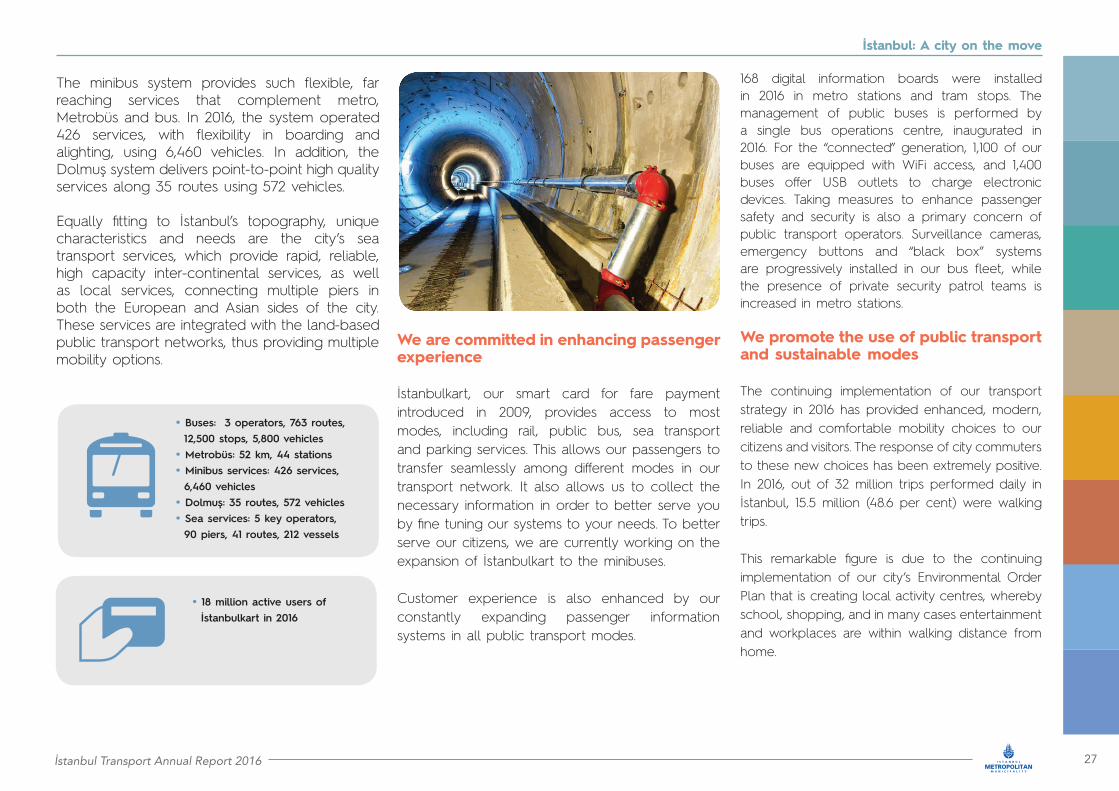
We are committed in enhancing passenger experience
İstanbulkart, our smart card for fare payment introduced in 2009, provides access to most modes, including rail, public bus, sea transport and parking services. This allows our passengers to transfer seamlessly among different modes in our transport network. It also allows us to collect the necessary information in order to better serve you by fine tuning our systems to your needs. To better serve our citizens, we are currently working on the expansion of İstanbulkart to the minibuses.
Customer experience is also enhanced by our constantly expanding passenger information systems in all public transport modes.
168 digital information boards were installed in 2016 in metro stations and tram stops. The management of public buses is performed by a single bus operations centre, inaugurated in 2016. For the “connected” generation, 1,100 of our buses are equipped with WiFi access, and 1,400 buses offer USB outlets to charge electronic devices. Taking measures to enhance passenger safety and security is also a primary concern of public transport operators. Surveillance cameras, emergency buttons and “black box” systems are progressively installed in our bus fleet, while the presence of private security patrol teams is increased in metro stations.
We promote the use of public transport and sustainable modes
The continuing implementation of our transport strategy in 2016 has provided enhanced, modern, reliable and comfortable mobility choices to our citizens and visitors. The response of city commuters to these new choices has been extremely positive. In 2016, out of 32 million trips performed daily in İstanbul, 15.5 million (48.6 per cent) were walking trips.
This remarkable figure is due to the continuing implementation of our city’s Environmental Order Plan that is creating local activity centres, whereby school, shopping, and in many cases entertainment and workplaces are within walking distance from home.
• Buses: 3 operators, 763 routes, 12,500 stops, 5,800 vehicles• Metrobüs: 52 km, 44 stations• Minibus services: 426 services, 6,460 vehicles• Dolmuş: 35 routes, 572 vehicles• Sea services: 5 key operators, 90 piers, 41 routes, 212 vessels
• 18 million active users of İstanbulkart in 2016
28 İstanbul Transport Annual Report 2016
İstanbul: A city on the move
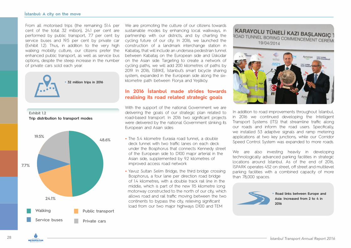
From all motorised trips (the remaining 51.4 per cent of the total 32 million), 24.1 per cent are performed by public transport, 7.7 per cent by service buses and 19.5 per cent by private car (Exhibit 1.2). Thus, in addition to the very high walking mobility culture, our citizens prefer the enhanced public transport, as well as service bus options, despite the steep increase in the number of private cars sold each year.
We are promoting the culture of our citizens towards sustainable modes by enhancing local walkways, in partnership with our districts, and by charting the cycling future of our city. In 2016, we launched the construction of a landmark interchange station in Kabataş, that will include an undersea pedestrian tunnel between Kabataş on the European side and Üsküdar on the Asian side. Targeting to create a network of cycling paths, we will add 200 kilometres of paths by 2019. In 2016, İSBIKE, İstanbul’s smart bicycle sharing system, expanded in the European side along the six-kilometre path between Florya and Yeşilköy.
In 2016 İstanbul made strides towards realising its road related strategic goals
With the support of the national Government we are delivering the goals of our strategic plan related to road-based transport. In 2016 two significant projects were delivered by the national Government slinking its European and Asian sides:
• The 5.4 kilometre Eurasia road tunnel, a double deck tunnel with two traffic lanes on each deck under the Bosphorus that connects Kennedy street of the European side to D100 major arterial in the Asian side, supplemented by 9.2 kilometres of improved access road network
• Yavuz Sultan Selim Bridge, the third bridge crossing Bosphorus, a four lane per direction road bridge of 1.4 kilometres, with a double track rail line in the middle, which is part of the new 115 kilometre long motorway constructed to the north of our city, which allows road and rail traffic moving between the two continents to bypass the city, relieving significant load from our two major highways D100 and TEM
In addition to road improvements throughout İstanbul, in 2016 we continued developing the Intelligent Transport Systems (ITS) that streamline traffic along our roads and inform the road users. Specifically, we installed 53 adaptive signals and ramp metering applications at two key junctions, while our Corridor Speed Control System was expanded to more roads.
We are also investing heavily in developing technologically advanced parking facilities in strategic locations around İstanbul. As of the end of 2016, İSPARK operates 452 on street, off street and multilevel parking facilities with a combined capacity of more than 78,000 spaces.
• 32 million trips in 2016
• Road links between Europe and Asia: Increased from 2 to 4 in 2016
Trip distribution to transport modesExhibit 1.2
48.6%
Walking Public transport
Service buses Private cars
24.1%
7.7%
19.5%
İstanbul Transport Annual Report 2016 29
İstanbul: A city on the move
As a result of our commitment in taking specific measures to improve the traffic situation and despite the continuing steep growth in the number of new private cars in our roads, amounting to 15,800 per month, traffic congestion in İstanbul has levelled off. This is evident from observing the city’s traffic congestion index introduced in 2014, as well as the average real time speed measurements along D100 and TEM. Furthermore, İstanbul dropped from third to sixth place in the TomTom Traffic Index that measures traffic congestion in cities around the world.
Our strategy always aspires to improve transport accessibility and sustainability
Our metro and tram systems are almost entirely accessible, a significant advance over global cities with older systems. However, we are constantly improving accessibility levels of our rail systems by adding appropriate turnstiles, accessible restrooms, audible warning and information systems with embossed surfaces for visually and hearing impaired people.
We continuously improve the accessibility of Metrobüs stations by adding accessible ramps, escalators and elevators. Moreover, we are enhancing the accessibility of sea services by installing suitable turnstiles in piers and upgrading vessels.
Equally important, we have increased disabled parking spaces in parking facilities managed by İSPARK to almost 1,500 spaces across the city. In 2016, 94% of public buses and 31% of minibuses were accessible, while improvements were made to 3,100 bus stops.
To achieve maximum pedestrian accessibility and safety, we are delivering geometrical arrangements, while pedestrian signals with audible information messages are progressively integrated into the signaling system. Thus, commuters with disabilities may now move independently and freely using most of our systems.
In terms of economic sustainability, transport operations are quite efficient. For example, the revenues of the metro and Marmaray systems exceeded operational cost by 23 per cent, requiring zero operational subsidies from İMM or the national Government.
The progressive shift to rail due to our recently delivered systems has a benefit of TRY970 million (USD277 million) annual savings attributed to shorter trip times. Based on our analysis, we avoid 1,050 accidents, including 83 serious injuries, while we save 11 lives per year.
In İMM we are constantly modernising our transport governance
İMM has exclusive responsibility for transport planning, financing and project delivery in İstanbul, while district municipalities are consulted and provide input in the context of UKOME. The national Government may deliver city transport projects of national importance. UKOME integrates 21 functions of the national Government, the Police, İstanbul’s Provincial Special Administration, İMM transport operators, and important professional advocacy groups. UKOME approves all major projects through a process in which representatives of the civil society are invited to express their views. All UKOME decisions are publicly available in http://ulasim.ibb.gov.tr/Ukomekararlari.aspx.
The award winning Beyaz Masa Alo153 municipal service (http://alo153.ibb.gov.tr/) collects and processes citizen feedback and recommendations through multiple channels.
İMM transport has established a special unit of 34 staff, which process critical input from local municipalities, as well as approximately 1,000 citizen annual requests on UKOME decisions within a 15-day response time.
In terms of environmental impact, we have estimated that the modal shift from road and sea based transport to metro has resulted in substantial environmental benefits, including reductions of 175,000 tonnes per year of carbon dioxide equivalent, reduction of noise valued over TRY40.3 million (USD11.5 million) annually, minimisation of land use and landscape protection.The progressive shift to rail due to our recently delivered systems has a benefit of TRY970 million (USD277 million) annual savings attributed to shorter trip times.
• 123% operational cost recovery in metro/Marmaray• 175,000 CO2e tonnes saved per year• TRY970 million per year saved in social costs
• Rail almost entirely accessible • 1,500 disabled parking spaces
of public buses accessible
of minibuses accessible
94% 31%
30 İstanbul Transport Annual Report 2016
Public transport

İstanbul Transport Annual Report 2016 31
Public transport
Public transport
3

32 İstanbul Transport Annual Report 2016
Public transport
3.1 Rail: A modern network expanding day by day
İstanbul’s rail network in 2016
Rail is becoming the core of our city’s public transport system
To effectively address our city’s transport challenges, we are developing a far reaching, integrated rail system based on the strategy clearly validated and articulated in our transportation master plan (Exhibit 3.1). Thus, under the vision “Metro Everywhere” for the year 2023, we are investing heavily in delivering a world class, efficient and safe rail network.
Source: Metro İstanbul A.Ş.
Currently, İstanbul’s metro and tram system includes five Metro lines of total length 95.69 kilometres and two Tram lines of total length 34.6 kilometres (Exhibits 3.2 and 3.3). These systems serve more than 1.6 million trips each day (Exhibit 3.4). In 2016, daily ridership increased by five per cent compared to 2015, adding 74,000 daily trips. As a result, the modal shares of metro and tram have reached 15.2 per cent and 6.1 per cent of all public transport trips, respectively.
Both metro and tram delivered extensive service outputs in 2016, amounting to 57.2 and 12.9 million vehicle kilometres, respectively (Exhibit 3.5).
Tram: • Two lines • 34.6 km • 0.5 million daily trips • 6.1% of public transport trips
Exhibit 3.1
Metro: • Five lines• 95.69 km • 1.16 million daily trips • 15.2% of public transport trips

İstanbul Transport Annual Report 2016 33
Public transport
Metro network in İstanbul
Tram network in İstanbul
KEY FEATURES
KEY FEATURES
Length (km)
Length (km)
26.8
19.3
23.49
15.3
15.9 26.2 3.3 95.69
34.6
26.2 3.3 74.49
-
4 73
170
19
From M2 453144
4.4 9 -
- - 21.20
53
Length – at grade (km)
Number of stops
17.2
31
0.8*
22
3.2
Length – underground (km)
Peak headway (minutes)
9.6
2
22.69
4
12.7
Number of stations
Rolling stock (number of cars)
23
92
16
78
11
Rolling stock (Wagons)
A/C in trains
Accessibility of stops and trams
105 124 80
Signalling system ATP (Fixed Block)
ATP (Moving Block)
ATP (Fixed Block)
All stations except Cumhuriyet are accessible
ATP (Moving Block)
ATP (Moving Block)
-
Peak headway (minutes) 2.5 2.7 5
Air conditioning in stations and vehicles
Passenger information system
Accessibility of stations
M1
T1
M2
T4
M3 M4 M6 Total
Total
* bridge over Golden HornSource: Metro İstanbul A.Ş.
Source: Metro İstanbul A.Ş.
Exhibit 3.2
Exhibit 3.3
34 İstanbul Transport Annual Report 2016
Public transport
Daily ridership and modal share of Metro and Tram (2015-2016)
Exhibit 3.4
2015 2016Source: İMM/Belbim A.Ş.
Service output by the metro and tram systems (2015 – 2016)
Exhibit 3.5
2015 2016
0
10
20
M1 M2 M3 M4
Ann
ual v
ehicle
- k
m (in m
illio
ns)
M6 Total metro
T4
13
57
13
52
T1 Totaltram
30
40
50
60
70
Source: Metro İstanbul A.Ş.
0
500
M1 M2 M3 M4
Daily rides
hip
(in tho
usan
d pa
ssen
gers)
M6 T1 T4 Total
1,000
1,500
2,0001672
1598
2016
0%
5%
Metro Tram Total
2015
Shar
e of
pub
lic tra
nspo
rt trip
s
10%
15%
20%
25%
21.3%20.5%

İstanbul Transport Annual Report 2016 35
Public transport
Average age of metro and tram trains
Customer satisfaction for metro and tram (2016)
Exhibit 3.6
Exhibit 3.7
M1
T1
0
0
5
10
10
20
15 20 25 30
M2
T4
M3
Totaltram
M4
M6
Totalmetro
2016
2016
Metro: Average age of fleet (years)
Tram: Average age of fleet (years)
Source: Metro İstanbul A.Ş.
Source: Metro İstanbul A.Ş.
In 2016, we continued improving our operations and service levels. To assess the results of our efforts, we pay significant attention to the voice of our passengers. Our recent surveys indicate customer satisfaction ratings of about 75 per cent across all lines (Exhibit 3.7). Furthermore, in 2016 we received 27 per cent and six per cent fewer customer complaints regarding metro and tram, respectively, compared to year 2015.
In 2016 our metro system also improved its on-time performance, reaching 99.8 per cent on-time departures. Regarding tram, the corresponding indicator surpassed 98 per cent (Exhibit 3.8) in 2016.
Train reliability also improved. For example, the Mean Distance Between Failures (MDBF) of the tram fleet reached 3,923 and 4,810 kilometres for the T1 and T4 lines, respectively. Finally, in 2016 virtually all planned schedules (over 99.8 per cent in metro and over 98.5 per cent in tram) were operated.
71.0
70.0M1 M2 M3 M4
Cus
tom
er s
atisfa
ctio
n (2
016)
M6 Metroaverage T4
74.574.1
T1 Tramaverage
72.0
73.0
74.0
75.0
76.0
77.0We operate modern trains that offer superior travel experience. Currently the average age of our metro and tram fleet is less than 15 years (Exhibit 3.6). With the exception of M1 Metro line, the average age of the metro fleet is less than ten years.
We are striving to deliver superior services to our passengers
Customer satisfaction about
Metro and tramon-time performance
75% >98%
36 İstanbul Transport Annual Report 2016
Public transport
On-time performance for metro and tramExhibit 3.8
M1
80% 90% 100%
M2
M3
M4
M6
2015
2016
Metro on-time performance (%)
Source: Metro İstanbul A.Ş.
This improved performance is due to key initiatives implemented in 2016
In 2016 we increased the capacity of M3 Metro line by 33 per cent during the morning peak. To do so we are now operating services every five minutes instead of six minutes 40 seconds. In M4 Metro line we modified the configuration of the train sets to achieve 25 per cent higher capacity, post the operation of the M4 extension. In M1 Metro line we increased capacity by about five per cent by reducing the number of seats and creating more comfortable standing space inside vehicles. We also implemented improvements in our control centres. For example, the control centre of M4 Metro line was redesigned.
Tram priority signalling systems are used in both T1 and T4 Tram lines. In T1 Tram line, the signal pre-emption system was installed and commissioned at all intersections. As a result, delays at intersections are reduced and so are travel times.
Even though all metro vehicles and stations are accessible, we are continuously pursuing our goal of universal accessibility. Characteristic examples for 2016 include elevator capacity enhancements, such as at Bayrampaşa station, ramp installation at Emniyet station, accessibility enhancements in two stops of T4 Tram line, and appropriate modifications inside tram vehicles.
T1
T4
İstanbul Transport Annual Report 2016 37
Public transport
Station improvements included a new escalator at Terazidere station, a new overpass at Ataköy station to minimize crowding, and a new overpass and walkway at Davutpaşa station for easy access to Yıldız Technical University. Furthermore, we are currently designing access improvements at certain stations of M2 Metro line. As a result, six new elevators will be installed and 30 elevators will be upgraded in M2 Metro line. Finally, in 2016, we installed 76 new Biletmatik machines at metro stations and 32 at tram stops. Regarding digital information dashboards, 143 have been installed at metro stations and 15 at tram stops.
Our vehicles and stations are more secure than before. This year, CCTV camera numbers reached 800 inside metro vehicles and 3,450 at metro stations. Furthermore, we have installed 92 CCTV cameras in tram vehicles and 346 at tram stops.
Initiatives related to train operations include automating the track switches (points) at our depots, so that they are now operated remotely by the control centre. Furthermore, in promoting energy conservation and sustainability, we installed 18 energy connection feeders to monitor energy consumption, regenerative braking systems, and partially converted lighting to LED in fourout of five metro lines.
In 2016 we stayed on course in expanding our system
In 2016 we delivered the 4.5 kilometre long extension of M4 Metro line to Tavşantepe. With three new stations, the M4 Metro line has reached 19 stations and a total length of 26.2 kilometres. The end-to-end journey time from Kadıköy to Tavşantepe is now 38.5 minutes. This has eased traffic congestion and reduced commute time along the east-west axis of the Asian side, connecting the southern districts and providing easy access to the Pendik district. As a result of the extension, the average daily ridership in M4 Metro line increased by 22,676 passengers.
The ground breaking ceremony for the extension of M3 Metro line between Kirazli and Bakırköy İDO took place on June 11. This nine kilometre underground line will be delivered to service at the end of 2018, and will serve residents of Bağcılar, Bahçelievler and Bakırköy. It is estimated that the extension will reduce travel time between Bağcılar and Bakırköy by ten minutes.
Our first driverless metro service is fast becoming a reality. We already received our first driverless vehicle for the new M5 Metro line. Fully automated driverless trains will be used between Üsküdar and Çekmeköy. This ATP world class rail control system is expected to increase reliability, punctuality and efficiency in our newest line.

38 İstanbul Transport Annual Report 2016
Public transport
Metro is popular among İstanbulites not only for transport
We are making the metro system even more popular among our citizens. In 2016, we started hosting wedding ceremonies at metro stations. Instead of using large wedding halls, couples in İstanbul can now organize their big day at one of the city’s landmark metro stations. In addition to proving an interesting, different experience, our stations provide exceptional views of the historical city. Haliç station in Golden Horn is one of the most popular stations for hosting ceremonies.
In 2017, we will continue to enhance passenger experience
In 2017, our passengers can experience cleaner metro and tram vehicles, since the frequency of vehicle cleaning, both in the interior and exterior, will be enhanced.
To meet the heightened security needs of a global metropolis, we are taking appropriate measures to enhance security at our stations and inside our trains. Metal detector gates will be installed at all station turnstile entry points. The presence of private security patrol teams will be increased. Starting in June 2017, these patrol teams will be armed. Furthermore, the number of private security personnel, currently at 1,271, will be increased to 1,549. Finally, in collaboration with relevant security stakeholders, we are planning to conduct extensive security exercises at rail lines and stations.
In 2017, we will complete the installation of digital information dashboards at metro stations and tram stops. In 2016 we already installed 168 such boards, and after the completion of the project 200 boards will be operational at metro stations and tram stops providing passenger information and guidance, collecting complaints and requests and facilitating passenger surveys.
We are guardians of our living transport history
Our funiculars, cable cars and nostalgic tram lines offer spectacular views and access to unique locations.
The Taksim – Kabataş funicular line, which integrates ferry and rail-based transport, carried more than six million passengers in 2016. The Tünel underground funicular performs a short trip from Karaköy to the historical area of Beyoğlu. Approximately 10.5 million passengers used the two funiculars services in 2016.
We celebrated the National Sovereignty and Children’s Day on April 23 with enthusiasm. Various vehicles were decorated in each line, clowns provided gifts to children, and fun activities, such as face painting, photography, singing, were organised. The happenings involved all lines and attracted crowds of children, parents and tourists.

İstanbul Transport Annual Report 2016 39
Public transport
The T2 and T3 nostalgic Tram lines are highly favoured by our citizens and tourists, who by using them take a trip back in time. The T2 nostalgic Tram line follows a heritage route through İstiklal street from Tünel square to Taksim square on the European side, while T3 line runs in a clockwise direction from Kadıköy square to Bahariye street and Moda street. By preserving these heritage systems in full functionality we pay our respects to the rich transport history of our city. The two nostalgic tram lines transported more than 1.3 million passengers in 2016.
The Maçka Taşkışla cable car line, which connects the Taksim Taşkışla and Maçka districts passing over Democracy Park, relieves road congestion and offers unique panoramic city views. The Eyüp – Piyerloti cable car was designed to conserve the district’s historical fabric and to provide convenient tourist access to Golden Horn’s observation deck, eliminating related transportation and parking problems. Together, the two cable car lines transported more than 1.6 million passengers in 2016 (Exhibits 3.9 and 3.10).
Funiculars, nostalgic trams and cable cars in İstanbul
Ridership of funiculars, nostalgic trams and cable cars
Exhibit 3.9
Exhibit 3.10
Key Features Taksim-Kabataş
T2 line
Funicular Nostalgic tram Cable cars
Karaköy-Beyoğlu
T3 line Maçka-Taşkışla
Eyüp-Piyerloti
Length (m) 640 573 1,700 2,600 300 420
Number of stations 2 2 5 10 2 2
Peak headway (minutes) 5 5 15 10 10 10
Number of vehicles 4 2 5 4 8 8
Source: Metro İstanbul A.Ş./İETT
Source: Metro İstanbul A.Ş./İETT
0
2
4
6
8
10
12
14
16
Funiculars Nostalgic trams Cable cars
2015
2016
Ann
ual rid
eship
(boa
rdings
in m
illio
ns)

40 İstanbul Transport Annual Report 2016
Public transport
3.2 Marmaray: Our train under the sea
A critical integrating rail link
It is now possible for İstanbul residents of the Asian side to reach work, entertainment spots, and cultural landmarks in the European side exclusively by rail. The same holds for a disabled business visitor arriving to Atatürk International Airport in the European side who, using the metro and Marmaray system, is now able to reach her/his meeting in Kadıköy in the Asian side (32 kilometres away) in less than one hour. Marmaray has made this unprecedented connectivity possible.
The Marmaray system, with 13.6 kilometres of its planned 76.3 kilometres already operational, is one of the most complex transport projects globally and includes the world’s deepest sea immersed tube tunnel (1.4 kilometres) under the Bosphorus (Exhibit 3.13). The system uses a total of 54 trainsets of 440 modern vehicles: 20 sets of five vehicles and 34 sets of ten vehicles. The average age of the rolling stock is only four years.
Marmaray operates under metro frequencies (headways) and forms a key part of our integrated public transport network.
With the addition of Marmaray, the rail network “bridges” the two continents connecting the city’s historical centre, important city neighbourhoods and business centres on both sides of the Bosphorus. At the landmark Yenikapi station, Marmaray integrates with M1 and M2 Metro lines. Also in the European side passengers can transfer from Marmaray to the popular T1 Tram line just before the Golden Horn at Sirkeci station. In the Asian side, Marmaray connects to M4 Metro line.
• 13.6 km and five stations today• 76.3 km and 43 stations in 2018 • Integrated with M1, M2, M4, T1 lines• 188,000 daily trips in 2016
Marmaray line characteristics (as of 2016)Exhibit 3.11
Line characteristics Marmaray in 2016
Length (km)
4
13.6
5
1.1
850
M1, M2, T1
M4
Number of stations
Average vehicle kilometres (million)
Annual passenger - km (billion)
Integration with (European side)
Integration with (Asian side)
Average age of fleet
Source: TCDD
İstanbul Transport Annual Report 2016 41
Public transport
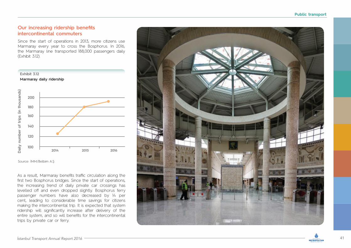
Since the start of operations in 2013, more citizens use Marmaray every year to cross the Bosphorus. In 2016, the Marmaray line transported 188,000 passengers daily (Exhibit 3.12).
As a result, Marmaray benefits traffic circulation along the first two Bosphorus bridges. Since the start of operations, the increasing trend of daily private car crossings has levelled off and even dropped slightly. Bosphorus ferry passenger numbers have also decreased by 14 per cent, leading to considerable time savings for citizens making the intercontinental trip. It is expected that system ridership will significantly increase after delivery of the entire system, and so will benefits for the intercontinental trips by private car or ferry.
Our increasing ridership benefits intercontinental commuters
Marmaray daily ridershipExhibit 3.12
100
120
140
160
180
200
2014 2015 2016Daily n
umbe
r of
trip
s (in
tho
usan
ds)
Source: İMM/Belbim A.Ş

42 İstanbul Transport Annual Report 2016
Public transport
Superior services delivered to our customers
Marmaray delivers fast, efficient and reliable services. The system’s on-time performance for 2016 was higher than 98 per cent and customer complaints were about one per 100,000 boardings, a remarkable testimony of our adherence to quality (Exhibit 3.13).
We listen carefully to the voice of our customers. Passenger communication forms are provided at 15 offices and seven desks. Passengers can also register their views online on the Marmaray website, through social media or through our 24/7 call centre. All passenger feedback is processed immediately, evaluated and answered by the Marmaray Passenger Directorate. Monthly evaluation reports are prepared and shared among the concerned departments to inform them about customer feedback, suggestions and related measures taken.
To inform our customers during their journey, we have installed a state-of-the-art visual and audio Passenger Information System (PIS). Real time information is provided through 60 information screens at stations and 800 screens inside vehicles. In addition to visual information, voice-based passenger information is provided by an automated system or by staff messaging. The automated messaging system is a part of the train operations system and provides station and other important information. Announcements are also made by staff from the station operation centres, by security officers, or by the communications coordinator at the train control centre.
Ensuring accessible and safe commuting
Station design incorporates the most recent accessibility standards. All stations, as well as trains, are accessible. Our staff also supports passengers requiring assistance. Security officers working at station platforms support passengers in need throughout their journey from boarding to alighting station, ensuring safe and comfortable travel.
To ensure passenger safety, 340 officers of the İstanbul Police Department work at our five stations and are assisted by 242 private security officers. To monitor access at entry points we have installed 20 gate magnetometers, we use 40 hand held metal detectors, as well as an X-ray device at the Yenikapi station. All stations are also equipped with cameras, which are monitored on a 24/7 basis by the train control centre at Üsküdar. Passenger security is enhanced by cameras installed in all trains. Each train is equipped with 16 cameras (ten in the interior and six in the exterior), which are monitored by the train driver.
On time performance and quality of serviceExhibit 3.13
Source: TCDD
0% 0
20% 0.5
40% 1
60% 1.5
80% 2
100%
201520162015 2016
Pass
enge
r jo
urne
ys o
n tim
e
Cus
tom
er c
ompl
ains
(per
100
,000
boa
rdings
)
• Customer complaints 1.23 per 100,000 boardings
journeys on time 98.11%
İstanbul Transport Annual Report 2016 43
Public transport
Service resilience despite ongoing expansion works
In 2018 Marmaray will serve a 76.3 kilometre route with 43 stations
Marmaray, the 100-year old dream of Turkey, will be operational along its entire length between Gebze and Halkalı in 2018. In addition to passenger services, the Marmaray line will also support freight services overnight. This will enhance intercontinental freight transport by rail between the Asian and European sides of Turkey.
Other key initiatives, intended to enhance passenger service and sustainability, will soon be completed:
• Installation of platform separator door system: We are planning to install this system at platforms. This will enhance passenger safety and will streamline system operations• Contactless fare payment by credit card at Marmaray turnstiles: With this feature our passengers will be able to use their credit cards as a mode of payment directly at the turnstiles. This will benefit rushing passengers who do not have time to reload their İstanbulkart• Energy savings: We are taking steps to save 15 per cent in high voltage and ten per cent in medium voltage energy. Currently we are implementing training programs to prevent unnecessary energy consumption.
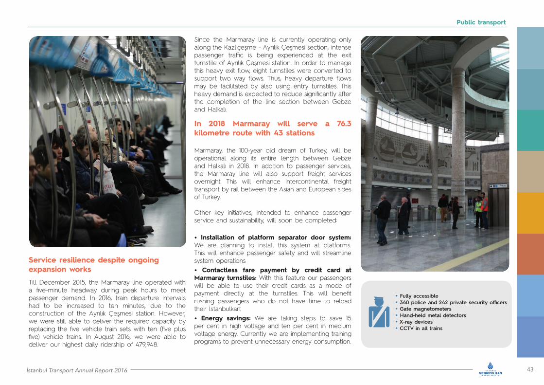
Till December 2015, the Marmaray line operated with a five-minute headway during peak hours to meet passenger demand. In 2016, train departure intervals had to be increased to ten minutes, due to the construction of the Ayrılık Çeşmesi station. However, we were still able to deliver the required capacity by replacing the five vehicle train sets with ten (five plus five) vehicle trains. In August 2016, we were able to deliver our highest daily ridership of 479,948.
Since the Marmaray line is currently operating only along the Kazlıçeşme − Ayrılık Çeşmesi section, intense passenger traffic is being experienced at the exit turnstile of Ayrılık Çeşmesi station. In order to manage this heavy exit flow, eight turnstiles were converted to support two way flows. Thus, heavy departure flows may be facilitated by also using entry turnstiles. This heavy demand is expected to reduce significantly after the completion of the line section between Gebze and Halkalı.
• Fully accessible• 340 police and 242 private security officers• Gate magnetometers• Hand-held metal detectors • X-ray devices • CCTV in all trains
44 İstanbul Transport Annual Report 2016
Public transport
3.3 Metrobüs: A corridor serving more than one million trips per day
Metrobüs is a critical backbone of our public transport system
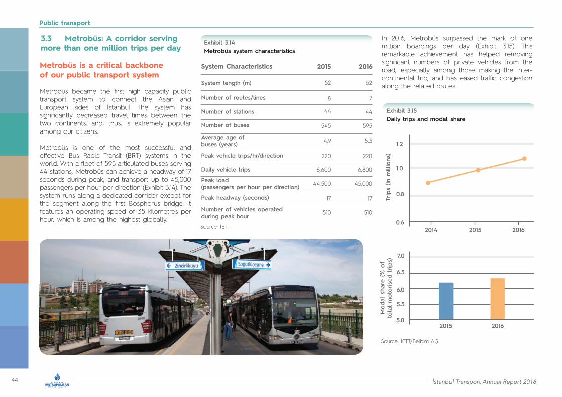
Metrobüs became the first high capacity public transport system to connect the Asian and European sides of İstanbul. The system has significantly decreased travel times between the two continents, and, thus, is extremely popular among our citizens.
Metrobüs is one of the most successful and effective Bus Rapid Transit (BRT) systems in the world. With a fleet of 595 articulated buses serving 44 stations, Metrobüs can achieve a headway of 17 seconds during peak, and transport up to 45,000 passengers per hour per direction (Exhibit 3.14). The system runs along a dedicated corridor except for the segment along the first Bosphorus bridge. It features an operating speed of 35 kilometres per hour, which is among the highest globally.
In 2016, Metrobüs surpassed the mark of one million boardings per day (Exhibit 3.15). This remarkable achievement has helped removing significant numbers of private vehicles from the road, especially among those making the inter-continental trip, and has eased traffic congestion along the related routes.
Metrobüs system characteristics Exhibit 3.14
System Characteristics 2016
System length (m)
Average age of buses (years)
44
6,800
52
5.3
7
220
595
45,000
17
510
2015
44
6,600
52
4.9
8
220
545
44,500
17
510
Number of routes/lines
Peak vehicle trips/hr/direction
Number of buses
Peak headway (seconds)
Number of vehicles operated during peak hour
Number of stations
Peak load (passengers per hour per direction)
Daily vehicle trips
Source: İETT
Daily trips and modal shareExhibit 3.15
Source: İETT/Belbim A.Ş
0.6
0.8
1.0
1.2
2014 2015 2016
Trip
s (in
millio
ns)
5.0
5.5
6.0
6.5
7.0
2015 2016
Mod
al s
hare
(% o
f to
tal m
otor
ised
trip
s)

İstanbul Transport Annual Report 2016 45
Public transport
Accessible, safe and secure
All vehicles of our Metrobüs fleet are low floor and fully accessible. Buses are also equipped with special features for passengers of reduced mobility. For pregnant passengers there are specially designed wide seats. Multiple stations are equipped with elevators and ramps for accessible end-to-end journeys. We are currently working to enhance accessibility at the remaining stations. As an example, in 2016 we improved the access to Sefaköy station by upgrading the pedestrian overpass to meet all accessibility requirements.
We have developed an advanced fleet management system to optimise system operations and enhance incident management. Buses are equipped with advanced technology, such as computer units and LCD screens for driver communications, and GPS. This technology is used by the command and control centre located at Edirnekapı depot to track buses in real time, collect significant data, and communicate with the driver through GPRS. Thus, vehicle performance may be optimised and immediate response may be provided in case of emergencies. The safety and security of passengers is also enhanced by cameras installed in all vehicles.
Continuing our efforts to exploit the most advanced technologies, we have started installing “black box” systems in our buses, similar to the ones used in airplanes. This initiative will reduce accidents, increase road safety, and save fuel. In 2016, we installed the system in 20 buses and we will continue system implementation in 2017.
As part of this effort, we are modernising bus stops with facilities, such as passenger information systems and equipment for charging electronic devices. Furthermore, we regularly train our drivers on the latest technical enhancements of our system. In 2016, we trained 852 drivers and provided special simulation training to 428 drivers.
Metrobüs customer satisfactionExhibit 3.16
60
61
62
63
64
65
66
2015 2016
Cus
tom
er s
atisfa
ctio
n (%
)
Enhancing passenger experience
We are continuously enhancing our system and services to deliver better experience to our passengers. Customer satisfaction has been high and improving (Exhibit 3.16).
46 İstanbul Transport Annual Report 2016
Public transport
İstanbul’s bus system is being constantly modernised. We have a young bus fleet, with average bus age of less than five years. Furthermore, all our buses are equipped with GPS for vehicle tracking and fleet management and with passenger information systems (Exhibit 3.19). For the “connected” generation, 1,100 of our buses are equipped with WiFi access, and 1,400 buses offer USB outlets to charge electronic devices.
We are currently enhancing our capabilities to provide information to our passengers by installing smart bus stops. To-date we have delivered over 1,050 such bus stops, which provide information on the status of the next bus of each service about to arrive at that stop. This allows our passengers to gain certainty on service arrivals and waiting times. We will continue this programme throughout 2017.
The role and architecture of the bus network is constantly evolving to capitalise on the significant ongoing expansion of the rail system. To better serve our passengers we are enhancing the integration of bus with Metrobüs and with the rail network. Bus routes are being restructured to transform metro competing routes to feeder routes. In 2016, 33 new routes were established, nine of which are feeder routes to other high capacity transport systems.
Modal share of public buses (ratio of motorised trips)
5%
4,5%4,5%
5%
7%
7%
Exhibit 3.18
Source: Belbim A.Ş
83%
84%
Modal Share: 2016
İETT İOAŞ ÖHO Other motorised modes
Modal Share: 2015
• 763 bus routes• 5,800 buses• 12,500 bus stops, including 1,050 smart bus stops• 2.6 million daily passengers• 16% share of motorised trips• Buses run by İETT, İOAŞ and ÖHO
3.4 Public buses: Reaching every neighbourhood of our city
Our bus network remains extremely popular among İstanbulites
Our network has traditionally been the principle mode of public transport in İstanbul. This continues to be so, especially in the Asian side, as well as in parts of the metropolitan area that are at a distance from the coastal region. Our network of 9,000 kilometres and 12,500 bus stops reaches every neighbourhood of our city. In 2016 our fleet of 5,800 buses, operating along 763 bus routes, transported about 2.6 million passengers per day (Exhibit 3.17). This translates to a share of about 16 per cent of motorised trips (Exhibit 3.18).
The entire bus network is designed and all operations are planned by İETT in order to safeguard integration, service reach, and service uniformity. Services are delivered by three operators: İETT, İOAŞ and ÖHO. İETT is a public operator, İOAŞ is an affiliate company of İMM, while ÖHO is privately owned.
Ridership of public buses Exhibit 3.17
0.5
1.0
1.5
2.0
2.5
3.0
2014
İETT İOAŞ ÖHO Total
2015 2016
Num
ber of
trip
s (in
millio
ns)
Source: Belbim A.Ş

İstanbul Transport Annual Report 2016 47
Public transport
As part of our efforts to satisfy the requirements of our customers, in 2016 we established two new routes that allow nature lovers to access environmentally rich areas of İstanbul with sustainable public transport. Route D2 links Beşiktaş to Belgrad forest, while route D1 provides access to the scenic wildlife area of Polonezköy.
• All buses with GPS• 1,100 buses with WiFi• 1,140 buses supporting USB charging
Key information of İstanbul’s public bus systemExhibit 3.19
Key features of public bus system 20162015
Number of routes
12,44412,241
763730
9,0948,761
1,050
2,734
100.3
1,050
2,766
95.2
Total length of the network (km)
Number of buses
Average age of fleet
Buses with GPS and passenger information systems
Number of bus stops
Peak headway (seconds)
Annual vehicle - km(million)
İETT
İETT
İOAŞ
İOAŞ
ÖHO
Total
3,034
71.6
3,034
70.1
5,768
100%
4.74
5,800
100%
4.34
345.3Total
Total
345.2
Annual vehicle - km(billion)
4.8
174.9
5.1
178.4
ÖHO
ÖHO
2.42.6İETT
2.62.8İOAŞ
9.810.5Source: İETT

48 İstanbul Transport Annual Report 2016
Public transport
Customer satisfaction and punctuality Exhibit 3.20
Improving passenger experience and safety
We are continuously upgrading our services to enhance passenger experience. As a result, customer satisfaction continued to improve this year (Exhibit 3.20) and customer complaints remained at the low level of 350 per one million boardings.
In 2016, low frequency services with less than four buses an hour, achieved on-time bus stop arrivals (punctuality) of 91 per cent, a slight improvement over 2015. High frequency services achieved on-time performance (reliability) higher than 95 per cent.
Passenger safety and security is our primary concern. All buses are equipped with cameras to monitor activity inside the vehicle. In 2016 we also started installing emergency buttons in our buses. The button acts as a precautionary measure to prevent incidents, and as a tool to assist in incident resolution. When the button is pressed, a signal is sent to the control centre, along with four current camera images that appear live on the centre’s screens. Furthermore, the position of the bus is transmitted via GPS. This rich information assists security to intervene swiftly and appropriately to ensure the safety of all involved.
We also modified our night operations to enhance safety of our female passengers. Since October 2016, female passengers using our buses after 22:00 are now able to stop a bus at any point along its route irrespective of the location of the bus stop. The aim of this service is to minimise walking distance from the stop to final destination, helping our female passengers to feel safer when using the system in these late hours.
0 90
10 90.2
20 90.4
30 90.6
40 90.8
50 91
60 91.2
70 91.4
2015 20152016 2016
Cus
tom
er s
atisfa
ctio
n (%
)
Punc
tual
ity o
f bu
ses
(%)
İETT
İOAŞ
ÖHO
Source: İETT
service punctuality service reliability91% 95%
To keep improving service delivery, we hired 209 new drivers in 2016. We are also training all our drivers on the latest technical enhancements. In 2016 we trained 3,817 bus drivers, and delivered simulation training to 345 drivers. We have also initiated stress management training to reinforce appropriate driver behaviour during stressful situations or during emergency management.

İstanbul Transport Annual Report 2016 49
Public transport
Innovation supports operations and service levels
All innovations introduced recently support operations of our new bus fleet management centre, inaugurated in 2016. We are now in a position to track and manage the entire fleet on a 24/7 basis. Thus, adherence to schedule is monitored and managed by the centre improving service and reliability, drivers are supported by real time communications and incident management is coordinated with security stakeholders.
We are now using “black box” systems in our buses similar to the ones used in airplanes. The black box system records various data related to vehicle operation, vehicle load, trip execution, and driver performance. These data are analysed to produce
This past year we developed our first concept smart stop, as part of a project to be expanded in many parts of our city. These stops go beyond the first generation smart bus stops already being delivered across our network. The concept bus stop is powered by solar panels and includes many innovations, such as LCD/LED-based digital passenger information, automated ticket machines, push-to-talk units, interfaces for charging power wheelchairs and free WiFi service. Passengers waiting at the bus stop are informed about upcoming buses and the estimated time of arrival. The installed push-to-talk units provide instant voice communication with our staff.
As part of our efforts to protect the environment against climate change, we continued enhancing our renewable energy investments. For example, in 2016 we installed a pilot 2.4 kilowatt wind turbine in one of our bus depots. The turbine is expected to produce annually about 6,250 kilowatt-hours of electricity and
• Management of buses through a single operations centre
• Quick and coordinated emergency response
• 24 hours a day, 7 days a week • Direct communication with drivers
reports and indicators that characterise vehicle health, trip execution and load, and driver performance. The outputs of this analysis provide valuable feedback for fine tuning operations, preventing vehicle breakdowns, and strengthening driving skills. Load information may also be made available to passengers through a smartphone application, so that they are informed for the occupancy of an upcoming bus. Finally, “black box” data are utilised in identifying causes of incidents and taking appropriate measures to prevent similar problems in the future. In 2016 we completed the project’s first phase fitting 500 black boxes and providing related training to 700 drivers.
prevent the release of approximately three tons of carbon dioxide. The system will be further supported by six kilowatt solar panels leading to an estimated electricity production of 17,000 kilowatt-hours per year. We are also promoting environmental awareness among our citizens. As an example of the initiatives targeting our younger generation, we launched the “science line” project, which aims to raise student interest in science as well as awareness about environmental technologies, all in a fun and effective way. The project included a specially designed bus visiting primary and secondary schools throughout the city and serving as a miniature science centre.
İstanbul’s public bus system has received international recognition
This year, İETT was the recipient of the bronze award in human resource management by Stevie International Business Awards, a prestigious recognition. After evaluating the best in the field, more than 200 jury members selected the İETT Human Resources and Education Department for their successful training and leadership programme. İETT was also awarded the first prize in the European Union Environmental Awards. Finally İEET was awarded the prestigious 2016 EFQM Excellence Achievement Award in the category “Value added to customers”. The award is given by the European Foundation for Quality Management.

50 İstanbul Transport Annual Report 2016
Public transport
3.5 Minibus, Dolmuş and Taxis: Flexible transport for İstanbul
Minibus and dolmuş transport fits the city’s characteristics
Minibuses and dolmuş form an integral part of İstanbul’s public transport. Due to their flexibility and extended reach, they are very popular among our citizens, carrying 1.7 million passengers daily and serving about 11 per cent of total motorised trips (Exhibit 3.21).
Recognising the importance of minibuses and dolmuş, İMM strives to optimise their networks, and integrate them with our city’s high capacity systems (Exhibit 3.22). The goal is to capitalise on the flexibility of minibuses and dolmuş to complement these trunk systems.
In 2016, four new services with a total length of 85.7 kilometres were added to the minibus network, increasing the total number of services to 426. Five routes were modified to integrate with metro, Marmaray and Metrobüs. Furthermore, a new three-kilometre dolmuş route was established to connect to Marmaray, increasing the total number of dolmuş routes to 35.
Daily ridership and modal share of minibuses and dolmuş (2015 – 2016)Exhibit 3.21
0.0 0%
0.5 5%
1.0 10%
1.5 15%
2.0
Minibuses MinibusesDolmuş Dolmuş
Daily n
umbe
r of
trip
s (in
millio
n)
Mod
al s
hare
(%of
tot
al
mot
orised
trip
s
Source: IMM 2015 20152016 2016
• Minibus and Dolmuş routes integrated with rail and Metrobüs
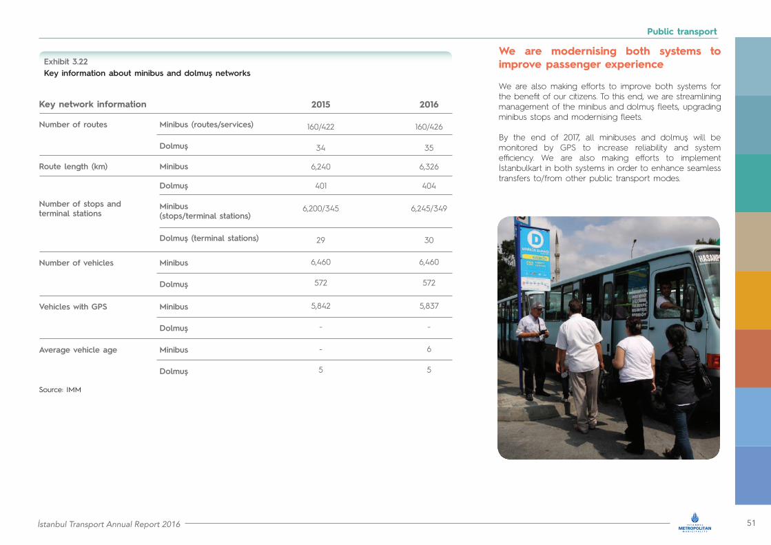
İstanbul Transport Annual Report 2016 51
Public transport
Source: IMM
Key information about minibus and dolmuş networks Exhibit 3.22
Key network information 20162015
Number of routes
Number of vehicles
Vehicles with GPS
Average vehicle age
Minibus (routes/services)
Minibus (stops/terminal stations)
Dolmuş
Dolmuş
Dolmuş
Dolmuş
Dolmuş
Dolmuş (terminal stations)
Minibus
Minibus
Minibus
Minibus
6,3266,240
160/426160/422
3534
404
6,245/349
6,460
5,837
6
572
-
5
30
401
6,200/345
6,460
5,842
-
572
-
5
29
Number of stops and terminal stations
Route length (km)
We are modernising both systems to improve passenger experience
We are also making efforts to improve both systems for the benefit of our citizens. To this end, we are streamlining management of the minibus and dolmuş fleets, upgrading minibus stops and modernising fleets.
By the end of 2017, all minibuses and dolmuş will be monitored by GPS to increase reliability and system efficiency. We are also making efforts to implement İstanbulkart in both systems in order to enhance seamless transfers to/from other public transport modes.

52 İstanbul Transport Annual Report 2016
Public transport
Our improvement efforts will continue in 2017 and beyond
In view of our expanding rail network and the emergence of new technology, we are optimising our routes and are upgrading our systems to deliver safer, reliable, sustainable and more efficient services. Specific plans for the near future include the following:
Control centre for minibuses, dolmuş and taxis: The centre has a total budget of TRY5.7 million and will provide:• Online and efficient fleet management from a single centre, equipped with appropriate software• Online and mobile passenger information system• Route violation warning and reporting system• Integration with public transport assistance system, which includes all modes of public transport
Vehicle tracking system for minibuses, dolmuş and taxis: The system has a total budget of TRY43.6 million and will support the following:
• Expansion of Intelligent Transportation System (ITS) capabilities to minibuses, dolmuş and taxis• Integration with the new control centre• Vehicle tracking and detection of route violations • Promotion of travel safety
Public transportation assistant system:The system has a budget of TRY52.5 million and will support the following:• Integration of minibus, dolmuş and taxis systems (GPS, taximeters, cameras, panic buttons, and electronic payment systems) with web and mobile applications available to passengers• Provision of information to passengers regarding routes, services, real time vehicle location and accessibility• A secure online electronic system that will support matching supply to demand.
• 18,000 taxis to be managed from a single call centre
• All taxis to be equipped with panic button, cameras and GPS
• All taxi stops to be modernised
İMM’s Minibus bus stop project is underway to upgrade minibus stops and terminal stations. The project will provide regulated and rearranged space for minibuses to pick up and drop off passengers, thus preventing interference with traffic operations. Key stops will also be managed by our staff to ensure orderly boarding and alighting procedures. To-date we have delivered 30 such upgraded stops. Furthermore, terminal stations will have additional amenities such as cafeterias, restrooms and enhanced parking spaces. Ten such terminal stations have already been modernised. As part of İMM’s overall plan to ensure sustainability and inclusiveness in public transport, all new minibus vehicles will be low emission (Euro 4 or higher) and accessible.
We are also modernising taxi services
İMM is developing a modern management system for the city’s 18,000 taxis using a single call centre. Passengers will be able to book a taxi pick up from any desired location or nearby taxi stop. In terms of advanced equipment, all taxis will be equipped with panic button, cameras and GPS to ensure safety of passengers and drivers. Project implementation will commence in early 2017.
Taxi stops are being modernised to provide adequate space for taxi pick up and drop off, without infringing upon traffic. Under this project, 50 taxi stops have already been upgraded.
In 2016, polices, such as tax exemptions for taxi procurement, have been fine tuned to encourage taxi operators to upgrade their fleet.

İstanbul Transport Annual Report 2016 53
Public transport
Total
% of public transport trips
90
41
1.4%
212
0.8%
0.5%
0.1%
3.2%
3.6 Sea services: Traditional transport service fitting İstanbul’s unique topography
Crossing seas and transferring İstanbulites
Over a century ago, as İstanbul expanded beyond the historical peninsula along both sides of the Bosphorus, sea transport became indispensable. In fact till 1973, when the first Bosphorus bridge was inaugurated, ferries were the only way to commute between the European and Asian sides of our city.
Even though intercontinental connectivity has vastly expanded today and comprises three bridges, the undersea Marmaray rail tunnel and the recently opened Avrasya road tunnel, sea transport is still a significant mode for making the trip across the Bosphorus. As an integral part of İstanbul’s public transport system, in 2016, sea services delivered about 3.2 per cent of total public transport trips (Exhibit 3.23).
There are multiple operators providing sea services in İstanbul. They use modern vessels that offer superior travel experience. İstanbul Şehir Hatları A.Ş. operates passenger ferryboats with capacities ranging from 600 to 2,100 passengers, İDO operates a combination of sea buses, fast ferries and conventional ferries, while Dentur Avrasya operates vessels of varied sizes. Turyol and Mavi Marmara provide sea services across the Bosphorus, as well as to the Princes’ islands. All operators use and operate dedicated piers for their services (Exhibit 3.24).
Ridership of sea services and share of public transport in İstanbul
Key sea service information for 2016
Exhibit 3.23
Exhibit 3.24
Sea service operator
Sea service elements
2015 2016Number of daily trips
İDO Turyol
Number of daily trips
Dentur Avrasya
% of public transport trips
İstanbul Şehir Hatları A.Ş.
Mavi Marmara
İDO
Piers
İstanbul Şehir Hatları A.Ş.
Routes
29,155*
35 6
27,459*
2
0.4%
41 6
0.4%
123,378
16 2
110,456
1
1.6%
20 2
53,332
53 60
58,907
41
0.7%
28 30
37,079 41,2750.5%
8,497 7,3100.1%
251,441 245,4073.3%
Dentur Avrasya
Vessels
Turyol
Mavi Marmara
Total
*indicates passenger tripsSource: Belbim A.Ş./Operators
Source: Sea service operators
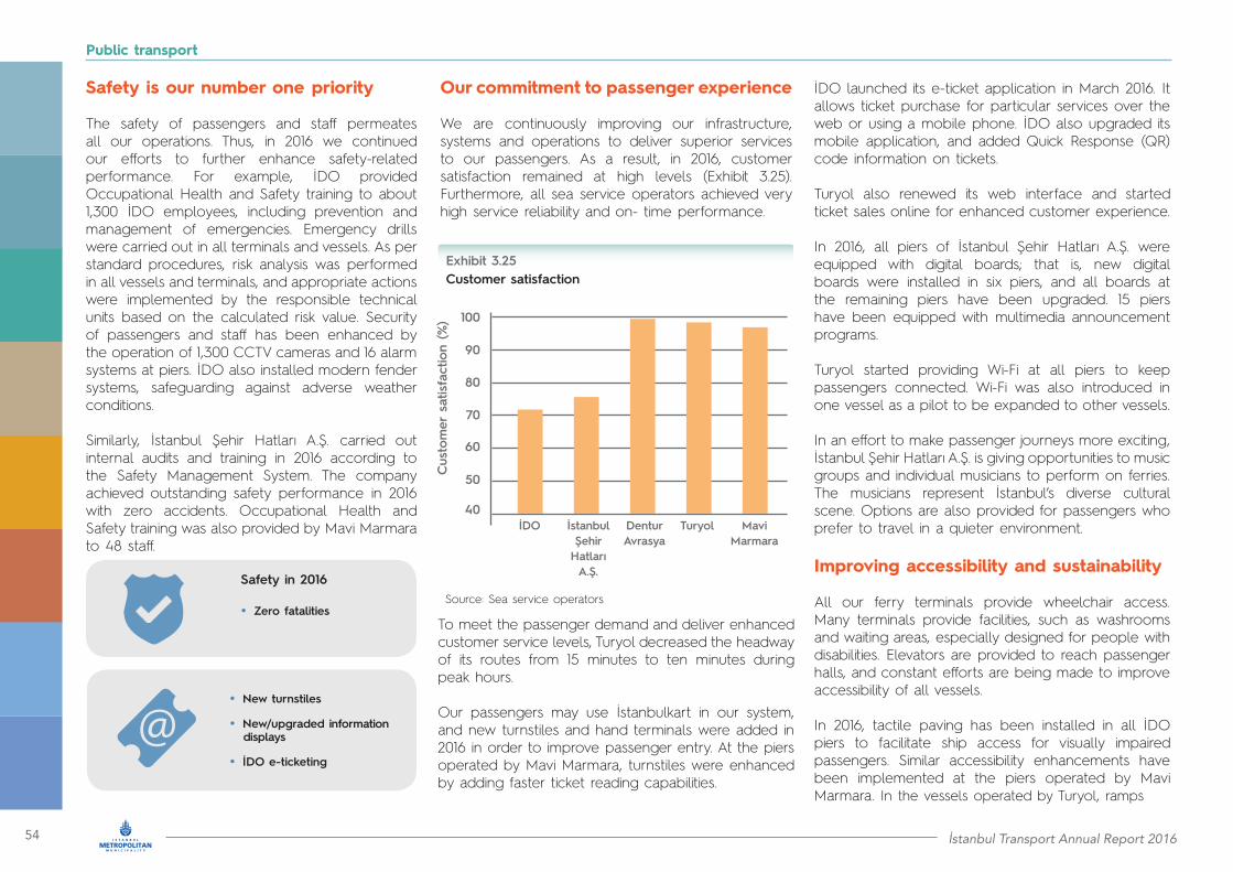
54 İstanbul Transport Annual Report 2016
Public transport
Safety is our number one priority
The safety of passengers and staff permeates all our operations. Thus, in 2016 we continued our efforts to further enhance safety-related performance. For example, İDO provided Occupational Health and Safety training to about 1,300 İDO employees, including prevention and management of emergencies. Emergency drills were carried out in all terminals and vessels. As per standard procedures, risk analysis was performed in all vessels and terminals, and appropriate actions were implemented by the responsible technical units based on the calculated risk value. Security of passengers and staff has been enhanced by the operation of 1,300 CCTV cameras and 16 alarm systems at piers. İDO also installed modern fender systems, safeguarding against adverse weather conditions.
Similarly, İstanbul Şehir Hatları A.Ş. carried out internal audits and training in 2016 according to the Safety Management System. The company achieved outstanding safety performance in 2016 with zero accidents. Occupational Health and Safety training was also provided by Mavi Marmara to 48 staff.
Our commitment to passenger experience
We are continuously improving our infrastructure, systems and operations to deliver superior services to our passengers. As a result, in 2016, customer satisfaction remained at high levels (Exhibit 3.25). Furthermore, all sea service operators achieved very high service reliability and on- time performance.
To meet the passenger demand and deliver enhanced customer service levels, Turyol decreased the headway of its routes from 15 minutes to ten minutes during peak hours.
Our passengers may use İstanbulkart in our system, and new turnstiles and hand terminals were added in 2016 in order to improve passenger entry. At the piers operated by Mavi Marmara, turnstiles were enhanced by adding faster ticket reading capabilities.
İDO launched its e-ticket application in March 2016. It allows ticket purchase for particular services over the web or using a mobile phone. İDO also upgraded its mobile application, and added Quick Response (QR) code information on tickets. Turyol also renewed its web interface and started ticket sales online for enhanced customer experience.
In 2016, all piers of İstanbul Şehir Hatları A.Ş. were equipped with digital boards; that is, new digital boards were installed in six piers, and all boards at the remaining piers have been upgraded. 15 piers have been equipped with multimedia announcement programs.
Turyol started providing Wi-Fi at all piers to keep passengers connected. Wi-Fi was also introduced in one vessel as a pilot to be expanded to other vessels.
In an effort to make passenger journeys more exciting, İstanbul Şehir Hatları A.Ş. is giving opportunities to music groups and individual musicians to perform on ferries. The musicians represent İstanbul’s diverse cultural scene. Options are also provided for passengers who prefer to travel in a quieter environment.
Improving accessibility and sustainability
All our ferry terminals provide wheelchair access. Many terminals provide facilities, such as washrooms and waiting areas, especially designed for people with disabilities. Elevators are provided to reach passenger halls, and constant efforts are being made to improve accessibility of all vessels.
In 2016, tactile paving has been installed in all İDO piers to facilitate ship access for visually impaired passengers. Similar accessibility enhancements have been implemented at the piers operated by Mavi Marmara. In the vessels operated by Turyol, ramps
• Zero fatalities
• New turnstiles
• New/upgraded information displays
• İDO e-ticketing
Safety in 2016
Customer satisfactionExhibit 3.25
40
50
60
70
80
90
100
Cus
tom
er s
atisfa
ctio
n (%
)
Source: Sea service operators
İDO TuryolDentur Avrasya
İstanbul Şehir Hatları A.Ş.
Mavi Marmara

İstanbul Transport Annual Report 2016 55
Public transport
have been installed to ensure safe passenger access. İstanbul Şehir Hatları A.Ş. upgraded the entrances to eight piers by widening the gate areas. Furthermore these piers have been equipped with wheel chairs. The new generation of passenger ferries offer access ramps, flat surface properties, wide corridors, and special amenities for our disabled passengers. Thus, disabled passengers may travel without requiring assistance.
In terms of environmental sustainability, we are striving to preserve the ecosystem of Bosphorus and Marmara sea, which is home to numerous marine flora and fauna, as well as an ecological tunnel that regulates two-way passage of marine organisms between the Mediterranean and the Black seas.
For limiting greenhouse gas emissions, in 2016 lighting at piers operated by İDO was upgraded to LED, leading to savings of up to 900,000 kilowatt-hours annually. Lights were also replaced in multiple ships for energy savings. Fuel efficiency was improved in İDO vessels by adopting special ship paint technology that reduces friction drag between hull and water.
Progress was also made in improving waste management. The industrial waste management plan of İDO has been approved, and temporary waste storage area permits were obtained for the piers at Yenikapı, Sirkeci, Bostancı and Eskihisar. Additional measures will be taken to limit water waste. It has been planned to install electronic on-line meters in the vessels operated İDO. The meters will be able to record the discharge of dirty water (from sink, shower and toilets) which will help managing waste water.
Enhancing infrastructure, services and systems
We are continuously improving our infrastructure and services to meet passenger demand, and to be future ready. In 2016, İMM started developing the state of the art “seagull shaped” transfer centre at Kabataş terminal. The upgraded hub will integrate sea, road and rail transport. In order to ensure uninterrupted pedestrian access along the coast, traffic will use a new road tunnel to be constructed under the terminal area. The project will also connect Kabataş in the European side to Üsküdar in the Asian side with an underwater pedestrian and bicycle tunnel. During the construction period, the Kabataş terminal will remain closed to sea traffic, and operation continuity is ensured by temporarily transferring services to other piers. In addition, İDO started operating the Beşiktaş − Bostancı service and increased the frequency of the Harem − Sirkeci service.
Our sea services use state of the art management systems to improve performance and to deliver world class services. İDO and Mavi Marmara field teams are able to access back office systems, such as Enterprise Resource Planning (ERP) and Customer Relationship Management (CRM) software, from inside the vessels through mobile devices. All processes of İstanbul Şehir Hatlari A.Ş. were re-engineered in 2016 and a process management system has been developed to measure and improve performance.
İDO’s 2015 Annual Report received the silver award by Stevie International Business Awards. İDO was also awarded a platinum, a gold and a bronze award at the 2015 Vision Awards organized by the League of American Communications Professionals (LACP).
Renovation works of the Pendik and Avşa terminals will be completed before the summer of 2017.
Fleet upgrades include the addition of three new car ferries by İstanbul Şehir Hatları A.Ş. and three new vessels by Mavi Marmara, while İDO intends to retire one vessel and sell three. İstanbul Şehir Hatları A.Ş. plans for fully accessible vessels in 2017.
In the area of passenger experience, İDO will start using a new system in 2017 that will support quick and easy online ticketing, streamlining access to information, segmenting of customers and creating new campaigns based on their needs. Mavi Marmara also plans to use a similar system.
Additional biletmatik machines will be installed at the piers of both İDO and İstanbul Şehir Hatları A.Ş., while the mobile phone application of both companies will also improve.
• Savings 900,000 kWh annually by LED
We will continue to improve in 2017
In 2017, İstanbul Şehir Hatları A.Ş. plans to offer a new car ferry service between Çubuklu and İstinye with peak headway of 30 minutes. This service will provide an alternative to using the second Bosphorus bridge and is expected to reduce annual crossings by about 540,000 vehicles carrying over one million passengers.

56 İstanbul Transport Annual Report 2016
Public transport
İstanbul Transport Annual Report 2016 57
Public transport
Private transport
4

58 İstanbul Transport Annual Report 2016
Private transport
4.1 Road network:Bold developments in 2016
Road improvement and network expansion enhances the city’s mobility
Road infrastructure represents a fundamental piece of the mobility puzzle, especially in our city where motorisation rate is rapidly growing. Recognising this, we use our expertise and technological advancements to continuously improve İstanbul’s road network, promote integration, and expand its reach. We aim to enhance road safety, road capacity and connectivity in order to streamline traffic flows throughout the city. To this end, breakthrough projects were delivered in 2016.
Opening of Odayeri – Paşaköy section of Northern Marmara Motorway, including third Bosphorus bridge
On August 26, 2016 the first and most significant section of the Northern Marmara Motorway, was inaugurated. This section features a 115 kilometre long motorway with four lanes per direction, 35 viaducts, 20 intersections and two tunnels. It was completed under the responsibility of the General Directorate of Highways (KGM) within a record breaking time period of 27 months, with a budget of TRY4.4 billion.
Its most impressive part is Yavuz Sultan Selim Bridge, the third bridge crossing Bosphorus. It was named after Selim I, the 16th century sultan known for his success in the expansion of the Ottoman Empire. The Yavuz Sultan Selim Bridge is the world’s widest suspension bridge with a width of 59 metres that consists of eight traffic lanes and two railway tracks running along its middle. The length of the bridge over Bosphorus is 1,408 metres, which makes the Yavuz Sultan Selim Bridge the longest railway suspension bridge in the world. The rail running through the bridge is part of the route from Edirne to İzmit, which will be integrated with İstanbul’s metro system and with future extensions of Marmaray line. The rail will connect to İstanbul’s new airport, currently under construction, as well as to Sabiha Gökçe International Airport.
The towers of Yavuz Sultan Selim Bridge reach impressive heights of 322 metres at the village of Garipçe on the European side and 318 metres in the Poyrazköy district of the Asian side. With these engineering achievements, the third Bosphorus bridge is considered as the highest suspension bridge in the world.
The third Bosphorus bridge with its dynamic design is one of the symbols of the modern Turkey. The Northern Marmara Motorway project includes two additional sections of 248 kilometres of motorways in Europe and Asia, expected to be delivered to operations by 2020. The Northern Marmara Motorway section, that operates since August 2016, has already contributed in the reduction of traffic in İstanbul, easing congestion significantly especially along the critical TEM and D100 motorways. It also allows moving between Europe and Asia uninterruptedly through the connection roads of Odayeri to İkitelli and Paşaköy to Çamlik. With an
estimated number of 135,000 vehicles per day, including trucks and heavy-duty vehicles, the project will also be beneficial in terms of time, fuel and emission savings. When fully completed, it will reduce significantly the travel time to the neighbouring cities.
The first section of the Northern Marmara Motorway had also significant employment benefits, since it created job opportunities for 6,500 construction workers and engineers.
• 115 km of a 4-lane per direction motorway completed
• Highest suspension bridge in the world
• 1,408 metres long bridge with 8 traffic lanes and 2 rail tracks

İstanbul Transport Annual Report 2016 59
Private transport
The Eurasia Tunnel, a unique engineering achievement under the Bosphorus
The Ministry of Transportation, Maritime Affairs and Communications in partnership with the General Directorate of Infrastructure Investments commissioned Eurasia Tunnel Operation Construction and Investments Incorporation (ATAŞ) to build and operate for 25 years and 28 days the Eurasia road tunnel. The project construction was initiated in February 2011. The project was inaugurated on December 20, 2016 and currently operates on a 24/7 basis.
The Eurasia tunnel connects İstanbul’s Asian and European sides via the first road tunnel under the bottom of the Bosphorus strait.
The entire project connects Kennedy Street on the European side of İstanbul to the D-100 major arterial on the Asian side, has a total length of 14.6 kilometres, and consisted of three sections:
• The first section concerned the European side road widening. It includes four U-turns (two of them as interchanges and the other two at grade) and four pedestrian crossings as overpasses along the part of Kennedy Street that stretches between Kazlıçeşme and Sarayburnu. It is a 5.4 kilometre section with traffic lanes varying from 3×2 to 2x4.
• The second section represents the actual Bosphorus crossing. It consists of a 5.4 kilometre double-deck tunnel with two traffic lanes on each deck. The excavated diameter of the tunnel is 13.7 metres with an inner diameter of 12 metres. The tunnel’s lowest depth under sea level is 106 metres, while its maximum depth below the seabed is 61 metres. This section also includes an Operation and Maintenance building on one side and toll plazas on both entrances of the tunnel.
• The third section is related to the Asian side road widening. The road widens from 2x3 and 2x4 lanes to 2x4 and 2x5 lanes along a stretch of approximately 3.8 kilometres of D100. It included the construction of two interchanges, one bridge expansion and one pedestrian bridge.
The first and the third sections of the project have been transferred for traffic management to İMM upon project completion.
With an investment of USD1.3 billion, Eurasia road tunnel is the first double-deck highway tunnel under the sea in that depth globally. Its 13.7 metre diameter makes it the sixth widest tunnel worldwide.
• First road tunnel under Bosphorus
• Sixth widest tunnel in the world
• 14.6 km of interventions, including a 5.4 km double deck road tunnel

60 İstanbul Transport Annual Report 2016
Private transport
Ensuring maximum passenger safety, the tunnel is designed to withstand earthquakes up to 7.25 of the moment magnitude scale. Furthermore, we have created protected emergency rooms every 200 metres, to provide shelter for the elderly and disabled, as well as escape routes between tunnel levels. Emergency phones have been installed every 65 metres, while internet and mobile connection inside the tunnel is preserved. The speed limit in the tunnel is set at 70 kilometres per hour. In order to prevent traffic bottlenecks, the tolls are collected solely via automatic systems, without option for cash payments. The initial traffic flow is expected to be around 80,000 vehicles a day. This number is expected to increase reaching the tunnel’s maximum capacity of 130,000 vehicles per day by 2023.
The Eurasia road tunnel is one of the most important transport related investments in our city, and, together with the Yavuz Sultan Selim Bridge, is expected to significantly reduce traffic congestion along the other two İstanbul bridges, providing additional options for intercontinental travel. Specifically, the project reduces the travel time between Zeytinburnu on the European side to Göztepe on the Asian side to 15 minutes, saving about 52 million hours of travel time per year for İstanbulites. The impact on fuel and emission savings is also very significant. It is estimated that total fuel savings will amount to TRY180 million per year, while emissions will reduce by approximately 82,000 tons per year.
Critical road development and maintenance activities also performed in 2016
2016 was another year of extensive road construction and maintenance works. Exhibit 4.1 provides an overview of delivered works. More specifically, we completed construction and upgrade projects for intersections at several locations, such as the 7.6 kilometre intervention in the intersection of Yarımburgaz and Halkalı streets in Küçükçekmece. To ease congestion we also developed interchanges, such as the access roads and the bridge to TEM in Metris at the border of Esenler with Gaziosmanpaşa. We also delivered several bridge projects that improve connectivity in certain areas across İstanbul.
To enhance safety for İstanbulites, we improved or developed new pedestrian overpasses, such as the one over D100 for Merter – Zeytinburnu, or in metrobüs and tram stations in order to maximize accessibility for public transport. We also delivered works in other areas including street rehabilitation, retainer wall construction, landslide mitigation, geometric arrangements and road improvements necessary for more efficient traffic movement across our city. Our efforts in this aspect will continue in 2017, with the goal to support surface transport mobility of our citizens and visitors.
On September 19, 2016, we reopened to traffic the Beylerbeyi Palace tunnel in Üsküdar. The tunnel, originally built between 1829 – 1832 operated as a museum and exhibition hall since the 1970s. It now serves as a road tunnel again, connecting Üsküdar with Beylerbeyi coastal road, adding about 650 metres in the local road network. İMM managed to maintain the original texture of the tunnel during the installation of lighting, energy and video surveillance systems. The 150 metre long and 2.90 metre high tunnel works in the direction of Üsküdar to Beykoz between 06:00 to 16:00 and in the opposite direction from 16:00 to 06:00.

İstanbul Transport Annual Report 2016 61
Private transport
Synopsis of road works delivered in 2016Exhibit 4.1
Location Length (in km)
Surface (in m2)
Wall(in m2)
Type of project
European side
Asian side
Intersections and interchanges
Other projects
Bridge projects
Intersections and interchanges
Pedestrian overpasses
Improvement of road connectivity
Pedestrian overpasses
Bridge projects
Improvement of road connectivity
Other projects
Source: İMM
13.54
1.99
4,159.82
1,478.00
7,075.89
13,837.89
10.78
12.85
1.22
5,827.96
3,011.25
not applicable
9,012.68
7,827.03
8,247.80
not applicable
30.90
not applicable
5.29
Total
0.75
77.32
264.00
2,471.17
not applicable
2,277.00
4,089.16
23,578.36
29,237.00
14,281.31
2,375.80
751.00
not applicable
92,646.40
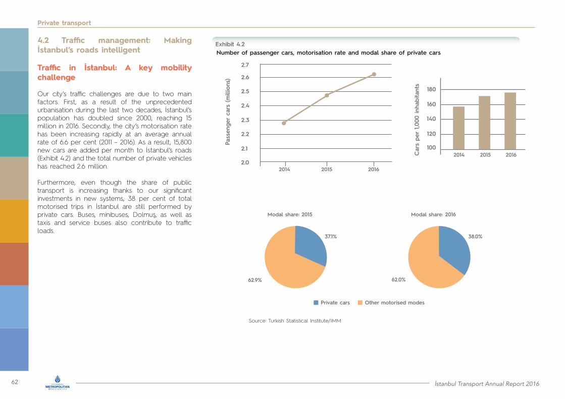
62 İstanbul Transport Annual Report 2016
4.2 Traffic management: Making İstanbul’s roads intelligent
Traffic in İstanbul: A key mobility challenge
Our city’s traffic challenges are due to two main factors. First, as a result of the unprecedented urbanisation during the last two decades, İstanbul’s population has doubled since 2000, reaching 15 million in 2016. Secondly, the city’s motorisation rate has been increasing rapidly at an average annual rate of 6.6 per cent (2011 – 2016). As a result, 15,800 new cars are added per month to İstanbul’s roads (Exhibit 4.2) and the total number of private vehicles has reached 2.6 million.
Furthermore, even though the share of public transport is increasing thanks to our significant investments in new systems, 38 per cent of total motorised trips in İstanbul are still performed by private cars. Buses, minibuses, Dolmuş, as well as taxis and service buses also contribute to traffic loads.
Private transport
2014
Number of passenger cars, motorisation rate and modal share of private carsExhibit 4.2
2.0
2.1
2.2
2.3
2.4
2.5
2.6
2.7
2015 2016
Pass
enge
r ca
rs (m
illio
ns)
100
120
140
160
180
Car
s pe
r 1,0
00 in
habi
tant
s
2014 20162015
62.9%
Private cars Other motorised modes
62.0%
37.1% 38.0%
Modal share: 2015 Modal share: 2016
Source: Turkish Statistical Institute/İMM

İstanbul Transport Annual Report 2016 63
Private transport
İMM is striving to improve traffic congestion
İMM uses three strategies to address the city’s traffic challenges. First, we invest heavily to enhance public transport systems and increase ridership. Secondly, we invest in road infrastructure. Thirdly, we exploit best practices in innovative traffic management. These strategies have started paying off. Specifically, in 2016 the vehicle average traffic index measured by İMM’s Traffic Directorate remained steady at the 2015 level (Exhibit 4.3). İMM uses its traffic index to assess traffic congestion based on actual speed measurements along İstanbul’s highways/motorways.
Furthermore, the average traffic speed along the city’s highways and motorways improved slightly to 67 kilometres per hour in 2016. The observed plateau in congestion has also been validated by international sources.
The 2016 results of TomTom Traffic Index (https://www.tomtom.com/en_gb/trafficindex/), which measures traffic congestion in cities around the world, indicate that congestion in İstanbul decreased by one per cent in 2016 compared to 2015. Thus, İstanbul dropped three positions in the TomTom Traffic Index: from third in the ranking of most congested cities globally in 2015 to sixth in 2016.
• Traffic index remained steady
• Average traffic speed increased
• Traffic congestion slightly decreased
Traffic index and average speed (2015 and 2016)Exhibit 4.3
Source: IMM
0
5
10
15
20
25
30
35
2015 2016
Traffi
c İn
dex
(%)
40
50
60
70
2015 2016
Ave
rage
tra
ffic
spee
d (k
m/h
)
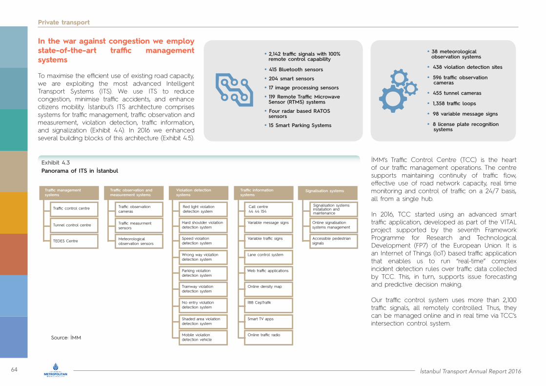
64 İstanbul Transport Annual Report 2016
Private transport
Source: İMM
In the war against congestion we employ state-of-the-art traffic management systems
To maximise the efficient use of existing road capacity, we are exploiting the most advanced Intelligent Transport Systems (ITS). We use ITS to reduce congestion, minimise traffic accidents, and enhance citizens mobility. İstanbul’s ITS architecture comprises systems for traffic management, traffic observation and measurement, violation detection, traffic information, and signalization (Exhibit 4.4). In 2016 we enhanced several building blocks of this architecture (Exhibit 4.5).
İMM’s Traffic Control Centre (TCC) is the heart of our traffic management operations. The centre supports maintaining continuity of traffic flow, effective use of road network capacity, real time monitoring and control of traffic on a 24/7 basis, all from a single hub.
In 2016, TCC started using an advanced smart traffic application, developed as part of the VITAL project supported by the seventh Framework Programme for Research and Technological Development (FP7) of the European Union. It is an Internet of Things (IoT) based traffic application that enables us to run “real-time” complex incident detection rules over traffic data collected by TCC. This, in turn, supports issue forecasting and predictive decision making.
Our traffic control system uses more than 2,100 traffic signals, all remotely controlled. Thus, they can be managed online and in real time via TCC’s intersection control system.
• 2,142 traffic signals with 100% remote control capability
• 415 Bluetooth sensors
• 204 smart sensors
• 17 image processing sensors
• 119 Remote Traffic Microwave Sensor (RTMS) systems
• Four radar based RATOS sensors
• 15 Smart Parking Systems
• 38 meteorological observation systems
• 438 violation detection sites
• 596 traffic observation cameras
• 455 tunnel cameras
• 1,358 traffic loops
• 98 variable message signs
• 8 license plate recognition systems
Panorama of ITS in İstanbulExhibit 4.3
Traffic management systems
Traffic observation andmeasurement systems
Violation detectionsystems
Traffic informationsystems
Signalisation systems
Traffic control centre Traffic observationcameras
Red light violationdetection system
Call centre44 44 154
Signalisation systemsinstallation and maintenance
Hard shoulder violationdetection system
Variable message signs Online signalisationsystems management
Speed violation detection system
Variable traffic signs Accessible pedestriansignals
Wrong way violationdetection system
Lane control system
Parking violation detection system
Web traffic applications
Tramway violationdetection system
Online density map
No entry violationdetection system
İBB CepTrafik
Shaded area violationdetection system
Smart TV apps
Mobile violationdetection vehicle
Online traffic radio
Traffic measurment sensors
Meteorologicalobservation sensors
Tunnel control centre
TEDES Centre
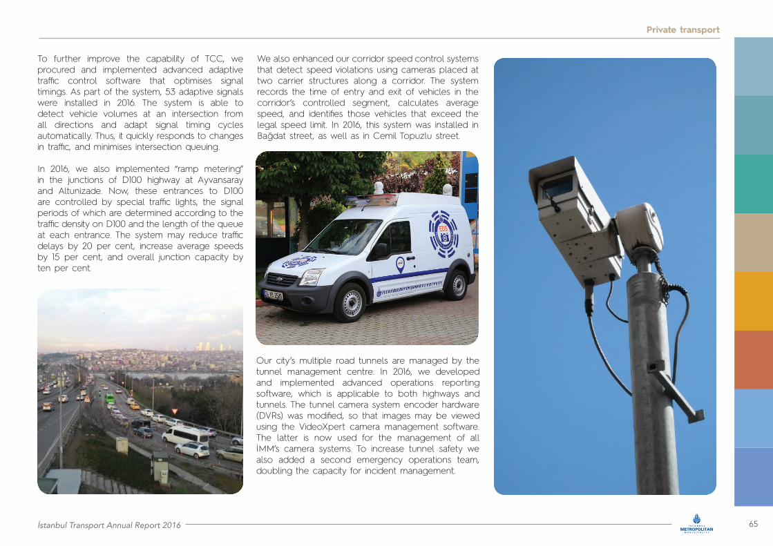
İstanbul Transport Annual Report 2016 65
Private transport
To further improve the capability of TCC, we procured and implemented advanced adaptive traffic control software that optimises signal timings. As part of the system, 53 adaptive signals were installed in 2016. The system is able to detect vehicle volumes at an intersection from all directions and adapt signal timing cycles automatically. Thus, it quickly responds to changes in traffic, and minimises intersection queuing.
In 2016, we also implemented “ramp metering” in the junctions of D100 highway at Ayvansaray and Altunizade. Now, these entrances to D100 are controlled by special traffic lights, the signal periods of which are determined according to the traffic density on D100 and the length of the queue at each entrance. The system may reduce traffic delays by 20 per cent, increase average speeds by 15 per cent, and overall junction capacity by ten per cent.
We also enhanced our corridor speed control systems that detect speed violations using cameras placed at two carrier structures along a corridor. The system records the time of entry and exit of vehicles in the corridor’s controlled segment, calculates average speed, and identifies those vehicles that exceed the legal speed limit. In 2016, this system was installed in Bağdat street, as well as in Cemil Topuzlu street.
Our city’s multiple road tunnels are managed by the tunnel management centre. In 2016, we developed and implemented advanced operations reporting software, which is applicable to both highways and tunnels. The tunnel camera system encoder hardware (DVRs) was modified, so that images may be viewed using the VideoXpert camera management software. The latter is now used for the management of all İMM’s camera systems. To increase tunnel safety we also added a second emergency operations team, doubling the capacity for incident management.

66 İstanbul Transport Annual Report 2016
Private transport
Timely and accurate driver information is valuable in managing demand
We use multiple channels and the latest technology to inform our citizens about the state of traffic in real time and about certain significant events and/or issues that affect traffic. The information channels include:• Online density map (Exhibit 4.6)• “İBB CepTrafik” mobile application• “İBB Radyo” mobile application• Web traffic applications• Call Center 44 44 154• Variable message signs• Travel time signs• Lane control system• Smart TV applications• Online traffic radio
Key ITMS infrastructure elements enhanced in 2016Exhibit 4.5
Key ITMS infrastructure 2015 2016
Traffic signals (number)
Smart sensors
Radar based sensors
Traffic observation cameras
Mobile variable message sign vehicles
Traffic signals remotely controlled
Image processing sensors
Meteorological observation systems
Tunnel cameras
License plate recognition systems
2,099
156
-
11
2,142
204
4
11
100%
17
34
526
100%
17
38
596
381
155
378
455
1,322
95
3
0
4
415
119
438
520
1,358
98
3
8
15
Bluetooth sensors
Remote traffic microwave sensors (RTMS)
Violation detection sites ( EDS)
Mobile violation detection vehicles
Varible message signs
Traffic loop counts
Smart parking systems

İstanbul Transport Annual Report 2016 67
Private transport
Source: İMM
Online traffic density map
Users of selective information channels
Exhibit 4.6
Exhibit 4.7
Source: IMM
All channels are extremely popular and are heavily used by drivers and public transport users to plan their commute. For example, the number of active users of our mobile application reached 3.3 million in 2016 (Exhibit 4.7).
Many of the above information channels were enhanced in 2016:
• TCC now uses a new traffic density map, which provides detailed traffic information down to the level of six class roads
• “İBB CepTrafik” mobile application was updated with additional information about pharmacies, points of interest, parking lot occupancy and weather alerts
• New reporting software was developed to provide faster and more detailed traffic analysis reports
• Three variable message signs and six variable traffic signs were commissioned
• New versions of the website and mobile application of İMM traffic radio were created. The duration of our live traffic broadcast increased from 15 to 16 hours.
Accessibility and sustainability are primary concerns
In 2016, 738 accessible pedestrian signals were installed. These signals use push buttons to control the pedestrian phase of the signal’s cycle. The signal skips the pedestrian phase when there is no pedestrian demand, ensuring continuous flow of traffic. Hence, it provides the highest level of pedestrian accessibility and security, while maintaining vehicle flows during the periods of lower pedestrian demand. According to our management approach of increased awareness about the environment, we employ solar energy in signalling, flashing/warning lights, traffic measurement detectors, meteorological observation sensors and cameras. Solar panels are used in both traffic measurement and observation systems.
Information channels and users
Number of mobile application active users/month (million)
Number of mobile application downloads (million)
20162015
2.1 3.1
7.7 10.0

68 İstanbul Transport Annual Report 2016
Private transport
Thus, we are contributing towards our goal of using energy resources, which do not harm the environment or human health.
International recognition and industry engagement
İMM’s website of TCC has been internationally recognised as a best practice in the field of creative interactivity and received the Silver Horizon Interactive Award.
Furthermore, during 2016 we organised or participated in multiple initiatives aimed at enriching knowledge and at encouraging innovation in transport. İMM organised TRANSIST 2016, in which multiple transport industry stakeholders, infrastructure and planning firms and academics from Turkey and abroad exchanged ideas and experiences. We also completed the FP7 VITAL EU research project after 39 months of innovative, creative and fruitful collaborative research. It should also be mentioned that İMM participates in the European Union funded Roadmaps for Energy (R4E) project developing application scenarios in smart traffic management and public transport.
• Introduce new tow trucks equipped with cameras• Obtain travel times, average speeds, vehicle classification information and origin/destination matrices via the High-Speed Toll System (HGS)tags• Enhance tunnel electromechanical/management systems• Increase the number of smart parking systems • Continue to expand alternative energy resources in our ITS solutions including solar/wind powered cameras, sensors and traffic signs
Future ITS plans beyond 2017 are provided in Exhibit 4.8.
Our efforts will continue in 2017 and beyond
İMM is continuing its efforts to effectively streamline traffic in İstanbul. For the short term future, our plans include certain significant initiatives as follows: • Introduce congestion charging and vehicle free zones in the historical peninsula to reduce transit traffic and traffic congestion
• Further expand ITS applications• Introduce IoT-based cloud traffic management systems especially for the optimisation of traffic signal management
• Launch “İBB Navi” mobile application, which will provide live traffic information across Marmara Region along with all features in İMM’s existing mobile traffic applications and will feature additional capabilities to support journey planning of city commuters
• Provide estimated travel times in all variable message signs in İstanbul
• Transfer accident information reported to insurance agencies to TCC. Thus, TCC may inform drivers and use accurate information in its related reports
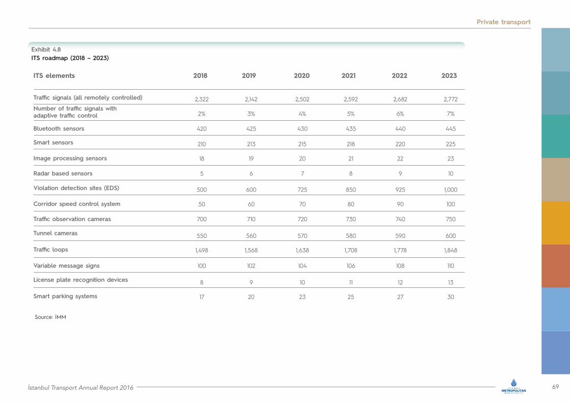
İstanbul Transport Annual Report 2016 69
Private transport
ITS roadmap (2018 – 2023)Exhibit 4.8
ITS elements
Traffic signals (all remotely controlled)
Smart sensors
Violation detection sites (EDS)
Traffic loops
Smart parking systems
Number of traffic signals with adaptive traffic control
Image processing sensors
Corridor speed control system
20192018
2,322
210
500
550
8
2,142
213
600
560
9
2%
18
50
1,498
17
3%
19
60
1,568
20
420
5
700
100
425
6
710
102
20212020
2,502
215
725
570
10
2,592
218
850
580
11
4%
20
70
1,638
23
5%
21
80
1,708
25
430
7
720
104
435
8
730
106
20232022
2,682
220
925
590
12
2,772
225
1,000
600
13
6%
22
90
1,778
27
7%
23
100
1,848
30
440
9
740
108
445
10
750
110
Bluetooth sensors
Radar based sensors
Traffic observation cameras
Variable message signs
Tunnel cameras
License plate recognition devices
Source: İMM

70 İstanbul Transport Annual Report 2016
Private transport
4.3 Parking: Facilities strategically located around İstanbul
Investing in modern parking facilities
İstanbul’s increasing motorisation rate raises significantly parking requirements across our city. To address this challenge, İSPARK, an İMM affiliated company, constructs and operates safe and state-of-the art parking facilities for more than a decade. As of the end of 2016, İSPARK operates 452 parking facilities with a combined capacity of more than 78,000 spaces (Exhibits 4.9 and 4.10).
Number of parking facilities managed by İSPARK (as of end of 2016)
Number of parking spaces managed by İSPARK (as of end of 2016)
Exhibit 4.9
Exhibit 4.10
0
0
100
20,000
200
40,000
300
60,000
400
80,000
500
100,000
Total
Total
On street
On street
Multilevel
Multilevel
Outdoor(off street)
Outdoor(off street)
Type
of p
arking
fac
ilitie
s
Type
of p
arking
fac
ilitie
s
2015
2015
2016
2016
+17%
+17%
+6%
+6%
+11%
+10%
+20%
+9%
Number of parking spaces
Number of parking spaces
Source: İSPARK A.Ş.
Source: İSPARK A.Ş.
+x%: per cent increase since 2015
+x%: per cent increase since 2015
In 2016 we increased our total parking capacity to 78,197 parking spaces (Exhibit 4.10) and we managed 28,153,469 entries into our facilities. Using demand analytics, we established 46 new parking facilities at selected locations with a total capacity of 7,221 vehicles. More specifically, we launched operations at parking facilities in Maltepe metro, Esenler sports complex, Sultanbeyli Kent Square and in Üsküdar. The capacities of these lots range between 150 and 300 vehicles. The new parking facilities incorporate the latest technology trends, including automatic payment systems and charging units for electric vehicles. They are also designed according to the strictest security and accessibility standards, and include cycle parking.
• 46 new facilities in 2016• 7,221 new spaces in 2016• Total capacity of 78,197 spaces• Increased by 10% since 2015P
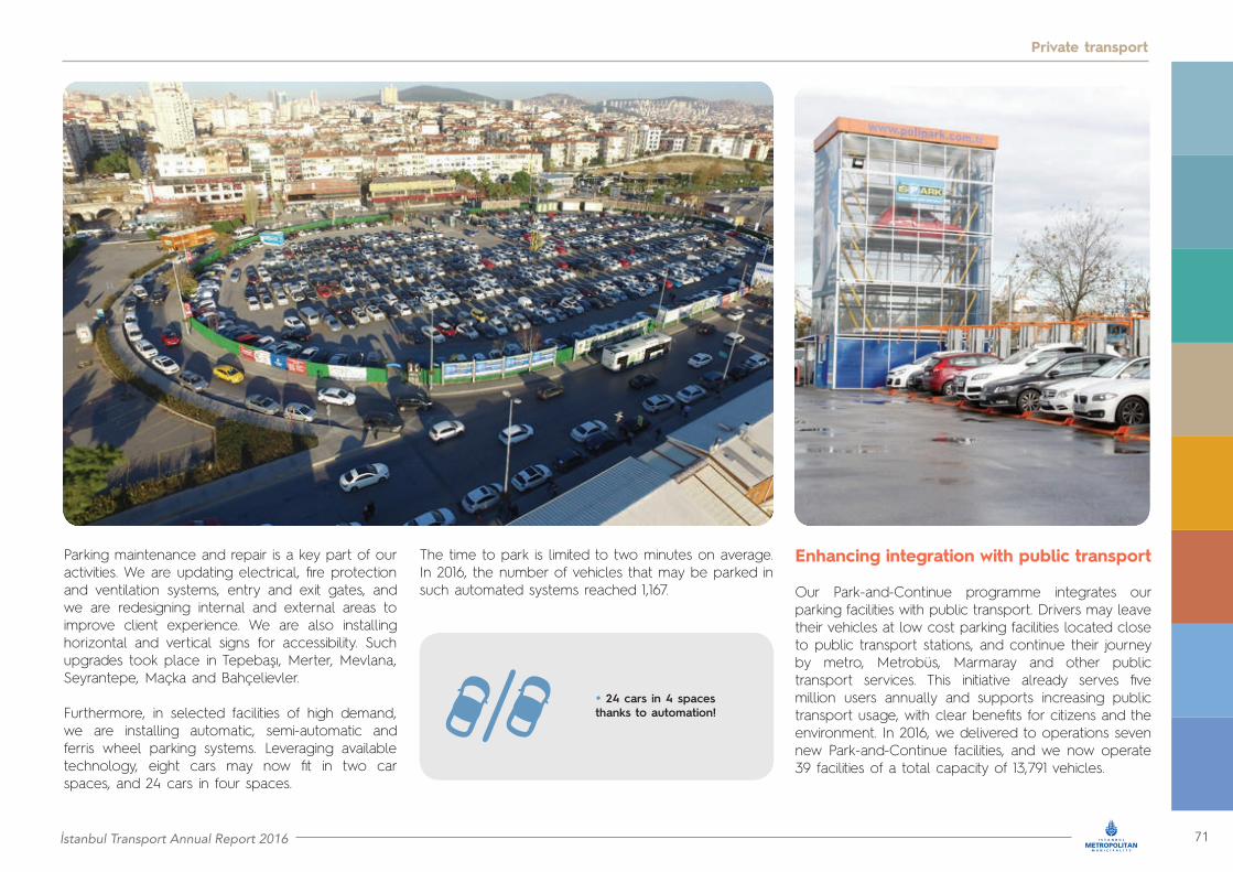
İstanbul Transport Annual Report 2016 71
Private transport
Parking maintenance and repair is a key part of our activities. We are updating electrical, fire protection and ventilation systems, entry and exit gates, and we are redesigning internal and external areas to improve client experience. We are also installing horizontal and vertical signs for accessibility. Such upgrades took place in Tepebaşı, Merter, Mevlana, Seyrantepe, Maçka and Bahçelievler.
Furthermore, in selected facilities of high demand, we are installing automatic, semi-automatic and ferris wheel parking systems. Leveraging available technology, eight cars may now fit in two car spaces, and 24 cars in four spaces.
The time to park is limited to two minutes on average. In 2016, the number of vehicles that may be parked in such automated systems reached 1,167.
Enhancing integration with public transport
Our Park-and-Continue programme integrates our parking facilities with public transport. Drivers may leave their vehicles at low cost parking facilities located close to public transport stations, and continue their journey by metro, Metrobüs, Marmaray and other public transport services. This initiative already serves five million users annually and supports increasing public transport usage, with clear benefits for citizens and the environment. In 2016, we delivered to operations seven new Park-and-Continue facilities, and we now operate 39 facilities of a total capacity of 13,791 vehicles.
• 24 cars in 4 spaces thanks to automation!

72 İstanbul Transport Annual Report 2016
Private transport
Based on the plan to relocate existing intercity bus terminals in Harem and in Esenler, in 2016 İSPARK constructed the first bus terminal in Alibeyköy, which already serves 2,000,000 passengers per month. This new intercity bus terminal features waiting areas, restaurants, children playground,
airport-like display screens to monitor bus schedules and ATMs, while it is integrated with taxi services and includes free parking of up to 30 minutes.
Park-and-Continue
• 5,000,000 users annually• 39 locations
• ~ 14,000 parking spaces

İstanbul Transport Annual Report 2016 73
Private transport
Overcoming obstacles of everyday life together
Aspiring to improve transport opportunities for all İstanbulites, it is our priority to provide special care to people with disabilities. To this end, we have equipped our parking facilities in a way that allows drivers requiring assistance to easily park their vehicles. We also offer eight hours of free parking in all facilities, as well as three hours of free on street parking. Thanks to the decision of İMM assembly, time limits for parking of families of war veterans and martyrs have been removed.
We are also progressively launching free valet parking services at the entry gates of hospital emergency departments. The first pilot implementation was launched at Fatih Sultan Mehmet university research hospital. This service will be provided soon at Üsküdar state hospital and Göztepe university research hospital.
Smart and sustainable
15,000 people have already downloaded İSPARK’s smart mobile application, which has been developed in collaboration with BELBİM. Application users are able to identify existing nearby İSPARK parking facilities and reach them using the navigation tool. Designed for IOS and Android devices, the application provides access to a wide range of information, such as real time occupancy, number of vacant parking spaces, pricing and distance to parking facility. To do so, it synchronises with real time data transmitted from handheld devices used by parking assistants.
Sustainability is embedded in all İSPARK plans. In 2016, we installed charging stations for electric vehicles at our facilities in Balmumcu, Cihangir, Merter, Ümraniye, Bostanci Günaydın and Kadıköy. Each charging station includes two spaces for vehicles, which may be recharged simultaneously. Thus we contribute to promoting the use of eco-friendly vehicles, resulting in lower fuel consumption and carbon emissions.
Along the same lines, we are upgrading electrical installations and lighting fixtures, in order to use LED lighting and smart sensor systems. In addition, we are installing signage powered by solar energy, having completed 500 such installations. These help drivers locate available parking spaces, and reduce energy consumption. In terms of reducing waste, our parking facilities incorporate rainwater and wastewater systems for better water management.
• 15,000 users of İSPARK smart mobile application

74 İstanbul Transport Annual Report 2016
Private transport
Human resource development contributes to operational excellence
Every day about 2,000 İSPARK employees provide services to 150,000 clients. To enhance service quality, in 2016 İSPARK’s Academy started offering a certification programme in parking and transport services. This programme includes training in driving and parking techniques, use of parking systems, automation and operations management. The programme may be attended by parking assistants working for provincial and district municipalities, as well as by international parking staff.
Focused training programs are also offered to parking supervisors in the use of handheld terminals and tablets in order to support operations. This improves staff coordination and enhances reliability, safety and quality of services provided.
Finally, İSPARK employees have the opportunity to join the postgraduate programme of “Urban Systems and Transportation Management” offered by İstanbul Ticaret University.
Adding almost 90,000 parking spaces by 2019
We will continue enhancing our city’s parking capacity and making improvements to the level of services provided. Our yearly targets for delivering new parking facilities across the city have been set in the İstanbul Parking Master Plan till 2019, and include delivery of 18,000 new spaces in 2017, 40,000 in 2018 and 32,000 in 2019.
In addition to the recent intercity bus terminal in Alibeyköy, we plan to construct new terminals at the outskirts of İstanbul. Currently, city access by intercity buses benefits from the Yavuz Sultan Selim Bridge and the Odayeri – Paşaköy section of the Northern Marmara Motorway.
To enhance this benefit, we plan to build two new terminal stations: İşıklar on the European side and Akfırat on the Asian side. These stations will have direct access to the Northern Marmara Motorway and the third bridge, as well as to our city’s high capacity public transport systems.
Finally, the heliport project managed by İSPARK will provide strong airborne mobility solutions. The heliports are intended to benefit transport services, support emergency services, and facilitate tourism activities. Modern heliports have already been delivered at Kadıköy and Üsküdar.
We are also in the process of issuing licences for the heliports at Yenikapı, Sütlüce and Hasdal, Finally, we consider heliport construction in Şişli, Bayrampaşa, Sarıyer, Pendik, Beykoz, Maltepe and Ümraniye.

İstanbul Transport Annual Report 2016 75
Private transport

76 İstanbul Transport Annual Report 2016
Public transport

İstanbul Transport Annual Report 2016 77
Public transport
Active transport
5

78 İstanbul Transport Annual Report 2016
Active transport
5.1 Walking: A dominant way to move around İstanbul
İstanbul keeps walking
There is no comparison to İstanbul’s culture for walking. On a daily basis, more than 15.5 million trips are walking trips, a remarkable figure that corresponds to almost 49 per cent of the total daily trips. In İstanbul we love to walk. It is the best way for shorter trips to reach school, shops and workplaces, but it is also an ideal way to enjoy İstanbul’s ambience at for leisure related trips.
In İMM we understand very well the significance of walking. It does not only have very important environmental and health benefits, but it also creates a vibrant city environment and has a positive impact on local businesses. Therefore, we are taking all required measures to improve our city’s pedestrian infrastructure, to connect public transport to pedestrian paths, to extend squares and pedestrianised zones citywide and to ensure pedestrian comfort and safety. We also understand the importance of ensuring the integrity and continuity of pedestrian trips within liveable urban spaces, and we are working in this direction. This will allow us to sustain and increase the high numbers of walking trips in the years to come and enjoy the beneficial outcomes for the environment, health and city life.
Our flagship project, the pedestrianisation of historic peninsula was delivered to our citizens in October 2013. More than 220 roads and 200,000 square metres were transformed into pedestrianised areas. After more than three years of operation, it is clear that this pedestrianisation was an opportunity to sustain the urban and natural environment of the historic peninsula, to improve social welfare and to change perceptions about the use of urban spaces.
Our work in historic peniscula is ongoing. A new project that is under way is the extension of the existing pedestrianisation of Ordu street. UKOME has already made the related decision, taking into account the views of the local community. The purpose of the project is to facilitate the circulation of pedestrians in this key area of İstanbul for tourism and commercial activities, so that people will be able to shop and travel in a healthier environment without suffering the consequences of the noise and air pollution generated by vehicles. According to our project, Ordu, Büyük Resit Paşa, Kurultay and Haznedar streets will be fully pedestrianised, while Laleli and Koca Ragip Paşa streets will be partially pedestrianised. Traffic circulation in Aksaray, Gençtürk, Şair Haşmet and Mesihpaşa streets will be modified. The project will guarantee the uninterrupted operation of Tram line T1.
Another flagship project is currently at its conception phase. In the context of the ongoing construction of a landmark interchange station in Kabataş, İMM plans to build an undersea tunnel that will connect the Kabataş district on the European side with Üsküdar district on the Asian side. The tunnel will be two kilometres long and it will be located 46 metres below the sea level. It will include moving pedestrian corridors and cycling paths in the top level, while there are plans for a lower level where electric vehicles will be able to circulate. The drilling tests for the undersea tunnel are ongoing.
• 15.5 million daily walking trips
We are working intensively in promoting and raising awareness about walking among İstanbulites. Our citizens should have access to information about the benefits of walking, and how to maximize these benefits in their everyday commuting. These messages will be embedded in our travel demand initiatives.
In 2016 we installed multiple signage and markings along pedestrian and cycling corridors to inform citizens about the calories consumed while exercising. It is our way to inform our citizens how walking and cycling enables us to maintain a healthy life style. This programme will continue in 2017.
More pedestrianised streets in every neighborhood In İMM, we aim to strike the right balance between urban growth and respect of public areas, as well as preservation of historic and cultural heritage. We have already harnessed the benefits of significant pedestrianisation projects and we will continue investing on them.
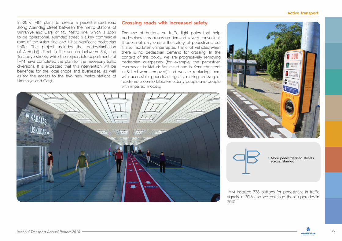
İstanbul Transport Annual Report 2016 79
Active transport
In 2017, İMM plans to create a pedestrianised road along Alemdağ street between the metro stations of Ümraniye and Çarşi of M5 Metro line, which is soon to be operational. Alemdağ street is a key commercial road of the Asian side and it has significant pedestrian traffic. The project includes the pedestrianisation of Alemdağ street in the section between Suiş and Tunaboyu streets, while the responsible departments of İMM have completed the plan for the necessary traffic diversions. It is expected that this intervention will be beneficial for the local shops and businesses, as well as for the access to the two new metro stations of Ümraniye and Çarşi.
Crossing roads with increased safety
The use of buttons on traffic light poles that help pedestrians cross roads on demand is very convenient. It does not only ensure the safety of pedestrians, but it also facilitates uninterrupted traffic of vehicles when there is no pedestrian demand for crossing. In the context of this policy, we are progressively removing pedestrian overpasses (for example, the pedestrian overpasses in Atatürk Boulevard and in Kennedy street in Sirkeci were removed) and we are replacing them with accessible pedestrian signals, making crossing of roads more comfortable for elderly people and people with impaired mobility.
İMM installed 738 buttons for pedestrians in traffic signals in 2016 and we continue these upgrades in 2017.
• More pedestrianised streets across İstanbul

80 İstanbul Transport Annual Report 2016
Active transport
5.2 Cycling: Striving to enhance the potential of cycling for transport
Expanding bicycle paths to create a network
Transport around İstanbul needs more than ever to use sustainable modes, such as public transport, walking and cycling. To this end, in İMM we are committed in promoting the cycling culture among İstanbulites and in removing obstacles to cycling. Thus, we need to improve and expand our cycling infrastructure, ensure integration of cycling with public transport stations, as well as with commercial centres, city parks and hospitals by providing suitable bicycle parking, take measures to ensure comfort and safety for cycling trips and encourage our citizens to start cycling both for commuting and for leisure. The current legislative framework in Turkey for the construction of cycling paths and for the promotion of cycling, officially established in November 2015, is very modern and helps us in our efforts to expand the use of bicycle. The existing framework calls for the continuity of cycling paths, the integration of cycling with public transport and the training of bus drivers on how to interact with cyclists.
There are currently 103 kilometres of cycling ways in İstanbul, equally balanced between European and Asian sides. We are also encouraging the use of bicycles by allowing İstanbulites to carry their bicycles on public transport for free. In the İETT bus fleet, there are buses equipped with bike racks. In such buses, commuters are free to carry their bicycles throughout the day.
For the rest of the bus fleet, it is possible to carry bicycles in specific time periods, outside the peak times. Similar rules apply to all public transport modes. Folding bicycles are allowed on public transport irrespectively of the time of the day.
Targeting to create a network of cycling paths, we will add 200 kilometres of paths by 2019. Specifically in 2017 – 2018, we are building 100 kilometres of cycling paths, out of which 33.3 kilometres are located on the Asian side and the remaining on the European side (Exhibit 5.1).
At the same time, we are working on charting the action plan and the master plan for the further development and integration of the bicycle network.
Between 2019 – 2023 we will add 750 kilometres of bicycle paths, which will bring the total length of our network to 1,053 kilometres by 2023, beyond our target of 1,000 kilometres.
• 303 kilometres of cycling paths by 2019
• 1,053 kilometre long network by 2023
Our sustainable bicycle sharing system grows day by day
İSBIKE, İstanbul’s smart bicycle sharing system, has now been upgraded and uses advanced technology that allows monitoring all bicycle movements and delivering bicycles to any smart bicycle station.
İSPARK, an İMM affiliate company in charge of public parking in our city, is also responsible for the operation of İSBIKE. There are already 140 available bicycles in 14 different stations along the 18 kilometre cycling path between Kadıköy and Maltepe City Park. In April 2016, the system expanded on the European side, with 60 bicycles and five stations along the six kilometre path between Florya and Yeşilköy.
İSBIKE is a user friendly system that operates with credit or membership cards. More than 150,000 İstanbulites have already enjoyed the services of the system. At the same time İSPARK has installed 650 bicycle parking spaces in 130 different locations across the city integrating cycling with public transport.
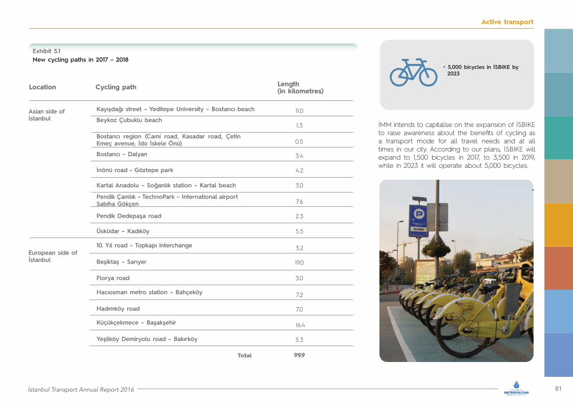
İstanbul Transport Annual Report 2016 81
Active transport
New cycling paths in 2017 – 2018Exhibit 5.1
Location Cycling path Length (in kilometres)
Kayışdağı street – Yeditepe University – Bostancı beachAsian side of İstanbul
European side of İstanbul
Bostancı – Dalyan
Pendik Çamlık – TechnoPark – International airport Sabiha Gökçen
Beşiktaş – Sarıyer
Hadımköy road
Yeşilköy Demiryolu road – Bakırköy
Beykoz Çubuklu beach
İnönü road – Göztepe park
Pendik Dedepaşa road
11.0
3.4
7.6
3.2
7.2
16.4
1.3
4.2
2.3
19.0
7.0
5.3
99.9
0.5
3.0
5.5
3.0
Bostancı region (Cami road, Kasadar road, Çetin Emeç avenue, İdo İskele Önü)
Kartal Anadolu – Soğanlık station – Kartal beach
Üsküdar – Kadıköy
Florya road
10. Yıl road – Topkapı interchange
Hacıosman metro station – Bahçeköy
Küçükçekmece – Başakşehir
• 5,000 bicycles in İSBIKE by 2023
İMM intends to capitalise on the expansion of İSBIKE to raise awareness about the benefits of cycling as a transport mode for all travel needs and at all times in our city. According to our plans, İSBIKE will expand to 1,500 bicycles in 2017, to 3,500 in 2019, while in 2023 it will operate about 5,000 bicycles.
Total

82 İstanbul Transport Annual Report 2016
Active Transport

İstanbul Transport Annual Report 2016 83
Active Transport
Our ticketing
system integrates all
modes
6
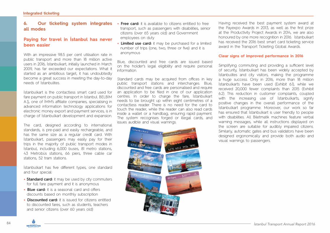
84 İstanbul Transport Annual Report 2016
Integrated ticketing
6. Our ticketing system integrates all modes
Paying for travel in İstanbul has never been easier
With an impressive 98.5 per cent utilisation rate in public transport and more than 18 million active users in 2016, İstanbulkart, initially launched in March 2009, has far exceeded our expectations. What it started as an ambitious target, it has undoubtedly become a great success in meeting the day-to-day needs of İstanbulites.
İstanbulkart is the contactless smart card used for fare payment on public transport in İstanbul. BELBİM A.Ş, one of İMM’s affiliate companies, specialising in advanced information technology applications for electronic money export and payment services, is in charge of İstanbulkart development and expansion.
The card, designed according to international standards, is pre-paid and easily rechargeable, and has the same size as a regular credit card. With İstanbulkart, passengers may easily pay for their trips in the majority of public transport modes in İstanbul, including 6,000 buses, 81 metro stations, 43 Metrobüs stations, 66 piers, three cable car stations, 52 tram stations.
İstanbulkart has five different types, one standard and four special:
• Standard card: it may be used by city commuters for full fare payment and it is anonymous• Blue card: it is a seasonal card and offers discounts based on monthly subscription• Discounted card: it is issued for citizens entitled to discounted fares, such as students, teachers and senior citizens (over 60 years old)
• Free card: it is available to citizens entitled to free transport, such as passengers with disabilities, senior citizens (over 65 years old) and Government employees on duty• Limited use card: it may be purchased for a limited number of trips (one, two, three or five) and it is anonymous
Blue, discounted and free cards are issued based on the holder’s legal eligibility and require personal information.
Standard cards may be acquired from offices in key public transport stations and interchanges. Blue, discounted and free cards are personalised and require an application to be filed in one of our application centres. In order to charge the fare, İstanbulkart needs to be brought up within eight centimetres of a contactless reader. There is no need for the card to touch the reader, while the reader can also read cards inside a wallet or a handbag, ensuring rapid payment. The system recognises forged or illegal cards, and issues audible and visual warnings.
Having received the best payment system award at the Payexpo Awards in 2013, as well as the first prize at the Productivity Project Awards in 2014, we are also honoured by one more recognition in 2016. İstanbulkart has received the 2016 best smart card ticketing service award in the Transport Ticketing Global Awards.
Clear signs of improved performance in 2016
Simplifying commuting and providing a sufficient level of security, İstanbulkart has been widely accepted by İstanbulites and city visitors, making the programme a huge success. Only in 2016, more than 18 million İstanbulkarts have been used (Exhibit 6.1), while we received 20,000 fewer complaints than 2015 (Exhibit 6.2). This reduction in customer complaints, coupled with the increasing use of İstanbulkarts, signify positive changes in the overall performance of the İstanbulkart programme. Moreover, our work so far has ensured that İstanbulkart is user friendly to people with disabilities. All Biletmatik machines feature verbal warning messages, while all instructions displayed on the screen are suitable for audibly impaired citizens. Similarly, automatic gates and bus validators have been designed ergonomically and provide both audio and visual warnings to passengers.

İstanbul Transport Annual Report 2016 85
Integrated ticketing
System expanded significantly in 2016
We remain focused on optimising the payment services provided to İstanbulites across our transport network. This year, we installed a significant number of additional Biletmatik machines and turnstiles (Exhibit 6.3). At the end of 2016, 559 Biletmatik machines operated across the city, 113 additional than in 2015, while more than 1,800 private vendors have the permission to sell the card.
Number of active İstanbulkarts per type in 2015 and 2016 Customer complaints in 2015 and 2016
New Biletmatik machines and turnstiles in 2016
Exhibit 6.1 Exhibit 6.2
Exhibit 6.3
0 5,000,000 10,000,000 15,000,000 20,000,000
Blue card
Standartcard
Total
Discountedcard
Free card
2015
2016
Active İstanbulkarts
0
200
400
600
800
1,000
2015 2016
Com
plaint
s pe
r 10
0,00
0 İsta
nbul
kart u
sers
• 113 new Biletmatik machines in 2016
• İstanbulkart in 378 parking facilities
In …
Total 113 191
Biletmatik machines Turnstiles
Metro stations
Public bus stops
Funicular stations
Marmaray stations
Metrobüs stations
İSPARK parking facilities
53
4
1
85
-
-
-
17
20
86
-
4
18
-
-
16
Tram stops
Piers
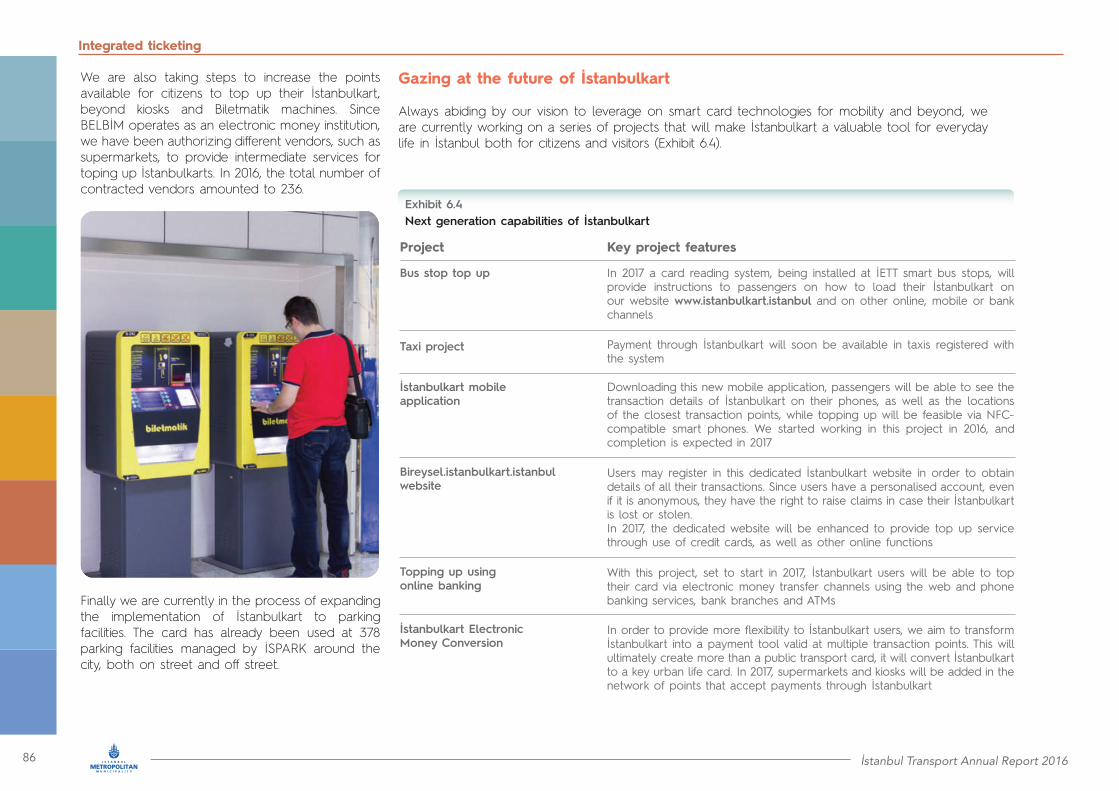
86 İstanbul Transport Annual Report 2016
Integrated ticketing
We are also taking steps to increase the points available for citizens to top up their İstanbulkart, beyond kiosks and Biletmatik machines. Since BELBİM operates as an electronic money institution, we have been authorizing different vendors, such as supermarkets, to provide intermediate services for toping up İstanbulkarts. In 2016, the total number of contracted vendors amounted to 236.
Gazing at the future of İstanbulkart
Always abiding by our vision to leverage on smart card technologies for mobility and beyond, we are currently working on a series of projects that will make İstanbulkart a valuable tool for everyday life in İstanbul both for citizens and visitors (Exhibit 6.4).
Finally we are currently in the process of expanding the implementation of İstanbulkart to parking facilities. The card has already been used at 378 parking facilities managed by İSPARK around the city, both on street and off street.
Next generation capabilities of İstanbulkartExhibit 6.4
Project Key project features
Bus stop top up
Taxi project
İstanbulkart mobile application
Bireysel.istanbulkart.istanbul website
Topping up using online banking
İstanbulkart Electronic Money Conversion
In 2017 a card reading system, being installed at İETT smart bus stops, will provide instructions to passengers on how to load their İstanbulkart on our website www.istanbulkart.istanbul and on other online, mobile or bank channels
Payment through İstanbulkart will soon be available in taxis registered with the system
Downloading this new mobile application, passengers will be able to see the transaction details of İstanbulkart on their phones, as well as the locations of the closest transaction points, while topping up will be feasible via NFC-compatible smart phones. We started working in this project in 2016, and completion is expected in 2017
Users may register in this dedicated İstanbulkart website in order to obtain details of all their transactions. Since users have a personalised account, even if it is anonymous, they have the right to raise claims in case their İstanbulkart is lost or stolen.In 2017, the dedicated website will be enhanced to provide top up service through use of credit cards, as well as other online functions
With this project, set to start in 2017, İstanbulkart users will be able to top their card via electronic money transfer channels using the web and phone banking services, bank branches and ATMs
In order to provide more flexibility to İstanbulkart users, we aim to transform İstanbulkart into a payment tool valid at multiple transaction points. This will ultimately create more than a public transport card, it will convert İstanbulkart to a key urban life card. In 2017, supermarkets and kiosks will be added in the network of points that accept payments through İstanbulkart
İstanbul Transport Annual Report 2016 87
Integrated ticketing
By 2019, the number of Biletmatik machines will double, reaching 1,200, while it is expected to triple by 2023. We also plan to expand the network of private vendors offering services related to İstanbulkart to 3,200 from the current number of 1,800.

88 İstanbul Transport Annual Report 2016
Public transportActive Transport

İstanbul Transport Annual Report 2016 89
Public transportActive Transport
Our commitment to inclusion in
mobility
7

90 İstanbul Transport Annual Report 2016
Accessible transport
7. Our commitment to inclusion in mobility
İstanbul accessible to all
İstanbul features a unique blend of historical sites, protected zones and newly developed modern precincts. Levels of accessibility vary across these sites and the city. In İMM, we maintain a strong community focus, and, therefore, inclusive mobility is a key strategic choice. The Turkish Disability Act (#5378) of 2005 includes provisions for measures to be taken by municipalities in order to ensure the accessibility of public transport services. Considering the provisions of the legislation and İstanbul needs, the “İstanbul Coordination Council Accessible to All” was established in 2008. The council includes representatives from İMM, districts, the province, as well as non governmental organisations, which interact on a monthly basis to identify areas for improvement in accessibility and to deliver solutions for our citizens and visitors with disabilities.
We are also transforming our rail systems by adding appropriate turnstiles, accessible restrooms, audible warning and information systems with embossed surfaces for visually and hearing impaired people. We have installed disabled ramps in tram stops and we continuously improve the accessibility of Metrobüs stations by adding accessible ramps, escalators and elevators. Elevators have also been installed in metro stations.
Moreover, we are enhancing the accessibility of sea services by installing suitable turnstiles in piers and upgrading vessels. Equally important, we have increased disabled parking spaces in parking facilities managed by İSPARK to almost 1,500 spaces across the city.
Since June 2006, all our citizens with a 40 per cent disability or greater, as well as their companions, may use a special İstanbulkart, that offers free public transport. In 2016, 39,975 cards for the disabled and 10,882 companion cards were issued. In total since 2006, we have issued 272,516 cards for the disabled and 97,652 cards for companions.
Within the scope of accessibility, we have also been enhancing pedestrian routes across İstanbul. Since 2008, we have delivered 101,800 square metres of ramp arrangements for 10,809 street crossings, 885 signalised intersections and 4,099 crossings. To support crossing of main arterials, we have installed voice traffic signalling systems in 292 locations. In addition, we have
placed 52,990 curved plates and 785 embossed intersection signs. Accessibility works have been performed in 65,000 square metres of pedestrian crossings and in 47,705 square metres of pedestrian walkways, while we have been adding ramps or elevators in pedestrian overpasses.
Since 2008, a series of initiatives and works enhanced significantly accessibility of public transport (Exhibit 7.1). A total of 4,445 public buses and 1,980 minibuses have been made accessible as of the end of 2016.
Accessibility achievements since 2008
• 2,734 İETT buses• 985 İOAŞ buses• 726 ÖHO buses• 1,980 minibuses• 115 Dentur Avrasya vessels• 28 Şehir Hatları vessels• 53 İDO vessels
• 39,975 disabled cards and 10,882 companion cards in 2016
İstanbul Transport Annual Report 2016 91
Accessible transport
Targeted accessibility enhancements in public transport and pedestrian paths in 2016
In 2016 we achieved significant accessibility improvements in mobility. Metro İstanbul A.Ş. has led significant projects for upgrading the accessibility of metro stations and tram stops. Elevators were installed across the M1A Metro line. Regarding tram stops, the only non-accessible stop is Cumhuriyet of T4 Tram line, for which there are unsurpassable technical issues. Metro has also developed clear guidelines for people with disabilities to easily reach the trains upon arrival at a station.
The two stations and the two vehicles of the F1 Funicular line between Taksim and Kabataş are accessible, while we added ramps in station gates.
At all stops of our public bus network we aspire to provide barrier free access. In 2016, improvements were made to 3,100 bus stops. All 2,734 buses of İETT are low floor and include information displays, audio announcements and manually operated ramps. At the same time the dedicated spaces for wheelchair users within the buses are equipped with belts to ensure safety during the trip.
Regarding our sea transport network, of a total of 89 piers we have completed accessibility upgrades to 28; that is, 17 İDO and 11 Dentur Avrasya piers.
To achieve maximum pedestrian accessibility and safety at intersections and pedestrian crossings, we delivered geometrical arrangements, while pedestrian signals with audible information messages are progressively integrated into the signaling system.
We are removing obstacles along pedestrian crossings, and in 2016 we installed a total of 12,528 horizontal and vertical traffic signs, disabled parking signs, curved standard and elastic traffic signs. In addition, 403 accessible pedestrian signals were installed this year at 103 interchanges reaching a total of 1,185 accessible pedestrian signals at 422 interchanges across our city.
Technology based support in journey planning
Leveraging on technology, our transport services feature innovations in information systems that support people with disabilities. We have introduced an Intelligent Passenger Information System for public buses and progressively we are transforming bus stops into smart bus stops. When, for example, visually impaired citizens arrive in such a smart bus stop, the intelligent system may recognise them by simply reading their İstanbulkart. Subsequently the system may provide audible information about bus lines. Another useful feature installed in such stops are push to talk units that provide real time voice communication with our staff. Using these units, visually impaired people may be informed about expected arrival times of the related bus lines. The smart bus stops also include easily accessible charge outlets, so that people with disabilities may charge their power wheelchairs.
Status of public transport accessibility in İstanbulExhibit 7.1
Public transport mode
% accessible in 2016
Stations / stops / piers Vehicles
Metro
Tram
Marmaray
Funicular
Cable cars
Metrobüs
Sea services
100%
100%
100%
100%
100%
56%
29.4%
100%
98%
100%
100%
100%
100%
93%
Source: İMM
• 12,528 signs installed in 2016
• 403 accessible pedestrian signals installed in 2016

92 İstanbul Transport Annual Report 2016
Accessible transport
Accessible and well equipped parking facilities for İstanbulites
We have, also, made significant efforts to strengthen disabled access in parking facilities managed by İSPARK. We offer currently 1,489 parking spaces for the disabled, out of our total 78,197 parking spaces, bringing the ratio of disabled to total spaces to 1.9 per cent. In 2016, 147 parking spaces for the disabled were added to İSPARK parking facilities, while 3,950 vehicles were registered by disabled with İSPARK. The total number of registered vehicles by disabled drivers amounts to 12,578.
In terms of access to parking facilities managed by İSPARK, people with disabilities are entitled to park for free at on street parking areas for three hours and at outdoor off street facilities for eight hours.
Similarly, using the Mobiett application, every bus stop is transformed into a smart bus stop. Users may check the arrival times of all bus lines in real time using their mobile phones. Mobiett users may also check whether the bus arriving at a bus stop is suitable for disabled access.
İMM’s CepTrafik application may also support journeys of people with disabilities. For example, hearing impaired citizens may benefit from video call services to our call operators, while visually impaired people may obtain traffic information via audible announcements from our traffic control centre. In addition, the ongoing IBeacon project, which is based on Bluetooth technology, offers voice instructions for navigation purposes to visually impaired passengers at bus stops
Focus on raising awareness about accessibility
In İMM, we try to understand in depth the difficulties that people with disabilities face every single day. Our goal is to make it possible for people with disabilities to participate in social life by moving without a companion throughout our city.
In 2016, İMM and affiliate company staff visited Gayrettepe metro station in groups, where, in collaboration with the Turkcell Dialogue Museum, we provided two innovative programmes: “Dialogue in the Dark” and “Dialogue in Silence”. In these exhibitions, visitors experience a simulation of everyday life activities without being able to see or hear. All private security personnel of Metro İstanbul A.Ş., who are in direct daily contact with our customers, have participated in these programmes.
In order to facilitate citizens with speech impairments, sign language training is regularly provided to our personnel who are engaged with frequent client interactions. In conjunction with the Hearing Impaired Federation, 500 İETT employees were trained in fingerspelling of the alphabet, numbers, days, weeks, months and seasons. Special training was also provided to İETT’s bus operations staff, who design, install and maintain our bus stops. The training raised awareness with respect to accessibility legislation, standards, specifications and applications that need to be embedded in İETT operations.
• 1,489 disabled parking spaces
• 12,578 vehicles registered by disabled • 1,783 private security officers of
Metro İstanbul A.Ş. trained in “Dialogue in the Dark”
• 3,175 İETT officers received accessibility training

İstanbul Transport Annual Report 2016 93
Accessible transport
Several other awareness initiatives are offered by İMM and the transport stakeholders. İMM’s Traffic Directorate organises training sessions on moving independently on the roads of İstanbul, and provides related supporting material.
Each year, İMM’s Directorate of Disabled People organises awareness activities for the International Day of Persons with Disabilities. In 2016, İMM participated in the International Trade Fair for Rehabilitation, Integration, Prevention and Care, which took place in İstanbul Expo Centre. The trade fair showcases industrial products designed to support the life of people with disabilities. In 2016 İETT had the opportunity to present in the trade fair the services provided to people with disabilities and their future plans.
Shaping the changes of 2017
We will continue to enhance the solutions and services that meet the needs of people with disabilities in 2017.
In particular, İETT will purchase 375 low-floor diesel buses, as well as 200 electric buses, out of which 97 will be suitable for disabled access. Moreover, preparatory work has been initiated to purchase new low-floor, high-capacity vehicles for Metrobüs services. In 2017, we will organise sessions for people with disabilities in order to provide guidance on safe circulation and waiting at Metrobüs stations.
We will also renovate a series of elements in metro stations. We will inspect the status of disabled turnstiles and install new ones where needed.
We will also add elevators and escalators where appropriate and install braille alphanumeric systems in elevators. Finally, we will prepare the ground to install braille alphabetical maps of the metro system along with braille alphabetical information labels at stations and corridors.
In order to continue enhancing accessibility to our sea service piers, we have initiated the expansion of gates in eight piers of Şehir Hatları A.Ş. in Kasımpaşa, Çengelköy, Eyüp, Kandilli, Kanlıca, Rumelikavağı, Sütlüce, Çubuklu.
With respect to pedestrian paths and crossings, we plan to install 248 accessible pedestrian signals in 66 intersections in the city.
In 2017• 375 new İETT diesel, low-floor buses• 97 new İETT accessible electric buses• Targeted improvements in metro stations• 248 new accessible pedestrian signals at 66 interchanges
All public transport vehicles, stations, stops and piers to be accessible by 2020
According to the Turkish Disability Act (#5378) and UKOME decision 2016/9–7 of December 28, 2016, until July 7, 2018, all public transport vehicles will be made accessible, including minibuses that have received a license and have not reached the ten-year age limit. Taxis and dolmuş are not included in the provisions of the legislation.
In addition to vehicles, our aim is to make all public transport stations, stops and piers accessible by the year 2020. We will also continue investing in barrier free use of pedestrian corridors, overpasses and public spaces, and we will enhance the capabilities of web and mobile applications for people with disabilities.
With respect to parking facilities, by 2019 there will be 3,300 disabled parking spaces across İstanbul in facilities managed by İSPARK, while this figure will reach 6,000 spaces by 2023.
We will also continue developing pedestrian navigation so that visually impaired citizens may be independent in their social life. To this end, our 2023 goal is for all existing and planned pedestrian signals to include audible messages.
Finally, although taxis are not included in the accessibility legislation, our goal is to have at least one accessible taxi in each taxi rank of our city. Visually handicapped citizens will benefit from convenient access to taxi services through our call centre, while hearing impaired people will use a suitable mobile application.
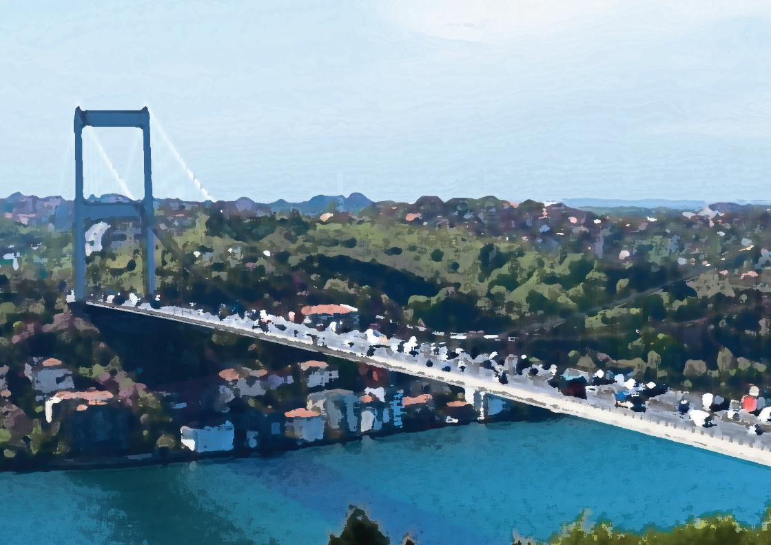
94 İstanbul Transport Annual Report 2016
Public transport

İstanbul Transport Annual Report 2016 95
Public transport
Our plans for mobility in
İstanbul by 2023
8

96 İstanbul Transport Annual Report 2016
8 Our plans for mobility in İstanbul by 2023
8.1 İstanbul’s rail network will be five times longer by 2023
Currently İstanbul enjoys substantial public transport infrastructure and systems that support more than ten million daily trips. This infrastructure includes six metro lines, two tram lines, one of the most popular Bus Rapid Transit systems in the world (Metrobüs) and the Marmaray line. At the same time, the city’s public transport is complemented by robust networks of public buses, minibuses, dolmuş and sea services.
To reach this point, İMM invested significant effort in developing the city’s Integrated Urban Transport Master Plan (İUAP), approved by UKOME in 2011. Taking into consideration İstanbul’s linear urban topography and hilly landscape, the waterways that bisect the city, as well as the unique urban fabric that makes the city a “live” monument, İUAP specifies significant investments in the city’s multi-modal transport network, promoting metro as the catalyst in transforming the city’s mobility map and facilitating the shift to public transport.
Over the last years, İMM has committed significant resources in the implementation of İUAP. In close partnership with the National Government, we managed to complete the most challenging part of İstanbul’s rail network by bridging the two continents with the Marmaray rail tunnel and by completing metro construction under the city’s historical centre with its fragile monuments of world heritage. Thanks to these coordinated efforts, our high capacity public transport system (rail and Metrobüs) is now 202.50 kilometres long.
Guided by the strategies of İUAP, we are constructing 196.60 kilometres of new rail systems in İstanbul, including the upgrade of Marmaray line, the metro connection to the new airport, the about to be delivered M5 Metro line, and the much expected M7 Metro line connecting Kabataş to Mahmutbey.
There are also ten additional metro lines, two tram lines and two monorail systems in the plans of İMM for completion by 2019. These lines will add 148.70 kilometres in the city’s rail infrastructure. By 2019, our rail network will reach 495.35 kilometres. In the period 2019 – 2023, we will extend our rail systems by 215.60 kilometres and on the 100th anniversary of the Turkish Republic we will enjoy a 710.95 kilometre long rail infrastructure.
In this section of the annual report, we are providing all-inclusive descriptions of the individual projects comprising our rail infrastructure plan up to 2023. We start with the under construction projects, then we move to the committed rail projects to be completed by 2019 and, finally, we present a summary of the rail investments to be implemented in the period 2019 – 2023.
Rail projects under development
We are currently constructing nine rail projects that include the under upgrade part of the Marmaray line, two extensions of existing metro lines, five new metro lines and one new tram line (Exhibit 8.1). When completed, these lines will expand our rail network by 196.60 kilometres and will add 134 new stations. The estimated cost is TRY26.7 billion (USD7.8 billion).
Out of the nine rail lines, five are being constructed on the European side and three on the Asian side, with Marmaray transcending both sides.
Exhibit 8.2 overviews the high capacity public transport systems of İstanbul that are currently operational. It also includes the alignment of the under construction rail projects that will be operational by 2019.
Below we are providing key information for the rail projects under development, including:
• The authority responsible for the project (İMM or the Ministry of Transport, Maritime Affairs and Communications)• Project implementation period and significant project milestones• Current project status• Estimated total project cost and expenditure to date• Purpose/objective• Key project features• Expected impact on commuting in İstanbul
Mobility plans to 2023
Rail projects under developmentExhibit 8.1
RL1 Marmaray line: Halkali – Gebze
RL2 Extension of M3 Metro line from Bakırköy (İDO) to Bağcılar (Kirazlı)
RL3 Extension of M4 Metro line from Sabiha Gökçen Airport to Kaynarca
RL4 M5 Metro line: Üsküdar – Ümraniye Çekmeköy
RL5 M7 Metro line: Kabataş - Mahmutbey
RL6 M8 Metro line: Dudullu - Bostancı
RL7 M9 Metro line: Ataköy - İkitelli Sanayi
RL8 Metro line between Gayrettepe and the new airport
RL9 Tram line between Eminönü and Alibeyköy

İstanbul Transport Annual Report 2016 97
Mobility plans to 2023
Operational and under development high capacity public transport systems of İstanbulExhibit 8.2
Map legend
Metro
Marmaray
Metrobüs
Tram, cable car,funicular, monorail
OperationalUnder
construction
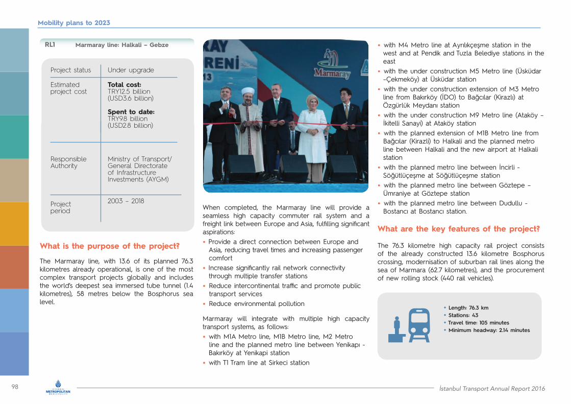
98 İstanbul Transport Annual Report 2016
Mobility plans to 2023
Marmaray line: Halkali – Gebze
Project status
Responsible Authority
Estimated project cost
Project period
Under upgrade
Ministry of Transport/ General Directorate of Infrastructure Investments (AYGM)
Total cost: TRY12.5 billion(USD3.6 billion)
Spent to date: TRY9.8 billion(USD2.8 billion)
2003 – 2018
What is the purpose of the project?
The Marmaray line, with 13.6 of its planned 76.3 kilometres already operational, is one of the most complex transport projects globally and includes the world’s deepest sea immersed tube tunnel (1.4 kilometres), 58 metres below the Bosphorus sea level.
When completed, the Marmaray line will provide a seamless high capacity commuter rail system and a freight link between Europe and Asia, fulfilling significant aspirations:• Provide a direct connection between Europe and Asia, reducing travel times and increasing passenger comfort• Increase significantly rail network connectivity through multiple transfer stations• Reduce intercontinental traffic and promote public transport services• Reduce environmental pollution
Marmaray will integrate with multiple high capacity transport systems, as follows:• with M1A Metro line, M1B Metro line, M2 Metro line and the planned metro line between Yenikapı - Bakırköy at Yenikapi station• with T1 Tram line at Sirkeci station
• with M4 Metro line at Ayrılıkçeşme station in the west and at Pendik and Tuzla Belediye stations in the east• with the under construction M5 Metro line (Üsküdar –Çekmeköy) at Üsküdar station• with the under construction extension of M3 Metro line from Bakırköy (İDO) to Bağcılar (Kirazlı) at Özgürlük Meydanı station• with the under construction M9 Metro line (Ataköy – İkitelli Sanayi) at Ataköy station• with the planned extension of M1B Metro line from Bağcılar (Kirazli) to Halkali and the planned metro line between Halkali and the new airport at Halkali station• with the planned metro line between İncirli - Söğütlüçeşme at Söğütlüçeşme station• with the planned metro line between Göztepe – Ümraniye at Göztepe station• with the planned metro line between Dudullu - Bostancı at Bostancı station.
What are the key features of the project?
The 76.3 kilometre high capacity rail project consists of the already constructed 13.6 kilometre Bosphorus crossing, modernisation of suburban rail lines along the sea of Marmara (62.7 kilometres), and the procurement of new rolling stock (440 rail vehicles).
• Length: 76.3 km• Stations: 43• Travel time: 105 minutes• Minimum headway: 2.14 minutes
RL1
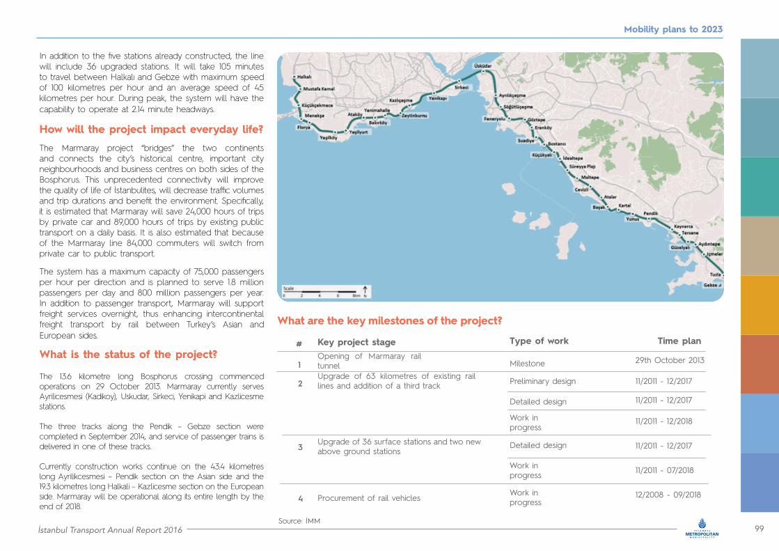
İstanbul Transport Annual Report 2016 99
Mobility plans to 2023
In addition to the five stations already constructed, the line will include 36 upgraded stations. It will take 105 minutes to travel between Halkalı and Gebze with maximum speed of 100 kilometres per hour and an average speed of 45 kilometres per hour. During peak, the system will have the capability to operate at 2.14 minute headways.
How will the project impact everyday life?
The Marmaray project “bridges” the two continents and connects the city’s historical centre, important city neighbourhoods and business centres on both sides of the Bosphorus. This unprecedented connectivity will improve the quality of life of İstanbulites, will decrease traffic volumes and trip durations and benefit the environment. Specifically, it is estimated that Marmaray will save 24,000 hours of trips by private car and 89,000 hours of trips by existing public transport on a daily basis. It is also estimated that because of the Marmaray line 84,000 commuters will switch from private car to public transport.
The system has a maximum capacity of 75,000 passengers per hour per direction and is planned to serve 1.8 million passengers per day and 800 million passengers per year. In addition to passenger transport, Marmaray will support freight services overnight, thus enhancing intercontinental freight transport by rail between Turkey’s Asian and European sides.
What are the key milestones of the project?
Key project stage Type of work Time plan
Opening of Marmaray rail tunnelUpgrade of 63 kilometres of existing rail lines and addition of a third track
Upgrade of 36 surface stations and two new above ground stations
Procurement of rail vehicles
Milestone
Preliminary design
Work in progress
Work in progress
Detailed design
Detailed design
Work in progress
29th October 2013
11/2011 - 12/2017
11/2011 - 12/2017
11/2011 - 12/2018
11/2011 - 12/2017
11/2011 - 07/2018
12/2008 - 09/2018
Source: İMM
#
1
2
3
4
What is the status of the project?
The 13.6 kilometre long Bosphorus crossing commenced operations on 29 October 2013. Marmaray currently serves Ayrilicesmesi (Kadikoy), Uskudar, Sirkeci, Yenikapi and Kazlicesme stations.
The three tracks along the Pendik – Gebze section were completed in September 2014, and service of passenger trains is delivered in one of these tracks.
Currently construction works continue on the 43.4 kilometres long Ayrilikcesmesi – Pendik section on the Asian side and the 19.3 kilometres long Halkali – Kazlicesme section on the European side. Marmaray will be operational along its entire length by the end of 2018.

100 İstanbul Transport Annual Report 2016
Mobility plans to 2023
What is the purpose of the project?
By 2018, the existing M3 Metro line between Bağcılar (Kirazlı), Başakşehir Metrokent and Olimpiyatkoy will be extended towards Bakırköy (İDO) in the south, connecting five important districts (Bakırköy, Bahçelievler, Güngören, Bağcılar and Başakşehir) of İstanbul’s European side. The 8.9 kilometre long metro extension will integrate with the following high capacity transport systems:• with Marmaray at Özgürlük Meydanı station • with M1A Metro line, the under construction metro line between Yenikapi and Sefaköy and Metrobüs at Bakırköy Incirli station• with M1B Metro line at Bağcılar (Kirazlı) station• with the planned tram line between Şirinevler and Mahmutbey at Molla Gürani station.
What are the key features of the project?
When completed, the extension of the M3 Metro line will be 8.9 kilometres long, seven of which form a TBM (Tunnel Boring Machine)/EPB (Earth Pressure Balance) tunnel section. It includes five cut-and-cover and two NATM (New Austrian Tunneling Method) tunnel stations. It will operate at a commercial speed of 42 kilometres per hour delivering a travel time between Bakırköy (İDO) and Kirazlı of 16 minutes. During peak, the system may operate at a minimum headway of two minutes.
Extension of M3 Metro line from Bakırköy (İDO) to Bağcılar (Kirazlı)
Project status
Responsible Authority
Estimated project cost
Project period
Under construction
Ministry of Transport/ AYGM
Total cost: TRY1.2 billion(USD355 million)
Spent to date: TRY148 million (USD42 million)
2013 – 2020
RL2

İstanbul Transport Annual Report 2016 101
Mobility plans to 2023
How will the project impact everyday life?
This extension will be an important north-south connector of five districts, which integrates with Metrobüs, Marmaray, three metro lines, one tram line and the new super-yacht marina. When completed in 2020, the line is expected to serve 500,000 trips per day.
What are the key milestones of the project?
What is the status of the project?
Currently, a) the excavation works at Bakırköy - IDO station have been completed, and b) TBM operations have started (an 80 metre tunnel has been completed as per April 2017). In addition, two NATM shafts are under construction at Özgürlük Meydanı station.
What is the purpose of the project?In the beginning of 2018, Sabiha Gökçen International Airport will be connected to İstanbul’s rail network through a 7.4 kilometre extension of M4 Metro line starting in Kaynarca station. The extension will include four stations.
How will the project impact everyday life?
Sabiha Gökçen International Airport passengers will be able to reach the airport solely by rail. Travel time from each part of the city to the airport will be significantly improved; for example the travel time from Kadıköy will be reduced from 75 to 46 minutes. The estimated travel time from Yenikapı to the airport will be about 60 minutes.
The extension of M4 Metro line to Sabiha Gökçen International Airport will be able to transport 20,000 passengers per hour per direction.
Key project stage To be completed by
TBM construction
Electromechanical works
Metro line opening
Second semester of 2019
End of 2020
End of 2020
Extension of M4 Metro line from SabihaGökçen International Airport to Kaynarca
Project status
Responsible Authority
Estimated project cost
Project period
Under construction
Ministry of Transport/ AYGM
Total cost: TRY535 million(USD153 million)
Spent to date: TRY217 million(USD62 million)
2015 – 2018
RL3
#
1
2
3
• Length: 8.9 km• Stations: 7• Travel time: 16 minutes• Minimum headway: 2 minutes
What are the key milestones of the project?
Key project stage Type of work Time period
Construction of a 7.4 kilometre tunnel, three bored tunnel stations and one cut and cover station
Opening of the M4 Metro line extension to Sabiha Gökçen International Airport
Work in progress
Milestone
2015 – 2018
February 28th, 2018
#
1
2
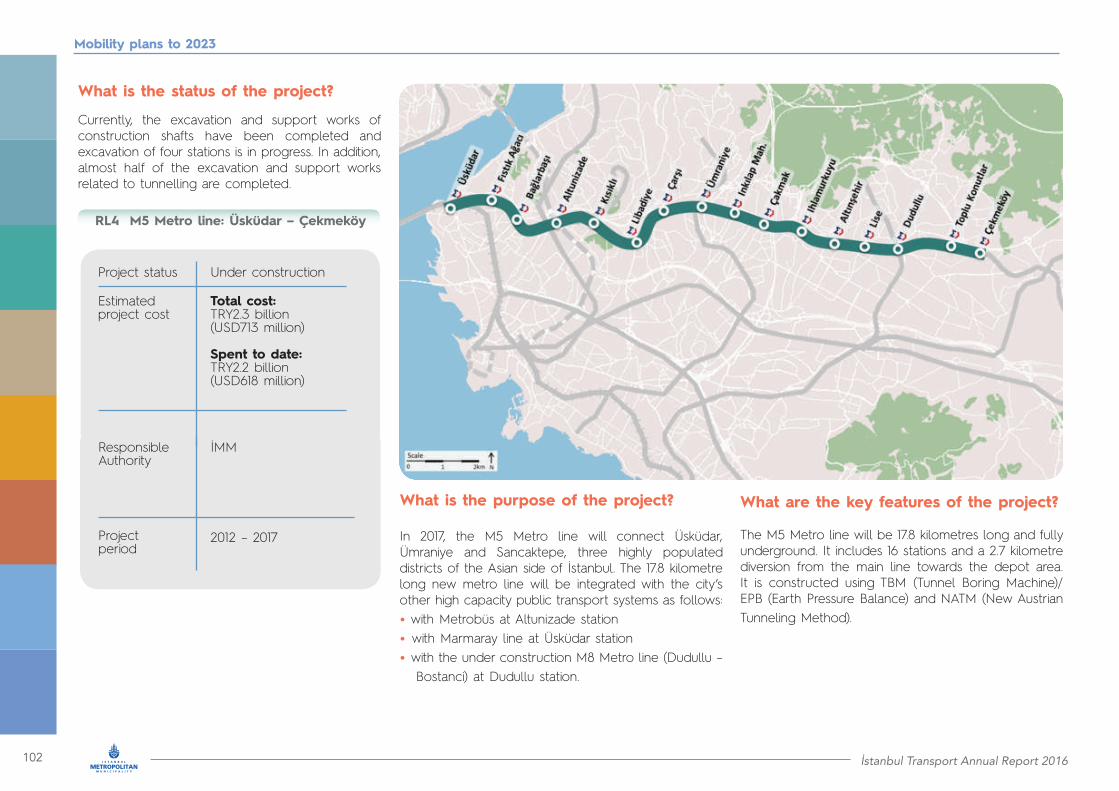
102 İstanbul Transport Annual Report 2016
Mobility plans to 2023
What is the status of the project?
Currently, the excavation and support works of construction shafts have been completed and excavation of four stations is in progress. In addition, almost half of the excavation and support works related to tunnelling are completed.
What is the purpose of the project?
In 2017, the M5 Metro line will connect Üsküdar, Ümraniye and Sancaktepe, three highly populated districts of the Asian side of İstanbul. The 17.8 kilometre long new metro line will be integrated with the city’s other high capacity public transport systems as follows:• with Metrobüs at Altunizade station• with Marmaray line at Üsküdar station• with the under construction M8 Metro line (Dudullu – Bostanci) at Dudullu station.
What are the key features of the project?
The M5 Metro line will be 17.8 kilometres long and fully underground. It includes 16 stations and a 2.7 kilometre diversion from the main line towards the depot area. It is constructed using TBM (Tunnel Boring Machine)/EPB (Earth Pressure Balance) and NATM (New Austrian Tunneling Method).
M5 Metro line: Üsküdar – Çekmeköy
Project status
Responsible Authority
Estimated project cost
Project period
Under construction
İMM
Total cost: TRY2.3 billion(USD713 million)
Spent to date: TRY2.2 billion(USD618 million)
2012 – 2017
RL4
İstanbul Transport Annual Report 2016 103
Mobility plans to 2023
• Length: 17.8 km• Stations: 16• Travel time: 27 minutes• Minimum headway: 90 seconds
How will the project impact everyday life?
By the end of 2017, passengers will be able to travel between Üsküdar and Sancaktepe in less than half an hour. Given the high speed and frequency, the line is expected to serve about 1.5 million trips per day. Its maximum capacity is 64,800 passengers per hour per direction.
Trackworks in the tunnels are in progress and concrete lining has been completed. Excavation works of tunnels constructed by the New Austrian Tunneling Method (NATM) have been almost completed.
The stations are being constructed with cut-and-cover or top-down methods. Excavation, supporting and reinforcement works have been completed. Finishing as well as electromechanical works at stations are in progress.
What is the status of the project?
Currently four TBMs are used in the project. Two TBMs have completed tunnel boring works from Çarşı station to Üsküdar station. The third TBM, which began tunnel boring from the depot area, has completed the tunnel connection and reached the Necip Fazıl station. Thereafter, the third TBM was disassembled and reassembled to be used along the Dudullu station direction. The fourth TBM is operational between Dudullu and Çakmak stations.
What are the key milestones of the project?
Key project stage# Type of work Time plan
NATM tunnel works1
2
3
4
5
6
Trackwork activities
Finishing works
TBM tunnel works
Reinforcement works
Electromechanical works
Work in progress
Work in progress
Work in progress
Work in progress
Work in progress
Work in progress
03/2012 – in progress
03/2016 – in progress
03/2015 – in progress
02/2013 – in progress
01/2014 – in progress
06/2015 – in progress
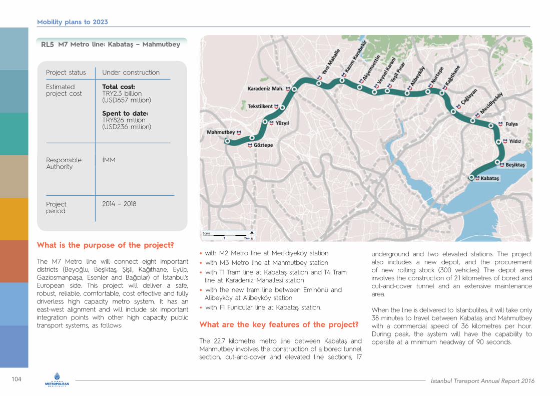
104 İstanbul Transport Annual Report 2016
Mobility plans to 2023
• with M2 Metro line at Mecidiyeköy station• with M3 Metro line at Mahmutbey station• with T1 Tram line at Kabataş station and T4 Tram line at Karadeniz Mahallesi station• with the new tram line between Eminönü and Alibeyköy at Alibeyköy station• with F1 Funicular line at Kabataş station.
What are the key features of the project?
The 22.7 kilometre metro line between Kabataş and Mahmutbey involves the construction of a bored tunnel section, cut-and-cover and elevated line sections, 17
What is the purpose of the project?
The M7 Metro line will connect eight important districts (Beyoğlu, Beşiktaş, Şişli, Kağıthane, Eyüp, Gaziosmanpaşa, Esenler and Bağcılar) of İstanbul’s European side. This project will deliver a safe, robust, reliable, comfortable, cost effective and fully driverless high capacity metro system. It has an east-west alignment and will include six important integration points with other high capacity public transport systems, as follows:
M7 Metro line: Kabataş – Mahmutbey
Project status
Responsible Authority
Estimated project cost
Project period
Under construction
İMM
Total cost: TRY2.3 billion(USD657 million)
Spent to date: TRY826 million(USD236 million)
2014 – 2018
RL5
underground and two elevated stations. The project also includes a new depot, and the procurement of new rolling stock (300 vehicles). The depot area involves the construction of 2.1 kilometres of bored and cut-and-cover tunnel and an extensive maintenance area.
When the line is delivered to İstanbulites, it will take only 38 minutes to travel between Kabataş and Mahmutbey with a commercial speed of 36 kilometres per hour. During peak, the system will have the capability to operate at a minimum headway of 90 seconds.

İstanbul Transport Annual Report 2016 105
Mobility plans to 2023
How will the project impact everyday life?
The M7 Metro line will serve the residents/ visitors of eight İstanbul districts. It is expected to serve about one million trips per day. During peak hours, the system’s maximum capacity in passengers per hour per direction will be 70,000.
What is the status of the project?
Construction works continue along the entire M7 Metro line. More specifically, in the part between Mecidiyeköy and Mahmutbey, 90 per cent of excavation and 61 per cent of reinforced concrete works have already been completed. Furthermore, between Mecidiyeköy and Mahmutbey 97 per cent of excavation and 68 per cent of lining works have been completed.
The construction of the TBM tunnel section between a) Veysel Karani and Tekstilkent and b) Fulya and Yıldız have been completed, while the TBM operations between Tekstilkent and Mahmutbey are expected to finish by September 2017. Finally, electromechanical and finishing works between Mecidiyeköy and Mahmutbey will start in the near future.
What are the key milestones of the project?
Key project stage# Type of work Time plan
Planning of the entire line1
2
3
4
5
6
Procurement of 300 rail vehicles
Construction of the 17.2 kilometre line between Mecidiyeköy and Mahmutbey, two elevated stations and 13 underground stations
Construction of the 5.5 kilometre line between Kabataş and Mecidiyeköy, four underground stations Electromechanical and finishing works of Kabataş – Mahmutbey
Construction of depot area
Opening of M7 Metro line Kabataş – Mahmutbey
Feasibility study
Preliminary design
Detailed design
Detailed design
Detailed design
Work in progress
Work in progress
Work in progress
Receiving first vehicles (milestone)
Work in progress
Milestone
2007
2014
04/2016 - 04/2021
01/2014 – 08/2017
05/2015 – 05/2018
01/2017 – 03/2018
01/2014 – 08/2017
05/2015 – 05/2018
01/2017 – 03/2018
28/02/2018
11/05/2018
• Length: 22.7 km• Stations: 19• Travel time: 38 minutes• Minimum headway: 90 seconds
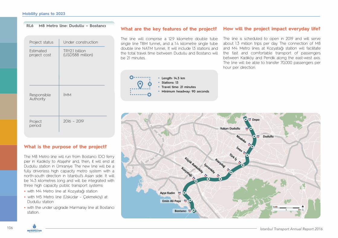
106 İstanbul Transport Annual Report 2016
Mobility plans to 2023
M8 Metro line: Dudullu – Bostancı
Project status
Responsible Authority
Estimated project cost
Project period
Under construction
İMM
TRY2.1 billion(USD588 million)
2016 – 2019
RL6
What is the purpose of the project?
The M8 Metro line will run from Bostancı İDO ferry pier in Kadıköy to Ataşehir and, then, it will end at Dudullu station in Ümraniye. The new line will be a fully driverless high capacity metro system with a north-south direction in İstanbul’s Asian side. It will be 14.3 kilometres long and will be integrated with three high capacity public transport systems:• with M4 Metro line at Kozyatağı station• with M5 Metro line (Üsküdar – Çekmeköy) at Dudullu station• with the under upgrade Marmaray line at Bostancı station.
What are the key features of the project?
The line will comprise a 12.9 kilometre double tube single line TBM tunnel, and a 1.4 kilometre single tube double line NATM tunnel. It will include 13 stations and the total travel time between Dudullu and Bostancı will be 21 minutes.
• Length: 14.3 km• Stations: 13• Travel time: 21 minutes• Minimum headway: 90 seconds
How will the project impact everyday life?
The line is scheduled to open in 2019 and will serve about 1.3 million trips per day. The connection of M8 and M4 Metro lines at Kozyatağı station will facilitate the fast and comfortable transport of passengers between Kadıköy and Pendik along the east-west axis. The line will be able to transfer 70,000 passengers per hour per direction.
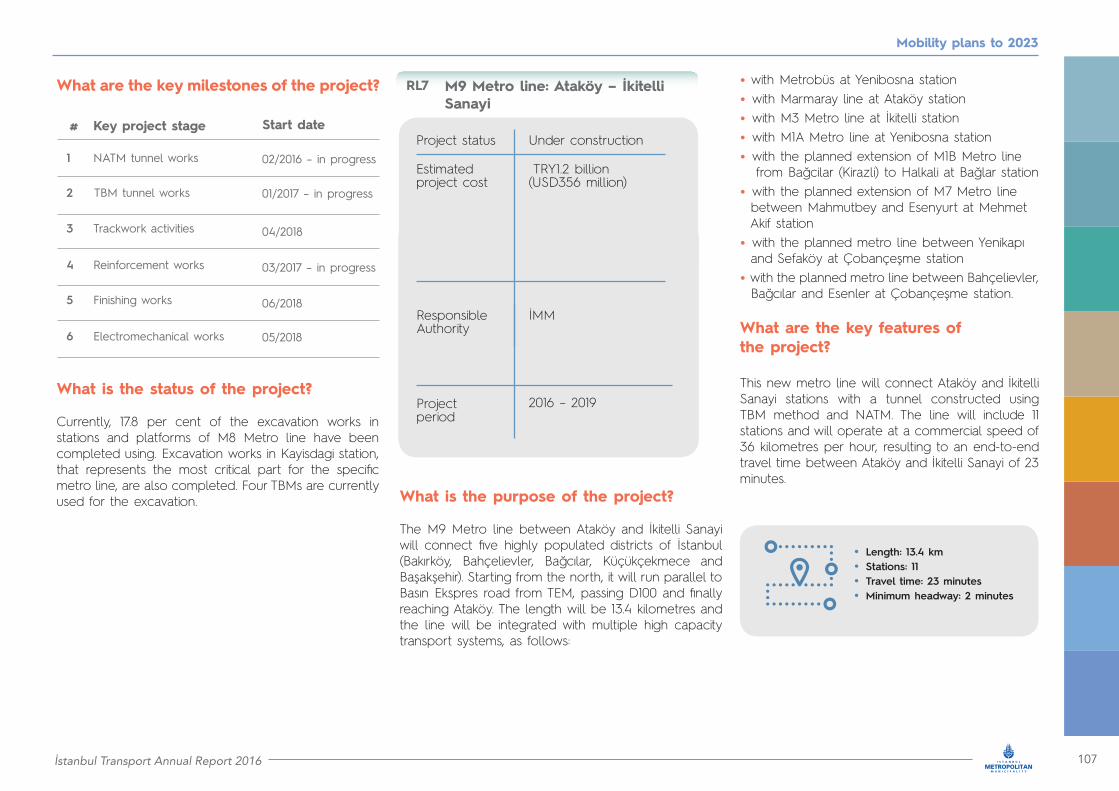
İstanbul Transport Annual Report 2016 107
Mobility plans to 2023
• Length: 13.4 km• Stations: 11• Travel time: 23 minutes• Minimum headway: 2 minutes
M9 Metro line: Ataköy – İkitelli Sanayi
Project status
Responsible Authority
Estimated project cost
Project period
Under construction
İMM
TRY1.2 billion(USD356 million)
2016 – 2019
RL7
What is the status of the project?
Currently, 17.8 per cent of the excavation works in stations and platforms of M8 Metro line have been completed using. Excavation works in Kayisdagi station, that represents the most critical part for the specific metro line, are also completed. Four TBMs are currently used for the excavation.
What are the key milestones of the project?
What is the purpose of the project?
The M9 Metro line between Ataköy and İkitelli Sanayi will connect five highly populated districts of İstanbul (Bakırköy, Bahçelievler, Bağcılar, Küçükçekmece and Başakşehir). Starting from the north, it will run parallel to Basın Ekspres road from TEM, passing D100 and finally reaching Ataköy. The length will be 13.4 kilometres and the line will be integrated with multiple high capacity transport systems, as follows:
• with Metrobüs at Yenibosna station• with Marmaray line at Ataköy station• with M3 Metro line at İkitelli station• with M1A Metro line at Yenibosna station• with the planned extension of M1B Metro line from Bağcilar (Kirazli) to Halkali at Bağlar station• with the planned extension of M7 Metro line between Mahmutbey and Esenyurt at Mehmet Akif station• with the planned metro line between Yenikapı and Sefaköy at Çobançeşme station• with the planned metro line between Bahçelievler, Bağcılar and Esenler at Çobançeşme station.
What are the key features of the project?
This new metro line will connect Ataköy and İkitelli Sanayi stations with a tunnel constructed using TBM method and NATM. The line will include 11 stations and will operate at a commercial speed of 36 kilometres per hour, resulting to an end-to-end travel time between Ataköy and İkitelli Sanayi of 23 minutes.
Key project stage# Start date
NATM tunnel works1
2
3
4
5
6
Trackwork activities
Finishing works
TBM tunnel works
Reinforcement works
Electromechanical works
02/2016 – in progress
01/2017 – in progress
04/2018
03/2017 – in progress
06/2018
05/2018

108 İstanbul Transport Annual Report 2016
Mobility plans to 2023
How will the project impact everyday life?
The metro line will be an important north-south connector of five districts of the European side, and will be integrated with Metrobüs, Marmaray and six metro lines,
What is the status of the project?
Currently, the excavation works of tunnels using NATM are in progress. Four TBMs will be used and are already on site. Out of four the first one has already been installed
What are the key milestones of the project?
Key project stage# Start date
NATM tunnel works1
2
3
4
5
7
6
8
Trackwork activities
Finishing works
Operation and maintenance works
TBM tunnel works
Reinforcement works
Electromechanical works
M9 Metro line opening
07/2016 – in progress
04/2017 – in progress
04/2018
03/2017 – in progress
10/2017
01/2019
03/2019 (milestone)
05/2018
two of which are in operation, and four are at the planning stage. The M9 Metro line is expected to serve 380,000 trips per day. The line will be able to transfer 28,800 passengers per hour per direction
at Çobançeşme Kuyumcukent station and the second one is currently being installed.

İstanbul Transport Annual Report 2016 109
Mobility plans to 2023
What is the purpose of the project?
The metro line to the new airport will be the longest and fastest one in Turkey. The line will connect Gayrettepe to the new (third) International Airport of İstanbul in less than 30 minutes. By 2023 the line will be further extended to Halkali. It will have very important integration points with other inner city high capacity transport systems as follows:
• with M2 Metro line, Metrobüs and the planned metro line between İncirli and Söğütlüçeşme at Gayrettepe station
• with the under construction M7 Metro line between Kabataş and Mahmutbey, the planned metro line from Kağıthane to İstinye and the planned tram line between Kağithane and Kemerburgaz Dekovil at Kağıthane station
• with the planned metro line between Seyrantepe and Alibeyköy at İski Arıtma station.
Metro line between Gayrettepe and the new airport
Project status
Responsible Authority
Estimated project cost
Project period
Under construction
Ministry of Transport/ AYGM
Total cost: TRY4.0 billion(USD1.2 billion)
Spent to date: TRY554 million(USD158 million)
2016 – 2019
RL8

110 İstanbul Transport Annual Report 2016
Mobility plans to 2023
What are the key features of the project?
The line will be 37.5 kilometres long and fully underground. It will include eight stations and operate at an average speed of 85 kilometres per hour delivering a travel time between Gayrettepe and the new airport of only 28 minutes. 80 rail vehicles will be purchased in 2019.
How will the project impact everyday life?
By the end of 2019, passengers of the new International Airport of İstanbul will be able to travel in less than 30 minutes to the city centre. Given its high speed and frequency, the line will have the capacity to serve about 300,000 passengers per day.
What is the status of the project?
Construction commenced in December 2016.
What are the key milestones of the project?
• Length: 37.5 km• Stations: 8• Travel time: 28 minutes
Key project stage#Construction of a 37.5-kilometre tunnel and eight underground stations
1
2 Procurement of 80 rail vehicles
Time plan
12/2016 – 12/2018
12/2016 – 12/2019
during 2019
Type of work
Detailed design
Work in progress
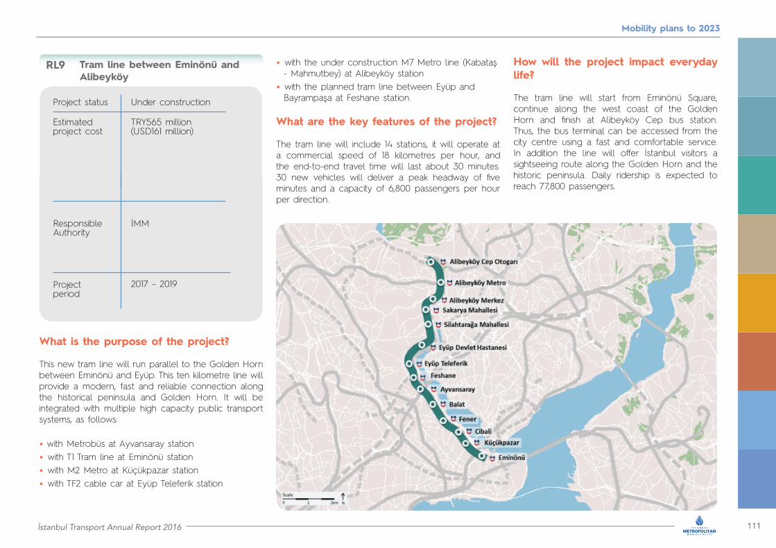
İstanbul Transport Annual Report 2016 111
Mobility plans to 2023
What is the purpose of the project?
This new tram line will run parallel to the Golden Horn between Eminönü and Eyüp. This ten kilometre line will provide a modern, fast and reliable connection along the historical peninsula and Golden Horn. It will be integrated with multiple high capacity public transport systems, as follows:
• with Metrobüs at Ayvansaray station• with T1 Tram line at Eminönü station• with M2 Metro at Küçükpazar station• with TF2 cable car at Eyüp Teleferik station
• with the under construction M7 Metro line (Kabataş - Mahmutbey) at Alibeyköy station• with the planned tram line between Eyüp and Bayrampaşa at Feshane station.
What are the key features of the project?
The tram line will include 14 stations, it will operate at a commercial speed of 18 kilometres per hour, and the end-to-end travel time will last about 30 minutes. 30 new vehicles will deliver a peak headway of five minutes and a capacity of 6,800 passengers per hour per direction.
How will the project impact everyday life?
The tram line will start from Eminönü Square, continue along the west coast of the Golden Horn and finish at Alibeyköy Cep bus station. Thus, the bus terminal can be accessed from the city centre using a fast and comfortable service. In addition the line will offer İstanbul visitors a sightseeing route along the Golden Horn and the historic peninsula. Daily ridership is expected to reach 77,800 passengers.
Tram line between Eminönü and Alibeyköy
Project status
Responsible Authority
Estimated project cost
Project period
Under construction
İMM
TRY565 million(USD161 million)
2017 – 2019
RL9
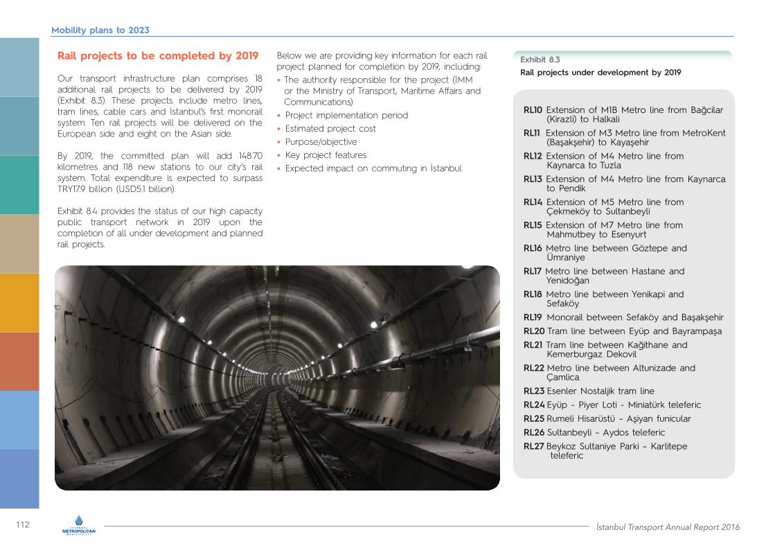
112 İstanbul Transport Annual Report 2016
Mobility plans to 2023
Below we are providing key information for each rail project planned for completion by 2019, including:• The authority responsible for the project (İMM or the Ministry of Transport, Maritime Affairs and Communications)• Project implementation period • Estimated project cost• Purpose/objective• Key project features• Expected impact on commuting in İstanbul
Rail projects to be completed by 2019
Our transport infrastructure plan comprises 18 additional rail projects to be delivered by 2019 (Exhibit 8.3). These projects include metro lines, tram lines, cable cars and İstanbul’s first monorail system. Ten rail projects will be delivered on the European side and eight on the Asian side.
By 2019, the committed plan will add 148.70 kilometres and 118 new stations to our city’s rail system. Total expenditure is expected to surpass TRY17.9 billion (USD5.1 billion).
Exhibit 8.4 provides the status of our high capacity public transport network in 2019 upon the completion of all under development and planned rail projects.
Rail projects under development by 2019Exhibit 8.3
RL10 Extension of M1B Metro line from Bağcilar (Kirazli) to HalkaliRL11 Extension of M3 Metro line from MetroKent (Başakşehir) to KayaşehirRL12 Extension of M4 Metro line from Kaynarca to TuzlaRL13 Extension of M4 Metro line from Kaynarca to PendikRL14 Extension of M5 Metro line from Çekmeköy to SultanbeyliRL15 Extension of M7 Metro line from Mahmutbey to EsenyurtRL16 Metro line between Göztepe and ÜmraniyeRL17 Metro line between Hastane and YenidoğanRL18 Metro line between Yenikapi and SefaköyRL19 Monorail between Sefaköy and BaşakşehirRL20 Tram line between Eyüp and BayrampaşaRL21 Tram line between Kağithane and Kemerburgaz DekovilRL22 Metro line between Altunizade and ÇamlicaRL23 Esenler Nostaljik tram lineRL24 Eyüp - Piyer Loti - Miniatürk telefericRL25 Rumeli Hisarüstü – Aşiyan funicularRL26 Sultanbeyli – Aydos telefericRL27 Beykoz Sultaniye Parki – Karlitepe teleferic
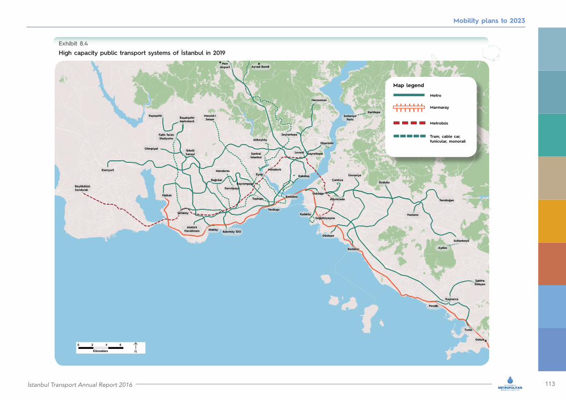
İstanbul Transport Annual Report 2016 113
Mobility plans to 2023
High capacity public transport systems of İstanbul in 2019Exhibit 8.4
Map legend
Metro
Marmaray
Metrobüs
Tram, cable car,funicular, monorail

114 İstanbul Transport Annual Report 2016
Extension of M1B Metro line from Bağcilar (Kirazli) to Halkalı
Project status
Responsible Authority
Estimated project cost
Projected implementation period
Planned
İMM
TRY1.6 billion(USD444 million)
2017 – 2019
RL10
Mobility plans to 2023
What is the purpose of the project?
With this extension, the M1B Metro line, which currently operates between Yenikapı and Kirazlı, will connect to Halkali in the west. Passengers using M1B Metro line will now have the option to transfer to:• Marmaray line at Halkalı station• M3 Metro line at Kirazlı station• the under construction M9 Metro line (Ataköy İkitelli) at Mimar Sinan station.
What are the key features of the project?
The planned extension will add 9.7 kilometres and ten stations to the M1B Metro line and, hence, will increase its total length to 23.7 kilometres with 22 stations. The M1B Metro line will operate at a commercial speed of 38 kilometres per hour enabling travel times between
Yenikapı and Halkalı of 74 minutes. The service will be able to run at peak headway of three minutes. 25 train sets of five vehicles each will be added to the existing fleet.

İstanbul Transport Annual Report 2016 115
Mobility plans to 2023
How will the project impact everyday life?
With the completion of this extension, the role of the M1B Metro line as a key east-west metro corridor will be enhanced. The extension will provide direct rail connectivity between Küçükçekmece and the city
centre. The entire line is expected to serve 633,000 trips per day with a peak capacity of 28,000 passengers per hour per direction.

116 İstanbul Transport Annual Report 2016
Extension of M3 Metro line from MetroKent (Başakşehir) to Kayaşehir
Project status
Responsible Authority
Estimated project cost
Planned
İMM
TRY1.3 billion(USD375 million)
2017 – 2019
RL11
Mobility plans to 2023
Projected implementation period
What is the purpose of the project?
This extension of M3 Metro line will reach Kayaşehir in north west of İstanbul. At Kayaşehir station the M3 Metro line will be integrated with the extension of Marmaray line to the new airport and will be delivered by 2023.
What are the key features of the project?
The project will add 6.2 kilometres and four stations to the M3 Metro line. 64 new vehicles will be procured to enable extended operations. Trains will achieve a commercial speed of 38 kilometres per hour and the headway will be 2.5 minutes.
How will the project impact everyday life?
After the completion of the project, passengers will be able to travel between Kayaşehir and Basaksehir in just ten minutes. The extension will serve dense population areas, as well as a major hospital currently under construction. After the delivery of the extension,
it is expected that the M3 Metro line will transport up to one million passengers per day and the journey time between Kayaşehir and Bakırköy will be only 30 minutes.

İstanbul Transport Annual Report 2016 117
Mobility plans to 2023
Extensions of M4 Metro line from Kaynarca to Tuzla and to Pendik
Project status
Responsible Authority
Estimated project cost
Planned
İMM
TRY3.1 billion(USD873 million)
2017 – 2019
RL12/RL13
Projected implementation period
What is the purpose of the project?
Two very important extensions of the M4 Metro line (Kadıköy – Kaynarca) will be completed by the end of 2019:
1. the extension from Kaynarca towards Esenyalı and Tuzla
2. the extension from Kaynarca towards Pendik The first extension will connect Tuzla directly to Kadıköy and will allow citizens of Tuzla to have convenient access to Metrobüs and Marmaray services. The second extension will integrate Marmaray and the high speed train terminal at Pendik with the M4 Metro line.
How will the project impact everyday life?
It is estimated that the extension to Tuzla will serve 648,000 passengers per day. Peak capacity will be 33,800 passengers per hour per direction. For the Pendik extension daily ridership will reach 296,000 passengers and peak capacity will reach
15,000 passengers per hour per direction. Finally, the direct connection of the high speed rail terminal with Sabiha Gökçen International Airport provides a valuable option to the city’s residents and visitors.
After the completion of the under construction extension between Kaynarca and Sabiha Gökçen International Airport, passengers using these two extensions will also be able to reach the airport.
What are the key features of the project?The Tuzla extension is 7.8 kilometres long, includes five stations and the travel time will be 10.5 minutes at a commercial speed of 38 kilometres per hour. The Pendik extension 3.8 kilometres long, includes one new station and the travel time will be four minutes at a commercial speed of 35 kilometres per hour. Trains will be able to run at four minute headways during peak. 28 trains (138 vehicles) will be purchased in view of both extensions.

118 İstanbul Transport Annual Report 2016
Mobility plans to 2023
Extension of M5 Metro line from Çekmeköy to Sultanbeyli
Project status
Responsible Authority
Estimated project cost
Planned
İMM
TRY1.8 billion(USD511 million)
2017 – 2019
RL14
Projected implementation period
What is the purpose of the project?
The under construction M5 Metro line from Üsküdar to Çekmeköy will be extended by 10.9 kilometres further east to Sultanbeyli. The line will integrate with four high capacity public transport systems, as follows:
• with Metrobüs at Altunizade station• with the under upgrade Marmaray line at Üsküdar station• with the planned metro line between Hastane and Yenidoğan at Sarıgazi station• with the planned metro line between Kadıköy and Sultanbeyli at Veysel Karani station.
In the future, this route will be further extended to Kurtköy (Viaport).
What are the key features of the project?
This extension will add 10.9 kilometres and eight stations to the under construction M5 Metro line. Thus, M5 will reach a total length of 27.9 kilometres and will include 24 stations. The line will operate at a commercial speed of 38 kilometres per hour, delivering a total travel time between Üsküdar to Sultanbeyli of 43 minutes. Based on current plans, 36 trains will be used (216 vehicles) to deliver a peak headway of three minutes.
How will the project impact everyday life?
The extension will serve the continuously growing eastern areas of our city, providing a valuable mobility alternative to private cars. Upon completion in 2019, it is estimated that the extended M5 Metro line will serve 832,000 passengers per day and the peak capacity may reach 40,500 passengers per hour per direction.

İstanbul Transport Annual Report 2016 119
Mobility plans to 2023
Extension of M7 Metro line from Mahmutbey to Esenyurt
Project status
Responsible Authority
Estimated project cost
Planned
İMM
TRY3.4 billion (USD970 million)
2017 – 2019
RL15
Projected implementation period
What is the purpose of the project?
The M7 Metro line will extend from Mahmutbey in the east to Esenyurt in the west, and will be integrated with multiple major public transport systems including:
• the under construction M9 Metro line (Ataköy- İkitelli) at Mehmet Akif station• the extended M3 Metro line (Bakırköy İDO- Başakşehir) at Mahmutbey station• the new monorail system between Sefaköy and Başakşehir at Toplu Konut station• the future extension of the Marmaray line from Halkali to the new airport at Tema Park station.
What are the key features of the project?
The extension of the M7 Metro line will be 18.5 kilometre long and will include 11 stations. It will operate at a commercial speed of 38 kilometres per hour ensuring a travel time of 28 minutes between Mahmutbey and Esenyurt. Trains will be able to run with frequencies of 2.25 minutes. To do so, 200 additional vehicles will be procured.
How will the project impact everyday life?
The extension of M7 Metro line runs along TEM, one of İstanbul’s most important transportation axes. Thus, the line will serve key residential areas and business centres along this axis, connecting Esenyurt to the historical Kabataş. The line will also enhance the north-south connectivity of Esenyurt through transfers to M9 and M3 Metro lines. The extended M7 Metro line is expected to transport two million passengers per day.

120 İstanbul Transport Annual Report 2016
Mobility plans to 2023
Metro line between Göztepe and Ümraniye
Project status
Responsible Authority
Estimated project cost
Planned
İMM
TRY1.8 billion(USD505 million)
2017 – 2019
RL16
Projected implementation period
What is the purpose of the project?
This new 13 kilometre metro line on the Asian side will connect Göztepe in Kadıköy with the neighbourhood of Kazim Karabekir in Ümraniye. The line will run parallel to Bosphorus, and to the under construction M8 Metro line between Dudullu and Bostanci. It will provide significant integration with four important metro lines:• the M4 Metro line at Yenisahra station• the under upgrade Marmaray line at Göztepe station• the about to be delivered M5 Metro line (Üsküdar - Çekmeköy) at Çarşı station• the planned metro line between Kadıköy and Sultanbeyli at Finans Merkezi station.
What are the key features of the project?
The new metro line will be 13 kilometres long and will include 11 stations. With a commercial speed of 38 kilometres per hour, the total trip will last about 20 minutes. The plan is to purchase 11 trains (44 vehicles) for commencement of operations in 2019. The metro service will run at a peak headway of about four minutes.
How will the project impact everyday life?
The line will be an important north-south connector of four metro lines. It is expected to serve 330,000 passengers per day. Peak capacity may reach 18,000 passengers per hour per direction.

İstanbul Transport Annual Report 2016 121
Mobility plans to 2023
What is the purpose of the project?
This new metro line will be constructed in Sancaktepe between Hastane and Yenidoğan and will be completed by 2019. At Sarıgazi station it will be integrated with the M5 Metro line, the extension of which to Sultanbeyli will be constructed during the same period. The line will be the first stage of a longer Türkiş Blocks – Yendidoğan line to be completed at a later stage.
What are the key features of the project?
The line will be almost seven kilometres and will include six stations. It will operate at a commercial speed of 34 kilometres per hour, thus completing the total trip in 11 minutes. Seven trains (31 vehicles) will be procured. The peak headway will be four minutes.
How will the project impact everyday life?
It is estimated that the new metro line will serve 324,000 passengers per day. Peak capacity will be 19,000 passengers per hour per direction.
Metro line between Hastane and Yenidoğan
Project status
Responsible Authority
Estimated project cost
Planned
İMM
TRY843 million(USD241 million)
2017 – 2018
RL17
Projected implementation period
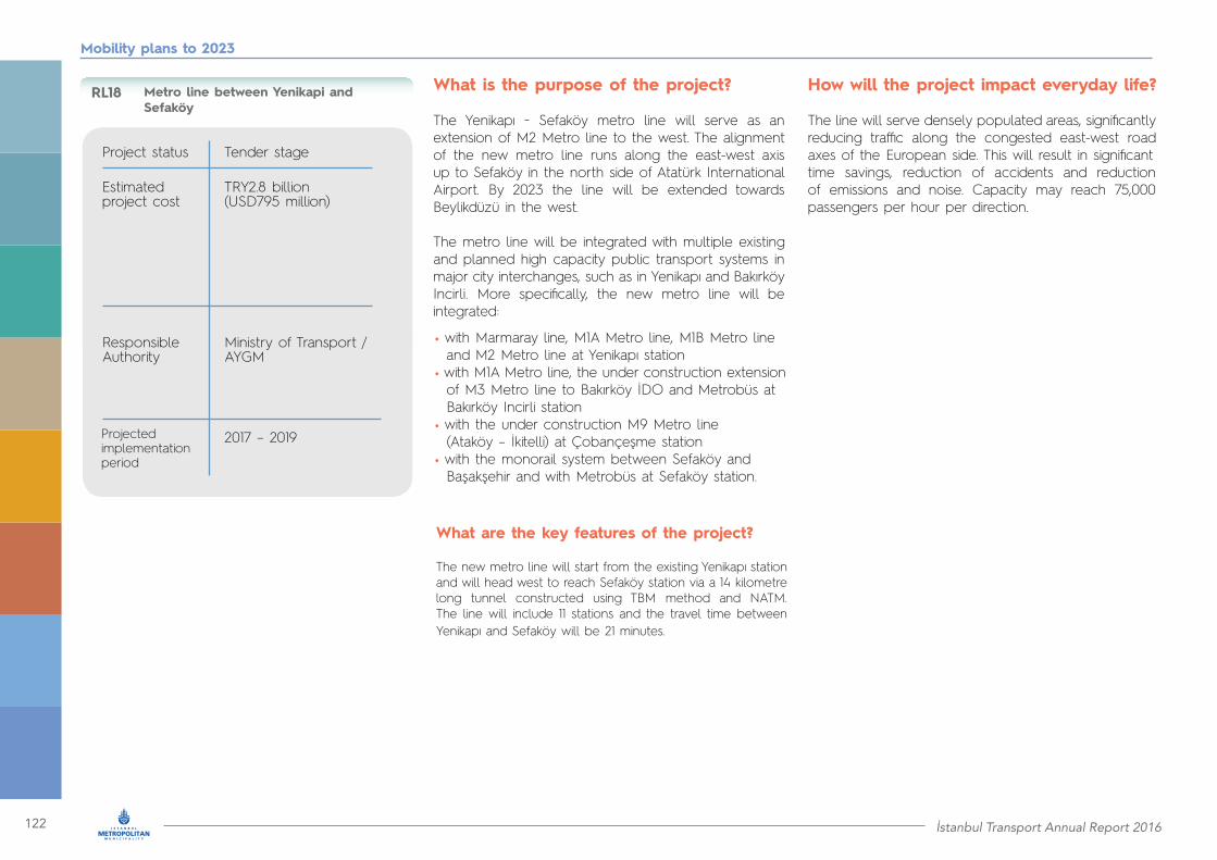
122 İstanbul Transport Annual Report 2016
Mobility plans to 2023
Metro line between Yenikapi and Sefaköy
Project status
Responsible Authority
Estimated project cost
Tender stage
Ministry of Transport / AYGM
TRY2.8 billion(USD795 million)
2017 – 2019
RL18
Projected implementation period
How will the project impact everyday life?
The line will serve densely populated areas, significantly reducing traffic along the congested east-west road axes of the European side. This will result in significanttime savings, reduction of accidents and reduction of emissions and noise. Capacity may reach 75,000 passengers per hour per direction.
• with Marmaray line, M1A Metro line, M1B Metro line and M2 Metro line at Yenikapı station• with M1A Metro line, the under construction extension of M3 Metro line to Bakırköy İDO and Metrobüs at Bakırköy Incirli station• with the under construction M9 Metro line (Ataköy – İkitelli) at Çobançeşme station• with the monorail system between Sefaköy and Başakşehir and with Metrobüs at Sefaköy station.
What are the key features of the project?
The new metro line will start from the existing Yenikapı station and will head west to reach Sefaköy station via a 14 kilometre long tunnel constructed using TBM method and NATM. The line will include 11 stations and the travel time between Yenikapı and Sefaköy will be 21 minutes.
What is the purpose of the project?
The Yenikapı − Sefaköy metro line will serve as an extension of M2 Metro line to the west. The alignment of the new metro line runs along the east-west axis up to Sefaköy in the north side of Atatürk International Airport. By 2023 the line will be extended towards Beylikdüzü in the west.
The metro line will be integrated with multiple existing and planned high capacity public transport systems in major city interchanges, such as in Yenikapı and Bakırköy Incirli. More specifically, the new metro line will be integrated:
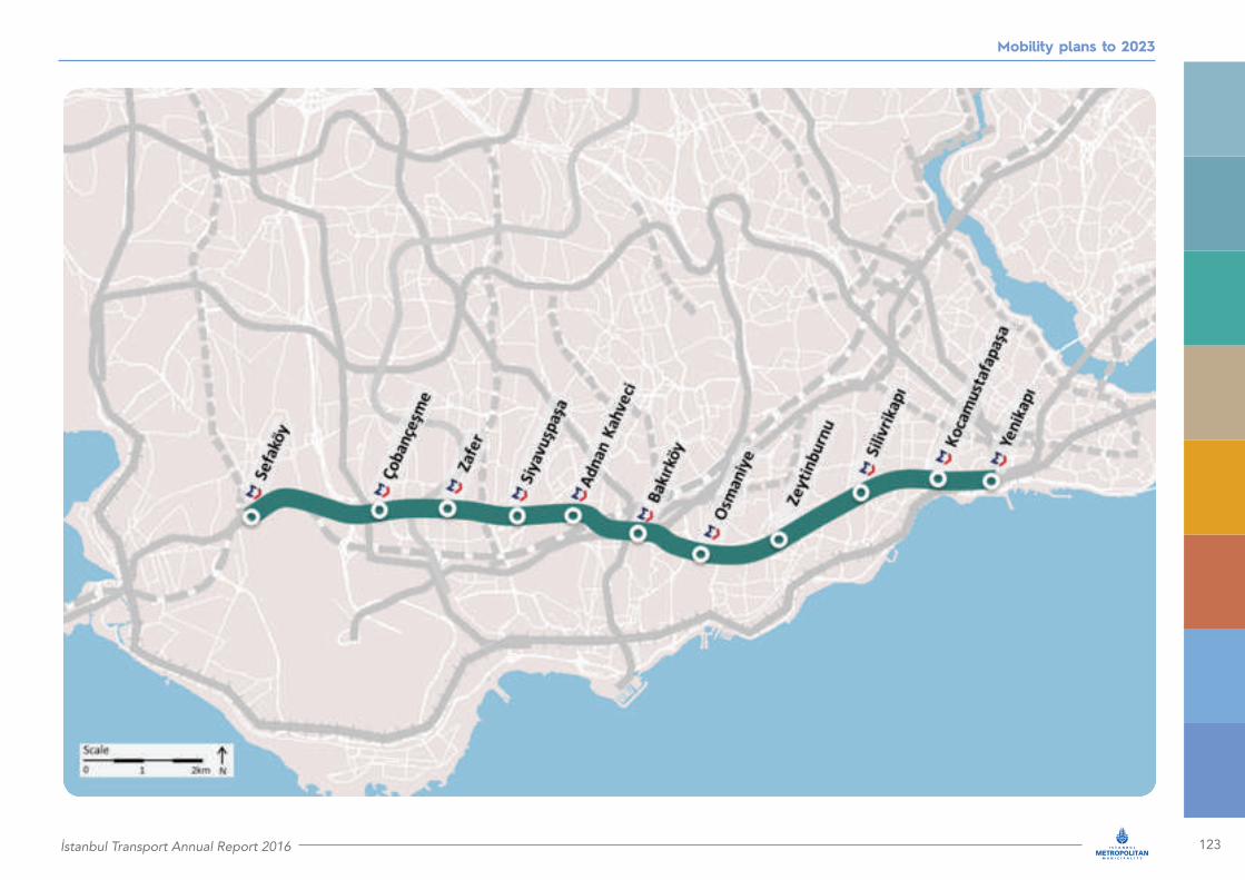
İstanbul Transport Annual Report 2016 123
Mobility plans to 2023

124 İstanbul Transport Annual Report 2016
What is the purpose of the project?
İstanbul’s first monorail (Havaray) system will connect the districts of Küçükçekmece and Başakşehir by 2019. The 15 kilometre long line will provide modern, fast and comfortable public transport service between Sefaköy and Fatih Terim Stadium along Halkalı Street and Hürriyet Boulevard. The line will be integrated with multiple high capacity public transport systems:
• with Metrobüs and the planned metro line between Yenikapi and Sefaköy at Sefaköy station• with the planned extension of M1B to Halkali at Halkalı Merkez station• with the planned extension of M7 Metro line to Esenyurt at Atakent Mahallesi• with the M3 Metro line at Ziya Gökalp and Başak Konutları stations.
How will the project impact everyday life?
The system will serve the densely populated and continuously growing, areas of Sefaköy and Başakşehir. It will decongest the busy roads of Sefaköy and Halkali and it is expected to reduce peak traffic along the congested part of D100 between Beylikdüzü and Bakırköy.
The monorail system will be able to transport 19,000 passengers per hour per direction. It is expected to serve 336,000 passengers per day.
What are the key features of the project?
The monorail line will be 15 kilometres long and will include 17 stations. The system will operate at an average commercial speed of 33 kilometres per hour delivering a travel time between Sefaköy and Fatih Terim Stadium of 27 minutes. Train headway will reach 1.5 minutes. Each train will comprise three to five vehicles and will carry up to 550 passengers (seating and standing). It is expected that 30 train sets will be procured for full operation.
Monorail between Sefaköy and Başakşehir
Project status
Responsible Authority
Estimated project cost
Design completed / Selection of the main contractor under way
İMM
TRY2.1 billion(USD553 million)
2017 – 2019
RL19
Projected implementation period
Mobility plans to 2023
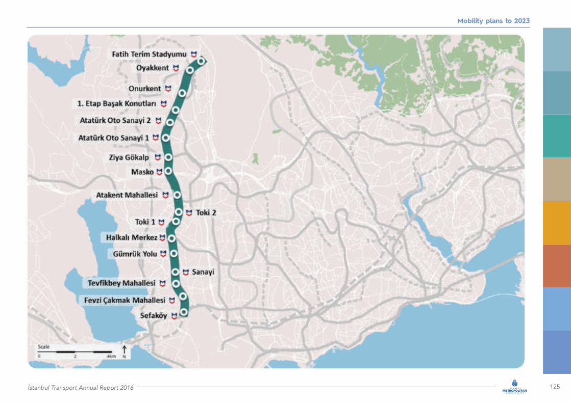
İstanbul Transport Annual Report 2016 125
Mobility plans to 2023
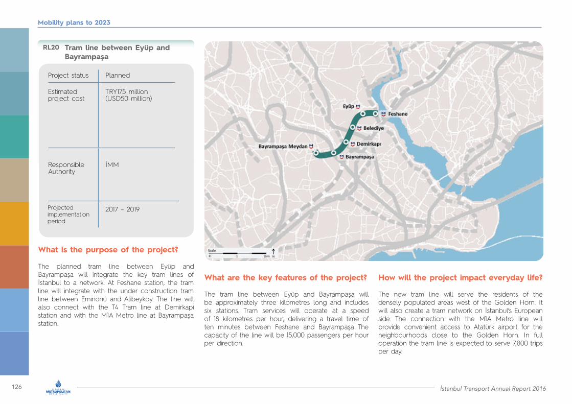
126 İstanbul Transport Annual Report 2016
Tram line between Eyüp and Bayrampaşa
Project status
Responsible Authority
Estimated project cost
Planned
İMM
TRY175 million(USD50 million)
2017 – 2019
RL20
Projected implementation period
Mobility plans to 2023
What is the purpose of the project?
The planned tram line between Eyüp and Bayrampaşa will integrate the key tram lines of İstanbul to a network. At Feshane station, the tram line will integrate with the under construction tram line between Eminönü and Alibeyköy. The line will also connect with the T4 Tram line at Demirkapi station and with the M1A Metro line at Bayrampaşa station.
What are the key features of the project?
The tram line between Eyüp and Bayrampaşa will be approximately three kilometres long and includes six stations. Tram services will operate at a speed of 18 kilometres per hour, delivering a travel time of ten minutes between Feshane and Bayrampaşa The capacity of the line will be 15,000 passengers per hour per direction.
How will the project impact everyday life?
The new tram line will serve the residents of the densely populated areas west of the Golden Horn. It will also create a tram network on İstanbul’s European side. The connection with the M1A Metro line will provide convenient access to Atatürk airport for the neighbourhoods close to the Golden Horn. In full operation the tram line is expected to serve 7,800 trips per day.

İstanbul Transport Annual Report 2016 127
Mobility plans to 2023
Tram line between Kağithane and Kemerburgaz Dekovil
Project status
Responsible Authority
Estimated project cost
Planned
İMM
TRY480 million(USD137 million)
2017 – 2019
RL21
Projected implementation period
What is the purpose of the project?
The planned tram line between Kagithane and Kemerburgaz will revitalise the historical rail line established between 1914 and 1916 to transfer coal from the north to the Silahtarağa electric power plant close to the Golden Horn. The new tram line will extend the rail network of İstanbul in the north direction and will also connect:
• with the under construction M7 Metro line (Kabataş Mahmutbey) at Sadabad station• with the tram line between Eminönü and Alibeyköy at Silahtarağa station• with the under construction metro line to the new airport at Kemerburgaz station• with the planned metro line between Kağithane and İstinye at Cendere and TT Arena stations.
What are the key features of the project?
The tram line will be 25 kilometres long and will include ten stations. The system will operate at a commercial speed of 20 kilometres per hour and the travel time between Kagithane and Kemerburgaz will be 75 minutes. 50 vehicles will be used running every six minutes during peak.
How will the project impact everyday life?
In addition to providing valuable public transport services in the region, the new tram will also be used by tourists to access the areas close to the Belgrad forest and Kagithane river. The line is estimated to transport 26,000 passengers daily and its peak capacity may reach 4,000 passengers per hour per direction.
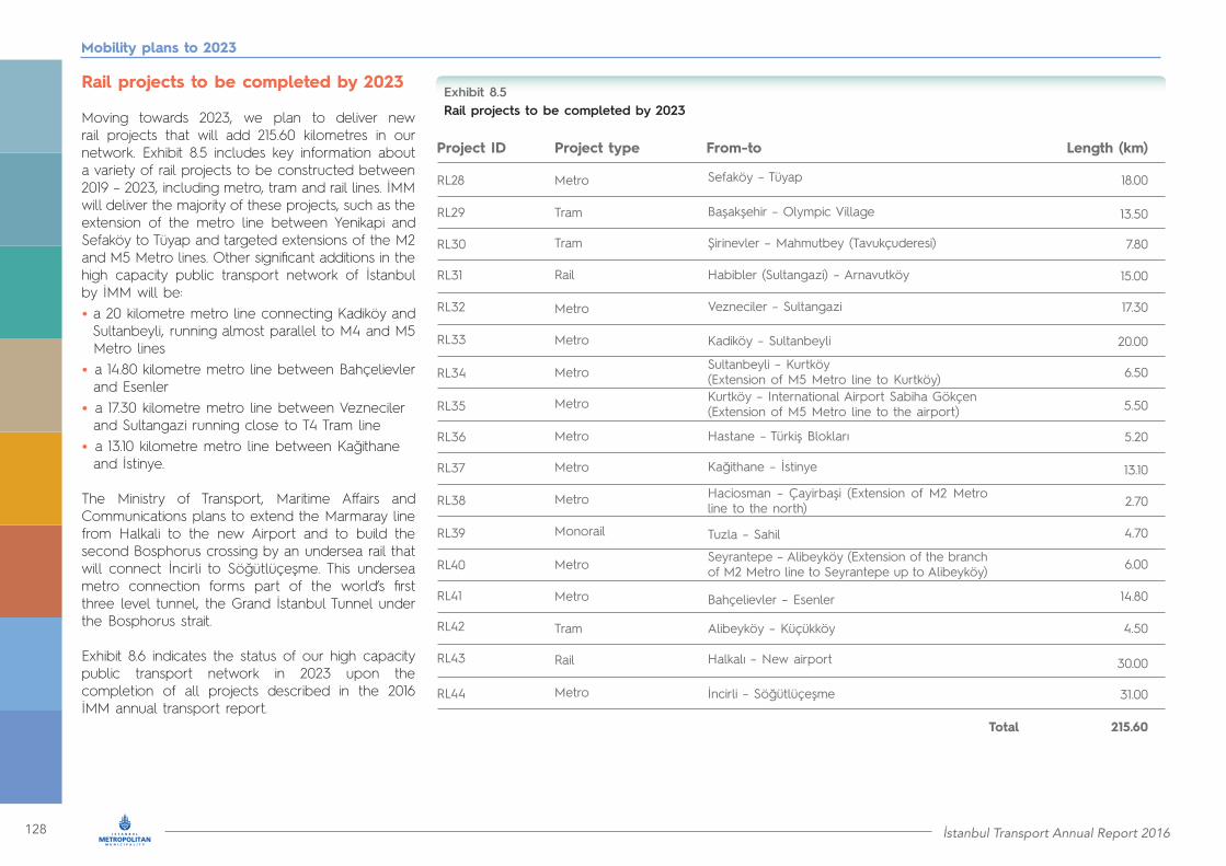
128 İstanbul Transport Annual Report 2016
Mobility plans to 2023
Rail projects to be completed by 2023
Moving towards 2023, we plan to deliver new rail projects that will add 215.60 kilometres in our network. Exhibit 8.5 includes key information about a variety of rail projects to be constructed between 2019 – 2023, including metro, tram and rail lines. İMM will deliver the majority of these projects, such as the extension of the metro line between Yenikapi and Sefaköy to Tüyap and targeted extensions of the M2 and M5 Metro lines. Other significant additions in the high capacity public transport network of İstanbul by İMM will be:• a 20 kilometre metro line connecting Kadiköy and Sultanbeyli, running almost parallel to M4 and M5 Metro lines• a 14.80 kilometre metro line between Bahçelievler and Esenler• a 17.30 kilometre metro line between Vezneciler and Sultangazi running close to T4 Tram line• a 13.10 kilometre metro line between Kağithane and İstinye.
The Ministry of Transport, Maritime Affairs and Communications plans to extend the Marmaray line from Halkali to the new Airport and to build the second Bosphorus crossing by an undersea rail that will connect İncirli to Söğütlüçeşme. This undersea metro connection forms part of the world’s first three level tunnel, the Grand İstanbul Tunnel under the Bosphorus strait.
Exhibit 8.6 indicates the status of our high capacity public transport network in 2023 upon the completion of all projects described in the 2016 İMM annual transport report.
Rail projects to be completed by 2023Exhibit 8.5
Project ID Project type From-to Length (km)
RL28 Metro 18.00
13.50
7.80
15.00
17.30
20.00
6.50
5.50
5.20
13.10
2.70
4.70
6.00
14.80
4.50
30.00
31.00
215.60
Sefaköy – Tüyap
Şirinevler – Mahmutbey (Tavukçuderesi)
Başakşehir – Olympic Village
Habibler (Sultangazi) – Arnavutköy
Vezneciler – Sultangazi
Kadiköy – Sultanbeyli
Sultanbeyli – Kurtköy (Extension of M5 Metro line to Kurtköy)Kurtköy – International Airport Sabiha Gökçen (Extension of M5 Metro line to the airport)
Hastane – Türkiş Blokları
Tuzla – Sahil
Alibeyköy – Küçükköy
Kağithane – İstinye
Halkalı – New airport
Haciosman – Çayirbaşi (Extension of M2 Metro line to the north)
Seyrantepe – Alibeyköy (Extension of the branch of M2 Metro line to Seyrantepe up to Alibeyköy)
Bahçelievler – Esenler
İncirli – Söğütlüçeşme
Total
Metro
Metro
Metro
Metro
Metro
Metro
Metro
Metro
Metro
Metro
Monorail
RL33
RL38
RL43
RL44
RL29 Tram
Tram
Tram
Rail
Rail
RL34
RL39
RL31
RL36
RL41
RL30
RL35
RL40
RL32
RL37
RL42

İstanbul Transport Annual Report 2016 129
Mobility plans to 2023
High capacity public transport systems of İstanbul in 2023Exhibit 8.6
Map legend
Metro
Marmaray
Metrobüs
Tram, cable car,funicular, monorail
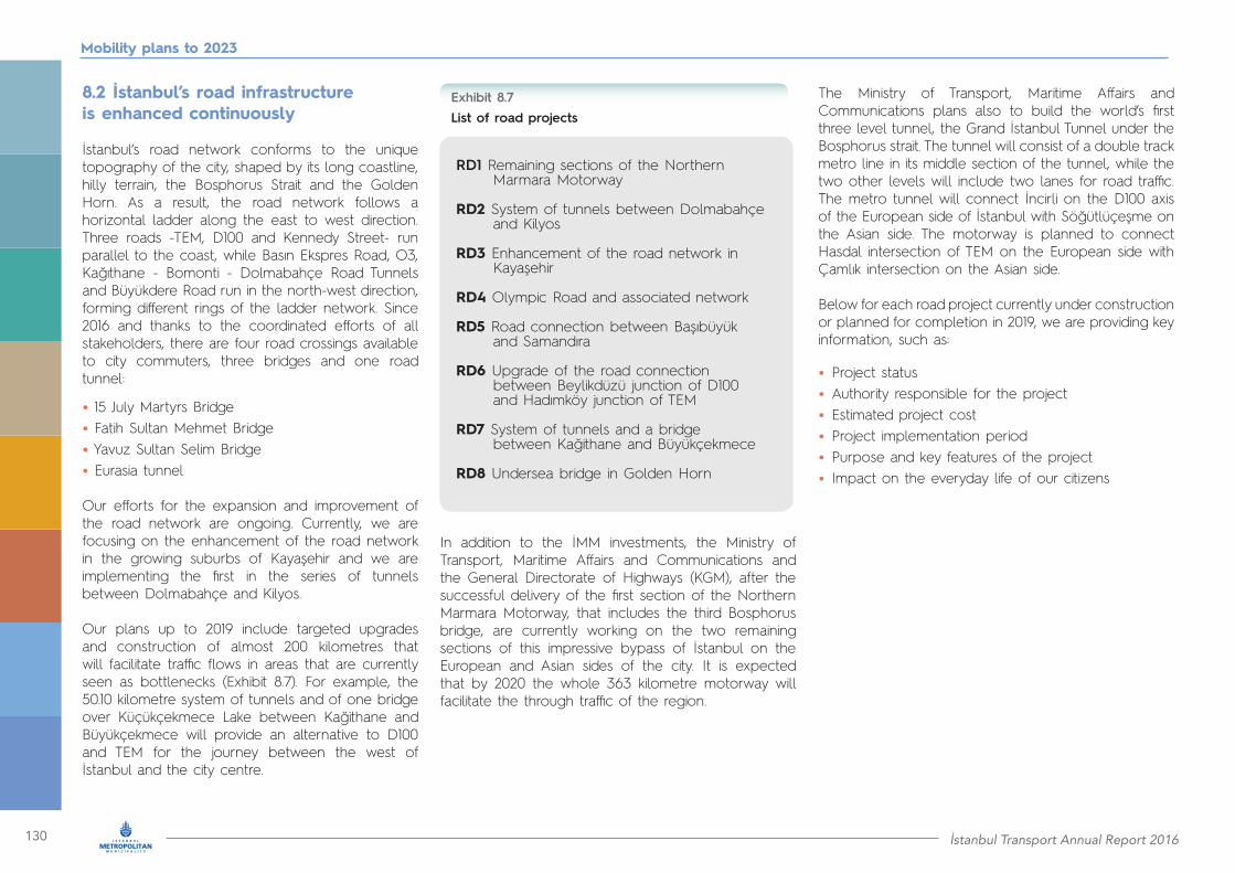
130 İstanbul Transport Annual Report 2016
Mobility plans to 2023
8.2 İstanbul’s road infrastructure is enhanced continuously
İstanbul’s road network conforms to the unique topography of the city, shaped by its long coastline, hilly terrain, the Bosphorus Strait and the Golden Horn. As a result, the road network follows a horizontal ladder along the east to west direction. Three roads -TEM, D100 and Kennedy Street- run parallel to the coast, while Basın Ekspres Road, O3, Kağıthane - Bomonti - Dolmabahçe Road Tunnels and Büyükdere Road run in the north-west direction, forming different rings of the ladder network. Since 2016 and thanks to the coordinated efforts of all stakeholders, there are four road crossings available to city commuters, three bridges and one road tunnel:
• 15 July Martyrs Bridge• Fatih Sultan Mehmet Bridge• Yavuz Sultan Selim Bridge • Eurasia tunnel Our efforts for the expansion and improvement of the road network are ongoing. Currently, we are focusing on the enhancement of the road network in the growing suburbs of Kayaşehir and we are implementing the first in the series of tunnels between Dolmabahçe and Kilyos.
Our plans up to 2019 include targeted upgrades and construction of almost 200 kilometres that will facilitate traffic flows in areas that are currently seen as bottlenecks (Exhibit 8.7). For example, the 50.10 kilometre system of tunnels and of one bridge over Küçükçekmece Lake between Kağithane and Büyükçekmece will provide an alternative to D100 and TEM for the journey between the west of İstanbul and the city centre.
In addition to the İMM investments, the Ministry of Transport, Maritime Affairs and Communications and the General Directorate of Highways (KGM), after the successful delivery of the first section of the Northern Marmara Motorway, that includes the third Bosphorus bridge, are currently working on the two remaining sections of this impressive bypass of İstanbul on the European and Asian sides of the city. It is expected that by 2020 the whole 363 kilometre motorway will facilitate the through traffic of the region.
The Ministry of Transport, Maritime Affairs and Communications plans also to build the world’s first three level tunnel, the Grand İstanbul Tunnel under the Bosphorus strait. The tunnel will consist of a double track metro line in its middle section of the tunnel, while the two other levels will include two lanes for road traffic. The metro tunnel will connect İncirli on the D100 axis of the European side of İstanbul with Söğütlüçeşme on the Asian side. The motorway is planned to connect Hasdal intersection of TEM on the European side with Çamlık intersection on the Asian side.
Below for each road project currently under construction or planned for completion in 2019, we are providing key information, such as:
• Project status• Authority responsible for the project• Estimated project cost• Project implementation period• Purpose and key features of the project• Impact on the everyday life of our citizens
List of road projectsExhibit 8.7
RD1 Remaining sections of the Northern Marmara Motorway
RD2 System of tunnels between Dolmabahçe and Kilyos
RD3 Enhancement of the road network in Kayaşehir
RD4 Olympic Road and associated network
RD5 Road connection between Başıbüyük and Samandıra
RD6 Upgrade of the road connection between Beylikdüzü junction of D100 and Hadımköy junction of TEM
RD7 System of tunnels and a bridge between Kağithane and Büyükçekmece
RD8 Undersea bridge in Golden Horn
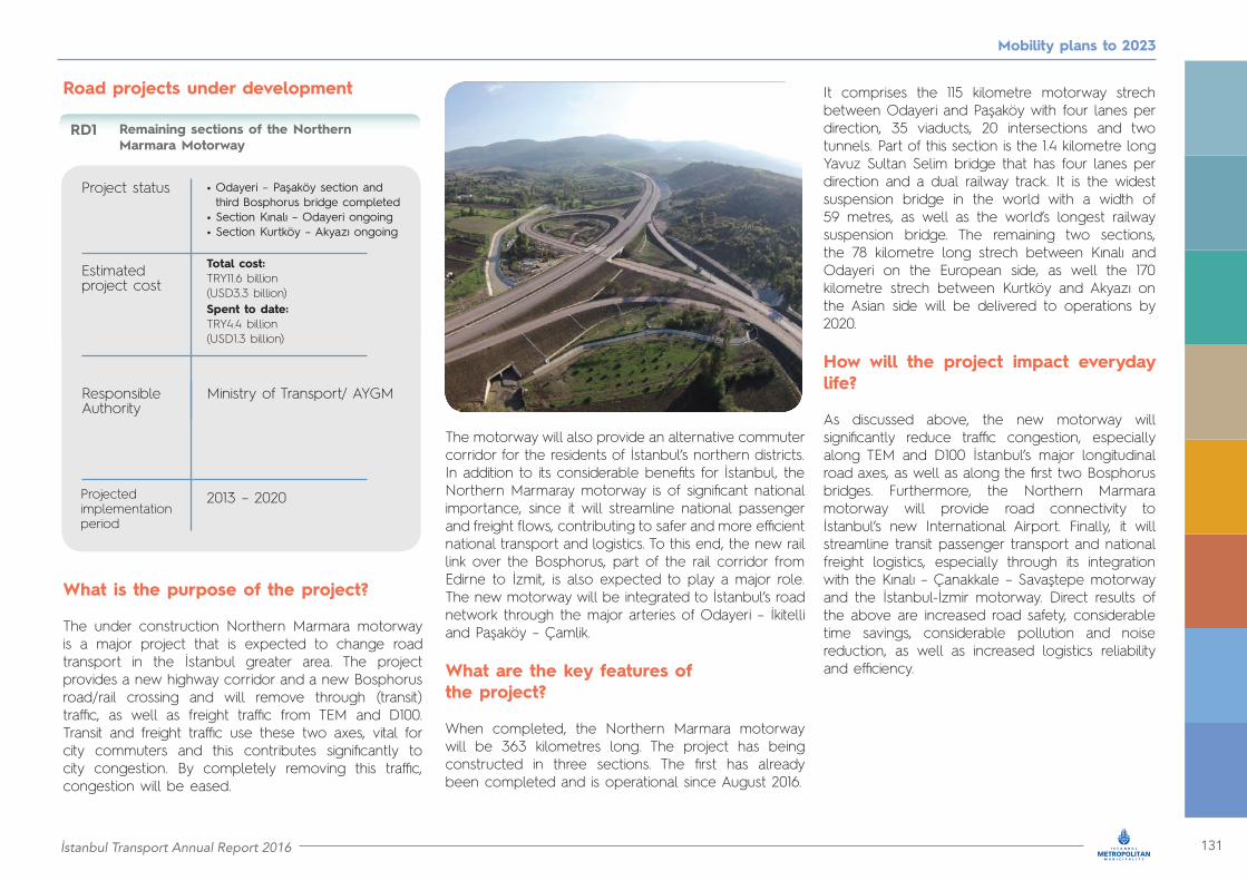
İstanbul Transport Annual Report 2016 131
Mobility plans to 2023
What is the purpose of the project?
The under construction Northern Marmara motorway is a major project that is expected to change road transport in the İstanbul greater area. The project provides a new highway corridor and a new Bosphorus road/rail crossing and will remove through (transit) traffic, as well as freight traffic from TEM and D100. Transit and freight traffic use these two axes, vital for city commuters and this contributes significantly to city congestion. By completely removing this traffic, congestion will be eased.
The motorway will also provide an alternative commuter corridor for the residents of İstanbul’s northern districts. In addition to its considerable benefits for İstanbul, the Northern Marmaray motorway is of significant national importance, since it will streamline national passenger and freight flows, contributing to safer and more efficient national transport and logistics. To this end, the new rail link over the Bosphorus, part of the rail corridor from Edirne to İzmit, is also expected to play a major role. The new motorway will be integrated to İstanbul’s road network through the major arteries of Odayeri – İkitelli and Paşaköy – Çamlik.
What are the key features of the project?
When completed, the Northern Marmara motorway will be 363 kilometres long. The project has being constructed in three sections. The first has already been completed and is operational since August 2016.
It comprises the 115 kilometre motorway strech between Odayeri and Paşaköy with four lanes per direction, 35 viaducts, 20 intersections and two tunnels. Part of this section is the 1.4 kilometre long Yavuz Sultan Selim bridge that has four lanes per direction and a dual railway track. It is the widest suspension bridge in the world with a width of 59 metres, as well as the world’s longest railway suspension bridge. The remaining two sections, the 78 kilometre long strech between Kınalı and Odayeri on the European side, as well the 170 kilometre strech between Kurtköy and Akyazı on the Asian side will be delivered to operations by 2020.
How will the project impact everyday life?
As discussed above, the new motorway will significantly reduce traffic congestion, especially along TEM and D100 İstanbul’s major longitudinal road axes, as well as along the first two Bosphorus bridges. Furthermore, the Northern Marmara motorway will provide road connectivity to İstanbul’s new International Airport. Finally, it will streamline transit passenger transport and national freight logistics, especially through its integration with the Kınalı – Çanakkale – Savaştepe motorway and the İstanbul-İzmir motorway. Direct results of the above are increased road safety, considerable time savings, considerable pollution and noise reduction, as well as increased logistics reliability and efficiency.
Road projects under development
Remaining sections of the Northern Marmara Motorway
Project status
Responsible Authority
Estimated project cost
• Odayeri – Paşaköy section and third Bosphorus bridge completed • Section Kınalı – Odayeri ongoing• Section Kurtköy – Akyazı ongoing
Ministry of Transport/ AYGM
Total cost:TRY11.6 billion(USD3.3 billion)Spent to date: TRY4.4 billion(USD1.3 billion)
2013 – 2020
RD1
Projected implementation period
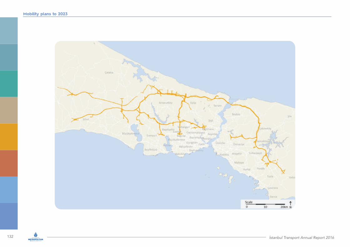
132 İstanbul Transport Annual Report 2016
Mobility plans to 2023
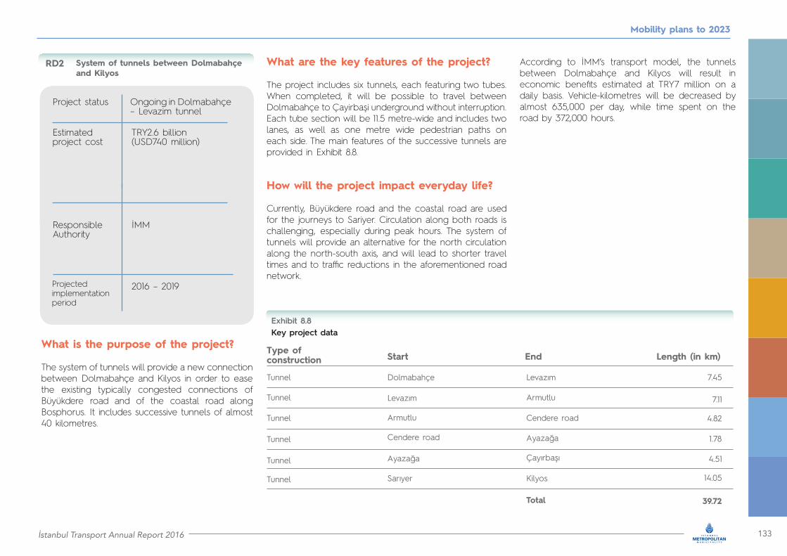
İstanbul Transport Annual Report 2016 133
Mobility plans to 2023
System of tunnels between Dolmabahçe and Kilyos
Project status
Responsible Authority
Estimated project cost
Ongoing in Dolmabahçe – Levazim tunnel
İMM
TRY2.6 billion(USD740 million)
2016 – 2019
RD2
Projected implementation period
What is the purpose of the project?
The system of tunnels will provide a new connection between Dolmabahçe and Kilyos in order to ease the existing typically congested connections of Büyükdere road and of the coastal road along Bosphorus. It includes successive tunnels of almost 40 kilometres.
What are the key features of the project?
The project includes six tunnels, each featuring two tubes. When completed, it will be possible to travel between Dolmabahçe to Çayirbaşi underground without interruption. Each tube section will be 11.5 metre-wide and includes twolanes, as well as one metre wide pedestrian paths on each side. The main features of the successive tunnels are provided in Exhibit 8.8.
How will the project impact everyday life?
Currently, Büyükdere road and the coastal road are used for the journeys to Sariyer. Circulation along both roads is challenging, especially during peak hours. The system of tunnels will provide an alternative for the north circulation along the north-south axis, and will lead to shorter travel times and to traffic reductions in the aforementioned road network.
According to İMM’s transport model, the tunnels between Dolmabahçe and Kilyos will result in economic benefits estimated at TRY7 million on a daily basis. Vehicle-kilometres will be decreased by almost 635,000 per day, while time spent on the road by 372,000 hours.
Key project dataExhibit 8.8
Type of construction Start End Length (in km)
Tunnel
Tunnel
Tunnel
Tunnel
Tunnel
Tunnel
Dolmabahçe Levazım 7.45
7.11
4.82
1.78
4.51
14.05
39.72
Levazım
Armutlu
Armutlu
Cendere road
Cendere road
Ayazağa
Ayazağa
Çayırbaşı
Kilyos
Total
Sarıyer

134 İstanbul Transport Annual Report 2016
Mobility plans to 2023

İstanbul Transport Annual Report 2016 135
Mobility plans to 2023

136 İstanbul Transport Annual Report 2016
Mobility plans to 2023
What is the purpose of the project?
The under construction road network in Kayaşehir in the district of Başakşehir extends to 74 kilometres and will provide much needed connectivity within the district, which is undergoing significant development. It will also ensure convenient access to the key arterials surrounding Başakşehir, such as the Northern Marmama Motorway and TEM.
What are the key features of the project?
The 74 kilometre network under construction includes roads with two and with three lanes per direction, while all intersections will have grade separation.
How will the project impact everyday life?
The district of Başakşehir experiences a rapid development in the recent years and has a current population of approximately 250,000 people. Due to the continuous residential development, the population is also increasing. It is also in the plans under examination of the Ministry of Health to build a new University hospital in the area. These circumstances make necessary the development of a robust road network in the area.
In addition to the growth of Başakşehir itself, the district is surrounded by key arterials, such as the corresponding parts of the Northern Marmara motorway in the north, TEM in the south and Mahmutbey road, Eski Edirne road and Arnavutköy – Habipler road in the east. As an example, the access to TEM in Edirne is not adequate to serve the demand of the area. Therefore, it is required to provide convenient access to these surrounding key arterials for the citizens of Başakşehir.
Finally, Başakşehir needs to have more convenient connectivity with the neighbouring district of Küçükçekmece.
When completed, the road network of Kayaşehir will address the above challenges and will provide safe and convenient connectivity to all key facilities within the district, as well as to the significant key arteries of İstanbul.
Enhancement of the road network in Kayaşehir
Project status
Responsible Authority
Estimated project cost
Ongoing
İMM
TRY330 million(USD94 million)
2016 – 2018
RD3
Projected implementation period
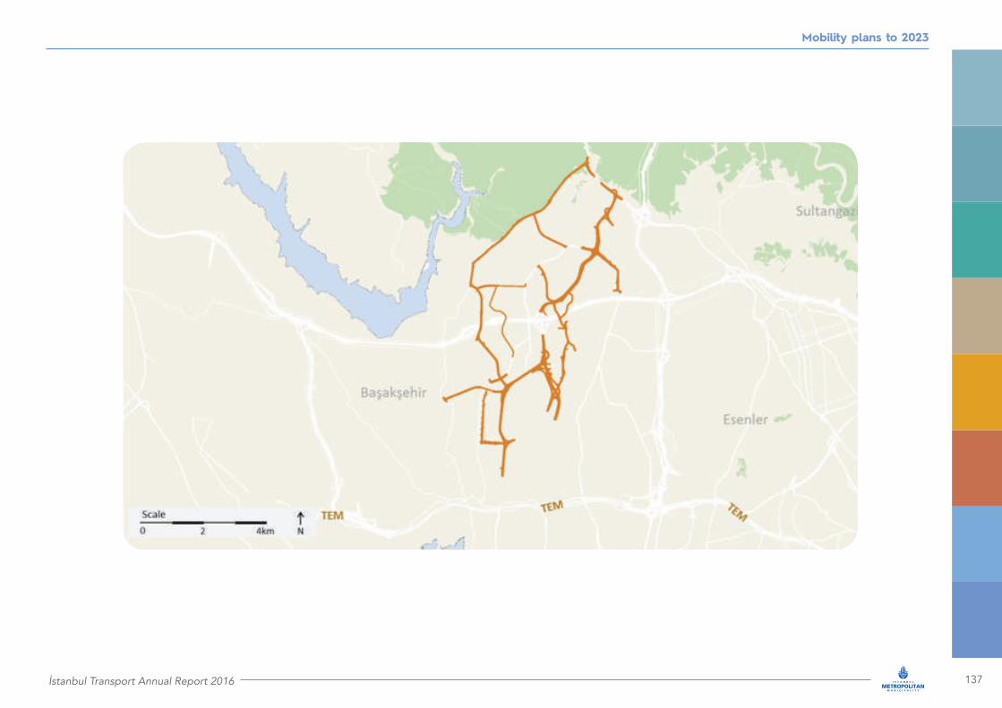
İstanbul Transport Annual Report 2016 137
Mobility plans to 2023
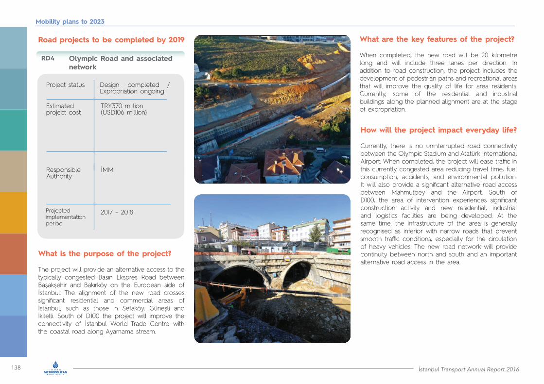
138 İstanbul Transport Annual Report 2016
Mobility plans to 2023
Olympic Road and associated network
Project status
Responsible Authority
Estimated project cost
Design completed / Expropriation ongoing
İMM
TRY370 million(USD106 million)
2017 – 2018
RD4
Projected implementation period
What is the purpose of the project?
The project will provide an alternative access to the typically congested Basın Ekspres Road between Başakşehir and Bakırköy on the European side of İstanbul. The alignment of the new road crosses significant residential and commercial areas of İstanbul, such as those in Sefaköy, Güneşli and İkitelli. South of D100 the project will improve the connectivity of İstanbul World Trade Centre with the coastal road along Ayamama stream.
Road projects to be completed by 2019 What are the key features of the project?
When completed, the new road will be 20 kilometre long and will include three lanes per direction. In addition to road construction, the project includes the development of pedestrian paths and recreational areas that will improve the quality of life for area residents. Currently, some of the residential and industrial buildings along the planned alignment are at the stage of expropriation.
How will the project impact everyday life?
Currently, there is no uninterrupted road connectivity between the Olympic Stadium and Atatürk International Airport. When completed, the project will ease traffic in this currently congested area reducing travel time, fuel consumption, accidents, and environmental pollution. It will also provide a significant alternative road access between Mahmutbey and the Airport. South of D100, the area of intervention experiences significant construction activity and new residential, industrial and logistics facilities are being developed. At the same time, the infrastructure of the area is generally recognised as inferior with narrow roads that prevent smooth traffic conditions, especially for the circulation of heavy vehicles. The new road network will provide continuity between north and south and an important alternative road access in the area.

İstanbul Transport Annual Report 2016 139
Mobility plans to 2023
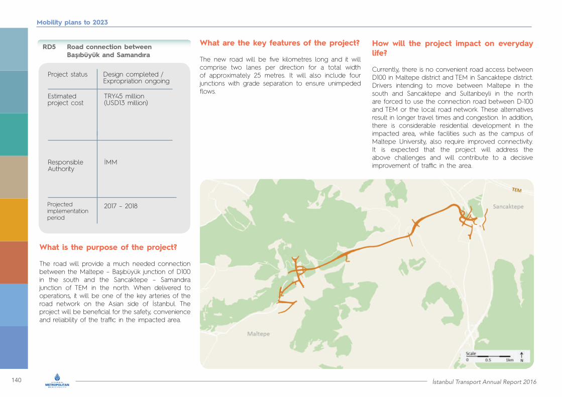
140 İstanbul Transport Annual Report 2016
Mobility plans to 2023
Road connection between Başıbüyük and Samandıra
Project status
Responsible Authority
Estimated project cost
Design completed / Expropriation ongoing
İMM
TRY45 million(USD13 million)
2017 – 2018
RD5
Projected implementation period
What is the purpose of the project?
The road will provide a much needed connection between the Maltepe – Başıbüyük junction of D100 in the south and the Sancaktepe – Samandıra junction of TEM in the north. When delivered to operations, it will be one of the key arteries of the road network on the Asian side of İstanbul. The project will be beneficial for the safety, convenience and reliability of the traffic in the impacted area.
How will the project impact on everyday life?
Currently, there is no convenient road access between D100 in Maltepe district and TEM in Sancaktepe district. Drivers intending to move between Maltepe in the south and Sancaktepe and Sultanbeyli in the north are forced to use the connection road between D-100 and TEM or the local road network. These alternatives result in longer travel times and congestion. In addition,there is considerable residential development in the impacted area, while facilities such as the campus of Maltepe University, also require improved connectivity. It is expected that the project will address the above challenges and will contribute to a decisive improvement of traffic in the area.
What are the key features of the project?
The new road will be five kilometres long and it will comprise two lanes per direction for a total width of approximately 25 metres. It will also include four junctions with grade separation to ensure unimpeded flows.

İstanbul Transport Annual Report 2016 141
Mobility plans to 2023
Upgrade of the road connection between Beylikdüzü junction of D100 and Hadımköy junction of TEM
Project status
Responsible Authority
Estimated project cost
Design completed
İMM
TRY80 million(USD23 million)
2018 – 2019
RD6
Projected implementation period
What is the purpose of the project?
The existing eight kilometre long road connection between Beylikdüzü junction of D100 and Hadımköy junction of TEM in Büyükçekmece will be upgraded to a modern connecting road that will provide uninterrupted circulation between D100 and TEM. All existing traffic lights of the corridor will be removed, while a network of side roads and junctions with grade separation will ensure smooth access to the various settlements along the road.
What are the key features of the project?
The intervention will take place along the eight kilometre long existing road connection between D100 and TEM in Büyükçekmece. One lane per direction will be added, and, thus, the connection road will be widened to three lanes per direction. Side roads and suitable junctions with grade separation will be constructed in order to eliminate the existing traffic lights.
How will the project impact everyday life?
The upgraded road will reduce travel times, accidents, fuel consumption, and environmental pollution generated by the journey between D100 and TEM in Büyükçekmece. The network of side road junctions with grade separation will improve road safety and convenience for the users. The project will also benefit mobility and the quality of life of local residents, increasing area attractiveness.

142 İstanbul Transport Annual Report 2016
Mobility plans to 2023
System of tunnels and a bridge between Kağithane and Büyükçekmece
Project status
Responsible Authority
Estimated project cost
Design completed / Expropriation ongoing
İMM
TRY4.5 billion(USD1.3 billion)
2017 – 2019
RD7
Projected implementation period
What is the purpose of the project?
The intervention will provide a new connection between Kağithane and Büyükçekmece on the European side of İstanbul parallel to the key arterials of TEM and D100. It includes successive tunnels of more than 48 kilometres and one bridge over Küçükçekmece Lake.
What are the key features of the project?
The project comprises eight tunnels featuring two tubes each and one bridge presented in Exhibit 8.9. Each tunnel tube has two traffic lanes and one metre wide pedestrian paths on each side. Ten interchanges will be constructed along the route.
Key project dataExhibit 8.9
Type of construction Start End Length (in km)
Tunnel
Tunnel
Tunnel
Tunnel
Bridge
Tunnel
Tunnel
Tunnel
Tunnel
Kâğıthane (Cendere road) 4.08
5.00
6.00
5.00
1.90
5.60
6.62
5.92
9.98
50.10
Gaziosmanpaşa – Eyüp (İstanbul road)Bayrampaşa – Esenler (Hal interchange)
Gaziosmanpaşa – Eyüp (İstanbul road)Bayrampaşa – Esenler (Hal interchange)Güngören – Esenler (Çinçin Deresi road)Bağcılar (Tavukçu Deresi road)
Avcılar Küçükçekmece Lake
Bahçelievler – Küçükçekmece (Olympic road)
Esenyurt (Haramidere)
Küçükçekmece (Gümrük Road)
Büyükçekmece (Tüyap)
Güngören – Esenler (Çinçin Deresi road)
Küçükçekmece (Gümrük Yolu)
Bağcılar (Tavukçu Deresi road)
Avcılar
Bahçelievler – Küçükçekmece(Olympic road)
Esenyurt (Haramidere)
Total
How will the project impact everyday life?
The system of tunnels and the bridge over Küçükçekmece Lake will provide a valuable alternative to D100 and TEM for those making the journey between the western districts of İstanbul and the city centre. When completed, the project is expected to ease traffic in the congested key arteries of İstanbul (D100 and TEM) and enable shorter travel times for road users.
According to İMM’s transport model, the project’s economic benefits are estimated at TRY4 million per day. Vehicle kilometres will decrease by almost 500,000 on a daily basis, while time spent on the road by 185,000 hours per day.
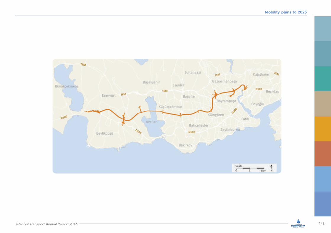
İstanbul Transport Annual Report 2016 143
Mobility plans to 2023

144 İstanbul Transport Annual Report 2016
Mobility plans to 2023
Undersea bridge in Golden Horn
Project status
Responsible Authority
Estimated project cost
Construction project awarded
İMM
TRY2.1 billion(USD589 million)
2017 – 2019
RD8
Projected implementation period
What is the purpose of the project?
The project will provide an undersea corridor connecting the historic peniscula in Unkapanı with the other side of Golden Horn up to Şişhane, Kasımpaşa and Karaköy. Thus, the existing Atatürk bridge will be removed, eliminating all negative impacts at the estuary of Golden Horn caused by existing restrictions in the natural flow of currents. The new undersea bridge will also reduce travel times in the area due to new intersections to be constructed.
What are the key features of the project?
The undersea bridge will be 900 metres long, 35.4 metres wide and its height will be 10.3 metres. It will include six lanes in total, three in each direction. It will be constructed on pillars at the bottom of the sea, 8.5 metres below the sea level.
How will the project impact everyday life?
The construction of the undersea bridge will be beneficial for the Golden Horn natural environment. The sea life and the undersea ecosystem will be revitalised. By removing the existing Atatürk bridge, the views to both sides of Golden Horn will be unimpeded, while the historical and cultural urban environment will be brought into the foreground.

İstanbul Transport Annual Report 2016 145
Mobility plans to 2023
8.3 Strategies and plans to enhance mobility
Streamlining city logistics: The İstanbul logistics master plan (İSTLAP)
City logistics makes our city work. It supplies retail stores, businesses, homes, it moves freight and construction materials, it supplies our ports and airports. Furthermore, freight passing through our city uses our highways, bridges, railways and ports. All these vital activities contribute significantly to traffic congestion, environmental pollution, parking requirements and local area operations. In order to streamline the flows of city logistics and minimise their impact, İMM is developing the İstanbul Logistics Master Plan (İSTLAP). In this pioneering work, to be completed in January 2018, İMM’s Transportation Planning Directorate collaborates with Yıldız Technical University (ITU-TTO), BİMTAŞ and field research teams.
We have already completed 72,000 questionnaires with logistics service providers and customers. Also, we engaged with 33 logistics focus groups representing organised industrial sites, ports, logistics terminals, customs and customs zones. Furthermore, our research team has conducted 85 interviews with key logistics stakeholders, including logistics centers, terminals, public institutions, non-governmental organisations and universities. As a result of this work we have gained a solid understanding on fundamental issues, expectations and recommendations from the entire spectrum of city logistics stakeholders. This forms the basis of our current work, which is focusing on developing scientific models to estimate the intensity of logistics activities throughout our city and at certain key regions, for today and for the years to come.
Subsequently, bottlenecks will be identified along our transport networks and alternative concepts will be developed to address them. These alternative concepts will be evaluated taking into account sectoral requirements. The concepts selected from this analysis will lead to appropriate logistics network structures and selected locations to establish major logistics facilities. Furthermore, based on our models we will propose strategies, policies and action plans that will optimise service levels and operational efficiency, while minimising the adverse impacts of logistics activities on traffic, parking and the environment.
Promoting effective and sustainable car use: İstanbul’s parking master plan
The motorisation rate of our city is rising rapidly and 15,800 new private cars are added to our roads each month. This is fueled by continuing urbanisation and growth in per capita incomes. As a result, our streets are becoming occupied by parked vehicles, a situation that brings adverse impacts to our neighboorhoods and everyday lives, especially in the central areas of our
city. In order to address effectively this growing issue, the Transportation Directorate of İMM has developed an integrated parking master plan for İstanbul. The latter includes a detailed capacity analysis of car parking spaces and aligns the parking needs with the objectives of both the environmental and transportation master plans.
The İstanbul parking master plan also addresses the entire spectrum of strategies and policies for delivering an effective, sustainable and integrated parking network that supports İMM’s overall mobility strategies and concepts. To this end, we benchmarked best practices from world class metropolises, identified suitable initiatives for our city and established a forecasting model to set short, medium, and long term demand and requirements.

146 İstanbul Transport Annual Report 2016
Mobility plans to 2023
Based on this foundation, we have developed a road map for minimising our city’s parking problems. In the short term, we have proposed policies for efficient use and improvement of parking supply. A characteristic example is the regulation and management of on street parking with emphasis in regions with mixed land use, new construction, high car ownership, and high on-street parking rates. Based on the measures and initiatives specified in parking master plan, we have initiated detailed studies and pilot projects, including the development of the İstanbul general plan for managing roadside parking. This will be followed by specific proposals on engineering projects in line with the region’s transport and land use policies in order to promote sustainable urban living for our citizens.
Improving road safety: The traffic safety master plan
Safety and citizen well-being reside at the center of our transport policies. In 2016, İMM’s Traffic Directorate completed our city’s traffic safety master plan.
Benchmarking and collection of detailed data on accidents (fatalities and injuries) across İstanbul formed the basis of our work. These detailed data were provided by İstanbul’s provincial Security Directorate and Traffic Supervision Directorate. Using the Kernel Density Estimation (KDE) method, we extracted the statistics necessary to identify critical accident areas along our road network. We classified the latter according to types of accidents and formed five basic classes. For the significant accident areas in these classes we conducted traffic surveys, as well as pedestrian and driver interviews. The results were used to develop road safety strategies, policies and standards, as well as a robust action plan.
In addition to supporting major road safety improvements, the master plan is also used as an educational guide for detecting accident critical areas with the help of appropriate software. The characteristics of these areas lead to strategies and initiatives to minimise fatalities, injuries and accidents.
Transportation master plan: Our guide to improve mobility
In İMM we strive to optimise citizen mobility, as well as transport service levels, while mitigating transport challenges and risks. Beyond safe, effective and efficient transport services, mobility has significant impacts on the environment, energy consumption and sustainability, while it promotes social inclusion and social balance. Our mobility strategy seeks to achieve transport excellence and address traffic congestion. Thus, we are developing and analysing innovative options for attaining current and future targets through new and improved public transport systems and sustainable transport modes, such as walking and cycling.
In all these areas our guide is İstanbul’s Integrated Urban Transportation Master Plan (İUAP). The plan is based on
an integrated, strategic model that captures transport demand, as well as citizen choices and behaviour taking into full account existing and future transportation investments and systems, including rail, Metrobüs, surface transport, motorways, bridges and tunnels. The model is based on the proven four-step methodology: a) trip generation and attraction, b) mode choice, c) trip distribution, and d) network assignment across road and public transport.
We started developing İUAP almost ten years ago. In 2009, we delivered a complete, calibrated model and plan which was approved by UKOME in 2011. Since then, İUAP is being used to support all significant decisions regarding İstanbul mobility based on significant criteria and indicators, including economic, social, and financial ones.

İstanbul Transport Annual Report 2016 147
Mobility plans to 2023
In 2012, we launched the initiative “İstanbul Transportation Master Plan model calibration and update” in order to align with the changing environment of our city. As an example of the changes considered by this initiative is the mobility rate, which from 1.72 in 2006 increased to 2.01 by year 2012. Similarly, while 35 per cent of our citizens currently live in Asia, this rate is on the rise and will reach 36 per cent in 2019 and 37 per cent by 2023. Employment rates are expected to maintain their current structure till 2023.
In 2016, we initiated a major model update in order to a) accurately reflect these changes, b) consider land use decisions stemming from İstanbul’s Environmental Plan, c) incorporate recent and future infrastructure investments, and d) consider the changing preferences of our citizens. This work will continue in 2017 in order to obtain a robust, powerful model that will support the upcoming versions of our Transportation Master Plan.
Congestion charging: A powerful tool for decongestion of target areas
The previously mentioned steep increase of car ownership in İstanbul, which has followed the economic development and income growth of recent years, makes necessary the management of the capacity of the existing road network of our city in the best and most efficient way possible. To address this pressing need, we are developing Travel Demand Management policies especially targeted to the areas where high traffic congestion is experienced.
In this context, after studying successful international initiatives to address traffic congestion in London, Singapore, Stockholm and Milan, İMM has decided to introduce a congestion charging scheme, according to which drivers will be charged for using a certain corridor or entering a certain zone during peak periods. In the areas of implementation, the specific measure is expected to reduce traffic congestion and its adverse effects in everyday life and the environment. It will also provide funding for road improvement initiatives in other areas.
We identified and studied several regions of high congestion in İstanbul, such as the central areas of Bakırköy and Kadıköy, the historical peninsula and Beyoğlu. For these regions, we investigated the alternative transport options to serve commuters, the appropriate fees to be imposed (including fee exemptions and reductions), the necessary technical infrastructure to be installed, as well as the necessary legal arrangements to be enacted. Furthermore, performance indicators have been used to assess the performance of congestion charging using İUAP’s model. Based on these studies, İMM has developed detailed implementation and operation plans.
The Eminönü district of the Historical Peninsula has been selected as the first implementation area. The area is surrounded by the coastal roads along its south, east and north sides, and by Atatürk Boulevard along its west side. Fees will be charged for entering this area, but not for circulating in the roads that surround the area. Moreover, drivers who use the Eurasia tunnel will not be charged, since they contribute to traffic relief along the Bosphorus bridges, which are among the most severe bottlenecks in our city. Exemptions have been proposed for emergency vehicles, such as fire brigade and ambulance, as well as public transport and electric vehicles. We are also considering offering substantial discounts for the residents of the area, who will be provided with appropriate permits.

148 İstanbul Transport Annual Report 2016
Mobility plans to 2023
In this project we plan to implement the High-Speed Toll System (Hızlı Geçiş Sistemi – HGS), which is familiar to Istanbulites since it is already applied to the Bosphorus bridges and the Eurasia road tunnel. According to this scheme, standard fees will be charged between 07:00 and 19:00 on weekdays, whereas in weekends and holidays access to the implementation area will be free of charge. Based on our past experience, the application of different fees at different times of the day will not be beneficial in this area.
İMM plans to launch the congestion charging scheme after the operation of the entire Marmaray line. Upon implementation of the traffic management measure, we estimate that the number of vehicles passing through the implementation area will decrease by 29 per cent, while the number of vehicles entering the city will decrease by eight per cent. Consequently, in the controlled region we estimate a reduction of 24 per cent in vehicle kilometres and of 66 per cent in vehicle hours.

İstanbul Transport Annual Report 2016 149
Mobility plans to 2023

150 İstanbul Transport Annual Report 2016
Public transport
ISTANBUL TRANSPORT ANNUAL REPORT
ibb.istanbul
2016