Isla Navarino - Rutas Patrimoniales
67
Patrimonial Trail Isla Navarino – Biosphere Reserve | MAGALLANES AND CHILEAN ANTARCTIC REGION – Circuit N°1, 7 and 16. PATRIMONIAL TRAILS • Cabo de Hornos: Dientes de Navarino • Desierto de Atacama: Ex Oficina Salitrera de Chacabuco • Campos de Hielo Sur: Glaciar de río Mosco • Andes Centrales: Río Olivares – Gran Salto • Andes Patagónicos: Río Palena • Campo de Hielo Sur: Los Glaciares • Cabo de Hornos: Lago Windhond • Archipiélago Juan Fernández: Isla Robinson Crusoe • Atacama Costero: El Morro • Bosques Patagónicos: Río Ventisquero • Valle Central: Camino Real a la Frontera • Campo de Hielo Norte: Caleta Tortel • Andes Altiplánicos: Quebradas de Tarapacá • Oasis del Desierto de Atacama: San Pedro, Chiu Chiu, La sanwa • Te Ara o Rapa Nui: Patrimonio de la Humanidad • Cabo de Hornos: Caleta Wulaia • Bosques Patagónicos: Río Blanco • Estuario de Valdivia: Los Castillos del fin del Mundo • Pampa del Tamarugal: Salitrera Humberstone • Valle Central: Camino del Centro del Corregimiento de Colchagua • Andes Patagónicos: Lago Palena • Bahía de Tongoy: Humedales Costeros • Valles Transversales: Camino Longitudinal Los Andes – Vicuña • Ciudad de Valparaíso: Patrimonio de la Humanidad • Desierto Costero: Desembocadura Río Loa • De Cordillera a Mar: Derrotero de Atacama • Bosque Valdiviano: Llancahue • Valles de La Araucanía: del Cautín al Ranquil • Milodón: Patagonia a los pies del Macizo del Paine • Santiago: Fragmentos de una Ciudad • Viña del Mar: Jardines, Castillos y Palacios frente al mar • Lagos de La Araucanía: Península de Lican Ray • Paisaje Alto andino: Laguna del Maule • Andes Patagónicos: Lago Verde – Lago Palena • Taltal - Punta Tórtolas: Historia y Desierto junto al mar • Nahuelbuta: Cordillera, Costa, Cultura • Andes Altiplánicos: Salar del Huasco – Collacagua • Litoral de Atacama: Caldera – Chañaral • Caleta y humedales del Choapa • Secano Costero: Camino Real de la Costa • Borde Costero Región del Maule: Ruta de los Humedales • Fray Jorge • Alto Biobío: Araucarias de la Cordillera de Pemehue • Valle de Azapa: Ruta del Esclavo • Ciudad de Cartagena: Arquitectura, Mar y Poesía • La Serena - Patrimonio Vivo: circuito urbano y rural • Punta Arenas: Un viaje por su historia • Ruta de la Memoria: Santiago 1973 – 1989 • Gabriela Mistral • Estrecho de Magallanes – Bien Nacional Protegido Cabo Froward • Valles de Nirivilo y Pichamán • Charles Darwin: Travesía al fin del mundo • Cuenca del Palena: La Junta – Raúl Marín B • Los Altos de Arica: Precordillera y Altiplano • Valparaíso: Un viaje a la ciudad de los múltiples colores • Ruta Costera de La Araucanía: Del Imperial al Budi • Bien Nacional Protegido: Oasis de niebla Alto Patache • Santiago en el Corazón: Recovecos de la Patria Popular • Archipiélago de Chiloé: Humedales, Aves y Cultura • Huellas de Pablo Neruda en Temuco • Padre Pancho: Misionero en La Araucanía • Arica y Parinacota: Fiestas Tradicionales y Populares del Norte • Tarapacá: Fiestas Tradicionales y Populares del Norte • Antofagasta: Fiestas Tradicionales y Populares del Norte • Atacama: Fiestas Tradicionales y Populares del Norte • Valparaíso Popular • Del Carbón: Región del Biobío • Coquimbo: Fiestas Tradicionales y Populares del Centro • Valparaíso: Fiestas Tradicionales y Populares del Centro • Libertador General Bernardo O’Higgins: Fiestas Tradicionales y Populares del Centro • Cultura Chinchorro. Región de Arica y Parinacota • Canquén Colorado. Magallanes: Refugio Natural RUTAS PATRIMONIALES SOUTH Isla Navarino Cape Horn Biosphera Reserve – Dientes de Navarino Circuit – Lago Windhond Circuit – Caleta Wulaia Circuit Lindenmayer massif, photographed during the ascent to ‘Paso Ventarrón – Windy Pass’, southeast orientation. Milestones 33. 14 th of January 2020 .
-
Upload
khangminh22 -
Category
Documents
-
view
0 -
download
0
Transcript of Isla Navarino - Rutas Patrimoniales

Patr
imon
ial T
rail
Isla
Nav
arin
o –
Bios
pher
e Re
serv
e |
MAG
ALLA
NES
AN
D C
HIL
EAN
AN
TARC
TIC
REG
ION
– C
ircui
t N°1
, 7 a
nd 1
6.
PATRIMONIAL TRAILS
• Cabo de Hornos: Dientes de Navarino
• Desierto de Atacama: Ex Oficina Salitrera de Chacabuco
• Campos de Hielo Sur: Glaciar de río Mosco
• Andes Centrales: Río Olivares – Gran Salto
• Andes Patagónicos: Río Palena
• Campo de Hielo Sur: Los Glaciares
• Cabo de Hornos: Lago Windhond
• Archipiélago Juan Fernández: Isla Robinson Crusoe
• Atacama Costero: El Morro
• Bosques Patagónicos: Río Ventisquero
• Valle Central: Camino Real a la Frontera
• Campo de Hielo Norte: Caleta Tortel
• Andes Altiplánicos: Quebradas de Tarapacá
• Oasis del Desierto de Atacama: San Pedro, Chiu Chiu, La sanwa
• Te Ara o Rapa Nui: Patrimonio de la Humanidad
• Cabo de Hornos: Caleta Wulaia
• Bosques Patagónicos: Río Blanco
• Estuario de Valdivia: Los Castillos del fin del Mundo
• Pampa del Tamarugal: Salitrera Humberstone
• Valle Central: Camino del Centro del Corregimiento de Colchagua
• Andes Patagónicos: Lago Palena
• Bahía de Tongoy: Humedales Costeros
• Valles Transversales: Camino Longitudinal Los Andes – Vicuña
• Ciudad de Valparaíso: Patrimonio de la Humanidad
• Desierto Costero: Desembocadura Río Loa
• De Cordillera a Mar: Derrotero de Atacama
• Bosque Valdiviano: Llancahue
• Valles de La Araucanía: del Cautín al Ranquil
• Milodón: Patagonia a los pies del Macizo del Paine
• Santiago: Fragmentos de una Ciudad
• Viña del Mar: Jardines, Castillos y Palacios frente al mar
• Lagos de La Araucanía: Península de Lican Ray
• Paisaje Alto andino: Laguna del Maule
• Andes Patagónicos: Lago Verde – Lago Palena
• Taltal - Punta Tórtolas: Historia y Desierto junto al mar
• Nahuelbuta: Cordillera, Costa, Cultura
• Andes Altiplánicos: Salar del Huasco – Collacagua
• Litoral de Atacama: Caldera – Chañaral
• Caleta y humedales del Choapa
• Secano Costero: Camino Real de la Costa
• Borde Costero Región del Maule: Ruta de los Humedales
• Fray Jorge
• Alto Biobío: Araucarias de la Cordillera de Pemehue
• Valle de Azapa: Ruta del Esclavo
• Ciudad de Cartagena: Arquitectura, Mar y Poesía
• La Serena - Patrimonio Vivo: circuito urbano y rural
• Punta Arenas: Un viaje por su historia
• Ruta de la Memoria: Santiago 1973 – 1989
• Gabriela Mistral
• Estrecho de Magallanes – Bien Nacional Protegido Cabo Froward
• Valles de Nirivilo y Pichamán
• Charles Darwin: Travesía al fin del mundo
• Cuenca del Palena: La Junta – Raúl Marín B
• Los Altos de Arica: Precordillera y Altiplano
• Valparaíso: Un viaje a la ciudad de los múltiples colores
• Ruta Costera de La Araucanía: Del Imperial al Budi
• Bien Nacional Protegido: Oasis de niebla Alto Patache
• Santiago en el Corazón: Recovecos de la Patria Popular
• Archipiélago de Chiloé: Humedales, Aves y Cultura
• Huellas de Pablo Neruda en Temuco
• Padre Pancho: Misionero en La Araucanía
• Arica y Parinacota: Fiestas Tradicionales y Populares del Norte
• Tarapacá: Fiestas Tradicionales y Populares del Norte
• Antofagasta: Fiestas Tradicionales y Populares del Norte
• Atacama: Fiestas Tradicionales y Populares del Norte
• Valparaíso Popular
• Del Carbón: Región del Biobío
• Coquimbo: Fiestas Tradicionales y Populares del Centro
• Valparaíso: Fiestas Tradicionales y Populares del Centro
• Libertador General Bernardo O’Higgins: Fiestas Tradicionales y Populares del Centro
• Cultura Chinchorro. Región de Arica y Parinacota
• Canquén Colorado. Magallanes: Refugio Natural
RUTASPATRIMONIALESSOUTH
Isla NavarinoCape Horn Biosphera Reserve
– Dientes de Navarino Circuit– Lago Windhond Circuit– Caleta Wulaia Circuit
Lind
enm
ayer
mas
sif,
phot
ogra
phed
dur
ing
the
asce
nt to
‘Pas
o Ve
ntar
rón
– W
indy
Pas
s’, s
outh
east
ori
enta
tion
. Mile
ston
es 3
3. 1
4th o
f Jan
uary
202
0
.

3
Monte Mashoa
Cerro Clens
Cerro ClemCerro Gabriel
Cerro Denis
Cerro Bandera
Cerro Róbalo
Cerro Virginia
PicachoDientede Navarino
Cerro Bettinelli
Monte Tortuga
LagoWindhond
LagoNavarino
LagoRojas
Río Dougla
s
LagoPulushejan
Río U
quik
a
Rí o María
PuertoWilliams
C H I L EA R G E N T I N A
C a n a l B e a g l e
B a h í a W i n d h o n d
Puerto Navarino
Isla Hoste
Puerto Toro
Puerto Isorna
Canal Murray
Wulaia
Estancia Beban
Puerto Eugenia
Lum
B a h í a N a s s a u
540000550000560000570000580000590000600000610000620000
3920
00º
3910
00º
3900
00º
3890
00º
3880
00º
3870
00º
540000550000560000570000580000590000600000610000620000
3920
00º
3910
00º
3900
00º
3890
00º
3880
00º
3870
00º
3
Walk according to your planningStart your day early, you should always arrive with daylight at your destination. Do not forget to hydrate, eat, and protect yourself from the cold and the sun. Never be separate from your friends.
Patrimonial Trails
S
1
2
3
1
2
3
Carta Solar y Horario23:45
19:00
14:15
9:30
4:45
0:00
DAYLIGHT
SUNSET
SUNRISE
17 15 13 11 10 9 9 10 12 14 16 18
J F M A M J J A S O N D
PUNTAARENAS
PUERTONATALES
ISLANAVARINO
Región de Magallanesy Antártica Chilena
Chile Continental68° W
68° W
72° W
72° W
76° W64° W
16° S16° S
18° S18° S
20° S20° S
22° S22° S
24° S24° S
26° S26° S
28° S28° S
30° S30° S
32° S32° S
34° S34° S
36° S36° S
38° S38° S
40° S40° S
42° S42° S
44° S44° S
46° S46° S
48° S48° S
50° S50° S
52° S52° S
54° S54° S
56° S56° S
58° S58° S
60° S60° S
TerritorioChileno
Antártico
Polo Sur 0
90º53º
400 km
*
* Acuerdo de 1998
0 900450Km
S
recommendations to visitors
DURING THE EXCURSION
WHEN YOU GET BACK FROM THE EXCURSION
BEFORE THE EXCURSION
Check the weather forecastCheck and monitor the weather forecast on various sources, for the days before and after the excursion (leave a margin in case you must extend the tour).
Leave a contactNotify a close person of your excursion, detail where you will be, when will you return and the phone numbers of the contacts of those who accompany you.
Register your excursionNotify the details of your departure at the Police Station of Puerto Williams (Carabineros) and at the entrance to the natural parks you visit.
Topographic maps and GPS filesThe maps of the three trails are available at [ ]. You can download GPS files from [ ].
Plan the route you will doAnalyze the timing of every strech of the trial, the right season, theequipment and details of the tour.
Take all the equipmentBring everything you’ll need: food and warm clothing. Do not forget to bring the details of the route, a flashlight, an extra battery for your cell phone, compass, and GPS.
Respect the environmentRespect the rules of local communities and the rest of other hikers. Do not make fire or feed wildlife.
Take back all your trashNature does not need anything that you take. Do not scratch the rocks and return all your trash. Let the photographs and the experiences be the only footprint in the place.
Notify your returnDon’t forget to notify your return at the Police Station of Puerto Williams (Carabineros) and to the institutions and people that you informed about your excursion.
Analyze your experienceAnalyze your excursion, especially what you can improve. Check the status of your equipment. And don’t forget to share the information about your excursion (www.andeshandbook.cl).
15 cm deep (6 inches). Once you are done, cover the debris with the dirt you had removed. Take away all the toilet paper and don’t set them on fire.
FireAs wet as you are, don’t light a fire anywhere on the island. This prohibition is to prevent fires and help ensure that your experience is wonderful like anyone else’s in the coming decades. Also, never stop paying attention to the stove while you cook.
Avoid coastal productsAs with all the coastal areas of Isla Navarino, eating seafood is not recommended due to unpredictable poisonous algae bloom episodes like red tide. This phenomenon is caused by high sea temperatures and irresponsible practices in salmon farming. Seafood intake affected by the red tide it can be fatal.
WaterWhen you need to do your basic needs, look for a distant location, at least 100 meters (110 yards) from any water course. Dig a hole (either with a small shovel, stake, or suitable metal utensil) of al less
GUide inFormation
Technical information What to seeCaution
patrimonial trials
Magallanes and Chilean Antarctic Region
Simbology Solar Chart and Schedule
Dientes de Navarino Circuit
Lago Windhond Circuit
Bahía Wulaia Circuit
Emergency Route
International Limit
Road
Airport
Mountain/Hill
Continental Chile
Principal City
Town/Homestead
River
Lake/Pond
Dientes de Navarino Circuit
Lago Windhond Circuit
Bahía Wulaia Circuit
Introduction 4
Dientes de Navarino Circuit 10
5 day journey 12
Day 1 - Trailhead to Laguna del Salto 14
Day 2 - Laguna del Salto to Laguna Escondida 20
Day 3 - Laguna Escondida to Laguna Martillo 26
Day 4 - Laguna Martillo to lookout Laguna Los Guanacos 32
Day 5 - Laguna Los Guanacos viewpoint to Puerto Williams 38
Faster Itineraries 42
The creator Clem Lindenmayer 43
Lago Windhond Circuit 46
6 day journey 44
Day 1 - Trailhead to Laguna del Salto 48
Day 2 - Laguna del Salto to Mount Bettinelli basecamp 52
Day 3 - Mount Bettinelli basecamp to Refugio Charles 56
Day 4 -Refugio Charles to Bahía Windhond to Refugio Charles 64
Day 5 - Refugio Charles to ex Refugeio Beaucheff 70
Day 6 - Ex Refugio Beaucheff to Puerto Williams 76
The confrontation at Windhond Bay 82
The screat lives of raised Sphagnum bogs 83
Dientes and Windhond Combo 83
Bahía Wulaia Circuit 84
8 day journey 86
Day 1 - Caleta Lum to campamento Choza 88
Day 2 - Campamento Choza to caleta Wulaia 94
Day 3 (optional) -Caleta Wulaia to Monte King Scott and back 100
Day 4 - Caleta Wulaia to playa Micalvi Norte 106
Day 5 - Playa Micalvi Norte to campamento Torre de Vigía 110
Day 6 - Campamento Torre de Vigía to Laguna Represa 116
Day 7 - Laguna Represa to puerto Hambre 120
Day 8 - Puerto Hambre to Puerto Navarino 124
Retelling the story of “Jemmy Button” and the Wulaia massacre 128
Packrafting 129
Highlights 130
Bibliographic reference 132
taBLe oF contents
PUNTAARENAS
PUERTONATALES
ISLANAVARINO
Región de Magallanesy Antártica Chilena
Chile Continental68° W
68° W
72° W
72° W
76° W64° W
16° S16° S
18° S18° S
20° S20° S
22° S22° S
24° S24° S
26° S26° S
28° S28° S
30° S30° S
32° S32° S
34° S34° S
36° S36° S
38° S38° S
40° S40° S
42° S42° S
44° S44° S
46° S46° S
48° S48° S
50° S50° S
52° S52° S
54° S54° S
56° S56° S
58° S58° S
60° S60° S
TerritorioChileno
Antártico
Polo Sur 0
90º53º
400 km
*
* Acuerdo de 1998
0 900450Km
S

4 54 5
patrimonial trails patrimonial trails
introdUction
You made it. Welcome to the world’s most southerly inhabited island. Take a moment to look around. You are now very close to the 55th parallel. This is the last hurrah of the Americas. Beyond is the eternal tempest of Drake’s Passage. It’s a sea rocked by gale force winds, a few fizzling islets and stray Antarctic icebergs. You’re so far south that if you rowed east across the Atlantic Ocean, you would cross into the Pacific and end up back on Navarino Island without crossing a lick of land. By contrast, at this equivalent latitude or beyond in the northern hemisphere you could be standing on dry land almost anywhere in Alaska, the majority of Canada, practically the entirety of Russia, or virtually anywhere
in Scotland, Norway or Sweden. Put simply, you are at the thin edge of the wedge. Prepare yourself now to set out into one of the world’s remotest and wildest landscapes.
You’re not the first people to arrive here. When the indigenous Yagán arrived at the bottom of the Americas over 60 centuries ago, they had travelled further than any other Homo sapien. The Canal Beagle (Beagle Channel) was likely still marshland, and the plentiful shores of Navarino Island provided a final home. However, even for these most worldly travelled people, the mountains were a bleak and inhospitable backdrop to their hunter-gatherer lives. And very few people until recently have ventured into the island’s craggy interior.
The Dientes de Navarino
beginning to appear from thick cloud,
photographed from Puerto
Williams airport looking north.
February 5th 2020.

6 7
Puerto Williams at sunset,
looking east.January 27th
2020.
patrimonial trails patrimonial trails
Unlike the Yagán, you probably haven’t arrived by canoe. Once ashore in the central hub of Puerto Williams , you’ve got two important pieces of business to take care of. Firstly, you need to get supplied. Equip yourself with knowledge at the beautifully curated Museo Antropológico Martín Gusinde (Martín Gusinde Anthropological Museum) in Puerto Williams, located to the west of town. It’s named in honour of the Austrian anthropologist who developed an intimate relationship with indigenous peoples of Tierra del Fuego during his research journeys to the archipelago from 1918-1924. The insights will give context to the colourful cast of characters
inhabiting modern Navarino Island ranging from Chilean navy men, to decades-waylaid adventurers and grizzled beaver hunters. Equip yourself also with last minute supplies at the well-stocked outdoor stores and supermarkets, before stopping in to one of the local restaurants for a slap-up last supper of grilled fish and local beer.
Secondly, you’ve got the difficult task of picking one of the three trails described in this guidebook. You’ve probably been tempted to hike on Isla Navarino with the promise of the increasingly notorious Patrimonial Trail Dientes de Navarino. It certainly lives up to the

8 9
Approaching coastal Micalvi Norte camping
site.January 2020..
hype and it’s described first in this guidebook due to its popularity and the jaw-aching views it affords of the iconic sabretooth towers that give name to the trail.
Yet Dientes is not the default option. Patrimonial Trail Wulaia and Patrimonial Trail Windhond in many ways provide a more historically insightful, rugged and intimate experience of everything the island has to offer. If you’ve already sampled the spires of Patagonia’s Torres del Paine and Cerro Fitz Roy, and are looking for deeper and remoter adventure, consider cutting your teeth on the Wulaia trail. It’s a journey into a land frozen in time, predating travel (let alone tourism) from when mankind operated exclusively within his or her hunting grounds. Windhond is for those with wanderlust. It’s for the would-be
frontiersman and for the budding fisherman. Its tapestry of lakes and rivers is for those harbouring a romantic sense of living off the land and an eye for a slower pace of travel.
Whichever option you choose, you are about to step off the planet’s deep end. Goodluck and hold onto to your boina hat. It’s about to get wild.
patrimonial trails patrimonial trails

RUTASPATRIMONIALESSOUTH
Isla NavarinoCale Horn Biosphera Reserve
10 11
Dientes de Navarino Circuit

L. del Salto
Circuito Ruta Windhond
Circuito Ruta Windho
nd
Laguna Róbalo
Laguna
Laguna Ukika
L. del
Laguna de los
Dientes
Laguna Escondida
Lago Denis
Laguna Martillo
Laguna del Guerrico
L. Rocallosa
L. Islote
Laguna
Laguna Betinelli
Río U
kika
Río Róbalo
Río M
acLean
Co. Róbalo
Co. Virginia
Co. Clem
Co. Clens
Co. Denis
Co. Gabriel
Picacho Diente de Navarino
Co. Bettinelli
Co. Bandera
C A N A L B E A G L E
(~22,3 km)
Hacia Puerto Navarino(~50,4 km)
Hacia Ca leta Eugenia
P a r q u e E t n o g r á � c o O m o r a
B a h í a V i r g i n i a
E n s e n a d a V i l l a r i n o
Puerto Williams
Co. Codrington
1111m
869m
Caleta Róbalo
DN
DN2DN3
DN4DN5
891m
930m
986m
853m
845m
926m
871m
740m
1017m
934m
Aeródromo Guardamarina Zañartu
delPaso
Picacho
Guanacosde los
L.Hermosa
L.Palachinque
L. Zeta
Yaghan Ferry (Punta Arenas - Yendegaia - Puerto Williams
Bote Ushuaia - Puerto Williams
S
The Dientes de Navarino (Teeth of Navarino) are the menacing granite fangs of the island’s central mountain range. These incisor-like peaks are cloaked behind storm clouds even in summer months, opening momentarily and snapping shut again at the shortest notice.
PATRIMONIAL TRAIL DIENTES DE NAVARINO: A FIVE DAY ITINERARY
The Dientes de Navarino hike packs native forest, mountain passes, rock scrambles, river crossings, peat bogs and scree-slope sliding into a 41km lap of the island’s central mountain range. The skies are grazed by three-metre wingspan condors. Fossilised sea creatures burst from trundling rocks on mountain passes.
Yet this is where you have chosen to venture. Lacking the skills to spear your meals from a canoe like the indigenous Yagán, start a warming fire with the dampest of twigs or weather a rainstorm without a waterproof – you’re already at a disadvantage. Unlike the island’s historic inhabitants, you’ll have to laden yourself with a rucksack of supplies to survive this five day hike. Unburden yourself of any expectations of the hike’s difficulty based on past mountainous experiences. The relatively short distances recommended for each day can easily unravel into exhausting dawn-to-dusk efforts. (The accompanying topo map, as well as the GPS track are essential supplements to this guide. See below.) Even in summer months, expect to break trail through snow on high passes and barge through buffering Patagonian winds. If you do get disorientated or hypothermic, it’s very unlikely anyone is coming to get you.
And the steamy forests drip with edible dihueñe mushrooms and chaura berries that burst in your mouth like purple popcorn. You’ll need to bring all your skills and patience to tackle this hike. But for the well-prepared adventurer, the Dientes de Navarino Patrimonial Trail is the adventure of a lifetime.
12 13

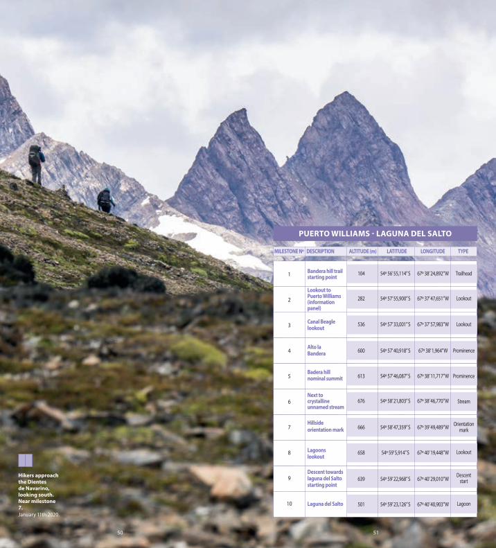
Day 1. Puerto Williams - laguna del Salto (8,7km, 379m ascent, 4 to 7 hours)
There’s lots to do the morning before beginning the hike, but the steadily opening views (weather permitting) are spectacular and will draw you along the trail to camp. After checking your kit against the latest weather forecast, be sure to register your excursion and intended return date at the police station (see Register your hike with the police below). You have a choice now of taking a taxi or hitching a ride to the trailhead; or alternatively it’s a three km pleasant gravel-paved and forested walk from the centre of town. From the carpark at a small damn, you’re heading straight up into the mountains. In the Spanish only topo guide this is referred to as Hito 1 (Milestone 1).
The forested skirt of Cerro Bandera
(Flag Mountain) is Magellanic forest at its most majestic. Stately evergreen coigue (Dombey’s beech) knits the canopy, their forking branches like road junctions in the sky. Beneath, slender lenga (southern beech) and lemon-fragrant canelo (Winter’s bark) fight for light. Woodpeckers as big as your forearm make raiding missions between fetid trunks, and gnawing fungi take advantage of the perpetual wet-rot from snowstorms and incessant rain.
After 200m of ascent through this southern-most jungle, you’ll pass a viewpoint (Milestone 2). It looks out over Canal Beagle. It ’s named after the ship that navigated the channel beneath you, transporting the British naturalist Charles Darwin on his f ive-year voyage that ultimately led to the publication of his
14 15
patrimonial trails dientes de navarino circuit
Magellanic forest.January 10th 2020.

16 17
seminal theory On the Origin of Species in 1859. Another stiff hour-hour of uphill hiking and you break out of the stumpy and knotted ñirre (Antarctic beech) to an Alpine landscape of shattered jet-black rock strata. Only the micro-forests of pale-green lichen can survive here. Watch out for them underfoot! Continue past the Chilean flag. This patriotic acknowledgement of the island’s past-and-present naval history following the 1978 territorial dispute with Argentina, marks the nominal summit of 596m Cerro Bandera (Milestone 5).
Patagonian dreams are born over the next f ive kilometres. You’re teetering along, high above the Róbalo Valley now, following a narrow trail above a precipitous scree slope for the next two hours. The turquoise lakes Róbalo and heart-shaped
Palachinque are far below, whilst ahead, the jaws of Dientes de Navarino open a little wider with each step forward. These millenia-chiselled 1000m high spires are the fulcrum of your journey as you travel around the Dientes massif over the next five days. You’ll see their grey faces in every light, and from almost every angle. Today’s journey closes with a quadricep-grinding descent through boulders to the Laguna del Salto (Waterfall Lake), where you might spy the chestnut-brown Magellan goose and her seagull-coloured mate (Milestone 10). Camping options can be as wet and sodden as the name suggests. Higher ground on the eastern shore is your best option. See “Water and Fire Safety” for overnight camping protocol on Isla Navarino.
patrimonial trails dientes de navarino circuit
Looking west towards hikers on the final steep climb towards Cerro Bandera, near milestone 3.January 28th 2020.

18 19
MILESTONE Nº DESCRIPTION ALTITUDE (m) LATITUDE LONGITUDE TYPE
PUERTO WILLIAMS - LAGUNA DEL SALTO
Banderamountain trailstarting point
Lookout toPuerto Williams(informationpanel)
Canal Beaglelookout
Alto la Bandera
Bandera hillnominal summit
Next to crystalineunnamedstream
Hillside orientation mark
Lagoonslookout
Descent towardslaguna del Saltostarting point
Laguna del Salto
104 54° 56’ 55,114” S 67° 38’ 24,892” W
282 54° 57’ 16,578” S 67° 37’ 47,651” W
536 54° 57’ 33,001” S 67° 37’ 57,983” W
600 54° 57’ 40,918” S 67° 38’ 1,964” W
613 54° 57’ 46,087” S 67° 38’ 11,717” W
676 54° 58’ 21,803” S 67° 38’ 46,770” W
666 54° 58’ 47,359” S 67° 39’ 49,489” W
658 54° 59’ 5,914” S 67° 40’ 19,448” W
639 54° 59’ 22,968” S 67° 40’ 29,010” W
501 54° 59’ 23,126” S 67° 40’ 40,903” W
Trailhead
Lookout
Lookout
Prominence
Prominence
Stream
Orientationmark
Lookout
Descent
Lagoon
The Dientes traverse near
milestone 7, looking south.
January 28th 2020.
1
2
3
4
5
6
7
8
9
10

20 21
Day 2. Laguna del Salto - laguna Escondida (8,7km, ~30m ascent, 5 to 7 hours)
Eat your porridge this morning. It ’s another steep start. Laguna del Salto is accessible to strong hikers on a day’s roundtrip from Puerto Williams. But now you are headed deeper into the island, higher still, and well off the beaten track. If you didn’t get wet yesterday, keep those waterproofs close to hand. Down here at the end of the world, Patagonians will proudly tell you it’s possible to experience all four seasons in one day. You have been warned.
Can you see the pyramid tower-block of rock on the south side of the lake? You’re headed up a trail to the left of it. Pick your way between uneven rock steps. You’re climbing out of a huge glacial cirque.
As you pause for breath, look over your shoulder. Yesterday’s views are emerging above this ice sculpted bowl below. You’ll pass some alternative camp spots on a flat, dry but exposed area 100 vertical metres above Laguna del Salto. Push on, following a steepening ridge where icy waterfall-spray will sting your face. Emerge at Paso Primero (First Pass, Milestone 13) with the option to hike 200m south-west uphill off-trail, to the fantastic and surprising Mirador de los Dientes (Dientes Viewpoint). Another steep push brings you out at 790m Paso Australia (Australia Pass) two hours after leaving camp (Milestone 14). Admire the view down to Laguna del Paso (Pass Lake). At 700m above sea level and surrounded by cliffs, it’s like a long-lost sapphire set into stone.
patrimonial trails dientes de navarino circuit
Laguna del Salto. Milestone 10.January 29 2020.

22 23
It ’s almost entirely downhill now for the remainder of the day. Descend to Pass Lake over treacherous scree-coated and often icy rocks for half-an-hour to Paso Dientes (Dientes Pass, 741m Milestone 15). This classic southerly viewpoint across the Navarino Island reveals mesmerizing waves of sedimentary rock, flipped vertical by the ages and sculpted by retreating glaciers. Beyond is Nassau Bay, the Wollaston Islands and then perhaps the most famous nautical rock anywhere on the planet – Cape Horn. Over four hundred years have passed since the Dutch sailors Schouten and le Maire rounded the very bottom of the Americas. But in geological time, this is nothing. The shark-fin rock of Cerro Picacho (Pointed Mountain) was thrust almost a kilometre into the sky to your east around 56million years ago.
It’s another couple of hours to camp. The outlet brook of Laguna Picacho tumbles tunefully besides the trail, lined with verdant Sphagnum mosses and pink carnivorous sundews. Past the turn off to Lago Windhond (Windhond Lake, Milestone 16) the trail becomes well-trodden and easier to follow. Those wirey ñirre trees have returned now you’re back at lower altitude and you’re beginning to close the loop as you head west for the first time. The descent to the placid Laguna de los Dientes (Dientes Lake) has sheltered sights to eat lunch and take-in Cerro Gabriel (Gabriel Mountain, 702m). From the base of the peak it’s two km to the first camp spots at Lago Escondida (Hidden Lake, Milestone 19). Another 500m, heading anti-clockwise around the lake, leads to a few more sites on the lake shore, curiously protected at the time of writing by man-made igloos of timber flotsam.
rutas patrimoniales
Climbing towards Australia Pass, milestone 13, looking south.January 29th 2020.
The famed naturalist John Muir had a similar view when referring to Yosemite in 1871.

24 25
Rock strata west of Laguna del Pichaco, near milestone 15.
January 29th 2020.
LAGUNA DEL SALTO - LAGUNA ESCONDIDA
MILESTONE Nº DESCRIPTION ALTITUDE (m) LATITUDE LONGITUDE TYPE
Laguna del Saltocampsite
Alternativecampsite
Turn off tolookout
Australia Pass
Los Dientes Pass
Dientes circuit - Lago Windhond circuit fork
East shore oflaguna de losDientes
Laguna Escondida valley
Laguna Escondida Eastern shore campsite
Laguna EscondidaSouth campsite
483 54° 59’ 30,595” S 67° 40’ 53,551” W
585 54° 59’ 40,524” S 67° 40’ 52,190” W
707 54° 59’ 54,636” S 67° 40’ 45,206” W
790 55° 0’ 10,386” S 67° 40’ 24,974” W
741 55° 0’ 19,807” S 67° 39’ 49,680” W
579 55° 1’ 2,874” S 67° 39’ 45,778” W
505 55° 1’ 0,307” S 67° 40’ 34,651” W
522 55° 1’ 1,507” S 67° 41’ 4,256” W
555 55° 0’ 50,558” S 67° 41’ 51,900” W
527 55° 1’ 6,870” S 67° 41’ 57,304” W
Campsite
Campsite
Trail fork/lookout
MountainPass
MountainPass
Trail fork
Lagoon
Orientationmark
Campsite
Campsite
11
12
13
14
15
16
17
18
19
20

26 27
Day 3. Laguna Escondida - laguna Martillo sur (6,6km, -75m ascent, 5 to 7 hours)
You’re at the remotest section of the hike. You camped last night behind the walls of the Dientes de Navarino fortress. Below the equator, its these south-facing slopes that accumulate most snow and ice. Rockfall reverberates above you and condors cruise around the peaks. This is the backstage view of the pyramidal towers you saw on day one. It’s the geological furnace where the island’s iconic mountain range is continually forged.
Today’s big objective is Paso Ventarrón (Windy Pass). Crossing it is a significant landmark in your return to civilisation. But beware. It often lives up to its name. The outlet river of Laguna Escondida can
be crossed via the beaver damns slightly downstream. An intermittent trail leads through a weather-beaten and stunted forest. The final zig-zagging ascent to 691m Ventarrón (Milestone 22) is steep, brightened by vast rainbow-sheets of sedimentary rock to the north. Multiple trail options ultimately converge on the pass, with westerly views across an almost uncharted territory of dazzling lakes and surely some of the world’s best fly fishing. Allow one-and-a-half hours to the pass from camp.
Cast your sights north-west, to that mountain that looks as if it’s been shaped by the wind. Beyond lies Montes Lindemayer (Lindemayer Massif) and 890m Cerro Clem (Clem Mountain) named after the trail’s
patrimonial trails dientes de navarino circuit
Looking back east as a hiker approaches Paso Ventaron, milestone 22.January 13th 2020.

28 29
creator (see guidebook section Trail Creator Clem Lindenmayer). You should also just be able to see a slither of Lago Hermoso (Beautiful Lake) in the valley below. The trail towards it takes you out of the wind, between a pair of placid lakes and over 553m Paso Guérrico (Warrior Pass, Milestone 24). Fight your way uphill between tree-trunks spaced like Junglegym bars. Their curious horizontal-growth at ground level is due to the phenomenon of soil creep, as the roots and earth slowly slides downhill. Wrestle out of the forest, and it’s a couple of kms and roughly forty-five minutes to camp. Folllow the western shore of Laguna Hermosa at the foot of Montes Lindemayer, then continue steeply down
the tussocky slope to potentially soggy but scenic camping spots on the southern shore of Laguna Martillo (Milestone 27). More secluded and potentially direr sites are available towards the northern shore.
patrimonial trails dientes de navarino circuit
The north-westerly descent off Paso Ventarrón, near milestone 22.January 13th 2020.

30 31
LAGUNA ESCONDIDA - LAGUNA MARTILLO
MILESTONE Nº DESCRIPTION ALTITUDE (m) LATITUDE LONGITUDE TYPE
Ventarrón pass ascent startingpoint
Ventarrón pass
Lagoon shorebefore ascent toGuerrico pass
Guerrico pass
Laguna Hermosaoutlet
Southern section oflaguna Martillo
579 55° 1’ 11,845” S 67° 43’ 5,585” W
691 55° 1’ 20,770” S 67° 43’ 24,114” W
501 55° 0’ 49,190” S 67° 44’ 48,973” W
553 55° 0’ 50,122” S 67° 45’ 9,488” W
518 55° 0’ 39,154” S 67° 45’ 41,324” W
452 55° 0’ 20,794” S 67° 45’ 40,838” W
Ascentstart
Mountainpass
Lagoon
Mountainpass
Lagoon
Lagoon
Approaching Paso Guérrico
with the Lindemayer
Massif beyond, near milestone
32, looking north-west.
January 13th 2020.
21
22
23
24
25
26

Day 4. Laguna Martillo sur – laguna Los Guanacos (11,5km, 20m ascent, 5 to 7 hours)
Aren’t you tired yet? You will be soon. Take your time this morning to enjoy the remote-feeling glaciated Guérrico valley as you descend north-west over rolling terrain. The short sections of bogs and fallen trees you’ll tussle with are part of the frontiersman-like wilderness experience that characterises the island’s other two much less frequently hiked patrimonial trails, Wulaia and Windhond. If the Dientes de Navarino trail felt beautiful but tame, you might be ready for these other Isla Navarino trails. But if days of wet-feet and navigating spider-webs of fallen timber isn’t your idea of fun, consider instead Patagonia’s more classic and relatively groomed trails of Cerro Castillo, Parque Patagonia or Torres del Paine.
There’s still some more adventure to be had on this trail though as you begin the climb to Paso Virginia (Virginia Pass). Haul yourself 150m up through a near-vertical forest. The initial exceptionally steep-slope trail alternates between bad, and terrible. Once you hear the white-water rush of a river (Milestone 33), some two-and-a half-hours after leaving camp, the worst of it is over. As the slope angle eases, you emerge from the forest to spectacular views of the Lindenmayer Massif behind you and the Beagle Canal and Ushuaia to the north-west. The site of this modern Argentinean city was once a Yagán stronghold. Pull on some layers as you continue the very exposed and windy hike for another 20 minutes across brittle dinner-plate plaques of rock, heading steadily uphill still to Paso Virginia (Milestone 34).
32 33
The blue hour in the Guérrico Valley, near milestone 29, looking north-west.January 13th 2020.
patrimonial trails dientes de navarino circuit

34 35
At 850m this is the highest pass of the Dientes de Navarino trail, arguably the best viewpoint on the entire trail and the ideal point to take stock of the odyssey you have been on. Beneath you now is Laguna los Guanacos (Guanacos Lake) where wind-whipped waves rip across its deep-blue surface. From the lake outlet, the thick swathe of treeline resumes, covering the lower slopes to the coast. Beyond is Canal Beagle once again and, further still, Isla Grande de Tierra de Fuego (the Large Island of Tierra del Fuego). The landscape seen from here is as pristine and wild as when our ancestors made that crossing 6000 years ago to this remotest of isles.
Pick up the helter-skelter trail down to Laguna los Guanacos, initially heading east from the viewpoint above a precipitous drop. Then head straight down into it, tiptoeing between solid foot placements, then, once lower down, skidding, sliding and digging your heels into the thicker scree to control your descent. You’ll lose 250m of elevation in just 500m of hiking. Continue the journey around the western shore of Laguna los Guanacos keeping an eye out for fossils underfoot (be sure to leave them where you find them). There are camping options an hour from the pass at the far end of the water by a raised viewing platform (Milestone 35), or alternatively continue another 15 minutes to potentially more sheltered sights at Laguna los Guanacas (Lake of the Female Guanacos, Milestone 36).
patrimonial trails
The remote feeling Guérrico Valley with the climb to Ventarrón Pass beyond, near milestone 31, looking north-west.January 14th 2020.

36 37
LAGUNA MARTILLO - LAGUNA LOS GUANACOS
Laguna Martillo campsite
Northern sectionof laguna Martillo
Laguna Martillooutlet
Guerrico valley
Laguna Rocallosa
Virginia passascent startingpoint
Virgina pass(lower stretch)
Virgina pass(upper stretch)
Laguna Los Guanacoscampsite
Laguna Los GuanacosSouthwest shore
448 54° 59’ 59,024” S 67° 46’ 22,494” W
454 54° 59’ 46,320” S 67° 46’ 37,481” W
448 54° 59’ 42,929” S 67° 46’ 49,937” W
451 54° 59’ 12,732” S 67° 47’ 16,256” W
429 54° 58’ 54,152” S 67° 47’ 35,045” W
406 54° 58’ 33,620” S 67° 47’ 47,070” W
714 54° 58’ 3,716” S 67° 47’ 44,174” W
850 54° 57’ 46,825” S 67° 46’ 40,206” W
543 54° 57’ 11,059” S 67° 45’ 45,194” W
472 54° 57’ 3,485” S 67° 45’ 40,000” W
Campsite
Lagoon
Lagoon
Valley
Lagoon
Ascentstart
Mountainpass
Mountainpass
Campsite
Lagoon
MILESTONE Nº DESCRIPTION ALTITUDE (m) LATITUDE LONGITUDE TYPE
Paso Ventarrón, looking north-west. Milestone 34.January 14th 2020.
27
28
29
30
31
32
33
34
35
36

38 39
Day 5. Laguna Los Guanacos – Puerto Williams (11,5km, -540m ascent, 5 to 7 hours)
Your wild adventure around the rock at the end of the world is coming to an end today. Just a half-day of downhill hiking separates you from the island’s perimeter road that leads to Puerto Williams. But there is one more surprise in store. After leaving the Laguna los Guanacos viewpoint, a pleasant forested trail leads into a beaver-created clearing at Laguna las Guanacas.
Beyond here though, begins a two-hour maze of dense, dark and disorientating native forest. When the wind whistles through here it ’s what the Nobel Prize winning Chilean poet Pablo Neruda describes as “earth music” in his infamous ode The Chilean Forest. You might doubt if the enthusiastic poet ever really ventured into woods as rich and wild as this one. But as you wrestle your way out with twigs in your hair and wild dihueñe and chaura berries in your belly, you will surely agree with Neruda that “those who don’t know the Chilean forest, do not know this planet.”
Occasional red and yellow blazes of paint lead the way onto the less densely forested lower slopes. A poor-condition information board marks the start of the final descent. You are aiming for the red-roofed MacLean ex-fisheries building, an hour’s hike downhill from exiting the thickest part of the forest. Alternatively, continue contouring east along the hillside for 2.7km to reach the attractive Cascada los Bronces (The Bronze Waterfal, Milestone 39) before following the river downstream to a bridge over the perimeter road, close to its outlet at Canal Beagle. It’s a 6km, two-and-a-half hour relatively flat hike along the road back to Puerto Williams. Alternatively, a shuttle may be possible from the house of tourism guide Jorge Barbero by the bridge (Milestone 40), or a pre-existing arrangement with a taxi in Puerto Williams.
The wooded descent to Laguna Guanacas, near milestone 36, looking north.January 14th 2020..
patrimonial trails

40 41
The final descent to the road on day five, near milestone 38.January 14th 2020.
MILESTONE Nº DESCRIPTION ALTITUDE (m) LATITUDE LONGITUDE TYPE
Forest
Old tree
Los BroncesCascade
Bridge
336 54° 56’ 49,209” S 67° 44’ 12,890” W
275 54° 56’ 41,861” S 67° 43’ 47,013” W
82 54° 56’ 38,326” S 67° 42’ 25,819” W
7 54° 56’ 27,449” S 67° 42’ 11,261” W
Forest
Orientationmark
Cascade
Bridge
LAGUNA LOS GUANACOS - PUERTO WILLIAMS
37
38
39
40

42 43
TRAIL CREATOR CLEM LINDENMAYERFASTER ITINERARIES
The Dientes de Navarino trail was designed by Clem Lindenmayer to be completed in five relatively short days and four nights, allowing enough time for the hiker to pitch camp, digest the day’s experiences and enjoy the new surroundings before moving on. For seasoned hikers during fair weather periods and on tight itineraries it is however possible to complete the Dientes de Navarino Patrimonial Trail in 3-4 days.
Days 4 and 5 described in this guide can be combined. For the exceptionally fit hiker, it may also be possible to reach Laguna Escondida in one day from Puerto Williams. In December each year Latitud Sur Expedition organise the Navarino Trail running race, offering ultra-fit competitors the chance to complete the circuit in one day. The current female record for the circuit is held by Katherine Cañete in a time of 7h33m07s and the male record is held by Felipe Cancino in a time of 6h29m25s, both set in 2018.
Clem Lindemayer was the Australian Lonely Planet guidebook writer who penned the first Trekking in the Patagonian Andes guidebook published in 1992 and is the creator of what he called the Dientes de Navarino Circuit.
No official hiking trails on Isla Navarino existed before that time. Lindenmayer, it is said, didn’t travel to the island with the intention of creating a trekking route. It was only when by chance his seat on the plane provided a view of the mountainous interior of the island that he began to question the idea of whether a hiking trail would be possible. Many qualities of Lindemayer’s experience remain the same: his 1992 guidebook description begins “The interior of Navarino is wild country and this trek should not be taken lightly.” The “excellent guanaco tracks” that helped him navigate the best route have sadly not survived and the camelids can only be found on the remotest
southern coast of the island today. The Lindenmayer Range and Cerro Clem were named in the trail creator’s honour by long-time Isla Navarino mountain guide Denis Chevallay. Lindemayer’s ashes were scattered by his surviving wife Romi Lindemayer at his eponymous mountain range in 2010.

RUTASPATRIMONIALESSOUTH
Isla NavarinoCale Horn Biosphera Reserve
Lago Windhond Circuit
44 45
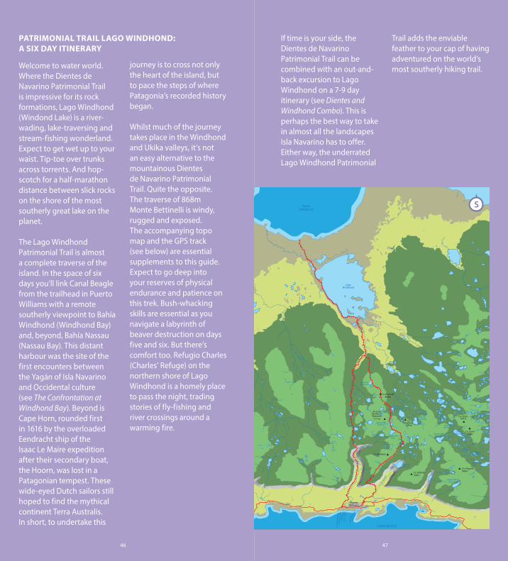
PATRIMONIAL TRAIL LAGO WINDHOND: A SIX DAY ITINERARY
Welcome to water world. Where the Dientes de Navarino Patrimonial Trail is impressive for its rock formations, Lago Windhond (Windond Lake) is a river-wading, lake-traversing and stream-fishing wonderland. Expect to get wet up to your waist. Tip-toe over trunks across torrents. And hop-scotch for a half-marathon distance between slick rocks on the shore of the most southerly great lake on the planet.
The Lago Windhond Patrimonial Trail is almost a complete traverse of the island. In the space of six days you’ll link Canal Beagle from the trailhead in Puerto Williams with a remote southerly viewpoint to Bahía Windhond (Windhond Bay) and, beyond, Bahía Nassau (Nassau Bay). This distant harbour was the site of the first encounters between the Yagán of Isla Navarino and Occidental culture (see The Confrontation at Windhond Bay). Beyond is Cape Horn, rounded first in 1616 by the overloaded Eendracht ship of the Isaac Le Maire expedition after their secondary boat, the Hoorn, was lost in a Patagonian tempest. These wide-eyed Dutch sailors still hoped to find the mythical continent Terra Australis. In short, to undertake this
journey is to cross not only the heart of the island, but to pace the steps of where Patagonia’s recorded history began.
Whilst much of the journey takes place in the Windhond and Ukika valleys, it’s not an easy alternative to the mountainous Dientes de Navarino Patrimonial Trail. Quite the opposite. The traverse of 868m Monte Bettinelli is windy, rugged and exposed. The accompanying topo map and the GPS track (see below) are essential supplements to this guide. Expect to go deep into your reserves of physical endurance and patience on this trek. Bush-whacking skills are essential as you navigate a labyrinth of beaver destruction on days five and six. But there’s comfort too. Refugio Charles (Charles’ Refuge) on the northern shore of Lago Windhond is a homely place to pass the night, trading stories of fly-fishing and river crossings around a warming fire.
If time is your side, the Dientes de Navarino Patrimonial Trail can be combined with an out-and-back excursion to Lago Windhond on a 7-9 day itinerary (see Dientes and Windhond Combo). This is perhaps the best way to take in almost all the landscapes Isla Navarino has to offer. Either way, the underrated Lago Windhond Patrimonial
Trail adds the enviable feather to your cap of having adventured on the world’s most southerly hiking trail.
46 47
Laguna de los Dientes
Co. Betinelli
Puerto Williams
869m
Laguna Bettinelli
Laguna Escondida
Laguna del Picacho
Laguna del Paso
Laguna Ukika
Laguna del Guerrico
Laguna Hermosa
Laguna Martillo
Laguna Róbalo
Laguna de los Guanacos
Laguna Islote
Laguna Zeta
Lago Denis
Lago Windhond
Bahía Windhond
Picacho Diente de Navarino
1111mCo.
Gabriel 845m
Co. Bandera
Co. Virginia 986mCo. Róbalo
926m
Co. Clem
Co. Clens 891m
930m
Río Ukika
Río R
óbalo
CANAL BEAGLE
C A N A L D E B E A G L E
Yendegaia -
Bote Ushuaia - Puerto W
illiam
s
Yaghan Ferry
(Punta Arenas - Puerto W
illiams)
S

patrimonial trails lago windhond circuit
Day 1. Puerto Williams - laguna del Salto (8,7km, 379m ascent, 4 to 7 hours)
Your first day-and-a-half on the Lago Windhond Patrimonial Trail follows the same route as the Dientes de Navarino trail, taking in the eponymous saw-tooth mountains in all their majesty. See Patrimonial Trail Dientes de Navarino: A five day itinerary for details as well as the Register your hike with the police section, below. It’s worth noting that in six days’ time, on the return journey to Puerto Williams, you’ll be rewarded with a fantastic surprise view of the Dientes de Navarino towers from the 499m Alinghi Pass. Despite the Dientes de Navarino Patrimonial Trail closely circuiting these iconic mountains, the Lago Windhond Patrimonial Trail actually offers the most
Rockscape in the vicinity of Cerro Bandera, looking west. Near milestone 5.January 11th 2020.
varied views of the range’s photogenic north face.
48 49
50 51
Hikers approach the Dientes de Navarino, looking south. Near milestone 7.January 11th 2020.
PUERTO WILLIAMS - LAGUNA DEL SALTO
MILESTONE Nº DESCRIPTION ALTITUDE (m) LATITUDE LONGITUDE TYPE
Bandera hill trailstarting point
Lookout to Puerto Williams(informationpanel)
Canal Beaglelookout
Alto laBandera
Badera hillnominal summit
Next tocrystallineunnamed stream
Hillsideorientation mark
Lagoonslookout
Descent towards laguna del Saltostarting point
Laguna del Salto
104 54º 56’ 55,114” S 67º 38’ 24,892” W
282 54º 57’ 55,900” S 67º 37’ 47,651” W
536 54º 57’ 33,001” S 67º 37’ 57,983” W
600 54º 57’ 40,918” S 67º 38’ 1,964” W
613 54º 57’ 46,087” S 67º 38’ 11,717” W
676 54º 58’ 21,803” S 67º 38’ 46,770” W
666 54º 58’ 47,359” S 67º 39’ 49,489” W
658 54º 59’ 5,914” S 67º 40’ 19,448” W
639 54º 59’ 22,968” S 67º 40’ 29,010” W
501 54º 59’ 23,126” S 67º 40’ 40,903” W
Trailhead
Lookout
Lookout
Prominence
Prominence
Stream
Orientationmark
Lookout
Descentstart
Lagoon
1
2
3
4
5
6
7
8
9
10

52 53
Day 2. Laguna del Salto – Campamento Bettinelli (6,2km, ~80m ascent, 3 to 5 hours)
Pace yourself on this second day, and enjoy the final company of other hikers as you climb to Paso Australia (Australia Pass) and descend via Laguna Pichaco (Pichacho Lake) to the junction of the two patrimonial trails at a tall cairn (see topo map, Hito / Milestone 16). Whilst the Dientes de Navarino Patrimonial Trail turns west here, you are about to continue south, heading seriously off-piste. Beneath you is a patchwork territory of lakes and lenga forest ruled over by troublesome beavers. Their ill-considered introduction in 1946 by Argentineans to a virgin and predatorless Patagonia has left irreparable scars across great swathes of the Tierra del Fuego archipelago. On your journey from this point on, the paw-prints from these insatiable vegetarian lumberjacks will be as common as any human ones. It’s another 2km and a
roughly an hour’s hike to camp.
Keeping to the east side of the lakes below, skirt the beaver playground. You’re likely to hear heavy splashing noises, especially if hiking late in the day. These mammals beat warning shots with their tails against the water before duck-diving to safety. There’s a get-wet river crossing as you enter the treeline. A sinuous trail leads on through lenga woodland, weaving between armchair-sized ancient Azorella plants, flame-like Darwin slipper flowers and porcelain orchids. Break out into a clearing with a square-shaped beaver lake. The woodland to your east has protected camping, on albeit sloping terrain (Milestone 18). There are two mediocre sites for small tents at the entrance to the forest, close to a small stream. A further site another 200m up the steepening hillside is suitable for a larger tent.
patrimonial trails lago windhond circuit
The viewpoint at Laguna del Salto, looking west. Near milestone 10.January 11th 2020.

54 55
The view down from
the Dientes/ Windhond trail
fork, looking south. Milestone
16.January 30th 2020.
LAGUNA DEL SALTO - CAMPAMENTO BETTINELLI
MILESTONE Nº DESCRIPTION ALTITUDE (m) LATITUDE LONGITUDE TYPE
Laguna del Saltocampsite
Alternativecampsite
Turn offto lookout
Australia pass
Los Dientes pass
Dientes circuit -Lago Windhondcircuit fork
Shore ofunnamedlagoon
Bettinellicampsite
483 54º 59’ 30,595” S 67º 40’ 53,551” W
585 54º 59’ 40,524” S 67º 40’ 52,190” W
707 54º 59’ 54,636” S 67º 40’ 45,206” W
790 55º 0’ 10,386” S 67º 40’ 45,206” W
741 55º 0’ 19,807” S 67º 39’ 49,680” W
587 55º 1’ 0,674” S 67º 39’ 41,407” W
481 55º 1’ 24,640” S 67º 39’ 38,538” W
563 55º 1’ 41,650” S 67º 39’ 16,945” W
Campsite
Campsite
Trail fork
Mountainpass
Mountainpass
Trail fork
Lagoon
Campsite
11
12
13
14
15
16
17
18

56 57
patrimonial trails lago windhond circuit
Day 3. Campamento Bettinelli – Refugio Charles (6,6km, -460m ascent, 4 to 7 hours)
Whilst collecting water for your porridge this morning, take a moment to admire Cerro Pichacho and Cerro Gabriel to your north and north-west respectively. By bedtime you’ll have put 882m Monte Bettinelli (Bettinelli Mountain) between you and these peaks of the Dientes de Navarino Patrimonial Trail. Eat heartily and enjoy your woodland breakfast to the soundtrack of chuckling striped woodpeckers. It’s another steep start. At 55˚ South, the treeline disintegrates quickly above 500m of altitude. Windswept grasses, hardy wildflowers and carpets of devil’s strawberry plants survive here. These quickly give way to a jagged rockscape here on the western slope of Monte Bettinelli. The climb itself is only 300m of ascent and
about an hour of climbing to the summit but the 20˚ slope angle and strong winds make it challenging.
The view from the summit (Milestone 19) across the great vast blue of Drake’s Passage is the stuff that global circumnavigation dreams are made of. Here, fearful sailors believed their captains would sail off the end of the world. Yet, our round planet continues beyond this crash of Pacific and Atlantic Oceans, stretching over a 1000km to Antarctica. Those islets in the foreground are the Wollaston Islands, and beyond, Cape Horn. The stretch of water separating them from Isla Navarino is the Nassau Bay, named after the Dutch armada of 1637 men who sheltered here en route to attack the Spanish in Peru in 1664 (see The Confrontation at Windhond Bay). Beneath you is Lago Bettinelli (Lake Bettinelli); a small
Looking back north towards the Dientes de Navarino from the wooded camp at the base of Monte Bettinelli, milestone 18.January 30th 2020.

58 59
patrimonial trails lago windhond circuit
turquoise soup in a giant seemingly wind-blown cauldron of rock. You’re about to hurtle down into it. But linger for a moment to consider your own journey in this nascent New World. It was only in 2001 that the mountain you’re standing on was named after the first known female ascensionist, Viviana Bettinelli.
Skid down towards the lake. You’re headed for the southern outlet stream where dainty Chorlo de Magallanes birds pluck riparian snacks between Patagonian gales. Venture now along the broad, gently angled but wickedly exposed southern slope of Cerro Bettinelli towards the distant treeline. With wind-lifted pebbles swirling around your feet and your body banked against the wind, imagine the life of a C17th sailor clinging to a three-masted schooner as it carved around Cape Horn. Focusing on the break in the stunted ñirre trees leading
The view south from the summit of Monte Bettinelli, milestone 19.January 31st 2020.
into the forest, a point known as Entrada de los Guanacos (Entrance of the Guanacos, Milestone 20), should help avoid sea sickness. It’s about 1.5 hours to this shelter from Monte Bettinelli’s summit.
The roller-coaster continues. A beguiling trail following initially clearly marked painted blazes on tree -trunk s soon descends into overgrown switchbacks. Before long, you’re mud-skiing down a 40˚ slip-n-slide (Milestone 21). On this wooded section down to the Rio Windhond (Windhond River), you’ll lose 416m of elevation in just 2km. The river flow is fast and you need to cross. From the point where you exit the forest, a fallen tree-trunk 50m south (at the time of writing) is a good spot to clamber to the other side. You’ve reached
2 According to Fuegia & Co Consultoría 2000-2001, a consultancy for the Ministerio de Bienes Nacionales of Chile.

60 61
patrimonial trails lago windhond circuit
Valle Windhond (Windhond Valley) and the “Y Point” of the journey (Milestone 22). In two days’ time you’ll return here, before continuing your adventure on the northern branch of the “Y” towards Paso Alinghi (Alinghi Pass).
Guided groups once used the Windhond Patrimonial Trail, but the web of fallen trees you will clamber through on the unmaintained valley route has narrowed the appeal of this adventure to only the most stoic and patient of explorers. A 45 minute section of clambering through tangled forest leaves you on the edge of a giant bog (see The Secret Lives of Raised Sphagnum Bogs below, Milestone 23). Following the wooden stakes, you’ll need to jump between the
islands of Sphagnum mosses to avoid a dunking in the reddish fetid pools. If luck is not on your side though, it’s only 3.5 km and around 1.5 hours to a drying fire at Refugio Charles (Milestone 25). The final 0.5km of the day is on firmer land, hugging the western shore of a small lake. Clamber over road-tunnel size fallen coigue, looking for the smoke-signals from the last hiking hut in the Americas.
Crossing río Windhond. Photograph taken looking south-west. Milestone 22.January 31st.

62 63
Colours of the bog, between milestone 23
and 24.January 31st 2020.
CAMPAMENTO BETTINELLI - REFUGIO CHARLES
MILESTONE Nº DESCRIPTION ALTITUDE (m) LATITUDE LONGITUDE TYPE
Cerro Bettinellisummit
‘Entrada LosGuanacos’ foreststarting point
Las Lengasascent
Lago Windhondcircuit fork
Windhond valley -large turbal
Forest end
Refugio Charles
882 55º 2’ 21,796” S 67º 38’ 40, 177” W
567 55º 3’ 40,126” S 67º 37’ 29,590” W
445 55º 4’ 7, 072” S 67º 37’ 36,476” W
150 55º 4’ 21,705” S 67º 37’ 5,222” W
150 55º 4’ 37,070” S 67º 37’ 8,425” W
94 55º 6’ 1,230” S 67º 36’ 22,560” W
100 54º 59’ 22,968” S 67º 36’ 24,581” W
Mountainsummit
Foreststart
Ascent start
Trail fork /river
Valley/turbal
Forest end
Refuge orhut
19
20
21
22
23
24
25

64 65
Day 4. Refugio Charles – Bahía Windhond – Refugio Charles (21km, 7 to 12 hours)
This tumbled-down, draughty and dark cabin is surprisingly homely. Built in 1962, the scribed name of its builders, the “Charles” regiment of the Chilean Navy, can still be seen on its now very wonky walls. That and the signatures of thousands of other guests it has since welcomed. There’s a rack to hang your fishing rod outside; a cooking area for your stove; three bunk beds; floor area for four more tired-hikers on sleeping mats and six more tent pitches on the grassy sites outside. Before today’s optional hike, grab your rod (or wrap some abandoned fishing nylon around a tin can) and compete with the kingfishers
for an hour or two in the lazy water of Rio Windhond. You’re more than likely to get a bite.
Today’s itinerary is for those with energy to spare. If some of your party prefer to stay and relax, you could split your group, as you are returning here tonight. Be sure to completely extinguish the oil-drum fire before sleeping in the refuge, and again before leaving. The base plate is narrow and thin. A stray spark could put an end to 60 years of backcountry hikers enjoying this cabin.
Your hiking objective today, if you choose to accept it, is to reach the vantage point above Bahía Windhond and Bahía Nassu
Refugio Charles. Milestone 25.February 2nd 2020.
patrimonial trails lago windhond circuit

66 67
patrimonial trails
Murtilla berries at Refugio Charles. Milestone 25.February 2nd 2020.
beyond. Follow the eastern shore of Lago Windhond on initially an intermittent and overgrown woodland trail. After hour an hour you’ll pass “playa La Puntilla” (Beach on the Point), providing an alternative secluded camping opportunity (Milestone 26). Another half-an-hour will bring you out on a thin strip of beach where on the far side, at a small river outlet, you’ll begin a southerly shoreline traverse over slick rocks for the next 6km and another two hours of hiking. Only once (around half-way through this section) will you need to leave the water’s edge, clambering inland around a rocky promontory before descending again to a fallen-trunk river crossing (Milestone 28). Once you’ve reached Windhond’s southern shore (Milestone 29), break east (see topo map) away from Lago Windhond. Follow the western shore of a unnamed minor lake for half an hour towards the Lago Windhond outlet river before looking downstream for a suitable crossing (Milestone 30). It’s an intense wade to the other side that requires river crossing experience and great caution. A further hour of continued eastbound travel will finally lead to various grassy viewpoint options where you can rest and take in the historic view from the most southerly point on the world’s most southerly hiking trail (Milestone 31). Retrace your steps back to Refugio Charles.

68 69
A vortex of trees on the eastern shore of Lago
Windhond. Near milestone 28.
February 1st 2020.
REFUGIO CHARLES - BAHÍA WINDHOND
MILESTONE Nº DESCRIPTION ALTITUDE (m) LATITUDE LONGITUDE TYPE
Windhond lakeNorthernshore
La Puntillabeach
Bypass of rockyshoreline
Windhond lakeSouthern shore
River crossing
BahíaWindhond
99 55º 6’ 26,039” S 67º 35’ 19,381” W
92 55º 7’ 44,321” S 67º 33’ 12,040” W
92 55º 7’ 44,321” S 67º 33’ 12,040” W
90 55º 9’ 1,034” S 67º 31’ 27,700” W
83 55º 9’ 33,491” S 67º 31’ 27,700” W
11 55º 10’ 38,687” S 67º 30’ 38,988” W
Lake
Beach
Bypass
Lake
River crossing
Seaside Bay/Campsite
26
27
28
29
30
31

70 71
patrimonial trails
Day 5. Refugio Charles – Ex refugio Beaucheff (11,9km, 200m ascent, 3 to 5 hours)
You’ll continue to retrace your steps to the “Y-Point” today. With your food supplies dwindling, try supplementing breakfast with a small handful of cooked murtilla berries (known merrily as diddle-dee on the Falkland Islands). This peppercorn-sized red fruit grows on the edge of the forest, recognised by the plant’s dense green and red-tinged leaves.
After hopping back though the bog, continue to where you made your woodland descent to the “Y-Point” on day three (Milestone 22). It should take just over two hours from Refugio Charles. The upper section of Rio Windhond and the entire Ukika Valley are less travelled from here. Windhond hikers often take the option to double-back over Monte Bettinelli (see Dientes and Windhond combo) from the “Y’-Point”. On the standard itinerary though, you are continuing north from the “Y-Point”, following the valley along the eastern bank of Rio Windhond.
Sporadic barkless poles mark the remains of the valley’s beaver-flooded forest. You’ll begin to notice the beaver lodges, built brazenly next to the trail. Their damns in this valley will force you at times to take a contouring line on its eastern slope, clambering between fallen trees as you go.
An hour north of “Y-Point” leads to a section of dense forest, where forward progress becomes easier on a more defined trail. After a descent past woodland enclosed beaver damns, you’ll have to fight your way out of the forest between fallen tree trunks to confront a crossing of the Rio Windhond. The river can potentially be forded on the western side of a large meander, but getting wet is likely. Once on the broad valley’s western shore, a further tributary-river crossing is necessary
The meandering journey to Refugio Charles, looking south towards Lago Windhond beyond. Photo taken near milestone 25.February 2nd 2020.
72 73
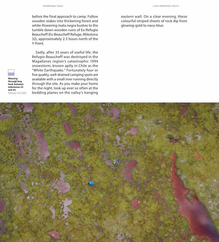
Weaving through bog land, between milestones 23 and 24.February 2nd 2020.
patrimonial trails lago windhond circuit
before the final approach to camp. Follow wooden stakes into thickening forest and white-flowering mata negra bushes to the tumble down wooden ruins of Ex-Refugio Beaucheff (Ex-Beaucheff Refuge, Milestone 32), approximately 2.5 hours north of the Y-Point.
Sadly, after 33 years of useful life, the Refugio Beaucheff was destroyed in the Magallanes region’s catastrophic 1994 snowstorm, known aptly in Chile as the “White Earthquake.” Fortunately four or five quality, well-drained camping spots are available with a small river running directly through the site. As you make your home for the night, look up ever so often at the bedding planes on the valley’s hanging
eastern wall. On a clear evening, these colourful-striped sheets of rock dip from glowing-gold to navy-blue.

74 75
Crossing of río Windhond on the approach to Ex Refugio
Beaucheff. Photo taken
looking north. Near milestone
32.February 2nd 2020.
BAHÍA WINDHOND - EX REFUGIO BEAUCHEFF
MILESTONE Nº DESCRIPTION ALTITUDE (m) LATITUDE LONGITUDE TYPE
Windhondriver crossing
Ex RefugioBeaucheffcampsite
233 55º 3’ 1,750” S 67º 36’ 7,182” W
300 55º 1’ 57,065” S 67º 35’ 57,912” W
River crossing
Campasite
32
33

76 77
patrimonial trails lago windhond circuit
Day 6. Ex refugio Beaucheff – Puerto Williams (13,6km, 300m ascent, 5 to 7 hours)
Set out on your final day, heading north again up Valle Windhond. Today’s final odyssey will take you between remote lakes, over secluded marshes and through cathedral-quiet woodlands. The lights and noise of civilization in albeit sleepy Puerto Williams will be a surprise after this deep-backcountry finale to your adventure.
On the remaining 200m climb to Paso Alinghi (499m) you’ll initially pass above an impressive canyon, where Rio Windhond rages even in summer months. Continue over often saturated but flatter ground, crossing a burbling tributary on your approach to an unnamed lake (Milestone 33). Pass this on the western shore, before beginning the final climb on an eroded
Rock buttresses observed west of the trail that runs through Valle Windhond. Near milestone 33.February 3rd 2020.
muddy trail to Paso Alinghi (Milestone 34). Allow roughly two hours to reach this high-point today from camp. Named after the American Cup winning Swiss yacht, Alinghi, this Patagonian pass as well as the Valle Windhond below were both named in the early 2000s by the long-time Isla Navarino guide and Tierra del Fuego historian Denis Chevallay. On the plateau, traverse to the west of a large lake, passing between two smaller lakes. Just before the trail drops into the Ukika Valley, divert ten metres off trail to climb steeply onto a raised mount for a superlative view of the Dientes de Navarino, as well as Canal Beagle.
A watery staircase alternating from lakes and peatbogs, to precipitous-plunges down overgrown hillsides, characterises the remaining 9km descent to Puerto Williams. The first and steepest wooded

78 79
patrimonial trails
Weaving between lakes and low clouds, near milestone 33.February 3rd 2020.
descent delivers you after half an hour to an unnamed lake’s eastern shore. Here you can see curiously abandoned beaver tree-felling activity, with v-notches in still-standing trunks. A further wooded descent is followed by a magnificent waterfall, roaring over the verdant hillside on its journey, just like you, to Canal Beagle beyond. Keep descending for another forty five minutes to a peat-bog meadow known as Marcas de Mansilla (Marks of Mansilla, Milestone 35); a favoured early 1950s guanaco hunting ground of Puerto Williams settler Eduardo Mansilla who once carved his named into a tree here. Interestingly, the tributary river joining the main flow from the south-west here, is from Laguna del Paso (the lake you traversed above on day two), now some 400 vertical metres above you.
The hard-hiking is over. March your way down to Puerto Williams for 5km on a reasonably marked trail. You are passing beneath imperial columns of immense coigue trees, interspersed by intermittent clearings until the junction of a 4x4 track (Milestone 37). Turn left here for a half hour downhill stroll into town. Stay on the 4x4 track, passing a bridge on your left after 200m. After a further 200m turn right at the next junction, heading briefly away from Puerto Williams. Now keep left as you close this slightly circuitous return to Puerto Williams, albeit with spectacular westerly views across the Canal Beagle. Join the main road at the settlement of Ukika where the eponymous river reaches the sea. Hopefully the last restaurants in the world are open for a celebratory meal. You’ve certainly earned it after surviving the planet’s most southerly hiking trail.

80 81
Puerto Williams port and air strip,
photographed looking west
from the junction of the
4x4 road in Ukika with the
Puerto Williams main road. Near
milestone 37.February 3rd 2020.
EX REFUGIO BEAUCHEFF - PUERTO WILLIAMS
MILESTONE Nº DESCRIPTION ALTITUDE (m) LATITUDE LONGITUDE TYPE
Alinghi pass
Saplings foreststarting point
Coigües foreststarting point
Trail fork andtrail’s end
End circuit
499 55º 0’ 20,020” S 67º 36’ 8,064” W
201 55º 58’ 56,507” S 67º 36’ 11,635” W
139 54º 57’ 34,315” S 67º 36’ 27,317” W
57 54º 56’ 38,573” S 67º 35’ 35, 506” W
50 54º55’59,88’’S 67º35’22,74’’ W
Mountain pass
Forest start
Forest/ orientationt
mark
Trail fork
Exit
Gran Miradorlookout 383 55º 0’ 56,932” S 67º 35’ 52,141” W Lookout 34
35
36
37
38
39

THE CONFRONTATION AT WINDHOND BAY THE SECRET LIVES OF RAISED SPHAGNUM BOGS
Different varieties of Sphagnum grow in the dome-shaped mounds on your approach to Refugio Charles, including the wine-red and green Sphagnum magellanicum. Sphagnum mosses, also known as peat moss, are capable of holding between 16-26 times their own weight in water. If you look closely you’ll also find carnivorous plants nestled amongst them. The bog’s valuable ability to store, filter and release water in a controlled way is known as an ecosystem service. But this is a sensitive set-up, and the changing rainfall patterns and increased temperatures associated with climate change are beginning to disrupt this terrestrial water cycle.
DIENTES AND WINDHOND COMBO
After reaching Refugio Charles it is possible to return to the “Y-Point” (Milestone 22) and, instead of continuing north in Valle Windhond, retrace your steps over Monte Bettinelli to rejoin the Dientes Circuit. This allows hikers to complete the full Dientes de Navarino hike whilst taking in the scenically very different lower segment of Valle Windond, including a visit to Refugio Charles. With this option, the hiker misses out on the upper Valle Windhond and Valle Ukika standard return leg of the Lago Windhond Patrimonial Trail. 7-9 days are recommended, depending on whether you take a rest day at Refugio Charles and complete the optional hike to the Bahia Windhond viewpoint.
In February 1624 a bloody incident occurred between sailors of the Dutch Nassau Fleet and the Yagán people close to Bahia Windhond. Isla Navarino historian Anne Chapman, relates how 19 unarmed men were sent ashore to resupply with water and firewood for the fleet’s continued journey north along the Chilean and Peruvian coast. Initially they communicated peacefully with the Yagán, but when forced to spend the night on the island due to deteriorating conditions, they were set upon and murdered. The rescue party reported incidents of cannibalism by the Yagán, based on either finding mutilated bodies or no traces at all. These events ultimately stigmatised these indigenous people as cannibals for over two centuries, with Darwin
and Fitz Roy reinforcing this idea. Chapman asks in her hefty tome, European Encounters with the Yamana People of Cape Horn, before and after Darwin, whether the Yagán’s murderous actions were prompted out of fear when faced with this armada of ships and these strange bearded Europeans (the Yagán kept hairless faces). Only in the late C19th and C20th was this colonial perception of the cannibalistic “savages” at the end of the world challenged. It was the Christian missionaries, Chapman states, that insisted the Yagán were not cannibals. In her book, the historian reflects on the Yágan the Europeans first encountered as being a highly adaptive and – relative to the resources available – technologically sophisticated culture.
82 83

84 85
RUTASPATRIMONIALESSOUTH
Isla NavarinoCale Horn Biosphera Reserve
Caleta Wulaia Circuit

PATRIMONIAL TRAIL WULAIA: AN EIGHT DAY ITINERARY
If you’ve ever had frontiersman dreams, Wulaia is the place to fulfil them. But like all adventure fantasies, the hardships are often overlooked. The Wulaia Patrimonial Trail is inspired by the Yagán people and the lives they historically led at Caleta Wulaia (Wulaia Harbour). When Darwin and Captain FitzRoy approached this bustling settlement on the north-west coast of Isla Navarino in 1843, they were escorted along the Canal Murray by twelve canoes, with four to five Yagán in each. Today, however, nobody lives here. And the territory is potentially as wild and as inhospitable as any point in its 6000 years of human history.
In the last ten years (2010-2020), the trail has officially been attempted by a total of just 63 hikers. (According to records at the Puerto Williams police station, see Register your hike with the police, below). Of the three patrimonial trails on Isla Navarino, this is by far the least frequented. Put simply, to fight your way along this almost non-existent trail – through thickest forests and its remotest bouldery-beaches – is to understand why the indigenous Yagán
navigated this territory not by foot; but by canoe (see Packrafting below).
“Wulaia” means Beautiful Bay in the Yagán language. Beauty indeed tumbles and sways and splashes through the soul of this trail. This landscape of water, wood and breaching whales lives an undisturbed, human-less existence. Nature has been allowed to develop its sprawling architecture for millenia here. When crossing 644m Paso Mladineo (Mladineo Pass) and reaching the summit of 594m Monte Mashoa (Mount King Scott) you’ll be alone with a view over Isla Hoste (Hoste Island) and the Tierra del Fuego archipelago. In modern times, these great swathes of land have been barely travelled by mankind. Your presence on the Wulaia Patrimonial Trail, besides a few sporadic markings on trees and very occasional cairns, has no more been catered for than any other creature you’ll find along the hike. Your enjoyment will be decided entirely by the mountain skills you bring to the challenge, and the expectations you set yourself. Tread lightly and respectfully though, and the surprises that await will be as fresh and vivid as any
Lewis and Clark or Alberto de Agostini expedition ever set their eyes upon.
This eight-day hiking itinerary details the trail’s attractions as well as some of its stories. Each of the eight days (besides day three which is harder) are similar in overall difficulty. They vary in distance, elevation and
the challenge presented by the terrain – but each should require between 4-6 hours of movement. You’ll absolutely need the accompanying topo map and the GPS track (see below) as well as heaps of experience having previously used these tools traversing the remotest and most challenging corners of our planet.
86 87
Monte Mashoa594m
Isla Martínez
Isla Button
Isla Strate
C A N A L B E A G L E
Isla Sur
Isla Troude
Islote Lobos
Caleta Domingo
Isla Pauvre
Puerto Corriente
Puerto Isorna
Puerto Hambre
Cabo Hahn
Isla Norte
Isla LargaIsla
Chela
Isla Hermosa
Isla Gil
Isla EmaIslote García
Isla Tito
Isla PatyBahía Honda
Isla Lawrence
Caleta Segura
Caleta Fique
Caleta Tanswuani
Punta Tasbani
Caleta Yekabahby
Bahía Catorce de Julio
Isla Aguila
Isla Conejos
Puerto Inútil
Canal Murray
C H I L E
A R G E N T I N A
Puerto Navarino
Caleta José
Caleta Wulaia
Liwuaia
Lum
Isla Dimancha
Playa Micalvi Norte
Isla Tongo
Isla Santibáñez
Islote Negro
Isla Coihue
S

88 89
patrimonial trails caleta wulaia circuit
Day 1. Estancia Lum – Campamento Choza (8,2km, ~350m ascent, 2 to 4 hours)
Depart Puerto Williams with a spring in your step: if it all feels like two much hard work by the end of tomorrow, you can (and should for your own safety) retreat the way you came. For anyone concerned about the Wulaia Patrimonial Trail’s challenge, this relatively easy out and back hike to Caleta Wulaia can be completed in four days (or two days if travelling light and fast). From Wulaia onwards, however, the trail gets even wilder.
Pick up the local bus from Puerto Williams heading west along the island’s perimeter road to Caleta Lum (see topo map, Hito / Milestone 1). This friendly service takes about one and a half hours, but the driver
Doña Maria, the trail guardian, photographed at her home at Caleta Lum. Milestone 1.January 19th 2020.
is known to wait if local children are still tying their shoelaces and not quite ready to board. So sit back, enjoy the journey along the water’s edge and watch the Canal Beagle slip along beneath you like the view from a ship’s cabin. As the saying goes: those who rush in Patagonia; lose time.
From the bridge at Caleta Lum, pick up the southbound trail, respectfully passing the house of Doña María Unión. If Doña María is home, be sure to stop and tell her your intention to reach Wualai. This remote homesteader has been instrumental in keeping the trail open. The Laguna Doña María (Doña Maria Lake), located 4km west of tonight’s camp spot, is named in her honour.
A deceptively easy wooded trail leads

90 91
patrimonial trails caleta wulaia circuit
uphill for a kilometre from Lum, flanked by the Rio Lum (Lum River) to the west and curtains of pale-green old man’s beard lichen festooning the lenga forest. Cross a tributary river to keep close to the main Rio Lum (Milestone 2). For the next two days, blazes of yellow-stipes and a red backdrop painted onto trees assist navigation. A complex moorland-like territory follows for the next two kilometres. Weave between stand of trees that have survived the rampant beaver activity towards a chocolate-coloured rapid that flows foamily through a mini canyon. Any semblance of a trail ends after this, approximately one and half hours after leaving Caleta Lum . You’re about to have your first encounter with the Wulaia Patrimonial Trail’s forest. Enter the forest (Milestone 5). Beat your way uphill
for 2.5km, clambering over fallen trunks, wading over sodden ground and squeezing your pack between trees for a further hour and a half. Emerge to a view over a sea of red Sphagnum moss below.
Can you see that gravel shore on the riverbank? This dry camping spot is known as Campamento Choza (Milestone 6). The river water can be foamy on this peaty ground and you might want to boil or chlorine-treat it before drinking. Sleep tight.
The first round of mata negra bush whacking, near milestone 3. Looking east.January 19th 2020.

92 93
Entering the forest near
milestone 5.January 19th 2020.
ESTANCIA LUM - CAMPAMENTO CHOZA
MILESTONE Nº DESCRIPTION ALTITUDE (m) LATITUDE LONGITUDE TYPE
Estancia Lum,circuit startingpoint
Tributary of Lumstream
Forest start
Forest end
Forest start
Chozacampsite
5 54° 54’ 28,323” S 68° 6’ 27,262” W
55 54° 55’ 9,095” S 68° 6’ 2,466” W
100 54° 55’ 26,644” S 68° 5’ 57,813” W
134 54° 55’ 44,303” S 68° 6’ 1,915” W
180 54° 56’ 5,442” S 68° 6’ 7,556” W
352 54° 57’ 34,326” S 68° 5’ 39,775” W
Trailheadf
Stream
Forest start
Forest end
Forest start
Campsite
1
2
3
4
5
6

94 95
patrimonial trails caleta wulaia circuit
Day 2. Campamento Choza– Caleta Wulaia (14,7km, -350m ascent, 3 to 6 hours)
Today’s landscape of lakes and often sleet-swept mountains can feel like an outing in the English Lake District. The British party aboard the infamous Beagle must of felt somewhat at home when they reached Caleta Wulaia (your journey’s end tonight), some 14,000km from their home.
After breaking camp and continuing south you’ll climb gradually between beaver-created lakes, shining like brilliant silver dinner plates between the rain showers. Press on, passing a series of cairns and clambering over the jumbled
Weaving through lake lands on the morning of day 2. Near milestone 7, looking south.January 20th 2020.
logs of beaver-dam terraces in the now steepening grassy valley. After an hour and a half you’ll pass 624m Cerro Vrsalovic (Vrsalovic Mountain, due east of Milestone 10) – the lowest of the three peaks to your east – named after one of two Croatia sheep-rearing families that settled at Caleta Wulaia in 1896. Above 550m the vegetation succumbs to an Alpine rocky landscape. It’s a stiff hour hike over very exposed terrain to 644m Paso Mladineo (Mladineo Pass, Milestone 12), named after the second Croatian family. With your rain-hood pulled tightly over your head, look out occasionally (south-west) over Canal Murray (Murray Narrows). When afternoon showers give way to sunlight, the jet-black

96 97
patrimonial trails caleta wulaia circuit
Caleta Wulaia, looking south towards Monte Mashoa. Near milestone 16.January 20th 2020.
rock of Isla Button (Button Island) emerges as if from a shimmering pool of mercury (see Retelling the story of “Jemmy Button”).
You can’t see Caleta Wulaia yet. It’s another two hours of steep south-westerly descent to the bay. Easy open ground leads to the Rio Matanza (Massacre River) where you have a choice. The north side of the river is initially a more challenging descent but later has a number of earth-shatteringly beautiful viewpoints towards the glacier capped peaks of Isla Hoste. The easier-going south side has similar views but less established viewpoints to stop and take it all in.
Once down in Wulaia bay (Milestone
17), you’re confronted by a creaky and preposterously large colonial style house. It was built in 1931 and used as a radio station by the Chilean Navy. Today the structure serves as a reminder of how invading powers came to dominate this ancient landscape that for a millenia saw nothing more than Yagán tepee style temporary construction from natural materials. Inside the usually locked building is a museum that is worth a visit if your hike coincides with the Australis cruise ship that brings tourists here. There’s plenty of space for camping. See Avoid Coastal Foraging, below.

98 99
Rolling terrain on the ascent to Paso Mladineo, with the Beagle
Channel beyond to the north.
Near milestone 12.
February 20th 2020.
CAMPAMENTO CHOZA - CALETA WULAIA
MILESTONE Nº DESCRIPTION ALTITUDE (m) LATITUDE LONGITUDE TYPE
Pirca (heap ofrocks)
Lookout
Lookoutprominence
Monte Vrsalovic
Rocky Alpinelandscape
Mladineo pass
Mladineodescent
Matanza river crossing
Forest start
Access to caletaWulaia
Caleta Wulaia
644 55° 1’ 9,541” S 68° 5’ 56,562” W
570 55° 1’ 32,182” S 68° 6’ 0,043” W
363 55° 2’ 37,799” S 55° 2’ 37,799” S
44 55° 2’ 47,598” S 68° 8’ 36,125” W
10 55° 2’ 51,112” S 68° 8’ 48,534” W
644 55° 1’ 9,541” S 68° 5’ 56,562” W
570 55° 1’ 32,182” S 68° 6’ 0,043” W
514 55° 01’ 51,05” S 68° 06’ 10,58” W
363 55° 2’ 37,799” S 55° 2’ 37,799” S
44 55° 2’ 47,598” S 68° 8’ 36,125” W
10 55° 2’ 51,112” S 68° 8’ 48,534” W
Orientationmark
Lookout
Lookout/ prominence
Orientation mark
Landscape
Pass
Descent start
Rivercrossing
Forest start
Inlet
Inlet
7
8
9
10
11
12
13
14
15
16
17

100 101
patrimonial trails caleta wulaia circuit
Day 3. Caleta Wulaia – Mount Mashoa – Caleta Wulaia (21km, 9 to 16 hours)
Today’s out-and-back hike to 594m Monte Mashoa is optional. But the mountain has the bucket-list credential of being the most southerly peak of any established hiking trail on the planet. Be warned though. This excursion requires wild bushwhacking, coastal scrambling, scree-slope climbing, bog-hopping and all-round ninja-like route finding skills. Progress will be measured in metres per hour rather than kilometres. Yet the view from the summit will overcome all frustrations. Set out south along the Wulaia coast, passing the memorial on the nearby hillock to Vice Almirante Robert FitzRoy (Vice Admiral Robert FitzRoy) within a couple of minutes. The shark-fin shaped peak you’re headed for is clearly visible on a clear day when facing FitzRoy’s cenotaph. Here, just 200m from the radio station, you’re at the
A hiker returns after reccing a section of coast-line on the low traverse towards Monte Mashoa. Photo taken looking south, two kilometres south of Caleta Wulaia.January 21st 2020.
end of the trail for today and you are on your own with route finding.
There is both a coastal route and an inland route for reaching Monte Mashoa. For the full adventure, try each of them to make a circuit, with the routes joining below the final summit approach (see topo map). The coastal route roughly follows the shoreline for the first 5km. From the FitzRoy memorial, following the coastal route, try and link the intermittent wild boar trails in a generally southerly direction for the first hour, whilst bushwhacking at times through neck-high mata negra bushes and spiky calafate (Darwin’s Barberry). Continue traversing towards the base of Monte Mashoa, scrambling at times around coastal peninsulas until after roughly three and a half hours you reach the steep and densely-wooded valley that descends to the sea from

102 103
patrimonial trails
Bushwacking a kilometre south of Caleta Wulaia, en route to Monte Mashoa. Photo taken looking south.January 21st 2020.
Monte Mashoa’s south face. Scramble your way up this, pulling yourself between trees in an exhausting fight for 1.5km. Allow over two hours just for this section.
Monte Mashoa is most easily summited on its east face. Reach this by crossing the river at the top of the steep valley. The coastal and the inland routes meet here. Then traverse around Monte Mashoa, along the west shore of a lake, between ancient gnarled ñirre tees. A forty-five minute scramble over sometimes loose boulders eventually leads to the gently sloping east summit ridge. From Monte Mashoa, look out across the Canal de Murray, towards the great wilderness of Isla Hoste (Hoste Island). Darwin described Tierra del Fuego as a “mountainous land, partly submerged in the sea”. You can see now what he meant. A wedge of water, the Seno Ponsonbry (Ponsonby Sound), divides Isla Hoste’s great Península Dumas (Dumas Peninsula) to the north, and Península Pasteur (Pasteur Peninsula) to the south. Beyond, where they meet in the haze, is the barely charted National Park of Alberto de Agostini, named in honour of the great Italian explorer, photographer and part-time missionary whose 1945 oeuvre Andes Patagonicos is still a masterclass in how to capture light and contrast with a camera.
Head back down towards the lakes and back across the outlet river. Instead of returning down the steep overgrown valley, keep high, traversing a marshland of Sphagnum moss bogs, beaver lakes and ancient beech woodland for approximately three hours. The final steep one and a half hour descent towards Caleta Wulaia is a woodland scramble through the “entangled mass of the thriving and the fallen” that Darwin experienced when adventuring through forests at this latitude over 185 years ago. A perfect end to a Tierra del Fuego day, as the naturalist would say, in all its “savage magnificence”.

104 105
The high traverse back to
Caleta Wulaia from the summit
of Monte Mashoa. Photo
taken looking north.
January 21st 2020.
CALETA WULAIA - MONTE MASHOA
MILESTONE Nº DESCRIPTION ALTITUDE (m) LATITUDE LONGITUDE TYPE
Monte Mashoafork
Monte Mashoasecond fork
Monte Mashoasummit
11 55º 03’ 26,91” S 68º 08’ 51,61” W
392 55º 05’ 52,16” S 68º 08’ 13,08” W
594 55º 05’ 59,18” S 68º 08’ 52,30” W
Trail fork
Trail fork
Mountain summit
18
19
20

106 107
Day 4. Caleta Wulaia – Playa Micalvi Norte (3km, 50m ascent, 2 to 4 hours)
You’ll be tired after yesterday. Today is very short in distance, but allow four hours for these 3kms. It ’s about to get even wilder. Turn back now to Caleta Lum if in doubt. The first hour of today’s hike, heading north along the island’s west coast, follows a reasonable trail through webs of old man’s beard lichen. The albeit intermittent signage has changed and is now a single red horizontal line blazed onto a white backdrop. Soon though, the trail once more disappears altogether.
As you traverse the beaches, look out for the mounds of shells. These are often active architectural sites and must not be disturbed. They are understood to be formed from the Yagán cooking seafood in one spot over many years. The discarded
Hikers stop to check their GPS as they enter the spectacularly overgrown northerly traverse of the Wulaia trail. Photo taken a kilometre south of milestone 21.January 22nd 2020.
shells are piled so high that they are likely to have proven useful as windbreaks. At other times you will be forced inland to wade through more energy-sapping thickets of mata negra and spiky purple-berried calafate that will leave bruise-coloured stains on your skin. Calafate is an acquired taste. Learning to separate the seeds from the flesh in your mouth brings you one step closer to being a true Patagonian.
Today’s journey comes to an end when you cross the Rio Micalvi (Micalvi River), in a v-notched rocky gorge. From here, head down to the north shore of the peninsula to camp on Playa Micalvi Norte (Micalvi North Beach, Milestone 21) by the mouth of a subsidiary branch of Rio Micalvi.
patrimonial trails caleta wulaia circuit

108 109
100 shades of seaweed. Near
milestone 21.January 22nd 2020.
CALETA WULAIA - PLAYA MICALVI NORTE
MILESTONE Nº DESCRIPTION ALTITUDE (m) LATITUDE LONGITUDE TYPE
Micalvi NorteBeach
61 55° 1’ 31,087” S 68° 9’ 36,194” W Beach 21

110 111
patrimonial trails caleta wulaia circuit
D a y 5 . P l a y a M i c a l v i N o r t e – Campamento Torre de Vigía (7,7km, -15m ascent, 5 to 10 hours)
Another short day in distance, but once again it will leave you wishing you could hollow out a coigue and paddle the remaining distance in a canoe. When the Yagán made first contact with western culture in 1624, their Tierra del Fuego travelling canoes were compared to Venetian barges. Their construction was considered to have reached a point of such perfection that no further improvements could be made. Let’s hope your hiking shoes are holding up just as well.
Prepare to go to battle again with the
Dusk ap-proaches on the woodland rollercoaster approach to Campamento Torre de Vigía. Near milestone 23.January 23rd 2020.
forest. Tomorrow this hiking trail relents, slightly. But today you’re going to be climbing over, ducking under and pushing through a seemingly impenetrable web of timber. Darwin had dark thoughts about the Tierra del Fuego forest describing it as “decayed to the heart.” Its atmosphere of relentless gales he perceived as “blacker than anywhere else.” In its disorder he saw “universal signs of violence.” He also bestowed these dark feelings on its inhabitants. Darwin made his reputation on the Beagle as a naturalist; but darkened it forever as a humanist, mistaking the Yagán for “miserable degraded savages.”
You’re traversing in the direction of the

112 113
patrimonial trails
Night falls as hikers reach the river canyon, just 35m south of Campamento Torre de Vigía and milestone 23. Photo taken looking south down the length of Bahía Inútil.January 23rd 2020.
far northern cove of the long and narrow bay of Puerto Inútil (Useless Port). 450m before this point you finish a very steep and sustained descent to a narrow inlet and a tree-covered river crossing. 35m immediately above this on the other side of the peninsula is Campamento Torre de Vigía (Camp Crow’s Nest, Milestone 23). It’s a rustic spot for two small tents, with perhaps the best view of any campsite on Isla Navarino. If you’re very lucky, you’ll be lulled to sleep by a pod of whales breaching in the darkness of the deep cove below.

114 115
For six thousand years the Yagán collected seafood from the island’s shores. Today is is not recommended, however, due to poisonous red tides. photograph taken a kilometre south of milestone 23.Janaury 23rd 2020.
PLAYA MICALVI NORTE - TORRE DE VIGÍA CAMP.
MILESTONE Nº DESCRIPTION ALTITUDE (m) LATITUDE LONGITUDE TYPE
Caleta José
Torre del Vigía(Crow’s Nest)campsite
8 54° 59’ 45,139” S 68° 10’ 17,137” W
46 54º 58’ 21,236”S 68º 12’ 23,544”W
Inlet
Campsite
22
23
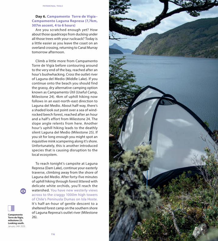
116 117116 117
Day 6. Campamento Torre de Vigía– Campamento Laguna Represa (7,7km, 307m ascent, 4 to 6 hours)
Are you scratched enough yet? How about those quadriceps from ducking under all those trees with your rucksack? Today is a little easier as you leave the coast on an overland crossing, returning to Canal Murray tomorrow afternoon.
Climb a little more from Campamento Torre de Vigía before contouring around to the very end of the bay, reached after an hour’s bushwhacking. Cross the outlet river of Laguna del Medio (Middle Lake). If you continue onto the beach you should find the grassy, dry alternative camping option known as Campamento Útil (Useful Camp, Milestone 24). 4km of uphill hiking now follows in an east-north-east direction to Laguna del Medio. About half-way, there’s a shaded look out point over a sea of wind-rocked beech forest, reached after an hour and a half’s effort from Milestone 24. The slope angle relents from here. Another hour’s uphill hiking leads to the deathly silent Laguna del Medio (Milestone 25). If you sit for long enough you might spot an inquisitive mink scampering along it’s shore. Unfortunately, this is another introduced species that is causing disruption to the local ecosystem.
To reach tonight’s campsite at Laguna Represa (Dam Lake), continue your easterly traverse, climbing away from the shore of Laguna del Medio. After forty-five minutes of uphill hiking through forest littered with delicate white orchids, you’ll reach the watershed. You have new westerly views across to the craggy 1000m high towers of Chile’s Penínusla Dumas on Isla Hoste. It ’s half-an-hour of gentle descent to a sheltered forest camp on the southern shore of Laguna Represa’s outlet river (Milestone 26).
Campamento Torre de Vigía, milestone 23. Looking south.January 24th 2020.
patrimonial trails

118 119
A minor lake on the traverse of
the mainland on day 6, close to
Laguna Represa, milestone 26.
Looking north.January 24th 2020.
TORRE DE VIGÍA CAMP. - LAGUNA REPRESA
MILESTONE Nº DESCRIPTION ALTITUDE (m) LATITUDE LONGITUDE TYPE
Laguna del Medio oulet
Laguna delMedio
Laguna Represacampsite
23 54° 58’ 28,704” S 68° 13’ 0,538” W
337 54° 58’ 1,960” S 68° 16’ 29,975” W
353 54° 58’ 5,149” S 68° 18’ 43,736” W
Lagoon
Lagoon
Campsite/ lagoon
24
25
26

120 121
patrimonial trails caleta wulaia circuit
Day 7. Campamento Laguna Represa– Puerto Hambre (7,7km, -342m ascent, 2 to 4 hours)
If you set off early, you could make it back to Puerto Navarino (Navarino Port) today. Don’t rush if you have time though. There’s plenty still to see. Continue your descent, following the Laguna Represa outlet river initially, then crossing it within twenty minutes via a fallen trunk (at the time of writing) on the eastern shore of another lake. It’s only 2.5km from your campsite to the Canal Murray, but it’s complicated by steep wooded descents and challenging route f inding as you weave your way through yet more beaver country for at least two hours from camp.
Once on the coast again at Puerto Isorna (Milestone 27), take a moment to explore
the rockpools. These were the Yagan’s aquatic hunting grounds where shellfish, birds, seals and whales were speared from canoes. Often the Yagán only made camp for a few days. Then pushed off again in their boats. You, however, are headed back into the forest. It’s probably best to collect drinking water here, as it’s in scarce supply at tonight’s camp.
It’s another hour to the secluded camp at Puerto Hambre (Milestone 28), found at the end of a descent to a small wooded peninsula. Civilisation isn’t far away now. Beyond the shore though, it’s a rich watery wilderness. Look carefully at nightfall. You might just see the majestic arching tail of a humpback whale before it slips back into the frigid water.
A return to coastal woodland on the northerly traverse to Puerto Hambre, milestone 28.January 25th 2020.

122 123
Puerto Isorna from the air. Milestone 27.January 25th 2020.
LAGUNA REPRESA - PUERTO HAMBRE
MILESTONE Nº DESCRIPTION ALTITUDE (m) LATITUDE LONGITUDE TYPE
Puerto Isorna
Puerto Hambre
7 54° 58’ 5,927” S 68° 21’ 13,284” W
13 54° 57’ 21,676” S 68° 21’ 55,300” W
Smallport/inlet
Smallport/inlet
27
28

124 125
Day 8. Puer to Hambre – Puer to Navarino (6,3km, -6m ascent, 2 to 4 hours)
The forest continues this morning for another kilometre on something resembling a trail. Listen out for the “thwack thwack” of the giant carpintero Magallánico (Magallanic woodpecker). Both are black in colour, but males have red heads. Both have tremendous punk-rock tufts of hair. You’re reaching the north-west corner of the island now. This is where Canal Murray and Canal Beagle meet (Milestone 29). It’s the site where the name of the trail you just hiked entered into the history books, when Captain FitzRoy took hostage here the 14-year old Yagán, Orundélico, on 11th May 1830 (see Retelling the story of “Jemmy Button”).
Your own journey is coming to an end. Leave the forest for a final 3km battle with mata negra bushes and calafate, linking animal trails to make forward progress for up to three hours. You’re heading east now
with the Argentinean city of Ushuaia clearly visible across the Canal Beagle. You’re wading through canelo trees, identifiable by their thick, shiny-green and elliptic shaped leaves. Captain John Winter found this Vitamin–C rich peppery-tasting plant helped cure his crew of scurvy whilst sailing with the British pirate Sir Francis Drake in 1579.
Once you reach the grassy cove of Liwuaia (“Spare Tail” in the Yagán language, Milestone 30) the going gets a little easier and there’s only 1.5km and forty five minute hiking between you and Puerto Navarino. Head for the saddle between the two hillocks straight ahead, passing beneath a long abandoned artillery gun placement on top of the seaward hillside. Puerto Navarino unfortunately has no tourist amenities and it’s best to pre-arrange onward travel before you begin your hike. It’s a 1.5 hour drive back to Puerto Williams before you can celebrate.
Mussels near Puerto Hambre, milestone 28.January 25th 2020.
patrimonial trails caleta wulaia circuit

126 127
Photo taken from
Caleta Liwuaia, milestone
30, looking north-west to
the mountains of Argentina.
January 26th 2020.
PUERTO HAMBRE - PUERTO NAVARINO
MILESTONE Nº DESCRIPTION ALTITUDE (m) LATITUDE LONGITUDE TYPE
Forest start(water)
Liwaia
Puerto Navarino,end of trail
58 54° 56’ 35,732” S 68° 22’ 2,136” W
15 54° 55’ 53,108” S 68° 20’ 44,394” W
7 54º 55’ 33,169” S 68º 19’ 19,395” W
Foreststart/water
Cove
Seasidehamlet/end
of trail
29
30
31

RETELLING THE STORY OF “JEMMY BUTTON” AND THE WULAIA MASSACRE
PACKRAFTING
Competent boaters (operating entirely at their own risk) could increase the authenticity of this coastal adventure by completing some or all of days 4-8 by water, from Wulaia to Puerto Navarino.
Orundélico is the actual name of the fourteen year old boy, re-named “Jemmy Button” by his kidnapper Captain Robert FitzRoy during the first voyage of the Beagle on 11th of May 1830. The nickname “Jemmy Button” refers to how Fitzroy supposedly “bought” the Yagán child from his family in exchange for a button. The indigenous Yagán thought Orundélico would be returned to a nearby island. FitzRoy. however, believed he could improve the life of Orundélico and his people by bringing him and three other indigenous prisoners back to London and instilling them with English language and religion. Fitz-Roy returned Orundélico, with his new English education and clothes, to Isla Navarino at Caleta Wulaia two and a half years later, accompanied by Charles Darwin on the second voyage of the Beagle. By this time, only three of the prisoners remained alive. Orundélico returned to find his father had died in his absence.
FitzRoy left Orundélico on the island on February 7th 1833 with a wealth of tools and clothes, accompanied by a Christian missionary. Just nine days later FitzRoy returned to find Orundélico’s family had become divided by the introduction of these strange possessions; the agricultural allotments they had dug were trampled and the missionary was rescued just in time to save his life. The historian Lucas Bridges wrote in defence of Orundélico’s family that no Yagán would swap their child for a button, nor even the Beagle and all its contents.
Intervention in Orundélico’s life continued in 1858. The Patagonian Missionary Society aboard the Allen Gardiner ship convinced Orundélico’s family to travel to the Falkland Islands for four months to undertake Christian instruction. When the Allen Gardiner returned to Wualai once more in 1859, the Yagán it seemed had had enough, murdering eight of the nine missionary crew members. Orundélico and his son were implicated as the ringleaders.
By the end of the C19th, the Yagán and other indigenous tribes were being slaughtered by seal hunters, as well as western diseases. Their degraded living conditions and lack of disease immunity made them particularly susceptible. Today there is only one native Yagán speaker alive; Cristina Calderon lives in the Ukika settlement on the eastern outskirts of Puerto Williams. No Yagán live today in Caleta Wulaia.
128 129

ANTHROPOLOGICAL MUSEUM MARTÍN GUSINDEThis museum is dedicated to the conservation and transmission
of the natural and cultural heritage of the archipelago. It is the only museum in Puerto Williams making it the southernmost in the world. Its name is given after the Austrian priest and scientist that lived within the Yaganes and Selk’man, as he developed one of the most important ethnographic works of the original inhabitants of Tierra del Fuego.
It was created in 1974, and its official opening was in 1975 with the museum being only 230 sqm. Today it has more than 800 sqm for visitors consisting of three permanent exhibition areas, a documentation and reading area, as well as the incorporation of the historic monument Stirling House.
https://www.museomartingusinde.gob.cl/sitio/Secciones/Quienes-somos/https://www.registromuseoschile.cl/663/w3-article-50660.htmlhttps://es.wikipedia.org/wiki/Museo_Antropol%C3%B3gico_Mart%C3%ADn_Gusinde
YACHT CLUB MICALVIA ship from the Chilean Navy, named after the petty officer
Constantino Micalvi who participated in the naval combat of Iquique (northern city) abord the Esmeralda. It was converted to a pontoon in 1961 for the transport of coal through the southern canals for more than 35 years. It became the yacht club in 1983.
Today it offers berth to more than a dozen yachts per season, number has been on the rise as years pass by. They usually are foreign vessels, mainly European, that seek to navigate Antarctica, look at the glaciers of the Darwin Mountain Range o live the experience of navigating Cape Horn.
https://www.patagoniachilena.com/puerto-williams/club-de-yates-micalvi/https://archivo.laprensaaustral.cl/cronica/el-club-micalvi-un-iman-que-atrapa-a-los-yatistas-de-todo-el-mundo/
FERRY TO PUERTO TOROPuerto Toro is the southernmost permanent settlement in Chile,
and of the world. Its origins were in a lukewarm “gold rush” at the end of the 19th century. Today it has around 30-40 residents. The few foreigners or tourists who arrive are looking for fishing experience. It is only 46 kilometers from Puerto Williams, but there is no road between the towns. The only means of transportation is through a ferry, operated by Transbordadora Austral Broom
Highlights (www.tabsa.cl), which leaves Puerto Williams once a month for the day (last Sunday of the month), and is free of charge. To be able to board, permission must be requested from the Puerto Williams Government in advance to ensure space ([email protected]) since residents or personnel with mandatory trips are entitled to use a space.
http://www.ptowilliams.cl/Puerto_Toro.htmlhttp://www.tabsa.cl/portal/index.php/es/
PARQUE ETNOBOTÁNICO OMORALocated 3 kilometers to the west of Puerto Williams, it consists of
a 1,000-hectare protected area within Cabo de Hornos (Cape Horn) Biosphere Reserve. ‘Omora’ has its origins in the Yagan word for the ruby hummingbird (sephanoides sephanoides), the southernmost specie of hummingbird in the world. This park develops scientific investigation, biocultural education and conservation of the southern area of Chile. It was created in the year 2000 by initiative of the Omora Foundation and Magallanes University. Within the park you will find the principal habitats for Coigües, Lenga and Nirre, peat of sphagnum and beaver wetlands. Other activities you may do are magnifying glass exploration which allows for the observation and admiration of flora at a scale which many times goes unnoticed (presence of more than 5% of the bryophyte plants (non-vascular land plants like mosses) of the world in an area that corresponds to less than 0.01% of the land surface of the world).
https://es.wikipedia.org/wiki/Parque_etnobot%C3%A1nico_Omorahttps://ieb-chile.cl/estacion-biologica/parque-omora/https://laderasur.com/destino/parque-etnobotanico-omora-de-lo-micro-a-lo-macro-2/http://parquesparachile.cl/index.php-option=content&task=view&id=51&Itemid=53.htm
VILLA UKIKALocated 2 kilometers east of Puerto Williams it is considered as a
historic appeal. This small community is home to the few Yaganes (original natives) that remain on the island. Its most prominent figure is “Grandmother Cristina”. With her 92 years she is the last person to speak the native language of the Yaganes. She has been recognized by the National Counsel of Culture and Arts of Chile as a “leaving human treasure”. You may find the last vestiges of the Yagan culture, identity and craftmanship.
http://www.gobernacionantartica.gov.cl/info_turismo/https://es.wikipedia.org/wiki/Cristina_Calder%C3%B3nhttps://www.minube.com/rincon/villa-ukika-puerto-williams-chile-a2189201
130 131

• Barros Valenzuela, Álvaro, 1931. “Yámana: los primitivos más australes de la tierra”. Disponible en Memoria Chilena, Biblioteca Nacional de Chile http://www.memoriachilena.gob.cl/602/w3-article-98657.html . Accedido en 10/2/2021.
• BIBLIOTECA NACIONAL DE CHILE. “Rito, chamanismo y música Selknam”. Memoria Chilena. Disponible en http://www.memoriachilena.gob.cl/602/w3-article-3687.html . Accedido en 10/2/2021.
• BIBLIOTECA NACIONAL DE CHILE. “Pueblos australes de Chile”. Memoria Chilena. Disponible en http://www.memoriachilena.gob.cl/602/w3-article-3412.html . Accedido en 10/2/2021.
• BIBLIOTECA NACIONAL DE CHILE. “Puerto Williams en la isla Navarino, el poblado más austral de Chile”, 1961. Disponible en Memoria Chilena, Biblioteca Nacional de Chile http://www.memoriachilena.gob.cl/602/w3-article-75488.html . Accedido en 10/2/2021.
• Darwin, Charles. “Darwin en Chile (1832-1835). Viaje de un naturalista alrededor del mundo”. Edición preparada por David Yudilevich L. y Eduardo Castro L. Editorial Universitaria, 1995.
• Dirección de Bibliotecas Archivos y Museos (DIBAM) de Chile, 2012. “La Casa Stirling. Misiones anglicanas entre los yaganes de Tierra del Fuego”. Ediciones LOM, 2012. Disponible en: https://bibliotecadigital.subdere.gov.cl/handle/123456789/79
• Gusinde, Martín, 1951. “Fueguinos. Una crónica sobre los pueblos australes”. Alquimia ediciones, 2020.
• Martinic Beros, Mateo, 1931. “Crónica de las tierras del sur del Canal Beagle”. Disponible en Memoria Chilena, Biblioteca Nacional de Chile http://www.memoriachilena.gob.cl/602/w3-article-10380.html . Accedido en 10/2/2021.
Recommended Reading
132


![INSTITUT AGAMA ISLA]YI NEGERI](https://static.fdokumen.com/doc/165x107/6313aa03b1e0e0053b0e7909/institut-agama-islayi-negeri.jpg)