Isfahan School of urban design: a morphological perspective (2014)
15
-
Upload
dieangewandte -
Category
Documents
-
view
0 -
download
0
Transcript of Isfahan School of urban design: a morphological perspective (2014)

2
ISBN: 978-972-99101-6-6
Editors: Vítor Oliveira, Paulo Pinho, Luisa Mendes Batista, Tiago Patatas, Cláudia Monteiro
Cover Design by Cláudia Monteiro
The present volume contains the full papers presented at the 21st International Seminar on Urban
Form, held in Porto, from 3 to 6 July, 2014. Authors alone are responsible for options expressed in
the book.
Cite as: Oliveira V, Pinho P, Batista L, Patatas T and Monteiro C (eds.) (2014) Our common future
in Urban Morphology, FEUP, Porto.
1795
The Middle Eastern Cities and Isfahan School of
Urban Morphology
Isfahan School of urban design: a morphological perspective
Fatemeh (Farnaz) Arefian1, Hassan Estaji
2, Mona Jabbari
3, Anna Koledova
4,
Mahya Fatemi4
1 Silk Cities, University College London.
2 Silk Cities; University of Applied Arts
Vienna. 3 Silk Cities; Universidade do Minho. Silk Cities;
4 The Bartlett Development
Planning Unit. 5 Silk Cities; The Bartlett Development Planning Unit-
E-mail: [email protected], [email protected], [email protected],
[email protected], [email protected].
Abstract. Urban morphology of cities in the Middle East and Central Asia has been of great interests to
academics from various disciplines. Through centuries of development Iranian (Persian) art and
architecture contributed to what is called now Islamic cities. Isfahan school of urban design has
particularly played a significant role in creating to be highly influential in development of Islamic cities
in the region. We discuss how establishment of this new school of thought on Islamic cities in 16th
century (concurrent with Renaissance) influenced the way we think about cities in the Middle East and
Central Asia today. Using content analysis and direct observation as our research methodology we
investigate urban fabric of Isfahan- the capital of the Isfahan region in Iran and once its most largest and
glorious city in order to extract the conceptual and practical lessons about traditional urban morphology
and advocate their importance and relevance for the contemporary urban development practices in
Islamic cities.
Key Words: Urban Morphology, Isfahan, Urban Design, Islamic Cities, Morphological Integration,
Iranian Art and Architecture, Samarkand.
Overview to Isfahan Urban Transformation from a Medieval City towards an Avant-
garde Metropolis
It can be argued that Isfahan's central position in Iran preconditioned it to become the capital of
two major dynasties, the Seljuk (1037–1157) and the Safavid (1502–1736) dynasties. Its dual
function as an emporium and as a capital manifested in Bazaars and in the courtly buildings that
gave Isfahan the reputation of an oriental Versailles (Jayyusi et al., 2008). Given the
geographical position of Isfahan at the center of the Iranian plateau, it has been known as one of
the most important trade centres of Iran. This position occasionally makes it the bridge between
the East, West, South, and North. According to Golombek (1974) Isfahan's urban development
shows three phases from the early history of Isfahan to the contemporary era:
Late Sasanid to early Islamic (7th-8th centuries): the satellite villages. During the first Islamic
century Isfahan consisted of two small settlements (Jayy and Yahudiyyah) and a large number
of villages around the Zayandeh-Rud. The pattern of Isfahan city, like other Iranian desert cities,
was based on the transformation of farming lots into urban residential spaces. The irrigation
network kept its form as a network of public spaces running through the streets and alleys.
Although the primary function of the irrigation systems was to supply water for agriculture, it
has also defined the city layout and its urban evolution.. Privately owned farms were divided

1796
into smaller lots of land for residential buildings (Estaji and Raith, 2012). Mehryar (2007)
believes that the city of Isfahan was originally the result of the amalgamation of fifteen villages.
From 8th to 15th centuries (early Abbasid to Safavid) the villages eventually amalgamated
and Isfahan became a walled town: The next major physical development happened during the
Buyids when Isfahan was walled. The exact date of the construction of the defensive wall and
its citadel is unknown. However, Muqaddasi, writing in 985, describes Isfahan as a walled city
with twelve gates”. As soon as the city was limited to its surrounding walls, it was socially and
physically divided to several neighbourhoods called Mahalleh (Golombek, 1974, Sarraf, 2010).
Mosque (religious space) and Bazaar (economic space) were the two main urban elements for
the formation and direction the growth of the city, similar to other Islamic cities. The first
mosque, in the mid-seventh century, served a symbol of victory and Islam, within the Jayy’s
walls (old Isfahan). The mosque was the central urban space, as the city formed and expanded
around it; it sparked the development of Isfahan into an early Islamic metropolis. In the early
Islamic cities the mosque was not only a place for religious purposes, it served functions of a
court, a school, a place for discussing and debating, and a place for announcing the Islamic
governmental orders. In other words, it was a political, social and religious centre and
consequently the centre of the city.
The main mosque of Islamic city was usually located near a large plaza (Meydan), main
routes were connected the main meydan to the city gates. Commercial spaces were usually
located on the sides of those routes near the city centre and around the main Meydan
(Kheirabadi, 2000). Figure 1 presents a schematic model of Islamic cities.
Figure 1. A schematic model of Islamic city (Kheirabadi, 2000).
In Isfahan, the complex of mosque and surrounding spaces and bazaar formed the main
structure of Isfahan city during the centuries. The Isfahan bazaar had three major developmental
steps after the advent of Islam in Iran: First is the formation the old Meydan and surrounding
bazaar that connected the Jayy and Yahudiyyah (Two initial nucleuses of old Isfahan) together.
The bazaar organically grew around the old meydan and the Friday mosque (Pourjafar et al.,
2014). From 11th century Isfahan evolves towards becoming a prominent Islamic city. Saljuqid
was a brilliant period for Art and Architecture in Isfahan, when Isfahan became the capital of
Persia (Iran) for the first time. Many of the most important monuments in Isfahan such as the
great dome of the Grand Mosque and some important Minarets were erected during this era. The
main streets of old Isfahan usually connected the city centre (old meydan) to the gates. These
1797
covered routes had another function; they were bazaar as a structure of Isfahan urban in Saljuqid
era. The form of City wall and bazaars followed the organic form of topography and water
routes. In the Timurid period the city organically developed further; the city wall expanded
southwards, the Isfahan bazaars grew and some new neighbourhoods were formed (Pakzad,
2011). This period sees Isfahan as well developed and quite prominent on the map of the
medieval cities of Asia (Babaei, 2008) reflecting blossoming Iranian art and architecture of the
time.
From the 15th century, from Safavid era, Isfahan emerged as an avant-garde metropolis
became the capital for the second time during Safavid. Shah Abbas the Great (1587-1629)
moved his capital from Qazvin to Isfahan and developed Isfahan for its new role. In general
Safavid’s strong central governments had plans for their capitals, for example, Qazvin shows
some examples of new urban interventions. But Shah Abbas’s ambitious plans for developing
Isfahan were realised in form of large-scale urban public places, new boulevards and
architectural monuments. Naqsh-e Jahan meydan and its surrounding buildings were erected for
the governmental function and the straight Chahar-Bagh Street connected the old city to the
royal palaces (Hezar Jarib) on the other side of the Zayande-Rud. Isfahan’s development before
Safavid was organic and slow during centuries of organic growth but it changed during Safavids
rule as the city developed according to a planned urban design based on the new Cartesian
geometry. Development of art and architecture in the city of Isfahan reached its peak and set
examples for other cities in the region. Complementary to large-scale urban plans , at this time a
new period in Persian architecture emerges bringing rich, sensationally coloured and
imaginative details developed by the predecessors into meaningful ensembles of immense
scale and grandeur (Pope, 1965) that was later referred to as the Isfahan School of thought by
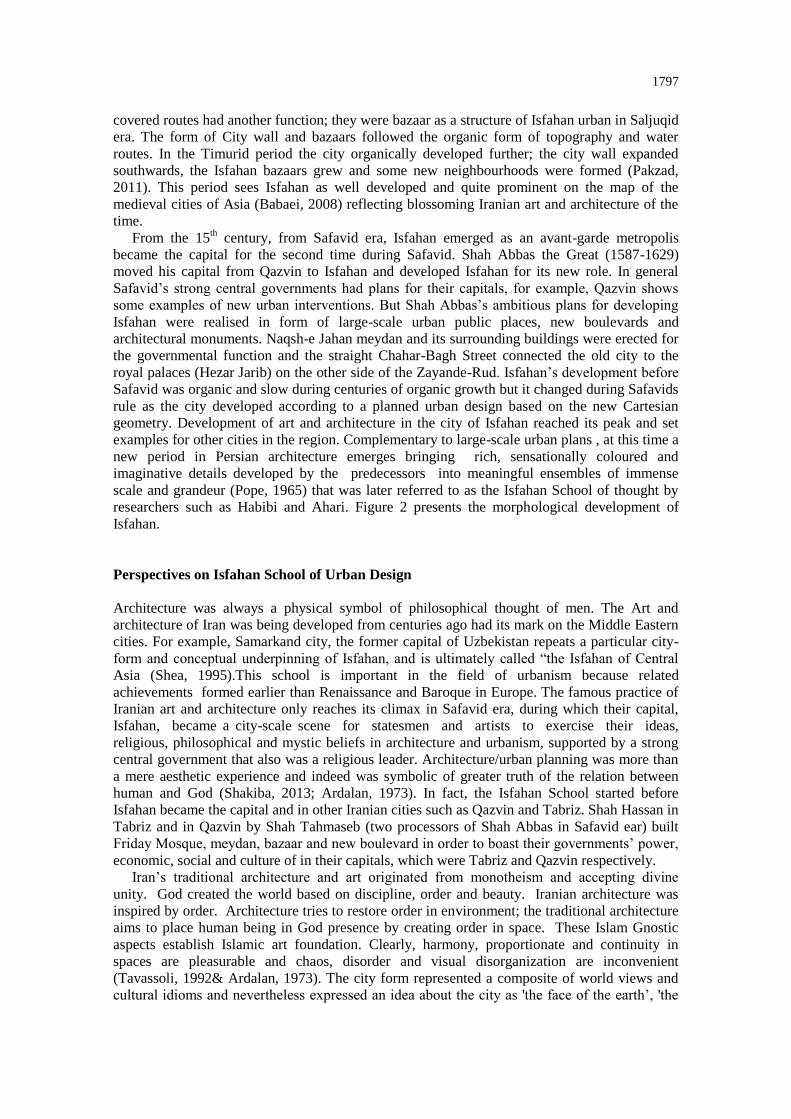
researchers such as Habibi and Ahari. Figure 2 presents the morphological development of
Isfahan.
Perspectives on Isfahan School of Urban Design
Architecture was always a physical symbol of philosophical thought of men. The Art and
architecture of Iran was being developed from centuries ago had its mark on the Middle Eastern
cities. For example, Samarkand city, the former capital of Uzbekistan repeats a particular city-
form and conceptual underpinning of Isfahan, and is ultimately called “the Isfahan of Central
Asia (Shea, 1995).This school is important in the field of urbanism because related
achievements formed earlier than Renaissance and Baroque in Europe. The famous practice of
Iranian art and architecture only reaches its climax in Safavid era, during which their capital,
Isfahan, became a city-scale scene for statesmen and artists to exercise their ideas,
religious, philosophical and mystic beliefs in architecture and urbanism, supported by a strong
central government that also was a religious leader. Architecture/urban planning was more than
a mere aesthetic experience and indeed was symbolic of greater truth of the relation between
human and God (Shakiba, 2013; Ardalan, 1973). In fact, the Isfahan School started before
Isfahan became the capital and in other Iranian cities such as Qazvin and Tabriz. Shah Hassan in
Tabriz and in Qazvin by Shah Tahmaseb (two processors of Shah Abbas in Safavid ear) built
Friday Mosque, meydan, bazaar and new boulevard in order to boast their governments’ power,
economic, social and culture of in their capitals, which were Tabriz and Qazvin respectively.
Iran’s traditional architecture and art originated from monotheism and accepting divine
unity. God created the world based on discipline, order and beauty. Iranian architecture was
inspired by order. Architecture tries to restore order in environment; the traditional architecture
aims to place human being in God presence by creating order in space. These Islam Gnostic
aspects establish Islamic art foundation. Clearly, harmony, proportionate and continuity in
spaces are pleasurable and chaos, disorder and visual disorganization are inconvenient
(Tavassoli, 1992& Ardalan, 1973). The city form represented a composite of world views and
cultural idioms and nevertheless expressed an idea about the city as 'the face of the earth’, 'the
1798
mirror of the world', 'the garden of souls' etc. Statements as such are compared to the poems of
the Sufy mystics that reveal conceptual essence of the Islamic art and architecture that addresses
the search for order and harmony in the natural world, the intangible world, the human soul and
the city. Such principles are repeated in cities that either are part of Iran or influenced by the
Iranian culture, art and architecture. For example Samarkand that represents the same principles
(Shea, 1995). Concepts of unity-pluralism and order-chaos are of the common fundamental
characteristics in art and architecture that can be seen as of the architectural tools for forming
cities, buildings and gardens that are the mirror of god on the earth. Both are manifested by
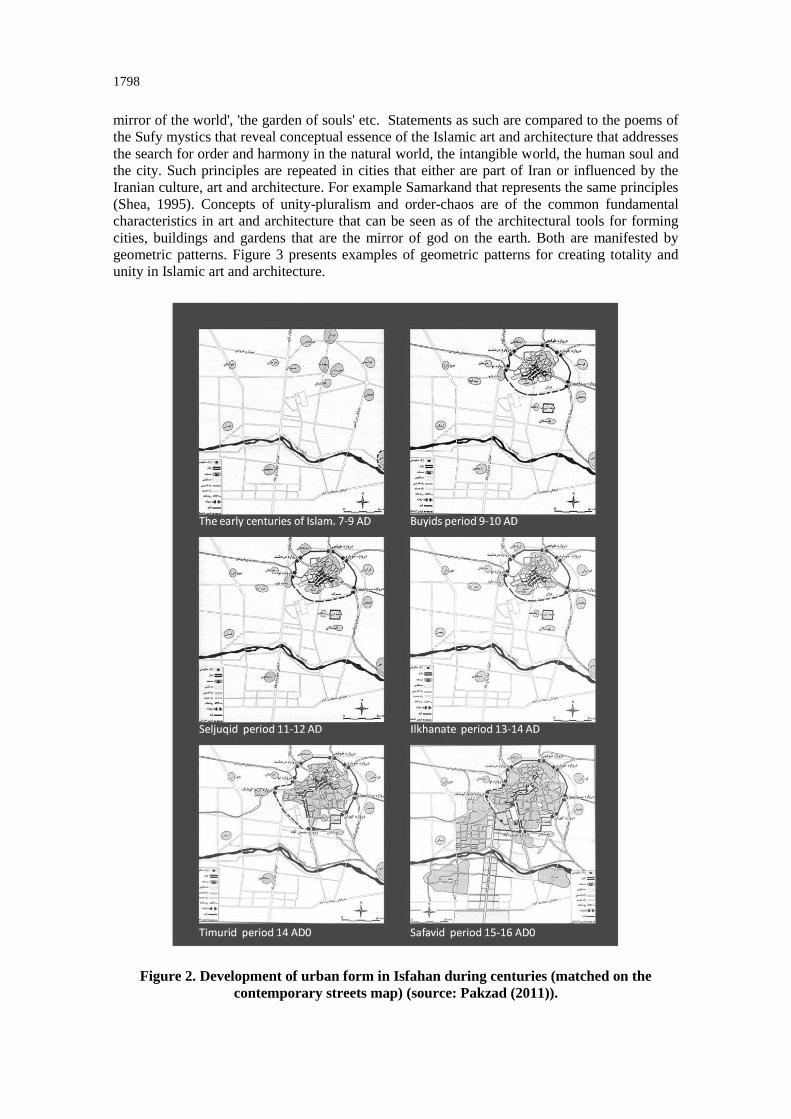
geometric patterns. Figure 3 presents examples of geometric patterns for creating totality and
unity in Islamic art and architecture.
Figure 2. Development of urban form in Isfahan during centuries (matched on the
contemporary streets map) (source: Pakzad (2011)).
1799
Figure 3. Examples of using geometry in art and architecture (source: Stierlin, 2011).
The concept of unity in art and architecture has resulted from Sufism spiritual thinking,
where the unity of one (God) and his beloved is celebrated and plural details all mirror the one.
The relationship between detail and totality is considered as an Iranian urbanism branch related
to unity and pluralism issue; every element and form is comprehensive, individually and
combined. While market stalls are independent and complete structured in a combination they
create the totality of bazaar (Shakiba, 2013; Tavassoli, 1992; Ardalan, 1973). Order is synonym
of geometry in Iranian architecture. Mathematics and geometry played a deterministic role in
visual arts and architecture besides organic and natural structures geometrical patterns.
Symmetry is a powerful tendency in Iranian architecture at the time. There is a difference
between organic expansion and Euclidean geometry but it is similar to fractal geometry,
while in static buildings an independent, individual and geometrical order is seen. Even in
bazaar, although the pathway creates an organic spiral form without classic geometry in total
arcades, architectural modules and nodal junctions offer the sense of geometry and continuity.
1800
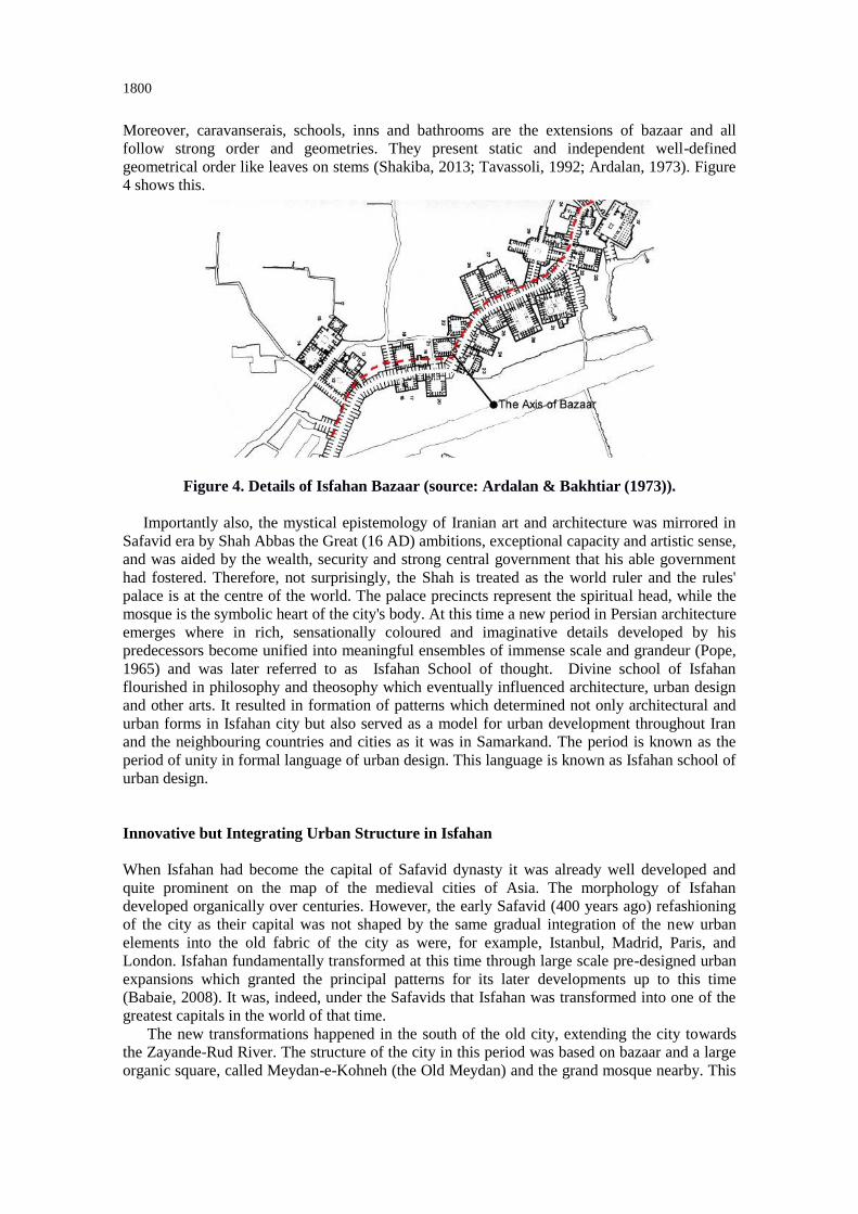
Moreover, caravanserais, schools, inns and bathrooms are the extensions of bazaar and all
follow strong order and geometries. They present static and independent well-defined
geometrical order like leaves on stems (Shakiba, 2013; Tavassoli, 1992; Ardalan, 1973). Figure
4 shows this.
Figure 4. Details of Isfahan Bazaar (source: Ardalan & Bakhtiar (1973)). Importantly also, the mystical epistemology of Iranian art and architecture was mirrored in
Safavid era by Shah Abbas the Great (16 AD) ambitions, exceptional capacity and artistic sense,
and was aided by the wealth, security and strong central government that his able government
had fostered. Therefore, not surprisingly, the Shah is treated as the world ruler and the rules'
palace is at the centre of the world. The palace precincts represent the spiritual head, while the
mosque is the symbolic heart of the city's body. At this time a new period in Persian architecture
emerges where in rich, sensationally coloured and imaginative details developed by his
predecessors become unified into meaningful ensembles of immense scale and grandeur (Pope,
1965) and was later referred to as Isfahan School of thought. Divine school of Isfahan
flourished in philosophy and theosophy which eventually influenced architecture, urban design
and other arts. It resulted in formation of patterns which determined not only architectural and
urban forms in Isfahan city but also served as a model for urban development throughout Iran
and the neighbouring countries and cities as it was in Samarkand. The period is known as the
period of unity in formal language of urban design. This language is known as Isfahan school of
urban design.
Innovative but Integrating Urban Structure in Isfahan
When Isfahan had become the capital of Safavid dynasty it was already well developed and
quite prominent on the map of the medieval cities of Asia. The morphology of Isfahan
developed organically over centuries. However, the early Safavid (400 years ago) refashioning
of the city as their capital was not shaped by the same gradual integration of the new urban
elements into the old fabric of the city as were, for example, Istanbul, Madrid, Paris, and
London. Isfahan fundamentally transformed at this time through large scale pre-designed urban
expansions which granted the principal patterns for its later developments up to this time
(Babaie, 2008). It was, indeed, under the Safavids that Isfahan was transformed into one of the
greatest capitals in the world of that time.
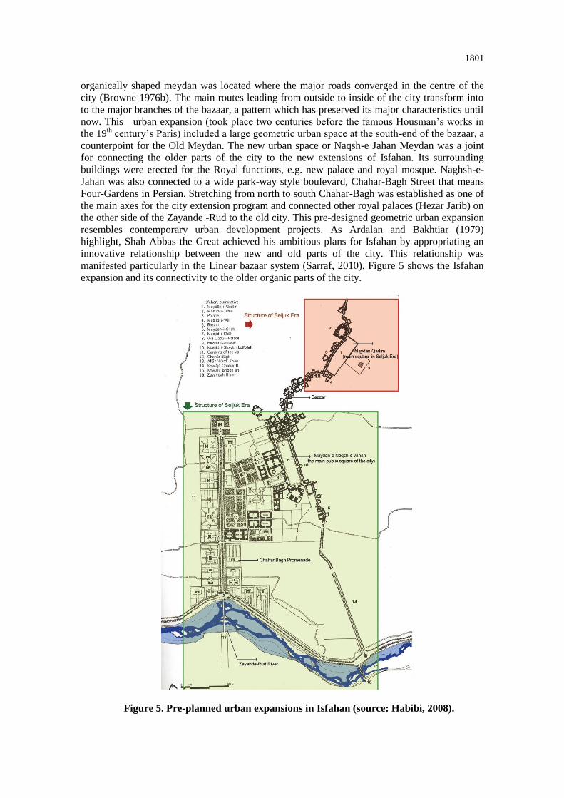
The new transformations happened in the south of the old city, extending the city towards
the Zayande-Rud River. The structure of the city in this period was based on bazaar and a large
organic square, called Meydan-e-Kohneh (the Old Meydan) and the grand mosque nearby. This
1801
organically shaped meydan was located where the major roads converged in the centre of the
city (Browne 1976b). The main routes leading from outside to inside of the city transform into
to the major branches of the bazaar, a pattern which has preserved its major characteristics until
now. This urban expansion (took place two centuries before the famous Housman’s works in
the 19th century’s Paris) included a large geometric urban space at the south-end of the bazaar, a
counterpoint for the Old Meydan. The new urban space or Naqsh-e Jahan Meydan was a joint
for connecting the older parts of the city to the new extensions of Isfahan. Its surrounding
buildings were erected for the Royal functions, e.g. new palace and royal mosque. Naghsh-e-
Jahan was also connected to a wide park-way style boulevard, Chahar-Bagh Street that means
Four-Gardens in Persian. Stretching from north to south Chahar-Bagh was established as one of
the main axes for the city extension program and connected other royal palaces (Hezar Jarib) on
the other side of the Zayande -Rud to the old city. This pre-designed geometric urban expansion
resembles contemporary urban development projects. As Ardalan and Bakhtiar (1979)
highlight, Shah Abbas the Great achieved his ambitious plans for Isfahan by appropriating an
innovative relationship between the new and old parts of the city. This relationship was
manifested particularly in the Linear bazaar system (Sarraf, 2010). Figure 5 shows the Isfahan
expansion and its connectivity to the older organic parts of the city.
Figure 5. Pre-planned urban expansions in Isfahan (source: Habibi, 2008).
1802
Isfahan urban structure and main elements
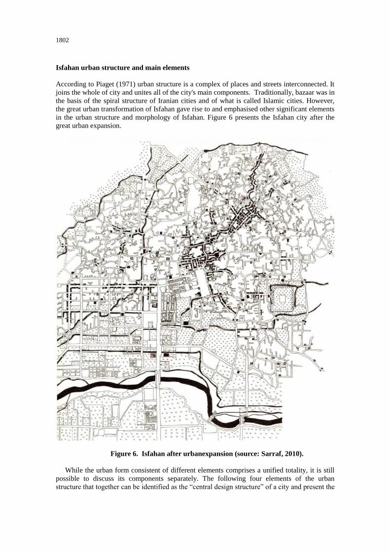
According to Piaget (1971) urban structure is a complex of places and streets interconnected. It
joins the whole of city and unites all of the city's main components. Traditionally, bazaar was in
the basis of the spiral structure of Iranian cities and of what is called Islamic cities. However,
the great urban transformation of Isfahan gave rise to and emphasised other significant elements
in the urban structure and morphology of Isfahan. Figure 6 presents the Isfahan city after the
great urban expansion.
Figure 6. Isfahan after urbanexpansion (source: Sarraf, 2010).
While the urban form consistent of different elements comprises a unified totality, it is still
possible to discuss its components separately. The following four elements of the urban
structure that together can be identified as the “central design structure” of a city and present the
1803
city's identity. These include: bazaar, Naqsh-e Jahan (the main public Meydan-plaza- of the
city), Chahar-Bagh Boulevard, and Zayande-Rud River.
They hold the city structure together over centuries and preserve areas that are now
recognized as the World Heritage Sites:
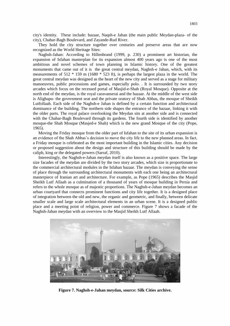
Naghsh-Jahan: According to Hillenbrand (1999, p. 230) a prominent art historian, the
expansion of Isfahan masterplan for its expansion almost 400 years ago is one of the most
ambitious and novel schemes of town planning in Islamic history. One of the greatest
monuments that came out of it is the great central meydan, Naghsh-e Jahan, which, with its
measurements of 512 * 159 m (1680 * 523 ft), is perhaps the largest plaza in the world. The
great central meydan was designed as the heart of the new city and served as a stage for military
manoeuvres, public processions and games, especially polo. . It is surrounded by two story
arcades which focus on the recessed portal of Masjid-e-Shah (Royal Mosque). Opposite at the
north end of the meydan, is the royal caravanserai and the bazaar. At the middle of the west side
is Alighapu- the government seat and the private oratory of Shah Abbas, the mosque of Sheikh
Lutfollaah. Each side of the Naghsh-e Jahan is defined by a certain function and architectural
dominance of the building. The northern side shapes the entrance of the bazaar, linking it with
the older parts. The royal palace overlooking the Meydan sits at another side and is connected
with the Chahar-Bagh Boulevard through its gardens. The fourth side is identified by another
mosque-the Shah Mosque (Masjed-e Shah) which is the new grand Mosque of the city (Pope,
1965).
Moving the Friday mosque from the older part of Isfahan to the site of its urban expansion is
an evidence of the Shah Abbas’s decision to move the city life to the new planned areas. In fact,
a Friday mosque is celebrated as the most important building in the Islamic cities. Any decision
or proposed suggestion about the design and structure of this building should be made by the
caliph, king or the delegated powers (Sarraf, 2010).
Interestingly, the Naghsh-e-Jahan meydan itself is also known as a positive space. The large
size facades of the meydan are divided by the two story arcades, which size is proportionate to
the commercial architectural modules in the Isfahan bazaar. The meydan is conveying the sense
of place through the surrounding architectural monuments with each one being an architectural
masterpiece of Iranian art and architecture. For example, as Pope (1965) describes the Masjid
Sheikh Lutf Allaah as a culmination of a thousand of years of mosque building in Persia and
refers to the whole mosque as of majestic proportions. The Naghsh-e-Jahan meydan becomes an
urban courtyard that connects prominent functions and city life together. It is a designed place
of integration between the old and new, the organic and geometric, and finally, between delicate
smaller scale and large scale architectural elements in an urban scene. It is a designed public
place and a meeting point of religion, power and commerce. Figure 7 shows a facade of the
Naghsh-Jahan meydan with an overview to the Masjid Sheikh Lutf Allaah.
Figure 7. Naghsh-e-Jahan meydan, source: Silk Cities archive.
1804
Bazaar: Despite the sudden expansion of the city, the Isfahan bazaar was kept as the main
urban structures for the new visionary city. Isfahan bazaar remains one of the best examples of
the Eastern bazaars, in terms of character, size and architecture. The high levels of spatial
integration extend from the Old meydan through different branches of the bazaar and reach the
gates. The main thoroughfares shape, at the same time, residential quarters around them are
joined by some secondary routes (Karimi, 2003). Isfahan bazaar also underpins the material and
spiritual aspects of the city; it does not make distinctions between the urban quarters, and forms
an integrated and unified complex with links to the different areas of the city. When Isfahan
reached the peak of its prosperity in the Safavid era, the bazaar connected the old and new cities
and ensured the survival and well-being of the city. Bazaars are never static because cities
continue to live and grow around their significant axes and they offer unique scientific values so
that anyone can find the city's identity through it (Pourjafar, 2014).
Ardalan and Bakhtiar (1979, p. 97) describe the bazaar of Isfahan as a strong movement
under the shade that stretches from the Khawju Bridge on the southeast to the northern
gateway, encompassing, in its course, the primary commercial, religious, and governmental
activities of the city.” All the different senses of hierarchy, unity, concentration, privacy and
publicity, solitude and togetherness, mobility and immobility, connection and proportion,
simplicity and complexity, and dimension and domain are implied in the complex of the bazaar
and its public spaces. According to them, the bazaar is the primary movement system in the
fabric of the city, while the residential pathways are the secondary and the Madi are the tertiary
one. Pedestrian crossings are like ribs feeding into the backbone of the city and the vital organs
are placed in close proximity to each other; the schools, the baths houses, the granaries, the
bakeries; tea houses and stores of craftsmen and of merchants (Shea, 1995).
Chahar-Bagh: Chahar-Bagh Boulevard or as its Persian name means "Four-Gardens", refers
to a popular garden typology consisting of four plots divided by waterways or paths forming a
cruciform plan. The original public boulevard is 1,650 meters long and consists of four
quadripartite gardens arranged along a north-south axis that slopes towards the south. Each
quadripartite unit is composed of two square and two rectangular plots separated by pathways
and is located slightly lower than the preceding unit. Together, they are experienced as a single
boulevard with a central promenade flanked by axial garden plots. The gardens have since been
converted into roadways, with plane trees lining either side. Running along the centre of the
promenade was a water channel with cascades; the promenade now only features circular flower
beds and light posts (Blake, 1999; Blunt, 1966; Ope, 1977; Katouzian, 1986; Alemi, 1986).
Water channel also contributes to creating a natural axis that directed further urban development
towards the south of the city.
Zayandeh Rud: The Zayandeh Rud River was considered as a natural southern border of
Isfahan; a natural element that directed the urban expansion during Safavid (Pourmoghaddas,
2006). Access to the south point of this river was provided with several bridges over it that were
constructed at different times. Although the river has always served as a sustainable water
source, being located outside the city it never influenced the socio-spatial relationship of Isfahan
to a large extent. However, during the Safavids era the Zayandeh Rud River and its bridges
played an important role for channelling commercial activities all over the city. Celebrations
were also conducted on the Zayandeh Rud River bank (Agha Ebrahimi Samani, 2012). The
river is on the main elements for creating natural axis in the city. This “combined natural axis”
is the main element that has led the urban growth of Isfahan during its past four centuries. This
axis consists of Naqsh-e- Jahan, Chahar-Bagh Promenade, Si-o-se-pol Bridge, and Chahar-Bagh
Bala - which is the contemporary extension of the historic Chahar-Bagh towards the south of
Isfahan. This axis connects the Zayande-Rud River to the city life with the nature and nature
and it ends in the agricultural fields beautifully (Habibi, 2008).
Encountering Modernisation
Since the 20th century, the new universal ideals shaped by the unfolding free market
economy, advanced technology and a nuclear family model at the micro-level have promped the

1805
relationship between architecture and modernisation (Ricouer cited in Foster, 1982:16). Like
anywhere in the world, desires for having modern cities have negatively affected historic cities
across the Middle East and Central Asia region. For example, following fashionable mindset of
becoming modern at the time (1925 onward) Pahlavi dynasty did not pay attention to the
existing urban structure and form. While Safavid ambitious plans for Isfahan included urban
expansion in the continuity with existing urban structure and morphology, the period of
modernisation cut through traditional urban fabric and changed the existing physical patterns
and relevant socio-spatial relationship. As Sarraf (2010) points out, although the Safavid urban
transformation is considered as a successful large-scale urban development initiative in the
history of Isfahan, there are strong criticisms about the urban renewal programs implemented in
20th century, in Pahlavi’s era in attempt to modernise Isfahan. The urban growth of Isfahan,
akin to many historic cities, was the outcome of a centuries long process. The modernisation
programmes of Reza Shah (1925-1941) gave the city a modern-looking face . Radical
modernism entailed more than urban expansion but also imposition of automobile as the
principal mean of transportation throughout the city and. hence, the cure for all the ills of the
compact, integrated urban fabric. Straight streets cut the compact, integrated fabric of the
Isfahan bazaar next to the Friday Mosque, as it was the case in many other cities in Iran in the
1930s-70s. Easy access by car to the city centre as its commercial/cultural heart became
prominent with automobiles being prioritised over pedestrians. Figure 8 shows how the urban
fabric and Isfahan bazaar was cut in order to provide transport solution for automobile
accessibility.
Figure 8. Cutting established urban structures to allow cars enter the commercial heart
of the city (source: Sarraf, 2010).

1806
Another example is Samarkand; during Russian and Soviet presence in Samarkand most of
the significant urban forms were destroyed or/and transformed for different uses. The rest of
city was re-planned by the soviet architects using the same model as in other Eastern European
towns and given none consideration to the concepts that shaped the city's archetypal forms.
Wide roads were built with long vistas cut through the fabric of the traditional courtyard
housing, and raptured of a traditional concept of settlement. Traditional urban neighbourhoods
(Mahalleh) were retreated from the principle avenues along which Soviet style apartment blocks
and administrative buildings occupied the cleared, open space. Multi storied apartment blocks,
hitherto unknown here before, supplanted the traditional courtyard houses and became
Samarkand's predominant building types transforming certain parts of the city (Oosterman,
2009).
Moreover, the superimposition of a pattern of straight streets onto many of the historic cities
was not only cutting the physical structure it violated the socio-spatial order which were
implanted in those urban structures over centuries of incremental growth. For example the
commercial connections in bazaar and the traditional residential neighbourhood patterns
(Mahalleh), which used to fill the urban fabric in the continuity with the main urban structure
and the holistic urban form. The first masterplan for Isfahan envisioned an imposed Cartesian
grid network of roads throughout the city. Fortunately the plan was never implemented and
some historic parts of Isfahan, e.g. Naghsh-e Jahan meydan were preserved as the World
Heritage site. However, as Sarraf (2010) highlights, today’s urban development programmes are
deeply rooted in the urban renewal strategies of the 1930s that consider the physical form of
cities apart from their social aspects.
Conclusion
Traditionally the built environment in the Middle East and Central Asia grew from people's
dedication to Islamic thoughts and actions. Isfahan city is an exemplary case of the Isfahan
school of thought Iranian Art and architecture that is rooted in the spiritual philosophy of
Sufism and harmony between the physical form of the city and its socio-cultural milieu and
expressed through geometric forms, squares, circles, domes and four-iwans courts. The Safavid
era provided support, prosperity and security for Iranian art and architecture and serve ambitious
urban expansions. Thus, Isfahan can be seen as an avant-garde case of urban development for its
time that generated values and lessons relevant for the contemporary cases .The morphological
integration between the pre designed Isfahan urban expansion and its existing organic urban
structure makes Isfahan a masterpiece of Islamic urbanism.
The traditional bazaar in Isfahan with its socio-economic and architectural values was an
integral part for urban morphology. Furthermore, the Iranian art and architecture, which
influenced the Middle East and Central Asia and developed over centuries, served a significant
role to create a morphological integration between the old and the new. Architectural harmony
and sense of place were created through architectural modality and excellence in monumental
buildings in the Naghsh-e Jahan meydan. However, such richness and inherited values in
Isfahan school of thought and the city itself was ignored, while encountering modernism that
prioritised automobile and cut through parts of the integrated fabric around the bazaar in order
to facilitate car accessibility. While the Safavid urban development plans were to complete the
existing structures, the modernistic approach tried to impose a new order regardless of what it
was in the ground, cutting through socio-spatial morphological patterns of the city.
Given the lessons from Isfahan School of urban design and exemplary case of the Isfahan
city itself, the question therefore, is how the future urban morphology as a determinant for
socio-spatial relationships of a city can be in harmony with the traditional morphological
pattern of a city. This question exists not only for the historic Islamic cities in the Middle East
and Central Asia that evolved during many centuries but also for all cities that regardless of
their age represent a specific morphological identity.
1807
References
Agha Ebrahimi Samani, F.; Salehi, E., Irani Behbahani, H, Jafari, H. (2012) ‘Urban Landscape Planning
and Design for the Interface Conflict between Urban Development and Landscape in Historic Cities - A
Case Study: Isfahan City’, Iran. In International Journal of Technical and Physical Problems of
Engineering (IJTPE) 4. 122-127.
Alemi, M. (1986) ‘Chahar Bagh Environmental Design’, Journal of the Islamic Environmental Design
Research Centre I., 38-45.
Ardalan, N. & Bakhtiar, L. (1973) The Sense of Unity: The Sufi Tradition in Persian Architecture
(University of Chicago Press, Chicago/London).
Blake, S. (1999) Half the World: The Social Architecture of Safavid Isfahan, 1590-1722 (Costa Mesa,
CA: Mazda Publishers).
Blunt, W (1966) Isfahan: Pearl of Asia (Elek Books, London).
Estaji, H. & Raith, K. (2012) The Role of Qanat and Irrigation Networks in the Process of City
Formation and Evolution in the Central Plateau of Iran, the Case of Sabzevar Urban Change in Iran,
2012 University College London, UCL.
Frampton, K. (1982). ‘Towards a Critical Regionalism: Six Points for an Architecture of Resistance’,
Foster, H., et al. (eds.) The Anti-Aesthetic: Essays on Postmodern Culture (Washington, Bay Press) 16-
39.
Golombek, L. (1974) ‘Urban patterns in pre‐Safavid Isfahan’, Iranian Studies 7, 18 - 44.
Habibi, M & Habibi, R. (2008) ‘Imagination of Isfahan School in Painting’, Jounal of Golestan Honar
14, 5-17.
Habibi, S. M. (1995) ‘Isfahan School, Exaltation and Promotion of government Concept’, First Iran
Architecture and Urban Building History Congress. Ark-Bam. Kerman Cultural Heritage Organization
of Iran. Tehran.
Humphrey, C. (2005) ‘Ideology in Infrastructure: Architecture and Soviet Imagination’, J.R. Royal
Anthropological Institute 11, 39 - 58.
Karimi, K ., Motamed, N. (2003) ‘The Tale of Two Cities: Urban Planning of the City Isfahan in the Past
and Present’, 4th International Space Syntax Symposium, London.
Katouzian, S. (1986)’ The Sense of Place in Persian Gardens. In Environmental Design’, Journal of the
Islamic Environmental Design Research Centre II, 42-47.
Kheirabadi, M. (2000) Iranian Cities: Formation and Development (US, Syracuse University Press).
Mawer, C. (2013). Safavid Isfahan (http://www.carolinemawer.com/in-depth/safavid-isfahan/) Accessed
23 May 2013.
Mehryar, M. (2007) ‘Isfahan in One-thousands Years Ago’, Farhang-e Isfahan, 30 -41.
Pakzad, J. (2011) History OF Iranian City, from Begin to Qajar Dynasty (Tehran, in Persian).
Piaget, J. (1971) Structuralis (Harper & Row, Universidade da Califórnia).
Pope, A. (1965). Persian Architecture (Thames and Hudson, London).
Pope, A. (ed.) (1977) A Survey of Persian Art from Prehistoric Times to the Present. Vol. 3, Architecture,
Its Ornament, City Plans, Gardens. (Tehran: Soroush Press, Tehran) 1407-1410.
Pourjafar, M & Amini, M.; Hatami Varzaneh, E & Mahdavinejad, M. (2014) ‘Role of Bazaars as a
Unifying Factor in Traditional Cities of Iran: The Isfahan bazaar’, Frontiers of Architectural Research
3, 10 -19.
Pourmoghaddas, H. (2006) ‘Water Quality and Health Issues in the Zayandeh Rud Basin. Research
Report’, International Water Management Institute, Iran.
Sarraf, M. (2010) Vestiges of Urban Spirit: Isfahan's Urban Fabric Through Socio-spatial
Transformations (KTH, Royal Institute of Technology).
Shea, C. (1995) Culture, Symbol and Time: The Revitalisation of Samarkand (University of
Massachusetts Insitute of Technology, Cambridge).
Stierlin, H. (2011) The Art of Persia (Imperimerie Nationale, Paris) (In French).
Tavassoli, M. & Bonyadi, N. (1992) Urban Space Design 1 (Urban Planning and Architectural
Research Center of Iran).
Shakiba, V., Fathi, M., Bahrieh, P. (2013) ‘The Role of Opposites in the Isfahan School Architecture and
Urban Planning’ Journal of Basic and Applied Scientific Research 5, 89 - 95.