Intrasite Spatial Organization of Grub/Kranawetberg: Methodology and Interpretations - Insights into...
28
Römisch-Germanisches Zentralmuseum Forschungsinstitut für Vor- und Frühgeschichte SITE-INTERNAL SPATIAL ORGANIZATION OF HUNTER-GATHERER SOCIETIES: CASE STUDIES FROM THE EUROPEAN PALAEOLITHIC AND MESOLITHIC Papers submitted at the session (C58) »Come in … and find out: Opening a new door into the analysis of hunter-gatherer social organisation and behaviour«, held at the 15 th U. I. S. P. P. conference in Lisbon, September 2006 Verlag des Römisch-Germanischen Zentralmuseums Mainz 2011 Sabine Gaudzinski-Windheuser · Olaf Jöris Martina Sensburg · Martin Street · Elaine Turner (eds) OFFPRINT FROM RGZM – TAGUNGEN BAND 12
Transcript of Intrasite Spatial Organization of Grub/Kranawetberg: Methodology and Interpretations - Insights into...
Römisch-Germanisches ZentralmuseumForschungsinstitut für Vor- und Frühgeschichte
SITE-INTERNAL SPATIAL ORGANIZATION OF HUNTER-GATHERER SOCIETIES: CASE STUDIES FROM THE EUROPEAN PALAEO LITHIC AND MESOLITHIC
Papers submitted at the session (C58) »Come in … and find out: Opening a new door into the analysis of hunter-gatherer socialorganisation and behaviour«, held at the 15th U. I. S. P. P. conference in Lisbon, September 2006
Verlag des Römisch-Germanischen Zentralmuseums Mainz 2011
Sabine Gaudzinski-Windheuser · Olaf JörisMartina Sensburg · Martin Street · Elaine Turner (eds)
OFFPRINT FROM RGZM – TAGUNGEN BAND 12
Redaktion: Martina Sensburg, Bendorf; Martin Street, ElaineTurner, Reinhard Köster (RGZM)Satz: Martina Sensburg, BendorfUmschlaggestaltung: Reinhard Köster (RGZM) unter Verwendungeines Plans von Gönnersdorf, S. 62 Abb.6a.
Bibliografische Information der Deutschen NationalbibliothekDie Deutsche Nationalbibliothek verzeichnet diese Publikation inder Deutschen Nationalbibliografie; detaillierte bibliografischeDaten sind im Internet über http://dnb.d-nb.de abrufbar.
ISBN 978-3-88467-190-0ISNN 1862-4812
© 2011 Verlag des Römisch-Germanischen Zentralmuseums
Das Werk ist urheberrechtlich geschützt. Die dadurch begründe-ten Rechte, insbesondere die der Übersetzung, des Nachdrucks,der Entnahme von Abbildungen, der Funk- und Fernsehsendung,der Wiedergabe auf fotomechanischem (Fotokopie, Mikrokopie)oder ähnlichem Wege und der Speicherung in Datenverarbei-tungsanlagen, Ton- und Bildträgern bleiben, auch bei nur aus-zugsweiser Verwertung, vorbehalten. Die Vergütungsansprüchedes §54, Abs. 2, UrhG. werden durch die Verwertungsgesell-schaft Wort wahrgenommen.
Druck: Strauss GmbH, MörlenbachPrinted in Germany.
PHILIP R. NIGST · WALPURGA ANTL-WEISER
INTRASITE SPATIAL ORGANIZATION OF GRUB / KRANAWET-
BERG: METHODOLOGY AND INTERPRETATIONSINSIGHTS INTO THE SPATIAL ORGANIZATION OF GRAVETTIAN SITES IN
EASTERN CENTRAL EUROPE
The basic idea behind spatial analysis is that distributions of finds and features at archaeological sites or onthe landscape somehow reflect past human behaviour and ideas. Spatial patterns of finds and features asarchaeological evidence are a result of a number of complex processes. Trying to identify or »read« theseprocesses and describing the genesis of a site is one of the basic endeavours of spatial analysis. The goal isto identify various natural processes and past human behaviour and ideas that shaped our record.At Grub / Kranawetberg (Austria) it was possible to investigate a multilayered Gravettian site, which is ofimportance for a number of reasons. One of them is the presence of abundant personal ornaments, inclu-ding some types not known before. Another is the possibility of investigating the formation, spatial pat-terning, and spatial organization of a Gravettian site, which should also permit new insights into otherGravettian localities of Central Europe (e.g. Predmostí, Pavlov, Dolní Vestonice etc.) investigated in earlieryears and passed down in less detail than recently excavated sites.
Methods
For the spatial analysis of Grub / Kranawetberg one of us (PRN) began constructing a Geographic InformationSystem (GIS) utilizing ArcGIS™ software and ESRI® object models. Spatial data from field drawings wererecorded by digitizing the position of the objects using AutoCAD® software. Today the entire excavationdocumentation process is digital (Nigst et al. 2004a; 2004b). Attribute data have been recorded in a rela-tional database and have later been linked to the spatial objects with ArcGIS™ software. For special analy-sis, for example the ring and sector method, an extension for ArcView® GIS software was written usingAvenue™ programming language (Nigst 2003). The methods used for intrasite spatial analysis of the potential structures presented here are piece plotting,mapping of find quantities, the ring and sector method and density analysis. Refitting, which we consideras a central analytical method, has not yet been applied due to the ongoing analysis of the finds, but isdefinitely part of the future research agenda. Our approach includes empirical (piece plotting and visual inspection, refitting) and analytical (Ring-and-Sector method etc.) strategies of analysis. While empirical strategies are often largely dependent upon intu-ition, analytical strategies were designed to identify patterning in the archaeological record independent ofthe knowledge of the analyst. Of course, many analytical strategies also involve some kind of intuitive com-ponent, e.g. in the visual inspection of the resulting plots. From our point of view, the strength of an appro-ach lies in a combination of the different strategies and the site formation models, as well as the beha-vioural models behind our work.
Site-internal spatial organization of hunter-gatherer societies 11

Ph. R. Nigst · W. Antl-Weiser · Intrasite spatial organization of Grub / Kranawetberg12
Piece plotting
Piece plotting and visual inspection of the maps provide one of the oldest methods of spatial analysis inarchaeology. We can distinguish between the plotting of the exact shapes of the objects or the use of sym-bols for object representation. In this paper we follow the latter procedure for several reasons, one of thesebeing that we consider the position of the object to be more important than its exact shape. This is parti-cularly true for small objects, which form the bulk of the finds in Grub / Kranawetberg. For the analysis ofthe distribution of larger objects (large mammal bones etc.), consideration of shape was also necessary. Sizeand weight were also taken into account in our analysis.
Plotting quantities of finds
Plotting quantities of finds per grid cell and their visual inspection is a common and widely applied method.
There are two reasons for this. On every excavation, a certain number of finds, usually those derived from
wet-sieving, is recorded by a square unit (either square-metre or quarter of a square-metre). Furthermore,
every effort is made to simplify the often complex patterns of individual piece plotting by mapping the piece
plotted finds per square unit. After calculating the number of finds per square, it has to be decided how
these values should be plotted. In general, the literature refers to two methods: using differently coloured
(or grey-scaled) grid cells / squares or using circles of different size located at the centre of the square units.
For this type of representation the quantities have to be grouped into intervals, leading to the problem of
determining the number of intervals and, in particular, of calculating the interval size. Normally, the number
of intervals lies between two and approximately twelve, depending on the overall number of finds and the
numbers of finds per square unit. It is not advisable to use more than twelve intervals, since the human eye
has difficulties distinguishing between more than twelve different grey tones or circle diameters and this
would greatly reduce the readability of the plot. The calculation of interval size has a great influence on the
final plan. In the past, various, and not always well defined, methods have been utilized (for summaries and
discussions see Cziesla 1990; Kind 1985). Here a method using equidistant group intervals / group sizes is
applied (see also Cziesla 1990). For calculating the equidistance (d), the number of finds in the square unit
with the maximum count of finds (n) is divided by the number of intervals (g): d=n÷g.The intervals are calculated as follows: interval 1=[1 to d], interval 2=[(d+1) to 2d], etc. The visual repre-sentation uses circles of different size (e.g. fig. 8).
Density analysis
Density analysis is a useful tool for determining where objects are concentrated, and might be easier to read
and interpret than plans showing piece plotted objects. There are different methods for calculating densi-
ty (e.g. Hodder / Orton 1976; Wheatley / Gillings 2002). The present paper uses Kernel Density Estimates
(Baxter 2003; Baxter / Beardah / Wright 1997; Silverman 1986). The Kernel function we utilized is the one
integrated in ESRI's Spatial Analyst. It is a quadratic approximation to a Gaussian Kernel, following
Silverman (1986, 76, equation 4.5). The user has to select a search radius or bandwidth parameter (C),
which influences the resulting density computation. Edge effects have to be taken into account when inter-
preting either areas near the edge of the analyzed area or small areas. Density always drops significantly
along edges, and this has to be considered when interpreting the patterning.

Site-internal spatial organization of hunter-gatherer societies 13
Ring-and-Sector method
The ring and sector method was developed by D. Stapert in the 1980s as a result of his analysis of the site
Oldeholtwolde (Stapert 1990; 1991; 1992). The pivotal idea of the ring and sector method is that the
hearth functions as a social focal point in a prehistoric hunter-gatherer camp. By applying L. Binford's model
seating plan (Binford 1978a), D. Stapert developed a feature-oriented approach based on ethnographically
known behavioural patterns, permitting observations on processes of discard into the surrounding area
when the hearth was in use, as well as size sorting within the discard processes (Binford 1978a; 1978b;
1983; Hayden / Cannon 1983; Kind 1983; 1985; O'Connell 1987; Stevenson 1991).
The ring and sector method is designed to analyze the distribution of finds around hearths, and especiallyto address the questions of the presence of a dwelling / tent and of asymmetrical distributions aroundhearths. This is achieved by dividing the area around a hearth into rings and calculating the number of findsper ring. The same process is undertaken for sectors around the hearth. The find quantities per ring arevisualized by histograms or cumulative frequency graphs (Boekschoten / Stapert 1996). D. Stapert distin-guishes two different patterns: the first one is characterized by a unimodal distribution, the other by a bi-or multimodal distribution (see fig. 1). For D. Stapert the unimodal distribution represents a hearth in theopen air with drop and toss zones (Binford 1978a). In contrast, the bi- or multimodal distributions repre-sent hearths inside dwellings. The first mode corresponds to the drop zone; the second mode representsthe so-called barrier effect. The barrier effect results from objects being deposited behind the backs of thepeople sitting around a hearth, and prevented from dispersing further by the presence of a tent wall. Thirdmodes represent door dumps (Stapert 1990; 1991; 1992). D. Stapert's interpretations are not unquestioned
and have been heavily debated (for a discussion of the criticisms published in the literature see Nigst 2003).
Fig. 1 Ring and sector method. Uni- and bimodaldistributions after D. Stapert. – (Graphic: Ph. R. Nigst,redrawn after Stapert / Street 1997).
Ph. R. Nigst · W. Antl-Weiser · Intrasite spatial organization of Grub / Kranawetberg14
The Grub / Kranawetberg site
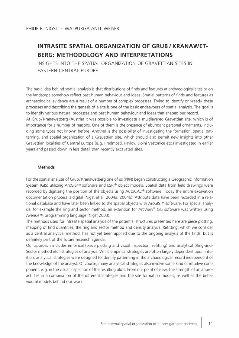
Grub / Kranawetberg is a multilayered Gravettian site in Lower Austria. It is located some 40km northeastof Vienna, close to the Austrian-Slovakian border, on a southward facing slope of a hill at the edge of theMarch river valley. The elevation is 196m a.s.l. The site has been known since the 1970s from surface col-lections. In 1993 W. Antl-Weiser started archaeological investigations with a test trench after mammothremains had been discovered on the surface. In 1994 a long-term research programme started (Antl 1997;1998; 1999; Antl / Fladerer 2004; Antl / Verginis 1998; Antl-Weiser 1994; 1995; 1996a; 1996b; 1996c;1999; Antl-Weiser et al. 1997; Antl-Weiser / Teschler-Nicola 2000; Nigst 2003; 2004a; 2004b; 2006; Nigstet al. 2003; 2004a; 2004b; Teschler-Nicola / Antl-Weiser / Prossinger 2004). From 1993 to 1995 the western
Fig. 2 Grub / Kranawetberg, excavated areas. – (Graphic: Ph. R. Nigst).
Tab. 1 Grub / Kranawetberg,archaeological horizon HS: 14C-dates. – (Antl / Fladerer 2004).
Site-internal spatial organization of hunter-gatherer societies 15
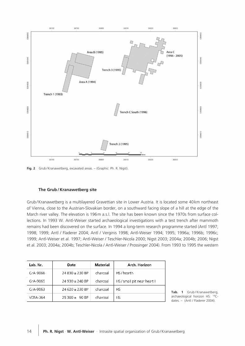
part of the site – an area referred to as the »bone accumulation« – was excavated (fig. 2). This area ischaracterized by large bones of mammoth and rhino, only a few lithics and traces of fire (burnt sediment,ashes and charcoal). So far, about 90m2 of the bone accumulation have been excavated.In 1995 the currently ongoing investigation of the eastern area was initiated. This area is characterized bya high density of finds. Most of the finds are lithics, small bones / bone fragments, etc. There are features(hearths, pits), which seem to belong to dwelling structures. In total about 160m2 have been excavated.While only a single archaeological horizon was present in the western area (1993-1995; bone accumula-tion), four archaeological horizons have been observed in the eastern part. Currently it is not possible tocorrelate the bone accumulation with any of the four archaeological horizons in the eastern part of the site.A few charcoal dates are available for the archaeological horizon HS (tab. 1) and place it at around 25kauncal. B.P.In the following analysis we will focus on the archaeological horizon HS. Up to date about 160m2 havebeen excavated. A high density of finds and evident structures characterize this horizon, and two hearthsand a number of small pits have also been documented. The locations of hearth I and the surrounding pitsare shown in figure 3. In addition, a star symbol indicates the location of hearth II.Among the abundant finds are lithics, bones / bone fragments, ochre and red ochre, stones, charcoal, boneand antler tools and personal ornaments (fig. 4). The faunal remains are highly fragmented and many of the smaller fragments are indeterminable (Fladerer1997). Two human remains (one deciduous right first lower molar and one deciduous left lateral upper in-cisor) have been reported from the site (Antl-Weiser / Teschler-Nicola 2000; Teschler-Nicola / Antl-Weiser /Prossinger 2004).
Fig. 3 Grub / Kranawetberg, eastern part: Hearth Iand pits. – (Graphic: Ph. R. Nigst).

Analysed area and material
The studies presented here are restricted to the archaeological horizon HS in the south-western part of AreaC (fig. 5). This part, comprising the squares A7 to A11, B4 to B11, C7 to C11, D7 to D11, and E7 to E11,was excavated in 1995 and 1996 and covers an area of 26.75m2 west of hearth I. Time and funding re-strictions during PRN's research for his M.A. thesis meant that the area analysed had to be limited to only
half of the surroundings of hearth I.Only finds piece-plotted during excavation areused for the current analysis. Finds derivedfrom wet-sieving are not included, but seem toshow similar patterns of distribution. 2 371finds have been included in the analysis. Mostof them (67.74%) are lithics. Bones and bonefragments form, with 11.52%, the second lar-gest group of finds (tab. 2).Hearth I was constructed by digging out ashallow depression approximately 10cm deepand 90cm in diameter (in the later phases ofcombustion the hearth increases slightly in dia-meter). The hearth shows 4 combustion phases,which are clearly separated by sterile loesslayers some 2 to 3cm. thick. Sediments strati-fied beneath the first combustion phase of thehearth and between the following differentphases show the effects of burning such asreddish colouring. Beneath the loess separa-
Ph. R. Nigst · W. Antl-Weiser · Intrasite spatial organization of Grub / Kranawetberg16
Fig. 4 Grub / Kranawetberg, archaeological horizon HS: selection ofpersonal ornaments. – 1-10 fragments of perforated beads; – 11 frag-ment of drop-shaped bead; – 12 rectangular bead; – 13-25 doubleheaded beads; – 26-29 fragments of double headed beads; – 30-37beads with central ring notch; – 38 pendant in the shape of a caninetooth of a deer; – 39 basket shaped pendant. – (Drawings: W. Antl-Weiser).
Fig. 5 Grub / Kranawetberg, archaeological horizon HS:Hearth I and 16 small pits. Three types of pits are distinguished:type F, type S, and type T. – (Graphic: Philip R. Nigst).
Site-internal spatial organization of hunter-gatherer societies 17
ting phases I and II was a well preserved ash layer. Large, well preserved pieces of charcoal have been re-covered from the layers in the hearth. 16 pits have been recorded in the area analyzed. Among them werecognize three types (Nigst 2003; 2004a): Type T (»Typ tief«) is characterized by steep walls and is alwaysat least 0.2m deep. Pits 3, 4, 7, and 12 belong to this type. Pits 8 and 10 represent type F (»Typ flach«),which is shallow with a maximum depth of 0.1m. Most of the pits belong to type S (pits 1, 2, 5, 6, 9-11,13, 15, and 16). Type S (»Typ schüsselförmig«) is bowl shaped and about 0.1 to 0.15m deep (fig. 6).Animal burrows are also present in the same area, but they are different in shape, size and, in particular,in their sediment filling and finds. While the filling of the pits is similar to the rest of the archaeological hori-zon, the filling of the animal burrows is always much lighter in colour and not so dense and compact. Finddensity in animal burrows is always lower than in the surrounding archaeological horizon. The opposite istrue for pits. Furthermore, all pits extend down only from the lower edge of the archaeological horizon. Incontrast, animal burrows normally transect the whole archaeological horizon.
The spatial patterns
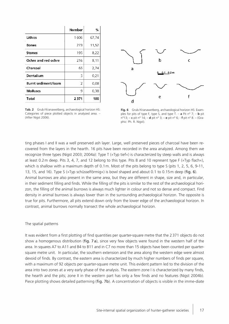
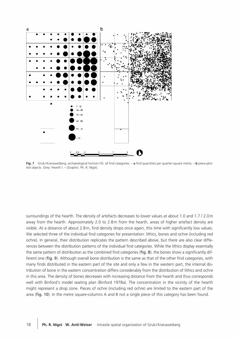
It was evident from a first plotting of find quantities per quarter-square metre that the 2 371 objects do not
show a homogenous distribution (fig. 7 a), since very few objects were found in the western half of the
area. In squares A7 to A11 and B4 to B11 and in C7 no more than 15 objects have been counted per quarter-
square metre unit. In particular, the southern extension and the area along the western edge were almost
devoid of finds. By contrast, the eastern area is characterized by much higher numbers of finds per square,
with a maximum of 92 objects per quarter-square metre unit. This evident pattern led to the division of the
area into two zones at a very early phase of the analysis. The eastern zone I is characterized by many finds,
the hearth and the pits; zone II in the western part has only a few finds and no features (Nigst 2004b).
Piece plotting shows detailed patterning (fig. 7b). A concentration of objects is visible in the imme-diate
Tab. 2 Grub / Kranawetberg, archaeological horizon HS:Categories of piece plotted objects in analyzed area. –(After Nigst 2006).
Fig. 6 Grub / Kranawetberg, archaeological horizon HS: Exam-ples for pits of type F, type S, and type T. – a Pit n° 7; – b pitn°13; – c pit n° 14; – d pit n° 3; – e pit n° 6; - f pit n° 8. – (Gra-phic: Ph. R. Nigst).
18 Ph. R. Nigst · W. Antl-Weiser · Intrasite spatial organization of Grub / Kranawetberg
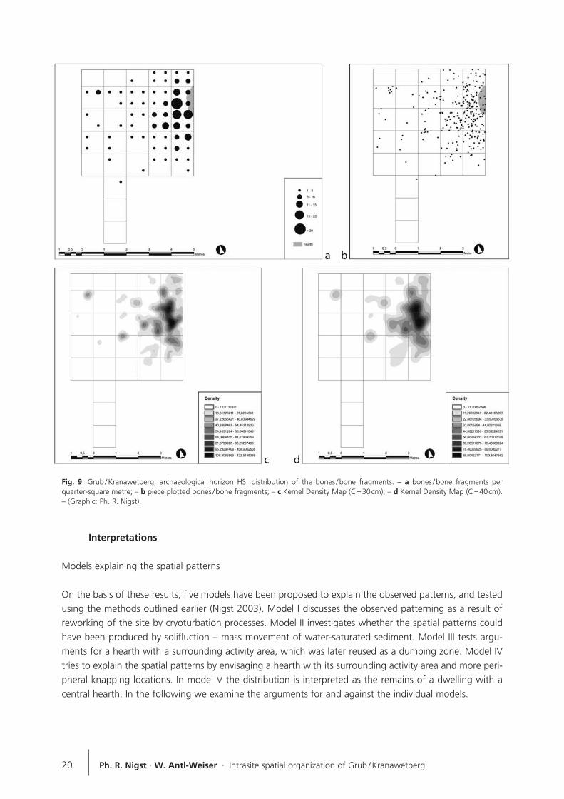
surroundings of the hearth. The density of artefacts decreases to lower values at about 1.0 and 1.7 / 2.0maway from the hearth. Approximately 2.0 to 2.8m from the hearth, areas of higher artefact density are visible. At a distance of about 2.8m, find density drops once again, this time with significantly low values.We selected three of the individual find categories for presentation: lithics, bones and ochre (including redochre). In general, their distribution replicates the pattern described above, but there are also clear diffe-rences between the distribution patterns of the individual find categories. While the lithics display essentiallythe same pattern of distribution as the combined find categories (fig. 8), the bones show a significantly dif-ferent one (fig. 9). Although overall bone distribution is the same as that of the other find categories, withmany finds distributed in the eastern part of the site and only a few in the western part, the internal dis-tribution of bone in the eastern concentration differs considerably from the distribution of lithics and ochrein this area. The density of bones decreases with increasing distance from the hearth and thus correspondswell with Binford's model seating plan (Binford 1978a). The concentration in the vicinity of the hearthmight represent a drop zone. Pieces of ochre (including red ochre) are limited to the eastern part of thearea (fig. 10). In the metre square-columns A and B not a single piece of this category has been found.
Fig. 7 Grub / Kranawetberg, archaeological horizon HS: all find categories. – a find quantities per quarter-square metre; – b piece-plot-ted objects. Grey: Hearth I. – (Graphic: Ph. R. Nigst).

19Site-internal spatial organization of hunter-gatherer societies
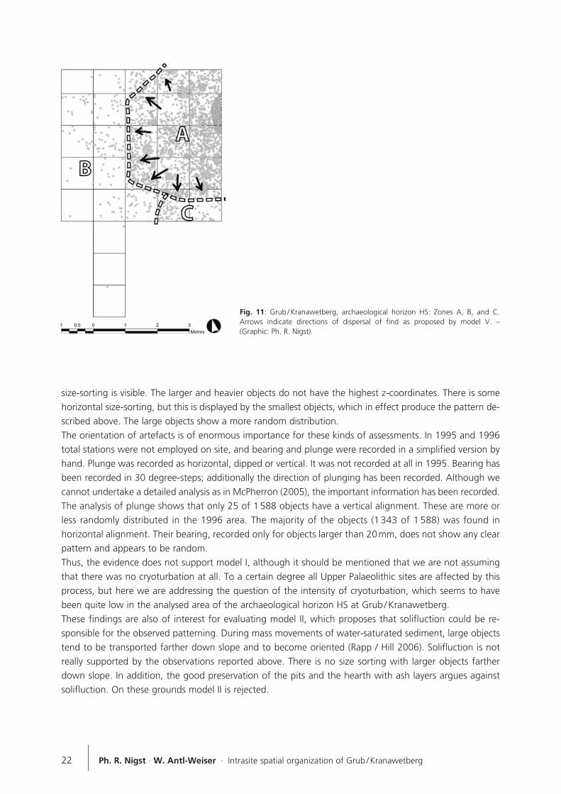
The patterning allowed us to subdivide the analysed area into three zones (A, B, and C; see fig. 11). ZoneA is the eastern part of the area analysed and is characterized by high find density and a heterogeneousinternal find distribution. The boundary with zones B and C is marked by a sudden decrease in find densi-ty. The area of zone A covers 10.91m2, and the majority (86,76%) of the finds is located in this area. Anumber of ivory beads has been recovered here by wet-sieving. Furthermore, zone A is characterized bythe presence of evident structures, the pits and the hearth. Both zones B and C contain considerably fewerobjects. Within the 14.48m2 of zone B only 206 finds have been recovered. They are not randomly or regu-larly distributed, but decrease in numbers from east to west (away from the hearth). There are no evidentstructures here. Zone C covers only 1.36m2. It is characterized by a clear boundary to zones A and B.Because of its small area the definition of zone C may have to be reconsidered after the squares to thesouth and east are excavated and analyzed.
Fig. 8 Grub / Kranawetberg, archaeological horizon HS: distribution of the lithics. – a lithics per quarter-square metre; – b piece plot-ted lithics; – c Kernel Density Map (C=30cm); – d Kernel Density Map (C=40cm). – (Graphic: Ph. R. Nigst).
20 Ph. R. Nigst · W. Antl-Weiser · Intrasite spatial organization of Grub / Kranawetberg
Interpretations
Models explaining the spatial patterns
On the basis of these results, five models have been proposed to explain the observed patterns, and testedusing the methods outlined earlier (Nigst 2003). Model I discusses the observed patterning as a result ofreworking of the site by cryoturbation processes. Model II investigates whether the spatial patterns couldhave been produced by solifluction – mass movement of water-saturated sediment. Model III tests argu-ments for a hearth with a surrounding activity area, which was later reused as a dumping zone. Model IVtries to explain the spatial patterns by envisaging a hearth with its surrounding activity area and more peri-pheral knapping locations. In model V the distribution is interpreted as the remains of a dwelling with acentral hearth. In the following we examine the arguments for and against the individual models.
Fig. 9: Grub / Kranawetberg; archaeological horizon HS: distribution of the bones / bone fragments. – a bones / bone fragments perquarter-square metre; – b piece plotted bones / bone fragments; – c Kernel Density Map (C=30cm); – d Kernel Density Map (C=40cm).– (Graphic: Ph. R. Nigst).

21Site-internal spatial organization of hunter-gatherer societies
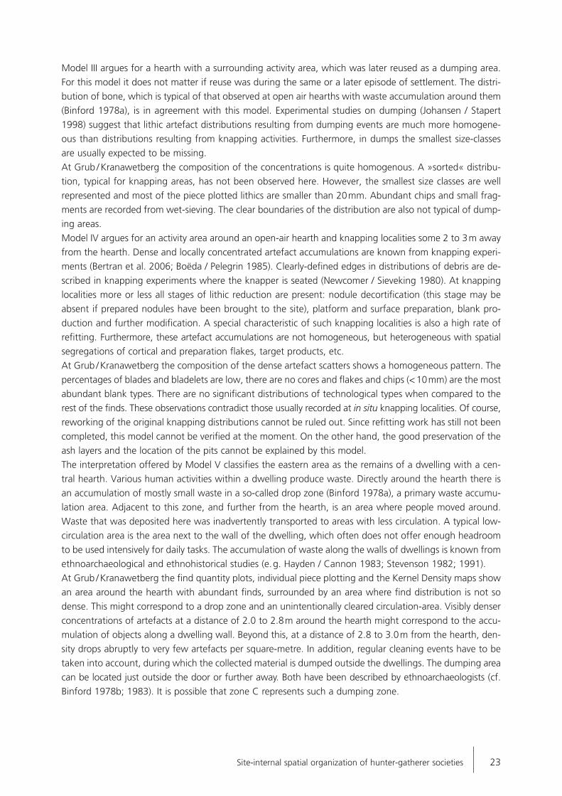
Both model I and model II imply severe post-depositional alteration of the analyzed site area. The differencebetween model I and II is that model I argues for a movement of the objects, but not the sediment, whilemodel II supports a movement of sediment including the objects.Model I, suggesting cryoturbation, would result in a clear size-sorting of larger objects close to the surfaceand so-called patterned ground features. Patterned ground features are often polygonal or circular struc -tures, and result in the movement of objects to the edges of the featuresNormally they are combined with frost heaving, resulting in a vertical orientation of the long axes of arte-facts (Embleton / King 1975; Rapp / Hill 2006; Wood / Johnson 1978). In Grub / Kranawetberg no vertical
Fig. 10 Grub / Kranawetberg, archaeological horizon HS: distribution of the pieces of ochre and red ochre. – a pieces of ochre and redochre per quarter-square metre; – b piece plotted ochre and red ochre; – c Kernel Density Map (C=30cm); – d Kernel Density Map(C=40cm). – (Graphic: Ph. R. Nigst).
size-sorting is visible. The larger and heavier objects do not have the highest z-coordinates. There is somehorizontal size-sorting, but this is displayed by the smallest objects, which in effect produce the pattern de-scribed above. The large objects show a more random distribution.The orientation of artefacts is of enormous importance for these kinds of assessments. In 1995 and 1996total stations were not employed on site, and bearing and plunge were recorded in a simplified version byhand. Plunge was recorded as horizontal, dipped or vertical. It was not recorded at all in 1995. Bearing hasbeen recorded in 30 degree-steps; additionally the direction of plunging has been recorded. Although wecannot undertake a detailed analysis as in McPherron (2005), the important information has been recorded.The analysis of plunge shows that only 25 of 1 588 objects have a vertical alignment. These are more orless randomly distributed in the 1996 area. The majority of the objects (1 343 of 1 588) was found inhorizontal alignment. Their bearing, recorded only for objects larger than 20mm, does not show any clearpattern and appears to be random.Thus, the evidence does not support model I, although it should be mentioned that we are not assumingthat there was no cryoturbation at all. To a certain degree all Upper Palaeolithic sites are affected by thisprocess, but here we are addressing the question of the intensity of cryoturbation, which seems to havebeen quite low in the analysed area of the archaeological horizon HS at Grub / Kranawetberg. These findings are also of interest for evaluating model II, which proposes that solifluction could be re-sponsible for the observed patterning. During mass movements of water-saturated sediment, large objectstend to be transported farther down slope and to become oriented (Rapp / Hill 2006). Solifluction is notreally supported by the observations reported above. There is no size sorting with larger objects fartherdown slope. In addition, the good preservation of the pits and the hearth with ash layers argues againstsolifluction. On these grounds model II is rejected.
22 Ph. R. Nigst · W. Antl-Weiser · Intrasite spatial organization of Grub / Kranawetberg
Fig. 11: Grub / Kranawetberg, archaeological horizon HS: Zones A, B, and C.Arrows indicate directions of dispersal of find as proposed by model V. –(Graphic: Ph. R. Nigst).
Model III argues for a hearth with a surrounding activity area, which was later reused as a dumping area.For this model it does not matter if reuse was during the same or a later episode of settlement. The distri-bution of bone, which is typical of that observed at open air hearths with waste accumulation around them(Binford 1978a), is in agreement with this model. Experimental studies on dumping (Johansen / Stapert1998) suggest that lithic artefact distributions resulting from dumping events are much more homogene-ous than distributions resulting from knapping activities. Furthermore, in dumps the smallest size-classesare usually expected to be missing.At Grub / Kranawetberg the composition of the concentrations is quite homogenous. A »sorted« distribu-tion, typical for knapping areas, has not been observed here. However, the smallest size classes are wellrepresented and most of the piece plotted lithics are smaller than 20mm. Abundant chips and small frag-ments are recorded from wet-sieving. The clear boundaries of the distribution are also not typical of dump-ing areas.Model IV argues for an activity area around an open-air hearth and knapping localities some 2 to 3m awayfrom the hearth. Dense and locally concentrated artefact accumulations are known from knapping experi-ments (Bertran et al. 2006; Boëda / Pelegrin 1985). Clearly-defined edges in distributions of debris are de-scribed in knapping experiments where the knapper is seated (Newcomer / Sieveking 1980). At knappinglocalities more or less all stages of lithic reduction are present: nodule decortification (this stage may beabsent if prepared nodules have been brought to the site), platform and surface preparation, blank pro-duction and further modification. A special characteristic of such knapping localities is also a high rate ofrefitting. Furthermore, these artefact accumulations are not homogeneous, but heterogeneous with spatialsegregations of cortical and preparation flakes, target products, etc.At Grub / Kranawetberg the composition of the dense artefact scatters shows a homogeneous pattern. Thepercentages of blades and bladelets are low, there are no cores and flakes and chips (< 10mm) are the mostabundant blank types. There are no significant distributions of technological types when compared to therest of the finds. These observations contradict those usually recorded at in situ knapping localities. Of course,reworking of the original knapping distributions cannot be ruled out. Since refitting work has still not beencompleted, this model cannot be verified at the moment. On the other hand, the good preservation of theash layers and the location of the pits cannot be explained by this model.The interpretation offered by Model V classifies the eastern area as the remains of a dwelling with a cen-tral hearth. Various human activities within a dwelling produce waste. Directly around the hearth there isan accumulation of mostly small waste in a so-called drop zone (Binford 1978a), a primary waste accumu-lation area. Adjacent to this zone, and further from the hearth, is an area where people moved around.Waste that was deposited here was inadvertently transported to areas with less circulation. A typical low-circulation area is the area next to the wall of the dwelling, which often does not offer enough headroomto be used intensively for daily tasks. The accumulation of waste along the walls of dwellings is known fromethnoarchaeological and ethnohistorical studies (e.g. Hayden / Cannon 1983; Stevenson 1982; 1991).At Grub / Kranawetberg the find quantity plots, individual piece plotting and the Kernel Density maps show
an area around the hearth with abundant finds, surrounded by an area where find distribution is not so
dense. This might correspond to a drop zone and an unintentionally cleared circulation-area. Visibly denser
concentrations of artefacts at a distance of 2.0 to 2.8m around the hearth might correspond to the accu-
mulation of objects along a dwelling wall. Beyond this, at a distance of 2.8 to 3.0m from the hearth, den-
sity drops abruptly to very few artefacts per square-metre. In addition, regular cleaning events have to be
taken into account, during which the collected material is dumped outside the dwellings. The dumping area
can be located just outside the door or further away. Both have been described by ethnoarchaeologists (cf.
Binford 1978b; 1983). It is possible that zone C represents such a dumping zone.
23Site-internal spatial organization of hunter-gatherer societies
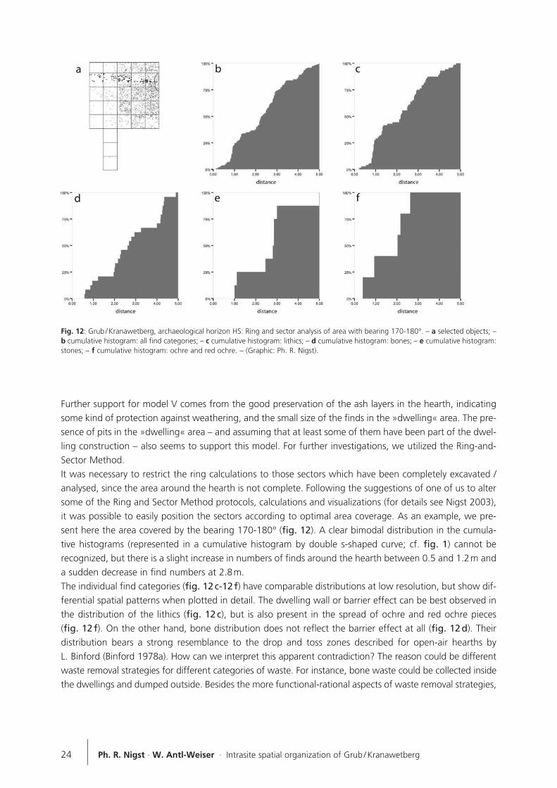
Further support for model V comes from the good preservation of the ash layers in the hearth, indicatingsome kind of protection against weathering, and the small size of the finds in the »dwelling« area. The pre-sence of pits in the »dwelling« area – and assuming that at least some of them have been part of the dwel-ling construction – also seems to support this model. For further investigations, we utilized the Ring-and-Sector Method.It was necessary to restrict the ring calculations to those sectors which have been completely excavated /analysed, since the area around the hearth is not complete. Following the suggestions of one of us to altersome of the Ring and Sector Method protocols, calculations and visualizations (for details see Nigst 2003),it was possible to easily position the sectors according to optimal area coverage. As an example, we pre-sent here the area covered by the bearing 170-180° (fig. 12). A clear bimodal distribution in the cumula-tive histograms (represented in a cumulative histogram by double s-shaped curve; cf. fig. 1) cannot berecognized, but there is a slight increase in numbers of finds around the hearth between 0.5 and 1.2m anda sudden decrease in find numbers at 2.8m.The individual find categories (fig. 12 c-12 f) have comparable distributions at low resolution, but show dif-ferential spatial patterns when plotted in detail. The dwelling wall or barrier effect can be best observed inthe distribution of the lithics (fig. 12 c), but is also present in the spread of ochre and red ochre pieces(fig. 12 f). On the other hand, bone distribution does not reflect the barrier effect at all (fig. 12 d). Theirdistribution bears a strong resemblance to the drop and toss zones described for open-air hearths by L. Binford (Binford 1978a). How can we interpret this apparent contradiction? The reason could be differentwaste removal strategies for different categories of waste. For instance, bone waste could be collected insidethe dwellings and dumped outside. Besides the more functional-rational aspects of waste removal strategies,
24 Ph. R. Nigst · W. Antl-Weiser · Intrasite spatial organization of Grub / Kranawetberg
Fig. 12: Grub / Kranawetberg, archaeological horizon HS: Ring and sector analysis of area with bearing 170-180°. – a selected objects; –b cumulative histogram: all find categories; – c cumulative histogram: lithics; – d cumulative histogram: bones; – e cumulative histogram:stones; – f cumulative histogram: ochre and red ochre. – (Graphic: Ph. R. Nigst).
we should also take into consideration the possibility that social, symbolic and ideological factors may haveinfluenced and directed strategies of waste removal (Hodder 1982; 1987; Whitelaw 1991; 1994).Pieces of ochre and red ochre occur only in zone A, which is within the proposed dwelling. The presenceof ochre (including red ochre), or just a red colouration of the ground, has been repeatedly interpreted asevidence of dwellings (for a summary see Bosinski 1989; Desbrosse / Kozłowski 2001).
Discussion
The archaeological horizon HS of Grub / Kranawetberg represents some kind of palimpsest. The question ishow much depth of time is recorded in this single archaeological horizon. The overlapping of different sett-lement episodes cannot be ruled out. Some of the lithic raw material units could belong to an earlier phaseof settlement. These lithic raw materials are characterized by low numbers of finds and extensive distri-bution over the whole area. However, it should be noted that the proposed dwelling must have been oneof the latest phases of settlement, because otherwise features, such as the well-defined boundaries in thepatterns of distribution, would not be so well preserved. Gravettian dwelling structures are not common features of European sites. Several of these dwellings were
uncovered many years ago, and their interpretation has to be treated with caution. Detailed questions cannot
be answered here due to the lack of resolution in the recording systems. Examples are the structures from
Moravany-Lopata (Slovakia), originally published as shallow rectangular depressions and interpreted as
dwellings (see e.g. Otte 1981). More recently, a similar feature from the nearby Epigravettian site of
Moravany-Zakovska was interpreted as a reworked hearth structure (Hromada / Kozłowski 1995).
Most of the published evidence concerning dwelling structures comes from southern Moravia. Some ofthese sites were excavated a long time ago and / or were rescue excavations, often resulting in nothingmore than a collection of artefacts by square-metre. Detailed comparisons of the artefact distributions aretherefore not possible. The published outlines of dwellings from these sites have to be critically considered.Nevertheless, we can gain important insights into large settlement areas of this region, even though theresolution is rather coarse. J. Svoboda distinguishes four dwelling types (Svoboda 1991; 2003). All of themhave diameters from 4 to 6m. Type A is characterized by a shallow depression and a hearth with stones toreflect the heat. Furthermore, large stones and postholes are present on the dwelling plan. A good exam-ple for this type is Dolní Vestonice I, settlement unit 2 (Svoboda 1991). Type B dwellings were erected ona flat surface and are delimited by mammoth bone remains. This type has been excavated at Milovice I / G(Oliva 1988; 1989) and Dolní Vestonice I, bone accumulation VI to VIII (excavation 1928) (Klíma 2001).Dwelling type C is characterized by a depression and one or more hearths. Examples of this type are DolníVestonice II, settlement unit 1 (Svoboda 1991), and Pavlov I, settlement unit 5 (Svoboda 1991). For type Ddwellings J. Svoboda reports a central hearth and pits. A good example is Dolní Vestonice II, settlement unit3 (Svoboda 2003). Two mammoth bone accumulations, interpreted as remains of mammoth bone dwellings, have been reported from the site Krakow-Spadzista Street B (Poland) (see e.g. Desbrosse / Kozłowski 2001), which issimilar to Milovice I / G. It is not clear how these mammoth bone accumulations formed, and a natural origincannot be ruled out. New excavations in the adjacent area B1 have identified at least two phases of sett-lement (Kozłowski 2003). In France two sites are known for their dwelling structures: La Vigne Brun and Plasenn-al-Lomm. At LaVigne Brun (Loire) four circular or rounded dwelling structures with diameters between 4 and 5m havebeen excavated. They consisted of a depression with reddish colouring due to red ochre. Larger stones or
25Site-internal spatial organization of hunter-gatherer societies
blocks formed a circle delimiting the ground plan of the dwelling. A hearth dug into the sediment was re-covered at the centre. The position of the entrances has not yet been identified. The excavators estimatethe number of people living in such a dwelling to be 5 or 6 (Combier 1980; Digan 2006; Onoratini /Combier 1998). At Plasenn-al-Lomm dwelling structures are formed by granite blocks. The diameter of thedwellings was about 4.5m (Monnier 1982).In Germany one dwelling is known from Sprendlingen (Rheinhessen) (Bosinski et al. 1985). Parts of the siteand the dwelling structure had already been destroyed during sand quarrying. The remaining 40m2 of thesite were excavated by a team led by G. Bosinski. No evident structures were recovered and the dwellingwas reconstructed from latent structures, such as a reddish colouration of the sediment, burnt boneremains (reconstructed as a hearth), refit lines and the distribution of the lithics.A number of dwelling structures has been published from the European part of the former USSR. Generally,they are interpreted as longhouses. Good examples are Avdeevo, Kostenki I, 1, and Aleksandrovka /Kostenki IV, lower layer (Bosinski 1989; Grigor'ev 1967; 1993). Most of them are characterized by a cen-tral alignment of hearths and several, sometimes peripheral, pits. Early interpretations described them aslonghouses, but there has been much critique and discussion about the outline and size of the dwellings(Hoffecker 2002; Klein 1973; Narr 1983; Veil 1981). These issues cannot be resolved since most moderntechniques of spatial analysis require a higher resolution of data than is currently available for the siteswhich were excavated many years ago. Another problem is the palimpsest character of these localities,which can also not be addressed due to the poor resolution of the recording systems. With the exception of the much debated Russian longhouses, most Gravettian dwelling structures are ofsimilar size, about 4 to 6m in diameter. Central hearths characterize many of them. The proposed dwellingof Grub / Kranawetberg best fits into J. Svoboda's type D of the Moravian Gravettian dwellings. Althoughhighly comparable in many aspects, an important difference is the presence of large bones and or stoneswithin and around the Moravian dwellings which has not been observed at Grub / Kranawetberg. A detailedcomparison between the latent structures, especially the barrier effect, would be interesting, but this isimpossible due to the lack of piece plotting during the early excavations of the Moravian sites. While Grub /Kranawetberg offers a very detailed and high resolution window into the Gravettian of Central Europe,most of the Moravian sites offer a much more coarse-grained view. Nevertheless, the much larger surfacesexposed at these sites provide us with information about the space between the settlement units. In future, spatial analysis will be extended in a north eastern direction to cover the second half of the areaaround hearth I, the area between hearth I and II, and the surroundings of hearth II. The archaeologicalexcavation of the immediate surroundings of hearth II and the analysis of the other areas are currently beingundertaken. The area surrounding hearth II shows similar features (small pits) to the area around hearth I,whereas the area between the two hearths is devoid of features, but is very rich in lithics, bone fragmentsetc. Subsequent analyses will study the areas between and around the two hearths in their context.
26 Ph. R. Nigst · W. Antl-Weiser · Intrasite spatial organization of Grub / Kranawetberg

27Site-internal spatial organization of hunter-gatherer societies
References
Antl 1997: W. Antl, KG Grub an der March. Fundberichte ausÖsterreich 35, 1996 (1997), 391.
1998: W. Antl, Grub an der March. Fundberichte aus Öster-reich 36, 1997 (1998), 725f.
1999: W. Antl, Grub an der March. Fundberichte aus Öster-reich 37, 1998 (1999), 675-676.
Antl / Fladerer 2004: W. Antl / F. A. Fladerer, Outlook to the East:the 25ky BP Gravettian Grub / Kranawetberg Campsite (LowerAustria). In: J. A. Svoboda / L. H. Sedlácková, The Gravettianalong the Danube, Proceedings of the Mikulov Conference,20-21 November 2002. The Dolní Vestonice Studies (Brno2004) 116-130.
Antl / Verginis 1998: W. Antl / S. Verginis, Geoelektrische Untersu-chungen an einem Lagerplatz des Gravettien in Grub bei Still-fried (Niederösterreich). Préhistoire Européenne 12, 1998, 59-70.
Antl-Weiser 1994: W. Antl-Weiser, KG Grub an der March. Fund-berichte aus Österreich 32, 1993 (1994), 643f.
1995: W. Antl-Weiser, Paläolithstation am Kranawetberg inGrub bei Stillfried, Niederösterreich (Vorbericht). Fundberichteaus Österreich 33, 1994 (1995), 25-30.
1996a: W. Antl-Weiser, paläolithischen Funde vom Kranawet-berg in Grub bei Stillfried a.d. March, NÖ. In: J. H. Svoboda,Paleolithic in the Middle Danube Region. Anniversary volumeto Bohuslav Klíma (Brno 1996) 81-91.
1996b: W. Antl-Weiser, Grub / Kranawetberg, ein jungpaläoli-thischer Fundplatz. Préhistoire Européenne 8, 1996, 117-123.
1996c: W. Antl-Weiser, Grub an der March. Fundberichte ausÖsterreich 34, 1995 (1996), 595.
1999: W. Antl-Weiser, Paläolithischer Schmuck von der Gra-vettienfundstelle Grub / Kranawetberg bei Stillfried, Nieder-österreich. Annalen des Naturhistorischen Museums in Wien101 A, 1999, 23-41.
Antl-Weiser et al. 1997: W. Antl-Weiser / F. A. Fladerer / R. Peticz-ka / F. C. Stadler / S. Verginis, Ein Lagerplatz eiszeitlicher Jägerin Grub bei Stillfried. Archäologie Österreichs 8 (1), 1997, 4-20.
Antl-Weiser / Teschler-Nicola 2000: W. Antl-Weiser / M. Teschler-Nicola, Die menschlichen Zahnfunde von der Gravettienfund-stelle Grub / Kranawetberg bei Stillfried an der March, Nieder-österreich. Archaeologia Austriaca 84-85, 2000, 201-212.
Baxter 2003: M. Baxter, Statistics in Archaeology (London 2003).
Baxter / Beardah / Wright 1997: M. J. Baxter / C. C. Beardah / R. V.S. Wright, Some Archaeological Applications of Kernel DensityEstimates. Journal of Archaeological Science 24 (4), 1997,347-354.
Bertran et al. 2006: P. Bertran / J.-G. Bordes / A. Barré / A. Lenoble /V. Mourre, Fabrique d'amas de débitage: données expérimen-
tales. Bulletin de la Societé Préhistorique Française 103 (1), 2006,33-47.
Binford 1978a: L. R. Binford, Dimensional analysis of behavior andsite structure: learning from an Eskimo hunting stand. Ameri-can Antiquity 43, 1978, 330-361.
1978b: L. R. Binford, Nunamiut Ethnoarchaeology (New York1978).
1983: L. R. Binford, In Pursuit of the Past. Decoding theArchaeological Record (London 1983).
Boëda / Pelegrin 1985: E. Boëda / J. Pelegrin, Approche expéri-mentale des amas de Marsangy. Archéologie expérimentale,Cahier 1, 1985, 19-36.
Boekschoten / Stapert 1996: G. R. Boekschoten / D. Stapert, A newtool for spatial analysis: »Rings & Sectors plus Density Analysisand Trace lines«. In: H. Kamermans / K. H. Fennema, Interfa-cing the Past. Computer Applications and QuantitativeMethods in Archaeology CAA95. Analecta Praehistorica Lei-densia 28 (Leiden 1996) 241-250.
Bosinski 1989: G. Bosinski, Die große Zeit der Eiszeitjäger. Europazwischen 40 000 und 10 000 v.Chr. Jahrbuch RGZM 34, 1987(1989), 1-142.
Bosinski et al. 1985: G. Bosinski / H. Bosinski / K. Brunnacker / E.Cziesla / K. P. Lanser / F. O. Neuffer / J. Preuss / H. Spoerer /W. Tillmanns / B. Urban, Sprendlingen. Ein Fundplatz des mitt-leren Jungpaläolithikums in Rheinhessen. Jahrbuch RGZM 32,1985, 5-91.
Combier 1980: J. Combier, Informations archéologiques: Circons-cription Rhône-Alpes. Gallia Préhistoire 23 (2), 1980, 511-516.
Cziesla 1990: E. Cziesla, Siedlungsdynamik auf steinzeitlichenFundplätzen. Methodische Aspekte zur Analyse latenter Struk-turen. Studies in Modern Archaeology 2 (Bonn 1990).
Desbrosse / Kozłowski 2001: R. Desbrosse / J. Kozłowski, Les habi-tats préhistoriques: des Australopithèques aux premiers agri-culteurs (Paris 2001).
Digan 2006: M. Digan, Le Gisement Gravettien de la Vigne-Brun(Loire, France). Étude de l'industrie de l'Unité KL19. BAR Int.Ser. 1473 (Oxford 2006).
Embleton / King 1975: C. Embleton / C. A. M. King, PeriglacialGeo morphology (London 1975).
Fladerer 1997: F. A. Fladerer, Tierreste und Paläoökonomie. Archä-ol ogie Österreichs 8 (1), 1997, 8-12.
Grigor'ev 1967: G. P. Grigor'ev, A New Reconstruction of theAbove-Ground Dwelling of Kostenki. Current Anthropology8(4), 1967, 344-349.
1993: G. P. Grigor'ev, Kostenki-Avdeevo Archaeological Cul-ture and the Willendorf-Pavlov-Kostenki-Avdeevo CulturalUnity. In: O. Soffer / N. D. H. Praslov, From Kostenki to Clovis.
Upper Paleolithic-Paleo-Indian Adaptations (New York 1993)51-65.
Hayden / Cannon 1983: B. Hayden / A. Cannon, Where the Gar-bage Goes: Refuse Disposal in the Maya Highlands. Journal ofAnthropological Archaeology 2, 1983, 117-163.
Hodder 1982: I. Hodder, Symbols in action: Ethnoarchaeologicalstudies of material culture (Cambridge 1982).
1987: I. Hodder, Meaning of Discard: Ash and Domestic Spacein Baringo. In: S. H. Kent, Method and Theory For Activity AreaResearch: An Ethnoarchaeological Approach (New York 1987)424-448.
Hodder / Orton 1976: I. Hodder / C. Orton, Spatial analysis inarchaeology (Cambridge 1976).
Hoffecker 2002: J. F. Hoffecker, Desolate landscapes: Ice-Age sett-lement in Eastern Europe (New Brunswick 2002).
Hromada / Kozlowski 1995: J. Hromada / J. K. Kozlowski, Mora-vany-Žakovska (excavations 1991-1992). Complex of UpperPalaeolithic sites near Moravany, Western Slovakia (Krakau1995).
Johansen / Stapert 1998: L. Johansen / D. Stapert, Dense Flint Scat-ters: Knapping or Dumping? In: N. J. Conard / C. J. Kind,Aktuelle Forschungen zum Mesolithikum / Current MesolithicResearch. Urgeschichtliche Materialhefte (Tübingen 1998) 29-41.
Kind 1983: C. J. Kind, Untersuchungen zur Verteilung von Steinar-tefakten in paläo- und mesolithischen Siedlungsplätzen.Archäologisches Korrespondenzblatt 13, 1983, 437-445.
1985: Die Verteilung von Steinartefakten in Grabungsflächen.Ein Modell zur Organisation alt- und mittelsteinzeitlicher Sied-lungsplätze. Urgeschichtliche Materialhefte 7 (Tübingen1985).
Klein 1973: R. G. Klein, Ice-Age Hunters of the Ukraine (Chicago1973).
Klíma 2001: B. Klíma, Die Kjökkenmöddinge Nr. 5-8 von Dolní Vìs-tonice. In: B. Ginter / B. Drobniewicz / B. Kazior / M. Nowak /Poùtowicz, Problems of the Stone Age in the Old World. Jubi-lee Book Dedicated to Professor Janusz K. Kozùowski on His40th Scientific Work in Jagiellonian University (Krakau 2001)173-193.
Kozlowski 2003: J. K. Kozlowski, Mammoth bone accumulationsand dwelling structures: some arguments around Krakow-Spadzista B site. In: S. A. Vasil'ev / O. Soffer / J. H. Kozlowski,Perceived Landscapes and Built Environments. The culturalgeography of Late Paleolithic Eurasia. Actes du XIVème CongrèsU.I.S.P.P., Université de Liège, Belgique, 2-8 septembre 2001,Colloques 6.2 & 6.5. BAR Int. Ser. 1122 (Oxford 2003) 59-64.
McPherron 2005: S. J. P. McPherron, Artifact orientations and siteformation processes from total station proveniences. Journalof Archaeological Science 32, 2005, 1003-1014.
Monnier 1982: J. L. Monnier, Le gisement Paléolithique supérieur
de Plasenn-al-Lomm (Ile de Bréhat, Côtes-du-Nord). Gallia Pré-histoire 25, 1982, 131-165.
Narr 1983: K. J. Narr, Kostenki I: Wohnbau und Fundverteilung.Archäologisches Korrespondenzblatt 13, 1983, 9-17.
Newcomer / Sieveking 1980: M. H. Newcomer / G. d. G. Sieveking,Experimental Flake Scatter-Patterns: a New InterpretativeTechnique. Journal of Field Archaeology 7, 1980, 345-352.
Nigst 2003: Ph. R. Nigst, Fundverteilungen um Feuerstellen, dieRing and Sector Method und Grub / Kranawetberg: Eine Studiezur Analyse latenter Strukturen altsteinzeitlicher WildbeuterIn-nenlager [M.A.-thesis, University of Vienna 2003].
2004a: Ph. R. Nigst, gravettienzeitlicher Behausungsgrundriß?Erste Beobachtungen zur räumlichen Organisation der Fund-stelle Grub / Kranawetberg (Österreich). Archäologisches Kor-respondenzblatt 34, 2004, 153-168.
2004b: Ph. R. Nigst, Some preliminary observations on intra-site spatial patterning of Grub / Kranawetberg (1995 and 1996area). In: J. A. Svoboda / L. H. Sedlácková, The Gravettianalong the Danube, Proceedings of the Mikulov Conference,20-21 November, 2002. The Dolní Vestonice Studies 11 (Brno2004).
2006: Ph. R. Nigst, Behausung aus dem Gravettien? VorläufigeErgebnisse der GIS-basierten Analyse der räumlichen Vertei-lung der Fundobjekte in Grub / Kranawetberg (Niederöster-reich). Archaeologia Austriaca 88, 2006, 29-66.
Nigst et al. 2003: Ph. R. Nigst / T. B. Viola / M. Doneus / W. Antl-Weiser, GRUPS and ArcGRIMP: a new system for digital exca-vation documentation and importing recorded data to a GIS.In: Enter the Past: The E-way into the four Dimensions of Cul-tural Heritage, Abstracts of CAA 2003 & Workshop 8 –-Archäologie und Computer, April 8-12 2003, Vienna City Hall,Vienna, Austria (Wien 2003) 130.
2004a: Ph. R. Nigst / T. B. Viola / M. Doneus / W. Antl-Weiser,Digitale Dokumentation paläolithischer Grabungen. Archäolo-gie Österreichs 15, 2004, 36-48.
2004b: Ph. R. Nigst / T. B. Viola / M. Doneus / W. Antl-Weiser,GRUPS and ArcGRIMP: a new system for digital excavationdocumentation and importing recorded data to a GIS. In:Magistrat der Stadt Wien – Referat Kulturelles Erbe – Stadtar-chäologie, Enter the Past: The E-way into the four Dimensionsof Cultural Heritage. CAA 2003. Computer Applications andQuantitative Methods in Archaeology, Proceedings of the 31st
Conference, Vienna, Austria, April 2003, CD-ROM Publikation(Beilage zu BAR Int. Ser. 1227) (Oxford 2004).
O'Connell 1987: J. F. O'Connell, Alyawara site structure and itsarchaeological implications. American Antiquity 52, 1987, 74-108.
Oliva 1988: M. Oliva, A Gravettian Site with Mammoth-Bone Dwel-ling in Milovice (Southern Moravia). Anthropologie 26, 105-112.
1989: M. Oliva, cabane des chasseurs de mammouths deMilovice, Moravie du Sud. L'Anthropologie 93, 1989, 887-892.
28 Ph. R. Nigst · W. Antl-Weiser · Intrasite spatial organization of Grub / Kranawetberg
Onoratini / Combier 1998: G. Onoratini / J. Combier, Les Gravet-tiens de la Bourgogne à la Méditerranée relations avec le Gra-vettien oriental. In: H. A. H. Amirkhanov, The Eastern Gravet-tian (Moskau 1998) 90-124.
Otte 1981: M. Otte, Le Gravettien en Europe Centrale. Dissertatio-nes Archaeologicae Gandenses (Gent 1981).
Rapp / Hill 2006: G. Rapp / C. L. Hill, Geoarchaeology: the earth-science approach to archaeological interpretation (New Haven2006).
Silverman 1986: B. W. Silverman, Density Estimation for Statisticsand Data Anlalysis. Monographs on Statistics and Applied Pro-bability (London 1986).
Stapert 1990: D. Stapert, Within the tent or outside? Spatial pat-terns in Late Palaeolithic sites. Helinium 29, 1990, 14-35.
1991: D. Stapert, The ring and sector method: intrasite spatialanalysis of Stone Age sites, with special reference to Pince-vent. Palaeohistoria 31, 1989 (1991), 1-57.
1992: D. Stapert, and sectors: intrasite spatial analysis ofStone Age sites [Ph.D.-thesis, University of Groningen 1992].
Stevenson 1982: M. G. Stevenson, Toward an Understanding ofSite Abandonment Behavior: Evidence from Historic MiningCamps in the Southwest Yukon. Journal of AnthropologicalArchaeology 1, 1982, 237-265.
1991: M. G. Stevenson, Beyond the Formation of Hearth-Associated Artifact Assemblages. In: E. M. Kroll / T. D. H. Price,The Interpretation of Archaeological Spatial Patterning (NewYork 1991) 269-299.
Svoboda 1991: J. Svoboda, Dolní Vestonice II – Western Slope.ERAUL 54 (Liège 1991).
2003: J. Svoboda, The Gravettian of Moravia: landscape, sett-lement, and dwellings. In: S. A. Vasil'ev / O. Soffer / J. H. Koz-lowski, Perceived Landscapes and Built Environments. The cul-tural geography of Late Paleolithic Eurasia. Actes du XIVème
Congrès UISPP, Université de Liège, Belgique, 2-8 septembre2001, Colloques 6.2 & 6.5. BAR Int. Ser. 1122 (Oxford 2003)121-129.
Teschler-Nicola / Antl-Weiser / Prossinger 2004: M. E. Teschler-Nicola / W. Antl-Weiser / H. Prossinger, Two Gravettian humandeciduous teeth from Grub / Kranawetberg, Lower Austria.Homo 54, 2004, 229-239.
Veil 1981: S. Veil, Überlegungen zur Interpretation des Siedlungs-befundes von Kostenki I, 1. Kölner Jahrbuch für Vor- undFrühgeschichte 15, 1975-1977 (1981), 68-82.
Wheatley / Gillings 2002: D. Wheatley / M. Gillings, Spatial Tech-nology and Archaeology: The archaeological applications ofGIS (London 2002).
Whitelaw 1991: T. Whitelaw, Some Dimensions of Variability in theSocial Organisation of Community Space Among Foragers. In:C. S. Gamble / W. A. H. Boismier, Ethnoarchaeological Appro-aches to Mobile Campsites. Hunter-Gatherer and PastoralistCase Studies. International Monographs in Prehistory, Ethno-archaeological Series 1 (Michigan 1991) 139-188.
1994: T. Whitelaw, without architecture: Functional, social andsymbolic dimensions in hunter-gatherer settlement organiza-tion. In: M. Parker Pearson / C. H. Richards, Architecture andOrder (London 1994) 217-243.
Wood / Johnson 1978: W. R. Wood / D. L. Johnson, A Survey ofDisturbance Processes in Archaeological Site Formation.Advances in Archaeological Method and Theory 1, 1978, 315-381.
29Site-internal spatial organization of hunter-gatherer societies
Abstract
Intrasite spatial organization of Grub / Kranawetberg: Methodology and interpretationsGrub / Kranawetberg is a multilayered Gravettian site in Lower Austria, close to the Slovakian border. The site has beenexcavated since 1993 and has yielded four archaeological horizons with abundant finds and some evident features.The main focus of this paper is a GIS-based intrasite spatial analysis, especially emphasizing the possibilities ofrecognizing formation processes, size-sorting and locating a possible dwelling. Application of various methods, amongthem piece-plotting, mapping of find quantities, application of kernel density estimates and ring-and-sector analysisshowed spatial patterns in the 1995 and 1996 excavation area which are interpreted as evidence for a dwelling in thispart of the site.
Keywords
Intrasite spatial analysis / dwelling / settlement structures / GIS / Gravettian

V
CONTENTS
Sabine Gaudzinski-Windheuser · Olaf Jöris · Martina Sensburg · Martin Street · Elaine Turner
Foreword . . . . . . . . . . . . . . . . . . . . . . . . . . . . . . . . . . . . . . . . . . . . . . . . . . . . . . . . . . . . . . . . . . . . . . . . 1
Philip R. Nigst · Walpurga Antl-Weiser
Intrasite spatial organization of Grub / Kranawetberg: Methodology and interpretations.
Insights into the spatial organization of Gravettian sites in Eastern Central Europe . . . . . . . . . . . . . . . . 11
Pablo Arias · Roberto Ontañón · Esteban Álvarez-Fernández · Marián Cueto · Mikelo Elorza
Cristina García-Moncó · Alexandra Güth · María-José Iriarte · Luis C. Teira · Débora Zurro
Magdalenian floors in the Lower Gallery of La Garma. A preliminary report . . . . . . . . . . . . . . . . . . . . . 31
Olaf Jöris · Martin Street · Elaine Turner
Spatial analysis at the Magdalenian site of Gönnersdorf (Central Rhineland, Germany).
An introduction . . . . . . . . . . . . . . . . . . . . . . . . . . . . . . . . . . . . . . . . . . . . . . . . . . . . . . . . . . . . . . . . . . 53
Martina Sensburg
The relation between time and space in Gönnersdorf K-II . . . . . . . . . . . . . . . . . . . . . . . . . . . . . . . . . . . 81
Frank Moseler
Spatial analysis of Concentration K-IV of the Magdalenian site of Gönnersdorf . . . . . . . . . . . . . . . . . 103
Sabine Gaudzinski-Windheuser
An introduction to living structures and the history of occupation at the
Late Upper Palaeolithic site of Oelknitz (Thuringia, Germany) . . . . . . . . . . . . . . . . . . . . . . . . . . . . . . . 127
Stefan Wenzel
The Magdalenian dwelling of Orp East (Belgium) and its spatial organization . . . . . . . . . . . . . . . . . . . 141
Frank Gelhausen
Subsistence strategies and settlement systems at the Federmessergruppen
site of Niederbieber (Central Rhineland, Germany) . . . . . . . . . . . . . . . . . . . . . . . . . . . . . . . . . . . . . . . 159
Claudio Casati · Lasse Sørensen
Two hut structures from an Early Mesolithic site at Ålyst (Denmark). A preliminary report . . . . . . . . . . 175
Daniela Holst
Spatial organization and settlement dynamics of Mesolithic nut processing sites
in the Duvensee bog (Northern Germany) . . . . . . . . . . . . . . . . . . . . . . . . . . . . . . . . . . . . . . . . . . . . . . 187
Jorge Martínez-Moreno · Rafael Mora Torcal
Spatial organization at Font del Ros, a Mesolithic settlement in the South-Eastern Pyrenees . . . . . . . . 213

VI
Lars Larsson · Arne Sjöström
Hut and house structures in the Mesolithic of Southern Scandinavia . . . . . . . . . . . . . . . . . . . . . . . . . 233
Ole Grøn
A 7 000 year old Mesolithic dwelling with a brush floor excavated under water.
A window into behavioural organization of hunter-gatherer dwellings . . . . . . . . . . . . . . . . . . . . . . . . 249
Dani Nadel · Ehud Weiss · Hartmut Tschauner
Gender-specific division of indoor space during the Upper Palaeolithic?
A brush hut floor as a case study . . . . . . . . . . . . . . . . . . . . . . . . . . . . . . . . . . . . . . . . . . . . . . . . . . . . 263
List of contributors . . . . . . . . . . . . . . . . . . . . . . . . . . . . . . . . . . . . . . . . . . . . . . . . . . . . . . . . . . . . . . . 275

Esteban Álvarez FernándezEdificio Interfacultativo de la
Universidad de Cantabria
Instituto Internacional de Investigacio-
nes Prehistóricas de Cantabria
Avda. de los Castros, s / n
E - 39005 Santander
Walpurga Antl-WeiserNaturhistorisches Museum Wien
Prähistorische Abteilung
Burgring 7
A - 1014 Wien
Pablo AriasEdificio Interfacultativo de la
Universidad de Cantabria
Instituto Internacional de Investigacio-
nes Prehistóricas de Cantabria
Avda. de los Castros, s / n
E - 39005 Santander
Claudio CasatiKøbenhavns Universitet
Saxo-Instituttet
and Frederiksundsvej 150, 1th
DK - 2700 Brønshøj
Marián CuetoEdificio Interfacultativo de la
Universidad de Cantabria
Instituto Internacional de Investigacio-
nes Prehistóricas de Cantabria
Avda. de los Castros, s / n
E - 39005 Santander
Mikelo ElorzaSociedad de Ciencias Aranzadi
Alto de Zorroaga 11
E - 20014 San Sebastián
Cristina García-MoncóEdificio Interfacultativo de la
Universidad de Cantabria
Instituto Internacional de Investigacio-
nes Prehistóricas de Cantabria
Avda. de los Castros, s / n
E - 39005 Santander
Sabine Gaudzinski-WindheuserRömisch-Germanisches Zentralmuseum
Forschungsbereich Altsteinzeit
Schloss Monrepos
D - 56567 Neuwied
Frank GelhausenRömisch-Germanisches Zentralmuseum
Forschungsbereich Altsteinzeit
Schloss Monrepos
D - 56567 Neuwied
Ole GrønLangelands Museum
Jens Winthersvej 12
DK - 5900 Rudkøbing
Alexandra GüthRömisch-Germanisches Zentralmuseum
Forschungsbereich Altsteinzeit
Schloss Monrepos
D - 56567 Neuwied
Daniela Holst Römisch-Germanisches Zentralmuseum
Forschungsbereich Altsteinzeit
Schloss Monrepos
D - 56567 Neuwied
Olaf JörisRömisch-Germanisches Zentralmuseum
Forschungsbereich Altsteinzeit
Schloss Monrepos
D - 56567 Neuwied
Maria José IriarteUniversidad del País Vasco
Area de Prehistoria
Grupo de Investigación de Alto
Rendimiento (9/UPV 155.130-
14570/2002)
C / Tomás y Valiente, s / n
E - 01006 Vitoria-Gasteiz (Alava)
Lars Larsson Lunds Universitet
Institutionen för arkeologi och antikens
historia
Box 117
SE - 221 00 Lund
Jorge Martínez-MorenoUniversitat Autònoma de Barcelona
Facultat de Lletres
Centre d’Estudis del Patrimoni
Arqueológic de la Prehistoria
E - 08193 Bellaterra
Rafael Mora TorcalUniversitat Autònoma de Barcelona
Facultat de Lletres
Centre d’Estudis del Patrimoni
Arqueológic de la Prehistoria
E - 08193 Bellaterra
Frank MoselerRömisch-Germanisches Zentralmuseum
Forschungsbereich Altsteinzeit
Schloss Monrepos
D - 56567 Neuwied
275Site-internal spatial organization of hunter-gatherer societies
LIST OF CONTRIBUTORS
Dani NadelUniversity of Haifa
Zinman Institute of Archaeology
Haifa
Israel 31905
Philipp R. NigstUniversity of Cambridge
Division of Archaeology
Department of Archaeology &
Anthropology
G04, Faculty Building
Downing Street
GB - CB2 3DZ Cambridge
Roberto OntañonEdificio Interfacultativo de la
Universidad de Cantabria
Instituto Internacional de Investigacio-
nes Prehistóricas de Cantabria
Avda. de los Castros, s / n
E - 39005 Santander
Martina SensburgAbteistr. 9
D - 56170 Bendorf
Arne SjöströmLunds Universitet
Institutionen för arkeologi och antikens
historia
Box 117
SE - 221 00 Lund
Lasse SørensenKøbenhavns Universitet
Saxo-Instituttet
and Sankt Hansgades Passage 11, 2th
DK - 2200 København N
Martin StreetRömisch-Germanisches Zentralmuseum
Forschungsbereich Altsteinzeit
Schloss Monrepos
D - 56567 Neuwied
Luis C. TeiraEdificio Interfacultativo de la
Universidad de Cantabria
Instituto Internacional de Investigacio-
nes Prehistóricas de Cantabria
Avda. de los Castros, s / n
D - 39005 Santander
Hartmut TschaunerexeGesIS Spatial Data Management Ltd
Great House Barn
New Street
GB - LD3 0AH Talgarth, Powys
Elaine TurnerRömisch-Germanisches Zentralmuseum
Forschungsbereich Altsteinzeit
Schloss Monrepos
D - 56567 Neuwied
Ehud Weiss Bar Ilan University
Faculty of Life Sciences and The
Institute of Archaeology
The Martin (Szusz) Department of Land
of Israel Studies and Archaeology
Ramat-Gan
Israel 52900
Stefan Wenzel Römisch-Germanisches Zentralmuseum
Forschungsbereich Vulkanologie,
Archäologie und Technikgeschichte
An den Mühlsteinen 7
D - 56727 Mayen
Débora ZurroDepartament d’Arqueologia i
Antropologia
Institución Milá y Fontanals
CSICC/Egipciaques, 15
E - 08001 Barcelona
276 List of contributors
Verlag des Römisch-Germanischen Zentralmuseums, MainzErnst-Ludwig-Platz 2 · 55116 Mainz · Tel.: 0 6131/ 91 24-0 · Fax: 0 6131/ 91 24-199E-Mail: [email protected] · Internet: www.rgzm.de
AUS DEM VERLAGSPROGRAMM
Monographien des RGZM, Band 90302 S. mit 151 z. T. farb. Abb.,
15 Plänen, 4 Listen, 23 Taf.,21×29,7cm,Hardcover, fadengeheftet
ISBN 978-3-88467-158-086,– €
Frank Gelhausen
Siedlungsmuster der allerødzeitlichen Federmesser-Gruppen in Niederbieber, Stadt NeuwiedDer Ausbruch des Laacher See-Vulkans um 11000 v.Chr. hat mit einermäch tigen Bimsdecke die Landschaft am Mittelrhein versiegelt. In einerunvergleichlichen Momentaufnahme blieben so das Geländerelief, dieReste von Vegetation und Fauna erhalten, dazu viele Hinweise auf die Nutzung der Region durch den Menschen. Der Fundplatz Niederbieber ist dabei für archäologische Untersuchungenvon herausragender Bedeutung. Hier konnte auf einer ca.1000m2 großenFläche eine beträchtliche Zahl von Fundkonzentrationen freigelegt werden,die Einblick in die sonst kaum zu fassenden Siedlungsprozesse der spät -eiszeitlichen Federmesser-Gruppen er möglichen. Der Autor hat in seinemBuch die Funde und Befunde des zentralen Flächenteils von Niederbieberanalysiert. Die Ergebnisse seiner Untersuchungen liefern neue Erkenntnisseüber die vor Ort ausgeführten Tätigkeiten, die Belegungsdauer derFundkonzentration sowie die Lebensweise der Menschen am Ende derEiszeit.
Monographien des RGZM, Band 81183 S. mit 150 s/w-Abb., 4 Farbtaf.,
21×29,7cm,Hardcover, fadengeheftetISBN 978-3-88467-136-8
70,– €
Stefan Wenzel
Behausungen im Späten Jung-paläo lithikum und im Mesolithikum in Nord-, Mittel- und WesteuropaWo in der Zeit von 15000-5000 v.Chr Jäger und Sammler in den Steppenund Wäldern Europas ihr Lager aufschlugen, blieben meist in großer ZahlSteinartefakte und Herdsteine zurück. Nur selten aber sind Wohnbautenanhand von erhaltenen Konstruktionselementen direkt nachweisbar.In diesem Buch werden sechs Fundkonzentrationen daraufhin untersucht,ob es Indizien dafür gibt, dass ehemals Zeltwände einer diffusen Verteilungder Steinabfälle nach außen hin als Hindernis im Weg standen: Orp Ost undRekem 10 in Belgien, Cepoy im Pariser Becken, Geldrop 3-2 in den süd-lichen Niederlanden, Berlin-Tegel IX sowie Hartmannsdorf 26 inBrandenburg. Bei diesen Siedlungsstrukturen wie bei den zum Vergleichheran-gezogenen Wohnbauten und nicht überdachten Lagerplätzen diesesZeitabschnitts lassen sich ferner Arbeitsbereiche rekonstruieren, dieAussagen zur Organisation der jeweiligen lokalen Gruppen erlauben.

Verlag des Römisch-Germanischen Zentralmuseums, MainzErnst-Ludwig-Platz 2 · 55116 Mainz · Tel.: 0 6131/ 91 24-0 · Fax: 0 6131/ 91 24-199E-Mail: [email protected] · Internet: www.rgzm.de
Monographien des RGZM, Band 73 176 S. mit 43 z.T. farb. Abb.,
13 Tab., 62 Plänen, 21×29,7cm,Hardcover, fadengeheftet
ISBN 978-3-88467-120-744,– €
Martina Sensburg · Frank Moseler
Die Konzentrationen IIb und IV desMagdalénien-Fundplatzes Gönnersdorf(Mittelrhein)Der Magdalénien-Fundplatz Gönnersdorf bietet einzigartige Möglichkeitender räumlichen Analyse eines jungpaläolithischen Siedlungsareals.Während die Konzentration IV bereits Gegenstand einer 1997 erschiene-nen Un ter suchung war, handelt es sich bei Konzentration IIb um eine bis-lang un erforschte Siedlungsstruktur.Die Konzentration IIb stellt eine Teilfläche der Großkonzentration II dar, de -ren zentrale Siedlungsstruktur (Konzentration IIa) bereits 2007 ausführlichbehandelt wurde. Im Vordergrund steht nun, sowohl die Funktion derSiedlungsstrukturen in Konzentration IIb als auch ihr zeitliches und räum-liches Verhältnis zu den benachbarten Konzentrationen IIa und III zu klären.Eine erneute räumliche Analyse von Konzentration IV erschien sinnvoll, dasich besonders digitale Analyseverfahren seit der Erstbearbeitung erheblichverfeinert haben und nun einige vormals unbehandelte Teilaspekte unter-sucht werden konnten. Das führte hinsichtlich der Beziehung zwischenlatenten und evidenten Befunden sowie der Artefaktherstellung inKonzentration IV zu detaillierten Ergebnissen.
Monographien des RGZM, Band 69 231 S. mit 113 z.T. farb. Abb., 1 Beil., 21×29,7cm,Hardcover,
faden geheftetISBN 978-3-88467-110-8
64,– €
Martina Sensburg
Die räumliche Organisation der Konzentration IIa von GönnersdorfDer Magdalénien-Fundplatz Gönnersdorf repräsentiert einen der europa-weit seltensten Siedlungsbefunde des späten Jungpaläolithikums. Seinaußer gewöhnlicher Erhaltungszustand ermöglicht seit seiner Entdeckung1968 einen beständigen Erkenntniszuwachs in Hinblick auf dieLebensweise eiszeitlicher Jäger und Sammler. So erfolgte bereits die grund-legende Unter suchung der Siedlungsstrukturen in denGroßkonzentrationen I, III und IV. Die Behandlung der zentralen undzugleich fundreichsten Konzentration IIa stand bislang jedoch noch aus.Mit der vorliegenden Arbeit kann diese Lücke nun geschlossen werden.Der Schwerpunkt der Analysen von Konzentration IIa liegt vor allem aufeiner Re konstruktion der alltäglichen Aktivitäten der ehemaligenBewohner. Hierzu wird die räumliche Beziehung latenter Fundverteilungenzu den evidenten Befunden, wie z.B. dem zentralen Behausungsgrundriss,den Gruben und den Feuerstellen, ausführlich diskutiert. Hieraus sowie ausden Zusammen setzungsanalysen ergeben sich schließlich entscheidendeHinweise, die zu der Entwicklung eines ganz neuen Besiedlungsmodellsnicht nur für Konzentration IIa, sondern für den gesamten Fundplatz füh-ren.
AUS DEM VERLAGSPROGRAMM