Neotectonics, seismicity and contemporary stress field in Norway – mechanisms and implications
Upload
independentCategory
view
2download
0
Accepted Manuscript
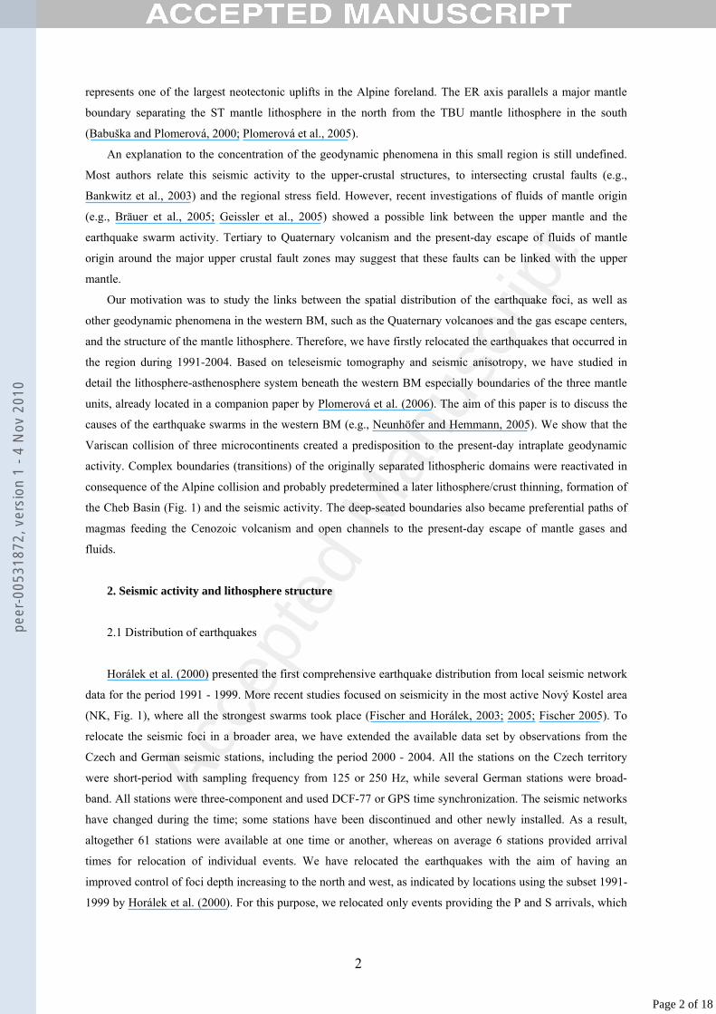
Title: Intraplate seismicity in the western Bohemian Massif(central Europe): A possible correlation with a paleoplatejunction
Authors: V. Babuska, J. Plomerova, T. Fischer
PII: S0264-3707(07)00025-7DOI: doi:10.1016/j.jog.2007.02.004Reference: GEOD 806
To appear in: Journal of Geodynamics
Received date: 7-9-2006Revised date: 1-2-2007Accepted date: 20-2-2007
Please cite this article as: Babuska, V., Plomerova, J., Fischer, T., Intraplate seismicity inthe western Bohemian Massif (central Europe): A possible correlation with a paleoplatejunction, Journal of Geodynamics (2007), doi:10.1016/j.jog.2007.02.004
This is a PDF file of an unedited manuscript that has been accepted for publication.As a service to our customers we are providing this early version of the manuscript.The manuscript will undergo copyediting, typesetting, and review of the resulting proofbefore it is published in its final form. Please note that during the production processerrors may be discovered which could affect the content, and all legal disclaimers thatapply to the journal pertain.pe
er-0
0531
872,
ver
sion
1 -
4 N
ov 2
010
Author manuscript, published in "Journal of Geodynamics 44, 3-5 (2007) 149" DOI : 10.1016/j.jog.2007.02.004
Acce
pted
Man
uscr
ipt
Intraplate seismicity in the western Bohemian Massif (central Europe): a possible
correlation with a paleoplate junction
V. Babuška*, J. Plomerová, T. Fischer
Geophysical Institute, Acad. Sci. of the Czech Republic, Boční II, 141 31 Prague 4, Czech Republic
Abstract
Locations of the Eger Rift, Cheb Basin, Quaternary volcanoes, crustal earthquake swarms and exhalation
centers of CO2 and 3He of mantle origin correlate with the tectonic fabric of the mantle lithosphere modeled
from seismic anisotropy. We suggest that positions of the seismic and volcanic phenomena, as well as of the
Cenozoic sedimentary basins, correlate with a ”triple junction” of three mantle lithospheres distinguished by
different orientations of their tectonic fabric consistent within each unit. The three mantle domains most
probably belong to the originally separated microcontinents - the Saxothuringian, Teplá-Barrandian and
Moldanubian - assembled during the Variscan orogeny. Cenozoic extension reactivated the junction and locally
thinned the crust and mantle lithosphere. The rigid part of the crust, characterized by the presence of earthquake
foci, decoupled near the junction from the mantle probably during the Variscan. The boundaries (transitions) of
three mantle domains provided open pathways for Quaternary volcanism and the ascent of 3He- and CO2-rich
fluids released from the asthenosphere. The deepest earthquakes, interpreted as an upper limit of the brittle-
ductile transition in the crust, are shallower above the junction of the mantle blocks (at about 12 km) than above
the more stable Saxothuringian mantle lithosphere (at about 20 km), probably due to a higher heat flow and
presence of fluids.
Keywords: Bohemian Massif, junction of paleoplates, intraplate earthquake swarms, brittle-ductile transition
1. Introduction
The Bohemian Massif (BM), the largest coherent surface exposure of basement rocks in central Europe, is
a part of the Variscan orogenic belt representing a collage of magmatic arcs and microcontinents caused by the
collision of Laurussia (Laurentia-Baltica) and Africa (Gondwana). The western BM represents a junction of
three first-order tectonometamorphic units (Franke, 2000): Saxothuringian (ST), Teplá-Barrandian (TBU) and
Moldanubian (MD, Fig. 1a,b). The Tertiary Eger (Ohře) Rift (ER), a 300 km long ENE-WSW striking structure
characterized by high heat flow and Cenozoic volcanism is part of the European Cenozoic Rift System (ECRIS;
Prodehl et al., 1995) and its formation is thought to be related to Alpine collision (Ziegler, 1992; see also review
of the ER development in Geissler et al., 2005). Active tectonics is primarily manifested by frequent weak to
moderate earthquake swarms (Horálek et al., 2000), emanations of CO2 dominated gases of mantle origin
(Weinlich et al. 1999; Bräuer et al., 2003), and by neotectonic crustal movements (Bankwitz et al., 2003). The
post-rift uplift of the Krušné hory Mts. (Erzgebirge), involving the NW margin of the ER (Rajchl et al., 2003),
*Corresponding author. Tel.: +420 267 103 049; fax: +420 272 761 549.
E-mail address: [email protected]
1
Page 1 of 18
peer
-005
3187
2, v
ersi
on 1
- 4
Nov
201
0
Acce
pted
Man
uscr
ipt
represents one of the largest neotectonic uplifts in the Alpine foreland. The ER axis parallels a major mantle
boundary separating the ST mantle lithosphere in the north from the TBU mantle lithosphere in the south
(Babuška and Plomerová, 2000; Plomerová et al., 2005).
An explanation to the concentration of the geodynamic phenomena in this small region is still undefined.
Most authors relate this seismic activity to the upper-crustal structures, to intersecting crustal faults (e.g.,
Bankwitz et al., 2003) and the regional stress field. However, recent investigations of fluids of mantle origin
(e.g., Bräuer et al., 2005; Geissler et al., 2005) showed a possible link between the upper mantle and the
earthquake swarm activity. Tertiary to Quaternary volcanism and the present-day escape of fluids of mantle
origin around the major upper crustal fault zones may suggest that these faults can be linked with the upper
mantle.
Our motivation was to study the links between the spatial distribution of the earthquake foci, as well as
other geodynamic phenomena in the western BM, such as the Quaternary volcanoes and the gas escape centers,
and the structure of the mantle lithosphere. Therefore, we have firstly relocated the earthquakes that occurred in
the region during 1991-2004. Based on teleseismic tomography and seismic anisotropy, we have studied in
detail the lithosphere-asthenosphere system beneath the western BM especially boundaries of the three mantle
units, already located in a companion paper by Plomerová et al. (2006). The aim of this paper is to discuss the
causes of the earthquake swarms in the western BM (e.g., Neunhöfer and Hemmann, 2005). We show that the
Variscan collision of three microcontinents created a predisposition to the present-day intraplate geodynamic
activity. Complex boundaries (transitions) of the originally separated lithospheric domains were reactivated in
consequence of the Alpine collision and probably predetermined a later lithosphere/crust thinning, formation of
the Cheb Basin (Fig. 1) and the seismic activity. The deep-seated boundaries also became preferential paths of
magmas feeding the Cenozoic volcanism and open channels to the present-day escape of mantle gases and
fluids.
2. Seismic activity and lithosphere structure
2.1 Distribution of earthquakes
Horálek et al. (2000) presented the first comprehensive earthquake distribution from local seismic network
data for the period 1991 - 1999. More recent studies focused on seismicity in the most active Nový Kostel area
(NK, Fig. 1), where all the strongest swarms took place (Fischer and Horálek, 2003; 2005; Fischer 2005). To
relocate the seismic foci in a broader area, we have extended the available data set by observations from the
Czech and German seismic stations, including the period 2000 - 2004. All the stations on the Czech territory
were short-period with sampling frequency from 125 or 250 Hz, while several German stations were broad-
band. All stations were three-component and used DCF-77 or GPS time synchronization. The seismic networks
have changed during the time; some stations have been discontinued and other newly installed. As a result,
altogether 61 stations were available at one time or another, whereas on average 6 stations provided arrival
times for relocation of individual events. We have relocated the earthquakes with the aim of having an
improved control of foci depth increasing to the north and west, as indicated by locations using the subset 1991-
1999 by Horálek et al. (2000). For this purpose, we relocated only events providing the P and S arrivals, which
2
Page 2 of 18
peer
-005
3187
2, v
ersi
on 1
- 4
Nov
201
0
Acce
pted
Man
uscr
ipt
were recorded by at least four stations with a minimum of one station at 20 km epicentral distance. This
restriction resulted in a final number of 6262 events, while 204 earthquakes could not be located.
We have applied the Velest code (Kissling et al., 1994) that implements a joint inversion for determining both
hypocenter coordinates and a velocity model. We relocated the events in two steps. First, we have improved the
1-D velocity model by a number of Velest runs using different subsets of earthquakes and initial velocity
models. The reason for this step was to check if the resulting velocity model is sensitive to observations from
stations in the northern part of the region, which were not included in the existing crustal models (e.g., Málek et
al., 2005). A final optimum model differs only slightly in the shallowest parts from the isotropic version of
model of Málek et al. (2005) which they derived from observations not including the northern stations. This
means that the effect of the northern stations on the model and the locations is small. Second, we have relocated
all the events using the optimum model.
We estimate the location error to be the difference between the location using all stations and the location
after excluding the nearest station. As expected, the errors in depth are larger than the errors of the horizontal
locations. Nevertheless, the depth errors are less than ±0.65 km in the central part (between the latitudes 50.1°N
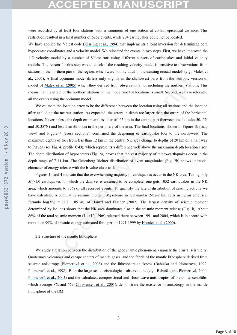
and 50.35°N) and less than ±2.0 km in the periphery of the area. The final locations, shown in Figure 1b (map
view) and Figure 4 (cross sections), confirmed the deepening of earthquake foci to the north-west. The
maximum depths of foci from less than 12 km in the central NK area change to depths of 20 km on a half way
to Plauen (see Fig. 4, profile C-D), which represents a difference well above the maximum depth location error.
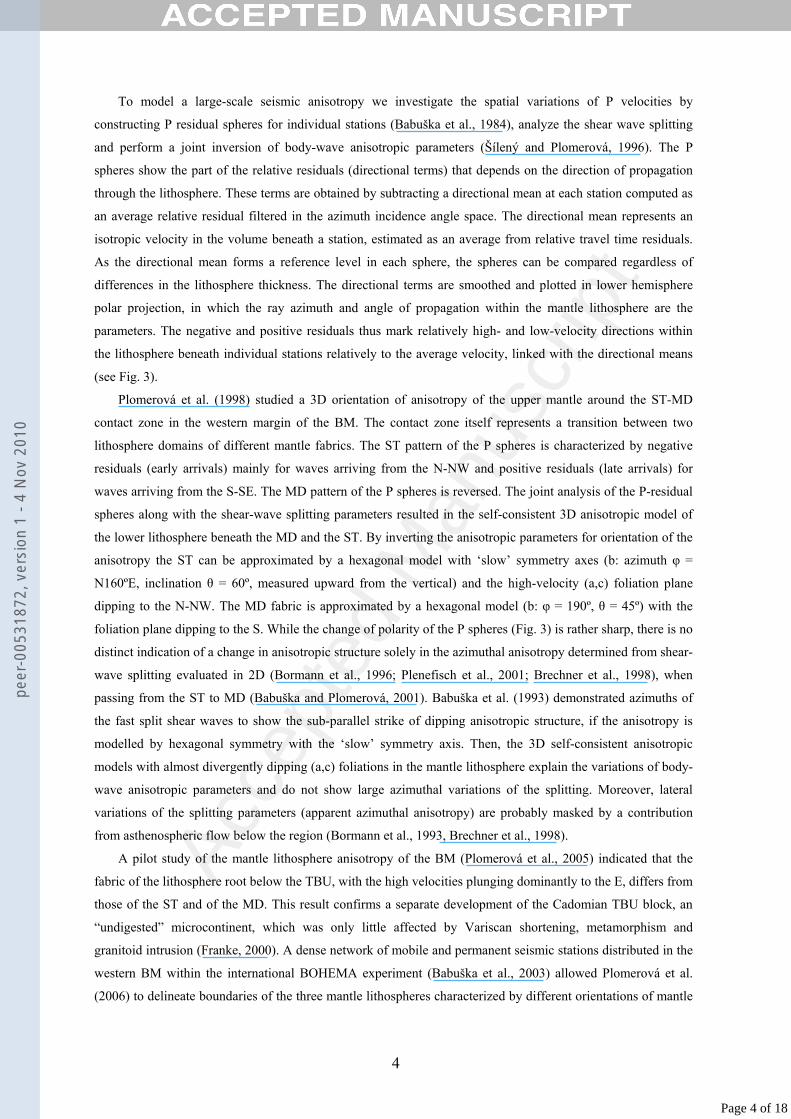
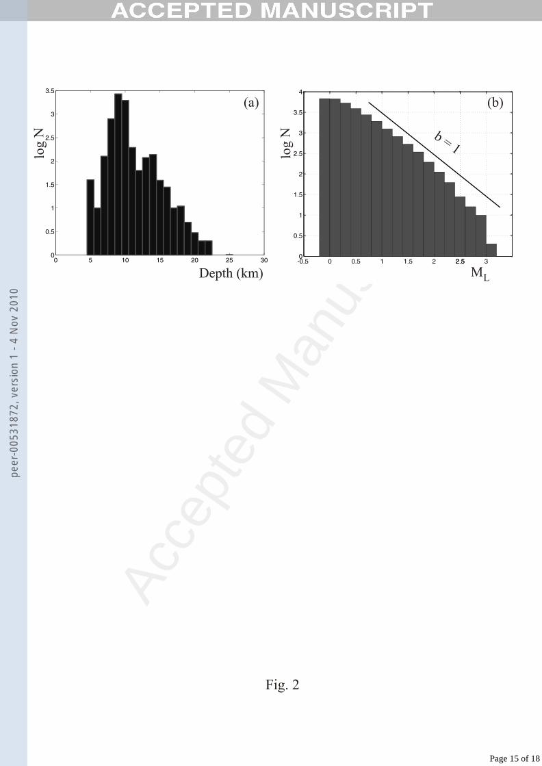
The depth distribution of hypocenters (Fig. 2a) proves that the vast majority of micro-earthquakes occur in the
depth range of 7-11 km. The Gutenberg-Richter distribution of event magnitudes (Fig. 2b) shows unimodal
character of energy release with the b-value close to 1.
Figures 1b and 4 indicate that the overwhelming majority of earthquakes occur in the NK area. Taking only
ML>1.0 earthquakes for which the data set is assumed to be complete, one gets 1052 earthquakes in the NK
area, which amounts to 87% of all recorded events. To quantify the lateral distribution of seismic activity we
have calculated a cumulative seismic moment M0 release in rectangular 2-by-2 km cells using an empirical
formula log(M0) = 11.1+1.05 ML of Hainzl and Fischer (2002). The largest density of seismic moment
determined by isolines shows that the NK area dominates also in the seismic moment release (Fig 1b). About
86% of the total seismic moment (1.4x10¹⁶ Nm) released there between 1991 and 2004, which is in accord with
more than 90% of seismic energy estimated for a period 1991-1999 by Horálek et al. (2000).
2.2 Structure of the mantle lithosphere
We study a relation between the distribution of the geodynamic phenomena - namely the crustal seismicity,
Quaternary volcanoes and escape centers of mantle gases, and the fabric of the mantle lithosphere derived from
seismic anisotropy (Plomerová et al., 2006) and the lithosphere thickness (Babuška and Plomerová, 1992;
Plomerová et al., 1998). Both the large-scale seismological observations (e.g., Babuška and Plomerová, 2000;
Plomerová et al., 2005) and the calculated compressional and shear wave anisotropies of lherzolite xenoliths,
which average 8% and 6% (Christensen et al., 2001), demonstrate the existence of anisotropy in the mantle
lithosphere of the BM.
3
Page 3 of 18
peer
-005
3187
2, v
ersi
on 1
- 4
Nov
201
0
Acce
pted
Man
uscr
ipt
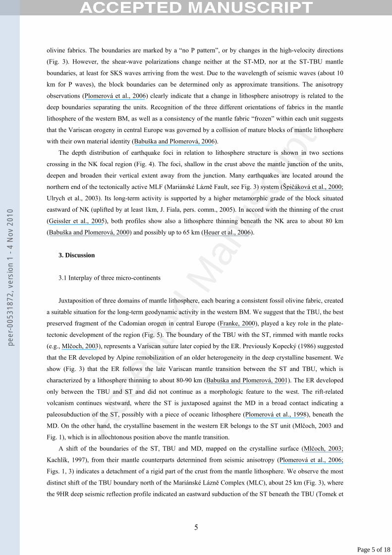
To model a large-scale seismic anisotropy we investigate the spatial variations of P velocities by
constructing P residual spheres for individual stations (Babuška et al., 1984), analyze the shear wave splitting
and perform a joint inversion of body-wave anisotropic parameters (Šílený and Plomerová, 1996). The P
spheres show the part of the relative residuals (directional terms) that depends on the direction of propagation
through the lithosphere. These terms are obtained by subtracting a directional mean at each station computed as
an average relative residual filtered in the azimuth incidence angle space. The directional mean represents an
isotropic velocity in the volume beneath a station, estimated as an average from relative travel time residuals.
As the directional mean forms a reference level in each sphere, the spheres can be compared regardless of
differences in the lithosphere thickness. The directional terms are smoothed and plotted in lower hemisphere
polar projection, in which the ray azimuth and angle of propagation within the mantle lithosphere are the
parameters. The negative and positive residuals thus mark relatively high- and low-velocity directions within
the lithosphere beneath individual stations relatively to the average velocity, linked with the directional means
(see Fig. 3).
Plomerová et al. (1998) studied a 3D orientation of anisotropy of the upper mantle around the ST-MD
contact zone in the western margin of the BM. The contact zone itself represents a transition between two
lithosphere domains of different mantle fabrics. The ST pattern of the P spheres is characterized by negative
residuals (early arrivals) mainly for waves arriving from the N-NW and positive residuals (late arrivals) for
waves arriving from the S-SE. The MD pattern of the P spheres is reversed. The joint analysis of the P-residual
spheres along with the shear-wave splitting parameters resulted in the self-consistent 3D anisotropic model of
the lower lithosphere beneath the MD and the ST. By inverting the anisotropic parameters for orientation of the
anisotropy the ST can be approximated by a hexagonal model with ‘slow’ symmetry axes (b: azimuth φ =
N160ºE, inclination θ = 60º, measured upward from the vertical) and the high-velocity (a,c) foliation plane
dipping to the N-NW. The MD fabric is approximated by a hexagonal model (b: φ = 190º, θ = 45º) with the
foliation plane dipping to the S. While the change of polarity of the P spheres (Fig. 3) is rather sharp, there is no
distinct indication of a change in anisotropic structure solely in the azimuthal anisotropy determined from shear-
wave splitting evaluated in 2D (Bormann et al., 1996; Plenefisch et al., 2001; Brechner et al., 1998), when
passing from the ST to MD (Babuška and Plomerová, 2001). Babuška et al. (1993) demonstrated azimuths of
the fast split shear waves to show the sub-parallel strike of dipping anisotropic structure, if the anisotropy is
modelled by hexagonal symmetry with the ‘slow’ symmetry axis. Then, the 3D self-consistent anisotropic
models with almost divergently dipping (a,c) foliations in the mantle lithosphere explain the variations of body-
wave anisotropic parameters and do not show large azimuthal variations of the splitting. Moreover, lateral
variations of the splitting parameters (apparent azimuthal anisotropy) are probably masked by a contribution
from asthenospheric flow below the region (Bormann et al., 1993, Brechner et al., 1998).
A pilot study of the mantle lithosphere anisotropy of the BM (Plomerová et al., 2005) indicated that the
fabric of the lithosphere root below the TBU, with the high velocities plunging dominantly to the E, differs from
those of the ST and of the MD. This result confirms a separate development of the Cadomian TBU block, an
“undigested” microcontinent, which was only little affected by Variscan shortening, metamorphism and
granitoid intrusion (Franke, 2000). A dense network of mobile and permanent seismic stations distributed in the
western BM within the international BOHEMA experiment (Babuška et al., 2003) allowed Plomerová et al.
(2006) to delineate boundaries of the three mantle lithospheres characterized by different orientations of mantle
4
Page 4 of 18
peer
-005
3187
2, v
ersi
on 1
- 4
Nov
201
0
Acce
pted
Man
uscr
ipt
olivine fabrics. The boundaries are marked by a “no P pattern”, or by changes in the high-velocity directions
(Fig. 3). However, the shear-wave polarizations change neither at the ST-MD, nor at the ST-TBU mantle
boundaries, at least for SKS waves arriving from the west. Due to the wavelength of seismic waves (about 10
km for P waves), the block boundaries can be determined only as approximate transitions. The anisotropy
observations (Plomerová et al., 2006) clearly indicate that a change in lithosphere anisotropy is related to the
deep boundaries separating the units. Recognition of the three different orientations of fabrics in the mantle
lithosphere of the western BM, as well as a consistency of the mantle fabric “frozen” within each unit suggests
that the Variscan orogeny in central Europe was governed by a collision of mature blocks of mantle lithosphere
with their own material identity (Babuška and Plomerová, 2006).
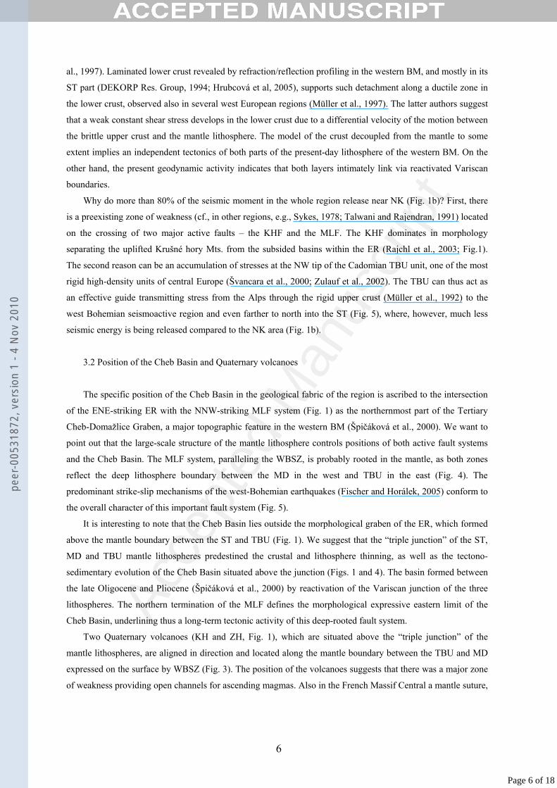
The depth distribution of earthquake foci in relation to lithosphere structure is shown in two sections
crossing in the NK focal region (Fig. 4). The foci, shallow in the crust above the mantle junction of the units,
deepen and broaden their vertical extent away from the junction. Many earthquakes are located around the
northern end of the tectonically active MLF (Mariánské Lázně Fault, see Fig. 3) system (Špičáková et al., 2000;
Ulrych et al., 2003). Its long-term activity is supported by a higher metamorphic grade of the block situated
eastward of NK (uplifted by at least 1km, J. Fiala, pers. comm., 2005). In accord with the thinning of the crust
(Geissler et al., 2005), both profiles show also a lithosphere thinning beneath the NK area to about 80 km
(Babuška and Plomerová, 2000) and possibly up to 65 km (Heuer et al., 2006).
3. Discussion
3.1 Interplay of three micro-continents
Juxtaposition of three domains of mantle lithosphere, each bearing a consistent fossil olivine fabric, created
a suitable situation for the long-term geodynamic activity in the western BM. We suggest that the TBU, the best
preserved fragment of the Cadomian orogen in central Europe (Franke, 2000), played a key role in the plate-
tectonic development of the region (Fig. 5). The boundary of the TBU with the ST, rimmed with mantle rocks
(e.g., Mlčoch, 2003), represents a Variscan suture later copied by the ER. Previously Kopecký (1986) suggested
that the ER developed by Alpine remobilization of an older heterogeneity in the deep crystalline basement. We
show (Fig. 3) that the ER follows the late Variscan mantle transition between the ST and TBU, which is
characterized by a lithosphere thinning to about 80-90 km (Babuška and Plomerová, 2001). The ER developed
only between the TBU and ST and did not continue as a morphologic feature to the west. The rift-related
volcanism continues westward, where the ST is juxtaposed against the MD in a broad contact indicating a
paleosubduction of the ST, possibly with a piece of oceanic lithosphere (Plomerová et al., 1998), beneath the
MD. On the other hand, the crystalline basement in the western ER belongs to the ST unit (Mlčoch, 2003 and
Fig. 1), which is in allochtonous position above the mantle transition.
A shift of the boundaries of the ST, TBU and MD, mapped on the crystalline surface (Mlčoch, 2003;
Kachlík, 1997), from their mantle counterparts determined from seismic anisotropy (Plomerová et al., 2006;
Figs. 1, 3) indicates a detachment of a rigid part of the crust from the mantle lithosphere. We observe the most
distinct shift of the TBU boundary north of the Mariánské Lázně Complex (MLC), about 25 km (Fig. 3), where
the 9HR deep seismic reflection profile indicated an eastward subduction of the ST beneath the TBU (Tomek et
5
Page 5 of 18
peer
-005
3187
2, v
ersi
on 1
- 4
Nov
201
0
Acce
pted
Man
uscr
ipt
al., 1997). Laminated lower crust revealed by refraction/reflection profiling in the western BM, and mostly in its
ST part (DEKORP Res. Group, 1994; Hrubcová et al, 2005), supports such detachment along a ductile zone in
the lower crust, observed also in several west European regions (Müller et al., 1997). The latter authors suggest
that a weak constant shear stress develops in the lower crust due to a differential velocity of the motion between
the brittle upper crust and the mantle lithosphere. The model of the crust decoupled from the mantle to some
extent implies an independent tectonics of both parts of the present-day lithosphere of the western BM. On the
other hand, the present geodynamic activity indicates that both layers intimately link via reactivated Variscan
boundaries.
Why do more than 80% of the seismic moment in the whole region release near NK (Fig. 1b)? First, there
is a preexisting zone of weakness (cf., in other regions, e.g., Sykes, 1978; Talwani and Rajendran, 1991) located
on the crossing of two major active faults – the KHF and the MLF. The KHF dominates in morphology
separating the uplifted Krušné hory Mts. from the subsided basins within the ER (Rajchl et al., 2003; Fig.1).
The second reason can be an accumulation of stresses at the NW tip of the Cadomian TBU unit, one of the most
rigid high-density units of central Europe (Švancara et al., 2000; Zulauf et al., 2002). The TBU can thus act as
an effective guide transmitting stress from the Alps through the rigid upper crust (Müller et al., 1992) to the
west Bohemian seismoactive region and even farther to north into the ST (Fig. 5), where, however, much less
seismic energy is being released compared to the NK area (Fig. 1b).
3.2 Position of the Cheb Basin and Quaternary volcanoes
The specific position of the Cheb Basin in the geological fabric of the region is ascribed to the intersection
of the ENE-striking ER with the NNW-striking MLF system (Fig. 1) as the northernmost part of the Tertiary
Cheb-Domažlice Graben, a major topographic feature in the western BM (Špičáková et al., 2000). We want to
point out that the large-scale structure of the mantle lithosphere controls positions of both active fault systems
and the Cheb Basin. The MLF system, paralleling the WBSZ, is probably rooted in the mantle, as both zones
reflect the deep lithosphere boundary between the MD in the west and TBU in the east (Fig. 4). The
predominant strike-slip mechanisms of the west-Bohemian earthquakes (Fischer and Horálek, 2005) conform to
the overall character of this important fault system (Fig. 5).
It is interesting to note that the Cheb Basin lies outside the morphological graben of the ER, which formed
above the mantle boundary between the ST and TBU (Fig. 1). We suggest that the “triple junction” of the ST,
MD and TBU mantle lithospheres predestined the crustal and lithosphere thinning, as well as the tectono-
sedimentary evolution of the Cheb Basin situated above the junction (Figs. 1 and 4). The basin formed between
the late Oligocene and Pliocene (Špičáková et al., 2000) by reactivation of the Variscan junction of the three
lithospheres. The northern termination of the MLF defines the morphological expressive eastern limit of the
Cheb Basin, underlining thus a long-term tectonic activity of this deep-rooted fault system.
Two Quaternary volcanoes (KH and ZH, Fig. 1), which are situated above the “triple junction” of the
mantle lithospheres, are aligned in direction and located along the mantle boundary between the TBU and MD
expressed on the surface by WBSZ (Fig. 3). The position of the volcanoes suggests that there was a major zone
of weakness providing open channels for ascending magmas. Also in the French Massif Central a mantle suture,
6
Page 6 of 18
peer
-005
3187
2, v
ersi
on 1
- 4
Nov
201
0

Acce
pted
Man
uscr
ipt
hidden beneath an allochtonous crust and reactivated during the Cenozoic extension of the thinned lithosphere,
provided a space for major volcanism (Babuška et al., 2002).
3.3 Correlation of escape centers of mantle fluids with deep tectonics
The post-Alpine crustal extension of rift systems is associated with an enhanced release of CO2 and
variable fractions of mantle-derived He (for review see Weinlich et al., 1999,). Newell et al. (2005) show that in
western North America the highest contribution of mantle helium correlates to the youngest and most active
tectonic regions and domains of the lowest mantle velocity. As to transport of gases to the surface, Kulongoski
et al. (2005) concluded that mantle helium, found in ground waters of the Morongo Basin east of the San
Andreas fault, moved via deeply penetrating faults. They also speculate that episodic seismicity and associated
hydrofracturing drive volatile transfer from the mantle to the crust.
Geissler et al (2005) hypothesized the release of CO2 dominated fluid/magma in the western BM from
isolated melt reservoirs fed from the asthenosphere and resting in the depth range of 60 to 30 km. We propose
that mantle fluids may escape directly from the asthenosphere and channel into the crust along the block
boundaries of the mantle lithosphere (Fig. 4). At the KV escape center (Karlovy Vary spa) the fluids may
ascend to the surface at the crossing of the northern limit of the TBU with the deep reaching Jáchymov fault
(Šrámek, pers. comm., 2006, and Fig. 3). Similarly, the CHB (Cheb Basin) escape center is situated above the
junction of three mantle lithospheres and near the crossing of two active fault systems – the MLF and KHF.
Another weakened and partly opened zone feeding the ML escape center (Mariánské Lázně spa) can be the
MLC comprising segments of oceanic crust thrust over SE margin of the ST (Franke and Stein, 2000). The
MLC probably marks a suture between two different Variscan tectonic units distinguished by the different
orientation of fabrics in the mantle lithosphere and a zone later revived by younger tectonic processes (Babuška
and Plomerová, 2000). The crust/lithosphere boundaries probably became preferential pathways for circulation
of meteoric water and its mixing with mantle fluids and thus played a crucial role in locations of the spa resorts.
3.4 Brittle-ductile transition in the crust
The largest depth of earthquakes, interpreted as the brittle-ductile transition (Fig. 4), depends on pressure,
temperature, lithology and presence of fluids (Scholz, 1990). The degree of metamorphism in the ST decreases
from mica schists/paragneisses near the ER to phyllites and slates in the north near Plauen (Franke and Stein,
2000). As the slates and phyllites should have a shallower maximum depth of brittle rupture (Magistrale and
Zhou, 1996) than crystalline schists and muscovite granite (Fiala and Vejnar, 2004) of the NK region, the
lithologic assemblages cannot explain the observed increase of hypocenter depths to the north, under the
assumption that the surface rocks continue down to the brittle-ductile transition.
The surface heat-flow map (Hurtig et al., 1992) gives values of 70-80 mW/m2 in the western ER and only
about 50-60 mW/m2 in the ST unit near Plauen (Fig. 1). Förster and Förster (2000) pointed out that high-heat
production Variscan granites, occurring to a depth of ~15km within a metamorphic basement of the western ER
(Švancara et al., 2000), substantially contribute to high heat flow in the Krušné hory (Erzgebirge) region.
Nevertheless, the authors estimate 5-10 mWm-2 of heat flow there supplied from the mantle in excess to average
7
Page 7 of 18
peer
-005
3187
2, v
ersi
on 1
- 4
Nov
201
0
Acce
pted
Man
uscr
ipt
mantle heat flow observed in tectonically stable terrains. The expected higher temperatures in the crust beneath
the NK focal area may thus contribute, besides an effect of fluids, to the observed upwelling of the brittle-
ductile transition.
Tullis and Yund (1980) found that the addition of 0.2 wt% of water to granite deformed under the dry
conditions produced a pronounced weakening, enhanced ductility and reduced the temperature of the brittle-
ductile transition by about 150-200o C for both quartz and feldspar. Although no gas and fluid exhalations are
directly above the NK hypocenters, possibly due to a low-permeable cap above the active hydraulic system
(Bräuer et al., 2003), the NK focal area is at the periphery of the CHB escape center (Fig. 1). It is probable that
fluids channeled along the weakened zone described above affect the local upwelling of the brittle-ductile
transition. The suggestion of Vavryčuk (2002) and Hainzl and Fischer (2002) that fluid overpressure may
initiate the seismicity in the NK region may thus be valid.
The active hydraulic system in the lower crust would create a localized decrease in the frictional strength.
Long and Zelt (1991) show on the intraplate seismicity of southeastern Tennessee that such decrease in the
strength of a localized area of the lower crust also decreases the depth of the brittle-ductile transition and
concentrates stress in the stronger elastic crust around and above the zone of decreased strength. Such a
situation may occur in the NK area and may contribute to the local upwelling of the brittle-ductile transition.
4. Conclusions
Mantle structure of the western BM is correlated with the distribution of crustal earthquakes, Quaternary
volcanoes and escape centers of mantle gases. Three domains of mantle lithosphere with different mantle fabric
produced by consistent orientation of seismic anisotropy represent the mantle components of the major tectonic
units (micro-continents): Saxothuringian, Teplá-Barrandian and Moldanubian, which assembled during the
Variscan orogeny. A lateral offset of boundaries of the crustal and mantle parts of the same block, extending for
about 20 km in the western rim of the TBU, indicates a detachment of the rigid upper crust from the mantle.
The boundaries, reactivated during Cenozoic extension, controlled the positions of the Eger Rift and the Cheb
Basin as its westernmost part, and provided open paths for Cenozoic volcanism and the ascent of 3He- and CO2-
rich fluids from the asthenosphere. Most of the seismic energy from periodically repeating earthquake swarms
is released in the upper crust at the crossing of two fault systems, the KHF and MLF. The brittle-ductile
transition in the crust, associated with the deepest foci, is shallower above the junction of the three mantle
blocks than above the more stable Saxothuringian mantle lithosphere. The transition upwelling is probably due
to fluids ascending along the block boundaries and partly due to a higher heat flow. We suggest that also in
other continental regions many intraplate earthquakes may be located at more or less healed paleoplate
boundaries.
Acknowledgements. We thank A.Docekal, R.Mittag and J.Wassermann for providing additional arrival
times for the event relocations, H. Kämpf, J.Fiala and V.Kachlík for valuable discussions and advice on
tectonics, G. Medaris, B. Heuer and V. Vavryčuk for comments, which improved the manuscript. Special
thanks go to L. Vecsey for handling the data and evaluation of shear-wave splitting. BOHEMA WG comprises
L.Vecsey, J.Zedník, P.Jedlička, J.Horálek, A.Boušková, B.Růžek, P.Kolář, M.Brož, J.Málek, V.Nehybka,
8
Page 8 of 18
peer
-005
3187
2, v
ersi
on 1
- 4
Nov
201
0

Acce
pted
Man
uscr
ipt
O.Novotný, M.Granet, U.Achauer, T.Piquet, M.Korn, S.Wendt, S.Funke, M.Brunner, D.Rössler, R.Kind,
H.Kämpf, W.Geissler, B.Heuer, K.Klinge, T.Plenefisch, K.Stammler, M.Lindemann, K.Bräuer and
P.Malischewsky. Constructive comments of two anonymous reviewers and financial support by the Czech
Grant Agency (grants Nos 205/04/0748, 205/06/1780, 205/07/1088) are greatly acknowledged.
References
Babuška, V., Plomerová, J., Šílený, J., 1984. Spatial variations of P residuals and deep structure of the European
lithosphere. Geophys. J.R. astr. Soc. 79, 363-383.
Babuška, V., Plomerová, J., 2000. Saxothuringian-Moldanubian suture and predisposition of seismicity in the
western Bohemian Massif. Studia geoph. et geod. 44, 292-306.
Babuška, V., Plomerová, J., 2001. Subcrustal lithosphere around the Saxothuringian-Moldanubian Suture Zone
- a model derived from anisotropy of seismic wave velocities. Tectonophysics 332, 185-199.
Babuška, V., Plomerová, J., Vecsey, L., Granet, M., Achauer, U., 2002. Seismic anisotropy of the French
Massif Central and predisposition of Cenozoic rifting and volcanism by Variscan suture hidden in the mantle
lithosphere. Tectonics 21, 11-1 – 11-20.
Babuška, V., Plomerová J., BOHEMA W.G., 2003. BOHEMA seismic experiment: search for an active
magmatic source in the deep lithosphere in central Europe. EOS, Trans. AGU 84, 409-417.
Babuška, V., Plomerová J., 2006. European mantle lithosphere assembled from rigid microplates with inherited
seismic anisotropy. Phys. Earth Planet Inter., 158, 264-280, doi:10.1016/J.pepi.2006.01.010.
Bankwitz, P., Schneider, G., Kämpf, H., Bankwitz, E., 2003. Structural characteristics of epicentral areas in
Central Europe: study case Cheb Basin (Czech Republic), Journ. Geodyn. 35, 5-32.
Bormann, P., Grünthal, G., Kind, R., Montag, H., 1996. Upper mantle anisotropy beneath central Europe from
SKS wave splitting: effects of absolute plate motion and lithosphere-asthenosphere boundary topography? J.
Geodynamics 22, 11-32.
Bräuer, K., Kämpf, H., Strauch, G., Weise, S.M., 2003. Isotopic evidence (3He/4He, 13CCO2) of fluid triggered
intraplate seismicicty. J. Geophys. Res. 108(B2), 2070, doi: 10.1029/2002JB002077.
Bräuer, K., Kämpf, H., Niedermann, S., Strauch, G., 2005. Evidence for ascending upper mantle-derived melt
beneath the Cheb basin, central Europe. Geophys. Res. Lett. 32, L08303, doi:10.1029/2004GL022205, 1-4.
Brechner, S., Klinge, K., Krüger, F., Plenefisch, T., 1998. Backazimuthal variations of splitting parameters of
teleseismic SKS phases observed at the broadband stations in Germany. Pure and Appl. Geophys. 151, 305-
331.
Christensen, N.I., Medaris, L.G., Wang, H.F., Jelínek, E., 2001. Depth variation of seismic anisotropy and
petrology in central European lithosphere: A tectonothermal synthesis from spinel lherzolite. J.Geophys.Res.
106, 645-664.
DEKORP Research Group, 1994. The deep reflection seismic profiles DEKORP 3/MVE-90. Z. Geol. Wiss.
22(6), 623-684.
Fiala, J., Vejnar, Z., 2004. The lithology, geochemistry, and metamorphic gradation of the crystalline basement
of the Cheb (Eger) Tertiary Basin, Saxothuringian Unit. Bull. of Geosci., Czech Geol. Survey 79, 41-52.
9
Page 9 of 18
peer
-005
3187
2, v
ersi
on 1
- 4
Nov
201
0

Acce
pted
Man
uscr
ipt
Fischer, T., 2005. Modeling of multiple-events using empirical Greens functions: method, application to swarm
earthquakes and implications for their rupture propagation. Geophys. J. Int. 163, doi:10.1111/j.1365-
246X.2005.02739.x, 991-1005.
Fischer, T., Horálek, J., 2003. Space-time distribution of earthquake swarms in the principal focal zone of the
NW Bohemia/Vogtland seismoactive region: period 1985-2001. J. Geodyn. 35, 125-144.
Fischer, T., Horálek, J., 2005. Slip-generated patterns of swarm microearthquakes from West
Bohemia/Vogtland (central Europe): Evidence of their triggering mechanism? J. Geophys. Res. 110,
B05S21, doi:10.1029/2004jb003363, 1-14.
Förster, A., Förster, H.-J., 2000. Crustal composition and mantle heat flow: Implications from surface heat flow
and radiogenic heat production in the Variscan Erzgebirge (Germany). J. Geophys. Res. 105, 27,917-27,938.
Franke, W., 2000. The mid-European segment of the Variscides: tectonostratigraphic units, terrane boundaries
and plate tectonic evolution. In: Franke, W., Haak, V., Oncken, O., Tanner, D. (Eds.), Orogenic Processes:
Quantification and Modelling in the Variscan Belt, Geol. Soc., Spec. Publ. 179, London, pp. 35-61.
Franke, W., Stein, E., 2000. Exhumation of high-grade rocks in the Saxo-Thuringian Belt: geological
constraints and geodynamic concepts. In: Franke, W., Haak, V., Oncken, O., Tanner, D. (Eds.), Orogenic
Processes: Quantification and Modelling in the Variscan Belt, Geol. Soc., Spec. Publ. 179, London, pp. 337-
354.
Geissler, W.H., Kampf, H., Kind, R., Bräuer, K., Klinge, K., Plenefisch, T., Horálek, J., Zedník, J., Nehybka,
V., 2005. Seismic structure and location of a CO2 source in the upper mantle of the western Eger (Ohře) Rift,
central Europe. Tectonics 24, TC5001, doi: 10.1029/2004TC001672.
Hainzl, S., Fischer, T., 2002. Indications for a successively triggered rupture growth underlying the 2000
earthquake swarm in Vogtland/NW-Bohemia. J. Geophys. Res. 107, B12, 2338, doi: 10.1029/2002JB001865.
Heuer, B., Geissler, W.H., Kind, R., Kämpf, H., 2006. Seismic evidence for asthenospheric updoming beneath
the western Bohemian Massif, central Europe. Geoph. Res. Lett. 33, L05311, doi:10.1029/2005GL025158.
Horálek, J., Fischer, T., Boušková, A., Jedlička, P., 2000. The western Bohemia/Vogtland region in the light of
the WEBNET network. Studia geoph. et geod. 44, 107-125.
Hrubcová, P., Sroda, P., Špičák, A., Guterch, A., Grad, M., Keller, G.R., Brueckl, E., Thybo, H., 2005. Crustal
and uppermost mantle structure of the Bohemian Massif based on CELEBRATION 2000 data. J. Geophys.
Res. 110, B11305, doi:101029/2004JB003080.
Hurtig, E., Čermák, V., Haenel, R., Zui, V.I., 1992. Geothermal Atlas of Europe, Hermann Haack
Verlagsgesellschaft mbH, Geographisch-Kartographische Anstalt, Set of 36 maps and Explanatory Note,
Rotha, 156 pp.
Kachlík, V., 1997. The Kladská Unit. In: Vrána, S., Štědrá, V. (Eds.), Geological model of western Bohemia
related to the KTB borehole in Germany. Sborn. Geol. Věd, Geologie 47, pp. 70-80.
Kissling, E., Ellsworth, W.L., Eberhart-Phillips, D., Kradolfer, U., 1994. Initial reference models in local
earthquake tomography. J. Geophys. Res. 99, 19635-19646.
Kopecký, L., 1986. Geological development and block structure of the Cenozoic Ohře rift (Czechoslovakia).
Proc. 6th Int. Conf. Basement Tectonics, Utah.
10
Page 10 of 18
peer
-005
3187
2, v
ersi
on 1
- 4
Nov
201
0
Acce
pted
Man
uscr
ipt
Kulongoski, J.T., Hilton, D.R., Izbicki, J.A., 2005. Source and movement of helium in the eastern Morongo
groundwater basin: The influence of regional tectonics on crustal and mantle helium fluxes. Geochimica et
Cosmochimica Acta 69, 3857-3872, doi: 10.1016/j.gca.2005.03.001.
Magistrale, H., Zhou Hua-Wei, 1996. Lithologic control of the depth of earthquakes in southern California.
Science 273, 639-642.
Málek, J, Horálek, J., Janský, J., 2005. One-dimensional qP-wave velocity model of the upper crust for the West
Bohemia/Vogtland earthquake swarm region. Studia geoph. et geod. 49, 501-524.
Mlčoch, B., 2003. Character of the contact between the Saxothuringian and Teplá-Barrandian unit. Geolines 16,
75.
Müller, B., Zoback, M.L., Fuchs, K., Mastin, I., Gregersen, S., Pavoni, N., Stephannsson, O., Ljunggren, C.,
1992. Regional patterns of tectonic stress in Europe. J. Geophys. Res. 97, 11783-11803.
Müller, B., Wehrle, V., Zeyen, H., Fuchs, K., 1997. Short-scale variations of tectonic regimes in the western
European stress province north of the Alps and Pyrenees. Tectonophysics 275, 199-219.
Neunhöfer, H., Hemmann, A., 2005. Earthquake swarms in the Vogtland/Western Bohemia region: Spatial
distribution and magnitude-frequency distribution as an indication of the genesis of swarms? J. Geodynamics
39, 361-385.
Newell, D.L., Crossey, L.J., Karlstrom, K.E., Fischer, T.P., 2005. Continental-scale links between the mantle
and groundwater systems of the western United States: Evidence from travertine springs and regional He
isotope data. GSA Today 15, no. 12, 4-10, doi: 10.1130/1052-5173(2005)015<4:CSLBTM>2.0.CO;2.
Plenefisch, T., Klinge, K., Kind, R., 2001. Upper mantle anisotropy at the transition zone of the
Saxothuringicum and Moldanubicum in southeast Germany revealed by shear wave splitting. Geophys. J.
Int. 144, 309-319.
Plomerová, J., Babuška, V., Šílený, J., Horálek, J., 1998. Seismic anisotropy and velocity variations in the
mantle beneath the Saxothuringicum-Moldanubicum contact in central Europe. Pure and Appl. Geophys.
151, 365-394.
Plomerová, J., Vecsey, L., Babuška, V., Granet, M., Achauer, U., 2005. Passive seismic experiment MOSAIC –
a pilote study of mantle lithosphere of the Bohemian Massif. Stud. Geophys. Geod. 49, 541-560.
Plomerová, J., Achauer, U., Babuška, V., Vecsey, L. and BOHEMA W.G., 2006. Upper mantle beneath the
Eger Rift (Central Europe): plume or asthenosphere upwelling? Geoph. J. Int., in press.
Prodehl, C., Mueller, S., Haak, V., 1995. The European Cenozoic rift system. In:. Olsen, K.H. (Ed.),
Continental Rifts: Evolution, Structure, Tectonics. Elsevier, pp. 133-212.
Rajchl, M., Uličný, D., Hubatka, F., 2003. Syn and post-sedimentary tectonics of the Most Basin (Ohre Rift,
Czech Republic); insights from seismic reflection data. Abstract, Proceedings of the 8th Meeting of the Czech
Tectonic Studies Group, April 24-27, 2003. Geolines 16, 86-87.
Scholz, C.H., 1990. The mechanics of earthquakes and faulting. Cambridge Univ. Press, New York.
Šílený, J., Plomerová, J., 1996. Inversion of shear-wave splitting parameters to retrieve three-dimensional
orientation of anisotropy of continental lithosphere. Phys. Earth. Planet. Int. 95, 277-292.
Špičáková, L., Uličný, D., Koudelková, G., 2000. Tectonosedimentary evolution of the Cheb Basin (NW
Bohemia, Czech Republic) between Late Oligocene and Pliocene: A preliminary note. Studia geoph. et geod.
44, 556-580.
11
Page 11 of 18
peer
-005
3187
2, v
ersi
on 1
- 4
Nov
201
0
Acce
pted
Man
uscr
ipt
Švancara, J., Gnojek, I., Hubatka, F. Dědáček, K., 2000. Geophysical field pattern in the west Bohemian
geodynamic active area. Studia geoph. et geod. 44, 307-326.
Sykes, L.R., 1978. Intraplate seismicity, reactivation of pre-existing zones of weakness, alkaline magmatism
and other tectonism postdating continental fragmentation. Rev. Geophys. Space Phys. 16, 621-688.
Talwani, P., Rajendran, K., 1991. Some seismological and geometric features of intraplate earthquakes.
Tectonophysics 186, 19-41.
Tomek, Č., Dvořáková, V., Vrána S., 1997. Geological interpretation of the 9HR and 503M seismic profiles in
western Bohemia. In: Vrána, S., Štědrá, V. (Eds.), Geological model of western Bohemia related to the KTB
borehole in Germany. Sborn. Geol. Věd, Geologie 47, 43-50.
Tullis, J., Yund, R.A., 1980. Hydrolytic weakening of experimentally deformed Westerly granite and Hale
albite rock. J. Struct. Geol. 2, 439-451.
Ulrych, J., Štěpánková, J., Lloyd, F.E., Balogh, K., 2003. Middle to Late Miocene alkaline volcanic series
associated with the Cheb-Domažlice Graben, W Bohemia: geochemistry and mineralogy. Geologica
Carpathica 54, 1-12.
Vavryčuk, V. , 2002. Non-double-couple earthquakes of 1997 January in West Bohemia, Czech Republic:
Evidence of tensile faulting. Geophys. J. Int. 149, 364-373.
Weinlich, F.H., Brauer, K., Kampf, H., Strauch, G., Tesař, J., Weise, S.M., 1999. An active subcontinental
mantle volatile system in the western Eger rift, Central Europe: Gas flux, isotopic (He, C, and N) and
compositional fingerprints. Geochim. et Cosmochim. Acta 63, 3653-3671.
Ziegler, P.A., 1992. European Cenozoic rift system. Tectonophysics 208, 91-111.
Zulauf, G., Bues, C., Dörr, W., Vejnar, Z., 2002. 10 km minimum throw along the West Bohemian shear zone:
Evidence from dramatic crustal thickening and high topography in the Bohemian Massif (European
Variscides). Int. Journ. Earth Sci. 91, 850-864.
12
Page 12 of 18
peer
-005
3187
2, v
ersi
on 1
- 4
Nov
201
0

Acce
pted
Man
uscr
ipt
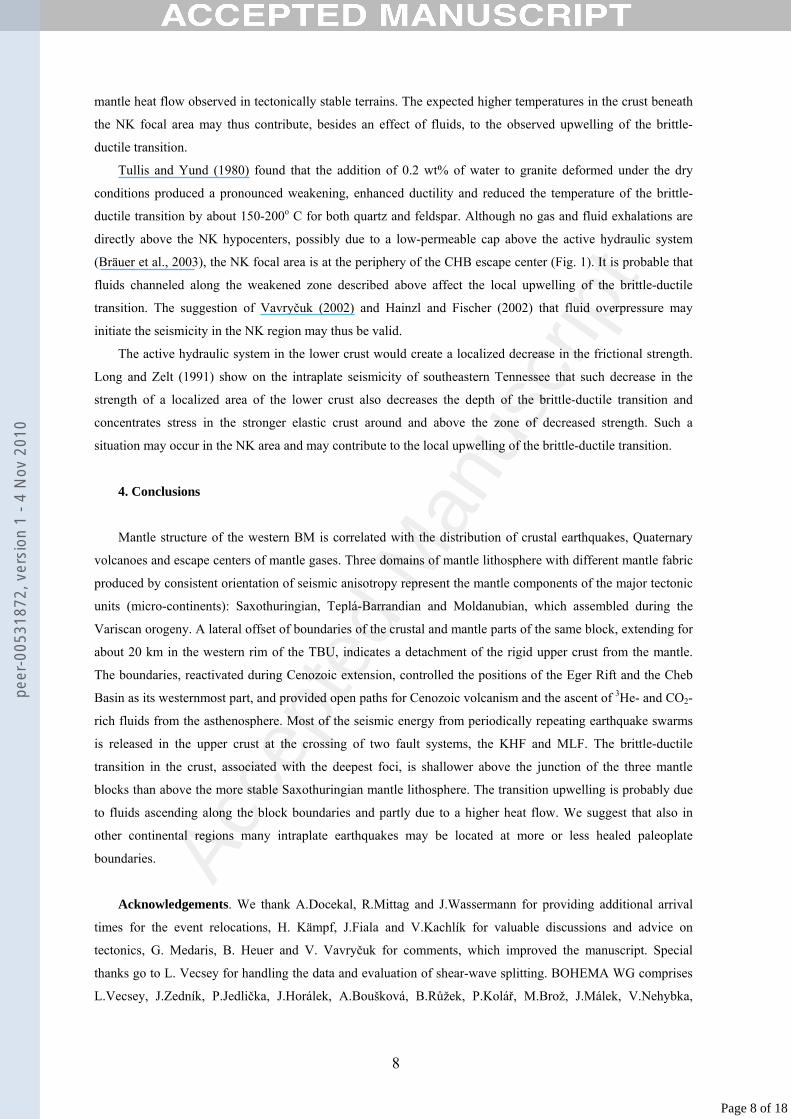
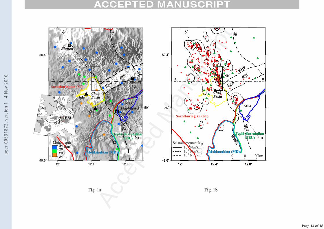
Fig. 1. a) Topographic map of the western Bohemian Massif (BM) and its position within the European
Variscides (inset). Simplified boundaries of the crystalline basement of tectonic units (ST, MD, TBU) are
according to Kachlík (1997), Zulauf et al. (2002) and Mlčoch (2003). MLC - Mariánské Lázně Complex
(contoured dark blue), MLF - Mariánské Lázně Fault, WBSZ - West Bohemian Shear Zone, KHF - Krušné Hory
(Erzgebirge) Fault, JF - Jáchymov Fault. Triangles labeled KH and ZH represent the Komorní and Železná
Hůrka Quaternary volcanoes. Circles denote crustal thickness from receiver function method according to Heuer
et al. (2006). Dot-and-dash lines AB, CD locate cross-sections of Fig. 3. b) Epicenters of 6262 events with ML
>0 (red dots) that occurred from 1991 to 2004 and isolines of density of released seismic moment M0. The
rectangle shows the most seismoactive area of Nový Kostel (NK). Green triangles – stations used for event
relocations.
Fig. 2. Distribution of hypocenter depths of earthquakes (a) shown in Fig. 1 and Gutenberg-Richter distribution
log N= a – b ML of event magnitudes (b).
Fig. 3. Map view of three mantle lithospheres defined by different orientation of seismic anisotropy and their
transition (color provinces), along with the contours of the crystalline basement of tectonic units as in Figure 1.
The area shown in Figure 1 is marked by the dashed rectangle. The double black arrows depict an approximate
shift of the TBU crustal boundary from its mantle counterpart. The color arrows point from each station to dip
directions of high P velocities in the mantle determined from the P-residual spheres (on the right are examples of
four typical patterns of the residual distribution – Saxothuringian, Moldanubian, Teplá-Barrandian and ‘no
pattern’). The blue triangles in the P-residual spheres represent early arrivals (relatively high-velocity directions),
the red circles represent late arrivals (relatively low-velocity directions). Full color arrows in the map mark a
well defined anisotropic pattern, open arrows a less well defined pattern, mostly due to a lack of data, and small
black circles stand for ‘no pattern’. Yellow lines show dip azimuths of the fast shear wave polarization of the
SKS propagating from the back azimuth (BAZ) depicted by the large arrow. Red dashed circles are major escape
centers (CHB – Cheb Basin; KV – Karlovy Vary, ML – Mariánské Lázně) of mantle CO2 and 3He (Weinlich et
al., 1999).
Fig. 4. Schematic cross-sections along profiles marked in Figures 1 and 2 with hypocenters projected from
bands 20 km wide along the profiles. Vertical and inclined dashed lines delimit a minimum and maximum extent
of the transitional zone in the mantle lithosphere estimated from the surface trace of the block boundaries (Fig. 2)
and from a schematic ray tracing of P waves. Moho depth is from Heuer et al. (2006) and Geissler et al. (2005),
lithosphere-asthenosphere boundary from Babuška and Plomerová (2000). Dotted lines show an asthenospheric
updoming estimated by Heuer et al. (2006) from P-receiver functions. Double arrows on the top indicate extents
of the Eger Rift and of major escape centers of mantle CO2 and 3He determined by Weinlich et al. (1999) and
showed also in the map view in Figure 2. The geometry of the Mariánské Lázně Complex (MLC) is drawn after
Tomek et al. (1997) and Švancara et al. (2000), the ST crust underthrusted beneath the MLC and TBU crust is
after Tomek et al. (1997). For other symbols see Figures 1 and 2.
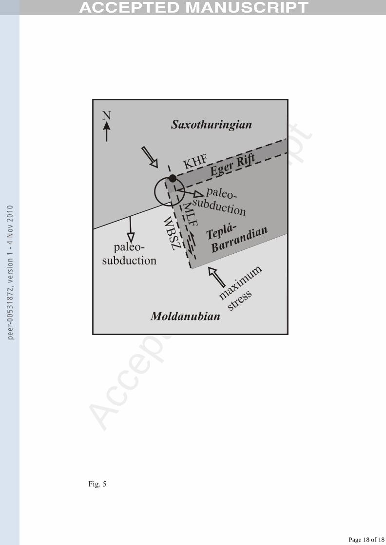
Fig. 5. Schematic sketch showing a present-day situation of the “triple junction” (circled) of the mantle
lithospheres of three microcontinents, with the Nový Kostel swarm area centered at the black dot. Stress
orientation in the uppermost crust is according to Müller et al. (1992). For other abbreviations see caption to
Figure 1.
13
Page 13 of 18
peer
-005
3187
2, v
ersi
on 1
- 4
Nov
201
0
Acce
pted
Man
uscr
ipt
Fig. 1a Fig. 1b
ST
MDBM
KHF
Karlovy Vary
MariánskéLáznìZH
KH
EgerRift
ChebBasin
Moldanubian (MD)
Saxothuringian (ST)
Teplá-Barrandian (TBU)
WB
SZ
ML
F
MLC
JF
Plauen
A B
C
DMoho depth (km)
KHF
EgerRift
Moldanubian (MD)
Saxothuringian (ST)
Teplá-Barrandian (TBU)
WB
SZ
MLC
ChebBasin
JF
ML
FA B
C
D
KHF
EgerRift
Moldanubian (MD)
Saxothuringian (ST)
Teplá-Barrandian (TBU)
WB
SZ
MLC
ChebBasin
JF
ML
FNK
Seismic moment M0
1014
10 9
101
Nm/km2
Nm/km2
Nm/km2 0 10 20km
Page 14 of 18
peer
-005
3187
2, v
ersi
on 1
- 4
Nov
201
0
Acce
pted
Man
uscr
ipt
b = 1
MLlo
g N
Depth (km)
log
N
(a) (b)
Fig. 2
Page 15 of 18
peer
-005
3187
2, v
ersi
on 1
- 4
Nov
201
0

Acce
pted
Man
uscr
ipt
Fig. 3
SaxothuringianBG07
MoldanubianGRB3
Teplá-BarrandianB30
B24no pattern
-1.0s-0.5s
0.5s1.0s
(-0.1s, 0.1s)
Directional terms of relative P residuals
ST mantlelithosphere
TBU mantlelithosphere
MD mantlelithosphere
transit
ion
1sSKS
BG07
GRB3
B30
BA
C
D
JF
ML
FCHB
KHF
EgerRift
WB
SZ
dipping high vP
STMD
TBU
B24
KV
ML
Backazimuth
SKS
Page 16 of 18
peer
-005
3187
2, v
ersi
on 1
- 4
Nov
201
0

Acce
pted
Man
uscr
iptEger Rift
Cheb BasinKV
ML
C DA B KHFKH
ST crust ST crust
rigid
ductile
ST crust
ST crust
rigid
ductile
MLC TBUcrust
asthenosphere asthenosphere
ST mantlelithosphere
TBU mantlelithospheretransition
transition
ST mantlelithosphere
TBU mantlelithosphere
He3
CO2
He3
CO2
He3
CO2
CO2
He3
km
km
km
Moho Moho
Eger Rift
Cheb Basin
0
40
100
80
60
20
0
40
100
80
60
20
-20 200 4020-20 0-40
Fig. 4
Page 17 of 18
peer
-005
3187
2, v
ersi
on 1
- 4
Nov
201
0
Acce
pted
Man
uscr
ipt
paleo-subduction
NSaxothuringian
Moldanubian
Teplá-
Barrandian
Eger RiftKHF
WB
SZ
ML
F
maxim
um
stres
s
paleo-subduction
Fig. 5
Page 18 of 18
peer
-005
3187
2, v
ersi
on 1
- 4
Nov
201
0
Copyright © 2022 FDOKUMEN