Industrial Land Bank 2019 - Invest MP
180
THE POWER OF TRUST I N D U S T R I A L L A N D B A N K MADHYA PRADESH 2019
-
Upload
khangminh22 -
Category
Documents
-
view
2 -
download
0
Transcript of Industrial Land Bank 2019 - Invest MP

AUTOMOBILE and ENGINEERINGAUTOMOBILE and ENGINEERING
�����������
THEPOWEROF TRUST
INDUSTRIALLAND BANK
MADHYA PRADESH
2019


INDUSTRIAL LAND BANK 2019
Madhya Pradesh Industrial Development Corporation
INDUSTRIAL LAND BANK 2019
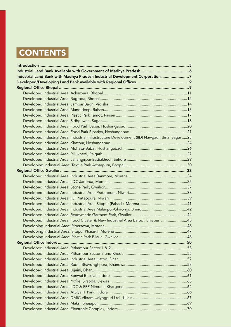
CONTENTS Introduction ..................................................................................................................................5Industrial Land Bank Available with Government of Madhya Pradesh ..........................................6Industrial Land Bank with Madhya Pradesh Industrial Development Corporation ........................7Developed/Developing Land Bank available with Regional Offices ..............................................9Regional Office Bhopal .................................................................................................................9
Developed Industrial Area: Acharpura, Bhopal ..............................................................................11Developed Industrial Area: Bagroda, Bhopal.................................................................................12Developed Industrial Area: Jambar Bagri, Vidisha .........................................................................14Developed Industrial Area: Mandideep, Raisen .............................................................................15Developed Industrial Area: Plastic Park Tamot, Raisen ..................................................................17Developed Industrial Area: Sidhguwan, Sagar ...............................................................................18Developed Industrial Area: Food Park Babai, Hoshangabad .........................................................20Developed Industrial Area: Food Park Pipariya, Hoshangabad .....................................................21Developed Industrial Area: Industrial Infrastructure Development (IID) Nawgaon Bina, Sagar .....23Developed Industrial Area: Kiratpur, Hoshangabad .......................................................................24Developed Industrial Area: Mohasa-Babai, Hoshangabad ............................................................26Developed Industrial Area: Pillukhedi, Rajgarh ..............................................................................27Developed Industrial Area: Jahangirpur-Badiakhedi, Sehore ........................................................29Developing Industrial Area: Textile Park Acharpura, Bhopal ..........................................................30
Regional Office Gwalior ..............................................................................................................32Developed Industrial Area: Industrial Area Banmore, Morena .......................................................34Developed Industrial Area: IIDC Jaderua, Morena ........................................................................35Developed Industrial Area: Stone Park, Gwalior ............................................................................37Developed Industrial Area: Industrial Area Pratappura, Niwari ......................................................38Developed Industrial Area: IID Pratappura, Niwari ........................................................................39Developed Industrial Area: Industrial Area Sitapur (Pahadi), Morena ............................................41Developed Industrial Area: Industrial Area Malanpur-Ghirongi, Bhind ..........................................42Developed Industrial Area: Readymade Garment Park, Gwalior ...................................................44Developed Industrial Area: Food Cluster & New Industrial Area Barodi, Shivpuri ........................45Developing Industrial Area: Pipersewa, Morena ............................................................................46Developing Industrial Area: Sitapur Phase-II, Morena ...................................................................47Developing Industrial Area: Plastic Park Bilaua, Gwalior ................................................................48
Regional Office Indore ................................................................................................................50Developed Industrial Area: Pithampur Sector 1 & 2 ......................................................................53Developed Industrial Area: Pithampur Sector 3 and Kheda ..........................................................55Developed Industrial Area: Industrial Area Hatod, Dhar ................................................................57Developed Industrial Area: Rudhi Bhavsinghpura, Khandwa .........................................................58Developed Industrial Area: Ujjaini, Dhar ........................................................................................60Developed Industrial Area: Sonwai Bheslai, Indore .......................................................................61Developed Industrial Area Profile: Sirsoda, Dewas ........................................................................63Developed Industrial Area: IIDC & FPP Nimrani, Khargone ..........................................................64Developed Industrial Area: Atulya IT Park, Indore .........................................................................66Developed Industrial Area: DMIC Vikram Udyogpuri Ltd., Ujjain ..................................................67Developed Industrial Area: Maksi, Shajapur ..................................................................................69Developed Industrial Area: Electronic Complex, Indore ................................................................70
INDUSTRIAL LAND BANK
2019
Developed Industrial Area Profile: Industrial area Dewas II & III ....................................................72Developed Industrial Area: IT Park, Indore ....................................................................................74Developed Industrial Area: Readymade Garment Complex, Indore .............................................75Developed Industrial Area: Pithampur Sector 6 .............................................................................77Developed Industrial Area: Special Economic Zone Phase I and II ................................................79Developed Industrial Area: Rangwasa, Indore ...............................................................................81Developed Industrial Area: Pithampur Sector 5 .............................................................................82Developed Industrial Area: Namkeen Cluster, Indore ....................................................................84Developed Industrial Area: Meghnagar, Jhabua ............................................................................86Developed Industrial Area: IIDC & FPP, Jaggakhedi ......................................................................87Developed Industrial Area: Nemawar, Dewas ................................................................................89Developed Industrial Area: Apparel Cluster, Bijepur .....................................................................90Developed Industrial Area: Relwa-Khajuri, Barwani .......................................................................92Developed Industrial Area: Jhajharwada, Neemuch ......................................................................93Developed Industrial Area: Tajpur, Ujjain .......................................................................................94Developed Industrial Area: Karmadi, Ratlam .................................................................................96Developed Industrial Area: Smart Industrial Park, Indore ..............................................................97Developing Industrial Area: Jetapura - Palasya, Dhar ....................................................................99Developing Industrial Area: Mohna, Depalpur. ............................................................................100Developing Industrial Area: Rehta-Khadkod, Burhanpur .............................................................102Developing Industrial Area: Kasarwardi, Jhabua ..........................................................................103
Regional Office Jabalpur ...........................................................................................................104Developed Industrial Area: Industrial Area Bhurkalkhapa, Seoni .................................................107Developed Industrial Area: Industrial Growth Centre (IGC) Maneri, Mandla ...............................108Developed Industrial Area: Industrial Area Umaria-Dungaria, Jabalpur ......................................110Developed Industrial Area: Industrial Area Hargarh, Jabalpur .....................................................111Developed Industrial Area: Industrial Area Amkuhi, Katni ...........................................................112Developed Industrial Area: Udhyog Giri Purena, Panna ..............................................................114Developed Industrial Area: Industrial Area & Food Park Borgaon, Chhindwara ..........................115Developed Industrial Area: Industrial Area & IIDC Lamtara, Katni ...............................................117Developed Industrial Area: Stone Park Hardua-Khaudawal, Katni ...............................................118Developing Industrial Area: Industrial Area Jamlapani, Chhindwara ...........................................119Developing Industrial Area: Industrial Area Lehgadua, Chhindwara ...........................................121
Regional Office Rewa ................................................................................................................122Developed Industrial Area: IID Nadantola, Amarpatan, Satna.....................................................124Developed Industrial Area: Udyog Dham, Maihar, Satna .............................................................125Developed Industrial Area: Udyog Vihar Chorhata, Rewa ...........................................................127Developed Industrial Profile: Udyog Deep, Waidhan ..................................................................128Developing Industrial Area: Babupur, Satna ................................................................................130Developing Industrial Area: Gurh, Rewa ......................................................................................131Developing Industrial Profile: Udyog Deep, Waidhan (Phase – III) ..............................................132
Undeveloped Land (A) ..............................................................................................................134Undeveloped Land (B) ..............................................................................................................150Undeveloped Land Allotment Guidelines .................................................................................162Developed Industrial Land Bank with Department of Micro Small and Medium Enterprises (MSME) ....168Developing Industrial Land Bank with Department of Micro Small and Medium Enterprises (MSME) ...175Industrial Land Bank with Madhya Pradesh State Electronic Development Corporation (MPSEDC) .....175
INDUSTRIAL LAND BANK 2019
4
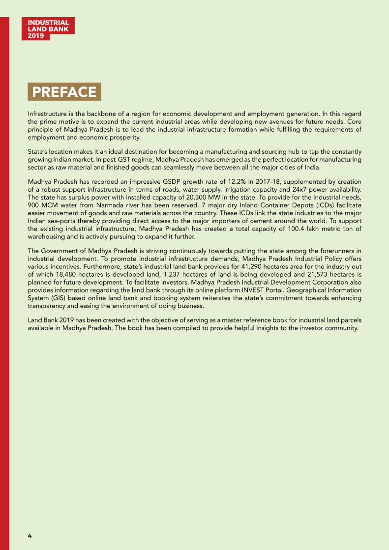
PREFACE Infrastructure is the backbone of a region for economic development and employment generation. In this regard the prime motive is to expand the current industrial areas while developing new avenues for future needs. Core principle of Madhya Pradesh is to lead the industrial infrastructure formation while fulfilling the requirements of employment and economic prosperity.
State’s location makes it an ideal destination for becoming a manufacturing and sourcing hub to tap the constantly growing Indian market. In post-GST regime, Madhya Pradesh has emerged as the perfect location for manufacturing sector as raw material and finished goods can seamlessly move between all the major cities of India.
Madhya Pradesh has recorded an impressive GSDP growth rate of 12.2% in 2017-18, supplemented by creation of a robust support infrastructure in terms of roads, water supply, irrigation capacity and 24x7 power availability. The state has surplus power with installed capacity of 20,300 MW in the state. To provide for the industrial needs, 900 MCM water from Narmada river has been reserved. 7 major dry Inland Container Depots (ICDs) facilitate easier movement of goods and raw materials across the country. These ICDs link the state industries to the major Indian sea-ports thereby providing direct access to the major importers of cement around the world. To support the existing industrial infrastructure, Madhya Pradesh has created a total capacity of 100.4 lakh metric ton of warehousing and is actively pursuing to expand it further.
The Government of Madhya Pradesh is striving continuously towards putting the state among the forerunners in industrial development. To promote industrial infrastructure demands, Madhya Pradesh Industrial Policy offers various incentives. Furthermore, state’s industrial land bank provides for 41,290 hectares area for the industry out of which 18,480 hectares is developed land, 1,237 hectares of land is being developed and 21,573 hectares is planned for future development. To facilitate investors, Madhya Pradesh Industrial Development Corporation also provides information regarding the land bank through its online platform INVEST Portal. Geographical Information System (GIS) based online land bank and booking system reiterates the state’s commitment towards enhancing transparency and easing the environment of doing business.
Land Bank 2019 has been created with the objective of serving as a master reference book for industrial land parcels available in Madhya Pradesh. The book has been compiled to provide helpful insights to the investor community.
5
INDUSTRIAL LAND BANK
2019
INTRODUCTION Madhya Pradesh has emerged as a Growth Centre of the country in the last decade. It has witnessed a radical transformation in terms of economic and social development.
The state’s location makes it an ideal destination as a manufacturing and sourcing hub to tap the constantly growing Indian market. In post-GST regime, Madhya Pradesh has emerged as the perfect location for manufacturing as raw material and finished goods can seamlessly move between all the major cities of India. Its location, abundant resources, skilled manpower and industry centric policies offer strategic advantage to companies. Owing to its rich soil, several rivers and large irrigation projects, Madhya Pradesh is a thriving destination for agriculture and food processing business. The state’s mineral wealth and skilled manpower enables setting up of heavy engineering companies. Having established a strong pedestal for rapid economic development, the people-centric transparent policies and hassle-free investment procedures in the state are gradually making Madhya Pradesh a Global Investment Hub.
The state has recorded an impressive GSDP growth rate of 12.2% in 2017-18, supplemented by creation of a robust support infrastructure in terms of roads, water supply and irrigation capacity and 24 x 7 power availability. The state has surplus of power with installed capacity of 20,300 MW in the state. It has 900 MCM water of Narmada water reserved for industrial purpose. The state also has 7 major dry Inland Container Depots (ICDs). Madhya Pradesh has created a total capacity of 100.4 lakh metric ton of warehousing.
These developments have proved to be beneficial for the entrepreneurs, fuelling the state economy with growth of manufacturing sector leading to increased employment opportunities, revenue, increased infrastructure investments and improved standard of living. The industries set up has been the backbone for a strong economical and infrastructural growth of Madhya Pradesh.
Department of Industrial Policy and Investment Promotion of GoMP develops industrial land through MPIDC. Developed areas of MPIDC have all basic infrastructure facilities for industries. Developed/developing/undeveloped government land in industrial areas of Madhya Pradesh can be viewed through GIS (Geographical Information system).
The online system helps for booking/allotment of vacant plots and can be accessed by visiting: http://www.invest.mp.gov.in
This land bank book as well as the GIS based online system of land identification and allotment will prove to be useful for the investors.

INDUSTRIAL LAND BANK 2019
6
INDUSTRIAL LAND BANK AVAILABLE WITH GOVERNMENT OF MADHYA PRADESH Government of Madhya Pradesh has huge availability of land for industrial use. Government of Madhya Pradesh has 41,290 hectares of land reserved for industrial purpose. Out of which 18,480 hectares is developed land, 1,237 hectares of land is being developed and 21,573 hectares of land is planned for future development.
Table 1: Total industrial land bank in Madhya Pradesh
Land Type Industrial Area Total Land (Hectares)
Total Allottable Land (Hectares)
Total Allotted Land (Hectares)
Available Land For Allotment (Hectares)
Developed MPIDC 12349.1 7440.2 5461.6 1978.7
MSME 6131.6 3678.6 3300 378.6
IT/ITeS/ESDM 341.5 91.8 55.1 36.7
Sub-Total 18480.7 11210.6 8816.7 2394
Developing MPIDC 1041.7 577.6 28.1 701.2
MSME 129.2 70 0 70
IT/ITeS/ESDM 65.6 39.3 23.6 15.7
Sub-Total 1236.5 686.9 51.7 786.9
Undeveloped A 10935.4 10935.4 0 10935.4
B 10637.4 0 0 0
Sub-Total 21572.8 10935.4 0 10935.4
Grand Total 41290 22832.9 8868.4 14116.3
Data rounded up to 1 decimal place.
7
INDUSTRIAL LAND BANK
2019
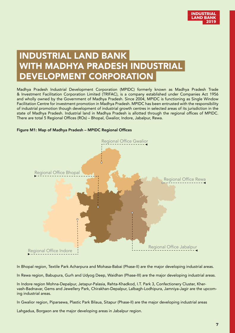
INDUSTRIAL LAND BANK WITH MADHYA PRADESH INDUSTRIAL DEVELOPMENT CORPORATION Madhya Pradesh Industrial Development Corporation (MPIDC) formerly known as Madhya Pradesh Trade & Investment Facilitation Corporation Limited (TRIFAC), is a company established under Companies Act 1956 and wholly owned by the Government of Madhya Pradesh. Since 2004, MPIDC is functioning as Single Window Facilitation Centre for investment promotion in Madhya Pradesh. MPIDC has been entrusted with the responsibility of industrial promotion though development of industrial growth centres in selected areas of its jurisdiction in the state of Madhya Pradesh. Industrial land in Madhya Pradesh is allotted through the regional offices of MPIDC. There are total 5 Regional Offices (ROs) – Bhopal, Gwalior, Indore, Jabalpur, Rewa.
Figure M1: Map of Madhya Pradesh – MPIDC Regional Offices
In Bhopal region, Textile Park Acharpura and Mohasa-Babai (Phase-II) are the major developing industrial areas.
In Rewa region, Babupura, Gurh and Udyog Deep, Waidhan (Phase-III) are the major developing industrial areas.
In Indore region Mohna-Depalpur, Jetapur-Palasia, Rehta-Khadkod, I.T. Park 3, Confectionery Cluster, Kher-vash-Badnavar, Gems and Jewellery Park, Chirakhan-Depalpur, Lalbagh-Lodhipura, Jamniya-Jagir are the upcom-ing industrial areas.
In Gwalior region, Piparsewa, Plastic Park Bilaua, Sitapur (Phase-II) are the major developing industrial areas
Lahgadua, Borgaon are the major developing areas in Jabalpur region.
Regional Office Indore
Regional Office Bhopal
Regional Office Jabalpur
Regional Office Rewa
Regional Office Gwalior
INDUSTRIAL LAND BANK 2019
8
Table M2: Land bank parcels in Madhya Pradesh
Name of Regional Office Total no. of developed areas in Regional Office
Total no. of developing areas in Regional Office
Bhopal 13 01
Gwalior 10 03
Indore 32 03
Jabalpur 12 02
Rewa 04 03
Total 71 12
Data rounded up to 1 decimal place.
There are 71 developed and 12 developing land parcels in Madhya Pradesh. The maximum number of industrial areas are in Indore region.
Table M3: Industrial land bank in developed industrial areas
Regional Office
Total Land (Hect.) Allottable Land (Hect.) Allotted Land (Hect.) Land available for allotment (Hect.)
Bhopal 2704.9 1954.4 1249.7 704.7
Gwalior 1905.1 1201.6 994.0 207.6
Indore 5425.2 3520.0 2640.6 879.4
Jabalpur 2056.6 607.5 448.6 158.9
Rewa 257.3 156.7 128.7 28.1
Total 12349.1 7440.2 5461.6 1978.7
Data rounded up to 1 decimal place.
Total developed land with MPIDC is approximately 12,349 hectares, out of which available land for allotment is around 1,979 hectares.
Table M4: Industrial land bank in developing industrial areas
Regional Office
Total Land (Hect.) Allottable Land (Hect.) Allotted Land (Hect.) Land available for allotment (Hect.)
Bhopal 44.0 28.9 0.0 28.9
Gwalior 273.6 157.6 16.1 141.5
Indore 450.8 280.1 12.0 419.8
Jabalpur 69.8 51.3 0.0 51.3
Rewa 203.5 59.7 0.0 59.7
Total 1041.7 577.6 28.1 701.2
Data rounded up to 1 decimal place.
Total developing land with MPIDC is around 1,042 hectares, out of which available land for booking/allotment is around 701 hectares.
9
INDUSTRIAL LAND BANK
2019
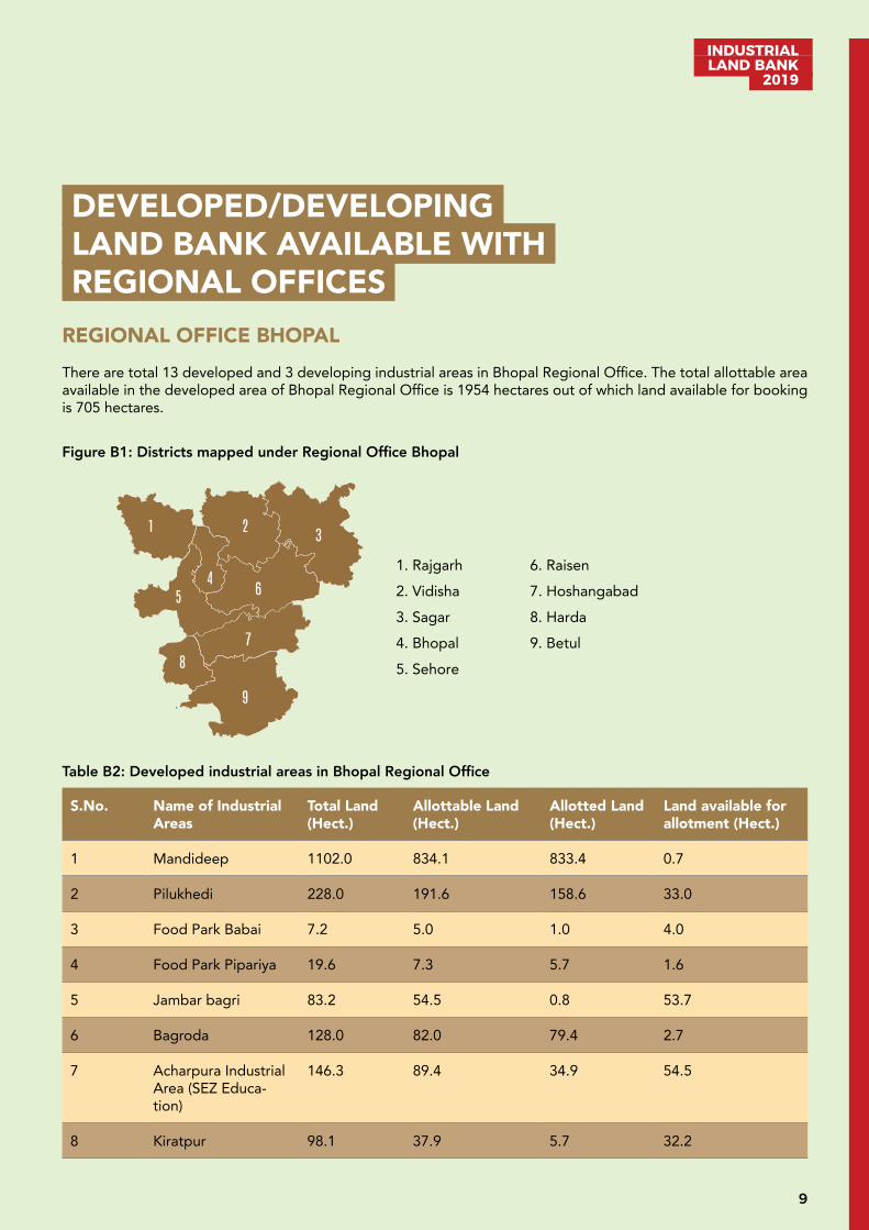
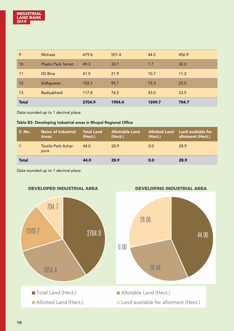
DEVELOPED/DEVELOPING LAND BANK AVAILABLE WITH REGIONAL OFFICES REGIONAL OFFICE BHOPAL There are total 13 developed and 3 developing industrial areas in Bhopal Regional Office. The total allottable area available in the developed area of Bhopal Regional Office is 1954 hectares out of which land available for booking is 705 hectares.
Figure B1: Districts mapped under Regional Office Bhopal
Table B2: Developed industrial areas in Bhopal Regional Office
S.No. Name of Industrial Areas
Total Land (Hect.)
Allottable Land (Hect.)
Allotted Land (Hect.)
Land available for allotment (Hect.)
1 Mandideep 1102.0 834.1 833.4 0.7
2 Pilukhedi 228.0 191.6 158.6 33.0
3 Food Park Babai 7.2 5.0 1.0 4.0
4 Food Park Pipariya 19.6 7.3 5.7 1.6
5 Jambar bagri 83.2 54.5 0.8 53.7
6 Bagroda 128.0 82.0 79.4 2.7
7 Acharpura Industrial Area (SEZ Educa-tion)
146.3 89.4 34.9 54.5
8 Kiratpur 98.1 37.9 5.7 32.2
1 2 3
4 5 6
7
8
9
1. Rajgarh 2. Vidisha 3. Sagar 4. Bhopal 5. Sehore
6. Raisen 7. Hoshangabad 8. Harda 9. Betul
INDUSTRIAL LAND BANK 2019
10
9 Mohasa 679.6 501.4 44.5 456.9
10 Plastic Park Tamot 49.3 33.7 1.7 32.0
11 IID Bina 41.5 21.9 10.7 11.2
12 Sidhguwan 122.1 95.7 73.3 22.5
13 Badiyakhedi 117.8 76.5 43.0 33.5
Total 2704.9 1954.4 1249.7 704.7
Data rounded up to 1 decimal place.
Table B3: Developing industrial areas in Bhopal Regional Office
S. No. Name of Industrial Areas
Total Land (Hect.)
Allottable Land (Hect.)
Allotted Land (Hect.)
Land available for allotment (Hect.)
1 Textile Park Achar-pura
44.0 28.9 0.0 28.9
Total 44.0 28.9 0.0 28.9
Data rounded up to 1 decimal place.
2704.9
1954.4
1249.7
704.7
Developed Industrial Area
Total Land (Hect.) Allotable Land (Hect.)
Alloted Land (Hect.) Land available for allotment (Hect.)
44.00
28.68
0.00
28.68
Developing Industrial Area
Total Land (Hect.) Allotable Land (Hect.)
Allotted Land (Hect.) Land available for allotment (Hect.)
DEVELOPING INDUSTRIAL AREADEVELOPED INDUSTRIAL AREA
11
INDUSTRIAL LAND BANK
2019
Developed Industrial Area: Acharpura, Bhopal
Industrial Area (I/A) Acharpura is situated near Bhopal (NH12) the capital of Madhya Pradesh. It is the only I/A in Madhya Pradesh having dedicated Special Education Zone. The total area of Acharpura Industrial Area is 146.3 hectares. Major industrial areas around Acharpura are Mandideep, Govindpura, Bagroda, Pillukhedi, Badiyakhedi. An upcoming nearby industrial area near Acharpura is Jamuniya Khejda.
A. Industrial profile
Name of Industrial Area Special Education Zone & Industrial Area Acharpura
Name of RO M P Industrial Development Corporation, RO Bhopal
Village/ Tehsil/District Acharpura/Huzur/Bhopal
Area (Hectares) 146.3
Sector Special Education Zone & Multi-product (only Non-Polluting Industries)
Connectivity Air: Bhopal Airport situated at 17 km
Road: ISBT Bhopal situated at 24 km
Rail: Bhopal Railway Station situated at 17 km
B. Critical Infrastructure
Water Availability Tube well based water supply within Industrial Area
Power Availability Two Power Sub Station (33/11KV) situated within Industrial Area
C. Support Infrastructure
Street Lighting Available
Ware Housing Plots have been reserved for warehousing activity
Logistics Available near industrial area within a radius of 10-15 km
Nearest Inland Container Depot
Container depot Mandideep 47 km
Nearest Port Jawaharlal Nehru Port, Mumbai situated at 803 km
Nearby Major Town/city
Bhopal situated at 16 km
D. Industrial climate
Total MSME 08
Total Investment INR 520 lakh
INDUSTRIAL LAND BANK 2019
12
Total Employment 62
Nearby major industrial units
BHEL BhopalCrompton Greaves LtdTAFE Motors & Tractors LtdVardhman Yarn and Anant Spinning MillDawat Foods Pvt LtdProcter & Gamble Hygiene and Health Care LtdLupin laboratoriesHindustan Electro GraphiteLapp India, PillukhhediOswal Danim, PillukhhediVE Commercial Vehicles Limited Welspun Corp. Ltd.
Nearby Major Industrial Areas
Industrial Area Govindpura situated at 20 kmIndustrial Area Mandideep situated at 45 kmIndustrial Area Bagroda situated at 49 kmIndustrial Area Plastic Park Tamot situated at 67 kmIndustrial Area Pillukhedi situated at 50 km
For further details regarding booking/allotment/detailed industrial profile, please visit http://invest.mp.gov.in
Developed Industrial Area: Bagroda, Bhopal
Industrial area Bagroda is situated near Bhopal, the capital of Madhya Pradesh. The total area of Bagroda is around 128 hectares. It is a multi-product Industrial area.
The major industrial areas around Bagroda are Mandideep, Govindpura and Acharpura. Mandideep Industrial Area is home to numerous industries and houses some of the most esteemed companies such as TAFE Motors, Crompton Greaves, Procter & Gamble, Daawat food, Vardhman Fabrication, Mahindra Steel and HEG. BHEL (Bharat Heavy Electricals Limited) is the largest manufacturing and engineering enterprise in Bhopal.
A. Industrial profile
Name of Industrial Area Bagroda
Name of RO M P Industrial Development Corporation, RO Bhopal
Village/Tehsil/District Bagroda/Huzur/Bhopal
Area (Hectares) 128
Sector Multi-product
Connectivity Air: Bhopal Airport situated at 39 km
Road: Bhopal Bus Stand situated at 19 km
Rail: Bhopal Railway Station situated at 20 km
13
INDUSTRIAL LAND BANK
2019
B. Critical Infrastructure
Water Availability Water supplied by MPIDC
Power Availability Power sub-station 132/33 KV and two 33/11 KV situated within Industrial area
Drainage Under implementation
C. Support Infrastructure
Street Lighting Available
Ware Housing Provisions made in the area
Logistics Available near the industrial area within a radius of 10-15 km
Nearest Inland Con-tainer Depot
Container Depot Mandideep situated at 12 km
Nearest Port Jawaharlal Nehru Port, Mumbai situated at 834 km
Nearby Major Town/city
Bhopal situated at 20 km
D. Industrial climate
Total Large Industry 1
Total MSME 20
Total Investment INR 1,697.7 Lakh
Total Employment 188
Nearby major industrial units
Crompton Greaves LtdTAFE Motors & Tractors LtdVardhman Yarn and Anant Spinning MillDawat Foods Pvt LtdProcter & Gamble Hygiene and Health Care LtdEicher TractorsLupin laboratoriesHindustan Electro Graphite
Nearby Major Industrial Areas
Industrial Area GovindpuraIndustrial Area MandideepIndustrial Area AcharpuraUpcoming Industrial Area- Plastic Park Tamot
For further details regarding booking/allotment/detailed industrial profile, please visit http://invest.mp.gov.in
INDUSTRIAL LAND BANK 2019
14
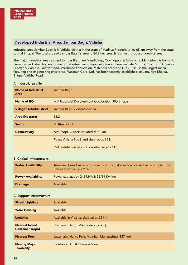
Developed Industrial Area: Jambar Bagri, Vidisha
Industrial area Jambar Bagri is in Vidisha district in the state of Madhya Pradesh. It lies 65 km away from the state capital Bhopal. The total area of Jambar Bagri is around 84.3 hectares. It is a multi-product Industrial area.
The major industrial areas around Jambar Bagri are Mandideep, Govindpura & Acharpura. Mandideep is home to numerous industrial houses. Some of the esteemed companies situated here are Tafe Motors, Crompton Greaves, Procter & Gamble, Daawat food, Vardhman Fabrication, Mahindra Steel and HEG. BHEL is the largest manu-facturing and engineering enterprise. Welspun Corp. Ltd. has been recently established on Jamuniya Khejda, Bhopal-Vidisha Road.
A. Industrial profile
Name of Industrial Area
Jambar Bagri
Name of RO M P Industrial Development Corporation, RO Bhopal
Village/ Tehsil/District Jambar Bagri/Vidisha/ Vidisha
Area (Hectares) 83.2
Sector Multi-product
Connectivity Air: Bhopal Airport situated at 71 km
Road: Vidisha Bus Stand situated at 25 km
Rail: Vidisha Railway Station situated at 27 km
B. Critical Infrastructure
Water Availability Tube-well based water supply within industrial area & proposed water supply from Bais river capacity 3 MLD
Power Availability Power sub-station 2x5 MVA & 33/11 KV line
Drainage Available
C. Support Infrastructure
Street Lighting Available
Ware Housing Available
Logistics Available in Vidisha, situated at 25 km
Nearest Inland Container Depot
Container Depot Mandideep (86 km)
Nearest Port Jawaharlal Nehru Port, Mumbai, Maharashtra (857 km)
Nearby Major Town/city
Vidisha- 25 km & Bhopal-65 km

15
INDUSTRIAL LAND BANK
2019
D. Industrial climate
Total MSME 12
Nearby major industri-al units
Adani Willmar Limited, VidishaWelspun Corp. Ltd., Jamuniya Khejda
Nearby Major Industri-al Areas
Govindpura Industrial area situated at 66 kmMandideep Industrial area situated at 84 kmAcharpura Industrial area situated at 67 km
For further details regarding booking/allotment/detailed industrial profile, please visit http://invest.mp.gov.in
Developed Industrial Area: Mandideep, Raisen
Mandideep Industrial Area is in Raisen district in the state of Madhya Pradesh. Mandideep is around 22 km from Bhopal and is an industrial township, which came into existence in late 1970s in an area of 1102.1 hectares. It is a multi-product industrial area. The major industrial units are Hindustan Electro Graphite (HEG), Procter & Gamble, Eicher Tractors Ltd, Lupin laboratories. Many more national and international companies have their manufac-turing units at Mandideep. There are total 712 MSME units and 40 large units which boast of a total investment of around INR 20,000 Crore. It houses more than 35,000 employers. The major sectors in Mandideep area are Textile, Pharmaceuticals, Food Processing, Automobile and Engineering.
A. Industrial profile
Name of Industrial Area
Mandideep
Name of RO M P Industrial Development Corporation, RO Bhopal
Village/Tehsil/District Mandideep/Gauharganj/Raisen
Area (Hectares) 1,102.1
Sector Multi-Product
Connectivity Air: Bhopal Airport situated at 49 km
Road: Bhopal Bus Stand (ISBT) situated at 18 km
Rail: Mandideep Railway Station situated at 0.5 km Bhopal Junction situated at 24 km
B. Critical Infrastructure
Water Availability 5 MGD from Dahod Dam situated at 09 km
Power Availability 132/33 KV, 33/11 KV and 220 KV Sub-Station situated within the industrial Area.
Drainage Available
INDUSTRIAL LAND BANK 2019
16
C. Support Infrastructure
Street Lighting Available
Ware Housing Available
Logistics Anand WarehousesMahalaxmi Logistics Pvt. Ltd.
Nearest Inland Con-tainer Depot
Container Corporation of India limited, Mandideep (02 km)
Nearest Port Jawaharlal Nehru Port, Mumbai, Maharashtra (835 km)
Nearby Major Town/City
Bhopal (23 km)
D. Industrial climate
Total Large Industry 40
Total MSME 712
Total Investment INR 20,000 Crore (Approx)
Total Employment 35,000 (Approx)
Nearby Major Industri-al units
Hindustan Electro Graphite Ltd. Crompton Greaves Ltd.TAFE Motors & Tractors Ltd.Vardhman Yarn and Anant Spinning MillDawat Foods Pvt Ltd.Procter & Gamble Hygiene and Health Care Ltd.Eicher TractorsLupin laboratoriesParle Agro Pvt. Ltd. Hershey India Private LimitedIWI Stationery Pvt. Ltd.Mahindra Steel Service Centre Ltd.
Nearby Major Industri-al Areas
Industrial Area Govindpura situated at 23 kmIndustrial Area Bagroda situated at 17 kmIndustrial Area Acharpura situated at 45 kmPlastic Park Tamot situated at 24 km
For further details regarding booking/allotment/detailed industrial profile, please visit http://invest.mp.gov.in
17
INDUSTRIAL LAND BANK
2019
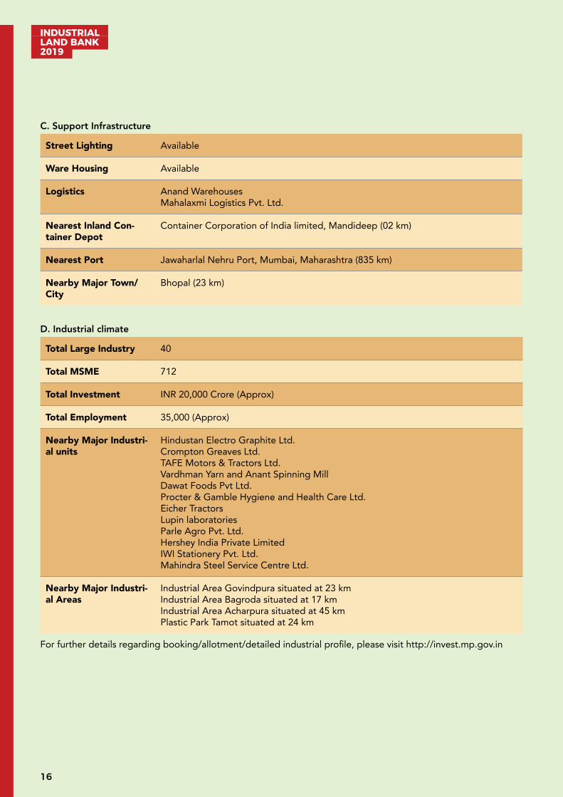
Developed Industrial Area: Plastic Park Tamot, Raisen
Plastic Park Tamot is situated in Raisen district of Madhya Pradesh state. It is close to the state capital Bhopal (48 km), on the NH-46 section between Bhopal and Jabalpur. Mandideep Industrial Area and Obedullahgunj are important industrial/urban centres near Plastic Park Tamot. The total area is around 49.3 hectares.
A. Industrial profile
Name of Industrial Area
Plastic Park Tamot
Name of RO M P Industrial Development Corporation, RO Bhopal
Village/ Tehsil/District Tamot/Gauharganj/Raisen
Area (Hectares) 49.3
Sector Plastic and polymer-based unit
Connectivity Air: Bhopal Airport situated at 64 km
Road: Inter State Bus Terminus, Bhopal situated at 43 km
Rail: Obedullahaganj Railway Station situated at 09 km Bhopal Junction situated at 50 km
B. Critical Infrastructure
Water Availability MPIDC Water Supply
Power Availability Available through 132/33KV, 33/11KV power sub-station (Under Construction) situ-ated within Industrial Park
Drainage Under Implementation
C. Support Infrastructure
Street Lighting Under Implementation
Ware Housing Available within 20 km radius of Plastic Park
Logistics Available within 20 km radius of Plastic Park
Nearest Inland Container Depot
Inland Container Depot, (CONCOR) Mandideep 21 km with direct rail link
Nearest Port Jawaharlal Nehru Port, Mumbai, Maharashtra (857 km)
Nearby Major Town/city
Bhopal 48 km
INDUSTRIAL LAND BANK 2019
18
D. Industrial climate
Total Medium & Small Manufacturing Industries
01
Total Investment INR 6.5 Crore
Total Employment 30
Nearby major industri-al units
Crompton Greaves Ltd, MandideepTAFE Motors & Tractors Ltd, MandideepVardhman Yarn and Anant Spinning Mill, MandideepDawat Foods Pvt Ltd, MandideepProcter & Gamble Hygiene and Health Care Ltd, MandideepEicher Tractors, MandideepLupin laboratories, MandideepHindustan Electro Graphite, Mandideep
Nearby Major Industri-al Areas
Govindpura Industrial Area situated at 44 kmIndustrial AreaBagroda situated at 36 kmIndustrial Area Acharpura situated at 67 km
For further details regarding booking/allotment/detailed industrial profile, please visit http://invest.mp.gov.in
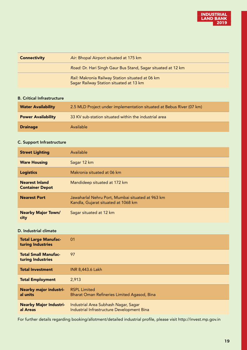
Developed Industrial Area: Sidhguwan, Sagar
Industrial area (I/A) Sidhguwan is in Sagar district in the Indian state of Madhya Pradesh. It is a multi-product I/A with 221 hectares of land. Industrial area Sidhguwan is about 12 km from Sagar and came in existence in early 1984. The major industry units running successfully in Sidhguwan are RSPL Ltd, Meenakshi Metal Industries, San-mati Food Product Pvt. Ltd. & Bhagat Ispat
The town of Sagar serves as its administrative centre. Other industries present are oil and flour mills, saw-mills, ghee processing, handloom cotton weaving, railway and engineering works among various mineral based indus-tries.
A. Industrial profile
Name of Industrial Area
Sidhguwan
Name of RO M P Industrial Development Corporation, RO Bhopal
Village/Tehsil/District Sidhguwan/Sagar/Sagar
Area (Hectares) 221 (122.1 hectare Developed)
Sector Multi-product
19
INDUSTRIAL LAND BANK
2019
Connectivity Air: Bhopal Airport situated at 175 km
Road: Dr. Hari Singh Gaur Bus Stand, Sagar situated at 12 km
Rail: Makronia Railway Station situated at 06 kmSagar Railway Station situated at 13 km
B. Critical Infrastructure
Water Availability 2.5 MLD Project under implementation situated at Bebus River (07 km)
Power Availability 33 KV sub-station situated within the industrial area
Drainage Available
C. Support Infrastructure
Street Lighting Available
Ware Housing Sagar 12 km
Logistics Makronia situated at 06 km
Nearest Inland Container Depot
Mandideep situated at 172 km
Nearest Port Jawaharlal Nehru Port, Mumbai situated at 963 kmKandla, Gujarat situated at 1068 km
Nearby Major Town/city
Sagar situated at 12 km
D. Industrial climate
Total Large Manufac-turing Industries
01
Total Small Manufac-turing Industries
97
Total Investment INR 8,443.6 Lakh
Total Employment 2,913
Nearby major industri-al units
RSPL LimitedBharat Oman Refineries Limited Agasod, Bina
Nearby Major Industri-al Areas
Industrial Area Subhash Nagar, SagarIndustrial Infrastructure Development Bina
For further details regarding booking/allotment/detailed industrial profile, please visit http://invest.mp.gov.in
INDUSTRIAL LAND BANK 2019
20
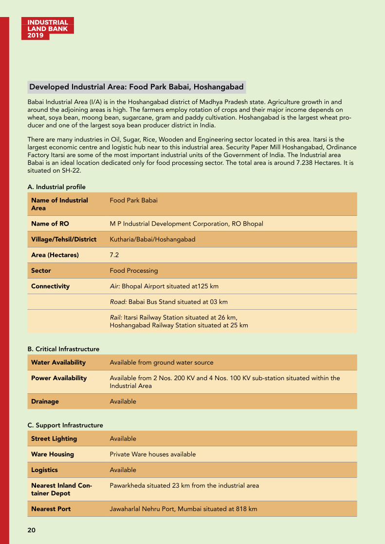
Developed Industrial Area: Food Park Babai, Hoshangabad
Babai Industrial Area (I/A) is in the Hoshangabad district of Madhya Pradesh state. Agriculture growth in and around the adjoining areas is high. The farmers employ rotation of crops and their major income depends on wheat, soya bean, moong bean, sugarcane, gram and paddy cultivation. Hoshangabad is the largest wheat pro-ducer and one of the largest soya bean producer district in India.
There are many industries in Oil, Sugar, Rice, Wooden and Engineering sector located in this area. Itarsi is the largest economic centre and logistic hub near to this industrial area. Security Paper Mill Hoshangabad, Ordinance Factory Itarsi are some of the most important industrial units of the Government of India. The Industrial area Babai is an ideal location dedicated only for food processing sector. The total area is around 7.238 Hectares. It is situated on SH-22.
A. Industrial profile
Name of Industrial Area
Food Park Babai
Name of RO M P Industrial Development Corporation, RO Bhopal
Village/Tehsil/District Kutharia/Babai/Hoshangabad
Area (Hectares) 7.2
Sector Food Processing
Connectivity Air: Bhopal Airport situated at125 km
Road: Babai Bus Stand situated at 03 km
Rail: Itarsi Railway Station situated at 26 km, Hoshangabad Railway Station situated at 25 km
B. Critical Infrastructure
Water Availability Available from ground water source
Power Availability Available from 2 Nos. 200 KV and 4 Nos. 100 KV sub-station situated within the Industrial Area
Drainage Available
C. Support Infrastructure
Street Lighting Available
Ware Housing Private Ware houses available
Logistics Available
Nearest Inland Con-tainer Depot
Pawarkheda situated 23 km from the industrial area
Nearest Port Jawaharlal Nehru Port, Mumbai situated at 818 km
21
INDUSTRIAL LAND BANK
2019
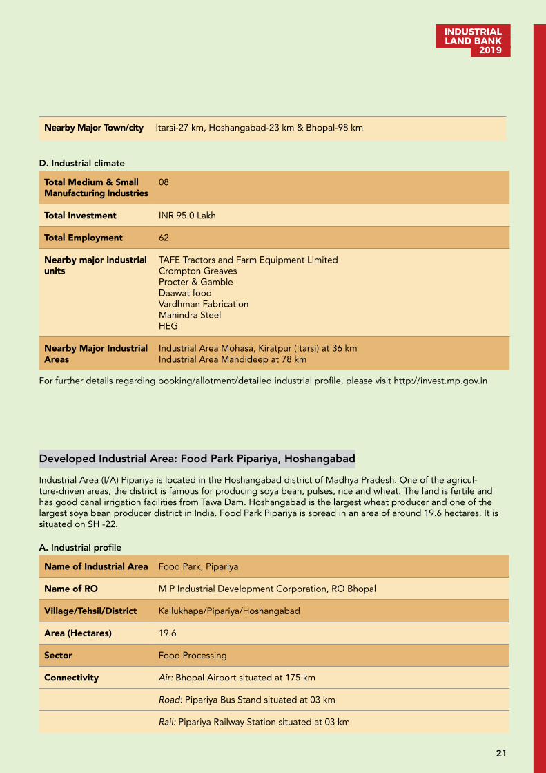
Nearby Major Town/city Itarsi-27 km, Hoshangabad-23 km & Bhopal-98 km
D. Industrial climate
Total Medium & Small Manufacturing Industries
08
Total Investment INR 95.0 Lakh
Total Employment 62
Nearby major industrial units
TAFE Tractors and Farm Equipment LimitedCrompton GreavesProcter & GambleDaawat foodVardhman FabricationMahindra SteelHEG
Nearby Major Industrial Areas
Industrial Area Mohasa, Kiratpur (Itarsi) at 36 kmIndustrial Area Mandideep at 78 km
For further details regarding booking/allotment/detailed industrial profile, please visit http://invest.mp.gov.in
Developed Industrial Area: Food Park Pipariya, Hoshangabad
Industrial Area (I/A) Pipariya is located in the Hoshangabad district of Madhya Pradesh. One of the agricul-ture-driven areas, the district is famous for producing soya bean, pulses, rice and wheat. The land is fertile and has good canal irrigation facilities from Tawa Dam. Hoshangabad is the largest wheat producer and one of the largest soya bean producer district in India. Food Park Pipariya is spread in an area of around 19.6 hectares. It is situated on SH -22.
A. Industrial profile
Name of Industrial Area Food Park, Pipariya
Name of RO M P Industrial Development Corporation, RO Bhopal
Village/Tehsil/District Kallukhapa/Pipariya/Hoshangabad
Area (Hectares) 19.6
Sector Food Processing
Connectivity Air: Bhopal Airport situated at 175 km
Road: Pipariya Bus Stand situated at 03 km
Rail: Pipariya Railway Station situated at 03 km

INDUSTRIAL LAND BANK 2019
22
B. Critical Infrastructure
Water Availability Available from ground water
Power Availability 33 KV/11 KV sub-station
Drainage Available
C. Support Infrastructure
Street Lighting Work in Progress
Ware Housing Available
Logistics Available
Nearest Inland Con-tainer Depot
Pawarkheda situated at a distance of 71 km
Nearest Port Jawaharlal Nehru Port, Mumbai situated at 866 km
Nearby Major Town/city
Pipariya 3 km, Hoshangabad 71 km & Bhopal 153 km
D. Industrial climate
Total Medium & Small Manufacturing Industries
06
Total Investment INR 4,700 Lakh
Total Employment 252
Nearby major industrial units
Ordinance Factory ItarsiSecurity Paper Mill, HoshangabadVardhman Fabrics, BudhniTrident, BudhniTAFE Tractors and Farm Equipment Limited, MandideepCrompton Greaves, MandideepProcter & Gamble, MandideepDaawat food, MandideepMahindra Steel, MandideepHEG, Mandideep
Nearby Major Industrial Areas
Industrial Area Mandideep; Upcoming Industrial Area at Mohasa-Babai and Kiratpur Industrial Area
For further details regarding booking/allotment/detailed industrial profile, please visit http://invest.mp.gov.in
23
INDUSTRIAL LAND BANK
2019
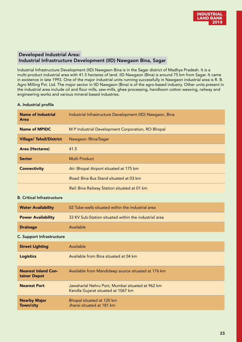
Developed Industrial Area: Industrial Infrastructure Development (IID) Nawgaon Bina, Sagar
Industrial Infrastructure Development (IID) Nawgaon Bina is in the Sagar district of Madhya Pradesh. It is a multi-product industrial area with 41.5 hectares of land. IID Nawgaon (Bina) is around 75 km from Sagar. It came in existence in late 1993. One of the major industrial units running successfully in Nawgaon industrial area is R. B. Agro Milling Pvt. Ltd. The major sector in IID Nawgaon (Bina) is of the agro-based industry. Other units present in the industrial area include oil and flour mills, saw-mills, ghee processing, handloom cotton weaving, railway and engineering works and various mineral based industries.
A. Industrial profile
Name of Industrial Area
Industrial Infrastructure Development (IID) Nawgaon, Bina
Name of MPIDC M P Industrial Development Corporation, RO Bhopal
Village/ Tehsil/District Nawgaon /Bina/Sagar
Area (Hectares) 41.5
Sector Multi Product
Connectivity Air: Bhopal Airport situated at 175 km
Road: Bina Bus Stand situated at 03 km
Rail: Bina Railway Station situated at 01 km
B. Critical Infrastructure
Water Availability 02 Tube-wells situated within the industrial area
Power Availability 33 KV Sub-Station situated within the industrial area
Drainage Available
C. Support Infrastructure
Street Lighting Available
Logistics Available from Bina situated at 04 km
Nearest Inland Con-tainer Depot
Available from Mandideep source situated at 176 km
Nearest Port Jawaharlal Nehru Port, Mumbai situated at 962 km Kandla Gujarat situated at 1067 km
Nearby Major Town/city
Bhopal situated at 120 kmJhansi situated at 181 km
INDUSTRIAL LAND BANK 2019
24
D. Industrial climate
Total Large Manufac-turing Industries
1
Total Medium & Small Manufacturing Industries
40
Total Investment INR 2,600 Lakh
Total Employment 368
Nearby major industri-al units
R.B.Agro Milling Pvt Ltd.Bina Refinery Ltd.
Nearby Major Industri-al Areas
Industrial Area Bina
For further details regarding booking/allotment/detailed industrial profile, please visit http://invest.mp.gov.in
Developed Industrial Area: Kiratpur, Hoshangabad
Industrial Area (I/A) Kiratpur is situated in Hoshangabad district of Madhya Pradesh. The site is located on NH 69, 07 km away from Itarsi towards Nagpur. Itarsi is a well-known railway junction and enjoys the distinction of having connectivity with all the parts of India through an efficient rail network. Kiratpur’s proximity to Itarsi results in availability of affordable and skilled labour. The total area of Kiratpur I/A is around 214 Hectare (98.05 Phase-I) hectares. It is a multi-product Industrial area.
A. Industrial profile
Name of Industrial Area Industrial Area Kiratpur
Name of RO M P Industrial Development Corporation, RO Bhopal
Village/Tehsil/District Kiratpur, Jilwani/Itarsi/Hoshangabad
Area (Hectares) 214 (98.05 Phase-I)
Sector Multi Product
Connectivity Air: Nearest Airport Bhopal situated at 128 km
Road: Nearest Bus Stand Itarsi situated at 7 km
Rail: Nearest Railway Station Itarsi situated at 7 km
25
INDUSTRIAL LAND BANK
2019
B. Critical Infrastructure
Water Availability Available
Power Availability 33/11KV (5 MV Capacity - Proposed) sub-station situated at 1 km132 KV sub-station situated at 1 km
Drainage Available
C. Support Infrastructure
Street Lighting Available
Ware Housing Work in progress
Logistics Work in progress
Nearest Inland Con-tainer Depot
Available at Pawar Kheda situated at 20 km
Nearest Port Jawaharlal Nehru Port, Mumbai, situated at 790 km
Nearby Major Town/city
Hoshangabad (25 km); Itarsi (07 km); Bhopal (101 km)
D. Industrial climate
Nearby Major Industri-al units
Security Paper mill, HoshangabadOrdnance Factory, ItarsiSanwaria Food Products, Kiratpur
Nearby Major Industri-al Areas
Industrial Area Kheda, Itarsi & Mandideep
For further details regarding booking/allotment/detailed industrial profile, please visit http://invest.mp.gov.in
INDUSTRIAL LAND BANK 2019
26
Developed Industrial Area: Mohasa-Babai, Hoshangabad
Industrial Area (I/A) Mohasa-Babai is situated in Hoshangabad district of Madhya Pradesh. The site is situated nearby SH 22. Hoshangabad is an agriculture-rich district of MP, well known for wheat and soyabean production.
Availability of treated water from river Narmada and uninterrupted power supply adds value to the industrial area. Its closeness to Itarsi railway station (20km) makes it well connected to rest of the India. The total area of Mohasa-Babai is around 679 hectares. It is a multi-product industrial area.
A. Industrial profile
Name of Industrial Area
Industrial Area Mohasa-Babai
Name of RO M P Industrial Development Corporation, RO Bhopal
Village/Tehsil/District Mohasa/Babai/Hoshangabad
Area (Hectares) 679.6
Sector Multi Product
Connectivity Air: Bhopal Airport situated at 115 km
Road: Hoshangabad Bus Stand situated at 20 km
Rail: Hoshangabad Railway Station situated at 20 km; Itarsi Railway Station situated at 20 km
B. Critical Infrastructure
Water Availability Available (Narmada River source situated at 07 km)
Power Availability Available 33/11KV (2 unit each at SMVAMV Capacity)
Drainage Work in Progress
Solid Waste Management
Provisions available in the area
C. Support Infrastructure
Ware Housing Area has been earmarked for warehousing activities.
Nearest Inland Con-tainer Depot
Pawarkheda situated at 23 km, ICD Mandideep situated at 76 km
Nearest Port Jawaharlal Nehru Port, Mumbai situated at 818 km
Nearby Major Town/city
Hoshangabad situated at 20 km; Bhopal situated at 90 km
27
INDUSTRIAL LAND BANK
2019
D. Industrial climate
Nearby major industrial units
TAFE Motors & Tractors Ltd.Crompton Greaves Procter & GambleDaawat foodVardhman FabricationMahindra SteelHEGParleAgroHarshey India
Nearby Major Industrial Areas
Industrial Area Mandideep
For further details regarding booking/allotment/detailed industrial profile, please visit http://invest.mp.gov.in
Developed Industrial Area: Pillukhedi, Rajgarh
Industrial area Pillukhedi is in Rajgarh district of Madhya Pradesh. It is in the proximity to the state capital Bhopal (57 km). This area is located on NH 12. A multi-product industrial area, the total area of Pillukhedi is around 228 hectares.
A. Industrial profile
Name of Industrial Area
Pillukhedi
Name of RO M P Industrial Development Corporation, RO Bhopal
Village/Tehsil/District Pillukhedi/Narsinghgarh/Rajgarh
Area (Hectares) 228
Sector Multi-product
Connectivity Air: Bhopal Airport situated at 45 km
Road: ISBT Bus Stand Bhopal situated at 60 km
Rail: Bhopal Railway Station situated at 57 km
B. Critical Infrastructure
Water Availability Water Supply available from Parvati River
Power Availability 33/11 KV Sub-station situated within the industrial area132 KV Sub Station is likely to start very soon
Drainage Available
INDUSTRIAL LAND BANK 2019
28
C. Support Infrastructure
Street Lighting Available
Ware Housing Plots reserved for warehousing purpose
Logistics Available near Industrial area within a radius of 10 km
Nearest Inland Con-tainer Depot
Mandideep 91 km
Nearest Port Jawaharlal Nehru Port, Mumbai situated at 800 km
Nearby Major Town/city Bhopal situated at 57 km
D. Industrial climate
Total Large Industries 6
Total MSME 60
Total Investment INR 74,249 Lakh
Total Employment 6,172
Nearby major industri-al units
M/S Hindustan Coca colaM/S Oswal Woolen Mills LimitedM/S Lapp IndiaM/S HPCL
Nearby Major Industri-al Areas
Industrial area Govindpura Bhopal at 50 kmMandideep Industrial area at 80 km
For further details regarding booking/allotment/detailed industrial profile, please visit http://invest.mp.gov.in
29
INDUSTRIAL LAND BANK
2019
Developing Industrial Area: Jahangirpur-Badiakhedi, Sehore
The proposed Jehangirpura-Badhaikhedi Industrial Area (I/A) is in Sehore district of Madhya Pradesh state. Se-hore is 39 km away from the state capital Bhopal towards south and on Bhopal-Indore highway. The total area is around 117.75 hectares and is proposed to be developed as a multi-product industrial area.
Sehore is primarily an agricultural district occupying the Narmada basin valley. Wheat, Rice, Jowar, Maize and Soyabean are the major crops sown in the district. Ground-water is an important source of irrigation. Vardhaman fabrics, Abhishek Industries, SEL Manufacturing Company ltd, Deepak Fasteners are some of the key industries successfully running in the district.
A. Industrial profile
Name of Industrial Area
Jahangirpura-Badiakhedi
Name of RO M P Industrial Development Corporation, RO Bhopal
Village/Tehsil/District Jahangirpura-Badiakhedi/Sehore
Area (Hectares) 117.75
Sector Multi-Product
Connectivity Air: Bhopal Airport situated at 34 km
Road: Halalpura Bus Stand situated at 31 km
Rail: Sehore Railway Station situated at 07 kmBhopal Railway Station situated at 39 km
Nearby major Industrial area
Sehore Industrial areaGovindpura Industrial area at Bhopal
B. Critical Infrastructure
Water Availability Available Jahangirpura Pond (Lotia Dam) situated at 06 km
Power Availability Available (MP Power Transmission Company Ichhwar, Sehore 132 KV, Power Sub-Station situated at 32 km33/11 Power substation 5 x 2 MVA situated with in industrial area
C. Industrial climate
Total Large Manufac-turing Industries
5
Total MSME 58
Total Investment INR 74,249 Lakh
Total Employment 6,172

INDUSTRIAL LAND BANK 2019
30
Nearby major industrial units
M/s Lion Fabrics Pvt. Ltd.M/s SEL Ltd.M/s ITC Ltd. (Proposed)
Nearby Major Industrial Areas
Industrial Area, SehoreIndustrial State Mandi SehoreIndustrial Area, PachamaIndustrial Area, Ichawar
For further details regarding booking/allotment/detailed industrial profile, please visit http://invest.mp.gov.in
Developing Industrial Area: Textile Park Acharpura, Bhopal
Developing Industrial Area Textile Park Acharpura is situated near the capital city of Bhopal (on NH12). It is the only industrial area in Madhya Pradesh having a dedicated Special Education Zone. The total area of Acharpura Textile Park is 44 hectares. The major industrial areas around Acharpura are Mandideep, Govindpura, Bagroda, Pillukhedi, Badiyakhedi. Upcoming industrial area near Acharpura is Jamuniya Khejda.
A. Industrial profile
Name of Industrial Area
Developing Industrial Area Textile Park Acharpura
Name of RO M P Industrial Development Corporation, RO Bhopal
Village/ Tehsil/District Acharpura/Huzur/Bhopal
Area (Hectares) 44
Sector Textile Park Acharpura (only Non-Polluting Industries)
Connectivity Air: Bhopal Airport situated at 17 km
Road: ISBT Bhopal situated at 24 km
Rail:Bhopal Railway Station situated at 17 km
B. Critical Infrastructure
Water Availability Tube well based water supply within industrial area
Power Availability Two power sub-station (33/11KV) situated within industrial area
C. Support Infrastructure
Street Lighting Available
Ware Housing Plots reserved for warehousing activity
Logistics Available near industrial area within a radius of 10-15 km.
Nearest Inland Container Depot
Container Depot Mandideep 47 km
31
INDUSTRIAL LAND BANK
2019
Nearest Port Jawaharlal Nehru Port, Mumbai situated at 803 km
Nearby Major Town/city Bhopal situated at 16 km
D. Industrial climate
Total Large Industry Being a developing area, the allotment of plots is in process
Total MSME 08
Total Investment INR 520 lakh
Total Employment 62
Nearby major industri-al units
BHEL BhopalCrompton Greaves LtdTAFE Motors & Tractors LtdVardhman Yarn and Anant Spinning MillDawat Foods Pvt LtdProcter & Gamble Hygiene and Health Care LtdLupin laboratoriesHindustan Electro GraphiteLapp India, PillukhhediOswal Danim, PillukhhediVE Commercial Vehicles Limited Welspun Corp. Ltd.
Nearby Major Industri-al Areas
Industrial Area Govindpura situated at 20 kmIndustrial Area Mandideep situated at 45 kmIndustrial Area Bagroda situated at 49 kmIndustrial Area Plastic Park Tamot situated at 67 kmIndustrial Area Pillukhedi situated at 50 km
For further details regarding booking/allotment/detailed industrial profile, please visit http://invest.mp.gov.in
INDUSTRIAL LAND BANK 2019
32
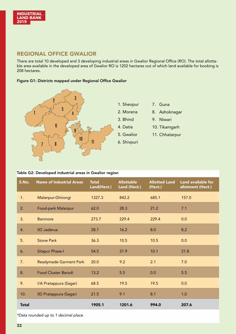
REGIONAL OFFICE GWALIORThere are total 10 developed and 3 developing industrial areas in Gwalior Regional Office (RO). The total allotta-ble area available in the developed area of Gwalior RO is 1202 hectares out of which land available for booking is 208 hectares.
Figure G1: Districts mapped under Regional Office Gwalior
Table G2: Developed industrial areas in Gwalior region
S.No. Name of Industrial Areas Total Land(Hect.)
Allottable Land (Hect.)
Allotted Land (Hect.)
Land available for allotment (Hect.)
1. Malanpur-Ghirongi 1327.3 842.2 685.1 157.0
2. Food-park Malanpur 62.0 28.3 21.2 7.1
3. Banmore 273.7 229.4 229.4 0.0
4. IID Jaderua 28.1 16.2 8.0 8.2
5. Stone Park 36.3 10.5 10.5 0.0
6. Sitapur Phase-I 54.5 31.9 10.1 21.8
7. Readymade Garment Park 20.0 9.2 2.1 7.0
8. Food Cluster Barodi 13.2 5.5 0.0 5.5
9. I/A Pratappura (Sagar) 68.5 19.5 19.5 0.0
10. IID Pratappura (Sagar) 21.5 9.1 8.1 1.0
Total 1905.1 1201.6 994.0 207.6
*Data rounded up to 1 decimal place.
1. Sheopur 2. Morena 3. Bhind 4. Datia 5. Gwalior 6. Shivpuri
2
1
3
4 5
6
7 8
9
10 11
7. Guna 8. Ashoknagar 9. Niwari 10. Tikamgarh 11. Chhatarpur

33
INDUSTRIAL LAND BANK
2019
DEVELOPING INDUSTRIAL AREADEVELOPED INDUSTRIAL AREA
1905.1
1201.6
994
207.6
Developed Area
Total Land (Hect.) Allottable Land (Hect.)Allotted Land (Hect.) Land available for allotment (Hect.)
273.6
157.6
16.1
141.5
Developing Areas
Total Land (Hect.) Allottable Land (Hect.)Booked / Allotted Land (Hect.) Land available for allotment (Hect.)
1905.1
1201.6
994
207.6
Developed Area
Total Land (Hect.) Allottable Land (Hect.)Allotted Land (Hect.) Land available for allotment (Hect.)
273.6
157.6
16.1
141.5
Developing Areas
Total Land (Hect.) Allottable Land (Hect.)Booked / Allotted Land (Hect.) Land available for allotment (Hect.)
2704.9
1954.4
1249.7
704.7
Developed Industrial Area
Total Land (Hect.) Allotable Land (Hect.)
Alloted Land (Hect.) Land available for allotment (Hect.)
44.00
28.68
0.00
28.68
Developing Industrial Area
Total Land (Hect.) Allotable Land (Hect.)
Allotted Land (Hect.) Land available for allotment (Hect.)
Table G3: Developing industrial areas in Gwalior region
S. No.
Name of Industrial Areas
Total Land (Hect.)
Allottable Land (Hect.)
Booked / Allotted Land (Hect.)
Land available for allotment (Hect.)
1. Piparsewa 80.4 38.8 2.3 36.5
2. Plastic Park Bilaua 37.6 22.0 0.1 21.9
3. Sitapur (Phase-II) 155.5 96.7 13.7 83.0
Total 273.6 157.6 16.1 141.5
*Data rounded up to 1 decimal place.

INDUSTRIAL LAND BANK 2019
34
Developed Industrial Area: Industrial Area Banmore, Morena
Industrial Area (I/A) Banmore is situated in Morena district of Madhya Pradesh. Spread across a total area of 273.7 Ha. I/A Banmore is a multiproduct industrial area. It is one of the major growth centres in Madhya Pradesh and is located strategically just 19 km from Gwalior on the Agra-Mumbai National Highway NH 44.
A. Industrial profile
Name of Industrial Area Industrial Area, Banmore
Name of RO Regional Office Gwalior, MPIDC
Village/ Tehsil/ District Banmore, Noorabad/Sewagaon/Morena
Area (Hectares) 273.7
Sector Multi-product (Food /Stone /Textile /Pharma /Auto /Agro/other)
Connectivity Air: Nearest Airport - Rajmata Vijayaraje Scindia air terminal Maharajpura Gwalior situated at 31 km
Road: Nearest Bus Stand - Banmore 02 km
Rail: Nearest Railway Station - Banmore situated at 01 km & Gwalior Junction at 20 km
B. Critical Infrastructure
Water Availability MPIDC water supply within industrial area
Power Availability Available substation situated at Banmore
C. Support Infrastructure
Street Lighting Available
Ware Housing Available
Logistics Available
Nearest Inland Container Depot
Available in Malanpur, situated at 27 km
Nearest Port Jawaharlal Nehru Port Trust Mumbai, Maharashtra (1247 km)
Nearby Major Town/city Gwalior situated at 19 km

35
INDUSTRIAL LAND BANK
2019
D. Industrial climate
Total Large Manufacturing Industries
07
Total Medium & Small Man-ufacturing Industries
130
Total Investment INR 200 Crore
Total Employment 6,382
Nearby major industrial units
J.K. Industry Ltd, Farseen Rubber Ind., Amba Shakti Udyog Ltd & M.P. Dudgh Mahasangh
Nearby Major Industrial Areas
Industrial area Malanpur Ghirongi situated at 27 km
For further details regarding booking/allotment/detailed industrial profile, please visit http://invest.mp.gov.in
Developed Industrial Area: IIDC Jaderua, Morena
Industrial Area (I/A) Jaderua is situated in Morena district of Madhya Pradesh. Spread across a total area of 28.1 Ha. I/A Jaderua is a multi-product industrial area situated at Agra Bombay road NH 44. Major nearby towns are Morena (11 km) and Gwalior (31 km).
A. Industrial profile
Name of Industrial Area Industrial Infrastructure Development Corporation, IID Jaderua
Name of RO Regional Office Gwalior, MPIDC
Village/Tehsil/District Noorabad/Morena/Morena
Area (Hectares) 28.14
Sector Multi - product
Connectivity Air: Nearest airport - Rajmata Vijayaraje Scindia Air Terminal Maharajpura Gwalior situated at 43 km
Road: Nearest Bus Stand - Banmore situated at 13 km
Rail: Nearest Railway Station - Banmore situated at 06 km & Gwalior Junction at 31 km
INDUSTRIAL LAND BANK 2019
36
B. Critical Infrastructure
Water Availability MPIDC water supply within industrial area
Power Availability Available
C. Support Infrastructure
Street Lighting Available
Ware Housing Available
Logistics Available from Banmore
Nearest Inland Container Depot
Available in Malanpur, situated at 39 km
Nearest Port Jawaharlal Nehru Port Mumbai, Maharashtra (1,259 km)
Nearby Major Town/city Gwalior situated at 31 km
Nearby Amenities
D. Industrial climate
Total Medium & Small Manufacturing Industries
10
Total Investment INR 1,890 Lakh
Total Employment 128
Nearby major industrial units
M/s J.K. Industry Ltd, Farseen Rubber Industrial, Amba Shakti Udyog Ltd & M.P. Dudgh Mahasangh
Nearby Major Industrial Areas
Malanpur Dist. Bhind situated at 39 km
For further details regarding booking/allotment/detailed industrial profile, please visit http://invest.mp.gov.in
37
INDUSTRIAL LAND BANK
2019
Developed Industrial Area: Stone Park, Gwalior
Stone Park is situated in Gwalior district of Madhya Pradesh. Spread across a total area of 36.3 Ha. stone park is exclusively used for stone crushing, polishing etc. Stone Park is situated at Purani Chhawani, Lashkar Gwalior. Mustard seeds and sand stone are locally available raw material in the region.
A. Industrial profile
Name of Industrial Area Stone Park
Name of RO Regional Office Gwalior, MPIDC
Village/ Tehsil/District Purani Chhawani/Gwalior/Gwalior
Area (Hectares) 36.27
Sector General
Connectivity Air: Nearest Airport - Rajmata Vijayaraje Scindia Air Terminal Maharajpura Gwalior situated at 16 km
Road: Nearest Bus Stand - Gwalior
Rail: Nearest Railway Station - Gwalior Junction at 11 km
B. Critical Infrastructure
Water Availability MPIDC water supply within industrial area
Power Availability Available from 5 MVA situated at industrial area stone park
C. Support Infrastructure
Street Lighting Available
Ware Housing Available in Purani chhawani Gwalior, situated at 06 km
Logistics Available in Purani chhawani Gwalior, situated at 06 km
Nearest Inland Container Depot
Available in Malanpur situated at 35 km
Nearest Port Jawaharlal Nehru Port (JNPT) Mumbai, Maharashtra situated at 1189 km
Nearby Major Town/city Gwalior situated at 08 km
D. Industrial climate
Total Medium & Small Man-ufacturing Industries
53
Total Investment INR 4,988.7 Lakh
INDUSTRIAL LAND BANK 2019
38
Total Employment 831
Nearby major industrial units
J.K. Industry (Tyre), Farseen Rubber, Gwalior Dudgh Mahasangh, Magnum Steel
Nearby Major Industrial Areas
Banmore Industrial Area (16 km), Tansen Nagar Industrial Area (09 km), Malan-pur Industrial Area (29 km)
For further details refer https://invest.mp.gov.in/
Developed Industrial Area: Industrial Area Pratappura, Niwari
Industrial area Pratappura is situated in Niwari district of Madhya Pradesh. Spread across a total area of 68.562 Ha., I/A Pratappura is a multi-product industrial area. I/A Pratappura is situated about 08 km from Jhansi (U.P.). The major Industrial units are Ankit Polyseck India Pvt. Ltd, Grenx India etc
A. Industrial profile
Name of Industrial Area Industrial Area Pratappura
Name of RO Regional Office Gwalior, MPIDC
Village/ Tehsil/District Pratappura/Orchha/Niwari
Area (Hectares) 68.5
Sector Multi Products
Connectivity Air: Nearest Airport - Khajuraho, situated at 125 km
Road: Nearest Bus Stand - Jhansi, situated at 10 km
Rail: Nearest Railway Station - Orchha situated at 04 km and Jhansi junction situated at 14 km.
B. Critical Infrastructure
Water Availability MPIDC water supply within industrial area
Power Availability Available from 33/11 KV, Sub-Station nearby industrial area
C. Support Infrastructure
Street Lighting Available
Ware Housing Available in Jhansi, situated at 08 km
39
INDUSTRIAL LAND BANK
2019
Logistics Available from Jhansi, situated at 08 km
Nearest Inland Container Depot
Available in Malanpur, situated at 140 km
Nearest Port Jawaharlal Nehru Port, Mumbai Maharashtra (839 km) Kandla Gujarat (938 km)
Nearby Major Town/city Jhansi situated at 10 km
D. Industrial climate
Total Large Manufacturing Industries
1
Total Medium & Small Man-ufacturing Industries
58
Total Investment INR 8,350 Lakh
Total Employment 516
Nearby major industrial units
Ankit Polyseck Pvt. Ltd, Grenx India, Agarwal Refectories
Nearby Major Industrial Areas
Industrial Infrastructure Development Pratappura and Industrial Area Niwadibhata
For further details regarding booking/allotment/detailed industrial profile, please visit http://invest.mp.gov.in
Developed Industrial Area: IID Pratappura, Niwari
IID Pratappura is situated in Niwari district of Madhya Pradesh. Spread across a total area of 21.5 Ha. IID Prat-appura is a multi-product industrial area. I/A Pratappura is situated about 08 km from Jhansi (U.P.). The major industrial units are Yogya Industries, Geeta Electricals. There are 24 SSI units with investment of INR 2,010 Lakh, the major sector is mining.
A. Industrial profile
Name of Industrial Area Industrial Infrastructure Development Pratappura
Name of RO Regional Office Gwalior, MPIDC
Village/ Tehsil/District Pratappura/Orchha/Niwari
Area (Hectares) 21.50
Sector Multi Products
INDUSTRIAL LAND BANK 2019
40
Connectivity Air: Nearest Airport - Khajuraho, situated at 125 km
Road: Nearest Bus Stand - Jhansi, situated at 10 km
Rail: Nearest Railway Station - Orchha, situated at 04 km and Jhansi junction, situated at 14 km
B. Critical Infrastructure
Water Availability MPIDC water supply within industrial area
Power Availability Available from 33/11 KV Sub-Station nearby industrial area.
C. Support Infrastructure
Street Lighting Available.
Ware Housing Available from Jhansi source situated at 08 km
Logistics Available from Jhansi source situated at 08 km
Nearest Inland Container Depot
Available from Mandideep source situated at 400 km
Nearest Port Jawaharlal Nehru Port, Mumbai Maharashtra (839 km) Kandla Gujarat (938 km)
Nearby Major Town/city Jhansi situated at 10 km
D. Industrial climate
Total LMI -
Total SMI 52
Total Investment INR 3,200 Lakh
Total Employment 372
Nearby major industrial units
Yogya Industries Ltd, Geeta Electricals Ltd
Nearby Major Industrial Areas
Industrial Area Pratappura, Industrial Area Niwadibhata
For further details regarding booking/allotment/detailed industrial profile, please visit http://invest.mp.gov.in
41
INDUSTRIAL LAND BANK
2019
Developed Industrial Area: Industrial Area Sitapur (Pahadi), Morena
Industrial Area (I/A) Sitapur (Pahadi) is situated in Morena district of Madhya Pradesh. Spread across a total area of 54.5 hectares I/A Sitapur (Pahadi) is a multiproduct industrial area. Industrial Area Sitapur (Pahadi) is located 05 km from Agra-Bombay road NH-44.
A. Industrial profile
Name of Industrial Area Industrial Area Sitapur (Pahadi)
Name of RO Regional Office Gwalior, MPIDC
Village/Tehsil/District Pahadi/Morena/Morena
Area (Hectares) 54.5
Sector Multi-product
Connectivity Air: Nearest Airport - Gwalior situated at 25 km
Road: Nearest Bus Stand - Gwalior situated at 31 km
Rail: Nearest Railway Station Banmore situated at 29 km
B. Critical Infrastructure
Water Availability MPIDC water supply within industrial area
Power Availability Available from 33/11 KV Sub-Station situated around 09 km
C. Support Infrastructure
Street Lighting Available
Ware Housing Available from Banmore; situated at 10 km
Logistics Available from Morena & Gwalior
Nearest Inland Container Depot
Available from Malanpur; situated at 39 km
Nearest Port Jawaharlal Nehru Port, Mumbai, Maharashtra (1,133 km)
Nearby Major Town/city Morena & Gwalior situated at 28 km & 30 km, respectively
Nearby Amenities
INDUSTRIAL LAND BANK 2019
42
D. Industrial climate
Total Large Manufacturing Industries
1
Total Investment INR 145 Crore
Total Employment 218
Nearby major industrial units
J.K. Industries (Tyre Plant), Punj Lloyd, Farseen Rubber Industries, Amba Shakti Steel Industries situated in Industrial area in Banmore
Nearby Major Industrial Areas
Industrial area Banmore, district Morena (85 km)
For further details regarding booking/allotment/detailed industrial profile, please visit http://invest.mp.gov.in
Developed Industrial Area: Industrial Area Malanpur-Ghirongi, Bhind
Industrial Area (I/A) Malanpur-Ghirongi is situated in Bhind district of Madhya Pradesh. Spread across a total area of 1,389.3 hectares, I/A Malanpur-Ghirongi is a multi-product industrial area with a dedicated food park situat-ed in 62 hectares. Industrial area Malanpur-Ghirongi is situated on NH-719, connecting Gwalior-Etawah-Kanpur and around 03 km away from North-South Corridor. Malanpur-Ghirongi also has an operational Inland Container Depot.
A. Industrial profile
Name of Industrial Area Malanpur-Ghirongi
Name of RO Regional Office Gwalior, MPIDC
Village/Tehsil/District Malanpur- Ghirongi- Singwari/ Gohad/ Bhind
Area (Hectares) 1,389.3
Sector Multi-product, food Processing Units
Connectivity Air: Nearest Airport - Rajmata Vijayaraje Scindia Air Terminal Maharajpura, Gwalior situated at 16 km
Road: Nearest Bus Stand - Malanpur 02 km
Rail: Nearest Railway Station - Malanpur situated at 02 km & Gwalior Junction at 23 km
B. Critical Infrastructure
Water Availability MPIDC water supply within industrial area, 5 MGD
Power Availability Available from 220 KV and 33 KV substation situated at Malanpur
43
INDUSTRIAL LAND BANK
2019
C. Support Infrastructure
Street Lighting Available
Ware Housing Available in industrial area
Logistics Available from Gwalior, situated at 24 km
Nearest Inland Container Depot
Available in Malanpur, situated at 2.5 km
Nearest Port Jawaharlal Nehru Port, Mumbai Maharashtra (1,236 km)
Nearby Major Town/city Gwalior situated at 20 km
D. Industrial climate
Total Large Manufacturing Industries
46
Total Medium & Small Manufacturing Industries
269
Total Investment INR 3815.65 Crore
Total Employment 14,743
Nearby major industrial units
SRF Limited, Surya Roshni Ltd, Godrej Consumer Ltd, Cadbury India Ltd, Supreme Industries Ltd, Teva API India Pvt Ltd, Kurlon Ltd, Gas Authority of India Ltd, Punj Lloyd Ltd, Sterling Agro Nova Ghee Ltd, Jamna Auto India Ltd, Crompton Greaves Ltd, Akzonobel India Ltd, Marvel Vinyl Ltd etc.
Food Park Malanpur major units - Badri Vishal Agro Pvt Ltd, V.R.S. Food Ltd, Vikram Arya Foods Pvt. Ltd, Godavari Nutri Foods Pvt. Ltd
Nearby Major Industrial Areas
Maharajpura Industrial Area, Gwalior situated at 13 km; I/A Baraghata Gwalior, situated at 39 kmI/A Birla Nagar situated at 21 km.
For further details regarding booking/allotment/detailed industrial profile, please visit http://invest.mp.gov.in
INDUSTRIAL LAND BANK 2019
44
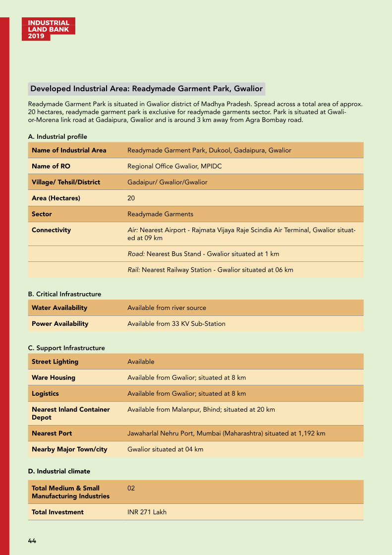
Developed Industrial Area: Readymade Garment Park, Gwalior
Readymade Garment Park is situated in Gwalior district of Madhya Pradesh. Spread across a total area of approx. 20 hectares, readymade garment park is exclusive for readymade garments sector. Park is situated at Gwali-or-Morena link road at Gadaipura, Gwalior and is around 3 km away from Agra Bombay road.
A. Industrial profile
Name of Industrial Area Readymade Garment Park, Dukool, Gadaipura, Gwalior
Name of RO Regional Office Gwalior, MPIDC
Village/ Tehsil/District Gadaipur/ Gwalior/Gwalior
Area (Hectares) 20
Sector Readymade Garments
Connectivity Air: Nearest Airport - Rajmata Vijaya Raje Scindia Air Terminal, Gwalior situat-ed at 09 km
Road: Nearest Bus Stand - Gwalior situated at 1 km
Rail: Nearest Railway Station - Gwalior situated at 06 km
B. Critical Infrastructure
Water Availability Available from river source
Power Availability Available from 33 KV Sub-Station
C. Support Infrastructure
Street Lighting Available
Ware Housing Available from Gwalior; situated at 8 km
Logistics Available from Gwalior; situated at 8 km
Nearest Inland Container Depot
Available from Malanpur, Bhind; situated at 20 km
Nearest Port Jawaharlal Nehru Port, Mumbai (Maharashtra) situated at 1,192 km
Nearby Major Town/city Gwalior situated at 04 km
D. Industrial climate
Total Medium & Small Manufacturing Industries
02
Total Investment INR 271 Lakh
45
INDUSTRIAL LAND BANK
2019
Total Employment 40
Nearby major industrial units
Double Trishul Aata Mill, Maharajpura
Nearby Major Industrial Areas
I/A (Talwar ka Bada) Tansen Nagar, Gwalior;Birla Nagar Industrial Area.
For further details regarding booking/allotment/detailed industrial profile, please visit http://invest.mp.gov.in
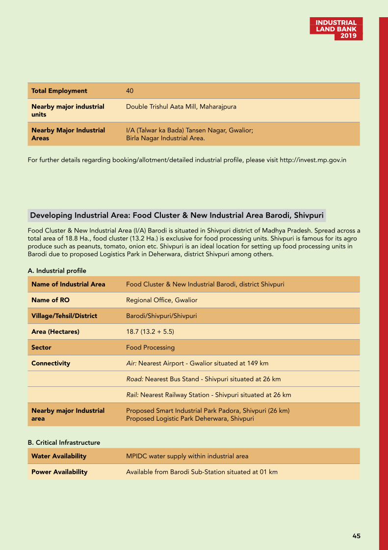
Developing Industrial Area: Food Cluster & New Industrial Area Barodi, Shivpuri
Food Cluster & New Industrial Area (I/A) Barodi is situated in Shivpuri district of Madhya Pradesh. Spread across a total area of 18.8 Ha., food cluster (13.2 Ha.) is exclusive for food processing units. Shivpuri is famous for its agro produce such as peanuts, tomato, onion etc. Shivpuri is an ideal location for setting up food processing units in Barodi due to proposed Logistics Park in Deherwara, district Shivpuri among others.
A. Industrial profile
Name of Industrial Area Food Cluster & New Industrial Barodi, district Shivpuri
Name of RO Regional Office, Gwalior
Village/Tehsil/District Barodi/Shivpuri/Shivpuri
Area (Hectares) 18.7 (13.2 + 5.5)
Sector Food Processing
Connectivity Air: Nearest Airport - Gwalior situated at 149 km
Road: Nearest Bus Stand - Shivpuri situated at 26 km
Rail: Nearest Railway Station - Shivpuri situated at 26 km
Nearby major Industrial area
Proposed Smart Industrial Park Padora, Shivpuri (26 km)Proposed Logistic Park Deherwara, Shivpuri
B. Critical Infrastructure
Water Availability MPIDC water supply within industrial area
Power Availability Available from Barodi Sub-Station situated at 01 km
INDUSTRIAL LAND BANK 2019
46
C. Support Infrastructure
Street Lighting Available
Logistics Available from Shivpuri; situated at 07 km
Nearest Inland Container Depot
Available from Malanpur, Bhind; situated at 196 km
Nearest Port Jawaharlal Nehru Port Mumbai, Maharashtra (1,077 km)
Nearby Major Town/city Shivpuri situated at 23 km and nearest city is Gwalior (139 km)
For further details regarding booking/allotment/detailed industrial profile, please visit http://invest.mp.gov.in
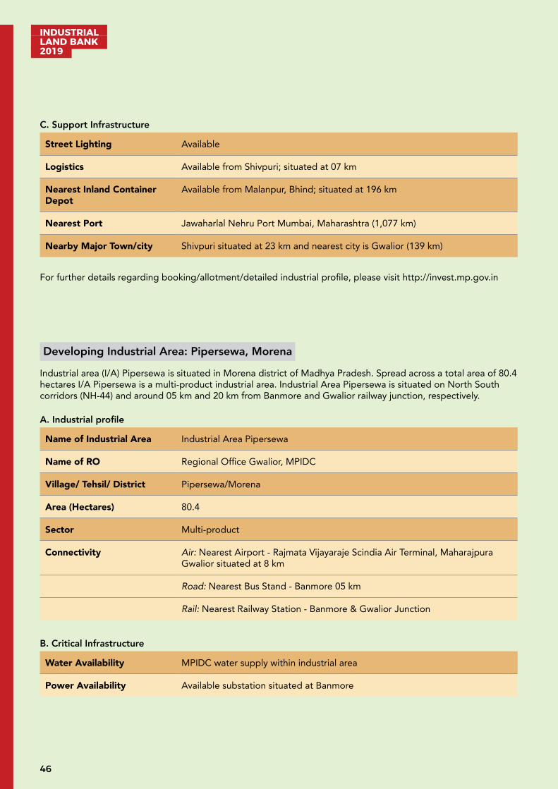
Developing Industrial Area: Pipersewa, Morena
Industrial area (I/A) Pipersewa is situated in Morena district of Madhya Pradesh. Spread across a total area of 80.4 hectares I/A Pipersewa is a multi-product industrial area. Industrial Area Pipersewa is situated on North South corridors (NH-44) and around 05 km and 20 km from Banmore and Gwalior railway junction, respectively.
A. Industrial profile
Name of Industrial Area Industrial Area Pipersewa
Name of RO Regional Office Gwalior, MPIDC
Village/ Tehsil/ District Pipersewa/Morena
Area (Hectares) 80.4
Sector Multi-product
Connectivity Air: Nearest Airport - Rajmata Vijayaraje Scindia Air Terminal, Maharajpura Gwalior situated at 8 km
Road: Nearest Bus Stand - Banmore 05 km
Rail: Nearest Railway Station - Banmore & Gwalior Junction
B. Critical Infrastructure
Water Availability MPIDC water supply within industrial area
Power Availability Available substation situated at Banmore
47
INDUSTRIAL LAND BANK
2019
C. Support Infrastructure
Street Lighting Available
Ware Housing Available
Logistics Available
Nearest Inland Container Depot
Available in Malanpur; situated at 20 km
Nearest Port Jawaharlal Nehru Port Trust Mumbai, Maharashtra (1247 km)
Nearby Major Town/city Gwalior situated at 18 km
D. Industrial climate
Nearby major industrial units
J.K. Tyre, Farseen Rubber, Magnum Steel
Total Large Manufacturing Industries
Industrial Area Banmore (05 km)
For further details regarding booking/allotment/detailed industrial profile, please visit http://invest.mp.gov.in
Developing Industrial Area: Sitapur Phase-II, Morena
Industrial Area (I/A) Sitapur Phase-II, is situated in Morena district of Madhya Pradesh. Spread across a total area of 155.5 hectares I/A Sitapur Phase-II is a multi-product industrial area. Industrial Area Sitapur Phase-II is located 05 km from Agra-Bombay road NH-3.
A. Industrial profile
Name of Industrial Area Industrial Area Sitapur Phase-II
Name of RO Regional Office Gwalior, MPIDC
Village/ Tehsil/District Sitapur/Morena
Area (Hectares) 155.5
Sector Multi-product
Connectivity Air: Nearest Airport - Gwalior situated at 25 km
Road: Nearest Bus Stand - Gwalior situated at 31 km
Rail: Nearest Railway Station Banmore situated at 29 km
INDUSTRIAL LAND BANK 2019
48
B. Critical Infrastructure
Water Availability MPIDC water supply within industrial area
Power Availability Available from 33/11 KV Sub-Station situated at 09 km
C. Support Infrastructure
Logistics Available from Banmore, situated at 10 km
Nearest Inland Container Depot
Available from Malanpur source situated at 39 km
Nearest Port Jawaharlal Nehru Port, Mumbai Maharashtra (1,268 km)
Nearby Major Town/city Morena & Gwalior situated at 28 km & 30 km respectively
For further details regarding booking/allotment/detailed industrial profile, please visit http://invest.mp.gov.in
Developing Industrial Area: Plastic Park Bilaua, Gwalior
Plastic Park Bilaua is situated in Gwalior district of Madhya Pradesh. It is situated around 28 km away from Gwali-or city. Spread across total area of 37.6 hectares, plastic park is earmarked for plastic industry. The product which will be manufactured are exclusively polymer based like Plastic Bottle, Pet Jar, PVC Chair, PVC Pipe fitting and fixtures.
A. Industrial profile
Name of Industrial Area Plastic Park Bilaua, district Gwalior
Name of RO Regional Office Gwalior, MPIDC
Village/Tehsil/District Bilaua/Dabra/Gwalior
Area (Hectares) 37.6
Sector Polymer based products
Connectivity Air: Nearest Airport - Rajmata Vijaya Raje Scindia Terminal, Gwalior situated at 37 km
Road: Nearest Bus Stand - Bilaua situated at 04 km
Rail: Nearest Railway Station - Dabra situated at 30 km
Nearby major Industrial area
Industrial Area - Baraghata, Gwalior 20 km
49
INDUSTRIAL LAND BANK
2019
B. Critical Infrastructure
Water Availability MPIDC water supply within industrial area
Power Availability Available from 132/33 KV Sub-Station, Bilaua situated at 04 km
C. Support Infrastructure
Logistics Available from Gwalior; situated at 30 km
Nearest Inland Container Depot
Available from Malanpur; situated at 51 km
Nearest Port Jawaharlal Nehru Port, Mumbai, Maharashtra (1,199 km)
Nearby Major Town/city Gwalior situated at 28 km
Nearby Amenities
For further details regarding booking/allotment/detailed industrial profile, please visit http://invest.mp.gov.in

INDUSTRIAL LAND BANK 2019
50
REGIONAL OFFICE INDOREThere are total 32 developed and 11 developing industrial areas in Indore Regional Office (RO). The total allotta-ble area available in the developed area of Indore RO is 3520 hectares out of which land available for booking is 880 hectares.
Figure IN1: Districts mapped under Regional Office Indore
Table IN2: Developed industrial areas in Indore region
S. No. Name of Industrial Area Total Land Area (in Hectare)
Allottable Area (in Hectare)
Allotted Area (in Hectare)
Vacant Plots Area (in Hectare)
1 Pithampur 2126.7 1446.1 1441.2 4.9
2 SEZ Indore 572 461 421.5 39.5
3 FPP Nimrani, Khargone 27.1 21.1 20.1 1
4 IIDC Nimrani, Khargone 74.1 40.6 36.7 4
5 Meghnagar, Jhabua 223.8 134.3 123.8 10.5
6 Readymade Garment Clus-ter Indore
16.6 9.9 9.9 0
7 Electronics Complex, Indore
18.8 6.4 6.4 0
8 Rangwasa, Indore 9 7.6 7.6 0
1
2
3
4
5
6
7
8
9
10 11
12 13
14
15
1. Neemuch 2. Mandsaur 3. Agar Malwa 4. Shajapur 5. Dewas 6. Khandwa 7. Burhanpur 8. Khargone
9. Indore 10. Ujjain 11. Ratlam 12. Dhar 13. Jhabua 14. Alirajpur 15. Barwani
51
INDUSTRIAL LAND BANK
2019
9 Sonway-Bhaislay, Indore 65.2 50.8 50.8 0
10 Rudhibhawsingpura, Khandwa
148.7 77.5 3.9 73.6
11 Relwa khurd & Khajuri 40.5 24 17.4 6.6
12 Namkeen Cluster Indore 5.1 2.1 2 0.1
13 Ujjaini, Teh. Dhar 58.4 41.8 26.4 15.4
14 Bijepur Industrial Area 36.8 18.9 4.9 14
15 Pithampur 5 22.7 22.7 22.7 0
16 Hatod, Teh. -Sardarpur 152.4 88.3 0 88.3
17 Cystal I.T. Park 8 3 3 0
18 I.T. Park Non SEZ 1.9 0.9 0.9 0
19 Smart Industrial Park (NA-TRIP LAND)
478.3 262 89 173
20 Pithampur 6 78 40.4 19.2 21.3
21 Dewas Sector 2 & 3 296.9 224.8 188.3 36.5
22 Maksi 89.2 82.7 82.6 0.1
23 IIDC Jaggakhedi 20.2 9.9 9.9 0
24 FPP Jaggakhedi 20.7 12.1 11.8 0.3
25 Sirsoda 49.6 26.1 0.2 25.8
26 Nemawar 40 22.6 0.2 22.4
27 Tajpur 81 27.3 2.1 25.2
28 Karmadi Namkeen Cluster Ratlam
18.2 8.8 6.7 2.1
29 Jhanjharwara Neemuch 86 49.1 0 49.1
30 Vikram Udyogpuri Ujjain 451 208 4.7 203.3
Total 5316.9 3430.8 2613.9 817
Data rounded up to 1 decimal place.

INDUSTRIAL LAND BANK 2019
52
Table IN3: Developing industrial areas in Indore region
S. No. Name of Industrial Areas Total Land (Hect.)
Allotable Land (Hect.)
Allotted Land (Hect.)
Land available for allotment (Hect.)
1. Mohna Depalpur Indore 140.4 84.2 12 128.4
2. Jetapur-Palasia Dhar 200 120 0 200
3. I/A Rehta-Khadkod 38.6 23.1 0 38.6
4. Kasarbardi 71.8 52.8 0 52.8
Total 450.8 280.1 12 419.8
Data rounded up to 1 decimal place.
5425.2
3520.0
2640.6
879.4
DEVELOPED AREA
Total Land Area (in Hectare) Allottable Area (in Hectare)Allotted Area (in Hectare) Vacant Plots Area (in Hectare)
378.978
227.38680
366.978
DEVELOPING AREAS
Total Land (Hect.) Allotable Land (Hect.)Allotted Land (Hect.) Land available for allotment (Hect.)
5425.2
3520.0
2640.6
879.4
DEVELOPED AREA
Total Land Area (in Hectare) Allottable Area (in Hectare)Allotted Area (in Hectare) Vacant Plots Area (in Hectare)
378.978
227.38680
366.978
DEVELOPING AREAS
Total Land (Hect.) Allotable Land (Hect.)Allotted Land (Hect.) Land available for allotment (Hect.)
53
INDUSTRIAL LAND BANK
2019
Developed Industrial Area: Pithampur Sector 1 & 2
Pithampur Industrial Area is in Dhar district in the Indian state of Madhya Pradesh. Indore being close to Pitham-pur is the largest city and commercial capital state of Madhya Pradesh. Indore with its satellite towns of Pitham-pur and Dewas, is one of the fastest growing economic regions of India.
Pithampur is the largest industrial area of Madhya Pradesh. It has presence of many national and international companies. Container Corporation of India (CONCOR) has an ICD and Private Freight Terminal at TIHI, near Pithampur. Asia’s largest ground for Auto Testing Track by NATRIP is also located at Pithampur. Availability of piped natural gas through GAIL, dedicated water supply system from Narmada River are some of the key high-lights of Pithampur Industrial area. Pithampur Industrial Area also falls under Delhi Mumbai Industrial Corridor (DMIC) influence region.
A. Industrial profile
Name of Industrial Area Pithampur Sector 1 and 2
Name of RO M P Industrial Development Corporation, RO Indore
Village/ Tehsil/District Dhar/Dhar
Area (Hectares) 756.73
Sector Multi Product
Connectivity Air: Nearest Airport Indore situated at 31 km
Road: Connected to NH-47 (5 - 20 km), NH-52 (10-15 km). Pithampur Bus Stand (04 km) & Indore Bus Stand 31 km
Rail: Indore Railway Station situated at 32 km
B. Critical Infrastructure
Water Availability Available at doorstep of industry situated in Sector I & II Pithampur from the developed water supply scheme based on surface source Sanjay Jalashay situ-ated at 6 km from location of WTP at Tarpura which is at sector II Pithampur.To cater future demand of industrial area Pithampur and surrounding Dhar-Mhow-Pithampur Investment Region in DMIC, a scheme of 90MLD water supply from Narmada-Kshipra Link has been planned and supposed to be completed within the next 3 years.
Power Availability Available at doorstep of industrythrough transmission lines connected to the transmission grid (Electrical substations, detail as given below) situated at various locations of industrial area Pithampur :-1 nos. 400KV substation 2 nos. 220/132/33KV substation (1 in sector I & 1 in sector III)6 nos. 33/11KV substation
Drainage Available
Solid Waste Management Available
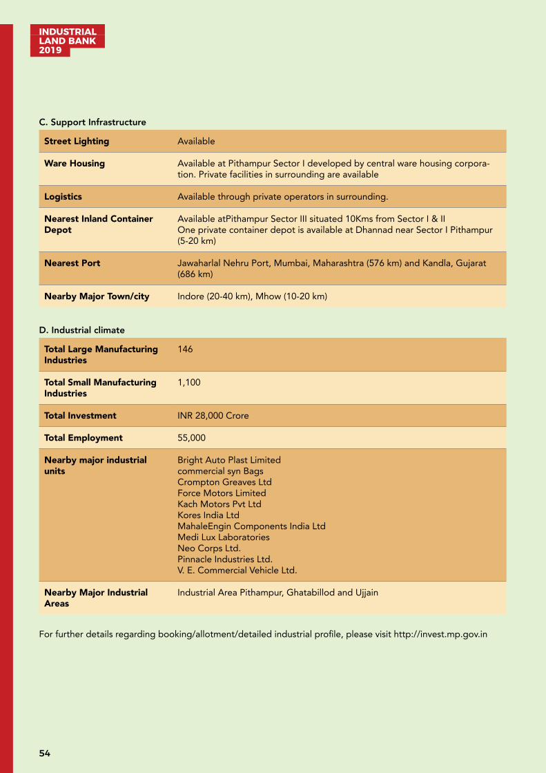
INDUSTRIAL LAND BANK 2019
54
C. Support Infrastructure
Street Lighting Available
Ware Housing Available at Pithampur Sector I developed by central ware housing corpora-tion. Private facilities in surrounding are available
Logistics Available through private operators in surrounding.
Nearest Inland Container Depot
Available atPithampur Sector III situated 10Kms from Sector I & IIOne private container depot is available at Dhannad near Sector I Pithampur (5-20 km)
Nearest Port Jawaharlal Nehru Port, Mumbai, Maharashtra (576 km) and Kandla, Gujarat (686 km)
Nearby Major Town/city Indore (20-40 km), Mhow (10-20 km)
D. Industrial climate
Total Large Manufacturing Industries
146
Total Small Manufacturing Industries
1,100
Total Investment INR 28,000 Crore
Total Employment 55,000
Nearby major industrial units
Bright Auto Plast Limitedcommercial syn BagsCrompton Greaves LtdForce Motors LimitedKach Motors Pvt LtdKores India LtdMahaleEngin Components India LtdMedi Lux LaboratoriesNeo Corps Ltd. Pinnacle Industries Ltd. V. E. Commercial Vehicle Ltd.
Nearby Major Industrial Areas
Industrial Area Pithampur, Ghatabillod and Ujjain
For further details regarding booking/allotment/detailed industrial profile, please visit http://invest.mp.gov.in

55
INDUSTRIAL LAND BANK
2019
Developed Industrial Area: Pithampur Sector 3 and Kheda
Pithampur Industrial Area is in Dhar district in the Indian state of Madhya Pradesh. Indore being close to Pitham-pur is the largest city and commercial capital state of Madhya Pradesh. Indore with its satellite towns of Pitham-pur and Dewas, is one of the fastest growing economic regions of India.
Pithampur is the largest industrial area of Madhya Pradesh. It has presence of many national and international companies. Container Corporation of India (CONCOR) has an ICD and Private Freight Terminal at TIHI, near Pithampur. Asia’s largest ground for Auto Testing Track by NATRIP is also located at Pithampur. Availability of piped natural gas through GAIL, dedicated water supply system from Narmada River are some of the key high-lights of Pithampur Industrial area. Pithampur Industrial Area also falls under Delhi Mumbai Industrial Corridor (DMIC) influence region.
A. Industrial profile
Name of Industrial Area Pithampur/Kheda
Name of RO M P Industrial Development Corporation, RO Indore
Village/ Tehsil/District Dhar/Dhar
Area (Hectares) 1,360.82
Sector Multi Product
Connectivity Air: Indore Airport situated at 33 km
Road: Connected to NH-47 (15 - 20 km), NH-52 (10 km). Nearest Bus Stand Pithampur 07 km & Indore 35 km
Rail: Indore Railway Station situated at 36 km
B. Critical Infrastructure
Water Availability For Sector III the schemes based on Karam dam situated at 6 km from WTP at Chandrapura which is 12 km from the industrial area.
To cater future demand of industrial area Pithampur and surrounding Dhar-Mhow-Pithampur Investment Region in DMIC, a scheme of 90MLD water supply from Narmada-Kshipra Link has been planned and supposed to be completed within next 3 years.
Power Availability Available at doorstep of industry through transmission lines connected to the transmission grid (Electrical substations, detail as given below) situated at various locations of industrial area Pithampur:1 nos. 400KV substation 2 nos. 220/132/33KV substation (1 in sector I & 1 in sector III)6 nos. 33/11KV substation
Drainage Available
SolidWaste Management Available
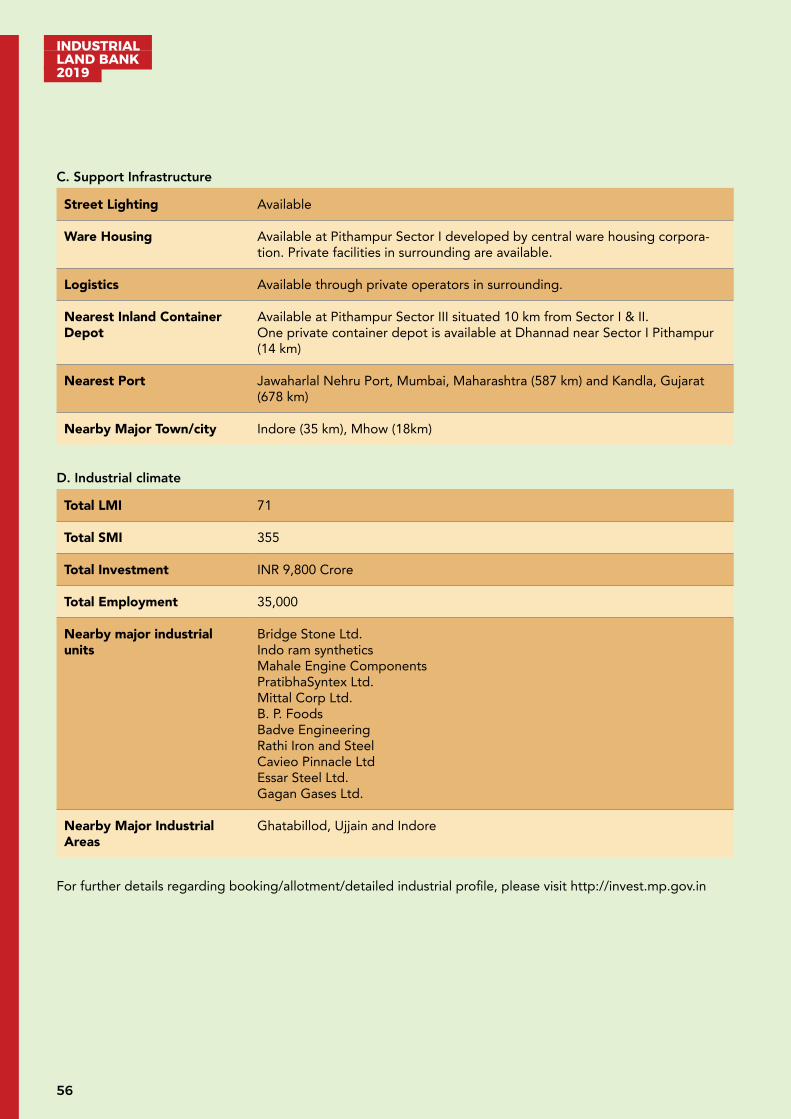
INDUSTRIAL LAND BANK 2019
56
C. Support Infrastructure
Street Lighting Available
Ware Housing Available at Pithampur Sector I developed by central ware housing corpora-tion. Private facilities in surrounding are available.
Logistics Available through private operators in surrounding.
Nearest Inland Container Depot
Available at Pithampur Sector III situated 10 km from Sector I & II.One private container depot is available at Dhannad near Sector I Pithampur (14 km)
Nearest Port Jawaharlal Nehru Port, Mumbai, Maharashtra (587 km) and Kandla, Gujarat (678 km)
Nearby Major Town/city Indore (35 km), Mhow (18km)
D. Industrial climate
Total LMI 71
Total SMI 355
Total Investment INR 9,800 Crore
Total Employment 35,000
Nearby major industrial units
Bridge Stone Ltd. Indo ram syntheticsMahale Engine ComponentsPratibhaSyntex Ltd. Mittal Corp Ltd. B. P. FoodsBadve EngineeringRathi Iron and SteelCavieo Pinnacle LtdEssar Steel Ltd. Gagan Gases Ltd.
Nearby Major Industrial Areas
Ghatabillod, Ujjain and Indore
For further details regarding booking/allotment/detailed industrial profile, please visit http://invest.mp.gov.in
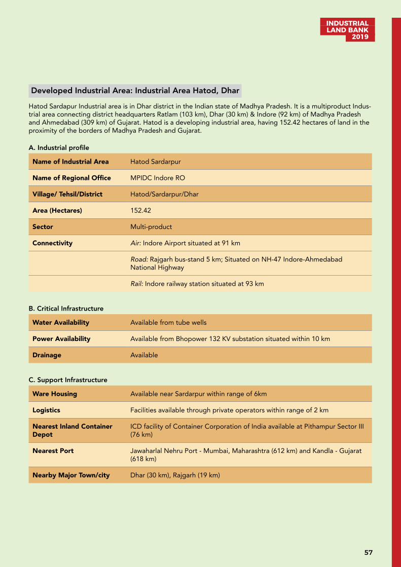
57
INDUSTRIAL LAND BANK
2019
Developed Industrial Area: Industrial Area Hatod, Dhar
Hatod Sardapur Industrial area is in Dhar district in the Indian state of Madhya Pradesh. It is a multiproduct Indus-trial area connecting district headquarters Ratlam (103 km), Dhar (30 km) & Indore (92 km) of Madhya Pradesh and Ahmedabad (309 km) of Gujarat. Hatod is a developing industrial area, having 152.42 hectares of land in the proximity of the borders of Madhya Pradesh and Gujarat.
A. Industrial profile
Name of Industrial Area Hatod Sardarpur
Name of Regional Office MPIDC Indore RO
Village/ Tehsil/District Hatod/Sardarpur/Dhar
Area (Hectares) 152.42
Sector Multi-product
Connectivity Air: Indore Airport situated at 91 km
Road: Rajgarh bus-stand 5 km; Situated on NH-47 Indore-Ahmedabad National Highway
Rail: Indore railway station situated at 93 km
B. Critical Infrastructure
Water Availability Available from tube wells
Power Availability Available from Bhopower 132 KV substation situated within 10 km
Drainage Available
C. Support Infrastructure
Ware Housing Available near Sardarpur within range of 6km
Logistics Facilities available through private operators within range of 2 km
Nearest Inland Container Depot
ICD facility of Container Corporation of India available at Pithampur Sector III (76 km)
Nearest Port Jawaharlal Nehru Port - Mumbai, Maharashtra (612 km) and Kandla - Gujarat (618 km)
Nearby Major Town/city Dhar (30 km), Rajgarh (19 km)
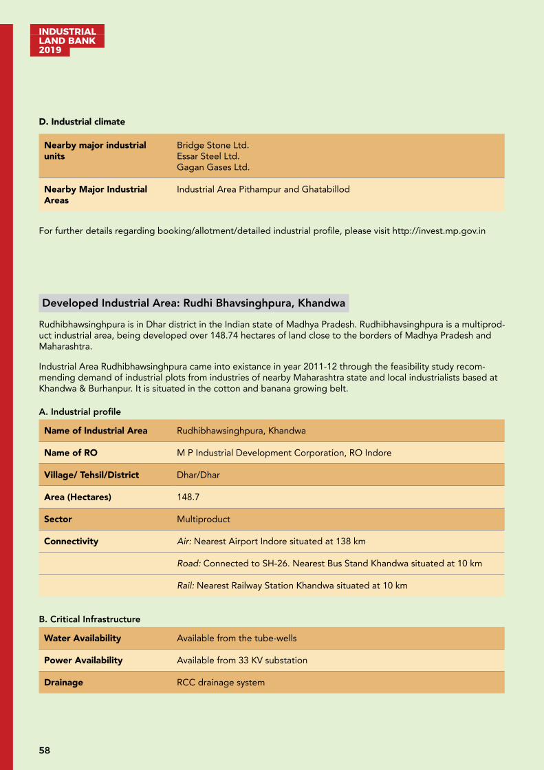
INDUSTRIAL LAND BANK 2019
58
D. Industrial climate
Nearby major industrial units
Bridge Stone Ltd. Essar Steel Ltd. Gagan Gases Ltd.
Nearby Major Industrial Areas
Industrial Area Pithampur and Ghatabillod
For further details regarding booking/allotment/detailed industrial profile, please visit http://invest.mp.gov.in
Developed Industrial Area: Rudhi Bhavsinghpura, Khandwa
Rudhibhawsinghpura is in Dhar district in the Indian state of Madhya Pradesh. Rudhibhavsinghpura is a multiprod-uct industrial area, being developed over 148.74 hectares of land close to the borders of Madhya Pradesh and Maharashtra.
Industrial Area Rudhibhawsinghpura came into existance in year 2011-12 through the feasibility study recom-mending demand of industrial plots from industries of nearby Maharashtra state and local industrialists based at Khandwa & Burhanpur. It is situated in the cotton and banana growing belt.
A. Industrial profile
Name of Industrial Area Rudhibhawsinghpura, Khandwa
Name of RO M P Industrial Development Corporation, RO Indore
Village/ Tehsil/District Dhar/Dhar
Area (Hectares) 148.7
Sector Multiproduct
Connectivity Air: Nearest Airport Indore situated at 138 km
Road: Connected to SH-26. Nearest Bus Stand Khandwa situated at 10 km
Rail: Nearest Railway Station Khandwa situated at 10 km
B. Critical Infrastructure
Water Availability Available from the tube-wells
Power Availability Available from 33 KV substation
Drainage RCC drainage system
59
INDUSTRIAL LAND BANK
2019
C. Support Infrastructure
Street Lighting Available
Ware Housing Available at Pandhana Road, Khandwa within the range of 15 – 20 km
Logistics Facilities available through private operators within the range of 10 km
Nearest Inland Container Depot
ICD facility of Container Corporation of India available at Pithampur Sector III situated at 130 km
Nearest Port Jawaharlal Nehru Port, Mumbai, Maharashtra situated at 605 km and Kandla, Gujarat situated at 816 km
Nearby Major Town/city Khandwa situated at 10 km
D. Industrial climate
Total SMI 8
Total Investment INR 14.83 Crore
Total Employment 123
Nearby major industrial units
Nepa Paper MillMansingka Oil MillNimar Textile area
Nearby Major Industrial Areas
Industrial Area Pithampur
For further details regarding booking/allotment/detailed industrial profile, please visit http://invest.mp.gov.in
INDUSTRIAL LAND BANK 2019
60
Developed Industrial Area: Ujjaini, Dhar
Ujjaini industrial area is in Dhar district in the Indian state of Madhya Pradesh. It is a multi-product industrial area with 58.4 hectares of land in the proximity of a well developed and established industrial area Pithampur situat-ed at 40 km, connecting district headquarters Dhar 20 km & Indore 66 km of Madhya Pradesh India. It has good accessiblity from two national highways: NH 47 and NH 52.
There are total 113 plots in the range of 4,500 - 25,000 sq.ft. areas. A leading packaging company VACMAT India has started Production at their Plant at the industrial area on 20 hectares of plot area; investment of this company is around INR 15 crore.
A. Industrial profile
Name of Industrial Area Ujjaini
Name of RO M P Industrial Development Corporation, RO Indore
Viilage/Tehsil/District Digthan/Dhar/Dhar
Area (Hectares) 58.4
Sector Multi-product
Connectivity Air: Indore Airport situated at 64 km
Road: Situated on 05 km inside Manpur-Lebad 4 lane road. Connected with NH-52 situated at 35 km, NH47 situated at 15 km. Nearest Bus stand Lebad, Ghatabillod situated at 10-15 km
Rail: Indore Railway Station situated at 67 km
B. Critical Infrastructure
Water Availability At present water is available from 4 nos of borewells situated at site within 500m
To cater future demand of the industrial area, new water supply scheme is pro-posed in which the pipeline from Chandrapura water treatment plant to Ujjaini industrial area will be laid.
Power Availability Available from 33/11 KV substation situated at Industrial Area Ujjaini for which 33KV Double CKT line is fed by 132/33 KV substation Bagri, situated at 15 km from Industrial Area Ujjaini
Drainage RCC & RR masonry drains has been provided for drainage system
SolidWaste Management Proposed
C. Support Infrastructure
Street Lighting Available
Ware Housing Proposed
61
INDUSTRIAL LAND BANK
2019
Logistics Presently nearest availability at pithampur 40 km from Ujjaini
Nearest Inland Container Depot
Available at Pithampur Sector III
Nearest Port Jawaharlal Nehru Port, Mumbai, Maharashtra (584 km) and Kandla, Gujarat (664 km)
Nearby Major Town/city Indore (66 km), Dhar (20 km)
D. Industrial climate
Total Large Manufacturing Industries
1
Total Investment INR 1,500 Lakh
Total Employment 750
Nearby major industrial units
Vacmet India Ltd.
Nearby Major Industrial Areas
Industrial Area Pithampur, Rau-Ragwasa, Ghatabillod, Apparel Cluster Bijepur
For further details regarding booking/allotment/detailed industrial profile, please visit http://invest.mp.gov.in
Developed Industrial Area: Sonwai Bheslai, Indore
Sonwai Bheslai industrial Area is in Indore district in the Indian state of Madhya Pradesh. Sonwai Bheslai is an Industrial township, which came into existence in 1994s in an area of 65.2 hectares.
It is a multiproduct Industrial area close to Indore city situated at 18 km and a leading industrial area Pithampur situated at 11 km. Indore is the largest city of the state of Madhya Pradesh and together with its satellite towns of Pithampur and Dewas, is one of the fastest growing economic regions of India.Indore is the commercial capital of the state and a hub for all major business activities in the western part of the state. Indore provides industries with the complete necessary civic and industrial infrastructure. Soya, pharmaceuticals, automobiles, plastics and packaging are some of the key industries operating here. The city is poised to become a software hub for inclu-sion in that coveted category of becoming a software city.
A. Industrial profile
Name of Industrial Area Sonwai Bheslai, Indore
Name of RO M P Industrial Development Corporation, RO Indore
Village/Tehsil/District Mhow/Indore
Area (Hectares) 65.2

INDUSTRIAL LAND BANK 2019
62
Sector Multi Product
Connectivity Air: Indore Airport situated at 22 km
Road: Situated on Rau Pithampur Road (5 km from Rau & Pithampur) Connect-ed with NH-52, NH47 with in range of 10-30 km. Nearest Bus Stand Rau 05 km & Indore 18 km
Rail: Mhow Railway Station 15 km & Indore 18 km
B. Critical Infrastructure
Water Availability Available at doorstep of industry situated in Area from the developed water supply scheme based on source of Narmada water supply scheme of IMC and bore wells in the area
Power Availability Available at door step of industries through overhead distribution network connected from existing 132/33/11 KV substation situated at Indore
Drainage Available
C. Support Infrastructure
Street Lighting Available
Ware Housing Facilities available through private operators within range of 2 - 8 km
Logistics Facilities available through private operators within range of 2 km
Nearest Inland Container Depot
ICD facility of Container Corporation of India available at Pithampur Sector III situated at 20 km. One private container depot is available at Dhannad near Sector I Pithampur situated at 05 km
Nearest Port Jawaharlal Nehru Port, Mumbai, Maharashtra situated at 589 km and Kandla, Gujarat situated at 694 km
Nearby Major Town/city Indore situated at 18 km
D. Industrial climate
Total Large Manufacturing Industries
2
Total Investment INR 350 Crore
Total Employment 6,316
Nearby major industrial units
Steel Tubes India Ltd.BALA G Industries
Nearby Major Industrial Areas Industrial Area Pithampur
For further details regarding booking/allotment/detailed industrial profile, please visit http://invest.mp.gov.in
63
INDUSTRIAL LAND BANK
2019
Developed Industrial Area Profile: Sirsoda, Dewas
Industrial Area Sirsoda, is in Dewas district in the Indian state of Madhya Pradesh. It is a multiproduct industrial area with 49.56 hectares of land. It is close to the state capital Bhopal (122 km), situated at Indore Bhopal state highway. Industrial Area Pithampur is close to Sirsoda Industrial Area.
The site is 32 km from Dewas, an important industrial township situated in the Malwa Plateau in Madhya Pradesh. Dewas district has many industrial units providing employment to thousands of industrial workers. It has industrial areas on Indore and Ujjain road. Dewas is known as the Soya capital of India having major soya bean processing industries in the country.
A. Industrial profile
Name of Industrial Area Sirsoda
Name of RO M P Industrial Development Corporation, RO Indore
Village/Tehsil/District Sirsoda/Sonkatch/Dewas
Area (Hectares) 49.56
Sector Multi-Product
Connectivity Air: Indore Airport situated at 82 km
Road: Sonkatch Bus Stand situated at 10 km
Rail: Dewas Railway Station situated at 32 km
B. Critical Infrastructure
Water Availability Available from Tube-well
Power Availability Available from 33/11 KV Sub-Station
Drainage Available
Solid Waste Management Available
C. Support Infrastructure
Street Lighting Available
Ware Housing Available from Dewas, source being situated at 40 km
Logistics Available from Dewas, source being situated at 40 km
Nearest Inland Container Depot
Available from Dewas, source being situated at 32 km
Nearest Port Jawaharlal Nehru Port, Mumbai, Maharashtra situated at 675 km and Kandla, Gujarat situated at 775 km
Nearby Major Town/city Dewas situated at 32 km
INDUSTRIAL LAND BANK 2019
64
D. Industrial climate
Nearby major industrial units
H.R. JohnsonJohn DeerGabriel IndiaPrestige SoyaJayahind Montupet Naveen fluorineCaparo steelTata precision SunpharmaTata International V.E. Commercial Kriti NutrientsBank Note Press
Nearby Major Industrial Areas
Dewas Industrial AreaPithampur Industrial Area
For further details regarding booking/allotment/detailed industrial profile, please visit http://invest.mp.gov.in
Developed Industrial Area: IIDC & FPP Nimrani, Khargone
Nimrani Industrial Area is in Khargone district in the Indian state of Madhya Pradesh. Nimrani is around 97 km from Indore which came into existence in late 2002 in an area of 101.20 hectares.
A multi-product industrial area comprising of Food Processing Park (27.12 hect.) and IIDC (74.08 hect.), it is situ-ated on NH-52 in the proximity to Indore city. Indore, the largest city of Madhya Pradesh together with its satel-lite towns of Pitampur and Dewas, is one of the fastest growing economic regions of India. Indore is the commer-cial capital of the state and a hub for all major business activities in the Western part of the state.
A. Industrial profile
Name of Industrial Area IIDC & FPP, Nimrani
Name of RO M P Industrial Development Corporation, RO Indore
Village/ Tehsil/District Kasravad/Khargone
Area (Hectares) 101.20 (IIDC 74.080 + FPP 27.120)
Sector Multi Product (IIDC) & Food Product (FPP)
Connectivity Air: Indore Airport situated at 98 km
Road: Situated on NH-52 (88 km from Indore); Khalghat Bus Stand situated at 07 km
Rail: Barwah Railway Station situated at 70 km & Mhow Railway Station situat-ed at 69 km

65
INDUSTRIAL LAND BANK
2019
B. Critical Infrastructure
Water Availability Available at doorstep of industry situated in Nimrani from the developed wa-ter supply scheme based on the source of Narmada river (2 km)
Power Availability Available at doorstep of industries through overhead distribution network con-nected with existing MPPKVVCL’s 33/11KV substation situated at Nimrani (1.5 km)
Drainage Available
C. Support Infrastructure
Street Lighting Available
Ware Housing Available at Nimrani FPP (3000MT)
Logistics Facilities available through private operators within a range of 2 km
Nearest Inland Container Depot
ICD facility of Container Corporation of India available at Pithampur Sector III situated at 80 km
Nearest Port Jawaharlal Nehru Port, Mumbai, Maharashtra situated at 510 km and Kandla, Gujarat situated at 697 km
Nearby Major Town/city Khargone situated at 53 km
D. Industrial climate
Total Large Manufacturing Industries
6
Total Small Manufacturing Industries
45
Total Investment INR 134.6 Crore
Total Employment 1,633
Nearby major industrial units
Akshat Agro MillingChameli Devi Flour MillGrain Milling Company Ltd.
Nearby Major Industrial Areas
Industrial Area Nemawar Dewas
For further details regarding booking/allotment/detailed industrial profile, please visit http://invest.mp.gov.in
INDUSTRIAL LAND BANK 2019
66
Developed Industrial Area: Atulya IT Park, Indore
Atulya IT Park is situated in the heart of Indore city in the state of Madhya Pradesh, India. It came into existence in year 2019 in an area of 1.295 hectares. Indore is famous world wide mainly for production of delicious vari-ties of namkeen and readymade garments. Now it is emerging as IT Hub of Central India. It is a product specific industrial area.
Indore is the largest city of Madhya Pradesh and together with its satellite towns of Pithampur and Dewas, is one of the fastest growing economic regions of India. Indore is the commercial capital of the state and a hub for all major business activities in the western part of the state. A small cosmopolitan, playing the pivotal role in the commerce of Madhya Pradesh. The city, after traversing centuries, is poised to become a software hub, for inclu-sion in that coveted category of software city.
A. Industrial profile
Name of Industrial Area Atulya IT Park
Name of RO M P Industrial Development Corporation, RO Indore
Village/Tehsil/District Indore/ Indore/Indore
Area (Hectares) 1.295
Sector Information Technology
Connectivity Air: Indore Airport situated at 12 km
Road: Situated in Indore city itself hence well connected to NH-52, NH47 passing through Indore city. Indore Bus stand 04 km
Rail: Indore Railway Station situated at 5 km
B. Critical Infrastructure
Water Availability Available at doorstep of industry situated in IT Park from the developed water supply scheme based on source of Narmada water supply scheme of IMC and bore wells in the area
Power Availability Available at door step of industries through underground distribution network connected with existing 33/11KV substation situated in the campus and feed-ed from 132KV substation, Navlakha Indore.
Drainage Available
C. Support Infrastructure
Street Lighting Available
Ware Housing Not available as there is no requirement of ware house in IT Park units.
Logistics Facilities available through private operators within range of 2 km
Nearest Inland Container Depot
ICD facility of Container Corporation of India available at Pithampur Sector III (40 km). One private container depot is available at Dhannad near Sector I Pithampur (30 km)
67
INDUSTRIAL LAND BANK
2019
Nearest Port Jawaharlal Nehru Port, Mumbai, Maharashtra (601 km) and Kandla, Gujarat (709 km)
Nearby Major Town/city Indore (5 km)
D. Industrial climate
Total Small Industries 5
Total Investment INR 10 Crore
Total Employment 350
Nearby major industrial units
Impetus Infotech India Pvt Ltd. Infobeans System Pvt Ltd. Intellicus Technologies Pvt Ltd. Yesh Technologies Ltd.
Nearby Major Industrial Areas
Industrial Area Pithampur
For further details regarding booking/allotment/detailed industrial profile, please visit http://invest.mp.gov.in
Developed Industrial Area: DMIC Vikram Udyogpuri Ltd., Ujjain
DMIC Vikram Udyogpuri Limited, a SPV incorporated under an agreement executed between NICDIT earlier known as DMIDC (An agency of Government of India) and MPIDC (Earlier AKVN Ujjain), introduces DMIC VUL one of the first smart & sustainable industrial cities in India. The site of DMIC Vikram Udyogpuri Limited is located at 14 km from Ujjain and 15 km from Dewas on the Dewas –Ujjain Road near Narwar village in Ujjain district and has a total area of 458.60 Ha.
The DMIC Vikram Udyogpuri Township consists of industrial, manufacturing, commercial, residential, public and semi-public buildings, educational institutes like medical colleges, engineering colleges, Industrial Training Insti-tutes, Automotive and Auto Components, IT and Engineering Services industries.
Ujjain is one of the ancient historical pilgrim and cultural city of the Central India famous for “Mahakaleshwar Mandir”, one of the 12 Jyotirlingas of Hindus. It has been selected as one of the hundred Indian cities to be de-veloped as a Smart City under the Government of India’s flagship programmes Smart City Mission.
A. Industrial profile
Name of Industrial Area DMIC Vikram Udyogpuri
Name of RO M P Industrial Development Corporation, RO Indore
Village/Tehsil/District Near Narwar Village, Ujjain
Area (Hectares) 458.60 Ha
INDUSTRIAL LAND BANK 2019
68
Sector Multi-Product
Connectivity Air: Nearest Airport Indore situated at 55 km
Road: Nearest Bus Stand Ujjain
Rail: Nearest Railway Station Karcha at 1.5 km and Ujjain at 20 km
B. Critical Infrastructure
Water Availability Available-11 MLD from Narmada-Kshipra Link Project
Power Availability Available- Three Nos 33/11 KV Sub-stations & 1 Nos 132/33 KV substation completed
Drainage Available-Road drain on both sides available
Solid Waste Management Available
C. Support Infrastructure
Street Lighting 327 nos. poles erected
Warehousing Available from Dewas-Ujjain Road source situated at 22 km
Logistics Available from Indore source situated at 55 km
Nearest Inland Container Depot
Available from Pithampur source situated at 90 km
Nearest Port Jawaharlal Nehru Port, Mumbai, Maharashtra (650 km) and Kandla, Gujarat (736 km)
Nearby Major Town/city Ujjain situated at 14 km
D. Industrial climate
Total LMI 2
Total Investment INR 96 cr
Total Employment 500
Nearby Major Industrial Units
Ramco Cement Pipe, MaksiRegent Beer Industrial Area, MaxiShriji Polymers Ltd. Industrial Area, Ujjain.M/S Shriniwas Containers & Closures Pvt. Ltd.Sanchi milk plant, Ujjain
Nearby Major Industrial Areas Industrial Area Pithampur (83 km)
For further details regarding booking/allotment/detailed industrial profile, please visit http://invest.mp.gov.in
69
INDUSTRIAL LAND BANK
2019
Developed Industrial Area: Maksi, Shajapur
Industrial Area Maksi is situated in Shajapur district of Madhya Pradesh state in India. It is close to the state com-mercial capital Indore, NH-52. The total area is around 86.96 hectares.
Shajapur is a City in Malwa region of Madhya Pradesh state in west-central India. It is the administrative head-quarter of Shajapur District. The district is bounded by Ujjain District to the west, Dewas and Sehore to the south, Rajgarh to the east, and Jhalawar District of Rajasthan to the north. Shajapur district is part of Ujjain Division.
A. Industrial profile
Name of Industrial Area Maksi
Name of RO M P Industrial Development Corporation, RO Indore
Village/Tehsil/District Maksi/Shajapur/Shajapur
Area (Hectares) 86.96
Sector Multi-product
Connectivity Air: Indore airport situated at 89 km
Road: Maksi bus stand situated at 0.3 km
Rail: Maksi railway station situated at 02 km
B. Critical Infrastructure
Water Availability Available from Lakhundar Dam situated at 10 km
Power Availability Available from 33 KV Sub-Station
Drainage Available
C. Support Infrastructure
Street Lighting Available
Ware Housing Available from Maksi situated a 0.5 km
Logistics Available from Maksi situated at 2.0 km
Nearest Inland Container Depot
Available from Dewas situated at 47 km
Nearest Port Jawaharlal Nehru Port, Mumbai, Maharashtra situated at 681 km and Kandla, Gujarat situated at 750 km
Nearby Major Town/city Dewas situated at 38 km
INDUSTRIAL LAND BANK 2019
70
D. Industrial climate
Total Large Manufacturing Industries
3
Total Small Manufacturing Industries
47
Total Investment INR 301 Crore
Total Employment 1,568
Nearby major industrial units
Ramco IndustriesM/S Aadani Willmar LtdM/S Regent Beer & Wine Ltd.Barman LaboratoryPawanshree Food International
Nearby Major Industrial Areas
Industrial Area Dewas situated at 47 kmIndustrial Area Pithampur situated at 115 km
For further details regarding booking/allotment/detailed industrial profile, please visit http://invest.mp.gov.in
Developed Industrial Area: Electronic Complex, Indore
Electronic Complex Industrial Area is in Indore city in the Indian state of Madhya Pradesh. Electronic Complex is basically a product specific industrial area, which came into existence in 1986-87 in an area of 18.8 hectares. Electronic Complex is in the citylimits of Indore city having an old history of business (mainly textiles) and known as commercial capital of Madhya Pradesh.
Indore is the largest city of the state of Madhya Pradesh and together with its satellite towns of Pitampur and Dewas, is one of the fastest growing economic regions of India. Indore provides the industries with the complete necessary civic and up to a large extent industrial infrastructure. The Industrial growth in this region has been phenomenal and international companies have solely because of the infrastructure at Indore, chosen to set up their industries here. Soya, pharmaceuticals, automobiles, plastics and packaging are some of the key industries operating here.
A. Industrial profile
Name of Industrial Area Electronic Complex, Indore
Name of RO M P Industrial Development Corporation, RO Indore
Village/ Tehsil/District Indore/Indore/Indore
Area (Hectares) 18.80
Sector Electronic
Connectivity Air: Nearest Airport Indore situated at 16 km
71
INDUSTRIAL LAND BANK
2019
Road: Situated in Indore city itself hence connected to NH-52, NH47. Nearest Bus Stand Indore situated at 05 km
Rail: Nearest Railway Station Indore situated at 05 km
B. Critical Infrastructure
Water Availability Available at doorstep of industry situated in Electronics Complex from the developed water supply scheme based on source of Narmada water supply scheme of IMC and bore wells in the area
Power Availability Available at door step of industries through overhead distribution network connected from existing 132/33/11KV substation situated at Electronic Com-plex/Readymade Complex Pardesipura Indore
Drainage Available
C. Support Infrastructure
Street Lighting Available
Ware Housing Facilities available through private operators within range of 2 - 8 km
Logistics Facilities available through private operators within range of 2 km
Nearest Inland Container Depot
ICD facility of Container Corporation of India available at Pithampur Sector III (51 km). One private container depot is available at Dhannad near Sector I Pithampur (34 km)
Nearest Port Jawaharlal Nehru Port, Mumbai, Maharashtra (608 km) and Kandla, Gujarat (724 km)
Nearby Major Town/city Indore (5 km)
D. Industrial climate
Total Small Manufacturing Industries
104
Total Investment INR 19.80 crore
Total Employment 3724
Nearby major industrial units All small units are located
Nearby Major Industrial Areas
Industrial Area Pithampur, Ready made Garment Complex, IndoreVikramUdyogpuri Ujjain
For further details regarding booking/allotment/detailed industrial profile, please visit http://invest.mp.gov.in
INDUSTRIAL LAND BANK 2019
72
Developed Industrial Area Profile: Industrial area Dewas II & III
Industrial Area Dewas is in Dewas district in the Indian state of Madhya Pradesh. It is close to the state commer-cial capital Indore situated at 36 km, on Agra- Bombay NH-52. The total area is around 296.9 hectares. Dewas is an important industrial township situated in the Malwa Plateau in Madhya Pradesh. The district has many industri-al units providing employment to thousands of industrial workers. The site is 42 km from city of Ujjain - one of the ancient, historical, pilgrim and cultural cities of central India, famous for ‘Mahakaleshwar Temple. It serves as the headquarter of both Ujjain District and Ujjain Division. A central power city, Ujjain exerts a significant impact upon commerce, finance, media, art, fashion, research, technology, education, and entertainment.
A. Industrial profile
Name of Industrial Area Industrial Area Dewas II & III, Dewas
Name of RO M P Industrial Development Corporation, RO Indore
Village/Tehsil/District Dewas/Dewas/Dewas
Area (Hectares) 296.93
Sector Multi-Product
Connectivity Air: Nearest AirportIndore situated at 47 km
Road: Nearest Bus Stand Dewassituated at 07 km
Rail: Nearest Railway Station Dewas situated at 08 km
B. Critical Infrastructure
Water Availability Available (From Narmada river)
Power Availability Available from 33/11 KV Substation
Drainage Available
SolidWaste Management -
C. Support Infrastructure
Street Lighting Available
Ware Housing Available from Dewas on NH52source situated at 03 km
Logistics Available from Dewassource situated at 06 km
Nearest Inland Container Depot
Available from Pithampursource situated at 60 km
Nearest Port Jawaharlal Nehru Port, Mumbai, Maharashtra (640 km) and Kandla, Gujarat (747 km)
Nearby Major Town/city Dewas situated at 06 km & Indore 36 km & Ujjain 42 km

73
INDUSTRIAL LAND BANK
2019
D. Industrial climate
Total Large Manufacturing Industries
18
Total Small-Scale Industries 116
Total Investment INR 1829.16 Crore
Total Employment 9,947
Nearby major industrial units
Tata internationalRanbaxy (Sun Pharma)KirloskarV.E. CommercialH.R. JohnsonJohn DeereGabriel IndiaPrestige SoyaKriti Nutrient Jayahind MontupetNaveen FluorineCaparo SteelTata PrecisionBank Note Press
Nearby Major Industrial Areas
Pithampur Industrial Area situated at 74 kmSEZ Pithampur situated at 32 kmReadymade Garment complex situated at 34 km
For further details regarding booking/allotment/detailed industrial profile, please visit http://invest.mp.gov.in

INDUSTRIAL LAND BANK 2019
74
Developed Industrial Area: IT Park, Indore
Crystal IT Park is situated in the heart of Indore city in the state of Madhya Pradesh, India. It came into existence in year 2003 in an area of 9.00 hectares. Crystal IT Park has been notified as an IT/ITES SEZ. The main companies are Yash Technologies, Impetus, Infobeans, and Yespay etc. Indore city having an old history of business (mainly textiles) and known as commercial capital of Madhya Pradesh. Indore is famous world wide mainly for production of delicious varities of Namkeen and Readymade Garments. Now it is emerging as IT Hub of Central India. It is a product specific industrial area.
A. Industrial profile
Name of Industrial Area Crystal IT Park
Name of RO M P Industrial Development Corporation, RO Indore
Village/Tehsil/District Indore/ Indore/Indore
Area (Hectares) 9.0
Sector Information Technology
Connectivity Air: Indore Airport situated at 12 km
Road: The area is situated in Indore city itself, hence is well connected to NH-52, with NH47 passing through Indore city. Nearest Bus stand Indore 04 km
Rail: Nearest Railway Station Indore is situated at 05 km
B. Critical Infrastructure
Water Availability Available at doorstep of industry situated in IT Park from the developed water supply scheme based on source of Narmada water supply scheme of IMC and bore wells in the area
Power Availability Available at the door step of industries through underground distribution net-work connected with existing 33/11KV substation situated in the campus and feeded from 132 KV substation, Navlakha & Rajendra Nagar, Indore (2 options are there)
Drainage Available
C. Support Infrastructure
Street Lighting Available
Ware Housing Not available, as there is no requirement of ware house in IT Park units.
Logistics Facilities available through private operators within a range of 2 km
Nearest Inland Container Depot
ICD facility of Container Corporation of India available at Pithampur Sector III situated at 40 km One private container depot is available at Dhannad near Sector I Pithampur situated at 30 km
75
INDUSTRIAL LAND BANK
2019
Nearest Port Jawaharlal Nehru Port, Mumbai, Maharashtra situated at 601 km and Kandla, Gujarat situated at 709 km
Nearby Major Town/city Indore situated at 05 km
D. Industrial climate
Total Small Industries 17
Total Investment INR 90 Crore
Total Employment 2,700
Nearby major industrial units
Impetus Infotech India Pvt Ltd. Infobeans System Pvt Ltd. Intellicus Technologies Pvt Ltd. Yesh Technologies Ltd.World Pay
Nearby Major Industrial Areas
Industrial Area Pithampur
For further details regarding booking/allotment/detailed industrial profile, please visit http://invest.mp.gov.in
Developed Industrial Area: Readymade Garment Complex, Indore
Readymade Garment Complex Industrial Area is in Indore city in the Indian state of Madhya Pradesh. Electronic Complex is basically a product specific industrial area, which came into existence in 1994s with an area of 16.3 hectares.
Indore provides the industries with necessary civic and industrial infrastructure. The Industrial growth in this region has been phenomenal and international companies have, solely because of the infrastructure at Indore, chosen to set up their industries here. Soya, pharmaceuticals, automobiles, plastics and packaging are some of the key industries operating here.
A. Industrial profile
Name of Industrial Area Readymade Garment Complex,
Name of RO M P Industrial Development Corporation, RO Indore
Village/Tehsil/District Indore
Area (Hectares) 16.3
Sector Textile
Connectivity Air: Nearest Airport Indore situated at 16 km

INDUSTRIAL LAND BANK 2019
76
Road: Situated in Indore city itself hence connected to NH-52, NH47. Nearest Bus Stand Indore situated at 05 km
Rail: Nearest Railway Station Indore situated at 05 km
B. Critical Infrastructure
Water Availability Available at doorstep of industry situated in Readymade Garment Complex from the developed water supply scheme based on source of Narmada water supply scheme of IMC and bore wells in the area
Power Availability Available at door step of industries through overhead distribution network connected from existing 132/33/11kv substation situated at Electronic Com-plex/Readymade Complex Pardesipura Indore
Drainage Available
C. Support Infrastructure
Street Lighting Available
Ware Housing Available (Facilities available through private operators within range of 2 - 8 km)
Logistics Available (Facilities available through private operators within range of 2 km)
Nearest Inland Container Depot
ICCD facility of Container Corporation of India available at Pithampur Sector III (51 km). One private container depot is available at Dhannadnear Sector I Pithampur (35 km)
Nearest Port Jawaharlal Nehru Port, Mumbai, Maharashtra (608 km) and Kandla, Gujarat (724 km)
Nearby Major Town/city Indore
D. Industrial climate
Total Small Manufacturing Industries
193
Total Investment 52.30 crore
Total Employment 8,100
Nearby major industrial units
Pithampur industrial area boasts of approximately 900 operating units from diverse industries, including Pharmaceuticals, Automobiles, Chemicals and Textiles
Nearby Major Industrial Areas
Industrial Area Pithampur Indore
For further details regarding booking/allotment/detailed industrial profile, please visit http://invest.mp.gov.in
77
INDUSTRIAL LAND BANK
2019
Developed Industrial Area: Pithampur Sector 6
Pithampur – 6 Industrial Area is in Dhar district in the Indian state of Madhya Pradesh. Pithampur – 6 is around 34 km from Indore which came into existence in 2018 in an area of 82.4 hectares.
It is a multi-product industrial area, situated close to Indore city. Indore is the largest city of the state of Madhya Pradesh and together with its satellite towns of Pithampur and Dewas, is one of the fastest growing economic regions of India. Indore is the commercial capital of the state and a hub for all major business activities in the western part of the state. The city after traversing centuries is poised to become a software hub for inclusion in that coveted category of software city. Indore provides the industries with the complete necessary civic and up to a large extent industrial infrastructure. The Industrial growth in this region has been phenomenal and interna-tional companies have, solely because of the infrastructure at Indore, chosen to set up their industries here. Soya, pharmaceuticals, automobiles, plastics and packaging are some of the key industries operating here.
A. Industrial profile
Name of Industrial Area Pithampur Sector 6
Name of RO M P Industrial Development Corporation, RO Indore
Village/ Tehsil/District Dhar/Dhar
Area (Hectares) 82.4
Sector Multi Product
Connectivity Air: Indore Airport situated at 33 km
Road: NH47
Rail: Rau Railway Station situated at 34 km
B. Critical Infrastructure
Water Availability Available at doorstep of industry situated in Sector I & II Pithampur from the developed water supply scheme based on surface source Sanjay Jalashay situ-ated at 6 km from location of WTP at Tarpura which is at sector II Pithampur.
To cater future demand of the industrial areas of Pithampur and surrounding Dhar-Mhow-Pithampur Investment Region in DMIC, a scheme of 90 MLD wa-ter supply from Narmada-Kshipra Link has been planned and is supposed to be completed within the next 3 years
Power Availability Available at doorstep of industrythrough transmission lines connected to the transmission grid situated at various locations of industrial area Pithampur:1 no. 400KV substation 2 nos. 220/132/33KV substation (1 in sector I & 1 in sector III)6 nos. 33/11KV substation
Drainage Available
SolidWasteManagement Available
INDUSTRIAL LAND BANK 2019
78
C. Support Infrastructure
Street Lighting Available
Ware Housing Available at Pithampur Sector I developed by central ware housing corpora-tion. Private facilities in surrounding are available.
Logistics Available through private operators in surrounding
Nearest Inland Container Depot
Available atPithampur Sector III situated at 11 km&One private container depot is available at Dhannad and kheda near Sector I Pithampur situated at 12 km
Nearest Port Jawaharlal Nehru Port, Mumbai, Maharashtra situated at 586 km and Kandla, Gujarat situated at 688 km
Nearby Major Town/city Indore situated at 34 km, Mhow situated at 17 km
D. Industrial climate
Total Large Manufacturing Industries
(Pithampur 1, 2, 3 & Kheda)
217
Total Small Manufacturing Industries(Pithampur 1, 2, 3 & Kheda)
610
Total Investment(Pithampur 1, 2, 3 & Kheda)
INR 37,800 crore
Total Employment(Pithampur 1, 2, 3 & Kheda)
90,000
Nearby Major Industrial Areas
Industrial Area Pithampur & Indore
For further details regarding booking/allotment/detailed industrial profile, please visit http://invest.mp.gov.in
79
INDUSTRIAL LAND BANK
2019
Developed Industrial Area: Special Economic Zone Phase I and II
Indore has India’s first green field operational Special Economic Zone Pithampur in Dhar district state of Madhya Pradesh. It is a multiproduct industrial area. SEZ is developed phase wise - Phase I & Phase II. SEZ Phase II has processing and non-processing units. SEZ Phase I & Phase II (Processing units) are developed industrial areas whereas SEZ Phase II (Non-processing unit) is an undeveloped industrial area. SEZ is around 30 km from Indore in an area of 572.0 hectares.
A. Industrial profile
Name of Industrial Area Special Economic Zone
Name of RO M P Industrial Development Corporation, RO Indore
District Pithampur/Dhar
Area (Hectares) 572.01. SEZ Phase I – 79.0 hecatres2. SEZ Phase II = SEZ II (Processing unit – 493 hecatres
Sector Multi Product
Connectivity Air: Indore Airport situated at 22 km
Road: Sarvate Bus Stand; connected with NH-52 (10 - 15 km), NH47 (30 km)
Rail: Indore Railway Station situated at 30 km
B. Critical Infrastructure
Water Availability Available at doorstep of industry situated in phase II SEZ from the developed water supply scheme based on Narmada-Kshipra Link.
Power Availability Available at doorstep of industry through transmission lines connected to the transmission grid (Electrical substations, detail as given below) situated at industrial area SEZ:- MPIDC is licensee distributer for SEZ I & II and Power is available at cost which is around Rs. 3.80/-2 nos. 33/11KV substation1 no. 132/33KV substation is under construction
Drainage Available
SolidWaste Management 1 no. STP in Phase I & 1 no. CETP in phase IISolid waste management through Hazardus waste treatment plant of RAMKY ENVIRO at Pithampur which is in range of 7-15 km
C. Support Infrastructure
Street Lighting Available
Ware Housing Available and MPIDC is developing dedecated cold chain for SEZ units around 1.5 lac. sq. ft.
INDUSTRIAL LAND BANK 2019
80
Logistics Available through private operators in surrounding areas.
Nearest Inland Container Depot
Available at Pithampur Sector III at 3 kmOne private container depot is available at Dhannad near Sector I Pithampur situated at 31 km
Nearest Port Jawaharlal Nehru Port, Mumbai, Maharashtra situated at 611 km and Kandla, Gujarat situated at 720 km
Nearby Major Town/city Indore situated at 25 km, Mhow situated at 18 km
D. Industrial climate
Total LMI 44
Total SMI 6
Total Investment INR 5,500 Crore
Total Employment 20,000
Nearby major industrial units
A. C. G. CapsulesAdvance Enzyme TechnologiesCIPLA Ltd. Container Corporation of IndiaCummines Turbo TechnologiesIPCA LaboratoriesLupin Pharma CareMylon LaboratoriesNichols Piramal Health CareS.R.F. LimitedShakti Pumps LtdSymbiotech
Nearby Major Industrial Areas
Industrial Area Pithampur & Vikram Udyogpuri, Ujjain
For further details regarding booking/allotment/detailed industrial profile, please visit http://invest.mp.gov.in
81
INDUSTRIAL LAND BANK
2019
Developed Industrial Area: Rangwasa, Indore
Rangwasa Industrial Area is in Indore district in the Indian state of Madhya Pradesh. Rangwasa is around 15 km from Indore which came into existence in 1994 in an area of 9.044 hectares. It is a multiproduct industrial area, close to Indore City and leading industrial area Pithampur (27km). Indore is the commercial capital of the state and a hub for all major business activities in the Western part of the state. The city after traversing centuries is poised to become a software hub, for inclusion in that coveted category of software city. The Industrial growth in Indore region has been phenomenal and international companies have, solely because of the infrastructure at Indore, chosen to set up their industries here. Soya, pharmaceuticals, automobiles, plastics and packaging are some of the key industries operating here.
A. Industrial profile
Name of Industrial Area Rangwasa, Indore
Name of RO M P Industrial Development Corporation, RO Indore
Village/ Tehsil/District Rau /Indore
Area (Hectares) 9.044
Sector Multiproduct
Connectivity Air: Indore Airport situated at 16 km
Road: Connected to NH-52, NH47; Rau bus stand situated at 03 km and In-dore bus stand situated at 14 km
Rail: Indore railway station situated at 14 km
B. Critical Infrastructure
Water Availability Available at doorstep of industry situated in phase II SEZ from the developed water supply scheme based on Narmada-Kshipra Link.
Power Availability Available at the doorstep of industries through overhead distribution network connected from existing 132/33/11 KV substation situated at Indore
Drainage Available
C. Support Infrastructure
Street Lighting Available
Ware Housing Facilities available through private operators within the range of 2 - 8 km
Logistics Facilities available through private operators within the range of 2 km
Nearest Inland Container Depot
ICD facility of Container Corporation of India available at Pithampur Sector III (30 km). One private container depot is available at Dhannad, near Sector I Pithampur situated at 11 km
Nearest Port Jawaharlal Nehru Port, Mumbai, Maharashtra situated at 594 km and Kandla, Gujarat situated at 700 km
Nearby Major Town/city Indore situated at 14 km
INDUSTRIAL LAND BANK 2019
82
D. Industrial climate
Total SMI 23
Total Investment INR 45 Crore
Total Employment 492
Nearby major industrial units
Industrial Area Pithampur
Nearby Major Industrial Areas
Industrial Area Pithampur
For further details regarding booking/allotment/detailed industrial profile, please visit http://invest.mp.gov.in
Developed Industrial Area: Pithampur Sector 5
Pithampur Sector 5 Industrial Area is in Dhar district in the Indian state of Madhya Pradesh. It is around 34 km from Indore which came into existence in 2016 in an area of 31 hectares.
It is a multiproduct industrial area, close to Indore city. Indore is the largest city of the state of Madhya Pradesh and together with its satellite towns of Pithampur and Dewas, is one of the fastest growing economic regions of India. Indore is the commercial capital of the state and a hub for all major business activities in the Western part of the state. The city after traversing centuries is poised to become a software hub for inclusion in that coveted category of software city.
It is close to Pithampur 1, 2, 3 and SEZ I & II. The major industrial units in Pithampur are VE Commercial, Force Motors, Mahale Engine, MAN Trucks, Caparo, Mahindra, Pratibha Syntex and Piramal Healthcare. Many more national and international companies have their manufacturing units at Pithampur. The major sectors in Pithampur area are Textile, Pharmaceuticals, Food processing units, Auto & Auto parts etc.
A. Industrial profile
Name of Industrial Area Pithampur Sector 5
Name of RO M P Industrial Development Corporation, RO Indore
Village/ Tehsil/District Dhar/Dhar
Area (Hectares) 31
Sector Multi Product
Connectivity Air: Indore Airport situated at 33 km
Road: NH47 (previously, NH-59A Road)
Rail: Rau Railway Station situated at 34 km

83
INDUSTRIAL LAND BANK
2019
B. Critical Infrastructure
Water Availability Available at doorstep of industry situated in Sector I & II Pithampur from the developed water supply scheme based on surface source Sanjay Jalashay situ-ated at 6 km from location of WTP at Tarpura which is at sector II Pithampur
To cater future demand of industrial area Pithampur and surrounding Dhar-Mhow-Pithampur Investment Region in DMIC, a scheme of 90 MLD water supply from Narmada-Kshipra Link has been planned and is supposed to be completed within next 3 years
Power Availability Available at the doorstep of industry through transmission lines connected to the transmission grid situated at various locations of industrial area Pithampur:1 no. 400KV substation 2 nos. 220/132/33KV substation (1 in sector I & 1 in sector III)6 nos. 33/11KV substation
Drainage Available
SolidWasteManagement Available
C. Support Infrastructure
Street Lighting Available
Ware Housing Available at Pithampur Sector I developed by central ware housing corpora-tion. Private facilities in surrounding are available.
Logistics Available through Concor private operators in the surrounding areas
Nearest Inland Container Depot
Available at Pithampur Sector III situated at 11 km 1 private container depot is available at Dhannad and kheda near Sector I Pithampur situated at 12 km
Nearest Port Jawaharlal Nehru Port, Mumbai, Maharashtra situated at 586 km and Kandla, Gujarat situated at 688 km
Nearby Major Town/city Indore situated at 34 km, Mhow situated at 17 km
D. Industrial climate
Total Large Manufacturing Industries
(Pithampur 1, 2, 3 & Kheda)
146
Total Small Manufacturing Industries(Pithampur 1, 2, 3 & Kheda)
1100
Total Investment(Pithampur 1, 2, 3 & Kheda)
INR 37,500 Crore

INDUSTRIAL LAND BANK 2019
84
Total Employment(Pithampur 1, 2, 3 & Kheda)
90,000
Nearby major industrial units
Bright Auto Plast Limitedcommercial syn BagsCrompton Greaves LtdForce Motors LimitedKach Motors Pvt LtdKores India LtdMahaleEngin Components India LtdMedi Lux LaboratoriesNeo Corps Ltd. Pinnacle Industries Ltd. V. E. Commercial Vehicle Ltd.Bridge Stone Ltd. Pratibha Syntex Ltd. Mittal Corp Ltd.
Nearby Major Industrial Areas
Industrial Area Pithampur & Indore
For further details regarding booking/allotment/detailed industrial profile, please visit http://invest.mp.gov.in
Developed Industrial Area: Namkeen Cluster, Indore
Namkeen Cluster Industrial Area is in Indore district in the Indian state of Madhya Pradesh. It is a product specific industrial area with 5.12 hectares of land in the city limits of Indore city. Indore is famous worldwide mainly for producing delicious varieties of Namkeen.
Indore provides industries with the necessary civic amenities and industrial infrastructure. Industrial growth in this region has been phenomenal and international companies have solely because of the infrastructure at Indore, chosen to set up their industries here. Soya, pharmaceuticals, automobiles, plastics and packaging are some of the key industries operating here. Other industries having existence belong to pharma, engineering, IT etc.
There are total 33 plots of 5,000 sq. ft. area to accommodate small players. Flatted industry facility with 45,000 sq. ft. built-up space has also been planned.
A. Industrial Area
Name of Industrial Area Namkeen Cluster
Name of RO M P Industrial Development Corporation, RO Indore
Village/ Tehsil/District Indore/Indore
Area (Hectares) 5.146
Sector Namkeen
85
INDUSTRIAL LAND BANK
2019
Connectivity Air: Indore Airport situated at 10 km
Road: Connected to NH-47, NH-52. Indore Bus Stand situated at 6 km
Rail: Indore Railway Station situated at 5 km
B. Critical Infrastructure
Water Availability Available at doorstep of industry situated in Namkeen Cluster from the de-veloped water supply scheme based on the source of Narmada water supply scheme
Power Availability Available at door step of industries through underground distribution network connected. Also has the proposed 33/11KV sub-station in the campus of Nam-keen Cluster of which work is under progress
Drainage Available (RCC storm water drain)
Solid Waste Management Available (construction work of CETP of 0.6 MLD capacity is in progress)
C. Support Infrastructure
Street Lighting Available
Ware Housing Facilities available through private operators within the range of 2 - 8 km
Logistics Facilities available through private operators within the range of 2 km
Nearest Inland Container Depot
ICD facility of Container Corporation of India available at Pithampur Sector III (34 km). One private container depot is available at Dhannad near Sector I Pithampur (20 – 30 km)
Nearest Port Jawaharlal Nehru Port, Mumbai, Maharashtra (607 km) and Kandla, Gujarat (718 km)
Nearby Major Town/city Indore
D. Industrial climate
Total Small Manufacturing Industries
28
Total Investment INR 31 Crore
Total Employment 668
Nearby Major Industrial Areas
Industrial Area Sanwer Road & Pologround at Indore, Pithampur & Dewas in the range of 30 km
For further details regarding booking/allotment/detailed industrial profile, please visit http://invest.mp.gov.in
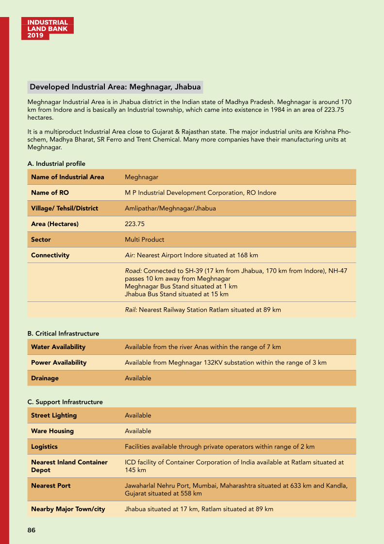
INDUSTRIAL LAND BANK 2019
86
Developed Industrial Area: Meghnagar, Jhabua
Meghnagar Industrial Area is in Jhabua district in the Indian state of Madhya Pradesh. Meghnagar is around 170 km from Indore and is basically an Industrial township, which came into existence in 1984 in an area of 223.75 hectares.
It is a multiproduct Industrial Area close to Gujarat & Rajasthan state. The major industrial units are Krishna Pho-schem, Madhya Bharat, SR Ferro and Trent Chemical. Many more companies have their manufacturing units at Meghnagar.
A. Industrial profile
Name of Industrial Area Meghnagar
Name of RO M P Industrial Development Corporation, RO Indore
Village/ Tehsil/District Amlipathar/Meghnagar/Jhabua
Area (Hectares) 223.75
Sector Multi Product
Connectivity Air: Nearest Airport Indore situated at 168 km
Road: Connected to SH-39 (17 km from Jhabua, 170 km from Indore), NH-47 passes 10 km away from MeghnagarMeghnagar Bus Stand situated at 1 km Jhabua Bus Stand situated at 15 km
Rail: Nearest Railway Station Ratlam situated at 89 km
B. Critical Infrastructure
Water Availability Available from the river Anas within the range of 7 km
Power Availability Available from Meghnagar 132KV substation within the range of 3 km
Drainage Available
C. Support Infrastructure
Street Lighting Available
Ware Housing Available
Logistics Facilities available through private operators within range of 2 km
Nearest Inland Container Depot
ICD facility of Container Corporation of India available at Ratlam situated at 145 km
Nearest Port Jawaharlal Nehru Port, Mumbai, Maharashtra situated at 633 km and Kandla, Gujarat situated at 558 km
Nearby Major Town/city Jhabua situated at 17 km, Ratlam situated at 89 km

87
INDUSTRIAL LAND BANK
2019
D. Industrial climate
Total Large Manufacturing Industries
4
Total Small Manufacturing Industries
111
Total Investment INR 852 Crore
Total Employment 2,000
Nearby major industrial units
A. P India BiotechKrishna Postechem Ltd. Madhya Bharat PhosphetTrent chemicals
Nearby Major Industrial Areas
Industrial Area Pithampur
For further details regarding booking/allotment/detailed industrial profile, please visit http://invest.mp.gov.in
Developed Industrial Area: IIDC & FPP, Jaggakhedi
Industrial Area Jaggakhedi is in Mandsaur district in the Indian state of Madhya Pradesh. It is a multiproduct industrial area with 40.89 hectares of land, out of which 20.56 hectares of land is for food processing units. It is close to the state commercial capital Indore situated at 216 km, via State Highway 17.
Mandsaur district is rich in archaeological and historical heritage having temple of Lord Pashupatinath located on the bank of Shivna River. Mandsaur district is also famous for large production of opium around the world. The major industries are Ruchi Soya, Ambuja export Soyabean plant, Sonic biochem, Rajaram & Brothers Starch factory, etc.
A. Industrial profile
Name of Industrial Area IIDC & FPP, Jaggakhedi
Name of RO M P Industrial Development Corporation, RO Indore
Village/Tehsil/District Jaggakhedi /Mandsaur/Mandsaur
Area (Hectares) IIDC (20.240) + FPP (20.650) = 40.89
Sector Food Processing & Multiproduct
Connectivity Air: Indore Airport situated at 217 km
Road: Mandsaur Bus Stand situated at 20 km
Rail: Mandsaur Railway Station situated at 52 km
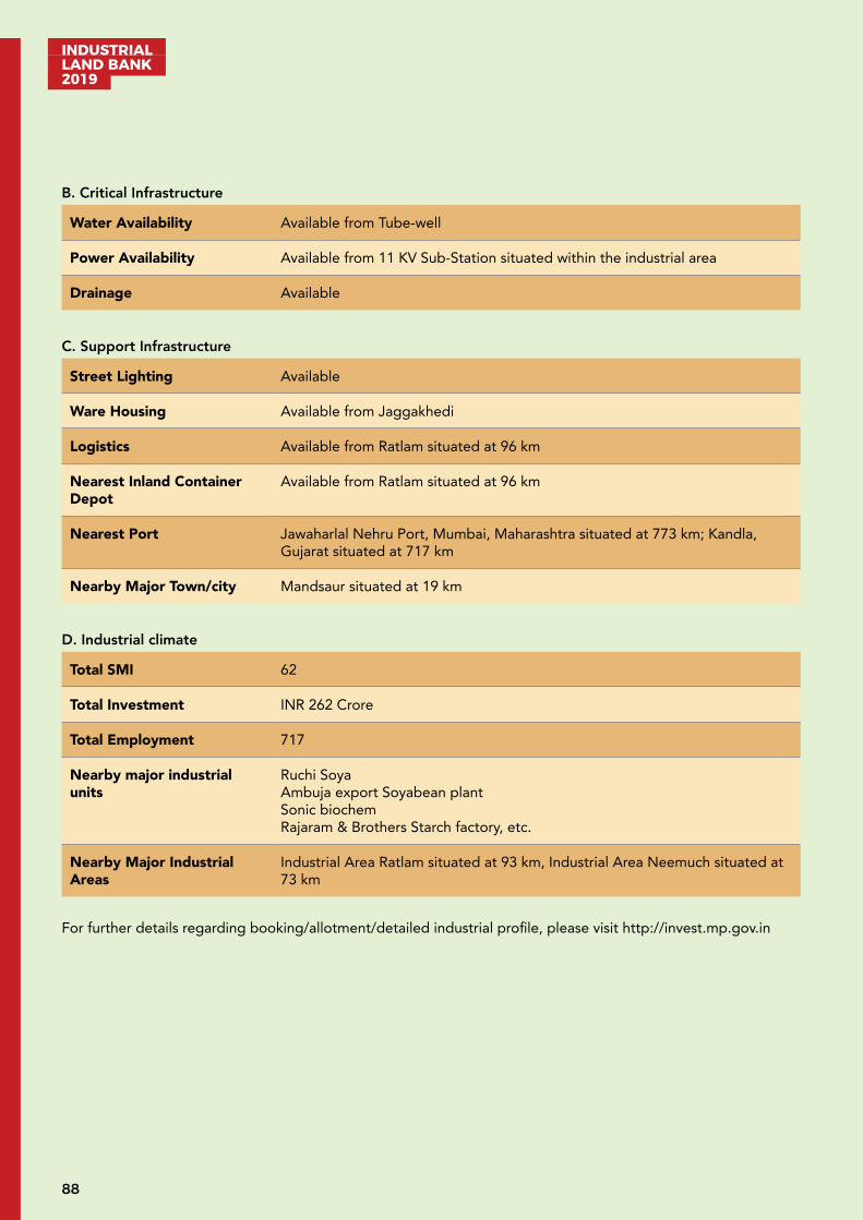
INDUSTRIAL LAND BANK 2019
88
B. Critical Infrastructure
Water Availability Available from Tube-well
Power Availability Available from 11 KV Sub-Station situated within the industrial area
Drainage Available
C. Support Infrastructure
Street Lighting Available
Ware Housing Available from Jaggakhedi
Logistics Available from Ratlam situated at 96 km
Nearest Inland Container Depot
Available from Ratlam situated at 96 km
Nearest Port Jawaharlal Nehru Port, Mumbai, Maharashtra situated at 773 km; Kandla, Gujarat situated at 717 km
Nearby Major Town/city Mandsaur situated at 19 km
D. Industrial climate
Total SMI 62
Total Investment INR 262 Crore
Total Employment 717
Nearby major industrial units
Ruchi SoyaAmbuja export Soyabean plantSonic biochemRajaram & Brothers Starch factory, etc.
Nearby Major Industrial Areas
Industrial Area Ratlam situated at 93 km, Industrial Area Neemuch situated at 73 km
For further details regarding booking/allotment/detailed industrial profile, please visit http://invest.mp.gov.in
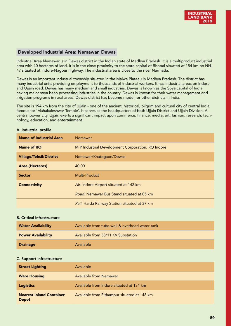
89
INDUSTRIAL LAND BANK
2019
Developed Industrial Area: Nemawar, Dewas
Industrial Area Nemawar is in Dewas district in the Indian state of Madhya Pradesh. It is a multiproduct industrial area with 40 hectares of land. It is in the close proximity to the state capital of Bhopal situated at 154 km on NH-47 situated at Indore-Nagpur highway. The industrial area is close to the river Narmada.
Dewas is an important industrial township situated in the Malwa Plateau in Madhya Pradesh. The district has many industrial units providing employment to thousands of industrial workers. It has industrial areas on Indore and Ujjain road. Dewas has many medium and small industries. Dewas is known as the Soya capital of India having major soya bean processing industries in the country. Dewas is known for their water management and irrigation programs in rural areas. Dewas district has become model for other districts in India.
The site is 194 km from the city of Ujjain - one of the ancient, historical, pilgrim and cultural city of central India, famous for ‘Mahakaleshwar Temple’. It serves as the headquarters of both Ujjain District and Ujjain Division. A central power city, Ujjain exerts a significant impact upon commerce, finance, media, art, fashion, research, tech-nology, education, and entertainment.
A. Industrial profile
Name of Industrial Area Nemawar
Name of RO M P Industrial Development Corporation, RO Indore
Village/Tehsil/District Nemawar/Khategaon/Dewas
Area (Hectares) 40.00
Sector Multi-Product
Connectivity Air: Indore Airport situated at 142 km
Road: Nemawar Bus Stand situated at 05 km
Rail: Harda Railway Station situated at 37 km
B. Critical Infrastructure
Water Availability Available from tube well & overhead water tank
Power Availability Available from 33/11 KV Substation
Drainage Available
C. Support Infrastructure
Street Lighting Available
Ware Housing Available from Nemawar
Logistics Available from Indore situated at 134 km
Nearest Inland Container Depot
Available from Pithampur situated at 148 km
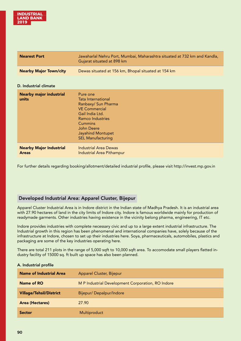
INDUSTRIAL LAND BANK 2019
90
Nearest Port Jawaharlal Nehru Port, Mumbai, Maharashtra situated at 732 km and Kandla, Gujarat situated at 898 km
Nearby Major Town/city Dewas situated at 156 km, Bhopal situated at 154 km
D. Industrial climate
Nearby major industrial units
Pure oneTata InternationalRanbaxy/ Sun PharmaVE CommercialGail India Ltd.Ramco IndustriesCumminsJohn DeereJayahind MontupetSEL Manufacturing
Nearby Major Industrial Areas
Industrial Area Dewas Industrial Area Pithampur
For further details regarding booking/allotment/detailed industrial profile, please visit http://invest.mp.gov.in
Developed Industrial Area: Apparel Cluster, Bijepur
Apparel Cluster Industrial Area is in Indore district in the Indian state of Madhya Pradesh. It is an industrial area with 27.90 hectares of land in the city limits of Indore city. Indore is famous worldwide mainly for production of readymade garments. Other industries having existence in the vicinity belong pharma, engineering, IT etc.
Indore provides industries with complete necessary civic and up to a large extent industrial infrastructure. The Industrial growth in this region has been phenomenal and international companies have, solely because of the infrastructure at Indore, chosen to set up their industries here. Soya, pharmaceuticals, automobiles, plastics and packaging are some of the key industries operating here.
There are total 211 plots in the range of 5,000 sqft to 10,000 sqft area. To accomodate small players flatted in-dustry facility of 15000 sq. ft built up space has also been planned.
A. Industrial profile
Name of Industrial Area Apparel Cluster, Bijepur
Name of RO M P Industrial Development Corporation, RO Indore
Village/Tehsil/District Bijepur/ Depalpur/Indore
Area (Hectares) 27.90
Sector Multiproduct
91
INDUSTRIAL LAND BANK
2019
Connectivity Air: Indore Airport situated at 24 km
Road: Situated on NH-47 (Indore-Ahmedabad), NH-52 connects in the range of 20 km. Betma bus stand is situtated at 03 km; Indore bus stand is situtated at 24 km
Rail: Indore Railway Station situated at 26 km
B. Critical Infrastructure
Water Availability Available at doorstep of industry situated at apparel cluster through 90 MLD water supply from Narmada-Kshipra Link
Power Availability Available at doorstep of industry through transmission lines connected to the transmission grid of 33/11KV substation in the campus
Drainage Available
Solid Waste Management Hazardus waste treatment plant of RAMKY ENVIRO at Pithampur which is in range of 20 km
C. Support Infrastructure
Street Lighting Available
Ware Housing Facilities available through private operators within the range of 2 - 10 km
Logistics Facilities available through private operators within the range of 2 - 10 km
Nearest Inland Container Depot
ICD facility of Container Corporation of India available at Pithampur Sector III situated at 17 km One private container depot is available at Dhannad near Sector I Pithampur situated at 17 km
Nearest Port Jawaharlal Nehru Port, Mumbai, Maharashtra situated at 592 km
Nearby Major Town/city Indore situated at 25 km
D. Industrial climate
Total SMI 33
Total Investment INR 54 Crore
Total Employment 300
Nearby Major Industrial Areas
Industrial Area Pithampur which is having 217 LMI units and 610 SMI units
For further details regarding booking/allotment/detailed industrial profile, please visit http://invest.mp.gov.in
INDUSTRIAL LAND BANK 2019
92
Developed Industrial Area: Relwa-Khajuri, Barwani
Relwa-Khajuri Industrial Area is in Barwani district in the Indian state of Madhya Pradesh. It is a multiproduct industrial area connecting district headquarters Badwani (44 km), Indore (123 km) of Madhya Pradesh and Mum-bai (468 km) of Maharashtra. Relwa-Khajuri is developing industrial area sprawling over 40.45 hectares of land close to the borders of Madhya Pradesh and Maharshtra. There are total 71 plots in the range of 5000 sq.ft.-100000 sq. ft. area. A leading wind energy equipment manufacturing company Inox Wind Ltd. has started production in their unit at this industrial area over 17 hectares of plot area.
A. Industrial profile
Name of Industrial Area Relwa- Khajuri, Barwani
Name of RO M P Industrial Development Corporation, RO Indore
Village/ Tehsil/District Relwakhurd/Rajpur/Barwani
Area (Hectares) 40.45
Sector Multi Product
Connectivity Air: Indore Airport situated at 125 km
Road: Julwania Bus stand situated at 19 km; Located on NH52
Rail: Mhow Railway Station situated at 96 km; Indore Railway Station situated at 124 km
B. Critical Infrastructure
Water Availability Available from tube-wells
Power Availability Available from 132/11 KV substation
Drainage RCC system
C. Support Infrastructure
Logistics Facilities available through private operators within a range of 10 km
Nearest Inland Container Depot
ICD facility of Container Corporation of India available at Pithampur Sector III situated at 106 km
Nearest Port Jawaharlal Nehru Port, Mumbai situated at 487 km and Kandla Gujarat situated at 686 km
Nearby Major Town/city Barwani situated at 44 km
93
INDUSTRIAL LAND BANK
2019
D. Industrial climate
Total LMI 1
Total SMI 2
Total Investment INR 600 Crore Proposed
Total Employment 250 Proposed
Nearby major industrial units
Inox Wind Ltd.
Nearby Major Industrial Areas
Industrial Area Pithampur
For further details regarding booking/allotment/detailed industrial profile, please visit http://invest.mp.gov.in
Developed Industrial Area: Jhajharwada, Neemuch
Proposed Industrial area Jhajharwada is in Neemuch district in the Indian state of Madhya Pradesh. It is a multi-product industrial area. It is close to Udaipur (138 km) and Indore (260 km) on the NH-27. The total area is around 85.96 hectares.
The town of Neemuch is the administrative headquarters of the district. It is located in Malwa plateau in western region of MP with fertile medium & deep soils. This region is part of the major agricultural production of Pota-to, Jowar and Wheat crops. Neemuch has Isabgol (psyllium seed) husk plant in Madhya Pradesh. The district is renowned worldwide for large production of opium.
A. Industrial profile
Name of Industrial Area Jhajharwada
Name of RO M P Industrial Development Corporation, RO Indore
Village/Tehsil/District Jhajharwada/Neemuch/Neemuch
Area (Hectares) 85.96
Sector Multi Product
Connectivity Air: Udaipur Airport situated at 137 km & Air strip at Neemuch
Road: Neemuch Bus Stand situated at 14 km
Rail: Neemuch Railway Station situated at 22 km
Nearby major Industrial area
Industrial Area Dewas situated at 252 km, Ujjain situated at 201 km & Pitham-pur situated at 300 km
INDUSTRIAL LAND BANK 2019
94
B. Critical Infrastructure
Water Availability Available from Thikriya dam situated at 10 km
Power Availability Available from 132 KV Substation situated at 12 km
C. Support Infrastructure
Logistics Available from Neemuch through private service provider
Nearest Inland Container Depot
Available from Ratlam source situated at 138 km
Nearest Port Jawaharlal Nehru Port, Mumbai, Maharashtra situated at 815 km and Kandla, Gujarat situated at 655 km
Nearby Major Town/city Neemuch situated at 12 km
D. Industrial climate
Nearby major industrial units
Ruchi SoyaAmbuja export Soyabean plantSonic bio chemRajaram & Brothers Starch factory, etc.
Nearby Major Industrial Areas
Industrial Area Ratlam situated at 93 km, Industrial Area Neemuch situated at 73 km
For further details regarding booking/allotment/detailed industrial profile, please visit http://invest.mp.gov.in
Developed Industrial Area: Tajpur, Ujjain
Industrial Area Tajpur is in Ujjain district in the Indian state of Madhya Pradesh. It is close to the state commercial capital Indore (89 km) on the Agra-Bombay National Highway near Maksi road. It is a multiproduct industrial area. The total area is around 82.84 hectares.
The city of Ujjain is one of the ancient, historical, pilgrim and cultural city of central India, famous for ‘Mahakalesh-war Temple’. It serves as the headquarter of both Ujjain District and Ujjain Division. A central power city, Ujjain exerts a significant impact upon commerce, finance, media, art, fashion, research, technology, education, and entertainment.
A. Industrial profile
Name of Industrial Area Tajpur
Name of RO M P Industrial Development Corporation, RO Indore
Village/Tehsil/District Tajpur/Ujjain/Ujjain
95
INDUSTRIAL LAND BANK
2019
Area (Hectares) 82.84
Sector Multiproduct
Connectivity Air: Indore Airport situated at 90 km;Datana-Matana air strip situated at 25 km
Road: Tajpur Bus Stand situated at 02 km
Rail: Tajpur Railway Station situated at 07 km
B. Critical Infrastructure
Water Availability Available from Sahibkhedi Dam situated at 18 km
Power Availability Available from 400 KV (MPPKVVCL) Sub-Station situated at 03 km
Drainage Available
C. Support Infrastructure
Street Lighting Available
Warehousing Available from Ujjain-Maksi Road situated at 02 km
Logistics Available from Indore source being situated at 88 km
Nearest Inland Container Depot
Available from Pithampur source being situated at 109 km
Nearest Port Jawaharlal Nehru Port, Mumbai, Maharashtra situated at 693 km and Kandla, Gujarat situated at 736 km
Nearby Major Town/city Ujjain situated at 34 km
D. Industrial climate
Total Small Manufacturing Industries
1
Total Investment INR 46.5 Lakh
Nearby major industrial units
Ramco Cement PipeRegent Beer Industrial Area MaxiShriji Polymers Ltd. Industrial Area Maxi road Ujjain.M/S Shriniwas Containers & Closures Pvt. Ltd.Sanchi milk plant,Avi Agro
Nearby Major Industrial Areas
Industrial Area Pithampur situated at 126 km
For further details regarding booking/allotment/detailed industrial profile, please visit http://invest.mp.gov.in
INDUSTRIAL LAND BANK 2019
96
Developed Industrial Area: Karmadi, Ratlam
Industrial area Karmadi, is in Ratlam district in the Indian state of Madhya Pradesh. It is a multiproduct industrial area and has several food processing industrial units. It is close to the commercial state capital Indore (139 km), on the NH-56. The total area is around 18.15 hectares. The belt is rich in production of soya seeds. Various pro-tein related products like DOC cake, soya flakes, soya milk, soya oil, soya flour are produced here.
Ratlam district is famous for its unique and appealing gateways and is administrative headquarters of the dis-trict. The economic activities in the town are mainly trade, commerce and industries. Ratlam has several chemical factories namely High-tech, IPCA, Shaba Chemicals, Bordiya Chemicals etc. There are several manufacturing units of copper wires and plastic ropes. Ratlam is also famous for its gold ornaments and special sarees designing. Ratlami Namkeen (sev) is famous throughout the country.
A. Industrial profile
Name of Industrial Area Karmadi
Name of RO M P Industrial Development Corporation, RO Indore
Village/Tehsil/District Karmadi/Ratlam/Ratlam
Area (Hectares) 18.15
Sector Food Processing (Namkeen Cluster) & Multi-product
Connectivity Air: Indore Airport situated at 137 km
Road: Ratlam Bus Stand situated at 08 km
Rail: Ratlam Railway Station situated at 05 km
B. Critical Infrastructure
Water Availability Available from RMC Water Supply Scheme, source being situated at 06 km
Power Availability Available from 132 KV (MPPKVVCL Salakhedi)Sub-Station situated at 07 km
Drainage Available
C. Support Infrastructure
Street Lighting Available
Ware Housing Available from Karmadi
Logistics Available from Ratlam, the source being situated at 04 km
Nearest Inland Container Depot
Available from Ratlam, the source being situated at 08 km
Nearest Port Jawaharlal Nehru Port,Mumbai, Maharashtra situated at 678 km and Kandla, Gujarat situated at 639 km
Nearby Major Town/city Ratlam situated at 04 km
97
INDUSTRIAL LAND BANK
2019
D. Industrial climate
Total Small Manufacturing Industries
1
Total Investment INR 100 lakh
Total Employment 12
Nearby major industrial units
IPCA LaboratoryKatariya wiresKhatan AgroRaj SolvexAmbikaSolvex
Nearby Major Industrial Areas Industrial Area Pithampur
For further details regarding booking/allotment/detailed industrial profile, please visit http://invest.mp.gov.in
Developed Industrial Area: Smart Industrial Park, Indore
Smart Industrial Park is in Dhar district in the Indian state of Madhya Pradesh. Industrial Area is around 70 km from Indore in an area of 469 hectares. It is a multiproduct Industrial area. The development focused Government of Madhya Pradesh (GoMP) with a vision to promote investment from Japan has declared an Industrial Township of 72.77 hectares for Japanese companies and companies belonging to South East & Far East Asian Nations (SEFEAN).
Indore being close to Smart Industrial Park is the largest city of the state of Madhya Pradesh and together with its satellite towns of Pithampur and Dewas, is one of the fastest growing economic regions of India. Indore is the commercial capital of the state and a hub for all major business activities in the Western part of the state. The site is also near the leading industrial growth centre Pithampur.
A. Industrial profile
Name of Industrial Area Smart Industrial Park
Name of RO M P Industrial Development Corporation, RO Indore
District Dhar/ Dhar
Area (Hectares) 469.97
Sector Multiproduct
Connectivity Air: Indore Airport situated at 42 km
Road: Connected to NH-52, NH47 (in the range of 5-15 km)
Rail: Rau Railway Station situated at 30 km Indore Railway Station situated at situated at 42 km
INDUSTRIAL LAND BANK 2019
98
Nearby major Industrial area
Pithampur 1, 2, 3 & Kheda, SEZ I & SEZ II
B. Critical Infrastructure
Water Availability 90 MLD water supply available from Narmada-Kshipra Link
Power Availability Available from 132 KV substation situated in nearby area
C. Support Infrastructure
Logistics Available through private operators within the range of 5-10 km
Nearest Inland Container Depot
Available at Pithampur Sector III; One private container depot is available at Dhannad near Sector I Pithampur situated at 50 km
Nearest Port Jawaharlal Nehru Port, Mumbai, Maharashtra situated at 579 km Kandla, Gujarat situated at 644 km
Nearby Major Town/city Indore situated at 70 km
D. Industrial climate
Total Large Manufacturing Industries
18
Total Small Manufacturing Industries
06
Total Investment INR 2,070 Lakh
Total Employment 12,000
Nearby Major Industrial Areas
Industrial Area Pithampur & Indore
For further details regarding booking/allotment/detailed industrial profile, please visit http://invest.mp.gov.in

99
INDUSTRIAL LAND BANK
2019
Developing Industrial Area: Jetapura - Palasya, Dhar
Jetapura Palasya Industrial area is in Dhar district in the Indian state of Madhya Pradesh. Jetapura Palasya indus-trial area is around 68 km from Indore in an area of 359.3 hectares. It is a multi-product industrial area.
Indore being close to proposed industrial area is the largest city of the state of Madhya Pradesh and together with its satellite towns of Pithampur and Dewas, is one of the fastest growing economic regions of India. Indore is the commercial capital of the state and a hub for all major business activities in the Western part of the state. The city of Indore is well connected through air, rail & road to almost all the major towns of India, which is a boon for the industries. Soya, pharmaceuticals, automobiles, plastics and packaging are some of the key industries operat-ing here
A. Industrial profile
Name of Industrial Area Jetapura - Palasya
Name of RO M P Industrial Development Corporation, RO Indore
Village/Tehsil/District Jetapur-Palasya/Dhrampuri/Dhar
Area (Hectares) Jetapur 82.0 hectaresPalasya 198.2 hectaresBanwari 79.2 hectares
Sector Multi-product
Connectivity Air: Nearest Airport Indore situated at 87 km
Road: Well connected to NH-52; Dhamnod Bus-stand situated at 03 km
Rail: Mhow Railway Station at 68 km & Indore at 68 km
Nearby major Industrial area
Industrial Area Nimrani & Industrial Area Pithampur
B. Critical Infrastructure
Water Availability Available from river Narmada situated in the range of 10 km
Power Availability Available from MPEB 132 KV Sub-Station situated at 5 km
C. Support Infrastructure
Logistics Facilities Available through private operators in surrounding within range of 5-8 km
Nearest Inland Container Depot
Container depot is available at Dhannad near Pithampur Sector 1 & 3 (in the range of 51 km)
Nearest Port Jawaharlal Nehru Port, Mumbai, Maharashtra situated at 579 km and Kandla, Gujarat situated at 645 km
Nearby Major Town/city Indore situated at 68 km
INDUSTRIAL LAND BANK 2019
100
D. Industrial climate
Total Large Manufacturing Industries
(Pithampur 1, 2, 3 & Kheda)
146
Total Small Manufacturing Industries(Pithampur 1, 2, 3 & Kheda)
1,100
Total Investment (Pithampur 1, 2, 3 & Kheda)
INR 37,800 Crore
Total Employment (Pithampur 1, 2, 3 & Kheda)
90,000
Nearby major industrial units
Bridge Stone Ltd. Indo ram syntheticsMahale Engine ComponentsMittal Corp Ltd.Badve EngineeringEssar Steel Ltd. Gagan Gases Ltd.
Nearby Major Industrial Areas
Industrial Area Pithampur & Indore
For further details regarding booking/allotment/detailed industrial profile, please visit http://invest.mp.gov.in
Developing Industrial Area: Mohna, Depalpur
Mohna Industrial area is in Indore district in the Indian state of Madhya Pradesh. It is Texile specific industrial area with 140.39 hectares of land in the city limits of Indore city (25 km). Indore is famous world wide mainly for production of Readymade Garments. Other industries are also having existance like pharma, engineering, IT etc. The planning came into existance in year 2018-19 through the demand of local manufacturers. The idea was to give an opportunity to the local manufacturers who have their old establishments in the city and have no scope of expansion at their existing place of establishment.
A. Industrial profile
Name of Industrial Area Mohna, Depalpur.
Name of RO MP Industrial Development Corporation, RO Indore
Village/Tehsil/District Bijepur/ Depalpur/Indore
Area (Hectares) 140.39
Sector Textile
101
INDUSTRIAL LAND BANK
2019
Connectivity Air: Nearest Airport Indore situated at 24 km
Road: Situated on NH-47 (Indore-Ahmedabad), NH-52 connects in the range of 20 km. Nearest bus stand Betma (03 km); Indore bus stand (24km)
Rail: Nearest Railway Station Indore situated at 26 km
B. Critical Infrastructure
Water Availability Available at doorstep of industry situated at Apparel Cluster from the devel-oped water supply scheme based on borewellssource situated in the campus.
To cater future demand of industrial area Apparel Cluster, a scheme of 90MLD water supply from Narmada-Kshipra Link has been planned and supposed to be completed within next 3 years.
Power Availability Available at doorstep of industry through transmission lines connected to the transmission grid of 33/11KV substation in the campus (work is almost com-pleted)
Drainage Available, Kachcha drain
Solid Waste Management (Hazardus waste treatment plant of RAMKY ENVIRO at Pithampur within the range of 20 km)
C. Support Infrastructure
Street Lighting Available
Ware Housing Facilities available through private operators within range of 2 - 10 km
Logistics Facilities available through private operators within range of 2 - 10 km
Nearest Inland Container Depot
ICD facility of Container Corporation of India available at Pithampur Sector III (17 km). One private container depot is available at Dhannad near Sector I Pithampur (17 km).
Nearest Port Jwaharlal Nehru Port, Mumabi, Maharashtra (592 km)
Nearby Major Town/city Indore (25 km)
D. Industrial climate
Nearby major industrial units
The area is under development
Nearby Major Industrial Areas
Industrial Area Pithampur which is having 217 Large and 610 Small Manufac-turing Units
For further details regarding booking/allotment/detailed industrial profile, please visit http://invest.mp.gov.in
INDUSTRIAL LAND BANK 2019
102
Developing Industrial Area: Rehta-Khadkod, Burhanpur
Rehta-Khadkod is an Industrial area in Burhanpur district in the Indian state of Madhya Pradesh. It is multi-product Industrial area connecting district headquarters. This industrial area is situated at 2.5 km distance from Burhan-pur-Amravati State Highway. Rehta-Khadkod is a developing industrial area with 30.6 hectares of land consisting 18.6 hectares of Village Rehta and 12.00 hectares of Khadkod.
A. Industrial profile
Name of Industrial Area Rehta-Khadkod, Burhanpur
Name of RO M P Industrial Development Corporation, RO Indore
Village/ Tehsil/District Rehta-Khakod/ Burhanpur
Area (Hectares) 30.6
Sector Multi-product
Connectivity Air: Indore Airport situated at 125 km
Road: Situated on NH52. Julwania bus stand situated at 19 km
Rail: Mhow Railway Station (96 km) & Indore Railway Station situated at 124 km
B. Critical Infrastructure
Water Availability Available
Power Availability Available from MPPKVVCL’s power distribution system
Drainage 6.5 km long RCC drainage
C. Support Infrastructure
Logistics Facilities available through private operators within range of 10 kms
Nearest Inland Container Depot
ICD facility of Container Corporation of India available at Pithampur Sector III situated at 106 km
Nearest Port Jawaharlal Nehru Port, Mumbai, Maharashtra situated at 487 km and Kandla, Gujarat situated at 686 km
Nearby Major Town/city Barwani situated at 44 km
D. Industrial climate
Nearby Major Industrial Areas
Industrial Area Pithampur
For further details regarding booking/allotment/detailed industrial profile, please visit http://invest.mp.gov.in
103
INDUSTRIAL LAND BANK
2019
Developing Industrial Area: Kasarwardi, Jhabua
Kasarwadi Industrial area is in Jhabua district in the Indian state of Madhya Pradesh. It is multi product Industrial area connecting district headquarters Ratlam (57 km), Jhabua (45 km), Dhar (96 km) & Indore (144 km) of Madhya Pradesh India and Ahmedabad (281 km) of Gujarat.
Hatod is developing industrial area, 71.8 hectares of land in the proximity of border of Madhya Pradesh and Gujarat. Its planning came into existance in year 2015-16 through the feasibility study recommending demand of industrial plot from industries of nearby Gujarat state.
A. Industrial profile
Name of Industrial Area Kasarwardi
Name of RO M P Industrial Development Corporation, RO Indore
Village/Tehsil/District Petlawad/Jhabua
Area (Hectares) 71.8
Sector Multi-product
Connectivity Air: Indore Airport situated at 142 km
Road: Connected to SH-39A (03 km) & SH-18 (03 km). Petlawad Bus Stand 50 km
Rail: Ratlam Railway Station situated at 57 km
B. Critical Infrastructure
Water Availability Available from the tube wells
Power Availability Available from Petlawad within range of 25 km
Drainage Available
C. Support Infrastructure
Ware Housing Available from Petlawad within range of 03 km
Logistics Facilities available through private operators within range of 2 km
Nearest Inland Container Depot
ICD facility of Container Corporation of India available at Ratlam (57 km)
Nearest Port Jawaharlal Nehru Port, Mumbai, Maharashtra (665 km) and Kandla, Gujarat (590 km)
Nearby Major Town/city Petlawad (21 km), Ratlam (57 km), Badnawar (53 km)
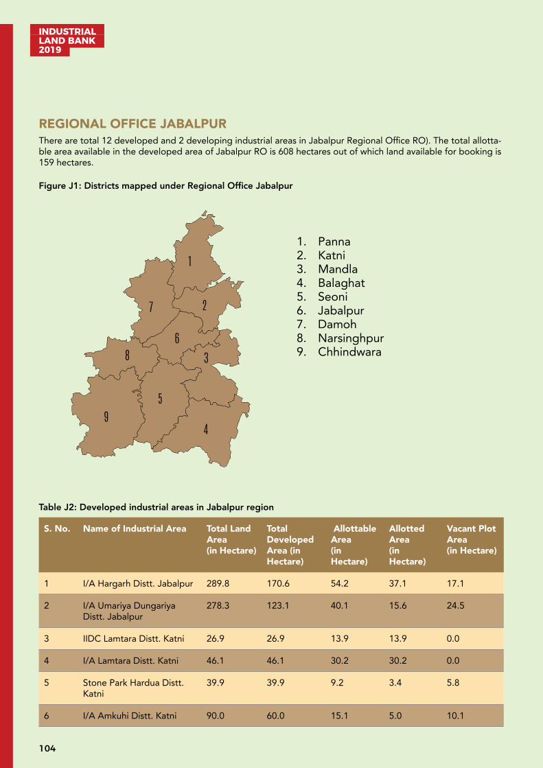
INDUSTRIAL LAND BANK 2019
104
REGIONAL OFFICE JABALPURThere are total 12 developed and 2 developing industrial areas in Jabalpur Regional Office RO). The total allotta-ble area available in the developed area of Jabalpur RO is 608 hectares out of which land available for booking is 159 hectares.
Figure J1: Districts mapped under Regional Office Jabalpur
Table J2: Developed industrial areas in Jabalpur region
S. No. Name of Industrial Area Total Land Area (in Hectare)
Total Developed Area (in Hectare)
Allottable Area (in Hectare)
Allotted Area (in Hectare)
Vacant Plot Area (in Hectare)
1 I/A Hargarh Distt. Jabalpur 289.8 170.6 54.2 37.1 17.1
2 I/A Umariya Dungariya Distt. Jabalpur
278.3 123.1 40.1 15.6 24.5
3 IIDC Lamtara Distt. Katni 26.9 26.9 13.9 13.9 0.0
4 I/A Lamtara Distt. Katni 46.1 46.1 30.2 30.2 0.0
5 Stone Park Hardua Distt. Katni
39.9 39.9 9.2 3.4 5.8
6 I/A Amkuhi Distt. Katni 90.0 60.0 15.1 5.0 10.1
1
2
3
4
5
6
7
8
9
1. Panna 2. Katni 3. Mandla 4. Balaghat 5. Seoni 6. Jabalpur 7. Damoh 8. Narsinghpur 9. Chhindwara

105
INDUSTRIAL LAND BANK
2019
7 IGC Maneri Distt. Mandla 486.9 486.9 173.8 114.2 59.7
8 Food Park Maneri Distt. Mandla
30.4 30.4 9.8 8.0 1.7
9 I/A Bhurkalkhapa Distt. Seoni
390.9 60.8 35.8 9.0 26.8
10 IGC Borgaon Distt. Chhindwara
250.4 250.4 149.1 148.3 0.8
11 Food Park Borgaon Distt. Chhindwara
21.5 21.5 12.9 12.9 0.0
12 I/A Purena 105.5 105.5 63.3 51.0 12.3
Distt. Pann
TOTAL 2056.6 1422.1 607.5 448.6 158.9
Table J3: Developing industrial areas in Jabalpur region
S. No. Name of Industrial Area Total Land Area (in Hectare)
Total Developed Area (in Hectare)
Allottable Area (in Hectare)
Allotted Area (in Hectare)
Vacant Plot Area (in Hectare)
1 I/A Lahgadua Distt. Chhindwara
35.0 35.0 26.9 - 26.9
2 I/A Borgaon Distt. Chhindwara
34.7 34.7 24.4 - 24.4
TOTAL 69.8 69.8 51.3 51.3

INDUSTRIAL LAND BANK 2019
106
2056.6
1422.1
607.5
448.6
158.9
DEVELOPED AREA
Total Land Area (in Hectare) Total Developed Area (in Hectare) Allottable Area (in Hectare) Allotted Area (in Hectare)
Vacant Plots’ Area (in Hectare)
69.8
69.8
51.3
0.0
51.3
DEVELOPING AREA
Total Land Area (in Hectare) Total Developed Area (in Hectare) Allottable Area (in Hectare) Allotted Area (in Hectare)
Vacant Plots’ Area (in Hectare)
107
INDUSTRIAL LAND BANK
2019
Developed Industrial Area: Industrial Area Bhurkalkhapa, Seoni
Industrial area (I/A) Bhurkalkhapa is situated in Seoni district of Madhya Pradesh. Spread across a total area of 676.9 hectares out of which 60.8 ha has been developed in 1st phase, I/A Bhurkalkhapa is a multi-product indus-trial area located near North South Corridor. Seoni district is primarily a tribal dominated area. Seoni is one of the forest rich districts in Madhya Pradesh having rich availability of timber. Wainganga river is the lifeline of the district.
A. Industrial profile
Name of Industrial Area Industrial Area, Bhurkalkhapa
Name of RO Regional Office Jabalpur, MPIDC
Village/Tehsil/District Bhurkalkhapa/Seoni/Seoni
Area (Hectares) 676.9 (Developed 60.8 Ha. in First Phase)
Sector Multi Product
Connectivity Air: Nearest Airport - Nagpur, 142 km
Road: Nearest Bus Stand – Seoni, 05 km
Rail: Nearest Railway Station - Nagpur, 139 km & Jabalpur, 159 kmBroad-gauge rail line under construction, passing through the Industrial Area Bhurkalkhapa
B. Critical Infrastructure
Water Availability MPIDC water supply within industrial area
Power Availability Available (33/11 KV sub-station)
C. Support Infrastructure
Street Lighting Available
Ware Housing Available in Seoni, 10 km
Logistics Available
Nearest Inland Container Depot
Available at Nagpur, sitauated at 151 km
Nearest Port Jawaharlal Nehru Port, Mumbai, Maharashtra (972 km)
Nearby Major Town/city Seoni - 05 km
INDUSTRIAL LAND BANK 2019
108
D. Industrial climate
Total Medium & Small Manufacturing Industries
10
Total Investment INR 25 Crore
Total Employment 357
Major industrial units R.H. Solvax Pvt. Ltd, MS Mining
Nearby Major Industrial Areas
Industrial Estate Seoni (05 km)
For further details regarding booking/allotment/detailed industrial profile, please visit http://invest.mp.gov.in
Developed Industrial Area: Industrial Growth Centre (IGC) Maneri, Mandla
Industrial Growth Centre (IGC) Maneri is situated in Mandla district of Madhya Pradesh. Spread across a total area of 517.3 hectares IGC Maneri is a multi-product industrial area with a dedicated food park with area of 30.4 hect-ares, situated on Barela-Niwas road. Mandla is a tribal district situated in the east-central part of Madhya Pradesh. The district lies almost entirely in the catchment of river Narmada and its tributaries. Jabalpur has a national airport which is connected to Hyderabad, Kolkata, Mumbai and New Delhi.
A. Industrial profile
Name of Industrial Area IGC & Food Park, Maneri
Name of RO Regional Office Jabalpur, MPIDC
Village/ Tehsil/District Medhi, Jhurki, Takweli/Niwas/Mandla
Area (Hectares) 517.3
Sector Multi Product in IGC & Food Processing Industries in Food Park
Connectivity Air: Nearest Airport - Jabalpur, 39km
Road: Nearest Bus Stand - Maneri, 0 km & Barela, 18 km
Rail: Nearest Railway Station – Jabalpur, 38 km
B. Critical Infrastructure
Water Availability MPIDC water supply within industrial area (3 MLD)
Power Availability Available (132 KV Substation at site)

109
INDUSTRIAL LAND BANK
2019
C. Support Infrastructure
Street Lighting Available
Ware Housing Available in Food Park
Logistics Available
Nearest Inland Container Depot
Available in Nagpur, situated at 318 km
Nearest Port Jawaharlal Nehru Port, Mumbai, Maharashtra (1156 km)
Nearby Major Town/city Jabalpur - 37 km
D. Industrial climate
Total Large Manufacturing Industries
2
Total Medium & Small Man-ufacturing Industries
82
Total Investment INR 224 Crore
Total Employment 1,921
Major industrial units Primo Pick N Pack Ltd, Hindustan Petroleum Cop. Ltd, P.S.L. Engineering, Vinayak Polytex Private Ltd
Nearby Major Industrial Areas
Industrial Estate Adhartal, Jabalpur (42 km)Industrial Area Richai, Jabalpur (47 km)Industrial Area Umaria-Dungaria, Jabalpur (60 km)
For further details regarding booking/allotment/detailed industrial profile, please visit http://invest.mp.gov.in
INDUSTRIAL LAND BANK 2019
110
Developed Industrial Area: Industrial Area Umaria-Dungaria, Jabalpur
Industrial Area (I/A) is situated in Umaria - Dungaria in Jabalpur district of Madhya Pradesh. Spread across a total area of 278.3 hectares I/A Umaria-Dungaria is a multi-product industrial area situated at Jabalpur-Chargawan-Go-tegaon road. Major available minerals are dolomite, iron, fire clay, manganese, marble, murram and sand. I/A Umariya-Dungariya is located 26 km from city of Jabalpur. Jabalpur has a national airport with connectivity to Hyderabad, Kolkata, Mumbai and New Delhi.
A. Industrial profile
Name of Industrial Area Industrial Area, Umaria-Dungariya
Name of RO Regional Office Jabalpur, MPIDC
Village/Tehsil/District Umaria, Dungria, Semra/Shahpura/Jabalpur
Area (Hectares) 278.3 (Developed Area 123.1 Hect.)
Sector Multi Product
Connectivity Air: Nearest Airport - Jabalpur, 36 km
Road: Nearest Bus Stand - Jabalpur, 26 km
Rail: Nearest Railway Station - Jabalpur, 28 km
B. Critical Infrastructure
Water Availability MPIDC water supply within industrial area (3 MLD)
Power Availability Available (33/11 KV substation)
C. Support Infrastructure
Logistics Available in Jabalpur, 26 km
Nearest Inland Container Depot
Available in Nagpur, situated at 271 km
Nearest Port Jawaharlal Nehru Port, Mumbai, Maharashtra (1,095 km)
Nearby Major Town/city Jabalpur, 26 km
D. Industrial climate
Total Medium & Small Man-ufacturing Industries
33
Total Investment INR 49 Crore
Total Employment 501
111
INDUSTRIAL LAND BANK
2019
Nearby major industrial units
Gun Carriage Factory, Ordinance Factory Khamariya, Vehicle Factory, Gray Iron Foundry
Nearby Major Industrial Areas
Industrial Estate Adhartal – Jabalpur, 30 kmIndustrial Area Richai – Jabalpur, 35 km
For further details regarding booking/allotment/detailed industrial profile, please visit http://invest.mp.gov.in
Developed Industrial Area: Industrial Area Hargarh, Jabalpur
Industrial Area (I/A) Hargarh is situated in Jabalpur district of Madhya Pradesh. Spread across a total area of 289.8 hectares, I/A Hargarh is a multi-product industrial area situated at Jabalpur-Sihora- Pan Umaria road. Jabalpur is located in the Mahakaushal region of Madhya Pradesh, on the divide between the watersheds of Narmada and Son. Major available minerals are dolomite, iron, fire clay, manganese, marble, murram and sand. I/A Hargarh is located 48 km from city of Jabalpur. Jabalpur has a national airport with connectivity to Hyderabad, Kolkata, Mumbai and New Delhi
A. Industrial profile
Name of Industrial Area Industrial Area, Hargarh
Name of RO Regional Office Jabalpur, MPIDC
Village/ Tehsil/District Hargarh/ Sihora/Jabalpur
Area (Hectares) 289.8 (Developed Area 170.6 Ha.)
Sector Multi Product
Connectivity Air: Nearest Airport - Jabalpur, 58 km
Road: Nearest Bus Stand - Sihora, 10 km
Rail: Nearest Railway Station - Sihora Road, 07 km & Jabalpur, 50 km
B. Critical Infrastructure
Water Availability MPIDC water supply within industrial area (3 MLD)
Power Availability Available (33/11 KV substation)
C. Support Infrastructure
Street Lighting Available
Ware Housing Available in Sihora, situated at 10 km
INDUSTRIAL LAND BANK 2019
112
Logistics Available
Nearest Inland Container Depot
Available in Nagpur, situated at 329 km
Nearest Port Jawaharlal Nehru Port, Mumbai, Maharashtra (1,121 km)
Nearby Major Town/city Sihora, 10 km & Jabalpur, 48 km
D. Industrial climate
Total Large Manufacturing Industries
1
Total Medium & Small Man-ufacturing Industries
5
Total Investment INR 150 Crore
Total Employment 366
Major industrial units Eurobond Industries Pvt. Ltd, Broken Hill Mines Company, Jain Mines & Min-eral
Nearby Major Industrial Areas
Industrial Area Richhai, Jabalpur (37 km)Industrial Estate Adhartal, Jabalpur (42 km)
For further details regarding booking/allotment/detailed industrial profile, please visit http://invest.mp.gov.in
Developed Industrial Area: Industrial Area Amkuhi, Katni
Industrial Area (I/A) Amkuhi is situated in Katni district of Madhya Pradesh. Spread across a total area of 90 hectares I/A Amkuhi is a multi-product industrial area situated 03 km away from Katni city and around 2 km from NH 30. Katni district has a perfect balance between agricultural productivity and industrial developments. Major industries present in the district are mineral based and from food processing sector.
Katni is also known for defence-related manufacturing industries. I/A Amkuhi is located 98 km from city of Jabal-pur, it has a national airport which serves Hyderabad, Kolkata, Mumbai and New Delhi.
A. Industrial profile
Name of Industrial Area Industrial Area Amkuhi
Name of RO Regional Office Jabalpur, MPIDC
Village/Tehsil/District Amkuhi/Katni/Katni
Area (Hectares) 90 (Developed Area 60 Ha.)
Sector Multi Product
113
INDUSTRIAL LAND BANK
2019
Connectivity Air: Airport - Jabalpur (106 km)
Road: Bus Stand - Katni (04 km)
Rail: Railway Station - Katni (4 km)
B. Critical Infrastructure
Water Availability MPIDC water supply within industrial area
Power Availability Available 33/11 KV
C. Support Infrastructure
Street Lighting Available
Ware Housing Available
Logistics Available
Nearest Inland Container Depot
Available in Nagpur, situated at 380 km
Nearest Port Jawaharlal Nehru Port, Mumbai, Maharashtra (1,157 km)
Nearby Major Town/city Katni situated at 03 km
D. Industrial climate
Total Medium & Small Man-ufacturing Industries
3
Total Investment INR 2 Crore
Total Employment 29
Nearby major industrial units
Ordinance Factory Katni, Calderys India Refractories Ltd, ACE Refractories Ltd, Kevlani Agro Industries, Ojaswani Marble, Allied Minerals, Dabur India, Sheela Agro, Fair Food
Nearby major industrial Area
Industrial Area Bargawa (1 km)IIDC/Industrial Area Lamtara (11 km)
For further details regarding booking/allotment/detailed industrial profile, please visit http://invest.mp.gov.in
INDUSTRIAL LAND BANK 2019
114
Developed Industrial Area: Udhyog Giri Purena, Panna
Udhyog Giri Purena Industrial Area (I/A) is situated in Panna district of Madhya Pradesh. Spread across a total area of 105.5 Ha. I/A Purena is a multi-product industrial area. Purena is situated about 20 km from Katni.
Panna district comes under Sagar Division. It is famous for its diamond mines located in a belt of about 80 km across the Panna town. The Industrial area is located 116 km from city of Jabalpur, it has national airport which serves Hyderabad, Kolkata, Mumbai and New Delhi.
A. Industrial profile
Name of Industrial Area Udhyog Giri Purena, Panna
Name of RO Regional Office Jabalpur, MPIDC
Village/ Tehsil/District Purena /Sahnagar/ Panna
Area (Hectares) 105.5
Sector Multi Products
Connectivity Air: Nearest Airport - Jabalpur, 136 km; Khajuraho, 143 km.
Road: Nearest Bus Stand - Katni, 20 km
Rail: Nearest Railway Station – Hardua, 04 km and Katni Junction, 23 km
B. Critical Infrastructure
Water Availability MPIDC water supply within industrial area
Power Availability Available from 33/ 11KV,
C. Support Infrastructure
Street Lighting Available
Ware Housing Available in Katni, situated at 20 km
Logistics Available in Katni, situated at 20 km
Nearest Inland Container Depot
Available from Mandideep, situated at 378 km
Nearest Port Jawaharlal Nehru Port, Mumbai Maharashtra (1150 km) Kandla Gujarat (1250 km)
Nearby Major Town/city Katni, 20 km

115
INDUSTRIAL LAND BANK
2019
D. Industrial climate
Total Medium & Small Manufacturing Industries
10
Total Investment INR 10 Crore
Total Employment 270
major industrial units Katni Minerals Pvt Ltd, Om Stone industries
Nearby Major Industrial Areas
IIDC/Industrial Area Lamtara, Katni 20km
For further details regarding booking/allotment/detailed industrial profile, please visit http://invest.mp.gov.in
Developed Industrial Area: Industrial Area & Food Park Borgaon, Chhindwara
Industrial Area (I/A) Borgaon is situated in Chhindwara district of Madhya Pradesh. Spread across a total area of 271.9 Ha., I/A Borgaon is a multi-product industrial area with a dedicated food park in 21.5 Ha. area. The industri-al area is situated on Nagpur Chhindwara Highway, 55 km from Nagpur and 70 km from Chhindwara.
Industries that have contributed to the industrial development of Chhindwara are Hindustan Unilever, Raymond Ltd. and Asia’s largest coal wash plant known as coal washery having around 15 coal mines in the Kanhan area.
A. Industrial Profile
Name of Industrial Area IGC & Food Park, Borgaon
Name of RO Regional Office Jabalpur, MPIDC
Village/Tehsil/District Kharitaigaon-Borgaon/Saunsar/Chhindwara
Area (Hectares) 271.900
Sector Multi Product in IGC & Food Processing Industries in Food Park
Connectivity Air: Nearest Airport - Nagpur, 62 km
Road: Nearest Bus Stand - IGC Borgaon
Rail: Nearest Railway Station - Lodhikheda, 05 km & Nagpur, 59 km
B. Critical Infrastructure
Water Availability MPIDC water supply within industrial area (9 MLD)
Power Availability Available (132 KV Substation 20 MVA)
INDUSTRIAL LAND BANK 2019
116
C. Support Infrastructure
Street Lighting Available
Ware Housing Available in Food Park
Logistics Available at Borgaon
Nearest Inland Container Depot
Available in Nagpur, situated at 55 km
Nearby Major Town/city Chhindwara, 70 km & Nagpur, 55 km
Nearest Port Jawaharlal Nehru Port, Mumbai Maharashtra (835km)
D. Industrial climate
Total Large Manufacturing Industries
08
Total Medium & Small Man-ufacturing Industries
97
Total Investment INR 1,237 Crore
Total Employment 8,290
Major industrial units Raymond Ltd, JCO Gas Pipe Ltd, Gulshan Polyoal Ltd, PBM Polytex Ltd, Royal Uniforce Roofing Pvt. Ltd
Nearby Major Industrial Areas
Industrial Area Kalamgaon, Tehsil Pandurna - 45 km
For further details regarding booking/allotment/detailed industrial profile, please visit http://invest.mp.gov.in
117
INDUSTRIAL LAND BANK
2019
Developed Industrial Area: Industrial Area & IIDC Lamtara, Katni
Industrial Area (I/A) Lamtara & IIDC Lamtara is situated in Katni district of Madhya Pradesh. Spread across a total area of 73 Ha. I/A Lamtara is a multi-product industrial area situated near NH 30, around 6 km away from the Kat-ni city. Katni district has a perfect balance between agricultural productivity and industrial developments. Major industries present in the district are mineral based and from food processing sector.
Katni is also known for defence-related manufacturing industries. I/A Lamtara is located 103 km from city of Ja-balpur, it has a national airport which is connected to Hyderabad, Kolkata, Ahmedabad, Mumbai and New Delhi.
A. Industrial profile
Name of Industrial Area IIDC & Industrial Area Lamtara
Name of RO M P Industrial Development Corporation, RO Jabalpur
Village/ Tehsil/District Lamtara/Katni/Katni
Area (Hectares) IIDC – 26.9Industrial area – 46.1Total – 73.0
Sector Multi Product
Connectivity Air: Nearest Airport - Jabalpur situated at 113 km
Road: Nearest Bus Stand - Katni situated at 07 km
Rail: Nearest Railway Station - Katni situated at 09 km
B. Critical Infrastructure
Water Availability MPIDC water supply within industrial area
Power Availability Available 33/11 KV
C. Support Infrastructure
Street Lighting Available
Ware Housing Available in Industrial Area
Logistics Available
Nearest Inland Container Depot
Nagpur - 389 km
Nearest Port Jawaharlal Nehru Port, Mumbai, Maharashtra (1157 km)
Nearby Major Town/city Katni - 6 km
INDUSTRIAL LAND BANK 2019
118
D. Industrial climate
Total Medium & Small Manufacturing Industries
105
Total Investment INR 155 Crore
Total Employment 1438
Major industrial units Dalmia Refractories, WallPlast Product Pvt Ltd, Miraj Drymix
Nearby Major Industrial Areas
Industrial Area Bargawan 09 km, Industrial Area Amkuhi 11 km
For further details regarding booking/allotment/detailed industrial profile, please visit http://invest.mp.gov.in
Developed Industrial Area: Stone Park Hardua-Khaudawal, Katni
Stone Park Hardua-Khaudawal is in Katni district in the Indian state of Madhya Pradesh. It is Multi product indus-trial area with 39.920 hectares of land, 19 km away from the Katni city is passing through NH-30. Katni district has a perfect balance between agricultural productivity and industrial developments. Major industries present in the district are mineral based and from food processing sector.
Katni is also known for defence-related manufacturing industries. I/A Lamtara is located 75 km from city of Jabal-pur, it has a national airport which serves Hyderabad, Kolkata, Ahmedabad, Mumbai and New Delhi.
A. Industrial profile
Name of Industrial Area Stone Park Hardua-Khudawal
Name of RO M P Industrial Development Corporation, RO Jabalpur
Village/ Tehsil/District Hardua-Khudawal/Bahoriband/Katni
Area (Hectares) 39.920
Sector Mineral Based
Connectivity Air: Nearest Airport Jabalpur 85 km
Road: Nearest Bus Stand 01 km at Sleemnabad
Rail: Nearest Railway Station Sleemnabad Road 05 km
B. Critical Infrastructure
Water Availability Available (Tube well)
Power Availability Available 33/11 KV substation
119
INDUSTRIAL LAND BANK
2019
C. Support Infrastructure
Ware Housing Available in Sleemnabad Situated at 01 km
Logistics Available
Nearest Inland Container Depot
ICD Nagpur 393 km
Nearest Port Jawaharlal Nehru Port, Mumbai, Maharashtra (1140 km)
Nearby Major Town/city Katni situated at 25 km
D. Industrial climate
Total Medium & Small Man-ufacturing Industries
4
Total Investment INR 4 Crore
Total Employment 87
major industrial units Samdariya Enterprises, Ojaswi Marble & Granite Pvt Ltd.
Nearby Major Industrial Areas
Industrial Area Bargawan, Katni 25 km
For further details regarding booking/allotment/detailed industrial profile, please visit http://invest.mp.gov.in
Developing Industrial Area: Industrial Area Jamlapani, Chhindwara
Industrial Area (I/A) Jamlapani is situated in Chhindwara district beside Industrial Growth Centre Borgaon in Chhindwara district of Madhya Pradesh. Spread across a total area of 34.7 Ha. I/A Jamlapani is a multi-product industrial area. The industrial area is situated on Nagpur Chhindwara Highway, 55 km from Nagpur and 70 km from Chinndwara.
Industries that have contributed to the industrial development of Chhindwara are Hindustan Unilever, Raymond Ltd. and Asia’s largest coal wash plant known as coal washery having around 15 coal mines in the Kanhan area
A. Industrial profile
Name of Industrial Area Industrial Area Jamlapani
Name of RO Regional Office Jabalpur, MPIDC
Village/Tehsil/District Jamlapani/Saunsar/Chhindwara
Area (Hectares) 34.731
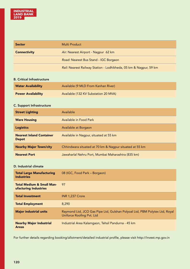
INDUSTRIAL LAND BANK 2019
120
Sector Multi Product
Connectivity Air: Nearest Airport - Nagpur 62 km
Road: Nearest Bus Stand - IGC Borgaon
Rail: Nearest Railway Station - Lodhikheda, 05 km & Nagpur, 59 km
B. Critical Infrastructure
Water Availability Available (9 MLD From Kanhan River)
Power Availability Available (132 KV Substation 20 MVA)
C. Support Infrastructure
Street Lighting Available
Ware Housing Available in Food Park
Logistics Available at Borgaon
Nearest Inland Container Depot
Available in Nagpur, situated at 55 km
Nearby Major Town/city Chhindwara situated at 70 km & Nagpur situated at 55 km
Nearest Port Jawaharlal Nehru Port, Mumbai Maharashtra (835 km)
D. Industrial climate
Total Large Manufacturing Industries
08 (IGC, Food Park – Borgaon)
Total Medium & Small Man-ufacturing Industries
97
Total Investment INR 1,237 Crore
Total Employment 8,290
Major industrial units Raymond Ltd, JCO Gas Pipe Ltd, Gulshan Polyoal Ltd, PBM Polytex Ltd, Royal Uniforce Roofing Pvt. Ltd
Nearby Major Industrial Areas
Industrial Area Kalamgaon, Tehsil Pandurna - 45 km
For further details regarding booking/allotment/detailed industrial profile, please visit http://invest.mp.gov.in
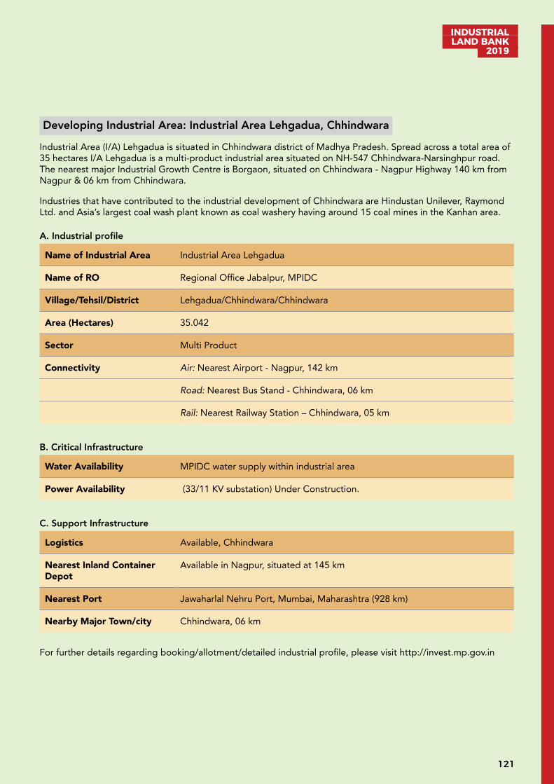
121
INDUSTRIAL LAND BANK
2019
Developing Industrial Area: Industrial Area Lehgadua, Chhindwara
Industrial Area (I/A) Lehgadua is situated in Chhindwara district of Madhya Pradesh. Spread across a total area of 35 hectares I/A Lehgadua is a multi-product industrial area situated on NH-547 Chhindwara-Narsinghpur road. The nearest major Industrial Growth Centre is Borgaon, situated on Chhindwara - Nagpur Highway 140 km from Nagpur & 06 km from Chhindwara.
Industries that have contributed to the industrial development of Chhindwara are Hindustan Unilever, Raymond Ltd. and Asia’s largest coal wash plant known as coal washery having around 15 coal mines in the Kanhan area.
A. Industrial profile
Name of Industrial Area Industrial Area Lehgadua
Name of RO Regional Office Jabalpur, MPIDC
Village/Tehsil/District Lehgadua/Chhindwara/Chhindwara
Area (Hectares) 35.042
Sector Multi Product
Connectivity Air: Nearest Airport - Nagpur, 142 km
Road: Nearest Bus Stand - Chhindwara, 06 km
Rail: Nearest Railway Station – Chhindwara, 05 km
B. Critical Infrastructure
Water Availability MPIDC water supply within industrial area
Power Availability (33/11 KV substation) Under Construction.
C. Support Infrastructure
Logistics Available, Chhindwara
Nearest Inland Container Depot
Available in Nagpur, situated at 145 km
Nearest Port Jawaharlal Nehru Port, Mumbai, Maharashtra (928 km)
Nearby Major Town/city Chhindwara, 06 km
For further details regarding booking/allotment/detailed industrial profile, please visit http://invest.mp.gov.in
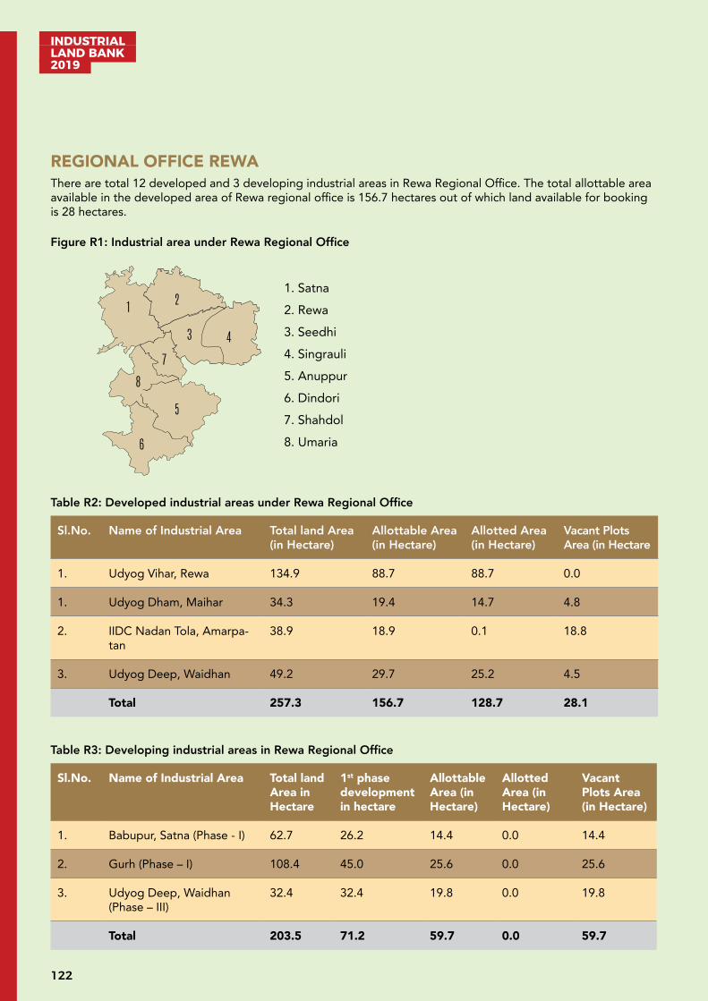
INDUSTRIAL LAND BANK 2019
122
REGIONAL OFFICE REWAThere are total 12 developed and 3 developing industrial areas in Rewa Regional Office. The total allottable area available in the developed area of Rewa regional office is 156.7 hectares out of which land available for booking is 28 hectares.
Figure R1: Industrial area under Rewa Regional Office
1 2
3 4
5
6
7
1. Satna 2. Rewa 3. Seedhi 4. Singrauli 5. Anuppur 6. Dindori 7. Shahdol 8. Umaria
8
Table R2: Developed industrial areas under Rewa Regional Office
Sl.No. Name of Industrial Area Total land Area (in Hectare)
Allottable Area (in Hectare)
Allotted Area (in Hectare)
Vacant Plots Area (in Hectare
1. Udyog Vihar, Rewa 134.9 88.7 88.7 0.0
1. Udyog Dham, Maihar 34.3 19.4 14.7 4.8
2. IIDC Nadan Tola, Amarpa-tan
38.9 18.9 0.1 18.8
3. Udyog Deep, Waidhan 49.2 29.7 25.2 4.5
Total 257.3 156.7 128.7 28.1
Table R3: Developing industrial areas in Rewa Regional Office
Sl.No. Name of Industrial Area Total land Area in Hectare
1st phase development in hectare
Allottable Area (in Hectare)
Allotted Area (in Hectare)
Vacant Plots Area (in Hectare)
1. Babupur, Satna (Phase - I) 62.7 26.2 14.4 0.0 14.4
2. Gurh (Phase – I) 108.4 45.0 25.6 0.0 25.6
3. Udyog Deep, Waidhan (Phase – III)
32.4 32.4 19.8 0.0 19.8
Total 203.5 71.2 59.7 0.0 59.7
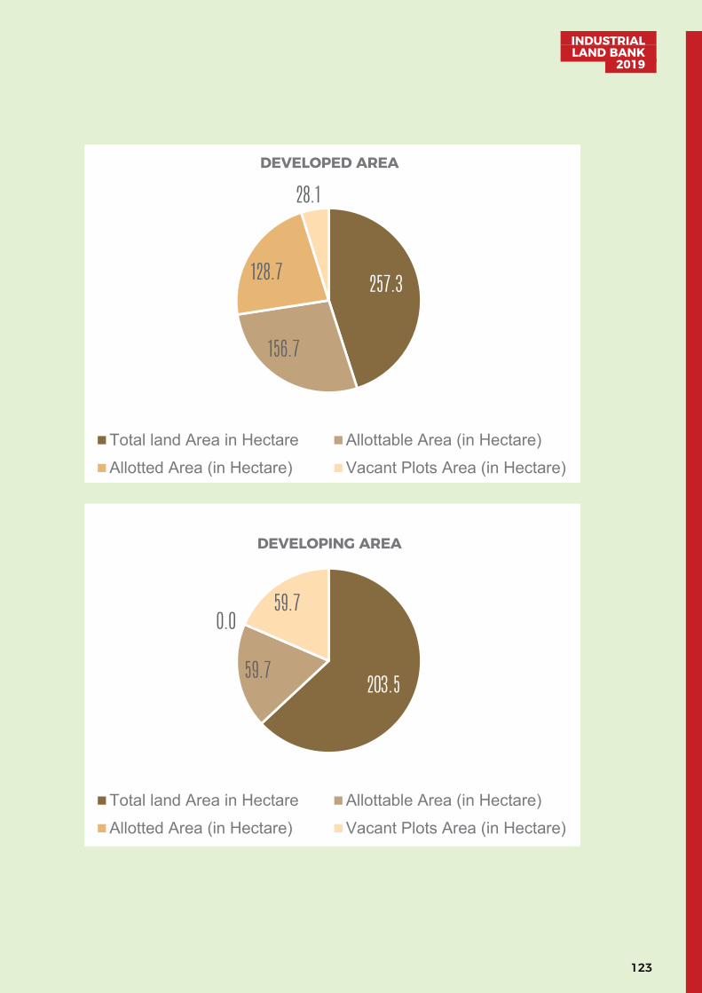
123
INDUSTRIAL LAND BANK
2019
257.3
156.7
128.7
28.1DEVELOPED AREA
Total land Area in Hectare Allottable Area (in Hectare)Allotted Area (in Hectare) Vacant Plots Area (in Hectare)
203.559.7
0.059.7
DEVELOPING AREA
Total land Area in Hectare Allottable Area (in Hectare)Allotted Area (in Hectare) Vacant Plots Area (in Hectare)
257.3
156.7
128.7
28.1DEVELOPED AREA
Total land Area in Hectare Allottable Area (in Hectare)Allotted Area (in Hectare) Vacant Plots Area (in Hectare)
203.559.7
0.059.7
DEVELOPING AREA
Total land Area in Hectare Allottable Area (in Hectare)Allotted Area (in Hectare) Vacant Plots Area (in Hectare)
INDUSTRIAL LAND BANK 2019
124
Developed Industrial Area: IID Nadantola, Amarpatan, Satna
Industrial Infrastructure Development Nadantola is in Satna district of Madhya Pradesh. It is a multi-product in-dustrial area with 38.9 hectares of land. The site is close to NH-30 and around 41 km from Satna Town.
Satna is a prominent city which shares its border with neighbouring state of Uttar Pradesh. Satna is home to nu-merous cement factories and plants because of the presence of huge reservoir of limestone mineral. Some of the major industries are Birla Cement Plant, KJS Cement Ltd., Prism Cement Plant etc.
A. Industrial profile
Name of Industrial Area IIDC Nadantola, Amarpatan, Satna
Name of RO RO Rewa, MPIDC
Village/Tehsil/District Nadantola/Amarpatan/Satna
Area (Hectares) 38.9
Sector Multi Product
Connectivity Air: Khajuraho Airport situated at 147 km
Road: Amarpatan Bus Stand situated at 06 km
Rail: Maihar Railway Station situated at 25 km
B. Critical Infrastructure
Water Availability Available
Power Availability Available from 33/11 KV, sub-station situated at 02 km
Drainage Available
C. Support Infrastructure
Ware Housing Available in Amarpatan situated at 03 km
Nearest Inland Container Depot
Available in Mandideep situated at 465 km
Nearest Port Jawaharlal Nehru Port, Mumbai situated at 1,237 km
Nearby Major Town/city Rewa situated at 45 km
D. Industrial climate
Total Small Manufacturing Industries
01
Total Investment INR 189 Lakh
125
INDUSTRIAL LAND BANK
2019
Total Employment 10
Nearby major industrial units
M/s KJS Cements, MaiharM/s Maihar Cements, Sarla Nagar, Maihar
Nearby Major Industrial Areas
Industrial Area Babupur situated at 18 km
For further details regarding booking/allotment/detailed industrial profile, please visit http://invest.mp.gov.in
Developed Industrial Area: Udyog Dham, Maihar, Satna
Industrial area Udyog Dham, Maihar is in Satna district in the Indian state of Madhya Pradesh. It is a multiproduct industrial area with 34.3 hectares of land. It is close to the world heritage site Khajuraho situated at 151 km on the NH30, between Jabalpur and Rewa.
Satna is a prominent city which shares its border with neighbouring state of Uttar Pradesh. Satna is home to sev-eral cement factories and plants because of presence of huge reservoir of limestone mineral. Some of the major industries are Birla Cement Plant, KJS Cement Ltd., Prism Cement Plant etc.
A. Industrial profile
Name of Industrial Area Udyog Dham, Maihar
Name of RO M P Industrial Development Corporation, RO Rewa
Village/Tehsil/District Harnampur/Maihar/Satna
Area (Hectares) 34.3
Sector Multi Product
Connectivity Air: Khajuraho Airport situated at 134 km
Road: Maihar Bus Stand situated at 03 km
Rail: Maihar Railway Station situated at 02 km
B. Critical Infrastructure
Water Availability Available
Power Availability Available
C. Support Infrastructure
Ware Housing Available at Amarpatan situated at 24 km
INDUSTRIAL LAND BANK 2019
126
Logistics Available
Nearest Inland Container Depot
Available at Mandideep situated at 443 km
Nearest Port Jawaharlal Nehru Port, Mumbai situated at 1,215 km
Nearby Major Town/city Satna situated at 44 km
D. Industrial climate
Total Small Manufacturing Industries
01
Total Investment INR 34.4 lakh
Total Employment 8
Nearby major industrial units
M/s KJS Cements, MaiharM/s Maihar Cements, Sarla Nagar, Maihar
Nearby Major Industrial Areas
IIDC Nadantola and Industrial Area Babupur
For further details regarding booking/allotment/detailed industrial profile, please visit http://invest.mp.gov.in
127
INDUSTRIAL LAND BANK
2019
Developed Industrial Area: Udyog Vihar Chorhata, Rewa
Industrial area Udyog Vihar, Chorhata is in Rewa district in the Indian state of Madhya Pradesh. It is a multi-prod-uct industrial area with 134.9 hectares of land. The industrial area is on the NH-30 between Varanasi and Kanyaku-mari.
Rewa is a city in the North-Eastern part of Madhya Pradesh. It is the administrative centre of Rewa district and Rewa Division. Rewa is largely driven by agricultural sector. Apart from the agricultural sector, industrial sector also makes vital contribution to the economic growth of the region. The major industries are J. P. Rewa Plant, Ultra Tech Bela Cement Plant, Heavy Engineering Works, Vindhya Telelinks, Birla Cable Ltd etc.
A. Industrial profile
Name of Industrial Area Udyog Vihar, Chorhata, Rewa
Name of RO M P Industrial Development Corporation, RO Rewa
Village/ Tehsil/District Nipania, Dohi, Babupur/Huzur/Rewa
Area (Hectares) 134.9
Sector Multi Product
Connectivity Air: Khajuraho Airport situated at 152 km
Road: Rewa Bus Stand situated at 05 km
Rail: Rewa Railway Station situated at 03 km
B. Critical Infrastructure
Water Availability Available
Power Availability Available 33/11 KV sub-station at industrial area
Drainage Available
C. Support Infrastructure
Street Lighting Available
Ware Housing Available at Chorhata industrial area
Nearest Inland Container Depot
Available from Mandideep situated at 501 km
Nearest Port Jawaharlal Nehru Port, Mumbai situated at 1,273 km
Nearby Major Town/city Rewa situated at 05 km
INDUSTRIAL LAND BANK 2019
128
D. Industrial climate
Total Large Manufacturing Industries
6
Total Small Manufacturing Industries
117
Total Investment INR 54,067 Lakh
Total Employment 2,235
Nearby Major Industrial Units
M/s J. P. Rewa Plant, Naubasta, Rewa (Cement)M/s Ultra Tech Bela Cement Plant, Madhepur, Rewa M/s Heavy Engineering Works, Naubasta, RewaM/s Vindhya Telelinks Ltd., Udyog Vihar, RewaM/s Birla Cable, Udyog Vihar, Chorhata , Rewa
Nearby Major Industrial Areas
Industrial Area Gurh situated at 26 km
For further details regarding booking/allotment/detailed industrial profile, please visit http://invest.mp.gov.in
Developed Industrial Profile: Udyog Deep, Waidhan
Industrial area Udyog Deep Waidhan is in Singrauli district in the state of Madhya Pradesh. It is a multi-product Industrial area with 81.6 (49.2 developed) hectares of land. It lies on NH-39.
Singrauli district is famous for its coal mining and power plants. Waidhan is an important town close to the in-dustrial area. The town is also known as India’s energy capital. It covers a region comprising eastern part of Sidhi district in Madhya Pradesh and the adjoining region in southern part of Sonbhadra district in Uttar Pradesh. Due to its immense natural potential and huge reserves of coal it is also known as ‘Urjanchal’ - the land of energy.
A. Industrial profile
Name of Industrial Area Udyog Deep, Waidhan
Name of RO RO Rewa, MPIDC
Village/Tehsil/District Ganiyari/Waidhan/Singrauli
Area (Hectares) 81.6 (49.2 developed)
Sector Multi Product
Connectivity Air: Varanasi Airport situated at 232 km
Road: Waidhan Bus Stand situated at 03 km
Rail: Bargawan Railway Station situated at 28 km

129
INDUSTRIAL LAND BANK
2019
B. Critical Infrastructure
Water Availability Available from Rihand Dam situated at 02 km
Power Availability Available 33/11 KV Sub-Station at Industrial Area
Drainage Available
C. Support Infrastructure
Street Lighting Available
Ware Housing Available
Logistics Available
Nearest Inland Container Depot
Available from Mandideep situated at 702 km
Nearest Port Jawaharlal Nehru Port, Mumbai situated at 1474 km
Nearby Major Town/city Varanasi situated at 217 km
D. Industrial climate
Total Small Manufacturing Industries
57
Total Investment INR 6,656 Lakh
Total Employment 1,014
Nearby major industrial units
M/s Trimula Industries Ltd., GodwaliM/s Nav Bharat Fuse Com. Ltd
Nearby Major Industrial Areas
Industrial Area, Udyog Vihar Chorahta Rewa situated at 210 kmIndustrial Area, Nadantola situated at 247 km
For further details regarding booking/allotment/detailed industrial profile, please visit http://invest.mp.gov.in

INDUSTRIAL LAND BANK 2019
130
Developing Industrial Area: Babupur, Satna
New Industrial area Babupur is in Satna district in the Indian state of Madhya Pradesh. It is a multi-product in-dustrial area with 62.6 hectares of land. The nearby unit is Bhilai JP Cement in Babupur. The site is around 18 km from Satna Town.
Satna is a prominent city which shares its border with neighbouring state of Uttar Pradesh. Satna is home to numerous cement factories and plants because of presence of huge reservoir of limestone mineral. Some of the major industries are Birla Cement Plant, KJS Cement Ltd., Prism Cement Plant etc.
A. Industrial profile
Name of Industrial Area Babupur
Name of RO M P Industrial Development Corporation, RO Rewa
Village/ Tehsil/District Atarhar/Unchehra/Satna
Area (Hectares) 62.6
Sector Multi Product
Connectivity Air: Khajuraho Airport situated at 128 km
Road: Satna Bus Stand situated at 18 km
Rail: Satna Railway Station situated at 14 km
B. Critical Infrastructure
Water Availability Available from Tamas river situated at 01 km
Power Availability Available 33/11 KV Sub-Station at Industrial area
Drainage Available
C. Support Infrastructure
Street Lighting Available
Ware Housing Available from Satna situated at 18 km
Nearest Inland Container Depot
Available at Mandideep situated at 482 km
Nearest Port Jawaharlal Nehru Port, Mumbai Maharashtra situated at 1,263 km
Nearby Major Town/city Satna situated at18 km
For further details regarding booking/allotment/detailed industrial profile, please visit http://invest.mp.gov.in
131
INDUSTRIAL LAND BANK
2019
Developing Industrial Area: Gurh, Rewa
New Industrial area Gurh is in Rewa district in the Indian state of Madhya Pradesh. It is a multi-product industrial area with 108.4 hectares of land. The industrial area is on the NH-39 between Rewa- Ranchi.
Rewa is a city in the North-Eastern part Madhya Pradesh. It is the administrative centre of Rewa district and Rewa Division. Rewa is largely driven by agricultural sector. Apart from agricultural, industrial sector also makes vital contribution to the economic growth of the region. The major industries are J. P. Rewa Plant & Bela Plant (Ce-ment), Heavy Engineering Works, Vindhya Telelinks, and Birla Ericsson Optical Ltd.
A. Industrial profile
Name of Industrial Area Gurh, Rewa
Name of RO M P Industrial Development Corporation, RO Rewa
Village/ Tehsil/District Atrari, Amradandi, Khamdih/Gurh/Rewa
Area (Hectares) 108.4
Sector Multi Product
Connectivity Air: Khajuraho Airport situated at 195 km
Road: Gurh Bus Stand situated at 04 km
Rail: Rewa Railway Station situated at 30 km
B. Critical Infrastructure
Water Availability Available
Power Availability Available from 33/11 KV Sub-Station
Drainage Available
C. Support Infrastructure
Street Lighting Available
Ware Housing Available from Gurh nearby Industrial Area
Nearest Inland Container Depot
Available from Mandideep situated at 545 km
Nearest Port Jawaharlal Nehru Port, Mumbai Maharashtra situated at 1,320 km
Nearby Major Town/city Rewa situated at 22 km
For further details regarding booking/allotment/detailed industrial profile, please visit http://invest.mp.gov.in
INDUSTRIAL LAND BANK 2019
132
Developing Industrial Profile: Udyog Deep, Waidhan (Phase – III)
Industrial area Udyog Deep Waidhan is in Singrauli district in the Indian state of Madhya Pradesh. It is a multi-product Industrial area with 32.387 hectares of land situated on the NH-39.
Singrauli district is famous for its coal mining and power plants. Waidhan is an important town close to industrial area. The town is also known as the energy capital of India. It covers a region comprising of the eastern part of Sidhi district in Madhya Pradesh and the adjoining region in southern part of Sonebhadra district in Uttar Pradesh. Due to its immense natural potential and huge reserves of coal it is also known as ‘Urjanchal - the land of energy’.
A. Industrial profile
Name of Industrial Area Udyog Deep, Waidhan
Name of RO MP Industrial Development Corporation, RO Rewa
Village/Tehsil/District Ganiyari /Waidhan/Singrauli
Area (Hectares) 32.387
Sector Multi Product
Connectivity Air: Varanasi Airport situated at 232 km
Road: Waidhan Bus Stand situated at 03 km
Rail: Bargawan Railway Station situated at 28 km
B. Critical Infrastructure
Water Availability Available from Rihand Dam situated at 02 km
Power Availability Available 33/11 KV sub-station at industrial Area
Drainage Available
C. Support Infrastructure
Street Lighting Available
Ware Housing Available
Logistics Available
Nearest Inland Container Depot
Available from Mandideep situated at (702 km)
Nearest Port Jawaharlal Nehru Port, Mumbai Maharashtra situated at 1474 km
Nearby Major Town/city Varanasi situated at 217 km

133
INDUSTRIAL LAND BANK
2019
D. Industrial climate
Total Small Manufacturing Industries
57 (Phase I & II)
Total Investment INR 6,656 Lakh (Phase I & II)
Total Employment 1014 (Phase I & II)
Nearby major industrial units
M/s Trimula Industries Ltd., GodwaliM/s Nav Bharat Fuse Com. Ltd
Nearby Major Industrial Areas
Industrial Area, Udyog Vihar Chorahta Rewa situated at 210 kmIndustrial Area, Nadantola situated at 247 km
For further details regarding booking/allotment/detailed industrial profile, please visit http://invest.mp.gov.in
INDUSTRIAL LAND BANK 2019
134
UNDEVELOPED LAND (A)S.No. District Tehsil Village Area (in Hectare) Nearest City/Town
& Distance (in km)Nearest NH/SH & Distance (in km)
Water source Availability & Distance (in km)
Availability of Electricity & Dis-tance (in km)
Bhopal
1. Raisen Goharganj Tamot 46.987 Bhopal-44 NH-1203
Ratapani Dam-11 M.P.P.T.C. SubstationTamot-0.5
2. Raisen Goharganj Beelkhedi 51.123 Bhopal-46 NH-1203
Ratapani Dam-11 M.P.P.T.C. SUBSTATION,Tamot-02
3. Raisen Raisen Jamunia &Khejda
108.602 Bhopal-25 SH-1805
Halali Dam02
M.P.P.T.C. SUBSTATION,Sukhi Sevaniya-13
4. Raisen Goharganj Rasulia,Goklakundi & Rojdachak
44.913 Bhopal-25 NH-1215
Betwa Riwar 06 M.P.P.T.C. SUBSTATION,Mandideep-08
5. Raisen Goharganj Tamot 5.407 Bhopal-44 - - -
6. Raisen Goharganj Manddehri 0.267 Bhopal-20 - - -
7. Raisen Raisen Pagneshwar 77.457 Raisen-12 SH-1805
Betwa Riwar 02 M.P.P.T.C. SUBSTATION,Mendki-04
8 Raisen Goharganj Nayapura 0.299 Bhopal-20 - - -
9 Raisen Goharganj Mandideep 12.411 Bhopal-20 - - -
10 Raisen Goharganj Mandideep 0.404 Bhopal-20 - - -
11 Hoshangabad Pipariya Kaluthapa 1.744 Pipariya-03 - - -
12 Hoshangabad Hoshangabad Dolariya 16.187 Hoshangabad-15
13 Hoshangabad Babai Vill.Manwada 4.005 - - - -
14 Hoshangabad Babai Vill.Guradiya Mati 2.577 - - - -
15 Hoshangabad Babai Vill.Madawan 1.832 - - - -
16 Bhopal Huzur Peepalner & Bairagarh Kala
33.23 Bhopal-05 NH-1202
Ground Water- M.P.P.T.C. sub-station,Kurana-04
17 Bhopal Huzur Kolua Kala & Narela Shankri
57.174 Bhopal-05 NH-1203
I.A. Govindpura Water Supply
M.P.P.T.C. sub-station,Govindpura-05
18 Bhopal Huzur Bangrasia 1.660 - - - -
19 Bhopal Huzur Bagroda 59.813 - - - -
20 Bhopal Bhopal Acharpura 44.00 Bhopal-12 NH-1210
I.A. Acharpura Water Supply I.A. Acharpura Electricity Supply-01
21 Bhopal Huzur Aanand Nagar 4.856 - - - -

135
INDUSTRIAL LAND BANK
2019
UNDEVELOPED LAND (A)S.No. District Tehsil Village Area (in Hectare) Nearest City/Town
& Distance (in km)Nearest NH/SH & Distance (in km)
Water source Availability & Distance (in km)
Availability of Electricity & Dis-tance (in km)
Bhopal
1. Raisen Goharganj Tamot 46.987 Bhopal-44 NH-1203
Ratapani Dam-11 M.P.P.T.C. SubstationTamot-0.5
2. Raisen Goharganj Beelkhedi 51.123 Bhopal-46 NH-1203
Ratapani Dam-11 M.P.P.T.C. SUBSTATION,Tamot-02
3. Raisen Raisen Jamunia &Khejda
108.602 Bhopal-25 SH-1805
Halali Dam02
M.P.P.T.C. SUBSTATION,Sukhi Sevaniya-13
4. Raisen Goharganj Rasulia,Goklakundi & Rojdachak
44.913 Bhopal-25 NH-1215
Betwa Riwar 06 M.P.P.T.C. SUBSTATION,Mandideep-08
5. Raisen Goharganj Tamot 5.407 Bhopal-44 - - -
6. Raisen Goharganj Manddehri 0.267 Bhopal-20 - - -
7. Raisen Raisen Pagneshwar 77.457 Raisen-12 SH-1805
Betwa Riwar 02 M.P.P.T.C. SUBSTATION,Mendki-04
8 Raisen Goharganj Nayapura 0.299 Bhopal-20 - - -
9 Raisen Goharganj Mandideep 12.411 Bhopal-20 - - -
10 Raisen Goharganj Mandideep 0.404 Bhopal-20 - - -
11 Hoshangabad Pipariya Kaluthapa 1.744 Pipariya-03 - - -
12 Hoshangabad Hoshangabad Dolariya 16.187 Hoshangabad-15
13 Hoshangabad Babai Vill.Manwada 4.005 - - - -
14 Hoshangabad Babai Vill.Guradiya Mati 2.577 - - - -
15 Hoshangabad Babai Vill.Madawan 1.832 - - - -
16 Bhopal Huzur Peepalner & Bairagarh Kala
33.23 Bhopal-05 NH-1202
Ground Water- M.P.P.T.C. sub-station,Kurana-04
17 Bhopal Huzur Kolua Kala & Narela Shankri
57.174 Bhopal-05 NH-1203
I.A. Govindpura Water Supply
M.P.P.T.C. sub-station,Govindpura-05
18 Bhopal Huzur Bangrasia 1.660 - - - -
19 Bhopal Huzur Bagroda 59.813 - - - -
20 Bhopal Bhopal Acharpura 44.00 Bhopal-12 NH-1210
I.A. Acharpura Water Supply I.A. Acharpura Electricity Supply-01
21 Bhopal Huzur Aanand Nagar 4.856 - - - -
Land rates as per Collector’s guidelines
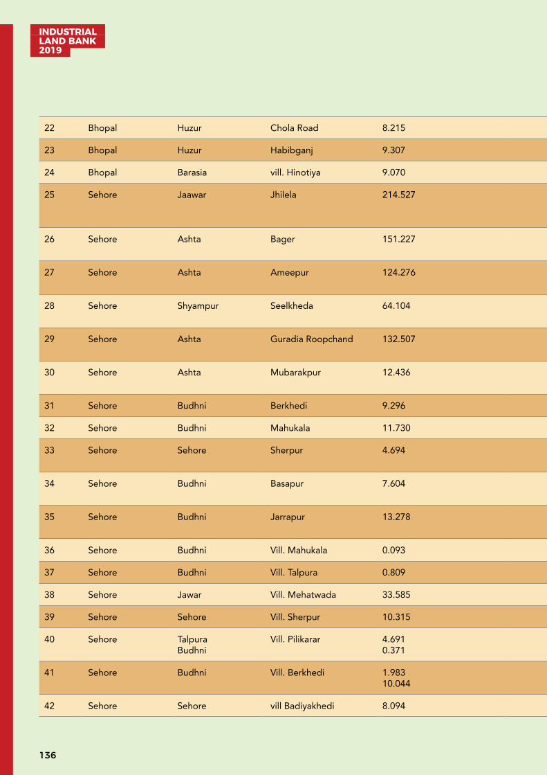
INDUSTRIAL LAND BANK 2019
136
22 Bhopal Huzur Chola Road 8.215 - - - -
23 Bhopal Huzur Habibganj 9.307 - - - -
24 Bhopal Barasia vill. Hinotiya 9.070 - - - -
25 Sehore Jaawar Jhilela 214.527 Ashta-18 SH-1805
Fundra Pond05
M.P.P.T.C. Sub-station,Dodi-05
26 Sehore Ashta Bager 151.227 Ashta-15 SH-1815
Bager Pond02
M.P.P.T.C. Sub-station,Bager-01
27 Sehore Ashta Ameepur 124.276 Ashta-10 SH-1810
Guradiyaroopchand Pond - 01
M.P.P.T.C. Substation,Bager-03
28 Sehore Shyampur Seelkheda 64.104 Bhopal-60 NH-1225
Seelkheda Pond – 01 M.P.P.T.C. Substation,Barkheda hasan-05
29 Sehore Ashta Guradia Roopchand 132.507 Ashta-15 SH-1813
Guradiyaroopchand Pond – 0.5
M.P.P.T.C. Substation,Bager-05
30 Sehore Ashta Mubarakpur 12.436 Ashta-10 SH-1810
Guradiyaroopchand Pond – 01
M.P.P.T.C. Substation,Bager-03
31 Sehore Budhni Berkhedi 9.296 - - - -
32 Sehore Budhni Mahukala 11.730 - - - -
33 Sehore Sehore Sherpur 4.694 Sehore-05 SH-180 km
Ground Water M.P.P.T.C. Substation,Sehore-08
34 Sehore Budhni Basapur 7.604 Hoshangabad-15 NH-6902
Narmada River-02 M.P.P.T.C. Substation,Budhni-04
35 Sehore Budhni Jarrapur 13.278 Hoshangabad-15 NH-6902
Narmada River-02 M.P.P.T.C. Substation,Budhni-04
36 Sehore Budhni Vill. Mahukala 0.093 - - - -
37 Sehore Budhni Vill. Talpura 0.809 - - - -
38 Sehore Jawar Vill. Mehatwada 33.585 - - - -
39 Sehore Sehore Vill. Sherpur 10.315 - - - -
40 Sehore TalpuraBudhni
Vill. Pilikarar 4.6910.371
- - - -
41 Sehore Budhni Vill. Berkhedi 1.98310.044
- - - -
42 Sehore Sehore vill Badiyakhedi 8.094 - - - -
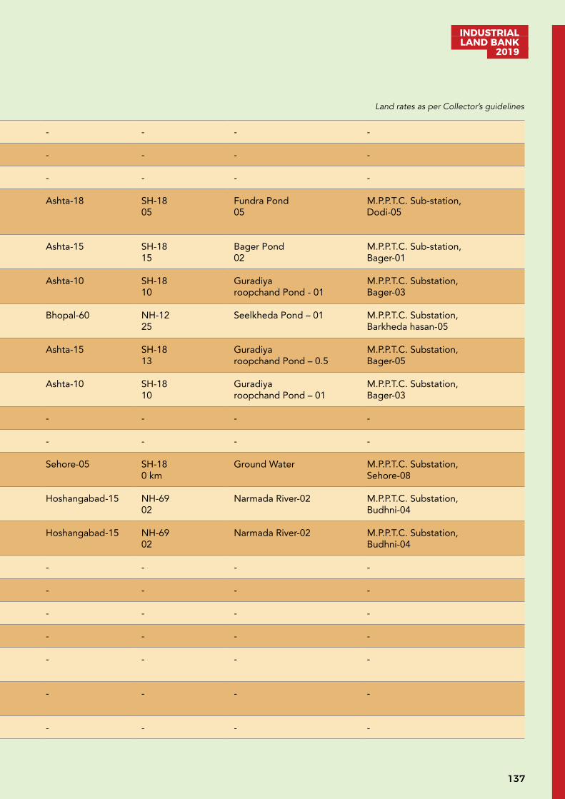
137
INDUSTRIAL LAND BANK
2019
22 Bhopal Huzur Chola Road 8.215 - - - -
23 Bhopal Huzur Habibganj 9.307 - - - -
24 Bhopal Barasia vill. Hinotiya 9.070 - - - -
25 Sehore Jaawar Jhilela 214.527 Ashta-18 SH-1805
Fundra Pond05
M.P.P.T.C. Sub-station,Dodi-05
26 Sehore Ashta Bager 151.227 Ashta-15 SH-1815
Bager Pond02
M.P.P.T.C. Sub-station,Bager-01
27 Sehore Ashta Ameepur 124.276 Ashta-10 SH-1810
Guradiyaroopchand Pond - 01
M.P.P.T.C. Substation,Bager-03
28 Sehore Shyampur Seelkheda 64.104 Bhopal-60 NH-1225
Seelkheda Pond – 01 M.P.P.T.C. Substation,Barkheda hasan-05
29 Sehore Ashta Guradia Roopchand 132.507 Ashta-15 SH-1813
Guradiyaroopchand Pond – 0.5
M.P.P.T.C. Substation,Bager-05
30 Sehore Ashta Mubarakpur 12.436 Ashta-10 SH-1810
Guradiyaroopchand Pond – 01
M.P.P.T.C. Substation,Bager-03
31 Sehore Budhni Berkhedi 9.296 - - - -
32 Sehore Budhni Mahukala 11.730 - - - -
33 Sehore Sehore Sherpur 4.694 Sehore-05 SH-180 km
Ground Water M.P.P.T.C. Substation,Sehore-08
34 Sehore Budhni Basapur 7.604 Hoshangabad-15 NH-6902
Narmada River-02 M.P.P.T.C. Substation,Budhni-04
35 Sehore Budhni Jarrapur 13.278 Hoshangabad-15 NH-6902
Narmada River-02 M.P.P.T.C. Substation,Budhni-04
36 Sehore Budhni Vill. Mahukala 0.093 - - - -
37 Sehore Budhni Vill. Talpura 0.809 - - - -
38 Sehore Jawar Vill. Mehatwada 33.585 - - - -
39 Sehore Sehore Vill. Sherpur 10.315 - - - -
40 Sehore TalpuraBudhni
Vill. Pilikarar 4.6910.371
- - - -
41 Sehore Budhni Vill. Berkhedi 1.98310.044
- - - -
42 Sehore Sehore vill Badiyakhedi 8.094 - - - -
Land rates as per Collector’s guidelines
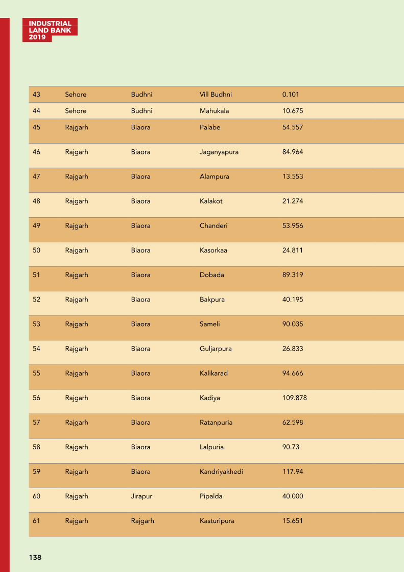
INDUSTRIAL LAND BANK 2019
138
43 Sehore Budhni Vill Budhni 0.101 - - - -
44 Sehore Budhni Mahukala 10.675 - - - -
45 Rajgarh Biaora Palabe 54.557 Biaora-15 NH-0303
BaghpurDam-07
M.P.P.T.C. Substation,Biaora-15
46 Rajgarh Biaora Jaganyapura 84.964 Biaora-15 NH-0303
BaghpurDam-07
M.P.P.T.C. Substation,Biaora-15
47 Rajgarh Biaora Alampura 13.553 Biaora-15 NH-0303
BaghpurDam-07
M.P.P.T.C. Substation,Biaora-15
48 Rajgarh Biaora Kalakot 21.274 Biaora-15 NH-0303
BaghpurDam-07
M.P.P.T.C. Substation,Biaora-15
49 Rajgarh Biaora Chanderi 53.956 Biaora-15 NH-0303
BaghpurDam-07
M.P.P.T.C. Substation,Biaora-15
50 Rajgarh Biaora Kasorkaa 24.811 Biaora-15 NH-0303
BaghpurDam-07
M.P.P.T.C. Substation,Biaora-15
51 Rajgarh Biaora Dobada 89.319 Biaora-15 NH-0303
BaghpurDam-07
M.P.P.T.C. Substation,Biaora-15
52 Rajgarh Biaora Bakpura 40.195 Biaora-15 NH-0303
BaghpurDam-07
M.P.P.T.C. Substation,Biaora-15
53 Rajgarh Biaora Sameli 90.035 Biaora-15 NH-0303
BaghpurDam-07
M.P.P.T.C. Substation,Biaora-15
54 Rajgarh Biaora Guljarpura 26.833 Biaora-15 NH-0303
BaghpurDam-07
M.P.P.T.C. Substation,Biaora-15
55 Rajgarh Biaora Kalikarad 94.666 Biaora-15 NH-0303
BaghpurDam-07
M.P.P.T.C. Substation,Biaora-15
56 Rajgarh Biaora Kadiya 109.878 Biaora-15 NH-0303
BaghpurDam-07
M.P.P.T.C. Substation,Biaora-15
57 Rajgarh Biaora Ratanpuria 62.598 Biaora-15 NH-0303
BaghpurDam-07
M.P.P.T.C. Substation,Biaora-15
58 Rajgarh Biaora Lalpuria 90.73 Biaora-15 NH-0303
BaghpurDam-07
M.P.P.T.C. Substation,Biaora-15
59 Rajgarh Biaora Kandriyakhedi 117.94 Biaora-15 NH-0303
BaghpurDam-07
M.P.P.T.C. Substation,Biaora-15
60 Rajgarh Jirapur Pipalda 40.000 Jirapur-05 NH-1218
ChapiDam-05
M.P.P.T.C. Substation,Chaphiheda-05
61 Rajgarh Rajgarh Kasturipura 15.651 Biaora-15 NH-0302
BaghpurDam-07
M.P.P.T.C. Substation,Biaora-15
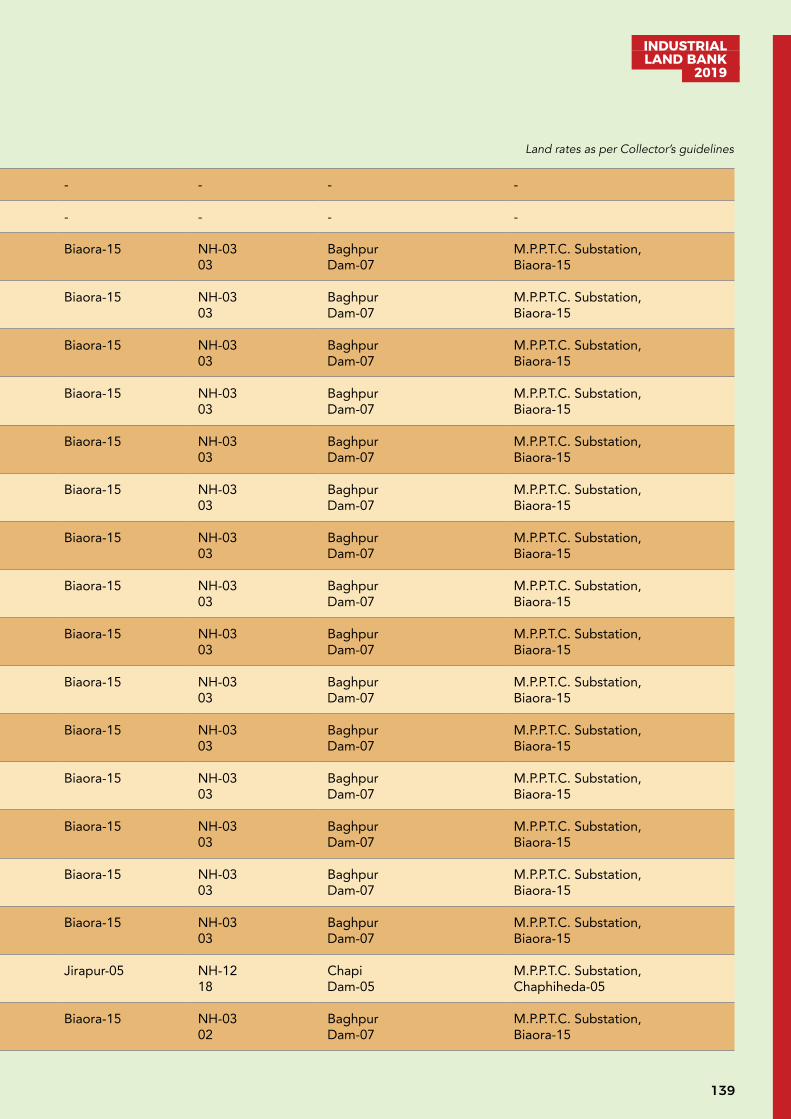
139
INDUSTRIAL LAND BANK
2019
43 Sehore Budhni Vill Budhni 0.101 - - - -
44 Sehore Budhni Mahukala 10.675 - - - -
45 Rajgarh Biaora Palabe 54.557 Biaora-15 NH-0303
BaghpurDam-07
M.P.P.T.C. Substation,Biaora-15
46 Rajgarh Biaora Jaganyapura 84.964 Biaora-15 NH-0303
BaghpurDam-07
M.P.P.T.C. Substation,Biaora-15
47 Rajgarh Biaora Alampura 13.553 Biaora-15 NH-0303
BaghpurDam-07
M.P.P.T.C. Substation,Biaora-15
48 Rajgarh Biaora Kalakot 21.274 Biaora-15 NH-0303
BaghpurDam-07
M.P.P.T.C. Substation,Biaora-15
49 Rajgarh Biaora Chanderi 53.956 Biaora-15 NH-0303
BaghpurDam-07
M.P.P.T.C. Substation,Biaora-15
50 Rajgarh Biaora Kasorkaa 24.811 Biaora-15 NH-0303
BaghpurDam-07
M.P.P.T.C. Substation,Biaora-15
51 Rajgarh Biaora Dobada 89.319 Biaora-15 NH-0303
BaghpurDam-07
M.P.P.T.C. Substation,Biaora-15
52 Rajgarh Biaora Bakpura 40.195 Biaora-15 NH-0303
BaghpurDam-07
M.P.P.T.C. Substation,Biaora-15
53 Rajgarh Biaora Sameli 90.035 Biaora-15 NH-0303
BaghpurDam-07
M.P.P.T.C. Substation,Biaora-15
54 Rajgarh Biaora Guljarpura 26.833 Biaora-15 NH-0303
BaghpurDam-07
M.P.P.T.C. Substation,Biaora-15
55 Rajgarh Biaora Kalikarad 94.666 Biaora-15 NH-0303
BaghpurDam-07
M.P.P.T.C. Substation,Biaora-15
56 Rajgarh Biaora Kadiya 109.878 Biaora-15 NH-0303
BaghpurDam-07
M.P.P.T.C. Substation,Biaora-15
57 Rajgarh Biaora Ratanpuria 62.598 Biaora-15 NH-0303
BaghpurDam-07
M.P.P.T.C. Substation,Biaora-15
58 Rajgarh Biaora Lalpuria 90.73 Biaora-15 NH-0303
BaghpurDam-07
M.P.P.T.C. Substation,Biaora-15
59 Rajgarh Biaora Kandriyakhedi 117.94 Biaora-15 NH-0303
BaghpurDam-07
M.P.P.T.C. Substation,Biaora-15
60 Rajgarh Jirapur Pipalda 40.000 Jirapur-05 NH-1218
ChapiDam-05
M.P.P.T.C. Substation,Chaphiheda-05
61 Rajgarh Rajgarh Kasturipura 15.651 Biaora-15 NH-0302
BaghpurDam-07
M.P.P.T.C. Substation,Biaora-15
Land rates as per Collector’s guidelines
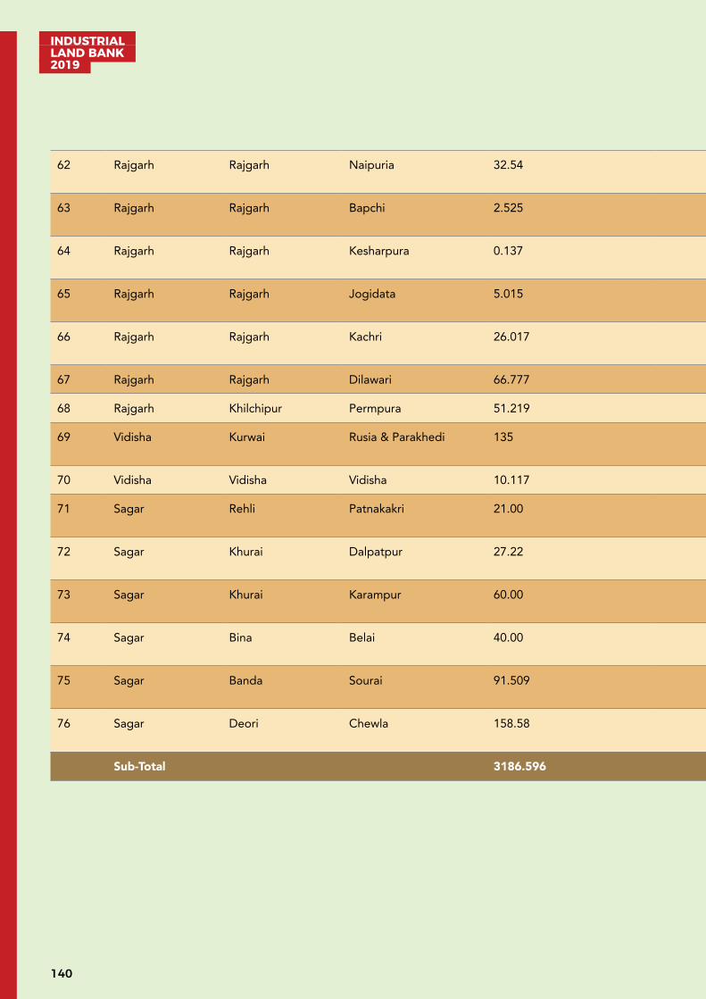
INDUSTRIAL LAND BANK 2019
140
62 Rajgarh Rajgarh Naipuria 32.54 Biaora-15 NH-0302
BaghpurDam-07
M.P.P.T.C. Substation,Biaora-15
63 Rajgarh Rajgarh Bapchi 2.525 Biaora-15 NH-0302
BaghpurDam-07
M.P.P.T.C. Substation,Biaora-15
64 Rajgarh Rajgarh Kesharpura 0.137 Biaora-15 NH-0302
BaghpurDam-07
M.P.P.T.C. Substation,Biaora-15
65 Rajgarh Rajgarh Jogidata 5.015 Biaora-15 NH-0302
BaghpurDam-07
M.P.P.T.C. Substation,Biaora-15
66 Rajgarh Rajgarh Kachri 26.017 Biaora-15 NH-0302
BaghpurDam-07
M.P.P.T.C. Substation,Biaora-15
67 Rajgarh Rajgarh Dilawari 66.777 Rajgarh-08 - - -
68 Rajgarh Khilchipur Permpura 51.219 Rajgarh-07 - - -
69 Vidisha Kurwai Rusia & Parakhedi 135 Vidisha-70 SH-180
Betwa River-01 M.P.P.T.C. Substation,Kurwai -05
70 Vidisha Vidisha Vidisha 10.117 - - - -
71 Sagar Rehli Patnakakri 21.00 Sagar -30 SH-15 A01
Sunar River -04 00
72 Sagar Khurai Dalpatpur 27.22 Sagar -50 SH-14 01
Bina River -01 04
73 Sagar Khurai Karampur 60.00 Sagar -55 SH-42 01
Naren River-15 02
74 Sagar Bina Belai 40.00 Sagar -80 SH-4210
Bina River-15 0.01
75 Sagar Banda Sourai 91.509 Sagar -30 NH-8600
Pagra Dam-18 02
76 Sagar Deori Chewla 158.58 Sagar -60 NH-2600
Dam-02 05
Sub-Total 3186.596
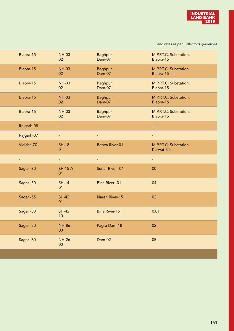
141
INDUSTRIAL LAND BANK
2019
62 Rajgarh Rajgarh Naipuria 32.54 Biaora-15 NH-0302
BaghpurDam-07
M.P.P.T.C. Substation,Biaora-15
63 Rajgarh Rajgarh Bapchi 2.525 Biaora-15 NH-0302
BaghpurDam-07
M.P.P.T.C. Substation,Biaora-15
64 Rajgarh Rajgarh Kesharpura 0.137 Biaora-15 NH-0302
BaghpurDam-07
M.P.P.T.C. Substation,Biaora-15
65 Rajgarh Rajgarh Jogidata 5.015 Biaora-15 NH-0302
BaghpurDam-07
M.P.P.T.C. Substation,Biaora-15
66 Rajgarh Rajgarh Kachri 26.017 Biaora-15 NH-0302
BaghpurDam-07
M.P.P.T.C. Substation,Biaora-15
67 Rajgarh Rajgarh Dilawari 66.777 Rajgarh-08 - - -
68 Rajgarh Khilchipur Permpura 51.219 Rajgarh-07 - - -
69 Vidisha Kurwai Rusia & Parakhedi 135 Vidisha-70 SH-180
Betwa River-01 M.P.P.T.C. Substation,Kurwai -05
70 Vidisha Vidisha Vidisha 10.117 - - - -
71 Sagar Rehli Patnakakri 21.00 Sagar -30 SH-15 A01
Sunar River -04 00
72 Sagar Khurai Dalpatpur 27.22 Sagar -50 SH-14 01
Bina River -01 04
73 Sagar Khurai Karampur 60.00 Sagar -55 SH-42 01
Naren River-15 02
74 Sagar Bina Belai 40.00 Sagar -80 SH-4210
Bina River-15 0.01
75 Sagar Banda Sourai 91.509 Sagar -30 NH-8600
Pagra Dam-18 02
76 Sagar Deori Chewla 158.58 Sagar -60 NH-2600
Dam-02 05
Sub-Total 3186.596
Land rates as per Collector’s guidelines
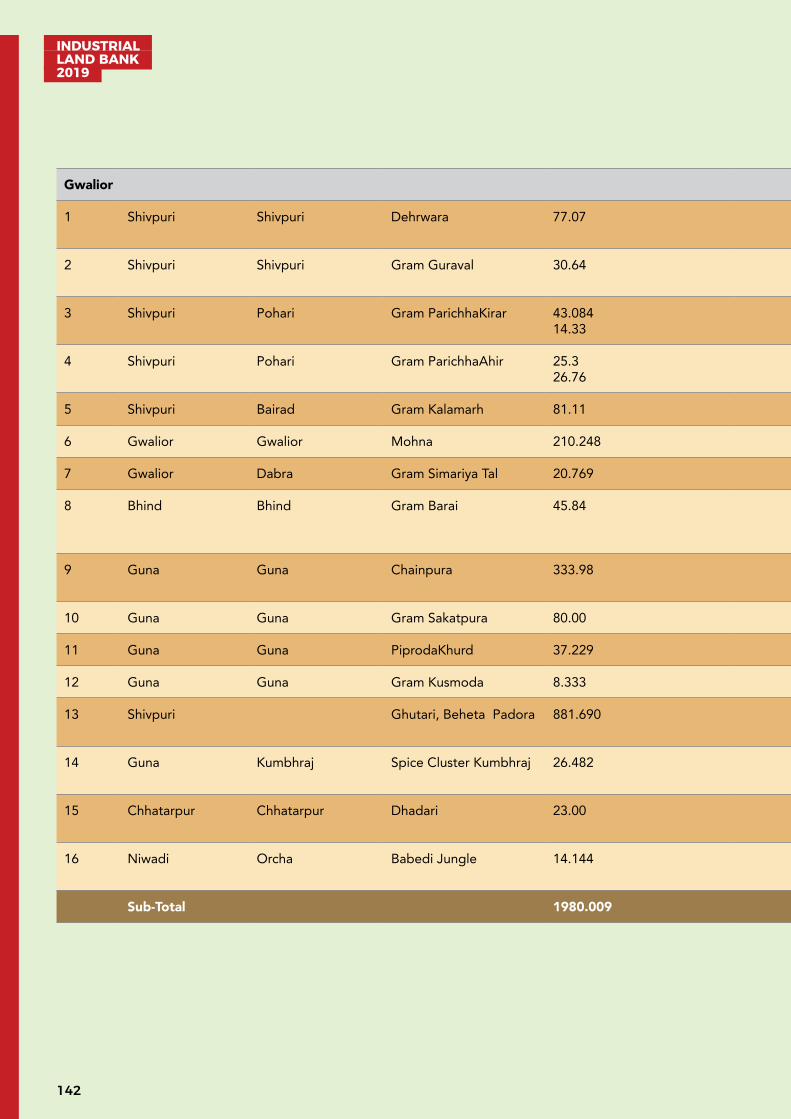
INDUSTRIAL LAND BANK 2019
142
Gwalior
1 Shivpuri Shivpuri Dehrwara 77.07 Shivpuri 0 km Ground Water Padora to Sub stationdistance be-tween 10 km
2 Shivpuri Shivpuri Gram Guraval 30.64 Shivpuri NH 3 Parwati River 01 km
Available
3 Shivpuri Pohari Gram ParichhaKirar 43.084 14.33
Shivpuri 27 km Ground Water 33 KV
4 Shivpuri Pohari Gram ParichhaAhir 25.3 26.76
Shivpuri 27 km Ground Water 33 KV
5 Shivpuri Bairad Gram Kalamarh 81.11 Shivpuri 27 km River 33 KV
6 Gwalior Gwalior Mohna 210.248 Gwalior 5 km From NH3 Parwati River Available
7 Gwalior Dabra Gram Simariya Tal 20.769 Gwalior 5 km From NH75 Available Available
8 Bhind Bhind Gram Barai 45.84 Bhind NH92 Chamble River 2 km
11 KV Line Available
9 Guna Guna Chainpura 333.98 Guna NH 3 Gopikrishana Dam 15 km
Available for 2 km
10 Guna Guna Gram Sakatpura 80.00 Guna 3 km Ground Water 33 KV Available for 5 km
11 Guna Guna PiprodaKhurd 37.229 Guna 3 km Ground Water 33 KV Available for 5 km
12 Guna Guna Gram Kusmoda 8.333 Guna 0km Ground Water 33 KV Available for 5 km
13 Shivpuri Ghutari, Beheta Padora 881.690 Shivpuri NH3 Khurinala, Shind River 07 km
33 KV Availble for 5 km
14 Guna Kumbhraj Spice Cluster Kumbhraj 26.482 Guna 12 km form NH3 From Kumbhraj River Khumbhraj Sub Station for 1 km
15 Chhatarpur Chhatarpur Dhadari 23.00 Chhatarpur10 km
02 km FromN.H.86
Tube Well 10 km
16 Niwadi Orcha Babedi Jungle 14.144 Tikamgarh28 km
02 km FromN.H. 75
Dam10 km
10 km
Sub-Total 1980.009
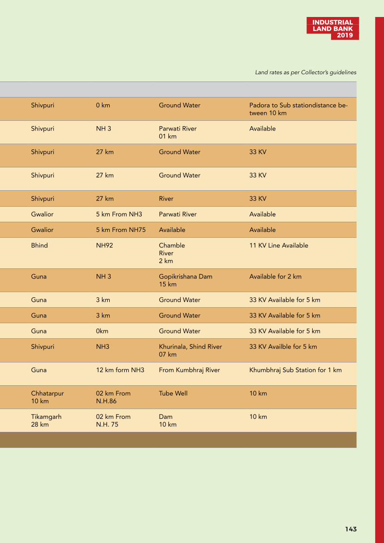
143
INDUSTRIAL LAND BANK
2019
Gwalior
1 Shivpuri Shivpuri Dehrwara 77.07 Shivpuri 0 km Ground Water Padora to Sub stationdistance be-tween 10 km
2 Shivpuri Shivpuri Gram Guraval 30.64 Shivpuri NH 3 Parwati River 01 km
Available
3 Shivpuri Pohari Gram ParichhaKirar 43.084 14.33
Shivpuri 27 km Ground Water 33 KV
4 Shivpuri Pohari Gram ParichhaAhir 25.3 26.76
Shivpuri 27 km Ground Water 33 KV
5 Shivpuri Bairad Gram Kalamarh 81.11 Shivpuri 27 km River 33 KV
6 Gwalior Gwalior Mohna 210.248 Gwalior 5 km From NH3 Parwati River Available
7 Gwalior Dabra Gram Simariya Tal 20.769 Gwalior 5 km From NH75 Available Available
8 Bhind Bhind Gram Barai 45.84 Bhind NH92 Chamble River 2 km
11 KV Line Available
9 Guna Guna Chainpura 333.98 Guna NH 3 Gopikrishana Dam 15 km
Available for 2 km
10 Guna Guna Gram Sakatpura 80.00 Guna 3 km Ground Water 33 KV Available for 5 km
11 Guna Guna PiprodaKhurd 37.229 Guna 3 km Ground Water 33 KV Available for 5 km
12 Guna Guna Gram Kusmoda 8.333 Guna 0km Ground Water 33 KV Available for 5 km
13 Shivpuri Ghutari, Beheta Padora 881.690 Shivpuri NH3 Khurinala, Shind River 07 km
33 KV Availble for 5 km
14 Guna Kumbhraj Spice Cluster Kumbhraj 26.482 Guna 12 km form NH3 From Kumbhraj River Khumbhraj Sub Station for 1 km
15 Chhatarpur Chhatarpur Dhadari 23.00 Chhatarpur10 km
02 km FromN.H.86
Tube Well 10 km
16 Niwadi Orcha Babedi Jungle 14.144 Tikamgarh28 km
02 km FromN.H. 75
Dam10 km
10 km
Sub-Total 1980.009
Land rates as per Collector’s guidelines
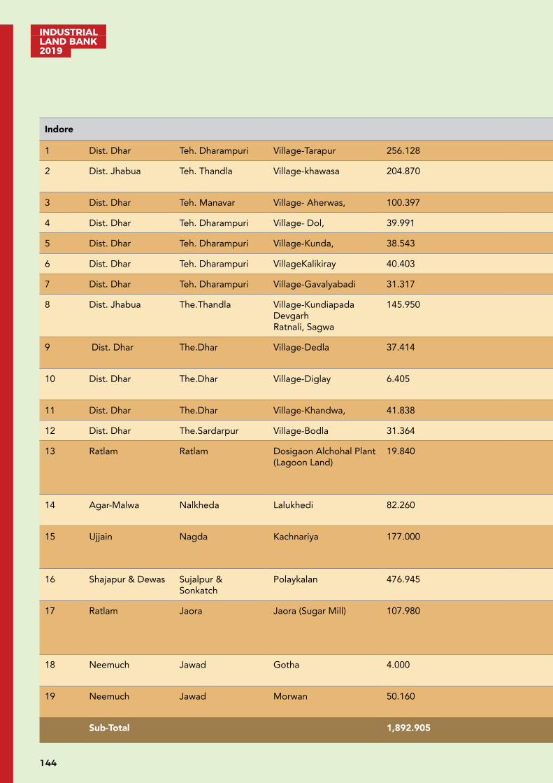
INDUSTRIAL LAND BANK 2019
144
Indore
1 Dist. Dhar Teh. Dharampuri Village-Tarapur 256.128 Dharampuri - 17 km NH-3, 18 km Sakalda Dam- 5 km Power station Aherwas 0 km
2 Dist. Jhabua Teh. Thandla Village-khawasa 204.870 Bamniya.3 km Thandla Bamniya Road.0 km
Ladli 7 km Khawasa 0 km
3 Dist. Dhar Teh. Manavar Village- Aherwas, 100.397 Dharampuri .10 km NH-3, 17 km Sakalda Dam3 km Power station Aherwas 0 km
4 Dist. Dhar Teh. Dharampuri Village- Dol, 39.991 Dhamnod 6 km NH-3, 7 km Narmada River 15 km Dhani Power Station 8 km
5 Dist. Dhar Teh. Dharampuri Village-Kunda, 38.543 Dhamnod 6 km NH-3, 6 km Sakalda Dam6 km Dhani Power Station 10 km
6 Dist. Dhar Teh. Dharampuri VillageKalikiray 40.403 Dharampuri .18 km NH-3, 15 km Sakalda Dam5 km Power station Aherwas 0 km
7 Dist. Dhar Teh. Dharampuri Village-Gavalyabadi 31.317 Dharampuri .18 km NH-3, 15 km Sakalda Dam5 km Power station Aherwas 0 km
8 Dist. Jhabua The.Thandla Village-Kundiapada Devgarh Ratnali, Sagwa
145.950 Bamniya.6 km Thandla Bamniya Road.0 km
Ladli 7 km Khawasa 3 km
9 Dist. Dhar The.Dhar Village-Dedla 37.414 Manpur 20 km Manpur-Lebad Road 4 km
Tubewell 0 km Ujjaini 0 km
10 Dist. Dhar The.Dhar Village-Diglay 6.405 Manpur 20 km Manpur-Lebad Road 4 km
Tubewell 0 km Ujjaini 0 km
11 Dist. Dhar The.Dhar Village-Khandwa, 41.838 Pithampur 5 km NH-3, 0 km Sanjay Talab 4 km Pithampur 7 km
12 Dist. Dhar The.Sardarpur Village-Bodla 31.364 Sardarpur 14 km NH-47, 0 km Mahi River 11 km Hatod 0 km
13 Ratlam Ratlam Dosigaon Alchohal Plant (Lagoon Land)
19.840 Ratlam 2 km Nayagaon-Lebad Four lane SH No. 18 5 km
Yes Nagar, Nigam Ratlam. 0 km
Yes 33/11 KV Substation 0 km
14 Agar-Malwa Nalkheda Lalukhedi 82.260 Agar 35 km Nalkheda –Agar Road 7 km
Tubule 0.5 km
33/11 KV Substation 5 km
15 Ujjain Nagda Kachnariya 177.000 Nagda 10 km Mahidpur Road Nagda Two Lane SH 17
Yes Chambal 15 km
Yes ,00 KV Substation 15 km
16 Shajapur & Dewas Sujalpur & Sonkatch
Polaykalan 476.945 Shujalpur 30 km
Ashtha – Shujalpur two lane 1 km
Yes, Tubewel & Newas River 7 km , Kalishindh Rever 8 km
Yes ,33/11 KV Substation 0 km
17 Ratlam Jaora Jaora (Sugar Mill) 107.980 Jaora 0 km Nayagaon-Lebad Four lane, SH No. 18 1 km
Yes , Maleni River 15 km, Chambal River 25 km
Yes Yes 33/11 KV Substation 10 km
18 Neemuch Jawad Gotha 4.000 Jawad 12 km SH Nayagaon-Leb-ad four lane 12 km
Yes 7 km
Yes
19 Neemuch Jawad Morwan 50.160 Jawad 15km SH Nayagaon-Leb-ad four lane 12 km
Yes 7 km
Yes
Sub-Total 1,892.905
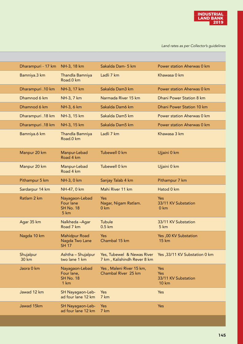
145
INDUSTRIAL LAND BANK
2019
Indore
1 Dist. Dhar Teh. Dharampuri Village-Tarapur 256.128 Dharampuri - 17 km NH-3, 18 km Sakalda Dam- 5 km Power station Aherwas 0 km
2 Dist. Jhabua Teh. Thandla Village-khawasa 204.870 Bamniya.3 km Thandla Bamniya Road.0 km
Ladli 7 km Khawasa 0 km
3 Dist. Dhar Teh. Manavar Village- Aherwas, 100.397 Dharampuri .10 km NH-3, 17 km Sakalda Dam3 km Power station Aherwas 0 km
4 Dist. Dhar Teh. Dharampuri Village- Dol, 39.991 Dhamnod 6 km NH-3, 7 km Narmada River 15 km Dhani Power Station 8 km
5 Dist. Dhar Teh. Dharampuri Village-Kunda, 38.543 Dhamnod 6 km NH-3, 6 km Sakalda Dam6 km Dhani Power Station 10 km
6 Dist. Dhar Teh. Dharampuri VillageKalikiray 40.403 Dharampuri .18 km NH-3, 15 km Sakalda Dam5 km Power station Aherwas 0 km
7 Dist. Dhar Teh. Dharampuri Village-Gavalyabadi 31.317 Dharampuri .18 km NH-3, 15 km Sakalda Dam5 km Power station Aherwas 0 km
8 Dist. Jhabua The.Thandla Village-Kundiapada Devgarh Ratnali, Sagwa
145.950 Bamniya.6 km Thandla Bamniya Road.0 km
Ladli 7 km Khawasa 3 km
9 Dist. Dhar The.Dhar Village-Dedla 37.414 Manpur 20 km Manpur-Lebad Road 4 km
Tubewell 0 km Ujjaini 0 km
10 Dist. Dhar The.Dhar Village-Diglay 6.405 Manpur 20 km Manpur-Lebad Road 4 km
Tubewell 0 km Ujjaini 0 km
11 Dist. Dhar The.Dhar Village-Khandwa, 41.838 Pithampur 5 km NH-3, 0 km Sanjay Talab 4 km Pithampur 7 km
12 Dist. Dhar The.Sardarpur Village-Bodla 31.364 Sardarpur 14 km NH-47, 0 km Mahi River 11 km Hatod 0 km
13 Ratlam Ratlam Dosigaon Alchohal Plant (Lagoon Land)
19.840 Ratlam 2 km Nayagaon-Lebad Four lane SH No. 18 5 km
Yes Nagar, Nigam Ratlam. 0 km
Yes 33/11 KV Substation 0 km
14 Agar-Malwa Nalkheda Lalukhedi 82.260 Agar 35 km Nalkheda –Agar Road 7 km
Tubule 0.5 km
33/11 KV Substation 5 km
15 Ujjain Nagda Kachnariya 177.000 Nagda 10 km Mahidpur Road Nagda Two Lane SH 17
Yes Chambal 15 km
Yes ,00 KV Substation 15 km
16 Shajapur & Dewas Sujalpur & Sonkatch
Polaykalan 476.945 Shujalpur 30 km
Ashtha – Shujalpur two lane 1 km
Yes, Tubewel & Newas River 7 km , Kalishindh Rever 8 km
Yes ,33/11 KV Substation 0 km
17 Ratlam Jaora Jaora (Sugar Mill) 107.980 Jaora 0 km Nayagaon-Lebad Four lane, SH No. 18 1 km
Yes , Maleni River 15 km, Chambal River 25 km
Yes Yes 33/11 KV Substation 10 km
18 Neemuch Jawad Gotha 4.000 Jawad 12 km SH Nayagaon-Leb-ad four lane 12 km
Yes 7 km
Yes
19 Neemuch Jawad Morwan 50.160 Jawad 15km SH Nayagaon-Leb-ad four lane 12 km
Yes 7 km
Yes
Sub-Total 1,892.905
Land rates as per Collector’s guidelines

INDUSTRIAL LAND BANK 2019
146
Jabalpur
1 Jabalpur Jabalpur Aithakheda 42.420 Jabalpur 18 km
NH-34 05 km
Ground Water Jabalpur (Bargi Hills) SubStation 10 km
2 Jabalpur Sihora Hargarh 101.210 Jabalpur 49 km
NH-30 08 km
Hiran River 01 km
33 KV Sub Station Available in I/A
3 Jabalpur Sihora Sarda 18.000 Jabalpur 49 km
NH-30 08 km
Hiran River 01 km
33 KV Sub Station Available in I/A
4 Jabalpur Sihora Dharampura 11.670 Jabalpur 30 km
NH-30 01 km
Ground Water Goshalpur 01 km
5 Jabalpur Sahpura Umariya Dungariya
193.390 Jabalpur 26 km
NH-34 13 km
Narmada River 10 km
33 KV Sub Station Available in I/A
6 Jabalpur Sahpura Umariya 38.160 Jabalpur 26 km
NH-34 13 km
Narmada River 10 km
33 KV Sub Station Available in I/A
7 Jabalpur Sahpura Khairi 53.970 Jabalpur 20 km
NH - 45 02 km
Ground Water Jabalpur 20 km
8 Katni Murwara Amkuhi 30.000 Katni 01 km
NH - 30 01 km
Ground Water 33 KV Sub Station Available in I/A
9 Katni Murwara Bohta 43.490 Katni 06 km
NH-30 0 km
Katni River 03 km
Katni 06 km
10 Katni Murwara Kailwara 30.000 Katni 06 km
NH-30 0 km
Katni River 03 km
Katni 06 km
11 Katni Murwara Banda 58.890 Katni 30 km
NH-30 05 km
Ground Water Katni 30 km
12 Katni Murwara Devari Hatai 99.310 Katni 28 km
NH-07 25 km
Ground Water Available
13 Katni Rithi Simra 135.640 Katni 30 km
SH-14 02 km
Aloni River 02 km
Devgaon 02 km
14 Katni Bahoriband Tihari 64.830 Katni 28 km
NH-30 02 km
Ground Water Available
15 Katni Badwara Vilayatkala, Dharwara 49.765 Katni 30 km
NH-43 02 km
Choti Mahanadi 04 km
Available
16 Katni Dheemarkheda Murwari & Other 7 Village
558.670 Katni 50 km
NH-30 25 km
Belkund River 03 km
Dheemarkheda 03 km
17 Katni Dheemarkheda Karondi 104.160 Katni 50 km
NH-30 25 km
Belkund River 05 km
Dheemarkheda 03 km
18 Katni Murwara Lamtara, Chaka 13.319 Katni 05 km
NH-43 0 km
Ground Water 33 KV Sub Station Available in I/A
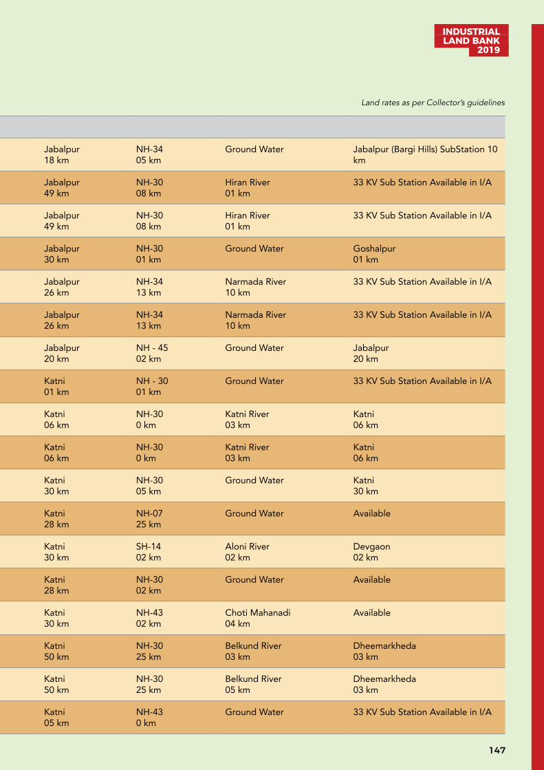
147
INDUSTRIAL LAND BANK
2019
Jabalpur
1 Jabalpur Jabalpur Aithakheda 42.420 Jabalpur 18 km
NH-34 05 km
Ground Water Jabalpur (Bargi Hills) SubStation 10 km
2 Jabalpur Sihora Hargarh 101.210 Jabalpur 49 km
NH-30 08 km
Hiran River 01 km
33 KV Sub Station Available in I/A
3 Jabalpur Sihora Sarda 18.000 Jabalpur 49 km
NH-30 08 km
Hiran River 01 km
33 KV Sub Station Available in I/A
4 Jabalpur Sihora Dharampura 11.670 Jabalpur 30 km
NH-30 01 km
Ground Water Goshalpur 01 km
5 Jabalpur Sahpura Umariya Dungariya
193.390 Jabalpur 26 km
NH-34 13 km
Narmada River 10 km
33 KV Sub Station Available in I/A
6 Jabalpur Sahpura Umariya 38.160 Jabalpur 26 km
NH-34 13 km
Narmada River 10 km
33 KV Sub Station Available in I/A
7 Jabalpur Sahpura Khairi 53.970 Jabalpur 20 km
NH - 45 02 km
Ground Water Jabalpur 20 km
8 Katni Murwara Amkuhi 30.000 Katni 01 km
NH - 30 01 km
Ground Water 33 KV Sub Station Available in I/A
9 Katni Murwara Bohta 43.490 Katni 06 km
NH-30 0 km
Katni River 03 km
Katni 06 km
10 Katni Murwara Kailwara 30.000 Katni 06 km
NH-30 0 km
Katni River 03 km
Katni 06 km
11 Katni Murwara Banda 58.890 Katni 30 km
NH-30 05 km
Ground Water Katni 30 km
12 Katni Murwara Devari Hatai 99.310 Katni 28 km
NH-07 25 km
Ground Water Available
13 Katni Rithi Simra 135.640 Katni 30 km
SH-14 02 km
Aloni River 02 km
Devgaon 02 km
14 Katni Bahoriband Tihari 64.830 Katni 28 km
NH-30 02 km
Ground Water Available
15 Katni Badwara Vilayatkala, Dharwara 49.765 Katni 30 km
NH-43 02 km
Choti Mahanadi 04 km
Available
16 Katni Dheemarkheda Murwari & Other 7 Village
558.670 Katni 50 km
NH-30 25 km
Belkund River 03 km
Dheemarkheda 03 km
17 Katni Dheemarkheda Karondi 104.160 Katni 50 km
NH-30 25 km
Belkund River 05 km
Dheemarkheda 03 km
18 Katni Murwara Lamtara, Chaka 13.319 Katni 05 km
NH-43 0 km
Ground Water 33 KV Sub Station Available in I/A
Land rates as per Collector’s guidelines

INDUSTRIAL LAND BANK 2019
148
20 Chhindwara Chhindwara Lahgadua, Kusmaili, Khapabhat
40.225 Chhindwara 02 km
NH-547 02 km
Ground Water Available
21 Narsinghpur Tendukheda Chawarpatha, Keshli, Badiyaghat
296.061 Kareli 12 km
NH-47 01 km
Narmada River 02 km
Barman 03 km
22 Narsinghpur Kareli Kathotiya 45.803 Narsinghpur 07 km
NH-44 02 km
Ground Water Narsinghpur 07 km
23 Narsinghpur Gotegaon Bagashpur 21.982 Gotegaon 05 km
SH-22 05 km
Ground Water Gotegaon 05 km
24 Balaghat Kirnapur Bodundakala 122.450 Balaghat 20 km
SH-11 06 km
Bagh River 02 km
Rajegaon 05 km
25 Balaghat Katangi Chikmara 5.850 Katangi 06 km
SH-54 01 km
Ground Water Katangi 06 km
26 Seoni Seoni Bhurkalkhapa 330.151 Seoni 05 km
NH-44 03 km
Ground Water 33 KV Sub Station Available
27 Seoni Seoni Dungariya, Bithli
261.350 Seoni 05 km
NH-44 03 km
Ground Water 33 KV Sub Station Available
28 Damoh Batiyagarh Gidan & Sagoni 497.984 Damoh 35 km.
NH-340 km
Sunar River 08 km.
Available
Sub-Total 3268.750
Rewa
1 Singrauli Singrauli Pidartali 63.03 Singrauli 8 km from NH - 75 River, Adjacent to the land 6 km
2 Singrauli Deosar Phulwari 60.34 Bargawan 11 km from NH 39 Kachan Dam 4 km
3 Singrauli Deosar Gadariya 40.73 Bargawan 0 km fromNH 39 Kachan Dam 2 km
4 Singrauli Deosar Baghadih 29.50 Bargawan 11 km from NH 39 Ground Water 6 km
5 Singrauli Deosar Bargawan* 43.01 Bargawan 0 km from NH 39 Kachan Dam 2 km
6 Shahdol Gohaparu Diyapeepar 38.91 Shahdol 0 km from SH - 9
Son River 4 km
7 Satna Reghuraj Nagar Bagha** 40.17 Satna 0.3 km from SH - 11
Ground water 2 km
8 Rewa Mauganj Ghurehta 175.06 Mauganj 9 km. from NH - 7 Belha Dam 2 km
9 Anuppur Kotma Jalsar 116.53 Bijuri 14 km. from NH - 43
Ground Water 5 km
Sub-Total 607.28
Grand Total 10935.44
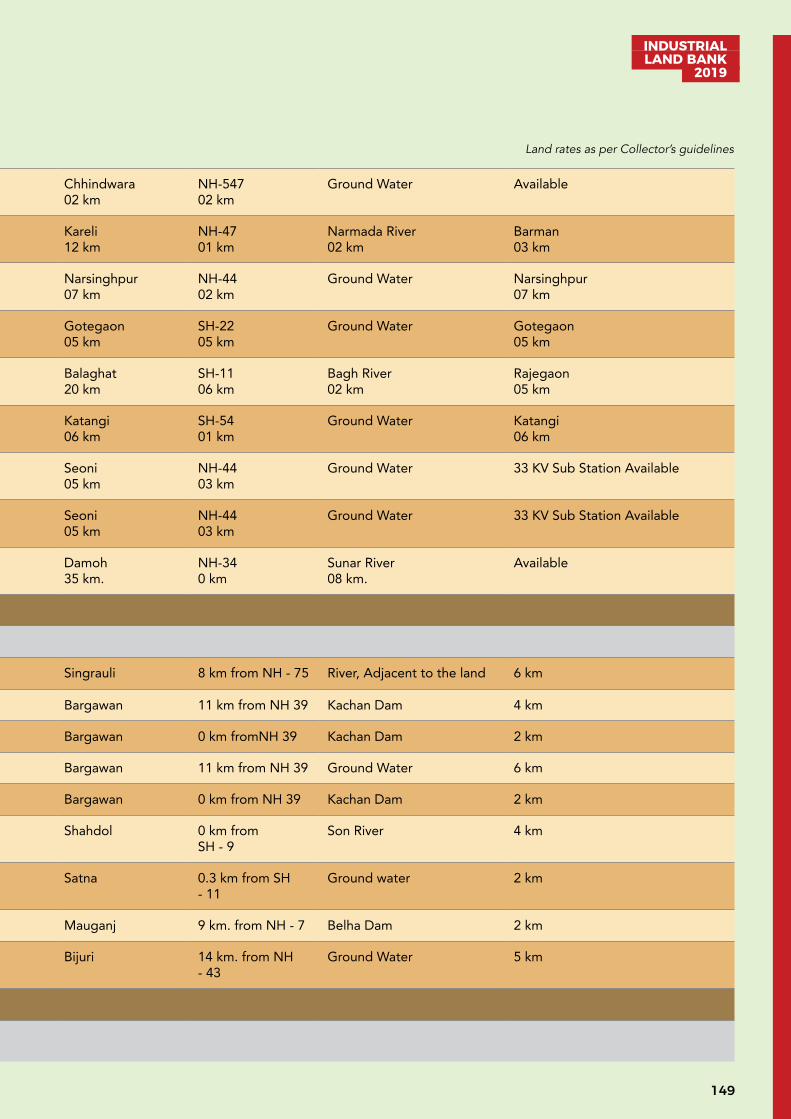
149
INDUSTRIAL LAND BANK
2019
20 Chhindwara Chhindwara Lahgadua, Kusmaili, Khapabhat
40.225 Chhindwara 02 km
NH-547 02 km
Ground Water Available
21 Narsinghpur Tendukheda Chawarpatha, Keshli, Badiyaghat
296.061 Kareli 12 km
NH-47 01 km
Narmada River 02 km
Barman 03 km
22 Narsinghpur Kareli Kathotiya 45.803 Narsinghpur 07 km
NH-44 02 km
Ground Water Narsinghpur 07 km
23 Narsinghpur Gotegaon Bagashpur 21.982 Gotegaon 05 km
SH-22 05 km
Ground Water Gotegaon 05 km
24 Balaghat Kirnapur Bodundakala 122.450 Balaghat 20 km
SH-11 06 km
Bagh River 02 km
Rajegaon 05 km
25 Balaghat Katangi Chikmara 5.850 Katangi 06 km
SH-54 01 km
Ground Water Katangi 06 km
26 Seoni Seoni Bhurkalkhapa 330.151 Seoni 05 km
NH-44 03 km
Ground Water 33 KV Sub Station Available
27 Seoni Seoni Dungariya, Bithli
261.350 Seoni 05 km
NH-44 03 km
Ground Water 33 KV Sub Station Available
28 Damoh Batiyagarh Gidan & Sagoni 497.984 Damoh 35 km.
NH-340 km
Sunar River 08 km.
Available
Sub-Total 3268.750
Rewa
1 Singrauli Singrauli Pidartali 63.03 Singrauli 8 km from NH - 75 River, Adjacent to the land 6 km
2 Singrauli Deosar Phulwari 60.34 Bargawan 11 km from NH 39 Kachan Dam 4 km
3 Singrauli Deosar Gadariya 40.73 Bargawan 0 km fromNH 39 Kachan Dam 2 km
4 Singrauli Deosar Baghadih 29.50 Bargawan 11 km from NH 39 Ground Water 6 km
5 Singrauli Deosar Bargawan* 43.01 Bargawan 0 km from NH 39 Kachan Dam 2 km
6 Shahdol Gohaparu Diyapeepar 38.91 Shahdol 0 km from SH - 9
Son River 4 km
7 Satna Reghuraj Nagar Bagha** 40.17 Satna 0.3 km from SH - 11
Ground water 2 km
8 Rewa Mauganj Ghurehta 175.06 Mauganj 9 km. from NH - 7 Belha Dam 2 km
9 Anuppur Kotma Jalsar 116.53 Bijuri 14 km. from NH - 43
Ground Water 5 km
Sub-Total 607.28
Grand Total 10935.44
Land rates as per Collector’s guidelines

INDUSTRIAL LAND BANK 2019
150
UNDEVELOPED LAND (B)S.No. District Tehsil Village Area in Hect. Nearest City/
Town & Distance (Km)
Nearest NH/SH & Distance in (Km)
Water source Availability & Distance (Km)
Availability of Electricity & Distance (Km)
Bhopal
1. Bhopal Berasia Budhirkhurd 126 Bhopal-37 SH-23- 11 Halali Dam-01 M.P.P.T.C. Substation,Gunga-33/11 KV-10
2. Bhopal Berasia Budhirkala 18 Bhopal-31 SH-23- 11 Halali Dam-01 M.P.P.T.C. Substation,Gunga-33/11 KV-10
3. Bhopal Berasia Runaha 86 Barasia-22 Barasia-Nazirabad Road-01
Ground Water M.P.P.T.C. Substation,Runaga-132 KV-0.25
4. Bhopal Huzur Sukhi Sewania 137.21 Bhopal-23 SH-18 – 0 Ground Water M.P.P.T.C. Substation,Sukhi Sewania -440 KV-01
5 Bhopal Huzur Hajampura 42.95 Bhopal-22 SH-18 – 02 Water supply from Acharpura I. A.
M.P.P.T.C. Substation,Acharpura-33/11 KV- 01
6. Sehore Ashta Khandourpur 166 Ashta-15 SH-18 – 15 Bager Pond-02 M.P.P.T.C. Substation,Bager-33/11 KV-03
7. Sehore Ashta Titoriya 105 Ashta-11 Ashta-Shujalpur Road–03
Ground Water M.P.P.T.C. Substation,Ashta-400 KV-09
8. Sehore Ashta Sevda 82 Ashta-10 Ashta-Shujalpur Road–03
Ground Water M.P.P.T.C. Substation,Ashta-400 KV-08
9. Sehore Ashta Bejnath 113 Ashta-11 Ashta-Shujalpur Road–03
Ground Water M.P.P.T.C. Substation,Ashta-400 KV-09
10. Sehore Ashta Khamkheda Bejnath 102 Ashta-11 Ashta-Shujalpur Road–03
Ground Water M.P.P.T.C. Substation,Ashta-400 KV-10
11. Sehore Ashta Bhawara 222 Ashta-15 SH-18-15 Bager Pond-03 M.P.P.T.C. Substation,Bager-33/11 KV-03
12. Sehore Ashta Bapchadonia 78 Ashta-17 SH-18-17 Bager Pond-03 M.P.P.T.C. Substation,Bager-33/11 KV-03
13. Sehore Ashta Mullani Mangalpur 256 Ashta-22 SH-18-07 Ground Water M.P.P.T.C. Substation,Kothri-33/11 KV-07
14. Sehore Ashta Gawakheda 144 Ashta-20 SH-18-06 Ground Water M.P.P.T.C. Substation,Kothri-33/11 KV-05
15. Sehore Sehore Konajheer 196 Sehore-08 SH-53- 0.3 Konajhir pond- 01 M.P.P.T.C. Substation,Sehore-33/11 KV-09
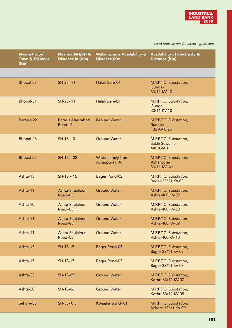
151
INDUSTRIAL LAND BANK
2019
UNDEVELOPED LAND (B)S.No. District Tehsil Village Area in Hect. Nearest City/
Town & Distance (Km)
Nearest NH/SH & Distance in (Km)
Water source Availability & Distance (Km)
Availability of Electricity & Distance (Km)
Bhopal
1. Bhopal Berasia Budhirkhurd 126 Bhopal-37 SH-23- 11 Halali Dam-01 M.P.P.T.C. Substation,Gunga-33/11 KV-10
2. Bhopal Berasia Budhirkala 18 Bhopal-31 SH-23- 11 Halali Dam-01 M.P.P.T.C. Substation,Gunga-33/11 KV-10
3. Bhopal Berasia Runaha 86 Barasia-22 Barasia-Nazirabad Road-01
Ground Water M.P.P.T.C. Substation,Runaga-132 KV-0.25
4. Bhopal Huzur Sukhi Sewania 137.21 Bhopal-23 SH-18 – 0 Ground Water M.P.P.T.C. Substation,Sukhi Sewania -440 KV-01
5 Bhopal Huzur Hajampura 42.95 Bhopal-22 SH-18 – 02 Water supply from Acharpura I. A.
M.P.P.T.C. Substation,Acharpura-33/11 KV- 01
6. Sehore Ashta Khandourpur 166 Ashta-15 SH-18 – 15 Bager Pond-02 M.P.P.T.C. Substation,Bager-33/11 KV-03
7. Sehore Ashta Titoriya 105 Ashta-11 Ashta-Shujalpur Road–03
Ground Water M.P.P.T.C. Substation,Ashta-400 KV-09
8. Sehore Ashta Sevda 82 Ashta-10 Ashta-Shujalpur Road–03
Ground Water M.P.P.T.C. Substation,Ashta-400 KV-08
9. Sehore Ashta Bejnath 113 Ashta-11 Ashta-Shujalpur Road–03
Ground Water M.P.P.T.C. Substation,Ashta-400 KV-09
10. Sehore Ashta Khamkheda Bejnath 102 Ashta-11 Ashta-Shujalpur Road–03
Ground Water M.P.P.T.C. Substation,Ashta-400 KV-10
11. Sehore Ashta Bhawara 222 Ashta-15 SH-18-15 Bager Pond-03 M.P.P.T.C. Substation,Bager-33/11 KV-03
12. Sehore Ashta Bapchadonia 78 Ashta-17 SH-18-17 Bager Pond-03 M.P.P.T.C. Substation,Bager-33/11 KV-03
13. Sehore Ashta Mullani Mangalpur 256 Ashta-22 SH-18-07 Ground Water M.P.P.T.C. Substation,Kothri-33/11 KV-07
14. Sehore Ashta Gawakheda 144 Ashta-20 SH-18-06 Ground Water M.P.P.T.C. Substation,Kothri-33/11 KV-05
15. Sehore Sehore Konajheer 196 Sehore-08 SH-53- 0.3 Konajhir pond- 01 M.P.P.T.C. Substation,Sehore-33/11 KV-09
Land rates as per Collector’s guidelines
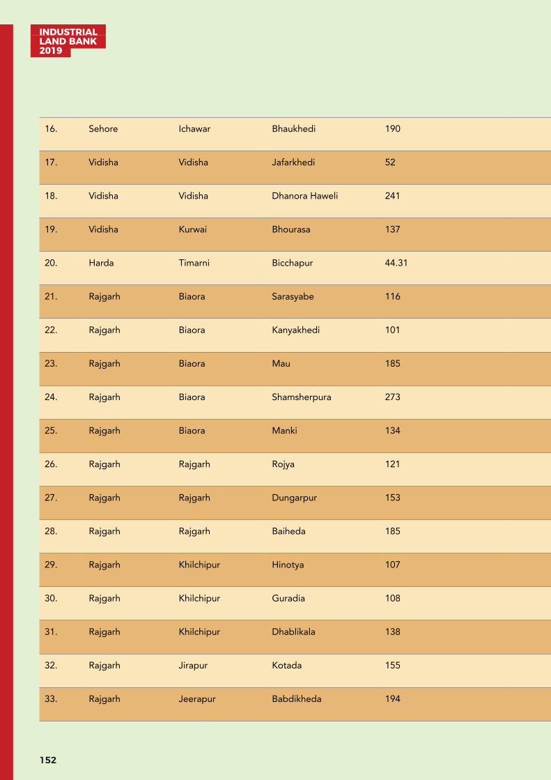
INDUSTRIAL LAND BANK 2019
152
16. Sehore Ichawar Bhaukhedi 190 Ichawar-07 SH-53- 0.3 Kakarkhheda pond- 01 M.P.P.T.C. Substation,Bhaukhedi -33/11 KV-02
17. Vidisha Vidisha Jafarkhedi 52 Vidisha-14 Vidisha-Berasia Road-03
Betwa River -02 M.P.P.T.C. Substation, Jambar-Bagri -33/11 KV-01
18. Vidisha Vidisha Dhanora Haweli 241 Vidisha-10 Bhopal-Vidishsa Road-10
Betwa River -12 M.P.P.T.C. Substation, Hasua -33/11 KV-11
19. Vidisha Kurwai Bhourasa 137 Vidisha-72 SH-18-05 Betwa River -04 M.P.P.T.C. Substation, Kurwai-33/11 KV-04
20. Harda Timarni Bicchapur 44.31 Timarni-10 SH-15- 10 Ganjal River-10 M.P.P.T.C. Substation, Timarni-33/11 KV-10
21. Rajgarh Biaora Sarasyabe 116 Suthaliya-12 NH-03-07 Bagpura Dam-04 M.P.P.T.C. Substation, Suthaliya-33/11 KV-12
22. Rajgarh Biaora Kanyakhedi 101 Biaora-15 NH-03-10 Bagpura Dam-03 M.P.P.T.C. Substation, Kachri-33/11 KV-10
23. Rajgarh Biaora Mau 185 Suthaliya-05 NH-03-07 Parwati River-05 M.P.P.T.C. Substation, Suthaliya-33/11 KV-07
24. Rajgarh Biaora Shamsherpura 273 Biaora-35 NH-12-15 Shamsherpura Dam-02 M.P.P.T.C. Substation, Pagari bangla-33/11 KV-15
25. Rajgarh Biaora Manki 134 Biaora-20 NH-12-10 Tulsipura Dam-05 M.P.P.T.C. Substation, Seelpatti-33/11 KV-10
26. Rajgarh Rajgarh Rojya 121 Rajgarh-25 NH-12-05 Ground Water M.P.P.T.C. Substation, Rajgarh-33/11 KV-25
27. Rajgarh Rajgarh Dungarpur 153 Rajgarh-40 NH-03-40 Nevaj River -05 M.P.P.T.C. Substation, Khujner-33/11 KV-15
28. Rajgarh Rajgarh Baiheda 185 Rajgarh-35 NH-03-35 Nevaj River -05 M.P.P.T.C. Substation, Khujner-33/11 KV-12
29. Rajgarh Khilchipur Hinotya 107 Khilchipur-15 NH-12-06 Ground Water M.P.P.T.C. Substation, Khilchipur-33/11 KV-15
30. Rajgarh Khilchipur Guradia 108 Khilchipur-20 NH-12-05 Chhapi Dam-15 M.P.P.T.C. Substation, Khilchipur-33/11 KV-20
31. Rajgarh Khilchipur Dhablikala 138 Khilchipur-15 NH-12-05 Ground Water M.P.P.T.C. Substation, Khilchipur-132 KV-15
32. Rajgarh Jirapur Kotada 155 Jirapur-15 NH-12-20 Chhapi Dam-20 M.P.P.T.C. Substation, Jirapur-132 KV-20
33. Rajgarh Jeerapur Babdikheda 194 Machalpur-15 NH-12-15 Kalisindh River- 20 M.P.P.T.C. Substation, Machalpur-33/11 KV-15
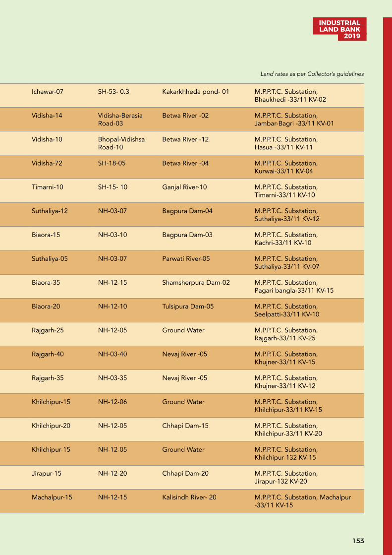
153
INDUSTRIAL LAND BANK
2019
16. Sehore Ichawar Bhaukhedi 190 Ichawar-07 SH-53- 0.3 Kakarkhheda pond- 01 M.P.P.T.C. Substation,Bhaukhedi -33/11 KV-02
17. Vidisha Vidisha Jafarkhedi 52 Vidisha-14 Vidisha-Berasia Road-03
Betwa River -02 M.P.P.T.C. Substation, Jambar-Bagri -33/11 KV-01
18. Vidisha Vidisha Dhanora Haweli 241 Vidisha-10 Bhopal-Vidishsa Road-10
Betwa River -12 M.P.P.T.C. Substation, Hasua -33/11 KV-11
19. Vidisha Kurwai Bhourasa 137 Vidisha-72 SH-18-05 Betwa River -04 M.P.P.T.C. Substation, Kurwai-33/11 KV-04
20. Harda Timarni Bicchapur 44.31 Timarni-10 SH-15- 10 Ganjal River-10 M.P.P.T.C. Substation, Timarni-33/11 KV-10
21. Rajgarh Biaora Sarasyabe 116 Suthaliya-12 NH-03-07 Bagpura Dam-04 M.P.P.T.C. Substation, Suthaliya-33/11 KV-12
22. Rajgarh Biaora Kanyakhedi 101 Biaora-15 NH-03-10 Bagpura Dam-03 M.P.P.T.C. Substation, Kachri-33/11 KV-10
23. Rajgarh Biaora Mau 185 Suthaliya-05 NH-03-07 Parwati River-05 M.P.P.T.C. Substation, Suthaliya-33/11 KV-07
24. Rajgarh Biaora Shamsherpura 273 Biaora-35 NH-12-15 Shamsherpura Dam-02 M.P.P.T.C. Substation, Pagari bangla-33/11 KV-15
25. Rajgarh Biaora Manki 134 Biaora-20 NH-12-10 Tulsipura Dam-05 M.P.P.T.C. Substation, Seelpatti-33/11 KV-10
26. Rajgarh Rajgarh Rojya 121 Rajgarh-25 NH-12-05 Ground Water M.P.P.T.C. Substation, Rajgarh-33/11 KV-25
27. Rajgarh Rajgarh Dungarpur 153 Rajgarh-40 NH-03-40 Nevaj River -05 M.P.P.T.C. Substation, Khujner-33/11 KV-15
28. Rajgarh Rajgarh Baiheda 185 Rajgarh-35 NH-03-35 Nevaj River -05 M.P.P.T.C. Substation, Khujner-33/11 KV-12
29. Rajgarh Khilchipur Hinotya 107 Khilchipur-15 NH-12-06 Ground Water M.P.P.T.C. Substation, Khilchipur-33/11 KV-15
30. Rajgarh Khilchipur Guradia 108 Khilchipur-20 NH-12-05 Chhapi Dam-15 M.P.P.T.C. Substation, Khilchipur-33/11 KV-20
31. Rajgarh Khilchipur Dhablikala 138 Khilchipur-15 NH-12-05 Ground Water M.P.P.T.C. Substation, Khilchipur-132 KV-15
32. Rajgarh Jirapur Kotada 155 Jirapur-15 NH-12-20 Chhapi Dam-20 M.P.P.T.C. Substation, Jirapur-132 KV-20
33. Rajgarh Jeerapur Babdikheda 194 Machalpur-15 NH-12-15 Kalisindh River- 20 M.P.P.T.C. Substation, Machalpur-33/11 KV-15
Land rates as per Collector’s guidelines
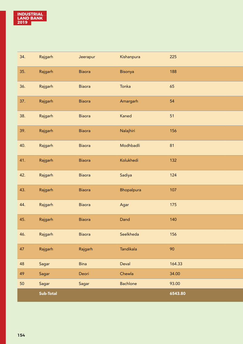
INDUSTRIAL LAND BANK 2019
154
34. Rajgarh Jeerapur Kishanpura 225 Machalpur-20 NH-12-15 Ground Water M.P.P.T.C. Substation, Jirapur-132 KV-40
35. Rajgarh Biaora Bisonya 188 Suthaliya-06 NH-03-03 Napanera Dam-05 M.P.P.T.C. Substation, Suthaliya-33/11 KV - 06
36. Rajgarh Biaora Tonka 65 Suthaliya-10 NH-03-25 Baghpura Dam-05 M.P.P.T.C. Substation, Suthaliya-33/11 KV - 10
37. Rajgarh Biaora Amargarh 54 Biaora-25 NH-03-10 Baghpura Dam-05 M.P.P.T.C. Substation, Kachri-33/11 KV – 10
38. Rajgarh Biaora Kaned 51 Suthaliya-10 NH-03-25 Parwati River-07 M.P.P.T.C. Substation, Suthaliya-33/11 KV - 10
39. Rajgarh Biaora Nalajhiri 156 Suthaliya-05 NH-03-20 Nalajhiri Dam - 09 M.P.P.T.C. Substation, Suthaliya-33/11 KV -05
40. Rajgarh Biaora Modhbadli 81 Suthaliya-07 NH-03-18 Bisonya Napanera Dam -03 M.P.P.T.C. Substation, Suthaliya-33/11 KV -07
41. Rajgarh Biaora Kolukhedi 132 Suthaliya-15 NH-12- 08 Kolukhedi Dam-03 M.P.P.T.C. Substation, Suthaliya-33/11 KV -15
42. Rajgarh Biaora Sadiya 124 Biaora-25 NH-03- 10 Ground Water M.P.P.T.C. Substation, Seelpatti-33/11 KV -10
43. Rajgarh Biaora Bhopalpura 107 Biaora-35 NH-03- 20 Shamsherpura Dam-05 M.P.P.T.C. Substation, Pagari bangla-33/11 KV -20
44. Rajgarh Biaora Agar 175 Narsingarh-10 NH-12 -05 Agar Dam-02 M.P.P.T.C. Substation, Narsingarh-33/11 KV -10
45. Rajgarh Biaora Dand 140 Narsingarh-10 NH-03-25 Agar Dam-02 M.P.P.T.C. Substation, Narsingarh-33/11 KV -10
46. Rajgarh Biaora Seelkheda 156 Narsingarh-20 NH-12-12 Parwati Rivar- 05 M.P.P.T.C. Substation, Narsingarh-33/11 KV -20
47 Rajgarh Rajgarh Tandikala 90 Rajgarh-10 NH-12-10 Navaj River- 10 M.P.P.T.C. Substation, Rajgarh-33/11 KV -10
48 Sagar Bina Deval 164.33 Sagar-80 SH-42-10 Bina River-18 15 km
49 Sagar Deori Chewla 34.00 Sagar-60 NH-26-00 Dam -02 5 km
50 Sagar Sagar Bachlone 93.00 Sagar-04 NH- 26-00 Dam-02 4 km
Sub-Total 6543.80
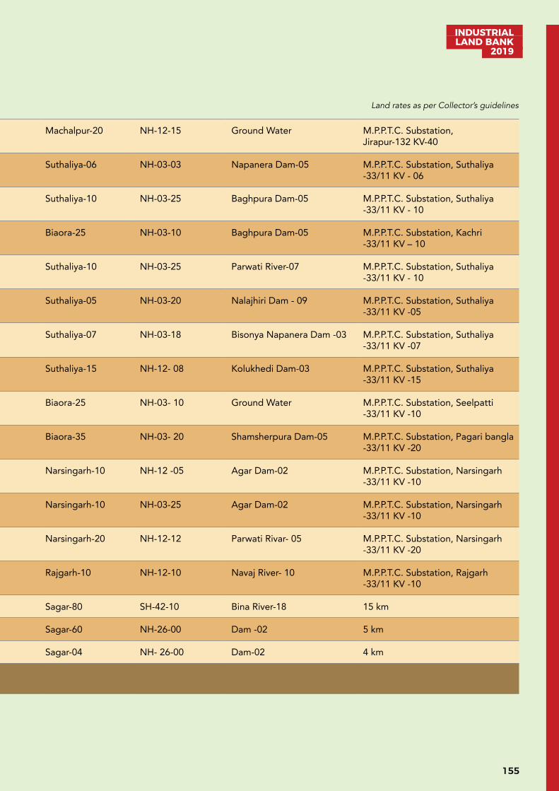
155
INDUSTRIAL LAND BANK
2019
34. Rajgarh Jeerapur Kishanpura 225 Machalpur-20 NH-12-15 Ground Water M.P.P.T.C. Substation, Jirapur-132 KV-40
35. Rajgarh Biaora Bisonya 188 Suthaliya-06 NH-03-03 Napanera Dam-05 M.P.P.T.C. Substation, Suthaliya-33/11 KV - 06
36. Rajgarh Biaora Tonka 65 Suthaliya-10 NH-03-25 Baghpura Dam-05 M.P.P.T.C. Substation, Suthaliya-33/11 KV - 10
37. Rajgarh Biaora Amargarh 54 Biaora-25 NH-03-10 Baghpura Dam-05 M.P.P.T.C. Substation, Kachri-33/11 KV – 10
38. Rajgarh Biaora Kaned 51 Suthaliya-10 NH-03-25 Parwati River-07 M.P.P.T.C. Substation, Suthaliya-33/11 KV - 10
39. Rajgarh Biaora Nalajhiri 156 Suthaliya-05 NH-03-20 Nalajhiri Dam - 09 M.P.P.T.C. Substation, Suthaliya-33/11 KV -05
40. Rajgarh Biaora Modhbadli 81 Suthaliya-07 NH-03-18 Bisonya Napanera Dam -03 M.P.P.T.C. Substation, Suthaliya-33/11 KV -07
41. Rajgarh Biaora Kolukhedi 132 Suthaliya-15 NH-12- 08 Kolukhedi Dam-03 M.P.P.T.C. Substation, Suthaliya-33/11 KV -15
42. Rajgarh Biaora Sadiya 124 Biaora-25 NH-03- 10 Ground Water M.P.P.T.C. Substation, Seelpatti-33/11 KV -10
43. Rajgarh Biaora Bhopalpura 107 Biaora-35 NH-03- 20 Shamsherpura Dam-05 M.P.P.T.C. Substation, Pagari bangla-33/11 KV -20
44. Rajgarh Biaora Agar 175 Narsingarh-10 NH-12 -05 Agar Dam-02 M.P.P.T.C. Substation, Narsingarh-33/11 KV -10
45. Rajgarh Biaora Dand 140 Narsingarh-10 NH-03-25 Agar Dam-02 M.P.P.T.C. Substation, Narsingarh-33/11 KV -10
46. Rajgarh Biaora Seelkheda 156 Narsingarh-20 NH-12-12 Parwati Rivar- 05 M.P.P.T.C. Substation, Narsingarh-33/11 KV -20
47 Rajgarh Rajgarh Tandikala 90 Rajgarh-10 NH-12-10 Navaj River- 10 M.P.P.T.C. Substation, Rajgarh-33/11 KV -10
48 Sagar Bina Deval 164.33 Sagar-80 SH-42-10 Bina River-18 15 km
49 Sagar Deori Chewla 34.00 Sagar-60 NH-26-00 Dam -02 5 km
50 Sagar Sagar Bachlone 93.00 Sagar-04 NH- 26-00 Dam-02 4 km
Sub-Total 6543.80
Land rates as per Collector’s guidelines

INDUSTRIAL LAND BANK 2019
156
Gwalior
1 Gwalior Gwalior Village Girbai 30.57 Gwalior NH46
2 Morena Morena Village Mena Basai 174.49 Morena Away to 15 km Morena City
Sank River
3 Guna Guna Village Murela, Singapura, Knoyakalan, Telegaon, Pura Lakhanwas, Gehukheda
430.77 Guna GhodaPachhad River, Parvati River &Tubewell
Available
4 Sheopur Sheopur Village, Sheopur Bagwaj, Datarda, Samarsa, Jagdajagir
812.38 Sheopur 2 km SavaiMadhopur Road
1 km Chambal Rive Available
5 Ashok Nagar Ashok Nagar Village Rawsar, Manakpur, Palkatori, Devlon, Malhargarh
331.03 Ashok Nagar 5 km AshoknagarIsagarh Road
Tubewell Available
6 Chhatarpur Nowgong Sikarpura 24.21 Chhatarpur 02 km From N.H. 3
Dam02 km
05 km
Sub-Total 1803.47
Indore
1 Dhar Dharampuri Village Bagwanya 47.03 Dhmnod – 9 km NH-3, 5 km Narmada River 15 km Power Station Dhani 8 km
2 Dhar Sardarpur Village Khareli 28.94 Sardarpur – 14 km NH-47, 0 km Mahi River 11 km Power Station Hatod 0 km
3 Dhar Sardarpur Village Hatod 175.84 Sardarpur – 14 km NH-47, 0 km Mahi River 11 km Power Station Hatod 0 km
4 Khargone Kasrawad Village Jalanpur 150.10 Kasrawad-14 km NH-3, 15 km Narmada River 0 km Power Station Nimrani 15 km
5 Khargone Kasrawad Village Nimrani 43.56 Kasrawad-15 km NH-3, 15 km Narmada River 0 km Power Station Nimrani 0 km
6 Khargone Kasrawad Village Rehmatpur 76.10 Kasrawad-15 km NH-3, 21 km Narmada River 7 km Power Station Nimrani 0 km
7 Khargone Kasrawad Village Panva 60.46 Kasrawad-13 km NH-3, 3 km Narmada River 0 km Power Station Nimrani 8 km
8 Khargone Kasrawad Village Maharaj Khedi 36 Kasrawad-15 km NH-3, 2 km Narmada River 10 km Power Station Nimrani 0 km
9 Dewas Tonk khurd Guradiya surdas, 162.25 Dewas 8 km 40 km Dam of Water Resource Department is Situated near Identified Land
Available at Distance of 2 km from Identified Land
10 Dewas Tonk khurd, Chayan hajjam 43.15 Dewas 55 km 43 km Canal 1.5 km, Local pond from identified Land
Available at Distance of 2 km from Identified Land
11 Dewas Kannod Nanasa 51.53 Kannod 8 km 2 km Narmada river is situated at 22 km distance from Identified Land
Available at Distance of 3 km from Identified Land
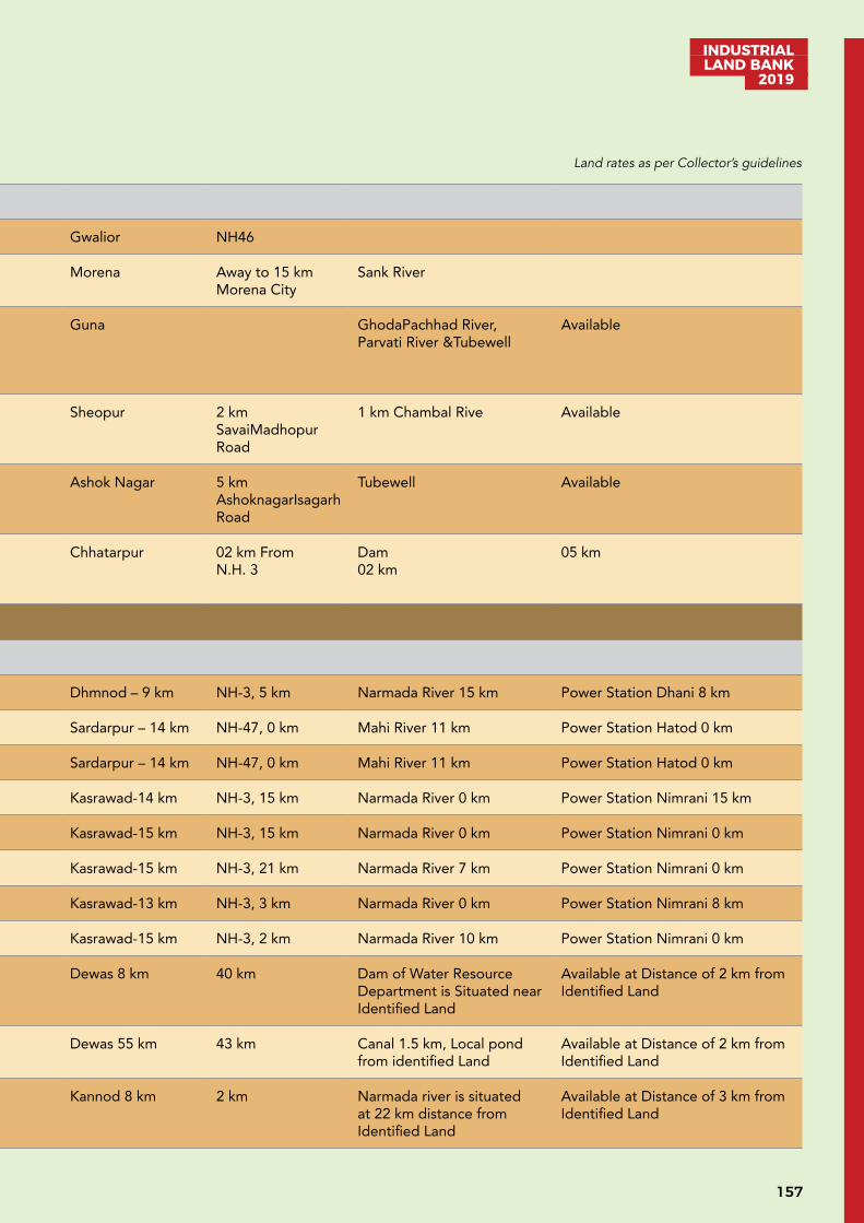
157
INDUSTRIAL LAND BANK
2019
Gwalior
1 Gwalior Gwalior Village Girbai 30.57 Gwalior NH46
2 Morena Morena Village Mena Basai 174.49 Morena Away to 15 km Morena City
Sank River
3 Guna Guna Village Murela, Singapura, Knoyakalan, Telegaon, Pura Lakhanwas, Gehukheda
430.77 Guna GhodaPachhad River, Parvati River &Tubewell
Available
4 Sheopur Sheopur Village, Sheopur Bagwaj, Datarda, Samarsa, Jagdajagir
812.38 Sheopur 2 km SavaiMadhopur Road
1 km Chambal Rive Available
5 Ashok Nagar Ashok Nagar Village Rawsar, Manakpur, Palkatori, Devlon, Malhargarh
331.03 Ashok Nagar 5 km AshoknagarIsagarh Road
Tubewell Available
6 Chhatarpur Nowgong Sikarpura 24.21 Chhatarpur 02 km From N.H. 3
Dam02 km
05 km
Sub-Total 1803.47
Indore
1 Dhar Dharampuri Village Bagwanya 47.03 Dhmnod – 9 km NH-3, 5 km Narmada River 15 km Power Station Dhani 8 km
2 Dhar Sardarpur Village Khareli 28.94 Sardarpur – 14 km NH-47, 0 km Mahi River 11 km Power Station Hatod 0 km
3 Dhar Sardarpur Village Hatod 175.84 Sardarpur – 14 km NH-47, 0 km Mahi River 11 km Power Station Hatod 0 km
4 Khargone Kasrawad Village Jalanpur 150.10 Kasrawad-14 km NH-3, 15 km Narmada River 0 km Power Station Nimrani 15 km
5 Khargone Kasrawad Village Nimrani 43.56 Kasrawad-15 km NH-3, 15 km Narmada River 0 km Power Station Nimrani 0 km
6 Khargone Kasrawad Village Rehmatpur 76.10 Kasrawad-15 km NH-3, 21 km Narmada River 7 km Power Station Nimrani 0 km
7 Khargone Kasrawad Village Panva 60.46 Kasrawad-13 km NH-3, 3 km Narmada River 0 km Power Station Nimrani 8 km
8 Khargone Kasrawad Village Maharaj Khedi 36 Kasrawad-15 km NH-3, 2 km Narmada River 10 km Power Station Nimrani 0 km
9 Dewas Tonk khurd Guradiya surdas, 162.25 Dewas 8 km 40 km Dam of Water Resource Department is Situated near Identified Land
Available at Distance of 2 km from Identified Land
10 Dewas Tonk khurd, Chayan hajjam 43.15 Dewas 55 km 43 km Canal 1.5 km, Local pond from identified Land
Available at Distance of 2 km from Identified Land
11 Dewas Kannod Nanasa 51.53 Kannod 8 km 2 km Narmada river is situated at 22 km distance from Identified Land
Available at Distance of 3 km from Identified Land
Land rates as per Collector’s guidelines
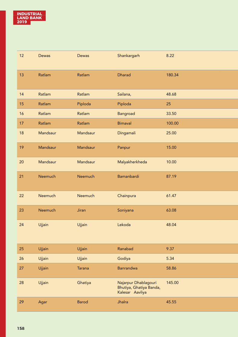
INDUSTRIAL LAND BANK 2019
158
12 Dewas Dewas Shankargarh 8.22 Dewas City 0 Km
0 km Welspun Company’s pipeline is situated near Identified Land
Near Plot
13 Ratlam Ratlam Dharad 180.34 Ratlam 12 km 5 km Kolbakhedi pond (Capacity 5.15 MCM) situated near Identified Land
Available, 33 KV
14 Ratlam Ratlam Sailana, 48.68 Ratlam 25 km 25 km Not Available Available, 132 KV
15 Ratlam Piploda Piploda 25 Ratlam 50 km 2 km Not Available Available, 132 KV
16 Ratlam Ratlam Bangroad 33.50 Ratlam 5 km 1 km Available Available, 33 KV
17 Ratlam Ratlam Bimaval 100.00 Ratlam 10 km Available Available, 33 KV
18 Mandsaur Mandsaur Dingamali 25.00 Mandsaur 50 km
0 km 5 km Available 33, KV
19 Mandsaur Mandsaur Panpur 15.00 Mandsaur 50 km
0 km 5 km Available 33
20 Mandsaur Mandsaur Malyakherkheda 10.00 Mandsaur 50 km
0 km 5 km Available 33
21 Neemuch Neemuch Bamanbardi 87.19 Neemuch 15 km 5 km Under Ground Water Available
33 KV Sub Station is Available at Village Piplwada Kala at 4 km distance from Identified Land
22 Neemuch Neemuch Chainpura 61.47 Neemuch 15 km 5 km Under Ground Water Available
33 KV Sub Station is Available at 4 km distance from Identified Land
23 Neemuch Jiran Soniyana 63.08 Neemuch 11 km 5 km Under Ground Water Available
33 KV Sub Station is Available at Village Dhamniya
24 Ujjain Ujjain Lekoda 48.04 Ujjain 20 km 15 km Lekoda pond at distance of 5 km, and Khan River at distance of 6 km, from Identified Land
High-tension line can be constructed at 20 km distance from Identified land
25 Ujjain Ujjain Ranabad 9.37
26 Ujjain Ujjain Godiya 5.34
27 Ujjain Tarana Banrandwa 58.86 Maksi 5 km 5 km Under Ground Water Available
Electricity lines Capacity of 33 KV is available near Identified Land
28 Ujjain Ghatiya Najarpur Dhablagouri Bhutiya, Ghatiya Banda, Kalesar Aavliya
145.00 Ujjain 22 km 1 km Under Ground Water Available
High-tension line can be constructed at 20 km distance from Identified land
29 Agar Barod Jhalra 45.55 Badod 8 km 3 km Under Ground Water Available
Available
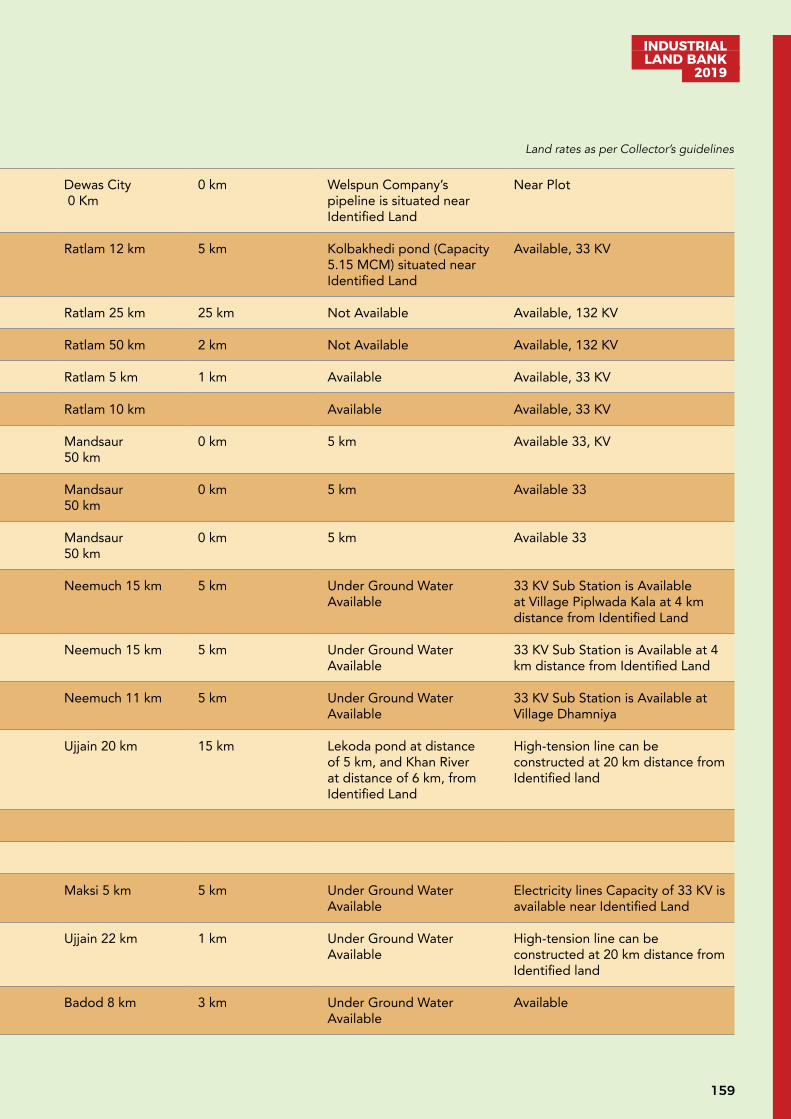
159
INDUSTRIAL LAND BANK
2019
12 Dewas Dewas Shankargarh 8.22 Dewas City 0 Km
0 km Welspun Company’s pipeline is situated near Identified Land
Near Plot
13 Ratlam Ratlam Dharad 180.34 Ratlam 12 km 5 km Kolbakhedi pond (Capacity 5.15 MCM) situated near Identified Land
Available, 33 KV
14 Ratlam Ratlam Sailana, 48.68 Ratlam 25 km 25 km Not Available Available, 132 KV
15 Ratlam Piploda Piploda 25 Ratlam 50 km 2 km Not Available Available, 132 KV
16 Ratlam Ratlam Bangroad 33.50 Ratlam 5 km 1 km Available Available, 33 KV
17 Ratlam Ratlam Bimaval 100.00 Ratlam 10 km Available Available, 33 KV
18 Mandsaur Mandsaur Dingamali 25.00 Mandsaur 50 km
0 km 5 km Available 33, KV
19 Mandsaur Mandsaur Panpur 15.00 Mandsaur 50 km
0 km 5 km Available 33
20 Mandsaur Mandsaur Malyakherkheda 10.00 Mandsaur 50 km
0 km 5 km Available 33
21 Neemuch Neemuch Bamanbardi 87.19 Neemuch 15 km 5 km Under Ground Water Available
33 KV Sub Station is Available at Village Piplwada Kala at 4 km distance from Identified Land
22 Neemuch Neemuch Chainpura 61.47 Neemuch 15 km 5 km Under Ground Water Available
33 KV Sub Station is Available at 4 km distance from Identified Land
23 Neemuch Jiran Soniyana 63.08 Neemuch 11 km 5 km Under Ground Water Available
33 KV Sub Station is Available at Village Dhamniya
24 Ujjain Ujjain Lekoda 48.04 Ujjain 20 km 15 km Lekoda pond at distance of 5 km, and Khan River at distance of 6 km, from Identified Land
High-tension line can be constructed at 20 km distance from Identified land
25 Ujjain Ujjain Ranabad 9.37
26 Ujjain Ujjain Godiya 5.34
27 Ujjain Tarana Banrandwa 58.86 Maksi 5 km 5 km Under Ground Water Available
Electricity lines Capacity of 33 KV is available near Identified Land
28 Ujjain Ghatiya Najarpur Dhablagouri Bhutiya, Ghatiya Banda, Kalesar Aavliya
145.00 Ujjain 22 km 1 km Under Ground Water Available
High-tension line can be constructed at 20 km distance from Identified land
29 Agar Barod Jhalra 45.55 Badod 8 km 3 km Under Ground Water Available
Available
Land rates as per Collector’s guidelines
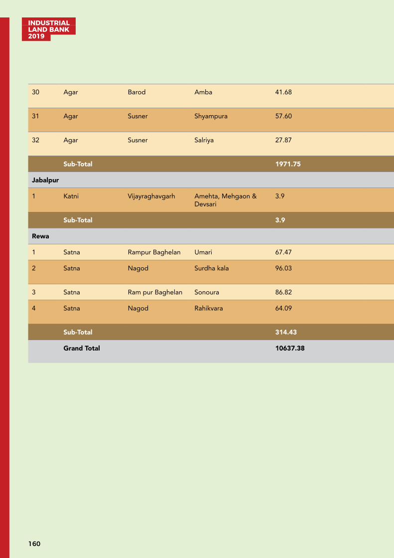
INDUSTRIAL LAND BANK 2019
160
30 Agar Barod Amba 41.68 Badod 7 km 7 km Under Ground Water Available
Available
31 Agar Susner Shyampura 57.60 Susner 12 km 5 km Under Ground Water Available
Available
32 Agar Susner Salriya 27.87 Susner 15 15 km Under Ground Water Available
Available
Sub-Total 1971.75
Jabalpur
1 Katni Vijayraghavgarh Amehta, Mehgaon & Devsari
3.9 Kaymore- 15 km NH-30 20 km
Ground Water Available
Sub-Total 3.9
Rewa
1 Satna Rampur Baghelan Umari 67.47 Satna 5.6 km from SH 13 Ground water 20 km
2 Satna Nagod Surdha kala 96.03 Satna 11 km from SH - 10
Ground water 12 km
3 Satna Ram pur Baghelan Sonoura 86.82 Satna 10 km from SH 13 Ground water 20 km
4 Satna Nagod Rahikvara 64.09 Satna 9.3 km from NH - 39
Ground water 08 km
Sub-Total 314.43
Grand Total 10637.38
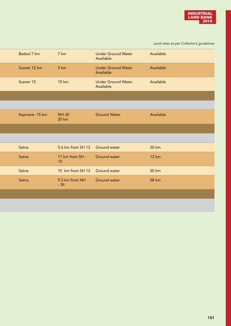
161
INDUSTRIAL LAND BANK
2019
30 Agar Barod Amba 41.68 Badod 7 km 7 km Under Ground Water Available
Available
31 Agar Susner Shyampura 57.60 Susner 12 km 5 km Under Ground Water Available
Available
32 Agar Susner Salriya 27.87 Susner 15 15 km Under Ground Water Available
Available
Sub-Total 1971.75
Jabalpur
1 Katni Vijayraghavgarh Amehta, Mehgaon & Devsari
3.9 Kaymore- 15 km NH-30 20 km
Ground Water Available
Sub-Total 3.9
Rewa
1 Satna Rampur Baghelan Umari 67.47 Satna 5.6 km from SH 13 Ground water 20 km
2 Satna Nagod Surdha kala 96.03 Satna 11 km from SH - 10
Ground water 12 km
3 Satna Ram pur Baghelan Sonoura 86.82 Satna 10 km from SH 13 Ground water 20 km
4 Satna Nagod Rahikvara 64.09 Satna 9.3 km from NH - 39
Ground water 08 km
Sub-Total 314.43
Grand Total 10637.38
Land rates as per Collector’s guidelines

INDUSTRIAL LAND BANK 2019
162
UNDEVELOPED LAND ALLOTMENT GUIDELINES
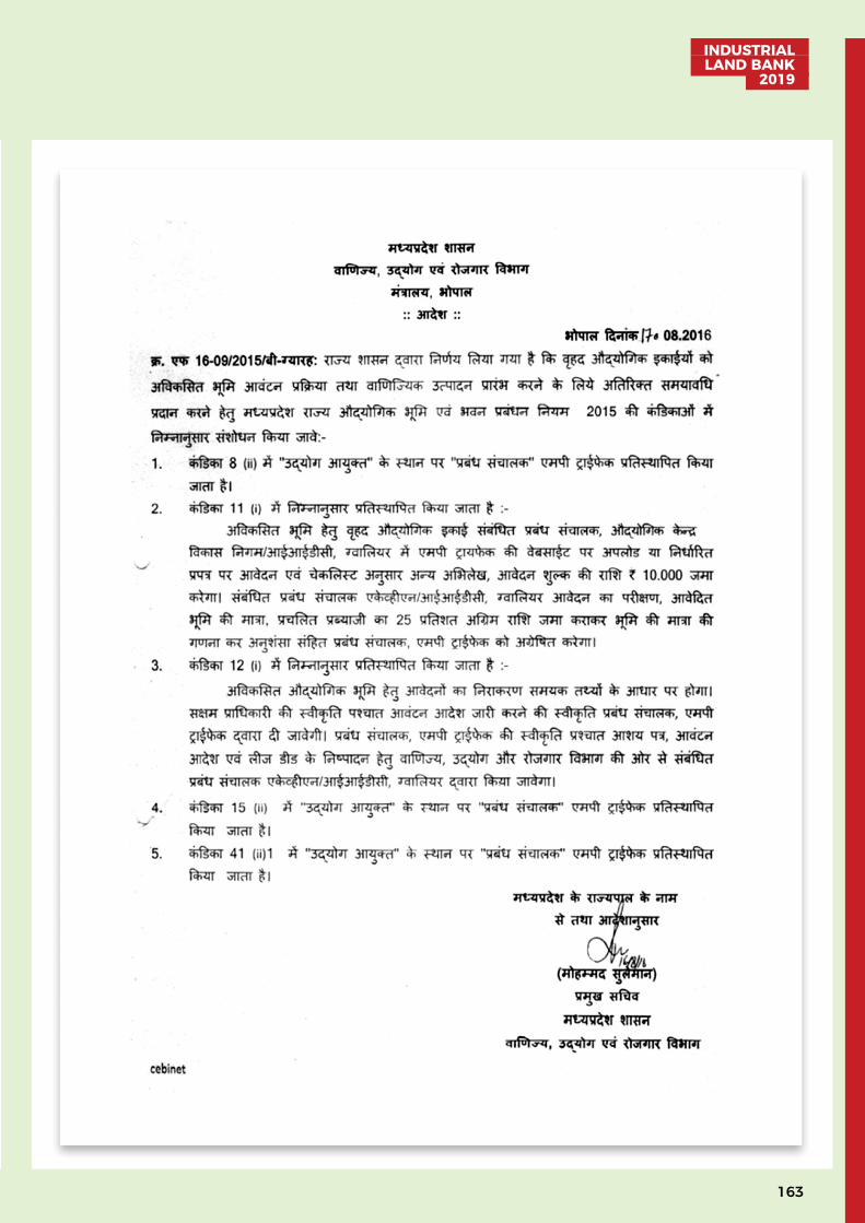
163
INDUSTRIAL LAND BANK
2019
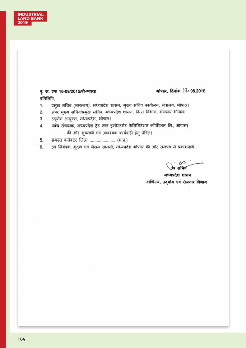
INDUSTRIAL LAND BANK 2019
164
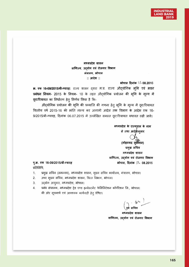
165
INDUSTRIAL LAND BANK
2019
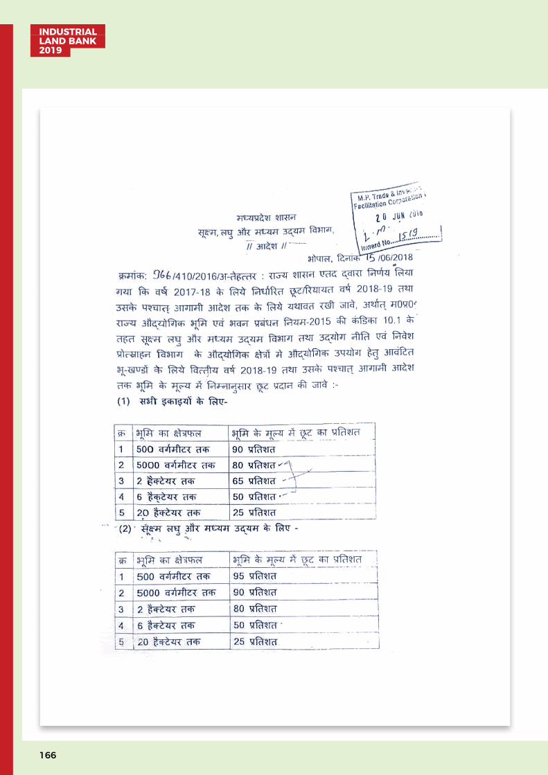
INDUSTRIAL LAND BANK 2019
166
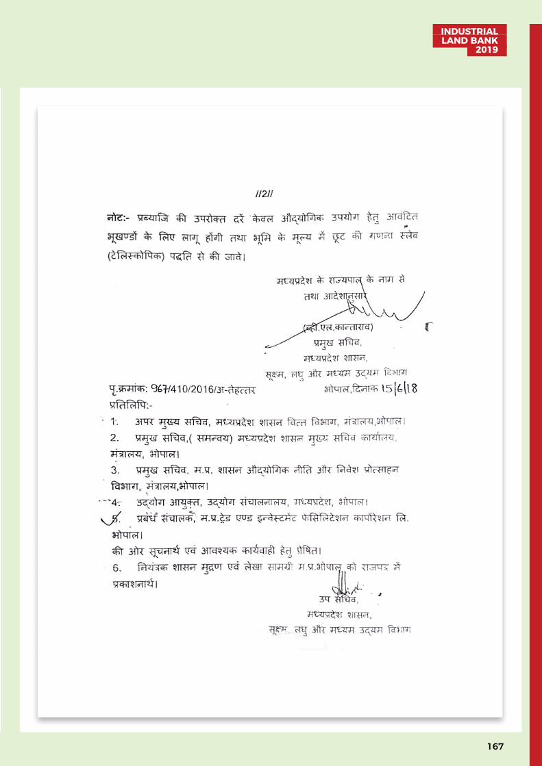
167
INDUSTRIAL LAND BANK
2019
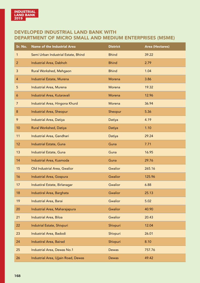
INDUSTRIAL LAND BANK 2019
168
DEVELOPED INDUSTRIAL LAND BANK WITH DEPARTMENT OF MICRO SMALL AND MEDIUM ENTERPRISES (MSME)Sr. No. Name of the Industrial Area District Area (Hectares)
1 Semi Urban Industrial Estate, Bhind Bhind 39.22
2 Industrial Area, Dabhoh Bhind 2.79
3 Rural Workshed, Mehgaon Bhind 1.04
4 Industrial Estate, Murena Morena 3.86
5 Industrial Area, Murena Morena 19.32
6 Industrial Area, Kutaravali Morena 12.96
7 Industrial Area, Hingona Khurd Morena 36.94
8 Industrial Area, Sheopur Sheopur 5.36
9 Industrial Area, Datiya Datiya 4.19
10 Rural Workshed, Datiya Datiya 1.10
11 Industrial Area, Gandhari Datiya 29.24
12 Industrial Estate, Guna Guna 7.71
13 Industrial Estate, Guna Guna 16.95
14 Industrial Area, Kusmoda Guna 29.76
15 Old Industrial Area, Gwalior Gwalior 265.16
16 Industrial Area, Gospura Gwalior 125.96
17 Industiral Estate, Birlanagar Gwalior 6.88
18 Industiral Area, Barghata Gwalior 25.13
19 Industrial Area, Barai Gwalior 5.02
20 Industrial Area, Maharajapura Gwalior 40.90
21 Industrial Area, Biloa Gwalior 20.43
22 Indutrial Estate, Shivpuri Shivpuri 12.04
23 Industrial Area, Badodi Shivpuri 26.01
24 Industiral Area, Bairad Shivpuri 8.10
25 Industrial Area, Dewas No.1 Dewas 757.76
26 Industrial Area, Ujjain Road, Dewas Dewas 49.42
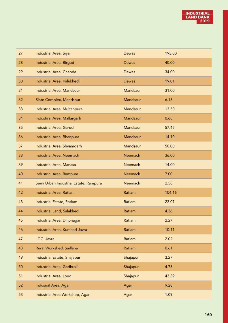
169
INDUSTRIAL LAND BANK
2019
27 Industrial Area, Siya Dewas 193.00
28 Industrial Area, Birgud Dewas 40.00
29 Industrial Area, Chapda Dewas 34.00
30 Industrial Area, Kalukhedi Dewas 19.01
31 Industrial Area, Mandsour Mandsaur 31.00
32 Slate Complex, Mandsour Mandsaur 6.15
33 Industrial Area, Multanpura Mandsaur 13.50
34 Industiral Area, Mallargarh Mandsaur 0.68
35 Industrial Area, Garod Mandsaur 57.45
36 Industrial Area, Bhanpura Mandsaur 14.10
37 Industrial Area, Shyamgarh Mandsaur 50.00
38 Industrial Area, Neemach Neemach 36.00
39 Industrial Area, Manasa Neemach 14.00
40 Industrial Area, Rampura Neemach 7.00
41 Semi Urban Industrial Estate, Rampura Neemach 2.58
42 Industrial Area, Ratlam Ratlam 104.16
43 Industrial Estate, Ratlam Ratlam 23.07
44 Industrial Land, Salakhedi Ratlam 4.36
45 Industrial Area, Dilipnagar Ratlam 2.27
46 Industrial Area, Kumhari Javra Ratlam 10.11
47 I.T.C. Javra Ratlam 2.02
48 Rural Workshed, Saillana Ratlam 0.61
49 Industrial Estate, Shajapur Shajapur 3.27
50 Industrial Area, Gadhroli Shajapur 4.73
51 Industrial Area, Lond Shajapur 43.39
52 Indusrial Area, Agar Agar 9.28
53 Industrial Area Workshop, Agar Agar 1.09
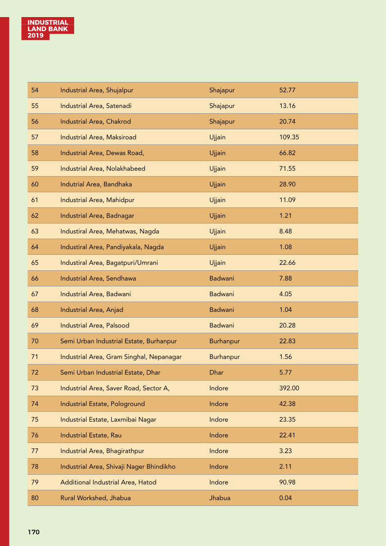
INDUSTRIAL LAND BANK 2019
170
54 Industrial Area, Shujalpur Shajapur 52.77
55 Industrial Area, Satenadi Shajapur 13.16
56 Industrial Area, Chakrod Shajapur 20.74
57 Industrial Area, Maksiroad Ujjain 109.35
58 Industrial Area, Dewas Road, Ujjain 66.82
59 Industrial Area, Nolakhabeed Ujjain 71.55
60 Indutrial Area, Bandhaka Ujjain 28.90
61 Industrial Area, Mahidpur Ujjain 11.09
62 Industrial Area, Badnagar Ujjain 1.21
63 Industiral Area, Mehatwas, Nagda Ujjain 8.48
64 Industiral Area, Pandiyakala, Nagda Ujjain 1.08
65 Industiral Area, Bagatpuri/Umrani Ujjain 22.66
66 Industrial Area, Sendhawa Badwani 7.88
67 Industrial Area, Badwani Badwani 4.05
68 Industrial Area, Anjad Badwani 1.04
69 Industrial Area, Palsood Badwani 20.28
70 Semi Urban Industrial Estate, Burhanpur Burhanpur 22.83
71 Industrial Area, Gram Singhal, Nepanagar Burhanpur 1.56
72 Semi Urban Industrial Estate, Dhar Dhar 5.77
73 Industrial Area, Saver Road, Sector A, Indore 392.00
74 Industrial Estate, Pologround Indore 42.38
75 Industrial Estate, Laxmibai Nagar Indore 23.35
76 Industrial Estate, Rau Indore 22.41
77 Industrial Area, Bhagirathpur Indore 3.23
78 Industrial Area, Shivaji Nager Bhindikho Indore 2.11
79 Additional Industrial Area, Hatod Indore 90.98
80 Rural Workshed, Jhabua Jhabua 0.04
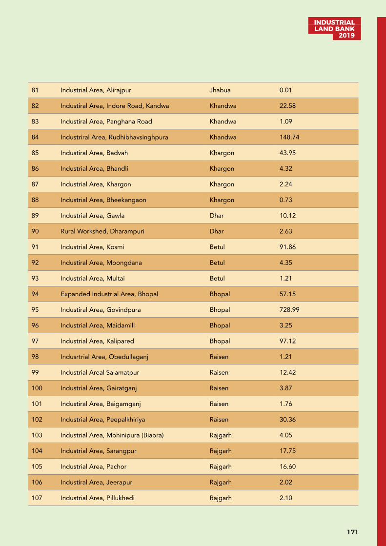
171
INDUSTRIAL LAND BANK
2019
81 Industrial Area, Alirajpur Jhabua 0.01
82 Industiral Area, Indore Road, Kandwa Khandwa 22.58
83 Industiral Area, Panghana Road Khandwa 1.09
84 Industriral Area, Rudhibhavsinghpura Khandwa 148.74
85 Industiral Area, Badvah Khargon 43.95
86 Industrial Area, Bhandli Khargon 4.32
87 Industrial Area, Khargon Khargon 2.24
88 Industrial Area, Bheekangaon Khargon 0.73
89 Industrial Area, Gawla Dhar 10.12
90 Rural Workshed, Dharampuri Dhar 2.63
91 Industrial Area, Kosmi Betul 91.86
92 Industiral Area, Moongdana Betul 4.35
93 Industrial Area, Multai Betul 1.21
94 Expanded Industrial Area, Bhopal Bhopal 57.15
95 Industiral Area, Govindpura Bhopal 728.99
96 Industrial Area, Maidamill Bhopal 3.25
97 Industrial Area, Kalipared Bhopal 97.12
98 Indusrtrial Area, Obedullaganj Raisen 1.21
99 Industrial Areal Salamatpur Raisen 12.42
100 Industrial Area, Gairatganj Raisen 3.87
101 Industiral Area, Baigamganj Raisen 1.76
102 Industrial Area, Peepalkhiriya Raisen 30.36
103 Industrial Area, Mohinipura (Biaora) Rajgarh 4.05
104 Industrial Area, Sarangpur Rajgarh 17.75
105 Industrial Area, Pachor Rajgarh 16.60
106 Industiral Area, Jeerapur Rajgarh 2.02
107 Industrial Area, Pillukhedi Rajgarh 2.10

INDUSTRIAL LAND BANK 2019
172
108 Semi Urben Industrial Estate, Narsinghgarh Rajgarh 1.21
109 Industrial Area, Kachnariya Rajgarh 20.00
110 Industiral Area, Mandi Sehore 13.26
111 Semi Urban Industrial Estate, Lohanipura Sehore 1.17
112 Industrial Area, Pachama Sehore 4.24
113 Rural Workshed, Ashta Sehore 2.43
114 Industiral Area, Budhni Sehore 20.24
115 Industrial Area, Ichawar Sehore 1.00
116 Industrial Area, Vidisha Vidisha 12.14
117 Industrial Area, Kurwai Vidisha 1.75
118 Industrial Area, Kanjana (Basoda) Vidisha 52.30
119 Industial Area, Harda Harda 20.01
120 Industialarea, Kisanpura Hoshangabad 9.10
121 Industrial Area, Kheda Hoshangabad 44.16
122 Industrial Area, Sonasanvari Hoshangabad 5.12
123 Industrial Area, Damadiya (Seoni) Hoshangabad 3.14
124 Industiral Area, Dolariya Hoshangabad 4.06
125 Semi Urban Industrial Estate, Chatarpur Chatarpur 3.46
126 Bullock Cart Project, Chatarpur Chatarpur 16.00
127 Industrial Area, Chandrapura Chatarpur 50.00
128 Industrial Area, Marutal, Damoh Damoh 93.08
129 Semi Urban Industrial Estate, Damoh Damoh 2.46
130 Industiral Area, Gandhi Aashram, Damoh Damoh 9.78
131 Semi Urban Industrial Estate, Panna Panna 1.21
132 Industrial Estate, Subhash Nagar Sagar 6.45
133 Industrial Area, Bina Sagar 6.27
134 Industrial Area, Rehli Sagar 1.39
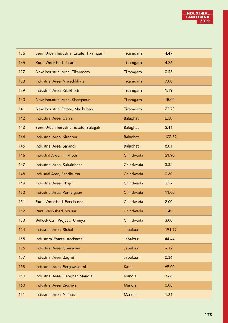
173
INDUSTRIAL LAND BANK
2019
135 Semi Urban Industrial Estate, Tikamgarh Tikamgarh 4.47
136 Rural Workshed, Jatara Tikamgarh 4.26
137 New Industrial Area, Tikamgarh Tikamgarh 0.55
138 Industrial Area, Niwadibhata Tikamgarh 7.00
139 Industrial Area, Kitakhedi Tikamgarh 1.19
140 New Industrial Area, Khargapur Tikamgarh 15.00
141 New Industrial Estate, Madhuban Tikamgarh 23.73
142 Industiral Area, Garra Balaghat 6.50
143 Semi Urban Industrial Estate, Balagaht Balaghat 2.41
144 Industrial Area, Kirnapur Balaghat 123.52
145 Industrial Area, Sarandi Balaghat 8.01
146 Industial Area, Imlikhedi Chindwada 21.90
147 Industrial Area, Sukuldhana Chindwada 3.32
148 Industial Area, Pandhurna Chindwada 0.80
149 Industrial Area, Khajri Chindwada 2.57
150 Industrial Area, Kamalgaon Chindwada 11.00
151 Rural Workshed, Pandhurna Chindwada 2.00
152 Rural Workshed, Sousar Chindwada 0.49
153 Bullock Cart Project,, Umriya Chindwada 3.00
154 Indusrtial Area, Richai Jabalpur 191.77
155 Industriral Estate, Aadhartal Jabalpur 44.44
156 Industiral Area, Gousalpur Jabalpur 9.32
157 Industrial Area, Bagraji Jabalpur 0.36
158 Industrial Area, Bargawakatni Katni 65.00
159 Industrial Area, Deoghar, Mandla Mandla 3.66
160 Industrial Area, Bicchiya Mandla 0.08
161 Industrial Area, Nainpur Mandla 1.21
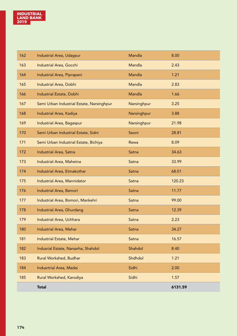
INDUSTRIAL LAND BANK 2019
174
162 Industrial Area, Udaypur Mandla 8.00
163 Industrial Area, Gocchi Mandla 2.43
164 Industrial Area, Piprapani Mandla 1.21
165 Industrial Area, Dobhi Mandla 2.83
166 Industrial Estate, Dobhi Mandla 1.66
167 Semi Urban Industrial Estate, Narsinghpur Narsinghpur 3.25
168 Industrial Area, Kadiya Narsinghpur 3.88
169 Industrial Area, Bagaspur Narsinghpur 21.98
170 Semi Urban Industrial Estate, Sidni Seoni 28.81
171 Semi Urban Industrial Estate, Bichiya Rewa 8.09
172 Industrial Area, Satna Satna 34.63
173 Industrial Area, Mahetna Satna 33.99
174 Industrial Area, Etmakothar Satna 68.01
175 Industrial Area, Mannidator Satna 120.23
176 Industrial Area, Bamori Satna 11.77
177 Industrial Area, Bomori, Mankehri Satna 99.00
178 Industrial Area, Ghurdang Satna 12.39
179 Industrial Area, Uchhara Satna 2.23
180 Industrial Area, Mehar Satna 34.27
181 Industrial Estate, Mehar Satna 16.57
182 Indusrial Estate, Narsarha, Shahdol Shahdol 8.40
183 Rural Workshed, Budhar Shdhdol 1.21
184 Indusrtrial Area, Madai Sidhi 2.00
185 Rural Workshed, Karodiya Sidhi 1.57
Total 6131.59
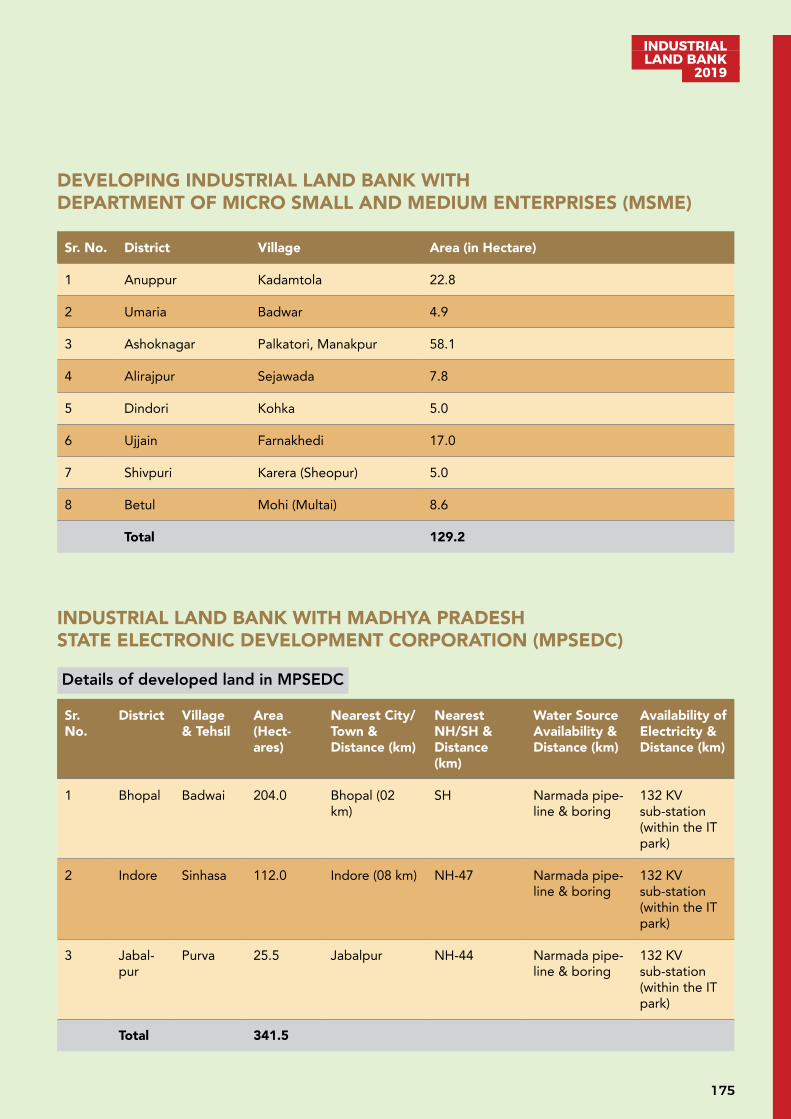
175
INDUSTRIAL LAND BANK
2019
DEVELOPING INDUSTRIAL LAND BANK WITH DEPARTMENT OF MICRO SMALL AND MEDIUM ENTERPRISES (MSME)
Sr. No. District Village Area (in Hectare)
1 Anuppur Kadamtola 22.8
2 Umaria Badwar 4.9
3 Ashoknagar Palkatori, Manakpur 58.1
4 Alirajpur Sejawada 7.8
5 Dindori Kohka 5.0
6 Ujjain Farnakhedi 17.0
7 Shivpuri Karera (Sheopur) 5.0
8 Betul Mohi (Multai) 8.6
Total 129.2
INDUSTRIAL LAND BANK WITH MADHYA PRADESH STATE ELECTRONIC DEVELOPMENT CORPORATION (MPSEDC)
Details of developed land in MPSEDC
Sr. No.
District Village & Tehsil
Area (Hect-ares)
Nearest City/Town & Distance (km)
Nearest NH/SH & Distance (km)
Water Source Availability & Distance (km)
Availability of Electricity & Distance (km)
1 Bhopal Badwai 204.0 Bhopal (02 km)
SH Narmada pipe-line & boring
132 KV sub-station (within the IT park)
2 Indore Sinhasa 112.0 Indore (08 km) NH-47 Narmada pipe-line & boring
132 KV sub-station (within the IT park)
3 Jabal-pur
Purva 25.5 Jabalpur NH-44 Narmada pipe-line & boring
132 KV sub-station (within the IT park)
Total 341.5
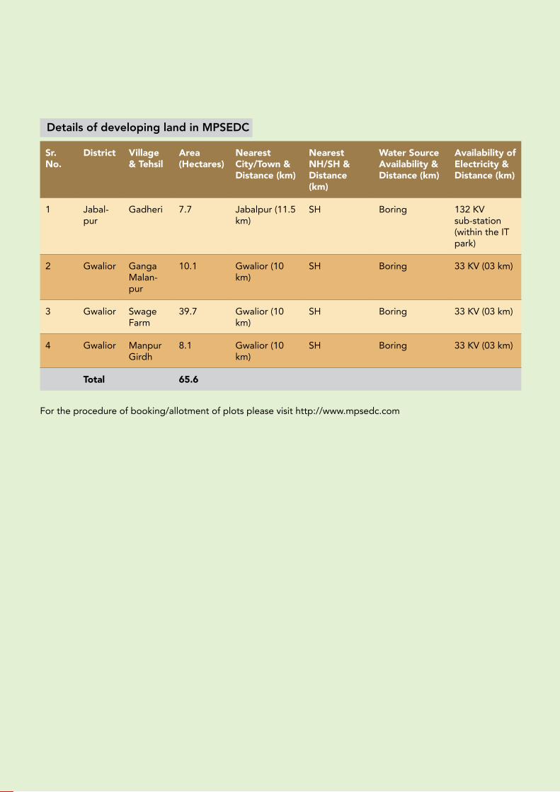
INDUSTRIAL LAND BANK 2019
176
Details of developing land in MPSEDC
Sr. No.
District Village & Tehsil
Area (Hectares)
Nearest City/Town & Distance (km)
Nearest NH/SH & Distance (km)
Water Source Availability & Distance (km)
Availability of Electricity & Distance (km)
1 Jabal-pur
Gadheri 7.7 Jabalpur (11.5 km)
SH Boring 132 KV sub-station (within the IT park)
2 Gwalior Ganga Malan-pur
10.1 Gwalior (10 km)
SH Boring 33 KV (03 km)
3 Gwalior Swage Farm
39.7 Gwalior (10 km)
SH Boring 33 KV (03 km)
4 Gwalior Manpur Girdh
8.1 Gwalior (10 km)
SH Boring 33 KV (03 km)
Total 65.6
For the procedure of booking/allotment of plots please visit http://www.mpsedc.com


www.invest.mp.gov.in
KNOWLEDGE PARTNERORGANISED BY NATIONAL PARTNER
MP INDUSTRIAL DEVELOPMENT CORPORATION LIMITED16-A, CEDMAP Bhawan, Arera Hills,Bhopal, Madhya Pradesh (INDIA)Phone: +91-755-2575618, 2571830Email: [email protected]