Indicators of soil fertility and opportunities for precontact agriculture in Kona, Hawai’i
20
Indicators of soil fertility and opportunities for precontact agriculture in Kona, Hawai’i NOA LINCOLN, 1, OLIVER CHADWICK, 2 AND PETER VITOUSEK 3 1 Emmett Interdisciplinary Program in Environment and Resources, Stanford University, Stanford, California 94305 USA 2 Department of Geography, University of California, Santa Barbara, California 93106 USA 3 Department of Biology, Stanford University, Stanford, California 94305 USA Citation: Lincoln, N., O. Chadwick, and P. Vitousek. 2014. Indicators of soil fertility and opportunities for precontact agriculture in Kona, Hawai’i. Ecosphere 5(4):42. http://dx.doi.org/10.1890/ES13-00328.1 Abstract. The distribution, mode, and intensity of agriculture both influence and are influenced by the natural environment. Soil fertility indicators that correlate with the intensification of dryland agriculture in pre-contact Hawai’i have been mapped across the Hawaiian archipelago. We investigated these soil fertility indicators and agricultural development in the unique environment of Kona, Hawai’i, the largest, culturally most significant, and geologically youngest of the dryland field systems in Hawai’i. Agriculture was intensified systematically on substrates 4,000 years old with appropriate climate and fertility in Kona, in keeping with archipelago-wide analyses. In comparison with other dryland agricultural systems in Hawaii, we found that soil fertility indicators used to predict pre-European agricultural intensification are shifted towards lower rainfall on the younger geological substrates of Kona. For example, base saturation reached low levels (,30%) at ;1200 mm/yr rainfall on 1,200 year old substrate and at ;1400 mm/yr on 7,500 year old substrate in Kona, versus ;1800 mm/yr on 150,000 year old substrate on Kohala Volcano. We suggest that this difference reflects a kinetic, rather than an irreversible, limitation to soil fertility in Kona, and we discuss how this difference could have influenced opportunities for agricultural intensification and the distribution of agroecological zones. Key words: agroecology; dryland agriculture; field systems; Hawaii; indigenous agriculture; Kona; soil development; soil nutrients. Received 25 October 2013; revised 23 January 2014; accepted 6 February 2014; final version received 28 February 2014; published 8 April 2014. Corresponding Editor: Y. Pan. Copyright: Ó 2014 Lincoln et al. This is an open-access article distributed under the terms of the Creative Commons Attribution License, which permits unrestricted use, distribution, and reproduction in any medium, provided the original author and source are credited. http://creativecommons.org/licenses/by/3.0/ E-mail: [email protected] INTRODUCTION Archeologists divide Pre-European Hawaiian agriculture into wetland, flood irrigated systems that were restricted to stream valleys and coastal plains of each island and dryland, rainfed systems that covered vast areas of relatively fertile soils on the younger islands (Ladefoged et al. 2009). Each agricultural system entrained its own pattern of social organization (Kirch 1994), and development of the dryland systems in particular led to consolidation of social control by the ruling elites (Kirch 2011). Some intensive dryland systems, such as the well-studied lee- ward Kohala agricultural area, supported rela- tively homogeneous agricultural infrastructure and intensive agricultural plantings (Ladefoged et al. 2003, Ladefoged and Graves 2008) whereas others such as the Kona system developed into a highly diverse patchwork characterized by a matrix of agricultural practices overlaid onto a spectrum of lava flows of varying ages. Research in the Kohala field system has demonstrated that the boundaries of systematic v www.esajournals.org 1 April 2014 v Volume 5(4) v Article 42
-
Upload
manoa-hawaii -
Category
Documents
-
view
7 -
download
0
Transcript of Indicators of soil fertility and opportunities for precontact agriculture in Kona, Hawai’i

Indicators of soil fertility and opportunitiesfor precontact agriculture in Kona, Hawai’i
NOA LINCOLN,1,� OLIVER CHADWICK,2 AND PETER VITOUSEK3
1Emmett Interdisciplinary Program in Environment and Resources, Stanford University, Stanford, California 94305 USA2Department of Geography, University of California, Santa Barbara, California 93106 USA
3Department of Biology, Stanford University, Stanford, California 94305 USA
Citation: Lincoln, N., O. Chadwick, and P. Vitousek. 2014. Indicators of soil fertility and opportunities for precontact
agriculture in Kona, Hawai’i. Ecosphere 5(4):42. http://dx.doi.org/10.1890/ES13-00328.1
Abstract. The distribution, mode, and intensity of agriculture both influence and are influenced by the
natural environment. Soil fertility indicators that correlate with the intensification of dryland agriculture in
pre-contact Hawai’i have been mapped across the Hawaiian archipelago. We investigated these soil fertility
indicators and agricultural development in the unique environment of Kona, Hawai’i, the largest,
culturally most significant, and geologically youngest of the dryland field systems in Hawai’i. Agriculture
was intensified systematically on substrates �4,000 years old with appropriate climate and fertility in
Kona, in keeping with archipelago-wide analyses. In comparison with other dryland agricultural systems
in Hawaii, we found that soil fertility indicators used to predict pre-European agricultural intensification
are shifted towards lower rainfall on the younger geological substrates of Kona. For example, base
saturation reached low levels (,30%) at ;1200 mm/yr rainfall on 1,200 year old substrate and at ;1400
mm/yr on 7,500 year old substrate in Kona, versus ;1800 mm/yr on 150,000 year old substrate on Kohala
Volcano. We suggest that this difference reflects a kinetic, rather than an irreversible, limitation to soil
fertility in Kona, and we discuss how this difference could have influenced opportunities for agricultural
intensification and the distribution of agroecological zones.
Key words: agroecology; dryland agriculture; field systems; Hawaii; indigenous agriculture; Kona; soil development;
soil nutrients.
Received 25 October 2013; revised 23 January 2014; accepted 6 February 2014; final version received 28 February 2014;
published 8 April 2014. Corresponding Editor: Y. Pan.
Copyright: � 2014 Lincoln et al. This is an open-access article distributed under the terms of the Creative Commons
Attribution License, which permits unrestricted use, distribution, and reproduction in any medium, provided the
original author and source are credited. http://creativecommons.org/licenses/by/3.0/
� E-mail: [email protected]
INTRODUCTION
Archeologists divide Pre-European Hawaiian
agriculture into wetland, flood irrigated systems
that were restricted to stream valleys and coastal
plains of each island and dryland, rainfed
systems that covered vast areas of relatively
fertile soils on the younger islands (Ladefoged et
al. 2009). Each agricultural system entrained its
own pattern of social organization (Kirch 1994),
and development of the dryland systems in
particular led to consolidation of social control
by the ruling elites (Kirch 2011). Some intensive
dryland systems, such as the well-studied lee-
ward Kohala agricultural area, supported rela-
tively homogeneous agricultural infrastructure
and intensive agricultural plantings (Ladefoged
et al. 2003, Ladefoged and Graves 2008) whereas
others such as the Kona system developed into a
highly diverse patchwork characterized by a
matrix of agricultural practices overlaid onto a
spectrum of lava flows of varying ages.
Research in the Kohala field system has
demonstrated that the boundaries of systematic
v www.esajournals.org 1 April 2014 v Volume 5(4) v Article 42

agricultural intensification consistently alignedwith several soil properties—particularly percentbase saturation, exchangeable calcium and totaland extractable phosphorus—which converselyhave been applied as indicators of a soil fertilitythreshold below which the systematic intensifi-cation of agriculture was not pursued (Vitouseket al. 2004). Ladefoged et al. (2009) used thisthreshold to evaluate the potential distribution ofintensive rainfed agricultural systems across theHawaiian Archipelago and summarized theirresults in a geospatial model depicting thepotential extent of intensified agricultural sys-tems in Hawai’i. Output of the model correlatedspatially with well-documented sites and led tothe identification of intensively cultivated areasnot previously mapped.
The Ladefoged et al. (2009) model wasdesigned to provide an archipelago-wide per-spective on the controls of agricultural intensifi-cation rather than a guide to place-basedintensification features (e.g., Vitousek et al.2010). Place-specific controls of soil fertility mayalter the predicted extent of agricultural intensi-fication. The Kona district of the Island ofHawai’i offers an opportunity to evaluate theimportance of place-specific controls in anenvironment with high spatial variability in soilproperties, extremely young substrate ages,unique agricultural practices and agroecology,and a large spatial extent of dryland agriculture(Kelly 1983, Allen 2001, 2004). Further, Konabecame the cultural and political center of theIsland of Hawai’i late in the precontact period(Kamakau 1961). The farming landscape of Konathus offers an opportunity to link soils, societies,and agricultural development in a culturallyimportant and highly diverse landscape.
In this paper we develop site-specific charac-terizations of soil fertility and summarize thearcheological evidence for pre-historic agricul-tural development in the Kona district. Wedescribe the properties of Kona soils from 0.5–7.5 ky, and discuss them in the context ofcontinuous intensive versus patchy systems ofagriculture, which we refer to as ‘‘systematic’’and ‘‘informal’’ agriculture respectively. For theKona system, the Ladefoged et al. (2009) modelpredicted patchy intensification of systematicagriculture due to the exclusion of lava flows,4 ky based on the expectation of inadequate
soil thickness. For the purpose of this paper‘‘Kona soils’’ refers to lava flows of all ages acrossthe landscape of Kona, ‘‘young soils’’ refer to ,4ky flows, and ‘‘old soils’’ will refer to �4 kyflows. We utilize this information on soils to ask(1) do soil fertility indicators in Kona follow thesame patterns with climate as they do in theintensified Kohala field system, (2) is 4 ky anappropriate age threshold for systematic orintensive agriculture in pre-European Hawai’i,and (3) what landscape-level patterns of agricul-ture occur on the different Kona soils?
SITE, CLIMATE, AND LAND-USE HISTORY
Climate, geology, and soilsKona is situated on the western slopes of
Mauna Loa and Hualalai volcanoes with a localweather system controlled by a land-sea breezecycle that creates a wet environment compared toother leeward areas in the archipelago. Rainfallincreases upslope from as little as 600 mm/yr atthe coast to as much as ;2000 mm/yr at ;600 melevation, declining again at higher elevation(Fig. 1A; Giambelluca et al. 2012).
Hualalai and Mauna Loa volcanoes also createa patchwork of overlapping lava flows (Fig. 1B)that range from less than 65 to over 10,000 yearsold (Trusdell et al. 2006). Hualalai lava has analkalic composition while Mauna Loa lava istholeiitic in nature. The two volcanic sourcesdiffer importantly in chemical composition, withalkalic sources typically containing much lowerconcentrations of silica and sodium, but higherconcentrations of aluminum and especially phos-phorus. Soils in Kona are primarily Histosols andAndisols (NRCS 2010). Histosols are recognizedin recent flows where organic matter hasaccumulated but tephra and lava have notsufficiently weathered to produce the short-range-order minerals that typify Andisols. Mostof the nutrient supplying and holding capacity inHistosols comes from organic matter that on veryyoung flows is introduced from nearby vegetatedareas and by in situ pioneering plants as theflows become vegetated. With increasing lavaflow age, weathering and secondary mineralformation lead to the development of Andisols,which feature both increased surface area pro-vided by clays and relatively abundant nutrientsderived from weathering.
v www.esajournals.org 2 April 2014 v Volume 5(4) v Article 42
LINCOLN ET AL.

Tephra deposits and organic matter settle ontop of the lava flows within the voids of theirregular shaped chunks of lava. Over time thisprocess forms a soil layer consisting of mostlyunweathered rocks known as clinkers; tephraand organic matter fill in the spaces between theclinkers, and the clinkers weather in place overtime. Because tephra is a significant componentof Kona soils, soil ages are younger on averagethan the underlying flow ages. Moreover, the fineand coarse fractions of soils may originate fromdifferent sources (Ziegler et al. 2003). Even underthe oldest Kona flows, ;12.5 ky, much of theoriginal lava texture can be observed almostunweathered on the underlying bedrock, illus-
trating the importance of tephra deposition andorganic matter accumulation in the developmentof Kona soils.
Farming landscape of the Kona field systemAcross the farming landscape and soils, Kona
was segregated into four major agroecologicalzones—the kula, kaluulu, apaa, and amau zones—that created distinct bands as one moved upslope(Kelly 1983, Malo 1951). These zones are thoughtto have existed irrespective of the age ofunderlying flows, but may have extended furtheralong the coastal-inland continuum dependingon substrate type. Crops grown in the differentzones are summarized in Table 1. The kula is the
Fig. 1. Map of study site showing (A) average annual rainfall distribution and (B) age of underlying lava flows
along with the location of soil samples. Sampling sites are the midpoint representation of three separate samples
composited for analyses.
v www.esajournals.org 3 April 2014 v Volume 5(4) v Article 42
LINCOLN ET AL.

dry coastal plains, described as the farmableareas receiving less than 1000 mm/yr rainfall. Thekaluulu was an agroforestry development whereunderstory crops were grown beneath an opencanopy primarily of breadfruit; Lincoln andLadefoged (in press) suggest it was bounded by;1000–1250 mm/yr of rainfall. The apaa, wasconsidered to be the most productive plantingzone; it is generalized from historical testimoniesas occurring between ;1250–2000 mm/yr, butarcheological evidence indicates variability in thetransition of the apaa to the amau, the final zone ofcultivation. This uppermost zone modified thenative forest to grow cultivated crops andencourage naturally occurring resource plantswithin the subcanopy. Historical descriptionsbroadly place this zone between 600-900 m.
Intensive, systematic agricultural systems canbe usefully separated from informal agriculturedevelopments. The former consisted of relativelyhomogenous infrastructure, short or no fallowperiod, and little redistribution of resourcesabove the level of an individual field within thesystem, while the latter vary widely in form andare believed to have depended upon resource
concentration. Systematic agriculture in Kona ischaracterized by a common infrastructure, mostimportantly long rock walls (kuaiwi ) runningparallel to the slope that encompassed clearedfields (Escott and Spear 2003). Other commonfeatures are cross walls that intersect perpendic-ularly with the kuaiwi, and rock mounds thatoccur in the fields between kuaiwi. As defined bythe common infrastructure, systematic agricul-ture is considered to have primarily occurredwithin the two central agroecological zones—thekaluulu and the apaa—although there are rareexamples in areas with favorable conditionswhere systematic infrastructure extends throughthe kula to sea level (Escott and Spear 2003).
Informal agricultural techniques are less gen-eralizable, and encompassed a range of tech-niques, infrastructures and planting densities. Weassume that informal farming techniques stroveto overcome agricultural limitations that pre-vented the establishment of systematic agricul-ture. These limitations may include soil depth,soil moisture, or soil fertility. The methods ofinformal agriculture therefore concentrated orexploited naturally concentrated soil resources,
Table 1. Crops grown in the climate defined ethno-agricultural zones of Kona, Hawai’i.
Crop
Agricultural zone
Kula Kaluulu Apaa Amau
Aleurites moluccana (Kukui) ... xx x xArtocarpus artilis (Ulu) ... xxx xx ...Broussonetia papyifera (Wauke) x xxx xCalophyllum inophyllum (Kamani) x ... ... ...Cocos nucifera (Niu) xxx ... ... ...Colocasia esculenta (Kalo) ... x xxx xCordia subcordata (Kou) xx ... ... ...Cordyline fruticosa (Ki) ... x xxx xCurcuma longa (Olena) ... x x ...Dioscorea alata (Uhi) ... ... xx xxxHeteropogon contortus (Pili ) xxx ... ... ...Hibiscus tiliaceus (Hau) xx ... ... ...Ipomea batatas (Uala) xx xxx xxx ...Lagenaria siceraria (Ipu) xx x ... ...Morinda citrifolia (Noni) xxx ... ... ...Musa spp. (Maia) ... xxx xxx xxxPandanus tectorius (Hala) xx x ... ...Piper methysticum (Awa) ... xx xx xPipturus albidus (Mamaki) ... ... ... xxxSaccharum officinarum (Ko) ... x xxx xSchizostachyum glaucifolium (Ohe) ... ... xx xSyzygium mallaccense (Ohia ai ) ... xx x xTacca leontopetaloides (Pia) ... xx ... ...Tephrosia purpurea (Auhuhu) xx ... ... ...Thespesia populnea (Kou) xx ... ... ...Touchardia latifolia (Olona) ... ... ... xxxZingiber zerumbet (Awapuhi) ... x x x
Note: xxx ¼ prevalent, xx ¼ occasional, x¼ probable.
v www.esajournals.org 4 April 2014 v Volume 5(4) v Article 42
LINCOLN ET AL.

increased organic matter in the soils, utilizeddeep or uniquely rooted plants to increasecapture, uptake and storage of nutrients, orenhanced or exploited naturally elevated soilmoisture. Informal agricultural techniques leftless noticeable archeological remains comparedto systematic agriculture, but are documented inall four farming zones in Kona. Informal farmingmethods can be placed in three general catego-ries: the use of terraces to capture soil and createswale agriculture, the use of composting to createsoils in ‘‘pocket’’ or rock mound farming, and theuse of tree crops or naturally forested areas topractice agroforestry.
SAMPLING AND ANALYSES METHODS
Soil samples were collected along four tran-sects (Fig. 1) representing five lava flow agesselected to encompass a range of rainfall andelevation. The lava flows have been dated toapproximately 0.5, 1.2, 2.25, 4, and 7.5 ky(Trusdell et al. 2006). Three samples of approx-imately 100 g each were taken by trowel fromsmall soil pits within localized depressions every50 m elevation from just above sea level to 1150m, and composited. Soil depth was variable, andthe lower portion of samples typically containedclinkers (rocks .2 mm) in a matrix of fine soil.Samples were taken to 30 cm with soil extractedfrom around clinkers; depth to clinker layer andtotal depth to 30 cm was noted during collection.Sampling locations were recorded on GPS, andclimatic data were summarized for each pointusing GIS layers obtained from the Hawai’i StateGIS Program (www.state.hi.us/dbedt/gis) and theUniversity of Hawai’i Geography Department(rainfall.geography.hawaii.edu).
All soils were passed through a 2 mm sieveand homogenized. The samples were split intothree parts. One subsample was analyzed for pH,total carbon and nitrogen, ammonium andnitrate, and resin extractable phosphorus atStanford University (following procedures in SoilSurvey Laboratory Staff 1992). A KCl extractionwas performed with 3 g of field-moist soil and 20ml of 2 M KCl. Samples were shaken for 2 hoursand filtered extract was analyzed with a WestCoSmartChem 200 Discrete Analyzer for ammoni-um and nitrate. Air-dried soil was mixed withdeionized water in a 1:2 ratio, allowed to stabilize
over a 30-minute period and measured for pH.Total C and N were analyzed on a Carlo ErbaNA1500 Elemental analyzer, using 5 mg of oven-dried soil. Resin extractable phosphate wasevaluated after shaking 5 g of air-dried soil in50 ml of deionized water for 24 hours with mixedcation and anion resin bags; resin bags wereeluted in a 0.5M HCl solution and analyzed forphosphate concentration using a WestCoSmartChem 200 Discrete Analyzer. A secondsubsample was shipped to ALS (Reno, Nevada)for total element analysis using lithium boratefusion and XRF. The loss or accumulation ofelements (relative to parent material) was deter-mined using Niobium as an immobile indexelement, and using average parent elementalconcentrations from Mauna Loa and/or KilaueaVolcanoes. Elemental gains or losses relative toparent material were calculated using the equa-tion in Porder et al. (2007). The third subsamplewas analyzed for exchangeable cations, cationexchange capacity, and base saturation using theammonium acetate (NH4OAc) method bufferedat pH 7; these analyses were carried out at theUniversity of California, Santa Barbara (follow-ing procedures in Soil Survey Laboratory Staff1992).
In addition to the data from our samples, wemade use of data from samples analyzed inPorder et al. (2007). Data was converted to matchour sampling protocol (homogenized samples 0–30 cm depth) by applying weighted averagesrepresenting thickness of soil horizons analyzedwithin the surface 30 cm. We also made use ofdata from Vitousek et al. (2004) and Palmer et al.(2009) for comparisons to the Kohala system;sampling depth in these studies matched ourown. Analytical procedures for each data setfollowed the same protocols applied in thisstudy.
RESULTS
Soil properties vary as a function of flow ageand of climate, and can interact with other soilproperties. We present the results from allsamples and analyses in the Supplement. Inaddition, Tables 2 and 3 summarize soil proper-ties by individual and grouped flow ages using asubset of samples in the rainfall range of 900–1300 mm/yr, where all flows were well repre-
v www.esajournals.org 5 April 2014 v Volume 5(4) v Article 42
LINCOLN ET AL.

sented with a similar mean rainfall (625 mm/yr);
these results are discussed in the subsections
below. Table 4 utilizes all results to summarize
the influence of rainfall as well as soil age and
carbon on soil properties. Results from two
regressions—one based on rainfall alone, the
other incorporating rainfall, soil age, and car-
bon—are presented to emphasize the influence of
rainfall for different soil properties; relevant
aspects of these results are highlighted in the
subsections below. In the final subsection we
summarize the important soil properties used as
indicators of Hawaiian agricultural intensifica-
tion as they vary with rainfall and age (Figs. 2–4).
We present information on element concentra-
tions relative to an assumed parent material as
Table 2. Mean values (with SE in parentheses) of soil properties for individual flow ages using a subsest of
samples in the rainfall range of 900–1300 mm/yr.
Soil property
Soil age (yr)
500(n ¼ 9)
1250(n ¼ 17)
2250(n ¼ 15)
4000(n ¼ 9)
7500(n ¼ 17)
12,500�(n ¼ 4)
Carbon (%) 28.0 (1.4) 16.9 (2.5) 17.7 (1.9) 8.0 (1.6) 10.9 (0.7) ...�Total nitrogen (%) 2.18 (0.36) 0.90 (0.10) 1.59 (0.10) 0.76 (0.14) 1.09 (0.07) ...Inorganic nitrogen (lg/g) 134.3 (50.1) 83.2 (12.6) 82.8 (22.8) 102.6 (23.0) 108.6 (17.9) ...C:N 14.5 (1.8) 17.5 (1.0) 10.9 (0.7) 10.6 (0.3) 9.9 (0.2) ...Caþþ (mEq/100 g) 39.7 (10.1) 27.4 (6.1) 26.8 (3.4) 25.6 (4.5) 36.6 (2.2) 38.1 (5.1)Kþ (mEq/100 g) 0.87 (0.24) 0.69 (0.16) 1.00 (0.16) 2.64 (0.66) 1.94 (0.36) 1.47 (1.1)Mgþþ (mEq/100 g) 14.0 (2.3) 7.2 (0.2) 10.1 (1.4) 13.6 (2.3) 12.9 (1.2) 15.7 (1.2)Naþ (mEq/100 g) 1.07 (0.19) 0.80 (0.13) 0.56 (0.09) 0.46 (0.06) 0.67 (0.09) 0.93 (0.30)Sum cations (mEq/100 g) 55.62 (12.17) 36.03 (7.83) 38.39 (4.74) 42.33 (6.60) 52.02 (2.81) 56.28 (5.48)CEC 131.5 (14.2) 93.2 (15.3) 89.4 (6.1) 81.6 (7.0) 85.0 (2.0) 56.3 (5.5)Base saturation (%) 40.1 (5.2) 42.5 (5.0) 46.3 (5.4) 52.1 (7.2) 61.0 (2.9) 87.7 (11.1)pH 5.00 (0.31) 4.54 (0.14) 4.95 (0.14) 5.54 (0.21) 5.63 (0.12) 6.66 (0.73)Extractable PO4 (ug/g) 15.6 (6.9) 29.7 (6.0) 17.9 (4.3) 44.8 (12.5) 121.6 (22.6) ...P2O5 (%) 0.17 (0.03) 0.12 (0.01) 0.24 (0.02) 0.25 (0.03) 0.36 (0.02) 0.22 (0.06)P2O5 remaining (%) 444.9 (220.7) 219.1 (15.1) 234.6 (40.9) 219.2 (28.7) 247.5 (14.9) 138.3 (36.8)P2O5 loss (%/y) �0.26 (0.12) �0.10 (0.01) �0.06 (0.02) �0.03 (0.01) �0.02 (0.00) �0.00 (0.00)Depth to clinkers (cm) 8.1 (0.8) 9.6 (1.2) 10.6 (1.5) 23.8 (0.9) 29.5 (0.2) 30.0 (0.0)Depth to bedrock (cm) 27.6 (1.2) 28.5 (0.4) 29.3 (0.3) 30.0 (0.0) 30.0 (0.0) 30.0 (0.0)
� Data adapted from Porder et al. (2007).� An ellipsis indicates data were not collected.
Table 3. Mean values (with SE in parentheses) of soil properties for grouped flow ages using a subsest of samples
in the rainfall range of 900–1300 mm/yr.
Soil property
Soil age groups
Young soils(n ¼ 41)
Old soils(n ¼ 30)
All soils(n ¼ 71)
Carbon (%) 19.2 (1.5) 10.0 (0.8) 15.9 (1.1)Total nitrogen (%) 1.39 (0.11) 0.99 (0.07) 1.24 (0.08)Inorganic nitrogen (lg/g) 92.2 (13.6) 106.7 (14.0) 97.4 (10.0)C:N 14.4 (0.8) 10.1 (0.2) 12.9 (0.6)Caþþ (mEq/100 g) 29.1 (3.4) 33.5 (2.1) 30.8 (2.3)Kþ (mEq/100 g) 0.83 (0.10) 2.10 (0.31) 1.32 (0.15)Mgþþ (mEq/100 g) 9.4 (1.0) 13.3 (1.0) 10.9 (0.8)Naþ (mEq/100 g) 0.75 (0.08) 0.63 (0.07) 0.70 (0.05)Sum cations (mEq/100 g) 40.05 (4.43) 49.55 (2.72) 43.73 (3.00)CEC 98.0 (8.0) 81.6 (2.8) 91.5 (5.0)Base saturation (%) 43.7 (3.1) 60.6 (3.3) 50.3 (2.5)pH 4.78 (0.10) 5.69 (0.12) 5.13 (0.10)Extractable PO4 (lg/g) 22.6 (3.4) 97.1 (17.5) 49.5 (8.1)P2O5 (%) 0.17 (0.01) 0.31 (0.02) 0.22 (0.02)P2O5 remaining (%) 266.7 (44.4) 225.4 (15.2) 251.6 (28.7)P2O5 loss (%/yr) �0.11 (0.02) �0.02 (0.00) �0.08 (0.02)Depth to clinkers (cm) 9.7 (0.8) 27.7 (0.7) 16.2 (1.2)Depth to bedrock (cm) 28.7 (0.3) 30.0 (0.0) 29.1 (0.2)
v www.esajournals.org 6 April 2014 v Volume 5(4) v Article 42
LINCOLN ET AL.
relevant to our discussion. However due touncertainties in the parent source of tephra inthe region we present this information inAppendix: Figs. A1–A9.
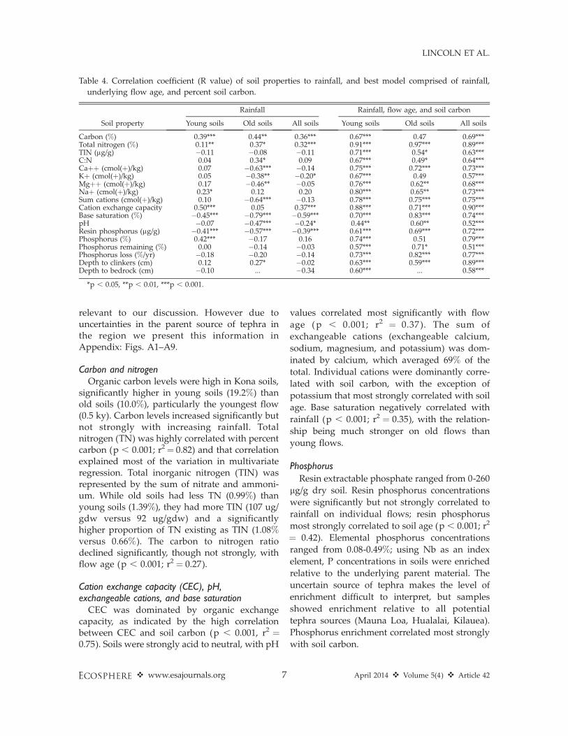
Carbon and nitrogenOrganic carbon levels were high in Kona soils,
significantly higher in young soils (19.2%) thanold soils (10.0%), particularly the youngest flow(0.5 ky). Carbon levels increased significantly butnot strongly with increasing rainfall. Totalnitrogen (TN) was highly correlated with percentcarbon (p , 0.001; r2¼ 0.82) and that correlationexplained most of the variation in multivariateregression. Total inorganic nitrogen (TIN) wasrepresented by the sum of nitrate and ammoni-um. While old soils had less TN (0.99%) thanyoung soils (1.39%), they had more TIN (107 ug/gdw versus 92 ug/gdw) and a significantlyhigher proportion of TN existing as TIN (1.08%versus 0.66%). The carbon to nitrogen ratiodeclined significantly, though not strongly, withflow age (p , 0.001; r2 ¼ 0.27).
Cation exchange capacity (CEC), pH,exchangeable cations, and base saturation
CEC was dominated by organic exchangecapacity, as indicated by the high correlationbetween CEC and soil carbon (p , 0.001, r2 ¼0.75). Soils were strongly acid to neutral, with pH
values correlated most significantly with flow
age (p , 0.001; r2 ¼ 0.37). The sum of
exchangeable cations (exchangeable calcium,
sodium, magnesium, and potassium) was dom-
inated by calcium, which averaged 69% of the
total. Individual cations were dominantly corre-
lated with soil carbon, with the exception of
potassium that most strongly correlated with soil
age. Base saturation negatively correlated with
rainfall (p , 0.001; r2 ¼ 0.35), with the relation-
ship being much stronger on old flows than
young flows.
Phosphorus
Resin extractable phosphate ranged from 0-260
lg/g dry soil. Resin phosphorus concentrations
were significantly but not strongly correlated to
rainfall on individual flows; resin phosphorus
most strongly correlated to soil age (p , 0.001; r2
¼ 0.42). Elemental phosphorus concentrations
ranged from 0.08-0.49%; using Nb as an index
element, P concentrations in soils were enriched
relative to the underlying parent material. The
uncertain source of tephra makes the level of
enrichment difficult to interpret, but samples
showed enrichment relative to all potential
tephra sources (Mauna Loa, Hualalai, Kilauea).
Phosphorus enrichment correlated most strongly
with soil carbon.
Table 4. Correlation coefficient (R value) of soil properties to rainfall, and best model comprised of rainfall,
underlying flow age, and percent soil carbon.
Soil property
Rainfall Rainfall, flow age, and soil carbon
Young soils Old soils All soils Young soils Old soils All soils
Carbon (%) 0.39*** 0.44** 0.36*** 0.67*** 0.47 0.69***Total nitrogen (%) 0.11** 0.37* 0.32*** 0.91*** 0.97*** 0.89***TIN (lg/g) �0.11 �0.08 �0.11 0.71*** 0.54* 0.63***C:N 0.04 0.34* 0.09 0.67*** 0.49* 0.64***Caþþ (cmol(þ)/kg) 0.07 �0.63*** �0.14 0.75*** 0.72*** 0.73***Kþ (cmol(þ)/kg) 0.05 �0.38** �0.20* 0.67*** 0.49 0.57***Mgþþ (cmol(þ)/kg) 0.17 �0.46** �0.05 0.76*** 0.62** 0.68***Naþ (cmol(þ)/kg) 0.23* 0.12 0.20 0.80*** 0.65** 0.73***Sum cations (cmol(þ)/kg) 0.10 �0.64*** �0.13 0.78*** 0.75*** 0.75***Cation exchange capacity 0.50*** 0.05 0.37*** 0.88*** 0.71*** 0.90***Base saturation (%) �0.45*** �0.79*** �0.59*** 0.70*** 0.83*** 0.74***pH �0.07 �0.47*** �0.24* 0.44** 0.60** 0.52***Resin phosphorus (lg/g) �0.41*** �0.57*** �0.39*** 0.61*** 0.69*** 0.72***Phosphorus (%) 0.42*** �0.17 0.16 0.74*** 0.51 0.79***Phosphorus remaining (%) 0.00 �0.14 �0.03 0.57*** 0.71* 0.51***Phosphorus loss (%/yr) �0.18 �0.20 �0.14 0.73*** 0.82*** 0.77***Depth to clinkers (cm) 0.12 0.27* �0.02 0.63*** 0.59*** 0.89***Depth to bedrock (cm) �0.10 ... �0.34 0.60*** ... 0.58***
*p , 0.05, **p , 0.01, ***p , 0.001.
v www.esajournals.org 7 April 2014 v Volume 5(4) v Article 42
LINCOLN ET AL.

Fig. 2. Resin extractable phosphorus and rainfall (top) within Kona by flow age and (bottom) in Kona and
Kohala. Elevated resin extractable phosphorus concentrations occur at a lower rainfall for successively younger
lava flows within Kona (top), and at lower rainfall in Kona compared to Kohala (bottom).
v www.esajournals.org 8 April 2014 v Volume 5(4) v Article 42
LINCOLN ET AL.

Soil depthDepth of the soil was variable, and in some
cases difficult to judge due to the uneven layer ofclinkers. We recorded the depth of clinker-freesoil for each sample, and the depth to bedrock(i.e., the bottom of the clinker layer) in caseswhere it was reached. In most cases clinkerscould be extracted to the full depth of the samplebut they comprised vast majority of the volumewithin the clinker layer. The clinker-free soil wasnot necessarily devoid of rocks, but was mostlysoil. Due to our sampling of local depressions,soil depth overestimates the landscape averagedepth for each flow age. Soil depth in the clinker-free layer correlated significantly with flow age(p , 0.001; r2¼ 0.79). Mean depth to the clinkerlayer was 9.7 cm and 27.7 cm on the young andold flows, respectively; the latter especially is anunderestimate because depths .30 cm wererecorded as 30 cm.
Elemental concentrations and retentionWe used the complete elemental analyses to
calculate apparent element retention and mobil-ity, relative to the index element Nb, across theKona landscape. This approach is useful forcalculating weathering in an environment whereboth mass and volume are subject to loss (vialeaching) or gain (via organic matter addition).However, because Kona soils often developed intephra derived from volcanoes other than thoseproducing the underlying lava flows, we presentthese data (together with all of our soil measure-ments) as a supplemental on-line table (Supple-ment). We used the 1.2 ky flow as the baselinefrom which to assess the mass loss. All elementsshow a general trend of depletion over time (withthe exception of phosphorus as discussed above).Despite uncertainty in the provenance of soilmaterial, our results are sufficiently robust todemonstrate substantial depletion of Ca, Na, Mg,
Fig. 3. Base saturation of soils with respect to rainfall in Kohala soils and three Kona flows. The value of base
saturation used to indicate agricultural intensification by Hawaiians, ;30%, is reached at progressively lower
rainfall on younger lava flows on Hawaii Island.
v www.esajournals.org 9 April 2014 v Volume 5(4) v Article 42
LINCOLN ET AL.

and Si in Kona soils relative to parent material,particularly on older flows and in higher-rainfallsites. Using the 1.2 ky baseline, each element(excepting phosphorus) showed a significant (p, 0.001), inverse linear relationship of concen-tration remaining over time on a log-log scale,indicating an exponential decay of elemental lossrates over time (shown on linear scale inAppendix: Figs. A1–A9).
Agriculturally important soil propertiesAs previous investigations showed, a few soil-
fertility related properties appeared particularlyimportant in defining boundaries of intensivecultivation, foremost among them being resinextractable phosphorus, base saturation, andexchangeable calcium. The distributions of theseproperties in relation to substrate age and rainfallare summarized in Figs. 2–4. These indicators of
soil fertility (and Polynesian agricultural intensi-fication) declined with increasing rainfall on allflows; moreover, the decline occurred at lowerrainfalls on successively younger lava flows.
Resin extractable phosphorus in Kona soils(Fig. 2A) averaged below 30 lg/g dry soil above1300 mm/yr of rainfall, with varying levels ofenrichment at lower rainfalls. Each successivelyyounger flow increased in resin phosphorus at alower rainfall than older flows; this trend holdsfor all flow ages. The decline in soil basesaturation with increasing rainfall also occurredat lower rainfall levels on younger flows (Fig. 3).While the flows in Fig. 3 were chosen forillustrative purposes—they are well representedby samples and are graphically distinct—thetrend holds for all flows with the exception ofthe 0.5 ky flow, which had a relatively constantbase saturation across the rainfall gradient. The
Fig. 4. Exchangeable calcium levels with respect to rainfall in Kohala and three Kona flows. Exchangeable
calcium has been suggested to be the best indicator of pre-European agricultural intensification in the Pacific.
Older flows on Hawaii Island show a noticeable pattern of depletion, but the pattern breaks down on young
flows where soil carbon levels are extremely high.
v www.esajournals.org 10 April 2014 v Volume 5(4) v Article 42
LINCOLN ET AL.
relationship of exchangeable calcium with rain-fall is less compelling in Kona than Kohala (Fig.4); the oldest Kona flows (7.5 and 12.5 ky)decrease with increasing rainfall, but the youngflows displayed no clear pattern of depletion,with high variability in samples across therainfall gradient. The high variability in ex-changeable calcium in the younger soils can beattributed to CEC being dominated by the highlevels of organic material rather than mineralsources.
DISCUSSION
The moderate but varying rainfall (;600–2000mm/yr) and young substrates (;0.5–12.5 ky)made pre-Contact agriculture in Kona funda-mentally different from other well-studied dry-land systems in Hawai’i. The best-known Kohalasystem is composed of relatively old and uniformsubstrate (areas of ;150 ky and ;400 ky), and isembedded within a very large rainfall gradient(;300–3500 mm/yr); rainfall and the leaching ofnutrients drive the limits of agriculture in thissystem (Vitousek et al. 2004). The agriculturalsystem in Kona more closely mirrors the Kahiki-nui system on Maui; that system encompasses abroad range of substrates (;3–130 ky), but asmall and relatively dry rainfall gradient (;400–900 mm/yr); sufficient moisture for mineralweathering and cultivation appears to drive thelimits of agriculture in this system (Kirch et al.2004, 2005, Hartshorn et al. 2006, Giambelluca etal. 2012). Agriculture in Kona developed withhigher rainfall than Kahikinui. As we discuss,portions of the Kona system likely were limitedby low rates of weathering and retention ofmineral nutrients in young flows. The low releaseand retention of nutrients in Kona may haveencouraged the broad application of resourceconcentrating farming methods.
Indicators of soil fertilityIn the well-studied Kohala system, the upper
(wetter, lower fertility) boundary of intensivepre-contact agriculture is associated with basesaturation ;30%, resin extractable phosphorus;50 ug/g, and exchangeable calcium ;10cmol(þ)/kg (Vitousek et al. 2004; Vitousek et al.,in press). In Kona, these soil properties variedwith climate in a way similar to Kohala,
declining at higher rainfall, particularly on theolder soils. However the annual rainfall at whichthese values are reached is lower in Kona than onthe older Kohala substrates, and within Kona it islower on younger than on older flows (Figs. 2–4).Over a much longer timescale (150–4,000 ky),these transitions occur at lower rainfall on veryold sites (Chadwick and Chorover 2001, Vitousekand Chadwick 2013); together with our results,this suggests that the maximum rainfall thatexperiences high soil fertility increases and thendeclines with long-term soils development, rath-er than experiencing a continuous decline, andthat the peak occurs relatively early in theprocess of Hawaiian basalts (.10–150 ky).
The observation that all three soil fertilityindicators are shifted towards drier conditionsin Kona than Kohala could be explained inseveral ways. We suggest that the weathering ofthe coarse substrate of young lava may beconstrained by low surface area, and the lowsoil fertility in moderately wet Kona sites mayreflect the kinetics of supply of elements viaweathering and their removal via leaching. Lowsurface area reduces the reaction of minerals withwater, but could increase material transport.Variation in particle size and mineralogy areprimarily responsible for heterogeneity in weath-ering rates within a given climate (Reeves andRothman 2013).
Other potential explanations for this patterninclude: (1) Kona may be wetter than reported(or Kohala drier), potentially explained by highfog drip in Kona (Brauman et al. 2010), highlylocalized variations, or vagaries of mapping; (2)water erosion may be significant on the younglava, leading soils at a given location to reflectuphill, and typically wetter, conditions; (3) highersoil moisture in Kona driven by higher levels ofsoil organic matter and lower wind intensity maymake soils at lower rainfall behave as if it werewetter; or (4) retention of mineral nutrients inKona may be limited by weakly adsorbing soilcomplexes that result in higher leaching ofnutrients at a given rainfall. The first two pointsseem unlikely to contribute substantially to thepattern, in that soil fertility parameters aretypically lower on young than old soils withinKona, and downhill fluvial transport is likelygreater on the fine-grained soils of Kohala thanthe coarse lava flows of Kona. The third and
v www.esajournals.org 11 April 2014 v Volume 5(4) v Article 42
LINCOLN ET AL.

fourth points may contribute to the pattern, butnot enough to explain the differences betweenolder flows within Kona, where carbon levels donot vary significantly and CEC declines withincreasing flow age.
There is evidence of intensified, systematicagricultural occurring above the rainfall levelsthat our analyses suggest should bound thedevelopment of systematic agriculture (for in-stance Tainter 1991, Burtchard 1996). Our soiltransects on old flows traversed areas of agricul-tural infrastructure that had soil fertility indica-tors below the established thresholds.Agricultural intensification in areas identified asmarginal based on previously determined indi-cators could occur if the distribution of theseindicators reflects a kinetic limitation of weath-ering rather than a boundary condition; therewould be a sustained supply of mineral nutrientsin low-fertility sites controlled by kinetic pro-cesses, differing from those controlled by irre-versible depletion of weatherable soil minerals asseen in Kohala. Our data set suggests that totalelemental concentrations in these wetter areasremain higher than levels seen in Kohala, andthat Kona soils therefore could provide sustainednutrient fluxes. Unfortunately our data set hasrelatively few samples in wetter areas of olderflows, is uncertain about parent matter concen-trations in tephra, and lacks detailed informationon the volume of non-fine materials, limiting ourability to draw a confident conclusion. Anotherpossibility is that some areas considered system-atic agriculture relied on alternative sources ofsoil fertility, such as inputs from nearby forests,incorporating fallow periods, or the developmentof agricultural practices that enhanced local soilfertility. If the latter is the case systematicagriculture in Kona may have required moremanagement and inputs than did other drylandsystems in Hawai’i.
Thresholds of systematic agriculture in KonaIn general, soils in Kona are more fertile the
older the underlying lava flow and the lower therainfall. The old soils in Kona that receive lessthan ;1400 mm/yr of rain are fertile enough tosupport the development of systematic agricul-ture as defined by the soil fertility indicatorsobserved in Kohala. In contrast, the flows ,4 kytypically fall below the fertility thresholds that
bound the Kohala field system, or exceed thoselimitations only at rainfalls below ;1000 mm/yr(i.e., the kula zone). The Ladefoged et al. (2009)model assumes inadequate soil development onthe young soils as the basis for the restriction ofsystematic agriculture. The background levels ofsoil fertility indicators in Kona soils support the 4ky threshold for the development of intensivepre-contact agricultural systems. The indicatorsof fertility in the young soils suggest thatsystematic agriculture was infeasible even wheresoil depth was sufficient. The low levels of soilfertility are reinforced by the low quantity of soilon the younger flows.
Nevertheless, examples show that a portion ofthe land within agricultural sites on young flowswas made farmable. However we don’t knowhow densely these microsites occur across thelandscape, or the extent of agriculture betweenfavorable microsites. Approximately half the areadefined as the Kona Field System consists ofyoung soils and so even a small percentage ofusage is a meaningful contribution to the totalyield of the region. Further synthesis of thearcheological record could better parse out thetypes and intensities of resource concentratingagriculture on the different flow ages in Kona.
The ethno-agricultural landscape within KonaThe matrix of agricultural opportunities in
Kona relative to climate and soil fertility suggestslinkages between Hawaiian farmers and theirenvironment in the development of the agricul-tural landscape. The four general zones ofcultivation (moving upslope the kula, kaluulu,apaa, and amau) can be viewed in terms of thevariable fertility between zones (variation withrainfall) and within zones (variation with flowage).
The kula zone, which was too dry to farm inKohala and Kahikinui (below ,750 mm/yr), hasadequate rainfall in Kona (in an average year) tocrop sweet potato (Kagawa and Vitousek 2012).Moreover, the soils within the kula show rela-tively high indicators of soil fertility even on theyoungest flows, and cropping would likely meetwith success wherever adequate soil and mois-ture could be gathered. The development ofsweet potato farming in the kula can be seen ininfrastructure that ranges from systematic kuaiwiin select areas on old soils (Hammatt and Clark
v www.esajournals.org 12 April 2014 v Volume 5(4) v Article 42
LINCOLN ET AL.

1980, Escott and Spear 2003), sparse kuaiwi,terraces and mounds in a wider range of areason old and young soils (Hammatt and Clark1980, Schilt 1984, Henry and Wolforth 1998,Escott and Spear 2003, Haun and Henry 2010),dense mounds and swales in more marginalareas on young soils (Schilt 1984, Rechtman et al.2001, Haun and Henry 2010), to sparse moundsand other informal techniques in the mostmarginal areas (Rechtman et al. 2001, Escottand Spear 2003). The high indicators of soilfertility and adequate rainfall for croppingsuggest that soil depth within the kula may bethe most significant constraint to agriculturehere.
The soil fertility indicators within the agrofor-estry plantations of the kaluulu zone remain highon old flows but fall below levels associated withintensification on the young flows. Lincoln andLadefoged (in press) show that breadfruit re-mains highly productive on flows as young as 1.2ky within this zone, and provides yields compa-rable to sweet potato production on older flows.Systematic agricultural infrastructure occurs onold flows in this zone (Escott and Spear 2003,Tomonari-Tuggle 2006), and evidence for exten-sive informal techniques occurs on young flows(Henry and Wolforth 1998, Haun and Henry2010), suggesting that although the breadfruitcanopy was continuous the density of understoryplantings varied with soil fertility within theplantations. Here the extensive application of aninformal agriculture technique (the use of treecrops) may have been facilitated by the closeproximity of high and low fertility soils. Youngflows in this zone show a higher density ofagricultural features in closer proximity to olderflows (e.g., Hammatt et al. 1997). The increasednutrient uplift and storage within the kaluulucould facilitate other informal agriculture. Ha-waiians often used groves of trees to providemulch to support pocket agriculture, to plantwithin the altered environment, or to periodicallyengage in slash and burn agriculture.
Within the apaa zone the soil fertility indicatorsare depleted for young flows, and above ;1400mm/yr even the oldest flows drop below levelsthought to have sustained intensification. Inaccordance with varying soil fertility, someevidence exists for apaa and amau zones ofvarying width. For example Cordy et al. (1991)
find a very narrow apaa zone on a 2.25 ky flow,with systematic infrastructure prevalent from;550–700 m (;1250–1315 mm/yr) followed bya rapid transition to informal infrastructureextending up to ;900 m; in contrast thesystematic infrastructure of the apaa zone on a 4ky flow in Kealakekua extends from ;375–800 m(;1250–1650 mm/yr), with historical accountsindicating a narrow amau zone extending to;900 m (Menzies 1920). This scenario wouldresult in ‘‘fingers’’ of forested area extendingfurther downslope on younger flows. Theseforested patches could enhance fertility on theyoung flows and botanical material from theforests could potentially augment fertility onnearby old flows.
CONCLUSION
The agricultural mosaic of Kona differed fromthe other farming landscapes in Hawai’i due tothe hospitable climate of Kona and proximity ofsoils of varying fertilities. Kona offers theopportunity to understand fertility in early soilpedogenesis and couple human engagementwith a diverse and productive landscape. Thesoil properties used as indicators for Hawaiiandryland agricultural intensification appear to besystematically shifted towards a lower rainfall inyounger lava flows within Kona and Kohala(0.5–400 ky). We attribute this shift to limitationof soil fertility in Kona soils by the kinetics ofrelease and retention of mineral nutrients incoarse substrates. It is clear that areas of highfertility were used in intensive, systematic ways,that there existed a range of intensities across thefertility gradients, and that informal techniqueswere applied in areas in which systematicagriculture was constrained. Agroecologicalzones within the Kona farming landscape rough-ly align with changing patterns of soil fertility asthey relate to rainfall, while localized adaptationsof infrastructure and planting density tend tovary more consistently with soil fertility as itrelates to lava flow age.
ACKNOWLEDGMENTS
We thank the many people who contributed to thisarticle. This project was funded by NSF grants ETBC-1020791and ETBC-1019640, the NSF Graduate Re-search Fellowship Program, the Emmett Interdisciplin-
v www.esajournals.org 13 April 2014 v Volume 5(4) v Article 42
LINCOLN ET AL.

ary Program in Environment and Resources, andStanford School of Earth Science. Adelaide Oneal,Casey Maue, Taryn Takahashi, Max Borella, ChristinaFeng, Jessica Eastling and Javier Stell-Fresquez con-tributed to collecting and analyzing samples. KyeEpps, Gabriel Maltais-Landry and Doug Turner whohelped with protocols. Testimonial contributions wereprovided by archeologists MaryAnne Maigret, AlanHaun and Bob Rechtman, and cultural historiansHannah Springer and Jerry Konanui.
LITERATURE CITED
Allen, M. S. 2001. Gardens of Lono: Archeologicalinvestigations at the Amy BH Greenwell Ethnobo-tanical Garden, Kealakekua, Hawai’i. Bishop Mu-seum Press, Honolulu, Hawaii, USA.
Allen, M. S. 2004. Bet-hedging strategies, agriculturalchange, and unpredictable environments: historicaldevelopment of dryland agriculture in Kona,Hawai’i. Journal of Anthropological Archaeology23:196–224.
Brauman, K., D. L. Freyberg, and G. C. Daily. 2010.Forest structure influences on rainfall partitioningand cloud interception: A comparison of nativeforest sites in Kona, Hawai’i. Agricultural andForest Meteorology 150(2):265–275.
Burtchard, G. C. 1996. Population and land-use of theKeauhou coast: The mauka land inventory survey,Keauhou, North Kona, Hawai’i Island. Internation-al Archeological Research Institute, Honolulu,Hawaii, USA.
Chadwick, O. A., and J. Chorover. 2001. The chemistryof pedogenic thresholds. Geoderma 100:321–353.
Cordy, R., J. Tainter, R. Regner, and R. Hitchcock. 1991.An Ahupua’a study: The 1971 archaeological workat Kaloko Ahupua’a, North Kona, Hawai’i: Ar-chaeology at Kaloka-Honokokau National Histor-ical Park. Western Archeological and ConservationCenter, Tuscon, Arizona, USA.
Escott, G., and R. L. Spear. 2003. A data recoveryreport for Hokulia: A study of a 1540 acre parcel inthe ahupua’a of Honua’ino, Hokukano, Kenaueue,Haleki’i, Ke’eke’e, ‘Ilikahi, Kanakau, Kalukalu, and‘Ono’uli, in the districts of North and South Kona,Island of Hawai’i, Hawai’i. Scientific ConsultingServices, Kailua-Kona, Hawaii, USA.
Giambelluca, T. W., Q. Chen, A. G. Frazier, J. P. Price,Y. L. Chen, P. S. Chu, J. K. Eischeid, and D. M.Delparte. 2012. Online rainfall atlas of Hawai’i.Bulletin of American Meteorological Society. doi:10.1175/BAMS-D-11-00228.1
Hammatt, H. H., D. F. Borthwick, B. L. Colin, I.Masterson, J. J. Robins, and H. Wong-Smith. 1997.Archaeological inventory survey and limited sub-surface testing of a 1,540-acre parcel in theahupua’a of Honua’ino, Hokukano, Kanaueue,
Haleki’i, Ke’eke’e, ‘Ilikahi, Kanakau, Kalukalu,and ‘Ono’uli, Districts of North and South Kona,Island of Hawai’i. Volumes 1-3. Cultural SurveysHawaii, Honolulu, Hawaii, USA.
Hammatt, H. H., and S. D. Clark. 1980. Archaeologicaltesting and salvage excavations of a 155 acre(Ginter) parcel in na ahupua’a Pahoehoe, La’aloa,and Kapala’alaea, Kona, Hawai’i. ArcheologicalResearch Center Hawaii, Lawai, Hawaii, USA.
Hartshorn, A. S., O. A. Chadwick, P. M. Vitousek, andP. V. Kirch. 2006. Prehistoric agricultural depletionof soil nutrients in Hawai’i. Proceedings of theNational Academy of Sciences USA 103(29):11092–11097.
Haun, A. E., and D. Henry. 2010. Archeologicalinventory survey (TMK: 3-7-9-05:76, 77 and 78)lands of Honalo, Maihi 1-2 and Kuamo’o 1, NorthKona District, Island of Hawai’i. Haun andAssociates, Kailua-Kona, Hawaii, USA.
Henry, D., and T. Wolforth. 1998. Settlement andagriculture in the central Kona field system kula:Archaeological inventory survey of the Ginterparcel, lands of Kapala’alaea 1st, La’aloa 1st and2nd, and Pahoehoe 4th, North Kona District, Islandof Hawai’i. Paul H Rosendahl, Hilo, Hawaii, USA.
Kagawa, A. K., and P. M. Vitousek. 2012. The ahupua’aof Puanui: A resource for understanding Hawaiianrain-fed agriculture. Pacific Science 66(2):161–172.
Kamakau, D. 1961. Ruling chiefs of Hawai’i. BishopMuseum Press, Honolulu, Hawaii, USA.
Kelly, M. 1983. Na mala o Kona. Bishop MuseumPress, Honolulu, Hawaii, USA.
Kirch, P. V. 1994. The wet and the dry. University ofChicago Press, Chicago, Illinois, USA.
Kirch, P. V. 2011. Roots of conflict. School forAdvanced Research Press, Santa Fe, New Mexico,USA.
Kirch, P. V., J. Coil, A. S. Hartshorn, M. Jeraj, P. M.Vitousek, and O. A. Chadwick. 2005. Intensivedryland farming on the leeward slopes of Halea-kala, Maui, Hawaiian Islands: archaeological,archaeobotanical, and geochemical perspectives.World Archaeology 37(2):240–258.
Kirch, P. V., A. S. Hartshorn, O. A. Chadwick, P. M.Vitousek, D. R. Sherrod, J. Coil, and W. D. Sharp.2004. Environment, agriculture, and settlementpatterns in a marginal Polynesian landscape.Proceedings of the National Academy of ScienceUSA 101:9936–9941.
Ladefoged, T. N., and M. W. Graves. 2008. Variabledevelopment of dryland agriculture in Hawai’i.Current Anthropology 49(5):771–802.
Ladefoged, T. N., M. W. Graves, and M. Mccoy. 2003.Archaeological evidence for agricultural develop-ment in Kohala, Island of Hawai’i. Journal ofArchaeological Science 30:923–940.
Ladefoged, T. N., P. V. Kirch, S. M. Gon, O. A.
v www.esajournals.org 14 April 2014 v Volume 5(4) v Article 42
LINCOLN ET AL.

Chadwick, A. S. Hartshorn, and P. M. Vitousek.2009. Opportunities and constraints for intensiveagriculture in the Hawaiian archipelago prior toEuropean contact. Journal of Archaeological Sci-ence 36(10):2374–2383.
Lincoln, N. K. and T. N. Ladefoged. In press. Definingthe kalu’ulu: The extent, yield, and impact ofHawaiian breadfruit groves in Kona, Hawai’i.Journal of Archaeological Science.
Malo, D. 1951. Hawaiian antiquities. Bishop MuseumPress, Honolulu, Hawaii, USA.
Menzies, A. 1920. Hawaii nei 128 years ago. [s.n.],Honolulu, Hawaii, USA.
NRCS. 2010. GIS draft of Hawaii soil types andanalyses. National Resources Conservation Servic-es, Kona Research Office, Hawaii, USA.
Palmer, M. A., M. W. Graves, T. N. Ladefoged, O. A.Chadwick, T. K. Duarte, S. Porder, and P. M.Vitousek. 2009. Sources of nutrients to windwardagricultural systems in pre-contact Hawai’i. Eco-logical Applications 19(6):1444–1453.
Porder, S., G. E. Hilley, and O. A. Chadwick. 2007.Chemical weathering, mass loss, and dust inputsacross a climate by time matrix in the HawaiianIslands. Earth and Planetary Science Letters258:414–427.
Rechtman, R., K. Maly, M. Clark, D. Dougherty, and O.Maly. 2001. Archaeological inventory survey of theKi’ilae Estates development area (TMK:3-8-5-05:19,22, 26, 27), Ki’ilae and Kauleolı̄ Ahupua’a, SouthKona District, Island of Hawai’i; Volume I. Re-chtman Consulting, Keaau, Hawai’i, USA.
Reeves, D., and D. H. Rothman. 2013. Diffusion andkinetic control of weathering layer development.Geofluids. doi: 10.1111/gfl.12056
Schilt, R. 1984. Subsistence and conflict in Kona,Hawai’i: An archeological study of the KuakiniHighway realignment corridor. Bishop MuseumPress, Honolulu, Hawaii, USA.
Soil Survey Laboratory Staff. 1992. Soil survey labora-tory methods manual. Soil Survey InvestigationsReport Number 42, Volume 2.0.
Tainter, J. 1991. The archeological survey of the uplandforest zone. Pages 425–45 in R. Cordy, J. Tainter, R.Renger, and R. Hitchcock, editors. An Ahupua’aStudy: The 1971 Archeological Work at KolokoAhupua’a, North Kona, Hawai’i. Western Archae-ological and Conservation Center Publications inAnthropology No. 58, Department of the Interior,National Park Service, USA.
Tomonari-Tuggle, M. J. 2006. Archeological datarecovery investigations for the northern portion ofCaptain Cook Ranch. International ArcheologicalResearch Institute, Honolulu, Hawaii, USA.
Trusdell, F. A., E. W. Wolfe, and J. Morris. 2006. Digitaldatabase of the geologic map of the Island ofHawai’i. USGS Data Series 144.
Vitousek, P. M., and O. A. Chadwick. 2013. Pedogenicthresholds and soil process domains in basalt-derived soils. Ecosystems. doi: 20.2007/210021-013-9690-z
Vitousek, P. M., O. A. Chadwick, G. Hilley, P. V. Kirch,and T. N. Ladefoged. 2010. Erosion, geologicalhistory, and indigenous agriculture: a tale of twovalleys. Ecosystems 13(5):782–793.
Vitousek, P. M., O. A. Chadwick, S. C. Hotchkiss, T. N.Ladefoged, and C. Stevenson. In press. Farming therock.
Vitousek, P. M., T. N. Ladefoged, P. V. Kirch, A. S.Hartshorn, M. W. Graves, S. C. Hotchkiss, andO. A. Chadwick. 2004. Soils, agriculture, andsociety in precontact Hawai’i. Science 304:1665–68.
Ziegler, K., J. C. Hsieh, O. A. Chadwick, E. F. Kelly,D. M. Hendricks, and S. M. Savin. 2003. Halloysiteas a kinetically controlled end product of arid-zonebasalt weathering. Chemical Geology 202(3-4):461–478.
v www.esajournals.org 15 April 2014 v Volume 5(4) v Article 42
LINCOLN ET AL.

SUPPLEMENTAL MATERIAL
APPENDIX
Fig. A1. Concentration of aluminum remaining (%) by age compared to the average parent material
concentrations from Mauna Loa and Kilauea volcanoes.
Fig. A2. Concentration of calcium remaining (%) by age compared to the average parent material
concentrations from Mauna Loa and Kilauea volcanoes.
v www.esajournals.org 16 April 2014 v Volume 5(4) v Article 42
LINCOLN ET AL.

Fig. A3. Concentration of iron remaining (%) by age compared to the average parent material concentrations
from Mauna Loa and Kilauea volcanoes.
Fig. A4. Concentration of potassium remaining (%) by age compared to the average parent material
concentrations from Mauna Loa and Kilauea volcanoes.
v www.esajournals.org 17 April 2014 v Volume 5(4) v Article 42
LINCOLN ET AL.

Fig. A5. Concentration of magnesium remaining (%) by age compared to the average parent material
concentrations from Mauna Loa and Kilauea volcanoes.
Fig. A6. Concentration of sodium remaining (%) by age compared to the average parent material
concentrations from Mauna Loa and Kilauea volcanoes.
v www.esajournals.org 18 April 2014 v Volume 5(4) v Article 42
LINCOLN ET AL.

Fig. A7. Concentration of phosphorus remaining (%) by age compared to the average parent material
concentrations from Mauna Loa and Kilauea volcanoes.
Fig. A8. Concentration of silicon remaining (%) by age compared to the average parent material concentrations
from Mauna Loa and Kilauea volcanoes.
v www.esajournals.org 19 April 2014 v Volume 5(4) v Article 42
LINCOLN ET AL.

SUPPLEMENT
Soil and site properties along four transects as described in the main text (Ecological ArchivesC005-003-S1).
Fig. A9. Concentration of titanium remaining (%) by age compared to the average parent material
concentrations from Mauna Loa and Kilauea volcanoes.
v www.esajournals.org 20 April 2014 v Volume 5(4) v Article 42
LINCOLN ET AL.