
Inconsistency Issues in Spatial Databases
35
Inconsistency Issues in Spatial Databases Andrea Rodr´ ıguez Department of Computer Science University of Concepci´ on, Chile [email protected] http://inf.udec.cl/~ andrea Abstract. This chapter analyzes inconsistency issues in spatial databases. In particular, it reviews types of inconsistency, specification of integrity constraints, and treatment of inconsistency in multiple representations and data integration. The chapter focuses on inconsistency associated with the geometric representation of objects, spatial relations between objects, and composite objects by aggregation. The main contribution of this paper is a survey of existing approaches to dealing with incon- sistency issues in spatial databases that emphasizes the current state of the art and that outlines research issues in the context of inconsistency tolerance. 1 Introduction During the past several years traditional databases have been enhanced to in- clude spatially referenced data. This type of data is an essential component of existing applications such as Geographic Information Systems (GIS), Computer- Aided Design (CAD), multimedia information systems, data warehousing, and NASA’s Earth Observing System (EOS). Spatial databases have been defined as database systems with a model and query language that support spatial data types and provide spatial indexing and efficient algorithms for spatial query processing [37]. Unlike classical database theory, where the content of databases is abstract, in spatial databases the con- tent has some interpretation and laws of real geometry hold. This interpretation induces to much diverse classes of data structures and data manipulations. Spa- tial databases have no clear separation between what is handled by the database management system (DBMS) and what is handled by the software application [48]. For example, it is not always clear whether or not an operation that finds the shortest path in a network is part of the spatial DBMS. Consequently, there is no consensus of what properties and features should be part of spatial data manipulation languages. In spatial databases, theory about spatial information is used to define spa- tial data models or geomatic models. Spatial data models represent information about the n-dimensional real space R n , a space that is infinite and cannot be represented with an extensional data model. Operations in spatial databases may or may not depend on the spatial data model underlying the data repre- sentation, an issue related to the concept of genericity that was introduced in
-
Upload
independent -
Category
Documents
-
view
5 -
download
0
Transcript of Inconsistency Issues in Spatial Databases

Inconsistency Issues in Spatial Databases
Andrea Rodrıguez
Department of Computer ScienceUniversity of Concepcion, Chile
http://inf.udec.cl/~ andrea
Abstract. This chapter analyzes inconsistency issues in spatial databases.In particular, it reviews types of inconsistency, specification of integrityconstraints, and treatment of inconsistency in multiple representationsand data integration. The chapter focuses on inconsistency associatedwith the geometric representation of objects, spatial relations betweenobjects, and composite objects by aggregation. The main contributionof this paper is a survey of existing approaches to dealing with incon-sistency issues in spatial databases that emphasizes the current state ofthe art and that outlines research issues in the context of inconsistencytolerance.
1 Introduction
During the past several years traditional databases have been enhanced to in-clude spatially referenced data. This type of data is an essential component ofexisting applications such as Geographic Information Systems (GIS), Computer-Aided Design (CAD), multimedia information systems, data warehousing, andNASA’s Earth Observing System (EOS).
Spatial databases have been defined as database systems with a model andquery language that support spatial data types and provide spatial indexing andefficient algorithms for spatial query processing [37]. Unlike classical databasetheory, where the content of databases is abstract, in spatial databases the con-tent has some interpretation and laws of real geometry hold. This interpretationinduces to much diverse classes of data structures and data manipulations. Spa-tial databases have no clear separation between what is handled by the databasemanagement system (DBMS) and what is handled by the software application[48]. For example, it is not always clear whether or not an operation that findsthe shortest path in a network is part of the spatial DBMS. Consequently, thereis no consensus of what properties and features should be part of spatial datamanipulation languages.
In spatial databases, theory about spatial information is used to define spa-tial data models or geomatic models. Spatial data models represent informationabout the n-dimensional real space Rn, a space that is infinite and cannot berepresented with an extensional data model. Operations in spatial databasesmay or may not depend on the spatial data model underlying the data repre-sentation, an issue related to the concept of genericity that was introduced in

2
classical databases [13] and then applied in the domain of spatial databases byParedaens et. al [47] [48].
The integration of spatial data into traditional database systems requiresaddressing nontrivial issues at various levels. They range from ontological is-sues about the conceptualization of space to more technical issues about accessmechanisms and file management [58]. As consequence, progress in SDBMS isthe result of an interdisciplinary research effort. The treatment of inconsistencyof spatial data also requires an interdisciplinary approach. Consistency of spatialinformation must deal with ontological issues concerning physical reality [18] [34](e.g., an object can only have one physical location at a time). It needs to con-sider the appropriate conceptual frameworks for analyzing spatial consistency[24] [30] [43] [63], such as models for consistency at multiple representationallevels or granularities. It also concerns the specification language of integrityconstraints [9] [41] and the design of computational-geometry algorithms to im-plement consistency checkers.
This chapter analyzes inconsistency issues in spatial databases. Its main con-tribution is a survey of existing approaches to dealing with inconsistency issuesthat emphasizes the state of the art and outlines research issues in the contextof inconsistency tolerance. The chapter focuses on the geometric representationof objects (i.e., location and shape), spatial relations between objects, and com-posite objects by aggregations. Positional information is often imprecise in spatialdatabases, which may result in conflicting geometric representations of objects(i.e., two different geometric representations for the same object). Spatial re-lations play an important role in spatial databases, since they are usually thebasis for specifying integrity and query constraints [28]. Spatial relations aretypically derived from positional information; however, they may not be affectedby conflicting objects’ geometric representations because objects may hold thesame spatial relation in these representations [53]. Nested aggregations are fun-damental abstraction mechanisms for modeling spatial phenomena. For example,countries contain states that contain counties. Aggregations impose requirementsfor data modeling and data consistency with respect to the relationships betweenparts and wholes.
The organization of this chapter is as follows. Section 2 gives a brief overviewof spatial databases. Section 3 discusses the types and sources of inconsistencyin spatial information. Section 4 discusses the specification of constraints, con-sistency at multiple representational levels, and consistency in the integration ofspatial information. Section 5 addresses inconsistency tolerance of spatial infor-mation. Final conclusions are given in Section 6.
2 Spatial Database Overview
Spatial database systems consist of data about objects and properties in theworld with respect to their locations [54]. These systems deal with diverse kindsof data, from natural to man-made features, which demands specific modelsthat both capture the semantics of spatial data and also offer a high level of

3
abstraction. At an abstract level, spatial objects can be atomic or complex.Atomic spatial objects are composed of a description and a spatial-component(e.g., a landparcel has a code number and a geometric component representedby a surface), and by aggregation, complex spatial objects are composed of adescription and a set of spatial objects (e.g., a sport club may be composed of asport field, tennis court, gymnasium, and so on).
Abstractions that need to be supported in a SDBMS are partitions and net-works [37]. A partition represents either a spatial feature or space cell. Partitionsare commonly used to represent thematic layers or maps (e.g., soil-type mapsand administrative boundaries). A network is seen as a graph embedded in theplane with nodes (e.g., places) that are connected by edges (e.g., highways, rivers,channels, and so on). Other collections of spatial objects that are often relevantto spatial databases are nested partitions (e.g., a country is an aggregation ofstates and a state is an aggregation of counties) and triangular irregular networks(TIN) (e.g., terrain digital models).
Applications of spatial information, in particular geospatial applications, dif-fer from traditional data applications for the following reasons [65]:
– Spatial information deals with spatial and non-spatial data, where the defi-nition of spatial data types should be closed under the operations applicableto them.
– Data are highly structured by the notion of object aggregation.– The existence of user-defined operations that require an extensible underly-
ing model.– Functions exist at both a low-level of abstraction (e.g., functions over points,
lines and polygons) and a high-level of abstraction (e.g., functions over mapsand configurations).
As an example of what is the kind of data that are modeled in a spatialdatabase, consider the case of a land information system (LIS) composed oflandparcels and information related to land ownership (Figure 1). A landparcelis a spatial object that has a spatial component (e.g., a landparcel may berepresented by a surface) and attributes describing properties of the land (e.g.,identification, owner, use, and so on). Aggregations of landparcels are sectionsin the LIS. Geometric operations may be defined at the level of an individuallandparcel (e.g., the area of a landparcel) or at the level of thematic maps (e.g.,the merge of landparels with topographic information). In addition to operationshandled by the data manipulation language, a user may need to define a newoperation over the landparcels’ geometries. For example, a user may want todefine a function that detects particular shapes of landparcels. This implies thatthe underlying data model must allow the definition of new types of operations.

4
Geo
met
ry
Poin
tC
urve
Surf
ace
Lin
e St
ring
Poly
gon
Lin
eL
inea
rRin
g
2..*
1..*
1..*
1..*
1..*
owns
Township
Section
LanParcel
Person
loca
ted_
at
1
1
1
1
1..*
Fig. 1. A conceptual model of a portion of a land information system in UML
2.1 Spatial Data Models or Geomatic Models
Spatial modelers often make the classical distinction between field-based andentity-based view of the space [22] [59]. In the field-based view of the space, eachpoint in the space has one or more attribute values that are typically definedby continuous functions in coordinates x and y (e.g., temperature, altitude, andpollution). The view of the space is a continuous field that represents a phe-nomenon whose attribute values vary with the position in the space. In thisview, the concept of entity or object is irrelevant. In the entity-based view ofthe space, by contrast, space is composed of spatial objects that are entitieswith explicit identity. Each of these views of space can be represented by usingdifferent spatial data models.
Spatial data models depend on the operations that have to be defined and theefficiency needs of the implementation. One of the simplest and common modelsis the spaguetti model or vector model [54]. Although the vector model is usuallyassociated with an entity-based view of the space (e.g., Figure 1), it can alsomodel a field-view of the space (e.g., a digital elevation model that is representedby a triangulated irregular network TIN). This model has efficient algorithms fordetecting properties of spatial objects (e.g., overlapping, intersection, and spatialinclusion). In this model, the information in a n-dimensional space is representedby using m-dimensional geometric primitives, with m < n. The common typesof primitives used in this model are, where <> are lists, [] are tuples and {} aresets:
– Points or zero-dimensional primitives (e.g., the locations of utility poles canbe represented by points): [x : real, y : real].
– Polylines or one-dimensional primitives, whose data structure is a finite listof points (e.g., the access roads to landparcels can be represented by one-dimensional primitives) : < point >.

5
– Polygons or two-dimensional primitives are also represented by a list ofpoints, but this list represents a non self-intersecting closed polylines (Fig-ure 2) (e.g., the spatial component of a landparcel is described by a two-dimensional primitive): < points >. By aggregation, complex polygons orregions are sets of polygons: {polygon}.
(a) (b)
Fig. 2. Polylines: (a) closed and non self-intersecting polyline and (b) closed and self-intersecting polyline
Using the Vector Model, in a two-dimensional space, for example, any spatialobject is presented by points or polylines, which are considered zero- and one-dimensional geometric primitives, respectively (Figure 3). In a tree-dimensionalspace, a polyhedra is represented by the boundaries of which contain planarfacets (i.e., surfaces), polylines, and points.
B
A
(3,9)
(1,5) (3,5)
(5,7) (8,7)
(5,1)
A = < [3, 9], [5, 7], [3, 5], [1, 5], [3, 9] >B = < [5, 7], [8, 7], [5, 1], [3, 5], [5, 7] >
Fig. 3. An example of the Vector Model

6
Other types of models that concern with practical issues of efficiency arethe raster model and the piano model [38] [39] [55], which are often, but notalways, seen as the typical way to model a field view of the space. The rastermodel intentionally represents spatial information by a finite number of cells orraster points, where the infinite number of points associated with a cell share thesame properties. The main problem of this model is the needed approximation ofgeometric elements to raster points of cells (Figure 4). The piano model combinestechniques of space-filling curves and quadtrees [55]. This model encodes a linearorder of cells that partition a space while maintaining locality (i.e., cells close toeach other in the space are also close to each other in the linear order). This linearorder is done recursively for a grid that is obtained by hierarchical subdivisionof the space (Figure 4).
Vector Model Raster Model Piano Model
B
A
(3,9)
(1,5) (3,5)
(5,7) (8,7)
(5,1)
B
A
B
A
Fig. 4. The Vector Model, Raster Model, and Piano Model
Focusing on theoretical issues of an entity-based view of the space, othermodels are the topological model and the constraint model. The topological modeladdresses data manipulation that is topological in nature. This type of datamanipulation involves concepts such as adjacency, connectivity and containment.For example, a query that can efficiently solve in this type of models is “findlandparcels that are adjacent to the landparcel whose identifier is equal to X.”
A topological model can be seen as a planar network, with the followingprimitives of interest:
– Points are pairs of real numbers: [x : real, y : real].– Nodes are tuples composed of a point and a list of arcs in which the node is
one of the extremes: [point,< arc >].– Arcs are tuples composed of a starting node, ending node, left polygon, right
polygon and list of internal points of the arcs :[start node, end node, left polygon, right polygon,< point >].
– Polygons are lists of arcs < arc >.

7
– Regions are sets of polygons {polygon}.
To make clear the difference between the Vector model and Topologicalmodel, consider the same spatial objects represented with these two models inFigure 5. The difference between the two models is that the topological modelhandles explicitly common boundaries and adjacency between polygons.
Vector Model Topological Model
A
B
(3,9)
(5,7) (8,7)
(5,1)
(3,5) (1,5)
ab
c
d
e
fg
A
B
(3,9)
(5,7) (8,7)
(5,1)
(3,5) (1,5)
N1
N2
A = < [3, 9], [5, 7], [3, 5], [1, 5], [3, 9] > A = < a, b, c, d >B = < [5, 7], [8, 7], [5, 1], [3, 5], [5, 7] > B = < c, e, f, g >
c = [N1, N2, B, A, <>]N1 = [[5, 7], < b, c, e >]
Fig. 5. Comparing representations of two landparcels in the Vector Model and Topo-logical Model
The constraint model defines any geometrical figure by an elementary ge-ometry expressed by first-order logic over the real numbers [42]. The constraintdata model aims to handle infinite relations (i.e., infinite sets of points in aspace), which are represented by quantifier-free formulas. For example, considerthe same objects A and B in Figure 5, the corresponding representations in theconstraint model are:
Object Constraint-based RepresentationA y ≥ 5 ∧ y ≤ 2x + 3 ∧ y ≤ −x + 12 ∧ y ≤ x + 2
B y ≤ 7 ∧ y ≤ x + 2 ∧ y ≤ 2x− 9 ∧ y ≤ −2x + 11
In addition to the geometric representation of spatial objects (i.e., positionand shape of objects), spatial relations between objects play an important role inspatial information systems, since such relations refer to the way people perceive,reason, and describe spatial information in a variety of languages [28]. Modelsof spatial information may be more or less efficient to determine spatial rela-tions. Positional information is often used for determining the spatial relations
8
between objects and, therefore, these relations can be determined when spatialdata models, such as the vector or raster models, are used. Spatial relationssuch as adjacency and containment, however, do not require absolute positionaldata [11] and are efficiently handled with the topological model. For example,one could say that two objects meet because they share a common boundary,disregarding the exact location of the objects.
Common spatial relations are typically grouped into three kinds: topological,orientation, and distance [61] [66]. Topological relations deal principally withthe concept of connectivity and are invariant under topological transformations,such as rotation, translation, scaling. Orientation relations presuppose the ex-istence of a vector space and are subject to changes under rotation, while theyare invariant under translation and scaling. Distance relations express spatialproperties that reflect the concept of a metric and, therefore, they change underscaling, but are invariant under translation and rotation. Among these spatialrelations, topological relations have spurred much recent research [17] [20] [25][28] [46]. They are considered to capture the essence of a spatial configuration−topology matters, metric refines [11].
In summary, spatial databases deal with objects that have a position in aspace as well as with spatial relations among these objects. Different modelsof spatial information exist that address the geometric representation of spatialobjects, some of them concerning theoretical issues and others concerning issuesof efficiency. It is still a research challenge to create models for spatial informationthat combine a solid theoretical foundation with efficiency considerations.
2.2 Data Model and Query Language
The previous Section has reviewed models for the geometric representation ofspatial objects. Such models have been integrated into traditional database man-agement systems to profit from well established data models and data structuresof traditional database systems. This Section concentrates on the extended re-lation model, one of the possible data models that supports the representationand querying of spatial objects. The extended relational model is the widest usedmodel in current spatial database management systems. Descriptions of othermodels, such as the object-oriented data model and the constraint data modelcan be found in [42][44][59][65].
In extended relational systems, end users manipulate values whose types arebasic, such as integer or characters, but also abstract data types (ADT) that areaccessible through the operations defined on them [35] [62]. In these systems,each type of spatial objects corresponds to a relation that contains a geometric-type attribute, such as region or line, among others. A link between relations ishandled through the standard mechanism of relational schemas; i.e., by meansof a foreign key.
Consider, for example, the cadastral application system presented in Figure1. The corresponding data schema in the SQL data definition language (DDL)is:
9
create table Township(town code: integer, name: stringgeometry: region, Primary Key (town code))
create table Section(town code: integer, section code: integer,geometry: region, Primary Key(section code),Secondary Key(town code))
create table LandParcel(section code: integer, parcel code: integer,geometry: region, Primary Key(parcel code),Secondary Key(section code))
create table Person(person id: integer, name: string,Primary Key(person id))
create table Ownership(person id: integer, parcel code: integer,Primary Key(person id,parcel code),Foreign Key(person id), Foreign Key(parcel code))
A spatial selection query in SQL based on the previous schema could be “findthe identifier of the town that contains the landparcel whose parcel code is equalto X:
select t.town code from Township t, LandParcel lwhere l.parcel code= ’X’ and inside(l.geometry,t.geometry)
The answer to this query will be inconsistent if two o more towns’ identifiers(town code) are retrieved, since a lanparcel must only be part of one town. Amore complex query is, for example, “create a map and retrieve the area from theaggregation of landparcels grouped by sections.” Such query could be expressedin SQL as:
select area(o.geometry), sum(l.geometry) from LandParcel l, Section owhere o.section code = l.section code group by l.section code
The query answer is inconsistent if the area of the aggregation is different tothe area of the spatial component of section (i.e., if area(sum(l.geometry)) 6=area(o.geometry))), since the aggregation of the geometric parts should be equalto the geometric whole.
3 Types and Sources of Inconsistency of SpatialInformation
Spatial information systems often must deal with different kinds of data imper-fections, which can be classified into uncertainty, imprecision/vagueness, incom-pleteness, and inconsistency [7] [10] [49]. Uncertainty is a kind of data imperfec-tion that arises from the lack of information about the state of the world (e.g., “ifthe distance between Santiago and Concepcion is unknown, the time that takesto travel from Santiago to Concepcion is uncertain”); imprecision is a kind ofdata imperfection that arises from the granularity of the language used to make

10
an imprecise statement (e.g., “Santiago is located in America”); vagueness is akind of imprecision that arises from the use of terms when there are cases forwhich it is difficult to decide if they are covered or not by a particular concept(e.g., “Santiago is close to Concepcion”); incompleteness is a kind of imperfec-tion that arises from the absence of some data values (e.g., a missing road in atransportation network); and inconsistency is a kind of data imperfection thatarises from the coexistence of two contradictory facts (e.g., “Concepcion is lo-cated at 500 km from Santiago” and “Concepcion is located at 600 km fromSantiago”).
From an ontological perspective, Frank [34] distinguishes consistency rulesthat capture the meaning of space and time. At a bottom level, the physicalreality, which is independent of human-perception, satisfies “natural laws,” rulesthat are thought to be universal; for example, the speed of an object is relatedto the acceleration. At the physical-observation level; that is, the physical realityobserved through instruments, data should follow the distribution of measure-ment values according to the expected error. For example, the distance that ismeasured by an instrument must not be too different from the calculated distancebetween two stored points. At the object-property level, objects should satisfynecessary conditions. For example, a stadium must be composed of a sport field.At the social-definition level, context constrains the consistency of data in theform of X counts as Y in context Z. For example, a historical building is abuilding older than 150 years, but this is true in the context of Chile. Finally, atthe cognitive-agent level (i.e., agents are people or organizations), there shouldbe no contradiction with respect to the common understanding of reality by anagent. For example, an organization (i.e., an agent) is composed of sub-agentsthat are departments of the organization. Consistency rules at this level enforcethat each of the sub-agents behaves consistently with the organization’s view ofthe world.
Considering ideas from [18] [69], spatial inconsistencies can be related to, butthey are not the same than, forms of error. From the perspective of the type ofcharacteristics the inconsistency refers to, inconsistency is related to what arecalled primary or secondary forms of error. The primary form of error corre-sponds to a wrong description of location or characteristics/qualities of spatialobjects. A typical case is the conflicting geometric representation of a spatialobject; for example, having an integrity constraint that states that objects haveonly one location, there is an inconsistency derived from a primary type of errorif there exist more than one location for a spatial object. This type of inconsis-tency occurs because there exist differences in data accuracy or precision, butalso because many observations of spatial phenomena are essentially vague. Forexample, the boundaries of cities, mountains, and oceans cannot be determinedwith precision, which may make two observers record two different locations forthe same object.
In general, an inconsistency associated with a primary error violates a basicprinciple of location or attribute uniqueness. In spite of the desirable condition ofpositional uniqueness, spatial information often deal with inaccurate coordinates

11
and imprecise data. Topological facts; however, may not require data about po-sitions of objects [53] to be consistent. There may exist different geometric repre-sentations of objects (i.e., inconsistency); however, the spatial relations betweenobjects may be the same in these representations (Figure 6).
A
B
A
B
Fig. 6. A configuration of two objects with two different geometric representations,but with the same topological relation disjoint between objects
A spatial inconsistency related to a secondary error refers to a contradictionbetween stored data and constraints associated with structural definitions ofgeometric primitives. For example, a surface must be bounded by closed andnon self-intersecting polylines. Inconsistency may also be related to semanticcontradictions, such as when a road overlaps a body of water. These types ofinconsistency, structural or semantic, depend on the spatial domain, and theyare captured by rules that should be expressed within the data model.
Some relevant characteristics of spatial applications that should be consideredin the treatment of consistency are [8] [53]:
– Spatial information deals with spatial and non-spatial data. In addition toinconsistency of non-spatial data, inconsistency may occur between spatialand non-spatial or within spatial data.
– Many spatial data are inherently vague, which may lead to conflicting data.Vagueness may make observations of a same spatial phenomenon be differentand, therefore, have conflicting representations.
– Topological and other spatial relations are very important and are usuallyimplicitly represented. Spatial relations are typically derived through datamanipulation such that checking topological inconsistency involves not onlyto check stored facts in a database; but also to check for results of datamanipulation.
– A modification in a spatial database may cause simultaneous updates in alarge number of records. Depending on a spatial representation, a modifica-tion of an object’s boundary may affect the representation of its neighboringobjects’ boundaries as well. For example, two partitions of the space thatshare a common boundary may need an update at the same time when oneof them changes its boundaries; otherwise, partitions could overlap, whichcontradicts the definition of partitions of a space.

12
– Spatial databases may need to treat different levels of detail in the spatialrepresentation. These representations may be handled as duplicate informa-tion or may be generated dynamically through a generalization process. Forexample, you may need to keep the representation of a city as a region anda point, depending on the visualization needs of an application. Since du-plication of information may occur, it is necessary to keep consistency ofmultiple representational levels (e.g., a region cannot be a line at a coarserepresentation).
– Many queries are defined in terms of combinations of functions that existat both a low-level of abstraction (e.g., geometry types) and a high-levelof abstraction (e.g., maps, configurations). For example, a query may be toselect the location of a lanparcel or may be to obtain a map by the merge oflanparcels with transportation networks.
As a conclusion, differences between traditional databases and spatial data-bases are based on the interpretation of data. The spatial domain brings updifferent types of inconsistency that may require ad-hoc treatments. A contra-diction of facts in a traditional database is commonly determined by the propertyof equality of attribute values. In spatial databases, however, a spatial attribute(e.g., a region that represents a spatial object) is not only a single value, it un-derlies a model of the space composed of a number of geometric primitives. Inthis context, data consistency does not only concern with the comparison of spa-tial attribute values, but also, the analysis of contradictions between the storeddata and the model of spatial information (e.g., a polygon that is representedby a self-intersecting polyline contradicts the classical model where a polygon isdefined by a closed and non self-intersecting polyline).
4 Work on Consistency in Spatial Databases
Research in the area of consistency in spatial databases has tried to clarify con-cepts about types of consistency, incorporate integrity constraints at differentlevels of the database design, and conceptualize consistency problems in gener-alization and information-integration processes. In all cases, the research efforthas focused on how to detect or prevent inconsistencies. Although issues aboutinconsistency tolerance have been addressed for traditional relational databases,spatial databases have not handled explicitly inconsistency tolerance in queryanswering.
4.1 Integrity constraints in Spatial Databases
Inconsistency arises when integrity constraints are violated. Thus, constraintsmust be taken into account when updating a database so that the semanticsand quality of data are preserved. In the spatial domain, integrity constraintshave been mainly used for preventing structural inconsistency (i.e., inconsistency

13
between stored data and rules of geometric primitives), whereas conflicting in-formation about positional information has been treated as a problem of dataaccuracy.
In addition to traditional integrity constraints concerning static, transition,and transactional aspects of databases systems [31], rules about spatial datamust ensure consistent updating of spatial information (i.e., consistency of thegeometric representation of objects with respect to a model of spatial informa-tion). A typical classification of these spatial constraints is [18] :
– Topological constraints. Topological constraints are those constraints thataddress geometrical properties and spatial relations. They may be associ-ated with structural considerations, such as that partitions only meet or aredisjoint, or topological conditions, such as centerlines must meet at inter-sections. Considering a subset of topological constraints, Servigne et al. [57]defined topo-semantic constraints as those that relate geometry with seman-tic conditions, as in the constraint that a city’s administrative region mustbe contained within its corresponding city limits.
– Semantic integrity constraints. These constraints are concerned with themeaning of geographic features; for example, landparcels are not containedin building blocks.
– user-defined integrity constraints. These types of constraints are equivalent tobusiness rules in non-spatial DBMS; for example, legal rules that constraintsthe installation of a gas station in a given region.
Like in traditional database systems, constraints at a conceptual and logicallevel in spatial databases are inherited by the implementation or physical level.These constraints are translated into a proprietary scripting language or into ex-plicit constraints coded in the application programs [31]. At a logical level, Hadzi-lacos and Tryfona [41] describe a logical model with definitions of constraintsbased on topological relations. They state that it is possible but cumbersome todefine topological constraints based on absolute positions. Therefore, they use aformal framework for defining topological relations [25] [27] upon which integrityconstraints are specified. This framework defines topological relations betweensubsets of a classical topological space by the emptiness or non-emptiness of thetwo-by-two intersections of the subsets’ interiors (◦) and boundaries (δ ). Ta-ble 1 summarizes the resulting eight possible topological relations between twopolygons. This table indicates, for example, that a disjoint relation exists whenthe intersections between boundaries, between interiors, between boundary andinterior, and between interior and boundary are the empty set.
Within Hadzilacos and Tryfona’s framework [41], spatial relations and in-tegrity constraints are expressed by using first-order logic. Atomic topologi-cal formulae in combination create topological sentences. Atomic topologicalformulae include geometric operators over objects, elementary topological rela-tions between objects, and comparison between objects’ attributes. For exam-ple, consider the following statement in natural language of a semantic integrityconstraint in a cadastral application: land-parcels are not contained in build-ing blocks. The formal specification of this constraint for land parcels lp and

14
Table 1. Definition of topological relations between regions
δδ ◦◦ δ◦ ◦δ Relation
disjoint ∅ ∅ ∅ ∅
meet ¬∅ ∅ ∅ ∅
overlap ¬∅ ¬∅ ¬∅ ¬∅
cover ¬∅ ¬∅ ¬∅ ∅
covered by ¬∅ ¬∅ ∅ ¬∅
contain ∅ ¬∅ ¬∅ ∅
inside ∅ ¬∅ ∅ ¬∅
equal ¬∅ ¬∅ ∅ ∅
building blocks bl based on the topological relations defined in Table 1 is:
∀(lp, bl)[¬inside(lp, bl) ∧ ¬covered by(lp, bl)] (1)
Some topological constraints define geometric primitives or some spatial de-pendences of composite objects. Consider, for example, partitions of a space.To define a partition rule in first-order logic, one needs to consider predicatesof the type Pi(x), with x being an interior point of an object Pi. The spatialaggregation of partitions P0() . . . Pn() into W (), assuming that partitions canonly meet or be disjoint, where meet and disjoint were defined in Table 1:
∀(Pi, Pj) [meet(Pi, Pj) ∨ disjoint(Pi, Pj)] (2)
is then defined by the statement that a point x in the aggregation must belongto one partition Pi():
∀(x)[W (x) ≡ (P0(x) ∨ P1(x) ∨ . . . ∨ Pn(x))] (3)
A graph-based model of maps has also been used to establish topologicalintegrity constraints of objects and their aggregations as a map [53]. This modelmakes it possible to guarantee the consistency of a map through database up-dates with respect to a set of topological constraints over vertices, edges andfaces on the map graph. Theses integrity constraints are equivalent to the math-ematical axioms of maps that are defined by a graph that is plane, connected,nonseparable and formed by edges that are straight lines bounding internal faces.
Some attempts have been made to provide end users with easy mechanismsthat hide the logic in specifying constraints [19] [52] [57]. An early work by

15
Pizarro et al. [52] presents a visual language that depicts unacceptable databasestates. This visual language can then generate first-order predicates of spatialconstraints. Another study allows users to define constraints in an English-likefashion. Basic components of the language are entity classes, relations, and qual-ifiers (e.g., forbidden, at least n times, at least most n times, or exactly n times)[57]. Following the same idea, Crockcroft’s work [19] extends the previous spec-ification to include attribute values in the topological constraints. For example,a butterfly valve must not intersect a pipe if the diameter of the pipe is greaterthan 40 inches. This interface for end-users is a standalone software tool that isintegrated with a Geographic Information System (GIS).
4.2 Consistency at Multiple Representational Levels
The problem of multiple representations consists of data changing their geo-metric and topological structure due to changes in scale. Conceptually, multiplerepresentations may be considered as different data sets that cover the samearea with different levels of detail. Within the context of assessing consistencyat multiple representations, topological relations are considered to be first-classinformation, which must prevail in case of conflicts [24] [29] [30] [43]. This meansthat, at different scales, there is no inconsistency in having different geometricrepresentations of a same object if some topological constraints are satisfied.
Initially, topological consistency was treated at the low level of data struc-tures, counting nodes and arcs to assure that an object’s topology is complete[45]. This strategy accounts for changes in the geometry of objects, but it doesnot assure consistency of the relations between objects. For example, it does nothandle consistency of the topological changes that may occur when, at a coarserepresentation, several parts become a single object or when holes of objectsdisappear. Figure 7 shows an object at two different representational levels. Ina detailed representation, the object is composed of two holes and, in a morecoarse representation, the two holes become only one. In both representations,however, the number of nodes and edges are the same.
coarserepresentation
Fig. 7. Two representations of the same object

16
Considering objects’ relations, Egenhofer et al. [24] present a framework thattreats consistency at multiple representational levels based on the comparison oftopological invariants [26]. They defined two types of equivalence: object equiva-lence and relation equivalence between different representations. This frameworkassumes that changes of topology through consecutive representational levels canbe ordered by a similarity relation ”topologically less general than or topologi-cally as general as” (≤), a relation that is reflexive, antisymmetric, and transitive.In this context, a representation is characterized by a set of topological invariants(T (Oi
x)) of an object (Ox) at a given representation (i), and a set of topologicalinvariants between objects (T (Oi
x, Oiy)) at a given representation (i).
The set of topological invariants of an object A (T (A)) is described by therelation matrix between the generalized object A∗ (i.e., the object A withoutholes) and the object A’s holes HA
i , and by the component invariant tables forthe boundary-boundary intersections between holes and between the general-ized object and the holes. The topological invariants of the boundary-boundaryintersections include the sequence of intersections and the dimension of theseintersections (i.e., zero-dimensional or point, one-dimensional or line). For ex-ample, Figure 8 shows a region A with three holes HA
1 . . .HA3 , the relation matrix
of the generalized region A∗ and the holes HAi , and the component invariant ta-
bles for the boundary-boundary intersections. In this case, there is one boundaryintersection between A∗ and HA
1 and two boundary intersections between HA2
and HA3 .
H2A
A
H1A
H3A
A∗ HA1 HA
2 HA3
A∗ equal covers contains containsHA
1 convered by equal disjoint disjointHA
2 inside disjoint equal meetHA
3 inside disjoint meet equal
TB(δA∗, HA1 ) =
»sequence 1
dimension 1
–, TB(δHA
2 , HA3 ) =
»sequence 1 2
dimension 1 0
–Fig. 8. A region A with three holes HA
1 . . . HA3 , the relation matrix between the gen-
eralized region A∗ and the component invariant tables for the boundary-boundaryintersections

17
The topological invariants between objects is characterized by the relationmatrix between objects and by the topological invariants of the boundary-boundary intersections between objects. These invariants are the sequence ofintersections, dimension of the intersections, type of intersections (i.e., an inter-section crosses into or out of an object), and boundedness of boundary-boundaryintersections (i.e., whether or not the components of boundary intersection areinside of the union of objects). As an example, consider the configuration in Fig-ure 9 with two objects at a given representational level and their correspondingrelation table and component invariant table of their boundaries.
A
B1 2 3
4
Ah
A HA1
B overlap disjoint
TB(δA, δB) =
2664sequence 1 2 3 4
dimension point point point pointtype cross into cross out cross into cross outboundedness unbounded bounded bounded unbounded
3775
Fig. 9. A configuration with two objects and its corresponding relation table and com-ponent invariant tables
Egenhofer et al. classify the set of topological equivalences between represen-tations into three types of similarity and three types of homeomorphism (Table2). Within this framework, two representational levels are topologically consis-tent if they satisfied the conditions of topological homeomorphism; that is, ifthey have the same topological invariants and relation matrices. Two differentrepresentational levels may also be consistent if they satisfy some basic condi-tions of topological similarity (≤) from a coarse to a detailed representation.The basic assumption when defining these consistency rules is that the goal ofa coarse representation is to reduce the complexity of objects. For objects withholes, this means that the number of holes should be reduced in a coarse rep-resentation. Likewise, the number of boundary-boundary intersections betweenholes and between a generalized region and a hole should get smaller. If the topo-logical relation between holes change, it changes from disjoint to meet. Thus,the dimension may increase from one to another representation. For example, iftwo holes are moved closer to each other, a component intersection that meetsin a node may change to a meet in an edge. Like these basic rules, many otherrules exist for objects with holes and for relations between objects with holes indifferent representations, which can be found in [24].

18
Table 2. Types of equivalence between representations Si and Sj
Type Rule
object-similar ∀(Oix ∈ Si, O
jx ∈ Sj)
[Si ≤ Sj ⊃ T (Oix) ≤ T (Oj
x)]
relation-similar ∀(Oix, Oi
y ∈ Si, Ojx, Oj
y ∈ Sj)[Si ≤ Sj ⊃ T (Oi
x, Oiy) ≤ T (Oj
x, Ojy)]
similar ∀(Oix, Oi
y ∈ Si, Ojx, Oj
y ∈ Sj)[Si ≤ Sj ⊃ (T (Oi
x, Oiy) ≤ T (Oj
x, Ojy))∧
(T (Oix) ≤ T (Oj
x)) ∧ (T (Oiy) ≤ T (Oj
y))]
object-homeomorphic ∀(Oix ∈ Si, O
jx ∈ Sj)
[Si ≤ Sj ⊃ T (Oix) = T (Oj
x)]
relation-homeomorphic ∀(Oix, Oi
y ∈ Si, Ojx, Oj
y ∈ Sj)[Si ≤ Sj ⊃ T (Oi
x, Oiy) = T (Oj
x, Ojy)]
homeomorphic ∀(Oix, Oi
y ∈ Si, Ojx, Oj
y ∈ Sj)[Si ≤ Sj ⊃ (T (Oi
x, Oiy) = T (Oj
x, Ojy))∧
(T (Oix) = T (Oj
x)) ∧ (T (Oiy) = T (Oj
y))]
Figure 10 shows a case of relation homomorphism, because both represen-tations have the same relation matrices, except for the fact that in the repre-sentation j a disjoint relation between objects Bi and HA is dropped; and therepresentations have identical component invariant tables for the relations be-tween non-empty boundaries intersections (i.e., T (Ai, Bi) = T (Aj , Bj)). In thiscase, the representation j may be considered a coarse or less detailed represen-tation than the representation i.
Ai
12
3
4
HA Aj
Bj1 2 3
4
Bi
Fig. 10. Two relation-homeomorphic representations
While the work by Egenhofer et al. [24] addresses consistency at multiplerepresentational levels of objects with holes, a work by Tryfona and Egenhofer[63] focuses on the computational assessment of topological consistency acrossmultiple representational levels of objects with disconnected parts. They definethat the generalized region A∗ of an object A with disconnected parts Ai is theunion of all its parts and all relevant connectors ∆Aij between parts Ai andAj . A connector ∆Aij between parts Ai and Aj is the region that links Ai andAj , filling the exterior between the two parts such that Ai, ∆Aij , and Aj areconnected. The basic rules of the generalized object A∗ and the parts Ai are:

19
∀(i)[A∗coversAi] (4)∀(i 6= j)[Ai disjoint Aj ] (5)
∀(i 6= j)[Ai meet∆Aij ∧Aj meet ∆Aij ] (6)
The goal of Tryfona and Egenhofer’s work was to determine the relationbetween the generalized object A∗ and another object B from the relations be-tween B and A’s parts. This derivation is based on the analysis of the topologicalinvariants defined by the set intersections of interior, boundary and exterior ofobjects [26], and on the consistency-checking of scenes [30]. For example, con-sider the case of two disjoint parts A0 and A1 and a third object B that containsA1 (Figure 11). Then, a unique possible relation of the generalized object A∗
with respect to B is overlap. A constraint of a relation between an object B andA∗ is terms of an A’s part Ai can be expressed by:
∀(A∗, B)[overlap(A∗, B) ≡ ∃(Ai)[overlap(Ai, B)]] (7)
A1A0
BB
∆A01A0 A1
Fig. 11. Derivable relation between an aggregate object A and object B
In summary, multiple representations in spatial databases may not imply in-consistent information, but rather, merely different levels of detail or scale. Insuch cases, topological consistency at the level of objects and objects’ relationsmust be analyzed. Analyses of consistency at multiple representational levelsare not included in current commercial DBMS, they are running as ad-hoc ap-plications. From the perspective of consistency in spatial databases, models ofconsistency at multiple representational levels lack the specification in a formallanguage for their treatments as integrity constraints.
4.3 Consistency in Spatial Information Integration
This Section discusses consistency in spatial information integration that con-siders cases where spatial data sets to be integrated contain the same featuresor objects, which can be extracted from several sources at different times. The
20
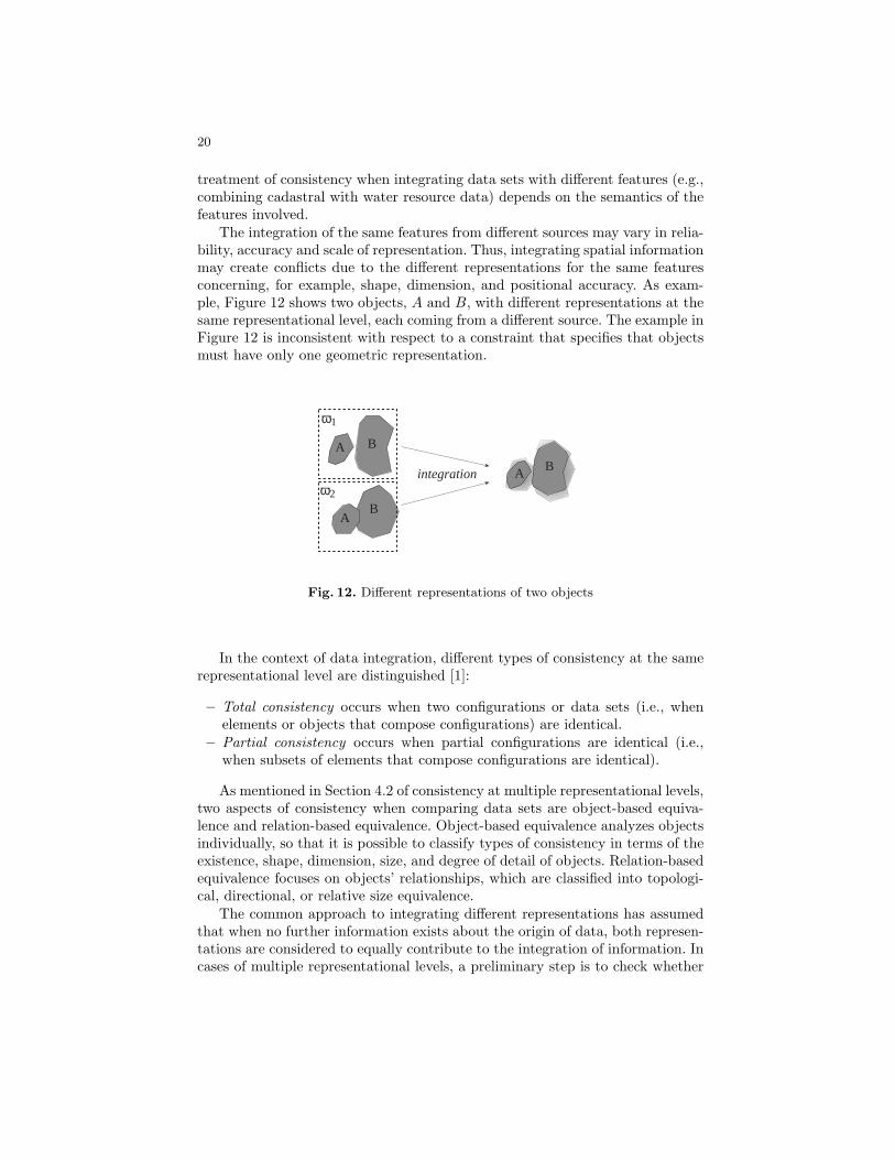
treatment of consistency when integrating data sets with different features (e.g.,combining cadastral with water resource data) depends on the semantics of thefeatures involved.
The integration of the same features from different sources may vary in relia-bility, accuracy and scale of representation. Thus, integrating spatial informationmay create conflicts due to the different representations for the same featuresconcerning, for example, shape, dimension, and positional accuracy. As exam-ple, Figure 12 shows two objects, A and B, with different representations at thesame representational level, each coming from a different source. The example inFigure 12 is inconsistent with respect to a constraint that specifies that objectsmust have only one geometric representation.
A
A
A
B
B
B
ω1
ω2
integration
Fig. 12. Different representations of two objects
In the context of data integration, different types of consistency at the samerepresentational level are distinguished [1]:
– Total consistency occurs when two configurations or data sets (i.e., whenelements or objects that compose configurations) are identical.
– Partial consistency occurs when partial configurations are identical (i.e.,when subsets of elements that compose configurations are identical).
As mentioned in Section 4.2 of consistency at multiple representational levels,two aspects of consistency when comparing data sets are object-based equiva-lence and relation-based equivalence. Object-based equivalence analyzes objectsindividually, so that it is possible to classify types of consistency in terms of theexistence, shape, dimension, size, and degree of detail of objects. Relation-basedequivalence focuses on objects’ relationships, which are classified into topologi-cal, directional, or relative size equivalence.
The common approach to integrating different representations has assumedthat when no further information exists about the origin of data, both represen-tations are considered to equally contribute to the integration of information. Incases of multiple representational levels, a preliminary step is to check whether

21
or not different representational levels are consistent. When representational lev-els are consistent, a more detailed level can be mapped onto and integrated intoa less detailed level; that is, into a representation generated by a generalizationprocess. If, at a common representational level, two different representationsexist, partial consistency may still be possible (i.e., parts of the different repre-sentations of an object or configuration are identical). The idea is to merge bothrepresentations in such a way that the resulting representation is modeled as avague or unclear one. In modeling these unclear boundaries, three alternativesare found [24]:
– Fuzzy models [2][56][64][71], which are based on fuzzy set theory and havebeen applied to spatial uncertainty. Fuzzy set theory is an extension of clas-sical boolean set theory that deals with different degrees of possibility thatan individual is a member of a set or that a given statement is true [70].Examples of fuzzy spatial objects are mountains, cities, and oceans.
– Probabilistic models [12][33], which are based on probability theory to modelpositional and measurement uncertainty. Probabilistic approaches model un-certainty by determining a degree of membership of an entity in a set in termsof statistically defined functions. An example of an unclear boundary thatcan be modeled by a probabilistic model is the water level of a lake that isnot certainly known.
– Exact models [15][16][21][32], which map data models for spatial objects withsharp boundaries onto spatial objects with broad boundaries.
Consider an example of a fuzzy representation of indeterminate regions (Fig-ure 13). A membership function for area A can be specified in 8, where B standsfor the region that is definitely outside of A, A/B is a region that can be part ofA or B, and da and db are the distances from a point (x, y) in the region A/Bto the core area of the region A (i.e. region where µA(x, u) = 1) and the corearea of the region B (i.e., region where µA(x, u) = 0):
1[0..1]0
A/Bx,y
da
db
BA
Fig. 13. A fuzzy region
µA(x, y) =
1 if(x, y) ∈ A ∧ (x, y) /∈ B1− da/(da + db) if(x, y) ∈ A ∧ (x, y) ∈ B0 if(x, y) /∈ A ∧ (x, y) ∈ B
(8)

22
In the context of data integration, fuzzy theory can be used in the integrationof two representations that overlap (i.e., a partial consistency). In such case, onecould consider that the overlapping areas or intersections between objects fromdifferent representations are the core areas of the integrated objects (i.e., darkgrey of Figure 13 with membership function equal to 1) and the differences be-tween the union and the intersection of representations are the unclear boundaryof objects (i.e., light grey region with membership function in the range [0 . . . 1]).The regions outside of objects in both representations are considered outside ofthe integrated objects.
Following an exact approach to handle indeterminate boundaries, a broadboundary is associated with objects whose boundaries are unclear after integra-tion. In the example of Figure 14, regions of broad boundaries are the regionsthat result from the difference between the union and intersection of objectsin both representations, that is, the regions that do not clearly belong to thegeometric representations of objects.
A
A
B
B
ω1
ω2
integration
A B union
(a)
(b)
A B
broadboundaries
A B intersection
context
consistency
Fig. 14. Example of integration of spatial data based on previous knowledge of datasets
There are various possible strategies that can formalize the integration ofmore than one observation about location in a region with broad boundaries.These strategies make distinctions depending on the contextual information thatcharacterizes the quality of representations [69]. For example, consider configu-rations in Figure 14, and assume that we know that both configurations (i.e.,ω1 and ω2) are not accurate (i.e, there exist errors in positional information)then, only the intersection of both representations can be considered consistent(i.e., option (a) in Figure 14). If we consider that configuration ω2 does not in-clude regions that it should (i.e., incomplete representation), the union of bothrepresentations is considered consistent (i.e., option (b) in Figure 14).
Focusing on the integration of topological relations, the relation between ob-jects with broad boundaries are described by an intersection matrix between in-

23
teriors (◦) (i.e., between the core of objects), broad boundaries (∆) (i.e., betweenthe unclear regions of objects), and exteriors (−) [15] [60][67][68] (Figure 15). Fortopological relationships between regions with broad boundaries, 44 realizablematrices are possible.
A B B◦ ∆B B−
A◦ ∅ ∅ ¬∅∆A ∅ ¬∅ ¬∅A− ¬∅ ¬∅ ¬∅
Fig. 15. Intersection matrix of objects with broad boundaries
Each intersection matrix of objects with broad boundaries has a set of topo-logical relations that are realizable when considering changes from the core tothe broad boundary of an object. In the case of Figure 15, three possible relationsare realizables: disjoint, meet and overlap. Figure 16 shows these three alterna-tives when one considers that the geometry of objects change from the core tothe broad boundaries. In this figure, gray lines represent the core boundary andbroad boundary of objects.
Disjoint Meet Overlap
A B A B A B
Fig. 16. Possible relations between objects with broad broundaries
To discuss the integration of different representations, consider the examplein Figure 17, where two representations of two objects are integrated, result-ing in objects with broad boundaries. The intersection of both representationsdefine the core of objects and the difference between the union and the inter-section defines the broad boundaries for each object. The idea here is not toanalyze what the boundaries of individual objects are, but the relationship be-tween objects; that is, what relationships are possible between the objects giventhat the integration of two representations results in objects with broad bound-aries. From the point of view of consistency, if the analysis of broad boundariesdetermines that there exists only one possible relation between objects based ontwo representations, there is no conflicting information about the spatial rela-tion between objects even in presence of different representations of objects. In

24
presence of multiple possible relations and a constraint that enforces a uniquerelation between objects, multiple representations are inconsistent. In the ex-ample of Figure 17, the broad boundaries (∆) make possible that objects aredisjoint, meet or overlap, that is, consistency cannot be guarantee based on bothrepresentations.
A
A
A
B
B
B
B◦ ∆B B−
A◦ ∅ ∅ ¬∅∆A ¬∅ ¬∅ ¬∅A− ¬∅ ¬∅ ¬∅
Fig. 17. Integration of two representations
In the same way than models for handling multiple representational levelsof spatial objects, applications that integrate spatial information run as ad-hocimplementations, that is, they are user-defined applications rather than toolsincorporated into current DBMS. These models also lack the specification in aformal language for their treatments as integrity constraints.
5 Consistency Tolerance in Spatial Databases
Although there has been active research on creating efficient spatial databases,the treatment of inconsistency in spatial databases is still a problem for cur-rent spatial information systems [8] [23]. The models described in the previousSections about consistency at multiple representational levels and for data in-tegration can be used in defining strategies for treating inconsistency in spatialdatabases; however, these models have not been integrated into a query processthat explicitly addresses the answer and process of data despite the fact thatthe data are inconsistent (i.e., inconsistency tolerance). Inconsistency tolerancecan be used to one’s advantage when accessing or integrating data from differentsources, or when it is inconvenient or impractical to enforce integrity constraintsduring data updates.
In traditional databases, studies have addressed inconsistency tolerance inquery answers [3] [6] of a relational database schema with a set of integrity

25
constraints over this schema. From these studies, possible alternatives for dealingwith inconsistency in query answering are: ignoring inconsistency (i.e., usingconflicting data in the answer), eliminating inconsistency data (i.e., consideringnone of the conflicting data for answer; data cleaning), and considering theconsistent answer that belongs to all consistent states of the database based onminimum repairs. Conceptually, these alternatives could be applied in the spatialdomain when issuing queries that rely on spatial operations from the relationalalgebra with spatial criteria.
For example, consider a spatial database that has conflicting representationsof spatial objects (conflicting representation of object A in Figure 18).
AB
C
D
A
@rectangle
Fig. 18. An inconsistent database with different representations of an object A and aquery defined by a window @rectangle
Using an extended relational database, the data set in Figure 18 is repre-sented by a relation Spatial Object with the following instances, where regioni
represents a value of the geometric primitive region:
Spatial Object Name RegionA region1
A region2
B region3
C region4
D region5
Having the functional dependency Name → Region, meaning that the Namefunctionally determines Region, the relation Spatial Object violates the func-tional dependency, since there are two tuples with value A in attribute Name.In this example, two selection queries based on a space window (i.e., a rectan-gular area of the space @rectangle) that was defined by a user are:

26
1 select clipping(r.geometry,@rectangle)from Regions rwhere Overlaps(r.geometry,@rectangle)
2 select r.geometryfrom Regions rwhere Overlaps(r.geometry,@rectangle)
The first query returns the geometric parts of objects that overlap the win-dow (@rectangle). The second query, on the other hand, returns the completegeometry of objects that totally or partially overlap the window. In answeringthese queries, the three alternatives of ignoring, eliminating, and consideringminimum repairs of traditional databases can be applied (Figure 19). For thefirst query, ignoring inconsistency will return the geometric parts of both con-sistent and inconsistent data that overlap the query window. In this case, theconflicting representations of object A lay outside the overlapping region withthe query window such that the answer does not have conflicting information.The situation is different, however, in the option of ignoring inconsistency for thesecond query, since the answer in that case will contain conflicting information,that is, two representations of object A that partially overlap the query window.In both queries, eliminating inconsistency data will not consider the conflictingdata, that is, the geometry of object A is not considered as part of the answer.
Ignoring Eliminating Minimum repairs (partial consistency)
Query 1
Query 2
Minimum repairs (total consistency)
A
B
C
@rectangle
B
C
@rectangle
B
C
@rectangle
AB
@rectangle
AB
C
@rectangle
AB
C
@rectangle
B
C
@rectangle
B
C
@rectangle
AB
C
@rectangle
A
Fig. 19. Alternatives to consistent query answers from the inconsistent database
The option of minimum repairs returns all the answers that belong to theresult of query evaluation in every repair [6]. In this database, there are twopossible repairs, each of them considering only one tuple of object A. In answer-ing the first query in Figure 19, both repairs contain the same geometric areaof objects A, B, and C that overlap the query window (Figure 20); therefore,

27
these areas are part of the consistent answer. For answering the second query,since it is the complete geometry of objects that overlap the query window whatis retrieved, only objects B and C can be considered consistent answers to thisquery.
Database Repair 1 Repair 2
AB
C
D
A
@rectangle
AB
C
D
@rectangle
B
C
D
A
@rectangle
Fig. 20. Minimum repairs of the database
The previous example of the second query illustrates that in the case ofminimum repairs, one could consider two further alternatives that depend on thegranularity of the determination of inconsistency in the geometric representationof spatial objects. One option is to take the geometry of an object as a whole,which is the basic case described before when making the repairs based on thecomplete geometries of objects (Figure 20). The second alternative of minimumrepairs is to consider that the geometry of an object can be partially inconsistent,in which case, the repair of the database takes the consistent parts of objects’representations. Partial consistency may be defined by the part of the geometricrepresentation of objects that is equivalent in conflicting information, that is, theintersection of geometric representations. For example, in the previous database,one of the representations of object A is inside of the other such that the formercorresponds to the intersection of both representations. This intersection region,by definition, is present in all representations of object A and, therefore, it ispart of the repair (Figure 21). In the example of the queries in Figure 19, theintersection of the geometric attribute of both tuples with value A in attributeName will be considered in the answer.
Other interesting queries are those that uses criteria defined by spatial re-lations between objects. Spatial relations are usually derived during the queryprocess, and they may not require accurate data about positional information.This type of query involves spatial joins between relations, which construct thepairs of tuples from the relations whose spatial components satisfy spatial pred-icates. When querying by spatial relations between objects, inconsistency withrespect to the representation of objects (i.e., location and shape of objects) maynot affect the consistency with respect to the spatial relation between objects(e.g., even with conflicting positional information exists, objects can still holdthe same topological relation). What is more, by considering some metric refine-ments of topological relations (i.e., relative size and distance of objects) [36], one

28
Database Repair
AB
C
D
A
@rectangle
AB
C
D
@rectangle
Fig. 21. The minimum repair of the database that considers partial consistency
could also determine that objects keep the same topological relations despite thefact that they have conflicting geometric representations.
Consider the same database of spatial objects in Figure 18 and the followingtwo selection queries based on a criteria of spatial relations between objects,where the difference is in the selection component (i.e., regions’ ids or regions’geometries):
1 select r1.idfrom Regions r1, Regions r2
where r2.id =′ B′ and Overlaps(r1.geometry, r2.geometry)
2 select r1.geometryfrom Regions r1, Regions r2
where r2.id =′ B′ and Overlaps(r1.geometry, r2.geometry)
In answering these queries, the geometric representation is needed for apply-ing the spatial criteria. The answer to the first query, however, does not concernthe selection of the geometric representation of objects, but the selection of ob-jects’ ids. Thus, since the spatial criteria is satisfied in both representations ofA, the answer to the query is the same in all repairs of the database. For thesecond query, in contrast, the answer is the geometric representation of objectsso that, even if the spatial criteria is satisfied in all repairs of the database, theanswer cannot include conflicting information (Figure 22).

29
A
C C C
Ignoring Elimining Minimum repairs (partial consistency)
Query 1 A,C C A,C A,C
Query 2
Minimum repairs (total consistency)
A
C
Fig. 22. Alternatives to consistent query answers from the inconsistent database
A different perspective for handling conflicting representations in answeringa query is the use of broad boundaries in a query concerning the geometricaggregation of objects. This idea of objects with broad boundaries could berelated to the way aggregate functions have been treated in consistent queryanswering from inconsistent traditional databases [4] [5] [14]. A consistent answerto an aggregation query is defined as a minimum interval such that the value ofthe aggregation function in every repair of the database belongs to this minimuminterval. The end-points of the minimum interval corresponds to the greatestlower bound and the least upper bound answers to the query in the database.
In a query by aggregation of objects’ geometry, two different geometric repre-sentations may lead to different aggregate objects. Answering a query may theninvolve treating the aggregate object as an object with broad boundaries, thatis, an object with a crisp boundary defined by the intersection of all possible ag-gregations, and with a broad boundary defined by t the union of all aggregations(Figure 23). In this case, the minimum interval of possible answer are limitedby the greatest lower bound that corresponds to the crisp region and the leastupper bound that corresponds to the region defined by the broad boundary.
AB
C
D
A Aggregation
Fig. 23. Aggregation of inconsistency representations by modeling objects with broadboundary

30
The previous examples have described conceptually the use of different al-ternatives for dealing with inconsistency tolerance with respect to geometricrepresentations, without taking in consideration the computational mechanismsfor obtaining consistent answers. Other examples with different types of inconsis-tencies, such as semantic inconsistency and topological inconsistency, and morecomplex queries are also possible. In all cases, much work need to be done withrespect to what repairs and consistent answers are in spatial databases.
The treatment of inconsistency tolerance raises new issues respect to topolog-ical constraints. In such cases, the inconsistency is not the result of conflictinginformation about the position of objects, but rather of a lack of consistencywith the rules that define the primitives of representation. For example, a typi-cal structural constraint of a polygon is to be bounded by a non self-intersectingand closed polyline. The satisfaction of topological constraints ensures that somecomputational-geometry algorithms can be successfully executed; however, notall of these algorithms require the same structural constraints. For example, theboundary of a region must be defined by a closed polyline in order to calculatethe area of a region. On the other hand, a closed and non self-intersecting poly-line is the requirement of an algorithm for determining whether or not a pointis inside of a region. So, if one only wants to compute the area of a polygon,polylines only need to be closed. This analysis may imply that topological con-straints may be associated with the particular use of spatial operators ratherthan with a general definition of geometric primitives.
6 Conclusions
This chapter presents a review of the work on inconsistency in spatial databases.It discusses the kinds and origins of inconsistency, the specification of integrityconstraints, and the treatment of inconsistency for representations at differentlevels and for data integration. Further, it discusses how inconsistency tolerancecan be introduced in querying inconsistent spatial databases. This review high-lightes issues about composite objects and spatial relations in the treatment ofinconsistency.
Summarizing, important issues for the treatment of inconsistency that werediscussed are:
– Inconsistency may relate to conflicting information with respect to positionalor qualitative attributes of objects or to contradictions with respect to struc-tural and semantic rules. Structural conditions of geometric primitives havebeen typically expressed as integrity constraints.
– Integrity constraints may refer to the geometric representation of objects bymaking reference to conditions on the geometric types of objects (i.e., point,polylines, regions), or they may refer to the semantic of spatial objects (e.g.,a road cannot run into a body of water ). Thus, constraints can be expressed,for example, by points or aggregations of points (i.e, by geometric primitives),or by objects or aggregations of objects (i.e., by objects that have a semanticmeaning, such as rivers, building and roads).

31
– Queries concerning spatial relations may not need a unique geometric rep-resentation of objects and, therefore, such queries are less sensitive to con-flicting positional information.
– Definitions of composite objects deal with sets of objects and impose con-straints between wholes and parts to enforce consistency.
– Geometric information about spatial objects can be considered as a wholeunit (i.e., a geometric representation is consistent or inconsistent as a whole)or can be considered as an aggregation of spatial parts (i.e., a geometricrepresentation is consistent, partially consistent, or totally inconsistent).
– Multiple representation levels with respect to different scales may be nec-essary in information systems. In such cases, multiple representations areconsidered consistent if they satisfy basic topological constraints.
– Different definitions of consistent answers and database repairs can be ap-plied to spatial databases based on the interpretation and use of the geo-metric representations.
Since this chapter has outlined issues concerning the treatment of incon-sistency of spatial databases, it leaves the door open for exploring aspects offormalization and implementation of mechanisms for consistent query answeringfrom inconsistent spatial databases. Although it was not discussed in the chap-ter, there is an increasing interest in the research community of spatial databasestoward the management of spatial-temporal applications. These types of appli-cations raise issues of temporal, spatial, and spatial-temporal consistency [40][50] [51].
Acknowledgment. Andrea Rodrıguez’s research work is partially funded byCONICYT under grant FONDECYT 1030301.
References
1. A. Abdelmoty and C. Jones. Towards maintening consistency in spatial databases.In Proceedings of the Sixth International Conference on Information and Knowl-edge Management, pages 293–300, Las Vergas, USA, 1997. ACM Press.
2. D. Altman. Fuzzy set theory approaches for hadling imprecision in spatial analysis.International Journal of Geographic Information Science, 8(3):271–289, 1994.
3. M. Arenas, L. Bertossi, and J. Chomicki. Consistent query answers in inconsistentdatabases. In ACM Symposium on Principles of Database Systems (PODS), pages68–79, 1999.
4. M. Arenas, L. Bertossi, and J. Chomicki. Specifying and querying database repairsusing logic programs with exceptions. In International Conference on FlexibleQuery Answering Systems (FGAS), pages 27–41. Springer-Verlag, 2000.
5. M. Arenas, L. Bertossi, and J. Chomicki. Answer sets for consistent query answer-ing in inconsistent databases. Theory and Practice of Logic Programming, 3(4 &5):393–424, 2003.
6. L. Bertossi and J. Chomicki. Query answering in inconsistent databases. InJ. Chimicki, G. Saake, and R. van der Meyden, editors, Logics for Emerging Ap-plications of Databases. Springer-Verlag, 2003.
32
7. P. Bonnissone and R. Tong. Reasoning with uncertainty in expert systems. Inter-national Journal of Man and Machine Studies, 22:241–250, 1985.
8. K. Borges, C. Davis, and A. Laender. Integrity constraints in spatial databases.In Database Integrity: Challenges and Solutions. Ideas Group, 2002.
9. K. Borges, A. Laender, and C. Davis. Spatial integrity constraints in object ori-ented geographic data modeling. In C. Bauzer-Medeiros, editor, ACM InternationalSymposium on Advances in GIS, pages 1–6. ACM Press, 1999.
10. P. Bosc and H. Prade. An introduction to fuzzy set and possibility theory basedapproaches to the treatment of uncertainty and imprecision in datatabase man-agement systems. In A. Motro and P. Smets, editors, Uncertainty Management inInformation Systems: From Needs to Solutions, pages 285–324. Kluwer AcademicPublishers, 1997.
11. T. Bruns and M. Egenhoger. Similarity of spatial scenes. In International Sympo-sium on Spatial Data Handling SDH’96, pages 31–42, Delf, The Netherlands, 1996.Taylor and Francis.
12. P. Burrough. Natural objects with undeterminate boundaries. In A. Frank, editor,Geographic Objects with Indeterminate Boundaries GISDATA, pages 3–28. Taylor& Francis, 1996.
13. A. Chandra and D. Harel. Computable queries for relational database systems.Journal of Computer and System Sciences, 21(2):156–178, 1980.
14. J. Chomicki. Consistent query answering: Recent developments and future direc-tions. In S. Jajodia and L. Strous, editors, Working Conference on Integrity andInternal Control in Information Systems, Lousanne, Switzerland, 2003. KluwerPublishers.
15. E. Clementini and P. Di Felice. An algebraic model for spatial objects with unde-terminate boundaries. In A. Frank, editor, Geographic Objects with IndeterminateBoundaries, pages 155–169, London, 1996. Taylor & Francis.
16. E. Clementini and P. Di Felice. Approximate topological relations. InternationalJournal of Approximate Reasoning, 16:73–204, 1997.
17. E. Clementini, J. Sharma, and M. Egenhofer. Modeling topological relations:Strategies for query preprocessing. Computers and Graphics, 18(6):815–822, 1994.
18. S. Cockcroft. A taxonomy of spatial integrity constraints. GeoInformatica,1(4):327–343, 1997.
19. S. Cockcroft. Modelling spatial data integrity constraints at the metadata level.In D. Pullar, editor, GeoComputation, Brisbane, Australia, 2001.
20. A. Cohn, B. Bennett, J. Gooday, and N. Gotts. Representing and reasoning withqualitative spatial relations about regions. In O. Stock, editor, Spatial and Tem-poral Reasoning, pages 97–134. Kluwer Academic Publishers, 1997.
21. G. Cohn and N. Gotts. The ’egg-yolk’ representation of regions with indeterminateboundaries. In A. Frank, editor, Geographic Objects with Indeterminate Bound-aries, pages 171–187, London, 1996. Taylor & Francis.
22. H. Couclelis. People manipulate objects (but cultivate fields): Beyond the raster-vecter debate in gis. In A. Frank, I. Campari, and U. Formentini, editors, Theoriesand Methods of Spatio-Temporal Reasoning in Geographic Space. LNCS vol. 639,pages 65–77. Springer-Verlag, 1992.
23. M. Egenhofer. Consistency revisited. GeoInformatica, 1(4):323–325, 1997.24. M. Egenhofer, E. Clementini, and P. Di Felice. Evaluating inconsistency among
multiple representations. In Spatial Data Handling, pages 901–920, Edinburg, Scot-land, 1994.
25. M. Egenhofer and R. Franzosa. Point-set topological spatial relations. InternationalJournal of Geographical Information Systems, 5(2):161–174, 1991.

33
26. M. Egenhofer and R. Franzosa. On the equivalence of topological relations. Inter-national Journal of Geographical Information Systems, 8(6):133–152, 1994.
27. M. Egenhofer and J. Herring. Categorizing topological spatial relations betweenpoint, line, and area objects. Technical Report Report 94-1, National Center forGeographic Information Analysis, 1994.
28. M. Egenhofer and D. Mark. Naive geography. In A. Frank and W. Kuhn, editors,Theoretical Basis for Geographic Information Systems COSIT’95, pages 1–14, Sem-mering, Austria, 1995. Springer-Verlag.
29. M. Egenhofer and J. Sharma. Topological consistency. In P. Bresnahan, E. Corwin,and D. Cowen, editors, Proceedings of the 5th International Symposium on SpatialData Handling, pages 335–343, Charleston, USA, 1992. IGU Commission of GIS.
30. M. Egenhofer and J. Sharma. Assessing the consistency of complete and incompletetopological information. Geographical Systems, 1(1):47–68, 1993.
31. R. Elsmari and S. Navathe. Fundamentals of Database Systems. Addison Wesley,3er edition edition, 2000.
32. M. Erwing and M. Schneider. Vague regions. In 5th Int. Symposium on Advancesin Spatial Databases SSD97. LNCS 1262, pages 298–320. Springer-Verlag, 1997.
33. J. Finn. Use of the average mutual information index in evaluating error andconsistency. International Journal of Geographic Information Science, 7(4):349–366, 1993.
34. A. Frank. Tiers of ontology and consistency constraints in geographical informationsystems. International Journal of Geographic Information Science, 15(7):667–678,2001.
35. G. Gardarin, J.P. Cheiney, G. Kiernan, D. Pastre, and H. Stora. Manageningcomplex objects in an extensible relational DBMS. In Proceedings of Very LargeData Bases, 1989.
36. F. Gody and A. Rodrıguez. A quantitative description of spatial configurations. InD. Richardson and P. van Oosterom, editors, Proceedings of the 10th Symposiumon Spatial Data Handling, pages 299–311. Springer, 2002.
37. R. Guting. An introduction to spatial database systems. VLDB Journal, 3:357–399, 1994.
38. R. Guting and M. Schneider. International Symposium on Spatial Databases, Lec-ture Notes in Computer Science Vol. 692, chapter Realms: A Foundation for SpatialData Types in Database Systems, pages 14–35. Springer-Verlag, 1993.
39. R. Guting and M. Schneider. Realm-based spatial data types: The rose algebra.Technical Report 141-3-93, Fern Universitat, Hagen, 1993.
40. R. Guuting, M. Bohlen, M. Erwing, C. Jensen, N. Lorentzos, M. Schneider, andM. Vazirgiannis. Foundation for representing and querying moving objects. ACMTransactions on Database Systems, 25(1):1–42, 2000.
41. T. Hadzilacos and N. Tryfona. A model for expressing topological constraints ingeographic databases. In A. Frank, I. Campari, and U. Formentini, editors, The-ories and Methods of Spatio-Temporal Reasoning in Geographic Space COSIT92,pages 252–268, Pisa, Italy, 1992. Springer-Verlag.
42. P. Kanellakis, G. Kuper, and P. Revesz. Constraint query languages. Journal ofComputer and System Sciences, 51(1):26–52, 1995.
43. B. Kuipers, J. Paredaens, and J. den Busshe. On topological equivalence of spatialdatabases. In F. Afrati and Ph. Kolaitis, editors, 6th International Conference onDatabase Theory ICDT97, LNCS 1186, pages 432–446. Springer Verlag, 1997.
44. G. Kuper, L. Libkin, and J. Paredaens. Constraint Databases. Springer-Verlag,2000.
34
45. R. Laurini and D. Thompson. Fundamentals ofr Spatial Information Systems.Academic Press, 1992.
46. D. Papadias and Y. Theodoridis. Spatial relations, minimum bounding rectanglesand spatial data structures. International Journal of Geographical InformationScience, 11(2):111–138, 1997.
47. J. Paredaens, J. Van den Bussche, and D. Van Gucht. Towards a theory of spatialdatabases queries. In Proceedings of the 13th ACM SIGACT-SIGMOD-SIGARTSymposium on Principles of Database Systems, pages 128–288. ACM Press, 1994.
48. J. Paredaens and B. Kuipers. Data models and query languages for spatialdatabases. Data Knowledge Engineering, 25(1-2):29–53, 1998.
49. S. Parson. Current approaches to handling imperfect information in data andknowledge bases. IEEE Transactions on Knowledge and Data Engineering,8(3):353–371, 1996.
50. D. Pfoser and C. Jensen. Capturing the uncertainty of moving-object representa-tions. In R. Guting, D. Papdias, and F. Lochovsky, editors, Proceedings of the 6thInternational Symposium on the Advances in Spatial Databases, pages 111–132.Springer Verlag, 1999.
51. D. Pfoser and N. Tryfona. Capturing fuzziness and uncertainty of spatiotemporalobjects. In A. Caplinskas and J. Eder, editors, 5th East-European Conference onAdvances in Databases and Information Systems ADBIS01. LNCS 2151, pages112–126, Lithuania, 2001. Springer Verlag.
52. A. Pizzaro, A. Klinger, and A. Cardenas. Specification of spatial integrity con-straints in pictorical databases. Computer, 22(12):59–71, 1989.
53. L. Plumer and G. Groger. Achieving integrity constraints in geographic informationsystemsd. GeoInformatica, 1(4):345–367, 1997.
54. P. Ragaux, M. Scholl, and A. Voisard. Spatial Databases: with Application in GIS.Academic Press, 2002.
55. H. Samet. The Design and Analysis of Spatial Data Structures. Addison-Wesley,1990.
56. M. Schneider. Metric operations on fuzzy spatial objects in databases. In Proceed-ings of the 8th ACm Symposium on Geographic Information Systems, pages 21–26,Washington DC, 2000. ACM Press.
57. S. Servige, T. Ubeda, A. Puricelli, and R. Laurini. A methodology for spatialconsistency improvement of geographic databases. GeoInformatica, 4:7–24, 2000.
58. S. Shekhar and S. Chawla. Spatial Databases: A Tour. Prentice Hall, 2003.59. S. Shekhar, M. Coyle, B. Goyal, D.-R. Liu, and S. Sarkar. Data models in geo-
graphic information systems. Comm. ACM, 40(4):103–111, 1997.60. J. Stell and M. Worboys. Stratified map spaces. In T. Poiker and N. Chrisman,
editors, Spatial Data Handling, pages 180–189, British Columbia, Canada, 1998.Taylor & Francis.
61. O. Stock. Spatial and Temporal Reasoning. Kluwer Acaddemic Publishers, 1997.62. M. Stonebraker and L.A. Rowe. The design of POSTGRES. In Proceedings of
ACM SIGARCT-SIGMOD, pages 340–355, 1986.63. N. Tryfona and M. Egenhofer. Consistency among parts and aggregates: A com-
putational model. Transactions on GIS, 1(3):189–206, 1997.64. E. Usery. A conceptual framwork and fuzzy set implementation for geographic
features. In A. Frank, editor, Geographic Objects with Undeterminate BoundariesGISDATA, pages 71–85. Taylor & Francis, 1996.
65. A. Voisard and B. David. A database pespective on geospatial data modeling.IEEE Transactions on Knowledge and Data Engineering, 14(2):226–246, 2002.

35
66. M. Worboys. A geometric model for planar geographical objects. InternationalJournal of Geographical Information Systems, 6(5):353–372, 1992.
67. M. Worboys. Computation with imprecise geographic data. Journal of Computers,Environment and Urvan Systems, 22:85–106, 1998.
68. M. Worboys. Imprecision in finite resolution spatial data. GeoInformatica, 2:257–280, 1998.
69. M. Worboys and E. Clementini. Integration of imperfect spatial information. Jour-nal of Visual Languages and Computing, 12:61–80, 2001.
70. L. Zadeh. Fuzzy sets. Information and Control, 8:338–358, 1965.71. F. Zhan. Approximate analysis of binary topological relations between geographic
regions with indeterminate boundaries. Soft Computing, 2:28–34, 1988.