Improvements for Neck Lake and El Capitan Cave Roads
89
Improvements for Neck Lake and El Capitan Cave Roads Environmental Assessment Scoping and Issues Report Thorne Bay Ranger District, Tongass National Forest, Alaska Scenery Subsistence Cultural Resources Transportation Recreation Wildlife United States Department of Agriculture Forest Service March 2015
-
Upload
khangminh22 -
Category
Documents
-
view
2 -
download
0
Transcript of Improvements for Neck Lake and El Capitan Cave Roads
Improvements for Neck Lake and El Capitan Cave Roads Environmental Assessment
Scoping and Issues Report
Thorne Bay Ranger District, Tongass National Forest, Alaska
Scenery Subsistence Cultural Resources
Transportation Recreation Wildlife
United States Department of Agriculture Forest Service
March 2015

The U.S. Department of Agriculture (USDA) prohibits discrimination against its customers, employees, and applicants for employment on the bases of race, color, national origin, age, disability, sex, gender identity, religion, reprisal, and where applicable, political beliefs, marital status, familial or parental status, sexual orientation, or all or part of an individual's income is derived from any public assistance program, or protected genetic information in employment or in any program or activity conducted or funded by the Department. (Not all prohibited bases will apply to all programs and/or employment activities.)
To File an Employment Complaint If you wish to file an employment complaint, you must contact your agency's EEO Counselor (PDF) within 45 days of the date of the alleged discriminatory act, event, or in the case of a personnel action. Additional information can be found online at www.ascr.usda.gov/complaint_filing_file.html.
To File a Program Complaint If you wish to file a Civil Rights program complaint of discrimination, complete the USDA Program Discrimination Complaint Form (PDF), found online at www.ascr.usda.gov/ complaint_filing_cust.html, or at any USDA office, or call (866) 632-9992 to request the form. You may also write a letter containing all of the information requested in the form. Send your completed complaint form or letter to us by mail at U.S. Department of Agriculture, Director, Office of Adjudication, 1400 Independence Avenue, S.W., Washington, D.C. 20250-9410, by fax (202) 690-7442 or email at [email protected].
Persons with Disabilities Individuals who are deaf, hard of hearing or have speech disabilities and you wish to file either an EEO or program complaint please contact USDA through the Federal Relay Service at (800) 877-8339 or (800) 845-6136 (in Spanish).
Persons with disabilities who wish to file a program complaint, please see information above on how to contact us by mail directly or by email. If you require alternative means of communication for program information (e.g., Braille, large print, audiotape, etc.) please contact USDA's TARGET Center at (202) 720-2600 (voice and TDD).
Improvements for Neck Lake and El Capitan Cave Roads EA Scoping and Issues Report
i
CONTENTS
1. Introduction .......................................................................................................................... 1
2. Document Purpose .............................................................................................................. 1
3. Document Organization ...................................................................................................... 1
4. Description of Scoping Meetings ....................................................................................... 2 4.1. Meeting Announcements ............................................................................................................... 2 4.2. Meeting Format ............................................................................................................................. 2
5. Opportunities for Public and Agency Comment ............................................................... 3
6. Scoping Comment Analysis ............................................................................................... 3
7. Summary of Public Comment ............................................................................................. 4 7.1. Scoping Topics .............................................................................................................................. 4
7.1.1. NEPA Process ....................................................................................................................... 4 7.1.2. Cultural Resources ................................................................................................................. 4 7.1.3. Recreation .............................................................................................................................. 4 7.1.4. Scenery .................................................................................................................................. 4 7.1.5. Socioeconomics ..................................................................................................................... 5 7.1.6. Subsistence ............................................................................................................................ 5 7.1.7. Transportation........................................................................................................................ 5 7.1.8. Wildlife .................................................................................................................................. 6
7.2. Issues ............................................................................................................................................. 6 7.2.1. Analysis Issues ...................................................................................................................... 6 7.2.2. Issues Addressed but not Analyzed in Detail ........................................................................ 9
8. References Cited ............................................................................................................... 10
Tables
Table 1. Dates, Times, and Locations of Formal Public Scoping Meetings ................................................. 2 Table 2. Announcement of Formal Public Scoping Meetings ...................................................................... 2 Table 3. Analysis Issues and Metrics ............................................................................................................ 7
Appendices
Appendix A: Public Outreach .................................................................................................................. A-1 Appendix B: Scoping Document ............................................................................................................... B-1 Appendix C: Tribal Consultation .............................................................................................................. C-1 Appendix D: Scoping Meeting Maps ....................................................................................................... D-1 Appendix E: Scoping Meeting Sign-in Sheets and Notes ......................................................................... E-1 Appendix F: Scoping Comments ............................................................................................................... F-1 Appendix G: Updated Mailing List .......................................................................................................... G-1
Improvements for Neck Lake and El Capitan Cave Roads EA Scoping and Issues Report
1
1. INTRODUCTION
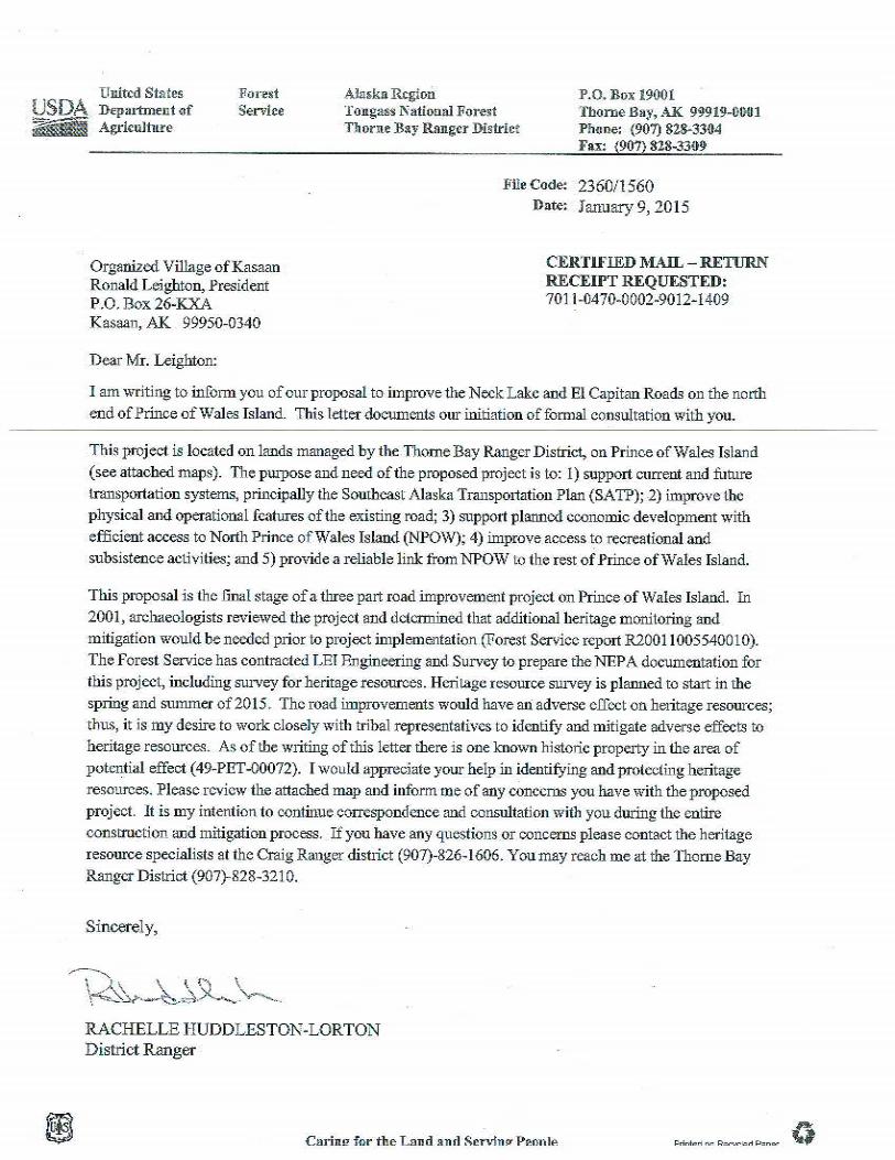
The U.S. Department of Agriculture (Forest Service) proposes road improvements to the National Forest System Roads (NFSRs) between Whale Pass and El Capitan Cave on the Thorne Bay Ranger District (TBRD) of the Tongass National Forest (Tongass NF). The project’s name is Improvements for Neck Lake and El Capitan Cave (NLECC) Roads. The Forest Service is preparing an environmental assessment (EA) to evaluate the potential effects from the implementation of the proposed action. The Forest Service is the lead federal agency responsible for compliance with the National Environmental Policy Act (NEPA) and other applicable environmental laws and regulations. This EA process will inform the public and agencies about the project’s potential impacts on human and natural resources.
A scoping document was distributed via mail, email, and the Tongass NF Schedule of Proposed Actions (SOPA) on January 5 and 6, 2015 (Appendices A and B). The scoping period was 30 days and closed February 6, 2015. Public scoping meetings were held in Naukati, Whale Pass, and Craig, Alaska; a presentation was also given at the monthly Prince of Wales Community Advisory Council (POW-CAC) meeting in Hydaburg, Alaska. The intent of these meetings was to give members of the public as well as agency personnel the opportunity to view project information and ask questions. Meeting attendees were also encouraged to provide comments on the issues that would be included in the EA.
2. DOCUMENT PURPOSE
This scoping and issues report is intended to aid in clarifying preliminary issues, determining the appropriate scope of environmental analysis, and gathering new input. It summarizes public and agency comments received during the formal scoping period; describes the analysis of those comments; and provides a preliminary list of issues, concerns, and opportunities for analysis in the EA. All substantive issues raised by respondents within the scope of the Forest Service’s decision will be included in the EA, as well as other resource categories and issues identified internally by the Forest Service and consultant interdisciplinary team (IDT).
3. DOCUMENT ORGANIZATION
This document contains the following sections:
Description of scoping meetings, including announcements leading up to the meetings
Opportunities for public and agency comment during the formal scoping period (January 5, 2015, through February 6, 2015)
Scoping comment analysis process
Summary of public comments received during the formal scoping period
Copies of all announcements and informational materials (Appendices A and B), tribal consultation (Appendix C), maps displayed at the meetings (Appendix D), meeting attendee information and notes (Appendix E), comments received during the formal scoping period (Appendix F), and an updated project mailing list (Appendix G)
Improvements for Neck Lake and El Capitan Cave Roads EA Scoping and Issues Report
2
4. DESCRIPTION OF SCOPING MEETINGS
Three public scoping meetings were held for the Improvements for NLECC Roads EA (Table 1), in addition to a presentation that was given at the monthly POW-CAC meeting in Hydaburg on January 27, 2015.
Table 1. Dates, Times, and Locations of Formal Public Scoping Meetings
Date Time City Location
January 14, 2015 6:30–7:00 p.m. Naukati Naukati School
January 22, 2015 1:00–2:40 p.m. Whale Pass Whale Pass Library
January 27, 2015 6:00–6:45 p.m. Craig Craig Ranger District Office,
900 Main Street
4.1. Meeting Announcements
Pursuant to NEPA requirements, the scoping meetings were announced in a variety of formats (Table 2; Appendices A and B) prior to their scheduled dates. For each format, the announcements provided logistics, explained the purpose of the scoping meetings, gave the schedule for the public and agency comment period, outlined additional ways to comment, and provided methods of obtaining additional information.
Table 2. Announcement of Formal Public Scoping Meetings
Newspaper Announcement, Media Notice, and Flyer (Appendix A)
The Improvements for NLECC Roads EA project was listed in the Tongass NF SOPA on January 1, 2015.
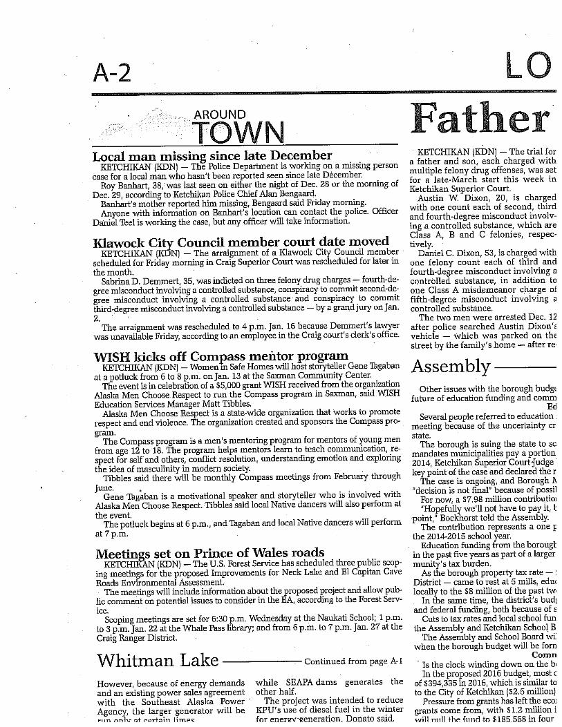
A newspaper announcement was published in the Ketchikan Daily News in the January 10–11, 2015, weekend edition.
Through the local public radio station, KRBD, the time and location information for the meetings was listed online in the community calendar and read on-air a few days prior to each meeting.
A flyer containing meeting information was sent electronically to the Whale Pass Community Association and posted by Forest Service staff in Thorne Bay, Klawock, and Craig.
Scoping Document (Appendix B)
Scoping documents (containing a brief description of the purpose and need for the project, the proposed action, and a map of the proposed project area) announcing the scoping meetings were mailed on January 6, 2015, to all individuals on the project mailing list who had not provided an email address. A separate electronic version of the scoping document was sent via email to all mailing list individuals who provided an email address on January 5, 2015.
4.2. Meeting Format
The scoping meetings included a brief presentation of the project by the Forest Service. Depending on their location, additional agency staff members were present. In Naukati, the Forest Service met with the Naukati City Council and other members of the public in attendance. The Western Federal Lands Highway Division (WFLHD) and the Alaska Department of Transportation and Public Facilities (ADOT&PF) accompanied the Forest Service at the Whale Pass public meeting. The ADOT&PF also attended the Craig meeting. At each meeting, attendees were greeted at the entrance and asked to sign in as a way to provide a record of attendance, and
Improvements for Neck Lake and El Capitan Cave Roads EA Scoping and Issues Report
3
so that they could be added to the mailing list (see Appendix E for copies of the sign-in sheets and Appendix G for the updated project mailing list). Forest Service, WFLHD, and ADOT&PF staff described the proposed improvements included in the project, and answered questions from the meeting attendees. Attendees were asked to provide written comments electronically or on the forms provided at the meeting (see the end of Appendix B).
The topics discussed at the meetings included the following:
1. Welcome message to meeting attendees
2. Description of the general purpose and need for the Improvements for NLECC Roads EA
3. Description of the proposed action
4. Map of the proposed action, including detailed maps indicating private ownership boundaries near the community of Whale Pass
5. NEPA process and schedule
6. Description of different ways to submit comments
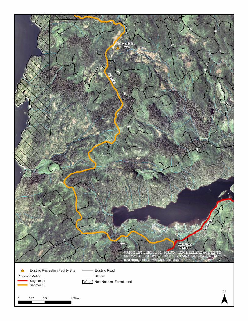
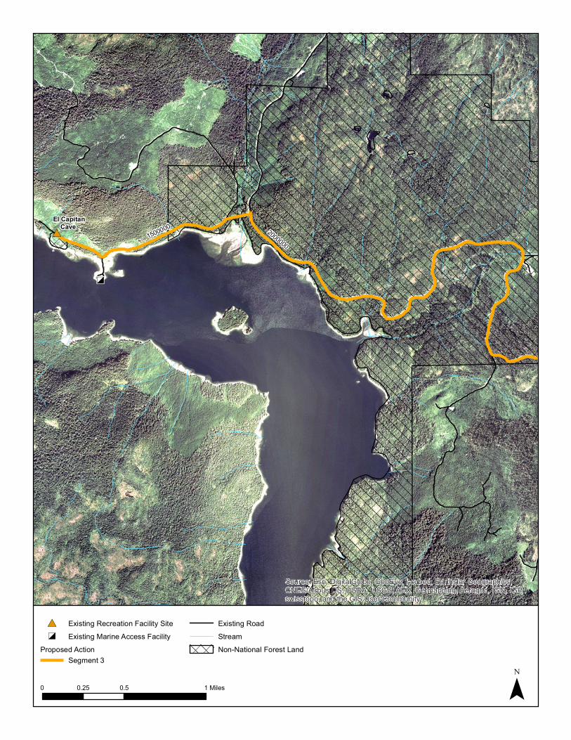
Appendix D shows the maps of the proposed action’s three segments. These maps were available at the meetings as 8.5 × 11–inch handouts and as large display maps (approximately 2 × 3 feet).
5. OPPORTUNITIES FOR PUBLIC AND AGENCY COMMENT
Members of the public and agency representatives were afforded several methods for providing scoping comments. Comments could be submitted
by mail to the U.S. Forest Service, Craig Ranger District, c/o Rich Jacobson, P.O. Box 500, Craig, AK 99921;
by fax to (907) 826-2972; via email at [email protected]; or in person at the Craig or Thorne Bay Ranger District Offices.
6. SCOPING COMMENT ANALYSIS
Public comments on the Improvements for NLECC Roads EA scoping were analyzed and categorized using a process called comment analysis. The comment analysis process consists of sorting comments, analyzing them, and summarizing the concerns raised in the comments. The goals of the analysis process were to achieve the following:
Ensure that every comment is considered Identify the concerns raised by all respondents Represent the breadth and depth of the public’s viewpoints and concerns as fairly as
possible Present those concerns in such a way as to facilitate the Forest Service’s consideration of
comments
Improvements for Neck Lake and El Capitan Cave Roads EA Scoping and Issues Report
4
As part of the NEPA process, all comments were reviewed, regardless of their method of transmittal. Names and contact information from all commenters were updated in the project mailing list (see updated list in Appendix G). All comments are included as Appendix F. Analysts read and summarized all comments in Section 7 of this report, identifying the public’s concerns.
7. SUMMARY OF PUBLIC COMMENT
In all, 12 comment letters from individuals, businesses, non-governmental organizations (NGOs), and government entities were received for the Improvements for NLECC Roads EA, as follows:
Six letters from individual respondents, some of whom submitted multiple letters Two letters from the Whale Pass Community Association, a local non-profit organization Two letters from the POW Island Chamber of Commerce, a local non-profit organization
representing business and community interests Two letters from businesses
Appendix G lists contact information for all individuals who provided comments during the public scoping period or have requested their inclusion on the project mailing list.
7.1. Scoping Topics
The following section summarizes the content of comments received during scoping for the Improvements for NLECC Roads EA. In addition to the topics discussed below, many commenters expressed either general support or opposition to the proposed project. All scoping period comments are provided in Appendix F.
7.1.1. NEPA Process
A commenter asked whether an environmental study has been prepared for the proposed action and is available to the public.
7.1.2. Cultural Resources
One commenter noted that “there are many archaeological or historical resources” in the area, and asked whether a study has been conducted to document these resources.
7.1.3. Recreation
There were two topics raised in the recreation-focused comments. A commenter was concerned that the road improvements would change the sense of remoteness in this part of POW Island, a trait sought by some recreationalists when visiting the island. Other comments were requests for improvement or installation of recreational facilities, specifically at Neck Lake Creek and El Capitan Cave.
7.1.4. Scenery
A commenter expressed concern over changes to the scenery from the proposed action.
Improvements for Neck Lake and El Capitan Cave Roads EA Scoping and Issues Report
5
7.1.5. Socioeconomics
Respondents provided both support for and concern over potential socioeconomic effects associated with the proposed road improvements. Although some commenters identified the potential for improved intra-island connection and increased tourism, others expressed concern that the proposed project would support seasonal residency in Whale Pass, and not provide the permanent residents necessary to retain the community’s school.
7.1.6. Subsistence
Respondents stated that the EA should include an evaluation of the potential for increased competition from improved access.
7.1.7. Transportation
Transportation comments focused on five main topics: design features, construction impacts, long-term impacts, maintenance and operation costs, and improvements to ancillary transportation facilities.
7.1.7.1. DESIGN FEATURES
The Southern Southeast Aquaculture Association (SSRAA) operates a coho salmon–rearing program in Neck Lake, and provides harvested adult fish to market in late summer (see full comment in Appendix F). The WFLHD is coordinating with the SSRAA regarding guardrail locations along Neck Lake so that the SSRAA can continue to conduct their barge-based salmon-feeding operations at the lake.
There were comments both in support of the 25–30 mile per hour (mph) design speed and requesting that it be reevaluated for higher speeds.
7.1.7.2. CONSTRUCTION IMPACTS
Commenters expressed concern over construction impacts such as detours and traffic delays.
7.1.7.3. LONG-TERM IMPACTS
A commenter requested that the potential for change to traffic patterns in the long term be disclosed in the EA. These include increased traffic, traffic traveling at higher speeds, whether off-highway vehicles (OHVs) would be allowed on the roads, and whether year-round access would be maintained after the proposed improvements. The Forest Service does not currently plow snow. After construction of the proposed improvements, the ADOT&PF would be responsible for year-round road management and maintenance, including plowing snow.
Whether OHVs would be allowed on the roads depends on the roads’ jurisdiction. Under Forest Service jurisdiction, most roads near Whale Pass are designated for mixed use—i.e., OHVs are allowed. When jurisdiction transfers to the ADOT&PF following proposed road improvements, then OHVs would be illegal. If the Alaska State Troopers observe OHVs on the roads, the drivers can be ticketed. Cities can pass resolutions that allow OHVs within the city limits under certain speeds and following safety guidelines.
Improvements for Neck Lake and El Capitan Cave Roads EA Scoping and Issues Report
6
7.1.7.4. MAINTENANCE AND OPERATION COSTS
A commenter requested clarifications regarding funding for maintenance and operation of the roads included in the proposed action. Currently the Forest Service is responsible for maintenance and operation costs. The ADOT&PF would be responsible for both the construction and future maintenance costs of the proposed action if it were implemented. These costs are estimated in the draft Southeast Alaska Transportation Plan (ADOT&PF 2014) and will also be included in the EA.
7.1.7.5. IMPROVEMENTS TO ANCILLARY TRANSPORTATION FACILITIES
Many commenters requested improvements to side roads and boat launch/ramp areas. These projects included improvements to
the log transfer facility (LTF) access road southeast of the Neck Lake outlet; the boat launch/ramp area, at the above-mentioned LTF, that Whale Pass residents refer
to as their “second boat launch”; the proposed future small boat harbor south of the LTF; and the El Capitan Cave boat launch/ramp area.
7.1.8. Wildlife
A commenter shared a bald eagle nest location so that the EA can examine project effects to this nest.
7.2. Issues
Based on the public and agency comments received during the scoping comment period, as well as internal scoping concerns, the IDT identified a preliminary list of issues for the Improvements for NLECC Roads EA. Preliminary issues were separated into two categories: 1) analysis issues included in the EA, and 2) issues that would not be impacted by the proposed project and therefore have been eliminated from detailed analysis. The EA will evaluate the no action and the proposed action because there were no key issues identified during scoping that would drive the development of additional action alternatives.
7.2.1. Analysis Issues
Analysis issues are defined as issues that are important to measure because they may be directly or indirectly affected by implementation of a proposed action. Public and internal agency scoping identified the following analysis issues:
NEPA Process – The scoping period initiated the EA process for the proposed project. Once written, the EA will be made available to the public.
Cultural Resources – Section 106 of the National Historic Preservation Act (NHPA) requires that federal agencies take into account the potential effects of proposed projects on historic properties. The Forest Service plans to conduct a cultural resources inventory so that these resources can be avoided, or that mitigation can be developed in coordination with local tribal entities, if the resources cannot be avoided. In compliance
Improvements for Neck Lake and El Capitan Cave Roads EA Scoping and Issues Report
7
with the NHPA, it is illegal to disclose to the public the location of these sensitive resources.
Recreation – The EA will include a discussion of recreational access and opportunities potentially affected by the proposed action.
Scenery – As part of the EA analysis, a scenic assessment will be conducted.
Socioeconomics – The EA will disclose anticipated revenue and employment during both construction and the long term.
Subsistence – The EA will include an evaluation of the potential for increased competition from improved access, as well as a cumulative impacts discussion regarding the potential for timber management on surrounding lands to alter deer habitat.
Transportation – A qualitative discussion of temporary construction and long-term project effects to traffic patterns, delays, and volume will be included in the EA. The best detour route would be identified for a variety of reasons, including safety.
Wildlife – Known nest locations will be discussed in the EA, and nesting surveys will be conducted by the Forest Service prior to construction. Timing restrictions for blasting within 660 feet of active nests would be included in project mitigation (i.e., no blasting would occur during the breeding season, which is April 15 to July 15).
Table 3 lists the analysis metrics planned for each of the identified analysis issues. Table 3. Analysis Issues and Metrics
Issue or Resource Metric for Analysis
Air quality Qualitative discussion of temporary impacts during construction (exhaust fumes, dust, particulates), with best management practices (BMPs) to control or reduce these impacts
Aquatic resources, including fisheries and hydrology
Number of drinking water sources affected, if any
Qualitative discussion of reduction in sediment contribution with proposed paved surface
BMPs to ensure that water quality standards are met during construction
Qualitative discussion of improved hydrologic connection with installation of new structures, including a map indicating stream crossings. If details regarding stream-crossing structures are available from conceptual design or from the agencies, they will be included in the EA.
Number of fish-bearing streams intersected by the project, and discussion of existing versus proposed passage structures
Cultural, historical, and paleontological resources*
Acreage of high-probability areas affected by the project
Number of historic properties affected during construction
Hazardous waste sites
Number of known contaminated sites affected
Qualitative discussion of spill control measures
Improvements for Neck Lake and El Capitan Cave Roads EA Scoping and Issues Report
8
Table 3. Analysis Issues and Metrics
Issue or Resource Metric for Analysis
Land use / right-of-way acquisitions
Acres of land use affected, including by Forest Service land use designations (LUDs)
Acres of land for ADOT&PF to acquire for the ROW
If necessary, the number of driveways that must be reconstructed to match with the road width through Whale Pass
Noise Qualitative discussion of noise from construction equipment and duration of noise
Qualitative discussion of noise from projected increased traffic
Public services and utilities
Miles and number of public utilities (pipe, power lines/poles) affected by project
Recreation* Acres of recreation opportunity spectrum (ROS) settings affected by project
Qualitative discussion of project effects to recreational access and opportunities, including discussion of specific sites accessed by the project and affects to access during construction
Qualitative and quantitative discussion of increased season of use where road is paved and maintained
Scenery* Qualitative discussion of project changes to line, color, and texture of landscape character for designated visual priority routes
Compliance with scenery integrity objectives
Socioeconomics Number of construction jobs and revenue for local communities
Qualitative discussion of long-term effects to local employment and revenue
Soils and geology, including karst and caves*
Acres of high to very high hazard rated soils disturbed by project construction activities
Acres of karst resources intersected by the project, if any
Qualitative discussion of project effects to mineral resources, including access to mining claims (still to be determined whether any would be affected)
Acres of geology intersected by the project with potential for acid rock drainage, noting that these materials will not be used in road construction
Subsistence use* Qualitative discussion of temporary construction and long-term project effects to subsistence resource availability, access, and competition
Transportation The EA will also refer to the conceptual designs included in the project record.
Comparison of existing and proposed road design standards; qualitative discussion of temporary construction and long-term project effects to traffic patterns, delays, and volume
Vegetation and wetlands
Acres of upland vegetation (by type) disturbed or removed
Acres of wetland disturbed or removed
Acres of suitable habitat for rare or sensitive plants
Acres of existing noxious and invasive plants intersected by the project and infested materials to avoid using during construction
Improvements for Neck Lake and El Capitan Cave Roads EA Scoping and Issues Report
9
Table 3. Analysis Issues and Metrics
Issue or Resource Metric for Analysis
Wildlife* The EA will also refer back to the vegetation and wetlands analysis.
Acres of suitable habitat for rare or sensitive species and species of other interest (management indicator species, game, migratory birds) disturbed or removed
Qualitative discussion of improved human access to wildlife resources, i.e., the proposed action would provide year-round access where there is no winter access under the existing condition. There would be increased hunting opportunities and there is the potential for increased harvest. Reader will be referred to the subsistence section for further details.
* The EA will refer to detailed discussion and analysis included in the resources report.
7.2.2. Issues Addressed but not Analyzed in Detail
Some comments received during the scoping period will not be carried forward for detailed analysis in the EA because they are 1) general in nature; 2) already addressed by law, regulation, Forest Plan, or other higher level decision; or 3) out of the scope of the analysis. As noted above, all comments received are provided in Appendix F.
The following issues were not carried forward for the Improvements for NLECC Roads EA:
Recreation: requests for facilities Socioeconomics: seasonal residency Specific transportation issues:
o Design speed other than 25–30 mph o Improvements to ancillary transportation facilities
Rationales for exclusion are provided by issue below.
7.2.2.1. RECREATION: REQUESTS FOR FACILITIES
Requests for improvement or installation of recreational facilities, specifically at Neck Lake Creek and El Capitan Cave, will be disclosed in an appendix to the recreation resources report prepared for the EA. These requested recreational improvements and installations will be noted by the Forest Service and the ADOT&PF as future projects that could be pursued with Federal Lands Access Program (FLAP) funding or other funds as they became available. These recreational improvements are outside the scope for this project. The EA will evaluate proposed improvements to the mainline roads, but not to recreational facilities.
7.2.2.2. SOCIOECONOMICS: SEASONAL RESIDENCY
This issue is outside the scope of the EA analysis. The Forest Service does not have jurisdiction over the people who choose to live in Whale Pass, nor the time of year that they live there.
Improvements for Neck Lake and El Capitan Cave Roads EA Scoping and Issues Report
10
7.2.2.3. DESIGN SPEED OTHER THAN 25–30 MPH
The WFLHD and ADOT&PF have determined that the 25–30 mph design speed would meet POW Island transportation infrastructure needs and traffic demands, providing year-round access and safety improvements for the reasonably foreseeable future (20 years).
7.2.2.4. IMPROVEMENTS TO ANCILLARY TRANSPORTATION FACILITIES
Improvements to the side roads and ancillary transportation facilities are out of the scope for this project, which proposes improvements to the mainline NLECC roads.
These requests will be provided to the ADOT&PF for their long-range transportation planning. The Forest Service would also assist the communities and ADOT&PF in pursuit of FLAP funding for these projects.
8. REFERENCES CITED Alaska Department of Transportation and Public Facilities (ADOT&PF). 2014. Southeast
Alaska Transportation Plan, 2014 Draft, 6/24/2014. Available at: http://dot.alaska.gov/sereg/projects/satp/assets/SATP_2014_Draft_Final_Web.pdf. Accessed September 5, 2014.

Improvements for Neck Lake and El Capitan Cave Roads EA Scoping and Issues Report
A-1
Appendix A: Public Outreach
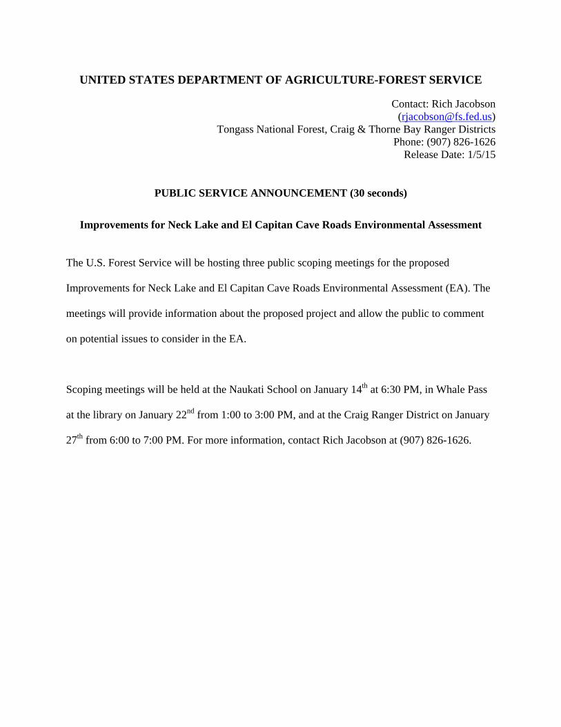
UNITED STATES DEPARTMENT OF AGRICULTURE-FOREST SERVICE
Contact: Rich Jacobson ([email protected])
Tongass National Forest, Craig & Thorne Bay Ranger Districts Phone: (907) 826-1626
Release Date: 1/5/15
PUBLIC SERVICE ANNOUNCEMENT (30 seconds)
Improvements for Neck Lake and El Capitan Cave Roads Environmental Assessment
The U.S. Forest Service will be hosting three public scoping meetings for the proposed
Improvements for Neck Lake and El Capitan Cave Roads Environmental Assessment (EA). The
meetings will provide information about the proposed project and allow the public to comment
on potential issues to consider in the EA.
Scoping meetings will be held at the Naukati School on January 14th at 6:30 PM, in Whale Pass
at the library on January 22nd from 1:00 to 3:00 PM, and at the Craig Ranger District on January
27th from 6:00 to 7:00 PM. For more information, contact Rich Jacobson at (907) 826-1626.
1
Jamie C. M. Young
To: Jamie C. M. YoungSubject: RE: PSA for USFS scoping meetings regarding a project on North POW Island
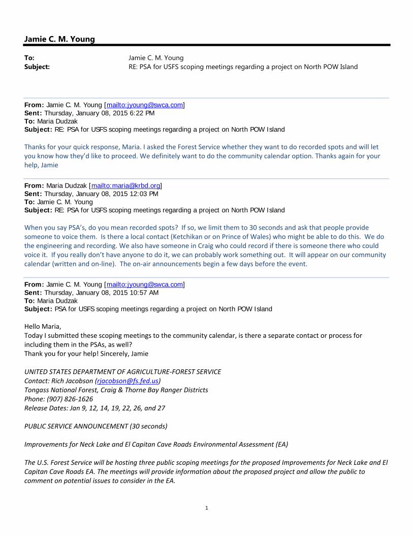
From: Jamie C. M. Young [mailto:[email protected]] Sent: Thursday, January 08, 2015 6:22 PM To: Maria Dudzak Subject: RE: PSA for USFS scoping meetings regarding a project on North POW Island Thanks for your quick response, Maria. I asked the Forest Service whether they want to do recorded spots and will let you know how they’d like to proceed. We definitely want to do the community calendar option. Thanks again for your help, Jamie
From: Maria Dudzak [mailto:[email protected]] Sent: Thursday, January 08, 2015 12:03 PM To: Jamie C. M. Young Subject: RE: PSA for USFS scoping meetings regarding a project on North POW Island When you say PSA’s, do you mean recorded spots? If so, we limit them to 30 seconds and ask that people provide someone to voice them. Is there a local contact (Ketchikan or on Prince of Wales) who might be able to do this. We do the engineering and recording. We also have someone in Craig who could record if there is someone there who could voice it. If you really don’t have anyone to do it, we can probably work something out. It will appear on our community calendar (written and on‐line). The on‐air announcements begin a few days before the event.
From: Jamie C. M. Young [mailto:[email protected]] Sent: Thursday, January 08, 2015 10:57 AM To: Maria Dudzak Subject: PSA for USFS scoping meetings regarding a project on North POW Island Hello Maria, Today I submitted these scoping meetings to the community calendar, is there a separate contact or process for including them in the PSAs, as well? Thank you for your help! Sincerely, Jamie UNITED STATES DEPARTMENT OF AGRICULTURE‐FOREST SERVICE Contact: Rich Jacobson ([email protected]) Tongass National Forest, Craig & Thorne Bay Ranger Districts Phone: (907) 826‐1626 Release Dates: Jan 9, 12, 14, 19, 22, 26, and 27 PUBLIC SERVICE ANNOUNCEMENT (30 seconds) Improvements for Neck Lake and El Capitan Cave Roads Environmental Assessment (EA) The U.S. Forest Service will be hosting three public scoping meetings for the proposed Improvements for Neck Lake and El Capitan Cave Roads EA. The meetings will provide information about the proposed project and allow the public to comment on potential issues to consider in the EA.
2
Scoping meetings will be held at the Naukati School on January 14th at 6:30 PM, in Whale Pass at the library on January 22nd from 1:00 to 3:00 PM, and at the Craig Ranger District on January 27th from 6:00 to 7:00 PM. For more information, contact Rich Jacobson at (907) 826‐1626. Jamie C. M. Young Project Manager / Natural Resources Specialist SWCA Environmental Consultants 4435 E. Canvasback Ave. Post Falls, ID 83854 P 208.262.9323 | C 907.821.0404 | F 907.279.7922
Visit Our Website: http://www.swca.com Please consider the environment before printing this email
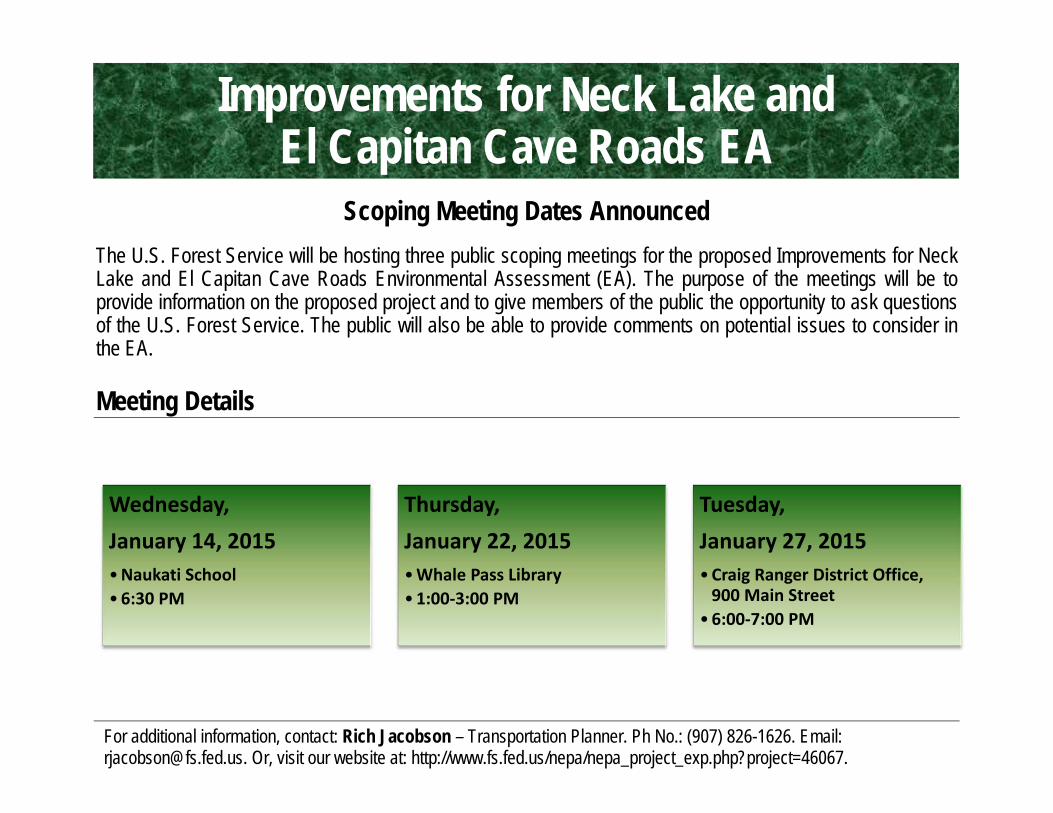
Scoping Meeting Dates Announced
The U.S. Forest Service will be hosting three public scoping meetings for the proposed Improvements for Neck Lake and El Capitan Cave Roads Environmental Assessment (EA). The purpose of the meetings will be to provide information on the proposed project and to give members of the public the opportunity to ask questions of the U.S. Forest Service. The public will also be able to provide comments on potential issues to consider in the EA.
Meeting Details
For additional information, contact: Rich Jacobson – Transportation Planner. Ph No.: (907) 826-1626. Email: [email protected]. Or, visit our website at: http://www.fs.fed.us/nepa/nepa_project_exp.php?project=46067.
Wednesday,January 14, 2015•Naukati School •6:30 PM
Thursday,January 22, 2015•Whale Pass Library•1:00‐3:00 PM
Tuesday,January 27, 2015•Craig Ranger District Office, 900 Main Street
•6:00‐7:00 PM
Improvements for Neck Lake and El Capitan Cave Roads EA
Improvements for Neck Lake and El Capitan Cave Roads EA Scoping and Issues Report
B-1
Appendix B: Scoping Document
United States Department of Agriculture
Forest Service
Alaska Region Tongass National Forest Thorne Bay Ranger District
P.O. Box 19001 Thorne Bay, AK 99919-0001 Phone: (907) 828-3304 Fax: (907) 828-3309
Caring for the Land and Serving People Printed on Recycled Paper
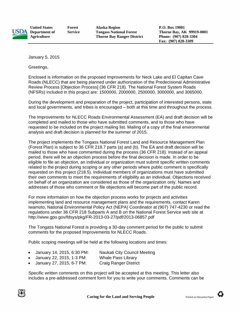
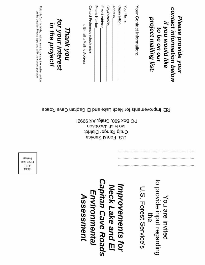
January 5, 2015 Greetings, Enclosed is information on the proposed Improvements for Neck Lake and El Capitan Cave Roads (NLECC) that are being planned under authorization of the Predecisional Administrative Review Process [Objection Process] (36 CFR 218). The National Forest System Roads (NFSRs) included in this project are: 1500000, 2000000, 2500000, 3000000, and 3065000. During the development and preparation of the project, participation of interested persons, state and local governments, and tribes is encouraged – both at this time and throughout the process. The Improvements for NLECC Roads Environmental Assessment (EA) and draft decision will be completed and mailed to those who have submitted comments, and to those who have requested to be included on the project mailing list. Mailing of a copy of the final environmental analysis and draft decision is planned for the summer of 2015. The project implements the Tongass National Forest Land and Resource Management Plan (Forest Plan) is subject to 36 CFR 218.7 parts (a) and (b). The EA and draft decision will be mailed to those who have commented during the process (36 CFR 218). Instead of an appeal period, there will be an objection process before the final decision is made. In order to be eligible to file an objection, an individual or organization must submit specific written comments related to the project during scoping or any other periods where public comment is specifically requested on this project (218.5). Individual members of organizations must have submitted their own comments to meet the requirements of eligibility as an individual. Objections received on behalf of an organization are considered as those of the organization only. Names and addresses of those who comment or file objections will become part of the public record. For more information on how the objection process works for projects and activities implementing land and resource management plans and the requirements, contact Karen Iwamoto, National Environmental Policy Act (NEPA) Coordinator at (907) 747-4230 or read the regulations under 36 CFR 218 Subparts A and B on the National Forest Service web site at http://www.gpo.gov/fdsys/pkg/FR-2013-03-27/pdf/2013-06857.pdf The Tongass National Forest is providing a 30-day comment period for the public to submit comments for the proposed Improvements for NLECC Roads. Public scoping meetings will be held at the following locations and times: January 14, 2015, 6:30 PM: Naukati City Council Meeting January 22, 2015, 1-3 PM: Whale Pass Library January 27, 2015, 6-7 PM: Craig Ranger District
Specific written comments on this project will be accepted at this meeting. This letter also includes a pre-addressed comment form for you to write your comments. Comments can be
Improvements for Neck Lake and El Capitan Cave Roads
Scoping Document: Page 1 of 5
Decisions to be Made Based on the environmental analysis in this EA, the District Ranger will decide whether to authorize construction, reconstruction, realignment, or other improvements to road conditions on the roads heading east and north from the Neck Lake junction, and if so, how the improvements will be implemented. Decisions will be made in accordance with Forest Plan goals, objectives, and desired future conditions. The decisions will include:
The location, design, and scheduling of road construction activities. Mitigation measures and monitoring requirements, including avoiding significant
restriction to subsistence uses. Project Purpose and Need The purpose and need of the proposed Improvements for Neck Lake El Capitan Cave (NLECC) Roads project is to: 1) support current and future transportation systems, principally the Southeast Alaska Transportation Plan (SATP); 2) improve the physical and operational features of the existing road; 3) support planned economic development with efficient access to North Prince of Wales Island (NPOW); 4) improve access to recreational and subsistence activities; and 5) provide a reliable link from NPOW to the rest of Prince of Wales Island. The project is consistent with the following goals and objectives of the 2008 Tongass National Forest Land and Resource Management Plan (Forest Plan):
1. Provide access to and through the National Forest for all users (2008 Forest Plan:2-8). 2. Develop and manage roads and utility systems to support resource management
activities; recognize the potential for future development of major Transportation and Utility Systems (TUSs) (2008 Forest Plan:2-8).
3. Manage and maintain roads to protect natural and cultural resources (2008 Forest Plan:2-8).
4. Provide a diversity of opportunities for resource uses that contribute to the local and regional economies of Southeast Alaska (2008 Forest Plan:2-5).
5. Provide a range of recreation opportunities consistent with public demand, emphasizing locally popular recreation places and those important to the tourism industry (2008 Forest Plan:2-6).
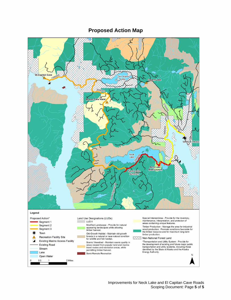
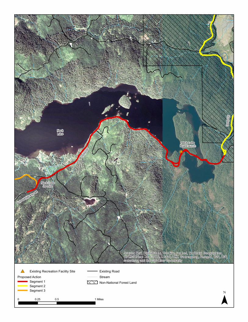
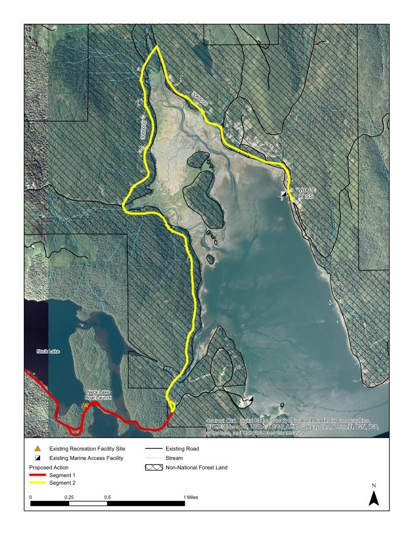
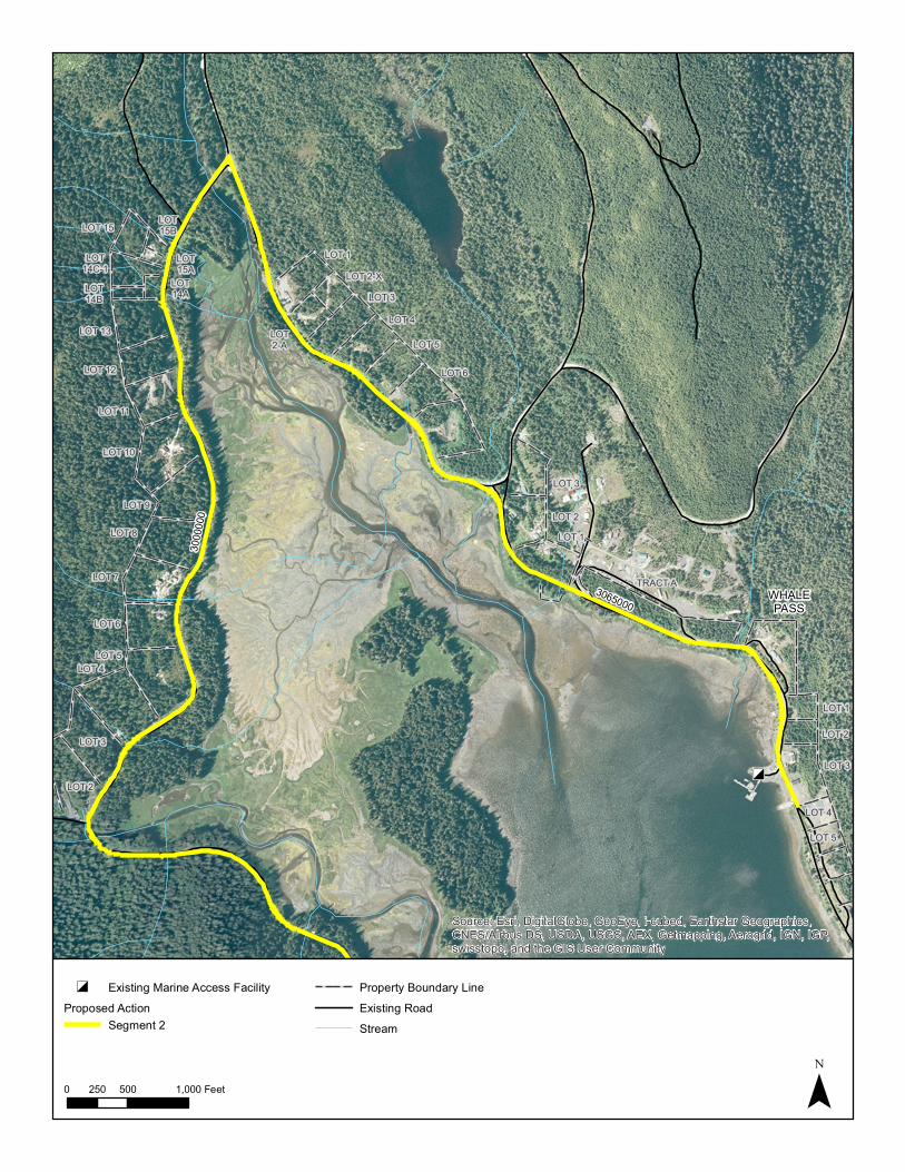
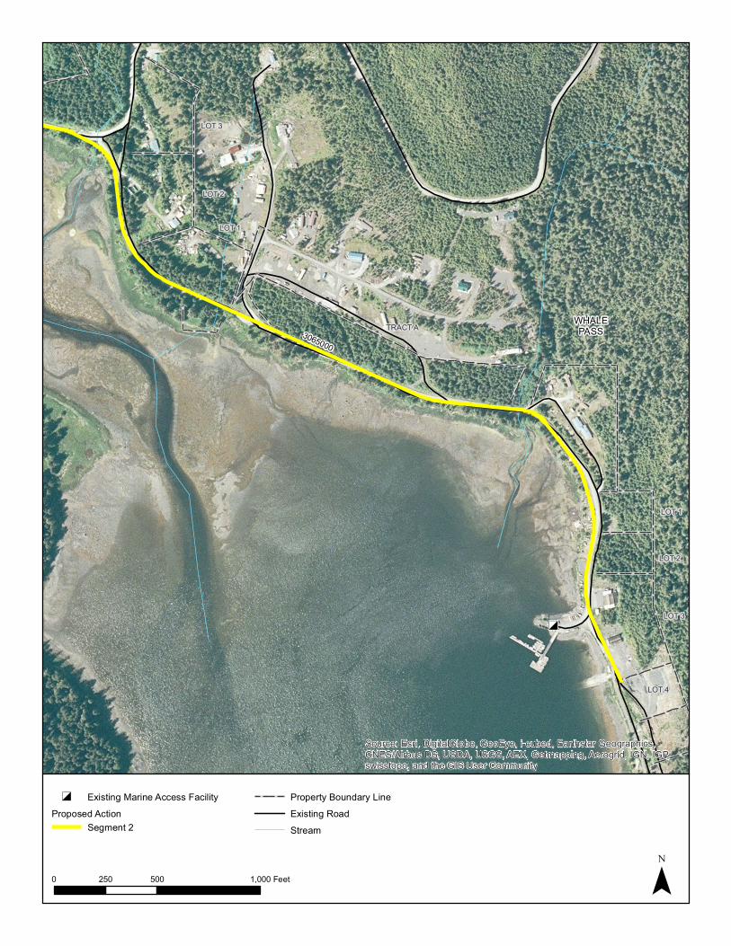
Proposed Action The proposed road improvements project will be divided into three segments (refer to the Proposed Action Map). Segment 1 starts at the Neck Lake junction and goes east along National Forest System Road (NFSR) 2500000 to its intersection with NFSR 3000000 south of the Neck Lake outlet. Segment 2 proceeds north along NFSR 3000000 around Whale Passage and then south to the community of Whale Pass along NFSR 3065000. The eastern terminus is the Whale Pass boat launch (located 375 feet past the access road to the seaplane base). The western segment, Segment 3, also starts at the Neck Lake junction and proceeds north and then west to the El Capitan Cave parking lot. The NFSRs included in Segment 3 from the Neck Lake junction heading west and then north are: 2000000 and 1500000, respectively. Features common to all segments are discussed below. The proposed action would meet the project purpose and need by improving roads that are part of the existing and future Prince of Wales Island transportation system, as planned in the Southeast Alaska Transportation Plan. The existing road segments between Whale Pass and El Capitan Cave were built as single-lane logging roads. The proposed project would be designed to bring the road up to American Association of State Highway and Transportation Officials (AASHTO) design standards. Depending on the specific portion of the roads, some would be to 25-mph design standards, while others will be to 30-mph. The proposed improvements would
Improvements for Neck Lake and El Capitan Cave Roads
Scoping Document: Page 2 of 5
allow vehicles to pass safely in two directions, either by constructing inter-visible turnouts or by widening the roads to two lanes. The additional lane width would accommodate a range of vehicles and drivers that are not familiar with safe driving practices for single-lane roads. Also higher design speeds would allow for more efficient travel and increased economic development potential in Whale Pass and pullouts and recreational enhancements would allow for improved recreational and subsistence access. The proposed action would meet the project purpose and need while limiting environmental impacts. Maintenance of the road would shift from the Forest Service to the Alaska Department of Transportation and Public Facilities (DOT&PF). Maintenance costs and efforts would decrease substantially both in the short term and long term after the proposed improvements. One of the purposes of the proposed action is to reduce maintenance costs for these roads, and there are several components of the proposed project that would reduce the maintenance costs and effort. A paved surface would require less frequent maintenance because the new surface would be more durable than the existing surface. Installing appropriately sized stream crossing structures would better protect the stability of the shoulders while reducing the need for future costly maintenance. Consistent road width and designated travel lanes would concentrate the vehicle load farther from the road edges, which protects the road edges and reduces the need for surface and shoulder maintenance. The proposed roads would be a uniform roadway of up to two 11-foot lanes and two 3-foot shoulders. Some of the roadway may be single lane only with inter-visible turnouts. The improvements will be a full AASHTO-compliant reconstruction for a 25 to 30-mph design speed. These improvements would address the inconsistent road width, lack of shoulders, and the substandard driving surface. The redesign would involve grade reductions, changes to curve radii, drainage improvement, pavement marking, and the addition of signage and guardrails. The majority of the road would be reconstructed within the existing corridor to reduce environmental impacts and minimize construction costs. To manage project costs, the engineering design would strive to balance cut-and-fills along every mile of the project. Blasting may occur along the entire length of the corridor to accommodate these cut-and-fill balances, as well as to further develop rock sources at existing rock pits. Waste material would be disposed of offsite in upland areas suitable for filling, for example existing rock pits. Slash would be available for residents to use as firewood or burned. The project would maintain natural drainage patterns and fish crossings. The existing undersized stream and drainage crossings structures would be replaced and additional drainage culverts would be added. The structures would be designed to accommodate the appropriate design storm, as follows: bridges would be designed to accommodate the 50-year flood flow; all other drainage crossings would be designed to accommodate the 25-year flood flow. Most bridges are anticipated to be single-span structures, although there could be several two span bridges. Crossings designated as resident or anadromous crossings would be designed to meet current design standards for aquatic organism passage. Conducting the proposed action’s improvements would require space to stage equipment, mine and process fill, and store surfacing material and erosion-protection armor, as well as dispose of excess waste soil excavated during construction. Existing open areas would be used for staging areas, and material would be mined and processed at existing sites. Excess materials will be disposed of in existing rock pits along the roadway. Upon completion of construction, these sites would be reclaimed and revegetated on Forest Service-managed lands per Forest Service guidelines and per negotiations with other landowners on private lands.
Improvements for Neck Lake and El Capitan Cave Roads
Scoping Document: Page 3 of 5
The construction timing would be staged over multiple years based on funding availability. The order of the stages is not known at this time because the sources of funding would likely define the portions that would be constructed. Logical portions, or phases, would be included in the construction design. During construction there would be temporary impacts in the form of traffic delays and inconveniences for road users along the roadway. Prior to construction activity, in order to keep traffic moving along the road as efficiently and safely as possible, a temporary traffic control plan would be developed. Traffic control devices, signage, and detour plans would be detailed in this plan. This plan would include public notification plans. Truck traffic along the roadway would increase as construction materials are hauled to and from material source and disposal sites. This impact is expected to be minimal, because a traffic control plan would be developed prior to construction activity that would keep traffic moving through the project area as efficiently and safely as possible. The public would be notified of construction activities that would impact travel along the road.
Improvements for Neck Lake and El Capitan Cave Roads
Scoping Document: Page 4 of 5
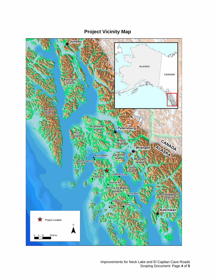
Project Vicinity Map
Improvements for Neck Lake and El Capitan Cave Roads
Scoping Document: Page 5 of 5
Proposed Action Map
P
lease pro
vide yo
ur
con
tact info
rmatio
n b
elow
if yo
u w
ou
ld like
to b
e on
ou
r p
roject m
ailing
list: Y
our Contact Inform
ation: Y
our Nam
e_______________________________
Organization______________________________
Address__________________________________
City/S
tate/Zip______________________________
E-m
ail Address_____________________________
Phone N
umber_____________________________
Contact P
reference (check one):
□ E-m
ail □ Mailing A
ddress
Th
ank yo
u
for yo
ur in
terest in
the p
roject!
Fold this form in thirds, m
aking sure to display the mailer portion
on the outside. Please tape and affix the correct postage.
....................................................................
....................................................................
....................................................................
U.S. Forest Service Craig Ranger District c/o Rich Jacobson
PO Box 500, Craig, AK 99921
RE: Improvements for Neck Lake and El Capitan Cave Roads
Y
ou are invited to provide input regarding
the U
.S. Forest S
ervice's
Imp
rovem
ents fo
r N
eck Lake an
d E
l C
apitan
Cave R
oad
s E
nviro
nm
ental
Assessm
ent
Please Affix
First Class Postage
TONGASS NATIONAL FOREST
Thorne Bay Ranger District
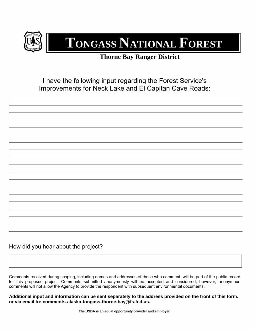
I have the following input regarding the Forest Service's Improvements for Neck Lake and El Capitan Cave Roads:
How did you hear about the project?
Comments received during scoping, including names and addresses of those who comment, will be part of the public record for this proposed project. Comments submitted anonymously will be accepted and considered; however, anonymous comments will not allow the Agency to provide the respondent with subsequent environmental documents.
Additional input and information can be sent separately to the address provided on the front of this form. or via email to: [email protected].
The USDA is an equal opportunity provider and employer.
Improvements for Neck Lake and El Capitan Cave Roads EA Scoping and Issues Report
C-1
Appendix C: Tribal Consultation
Improvements for Neck Lake and El Capitan Cave Roads EA Scoping and Issues Report
D-1
Appendix D: Scoping Meeting Maps
#*
250000
0
3000
000
Forest Highway 44
NeckLake
Neck LakeBoat Launch
Neck LakeJunction
Source: Esri, DigitalGlobe, GeoEye, i-cubed, Earthstar Geographics,CNES/Airbus DS, USDA, USGS, AEX, Getmapping, Aerogrid, IGN, IGP,swisstopo, and the GIS User Community
0 0.5 10.25 Miles ¯
#* Existing Recreation Facility SiteProposed Action
Segment 1Segment 2Segment 3
Existing RoadStreamNon-National Forest Land
Úð
Úð
#*
3000
000
3065000
Neck Lake
Neck LakeBoat Launch
WHALEPASS
Source: Esri, DigitalGlobe, GeoEye, i-cubed, Earthstar Geographics,CNES/Airbus DS, USDA, USGS, AEX, Getmapping, Aerogrid, IGN, IGP,swisstopo, and the GIS User Community
0 0.5 10.25 Miles ¯
#* Existing Recreation Facility SiteÚð Existing Marine Access Facility
Proposed ActionSegment 1Segment 2
Existing RoadStreamNon-National Forest Land
Úð
3065000WHALEPASS
3000
000
LOT 1LOT 2
LOT 3
LOT 6
LOT 5
LOT 4LOT 3
LOT 1
LOT 5
LOT 1
LOT 2
LOT 3
LOT 4
LOT 4LOT 5
LOT 6
LOT 7
LOT 8
LOT 9
LOT 10
LOT 11
LOT 12
LOT 13
LOT 15
LOT15A
LOT14ALOT
14B
LOT 2-X
LOT2-A
TRACT A
LOT14C-1
LOT15B
LOT 3
LOT 2
Source: Esri, DigitalGlobe, GeoEye, i-cubed, Earthstar Geographics,CNES/Airbus DS, USDA, USGS, AEX, Getmapping, Aerogrid, IGN, IGP,swisstopo, and the GIS User Community
0 500 1,000250 Feet ¯
Úð Existing Marine Access FacilityProposed Action
Segment 2
Property Boundary LineExisting RoadStream
Úð
WHALEPASS3065000
TRACT A
LOT 4
LOT 3
LOT 2
LOT 1
LOT 3
LOT 2
LOT 1
Source: Esri, DigitalGlobe, GeoEye, i-cubed, Earthstar Geographics,CNES/Airbus DS, USDA, USGS, AEX, Getmapping, Aerogrid, IGN, IGP,swisstopo, and the GIS User Community
0 500 1,000250 Feet ¯
Úð Existing Marine Access FacilityProposed Action
Segment 2
Property Boundary LineExisting RoadStream
#*Beaver Falls
Karst
2000000
250000
0
Neck LakeJunction
Source: Esri, DigitalGlobe, GeoEye, i-cubed, Earthstar Geographics,CNES/Airbus DS, USDA, USGS, AEX, Getmapping, Aerogrid, IGN, IGP,swisstopo, and the GIS User Community
0 0.5 10.25 Miles ¯
#* Existing Recreation Facility SiteProposed Action
Segment 1Segment 3
Existing RoadStreamNon-National Forest Land
Úð
#*
El CapitanCave
1500000 2000000
Source: Esri, DigitalGlobe, GeoEye, i-cubed, Earthstar Geographics,CNES/Airbus DS, USDA, USGS, AEX, Getmapping, Aerogrid, IGN, IGP,swisstopo, and the GIS User Community
0 0.5 10.25 Miles ¯
#* Existing Recreation Facility SiteÚð Existing Marine Access Facility
Proposed ActionSegment 3
Existing RoadStreamNon-National Forest Land

Improvements for Neck Lake and El Capitan Cave Roads EA Scoping and Issues Report
E-1
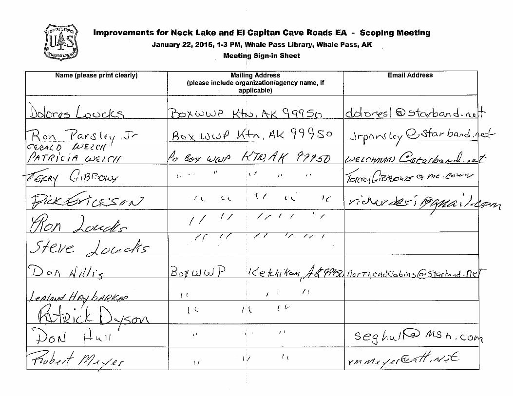
Appendix E: Scoping Meeting Sign-in Sheets and Notes
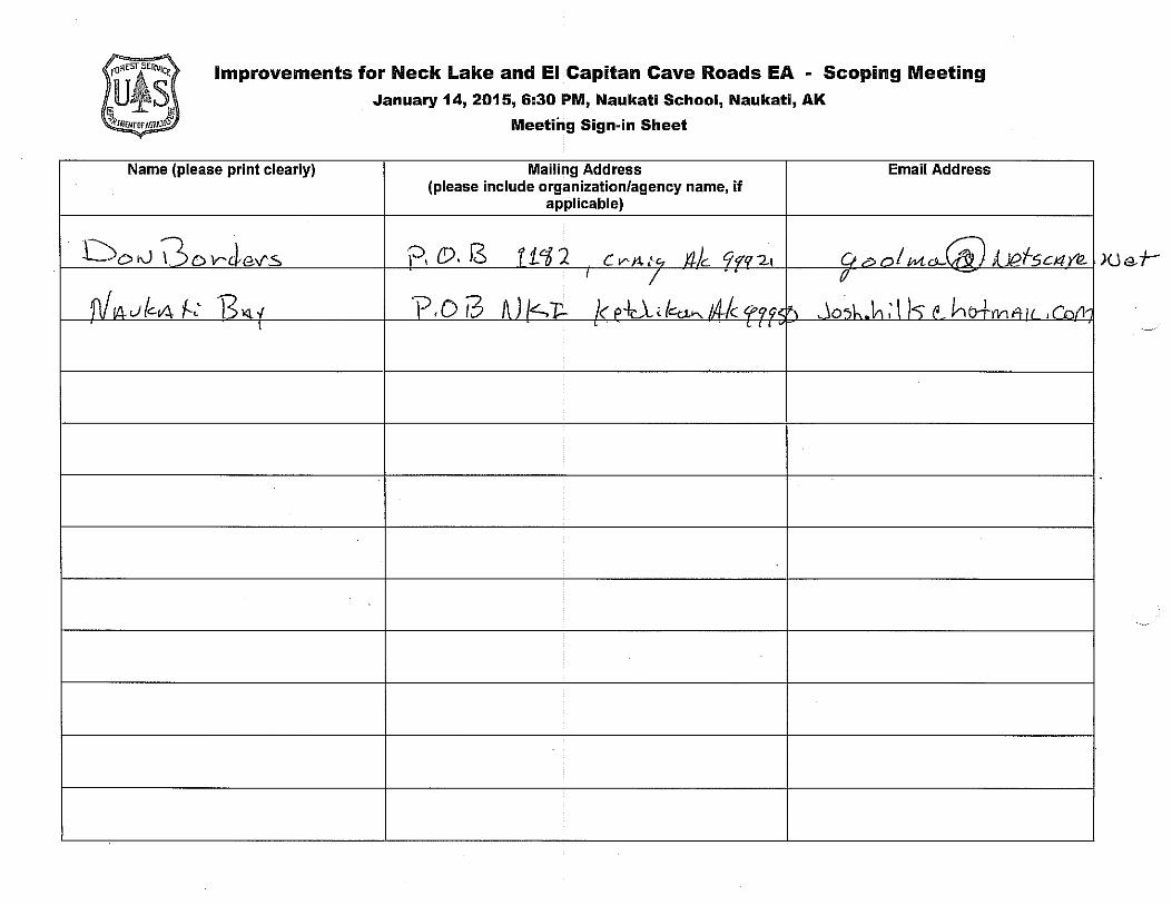
Improvements for Neck Lake and El Capitan Cave Roads EA - Scoping Meeting January 14, 2015, 6:30 PM, Naukati School, Naukati, AK
Meeting Sign-in Sheet
Name (please print clearly) Mailing Address Email Address (please include organization/agency name, if
applicable)
Doi\.J 0ov-rle.v"S ?, {!). l3 f i<i?. c V' J1. {c, 'il/c tf qq 2t r, ~ ,....,/ ,,,, 0-(f;} d 1C>/-sci4Y/2. I I
. (/
f\/ /fJ. J (cv.i, f-,' .R"' " v.oi3 A)/~-c... I< P +.. \ , lct:J......_ 1/JJc - , .; ' lo-.L .\ri; \ )<;" ~ hb+111v"·ll ,,-"',' . \ ' ' ' '
Improvements for Neck Lake – El Capitan Cave Roads EA
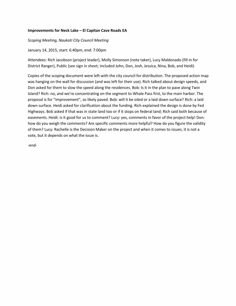
Scoping Meeting, Naukati City Council Meeting
January 14, 2015, start: 6:40pm, end: 7:00pm
Attendees: Rich Jacobson (project leader), Molly Simonson (note taker), Lucy Maldonado (fill in for District Ranger), Public (see sign in sheet; included John, Don, Josh, Jessica, Nina, Bob, and Heidi)
Copies of the scoping document were left with the city council for distribution. The proposed action map was hanging on the wall for discussion (and was left for their use). Rich talked about design speeds, and Don asked for them to slow the speed along the residences. Bob: Is it in the plan to pave along Twin Island? Rich: no, and we’re concentrating on the segment to Whale Pass first, to the main harbor. The proposal is for “improvement”, so likely paved. Bob: will it be oiled or a laid down surface? Rich: a laid down surface. Heidi asked for clarification about the funding. Rich explained the design is done by Fed Highways. Bob asked if that was in state land too or if it stops on federal land; Rich said both because of easements. Heidi: is it good for us to comment? Lucy: yes, comments in favor of the project help! Don: how do you weigh the comments? Are specific comments more helpful? How do you figure the validity of them? Lucy: Rachelle is the Decision Maker on the project and when it comes to issues, it is not a vote, but it depends on what the issue is.
-end-
Improvements for Neck Lake and El Capitan Cave Roads EA - Scoping Meeting
January 22, 2015, 1-3 PM, Whale Pass Library, Whale Pass, AK
Name (please print clearly)
C€.-e4( 0 .tuE( ct(
jJ,11 TR t'c_ l fl CLYC.LC'tf
G 1 F3 P.:ow/ ,.
3
Meeting Sign-in Sheet
Mailing Address (please include organization/agency name, if
applicable)
qC[C(S I
" ' r I 1 r •
i (
(I I/
!"( rr //
wwP I ( e fc lu l(C<hf
I c I ' /1
l (_ I \,__ { [,,
'' I ' I I
II I c f I
Email Address
se3 /,.u._/P fot.s ri. c.o
Y m n-1 ..e /-.!! r@-"'f-11, /1/ ..,-t
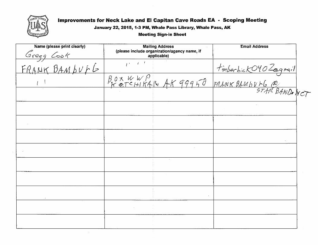
Improvements for Neck Lake and El Capitan Cave Roads EA - Scoping Meeting
January 22, 2015, 1-3 PM, Whale Pass Library, Whale Pass, AK
Meeting Sign-in Sheet
Name (please print clearly) Mailing Address Email Address
C'(eqq 0::,0 r( (please include organization/agency name, if
applicable) ..//
f
~a .A. K.I r< AA-M h t1 r. & I, I
f,,;1'/ bar h i'c. kfJ ~ 0 k_q P.,q / 'I .
f)O/\. 11v wP v
I I A-K eye; q ~---o ff/ l-N I< J9AA1 h V J-.l (5)/ , 1-< &T~ f+l lf"4-l\1 . . 5T,f/!_ B4-AJ(fa' y,
Improvements for Neck Lake – El Capitan Cave Roads EA
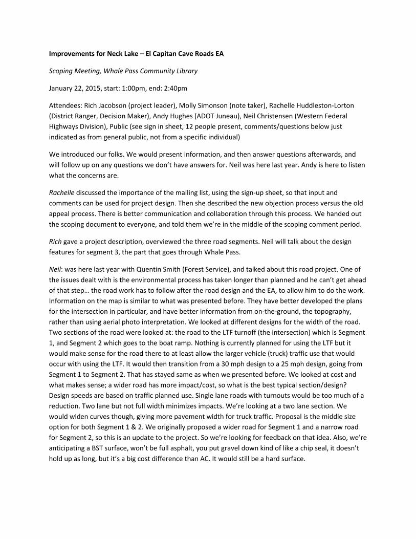
Scoping Meeting, Whale Pass Community Library
January 22, 2015, start: 1:00pm, end: 2:40pm
Attendees: Rich Jacobson (project leader), Molly Simonson (note taker), Rachelle Huddleston-Lorton (District Ranger, Decision Maker), Andy Hughes (ADOT Juneau), Neil Christensen (Western Federal Highways Division), Public (see sign in sheet, 12 people present, comments/questions below just indicated as from general public, not from a specific individual)
We introduced our folks. We would present information, and then answer questions afterwards, and will follow up on any questions we don’t have answers for. Neil was here last year. Andy is here to listen what the concerns are.
Rachelle discussed the importance of the mailing list, using the sign-up sheet, so that input and comments can be used for project design. Then she described the new objection process versus the old appeal process. There is better communication and collaboration through this process. We handed out the scoping document to everyone, and told them we’re in the middle of the scoping comment period.
Rich gave a project description, overviewed the three road segments. Neil will talk about the design features for segment 3, the part that goes through Whale Pass.
Neil: was here last year with Quentin Smith (Forest Service), and talked about this road project. One of the issues dealt with is the environmental process has taken longer than planned and he can’t get ahead of that step… the road work has to follow after the road design and the EA, to allow him to do the work. Information on the map is similar to what was presented before. They have better developed the plans for the intersection in particular, and have better information from on-the-ground, the topography, rather than using aerial photo interpretation. We looked at different designs for the width of the road. Two sections of the road were looked at: the road to the LTF turnoff (the intersection) which is Segment 1, and Segment 2 which goes to the boat ramp. Nothing is currently planned for using the LTF but it would make sense for the road there to at least allow the larger vehicle (truck) traffic use that would occur with using the LTF. It would then transition from a 30 mph design to a 25 mph design, going from Segment 1 to Segment 2. That has stayed same as when we presented before. We looked at cost and what makes sense; a wider road has more impact/cost, so what is the best typical section/design? Design speeds are based on traffic planned use. Single lane roads with turnouts would be too much of a reduction. Two lane but not full width minimizes impacts. We’re looking at a two lane section. We would widen curves though, giving more pavement width for truck traffic. Proposal is the middle size option for both Segment 1 & 2. We originally proposed a wider road for Segment 1 and a narrow road for Segment 2, so this is an update to the project. So we’re looking for feedback on that idea. Also, we’re anticipating a BST surface, won’t be full asphalt, you put gravel down kind of like a chip seal, it doesn’t hold up as long, but it’s a big cost difference than AC. It would still be a hard surface.
Public: Chip seal didn’t work down to Hydaburg, it doesn’t last very long, the chuck holes can’t be fixed, so how do you maintain it long term, with that many miles? Lots of maintenance will be needed if it’s going to stay like that. Neil: The challenge is finding the balance to get the end result that we want and it not be so costly it can’t be done.
Andy: I have asked Neil to look at different paving surfaces and design because funding is getting a lot tighter. We recognize when we do create this road we have to be prepared to maintain it. Two primary goals as a department: provide a paved surface, and a surface that you can plow snow on. We have experience with a BST surface to Hydaburg, and need to be prepared to patch it with asphalt. We have a project to resurface the Hydaburg Road with another chip seal. It is half the cost. We will be strengthening the sub-base to better maintain the surface in the future. It is more maintenance intensive but more economical overall.
Public: where’s the maintenance crew come out of? Coffman Cove? Andy: it’s up to the state.
Andy: Once Neil has the design, the availability of funding will be dependent on how big the federal aid program is for Alaska and in part on whether other projects in their program use the funding. It gets placed on the shelf as a contingency project.
Public: You might as well go with pavement then (in regards to needing shelf ready projects so Alaska doesn’t lose funding if it can’t obligate it to a project).
Public: When would it be built? Andy: We don’t know. The environmental process will hopefully be concluded by the end of this year then Neil will take over the design effort, completed maybe August of 2016, to then be in the queue to take advantage of whenever funding does become available, which may take years, as it does take congress to make it happen.
Public: Will they build the road to El Cap first before the community road? Andy: no, this is dependent on the state’s priorities and the priority is to improve access to communities. The current road project is pretty much done for now. Other projects will be up for bid later this year here on the island in the meantime.
Public: We prefer pavement, but if we get the chip seal, will you plow it just the same and do snow removal? Andy: Yes, it’s the same as with asphalt. We’re tired of repairing sections of road at a time, so now we’re getting to redo the entire Hydaburg Road at a lower cost by selecting BST. Hydaburg also prefers pavement.
Public: What is the difference in cost? Andy: double.
Public: When it snows, who’s plowing the paved part that was already completed? Andy: The state does not have the easement yet to maintain the road, and we need the easement to spend the money/resources. It won’t happen until the Forest Service signs that over. Rachelle: The state doesn’t want the full easement until the project is complete, right? Andy: No, we’d take the segments as they’re ready. We had an easement issue on the Hydaburg road too for the Forest Service to release their segment even though it had already been maintained for years. Rachelle: I will follow up. The lands
team is buried currently though because of the Sealaska land selection. Andy: There is an ongoing easement discussion at the regional level; it’s already a hot topic. Rachelle: We’ll rattle the cages over this at that higher level.
Neil: We’ll roughly follow the road that’s out there today, with smoother curves. We’re checking the structural adequacy of the bridges that are out there. Some from the Forest Service are newer and fine. If they are adequate but not two lanes, why not keep it in to save some money. The just need adequate sight distance in order to see who has the right of way. There are six bridges total; three are wide enough, and three are essentially single lane (16 ft counts as single). We have to look at them through this process, in terms of earthquake capacity, guardrails, and so on.
Public: is it possible to widen those? Neil: You would essentially have to build a new bridge. The road could be closed to do some of the construction. Some sections along the lake would have to be closed because of how narrow it is; it’s just too tight. Public: how long? Neil: If for bridge replacement, it could be the summer season. If it’s just construction could be just a couple days. Public: It’s painful but it will help speed things up. Neil: Equipment in the road and blasting is going to close it down. Rachelle: That’s quite an impact, can we have an option like one day a week they can travel through? Just consider that. Public: It’s actually not terrible to detour; the potholes even out the time. What about for the El Cap section? Would they detour people to Whale Pass? It would be nice if we had a good road for that when it happens. Neil: Yeah, possibly, but the El Cap section is even further out time wise than the Whale Pass portion.
Public: By the boat launch on Neck Lake what are you going to do with the large culverts? Neil: We would replace them with larger culverts, and raise the grade. We have to raise the grade over most of that piece, use appropriate sized culverts so it doesn’t back up. Use enough large pipe and it’ll flow. Public: not so sure about that! Need the water to drain through easier. Neil: We have thought about a bridge there but we think that we’ll get the hydrologic capacity with large pipes based on the design.
Neil: We’re at roughly 15% design, and this summer would be advanced design. We’ll have a geotechnical crew come out this summer, do some drilling, look at the bridges, soil, and rock. There will only be temporary delays moving around them. After the EA they’ll be ready to move into final design.
Public: If you widen the road, where will it widen? Along the beach or along the property owners side? Neil: Hillside property or state water… that’s a challenge to answer now. We can make it work with what’s available now. Driveways won’t be any worse than they are right now. Public: Is the current extent of the poles the farthest extent of the road and ditches? Neil: We’ll need to move some power/telephone poles. Public: It’s a 60 ft easement, how much do they need? Neil: We’ll keep within that easement. Some have 100 ft, and some have 66 ft easement (after the Exchange Cove turnoff). The goal is absolutely to stay within that right of way. It is possible that we’ll need some new easements, not sure where that may be, but we have a good chance of staying within those rights of way.
Public: Last time here we talked about ATVs along the road… when the state takes over the road, will no ATVs be allowed? Neil: Right, they’re not allowed now even as a FS road. Rachelle gave clarifications on
what vehicle use is allowed on road types. Andy: State Troopers are charged with enforcing that. Whether you get cited is really based on how frequently they are in the area.
Public: When you come around the lake, we request that you guardrail the lake shore. Neil: We’re not looking at guardrail everywhere; that is based partially on accident history.
Public: Access for loading feed is needed. Neil: We can accommodate the needs for feed, we’ll work with hatchery on that.
Public: So the road being so close to water is ok? Neil: Yes, the road is fine where it is, needs to be cut into the rock some though. Andy: One suggestion was to raise it a few feet away from the water. Neil: Good grade ditches would buffer against rain water going right into the stream/lake; natural ditch processes would help filter it before reaching that water.
Public: The environmentalists are ok with this, like the environmental councils and such? Andy: Yeah, no chatter about this right now.
Neil: What’s the hatchery think? Public: It’s good for the hatchery; we’re not worried about runoff and tar and such. We can also take the boat from the boat launch if needed.
Public: Will the boat launch be improved too? Neil: The funds would only be for the road project but the Forest Service could fund other projects like improving the boat launch if you find other money. Rachelle: Would this project be available for FLAP money? Andy: It has FLAP money in it. Neil: You could apply for more FLAP money too. Rachelle: Sarkar is an example of a project paid for with FLAP dollars. The community members could come up with some of those ideas too, and work collaboratively with the community and Forest Service to apply for the grants for projects. Other unfamiliar faces will be in this neck of the woods this summer, dealing with cultural resources and such.
Public: What kind of comments are you looking for? Rachelle: Positive comments are great, if you know of any resource concerns, concerns about impacts to private property or access… we’re looking for any of those. Rich: Mention the dates? Rachelle: Told what the scoping period dates for getting comments in are. The draft EA/DN will be done on Aug 10P
thP… or roughly the middle of August. That starts the clock on
the comment period, and a decision document will trigger the objection process later in the year.
Public: I heard they’re going to raise the gas tax to improve infrastructure? What happens to the gas tax now? There is not enough money!
Rich: Did the email work? Did the scoping document get to people? A few raised hands, yes it worked, got by email. We left scoping documents here at the library.
Public: It’s posted to the community website too.
Public: Can you check on the snow plow issue? Rachelle: I will rattle the cages. We looked into it last year. There was a document giving Whale Pass Community permission to plow the road, until the Forest Service doesn’t have jurisdiction anymore or it’s rescinded. Andy: If it snows, and community is not

plowing, call the maintenance foreman in Klawock to see if he can handle plowing the pavement up here; it may not be a problem. Rachelle: Both contracts included a provision for these roads to be passable in the winter.
-end-
Improvements for Neck lake and El Capitan Cave Roads EA - Scoping Meeting January 27, 2015, POWCAC, Hydaburgh, AK
Name (please print clearly)
Meeting Sign-in Sheet
Mailing Address (please include organization/agency name, if
applicable)
Email Address
~:::Cll.i.i'.1.L___:::ld:;:._m:;kffi'.J_J_CtJ___j~~~x~ff)~\~JLli1~~-qig~oLJ~~52-___µ~llL~Lirnllel'1~'J1fll{,~,. tJYJ1
L_~a~~~n~fi~ifi~e~/~~~l--~~f&ox'~~;~qs,~z~~~c__,,21~l:i~.ru~~1J~~1~~~111___jj~~t:__~~~~~.YL.d-fh Ji'- -/i; 00'0- Po,' !J - & 199
'/J \ ,
~·I{. co . 6~~4k3 2 1 l(7L \:i'"'rs AK 59 '7 z z
/J 1.. 9 ... r, " _;.er r - ' _
' ' If\
Improvements for Neck lake and El Capitan Cave Roads EA - Scoping Meeting
January 27, 2015, POWCAC, Hydaburgh, AK
Meeting Sign-in Sheet
Name (please print clearly) Mailing Address Email Address (please include organization/agency name, if
applicable)
' Q,(!!l,to (Y) 1 c... /iu.50-;:, .P. ti' ~.[ d-o'1 Ci.A:t<.o A-le_ r?.f" =, (\) 1£) q_l0¥a_(.CJcoV~. c~~
' ( I '
Improvements for Neck Lake and El Capitan Cave Roads EA - Scoping Meeting
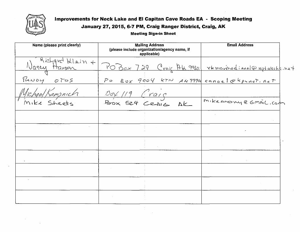
January 27, 2015, 6-7 PM, Craig Ranger District, Craig, AK
Meeting Sign-in Sheet
Name (please print clearly) Mailing Address Email Address (please include organization/agency name, if
applicable)
"·J . \\ ;ci,~J \1_ I __\L~ V\ + VO~cx 7 )q C ... c,•r \+ v.. 9'lq.,.('l I \, Q V\ tLlJ\ \fl SCV'-.._ Y.k Yncwi'v-~ J; .iwJLl 0 140-l- <l.IQs k ~ D '
~A.JD '-1 01°5 Po IS l'.lY Cjoo </ tcrN A I< 77'1o c 0, "' " <!. 1 <E' Le p '1 VI -e. I . fl -e -r--
Mcke?/ J:ar>tJ111cA /)cry! /11 (' rcr r. <' (! / I
' J fY1 ' k -e. "' ND v""-1 @ G fYl A.I.... ' Co ,, (Y\ I k:-L s h..z...-e..,-\: ~ ·l=b-ucx;. Sz,4- Ce-A1b- Afc.__
~·
'>
Improvements for Neck Lake – El Capitan Cave Roads EA
Scoping Meeting, Craig Ranger District Conference Room
January 27, 2015, start: 6:00pm, end: 6:45pm
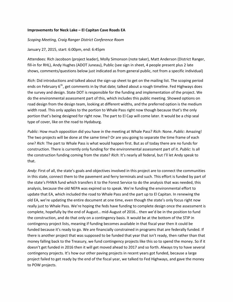
Attendees: Rich Jacobson (project leader), Molly Simonson (note taker), Matt Anderson (District Ranger, fill-in for RHL), Andy Hughes (ADOT Juneau), Public (see sign in sheet, 4 people present plus 2 late shows, comments/questions below just indicated as from general public, not from a specific individual)
Rich: Did introductions and talked about the sign-up sheet to get on the mailing list. The scoping period ends on February 6P
thP, get comments in by that date; talked about a rough timeline. Fed Highways does
the survey and design. State DOT is responsible for the funding and implementation of the project. We do the environmental assessment part of this, which includes this public meeting. Showed options on road design from the design team, looking at different widths, and the preferred option is the medium width road. This only applies to the portion to Whale Pass right now though because that’s the only portion that’s being designed for right now. The part to El Cap will come later. It would be a chip seal type of cover, like on the road to Hydaburg.
Public: How much opposition did you have in the meeting at Whale Pass? Rich: None. Public: Amazing! The two projects will be done at the same time? Or are you going to separate the time frame of each one? Rich: The part to Whale Pass is what would happen first. But as of today there are no funds for construction. There is currently only funding for the environmental assessment part of it. Public: Is all the construction funding coming from the state? Rich: It’s nearly all federal, but I’ll let Andy speak to that.
Andy: First of all, the state’s goals and objectives involved in this project are to connect the communities in this state, connect them to the pavement and ferry terminals and such. This effort is funded by part of the state’s FHWA fund which transfers it to the Forest Service to do the analysis that was needed, this analysis, because the old NEPA was expired so to speak. We’re funding the environmental effort to update that EA, which included the road to Whale Pass and the part up to El Capitan. In renewing the old EA, we’re updating the entire document at one time, even though the state’s only focus right now really just to Whale Pass. We’re hoping the feds have funding to complete design once the assessment is complete, hopefully by the end of August… mid-August of 2016… then we’d be in the position to fund the construction, and do that only on a contingency basis. It would be at the bottom of the STIP in contingency project lists, meaning if funding becomes available in that fiscal year then it could be funded because it’s ready to go. We are financially constrained in programs that are federally funded. If there is another project that was supposed to be funded that year that isn’t ready, then rather than that money falling back to the Treasury, we fund contingency projects like this so to spend the money. So if it doesn’t get funded in 2016 then it will get moved ahead to 2017 and so forth. Always try to have several contingency projects. It’s how our other paving projects in recent years got funded, because a large project failed to get ready by the end of the fiscal year, we talked to Fed Highways, and gave the money to POW projects.
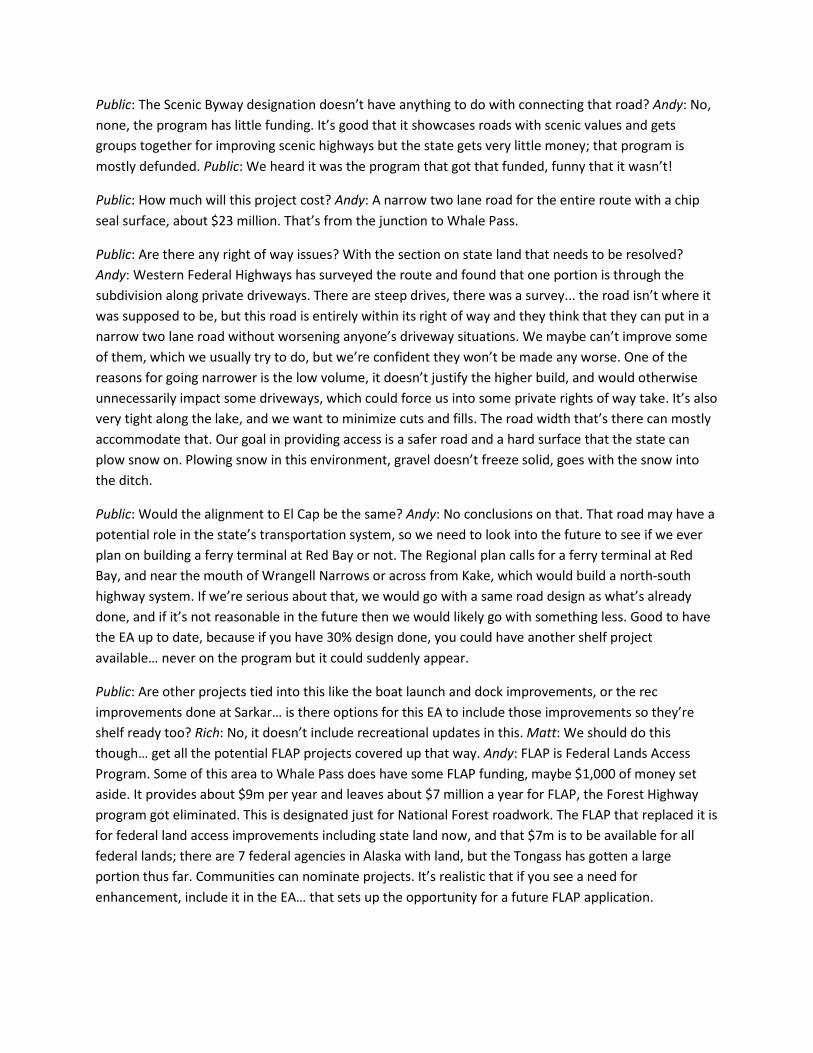
Public: The Scenic Byway designation doesn’t have anything to do with connecting that road? Andy: No, none, the program has little funding. It’s good that it showcases roads with scenic values and gets groups together for improving scenic highways but the state gets very little money; that program is mostly defunded. Public: We heard it was the program that got that funded, funny that it wasn’t!
Public: How much will this project cost? Andy: A narrow two lane road for the entire route with a chip seal surface, about $23 million. That’s from the junction to Whale Pass.
Public: Are there any right of way issues? With the section on state land that needs to be resolved? Andy: Western Federal Highways has surveyed the route and found that one portion is through the subdivision along private driveways. There are steep drives, there was a survey... the road isn’t where it was supposed to be, but this road is entirely within its right of way and they think that they can put in a narrow two lane road without worsening anyone’s driveway situations. We maybe can’t improve some of them, which we usually try to do, but we’re confident they won’t be made any worse. One of the reasons for going narrower is the low volume, it doesn’t justify the higher build, and would otherwise unnecessarily impact some driveways, which could force us into some private rights of way take. It’s also very tight along the lake, and we want to minimize cuts and fills. The road width that’s there can mostly accommodate that. Our goal in providing access is a safer road and a hard surface that the state can plow snow on. Plowing snow in this environment, gravel doesn’t freeze solid, goes with the snow into the ditch.
Public: Would the alignment to El Cap be the same? Andy: No conclusions on that. That road may have a potential role in the state’s transportation system, so we need to look into the future to see if we ever plan on building a ferry terminal at Red Bay or not. The Regional plan calls for a ferry terminal at Red Bay, and near the mouth of Wrangell Narrows or across from Kake, which would build a north-south highway system. If we’re serious about that, we would go with a same road design as what’s already done, and if it’s not reasonable in the future then we would likely go with something less. Good to have the EA up to date, because if you have 30% design done, you could have another shelf project available… never on the program but it could suddenly appear.
Public: Are other projects tied into this like the boat launch and dock improvements, or the rec improvements done at Sarkar… is there options for this EA to include those improvements so they’re shelf ready too? Rich: No, it doesn’t include recreational updates in this. Matt: We should do this though… get all the potential FLAP projects covered up that way. Andy: FLAP is Federal Lands Access Program. Some of this area to Whale Pass does have some FLAP funding, maybe $1,000 of money set aside. It provides about $9m per year and leaves about $7 million a year for FLAP, the Forest Highway program got eliminated. This is designated just for National Forest roadwork. The FLAP that replaced it is for federal land access improvements including state land now, and that $7m is to be available for all federal lands; there are 7 federal agencies in Alaska with land, but the Tongass has gotten a large portion thus far. Communities can nominate projects. It’s realistic that if you see a need for enhancement, include it in the EA… that sets up the opportunity for a future FLAP application.
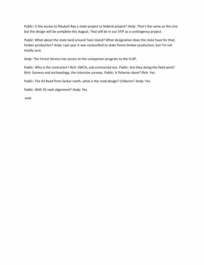
Public: Is the access to Naukati Bay a state project or federal project? Andy: That’s the same as this one but the design will be complete this August. That will be in our STIP as a contingency project.
Public: What about the state land around Twin Island? What designation does the state have for that, timber production? Andy: Last year it was reclassified to state forest timber production, but I’m not totally sure.
Andy: The Forest Service has access to the companion program to the FLAP.
Public: Who is the contractor? Rich: SWCA, sub-contracted out. Public: Are they doing the field work? Rich: Scenery and archaeology, the intensive surveys. Public: Is fisheries done? Rich: Yes.
Public: The 43 Road from Sarkar north, what is the road design? Collector? Andy: Yes.
Public: With 35 mph alignment? Andy: Yes.
-end-

Improvements for Neck Lake and El Capitan Cave Roads EA Scoping and Issues Report
F-1
Appendix F: Scoping Comments
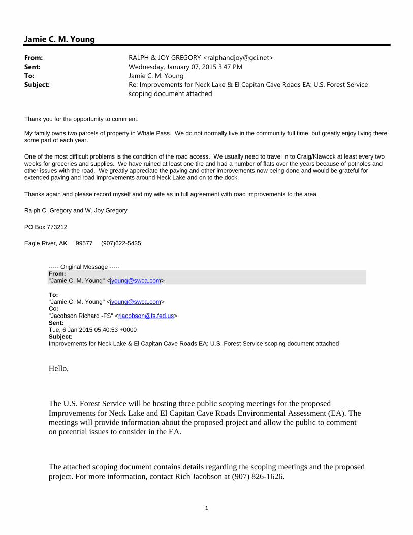
1
Jamie C. M. Young
From: RALPH & JOY GREGORY <[email protected]>Sent: Wednesday, January 07, 2015 3:47 PMTo: Jamie C. M. YoungSubject: Re: Improvements for Neck Lake & El Capitan Cave Roads EA: U.S. Forest Service
scoping document attached
Thank you for the opportunity to comment. My family owns two parcels of property in Whale Pass. We do not normally live in the community full time, but greatly enjoy living there some part of each year.
One of the most difficult problems is the condition of the road access. We usually need to travel in to Craig/Klawock at least every two weeks for groceries and supplies. We have ruined at least one tire and had a number of flats over the years because of potholes and other issues with the road. We greatly appreciate the paving and other improvements now being done and would be grateful for extended paving and road improvements around Neck Lake and on to the dock.
Thanks again and please record myself and my wife as in full agreement with road improvements to the area.
Ralph C. Gregory and W. Joy Gregory
PO Box 773212
Eagle River, AK 99577 (907)622-5435
----- Original Message ----- From: "Jamie C. M. Young" <[email protected]> To: "Jamie C. M. Young" <[email protected]> Cc: "Jacobson Richard -FS" <[email protected]> Sent: Tue, 6 Jan 2015 05:40:53 +0000 Subject: Improvements for Neck Lake & El Capitan Cave Roads EA: U.S. Forest Service scoping document attached
Hello,
The U.S. Forest Service will be hosting three public scoping meetings for the proposed Improvements for Neck Lake and El Capitan Cave Roads Environmental Assessment (EA). The meetings will provide information about the proposed project and allow the public to comment on potential issues to consider in the EA.
The attached scoping document contains details regarding the scoping meetings and the proposed project. For more information, contact Rich Jacobson at (907) 826-1626.

2
Thank you for your time, sincerely, Jamie Young
Jamie C. M. Young Project Manager / Natural Resources Specialist SWCA Environmental Consultants P 208.262.9323 | C 907.821.0404 | F 907.279.7922
WPCA
WHALE PASS COMMUNITY ASSOCIATION PO Box WWP
Ketchikan, Alaska 99950 29 September 2014 Andy Hughes AKDOT&PF 6860 Glacier Hwy Juneau, AK 99801 [email protected]
David Morton US Forest Service PO Box 309 Petersburg, AK 99833 [email protected]
Dear Sirs: The WPCA Board wishes to reaffirm our support for a paved two-lane highway into Whale Pass. Redesigning and paving the existing gravel road will reduce the costs of road and vehicle maintenance, improve highway safety and provide community residents with improved access to the POW road system. As you work through the planning and design process, we would like to request that:
• The road to the community’s second boat launch facility near the FS log dump be included in the road design. In addition to providing improved access to the boat-launching ramp, an improved road will provide better access to residents living south of Neck Lake Creek. As a result of recent land sales more people are moving into the in the area thereby increasing the need for improved road access increased.
• The plans include a parking area across the road from the SARR terminal harvest site with a dedicated space for a restroom facility. This will reduce the number of vehicles parked along the road during the fishing season. The board is working with the Alaska Department of Fish and Game to improve fish access to Neck Lake Creek. The proposed improvements will include stairs from the road down to the Creek and improved restroom facilities to replace the two Port-a-Potties.
Thank you for your consideration.
Sincerely, Robert M Meyer, President Whale Pass Community Association 907-846-5356 [email protected]
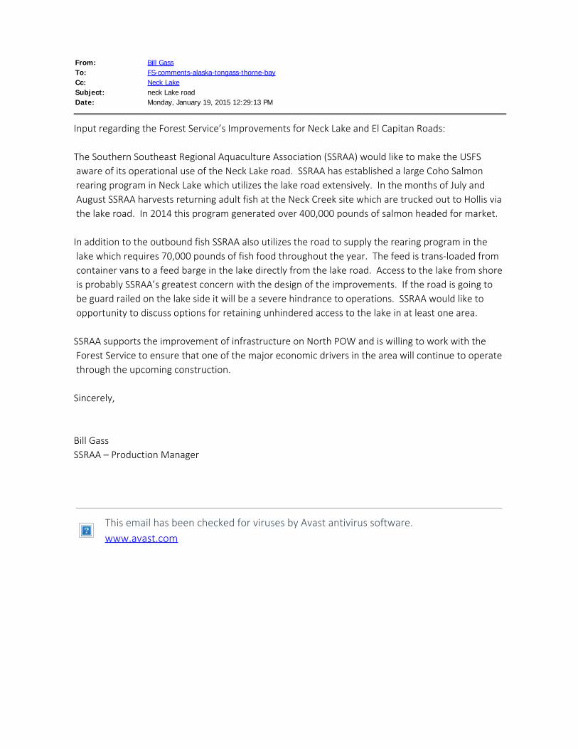
From: Bill GassTo: FS-comments-alaska-tongass-thorne-bayCc: Neck LakeSubject: neck Lake roadDate: Monday, January 19, 2015 12:29:13 PM
Input regarding the Forest Service’s Improvements for Neck Lake and El Capitan Roads: The Southern Southeast Regional Aquaculture Association (SSRAA) would like to make the USFS aware of its operational use of the Neck Lake road. SSRAA has established a large Coho Salmon rearing program in Neck Lake which utilizes the lake road extensively. In the months of July and August SSRAA harvests returning adult fish at the Neck Creek site which are trucked out to Hollis via the lake road. In 2014 this program generated over 400,000 pounds of salmon headed for market. In addition to the outbound fish SSRAA also utilizes the road to supply the rearing program in the lake which requires 70,000 pounds of fish food throughout the year. The feed is trans-loaded from container vans to a feed barge in the lake directly from the lake road. Access to the lake from shore is probably SSRAA’s greatest concern with the design of the improvements. If the road is going to be guard railed on the lake side it will be a severe hindrance to operations. SSRAA would like to opportunity to discuss options for retaining unhindered access to the lake in at least one area. SSRAA supports the improvement of infrastructure on North POW and is willing to work with the Forest Service to ensure that one of the major economic drivers in the area will continue to operate through the upcoming construction. Sincerely, Bill GassSSRAA – Production Manager
This email has been checked for viruses by Avast antivirus software. www.avast.com
Robert M. Sheets Box 524 Craig, Alaska 99921 (907) 401-0524
January 20, 2015 Mr. Rich Jacobson Attn: “Improvements for Neck Lake and El Capitan Cave Roads” 900 Main Street, Craig, Alaska 99921 RE: Comments on the Neck Lake and El Capitan Cave Roads Mr. Jacobson, I am a property owner at Red Bay on the north end of Prince of Wales Island and have concerns regarding the proposed construction on the 20 and 25 roads leading north and east from the Neck Lake Junction. My concerns are three-fold:
1. The environmental analysis must investigate, determine and mitigate the effects of the actual construction process not just the effects of the completed project.
My primary concern is with how the project will be implemented. As you are aware, the previous reconstruction of the 20 road between the Coffman junction and the Neck Lake junction was extremely contentious because of the way the construction contractors were allowed to implement unnecessary detours, excessive road closures and failed to maintain the road in reasonable order during construction. Simply stated, the construction contractors were allowed to put their profits ahead of safety, environmental concerns and common curtesy to the general public. While doing so, they created situations where the negative impacts of the project to the human environment where significant and far exceeded what was anticipated in the environmental analysis. As a result of how those projects were implemented, my family and I suffered irrevocable harm. Due to the dangerous detour, delays and disastrous running surface between Sarkar and the Whale Pass junction, my family eventually just about refused to travel to our north end property. My son was 9 years old when the construction began he is now 12. I will never get those weekends I could have spent with him at our property back nor the time lost on our own construction schedule at that property. I additionally suffered repeated damage to my vehicle as a result of driving through the detour and construction zones. Based on the impacts these past projects have had on my family and the potential this project has to add to those impacts, I will object to any project that does not specifically address this issue and require traffic control measures and mitigations that:
• Limits traffic delays to one-hour or less between 7:00 AM and 7:00 PM each day.
• Prohibits a detour route that requires north bound traffic to utilize the Neck Lake road during construction of Segment 3 between the Neck Lake junction and El Capitan Cave.
• Requires a reasonable running surface of 2-inch minus crushed rock to be maintained during construction to the maximum extent possible.
• Utilizes flaggers at specific construction sites rather than using complete road closures on days when only minor construction activities are occurring.
2. The 25-30 MPH design speed should be re-evaluated. A project design that is limited to such a slow speed seems counterintuitive considering the cost of the project. The EA should evaluate the cost and safety of a higher design speed now vs. the cost of future upgrades if an investment in asphalt pavement is going to be made in the first place. I assume an alignment to a 25 or 30 MPH standard would be equally as expensive as what has been done on the 20 road so far. How much more expensive would it be to upgrade to a 45 MPH alignment? A slightly better alignment now would likely serve the Island well into the future with no regrets. The 30 MPH alignment between Sarkar and the Whale Pass junction is just straight enough to be dangerous and just curvy enough to make you question the intelligence of the designers. Repeating the same mistake is not logical. 3. The effects to subsistence resources should be fully explored. I am also concerned about the effect to subsistence resources brought about by improved access to north POW. Improved access will certainly create more competition for already limited resources. Unfortunately the north end of Prince of Wales is the least resilient place on the island for this to take place. The deer population here is just recently recovering from die offs suffered during a series of heavy snow winters starting about 10 years ago. The recent Sealaska land legislation will also certainly create additional pressure as roaded former National Forest lands selected by Sealaska become off limits and depleted of deer habitat. The potential effects to subsistence should also be investigated in light of the changes the road may have on the economics of timber harvest. Many north end timber projects are somewhat economically isolated from harvest based upon the costs to move the timber to the Klawock mill. This has kept large scale harvest from occurring on the north end since the closing of the pulp mills. The proposed road improvements may change this and ultimately result in additional restrictions to subsistence opportunities.
Thanks you for addressing these concerns, R.M. Sheets
From: Tammy CarrollTo: FS-comments-alaska-tongass-thorne-baySubject: Improvements for Neck Lake and El Capitan Cave RoadsDate: Wednesday, January 28, 2015 9:48:04 AM
Ketchikan Ready Mix and Quarry Inc. would like to be included in mailing listregarding the “Improvements for Neck Lake and El Capitan Cave Roads”. We are pleased to hear of these proposed improvements for the benefitof residents, tourists and commercial operators on Prince of Wales Island. Thank you Tammy CarrollKetchikan Ready Mix and Quarry Inc.4418 N. Tongass HighwayKetchikan AK 99901Phone 360-832-4751 Fax 360-832-8683
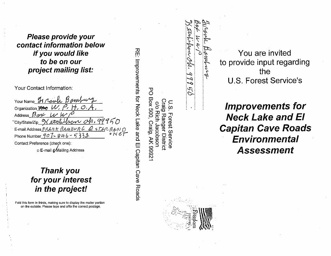
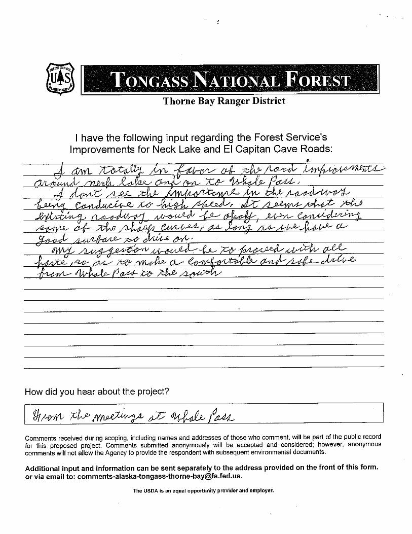
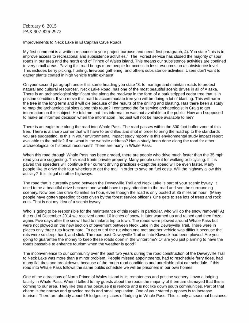
February 6, 2015 FAX 907-826-2972 Improvements to Neck Lake in El Capitan Cave Roads My first comment is a written response to your project purpose and need, first paragraph, 4). You state “this is to improve access to recreational and subsistence activities.” The Forest service has closed the majority of spur roads in our area and the north end of Prince of Wales island. This means our subsistence activities are confined to very small areas. Paving this road brings more people for access to less resources on a subsistence level. This includes berry picking, hunting, firewood gathering, and others subsistence activities. Users don't want to gather plants coated in high vehicle traffic exhaust. On your second paragraph under this same heading you state “3. to manage and maintain roads to protect natural and cultural resources”. Neck Lake Road. has one of the most beautiful scenic drives in all of Alaska. There is an archaeological significant site along the roadway in the form of a bark stripped cedar tree that is in pristine condition. If you move this road to accommodate tree you will be doing a lot of blasting. This will harm the tree in the long term and it will die because of the results of the drilling and blasting. Has there been a study to map the archaeological sites along this route? I contacted the for service archaeologist in Craig to get information on this subject. He told me that this information was not available to the public. How am I supposed to make an informed decision when the information I request will not be made available to me? There is an eagle tree along the road into Whale Pass. The road passes within the 300 foot buffer zone of this tree. There is a sharp corner that will have to be drilled and shot in order to bring the road up to the standards you are suggesting. Is this in your environmental impact study report? Is this environmental study impact report available to the public? If so, what is the website address? Has a study been done along the road for other archaeological or historical resources? There are many in Whale Pass. When this road through Whale Pass has been graded, there are people who drive much faster than the 35 mph road you are suggesting. This road fronts private property. Many people use it for walking or bicycling. If it is paved this speeders will continue their current driving practices except the speed will be even faster. Many people like to drive their four wheelers to get the mail in order to save on fuel costs. Will the highway allow this activity? It is illegal on other highways. The road that is currently paved between the Deweyville Trail and Neck Lake is part of your scenic byway. It used to be a beautiful drive because one would have to pay attention to the road and see the surrounding scenery. Now one can drive 45 miles an hour, even though the road is only posted at 35 miles an hour. (Many people have gotten speeding tickets given by the forest service officer.) One gets to see lots of trees and rock cuts. That is not my idea of a scenic byway. Who is going to be responsible for the maintenance of this road? In particular, who will do the snow removal? At the end of December 2014 we received about 10 inches of snow. It later warmed up and rained and then froze again. Five days after the snow I had to make a trip to town. The roads were plowed around Whale Pass but were not plowed on the new section of pavement between Neck Lake in the Deweyville Trail. There were in places only three ruts frozen hard. To get out of the rut when one met another vehicle was difficult because the ruts were so deep, hard, and slick. The road past Deweyville Trail on into Klawock had been plowed. Are you going to guarantee the money to keep these roads open in the wintertime? Or are you just planning to have the roads passable to enhance tourism when the weather is good? The inconvenience to our community over the past two years during the road construction of the Deweyville Trail to Neck Lake was more than a minor problem. People missed appointments, had to reschedule ferry rides, had many flat tires and breakdowns because of the rough road conditions and unreliable pilot car schedule. If this road into Whale Pass follows the same public schedule we will be prisoners in our own homes. One of the attractions of North Prince of Wales Island is its remoteness and pristine scenery. I own a lodging facility in Whale Pass. When I talked to my guests about the roads the majority of them are dismayed that this is coming to our area. They like this area because it is remote and is not like down south communities. Part of that charm is the narrow and graveled roads and small population. One of your stated purposes is to increase tourism. There are already about 15 lodges or places of lodging in Whale Pass. This is only a seasonal business.
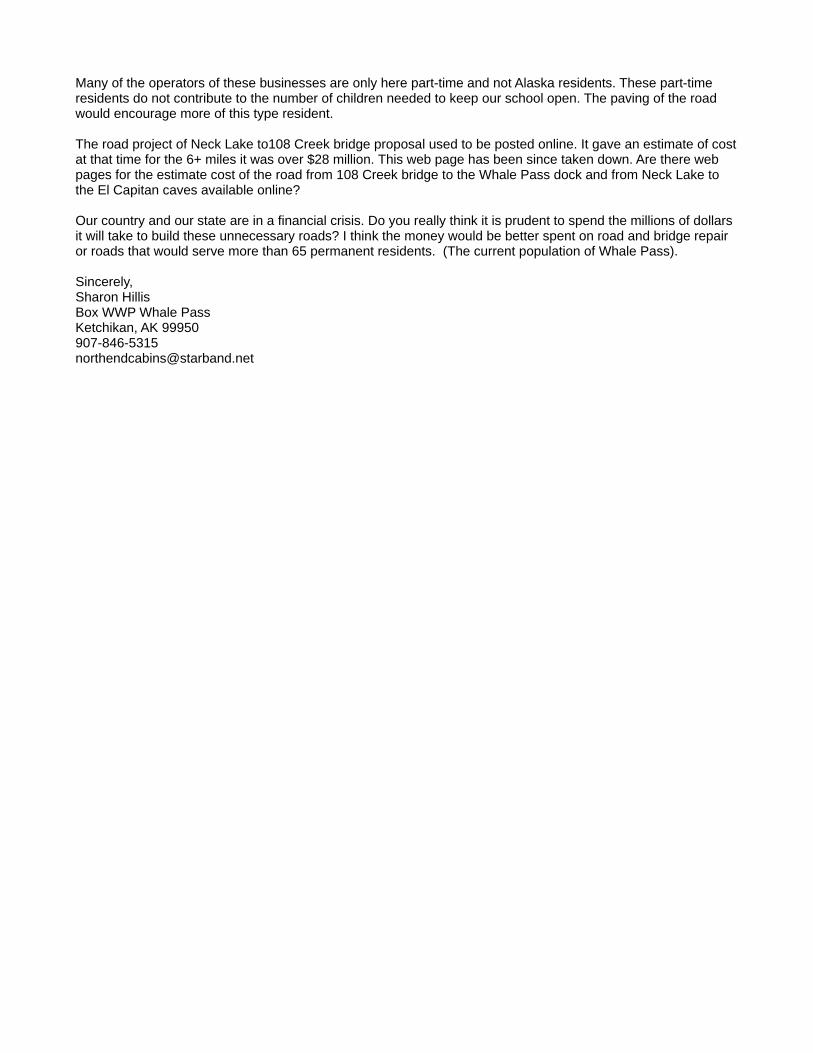
Many of the operators of these businesses are only here part-time and not Alaska residents. These part-time residents do not contribute to the number of children needed to keep our school open. The paving of the road would encourage more of this type resident. The road project of Neck Lake to108 Creek bridge proposal used to be posted online. It gave an estimate of cost at that time for the 6+ miles it was over $28 million. This web page has been since taken down. Are there web pages for the estimate cost of the road from 108 Creek bridge to the Whale Pass dock and from Neck Lake to the El Capitan caves available online? Our country and our state are in a financial crisis. Do you really think it is prudent to spend the millions of dollars it will take to build these unnecessary roads? I think the money would be better spent on road and bridge repair or roads that would serve more than 65 permanent residents. (The current population of Whale Pass). Sincerely, Sharon Hillis Box WWP Whale Pass Ketchikan, AK 99950 907-846-5315 [email protected]
WPCA
WHALE PASS COMMUNITY ASSOCIATION PO Box WWP
Ketchikan, Alaska 99950 February 13, 2015 Ms. Rachelle Huddleston-Lorton Thorne Bay District Ranger Tongass National Forest Thorne Bay, Alaska 99921 Dear Ms. Huddleston-Lorton: Thank you for including our community in the Neck Lake and El Capitan Cave Roads Environmental Assessment scooping process. We continue to support these road projects. We request that the planning and design work on NFSR 25 be extended to include all of NFSR 25 from the junction with NFSR 43 to its terminus at the log transfer site. Our request is based on the observation that about half of the Whale Pass residents live along that portion of NFSR 25 and that the pioneer boat launching ramp is actively used by local residents and that the barge ramp is used by firms hauling heavy equipment to the north end of the Island. With passage of the Sea Alaska land transfer act we expect increased use of barge ramp. We would also like to have a parking area with out house facilities and bear viewing platform be included as part of the planning and design work. Currently, those wishing to view bears feeding at the mouth of Neck Lake park along the NFSR 30 and use the bridge for a viewing platform thereby creating a traffic hazard. In addition, the WPCA is working with the ADF&G and SRAA to improve access to the mouth of the creek with an improved trail and fish cleaning facility. ADF&G currently provides port-a-potties at the small parking area near the bridge. The pioneer small boat-launching ramp at the log transfer facility is actively used by residents living on that side of Whale Pass, therefore we are requesting that improve the ramp with a hard surface be including in the planning process. Last summer, a tour company moored small tour ship in Whale Pass and bussed their clients across the island to visit the Beaver Creek nature trail facility and the El Capitan Cave. The ship was forced to anchor out because the Whale Pass boat harbor has silted in to the point where it is usable only by small boats. The area south of the log transfer facility is a logical location for a
future boat harbor that could accommodate small ships in the 100 ft. to 150ft. range. It provides protection for winter winds and drifting ice. Therefore, we are requesting that provisions for a future small boat harbor be included in the plans at the terminus of NFSR 25. Lastly, since many of our residents use the pioneer small boat-launching ramp near the El Capitan Cave, we are also asking that improving that facility be included in your long range planning. Thank you for your consideration and attention to this request. Sincerely, Robert M Meyer, President Whale Pass community Association [email protected]
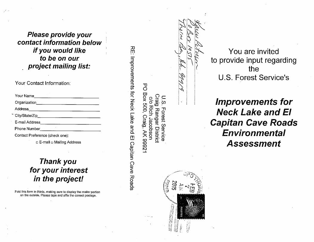
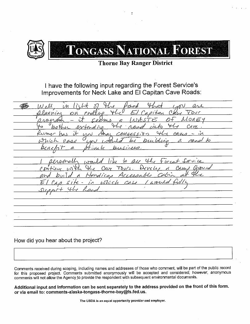

Improvements for Neck Lake and El Capitan Cave Roads EA Scoping and Issues Report
G-1
Appendix G: Updated Mailing List
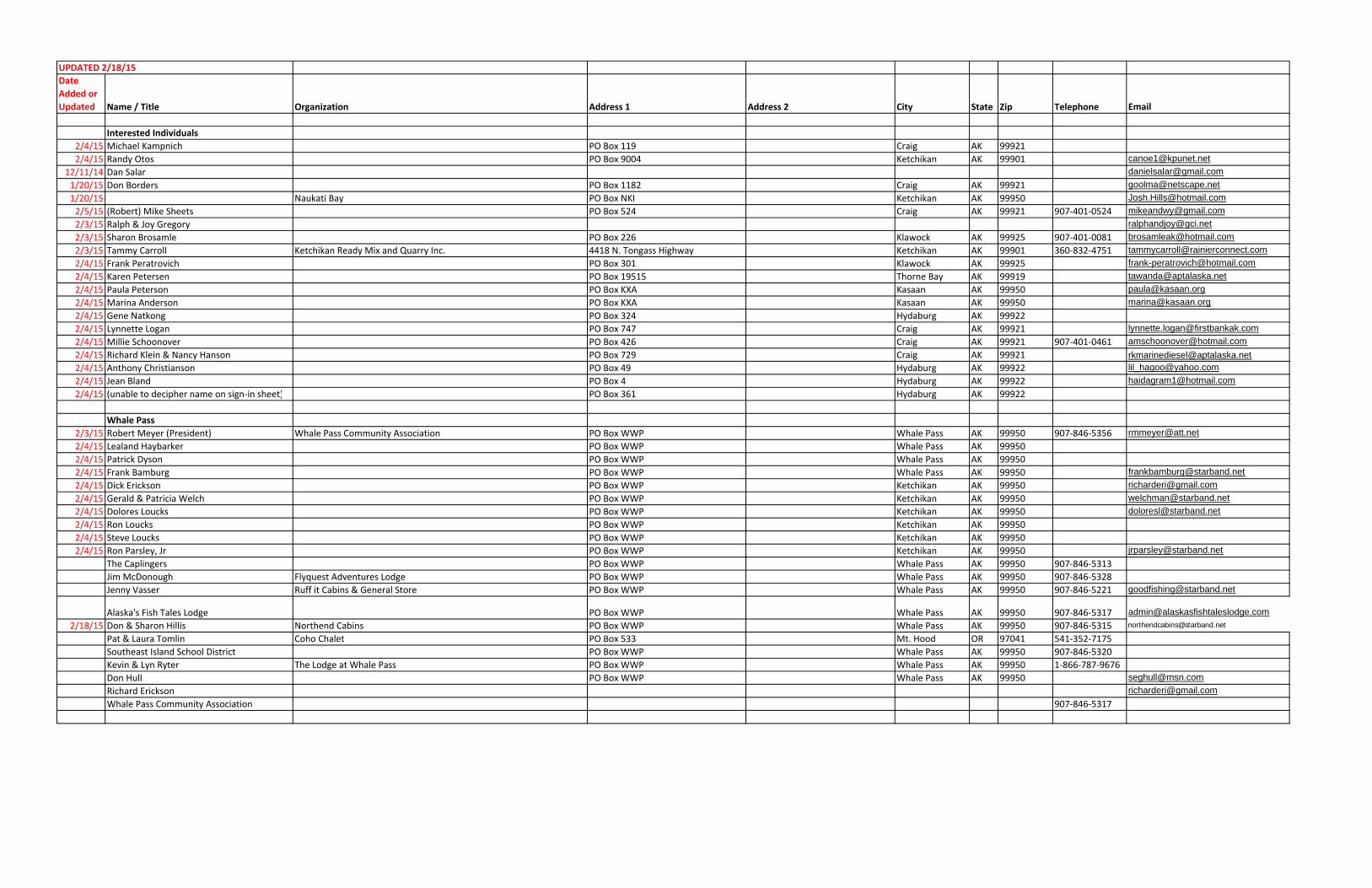
UPDATED 2/18/15Date Added or Updated Name / Title Organization Address 1 Address 2 City State Zip Telephone Email
Interested Individuals2/4/15 Michael Kampnich PO Box 119 Craig AK 99921
2/4/15 Randy Otos PO Box 9004 Ketchikan AK 99901 [email protected]
12/11/14 Dan Salar [email protected]
1/20/15 Don Borders PO Box 1182 Craig AK 99921 [email protected]
1/20/15 Naukati Bay PO Box NKI Ketchikan AK 99950 [email protected]
2/5/15 (Robert) Mike Sheets PO Box 524 Craig AK 99921 907‐401‐0524 [email protected]
2/3/15 Ralph & Joy Gregory [email protected]
2/3/15 Sharon Brosamle PO Box 226 Klawock AK 99925 907‐401‐0081 [email protected]
2/3/15 Tammy Carroll Ketchikan Ready Mix and Quarry Inc. 4418 N. Tongass Highway Ketchikan AK 99901 360‐832‐4751 [email protected]
2/4/15 Frank Peratrovich PO Box 301 Klawock AK 99925 [email protected]
2/4/15 Karen Petersen PO Box 19515 Thorne Bay AK 99919 [email protected]
2/4/15 Paula Peterson PO Box KXA Kasaan AK 99950 [email protected]
2/4/15 Marina Anderson PO Box KXA Kasaan AK 99950 [email protected]
2/4/15 Gene Natkong PO Box 324 Hydaburg AK 99922
2/4/15 Lynnette Logan PO Box 747 Craig AK 99921 [email protected]
2/4/15 Millie Schoonover PO Box 426 Craig AK 99921 907‐401‐0461 [email protected]
2/4/15 Richard Klein & Nancy Hanson PO Box 729 Craig AK 99921 [email protected]
2/4/15 Anthony Christianson PO Box 49 Hydaburg AK 99922 [email protected]
2/4/15 Jean Bland PO Box 4 Hydaburg AK 99922 [email protected]
2/4/15 (unable to decipher name on sign‐in sheet) PO Box 361 Hydaburg AK 99922
Whale Pass2/3/15 Robert Meyer (President) Whale Pass Community Association PO Box WWP Whale Pass AK 99950 907‐846‐5356 [email protected]
2/4/15 Lealand Haybarker PO Box WWP Whale Pass AK 99950
2/4/15 Patrick Dyson PO Box WWP Whale Pass AK 99950
2/4/15 Frank Bamburg PO Box WWP Whale Pass AK 99950 [email protected]
2/4/15 Dick Erickson PO Box WWP Ketchikan AK 99950 [email protected]
2/4/15 Gerald & Patricia Welch PO Box WWP Ketchikan AK 99950 [email protected]
2/4/15 Dolores Loucks PO Box WWP Ketchikan AK 99950 [email protected]
2/4/15 Ron Loucks PO Box WWP Ketchikan AK 99950
2/4/15 Steve Loucks PO Box WWP Ketchikan AK 99950
2/4/15 Ron Parsley, Jr PO Box WWP Ketchikan AK 99950 [email protected]
The Caplingers PO Box WWP Whale Pass AK 99950 907‐846‐5313
Jim McDonough Flyquest Adventures Lodge PO Box WWP Whale Pass AK 99950 907‐846‐5328
Jenny Vasser Ruff it Cabins & General Store PO Box WWP Whale Pass AK 99950 907‐846‐5221 [email protected]
Alaska's Fish Tales Lodge PO Box WWP Whale Pass AK 99950 907‐846‐5317 [email protected]
2/18/15 Don & Sharon Hillis Northend Cabins PO Box WWP Whale Pass AK 99950 907‐846‐5315 [email protected]
Pat & Laura Tomlin Coho Chalet PO Box 533 Mt. Hood OR 97041 541‐352‐7175
Southeast Island School District PO Box WWP Whale Pass AK 99950 907‐846‐5320
Kevin & Lyn Ryter The Lodge at Whale Pass PO Box WWP Whale Pass AK 99950 1‐866‐787‐9676
Don Hull PO Box WWP Whale Pass AK 99950 [email protected]
Richard Erickson [email protected]
Whale Pass Community Association 907‐846‐5317
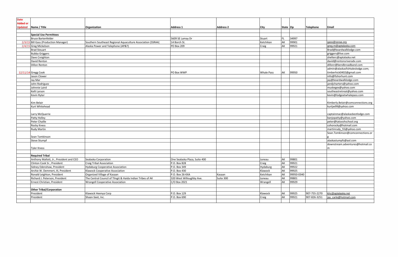
Date Added or Updated Name / Title Organization Address 1 Address 2 City State Zip Telephone Email
Special Use PermitteesBruce Bartenfelder 5609 SE Lamay Dr Stuart FL 34997
2/3/15 Bill Gass (Production Manager) Southern Southeast Regional Aquaculture Association (SSRAA) 14 Borch St. Ketchikan AK 99901 [email protected]
2/4/15 Greg Mickelson Alaska Power and Telephone (AP&T) PO Box 209 Craig AK 99921 [email protected]
Brad Steuart [email protected]
Bubba Griggers [email protected]
Dave Creighton [email protected]
David Renton [email protected]
Dillon Renton [email protected]
12/11/14 Gregg Cook PO Box WWP Whale Pass AK 99950
Jason Clower [email protected]
Jay Mar [email protected]
John Rodriguez [email protected]
Johnnie Laird [email protected]
Kelli Larson [email protected]
Kevin Ryter [email protected]
Kim Belair [email protected]
Kurt Whitehead [email protected]
Larry McQuarrie [email protected]
Patty Holley [email protected]
Peter Chaille [email protected]
Rocky Kness [email protected]
Rudy Martin [email protected]
Sean Tomkinson
g
Steve Stumpf [email protected]
Tyler Kness
m
Required TribalAnthony Mallott, Jr., President and CEO Sealaska Corporation One Sealaska Plaza, Suite 400 Juneau AK 99801
Clinton Cook Sr., President Craig Tribal Association P.O. Box 828 Craig AK 99921
Sidney Edenshaw, President Hydaburg Cooperative Association P.O. Box 349 Hydaburg AK 99922
Archie W. Demmert, III, President Klawock Cooperative Association P.O. Box 430 Klawock AK 99925
Ronald Leighton, President Organized Village of Kasaan P.O. Box 26‐KXA Kasaan Ketchikan AK 99950‐0340
Richard J. Peterson, President The Central Council of Tlingit & Haida Indian Tribes of AK 320 West Willoughby Ave. Suite 300 Juneau AK 99801
Ernest Christian, President Wrangell Cooperative Association C/O Box 2021 Wrangell AK 99929
Other Tribal/CorporationPresident Klawock Heenya Corp P.O. Box 129 Klawock AK 99925 907‐755‐2270 [email protected]
President Shaan‐Seet, Inc. P.O. Box 690 Craig AK 99921 907‐826‐3251 [email protected]
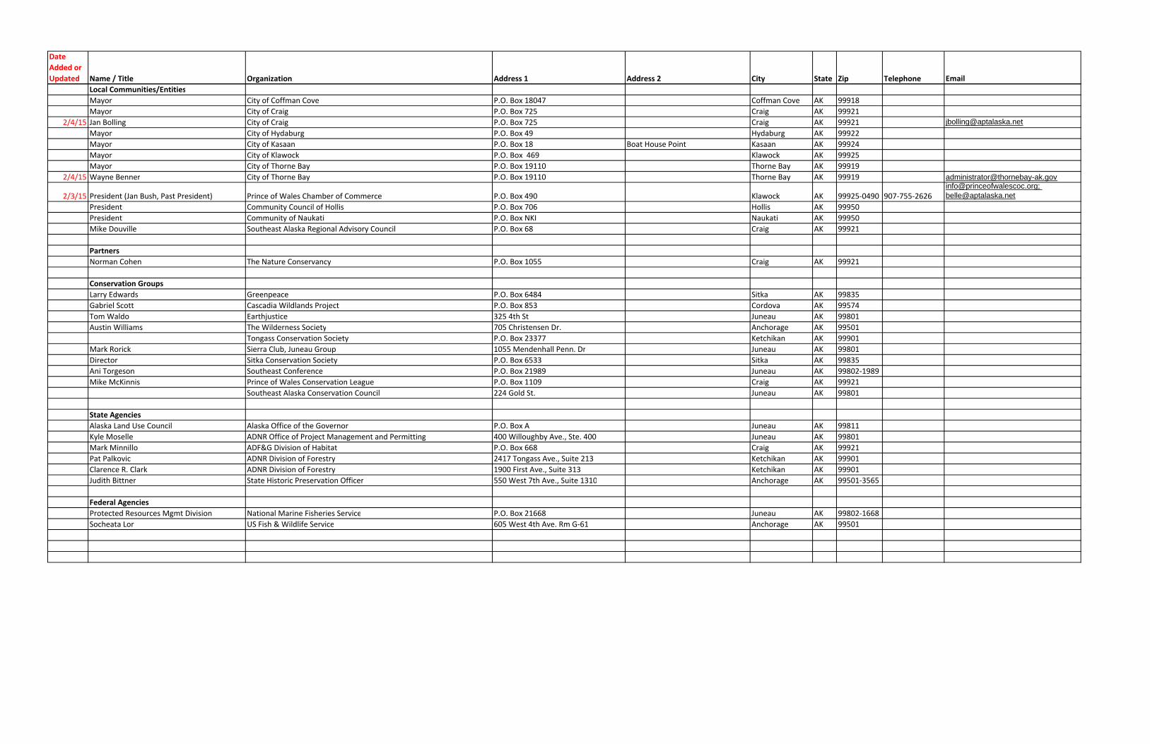
Date Added or Updated Name / Title Organization Address 1 Address 2 City State Zip Telephone Email
Local Communities/EntitiesMayor City of Coffman Cove P.O. Box 18047 Coffman Cove AK 99918
Mayor City of Craig P.O. Box 725 Craig AK 99921
2/4/15 Jan Bolling City of Craig P.O. Box 725 Craig AK 99921 [email protected]
Mayor City of Hydaburg P.O. Box 49 Hydaburg AK 99922
Mayor City of Kasaan P.O. Box 18 Boat House Point Kasaan AK 99924
Mayor City of Klawock P.O. Box 469 Klawock AK 99925
Mayor City of Thorne Bay P.O. Box 19110 Thorne Bay AK 99919
2/4/15 Wayne Benner City of Thorne Bay P.O. Box 19110 Thorne Bay AK 99919 [email protected]
2/3/15 President (Jan Bush, Past President) Prince of Wales Chamber of Commerce P.O. Box 490 Klawock AK 99925‐0490 907‐755‐[email protected]; [email protected]
President Community Council of Hollis P.O. Box 706 Hollis AK 99950
President Community of Naukati P.O. Box NKI Naukati AK 99950
Mike Douville Southeast Alaska Regional Advisory Council P.O. Box 68 Craig AK 99921
PartnersNorman Cohen The Nature Conservancy P.O. Box 1055 Craig AK 99921
Conservation GroupsLarry Edwards Greenpeace P.O. Box 6484 Sitka AK 99835
Gabriel Scott Cascadia Wildlands Project P.O. Box 853 Cordova AK 99574
Tom Waldo Earthjustice 325 4th St Juneau AK 99801
Austin Williams The Wilderness Society 705 Christensen Dr. Anchorage AK 99501
Tongass Conservation Society P.O. Box 23377 Ketchikan AK 99901
Mark Rorick Sierra Club, Juneau Group 1055 Mendenhall Penn. Dr Juneau AK 99801
Director Sitka Conservation Society P.O. Box 6533 Sitka AK 99835
Ani Torgeson Southeast Conference P.O. Box 21989 Juneau AK 99802‐1989
Mike McKinnis Prince of Wales Conservation League P.O. Box 1109 Craig AK 99921
Southeast Alaska Conservation Council 224 Gold St. Juneau AK 99801
State AgenciesAlaska Land Use Council Alaska Office of the Governor P.O. Box A Juneau AK 99811
Kyle Moselle ADNR Office of Project Management and Permitting 400 Willoughby Ave., Ste. 400 Juneau AK 99801
Mark Minnillo ADF&G Division of Habitat P.O. Box 668 Craig AK 99921
Pat Palkovic ADNR Division of Forestry 2417 Tongass Ave., Suite 213 Ketchikan AK 99901
Clarence R. Clark ADNR Division of Forestry 1900 First Ave., Suite 313 Ketchikan AK 99901
Judith Bittner State Historic Preservation Officer 550 West 7th Ave., Suite 1310 Anchorage AK 99501‐3565
Federal AgenciesProtected Resources Mgmt Division National Marine Fisheries Service P.O. Box 21668 Juneau AK 99802‐1668
Socheata Lor US Fish & Wildlife Service 605 West 4th Ave. Rm G‐61 Anchorage AK 99501