Implications of Proposed Budhi Gandaki and Upper Seti Storage Projects on Nepal-India Water Relation...
84
0 IMPLICATIONS OF PROPOSED BUDHI GANDAKI AND UPPER SETI STORAGE PROJECTS ON NEPAL-INDIA WATER RELATION IN CHANGING CLIMATIC REGIME By Prakash Gaudel A thesis submitted in partial fulfillment of the requirements for the degree of Master of Science (M.Sc.) in Interdisciplinary Water Resources Management awarded by Pokhara University Center for Postgraduate Studies Nepal Engineering College Nepal February, 2013
Transcript of Implications of Proposed Budhi Gandaki and Upper Seti Storage Projects on Nepal-India Water Relation...

0
IMPLICATIONS OF PROPOSED BUDHI GANDAKI AND UPPER
SETI STORAGE PROJECTS ON NEPAL-INDIA WATER RELATION
IN CHANGING CLIMATIC REGIME
By
Prakash Gaudel
A thesis submitted in partial fulfillment of the requirements for the
degree of Master of Science (M.Sc.) in
Interdisciplinary Water Resources Management awarded by
Pokhara University
Center for Postgraduate Studies
Nepal Engineering College
Nepal
February, 2013

i
Abstract
This research looks at the possible consequences, both good and bad, of building storage dam in Nepal. Two proposed projects, Budhi Gandaki Storage Project (BGSP) and Upper Seti Storage Project (USSP) are considered. These projects are proposed on the two major tributaries of the Gandak River- a transboundary river that flows from Nepal to meet with the Ganges River in India. Any intervention carried out on the upper riparian country-Nepal will also affect the lower riparian countries, mostly India. In the selected cases, the intervention is to be made through the construction of storage dam. The overall water resources development within the Gandak River Basin is governed by a bilateral treaty between Nepal and India- the Gandak Treaty of 1959. In changing climatic regime, the issue of water conservation is a major issue. The region is facing increasing water stress as the climate is becoming more uncertain. But, the existing Gandak Treaty has no provision for conservation of water or watershed. The Treaty is no longer in a position to address the new challenges of transboundary water management. The study shows that with increasing demand of water and reducing water availability which is accelerated by changing climatic regime, the need for storing of more water is realized. The proposed projects serve the purpose. To meet the energy demand within Nepal and supply reliable energy all the year round, these projects (with a joint installed capacity of 740MW) have immense importance and role to play. BGSP with large live storage capacity (2755 MCM) has flood control benefits in the wet season and regulated flow (1670.46 MCM) in the dry season. With this regulated flow of water there is a huge potential of irrigation mostly in India which will help to improve the food security and livelihood of the people of the region. In this research, the question of whether it is possible to negotiate or share possible costs and benefits among the riparian countries that would incur with the execution of these projects, is raised. This study sheds light on the importance of developing storage project which explains the role of BGSP and USSP in reducing uncertainties of water availability in changing climatic regime. The research also points out some of the gaps in the existing Gandak Treaty that need to be addressed and concludes that BGSP should be taken as an initial strategic project which can break-down the barriers between the riparian states. This research suggests that the development of such multipurpose project on transboundary rivers which benefits crosses the border, common consensus and mutual trust is essential which has been lacking between the states. Depending on the experiences on sharing of benefits and costs of transboundary water management around the world, this study proposes similar models of transboundary cooperation. It is further argued that the possible mechanism/models of downstream benefit sharing is a solution that both riparian states, Nepal and India, accept.

ii
Disclaimer
I hereby declare that this study entitled “Implications of Proposed Budhi Gandaki and
Upper Seti Storage Projects on Nepal-India Water Relation in Changing Climatic
Regime" is based on my original research work. Related works on the topic, by other researchers, have been duly acknowledged. I owe all the liabilities relating to accuracy and authenticity of the data or any other information included hereunder.

iii
Recommendation
This is to certify that this thesis entitled, “Implications of Proposed Budhi Gandaki and
Upper Seti Storage Projects on Nepal-India Water Relation in Changing Climatic
Regime” prepared and submitted by Prakash Gaudel, in partial fulfillment of the requirements of the degree of Master of Science (M.Sc.) in Interdisciplinary Water
Resources Management awarded by Pokhara University, has been completed under my supervision. I recommend the same for acceptance by Pokhara University.

iv

v
Acknowledgment
It is very gratifying to acknowledge the supervision made by supervisor Mr. Surya Nath Upadhyay, Secretary General, Jalsrot Vikas Sanstha (JVS) Nepal without whose guidance and constant encouragement, this work would have been impossible. I would like to express my deepest sincere gratitude to him for his valuable comments, suggestions, advice, criticism, guidance and encouragement throughout the period of research and in the thesis writing. It is with his constant encouragement, guidance and suggestion that I have been able to accomplish this research successfully. I am grateful to South Asia Consortium for Interdisciplinary Water Resources Studies (SaciWATERs) for providing me SAWA Fellowship and Center of Research for Environment Energy and Water (CREEW) for partially funding this research work. I am deeply indebted to Prof. Ashutosh Shukla, nec-CPS, whose help, stimulating suggestions, valuable advice and encouragements helped me in my every step. I would like to thank Mr. Dina Mani Pokharel and Mr. Som Nath Poudel for their guidance and critical views. I am indebted to Mr. Santa Bahadur Pun (former Managing director, NEA) for providing me with the new insights for the research. I am grateful to Dr. Katak B. Malla, researcher and guest lecturer, Stockholm University for his valuable suggestion and guidance. My special thanks goes to Prof. Dr. Khem Raj Sharma, Program Coordinator of iWRM, Dr. Dibya R. Kansakar, visiting professor of iWRM for their valuable supports in providing guidance and suggestions. I am thankful to Dr. Sangam Shrestha, Dr. Rabin Malla, Dr. Saroj Chapagain and entire CREEW team for their support and suggestions. Mr. Ramji Bhandari, (Manager, NEA) deserve special thanks who assisted me in understanding the different aspects of my research and who has been a constant source of inspiration and encouragement. My special thanks to Mr. Kehsav Raj Bhatta, Mr. Mohan Ratna Shakya, Ms. Anu Raj Bhandari, Ms. Ritu Duwal, Mr. Umesh Bista, Mr. Birendra B. Malla, Mr. Raju Gyawali and all the staffs of ESSD-NEA for their support and for providing related documents and publications. Mr. Shyamji Bhandari and Mr. Ramnath Subedi of Upper Seti Storage Project deserve special thanks. I am grateful to Mr. Kupdeep Prasad Acharya, Mr. Santosh Shrestha and all the staffs of Indreni Forum for Social Development, Nawalparasi for the their support and assistance during field visit to Gandak irrigation area. I express my deep gratitude to Prof. Amulya R. Tuladhar, for his continuous support, suggestions and inspiration in making my effort fruitful. Special thanks to my friends Mr. Tejendra G.C., Mr. Ajay Adhikari, Ms. Neha Bhardwaj, Ms. Kanchan Ojha, Ms. Shristi Sharma and those who directly or indirectly helped me and without whose constant encouragement, I couldn’t have been able to accomplish this research in this form. My deepest gratitude goes to my family for their unflagging love and support throughout my life. I owe all my success to them.
vi
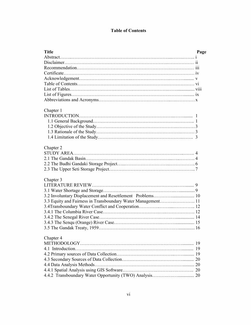
Table of Contents
Title Page
Abstract……..………………………………………………………...…….…….. i Disclaimer………………………………………………………….………………ii Recommendation…………………………………………………….…………… iii Certificate………………………………………….……………………………… iv Acknowledgement…………………………….…………………….………......... v Table of Contents………………………………….……………………………… vi List of Tables……………………………………………………….……...............viii List of Figures……………………………………………………….………......... ix Abbreviations and Acronyms………………………………………..….…………x Chapter 1 INTRODUCTION……………………………………………………..……........ 1
1.1 General Background……………………………………………….……….. 1 1.2 Objective of the Study…………………………………………….…………3 1.3 Rationale of the Study……………………………………………….……… 3 1.4 Limitation of the Study……………………………………………….……. 3
Chapter 2 STUDY AREA………………………………………………………….…..……. 4 2.1 The Gandak Basin………………………………………………...…..………. 4 2.2 The Budhi Gandaki Storage Project…...………………………..……………..6 2.3 The Upper Seti Storage Project……………………………………………….. 7
Chapter 3 LITERATURE REVIEW……………………………………………….……....... 9 3.1 Water Shortage and Storage………………………………………..…............. 9 3.2 Involuntary Displacement and Resettlement Problems…………....................10 3.3 Equity and Fairness in Transboundary Water Management……….…………. 11 3.4Transboundary Water Conflict and Cooperation…………..……....………….. 12 3.4.1 The Columbia River Case……………………………….….………………. 12 3.4.2 The Senegal River Case………………………………….…….…................ 14 3.4.3 The Senqu (Orange) River Case………………………….……….................15 3.5 The Gandak Treaty, 1959………………………………………….…..............16 Chapter 4 METHODOLOGY………………………………………………………….......... 19 4.1 Introduction…………………………………………………………….......... 19 4.2 Primary sources of Data Collection………………………………..……......... 19 4.3 Secondary Sources of Data Collection………………………………….......... 20 4.4 Data Analysis Methods………………………………………………….......... 20 4.4.1 Spatial Analysis using GIS Software………………….……….….……….. 20 4.4.2 Transboundary Water Opportunity (TWO) Analysis……….….….............. 20

vii
Chapter 5 RESULTS AND DISCUSSION……………………………………...………….. 21 5.1 BGSP and USSP in Changing Climatic Regime…………………..…………..21 5.2 Upstream Impacts……………………………………………….….………….23 5.2.1 Budhi Gandaki Storage Dam………………….………………..……………23 5.2.2 Upper Seti Storage Dam…………………………………….……………….25 5.3 Downstream Benefits…………………………………………………………. 26 5.3.1 Regulated Water…………………………………………………..………… 26 5.3.2 Extended Irrigation/Increased Cropping Intensity….………..……............... 29 5.3.3 Navigation…………………………………………….…..………………… 30 5.3.4 Flood Control…………………………………………….…………………. 30 5.4 Associated Environmental Impacts…………………………………....……… 31 5.4.1Impact on Fish and Aquatic Life………………………..….…...................... 31 5.4.2 Methane Generation…………………………………………....…………… 32 5.4.3 Siltation…………………………………………..…………….…………… 32 5.4.4 Changes in Microclimate…………………………...………….…….............32 5.4.5 Seismicity and Dam Safety…………………………………..…………….. 33 5.5 Transboundary Water Opportunity (TWO) Analysis………………….............33 5.5.1 New Water………………………………….……………………..…………33 5.5.2 Efficient Use of Water……………………….………………….…...............34 5.5.3 Crop Yields………………………….……………………………................ 34 5.5.4 Industrial Development and Tourism………………………………………..34 5.6 Benefit Sharing Mechanism and Basin-wide Cooperation……….………..…. 35 5.6.1 Pitfalls in Gandak Treaty………………………….…………….....……….. 35 5.6.2 Local’s Perspective- Unsatisfactory Implementation of the Commitments...36 5.6.3 Possible Models of Benefit Sharing………………………..…..….………... 36 I. Co-finance on Major Infrastructures……………...….………………………… 36 II. Economic Valuation…………………………………..……………………….. 37 III. Utilizing the Downstream Benefit within the Country……………………….. 38 5.7 Proposed Storage Projects under International Water Law Regime………….. 40 5.8 Challenges for Transboundary Cooperation ……………………….………….40 5.9 Time to Move from Single Purpose to Multi-purpose Projects…….…............ 42 Chapter 6 CONCLUSION AND RECOMMENDATIONS……………….…..…...………. 43 6.1 Conclusions……………………………………...…………….….…………... 43 6.2 Recommendations………………………………………………….…………. 45 REFERENCES……………………………………..…………….….…………… 46 ANNEX…………………………………………..……………………………… 55 PHOTOGRAPHS………………………………………………….…………….. 71

viii
List of Tables
Title Page
Table 2.1 Comparison among Major River Basins of Nepal …………………...…....5 Table 5.1 Changes in Glacier Coverage in the Budhi Gandaki and
Seti River Basins…………………………………………………….……..21 Table 5.2 Glacial lakes of Subbasins of Gandak basin of Nepal……………….…….22 Table 5.3 Affected VDCs of Dhading and Gorkha Districts…………………………23 Table 5.4 Affected VDCs and Municipality of Tanahu District………………….…..25 Table 5.5 Monthly Flow, Turbine Flow and Spillage from the
Reservoir of BGSP……………………………………………………....…26 Table 5.6 Monthly Flow, Turbine Flow and Spillage from the
Reservoir of USSP……………………………………………………....…28 Table 5.7 A simplified and highly condensed form of TWO
Analysis Matrix of the Gandak Basin……………………………..……….33 Table 5.8 Responses and Colour Codes for TWO Analysis……………………….....34 Table 5.9 Comparison between BGSP and Tehri Storage Project Features...…….….42

ix
List of Figures
Title Page
Figure 2.1 Districts of Nepal within the Gandak Basin…………………………...…….4 Figure 2.2 Sub-basins of the Gandak Basin……………………………………….….….5 Figure 2.3 Location of proposed BGSP and USSP; and existing
Gandak Barrage………………………………………………………………8 Figure 4.1 Methodological Framework of the Study …………………………….……19 Figure 5.1 Landuse maps of Upper Seti River Basin and Budhi
Gandaki River Basin……………………………………………………..…..22 Figure 5.2 BGSP Affected VDCs of Gorkha and Dhading Districts………………..….24 Figure 5.3 USSP Affected VDCs and Municipality of Tanahu District……………..….25 Figure 5.4 Flow Comparison before and after Execution of BGSP………………….....27 Figure 5. 5 Flow Comparison before and after Execution of USSP…………….….…..28 Figure 5.6 Flood Control from BGSP…………………………………………………...31 Figure 5.7 Flow Comparison before and after the Execution of the
BGSP and USSP from the Month of February to March……………….…....39 Figure 5.8 Regulated Water from BGSP and USSP from the Month of February to April………………………………………………………...…..39

x
Abbreviations and Acronyms
ADB Asian Development Bank BAU Business-as-Usual BGSD Budhi Gandaki Storage Dam BGSP Budhi Gandaki Storage Project BGREI Bringing Green Revolution in Eastern India CII Confederation of Indian Industry DES Detailed Engineering Study DFID Department for International Development DOI Department of Irrigation ESSD-NEA Environment and Social Studies Department-Nepal Electricity Authority EUW Efficient Use of Water FGD Focused Group Discussion FSL Full Supply Level GCI Green Cross International GCM General Circulation Model GDP Gross Domestic Product GHGs Green House Gases GIS Geographic Information System GOI Government of India GON Government of Nepal HHs Households ICIMOD International Centre for Integrated Mountain Development ICPR International Commission on the Protection of the Rhine IIDS International Institute for Development Studies IPCC Intergovernmental Panel on Climate Change IPPAN Independent Power Producers’ Association Nepal IWMI International Water Management Institute IWRM Integrated Water Resources Management JCWR Joint Committee on Water Resources JICA Japan International Co-operation Agency KII Key Informant Interview LHWP Lesotho Highlands Water Project MOPE Ministry of Population and Environment NCIWRD National Commission for Integrated Water Resources Development NCVST Nepal Climate Vulnerability Study Team NEA Nepal Electricity Authority NRLP National River Linking Project NW New Water NWDA National Water Development Agency OECD Organization for Economic Co-operation and Development OMVS Organisation pour la Mise en Valeur du Fleuve Sénégal, (Senegal River
Basin Authority) PSOs Positive-Sum Outcomes RBOs River Basin Organizations

xi
RegCM Regional Climate Model ROR Run-off the River SAARC South Asian Association for Regional Cooperation SMEC Snowy Mountain Engineering Corporation TWO Transboundary Water Opportunity UNEP-DDP United Nations Environment Program- Dams and Development Project US United States USD United States Dollar USSD Upper Seti Storage Dam USSP Upper Seti Storage Project VDC Village Development Committee WB The World Bank WCD World Commission on Dams WECS Water and Energy Commission Secretariat WWF World Wide Fund for Nature Units
BCM Billion Cubic Meter Cusec Cubic feet per second GWh Giga Watt-hour ha Hectare km2 square kilometer km3/yr cubic kilometer per year m3/s cubic meter per second (Cumec) MCM Million Cubic Meter Mha Million hectare MW Mega-Watt t/km2/yr tons per square kilometer per year

1
Chapter 1
Introduction
1.1 General Background
The fresh water of the world, which itself is a small fraction of the whole water resource, is facing peering stress to meet the increasing demands. The unprecedented growth in population, increasing urbanization, intensified agriculture and growing industries are the competing sectors of water use. The scenario has been further aggravated by the ongoing climate change and its impact on almost all the sectors, including water as its principal sector. The World Commission on Dams Report (2000) recognizes important and significant contribution made by dams to human development, and the considerable benefits derived from them. Particularly in poor countries with highly seasonal and often unpredictable rainfall, a lack of adequate water storage already causes large and avoidable economic losses from floods and droughts, and constrains long-term growth whereas the benefits provided by water storage in wealthy countries are reflected by their high per capita rates of water storage. So, improved water storage is considered as a major driver of economic growth (DFID, 2009). The Fourth Assessment Report of Intergovernmental Panel on Climate Change (IPCC, 2007) highlights that the freshwater availability in central, South, East and South-East Asia, particularly in large river basins, is projected to decrease due to climate change, which could affect more than a billion people by 2050s. In Nepal, Shrestha et al. (1999) reported the temperature (maximum temperature) increase of 0.06ºC to 0.12ºC per year in most of the middle mountain and Himalayan regions, while the Siwalik and Terai (southern plains) regions show warming trends of less than 0.03ºC per year from 1971-1994. Studies show that water sector of Nepal is most vulnerable sector to climate change. Agrawala et al. (2003) has given the priority ranking of climate change impacts for Nepal and have ranked water resources and hydropower significantly higher than other sectors. Changes in hydrological cycle and the depletion of water resources are some of the top environmental challenges facing Nepal in context of global warming (MOPE, 2004). Nepal hydroelectric plants are highly dependent on predictable runoff patterns. Therefore, increased climatic variability, which can affect frequency and intensity of flooding and droughts, could affect Nepal severely. Increasing temperature will directly affect the whole hydrologic cycle resulting in the new flow of regimes of the rivers (Chaulagain, 2004). Failure to adapt climate induced risks to hydropower can cause a reduced hydropower potential which might imply that Nepal will have to seek for alternative sources of power generation including from fossil fuel sources (Agrawala et al. 2003). By providing a buffer, water storage reduces risk and offsets some of the potential negative impacts of climate change, thereby reducing the vulnerability of people (McCartney and Smakhtin, 2010). Water storage has a vital role to play in improving global food security and building resilience for adaptation to climate change (IWMI, 2009). Though the climate variability or climate uncertainty is high in Nepal the water storage, mainly through built storage is low. The only large scale storage dam available in

2
the country is Kulekhani Reservoir with the designed gross capacity of 85.3 million cubic meter (MCM) of which 73.3 MCM was live storage capacity; build mainly for the purpose of producing hydroelectricity. This storage project has a significant contribution in the hydropower production of the country. The installed capacity of the Kulekhani reservoir is 92 MW (through Kulekhani I and II power stations, build on a cascade type) which is about 15% of the total installed hydropower capacity of the country. The third power station (Kulekhani III of 14 MW Capacity) is under construction.
So there is a need to rethink of water storage in a future of rapidly rising population and increasing uncertainty related to climate change. It is also the high time to revise the water storage practice for better planning and management of the full range of water storage options available in the country. The Problem Statement
Many large scale storage projects have been proposed within Nepal mainly for the purpose of hydropower generation. Such large projects within the young and fragile Himalayan geology often face criticisms because of their environmental and socio-economic threats and risks. The 225m high dam in the Budhi Gandaki River will submerge the lower regions of Gorkha and Dhading districts along the river and its tributaries. Similarly, the 140m high dam in the Upper Seti River will submerge the lower regions of the Tanahu District along the river. Unlike other parts of the World, the Himalayan region is more vulnerable and susceptible to the impacts of climate change. Studies reveal that the glaciers, upon which most of the river flow depends, are retreating at an alarming rate (Bajracharya et al. 2007; Jiawen et al. 2004). With the increasing climatic uncertainty, the urgency of storing water is preferred as a major adaptation strategy. Nepal Electricity Authority (NEA) has already opened Request for Proposals from the interested parties for the execution of the Budhi Gandaki Storage Project (BGSP). NEA intends for the Joint Venture development of the project and has focused the project mainly to serve the domestic energy requirement of the country. Similarly, work is on progress regarding the Upper Seti Storage Project (USSP). The Detailed Engineering Study (DES) is being carried out since August 2011 with the assistance from Asian Development Bank (ADB) and the construction work is expected to start in the second quarter of 2013 (NEA, 2012). In this background of the process that has already taken place, yet no initiatives have been taken to look into the relation of these projects to climate change adaptation and downstream impacts caused mainly by the regulated flow of the rivers after the construction of these projects. Climate and environmental changes and a rising water demand have increased the competition over water resources and have made cooperation between riparian countries an important issue in water resources management (Stahl, 2005). So, it is the high time for Nepal to think upon developing mechanisms for sharing the downstream benefits that India will obtain with the execution of these projects. Though NEA has taken initiative to start up with new storage projects, the research regarding the role of these projects in changing climatic context and studies relating to Nepal-India water relation are still lacking. So, this research aims to fill up this gap and

3
aims to open new dimensions in construction of storage dams as well as in Nepal-India water relations in changing climatic regime. Through the Transboundary Water Opportunity (TWO) Analysis, this study uses a theoretical framework based on fairness and equity under international water law to explore the new dimensions of water management between the two riparians. Research Questions
1) What is the role of proposed BGSP and USSP in reducing uncertainties of water availability, due to changing climatic regime, for different productive uses?
2) What are the upstream impacts of these projects mainly including the issues of inundation and involuntary displacement?
3) What are the benefits incurred in the downstream (both Nepal and India) mostly with the increase in the lean season flow at Gandak Barrage? What are their roles in flood control?
4) What are the possible ways and mechanisms to share the benefits between Nepal and India resulting from this regulated and increased dry season flow? How these can be instrumental in avoiding the pitfalls, if any, of existing Gandak Treaty?
1.2 Objectives of the Study
1) To assess the role and necessity of proposed BGSP and USSP in changing climatic regime.
2) To evaluate the upstream impacts (such as inundation, involuntary displacement) and downstream benefits (its possible use in India and Nepal in terms of extended irrigation or the incidence of cropping intensity and increased hydropower generation).
3) To establish the possible ways and mechanisms to share such benefits incurring, on the basis of international water law regime.
1.3 Rationale of the Study
The international rivers are coming under growing pressure from increasing water demand and water quality deterioration (Sadoff and Grey, 2002). So it is important to understand the benefits that would arise from cooperation on transboundary rivers. Careful scrutiny and analysis of any project, like the proposed storage projects, which has the potential to affect the lives of the millions is important, and it is hoped that this research is the first of many to critically look at and attempt solving the problem under the lens of fairness and equity is sharing the benefits. With the growing realization that climate change is a reality and that the future climate uncertainties can be addressed only within an integrated framework, there is a need for such new approach towards regional cooperation. It is because of the critical nature of the problem, and the hope that the TWO Analysis aims to alleviate the problem, that motivates this research.
1.4 Limitation of the Study
The use of TWO analysis tool is limited to the theoretical concept as it requires the detail study of the basin, which is beyond the scope of this study. Similarly, the study was also limited by the lack of access to the information on the water use of the Gandak River on the Indian Side.

4
Chapter 2
Study Area
2.1 The Gandak Basin
The Gandak (River) Basin extends from longitude 83o10’ to 85o30’E and latitude 27o30’ to 29020’N in the central region of Nepal. The catchment area within Nepal is estimated to be around 36,000 km2 with an additional area of approximately 4600 km2 of Tibet being drained out by tributaries of Kali Gandaki, Budhi Gandaki and Trishuli Rivers (SMEC, 1979). Whereas Shankar (1999) estimates that about 86.07% of the total catchment area of 34,960 km2 of the Gandak basin, lies in Nepal only and the estimated yearly mean runoff is 1767 m3/sec. A more recent estimate (WECS, 2002) shows that out of the total basin area of 34,960 km2, about 84.74% (29,626 km2) of the area lies within Nepal and the remaining 5,334 km2 lies in Tibet of China. Within Nepal, the Gandak Basin is composed of some 19 districts (Figure 2.1).
Figure 2.1 Districts of Nepal within the Gandak Basin Most of the rivers within the basin are glacial fed. There are altogether 1,025 glaciers in the Gandaki River Basin which cover an area of 2,030.15 km2 and the basin has an estimated ice reserve of 191.39 km3 (Mool et al, 2001). The basin consists of two main river systems, Trishuli and Kali Gandaki. The Trishuli River and its major tributaries Budhi Gandaki, Marsyangdi and Seti drain the area east of Pokhara whereas the Kali Gandaki River drains the area west of Pokhara valley. Figure 2.2 shows the different sub-basins of the Gandak Basin.

5
Figure 2.2 Sub-Basins of the Gandak Basin Out of the three major basins of Nepal, Gandak occupies the smallest area after Karnali and Koshi within the country. The basin supports 19% of total population of Nepal (of the census year 2001). This is more than that of Koshi and Karnali river basins which holds 12% and 9% of the population of the same year respectively (WECS, 2011). Similarly out of the total surface water available annually in Nepal, the Gandak basin alone contributes 26% though the basin covers only about 19% of the total area of Nepal (Table 2.1). Though smallest among three, the basin contributes the highest percentage of total surface water availability and holds the maximum population of the country.
Table 2.1 Comparison among Major River Basins of Nepal
S.
No.
Major Basin
Basin Characteristic
Area out of Total Area of Nepal (%)
Surface Water Availability (%)
Population as of 2001 (%)
1. Gandak 19.09 26 19 2. Koshi 21.70 23 12 3. Karnali 28.46 20 9
Total 69.25 69 40 (Source: WECS 2011 and WECS 2002)
The Gandak Basin is the most developed basin among the major basins of Nepal in terms of hydropower. More than 50 % of the total hydropower generated in Nepal comes from this basin. A master plan was also developed in 1979 mainly to promote hydropower generation within the basin. Among many potentialities of storages project within the basin, the Government of Nepal has kept both USSP and BGSP as the prioritized projects.

6
2.2 The Budhi Gandaki Storage Project (BGSP)
The Budhi Gandaki River is one of the tributaries of the Trishuli River in the central part of Nepal. The river originates from two main branches, one from the Lark Himal and the other, the Mowang Khola, from the Ladak Himal in Tibet. After the confluence of these two branches the river flows about 120km to the south before it joins the Trishuli River. The catchment area in Tibet is approximately 1750 km2 (SMEC, 1979). The total catchment area of the basin at dam site is about 5370km2. A high dam storage reservoir project is proposed at this river (Figure 2.1) primarily for the purpose of hydropower generation with a capacity of 600 MW. Pre feasibility study of this BGSP was done in early 1980's (MOWR, 1984). As per the pre-feasibility study report (April, 1984) the project would involve construction of a 225 m high earth and rock-fill dam across the Budhi Gandaki river, about 2 km downstream of its confluence with Trishuli river at Benighat (about 79 km west from Kathmandu on the Prithvi Highway) to create a reservoir with an effective storage capacity of 2,755 MCM. The water from the reservoir would be led to an underground power house with an installation of 4 units each of 150 MW capacity operating under a rated net head of 185 m for power generation (MOWR, 1984). The project would afford annual energy generation of 2,496.6 GWh (NEA 2011, IPPAN and CII, 2006). The underground powerhouse is to be located at the right bank of the Budhi Gandaki River in Ghalchowk VDC of Gorkha district. The BGSP is a big project, in terms of cost and benefit, and only this case would have been taken for this research work. But the initiation of USSP, though relatively small one in comparison to BGSP, by the GON has made it necessary to include both the cases for fulfilling the research theme.
Plate 1: Proposed dam site of Budhi Gandaki Storage Project (Source: Field Visit, 2012)

7
2.3 The Upper Seti Storage Project (USSP)
The Seti River is also a tributary of Narayani River in the western part of Nepal. It originates from the southern slopes of the Annapurna Himal (at about 7555 m elevation) of the Himalayas. The river flows south and near Pokhara, forms some narrow and deep gorges from where it proceeds south-east and collects the outflow from some lakes in the area. It continues to flow to the south and then turns west, meets the Madi River, which also originates from the Annapurna Himal, then flows south-east 20 km and joins the Trishuli River. To deal with worsening electricity situation in the country, the government announced in 2009 that the USSP with installed capacity of 140MW would be one of the most critical three projects for the country as the Project of National Pride. The project area lies in the lower reach of the Seti River south of Damauli, Western Nepal (Fig. 2.1). The dam-site is located in a narrow gorge in the river about 2 km upstream from the confluence of the Seti River and the Madi River. The powerhouse site is located about 2 km downstream from the confluence (Regmi et al, 2007). The length of the Seti river from the origin to the dam site is about 120 km and catchment area at the dam site is 1502 km2 (JICA, 2007). NEA carried out feasibility study in 2001 which was followed by the upgrading feasibility study carried out by JICA in 2007. As per the feasibility study, the project would involve the construction of 140m high dam creating a reservoir of gross storage capacity of 295 MCM and annually generate 605.77 GWh of energy with an estimated cost of USD 341 million. The revised cost of the project is US$465 million and the project will generate 585.7 GWh per annum of power over the initial 10 years of project operation and 489.9 GWh per annum from eleventh year onwards (NEA and ADB, 2012).
Plate 2: Proposed Dam site of Upper Seti Storage Project. (Source: Field Visit, 2012)

8
Figure 2.3 Location of proposed Budhi Gandaki Storage Dam (BGSD), Upper Seti Storage Dam (USSD) and existing Gandak Barrage
These projects envisage utilization of the hydro-electric potential of the Budhi Gandaki River and the Seti River, the tributaries of the Narayani River (called as the Gandak River when it enters India) for power generation in a storage type development. Since the Gandak River, like all major rivers of Nepal drains into India, the river is a transboundary river. Nepal has already entered into a bilateral Treaty on the Gandak River back in 1959 AD which was later amended in 1964 (Annex 1). With the implementation of the Treaty, India has constructed the Gandak barrage at Nepal-India border mainly for the purpose of irrigation and flood control in India. The Treaty is criticized within Nepal for limited benefits Nepal acquiring from the Treaty. Large dams such as Budhi Gandaki and Upper Seti can be very beneficial in many aspects. These projects can provide regulated flow to generate abundant hydroelectric energy (a total of 740MW). Similarly it would be possible to enhance agriculture production by supplying regulated water for irrigation in the dry season when the demand for water is the highest, mainly through the Gandak canals both in Nepal and India. Such regulation of water has become more important in the context of rising population and changing climate. The benefits of flood control and inland navigation also need to be assessed.

9
Chapter 3
Literature Review
3.1 Water Shortage and Storage
The unprecedentedly growing human populations, increasing urbanization and intensive agriculture have resulted in over-exploitation of water resources. The world is increasingly forced to face the challenge of how to ensure access to adequate water resources for expanding populations and economies whilst maintaining healthy freshwater ecosystems and the vital services they provide (WWF 2009; WWF, 2007). In many regions around the world human water use- domestic, industrial and agricultural, exceeds average annual water supplies. Countries with low rainfall variability typically have high GDPs (Gross Domestic Products), while countries struggling with large seasonal variability in water availability typically have low GDPs (Brown and Lall, 2006). Even in the heavy rainfall zones, the high seasonality of rainfall causes seasonal water shortages in non–rainy months. The South Asian Region is characterized by the seasonal variability in water that is mostly guided by the Monsoon. In Nepal, around 80% of the total annual rainfall occurs in just four months, from June to September. Increasing water storage capacity and reducing seasonal differences in availability of water may help to reduce this gap. Although dams have existed for thousands of years, the past century has witnessed a huge surge in large dam construction, most notably in the developing world (Namy, 2007). After the devastation from the Second World War, the world realized that the availability of adequate infrastructure facilities was vital for the acceleration of their economic development (Nayak, 2010). China, which had only 22 dams prior to 1949, has built around 22,000 large dams whereas the Unites States has over 6,390 dams (WCD, 2000). Dams, thus, became the symbol of development and their multipurpose utility – generation of electricity, irrigation, flood control and navigation – contributed greatly to the growth of a nation (Bandyopadhyay et al 2002). Over 45,000 large dams have been built all around the world, primarily to support growing water and energy needs (WCD, 2000). According to 2002 Central Water Commission Register of dams, India had 4525 large dams, including 475 under construction dams. As competition for water increases in many regions of the world, an increasingly higher proportion of normal flow of water is likely to be consumed, and the risk of shortages in periods of low flow will increase there is a need for additional storage as a proportion of the total water consumed will increase in the future (Keller et al, 2000). So, there is a need to reconsider the development of water storage capacity as an integral part of integrated water resources management (IWRM) which is also considered to be an adaptive measure for climate change impacts (IPCC, 2007). Reduction in per capita water availability associated with changes in hydrological balance can create unrest in communities and initiate new water related issues, especially in countries with increasing trends for urbanization, programs in agricultural expansion and failure in controlling population growth. In South Asia (mainly India, Pakistan, Nepal and Bangladesh), water shortages have been attributed to issues such as rapid urbanization and industrialization, population growth and inefficient water use, which are all aggravated by

10
changing climate and its adverse impacts on demand, supply and water quality (Bates et al, 2008). Three medium rivers of Nepal – Kankai, Bagmati and Babai have already been identified as water deficit basins in the critical dry seasons (WECS, 2002). For India whose total water demand was 680 BCM (Billion Cubic Meters) in the year 2000, under the Business-as-Usual (BAU) scenario the total water demand will increase by 22% ( and reach to 833 BCM) and 32% ( and reach to 900 BCM) by 2025 and 2050 respectively. (Amarasinghe et al, 2007). Similarly, the Monsoonal rainfall over India has decreased by approximately 5 to 8% since 1950s, which might contribute to more intense, longer or more widespread droughts (Chung and Ramanathan, 2006). Such droughts would add pressure on existing water use. In the Indo-Gangetic Plain which is strongly dependent on irrigated agriculture, high water overuse tends to occur (WWF, 2007). Such pressures imposed on fresh water supplies as well as on the demand for water can easily contribute to water conflicts. Water storage, in its various forms, provides a mechanism for dealing with climatic variability and dwindling water availability which, if planned and managed correctly, increases water security, agricultural productivity and adaptive capacity (McCartney and Smakhtin, 2010). Constructing dams has been and is one of the major approaches in water resources development, though natural reservoirs for water also provide better solutions. Improved water storage will increase resilience to climate change and support better water and food security in poor and vulnerable countries which will require actions to improve both natural water storage in rivers, lakes, aquifers, wetlands and soils, as well as built storage (DFID, 2009). But large dams can have widespread and far-ranging ecosystem impacts due simply to the blocking of a river. The result is a series of terrestrial, aquatic and riparian impacts that not only affect ecosystems and biodiversity but also have serious consequences for people who live both near and far from the dam site (WCD, 2000). 3.2 Involuntary Displacement and Resettlement Problems
WCD (2000) defines displacement as both physical displacement and livelihood displacement (or deprivation) which occurs not only from the inundation of reservoirs but from the installation of project facilities and associated infrastructure. The involuntary displacement of people poses different risks that can lead to impoverishment. Cernea (2004; 1997) have identified eight major types of such risks which include; landlessness, joblessness, homelessness, marginalization, increased morbidity and mortality, food insecurity, loss of access to common property and social (community) disarticulation. So, the cost of human displacement assumes overwhelming importance with respect to massive development interventions (Malla et al, 2001). Globally, the construction of large dams has displaced 40-80 million people and most of them are in the world’s two most populous countries, China and India, who have built around 57% of the world’s large dams and account for the largest number of people displaced (WCD, 2000). In the past, development agencies viewed involuntary displacement as a necessary sacrifice to be made by a few to facilitate development for the benefit of larger section of the society (Upadhyaya and Sharma, 2005; Bisangkhe, 2004). Since development projects conceived and implemented by the state are considered as nation building, the state often ignores the hardship experienced by the displaced (Bisangkhe, 2004) and the issues of displacement and resettlement have not received adequate attention in the development analysis (Upadhyaya and Sharma, 2005).

11
Resettlement from large dams tends to be on the larger scale than the resettlement associated with other types of physical infrastructure. In comparison to the run-of-river type hydropower scheme, dams inundate rich and fertile agriculture lands of river valleys and displace huge number of people in the upstream region. Construction of large dams is most often associated with high environmental and social costs. The changes in ecosystem structure and function along with loss of biodiversity are major environmental costs whereas the involuntary displacement of the local people and their resettlement are the social costs. In India, dams have been the biggest source of destruction of habitat and displacement of people in the last 50 years (Ray, 2000). Those resettled from dam or reservoir sites often loose not only their homes but also their livelihoods. Relocation in rural settings where good land is already occupied can be problematic. Consequently, the social and cultural implications of putting a dam into such a landscape are spatially significant, locally disruptive, lasting and often irreversible (WCD, 2000). Communities surviving on traditional modes of life are often forced to move out of their traditional livelihoods, thus falling a prey to ‘development’ (Malla et al, 2001). Other argument is that the lengthy gestation periods of large projects and vast resources allocated in their development ‘crowd out’ other worthwhile investments (Malla et al, 2001). 3.3 Equity and Fairness in Transboundary Water Management
Effective freshwater management is imperative for both humankind and nature, but is complicated by the international character of many freshwater resources (Mostert, 2003). Conflict over transboundary rivers usually results from a power imbalance amongst riparians where one state is sufficiently influential to exert its authority over others (WCD, 2000). As awareness of water scarcity increases, transboundary waters become an issue of sovereignty of the states and the stewardship of the resources move from departments managing the water to the state bodies that conduct foreign relations- the Ministry of Foreign Affairs (Phillips et al, 2008). With the objective of maximizing the benefits from the transboundary waters, the states enter into agreements or treaties. But, most often such agreements are criticized of being inequitable and unfair. But the terms such as ‘equitable utilization’, ‘equity’ and ‘fairness’ all suffer from meaning different things to different parties applying the concept to different situations (Albin 2003) and thus resulting in ambiguity of the terms. Laczniak and Murphy (2008) explain fairness in terms of three possibilities; (a) outcomes should be equal for all, (b) rewards should be divided based upon effort expended, and (c) awards should be divided up according to merit. With reference to allocation of certain goods under negotiation, the allocation procedure can be considered fair to the degree that it satisfies certain desirable properties and enables each player to achieve a certain level of satisfaction (Carraro et al 2007). In context of transboundary water agreements, equity is associated with the notion of ‘equitable and reasonable utilization’ which is central to the Helsinki Rules on the Uses of the Waters of International Rivers of 1966 and the UN Convention on the Law of Non-navigational Uses of International Watercourses of 1997. The Helsinki Rules on the Uses of the Waters of International Rivers was the first legal code, and embodied notions of reasonable and equitable sharing of water resources and recognized the ‘international drainage basin’ as a fundamental concept for formulating international water law (Dolatyar and Gray 2000).

12
In relation to water allocation processes, equitable utilization broadly means, water resources within a river basin should be fairly shared by all of the stakeholders (Wang et al 2007), consistent with the equality of rights shared by sovereign nations (Elumsa 2004). Here, it is important to make a distinction between two separate but often mistakenly identical concepts ‘equality of rights’ and ‘equitable utilization’ of water resources. According to Kaya (2003), equality of rights is the sovereign equality of states which clarifies that each state is entitled to their sovereign right to use the water of a transboundary watercourse whereas ‘equitable utilization’ of an international watercourse refers to the manner in which the resource is utilized, taking into account a non-exhaustive list of relevant factors and circumstances, listed in Article 6 of the 1997 UN Watercourse Convention. 3.4 Transboundary Water Conflict and Cooperation
Most transboundary water agreements are generally based on the assumption that future water supply and quality will not change. But a new challenge of climate change is emerging which will inevitably alter the form, intensity, timing of water demand, precipitation and runoff which mean that the past climate conditions are no longer adequate predictor of the future. So, the transboundary agreements are needed now more than ever, but new forms or arrangements for such agreement may be necessary and old agreement may need to be renegotiated in the context of a changing climate (Cooley et al, 2009). Transboundary water management, as such, often requires the creation of international guidelines or specific agreements between the riparian states. As the transboundary waters transverse political and jurisdiction lines, transboundary water disputes are to be resolved diplomatically, so that the shared water becomes the source of cooperation and negotiation. Though an estimated of 300 agreements have been developed between riparian states (Cooley et al, 2009) not all such agreements have resulted into solving water disputes. Increasing population, accelerating economic growth and climate change could increase the tension in future, even in areas that in the past have been characterized by co-operation on transboundary water management. Another important aspect is that very few such agreements are multilateral, often neglecting the role of the other concerned states. Of the 145 agreements negotiated in the 20th century, an overwhelming 86% are bilateral, despite the fact that many states that should be a party to such agreements are excluded (Jägerskog and Phillips, 2006). Never-the-less, the world has observed some notable examples of transboundary cooperation. Regarding the building of storage dam in upper riparian country and equitable sharing of the benefits between the riparians, the Columbia Treaty is often cited case. Two cases from Africa (Lesotho Highland Water Project and Senegal River Basin Development) and one case from North America (Columbia River) are studied here as the model cases of transboundary water management. 3.4.1 The Columbia River Case
The Columbia River is the fourth largest river in North America. It flows through one province in Canada, (British Columbia), and seven states of the United States (US) which include Washington, Oregon, Idaho, Montana, Nevada, Wyoming and Utah. The US (the lower riparian country) had two objectives from cooperative development of the Columbia River in British Columbia of Canada (the upper riparian country), i) increased flood protection and ii) increased generation at its existing hydroelectric stations, some of which were run-of-river and some of which did not have enough storage to allow for full utilization of the total annual water flow. British Columbia did not need flood protection

13
but could use some additional electricity to meet expected domestic needs (Égré, 2007). The Columbia River Treaty was initiated in 1961, and ratified in 1964, by the governments of the US and Canada. The Treaty was signed for a 60 year period and neither of the countries can terminate the Treaty during the defined time period. If one of the countries wants to terminate the Treaty at the end of the 60 year period, they will have to notify the other country 10 years in advance (Ofjord and Palmer, 2002). This Treaty co-ordinates flood control and hydropower production in the Columbia River and does not expire until 2024. According to the Columbia River Treaty, Canada stores 19 BCM of water each summer in three dams to provide downstream flows. These dams are also drafted lower during the spring runoff to provide flood protection (Ofjord and Palmer, 2002). As a result of the Treaty, three dams were built on the Canadian side: Duncan (completed in 1968), Keenleyside (1969) and Mica (1975). Apart from the direct benefits generated at hydropower stations within the country, Canada has received a large sum of money from the US in return for flood control benefits to ensue in the downstream. But these benefits were obtained at the cost of displacement of large number of people and other impacts mainly on the upstream regions. With the execution of the Treaty through building of three dams, 2,300 people were displaced by the reservoirs and project facilities and 60,000 ha of fertile valley-bottom land was submerged (Égré, 2007). As these dams were built in the 1960s and early 1970s, less attention was devoted to mitigation and compensation measures and there had been very few consultations with the project-affected people. With this Treaty the US agreed to pay USD 64 million for downstream benefits accrued in their territory as a result of the Canadian Storage. Similarly the hydropower generated by these augmented waters was divided equally with Canada, and the Canadian share was later bought by the US at an agreed price of USD 254 million. The benefits accruing from these projects were classified as power, flood control and irrigation and were each shared equally. The US also is required by the Treaty to utilize the flows from the Canadian storage in an efficient way to produce hydropower. In return for the building of the dams Canada is entitled to half of the additional hydropower benefits generated in the US part of the river. So, Canada is receiving from the USA 50% of additional power generated at 11 downstream hydropower stations, in return for providing the regulated water through water storage. This Treaty has been one of the pioneer examples of mutual benefits sharing and co-operation among the riparian countries regarding the transboundary water. The idea of downstream benefits was first developed and recognized, costs and benefits were equitably shared and the project undertaken jointly. The concept could be followed in some ways in regard to Nepal-India water relations. In fact, Nepal has been always insisting on following the concept envisaged by the Columbia Treaty which would be the basis to resolve all outstanding issues with India as this will provide the opportunity for Nepal to have a reasonable and equitable entitlement of huge water resources (Verghese, 1999). In comparison to the downstream riparians, (India and the US), the respective upstream countries Nepal and Canada have huge water resources (per capita water availability). And in order to maximize the benefits, cooperation from downstream countries by paying for the benefits they accrued from the work of upstream countries is required. Canada and the US were able to maximize the benefits from the development of transboundary waters, mainly through construction of dams, by agreeing to share both the

14
costs and benefits. As Nepal is in a process of constructing storage dams over the transboundary waters, the principles set out by the Columbia Treaty can help maximize the benefits by improving the cooperation between the riparians. 3.4.2 The Senegal River Case
The Senegal River originates in Guinea and drains portions of that country, Mali, Mauritania, and Senegal. In 1963, the riparian states of the Senegal River Basin (Mauritania, Senegal and Mali) entered into the Convention relating to the General Development of the Basin. The 1963 Senegal River Convention was followed by the 1964 Convention relating to the Status of the Senegal River. The 1964 Convention also established a committee composed of representatives of the riparian States with powers over the development and exploitation of the basin, and having the objectives of safeguarding freedom of navigation. The formation of the Mission d’Aménagement du fleuve Sénégal (MAS, the mission for the development of the Senegal River) as early as 1938 shows initiative towards broader management of river (Niang, 2007). But it was only in 1972, the governments of Mali, Mauritania and Senegal set up a river basin organization called as the Organisation pour
la Mise en Valeur du Fleuve Senegal (OMVS in French). Originally, only Mauritania, Mali, and Senegal were parties to the OMVS Convention and to the Senegal River Convention. Guinea, the fourth basin country and with headwaters located within its territory, has recently joined the OMVS as well. The riparian countries have established the Senegal River Organization as a governing structure of planning and management. The objective of forming such organization was to promote irrigation, power generation and navigation in the Senegal valley. Since the establishment, in 1963, of the Senegal River Inter-State Committee, and the agreement on the international status of the river and reformation into the Organization for the Development of the Senegal River (OMVS) in 1972, the riparian states have shown a willingness to cooperate within a very flexible framework based on the two key principles that: a) each state should have something to gain, and b) no state should be entirely dependent on another for access to the resources of the Senegal (GCI, 2000). Under the supervision and support of the OMVS, construction of the Manantali dam began in 1981 and completed in 1987. The purpose was to regulate the flow of the Senegal River to a minimum flow of 300m3/s in order to irrigate at least 275,000 ha of land, to generate hydropower of 800 GWh per year and ensure a minimum flow of 100m3/s on last point downstream for all season navigation on between the cities of St. Louis (Senegal) and Kayes (Mali). The Manantali dam (65m high and 1460m long) is constructed on the Bafing River, a tributary of the Senegal River which has created a reservoir with storage capacity of 11.3 BCM and a surface area of 477 km2. A power station of 200MW and a network of 1300 km of transmission lines to the capitals of Mali (Bamako), Mauritania (Nouakschott) and Senegal (Dakar) were constructed. Manantali reservoir destroyed 120 km² of forest and large grazing lands and some 12,000 people were involuntarily displaced. The Senegal River Authority (OMVS) is strongly committed to the socio economic development and the protection of the environment of the basin following the construction of major infrastructure for the control of water resources at Diama and Manantali. In addition to these, OMVS has strategy actions targeting the improvement of the standard of

15
living, incomes and productivity of the local people. Such measures included; (i) the electrification of the Manantali zone (the location for the resettlement villages), (ii) implementation of a rural electrification program for the main villages neighboring the basin (10 villages per country); (iii) launching income generating activities supported by micro subsidies in order to reinforce of poverty reduction. One of the important aspects of this case is that the resources are not allocated to riparian states in terms of volumes of water to be withdrawn, but rather to uses as a function of possibilities. This is backed up by legal and regulatory framework established by the OMVS’s fundamental conventions of 1972 and the Senegal River Water Charter signed in May 2002. This framework clearly stated that the river water must be allocated to the various use sectors. The management of the basin thus rests on the principles of rational sharing of the benefits in the exploitation of resources. Another notable feature of this case is the modality of funding. Two types of funding are used to finance the development of the Senegal River basin. The first one covers operating costs of the various OMVS bodies, and comes from the three member states; each of them pays one third of the total in January of every year. To finance the jointly owned structures and other development activities, funds are sought in the form of loans extended either to the states or directly to the OMVS. In this case, the member states must guarantee the loans. Each member state ensures the reimbursement of its share of the loans. The management of the Senegal River offers a unique example of benefit sharing between the riparian states. The benefits obtained and shared were in terms of irrigation, navigation and hydropower generation. This case shows how the developing co-riparian countries can cooperate for maximizing the benefits and how the states can jointly finance the major infrastructures for the development of the transboundary rivers. From this case we can conclude that the formation of the river basin organization, the clearly defined roles and duties of the organization and rational share of the costs and benefits are the major reasons for the maximizing the benefits and establishing cooperation among riparian states over the international rivers. Such co-operation is required among the states over Gandak Basin for its development.
3.4.3 The Senqu (Orange) River Case
The Orange River rises in the high-rainfall mountainous area in Lesotho where the river is called the Senqu. The entire country, which is completely landlocked by South Africa, falls within the basin which has a catchment area of 24 485 km² (in Lesotho). As identified by Baillat (2004), the water resource relations between Lesotho and South Africa are entirely linked to the Lesotho Highlands Water Project (LHWP), the largest and most complex water scheme in Africa initiated in 1986. The LHWP is a bi-national project between Lesotho and South Africa involving the export of water from Lesotho (through a series of dams and tunnels) to the water-scarce Gauteng Province in South Africa (which produces 60% of South Africa GDP). The LHWP envisaged to eventually comprise six major dams ( 4 phases) and associated infrastructure, on the headwaters of the Senqu River in Lesotho which becomes the Orange River as it crosses into South Africa (WWF, 2009). The signing of ‘Treaty on the Lesotho Highlands Water Project’ between the government of the Kingdom of Lesotho and the government of the Republic of South Africa on 24 October 1986 authorized the beginning of the project

16
in which the two parties committed themselves to the first two phases (Phases 1A and 1B) of the project. The Katse Dam (185m high) in Lesotho is together with the Mohale Dam (145m) form the key components of the LHWP transferring water from Lesotho to South Africa (LHDA 2004). This huge inter basin water transfer scheme also comprises of 72 MW hydropower plant. According to the Treaty, South Africa will pay Lesotho royalties for water transferred and Lesotho will receive all of the hydroelectric power generated by the project. Article 12 (Royalty Payments) of the Treaty states that the royalty from the net benefit obtained is to be paid on the basis of 56% on the part of Lesotho and 44% of the part of South Africa. The net benefits are computed in accordance with the procedures set out by the ‘Royalty Manual’. With the completion of Phase 1A of the project, Lesotho earned each year the 5% (approximately USD 31 million) of the country’s GDP from the transfer of water to South Africa (Sadoff and Grey, 2002; Shah et al, 2008). After Completion of Phase 1B which increased the transfer rate of water from 18m3/s to 30m3/s, the annual royalties received by Lesotho were over USD 80 million which accounts approximately 28% of the total government revenue (WWF 2007). If all four of the envisaged phases are developed, the total yield of the LHWP is expected to be in excess of 2.0 km3/yr, which would generate annual royalty payments to Lesotho of about USD 100 million (WWF, 2009). By 2011, Lesotho has already sold 7957.02 MCM of water to South Africa which generated the total revenue of 3,347,051,689.72 Maloti (Annex 2). This is equivalent to USD 424.75 million (conversion rate: USD 1 = 7.88 Maloti as of April 8, 2012). So the average selling rate of per MCM of water comes to be around USD 53,381. This case is mainly about the transferring of waters of an entire river and do not exactly match with the current situation of developing of storage projects in Nepal. But this Treaty has set up a new dimension on how a relatively weak riparian country, Lesotho, was enabled to make agreement with a powerful nation, South Africa, in which equity and fairness were obtained for both. And there are quite similarities between Lesotho and Nepal. Both of these are small mountainous land-locked states and home to transboundary waters. Despite being the upstream countries, both of these are economically reliant on downstream regional hegemons South Africa and India. The three cases presented above set the notable examples on the sharing of the benefits of transboundary rivers development around the world. The success of these cases is mainly guided through the wider acceptance of the treaty or convention by the signing riparian countries. In context of the Gandak River – a transboundary river, Nepal and India have entered into an agreement known as the Gandak Treaty back in 1959 which is criticized mainly in Nepal. 3.5 The Gandak Treaty, 1959
In general, from geographic point of view, the upstream states are considered to be in a more influential position as they can control the water source. This is not always the case as the regional power imbalances can also make it possible for the downstream riparians to exert influence over upstream states (WCD, 2000). In case of Nepal and India, though being a downstream riparian, India with its regional power, has been exerting influence over Nepal’s water resources. As there have been difficulties in the past in Nepal-India

17
cooperation on water resources (mostly due to the implementation of various projects), there exists serious doubt as to whether co-operation between the two countries can be achieved on water resources (Upadhyay, 2005). In the context of the Gandak basin, Nepal and India have an old agreement known as the Gandak Treaty signed in 1959 (Amended 1964). The Gandak Treaty was essentially a project conceived by India to meet its requirements or solve its problems, with some benefits to Nepal included (Iyer, 2008). This Agreement allowed India to construct a barrage on the Narayani (Gandak) River at its own cost at the Nepal-India border located between the districts of Nawalparasi in Nepal and West Champaran in Bihar. The 739 m barrage was designed to irrigate 920,520 ha in Bihar State of India and 37,200 ha in Bara, Parsa and Rautahat districts of Nepal from the Main Eastern Canal, and 930,000 ha in Uttar Pradesh State of India and 4,700 ha in Nawalparasi district of Nepal from the Main Western Canal. Similarly, Western Nepal Canal was designed to irrigate 16,000 ha (40,000 acres) of land in Nawalparasi district of Nepal. But, Gyawali (2003) indicates that the Western Nepal Canal, which is 50 to 60 times smaller in capacity than the Gandak Main Eastern or Western Canals, supplies water to a targeted gross command area of 15,800 ha in Nawalparasi District. According to the original Treaty, the total gross command area under the Eastern Nepal Canal was 41,400 ha (103,500 acres) but was later revised through a Letter of Exchange dated Dec.4, 1959 to a figure of 37,200 ha (93,000 acres). The Letter explains that this reduction is due to western movement of Bagmati River. While the Gandak Water irrigates a huge 1,850,520 ha of land in Uttar Pradesh and Bihar, Nepal could irrigate only 46,900 ha of her land, which is a humble 2.5% of what India irrigates (Pun, 2007). Although the Treaty specified Nepal’s share of water, quantum of water that could be withdrawn by India was left unspecified. The Treaty was subsequently amended in 1964. With this Amendment of the Treaty, Nepal was able in deleting the obnoxious Schedule of Water Requirement Clause (Clause 10 (c) of the original Treaty of 1959), but at the same time Nepal also failed in preventing India from inserting another detrimental Clause of Trans-valley Water Use (Pun, 2007). Clause 9 of the amended Treaty makes it mandatory for Nepal to make a separate agreement with India regarding the trans-valley use of Gandak waters in the months of February to April. Another important aspect of the Treaty is hydropower generation. Under Article 8 of the Treaty, GOI agreed to construct a powerhouse with installed capacity of 15 MW in the Nepalese territory on the Main Western Canal. Though the powerhouse was commissioned in April 1979, the Gandak Treaty’s 60% load factor for the power house to be handed over to Nepal [Article 8 (iii)] forced Nepal to buy Gandak Power from 1979 to 1981 (Pun, 2007). The Treaty established the plans for the Gandak project, which consisted of a barrage and two power houses on both Nepalese and Indian territories, for which financial compensation to Nepal was made. The demand for re-negotiations by Nepal delayed the completion of the project and although many Nepalese have claimed it was an unequal Treaty, others have argued that this has more to do with the nation’s sensitivity to national sovereignty and resources (Baillat, 2004). The project is criticized in Nepal for conferring substantially more benefits on India than on Nepal, though this was inevitable given the relative magnitude of cultivable areas in the two countries (Iyer, 2008).

18
Achieving cooperative solutions is difficult task and this difficulty is more compounded when- as is often the case- riparian countries have heterogeneous capabilities (that is, relative economic, political and geographical power), interest and perception (Qaddumi, 2008). There exists a huge gap between the two co-riparian countries Nepal and India regarding such capabilities. The cooperation between Nepal and India on the issues related to water, which has not been easy and forthcoming, in particular because of the extreme sensitivities and divergent interests and approaches of the political parties (UNEP-DDP 2007). India is primarily interested in Nepal’s water and mainly for the development of storage projects within Nepal so that India can have regulated water in dry season and flood control in the wet season. As it is expected that climate change will not only have a significant impact on the availability and quality of freshwater resources but also will increase conflicts which are water related (Van der Molen and Hildering, 2005), there is an increasing urgency of better managing transboundary waters for the mutual benefits of the riparian countries. For integrating international co-operation and conflict resolution into water management of transboundary rivers, it requires a good understanding of the history and patterns of conflict and cooperation among the riparian countries and of different factors that have influenced their international relations (Stahl, 2005). Though there is, undoubtedly, a severe lack of mutual trust and harmony in the Nepal-India water resources cooperation (Pun, 2011) Nepal’s storage type hydropower projects open possibilities for bilateral and regional cooperation. This possibility exists as such storage project development is associated with the multiple benefits like flood control, navigation and increased irrigation in dry season, besides hydropower generation, which in turn lead to economic growth along the region (Paudyal and Shrestha, 2010). India must concede that stored and regulated water has monetary value; but, so far, India has been reluctant to put a price on stored water and flood moderation (Pun, 2011). As Nepal is moving forward to developing storage projects within the Gandak Basin, the costs and benefits are to be evaluated and shared among the riparians.

19
Chapter 4
Methodology
4.1 Introduction
This research focuses on different aspects of transboundary water resources management. Attempts were taken to collect in-depth information in order to fully understand and analyze the research objectives. Figure 4.1 shows the methodological framework of the study.
Figure 4.1 Methodological Framework of the Study
4.2 Primary Sources of Data Collection
Primary data collection was done through three methods, i) Key Informant Interview (KII), ii) direct field observation and iii) Focused Group Discussion (FGD). A Checklist for KII (Annex 3) was prepared along with the list of key informants (Annex 4) and the interview was conducted .The list composed of key informants included the storage project officials (mainly from NEA) and the Nepal-India water relation analysts. Field visits were conducted in the proposed USSP, BGSP and the Gandak irrigation command areas. The checklist for FGD (Annex 5) mainly focused on the implication of Gandak Project on local people. FGD was mainly conducted with the farmers and social mobilizers of the Nawalparasi district (Annex 6).
Data Analysis
Data Interpretation
Report Writing
Field Research Tools • Key Informant Interview
• Direct Field Observation
• Focused Group Discussion
Primary Data
Literature Review • Journals/magazines/publications
• Annual reports
• District profiles
Secondary Data
Data Collection
Data Presentation

20
4.3 Secondary Sources of Data Collection
4.3.1 Desk Review
Relevant literature and information available on BGSP, USSP, and Nepal India water relations were reviewed in order to gather the information relevant to this research and find the gaps in the literature. Previous literature related to the topics, scientific journals, research reports both published and unpublished, operation plans and other records were reviewed. The hydrological data obtained mainly from the feasibility reports of these projects were developed into graphs and further analyzed to meet the research objectives. Besides the literature, different laws and policies, national and international, related to transboundary water management were also reviewed. The analyses of the data/ information collected during the course of the study involve both qualitative as well as quantitative analyses.
4.4 Data Analysis Methods
Attempts were made to use the information collected during the study to characterize the availability of the water and then assess the potential socio-economic activities that can be supported by the resource. The hydrological data obtained from the feasibility study reports of these storage projects were developed into graphs and further analyzed to meet the research objectives. The analyses of the data/information collected in the course of the study involved both qualitative as well as quantitative analysis. 4.4.1. Spatial Analysis using GIS Software
Geographic Information System (GIS) is a strong tool to analyze the different spatial data. ArcGIS 9.3 software was used to analyze different spatial data of the basins and relevant maps and required information were generated. 4.4.2 Transboundary Water Opportunity (TWO) Analysis The Transboundary Waters Opportunity (TWO) Analysis is part of a broader research initiative by a number of different research institutions in Africa and Europe. TWO Analysis was published in its initial form in late 2008 (Phillips, 2009) and therefore is a new tool. This tool is designed to be used mainly at the strategic level of investigations addressing transboundary basins. As the objective of the TWO Analysis is to promote the sustainable and equitable use of transboundary water resources, and to clarify the trade-offs relating to development (Claassen, 2009; Phillips et al, 2008), this analysis method will help meeting the objective of the research work as well. The framework (Annex 7) emphasizes the creation of “baskets of benefits at the regional level by identifying the Positive-Sum Outcomes (PSOs) that would benefit all the basin states” (Phillips et al, 2008) and can also be applied for bilateral negotiations and agreements like the Gandak Treaty. The TWO Analysis creates possibilities of PSOs for the development opportunities between the riparian countries by identifying the areas in need of subsequent investigations by the countries involved (Phillips et al, 2008). The TWO Analysis framework consists of a matrix of four development opportunities as i) Hydropower and Power Trading; ii) Primary Production, iii) Urban Growth and Industrial Development and iv) Environment and Ecosystem Services; and two main categories of freshwater sources as i) New Water and ii) Efficient Use of Water.

21
Chapter 5
Results and Discussion
5.1 BGSP and USSP in Changing Climatic Regime
The available climate change scenarios indicate that climate uncertainties will be increasing over time as extreme weather events and natural hazards become more frequent and geographical and temporal clustering of precipitation pattern shifts (IPCC, 2007). Different studies carried out on the climate change projection, mainly based on different climate models, have predicted the rise in temperature and changes in precipitation over the entire Nepal for different time periods. Based on Regional Climate Model (RegCM3) output for A2 scenario, Karmacharya et al (2007) have predicted annual mean temperature rise with the range of 1.70C in the south to 2.50C in the north for the mid century period of 2039-2069. This study indicated the decrease in monsoon precipitation in most part of the country for the same time period. Similarly, the General Circulation Model (GCM) projection for Nepal showed that the mean annual temperature across the country is projected to increase by 0.5oC to 2.0oC with a multi-model mean of 1.4oC by 2030s and 1.7oC to 4.1oC with a multi-model mean of 2.8oC by 2060s (NCVST, 2009). Similarly, the glacier area of Nepal is decreasing at the rate of 30km2 per year since 1970s and if this trend continues, the glaciers of Nepal will disappear in 140 years or by 2150AD (Bajracharya et al, 2011). If these climate projections are indicative of future trends, the risks associated with water-related climate variability are likely to intensify and worsen. So, these uncertainties associated with climate change have made it necessary to re-think and reform the conventional development paths, including the water resources development plans and projects. With temperatures projected as continuing to rise, the annual flow of the rivers will invariably decline over time, particularly for those dependent on melting snow and ice, but less for those more dependent on the monsoon rains (Nellemann and Kaltenborn, 2009). Though the major rivers of the Gandak basin are glacial fed, there is still lack of adequate data regarding the contribution of glacial melt on runoff in the Gandak basin. The snowline in the basin lies close to 5000m elevation. Armstrong et al (2009) showed that the glacial contribution to basin stream flow is 20% for Budhi Gandaki Basin. Whereas other study (WB 2012) shows that the glaciers’ contribution to the total measured stream flow is about 30% in the Basin. The comparison of glacier inventory of 2001 and 2010 shows the increase in total number of glacier in the Budhi Gandaki sub-basin but the total glacier area has decreased by 12.38%. The increase in the number of glaciers is due to actual shrinking and fragmentation of the glaciers as an impact of global warming (Bajracharya et al. 2011). In case of the Seti sub-basin, though the number of glaciers has decreased, the glacier area has decreased by 56.16% (Table 5.1). Table 5.1Changes in Glacier Coverage in the Budhi Gandaki and Seti River Basins S.
No.
Sub-Basin
Glacier Inventory 2001 Glacier Inventory 2010
No. Area (km2)
Ice Reserve (km3)
No. Area (km2)
Ice Reserve (km3)
1. Budhi Gandaki 180 442.14 40.40 242 387.40 33.67 2. Seti 61 164.48 16.88 45 72.10 8.35
(Source: Bajracharya et al, 2011)

22
Altogether 338 glacial lakes with total area of 12.5 km2 were identified in the Gandak Basin by a glacial lake inventory of 2001 (Mool et al, 2001) whereas the recent glacial lake inventory of 2009 shows a total of 116 glacial lakes with the total area of 9.54 km2
within the basin (Ives et al, 2010). This change was a result from the fact that many of the very small supra- glacial lakes mapped during the first inventory had amalgamated to form fewer but larger lakes in the second inventory, while some small lakes had disappeared (Table 5.2). Figure 5.1 shows that both the rivers are glacial fed and the upper regions of these basins consist of snow/glaciers.
Table 5.2: Glacial lakes of Subbasins of Gandak basin of Nepal
S.No. Sub-basin Glacial Lakes 2001 Glacial Lakes 2009 Number Area (km2) Number Area (km2)
1. Budhi Gandaki 37 0.64 12 0.71 2. Seti 10 0.26 6 0.11 3. Trishuli 117 2.03 50 1.68 4. Marsyangdi 78 6.28 22 5.16 5. Kali Gandaki 96 3.29 26 1.88
Total 338 12.50 116 9.54 (Source: ICIMOD 2011; Ives et al, 2010)
Figure 5.1 Land-use Maps of Upper Seti River basin and Budhi Gandaki River Basin. For the Gandak River (a transboundary river), the effects of enhanced monsoon precipitation of summer and decreased stream-flow envisaged under climate change will

23
not only be confined within Nepal but will also affect the downstream regions shared by the most populous regions of India and Bangladesh too (MOPE, 2004). The reservoirs not only address floods but also droughts and thus are the most powerful measures that can be taken to deal with climate variability (Van Beek, 2009). So, the necessity of building of more water storage capacities in the basin is increasing as this acts as a solution to the problem in the long run. Construction of large storage projects like BGSP or medium projects like USSP within the Gandak Basin seems to serve the purpose. 5.2 Upstream Impacts
Any type of storage project will have upstream impacts mainly due to impoundment. The low lying river valleys are generally fertile from agricultural point of view and preferred place for human settlements. The execution of BGSP and USSP will not only displace settlements but also inundate the agricultural lands and forest ultimately affecting the livelihood of the people. The upstream impacts of these two proposed projects are discussed under separate headings as follows. 5.2.1 Budhi Gandaki Storage Dam
The reservoir of BGSP will cover an area of 49.8 km2 at Full Supply Level (FSL) of 520m (MOWR, 1984). The high impact area includes areas of 21 VDCs of Dhading and Gorkha districts which will be inundated by the project (Table 5.3).
Table 5.3 BGSP Affected VDCs of Dhading and Gorkha Districts
S. No. Affected VDCs of
Gorkha District Dhading District 1. Borlan Chainpur 2. Namjung Jyamrung 3. Bunkot Khari 4. Phujel Maidi 5. Darban Salyantar 6. Ghalchowk Salyan 7. Arupokhari Budhathum 8. Tandran Tribureshor 9. Dhawa Ainchowk 10. Aruchanauti Mulpani 11. Arban
An earlier study carried out by Dixit, et al. in 2005 estimated that about 28.2 km2 of agriculture land and 15 km2 of forest will be inundated and about 16,531 people will be involuntary displaced with the execution of BGSP. The more recent but preliminary environmental study carried out by ESSD-NEA (2010), estimated that 3347 ha of land will be inundated out of which 33.8% (1132 ha) consists of forest and 48.4% (1620 ha) consists of agricultural land. The study also showed that, all together 42 settlements, 3242 Households, 67 infrastructures (including 5 market centers) and 50 community forests within these 21 VDCs will be affected by the project. Aarughat bazaar which extends both in Dhading and Gorkha districts will be submerged by the project.
As the reservoir area of the project extends over an approximately 40 km stretch along the Budhi Gandaki River (Figure 5.2) the primary adverse environmental impact will be

24
involuntary displacement of 3,242 households. This would mean about 20,000 people will be displaced. The fluctuating water level up to 60-75m in the reservoir will increase the existing risk of stability in the inundated section of the Budhi Gandaki valley.
Figure 5.2 BGSP Affected VDCs of Gorkha and Dhading Districts

25
5.2.2 Upper Seti Storage Dam
The Upper Seti dam (140m high) will create a 25 km long reservoir extending up to Bhimad VDC. The dam at FSL of 415m will create a reservoir of about 6.5 km2 (NEA, 2012). So, the high impact area of the USSP includes inundated areas of 7 VDCs and 1 municipality of Tanahu District (Table 5.4). The project will have direct and indirect impacts on 41 settlements in those areas of Tanahu District during the construction and operation phases.
Table 5.4 USSP Affected VDCs and Municipality of Tanahu District
S. No. Affected VDCs Affected Municipality 1. Bhimad
Byas
2. Chhang 3. Majhkot 4. Rising Ranipokhari 5. Kot Darbar 6. Kahun Shivapur 7. JamuneBhanjyang
Of the total 8 VDCs and 1 municipality shown in Figure 5.3, the Pokhari Bhanjyang VDC which lies downstream of the dam will not be affected by the inundation problem. The impact is rather by the reduction of water till the river meets the tailrace water.
Figure 5.3: USSP Affected VDCs and Municipality of Tanahu District

26
The project will permanently acquire a total area of 1034 ha out which 162 ha is agriculture land and 422.5 ha forest land and 114.5 ha shrub land area. About 45 households will be impacted directly by the land and property acquisition whereas the number of affected households who will lose their agricultural land is estimated to be 324 (JICA, 2007). Site clearing activities at the project site and creation of a reservoir will result in the loss of 460 ha of forest area. Similarly, the fluctuating water level in the reservoir will increase the existing risk of stability in the inundated section of the Seti valley. 5.3 Downstream Benefits
The Gandak basin, like the other basin of Nepal, is rich in flood for 4 months (June to September) and drought (referring to the low water flow condition or dry season) for remaining 8 months. Building a storage project means not only inundation of land an involuntary displacement of people but also to obtain hydropower, regulated flow during dry season and flood control. Such availability of regulated flow of water during dry season can be used to increase cropping intensity or extend irrigation in lower riparian areas thereby increasing both agricultural production and productivity. Such downstream benefits incurring from BGSP as well as USSP can be broadly categorized as below. 5.3.1 Regulated Water
The flow in the downstream of the tailrace outlet from BGSP will fluctuate in a manner dictated by the daily reservoir filling and peaking operations. As per the reservoir simulation carried out by NEA in 2011, the average yearly spillage from the reservoir after the dam operation is 4.8m3/s whereas the current mean annual flow of the river is 167.2m3/s (Table 5.5). This shows that the water utilization in BGSP is 97% and remaining only about 3% of water is spilled out.
Table 5.5 Monthly Flow, Turbine Flow and Spillage from the Reservoir of BGSP
S. No.
Months Average Monthly
Flow (m3/s)
Average Turbine
Flow (m3/s)
Spillage from Dam (m3/s)
Flow Augmentation
during dry season (m3/s)
Flood Control
during wet season (m3/s)
Regulated Water
during dry season (MCM)
1. January 34.9 147.9 0 113.0 - 302.66 2. February 29.6 149.9 0 120.3 - 291.03 3. March 34.2 151.0 0 116.8 - 312.84 4. April 57.9 147.0 0 89.1 - 230.95 5. May 103.0 158.0 0 55.0 - 147.31 6. June 230.1 171.0 0 - 59.1 0.00 7. July 430.1 160.0 0 - 270.1 0.00 8. August 456.6 193.2 22.2 - 285.6 0.00 9. September 328.6 223.4 34.9 - 140.1 0.00 10. October 165.0 161.8 0 -3.2 - -8.57 11. November 84.8 140.8 0 56.0 - 145.15 12. December 50.7 143.7 0 93.0 - 249.09
Mean 167.2 162.3 4.8 Total 1670.46
(Source: NEA 2011)

27
Table 5.5 shows that the total regulated water during the dry season (from October to May) is 1670.46 MCM. In addition to this, BGSP also has flood control benefit during the wet or monsoon season (from June to September). The average monthly discharge is reduced by 25.7% in June, 62.8% July, 62.5% in August, and 42.6% in September. Figure 5.4 depicts the changes in the monthly discharge before and after the construction of the dam of the Budhi Gandaki River. This figure clearly shows that the peak of the hydrograph is moderated during the months from June to September and the stored water is made available for the remaining months.
Figure 5.4 Flow Comparison Before and After Execution of BGSP
In case of USSP, a maximum discharge of 127.4 m3/s will be taken from the intake located around 400 m upstream of the dam and will be conveyed to the power station via a headrace tunnel of 927 m long and a penstock of approximately 195m in extension (JICA, 2007). The average yearly spillage from the reservoir after the dam operation is 37.4 m3/s whereas the current mean annual flow of the river is 107.2 m3/s. This shows that the water utilization in USSP is about 65% annually and remaining is spilled out. The further analysis of the data available on monthly flow, turbine flow and spillage from the reservoir of USSP shows the flow augmentation during the dry season for the months of January to May and October (Table 5.6).

28
Table 5.6 Monthly Flow, Turbine Flow and Spillage from the Reservoir of USSP
S. No.
Months Average Monthly
Flow (m3/s)
Average Turbine
Flow (m3/s)
Spillage from Dam
(m3/s)
Flow augmentation
during dry season (m3/s)
Regulated water
(MCM)
1. January 27.0 33.1 0 6.1 16.34 2. February 23.7 31.9 0 8.2 19.84 3. March 24.0 28.4 0 4.4 11.78 4. April 27.4 29.1 0 1.7 4.41 5. May 41.1 42.0 0 0.9 2.41 6. June 113.8 98.3 3.1 - 0.00 7. July 287.2 124.0 128.4 - 0.00 8. August 322.6 116.5 201.5 - 0.00 9. September 225.8 116.1 107.1 - 0.00 10. October 107.4 106.6 8.7 7.9 21.16 11. November 52.0 49.7 0 -2.3 -5.96 12. December 34.4 32.2 0 -2.2 -5.89
Mean 107.2 67.3 37.4 Total 64.08 (Source: JICA 2007)
The total regulated water during the dry season (from October to May) is 64.08 MCM (Table 5.6). Figure 5.5 depicts the changes in the monthly discharge before and after the construction of the dam on the Upper Seti River.
Figure 5.5 Flow Comparison Before and After Execution of USSP

29
5.3.2 Extended Irrigation/Increased Cropping Intensity
The population if India is on rise and with this rise there is increase in the demand for more food supply which ultimately puts pressure on the agriculture sector. For increasing the agricultural production and productivity, one key factor is irrigation. And thus the demand of water for agriculture in India is also on rise. This chain of relation between population rise and water demand for agriculture in India is also justified by two national level programs. First program is ‘Bringing Green Revolution in Eastern India (BGREI)’ and the other one is ‘National River Linking Project (NRLP)’.
Taking into consideration the problems being faced due to over-exploitation of water resources in the states like Punjab, Haryana and Western Uttar Pradesh, GOI initiated the BGREI Program in 2009. Though the ‘Guidelines for Extending Green Revolution in Eastern India’ heavily concentrates on groundwater development for bringing green revolution (GOI, 2011) some studies have shown that the groundwater in eastern India is not sufficient to support such intensive agriculture. As a result of the high dependence on groundwater for irrigation, over 50% of the land area in Uttar Pradesh (comprising all areas towards and beyond irrigation canal tail end zones) now has a falling water table and the resulted impacts are increasingly being visible in terms of irrigation tube-well dewatering and yield reductions and the failure of hand pumps and rural water supply wells (WB, 2010). India’s River Linking Project which advocates for 37 rivers to be connected through 30 links and 36 major dams reads like a suicide note from an ecological point of view (D’Souza, 2008). The project has two components; i) Himalayan and ii) Peninsular. The Himalayan component needs several storage dams in Nepal (and Bhutan) to store and transfer flood waters form the tributaries of Ganges to the western part of India, which are referred as water deficit basins. But, Garg and Hassan (2007) has raised the big question upon the water availability through inter-basin transfers as their analysis yields that almost all basins will become water deficit. So, the river linking project heavily relies on building of storage reservoirs in upstream regions and connecting them to other drier parts of the country so as to reduce the prevailing regional water imbalances. India has already commissioned the 260.5 m high Tehri Dam with live storage of 2.5 BCM upstream of Bhagirathi so as to augment the Ganges. India as well as Bangladesh are both more interested in construction of storage projects in upstream of the Ganges, mainly in Nepal. The rapidly growing population of India which requires the country to produce more food is the major motivation behind the prime motivation of this grand plan. As per the estimates of the Ministry of Water Resources (GOI), with the increase in population and maturing economy, India’s annual water demand will increase to 1422BCM by 2050. This increase will be three-fold as compared to the base year of 1990 with annual demand of only 519 BCM (NCIWRD, 1999). India will require about 450 million tonnes of food grains per annum to feed a population of 1.5 billion in the year 2050 (NCIWRD 1999) and to meet this requirement, India needs to expand its irrigation potential to 160 Mha, which is 20 Mha more than the total irrigation potential without NRLP (NWDA, 2006). Construction of storage projects in Nepal has high augmentation potential of the Ganges at Farakka (IIDS, 2000). Bangladesh has also recommended through its proposal of 1978 for the augmentation of the dry season flow of the Ganges by conserving a part of its monsoon flow through construction of storage dams in Nepal and India in upstream

30
stretches to solve the problem of water shortage in the downstream areas (Rahaman, 2009). Though the downstream states, mainly India is silent about the issue of development of storage projects in Nepal, the shoring demand of water will force India as well as Bangladesh to negotiate with Nepal in the very near future.
5.3.3 Navigation
Navigation is possible only at the lower reaches of Gandak, and this water way is important for central Nepal as well as for the western part of Indian states of Bihar and eastern UP for linking it with India’s No 1 highway, extending from Allahabad to Haldia. Bangladesh has also proposed the navigation on the Gandak and the Koshi, via the Mahananda and the Koroyota and thus into the lower Ganga-Brahmaputra system (Upreti, 2005). But, cognizance has to be taken of the adverse situation that could arise due to increasing use of the Gandak for irrigation in dry seasons for maintaining the river level for possible navigation (Malla et al, 2001). Bangladesh proposed, through its proposal of 1978, a canal to be constructed along the Terai of Nepal that could convey the waters from the Gandak and the Koshi Rivers to augment the dry season flows of the Mahananda River in West Bengal as well as the Korotoya and Atari Rivers in Bangladesh so that the canal could serve as an international navigational route that would provide landlocked Nepal with direct access to the sea via Bangladesh (Rahaman, 2009). But disregarding Nepal’s legitimate demand for navigational rights over the river access to the sea India has persistently maintained that Ganga is an Indian river (IIDS, 1994). The Gandak Treaty also has provision for the use of the Gandak water for navigation. As per the treaty, a navigation lock was constructed in the Gandak Barrage for facilitating river traffic across the barrage. Despite the availability of the infrastructures and possibilities for navigation, it was never practiced. There are some problems in the design and location of the navigation lock itself. The study carried out by IIDS in 1994 observed that the width of the lock and the curve of the by-pass canal between the upstream and downstream locks would pose some problems. The study further illustrates that the location of sediment exclusion structure right along the bank a short distance from the downstream lock has caused sediment to be deposited in front of the lock entrance. Though the river development programs were first incorporated in the Sixth Plan (1980-1985) so as to develop the inland water transport in the Narayani (Gandak) River on an experimental basis, no significant progress has been made yet in this regard. Besides, Nepal is not being able to enjoy the navigational facilities via rivers down to the sea, as this issue of inland navigation was never appreciated by India. So, with the execution of the storage projects- BGSP and USSP, the regulated flow thus obtained will increase the possibility of maintaining water level for navigation. 5.3.4 Flood Control
Dams can be effectively used to regulate river levels and flooding downstream of the dam by temporarily storing the flood volume and releasing it later. In case of the Ganges basin, the Monsoon season which extends from the month of June to September is responsible for the flood disaster. And building of storage dams not only regulates floods but also store water for the use in dry season. With the increasing uncertainty in climate, the

31
instances of floods and droughts are expected to be more frequent, so storage dams thus can act as buffer to cope with such changing climatic regime. The role of USSP in flood control is negligible in comparison to that of BGSP. Figure 5.6 depicts the reduction in the average monthly flow after the construction of BGSP and clearly shows the contribution of BGSP in flood control in the monsoon season (June to September). With the execution of this project the average monthly discharge of the Budhi Gandaki River will be reduced by 25.7% (from 230.1 m3/s to 171 m3/s) in June, 62.8% (from 430.1m3/s to 160.0 m3/s) in July, 52.8% (from 456.6m3/s to 193.2 m3/s) in August and 21.4% (from 328.6m3/s to 258.3 m3/s) in September.
Figure 5.6 Flood Control from BGSP
5.4 Associated Environmental Impacts
Construction of dams in the Himalayan Region includes complex as well as costly structures characterized by multiple problems. Besides different socio-economic impacts, the creation of huge reservoirs on the lap of Himalayas will also affect the microclimate of the region. Some major associated environmental impacts of construction of BGSP and USSP are categorized as follows. 5.4.1 Impact on Fish and Aquatic Life
The transition of the lotic ecosystem (riverine system) to lentic one (lacustrine conditions) with the construction of dams will have profound impacts on the aquatic life. This will also submerge the spawning and rearing areas of fish. But the colonization of fish species preferring the standing water environments can take place with the creation of reservoir. But the creation of such reservoir will reduce or eliminate the migratory catfish such as Bagarius bagairus and Clupisoma garua for the reservoir area which are common in the Gandak River (See Annex 8). The construction and operation of these storage dams are likely to have impacts on local and migrant fish and other aquatic life. Construction of high dams (140 m for USSP and 225 m for BGSP) will have barrier effect on long distance and mid-range migrant species. Fragmentation of aquatic habitats is expected due to reservoir creation, dam wall obstruction, and reduced water flow downstream of dam. In case of USSP, it will
32
submerge of 7.26 km2 riverine habitats and blockage of fish migration. Out of the 36 species reported from Seti River, 6 are long distance migrant, 6 are midrange migrant and remaining 23 are resident in habit (ESSD-NEA 2009). 5.4.2 Methane Generation
The generation of methane as well as carbon dioxide (green house gases) due to the decomposition of organic matter in the reservoir is important issue. Reservoirs interrupt the downstream flow of organic carbon, leading to emissions of greenhouse gases such as methane and carbon dioxide that contribute to climate change (WCD, 2000). Though the generation of such methane is important aspect of storage projects, the detail study of this issue is beyond the scope of this study. 5.4.3 Siltation
With the removal of suspended solids in the reservoir, the water released from the dam is less turbid and the water quality is improved. This is a positive impact of sedimentation with which makes water treatment easier and less costly. Additional downstream benefits are enhanced recreation, improved local living conditions and facilitating riparian and aquatic wildlife. The negative aspects of reservoir sedimentation are progressive loss of storage capacity, and increased erosion in downstream river channels. The Himalayas are geologically young mountains highly prone to erosion and thus Himalayan rivers are rich in silt. The damming of such rivers will result in high silt yield. The Budhi Gandaki River originating from the Tibetan region has a high sediment load. The total sediment load for this river is estimated as 2500m3/km2/year (MOWR, 1984). The Seti River originating for the Annapurna Range contains a high sediment yield. The annual sediment load in the river system has been calculated as about 6240t/km2/year (JICA, 2007). Similarly, due to the fluctuation in the reservoir level, landslides will be triggered due to bank erosion and further contributes to sediment. 5.4.4 Changes in Microclimate
Impounding water in dams and releasing a minimum flow downstream of dam are expected to increase the water temperature in the downstream dewatered stretch. The storage of water in dams will form a temperature and dissolved oxygen gradient resulting in the decreasing of both temperature and oxygen with the water depth. So, as a consequence of water storage and altered timing of downstream flows, such dams finally alter water temperature and chemistry. Increase in the humidity due to evaporation from such reservoirs, and decrease in the average maximum temperature in summer season as well as rise in the average minimum temperature in the vicinity of reservoir are expected. With the temperature cooling down especially during the night, fog formation can also be expected with the execution of these projects. The current practice in Nepal is to release a minimum of 10% flow in the downstream while constructing any hydropower project as a compensatory or riparian flow. But the effectiveness of such releases downstream of the dam is questionable. In case of BGSP this impact will be reduced when the dewatered stretch of the project will augment the water of Trishuli River, about 2 km downstream of the proposed dam site. In case of USSP, the augmentation of Madi River will help mitigate such impacts.

33
5.4.5 Seismicity and Dam Safety
The Himalayan Region in which the dams are proposed is a high-risk seismic zone. This can have severe implications for both the safety of the projects and the surrounding areas. The floods resulting from such dams, due to failure of dam by earthquake could result into disastrous results in the downstream. 5.5 Transboundary Water Opportunity (TWO) Analysis:
TWO analysis of Gandak Basin was carried out mainly in context of proposed BGSP and USSP. On the basis of the information obtained, TWO Analysis Matrix was developed and analyzed. The TWO Analysis consists mainly of two matrices, one of ‘Questions’ (Table 5.6) and another of ‘Responses’ (Table 5.7). Questions:
Table 5.7 A simplified and highly condensed form of TWO Analysis Matrix of Gandak Basin. (NW: New Water. EUW: Efficient Use of Water.)
S. No.
Development Opportunity
Sub-Category New Water Efficient Use of Water
1. Hydropower Construction of BGSD and USSD
Can BGSD and USSD create NW?
Can BGSD and USSD allow more
EUW?
Construction of BGSD and USSD
Can NW affect BGSD and USSD
construction?
Can the EUW affect BGSD and USSD
construction? 2. Primary
Production Crop Yields Can Crop yield
changes create NW?
Can Crop yield changes affect the
EUW? Crop Yields Can NW enhance
crop yields? Can the EUW
enhance crop yields? 3. Urban
Growth/ Industrial development
Growth of Mining Sector
Can Mining growth create NW?
Can mining growth affect the EUW?
Growth of Mining Sector
Can NW enhance mining growth?
Can the EUW enhance mining
growth?
4. Environment and Ecosystem Services
Tourism Can increased tourism create NW?
Can increased tourism affect the
EUW? Tourism Can NW increase
tourism? Can the EUW
increase tourism?
5.5.1 New Water
The TWO Analysis examines the location of storage project which determine the rate of evaporation. The BGSP is located in the Mahabharat region and its reservoir extends up to 40 km upstream of the dam. So, with the construction of BGSD, new water will be available in the basin mainly by regulating the water flow.

34
5.5.2 Efficient Use of Water
An increase in the efficiency of water use in a transboundary basin will give rise to enhanced benefits, whether these arise from agricultural output or from other uses of water. There are different options for improving the existing efficiency in the use of transboundary waters by the basin States. The location of dams in influences the geographical pattern of water availability which has a profound impact on the net benefits arising from the transboundary watercourse. The location of BGSD on the upper stretches of the Gandak Basin will help for the efficient use of water in the downstream.
5.5.3 Crop Yields
Large areas of India (1.85 million ha) and some areas of Nepal (57,000 ha) are dependent on Gandak Water for irrigation through the Gandak canals where water is not sufficiently available during the dry season. The New Water created mainly from the regulated flow from the storage projects will help increase the cropping intensity and crop yield. With irrigation water duty of 3 liters/sec/ha about 27,500 ha of additional land can be irrigated from October to May with the total regulated water of 1734.54 MCM from these projects in the downstream. If the duty is reduced to 1 liter/sec/ha some 82,600 ha of land can be irrigated for the same period of the year.
5.5.4 Industrial Development and Tourism
The execution of BGSP and USSP can enhance the industrial mining of water, particularly in the lower reaches of the basin. The Indian states of Bihar and Uttar Pradesh are in the process of both agricultural and industrial transition and thus have increasing water demand. Similarly such growth in mining sector may help for more efficient use of water. Similarly, formation of large lake in the upstream of dams can attract tourist for recreation and thus help promote tourism, which in turn will provide good return of the investment made. So, with these possibilities observed for the two proposed storage projects, the responses for the TWO analysis matrix are shown in Table 5.8. The colour codes are used to support the response, the green representing strong positive possibilities, yellow showing weak or indirect relations and red representing no possibilities.
Table 5.8 Responses and Colour Codes for TWO Analysis S.
No. Development Opportunity
Sub-Category New Water Efficient Use of Water
1. Hydropower Construction of BGSD and USSD
Yes Yes, by changing water availability
Construction of BGSD and USSD
No Not directly
2. Primary Production
Crop Yields No No Crop Yields Yes, and this is
important Yes, and this is important
3. Urban Growth/ Industrial development
Growth of Mining Sector
No No
Growth of Mining Sector
Yes, if in the correct location
Yes, if in the correct location
4. Environment and Ecosystem Services
Tourism No Yes, as water could be reallocated
Tourism Yes and this creates high return
Not directly

35
The TWO Analysis thus shows that with the execution of BGSP and USSP immense potentialities of benefits would occur. These benefits range from hydropower generation to primary productivity, industrial development and ecosystem services. So these opportunities of benefits that arise on transboundary waters need to be grabbed and shared among the riparian states which require benefit sharing mechanism and basin-wide cooperation. 5.6 Benefit Sharing Mechanism and Basin-wide Cooperation
The riparian countries can generate ‘public goods’ such as i) flood and drought protection, ii) enhanced water quality, iii) increased biodiversity and improved conservation and iv) even greater possibility for peace and regional stability (Jägerskog et al, 2007). The regional peace and stability can be achieved through equitable sharing of resources and benefit incurring through basin wide co-operation. But there exist different impediments on the way to such co-operation between the riparian states. Roger and Brown (1989) has identified two types of situations from which the pace of negotiation between a big and small state suffer; i) fear of being the ‘loser’ in an exchange inhibiting an open and serious negotiation; and ii) the reluctance of smaller countries to make concessions in bilateral negotiations with a stronger neighbor because of fear that this might be interpreted by the domestic opponents as a sign of weakness. Both types of situations prevail in the Nepal-India water relations. In the case of Nepal there is, however, a third element which supersedes the earlier two points and that is the ‘no option’ trap that Nepal is in. Being faced with the only country in the south when all the waters of Nepal drain out, Nepal has no option but to negotiate with India. On the other hand, India has always been in a better situation in terms of its leagues with Nepal on many fronts. The huge league gives India much higher strength for exploiting the situation. However, this has contributed to towards ‘lost opportunities’ and India has shown the ability to bear the shock of such opportunity in its larger interest strategically. Large amount of dry season flow have been tapped for irrigation purpose in India while attempts on the part of Nepal to increase its irrigation coverage utilizing the water flowing from its territory have involved conflicts in uses giving rise to a situation of a “zero-sum-game” (Shrestha, 1994). India’s extreme sensitiveness about her existing water use rights and her wish of first preference to the government or the nationals of India in the development of natural resources of Nepal has created much mistrusts and misunderstandings between the two countries (Pun, 2005). So before developing some possible models of benefit sharing so as to improve the basin wide cooperation, it is essential to know the drawbacks and the local’s perception about the existing bilateral Treaty. 5.6.1 Pitfalls in the Gandak Treaty
The data on climatic and hydrological conditions from the past are not reliable anymore to guide decisions on long-term water planning and construction of new water supply and irrigation systems for the future (Van der Molen and Hildering, 2005). So, if the two co-riparian countries, Nepal and India, want to address (demand and supply induced) water scarcity, or to respond to an increase of intensity or magnitude of floods, it is now a prerequisite to re-examine the existing policies, i.e. the Gandak Treaty and use new information from climate change forecasts for the wider benefit of both the states.

36
Though the Treaty has mentioned the description of irrigation facilities to be provided to Nepal from the Project, the Treaty says nothing about irrigation benefits to India from the project. Lack of such transparency is another major pitfall of the Treaty. Similarly, the upstream watershed conditions are the prime factors in determining the quality and quantity of water available in the downstream. For such maintenance of flow of water, conservation of watershed plays an important role. The existing Gandak Treaty does not acknowledge the importance of watershed conservation. The most debated issue related to the Treaty is regarding the interbasin water transfer. The Gandak Treaty imposes restriction for Nepal on the transvalley uses of Gandak Waters. The amended version of the Treaty of 1964 does not allow Nepal to transfer the water from the Gandak Basin to another basin during lean season. With the temporal and spatial changes in the basin, the demand for water also changes. Besides, any water resources development infrastructure has its life time. So, taking these things into consideration, the agreements on international water resources do have the validity period. But, the Gandak Treaty which is mainly focused on using water by constructing a barrage across the river is silent about its validity period. Since there is no time mentioned in the Treaty it may be interpreted for perpetuity. However, it is not so. The Gandak Treaty like many transboundary agreements also excludes monitoring, enforcement though the Treaty has conflict resolution procedures through arbitration. The notion of flood control was implicitly embedded in the building of embankments as components of the barrage but the Treaty made no specific reference to flood control or the mitigation of its harmful impacts (Dixit, 2009). So the existing Gandak Treaty is not sufficient to handle the strains of future pressures, including climate change. These loopholes of the Treaty need to be addressed. For this cooperation with India is necessary, such co-operation could be initiated with the possible models of benefit sharing from the proposed storage projects within the Gandak Basin. 5.6.2 Local’s Perspective- Unsatisfactory Implementation of the Commitments
As per the FGD conducted in the Gandak area, the local farmers believe that despite the inequality in the Treaty provisions, the situation would have been better-off if the commitments made by India under the Treaty were fully implemented. The farmers of the Nepalese side argue that due to non–maintenance of the water level in the barrage, Nepal has not received the agreed amount of water on the Nepalese Western Canal. The sole ownership of the project is with India and the locals perceive that at least some percentage of ownership and control over the project should be given to Nepal to improve the situation. But this is limited by the existing Treaty and thus the local’s have prioritized the need of Treaty revision.
5.6.3 Possible Models of Benefit Sharing The fact is clear that the dry season flow of Ganges at Farakka is insufficient to meet the water demands for both Bangladesh and India. As there is no universally accepted international protocol on sharing the transboundary waters, negotiation and arbitration are only the mechanisms available to resolve the water sharing disputes (Ray, 2008). For such negotiations different models of benefit sharing can be put forward.

37
I. Co-finance on Major Infrastructures
All major infrastructures can be co-financed by the riparian countries (Nepal, India and Bangladesh) and managed by a coordinated organization through win-win tradeoffs. The often sited example under this model is the Senegal Basin. The Manantali dam is located 300km inside of Mali but jointly shared by Mauritania, Mali and Senegal (Sadoff and Grey, 2002). In case of the storage dams within Nepal, which have the major impact on the flood control and irrigation benefits in India as well as Bangladesh, the modality of such co-finance should be case specific. Similar modality of co-finance was developed between these two riparian countries on the Pancheshwor high dam project under the Integrated Mahakali Treaty signed in 1997. For such co finance on any such transboundary river, joint institution is required. In the case of Pancheshwor, pursuant to Article 10 of the Mahakali Treaty, the Pancheshwor Development Authority was agreed to set up by both in governments at the third meeting of the Joint Committee on Water Resources (JCWR). In case of the Gandak Basin, the ideal institution would have a broad scope including all the riparian states (as Nepal, India and Bangladesh for the Gandak Basin Development) and have management and enforcement authority. Creation of such joint institution can play an important role in managing transboundary water resources, particularly in light of changing conditions (Cooley and Glieck, 2011).For this wide scope and jurisdiction need to be given to the institution (Fischhendler, 2004). In case of Gandak basin such joint institution need to include management elements as initiating joint projects like storage reservoirs, BGSP or USSP, aimed at increasing the available water supply. In climate change regime, such body can convene a technical committee to develop a common hydrological model of the basin and common climate change scenarios, so that basin wide planning could be made possible. So, such joint body can also fulfill a variety of roles to facilitate adaptation to climate change. The recent example includes the case of the Rhine River. The International Commission on the Protection of the Rhine (ICPR) commissioned an assessment of the state of the knowledge on climate change and its expected impacts on the water regime of the Rhine (ICPR, 2009). As transboundary cooperation can help broaden the knowledge base, enlarge the range of measures available for prevention, preparedness and recovery and help indentify better and more cost effective solutions for adapting climate change (Cooley and Glieck, 2011), it is the demand of the time that all the co riparian countries of the Gandak Basin work on common scenarios and models to develop a joint understanding of possible impacts. So, such roles and responsibilities should be clearly defined within the scope of the Gandak basin joint institution. Moving from the bilateral to multilateral cooperation and benefit sharing is not an easy task. The creation of such supra-national authority can be perceived as a threat to more politically powerful nations for fear of losing power (Fischhendler, 2004). Around the world only 106 international river basins have water institutions, and a few of them are multinational (UNEP/OSU 2002). In case of the Ganges basin, India’s policy with respect to its riparian countries has been focused on bilateralism rather than multilateralism. II. Economic Valuation In absence of any investment of money, effort or technology by the lower riparian countries (that is in absence of first model of benefit sharing); if investment is to put into

38
any water resources project on a transboundary river and if such work yields any benefit to the downstream states, benefits must be paid by the beneficiary in proportion to the cost and benefits (Uprety, 2005). Such downstream benefits can include augmentation of water, flood modernization, navigation, power generation, recreation, fisheries. These benefits are possible mainly through the regulated water from storage dams and thus the regulated water has economic value. Such value should be monetized. This is another model of riparian co-operation. The often cited examples include the case of Lesotho and South Africa. The Lesotho Highlands Water Project (LHWP) built and managed by Lesotho and South Africa illustrates the dynamics of transboundary water management in a developing country context. With the execution of these two storage projects BGSP and USSP, a total of 1734.54 MCM of augmented water will be available during the dry season (from October to May) annually. Out of this total augmented water, BGSP will contribute 96.3% (1670.46 MCM) and the remaining (64.08 MCM) will come from USSP. This augmented water will worth USD 92.59 million annually based on the principle set forth by the agreement between Lesotho and South Africa for the purpose. III. Utilizing the Downstream Benefits within the country
Though this is least preferred method, this can be the last resort for Nepal for the time-being. If the lower riparian countries do not show interest and co-operation over such water resources development project, which can generate long term benefits, such benefits need to be utilized within the country. There are possibilities of using such regulated flow within Nepal as well. The Kaligandaki-Tinau diversion project is a runoff type project aimed to divert Kaligandaki River water to Kapilbastu and Rupandehi districts for irrigation, water supply and industrial purpose (DOI, 2011). The project is a multipurpose project aimed for generating 104 MW of electricity, providing irrigation for 63300 ha of land in Rupandehi and Kapilbastu districts and also supplying water for domestic and industrial purpose. This project, if executed, will benefit the people residing in 70 VDCs of Rupandehi and 40 VDCs of Kapilbastu districts. Though the prefeasibility study of the project does not include the international aspect of such inter-basin transfer of water, the existing Gandak Treaty puts a barrier on such transfers without taking prior consent of India. Article 9 of the Gandak Treaty (Amended 1964) clearly states that for any trans-valley water use of the Gandak waters within Nepal, separate agreement is required for the uses of water in the months of February to April only. With the execution of BGSP and USSP, the total discharge will increase by more than 100 percent of total average monthly flow from these two rivers (Figure 5.7). the total discharge from these two rivers for the month of Feruary is only 53.3 m3/s whereas with the operation of the dams, the discharge will be 181.8m3/s for the same month. Similarly, for the month of March and April, the discharge will increase from 58.2 m3/s to 179.4 m3/s for the month of March and from 85.3 m3/s to 176.1 m3/s for April.

39
Figure 5.7: Flow Comparison before and after the Execution of the BGSP and USSP from the Month of February to March.
If the negotiation and cooperation on BGSP does not go well with the lower riparian countries, Nepal should take this new stand. Without violating the existing Gandak Treaty and the water allocation, Nepal has the right to use the new water (regulated water) within the country. So, the Kaligandaki-Tinau diversion project can be justified by the transfer of regulated water from these storage projects within the basin in the dry season (from February to April). Much of the regulated water for these months comes from the BGSP whereas the USSP has relatively less contribution (Figure 5.8).
Figure 5.8 Regulated water from BGSP and USSP from the month of February to April.

40
5.7 Proposed Storage Projects under International Water Law Regime
For the sustainable utilization of the transboundary water of the Gandak River, the proposed storage projects play a vital role. This is justified with the fact that these projects regulate the Monsoon flood and make it available for the dry season. The beneficiaries are mainly the lower riparian countries where floods in Monsoon and low water availability in lean season are major challenges. So, the development of storage projects and thus the sustainable utilization of transboundary water are in accordance with the provision of ‘equitable and reasonable utilization’ spelled out by Article 5(1) of the UN Convention on the Law of the Non-navigational Uses of International Watercourses-1997. The formation of joint institution (under proposed Model I for basin wide cooperation) urges the riparian countries for the joint effort in utilizing and proper management of the Gandak Basin. Such formation of joint institution will validate the provision of UN Convention on International Watercourses (1997). Article 5 (2) of the Convention requires the riparian countries to participate and co-operate for the use, development and protection of a transboundary river in an equitable and reasonable manner. It is worth noting here that the construction of storage projects (BGSP and USSP) in the upper riparian state- Nepal is based on the ‘no-harm principle’ as stipulated by Article 7 of UN Convention on International Watercourses (1977) and Article 16 of Berlin Rules on Water Resources (2004). The implementation of these storage projects, rather than causing significant harm causing significant harm, will help generate benefits in the downstream states. 5.8 Challenges for Transboundary Cooperation
The Gandak River, a transboundary river, which is governed by a bilateral agreement, is no away from impacts of such uncertainties of climate. It is well established that the impacts of climate change on hydrology has regional dimensions as the effects in upstream regions also propagate into downstream valleys and plains. So it is required that the treaties that govern such transboundary waters need to adopt flexibility for ensuring that the requirements are met even during the climate induced crises like droughts and floods. But in most cases, it is the perceived threat to sovereignty, the nature of treaties as package deals and regional water stress that stop riparian countries from adopting climate-uncertainty mechanisms in treaties regulating transboundary rivers (Fischhendler, 2004). The Gandak Treaty, signed long back, has no any such mechanism. During the driest period of the year i.e. from January to April, almost 50% of the natural monthly average flow is already used for irrigation in the Ganges Basin (Poudel, 2009). Similarly, during the same critical dry season, as much as 75% of Ganges flow at Farakka is contributed by Nepal’s rivers so India essentially is interested in Nepal’s water only and not hydropower (Pun, 2005). Though the downstream benefits of storage dams are well established and mutually shared in many parts of the world, Nepal seems reluctant to adopt such mechanisms. Disregard of the increasing importance of the regulated water, Nepal is uni-directionally heading towards generating only hydropower through storage projects. Unlike Sapta-Koshi, Pancheshwor or Karnali high dam, India has not proposed any storage projects on the Gandak River basin though India is in the process of transferring Gandak water westward across the Karnali (Ghagra) river to augment the Ganges through Gandak-Ganga Link. However, Nepal is keen to assist India, by design or otherwise to augment Gandak’s flow by implementing 3 major storage hydropower

41
projects within the Gandak Basin: i) 600 MW BGSP with 2.8 BCM live storage, ii) 660MW Kali Gandaki -2 with 3.4 BCM live storage and iii) 140 MW USSP with 1.9 BCM live storage (Pun, 2011). India, as an upper riparian country, is bargaining with the lower riparian country Bangladesh for the construction of Dihang dam in the far east of India. The bargain is over the downstream benefit incurring in Bangladesh as India claims that the construction of the project would bring down the flood level by one meter, with Bangladesh substantially benefiting from the mitigation of flood damage (Upreti, 2005).If India is expecting co-operation from her lower riparian country Bangladesh; India as a lower riparian country for Nepal should also be in the position to uphold the same cooperation with the upper riparian one. So, India as a middle riparian country has two fold responsibilities; first she needs to observe closely the water policies of upper riparian country (Nepal) and second, she is obliged to ensure that lower riparian country (Bangladesh) cannot accuse her of not following rules that she expects from the upper riparian country (Ray, 2008). But the sharing and allocation of benefits from Nepalese water resources is not only bilateral in nature; it has crossed over into the sphere of regional management as Bangladesh would, like India, benefit from the water development projects in Nepal (Upreti, 2005). In such situation, the platform of South Asian Association for Regional Cooperation (SAARC), established with the objective of strengthening cooperation among the member countries on matter of common interests, will be helpful in achieving such regional cooperation. But it is not encouraging to know that water resources has not been included in the list of areas of cooperation, which has been identified so far by SAARC (Upadhyay, 2012). Until now there is no basin wide knowledge base and analytical framework that could be used by riparian states to explore options and facilitate planning in the basin level (WB, 2012). Ohlsson (1999) makes a distinction between first-order conflicts, which are resulting from natural resource scarcity itself; and second-order conflicts, which result from the adaptation strategies by which societies try to overcome natural resource scarcity. The conflict which emerges when large numbers of people are displaced by dam building project is a type of second order conflict and this is a major challenge in executing the storage projects particularly the BGSD since as many as 3242 households will be displaced from this single project. Ohlsson (2000) further indicates that instead, a realization is growing that the most insidious conflict risks connected to water scarcity is not the risk of first-order conflicts about water itself, but the risk of second-order conflicts, caused by the inability of a society to deal with the social consequences of not being able to acquire a sufficient amount of water for the needs of the agricultural sector in that country. New agreement on transboundary water may prove easier to conclude if they are initiated before new conflicts or tensions emerge as a result of changing hydrological conditions (Cooley and Glieck, 2011). But the long history of mistrust between Nepal and India associated with the transboundary water resources highlights the challenges associated with managing such shared water resources. Besides, the geo-political realities, rapidly shifting population and water demands, India’s rise to the economic and political superpower in the region makes negotiated and/or renegotiated settlement on complex water and water associated benefit sharing issues difficult, though not impossible.

42
5.9 Time to Move from Single Purpose to Multi-purpose Projects
The GON has defined BGSP as the nation’s pride and is promoting as a single purpose project, so as to generate 600 MW of electricity. Whereas, India has developed Tehri Storage project as a multipurpose project. Besides generating electricity and flood moderation, the project was designed to irrigate 270,000 ha of additional lands and supply 300 cusecs (162 million gallons per day) of drinking water for Delhi to meet the requirements of about 4 million people and additional 200 cusecs (108 million gallons per day) of drinking water for towns and villages of Uttar Pradesh to meet the requirement of 3 million people (IITR, 2008). A comparison made between the features of these projects (Table 5.9) shows that the dam height and storage capacities of BGSP and Tehri project are similar. The catchment area of Tehri Dam is larger than that of Budhi Gandaki Dam but BGSP has more live storage capacity as compared to that of Tehri project. Despite such compatibility, the BGSP is being exclusively promoted as single purpose project. It is the time for paradigm shift, from single purpose to multi-purpose storage projects.
Table 5.9 Comparison between BGSP and Tehri Storage Project Features
S. No. Features BGSP, Nepal Tehri Storage Project, India
1. Dam Height (m) 225 260.5 2. Reservoir Area (km2) 33.47 42 3. Gross Storage (MCM) 3320 3540 4. Live Storage (MCM) 2755 2615 5. Net Head (m) 185 188 6. Design Discharge (m3/s) 430 .... 7. Installed capacity (MW) 600 2400 8. Average Annual Energy (GWh) 2495 6200 7. Catchment Area (km2) 5370 6920 7. Resettlement (no. of HHs) 3424 12, 547 8. Project Cost (USD) 774 million (1983) 1.2 billion (1999) 9. Useful Life (years) 50 62
The downstream hydropower projects, mainly ROR type, are benefitted by the regulated water from the upstream dams. The reduction of floods and sediment in the wet season and the increase of discharge in dry season benefit such downstream hydropower plants. But in the case of the two proposed storage projects (BGSP and USSP) there is no any hydropower plant in the downstream (except a small 15 MW Gandak power plant). Had such storage projects been proposed or designed upstream of existing big ROR projects like Kaligandaki or Marsyangdi, the regulated flow would have increased the dry season generation of such ROR projects significantly. This shows that we are in a process to invest huge amount and bear huge cost to gain minimal benefits of hydropower only, which otherwise could have been maximized. So, there is urgency of looking into the multipurpose use of the project before it is too late.

43
Chapter 6
Conclusion and Recommendations
6.1 Conclusion
This study shows that with increasing demand of water and reducing water availability which is accelerated by changing climatic regime the need for storing of more water is realized. The proposed two projects – BGSP and USSP serve the purpose. Nepal is facing severe energy crisis and this trend seems to be more severe in the future unless some big projects are implemented. So, to meet the energy demand within the country and supply reliable energy all the year round, the two proposed projects have immense importance and role to play. Their role is more highlighted in dry season where the generation from ROR type hydropower reduces significantly, almost to one third of installed capacity. With large live storage capacity, these projects (mainly BGSP) have flood control benefits as well. In relation to the second objective of this research, it was observed that with the higher dam height, the upstream impacts of BGSP (with 225m high dam) are more severe in comparison in that of USSP (with dam height of 140m). Implementation of BGSP will lead to involuntary displacement of large number of people (3242 households) which shows the necessity of formulation and execution of good resettlement plan. With relocation of these people in suitable place the alternative livelihood options should also be provided. This is one of the most challenging issues for executing BGSP. In comparison to BGSP, the upstream impacts are less severe in case of USSP. Relatively less people (45 HHs) will be involuntarily displaced by the project. Never-the-less proper design and implementation of resettlement plan is also necessary. A total of about 1782 ha of agricultural land and 1670 ha of forest will be inundated by the two projects. Though the storage projects have multiple benefits, the GON and the project promoters have focused only on the hydropower generation. The total hydropower installed capacity is 740 MW (600 MW from BGSP and 140MW from USSP) which will annually generate 3102.4 GWh electricity. Based on the available data, analysis was made to evaluate the downstream benefits and categorized as regulated flow, navigation, extended irrigation and flood control. Due to huge storage capacity of these projects, the regulated flow thus obtained open up such downstream benefits. From this research, it is clear that a total of 1734.54 MCM of augmented water will be available annually during the dry season (from October to May) with the execution of BGSP and USSP. This amount of regulated water will be obtained by storing Monsoon water which in turn will help reducing flood hazard in the basin. As these water development projects are to be made on transboundary river, the benefits will cross the political boundaries. The downstream states, India and Bangladesh, have falling per capita water availability and managing water for competing sectors is big challenge for both. Though Bangladesh is more interested for moving into benefit sharing and basin wide cooperation by building storage projects in Nepal, India seems more reluctant towards such regional cooperation in water management. Though the world has already experienced notable examples of benefit sharing and cooperation on transboundary water management (such as Columbia River Treaty, LHWP), GON has not

44
been able to move forward and negotiate with its riparian states for such cooperation. It seems that the GON is still not in a position to recognize or consider the multiple and regional benefits of the BGSP and USSP. In transboundary waters, the real issues in development and management of such waters is the sharing of costs and benefit with the riparian states. As the purpose of this research is to identify possible mechanisms and models and ultimately help in such negotiation, three models were developed. Out of those three models proposed in this research, first two – (i) Co-finance on Major Infrastructures and (ii) Economic Valuation serve as the best model for benefit sharing. From equity and fairness perspective, these downstream benefit sharing models (Model I and II) do have potential to reduce the feeling of unfair dealings on the Gandak Agreement of 1959, which still looms large in the mindset of the people of Nepal. This feeling of unfair feeling has in-turn led to a situation in which no any meaningful bilateral (or multilateral) project has been conceived for a long time within the basin. The third model, which suggests using the benefits within the country, is not actually a model for basin wide cooperation. Never-the-less this model offers an option for Nepal, when the riparian states are not in a position to negotiate and move into a new era of transboundary water management. It is clear from the fact that the current practice of management of transboundary water of Gandak basin is not going to sustain for a longer time in the future. Nepal is planning for interbasin transfer of water through Kaligandaki-Tinau diversion project and India has already initiated the River Linking Project, and planning for augmenting the Ganges through Gandak-Ganga Link. As such one sided planning and projects, without the consent of each other on transboundary water can lead to disputes and conflicts, today or tomorrow the co-riparian states must enter into a broader framework of co-operation and benefit sharing, that is more widely accepted by both the countries. Besides these, the region is facing increasing water stress as the climate is becoming more uncertain. So, joint institutions as mentioned in Model I can be important instruments for dealing with increasing water variability and rapid demographic or physical changes in the basin. So, there is a need for the co-finance of such projects and for this regional cooperation and establishment of joint institution or the river basin organization can be imperative. Since, the overall development and management of the Gandak Water is guided by the existing Gandak Treaty, it is necessary to enter into the renegotiation of Gandak Treaty because this Treaty is no longer in a position to manage the new challenges of transboundary water management.

45
6.2 Recommendations
Despite huge benefit potentialities, in addition to hydropower, it is not encouraging to promote these two storage projects as single purpose projects. It is the right time for Nepal to reconsider additional benefits such as extended irrigation, flood control and navigation, which will increase the benefit to cost ratio of these two proposed storage projects. At present, the water from the basin is flowing to India and finally to Bangladesh. When these two proposed projects (BGSP and USSP) will be executed, the augmented water will also flow to India. Such storage projects will thus provide free regulated water to India by default. So, it is essential that there is interest and commitment from India and Nepal to look at such issues collectively. The existing Gandak Treaty has no provision for conservation of water or watershed, though in changing climatic regime, the issue of water conservation is predominant. So, the Treaty is no longer in a position to address the new challenges of transboundary water management like climate change. But without revisiting the Treaty is amended, India is not in a position to share any liabilities for any type of watershed conservation activities in the upstream region. And unless any mechanisms are developed, the augmented water, along with other associated benefits, will directly benefit India. So, it is strongly recommended that these storage projects be executed only after the existing Treaty is revisited or unless we are ready to divert for our own use within the country. For such initiation of negotiation with the riparian states, detail development of different model options is required. The detail development of such models must be based on the principle of equity and fairness, as set out by the international watercourses law. A situation of conflict can arise where no mutual benefits are possible on managing transboundary waters. But the proposed projects put forward a basket of such mutual, which are multiple benefits as well. This can lead to co-operation among the riparian countries. For this, at least a common understanding of downstream benefits is essential among the riparians, mainly India and Nepal, to negotiating equitable benefit sharing arrangements on water resources infrastructure development that have cross-border impacts. The BGSP should be taken as initial strategic project which can break-down the barriers among the riparian states and can facilitate a shared vision and commitment. This would help the riparian states to make their situation better off without making others worse off. This will further help the countries enable them to focus jointly on priority issue of the basin resulting into a win-win situation.

46
References:
Agrawala, S.; Raksakulthai, V.; Alast, M.; Larsen, P.; Smith, J.; and Reynolds, J. 2003. Development and Climate Change in Nepal: Focus on Water Resources and Hydropower, Paris, Organization for Economic Co-operation and Development (OECD). Retrieved from-http://www.oecd.org/dataoecd/6/51/19742202.pdf Amarasinghe, U. A.; Shah, T.; Turral, H.; and Anand, B. K. 2007. India’s water future to
2025-2050: Business-as-usual scenario and deviations. IWMI Research Report 123, International Water Management Institute, Colombo, Sri Lanka.
Albin, C. 2003. Negotiating International Cooperation: Global Public Goods and Fairness. Review of International Studies. British International Studies Association. Vol. 29, pp. 365-385. Armstrong, R.; Alford, D. and Racoviteanu, A. 2009. Glaciers as Indicators of Climate Change- The Special Case of the High Elevation Glaciers of the Nepal Himalaya. Water
Storage- A Strategy for Climate Change Adaptation in the Himalayas. Sustainable mountain Development No. 56, International Centre for Integrated Mountain Development (ICIMOD), Kathmandu, pp.14-16.
Baillat, A. 2004. ‘Hydropolitics in Small Mountainous States - Two Cases of Cross- Asymmetries: The Kingdom of Lesotho and the Republic of South Africa, the Kingdom of Nepal and the Republic of India’, Working Paper 04/03, Graduate Institute of
International Studies, Geneva. Retrieved from http://graduateinstitute.ch/webdav/site/ international_law/users/Mary_Picard/public/Baillat.pdf
Bajracharya, S.R.; Mool, P.K.; and Shrestha, B.R. 2007. Impacts of Climate Change on
Himalayan Glaciers and Glacial Lakes- Case Studies on GLOF and associated Hazards
in Nepal and Bhutan, International Centre for Integrated Mountain Development (ICIMOD), Kathmandu.
Bajracharya S. R.; Maharjan S. B.; and Shrestha, F. 2011. Glaciers Shrinking in Nepal Himalaya, Climate Change - Geophysical Foundations and Ecological Effects, Dr Juan Blanco (Ed.). Retrieved from: http://www.intechopen.com/books/climate-change-geo physical-foundationsand-ecological-effects/glaciers-shrinking-in-nepal-himalaya.pdf
Bandhopadhyay, J.; Mallik, B.; Madal, M. and Perveen, S. 2002. Dams and Development- Report on Policy Dialogue. Economic & Political Weekly, 5 October. Vol.37, No.4. pp. 4108-4112.
Bates, B.C., Z.W. Kundzewicz, S. Wu and J.P. Palutikof, (Eds.), 2008. Climate Change
and Water. Technical Paper of the Intergovernmental Panel on Climate Change, IPCC Secretariat, Geneva.
Bisangkhe, S. 2004. Water Project related Involuntary Displacement in Nepal. Water
Nepal Vol. II, No. 1: pp.85-103.Nepal Water Conservation Foundation, Kathmandu.
Brown, C. and Lall, U. 2006. Water and Economic Development – The Role of Variability and a Framework for Resilience. Natural Resources Forum Vol. 30, pp.306-317.

47
Carraro, C.; Marchiori, C. and Sgobbi, A. 2007. Negotiating on Water: Insights from Non-cooperative Bargaining Theory. Environment and Development Economics. Cambridge University Press Vol.12. pp. 329-349. Cernea, M.M.2004. Social Impacts and Social Risks in Hydropower Programs-
Preemptive Planning and Counter-Risk Measures. Keynote address- Session on Social Aspects of Hydropower Development, United Nations Symposium on Hydropower and Sustainable Development 27-29 October, Beijing, China. Retrieved from- http://www.un.o rg/esa/sustdev/sdissues/energy/op/hydro_cernea_social%20impacts_backgroundpaper.pdf Cernea, M.M. 1997. The Risks and Reconstruction Model for Resettling Displaced Populations. World Development Vol. 25, No.10: pp.1569–1588. Chaulagain, N.P. 2004. Hydropower Development in Nepal in the Face of Climatic and
Hydrological Uncertainties. Retrieved from- http://www.unilensburg.de/sesam/msc thes es%20and%20conferencesSummerSchool2004/abstracts%20Flensburg/Chaulagain_Hydropower%20of%20Nepal (paper).pdf
Chung, C.E and Ramanathan, V. 2006. Weakening of North Indian SST Gradients and the Monsoon Rainfall in India and the Sahel. Journal of Climate. Vol. 19, No. 10, pp.2036-2045.
Cooley, H.; Christian-Smith, J.; Gleick, P.H.; Allen, L. and Cohen, M. 2009. Understanding and Reducing the Risks of Climate Change for Transboundary Waters, Pacific Institute, California. Retrieved from: http://www.pacinst.org/reports/transboundar y _waters/transboundary_water_and_climate_report.pdf
Cooley, H. and Gleick, P.H. 2011. Climate-Proofing Transboundary Water Agreements. Hydrological Sciences Journal. Vol. 56, No.4, pp. 711-718
D’Souza, R. 2008. River Linking and its Discontents- The Final Plunge for Supply-side Hydrology in India. Water First –Issues and Challenges for Nations and Communities in
South Asia (eds. K. Lahiri-Dutt and R.J. Wasson), Sage Publications, New Delhi. pp. 99-121.
De Stefano L.; Duncan, J.; Dinar, S.; Stahl, K.; Strzepek, K. and Wolf, A. T. 2010. Mapping the Resilience of International River Basins to Future Climate Change-Induced
Water Variability. Water Sector Board Discussion Paper Series Paper No. 15. The World Bank, Water Sector Board, Bank-Netherlands Water Partnership Program, Water Partnership Program and Norwegian Ministry of Foreign Affairs.
DFID, 2009. Water Storage and Hydropower: Supporting Growth, Resilience and Low
Carbon Development- A DFID evidence-into-action paper, London.
Dixit, A. 2009. Minimising Flood Risks in the Ganga Plains- Need for a Paradigm Shift. Mahakali Treaty–Pros and Cons for Nepal (eds. A.P. Srestha and P. Adhikari), Sangam Institute, Kathmandu, pp. 65-100.

48
Dixit, A; Tumbahangfe, A.; and Bisangkhe, S. 2005. Involuntary Displacement and
Livelihood: An Analysis of Nepal’s Proposed Five High Dam Projects, Nepal Water Conservation Foundation and Action Aid Nepal, Kathmandu.
DOI 2011. Prefeasibility Study of Kaligandaki Tinau Diversion Project, Main Report Vol. I, Draft Final. Planning Design Monitoring and Evaluation Division, Department of Irrigation, Kathmandu. Dolatyar, M. and Gray, T. 2000. Water Politics in the Middle East: A Context for Conflict
or Cooperation. MaCmillan Press Limited.
Égré, D. 2007. Benefit Sharing Issue –Revised Final Report. Compendium of Relevant Practice-2nd Stage, Dams and Development Project, United Nations’ Environment Programme. Elmusa, S. 2004. Equitable Utilization and Significant Harm: Focusing International Water Law on Development. The Arab World Geographer. Vol. 7, No. 4. pp. 228-241 ESSD-NEA 2010. Environmental Consideration of Budhi Gandaki Storage Hydroelectric
Project. Environment and Social Studies Department, Nepal Electricity Authority, Kathmandu.
ESSD-NEA 2009. Environmental Impact Assessment of Upper Seti Storage Hydroelectric
Project. Final Report, Vol. 1. Main Report, Environment and Social Studies Department, Nepal Electricity Authority, Kathmandu. Fischhendler, I. 2004. Legal and Institutional Adaptation to Climate Uncertainty- A Study of International Rivers. Water Policy. Vol.6. pp.281-302. Garg, N.K. and Hassan, Q. 2007. Alarming Scarcity of Water in India. Current Science Vol.93, No.7: pp. 932-941.
GCI, 2000. National Sovereignty and International Watercourses. Green Cross International. Geneva, Switzerland.
GOI, 2011. Guidelines for Extending Green Revolution to Eastern India. Department of Agriculture and Cooperation, Ministry of Agriculture, Government of India.
Gyawali, D. 2003. Water Conflicts in Southern Riparian Lands. Rivers, Technology and
Society- Learning the Lessons of Water Management in Nepal, Himal Books, Kathmandu, pp. 87-118.
ICIMOD 2011. Glacial Lakes and Glacial Lake Outburst Floods in Nepal. International Centre for Integrated Mountain Development, Kathmandu.
IIDS 2000. Cooperation on Eastern Himalayan Rivers-Opportunities and Challenges. (Eds. K.D. Adhikari, Q.K. Ahmad, S.K. Malla, b.B. Pradhan, K.Rahman, R.Rangachari, K.B.S. Rasheed and B.G. Verghese) Institute for Integrated Development Studies, Kathmandu.

49
IIDS 1994. Converting Water into Wealth-Regional Co-operation in Harnessing the
Eastern Himalayan Rivers. (Eds. Q.K. Ahmad, B.G. Verghese, R.R. Iyer, B.B. Pradhan and S.K. Malla) Institute for Integrated Development Studies, Kathmandu. IITR, 2008. Impact of Tehri Dam – Lesson Learnt. Prepared by Water for Welfare Secretariat, Indian Institute of Technology Roorkee. IPCC 2007. Summary for Policymakers. In: Climate Change 2007: Mitigation.
Contribution of Working Group III to the Fourth Assessment Report of the
Intergovernmental Panel on Climate Change, (eds.) B. Metz, O.R. Davidson, P.R. Bosch, R. Dave, L.A. Meyer, Cambridge University Press, Cambridge, United Kingdom and New York, NY, USA.
IPPAN and CII 2006. Nepal India Cooperation on Hydropower, Final Report, Independent Power Producers’ Association Nepal and Confederation of Indian Industry.
Ives, J.D.; Shrestha, R.B.; and Mool, P.K. 2010. Formation of Glacial Lakes in the Hindu
Kush-Himalayas and GLOF risk Assessment. International Centre for Integrated Mountain Development, Kathmandu, Nepal.
IWMI 2009. Flexible Water Storage Options and Adaptation to Climate Change, Water Policy Brief, Issue 31, International Water Management Institute, Colombo, Sri Lanka.
Iyer, R. R. 2008. Water- Perspectives, Issues, Concerns. Sage Publications, New Delhi, India.
Jägerskog, A.; Granit, J.; Risberg, A. and Yu, W. 2007. Transboundary Water
Management as a Regional Public Good. Financing Development- An Example from the
Nile Basin. Report No.20. Stockholm International Water Institute, Stockholm.
Jägerskog A. and Phillips D. 2006 Managing Trans-boundary Waters for Human
Development. Human Development Report Office Occasional Paper. Retrieved from: http://hdr.undp.org/en/reports/global/hdr2006/papers/jagerskog%20anders.pdf Jiawen, R.; Dahe, Q.; Shichang, K.; Shugui, H.; Jianchen, P.; and Zhefan J. 2004. Glacier Variations and Climate Warming and Drying in the Central Himalayas. Chinese Science
Bulletin Vol. 49No.1: pp.65-69.
JICA 2007. Upgrading Feasibility Study on Upper Seti (Damauli) Storage Hydroelectric
Project in Nepal. Final Report. Japan International Cooperation Agency, Electric Power Development Co. Ltd. and Nippon Koei Co. Ltd.
Karmacharya, J; Shrestha, A.; Rajbhandari, R. and Shrestha, M.L. 2007. Climate Change
Scenarios for Nepal based on Regional Climate Model RegCM3 (Final). Department of Hydrology and Meteorology, Kathmandu, Nepal.
Kaya, I. 2003. Equitable Utilization: The Law of the Non-Navigational Uses of
International Watercourses. Ashgate Publishing Limited.

50
Keller, A.; Sakthivadivel, R.; and Seckler, D. 2000. Water Scarcity and the Role of
Storage in Development. Research report 39, International Water Management Institute (IWMI), Colombo, Sri Lanka. Laczniak, G., and Murphy, P. 2008. Distributive Justice: Pressing Questions, Emerging Directions, and the Promise of Rawlsian Analysis. Journal of Macromarketing. Sage Publications, Vol. 28, No. 1. pp. 5-11 Malla, S.K.; Shrestha, S.K.; and Sainju, M.M. 2001. Nepal’s Water Vision and the GBM Basin Framework. Ganges-Brahmaputra-Meghna Region: A Framework for Sustainable
Development (eds. Q.K. Ahmad; A.K. Biswas; R. Rangachari and M.M. Sainju), The University Press, Dhaka, Bangladesh, pp. 143-199.
McCartney, M. and Smakhtin, V. 2010. Water Storage in an Era of Climate Change:
Addressing the Challenge of Increasing Rainfall Variability, Blue Paper, International Water Management Institute, Colombo, Sri Lanka.
Mool, P.K.; Bajracharya S.R.; and Joshi, S.P. 2001. Inventory of Glaciers, Glacial Lakes
and Glacial Lake Outburst Floods Monitoring and Early Warning Systems in the Hindu
Kush-Himalayan Region, Nepal. ICIMOD, Kathmandu. MOPE 2004. Nepal: Initial National Communication to the Conference of the Parties of
the United Nations Framework Convention on Climate Change, Ministry of Population and Environment, Kathmandu.
Mostert, E. 2003. Conflict and Cooperation in the Management of International
Freshwater Resources: A Global Review. Technical Documents in Hydrology. UNESCO-IHP.
MOWR 1984. Burhi Gandaki Hydroelectric Project- Prefeasibility Study. Main Report, Vol. (I), Electricity Department, Ministry of Water Resources, Kathmandu.
Namy, S. 2007. Addressing the Social Impacts of Large Hydropower Dams. The Journal
of International Policy Solutions Vol. 7, pp. 11-17.
Nayak, A.K. 2010. Big Dams and Protests in India- A Study of Kirakud Dam. Economic
and Political Weekly Vol. XLV, No.2: pp. 69-73. NCIWRD 1999. Integrated Water Resources Development- A Plan for Action. Report of the National Commission for Integrated Water Resource Development Volume I, Ministry of Water Resources. Government of India, New Delhi.
NCVST 2009. Vulnerability through the Eyes of the Vulnerable- Climate Change Induced
Uncertainties and Nepal’s Development Predicaments. Institute for Social and Environmental Transition-Nepal (ISET-N, Kathmandu) and ISET (Boulder, Colorado) for Nepal Climate Vulnerability Study Team (NCVST), Kathmandu.
NEA 2012. Nepal Electricity Authority –A Year in Review –Fiscal Year 2011/2012. Kathmandu, Nepal.

51
NEA 2011. Budhi Gandaki Hydroelectric Project- Review Report. Project Development Department, Engineering Services, Nepal Electricity Authority.
NEA and ADB 2012. Environmental Addendum- NEP:Tanahu (Upper Seti) Hydropower
Project. Draft Report. Asian Development Bank and Nepal Electricity Authority. Retrieved from: http://www.adb.org/sites/default/ files/projdocs/2012/4328 1-013-nep-eia-addendum.pdf
Nellemann, C. and Kaltenborn, B.P. 2009. The Environmental Food Crisis in Asia- A ‘Blue Revolution’ in Water Efficiency is needed to Adapt to Asia’s Looming Water Crisis. In: Water Storage- A Strategy for Climate Change Adaptation in the Himalayas. Sustainable Mountain Development No. 56, International Centre for Integrated Mountain Development, Kathmandu, pp.6-9.
Niang, I. 2007. Institutional Framework in Relation to Climate Change in West and
Central Africa. Climate Change Adaptation in Africa Programme, Dakar.
NWDA 2006. The Need, National Water Development Agency. Retrieved from- www.nwda.gov.in.
Ofjord, G.D. and Palmer, R. 2002. Use of Computer Models in Management and Negotiation of International Water Resources. In: Proceedings- From Conflict to Co-
operation in International Water Resources Management: Challenges and Opportunities
(ed. S. Castelein). International Conference, UNESCO-IHE Institute for Water Education, Delft, The Netherlands.
Ohlsson, L. 2000. Livelihood Conflicts - Linking Poverty and Environment as Causes of
Conflict, Environmental Policy Unit, SIDA, SE-105 25 Stockholm, Sweden. Paudyal, P. and Shrestha, B.D. 2010. Decision Making in the Electricity Bureaucracy: Case of Budhi Gandaki. In: Hydro Nepal, Issue No.6, Kathmandu. pp. 61-64. Phillips, D.J.H. 2009. The Trans-boundary Water Opportunity Analysis as a Tool for
RBOs. Report prepared for SADC Water Division, Gaborone, Botswana.
Phillips, D.J.H.; Allan, J.A.; Classen, M.; Granit, J.; Jägerskog, A.; Patrick, M. and Turton, A. 2008. The TWO Analysis: Introducing a Methodology for the Transboundary Waters
Opportunity Analysis. Report No. 23, SIWI, Stockholm.
Poudel, S.N. 2009. Water Resources Utilization-Irrigation. In: The Nepal-India Water
Resources Relationship: Challenges, (Eds. D. N. Dhungel and S.B. Pun), Springer Science + Business Media B.V. pp. 99-123. Pun, S.B. 2011. India’s National River Linking Project and Nepalese Plans for Storage Reservoir Projects Providing Free Regulated Water by Default! Vidyut Year 22, No.1: pp. 46-55.

52
Pun, S.B. 2007. Whither Indo-Nepal Water Resources? Part III- Issues and Episodes to Reflect on Gandak River: Indo-Nepal Gandak Treaty, Amendment and Gandak Master Plan Study. Vidyut Year18, No.1: pp. 1-11.
Pun, S.B. 2005. Nepal’s Hydropower Export in the Context of India’s River Linking Project. In: Proceedings of 6
th International Conference on Development of Hydropower-
A major Source of Renewable Energy. Organized by International Association of Electricity Generation, Transmission and Distribution (Afro-Asian Region), Nepal Electricity Authority and Central Board of Irrigation and Power, India. June 7-9, Kathmandu. pp. III110-III122.
Qaddumi, H. 2008. Practical Approaches to Transboundary Water Benefit Sharing, Working Paper 292, Overseas Development Institute, London. Rahaman, M.M. 2009. Integrated Ganges Basin Management: Conflict and Hope for Regional Development. Water Policy 11. pp. 168-190.
Ray, B. 2008. Global Conventions and Regulations in International Rivers- Implications for South Asia. In: Water First –Issues and Challenges for Nations and Communities in
South Asia (eds. K. Lahiri-Dutt and R.J. Wasson), Sage Publications, New Delhi. pp. 81-98. Ray, P. 2000. Development Induced Displacement in India. In: SARWATCH, Vol.2, No. 1. South Asian Refugee Watch, pp. 33-40. Regmi, N.K.; Adhikary, P.C.; Tamrakar, J.M. and Dhakal, R.P. 2007. Stability and Stress Analyses of Headrace Tunnel, Upper Seti Storage Hydroelectric Project, Western Nepal. In: Bulletin of the Department of Geology, Vol. 10, Central Department of Geology, Tribhuvan University, Kathmandu, pp. 45–54. Roger F. and Brown, S. 1989. Getting Together: Building Relationships as We Negotiate. Penguin Books, New York.
Sadoff, C.W. and Grey, D. 2002. Beyond the River: The Benefits of Cooperation on International Rivers. Water Policy 4, Elsevier Science Ltd., pp. 389-403.
Shankar, K. 1999. Water Resources. Nepal Nature’s Paradise-Insights into Diverse Facets
of Topography, Flora and Ecology (Eds. T.C. Majupuria and R.K. Majupuria), M. Devi, Gwalior, India, pp.25-31.
Shrestha, A.B.; Wake, C.P.; Mayewski, P. A.; and Dibb, J. E. 1999. Maximum Temperature Trends in the Himalaya and its Vicinity: An Analysis Based on Temperature Records from Nepal for the Period 1971 – 94. Journal of Climate, Vol. 12, pp. 2775-2789.
Shrestha, G.D. 1994. Perspective on Regional Cooperation. In: Water Resources
Development-Nepalese Perspectives (eds. B.B. Thapa and B.B. Pradhan), Konark Publishers, New Delhi. pp. 224-242.

53
SMEC 1979. Gandak River Basin Power Study –Basin Study- Basin Master Plan. Vol. I, Main Report. Commissioned for GoN by UNDP, prepared by SMEC in association with Environmental planning Associates and supported by Nepal Electricity Authority.
Stahl, K. 2005. Influence of Hydroclimatology and Socioeconomic Conditions on Water-Related International Relations. Water International, International Water Resources Association, Vol. 30. No. 3: pp. 270-282.
UNEP-DDP 2007. Dams and Development-Relevant Practices for Improved Decision
Making: A Compendium of Relevant Practices for Improved Decision Making on Dams
and their Alternatives. United Nations Environment Program- Dams and Development Project, Nairobi, Kenya. UNEP/OSU 2002. Atlas of International Freshwater Agreements. United Nations Environment Programme and Oregon State University Nairobi, Kenya: UNEP Press.
Upadhyaya, S.K. and Sharma, K. 2005. Displacement, Resettlement and Rehabilitation Issues in Hydropower. In: In: Proceedings of 6
th International Conference on
Development of Hydropower- A major Source of Renewable Energy. Organized by International Association of Electricity Generation, Transmission and Distribution (Afro-Asian Region), Nepal Electricity Authority and Central Board of Irrigation and Power, India. June 7-9, 2005. Kathmandu. pp. I111-I128. Upadhyay, S.N. 2012. International Watercourses Law and A Perspective on Nepal-India
Cooperation. Ekta Books, Kathmandu. Upadhyay, S.N. 2005. The Legal Regime on Water Resources in Nepal. In: International
Watercourses Law for the 21st Century-The Case of the River Ganges Basin (ed. S.P.
Subedi), Ashgate Publishing Limited, Hampshire, London. pp. 195-209.
Upreti, T. 2005. Equitable Utilization of Nepalese Water Resources: Bilateral and Regional Perspectives. In: International Watercourses Law for the 21
st Century-The Case
of the River Ganges Basin (ed. S.P. Subedi), Ashgate Publishing Limited, Hampshire, London. pp. 221-246. Van Beek, E. 2009. Managing Water under Current Climate Variability. In: Climate
Change Adaptation in the Water Sector (eds. F. Ludwig, P. Kabat, H. van Schaik and M. van der Valk), Earthscan, London. pp. 51-77.
Van der Molen, I. and Hildering, A. 2005. Water-Cause for Conflict or Co-operation? In: Journal on Science and World Affairs, Vol. 1, No.2. pp. 133-143.
Verghese, B.G. 1999.Water of Hope- From Vision to Reality in Himalaya Ganga
Development Cooperation. Oxford and IBH Publishing House, New Delhi. WB 2012. Ganges Strategic Basin Assessment: A Discussion of Regional Opportunities
and Risks (Draft Final), The World Bank.

54
WB 2010. Deep Wells and Prudence: Towards Pragmatic Action for Addressing
Groundwater Overexploitation in India. The World Bank, Washington D.C.
WCD 2000. Dams and Development: A New Framework for Decision-Making. The Report of the World Commission on Dams, Earthscan Publications Ltd, London and Sterling, VA. Wang, L.; Fang, L. and Hipel, K. 2007. Basin-wide Cooperative Water Resources Allocation. European Journal of Operational Research. Elsevier, Vol.190. pp.798-817. WECS 2011. Water Resources of Nepal in the Context of Climate Change. Water and Energy Commission Secretariat, Kathmandu.
WECS 2002. Water Resources Strategy. Water and Energy Commission Secretariat, Kathmandu.
WWF, 2009. Interbasin Water Transfers and Water Scarcity in a Changing World - A
Solution or a Pipedream? A Discussion Paper for a Burning Issue, second edition (eds. J. Pittock, J. Meng, M. Geiger and A.K. Chapagain), WWF Germany.
WWF, 2007. Pipedreams? Interbasin Water Transfers and Water Shortages. WWF Global Freshwater Programme, Netherlands.

55
Annex 1:
Agreement between the Government of Nepal and Government of India on the
Gandak Irrigation and Power Project (1959)
Amended 1964
Preamble:- Whereas the Government of Nepal and the Government of India consider that it is in the common interests of both Nepal and India to construct a barrage, canal head regulators and other appurtenant works about 1,000 feet below the existing Tribeni canal head regulator and of taking out canal systems for purposes of irrigation and development of power for Nepal and India (hereinafter referred to as "the project") And whereas in View of the common benefits, Government of Nepal have agreed to the construction of the said barrage, canal head regulators and other connected works as shown in the Plan annexed to this Agreement to the extent that they lie within the territory of Nepal, by and at the cost of Government of India.
NOW THE PARTIES AGREE AS FOLLOWS: —
1. Investigation and Surveys:- The Government of Nepal authorise the Project Officers and other persons acting under the general or special orders of such officers to move in the area indicated in the said Plan with men, material and equipment as may be required for the surveys and investigations in connection with the Project, before, during and after construction, as may be found necessary from time to time. These surveys include ground, aerial, hydraulic, hydrometric, hydrological and geological surveys; investigations for communication and for alignment of canals and for materials required for the construction and maintenance of the Project. 2. Authority for the execution of works and their maintenance:- (i) The Government of Nepal authorise the Government of India to proceed with the
execution of the Project and for this purpose the Government of Nepal shall acquire all such land as the Government of India may require and will permit the access to the movement within and the residence in the area indicated in the Plan of offices and field staff with labour force, draught animals, vehicles, plants, machinery, equipment and instruments as may be necessary for the execution of the Project and for its operation and maintenance after its completion.
(ii) In case of any apprehended danger of accident to any of the structures, the officers of the Government of India will execute all works which may be necessary for repairing the existing works or preventing such accidents and/or danger in the areas indicated in the Plan. If any of such works have to be constructed on lands which do not belong to the Government of India, the Government of Nepal will authorise these works to be executed and acquire such additional lands as may be necessary for the purpose. In all such cases the Government of India shall pay reasonable compensation for the lands so acquired as well as for damage, if any, arising out of the execution of these works.
3. Land acquisition:- (i) The Government of Nepal will acquire or requisition, as the case may be, all such lands
as are required by the Government of India for the Project, i.e., for the purpose of

56
investigation, construction and maintenance of the Project and the Government of India shall pay reasonable compensation for such lands acquired or requisitioned.
(ii) The Government of Nepal shall transfer to the Government of India such lands belonging to The Government of Nepal as are required for the purpose of the Project on payment of reasonable compensation by the Government of India.
(iii) Lands requisitioned under paragraph (i) shall be held by the Government of India for the duration of the requisition and lands acquired under sub-clause (i) or transferred under sub-clause (ii) shall vest in the Government of India as proprietor and subject to payment of land revenue (Malpot) at the rates at which it is leviable on agricultural lands in the neighbourhood.
(iv)When such land vesting in the Government of India or any part thereof ceases to be required by the Government of India for the purpose of the Project, the Government of India will reconvey the same to The Government of Nepalfree of charge.
4. Quarrying:- The Government of Nepal shall permit the Government of India on payment of reasonable royalty to quarry materials, such as block stones, boulders, shingles and sand required for the construction and maintenance of the Project from the areas indicated in the said Plan. 5. Communication:- (i) The Government of Nepal shall allow the Government of India to construct and
maintain such portion of the Main Western Canal which falls in Nepal territory and to construct and maintain communications for the construction and maintenance of the Project. The road will be essentially departmental roads of the Project and their use by commercial and noncommercial vehicles of Nepal will be regulated as mutually agreed upon between the Government of Nepal and Government of India.
(ii) The bridge over the Gandak Barrage will be open to public traffic, but the Government of India shall have the right to close the traffic over the bridge for repair, etc.
(iii) The Government of India agree to provide locking arrangements for facility of riverine traffic across the barrage free from payment of any tolls whatever, provided that this traffic will be regulated by the Project staff in accordance with the rules mutually agreed upon between the Government of Nepal and the Government of India.
(iv)The Government of Nepal agree to permit installation of telegraph, telephone; and radio communications as approximately indicated in the Plan for the bona fide purpose of the construction, maintenance and operation of the Project.
(v) The Government of India shall permit the use of internal telegraph, telephone and radio communications as indicated in the Plan to the authorised servants of the Government of Nepal in emergencies, provided such use does not interfere with the construction, maintenance and operation of the Project.
6. Ownership, operation and maintenance of works:- Subject to the provisions of sub-clause (v) of clause 7, all works connected with the Project in the territory of Nepal will remain the property of and be operated and maintained by the Government of India.
7. Irrigation for Nepal:- (i) The Government of India shall construct at their own cost the Western Nepal Canal
including the distributary system thereof down to a minimum discharge of 20 cusecs for providing flow irrigation in the gross command area estimated to be about 40,000 acres.

57
(ii) The Government of India shall construct the Eastern Nepal Canal from the tail-end of the Don Branch Canal up to the River Bagmati including the distributary system down to a minimum discharge of 20 cusecs at their own cost for providing flow irrigation in Nepal for the gross command area estimated to be 1,03,500 acres.
(iii) The Government of Nepal shall be responsible for the construction of channels below 20 cusecs capacity for irrigation in Nepal but the Government of India shall contribute such sum of money as they may consider reasonable to meet the cost of construction.
(iv)The Nepal Eastern Canal and the Nepal Western Canal shall be completed, as far as possible, within one year of the completion of the barrage.
(v) The canal systems including the service roads situated in Nepal territory except the Main Western Canal shall be handed over to the Government of Nepal for operation and maintenance at their cost.
Also, the head regulator of the Don Branch Canal shall be operated by the Government
of Nepal keeping in view the irrigation requirements of areas irrigated by this branch
canal in India and Nepal.1
8. Power development and reservation for Nepal:- (i) The Government of India agree to construct one Power House with an installed
capacity of 15,000 kW in Nepal territory on the Main Western Canal. (ii) The Government of India also agree to construct a transmission line from the Power
House in Nepal to the Bihar border near Bhaisalotan and from Sugauli to Raxaul in Bihar in order to facilitate supply of power on any point in the Bihar Grid up to and including Raxaul.
(iii) The Government of India shall supply power to the Government of Nepal at the Power House and/or at any point in the Grid up to and including Raxaul to an aggregate maximum of 10,000 kW up to 60 percent load factor at power factor not below 0.85. The charges for supply at the Power House shall be the actual cost of production, and on any point on the Grid up to Raxaul it shall be the cost of production plus the cost of transmission on such terms and conditions as may be mutually agreed upon.
(iv) The Government of Nepal will be responsible for the construction at their own cost of the transmission and distribution system for the supply of power within Nepal from the Power House or from any point on the grid up to and including Raxaul.
(v) The ownership and management of the Power House shall be transferred to the Government of Nepal on one year’s notice in writing given by them to the Government of India after the full load of 10,000 kW at 60 percent load factor has been developed in Nepal from this Power House.
(vi) The ownership of the transmission system constructed by the Government of India at its cost shall remain vested in the Government of India, but, on transfer of the Power House, the Government of India shall continue the arrangements for transmission of power, if so desired by His Majesty’s Government, on payment of the cost of transmission. Provided that the Government of Nepal shall have the right to purchase the transmission system from the Power House to Bhaisalotan situated in Nepal territory on payment of the original cost minus depreciation.
(vii) The Government of India shall be free to regulate the flow into or close the Main Western Canal Head Regulator temporarily, if such works are found to be necessary in the interest of the efficient maintenance and operation of the Canal or the Power House, provided that in such situations the Government of India agree to supply the minimum
1 This has been added in accordance with the revised Agreement signed on
April 30, 1964

58
essential power from the Bihar Grid to the extent possible on such terms and conditions as may be mutually agreed upon.
9. Protection of Nepal’s riparian rights:-2
The Government of Nepal will continue to have the right to withdraw for irrigation or any other purpose from the river or its tributaries in Nepal such supplies of water as may be required by them from time to time in the Valley.
For the trans-Valley uses of Gandak waters, separate agreements between the Government of Nepal and the Government of India will be entered into for the uses of waters in the months of February to April only. 10.Deleted:-
3
11. Sovereignty and Jurisdiction:- Nothing in this Agreement shall be deemed to derogate from the sovereignty and territorial jurisdiction of the Government of Nepal in respect of lands acquired by the Government of Nepal and made available to the Government of India for investigation, execution and maintenance of the Project. 12. Arbitration:- (1) Any dispute or difference arising out of or in any way touching or concerning the
construction, effect or meaning of this Agreement or of any matter contained herein or the respective rights and liabilities of the parties hereunder, if not settled by discussion, shall be determined in accordance with the provisions of this clause.
(2) Any of the Parties may by notice in writing inform the other party of its intention to refer to arbitration any such dispute or difference mentioned in sub-clause (1) and within 90 days of the delivery of such notice, each of the two parties shall nominate an arbitrator for jointly determining such dispute or difference and the award of the arbitrators shall be binding on the parties.
(3) In case the arbitrators are unable to agree, the parties hereto may consult each other and appoint an Umpire whose award shall be final and binding on them.
2 This has been amended vide the revised Agreement signed on the
April 30, 1964 The original clause read as follows: -
"9. Protection of Nepal's riparian rights: - The Government of Nepal will continue to have the right to withdraw for irrigation of any other purpose from the river or its tributaries in Nepal such supplies of water as may be required by them from time to time and the Government of Nepal agree that they shall not exercise this right in such manner as is likely in the opinion of the parties hereto prejudicially to affect the water requirements of the Project as set out in the schedule annexed hereto." The scheduled referred to may be seen in Appendix II. 3 This has been deleted in accordance with the revised Agreement signed on the April 30, 1964. The original clause read as follows: -
"10. Pro rata reduction of supplies during period of shortage: - Whenever the supply of water available for irrigation falls short of the requirements of the total area under the Project for which irrigation has to be provided the shortage shall be shard on pro rata basis between the Government of India and His Majesty's Government."

59
13. This Agreement will come into force with effect from the date of signatures of the
authorised representatives of the Government of Nepal and Government of India
respectively. In witness whereof the undersigned being duly authorised thereof by their respective Governments have signed the present AGREEMENT in Nepali, Hindi and English in duplicate, all three texts being equally authentic, at Katmandu this 19th day of Marg Sambat 2016 corresponding to December 4, 1959. For purposes of interpretation the English text shall be used.
For the Government of India For and on behalf of the On behalf of PRESIDENT OF INDIA GOVERNMENT OF NEPAL BHAGWAN SAHAY, SUBARNA SHAMSHERE Ambassador of India Deputy Prime Minister

60
Annex 2:Water Sales and Revenue Generation from LHWP

61

62

63

64

65
Annex 3:
Checklist for KII
Date: Place: Key Informant’s Information Name: Designation: 1. How do you perceive the Gandak Treaty from through the lens of equity and fairness? 2. What were the major benefits and drawbacks for the Treaty for Nepal? 3. Is there the necessity of revision of the existing Gandak Treaty? If yes, how should
Nepal start negotiation with India? 4. As Nepal is planning for the storage hydropower projects on the Gandak Basin, is it
worthwhile to talk about the downstream benefit sharing with India? 5. Any other relevant information about the Gandak Project or the Gandak Treaty.

66
Annex 4:
List of Key Informants
S.
No.
Name of Key
Informant
Designation Date of
Interview
1. Mr. Santa Bahadur Pun Former Managing Director, NEA Dec. 16, 2011 2. Mr. Bal Krishna Prasai Former Chief District Officer (CDO),
Nawalparasi Feb.12, 2012
3. Mr. Lila Nath Bhattarai Project Director, BGSP July 20, 2012 4. Mr. Kuldeep Prasad
Acharya Indreni Forum for Social Development, Panchanagar, Nawalparasi
Jan.17, 2012
5. Mr. Narayan Jaisi Tiwari
Head, Gandak Hydropower Station, Surajpura, Nawalparasi
Jan.16, 2012
6. Dr. Katak B. Malla Researcher and Guest Lecturer, Stockholm University
March 23, 2012
7. Mr. Som Nath Poudel Vice Chairman, Jalsrot Vikas Sanstha, Kathmandu
Multiple meetings
8. Mr. Dina Mani Pokharel
Advocate, Supreme Court of Nepal Multiple meetings
9. Mr. Shyamji Bhandari Engineer, USSP Multiple meetings
10. Mr. Manoj Kumar Yadav
Head, Division No.7, Western Irrigation Office, Semari, Nawalparasi
Jan.15, 2012

67
Annex 5: Checklist for FGD
Date of Focused Group Discussion: Place: Respondents' Information: S/N Name of the Respondent Occupation
1. How you perceive the Gandak Treaty?
2. What are the major difficulties or problems faced by the local people from the Gandak Project?
3. What should be done to improve the existing situation?
4. Any other relevant information about the Gandak Project or the Gandak Treaty.
68
Annex 6:
FGD: List of Participants
Date: January 16, 2012 Place: Premises of Indreni Samaj, Nawalparasi
S. No. Name of Participants Remarks
1. Mr. Sailendra Kumar Shrestha Most of the participants are the social mobilizer as well as farmers of the Nawalparasi District.
2. Ms.Sakuntala Chaudhary 3. Mr. Narayan Bhandari 4. Ms. Bidhata Yadav 5. Mr. Pabitra Neupane 6. Ms. Geeta Aryal 7. Mr. Buddhi Sagar Upadhyay 8. Mr. Ram Prasad Neupane
Facilitator: Mr. Santosh Shrestha

69
Annex 7:
The Conceptual Framework for the TWO Analysis Development
Opportunity
New Water More Efficient Use of Water
Oth
er S
ou
rces: In basins that are not closed, additional w
ater that is not in use may be brought into
utilization, to assist in driving any of the four major categories of developm
ent opportunity.
Hydropower
and Power
Trading
New Water can be created by the siting of dams where
evaporative losses are minimized. The interplay to
Green and Blue Water dynamics should be
addressed.
The siting of dams in transboundary basins
influences the geographical pattern of water availability.
This has a profound impact on the net benefits arising from a transboundary watercourse.
Primary
Production
Desalinated sources of water are generally not suitable for agricultural use, due to cost
and quality-related constraints. However, there is great scope for the re-use of treated wastewaters in many
developing countries. Interbasin transfers are also likely to become much more
common in the future.
The key method of relevance to increasing the efficiency of
water use for primary production involves closer
attention to the Green Water- Blue Water interface. The output of the agricultural
sector can be greatly enhanced in many trans-boundary basins, if this is
taken into account. Urban
Growth and
Industrial
Development
The much higher economic returns from water in the
industrial and services sectors (compared to the agricultural
sector) provide a route to enhanced economic growth
for many developing countries. However, societal effects must be addressed.
Where inter-sectoral allocations occur and move
water from agriculture to the sectors with higher economic returns, it is most important
that the resource is used efficiently, maximizing the economic returns per unit
volume. Environment
and
Ecosystem
Services
Enhanced attention to the Green Water-Blue Water interface can improve or
guarantee ecosystem services in downstream stretches of
shared watercourses. Benefits from this can be transferred upstream, as in the ‘Green
Credit’ proposals.
All forms of more efficient water use will alter river flow
dynamics, and this offers potential for optimizing returns from ecosystem services. Fisheries and tourism are especially
important generators of income in such scenarios.
Others? Every shared basin is unique, and other types of Positive-Sum Outcomes no doubt exist.
The text within each box provides examples only of the importance of each node of the matrix, and is not exhaustive in coverage. [Phillips et al., 2008].

70
Annex 8: Some Major Fish Species of the Gandak River
S.
No.
Fish Type Fish Species
Local Name Scientific Name
1. Long Distance Migrant
Sahar Tor putitora
Katle/ Sor Tor tor
RajBam Anguilla bengalensis
Gonch/Gochara Bagarius bagarius
Jalkapoor Clupisoma garua
2. Mid-range Migrant
Buchhe Asala Schizothorax plagiostomus
Chuchhe Asala Schizothoraichthys progastus
Neolissocheilus hexagononepis
Gurdi/ Rahu Labeo dero
3. Resident Buduna Garra gotyla
Gadela/Kanchenia Noemacheilus bevani
Gadela Noemacheilus rupicola
Kotel Glyptothorax sp. Guderi/ Fageta/ Jho jho Barlius bendelisis
Poti /Faktar Barilius barna
(Source: ESSD-NEA, 2009)

71
Photographs from the Field
Plate 1: Conduction FGD with the farmers of Nawalparasi, Nepal
Plate 2: KII with the head of Surajpura (Gandak) Hydroelectric Project
Plate 3: Interviewing with local people.

72
Plate 4: Proposed dam site and intake of BGSP
Plate 5: Settlements on fertile river valley of Budhi Gandaki River
Plate 6: Site Observation of USSP