Impact of groundwater flow on meandering; example from the Geul River, The Netherlands
19
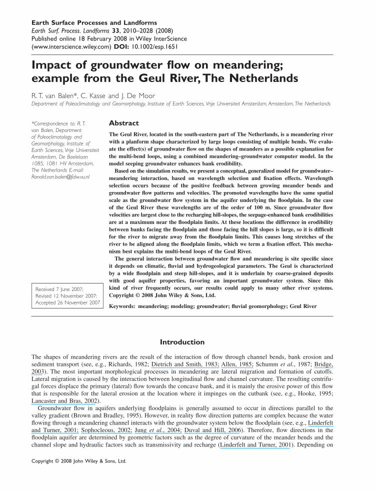
Copyright © 2008 John Wiley & Sons, Ltd. Earth Surface Processes and Landforms Earth Surf. Process. Landforms 33, 2010–2028 (2008) Published online 18 February 2008 in Wiley InterScience (www.interscience.wiley.com) DOI: 10.1002/esp.1651 Impact of groundwater flow on meandering; example from the Geul River, The Netherlands R. T. van Balen*, C. Kasse and J. De Moor Department of Paleoclimatology and Geomorphology, Institute of Earth Sciences, Vrije Universiteit Amsterdam, Amsterdam, The Netherlands Abstract The Geul River, located in the south-eastern part of The Netherlands, is a meandering river with a planform shape characterized by large loops consisting of multiple bends. We evalu- ate the effect(s) of groundwater flow on the shapes of meanders as a possible explanation for the multi-bend loops, using a combined meandering–groundwater computer model. In the model seeping groundwater enhances bank erodibility. Based on the simulation results, we present a conceptual, generalized model for groundwater– meandering interaction, based on wavelength selection and fixation effects. Wavelength selection occurs because of the positive feedback between growing meander bends and groundwater flow patterns and velocities. The promoted wavelengths have the same spatial scale as the groundwater flow system in the aquifer underlying the floodplain. In the case of the Geul River these wavelengths are of the order of 100 m. Since groundwater flow velocities are largest close to the recharging hill-slopes, the seepage-enhanced bank erodibilities are at a maximum near the floodplain limits. At these locations the difference in erodibility between banks facing the floodplain and those facing the hill slopes is large, so it is difficult for the river to migrate away from the floodplain limits. This causes long stretches of the river to be aligned along the floodplain limits, which we term a fixation effect. This mecha- nism best explains the multi-bend loops of the Geul River. The general interaction between groundwater flow and meandering is site specific since it depends on climatic, fluvial and hydrogeological parameters. The Geul is characterized by a wide floodplain and steep hill-slopes, and it is underlain by coarse-grained deposits with good aquifer properties, favoring an important groundwater system. Since this kind of river frequently occurs, our results could apply to many other river systems. Copyright © 2008 John Wiley & Sons, Ltd. Keywords: meandering; modeling; groundwater; fluvial geomorphology; Geul River Received 7 June 2007; Revised 12 November 2007; Accepted 26 November 2007 *Correspondence to: R. T. van Balen, Department of Paleoclimatology and Geomorphology, Institute of Earth Sciences, Vrije Universiteit Amsterdam, De Boelelaan 1085, 1081 HV Amsterdam, The Netherlands E-mail: [email protected] Introduction The shapes of meandering rivers are the result of the interaction of flow through channel bends, bank erosion and sediment transport (see, e.g., Richards, 1982; Dietrich and Smith, 1983; Allen, 1985; Schumm et al., 1987; Bridge, 2003). The most important morphological processes in meandering are lateral migration and formation of cutoffs. Lateral migration is caused by the interaction between longitudinal flow and channel curvature. The resulting centrifu- gal forces displace the primary (lateral) flow towards the concave bank, and it is mainly the erosive power of this flow that is responsible for the lateral erosion at the location where it impinges on the cutbank (see, e.g., Hooke, 1995; Lancaster and Bras, 2002). Groundwater flow in aquifers underlying floodplains is generally assumed to occur in directions parallel to the valley gradient (Brown and Bradley, 1995). However, in reality flow direction patterns are complex because the water flowing through a meandering channel interacts with the groundwater system below the floodplain (see, e.g., Linderfelt and Turner, 2001; Sophocleous, 2002; Jung et al., 2004; Duval and Hill, 2006). Therefore, flow directions in the floodplain aquifer are determined by geometric factors such as the degree of curvature of the meander bends and the channel slope and hydraulic factors such as transmissivity and recharge (Linderfelt and Turner, 2001). Depending on
-
Upload
independent -
Category
Documents
-
view
1 -
download
0
Transcript of Impact of groundwater flow on meandering; example from the Geul River, The Netherlands
Copyright © 2008 John Wiley & Sons, Ltd. Earth Surf. Process. Landforms 33, 2010–2028 (2008)DOI: 10.1002/esp
2010 R. T. van Balen et al.Earth Surface Processes and LandformsEarth Surf. Process. Landforms 33, 2010–2028 (2008)Published online 18 February 2008 in Wiley InterScience(www.interscience.wiley.com) DOI: 10.1002/esp.1651
Impact of groundwater flow on meandering;example from the Geul River, The NetherlandsR. T. van Balen*, C. Kasse and J. De MoorDepartment of Paleoclimatology and Geomorphology, Institute of Earth Sciences, Vrije Universiteit Amsterdam, Amsterdam, The Netherlands
AbstractThe Geul River, located in the south-eastern part of The Netherlands, is a meandering riverwith a planform shape characterized by large loops consisting of multiple bends. We evalu-ate the effect(s) of groundwater flow on the shapes of meanders as a possible explanation forthe multi-bend loops, using a combined meandering–groundwater computer model. In themodel seeping groundwater enhances bank erodibility.
Based on the simulation results, we present a conceptual, generalized model for groundwater–meandering interaction, based on wavelength selection and fixation effects. Wavelengthselection occurs because of the positive feedback between growing meander bends andgroundwater flow patterns and velocities. The promoted wavelengths have the same spatialscale as the groundwater flow system in the aquifer underlying the floodplain. In the caseof the Geul River these wavelengths are of the order of 100 m. Since groundwater flowvelocities are largest close to the recharging hill-slopes, the seepage-enhanced bank erodibilitiesare at a maximum near the floodplain limits. At these locations the difference in erodibilitybetween banks facing the floodplain and those facing the hill slopes is large, so it is difficultfor the river to migrate away from the floodplain limits. This causes long stretches of theriver to be aligned along the floodplain limits, which we term a fixation effect. This mecha-nism best explains the multi-bend loops of the Geul River.
The general interaction between groundwater flow and meandering is site specific sinceit depends on climatic, fluvial and hydrogeological parameters. The Geul is characterizedby a wide floodplain and steep hill-slopes, and it is underlain by coarse-grained depositswith good aquifer properties, favoring an important groundwater system. Since thiskind of river frequently occurs, our results could apply to many other river systems.Copyright © 2008 John Wiley & Sons, Ltd.
Keywords: meandering; modeling; groundwater; fluvial geomorphology; Geul River
Received 7 June 2007;Revised 12 November 2007;Accepted 26 November 2007
*Correspondence to: R. T.van Balen, Departmentof Paleoclimatology andGeomorphology, Institute ofEarth Sciences, Vrije UniversiteitAmsterdam, De Boelelaan1085, 1081 HV Amsterdam,The Netherlands E-mail:[email protected]
Introduction
The shapes of meandering rivers are the result of the interaction of flow through channel bends, bank erosion andsediment transport (see, e.g., Richards, 1982; Dietrich and Smith, 1983; Allen, 1985; Schumm et al., 1987; Bridge,2003). The most important morphological processes in meandering are lateral migration and formation of cutoffs.Lateral migration is caused by the interaction between longitudinal flow and channel curvature. The resulting centrifu-gal forces displace the primary (lateral) flow towards the concave bank, and it is mainly the erosive power of this flowthat is responsible for the lateral erosion at the location where it impinges on the cutbank (see, e.g., Hooke, 1995;Lancaster and Bras, 2002).
Groundwater flow in aquifers underlying floodplains is generally assumed to occur in directions parallel to thevalley gradient (Brown and Bradley, 1995). However, in reality flow direction patterns are complex because the waterflowing through a meandering channel interacts with the groundwater system below the floodplain (see, e.g., Linderfeltand Turner, 2001; Sophocleous, 2002; Jung et al., 2004; Duval and Hill, 2006). Therefore, flow directions in thefloodplain aquifer are determined by geometric factors such as the degree of curvature of the meander bends and thechannel slope and hydraulic factors such as transmissivity and recharge (Linderfelt and Turner, 2001). Depending on
Impact of groundwater flow on meandering; example from the Geul River, The Netherlands 2011
Copyright © 2008 John Wiley & Sons, Ltd. Earth Surf. Process. Landforms 33, 2010–2028 (2008)DOI: 10.1002/esp
the river’s stage and the hydrologic conditions, groundwater flows either towards the river or away from it. Becausehigh water stages in the river are relatively rare, most of the time groundwater flow is directed towards the river,contributing to the river’s baseflow discharge (Sophocleous, 2002; Jung et al., 2004).
Seeping groundwater affects the retreat rates of river banks. Seepage at cutbanks causes direct erosion by entrain-ment of grains and small pebbles. If concentrated, the seepage occurs through pipes or tunnels. This type of bankerosion typically produces small embayments along the banks, which result from undermining and collapse (Twidale,1964; Keller and Kondolf, 1990). In soft sediments, diffuse exfiltration may also entrain and displace small grainsleading to undermining and collapse, but not resulting in embayments, because the outflow is disperse. An indirecteffect of groundwater on bank erosion takes place via bank erodibility. These effects can be grouped into effects ofseepage on weathering, and the effect of changes in the groundwater head elevation on vegetation on the banks andfailure of the banks (Keller and Kodolf, 1990; Brown and Bradley, 1995; Hooke, 1995; Pederson, 2001). Seepageenhances erodibility by causing weathering due to wetting–desiccation cycles or freeze–thaw cycles in exposed bankmaterial. Because groundwater seepage affects bank retreat rates it can be expected that it has an effect on theplanform shapes of meandering rivers. We study such effects in this paper by means of computer modeling of the GeulRiver. This relatively small river shows a planform shape characterized by large loops consisting of multiple bends.Along parts of the Geul these loops are so important that the river does not have a well developed meandering axis. Inthe first part of this paper the planform characteristics of the Geul are analyzed. We pay special attention to the multi-bend loops and the groundwater flow system in order to explore whether they are related to each other. The secondpart consists of forward modeling of the planform shape using the Lancaster–Bras (2002) meander model. In aprevious study we have applied a similar meander model to study present-day lateral migration patterns (De Mooret al., 2007). In this study we focus on the characteristics of the planform shape, and thus we study a longer migrationhistory. We explore common model parameters such as bank-full discharge and channel width, and we pay specialattention to the role of groundwater flow in lateral migration. This has not been investigated in existing modelingstudies.
The Geul River
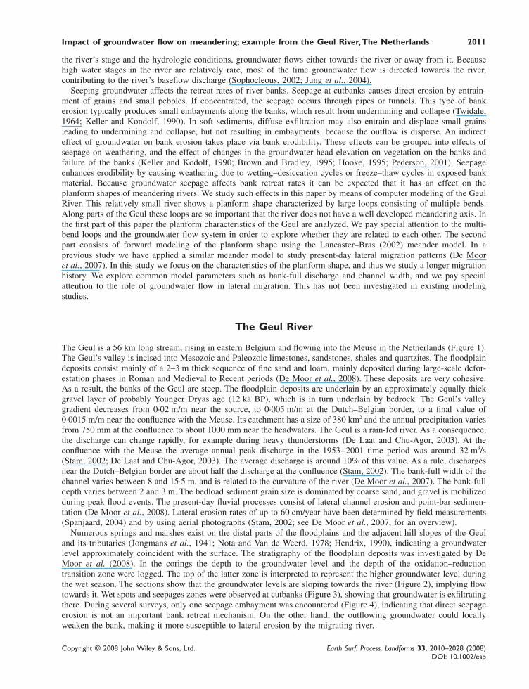
The Geul is a 56 km long stream, rising in eastern Belgium and flowing into the Meuse in the Netherlands (Figure 1).The Geul’s valley is incised into Mesozoic and Paleozoic limestones, sandstones, shales and quartzites. The floodplaindeposits consist mainly of a 2–3 m thick sequence of fine sand and loam, mainly deposited during large-scale defor-estation phases in Roman and Medieval to Recent periods (De Moor et al., 2008). These deposits are very cohesive.As a result, the banks of the Geul are steep. The floodplain deposits are underlain by an approximately equally thickgravel layer of probably Younger Dryas age (12 ka BP), which is in turn underlain by bedrock. The Geul’s valleygradient decreases from 0·02 m/m near the source, to 0·005 m/m at the Dutch–Belgian border, to a final value of0·0015 m/m near the confluence with the Meuse. Its catchment has a size of 380 km2 and the annual precipitation variesfrom 750 mm at the confluence to about 1000 mm near the headwaters. The Geul is a rain-fed river. As a consequence,the discharge can change rapidly, for example during heavy thunderstorms (De Laat and Chu-Agor, 2003). At theconfluence with the Meuse the average annual peak discharge in the 1953–2001 time period was around 32 m3/s(Stam, 2002; De Laat and Chu-Agor, 2003). The average discharge is around 10% of this value. As a rule, dischargesnear the Dutch–Belgian border are about half the discharge at the confluence (Stam, 2002). The bank-full width of thechannel varies between 8 and 15·5 m, and is related to the curvature of the river (De Moor et al., 2007). The bank-fulldepth varies between 2 and 3 m. The bedload sediment grain size is dominated by coarse sand, and gravel is mobilizedduring peak flood events. The present-day fluvial processes consist of lateral channel erosion and point-bar sedimen-tation (De Moor et al., 2008). Lateral erosion rates of up to 60 cm/year have been determined by field measurements(Spanjaard, 2004) and by using aerial photographs (Stam, 2002; see De Moor et al., 2007, for an overview).
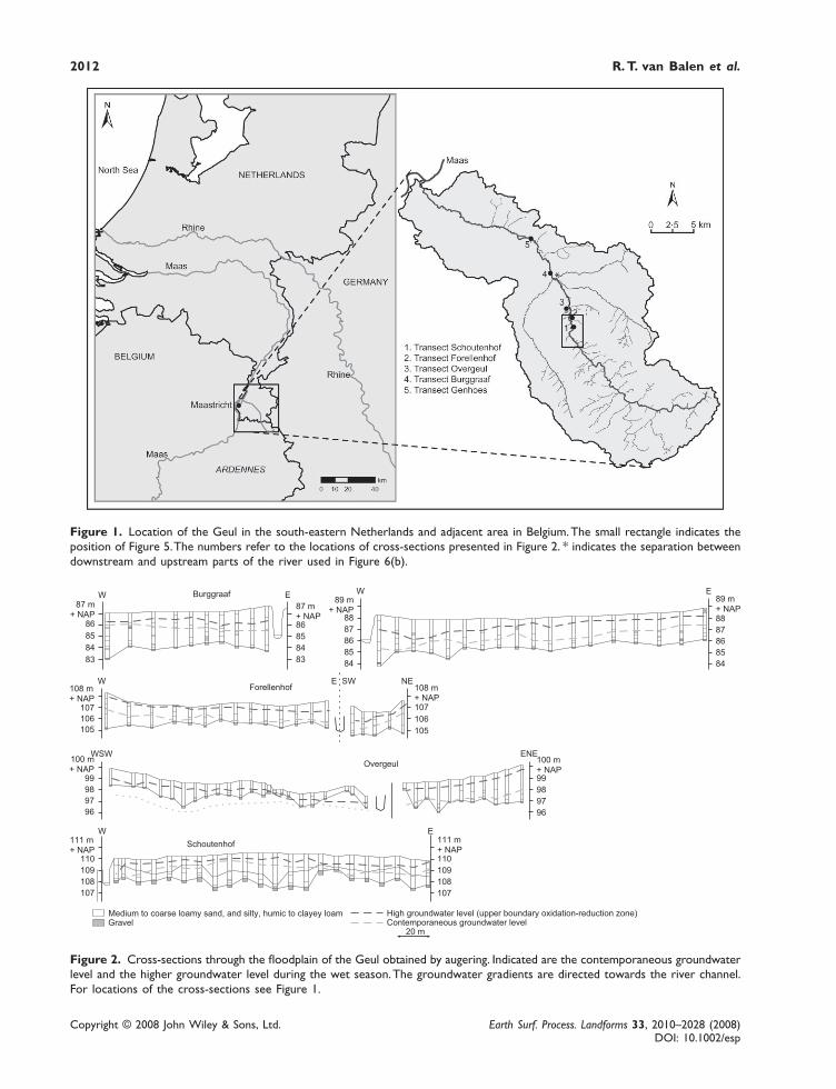
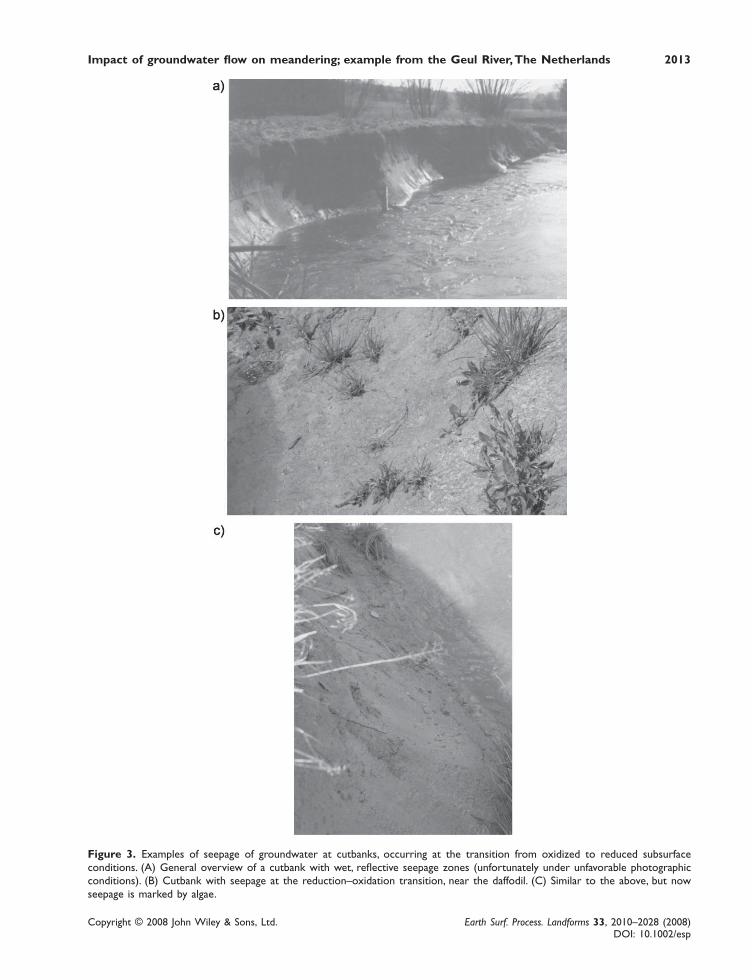
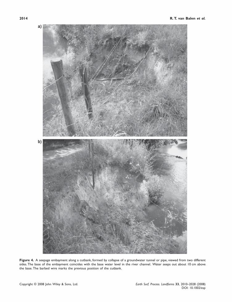
Numerous springs and marshes exist on the distal parts of the floodplains and the adjacent hill slopes of the Geuland its tributaries (Jongmans et al., 1941; Nota and Van de Weerd, 1978; Hendrix, 1990), indicating a groundwaterlevel approximately coincident with the surface. The stratigraphy of the floodplain deposits was investigated by DeMoor et al. (2008). In the corings the depth to the groundwater level and the depth of the oxidation–reductiontransition zone were logged. The top of the latter zone is interpreted to represent the higher groundwater level duringthe wet season. The sections show that the groundwater levels are sloping towards the river (Figure 2), implying flowtowards it. Wet spots and seepages zones were observed at cutbanks (Figure 3), showing that groundwater is exfiltratingthere. During several surveys, only one seepage embayment was encountered (Figure 4), indicating that direct seepageerosion is not an important bank retreat mechanism. On the other hand, the outflowing groundwater could locallyweaken the bank, making it more susceptible to lateral erosion by the migrating river.
Copyright © 2008 John Wiley & Sons, Ltd. Earth Surf. Process. Landforms 33, 2010–2028 (2008)DOI: 10.1002/esp
2012 R. T. van Balen et al.
Figure 2. Cross-sections through the floodplain of the Geul obtained by augering. Indicated are the contemporaneous groundwaterlevel and the higher groundwater level during the wet season. The groundwater gradients are directed towards the river channel.For locations of the cross-sections see Figure 1.
Figure 1. Location of the Geul in the south-eastern Netherlands and adjacent area in Belgium. The small rectangle indicates theposition of Figure 5. The numbers refer to the locations of cross-sections presented in Figure 2. * indicates the separation betweendownstream and upstream parts of the river used in Figure 6(b).
Impact of groundwater flow on meandering; example from the Geul River, The Netherlands 2013
Copyright © 2008 John Wiley & Sons, Ltd. Earth Surf. Process. Landforms 33, 2010–2028 (2008)DOI: 10.1002/esp
Figure 3. Examples of seepage of groundwater at cutbanks, occurring at the transition from oxidized to reduced subsurfaceconditions. (A) General overview of a cutbank with wet, reflective seepage zones (unfortunately under unfavorable photographicconditions). (B) Cutbank with seepage at the reduction–oxidation transition, near the daffodil. (C) Similar to the above, but nowseepage is marked by algae.
Copyright © 2008 John Wiley & Sons, Ltd. Earth Surf. Process. Landforms 33, 2010–2028 (2008)DOI: 10.1002/esp
2014 R. T. van Balen et al.
Figure 4. A seepage embayment along a cutbank, formed by collapse of a groundwater tunnel or pipe, viewed from two differentsides. The base of the embayment coincides with the base water level in the river channel. Water seeps out about 10 cm abovethe base. The barbed wire marks the previous position of the cutbank.
Impact of groundwater flow on meandering; example from the Geul River, The Netherlands 2015
Copyright © 2008 John Wiley & Sons, Ltd. Earth Surf. Process. Landforms 33, 2010–2028 (2008)DOI: 10.1002/esp
The groundwater flow systems differ between the upstream and downstream reaches of the Geul catchment. In theupstream part the aquifer below the floodplain is relatively thin (~5 m). It consists of Holocene floodplain deposits andan underlying gravel layer, overlying impermeable Paleozoic rocks. Since the half-width of the floodplain is about100 m, the floodplain aquifer is essentially two dimensional and flow in it is horizontal. This leads to relatively highexfiltration rates at cutbanks. In the downstream reach the groundwater flow system is three dimensional becausepermeable Late Cretaceous–Early Tertiary limestones underlie the fluvial deposits. As a consequence, part of thegroundwater discharges from below in to the river via the channel bed (Hendrix, personal communication 2004), and,consequently, exfiltration rates at cutbanks are expected to be relatively low compared with the upstream part. There-fore, if exfiltrating groundwater has an effect on bank retreat rates, and consequently on planform shapes, the largesteffect is expected in the southern, upstream part of the Geul.
Planform Characteristics of the Geul
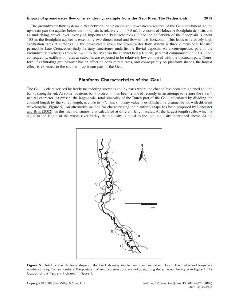
The Geul is characterized by freely meandering stretches and by parts where the channel has been straightened and thebanks strengthened. At some locations bank protection has been removed recently in an attempt to restore the river’snatural character. At present the large-scale, total sinuosity of the Dutch part of the Geul, calculated by dividing thechannel length by the valley length, is close to 1·7. This sinuosity value is established by channel bends with differentwavelengths (Figure 5). An alternative method for characterizing the planform shape has been proposed by Lancasterand Bras (2002). In this method, sinuosity is calculated at different length scales. At the largest length scale, which isequal to the length of the whole river valley, the sinuosity is equal to the total sinuosity mentioned above. At the
Figure 5. Detail of the planform shape of the Geul showing simple bends and multi-bend loops. The multi-bend loops arenumbered using Roman numbers. The positions of two cross-sections are indicated, using the same numbering as in Figure 1. Thelocation of this Figure is indicated in Figure 1.
Copyright © 2008 John Wiley & Sons, Ltd. Earth Surf. Process. Landforms 33, 2010–2028 (2008)DOI: 10.1002/esp
2016 R. T. van Balen et al.
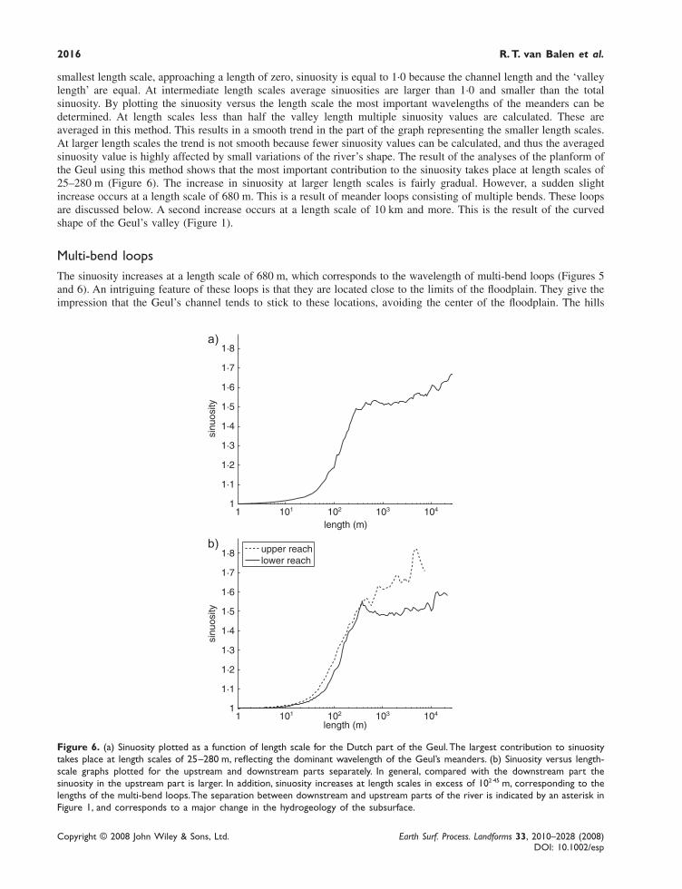
smallest length scale, approaching a length of zero, sinuosity is equal to 1·0 because the channel length and the ‘valleylength’ are equal. At intermediate length scales average sinuosities are larger than 1·0 and smaller than the totalsinuosity. By plotting the sinuosity versus the length scale the most important wavelengths of the meanders can bedetermined. At length scales less than half the valley length multiple sinuosity values are calculated. These areaveraged in this method. This results in a smooth trend in the part of the graph representing the smaller length scales.At larger length scales the trend is not smooth because fewer sinuosity values can be calculated, and thus the averagedsinuosity value is highly affected by small variations of the river’s shape. The result of the analyses of the planform ofthe Geul using this method shows that the most important contribution to the sinuosity takes place at length scales of25–280 m (Figure 6). The increase in sinuosity at larger length scales is fairly gradual. However, a sudden slightincrease occurs at a length scale of 680 m. This is a result of meander loops consisting of multiple bends. These loopsare discussed below. A second increase occurs at a length scale of 10 km and more. This is the result of the curvedshape of the Geul’s valley (Figure 1).
Multi-bend loopsThe sinuosity increases at a length scale of 680 m, which corresponds to the wavelength of multi-bend loops (Figures 5and 6). An intriguing feature of these loops is that they are located close to the limits of the floodplain. They give theimpression that the Geul’s channel tends to stick to these locations, avoiding the center of the floodplain. The hills
Figure 6. (a) Sinuosity plotted as a function of length scale for the Dutch part of the Geul. The largest contribution to sinuositytakes place at length scales of 25–280 m, reflecting the dominant wavelength of the Geul’s meanders. (b) Sinuosity versus length-scale graphs plotted for the upstream and downstream parts separately. In general, compared with the downstream part thesinuosity in the upstream part is larger. In addition, sinuosity increases at length scales in excess of 102·45 m, corresponding to thelengths of the multi-bend loops. The separation between downstream and upstream parts of the river is indicated by an asterisk inFigure 1, and corresponds to a major change in the hydrogeology of the subsurface.
Impact of groundwater flow on meandering; example from the Geul River, The Netherlands 2017
Copyright © 2008 John Wiley & Sons, Ltd. Earth Surf. Process. Landforms 33, 2010–2028 (2008)DOI: 10.1002/esp
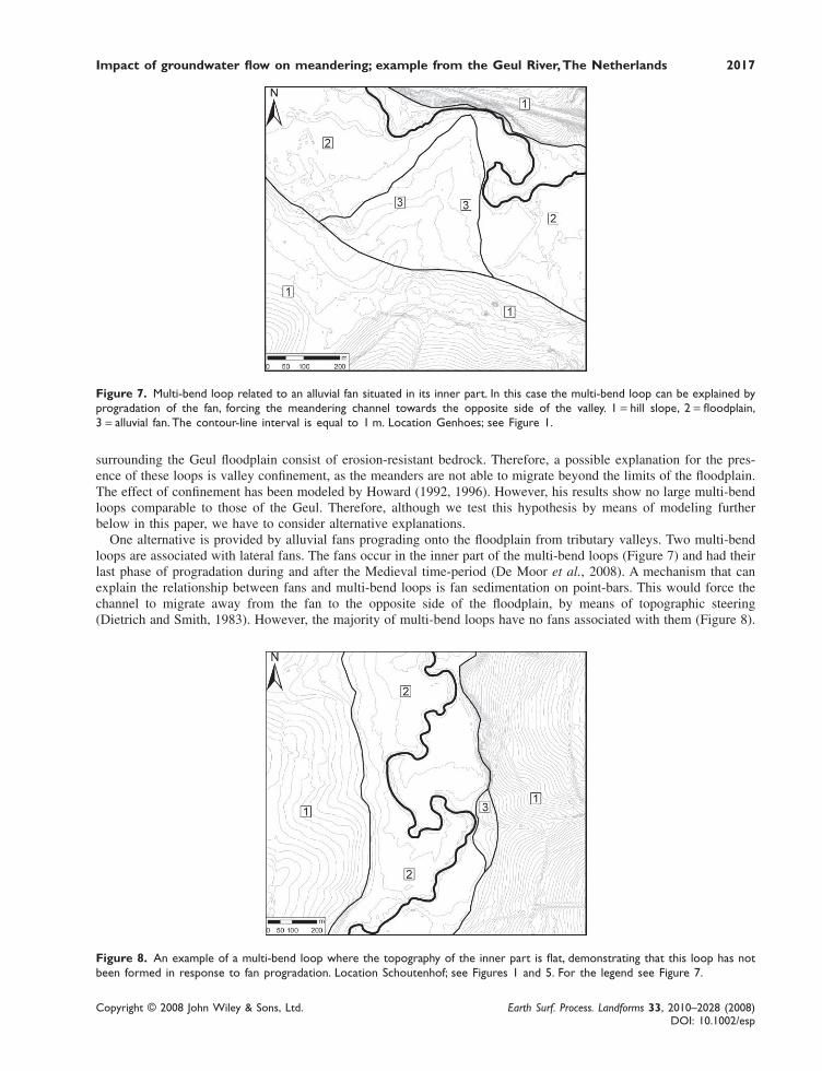
Figure 7. Multi-bend loop related to an alluvial fan situated in its inner part. In this case the multi-bend loop can be explained byprogradation of the fan, forcing the meandering channel towards the opposite side of the valley. 1 = hill slope, 2 = floodplain,3 = alluvial fan. The contour-line interval is equal to 1 m. Location Genhoes; see Figure 1.
surrounding the Geul floodplain consist of erosion-resistant bedrock. Therefore, a possible explanation for the pres-ence of these loops is valley confinement, as the meanders are not able to migrate beyond the limits of the floodplain.The effect of confinement has been modeled by Howard (1992, 1996). However, his results show no large multi-bendloops comparable to those of the Geul. Therefore, although we test this hypothesis by means of modeling furtherbelow in this paper, we have to consider alternative explanations.
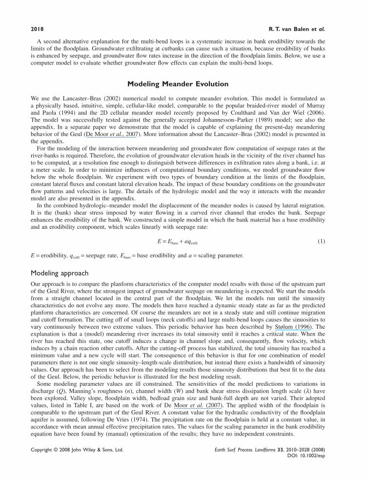
One alternative is provided by alluvial fans prograding onto the floodplain from tributary valleys. Two multi-bendloops are associated with lateral fans. The fans occur in the inner part of the multi-bend loops (Figure 7) and had theirlast phase of progradation during and after the Medieval time-period (De Moor et al., 2008). A mechanism that canexplain the relationship between fans and multi-bend loops is fan sedimentation on point-bars. This would force thechannel to migrate away from the fan to the opposite side of the floodplain, by means of topographic steering(Dietrich and Smith, 1983). However, the majority of multi-bend loops have no fans associated with them (Figure 8).
Figure 8. An example of a multi-bend loop where the topography of the inner part is flat, demonstrating that this loop has notbeen formed in response to fan progradation. Location Schoutenhof; see Figures 1 and 5. For the legend see Figure 7.
Copyright © 2008 John Wiley & Sons, Ltd. Earth Surf. Process. Landforms 33, 2010–2028 (2008)DOI: 10.1002/esp
2018 R. T. van Balen et al.
A second alternative explanation for the multi-bend loops is a systematic increase in bank erodibility towards thelimits of the floodplain. Groundwater exfiltrating at cutbanks can cause such a situation, because erodibility of banksis enhanced by seepage, and groundwater flow rates increase in the direction of the floodplain limits. Below, we use acomputer model to evaluate whether groundwater flow effects can explain the multi-bend loops.
Modeling Meander Evolution
We use the Lancaster–Bras (2002) numerical model to compute meander evolution. This model is formulated asa physically based, intuitive, simple, cellular-like model, comparable to the popular braided-river model of Murrayand Paola (1994) and the 2D cellular meander model recently proposed by Coulthard and Van der Wiel (2006).The model was successfully tested against the generally accepted Johannesson–Parker (1989) model; see also theappendix. In a separate paper we demonstrate that the model is capable of explaining the present-day meanderingbehavior of the Geul (De Moor et al., 2007). More information about the Lancaster–Bras (2002) model is presented inthe appendix.
For the modeling of the interaction between meandering and groundwater flow computation of seepage rates at theriver-banks is required. Therefore, the evolution of groundwater elevation heads in the vicinity of the river channel hasto be computed, at a resolution fine enough to distinguish between differences in exfiltration rates along a bank, i.e. ata meter scale. In order to minimize influences of computational boundary conditions, we model groundwater flowbelow the whole floodplain. We experiment with two types of boundary condition at the limits of the floodplain,constant lateral fluxes and constant lateral elevation heads. The impact of these boundary conditions on the groundwaterflow patterns and velocities is large. The details of the hydrologic model and the way it interacts with the meandermodel are also presented in the appendix.
In the combined hydrologic–meander model the displacement of the meander nodes is caused by lateral migration.It is the (bank) shear stress imposed by water flowing in a curved river channel that erodes the bank. Seepageenhances the erodibility of the bank. We constructed a simple model in which the bank material has a base erodibilityand an erodibility component, which scales linearly with seepage rate:
E = Ebase + aqexfil (1)
E = erodibility, qexfil = seepage rate, Ebase = base erodibility and a = scaling parameter.
Modeling approachOur approach is to compare the planform characteristics of the computer model results with those of the upstream partof the Geul River, where the strongest impact of groundwater seepage on meandering is expected. We start the modelsfrom a straight channel located in the central part of the floodplain. We let the models run until the sinuositycharacteristics do not evolve any more. The models then have reached a dynamic steady state as far as the predictedplanform characteristics are concerned. Of course the meanders are not in a steady state and still continue migrationand cutoff formation. The cutting off of small loops (neck cutoffs) and large multi-bend loops causes the sinuosities tovary continuously between two extreme values. This periodic behavior has been described by Stølum (1996). Theexplanation is that a (model) meandering river increases its total sinuosity until it reaches a critical state. When theriver has reached this state, one cutoff induces a change in channel slope and, consequently, flow velocity, whichinduces by a chain reaction other cutoffs. After the cutting-off process has stabilized, the total sinuosity has reached aminimum value and a new cycle will start. The consequence of this behavior is that for one combination of modelparameters there is not one single sinuosity–length-scale distribution, but instead there exists a bandwidth of sinuosityvalues. Our approach has been to select from the modeling results those sinuosity distributions that best fit to the dataof the Geul. Below, the periodic behavior is illustrated for the best modeling result.
Some modeling parameter values are ill constrained. The sensitivities of the model predictions to variations indischarge (Q), Manning’s roughness (n), channel width (W) and bank shear stress dissipation length scale (λ) havebeen explored. Valley slope, floodplain width, bedload grain size and bank-full depth are not varied. Their adoptedvalues, listed in Table I, are based on the work of De Moor et al. (2007). The applied width of the floodplain iscomparable to the upstream part of the Geul River. A constant value for the hydraulic conductivity of the floodplainaquifer is assumed, following De Vries (1974). The precipitation rate on the floodplain is held at a constant value, inaccordance with mean annual effective precipitation rates. The values for the scaling parameter in the bank erodibilityequation have been found by (manual) optimization of the results; they have no independent constraints.
Impact of groundwater flow on meandering; example from the Geul River, The Netherlands 2019
Copyright © 2008 John Wiley & Sons, Ltd. Earth Surf. Process. Landforms 33, 2010–2028 (2008)DOI: 10.1002/esp
Table I. Parameter values
Valley slope 0·004 m/mValley width 200 mD50 bedload 5 cmBank-full depth 2·5 mHydraulic conductivity 15 m/dEffective precipitation rate 200 mm/yErodibility 1·0 m3/N yBank-full discharge, Q 10–18 m3/sRoughness, n 0·035–0·07Channel width, w 8–15·5 mDissipation length scale, λ 15–30 mNode spacing (nominal) meander 5·0 mNode spacing (fixed) floodplain 1·0 mMaximum displacement per time step 0·1 mGroundwater elevation head near channel 0·5 m(relative to the river’s base level)Groundwater elevation head at lateral boundary 4·0 m(relative to the river’s base level)
Table II. Calibrated parameters for groundwater models
Model Parameter a
Erodibility, constant lateral head 0·5 m3/N y/m3/sErodibility, constant lateral flux 0·35 m3/N y/m3/s
Results
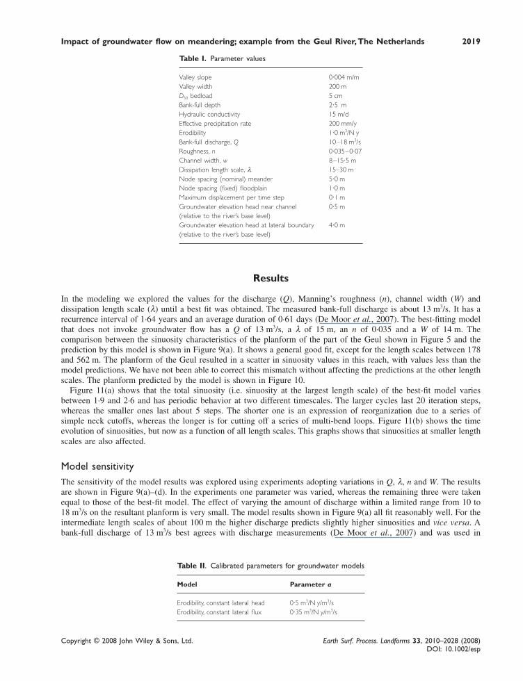
In the modeling we explored the values for the discharge (Q), Manning’s roughness (n), channel width (W) anddissipation length scale (λ) until a best fit was obtained. The measured bank-full discharge is about 13 m3/s. It has arecurrence interval of 1·64 years and an average duration of 0·61 days (De Moor et al., 2007). The best-fitting modelthat does not invoke groundwater flow has a Q of 13 m3/s, a λ of 15 m, an n of 0·035 and a W of 14 m. Thecomparison between the sinuosity characteristics of the planform of the part of the Geul shown in Figure 5 and theprediction by this model is shown in Figure 9(a). It shows a general good fit, except for the length scales between 178and 562 m. The planform of the Geul resulted in a scatter in sinuosity values in this reach, with values less than themodel predictions. We have not been able to correct this mismatch without affecting the predictions at the other lengthscales. The planform predicted by the model is shown in Figure 10.
Figure 11(a) shows that the total sinuosity (i.e. sinuosity at the largest length scale) of the best-fit model variesbetween 1·9 and 2·6 and has periodic behavior at two different timescales. The larger cycles last 20 iteration steps,whereas the smaller ones last about 5 steps. The shorter one is an expression of reorganization due to a series ofsimple neck cutoffs, whereas the longer is for cutting off a series of multi-bend loops. Figure 11(b) shows the timeevolution of sinuosities, but now as a function of all length scales. This graphs shows that sinuosities at smaller lengthscales are also affected.
Model sensitivityThe sensitivity of the model results was explored using experiments adopting variations in Q, λ, n and W. The resultsare shown in Figure 9(a)–(d). In the experiments one parameter was varied, whereas the remaining three were takenequal to those of the best-fit model. The effect of varying the amount of discharge within a limited range from 10 to18 m3/s on the resultant planform is very small. The model results shown in Figure 9(a) all fit reasonably well. For theintermediate length scales of about 100 m the higher discharge predicts slightly higher sinuosities and vice versa. Abank-full discharge of 13 m3/s best agrees with discharge measurements (De Moor et al., 2007) and was used in
Copyright © 2008 John Wiley & Sons, Ltd. Earth Surf. Process. Landforms 33, 2010–2028 (2008)DOI: 10.1002/esp
2020 R. T. van Balen et al.
Figure 9. Simulation results for models without groundwater flow. Shown are slightly smoothened sinuosity versus length-scaledistributions for different sets of experiments. The best model result has a discharge (Q) = 13 m3/s, dissipation length (λ) = 15 m,Manning’s roughness (n) = 0·035 and channel width (W) = 14 m. In each experiment set one parameter was varied whereas theothers were held constant, and the results are compared with the best-fit model (straight line). Also shown are the non-smoothened sinuosity characteristics of the river stretch depicted in Figure 5. (a) The impact of variations in discharge; (b) thesensitivity of model results to a variation in λ; (c) the impact of different values for roughness; (d) the effect of the adopted channelwidth. See the text for discussion.
further experiments. Although the predicted planform shapes are similar, the predicted migration rates are much largerfor the higher discharges, due to their quadratic relationship in the simulation model (see Lancaster and Bras, 2002).
The second series of experiments involved λ. According to Lancaster and Bras (2002), a good approximation forthe value of this parameter is the average length of the cutbanks. According to De Moor et al. (2007), this approachresults in a value of 30 m for the Geul River. Compared with the model invoking a λ of 15 m, the effect of increasing
Figure 10. Predicted planform of the model with Q = 13 m3/s, λ = 15 m, n = 0·035 and W = 14 m. Although this model’s sinuositycharacteristics fit reasonably well, the planform does not look like the planform of the Geul (Figure 5).

Impact of groundwater flow on meandering; example from the Geul River, The Netherlands 2021
Copyright © 2008 John Wiley & Sons, Ltd. Earth Surf. Process. Landforms 33, 2010–2028 (2008)DOI: 10.1002/esp
Figure 11. (a) Time evolution of the total sinuosity (i.e. at the largest length scale) for a model with Q = 13 m3/s, λ = 15 m,n = 0·035, W = 14 m, showing periodic behavior. (b) Evolution of the sinuosity as a function of length scale for the same model.
λ to values of 22 and 30 m is to shift the sinuosity distribution to larger length scales (Figure 9(b)), as expected sincethe bank shear stress is spread over a larger stretch of the cutbank. However, the predicted sinuosities agree less wellwith the data.
Roughness parameter n affects the cross-sectional channel slope via hydraulic radius R, which is computed usingManning’s equation for flow resistance in combination with the continuity equation for water flowing in a (river)channel. The dependences are such that a larger n results in a larger value for the slope. A value of 0·07 for n wasproposed by De Moor et al. (2007) based on an empirical analyses of the controlling parameters, such as vegetationtype. A value of 0·035 is a widely accepted, standard value. Our modeling experiments show that varying n in a rangefrom 0·035 to 0·07 does not have a discernable effect on the results (Figure 9(c)). De Moor et al. (2007) alsoconcluded that the differences in the modeling results are minor.
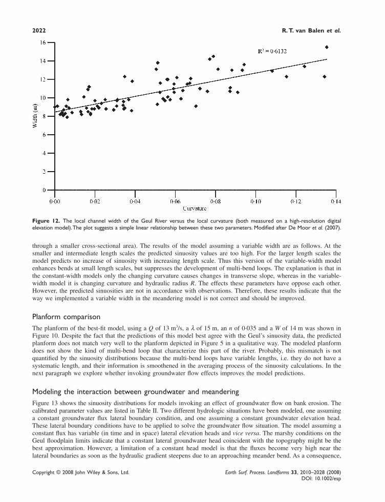
The actual width of the Geul River channel varies between 8 and 15·5 m. According to De Moor et al. (2007),width correlates linearly with curvature (Figure 11). De Moor et al. (2007) included a variable channel width in themodel published by Lancaster and Bras (2002). In the modified model the varying channel width affects the waterflow velocity and the hydraulic radius, R. Because R is computed using Manning’s equation combined with a continu-ity equation, an increasing width reduces R, which in turn reduces the transverse channel slope. In addition, thedecreasing flow velocity causes a reduction of the bank erosion rate. In the model the width is taken to depend linearlyon curvature, as indicated by the Geul’s data (Figure 12). At high curvature the width is 15·5 m; at low curvature thewidth is 8·0 m. As shown by De Moor et al. (2007), the variable width modeling scheme predicts a much moredynamic meandering river because the transverse channel slope varies more compared with models in which this slopeonly depends on curvature, and it is the variation in transverse slope that drives the lateral migration in the Lancaster–Bras model. Figure 9(d) shows the comparison of results for two model runs with a fixed, non-varying width of 8 and14 m, and one model run in which the width is variable. A model invoking a small constant width of 8 m predictshigher sinuosity values at all length scales, which is caused by the higher flow velocities (the same discharge is forced
Copyright © 2008 John Wiley & Sons, Ltd. Earth Surf. Process. Landforms 33, 2010–2028 (2008)DOI: 10.1002/esp
2022 R. T. van Balen et al.
Figure 12. The local channel width of the Geul River versus the local curvature (both measured on a high-resolution digitalelevation model). The plot suggests a simple linear relationship between these two parameters. Modified after De Moor et al. (2007).
through a smaller cross-sectional area). The results of the model assuming a variable width are as follows. At thesmaller and intermediate length scales the predicted sinuosity values are too high. For the larger length scales themodel predicts no increase of sinuosity with increasing length scale. Thus this version of the variable-width modelenhances bends at small length scales, but suppresses the development of multi-bend loops. The explanation is that inthe constant-width models only the changing curvature causes changes in transverse slope, whereas in the variable-width model it is changing curvature and hydraulic radius R. The effects these parameters have oppose each other.However, the predicted sinuosities are not in accordance with observations. Therefore, these results indicate that theway we implemented a variable width in the meandering model is not correct and should be improved.
Planform comparisonThe planform of the best-fit model, using a Q of 13 m3/s, a λ of 15 m, an n of 0·035 and a W of 14 m was shown inFigure 10. Despite the fact that the predictions of this model best agree with the Geul’s sinuosity data, the predictedplanform does not match very well to the planform depicted in Figure 5 in a qualitative way. The modeled planformdoes not show the kind of multi-bend loop that characterize this part of the river. Probably, this mismatch is notquantified by the sinuosity distributions because the multi-bend loops have variable lengths, i.e. they do not have asystematic length, and their information is smoothened in the averaging process of the sinuosity calculations. In thenext paragraph we explore whether invoking groundwater flow effects improves the model predictions.
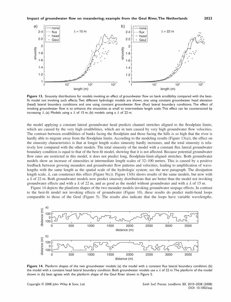
Modeling the interaction between groundwater and meanderingFigure 13 shows the sinuosity distributions for models invoking an effect of groundwater flow on bank erosion. Thecalibrated parameter values are listed in Table II. Two different hydrologic situations have been modeled, one assuminga constant groundwater flux lateral boundary condition, and one assuming a constant groundwater elevation head.These lateral boundary conditions have to be applied to solve the groundwater flow situation. The model assuming aconstant flux has variable (in time and in space) lateral elevation heads and vice versa. The marshy conditions on theGeul floodplain limits indicate that a constant lateral groundwater head coincident with the topography might be thebest approximation. However, a limitation of a constant head model is that the fluxes become very high near thelateral boundaries as soon as the hydraulic gradient steepens due to an approaching meander bend. As a consequence,
Impact of groundwater flow on meandering; example from the Geul River, The Netherlands 2023
Copyright © 2008 John Wiley & Sons, Ltd. Earth Surf. Process. Landforms 33, 2010–2028 (2008)DOI: 10.1002/esp
Figure 13. Sinuosity distributions for models invoking an effect of groundwater flow on bank erodibility compared with the best-fit model not invoking such effects. Two different hydrologic models are shown, one using constant groundwater head elevation(head) lateral boundary conditions and one using constant groundwater flow (flux) lateral boundary conditions. The effect ofinvoking groundwater flow is to enhance the sinuosities at small to intermediate length scale. This effect can be counteracted byincreasing λ. (a) Models using a λ of 15 m; (b) models using a λ of 22 m.
Figure 14. Planform shapes of the two groundwater models: (a) the model with a constant flux lateral boundary condition; (b)the model with a constant head lateral boundary condition. Both groundwater models use a λ of 22 m. The planform of the modelshown in (b) best agrees with the planform shape of the Geul River shown in Figure 5.
the model applying a constant lateral groundwater head predicts channel stretches aligned to the floodplain limits,which are caused by the very high erodibilities, which are in turn caused by very high groundwater flow velocities.The contrast between erodibilities of banks facing the floodplain and those facing the hills is so high that the river ishardly able to migrate away from the floodplain limits. According to the modeling results (Figure 13(a)), the effect onthe sinuosity characteristics is that at longer length scales sinuosity hardly increases, and the total sinuosity is rela-tively low compared with the other models. The total sinuosity of the model with a constant flux lateral groundwaterboundary condition is equal to that of the best-fit model, showing that it is not affected. Because potential groundwaterflow rates are restricted in this model, it does not predict long, floodplain-limit-aligned stretches. Both groundwatermodels show an increase of sinuosities at intermediate length scales of 32–100 meters. This is caused by a positivefeedback between growing meanders and groundwater flow patterns and velocities, leading to amplification of wave-lengths with the same length as the spatial scale of the hydrologic system; see the next paragraph. The dissipationlength scale, λ, can counteract this effect (Figure 9(c)). Figure 13(b) shows results of the same models, but now witha λ of 22 m. Both groundwater models now predict sinuosity distributions that are better than the model not invokinggroundwater effects and with a λ of 22 m, and as good as the model without groundwater and with a λ of 15 m.
Figure 14 depicts the planform shapes of the two meander models invoking groundwater seepage effects. In contrastto the best-fit model not invoking effects of groundwater (Figure 10), these results do predict multi-bend loopscomparable to those of the Geul (Figure 5). The results also indicate that the loops have variable wavelengths.
Copyright © 2008 John Wiley & Sons, Ltd. Earth Surf. Process. Landforms 33, 2010–2028 (2008)DOI: 10.1002/esp
2024 R. T. van Balen et al.
Therefore, these loops are not well expressed in the sinuosity distributions as a result of the averaging in the sinuositycalculations. Thus, although the two groundwater models predict equally well the sinuosity distribution, a qualitativecomparison of the planform shapes shows that the groundwater models better reproduce the multi-bend loops that arepresent in the Geul River. In particular, the constant head lateral groundwater boundary condition model predicts ariver course that tends to avoid the center of the floodplain, similar to the Geul River.
A Conceptual Model for Groundwater–bank Erosion Interaction
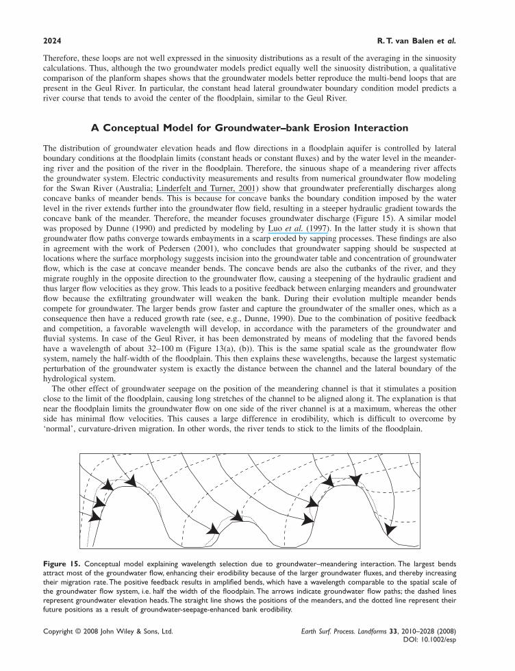
The distribution of groundwater elevation heads and flow directions in a floodplain aquifer is controlled by lateralboundary conditions at the floodplain limits (constant heads or constant fluxes) and by the water level in the meander-ing river and the position of the river in the floodplain. Therefore, the sinuous shape of a meandering river affectsthe groundwater system. Electric conductivity measurements and results from numerical groundwater flow modelingfor the Swan River (Australia; Linderfelt and Turner, 2001) show that groundwater preferentially discharges alongconcave banks of meander bends. This is because for concave banks the boundary condition imposed by the waterlevel in the river extends further into the groundwater flow field, resulting in a steeper hydraulic gradient towards theconcave bank of the meander. Therefore, the meander focuses groundwater discharge (Figure 15). A similar modelwas proposed by Dunne (1990) and predicted by modeling by Luo et al. (1997). In the latter study it is shown thatgroundwater flow paths converge towards embayments in a scarp eroded by sapping processes. These findings are alsoin agreement with the work of Pedersen (2001), who concludes that groundwater sapping should be suspected atlocations where the surface morphology suggests incision into the groundwater table and concentration of groundwaterflow, which is the case at concave meander bends. The concave bends are also the cutbanks of the river, and theymigrate roughly in the opposite direction to the groundwater flow, causing a steepening of the hydraulic gradient andthus larger flow velocities as they grow. This leads to a positive feedback between enlarging meanders and groundwaterflow because the exfiltrating groundwater will weaken the bank. During their evolution multiple meander bendscompete for groundwater. The larger bends grow faster and capture the groundwater of the smaller ones, which as aconsequence then have a reduced growth rate (see, e.g., Dunne, 1990). Due to the combination of positive feedbackand competition, a favorable wavelength will develop, in accordance with the parameters of the groundwater andfluvial systems. In case of the Geul River, it has been demonstrated by means of modeling that the favored bendshave a wavelength of about 32–100 m (Figure 13(a), (b)). This is the same spatial scale as the groundwater flowsystem, namely the half-width of the floodplain. This then explains these wavelengths, because the largest systematicperturbation of the groundwater system is exactly the distance between the channel and the lateral boundary of thehydrological system.
The other effect of groundwater seepage on the position of the meandering channel is that it stimulates a positionclose to the limit of the floodplain, causing long stretches of the channel to be aligned along it. The explanation is thatnear the floodplain limits the groundwater flow on one side of the river channel is at a maximum, whereas the otherside has minimal flow velocities. This causes a large difference in erodibility, which is difficult to overcome by‘normal’, curvature-driven migration. In other words, the river tends to stick to the limits of the floodplain.
Figure 15. Conceptual model explaining wavelength selection due to groundwater–meandering interaction. The largest bendsattract most of the groundwater flow, enhancing their erodibility because of the larger groundwater fluxes, and thereby increasingtheir migration rate. The positive feedback results in amplified bends, which have a wavelength comparable to the spatial scale ofthe groundwater flow system, i.e. half the width of the floodplain. The arrows indicate groundwater flow paths; the dashed linesrepresent groundwater elevation heads. The straight line shows the positions of the meanders, and the dotted line represent theirfuture positions as a result of groundwater-seepage-enhanced bank erodibility.
Impact of groundwater flow on meandering; example from the Geul River, The Netherlands 2025
Copyright © 2008 John Wiley & Sons, Ltd. Earth Surf. Process. Landforms 33, 2010–2028 (2008)DOI: 10.1002/esp
Conclusions
The Geul is a meandering river with a sinuosity caused by bends and loops at different length scales. Most meandershave small wavelengths, but an important contribution is made by multi-bend loops with a length of 680 m. Groundwaterflow is important in the floodplain and along the channel banks. The limits of the Geul floodplain have marshyconditions and the neighboring hill-slopes have multiple springs, indicating an important groundwater system. Thegroundwater elevation heads at the floodplain limits almost coincide with the surface. Transects through the floodplainshow groundwater levels declining towards the river, implying flow in this direction. Seepage faces at the banks andone example of sapping erosion demonstrate that groundwater exfiltrates into the river.
Computer modeling results show that seepage-enhanced erodibility of the banks can explain the existence ofmulti-bend loops. In particular, a model assuming constant lateral groundwater elevations heads predicts sinuositycharacteristics and a planform shape that are is similar to those of the Geul River. The effect that groundwater flow hason the meandering shapes can be summarized into (1) an amplification effect due to positive feedback betweengroundwater flow and migration of those meander bends that have a wavelength comparable to the spatial scale ofthe groundwater system and (2) a fixation of the channel along the valley sides due to the larger erodibilities (inducedby seepage) of banks aligned to the floodplain limits.
Although seepage-enhanced erodibility can explain the multi-bend loops of the Geul River, we can not exclude thatother mechanisms also contribute to these shapes. For example, the roughness of the valley sides, where the channelloops are close to the bedrock, could play a role (although it has nowhere been observed that the channel is in directcontact with bedrock). Confinement could play an important role, although the general results of Howard (1992, 1996)and our modeling results presented in this study (which do take confinement of the Geul into account) indicate thatthis mechanism is not sufficient to explain the planform shape. The potentially significant role of alternate bars ishowever not important in the Geul River, since this type of bar is not present (De Moor et al., 2008; Spanjaard, 2004).
If groundwater is indeed as important as we propose, than hydrologic heterogeneities in the subsurface induced by thecontinuous deposition and erosion of overbank, channel and point-bar deposits could have a strong impact on the directionof groundwater flow, and therefore also on the distribution of seepage-enhanced erodibility. We do not have howeversufficient information on the distribution of these different types of deposit to quantify the effects of heterogeneities.
Implications for other riversThe characteristics of our study area (wide floodplain, relatively thin alluvial sequence, steep hill-slopes) are typical ofmany European rivers draining mid-altitude regions (see, e.g., Jung et al., 2004). Therefore, we believe that ourfindings are applicable to other river systems in similar geological and geomorphological settings. The effect ofgroundwater flow on meandering will of course depend on the relative importance of groundwater-affected meanderdisplacement compared with the fluvial processes. In order to have a noticeable effect, curvature-driven bank erosionshould not overwhelm the effects of variations in erodibility or of seepage erosion. On the other hand, large rivers ingeneral seem to respond to gentle forcing, such as tectonic tilting, so they might also respond to the small forcingprovided by exfiltrating groundwater (Nanson, personal communication 2006).
Neighboring catchments of the Geul, such as the Worm, Gulp and Berwinne, have the same hydrogeologic andlandscape setting and show comparable multi-bend loops. In the Rhine–Meuse system, in the central Netherlands,channels near the limits of the delta are meandering, in contrast with channels in the central part, which are straighter.This difference has been attributed to a higher (bank) erodibility at the rims of the delta (Berendsen and Stouthamer,2002). However, according to Cohen (2003), effects on bank stability by local groundwater outflow may also havepromoted a meandering channel style. In the southern part of the Netherlands, in the coversand area, Wolfert (2001)studied the development of meanders in several small streams, following river restoration projects. He noted that, inaddition to scour at bank toes, groundwater seepage in winter and spring resulted in bank undermining and collapse.
Appendix
The Topographic Steering Meander (TSM) ModelThe most popular type of numerical meander model is a process-based bend erosion model, like the ones proposed byIkeda et al. (1981), Parker et al. (1982), Odgaard (1989), Howard (1992), Sun et al. (1996, 2001a, 2001b). Thesetypes of model utilize idealized and non-mechanistic relationships that link bank erosion rate (and thus bend migra-tion) to the near-bank velocity variation, which is obtained from a linear computation of the flow field and the bed
Copyright © 2008 John Wiley & Sons, Ltd. Earth Surf. Process. Landforms 33, 2010–2028 (2008)DOI: 10.1002/esp
2026 R. T. van Balen et al.
topography in a curved channel (Ikeda et al., 1981). Several simplifying assumptions are incorporated, among whichare a spatially and temporally constant channel width and a linear cross-stream variation in the vertically averageddownstream velocity, with negligible sidewall effects on near-bank flows (Howard, 1992). The flow field is coupled tothe river-bed topography by using a simple proportionality between bed inclination and the local channel curvature.
Despite their success in theoretical studies, numerical models based on the linear theory of Ikeda et al. (1981) arephysically and mathematically complex, and therefore difficult to apply to geomorphic modeling of real cases. Inaddition, Lancaster (1998) and Lancaster and Bras (2002) showed that the linear theory models can not satisfactorilymodel compound bends (‘cumuliform’, ‘double heading’, ‘lobing’). These bends develop from simple bends byforming a curvature reversal during the bend evolution. Such bend forms probably arise from the interactions betweenflow and the banks. Therefore, a new conceptual model was developed by Lancaster (1998) and Lancaster and Bras(2002), based on the work of Dietrich and Smith (1983). Whereas in the classical models meander migration isultimately driven by the effects of curvature on near-bank downstream velocity (velocity perturbation), this modeluses the relationship between lateral bed topography and meander migration. The cross-sectional channel shape directs(steers) the downstream flow’s high-velocity core towards the outer bank, where it causes erosion and thus bankmigration. Leopold and Wolman (1960) have already pointed out this mechanism. Essentially, the model uses apositive feedback between point bar formation and bank erosion: a small point bar steers the flow to the outer bank;the outer bank erosion increases the channel curvature, which in turn causes growth of the point bar.
In the topographic steering model it is the change in bed inclination that ultimately determines the bank shear stress.The inclination is in turn computed from local channel curvature. Thus changes in curvature control meander evolu-tion. This is also the case for the older ‘traditional’ computer models such as those by Ikeda et al. (1981), Parker et al.(1982) and Johannesson and Parker (1989) and their derivatives. However, the topographic steering model is lesscomplex than these models because it uses one main empirical element, the dissipation length scale λ, which needs tobe specified, whereas other models calculate this length implicitly from the flow. The reduction in complexity makesthe model easier to apply for geomorphic experiments as we do in this paper.
ImplementationThe meandering river channel is discretized into a one-dimensional line of linked nodes representing the channelcenter. On these nodes the local curvature is computed by using the position of neighboring nodes. The curvaturedrives lateral migration via the cross-sectional channel slope. The spacing between the nodes is half the channel width(Lancaster and Bras, 2002; Crosato, 2006). The curvature is computed locally, and is not smoothened. Accordingto Crosato (2006) and the results of our own experiments this does not affect the predictions for this type of meandermodel. Nodes move due to migration. If nodes become too close, one of them is deleted. If the distance between twonodes becomes too large, a new node is inserted in between them. If meander loops become so tight that in naturea neck cutoff should occur, a new link is established between nodes close to where the cutoff should occur, and thenodes previously in between them are deleted. Chute cutoffs are not modeled. The position of the one-dimensionalcomputational channel is tracked on a rectangular two-dimensional grid representing the floodplain, which serves asa memory for former channel locations. The same grid is used for the hydrologic computations, and because oftheir requirements the resolution is 1 m. The computational time-step of the meandering module is determined bya specified maximum horizontal displacement for the nodes, which in our case was 0·01 m.
Hydrologic modelThe groundwater movements in the vicinity of the channel are part of a three-dimensional groundwater flow field,with the lateral boundaries approximately coincident with the drainage divides in the surrounding hills. However, welimit the modeling to the floodplain by using appropriate boundary conditions at the floodplain limits. We focus themodeling study on the upstream part of the Geul. Here the effect of groundwater is expected to be the largest and theaquifer below the floodplain is essentially two dimensional, which is computationally efficient because we can neglectthe vertical flow component and the model groundwater flow using the Dupuit–Forchheimer approximation. Note thatthis still allows for incorporating precipitation on the floodplain.
Meandering is a slow process (on average centimeters per year) compared with groundwater flow (meters per year).Thus we can safely assume that the groundwater flow around a migrating meandering channel evolves independentlyfrom the displacing meanders; time-dependent effects due to migration are neglected. A second simplification is thatprecipitation rate does not vary with time. The hydrologic model is thus highly simplified, and therefore inaccurate.However, the model is not designed to simulate every detail of the hydrologic situation, but rather to evaluate thehypothesis that groundwater flow could explain the meander shapes of the Geul River.
Impact of groundwater flow on meandering; example from the Geul River, The Netherlands 2027
Copyright © 2008 John Wiley & Sons, Ltd. Earth Surf. Process. Landforms 33, 2010–2028 (2008)DOI: 10.1002/esp
We compute the steady-state groundwater elevation head, and the flows caused by it at the river banks for each timestep meandering is computed. Thus, the modeled groundwater evolves through a series of steadystates.
Hydrologic Boundary conditionsIn the experiments we use two types of hydrologic lateral boundary condition. One is a constant elevation of thegroundwater head. The other is a constant flow velocity, which is computed at the start of the model from solving thesteady state groundwater head distribution with a straight channel located at the center of the floodplain and a lateralgroundwater head coincident with the topography. From the calculated distribution of heads the horizontal groundwatervelocities near the lateral boundaries are computed, which due to the geometry are equal all along the lateral bounda-ries of this model. Subsequently, the amount of inflow at the later boundaries is held constant for the rest of thesimulation. Due to the evolving geometry of the meanders, the groundwater elevation head distribution will adapt tocomply with the lateral flux boundary condition and the water level in the river channel. The upstream and down-stream hydrologic boundary conditions are constant heads. At these locations it is assumed that the river extendsstraight (non-meandering) and that it is located in the center of the floodplain. An internal boundary condition isprovided by the water level in the channel. Here we assume that this level coincides with the depth of the riverchannel at low water stages, which is on average 0·5 m, since most of the time the river is at a low stage.
The computations are carried out using an explicit finite differencing scheme and Gauss-Seidel iteration. At the veryfirst time-step the model is initialized with the analytical solution, in order to speed up calculations.
Combining the hydrologic and meander modelsThe time-stepping of the meandering process is determined by a critical displacement distance, the maximum dis-placement per timestep for the nodes, which is 0·01 m. For each time-step the position of the river is tracked on thetwo-dimensional floodplain grid, at a resolution of 1 m. Subsequently, the updated grid is used to compute the steady-state groundwater head distribution. In this step we iterate to find the groundwater head levels, since the transmissivityof the aquifer depends on the groundwater heads and vice versa: for an unconfined aquifer the transmissivity is equalto the permeability times the level of the groundwater head. From the groundwater heads and the transmissivities theseepage rates at cutbanks is calculated. Only the flows directed towards the channels at active cutbanks are used tocompute bank erodibilities and seepage-induced bank erosion rates, using Equation (1).
AcknowledgementsJ. Vandenberghe and C. Hemker are thanked for their help and interest. Stephen Lancaster kindly provided his meandering code anddiscussed the re-implementation of his meander model. The manuscript benefited from a review by Tom Coulthard and an anony-mous reviewer.
References
Allen JRL. 1985. Principles of Physical Sedimentology. George Allen and Unwin: London.Berendsen HJA, Stouthamer E. 2002. Palaeogeographic evolution and avulsion history of the Holocene Rhine-Meuse delta, the Netherlands.
Netherlands Journal of Geosciences/Geologie en Mijnbouw 81(1): 97–112.Bridge JS. 2003. Rivers and floodplains, Forms, Processes and Sedimentary Record. Blackwell: Oxford.Brown AG, Bradley C. 1995. Geomorphology and groundwater: convergence and diversification. In Geomorphology and Groundwater,
Brown AG (ed.). Wiley, Chichester; 1–20.Cohen KM. 2003. Differential Subsidence Within a Coastal Prism: Late-Glacial–Holocene Tectonics in the Rhine–Meuse Delta, the Nether-
lands, PhD thesis, Utrecht University.Coulthard TJ, Van de Wiel MJ. 2006. A cellular model of river meandering. Earth Surface Processes and Landforms 31: 123–132. DOI:
10.1002/esp.1315Crosato A. 2007. Effects of smoothing and regridding in numerical meander migration models. Water Resources Research 43: W01401.
DOI: 10.1029/2006WR005087De Laat P, Chu-Agor ML. 2003. Geen toename piekafvoer van de Geul. H2O 9: 25–27.De Moor JJW, Kasse C, Van Balen R, Vandenberghe J, Wallinga J. 2008. Human and climate impact on catchment development during the
Holocene – Geul River, Netherlands. Geomorphology. DOI: 10.1016/j.geomorph.2006.12.033De Moor JJW, Van Balen RT, Kasse C. 2007. Simulating meander evolution of the Geul River (the Netherlands) using a topographic steering
model. Earth Surface Processes and Landforms 32: 1077–1093.De Vries JJ. 1974. Groundwater flow Systems and Stream Nets in the Netherlands, Amsterdam Hydrology Series 1; 226.
Copyright © 2008 John Wiley & Sons, Ltd. Earth Surf. Process. Landforms 33, 2010–2028 (2008)DOI: 10.1002/esp
2028 R. T. van Balen et al.
Dietrich WE, Smith JD. 1983. Influence of the point-bar flow through curved channels. Water Resources Research 19: 1173–1192.Dunne T. 1990. Hydrology, mechanics, and geomorphic implications of erosion by subsurface flow. In Groundwater Geomorphology, the
Role of Subsurface Water in Earth Surface Processes and Landforms, Geological Society of America Special Paper 252, Higgins CG,Coates DR (eds); 1–28.
Duval TP, Hill AR. 2006. Influence of stream bank seepage during low-flow conditions on riparian zone hydrology. Water ResourcesResearch 42: W10425. DOI: 10.1029/2006WR004861
Hendrix WPAM. 1990. Bronnen in Zuid Limburg. Natuur Historisch Maandblad 79(3/4): 14 –26.Hooke JM. 1995. Processes of channel planform change on meandering channels in the UK. In Changing River Channels, Gurnell A,
Petts G (eds). Wiley: Chichester; 87–115.Howard AD. 1992. Modeling channel migration and floodplain sedimentation in meandering streams. In Lowland floodplain Rivers:
Geomorphological Perspectives, Carling PA, Petts GE (eds). Wiley: Chichester; 1–41.Howard AD. 1996. Modelling channel evolution and floodplain morphology. In floodplain Processes, Anderson MG, Walling DE, Bates PD
(eds). Wiley: Chichester; 15–62.Ikeda S. 1989. Sediment transport and sorting at bends. In River Meandering, Water Resources Monograph, Ikeda S, Parker G (eds).
American Geophysical Union: Washington, DC; 103–126.Ikeda S, Parker G, Sawai K. 1981. Bend theory of river meanders. Part 1. Journal of Fluid Mechanics 112: 363–377.Johannesson H, Parker G. 1989. Velocity redistribution in meandering rivers. Journal of Hydraulic Engineering 113: 190–206.Jongmans WJ, Krul WFJM, Vos JJH. 1941. Waterwinning in Z. Limburg. N.V. Waterleiding Mij. voor Z-Limburg: Maastricht.Jung M, Burt TP, Bates PD. 2004. Toward a conceptual model of floodplain water table response. Water Resources Research 40: W12409.
DOI: 10.129/2003WR002619Keller EA, Kondolf GM. 1990. Groundwater and fluvial processes; selected observations. In Groundwater Geomorphology, the Role of
Subsurface Water in Earth Surface Processes and Landforms, Geological Society of America Special Paper 252, Higgins CG, Coates DR(eds); 319–340.
Lancaster ST. 1998. A Nonlinear River Meandering Model and its Incorporation in a Landscape Evolution Model. PhD Thesis, Massachu-setts Institute of Technology.
Lancaster S, Bras RL. 2002. A simple model of river meandering and its comparison to natural channels. Hydrological Processes 16: 1–26.Leopold LB, Wolman MG. 1960. River meanders. Geological Society of America Bulletin 71: 769–793.Linderfelt WR, Turner JV. 2001. Interaction between shallow groundwater, saline surface water and nutrient discharge in a seasonal estuary:
the Swan–Canning system. Hydrological Processes 15: 2631–2653.Luo W, Arvidson RE, Sultan M, Becker R, Crombie MK, Sturchio N, El Alfy Z. 1997. Groundwater sapping processes, Western Desert
Egypt. Geological Society of America Bulletin 109: 43–62.Murray AB, Paola C. 1994. A cellular model of braided rivers. Nature 371: 54 –57.Nota DJG, Van de Weerd B. 1978. A hydrogeological study in the basin of the Gulp creek – a reconnaissance in a small catchment area. 1.
Groundwater flow characteristics. Mededelingen Landbouwhogeschool Wageningen 78–20, 1–26.Odgaard AJ. 1989. River-meander model. I: development. Journal of Hydraulic Engineering 115: 1433–1450.Parker G, Sawai K, Ikeda S. 1982. Bend theory of river meanders. Part 2. Nonlinear deformation of finite-amplitude bends. Journal of Fluid
Mechanics 115: 303–314.Pederson DT. 2001. Stream piracy revisited: a groundwater-sapping solution. GSA Today 11: 4–10.Richards K. 1982. Rivers, Forms and Processes in Alluvial Channels. Methuen: London.Schumm SA, Mosley MP, Weaver WE. 1987. Experimental Fluvial Geomorphology. Wiley.Sophocleous M. 2002. Interactions between groundwater and surface water: the state of science. Hydrogeology Journal 10: 52–67.Spanjaard G. 2004. Recent Erosion and Sedimentation Processes in the Geul River, unpublished MSc Thesis, Vrije Universiteit Amsterdam.Stam MH. 2002. Effects of Land-Use and Precipitation Changes on Floodplain Sedimentation in the Nineteenth and Twentieth Centuries
(Geul River, The Netherlands), Special Publication of the International Association of Sedimentologists 32; 251–267.Stølum H. 1996. River meandering as a self-organization process. Science 271: 1710–1713.Sun T, Meakin P, Jøssang T. 1996. A simulation model for meandering rivers. Water Resources Research 32: 2937–2954.Sun T, Meakin P, Jøssang T. 2001a. Meander migration and the lateral tilting of floodplains. Water Resources Research 37: 1485–1502.Sun T, Meakin P, Jøssang T. 2001b. A meander model for meandering rivers with multiple bed load sediment sizes. 1. Theory. Water
Resources Research 37: 2227–2241.Twidale CR. 1964. Erosion of an alluvial bank at Birdwood, South Australia. Zeitschrift für Geomorfologie 8: 189–211.Wolfert HP. 2001. Geomorphological Change and River Rehabilitation, Ph.D. thesis, Utrecht University.