Illill'llill'llili lillilll'll Illili AZ 15053-4 - Bureau of Land Management
500
NOTICE! ! These documents have been scanned! Do not place un-scanned documents beneath this notice! Do not remove this notice from this file! GPO Jacket No. 560-102 Print Order 61540 Rise Business Services, LLC Job=AZ15 5/15/2019 Box Number= AZ15053 11111111111111111111111'llililil lillill'l lill 11111111111 illill ill' 1111111111111111 11111111 1111'lll Claim Begin-End: AMC412595-AMC412679 1 Initial Receipt Illill'llill'llili lillilll'll Illili AZ 15053-4 AMC412566-AMC413285
-
Upload
khangminh22 -
Category
Documents
-
view
1 -
download
0
Transcript of Illill'llill'llili lillilll'll Illili AZ 15053-4 - Bureau of Land Management

NOTICE! !
These documents have been scanned!
Do not place un-scanned documents beneath this notice!
Do not remove this notice from this file!
GPO Jacket No. 560-102Print Order 61540
Rise Business Services, LLCJob=AZ15 5/15/2019
Box Number= AZ15053
11111111111111111111111'llililil lillill'l lill 11111111111 illill ill' 1111111111111111 11111111 1111'lllClaim Begin-End: AMC412595-AMC412679
1 Initial Receipt
Illill'llill'llili lillilll'll Illili AZ 15053-4 AMC412566-AMC413285
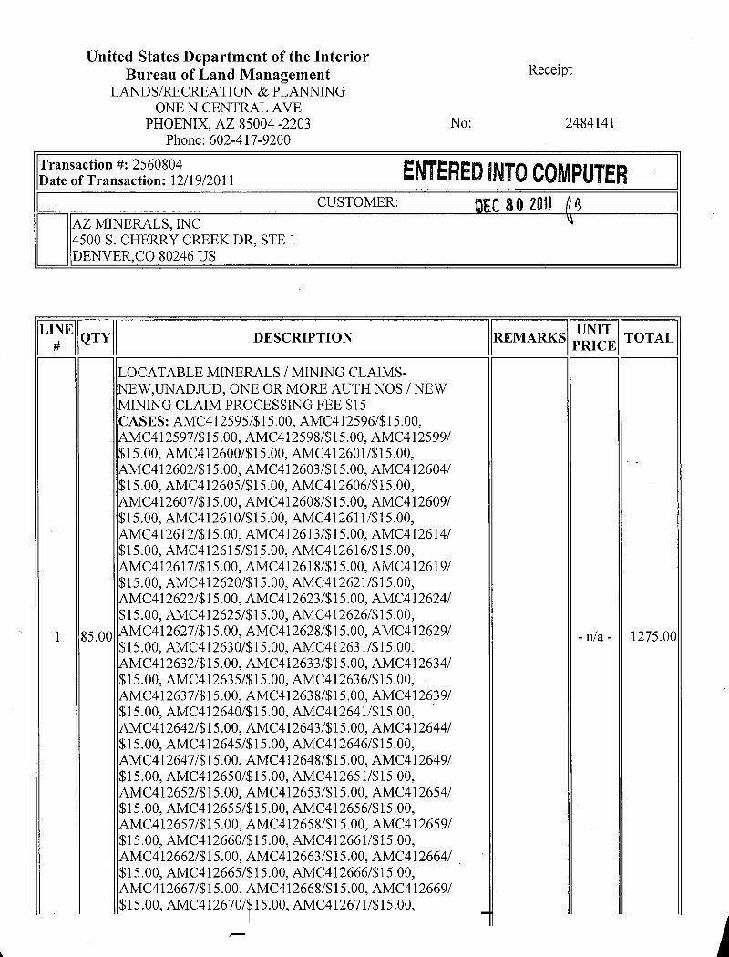
United States Department of the InteriorBureau of Land Management Receipt
LANDS/RECREATION & PLANNINGONE N CENTRAL AVE
PHOENIX, AZ 85004 -2203 No: 2484141Phone: 602-417-9200
Transaction #: 2560804 ENTERED INTO COMPUTERDate of Transaction: 12/19/2011CUSTOMER: 2011
AZ MINERALS, INC4500 S. CHERRY CREEK DR, STE 1DENVER,CO 80246 US
LINE F-----11-ruirrf-# QTY DESCRIPTION IREMARKSII 11 TOTAL I~~PRICE~~
LOCATABLE MINERALS / MINING CLAIMS-NEW,UNADJUD, ONE OR MORE AUTH NOS /NEWMINING CLAIM PROCESSING FEE $15CASES: AMC412595/$15.00, AMC412596/$15.00,AMC412597/$15.00, AMC412598/$15.00, AMC412599/$15.00, AMC412600/$15.00, AMC412601/$15.00,AMC412602/$15.00, AMC412603/$15.00, AMC412604/$15.00, AMC412605/$15.00, AMC412606/$15.00,AMC412607/$15.00, AMC412608/$15.00, AMC412609/$15.00, AMC412610/$15.00, AMC412611/$15.00,AMC412612/$15.00, AMC412613/$15.00, AMC412614/$15.00, AMC412615/$15.00, AMC412616/$15.00,AMC412617/$15.00, AMC412618/$15.00, AMC412619/$15.00, AMC412620/$15.00, AMC412621/$15.00,AMC412622/$15.00, AMC412623/$15.00, AMC412624/$15.00, AMC412625/$15.00, AMC412626/$15.00,
1 85.00 AMC412627/$15.00, AMC412628/$15.00, AMC412629/ -n/a - 1275.00$15.00, AMC412630/$15.00, AMC412631/$15.00,AMC412632/$15.00, AMC412633/$15.00, AMC412634/$15.00, AMC412635/$15.00, AMC412636/$15.00,AMC412637/$15.00, AMC412638/$15.00, AMC412639/$15.00, AMC412640/$15.00, AMC412641/$15.00,AMC412642/$15.00, AMC412643/$15.00, AMC412644/$15.00, AMC412645/$15.00, AMC412646/$15.00,AMC412647/$15.00, AMC412648/$15.00, AMC412649/$15.00, AMC412650/$15.00, AMC412651/$15.00,AMC412652/$15.00, AMC412653/$15.00, AMC412654/$15.00, AMC412655/$15.00, AMC412656/$15.00,AMC412657/$15.00, AMC412658/$15.00, AMC412659/$15.00, AMC412660/$15.00, AMC412661/$15.00,AMC412662/$15.00, AMC412663/$15.00, AMC412664/$15.00, AMC412665/$15.00, AMC412666/$15.00,AMC412667/$15.00, AMC412668/$15.00, AMC412669/$15.00, AMC412670/~15.00, AMC412671/$15.00,

1-1~ AMC412672/$15.00, AMC412673/$15.00, AMC412674/$15.00, AMC412675/$15.00, AMC412676/$15.00,
|$15-00AMC412677/$15.00, AMC412678/$15.00, AMC412679/
LOCATABLE MINERALS / MINING CLAIMS-NEW,UNADJUD, ONE OR MORE AUTH NOS /NEWMINING CLAIM LOCATION FEE $34CASES: AMC412595/$34.00, AMC412596/$34.00,AMC412597/$34.00, AMC412598/$34.00, AMC412599/$34.00, AMC412600/$34.00, AMC412601/$34.00,AMC412602/$34.00, AMC412603/$34.00, AM(412604/$34.00, AMC412605/$34.00, AMC412606/$34.00,AMC412607/$34.00, AMC412608/$34.00, AMC412609/$34.00, AMC412610/$34.00, AMC412611/$34.00,AMC412612/$34.00, AMC412613/$34.00, AMC412614/$34.00, AMC412615/$34.00, AMC412616/$34.00,AMC412617/$34.00, AMC412618/$34.00, AMC412619/$34.00, AMC412620/$34.00, AMC412621/$34.00,AMC412622/$34.00, AMC412623/$34.00, AMC412624/$34.00, AMC412625/$34.00, AMC412626/$34.00,AMC412627/$34.00, AMC412628/$34.00, AMC412629/$34.00, AMC412630/$34.00, AMC412631/$34.00,AMC412632/$34.00, AMC412633/$34.00, AMC412634/2 85.00 -n/a- 2890.00$34.00, AMC412635/$34.00, AMC412636/$34.00,AMC412637/$34.00, AMC412638/$34.00, AMC412639/$34.00, AMC412640/$34.00, AMC412641/$34.00,AMC412642/$34.00, AMC412643/$34.00, AMC412644/$34.00, AMC412645/$34.00, AMC412646/$34.00,AMC412647/$34.00, AMC412648/$34.00, AMC412649/$34.00, AMC412650/$34.00, AMC412651/$34.00,AMC412652/$34.00, AMC412653/$34.00, AMC412654/$34.00, AMC412655/$34.00, AMC412656/$34.00,AMC412657/$34.00, AMC412658/$34.00, AMC412659/$34.00, AMC412660/$34.00, AMC412661/$34.00,AMC412662/$34.00, AMC412663/$34.00, AMC412664/$34.00, AMC412665/$34.00, AMC412666/$34.00,AMC412667/$34.00, AMC412668/$34.00, AMC412669/$34.00, AMC412670/$34.00, AMC412671/$34.00,AMC412672/$34.00, AMC412673/$34.00, AMC412674/$34.00, AMC412675/$34.00, AMC412676/$34.00,AMC412677/$34.00, AMC412678/$34.00, AMC412679/$34.00
LOCATABLE MINERALS / MINING CLAIMS-NEW,UNADJUD, ONE OR MORE AUTH NOS / NEWMINING CLAIM MAINT FEE $140CASES: AMC412595/$140.00, AMC412596/$140.00,AMC412597/$140.00, AMC412598/$140.00, AMC412599/$140.00, AMC412600/$140.00, AMC412601/$140.00,AMC412602/$140.00, AMC412603/$140.00, AMC412604/$140.00, AMC412605/$140.00, AMC412606/$140.00,AMC412607/$140.00, AMC412608/$140.00, AMC412609/$140.00, AM(412<~IM140.00, AMC412611/$140.00,

AMC412612/$140.00, AMC412613/$140.00, AMC412614/$140.00, AMC412615/$140.00, AMC412616/$140.00,AMC412617/$140.00, AMC412618/$140.00, AMC412619/$140.00, AMC412620/$140.00, AMC412621/$140.00,AMC412622/$140.00, AMC412623/$140.00, AMC412624/$140.00, AMC412625/$140.00, AMC412626/$140.00,AMC412627/$140.00, AMC412628/$140.00, AMC412629/$140.00, AMC412630/$140.00, AMC412631/$140.00,AMC412632/$140.00, AMC412633/$140.00, AMC412634/$140.00, AMC412635/$140.00, AMC412636/$140.00,AMC412637/$140.00, AMC412638/$140.00, AMC412639/$140.00, AMC412640/$140.00, AMC412641/$140.00,AMC412642/$140.00, AMC412643/$140.00, AMC412644/
3 85.00 $140.00, AMC412645/$140.00, AMC412646/$140.00, - rda - 11900.00AMC412647/$140.00, AMC412648/$140.00, AMC412649/$140.00, AMC412650/$140.00, AMC412651/$140.00,AMC412652/$140.00, AMC412653/$140.00, AMC412654/$140.00, AMC412655/$140.00, AMC412656/$140.00,AMC412657/$140.00, AMC412658/$140.00, AMC412659/$140.00, AMC412660/$140.00, AMC412661/$140.00,AMC412662/$140.00, AMC412663/$140.00, AMC412664/$140.00, AMC412665/$140.00, AMC412666/$140.00,AMC412667/$140.00, AMC412668/$140.00, AMC412669/$140.00, AMC412670/$140.00, AMC412671/$140.00,AMC412672/$140.00, AMC412673/$140.00, AMC412674/$140.00, AMC412675/$140.00, AMC412676/$140.00,AMC412677/$140.00, AMC412678/$140.00, AMC412679/$140.00
PAYMENT INFORMATION1---AMOUNT: 16065.00 POSTMARKED: IN/A1------TYPE:ICHEEKRECERED:12/19/2611
-CHEEKNO: 000662841NAME: AZ MINERALS, INC
4500 S. CHERRY CREEK DR, STE 1DENVER CO 80246 US
REMARKS
This receipt was generated by the automated BLM Collections and Billing System and is a paper representation of a portion of theofficial electronic record contained therein.

NOTICE!!
These documents have been scanned!
Do not place un-scanned documents beneath this notice!
Do not remove this notice from this file!
GPO Jacket No. 560-102Print Order 61540
Rise Business Services, LLCJob=AZ15 5/15/2019
I il i I l~ Ill li ~ li li Il l w Hi l lili ill I ~I il iBox Number= AZ15053
Illillill'lli illill'll'll'11111111'Illill'llill'111111111 11111111111'lill'Illillil ill'll'llill'11'llClaim Begin-End: AMC412595-AMC412679
2 Correspondence
Illl'llilll'llilillillilill'llillil AZ15053-4 AMC412566-AMC413285

NODOCUMENTS
FOUNDNO DOCUMENTS FOUNDNO DOCUMENTS FOUND

NOTICE!!
These documents have been scanned!
Do not place un-scanned documents beneath this notice!
Do not remove this notice from this file!
GPO jacket No. 560-102Print Order 61540
Rise Business Services, LLCJob=AZ15 5/15/2019
Box Number= AZ15053
111111111111 111111Nlililill Ili lill Illii lmililill lill i 111111111111111111111111111111 111111Claim Begin-End: AMC412595-AMC412679
3 Transfers
Ilillillill'll'll'llilll'lll'llil AZ15053-4 AMC412566-AMC413285

NODOCUMENTS
FOUNDNO DOCUMENTS FOUNDNO DOCUMENTS FOUND

NOTICE!!
These documents have been scanned!
Do not place un-scanned documents beneath this notice!
Do not remove this notice from this file!
GPO Jacket No. 560-102Print Order 61540
Rise Business Services, LLCJob=AZ15 5/15/2019
Box Number= AZ15053
~~111'lli II IrII Iiiiiiiii Iiiiiiiiiiim Iiiiiiiii IiI IiI 1 111111 Iiii I I ji II IiiiiiiiiClaim Begin-End: AMC412595-AMC412679
4 Miscellaneous
Illl'llilll'll'lll'llillill'llillil AZ15053-4 AMC412566-AMC413285

NODOCUMENTS
FOUNDNO DOCUMENTS FOUNDNO DOCUMENTS FOUND

NOTICE!!
These documents have been scanned!
Do not place un-scanned documents beneath this notice!
Do not remove this notice from this file!
GPO Jacket No. 560-102Print Order 61540
Rise Business Services, LLCJob=AZ15 5/15/2019
111111 111111111111111111111 11 lilli'IHIIIBox Number= AZ15053
11'lll'1111111 Ill' 11111111! 111'll'll Illil l'll 1111111111 Ill'll 111111111'll'lll'111111111111 11111 'lllClaim Begin-End: AMC412595-AMC412679
5 Annual Filings
Illl'llill'llill'll'll'llill'lillil AZ15053-4 AMC412566-AMC413285

..
1. 438099938,118
Quarles*Brady LI r One South Church Avenue -1 Attorneys at Law in 9389/RSuite 1700 379997 ChicagoTucson, Arizona 85701-1621 Indianapolis 439We7520.770.8700 3%3330 MadisonFax 520.623.2418 Milwaukeewww.quarles.com Naples 94015943-4 390 Phoenix
37 63 29 - Scottsdale
9 12 545 Tampa 93599/Tucson~& 3-76437 4 1 1 0153 Washington , D . C . 2(18756Writer's Direct Dial: 520-770-8708
E-Mail: [email protected] 44'Gisq, 9505679 3.3 V LK August 10.2018
VIA OVERNIGHT COURIER 3 -7 9 l.1 1 3 il#00 4315. * = 59907960 CO „.
Bureau of Land Management 4 3 f O 89 ifi I le 6 5 5 %73 9 j li 01m >Arizona State Office ,--1£.-.-- ]01,Attention: Information Access Center H rl 350 3, W -:5 2 3 2 Lf 34
--One North Central Avenue, Suite 800 3 6739 8 - vPhoenix, Arizona 85004-4427 EW37499-77686 & 1 1 - -P W --'RE. Payment ofClaim Maintenance Fees for Arizona Minerals Inc, W -3 3999543-73 367 .4 GLy 5*60Dear Ladies and Gentlemen:2 7 6 3-1 -7
Delivered herewith is a check in the amount of $187:240 as payment of the claimmaintenance fees pursuant to 30 U.S.C. § 281'(a). as adjusted by 30 U.S.C. § 28j(c) andimplemented by notice in the 74 Federal Register 30959-61 (June 29, 2009) and as amended by'the Consolidated Appropriations Act 2012: Pub. L. No. 112-74,125 Stat 786 (2011). The owneris paying a maintenance fee of S 1 55.00 per lode claim for the assessment year beginiiingSeptember 1, 2018. Also enclosed is a copy of the Certification of Payment of Maintenance Feein Lieu of Affidavit of Annual Assessment Work to be recorded with the Santa Cruz CounhRecorder's Office.
Please returna_date-stamizedcom ofthisletterandthe*ffidarit-along-xithihereceipt for payment to this office.
Thank you for your assistance and please feel free to contact me with any questions orconcerns.
Sincerely,
f«XL__-2Tiffany N. MorrisLegal Specialist
EnclosuresQB\159799.00005\52959066.1
AUG 1 7 2018j i :-1 7 r / r.> r *r tEE ** 12«44 3301

When Recorded Mail To:
Marian C. LaLonde, Esq.QUARLES & BRADY, LLP1 S. Church Avenue, Suite 1700Tucson, Arizona 85701
CAPTION HEADING: Certification of Payment of Maintenance Fee In Lieuof Affidavit of Annual Assessment Work
BLM
0=0rn ... r>E 55 3=11
- (,9 81> UJ33 hy<N CD 0O N -1Z .. -7> W 5
£ m
QB\159799.00005\52959095.1 1

CERTIFICATION OF PAYMENT OF MAINTENANCE FEEIN LIEU OF AFFIDAVIT OF ANNUAL ASSESSMENT WORK
f--.
=STATE OF ARIZONA ) 0 00
) SS. 5 3.- glCounty of Pima )3>30Marian C. LaLonde, being first duly sworn, deposes and says that: - -0 77N 0 0
1. She is an agent for Arizona Minerals Inc., a Nevada corporatio4-owlij ofjheunpatented lode mining claims situated in Santa Cruz County, Arizona (thd "Claims"),:4helocation notices of which are of record in said county, and in the records of the Arizona StateOffice of the Bureau of Land Management under the file numbers indicated in the attachedExhibit A.
2. Pursuant to the 30 U.S.C. § 28f(a), as adjusted by 30 U.S.C. § 28j(c) andimplemented by notice in 74 Federal Register 30959-62 (June 29 , 2009) and as amended by theConsolidated Appropriations Act 2012, Pub. L. No. 112-74,125 Stat. 786 (2011), the owner haspaid a maintenance fee of $155.00 per claim for the assessment year beginning September 1,2018. This Certificate is in lieu of an affidavit of performance of annual assessment work ornotice of intent to hold and a copy of the receipt of payment to the Bureau of Land Managementis attached hereto.
3. The name and address of the owner of the Claims for Which this Certificate isprepared are Arizona Minerals Inc., 2210 E. Fort Lowell Road, Tucson, Arizona, 85719. THIS1~ A CHANGE OF ADDRESS FOR ALL OF ARIZONA MINERALS, INC.'S CLAIMS.
4. The Claims are held and claimed by the owner for the valuable mineral containedtherein.
DATED this ~(~ 'day ofAugust, 2018.
1~1
Marian C. LaLonde * ~Sworn and subscribed to before me this ~ ~771 day of August, 2018, by Marian C.
LaLonde, Agent for Arizona Minerals, Inc.
OFFICIAL SEAL 01«C 12¥kIM an¥WPUBUC•STATEOFARIZONA -
PIMA COUNTr' Notary Public'GIP' My km· E#ms August 8,2018
QB\159799.00005\52959095.1 2

EXHIBIT A
Arizona Minerals, Inc. Unpatented Mining Claims
A. Recently Located Unpatented Mining Claims (2015-2018):
The following are the active unpatented lode mining claims for Arizona Minerals Inc. situated inthe Harshaw and Patagonia Mining Districts in Sections 04, 05, 16, 17, 20 through 23, 26through 29, and 32 through 35 of Township 23 South, Range 16 East; in Sections 13,24,25,26,35 and 36 of Township 22 South, Range 15 East; in Sections 17 through 20,25 through 27,29through 32, and 34 through 36 of Township 22 South, Range 16 East; and in Section 31 ofTownship 22 South, Range 17 East all in the G&SR Meridian, Santa Cruz County, Arizona, thelocation notices of which are of record in the office of the Recorder of Santa Cruz County,Arizona and the Arizona State office ofthe Bureau of Land Management as follows:
BLM Serial Location County RecordsClaim Name Recording DateNumber Date NumberF AMC438049 AAGH NO. 6 04/15/2016 2016-02352 04/25/2016
AMC438050 AAGH NO. 8 03/23/2016 2016-02353 04/25/2016AMC438051 AAGH NO. 9 03/23/2016 2016-02423 04/25/2016AMC438052 AAGH NO. 10 03/23/2016 2016-02424 04/25/2016AMC438053 AAGH NO. 17 03/28/2016 2016-02421 04/25/2016AMC438054 AAGH NO. 18 03/23/2016 2016-02425 04/25/2016AMC438055 AAGH NO. 19 04/18/2016 2016-02354 4/2 0162AMC438056 AAGH NO. 20 03/28/2016 2016-02426 4/2542016..AMC438057 ANDES NO. 1 04/04/2016 2016-02355 5914/29)2016]61AMC438058 BLUE EAGLE NO. 1 03/31/2016 2016-02427 >04/2@/2016] TAMC438059 BORDER SIDE 03/31/2016 2016-02356 404/zmol S rnAMC438060 COWBOY 03/23/2016 2016-02428 :~04/29201*AMC438061 DORFEE 02/26/2016 2016-02412 04/ 20RjAMC438062 ESTHER 03/23/2016 2016-02429 04/25/2016AMC438063 FOX NO. 2 04/04/2016 2016-02359 04/25/2016AMC438064 FOX NO. 4 04/04/2016 2016-02360 04/25/2016AMC438065 FOX NO. 5 04/04/2016 2016-02361 04/25/2016AMC438066 GEM NO. 1 04/04/2016 2016-02362 04/25/2016AMC438067 GEM NO. 2 04/18/2016 2016-02363 04/25/2016AMC438068 HANK NO. 12 02/22/2016 2016-02389 04/25/2016AMC438069 HANK NO. 20 02/22/2016 2016-02390 04/25/2016AMC438070 HANK NO. 22 02/22/2016 2016-02391 04/25/2016
L AMC438071 HANK NO. 27 02/25/2016 2016-02413 04/25/2016
QB\159799.00005\52959095.1 3 w.32f>

BLM Serial Location County RecordsClaim Name Recording DateNumber I)ate Number~ AMC438072 HANK NO. 28 02/25/2016 2016-02414 04/25/2016
AMC438073 HOPE NO. 2 02/29/2016 2016-02415 04/25/2016AMC438074 JOCO NO. 37 04/04/2016 2016-02364 04/25/2016AMC438075 JOCO NO. 38 04/04/2016 2016-02365 04/25/2016AMC438076 JOCO NO. 39 04/04/2016 2016-02366 04/25/2016AMC438077 LA TUNA NO. 1 03/28/2016 2016-02416 04/25/2016AMC438078 LIME BANK NO. 4 04/18/2016 2016-02357 04/25/2016AMC438079 LIME BANK NO. 5 04/18/2016 2016-02358 04/25/2016AMC438080 LOG CABIN 03/23/2016 2016-02430 04/25/2016AMC438081 OLD BOY ROGER 03/28/2016 2016-02431 04/25/2016AMC438082 RED CASTLE NO. 1 04/13/2016 2016-02367 04/25/2016AMC438083 RED CASTLE NO. 3 04/06/2016 2016-02368 04/25/2016AMC438084 RED CASTLE NO. 4 04/18/2016 2016-02369 04/25/2016AMC438085 RED CASTLE NO. 5 04/04/2016 2016-02370 04/25/2016AMC438086 RED CASTLE NO. 6 04/04/2016 2016-02371 04/25/2016AMC438087 RED CASTLE NO. 7 04/04/2016 2016-02372 -44/280153AMC438088 RED HAWK NO. 6 02/29/2016 2016-02417 004/2112011*AMC438089 SHELL-502 02/24/2016 2016-02394 504/*2014 33AMC438090 SHELL-503 02/24/2016 2016-02395 . 04/25/2016 hAMC438091 SHELL-504 02/24/2016 2016-02396 :0 04/ /201*2AMC438092 SHELL-505 02/25/2016 2016-02397 g 04/ /20*60AMC438093 SHELL-506 02/25/2016 2016-02398 S 04@/2(g~AMC438094 SHELL-507 02/25/2016 2016-02399 04/55/20716AMC438095 SHELL-508 02/25/2016 2016-02400 04/25/2016AMC438096 SHELL-509 02/25/2016 2016-02392 04/25/2016AMC438097 SHELL-510 02/25/2016 2016-02393 04/25/2016AMC438098 SHELL-511 02/29/2016 2016-02401 04/25/2016AMC438099 SHELL-512 02/29/2016 2016-02402 04/25/2016AMC438100 SHELL-513 02/29/2016 2016-02403 04/25/2016AMC438101 SHELL-514 02/29/2016 2016-02404 04/25/2016AMC438102 SHELL-515 02/29/2016 2016-02405 04/25/2016AMC438103 SHELL-516 03/04/2016 2016-02406 04/25/2016AMC438104 SHELL-517 03/04/2016 2016-02407 04/25/2016AMC438105 SHELL-518 03/04/2016 2016-02408 04/25/2016AMC438106 SHELL-519 03/04/2016 2016-02409 04/25/2016AMC438107 SHELL-520 03/04/2016 2016-02410 04/25/2016
L AMC438108 SHELL-521 03/23/2016 2016-02435 04/25/2016
QB\159799.00005\52959095.1 4

BLM Serial Location County RecordsClaim Name Recording DateNumber Date Number-* AMC438109 SHELL-522 03/23/2016 2016-02436 04/25/2016
AMC438110 SHELL-523 03/09/2016 2016-02437 04/25/2016AMC438111 SHELL-524 03/09/2016 2016-02438 04/25/2016AMC438112 SHELL-525 03/09/2016 2016-02439 04/25/2016AMC438113 SHELL-526 03/09/2016 2016-02440 04/25/2016AMC438114 SHELL-527 03/09/2016 2016-02441 04/25/2016AMC438115 SHELL-528 03/09/2016 2016-02442 04/25/2016AMC438116 SHELL-529 03/09/2016 2016-02443 04/25/2016AMC438117 SHELL-530 03/09/2016 2016-02444 04/25/2016AMC438118 SHELL-531 03/09/2016 2016-02445 04/25/2016AMC438119 SHELL-532 03/09/2016 2016-02446 04/25/2016AMC438120 SHELL-533 03/23/2016 2016-02447 04/25/2016AMC438121 SHELL-534 03/23/2016 2016-02448 04/25/2016AMC438122 SHELL-535 03/23/2016 2016-02449 04/25/2016AMC438123 SHELL-536 03/28/2016 2016-02450 04/25/20 26AMC43 8124 SHELL-537 03/28/2016 2016-02451 z04/ 20tfiAMC438125 SHELL-538 03/31/2016 2016-02452 m04/*2014 33AMC438126 SHELL-539 03/28/2016 2016-02455 2<04/25/20 t€'nAMC438127 SHELL-540 03/23/2016 2016-02453 204/ /201§ 2AMC438128 SHELL-541 03/28/2016 2016-02454 6304/2 20160AMC438129 SHELL-542 04/15/2016 2016-02375 z04/ 201JEAMC438130 SHELL-543 04/15/2016 2016-02376 04/25201-6AMC438131 SHELL-544 04/18/2016 2016-02377 04/25/2016AMC438132 SHELL-546 04/01/2016 2016-02379 04/25/2016AMC438133 SHELL-547 04/01/2016 2016-02380 04/25/2016AMC438134 SHELL-548 04/01/2016 2016-02381 04/25/2016AMC438135 SHELL-549 04/01/2016 2016-02382 04/25/2016AMC438136 SHELL-550 04/08/2016 2016-02383 04/25/2016AMC438137 SHELL-551 04/08/2016 2016-02384 04/25/2016AMC438138 SHELL-552 04/18/2016 2016-02385 04/25/2016AMC438139 SHELL-553 04/08/2016 2016-02386 04/25/2016AMC438140 SHELL-554 04/08/2016 2016-02387 04/25/2016AMC438141 SHELL-555 04/08/2016 2016-02456 04/25/2016AMC438142 SHELL-556 04/08/2016 2016-02457 04/25/2016AMC438143 SHELL-557 04/08/2016 2016-02458 04/25/2016AMC438144 SHELL-558 04/08/2016 2016-02459 04/25/2016AMC438145 SHELL-559 03/28/2016 2016-02460 04/25/2016
QB\159799.00005\52959095.1 5

BLM Serial Location County RecordsClaim Name Recording DateNumber Date NumberAMC438146 SHELL-560 03/28/2016 2016-02461 04/25/2016AMC438147 SHELL-561 03/28/2016 2016-02462 04/25/2016AMC438148 SHELL-562 03/28/2016 2016-02463 04/25/2016AMC438149 SHELL-563 03/28/2016 2016-02464 04/25/2016AMC438150 SHELL-564 04/09/2016 2016-02465 04/25/2016AMC438151 SHELL-565 04/09/2016 2016-02466 04/25/2016AMC438152 SHELL-566 04/09/2016 2016-02467 04/25/2016AMC438153 SHELL-567 04/09/2016 2016-02468 04/25/2016AMC438154 SHELL-568 04/09/2016 2016-02469 04/25/2016AMC438155 SHELL-569 04/08/2016 2016-02470 04/25/2016AMC438156 SHELL-570 04/08/2016 2016-02471 04/25/2016AMC438157 SHELL-571 04/08/2016 2016-02472 04/25/2016AMC438158 SHELL-572 04/08/2016 2016-02473 04/25/2016AMC438159 SHELL-573 03/26/2016 2016-02474 04/25/2016AMC438160 SHELL-574 03/26/2016 2016-02475 04/25/2016AMC438161 SHELL-575 03/26/2016 2016-02476 04/25/2Qi#AMC438162 SHELL-576 03/26/2016 2016-02477 =c 04 /2Q]65AMC438163 SHELL-577 04/09/2016 2016-02478 62 045/20r6AMC438164 SHELL-578 04/09/2016 2016-02479 x 0425/201.~AMC438165 SHELL-579 04/09/2016 2016-02480 1> 04 5/20182AMC438166 SHELL-580 04/09/2016 2016-02481 63 04/ /2*AMC438167 SHELL-581 04/09/2016 2016-02482 z 04 5/201]6AMC438168 SHELL-582 03/26/2016 2016-02483 04*5/26*6AMC438169 SHELL-583 03/26/2016 2016-02484 04/25/2016AMC438170 SHELL-584 03/26/2016 2016-02485 04/25/2016AMC438171 SHELL-585 03/26/2016 2016-02486 04/25/2016AMC438172 SHELL-586 03/26/2016 2016-02487 04/25/2016AMC438173 SHELL-587 03/26/2016 2016-02488 04/25/2016AMC438174 SHELL-588 04/09/2016 2016-02489 04/25/2016AMC438175 SHELL-589 02/25/2016 2016-02411 04/25/2016AMC438176 SHELL-590 04/18/2016 2016-02388 04/25/2016AMC438177 SHELL-591 04/25/2016 2016-02351 04/25/2016AMC438178 SHELL-592 04/25/2016 2016-02350 04/25/2016AMC438179 SOUTH RED MTN 02/29/2016 2016-02418 04/25/2016
NO. 7AMC438180 SOUTH RED MTN 02/29/2016 2016-02419 04/25/2016
NO. 8
QB\159799.00005\52959095.1 6

BLM Serial Location County RecordsClaim Name Recording DateNumber Date NumberAMC438181 STEAM SHOVEL 03/23/2016 2016-02432 04/25/2016
ir- AMC438182 TERRY NO. 1 04/18/2016 2016-02373 04/25/2016AMC438183 UNITED VERDE 03/31/2016 2016-02422 04/25/2016
NO. 2AMC438184 UNITED VERDE 03/31/2016 2016-02433 04/25/2016
NO. 3AMC438185 UNITED VERDE 03/31/2016 2016-02434 04/25/2016
NO. 4~_ AMC438186 UNITED VERDE 03/31/2016 2016-02420 04/25/2016
NO. 5-~ AMC438218 SHELL-545 04/15/2016 2016-02378 04/25/2016
~ AMC438412 SHELL-593 05/26/2016 2016-03309 05/26/2016Amended 10/10/2016 2016-07320 11/08/2016
AMC438413 SHELL-594 05/26/2016 2016-03310 05/26/2016Amended 10/10/2016 2016-07321 11/08/2016
~ AMC438414 SHELL-595 05/26/2016 2016-03311 05/26/2016Amended 10/10/2016 2016-07322 11/08/2016
~ AMC439467 BIRD 1 08/02/2016 2016-05935 0~ 3/- 6AMC439468 BIRD 2 08/02/2016 2016-05936 0 3/2016AMC439469 BIRD 3 08/02/2016 2016-05937 0 3/2.«f~AMC439470 BIRD 4 08/02/2016 2016-05938 05 3/2*1:AMC439471 BIRD 5 08/02/2016 2016-05939 0 3/20AMC439472 BIRD 6 08/02/2016 2016-05940 ORS 3/2 -.1AMC439473 BIRD 7 08/02/2016 2016-05941 092i 3/2816AMC439474 BIRD 8 08/02/2016 2016-05942 6 13/2016AMC439475 BIRD 9 07/27/2016 2016-05943 09/13/2016AMC439476 BIRD 10 07/27/2016 2016-05944 09/13/2016AMC439477 BIRD 11 07/27/2016 2016-05945 09/13/2016AMC439478 BIRD 12 07/27/2016 2016-05946 09/13/2016AMC439479 BIRD 13 08/01/2016 2016-05947 09/13/2016AMC439480 BIRD 14 08/01/2016 2016-05948 09/13/2016AMC439481 BIRD 15 08/01/2016 2016-05949 09/13/2016AMC439482 BIRD 16 08/01/2016 2016-05950 09/13/2016AMC439483 BIRD 17 08/01/2016 2016-05951 09/13/2016AMC439484 BIRD 18 08/01/2016 2016-05952 09/13/2016AMC439485 BIRD 19 08/01/2016 2016-05953 09/13/2016AMC439486 BIRD 20 08/01/2016 2016-05954 09/13/2016
L AMC439487 BIRD 21 08/01/2016 2016-05955 09/13/2016
QB\159799.00005\52959095.1 7

BLM Serial Location County Records Recording DateClaim NameNumber Date Number~ AMC439488 BIRD 22 08/01/2016 2016-05956 09/13/2016
AMC439489 BIRD 23 08/01/2016 2016-05957 09/13/2016AMC439490 BIRD 24 08/01/2016 2016-05958 09/13/2016AMC439491 BIRD 25 08/01/2016 2016-05959 09/13/2016AMC439492 BIRD 26 08/01/2016 2016-05960 09/13/2016AMC439493 BIRD 27 07/21/2016 2016-05961 09/13/2016AMC439494 BIRD 28 07/21/2016 2016-05962 09/13/2016AMC439495 BIRD 29 07/21/2016 2016-05963 09/13/2016AMC439496 BIRD 30 07/21/2016 2016-05964 09/13/2016AMC439497 BIRD 31 08/01/2016 2016-05965 09/13/2016AMC439498 BIRD 32 07/13/2016 2016-05966 09/13/2016AMC439499 BIRD 33 07/21/2016 2016-05967 09/13/2016AMC439500 BIRD 34 07/21/2016 2016-05968 09/13/2016AMC439501 BIRD 35 07/21/2016 2016-05969 09/13/2016AMC439502 BIRD 36 07/21/2016 2016-05970 09/13/2016AMC439503 BIRD 37 07/21/2016 2016-05971 09/13/2016AMC439504 BIRD 38 07/21/2016 2016-05972 09/13/2016AMC439505 BIRD 39 07/19/2016 2016-05973 09/13/2016AMC439506 BIRD 40 07/19/2016 2016-05974 3 09¤5/2 Lf6AMC439507 BIRD 41 07/19/2016 2016-05975 m 0963/2016AMC439508 BIRD 42 07/19/2016 2016-05976 - 09923/204*AMC439509 BIRD 43 07/19/2016 2016-05977 > 0983/20153AMC439510 BIRD 44 07/19/2016 2016-05978 - 0903/291.1AMC439511 BIRD 45 07/19/2016 2016-05979 0%13/29116AMC439512 BIRD 46 07/19/2016 2016-05980 0 3/*16AMC439513 BIRD 47 07/19/2016 2016-05981 09/13/2016AMC439514 BIRD 48 07/19/2016 2016-05982 09/13/2016AMC439515 BIRD 49 07/19/2016 2016-05983 09/13/2016AMC439516 BIRD 50 07/19/2016 2016-05984 09/13/2016AMC439517 BIRD 51 07/19/2016 2016-05985 09/13/2016AMC439518 BIRD 52 07/19/2016 2016-05986 09/13/2016AMC439519 BIRD 53 07/20/2016 2016-05987 09/13/2016AMC439520 BIRD 54 07/20/2016 2016-05988 09/13/2016AMC439521 BIRD 55 07/20/2016 2016-05989 09/13/2016AMC439522 BIRD 56 07/20/2016 2016-05990 09/13/2016AMC439523 BIRD 57 07/20/2016 2016-05991 09/13/2016
L AMC439524 BIRD 58 07/20/2016 2016-05992 09/13/2016
QB\159799.00005\52959095.1 8

BLM Serial Location County RecordsClaim Name Recording DateNumber Date Numberr AMC439525 BIRD 59 07/20/2016 2016-05993 09/13/2016
~ AMC439526 BIRD 60 07/20/2016 2016-05994 09/13/2016AMC439527 BIRD 61 07/20/2016 2016-05995 09/13/2016AMC439528 BIRD 62 07/20/2016 2016-05996 09/13/2016AMC439529 BIRD 63 07/18/2016 2016-05997 09/13/2016AMC439530 BIRD 64 07/18/2016 2016-05998 09/13/2016AMC439531 BIRD 65 07/18/2016 2016-05999 09/13/2016AMC439532 BIRD 66 07/18/2016 2016-06000 09/13/2016AMC439533 BIRD 67 07/18/2016 2016-06001 09/13/2016AMC439534 BIRD 68 07/18/2016 2016-06002 09/13/2016AMC439535 BIRD 69 07/18/2016 2016-06003 09/13/2016AMC439536 BIRD 70 07/18/2016 2016-06004 09/13/2016AMC439537 BIRD 71 07/18/2016 2016-06005 09/13/2016AMC439538 BIRD 72 07/18/2016 2016-06006 09/13/2016AMC439539 BIRD 73 07/18/2016 2016-06007 09/13/2016AMC439540 BIRD 74 07/18/2016 2016-06008 = 09=/=6AMC439541 BIRD 75 07/18/2016 2016-06009 62 09~/201,6AMC439542 BIRD 76 07/18/2016 2016-06010 2< 09 3/201AMC439543 BIRD 77 07/12/2016 2016-06011 > 0 3/20-fWAMC439544 BIRD 78 07/12/2016 2016-06012 O 3/241%AMC439545 BIRD 79 07/12/2016 2016-06013 0 3/29.16AMC439546 BIRD 80 07/12/2016 2016-06014 0 3/2016AMC439547 BIRD 81 07/12/2016 2016-06015 09/13/2016AMC439548 BIRD 82 07/12/2016 2016-06016 09/13/2016AMC439549 BIRD 83 07/12/2016 2016-06017 09/13/2016AMC439550 BIRD 84 07/12/2016 2016-06018 09/13/2016AMC439551 BIRD 85 07/12/2016 2016-06019 09/13/2016AMC439552 BIRD 86 07/12/2016 2016-06020 09/13/2016AMC439553 BIRD 87 07/11/2016 2016-06021 09/13/2016AMC439554 BIRD 88 07/11/2016 2016-06022 09/13/2016AMC439555 BIRD 89 07/11/2016 2016-06023 09/13/2016AMC439556 BIRD 90 07/11/2016 2016-06024 09/13/2016AMC439557 BIRD 91 07/11/2016 2016-06025 09/13/2016AMC439558 BIRD 92 07/11/2016 2016-06026 09/13/2016AMC439559 BIRD 93 07/11/2016 2016-06027 09/13/2016 'AMC439560 BIRD 94 07/11/2016 2016-06028 09/13/2016
L AMC439561 BIRD 95 07/11/2016 2016-06029 09/13/2016
QB\159799.00005\52959095.1 9

BLM Serial Location County RecordsClaim Name Recording DateNumber Date Number~ AMC439562 BIRD 96 07/11/2016 2016-06030 09/13/2016
AMC439563 BIRD 97 07/11/2016 2016-06031 09/13/2016AMC439564 BIRD 98 07/11/2016 2016-06032 09/13/2016AMC439565 BIRD 99 07/11/2016 2016-06033 09/13/2016AMC439566 BIRD 100 07/11/2016 2016-06034 09/13/2016AMC439567 BIRD 101 07/11/2016 2016-06035 09/13/2016AMC439568 BIRD 102 07/11/2016 2016-06036 09/13/2016AMC439569 BIRD 103 07/11/2016 2016-06037 09/13/2016AMC439570 BIRD 104 07/11/2016 2016-06038 09/13/2016AMC439571 BIRD 105 07/11/2016 2016-06039 09/13/2016AMC439572 BIRD 106 07/11/2016 2016-06040 09/13/2016AMC439573 BIRD 107 07/11/2016 2016-06041 09/13/2016AMC439574 BIRD 108 07/11/2016 2016-06042 09/13/2016AMC439575 BIRD 109 07/11/2016 2016-06043 09/13/2016AMC439576 BIRD 110 07/11/2016 2016-06044 09/13/2016AMC439577 BIRD 111 07/11/2016 2016-06045 =r:09/~201.-AMC439578 BIRD 112 07/11/2016 2016-06046 m 09/12/20 6AMC439579 BIRD 113 07/11/2016 2016-06047 ,<09/!9/20), AlAMC439580 BIRD 114 07/11/2016 2016-06048 > 09/40/20165AMC439581 BIRD 115 07/07/2016 2016-06049 - 09/0/2016-8AMC439582 BIRD 116 07/07/2016 2016-06050 10 09/19/20*6AMC439583 BIRD 117 07/07/2016 2016-06051 09 /201}6AMC439584 BIRD 118 07/07/2016 2016-06052 09/13/2016AMC439585 BIRD 119 07/07/2016 2016-06053 09/13/2016AMC439586 BIRD 120 07/07/2016 2016-06054 09/13/2016AMC439587 BIRD 121 07/07/2016 2016-06055 09/13/2016AMC439588 BIRD 122 07/07/2016 2016-06056 09/13/2016AMC439589 BIRD 123 07/07/2016 2016-06057 09/13/2016AMC439590 BIRD 124 07/07/2016 2016-06058 09/13/2016AMC439591 BIRD 125 07/07/2016 2016-06059 09/13/2016AMC439592 BIRD 126 07/07/2016 2016-06060 09/13/2016AMC439593 BIRD 127 07/07/2016 2016-06061 09/13/2016AMC439594 BIRD 128 07/07/2016 2016-06062 09/13/2016AMC439595 BIRD 129 07/07/2016 2016-06063 09/13/2016AMC439596 BIRD 130 07/07/2016 2016-06064 09/13/2016AMC439597 BIRD 131 07/07/2016 2016-06065 09/13/2016
L AMC439598 BIRD 132 07/07/2016 2016-06066 09/13/2016
QB\159799.00005\52959095.1 10

BLM Serial Location County Records Recording DateClaim NameNumber Date NumberAMC439599 BIRD 133 07/06/2016 2016-06067 09/13/2016
~ AMC439600 BIRD 134 07/06/2016 2016-06068 09/13/2016AMC439601 BIRD 135 07/06/2016 2016-06069 09/13/2016AMC439602 BIRD 136 07/06/2016 2016-06070 09/13/2016AMC439603 BIRD 137 07/06/2016 2016-06071 09/13/2016AMC439604 BIRD 138 07/06/2016 2016-06072 09/13/2016AMC439605 BIRD 139 07/06/2016 2016-06073 09/13/2016AMC439606 BIRD 140 07/06/2016 2016-06074 09/13/2016AMC439607 BIRD 141 07/06/2016 2016-06075 09/13/2016AMC439608 BIRD 142 07/06/2016 2016-06076 09/13/2016AMC439609 BIRD 143 07/06/2016 2016-06077 09/13/2016AMC439610 BIRD 144 07/06/2016 2016-06078 09/13/2016AMC439611 BIRD 145 07/06/2016 2016-06079 09/13/2016AMC439612 BIRD 146 07/06/2016 2016-06080 09/13/2016AMC439613 BIRD 147 07/06/2016 2016-06081 09/13/2016AMC439614 BIRD 148 07/06/2016 2016-06082 09/13/2016AMC439615 BIRD 149 07/06/2016 2016-06083 -O 09~/2®?6
AMC439616 BIRD 150 07/06/2016 2016-06084 0 09 /20*6AMC439617 BIRD 151 07/06/2016 2016-06085 E 09 /2016gAMC439618 BIRD 152 07/06/2016 2016-06086 - 0~53/201'_AMC439619 BIRD 153 07/06/2016 2016-06087 20 /26f BiAMC439620 BIRD 154 07/06/2016 2016-06088 0 04(13/29-AMC439621 BIRD 155 07/06/2016 2016-06089 > 096'3/2036AMC439622 BIRD 156 07/06/2016 2016-06090 09 13/2016AMC439623 BIRD 157 07/06/2016 2016-06091 09/13/2016AMC439624 BIRD 158 07/06/2016 2016-06092 09/13/2016AMC439625 BIRD 159 07/06/2016 2016-06093 09/13/2016AMC439626 BIRD 160 07/06/2016 2016-06094 09/13/2016AMC439627 BIRD 161 07/06/2016 2016-06095 09/13/2016AMC439628 BIRD 162 07/06/2016 2016-06096 09/13/2016AMC439629 BIRD 163 07/07/2016 2016-06097 09/13/2016AMC439630 BIRD 164 07/07/2016 2016-06098 09/13/2016AMC439631 BIRD 165 07/07/2016 2016-06099 09/13/2016AMC439632 BIRD 166 07/07/2016 2016-06100 09/13/2016AMC439633 BIRD 167 06/27/2016 2016-06101 09/13/2016AMC439634 BIRD 168 06/27/2016 2016-06102 09/13/2016
L AMC439635 BIRD 169 07/06/2016 2016-06103 09/13/2016
QB\159799.00005\52959095.1 11

BLM Serial Location County RecordsClaim Name Recording DateNumber Date NumberAMC439636 BIRD 170 07/06/2016 2016-06104 09/13/2016AMC439637 BIRD 171 07/06/2016 2016-06105 09/13/2016AMC440259 SHELL 618 09/17/2016 2016-06312 09/21/2016rL_ AMC440260 WILD PIG NO. 16 11/21/2016 2016-07536 11/22/2016AMC435891 SHELL-452 12/23/2015 2016-00116 01/08/2016
~ AMC435892 SHELL-453 12/23/2015 2016-00117 01/08/2016AMC435893 SHELL-454 12/23/2015 2016-00118 01/08/2016AMC435894 SHELL-455 12/23/2015 2016-00119 01/08/2016AMC435895 SHELL-456 12/23/2015 2016-00120 01/08/2016AMC435896 SHELL-457 12/17/2015 2016-00121 01/08/2016AMC435897 SHELL-458 12/23/2015 2016-00122 01/08/2016AMC435898 SHELL-459 12/21/2015 2016-00123 01/08/2016AMC435899 SHELL-460 12/16/2015 2016-00124 01/08/2016AMC435900 SHELL-461 12/17/2015 2016-00125 01/08/2016AMC435901 SHELL-462 12/16/2015 2016-00126 01/08/2916AMC435902 SHELL-463 12/17/2015 2016-00127 I 01 /2 -26AMC435903 SHELL-464 12/16/2015 2016-00128 m 01*8/20%60AMC435904 SHELL-465 12/17/2015 2016-00129 52 01-8/20,131AMC435905 SHELL-466 12/16/2015 2016-00130 3> 01708/20.182AMC435906 SHELL-467 12/17/2015 2016-00131 - 01/ /201AMC435907 SHELL-468 12/16/2015 2016-00132 @ 01/58/201$AMC435908 SHELL-469 12/16/2015 2016-00133 01 /20*6AMC435909 SHELL-470 12/16/2015 2016-00134 01/08/2016AMC435910 SHELL-471 12/16/2015 2016-00135 01/08/2016AMC435911 SHELL-472 12/28/2015 2016-00136 01/08/2016AMC435912 SHELL-473 12/28/2015 2016-00137 01/08/2016
1- AMC435913 SHELL-474 12/22/2015 2016-00138 01/08/2016~ AMC435914 SHELL-475 12/22/2015 2016-00139 01/08/2016~ AMC435916 SHELL-477 12/23/2015 2016-00141 01/08/2016
AMC435917 SHELL-478 12/21/2015 2016-00142 01/08/2016AMC435918 SHELL-479 12/23/2015 2016-00143 01/08/2016AMC435919 SHELL-480 12/21/2015 2016-00144 01/08/2016AMC435920 SHELL-481 12/17/2015 2016-00145 01/08/2016AMC435921 SHELL-482 12/21/2015 2016-00146 01/08/2016AMC435922 SHELL-483 12/18/2015 2016-00147 01/08/2016AMC435923 SHELL-484 12/18/2015 2016-00148 01/08/2016
L AMC435924 SHELL-485 12/17/2015 2016-00149 01/08/2016
QB\159799.00005\52959095.1 12

BLM Serial Location County RecordsClaim Name Recording DateNumber Date Number~ AMC435925 SHELL-486 12/18/2015 2016-00150 01/08/2016
AMC435926 SHELL-487 12/17/2015 2016-00151 01/08/2016AMC435927 SHELL-488 12/18/2015 2016-00152 01/08/2016AMC435928 SHELL-489 12/17/2015 2016-00153 01/08/2016AMC435929 SHELL-490 12/18/2015 2016-00154 01/08/2016AMC435930 SHELL-491 12/17/2015 2016-00155 01/08/2016AMC435931 SHELL-492 12/18/2015 2016-00156 01/08/2016
Amended 10/10/2016 2016-07319 11/08/2016AMC435932 SHELL-493 12/21/2015 2016-00157 01/08/2016
Amended 07/27/2016 2016-04628 07/27/2016AMC435933 SHELL-494 12/21/2015 2016-00158 01/08/2016AMC435934 SHELL-495 12/21/2015 2016-00159 01/08/2016AMC435935 SHELL-496 12/21/2015 2016-00160 01/08/2016AMC435936 SHELL-497 12/18/2015 2016-00161 01/08/2016AMC435937 SHELL-498 12/18/2015 2016-00162 01/08/2016AMC435938 SHELL-499 12/22/2015 2016-00163 01/08/2016AMC435939 SHELL-500 12/22/2015 2016-00164 01/08/2016
L AMC435940 SHELL-501 12/22/2015 2016-00165 -001/IM201_~ AMC448756 SHELL-619 11/12/2017 2017-09048 R}12/ 2OS
AMC448757 SHELL-620 11/13/2017 2017-09049 -12/6892017rnAMC448758 SHELL-621 11/13/2017 2017-09050 b 12/@5¢2017 TAMC448759 SHELL-622 11/13/2017 2017-09051 212/092017 mAMC448760 SHELL-623 11/13/2017 2017-09052 0 12/06/2013AMC448761 SHELL-624 11/13/2017 2017-09053 > 12/ /20 5AMC448762 SHELL-625 11/13/2017 2017-09054 12/06/2017AMC448763 SHELL-626 11/13/2017 2017-09055 12/06/2017
L AMC448764 SHELL-627 11/13/2017 2017-09056 12/06/2017~ AMC450567 SHELL-628 04/14/2018 2018-02550 04/18/2018
AMC450568 SHELL-629 04/14/2018 2018-02551 04/18/2018AMC450569 SHELL-630 04/08/2018 2018-02552 04/18/2018AMC450570 SHELL-631 04/08/2018 2018-02553 04/18/2018AMC450571 SHELL-632 03/24/2018 2018-02554 04/18/2018AMC450572 SHELL-633 03/24/2018 2018-02555 04/18/2018AMC450573 SHELL-634 03/14/2018 2018-02556 04/18/2018AMC450574 SHELL-635 03/24/2018 2018-02557 04/18/2018AMC450575 SHELL-636 03/17/2018 2018-02558 04/18/2018AMC450576 SHELL-637 03/17/2018 2018-02559 04/18/2018
QB\159799.00005\52959095.1 13

BLM Serial Location County RecordsClaim Name Recording DateNumber Date Numberr A~C450577 SHELL-638 03/17/2018 2018-02560 04/18/2018| AMC450578 SHELL-639 03/17/2018 2018-02561 04/18/2018
AMC450579 SHELL-640 03/17/2018 2018-02562 04/18/2018AMC450580 SHELL-641 03/17/2018 2018-02563 04/18/2018AMC450581 SHELL-642 03/24/2018 2018-02564 04/18/2018AMC450582 SHELL-643 03/24/2018 2018-02565 04/18/2018AMC450583 SHELL-644 03/24/2018 2018-02566 04/18/2018AMC450584 SHELL-645 03/24/2018 2018-02567 04/18/2018AMC450585 SHELL-646 04/08/2018 2018-02568 04/18/2018AMC450586 SHELL-647 04/08/2018 2018-02569 04/18/2018AMC450587 SHELL-648 04/14/2018 2018-02570 04/18/2018AMC450588 SHELL-649 04/14/2018 2018-02571 04/18/2018AMC450589 SHELL-650 04/14/2018 2018-02572 04/18/2018AMC450590 SHELL-651 04/14/2018 2018-02573 04/18/2018AMC450591 SHELL-652 04/08/2018 2018-02574 04/18/209AMC450592 SHELL-653 04/08/2018 2018-02575 =c 045/2035AMC450593 SHELL-654 03/24/2018 2018-02576 g 04=2031AMC450594 SHELL-655 03/24/2018 2018-02577 ?< 04£18/20*g~AMC450595 SHELL-656 03/24/2018 2018-02578 3> 04 8/2011&2AMC450596 SHELL-657 03/24/2018 2018-02579 N 04 /2QjAMC450597 SHELL-658 03/17/2018 2018-02580 z 0 8/29) 8AMC450598 SHELL-659 03/17/2018 2018-02581 0 8/2 18AMC450599 SHELL-660 03/17/2018 2018-02582 04/18/2018AMC450600 SHELL-661 03/17/2018 2018-02583 04/18/2018AMC450601 SHELL-662 03/17/2018 2018-02584 04/18/2018AMC450602 SHELL-663 03/17/2018 2018-02585 04/18/2018AMC450603 SHELL-664 03/24/2018 2018-02586 04/18/2018AMC450604 SHELL-665 03/24/2018 2018-02587 04/18/2018AMC450605 SHELL-666 03/24/2018 2018-02588 04/18/2018AMC450606 SHELL-667 03/24/2018 2018-02589 04/i 8/2018AMC450607 SHELL-668 04/08/2018 2018-02590 04/18/2018AMC450608 SHELL-669 04/08/2018 2018-02591 04/18/2018AMC450609 SHELL-670 04/14/2018 2018-02592 04/18/2018AMC450610 SHELL-671 04/14/2018 2018-02593 04/18/2018AMC450611 SHELL-672 04/14/2018 2018-02594 04/18/2018AMC450612 SHELL-673 04/14/2018 2018-02595 04/18/2018
~ AMC450613 SHELL-674 04/08/2018 2018-02596 04/18/2018
QB\159799.00005\52959095.1 14

BLM Serial Location County RecordsClaim Name Recording DateNumber Date Numberr AMC450614 SHELL-675 04/08/2018 2018-02597 04/18/2018
AMC450615 SHELL-676 03/24/2018 2018-02598 04/18/2018AMC450616 SHELL-677 03/24/2018 2018-02599 04/18/2018AMC450617 SHELL-678 03/24/2018 2018-02600 04/18/2018AMC450618 SHELL-679 03/24/2018 2018-02601 04/18/2018AMC450619 SHELL-680 03/17/2018 2018-02602 04/18/2018AMC450620 SHELL-681 03/17/2018 2018-02603 04/18/2018AMC450621 SHELL-682 03/17/2018 2018-02604 04/18/2018AMC450622 SHELL-683 03/17/2018 2018-02605 04/18/2018AMC450623 SHELL-684 03/17/2018 2018-02606 04/18/2018AMC450624 SHELL-685 03/24/2018 2018-02607 04/18/2018AMC450625 SHELL-686 03/24/2018 2018-02608 04/18/2018AMC450626 SHELL-687 03/24/2018 2018-02609 04/18/2018AMC450627 SHELL-688 03/24/2018 2018-02610 04/18/2018AMC450628 SHELL-689 04/08/2018 2018-02611 3 049/208AMC450629 SHELL-690 04/08/2018 2018-02612 0 04*/20*AMC450630 SHELL-691 04/14/2018 2018-02613 1 04 /201825;AMC450631 SHELL-692 04/14/2018 2018-02614 - 048/20.t83AMC450632 SHELL-693 04/14/2018 2018-02615 2 04 /2OtAMC450633 SHELL-694 04/14/2018 2018-02616 0 0441~/24%-AMC450634 SHELL-695 04/08/2018 2018-02617 > 04£18/2018AMC450635 SHELL-696 04/08/2018 2018-02618 04/18/2618AMC450636 SHELL-697 03/24/2018 2018-02619 04/18/2018AMC450637 SHELL-698 03/24/2018 2018-02620 04/18/2018AMC450638 SHELL-699 03/24/2018 2018-02621 04/18/2018AMC450639 SHELL-700 03/24/2018 2018-02622 04/18/2018AMC450640 SHELL-701 03/17/2018 2018-02623 04/18/2018AMC450641 SHELL-702 03/17/2018 2018-02624 04/18/2018AMC450642 SHELL-703 03/17/2018 2018-02625 04/18/2018AMC450643 SHELL-704 03/24/2018 2018-02626 04/18/2018AMC450644 SHELL-705 03/24/2018 2018-02627 04/18/2018AMC450645 SHELL-706 03/24/2018 2018-02628 04/18/2018AMC450646 SHELL-707 03/24/2018 2018-02629 04/18/2018AMC450647 SHELL-708 04/08/2018 2018-02630 04/18/2018AMC450648 SHELL-709 04/08/2018 2018-02631 04/18/2018AMC450649 SHELL-710 04/14/2018 2018-02632 04/18/2018
L AMC450650 SHELL-711 04/14/2018 2018-02633 04/18/2018
QB\159799.00005\52959095.1 15

BLM Serial Location County RecordsClaim Name Recording DateNumber Date NumberAMC450651 SHELL-712 03/24/2018 2018-02634 04/18/2018AMC450652 SHELL-713 03/24/2018 2018-02635 04/18/2018AMC450653 SHELL-714 03/17/2018 2018-02636 04/18/2018AMC450654 SHELL-715 03/17/2018 2018-02637 04/18/2018AMC450655 SHELL-716 03/17/2018 2018-02638 04/18/2018AMC450656 SHELL-717 03/17/2018 2018-02639 04/18/2018AMC450657 SHELL-718 03/17/2018 2018-02640 04/18/2018AMC450658 SHELL-719 03/24/2018 2018-02641 04/18/2018AMC450659 SHELL-720 03/24/2018 2018-02642 04/18/2018
L AMC450660 SHELL-721 03/17/2018 2018-02643 04/18/2018-3. AMC450740 SHELL-722 03/24/2018 2018-02644 04/18/2018
B. Historical SHELL Unpatented Claims:
The following are the active unpatented lode mining claims for Arizona Minerals Inc. situated inthe Harshaw and Patagonia Mining Districts, in Sections 27,28,29, and 32 through 36 inTownship 22 South, Range 16 East; in Sections 1 through 5, 8 through 16 (unsurveyed) and 21through 23 in Township 23 South, Range 16 East; in Sections 6, 7 and 18, Township 23 South,Range 17 East all in the G&SR Meridian, Santa Cruz County, Arizona, the names of which, andthe place of recording of their location notices in the Official Records of Santa Cruz County andthe Arizona State office of the Bureau o f Land Management are as follows:
BLM Serial Location County Records ID h.' 52
Claim Name iBecoSing-pateNumber Date Number~- AMC51409 SHELL NO. 1 01/29/1965 58 - 135 E 02%3/196 f
Amended 04/25/2013 2013-03346 " 04230/20*1AMC51410 SHELL NO. 2 01/29/1965 58 - 136 5 0 3/196%
Amended 04/25/2013 2013-03347 0 0 0/201Y~ AMC392436 SHELL 2A 05/09/2008 2008-05629 0542/2808
Amended 04/25/2013 2013-03348 64/30/20'13AMC392437 SHELL 2B 05/12/2008 2008-05630 05/22/2008
Amended 04/25/2013 2013-03349 04/30/2013~- AMC51411 SHELL NO. 3 01/29/1965 58 - 137 02/03/1965
AMC51412 SHELL NO. 4 01/29/1965 58 - 138 02/03/1965AMC51413 SHELL NO. 5 01/29/1965 58 - 139 02/03/1965AMC51414 SHELL NO. 6 01/28/1965 58 - 140 02/03/1965AMC51415 SHELL NO. 7 01/28/1965 58 - 141 02/03/1965
~_ AMC51416 SHELL NO. 8 01/28/1965 58 - 142 02/03/1965
QB\159799.00005\52959095.1 16

BLM Serial Location County RecordsClaim Name Recording DateNumber Date NumberAMC51417 SHELL NO. 9 01/29/1965 58 - 143 02/03/1965AMC51418 SHELL NO. 10 01/29/1965 58 - 144 02/03/1965AMC51419 SHELL NO. 11 01/28/1965 58 - 145 02/03/1965AMC51420 SHELL NO. 12 01/28/1965 58 - 146 02/03/1965AMC51421 SHELL NO. 13 01/29/1965 58 - 147 02/03/1965AMC51422 SHELL NO. 14 01/29/1965 58 - 148 02/03/1965AMC51423 SHELL NO. 15 01/28/1965 58 - 149 02/03/1965AMC51424 SHELL NO. 16 01/28/1965 58 - 150 02/03/1965AMC51425 SHELL NO. 17 01/28/1965 58 - 151 02/03/1965AMC51426 SHELL NO. 18 01/28/1965 58 - 152 02/03/1965AMC51427 SHELL NO. 19 01/28/1965 58 - 153 02/03/1965
L. AMC51428 SHELL NO. 20 01/28/1965 58 - 154 02/03/1965~ AMC376997 SHELL 21 12/21/2006 2007-01462 01/29/2007
AMC376998 SHELL 22 12/21/2006 2007-01463 01/29/2007L AMC376999 SHELL 23 12/21/2006 2007-01464 01/29/2007
-~ AMC394954 SHELL 24 09/15/2008 2008-11346 11/13/2008_27 AMC424560 SHELL-24A 07/25/2013 2013-05811 08/06/2013
~- AMC377OOO SHELL 25 12/29/2006 2007-01465 ~1/2*oofAMC377001 SHELL 26 12/29/2006 2007-01466 m01/ goofAMC377002 SHELL 27 12/29/2006 2007-01467 5201/182007; 4AMC377003 SHELL 28 01/02/2007 2007-01468 >01/24/2007,73AMC377004 SHELL 29 01/02/2007 2007-01469 - 01/1920074
~ AMC377005 SHELL 30 01/02/2007 2007-01470 2 01/99/20(17-9 AMC392438 SHELL 31B 05/15/2008 2008-05631 05 2058
Amended 07/22/2008 2008-07616 07/23/2007~ AMC377007 SHELL 32 01/02/2007 2007-01472 01/29/2007
AMC377008 SHELL 33 01/04/2007 2007-01473 01/29/2007AMC377009 SHELL 34 01/04/2007 2007-01474 01/29/2007AMC377010 SHELL 35 12/21/2006 2007-01475 01/29/2007AMC377011 SHELL 36 12/21/2006 2007-01476 01/29/2007AMC377012 SHELL 37 12/21/2006 2007-01477 01/29/2007AMC377013 SHELL 38 12/22/2006 2007-01478 01/29/2007AMC377014 SHELL 39 12/22/2006 2007-01479 01/29/2007AMC377015 SHELL 40 12/22/2006 2007-01480 01/29/2007AMC377016 SHELL 41 12/22/2006 2007-01481 01/29/2007AMC377017 SHELL 42 12/22/2006 2007-01482 01/29/2007
1-- AMC377018 SHELL 43 12/22/2006 2007-01483 01/29/2007
QB\159799.00005\52959095.1 17

BLM Serial Location County RecordsClaim Name Recording DateNumber Date Number~ AMC51452 SHELL NO. 44 07/25/1967 81-212 08/04/1967
AMC51453 SHELL NO. 45 07/25/1967 82 -213 08/04/1967AMC51454 SHELL NO. 46 07/27/1967 83 -214 08/04/1967AMC51455 SHELL NO. 47 07/27/1967 84 -215 08/04/1967AMC51456 SHELL NO. 48 07/27/1967 85 -216 08/04/1967AMC51457 SHELL NO. 49 07/27/1967 86 -217 08/04/1967
„ AMC377019 SHELL 51 12/29/2006 2007-01484 01/29/2007AMC377020 SHELL 52 12/29/2006 2007-01485 01/29/2007AMC377021 SHELL 53 12/29/2006 2007-01486 01/29/2007AMC377022 SHELL 54 01/02/2007 2007-01487 01/29/2007AMC377023 SHELL 55 01/02/2007 2007-01488 01/29/2007AMC377024 SHELL 56 01/02/2007 2007-01489 01/29/2007AMC377025 SHELL 57 01/02/2007 2007-01490 01/29/2007AMC377026 SHELL 58 01/02/2007 2007-01491 01/29/2007AMC377027 SHELL 59 01/04/2007 2007-01492 01/29/2007AMC377028 SHELL 60 04/01/2007 2007-01493 01/29/2 7AMC377029 SHELL 61 01/04/2007 2007-01494 :* 01 /26&7AMC377030 SHELL 62 01/04/2007 2007-01495 rn 01*/2667-,AMC377031 SHELL 63 04/01/2007 2007-01496 52 01/29/20yRAMC377032 SHELL 64 01/04/2007 2007-01497 3> 01 56/200ZEAMC377033 SHELL 65 01/02/2007 2007-01498 Ri 01/ /20006AMC377034 SHELL 66 01/02/2007 2007-01499 ~ 01/%/200'AMC377035 SHELL 67 01/02/2007 2007-01500 2 01/ /206tAMC377036 SHELL 68 01/02/2007 2007-01501 01/29/2007AMC377037 SHELL 69 12/22/2006 2007-01502 01/29/2007AMC377038 SHELL 70 12/22/2006 2007-01503 01/29/2007AMC377039 SHELL 71 12/22/2006 2007-01504 01/29/2007
L AMC377040 SHELL 72 12/22/2006 2007-01505 01/29/2007r AMC383320 SHELL 73 04/24/2007 2007-08110 06/06/2007
AMC383321 SHELL 74 04/24/2007 2007-08111 06/06/2007AMC383322 SHELL 75 04/24/2007 2007-08112 06/06/2007AMC383323 SHELL 76 04/24/2007 2007-08113 06/06/2007
Amended 05/06/2008 2008-05484 05/20/2008AMC383324 SHELL 77 04/24/2007 2007-08114 06/06/2007
Amended 05/06/2008 2008-05485 05/20/2008AMC383325 SHELL 78 04/24/2007 2007-08115 06/06/2007
L AMC383326 SHELL 79 04/24/2007 2007-08116 06/06/2007
QB\159799.00005\52959095.1 18

BLM Serial Location County RecordsClaim Name Recording DateNumber Date Number2~ AMC424561 SHELL-79A 07/25/2013 2013-05812 08/06/2013
AMC383327 SHELL 80 04/24/2007 2007-08117 06/06/2007~ AMC383328 SHELL 81 04/24/2007 2007-08118 06/06/2007AMC383329 SHELL 82 05/21/2007 2007-08119 06/06/2007
Amended 05/07/2008 2008-05486 05/20/2008AMC383330 SHELL 83 05/21/2007 2007-08120 06/06/2007
Amended 05/07/2008 2008-05487 05/20/2008AMC383331 SHELL 84 05/21/2007 2007-08121 06/06/2007
Amended 05/07/2008 2008-05488 05/20/2008AMC383332 SHELL 85 05/21/2007 2007-08122 06/06/2007AMC383333 SHELL 86 05/21/2007 2007-08123 06/06/2007
Amended 05/07/2008 2008-05489 05/20/2008AMC383334 SHELL 87 05/21/2007 2007-08124 06/06/2007AMC383335 SHELL 88 05/21/2007 2007-08125 06/06/2007
Amended 05/07/2008 2008-05490 05/20/2008AMC383336 SHELL 89 05/2112007 2007-08126 06/06/2007AMC383337 SHELL 90 05/21/2007 2007-08127 306/6212001
Amended 05/07/2008 2008-05491 A05/~2008-AMC383338 SHELL 91 05/21/2007 2007-08128 --06/OF32007, EnAMC383339 SHELL 92 05/17/2007 2007-08129 06/0442007' T
Amended 05/06/2008 2008-05492 205/21020081 mAMC383340 SHELL 93 05/17/2007 2007-08130 006/0~'206%
Amended 05/06/2008 2008-05493 >05/ 0082AMC383341 SHELL 94 05/17/2007 2007-08131 06/06/2007AMC383342 SHELL 95 05/17/2007 2007-08132 06/06/2007
Amended 05/06/2008 2008-05494 05/20/2008AMC383343 SHELL 96 05/17/2007 2007-08133 06/06/2007AMC383344 SHELL 97 05/17/2007 2007-08134 06/06/2007
Amended 05/06/2008 2008-05495 05/20/2008AMC383345 SHELL 98 05/16/2007 2007-08135 06/06/2007AMC383346 SHELL 99 05/16/2007 2007-08136 06/06/2007
Amended 05/06/2008 2008-05496 05/20/2008AMC383347 SHELL 100 05/16/2007 2007-08137 06/06/2007AMC383348 SHELL 101 05/16/2007 2007-08138 06/06/2007
Amended 05/06/2008 2008-05497 05/20/2008AMC383349 SHELL 102 04/24/2007 2007-08139 06/06/2007AMC383350 SHELL 103 04/24/2007 2007-08140 06/06/2007
QB\159799.00005\52959095.1 19

BLM Serial Location County RecordsClaim Name Recording DateNumber Date NumberAmended 04/30/2008 2008-05498 05/20/2008
~ AMC383351 SHELL 104 04/24/2007 2007-08141 06/06/2007AMC383352 SHELL 105 04/24/2007 2007-08142 06/06/2007
Amended 04/30/2008 2008-05499 05/20/2008AMC383353 SHELL 106 04/24/2007 2007-08143 06/06/2007
Amended 04/30/2008 2008-05500 05/20/2008AMC383354 SHELL 107 04/24/2007 2007-08144 06/06/2007
Amended 04/30/2008 2008-05501 05/20/2008AMC383355 SHELL 108 04/24/2007 2007-08145 06/06/2007
Amended 04/30/2008 2008-05502 05/20/2008AMC383356 SHELL 109 04/24/2007 2007-08146 06/06/2007
Amended 04/30/2008 2008-05503 05/20/2008AMC383357 SHELL 110 04/24/2007 2007-08147 06/06/2007AMC383358 SHELL 111 04/24/2007 2007-08148 06/06/2007
Amended 04/30/2008 2008-05504 05/20/2008AMC383359 SHELL 112 04/26/2007 2007-08149 06/06/2AMC383360 SHELL 113 04/26/2007 2007-08150 I 065/205
Amended 04/30/2008 2008-05505 T 05*/2(EAMC383361 SHELL 114 04/26/2007 2007-08151 52 06/86/20018}AMC383362 SHELL 115 04/26/2007 2007-08152 2 06~66/200»
Amended 04/30/2008 2008-05506 A 05/ /200*BAMC383363 SHELL 116 04/26/2007 2007-08153 z 06~15/2007AMC383364 SHELL 117 04/26/2007 2007-08154 06 /20./,7
Amended 04/30/2008 2008-05507 05/20/2008AMC383365 SHELL 118 05/07/2007 2007-08155 06/06/2007
Amended 04/30/2008 2008-05508 05/20/2008Amended 09/26/2012 2012-08383 10/19/2012
AMC383366 SHELL 119 05/07/2007 2007-08156 06/06/2007Amended 04/30/2008 2008-05509 05/20/2008Amended 09/26/2012 2012-08384 10/19/2012
AMC383367 SHELL 120 05/07/2007 2007-08157 06/06/2007AMC383368 SHELL 121 05/07/2007 2007-08158 06/06/2007
Amended 05/05/2008 2008-05510 05/20/2008Amended 09/26/2012 2012-08385 10/19/2012
AMC383369 SHELL 122 05/07/2007 2007-08159 06/06/2007L- AMC383370 SHELL 123 05/07/2007 2007-08160 06/06/2007
Amended 05/05/2008 2008-05511 05/20/2008
QB\159799.00005\52959095.1 20

BLM Serial Location County RecordsClaim Name Recording DateNumber Date NumberAmended 09/26/2012 2012-08386 10/19/2012
p AMC383371 SHELL 124 05/07/2007 2007-08161 06/06/2007AMC383372 SHELL 125 05/07/2007 2007-08162 06/06/2007
Amended 05/05/2008 2008-05512 05/20/2008Amended 09/26/2012 2012-08387 10/19/2012
AMC383373 SHELL 126 05/11/2007 2007-08163 06/06/2007Amended 05/05/2008 2008-05513 05/20/2008
AMC383374 SHELL 127 05/11/2007 2007-08164 06/06/2007Amended 05/05/2008 2008-05514 05/20/2008
AMC383375 SHELL 128 05/11/2007 2007-08165 06/06/2007AMC383376 SHELL 129 05/11/2007 2007-08166 06/06/2007
Amended 05/05/2008 2008-05515 05/20/2008AMC383377 SHELL 130 05/11/2007 2007-08167 06/06/2007AMC383378 SHELL 131 05/11/2007 2007-08168 06/06/2007
Amended 05/01/2008 2008-05516 05/20/2008AMC383379 SHELL 132 05/11/2007 2007-08169 06/06/2007AMC383380 SHELL 133 05/11/2007 2007-08170 -0 0 6/2/7
Amended 05/01/2008 2008-05517 0 05910/2868AMC383381 SHELL 134 05/14/2007 2007-08171 E 0(@6/200AMC383382 SHELL 135 05/14/2007 2007-08172 ?< 0 6/266*
Amended 05/01/2008 2008-05518 73 0 0/20*iAMC383383 SHELL 136 05/23/2007 2007-08173 ~ O 6/2669
Amended 05/()7/2008 2008-05519 5 0550/2®8AMC383384 SHELL 137 05/23/2007 2007-08174 0 06/2067AMC383385 SHELL 138 05/23/2007 2007-08175 06/06/2007AMC383386 SHELL 139 05/23/2007 2007-08176 06/06/2007AMC383387 SHELL 140 05/18/2007 2007-08177 06/06/2007
Amended 05/07/2008 2008-05520 05/20/2008AMC383388 SHELL 141 05/18/2007 2007-08178 06/06/2007
Amended 05/07/2008 2008-05521 05/20/2008AMC383389 SHELL 142 05/16/2007 2007-08179 06/06/2007
Amended 05/06/2008 2008-05522 05/20/2008AMC383390 SHELL 143 05/16/2007 2007-08180 06/06/2007AMC383391 SHELL 144 05/16/2007 2007-08181 06/06/2007
Amended 05/06/2008 2008-05523 05/20/2008L AMC383392 SHELL 145 05/16/2007 2007-08182 06/06/2007
Amended 05/06/2008 2008-05524 05/20/2008
QB\159799.00005\52959095.1 21

BLM Serial Location County RecordsClaim Name Recording DateNumber Date Number* AMC424350 SHELL-145A 06/20/2013 2013-05410 07/22/2013T- AMC383393 SHELL 146 05/14/2007 2007-08183 06/06/2007
Amended 05/01/2008 2008-05525 05/20/2008AMC383394 SHELL 147 05/14/2007 2007-08184 06/06/2007AMC383395 SHELL 148 05/14/2007 2007-08185 06/06/2007
Amended 05/01/2008 2008-05526 05/20/2008& AMC383396 SHELL 149 05/14/2007 2007-08186 06/06/2007
Amended 05/01/2008 2008-05527 05/20/2008_.1 AM(392439 SHELL 150 05/13/2008 2008-05632 05/22/2008
Amended 07/22/2008 2008-07615 07/23/2008~- AMC394955 SHELL 151 09/15/2008 2008-11347 11/13/2008
AMC394956 SHELL 152 09/15/2008 2008-11348 11/13/2008AMC394957 SHELL 153 09/15/2008 2008-11349 11/13/2008AMC394958 SHELL 154 09/15/2008 2008-11350 11/13/2008AMC394959 SHELL 155 09/15/2008 2008-11351 11/13/2008AMC394960 SHELL 156 09/15/2008 2008-11352 11/13/2008AMC394961 SHELL 157 09/15/2008 2008-11353 -0 11 /2(*kAMC394962 SHELL 158 09/14/2008 2008-11354 011/~/2008AMC394963 SHELL 159 09/14/2008 2008-11355 E llS/20]*F;AMC394964 SHELL 160 09/14/2008 2008-11356 ?< 11 /200#nAMC394965 SHELL 161 09/14/2008 2008-11357 50 11/ /20@%AMC394966 SHELL 162 09/14/2008 2008-11358 N 11/ 206%AMC394967 SHELL 163 09/14/2008 2008-11359 z 11/UV2008AMC394968 SHELL 164 09/14/2008 2008-11360 11/ /2068
~ AMC394969 SHELL 165 09/14/2008 2008-11361 11/13/2008~ AMC412595 SHELL-166 11/10/2011 2012-00377 01/17/2012
AMC412596 SHELL-167 11/10/2011 2012-00378 01/17/2012Amended 09/25/2012 2012-08388 10/19/2012
AMC412597 SHELL-168 11/10/2011 2012-00379 01/17/2012AMC412598 SHELL-169 11/10/2011 2012-00380 01/17/2012AMC412599 SHELL-170 11/08/2011 2012-00381 01/17/2012AMC412600 SHELL-171 11/11/2011 2012-00382 01/17/2012AMC412601 SHELL-172 11/08/2011 2012-00383 01/17/2012AMC412602 SHELL-173 11/10/2011 2012-00384 01/17/2012AMC412603 SHELL-174 11/10/2011 2012-00385 01/17/2012AMC412604 SHELL-175 12/08/2011 2012-00386 01/17/2012
L AMC412605 SHELL-176 11/14/2011 2012-00387 01/17/2012
QB\159799.00005\52959095.1 22

BLM Serial Location County RecordsClaim Name Recording DateNumber Date Number~-- AMC412606 SHELL-177 11/14/2011 2012-00388 01/17/2012
AMC412607 SHELL-178 11/14/2011 2012-00389 01/17/2012Amended 09/26/2012 10/19/2012
AMC412608 SHELL-179 11/14/2011 2012-00390 01/17/2012Amended 09/26/2012 10/19/2012
AMC412609 SHELL-180 11/14/2011 2012-00391 01/17/2012AMC412610 SHELL-181 11/14/2011 2012-00392 01/17/2012AMC412611 SHELL-182 11/14/2011 2012-00393 01/17/2012AMC412612 SHELL-183 11/14/2011 2012-00394 01/17/2012AMC412613 SLIELL-184 11/14/2011 2012-00395 01/17/2012AMC412614 SHELL-185 11/14/2011 2012-00396 01/17/2012AMC412615 SHELL-186 11/14/2011 2012-00397 01/17/2012AMC412616 SHELL-187 11/14/2011 2012-00398 01/17/2012AMC412617 SHELL-188 11/14/2011 2012-00399 01/17/2012AMC412618 SHELL-189 11/14/2011 2012-00400 01/17/2012AMC412619 SHELL-190 11/14/2011 2012-00401 -001/122012AMC412620 SHELL-191 11/14/2011 2012-00402 601/1*2013AMC412621 SHELL-192 11/17/2011 2012-00403 =01/520124 70AMC412622 SHELL-193 11/17/2011 2012-00404 ?<01/ 201:242AMC412623 SHELL-194 11/22/2011 2012-00405 :601/ 2012,<AMC412624 SHELL-195 11/22/2011 2012-00406 r401/17 2013FAMC412625 SHELL-196 11/22/2011 2012-00407 ~01/41-1201*AMC412626 SHELL-197 11/22/2011 2012-00408 01/19)206;AMC412627 SHELL-198 11/17/2011 2012-00409 01/17/2012AMC412628 SHELL-199 11/17/2011 2012-00410 01/17/2012AMC412629 SHELL-200 11/17/2011 2012-00411 01/17/2012AMC412630 SHELL-201 11/17/2011 2012-00412 01/17/2012AMC412631 SHELL-202 11/17/2011 2012-00413 01/17/2012AMC412632 SHELL-203 11/17/2011 2012 00414 01/17/2012AMC412633 SHELL-204 11/17/2011 2012-00415 01/17/2012AMC412634 SHELL-205 11/17/2011 2012-00416 01/17/2012AMC412635 SHELL-206 11/17/2011 2012-00417 01/17/2012AMC412636 SHELL-207 11/17/2011 2012-00418 01/17/2012AMC412637 SHELL-208 11/17/2011 2012-00419 01/17/2012AMC412638 SHELL-209 11/17/2011 2012-00420 01/17/2012AMC412639 SHELL-210 11/11/2011 2012-00421 01/17/2012
5 AM(412640 SHELL-211 11/11/2011 2012-00422 01/17/2012
QB\159799.00005\52959095.1 23

BLM Serial Location County RecordsClaim Name Recording DateNumber Date Number~ AM(412641 SHELL-212 11/11/2011 2012-00423 01/17/2012
AMC412642 SHELL-213 11/11/2011 2012-00424 01/17/2012AMC412643 SHELL-214 11/11/2011 2012-00425 01/17/2012AMC412644 SHELL-215 12/08/2011 2012-00426 01/17/2012AMC412645 SHELL-216 11/11/2011 2012-00427 01/17/2012
_~ AMC412646 SHELL-217 11/28/2011 2012-00428 01/17/2012-3> AMC424562 SHELL-217A 07/25/2013 2013-05813 08/06/2013~- AMC412647 SHELL-218 11/28/2011 2012-00429 01/17/2012
Amended 01/10/2012 2012-08391 10/19/2012L AMC412648 SHELL-219 11/28/2011 2012-00430 01/17/2012
Amended 09/26/2012 2012-08392 10/19/2012p AMC424563 SHELL-219A 07/31/2013 2013-05814 08/06/20136 AMC424564 SHELL-219B 07/31/2013 2013-05815 08/06/2013~ AM(412649 SHELL-220 11/28/2011 2012-00431 01/17/2012
Amended 10/01/2012 2012-08393 10/19/2012AMC412650 SHELL-221 11/28/2011 2012-00432 01/17/2012
Amended 10/01/2012 2012-08394 3 10U/205*2AMC412651 SHELL-222 11/28/2011 2012-00433 A olD/2012
Amended 10/01/2012 2012-08395 * 10~9/201*;AMC412652 SHELL-223 11/22/2011 2012-00434 - 0161,7/20 f ,
Amended 10/01/2012 2012-08396 5 1 9/2 %AMC412653 SHELL-224 11/22/2011 2012-00435 0 0,~<37/218
Amended 10/01/2012 2012-08397 1 9/3112AMC412654 SHELL-225 11/22/2011 2012-00436 01/17/2012
Arnended 10/01/2012 2012-08398 10/19/2012AMC412655 SHELL-226 11/22/2011 2012-00437 01/17/2012
Amended 10/01/2012 2012-08399 10/19/2012AMC412656 SHELL-227 11/22/2011 2012-00438 01/17/2012
Amended 10/01/2012 2012-08400 10/19/2012AMC412657 SHELL-228 11/22/2011 2012-00439 01/17/2012
Amended 10/01/2012 2012-08401 10/19/2012AMC412658 SHELL-229 11/22/2011 2012-00440 01/17/2012
Amended 10/01/2012 2012-08402 10/19/2012AMC412659 SHELL-230 11/22/2011 2012-00441 01/17/2012
Amended 10/01/2012 2012-08403 10/19/2012l- AMC412660 SHELL-231 11/21/2011 2012-00442 01/17/2012
Amended 10/01/2012 2012-08404 10/19/2012
QB\159799.00005\52959095.1 24

BLM Serial Location County RecordsClaim Name Recording DateNumber Date NumberAMC412661 SHELL-232 11/22/2011 2012-00443 01/17/2012
Amended 10/01/2012 2012-08405 10/19/2012AMC412662 SHELL-233 11/22/2011 2012-00444 01/17/2012
Amended 10/01/2012 2012-08406 10/19/2012AMC412663 SHELL-234 11/22/2011 2012-00445 01/17/2012
Amended 10/01/2012 2012-08407 10/19/2012AMC412664 SHELL-235 11/21/2011 2012-00446 01/17/2012
Amended 10/01/2012 2012-08408 10/19/2012AMC412665 SHELL-236 11/21/2011 2012-00447 01/17/2012
Amended 10/01/2012 2012-08409 10/19/2012AMC412666 SHELL-237 11/21/2011 2012-00448 01/17/2012
Amended 10/01/2012 2012-08410 10/19/2012AMC412667 SHELL-238 11/21/2011 2012-00449 01/17/2012
Amended 10/01/2012 2012-08411 10/19/2012AMC412668 SHELL-239 11/21/2011 2012-00450 01/17/2012
Amended 09/26/2012 2012-08412 10/19/2012AMC412669 SHELL-240 11/21/2011 2012-00451 1301/1~201-
Amended 09/26/2012 2012-08413 ~ 10/1@l2OdAMC412670 SHELL-241 11/21/2011 2012-00452 .01/f992012'A
Amended 09/26/2012 2012-08414 10/0/201256AMC412671 SHELL-242 11/21/2011 2012-00453 2 01/ /2012rn
Amended 09/26/2012 2012-08415 010/44/20#AMC412672 SHELL-243 11/21/2011 2012-00454 > 01 /2012
Amended 09/26/2012 2012-08416 10/19/2012AMC412673 SHELL-244 11/21/2011 2012-00455 01/17/2012
Amended 09/26/2012 2012-08417 10/19/2012AMC412674 SHELL-245 11/21/2011 2012-00456 01/17/2012
Amended 09/26/2012 2012-08418 10/19/2012AMC412675 SHELL-246 11/21/2011 2012-00457 01/17/2012
Amended 09/26/2012 2012-08419 10/19/2012AMC412676 SHELL-247 11/21/2011 2012-00458 01/17/2012
Amended 09/26/2012 2012-08420 10/19/2012AMC412677 SHELL-248 11/21/2011 2012-00459 01/17/2012
Amended 09/26/2012 2012-08421 10/19/2012AMC412678 SHELL-249 11/21/2011 2012-00460 01/17/2012
Amended 09/26/2012 2012-08422 10/19/2012L» AMC412679 SHELL-250 11/21/2011 2012-00461 01/17/2012
QB\159799.00005\52959095.1 25

BLM Serial Location County RecordsClaim Name Recording DateNumber Date NumberAmended 09/26/2012 2012-08423 10/19/2012
AMC414953 SHELL-251 03/14/2012 2012-02862 04/11/2012AMC414954 SHELL-252 03/14/2012 2012-02863 04/11/2012AMC414955 SHELL-253 03/14/2012 2012-02864 04/11/2012AMC414956 SHELL-254 03/14/2012 2012-02865 04/11/2012AMC414957 SHELL-255 03/14/2012 2012-02866 04/11/2012AMC414958 SHELL-256 03/14/2012 2012-02867 04/11/2012AMC414959 SHELL-257 03/14/2012 2012-02868 04/11/2012AMC414960 SHELL-258 03/14/2012 2012-02869 04/11/2012AMC414961 SHELL-259 03/14/2012 2012-02870 04/11/2012AMC414962 SHELL-260 03/14/2012 2012-02871 04/11/2012AMC414963 SHELL-261 03/14/2012 2012-02872 04/11/2012AMC414964 SHELL-262 03/14/2012 2012-02873 04/11/2012AMC414965 SHELL-263 03/13/2012 2012-02874 04/11/2012AMC414966 SHELL-264 03/13/2012 2012-02875 04/11/2012AMC414967 SHELL-265 03/13/2012 2012-02876 04/11/2012AMC414968 SHELL-266 03/13/2012 2012-02877 04/11/2012AMC414969 SHELL-267 03/13/2012 2012-02878 04/11/2012AMC414970 SHELL-268 03/13/2012 2012-02879 04/11/2012AMC414971 SHELL-269 03/13/2012 2012-02880 04/11/2012AMC414972 SHELL-270 03/12/2012 2012-02881 44/11@01 82AMC414973 SHELL-271 03/13/2012 2012-02882 4/1132015AMC414974 SHELL-272 03/13/2012 2012-02883 4/1 20123 ZOAMC414975 SHELL-273 03/13/2012 2012-02884 . 4/1442012: hAMC414976 SHELL-274 03/13/2012 2012-02885 :004/11/201212AMC414977 SHELL-275 03/15/2012 2012-02886 ~04/1 /2012 e-r.
AMC414978 SHELL-276 03/15/2012 2012-02887 ~ 04/ ' 2012AMC414979 SHELL-277 03/15/2012 2012-02888 0411*2012AMC414980 SHELL-278 03/15/2012 2012-02889 04/11/2012AMC414981 SHELL-279 03/15/2012 2012-02890 04/11/2012AMC414982 SHELL-280 03/15/2012 2012-02891 04/11/2012AMC414983 SHELL-281 03/15/2012 2012-02892 04/11/2012AMC414984 SHELL-282 03/15/2012 2012-02893 04/11/2012AMC414985 SHELL-283 03/15/2012 2012-02894 04/11/2012AMC414986 SHELL-284 03/15/2012 2012-02895 04/11/2012AMC414987 SHELL-285 03/15/2012 2012-02896 04/11/2012AMC414988 SHELL-286 03/15/2012 2012-02897 04/11/2012
QB\.159799.00005\52959095.1 26

BLM Serial Location County RecordsClaim Name Recording DateNumber Date Number[- AMC414989 SHELL-287 03/15/2012 2012-02898 04/11/2012
AMC414990 SHELL-288 03/15/2012 2012-02899 04/11/2012AMC414991 SHELL-289 03/15/2012 2012-02900 04/11/2012AMC414992 SHELL-290 03/15/2012 2012-02901 04/11/2012AMC414993 SHELL-291 03/15/2012 2012-02902 04/11/2012AMC414994 SHELL-292 03/15/2012 2012-02903 04/11/2012AMC414995 SHELL-293 03/15/2012 2012-02904 04/11/2012AMC414996 SHELL-294 03/15/2012 2012-02905 04/11/2012AMC414997 SHELL-295 03/I5/2012 2012-02906 04/11/2012AMC414998 SHELL-296 03/15/2012 2012-02907 04/11/2012AMC414999 SHELL-297 03/15/2012 2012-02908 04/11/2012AMC415000 SHELL-298 03/15/2012 2012-02909 04/11/2012AMC415001 SHELL-299 03/16/2012 2012-02910 04/11/2012AMC415002 SHELL-300 03/16/2012 2012-02911 04/11/2012AMC415003 SHELL-301 03/16/2012 2012-02912 04/11/2012AMC415004 SHELL-302 03/16/2012 2012-02913 04/11/2012AMC415005 SHELL-303 03/16/2012 2012-02914 4/1 / 016AMC415006 SHELL-304 03/16/2012 2012-02915 8})4/1¤20121AMC415007 SHELL-305 03/16/2012 2012-02916 4/1 201*33AMC415008 SHELL-306 03/16/2012 2012-02917 2<04/1442011 0AMC415009 SHELL-307 03/16/2012 2012-02918 *04/11/201%2AMC415010 SHELL-308 03/16/2012 2012-02919 r404/1 /2012' c:3AMC415011 SHELL-309 03/16/2012 2012-02920 1 04/ 72012
L AMC415012 SHELL-310 03/16/2012 2012-02921 04/HnOIS~ AMC416189 SHELL-311 05/10/2012 2012-04673 06/13/2012
Amended 09/25/2012 2012-08424 10/19/2012L AMC416190 SHELL-312 05/10/2012 2012-04674 06/13/2012
Amended 09/25/2012 2012-08425 10/19/2012~ AMC420822 SHELL-313 12/05/2012 2013-00649 01/24/2013
AMC420823 SHELL-314 12/05/2012 2013-00650 01/24/2013AMC420824 SHELL-315 12/05/2012 2013-00651 01/24/2013AMC420825 SHELL-316 12/05/2012 2013-00652 01/24/2013AMC420826 SHELL-317 12/06/2012 2013-00653 01/24/2013AMC420827 SHELL-318 12/06/2012 2013-00654 01/24/2013AMC420828 SHELL-319 12/06/2012 2013-00655 01/24/2013AMC420829 SHELL-320 12/06/2012 2013-00656 01/24/2013
1_ AMC420830 SHELL-321 12/11/2012 2013-00657 01/24/2013
QB\159799.00005\52959095.1 27

BLM Serial Location County RecordsClaim Name Recording DateNumber Date Number~' AMC42083 1 SHELL-322 12/11/2012 2013-00658 01/24/2013
AMC420832 SHELL-323 12/11/2012 2013-00659 01/24/2013AMC420833 SHELL-324 12/11/2012 2013-00660 01/24/2013AMC420834 SHELL-325 12/05/2012 2013-00661 01/24/2013AMC420835 SHELL-326 12/05/2012 2013-00662 01/24/2013AMC420836 SHELL-327 12/03/2012 2013-00663 01/24/2013AMC420837 SHELL-328 12/03/2012 2013-00664 01/24/2013
4- AMC420838 SHELL-329 12/03/2012 2013-00665 01/24/2013~ AM(421166 SHELL-330 01/07/2013 2013-01676 03/04/2013
AMC421167 SHELL-331 01/07/2013 2013-01677 03/04/2013AMC421168 SHELL-332 01/07/2013 2013-01678 03/04/2013AMC421169 SHELL-333 01/07/2013 2013-01679 03/04/2013AMC421170 SHELL-334 01/07/2013 2013-01680 03/04/2013AMC421171 SHELL-335 01/07/2013 2013-01681 03/04/2013AMC421172 SHELL-336 01/04/2013 2013-01682 03/04/2013AMC421173 SHELL-337 12/28/2012 2013-01683 03/04/2013AMC421174 SHELL-338 12/28/2012 2013-01684 03/04/2013AMC421175 SHELL-339 12/28/2012 2013-01685 03/04/2013AM(421176 SHELL-340 12/28/2012 2013-01686 -c03/041201 82AMC421177 SHELL-341 12/28/2012 2013-01687 c=03/OR01 SAMC421178 SHELL-342 12/28/2012 2013-01688 303/%013: ZAMC421179 SHELL-343 12/28/2012 2013-01689 03/ 20151 hAMC421180 SHELL-344 12/28/2012 2013-01690 =003/ 2013<AMC421181 SHELL-345 12/27/2012 2013-01691 ~03/ /2013 aAMC421182 SHELL-346 12/27/2012 2013-01692 > 03/ /205AMC421183 SHELL-347 12/27/2012 2013-01693 03/0*20BAMC421184 SHELL-348 12/27/2012 2013-01694 03/04/2013AMC421185 SHELL-349 12/27/2012 2013-01695 03/04/2013AMC421186 SHELL-350 12/27/2012 2013-01696 03/04/2013AMC421187 SHELL-351 12/27/2012 2013-01697 03/04/2013AMC421188 SHELL-352 12/27/2012 2013-01698 03/04/2013AMC421189 SHELL-353 12/27/2012 2013-01699 03/04/2013AMC421190 SHELL-354 12/27/2012 2013-01700 03/04/2013AMC421191 SHELL-355 12/27/2012 2013-01701 03/04/2013AMC421192 SHELL-356 12/27/2012 2013-01702 03/04/2013AMC421193 SHELL-357 12/28/2012 2013-01703 03/04/2013
L AMC421194 SHELL-358 12/28/2012 2013-01704 03/04/2013
QB\159799.00005\52959095.1 28
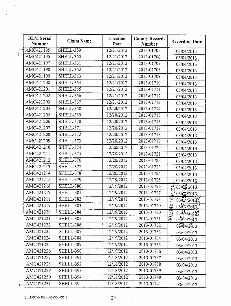
BLM Serial Location County RecordsClaim Name Recording DateNumber Date NumberAMC421195 SHELL-359 12/21/2012 2013-01705 03/04/2013AMC421196 SHELL-360 12/21/2012 2013-01706 03/04/2013AMC421197 SHELL-361 12/21/2012 2013-01707 03/04/2013AMC421198 SHELL-362 12/21/2012 2013-01708 03/04/2013AMC421199 SHELL-363 12/21/2012 2013-01709 03/04/2013AMC421200 SHELL-364 12/21/2012 2013-01710 03/04/2013AMC421201 SHELL-365 12/21/2012 2013-01711 03/04/2013AMC421202 SHELL-366 12/21/2012 2013-01712 03/04/2013AMC421203 SHELL-367 12/21/2012 2013-01713 03/04/2013AMC421204 SHELL-368 12/20/2012 2013-01714 03/04/2013AMC421205 SHELL-369 12/20/2012 2013-01715 03/04/2013AMC421206 SHELL-370 12/20/2012 2013-01716 03/04/2013AMC421207 SHELL-371 12/20/2012 2013-01717 03/04/2013AMC421208 SHELL-372 12/20/2012 2013-01718 03/04/2013AMC421209 SHELL-373 12/20/2012 2013-01719 03/04/2013AMC421210 SHELL-374 12/20/2012 2013-01720 03/04/2013AMC421211 SHELL-375 12/20/2012 2013-01721 03/04/2013AMC421212 SHELL-376 12/20/2012 2013-01722 03/04/2013AMC421213 SHELL-377 12/20/2012 2013-01723 03/04/2013AMC421214 SHELL-378 12/20/2012 2013-01724 03/04/2013AMC421215 SHELL-379 12/19/2012 2013-01725 03/04/20 UAMC421216 SHELL-380 12/19/2012 2013-01726 m 03/*20GAMC421217 SHELL-381 12/19/2012 2013-01727 ~ 03/~5/20.16AMC421218 SHELL-382 12/19/2012 2013-01728 P< 03£4/20 b 'AMC421219 SHELL-383 12/19/2012 2013-01729 > 03 4/20-lijuAMC421220 SHELL-384 12/19/2012 2013-01730 N 03 4/2ofAMC421221 SHELL-385 12/19/2012 2013-01731 1 0 4/2013AMC421222 SHELL-386 12/19/2012 2013-01732 01684/*}13AMC421223 SHELL-387 12/19/2012 2013-01733 03/04/2013AMC421224 SHELL-388 12/19/2012 2013-01734 03/04/2013AMC421225 SHELL-389 12/19/2012 2013-01735 03/04/2013AMC421226 SHELL-390 12/19/2012 2013-01736 03/04/2013AMC421227 SHELL-391 12/18/2012 2013-01737 03/04/2013AMC421228 SHELL-392 12/18/2012 2013-01738 03/04/2013AMC421229 SHELL-393 12/18/2012 2013-01739 03/04/2013AMC421230 SHELL-394 12/18/2012 2013-01740 03/04/2013
L AMC421231 SHELL-395 12/18/2012 2013-01741 03/04/2013
QB\159799.00005\52959095.1 29

BLM Serial Location County RecordsClaim Name Recording DateNumber Date Number~ AMC421232 SHELL-396 12/18/2012 2013-01742 03/04/2013
AMC421233 SHELL-397 12/18/2012 2013-01743 03/04/2013AMC421234 SHELL-398 12/18/2012 2013-01744 03/04/2013
L AMC421235 SHELL-399 02/05/2013 2013-01745 03/04/2013v~ AMC424351 SHELL-400 06/20/2013 2013-05411 07/22/2013
*3 AMC424565 SHELL-400A 07/31/2013 2013-05816 08/06/2013r- AMC424352 SHELL-401 06/20/2013 2013-05412 07/22/2013/ AMC424353 SHELL-402 06/20/2013 2013-05413 07/22/2013
AMC424354 SHELL-403 06/17/2013 2013-05414 07/22/2013AMC424355 SHELL-404 06/17/2013 2013-05415 07/22/2013AMC424356 SHELL-405 06/17/2013 2013-05416 07/22/2013AMC424357 SHELL-406 06/17/2013 2013-05417 07/22/2013AMC4243 58 SHELL-407 06/17/2013 2013-05418 07/22/2013AMC424359 SHELL-408 06/17/2013 2013-05419 07/22/2013AMC424360 SHELL-409 06/18/2013 2013-05420 07/22/2013AMC424361 SHELL-409A 06/20/2013 2013-05421 07/22/2013AMC424362 SHELL-410 07/11/2013 2013-05422 07/22/2013AMC424363 SHELL-411 06/20/2013 2013-05423 07/22/2013AMC424364 SHELL-412 07/11/2013 2013-05424 47/220016AMC424365 SHELL-413 06/20/2013 2013-05425 7/2~013=AMC424366 SHELL-414 06/ 17/2013 2013-05426 111 1 OlS] ijAMC424367 SHELL-415 06/17/2013 2013-05427 ?<07/22/20 1 S oAMC424368 SHELL-416 06/17/2013 2013-05428 :007/ /201§2AMC424369 SHELL-417 07/11/2013 2013-05429 N 07/2 /2013 0AMC424370 SHELL-418 06/17/2013 2013-05430 - 07/ ' /208AMC424371 SHELL-419 06/18/2013 2013-05431 07/22/2016AMC424372 SHELL-420 06/20/2013 2013-05432 07/22/2013AMC424373 SHELL-421 06/20/2013 2013-05433 07/22/2013AMC424374 SHELL-422 06/20/2013 2013-05434 07/22/2013AMC424375 SHELL-423 06/18/2013 2013-05435 07/22/2013AMC424376 SHELL-424 06/18/2013 2013-05436 07/22/2013AMC424377 SHELL-425 06/18/2013 2013-05437 07/22/2013AMC424378 SHELL-426 06/18/2013 2013-05438 07/22/2013AMC424379 SHELL-427 06/18/2013 2013-05439 07/22/2013AMC424380 SHELL-428 06/18/2013 2013-05440 07/22/2013AMC424381 SHELL-429 06/18/2013 2013-05441 07/22/2013
L AMC424382 SHELL-430 06/18/2013 2013-05442 07/22/2013
QB\159799.00005\52959095.1 30
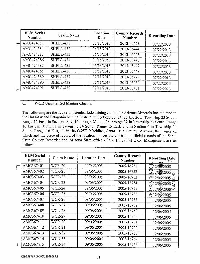
BLM Serial Location County RecordsClaim Name Recording DateNumber Date Number·j- AMC424383 SHELL-431 06/18/2013 2013-05443 07/22/2013
AMC424384 SHELL-432 06/18/2013 2013-05444 07/22/2013AMC424385 SHELL-433 06/20/2013 2013-05445 07/22/2013AMC424386 SHELL-434 06/18/2013 2013-05446 07/22/2013AMC424387 SHELL-435 06/18/2013 2013-05447 07/22/2013AMC424388 SHELL-436 06/18/2013 2013-05448 07/22/2013AMC424389 SHELL-437 07/11/2013 2013-05449 07/22/2013AMC424390 SHELL-438 07/11/2013 2013-05450 07/22/2013
1- AMC424391 SHELL-439 07/11/2013 2013-05451 07/22/2013
C. WCR Unpatented Mining Claims:
The following are the active unpatented lode mining claims for Arizona Minerals Inc. situated inthe Harshaw and Patagonia Mining District, in Sections 13, 24,25 and 36 in Township 23 South,Range 15 East; in Sections 8,9,16 through 21, and 28 through 32 in Township 23 South, Range16 East; in Section 1 in Township 24 South, Range 15 East; and in Section 6 in Township 24South, Range 16 East, all in the G&SR Meridian, Santa Cruz County, Arizona, the names ofwhich and the place of record of the location notices thereof in the official records of the SantaCruz County Recorder and Arizona State office of the Bureau of Land Management are asfollows:
BLM Serial County RecordsClaim Name Location Date Recording DateNumber Number #.* 52~ AMC367401 WCR-20 09/06/2005 2005-16751 312/082005
AMC367402 WCR-21 09/06/2005 2005-16752 z 12/ 20053 =0AMC367403 WCR-22 09/06/2005 2005-16753 ?< 12/0612005 hAMC367404 WCR-23 09/06/2005 2005-16754 %12/ 2064<AMC367405 WCR-24 09/06/2005 2005-16755 N 12/0 /20(ISOAMC367406 WCR-25 09/06/2005 2005-16756 5 12/ 3 2063AMC367407 WCR-26 09/06/2005 2005-16757 12/0#/2065AMC367408 WCR-27 09/06/2005 2005-16758 12/06/2005AMC367409 WCR-28 09/06/2005 2005-16759 12/06/2005AMC367410 WCR-29 09/06/2005 2005-16760 12/06/2005AMC367411 WCR-30 09/06/2005 2005-16761 12/06/2005AMC367412 WCR-31 09/06/2005 2005-16762 12/06/2005AMC367413 WCR-32 09/06/2005 2005-16763 12/06/2005AMC367414 WCR-33 09/06/2005 2005-16764 12/06/2005
L AMC367415 WCR-34 09/06/2005 2005-16765 12/06/2005
QB\159799.00005\52959095.1 31

BLM Serial County RecordsClaim Name Location Date Recording DateNumber Number~ AMC367416 WCR-35 09/06/2005 2005-16766 12/06/2005
AMC367417 WOR-36 09/06/2005 2005-16767 12/06/2005AMC367418 WCR-37 09/06/2005 2005-16768 12/06/2005AMC367419 WCR-38 09/06/2005 2005-16769 12/06/2005
1- AMC367420 WCR-39 09/06/2005 2005-16770 12/06/2005-\ AMC367422 WCR-41 09/06/2005 2005-16772 12/06/2005
-y> AMC367424 WCR-43 09/06/2005 2005-16774 12/06/2005- AMC367426 WCR-45 09/06/2005 2005-16776 12/06/2005
Er AMC367428 WCR-47 09/06/2005 2005-16778 12/06/2005~- AMC367430 WCR-49 09/06/2005 2005-16780 12/06/2005
AMC367431 WCR-50 09/07/2005 2005-16781 12/06/2005AMC367432 WCR-51 09/07/2005 2005-16782 12/06/2005AMC367433 WCR-52 09/07/2005 2005-16783 12/06/2005AMC367434 WCR-53 09/07/2005 2005-16784 12/06/2005AMC367435 WCR-54 09/07/2005 2005-16785 12/06/2005AMC367436 WCR-55 09/07/2005 2005-16786 12/06/2005AMC367437 WCR-56 09/07/2005 2005-16787 12/06/2005AMC367438 WCR-57 09/07/2005 2005-16788 12/06/2005AMC367439 WCR-58 09/07/2005 2005-16789 m 12/5201
7 AMC367441 WCR-60 09/07/2005 2005-16791 rn 12/84/2063AMC367442 WCR-61 09/07/2005 2005-16792 - 12/88/200*fAMC367443 WCR-62 09/07/2005 2005-16793 > 12~96/206513AMC367444 WCR-63 09/07/2005 2005-16794 - 12/(F/20053AMC367445 WCR-64 09/07/2005 2005-16795 9 12£96/2005AMC367446 WCR-65 09/07/2005 2005-16796 1 6/2®5AMC367447 WCR-66 09/07/2005 2005-16797 12/06/2005AMC367448 WCR-67 09/07/2005 2005-16798 12/06/2005AMC367449 WCR-68 09/07/2005 2005-16799 12/06/2005AMC367450 WCR-69 09/07/2005 2005-16800 12/06/2005AMC367451 WCR-70 09/07/2005 2005-16801 12/06/2005AMC367452 WCR-71 09/07/2005 2005-16802 12/06/2005AMC367453 WCR-72 09/07/2005 2005-16803 12/06/2005AMC367454 WCR-73 09/07/2005 2005-16804 12/06/2005AMC367455 WCR-74 09/07/2005 2005-16805 12/06/2005AMC367456 WCR-75 09/07/2005 2005-16806 12/06/2005AMC367457 WCR-76 09/07/2005 2005-16807 12/06/2005
L AMC367458 WCR-77 09/07/2005 2005-16808 12/06/2005
QB\159799.00005\52959095.1 32

BLM Serial County RecordsClaim Name Location Date Recording DateNumber Number~ AMC367459 WCR-78 09/07/2005 2005-16809 12/06/2005
AMC367460 WCR-79 09/07/2005 2005-16810 12/06/2005AMC367461 WCR-81 09/07/2005 2005-16811 12/06/2005AMC367462 WCR-82 09/07/2005 2005-16812 12/06/2005AMC367463 WCR-83 09/07/2005 2005-16813 12/06/2005AMC367464 WCR-85 09/07/2005 2005-16814 12/06/2005AMC367465 WCR-87 09/07/2005 2005-16815 12/06/2005AMC367466 WCR-88 09/07/2005 2005-16816 12/06/2005AMC367467 WCR-89 09/07/2005 2005-16817 12/06/2005AMC367468 WCR-90 09/07/2005 2005-16818 12/06/2005AMC367469 WCR-91 09/07/2005 2005-16819 12/06/2005AMC367470 WCR-93 09/07/2005 2005-16820 12/06/2005AMC367471 WCR-94 09/07/2005 2005-16821 12/06/2005AMC367472 WCR-95 09/08/2005 2005-16822 12/06/2005AMC367473 WCR-96 09/08/2005 2005-16823 12/06/2005AMC367474 WCR-97 09/08/2005 2005-16824 12/06/2005AMC367475 WCR-98 09/08/2005 2005-16825 32/OWOO_AMC367476 WCR-99 09/08/2005 2005-16826 2/0 005,AMC367477 WCR-100 09/08/2005 2005-16827 212/0 0053 mAMC367478 WCR-101 09/08/2005 2005-16828 12/0~20053;nAMC367479 WCR-102 09/08/2005 2005-16829 272/0 005
1/E
AMC367480 WCR-103 09/08/2005 2005-16830 d2/0$(20052AMC367481 WCR-104 09/08/2005 2005-16831 542/0 0055AMC367482 WCR-105 09/08/2005 2005-16832 12/06/2005AMC367483 WCR-106 09/08/2005 2005-16833 12/06/2005AMC367484 WCR-107 09/08/2005 2005-16834 12/06/2005AMC367485 WCR-108 09/08/2005 2005-16835 12/06/2005AMC367486 WCR-109 09/08/2005 2005-16836 12/06/2005AMC367487 WCR-110 09/08/2005 2005-16837 12/06/2005
-7 AMC376328 * Amended 12/07/2006 2006-19777 12/15/2006 6- CL.0 5
AMC367488 WCR-111 09/08/2005 2005-16838 12/06/2005AMC367489 WCR-112 09/08/2005 2005-16839 12/06/2005
* Please note that the BLM erroneously assigned new "AMC" numbers to these amendments at the time they werefiled. The AMC numbers associated with the amendments are "closed" due to non-payment ofmaintenance fees,but that does not influence the effectiveness ofthe original claims, which are valid and up-to-date. ArizonaMinerals, Inc. is working with the BLM to correct the filing error.
QB\159799.00005\52959095.1 33

BLM Serial County RecordsClaim Name Location Date Recording DateNumber Number~ AMC376329 * Amended 12/08/2006 2006-19778 12/15/2006 4- cposer AMC367490 WCR-113 09/08/2005 2005-16840 12/06/2005L AMC367491 WCR-114 09/08/2005 2005-16841 12/06/20059 AMC376330 * Amended 12/09/2006 2006-19779 12/15/2006 «c 1 656
~ AMC367492 WCR-115 09/08/2005 2005-16842 12/06/2005AMC367493 WCR-116 09/08/2005 2005-16843 12/06/2005AMC367494 WCR-117 09/09/2005 2005-16844 12/06/2005AMC367495 WCR-118 09/09/2005 2005-16845 12/06/2005AMC367496 WCR-119 09/09/2005 2005-16846 12/06/2005AMC367497 WCR-120 09/09/2005 2005-16847 12/06/2005AMC367498 WCR-121 09/09/2005 2005-16848 12/06/2005AMC367499 WCR-122 09/09/2005 2005-16849 12/06/2005AMC367500 WCR-123 09/09/2005 2005-16850 12/06/2005AMC367501 WCR-124 09/08/2005 2005-16851 12/06/2005AMC367502 WCR-125 09/08/2005 2005-16852 12/06/2005AMC367503 WCR-126 09/08/2005 2005-16853 12/06/2005AMC367504 WCR-127 09/08/2005 2005-16854 12/06/2005AMC367505 WCR-128 09/08/2005 2005-16855 7112/08005AMC367506 WCR-129 09/08/2005 2005-16856 612/0¥2003:AMC367507 WCR-130 09/08/2005 2005-16857 512/ 20@3; ZAMC367508 WCR-131 09/08/2005 2005-16858 ?< 12/ /2063 nAMC367509 WCR-132 09/08/2005 2005-16859 :0 12/ 2063 2AMC367510 WCR-133 09/08/2005 2005-16860 g 12/0 /200 0AMC367511 WCR-134 09/08/2005 2005-16861 S 12/ ' /2063AMC367512 WCR-135 09/08/2005 2005-16862 12/02/20-05AMC367513 WCR-136 09/08/2005 2005-16863 12/06/2005AMC367514 WCR-137 09/08/2005 2005-16864 12/06/2005AMC367515 WCR-138 09/08/2005 2005-16865 12/06/2005AMC367516 WCR-139 09/08/2005 2005-16866 12/06/2005AMC367517 WCR-140 09/08/2005 2005-16867 12/06/2005AMC367518 WCR-141 09/08/2005 2005-16868 12/06/2005AMC367519 WCR-142 09/08/2005 2005-16869 12/06/2005
C. AMC367520 WCR-143 09/08/2005 2005-16870 12/06/2005
* Please note that the BLM erroneously assigned new "AMC" numbers to these amendments at the time they werefiled. The AMC numbers associated with the amendments are "closed" due to non-payment ofmaintenance fees,but that does not influence the effectiveness ofthe original claims, which are valid and up-to-date. ArizonaMinerals, Inc. is working with the BLM to correct the filing error.
QB\159799.00005\52959095.1 34

BLM Serial County RecordsClaim Name Location Date Recording DateNumber Number~ AMC367521 WCR-144 09/09/2005 2005-16871 12/06/2005
AMC367522 WCR-145 09/09/2005 2005-16872 12/06/2005AMC367523 WCR-146 09/09/2005 2005-16873 12/06/2005AMC367524 WCR-147 09/09/2005 2005-16874 12/06/2005AMC367525 WCR-148 09/09/2005 2005-16875 12/06/2005AMC367526 WCR-149 09/09/2005 2005-16876 12/06/2005AMC367527 WCR-150 09/09/2005 2005-16877 12/06/2005AMC367528 WCR-151 09/09/2005 2005-16878 12/06/2005AMC367529 WCR-152 09/08/2005 2005-16879 12/06/2005AMC367530 WCR-153 09/08/2005 2005-16880 12/06/2005AMC367531 WCR-154 09/08/2005 2005-16881 12/06/2005AMC367532 WCR-155 09/08/2005 2005-16882 12/06/2005AMC367533 WCR-156 09/08/2005 2005-16883 12/06/2005AMC367534 WCR-157 09/08/2005 2005-16884 12/06/2005AMC367535 WCR-158 09/08/2005 2005-16885 12/06/2005AMC367536 WCR-159 09/08/2005 2005-16886 12/06/2005AMC367537 WCR-160 09/08/2005 2005-16887 -0 1 ~6/2 5AMC367538 WCR-161 09/08/2005 2005-16888 6 12906/2995AMC367539 WCR-162 09/09/2005 2005-16889 z 12~6/2065,AMC367540 WCR-163 09/09/2005 2005-16890 . 12@3/29121AMC367541 WCR-164 09/09/2005 2005-16891 30 12 /2005-nAMC367542 WCR-165 09/09/2005 2005-16892 31 12*/2005AMC367543 WCR-166 09/09/2005 2005-16893 t, 12/06/2055AMC367544 WCR-167 09/09/2005 2005-16894 12/ /2005AMC367545 WCR-168 09/09/2005 2005-16895 12/06/2005AMC367546 WCR-169 09/09/2005 2005-16896 12/06/2005AMC367547 WCR-170 09/09/2005 2005-16897 12/06/2005AMC367548 WCR-171 09/09/2005 2005-16898 12/06/2005AMC367549 WCR-172 09/09/2005 2005-16899 12/06/2005AMC367550 WCR-173 09/09/2005 2005-16900 12/06/2005AMC367551 WCR-174 09/09/2005 2005-16901 12/06/2005AMC367552 WCR-175 09/07/2005 2005-16902 12/06/2005AMC367553 WCR-176 09/07/2005 2005-16903 12/06/2005AMC367554 WCR-177 09/11/2005 2005-16904 12/06/2005AMC367555 WCR-178 09/11/2005 2005-16905 12/06/2005AMC367556 WCR-179 09/11/2005 2005-16906 12/06/2005
L AMC367557 WCR-180 09/11/2005 2005-16907 12/06/2005
QB\159799.00005\52959095.1 35

BLM Serial County RecordsClaim Name Location Date Recording DateNumber Number:=- AMC367558 WCR-181 09/11/2005 2005-16908 12/06/2005
AMC367559 WCR-182 09/11/2005 2005-16909 12/06/2005AMC367584 WCR-207 09/11/2005 2005-16934 12/06/2005AMC367585 WCR-208 09/09/2005 2005-16935 12/06/2005AMC367586 WCR-209 09/11/2005 2005-16936 12/06/2005AMC367587 WCR-210 09/11/2005 2005-16937 12/06/2005AMC367588 WCR-211 09/11/2005 2005-16938 12/06/2005AMC367589 WCR-212 09/11/2005 2005-16939 12/06/2005AMC367590 WCR-213 09/11/2005 2005-16940 12/06/2005AMC367591 WCR-214 09/08/2005 2005-16941 12/06/2005AMC367592 WCR-215 09/08/2005 2005-16942 12/06/2005AMC367593 WCR-216 09/11/2005 2005-16943 12/06/2005AMC367594 WCR-217 09/11/2005 2005-16944 12/06/2005AMC367595 WCR-218 09/08/2005 2005-16945 12/06/2005AMC367596 WCR-219 09/11/2005 2005-16946 12/06/2005AMC367597 WCR-220 09/08/2005 2005-16947 12/06/2005
/- AMC367598 WCR-221 09/08/2005 2005-16948 12/06/2005_~ AMC367600 WCR-223 09/08/2005 2005-16950 12/06/2005~- AMC368661 WCR 274 09/21/2005 2005-16725 12/06/2005
Amended 12/23/2005 2005-18179 -0 12/~2065AMC368662 WCR 275 09/21/2005 2005-16726 0 12/ 2003
Amended 12/23/2005 2005-18180 E 12/58/206-3 2%AMC368663 WCR 277 09/21/2005 2005-16727 4 12/06/20035
Amended 12/23/2005 2005-18181 2 12/ /2005!-8AMC368664 WCR 278 09/21/2005 2005-16728 8 12/66/2005
Amended 12/23/2005 2005-18182 > 12 /2008AMC368665 WCR 293 09/22/2005 2005-16729 12/06/2005
Amended 12/23/2005 2005-18183 12/28/2005AMC368666 WCR 301 09/22/2005 2005-16730 12/06/2005
Amended 12/23/2005 2005-18184 12/28/2005AMC368667 WOR 303 10/13/2005 2005-16731 12/06/2005
Amended 12/23/2005 2005-18185 12/28/2005AMC368668 WCR 304 10/13/2005 2005-16732 12/06/2005
Amended 12/23/2005 2005-18186 12/28/2005AMC368669 WCR 305 10/13/2005 2005-16733 12/06/2005
Amended 12/23/2005 2005-18187 12/28/2005AMC368670 WCR 306 10/13/2005 2005-16734 12/06/2005
QB;159799.00005\52959095.1 36

BLM Serial County RecordsClaim Name Location Date Recording DateNumber NumberAmended 12/23/2005 2005-18188 12/28/2005
~ AMC368671 WCR 307 10/12/2005 2005-16735 12/06/2005Amended 12/23/2005 2005-18189 12/28/2005
AMC368672 WCR 308 10/12/2005 2005-16736 12/06/2005Amended 12/23/2005 2005-18190 12/28/2005
AMC368673 WCR 309 10/12/2005 2005-16737 12/06/2005Amended 12/23/2005 2005-18191 12/28/2005
AMC368674 WCR 310 10/12/2005 2005-16738 12/06/2005Amended 12/23/2005 2005-18192 12/28/2005
AMC368675 WCR 311 10/12/2005 2005-16739 12/06/2005Amended 12/23/2005 2005-18193 12/28/2005
AMC368676 WCR 312 10/12/2005 2005-16740 12/06/2005Amended 12/23/2005 2005-18194 12/28/2005
AMC368677 WCR 313 10/12/2005 2005-16741 12/06/2005Amended 12/23/2005 2005-18195 12/28/2005
AMC368678 WCR 314 10/12/2005 2005-16742 12/06/2005Amended 12/23/2005 2005-18196 12/28/2005
AMC368679 WCR 315 10/12/2005 2005-16743 12/06/2095Amended 12/23/2005 2005-18197 I 12 /2005
AMC368680 WCR 316 10/12/2005 2005-16744 m 12S/20~0Amended 12/23/2005 2005-18198 52 12/28/20QA
AMC368681 WCR 317 10/12/2005 2005-16745 2 12 /20052Amended 12/23/2005 2005-18199 N 12/ /200 -1
L AMC368682 WCR 318 10/12/2005 2005-16746 z 12)86/2005Amended 12/23/2005 2005-18200 - 12/58/2665
~> AMC373271 WCR-323 05/01/2006 2006-07297 05/02/2006~ AMC373273 WCR-359 07/14/2006 2006-11578 07/19/2006
AMC373274 WCR-360 07/14/2006 2006-11579 07/19/2006AMC373275 WCR-361 07/14/2006 2006-11580 07/19/2006
g AMC376279 WCR-80 10/19/2006 2006-19728 12/15/2006AMC376280 WCR-84 10/19/2006 2006-19729 12/15/2006AMC376281 WCR-86 10/19/2006 2006-19730 12/15/2006AMC376282 WCR-4 10/13/2006 2006-19731 12/15/2006AMC376283 WCR-5 10/13/2006 2006-19732 12/15/2006AMC376284 WCR-6 10/13/2006 2006-19733 12/15/2006AMC376285 WCR-7 10/13/2006 2006-19734 12/15/2006
L AMC376286 WCR-8 10/13/2006 2006-19735 12/15/2006
QB\159799.00005\52959095.1 37

BLM Serial County RecordsClaim Name Location Date Recording DateNumber NumberAMC376287 WCR-9 10/13/2006 2006-19736 12/15/2006AMC376288 WCR-10 10/13/2006 2006-19737 12/15/2006AMC376289 WCR-11 10/13/2006 2006-19738 12/15/2006AMC376290 WCR-12 10/13/2006 2006-19739 12/15/2006AMC376291 WCR-13 10/13/2006 2006-19740 12/15/2006AMC376292 WCR-14 10/13/2006 2006-19741 12/15/2006AMC376293 WCR-15 10/13/2006 2006-19742 12/15/2006AMC376294 WCR-16 10/13/2006 2006-19743 12/15/2006AMC376295 WCR-17 10/13/2006 2006-19744 12/15/2006AMC376296 WCR-18 10/13/2006 2006-19745 12/15/2006
~- AMC376297 WCR-19 10/13/2006 2006-19746 12/15/2006r AMC376302 WCR-404 10/13/2006 2006-19751 12/15/2006
AMC376303 WCR-405 10/13/2006 2006-19752 12/15/2006f AMC376304 WCR-406 10/13/2006 2006-19753 12/15/2006L AMC376305 WCR-407 10/13/2006 2006-19754 12/15/2006~ AMC376316 WCR-42OA 12/13/2006 2006-19765 12/15/20
AMC376317 WCR-421A 12/13/2006 2006-19766 * 12/S'206]6AMC3 76318 WCR-422 10/10/2006 2006-19767 m 12/ 2006 _AMC376319 WCR-423 10/10/2006 2006-19768 - 12/ff/2006 RAMC376320 WCR-424 10/10/2006 2006-19769 > 12/}*2004 TAMC376321 WCR-425 10/10/2006 2006-19770 2 12/fs/2006[JAMC376322 WCR-426 10/18/2006 2006-19771 212/IS/2068AMC376323 WCR-427 10/18/2006 2006-19772 > 12/M2068AMC376324 WCR-428 10/29/2006 2006-19773 12/15/2006AMC376325 WCR-429 10/29/2006 2006-19774 12/15/2006AMC376326 WCR-430 11/30/2006 2006-19775 12/15/2006
L AMC376327 WCR-431 12/11/2006 2006-19776 12/15/2006~ AMC376331 WCR-110E 12/06/2006 2006-19780 12/15/2006
AMC376332 WCR-112E 12/06/2006 2006-19781 12/15/2006AMC376333 WCR-114E 12/06/2006 2006-19782 12/15/2006
~ AMC376440 WCR-432 12/20/2006 2007-01454 01/29/2007AMC376441 WCR-433 12/20/2006 2007-01455 01/29/2007AMC376442 WCR-434 12/20/2006 2007-01456 01/29/2007AMC376443 WCR-435 12/20/2006 2007-01457 01/29/2007AMC376444 WCR-436 12/20/2006 2007-01458 01/29/2007AMC376445 WCR-437 12/20/2006 2007-01459 01/29/2007AMC376446 WCR-438 12/20/2006 2007-01460 01/29/2007
QB\159799.00005\52959095.1 38

BLM Serial County RecordsClaim Name Location Date Recording DateNumber Number1 AMC376447 WCR-439 12/20/2006 2007-01461 01/29/2007
AMC427463 WCR-92 02/10/2014 2014-01329 03/10/2014AMC427464 WCR-183 02/05/2014 2014-01330 03/10/2014AMC427465 WCR-184 02/04/2014 2014-01331 03/10/2014AMC427466 WCR-185 02/05/2014 2014-01332 03/10/2014AMC427467 WCR-186 02/04/2014 2014-01333 03/10/2014AMC427468 WCR-187 02/05/2014 2014-01334 03/10/2014AMC427469 WCR-188 02/04/2014 2014-01335 03/10/2014AMC427470 WCR-189 02/05/2014 2014-01336 03/10/2014AMC427471 WCR-190 02/04/2014 2014-01337 03/10/2014AMC427472 WCR-191 02/05/2014 2014-01338 03/10/2014AMC427473 WCR-192 02/04/2014 2014-01339 03/10/2014AMC427474 WCR-193 02/05/2014 2014-01340 03/10/2014AMC427475 WCR-194 02/04/2014 2014-01341 03/10/2014AMC427476 WCR-195 02/05/2014 2014-01342 03/10/2014AMC427477 WCR-196 02/04/2014 2014-01343 03/10/2014AMC427478 WCR-197 02/05/2014 2014-01344 03/10/2014AMC427479 WCR-198 02/04/2014 2014-01345 -003/~/20 ~fAMC427480 WCR-199 02/05/2014 2014-01346 0 03/ /2013AMC427481 WCR-200 02/04/2014 2014-01347 1 03/65/201-digAMC427482 WCR-201 02/05/2014 2014-01348 2 03/@/201*47AMC427483 WCR-202 02/05/2014 2014-01349 2 03/ /20i-4%AMC427484 WCR-203 02/05/2014 2014-01350 0 03419/26 Fil-AMC427485 WCR-204 02/05/2014 2014-01351 3> 03*®/2024AMC427486 WCR-205 02/05/2014 2014-01352 03/10/2014AMC427487 WCR-206 02/05/2014 2014-01353 03/10/2014AMC427488 WCR-255 02/10/2014 2014-01354 03/10/2014AMC427489 WCR-256 02/06/2014 2014-01355 03/10/2014AMC427490 WCR-257 02/10/2014 2014-01356 03/10/2014AMC427491 WCR-258 02/06/2014 2014-01357 03/10/2014AMC427492 WCR-259 02/10/2014 2014-01358 03/10/2014AMC427493 WCR-260 02/06/2014 2014-01359 03/10/2014AMC427494 WCR-261 02/10/2014 2014-01360 03/10/2014AMC427495 WCR-262 02/10/2014 2014-01361 03/10/2014AMC427496 WCR-263 02/10/2014 2014-01362 03/10/2014AMC427497 WCR-264 02/10/2014 2014-01363 03/10/2014
QB\159799.00005\52959095.1 39

D. FOBC Unpatented Mining Claims:
The following described unpatented lode mining are in the Harshaw and Patagonia MiningDistrict, situated within Sections 5,8 and 9 in Township 23 South, Range 16 East in the G&SRMeridian, Santa Cruz County, Arizona, the names of which and the place of record of thelocation notices thereof in the official records of the Santa Cruz County Recorder and ArizonaState Office of the Bureau of Land Management are as follows:
BLM Serial County RecordsClaim Name Location Date Recording DateNumber Number~ AMC374413 PAT 1 07/10/2006 2006-16082 10/06/2006
AMC374414 PAT 2 07/10/2006 2006-16083 10/06/2006AMC374415 PAT 3 07/10/2006 2006-16084 10/06/2006AMC374416 PAT 4 07/10/2006 2006-16085 10/06/2006AMC374417 PAT 5 07/10/2006 2006-16086 10/06/2006AMC374418 PAT 6 07/10/2006 2006-16087 10/06/2006AMC374419 PAT 7 07/10/2006 2006-16088 10/06/2006AMC374420 PAT 8 07/10/2006 2006-16089 10/06/2006
-L AMC374421 PAT 9 07/10/2006 2006-16090 10/06/2006-* AMC435089 PAT 10 07/10/2006 2006-16091 10/06/2006
Amended 10/28/2015 2015-06352 11/05/2015~ AMC374423 PAT 11 07/10/2006 2006-16092 10/06/2006
AMC374424 PAT 12 07/10/2006 2006-16093 10/06/2006AMC374425 PAT 13 07/10/2006 2006-16094 10/06/2006AMC374426 PAT 14 07/10/2006 2006-16095 10/06/2006AMC374427 PAT 15 07/10/2006 2006-16096 10/06/2006
L AMC374428 PAT 16 07/10/2006 2006-16097 10/06/2006Amended 10/28/2015 2015-06353 11/05/2015
52I='0 00 35
rnS 5 ' »' 33
....
>Le-
50 --i <- -0 7rnr.4 0
> W z
QB\159799.00005\52959095.1 40

i TIFFAII'ill. 1.10RIS5207708708 1.0 LBS LTR 1 OF 1
1 QUARLES & BRADY, LLC-r; ' 1 SOUTH CHURCH AYETIUE0 ~ TUCSOZE AZ 85701 ~ ~~
de Expresd
(1)
A SHIP TO:
v!/JOS la,Jed Pa}!Url
91 St/L
LOLS(LOLO
- -6 1 ARIZONA STATE OFFICE
Extre
mel
y Ur
gent
This
enve
lope
is fo
r us
e w
ith th
e fo
llow
ing
serv
ices:
xt D
ay A
ir > V5 v N 1 BUREAU OF LAND MANAGEMENT Is=f5 4 -E -o 56 ( 3: | ATrN: INFORMATION ACCESS CENTER2 0 - C -O : 73 ~ SUITE 800M C fo -i
a, 3 E 5 230 2 1 1 N. CENTRAL AVENUEZBA s U M ff' ) 1 PHOENIX AZ 85004t/> M Ln O 9004 1
SJUD . 00 244 310'18 Joi nOA Sl,!AJas
0- 0- O- ! 0
000
ICL
·p 1!qltioid el s·n 01 AJell
· MU
03 peal Aq spooy JO .
mp)·lcilolleulatul
lo/Put! C UOI ju ~u[) .
/p sainiatil 01 lialqn
4 1,1 *punajoll
AZ 850 9-10
05 1 Jed P~!un
UPS NEXT DAY AIRTRACKING #: 1Z 816 929 01 9663 9799
D
~ Reference No.1: 159799.00005
-IO-3
Cne
cule
'a-p
icK
up-o
r TI
U a-
Gro
p-O
TT l
oca
o ea y
ou. 5
corre
spon
denc
e, ur
ge t
ocu 5M
ulroparn
e~~ or e~
ectreo
sni~a
meo~
~y ~n
dtm
ust
~a~~
ilne~
~1~eym
wse~~
c tha
n
-4.U
, uu Ju bjudU.111.)0 jo
; Aiuo pasn a
A
RECFIVFDBLM..Z JIA; ~. OFFICE5 LU C, ' all AUG 13 P 333S. 50 8
· To
qua
lify fo
r the
Let
ter r
ate,
value
. Cer
t co
untrie
s c
ider e
lect'
*= BE
o not
reco
ttilinf
orma
tioi
PHOENIX, ARIZONA £Le : 40= 0 I & L M5 4 5 ai ED .
Dom
estic
Shi
pmen
ts LJ
£3 #5 -j~ ~~a0 0 W a.E Am ms-2Z
EM 2 K! S 5 B -itiE n
ups.c
orn/
impo
rtexp
t t
•- a, Crt,·, . - -
95 2 A 6955 443C-. . z:8

Receipt Page 1 of 1
United States Department of the InteriorBureau of Land Management Receipt
DIV OF LANDS, MINRLS & ENERGY. ONE N CENTRAL AVEPHOENIX, AZ 85004 -4427 No: 4235094
Phone: 602-417-9200
Transaction #: 4350446' Date of Transaction: 08/14/2018
CUSTOMER:~ QUARLES & BRADY LLP
11 S CHURCH AVE«-------------1TUCSON:AZ 85701-1612 US
i[LINE]1--~1 F------11--TRITg-11 # 11QTY' DESCRIPTION 1 REMARKS N N TOTAL l1 11 PRICE 11 1LOCATABLE MINERALS / MININGCLAIMS-NOT NEW-UNADJUD.ONE AUTH MAINT1 1 . 00 0. ONLY / MINING CLAIM MONEY - nja - 187240 . 002019/1208RECEIVEDCASES: AMC438049/$187240.00
OSTMARKED]1~-PE: CHEEK-RECEIVED:~08/13/201811F--CHEEK-NO:~
NAME: ARIZONA MINERALS INC2210 E FORT LOWELL RDTUCSON AZ 85719 US
11---------------------------1This receipt was generated by the automated BLM Collections and Billing System and is a paper representation of aportion of the official electronic record contained therein.
0/1/1/lnl 0

11 1. 43%099C.
9 9 0 16-937 6 A-7-7
6/6 8 4 / 2-3717G-7
93996-737 6 3 3~5 5/409316437 89 8- ,#364&7 763 37699737Hq1393 5089 9529 5 60
3 8 3 3 30VAL~350El /3 5 9 5-
9161%q*i) 3 3 -64, li669-652913 G-7 & 9%362 5 66 1
~NTERE~AUG 18 2017 ~
sy,I----IdnLL--

1
One South Church Avenue Attorneys at Law inSuite 1700 Chicago
QjuirlesjBmdy LLP Tucson , Arizona 85701 - 1621 Indianapolis520.770.8700 MadisonFax 520.623.2418 Milwaukeewww.quarles.com Naples
PhoenixScottsdaleTampaTucsonWashington, D.C.
Writefs Direct Dial: 520-770-8717E-Mail: [email protected]
August 9, 2017VIA OVERNIGHT COURIER
i il ..i L
l *1 8
2
Bureau of Land ManagementArizona State Office
1011 AUG 1 U P
l: 5 b
Attention: Information Access Center -One North Central Avenue, Suite 800 0Phoenix, AZ 85004-4427
RE: Payment of Claim Maintenance Fees - Arizona Minerals Inc.
Ladies and Gentlemen:
Delivered herewith is a check in the amount of $171,120 as payment of the claimmaintenance fees pursuant to 30 U.S.C. § 28]Ra), as adjusted by 30 U.S.C. § 28j(c) andimplemented by notice in the 74 Federal Register 30959-62 (June 29 , 2009) and as amended bythe Consolidated Appropriations Act 2012, Pub. L. No. 112-74,125 Stat 786 (2011). The owneris paying a maintenance fee of $155.00 per lode claim for the assessment year beginningSeptember 1, 2017. Also enclosed are copies of the Certification of Payment of MaintenanceFee in Lieu of Affidavit of Annual Assessment Work to be recorded with the Santa Cruz County ,Recorder's Office.
Please return a date-stamped copv of this letter and the Affidavit alone with thereceipt for payment to this office.
Thank you for your assistance and please feel free to contact me with any questions orconcerns.
Sincerely,
44.- 4C V. \BK)F--0 1-
Marian C. LaLonde
Enclosure(s)
QB\47453397.1

After recording, please return to:
Marian C. LaLondeQuarles & Brady LLPOne S. Church Ave., Ste. 1700Tucson, AZ 85701
STATE OF ARIZONA )) SS:
County of Pima )
CERTIFICATION OF PAYMENT OF MAINTENANCE FEEIN LIEU OF AFFIDAVIT OF ANNUAL ASSESSMENT WORK
Marian C. LaLonde, being first duly sworn, deposes and says that:
1. She is an agent for Arizona Minerals Inc., a Nevada corporation, owner ofthe unpatented lode mining claims and millsites situated in Santa Cruz County, Arizona(the "Claims'), the location notices of which are of record in said county, and in therecords of the Arizona State Office of the Bureau of Land Management under the filenumbers indicated in the attached Exhibit A.
2. Pursuant to the 30 U.S.C. § 28f(a), as adjusted by 30 U.S.C. § 28j(c) andimplemented by notice in 74 Federal Register 30959-62 (June 29, 2009) and as amendedby the Consolidated Appropriations Act 2012, Pub. L. No. 112-74,125 Stat. 786 (2011),the owner has paid a maintenance fee of $155.00 per claim for the assessment yearbeginning September 1,2017. This Certificate is in lieu of an affidavit of performance ofannual assessment work or notice of intent to hold and a copy of the receipt of paymentto the Bureau of Land Management is attached hereto.
3. The name and address of the owner of the Claims for which thisCertificate is prepared are as follows:
Part I: Arizona Minerals Inc., 3845 N. Business Center Drive, Suite 115,Tucson, Arizona, 85705. THIS Is A CHANGE OF ADDRESS FOR ALLTHEIR CLAIMS.
Part II: FOBC, LLC 1815 E. Winsett St. Tucson, AZ 85719-6547. This is NOT achange of address - 1011
4. The Claims are held and claimed by the owner for the val®ble Ialneralcontained therein and the millsites for uses related to the mining claims. 25 5
-
Ir
r U r=1r -1
0
(37
1

1 /fkDATED this ~ day of August, 2017.
6-~44Ma an C. LaLonde
Sworn and subscribe to before me this ~ 1 *'Ylay of August, 2017, by Marian C.LaLonde, Agent for Arizona Minerals Inc.
-31VQNNE R YOUNO 1 ----lhu¥_L.ai~r.+- 16 & vyr,1/w - rNotaripublfc
. L A l , 2 Rl L O h,t
1011 AUG 1 4 P 1: 51
2

EXHIBIT A
PART I: Arizona Minerals Unpatented Mining Claims:
A. Recently Located Unpatented Claims (2015-2016)
The following are the active unpatented lode mining claims for Arizona Minerals Inc.situated in the Harshaw and Patagonia Mining Districts in Sections 04, 05, 16, 17, 20through 23,26 through 29, and 32 through 35 of Township 23 South, Range 16 East; inSections 13,24,25,26,35 and 36 of Township 22 South, Range 15 East; in Sections 17through 20 and 27,29, 30,31, and 32 of Township 22 South, Range 16 East all in theG&SR Meridian, Santa Cruz County, Arizona, the location notices of which are of recordin the office of the Recorder of Santa Cruz County, Arizona and the Arizona State officeof the Bureau o f Land Management as follows:
County Records AMC SerialName of Claim Number Number Location DateAAGH NO. 6 2016-02352; AMC438049 -7 04/15/2016AAGH NO. 8 2016-02353; AMC438050 03/23/2016AAGH NO. 9 2016-02423; AMC438051 03/23/2016AAGH NO. 10 2016-02424; AMC438052 03/23/2016AAGH NO. 17 2016-02421; AMC438053 03/28/2016AAGH NO. 18 2016-02425; AMC438054 03/23/2016AAGH NO. 19 2016-02354; AMC438055 04/18/2016AAGH NO. 20 2016-02426; AMC438056 03/28/2016ANDES NO. 1 2016-02355; AMC438057 04/04/2016BLUE EAGLE NO. 1 2016-02427; AMC438058 03/31/2016BORDER SIDE 2016-02356; AMC438059 03/31/2016COWBOY 2016-02428; AMC438060 03/23/2016DORFEE 2016-02412; AMC438061 02/26/2016ESTHER 2016-02429; AMC438062 03/23/2016FOX NO. 2 2016-02359; AMC438063 04/04/2016FOX NO. 4 2016-02360; AMC438064 04/04/2016FOX NO. 5 2016-02361; AMC438065 04/04/2016GEM NO. 1 2016-02362; AMC438066 04/04/2016GEM NO. 2 2016-02363; AMC438067 04/18/2016HANK NO. 12 2016-02389; AMC438068 02/ 2016-HANK NO. 20 2016-02390; AMC438069 c 02/292016HANK NO. 22 2016-02391; AMC438070 -t 02/ 2016.HANK NO. 27 2016-02413; AMC438071 02/25/2016HANK NO. 28 2016-02414; AMC438072 02/25/2016HOPENO. 2 2016-02415; AMC438073 J r-· 02/ /2016: ~
- f--
6 crl-.
3

,
JOCO NO. 37 2016-02364; AMC438074 7 04/04/2016JOCO NO. 38 2016-02365; AMC438075 04/04/2016JOCO NO. 39 2016-02366; AMC438076 04/04/2016LA TUNA NO. 1 2016-02416; AMC438077 03/28/2016LIME BANK NO. 4 2016-02357; AMC438078 04/18/2016LIME BANK NO. 5 2016-02358; AMC438079 04/18/2016LOG CABIN 2016-02430; AMC438080 03/23/2016OLD BOY ROGER 2016-02431; AMC438081 03/28/2016RED CASTLE NO. 1 2016-02367; AMC438082 04/13/2016RED CASTLE NO. 3 2016-02368; AMC438083 04/06/2016RED CASTLE NO. 4 2016-02369; AMC438084 04/18/2016RED CASTLE NO. 5 2016-02370; AMC438085 04/04/2016RED CASTLE NO. 6 2016-02371; AMC438086 04/04/2016RED CASTLE NO. 7 2016-02372; AMC438087 04/04/2016RED HAWK NO. 6 2016-02417; AMC438088 02/29/2016SHELL-502 2016-02394; AMC438089 02/24/2016SHELL-503 2016-02395; AMC438090 02/24/2016SHELL-504 2016-02396; AMC438091 02/24/2016SHELL-505 2016-02397; AMC438092 02/25/2016SHELL-506 2016-02398; AMC438093 02/25/2016SHELL-507 2016-02399; AMC438094 02/25/2016SHELL-508 2016-02400; AMC438095 02/25/2016SHELL-509 2016-02392; AMC438096 02/25/2016SHELL-510 2016-02393; AMC438097 02/25/2016SHELL-511 2016-02401; AMC438098 02/29/2016SHELL-512 2016-02402; AMC438099 02/29/2016SHELL-513 2016-02403; AMC438100 02/29/2016SHELL-514 2016-02404; AMC438101 02/29/2016SHELL-515 2016-02405; AMC43 8102 02/29/2016SHELL-516 2016-02406; AMC438103 03/04/2016SHELL-517 2016-02407; AMC438104 03/04/2016SHELL-518 2016-02408; AMC438105 03/04/2016SHELL-519 2016-02409; AMC438106 03/04/2016SHELL-520 2016-02410; AMC438107 03/04/2016SHELL-521 2016-02435; AMC438108 1 -03/*2016SHELL-522 2016-02436; AMC438109 c- 03/32/2016SHELL-523 2016-02437; AMC438110 1-03/69/2016SHELL-524 2016-02438; AMC438111 1 03/09/2016SHELL-525 2016-02439; AMC438112 52 03/ 2016 -nSHELL-526 2016-02440; AMC438113 ~7 03/02/2016SHELL-527 2016-02441; AMC438114 2.5 03/ Q]N201-6.SHELL-528 2016-02442; AMC438115 3 03/0992016
4

SHELL-529 2016-02443; AMC438116 -7 03/09/2016SHELL-530 2016-02444; AMC438117 03/09/2016SHELL-531 2016-02445; AMC438118 03/09/2016SHELL-532 2016-02446; AMC438119 03/09/2016SHELL-533 2016-02447; AMC438120 03/23/2016SHELL-534 2016-02448; AMC438121 03/23/2016SHELL-535 2016-02449; AMC438122 03/23/2016SHELL-536 2016-02450; AMC438123 03/28/2016SHELL-537 2016-02451; AMC438124 03/28/2016SHELL-538 2016-02452; AMC438125 03/31/2016SHELL-539 2016-02455; AMC438126 03/28/2016SHELL-540 2016-02453; AMC438127 03/23/2016SHELL-541 2016-02454; AMC438128 03/28/2016SHELL-542 2016-02375; AMC438129 04/15/2016SHELL-543 2016-02376; AMC438130 04/15/2016SHELL-544 2016-02377; AMC438131 04/18/2016SHELL-545 2016-02378 AMC438218 - 04/15/2016SHELL-546 2016-02379; AMC438132 04/01/2016SHELL-547 2016-02380; AMC438133 04/01/2016SHELL-548 2016-02381; AMC438134 04/01/2016SHELL-549 2016-02382; AMC438135 04/01/2016SHELL-550 2016-02383; AMC438136 04/08/2016SHELL-551 2016-02384; AMC438137 04/08/2016SHELL-552 2016-02385; AMC438138 04/18/2016SHELL-553 2016-02386; AMC438139 04/08/2016SHELL-554 2016-02387; AMC438140 04/08/2016SHELL-555 2016-02456; AMC438141 04/08/2016SHELL-556 2016-02457; AMC438142 04/08/2016SHELL-557 2016-02458; AMC438143 04/08/2016SHELL-558 2016-02459; AMC438144 04/08/2016SHELL-559 2016-02460; AMC438145 03/28/2016SHELL-560 2016-02461; AMC438146 03/28/2016SHELL-561 2016-02462; AMC438147 03/28/2016SHELL-562 2016-02463; AMC438148 03/28/2016SHELL-563 2016-02464; AMC438149 03/28/2016SHELL-564 2016-02465; AMC438150 -· 04/~20 16SHELL-565 2016-02466; AMC438151 c 04/01/2016-SHELL-566 2016-02467; AMC438152 z 04/$/2016SHELL-567 2016-02468; AMC438153 :- 04/09/2016SHELL-568 2016-02469; AMC438154 4 04/09/2016SHELL-569 2016-02470; AMC438155 R] 04/0 /2016'SHELL-570 2016-02471; AMC438156 2 04/65/2016
-1 ;
5

SHELL-571 2016-02472; AMC438157 1 04/08/2016SHELL-572 2016-02473; AMC438158 04/08/2016SHELL-573 2016-02474; AMC438159 03/26/2016SHELL-574 2016-02475; AMC438160 03/26/2016SHELL-575 2016-02476; AMC438161 03/26/2016SHELL-576 2016-02477; AMC438162 03/26/2016SHELL-577 2016-02478; AMC438163 04/09/2016SHELL-578 2016-02479; AMC438164 04/09/2016SHELL-579 2016-02480; AMC438165 04/09/2016SHELL-580 2016-02481; AMC438166 04/09/2016SHELL-581 2016-02482; AMC438167 04/09/2016SHELL-582 2016-02483; AMC438168 03/26/2016SHELL-583 2016-02484; AMC438169 03/26/2016SHELL-584 2016-02485; AMC438170 03/26/2016SHELL-585 2016-02486; AMC438171 03/26/2016SHELL-586 2016-02487; AMC438172 03/26/2016SHELL-587 2016-02488; AMC438173 03/26/2016SHELL-588 2016-02489; AMC438174 04/09/2016SHELL-589 2016-02411; AMC438175 02/25/2016SHELL-590 2016-02388; AMC438176 04/18/2016SHELL-591 2016-02351; AMC438177 04/25/2016SHELL-592 2016-02350; AMC438178 04/25/2016SOUTH RED MTN NO. 7 2016-02418; AMC438179 02/29/2016SOUTH RED MTN NO. 8 2016-02419; AMC438180 02/29/2016STEAM SHOVEL 2016-02432; AMC438181 03/23/2016TERRY NO. 1 2016-02373; AMC438182 04/18/2016UNITED VERDE NO. 2 2016-02422; AMC438183 03/31/2016UNITED VERDE NO. 3 2016-02433; AMC438184 03/31/2016UNITED VERDE NO. 4 2016-02434; AMC438185 03/31/2016UNITED VERDE NO. 5 2016-02420; AMC438186 03/31/2016WILD PIG NO. 16 2016-07536; AMC440260 / 11/21/2016SHELL-593 2016-03309 AMC43 8412 05/26/2016SHELL-594 2016-03310 AMC438413 05/26/2016SHELL-595 2016-03311 AMC438414 05/26/2016SHELL-618 2016-06312 AMC440259 - 09/17/2016,BIRD 1 2016-05935 AMC439467 9/*201€BIRD 2 2016-05936 AMC439468 C 9/1 016.BIRD 3 2016-05937 AMC439469 - 9/1*2016 ,BIRD 4 2016-05938 AMC439470 ' 9/1 2016 fBIRD 5 2016-05939 AMC439471 - 9/1 016 ,,BIRD 6 2016-05940 AMC439472 1\Z 9/13 2016BIRD 7 2016-05941 AMC439473 ' 9/1 016·
_J
6

BIRD 8 2016-05942 AMC439474 -1 9/13/2016BIRD 9 2016-05943 AMC439475 9/13/2016BIRD 10 2016-05944 AMC439476 9/13/2016BIRD 11 2016-05945 AMC439477 9/13/2016BIRD 12 2016-05946 AN*2439478 9/13/2016BIRD 13 2016-05947 AMC439479 9/13/2016BIRD 14 2016-05948 AMC439480 9/13/2016BIRD 15 2016-05949 AMC439481 9/13/2016BIRD 16 2016-05950 AMC439482 9/13/2016BIRD 17 2016-05951 AMC439483 9/13/2016BIRD 18 2016-05952 AMC439484 9/13/2016BIRD 19 2016-05953 AMC439485 9/13/2016BIRD 20 2016-05954 AMC439486 9/13/2016BIRD 21 2016-05955 AMC439487 9/13/2016BIRD 22 2016-05956 AMC439488 9/13/2016BIRD 23 2016-05957 AMC439489 9/13/2016BIRD 24 2016-05958 AMC439490 9/13/2016BIRD 25 2016-05959 AMC439491 9/13/2016BIRD 26 2016-05960 AMC439492 9/13/2016BIRD 27 2016-05961 AMC439493 9/13/2016BIRD 28 2016-05962 AMC439494 9/13/2016BIRD 29 2016-05963 AMC439495 . 9/13/2016BIRD 30 2016-05964 AMC439496 9/13/2016BIRD 31 2016-05965 AMC439497 9/13/2016BIRD 32 2016-05966 AMC439498 9/13/2016BIRD 33 2016-05967 AMC439499 9/13/2016BIRD 34 2016-05968 AMC439500 9/13/2016BIRD 35 2016-05969 AMC439501 9/13/2016BIRD 36 2016-05970 AMC439502 9/13/2016BIRD 37 2016-05971 AMC439503 9/13/2016BIRD 38 2016-05972 AMC439504 9/13/2016BIRD 39 2016-05973 AMC439505 9/13/2016BIRD 40 2016-05974 AMC439506 9/13/2016BIRD 41 2016-05975 AMC439507 9/13/2016BIRD 42 2016-05976 AMC439508 1 9/W2016BIRD 43 2016-05977 AMC439509 r 9/ 2016»BIRD 44 2016-05978 AMC439510 F 9/182016BIRD 45 2016-05979 AMC439511 :- 9/ 2016BIRD 46 2016-05980 AMC439512 5 9/ 2016 _-BIRD 47 2016-05981 AMC439513 ry- 9/1 /2016BIRD 48 2016-05982 AMC439514 9/13/2016BIRD 49 2016-05983 AMC439515 9/1312016
7

BIRD 50 2016-05984 AMC439516 9/13/2016BIRD 51 2016-05985 AMC439517 9/13/2016BIRD 52 2016-05986 AN*2439518 9/13/2016BIRD 53 2016-05987 AMC439519 9/13/2016BIRD 54 2016-05988 AMC439520 9/13/2016BIRD 55 2016-05989 AMC439521 9/13/2016BIRD 56 2016-05990 AMC439522 9/13/2016BIRD 57 2016-05991 AMC439523 9/13/2016BIRD 58 2016-05992 AMC439524 9/13/2016BIRD 59 2016-05993 AMC439525 9/13/2016BIRD 60 2016-05994 AMC439526 9/13/2016BIRD 61 2016-05995 AMC439527 9/13/2016BIRD 62 2016-05996 AMC439528 9/13/2016BIRD 63 2016-05997 AMC439529 9/13/2016BIRD 64 2016-05998 AMC439530 9/13/2016BIRD 65 2016-05999 AMC439531 9/13/2016BIRD 66 2016-06000 AMC439532 9/13/2016BIRD 67 2016-06001 AMC439533 9/13/2016BIRD 68 2016-06002 AMC439534 9/13/2016BIRD 69 2016-06003 AMC439535 9/13/2016BIRD 70 2016-06004 AMC439536 9/13/2016BIRD 71 2016-06005 AMC439537 9/13/2016BIRD 72 2016-06006 AMC439538 9/13/2016BIRD 73 2016-06007 AMC439539 9/13/2016BIRD 74 2016-06008 AMC439540 9/13/2016BIRD 75 2016-06009 AMC439541 9/13/2016BIRD 76 2016-06010 AMC439542 9/13/2016BIRD 77 2016-06011 AMC439543 9/13/2016BIRD 78 2016-06012 AMC439544 9/13/2016BIRD 79 2016-06013 AMC439545 9/13/2016BIRD 80 2016-06014 AMC439546 9/13/2016BIRD 81 2016-06015 AMC439547 9/13/2016BIRD 82 2016-06016 AMC439548 9/13/2016BIRD 83 2016-06017 AMC439549 9/13/2016BIRD 84 2016-06018 AMC439550 1.9/13~16BIRD 85 2016-06019 AMC439551 5·'9/13 16.-BIRD 86 2016-06020 AMC439552 E-9/135016 5BIRD 87 2016-06021 AMC439553 : 9/1 016 ,BIRD 88 2016-06022 AMC439554 5 9/1 016BIRD 89 2016-06023 AMC439555 '»1 9/13 016 -BIRD 90 2016-06024 AMC439556 -r 9/13?1016BIRD 91 2016-06025 AMC439557 ' 9/1312016-3
8

BIRD 92 2016-06026 AMC439558 9/13/2016BIRD 93 2016-06027 AMC439559 9/13/2016BIRD 94 2016-06028 AMC439560 9/13/2016BIRD 95 2016-06029 AMC439561 9/13/2016BIRD 96 2016-06030 AMC439562 9/13/2016BIRD 97 2016-06031 AMC439563 9/13/2016BIRD 98 2016-06032 AMC439564 9/13/2016BIRD 99 2016-06033 AMC439565 9/13/2016BIRD 100 2016-06034 AMC439566 9/13/2016BIRD 101 2016-06035 AMC439567 9/13/2016BIRD 102 2016-06036 AMC439568 9/13/2016BIRD 103 2016-06037 AMC439569 9/13/2016BIRD 104 2016-06038 AMC439570 9/13/2016BIRD 105 2016-06039 AMC439571 9/13/2016BIRD 106 2016-06040 AMC439572 9/13/2016BIRD 107 2016-06041 AMC439573 9/13/2016BIRD 108 2016-06042 AMC439574 9/13/2016BIRD 109 2016-06043 AMC439575 9/13/2016BIRD 110 2016-06044 AMC439576 9/13/2016BIRD 111 2016-06045 AMC439577 9/13/2016BIRD 112 2016-06046 AMC439578 9/13/2016BIRD 113 2016-06047 AMC439579 9/13/2016BIRD 114 2016-06048 AMC439580 9/13/2016BIRD 115 2016-06049 AMC439581 9/13/2016BIRD 116 2016-06050 AMC439582 9/13/2016BIRD 117 2016-06051 AMC439583 9/13/2016BIRD 118 2016-06052 AMC439584 9/13/2016BIRD 119 2016-06053 AMC439585 9/13/2016BIRD 120 2016-06054 AMC439586 9/13/2016BIRD 121 2016-06055 AMC439587 9/13/2016BIRD 122 2016-06056 AMC439588 9/13/2016BIRD 123 2016-06057 AMC439589 9/13/2016BIRD 124 2016-06058 AMC439590 9/13/2016BIRD 125 2016-06059 AMC439591 9/13/2016BIRD 126 2016-06060 AMC439592 9/13/2016.BIRD 127 2016-06061 AMC439593 9/~201-6BIRD 128 2016-06062 AMC439594 A 9/ba/2016· .BIRD 129 2016-06063 AMC439595 9/f312016 2BIRD 130 2016-06064 AMC439596 9/1512016 2BIRD 131 2016-06065 AMC439597 9/ 2016,1BIRD 132 2016-06066 AMC439598 B 9/1312016BIRD 133 2016-06067 AMC439599 9/1612016.
-1 ,
9

BLRD 134 2016-06068 AMC439600 9/13/2016BIRD 135 2016-06069 AMC439601 9/13/2016BIRD 136 2016-06070 AMC439602 9/13/2016BIRD 137 2016-06071 AMC439603 9/13/2016BIRD 138 2016-06072 AMC439604 9/13/2016BIRD 139 2016-06073 AMC439605 9/13/2016BIRD 140 2016-06074 AMC439606 9/13/2016BIRD 141 2016-06075 AMC439607 9/13/2016BIRD 142 2016-06076 AMC439608 9/13/2016BIRD 143 2016-06077 AMC439609 9/13/2016BIRD 144 2016-06078 AMC439610 9/13/2016BIRD 145 2016-06079 AMC439611 9/13/2016BIRD 146 2016-06080 AMC439612 9/13/2016BIRD 147 2016-06081 AMC439613 9/13/2016BIRD 148 2016-06082 AMC439614 9/13/2016BIRD 149 2016-06083 AMC439615 9/13/2016BIRD 150 2016-06084 AMC439616 9/13/2016BIRD 151 2016-06085 AMC439617 9/13/2016BIRD 152 2016-06086 AMC439618 9/13/2016BIRD 153 2016-06087 AMC439619 9/13/2016BIRD 154 2016-06088 AMC439620 9/13/2016BIRD 155 2016-06089 AMC439621 9/13/2016BIRD 156 2016-06090 AMC439622 9/13/2016BIRD 157 2016-06091 AMC439623 9/13/2016BIRD 158 2016-06092 AMC439624 9/13/2016BIRD 159 2016-06093 AMC439625 9/13/2016BIRD 160 2016-06094 AMC439626 9/13/2016BIRD 161 2016-06095 AMC439627 9/13/2016BIRI) 162 2016-06096 AMC439628 9/13/2016BIRD 163 2016-06097 AMC439629 9/13/2016BIRD 164 2016-06098 AMC439630 9/13/2016BIRD 165 2016-06099 AMC439631 9/13/2016BIRD 166 2016-06100 AMC439632 9/13/2016BIRD 167 2016-06101 AMC439633 9/13/2016BIRD 168 2016-06102 AMC439634 9/*2016BIRD 169 2016-06103 AMC439635 2016BIRD 170 2016-06104 AMC439636 9/ /2016 :BIRD 171 2016-06105 AMC439637 9/ /2016
Cl
P 1: 51
10

B. Historical SHELL Unpatented Claims
The following are the active unpatented lode mining claims for Arizona Minerals Inc.situated in the Harshaw and Patagonia Mining Districts, in Sections 27,28,29, and 32through 36 in Township 22 South, Range 16 East; in Sections 1 through 5, 8 through 16(unsurveyed) and 21 through 23 in Township 23 South, Range 16 East; in Sections 6,7and 18, Township 23 South, Range 17 East all in the G&SR Meridian, Santa CruzCounty, Arizona, the names of which, and the place of recording of their location noticesin the Official Records of Santa Cruz County and the Arizona State office of the BureauofLand Management are as follows:
AMC SerialName of Claim County Records Number Number Location DateSHELL NO. 1 58 135 51409 7 1/29/1965Amended 2013-03346 04/25/2013SHELL NO.2 58 136 51410 1/29/1965Amended 2013-03347 04/25/2013Shell 2A 2008-05629 392436 -7 05/07/2008Amended 2013-03348 04/25/2013Shell 2B 2008-05630 392437 -1 05/12/2008Amended 2013-03349 04/25/2013SHELL NO. 3 58 137 51411 -1 01/29/1965SHELL NO. 4 58 138 51412 1/29/1965SHELL NO. 5 58 139 51413 01/29/1965SHELL NO. 6 58 140 51414 1/28/1965SHELL NO. 7 58 141 51415 1/28/1965SHELL NO. 8 58 142 51416 1/28/1965SHELL NO. 9 58 143 51417 1/29/1965SHELL NO. 10 58 144 51418 1/29/1965SHELL NO. 11 58 145 51419 01/28/1965SHELL NO. 12 58 146 51420 01/28/1965SHELL NO. 13 58 147 51421 01/29/1965SHELL NO. 14 58 148 51422 1/29/1965SHELL NO. 15 58 149 51423 1/28/1965SHELL NO. 16 58 150 51424 01/*8/196~SHELL NO. 17 58 151 51425 01/28/1965-'SHELL NO. 18 58 152 51426 01/7*/1965SHELL NO. 19 58 153 51427 01/28/1965-SHELL NO. 20 58 154 51428 J 01/*/1965Shell-21 2007-01462 376997 1 12/At/2006Shell-22 2007-01463 376998 J 12/%112006'
-J
11
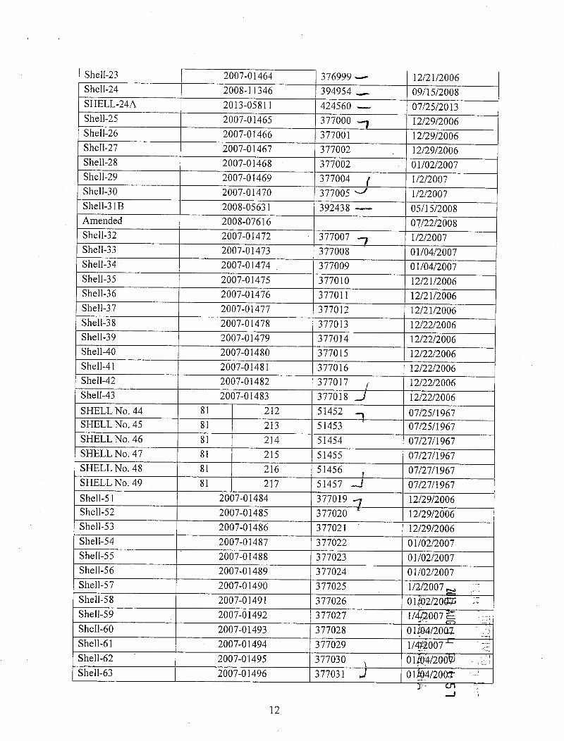
Shell-23 2007-01464 376999 - 12/21/2006Shell-24 2008-11346 394954 - 09/15/2008SHELL-24A 2013-05811 424560 - 07/25/2013Shell-25 2007-01465 377000 12/29/2006Shell-26 2007-01466 377001 12/29/2006Shell-27 2007-01467 377002 12/29/2006Shell-28 2007-01468 377002 01/02/2007Shell-29 2007-01469 377004 1/2/2007Shell-30 2007-01470 377005 1/2/2007Shell-318 2008-05631 392438 - 05/15/2008Amended 2008-07616 07/22/2008Shell-32 2007-01472 377007 1/2/2007Shell-33 2007-01473 377008 01/04/2007Shell-34 2007-01474 377009 01/04/2007Shell-35 2007-01475 377010 12/21/2006Shell-36 2007-01476 377011 12/21/2006Shell-37 2007-01477 377012 12/21/2006Shell-38 2007-01478 377013 12/22/2006Shell-39 2007-01479 377014 12/22/2006Shell-40 2007-01480 377015 12/22/2006Shell-41 2007-01481 377016 12/22/2006Shell-42 2007-01482 377017 12/22/2006Shell-43 2007-01483 377018 J 12/22/2006SHELL No. 44 81 212 51452 07/25/1967SHELL No. 45 81 213 51453 07/25/1967SHELL No. 46 81 214 51454 07/27/1967SHELL No. 47 81 215 51455 07/27/1967SHELL No. 48 81 216 51456 , 07/27/1967SHELL No. 49 81 217 51457 -i 07/27/1967Shell-51 2007-01484 377019 1 12/29/2006Shell-52 2007-01485 377020 12/29/2006Shell-53 2007-01486 377021 12/29/2006Shell-54 2007-01487 377022 01/02/2007Shell-55 2007-01488 377023 01/02/2007Shell-56 2007-01489 377024 01/02/2007Shell-57 2007-01490 377025 1/2/2007 -.,Shell-58 2007-01491 377026 01402/2063;Shell-59 2007-01492 377027 1/ -007 &Shell-60 2007-01493 377028 01104/2001Shell-61 2007-01494 377029 1/*2007Shell-62 2007-01495 377030 01f®/200Shell-63 2007-01496 377031 01-4/200*
.-J
12

Shell-64 2007-01497 377032 -7 01/04/2007Shell-65 2007-01498 377033 01/02/2007Shell-66 2007-01499 377034 01/02/2007Shell-67 2007-01500 377035 01/02/2007Shell-68 2007-01501 377036 01/02/2007Shell-69 2007-01502 377037 12/22/2006Shell-70 2007-01503 377038 12/22/2006Shell-71 2007-01504 377039 12/22/2006Shell-72 2007-01505 377040 12/22/2006SHELL 73 2007-08110 383320 04/24/2007SHELL 74 2007-08111 383321 04/24/2007SHELL 75 2007-08112 383322 04/24/2007SHELL 76 2007-08113 383323 04/24/2007Amended 2008-05484 05/06/2008SHELL 77 2007-08114 383324 04/24/2007Amended 2008-05485 05/06/2008SHELL 78 2007-08115 383325 04/24/2007SHELL 79 2007-08116 383326 04/24/2007SHELL-79A 2013-05812 424561 - 07/25/2013SHELL 80 2007-08117 383327 04/24/2007SHELL 81 2007-08118 383328 04/24/2007SHELL 82 2007-08119 383329 05/21/2007Amended 2008-05486 05/07/2008SHELL 83 2007-08120 383330 05/21/2007Amended 2008-05487 05/07/2008SHELL 84 2007-08121 383331 05/21/2007Amended 2008-05488 05/07/2008SHELL 85 2007-08122 383332 05/21/2007SHELL 86 2007-08123 383333 05/21/2007Amended 2008-05489 05/07/2008SHELL 87 2007-08124 383334 05/21/2007SHELL 88 2007-08125 383335 05/21/2007Amended 2008-05490 05/07/2008SHELL 89 2007-08126 383336 05/2112007SHELL 90 2007-08127 383337 05/21/2007Amended 2008-05491 05Z07/2098,SHELL 91 2007-08128 383338 05@1/2093SHELL 92 2007-08129 383339 0509/20Amended 2008-05492 05106/2008.SHELL 93 2007-08130 383340 05219/20Amended 2008-05493 056/200SHELL 94 2007-08131 383341 J 058/2002-
-1
13

SHELL 95 2007-08132 383342 7 05/17/2007Amended 2008-05494 05/06/2008SHELL 96 2007-08133 383343 05/17/2007SHELL 97 2007-08134 383344 05/17/2007Amended 2008-05495 05/06/2008SHELL 98 2007-08135 383345 05/16/2007SHELL 99 2007-08136 383346 5/16/2007Amended 2008-05496 05/06/2008SHELL 100 2007-08137 383347 05/16/2007SHELL 101 2007-08138 383348 05/16/2007Amended 2008-05497 05/06/2008SHELL 102 2007-08139 383349 04/24/2007SHELL 103 2007-08140 383350 04/24/2007Amended 2008-05498 04/30/2008SHELL 104 2007-08141 383351 04/24/2007SHELL 105 2007-08142 383352 04/24/2007Amended 2008-05499 04/30/2008SHELL 106 2007-08143 383353 04/24/2007Amended 2008-05500 04/30/2008SHELL 107 2007-08144 383354 04/24/2007Amended 2008/05501 04/30/2008SHELL 108 2007-08145 383355 04/24/2007Amended 2008-05502 04/30/2008SHELL 109 2007-08146 383356 04/24/2007Amended 2008-05503 04/30/2008SHELL 110 2007-08147 383357 04/24/2007SHELL 111 2007-08148 383358 04/24/2007Amended 2008-05504 04/30/2008SHELL 112 2007-08149 383359 04/26/2007SHELL 113 2007-08150 383360 04/26/2007Amended 2008-05505 04/30/2008SHELL 114 2007-08151 383361 04/26/2007SHELL 115 2007-08152 383362 04/26/2007Amended 2008-05506 04/30/2008SHELL 116 2007-08153 383363 04/26/2007SHELL 117 2007-08154 383364 04/26/2007Amended 2008-05507 04/30/202§SHELL 118 2007-08155 383365 05707/20Amended 2008-05508 0493-0/20MAmended 2012-08383 0926/20 2SHELL 119 2007-08156 383366 J 05~(07/2099Amended 2008-05509 0480/20661
0 -
crl14 co

Amended 2012-08384 09/26/2012SHELL 120 2007-08157 383367 05/07/2007SHELL 121 2007-08158 383368 05/07/2007Amended 2008-05510 05/05/2008Amended 2012-08385 09/26/2012SHELL 122 2007-08159 383369 05/07/2007SHELL 123 2007-08160 383370 05/07/2007Amended 2008-05511 05/05/2008Amended 2012-08386 09/26/2012SHELL 124 2007-08161 383371 05/07/2007SHELL 125 2007-08162 383372 05/07/2007Amended 2008-05512 05/05/2008Amended 2012-08387 09/26/2012SHELL 126 2007-08163 383373 05/11/2007Amended 2008-05513 05/05/2008SHELL 127 2007-08164 383374 05/11/2007Amended 2008-05514 05/05/2008SHELL 128 2007-08165 383375 05/11/2007SHELL 129 2007-08166 383376 05/11/2007Amended 2008-05515 05/05/2008SHELL 130 2007-08167 383377 05/11/2007SHELL 131 2007-08168 383378 05/11/2007Amended 2008-05516 05/01/2008SHELL 132 2007-08169 383379 05/11/2007SHELL 133 2007-08170 383380 5/11/2007Amended 2008-05517 05/01/2008SHELL 134 2007-08171 383381 05/14/2007SHELL 135 2007-08172 383382 05/14/2007Amended 2008-05518 05/01/2008Shell-136 2007-08173 383383 05/23/2007Amended 2008-05519 05/07/2008Shell-137 2007-08174 383384 05/23/2007Shell-138 2007-08175 383385 05/23/2007Shell-139 2007-08176 383386 05/23/2007SHELL 140 2007-08177 383387 05/18/2007Amended 2008-05520 05/07/20§~SHELL 141 2007-08178 383388 05218/2009Amended 2008-05521 05817/209ASHELL 142 2007-08179 383389 0521·6/2009Amended 2008-05522 05206/2098SHELL 143 2007-08180 383390 0518/200SHELL 144 2007-08181 383391 05.6/2007
CO
15

Amended 2008-05523 05/06/2008SHELL 145 2007-08182 383392- 5/16/2007Amended 2008-05524 05/06/2008SHELL-145A 2013-05410 424350 - 06/20/2013SHELL 146 2007-08183 383393 5/14/2007Amended 2008-05525 05/01/2008SHELL 147 2007-08184 383394 05/14/2007SHELL 148 2007-08185 383395 05/14/2007Amended 2008-05526 05/01/2008SHELL 149 2007-08186 383396 05/14/2007Amended 2008-05527 05/01/2008SHELL 150 2008-05632 392439 - 05/13/2008Amended 2008-07615 07/22/2008Shell 151 2008-11347 394955 09/15/2008Shell 152 2008-11348 394956 09/15/2008Shell 153 2008-11349 394957 09/15/2008Shell 154 2008-11350 394958 09/15/2008She11155 2008-11351 394959 09/15/2008Shell 156 2008-11352 394960 09/15/2008Shell 157 2008-11353 394961 09/15/2008Shell 158 2008-11354 394962 09/14/2008Shell 159 2008-11355 394963 09/14/2008Shell 160 2008-11356 394964 09/14/2008Shell 161 2008-11357 394965 09/14/2008Shell 162 2008-11358 394966 09/14/2008Shell 163 2008-11359 394967 09/14/2008Shell 164 2008-11360 394968 09/14/2008Shell 165 2008-11361 394969 09/14/2008SHELL-166 2012-00377 412595 11/10/2011SHELL-167 2012-00378 412596 11/10/2011Amended 2012-08388 09/25/2012SHELL-168 2012-00379 412597 11/10/2011SHELL-169 2012-00380 412598 11/10/2011SHELL-170 2012-00381 412599 11/08/2011SHELL-171 2012-00382 412600 11/11/2011SHELL-172 2012-00383 412601 11/08/20~LSHELL-173 2012-00384 412602 1161 0/20AGSHELL-174 2012-00385 412603 11 j 0/201*SHELL-175 2012-00386 412604 12~98/2014-SHELL-176 2012-00387 412605 1144/201SHELL-177 2012-00388 412606 11414/201SHELL-178 2012-00389 412607 11 4/201 R
00
16

Amended 2012-08389 09/26/2012SHELL-179 2012-00390 412608 1 11/14/2011Amended 2012-08390 09/26/2012SHELL-180 2012-00391 412609 11/14/2011SHELL-181 2012-00392 412610 11/14/2011SHELL-182 2012-00393 412611 11/14/2011SHELL-183 2012-00394 412612 11/14/2011SHELL-184 2012-00395 412613 11/14/2011SHELL-185 2012-00396 412614 11/14/2011SHELL-186 2012-00397 412615 11/14/2011SHELL-187 2012-00398 412616 11/14/2011SHELL-188 2012-00399 412617 11/14/2011SHELL-189 2012-00400 412618 11/14/2011SHELL-190 2012-00401 412619 11/14/2011SHELL-191 2012-00402 412620 11/14/2011SHELL-192 2012-00403 412621 11/17/2011SHELL-193 2012-00404 412622 11/17/2011SHELL-194 2012-00405 412623 11/22/2011SHELL-195 2012-00406 412624 11/22/2011SHELL-196 2012-00407 412625 11/22/2011SHELL-197 2012-00408 412626 11/22/2011SHELL-198 2012-00409 412627 11/17/2011SHELL-199 2012-00410 412628 11/17/2011SHELL-200 2012-00411 412629. 11/17/2011SHELL-201 2012-00412 412630 11/17/2011SHELL-202 2012-00413 412631 11/17/2011SHELL-203 2012 00414 412632 11/17/2011SHELL-204 2012-00415 412633 11/17/2011SHELL-205 2012-00416 412634 11/17/2011SHELL-206 2012-00417 412635 11/17/2011SHELL-207 2012-00418 412636 11/17/2011SHELL-208 2012-00419 412637 11/17/2011SHELL-209 2012-00420 412638 11/17/2011SHELL-210 2012-00421 412639 11/11/2011SHELL-211 2012-00422 412640 11/11/2011SHELL-212 2012-00423 412641 11/11/2011SHELL-213 2012-00424 412642 11:/.11/20SSHELL-214 2012-00425 412643 11~1:1/20MSHELL-215 2012-00426 412644 12&8/20fYSHELL-216 2012-00427 412645 1101/2019SHELL-217 2012-00428 412646 1158/2049 1SHELL-217A 2013-05813 424562 --- 07115/2011
32· cn00
17

SHELL-218 2012-00429 4126471 11/28/2011Amended 2012-08391 10/01/2012SHELL-219 2012-00430 412648 11/28/2011Amended 2012-08392 09/26/2012SHELL-219A 2013-05814 424563 07/31/2013SHELL-219B 2013-05815 424564 07/3112013SHELL-220 2012-00431 412649 11/28/2011Amended 2012-08393 10/01/2012SHELL-221 2012-00432 412650 11/28/2011Amended 2012-08394 10/01/2012SHELL-222 2012-00433 412651 11/28/2011Amended 2012-08395 10/01/2012SHELL-223 2012-00434 412652 11/22/2011Amended 2012-08396 10/01/2012SHELL-224 2012-00435 412653 11/22/2011Amended 2012-08397 10/01/2012SHELL-225 2012-00436 412654 11/22/2011Amended 2012-08398 10/1/2012SHELL-226 2012-00437 412655 11/22/2011Amended 2012-08399 10/01/2012SHELL-227 2012-00438 412656 11/22/2011Amended 2012-08400 10/01/2012SHELL-228 2012-00439 412657 11/22/2011Amended 2012-08401 10/01/2012SHELL-229 2012-00440 412658 11/22/2011Amended 2012-08402 10/1/2012SHELL-230 2012-00441 412659 11/22/2011Amended 2012-08403 10/1/2012SHELL-231 2012-00442 412660 11/21/2011Amended 2012-08404 10/1/2012SHELL-232 2012-00443 412661 11/22/2011Amended 2012-08405 10/01/2012SHELL-233 2012-00444 412662 11/22/2011Amended 2012-08406 10/01/2012SHELL-234 2012-00445 412663 11222/20 W -Amended 2012-08407 10/11120 -SHELL-235 2012-00446 412664 1127/20 ,Amended 2012-08408 10,401120]~SHELL-236 2012-00447 412665 11/21/20Amended 2012-08409 10101/2012SHELL-237 2012-00448 412666 11/23/201Amended 2012-08410 10/01/20190
18

SHELL-238 2012-00449 412667 1 11/21/2011Amended 2012-08411 10/1/2012SHELL-239 2012-00450 412668 11/21/2011Amended 2012-08412 09/26/2012SHELL-240 2012-00451 412669 11/21/2011Amended 2012-08413 09/26/2012SHELL-241 2012-00452 412670 11/21/2011Amended 2012-08414 09/26/2012SHELL-242 2012-00453 412671 11/21/2011Amended 2012-08415 09/26/2012SHELL-243 2012-00454 412672 11/21/2011Amended 2012-08416 09/26/2012SHELL-244 2012-00455 412673 11/21/2011Amended 2012-08417 09/26/2012SHELL-245 2012-00456 412674 11/21/2011Amended 2012-08418 09/26/2012SHELL-246 2012-00457 412675 11/21/2011Amended 2012-08419 09/26/2012SHELL-247 2012-00458 412676 11/21/2011Amended 2012-08420 09/26/2012SHELL-248 2012-00459 412677 11/21/2011Amended 2012-08421 09/26/2012SHELL-249 2012-00460 412678 11/21/2011Amended 2012-08422 09/26/2012SHELL-250 2012-00461 412679 11/21/2011Amended 2012-08423 09/26/2012SHELL-251 2012-02862 414953 03/14/2012SHELL-252 2012-02863 414954 03/14/2012SHELL-253 2012-02864 414955 03/14/2012SHELL-254 2012-02865 414956 03/14/2012SHELL-255 2012-02866 414957 03/14/2012SHELL-256 2012-02867 414958 03/14/2012SHELL-257 2012-02868 414959 03/14/2012SHELL-258 2012-02869 414960 03/14/2012SHELL-259 2012-02870 414961 03/14/2012SHELL-260 2012-02871 414962 03/14/20BSHELL-261 2012-02872 414963 03114/2012SHELL-262 2012-02873 414964 0 14/2012SHELL-263 2012-02874 414965 0371-3/20+2SHELL-264 2012-02875 414966 03?13/2012SHELL-265 2012-02876 414967 03~13/201SHELL-266 2012-02877 414968 0383/20 E
00
19

SHELL-267 2012-02878 414969 7 03/13/2012SHELL-268 2012-02879 414970 03/13/2012SHELL-269 2012-02880 414971 03/13/2012SHELL-270 2012-02881 414972 03/12/2012SHELL-271 2012-02882 414973 03/13/2012SHELL-272 2012-02883 414974 03/13/2012SHELL-273 2012-02884 414975 03/13/2012SHELL-274 2012-02885 414976 03/13/2012SHELL-275 2012-02886 414977 03/15/2012SHELL-276 2012-02887 414978 03/15/2012SHELL-277 2012-02888 414979 03/15/2012SHELL-278 2012-02889 414980 03/15/2012SHELL-279 2012-02890 414981 03/15/2012SHELL-280 2012-02891 414982 03/15/2012SHELL-281 2012-02892 414983 3/15/2012 »*SHELL-282 2012-02893 414984 3/15/2012SHELL-283 2012-02894 414985 03/15/2012SHELL-284 2012-02895 414986 03/15/2012SHELL-285 2012-02896 414987 03/15/2012SHELL-286 2012-02897 414988 03/15/2012SHELL-287 2012-02898 414989 03/15/2012SHELL-288 2012-02899 414990 03/15/2012SHELL-289 2012-02900 414991 03/15/2012SHELL-290 2012-02901 414992 03/15/2012SHELL-291 2012-02902 414993 03/15/2012SHELL-292 2012-02903 414994 03/15/2012SHELL-293 2012-02904 414995 03/15/2012SHELL-294 2012-02905 414996 03/15/2012SHELL-295 2012-02906 414997 03/15/2012SHELL-296 2012-02907 414998 03/15/2012SHELL-297 2012-02908 414999 03/15/2012SHELL-298 2012-02909 415000 03/15/2012SHELL-299 2012-02910 415001 03/16/2012SHELL-300 2012-02911 415002 03/16/2012SHELL-301 2012-02912 415003 03/r-6/2014SHELL-302 2012-02913 415004 3/1672012 ~SHELL-303 2012-02914 415005 03/16/201 jSHELL-304 2012-02915 415006 03/@/2015SHELL-305 2012-02916 415007 03/{*2011SHELL-306 2012-02917 415008 03/012012_SHELL-307 2012-02918 415009 J 3/1€2012 cn
20

SHELL-308 2012-02919 415010 -) 03/16/2012SHELL-309 2012-02920 415011 03/16/2012SHELL-310 2012-02921 415012 »j 03/16/2012SHELL-311 2012-04673 416189 10/05/2012Amended 2012-08424 09/25/2012SHELL-312 2012-04674 416190 , 10/05/2012Amended 2012-08425 09/25/2012SHELL-313 2013-00649 420822 05/12/2012SHELL-314 2013-00650 420823 ' 05/12/2012SHELL-315 2013-00651 420824 05/12/2012SHELL-316 2013-00652 420825 05/12/2012SHELL-317 2013-00653 420826 06/12/2012SHELL-318 2013-00654 420827 06/12/2012SHELL-319 2013-00655 420828 06/12/2012SHELL-320 2013-00656 420829 06/12/2012SHELL-321 2013-00657 420830 12/11/2012SHELL-322 2013-00658 420831 11/12/2012SHELL-323 2013-00659 420832 11/12/2012SHELL-324 2013-00660 420833 11/12/2012SHELL-325 2013-00661 420834 05/12/2012SHELL-326 2013-00662 420835 05/12/2012SHELL-327 2013-00663 420836 03/12/2012SHELL-328 2013-00664 420837 03/12/2012SHELL-329 2013-00665 420838 03/12/2012SHELL-330 2013-01676 421166 7 01/07/2013SHELL-331 2013-01677 421167 01/07/2013SHELL-332 2013-01678 421168 01/07/2013SHELL-333 2013-01679 421169 01/07/2013SHELL-334 2013-01680 421170 01/07/2013SHELL-335 2013-01681 421171 01/07/2013SHELL-336 2013-01682 421172 01/04/2013SHELL-337 2013-01683 421173 12/28/2012SHELL-338 2013-01684 421174 12/28/2012SHELL-339 2013-01685 421175 12/28/2012SHELL-340 2013-01686 421176 12/28/2015SHELL-341 2013-01687 421177 12/28/201ZESHELL-342 2013-01688 421178 12/28/2012SHELL-343 2013-01689 421179 12/28/201SHELL-344 2013-01690 421180 12/28/201SHELL-345 2013-01691 421181 12/*20127
00
21

SHELL-346 2013-01692 421182 7 12/27/2012SHELL-347 2013-01693 421183 12/27/2012SHELL-348 2013-01694 421184 12/27/2012SHELL-349 2013-01695 421185 12/27/2012SHELL-350 2013-01696 421186 12/27/2012SHELL-351 2013-01697 421187 12/27/2012SHELL-352 2013-01698 421188 12/27/2012SHELL-353 2013-01699 421189 12/27/2012SHELL-354 2013-01700 421190 12/27/2012SHELL-355 2013-01701 421191 12/27/2012SHELL-356 2013-01702 421192 12/27/2012SHELL-357 2013-01703 421193 12/28/2012SHELL-358 2013-01704 421194 12/28/2012SHELL-359 2013-01705 421195 12/21/2012SHELL-360 2013-01706 421196 12/21/2012SHELL-361 2013-01707 421197 12/21/2012SHELL-362 2013-01708 421198 12/21/2012SHELL-363 2013-01709 421199 12/21/2012SHELL-364 2013-01710 421200 12/21/2012SHELL-365 2013-01711 421201 12/21/2012SHELL-366 2013-01712 421202 12/21/2012SHELL-367 2013-01713 421203 12/21/2012SHELL-368 2013-01714 421204 12/20/2012SHELL-369 2013-01715 421205 12/20/2012SHELL-370 2013-01716 421206 12/20/2012SHELL-371 2013-01717 421207 12/20/2012SHELL-372 2013-01718 421208 12/20/2012SHELL-373 2013-01719 421209 12/20/2012SHELL-374 2013-01720 421210 12/20/2012SHELL-375 2013-01721 421211 12/20/2012SHELL-376 2013-01722 421212 12/20/2012SHELL-377 2013-01723 421213 12/20/2012SHELL-378 2013-01724 421214 12/20/2012SHELL-379 2013-01725 421215 12/19/~12SHELL-380 2013-01726 421216 j 2/19/2812SHELL-381 2013-01727 421217 y2/19/ 12SHELL-382 2013-01728 421218 32/19/2012SHELL-383 2013-01729 421219 212/19/2012SHELL-384 2013-01730 421220 72/19/ 12SHELL-385 2013-01731 421221 3 =12/19/2012
CO
22

SHELL-386 2013-01732 421222 1 12/19/2012SHELL-387 2013-01733 421223 12/19/2012SHELL-388 2013-01734 421224 12/19/2012SHELL-389 2013-01735 421225 12/19/2012SHELL-390 2013-01736 421226 12/19/2012SHELL-391 2013-01737 421227 12/18/2012SHELL-392 2013-01738 421228 12/18/2012SHELL-393 2013-01739 421229 12/18/2012SHELL-394 2013-01740 421230 12/18/2012SHELL-395 2013-01741 421231 12/18/2012SHELL-396 2013-01742 421232 12/18/2012SHELL-397 2013-01743 421233 12/18/2012SHELL-398 2013-01744 421234 12/18/2012SHELL-399 2013-01745 421235 -' 05/02/2013SHELL-400 2013-05411 424351 - 06/20/2013SHELL-400A 2013-05816 424565 - 07/31/2013SHELL-401 2013-05412 424352 06/20/2013SHELL-402 2013-05413 424353 06/20/2013SHELL-403 2013-05414 424354 06/17/2013SHELL-404 2013-05415 424355 06/17/2013SHELL-405 2013-05416 424356 06/17/2013SHELL-406 2013-05417 424357 06/17/2013SHELL-407 2013-05418 424358 06/17/2013SHELL-408 2013-05419 424359 06/17/2013SHELL-409 2013-05420 424360 06/18/2013SHELL-409A 2013-05421 424361 06/20/2013SHELL-410 2013-05422 424362 06/11/2013SHELL-411 2013-05423 424363 06/20/2013SHELL-412 2013-05424 424364 06/11/2013SHELL-413 2013-05425 424365 06/20/2013SHELL-414 2013-05426 424366 06/17/2013SHELL-415 2013-05427 424367 06/17/2013SHELL-416 2013-05428 424368 06/17/2013SHELL-417 2013-05429 424369 11/06/2013SHELL-418 2013-05430 424370 06/17/2013SHELL-419 2013-05431 424371 06/18/20,13SHELL-420 2013-05432 424372 06720/20*JSHELL-421 2013-05433 424373 0*20/2gSHELL-422 2013-05434 424374 06120/20+3SHELL-423 2013-05435 424375 -) 06/18/2013
CO
23
1: 58

SHELL-424 2013-05436 424376 '] 06/18/2013SHELL-425 2013-05437 424377 06/18/2013SHELL-426 2013-05438 424378 06/18/2013SHELL-427 2013-05439 424379 06/18/2013SHELL-428 2013-05440 424380 06/18/2013SHELL-429 2013-05441 424381 06/18/2013SHELL-430 2013-05442 424382 06/18/2013SHELL-431 2013-05443 424383 06/18/2013SHELL-432 2013-05444 424384 06/18/2013SHELL-433 2013-05445 424385 06/20/2013SHELL-434 2013-05446 424386 06/18/2013SHELL-435 2013-05447 424387 06/18/2013SHELL-436 2013-05448 424388 06/18/2013SHELL-437 2013-05449 424389 6/11/2013SHELL-438 2013-05450 424390 6/11/2013SHELL-439 2013-05451 424391 _j 06/11/2013SHELL-452 2016-00116 435891 -7 12/23/2015SHELL-453 2016-00117 435892 12/23/2015SHELL-454 2016-00118 435893 12/23/2015SHELL-455 2016-00119 435894 12/23/2015SHELL-456 2016-00120 435895 12/23/2015SHELL-457 2016-00121 435896 12/17/2015SHELL-458 2016-00122 435897 12/23/2015SHELL-459 2016-00123 435898 12/21/2015SHELL-460 2016-00124 435899 12/16/2015SHELL-461 2016-00125 435900 12/17/2015SHELL-462 2016-00126 435901 12/16/2015SHELL-463 2016-00127 435902 12/17/2015SHELL-464 2016-00128 435903 12/16/2015SHELL-465 2016-00129 435904 12/17/2015SHELL-466 2016-00130 435905 12/16/2015SHELL-467 2016-00131 435906 12/17/2015SHELL-468 2016-00132 435907 12/16/2015SHELL-469 2016-00133 435908 12/16/2015AMENDEDSHELL-470 2016-00134 435909 12/£6/2013=AMENDEDSHELL-471 2016-00135 435910 12/ /20155AMENDEDSHELL-472 2016-00136 435911 12/2*/2015-AMENDEDSHELL-473 2016-00137 435912 J 12/28/2015
24

AMENDEDSHELL-474 2016-00138 435913 -7 12/22/2015AMENDEDSHELL-475 2016-00139 435914 3 12/22/2015AMENDEDSHELL-477 2016-00141 435916 -«= 12/23/2015SHELL-478 2016-00142 435917 12/21/2015SHELL-479 2016-00143 435918 12/23/2015SHELL-480 2016-00144 435919 12/21/2015SHELL-481 2016-00145 435920 12/17/2015SHELL-482 2016-00146 435921 12/21/2015SHELL-483 2016-00147 435922 12/18/2015SHELL-484 2016-00148 435923 12/18/2015SHELL-485 2016-00149 435924 12/17/2015SHELL-486 2016-00150 435925 12/18/2015SHELL-487 2016-00151 435926 12/17/2015SHELL-488 2016-00152 435927 12/18/2015SHELL-489 2016-00153 435928 12/17/2015SHELL-490 2016-00154 435929 12/18/2015SHELL-491 2016-00155 435930 12/17/2015SHELL-492 2016-00156 435931 12/18/2015SHELL-493 2016-00157 435932 12/21/2015SHELL-494 2016-00158 435933 12/21/2015SHELL-495 2016-00159 435934 12/21/2015SHELL-496 2016-00160 435935 12/21/2015SHELL-497 2016-00161 435936 12/18/2015SHELL-498 2016-00162 435937 12/18/2015SHELL-499 2016-00163 435938 12/22/2015SHELL-500 2016-00164 435939 12/22/2015SHELL-501 2016-00165 435940 J 12/22/2015
1611 AUG Ill P
i. 59
t-"
CO
25

C. WCR Unpatented Claims
The following are the active unpatented lode mining claims for Arizona Minerals Inc. situated inthe Harshaw and Patagonia Mining District, in Sections 13,24,25 and 36 in Township 23 South,Range 15 East; in Sections 8,9,16 through 21, and 28 through 32 in Township 23 South, Range16 East; in Section 1 in Township 24 South, Range 15 East; and in Section 6 in Township 24South, Range 16 East, all in the G&SR Meridian, Santa Cruz County, Arizona, the names ofwhich and the place ofrecord ofthe location notices thereof in the official records ofthe SantaCruz County Recorder and Arizona State office of the Bureau o f Land Management are asfollows:
County Records AMC SerialName of Claim Number Number Location DateWCR-20 2005-16751 AMC367401 7 09/06/2005WCR-21 2005-16752 AMC367402 09/06/2005WCR-22 2005-16753 AMC367403 09/06/2005WCR-23 2005-16754 AMC367404 09/06/2005WCR-24 2005-16755 AMC367405 09/06/2005WCR-25 2005-16756 AMC367406 09/06/2005WCR-26 2005-16757 AMC367407 09/06/2005WCR-27 2005-16758 AMC367408 09/06/2005WCR-28 2005-16759 AMC367409 09/06/2005WCR-29 2005-16760 AMC367410 09/06/2005WCR-30 2005-16761 AMC367411 09/06/2005WCR-31 2005-16762 AMC367412 09/06/2005WCR-32 2005-16763 AMC367413 09/06/2005WCR-33 2005-16764 AMC367414 09/06/2005WCR-34 2005-16765 AMC367415 09/06/2005WCR-35 2005-16766 AMC367416 09/06/2005WCR-36 2005-16767 AMC367417 09/06/2005WCR-37 2005-16768 AMC367418 09/06/2005WCR-3 8 2005-16769 AMC367419 09/06/2005WCR-39 2005-16770 AMC367420 09/06/2005WCR-41 2005-16772 AMC367422 - 09/06/200£!WCR-43 2005-16774 AMC367424 - 09/06/2005>WCR-45 2005-16776 AMC367426,- 09/®720052WCR-47 2005-16778 AMC367428 - 09/07/200irWCR-49 2005-16780 AMC367430 09/67/200WCR-50 2005-16781 AMC367431 09/Off/2005WCR-51 2005-16782 AMC367432 J 09®7/20
-0
26 1

WCR-52 | 2005-16783 AMC367433 09/07/2005WCR-53 2005-16784 AMC367434 09/07/2005WCR-54 2005-16785 AMC367435 09/07/2005WCR-55 2005-16786 AMC367436 09/07/2005WCR-56 2005-16787 AMC367437 09/07/2005WCR-57 2005-16788 AMC367438 7 09/07/2005WCR-58 2005-16789 AMC367439 09/07/2005WCR-60 2005-16791 AMC367441 09/07/2005WCR-61 2005-16792 AMC367442 09/07/2005WCR-62 2005-16793 AMC367443 09/07/2005WCR-63 2005-16794 AMC367444 09/07/2005WCR-64 2005-16795 AMC367445 09/07/2005WCR-65 2005-16796 AMC367446 09/07/2005WCR-66 2005-16797 AMC367447 09/07/2005WCR-67 2005-16798 AMC367448 09/07/2005WCR-68 2005-16799 AMC367449 09/07/2005WCR-69 2005-16800 AMC367450 09/07/2005WCR-70 2005-16801 AMC367451 09/07/2005WCR-71 2005-16802 AMC367452 09/07/2005WCR-72 2005-16803 AMC367453 09/07/2005WCR-73 2005-16804 AMC367454 09/07/2005WCR-74 2005-16805 AMC367455 09/07/2005WCR-75 2005-16806 AMC367456 09/07/2005WCR-76 2005-16807 AMC367457 09/07/2005WCR-77 2005-16808 AMC367458 09/07/2005WCR-78 2005-16809 AMC367459 09/07/2005WCR-79 2005-16810 AMC367460 09/07/2005WCR-81 2005-16811 AMC367461 09/07/2005WCR-82 2005-16812 AMC367462 09/07/2005WCR-83 2005-16813 AMC367463 09/07/2005WCR-85 2005-16814 AMC367464 09/07/2005WCR-87 2005-16815 AMC367465 09/07/2005WCR-88 2005-16816 AMC367466 09/07/2005WCR-89 2005-16817 AMC367467 09/07/2005WCR-90 2005-16818 AMC367468 09/07/2005WCR-91 2005-16819 AMC367469 09/0712005 0WCR-93 2005-16820 AMC367470 09/0 2005 -'WCR-94 2005-16821 AMC367471 09/0-62005 EWCR-95 2005-16822 AMC367472 09/08/2005WCR-96 2005-16823 AMC367473 09/082005.WCR-97 2005-16824 AMC367474 09/08/2005WCR-98 2005-16825 AMC367475 -1 09/0872005
.
27

WCR-99 2005-16826 AMC367476 7 09/08/2005WCR-100 2005-16827 AMC367477 09/08/2005WCR-101 2005-16828 AMC367478 09/08/2005WCR-102 2005-16829 AMC367479 09/08/2005WCR-103 2005-16830 AMC367480 09/08/2005WCR-104 2005-16831 AMC367481 09/08/2005WCR-105 2005-16832 AMC367482 09/08/2005WCR-106 2005-16833 AMC367483 09/08/2005WCR-107 2005-16834 AMC367484 09/08/2005WCR-108 2005-16835 AMC367485 09/08/2005WCR-109 2005-16836 AMC367486 09/08/2005WCR-110 2005-16837 AMC367487 09/08/2005WCR-111 2005-16838 AMC367488 09/08/2005WCR-112 2005-16839 AMC367489 09/08/2005WCR-113 2005-16840 AMC367490 09/08/2005WCR-114 2005-16841 AMC367491 09/08/2005WCR-115 2005-16842 AMC367492 09/08/2005WCR-116 2005-16843 AMC367493 09/08/2005WCR-117 2005-16844 AMC367494 09/09/2005 ,~WCR-118 2005-16845 AMC367495 09/09/2005WCR-119 2005-16846 AMC367496 09/09/2005WCR-120 2005-16847 AMC367497 09/09/2005WCR-121 2005-16848 AMC367498 09/09/2005WCR-122 2005-16849 AMC367499 09/09/2005WCR-123 2005-16850 AMC367500 09/09/2005WCR-124 2005-16851 AMC367501 09/08/2005WCR-125 2005-16852 AMC367502 09/08/2005WCR-126 2005-16853 AMC367503 09/08/2005WCR-127 2005-16854 AMC367504 09/08/2005WCR-128 2005-16855 AMC367505 09/08/2005WCR-129 2005-16856 AMC367506 09/08/2005WCR-130 2005-16857 AMC367507 09/08/2005WCR-131 2005-16858 AMC367508 09/08/2005WCR-132 2005-16859 AMC367509 09/08/2005WCR-133 2005-16860 AMC367510 09/08/2005WCR-134 2005-16861 AMC367511 09/!08/20£%WCR-135 2005-16862 AMC367512 09*)8/20WCR-136 2005-16863 AMC367513 09*8/206*WCR-137 2005-16864 AMC367514 09*8/2005WCR-138 2005-16865 AMC367515 0%08/2005' nWCR-139 2005-16866 AMC367516 09}68/20QiWCR-140 2005-16867 AMC367517 J 09208/20eh
28

WCR-141 2005-16868 AMC367518 -7 09/08/2005WCR-142 2005-16869 AMC367519 09/08/2005WCR-143 2005-16870 AMC367520 09/08/2005WCR-144 2005-16871 AMC367521 09/09/2005WCR-145 2005-16872 AMC367522 09/09/2005WCR-146 2005-16873 AMC367523 09/09/2005WCR-147 2005-16874 AMC367524 09/09/2005WCR-148 2005-16875 AMC367525 09/09/2005WCR-149 2005-16876 AMC367526 09/09/2005WCR-150 2005-16877 AMC367527 09/09/2005WCR-151 2005-16878 AMC367528 09/09/2005WCR-152 2005-16879 AMC367529 09/08/2005WCR-153 2005-16880 AMC367530 09/08/2005WCR-154 2005-16881 AMC367531 09/08/2005WCR-155 2005-16882 AMC367532 09/08/2005WCR-156 2005-16883 AMC367533 09/08/2005WCR-157 2005-16884 AMC367534 09/08/2005WCR-158 2005-16885 AMC367535 09/08/2005WCR-159 2005-16886 AMC367536 09/08/2005WCR-160 2005-16887 AMC367537 09/08/2005WCR-161 2005-16888 AMC367538 09/08/2005WCR-162 2005-16889 AMC367539 09/09/2005WCR-163 2005-16890 AMC367540 09/09/2005WCR-164 2005-16891 AMC367541 09/09/2005WCR-165 2005-16892 AMC367542 09/09/2005WCR-166 2005-16893 AMC367543 09/09/2005WCR-167 2005-16894 AMC367544 09/09/2005WCR-168 2005-16895 AMC367545 09/09/2005WCR-169 2005-16896 AMC367546 09/09/2005WCR-170 2005-16897 AMC367547 09/09/2005WCR-171 2005-16898 AMC367548 09/09/2005WCR-172 2005-16899 AMC367549 09/09/2005WCR-173 2005-16900 AMC367550 09/09/2005WCR-174 2005-16901 AMC367551 09/09/2005WCR-175 2005-16902 AMC367552 09/07/2005WCR-176 2005-16903 AMC367553 09/0-7/2005~ ~WCR- 177 2005- 16904 AMC367554 09/lmoos-'WCR-178 2005-16905 AMC367555 09/11/20055 7WCR-179 2005-16906 AMC367556 09/1 112005WCR-180 2005-16907 AMC367557 09/1 1/2005WCR-181 2005-16908 AMC367558 09/1 moos 3WCR-182 2005-16909 AMC367559 09/1 %2005
ID
29

WCR-207 2005-16934 AMC367584 1 09/11/2005WCR-208 2005-16935 AMC367585 09/09/2005WCR-209 2005-16936 AMC367586 09/11/2005WCR-210 2005-16937 AMC367587 09/11/2005WCR-211 2005-16938 AMC367588 09/11/2005WCR-212 2005-16939 AMC367589 09/11/2005WCR-213 2005-16940 AMC367590 09/11/2005WCR-214 2005-16941 AMC367591 09/08/2005WCR-215 2005-16942 AMC367592 09/08/2005WCR-216 2005-16943 AMC367593 09/11/2005WCR-217 2005-16944 AMC367594 09/11/2005WCR-218 2005-16945 AMC367595 09/08/2005WCR-219 2005-16946 AMC367596 09/11/2005WCR-220 2005-16947 AMC367597 09/08/2005WCR-221 2005-16948 AMC367598 09/08/2005WCR-223 2005-16950 AMC3676003 09/08/2005WCR 274 2005-16725 AMC368661 09/21/2005WCR 275 2005-16726 AMC368662 09/21/2005WCR 277 2005-16727 AMC368663 09/21/2005WCR 278 2005-16728 AMC368664 09/21/2005WCR 293 2005-16729 AMC368665 09/22/200WCR 301 2005-16730 AMC368666 09/22/2005 .'4 . *-,fWCR 303 2005-16731 AMC368667 10/13/2005WCR 304 2005-16732 AMC368668 10/13/2005WCR 305 2005-16733 AMC368669 10/13/2005WCR 306 2005-16734 AMC368670 10/13/2005WCR 307 2005-16735 AMC368671 10/12/2005WCR 308 2005-16736 AMC368672 10/12/2005WCR 309 2005-16737 AMC368673 10/12/2005WCR 310 2005-16738 AMC368674 10/12/2005WCR 311 2005-16739 AMC368675 10/12/2005WCR 312 2005-16740 AMC368676 10/12/2005WCR 313 2005-16741 AMC368677 10/12/2005WCR 314 2005-16742 AMC368678 10/12/2005WCR 315 2005-16743 AMC368679 10/12l2005WCR 316 2005-16744 AMC368680 10/12/2005 3WCR 317 2005-16745 AMC368681 10/12/2005 3
-1WCR 318 2005-16746 AMC368682J 10/12/2005- 3WCR-323 2006-07297 AMC373271 *- 05/01/2006WCR-359 2006-11578 AMC373273 -- 07/1*006
C-11
30

WCR-360 2006-11579 AMC373274 07/14/2006WCR-361 2006-11580 AMC373275 -~ 07/14/2006WCR-80 2006-19728 AMC376279 10/19/2006WCR-84 2005-16814 AMC376280 10/19/2006WCR-86 2006-19730 AMC376281 10/19/2006WCR-4 2006-19731 AMC376282 10/13/2006WCR-5 2006-19732 AMC376283 10/13/2006WCR-6 2006-19733 AMC376284 10/13/2006WCR-7 2006-19734 AMC376285 10/13/2006WCR-8 2006-19735 AMC376286 10/13/2006WCR-9 2006-19736 AMC376287 10/13/2006WCR-10 2006-19737 AMC376288 10/13/2006WCR-11 2006-19738 AMC376289 10/13/2006WCR-12 2006-19739 AMC376290 10/13/2006WCR-13 2006-19740 AMC376291 10/13/2006WCR-14 2006-19741 AMC376292 10/13/2006WCR-15 2006-19742 AMC376293 10/13/2006 <WCR-16 2006-19743 AMC376294 10/13/2006 ,„Ir< ' ~~
WCR-17 2006-19744 AMC376295 10/13/2006WCR-18 2006-19745 AMC376296 10/13/2006WCR-19 2006-19746 AMC376297 10/13/2006WCR-404 2006-19751 AMC376302 10/13/2006WCR-405 2006-19752 AMC376303 10/13/2006WCR-406 2006-19753 AMC376304 , 10/13/2006WCR-407 2006-19754 AMC376305 J 10/13/2006WCR-420A 2006-19765 AMC376316 12/13/2006WCR-421A 2006-19766 AMC376317 e 12/13/2006WCR-422 2006-19767 AMC376318 10/10/2006WCR-423 2006-19768 AMC376319 10/10/2006WCR-424 2006-19769 AMC376320 10/10/2006WCR-425 2006-19770 AMC376321 10/10/2006WCR-426 2006-19771 AMC376322 10/18/2006 1WCR-427 2006-19772 AMC376323 10/18/2006 1WCR-428 2006-19773 AMC376324 10/29/2006WCR-429 2006-19774 AMC376325 10/29/2006= IWCR-430 2006-19775 AMC376326 11/30/20062WCR-431 2006-19776 AMC376327 12/1*006~WCR-11OE 2006-19780 AMC376331 12/0620065WCR-112E 2006-19781 AMC376332 12/07020060
C.n31 -0

WCR-114E 2006-19782 AMC376333 - 12/08/2006WCR-432 2007-01454 AMC376440 12/20/2006WCR-433 2007-01455 AMC376441 12/20/2006WCR-434 2007-01456 AMC376442 12/20/2006WCR-435 2007-01457 AMC376443 12/20/2006WCR-436 2007-01458 AMC376444 12/20/2006WCR-437 2007-01459 AMC376445 12/20/2006WCR-438 2007-01460 AMC376446 12/20/2006WCR-439 2007-01461 AMC376447 12/20/2006WCR-92 2014-01329 AMC427463 02/10/2014WCR-183 2014-01330 AMC427464 02/05/2014WCR-184 2014-01331 AMC427465 02/04/2014WCR-185 2014-01332 AMC427466 02/05/2014WCR-186 2014-01333 AMC427467 02/04/2014
2 WCR-187 2014-01334 AMC427468 02/05/2014WCR-188 2014-01335 AMC427469 02/04/2014WCR-189 2014-01336 AMC427470 02/05/2014WCR-190 2014-01337 AMC427471 02/04/2014WCR-191 2014-01338 AMC427472 02/05/2014WCR-192 2014-01339 AMC427473 02/04/20144~<4/:,1WCR-193 2014-01340 AMC427474 02/05/20WCR-194 2014-01341 AMC427475 02/04/WCR-195 2014-01342 AMC427476 02/05/2WCR-196 2014-01343 AMC427477 02/04/2014WCR-197 2014-01344 AMC427478 02/05/2014WCR-198 2014-01345 AMC427479 02/04/2014WCR-199 2014-01346 AMC427480 02/05/2014WCR-200 2014-01347 AMC427481 02/04/2014WCR-201 2014-01348 AMC427482 02/05/2014WCR-202 2014-01349 AMC427483 02/05/2014WCR-203 2014-01350 AMC427484 02/05/2014WCR-204 2014-01351 AMC427485 02/05/2014WCR-205 2014-01352 AMC427486 02/05/2014WCR-206 2014-01353 AMC427487 02/05/2014WCR-255 2014-01354 AMC427488 02/10/2014WCR-256 2014-01355 AMC427489 02/06/2014WCR-257 2014-01356 AMC427490 02/10/2014WCR-258 2014-01357 AMC427491 02/0612014=WCR-259 2014-01358 AMC427492 02/10/2014 -WCR-260 2014-01359 AMC427493 02/06/2014 5-7
WCR-261 2014-01360 AMC427494 02/16/2014 EWCR-262 2014-01361 AMC427495 02/10/2014 -r
32 Ul-0

WCR-263 2014-01362 AMC427496 1 02/10/2014WCR-264 2014-01363 AMC427497 J 02/10/2014WCR-110 Amended 2006-19777 AMC367487 - 12/07/2006WCR-112 Amended 2006-19778 AMC367489 -·. 12/08/2006WCR-114 Amended 2006-19779 AMC367491 -- 12/09/2006
Part II. FOBC Unpatented Mining Claims:
The following described unpatented lode mining claims for Arizona MineralsInc. are held under an Exploration and Option Agreement with FOBC, LLC, in theHarshaw and Patagonia Mining District, situated within Sections 5,8 and 9 in Township23 South, Range 16 East in the G&SR Meridian, Santa Cruz County, Arizona, the namesof which and the place o f record of the location notices thereof in the official records ofthe Santa Cruz County Recorder and Arizona State Office of the Bureau of Land 91>*1Management are as follows: i
Serial No. Name of Claim Location Date County RecordsNumber
AMC374413 PAT 1 07/10/2006 2006-16082AMC374414 PAT 2 07/10/2006 2006-16083AMC374415 PAT 3 07/10/2006 2006-16084 4'-AMC374416 PAT 4 07/10/2006 2006-16085AMC374417 PAT 5 07/10/2006 2006-16086AMC374418 PAT 6 07/10/2006 2006-16087AMC374419 PAT 7 07/10/2006 2006-16088AMC374420 PAT 8 07/10/2006 2006-16089AMC374421 PAT 9 07/10/2006 2006-16090AMC435089 PAT 10 10/28/2015 2015-06352AMC374423 PAT 11 07/10/2006 2006-16092AMC374424 PAT 12 07/10/2006 2006-16093AMC374425 PAT 13 07/10/2006 2006-16094AMC374426 PAT 14 07/10/2006 2006-16095AMC374427 PAT 15 07/10/2006 2006-16096AMC374428 PAT 16 07/10/2006 2006-16097
PAT 16 AMENDED 10/28/2015 2015-06353 Ull A G
QB\47452950.1
Ul-0
33

® :ryr[conedult'
'
z if sj i s * I /19-5 2 nar -Re£ Sp~.2* c j
5 .-/
d le a pickup or find a drop offisit ups.com
' or call 1-800-PICK-UP (1-800-742-5877)
ents on this side.53
}[Mull
'lla)$
.80"
2111
' 4/
01
Aew
lou[
1/8
''qui=
Koi:r
ofilld
,v pu
!,\\1u
!·1(1
1 1~
3p=1 d
u! O
u 13
Vi.O
lro.1
0~5!
n/wo
o·sd
.~~.
w'a~
:sd n·'01 HIE YOU]JG 1.0 LBS LTR 1 OF 1QUARLES & BRAL)Y LLPTS. C]IURCI{,WE.3-11<3011 AZ 85701
SHIP TO:BIJRFAU OF IAND MANAGEMENTARIZONA 51'ATE OFFICE O ~.ONE NOR'l'[I CENTRAI. AVENUE, SUITE 800 n
PHOENIX AZ 8500+4427 -0
0C
3 +
GS ki *2-Auf·i] 1111111illillillillill'll'll IfUPS NEXT DAY AIR *"TRACKING #: 17,816 929 01 9432 5452 1 /
= 1 1111111111 lilli 1C
Mpv
1 41!
.pif.
1'.
11
BILLING: P/P <
L/·1rD
. . ~ i~is,auv,elope is for use w
ith the following services:
UPS Next Day Air
<Referefice#1:Yvonne Youngcro Referetice#2: 159799.000(15 6usl©.546 Ii-/.1-4.2:2./07./1 - 30'.
1 0 -ti-- --- --
01 .,
30rD-
e
0'!~
5 1
3 ed
Pe
un
91
51/1
1015
610t
o
~ ~ ~
0')!A
Jas
10)Je
d Pa
l!un
Do not use this en
UFS 2nd Day
I 2 2-/-
-0 C
Ul'S W
orldwide Express
171604 R~.12/09 FD~ 3
.

Receipt Page 1 of 1
United States Department of the InteriorReceiptBureau of Land Management
DIV OF LANDS, MINRLS & ENERGYONE N CENTRAL AVE
PHOENIX, AZ 85004 -4427 No: 3938186Phone: 602-417-9200
Transaction #: 4047828Date of Transaction: 08/15/2017
CUSTOMER:
QUARLES & BRADY LLP1 S CHURCH AVE
TUCSON,AZ 85701-1612 US
LINE -~-# QTY DESCRIPTION 1 REMARKS I MTOTAL!~1 PRICE 11 1
|NOT NEW-UNADJUD.ONE AUTH NO. ONLY / 1~MAINT1 1 1 1.00 1 -rda- 1171120.00
lIMINING CLAIM MONEY RECEIVED 2018/11041~~
ELLLELLELLELLELLEELL TOTAL:[§171,120.00PAYMENT INFORMATION
1 1--*iOUNT:~~171120.00~POSTMARKED: IN/A1-----TYjfjjj'CHECKLI=RECEIVEDEOS/14/2017
NAME: QUARLES & BRADY LLP1 S CHURCH AVESUITE 1700TUCSON AZ 85701-1612 US
REMARKSUPS DAMAGED DOCUMENTS PRIOR TO BEING RECEIVED IN OUR OFFICE
This receipt was generated by the automated BLM Collections and Billing System and is a paper representation of a portionof the official electronic record contained therein.
https://ilmocopOap93 3.blm.doi.net/cgibin/cbsp/zorder 8/15/2017

5 1409Lff'1 963
39&9363703&8 37699736%661
394954373267376437 41*45 60
43 5 0 59 3633203749/3 q /339 5-
4/9953
weng920 Bazz921 16692935-04358914380999309/A37027736739%
AUG 2 3 2016I1

[13Ffl DECONCI~ ~CDONALD YETWIN & LACYA PROFESSIONAL CORPORATION
1-~L ~ ATTORNEYS AT LAW~ 2525 EAST BROADWAY BOULEVARD • SUITE 200 · TUCSON, ARIZONA 85716-5300~ (520) 322-5000 • (520) 322-5585 (FAX) DMYL.COM
DENISEM . BAINTON RYAN D. O' NEAL FIRM FOUNDERS:AUCE W. CALLISON ALEXIA J. PETERSON EVO A. DECONCINI (1901-1986)BARRY M. COREY JOHN C. RICHARDSON JOHN R. MCDONALD (1933-2012)JODY A. CORRALES LISA ANNE SMITH DENNIS W. DECONCINIPETER B. GOLDMAN SPENCER A. SMITHNATHAN B. HANNAH SESALY O. STAMPSSTEVEN j. ITKIN JAMES M . SUSA PHOENIX OFFICE.JAMES A. JUTRY PAUL M. TILLEY 7310 NORTH 16TH STREEL SUITE 330JOHN C. LACY CARY F. URMAN PHOENIX, ARIZONA 85020161THRYN B. NELSON MICHAEL R. URMAN (602) 282-0500OF COUNSEL: August 16, 2016 FAX : (602) 282- 0520RICHARD M. YETWINBARRON & ASSOCIATES, P.C. - JOHN H. BARRON, 111SHIJIE FENG PLEASE REPLY TO TUCSON
Yja_Federal Express :V, 1
..fi,N -0 = 12Arizona State Office ; 3Bureau of Land Management C #50Attention: Public Room 0 11
HOENIX. ARIZ
One North Central Avenue, Suite 800 A im2Phoenix, AZ 85004-4427 > SRE: Payment of Claim Maintenance Fee; Arizona Minerals Inc. ~ 90
ATE OFFICE
Ladies and Gentlemen:
Delivered herewith are two checks in the amounts of $143,995.00 and $495.00 aspayment of the claim maintenance fees pursuant to the 30 U.S.C. § 28f(a), as adjusted by 30U.S.C. § 28j(c) and implemented by notice in 74 Federal Register 30959-62 (June 29,2009) andas amended by the Consolidated Appropriations Act 2012, Pub. L. No. 112-74, 125 Stat. 786(2011), and a notice in 79 Federal Register 36662-65 (June 30, 2014). The owner has paid amaintenance fee of $155 per claim (932 claims) for the assessment year beginning September 1,2016. A copy of the Certification of Payment of Maintenance Fee in Lieu ofAffidavit of AnnualAssessment Work to be recorded with the Santa Cruz County Recorder's Office is also enclosedherewith.
Please-return-tothisofficeadate-stamned-co Lof-thisletterandthe-affidavitalon;viththe_res~int_foripayment.
Thank you for your assistance and please feel free to contact me or John Lacy with anyquestions or concerns.
Sincere ,
#4,0AUU 6 6 LUIDKat ery Smith, CPCertified aralegal
Encl.cc Greg Lucero (w/0 encl)I:\FILES\DOCS\AUGU05\251031\LTR\1000883.DOCX
MOT Ite Sair OFC.De#*er Asic.4*-5. RECEIPT # 36 9[Qup/4 W

-
-0 W0m m
After recording, please return to: E al-
BLM AZ -TATE OFFICERESEIVEDJohn C. Lacy >2 >DeConcini McDonald Yetwin & Lacy, P.C. N
2525 E. Broadway Blvd., #200 0 41ZTucson, AZ 85716 b --
STATE OF ARIZONA )) SS:
County of Pima )
CERTIFICATION OF PAYMENT OF MAINTENANCE FEEIN LIEU OF AFFIDAVIT OF ANNUAL ASSESSMENT WORK
John C. Lacy, being first duly sworn, deposes and says that:
1. He is an agent for Arizona Minerals Inc., a Nevada corporation, the ownerof the unpatented lode mining claims described in Parts I and II and the optionee of theclaims described in Part III, all situated in Santa Cruz County, Arizona (the "Claims"),the location notices of which are of record in Santa Cruz County, and in the records of theArizona State Office of the Bureau of Land Management under the file numbersindicated in the attached Exhibit A.
2. Pursuant to the 30 U.S.C. § 28«a), as adjusted by 30 U.S.C. § 28j(c) andimplemented by notice in 74 Federal Register 30959-62 (June 29,2009), as amended bythe Consolidated Appropriations Act 2012, Pub. L. No. 112-74,125 Stat. 786 (2011) anda notice in 79 Federal Register 36662-65 (June 30,2014), the owner paid a maintenancefee of $155 per claim to the Bureau ofLand Management forthe assessment yearbeginning September 1, 2016. This Affidavit is recorded to attestto the payment andreceipt of such payment and as an affirmation of an intent to hold those Claims describedin Exhibit A attached herein.
3. The names and addresses of the owners of the Claims for which thisCertificate is prepared are as follows:
Parts I and II: Arizona Minerals Inc., c/o AZ Mining Inc., 3845 N.Business Center Drive, Suite 115, Tucson, AZ 85705. THIS la A CHANGEOF ADDRESS.
Part II: FOBC, LLC, 1815 W. Winsett Street, Tucson, AZ 85719.THIS IS NOT A CHANGE OF ADDRESS.
1
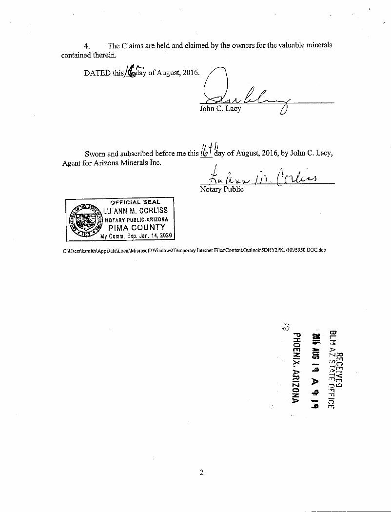
4. The Claims are held and claimed by the owners for the valuable mineralscontained therein.
1#/,1DATED this~~day ofAugust, 2016.
John C. Lacy
Sworn and subscribed before me this /..~ day of August, 2016, by John C. Lacy,Agent for Arizona Minerals Inc. ~ 1 /l - a
h iL l. 3 - C LLA.42Notary Public
miz2~LU ANN M. CORLISS |Rei"Wiii NOTARY PUBLIC-ARIZONA ~
, ~~5{f PIMA COUNTy ~1__Ztss_ My Co-911· Eig.-f.E~14, 20201
C:\Users\ksmith\AppData\Local\Microsoft\Windows\Temporary Internet Files\ContentOutloolMDRY2PKJ\1095950 DOC.doc
e= r-000rn » >Z S -4135 -- :S , 4
ESFIVED
0Z •IP- ZR
-3-0 m
2

PHOENIX. ARIZ
BLM AZEXHIBIT A il :-A
Mining Claims .0 30PART I (Shell Claims): -1<
00The following unpatented lode mining claims are situated in the Hars~w at 1
Patagonia Mining Districts, in Sections 13,24,25,26, 35 and 36, Township 35 Sot~ ARange 15 East; in Sections 17 through 20 and 27 through 36, Township 22 South, Range16 East; in Sections 1 through 5, 8 through 16 (unsurveyed), Township 23 South, Range16 East; Sections 6, 7 and 18, Township 23 South, Range 17 East; in Section 1, Township24 South, Range 17 East; and in Section 6, Township 24 South, Range 16 East, G&SRMer., Santa Cruz County, Arizona, the names ofwhich, and the place of recording oftheir location notices in the Official Records of Santa Cruz County and the Arizona StateOffice ofthe Bureau of Land Management are as follows:
Santa Cruz County BLM SerialName of Claim Location Date Docket/Page or Fee No. AMCNo.
SHELL NO. 1 01/29/1965 058 135 51409-7Amended 04/25/2013 2013-03346
SHELL NO. 2 01/29/1965 058 136 51410-jAmended 04/25/2013 2013-03347
Shell 2A 05/07/2008 2008-05629 3924361Amended 04/25/2013 2013-03348
Shell 2B 05/12/2008 2008-05630 392437-,Amended 04/25/2013 2013-03349 7SHELL NO. 3 01/29/1965 058 137 51411 .
SHELL NO. 4 01/29/1965 058 138 51412SHELL NO. 5 01/29/1965 058 139 51413SHELL NO. 6 01/28/1965 058 140 51414SHELL NO. 7 01/28/1965 058 141 51415SHELL NO. 8 01/28/1965 058 142 51416SHELL NO. 9 01/29/1965 058 143 51417SHELL NO. 10 01/29/1965 058 144 51418SHELL NO. 11 01/28/1965 058 145 51419SHELL NO. 12 01/28/1965 058 146 51420SHELL NO. 13 01/29/1965 058 147 51421SHELL NO.14 01/29/1965 058 148 51422SHELL NO. 15 01/28/1965 058 149 51423SHELL NO. 16 01/28/1965 058 150 51424SHELL NO. 17 01/28/1965 058 151 51425SHELL NO. 18 01/28/1965 058 152 51426SHELL NO. 19 01/28/1965 058 153 51427SHELL NO. 20 01/28/1965 058 154 51428 jShell-21 12/21/2006 2007-01462 3769977Shell-22 12/21/2006 2007-01463 376998Shell-23 12/21/2006 2007-01464 376999.jShell-24 09/15/2008 2008-11346 394954 --*
1

Santa Cruz County BLM SerialName of Claim Location Date Docket/Page or Fee No. AMC No.
SHELL-24A 07/25/2013 2013-05811 424560-Shell-25 12/29/2006 2007-01465 377000 3Shell-26 12/29/2006 2007-01466 377001Shell-27 12/29/2006 2007-01467 377002Shell-28 01/02/2007 2007-01468 377003Shell-29 01/02/2007 2007-01469 377004Shell-30 01/02/2007 2007-01470 377005,1Shell-31B 05/15/2008 2008-05631 392438 <Amended 07/22/2008 2008-07616Shell-32 01/02/2007 2007-01472 377007Shell-33 01/04/2007 2007-01473 377008Shell-34 01/04/2007 2007-01474 377009Shell-35 12/21/2006 2007-01475 377010Shell-36 12/21/2006 2007-01476 377011Shell-37 12/21/2006 2007-01477 377012Shell-38 12/22/2006 2007-01478 377013Shell-39 12/22/2006 2007-01479 377014Shell-40 12/22/2006 2007-01480 377015Shell-41 12/22/2006 2007-01481 377016Shell-42 12/22/2006 2007-01482 377017Shell-43 12/22/2006 2007-01483 377018_jSHELL No. 44 07/25/1967 81 212 51452 -7SHELL No. 45 07/25/1967 81 213 51453SHELL No. 46 07/27/1967 81 214 51454SHELL No. 47 07/27/1967 81 215 51455SHELL No. 48 07/27/1967 81 216 51456SHELL No. 49 07/27/1967 81 217 51457 JShell-51 12/29/2006 2007-01484 377019-1Shell-52 12/29/2006 2007-01485 377020 'Shell-53 12/29/2006 2007-01486 377021Shell-54 , 01/02/2007 2007-01487 377022Shell-55 01/02/2007 2007-01488 377023Shell-56 01/02/2007 2007-01489 377024Shell-57 01/02/2007 2007-01490 377025Shell-58 01/02/2007 2007-01491 377026 UJShell-59 01/04/2007 2007-01492 377027 ~4 *30'Shell-60 01/04/2007 2007-01493 37702*%4 ~ ~.*Shell-61 01/04/2007 2007-01494 370'PShell-62 01/04/2007 2007-01495 377030 1 ~Shell-63 01/04/2007 2007-01496 3770280 f*18
Shell-64 01/04/2007 2007-01497 37~2 /4,41%Shell-65 01/02/2007 2007-01498 37'703~3446~6~~ ~ .Shell-66 01/02/2007 2007-01499 377034 1
2

Santa Cruz County BLM SerialName of Claim Location Date Docket/Page or Fee No. AMC No.
Shell-67 01/02/2007 2007-01500 377035 /Shell-68 01/02/2007 2007-01501 377036Shell-69 12/22/2006 2007-01502 377037Shell-70 12/22/2006 2007-01503 377038Shell-71 12/22/2006 2007-01504 377039Shell-72 12/22/2006 2007-01505 377040_/SHELL 73 04/24/2007 2007-08110 383320-7SHELL 74 04/24/2007 2007-08111 383321SHELL 75 04/24/2007 2007-08112 383322SHELL 76 04/24/2007 2007-08113 383323
Amended 05/06/2008 2008-05484SHELL 77 04/24/2007 2007-08114 383324
Amended 05/06/2008 2008-05485SHELL 78 04/24/2007 2007-08115 383325 jSHELL 79 04/24/2007 2007-08116 ~383326 JSHELL-79A 07/25/2013 2013-05812 - 4945614~ eSHELL 80 04/24/2007 2007-08117 *3251 5SHELL 81 04/24/2007 2007-08118 ~332* ~SHELL 82 05/21/2007 2007-08119 38332-P 6
Amended 05/07/2008 2008-05486 3> 4 2
RECE
SHELL 83 05/21/2007 2007-08120 53334 ~12Amended 05/07/2008 2008-05487 N , gg
SHELL 84 05/21/2007 2007-08121 ~2336 ~11Amended 05/07/2008 2008-05488 ....0 rnSHELL 85 05/21/2007 2007-08122 383332SHELL 86 05/21/2007 2007-08123 383333
Amended 05/07/2008 2008-05489SHELL 87 05/21/2007 2007-08124 383334SHELL 88 05/21/2007 2007-08125 383335
Amended 05/07/2008 2008-05490SHELL 89 05/21/2007 2007-08126 383336SHELL 90 05/21/2007 2007-08127 383337
Amended 05/07/2008 2008-05491SHELL 91 05/21/2007 2007-08128 383338SHELL 92 05/17/2007 2007-08129 383339
Amended 05/06/2008 2008-05492SHELL 93 05/17/2007 2007-08130 383340
Amended 05/06/2008 2008-05493SHELL 94 05/17/2007 2007-08131 383341SHELL 95 05/17/2007 2007-08132 383342
Amended 05/06/2008 2008-05494SHELL 96 05/17/2007 2007-08133 383343SHELL 97 05/17/2007 2007-08134 383344«j
Amended 05/06/2008 2008-05495
3

Santa Cruz County BLM SerialName of Claim Location Date Docket/Page or Fee No. AMC No.
<4SHELL 98 05/16/2007 2007-08135 383345 jSHELL 99 05/16/2007 2007-08136 383346
Arnended 05/06/2008 2008-05496SHELL 100 05/16/2007 2007-08137 383347SHELL 101 05/16/2007 2007-08138 383348
Amended 05/06/2008 2008-05497SHELL 102 04/24/2007 2007-08139 383349SHELL 103 04/24/2007 2007-08140 383350
Amended 04/30/2008 2008-05498SHELL 104 04/24/2007 2007-08141 383351SHELL 105 04/24/2007 2007-08142 383352
Amended 04/30/2008 2008-05499SHELL 106 04/24/2007 2007-08143 383353
Arnended 04/30/2008 2008-05500SHELL 107 04/24/2007 2007-08144 383354
Amended 04/30/2008 2008/05501SHELL 108 04/24/2007 2007-08145 383355
Amended 04/30/2008 2008-05502SHELL 109 04/24/2007 2007-08146 383356
Amended 04/30/2008 2008-05503SHELL 110 04/24/2007 2007-08147 383357SHELL 111 04/24/2007 2007-08148 383358
Amended 04/30/2008 2008-05504SHELL 112 04/26/2007 2007-08149 383359SHELL 113 04/26/2007 2007-08150 383360
Amended 04/30/2008 2008-05505SHELL 114 04/26/2007 2007-08151 383361SHELL 115 04/26/2007 2007-08152 383362
Amended 04/30/2008 2008-05506SHELL 116 04/26/2007 2007-08153 383363SHELL 117 04/26/2007 2007-08154 383364
Amended 04/30/2008 2008-05507SHELL 118 05/07/2007 2007-08155 383365
Amended 04/30/2008 2008-05508 .4Amended 09/26/2012 2012-08383SHELL 119 05/07/2007 2007-08156 38336~
Amended 04/30/2008 2008-05509 .6Amended 09/26/2012 2012-08384 .©r . #
SHELL 120 05/07/2007 2007-08157 ~63336VP ./SHELL 121 05/07/2007 2007-08158 s0 38338*Amended 05/05/2008 2008-05510Amended 09/26/2012 2012-08385
SHELL 122 05/07/2007 2007-08159 *0 3833441.3\' U//
4

Santa Cruz County BLM SerialName of Claim Location Date Docket/Page or Fee No. AMC No.
SHELL 123 05/07/2007 2007-08160 383370Amended 05/05/2008 2008-05511Amended 09/26/2012 2012-08386
SHELL 124 05/07/2007 2007-08161 383371SHELL 125 05/07/2007 2007-08162 383372
Amended 05/05/2008 2008-05512Amended 09/26/2012 2012-08387
SHELL 126 05/11/2007 2007-08163 383373Amended 05/05/2008 2008-05513
SHELL 127 05/11/2007 2007-08164 383374Amended 05/05/2008 2008-05514
SHELL 128 05/11/2007 2007-08165 383375SHELL 129 05/11/2007 2007-08166 383376
Amended 05/05/2008 2008-05515SHELL 130 05/11/2007 2007-08167 383377SHELL 131 05/11/2007 2007-08168 383378
Amended 05/01/2008 2008-05516SHELL 132 05/11/2007 2007-08169 383379SHELL 133 05/11/2007 2007-08170 383380
Amended 05/01/2008 2008-05517SHELL 134 05/14/2007 2007-08171 383381SHELL 135 05/14/2007 2007-08172 383382
Amended 05/01/2008 2008/05518Shell-136 05/23/2007 2007-08173 383383
Amended 05/07/2008 2008-05519Shell-137 05/23/2007 2007-08174 383384Shell-138 05/23/2007 2007-08175 383385Shell-139 05/23/2007 2007-08176 383386SHELL 140 05/18/2007 2007-08177 383387
Amended 05/07/2008 2008-05520SHELL 141 05/18/2007 2007-08178 383388
Amended 05/07/2008 2008-05521SHELL 142 05/16/2007 2007-08179 383389
Amended 05/06/2008 2008-05522SHELL 143 05/16/2007 2007-08180 38339091SHELL 144 05/16/2007 2007-08181 383391 ~
Amended 05/06/2008 2008-05523 fl dilf AhSHELL 145 05/16/2007 2007-08182 38339*' 4' '*Amended 05/06/2008 2008-05524 -rSHELL-145A 06/20/2013 2013-05410 4244~0 ~4 -*SHELL 146 05/14/2007 2007-08183 3*931 ...i r)4.4,
Amended 05/01/2008 2008-05525 %-teSHELL 147 05/14/2007 2007-08184 .. 38339Ci 93-
5

Santa Cruz County BLM SerialName of Claim Location Date Docket/Page or Fee No. AMC No.
SHELL 148 05/14/2007 2007-08185 383395 'Amended 05/01/2008 2008-05526SHELL 149 05/14/2007 2007-08186 38339©Amended 05/01/2008 2008-05527SHELL 150 05/13/2008 2008-05632 392439=>-Amended 07/22/2008 2008-07615Shell 151 09/15/2008 2008-11347 394955 ~Shell 152 09/15/2008 2008-11348 394956Shell 153 09/15/2008 2008-11349 394957
Shell 154 09/15/2008 2008-11350 394958Shell 155 09/15/2008 2008-11351 394959Shell 156 09/15/2008 2008-11352 394960Shell 157 09/15/2008 2008-11353 394961Shell 158 09/14/2008 2008-11354 394962Shell 159 09/14/2008 2008-11355 394963Shell 160 09/14/2008 2008-11356 394964Shell 161 09/14/2008 2008-11357 394965Shell 162 09/14/2008 2008-11358 394966Shell 163 09/14/2008 2008-11359 394967Shell 164 09/14/2008 2008-11360 394968 ,Shell 165 09/14/2008 2008-11361 394969-jSHELL-166 11/10/2011 2012-00377 412595 -1SHELL-167 11/10/2011 2012-00378 412596Amended 09/25/2012 2012-08388SHELL-168 11/10/2011 2012-00379 412597SHELL-169 11/10/2011 2012-00380 412598SHELL-170 11/08/2011 2012-00381 412599SHELL-171 11/11/2011 2012-00382 412600SHELL-172 11/08/2011 2012-00383 412601SHELL-173 11/10/2011 2012-00384 412602SHELL-174 11/102011 2012-00385 412601*SHELL-175 12/08/2011 2012-00386 41260*SHELL-176 11/14/2011 2012-00387 412605 ~SHELL-177 11/14/2011 2012-00388 41260#0 5SHELL-178 11/14/2011 2012-00389 4126* 4,/' t.Q,Amended 09/26/2012 2012-08389 Ar# »SHELL-179 11/14/2011 2012-00390 4~08 -5 94Amended 09/26/2012 2012-08390 0 0,7SHELL-180 11/14/2011 2012-00391 ~012609-- -fX~SHELL-181 11/14/2011 2012-00392 41 -04>SHELL-182 11/14/2011 2012-00393 4191 1 4*~SHELL-183 11/14/2011 2012-00394 412615»SHELL-184 11/14/2011 2012-00395 412613 1
'-'16

Santa Cruz Coun(p BLM SerialName OfClaim Location Date Docket/Page or Fee No. AMC No.
SHELL-185 11/14/2011 2012-00396 412614~SHELL-186 11/14/2011 2012-00397 412615SHELL-187 11/14/2011 2012-00398 412616SHELL-188 11/14/2011 2012-00399 412617SHELL-189 11/14/2011 2012-00400 412618SHELL-190 11/14/2011 2012-00401 412619SHELL-191 11/14/2011 2012-00402 412620SHELL-192 11/17/2011 2012-00403 412621SHELL-193 11/17/2011 2012-00404 412622SHELL-194 11/22/2011 2012-00405 412623SHELL-195 11/22/2011 2012-00406 412624SHELL-196 11/22/2011 2012-00407 412625SHELL-197 11/22/2011 2012-00408 412626SHELL-198 11/17/2011 2012-00409 412627SHELL-199 11/17/2011 2012-00410 412628SHELL-200 11/17/2011 2012-00411 412629SHELL-201 11/17/2011 2012-00412 412630SHELL-202 11/17/2011 2012-00413 412631SHELL-203 11/17/2011 2012-00414 412632SHELL-204 11/17/2011 2012-00415 412633SHELL-205 11/17/2011 2012-00416 412634SHELL-206 11/17/2011 2012-00417 412635SHELL-207 11/17/2011 2012-00418 412636SHELL-208 11/17/2011 2012-00419 412637SHELL-209 11/17/2011 2012-00420 412638SHELL-210 11/11/2011 2012-00421 412639SHELL-211 11/11/2011 2012-00422 412640SHELL-212 11/11/2011 2012-00423 412641SHELL-213 11/11/2011 2012-00424 412642SHELL-214 11/11/2011 2012-00425 412643SHELL-215 12/08/2011 2012-00426 412644SHELL-216 11/11/2011 2012-00427 412645SHELL-217 11/28/2011 2012-00428 412646JSHELL-217A 07/25/2013 2013-05813 424562 .--SHELL-218 11/28/2011 2012-00429 4126471
Amended 10/01/2012 2012-08391SHELL-219 11/28/2011 2012-00430 412648*1 0
Amended 09/26/2012 2012-08392 0SHELL-219A 07/31/2013 2013-05814 424563 -ir © ,0SHELL-219B 07/31/2013 2013-05815 424564~ < ,>SHELL-220 11/28/2011 2012-00431 41264~ . '0 -450
Amended 10/01/2012 2012-08393 42 44 :its,SHELL-221 11/28/2011 2012-00432 412~50~ v?44Amended 10/01/2012 2012-08394 tly,
7

Santa Cruz County BLM SerialName of Claim Location Date Docket/Page or Fee No. AMC No.
SHELL-222 11/28/2011 2012-00433 412651 i*1
Amended 10/01/2012 2012-08395SHELL-223 11/22/2011 2012-00434 412652
Amended 10/01/2012 2012-08396SHELL-224 11/22/2011 2012-00435 412653
Amended 10/01/2012 2012-08397SHELL-225 11/22/2011 2012-00436 412654
Amended 10/01/2012 2012-08398SHELL-226 11/22/2011 2012-00437 412655
Amended 10/01/2012 2012-08399SHELL-227 11/22/2011 2012-00438 412656
Amended 10/01/2012 2012-08400SHELL-228 11/22/2011 2012-00439 412657
Amended 10/01/2012 2012-08401SHELL-229 11/22/2011 2012-00440 412658
Amended 10/01/2012 2012-08402SHELL-230 11/22/2011 2012-00441 412659
Amended 10/01/2012 2012-08403SHELL-231 11/21/2011 2012-00442 412660
Amended 10/01/2012 2012-08404SHELL-232 11/22/2011 2012-00443 412661
Amended 10/01/2012 2012-08405SHELL-233 11/22/2011 2012-00444 412662
Amended 10/01/2012 2012-08406SHELL-234 11/22/2011 2012-00445 412663
Amended 10/01/2012 2012-08407SHELL-235 11/21/2011 2012-00446 412664
Amended 10/01/2012 2012-08408SHELL-236 11/21/2011 2012-00447 412665
Amended 10/01/2012 2012-08409SHELL-237 11/21/2011 2012-00448 412666
Amended 10/01/2012 2012-08410SHELL-238 11/21/2011 2012-00449 412667
Amended 10/01/2012 2012-08411SHELL-239 11/21/2011 2012-00450 412668
Amended 09/26/2012 2012-08412SHELL-240 11/21/2011 2012-00451 412669
Amended 09/26/2012 2012-08413SHELL-241 11/21/2011 2012-00452 412670 <~>
Aniended 09/26/2012 2012-08414 10 9.SHELL-242 11/21/2011 2012-00453 41267~ 44 +Amended 09/26/2012 2012-08415 -4 ~m.SHELL-243 11/21/2011 2012-00454 41#2 }6* i~~-Amended 09/26/2012 2012-08416 */
f8
42
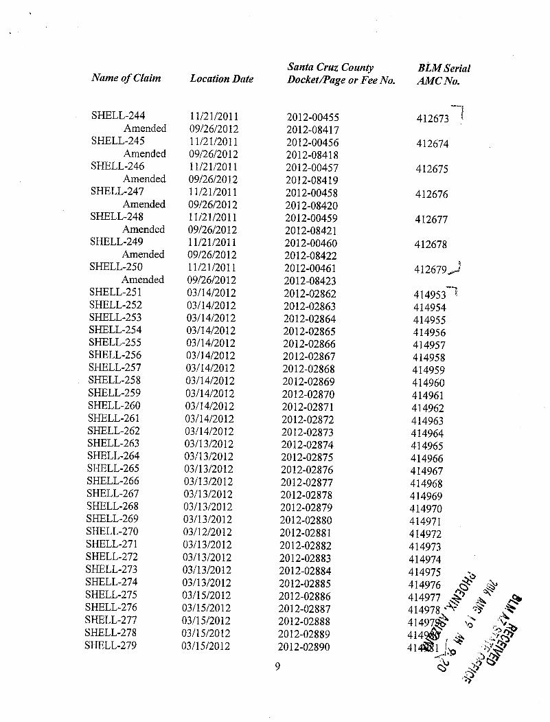
Santa Cruz County BLM SerialName of Claim Location Date Docket/Page or Fee No. AMC No.
SHELL-244 11/21/2011 2012-00455 412673 CAmended 09/26/2012 2012-08417
SHELL-245 11/21/2011 2012-00456 412674Amended 09/26/2012 2012-08418
SHELL-246 11/21/2011 2012-00457 412675Amended 09/26/2012 2012-08419
SHELL-247 11/21/2011 2012-00458 412676Amended 09/26/2012 2012-08420
SHELL-248 11/21/2011 2012-00459 412677Amended 09/26/2012 2012-08421
SHELL-249 11/21/2011 2012-00460 412678Amended 09/26/2012 2012-08422
SHELL-250 11/21/2011 2012-00461 412679~Amended 09/26/2012 2012-08423
SHELL-251 03/14/2012 2012-02862 414953SHELL-252 03/14/2012 2012-02863 414954SHELL-253 03/14/2012 2012-02864 414955SHELL-254 03/14/2012 2012-02865 414956SHELL-255 03/14/2012 2012-02866 414957SHELL-256 03/14/2012 2012-02867 414958SHELL-257 03/14/2012 2012-02868 414959SHELL-258 03/14/2012 2012-02869 414960SHELL-259 03/14/2012 2012-02870 414961SHELL-260 03/14/2012 2012-02871 414962SHELL-261 03/14/2012 2012-02872 414963SHELL-262 03/14/2012 2012-02873 414964SHELL-263 03/13/2012 2012-02874 414965SHELL-264 03/13/2012 2012-02875 414966SHELL-265 03/13/2012 2012-02876 414967SHELL-266 03/13/2012 2012-02877 414968SHELL-267 03/13/2012 2012-02878 414969SHELL-268 03/13/2012 2012-02879 414970SHELL-269 03/13/2012 2012-02880 414971SHELL-270 03/12/2012 2012-02881 414972SHELL-271 03/13/2012 2012-02882 414973SHELL-272 03/13/2012 2012-02883 414974SHELL-273 03/13/2012 2012-02884 414975SHELL-274 03/13/2012 2012-02885 414976SHELL-275 03/15/2012 2012-02886 414977 ~ S 40SHELL-276 03/15/2012 2012-02887 414978'SHELL-277 03/15/2012 2012-02888 414970 4SHELL-278 03/15/2012 2012-02889 4145~ *SHELL-279 03/15/2012 2012-02890 41401 ~ f
*12<%;?p
9 9 9*

Santa Cruz County BLM SerialName of Claim Location Date Docket/Page or Fee No. AMC No.
SHELL-280 03/15/2012 2012-02891 414982 /nSHELL-281 03/15/2012 2012-02892 414983SHELL-282 03/15/2012 2012-02893 414984SHELL-283 03/15/2012 2012-02894 414985SHELL-284 03/15/2012 2012-02895 414986SHELL-285 03/15/2012 2012-02896 414987SHELL-286 03/15/2012 2012-02897 414988SHELL-287 03/15/2012 2012-02898 414989SHELL-288 03/15/2012 2012-02899 414990SHELL-289 03/15/2012 2012-02900 414991SHELL-290 03/15/2012 2012-02901 414992SHELL-291 03/15/2012 2012-02902 414993SHELL-292 03/15/2012 2012-02903 414994SHELL-293 03/15/2012 2012-02904 414995SHELL-294 03/15/2012 2012-02905 414996SHELL-295 03/15/2012 2012-02906 414997SHELL-296 03/15/2012 2012-02907 414998SHELL-297 03/15/2012 2012-02908 414999SHELL-298 03/15/2012 2012-02909 415000SHELL-299 03/16/2012 2012-02910 415001SHELL-300 03/16/2012 2012-02911 415002SHELL-301 03/16/2012 2012-02912 415003SHELL-302 03/16/2012 2012-02913 415004SHELL-303 03/16/2012 2012-02914 415005SHELL-304 03/16/2012 2012-02915 415006SHELL-305 03/16/2012 2012-02916 415007SHELL-306 03/16/2012 2012-02917 415008SHELL-307 03/16/2012 2012-02918 415009SHELL-308 03/16/2012 2012-02919 415010SHELL-309 03/16/2012 2012-02920 415011SHELL-310 03/16/2012 2012-02921 415012_[SHELL-311 05/10/2012 2012-04673 4161897
Amended 09/25/2012 2012-08424SHELL-312 05/10/2012 2012-04674 416190 j
Amended 09/25/2012 2012-08425SHELL-313 12/05/2012 2013-00649 420822 -~SHELL-314 12/05/2012 2013-00650 420823SHELL-315 12/05/2012 2013-00651 420824SHELL-316 12/05/2012 2013-00652 420825 i,SHELL-317 12/06/2012 2013-00653 42082§~ »SHELL-318 12/06/2012 2013-00654 420§»SHELL-319 12/06/2012 2013-00655 42-&BYS , 5<4SHELL-320 12/06/2012 2013-00656 4%2829 ©SHELL-321 12/11/2012 2013-00657 °fo834,J -1

0 01>
Santa Cruz County BLMSerial» ~~;g*Name of Claim Location Date Docket/Page or Fee No. AMCNo. 4 - . p (*
SHELL-322 12/11/2012 2013-00658 420831SHELL-323 12/11/2012 2013-00659 420832 -flitis~listi:*51 T ..4.*trrzeSHELL-324 12/11/2012 2013-00660 420833SHELL-325 12/05/2012 2013-00661 420834 12 42;0SHELL-326 12/05/2012 2013-00662 420835SHELL-327 12/03/2012 2013-00663 420836SHELL-328 12/03/2012 2013-00664 420837 ,SHELL-329 12/03/2012 2013-00665 420838_/'SHELL-330 01/07/2013 2013-01676 421166-7SHELL-331 01/07/2013 2013-01677 421167SHELL-332 01/07/2013 2013-01678 421168SHELL-333 01/07/2013 2013-01679 421169SHELL-334 01/07/2013 2013-01680 421170SHELL-335 01/07/2013 2013-01681 421171SHELL-336 01/04/2013 2013-01682 421172SHELL-337 12/28/2012 2013-01683 421173SHELL-338 12/28/2012 2013-01684 421174SHELL-339 12/28/2012 2013-01685 421175SHELL-340 12/28/2012 2013-01686 421176SHELL-341 12/28/2012 2013-01687 421177SHELL-342 12/28/2012 2013-01688 421178SHELL-343 12/28/2012 2013-01689 421179SHELL-344 12/28/2012 2013-01690 421180SHELL-345 12/27/2012 2013-01691 421181SHELL-346 12/27/2012 2013-01692 421182SHELL-347 12/27/2012 2013-01693 421183SHELL-348 12/27/2012 2013-01694 421184SHELL-349 12/27/2012 2013-01695 421185SHELL-350 12/27/2012 2013-01696 421186SHELL-351 12/27/2012 2013-01697 421187SHELL-352 12/27/2012 2013-01698 421188SHELL-353 12/27/2012 2013-01699 421189SHELL-354 12/27/2012 2013-01700 421190SHELL-355 12/27/2012 2013-01701 421191SHELL-356 12/27/2012 2013-01702 421192SHELL-357 12/28/2012 2013-01703 421193SHELL-358 12/28/2012 2013-01704 421194SHELL-359 12/21/2012 2013-01705 421195SHELL-360 12/21/2012 2013-01706 421196SHELL-361 12/21/2012 2013-01707 421197SHELL-362 12/21/2012 2013-01708 421198SHELL-363 12/21/2012 2013-01709 421199SHELL-364 12/21/2012 2013-01710 421200SHELL-365 12/21/2012 2013-01711 421201
11

.-Li- S *SSanta Cruz County A*aeriName of Claim Location Date Docket/Page or Fee No. AMC'*b. 16* Fr
Zaf .-2 .31SHELL-366 12/21/2012 2013-01712 421202f S
*815~pssSSHELL-367 12/21/2012 2013-01713 421203 50'1SHELL-368 12/20/2012 2013-01714 421204 0 -19 -9SHELL-369 12/20/2012 2013-01715 421205 41 '0SHELL-370 12/20/2012 2013-01716 421206SHELL-371 12/20/2012 2013-01717 421207SHELL-372 12/20/2012 2013-01718 421208SHELL-373 12/20/2012 2013-01719 421209SHELL-374 12/20/2012 2013-01720 421210SHELL-375 12/20/2012 2013-01721 421211SHELL-376 12/20/2012 2013-01722 421212SHELL-377 12/20/2012 2013-01723 421213SHELL-378 12/20/2012 2013-01724 421214SHELL-379 12/19/2012 2013-01725 421215SHELL-380 12/19/2012 2013-01726 421216SHELL-381 12/19/2012 2013-01727 421217SHELL-382 12/19/2012 2013-01728 421218SHELL-383 12/19/2012 2013-01729 421219SHELL-384 12/19/2012 2013-01730 421220SHELL-385 12/19/2012 2013-01731 421221SHELL-386 12/19/2012 2013-01732 421222SHELL-387 12/19/2012 2013-01733 421223SHELL-388 12/19/2012 2013-01734 421224SHELL-389 12/19/2012 2013-01735 421225SHELL-390 12/19/2012 2013-01736 421226SHELL-391 12/18/2012 2013-01737 421227SHELL-392 12/18/2012 2013-01738 421228SHELL-393 12/18/2012 2013-01739 421229SHELL-394 12/18/2012 2013-01740 421230SHELL-395 12/18/2012 2013-01741 421231SHELL-396 12/18/2012 2013-01742 421232SHELL-397 12/18/2012 2013-01743 421233SHELL-398 12/18/2012 2013-01744 421234 ,SHELL-399 02/05/2013 2013-01745 4212353SHELL-400 06/20/2013 2013-05411 424351 .'-„-'-,SHELL-400A 07/31/2013 2013-05816 424565-SHELL-401 06/20/2013 2013-05412 4243521SHELL-402 06/20/2013 2013-05413 424353SHELL-403 06/17/2013 2013-05414 424354SHELL-404 06/17/2013 2013-05415 424355SHELL-405 06/17/2013 2013-05416 424356SHELL-406 06/17/2013 2013-05417 424357SHELL-407 06/17/2013 2013-05418 424358SHELL-408 06/17/2013 2013-05419 424359 f-3
12

Santa Cruz County BLM Seria14
1
Name of Claim Location Date Docket/Page or Fee No. AMC Ncb %'A 18-SHELL-409 06/18/2013 2013-05420 424360 · *4 - *2SHELL-409A 06/20/2013 2013-05421 424361 41 -O '0 SSHELL-410 06/11/2013 2013-05422 424362 14 14 <*
SHELL-411 06/20/2013 2013-05423 424363 '* 4 nSHELL-412 06/11/2013 2013-05424 424364 (%.4 fpSHELL-413 06/20/2013 2013-05425 424365SHELL-414 06/17/2013 2013-05426 424366SHELL-415 06/17/2013 2013-05427 424367SHELL-416 06/17/2013 2013-05428 424368SHELL-417 06/11/2013 2013-05429 424369SHELL-418 06/17/2013 2013-05430 424370SHELL-419 06/18/2013 2013-05431 424371SHELL-420 06/20/2013 2013-05432 424372SHELL-421 06/20/2013 2013-05433 424373SHELL-422 06/20/2013 2013-05434 424374SHELL-423 06/18/2013 2013-05435 424375SHELL-424 06/18/2013 2013-05436 424376SHELL-425 06/18/2013 2013-05437 424377SHELL-426 06/18/2013 2013-05438 424378SHELL-427 06/18/2013 2013-05439 424379SHELL-428 06/18/2013 2013-05440 424380SHELL-429 06/18/2013 2013-05441 424381SHELL-430 06/18/2013 2013-05442 424382SHELL-431 06/18/2013 2013-05443 424383SHELL-432 06/18/2013 2013-05444 424384SHELL-433 06/20/2013 2013-05445 424385SHELL-434 06/18/2013 2013-05446 424386SHELL-435 06/18/2013 2013-05447 424387SHELL-436 06/18/2013 2013-05448 424388SHELL-437 06/11/2013 2013-05449 424389SHELL-438 06/11/2013 2013-05450 424390SHELL-439 06/11/2013 2013-05451 424391.)SHELL-452 12/23/2015 2016-00116 4358911SHELL-453 12/23/2015 2016-00117 435892SHELL-454 12/23/2015 2016-00118 435893SHELL-455 12/23/2015 2016-00119 435894SHELL-456 12/23/2015 2016-00120 435895SHELL-457 12/17/2015 2016-00121 435896SHELL-458 12/23/2015 2016-00122 435897SHELL-459 12/21/2015 2016-00123 435898SHELL-460 12/16/2015 2016-00124 435899SHELL-461 12/17/2015 2016-00125 435900SHELL-462 12/16/2015 2016-00126 435901SHELL-463 12/17/2015 2016-00127 435902 f
13

S-O 9-*»58fS Santa Cruz County BLM ~riallmName ofClaim Location Date Docket/Page or Fee No. AMCA%: % #1423
SHELL-464 12/16/2015 2016-00128 435903 155 3 36SHELL-465 12/17/2015 2016-00129 435904 0 -9 ~1SHELL-466 12/16/2015 2016-00130 435905 * r-2-0SHELL-467 12/17/2015 2016-00131 435906 7SHELL-468 12/16/2015 2016-00132 435907SHELL-469 12/16/2015 2016-00133 435908SHELL-470 12/16/2015 2016-00134 435909SHELL-471 12/16/2015 2016-00135 435910SHELL-472 12/28/2015 2016-00136 435911SHELL-473 12/28/2015 2016-00137 435912SHELL-474 12/22/2015 2016-00138 435913SHELL-475 12/22/2015 2016-00139 435914SHELL-477 12/23/2015 2016-00141 435916SHELL-478 12/21/2015 2016-00142 435917SHELL-479 12/23/2015 2016-00143 435918SHELL-480 12/21/2015 2016-00144 435919SHELL-481 12/17/2015 2016-00145 435920SHELL-482 12/21/2015 2016-00146 435921SHELL-483 12/18/2015 2016-00147 435922SHELL-484 12/18/2015 2016-00148 435923SHELL-485 12/17/2015 2016-00149 435924SHELL-486 12/17/2015 2016-00150 435925SHELL-487 12/17/2015 2016-00151 435926SHELL-488 12/18/2015 2016-00152 435927SHELL-489 12/17/2015 2016-00153 435928SHELL-490 12/18/2015 2016-00154 435929SHELL-491 12/17/2015 2016-00155 435930SHELL-492 12/18/2015 2016-00156 435931SHELL-493 12/21/2015 2016-00157 435932SHELL-494 12/21/2015 2016-00158 435933SHELL-495 12/21/2015 2016-00159 435934SHELL-496 12/21/2015 2016-00160 435935SHELL-497 12/18/2015 2016-00161 435936SHELL-498 12/18/2015 2016-00162 435937SHELL-499 12/22/2015 2016-00163 435938SHELL-500 12/22/2015 2016-00164 435939SHELL-501 12/22/2015 2016-00165 435940JSHELL-502 02/24/2016 2016-02394 4380891SHELL-503 02/24/2016 2016-02395 438090SHELL-504 02/24/2016 2016-02396 438091SHELL-505 02/25/2016 2016-02397 438092SHELL-506 02/25/2016 2016-02398 438093SHELL-507 02/25/2016 2016-02399 438094 J
Santa Cruz County BLM Serial14

ple.Name ofClaim Location Date Docket/Page or Fee No. AMO* 1§, (8>8~
SHELL-508 02/25/2016 2016-02400 r 4380951~ 5, iN~SHELL-509 02/29/2016 2016-02392 438096 --, 4 36SHELL-510 02/25/2016 2016-02393 438097 3?. rSHELL-511 02/25/2016 2016-02401 438098 -0
*LONASHELL-512 02/29/2016 2016-02402 438099SHELL-513 02/29/2016 2016-02403 438100SHELL-514 02/29/2016 2016-02404 438101SHELL-515 02/29/2016 2016-02405 438102SHELL-516 03/04/2016 2016-02406 438103SHELL-517 03/04/2016 2016-02407 438104SHELL-518 03/04/2016 2016-02408 438105SHELL-519 03/04/2016 2016-02409 438106SHELL-520 03/04/2016 2016-02410 438107SHELL-521 03/23/2016 2016-02435 438108SHELL-522 03/23/2016 2016-02436 438109SHELL-523 03/09/2016 2016-02437 438110SHELL-524 03/09/2016 2016-02438 438111SHELL-525 03/09/2016 2016-02439 438112SHELL-526 03/09/2016 2016-02440 438113SHELL-527 03/09/2016 2016-02441 438114SHELL-528 03/09/2016 2016-02442 438115SHELL-529 03/09/2016 2016-02443 438116SHELL-530 03/09/2016 2016-02444 438117SHELL-531 03/09/2016 2016-02445 438118SHELL-532 03/09/2016 2016-02446 438119SHELL-533 03/23/2016 2016-02447 438120SHELL-534 03/23/2016 2016-02448 438121SHELL-535 03/23/2016 2016-02449 438122SHELL-536 03/28/2016 2016-02450 438123SHELL-537 03/28/2016 2016-02451 438124SHELL-538 03/31/2016 2016-02452 438125SHELL-539 03/28/2016 2016-02455 438126SHELL-540 03/23/2016 2016-02453 438127SHELL-541 03/28/2016 2016-02454 438128SHELL-542 04/15/2016 2016-02375 438129SHELL-543 04/15/2016 2016-02376 438130SHELL-544 04/18/2016 2016-02377 L_438131SHELL-545 04/15/2016 2016-02378 -438218SHELL-546 04/01/2016 2016-02379 ~438132SHELL-547 04/01/2016 2016-02380 438133SHELL-548 04/01/2016 2016-02381 438134SHELL-549 04/01/2016 2016-02382 438135SHELL-550 04/08/2016 2016-02383 438136SHELL-551 04/08/2016 2016-02384 , 438137
15

7 6)i. . r'ZJ.*31Santa Cruz County BLM*fri~'15x ' 659Name Of Claim Location Date Docket/Page or Fee No. AMC» <b-DSHELL-552 04/18/2016 2016-02385 ~38138 -~1 -4SHELL-553 04/08/2016 2016-02386 438139 8 4 naSHELL- 554 04/08/2016 2016-02387 438140 0 1SHELL-555 04/08/2016 2016-02456 438141 1SHELL-556 04/08/2016 2016-02457 438142SHELL-557 04/08/2016 2016-02458 438143SHELL-558 04/08/2016 2016-02459 438144SHELL-559 03/28/2016 2016-02460 438145SHELL-560 03/28/2016 2016-02461 438146SHELL-561 03/28/2016 2016-02462 438147SHELL-562 03/28/2016 2016-02463 438148SHELL-563 03/28/2016 2016-02464 438149SHELL-564 04/09/2016 2016-02465 438150SHELL-565 04/09/2016 2016-02466 438151SHELL-566 04/09/2016 2016-02467 438152SHELL-567 04/09/2016 2016-02468 438153SHELL-568 04/09/2016 2016-02469 438154SHELL-569 04/08/2016 2016-02470 438155 1SHELL-570 04/08/2016 2016-02471 438156SHELL-571 04/08/2016 2016-02472 438157SHELL-572 04/08/2016 2016-02473 438158SHELL-573 03/26/2016 2016-02474 438159SHELL-574 03/26/2016 2016-02475 438160SHELL-575 03/26/2016 2016-02476 438161SHELL-576 03/26/2016 2016-02477 438162SHELL-577 04/09/2016 2016-02478 438163SHELL-578 04/09/2016 2016-02479 438164SHELL-579 04/09/2016 2016-02480 438165SHELL-580 04/09/2016 2016-02481 438166SHELL-581 04/09/2016 2016-02482 438167SHELL-582 03/26/2016 2016-02483 438168SHELL-583 03/26/2016 2016-02484 438169SHELL-584 03/26/2016 2016-02485 438170SHELL-585 03/26/2016 2016-02486 438171SHELL-586 03/26/2016 2016-02487 438172SHELL-587 03/26/2016 2016-02488 438173SHELL-588 04/09/2016 2016-02489 438174SHELL-589 02/25/2016 2016-02411 438175SHELL-590 04/18/2016 2016-02388 438176SHELL-591 04/25/2016 2016-02351 438177SHELL-592 04/25/2016 2016-02350 1-438178SHELL-593 05/26/2016 2016-03309 r438492 431*1SHELL-594 05/26/2016 2016-03310 438493 734,1 6SHELL-595 05/26/2016 2016-03311 , 438494 1:947
--
16

.0Santa Cruz County BLM *jial'% ':]f
Name of Claim Location Date Docket/Page or Fee No. AMC Nt~ '.9 nAAGH NO.6 04/15/2016 2016-02352 f 438049 9AAGH NO.8 03/23/2016 2016-02353 438050 45 ~0AAGH NO.9 03/23/2016 2016-02423 438051 <1AAGH NO.10 03/23/2016 2016-02424 438052
04 4
AAGH NO.17 03/28/2016 2016-02421 438053AAGH NO.18 03/23/2016 2016-02425 438054AAGH NO.19 04/18/2016 2016-02354 438055AAGH NO.20 03/28/2016 2016-02426 438056
ANDES NO. 1 04/04/2016 2016-02355 438057BLUE EAGLE NO. 1 03/31/2016 2016-02427 438058BORDER SIDE 03/31/2016 2016-02356 438059
COWBOY 03/23/2016 2016-02428 438060DORFEE 02/26/2016 2016-02412 438061ESTHER 03/23/2016 2016-02429 438062
FOX NO. 2 04/04/2016 2016-02359 438063FOX NO. 4 04/04/2016 2016-02360 438064FOX NO. 5 04/04/2016 2016-02361 438065
GEM NO. 1 04/04/2016 2016-02362 438066GEM NO. 2 04/18/2016 2016-02363 438067
HANK NO. 12 02/22/2016 2016-02389 438068HANK NO. 20 02/22/2016 2016-02390 438069HANK NO. 22 02/22/2016 2016-02391 438070HANK NO. 27 02/25/2016 2016-02413 438071HANK NO. 28 02/25/2016 2016-02414 438072
HOPE NO. 2 02/29/2016 2016-02415 438073
JOCO NO.37 04/04/2016 2016-02364 438074JOCO NO.38 04/04/2016 2016-02365 438075JOCO NO.39 04/04/2016 2016-02366 438076
LA TUNA NO. 1 03/28/2016 2016-02416 438077
LIME BANK NO.4 04/18/2016 2016-02357 438078LIME BANK NO.5 04/18/2016 2016-02358 438079
LOG CABIN 03/23/2016 2016-02430 438080OLD BOY ROGER 03/28/2016 2016-02431 ~-438081
17

156Santa Cruz County BLM~rials -93.Name ofClaim Location Date Docket/Page or Fee No. AMC /@ 35 SAW'S.2RED CASTLE NO. 1 04/13/2016 2016-02367 T-438082 91 -0 (90RED CASTLE NO.3 04/06/2016 2016-02368 438083 -1 4 54
RED CASTLE NO.4 04/18/2016 2016-02369 438084 Px4 4 -~RED CASTLE NO.5 04/04/2016 2016-02370 438085 0 .,RED CASTLE NO.6 04/04/2016 2016-02371 438086 1 --525 03
RED CASTLE NO.7 04/04/2016 2016-02372 438087
RED HAWK NO.6 02/29/2016 2016-02417 L438088STEAM SHOVEL 03/23/2016 2016-02432 -- 438181
SOUTH REDMIN NO.7 02/29/2016 2016-02418 F 438179
SOUTH REDMTN NO.8 02/29/2016 2016-02419 , 438180
r-TERRY NO. 1 04/18/2016 2016-02373 c 438182UNITED VERDE NO.2 03/31/2016 2016-02422 438183UNITED VERDE NO.3 03/31/2016 2016-02433 438184UNITED VERDIE NO.4 03/31/2016 2016-02434 438185UNITED VERDE NO.5 03/31/2016 2016-02420 L538186
PART II (WCR Claims):
The unpatented lode mining claims situated in the Harshaw and Patagonia MiningDistrict, situated within the protracted survey lines of Sections 13,24,25 and 36,Township 23 South, Range 15 East; Sections 5,8,9,16,17,18,19,20,29,30,31 and32, Township 23 South, Range 16 East; Section 1, Township 24 South, Range 15 East;and Section 6, Township 24 South, Range 16 East, 6&SR Mer., Santa Cruz County,Arizona, the names of which and the place of record ofthe location notices thereof in theofficial records of the Santa Cruz County Recorder and Arizona State Office oftheBureau of Land Management are as follows:
Claim Name AMC Number County Recording NumberWCR-4 3762827 2006-19731WCR-5 376283 2006-19732WCR-6 376284 2006-19733WCR-7 376285 2006-19734WCR-8 376286 2006-19735WCR-9 376287-/ 2006-19736
18

15 % f»Claim Name AMC Number County Recording Numb* 3
WCR-10 376288 3 2006-19737 S :J-WCR-11 376289 2006-19738WCR-12 376290 2006-19739WCR-13 376291 2006-19740WCR-14 376292 2006-19741WCR-15 376293 2006-19742WCR-16 376294 2006-19743WCR-17 376295 2006-19744WCR-18 376296 2006-19745WCR-19 376297 J 2006-19746WCR-20 367401 -1 2005-16751WCR-21 367402 2005-16752WCR-22 367403 2005-16753WCR-23 367404 2005-16754WCR-24 367405 2005-16755WCR-25 367406 2005-16756WCR-26 367407 2005-16757WCR-27 367408 2005-16758WCR-28 367409 2005-16759WCR-29 367410 2005-16760WCR-30 367411 2005-16761WCR-31 367412 2005-16762WCR-32 367413 2005-16763WCR-33 367414 2005-16764WCR-34 367415 2005-16765WCR-35 367416 2005-16766WCR-36 367417 U 2005-16767
19

1% 9:2\. 9 -34Claim Name AMC Number County Recording Nul#ber
WCR-37 367418 -7 2005-16768 9 ./
f. J
WCR-38 367419 2005-16769 7 59WCR-39 367420 2 2005-16770WCR-41 367422 - 2005-16772WCR-43 367424 --- 2005-16774WCR-45 367426 - 2005-16776WCR-47 367428 - 2005-16778WCR-49 367430 n 2005-16780WCR-50 367431 2005-16781WCR-51 367432 2005-16782WCR-52 367433 2005-16783WCR-53 367434 2005-16784WCR-54 367435 2005-16785WCR-55 367436 2005-16786WCR-56 367437 2005-16787WCR-57 367438 2005-16788WCR-58 367439 ) 2005-16789WCR-60 367441 1 2005-16791WCR-61 367442 2005-16792WCR-62 367443 2005-16793WCR-63 367444 2005-16794WCR-64 367445 2005-16795WCR-65 367446 2005-16796WCR-66 367447 2005-16797WCR-67 367448 2005-16798WCR-68 367449 2005-16799WCR-69 367450 J 2005-16800
20

Claim Name AMC Number County Recording Numbc*B\-M, AWCR-70 367451 -7 f f:.IC '
2005-16801 5 5 1-al?,WCR-71 367452 2005-16802 ~ **t-..WCR-72 367453 2005-16803 3 7.WCR-73 367454 2005-16804WCR-74 367455 2005-16805WCR-75 367456 2005-16806WCR-76 367457 2005-16807WCR-77 367458 2005-16808WCR-78 367459 2005-16809WCR-79 367460 J 2005-16810WCR-80 376279 - 2006-19728WCR-81 367461 7 2005-16811WCR-82 367462 2005-16812WCR-83 367463 J 2005-16813WCR-84 376280 / 2006-19729WCR-85 367464.- 2005-16814WCR-86 376281 -- 2006-19730WCR-87 367465 1 2005-16815WCR-88 367466 2005-16816WCR-89 367467 2005-16817WCR-90 367468 2005-16818WCR-91 367469 _j 2005-16819WCR-92 427463 -- 2014-01329WCR-93 367470 -1 2005-16820WCR-94 367471 2005-16821WCR-95 367472 2005-16822WCR-96 367473 -1 2005-16823
21

Claim Name AMC Number County Recording NumM SWCR-97 367474 -7 2005-16824 * 5 340
WCR-98 367475 2005-16825 ~
~09?:oFFICSWCR-99 367476 2005-16826 ~ 5WCR-100 367477 2005-16827 bo -0WCR-101 367478 2005-16828.WCR-102 367479 2005-16829WCR-103 367480 2005-16830WCR-104 367481 2005-16831WCR-105 367482 2005-16832WCR-106 367483 2005-16833WCR-107 367484 2005-16834WCR-108 367485 2005-16835WCR-109 367486 2005-16836WCR-110 367487 3 2005-16837
Amended 2006-19777WCR-11OE 376331 - 2006-19780WCR-111 367488 -7 2005-16838WCR-112 367489 J 2005-16839
Amended 2006-19778WCR-112E 376332 - 2006-19781WCR-113 367490 -p 2005-16840WCR-114 367491 -) 2005-16841
Amended 2006-19779WCR-114E 376333 < 2006-19782WCR-115 367492 1 2005-16842WCR-116 367493 2005-16843WCR-117 367494 4 2005-16844
22

SA3- 35116Claim Name AMC Number County Recording I'f~ 1;i~AWCR-118 367495 7 2005-16845 t
WCR-119 367496 2005-16846 ~41 -0 --5,WCR-120 367497 2005-16847
..9.\
B
WCR-121 367498 2005-16848WCR-122 367499 2005-16849WCR-123 367500 2005-16850WCR-124 367501 2005-16851WCR-125 367502 2005-16852WCR-126 367503 2005-16853WCR-127 367504 2005-16854WCR-128 367505 2005-16855WCR-129 367506 2005-16856WCR-130 367507 2005-16857WCR-131 367508 2005-16858WCR-132 367509 2005-16859WCR-133 367510 2005-16860WCR-134 367511 2005-16861WCR-135 367512 2005-16862WCR-136 367513 2005-16863WCR-137 367514 2005-16864WCR-13 8 367515 2005-16865WCR-139 367516 2005-16866WCR-140 367517 2005-16867WCR-141 367518 2005-16868WCR-142 367519 2005-16869WCR-143 367520 2005-16870WCR-144 367521 -j 2005-16871
23

62- *-6- 0
Claim Name AMC Number County Recording N*be#~ f]~WCR-145 367522 7 2005-16872 9 - 3 P.WCR-146 367523 2005-16873 3 -9 04WCR-147 367524 2005-16874 ..6WCR-148 367525 2005-16875WCR-149 367526 2005-16876WCR-150 367527 2005-16877WOR-151 367528 2005-16878WCR-152 367529 2005-16879WCR-153 367530 2005-16880WCR-154 367531 2005-16881WCR-155 367532 2005-16882WCR-156 367533 2005-16883WCR-157 367534 2005-16884WCR-158 367535 2005-16885WCR-159 367536 2005-16886WCR-160 367537 2005-16887WCR-161 367538 2005-16888WCR-162 367539 2005-16889WCR-163 367540 2005-16890WCR-164 367541 2005-16891WCR-165 367542 2005-16892WCR-166 367543 2005-16893WCR-167 367544 2005-16894WCR-168 367545 2005-16895WCR-169 367546 2005-16896WCR-170 367547 2005-16897WCR-171 367548 -) 2005-16898
24

Claim Name AMC Number County Recording Numb~%114WCR-172 367549 1 2005-16899 44 f ry]41-
WCR-173 367550 2005-16900 9 / 363,. laWCR-174 367551 2005-16901
r*
WCR-175 367552 2005-16902 .3/WCR-176 367553 2005-16903
WCR-177 367554 2005-16904WCR-178 367555 2005-16905WCR-179 367556 2005-16906WCR-180 367557 2005-16907WCR-181 367558 2005-16908WCR-182 367559 2005-16909WCR-183 427464 7 2014-01330WCR-184 427465 2014-01331WCR-185 427466 2014-01332WCR-186 427467 2014-01333WCR-187 427468 2014-01334WCR-188 427469 2014-01335WCR-189 427470 2014-01336WCR-190 427471 2014-01337WCR-191 427472 2014-01338WCR-192 427473 2014-01339WCR-193 427474 2014-01340WCR-194 427475 2014-01341WCR-195 427476 2014-01342WCR-196 427477 2014-01343WCR-197 427478 2014-01344WCR-198 427479 ,; 2014-01345
25

Claim Name AMC Number County Recording NumberWCR-199 427480 -7 2014-01346.0 4 4~%WCR-200 427481 2014-01347 7& ., '# :<S>
/0 6-) ce}]{kWCR-201 427482 2014-01348 2~, -4 -7
45WCR-202 427483 2014-01349 *~ -9 7910 e/WCR-203 427484 2014-01350
WCR-204 427485 2014-01351WCR-205 427486 2014-01352WCR-206 427487 -3 2014-01353WCR-207 367584 -1 2005-16934WCR-208 367585 2005-16935WCR-209 367586 2005-16936WCR-210 367587 2005-16937WCR-211 367588 2005-16938WCR-212 367589 2005-16939WCR-213 367590 2005-16940WCR-214 367591 2005-16941WOR-215 367592 2005-16942WCR-216 367593 2005-16943WCR-217 367594 2005-16944WCR-218 367595 2005-16945WCR-219 367596 2005-16946WCR-220 367597 2005-16947WCR-221 367598 .1 2005-16948WCR-223 367600 2005-16950WCR-255 427488 -7 2014-01354WCR-256 427489 2014-01355WCR-257 427490 J 2014-01356
26

Claim Name AMC Number County Recording m BEr 1.47~ -4*WCR-258 427491 3 2014-01357 92 5-35
7L - .),1 41WCR-259 427492 2014-01358 -SWCR-260 427493 2014-01359 15 -9 121
WCR-261 427494 2014-01360 7 /WCR-262 427495 2014-01361WCR-263 427496 2014-01362WCR-264 427497 2014-01363WCR-274 368661 7 2005-16725WCR-275 368662 2005-16726WCR-277 368663 2005-16727WCR-278 368664 2005-16728WCR-293 368665 2005-16729WCR-301 368666 2005-16730WCR-303 368667 2005-16731WCR-304 368668 2005-16732WCR-305 368669 2005-16733WCR-306 368670 2005-16734WCR-307 368671 2005-16735WCR-308 368672 2005-16736WCR-309 368673 2005-16737WCR-310 368674 2005-16738WCR-311 368675 2005-16739WCR-312 368676 2005-16740WCR-313 368677 2005-16741WCR-314 368678 2005-16742WCR-315 368679 2005-16743WCR-316 368680 J 2005-16744
27

Claim Name AMC Number County Recording NumberWCR-317 368681 -7 2005-16745 _,WCR-318 368682 .0 2005-167465WCR-323 373271 - 2006-07297 9 16WCR-359 373273 n 2006-11578 -1WCR-360 373274 2006-11579 %WCR-361 373275 2006-11580WCR-404 376302 -7 2006-19751WCR-405 376303 2006-19752WCR-406 376304 2006-19753WCR-407 376305 _f 2006-19754
WCR-42OA 376316 -7 2006-19765WCR-421A 376317 2006-19766WCR-422 376318 2006-19767WCR-423 376319 _j 2006-19768WCR-424 376320 1 2006-19769WCR-425 376321 2006-19770WCR-426 376322 2006-19771WCR-427 376323 2006-19772WCR-428 376324 2006-19773WCR-429 376325 2006-19774WCR-430 376326 2006-19775WCR-431 376327 J 2006-19776WCR-432 376440 2007-01454WCR-433 376441 2007-01455WCR-434 376442 2007-01456WCR-435 376443 2007-01457WCR-436 376444 3 2007-01458
28

0, ..A
40 M. «aClaim Name AMC Number County Recording Nil#~ber
WCR-437 376445 7 2007-01459 'S 4 «13,WCR-438 376446 2007-01460 0%WCR-439 376447 J 2007-01461
PART III (FOBC Claims):
The following described unpatented lode mining claims are held under anExploration and Option Agreement with FOBC, LLC, and are situated in the Harshawand Patagonia Mining District, situated within Sections 4,5 and 8, Township 23 South,Range 16 East, G&SR Mer., Santa C= County, Arizona, the names of which and theplace of record ofthe location notices thereof in the official records ofthe Santa CruzCounty Recorder and Arizona State Office of the Bureau of Land Management are asfollows:
Santa Cruz County BLM SerialName of Claim Location Date Docket/Page or Fee No. AMC No.PAT 1 7/10/2006 2006-16082 374413nPAT 2 7/10/2006 2006-16083 374414PAT 3 7/10/2006 2006-16084 374415PAT 4 7/10/2006 2006-16085 374416PATS 7/10/2006 2006-16086 374417PAT 6 7/10/2006 2006-16087 374418PAT 7 7/10/2006 2006-16088 374419PAT 8 7/10/2006 2006-16089 374420PAT 9 7/10/2006 2006-16090 37442 UPAT 10 7/10/2006 2006-16091 435910 - 93 40%9PAT 11 7/10/2006 2006-16092 374423 7PAT 12 7/10/2006 2006-16093 374424PAT 13 7/10/2006 2006-16094 374425PAT 14 7/10/2006 2006-16095 374426PAT 15 7/10/2006 2006-16096 374427PAT 16 7/10/2006 2006-16097 374420 -
1:\FILES\DOCS\AUGU05\251031\DOC\1 OC7871.DOC
29

s-xpress 1Pa
ge 1
of 1 ORIGIN ID.TUSA (520) 322-5000 SHIP DATE: 18AUG16 f
DECONCINI MCDONALD ETAL ACTWGT: 0.50 LaKATHY SMITH CAD: 3676665ANET37902525 E. BROADWAY BLVD.SUITE 200TUCSON AZ 85716 BILL SENDERUNITED STATES US
To ARIZONA STATE OFFICE {BUREAU OF LAND MANAGEMENT m
-__90 n»g~*p Igu'ts bloodz- r clin1915&lmmls o jhkgackagiibz - .
ONE NORTH CENTRAL AVENUE #800 E
PHOENIX AZ 85004(602) 417-9398 REF: 1*5871598/251031260709BNPO, DEPT,
11111111111111111!111111111111ullul!11111111!Illullm!111111111111111111111111111111111111111 4
FRI - 19 AUG 10:30APRIORITY OVERNIGHT r24,«~~
*~ 7770 30049092 rji
85004 1 CDXH ZSYA AZ-US PHX F
Ill lili Ill 'll'lll Im' 1 &CDj r.+ - j
Z606 *0~ 8 LZ
14 Insert Shipping~ document here.
<·9fj„rj-55,5 ~,«»1'.:fr:~]: *

f T.Align top of FedEx Express® shipping label here.~smart
-11 ... I .1 -12.1,1 ~ FedEx carbon-neutral:... '=~4*61'1~-grl,1 - -4% envelope shipping
, f,I X.%49.1,,2 - ,
. 5,2.. Ule t.71-- ,1,1,
1 . 13 I
1 I.-,1rt :, 1 -1,
Expr
ess
1 4'FC -U
I lili r
Envel-upePHOENIX. ARIZONA
ELM A F.M
0 f ICE
- .1-0, rns
a
f
,< I. ,- ..,1 2.2 'h-, 0''Il~~*2 /-y,9.·i'.4 ~. f
-- -2,1@25''tt'2.-"I-j,4:'*~~F-- 4]=fl''f-~. -- ~~~~'Z~3,2s#~---~I~k-" ,~s , 1%' - I bas -7*'f~:'l-''EAF.,·31„1, ,44~fl,4.05-,=-pt':"2- 7/.94 1--]*{i].
"l-r f ._, · , -F»·,1 5.,_ -= -*+13*7_ =1.11

United States Department of the InteriorBureau of Land Management Receipt
DIV OF LANDS, MINRLS & ENERGYONIE N CENTRAL AVE
PHOENIX, AZ 85004 -4427 No: 3636994Phone: 602-417-9200
Transaction #: 3740871Date of Transaction: 08/22/2016
CUSTOMER:DECONCINI MCDONALD YETWIN & LACY P C2525 E BROADWAY BLVD STE 200TUCSON,AZ 85716-5350 US
DESCRIPTION 1 REMARKS 11 11 TOTAL I11 PRICE 11
1|NOT NEW-UNADJUD,ONE AUTH NO. ||MAINT FEE |11 1 111.00 11 11 - iva - | 144490.00|CASES: AMC51409/$144490.001IONLY / MINING CLAIM MONEY RECEIVED ~12017 - 932 11
PAYMENT INFORMATION1 1--AMOET: 495.001POSTMARKED:08/18/2016
-TYPE:ICHEEKRECERED:08/19/2616-CHEEKNO: 063185
NAME: DECONCINI MCDONALD YETWIN & LACY PC2525 E BROADWAY BLVD STE 200TUCSON AZ 85716-5350 US
2 IAMOUNT:[143995.06---------11#6§*RRKED:1168/18/2616-1
NAME: ARIZONA MINERALS INC3845 N BUSINESS CENTER DRSUITE 115TUCSON AZ 85705 US
REMARKS
This receipt was generated by the automated BLM Collections and Billing System and is a paper representation of a portionof the official electronic record contained therein.

5140993*09 3782 936
3769973949599295603833)0
YA935-0
905-45-61 ~99 5-3C/le 1999 &0 8 21
93589 I9380 9 9L/39 2189389 13-3765-77
367398927 9633-763AB108 66 j37 8 ~67379 9 1 7379913

R FS[-11(f DBLM AZ 5 - - OFFICE
= DECONCINI J~ONALD YETWIN & LACYA PROFESSIONAL CORPORATION !1116 AUG 31 P 12: 00
YkL ATTORNEYS AT LAW2525 EAST BROADWAY BOULEVARD · SUITE 200 · TUCSON, ARIZONA 85716-5300(520) 322-5000 · (520) 322-5585 (FAx) rtinru! v 1n!7,-111 4 DMYL.COM
f 11Uk-iliA, MAI.LUI'l/i
DENISEM . BAINTON RYAN D . O' NEAL FfRMFOUNDERS:ALICEW. CALLISON ALEXI,\J. PETERSON EVO A. DECONCINI (1901-1986)BARRY At. COREY JOHN C. RICHARDSON JOHN R. MCDONALD(1933-2012)JooY A. CORRALES LISAANNESMITH DENNIS W. DECONCIN[PETER B. GOLDMAN SPENCERA. SMITHNATHAN B. HANNAH SESALY O. STAMPSSTEVEN J . ITKIN JAMES M . SUM PHOENIX OFFICE.JAMES A JUTRY PAUL M. TILLEY 7310 NORTH 16TH STREET, SUITE 330JOHN C. LACY GARY F. URMAN PHOENIX, ARIZONA 85020KATHRYN B. NELSON MICHAEL R. URMAN (602) 282-0500
OF COUNSEL: August 29, 2016 FAX: (602) 282-0520
RICHARD M. YETWINBARRON & ASSOCIATES, P.C. - JOHN H. BARRON, 111SHIJIE FENG PLEASE REPLY TO TUCSON
Via Federal Express
Arizona State OfficeBureau of Land ManagementAttention: Public RoomOne North Central Avenue, Suite 800Phoenix, AZ 85004-4427
RE: Arizona Minerals Inc. - Revised Assessment Affidavit
Ladies and Gentlemen:
On August 16, 2016, we submitted two checks in the amounts of $143,995.00 and$495.00 as payment of the claim maintenance fees for Arizona Minerals Inc. I am enclosing acopy of the receipt we received from you for the payment of 932 claims. 1 am enclosing a revisedAssessment Affidavit reflecting a change with two claims on page 29 of Exhibit A. The AMCnumber, location date and county fee number have been changed for PAT 10 and an additionalfee number has been added to PAT 16.
Please feel free to contact me or John Lacy with any questions or concerns.
Sincerely,9 n
,1 ~4-l--'
Kath~». Mnith, CPCertified Paralegal
Enel.ec Greg Lucero (w/0 encl)I:\FILES\DOCS\AUGU05\251031\1-TR\1 0E4733.DOCX

RECEIVEDEXHIBIT A BLM AZ STATE OFFICEMining ClaimsPART I (Shell Claims): 1016 AUG 31 P 12: 28
The following unpatented lode mining claims are situated iPFhY#frlb*vbfyi\NAPatagonia Mining Districts, in Sections 13,24,25,26,35 and 36, Townihi~ 22#bmfi,Range 15 East; in Sections 17 through 20 and 27 through 36, Township 22 South, Range16 East; in Sections 1 through 5, 8 through 16 (unsurveyed), Township 23 South, Range16 East; Sections 6,7 and 18, Township 23 South, Range 17 East; in Section 1, Township24 South, Range 17 East; and in Section 6, Township 24 South, Range 16 East, G&SRMer., Santa Cruz County, Arizona, the names ofwhich, and the place of recording oftheir location notices in the Official Records of Santa Cruz County and the Arizona StateOffice ofthe Bureau of Land Management are as follows:
Santa Cruz County BLM SerialName of Claim Location Date Docket/Page or Fee No. AMC No.
SHELL NO. 1 01/29/1965 058 135 51409Amended 04/25/2013 2013-03346
SHELL NO. 2 01/29/1965 058 136 51410Amended 04/25/2013 2013-03347
Shell 2A 05/07/2008 2008-05629 392436Amended 04/25/2013 2013-03348
Shell 2B 05/12/2008 2008-05630 392437Amended 04/25/2013 2013-03349
SHELL NO. 3 01/29/1965 058 137 51411SHELL NO. 4 01/29/1965 058 138 51412SHELL NO. 5 01/29/1965 058 139 51413SHELL NO. 6 01/28/1965 058 140 51414SHELL NO. 7 01/28/1965 058 141 51415SHELL NO. 8 01/28/1965 058 142 51416SHELL NO. 9 01/29/1965 058 143 51417SHELL NO. 10 01/29/1965 058 144 51418SHELL NO. 11 01/28/1965 058 145 51419SHELL NO. 12 01/28/1965 058 146 51420SHELL NO. 13 01/29/1965 058 147 51421SHELL NO.14 01/29/1965 058 148 51422SHELL NO. 15 01/28/1965 058 149 51423SHELL NO. 16 01/28/1965 058 150 51424SHELL NO. 17 01/28/1965 058 151 51425SHELL NO. 18 01/28/1965 058 152 51426SHELL NO. 19 01/28/1965 058 153 51427SHELL NO. 20 01/28/1965 058 154 51428Shell-21 12/21/2006 2007-01462 376997Shell-22 12/21/2006 2007-01463 376998Shell-23 12/21/2006 2007-01464 376999Shell-24 09/15/2008 2008-11346 394954
1

Santa Cruz County BLM SerialName of Claim Location Date Docket/Page or Fee No. AMC No.
SHELL-24A 07/25/2013 2013-05811 424560Shell-25 12/29/2006 2007-01465 377000Shell-26 12/29/2006 2007-01466 377001Shell-27 12/29/2006 2007-01467 377002Shell-28 01/02/2007 2007-01468 377003Shell-29 01/02/2007 2007-01469 377004Shell-30 01/02/2007 2007-01470 377005Shell-31B 05/15/2008 2008-05631 392438
Amended 07/22/2008 2008-07616Shell-32 01/02/2007 2007-01472 377007Shell-33 01/04/2007 2007-01473 377008Shell-34 01/04/2007 2007-01474 377009Shell-35 12/21/2006 2007-01475 377010Shell-36 12/21/2006 2007-01476 377011Shell-37 12/21/2006 2007-01477 377012Shell-38 12/22/2006 2007-01478 377013Shell-39 12/22/2006 2007-01479 377014Shell-40 12/22/2006 2007-01480 377015Shell-41 12/22/2006 2007-01481 377016Shell-42 12/22/2006 2007-01482 377017Shell-43 12/22/2006 2007-01483 377018SHELL No. 44 07/25/1967 81 212 51452SHELL No. 45 07/25/1967 81 213 51453SHELL No. 46 07/27/1967 81 214 51454SHELL No. 47 07/27/1967 81 215 51455SHELL No. 48 07/27/1967 81 216 51456SHELL No. 49 07/27/1967 81 217 51457Shell-51 12/29/2006 2007-01484 377019Shell-52 12/29/2006 2007-01485 377020Shell-53 12/29/2006 2007-01486 377021Shell-54 01/02/2007 2007-01487 377022Shell-55 01/02/2007 2007-01488 377023Shell-56 01/02/2007 2007-01489 377024Shell-57 01/02/2007 2007-01490 377025Shell-58 01/02/2007 2007-01491 377026Shell-59 01/04/2007 2007-01492 377027Shell-60 01/04/2007 2007-01493 377028Shell-61 01/04/2007 2007-01494 377029Shell-62 01/04/2007 2007-01495 377030Shell-63 01/04/2007 2007-01496 377031Shell-64 01/04/2007 2007-01497 377032Shell-65 01/02/2007 2007-01498 377033Shell-66 01/02/2007 2007-01499 377034
2

Santa Cruz County BLM SerialName of Claim Location Date Docket/Page or Fee No. AMC No.
Shell-67 01/02/2007 2007-01500 377035Shell-68 01/02/2007 2007-01501 377036Shell-69 12/22/2006 2007-01502 377037Shell-70 12/22/2006 2007-01503 377038Shell-71 12/22/2006 2007-01504 377039Shell-72 12/22/2006 2007-01505 377040SHELL 73 04/24/2007 2007-08110 383320SHELL 74 04/24/2007 2007-08111 383321SHELL 75 04/24/2007 2007-08112 383322SHELL 76 04/24/2007 2007-08113 383323
Amended 05/06/2008 2008-05484SHELL 77 04/24/2007 2007-08114 383324
Amended 05/06/2008 2008-05485SHELL 78 04/24/2007 2007-08115 383325SHELL 79 04/24/2007 2007-08116 383326 -*SHELL-79A 07/25/2013 2013-05812 42E61 5
BLM
SHELL 80 04/24/2007 2007-08117 38~27 ,-SHELL 81 04/24/2007 2007-08118 383528 E1 ~SHELL 82 05/21/2007 2007-08119 38#29 t! :drn
Amended 05/07/2008 2008-05486 > --i <
31 -0 rrirnSHELL 83 05/21/2007 2007-08120 383330 00
Amended 05/07/2008 2008-05487 CD 5 IRSHELL 84 05/21/2007 2007-08121 383561 ~ 0:7.
Amended 05/07/2008 2008-05488SHELL 85 05/21/2007 2007-08122 383332SHELL 86 05/21/2007 2007-08123 383333
Amended 05/07/2008 2008-05489SHELL 87 05/21/2007 2007-08124 383334SHELL 88 05/21/2007 2007-08125 383335
Amended 05/07/2008 2008-05490SHELL 89 05/21/2007 2007-08126 383336SHELL 90 05/21/2007 2007-08127 383337
Amended 05/07/2008 2008-05491SHELL 91 05/21/2007 2007-08128 383338SHELL 92 05/17/2007 2007-08129 383339
Amended 05/06/2008 2008-05492SHELL 93 05/17/2007 2007-08130 383340
Amended 05/06/2008 2008-05493SHELL 94 05/17/2007 2007-08131 383341SHELL 95 05/17/2007 2007-08132 383342
Amended 05/06/2008 2008-05494SHELL 96 05/17/2007 2007-08133 383343SHELL 97 05/17/2007 2007-08134 383344
Amended 05/06/2008 2008-05495
3

Santa Cruz County BLM SerialName of Claim Location Date Docket/Page or Fee No. AMC No.
SHELL 98 05/16/2007 2007-08135 383345SHELL 99 05/16/2007 2007-08136 383346
Ainended 05/06/2008 2008-05496SHELL 100 05/16/2007 2007-08137 383347SHELL 101 05/16/2007 2007-08138 383348
Amended 05/06/2008 2008-05497SHELL 102 04/24/2007 2007-08139 383349SHELL 103 04/24/2007 2007-08140 383350
Amended 04/30/2008 2008-05498SHELL 104 04/24/2007 2007-08141 383351SHELL 105 04/24/2007 2007-08142 383352
Amended 04/30/2008 2008-05499SHELL 106 04/24/2007 2007-08143 383353
Amended 04/30/2008 2008-05500SHELL 107 04/24/2007 2007-08144 383354
Amended 04/30/2008 2008/05501 3 %=.a
BLM ASHELL 108 04/24/2007 2007-08145 386355 =-rnAmended 04/30/2008 2008-05502 !\iso
SHELL 109 04/24/2007 2007-08146 38*56 5 s5Amended 04/30/2008 2008-05503 >SHELL 110 04/24/2007 2007-08147 3 823 5 7 -0 01 dCD 'SHELL 111 04/24/2007 2007-08148 386458 K3 ZI!
Amended 04/30/2008 2008-05504 > N 0SHELL 112 04/26/2007 2007-08149 383359 -0 rnSHELL 113 04/26/2007 2007-08150 383360
Amended 04/30/2008 2008-05505SHELL 114 04/26/2007 2007-08151 383361SHELL 115 04/26/2007 2007-08152 383362
Amended 04/30/2008 2008-05506SHELL 116 04/26/2007 2007-08153 383363SHELL 117 04/26/2007 2007-08154 383364
Amended 04/30/2008 2008-05507SHELL 118 05/07/2007 2007-08155 383365
Amended 04/30/2008 2008-05508Amended 09/26/2012 2012-08383
SHELL 119 05/07/2007 2007-08156 383366Amended 04/30/2008 2008-05509Amended 09/26/2012 2012-08384
SHELL 120 05/07/2007 2007-08157 383367SHELL 121 05/07/2007 2007-08158 383368
Amended 05/05/2008 2008-05510Amended 09/26/2012 2012-08385
SHELL 122 05/07/2007 2007-08159 383369
4

Santa Cruz County BLM SerialName of Claim Location Date Docket/Page or Fee No. AMC No.
SHELL 123 05/07/2007 2007-08160 383370Amended 05/05/2008 2008-05511Amended 09/26/2012 2012-08386
SHELL 124 05/07/2007 2007-08161 383371SHELL 125 05/07/2007 2007-08162 383372
Amended 05/05/2008 2008-05512Amended 09/26/2012 2012-08387
SHELL 126 05/11/2007 2007-08163 383373Amended 05/05/2008 2008-05513
SHELL 127 05/11/2007 2007-08164 383374Amended 05/05/2008 2008-05514
SHELL 128 05/11/2007 2007-08165 383375SHELL 129 05/11/2007 2007-08166 383376
Amended 05/05/2008 2008-05515SHELL 130 05/11/2007 2007-08167 383377SHELL 131 05/11/2007 2007-08168 383378
Amended 05/01/2008 2008-05516SHELL 132 05/11/2007 2007-08169 383379SHELL 133 05/11/2007 2007-08170 383380
Amended 05/01/2008 2008-05517 .1 9,;
BLM ASHELL 134 05/14/2007 2007-08171 38~81 ~SHELL 135 05/14/2007 2007-08172 38982 55 NM
-- (fy bAmended 05/01/2008 2008/05518 2< E Tri mShell-136 05/23/2007 2007-08173 383983 i- 2
Amended 05/07/2008 2008-05519 71 -0 r:nm00
Shell-137 05/23/2007 2007-08174 381*4 5 -nShell-138 05/23/2007 2007-08175 38*5 i.4 73Shell-139 05/23/2007 2007-08176 383386 -SHELL 140 05/18/2007 2007-08177 383387
Amended 05/07/2008 2008-05520SHELL« 141 05/18/2007 2007-08178 383388
Amended 05/07/2008 2008-05521SHELL 142 05/16/2007 2007-08179 383389
Amended 05/06/2008 2008-05522SHELL 143 05/16/2007 2007-08180 383390SHELL 144 05/16/2007 2007-08181 383391
Amended 05/06/2008 2008-05523SHELL 145 05/16/2007 2007-08182 383392
Amended 05/06/2008 2008-05524SHELL-145A 06/20/2013 2013-05410 424350SHELL 146 05/14/2007 2007-08183 383393
Amended 05/01/2008 2008-05525SHELL 147 05/14/2007 2007-08184 383394
5

I-- Santa Cruz County BLM SerialName of Claim Location Date Docket/Page or Fee No. AMC No.
SHELL 148 05/14/2007 2007-08185 383395Amended 05/01/2008 2008-05526
SHELL 149 05/14/2007 2007-08186 383396Amended 05/01/2008 2008-05527
SHELL 150 05/13/2008 2008-05632 392439Amended 07/22/2008 2008-07615
Shell 151 09/15/2008 2008-11347 394955Shell 152 09/15/2008 2008-11348 394956Shell 153 09/15/2008 2008-11349 394957
Shell 154 09/15/2008 2008-11350 394958Shell 155 09/15/2008 2008-11351 394959Shell 156 09/15/2008 2008-11352 394960Shell 157 09/15/2008 2008-11353 394961Shell 158 09/14/2008 2008-11354 394962Shell 159 09/14/2008 2008-11355 394963Shell 160 09/14/2008 2008-11356 394964Shell 161 09/14/2008 2008-11357 394965Shell 162 09/14/2008 2008-11358 394966Shell 163 09/14/2008 2008-11359 394967Shell 164 09/14/2008 2008-11360 3949640 9 2
SHELL-166 11/10/2011 2012-00377 4125993 C r·-1 50
Shell 165 09/14/2008 2008-11361 39496* i 1t>
SHELI,-167 11/10/2011 2012-00378 41259(a O f.-) RAmended 09/25/2012 2012-08388 . - «a3> I--1 <*
SHELL-168 11/10/2011 2012-00379 41259722 -O rari00
SHELL-169 11/10/2011 2012-00380 412598g ien ---1
SHELL-170 11/08/2011 2012-00381 41259%1= ' M -7- R ES
SHELL-171 11/11/2011 2012-00382 412600" 40 mSHELL-172 11/08/2011 2012-00383 412601SHELL-173 11/10/2011 2012-00384 412602SHELL-174 11/102011 2012-00385 412603SHELL-175 12/08/2011 2012-00386 412604SHELL-176 11/14/2011 2012-00387 412605SHELL-177 11/14/2011 2012-00388 412606SHELL-178 11/14/2011 2012-00389 412607
Amended 09/26/2012 2012-08389SHELL-179 11/14/2011 2012-00390 412608
Amended 09/26/2012 2012-08390SHELL-180 11/14/2011 2012-00391 412609SHELL-181 11/14/2011 2012-00392 412610SHELL-182 11/14/2011 2012-00393 412611SHELL-183 11/14/2011 2012-00394 412612SHELL-184 11/14/2011 2012-00395 412613
6

Santa Cruz County BLM SerialName of Claim Location Date Docket/Page or Fee No. AMC No.
SHELL-185 11/14/2011 2012-00396 412614SHELL-186 11/14/2011 2012-00397 412615SHELL-187 11/14/2011 2012-00398 412616SHELL-188 11/14/2011 2012-00399 412617SHELL-189 11/14/2011 2012-00400 412618SHELL-190 11/14/2011 2012-00401 412619SHELL-191 11/14/2011 2012-00402 412620 -SHELL-192 11/17/2011 2012-00403 412621SHELL-193 11/17/2011 2012-00404 412622SHELL-194 11/22/2011 2012-00405 412623SHELL-195 11/22/2011 2012-00406 412624SHELL-196 11/22/2011 2012-00407 412625SHELL-197 11/22/2011 2012-00408 412626SHELL-198 11/17/2011 2012-00409 412627SHELL-199 11/17/2011 2012-00410 412628SHELL-200 11/17/2011 2012-00411 412629SHELL-201 11/17/2011 2012-00412 412630SHELL-202 11/17/2011 2012-00413 412631SHELL-203 11/17/2011 2012-00414 412632 -SHELL-204 11/17/2011 2012-00415 412633 3 Sg
BLM ASHELL-205 11/17/2011 2012-00416 412634 25 =-SHELL-206 11/17/2011 2012-00417 412635 m C /4 30
SHELL-207 11/17/2011 2012-00418 412636 5 5 ~SHELL-208 11/17/2011 2012-00419 412637 ~ - 5-1SHELL-209 11/17/2011 2012-00420 412638 50 ry= ~
SHELL-210 11/11/2011 2012-00421 412639 § ~ rSHELL-211 11/11/2011 2012-00422 412640 Z> r. 55SHELL-212 11/11/2011 2012-00423 412641 -0 rnSHELL-213 11/11/2011 2012-00424 412642SHELL-214 11/11/2011 2012-00425 412643SHELL-215 12/08/2011 2012-00426 412644SHELL-216 11/11/2011 2012-00427 412645SHELL-217 11/28/2011 2012-00428 412646SHELL-217A 07/25/2013 2013-05813 424562SHELL-218 11/28/2011 2012-00429 412647
Amended 10/01/2012 2012-08391SHELL-219 11/28/2011 2012-00430 412648
Amended 09/26/2012 2012-08392SHELL-219A 07/31/2013 2013-05814 424563SHELL-219B 07/31/2013 2013-05815 424564SHELL-220 11/28/2011 2012-00431 412649
Amended 10/01/2012 2012-08393SHELL-221 11/28/2011 2012-00432 412650
Amended 10/01/2012 2012-08394
7

Santa Cruz County BLM SerialName of Claim Location Date Docket/Page or Fee No. AMC No.
SHELL-222 11/28/2011 2012-00433 412651Amended 10/01/2012 2012-08395
SHELL-223 11/22/2011 2012-00434 412652Amended 10/01/2012 2012-08396
SHELL-224 11/22/2011 2012-00435 412653Amended 10/01/2012 2012-08397
SHELL-225 11/22/2011 2012-00436 412654Amended 10/01/2012 2012-08398
SHELL-226 11/22/2011 2012-00437 412655Amended 10/01/2012 2012-08399
SHELL-227 11/22/2011 2012-00438 412656Amended 10/01/2012 2012-08400
SHELL-228 11/22/2011 2012-00439 412657Amended 10/01/2012 2012-08401
SHELL-229 11/22/2011 2012-00440 412658Aniended 10/01/2012 2012-08402
SHELL-230 11/22/2011 2012-00441 412659Amended 10/01/2012 2012-08403
SHELL-231 11/21/2011 2012-00442 412660Amended 10/01/2012 2012-08404
SHELL-232 11/22/2011 2012-00443 412661Amended 10/01/2012 2012-08405 -0
Z6lbBLM ASHELL-233 11/22/2011 2012-00444 412662 3
Amended 10/01/2012 2012-08406 Z ~ f-JPJrn 0..
SHELL-234 11/22/2011 2012-00445 412663 52 uuAmended 10/01/2012 2012-08407
FE'vy
SHELL-235 11/21/2011 2012-00446 412664 29 -0r-4
Amended 10/01/2012 2012-08408 0 5 4
SHELL-236 11/21/2011 2012-00447 412665 25 -- ..V L J
Amended 10/01/2012 2012-08409 10 ~'SHELL-237 11/21/2011 2012-00448 412666
Amended 10/01/2012 2012-08410SHELL-238 11/21/2011 2012-00449 412667
Amended 10/01/2012 2012-08411SHELL-239 11/21/2011 2012-00450 412668
Amended 09/26/2012 2012-08412SHELL-240 11/21/2011 2012-00451 412669
Amended 09/26/2012 2012-08413SHELL-241 11/21/2011 2012-00452 412670
Amended 09/26/2012 2012-08414SHELL-242 11/21/2011 2012-00453 412671
Amended 09/26/2012 2012-08415SHELL-243 11/21/2011 2012-00454 412672
Amended 09/26/2012 2012-08416
8

Santa Cruz County BLM SerialName of Claim Location Date Docket/Page or Fee No. AMC No.
SHELL-244 11/21/2011 2012-00455 412673Amended 09/26/2012 2012-08417
SHELL-245 11/21/2011 2012-00456 412674Amended 09/26/2012 2012-08418
SHELL-246 11/21/2011 2012-00457 412675Amended 09/26/2012 2012-08419
SHELL-247 11/21/2011 2012-00458 412676Amended 09/26/2012 2012-08420
SHELL-248 11/21/2011 2012-00459 412677Amended 09/26/2012 2012-08421
SHELL-249 11/21/2011 2012-00460 412678AInended 09/26/2012 2012-08422
SHELL-250 11/21/2011 2012-00461 412679Amended 09/26/2012 2012-08423
SHELL-251 03/14/2012 2012-02862 414953SHELL-252 03/14/2012 2012-02863 414954SHELL-253 03/14/2012 2012-02864 414955SHELL-254 03/14/2012 2012-02865 414956SHELL-255 03/14/2012 2012-02866 414957 =PHOENIX, ARIZONA
ELM ASHELL-256 03/14/2012 2012-02867 414958SHELL-257 03/14/2012 2012-02868 414959 C .4 30
SHELL-258 03/14/2012 2012-02869 414960 E *TSHELL-259 03/14/2012 2012-02870 414961SHELL-260 03/14/2012 2012-02871 414962 ~0 ''' m00SHELL-261 03/14/2012 2012-02872 414963 5, IRSHELL-262 03/14/2012 2012-02873 414964 A : ,
--
SHELL-263 03/13/2012 2012-02874 414965 8 .-;
SHELL-264 03/13/2012 2012-02875 414966SHELL-265 03/13/2012 2012-02876 414967SHELL-266 03/13/2012 2012-02877 414968SHELL-267 03/13/2012 2012-02878 414969SHELL-268 03/13/2012 2012-02879 414970SHELL-269 03/13/2012 2012-02880 414971SHELL-270 03/12/2012 2012-02881 414972SHELL-271 03/13/2012 2012-02882 414973SHELL-272 03/13/2012 2012-02883 414974SHELL-273 03/13/2012 2012-02884 414975SHELL-274 03/13/2012 2012-02885 414976SHELL-275 03/15/2012 2012-02886 414977SHELL-276 03/15/2012 2012-02887 414978SHELL-277 03/15/2012 2012-02888 414979SHELL-278 03/15/2012 2012-02889 414980SHELL-279 03/15/2012 2012-02890 414981
9

Santa Cruz County ELM SerialName of Claim Location Date Docket/Page or Fee No. AMC No.
SHELL-280 03/15/2012 2012-02891 414982SHELL-281 03/15/2012 2012-02892 414983SHELL-282 03/15/2012 2012-02893 414984SHELL-283 03/15/2012 2012-02894 414985SHELL-284 03/15/2012 2012-02895 414986SHELL-285 03/15/2012 2012-02896 414987SHELL-286 03/15/2012 2012-02897 414988SHELL-287 03/15/2012 2012-02898 414989SHELL-288 03/15/2012 2012-02899 414990SHELL-289 03/15/2012 2012-02900 414991SHELL-290 03/15/2012 2012-02901 414992SHELL-291 03/15/2012 2012-02902 414993SHELL-292 03/15/2012 2012-02903 414994SHELL-293 03/15/2012 2012-02904 414995SHELL-294 03/15/2012 2012-02905 414996SHELL-295 03/15/2012 2012-02906 414997SHELL-296 03/15/2012 2012-02907 414998SHELL-297 03/15/2012 2012-02908 414999SHELL-298 03/15/2012 2012-02909 415000SHELL-299 03/16/2012 2012-02910 415001 =PHOENIX. A
-
BLM ASHELL-300 03/16/2012 2012-02911 415002SHELL-301 03/16/2012 2012-02912 415003 CS ··-»1 30
(1 --1
SHELL-302 03/16/2012 2012-02913 415004 UJ --1 NSHELL-303 03/16/2012 2012-02914 415005SHELL-304 03/16/2012 2012-02915 415006SHELL-305 03/16/2012 2012-02916 415007
-..
SHELL-306 03/16/2012 2012-02917 415008 4- --
33»SHELL-307 03/16/2012 2012-02918 415009 .D m
SHELL-308 03/16/2012 2012-02919 415010SHELL-309 03/16/2012 2012-02920 415011SHELL-310 03/16/2012 2012-02921 415012SHELL-311 05/10/2012 2012-04673 416189
Amended 09/25/2012 2012-08424SHELL-312 05/10/2012 2012-04674 416190
Amended 09/25/2012 2012-08425SHELL-313 12/05/2012 2013-00649 420822SHELL-314 12/05/2012 2013-00650 420823SHELL-315 12/05/2012 2013-00651 420824SHELL-316 12/05/2012 2013-00652 420825SHELL-317 12/06/2012 2013-00653 420826SHELL-318 12/06/2012 2013-00654 420827SHELL-319 12/06/2012 2013-00655 420828SHELL-320 12/06/2012 2013-00656 420829SHELL-321 12/11/2012 2013-00657 420830
10

Santa Cruz County BLM SerialName of Claim Location Date Docket/Page or Fee No. AMC No.
SHELL-322 12/11/2012 2013-00658 420831SHELL-323 12/11/2012 2013-00659 420832SHELL-324 12/11/2012 2013-00660 420833SHELL-325 12/05/2012 2013-00661 420834SHELL-326 12/05/2012 2013-00662 420835SHELL-327 12/03/2012 2013-00663 420836SHELL-328 12/03/2012 2013-00664 420837SHELL-329 12/03/2012 2013-00665 420838SHELL-330 01/07/2013 2013-01676 421166SHELL-331 01/07/2013 2013-01677 421167SHELL-332 01/07/2013 2013-01678 421168SHELL-333 01/07/2013 2013-01679 421169SHELL-334 01/07/2013 2013-01680 421170SHELL-335 01/07/2013 2013-01681 421171SHELL-336 01/04/2013 2013-01682 421172SHELL-337 12/28/2012 2013-01683 421173SHELL-338 12/28/2012 2013-01684 421174SHELL-339 12/28/2012 2013-01685 421175
03SHELL-340 12/28/2012 2013-01686 421176 -0
-r
Zolb
SHELL-341 12/28/2012 2013-01687 421177 25 >SHELL-342 12/28/2012 2013-01688 421178 r·-1 -33Stz OnSHELL-343 12/28/2012 2013-01689 421179 X UJ <9'0
. - Lri f.·rlSHELL-344 12/28/2012 2013-01690 421180 3> -'--SHELL-345 12/27/2012 2013-01691 421181 ,-' 0
9.% rn
SHELL-346 12/27/2012 2013-01692 421182 O ~ 2-..
SHELL-347 12/27/2012 2013-01693 421183 .NeW
Ld 5
SHELL-348 12/27/2012 2013-01694 421184 O 51
SHELL-349 12/27/2012 2013-01695 421185SHELL-350 12/27/2012 2013-01696 421186SHELL-351 12/27/2012 2013-01697 421187SHELL-352 12/27/2012 2013-01698 421188SHELL-353 12/27/2012 2013-01699 421189SHELL-354 12/27/2012 2013-01700 421190SHELL-355 12/27/2012 2013-01701 421191 iSHELL-356 12/27/2012 2013-01702 421192SHELL-357 12/28/2012 2013-01703 421193SHELL-358 12/28/2012 2013-01704 421194SHELL-359 12/21/2012 2013-01705 421195SHELL-360 12/21/2012 2013-01706 421196SHELL-361 12/21/2012 2013-01707 421197SHELL-362 12/21/2012 2013-01708 421198SHELL-363 12/21/2012 2013-01709 421199SHELL-364 12/21/2012 2013-01710 421200SHELL-365 12/21/2012 2013-01711 421201
11

Santa Cruz County BLM SerialName of Claim Location Date Docket/Page or Fee No. AMC No.
SHELL-366 12/21/2012 2013-01712 421202SHELL-367 12/21/2012 2013-01713 421203SHELL-368 12/20/2012 2013-01714 421204SHELL-369 12/20/2012 2013-01715 421205SHELL-370 12/20/2012 2013-01716 421206SHELL-371 12/20/2012 2013-01717 421207SHELL-372 12/20/2012 2013-01718 421208SHELL-373 12/20/2012 2013-01719 421209SHELL-374 12/20/2012 2013-01720 421210SHELL-375 12/20/2012 2013-01721 421211SHELL-376 12/20/2012 2013-01722 421212SHELL-377 12/20/2012 2013-01723 421213SHELL-378 12/20/2012 2013-01724 421214SHELL-379 12/19/2012 2013-01725 421215SHELL-3 80 12/19/2012 2013-01726 421216SHELL-381 12/19/2012 2013-01727 421217SHELL-382 12/19/2012 2013-01728 421218SHELL-383 12/19/2012 2013-01729 421219SHELL-384 12/19/2012 2013-01730 421220SHELL-385 12/19/2012 2013-01731 421221SHELL-386 12/19/2012 2013-01732 421222 -0
1816--
SHELL-387 12/19/2012 2013-01733 421223 -4.-
0
BLM A
SHELL-388 12/19/2012 2013-01734 421224 r-rl .47
SHELL-389 12/19/2012 2013-01735 421225 X LU 60»- =:rl
SHELL-390 12/19/2012 2013-01736 421226 --14
SHELL-391 12/18/2012 2013-01737 421227 R -0 34 2SHELL-392 12/18/2012 2013-01738 421228 1 5 3SHELL-393 12/18/2012 2013-01739 421229 W -3SHELL-394 12/18/2012 2013-01740 421230 e m
SHELL-395 12/18/2012 2013-01741 421231SHELL-396 12/18/2012 2013-01742 421232SHELL-397 12/18/2012 2013-01743 421233SHELL-398 12/18/2012 2013-01744 421234SHELL-399 02/05/2013 2013-01745 421235SHELL-400 06/20/2013 2013-05411 424351SHELL-400A 07/31/2013 2013-05816 424565SHELL-401 06/20/2013 2013-05412 424352SHELL-402 06/20/2013 2013-05413 424353SHELL-403 06/17/2013 2013-05414 424354SHELL-404 06/17/2013 2013-05415 424355SHELL-405 06/17/2013 2013-05416 424356SHELL-406 06/17/2013 2013-05417 424357SHELL-407 06/17/2013 2013-05418 424358SHELL-408 06/17/2013 2013-05419 424359
12

Santa Cruz County BLM SerialName of Claim Location Dafe Docket/Page or Fee No. AMC No.
SHELL-409 06/18/2013 2013-05420 424360SHELL-409A 06/20/2013 2013-05421 424361SHELL-410 06/11/2013 2013-05422 424362SHELL-411 06/20/2013 2013-05423 424363SHELL-412 06/11/2013 2013-05424 424364SHELL-413 06/20/2013 2013-05425 424365SHELL-414 06/17/2013 2013-05426 424366SHELL-415 06/17/2013 2013-05427 424367SHELL-416 06/17/2013 2013-05428 424368SHELL-417 06/11/2013 2013-05429 424369SHELL-418 06/17/2013 2013-05430 424370SHELL-419 06/18/2013 2013-05431 424371SHELL-420 06/20/2013 2013-05432 424372SHELL-421 06/20/2013 2013-05433 424373SHELL-422 06/20/2013 2013-05434 424374 1SHELL-423 06/18/2013 2013-05435 424375SHELL-424 06/18/2013 2013-05436 424376SHELL-425 06/18/2013 2013-05437 424377SHELL-426 06/18/2013 2013-05438 424378·- St r-
CO
SHELL-427 06/18/2013 2013-05439 424379 =E --c, 0- tSHELL-428 06/18/2013 2013-05440 424380SHELL-429 06/18/2013 2013-05441 424381 5 s, 6, rn
UJSHELL-430 06/18/2013 2013-05442 424382 - - CSHELL-431 06/18/2013 2013-05443 424383 5 77 rn
CEIvE
SHELL-432 06/18/2013 2013-05444 424384 N ,-- 0
SHELL-433 06/20/2013 2013-05445 424385 5 5 FSHELL-434 06/18/2013 2013-05446 424386 W o
0 m
SHELL-435 06/18/2013 2013-05447 424387SHELL-436 06/18/2013 2013-05448 424388SHELL-437 06/11/2013 2013-05449 424389SHELL-438 06/11/2013 2013-05450 424390SHELL-439 06/11/2013 2013-05451 424391SHELL-452 12/23/2015 2016-00116 435891SHELL-453 12/23/2015 2016-00117 435892SHELL-454 12/23/2015 2016-00118 435893SHELL-455 12/23/2015 2016-00119 435894SHELL-456 12/23/2015 2016-00120 435895SHELL-457 12/17/2015 2016-00121 435896SHELL-458 12/23/2015 2016-00122 435897SHELL-459 12/21/2015 2016-00123 435898SHELL-460 12/16/2015 2016-00124 435899SHELL-461 12/17/2015 2016-00125 435900SHELL-462 12/16/2015 2016-00126 435901SHELL-463 12/17/2015 2016-00127 435902
13

S Santa Cruz County BLM SerialName of Claim Location Date Docket/Page or Fee No. AMC No.
SHELL-464 12/16/2015 2016-00128 435903SHELL-465 12/17/2015 2016-00129 435904SHELL-466 12/16/2015 2016-00130 435905SHELL-467 12/17/2015 2016-00131 435906SHELL-468 12/16/2015 2016-00132 435907SHELL-469 12/16/2015 2016-00133 435908SHELL-470 12/16/2015 2016-00134 435909SHELL-471 12/16/2015 2016-00135 435910SHELL-472 12/28/2015 2016-00136 435911SHELL-473 12/28/2015 2016-00137 435912SHELL-474 12/22/2015 2016-00138 435913SHELL-475 12/22/2015 2016-00139 435914SHELL-477 12/23/2015 2016-00141 435916SHELL-478 12/21/2015 2016-00142 435917SHELL-479 12/23/2015 2016-00143 435918SHELL-480 12/21/2015 2016-00144 435919SHELL-481 12/17/2015 2016-00145 435920SHELL-482 12/21/2015 2016-00146 435921 CO
SHELL-483 12/18/2015 2016-00147 435922 = r
SHELL-484 12/18/2015 2016-00148 435923SHELL-485 12/17/2015 2016-00149 435924 SE~=ISHELL-486 12/17/2015 2016-00150 435925 5 E 58SHELL-487 12/17/2015 2016-00151 435926 P -2 <SHELL-488 12/18/2015 2016-00152 435927 2 -O ' 'irn
co Or··-1 .._ .- -pSHELL-489 12/17/2015 2016-00153 435928 CD 4 -41 1
SHELL-490 12/18/2015 2016-00154 435929SHELL-491 12/17/2015 2016-00155 435930 0 57
SHELL-492 12/18/2015 2016-00156 435931SHELL-493 12/21/2015 2016-00157 435932SHELL-494 12/21/2015 2016-00158 435933SHELL-495 12/21/2015 2016-00159 435934SHELL-496 12/21/2015 2016-00160 435935SHELL-497 12/18/2015 2016-00161 435936SHELL-498 12/18/2015 2016-00162 435937SHELL-499 12/22/2015 2016-00163 435938SHELL-500 12/22/2015 2016-00164 435939SHELL-501 12/22/2015 2016-00165 435940SHELL-502 02/24/2016 2016-02394 438089SHELL-503 02/24/2016 2016-02395 438090SHELL-504 02/24/2016 2016-02396 438091SHELL-505 02/25/2016 2016-02397 438092SHELL-506 02/25/2016 2016-02398 438093SHELL-507 02/25/2016 2016-02399 438094
Santa Cruz County BLM Serial
14

Name of Claim Location Date Docket/Page or Fee No. AMC No.
SHELL-508 02/25/2016 2016-02400 438095SHELL-509 02/29/2016 2016-02392 438096SHELL-510 02/25/2016 2016-02393 438097SHELL-511 02/25/2016 2016-02401 438098SHELL-512 02/29/2016 2016-02402 438099SHELL-513 02/29/2016 2016-02403 438100SHELL-514 02/29/2016 2016-02404 438101SHELL-515 02/29/2016 2016-02405 438102SHELL-516 03/04/2016 2016-02406 438103SHELL-517 03/04/2016 2016-02407 438104 =O 0
-
BLM ASHELL-518 03/04/2016 2016-02408 438105 g --SHELL-519 03/04/2016 2016-02409 438106 m m ru SO35 Gl 5-31SHELL-520 03/04/2016 2016-02410 438107 52 En CDW :-1 rnSHELL-521 03/23/2016 2016-02435 438108 - ->SHELL-522 03/23/2016 2016-02436 438109 po
rn 0*'0 'prn
SHELL-523 03/09/2016 2016-02437 438110 N _0 5 4SHELL-524 03/09/2016 2016-02438 438111SHELL-525 03/09/2016 2016-02439 438112
b WHO
SHELL-526 03/09/2016 2016-02440 438113SHELL-527 03/09/2016 2016-02441 438114SHELL-528 03/09/2016 2016-02442 438115SHELL-529 03/09/2016 2016-02443 438116SHELL-530 03/09/2016 2016-02444 438117SHELL-531 03/09/2016 2016-02445 438118SHELL-532 03/09/2016 2016-02446 438119
PHOENIX. ARIZONA
j ZOIb AUG 3 1 P 12: 30
SHELL-533 03/23/2016 2016-02447 438120SHELL-534 03/23/2016 2016-02448 438121SHELL-535 03/23/2016 2016-02449 438122SHELL-536 03/28/2016 2016-02450 438123SHELL-537 03/28/2016 2016-02451 438124SHELL-538 03/31/2016 2016-02452 438125SHELL-539 03/28/2016 2016-02455 438126SHELL-540 03/23/2016 2016-02453 438127SHELL-541 03/28/2016 2016-02454 438128SHELL-542 04/15/2016 2016-02375 438129SHELL-543 04/15/2016 2016-02376 438130SHELL-544 04/18/2016 2016-02377 438131SHELL-545 04/15/2016 2016-02378 438218SHELL-546 04/01/2016 2016-02379 438132SHELL-547 04/01/2016 2016-02380 438133SHELL-548 04/01/2016 2016-02381 438134SHELL-549 04/01/2016 2016-02382 438135SHELL-550 04/08/2016 2016-02383 438136SHELL-551 04/08/2016 2016-02384 438137
15

Santa Cruz County BLM SerialName of Claim Location Date Docket/Page or Fee No. AMC No.
SHELL-552 04/18/2016 2016-02385 438138SHELL-553 04/08/2016 2016-02386 438139SHELL-554 04/08/2016 2016-02387 438140SHELL-555 04/08/2016 2016-02456 438141SHELL-556 04/08/2016 2016-02457 438142SHELL-557 04/08/2016 2016-02458 438143SHELL-558 04/08/2016 2016-02459 438144SHELL-559 03/28/2016 2016-02460 438145SHELL-560 03/28/2016 2016-02461 438146SHELL-561 03/28/2016 2016-02462 438147SHELL-562 03/28/2016 2016-02463 438148SHELL-563 03/28/2016 2016-02464 438149SHELL-564 04/09/2016 2016-02465 438150SHELL-565 04/09/2016 2016-02466 438151SHELL-566 04/09/2016 2016-02467 438152SHELL-567 04/09/2016 2016-02468 438153SHELL-568 04/09/2016 2016-02469 438154SHELL-569 04/08/2016 2016-02470 438155SHELL-570 04/08/2016 2016-02471 438156 crSHELL-571 04/08/2016 2016-02472 438157SHELL-572 04/08/2016 2016-02473 438158 fri :
1016 AUG 3 1 P 12: 30
SHELL-573 03/26/2016 2016-02474 438159SHELL-574 03/26/2016 2016-02475 438160SHELL-575 03/26/2016 2016-02476 438161 iSHELL-576 03/26/2016 2016-02477 438162
PHO NIX. ARIZONASHELL-577 04/09/2016 2016-02478 438163SHELL-578 04/09/2016 2016-02479 438164SHELL-579 04/09/2016 2016-02480 438165SHELL-580 04/09/2016 2016-02481 438166SHELL-581 04/09/2016 2016-02482 438167SHELL-582 03/26/2016 2016-02483 438168SHELL-583 03/26/2016 2016-02484 438169SHELL-584 03/26/2016 2016-02485 438170SHELL-585 03/26/2016 2016-02486 438171SHELL-586 03/26/2016 2016-02487 438172SHELL-587 03/26/2016 2016-02488 438173SHELL-588 04/09/2016 2016-02489 438174SHELL-589 02/25/2016 2016-02411 438175SHELL-590 04/18/2016 2016-02388 438176SHELL-591 04/25/2016 2016-02351 438177SHELL-592 04/25/2016 2016-02350 438178SHELL-593 05/26/2016 2016-03309 438492SHELL-594 05/26/2016 2016-03310 438493SHELL-595 05/26/2016 2016-03311 438494
16

Santa Cruz Comity BLM SerialName of Claim Location Date Docket/Page or Fee No. AMC No.AAGH NO.6 04/15/2016 2016-02352 438049AAGH NO.8 03/23/2016 2016-02353 438050AAGH NO.9 03/23/2016 2016-02423 438051AAGH NO.10 03/23/2016 2016-02424 438052AAGH NO.17 03/28/2016 2016-02421 438053AAGH NO.18 03/23/2016 2016-02425 438054AAGH NO.19 04/18/2016 2016-02354 438055AAGH NO.20 03/28/2016 2016-02426 438056
ANDES NO.1 04/04/2016 2016-02355 438057BLUE EAGLE NO. 1 03/31/2016 2016-02427 438058BORDER SIDE 03/31/2016 2016-02356 438059
COWBOY 03/23/2016 2016-02428 438060DORFEE 02/26/2016 2016-02412 438061ESTHER 03/23/2016 2016-02429 438062
FOX NO. 2 04/04/2016 2016-02359 438063 -0 =
BLM
FOX NO. 4 04/04/2016 2016-02360 438064 I =
FOX NO. 5 04/04/2016 2016-02361 438065 m 3- 3»Z C~- G, r r>F2< W 1431
GEM NO. 1 04/04/2016 2016-02362 438066 ./.- „:3>GEM NO. 2 04/18/2016 2016-02363 438067 m 71 rE
CDHANK NO. 12 02/22/2016 2016-02389 438068 Z .. -1
> W -3HANK NO. 20 02/22/2016 2016-02390 438069 O m
HANK NO. 22 02/22/2016 2016-02391 438070HANK NO. 27 02/25/2016 2016-02413 438071HANK NO. 28 02/25/2016 2016-02414 438072
HOPE NO. 2 02/29/2016 2016-02415 438073
JOCO NO.37 04/04/2016 2016-02364 438074JOCO NO.38 04/04/2016 2016-02365 438075JOCO NO.39 04/04/2016 2016-02366 438076
LA TUNA NO. 1 03/28/2016 2016-02416 438077
LIME BANKNO.4 04/18/2016 2016-02357 438078LIME BANK NO.5 04/18/2016 2016-02358 438079
LOG CABIN 03/23/2016 2016-02430 438080OLD BOY ROGER 03/28/2016 2016-02431 438081
17

Santa Cruz County BLM SerialName of Claim Location Date Docket/Page or Fee No. AMC No.RED CASTLE NO.1 04/13/2016 2016-02367 438082RED CASTLE NO.3 04/06/2016 2016-02368 438083RED CASTLE NO.4 04/18/2016 2016-02369 438084RED CASTLE NO.5 04/04/2016 2016-02370 438085RED CASTLE NO.6 04/04/2016 2016-02371 438086RED CASTLE NO,7 04/04/2016 2016-02372 438087
RED HAWK NO.6 02/29/2016 2016-02417 438088STEAM SHOVEL 03/23/2016 2016-02432 438181
SOUTH REDMTN NO.7 02/29/2016 2016-02418 438179
SOUTH REDMTN NO.8 02/29/2016 2016-02419 438180
TERRY NO. 1 04/18/2016 2016-02373 438182
UNITED VERDE NO.2 03/31/2016 2016-02422 438183 BLM A i TATI] OFF i C E
Ktrtti ¥
Lu
UNITED VERDIE NO.3 03/31/2016 2016-02433 438184 I g
UNITED VERDIE NO.4 03/31/2016 2016-02434 438185 CDm ZE V..2UNITED VERDE NO.5 03/31/2016 2016-02420 438186 E
PART II (WCR Claims): 50A
The unpatented lode mining claims situated in the Harshaw and Patagonia Mining Q
6 31 P 12: 30District, situated within the protracted survey lines of Sections 13,24,25 and 36, 3>
Township 23 South. Range 15 East; Sections 5,8,9,16,17,18,19,20,29,30,31 and32, Township 23 South, Range 16 East; Section 1, Township 24 South, Range 15 East;and Section 6, Township 24 South, Range 16 East, G&SR Mer., Santa Cruz County,Arizona, the names of which and the place of record of the location notices thereof in theofficial records ofthe Santa Cruz County Recorder and Arizona State Office of theBureau of Land Management are as follows:
Claim Name AMC Number County Recording Number
WCR-4 376282 2006-19731
WCR-5 376283 2006-19732
WCR-6 376284 2006-19733
WCR-7 376285 2006-19734
WCR-8 376286 2006-19735
WCR-9 376287 2006-19736
18

Claim Name AMC Number County Recording Number
WCR-10 376288 2006-19737
WCR-11 376289 2006-19738
WCR-12 376290 2006-19739
WCR-13 376291 2006-19740
WCR-14 376292 2006-19741
WCR-15 376293 2006-19742
WCR-16 376294 2006-19743
WCR-17 376295 2006-19744
WCR--18 376296 2006-19745
WCR- 19 376297 2006-19746
WCR-20 367401 2005-16751
WCR-21 367402 2005-16752
WCR-22 367403 2005-16753*'.
WCR-23 367404 2005-16754 ,
BLM AZ 5 i ,.4WCR-24 367405 2005-16755 UJ
RECEIVE~WCR-25 367406 2005-16756 -0WCR-26 367407 2005-16757 5 -,7,
--
W 6-3WCR-27 367408 2005-16758 -- m
WCR-28 367409 2005-16759
WCR-29 367410 2005-16760
WCR-30 367411 2005-16761
WCR-31 367412 2005-16762
WCR-32 367413 2005-16763
WCR-33 367414 2005-16764
WCR-34 367415 2005-16765
WCR-35 367416 2005-16766
WCR-36 367417 2005-16767
19

Claim Name AMC Number County Recording Number
WCR-37 367418 2005-16768
WCR-38 367419 2005-16769
WCR-39 367420 2005-16770
WCR-41 367422 2005-16772
WCR-43 367424 2005-16774
WCR-45 367426 2005-16776
WCR-47 367428 2005-16778
WCR-49 367430 2005-16780
WCR-50 367431 2005-16781
WCR-51 367432 2005-16782
WCR-52 367433 2005-16783
WCR-53 367434 2005-16784
WCR-54 367435 2005-16785
WCR-55 367436 2005-16786
WCR-56 367437 2005-16787 5 1
BLM A
WCR-57 367438 2005-16788 25 R 3%nWCR-5 8 367439 2005-16789
A U 00rr·; rh
WCR-60 367441 2005-16791 0 5 -4WCR-61 367442 2005-16792 > W 04.. Fr;
WCR-62 367443 2005-16793
WCR-63 367444 2005-16794
WCR-64 367445 2005-16795
WCR-65 367446 2005-16796
WCR-66 367447 2005-16797
WCR-67 367448 2005-16798
WCR-68 367449 2005-16799
WCR-69 367450 2005-16800
20

Claim Name AMC Number County Recording Number
WCR-70 367451 2005-16801
WCR-71 367452 2005-16802
WCR-72 367453 2005-16803
WCR-73 367454 2005-16804
WCR-74 367455 2005-16805
WCR-75 367456 2005-16806
WCR-76 367457 2005-16807
WCR-77 367458 2005-16808
WCR-78 367459 2005-16809
WCR--79 367460 2005-16810
WCR-80 376279 2006-19728
WCR-81 367461 2005-16811
WCR-82 367462 2005-16812 ,-' 02= 5,WCR-83 367463 2005-16813
WCR-84 376280 2006-19729 W ri M-
--i<WCR-85 367464 2005-16814 -0 O0
WCR-86 376281 2006-19730 e mW 0
WCR-87 367465 2005-16815 - m
WCR-88 367466 2005-16816
WCR-89 367467 2005-16817
WCR-90 367468 2005-16818
WCR-91 367469 2005-16819
WCR-92 427463 2014-01329
WCR-93 367470 2005-16820
WCR-94 367471 2005-16821
WCR-95 367472 2005-16822
WCR-96 367473 2005-16823
21

Claim Name AMC Number County Recording Number
WCR-97 367474 2005-16824
WCR-98 367475 2005-16825
WCR-99 367476 2005-16826
WCR-100 367477 2005-16827
WCR-101 367478 2005-16828
WCR-102 367479 2005-16829
WCR-103 367480 2005-16830
WCR-104 367481 2005-16831
WCR-105 367482 2005-16832
WCR-106 367483 2005-16833
WCR-107 367484 2005-16834
WOR-108 367485 2005-16835
WCR-109 367486 2005-16836 E!WCR-110 367487 2005-16837 r
BLM AZ JC 30
Ainended 2006-19777 . rnUJ
WCR-11OE 376331 2006-19780 :«.<-0 SUWCR-111 367488 2005-16838 5, 74
W nWCR-112 367489 2005-16839 - 73
Amended 2006-19778
WCR- 112E 376332 2006-19781
WCIl-113 367490 2005-16840
WCR-114 367491 2005-16841
Amended 2006-19779
WCR-114E 376333 2006-19782
WCR-115 367492 2005-16842
WCR-116 367493 2005-16843
WCR-117 367494 2005-16844
22

Claim Name AMC Number County Recording Number
WCR-118 367495 2005-16845
WCR-119 367496 2005-16846
WCR- 120 367497 2005-16847
WCR-121 367498 2005-16848
WCR- 122 367499 2005-16849
WCR-123 367500 2005-16850
WCR- 124 367501 2005-16851
WCR-125 367502 2005-16852
WCR-126 367503 2005-16853
WCR-127 367504 2005-16854
WCR- 128 367505 2005-16855
WCR-129 367506 2005-16856
WCR-130 367507 2005-16857 BLM AWCR-131 367508 2005-16858 =n W0
WCR-132 367509 2005-16859 Z C i./1 30rn
- STWCR-133 367510 2005-16860 > Ii<
WCR-134 367511 2005-16861 N 5 -4O0
ZWCR-135 367512 2005-16862 > w ESrn
WCR-136 367513 2005-16863
WCR-137 367514 2005-16864
WCR-138 367515 2005-16865
WCR-139 367516 2005-16866
WCR-140 367517 2005-16867
WCR-141 367518 2005-16868
WCR-142 367519 2005-16869
WCR-143 367520 2005-16870
WCR-144 367521 2005-16871
23

Claim Name AMC Number County Recording Number
WCR--145 367522 2005-16872
WCR-146 367523 2005-16873
WCR-147 367524 2005-16874
WCR-148 367525 2005-16875
WCR-149 367526 2005-16876
WCR-150 367527 2005-16877
WCR-151 367528 2005-16878
WCR-152 367529 2005-16879
WCR-153 367530 2005-16880
WCR-154 367531 2005-16881
WCR-155 367532 2005-16882
WCR-156 367533 2005-16883o B?
WCR-157 367534 2005-16884 , /
WCR- 158 367535 2005-16885 55 r..1%
w (,1 hWCR-159 367536 2005-16886 - Ern
WCR-160 367537 2005-16887 71 0/119 -n
WCR-161 367538 2005-16888 W CO- m
WCR-162 367539 2005-16889
WCR- 163 367540 2005-16890
WCR-164 367541 2005-16891
WCR-165 367542 2005-16892
WCR-166 367543 2005-16893
WCR-167 367544 2005-16894
WCR-168 367545 2005-16895
WCR-169 367546 2005-16896
WCR-170 367547 2005-16897
WCR-171 367548 2005-16898
24

Claim Name AMC Number County Recording Number
WCR-172 367549 2005-16899
WCR-173 367550 2005-16900
WCR-174 367551 2005-16901
WCR-175 367552 2005-16902
WCR-176 367553 2005-16903
WCR-177 367554 2005-16904
WCR-178 367555 2005-16905
WCIl-179 367556 2005-16906
WCR-180 367557 2005-16907
WCR-181 367558 2005-16908
WCR-182 367559 2005-16909
WCR-183 427464 2014-01330
WCR-184 427465 2014-01331 -0 0
BLM A
WCR-185 427466 2014-01332 9 = ~=09 0
WCR-186 427467 2014-01333 T E CoWCR-187 427468 2014-01334 E -~ rn,71
N CD.0
WCR-188 427469 2014-01335 z 5 mW 0
WCR-189 427470 2014-01336
WCR-190 427471 2014-01337
WCR-191 427472 2014-01338
WCR-192 427473 2014-01339
WCR-193 427474 2014-01340
WCR-194 427475 2014-01341
WCR-195 427476 2014-01342
WCR-196 427477 2014-01343
WCR-197 427478 2014-01344
WCR-198 427479 2014-01345
25

Claim Name AMC Number County Recording Number
WCR-199 427480 2014-01346
WCR-200 427481 2014-01347
WCR-201 427482 2014-01348
WCR--202 427483 2014-01349
WCR-203 427484 2014-01350
WCR-204 427485 2014-01351
WCR-205 427486 2014-01352
WCR-206 427487 2014-01353
WCR-207 367584 2005-16934
WCR-208 367585 2005-16935
WCR-209 367586 2005-16936
WCR-210 367587 2005-16937-. StI F
BLM AWCR-211 367588 2005-16938 0
WCR-212 367589 2005-16939 z t--130
69 O90
WCR-213 367590 2005-16940 n rn00
WCR-214 367591 2005-16941 54 -nCD -nC1
WCR-215 367592 2005-16942 3>
631 P
1331 -
S1
WCR-216 367593 2005-16943
WCR-217 367594 2005-16944
WCR-218 367595 2005-16945
WCR-219 367596 2005-16946
WCR-220 367597 2005-16947
WCR-221 367598 2005-16948
WCR-223 367600 2005-16950
WeR-255 427488 2014-01354
WCR-256 427489 2014-01355
WCR-257 427490 2014-01356
26

Claim Name AMC Number County Recording Number
WCR-258 427491 2014-01357
WCR-259 427492 2014-01358
WCR-260 427493 2014-01359
WCR-261 427494 2014-01360
WCR-262 427495 2014-01361
WCR-263 427496 2014-01362
WCR-264 427497 2014-01363
WCR-274 368661 2005-16725
WCR-275 368662 2005-16726
WCR-277 368663 2005-16727
WCR-278 368664 2005-16728
WCR-293 368665 2005-16729
WCR-301 368666 2005-16730 =
BLM A
WCR-303 368667 2005-16731 9/.. r,473al , 91WCR-304 368668 2005-16732 LU Orn
1-1~WCR-305 368669 2005-16733 rern
n0
WCR-306 368670 2005-16734 gElW n
WCR-307 368671 2005-16735 - 59
WCR-308 368672 2005-16736 )
WCR-309 368673 2005-16737
WCR-310 368674 2005-16738
WCR-311 368675 2005-16739
WCR-312 368676 2005-16740
WCR-313 368677 2005-16741
WCR-314 368678 2005-16742
WCR-315 368679 2005-16743
WCR-316 368680 2005-16744
27

Claim Name AMC Number County Recording Number
WCR-317 368681 2005-16745
WCR-318 368682 2005-16746
WCR-323 373271 2006-07297
WCR-359 373273 2006-11578
WCR-360 373274 2006-11579
WCR-361 373275 2006-11580
WCR-404 376302 2006-19751
WCR-405 376303 2006-19752
WCR-406 376304 2006-19753
WCR-407 376305 2006-19754
WCR-42OA 376316 2006-19765
WOR-421 A 376317 2006-19766
WCR-422 376318 2006-19767 -0 1ZE 5-
B L M A
TATE OFFI
WCR-423 376319 2006-19768 re = ri:0
X W rWCR-424 376320 2006-19769 -
WCR-425 376321 2006-19770 2 -O 1NO NWCR-426 376322 2006-19771 Z -t! 52WCR-427 376323 2006-19772
WCR-428 376324 2006-19773
WCR-429 376325 2006-19774
WCR-430 376326 2006-19775
WCR-431 376327 2006-19776
WCR-432 376440 2007-01454
WCR-433 376441 2007-01455
WCR-434 376442 2007-01456
WCR-435 376443 2007-01457
WCR-436 376444 2007-01458
28

Claim Name AMC Number County Recording Number
WCR-437 376445 2007-01459
WCR-43 8 376446 2007-01460
WCR-439 376447 2007-01461
PART III (FOBC Claims):
The following described unpatented lode mining claims are held under anExploration and Option Agreement with FOBC, LLC, and are situated in the Harshawand Patagonia Mining District, situated within Sections 4,5 and 8, Township 23 South,Range 16 East, G&SR Mer., Santa Cruz County, Arizona, the names of which and theplace of record of the location notices thereof in the ofticial records of the Santa CruzCounty Recorder and Arizona State Office of the Bureau of Land Management are asfollows:
Santa Cruz County BLM SerialName of Claim Location Date Docket/Page or Fee No. AMC No.
PAT 1 7/10/2006 2006-16082 374413PAT 2 7/10/2006 2006-16083 374414PAT 3 7/10/2006 2006-16084 374415PAT 4 7/10/2006 2006-16085 374416PAT 5 7/10/2006 2006-16086 374417PAT 6 7/10/2006 2006-16087 374418PAT 7 7/10/2006 2006-16088 374419PAT 8 7/10/2006 2006-16089 374420PAT 9 7/10/2006 2006-16090 374421PAT 10 10/28/2015 2015-06352 435089PAT 11 7/10/2006 2006-16092 374423PAT 12 7/10/2006 2006-16093 374424PAT 13 7/10/2006 2006-16094 374425PAT 14 7/10/2006 2006-16095 374%26PAT 15 7/10/2006 2006-16096 37#427 ~
BLM A
PAT 16 7/10/2006 2006-16097/2015-06353 37~28 235 m
2< W 61 0- g. m1:\FILES\DOCS\AUGU05\251031\DOC\10C7871.DOC 4.<
' m-
N - 00
93> t! 52
29

441~ - / . ·· ~ 66-lE- '11 - p- fSH*r,
=11 --
- - -# -1· -- 1$L --4: 2-3-5N~3*I'> - 6 62€ 3Sf'f~*E '
-- -Li z . 1·· · r-/1.* -Ff-
f
.
4 8184 walliniopSw.ddills uesul , ~
~ ORIGIN ID>TUSA (520)322-5000 SHIP DATE 30AUG16DECONCINIMCDONALDETAL ACTWGT: 0.50 LeKATHY SMITH CAD: 3676665/INET3790
2525 E BROADWAY BLVD.SUATE200 BILL SENDERUNITED #TATES US
To ARIZONA STATE OFFICEBUREAU OF LAND MANAGEMENTONE NORTH CENTRAL AVENUE #800
iM F ATTN: PUBLIC ROOM
ship
liquids
. bloo
d, or
clinica
l spe
cimen
s in t
his p LL.5 PHOENIX AZ 85004
REFE KASQ251031
a PO: 067
11111111111111111!Illill]1111~11111111111111Illi~Iliulmillill,1111111111111111111Nllill!!al
F
WED . 31 AUG 10:3OAPRIORITY OVERNIGHT
if'51 7771 1745 653985004
XH ZSYA AZ-US PHX
4

~smartFedEx carbon-neutralenvelope shipping
pjml
Expr
ess
1 111
14L 4
Envelope
33.13,s.03*130418
·U d_. · ' , 0._ -_. _-:. .-:- ,~,. ... lA·~ &

United States Department of the InteriorBureau of Land Management Receipt
DIV OF LANDS, MINRLS & ENERGYONE N CENTRAL AVE
PHOENIX, AZ 85004 -4427 No: 3636994Phone: 602-417-9200
Transaction #: 3740871Date of Transaction: 08/22/2016
CUSTOMER:DECONCINI MCDONALD YETWIN & LACY P C2525 E BROADWAY BLVD STE 200TUCSON,AZ 85716-5350 US
DESCRIPTION I REMARKS 11 11 TOTAL I11 PRICE 11LOCATABLE MINERALS / MINING CLAIMS- E-7 1-11-1|NOT NEW-UNADJUD,ONE AUTH NO. |MAINT FEE~ 1 ~11.0011 11 - n/a - 1~144490.00
1IONLY / MINING CLAIM MONEY RECEIVED 112017 - 932 11
PAYMENT INFORMATION1 ~AMOUNT:11495.66----------11POSTMARKED:1168/18/2616-1
-TYPE:CHEEKII-RECEIVED:1168/19/26161-CHECKNO: 1663185
NAME: DECONCINI MCDONALD YETWIN & LACY PC2525 E BROADWAY BLVD STE 200TUCSON AZ 85716-5350 US
2 AMOUNT: 143995.001POSTMARKED: 168/18/2-0-~-6---TYPE:CHEEKRECEIVED:08/19/2016-CHECKNO: 4932
NAME: ARIZONA MINERALS INC3845 N BUSINESS CENTER DRSUITE 115TUCSON AZ 85705 US z
PHOE X A E
11116 AU 3
BLM AZ STATE
rT
REMARKS 9rt
Pi::~YT:ZZZltE~nau~steher~I;~[ Collections and Billing System and is a paper representation *1 po~n

DECONCI~ ~ACDONALD YETWIN & LACY 39*936=- A PROFESSIONAL CORPORATION
YkL ATTORNEYS AT LAW 2-769172525 EAST BROADWAY BOULEVARD · SUITE 200 · TUCSON, ARIZONA 85716-5300(520) 322-5000 · (520) 322-5585 (FAX) *~#tur"'Fl,09;
DENISE M. BAINTON RYAN D. O'NEAL 376377ALICE W. CALLISON ALEXIA J- PETERSON EVOA DECONCINI (1901-1986)
> 5 80FIRM-FOUNDERS:BARRY M. COREY jOHN C. RICHARDSON
JOHN R. McDONALD (1933-2012)JODY A. CORRALES LISA ANNE SMITH 76739* DENNIS W. DECONCINIPETER B. GOLDMAN SPENCER k SMITHNATHAN B. HANNAH SESALY O. STAMPSSTEVEN J . ITKIN JAMES M . SUSA
PHOEN;X OFFICE.JAMES A JUTRY PAUL M. TILLEYEDWARD J. LABER GARY F. URMAN
PHOENIX, ARIZONA 85020310 NORTH 16TH STREEL SUITE 330
JOHNC. LACY MICHAEL R. URMAN (602) 282-0500KATHRYN B. NELSON 37637% FAX: (602) 282-0520OFCOUNSEL: August 14, 2015RICHARD M. YETWIN 5* 3 0 AuBARRON & ASSOCIATES, P.C. - JOHN H. BARRON, ill 2/ 0661 PLEASE REPLY TO TUCSONSHINE FENG 2 0 0 [email protected]
Yjifedera!-Express 373567 VAVESOArizona State Office 376937 39 99 5 9Bureau of Land ManagementAttention: Public RoomOne North Central Avenue, Suite 800Phoenix, AZ 85004-4427 ddL/5 5
4161%5RE: Payment of Claim Maintenance Fee; Arizona Minerals Inc.
Ladies and Gentlemen: 920% 6,1
L./2 1 i beDelivered herewith is a check in the amount of $112,220.00, as payment of the claimmaintenance fees pursuant to the 30 U.S.C. § 28]f(a), as adjusted by 30 U.S.C. § 28j(c) andimplemented by notice in 74 Federal Register 30959-62 (June 29 , 2009) and as amended by theConsolidated Appropriations Act 2012, Pub. L. No. 112-74,125 Stat. 786 (2011), and a notice in19 Federal Register 36662-65 (June 30 , 2014). The owner has paid a maintenance fee of $ 155per claim for the assessment year beginning September 1, 2015. A copy of the Certification ofPayment of Maintenance Fee in Lieu of Affidavit of Annual Assessment Work to be recordedwith the Santa Cruz County Recorder's Office is also enclosed herewith.
Pleasereturn¢odhis office a date-stamped copy of this letter and the affidavit alonHwfth the receipt for payment.
Thank you for your assistance and please feel free to contact me or John Lacy with anyquestions or concerns. -3 r.#
3 zSincerely, } 51.-C01 1
-»4» *194 .- - 0
L /1,
13 7 /2 1 0-0 nl11Kathebm,A>Smith, CP - > E r3
Certified Paralegal '3 -0 -'gli - 3 '- 23
Encls. - -7CDcnCC (w/0 encl.) Donald Taylor -0 011:\FILES\DOCS\AUGU05\251031\LTR\QM0750,DOCxi~i -"r ~ 5~ ~
~1 AUG 2 5 315RECEIPT # 3325 -
BY: -- - Fk-

After recording, please return to:John C. LacyDeConcini McDonald Yetwin & Lacy, P.C.2525 E. Broadway Blvd., #200Tucson, AZ 85716
STATE OF ARIZONA )) SS:
County of Pirna )
CERTIFICATION OF PAYMENT OF MAINTENANCE FEEIN LIEU OF AFFIDAVIT OF ANNUAL ASSESSMENT WORK
John C. Lacy, being first duly sworn, deposes and says that:
1. He is an agent for Arizona Minerals Inc., a Nevada corporation, the ownerofthe unpatented lode mining claims situated in Santa Cruz County, Arizona (the"Claims"), the location notices of which are of record in Santa Cruz County, and in therecords of the Arizona State Office of the Bureau of Land Management under the filenumbers indicated in the attached Exhibit A.
2. Pursuant to the 30 U.S.C. § 28f(a), as adjusted by 30 U.S.C. § 28j(c) andimplemented by notice in 74 Federal Register 30959-62 (June 29,2009), as amended bythe Consolidated Appropriations Act 2012, Pub. L. No. 112-74,125 Stat. 786 (2011) anda notice in 79 Federal Register 36662-65 (June 30, 2014), the owner paid a maintenancefee of $155 per claim to the Bureau of Land Management forthe assessment yearbeginning September 1, 2015. This Affidavit is recorded to attest to the payment andreceipt of such payment and as an affirmation of an intent to hold those Claims describedin Exhibit A attached herein.
3. The name and address of the owner of the Claims for which thisCertificate is prepared is Arizona Minerals Inc., c/o AZ Mining Inc., 4500 Cherry CreekSouth Drive, Ste. 1040, Denver, CO 80246. THIS IS NOT A CHANGE OF ADDRESS.
4 The Claims are held and claimed by the owners for the valuable mineralscontained therein.'Sh'\DATED thi*1 day of August, 2015. 0-3 W
Bl.MA
STA F IFFICE
/01/ E= N 30mJohn C. Lacy C). > -0 m
Sworn and subscribed before me this 1~~May of August, 2015, by Joh~P. LD'y, (- arlAgent for Arizona Minerals Inc. CD
2 m ck BLE sOFFICIAL SEAL -~5*~srUSi\LU ANN M. CORLISS Notary Public
I.\FILES\DOCS\AUGU05\251031\AFFADAVI\QK1530.DOC175*€3151 NOTARY PUBLIC.ARIZONALE'413-'' My Comm. Exp. Jan. 14 2016 1

EXHIBIT AMining Claims
The following unpatented lode mining claims are situated in the Harshaw andPatagonia Mining Districts, in Sections 27,28,29,32,33 and 34, Township 22 South,Range 16 East, and in Sections 1, 2, 3, 4, 5, 8, 9, 10, 11, 12, 13, 14, 15 and 16(unsurveyed), Township 23 South, Range 16 East, 6&SR Mer., Santa Cruz County,Arizona, the names of which, and the place of recording of their location notices in theOfficial Records of Santa Cruz County and the Arizona State Office of the Bureau ofLand Management are as follows:
Santa Cruz County BLM SerialName of Claim Location Date Docket/Page or Fee No. A MC No.
SHELL NO. 1 01/29/1965 058 135 51409-Amended 04/25/2013 2013-03346
SHELL NO. 2 01/29/1965 058 136 51410 1Amended 04/25/2013 2013-03347 -_ 1
Shell 2A 05/07/2008 2008-05629 392436 ~Amended 04/25/2013 2013-03348
Shell 2B 05/12/2008 2008-05630 392437 < jAmended 04/25/2013 2013-03349
SHELL NO. 3 01/29/1965 058 137 514114SHELL NO. 4 01/29/1965 058 138 51412SHELL NO. 5 01/29/1965 058 139 51413SHELL NO. 6 01/28/1965 058 140 51414SHELL NO. 7 01/28/1965 058 141 . 51415SHELL NO. 8 01/28/1965 058 142 51416SHELL NO. 9 01/29/1965 058 143 51417SHELL NO. 10 01/29/1965 058 144 51418SHELL NO. 11 01/28/1965 058 145 51419SHELL NO. 12 01/28/1965 058 146 51420'SHELL NO. 13 01/29/1965 058 147 51421/SHELL NO.14 01/29/1965 058 148 51422 /SHELL NO. 15 01/28/1965 058 149 51423SHELL NO. 16 01/28/1965 058 150 51424'SHELL NO. 17 01/28/1965 058 151 514@ '« =
BL.M ASHELL NO. 18 01/28/1965 058 152 51424' ~"
-SHELL NO. 19 01/28/1965 058 153 51427 r 5 N 30SHELL NO. 20 01/28/1965 058 154 51421' _ ER-3 rnShell-21 12/21/2006 2007-01462 376927 /- 1121-TI f-71Shell-22 12/21/2006 2007-01463 376}*8,]> cioShell-23 12/21/2006 2007-01464 C -_ 376935 /-0 -1Shell-24 09/15/2008 2008-11346 6 __324*ZB aSHELL-24A 07/25/2013 2013-05811 I-424560.1 -0 mShell-25 12/29/2006 2007-01465 -3377000 -Shell-26 12/29/2006 2007-01466 377001 -Shell-27 12/29/2006 2007-01467 377002-=
0 04-' f2
3 7. toe 5

Santa Cruz County BLM SerialName of Claim Location Date Docket/Page or Fee No. A MC No.
Shell-28 01/02/2007 2007-01468 377003 'Shell-29 01/02/2007 2007-01469 377004 /Shell-30 01/02/2007 2007-01470 277-905 -Shell-31B 05/15/2008 2008-05631 392438 *
Amended 07/22/2008 2008-07616Shell-32 01/02/2007 2007-01472 377007Shell-33 01/04/2007 2007-01473 377008Shell-34 01/04/2007 2007-01474 377009Shell-35 12/21/2006 2007-01475 377010 <Shell-36 12/21/2006 2007-01476 377011 ·'*Shell-37 12/21/2006 2007-01477 377012 -Shell-38 12/22/2006 2007-01478 377013Shell-39 12/22/2006 2007-01479 377014Shell-40 12/22/2006 2007-01480 377015Shell-41 12/22/2006 2007-01481 377016Shell-42 12/22/2006 2007-01482 377017Shell-43 12/22/2006 2007-01483 377018 2
SHELL No. 44 07/25/1967 81 212 51452SHELL No. 45 07/25/1967 81 213 51453SHELL No. 46 07/27/1967 81 214 51454 ~SHELL No. 47 07/27/1967 81 215 51455 ~SHELL No. 48 07/27/1967 81 216 51456SHELL No. 49 07/27/1967 81 217 51457 __/Shell-51 12/29/2006 2007-01484 377019 --Shell-52 12/29/2006 2007-01485 377020Shell-53 12/29/2006 2007-01486 377021Shell-54 01/02/2007 2007-01487 377022Shell-55 01/02/2007 2007-01488 377023Shell-56 01/02/2007 2007-01489 377(13$ 0Shell-57 01/02/2007 2007-01490 377025 4-rn
Bl.MA7Shell-58 01/02/2007 2007-01491 377026 / S 'f.1 3> 30
Shell-59 01/04/2007 2007-01492 377027' - =Jrncn m
Shell-60 01/04/2007 2007-01493 377028/ -= 42Shell-61 01/04/2007 2007-01494 3770*1/> F m
00Shell-62 01/04/2007 2007-01495 3770% / 4 ~Shell-63 01/04/2007 2007-01496 3770*I cn 3Shell-64 01/04/2007 2007-01497 377032 -0 rnShell-65 01/02/2007 2007-01498 377033Shell-66 01/02/2007 2007-01499 377034Shell-67 01/02/2007 2007-01500 377035Shell-68 01/02/2007 2007-01501 377036Shell-69 12/22/2006 2007-01502 377037Shell-70 12/22/2006 2007-01503 377038 _, , /'\. V
3 1 rees 3
737-6,14 6

Santa Cruz County BLM SerialName of Claim Location Date Docket/Page or Fee No. A MC No.
Shell-71 12/22/2006 2007-01504 377039Shell-72 12/22/2006 2007-01505 377040SHELL 73 04/24/2007 2007-08110 383320SHELL 74 04/24/2007 2007-08111 383321SHELL 75 04/24/2007 2007-08112 383322SHELL 76 04/24/2007 2007-08113 383323
Ainended 05/06/2008 2008-05484SHELL 77 04/24/2007 2007-08114 383324
Amended 05/06/2008 2008-05485SHELL 78 04/24/2007 2007-08115 383325SHELL 79 04/24/2007 2007-08116 383326 -SHELL-79A 07/25/2013 2013-05812 -3«r)SHELL 80 04/24/2007 2007-08117 383327 -SHELL 81 04/24/2007 2007-08118 383328SHELL 82 05/21/2007 2007-08119 383329
Amended 05/07/2008 2008-05486SHELL 83 05/21/2007 2007-08120 383330
Amended 05/07/2008 2008-05487SHELL 84 05/21/2007 2007-08121 383331
Amended 05/07/2008 2008-05488SHELL 85 05/21/2007 2007-08122 383332SHELL 86 05/21/2007 2007-08123 383333
Amended 05/07/2008 2008-05489SHELL 87 05/21/2007 2007-08124 383334SHELL 88 05/21/2007 2007-08125 383335
Amended 05/07/2008 2008-05490SHELL 89 05/21/2007 2007-08126 383336SHELL 90 05/21/2007 2007-08127 383337
Amended 05/07/2008 2008-05491SHELL 91 05/21/2007 2007-08128 38*8 Z ~SHELL 92 05/17/2007 2007-08129 38*9 om Z=oAmended 05/06/2008 2008-05492 1. 155 0 55SHELL 93 05/17/2007 2007-08130 3833_~0 -2 MmAmended 05/06/2008 2008-05493 - rn m
-1230SHELL 94 05/17/2007 2007-08131 383*41 3> cD o
SHELL 95 05/17/2007 2007-08132 3833*2 40Amended 05/06/2008 2008-05494 3 cn
FFICE
SHELL 96 05/17/2007 2007-08133 383343SHELL 97 05/17/2007 2007-08134 383344
Amended 05/06/2008 2008-05495SHELL 98 05/16/2007 2007-08135 383345SHELL 99 05/16/2007 2007-08136 383346
Amended 05/06/2008 2008-05496SHELL 100 05/16/2007 2007-08137 383347SHELL 101 05/16/2007 2007-08138 383348
o\A >4 4. 6/

Santa Cruz County BLM SerialName of Claim Location Date Docket/Page or Fee No. A MC No.
Amended 05/06/2008 2008-05497SHELL 102 04/24/2007 2007-08139 383349SPIELL 103 04/24/2007 2007-08140 383350
Amended 04/30/2008 2008-05498SHELL 104 04/24/2007 2007-08141 383351SHELL 105 04/24/2007 2007-08142 383352
Amended 04/30/2008 2008-05499SHELL 106 04/24/2007 2007-08143 383353
Amended 04/30/2008 2008-05500SHELL 107 04/24/2007 2007-08144 383354
Amended 04BO/2008 2008/05501SHELL 108 04/24/2007 2007-08145 383355
Amended 04/30/2008 2008-05502SHELL 109 04/24/2007 2007-08146 383356
Amended 04/30/2008 2008-05503SHELL 110 04/24/2007 2007-08147 383357SHELL 111 04/24/2007 2007-08148 383358
Amended 04/30/2008 2008-05504SHELL 112 04/26/2007 2007-08149 383359SHELL 113 04/26/2007 2007-08150 383360
Amended 04/30/2008 2008-05505SHELL 114 04/26/2007 2007-08151 383361SHELL 115 04/26/2007 2007-08152 383362
Amended 04BO/2008 2008-05506SHELL 116 04/26/2007 2007-08153 383363SHELL 117 04/26/2007 2007-08154 383364
Amended 04BO/2008 2008-05507SHELL 118 05/07/2007 2007-08155 383365
Amended 04/30/2008 2008-05508Amended 09/26/2012 2012-08383
SHELL 119 05/07/2007 2007-08156 383366Amended 04/30/2008 2008-05509
Bl.M AZ
-
Amended 09/26/2012 2012-08384 I .3 Da
i '1 3ZZ 333SHELL 120 05/07/2007 2007-08157 383367 65 528SHELL 121 05/07/2007 2007-08158 383168 5 452
Amended 05/05/2008 2008-05510 -*1<5-3 rr.; rnAmended 09/26/2012 2012-08385 - > 00»1SHELL 122 05/07/2007 2007-08159 383369 -0 m
SHELL 123 05/07/2007 2007-08160 383370 cn 0--
Amended 05/05/2008 2008-05511 _0 rn
Amended 09/26/2012 2012-08386SHELL 124 05/07/2007 2007-08161 383371SHELL 125 05/07/2007 2007-08162 383372
Amended 05/05/2008 2008-05512 f 5Amended 09/26/2012 2012-08387 1
5%

Santa Cruz County BLM SerialName of Claim Location Date Docket/Page or Fee No. AMCNo.
SHELL 126 05/11/2007 2007-08163 383373Amended 05/05/2008 2008-05513
SHELL 127 05/11/2007 2007-08164 383374Amended 05/05/2008 2008-05514
SHELL 128 05/11/2007 . 2007-08165 383375SHELL 129 05/11/2007 2007-08166 383376Amended 05/05/2008 2008-05515
SHELL 130 05/11/2007 2007-08167 383377SHELL 131 05/11/2007 2007-08168 383378
Amended 05/01/2008 2008-05516SHELL 132 05/11/2007 2007-08169 383379SHELL 133 05/11/2007 2007-08170 383380
Amended 05/01/2008 2008-05517SHELL 134 05/14/2007 2007-08171 383381SHELL 135 05/14/2007 2007-08172 383382Amended 05/01/2008 2008/05518Shell-136 05/23/2007 2007-08173 ' 383383
Amended 05/07/2008 2008-05519Shell-137 05/23/2007 2007-08174 383384Shell-138 05/23/2007 2007-08175 383385Shell-139 05/23/2007 2007-08176 383386SHELL 140 05/18/2007 2007-08177 383387
Amended 05/07/2008 2008-05520SHELL 141 05/18/2007 2007-08178 383388
Amended 05/07/2008 2008-05521SHELL 142 05/16/2007 2007-08179 383389
Amended 05/06/2008 2008-05522SHELL 143 05/16/2007 2007-08180 383390SHELL 144 05/16/2007 2007-08181 383391
Amended 05/06/2008 2008-05523SHELL 145 05/16/2007 2007-08182 383392 --~,
Amended 05/06/2008 2008-05524SHELL-145A 06/20/2013 2013-05410 42435)51. =cSHELL 146 05/14/2007 2007-08183 3~83343 -IL
Amended 05/01/2008 2008-05525 v g 5=SHELL 147 05/14/2007 2007-08184 383894 3 4 r'l0
SHELL 148 05/14/2007 2007-08185 383*95 M~Amended 05/01/2008 2008-05526 m >
SHELL 149 05/14/2007 2007-08186 3835§6 4 INAmended 05/01/2008 2008-05527 .___ > _ 07 o
SHELL 150 05/13/2008 2008-05632 392439-0 m
Amended 07/22/2008 2008-07615 ------------$--U-
Shell 151 09/15/2008 2008-11347 394955Shell 152 09/15/2008 2008-11348 394956 \Shell 153 09/15/2008 2008-11349 394957 , '-I ,
C B.:. .~, ,6

Santa Cruz County BLM SerialName of Claim Location Date Docket/Page or Fee No. A MC No.
Shell 154 09/15/2008 2008-11350 394958Shell 155 09/15/2008 2008-11351 394959Shell 156 09/15/2008 2008-11352 394960Shell 157 09/15/2008 2008-11353 394961She11158 09/14/2008 2008-11354 394962Shell 159 09/14/2008 2008-11355 394963Shell 160 69/14/2008 2008-11356 394964Shell 161 09/14/2008 2008-11357 394965Shell 162 09/14/2008 2008-11358 394966Shell 163 09/14/2008 2008-11359 394967Shell 164 09/14/2008 2008-11360 394968Shell 165 09/14/2008 2008-11361 -394969.SHELL-166 11/10/2011 2012-00377 412595SHELL-167 11/10/2011 2012-00378 412596
Amended 09/25/2012 2012-08388SHELL-168 11/10/2011 2012-00379 412597SHELL-169 11/10/2011 2012-00380 412598SHELL-170 11/08/2011 2012-00381 412599SHELL-171 11/11/2011 2012-00382 412600SHELL-172 11/08/2011 2012-00383 412601SHELL-173 11/10/2011 2012-00384 412602SHELL-174 11/102011 2012-00385 412603SHELL-175 12/08/2011 2012-00386 412604SHELL-176 11/14/2011 2012-00387 412605SHELL-177 11/14/2011 2012-00388 412606SHELL-178 11/14/2011 2012-00389 412607
Amended 09/26/2012 2012-08389SHELL-179 11/14/2011 2012-00390 412608
Amended 09/26/2012 2012-08390SHELL-180 11/14/2011 2012-00391 412609SHELL-181 11/14/2011 2012-00392 412610SHELL-182 11/14/2011 2012-00393 412611SHELL-183 11/14/2011 2012-00394 412612SHELL-184 11/14/2011 2012-00395 412613SPEELL-185 11/14/2011 2012-00396 412614SHELL-186 11/14/2011 2012-00397 4126-j5
?0 IS AUG
BL.M A
N 30SHELL-187 11/14/2011 2012-00398 412616 r 7Cl, CDSHELL-188 11/14/2011 2012-00399 4126]Pl 3 52!23SHELL-189 11/14/2011 2012-00400 4126 58 *- rn mSHELL-190 11/14/2011 2012-00401 412618 0 00
SHELL-191 11/14/2011 2012-00402 4126® m 41SHELL-192 11/17/2011 2012-00403 412621 5 }1SHELL-193 11/17/2011 2012-00404 412622SHELL-194 11/22/2011 2012-00405 412623SHELL-195 11/22/2011 2012-00406 412624
C r o e K-« <

Santa Cruz County BLM SerialName of Claim Location Date Docket/Page or Fee No. A MC No.
SHELL-196 11/22/2011 2012-00407 412625SHELL-197 11/22/2011 2012-00408 412626SHELL-198 11/17/2011 2012-00409 412627SHELL-199 11/17/2011 2012-00410 412628SHELL-200 11/17/2011 2012-00411 412629SHELL-201 11/17/2011 2012-00412 412630SHELL-202 11/17/2011 2012-00413 412631SHELL-203 11/17/2011 2012-00414 412632SHELL-204 11/17/2011 2012-00415 412633SHELL-205 11/17/2011 2012-00416 412634SHELL-206 11/17/2011 2012-00417 412635SHELL-207 11/17/2011 2012-00418 412636SHELL-208 11/17/2011 2012-00419 412637SHELL-209 11/17/2011 2012-00420 412638SHELL-210 11/11/2011 2012-00421 412639SHELL-211 11/11/2011 2012-00422 412640SHELL-212 11/11/2011 2012-00423 412641SHELL-213 11/11/2011 2012-00424 412642SHELL-214 11/11/2011 2012-00425 412643SHELL-215 12/08/2011 2012-00426 412644SHELL-216 11/11/2011 2012-00427 412645SHELL-217 11/28/2011 2012-00428 -412646_. _SHELL-217A 07/25/2013 2013-05813 424562 --·-SHELL-218 11/28/2011 2012-00429 412647
Amended 10/01/2012 2012-08391SHELL-219 11/28/2011 2012-00430 412648 1
Amended 09/26/2012 2012-08392 --- ~SHELL-219A 07/31/2013 2013-05814 424563 ,0SHELL-219B 07/31/2013 2013-05815 424564SHELL-220 11/28/2011 2012-00431 412649
Amended 10/01/2012 2012-08393SHELL-221 11/28/2011 2012-00432 412650 rio
Amended 10/01/2012 2012-08394 :1 2,-/
-
SHELL-222 11/28/2011 2012-00433 412661 ~ r,Amended 10/01/2012 2012-08395 rr~
r- 1 -* r.450- cn C/) 0SHELL-223 11/22/2011 2012-00434 412652 - 4rn
Amended 10/01/2012 2012-08396 · , -0 5. <SHELL-224 11/22/2011 2012-00435 4126531 > r 71 m
COAmended 10/01/2012 2012-08397 1--4:41 -44SHELL-225 11/22/2011 2012-00436 41265< u1 35Amended 10/01/2012 2012-08398 _D Pl
SHELL-226 11/22/2011 2012-00437 412655Amended 10/01/2012 2012-08399
SHELL-227 11/22/2011 2012-00438 412656Amended 10/01/2012 2012-08400 1
8 4 (L 4 1 1 / -».-~ < 0 31-~1 7 6--

Santa Cruz County BLM SerialName of Claim Location Date Docket/Page or Fee No. AMCNo.SHELL-228 11/22/2011 2012-00439 412657Amended 10/01/2012 2012-08401SHELL-229 11/22/2011 2012-00440 412658Arnended 10/01/2012 2012-08402SHELL-230 11/22/2011 2012-00441 412659Amended 10/01/2012 2012-08403SHELL-231 11/21/2011 2012-00442 412660Amended 10/01/2012 2012-08404SHELL-232 11/22/2011 2012-00443 412661Amended 10/01/2012 2012-08405SHELL-233 11/22/2011 2012-00444 412662Amended 10/01/2012 2012-08406SHELL-234 11/22/2011 2012-00445 412663Amended 10/01/2012 2012-08407SHELL-235 11/21/2011 2012-00446 412664Amended 10/01/2012 2012-08408SIIELL-236 11/21/2011 2012-00447 412665Amended 10/01/2012 2012-08409SHELL-237 11/21/2011 2012-00448 412666
Amended 10/01/2012 2012-08410SHELL-238 11/21/2011 2012-00449 412667Amended 10/01/2012 2012-08411SHELL-239 11/21/2011 2012-00450 412668Amended 09/26/2012 2012-08412SHELL-240 11/21/2011 2012-00451 412669Amended 09/26/2012 2012-08413SHELL-241 11/21/2011 2012-00452 412670Amended 09/26/2012 2012-08414SHELL-242 11/21/2011 2012-00453 412671Amended 09/26/2012 2012-08415SHELL-243 11/21/2011 2012-00454 412672Amended 09/26/2012 2012-08416SHELL-244 11/21/2011 2012-00455 412673
Amended 09/26/2012 2012-08417SHELL-245 11/21/2011 2012-00456 412684 = !Amended 09/26/2012 2012-08418 ..r'-IKSHELL-246 11/21/2011 2012-00457 41267& a m=Amended 09/26/2012 2012-08419 - 9 0SHELL-247 11/21/2011 2012-00458 412626 1! -2
1 -; i'-rlAmended 09/26/2012 2012-08420 - 3
-SHELL-248 11/21/2011 2012-00459 4126*o C
Amended 09/26/2012 2012-08421SHELL-249 11/21/2011 2012-00460 412678 rn
1 9 A 959 -1
Amended 09/26/2012 2012-08422 rSHELL-250 11/21/2011 2012-00461 4126799

Santa Cruz County BLM SerialName of Claim Location Date Docket/Page or Fee No. A MC No.
Amended 09/26/2012 . 2012-08423SHELL-251 03/14/2012 2012-02862 414953SHELL-252 03/14/2012 2012-02863 414954SHELL-253 03/14/2012 2012-02864 414955SHELL-254 03/14/2012 2012-02865 414956SHELL-255 03/14/2012 2012-02866 414957SHELL-256 03/14/2012 2012-02867 414958SHELL-257 03/14/2012 2012-02868 414959SHELL-258 03/14/2012 2012-02869 414960SHELL-259 03/14/2012 2012-02870 414961SHELL-260 03/14/2012 2012-02871 414962SHELL-261 03/14/2012 2012-02872 414963SHELL-262 03/14/2012 2012-02873 414964SHELL-263 03/13/2012 2012-02874 414965SHELL-264 03/13/2012 2012-02875 414966SHELL-265 03/13/2012 2012-02876 414967SHELL-266 03/13/2012 2012-02877 414968SHELL-267 03/13/2012 2012-02878 414969SHELL-268 03/13/2012 2012-02879 414970SHELL-269 03/13/2012 2012-02880 414971SHELL-270 03/12/2012 2012-02881 414972SHELL-271 03/13/2012 2012-02882 414973SHELL-272 03/13/2012 2012-02883 414974SHELL-273 03/13/2012 2012-02884 414975SHELL-274 03/13/2012 2012-02885 414976SHELL-275 03/15/2012 2012-02886 414977SHELL-276 03/15/2012 2012-02887 414978SHELL-277 03/15/2012 2012-02888 414979SHELL-278 03/15/2012 2012-02889 414980SHELL-279 03/15/2012 2012-02890 414981SHELL-280 03/15/2012 2012-02891 414282SHELL-281 03/15/2012 2012-02892 414*3SHELL-282 03/15/2012 2012-02893 414#4 _
?815 A
BL.MAZ
SHELL-283 03/15/2012 2012-02894 414®85.55 c.0SHELL-284 03/15/2012 2012-02895 41@%6 -5 E
RECEIVSHELL-285 03/15/2012 2012-02896 414*7SHELL-286 03/15/2012 2012-02897 41*8 > oSSHELL-287 03/15/2012 2012-02898 41*9 4 INSHELL-288 03/15/2012 2012-02899 414990 5 5SHELL-289 03/15/2012 2012-02900 414991 mSHELL-290 03/15/2012 2012-02901 414992SHELL-291 03/15/2012 2012-02902 414993SI{ELL-292 03/15/2012 2012-02903 414994SHELL-293 03/15/2012 2012-02904 414995 f ,\\ ~SHELL-294 03/15/2012 2012-02905 414996 a 1 ,<U \ .
10

Santa Cruz County BLM SerialName of Claim Location Date Docket/Page or Fee No. A MC No.
SHELL-295 03/15/2012 2012-02906 414997SHELL-296 03/15/2012 2012-02907 414998SHELL-297 03/15/2012 2012-02908 414999SHELL-298 03/15/2012 2012-02909 415000SHELL-299 03/16/2012 2012-02910 415001SHELL-300 03/16/2012 2012-02911 415002SHELL-301 03/16/2012 2012-02912 415003SHELL-302 03/16/2012 2012-02913 415004SHELL-303 03/16/2012 2012-02914 415005SHELL-304 03/16/2012 2012-02915 415006SHELL-305 03/16/2012 2012-02916 415007SHELL-306 03/16/2012 2012-02917 415008SHELL-307 03/16/2012 2012-02918 415009SHELL-308 03/16/2012 2012-02919 415010SHELL-309 03/16/2012 2012-02920 415011SHELL-310 03/16/2012 2012-02921 -4150_1-2-_SHELL-311 05/10/2012 2012-04673 416189Amended 09/25/2012 2012-08424SHELL-312 05/10/2012 2012-04674 416190Amended 09/25/2012 2012-08425SHELL-313 12/05/2012 2013-00649 420822SHELL-314 12/05/2012 2013-00650 420823SHELL-315 12/05/2012 2013-00651 420824SHELL-316 12/05/2012 2013-00652 420825SHELL-317 12/06/2012 2013-00653 420826SHELL-318 12/06/2012 2013-00654 420827SHELL-319 12/06/2012 2013-00655 420828SHELL-320 12/06/2012 2013-00656 420829SHELL-321 12/11/2012 2013-00657 420830SHELL-322 12/11/2012 2013-00658 420831SHELL-323 12/11/2012 2013-00659 420832SHELL-324 12/11/2012 2013-00660 420833SHELL-325 12/05/2012 2013-00661 420834SHELL-326 12/05/2012 2013-00662 420835SHELL-327 12/03/2012 2013-00663 420836SHELL-328 12/03/2012 2013-00664 420837SHELL-329 12/03/2012 2013-00665 42Q#58 --5
BLM ASHELL-330 01/07/2013 2013-01676 421166 8 NiJSHELL-331 01/07/2013 2013-01677 421*7 G.1 0) RSHELL-332 01/07/2013 2013-01678 421*8 3 Pri
--1 ZESHELL-333 01/07/2013 2013-01679 4213[59 ~SHELL-334 01/07/2013 2013-01680 42110 00SHELL-335 01/07/2013 2013-01681 421*71 4 ~7SHELL-336 01/04/2013 2013-01682 42ff72 5 mSHELL-337 12/28/2012 2013-01683 42117311

Santa Cruz County BLM SerialName of Claim Location Date' Docket/Page or Fee No. A MC No.
SHELL-338 12/28/2012 2013-01684 421174SHELL-339 12/28/2012 2013-01685 421175SHELL-340 12/28/2012 2013-01686 421176SHELL-341 12/28/2012 2013-01687 421177SHELL-342 12/28/2012 2013-01688 421178SHELL-343 12/28/2012 2013-01689 421179SHELL-344 12/28/2012 2013-01690 421180SHELL-345 12/27/2012 2013-01691 421181SHELL-346 12/27/2012 2013-01692 421182SHELL-347 12/27/2012 2013-01693 421183SHELL-348 12/27/2012 2013-01694 421184SHELL-349 12/27/2012 2013-01695 421185SHELL-350 12/27/2012 2013-01696 421186SHELL-351 12/27/2012 2013-01697 421187SHELL-352 12/27/2012 2013-01698 421188SHELL-353 12/27/2012 2013-01699 421189SHELL-354 12/27/2012 2013-01700 421190SHELL-355 12/27/2012 2013-01701 421191SHELL-356 12/27/2012 2013-01702 421192SHELL-357 12/28/2012 2013-01703 421193SHELL-358 12/28/2012 2013-01704 421194SHELL-359 12/21/2012 2013-01705 421195SHELL-360 12/21/2012 2013-01706 421196SHELL-361 12/21/2012 2013-01707 421197SHELL-362 12/21/2012 2013-01708 421198SHELL-363 12/21/2012 2013-01709 421199SHELL-364 12/21/2012 2013-01710 421200SHELL-365 12/21/2012 2013-01711 421201SHELL-366 12/21/2012 2013-01712 421202SHELL-367 12/21/2012 2013-01713 421203SHELL-368 12/20/2012 2013-01714 421204SHELL-369 12/20/2012 2013-01715 421205 03SHELL-370 12/20/2012 2013-01716 421206 5-SHELL-371 12/20/2012 2013-01717 421267 --- ->
?015
SHELL-372 12/20/2012 2013-01718 421#68 53 >·,1 30SHELL-373 12/20/2012 2013-01719 421209 - n-' rn-1
9, CDSHELL-374 12/20/2012 2013-01720 421210 o f --SHELL-375 12/20/2012 2013-01721 42101 1 > nimSHELL-376 12/20/2012 2013-01722 421~12 5 -4 °SHELL-377 12/20/2012 2013-01723 421%13 o SSHELL-378 12/20/2012 2013-01724 421214 0 r77SHELL-379 12/19/2012 2013-01725 _421215SHELL-380 12/19/2012 2013-01726 ~421216SHELL-381 12/19/2012 2013-01727 421217SHELL-382 12/19/2012 2013-01728 421218
12

Santa Cruz County BLM SerialName Of Claim Location Date Docket/Page or FeeNo. A MC No.
SHELL-383 12/19/2012 2013-01729 421219SHELL-384 12/19/2012 2013-01730 421220SHELL-385 12/19/2012 2013-01731 421221SHELL-386 12/19/2012 2013-01732 421222SHELL-387 12/19/2012 2013-01733 421223SHELL-388 12/19/2012 2013-01734 421224SHELL-389 12/19/2012 2013-01735 421225SHELL-390 12/19/2012 2013-01736 421226SHELL-391 12/18/2012 2013-01737 421227SHELL-392 12/18/2012 2013-01738 421228SI-mLL-393 12/18/2012 2013-01739 421229SHELL-394 12/18/2012 2013-01740 421230SHELL-395 12/18/2012 2013-01741 421231SHELL-396 12/18/2012 2013-01742 421232SHELL-397 12/18/2012 2013-01743 421233SHELL-398 12/18/2012 2013-01744 421234SHELL-399 02/05/2013 2013-01745 421235_SHELL-400 06/20/2013 2013-05411 424351 - »:SHELL-400A 07/31/2013 2013-05816 _~24565_" ~SHELL-401 06/20/2013 2013-05412 424352 «SHELL-402 06/20/2013 2013-05413 424353SHELL-403 06/17/2013 2013-05414 424354SHELL-404 06/17/2013 2013-05415 424355SHELL-405 06/17/2013 2013-05416 424356SHELL-406 06/17/2013 2013-05417 424357SHELL-407 06/17/2013 2013-05418 424358SHELL-408 06/17/2013 2013-05419 424359SHELL-409 06/18/2013 2013-05420 424360SHELL-409A 06/20/2013 2013-05421 424361SHELL-410 06/11/2013 2013-05422 424362SHELL-411 06/20/2013 2013-05423 424363SHELL-412 06/11/2013 2013-05424 424364SHELL-413 06/20/2013 2013-05425 424365SHELL-414 06/17/2013 2013-05426 424366 01r---SHELL-415 06/17/2013 2013-05427 424367 id
-./-' 1SHELL-416 06/17/2013 2013-05428 424168 z.SHELL-417 06/11/2013 2013-05429 424369 -63 5,fSHELL-418 06/17/2013 2013-05430 424370 » 3 - rSHELL-419 06/18/2013 2013-05431 424311 '
RECEIVEDSHELL-420 06/20/2013 2013-05432 424j52 1~ ~IrSHELL-421 06/20/2013 2013-05433 424313 c~. ---iSHELL-422 06/20/2013 2013-05434 424394 g (3r flSHELL-423 06/18/2013 2013-05435 424375SHELL-424 06/18/2013 2013-05436 424376 16SHELL-425 06/18/2013 2013-05437 424377/
13

SHELL-426 06/18/2013 2013-05438 424378SHELL-427 06/18/2013 2013-05439 424379SHELL-428 06/18/2013 2013-05440 424380SHELL-429 06/18/2013 2013-05441 424381SHELL-430 06/18/2013 2013-05442 424382SHELL-431 06/18/2013 2013-05443 424383SHELL-432 06/18/2013 2013-05444 424384SHELL-433 06/20/2013 2013-05445 424385SHELL-434 06/18/2013 2013-05446 424386SHELL-435 06/18/2013 2013-05447 424387SHELL-436 06/18/2013 2013-05448 424388SHELL-437 06/11/2013 2013-05449 424389SHELL-438 06/11/2013 2013-05450 424390SHELL-439 06/11/2013 2013-05451 424391
i i C. ic.:3(-3 ' .)- : .-1 4,-# 4 - 1'1 - 7 . , .-2f1
H
14

The unpatented lode mining claims situated in the Harshaw and Patagonia MiningDistrict, situated within the protracted survey lines of Sections 1,13,24,25,29,32 and36, Township 23 South, Range 15 East, and Sections 5,6,8,9,15,16,17,18,19,20,29,30, 31 and 32, Township 23 South, Range 16 East, G&SR Mer., Santa Cruz County,Arizona, the names ofwhich and the place ofrecord of the location notices thereof in theofficial records ofthe Santa Cruz County Recorder and Arizona State Office oftheBureau ofLand Management are as follows:
Claim Name AMC Number County Recording NumberWCR-4 376282 2006-19731WCR-5 376283 - 2006-19732WCR-6 376284 :- 2006-19733WCR-7 376285 - 2006-19734WCR-8 376286 2006-19735WCR-9 376287 + 2006-19736
WCR-10 376288 :* 2006-19737WCR-11 376289 2006-19738WCR-12 376290 --- 2006-19739WCR-13 376291 --- 2006-19740WCR-14 376292 2006-19741WCR-15 376293 2006-19742WCR-16 376294 2006-19743:E ~ S
-Ii
>WCR-17 376295 - 2006-19744EY ~ N DJ- d77- 50WCR-18 376296 , 2006-197452 -O . ' 11
WCR-19 376297 2006-1974«3 > ~'~7-61WCR-20 367401 - 2005-1675 g c; 5~
WCR-21 367402 2005-16752 Fl
WCR-22 367403 -: 2005-16753WCR-23 367404 - 2005-16754WCR-24 367405 /' 2005-16755WCR-25 367406 - 2005-16756WCR-26 367407 - 2005-16757
15 2 3 / l.,2 1\»h

Claim Name AMC Number County Recording NumberWCR-27 367408 - 2005-16758WCR-28 367409 - 2005-16759WCR-29 367410 - 2005-16760WCR-30 367411 .-- 2005-16761WCR-31 367412 2005-16762WCR-32 367413 - 2005-16763WCR-33 367414 - 2005-16764WCR-34 367415 - 2005-16765WCR-35 367416 -- 2005-16766WCR-36 367417 2005-16767WCR-37 367418 2005-16768WCR-38 367419 - 2005-16769WCR-39 367420 2005-16770WCR-41 367422 2005-16772WCR-43 367424 2005-16774WCR-45 367426 «- 2005-16776WCR-47 367428 - 2005-16778WCR-49 367430 -- 2005-16780 (33
f-WCR-50 367431 - 2005-1678 Fs S ~>4 50WCR-51 367432 -- 2005-16782-5 05 ,_n'2]L J1-4,117WCR-52 367433 2005-16783> -' . 4 <1,7 rnWCR-53 367434 .- 2005-167814 25 57LJ--WCR-54 367435 , 2005-167853 co (D
CO 171WCR--55 367436 -- 2005-16786WCR-56 367437 + 2005-16787WCR-57 367438 - 2005-16788WCR-58 367439 * 2005-16789WCR-60 367441 / 2005-16791
A

Claim Name AMC Number County Recording NumberWCR-61 367442 2005-16792WCR-62 367443 : 2005-16793WCR-63 367444 .. 2005-16794WCR-64 367445 2005-16795WCR-65 367446 , 2005-16796WCR-66 367447 2005-16797WCR-67 367448 .- 2005-16798WCR-68 367449 2005-16799WCR-69 367450 2005-16800WCR-70 367451 , 2005-16801WCR-71 367452 « 2005-16802WCR-72 367453 -- 2005-16803WCR-73 367454 . 2005-16804WCR-74 367455 -- 2005-16805WCR-75 367456 . 2005-16806WCR-76 367457 2005-16807WCR-77 367458 2005-16808
rxiWCR-78 367459 * 2005-168093 -' rWCR-79 367460 - 2005-16810,ff] ~ ~4%<n nWCR-80 / 376279 - 2006-197287 3 #mWCR-81 4 367461 , 2005-16811:2 > 35WCR-82 367462 * 2005-16812 * (5 -2
CDWCR-83 3674-6-3 <\ 2005-16813 0 m
WCR-84 - 376280 - ~ 2006-19729WCR-85 C -» - 367464 -««- 2005-16814WCR-86 r* 376281 -1 2006-19730WCR-87 "ha 367465 2005-16815WCR-88 367466 ' 2005-16816
17 '.3 -,

Claim Name AMC Number County Recording NumberWCR-89 367467 - 2005-16817WCR-90 367468 2005-16818WCR-91 <, 367469 2005-16819WCR-92 42746-3-. 2014-01329WCR-93 , 367470 2005-16820WCR-94 367471 2005-16821WCR-95 367472 2005-16822WCR-96 367473 . 2005-16823WCR-97 367474 2005-16824WCR-98 367475 2005-16825WCR-99 367476 2005-16826
WCR-100 367477 2005-16827WCR-101 367478 -· 2005-16828WCR-102 367479 , 2005-16829WCR-103 367480 -- 2005-16830WCR-104 367481 * 2005-16831WCR-105 367482 2005-16832WCR-106 367483 - 2005-16833WCR-107 367484 2005-16834WCR-108 367485 2005-16835WCR-109 367486 < 2005-16836WCR-110 367487 2005-16837
Amended 2006-19777WCR-11OE / «1_376331 / 2006-19780WCR-111 1 367488 - 2005-16838WCR-112 367489~ 2005-16839
Amended 2006-19778WCR-112E - 376332 ' 2006-19781
318 n

Claim Name AMC Number County Recording NumberWCR-113 367490 - 2005-16840WCR-114 367491 2005-16841
Amended 2006-19779WCR-114E 376333 2006-19782WCR-115 * 367492 -- 2005-16842WCR-116 367493 -- 2005-16843WCR-117 367494 - 2005-16844WCR-118 367495 -- 2005-16845WCR-119 367496 -- 2005-16846WCR-120 367497 , 2005- 16847WCR-121 367498 - 2005-16848WCR-122 367499 , 2005-16849WCR-123 367500 '-- 2005-16850WCR-124 367501 - 2005-16851WCR-125 367502 2005-16852~ ?051 G
Bl.M AWCR-126 367503 .- 2005-1685* i'.4 ZWCR-127 367504 2005-1685* J'6/1*mWCR-128 367505 - 2005-1685* m
0OWCR-129 367506 -- 2005-1685@ 9WCR-130 367507 - 2005-16857 0WCR-131 367508 - 2005-16858WCR-132 367509 - 2005-16859WCR-133 367510 * 2005-16860WCR-134 367511 -- 2005-16861WCR-135 367512 2005-16862WCR-136 367513 - 2005-16863WCR-137 367514 2005-16864WCR-138 367515 - 2005-16865
- 419

.
Claim Name AMC Number County Recording NumberWCR-139 367516 ,- 2005-16866WCR-140 367517=- 2005-16867WCR-141 367518 2005-16868WCR-142 367519 - 2005-16869WCR-143 367520 2005-16870WCR-144 367521 2005-16871WCR-145 367522 2005-16872WCR-146 367523 - 2005-16873WCR-147 367524 2005-16874WCR-148 367525 r 2005-16875WCR-149 367526 ·- 2005-16876WCR-150 367527 2005-16877WCR-151 367528 2005-16878WCR-152 367529 2005-16879WCR-153 367530 2005-16880WCR-154 367531 2005-16881WCR-155 367532 - 2005-16882WCR-156 367533 : 2005-16883WCR-157 367534 2005-16884WCR-158 367535 2005-16885WCR-159 367536 2005-16886£ 3
BL.M A Fru=-8!*B FFICE
WCR-160 367537 2005-16887* 5WCR-161 367538 2005-16888> -0WCR-162 367539 2005-16889y _WCR-163 367540 2005-168905 0WCR-164 367541 ' 2005-16891WCR-165 367542 - 2005-16892WCR-166 367543 -- 2005-16893
20--

Claim Name AMC Number County Recording NumberWCR-167 367544 ,- 2005-16894WCR-168 367545 2005-16895WCR-169 367546 2005-16896WCR-170 367547 2005-16897WCR-171 367548 2005-16898WCR-172 367549-. 2005-16899WCR-173 367550 2005-16900WCR-174 367551 . 2005-16901WCR-175 367552 . 2005-16902WCR-176 367553 , 2005-16903WCR-177 367554 ..= 2005-16904WCR-178 367555, 2005-16905WCR-179 367556 ,- 2005-16906WCR-180 367557 - 2005-16907WCR-181 367558 - 2005-16908WCR-182 367559 , 2005-16909WCR-183 427464 - 2014-01330WCR-184 427465 .. 2014-01331 (DWCR-185 427466 -- 2014-01332WCR-186 427467 « 2014-01333 4 55 friWCR-187 427468 ., 2014-01334 p -0 >21WCR-188 427469 - 2014-01335 R _ 00
LM FF
WCR-189 427470 - 2014-01336 > 0 6CD f-r;WCR-190 427471 , 2014-01337WCR-191 427472 ,« 2014-01338WCR-192 427473 , 2014-01339WCR-193 427474 - 2014-01340WCR- 194 427475 * 2014-01341
21 ' 666395 4

Claim Name AMC Number County Recording NumberWCR- 195 421476 ,- 2014-01342WCR-196 427477 c 2014-01343WCR-197 427478 , 2014-01344WCR-198 427479 . 2014-01345WCR-199 427480 -« 2014-01346WCR-200 427481 2014-01347WCR-201 427482 2014-01348WCR-202 427483 .- 2014-01349WCR-203 427484 . 2014-01350WCR-204 427485 - 2014-01351WCR-205 427486 , 2014-01352WCR-206 427487 . 2014-01353WCR-207 367584 ,- 2005-16934WCR-208 367585 - 2005-16935WCR-209 367586 -- 2005-16936WCR-210 367587 «-. 2005-16937WCR-211 367588 - 2005-169388 =
Bl.M A
WCR-212 367589 - 2005-169392 Z NX]WCR-213 367590 2005-1694@< -3 :ge2-1<WCR-214 367591 , 2005-169412 > 00
WCR-215 367592 , 2005-16942=z0 0
0WCR-216 367593 .* 2005-16943 m
WCR-217 367594 < 2005-16944WCR-218 367595 ... 2005-16945WCR-219 367596 * 2005-16946WCR-220 367597 2005-16947WCR-221 367598 # 2005-16948WCR-223 367600 / 2005-16950
22 1 j 64) .'1\

Claim Name AMC Number County Recording Number
WCR-255 427488 - 2014-01354WCR-256 427489 « 2014-01355
WCR--257 427490 / 2014-01356
WCR-258 427491 - 2014-01357
WCR-259 427492 , 2014-01358
WCR-260 427493 ,- 2014-01359
WCR-261 427494 , 2014-01360
WCR-262 427495 - 2014-01361
WCR-263 427496 r 2014-01362
WCR-264 427497 < 2014-01363
WCR-274 368661 - 2005-16725
WCR-275 368662 .-- 2005-16726
WCR-277 368663 . 2005-16727
WCR-278 368664 . 2005-16728
WCR-293 368665 - 2005-16729
WCR-301 368666 .·- 2005-167362 E! MA
OFFICE
WCR-303 368667 . 2005-167311 E N rWCR-304 368668 , 2005-16735< 3 3!5
WCR-305 368669 2005-167332 > Frl r 72-4 0
WCR-306 368670 - 2005-167345 ~
WCR-307 368671 -- 2005-16735 0
WCR-308 368672 - 2005-16736
WCR-309 368673 -- 2005-16737
WCR-310 368674 , 2005-16738
WCR-311 368675 2005-16739
WCR-312 368676 2005-16740
WCR-313 368677 - 2005-16741
WCR-314 368678 2005-16742
23 i L-

FFICEClaim Name AMC Number County Recording Number
WCR-315 368679 -. 2005-16743WCR-316 368680 2005-16744WCR-317 368681 -- 2005-16745WCR-318 368682 2005-16746WCR-323 373271 - 2006-07297WCR-359 373273 - 2006-11578WCR-360 373274 2006-11579WCR-361 373275 =«_ 2006-11580WCR-404 376302 * 2006-19751WCR-405 376303 *< 2006-19752WCR-406 376304 .. 2006-19753WCR-407 376305 -- 2006-19754
WCR-420A 376316 * 2006-19765WCR-421A 376317 2006-19766WCR-422 376318 - 2006-19767WCR-423 376319 2006-19768
COWCR-424 376320 2006-19769 32 E ~77.WCR-425 376321 2006-19770 5 E :V Zcn AnWCR-426 376322 2006-19771 ?< -0 5*2AmWCR-427 376323 2006-19772 2 > CD CJ
0WCR-428 376324 2006-19773 M o0WCR-429 376325 2006-19774
WCR-430 376326 2006-19775WCR-431 376327_ 2006-19776WCR-432 376440 - 2007-01454WCR-433 376441 2007-01455WCR-434 376442 / 2007-01456WCR-435 376443 2007-01457
24 r

Claim Name AMC Number County Recording NumberWCR-436 376444 .* 2007-01458WCR-437 376445 - 2007-01459WCR-438 376446 , 2007-01460WCR-439 376447 / 2007-01461
I:\FILES\DOCS\AUGU05\251031\AFFADAVI\QK1530.DOC
. 73I .-4 :
C.R= -
,-3 -11.
- C
-4 -
RECEIVE
O 3CD Cl
25

I
i .#
r_ Ss 1
:~ES,E
.j),ED OF
F;CE @
lof 1
SHP DAJE 18AUG15
ORIGIN ID:TUSA (5201322-5000
~~~Wf~COONALDETAL CAD: 36?5865/INET36?0AC1WGT: a50 1.8
¥66SoN AZ 85716 BILL SENDER
l**IED STATES US
m ARIZONA STATE OFFICE
ONE NORTH CENTRAL AVENUE #800
?81
BUREAU OF LAND MANAGEMENT
--r
001£NOB:*trGE9
ATTN: PUBLIC ROOM
PHOENIX AZ 85004
-I-l.-I
' )- -
I
l
~2)4174398 Fal<A52'51031871698
PO
DEPT.
00 notship quids, biwd o£crftsrimens In th,spacka
WED - 19 AUG 10:38A r
PRIORITY OVERNIGHT
Ill 7743 0952 4096 85004
XH ZSYA ALUS PHX 1
2 1
11.-1

, Page 1 of 1
United States Department of the InteriorBureau of Land Management Receipt
LANDS/RECREATION & PLANNINGONE N CENTRAL AVE
PHOENIX, AZ 85004 -2203 No: 3372065Phone: 602-417-9200
Transaction #: 3470247Date of Transaction: 08/20/2015
CUSTOMER:DECONCINI MCDONALD YETWIN & LACY P C2525 E BROADWAY BLVD STE 200TUCSON,AZ 85716-5350 US
DESCRIPTION 1 REMARKS 11 11 TOTAL I__-1~ PRICE t j _-1
r-IF-1 LOCATABLE MINERALS / MINING| CLAIMS-NOT NEW-UNADJUD,ONE AUTH MAINT FEE
1 1 11 1.00 1 NO. ONLY / MINING CLAIM MONEY -Wa - 112220.00
11 PYMNT 2016
CASES: AMC51409/$112220.00
PAYMENT INFORMATION1 AMOUATE'[112220.00EIIPOSTMARKED: 168/18/2015-31
-:fYPE: CHECK--EIF--RECEIVED:108/19/2615-
NAME: ARIZONA MINERALS INC4500 E CHERRY CREEK S DR STE 1 1 1 2-1_oDENVER CO 80246 US
REMARKS
This receipt was generated by the automated BLM Collections and Billing System and is a paper representation of a portionof the official electronic record contained therein.
8/20/2015

4
--- 0-Fii-25-6,C D ..) \, T (3 15'-Yj
957293 1 0- 9 9 c

,
393436 367390A PROFESSIONAL CORPORATION 32795* 36866)DECONCINI =IDONALD YETWIN & LACY
4/3595 373 5671 Ya_LI ATTORN EYS AT LAW2525 EAST BROADWAY BOULEVARD · SUITE 200 · TUCSON, ARIZONA 85716-5300 376277
1 (520) 322-5000 · (520) 322-5585 (FAX) 9/9953 DMYL.COM
DENISE M . BAINTON laTHRYN B . NELSON 4 / 6 / 89 IRM FOUNDERS:
763 ABALICE W. CALLISON ALEXIA 1 . PETERSON 5-1409 EVOA. DECONCINI ( 1901 - 1986)BARRY M. COREY IOHN C. RICHARDSON 9 2.093-3 IOHN R. MCDONALD (1933-2012)SHIjIE FENG LISA ANNE SMITH DENNIS W DECONCINIPETER B, GOLDMAN SPENCER A. SMITHNATHAN B. HANNAH SESALYO, STAMPSSTEVEN j. ITKIN CARY F URMAN 91//66 376937
PHOENIX OFFICEIAMES A. JUTRY MICHAEL R. URMAN 310 NORTH 1,TH STREET, SUITE 330KRISTEN B, KLOTZ RONALD ZACK 9393* (601) 282-0500IOHN C. LACY PHOENIX, ARIZONA 85020
OF COUNSEL: August 21 , 2014 FAX : (602 ) 282 -0520
RICHARD M . YETWIN Hb-Hgho 376997BARRON & ASSOCIATES, P.C - JOHN H. BARRON, 111 PLEASE REPLY TO TUCSON957 963 [email protected]
NO. OF CLAIMS 3%33 30Via Federal Express AMOUNT AT7=33539 -~-r! , ...1
RECEIPT No. 37~571~ ....Arizona State Office 3[NIT. C el, atill-Bureau of Land Management
** BLM-ASO**Attention: Public Room ; -,to
One North Central Avenue, Suite 800Phoenix, AZ 85004-4427
)
RE: Payment of Claim Maintenance Fee; Arizona Minerals Inc.- f 11
Ladies and Gentlemen:
Delivered herewith is a check in the amount of $112,220.00, as payment of the claimmaintenance fees pursuant to the 30 U.S.C. § 28f(a), as adjusted by 30 U.S.C. § 28j(c) andimplemented by notice in 74 Federal Register 30959-62 (June 29 , 2009 ) and as amended by theConsolidated Appropriations Act 2012, Pub. L. No. 112-74,125 Stat. 786 (2011). The owner haspaid a maintenance fee of $155 per claim for the assessment year beginning September 1, 2014.A copy of the Certification of Payment of Maintenance Fee in Lieu of Affidavit of AnnualAssessment Work to be recorded with the Santa Cruz County Recorder's Office is also enclosedherewith.
Pleaseretur[Litothisofficeadate-stamuedco-ofthisletterandtheaffidavit_alonwith the receipt for payment.
Thank you for your assistance and please feel free to contact me or John Lacy with anyquestions or concerns. BNTERESincerely,/14 4- 0/1/ C C AUG 26 2014
Katheryn A. Smith, CP BY:-e__Certified Paralegal
Encl.ce Nancy FitzSimmons (w/0 encl)1:\FILES\DOCS\AUGU05\251031\LTR\PB6967.DOCX

337-
r .
After recording, please return to: 3.-John C. Lacy f 'DeConcini McDonald Yetwin & Lacy, P.C.
2525 E. Broadway Blvd., #200Tucson, AZ 85716 (: -
STATE OF ARIZONA ) ,-el) SS:
County of Pima )
CERTIFICATION OF PAYMENT OF MAINTENANCE FEEIN LIEU OF AFFIDAVIT OF ANNUAL ASSESSMENT WORK
John C. Lacy, being first duly sworn, deposes and says that:
1. He is an agent for Arizona Minerals Inc., a Nevada corporation, the ownerof the unpatented lode mining claims situated in Santa Cruz County, Arizona (the"Claims"), the location notices ofwhich are of record in Santa Cruz County, and in therecords ofthe Arizona State Office ofthe Bureau of Land Management under the filenumbers indicated in the attached Exhibit A.
2. Pursuant to the 30 U.S.C. § 28«a), as adjusted by 30 U.S.C. § 28j(c) andimplemented by notice in 74 Federal Register 30959-62 (June 29, 2009) and as amendedby the Consolidated Appropriations Act 2012, Pub. L. No. 112-74, 125 Stat. 786 (2011),the owner has paid a maintenance fee of $155 per for the assessment year beginningSeptember 1, 2014. This Certificate is in lieu of an affidavit of performance of annualassessment work or notice of intent to hold.
3. The name and address of the owner of the Claims for which thisCertificate is prepared is Arizona Minerals Inc., c/o Wildcat Silver Corp., 4500 CherryCreek South Drive, Ste. 1040, Denver, CO 80246. THIS IS NOT A CHANGE OFADDRESS.
4. The Claims are held and claimed b the owners for the valuable mineralscontained therein.Tti FNTEREMDATED this ZL day ofAugust, 2 14.
r AUG 2 5 2614 ~ ~John C. Lacy -- -4151-
Sworn and subscribed before me this ->61 <day of August, 2014, by John C. Lacy,Agent for Arizona Minerals Inc.
st#siil#,A KATHERYN ALDRICH SMITH -*-39 -L<- ut /de., j& (c- c <Sj1&9L~~ Nota~ Pub#c - State of Aitona
PIMA COUNTY Notary Publi€I:\FILES\DOCS\AUGU05\251031\AFFADAVI\P60295.DOCELIJ

EXHIBIT AMining Claims
The following unpatented lode mining claims are situated in the Harshaw andPatagonia Mining Districts, in Sections 27,28,29,32,33 and 34, Township 22 South,Range 16 East, and in Sections 1,2,3,4,5, 8,9,10,11,12,13,14,15 and 16 0(unsurveyed), Township 23 South, Range 16 East, G&SR Mer., Santa Cruz C,junt* 4Arizona, the names of which, and the place of recording oftheir location notices inlite >Official Records of Santa Cruz County and the Arizona State Office ofthe Bureauiof 71,-1Land Management are as follows:
1 -Santa Cruz County BLM Sdrial c 4-,Name of Claim Location Date Docket/Page or Fee No. A\MC N#. VA
SHELL NO. 1 01/29/1965 058 135 51409·. i 11
Amended 04/25/2013 2013-03346SHELL NO. 2 01/29/1965 058 136 51410
Amended 04/25/2013 2013-03347Shell 2A 05/07/2008 2008-05629 392436
Amended 04/25/2013 2013-03348Shell 2B 05/12/2008 2008-05630 392437
Amended 04/25/2013 2013-03349SHELL NO. 3 01/29/1965 058 137 51411-SHELL NO. 4 01/29/1965 058 138 51412SHELL NO. 5 01/29/1965 058 139 51413SHELL NO. 6 01/28/1965 058 140 51414SHELL NO. 7 01/28/1965 058 141 51415SHELL NO. 8 01/28/1965 058 142 51416SHELL NO. 9 01/29/1965 058 143 51417SHELL NO. 10 01/29/1965 058 144 51418SHELL NO. 11 01/28/1965 058 145 51419SHELL NO. 12 01/28/1965 058 146 51420SHELL NO. 13 01/29/1965 058 147 51421SHELL NO. 14 01/29/1965 058 148 51422SHELL NO. 15 01/28/1965 058 149 51423SHELL NO. 16 01/28/1965 058 150 51424SHELL NO. 17 01/28/1965 058 151 51425SHELL NO. 18 01/28/1965 058 152 51426SHELL NO. 19 01/28/1965 058 153 51427SHELL NO. 20 01/28/1965 058 154 51428·Shell-21 12/21/2006 2007-01462 376997»Shell-22 12/21/2006 2007-01463 376998Shell-23 12/21/2006 2007-01464 376999Shell-24 09/15/2008 2008-11346 394954 --SHELL-24A 07/25/2013 2013-05811 424560Shell-25 12/29/2006 2007-01465 377000Shell-26 12/29/2006 2007-01466 377001Shell-27 12/29/2006 2007-01467 377002
1

Santa Cruz County BLM SerialName of Claim Location Date Docket/Page or Fee No. A MC No.
Shell-28 01/02/2007 2007-01468 377003-Shell-29 01/02/2007 2007-01469 377004Shell-30 01/02/2007 2007-01470 377005Shell-31B 05/15/2008 2008-05631 392438---
Amended 07/22/2008 2008-07616Shell-32 01/02/2007 ' 2007-01472 377007-Shell-33 01/04/2007 2007-01473 377008Shell-34 01/04/2007 2007-01474 377009Shell-35 12/21/2006 2007-01475 377010Shell-36 12/21/2006 2007-01476 377011Shell-37 12/21/2006 2007-01477 377012Shell-38 12/22/2006 2007-01478 377013Shell-39 12/22/2006 2007-01479 377014Shell-40 12/22/2006 2007-01480 377015
FriShell-41 12/22/2006 2007-01481 377016 r«. ,-c„n 1 -Shell-42 12/22/2006 2007-01482 3 77,017 , :u fShell-43 12/22/2006 2007-01483 371018jj- /Sr,t< ..
1, i .)SHELL No. 44 07/25/1967 81 212 51452 1 A,SHELL No. 45 07/25/1967 81 213
51455 )> r.. i r,-iSHELL No. 46 07/27/1967 81 214 51434 : : D jSHELL No. 47 07/27/1967 81 215 51456SHELL No. 48 07/27/1967 81 216 51456 -- C 3/ rilSHELL No. 49 07/27/1967 81 217 51457 1
Shell-51 12/29/2006 2007-01484 377019-,Shell-52 12/29/2006 2007-01485 377020Shell-53 12/29/2006 2007-01486 377021Shell-54 01/02/2007 2007-01487 377022Shell-55 01/02/2007 2007-01488 377023Shell-56 01/02/2007 2007-01489 377024-Shell-57 01/02/2007 2007-01490 377025.Shell-58 01/02/2007 2007-01491 377026Shell-59 01/04/2007 2007-01492 377027Shell-60 01/04/2007 2007-01493 377028Shell-61 01/04/2007 2007-01494 377029Shell-62 01/04/2007 2007-01495 377030Shell-63 01/04/2007 2007-01496 377031Shell-64 01/04/2007 2007-01497 377032Shell-65 01/02/2007 2007-01498 377033Shell-66 01/02/2007 2007-01499 377034Shell-67 01/02/2007 2007-01500 377035Shell-68 01/02/2007 2007-01501 377036Shell-69 12/22/2006 2007-01502 377037Shell-70 12/22/2006 2007-01503 377038 1,
2

Santa Cruz County BLM SerialName of Claim Location Date Docket/Page or Fee No. A MC No.
Shell-71 12/22/2006 2007-01504 377039Shell-72 12/22/2006 2007-01505 »377040SHELL 73 04/24/2007 2007-08110 383320--SHELL 74 04/24/2007 2007-08111 383321SHELL 75 04/24/2007 2007-08112 383322SHELL 76 04/24/2007 2007-08113 383323
Amended 05/06/2008 2008-05484SHELL 77 04/24/2007 2007-08114 383324
3Amended 05/06/2008 2008-05485 - r) ... 3 :--: lili . I
SHELL 78 04/24/2007 2007-08115 3 83325 23 j~SHELL 79 04/24/2007 2007-08116 38*63 M rw:USHELL-79A 07/25/2013 201~3-05812 . 424361rS 5 6 4
: f .,SHELL 80 04/24/2007 2007-08117 3839271 10 2: '-_'SHELL 81 04/24/2007 2007-08118 383p?8 > ENSHELL 82 05/21/2007 2007-08119 383329 :-: ·,i--
I. .11Amended 05/07/2008 2008-05486 . -C3SHELL 83 05/21/2007 2007-08120 383330 - 1/1
Aunended 05/07/2008 2008-05487SHELL 84 05/21/2007 2007-08121 383331
Amended 05/07/2008 2008-05488SHELL 85 05/21/2007 2007-08122 383332SHELL 86 05/21/2007 2007-08123 383333
Amended 05/07/2008 2008-05489SHELL 87 05/21/2007 2007-08124 383334SHELL 88 05/21/2007 2007-08125 383335
Amended 05/07/2008 2008-05490SHELL 89 05/21/2007 2007-08126 383336SHELL 90 05/21/2007 2007-08127 383337
Amended 05/07/2008 2008-05491SHELL 91 05/21/2007 2007-08128 383338SHELL 92 05/17/2007 2007-08129 383339
Amended 05/06/2008 2008-05492SHELL 93 05/17/2007 2007-08130 383340
Amended 05/06/2008 2008-05493SHELL 94 05/17/2007 2007-08131 383341SHELL 95 05/17/2007 2007-08132 383342
Amended 05/06/2008 2008-05494SHELL 96 05/17/2007 2007-08133 383343SHELL 97 05/17/2007 2007-08134 383344
Amended 05/06/2008 2008-05495SHELL 98 05/16/2007 2007-08135 383345SHELL 99 05/16/2007 2007-08136 383346
Amended 05/06/2008 2008-05496SHELL 100 05/16/2007 2007-08137 383347SHELL 101 05/16/2007 2007-08138 383348
3

Santa Cruz County BLM SerialName of Claim Location Date Docket/Page or Fee No. A MC No.
Amended 05/06/2008 2008-05497SHELL 102 04/24/2007 2007-08139 383349SHELL 103 04/24/2007 2007-08140 383350
Amended 04/30/2008 2008-05498SHELL 104 04/24/2007 2007-08141 383351SHELL 105 04/24/2007 2007-08142 383352
Amended 04/30/2008 2008-05499SHELL 106 04/24/2007 2007-08143 383353
Amended 04/30/2008 2008-05500SHELL 107 04/24/2007 2007-08144 383354
Amended 04/30/2008 2008/05501SHELL 108 04/24/2007 2007-08145 383355
Amended 04/30/2008 2008-05502SHELL 109 04/24/2007 2007-08146 383356
Amended 04/30/2008 2008-05503SHELL 110 04/24/2007 2007-08147 383357SHELL 111 04/24/2007 2007-08148 383358
Amended 04/30/2008 2008-05504SHELL 112 04/26/2007 2007-08149 3833* t: 1 -SHELL 113 04/26/2007 2007-08150 383560 06 3>
Amended 04/30/2008 2008-05505 . - 0,
SHELL 114 04/26/2007 2007-08151 383361 59 .--FSHELL 115 04/26/2007 2007-08152 3833-42 "' fs-f..- 7.->Amended 04/30/2008 2008-05506 It .SHELL 116 04/26/2007 2007-08153 383363 9- iSHELL 117 04/26/2007 2007-08154 383364 3
Amended 04/30/2008 2008-05507 Fl
SHELL 118 05/07/2007 2007-08155 383365Amended 04/30/2008 2008-05508Amended 09/26/2012 2012-08383
SHELL 119 05/07/2007 2007-08156 383366Amended 04/30/2008 2008-05509Amended 09/26/2012 2012-08384
SHELL 120 05/07/2007 2007-08157 383367SHELL 121 05/07/2007 2007-08158 383368
Amended 05/05/2008 2008-05510Amended 09/26/2012 2012-08385
SHELL 122 05/07/2007 2007-08159 383369SHELL 123 05/07/2007 2007-08160 383370
Amended 05/05/2008 2008-05511Amended 09/26/2012 2012-08386
SHELL 124 05/07/2007 2007-08161 383371SHELL 125 05/07/2007 2007-08162 383372
Amended 05/05/2008 2008-05512Amended 09/26/2012 2012-08387
4

Santa Cruz County BLM Sef~l .t2 -Name of Claim Location Date Docket/Page or Fee No. A Mf NE -»
SHELL 126 05/11/2007 2007-08163 38~~73 c., cr, 1 &:-1 :.1Amended 05/05/2008 2008-05513 - w
SHELL 127 05/11/2007 2007-08164 383*4 > InisAmended 05/05/2008 2008-05514 t-1
SHELL 128 05/11/2007 2007-08165 383ifs = 21C1SHELL 129 05/11/2007 2007-08166 383376 -E ril
Amended 05/05/2008 2008-05515SHELL 130 05/11/2007 2007-08167 383377SHELL 131 05/11/2007 2007-08168 383378
Amended 05/01/2008 2008-05516SHELL 132 , 05/11/2007 2007-08169 383379SHELL 133 05/11/2007 2007-08170 383380
Amended 05/01/2008 2008-05517SHELL 134 05/14/2007 2007-08171 383381SHELL 135 05/14/2007 2007-08172 383382
Amended 05/01/2008 2008/05518Shell-136 05/23/2007 2007-08173 383383
Amended 05/07/2008 2008-05519Shell-137 05/23/2007 2007-08174 383384Shell-138 05/23/2007 2607-08175 383385Shell-139 05/23/2007 2007-08176 383386SHELL 140 05/18/2007 2007-08177 383387
Amended 05/07/2008 2008-05520SHELL 141 05/18/2007 2007-08178 383388
Amended 05/07/2008 2008-05521SHELL 142 05/16/2007 2007-08179 383389
Amended 05/06/2008 2008-05522SHELL 143 05/16/2007 2007-08180 383390SHELL 144 05/16/2007 2007-08181 383391
Amended 05/06/2008 2008-05523SHELL 145 05/16/2007 2007-08182 383392 1
Amended 05/06/2008 2008-05524SHELL-145A 06/20/2013 2013-05410 .424350SHELL 146 05/14/2007 2007-08183 383393
Amended 05/01/2008 2008-05525SHELL 147 05/14/2007 2007-08184 383394SHELL 148 05/14/2007 2007-08185 383395
Amended 05/01/2008 2008-05526SHELL 149 05/14/2007 2007-08186 ,383396 4
Amended 05/01/2008 2008-05527SHELL 150 05/13/2008 2008-05632 392439
Amended 07/22/2008 2008-07615Shell 151 09/15/2008 2008-11347 394955 -Shell 152 09/15/2008 2008-11348 394956Shell 153 09/15/2008 2008-11349 394957
5-

Santa Cruz County BLM SerialName of Claim Location Date Docket/Page or Fee No. A MC No.
Shell 154 09/15/2008 2008-11350 394958~Shell 155 09/15/2008 2008-11351 394959Shell 156 09/15/2008 2008-11352 394960Shell 157 09/15/2008 2008-11353 394961Shell 158 09/14/2008 2008-11354 394962Shell 159 09/14/2008 2008-11355 394963Shell 160 09/14/2008 2008-11356 394964Shell 161 09/14/2008 2008-11357 394965Shell 162 09/14/2008 2008-11358 394966Shell 163 09/14/2008 2008-11359 394967Shell 164 09/14/2008 2008-11360 394968Shell 165 09/14/2008 2008-11361 394969 -'SHELL-166 11/10/2011 2012-00377 412595 --SHELL-167 11/10/2011 2012-00378 412596
Amended 09/25/2012 2012-08388SHELL-168 11/10/2011 2012-00379 412597SHELL-169 11/10/2011 2012-00380 412598SHELL-170 11/08/2011 2012-00381 412599SHELL-171 11/11/2011 2012-00382 412600SHELL-172 11/08/2011 2012-00383 412601SHELL-173 11/10/2011 2012-00384 412602SHELL-174 11/102011 2012-00385 412603SHELL-175 12/08/2011 2012-00386 412604SHELL-176 11/14/2011 2012-00387 412605SHELL-177 11/14/2011 2012-00388 412606SHELL-178 11/14/2011 2012-00389 412607
I. '.-I , FAmended 09/26/2012 2012-08389SHELL-179 11/14/2011 2012-00390 412608 D- 1
Amended 09/26/2012 2012-08390 r/) LiSHELL-180 11/14/2011 2012-00391 41.~609 8 :--9, ,SHELL-181 11/14/2011 2012-00392 412610 .
52. Fr:SHELL-182 11/14/2011 2012-00393 412611 _ r 'SHELL-183 11/14/2011 2012-00394 412612 -SHELL-184 11/14/2011 2012-00395 4I2613 2 6SHELL-185 11/14/2011 2012-00396 412614 1-,1
SHELL-186 11/14/2011 2012-00397 412615SHELL-187 11/14/2011 2012-00398 412616SHELL-188 11/14/2011 2012-00399 412617SHELL-189 11/14/2011 2012-00400 412618SHELL-190 11/14/2011 2012-00401 412619SHELL-191 11/14/2011 2012-00402 412620SHELL-192 11/17/2011 2012-00403 412621SHELL-193 11/17/2011 2012-00404 412622SHELL-194 11/22/2011 2012-00405 412623SHELL-195 11/22/2011 2012-00406 412624.,
6

Santa Cruz County BLM SerialName of Claim Location Date Docket/Page or Fee No. A MC No.
SHELL-196 11/22/2011 2012-00407 412625SHELL-197 11/22/2011 2012-00408 412626SHELL-198 11/17/2011 2012-00409 412627SHELL-199 11/17/2011 2012-00410 412628SHELL-200 11/17/2011 2012-00411 412629SHELL-201 11/17/2011 2012-00412 412630SHELL-202 11/17/2011 2012-00413 412631SHELL-203 11/17/2011 2012-00414 412632SHELL-204 11/17/2011 2012-00415 412633SHELL-205 11/17/2011 2012-00416 412634SHELL-206 11/17/2011 2012-00417 412635 CO
F --
SHELL-207 11/17/2011 2012-00418 4i:2636 8% 2,SHELL-208 11/17/2011 2012-00419 41*37 7 r ·nSHELL-209 11/17/2011 2012-00420 412638 t; co ,- )SHELL-210 11/11/2011 2012-00421 412839 Z : -f I.~1SHELL-211 11/11/2011 2012-00422 412440 1~':i,-1SHELL-212 11/11/2011 2012-00423 41$641 3> E-1 U-3
SHELL-213 11/11/2011 2012-00424 412642 r- -,2SHELL-214 11/11/2011 2012-00425 412643 1- r,iC.'
SHELL-215 12/08/2011 2012-00426 412644SHELL-216 11/11/2011 2012-00427 412645SHELL-217 11/28/2011 2012-00428 412646SHELL-217A 07/25/2013 2013-05813 424562/SHELL-218 11/28/2011 2012-00429 412647\
Amended 10/01/2012 2012-08391SHELL-219 11/28/2011 2012-00430 412648,
Amended 09/26/2012 2012-08392SHELL-219A 07/31/2013 2013-05814 424563 -.SHELL-219B 07/31/2013 2013-05815 -424564SHELL-220 11/28/2011 2012-00431 412649 r
Amended 10/01/2012 2012-08393SHELL-221 11/28/2011 2012-00432 412650
Amended 10/01/2012 2012-08394SHELL-222 11/28/2011 2012-00433 412651
Amended 10/01/2012 2012-08395SHELL-223 11/22/2011 2012-00434 412652
Amended 10/01/2012 2012-08396SHELL-224 11/22/2011 2012-00435 412653
Amended 10/01/2012 2012-08397SHELL-225 11/22/2011 2012-00436 412654
Amended 10/01/2012 2012-08398SHELL-226 11/22/2011 2012-00437 412655
Amended 10/01/2012 2012-08399SHELL-227 11/22/2011 2012-00438 412656
Amended 10/01/2012 2012-08400
7

Santa Cruz County BLM SerialName of Claim Location Date Docket/Page or Fee No. A MC No.
SHELL-228 11/22/2011 2012-00439 412657 -Amended 10/01/2012 2012-08401
SHELL-229 11/22/2011 2012-00440 412658Amended 10/01/2012 2012-08402
SHELL-230 11/22/2011 2012-00441 412659Amended 10/01/2012 2012-08403
SHELL-231 11/21/2011 2012-00442 412660Amended 10/01/2012 2012-08404
SHELL-232 11/22/2011 2012-00443 412661Amended 10/01/2012 2012-08405
SHELL-233 11/22/2011 2012-00444 412662Amended 10/01/2012 2012-08406
SHELL-234 11/22/2011 2012-00445 412663Amended 10/01/2012 2012-08407
SHELL-235 11/21/2011 2012-00446 412664 tz ;Amended 10/01/2012 2012-08408 ; 1 ,·0
r-' *
SHELL-236 11/21/2011 2012-00447 412665 >E[,1 :Amended 10/01/2012 2012-08409 - ... c·-
SHELL-237 11/21/2011 2012-00448 412666 S '
L.n AL 0 Ir:1 -Amended 10/01/2012 2012-08410 to
3=ST]\/=,7SHELL-238 11/21/2011 2012-00449 412167 > 21''Amended 10/01/2012 2012-08411
SHELL-239 11/21/2011 2012-00450 412668 : 1 {1]Amended 09/26/2012 2012-08412 r,j
SHELL-240 11/21/2011 2012-00451 412669Amended 09/26/2012 2012-08413
SHELL-241 11/21/2011 2012-00452 412670Amended 09/26/2012 2012-08414
SHELL-242 11/21/2011 2012-00453 412671Amended 09/26/2012 2012-08415
SHELL-243 11/21/2011 2012-00454 412672Amended 09/26/2012 2012-08416
SHELL-244 11/21/2011 2012-00455 412673Amended 09/26/2012 2012-08417
SHELL-245 11/21/2011 2012-00456 412674Amended 09/26/2012 2012-08418
SHELL-246 11/21/2011 2012-00457 412675Amended 09/26/2012 2012-08419
SHELL-247 11/21/2011 2012-00458 412676Amended 09/26/2012 2012-08420
SHELL-248 11/21/2011 2012-00459 412677Amended 09/26/2012 2012-08421
SHELL-249 11/21/2011 2012-00460 412678Amended 09/26/2012 2012-08422
SHELL-250 11/21/2011 2012-00461 412679
8

Santa Cruz County BLM SerialName of Claim Location Date Docket/Page or Fee No. A MC No.
Amended 09/26/2012 2012-08423SHELL-251 03/14/2012 2012-02862 414953-SHELL-252 03/14/2012 2012-02863 414954SHELL-253 03/14/2012 2012-02864 414955SHELL-254 03/14/2012 2012-02865 414956SHELL-255 03/14/2012 2012-02866 414957SHELL-256 03/14/2012 2012-02867 414958SHELL-257 03/14/2012 2012-02868 414959SHELL-258 03/14/2012 2012-02869 414960SHELL-259 03/14/2012 2012-02870 414961SHELL-260 03/14/2012 2012-02871 414962SHELL-261 03/14/2012 2012-02872 414963SHELL-262 03/14/2012 2012-02873 414964SHELL-263 03/13/2012 2012-02874 414965SHELL-264 03/13/2012 2012-02875 414966SHELL-265 03/13/2012 2012-02876 414967SHELL-266 03/13/2012 2012-02877 414968SHELL-267 03/13/2012 2012-02878 414969SHELL-268 03/13/2012 2012-02879 414970SHELL-269 03/13/2012 2012-02880 414971SHELL-270 03/12/2012 2012-02881 414972SHELL-271 03/13/2012 2012-02882 414973SHELL-272 03/13/2012 2012-02883 414974SHELL-273 03/13/2012 2012-02884 414975SHELL-274 03/13/2012 2012-02885 414976SHELL-275 03/15/2012 2012-02886 414977SHELL-276 03/15/2012 2012-02887 414978SHELL-277 03/15/2012 2012-02888 414979 t rt fSHELL-278 03/15/2012 2012-02889 414980 7-: C.-SHELL-279 03/15/2012 2012-02890 414«1 f. r.]SHELL-280 03/15/2012 2012-02891 414982 2, F
SHELL-281 03/15/2012 2012-02892 414983 10 2, ,SHELL-282 03/15/2012 2012-02893 4142?4 r©SHELL-283 03/15/2012 2012-02894 414985 > r"1/''C , 3SHELL-284 03/15/2012 2012-02895 414986 3 : :·,
, iSHELL-285 03/15/2012 2012-02896 414987 - c;SHELL-286 03/15/2012 2012-02897 414988 i
SHELL-287 03/15/2012 2012-02898 414989SHELL-288 03/15/2012 2012-02899 414990SHELL-289 03/15/2012 2012-02900 414991SHELL-290 03/15/2012 2012-02901 414992SHELL-291 03/15/2012 2012-02902 414993SHELL-292 03/15/2012 2012-02903 414994SHELL-293 03/15/2012 2012-02904 414995SHELL-294 03/15/2012 2012-02905 414996
9

Santa Cruz County BLM SerialName of Claim Location Date Docket/Page or Fee No. A MC No.
SHELL-295 03/15/2012 2012-02906 414997SHELL-296 03/15/2012 2012-02907 414998SHELL-297 03/15/2012 2012-02908 414999SHELL-298 03/15/2012 2012-02909 415000SHELL-299 03/16/2012 2012-02910 415001SHELL-300 03/16/2012 2012-02911 415002 -SHELL-301 03/16/2012 2012-02912 415003SHELL-302 03/16/2012 2012-02913 415004SHELL-303 03/16/2012 2012-02914 415005SHELL-304 03/16/2012 2012-02915 415006SHELL-305 03/16/2012 2012-02916 415007SHELL-306 03/16/2012 2012-02917 415008SHELL-307 03/16/2012 2012-02918 415009SHELL-308 03/16/2012 2012-02919 415010SHELL-309 03/16/2012 2012-02920 415011SHELL-310 03/16/2012 2012-02921 415012-YSHELL-311 05/10/2012 2012-04673 -4161891
Amended 09/25/2012 2012-08424SHELL-312 05/10/2012 2012-04674 416190
Amended 09/25/2012 2012-08425SHELL-313 12/05/2012 2013-00649 «420822-1SHELL-314 12/05/2012 2013-00650 420823SHELL-315 12/05/2012 2013-00651 420824SHELL-316 12/05/2012 2013-00652 420825SHELL-317 12/06/2012 2013-00653 420826SHELL-318 12/06/2012 2013-00654 420827SHELL-319 12/06/2012 2013-00655 420828SHELL-320 12/06/2012 2013-00656 420829SHELL-321 12/11/2012 2013-00657 420830SHELL-322 12/11/2012 2013-00658 420831SHELL-323 12/11/2012 2013-00659 420832 t.: 1SHELL-324 12/11/2012 2013-00660 420833 2. 1.:SHELL-325 12/05/2012 2013-00661 42083,4 -C' "tSHELL-326 12/05/2012 2013-00662 42083-5 AsSHELL-327 12/03/2012 2013-00663 420836 i -3 1SHELL-328 12/03/2012 2013-00664 420837 ' 3 3 -SHELL-329 12/03/2012 2013-00665 4208384 >SHELL-330 01/07/2013 2013-01676 --421 f46 -j r = J dSHELL-331 01/07/2013 2013-01677 421167 -- 6 6f 1
SHELL-332 01/07/2013 2013-01678 421168 f-rj
SHELL-333 01/07/2013 2013-01679 421169SHELL-334 01/07/2013 2013-01680 421170SHELL-335 01/07/2013 2013-01681 421171SHELL-336 01/04/2013 2013-01682 421172SHELL-337 12/28/2012 2013-01683 421173 6
la

Santa Cruz County BLM SerialName of Claim Location Date Docket/Page or Fee No. A MC No.
4SHELL-338 12/28/2012 2013-01684 421174SHELL-339 12/28/2012 2013-01685 421175SHELL-340 12/28/2012 2013-01686 421176SHELL-341 12/28/2012 2013-01687 421177SHELL-342 12/28/2012 2013-01688 421178SHELL-343 12/28/2012 2013-01689 421179SHELL-344 12/28/2012 2013-01690 421180SHELL-345 12/27/2012 2013-01691 421181SHELL-346 12/27/2012 2013-01692 421182SHELL-347 12/27/2012 2013-01693 421183SHELL-348 12/27/2012 2013-01694 421184SHELL-349 12/27/2012 2013-01695 421185SHELL-350 12/27/2012 2013-01696 421186SHELL-351 12/27/2012 2013-01697 421187SHELL-352 12/27/2012 2013-01698 421188SHELL-353 12/27/2012 2013-01699 421189SHELL-354 12/27/2012 2013-01700 421190SHELL-355 12/27/2012 2013-01701 421191SHELL-356 12/27/2012 2013-01702 421192SHELL-357 12/28/2012 2013-01703 421193SHELL-358 12/28/2012 2013-01704 421194SHELL-359 12/21/2012 2013-01705 421195SHELL-360 12/21/2012 2013-01706 421196SHELL-361 12/21/2012 2013-01707 421197SHELL-362 12/21/2012 2013-01708 421198 L 13
r--' !
SHELL-363 12/21/2012 2013-01709 421199 r :SHELL-364 12/21/2012 2013-01710 421200 3- · i· ,SHELL-365 12/21/2012 2013-01711 421201 " --SHELL-366 12/21/2012 2013-01712 421262 3 - · ISHELL-367 12/21/2012 2013-01713 421203 7 i,jSHELL-368 12/20/2012 2013-01714 421204 - j ~ ~SHELL-369 12/20/2012 2013-01715 421565 -a -,1SHELL-370 12/20/2012 2013-01716 421&66 ro „jSHELL-371 12/20/2012 2013-01717 421207SHELL-372 12/20/2012 2013-01718 421208SHELL-373 12/20/2012 2013-01719 421209SHELL-374 12/20/2012 2013-01720 421210SHELL-375 12/20/2012 2013-01721 421211SHELL-376 12/20/2012 2013-01722 421212SHELL-377 12/20/2012 2013-01723 421213SHELL-378 12/20/2012 2013-01724 421214SHELL-379 12/19/2012 2013-01725 421215SHELL-380 12/19/2012 2013-01726 421216SHELL-381 12/19/2012 2013-01727 421217SHELL-382 12/19/2012 2013-01728 421218 1
11

Santa Cruz County BLM SerialName of Claim Location Date Docket/Page or Fee No. A MC No.
SHELL-383 12/19/2012 2013-01729 421219SHELL-384 12/19/2012 2013-01730 421220SHELL-385 12/19/2012 2013-01731 421221SHELL-386 12/19/2012 2013-01732 421222SHELL-387 12/19/2012 2013-01733 421223SHELL-388 12/19/2012 2013-01734 421224SHELL-389 12/19/2012 2013-01735 421225SHELL-390 12/19/2012 2013-01736 421226SHELL-391 12/18/2012 2013-01737 421227SHELL-392 12/18/2012 2013-01738 421228SHELL-393 12/18/2012 2013-01739 421229SHELL-394 12/18/2012 2013-01740 421230SHELL-395 12/18/2012 2013-01741 421231SHELL-396 12/18/2012 2013-01742 421232SHELL-397 12/18/2012 2013-01743 421233SHELL-398 12/18/2012 2013-01744 421234SHELL-399 02/05/2013 2013-01745 421235-jSHELL-400 06/20/2013 2013-05411 . 424351-SHELL-400A 07/31/2013 2013-05816 424565 -4SHELL-401 06/20/2013 2013-05412 4243521SHELL-402 06/20/2013 2013-05413 424353SHELL-403 06/17/2013 2013-05414 424354SHELL-404 06/17/2013 2013-05415 424355SHELL-405 06/17/2013 2013-05416 424356SHELL-406 06/17/2013 2013-05417 424357SHELL-407 06/17/2013 2013-05418 4*1358 01 NSHELL-408 06/17/2013 2013-05419 42#359 F $2SHELL-409 06/18/2013 2013-05420 424360 & N-,SHELL-409A 06/20/2013 2013-05421 4231361 ~ Cin F'I
¥Jr:1SHELL-410 06/11/2013 2013-05422 42* 62 ro --SHELL-411 06/20/2013 2013-05423 42*363 1, r.' ; i. ESHELL-412 06/11/2013 2013-05424 428164 z: Et '- ~SHELL-413 06/20/2013 2013-05425 42*65 - ='!- C 3SHELL-414 06/17/2013 2013-05426 424366 N r iSHELL-415 06/17/2013 2013-05427 424367SHELL-416 06/17/2013 2013-05428 424368SHELL-417 06/11/2013 2013-05429 424369SHELL-418 06/17/2013 2013-05430 424370SHELL-419 06/18/2013 2013-05431 424371SHELL-420 06/20/2013 2013-05432 424372SHELL-421 06/20/2013 2013-05433 424373SHELL-422 06/20/2013 2013-05434 424374SHELL-423 06/18/2013 2013-05435 424375SHELL-424 06/18/2013 2013-05436 424376SHELL-425 06/18/2013 2013-05437 424377
12

SHELL-426 06/18/2013 2013-05438 424378SHELL-427 06/18/2013 2013-05439 424379SHELL-428 06/18/2013 2013-05440 424380SHELL-429 06/18/2013 2013-05441 424381SHELL-430 06/18/2013 2013-05442 424382SHELL-431 06/18/2013 2013-05443 424383SHELL-432 06/18/2013 2013-05444 424384SHELL-433 06/20/2013 2013-05445 424385SHELL-434 06/18/2013 2013-05446 424386SHELL-435 06/18/2013 2013-05447 424387SHELL-43 6 06/18/2013 2013-05448 424388SHELL-437 06/11/2013 2013-05449 424389SHELL-43 8 06/11/2013 2013-05450 424390SHELL-439 06/11/2013 2013-05451 424391-
Sl-O C X-H
on i. A
3>r-: r"
6,N T.'
5 1 -2C j L. '
rj -63
*- - 21ro r,1
fY-

The unpatented lode mining claims situated in the Harshaw and Patagonia MiningDistrict, situated within the protracted survey lines of Sections 1,13,24,25,29,32 and36, Township 23 South, Range 15 East, and Sections 5, 6, 8, 9, 15, 16, 17, 18, 19, 20, 29,30, 31 and 32, Township 23 South, Range 16 East, 6&SR Mer., Santa Cruz County,Arizona, the names of which and the place ofrecord of the location notices thereof in theofficial records of the Santa Cruz County Recorder and Arizona State Office oftheBureau of Land Management are as follows:
Claim Name AMC Number County Recording NumberWCR-4 376282 3 2006-19731WCR-5 376283 2006-19732WCR-6 376284 2006-19733WCR-7 376285 2006-19734WCR-8 376286 2006-19735WCR-9 376287 2006-19736WCR-10 376288 2006-19737WCR-11 376289 2006-19738WCR-12 376290 2006-19'739 9WCR-13 376291 2006-197{!0 ZI c ,WCR-14 376292 2006-19741, wWCR-15 376293 2006-19740WCR-16 376294 2006-197435 -- - jWCR-17 376295 2006-19744WCR-18 376296 2006-19745WCR-19 376297 -j 2006-19746WCR-20 367401 - 2005-16751WCR-21 367402 2005-16752WCR-22 367403 2005-16753WCR-23 367404 2005-16754WCR-24 367405 2005-16755WCR-25 367406 2005-16756WCR-26 367407 2005-16757
14

Claim Name AMC Number County Recording Number
WCR-27 367408 2005-16758
WCR-28 367409 2005-16759
WCR-29 367410 2005-16760
WCR-30 367411 2005-16761
WCR-31 367412 2005-16762
WCR-32 367413 2005-16763
WCR-33 367414 2005-16764
WCR-34 367415 2005-16765
WCR-35 367416 2005-16766
WCR-36 367417 2005-16767
WCR-37 367418. 2005-16768
WCR-38 367419 2005-16769
WCR-39 367420 * 2005-16770C,
WCR-41 367422 - 2005-16772 3= TWCR-43 367424 -- 2005-16774 5, c ,WCR-45 367426 - 2005-167%6. r,0
& 11 j
WCR-47 367428 -- 2005-167784 -. AWCR-49 367430 2005-1678~ L -,6,WCR-50 367431 1 2005-16781
WCR-51 367432 2005-16782
WCR-52 367433 2005-16783
WCR-53 367434 2005-16784
WCR-54 367435 2005-16785
WCR-55 367436 2005-16786
WCR-56 367437 2005-16787
WCR-57 367438 2005-16788
WCR-58 367439 J 2005-16789
WCR-60 367441 - 4 2005-16791
15

Claim Name AMC Number County Recording Number
WCR-61 367442 2005-16792
WCR-62 367443 2005-16793
WCR-63 367444 2005-16794
WCR-64 367445 2005-16795
WCR-65 367446 2005-16796
WCR-66 367447 2005-16797
WCR-67 367448 2005-16798WCR-68 367449 2005-16799
WCR-69 367450 2005-16800
WCR-70 367451 2005-16801WCR-71 367452 2005-16802
WCR-72 367453 2005-16803WCR-73 367454 2005-16804WCR-74 367455 2005-16805WCR-75 367456 2005-16806 LJ L
/
WCR-76 367457 2005-16897, S ~WCR-77 367458 2005-168(m EWCR-78 367459 2005-168®. wWCR-79 L 367460 ./ 2005-168161 ~WCR-80 - 376279 - 2006-1972* w ,WCR-81 367461 -- 2005-16811
WCR-82 367462 2005-16812WCR-83 367463 j 2005-16813WCR-84 376280 ..1 2006-19729WCR-85 367464 - 2005-16814
WCR-86 376281 - 2006-19730
WCR-87 367465 0 2005-16815
WCR-88 367466 - 2005-16816
16291:

Claim Name AMC Number County Recording Number
WCR-89 367467 2005-16817
WCR-90 367468 2005-16818
WCR-91 367469 1 2005-16819
WCR-92 427463 «== 2014-01329
WCR-93 367470 i 2005-16820L
WCR-94 367471 2005-16821 ,_5 5.
WCR-95 367472 2005-16822 2 <
WCR-96 367473 2005-168* L r
WCR-97 367474. 2005-1682ff, ,- _jWCR-98 367475 . 2005-16823% E d
C}
WCR-99 367476. 2005-16826~ r 1
WCR-100 367477 2005-16827
WCR-101 367478 2005-16828
WCR-102 367479 . 2005-16829
WCR-103 367480 2005-16830
WCR-104 367481 2005-16831
WCR-105 367482 2005-16832
WCR-106 367483 2005-16833
WCR-107 367484 2005-16834
WCR-108 367485 2005-16835
WCR-109 367486 2005-16836
WCR-110 6.367487 4 2005-16837
Amended 2006-19777
WCR-11OE 376331 2006-19780
WCR-111 367488 7 2005-16838
WCR-112 367489 a 2005-16839
Amended 2006-19778
WCR-112E 376332 2006-19781
17

Claim Name AMC Number County Recording NumberWCR-113 367490 -7 2005-16840WCR-114 367491 ,»i 2005-16841
Amended 2006-19779WCR-114E 376333 2006-19782
WCR-115 367492 - 2005-16842WCR-116 367493 2005-16843WCR-117 367494 2005-16844WCR-118 367495 2005-16845WCR-119 367496 2005-16846WCR-120 367497 2005-16847WCR-121 367498 2005-16848WCR-122 367499 2005-16849WCR-123 367500 2005-16850WCR-124 367501 2005-1~8519. IWCR-125 367502 2005-1-6852 6WCR-126 367503 2005-16853 roWCR-127 367504 2005-16854 -WCR-128 367505 2005-16855 -, rWCR-129 367506 2005-16856WCR-130 367507 2005-16857WCR-131 367508 2005-16858WCR-132 367509 2005-16859WCR-133 367510 2005-16860WCR-134 367511 2005-16861WCR-135 367512 2005-16862WCR-136 367513 2005-16863WCR-137 367514 2005-16864WCR-138 367515 - 2005-16865
18

Claim Name AMC Number' County Recording Number
WCR-139 367516 2005-16866
WCR-140 367517 2005-16867
WCR-141 367518 2005-16868
WCR-142 367519 2005-16869
WCR-143 367520 2005-16870
WCR-144 367521 2005-16871
WCR-145 367522 2005-16872
WCR-146 367523 2005-16873
WCR-147 367524 2005-16874
WCR-148 367525 2005-16875
WCR-149 367526 2005-16876
WCR-150 367527 2005-16877
WCR-151 367528 2005-16878
WCR-152 367529 2005-16-879 El 12«.
WCR-153 367530 2005-16280 5WCR-154 367531 2005-16* 8 1
WCR-155 367532 2005-16##2 >
WCR-156 367533 2005-16*3 -- 2 1
WCR-157 367534 2005-16884
WCR-158 367535 2005-16885
WCR-159 367536 2005-16886
WCR-160 367537 2005-16887
WCR-161 367538 2005-16888
WCR-162 367539 2005-16889
WCR-163 367540 2005-16890
WCR-164 367541 2005-16891
WCR-165 367542 2005-16892
WCR-166 367543 ' 2005-16893
'19
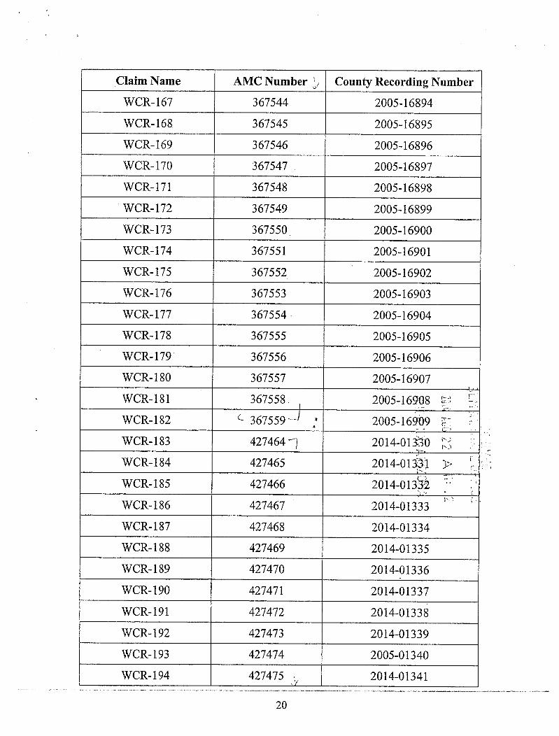
Claim Name AMC Number 6 County Recording NumberWCR-167 367544 2005-16894
WCR-168 367545 2005-16895WCR-169 367546 2005-16896WCR-170 367547 2005-16897WCR-171 367548 2005-16898WCR-172 367549 2005-16899WCR-173 367550 2005-16900WCR-174 367551 2005-16901
WCR-175 367552 2005-16902WCR-176 367553 2005-16903WCR-177 367554 2005-16904WCR-178 367555 2005-16905WCR-179 367556 2005-16906WCR-180 367557 2005-16907WCR-181 367558 2005-16908 5< LWCR-182 C 367559 --1 * 2005-16909 3-WCR-183 427464 -1 2014-01330 5WCR-184 427465 2014-013*1 1 >WCR-185 427466 2014-013* ]WCR-186 427467 2014-01333WCR-187 427468 2014-01334WCR-188 427469 2014-01335WCR-189 427470 2014-01336WCR-190 427471 2014-01337WCR-191 427472 2014-01338WCR-192 427473 2014-01339WCR-193 427474 2005-01340WCR-194 427475 i 2014-01341
20

Claim Name AMC Number County Recording Number
WCR-195 427476 2014-01342
WCR-196 427477 2014-01343
WCR-197 427478 2014-01344
WCR-198 427479 2014-01345
WCR-199 427480 2014-01346
WCR-200 427481 2014-01347
WCR-201 427482 2014-01348
WCR-202 427483 2014-01349
WCR-203 427484 2014-01350
WCR-204 427485 2014-01351
WCR-205 427486 2014-01352
WCR-206 427487 ---/ 2014-01353
WCR-207 - 367584 -- 2005-16934
WCR-208 367585 2005-16835 (-, F
WCR-209 367586 2005-14936
JiiA AU 4
WCR-210 367587 2005-16937 :-2
WCR-211 367588 2005-16938 - -7 ,_
WCR-212 367589 2005-16939 0·
WCR-213 367590 2005-16940 r
WCR-214 367591 2005-16941
WCR-215 367592 2005-16942
WCR-216 367593 2005-16943
WCR-217 367594 2005-16944
WCR-218 367595 2005-16945
WCR-219 367596 2005-16946
WCR-220 367597 2005-16947
WCR-221 367598 1 2005-16948
WCR-223 367600. 2005-16950
21-

Claim Name AMC Number County Recording NumberWCR-255 427488 -1 2014-01354WCR-256 427489 2014-01355WCR-257 427490 2014-01356WCR-258 427491 2014-01357WCR-259 427492 2014-01358WCR-260 427493 2014-01359WCR-261 427494 2014-01360WCR-262 427495 2014-01361WCR-263 427496 2014-01362WCR-264 427497 -1 2014-01363WCR-274 r 368661-7 2005-16725WCR-275 368662 2005-16726WCR-277 368663 2005-16727WCR-278 368664 2005-16728WCR-293 368665 2005-16729 -+ 4WCR-301 368666 2005-167!30 SWCR-303 368667 2005-1€731 tWCR-304 368668 2005-16732 1> 1WCR-305 368669 2005-16133 -r-WCR-306 368670 2005-16734WCR-307 368671 2005-16735WCR-308 368672 2005-16736WCR-309 368673 2005-16737WCR-310 368674 2005-16738WCR-311 368675 2005-16739WCR-312 368676 2005-16740WCR-313 368677 2005-16741WCR-314 368678 4 2005-16742
22

Claim Name AMC Number County Recording Number
WCR-315 368679 2005-16743
WCR-316 368680 2005-16744
WCR-317 368681 2005-16745
WCR-318 368682 -i 2005-16746
WCR-323 .. - 373271/ 2006-07297
WCR-359 373273 -1 2006-11578
WCR-360 373274 2006-11579
WCR-361 373275 -1 2006-11580
WCR-404 376302 7 2006-19751
WCR-405 376303 2006-19752
WCR-406 376304 2006-19753
WCR-407 376305 J 2006-19754
WCR-420A 376316-- 2006-19765
WCR-421 A 376317 2006-19766
WCR-422 376318 20064976~
WCR-423 376319 2006-1976*S
WCR-424 376320 2006-19769-
WCR-425 376321 2006-197701
WCR-426 376322 2006-19771 -
WCR-427 376323 2006-19772
WCR-428 376324 2006-19773
WCR-429 376325 2006-19774
WCR-430 376326 2006-19775
WCR-431 376327 J 2006-19776
WCR-432 376440 n 2007-01454
WCR-433 376441 2007-01455
WCR-434 376442 2007-01456
WCR-435 376443 j , 2007-01457
23

Claim Name AMC Number County Recording NumberWCR-436 376444 2007-01458
WCR-437 376445 2007-01459
WCR-438 376446 2007-01460
WCR-439 376447 J 2007-01461
I:\FILES\DOCS\AUGU05\251031\DOC\P60400.DOC
rE,%8 0 E REM
r.
24

Page 1 of 1.
United States Department of the InteriorBureau of Land Management Receipt
LANDS/RECREATION & PLANNINGONE N CENTRAL AVE
PHOENIX, AZ 85004 -2203 No: 3111074Phone: 602-417-9200
Transaction #: 3202775Date of Transaction: 08/25/2014
CUSTOMER:DECONCINI MCDONALD YETWIN & LACY P C AUG 262OM2525 E BROADWAY BLVD STE 200TUCSON,AZ 85716-5350 US
DESCRIPTION 1 REMARKS 11 11 TOTAL I1 II PRICE H 1CLAIMS-NOT NEW-UNADJUD,ONE AUTH MAINT FEE~__~~~~~|NO. ONLY / MINING CLAIM MONEY ~ PYMNT 2015 -Wa - 112220.00RECEIVEDCASES: AMC51409/$112220.00
PAYMENT INFORMATION1 F--=OUNT: 112220.001POSTMARKED: 08/22/2014
--TYPE:ICHEEK-RECEIVED]116§)55--11--CHECKNO:i®*F--------------3-JEI-3
NAME: DECONCINI MCDONALD YETWIN LACY PC2525 E BROADWAY BLVD STE 200TUCSON AZ 85716-5350 US
REMARKS
This receipt was generated by the automated BLM Collections and Billing System and is a paper representation of a portionof the official electronic record contained therein.
8/25/14

C
..1
pres
sExtremely Urgent
t
FedEx Ship Manager - Print Your Label(s) Page l of l cs,cs;
OECONCINIMCDONALD ETAL
Tucson, AZ 85716 ~.C„to:TUSA ~~• ~~~abae(1~G~4355O 4/ |~ 2 IiDj' -2'§1 --'41~4*M"9**&9~<
-_- _ sr 7.2Suite 200 Deliver,Addic,3 Bar Code 4840J 1420 14661903ur 1 11/"lin"Imill]- - , 08.22
SHIP TO: (602)417-9398 BILL SENDER 1
Refit KAS/251031,870135Arizona State Office Invoice#Bureau of Land Management PO#Oept#1 N CENTRAL AVE
PHO~X, AZ 85004
FRI - 22 AUG 10:30APRIORITY OVERNIGHTTRK# 77090886 4840
85004XH ZSYA AZ·US
PHX
1522GIECFP/BAC9

14 1%.r O v l.{SAZ) (in.W FILES
Reele ir Kto. - 28 cy<* 23_PRES_---De(ovx,4,!55~ZEAL Gle#wriu , UC-
Alne- 11 4 ec,AME 192436
394qcs'H414 Eec3769973931'10424 350
4 t25954/49534/6 18942082-141/ \ 6 9376R-171673983-18 32%3764'in36566 1gn?>wi
~IYTERE~~ AUG 12 2013 ~1* CD q

DECONCINI MCDONALD YETWIN & LACYA PROFESSIONAL CORPORATION
ATTORNEYS AT LAW
ROBIN E. BARNES, RL/CP 2525 EAST BROADWAY BOULEVARD • SUITE 200TUCSON, ARIZONA [email protected] (520) 322-5000 • (520) 322-5585 (Fax)
WLVW.DICONCINIMCIXJNALD.COM
mAugust 14,2013 RE 50 >Via Federal Express 0 5 r.4,0
T -- -IrnArizona State Office crl >-Bureau ofLand Management 7-3-- > 00Attention: Public Room i=-1
CD 0 3One North Central Avenue, Suite 800Phoenix, AZ 85004-4427 >• LJ CDrn
RE: Payment of Claim Maintenance Fee; Arizona Minerals Inc.
Ladies and Gentlemen:
Delivered herewith are two (2) checks in the amount of $15.00 and $101,345.00,respectively, as payment of the claim maintenance fees pursuant to the 30 U.S.C. § 28f(a), asadjusted by 30 U.S.C. § 28j(c) and implemented by notice in 74 Federal Register 30959-62(June 29,2009) and as amended by the Consolidated Appropriations Act 2012, Pub. L. No. 112-74, 125 Stat. 786 (2011). The owner has paid a maintenance fee of $140 per claim for theassessment year beginning September 1, 2013. A copy of the Certification of Payment ofMaintenance Fee in Lieu of Affidavit of Annual Assessment Work to be recorded with the SantaCruz County Recorder's Office is also enclosed herewith.
Please return to this office a date-stamped copvof this letter and the affidavit along~ith the receipt for payment.
Thank you for your assistance and please feel free to contact me or John Lacy with anyquestions or concerns.
Sincerely,
14* 6 Ga~vu-0Robin E. Barnes, RL/CPRegistered Landman/Certified Paralegal
reb
c. w/out enc. Don Taylor (via email)Nancy FitzSimmons (via email)
I:\FILES\DOCS\AUGU05\251031\LTR\023531.DOCX
Tucson Phoenjx

.
3' *
After recording, please return to:John C. LacyDeConcini McDonald Yetwin & Lacy, P.C.2525 E. Broadway Blvd., #200Tucson, AZ 85716 -0
0f-,1STATE OF ARIZONA )
1613 AUG 15 A
Bl.MAZ517~
) SS: «County of Pima ) >
5,3 rrif-13CERTIFICATION OF PAYMENT OF MAINTENANCE FEE 8 00
IN LIEU OF AFFIDAVIT OF ANNUAL ASSESSMENT WORK 3 ~ 22CD00 i-rjJohn C. Lacy, being first duly sworn, deposes and says that:
1. He is an agent for Arizona Minerals Inc., a Nevada corporation, the ownerofthe unpatented lode mining claims situated in Santa Cruz County, Arizona (the"Claims"), the location notices ofwhich are ofrecord in Santa Cruz County, and in therecords ofthe Arizona State Office ofthe Bureau ofLand Management under the filenumbers indicated in the attached Exhibit A.
2. Pursuant to the 30 U.S.C. § 28f(a), as adjusted by 30 U.S.C. § 28j(c) andimplemented by notice in 74 FederalRegister 30959-62 (June 29, 2009) and as amendedby the Consolidated Appropriations Act 2012, Pub. L. No. 112-74,125 Stat. 786 (2011),the owner has paid a maintenance fee of $140 per for the assessment year beginningSeptember 1, 2013. This Certificate is in lieu of an affidavit of performance of annualassessment work or notice of intent to hold.
3. The name and address of the owner of the Claims for which thisCertificate is prepared is Arizona Minerals Inc., c/o Wildcat Silver Corp., 4500 CherryCreek South Drive, Ste. 1040, Denver, CO 80246. THIS IS NOT A CHANGE OFADDRESS.
4. The Claims are held and claimed by the owners for the valuable mineralscontained therein.
DATED thil~day ofAugust, 201 .
John C. Lacy
Sworn and subscribed before me this tqtay ofAugust, 2013, by John C. Lacy,Agent for Arizona Minerals Inc.
OFFICIALSEAL ~)2~4 e /9 4%&0~ ROBIN E BARNES
Notag Pubic-Arizona Notary Public
~ My =$~6 I:\FILES\DOCS\AUGU05\251031\DOC\NZ3621.DOCELIJ
1

EXHIBIT A Santa Cruz County BLM SerialMining Claims Name of Claim Location Date Docket/Page or Fee No. A MC No.
The following unpatented lode mining claims are situated in the Harshaw and Shell-28 01/02/2007 2007-01468 377003Patagonia Mining Districts, in Sections 27,28,29,32,33 and 34, Township 22 South, Shell-29 01/02/2007 2007-01469 377004Range 16 East, and in Sections 1,2,3,4,5,8,9,10,11, 12,13,14,15 and 16 Shell-30 01/02/2007 2007-01470 377005(unsurveyed), Township 23 South, Range 16 East, G&SR Mer., Santa Cruz County, Shell-318 05/15/2008 2008-05631 392438Arizona, the names ofwhich, and the place of recording of their location notices in the Amended 07/22/2008 2008.07616Official Records ofSanta Cruz County and the Arizona State Office of the Bureau of 2007-01473
- Shell-32 01/02/2007 2007-01472 377007Land Management are as follows: 2007-01474
Shell-33 01/04/2007 377008Shell-34 01/04/2007 377009
Santa Cru: County BLMSerial 12/21 /2006 377010Shell-35 2007-01475Name ofClaim Location Date Docket/Page or Fee No. A MC No. 2007-01477 377012
Shell-36 12/21/2006 2007-01476 377011Shell-37 12/21/2006SHELL NO. 1 01/29/1965 058 135 51409 Shell-38 12/22/2006 2007-01478 377013Amended 04/25/2013 2013-03346 Shell-39 12/22/2006 2007-01479 377014SHELL NO. 2 01/29/1965 058 136 51410 Shell-40 12/22/2006 2007-01480 377015Amended 04/25/2013 2013-03347
2007-01482Shell-41 12/22/2006 2007-01481 377016Shell 2A 05/07/2008 2008-05629 , 392436 Shell-42 12/22/2006 377017Amended 04/25/2013 2013-03348 Shell-43 12/22/2006 2007-01483 377018Shell 2B 05/12/2008 2008-05630 392437
Amended 04/25/2013 2013-03349 SHELL No. 44 07/25/1967 81 212 51452SHELL NO, 3 01/29/1965 058 137 ' .4 51411 SHELL No. 45 07/25/1967 81 213 51453SHELL NO. 4 01/29/1965 058 138 51412 SHELL No, 46 07/27/1967 81 214 51454SHELL NO. 5 01/29/1965 058 139 51413 SHELL No. 47 07/27/1967 81 215 51665 9 ESHELL NO. 6 01/28/1965 058 140 51414 SHELL No. 48 07/27/1967 81 216 51~6 0SHELL NO. 7 01/28/1965 058 141 51415 SHELL No. 49 07/27/1967 81 217 . 515* .5 ~SHELL NO. 8 01/28/1965 058 142 51416 37419 ~ ES!SHELL NO. 9 01/29/1965 058 143 51417 Shell-51 12/29/2006 2007-01484SHELL NO. 10 01/29/1965 058 144 5144# - S Shell-52 12/29/2006 2007-01485SHELL NO. 11 01/28/1965 058 145 51419 2 k Shell-53 12/29/2006 2007-01486 :*E @NSHELL NO. 12 01/28/1965 058 146 51@ E ZF Shell-54 01/02/2007 2007-01487 377@2 9 23SHELL NO. 13 01/29/1965 058 147 5148 9, L" 0 Shell-55 01/02/2007 2007-01488 377323 ww MSHELL NO. 14 01/29/1965 058 148 514~ -w Fm Shell-56 01/02/2007 2007-01489 377024SHELL NO. 15 01/28/1965 058 149 514El AM Shell-57 01/02/2007 2007-01490 377025SHELL NO. 16 01/28/1965 058 150 51* > CO Shell-58 01/02/2007 2007-01491 377026SHELL NO. 17 01/28/1965 058 151 5142 Ci -rt-7 01/04/2007 2007-01492Shell-59 377027SHELL NO. 18 01/28/1965 058 152 51495 ~ R Shell-60 01/04/2007 2007-01493 377028SHELL NO. 19 01/28/1965 058 153 51427 Shell-61 01/04/2007 2007-01494 377029SHELL NO. 20 01/28/1965 058 154 51428 Shell-62 01/04/2007 2007-01495 377030Shell-21 12/21/2006 2007-01462 ' 376997 Shell-63 01/04/2007 2007-01496 377031Shell-22 12/21/2006 2007-01463 376998 Shell-64 01/04/2007 2007-01497 377032Shell-23 12/21/2006 2007-01464 376999 377033Shell-65 01/02/2007 2007-01498Shell-24 09/15/2008 2008-11346 , 394954 Shell-66 01/02/2007 2007-01499 377034SHELL 24A 07/25/2013 2013-05811 324560 Shell-67 01/02/2007 2007-01500 377035Shell-25 12/29/2006 2007-01465 377000 Shell-68 01/02/2007 2007-01501 377036Shell-26 12/29/2006 2007-01466 377001 Shell-69 12/22/2006 2007-01502 377037Shell-27 12/29/2006 2007-01467 377002 Shell-70 12/22/2006 2007-01503 377038
1 2

Sontu Cruz Couno' ELM Serhil Sonia Crut Cutility BLM SerialName of Claim Location Duk Docket/Page or Fee No. A MI' No. Name Of Claim Lowlion Date Docket/Page mr Fee No. A MC No.Shell-71 12/22/2006 2007-01504 377039 Aineiided 05/06/2008 2()08-0549 /Shell-72 12/22/2006 2007-01505 377040 SHELL 102 04/24/2()07 20()7-0813') 383349SHELL 73 04/24/2()07 2007-08110 383320 SHELL 103 04/24/2007 2007-0814() 383350SHELL 74 04/24/2007 2007-08111 38332J Amended 04/30/2008 2008-05498SHELL 75 04/24/2007 2007-08112 383322 SH ELL 104 04/24/2007 2007-08141 383351SHELL 76 04/24/2007 2007-08113 383323 SHELL 105 04/24/2007 2007-08142 383352Amended 05/06/2008 2008-05484 Aniended 04/30/2008 2008-05499SHELL 77 04/24/2007 2007-0*114 383324 SfIELL 106 04/24/2007 2007-08143 383353Amended 05/06/2008 2008-05485 Amended 04/30/2008 2008-05500SHELL 78 04/24/2007 2007-08115 383325 SHELL 107 04/24/2007 2007-08144 383354SHELL 79 04/24/2007 2007-08116 383326 Amended 04/30/2008 2008/05501SHELI. 79A 07/25/2013 2013-05812 424561 SHELL 108 04/24/2007 2007-08145 383355SHELL 80 04/24/2007 2007-08117 383327 Amended 04/30/2008 2008-05502SHELL 81 04/24/2007 2007-05118 383328 SHELL 109 ()4/24/2007 2007-08146 383356SHELL 82 05/21/2007 2007-08119 383329 Amended 04/3()/2008 2008-05503Amended 05/07/2008 2008-05486 SHELI. 110 04/24/2007 2007-08147 383357SHELL 83 05/21/2007 2007-08120 383330 SHELL 111 04/24/2007 2()07-08]48 383358Amended 05/07/2008 2008-()5487 Amended 04/30/2008 2008-05504SHELI. 84 05/21/2007 2007-08121 383331 SHELL 112 04/26/2007 2007-08149 383359Amended 05/07/20()8 2008-05488 cr' SHELLI 13 04/26/2007 2007-08150 383360SHELL 85 05/21/2007 2007-08122 383932 0 Amended 04/30/2008 2008-05505SHELL 86 05/21/2007 2007-08123 38*93 = 4,7 SHELL 114 04/26/2007 2007-08151 383361Amended 05/07/2008 2008-05489 - - SHELL 115 04/26/2007 2007-08152 383362SHELL 87 05/21/2007 2007-08124 38.~4 E 55 Amended 04/30/2008 2008-05506 00SHELL 88 05/21/2007 2007-08125 383935 -4-E SHELL 116 04/26/2007 2007-08153 383963 0 -Amended 05/07/2008 2008-()5490 SHELL 117 04/26/2007 2007-08154SHELL 89 05/21/20()7 2007-08126 383~6 ~ ~ru
Ametided 04/30/2008 2008-05507SHELL 90 05/21/20()7 2007-08127 383337 we R Sl IELL 118 05/07/2007 2007-08155 383365 - -4Amended 05/07/2008 2008-05491 Amended 04/30/2008 2008-05508 9. ul 42SHELL 91 05/21/2007 2007-08128 383338 Amended 09/26/2012 2012-08383 - 00:1') z',riSHELL 92 05/17/2007 2007-08129 383339 SHELL 119 05/07/2007 2007-08156 3831*6 Z EAmended 05/06/2008 2008-05492 Amended 04/30/2008 2008-05509SHELL 93 05/17/2007 2007-08130 38334() Amended 09/26/2012 2012-08384 CO P 1>W
Amended 05/06/2()08 2008-05493 SHELL 120 05/07/2007 2007-08157 383367SHELL 94 05/17/2007 2007-08131 383341 SHELL 121 05/07/2007 2007-08158 383368SI{ELL 95 05/17/2007 2007-08132 383342 Amended 05/05/2008 2008-05510Ainended 05/06/2008 2008-05494 Amended 09/26/2012 2012-08385SHELL 96 05/17/2007 2007-08133 383343 SHELL 122 05/07/2007 2007-08159 383369SHELL. 97 05/17/2007 2007-08134 383344 SHELL 123 05/07/2007 2007-08160 383370Aniended 05/06/2008 2008-05495 Amended 05/05/2008 2008-05511SHELL 98 05/16/2007 2007-08135 383345 Amended 09/26/2012 2012-08386SHEU- 99 05/16/2007 2007-08136 383346 SHELL 124 05/07/2007 2007-08161 383371Amended 05/06/2008 2008-05496 SHELL 125 05/07/2007 2007-08162 383372SHELL 100 05/16/2007 2007-08137 383347 Amended 05/05/2008 2008-05512SHELL 101 05/16/2007 2007-OK 138 383348 Amended 09/26/2012 2012-083873 4

Santa Cruz County BLM Serial Santa Cruz County BLM SerialName of Claim Location Date Docket/Page or Fee No. A MC No. Name oj'Claim Location Date Docket/page or Fee No. A MC No.SHELL 126 05/1 1/2007 2007-08163 383373 Shell 154 09/15/2008 2008-11350 394958Amended 05/05/2008 2008-05513 Shell 155 09/15/2008 2008-11351 394959SHELL 127 05/11/2007 2007-08164 383374 Sheli 156 09/15/2008 2008-11352 394960Amended 05/05/2008 2008-05514 Shell 157 09/15/2008 2008-11353 394961SHELL 128 05/11/2007 2007-08165 383375 Shell 158 09/14/2008 2008-11354 394962SHELL 129 05/11/2007 2007-08166 383376 Shell 159 09/14/2008 2008-11355 394963Amended 05/05/2008 2008-05515 Shell 160 09/14/2008 2008-11356 394964SHELL 130 05/11/2007 2007-08167 383377 Shell 161 09/14/2008 2008-11357 394965SHELL 131 05/11/2007 2007-08168 383378 Shell ]62 09/14/2008 2008-11358 394966Amended 05/01/2008 2008-05516 Shell 163 09/14/2008 2008-11359 394967SHELL 132 05/11/2007 2007-08169 383379 Shell 164 09/14/2008 200841360 394968SHELL 133 05/11/2007 2007-08170 383380 Shell 165 09/14/2008 200841361 394969Amended 05/01/2008 2008-05517 SHELL-166 11/10/2011 2012-00377 412595SHELL 134 05/14/2007 2007-08171 383381 SHELL-167 11/10/2011 2012-00378 412596SHELL 135 05/14/2007 2007-08172 383382 Amended 09/25/2012 2012-08388Amended 05/01/2008 2008/05518 SHELL-168 11/10/2011 2012-00379 412597Shell-136 05/23/2007 2007-08173 383383 SHELL-169 11/10/2011 2012-00380 412598Amended 05/07/2008 2008-05519 SHELL=170 11/08/201 1 2012-00381 412599Shell-137 05/23/2007 2007-08174 383384 SHELL-171 11/11/2011 2012-00382 412600Shell-138 05/23/2007 2007-08175 383385 SHELL-172 11/08/201 1 2012-00383 412601Shell-139 05/23/2007 2007-08176 383386 SHELL-173 11/10/2011 2012-00384 412602SHELL 140 05/18/2007 2007-08177 383387 SHELL-174 11/102011 2012-00385 412603Amended 05A)7/2008 2008-05520 SHELL-175 12/08/2011 2012-00386 412604SHELL 141 05/18/2007 2007-08178 383388 00 SHELL-176 11/14/2011 2012-00387 412605 0Amended 05/07/2008 2008-05521 3= C SHELL-177 11/14/2011 2012-00388 412496 St RSHELL 142 05/16/2007 2007-08179 383#9 0 Tz* SHELL-178 11/14/2011 2012-00389 412~7 w 1Amended 05/06/2008 2008-05522 rn E N=-3 Amended 09/26/2012 2012-08389 0 5 %1SHELL 143 05/16/2007 2007-08180 383$ E ZE SHELL-179 11/14/2011 2012-00390 412*8 _ E~51SHELL 144 05/16/2007 2007-08181 3833~ cn 2* Amended 09/26/2012 2012-08390 .u,MZAmended 05/06/2008 2008-05523 3833~ 2, TE] 09SHELL-180 11/14/2011 2012-00391 412(~ *- rrirnSHELL 145 05/16/2007 2007-08182 SHELL-181 11/14/201 1 2012-00392 4126@ S -4Amended 05/06/2008 2008-05524 SHELL-182 11/14/2011 2012-00393 4126$* wW 3SHELL-145A 06/20/2013 2013-05410 ' 4243~ m m SHELL-183 11/14/2011 2012-00394 41268 co CJ
Fl E
SHELL 146 05/14/2007 2007-08183 -383393 SHELL-184 11/14/2011 2012-00395 412613Amended 05/01/2008 2008-05525 SHELL-185 11/14/2011 2012-00396 412614SHELL 147 05/14/2007 2007-08]84 383394 SHELL-186 11/14/2011 2012-00397 412615SHELL 148 05/14/2007 2007-08185 383395 SHELL-187 11/14/2011 2012-00398 412616Amended 05/01/2008 2008-05526 SHELL-188 11/14/2011 2012-00399 412617SHELL 149 05/14/2007 2007-08186 383396 SHELL-189 11/14/2011 2012-00400 412618Amended 05/01/2008 2008-05527 SHELL-190 11/14/2011 2012-00401 412619SHELL 150 05/13/2008 2008-05632 392439 SHELL-191 11/14/2011 2012-00402 412620Amended 07/22/2008 2008-07615 SHELL-192 11/17/2011 2012-00403 412621Shell 151 09/15/2008 2008-11347 394955 SHELL-193 11/17/2011 2012-00404 412622Shell 152 09/15/2008 2008-11348 394956 SHELL-194 11/22/2011 2012-00405 412623Shell 153 09/15/2008 2008-11349 394957 SHELL-195 11/22/2011 2012-00406 4126245 6
fo

Santa Cruz Cocinty 81.M Seriul Santa Critz Countr BLM SeritilNume of Claim Location Date Docket/Page or Fee No. AMC N,1. Nu»ie (}:f Claim Location Dafe Docket/Page or Fee No. A MC: No.SHELL-196 11/22/2(311 2012-(10·1(37 412625 SHEI 1.-228 11/22/2011 2012-00439 412657SH El.L-197 11/22/2011 2012-00408 412626 Amended 10/01/2012 2()12-08401SHELL-198 11/1 7/2011 2012-00409 412627 Sl IELI.-229 11/22/2011 2012-00440 4!265XS]IELL-199 11/17/201 1 2012-00410 4]2628 Ametidcd 10/01/2012 2012-08402SHELL-200 11/17/2011 2012-(3041] 412629 SHEI.I.-230 11/22/2011 2012-00441 412659SHELL-2.01 I 1/17/2011 2012-Of)412 412630
2012-00442Amended 10/01/2012 2012-08403Sl jELL-202 1 1/17/20 1 1 201240413 412631 SHELL-231 11/21/2011 412660S]IELL-203 11/17/2011 2012-00414 412632 Amended 10/01/2012 2012-08404S}IELL-204 11/17/2011 2012„00415 412633 SHELI.-232 11/22/2011 2012-0()443 412661SI ]ELL-205 11/17/2011 2012-00416 412634 Amended 10/01/2012 2012-08405Sl·/ELL-206 11/17/2011 20 12-(H)417 412635 SHELI.-233 11/22/2011 2012-00444 412662SHI.LL-207 11/1 7/2011 2012-()0418 412636 Amended 10/01/2012 2012-08406S/11.LL-208 1 1/1 7/2011 21)]2-00419 412637 SHELL-234 11/22/2011 2012-00445 412663SHEI.1.-209 11/17/2011 2012-0)420 412638 Amended 10/01/2012 2012-08407SHELL-210 11/11/20!I 2012-()()421 412639 SllELL-235 11/21/2011 2012-00446 412664SHELL-211 11/11/2011 2012-00422 4]2640 Amended 10/01/2012 2012-08408SIIELL-212 11/1 1 /2(111 2012-00423 412641 SkIELL-236 11/21/2011 2012-00447 412665SHELL-2 13 11/11/2011 2012-0()424 412642 Amended 10/01/2012 2012-08404S 1!ELL-2 14 11/11/2011 2012-00425 412643 SHEI.L-237 11/21/2011 2012-00448 412666SHELL-215 12/08/2011 2012-00426 412644 Amended 10/01/2012 2012-08410SHELL-216 11/11/2011 2012-()()427 412645 99 SHELL-238 11/21/2011 2012-0()449 412667SllELL-217 11/28/2011 2012-00428 4 1 *46 = Amended 10/01/2012 2012-08411SHELL 217A 07/25/2013 20]3-05813 42«02 Z km SH ELI.-239 1]/21/2011 2012-00450 412668SHELL-218 11/28/2011 2012-0()429 , 4122517 5 35; Amended 09/26/2012 20124)8412Amended 10/01/2012 2012-08391 SHEI.L-240 11/21/2011 2012-0()451 412669 03SHELL-219 11/28/2011 2012-00430 Amended 09/26/2012 2012-08413 -0 0
cn D - --{, 412~8 _ R:?fi SHELL-241 11/21/2011 2012-00452 41 *670 r; 3.Amended 09/26/2012 2012-08392 L RE O CJSHELL 219A 07/31/2013 2013-(15814 424359 9 -1 2012-08414Amended 09/26/2012 9 5 %3SHELL 2198 07/31/2013 20134)5815 W 5 STIELL-242 11/21/20 1 1 2012-00453 412511 - M{51424554 00 1.r
11l21/2011 2012-Ol)454
SfIELL-220 11/28/2011 20124)()431 412649 Amended 09/26/2012 2012-08415 c.Amended 10/01/2012 2012-08393 SltELL-243 4]2~2 > BSHELL.-221 11/28/2011 20124)0432 412650 Amended 09/26/2012 2012-08416 o g 7Amended 10/01/2012 2012-08394 SliELL-244 11/21/2011 2012-00455 412(83 ~ ESHELL-222 11/28/2011 2012-00433 412651 Amended 09/26/2012 2012-08417Amended 10/01/2012 2012-08395 SHELL-245 11/21/2011 2012-00456 412674SliELL-223 11/22/2011 2012-00434 412652 Amended 09/26/2012 2012-08418Ainended 10/01/2012 2012-08396 SHEI.L-246 11/21/2011 2012-00457 412675SHELL-224 11/22/2011 2012-00435 412653 Amended 09/26/2012 2012-08419Amended 10/01/2012 2012-08397 SHELI«-247 11/21/2011 2012-00458 412676SHELL-225 11/22/2011 2012-00436 412654 Amended 09/26/2012 2012-08420Amended 10/01/2012 2012-08398 SIZELL-248 11/21/2011 2012-00459 412677SlIELL-226 11/22/2011 2012-00437 412655 Amended 09/26/2()12 2012-08421Amended 10/01/2012 2012-08399 STIELL-249 11/21/2011 2012-00460 412678S]IELL-227 11/22/2011 2012-00438 412656 Amended 09/26/2012 2012-08422Amended 10/01/2012 2012-084()() SliELL-250 11/21/2011 2012-()046] 412679
7 83

Santa Cri,z Coluity BLM ScrutSanta CruT. County BLM SerialName O/' Clai' iii Location Dorr Docket/Page or Fee No. A MC No. Nalne o. f Clam Location Dole Docketil'age or Fcc No. A MC No.
Amended 09/26/2012 2012-08423 SlihiA.-295 03/15/2012 2012-029 6 414997SIIE:L L-206 03/1 5/2012 2012-(12'10'1 414998SHELL-251 03/14/2012 2012-02862 414953
MB.I.-297 03/15/2012 2012-021)08 414999SHELL.-252 03/14/2012 2012-02863 414954SHELL-253 03/14/2012 2012-02864 414955 SHELL-298 03/15/2012 20 12-034(* 4150()0SHELL-254 03/14/2012 2012-02865 414956 SHE.1.1.-299 03/16/2012 20 12-02410 415001St JEI.L-255 03/14/2012 414957 SI ]El-1--300 03/16/2012 2012-029~1 415002
2012-02866SHELI.-256 03/14/2012 2012-02867 414958 SHEI.1..-301 03/16/2012 2012-02912 415003SHEA.1.-257 03/14/2012 414959 SHELL-302 03/16/2012 2012- 201.3 415004
2012-02868 415005
SHELL-258 03/14/2012 2012-02869 414960 SHEI.L-303 03/16/2012 2012-02914SHELL-259 03/14/2012 SI[El.I.-304 03/16/2012 2012-02915 4150062012-02870 414961
03/16/2012 2012-02916SI ]ELL-260 03/14/2012 2012-02871 414962 9 1921.L-305 415007SliI.U.-261 03/14/2012 2012-02872 414963 S]IELL-306 03/16/2012 2012-02917 415008SHELI--262 03/14/2012 2012-02873 414964 SHELL-307 03/16/2012 2012-02918 415009SHELL--263 03/13/2012 2012-02874 414965 SHEN -308 03/16/2012 2012-02919 415010SI I ELI«-309 03/16/2012 2012-02920 415011SHE.LL-264 03/13/2012 2012-02875 414966
415012SHELL-265 03/13/2012 2012-02876 414967 SFIELL-310 03/16/2012 2012-02921SHELI.-266 03/13/2012 2012-02877 414968 SHELL-311 05/10/2012 2012-04673 416189SHEI.L-267 03/13/2012 2012-02878 414969 Amended 09/25/2012 2012-08424SPIEL.L-268 03/13/2012 4]4970 SHELL-312 05/10/2012 2012-04674 416190
2012-02879SHELL-269 03/13/2012 2012-02880 414971 Amended 09/25/2012 2012-08425SHELL-270 03/12/2012 2012-02881 414972 SI IELI.-3 13 12/05/2012 2013-00649 420822SHELL-314 12/05/2012 2013-00650 420823SHELL-271 03/13/2012 2012-02882 414973 - 92SHELL-272 03/13/2012 2012-02883 41*74 5 ~ SHELL-315 12/05/2012 2013-00651 420824SHELL-273 03/13/2012 2012-02884 41075 ~ ki r SHELL-316 12/05/2012 2013-00652 420825SHELI.-274 03/13/2012 2012-02885 4*763 ?511 SHELL.-317 12/06/2012 2013-00653 429826 TriSHELL-275 03/15/2012 2012-02886 41*77 ui L] 94 SIIELL-318 12/06/2012 2013-00654 489827%9 TSHELL-319 12/06/2012 2013-00655 4*82&- E-9SHELL-276 03/15/2012 2012-02887 41*78 > rn A
2013-00656 1;6)820/ Yi~SHELL.-320 12/06/2012SHELL-277 03/15/2012 2012-02888 41~79 5 51 0SIJELL-278 03/15/2012 2012-02889 41*80 21 SHELL-321 12/11/2012 2013-00657 4208351 '.'rr,SHELL-279 03/15/2012 2012-02890 41'*81 ~ c, 011ELL,-322 12/11/2012 2013-00658 830831 4==SI[ELL-280 03/15/2012 2012-02891 414982 SliELL-323 12/11/2012 2013-00659 ~083* 2(]SHELL:281 03/15/2012 2012-02892 414983 SHELL-324 12/11/2012 2013-00660 *080 4SHELL-282 03/15/2012 2012-02893 414984 SHEI,I,-325 12/05/2012 2013-00661 *208:5 5SHELL-283 03/15/2012 2012-02894 414985 SHEI.I. -326 12/05/2012 2013-00662 420835 ' 9S]IELI:284 03/15/2012 2012-02895 414986 SHELL-327 12/03/2012 2013-00663 420836SHELL-285 03/15/2012 2012-02896 414987 SHELL-328 12/03/2012 2013-00664 420837SHELL-286 03/15/2012 2012-02897 414988 SHELL-329 12/03/2012 2013-00665 420838SHELL-287 03/15/2012 2012-02898 414989 SHELL-330 01/07/2013 2013-01676 421166SHELL.-288 03/15/2012 2012-02899 414990 SHELL.-331 01/07/2013 2013-01677 421167SliELL-289 03/15/2012 2012-02900 414991 SHEI.L-332 01/07/2013 2013-01678 421168SHEI.L-290 03/15/2012 2012-02901 414992 SliELL.-333 01/07/2013 2013-01679 421169SHEE.1.-291 03/15/2012 2012-02902 414993 20 13-016>:i) 421170SHEL.I.-334 01/07/2013SHELL-292 03/15/2012 2012-02903 414994 SliELI.-335 (}1/07/20 13 20 13-0 16&1 421171SHEI.L-293 03/15/2012 2012-02904 414995 SHELL-336 01/04/2013 2013-01682 421172SHELL-294 03/15/2012 2012-02905 414996 SIniI.1,-337 12/28/2012 2013-01683 421173
109

Santa Cruz County BLM SeridName of Claim Location Date Docket/Page or Fee No. A MC No. Name of Claim Localion Date Docket/Page or Fee No. AMC No.Santa Crilf County BLM Serial
SHELL-338 12/28/2012 2013-01684 421174 SHELL-383 12/19/2012 2013-01729 421219SHELL-338 12/28/2012 2013-01685 421175 SHELL-384 12/19/2012 2013-01730 421220SHELL-340 12/28/2012 2013-01686 421176 SHELL-385 12/19/2012 2013-01731 421221SHELL-341 12/28/2012 2013-01687 421177 SHELL-386 12/19/2012 2013-01732 421222SHELL-342 12/28/2012 2013-01688 421178 SHELL-387 12/19/2012 2013-01733. 421223SHELL-343 12/28/2012 2013-01689 421179 SHELL-388 12/19/2012 2013-01734 421224SHELL-344 12/28/2012 2013-01690 421180 SHELL-389 12/19/2012 2013-01735 421225SHELL-345 12/27/2012 2013-01691 421181 SHELL-390 12/19/2012 2013-01736 421226SHELL-346 12/27/2012 2013-01692 421182 SHELL-391 12/18/2012 2013-01737 421227SHELL-347 12/27/2012 2013-01693 421183 SHELL-392 12/18/2012 2013-01738 421228SHELL-348 12/27/2012 2013-01694 421184 SHELL-393 12/18/2012 2013-01739 421229SHELL-349 12/27/2012 2013-01695 421185 SHELL-394 12/18/2012 2013-01740 421230SHELL-350 12/27/2012 2013-01696 421186 SHELL-395 12/18/2012 2013-01741 421231SHELL-351 12/27/2012 2013-01697 421187 SHELL-396 12/18/2012 2013-01742 421232SHELL-352 12/27/2012 2013-01698 421188 SHELL-397 12/18/2012 2013-01743 421233SHELL-353 12/27/2012 2013-01699 421189 SHELL-398 12/18/2012 2013-01744 421234SHELL-354 12/27/2012 2013-01700 421190 SHELL-399 02/05/2013 2013-01745 421235SHELL-355 12/27/2012 2013-01701 421191 SHELL-400 06/20/2013 2013-05411 424351SHELL-356 12/27/2012 2013-01702 421192 SHELL 400A 07/31/2013 2013-05816 ]424565SHELL-357 12/28/2012 2013-01703 421 i93 SHELL-401 06/20/2013 2013-05412 414352SHELL-358 12/28/2012 2013-01704 421194 SHELL-402 06/20/2013 2013-05413 424353 00SHELL-359 12/21/2012 2013-01705 421195 99 SHELL-403 06/17/2013 2013-05414 *13540 -SHELL-360 12/21/2012 2013-01706 4896%4 i SHELL-404 06/17/2013 2013-05415 42835%0SHELL-361 12/21/2012 2013-01707 4*197 5 >- SHELL-405 06/17/2013 2013-05416 4835* ~gSHELL-362 12/21/2012 2013-01708 421198 h5 C/'W SHELL-406 06/17/2013 4*4357_ Ec>2013-05417SHELL-363 12/21/2012 2013-01709 422199 0 5201 SHELL-407 06/17/2013 2013-05418 4;0358'·n =SHELL-364 12/21/2012 2013-01710 42~0 Mg SHELL-408 06/17/2013 2013-05419 499359» mmSHELL-365 12/21/2012 2013-01711 42ER)1 # SAC~ SHELL-409 06/18/2013 2013-05420 4#360& 50SHELL-366 12/21/2012 2013-01712 SHELL-409A 06/20/2013 2013-05421 4D36 Iw g42%2 9 -nSHELL-367 12/21/2012 2013-01713 421*3 ~ A SHELL-410 06/11/2013 2013-05422 424362-0 mSHELL-368 12/20/2012 2013-01714 421204 SHELL-411 06/20/2013 2013-05423 424363SHELL-369 12/20/2012 2013-01715 421205 SHELL-412 06/11/2013 2013-05424 424364SHELL-370 12/20/2012 2013-01716 421206 SHELL-413 06/20/2013 2013-05425 424365SHELL-371 12/20/2012 2013-01717 421207 SHELL-414 06/17/2013 2013-05426 424366SHELL-372 12/20/2012 2013-01718 421208 SHELL-415 06/17/2013 2013-05427 424367SHELL-373 12/20/2012 2013-01719 421209 SHELL-416 06/17/2013 2013-05428 424368SHELL-374 12/20/2012 2013-01720 421210 SHELL-417 06/11/2013 2013-05429 424369SHELL-375 12/20/2012 2013-01721 421211 SHELL-418 06/17/2013 2013-05430 424370SHELL-376 12/20/2012 2013-01722 421212 SHELL-419 06/18/2013 2013-05431 424371SHELL-377 12/20/2012 2013-01723 421213 SHELL-420 06/20/2013 2013-05432 424372SHELL-378 12/20/2012 2013-01724 42]214 SHELL-421 06/20/2013 2013-05433 424373SHELL-379 12/19/2012 2013-01725 421215 SHELL-422 06/20/2013 2013-05434 424374SHE«L-380 12/19/2012 2013=01726 421216 SHELL-423 06/18/2013 2013-05435 424375SHELL-381 12/19/2012 2013-01727 421217 SHELL.-424 06/18/2013 2013-05436 424376SHELL-382 12/19/2012 2013-01728 421218 SHELL-425 06/18/2013 2013-05437 424377
11 12

. I
SHELL-426 06/18/2013 2013-05438 424378 The unpatented lode mining claims situated in the Harshaw and Patagonia MiningSHELL-427 06/18/2013 2013-05439 424379 District, situated within the protracted survey lines ofSections 1,13,24,25,29,32 andSHELL-428 06/18/2013 2013-05440 424380 36, Township 23 South, Range 15 East, and Sections 5,6,8,9,15,16,17,18,19,20,29,SHELL-429 06/18/2013 2013-05441 424381 30,31 and 32, Township 23 South, Range 16 East, GASR Men, Santa Cruz County,SHELL-430 06/18/2013 2013-05442 424382 Arizona, the names of which and the place of record of the location notices thereof in theSHELL-431 06/18/2013 20]3-05443 424383 official records of the Santa Cruz County Recorder and Arizona State Office of theSHELL-432 06/18/2013 2013-05444 424384 Bureau of Land Management arc as follows:SHELL-433 06/20/20 13 2013-05445 424385SHELL-434 06/18/2013 2013-05446 424386 F---CkIm-Name-AMC Number County Recording NumberSHELL-435 06/18/2013 2013-05447 424387SHELL-436 06/18/2013 2013-05448 424388 1 WCR-4 376282 2006-19731SHELL-437 06/11/2013 2013-05449 424389SHELL-438 06/11/2013 2013-05450 424390 376283WCR-5 2006-19732SHELL-439 06/11/2013 2013-05451 424391 WCR-6 376284 2006-19733WCR-7 367285 2006-19734WCR-8 376286 2006-19735WCR-9 376287 2006-19736
WCR-10 376288 2006-19737WCR-11 376289 2006-19738WCR-12 376290 2006-19739WCR- 13 376291 2006-19740WCR-14 376292 2006-19741WCR-15 376293 2006-197
VNOZ
IEV
'XIN
30HJ
b E :0
1 V S
1 98
¥ EID
Z
S zvw
ls WCR-16 376294 2006-197 . 430mWCR-17 376295 2006-1974;f m 2 8rn
<WCR-18 376296 2006-197452 1. urti
rri A WCR-19 376297 2006-1974 <' 100-,1 WCR-20 367401 2005-16751 -' '-70ri WCR-21 367402 2005- 16752
WCR-22 367403 2005-16753WCR-23 367404 2005-16754WCR-24 367405 2005-16755WCR-25 367406 2005-16756WCR-26 367407 2005-16757
13 14

~ _ Claim Name AM('Number- ~_founly Ref~223ng Num[9-r_j ~ claim Name ___ ]-- i<#j-Number ] -I]junty Record(n-4-Numbe~-]WCR-27 367408 2005-16758 WCR-61 ~ 3674~- 1 2005- 16792WCR-28 --3(17-409 ---11 - 39qlf67« - ~ WCR-62 367443 ~ 2005-16793 _-=-WeR-29 367410 2005 -16760 ~ -- --- - 1----- -.-------- ---- -WCR-63 367444 2005-16794WCR-30 367411 ~ -- 2305-16761 -- -| 1- -------.------.-»~~ - - - 1~--
WCR-64 | 367445 2005-16795WCR-31 3,7412 -~ 2005-16762 WCR-65 367446 2005-16796 _~---VVCR-f2 367413 2005-16763 WCR-66 367447 2005-16797WCR-33 367414 2005-16764 WCR-67 367448 2005 16798WCR-34 367415 2()05-16765 WCR-68 367449 2005-16799WCR-35 367416 2005-16766 WCR-69 367450 2005-16800WCR-36 367417 WCR-70 367451 2005-1680]WCR-37 367418 2005-16768 WCR-71 367452 2005-16802WCR-38 367419 2005-16769 WCR-72 367453 2005-16803WCR-39 367420 ~-__--~-2005-167f<-fU WCR-73 367454 2005-16804WCR-41 367422 2005-16772 WCR-74 367455 2005-16805WCR-43 367424 2005-16114 9: L ~__-WCR-75-~~__~flti- -]---2005-~6~~6~=~1WCR-45 367426 2005-167~- _,5_ 4; WCR-76 367457 2005-1*7 - 7-1WCR-47 367428 2005-1679 5, U WCR-77 367458 2005-1,58 r 5 iWCR49 367430 2005-1678,11- 05 WCR-78 367459 2005-16%9WCR-50 367431 2005-16780 9 - ./.J 0 WCR-79 367460 2005 - 16&) ~ 4WCR-51 367432 2005-16782 WCR-80 376279 2006-19#WCR-52 367433 2005-16783 WCR-81 367461 2005-16811WCR-53 367434 2005-16784 WCR-82 367462 2005-16812WCR-54 367435 2005-16785 WCR-83 367463 2005-16813WCR-55 367436 2005-16786 WCR-84 37628() 2006-19729WCR-56 367437 2005-16787 WCR-85 367464 2005-16814WCR-57 367438 2005-16788 WCR-~6_ 376281 2006-19730WCR-58
WCR-60 367439 2005-16789 WC 12-87 367465 2005-16815___ - ~367441 2005-16791 | WER-88-j~~- 367466 2005-16816
15 16

Claim Name AMC Number ~ County Recor-di~g--umber~ Claim Name AMC Number 5_ County Recording NumberWCR-89 367467 2005-16817 WCR-113 367490 2005-16840WCR-90 367468 2005-16818 1 WCR-114 367491 2005-16841WCR-91 367469 2005-16819 -7 Amended 2006-19779WCR-92 376437 2007-01451 WCR-114E 376333 2006-19782WCR-93 367470 2005-16820 WCR-115 367492 2005-16842WCR-94 367471 2005-16821 WCR-116 367493 2005-16843WCR-95 367472 2005-16822 WCR-117 367494 2005-16844WCR-96 367473 2005-16823 WCR-118 367495 2005-16845WCR-97 367474 2005-16824 WCR-119 367496 2005-16846WCR-98 367475 2005-16825 WCR-120 367497 L 2005-16847WCR-99 367476 2005-16826 WCR-121 367498 2005-16848
WCR-100 367477 2005-16827 WCR-122 367499 2005-16849WCR-101 367478 2005-16828 WCR-123 367500 2005-168500 w -,WCR-102 367479 2005-16829 WCR-124 367501 2005-1685*1 m ~5WCR-103 367480 2005-16830 WCR-125 367502 2005-1685232 -WCR-104 367481 2005-168332 = WCR-126 367503 2005-16853S >WCR-105 367482 2005-1683R Z F WCR-127 367504 2005-16854 * *
-
WCR-106 367483 2005-168# m E WCR-128 367505 2005-16855 -0 m
WCR-107 367484 2005-1683iR > S WCR-129 367506 2005-16856WCR-108 367485 2005-1683&2 <b WCR-130 367507 2005-16857WCR-109 367486 2005-16836 " WCR-131 367508 2005-16858WCR-110 367487 2005-16837 WCR-132 367509 2005-16859
Amended 2006-19777 WCR-133 367510 2005-16860WCR-11OE :. 376331 2006-19780 WCR-134 367511 2005-16861WCR-111 </ "367488 2005-16838 WCR-135 367512 2005-16862WCR-112 j 367489 2005-16839 WCR-136 367513 2005-16863
Amended 2006-19778 WCR-137 367514 2005-16864WCR-1128 376332 2006-19781 WeR-138 367515 2005-16865
17 18

Claim Name AMC Number County Recording Number Claim Name AMC Number County Recording NumberWCR-139 367516 2005-16866 WCR-167 367544 2005-16894WCR-140 367517 2005-16867 WCR-168 367545- 2005-16895WCR-141 367518 2005-16868 WCR-169 367546 2005-16896WCR-142 367519 2005-16869 WCR-170 367547 -7 2005-16897WCR-143 367520 2005-16870 WCR-171 367548 T 2005-16898WCR-144 367521 2005-16871 WCR-172 367549 2005-16899WCR-145 367522 2005-16872 WCR-173 367550 2005-16900WCR-146 367523 2005-16873 WCR-174 367551 2005-16901WCR- 147 367524 2005-16874 WCR-175 367552 2005-16902WCR-148 367525 2005-16875 WCR-176 367553 2005-16903WCR-149 367526 2005-16876 WCR-177 367554 2005-16904WCR-150 367527 2005-16877 WCR-178 367555 2005-16905WCR-151 367528 2005-16878 WCR-179 367556 2005-16906WCR-152 367529 2005-16879 c¤ WCR-180 367557 2005-1690* 5_-CWCR-153 367530 2005-1688(8 =3 2 WCR-181 367558 2005-169062 ~WCR-154 367531 2005-1688 Z Si 58] WCR-182 367559 2005-1690% u, ~WCR-155 367532 2005-1688> U' Pm
RECEIVEDWCR-183 367560 2005-1691|1WCR-156 367533 2005-1688?@ TO WCR-184 367561 2005-1691* w-r,
WCR-157 367534 2005-16884> tg ~ WCR-185 367562 2005-16912
CE
WCR-158 367535 2005-16885 WCR-186 367563 2005-16913WCR-159 367536 2005-16886 WCR-187 367564 2005-16914WCR-160 367537 2005-16887 WCR-188 367565 2005-16915WCR-161 367538 2005-16888 WCR-189 367566 2005-16916WeR-162 367539 2005-16889 WCR-190 367567 2005-16917WCR-163 367540 2005-16890 WCR-191 367568 2005-16918WCR-164 367541 2005-16891 WCR-192 367569 2005-16919WCR-165 367542 2005-16892 WCR-193 367570 2005-16920WCR-166 367543 2005-16893 WCR-194 367571 L___3005-16921
19 20

Claim Name AMC Number ~ County Recording NumberClaim Name AMC Number County Recording Number
WCR-255 367632 2005-16981WCR-195 367572 2005-16922WCR-196 2005-16923 WCR-256 367633 2005-16982367573WCR-197 2005-16924 WCR-257 367634 2005-16983367574
WCR-258 367635 2005-16984WCR-198 367575 2005-16925WCR-199 367576 2005-16926 WCR-259 367636 2005-16985WCR-200 367577 2005-16927 WCR-260 367637 2005-16986
2005-16987WCR-201 367578 2005-16928 WCR-261 367638WCR-202 367579 2005-16929 WCR-262 367639 2005-16988WCR-203 367580 2005-16930 WCR-263 367640 2005-16989
WCR-264 367641 2005-16990WCR-204 367581 2005-1693 1WCR-205 367582 2005-16932 WCR-274 368661 200546725WCR-206 2005-16933 WCR-275 368662 2005-16726367583WCR-207 367584 2005-16934 WCR-277 368663 2005-16727WCR-208 367585 2005-1693~ - WCR-278 368664 2005-16 28 _ rnWCR-209 367586 2005-1693#i; 9 WeR-293 368665 2005-16~9 j
WCR·301 368666 2005-16* CD
1 AREC EIV
WCR-210 367587 2005-1693% I CD.m 368667 2005-16*WCR-211 367588 2005-1693* WCR-303 r·=,WCR-212 367589 2005-1693% O WOR-304 368668 2005-161*2 © =WCR-213 367590 2005-1692 wj WCR-305 368669 2005-16153 1 AWCR-214 367591 2005-16941 WCR-306 368670 2005-16734WCR-215 367592 2005-16942 WCR·307 368671 2005-16735WCR-216 367593 2005-16943 WCR-308 368672 2005-16736WCR-217 367594 2005-16944 WCR-309 368673 2005-16737WCR-218 367595 2005-16945 WCR-310 368674 2005-16738WCR-219 367596 2005-16946 WOR-311 368675 2005-16739WCR-220 367597 2005-16947 WER-312 368676 2005-16740
2005-16741WCR-221 367598 200546948 WCR-313 368677WCR-223 367600 2005-16950 WeR-314 368678 2005-16742
2221

,
Claim Name AMC Number County Recording Number Claim Name AMC Number County Recording NumberWCR-315 368679 2005-16743 WCR-436 376444 2007-01458WCR-316 368680 7i- 2005-16744 WCR-437 376445 2007-01459WCR-317 368681 2005-16745 WCR-438 376446 2007-01460
WCR-318 368682 2005-16746 WCR-439 376447 2007-01461 ~WCR-323 373271 2006-07297
WCR-359 373273 2006-11578 1:\FILES\DOCS\AUGU05\25103 1\DOC1NUI7407.DOC
WCR-360 373274 2006-11579
WCR-361 373275 2006-11580WCR-404 376302 2006-19751WCR-405 376303 2006-19752
WCR-406 376304 2006-19753WCR-407 376305 2006-19754
WCR-420A 376316 2006-19765WCR-421 A 376317 2006-19~6WCR-422 376318 2006-19~37 &
WCR-423 376319 2006-1948 m 52 nWCR-424 376320 2006-19 9> m !
PHOENIX. ARIZON
201] AUG I
BLMAZ S-WCR425 376321 2006-19 0 3WCR-426 376322 2006-19771 m 25 1WCR-427 376323 2006-19772 <5 m
3 1WCR-428 376324 2006-19773 o AlWCR-429 376325 200649774WCR-430 376326 2006-19775WCR-431 376327 2006-19776WCR-432 376440 2007-01454WCR-433 376441 2007-01455WCR-434 376442 2007-01456WCR-435 376443 2007-01457
23 24

X Page 1 of 1O 4
From: (520) 322-5000 Origin ID: TUSA Ship Date: 14AUG13DECONCINI MCDONALD ETAL . ActWgt 1.0 LBRobin Barnes
Express CAD: 3676665/INET34302525 E Broadway Blvd.Suke 200 Delivery Address Bar CodeTucson, AZ 85716
J13201306280326 111 lili lill li li li 111 il il I 11111 U li 11111111111111111 i llili ll i ll ill 11111111 li lliSHIP TO. (602) 417-9200 BILL SENDER Ref# RES/251031Attention: Public Room Invoice #
PO#Bureau of Land Management Dept#One North Central AvenueSuite 800Phoenix, AZ 85004
THU - 15 AUG 10:30APRIORITY OVERNIGHT
TRI(# 7964 6766 2571
85004AZ·US
PHX
51AG1,0989/1ME
Wor- '-, f ! L - *- *. L.I-'--c " - ~ ~r-'S /. I
... t. 1 -t 'C. -'._.'
PHOENIX. ARIZONA
BLMAZ S
T FFICE
6*J
5 33Gl m
037 21 m
rril,91A 10: 31
00
L** 11--.---- ' +.- A 61-4. A .4 .- 6.-Al <, 9-46.A-A 0 / 121 /on 1 7

Page 1 of 1
Vt#4 Fl GPMessage: PNTEREh Mt Res *n724 ROWS RETRIEVED L -HAr-(42·435-0 -39 \AUG 2 3 101v i i
W AM£ 424 960 -5657CBS Export Results Report
r Include Resolved Records ~Record Status Search Criteria Responsible Area (Errors Only)r Error Records (E/M/1) Enter export Date (mm/dd/yyyy) REI~ r User (U,X)r Accepted Records (A/W) Serial Number match (optional) E----- r Programmer (P,X)r "On Hold" Records (H) Receipt Nr (optional)Iii-56623- Q All (U,P,X)~ All Records (for s/n or receipt nr) Export Nr (exclusive) -r Exported, No Results From CBS LR2000 User (defaults to login) AL-r New (not yet exported) F. =r 1 Reset ~ LI~er GuideEr!*&!fLES}rl!*lkLElit!(!~!1~E.an~
Resend?Ex ort N D Serial Nr Mui ode Amoun Remarks Recei t N LR2000 Use Ms Resolved? K tatl reaCBSMs 1 tat2 rea Ms 2 CBS 392 ID 92$ Am ction U date DateResend Resend Ori Ex ort Date1r 223078 MC51409 82 140.00 014;$140 856623 REBERT 1 r A CCPT 1962163 101360.00 /22/2013 10:17 /22/20132r 223079 MC51410 82 140.00 2014·$140 856623 EBERT 1 r A CCPT 1962163 101360.00 /22/2013 10:17 /22/20133r 223080 MC51411 82 140.00 014·$140 856623 EBERT 1 F A CCPT 1962163 101360.00 /22/2013 10:17 /22/20134F 223081 MC51412 82 140 . 00 014 ;$ 140 856623 EBERT 1 r A CCPT 1962163 101360.00 /22/2013 10 : 17 /22/20135r 223082 MC51413 82 140 . 00 014 ;$ 140 856623 REBERT 1 A CCPT 1962163 101360.00 /22/2013 10 : 17 /22/2013Gr 223083 MC5141 82 140.00 014·$140 856623 REBERT 1 r A CCPT 1962163 101360.00 /22/2013 10:17 /22/2013Tr 223084 MC51415 82 140 . 00 014 ·$ 140 856623 REBERT 1 r A CCPT 1962163 101360.00 /22/2013 10 : 17 /22/20138r 223085 MC51416 82 140.00 014;$140 856623 REBERT 1 r A CCPT 1962163 101360.00 /22/2013 10:17 /22/20139r 223086 MC51417 82 140.00 014;$140 856623 REBERT 1 r A CCPT 1962163 101360.00 /22/2013 10:17 /22/2013¤ 10 r 223087 MC51418 82 140.00 014;$140 856623 REBERT 1 r A CCPT 1962163 101360.00 /22/2013 10:17 /22/2013
11 r 223088 MC51419 82 140.00 014·$140 856623 REBERT 1 r A COPT 1962163 101360.00 /22/2013 10:17 /22/201312r 223089 MC51420 82 140.00 014;$140 856623 REBERT 1 F A CCPT 1962163 101360.00 /22/2013 10:17 /22/201313 r 223090 MC51421 82 140.00 014;$140 856623 EBERT 1 r A COPT 1962163 101360.00 /22/2013 10:18 /22/20131 r 223091 MC51422 82 140.00 014;$140 856623 EBERT lr A CCPT 1962163 101360.00 /22/2013 10:18 /22/201315 r 223092 MC51423 82 140.00 014·$140 856623 REBERT 1 r A CCPT 1962163 101360.00 /22/2013 10:18 /22/201316 r 223093 MCS 42 82 140.00 014;$140 856623 REBERT 1 r A CCPT 1962163 101360.00 /22/2013 10:18 /22/201317 r 223094 MC51425 82 140.00 014;$140 856623 REBERT 1 r A CCPT 1962163 101360.00 /22/2013 10:18 /22/201318 r 223095 MC51426 82 140.00 014;$140 856623 EBERT 1 r A CCPT 1962163 101360.00 /22/2013 10:18 /22/20'19 r 223096 MC51427 82 140.00 014·$140 856623 REBERT 1 r A CCPT 1962163 101360.00 /22/2013 10:18 /22/2020 r 223097 MC51428 82 140.00 014;$140 856623 REBERT 1 r A CCPT 1962163 101360.00 /22/2013 10:18 /22/20
8/23/2013

Page 1 of
Message:676 ROWS RETRIEVED - 5-Nrelity By Reher-,r
orl:AUG 22 2043CBS Export Results Report
r Include Resolved RecordsRecord Status Search Criteria Responsible Area (Errors Onar Error Records (E/RMil) Enter export Date (mmiddlyyyy) ~ r User (U,X)r Accepted Records (A/W) Serial Number match (optional) - r Programmer (P,X)r "On Hold" Records (H) Receipt Nr (optional)liE635-- a All (U,P,X)9 All Records (for s/n or receipt nr) Export Nr (exclusive) E--r ExPorted, No Results From CBS LR2000 User (defaults to login) |Er--r New (not yet exported) 1-Queiy Reset i User GuilE[intable Format (leqal/landscage)
Resend? x ort N D rial Nr Mui ode Amoun Remarks Recei t N LR2000 Use Ms Resolved? K tatl rea CBS Ms 1 ta rea Ms 2 CBS 392 ID 92$ Am cton U date Date Resend Resend Ori x ort Dateir 223078 MC51 9 82 140.00 014·$140 856623 REBERT 1r A CCPT 1962163 101360.00 /22j2013 10:17 /22/20132r 223079 MC51410 82 140.00 014$140 856623 REBERT 1r A CCPT 1962163 101360.00 /2212013 10:17 /22/20133r 223080 MC51411 82 140.00 014·$140 856623 EBERT lr A COPT 1962163 101360.00 /2212013 10:17 /22/20134r 223081 MC51412 82 140.00 014·$140 856623 REBERT 1r A CCPT 1962163 101360.00 /22/2013 10:17 /22L2013sr 223082 MCS 413 82 140.00 014·$140 856623 REBERT 1 r A CCPT 1962163 101360.00 /22/201310:17 /22/20136r 223083 MC5141 82 140.00 014;$140 856623 REBERT 1 r A CCPT 1962163 101360.00 /22/2013 10:17 /22/20137r 223084 MC51415 82 140.00 014·$140 856623 EBERT 1 r A CCPT 1962163 101360.00 /22/2013 10 : 17 /22/2013Br 223085 MC51416 82 140.00 014·$140 856623 REBERT 1 r A CCPT 1962163 101360.00 /22/2013 10:17 /22/20139r 223086 C51417 82 140.00 014·$140 856623 REBERT 1 r A CCPT 1962163 101360.00 /2212013 10:17 /22/2013
10 r 223087 MC51418 82 140.00 014·$140 856623 EBERT 1 r A CCPT 1962163 101360.00 /22/2013 10:17 /22/201311 r 223088 MCS 419 82 140.00 014·$140 856623 EBERT 1 r A CCPT 1962163 101360.00 /22/2013 10:17 /22/201312 r 223089 MCS 420 82 140.00 014·$140 856623 EBERT lr A CCPT 1962163 101360.00 /22/2013 10:17 /22/201313 r 223090 MC51421 82 140.00 014·$140 856623 REBERT 1 r A CCPT 1962163 101360.00 /22/2013 10:18 /22/20131r 223091 MC 1422 82 140.00 014·$140 856623 REBERT 1 r A CCPT 1962163 101360.00 /22/2013 10:18 /22/201315 r 223092 MC51423 82 40.00 014·$140 856623 EBERT lr A CCPT 1962163 101360.00 /22/2013 10:18 /22/201316 r 223093 MC 142 82 140.00 014·$140 856623 REBERT 1r A CCPT 1962163 101360.00 /22/2013 10:18 /22/201317 r 223094 MC51425 82 140.00 014·$140 856623 REBERT 1 r A CCPT 1962163 101360.00 /22/2013 10:18 /22/201318 r 223095 MC51426 82 140 . 00 014·$140 856623 REBERT 1 r A CCPT 1962163 101360.00 /22/2013 10 : 18 122119 r 223096 MC 1427 82 140.00 014 -$ 140 856623 EBERT 1 A CCPT 1962163 101360 .00 /22/2013 10 : 18 122120 r 223097 MC51428 82 140 .00 014·$140 856623 REBERT 1 A CCPT 1962163 101360 .00 /22/2013 10 : 18 1221~
8/23/20

,4- " United States Deparlpt of the InteriorI * ' Bureau of Lanll-ttlianagement Receipt
LANDS/RECREATION & PLANNINGONE N CENTRAL AVE
PHOENIX, AZ 85004 -2203 No: 2856623Phone: 602-417-9200
Transaction #: 2942432Date of Transaction: 08/15/2013
CUSTOMER:
~~2525 EBROADWAYBLVDSTE 200DECONCINI MCDONALD YETWIN & LACY
TUCSON,AZ 85716-5300 US
DESCRIPTION 1 REMARKS 11 11 TOTAL I11 PRICE 11~--~ LOCATABLE MINERALS / MINING CLAIMS-NOT NEW-
~1 . 1 MONEY RECEIVED 12014/724 11 00 ~UNADJUD,ONE AUTH NO. ONLY / MINING CLAIM MAINT 1 - Wa - 11101360.001
| CASES: AMC51409/$101360.00 L_~L_]L__11------------------------TOTAL:~$iii£360.00
PAYMENT INFORMATION~AMOUNT: 101345.661POSTMARKED:10/15/26131
-TYPE:ICHEEKI-RECERED:108/15/2613
NAME: DECONCINI MCDONALD YETWIN LACY PC2525 E BROADWAY BLVD STE 200TUCSON AZ 85716-5300 US
1--AMOUNT: 15.661POSTMARKED: 08/15/2013-TYPE:CHECKIE---RECERED:108/15/20131
1---EmiEFEf6]116~F------------------~NAME: DECONCINI MCDONALD YETWIN LACY PC
2525 E BROADWAY BLVD STE 200TUCSON AZ 85716-5300 US
REMARKS
This receipt was generated by the automated BLM Collections and Billing System and is a paper representation of a portion of the officialelectronic record contained therein.

~ECONCINI MCDONALD YETWIN &-~YA PROFESSIONAL CORPORATION
ATTORNEYS AT LAW
ROBIN E. BARNES, CP »0 51409 2525 EAST BROADWAY BOULEVARD · SUITE [email protected] 392*436 TUCSON, ARIZONA 85716-5300
(520) 322-5000 • (520) 322-5585 (Fax)
376947 WWW.DECONCINIMCDONALD.COM
399159August 23, 2012 r-7
383320 4' N --0Via_KederAI_Exuress 7- .-4 1 ·2,5 9 r r rer
: 6 ) C.. f-PArizona State Office 4 14953 -: roBureau of Land Management » c EEAttention: Public Room 916 (81 ,J ...> Ah-7
C.-1One North Central Avenue, Suite 800 0 0 -n-.-:471Phoenix , AZ 85004-4427 A= CD-
CO FiRE: Payment of Claim Maintenance Fee; Arizona Minerals Inc.
Ladies and Gentlemen:
Delivered herewith is a check in the amount of $43,820.00 as payment of the claimmaintenance fees pursuant to the 30 U.S.C. § 28f(a), as adjusted by 30 U.S.C. § 28j(c) andimplemented by notice in 74 Federal Register 30959-62 (June 29, 2009) and as amended by theConsolidated Appropriations Act 2012, Pub. L. No. 112-74,125 Stat. 786 (2011). The owner haspaid a maintenance fee of $140 per for the assessment year beginning September 1, 2012. Acopy of the Certification of Payment of Maintenance Fee in Lieu of Affidavit of AnnualAssessment Work to be recorded with the Santa Cruz County Recorder's Office is also enclosedherewith.
Please_retulln- adate-stamed_copy of this letter and the affilavit alon-g_withthe££ceipt_for [layment tg this_office.
Thank you for your assistance and please feel free to contact me or John Lacy with anyquestions or concerns.
Sincerely,
6 4 V -b' L L « -3
Robin E. Barnes, CPCertified Paralegal
reb NO.OF CLAIMS j~/ 6c. w/out enc. Paul Ireland (via email) -4-4-Llak,--c--c 7AMOUNT /,-F--c,---1-~-,1~-
Nancy Fitzsimmons (via email) RECEIPT NO. iLd:~2.760Fleetwood Koutz (via email) [NIT. 1Ld=.4-** BLM-ASO**
1:~FILES,DOCS\AUGU(15 251031\LTR\MV 1570.DOCX ENTERED INTO COMPUTER1~~~14 8-<Tucson Phoenix Flagstaff Scottsdale

From: (520) 322-5000 Origin ID: TUSA Ship Date: 23AUG12Lu Ann Corliss e ActWgt 1.0 LBDeConcini Law Flim E:4122 CAD: 5333594/INET33002525 East BroadwaySuite 200 r=7 Delivery Address Bar CodeTucson, AZ 85716 tlid
J12201207160325 111 Ill ill Il li llill 1111 111111' llil l il li ll l'l ll 111111111 1 11111 11 1111111 I lil ili li l illil i lil lilSHIP TO: (520) 322-5000 BILL SENDER Ref# 291366/1107761120165/251031/RBArizona State Office Invoice#Bureau of Land Management PO #
Dept #One North Central Ave., #800Attn: Public RoomPhoenix, AZ 85004
FRI - 24 AUG AlPRIORITY OVERNIGHTTRI(# 7988 1472 2949
XH ZSYA AZ-US
PHX
515GZ/OC34/AA#4
:erprinting tms 1.*el·'r·' . : :•or ·~fi ,>s page :0 0,-int vole '36ej to yol,r faser er infe: pr·sl·fr
,· ' ··· .J:- ··-· :· i.~e :.i:/-, fllt:3 1:Cr<Zon?al Ii,-1,9--- 2..t 1 ..n.--~0 20,1( and -ir X 1 1.,yout·:Iripien! St) t#Tle b31-loleoonto:, Of ~:1-: 'at·Mcall treadand scan·'ed
Warning, Use only the pfinted original label for sh!pptng Using a photocopy ofihis latel for sh,pping purposes ts fraudu ent and couldresuil In adailloral bliting charges. along with the cancellation cf your FedEx account numberUse of this system constitutes your agreement to the service conditions in the current FedEx Service Guide, available on fedex.com FedEx will not beresponsible for any claim in excess o f $100 per package, whether the result of loss, damage, delay, non-delivery,misdelivery,or misinformation. unlessyou declare a higher value, pay an additional charge, document your actual loss and file a timely claim.Limitations found in the current FedEx ServiceGuide apply. Your right to recover from FedEx for any loss, including intrinsic value of the package, loss of sales, income interest, prolit, attorney's fees,costs, and other forms of damage whether direct, Incidental.consequential, or special is limited to the greater of $100 or the aulhorized dedared value.Recovery cannot exceed actual documented loss.Maximum for items of extraordinary value is $500, e.g. jewelry, precious metals, negotiableinstruments and other items listed in our SeniceGuide. Written claims must be filed within strict time limits, see current FedEx Service Guide.
'4...5:.
3-»
.J '. D
0[· M ~ S TA] E JFF
-C'
> '1
co g
https://www.fedex.com/shipping/shipAction.handle?method=doContinue 8/23/2012

After recording, please return to:John C. LacyDeConcini McDonald Yetwin & Lacy, P.C.2525 E. Broadway Blvd., #200 .. .. ==I
:
Tucson, AZ 85716 r*4
crl . ,-, FlSTATE OF ARIZONA )
) SS: 3. - -<>.: rnCounty of Pima )
CERTIFICATION OF PAYMENT OF MAINTENANCE FEE > = 6CO f-11IN LIEU OF AFFIDAVIT OF ANNUAL ASSESSMENT WORK
John C. Lacy, being first duly sworn, deposes and says that:
1. He is an agent for Arizona Minerals Inc., a Nevada corporation, the ownerof the unpatented lode mining claims situated in Santa Cruz County, Arizona (the"Claims"), the location notices of which are ofrecord in Santa Cruz County, and in therecords of the Arizona State Office of the Bureau of Land Management under the filenumbers indicated in the attached Exhibit A.
2. Pursuant to the 30 U.S.C. § 28f(a), as adjusted by 30 U.S.C. § 28j(c) andimplemented by notice in 74 Federal Register 30959-62 (June 29,2009) and as amendedby the Consolidated Appropriations Act 2012, Pub. L. No. 112-74, 125 Stat. 786 (2011),the owner has paid a maintenance fee of $140 per for the assessment year beginningSeptember 1, 2012. This Certificate is in lieu of an affidavit of performance of annualassessment work or notice of intent to hold.
3. The name and address of the owner of the Claims for which thisCertificate is prepared is Arizona Minerals Inc., c/o Wildcat Silver Corp., 4500 CherryCreek South Drive, Denver, CO 80246. THIS IS NOT A CHANGE OF ADDRESS.
4. The Claims are held and claimed by the owners for the valuable mineralscontained therein.
BolDATED thise day ofAugust, 2012.
jJohn C. Lacy L/~f 1206Sworn and subscribed before me this 23 day ofAugust, 2012, by John C. Lacy,
Agent for Arizona Minerals Inc.
OFFICIAL SEAL «S EE-v- 8 b*n-c-L)ROBIN E. BARNES Notary PublicNotary PublicI:\FIL S \251031\QQQ~65~ST)OC
February 23,2014
1

,
EXHIBIT AMining Claims
The following unpatented lode mining claims are situated in the Harshaw andPatagonia Mining Districts, in Sections 27,28,29,32,33 and 34, Township 22 South,Range 16 East, and in Sections 1, 2,3,4, 5, 8,9, 10, 11, 12, 13, 14, 15 and 16(unsurveyed), Township 23 South, Range 16 East, 6&SR Mer., Santa Cruz County,Arizona, the names of which, and the place of recording of their location notices in theOfficial Records of Santa Cruz County and the Arizona State Office ofthe Bureau ofLand Management are as follows:
Santa Cruz County BLM SerialName of Claim Location Date Docket/Page or Fee No. A MC No.
SHELL NO. 1 01/29/1965 058 135 51409 -.SHELL NO. 2 01/29/1965 058 136 51410 -@6She112A 05/07/2008 2008-05629 392436 <Shell 2B 05/12/2008 2008-05630 39243* - L 2SHELL NO. 3 01/29/1965 058 137 5141-t: 3 ---SHELL NO. 4 01/29/1965 058 138 5141 3 8 "i-3SHELL NO. 5 01/29/1965 058 139 514]~ ~1 rnI--21SHELL NO. 6 01/28/1965 058 140 514{4 ~ RiljSHELL NO. 7 01/28/1965 058 141 514}5 > 1 8 FiSHELL NO. 8 01/28/1965 058 142 514%§ n -rl
cD CDSHELL NO. 9 01/29/1965 058 143 5 14117 * - flSHELL NO. 10 01/29/1965 058 144 5141% 5 ASHELL NO. 11 01/28/1965 058 145 51419SHELL NO. 12 01/28/1965 058 146 51420SHELL NO. 13 01/29/1965 058 147 51421SHELL NO. 14 01/29/1965 058 148 51422SHELL NO. 15 01/28/1965 058 149 51423 -SHELL NO. 16 01/28/1965 058 150 51424SHELL NO. 17 01/28/1965 058 151 51425SHELL NO. 18 01/28/1965 058 152 51426SHELL NO. 19 01/28/1965 058 153 51427SHELL NO. 20 01/28/1965 058 154 51428*-Shell-21 12/21/2006 2007-01462 376997Shell-22 12/21/2006 2007-01463 376998Shell-23 12/21/2006 2007-01464 376999. -Shell-24 09/15/2008 2008-11346 394954 /Shell-25 12/29/2006 2007-01465 377000Shell-26 12/29/2006 2007-01466 377001Shell-27 12/29/2006 2007-01467 377002Shell-28 01/02/2007 2007-01468 377003Shell-29 01/02/2007 2007-01469 377004 vShell-30 01/02/2007 2007-01470 377005/3'Shell-318 05/15/2008 2008-05631 392438«:
1 .

. I
Amended 07/22/2008 2008-07616Santa Cruz County BLM Serial
Name of Claim Location Date Docket/Page or Fee No. A MC No.
Shell-32 01/02/2007 2007-01472 377007Shell-33 01/04/2007 2007-01473 377008Shell-34 01/04/2007 2007-01474 377009Shell-35 12/21/2006 2007-01475 377010Shell-36 12/21/2006 2007-01476 377011Shell-37 12/21/2006 2007-01477 377012Shell-38 12/22/2006 2007-01478 377013 52 4Shell-39 12/22/2006 2007-01479 377014 > 3>Shell-40 12/22/2006 2007-01480 377*5 9 ggShell-41 12/22/2006 2007-01481 3776f6 9 -)1 -r,
-~ CD
Shell-42 12/22/2006 2007-01482 377017 p-Ii ·r··Shell-43 12/22/2006 2007-01483 377(88..ib 0 CD
Fl fA
SHELL No. 44 07/25/1967 81 212 51492 = 25SHELL No. 45 07/25/1967 81 213 51453
COrn
SHELL No. 46 07/27/1967 81 214 51454SHELL No. 47 07/27/1967 81 215 51455SHELL No. 48 07/27/1967 81 216 51456SHELL No. 49 07/27/1967 81 217 51457/
Shell-51 12/29/2006 2007-01484 377019Shell-52 12/29/2006 2007-01485 377020Shell-53 12/29/2006 2007-01486 377021Shell-54 01/02/2007 2007-01487 377022
- Shell-55 01/02/2007 2007-01488 377023Shell-56 01/02/2007 2007-01489 377024Shell-57 01/02/2007 2007-01490 377025Shell-58 01/02/2007 2007-01491 377026Shell-59 01/04/2007 2007-01492 377027Shell-60 01/04/2007 2007-01493 377028Shell-61 01/04/2007 2007-01494 377029Shell-62 01/04/2007 2007-01495 377030Shell-63 01/04/2007 2007-01496 377031Shell-64 01/04/2007 2007-01497 377032Shell-65 01/02/2007 2007-01498 377033Shell-66 01/02/2007 2007-01499 377034Shell-67 01/02/2007 2007-01500 377035Shell-68 01/02/2007 2007-01501 377036Shell-69 12/22/2006 2007-01502 377037SheH-70 12/22/2006 2007-01503 377038Shell-71 12/22/2006 2007-01504 377039Shell-72 12/22/2006 2007-01505 37704*-SHELL 73 04/24/2007 2007-08110 383320
2

I, /
Santa Cruz County BLM SerialName of Claim Location Date Fee Number A MC No.
SHELL 74 04/24/2007 2007-08111 383321SHELL 75 04/24/2007 2007-08112 383322SHELL 76 04/24/2007 2007-08113 383323
Amended 05/06/2008 2008-05484SHELL 77 04/24/2007 2007-08114 383324
Amended 05/06/2008 2008-05485SHELL 78 04/24/2007 2007-08115 383326 ,--eSHELL 79 04/24/2007 2007-08116 383326 - 4.SHELL 80 04/24/2007 2007-08117 383317 55 -3 -73SHELL 81 04/24/2007 2007-08118 3833i8 ~i '2:~SHELL 82 05/21/2007 . 2007-08119 3833'29 r 45
Amended 05/07/2008 2008-05486 {f > gpofSHELL 83 05/21/2007 2007-08120 3833YOAmended 05/07/2008 2008-05487 SE 4 37
SHELL 84 05/21/2007 2007-08121 383331 co f-1-15 4 3
Amended 05/07/2008 2008-05488SHELL 85 05/21/2007 2007-08122 383332SHELL 86 05/21/2007 2007-08123 383333
Amended 05/07/2008 2008-05489SHELL 87 05/21/2007 2007-08124 383334SHELL 88 05/21/2007 2007-08125 383335
Amended 05/07/2008 2008-05490SHELL 89 05/21/2007 2007-08126 383336SHELL 90 05/21/2007 2007-08127 383337
Amended 05/07/2008 2008-05491SHELL 91 05/21/2007 2007-08128 383338SHELL 92 05/17/2007 2007-08129 383339
Amended 05/06/2008 2008-05492SHELL 93 05/17/2007 2007-08130 383340
Amended 05/06/2008 2008-05493SHELL 94 05/17/2007 2007-08131 383341SHELL 95 05/17/2007 2007-08132 383342
Amended 05/06/2008 2008-05494SHELL 96 05/17/2007 2007-08133 383343SHELL 97 05/17/2007 2007-08134 383344
Amended 05/06/2008 2008-05495SHELL 98 05/16/2007 2007-08135 383345SHELL 99 05/16/2007 2007-08136 383346
Amended 05/06/2008 2008-05496SHELL 100 05/16/2007 2007-08137 383347SHELL 101 05/16/2007 2007-08138 383348
Amended 05/06/2008 2008-05497SHELL 102 04/24/2007 2007-08139 383349
3

Santa Cruz County BLM SerialName of Claim Location Date Fee Number A MC No.
SHELL 103 04/24/2007 2007-08140 383350Amended 04/30/2008 2008-05498
SHELL 104 04/24/2007 2007-08141 383351SHELL 105 04/24/2007 2007-08142 383352
Amended 04/30/2008 2008-05499SHELL 106 04/24/2007 2007-08143 383353
Amended 04/30/2008 2008-05500SHELL 107 04/24/2007 2007-08144 383354
Amended 04/30/2008 2008/05501 67
SHELL 108 04/24/2007 2007-08145 383353 2 ~Amended 04/30/2008 2008-05502
SHELL 109 04/24/2007 2007-08146 PO ---···! UAmended 04/30/2008 2008-05503 31> !21SHELL 110 04/24/2007 2007-08147 383357 3> Fl 1-GiSHELL 111 04/24/2007 2007-08148 383358 -9 21
0 CDAmended 04/30/2008 2008-05504
SHELL 112 04/26/2007 2007-08149 3833* g dSHELL 113 04/26/2007 2007-08150 383360Amended 04/30/2008 2008-05505
SHELL 114 04/26/2007 2007-08151 383361SHELL 115 04/26/2007 2007-08152 383362
Amended 04/30/2008 2008-05506SHELL 116 04/26/2007 2007-08153 383363SHELL 117 04/26/2007 2007-08154 383364- Amended 04/30/2008 2008-05507SHELL 118 05/07/2007 2007-08155 383365
Amended 04/30/2008 2008-05508SHELL 119 05/07/2007 2007-08156 383366
Amended 04/30/2008 2008-05509SHELL 120 05/07/2007 2007-08157 383367SHELL 121 05/07/2007 2007-08158 383368
Amended 05/05/2008 2008-05510SHELL 122 05/07/2007 2007-08159 383369SHELL 123 05/07/2007 2007-08160 383370
Amended 05/05/2008 2008-05511SHELL 124 05/07/2007 2007-08161 383371SHELL 125 05/07/2007 2007-08162 383372
Amended 05/05/2008 2008-05512SHELL 126 05/11/2007 2007-08163 383373
Amended 05/05/2008 2008-05513 1SHELL 127 05/11/2007 2007-08164 383374Amended 05/05/2008 2008-05514
SHELL 128 05/11/2007 2007-08165 383375
4

, 4
Santa Cruz County BLM SerialName of Claim Location Date Fee Number A MC No.
SHELL 129 05/11/2007 2007-08166 383376Amended 05/05/2008 2008-05515
SHELL 130 05/11/2007 2007-08167 383377SHELL 131 05/11/2007 2007-08168 383378
Amended 05/01/2008 2008-05516SHELL 132 05/11/2007 2007-08169 383379SHELL 133 05/11/2007 2007-08170 383380
Amended 05/01/2008 2008-05517 r/3SHELL 134 05/14/2007 2007-08171 383381 7 5SHELL 135 05/14/2007 2007-08172 383382 r-' -.
--
r> .Amended 05/01/2008 2008/05518Shell-136 . 05/23/2007 2007-08173 383383 ~
01 ; 1
Amended 05/07/2008 2008-05519 > 1-
Shell-137 05/23/2007 2007-08174 3833%4 > 523Shell-138 05/23/2007 2007-08175 383385 -9 -,1Shell-139 05/23/2007 2007-08176 383386 .tr E~SHELL 140 05/18/2007 2007-08177 383387 00 )·1
Amended 05/07/2008 2008-05520SHELL 141 05/18/2007 2007-08178 383388
Amended 05/07/2008 2008-05521SHELL 142 05/16/2007 2007-08179 383389
Amended 05/06/2008 2008-05522SHELL 143 05/16/2007 2007-08180 383390SHELL 144 05/16/2007 2007-08181 383391
Amended 05/06/2008 2008-05523SHELL 145 05/16/2007 2007-08182 383392
Amended 05/06/2008 2008-05524SHELL 146 05/14/2007 2007-08183 383393
Amended 05/01/2008 2008-05525SHELL 147 05/14/2007 2007-08184 383394SHELL 148 05/14/2007 2007-08185 383395
Amended 05/01/2008 2008-05526SHELL 149 05/14/2007 2007-08186 383396~
Amended 05/01/2008 2008-05527SHELL 150 05/13/2008 2008-05632 392439-..--
Amended 07/22/2008 2008-07615Shell 151 09/15/2008 2008-11347 394955She11152 09/15/2008 2008-11348 394956Shell 153 09/15/2008 2008-11349 394957Shell 154 09/15/2008 2008-11350 394958Shell 155 09/15/2008 2008-11351 394959She11156 09/15/2008 2008-11352 394960She11157 09/15/2008 2008-11353 394961
5

,
Santa Cruz County BLM SerialName of Claim Location Date Fee Number A MC No.
Shell 158 09/14/2008 2008-11354 394962Shell 159 09/14/2008 2008-11355 394963Shell 160 09/14/2008 2008-11356 394964Shell 161 09/14/2008 2008-11357 394965Shell 162 09/14/2008 2008-11358 394966Shell 163 09/14/2008 2008-11359 394967Shell 164 09/14/2008 2008-11360 394968Shell 165 09/14/2008 2008-11361 39496*,«SHELL-166 11/10/2011 2012-00377 412595SHELL-167 11/10/2011 2012-00378 412596SHELL-168 11/10/2011 2012-00379 41*97 ~
BL.1.
SHELL-169 11/10/2011 2012-00380 412398 C 3N 33SHELL-170 11/08/2011 2012-00381 4125.99 84 ,_0 mSHELL-171 11/11/2011 2012-00382 411600 1'0 _f CD
- r >5SHELL-172 11/08/2011 2012-00383 412101 --1 9,+ISHELL-173 11/10/2011 2012-00384 412-602 > 5?!9SHELL-174 11/102011 2012-00385 412603 #SHELL-175 12/08/2011 2012-00386 412604 m 25SHELL-176 11/14/2011 2012-00387 412605 -0 mSHELL-177 11/14/2011 2012-00388 412606SHELL-178 11/14/2011 2012-00389 412607SHELL-179 11/14/2011 2012-00390 412608SHELL-180 11/14/2011 2012-00391 412609SHELL-181 11/14/2011 2012-00392 412610SHELL-182 11/14/2011 2012-00393 412611SHELL-183 11/14/2011 2012-00394 412612SHELL-184 11/14/2011 2012-00395 412613SHELL-185 11/14/2011 2012-00396 412614SHELL-186 11/14/2011 2012-00397 412615SHELL-187 11/14/2011 2012-00398 412616SHELL-188 11/14/2011 2012-00399 412617SHELL-189 11/14/2011 2012-00400 412618SHELL-190 11/14/2011 2012-00401 412619SHELL-191 11/14/2011 2012-00402 412620SHELL-192 11/17/2011 2012-00403 412621SHELL-193 11/17/2011 2012-00404 412622SHELL-194 11/22/2011 2012-00405 412623SHELL-195 11/22/2011 2012-00406 412624SHELL-196 11/22/2011 2012-00407 412625SHELL-197 11/22/2011 2012-00408 412626SHELL-198 11/17/2011 2012-00409 412627SHELL-199 11/17/2011 2012-00410 412628SHELL-200 11/17/2011 2012-00411 412629
6

4
Santa Cruz County BLM SerialName of Claim Location Date Fee Number A MC No.
SHELL-201 11/17/2011 2012-00412 412630SHELL-202 11/17/2011 2012-00413 412631SHELL-203 11/17/2011 2012-00414 412632SHELL-204 11/17/2011 2012-00415 412633SHELL-205 11/17/2011 2012-00416 412634SHELL-206 11/17/2011 2012-00417 412635SHELL-207 11/17/2011 2012-00418 412636SHELL-208 11/17/2011 2012-00419 ~~SSS~ = - !=00
SHELL-209 11/17/2011 2012-00420SHELL-210 11/11/2011 2012-00421 412639 = 3>
-SHELL-211 11/11/2011 2012-00422 412410 47 c„r,7SHELL-212 11/11/2011 2012-00423 412641 r
14 7
r4 21;RSHELL-213 11/11/2011 2012-00424 41*842 ~ i«rASHELL-214 11/11/2011 2012-00425 412*13 a 910SHELL-215 12/08/2011 2012-00426 412$44 :r 21SHELL-216 11/11/2011 2012-00427 412645 5 51SHELL-217 11/28/2011 2012-00428 412646SHELL-218 11/28/2011 2012-00429 412647SHELL-219 11/28/2011 2012-00430 412648SHELL-220 11/28/2011 2012-00431 412649SHELL-221 11/28/2011 2012-00432 412650SHELL-222 11/28/2011 2012-00433 412651SHELL-223 11/22/2011 2012-00434 412652SHELL-224 11/22/2011 2012-00435 412653SHELL-225 11/22/2011 2012-00436 412654SHELL-226 11/22/2011 2012-00437 412655SHELL-227 11/22/2011 2012-00438 412656SHELL-228 11/22/2011 2012-00439 412657SHELL-229 11/22/2011 2012-00440 4126581 SHELL-230 11/22/2011 2012-00441 412659
SHELL-233 11/22/2011 2012-00444 412662
SHELL-231 11/21/2011 2012-00442 412660SHELL-232 11/22/2011 2012-00443 412661
SHELL-234 11/22/2011 2012-00445 412663SHELL-235 11/21/2011 2012-00446 412664SHELL-236 11/21/2011 2012-00447 412665SHELL-237 11/21/2011 2012-00448 412666SHELL-238 11/21/2011 2012-00449 412667SHELL-239 11/21/2011 2012-00450 412668SHELL-240 11/21/2011 2012-00451 412669SHELL-241 11/21/2011 2012-00452 412670SHELL-242 11/21/2011 2012-00453 412671SHELL-243 11/21/2011 2012-00454 412672
7

Santa Cruz County BLM SerialName of Claim Location Date Fee Number A MC No.
SHELL-244 11/21/2011 2012-00455 412673SHELL-245 11/21/2011 2012-00456 412674SHELL-246 11/21/2011 2012-00457 412675SHELL-247 11/21/2011 2012-00458 412676SHELL-248 11/21/2011 2012-00459 412677SHELL-249 11/21/2011 2012-00460 412678SHELL-250 11/21/2011 2012-00461 412679-4-SHELL-251 03/14/2012 2012-02862 414953SHELL-252 03/14/2012 2012-02863 414954 COSHELL-253 03/14/2012 2012-02864 414965 -+ 5SHELL-254 03/14/2012 2012-02865 414966 U >SHELL-255 03/14/2012 2012-02866 414967 3 r~42SHELL-256 03/14/2012 2012-02867 414958 iv .-1 1.8rSHELL-257 03/14/2012 2012-02868 414959 -4.-.SHELL-258 03/14/2012 2012-02869 414#60 > 00SHELL-259 03/14/2012 2012-02870 4149.61 4 -,1
7-1SHELL-260 03/14/2012 2012-02871 414*62 = 35SHELL-261 03/14/2012 2012-02872 414963
-0 171
SHELL-262 03/14/2012 2012-02873 414964SHELL-263 03/13/2012 2012-02874 414965SHELL-264 03/13/2012 2012-02875 414966SHELL-265 03/13/2012 2012-02876 414967SHELL-266 03/13/2012 2012-02877 414968SHELL-267 03/13/2012 2012-02878 414969SHELL-268 03/13/2012 2012-02879 414970SHELL-269 03/13/2012 2012-02880 414971
- SHELL-270 03/12/2012 2012-02881 414972SHELL-271 03/13/2012 2012-02882 414973SHELL-272 03/13/2012 2012-02883 414974SHELL-273 03/13/2012 2012-02884 414975SHELL-274 03/13/2012 2012-02885 414976SHELL-275 03/15/2012 2012-02886 414977SHELL-276 03/15/2012 2012-02887 414978SHELL-277 03/15/2012 2012-02888 414979SHELL-278 03/15/2012 2012-02889 414980SHELL-279 03/15/2012 2012-02890 414981SHELL-280 03/15/2012 2012-02891 414982SHELL-281 03/15/2012 2012-02892 414983SHELL-282 03/15/2012 2012-02893 414984SHELL-283 03/15/2012 2012-02894 414985SHELL-284 03/15/2012 2012-02895 414986SHELL-285 03/15/2012 2012-02896 414987SHELL-286 03/15/2012 2012-02897 414988
8

Santa Cruz County BLM SerialName of Claim Location Date Fee Number A MC No.
SHELL-287 03/15/2012 2012-02898 414989SHELL-288 03/15/2012 2012-02899 414990SHELL-289 03/15/2012 2012-02900 414991SHELL-290 03/15/2012 2012-02901 414992SHELL-291 03/15/2012 2012-02902 414993SHELL-292 03/15/2012 2012-02903 414994SHELL-293 03/15/2012 2012-02904 414995SHELL-294 03/15/2012 2012-02905 414996SHELL-295 03/15/2012 2012-02906 414997SHELL-296 03/15/2012 2012-02907 414998SHELL-297 03/15/2012 2012-02908 414999SHELL-298 03/15/2012 2012-02909 415000SHELL-299 03/16/2012 2012-02910 415001SHELL-300 03/16/2012 2012-02911 415002SHELL-301 03/16/2012 2012-02912 415003SHELL-302 03/16/2012 2012-02913 415004SHELL-303 03/16/2012 2012-02914 415005SHELL-304 03/16/2012 2012-02915 415006SHELL-305 03/16/2012 2012-02916 415007SHELL-306 03/16/2012 2012-02917 415008SHELL-307 03/16/2012 2012-02918 415009SHELL-308 03/16/2012 2012-02919 415010SHELL-309 03/16/2012 2012-02920 415011SHELL-310 03/16/2012 2012-02921 4150131SHELL-311 05/10/2012 2012-04673 416189SHELL-312 05/10/2012 2012-04674 416190
I:\FILES\DOCS\AUGU05\251031\DOC\MP4775.DOC
-71
f .r ./3V
14 7 UD52 41 A
..O ill
9

.'£'I'.lili#. I
Ill L
(/1NY@S/;*+4..2.-CD Extremely Urgenti Zil~~.'85/4 j-
FedEx Ship Manager - Print Your Label(s) Page 1 of 1Rents Onlyile with the container andi terms and conditions and f 8
From: (520) 322-5000 Odgin ID: TUSA F- 32.- Ship Date: 23AUG12Lu Ann Corliss reUSZZ. ActWgt 1.0 LB tlie applicable FedEx fDeConcini Law Fim ~ess CAD: 5333594&673300 j,e current FedEx Service, Z 12525 East eoadway git nSuite 200 Dervely Address Bar Code g
ddills Vesul bTucson ~ 65716 Ex Express services,J12201207160325 11111111111111111111111111~11111111111111111111111111111111111~1111111111111 5 o is, go to fedex.com,
SHIP TO: (520) 322-5000 Bill SENDER O--291366/110776/120165/251031RBArizona State Office In¥oici# 13-1 2. 3> c location.
PO# z 55 NPOBureau of Land Management Dapt # 8,2 BEOne North Central Ave., #800Attn: Public Room iri -1<Phoenix, AZ 85004 20 m rn
FRI - 24*UG 61 5FPRIORITY O~NI®IT 2
TRI(# 7988 1472 2949 Com 5 RT275.28 ~
85004AZ-US 2949
111111111111 Ill 111111111111111111111111111 11 Alter P,Int Ing th , hit' el
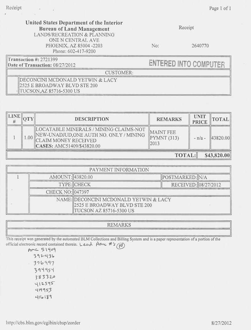
Redeipt . Page 1 of 1
United States Department of the InteriorBureau of Land Management Receipt
LANDS/RECREATION & PLANNINGONE N CENTRAL AVE
PHOENIX, AZ 85004 -2203 No: 2640770Phone: 602-417-9200
Transaction #: 2721399 ENTERED INTO COMPUTERDate of Transaction: 08/27/2012CUSTOMER:
DECONCINI MCDONALD YETWIN & LACY2525 E BROADWAY BLVD STE 200TUCSON,AZ 85716-5300 US
LINE -FERif-1-# QTY DESCRIPTION 1 REMARKS H 11 TOTAL I1~ PRICE ~
lIMAINT FEE INEW-UNADJUD,ONE AUTH NO. ONLY / MINING '1 111.00 6 ||PYMNT (313) ~ - n/a - ~ 43820.00~CASES: AMC51409/$43820.0011CLAIM MONEY RECEIVED ,|2013
PAYMENT INFORMATION1 E-=MOUNT:43826.601POSTMARKED: N/A
NAME: DECONCINI MCDONALD YETWIN & LACY2525 E BROADWAY BLVD STE 200TUCSON AZ 85716-5300 US
REMARKS
This receipt was generated by the automated BLM Collections and Billing System and is a paper representation of a portion of theofficial electronic record contained therein. L.*04 BAL * 5 (ED
ff-4 5 \909391-9363 16 19739995939332.04\2515-41 M 99,3
4t&l11
http://cbs.blm.gov/cgibin/cbsp/zorder 8/27/2012

NOTICE!!
These documents have been scanned!
Do not place un-scanned documents beneath this notice!
Do not remove this notice from this file!
GPO Jacket No. 560-102Print Order 61540
Rise Business Services, LLCJob=AZ15 5/15/2019
I li i Ill I li i I ~1 l illi I il li liul I~i I I H I illBox Number= AZ15053
lillillillillillililillill'11111'll lilillilill'111111111111111111111'lill'lll'llill 111111'llillilillClaim Begin-End: AMC412595-AMC412679
6 Location Notices-Amendments and Supporting Documents
Illl'llilll'll Ilillillilll'll liIll AZ15053-4 AMC412566-AMC413285

A "\1\
MINING CLAIM STATU ~-~EPORTDEC 3 0 2011 n 11
DATAMTP Checked by 4
ENTERED nEr Q A 2011 4 GEO Checked by SEC 3 v_2;11101
LEAD SERIAL NUMBER Wc lAi S«15 thru AMC 51- SEGl___1_# OF CLAIMS & TYPE CHARGES 4
# LODE Location Fee @ $34 = $
# PLACER Processing Fee @ $ 15 = $ 1 175
# ASSOCIATION PLACER Maintenance Fee @ $140 = $ //9 00# MILL SITE
Overage (+) $# TUNNEL SITE
Shortage (-) $Other Fees _$
-TOTAL 1-_LE.0,--6,-,~,-„„,.,-ARE THERE ENOUGH LOCATORS?Yes (f, 1 No( )DOCUMENTS RECEIVED VIA -
nMELY FILED? -
-9*OLECounier {)21 _-Mall E--}- ----- -Yes (>(}- No ( 1.LEGAL DESCRIPION - T. R /65T R SECT R SECT R SECBLM ( ) FOREST SERVICE ( )
SUBJ TO PL 359: Yes C ) No ( 1WILDERNESS AREA: No C } Yes ( )
SPLIT ESTATE - N/A C ) SX C ) PX C ) SRHA C J OTHER ( 1Proper Notice Filed if Located on SHRA Lands? N/A ( 1 Yes ( 1 No ( 1RECONVEYED MINERALS ON BUM LANDS REQUIRE OPENING ORDERS FROM 1944 TO 1993 - --7
2545
Open to Entry on: N/A[ 1-
0
COMMENTS/STATUS - VOID ( } PARTIALLY VOID ( ) PVT MINERALS { } WITHDRAWN LANDS ( }OTHER ( 1 5 /'2/ / 3- 1 21 -2. 19 3- Iq 211
Claimant acknowledges that portions of the following claims(s) site(s) may be void or voldable.
Printed Name of Claimant Signature of Claimant
FINAL ADJUDICATION *.************************DATE ___5-- 22€LL-- INITIALS /

United States Department of the InteriorBureau of Land Management Receipt
LANDS/RECREATION & PLANNINGONE N CENTRAL AVE
PHOENIX, AZ 85004 -2203 No: 2682785Phone: 602-417-9200
Transaction #: 2764276Date of Transaction: 11/01/2012
CUSTOMER:
ELLILLELLLARIZONA MINERALS INC4500 CHERRY CREEKSOUTH DRIVE, STE 1040
DESCRIPTION IREMARKSII 11TOTALI~1 PRICE 11LOCATABLE MINERALS / MINING CLAIMS-NOTNEW-UNADJUD,ONE AUTH NO. ONLY / MINING AMEND I
1 1.00 11 -Wa- 11 430.001 CLAIM MONEY RECEIVED|CASES: AMC383365/$430.00
PAYMENT INFORMATION
~AMOUNT.IR~F----------IEOSTMARKED.11~~~~3F---*E][CHEEK~RECEIVER111/61/2612~
NAME: ARIZONA MINERALS INC4500 CHERRY CREEKSOUTH DRIVE, STE 1040DENVER CO 80246 US
REMARKS
This receipt was generated by the automated BLM Collections and Billing System and is a paper representation of a portion of theofficial electronic record contained therein.
C-Rec4# 80 4 64# A-/Awjb=Ar Amt 3%3365 -368, AfY\ 63*3310,
Am,6 38 337 2, A Re 4125)6 7AAe- 412647 - 6,19 2 ArAC Ltl~,tsct-196

When Filed Return To:AZ MINERALS, INC.
4500 S. CHERRY CREEK DR, SUITE 1040
DENVER, CO 80246
LOCATION NOTICE FOR LODE MINING CLAIM
NOTICE IS HEREBY GIVEN that the SHELL-166 lode mining claim BLMDate
has been located Stamp PHOE;*'IX. A
20 DEC 1 9
B.L 1. AZ ST
i O
F
By: AZ MINERALS, INC.
RECEIV
4500 S. CHERRY CREEK DR, SUITE 1040 ~ F7 F-15 -,1
DENVER, CO 80246PO r-71
The general course of this claim is EAST TO WEST and it is situated in SANTA CRUZ County, Arizona. This claim is 1500
feet in length and 600 feet in width.
This claim runs from the location monument on which this location notice is posted approximately 2Q feet in a
EASTERLY direction to the EAST end line and 1480 feet in a WESTERLY direction to the WEST end line. This claim is
marked by six monuments, one at each corner and one at the center of each end line of the claim.
The location monument on which this notice is posted is situated within Section 2, Township 23 SOUTH, Range 16 EAST,
from the Gila and Salt River Meridian, and this claim encompasses portions of the following quarter section (s), section (s),
Township (s) and Range (s) NW 1 /4 of SECTION 2. T. 235. R.16E. from the Gila and Salt River Meridian, Arizona.
The locality of this claim with reference to some natural object or permanent monument and additional information
(if any) concerning its locality are as follows: THE NORTHEAST CORNER of the claim is located 2612 feet EAST and_
321-feeLSQI!7Hfrom the-SOL]THWEST_Comer-of_Section 35 I. 2283116E f-omthe-Gilaand-Salt RiverMeridian
SANTA CRUZ COUNTY, AZ.
DATED AND POSTED on the ground this ~ 0 day of NDJ , 20 li
f«( Sent 30 NES
r '104125q5AGENT: Darling Environmental & Surveying, Ltd.
9040 South Rita Road, Suite 2350
Tucson, AZ 85747

MINING CLAIM MAPLode (X)
Placer ( )
T 23 S
SHELL 166 SHELL 167 SHELL 210 ' SHELL 211
SHELL 168 SHELL 169 SHELL 212 &
SHELL 170 58ELL 171 SHELL 214 !8 B.L.M.SHELL 216SHELL 172 - 70
Zr 7' 30A m703 SHELL 173 *59%06 ~ r--1 0
40, CO --1 \r,1 77105 SHELL 174 SHELL 21 N * CD 0
HELL 175 N -77--7
107 SHELL 176 #HELL 177 SHELL 21 r N 23ro Fri
1109 SHELL 178 4HELL 179 SHELL 220 SHELL 219
111 SHELL 180 SHELL 181 SHELL 222 SHELL 221
113 ' SHELL 182 SHELL 183 SHELL 224 SHELL 223
1 SHELL 184 HELL 185 SHELL 226 SHELL 225
1. The above map depicts the SHELL 166 mining dalm, which is located in Section (s) 2
4, Township 23.S, Range 16E, Gita and Salt River Meridian, SANTA CRUZ County, Arizona.
2. The type of comer and location monuments used are as follows: 2")(2")(5' WOOD POSTS.
FMC4 2595
3. The bearIngs and distances in degrees and feet between claim corners are as depicted on the map oras stated on page 1 of this notice.
FormMCF100*
Revise ~d July 2005
This form is available from the Arizona De artment of Mine & Mineral Resources mid bir rod

201 -2 --08 3/,3When Filed Return To: Pilge 1 of 2 AlARIZONA MINERALS, INC. -; Requested 891~ona Minerals
SUZANNE SAINZT RECORDER4500 5. CHERRY CREEK DR, SUITE 1040 SANTA CRUZ COUNTY, ARIZONADENVER, CO 80246 10-19-2012 03:52 PM Recording Fee *10.00
AMENDED LOCATION NOTICE FOR LODE MINING CLAIM
NOTICE IS HEREBY GIVEN that the SHELL-167 lode mining claim 03BLM -9BLM serial number, AMC 412596, having an original location date of Date ,- J..
10 NOVEMBER, 2011, as recorded in the office of the County Recorder Sta m p .....-·of Santa Cruz County, State of Arizona, at Reception No. 2012-00378 mhas been AMENDED -71
By: ARIZONA MINERALS, INC.
,\ . 5 TA ff f , FFIC
45005. CHERRY CREEK DR, SUITE 1040
DENVER, CO 80246
The general course of this claim is WEST TO EAST and it is situated in SANTA CRUZ County. Arizona. This claim is 1500
feet in length and 600 feet in width.
This claim runs from the location monument on which this location notice is posted approximately 2Q feet in a
WESTERLY direction to the WEST end line and 1480 feet in a EASTERLY direction to the EAST end line. This claim is
marked by six monuments, one at each corner and one at the center of each end line of the claim.The location monument on which this notice is posted is situated within Section 2, Township 23 SOUTH, Range 16 EAST,
from the Gila and Salt River Meridian, and this claim encompasses portions of the following quarter section (s), section (s),Township (s) and Range (s) NW_1/4&_NE-1/4 of.SECTION 2. T. 222_R.16.E* from the Gila and Salt River Meridian,
Arizona.
The locality of this claim with reference to some natural object or permanent monument and additional information(if any) concerning its locality are as follows:_THENORTHEASTCORNER-oftheclaimislocated_4111 feet FASTand1Qi_feeLSQUI«tifrom»the_SOU-THWEST_Comerof_Section _35 T. 22S. R. I6E fromthe Gilaand Salt Ri,eL.MeridianSANIA-CRUZCOLWTY._AZ.
DATED 24- day of 56 11 , 20 17.
*V
EL//1
5 9
6
Lt -AGENT: Darling Er*ironmental & Surveying, Ltd.9040 Sotith Rita Road, Suite 2350*6 1-2-0,3« Tucson. AZ 85747
FIUT=m=n INTO -rnP'J-! EK

2012-08388_10-19-2012 03:52 PM Page 2 of 2
MINING CLAIM MAPLode (X)
Placer ( )
65 SHELL 166 - SHgLL 167 SHELL 210 | SHELL 211
63 SHELL 168 0 SHELL 169 SHELL 212 CLE 773HS61 SHELL 170 SH~ELL 171 SHELL 214
SHELL 216159 SHELL 172
103 SHELL 1733 1
105 SHELL 174 SHELL 217 ~ 59S ELL 175
.107 SHELL 116 SHELL 177 SHELL 218
109 4 SHELL 178 S ELL 179 SHELL 220 SHELL 219
111 SHELL 180 S~ELL 181 SHELL 222 SHELL 221
113 SHELL 182 S~ELL 183 SHELL 224 SHELL 223
115 SHELL 184 0 SHELL 185 SHELL 226 ~ SHELL 225
1. The above map depicts the SHELL 167 mining claim, which is located in Section (s) 2
4, Township 23S, Range 16E , Gila and Salt River Meridian, SANTA CRUZ County, Arizona.
2. The type of corner and location monuments used are as follows: 232"XS'_WOOD PO-SIS.3. The bearings and distances in degrees and feet between claim corners are as depicted on the map or
as stated on page 1 of this notice.-7-
CD.-..rnCD -.
~5 3:Mgget0 5 INvise• • ,-1> 1 Ju10OO5
Illisformisavailablettomthe-Arizonallenartmento£Mines&Mineral-ResourcesandmaxlmEnrodi2ed

11~ When Filed Return To:AZ MINERALS, INC.
45005. CHERRY CREEK DR, SUITE 1040
DENVER, CO 80246
LOCATION NOTICE FOR LODE MINING CLAIM
NOTICE IS HEREBY GIVEN that the SHELL-167 lode mining claim BLMDate -U
has been located Sta m p31
CD C3By: AZ MINERALS, INC. ;-:1-0
45005. CHERRY CREEK DR, SUITE 1040
AZ STATE OFEC El VED
DENVER, CO 80246 0
r., 03A.) 1 -n
The general course of this claim is WEST TO EAST and it is situated in SANTA CRUZ County, Arizona. This claim is 1500
feet in length and 600 feet in width.
This claim runs from the location monument on which this location notice is posted approximately 2Q feet in a
WESTERLY direction to the WEST end line and 1480 feet in a EASTERLY direction to the EAST end line. This claim is
marked by six monuments, one at each corner and one at the center of each end line of the claim.
The location monument on which this notice is posted is situated within Section 2, Township 23 SOUTH, Range 16 EAST,
from the Gila and Salt River Meridian, and this claim encompasses portions of the following quarter section (s), section (s),
Township (s) and Range (s) NW 1 /4 of SECTION 2, T. 235. R.16E. from the Gila and Salt River Meridian, Arizona.
The locality of this claim with reference to some natural object or permanent monument and additional information
(if any) concerning its locality are as follows:_THE_NORTHEASICORNER of the claim is located 4111 feet FASTanil=
305 feet-SOLE[lifrom the_SQUIHWEST_Comer of_Section_31_I. 22S. R._15E from_the Gila and-Balt-Rirer MendiaIE3 ~SANTA CRUZ COUNTY, AZ.
DATED AND POSTED on the ground this < O day of :VOV ,20 J
11259b
,,
Dgict r r. 4 64
51 -nt J s ve)AGENT: Darling Environmental & Surveying, Ltd.
9040 South Rita Road. Suite 2350
Tucson, AZ 85747

MINING CLAIM MAPLode (X)
Placer ( )
SHELL 166 SHELL 167 SHELL 210 ' SHELL 211
SHELL 168 SHELL 169 SHELL 212
£&2 -113HS
20 DEC
SHELL 170 5~ELL 171 SHELL 214
B.L.9,1.FYICSE'\65
SHELL 216SHELL 172 - ,i
1Z
'103 SHELL 173 ~000
SHELL 174 ~-- - = - SHELL 21 Si ~ i~ 8HELL 175 m
407 SHELL 176 ~HELL 177 SHELL 21 ~
1109 SHELL 178 « ~HELL 179 SHELL 220 SHELL 219
1111 SHELL 180 SHELL 181 SHELL 222 SHELL 221
1113 ' SHELL 182 SHELL 183 SHELL 224 SHELL 223
'115 SHELL 184 HELL 185 SHELL 226 SHELL 225 B MC 25qb
1. The above map depicts the SHELL 167 mining daim, which is located in Section (s) 2
4, Township 235, Range 16E, Gita and Salt River Meridian, SANTA_CRUZ County, Arizona.
2. The type of comer and location monuments used are as follows: 2")(2")(5' WOOD POSTS.
3. The bearings and distances in degrees and feet between daim corners are as depicted on the map oras stated on page 1 of this notice.
FormMCF10Oa
Revised July 2005
'Iltis form is available from the Arizona De artment of Mines & Mineral Resources and r rodu

- Wheil Filed Return To:AZ MINERALS, INC.
4500 S. CHERRY CREEK DR, SUITE 1040
DENVER, CO 80246
LOCATION NOTICE FOR LODE MINING CLAIM 20
B.L.M. AL
-UNOTICE IS HEREBY GIVEN that the SHELL-168 lode mining claim BLMDate CD C-3
has been located -1 - rnStamp 52 -0 31
REQCEIVED
By: AZ MINERALS, INC.25 m
45005. CHERRY CREEK DR, SUITE 1040 140 0M
DENVER, CO 80246
The general course of this claim is EAST TO WEST and it is situated in SANTA CRUZ County, Arizona. This claim is 1500
feet in length and 600 feet in width.
This claim runs from the location monument on which this location notice is posted approximately 2Q feet in a
EASTERLY direction to the EAST end line and 1480 feet in a WESTERLY direction to the WEST end line. This claim is
marked by six monuments, one at each corner and one at the center of each end line of the claim.
The location monument on which this notice is posted is situated within Section 2, Township 23 SOUTH, Range 16 EAST,
from the Gila and Salt River Meridian, and this claim encompasses portions of the following quarter section (s), section (s),
Township (s) and Range (s) NW 1/4 of SECTION 2, T. 235, R.16E, from the Gila and Salt River Meridian, Arizona.
The locality of this claim with reference to some natural object or permanent monument and additional information
(if any) concerning its locality are as follows: THE NORTHEAST CORNER of the claim is located 2618 feet EAST and
921 feet SOUTH from the SOUTHWEST Comer of Section 35, T. 22S, R. 16E, from the Gila and Salt River Meridian,
SANTA CRUZ COUNTY, AZ.
DATED AND POSTED on the ground this L O day of 404 , 20 I f B MC 2591
Li- 1 -
§514 JO des
AGEN ·: Darling Environmental & Surveying, Ltd.
9040 South Rita Road, Suite 2350
Tucson, AZ 85747

' I
MINING CLAIM MAPLode (X)
Placer ( )
0 0 T 235
SHELL 166 SHELL 167 SHELL 210 SHELL 211
SHELL 168 SHELL 169 SHELL 212 ' &
SHELL 170 5~ELL 171 SHELL 214 i % orn
SHELL 172 SHELL 216 [3' c-0
1
REC
EIVED
'103 SHELL 173 ~86
'105 SHELL 174 _ SHELL 21 A 4/N, r
HELL 175
107 SHELL 176 ~HELI- 177 SHELL 21 r
9109 SHELL 178 ~HELL 179 SHELL 220 SHELL 219
1111 SHELL 180 SHELL 181 SHELL 222 SHELL 221
1113 « SHELL 182 SHELL 183 SHELL 224 SHELL 223
'115 SHELL 184 HELL 185 SHELL 226 SHELL 225
1. The above map depicts the SHELL_168 mining claim, which is located In Section (s) 2
4, Township 23S , Range 16E, Gila and Salt River Meridian, SANIA CRUZ County, Arizona.
BMC[ 2591
2. The type of comer and location monuments used are as follows: 2")(2"xs' wOOD POSTS.
3. The bearings and distances in degrees and feet between claim corners are as depicted on the map oras stated on page 1 of this notice.
FormMCF100*
Revised July 2005
Thi,s form is available from the Arizona Deliartment_of_Miltel*Milleral-Rejoureej anfimalbq.mQrodlizd

. When Filed Return To:AZ MINERALS, INC.
4500 S. CHERRY CREEK DR, SUITE 1040
DENVER, CO 80246
LOCATION NOTICE FOR LODE MINING CLAIM 03i-
-0NOTICE IS HEREBY GIVEN that the SHELL-169 lode mining claim BLM I R 42
Date CD CD f\J F17has been located Sta m p -D --...-
By: AZ MINERALS, INC. r-J -n
45005. CHERRY CREEK DR, SUITE 1040 1\) 33f~) ill
DENVER, CO 80246
The general course of this claim is WEST TO EAST and it is situated in SANTA CRUZ County, Arizona. This claim is 1500
feet in length and 600 feet in width.
This claim runs from the location monument on which this location notice is posted approximately 2.Q feet in a
WESTERLY direction to the WEST end line and 1480 feet in a EASTERLY direction to the EAST end line. This claim is
marked by six monuments, one at each corner and one at the center of each end line of the claim.
The location monument on which this notice is posted is situated within Section 2, Township 23 SOUTH, Range 16 EAST,
from the Gila and Salt River Meridian, and this claim encompasses portions of the following quarter section (s), section (s),
Township (s) and Range (s) NE & NW 1/4 of SECTION 2, T. 235, R.16E, from the Gila and Salt River Meridian, ArizoriZ
The locality of this claim with reference to some natural object or permanent monument and additional information ~
(if any) concerning its locality are as follows: THE NORTHEAST CORNER of the claim is located 4118 feet EAST amr
905 feet SOUTH from the SOUTHWEST Comer of Section 35, T. 22S, R. 16E. from the Gila and Salt River Meridi%.
SANTA CRUZ COUNTY, AZ. CO
DATED AND POSTED on the ground this ~~ day of ,01)4 , 20 U
C n
S €176 JovES
AGENT: Darling Environmental & Surveying, Ltd.
9040 South Rita Road, Suite 2350
Tucson, AZ 85747

.
MINING CLAIM MAPLode (X)
Placer ( )T @11 -¥13-5
SHELL 166 SHELL 167 SHELL 210 ' SHELL 211
SHELL 168 SHELL let SHELL 212
SHELL 170 S~ELL 171 SHELL 214 ~ 6&
SHELL 216 ~ 0SHELL 172
rn,
'103 SHELL 173 F~e,5306 bm *
REC
EIVED
i05 SHELL 174 ~- -- - - SHELL 21 N ~jc,i iHELL 175 -4 BJ I
iii r
d 07 SHELL 176 ~HELL 177 SHELL 21 r
1109 SHELL 178 ~HELL 179 SHELL 220 SHELL 219
311 SHELL 180 SHELL 181 SHELL 222 SHELL 221
;113 ' SHELL 182 SHELL 183 SHELL 224 SHELL 223
115 SHELL 184 HELL 185 SHELL 226 SHELL 225
1. The above map depicts the SHELL 169 mining daim, which is located in Section (s) 2 AMC 2598
4, Township 235, Range 162, Gila and Salt River Meridian, SANTA_CRUZ County, Artzona.
2. The type of comer and location monuments used are as follows: 2")(2"XS' WOOD POSTS.
3. The hearings and distances in degrees and feet between claim corners are as depicted on the map oras stated on page 1 of this notice.
FormMCF100*
Revised July 2005
Thi form is available from the Arlzona De artment of Mines & Miner i Resources and ma be

When Filed Return To:AZ MINERALS, INC.
4500 S. CHERRY CREEK DR, SUITE 1040
DENVER, CO 80246
LOCATION NOTICE FOR LODE MINING CLAIM
NOTICE IS HEREBY GIVEN that the SHELL-170 lode mining claim BLM
B.L.M.
Date = .>30has been located Stamp n Fi m
PHOE {IX.
EmBy: AZ MINERALS, INC.
45005. CHERRY CREEK DR, SUITE 1040Wr..) rn
DENVER, CO 80246
The general course of this claim is WEST TO EAST and it is situated in SANTA CRUZ County, Arizona. This claim is 1500
feet in length and 600 feet in width.
This claim runs from the location monument on which this location notice is posted approximately 2Q feet in a
WESTERLY direction to the WEST end line and 1480 feet in a EASTERLY direction to the EAST end line. This claim is
marked by six monuments, one at each corner and one at the center of each end line of the claim.
The location monument on which this notice is posted is situated within Section 2, Township 23 SOUTH, Range 16 EAST,
from the Gila and Salt River Meridian, and this claim encompasses portions of the following quarter section (s), section (s),
Township (s) and Range (s) NW 1 /4 of SECTION 2. T. 235. R.16E. from the Gila and Salt River Meridian, Arizona.
The locality of this claim with reference to some natural object or permanent monument and additional information
(if any) concerning its locality are as follows: THE NORTHEAST CORNER of the claim is located 2625 feet EAST ajl0
1521 feet SOUTH from the SOUTHWEST Corner of Section 35, T. 22S, R. 16E, from the Gila and Salt River Meridian.
SANTACRUZ COUNTLAZ: r\~)'4DATED AND POSTED on the ground this / day of NO V , 20 1/ , an-0
-0
/if «-SETH J.u,Jgs
AGENT: Darling Environmental & Surveying, Ltd.
9040 South Rita Road, Suite 2350
Tucson, AZ 85747

MINING CLAIM MAPLode (X)
Placer ( )
0 0 T23-5
SHELL 166 SHELL 167 SHELL 210 ' SHELL 211
SHELL 168 SHELL 169 SHELL 212
SHELL 170 5~ELL 171 SHELL 214
€KE 773HS
SHELL 216 -'SHELL 172 »
2011-DEC 1 9- A 10:-22
>2ic
'103 SHELL 173 46» 396 / 62 002-1 Umm
'105 SHELL 174 ~- SHELL 21 5 3>W 00HELL 175 d N~
LU
FFICE
'107 SHELL 176 ~HELL 177 SHELL 21 r
1109 SHELL 178 ~HELL 119 SHELL 220 SHELL 219
1111 SHELL 180 SHELL 181 SHELL 222 SHELL 221
1113 « SHELL 182 SHELL 183 SHELL 224 SHELL 223
'115 SHELL 184 HELL 185 SHELL 226 SHELL 225
AIC4 2599
1. The above map depicts the SHELL 170 mining daim, which is located In Section (s) 2
4, Township 233, Range 16E, Gita and Salt River Meridian, SANTA_CRUZ County, Arizona.
2. The type of comer and location monuments used are as follows: 2")(2"XS' WOOD POSTS.
3. The bearings and distances in degrees and feet between claim corners are as depicted on the map oras stated on page 1 of this notice.
FormMCF'100*
Revisedjuty 2005
Thi form is available from the Arizona De artment of Mines & Mineral Resources and be rodu

-When Filed Return To:AZ MINERALS, INC.
4500 S. CHERRY CREEK DR, SUITE 1040
DENVER, CO 80246
LOCATION NOTICE FOR LODE MINING CLAIM
NOTICE IS HEREBY GIVEN that the SHELL-171 lode mining claim BLM CO
Datehas been located Sta m p S fil Um
mBy: AZ MINERALS, INC. Z ID -«[I]
4500 S. CHERRY CREEK DR, SUITE 1040 0N 25
iZ S A.E OFFIC
DENVER, CO 80246 r..3
The general course of this claim is EAST TO WEST and it is situated in SANTA CRUZ County, Arizona. This claim is 1500
feet in length and 600 feet in width.
This claim runs from the location monument on which this location notice is posted approximately 2Q feet in a
EASTERLY direction to the EAST end line and 1480 feet in a WESTERLY direction to the WEST end line. This claim is
marked by six monuments, one at each corner and one at the center of each end line of the claim.
The location monument on which this notice is posted is situated within Section 2, Township 23 SOUTH, Range 16 EAST,
from the Gila and Salt River Meridian, and this claim encompasses portions of the following quarter section (s), section (s),
Township (s) and Range (s) NE & NW 1 /4 of SECTION 2, T. 235, R. 16E, from the Gila and Salt River Meridian, Arizona.
The locality of this claim with reference to some natural object or permanent monument and additional information -0
(if any) concerning its locality are as follows: THE NORTHEAST CORNER of the claim is located 4124 feet EAS'Rand
1504 feet SOUTH from the SOUTHWEST Comer of Section 35 T. 22S R. 16E from the Gila and Salt River Me an
SANTA CRUZ COUNTY, AZ. (3-
DATED AND POSTED on the ground this \ ~ day of NOV , 20 ([ . O
AGENT: Darling Environmental & Surveying, Ltd.
9040 South Rita Road, Suite 2350
Tucson, AZ 85747

MINING CLAIM MAPLode (X)
Placer ( )7- - I -= --
723-5
SHELL 166 SHELL 167 SHELL 210 SHELL 211
SHELL 168 SHELL 169 SHELL 212 ' G
SHELL 170 -5~Lill» SHELL 214 i LU
SHELL 172 1 SHELL 216 e n v
'103 SHELL 173
~05 306 1 B b
REC
EIVED
'105 SHELL 174 - SHELL 21 4/ N
-- -
c CE
HELk 175 t r,+3
2 113HS
'107 SHELL 176 #HELL 177 SHELL 21
&109 SHELL 178 ~HELL 179 SHELL 220 SHELL 219
1 --311 SHELL 180 SHELL 181 SHELL 222 SHELL 221
1113 , SHELL 182 SHELL 183 SHELL 224 SHELL 223
'115 SHELL 184 HELL 185 SHEU 226 SHELL 225
1. The above map depicts the SHELL 171 mining daim, which Is located in Section (s) 2
4, Township 238, Range 16E, Gita and Salt River Meridian, SANTA CRUZ County, Arizona.
2. The type of comer and location monuments used are as follows: 2*X2")(5' WOOD POSTS.
AMCQ Zb 00
3. The bearings and distances in degrees and feet between claim corners are as depicted on the map oras stated on page 1 of this notice.
FormMCF100*
Revised July 2005
This f rm is vailable from the Arizona De artment of Mines & Mineral Resource and be rodu

V\4Men Filed Return To:AZ MINERALS, INC.
4500 S. CHERRY CREEK DR, SUITE 1040
DENVER, CO 80246
LOCATION NOTICE FOR LODE MINING CLAIMCS;r-
NOTICE IS HEREBY GIVEN that the SHELL-172 lode mining claim BLM X-0Date 72 ~ ·.-*. 30has been located n LmStamp
By: AZ MINERALS, INC. " ~ ~-r, r.rl00
4500 S. CHERRY CREEK DR, SUITE 1040 A 5 ~1N Om
DENVER, CO 80246
The general course of this claim is WEST TO EAST and it is situated in SANTA CRUZ County, Arizona. This claim is 1500
feet in length and 600 feet in width.
This claim runs from the location monument on which this location notice is posted approximately 2Q feet in a
WESTERLY direction to the WEST end line and 1480 feet in a EASTERLY direction to the EAST end line. This claim is
marked by six monuments, one at each corner and one at the center of each end line of the claim.
The location monument on which this notice is posted is situated within Section 2, Township 23 SOUTH, Range 16 EAST,
from the Gila and Salt River Meridian, and this claim encompasses portions of the following quarter section (s), section (s),
Township (s) and Range (s) NW 1/4 of SECTION 2, T. 235, R.1 BE. from the Gila and Salt River Meridian, Arizona.
The locality of this claim with reference to some natural object or permanent monument and additional information
(if any) concerning its locality are as follows: THE NORTHEAST CORNER of the claim is located 2630 feet EAST and
2121 feet SOUTH from the SOUTHWEST Corner of Section 35, T. 221 R. 1613, from the Gila and Salt River Meridian,
SANTA CRUZ COUNTY, AZ.
DATED AND POSTED on the ground this ~ day of /\Joe , 20 1 1
AMC412bOSent 30 .vefAGENT: Darling Environmental & Surveying, Ltd.
9040 South Rita Road, Suite 2350
Tucson, AZ 85747

MINING CLAIM MAPLode (X)
Placer ( )
SHELL 166 SHELL 167 SHELL 210 ' SHELL 211
SHELL 168 SHELL 169 SHELL 212 &=1
SHELL 170 5~ELL 171 SHELL 214 !0 i 28UN CS
SHELL 216 g 52 - .FASHELL 172 50
11-24<
'103 SHELL 173 ~es 308 .rn
105 SHELL 174 - - SHELL 21 2 r*J CO g nW ru
HELk 175 Z /,03
107 SHELL 176 ~HELL 177 SHELL 21 I
409 SHELL 178 ~HELL 179 SHELL 220 SHELL 219
1111 SHELL 180 SHELL 181 SHELL 222 SHELL 221
1113 ' SHELL 182 SHELL 183 SHELL 224 SHELL 223
'115 SHELL 184 HELL 185 SHELL 226 SHELL 225
1. The above map depicts the SHELL 172 mining claim, which is located in Section (s) 2
AMC
4, Township 235, Range 16E, Gita and Salt River Meridian, SANTA CRUZ County, Arizona.
2. The type of comer and location monuments used are as follows: 2")(2*XS' WOOD POSTS.PO
3. The bearings and distances in degrees and feet between claim corners are as depicted on the map or 0-as stated on page 1 of this notice. C=>
FormMCF100*
Revised July 2003
Thi form is avail ble from the Arizona De artment of Mine Mineral Resou e and be r roduced

When Filed Return To:AZ MINERALS, INC.
4500 S. CHERRY CREEK DR, SUITE 1040
DENVER, CO 80246
LOCATION NOTICE FOR LODE MINING CLAIM03
NOTICE IS HEREBY GIVEN that the SHELL-173 lode mining claim BLMDate -0has been located Stamp 0
20 DEC
9rnZ
By: AZ MINERALS, INC. >< <
04500 S. CHERRY CREEK DR, SUITE 1040 N 5
, TAT I OFFICE
DENVER, CO 80246 N
The general course of this claim is WEST TO EAST and it is situated in SANTA CRUZ County, Arizona. This claim is 1500
feet in length and 600 feet in width.
This claim runs from the location monument on which this location notice is posted approximately 2Q feet in a
WESTERLY direction to the WEST end line and 1480 feet in a EASTERLY direction to the EAST end line. This claim is
marked by six monuments, one at each corner and one at the center of each end line of the claim.
The location monument on which this notice is posted is situated within Section 2, Township 23 SOUTH, Range 16 EAST,
from the Gila and Salt River Meridian, and this claim encompasses portions of the following quarter section (s), section (s),
Township (s) and Range (s) NW 1 /4 of SECTION 2. T. 23S, R.16E, from the Gila and Salt River Meridian, Arizona.
The locality of this claim with reference to some natural object or permanent monument and additional information
(if any) concerning its locality are as follows: THE NORTHEAST CORNER of the claim is located 2637 feet EAST and
2720-feeLSOLE[ILfromthe_SOIJIHTNEST Comerof.Section 35*I. 221R. 16E fEQmthe-Gila and Salt RiverMeridiSANTA CRUZ COUNTY, AZ.
Adl C 4 1 2 b 0
DATED AND POSTED on the ground this (~ day of Ail O V , 20 1/
M- le--
1711 Jo~25AGENT: Darling Environmental & Surveying, Ltd.
9040 South Rita Road, Suite 2350
Tucson, AZ 85747

MINING CLAIM MAPLode (X)
Placer ( )
€ lE 713H
S®*_7 23 s
SHELL 166 SHELL 167 SHELL 210 ' SHELL 211
SHELL 168 SHELL 169 SHELL 212 v
SHELL 170 S~ELL 171 SHELL 214 0-
0!
SHELL 172 i SHELL 21660 m
0rri
'103 SHEEL t73] - # 308 1 FO --.0
Fl 1-rl0
'105 SHELL 174 -- --- - -- - SHELL 21 R yHELL 175 d
. AZ S 1-\T OFFICE
LU'107 SHELL 176 ®Eli 177 SHELL 21 r
~109 SHELL 178 ~HELL 179 SHELL 220 SHELL 219
311 SHELL 180 SHELL 181 SHELL 222 SHELL 221
5113 ' SHELL 182 SHELL 183 SHELL 224 SHELL 223
'115 SHELL 184 HELL 185 SHELL 226 SHELL 225
AMC 2b02
1. The above map depicts the SHELL_173 mining daim, which is located in Section (s) 2
4, Township 235, Range 16E, Gita and Salt River Meridian, SANIA_CRUZ County, Arizona.
2. The type of corner and location monuments used are as follows: 2"X2")(5' WOOD POSTS.
3. The bearings and distances in degrees and feet between claim corners are as depicted on the map oras stated on page 1 of this notice.
FormMCF100*
Revised July 2005
Tlii form i available from the Arizona De artment of Mine Mineral Resources r r

When Filed Return To:AZ MINERALS, INC.
4500 S. CHERRY CREEK DR, SUITE 1040
DENVER, CO 80246
LOCATION NOTICE FOR LODE MINING CLAIM
NOTICE IS HEREBY GIVEN that the SHELL-174 lode mining claim BLMDate
B.L.M.has been located Stamp 3 00 c-) r<Fl
0By: AZ MINERALS, INC.
4500 S. CHERRY CREEK DR, SUITE 1040N 5
DENVER, CO 80246m
The general course of this claim is WEST TO EAST and it is situated in SANTA CRUZ County, Arizona. This claim is 1500
feet in length and 600 feet in width.
This clfim runs from the location monument on which this location notice is posted approximately 2Q feet in a
WESTERLY direction to the WEST end line and 1480 feet in a EASTERLY direction to the EAST end line. This claim is
marked by six monuments, one at each corner and one at the center of each end line of the claim.
The location monument on which this notice is posted is situated within Section 2, Township 23 SOUTH, Range 16 EAST,
from the Gila and Salt River Meridian, and this claim encompasses portions of the following quarter section (s), section (s),
Township (s) and Range (s) NW 1 /4 of SECTION 2. T. 23S, R.16E. from the Gila and Salt River Meridian, Arizona.
The locality of this claim with reference to some natural object or permanent monument and additional information
(if any) concerning its locality are as follows: THE NORTHEAST CORNER of the claim is located 2644 feet EAST and•
3320-feet-SQUTH_fromthe_SOUTHWEST(ornerof..3.ection--35 T.-225,_R._158-fromthe Gilaand_Salt_River-MeridSANTA CRUZ COUNTY, AZ.
DATED AND POSTED on the ground this #0 day of 6,104 , 20 1(
4 2 b O
Fl1 /
5-el, 3 OBEJAGENT: Darling Environmental & Surveying, Ltd.
9040 South Rita Road, Suite 2350
Tucson, AZ 85747

MINING CLAIM MAPLode (X)
Placer ( )
SHELL 166 SHELL 167 SHELL 210 SHELL 211
SHELL 168 SHELL 169 SHELL 212 1 SO
SHELL 170 5~ELL 171 SHELL 214
REC
EIV-0
~ ~ SHELL 216 _ f_ > . 0 FlSHELL 172
- ' 30 ;8 ¤ 7'103 SHELL 173 #
'105 > SHELL 174 _ SHELL 21 5 W IHELL 175
' 107 SHELL 176 ~HELL 177 SHELL 21 i5
1109 SHELL 178 ~HELL 179 SHELL 220 SHELL 219
111 SHELL 180 SHELL 181 SHELL 222 SHELL 221
1113 ' SHELL 182 SHELL 183 SHELL 224 SHELL 223
'115 SHELL 184 HELL 185 SHELL 226 SHELL 225 AMC 2603
1. The above map depicts the SHELL_174 mining dalm, which Is located in Section (s) 2
4, Township 233, Range 16E, Gila and Salt River Meridian, SANTA CRUZ County, Arizona.
2. The type of comer and location monuments used are as follows: 2"X2"XS' WOOD_ POSTS.
3. The bearings and distances in degrees and feet between claim corners are as depicted on the map oras stated on page 1 of this notice.
FormMCF100*
Refised July 2005
This form is available from the Arizona De artment of Mines & Mineral Resources and U

When Filed Return To:AZ MINERALS, INC.
4500 S. CHERRY CREEK DR, SUITE 1040
DENVER, CO 80246
LOCATION NOTICE FOR LODE MINING CLAIM ~ r
NOTICE IS HEREBY GIVEN that the SHELL-175 lode mining claim BLM 4 >Date
has been located Sta m p
PHOE X AZ
REPEYED
By: AZ MINERALS, INC. 5 71ro
4500 S. CHERRY CREEK DR, SUITE 1040 m
DENVER, CO 80246
The general course of this claim is EAST TO WEST and it is situated in SANTA CRUZ County, Arizona. This claim is 1500
feet in length and 300 feet in width.
This claim runs from the location monument on which this location notice is posted approximately 21 feet in a
EASTERLY direction to the EAST end line and 1480 feet in a WESTERLY direction to the WEST end line. This claim is
marked by six monuments, one at each corner and one at the center of each end line of the claim.
The location monument on which this notice is posted is situated within Section 2, Township 23 SOUTH, Range 16 EAST,
from the Gila and Salt River Meridian, and this claim encompasses portions of the following quarter section (s), section (s),
Township (s) and Range (s) NE_& NW 1 /4 of SECTION 2. T. 235. R.16E. from the Gila and Salt River Meridian, Arizona.
The locality of this claim with reference to some natural object or permanent monument and additional information
(if any) concerning its locality are as follows:_THENORTHEAST_CORNER-ofthe claimis located 4147 feet EASTand
3604_feet SQUTH_fmmithe_SQUTHTNEST_Comer-of_Section 35*T. 223*1L168_frgmithe.Gilaand Salt_RiverMeridian
SANIA_CRUZ-COUNTY_AZ.
DATED AND POSTED on the ground this 3 6- day of 2)60 . 20 /C
~-f-fz.#1'4 --2< AW 91\ <0 4/
AMC 4 2 6 0 4
AGENT: Darling Environmental & Surveying, Ltd.
9040 South Rita Road, Suite 2350
Tucson, AZ 85747

MINING CLAIM MAPLode (X)
Placer ( )
SHELL 166 SHELL 167 SHELL 210 ' SHELL 211
SHELL 168 SHELL 169 SHELL 212
SHELL 170 5~ELL 171 SHELL 214
etz 775#GEN X-,-A
2011- DEC 19
SHELL 172 SHELL 216
, RFCS,~ED
'103 SHELL 173Bj
105 SHELL 174 SHELL 21 Li. P.9Uls Z
-gLZ 113HS
'107 SHELL 176 ~HELL 177 SHELL 21
5109 SHELL 178 ~HELL 179 SHELL 220 SHELL 219
111 SHELL 180 SHELL 181 SHELL 222 SHELL 221
113 ' SHELL 182 SHELL 183 SHELL 224 SHELL 223
'115 SHELL 184 HELL 185 SHELL 226 SHELL 225
1. The above map depicts the SHELL-315 mining daim, which is located In Section (s) 2
4, Township US, Range 16E, Gita and Salt River Meridian, SANTACRUZ County, Arizona.
A £ C 2504
2. The type of comer and location monuments used are as follows: 2*)(2")(5' WOOD POSTS.
3. The bearings and distances in degrees and feet between claim corners are as depicted on the map oras stated on page 1 of this notice.
FormMCF10{)a
Revised July 2005
This form i available from the Arizona De artment of Mine & Mineral Reso item and ma¥ r

Whenliled Return To:AZ MINERALS, INC.
4500 S. CHERRY CREEK DR, SUITE 1040
DENVER, CO 80246
LOCATION NOTICE FOR LODE MINING CLAIM 20 DECNOTICE IS HEREBY GIVEN that the SHELL-176 lode mining claim BLM DJ
Date Nfri
has been located Sta m p 6 m
PHOEI X
By: AZ MINERALS, INC. ~ 7-17,4500 S. CHERRY CREEK DR, SUITE 1040 3mDENVER, CO 80246
The general course of this claim is EAST TO WEST and it is situated in SANTA CRUZ County, Arizona. This claim is 1500
feet in length and 600 feet in width.
This claim runs from the location monument on which this location notice is posted approximately 2Q feet in a
EASTERLY direction to the EAST end line and 1480 feet in a WESTERLY direction to the WEST end line. This claim is
marked by six monuments, one at each corner and one at the center of each end line of the claim.
The location monument on which this notice is posted is situated within Section 2, Township 23 SOUTH, Range 16 EAST,
from the Gila and Salt River Meridian, and this claim encompasses portions of the following quarter section (s), section (s),
Township (s) and Range (s) NW 1 /4 of SECTION 2. T. 235. R.16E. from the Gila and Salt River Meridian, Arizona.
The locality of this claim with reference to some natural object or permanent monument and additional information
(if any) concerning its locality are as follows: THE NORTHEAST CORNER of the claim is located 2650 feet EAST and
3921-feet SQUIHitomithe SQUTINEST.Comerof.Section_35_T. 223,_R~_16E_fj=~the Gilaand aalt-RiverMeridian_
SANTA CRUZ COUNTY. AZ. ZE.
DATED AND POSTED on the ground this 14 day of NOV , 20 1 ~ . c-42-
>0Cr(]Z>C-Jl
SWTH Jo,defAGENT: Darling Environmental & Surveying, Ltd.
9040 South Rita Road, Suite 2350
Tucson, AZ 85747

MINING CLAIM MAPLode (X)
Placer ( )
SHELL 166 SHELL 167 SHELL 210 SHELL 211
SHELL 168 SHELL 169 SHELL 212
SHELL 170 *ELL 171 SHELL 214 9
ELE -113HS *14
I.1 rSHELL 216 @ 0
SHELL 172
f. CEI \,/ ED703 SHELL 173 ~0306
SHELL 174 - SHELL 21 Mi f ElsHELL 175
'107 -SHBrr796 ~HELL 177 SHELL 21 r
1109 SHELL 178 ~HELL 179 SHELL 220 SHELL 219
1111 SHELL 180 SHELL 181 SHELL 222 SHELL 221
0113 * SHELL 182 SHELL 183 SHELL 224 SHELL 223
'115 SHELL 184 HELL 185 SHELL 226 SHELL 225
1. The above map depicts the SHELL.116 mining daim, which is located in Section (s) 2
AMC 2605
4, Township 215, Range 16E , Gila and Salt River Meridian, SANTA-CRUZ County, Arizona.
2. The type of comerand location monuments used are as follows: 27275' WOOD_POSIS.
3. The bearings and distances in degrees and feet between claim corners are as depicted on the map oras stated on page 1 of this notice.
FormMCF10()a
Revised July 2005
Ibii.frmilvlablfrm-th-Adzona-lleding[!LofMingLAMingrLBenr

Wheltfiled Return To:AZ MINERALS, INC.
4500 S. CHERRY CREEK DR, SUITE 1040
DENVER, CO 80246
LOCATION NOTICE FOR LODE MINING CLAIM
NOTICE IS HEREBY GIVEN that the SHELL-177 lode mining claim BLM CO
Date
Ai E OFFIC
has been located Stam p :I TR -» ..JOm 0
By: AZ MINERALS, INC. ES ..0 51[54<
4500 S. CHERRY CREEK DR, SUITE 1040 0N 25
DENVER, CO 80246 re
The general course of this claim is WEST TO EAST and it is situated in SANTA CRUZ County, Arizona. This claim is 1500
feet in length and 600 feet in width.
This claim runs from the location monument on which this location notice is posted approximately 2fl feet in a
WESTERLY direction to the WEST end line and 1480 feet in a EASTERLY direction to the EAST end line. This claim is
marked by six monuments, one at each corner and one at the center of each end line of the claim.
The location monument on which this notice is posted is situated within Section 2, Township 23 SOUTH, Range 16 EAST,
from the Gila and Salt River Meridian, and this claim encompasses portions of the following quarter section (s), section (s),
Township (s) and Range (s) NEANZ/ 1/4 of SECTION 2, T. 235, R.16E from the Gila and Salt River Meridian, Arizona.>
The locality of this claim with reference to some natural object or permanent monument and additional information
(if any) concerning its locality are as follows: THENORTHEAST.CORNERoftheclaimislocated 4150_feeLEASTan
MC 4.J 2 03905.-feeLSQUIHImmthe_SOCJTHWEST_Comerof-Section 35 _T. 221-L168 &0m the Gilaand-Salt River Meridi
SANTA-CRUZCQUATILAZ. 0-
DATED AND POSTED on the ground this ~t~ day of No J , 20 U
581\1 JogefAGENT: Darling Environmental & Surveying, Ltd.
9040 South Rita Road, Suite 2350
Tucson, AZ 85747

E--
-
MINING CLAIM MAPLode (X)
Placer ( )
SHELL 166 SHELL 167 SHELL 210 SHELL 211
SHELL 168 SHELL 169 SHELL 212 2 0-1
- 305%' M -496SHELL 170 5~ELL 171 SHELL 214 55 --r *mSHELL 216 -0 242
SHELL 172 1--rl m
P 003>
9903 SHELL 173 ~ 306 1 008
FFICE
6'LU
tu'105 SHELL 174 SHELL 21 ZHELL- 175
912 113HS
<107 SHELL.176 #HELL 177 SHELL 21
1109 SHELL 178 ~HELL 179 SHELL 220 SHELL 219
1 3~111 SHELL 180 SHELL 181 SHELL 222 SHELL 221
&113 ' SHELL 182 SHELL 183 SHELL 224 SHELL 223
'115 SHELL 184 HELL 185 SHELL 226 SHELL 225
1. The above map depicts the SHELL 177 mining claim, which is located in Section (s) 2
4, Township 235, Range 16E, Gila and Salt River Meridian, SANTA CRUZ County, Arizona.
AMC 4 2 b O b2. The type of comer and location monuments used are as follows: 2")(2"XS' WOOD_POSTS.
3. The bearings and distances in degrees and feet between claim corners are as depicted on the map oras stated on page 1 of this notice.
FormMCF1008
Revised July 2005
Thi form is available from the Arizona De ent of Mines & Mineral Resoums and be

2012·-08 --9When Filed Return To:ARIZONA MINERALS, INC. Re~uested By:-~~|~-|-z~ona Minerals4500 S. CHERRY CREEK DR, SUITE 1040 SUZANNE SAINZ, RECORDERDENVER, CO 80246 SANTA CRUZ COUNTY, ARIZONA
10-19-2012 03:52 PM Recording Fee $10.00
AMENDED LOCATION NOTICE FOR LODE MINING CLAIMCIJ
NOTICE IS HEREBY GIVEN that the SHELL-178 lode mining claim BLM Z0 -.BLM serial number, AMC 412607, having an original location date of Date raZ ·- 6 23
Eli NOV
14 NOVEMBER, 2011, as recorded in the office of the County Recorder Stamp >< . '.'.) Tof Santa Cruz County, State of Arizona, at Reception No. 2012-00389 ]> --has been AMENDED
i..4e mFl
By: ARIZONA MINERALS, INC.
4500 S. CHERRY CREEK DR, SUITE 1040
DENVER, CO 80246
The general course of this claim is EAST TO WEST and it is situated in SANTA CRUZ County, Arizona. This claim is 1500feet in length and 600 feet in width.This claim runs from the location monument on which this location notice is posted approximately 2Q feet in aEASTERLY direction to the EAST end line and 1480 feet in a WESTERLY direction to the WEST end line. This claim ismarked by six monuments, one at each corner and one at the center of each end line of the claim.The location monument on which this notice is posted is situated within Section 2, Township 23 SOUTH, Range 16 EAST,from the Gila and Salt River Meridian, and this claim encompasses portions of the following quarter section (s), section (s),Township (s) and Range (s) NW 1/4 and the SW 1/4 QLSECTION-2J1-23S _R.lfiE: from the Gila and Salt River Meridian,Arizona.
The locality of this claim with reference to some natural object or permanent monument and additional information(if any) concerning its locality are as follows:_THE_NORTHEASTCORNER.of the claimislocated 2657-fedEASTand4520 feet S.OUTEif[Qmthe_SQUIHWESTCgmerof-Section liT._221-R. 16E_fmmithe_Gilaand-Salt RiverMeridianSANTA-CRUZ_COUNIYAZ.DATED AND POSTED on the ground this 2 42 day of __SE f , 20 1 2_
CK-2 10- a /2.12-is 9040 S~th Rita Road, Suite 2350
AGENT/Dartingfnvironmental & surveying, Ltd.
Tucson, AZ 85747
/1401

2012-083Ii 1 11 -19-2012 03:52 PM Page 2 of 2
MINING CLAIM MAPLode (X)
Placer ( )
/2)
65 SHELL 166 SHELL 167 SHELL 210 | SHELL 211
63 SHELL 168 SHELL 169 SHELL 212 £12 113HS!61 SHELL 170 SH~ELL 171 SHELL 214
SHELL 216159 ~ SHELL 172
103 ~ SHELL 173
105 SHELL 174 SHELL 217 lin toS ELL 175 N 4
'LU
107 SHELL 176 S~ELL 177 SHELL 218 I
. 109 ~_SHELL 178 S ELL 179 SHELL 220 0 SHELL 219
111 SHELL 180 S~ELL 181 SHELL 222 SHELL 221 }
113 SHELL 182 S~ELL 183 SHELL 224 SHELL 223
115 SHELL 184 SHELL 185 SHELL 226 SHELL 225
1. The above map depicts the SHELL 178 mining claim, which is located in Section (s) 2
4, Township 233, Range 16E , Gila and Salt River Meridian, SANTA CRUZ County, Arizona.
2. The type of corner and location monuments used are as follows: 2"X2")<5' WOOD POSTS. r-* 13. The bearings and distances in degrees and feet between claim corners are as depicteen th€*lap.or
.as stated on page 1 of this notice. 1,1 CkL-5 5... L
PF
1.-'
·x , rl S00
0 F*}n«41. -3> M?CFMa
IrRevise
d July 2005Illisformisavailableitomthe ArizonaIZeuartinento£Mines&-MineralResgurcesandma_bereroduced

' WI~n Filed Return To: ./AZ MINERALS, INC.
4500 S. CHERRY CREEK DR, SUITE 1040
DENVER, CO 80246
LOCATION NOTICE FOR LODE MINING CLAIM N
1 FFICE
NOTICE IS HEREBY GIVEN that the SHELL-178 lode mining claim BLM 0rnDate SH
has been located Sta m p >< HZmmCD 0
By: AZ MINERALS, INC. N 0
W4500 S. CHERRY CREEK DR, SUITE 1040
DENVER, CO 80246
The general course of this claim is EAST TO WEST and it is situated in SANTA CRUZ County, Arizona. This claim is 1500
feet in length and 600 feet in width.
This claim runs from the location monument on which this location notice is posted approximately 2Q feet in a
EASTERLY direction to the EAST end line and 1480 feet in a WESTERLY direction to the WEST end line. This claim is
marked by six monuments, one at each corner and one at the center of each end line of the claim.
The location monument on which this notice is posted is situated within Section 2, Township 23 SOUTH, Range 16 EAST,
from the Gila and Salt River Meridian, and this claim encompasses portions of the following quarter section (s), section (s),
Township (s) and Range (s) NW 1 /4 of SECTION 2. T. 235. R.1 BE~ from the Gila and Salt River Meridian, Arizona.
The locality of this claim with reference to some natural object or permanent monument and additional information
AM 42601
(if any) concerning its locality are as follows:.THE-NORTHEASICORNER ofthe claimis located 2657-feet EAST-£2
4520.-feet-SOUTILf[om the SOUTHWEST-Comer_of_Section 35 .T. 228 «R.16E k0m the Gila and Salt River Meri
SANTACRUZ_COUNILAZ.DATED AND POSTED on the ground this 14 day of NOW , 20 1 1
52-11+ 30,de jAGENT: Darling Environmental & Surveying, Ltd.
9040 South Rita Road, Suite 2350
Tucson, AZ 85747

-
MINING CLAIM MAPLode (X)
Placer ( )
® 0 T 23-5
SHELL 166 SHELL 167 SHELL 210 SHELL 211 B.L.M,
SHELL 168 SHELL 169 SHELL 212 &3 21 8~ i<[!]SHELL 170 S~ELL 171 SHELL 214 !8 4' Z Elim
1 --4 'KSHELL 216 7 mm
SHELL 172 E ooNOI~
0
103 SHELL 173 1 w rn
'105 SHELL 174 - SHELL 21HELL 175 2
9% 113H
S
-m
'107 SHELL 176 ~HELL 177 SHELL 21
1109 SHELL 178 ' ~HELL 119 SHELL 220 SHELL 219
'111 SHELL 180 SHELL 181 SHELL 222 SHELL 221
1113 « SHELL 182 SHELL 183 SHELL 224 SHELL 223
' 115 SHELL 184 HELL 185 SHELL 226 SHELL 225
1. The above map depicts the SHELL 178 mining claim, which is located in Section (s) 2
Af C 4 2 b 0 1
4, Township 23S, Range 16E, Gila and Salt River Meridian, SANTAC_RUZ County, Arizona.
2. The type of comer and location monuments used are as follows: 2*X2*XS' WOOD POSTS.
3. The bearings and distances in degrees and feet between claim corners are as depicted on the map oras stated on page 1 of this notice.
FormMCF1008
Revised July 2003
Tlds form is available from the Arizona D artment of Mines & Min ral Resource and ma r rodu

2012--Cm.S'-"~4.IWhen Filed Return To: Page 1 of 1 - -ARIZONA MINERALS, INC. Requested By >~ | ~ ona Minerals4500 S. CHERRY CREEK DR, SUITE 1040 SUZANNE SAINZ, RECORDERSANTA CRUZ COUNTY, ARIZONADENVER, CO 80246 10-19-2012 03:52 PM Recording Fee $10.00
AMENDED LOCATION NOTICE FOR LODE MINING CLAIM
NOTICE IS HEREBY GIVEN that the SHELL-179 lode mining claim BLM r-BLM serial number, AMC 412608, having an original location date of Date I0
14 NOVEMBER, 2011, as recorded in the office of the County Recorder Sta m p rilof Santa Cruz County, State of Arizona, at Reception No. 2012-00390 ><
1011 NOV - 1 Ahas been AMENDED '..
R·CEIVED
NBy: ARIZONA MINERALS, INC. 2 5
> W4500 S. CHERRY CREEK DR, SUITE 1040
DENVER, CO 80246
The general course of this claim is WEST TO EAST and it is situated in SANTA CRUZ County, Arizona. This claim is 1500feet in length and 600 feet in width.This claim runs from the location monument on which this location notice is posted approximately 2Q feet in aWESTERLY direction to the WEST end line and 1480 feet in a EASTERLY direction to the EAST end line. This claim ismarked by six monuments, one at each corner and one at the center of each end line of the claim.The location monument on which this notice is posted is situated within Section 2, Township 23 SOUTH, Range 16 EAST,from the Gila and Salt River Meridian, and this claim encompasses portions of the following quarter section (s), section (s),Township (s) and Range (s) h[EllELSE_114 SYY_1/4 & NYL*Lof-SECTION_LT. 23S R.16E from the Gila and Salt RiverMeridian, Arizona.
The locality of this claim with reference to some natural object or permanent monument and additional information(if any) concerning its locality are as follows: THE_NORTHEAST_CORNER»of the_claim-is_located 4156_feet-EAST-and- 14504_feet SOLEriLfromthe-SQUIHTNEST_Comer_of-Section 35 1.223*IL_1*E_fmmthe-GilaandBall«River_MeridianSANTACRIZCQUNIYAZ.DATED AND POSTED ontheground this __26 day of__ 5Ef_-,20 iL .
<1
ENT=o An INTO COMP" ]TEE AGENT: rling E vironmental & Surveying, Ltd.9040 South Rita Road, Suite 2350
1 9'(06%
2 (26 / 2617_ '(-5 Tucson, AZ 85747

2012-1)83~~~19-2012 03:52 PM Page -' of 2-
MINING CLAIM MAPLode (X)
Placer ( )
3)65 SHELL 166 SH~LL 167 SHELL 210 | SHELL 211
63 SHELL 168 SHELL 169 SHELL 212 CLZ 113HS,61 SHELL 170 SlyLL 171 SHELL 214
SHELL 216159 SHELL 172
103 SHELL 173 0
105 SHELL 174 SHELL 217 'd 15 -9S ELL 175 101 <
.107 SHELL 176 S~ELL 177 SHELL 218 r
109 SHELL 178 S ELL 179 SHELL 220 . SHELL 219 s
111 SHELL 180 S~ELL 181 SHELL 222 SHELL 221
113 SHELL 182 S~ELL 183 SHELL 224 SHELL 223 0-0
115 SHELL 184 SHELL 185 SHELL 226 SHELI~5 >-/
- - 3] a1. The above map depicts the SHELL 179 mining claim, which is located in Section (s) 2 E 4.<*<1
4, Township 23S, Range 16E , Gila and Salt River Meridian, SANTA CRUZ County, Ar izg~. _ 5~}~;Z 9 77
2. The type of corner and location monuments used are as follows: 2")<2")<5' WOOD POSSS. w 25- cn rri
3. The bearings and distances in degrees and feet between claim corners are as depicted on the map oras stated on page 1 of this notice.
FormMCF100a
Revised July 2005
Thisfonnisavailablefromthe_ArizonalleRartinentof_Mines-*MineraLResourcesandmaberenroduced

· When Filed Return To: ~AZ MINERALS, INC.
4500 S. CHERRY CREEK DR, SUITE 1040
DENVER, CO 80246
LOCATION NOTICE FOR LODE MINING CLAIM
NOTICE IS HEREBY GIVEN that the SHELL-179 lode mining claim BLMDate
has been located Stamp
PHOENIX. AZ
20 DEC 19 A 10
B. L A
Z., ATE OFFICER
E°6IV
EDBy: AZ MINERALS, INC.
4500 S. CHERRY CREEK DR, SUITE 1040
DENVER, CO 80246 W
The general course of this claim is WEST TO EAST and it is situated in SANTA CRUZ County, Arizona. This claim is 1500
feet in length and 600 feet in width.
This claim runs from the location monument on which this location notice is posted approximately 21 feet in a
WESTERLY direction to the WEST end line and 1480 feet in a EASTERLY direction to the EAST end line. This claim is
marked by six monuments, one at each corner and one at the center of each end line of the claim.
The location monument on which this notice is posted is situated within Section 2, Township 23 SOUTH, Range 16 EAST,
from the Gila and Salt River Meridian, and this claim encompasses portions of the following quarter section (s), section (s),
Township (s) and Range (s) NE & NW 1 /4 of SECTION 2. T. 235. R.16E. from the Gila and Salt River Meridian, Arizona.
The locality of this claim with reference to some natural object or permanent monument and additional information
(if any) concerning its locality are as follows: THE NORTHEAST CORNER of the claim is located 4156 feet EAST and
4504 feet SOUTH from the SOUTHWEST Corner of Section 35, T. 22S, R. 168, from the Gila and Salt River Meridian,
SANTA CRUZ COUNTY, AZ. b--1.
DATED AND POSTED on the ground this \,4 day of NO~ , 20 ~ ~ . 0
\ k,4 1 -
i.vi1
0CO
Sent Jo Ne)AGENT: Darling Environmental & Surveying, Ltd.
9040 South Rita Road, Suite 2350
Tucson, AZ 85747

MINING CLAIM MAPLode (X)
Placer ( )
® s _f_TY-SSHELL 166 SHELL 167 SHELL 210 ~ SHELL 211
SHELL 168 SHELL 169 SHELL 212 Sd
SHELL 170 S~ELL 171 SHELL 214 ~
SHELL 216 0
201 DEC 19
9
SHELL 172 , I
E.903 SHELL 173 ~55 306
REC
EIVED
'105 SHELL 174 - - - SHELL 21 A W NHELL 175 d AwU.1
[107 SHEU 176 ~HELL 177 SHELL 21 ~
~109 SHELL 178 ~HELL 179- SHELL 220 SHELL 219
311 SHELL 180 SHELL 181 SHELL 222 SHELL 221
113 ' SHELL 182 SHELL 183 SHELL 224 SHELL 223
'115 SHELL 184 HELL 185 SHELL 226 SHELL 225
1. The above map depicts the SHELL 179 mining daim, which is located in Section (s) 2
4, Township 235, Range 16E, Gita and Salt River Meridian, SANTA CRUZ County, Arizona. -)CD
2. The type of comer and location monuments used are as follows: 2")(2")<5' WOOD POSTS. -=
3. The bearings and distances in degrees and feet between claim corners are as depicted on the map or 1\0as stated on page 1 of this notice. cr
CDCO
FormMCF1008
Revised July 2003
This f rm is av 'table fr m the na De artment of Min & Mineral Resour es and r u
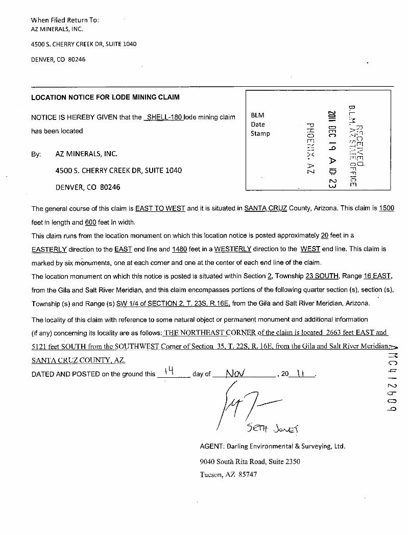
When Filed Return To:AZ MINERALS, INC.
4500 S. CHERRY CREEK DR, SUITE 1040
DENVER, CO 80246
LOCATION NOTICE FOR LODE MINING CLAIM
NOTICE IS HEREBY GIVEN that the SHELL-180 lode mining claim BLM rDate -0
has been located Sta m p o -p,E-1I = n>mm ;.CD
-0By: AZ MINERALS, INC. :< a<
0045005. CHERRY CREEK DR, SUITE 1040 0 4
70 0
DENVER, CO 80246 w m
The general course of this claim is EAST TO WEST and it is situated in SANTA CRUZ County, Arizona. This claim is 1500
feet in length and 600 feet in width.
This claim runs from the location monument on which this location notice is posted approximately 2Q feet in a
EASTERLY direction to the EAST end line and 1480 feet in a WESTERLY direction to the WEST end line. This claim is
marked by six monuments, one at each corner and one at the center of each end line of the claim.
The location monument on which this notice is posted is situated within Section 2, Township 23 SOUTH, Range 16 EAST,
from the Gila and Salt River Meridian, and this claim encompasses portions of the following quarter section (s), section (s),
Township (s) and Range (s) SW 1/4 of SECTION 2. T. 235. R.16E. from the Gila and Salt River Meridian, Arizona.
The locality of this claim with reference to some natural object or permanent monument and additional information
(if any) concerning its locality are as follows:_TUE NORTHEAST CORNER of the claim is located 2663 feet EAST and
5121_feeLSQUILfmmthe-SOUTHWESTComerof Section 35 _I. 22S R._168,-fmmthe Gilaand-Salt River«Meridiana>
SANTACRUZ_COIINTYAZ. -I.
0
DATED AND POSTED on the ground this fl-1 day of NOU , 20 \1 . 4=
47- EM5 ent .6.42<
AGENT: Darling Environmental & Surveying, Ltd.
9040 South Rita Road, Suite 2350
Tucson, AZ 85747

MINING CLAIM MAPLode (X)
Placer ( )-r T 235
SHELL 166 SHELL 167 SHELL 210 ' SHELL 211
B.L.M.SHELL 168 SHELL 169 SHELL 212 '
SHELL 170 S~ELL 171 SHELL 214 ' f 't ./O
LE 3H m >-
Nrc
AmSHELL 172 SHELL 216 --1 -\
CD 0iN 71
'103 SHELL 173 i M 25q
m
'105 SHELL 174 - ~ - - - -SHELL 21 R ~HELL 175 3
107 SHELL 176 ~HELL 177 SHELL 21 5
1109 SHELL 178 ~HELL 179 SHELL 220 SHELL 219
1111 SHELL 180 SHELL 181 SHELL 222 SHELL 22111
1113 . SHELL 182 SHELL 183 SHELL 224 SHELL 223
115 SHELL 184 HELL 185 SHELL 226 SHELL 225
1. The above map depicts the SHELL 180 mining daim, which is located in Section (s) 2
4, Township 235, Range 16E, Gita and Salt River Meridian, SANTACRUZ County, Arizona.
AMC 2609
2. The type of comer and location monuments used are as follows: 2")(2"XS' WOOD POSTS.
3. The bearings and distances in degrees and feet between claim corners are as depicted on the map oras stated on page 1 of this notice.
FormMCF1008
Revised July 2003
This_formis ayailable from the Arizona Denartment of Mines & Mineral Resources_and_may-be-ret*odt=d

When Filed Return To:AZ MINERALS, INC.
4500 S. CHERRY CREEK DR, SUITE 1040
DENVER, CO 80246
LOCATION NOTICE FOR LODE MINING CLAIM
NOTICE IS HEREBY GIVEN that the SHELL-181 lode mining claim BLMDate
PHOEH X
201 DEC
9 A 10
B.L.M. AZ STATE
FFICE
has been located Stamp
RECEIVE
By: AZ MINERALS, INC. 00
45005. CHERRY CREEK DR, SUITE 1040 r.)
DENVER, CO 80246
The general course of this claim is WEST TO EAST and it is situated in SANTA CRUZ County, Arizona. This claim is 1500
feet in length and 600 feet in width.
This claim runs from the location monument on which this location notice is posted approximately 2Q feet in a
WESTERLY direction to the WEST end line and 1480 feet in a EASTERLY direction to the EAST end line. This claim is
marked by six monuments, one at each corner and one at the center of each end line of the claim.
The location monument on which this notice is posted is situated within Section 2, Township 23 SOUTH, Range 16 EAST,
from the Gila and Salt River Meridian, and this claim encompasses portions of the following quarter section (s), section (s),
Township (s) and Range (s) SE_& -SW 1 /4 of SECTION 2. T. 235. R.16E. from the Gila and Salt River Meridian, Arizona.
The locality of this claim with reference to some natural object or permanent monument and additional information
(if any) concerning its locality are as follows: THE NORTHEAST CORNER of the claim is located 4163 feet EAST and
5105 feeLSQUTH-fmm the SOLITINEST_Comerof Section 35 I. 2283L_thE,_fmm the Gilaand Salt River-Meridian
SANTA CRUZ COUNTY, AZ.
DATED AND POSTED on the ground this 14 day of NOW , 20 \-1
(n
AMC[12510Y Ent -jo>.,4-AGENT: Darling Environmental & Surveying, Ltd.
9040 South Rita Road, Suite 2350
Tucson, AZ 85747

MINING CLAIM MAPLode (X)
Placer ( )
-r ®CD --T 23«_
SHELL 166 SHELL 167 SHELL 210 SHELL 211 B.L.. 4,-SHELL 168 SHELL 169 SHELL 212 ' A 0
RE/CSE~1
SHELL 170 S~ELL 171 SHELL 214 ~ ,mmPSHELL 216 00
SHELL 172 -77
1 306CD
'103 SHELL 173 ~000
105 SHELL 174 « SHELL 21 R ~ 1HELL 175
407 SHELL 176 ~HELL 177 SHELL 21 r
109 SHELL 178 ~HELL 179 SHELL 220 SHELL 219
1 1' 111 SHELL 180 SHELL 181 SHELL 222 SHELL 221
1113 ' SHELL 182 SHELL 183 SHELL 224 SHELL 223
'115 SHELL 184 HELL 185 SHELL 226 SHELL 225
1. The above map depicts the SHELL_181 mining dalm, which is located in Section (s) 2
4, Township BS, Range 16E, Gita and Salt River Meridian, SANTA CRUZ County, Arizona. AMC 26
0
2. The type of comer and location monuments used are as follows: 2')(2"XS' WOOD POSIS.
3. The bearings and distances in degrees and feet between claim corners are as depicted on the map oras stated on page 1 of this notice.
FormMCF1008
Revised July 2005
This form is available from the Arizona De artment of Mines & Mineral Resources and m rodu

When'Filed Return To:AZ MINERALS, INC.
4500 S. CHERRY CREEK DR, SUITE 1040
DENVER, CO 80246
LOCATION NOTICE FOR LODE MINING CLAIM 20 DEC
B.L FFICE
-0NOTICE IS HEREBY GIVEN that the SHELL-182 lode mining claim BLM --»71Date 6 A (71has been located Sta m p =
-0 24<r- 3> rn mBy: AZ MINERALS, INC. >-00
N CP4500 S. CHERRY CREEK DR, SUITE 1040 N
W
DENVER, CO 80246
The general course of this claim is EAST TO WEST and it is situated in SANTA CRUZ County, Arizona. This claim is 1500
feet in length and 600 feet in width.
This claim runs from the location monument on which this location notice is posted approximately 2Q feet in a
EASTERLY direction to the EAST end line and 1480 feet in a WESTERLY direction to the WEST end line. This claim is
marked by six monuments, one at each corner and one at the center of each end line of the claim.
The location monument on which this notice is posted is situated within Section 2, Township 23 SOUTH, Range 16 EAST,
from the Gila and Salt River Meridian, and this claim encompasses portions of the following quarter section (s), section (s),
Township (s) and Range (s) SW 1/4 of SECTION 2. T. 235. R.16E. from the Gila and Salt River Meridian, Arizona.
The locality of this claim with reference to some natural object or permanent monument and additional information
(if any) concerning its locality are as follows: THE NORTHEAST CORNER ofthe claim is located 2669 feet EAST and
5720_feeLSQUIJifkomthe SQUIHWEST.Comer-of-SectionliT. 22LL16Ezfromthe-GilaandSalt_River_MeridianSANTA CRUZ COUNTY, AZ.
DATED AND POSTED on the ground this 1 4 day of AIDV , 20 1 /
4f-
AMC412b
S Ellf :jo.u€jAGENT: Darling Environmental & Surveying, Ltd.
9040 South Rita Road, Suite 2350
Tucson, AZ 85747

MINING CLAIM MAPLode (X)
Placer ( )-r @ (D __ T 23-5
SHELL 166 SHELL 167 SHELL 210 SHELL 211€KE 113H
S
B.L.M.
OFFICE
SHELL 168 SHELL 169 SHELL 2120~ ~/SHELL 170 SNELL 171 SHELL 214 ~
SHELL 216 4<SHELL 172 > > Ag
'103 SHELL 173
'105 SHELL 174 - <- SHELL 21HELL- 175
SH
113HS
~107 SHELL 176 4HELL 177 SHELL 21
109 SHELL 178 ~HELL 179 SHELL 220 SHELL 219
~ 111 SHELL 180 SHELL 181 SHELL 222 SHELL 221
1113 ~ SHELL 182« SHELL 183 SHELL 224 SHELL 223
'115 SHELL 184 HELL 185 SHELL 226 SHELL 225
1. The above map depicts the SHELL_182 mining claim, which is located in Section (s) 2
4, Township 23$, Range 16E, Gita and Salt River Meridian, SANTA CRUZ County, Arizona.
2. The type of comer and location monuments used are as follows: 2*)(2"XS' WOOD POSTS. 30
3. The bearings and distances in degrees and feet between claim corners are as depicted on the map oras stated on page 1 of this notice.
X)CD-
FormMCF100,I
Revised July 2005
Thi form is available from the Arizona De artment of Min & Mineral Resources and m ru

' When Filed Return To: ~AZ MINERALS, INC.
4500 S. CHERRY CREEK DR, SUITE 1040
DENVER, CO 80246
LOCATION NOTICE FOR LODE MINING CLAIM
NOTICE IS HEREBY GIVEN that the SHELL-183 lode mining claim BLM -E
20 DEC
9
B.L AZ
OFFICE
Date -7- Dhas been located Stamp rn -0
tkBy: AZ MINERALS, INC. ~ I., F~|
CJ5
4500 S. CHERRY CREEK DR, SUITE 1040W
DENVER, CO 80246
The general course of this claim is WEST TO EAST and it is situated in SANTA CRUZ County, Arizona. This claim is 1500
feet in length and 600 feet in width.
This claim runs from the location monument on which this location notice is posted approximately 2Q feet in a
WESTERLY direction to the WEST end line and 1480 feet in a EASTERLY direction to the EAST end line. This claim is
marked by six monuments, one at each corner and one at the center of each end line of the claim.
The location monument on which this notice is posted is situated within Section 2, Township 23 SOUTH, Range 16 EAST,
from the Gila and Salt River Meridian, and this claim encompasses portions of the following quarter section (s), section (s),
Township (s) and Range (s) SE_&_SMY_1/4 of SECTION 2 T. 23LE.16E: from the Gila and Salt River Meridian, Arizona.
The locality of this claim with reference to some natural object or permanent monument and additional information
(if any) concerning its locality are as follows:_THE_NORTHEAST_CORNERoftheclaimislogated__4170 feet_EASTand
5795_-feer SQUIH fromthe-SQUTHWESI C.ornerof-Section_3131_225,«L*E fromthe Gilaand Salt River-kieridian
SANIA-CRUZ_COUNIYAZ.
DATED AND POSTED on the ground this 1 9 day of NOV , 20 1 1
1.,«// , ANC 4 1 2 b1* 1 8 *f Af-*011 co I Sn# S ~e)AGENT: Darling Environmental & Surveying, Ltd.
:\09040 South Rita Road, Suite 2350
Tucson, AZ 85747

When Filed Return To:AZ MINERALS, INC.
4500 S. CHERRY CREEK DR, SUITE 1040
DENVER, CO 80246
LOCATION NOTICE FOR LODE MINING CLAIM
NOTICE IS HEREBY GIVEN that the SHELL-184 lode mining claim BLMDate -'
has been located Sta m p I = 10 (1 -;imm O
By: AZ MINERALS, INC. E Z =R
45005. CHERRY CREEK DR, SUITE 1040 00
A .S,AT
FFIC
DENVER, CO 80246 N
The general course of this claim is EAST TO WEST and it is situated in SANTA CRUZ County, Arizona. This claim is 1500
feet in length and 600 feet in width.
This claim runs from the location monument on which this location notice is posted approximately 2Q feet in a
EASTERLY direction to the EAST end line and 1480 feet in a WESTERLY direction to the WEST end line. This claim is
marked by six monuments, one at each corner and one at the center of each end line of the claim.
The location monument on which this notice is posted is situated within Section 2, Township 23 SOUTH, Range 16 EAST,
from the Gila and Salt River Meridian, and this claim encompasses portions of the following quarter section (s), section (s),
Township (s) and Range (s) SW 1 /4 of SECTION 2. T. 235. R.16E, from the Gila and Salt River Meridian, Arizona.
The locality of this claim with reference to some natural object or permanent monument and additional information
(if any) concerning its locality are as follows:_THE-NORTHEASTCORNER-ofthedaimis located-2676 feet EASTand
6320.feeLSOUTH from-the.SQUIHWESTComerof-Section 35 T._223 -R.16Ezfrom»the_Gilaand Salt River Meridian
SANTACRUZCOUNTLAZ.
DATED AND POSTED on the ground this 1 4 day of A)0 4 , 20 1 f
MC412613
AGENT: Darling Environmental & Surveying, Ltd.
9040 South Rita Road, Suite 2350
Tucson, AZ 85747

I I
MINING CLAIM MAPLode (X)
Placer ( )
SHELL 184 ~HELL 185 SHELL 226 SHELL 225
SHELL 186 ~HELL 187 SHELL 228 SHEL6227
2 1 ,-r11189 SHELL-2
R~C
EIVED
SHELL 190 ~SHELL 191 SHELL 232 ' SHEL~231r.4
. FFICE
SHELL 192 SHELL 193 SHELL 234' SHELL 233
SHELL 194 SHELL 195 SHELL 236 SHELL 235
SHELL 196 ISHELL 197 SHELL 238 SHELL 237
SHELL 198 SHELL 199 SHELL 240, SHELL 239
SHELL 200 1 SHELL 201 SHELL 242 SHELL 241
SHELL 202 ~ SHELL 203 SHELL 244 SHELL 243
SHELL 204 ~ SHELL 205 SHELL 24« SHELL 245L_
1. The above map depicts the SHELL_184 mining dalm, which is located In Section (s) 2
4, Township 23S, Range 16E , Glla and Salt River Meridian, SANTA CRUZ County, Artzona.
2. The type of comer and location monuments used are as follows: 27275' WOOD_POSTS.
3. The bearings and distances in degrees and feet between claim corners are as depicted on the map or
A (4
26
as stated on page 1 of this notice.
L.UForm
MCFIOOaRevise
d July 2005Ibifimailehommnalleadmnt[Min-Min

Wh# Filed Return To:AZ MINERALS, INC.
4500 S. CHERRY CREEK DR, SUITE 1040
DENVER, CO 80246
LOCATION NOTICE FOR LODE MINING CLAIM
NOTICE IS HEREBY GIVEN that the SHELL-185 lode mining claim BLMDate
B.L 1. S ATE OFFIC
has been located Sta m p ISO -7n 0
By: AZ MINERALS, INC.
45005. CHERRY CREEK DR, SUITE 1040 >N
DENVER, CO 80246 r.)
The general course of this claim is WEST TO EAST and it is situated in SANTA CRUZ County, Arizona. This claim is 1500
feet in length and 600 feet in width.
This claim runs from the location monument on which this location notice is posted approximately 22 feet in a
WESTERLY directiori to the WEST end line and 1480 feet in a EASTERLY direction to the EAST end line. This claim is
marked by six monuments, one at each corner and one at the center of each end line of the claim.
The location monument on which this notice is posted is situated within Section 2, Township 23 SOUTH, Range 16 EAST,
from the Gila and Salt River Meridian, and this claim encompasses portions of the following quarter section (s), section (s),
Township (s) and Range (s) SE&_S~1/4 of SECTION 2. T. 235, R.16E, from the Gila and Salt River Meridian, Arizona.
The locality of this claim with reference to some natural object or permanent monument and additional information
(if any) concerning its locality are as follows:_THE NORTHEAST CORNER of the claim is located 4176 feet EAST and
6304 feet SQUTH-frgmthe SOUTHWEST-Cgmer_of-Section 33 T. 221116E ftomjthe Gilaand Salt_Rive[Meridian,~
SANTA.CRUZCQUIVTYAZ.
DATED AND POSTED on the ground this i4 day of NOV , 20 I 1
MC412614
hi.*- T jO #Ef-AGENT: Darling Environmental & Surveying, Ltd.
9040 South Rita Road, Suite 2350
Tucson, AZ 85747

. 4
MINING CLAIM MAPLode (X)
Placer ( )
SHELL 184 ~HELL 185 SHELL 226 SHELL 225
SHELL 186 ~ HELL 187 SHELL 228 SHELL 227
*Elr 158 - - »EL-188 SHELL- 2 12 * SHEEL- B.L.M.
SHELL 190 ~SHELL 191 SHELL 232 ' SHELL 23} cmCO i=41 rl
SHELL 192 ~SHELL 193 SHELL 234' SHELL 233 ~m-4<r-r; f-rlCO
SHELL 194 SHELL 195 SHELL 236 SHELL 235 -n-
(D
SHELL 196 ISHELL 197 SHELL 238' SHELL 237 r m
SHELL 198 SHELL 199 SHELL 240, SHELL 239
SHELL 200 1 SHELL 201 SHELL 242 SHELL 241
SHELL 202 ~ SHELL 203 SHELL 244 SHELL 243
SHELL 204 SHELL 205 SHELL 244 SHELL 245
1. The above map depicts the SHELL_185 mining claim, which is located in Section (s) 2
A 04
2b4, Township 238, Range 16E , Gila and Salt River Meridian, SANTA CRUZ County, Arlzona.
2. The type of comer and location monuments used are as follows: 2")(2*)(5' WOOD POSTS.
3. The bearings and distances in degrees and feet between claim comets are as depicted on the map or „=as stated on page 1 of this notice.
FormMCF10()a
Revised July 2005
Th~ablefrom_ike_A*-na--De-Dartment_of«Mha_&-Mi~*Remourtemandmal!&Ignmsttlggd

When 1:iled Return To:AZ MINERALS, INC.
4500 S. CHERRY CREEK DR, SUITE 1040
DENVER, CO 80246
LOCATION NOTICE FOR LODE MINING CLAIM 20 DEC
q A IO
NOTICE IS HEREBY GIVEN that the SHELL-186 lode mining claim BLM -uDate 0has been located Sta m p rn
By: AZ MINERALS, INC.
4500 S. CHERRY CREEK DR, SUITE 1040rn
DENVER, CO 80246
The general course of this claim is EAST TO WEST and it is situated in SANTA CRUZ County, Arizona. This claim is 1500
feet in length and 600 feet in width.
This claim runs from the location monument on which this location notice is posted approximately 2Q feet in a
EASTERLY direction to the EAST end line and 1480 feet in a WESTERLY direction to the WEST end line. This claim is
marked by six monuments, one at each corner and one at the center of each end line of the claim.
The location monument on which this notice is posted is situated within Section 2, Township 23 SOUTH, Range 16 EAST,
from the Gila and Salt River Meridian, and this claim encompasses portions of the following quarter section (s), section (s),
Township (s) and Range (s) SW 1/4 of SECTION 2, T. 235. R.16E, from the Gila and Salt River Meridian, Arizona.
The locality of this claim with reference to some natural object or permanent monument and additional information
(if any) concerning its locality are as follows:_THENORTHEASTCORNER-oftheclaimislocated_2682 feet EAST_and6920_feet SQUIELfromthe-SQUIENESTComer-ofSection 35 -T. 221£3*E kgmithe GilaandSall.River.Meridian
SANTACRUZCQUEY-AZ.DATED AND POSTED on the ground this 19 day of A/OU , 20 1[ =CD
.-'
Ul
5 ent joyrfAGENT: Darling Environmental & Surveying, Ltd.
9040 South Rita Road, Suite 2350
Tucson, AZ 85747

.
MINING CLAIM MAPLode (X)
Placer ( )
SHELL 184 #HELL 185 SHELL 226 SHELL 225
SHELL 186 ~HELL 187 SHELL 228 SHELL 227
*FiELE 88 -- --~HE117189 SHEtl- 2 1 © SHE'%30
SHELL 190 ~SHELL 191 SHELL 232 ' SHE{11 231
EC
E'X
ED
.SHELL 192 iSHELL 193 SHELL 234 ' SHE§L 233
SHELL 194 ISHELL 195 SHELL 236 ' SHELL 235
SHELL 196 ISHELL 197 SHELL 238' SHELL 237
SHELL 198 SHELL 199 SHELL 240, SHELL 239
SHELL 200 ~ SHELL 201 SHELL 242' SHELL 241
SHELL 202 j SHELL 203 SHELL 244 SHELL 243
SHELL 204 ~ SHELL 205 SHELL 244 SHELL 245 AMCI 261. The above map depicts the SHELL 188 mining daim, which is located in Section (s) 2
4, Township 23S, Range 16E , Gila and Salt River Meridian, SANTA CRUZ County, Arizona.
2. The type of comer and location monuments used are as follows: 2»XFXS' WOOD PQSIS. cn
3. The bearings and distances in degrees and feet between daim corners are as depicted on the map oras stated on page 1 of this notice.
FormMCF100a
Revised July 2005
11!isformisavailablefromth Arizonal}maitmentoLMinm.AMineralgemurtemandmabemmdj=d

When KTed Return To:AZ MINERALS, INC.
4500 S. CHERRY CREEK DR, SUITE 1040
DENVER, CO 80246
LOCATION NOTICE FOR LODE MINING CLAIM B.L.M.NOTICE IS HEREBY GIVEN that the SHELL-187 lode mining claim BLMDate -U
has been located Stamp CD n N f.,1n; , 1 C-)
Li mBy: AZ MINERALS, INC. >< 42
C04500 S. CHERRY CREEK DR, SUITE 1040 NO 47
1\0 CDm
DENVER, CO 80246
The general course of this claim is WEST TO EAST and it is situated in SANTA CRUZ County, Arizona. This claim is 1500
feet in length and 600 feet in width.
This claim runs from the location monument on which this location notice is posted approximately 2Q feet in a
WESTERLY direction to the WEST end line and 1480 feet in a EASTERLY direction to the EAST end line. This claim is
marked by six monuments, one at each corner and one at the center of each end line of the claim.
The location monument on which this notice is posted is situated within Section 2, Township 23 SOUTH, Range 16 EAST,
from the Gila and Salt River Meridian, and this claim encompasses portions of the following quarter section (s), section (s),
Township (s) and Range (s) SE & SW 1 /4 of SECTION 2. T. 235. R.16E, from the Gila and Salt River Meridian, Arizona.
The locality of this claim with reference to some natural object or permanent monument and additional information
(if any) concerning its locality are as follows:_THE-NORTHEAST_CORNER.of-iheclaimislocated 4182®eLEASTand
6904 feeLSQUIH fromthe_SOUTHWEST-Comerof_Section 35*I. 228_B._16E flom the Gila_and-Salt River«Meridian*.
SANTACRUZ-COUNTYAZ.DATED AND POSTED on the ground this N day of kj'OV , 20 (1 .
AMC412bl,§2 13 Jve,AGENT: Darling Environmental & Surveying, Ltd.
cr 19040 South Rita Road, Suite 2350
Tucson, AZ 85747

MINING CLAIM MAPLode (X)
Placer ( )
SHELL 184 ~HELL 185 SHELL 226 SHELL 225
SHELL 186 ~HELL 187 SHELL 228 SHELL 227
-S-REEL= 188 -- »Elrl 89 SHELL- 2 2 * SHELL-
B.L.!·1.~fz°ifd
SHELL 190 ~SHELL 191 SHELL 232 SHEL431 R- -01
SHELL 192 ~SHELL 193 SHELL 234' SHELU233 - ~1~ rri m-0 00
SHELL 194 SHELL 195 SHELL 236 SHELL 235 r~~i ~m
SHELL 196 ISHELL 197 SHELL 238' SHELL 237
SHELL 198 ! SHELL 199 SHELL 240 SHELL 239
SHELL 200 1 SHELL 201 SHELL 242' SHELL 241
SHELL 202 ~ SHELL 203 SHELL 244 SHELL 243
SHELL 204 ~ SHELL 205 SHELL 2461 SHELL 245
1. The above map depicts the SHELL 18_7 mining claim, which is located in Section (s) 2 AMC
4, Township 235, Range 16E, Gila and Salt River Meridian, SANTA CRUZ County, Arizona.
2. The type of comer and location monuments used are as follows: 27275' WOOD POSTS.
3. The bearings and distances in degrees and feet between claim corners are as depicted on the map orCD-
as stated on page 1 of this notice.CD-
FormMCF100*
Revised July 2003
This form i vailable from the Arizona De artment of Mines & Min ral Res ur es an ma odu

When Filed Return To: ,AZ MINERALS, INC.
4500 5. CHERRY CREEK DR, SUITE 1040
DENVER, CO 80246
LOCATION NOTICE FOR LODE MINING CLAIM 20 DEC
B.L.M. ANOTICE IS HEREBY GIVEN that the SHELL-188 lode mining claim BLM -0
Date CD 1--4
RECEIhas been located 1-71 _ u)Sta m p E a E<By: AZ MINERALS, INC. 00
4500 5. CHERRY CREEK DR, SUITE 1040 N nm
DENVER, CO 80246
The general course of this claim is EAST TO WEST and it is situated in SANTA CRUZ County, Arizona. This claim is 1500
feet in length and 600 feet in width.
This claim runs from the location monument on which this location notice is posted approximately 2Q feet in a
EASTERLY direction to the EAST end line and 1480 feet in a WESTERLY direction to the WEST end line. This claim is
marked by six monuments, one at each corner and one at the center of each end line of the claim.
The location monument on which this notice is posted is situated within Section 11, Township 23 SOUTH, Range 16
EAST, from the Gila and Salt River Meridian, and this claim encompasses portions of the following quarter section (s),
section (s), Township (s) and Range (s) SW 1/4 of SECTION 2. & NW 1/4 of SECTION 11. T. 235. R.16E, from the Gila
and Salt River Meridian, Arizona.
The locality of this claim with reference to some natural object or permanent monument and additional information
(if any) concerning its locality are as follows: IHE_NORTHEAST CORNER ofthe claim is located 2689 feet EAST and=Z
752Lfeet-SOUTH_fmmthe-SOL{TH-WEST_Comerof_Section 35 T. 22S R. 16E ftomthe Gilaand_Salt River MeridiSANTA CRUZ COUNTY. AZ.
(12611DATED AND POSTED on the ground this l'-1 day of Abu '20 1 ~
AGENT: Darling Environmental & Surveying, Ltd.
9040 South Rita Road, Suite 2350
Tucson, AZ 85747

MINING CLAIM MAPLode (X)
Placer ( )
SHELL 184 ~HELL 185 SHELL 226 SHELL 225
SHELL 186 ~HELL 187 SHELL 228 SHELL 2271
2 1 211-189 SHELL: 2
-n3>IS
SHELL 190 ~SHELL 191 SHELL 232 ' SHEL~31 0,Fl
24<SHELL 192 SHELL 193 SHELL 234 ' SHEI*»233 · m
CO-71
SHELL 194 SHELL 195 SHELL 236 SHELL 235
SHELL 196 ISHELL 197 SHELL 238' SHELL 237
SHELL 198 ~ SHELL 199 SHELL 240, SHELL 239
SHELL 200 1 SHELL 201 SHELL 242 SHELL 241
SHELL 202 j SHELL 203 SHELL 244 SHELL 243
SHELL 204 i SHELL 205 SHELL 244 SHELL 245
1. The above map depicts the SHELL_188 mining daim, which Is located in Section (s) 2 & 11
ANC 4 2 b
4, Township 21S, Range 162, Gila and Salt River Meridian, SANTA CRUZ County, Arizona.
2. The type of comer and location monuments used are as follows: 27275' WOOD POSIS.
3. The bearings and distances in degrees and feet between claim corners are as depicted on the map oras stated on page 1 of this notice. -J
FormMCF10{)a
Revisedjttly 2005
Thi form is available from the Arizona De artment of Mines & Mineral Resource m be r rodu

Wifen Fited Return To:AZ MINERALS, INC.
4500 S. CHERRY CREEK DR, SUITE 1040
DENVER, CO 80246
LOCATION NOTICE FOR LODE MINING CLAIM B.L 1, A i„ - -
FFICE
NOTICE IS HEREBY GIVEN that the SHELL-189 lode mining claim BLM 3)Date Fl0has been located Stamp 1-1 n =5{
3 _DX
By: AZ MINERALS, INC. *.- p 00CD
45005. CHERRY CREEK DR, SUITE 1040 r.,
DENVER, CO 80246
The general course of this claim is WEST TO EAST and it is situated in SANTA CRUZ County, Arizona. This claim is 1500
feet in length and 600 feet in width.
This claim runs from the location monument on which this location notice is posted approximately 2Q feet in a
WESTERLY direction to the WEST end line and 1480 feet in a EASTERLY direction to the EAST end line. This claim is
marked by six monuments, one at each corner and one at the center of each end line of the claim.
The location monument on which this notice is posted is situated within Section 11, Township 23 SOUTH, Range 16
EAST, from the Gila and Salt River Meridian, and this claim encompasses portions of the following quarter section (s),
section (s), Township (s) and Range (s) SE & SW 1 /4 of SECTION 2, and the NE & NW of SECTION 11, T. 235, R.16E,
from the Gila and Salt River Meridian, Arizona.
The locality of this claim with reference to some natural object or permanent monument and additional information -ZCD
(if any) concerning its locality are as follows: THE NORTHEAST CORNER ofthe claim is located 4189 feet EAST and mr
7504 feet SQUIH fromthe SQUIHWEST-Comer-of*ection 35 _I. 22S _R.16Edromthe Gilaand*alt«RiverMeridia43
SANTA CRUZ_COUNTYAL (0--
DATED AND POSTED on the ground this N day of NO\J , 20.11 (DO
1 /1./1 ' 1~x-561:¥ l>,wG f
AGENT: Darling Environmental & Surveying, Ltd.
9040 South Rita Road, Suite 2350
Tucson, AZ 85747

I .
MINING CLAIM MAPLode (X)
Placer ( )
SHELL 184 ~HELL 185 SHELL 226 SHELL 225
SHELL 186 ~HELL 187 SHELL 228 SHELL 227
- SFIELE TBB - - --~FIT-189 SHEtt- 2 1 SHEEL-0 0
B.L.M.
-0
SHELL 190 ~HELL 191 SHELL 232 SHE.4831 M %#
SHELL 192 ISHELL 193 SHELL 234' SHELL~33 ~ ~
SHELL 194 SHELL 195 SHELL 236' SHELL 2350m
SHELL 196 1 SHELL 197 SHELL 238' SHELL 237
SHELL 198 SHELL 199 SHELL 240, SHELL 239
SHELL 200 1 SHELL 201 SHELL 242 SHELL 241
SHELL 202 SHELL 203 SHELL 244' SHELL 243
SHELL 204 ~ SHELL 205 SHELL 244 SHELL 245
1. The above map depicts the SHELL-189 mining claim, which is located In Section (s) 2 & 11
4, Township 235, Range 16E , Glla and Salt River Meridian, SANTA CRUZ County, Arizona.
2. The type of comer and location monuments used are as follows: 2D(2*)(5' WOOD POSTS.
3. The bearings and distances in degrees and feet between claim comets are as depicted on the map oras stated on page 1 of this notice.
AMC4 2 b
Form coMCF1008
Revised July 2003
IlliformisaxglablefromtheMzonilleartmentoLMillem&MineraiRENourtemimdmbermdu

Wh@n Filed Return To:AZ MINERALS, INC.
4500 S. CHERRY CREEK DR, SUITE 1040
DENVER, CO 80246
LOCATION NOTICE FOR LODE MINING CLAIM 20 DEC
B.L RA-7-ESTikfFo
-i
NOTICE IS HEREBY GIVEN that the SHELL-190 lode mining claim BLM -0
Date CDm mhas been located Sta m p Z
By: AZ MINERALS, INC. 72.
4500 S. CHERRY CREEK DR, SUITE 1040 0r m
DENVER, CO 80246
The general course of this claim is EAST TO WEST and it is situated in SANTA CRUZ County, Arizona. This claim is 1500
feet in length and 600 feet in width.
This claim runs from the location monument on which this location notice is posted approximately 2Q feet in a
EASTERLY direction to the EAST end line and 1480 feet in a WESTERLY direction to the WEST end line. This claim is
marked by six monuments, one at each corner and one at the center of each end line of the claim.
The location monument on which this notice is posted is situated within Section 11, Township 23 SOUTH, Range li
EAST, from the Gila and Salt River Meridian, and this claim encompasses portions of the following quarter section (s),
section (s), Township (s) and Range (s) NW 1/4 of SECTION 11, T. 235, R.16E, from the Gila and Salt River Meridian,~:»
Arizona.
MC41The locality of this claim with reference to some natural object or permanent monument and additional information
(if any) concerning its locality are as follows: THE NORTHEAST CORNER of the claim is located 2696 feet EAST aN0--
8121.fggLSQIJI[LfrgmlkSQIZIEIWESI-Cgmg_gf_8£gljgL31I_22i_LlSEJmmths~QjlfL=LS~11.Rjyg~*[gridi~_-0
SANTA CRUZ COUNTY, AZ.
DATED AND POSTED on the ground this I lA day of kbU , 20 ! ~
52111 Jowe 1-AGENT: Darling Environmental & Surveying, Ltd.
9040 South Rita Road, Suite 2350
Tucson, AZ 85747

u .
MINING CLAIM MAPLode (X)
Placer ( )
SHELL 184 ~HELL 185 SHELL 226 SHELL 225
SHELL 186 ~HELL 187 SHELL 228 SHELL 227
SRECE 158 - - »Ell-189 SHELL- 2 1- (0 SH=-
SHELL 190 ~HELL 191 SHELL 232 ' SHELL 23
RBf'
. ---- --- 1 f.:i<SHELL 192 ~S HELL 193 SHELL 234 ' SHELL 23$> rrn
SHELL 194 SHELL 195 SHELL 236 SHELL 2* ~
SHELL 196 SHELL 197 SHELL 238' SHELL 237
SHELL 198 SHELL 199 SHELL 240 SHELL 239
SHELL 200 1 SHELL 201 SHELL 242t SHELL 241
SHELL 202 l SHELL 203 SHELL 244 SHELL 243
SHELL 204 ~ SHELL 205 SHELL 24« SHELL 245
1. The above map depicts the SHELL_193 mining daim, which is located in Section (s) 11
4, Township 235, Range 16E, Gila and Salt River Meridian, SANTA CRUZ County, Arizona.
AMC4 26
9
2. The type of comer and location monuments used are as follows: 2*X215' WOOD POSTS.
3. The bearings and distances in degrees and feet between claim corners are as depicted on the map oras stated on page 1 of this notice.
FormMCF100a
Revised July 2005
This f rm is vailable from th Ariz na De artment of Mines & Mineral Resourc a m r U

Vphen Filed Return To:AZ MINERALS, INC.
4500 S. CHERRY CREEK DR, SUITE 1040
DENVER, CO 80246
LOCATION NOTICE FOR LODE MINING CLAIM 20
B.L.M. AZNOTICE IS HEREBY GIVEN that the SHELL-191 lode mining claim BLM IE R 30
Date ED r,has been located Stamp
By: AZ MINERALS, INC. 00NOE]
4500 5. CHERRY CREEK DR, SUITE 1040 r.) CDr Fri
DENVER, CO 80246
The general course of this claim is WEST TO EAST and it is situated in SANTA CRUZ County, Arizona. This claim is 1500
feet in length and 600 feet in width.
This claim runs from the location monument on which this location notice is posted approximately 2Q feet in a
WESTERLY direction to the WEST end line and 1480 feet in a EASTERLY direction to the EAST end line. This claim is
marked by six monuments, one at each corner and one at the center of each end line of the claim.
The location monument on which this notice is posted is situated within Section 11, Township 23 SOUTH, Range 16
EAST, from the Gila and Salt River Meridian, and this claim encompasses portions of the following quarter section (s),
section (s), Township (s) and Range (s) NE & NW of SECTION 11, T. 235, R.16E, from the Gila and Salt River Meridian
Arizona.
.AM C 4 1The locality of this claim with reference to some natural object or permanent monument and additional information
(if any) concerning its locality are as follows: THE NORTHEAST CORNER ofthe claim is located 4196 feet EAST andr~
8104 feet SOUTH from the SOUTHWEST Corner of Section 35, T. 223, R. 168, from the Gila and Salt River Meridia<
SANTA CRUZ COUNTY, AZ. CD
DATED AND POSTED on the ground this 1 H day of AJOV , 20 1/
~/fr' 4 - /<
AGENT: Darling Environm@ntal & Surveying, Ltd.
9040 South Rita Road, Suite 2350
Tucson, AZ 85747

'.
MINING CLAIM MAPLode (X)
Placer ( )
SHELL 184 ~HELL 185 SHELL 226 SHELL 225
SHELL 186 ~HELL 187 SHELL 228 SHELL 227
13-RELE 158 - - -L-189 - SHEtt- 2 SHEI=L- F'#
1@ 0
B.L 1.
SHELL 190 ~SHELL. 191 SHELL 232 ' SHELl-231 ~ .~r-:7 55
SHELL 192 ~SHELL 193 SHELL 234' SHELL 233 4<rn m00
SHELL 194 SHELL 195 SHELL 236 SHELC235 m
SHELL 196 SHELL 197 SHELL 238 SHELL 237
SHELL 198 SHELL 199 SHELL 240' SHELL 239
SHELL 200 ~ SHELL 201 SHELL 242' SHELL 241
SHELL 202 1 SHELL 203 SHELL 244' SHELL 243
SHELL 204 ~ SHELL 205 SHELL 24« SHELL 245 AMC
1. The above map depicts the SHELL 191 mining claim, which is located in Section (s) 11
4, Township 235, Range 16E, Gila and Salt River Meridian, SANIA-CRUZ County, Arizona. crr..0
2. The type of comer and location monuments used are as follows: 2")(2")(5' WOOD POSTS. O
3. The bearIngs and distances in degrees and feet between claim corners are as depicted on the map oras stated on page 1 of this notice.
FormMCF100*
Revisedjuty 2005
This f rm is available from the Arizona De artment of Mines & Mineral Resource an m rodu

-When Filed Return To:AZ MINERALS, INC.
4500 S. CHERRY CREEK DR, SUITE 1040
DENVER, CO 80246
LOCATION NOTICE FOR LODE MINING CLAIM CD
NOTICE IS HEREBY GIVEN that the SHELL-192 lode mining claim BLM .1 nDate I
has been located 0
20 DEC
9 A
Sta m p m 0
XBy: AZ MINERALS, INC. nm
00N 5
4500 S. CHERRY CREEK DR, SUITE 1040
. AZ S AT- FFICE
DENVER, CO 80246
The general course of this claim is EAST TO WEST and it is situated in SANTA CRUZ County, Arizona. This claim is 1500
feet in length and 600 feet in width.
This claim runs from the location monument on which this location notice is posted approximately 2Q feet in a
EASTERLY direction to the EAST end line and 1480 feet in a WESTERLY direction to the WEST end line. This claim is
marked by six monuments, one at each corner and one at the center of each end line of the claim.
The location monument on which this notice is posted is situated within Section 11, Township 23 SOUTH, Range 16
EAST, from the Gila and Salt River Meridian, and this claim encompasses portions of the following quarter section (s),
section (s), Township (s) and Range (s) NW 1 /4 of SECTION 11, T. 235, R.16E, from the Gila and Salt River Meridian,
Arizona.
The locality of this claim with reference to some natural object or permanent monument and additional information
(if any) concerning its locality are as follows: THE NORTHEAST CORNER of the claim is located 2702 feet EAST and
8721 feet SOUTH from the SOUTHWEST Corner of Section 35, T. 22S, R. 16E, from the Gila and Salt River Meridian,
SANTA CRUZ COUNTY. AZ.
DATED AND POSTED on the ground this 1 7 day of NOV , 20.11 AMC Icr
AGENT: Darling Environmental & Surveying, Ltd. i\0i /
9445-SButh Rita Road, Suite 2350
Tucson, AZ 85747
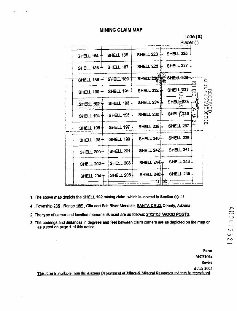
I .
MINING CLAIM MAPLode (X)
Placer ( )
SHELL 184 ~HELL 185 SHELL 226 SHELL 225
SHELL 186 ~HELL 187 SHELL 228 SHELL 227
3HECE 158 -- -*Ell-189 SHEEL: 2 1 ~ SHEEL- CJ
SHELL 190 ~HELL 191 SHELL 232 SHELL@31 ~: SJ.0-- C. i.4
SHELL 192 ~SHELL 193 SHELL 234' SHEL12233 3 :-4 '_1C<mm
SHELL 194 SHELL 195 SHELL 236 6 SHELE*35 - 51 0-3-
N CD
SHELL 196 1 SHELL 197 SHELL 238 j SHELL 237 r m
SHELL 198 SHELL 199 SHELL 240' SHELL 239
SHELL 200 SHELL 201 SHELL 242' SHELL 241
SHELL 202 < SHELL 203 SHELL 244 SHELL 243
SHELL 204 ~ SHELL 205 SHELL 24« SHELL 245
1. The above map depicts the SHELL_192 mining daim, which is located in Section (s) 11
4, Township 238, Range 16E , Gita and Salt River Meridian, SANTA CRUZ County, Arizona.
2. The type of comer and location monuments used are as follows: 2»)(2*)(5' WOOD POSTS.
ANC 2 b 2
3. The bearings and distances in degrees and feet between claim corners are as depicted on the map oras stated on page 1 of this notice.
FormMCF100*
Revisedjdy 2005
Thisfrmilavailable.fromtharizona,Reartment.ofMInem&Miner!!LEemurge;mdmbernruS

·#hen Eiled Return To:AZ MINERALS, INC.
4500 S. CHERRY CREEK DR, SUITE 1040
DENVER, CO 80246
LOCATION NOTICE FOR LODE MINING CLAIM
NOTICE IS HEREBY GIVEN that the SHELL-193 lode mining claim BLMDate
has been located Sta m p -ri -
B.L.M. AZ ST«, FF CE
RECEBy: AZ MINERALS, INC. Z I.I..In
45005. CHERRY CREEK DR, SUITE 1040 ~ ~ MFTI
N 25 00
DENVER, CO 80246-C
The general course of this claim is WEST TO EAST and it is situated in SANTA CRUZ County, Arizona. This claim is 1500
feet in length and 600 feet in width.
This claim runs from the location monument on which this location notice is posted approximately 2Q feet in a
WESTERLY direction to the WEST end line and 1480 feet in a EASTERLY direction to the EAST end line. This claim is
marked by six monuments, one at each corner and one at the center of each end line of the claim.
The location monument on which this notice is posted is situated within Section 11, Township 23 SOUTH, Range 16
EAST, from the Gila and Salt River Meridian, and this claim encompasses portions of the following quarter section (s),
section (s), Township (s) and Range (s) NE & NW of SECTION 11. T. 235. R.16E. from the Gila and Salt River Meridian,
Arizona.
The locality of this claim with reference to some natural object or permanent monument and additional information
(if any) concerning its locality are as follows: THE NORTHEAST CORNER of the claim is located 4202 feet EAST and
8704 feeLSQUTH from the SOUTHWEST Corner of Section 35, T. 22S, R. 16E, from the Gila and Salt River Meridian,
AMC412622
SANTA CRUZ COUNTY, AZ.
DATED AND POSTED on the ground this (7 day of NOV , 20.11
C-,33 V HetbA/lA"/
<»D------- 7-r-----
AGEN~Darling Environmental & Surveying, Ltd.
9040 South Rita Road, Suite 2350
Tucson, AZ 85747

-
MINING CLAIM MAPLode (X)
Placer ( )
SHELL 184 ~HELL 185 SHELL 226 SHELL 225
SHELL 186 ~HELL 187 SHELL 228 SHELL 227
SRECETES - --~HEII-189 SHEtt: 2 12 (2 SHEEL
SHELL 190 ~SHELL 191 SHELL 232 SHE[*231 -;C Lm
-0 RSHELL 192 ~SHELL 193 SHELL 234 SHE*233 >Z
SHELL 194 SHELL 195 SHELL 236 i SHEI~ 235 ~ 0
SHELL 196 1 SHELL 197 SHELL 238' SHELL 237
SHELL 198 1 SHELL 199 SHELL 240, SHELL 239
SHELL 200 1 SHELL 201 SHELL 242' SHELL 241
SHELL 202 ~ SHELL 203 SHELL 244' SHELL 243
SHELL 204 SHELL 205 SHELL 24« SHELL 245
1. The above map depicts the SHELL 193 mining daim, which is located in Section (s) 11
6, Township 235, Range 162, Gila and Salt River Meridian, SANTA CRUZ County, Arizona.
2. The type of comer and location monuments used are as follows: 27275' WOOD POSTS. =>
3. The bearlngs and distances in degrees and feet between claim corners are as depicted on the map or 0as stated on page 1 of this notice. .-
(0-
Form :\0
MCF1008Revise
d July 200511ils-formisavailable_from_11*Arizona Department of-Mlacs_-4-«MineraLR-e-~-uAvi~Lmay-bgjmrodugs;d

When 'Filed Riaturn To:AZ MINERALS, INC.
4500 S. CHERRY CREEK DR, SUITE 1040
DENVER, CO 80246
LOCATION NOTICE FOR LODE MINING CLAIM01r-
NOTICE IS HEREBY GIVEN that the SHELL-194 lode mining claim BLMDate -0
has been located 32 35Stamp me
Z
By: AZ MINERALS, INC.3>
45005. CHERRY CREEK DR, SUITE 1040 N E5
AT FFICE
DENVER, CO 80246
The general course of this claim is EAST TO WEST and it is situated in SANTA CRUZ County, Arizona. This claim is 1500
feet in length and 600 feet in width.
This claim runs from the location monument on which this location notice is posted approximately 2[! feet in a
EASTERLY direction to the EAST end line and 1480 feet in a WESTERLY direction to the WEST end line. This claim is
marked by six monuments, one at each corner and one at the center of each end line of the claim.
The location monument on which this notice is posted is situated within Section 11, Township 23 SOUTH, Range 16
EAST, from the Gila and Salt River Meridian, and this claim encompasses portions of the following quarter section (s),
section (s), Township (s) and Range (s) NW 1/4 of SECTION 11, T. 235, R.16E, from the Gila and Salt River Meridian,
Arizona.
The locality of this claim with reference to some natural object or permanent monument and additional information
(if any) concerning its locality are as follows: THE NORTHEAST CORNER of the claim is located 2708 feet EAST and~-U-
9320-feet SOLITH #om the SOL!THWEST.Comer of Section liI. 22S R.-16E fvm the Gilaand Salt River MeridiSANTA CRUZ COUNTY, AZ.
41262DATED AND POSTED on the ground this 21 day of WOU , 20 ( 1r
L-U
56771 Jo,~re)-AGENT: Darling Environmental & Surveying, Ltd.
9040 South Rita Road, Suite 2350
Tucson, AZ 85747

I -
MINING CLAIM MAPLode (X)
Placer ( )
SHELL 184 ~HELL 185 SHELL 226 SHELL 225
SHELL 186 ~HELL 187 SHELL 228 SHELL 227
~HEII-189 SHEtt 2 1 * SHEIi- B.L.M. A STAT
FFICE
SHELL 190 ~HELL 191 SHELL 232 ' SHELL 2* =
SHELL 192 ~SHELL 193 SHELL 234 + SHELL 2~
RECEIV
SHELL 194 SHELL 195 SHELL 236 SHELL 28 00
ro_*1®+ 196 -315%=lf_ SHELL 238' SHELL 237 r
SHELL 198 SHELL 199 SHELL 240, SHELL 239
SHELL 200 1 SHELL 201 SHELL 242' SHELL 241
SHELL 202 ~ SHELL 203 SHELL 244 SHELL 243
SHELL 204 ~ SHELL 205 SHELL 244 SHELL 245
1. The above map depicts the SHELL 194 mining claim, which Is located In Section (s) 11 --7
2623
04, Township 23-S, Range 16E , Glla and Salt River Meridian, SANTA CRUZ County, Arizona.
2. The type of comer and location monuments used are as follows: 272*)(5' WOOD POSTS.
3. The bearings and distances in degrees and feet between claim corners are as depicted on the map oras stated on page 1 of this notice.
FormM/Fl{)08
Revised July 2005
Tl,is form_is available from the Arizona Department.of Mines_& Mineral Resources and ma¥ be reproduced

Whe* Filed Return To:AZ MINERALS, INC.
4500 S. CHERRY CREEK DR, SUITE 1040
DENVER, CO 80246
LOCATION NOTICE FOR LODE MINING CLAIM
NOTICE IS HEREBY GIVEN that the SHELL-195 lode mining claim BLM CO
Date f-has been located Stamp -0 R >m0 n xmBy: AZ MINERALS, INC.
4500 S. CHERRY CREEK DR, SUITE 1040 2~ CDC0
AT FFIC iDENVER, CO 80246 r.)
The general course of this claim is WEST TO EAST and it is situated in SANTA CRUZ County, Arizona. This claim is 1500
feet in length and 600 feet in width.
This claim runs from the location monument on which this location notice is posted approximately 2[1 feet in a
WESTERLY direction to the WEST end line and 1480 feet in a EASTERLY direction to the EAST end line. This claim is
marked by six monuments, one at each corner and one at the center of each end line of the claim.
The location monument on which this notice is posted is situated within Section 11, Township 23 SOUTH, Range 16
EAST, from the Gila and Salt River Meridian, and this claim encompasses portions of the following quarter section (s),
section (s), Township (s) and Range (s) NE & NW of SECTION 11, T. 235. R.16E, from the Gila and Salt River Meridian,
Arizona.
The locality of this claim with reference to some natural object or permanent monument and additional information 1'
(if any) concerning its locality are as follows: THE NORTHEAST CORNER of the claim is located 4208 feet EAST andD
9304 feet-SQUIELfromthe SQUIHWEST_Comer-of_Section_15 T. 2211L1.6E fromithe GilaandSalt_River-Meridia~rSANTA CRUZ COUNTY, AZ. crDATED AND POSTED on the ground this 22 day of /Ub U , 20 Y . f\)
9,6~7-SETH J-,421
AGENT: Darling Environmental & Surveying, Ltd.
9040 South Rita Road, Suite 2350
Tucson, AZ 85747

.
MINING CLAIM MAPLode (X)
Placer ( )
SHELL 184 ~HELL 185 SHELL 226 SHELL 225
SHELL 186 ~HELL 187 SHELL 228 SHELL 227
*FIELIi 158 - ~HE11189 - SHEEL- 2 1~ ~ SHEI=L Oil DEC
B.L . AZ SSHELL 190 SHELL 191 SHELL 232 ' SHELL Sl
RECEIFri------1- -- -4
SHELL 192 <SHELL 193 SHELL 234 ' SHELL»3 24 <rrim00
SHELL 194 ~SHELL 195 4 SHELL 236 SHELL;-55 - mCDr rn
SHELL 196 SHELL 197 SHELL 238' SHELL 237
SHELL 198 1 SHELL 199 SHELL 240 SHELL 239
SHELL 200 I SHELL 201 SHELL 242' SHELL 241
SHELL 202 ~ SHELL 203 SHELL 244 SHELL 243
SHELL 204 ~ SHELL 205 SHELL 244 SHELL 245
1. The above map depicts the SHELL195 mining dalm, which is located in Section (s) 110
4, Township 235, Range 16E , Gila and Salt River Meridian, SANTA CRUZ County, Arizona.
2. The type of comer and location monuments used are as follows: 2*)(2*)(5' WOOD POSTS. r-\)cr
3. The bearIngs and distances in degrees and feet between claim corners are as depicted on the map or 2--0
as stated on page 1 of this notice.
FormMCF10{)a
Revised July 2005
This_form is ay_*Jable from-_thcAriz~na Denartment_of Mine--4 Mincral_Resou-ries_and_may_b¢_reDroduced

When Filed Return To:AZ MINERALS, INC.
4500 S. CHERRY CREEK DR, SUITE 1040
DENVER, CO 80246
LOCATION NOTICE FOR LODE MINING CLAIMCJr-
NOTICE IS HEREBY GIVEN that the SHELL-196 lode mining claim BLM 17Date >33
has been located Sta m p
Pt OE VIX
0-0 --4 j ' i
By: AZ MINERALS, INC. 1, 70 m00F.:
4500 S. CHERRY CREEK DR, SUITE 1040 -nCD
UlDENVER, CO 80246
The general course of this claim is EAST TO WEST and it is situated in SANTA CRUZ County, Arizona. This claim is 1500
feet in length and 600 feet in width.
This claim runs from the location monument on which this location notice is posted approximately 2Q feet in a
EASTERLY direction to the EAST end line and 1480 feet in a WESTERLY direction to the WEST end line. This claim is
marked by six monuments, one at each corner and one at the center of each end line of the claim.
The location monument on which this notice is posted is situated within Section 11, Township 23 SOUTH, Range 16
EAST, from the Gila and Salt River Meridian, and this claim encompasses portions of the following quarter section (s),
section (s), Township (s) and Range (s) NW & SW 1/4 of SECTION 11. T. 235. R.16E. from the Gila and Salt River
Meridian, Arizona.>
The locality of this claim with reference to some natural object or permanent monument and additional information Z0
(if any) concerning its locality are as follows: THE NORTHEAST CORNER of the claim is located 2715 feet EAST an&
9920-feeL-SQUIELf[Qmthe-SOUTINEST_ComerofSection 35 T.-225*.R._168-f[gm the-Gilaand Salt River Meridi
aaNTA CRUZ_COUNTLAZ. (0-r-,
DATED AND POSTED on the ground this 22_ day of /VDV , 20 ~ 1 . cri
41-n i 1.,_ r./~5 \ ~ Lk) UU )AGENT: Darling Environmental & Surveying, Ltd.
9040 South Rita Road, Suite 2350
Tucson, AZ 85747

MINING CLAIM MAPLode (X)
Placer ( )
SHELL 184 ~HELL 185 SHELL 226 SHELL 225
SHELL 186 ~HELL 187 SHELL 228 SHELL 227Cli
N1
~HELE-189 SHEtl: 2 ~* SHELL -= 431ig f 11SHELL 190 ~SHELL 191 SHELL 232 ~ SHELL~31 -o fd~
ES<
SHELL 192 BHELL 193 SHELL 234 ' SHELD:233 00FFICE
SHELL 194 SHELL 195 SHELL 236 ' SHELL 235 ro
SHELL 196« I SHELL 197 SHELL 238' SHELL 237
SHELL 198 1 SHELL 199 SHELL 240, SHELL 239
SHELL 200 z SHELL 201 SHELL 242' SHELL 241
SHELL 202 l SHELL 203 SHELL 244' SHELL 243
SHELL 204 ~ SHELL 205 SHELL 24« SHELL 245
1. The above map depicts the SHELL_196 mining daim, which is located in Section (s) 11
AMC
4, Township 235, Range leE, Gila and Salt River Meridian, SANTA CRUZ County, Arizona.
2. The type of comer and location monuments used are as follows: 27215' WOOD POSTS. cr3. The bearIngs and distances in degrees and feet between claim corners are as depicted on the map or i..)
as stated on page 1 ofthis notice. c.n
FormMCF100*
Revised July 2005
Thiform-jiavailable-fromthiArizonit}eartment.gLMillei&Mineral.Remouremanimberrodu

. When Filed Return To:AZ MINERALS, INC.
4500 S. CHERRY CREEK DR, SUITE 1040
DENVER, CO 80246
LOCATION NOTICE FOR LODE MINING CLAIM
i-NOTICE IS HEREBY GIVEN that the SHELL-197 lode mining claim BLM -
- -0 -Date = R 433
has been located 0Sta m p m o-0
By: AZ MINERALS, INC.00
25 -Nl45005. CHERRY CREEK DR, SUITE 10401'0 CDcrl m
DENVER, CO 80246
The general course of this claim is WEST TO EAST and it is situated in SANTA CRUZ County, Arizona. This claim is 1500
feet in length and 600 feet in width.
This claim runs from the location monument on which this location notice is posted approximately 2Q feet in a
WESTERLY direction to the WEST end line and 1480 feet in a EASTERLY direction to the EAST end line. This claim is
marked by six monuments, one at each corner and one at the center of each end line of the claim.
The location monument on which this notice is posted is situated within Section 11, Township 23 SOUTH, Range 16
EAST, from the Gila and Salt River Meridian, and this claim encompasses portions of the following quarter section (s),
section (s), Township (s) and Range (s) NE. NW. SE & SW 1 /4 of SECTION 11. T. 235, R.1 BE, from the Gila and Salt
River Meridian, Arizona.
The locality of this claim with reference to some natural object or permanent monument and additional information
AMO
(if any) concerning its locality are as follows: THENORTHEAST CORNER of the claim is located 4215 feet EAST an#:
9904 feet SOUTH from the SOUTHWEST Corner of Section 35. T. 22S. R. 16E. from the Gila and Salt River MerididI
SANTA CRUZ COUNTY, AZ. 0-r\)
DATED AND POSTED on the ground this 22- day of A/O 4 , 20 1 I cr
/47-*Ill Jvs fAGENT: Darling Environmental & Surveying, Ltd.
9040 South Rita Road, Suite 2350
Tucson, AZ 85747

MINING CLAIM MAPLode (X)
Placer ( )
SHELL 184 ~HELL 185 SHELL 226 SHELL 225
SHELL 186 ~HELL 187 SHELL 228 SHELL 227
SHELE 158 - -~HELE-189 SHELL- 2 12 (0 SHEEL-
SHELL 190 ~SHELL 191 SHELL 232 SHEI.4231'rrl
SHELL 192 ~SHELL 193 SHELL 234 ~ SHEIZ233 , S1<.rrl
SHELL 194 BHELL 195 SHELL 236 ' SHE&6235 0N
SHELL 196 1 SHELL 197 SHELL 238' SHELL 237
SHELL 198 SHELL 199 SHELL 240 SHELL 239
SHELL 200 ~ SHELL 201 SHELL 242l SHELL 241
SHELL 202 ~ SHELL 203 SHELL 2442 SHELL 243
SHELL 204 SHELL 205 SHELL 244 SHELL 245 >
CD
1. The above map depicts the SHELL_197 mining daim, which is located in Section (s) 11
4, Township 235, Range 162, Gila and Salt River Meridian, SANTAC_RUZ County, Arizona.
2 bZb
2. The type of comer and location monuments used are as follows: 2")(2*XS' WOOD POSTS.
3. The bearings and distances in degrees and feet between claim corners are as depicted on the map oras stated on page 1 of this notice.
FormMCF100a
Revised July 2005
Thi form i availabl from the Arizona De artment f Min s & Miner Resources d rru

When Filed Return To:AZ MINERALS, INC.
4500 S. CHERRY CREEK DR, SUITE 1040
DENVER, CO 80246
LOCATION NOTICE FOR LODE MINING CLAIM 20 DEC
9
B. L 1. A ZNOTICE IS HEREBY GIVEN that the SHELL-198 lode mining claim BLM I
RECDate 0mhas been located Sta m p Z 5 mX
~ in FTl
By: AZ MINERALS, INC. N 5 E4500 S. CHERRY CREEK DR, SUITE 1040 A) 0
Ul m
DENVER, CO 80246
The general course of this claim is EAST TO WEST and it is situated in SANTA CRUZ County, Arizona. This claim is 1500
feet in length and 600 feet in width.
This claim runs from the location monument on which this location notice is posted approximately 2Q feet in a
EASTERLY direction to the EAST end line and 1480 feet in a WESTERLY direction to the WEST end line. This claim is
marked by six monuments, one at each corner and one at the center of each end line of the claim.
The location monument on which this notice is posted is situated within Section 11, Township 23 SOUTH, Range 1.6
EAST, from the Gila and Salt River Meridian, and this claim encompasses portions of the following quarter section (s),
section (s), Township (s) and Range (s) SW 1 /4 of SECTION 11. T. 235. R.16E, from the Gila and Salt River Meridian,
AMC4 I 2b21
Arizona.
The locality of this claim with reference to some natural object or permanent monument and additional information
(if any) concerning its locality are as follows: THE NORTHEAST CORNER ofthe claim is located 2721 feet EAST and
10520 feet SOUTH from the SOUTHWEST Corner of Section 35, T. 22S, R. 16E, from the Gila and Salt River Meridian,
SANTA CRUZ COUNTY, AZ.
DATED AND POSTED on the ground this 17 day of Nov , 20 1 1
A T: Darling Environmental & Surveying, Ltd.
9040 South Rita Road, Suite 2350
Tucson, AZ 85747

MINING CLAIM MAPLode (X)
Placer ( )
SHELL 184 ~HELL 185 SHELL 226 SHELL 225
SHELL 186 ~HELL 187 SHELL 228 SHELL 227CO
SHELE T88 -- -[-189 SHELL- 2 2 -1- SHEkL- r1
tc = > 30
SHELL 190 ~HELL 191 SHELL 232 ' SHELL»1 n X Fl
- 5/bri:25<SHELL 192 ISHELL 193 SHELL 234' SHELL?233 ~ ,-n Fl
> - 31 00N r.¥-n
SHELL 194 SHELL 195 SHELL 236 SHELL 235 ~ 30
Ul' m
SHELL 196 ISHELL 197 SHELL 238' SHELL 237
SHELL 198 SHELL 199 SHELL 240 SHELL 239
SHELL 200 i SHELL 201 SHELL 242; SHELL 241
SHELL 202 ~ SHELL 203 SHELL 244 SHELL 243
SHELL 204 SHELL 205 SHELL 244 SHELL 245
AMC 2621
1. The above map depicts the SHELL 198 mining daim, which is located in Section (s) 11
4, Township 23S, Range 16E, Gila and Salt River Meridian, SANTA CRUZ County, Arizona.
2. The type of comer and location monuments used are as follows: 2")(2")(5' WOOD POSTS.
3. The bearings and distances in degrees and feet between claim corners are as depicted on the map oras stated on page 1 of this notice.
FormMCIFIOOa
Revised July 2005
Thi form i available from the Arizon De artment of Min & Mineral Resources and ma rru

When Filed Return To:AZ MINERALS, INC.
4500 S. CHERRY CREEK DR, SUITE 1040
DENVER, CO 80246
LOCATION NOTICE FOR LODE MINING CLAIM
NOTICE IS HEREBY GIVEN that the SHELL-199 lode mining claim BLM 2
Date ~ am 2 33has been located Sta m p orn 83 Frl
By: AZ MINERALS, INC. X -3<.rn 73 0
4500 S. CHERRY CREEK DR, SUITE 1040 r.1 all -770
DENVER, CO 80246 crl m
The general course of this claim is WEST TO EAST and it is situated in SANTA CRUZ County, Arizona. This claim is 1500
feet in length and 600 feet in width.
This claim runs from the location monument on which this location notice is posted approximately 2Q feet in a
WESTERLY direction to the WEST end line and 1480 feet in a EASTERLY direction to the EAST end line. This claim is
marked by six monuments, one at each corner and one at the center of each end line of the claim.
The location monument on which this notice is posted is situated within Section 11, Township 23 SOUTH, Range 16
EAST, from the Gila and Salt River Meridian, and this claim encompasses portions of the following quarter section (s),
section (s), Township (s) and Range (s) SE & SW 1/4 of SECTION 11. T. 235. R.16E. from the Gila and Salt River
Meridian, Arizona.
The locality of this claim with reference to some natural object or permanent monument and additional information
(if any) concerning its locality are as follows: THE NORTHEAST CORNER ofthe claim is located 4221 feet EAST and
10504 feet SOUTH from the SOUTHWEST Corner of Section 35, T. 221 R. 168, from the Gila and Salt River Meridian.
SANTA CRUZ COUNTY, AZ.
DATED AND POSTED on the ground this E~ day of NO\f , 20 1 1
AY>l YESW\AU d
.-'
/AGENT: Darling Environmental & Surveying, Ltd. CD
1/9040 South Rita Road, Suite 2350•
Tucson, AZ 85747 (-D-7-0CO

MINING CLAIM MAPLode (X)
Placer ( )
SHELL 184 ~HELL 185 SHELL 226 SHELL 225
SHELL 186 ~HELL 187 SHELL 228 SHELL 227-0 33
ri
ENEiriES-- -®Ell-189 SHELL- 2 1 SHE* 0@ z :m
SHELL 190 ~SHELL 191 SHELL 232' SHEI~ 231 irri0
SHELL 192 ~SHELL 193 SHELL 234' SHELL 233
SHELL 194 SHELL 195 SHELL 236 ' SHELL 235
SHELL 196 1 SHELL 197 SHELL 238 SHELL 237
SHELL 198 1 SHELL 199 SHELL 240 SHELL 239
SHELL 200 ~ SHELL 201 SHELL 242 SHELL 241
SHELL 202 ~ SHELL 203 SHELL 244 SHELL 243
SHELL 204 ~ SHELL 205 SHELL 244 SHELL 245
1. The above map depicts the SHELL_1_99 mining claim, which is located in Section (s) 11
4, Township 23S, Range 16E, Gila and Salt River Meridian, SANTA_CRUZ County, Arizona.
2, The type of comer and location monuments used are as follows: 23¢Z)¢51WQQQ_EZQSIS.
3. The bearings and distances In degrees and feet between claim corners are as depicted on the map oras stated on page 1 of this notice.
Ar C 4
r\1Form 0-
MCF100* I\J
CORevised Jttly 2003
Thi f rm is vailable from the Arizona De artment of Min m & Mineral Resources and m rru

'Wh€ Al-Filed Return To:AZ MINERALS, INC.
4500 S. CHERRY CREEK DR, SUITE 1040
DENVER, CO 80246
LOCATION NOTICE FOR LODE MINING CLAIM 20 DEC I
FICE
NOTICE IS HEREBY GIVEN that the SHELL-200 lode mining claim BLMDate N f71
has been located Sta m p -0-- -
PHOENIX, AZBy: AZ MINERALS, INC.
45005. CHERRY CREEK DR, SUITE 1040 r.1U1
DENVER, CO 80246
The general course of this claim is EAST TO WEST and it is situated in SANTA CRUZ County, Arizona. This claim is 1500
feet in length and 600 feet in width.
This claim runs from the location monument on which this location notice is posted approximately 2Q feet in a
EASTERLY direction to the EAST end line and 1480 feet in a WESTERLY direction to the WEST end line. This claim is
marked by six monuments, one at each corner and one at the center of each end line of the claim.
The location monument on which this notice is posted is situated within Section 11, Township 23 SOUTH, Range 16
EAST, from the Gila and Salt River Meridian, and this claim encompasses portions of the following quarter section (s),
section (s), Township (s) and Range (s) SW 1/4 of SECTION 11. T. 235, R.16E, from the Gila and Salt River Meridian,
Arizona.
The locality of this claim with reference to some natural object or permanent monument and additional information
(if any) concerning its locality are as follows: THE NORTHEAST CORNER of the claim is located 2727 feet_EASTand
11120 feeLSOUTH_fmmthe.SOLITINESTCornerof-.Section 35 I. 2211L_-16E fgmithe-Gilaand_SalLRiver MeridianSANTA CRUZ COUNTY, AZ.
DATED AND POSTED on the ground this 17 day of N OV , 20 1 1
»0 Eleff*)4N/J--
AMCQ
AGENT' ling Environmental & Surveying, Ltd.
0-9040 South Rita Road, Suite 23501\0
Tucson, AZ 85747 -0

4
MINING CLAIM MAPLode (X)
Placer ( )
SHELL 184 ~HELL 185 SHELL 226 SHELL 225
SHELL 186 ~ HELL 187 SHELL 228 SHELL 227
5~EII 188 - -~HEII-189 SHELL- 2 1 SHEtt
SHELL 190 ~SHELL 191 SHELL 232 ' SHE@ 231 - 1
m
SHELL 192 ~SHELL 193 SHELL 234 ~ SHE@ 233
RE,CEIVED
SHELL 194 iSHELL 195 SHELL 236' SHE£L 2
SHELL 196 SHELL 197 SHELL 238 ' SHELL 237
SHELL 198 ! SHELL 199 SHELL 240, SHELL 239
SHELL 200 SHELL 201 SHELL 242' SHELL 241
SHELL 202 1 SHELL 203 SHELL 244' SHELL 243
SHELL 204 ~ SHELL 205 SHELL 244 SHELL 245
1. The above map depicts the SHELL_200 mining claim, which is located in Section (s) 11
4, Township 235, Range 16E, Glla and Salt River Meridian, SANTA CRUZ County, Arizona.
2. The type of comer and location monuments used are as follows: 27275' WOOD POSTS.
3. The bearings and distances in degrees and feet between claim corners are as depicted on the map oras stated on page 1 of this notice.
AMC4 2629Form
MCIFIOOaRevise
d July 2005Thi form is available from th Arizona De artment of Mines & Mineral Resources ma r r

When FTIed Return To:AZ MINERALS, INC.
4500 S. CHERRY CREEK DR, SUITE 1040
DENVER, CO 80246
LOCATION NOTICE FOR LODE MINING CLAIM
NOTICE IS HEREBY GIVEN that the SHELL-201 lode mining claim BLM -Ti
20 DEC
q
Date 0 A rrimhas been located Sta m p z
By: AZ MINERALS, INC. 05
OFFICE4500 S. CHERRY CREEK DR, SUITE 1040 A)cn
DENVER, CO 80246
The general course of this claim is WEST TO EAST and it is situated in SANTA CRUZ County, Arizona. This claim is 1500
feet in length and 600 feet in width.
This claim runs from the location monument on which this location notice is posted approximately 2fl feet in a
WESTERLY direction to the WEST end line and 1480 feet in a EASTERLY direction to the EAST end line. This claim is
marked by six monuments, one at each corner and one at the center of each end line of the claim.
The location monument on which this notice is posted is situated within Section 11, Township 23 SOUTH, Range 16
EAST, from the Gila and Salt River Meridian, and this claim encompasses portions of the following quarter section (s),
section (s), Township (s) and Range (s) SE & SW 1/4 of SECTION 11. T. 235. R.16E. from the Gila and Salt River
Meridian, Arizona.
The locality of this claim with reference to some natural object or permanent monument and additional information
(if any) concerning its locality are as follows:_TBENORTHEAST CORNER ofthe claim is located 4228 feet EAST and
11.1QELfggLSQIJIELf[g111111§_SQUIEI~ESI_Cgmg-gf.S£~iiQL11IU28*«B„_1*E~fJ~~tbg-Qjk=sL~LILiyg[Mgidi~-SANTA CRUZ COUNTY, AZ.
DATED AND POSTED on the ground this ~ -7 day of NOJ , 20 11
» 1-EV»ki
AM (4 12 b 30
AGENT rling Environmental & Surveying, Ltd.
9040 South Rita Road, Suite 2350
Tucson, AZ 85747

MINING CLAIM MAPLode (X)
Placer ( )
SHELL 184 ~HELL 185 SHELL 226 SHELL 225
SHELL 186 ~HELL 187 SHELL 228 SHELL 227
~HEII-189 SHEW 2 1 SHEEL-@ 20
DE
B.L.M.
SHELL 190 ~SHELL 191 SHELL 232 SHELL~31 > 300 N:7
SHELL 192 ~SHELL 193 SHELL 234' SHELLE233 5 $~212
SHELL 194 SHELL 195 SHELL 236 + SHEL<135 90
SHELL 196 ISHELL 197 SHELL 238' SHELL 237 rn
SHELL 198 SHELL 199 SHELL 240, SHELL 239
SHELL 200 1 SHELL 2014 SHELL 242~ SHELL 241
SHELL 202 1 SHELL 203 SHELL 24* SHELL 243
SHELL 204 1 SHELL 205 SHELL 2461 SHELL 245
1. The above map depicts the SHELL_2Q1 mining daim, which is located in Section (s) 11
4, Township 235, Range 162, Glla and Salt River Meridian, SANTA_CRUZ County, Arizona.
2. The type of corner and location monuments used are as follows: 272*)(5' WOOD POSTS.
3. The bealings and distances in degrees and feet between claim corners are as depicted on the map oras stated on page 1 of this notice.
A"(4 2630
FormMCF10(}a
Revisedjuty 2005
Thi form is available from the Arizona De artment of Mines & Mineral Resources and m r u

'A/1-~iled Return To:AZ re~RALS, INC.
4500 S. CHERRY CREEK DR, SUITE 1040
DENVER, CO 80246
LOCATION NOTICE FOR LODE MINING CLAIM
NOTICE IS HEREBY GIVEN that the SHELL-202 lode mining claim BLM
STAT FFIC
Date -0has been located Stamp o r, Al 27
rn (0-0
By: AZ MINERALS, INC. X <
4500 S. CHERRY CREEK DR, SUITE 1040 N 5 00
DENVER, CO 80246
The general course of this claim is EAST TO WEST and it is situated in SANTA CRUZ County, Arizona. This claim is 1500
feet in length and 600 feet in width.
This claim runs from the location monument on which this location notice is posted approximately 2Q feet in a
EASTERLY direction to the EAST end line and 1480 feet in a WESTERLY direction to the WEST end line. This claim is
marked by six monuments, one at each corner and one at the center of each end line of the claim.
The location monument on which this notice is posted is situated within Section 11, Township 23 SOUTH, Range 16
EAST, from the Gila and Salt River Meridian, and this claim encompasses portions of the following quarter section (s),
section (s), Township (s) and Range (s) SW 1/4 of SECTION 11. T. 235, R.16E, from the Gila and Salt River Meridian,
Arizona.
The locality of this claim with reference to some natural object or permanent monument and additional information
(if any) concerning its locality are as follows:_THE NORIHEAST_CORNER-oftheclaimislocated_2734-feeLEASTand ~
11720-feet SQUIELftom the SQUIHWEST-Comer_of_Section 35 -I. 221R..16EJmmthe-Gilaand Salt-Ejver-Meridian .
SANTA-CRUZ-COUNIXAZ.DATED AND POSTED on the ground this 1-7 day of NOV , 20 1 1
33Ai texhN»KI0
AGEN~~affing Environmental & Surveying, Ltd. 0-LU
9040 South Rita Road, Suite 2350
Tucson, AZ 85747

RAESCcEIVED
MINING CLAIM MAPLode (X)
Placer ( )
SHELL 184 ~HELL 185 SHELL 226 SHELL 225
SHELL 186 ~HELL 187 SHELL 228 SHELL 227
- -SREIr 158 - - »ELL-189 SHELL- 2 11 @ SHEtt-
mSHELL 190 ~SHELL 191 SHELL 232 ' SHELL 23*E
SHELL 192 ~SHELL 193 SHELL 234 + SHELL 23*;
B.L 1. - _ JTATE OF ICE
71
SHELL 194 SHELL 195 SHELL 236 ' SHELL 235 ~
SHELL 196 SHELL 197 SHELL 238 SHELL 237
SHELL 198 1 SHELL 199 SHELL 240 SHELL 239
SHELL 200 ~ SHELL 201 SHELL 242' SHELL 241
SHELL 202 ~ SHELL 203 SHELL 244' SHELL 243
SHELL 204 SHELL 205 SHELL 244 SHELL 245
1. The above map depicts the SHELL_202 mining claim, which Is located in Section (s) 11
AMC4
4, Township 235, Range 162, Gita and Salt River Meridian, SANIACRUZ County, Arizona.
2. The type of corner and location monuments used are as follows: 2")(2"XS' WOOD POSTS. (-00-
3. The bearings and distances in degrees and feet between claim corners are as depicted on the map or UJas stated on page 1 of this notice.
FormMCF100a
Revised July 2003
Thi f rm is available from the Ariz na De artm nt of Min Mineral Remourc s an ma be r u

V'v'hesflied Return To:AZ MINERALS, INC.
4500 S. CHERRY CREEK DR, SUITE 1040
DENVER, CO 80246
LOCATION NOTICE FOR LODE MINING CLAIM B.L 1. ,1 L ST.t OFFICE
NOTICE IS HEREBY GIVEN that the SHELL-203 lode mining claim BLM 3 0 33Date - ~ 1 70 0has been located Stamp 21Z -0
4<- ~ rn Fl
By: AZ MINERALS, INC. > - 0N cp
45005. CHERRY CREEK DR, SUITE 1040 r.)inDENVER, CO 80246
The general course of this claim is WEST TO EAST and it is situated in SANTA CRUZ County, Arizona. This claim is 1500
feet in length and 600 feet in width.
This claim runs from the location monument on which this location notice is posted approximately 2[1 feet in a
WESTERLY direction to the WEST end line and 1480 feet in a EASTERLY direction to the EAST end line. This claim is
marked by six monuments, one at each corner and one at the center of each end line of the claim.
The location monument on which this notice is posted is situated within Section 11, Township 23 SOUTH, Range 15-
EAST, from the Gila and Salt River Meridian, and this claim encompasses portions of the following quarter section (s),
section (s), Township (s) and Range (s) SE & SW 1/4 of SECTION 11. T. 235. R.16E, from the Gila and Salt River
Meridian, Arizona.
The locality of this claim with reference to some natural object or permanent monument and additional information
(if any) concerning its locality are as follows:.THE_NORTHEASTCORNER-oftheclaimislocated_4234 feeLEASTand
11704 feeLSQUTHfromthe SOLITHLVEST_Corner-of.Section_35 I._2253L_161if[omthegilaandaall.River_Meridian
SANTA CRUZ COUNTY, AZ.
DATED AND POSTED on the ground this l-7 day of N d , 20 (1 3>ZK0,
0-UJAGE* Darling Environmental & Surveying, Ltd.
%40 South Rita Road, Suite 2350
Tucson, AZ 85747

MINING CLAIM MAPLode (X)
Placer ( )
SHELL 184 ~HELL 185 SHELL 226 SHELL 225
SHELL 186 §HELL 187 SHELL 228 SHELL 227
1
B.L.M
-SHELL-28- - V-189 SHELL 2 1 9 -7 0 . -Mrn >-ui'~4 m
SHELL 190 SHELL 191 SHELL 232 ' SHELE231 - eo« mS2
SHELL 192 ~HELL 193 SHELL 234 ~ SHEL!2233 m 7700
N 7
SHELL 194 SHELL 195 SHELL 236 SHELL 235
SHELL 196 ISHELL 197 SHELL 238' SHELL 237
SHELL 198 SHELL 199 SHELL 240' SHELL 239
SHELL 200 1 SHELL 201 SHELL 242 SHELL 241
SHELL 202 ~ SHELL 203 SHELL 244 SHELL 243
SHELL 204 SHELL 205 SHELL 244 SHELL 245
1. The above map depicts the SHELL*3 mining claim, which is located in Section (s) 11
4, Township 23-S, Range 162, Gila and Salt River Meridian, SANIA-CRUZ County, Arizona.
AMC
2. The type of comer and location monuments used are as follows: 27275' WOOD POSTS.
3. The bearlngs and distances In degrees and feet between claim corners are as depicted on the map oras stated on page 1 of this notice. r..'
crC_Ur..)
FormMCF10{)a
Revised July 2003
Thi.s-formisavdlable#o~_the_Arizon,Dell#-me~it[Mi~AMI~ter-alu-e#ggrcet=l=y-ti=Lod!1~

Whentiled Return To:AZ MINERALS, INC.
4500 S. CHERRY CREEK DR, SUITE 1040
DENVER, CO 80246
LOCATION NOTICE FOR LODE MINING CLAIM 20
B.L.M. FFICE
NOTICE IS HEREBY GIVEN that the SHELL-204 lode mining claim BLM 6 R imDate r77has been located Sta m p - 8 48By: AZ MINERALS, INC. > > So
4500 S. CHERRY CREEK DR, SUITE 1040 Ul
DENVER, CO 80246
The general course of this claim is EAST TO WEST and it is situated in SANTA CRUZ County, Arizona. This claim is 1500
feet in length and 600 feet in width.
This claim runs from the location monument on which this location notice is posted approximately 2Q feet in a
EASTERLY direction to the EAST end line and 1480 feet in a WESTERLY direction to the WEST end line. This claim is
marked by six monuments, one at each corner and one at the center of each end line of the claim.
The location monument on which this notice is posted is situated within Section 11, Township 23 SOUTH, Range 1.6
EAST, from the Gila and Salt River Meridian, and this claim encompasses portions of the following quarter section (s),
section (s), Township (s) and Range (s) 26( 1/4 of SECTION 11, T. 235, R. 165, from the Gila and Salt River Meridian,
Arizona.
The locality of this claim with reference to some natural object or permanent monument and additional information
(if any) concerning its locality are as follows:-THE NORTHEAST_CORNERoftheclaimislocated_2741_feeLEAST-and
12320-feet_SQUIEL#omthe SQUIHWESI.Comer-of Section 35 T. 22S R.16E ftomthe_Gilaand Salt River_Meridian~
SANTA CRUZ COUNTY, AZ.
DATED AND POSTED on the ground this 1 7 day of ,9 0 4 , 20 U
AM C 4
3 Ai ·1--Efo»J d f\, 1<0-IJJL.U
AGEN . rling Environmental & Surveying, Ltd.
9040 South Rita Road, Suite 2350
Tucson, AZ 85747

.-.
MINING CLAIM MAPLode (X)
Placer C )
SHELL 184 ~HELL 185 SHELL 226 SHELL 225
SHELL 186 ~HELL 187 SHELL 228 SHELL 227
SHELL 190 ~SHELL 191 SHELL 232 SHE@ 231
R<C
EIVEDSHELL 192 ~SHELL 193 SHELL 234 SHEEt 233
SHELL 194 SHELL 195 SHELL 236 SHELL 2
SHELL 196 TSHELL 197 SHELL 238' SHELL 237
SHELL 198 SHELL 199 SHELL 240, SHELL 239
SHELL 200 I SHELL 201 SHELL 242 SHELL 241
SHELL 202 l SHELL 203 SHELL 244 SHELL 243
SHELL 204 ~ SHELL 205 SHELL 2461 SHELL 245
1. The above map depicts the SHELL 2OA mining daim, which is located in Section (s) 11
4, Township 23S, Range 162, Gila and Salt River Meridian, SANTA_CRUZ County, Arizona.
AMC
2. The type of comer and location monuments used are as follows: F)(2*)(5' WOOD POSTS.
3. The bearlngs and distances in degrees and feet between claim corners are as depicted on the map oras stated on page 1 of this notice. f\')
cr1.--UL.U
FormMCF10Oa
Revised July 2003
Thi f rin is avail le fr m the Arizona De ent of Mines Mineral Resource att m be r u

\A,~n -Filed Return To:AZ MINERALS, INC.
4500 S. CHERRY CREEK DR, SUITE 1040
DENVER, CO 80246
LOCATION NOTICE FOR LODE MINING CLAIM00
NOTICE IS HEREBY GIVEN that the SHELL-205 lode mining claim BLMDate 37has been located Stamp ~m
PHOENIX, AZ
20 DEC 19
A
. L . M AZ S 1 n imBy: AZ MINERALS, INC. ;,7 m
004500 S. CHERRY CREEK DR, SUITE 1040 0 IN
mDENVER, CO 80246
The general course of this claim is WEST TO EAST and it is situated in SANTA CRUZ County, Arizona. This claim is 1500
feet in length and 600 feet in width.
This claim runs from the location monument on which this location notice is posted approximately 2[1 feet in a
WESTERLY direction to the WEST end line and 1480 feet in a EASTERLY direction to the EAST end line. This claim is
marked by six monuments, one at each corner and one at the center of each end line of the claim.
The location monument on which this notice is posted is situated within Section 11, Township 23 SOUTH, Range li
EAST, from the Gila and Salt River Meridian, and this claim encompasses portions of the following quarter section (s),
section (s), Township (s) and Range (s) SE & SW 1 /4 of SECTION 11, T. 235, R. 1 BE, from the Gila and Salt River
Meridian, Arizona.
The locality of this claim with reference to some natural object or permanent monument and additional information
(if any) concerning its locality are as follows: THE NORTHEAST CORNER of the claim is located 4241 feet EAST and
12304 feeLSQUTH_fromithe-SQUIHWEST_Cornerof-Section 35 _I. 22S R. 16,E fromithe-~jkand-Salt River-Meridi
SANTA CRUZ. COUNTLAZ. ==CDDATED AND POSTED on the ground this 1-7 day of NOG , 20 < 1
35Kic klefc*1.'~ju,4 740-LU
r
AGE : Darling Environmental & Surveying, Ltd.
9040 South Rita Road, Suite 2350
Tucson, AZ 85747

MINING CLAIM MAPLode (X)
Placer ( )
SHELL 184 ~HELL 185 SHELL 226 SHELL 225
SHELL 186 ~HELL 187 SHELL 228 SHELL 227
1SREIZ- 188 - - -~HEII-189 -SHELL- 2 11 @S =~~
e 306 71
SHELL 190 ~SHELL 191 SHELL 232 ' SHELE231
CJIV
ED
SHELL 192 ~SHELL 193 SHELL 234 ' SHEAL 233N
SHELL 194 ISHELL 195 SHELL 236' SHELL 235
SHELL 196 ISHELL 197 SHELL 238' SHELL 237
SHELL 198 SHELL 199 SHELL 240' SHELL 239
SHELL 200 1 SHELL 201 SHELL 242 SHELL 241
SHELL 202 1 SHELL 203 SHELL 244' SHELL 243
SHELL 204 i SHELL 205f SHELL 24« SHELL 245
1. The above map depicts the SHELL_205 mining claim, which is located in Section (s) 11 CD
4, Township 235, Range 162, Gita and Salt River Meridian, SANTA CRUZ County, Arizona.
2. The type of comer and location monuments used are as follows: 272'XS' WOOD_POSTS. crLU
3. The bearings and distances in degrees and feet between dalm corners are as depicted on the map oras stated on page 1 of this notice.
FormMCF10()a
Revised July 2005
This form is v 'table from th Arlzona De artment of Mines & Mineral Resourc an r rodu

When Jiled Relurn To:AZ MINERALS, INC.
4500 S. CHERRY CREEK DR, SUITE 1040
DENVER, CO 80246
LOCATION NOTICE FOR LODE MINING CLAIM
FFICE
NOTICE IS HEREBY GIVEN that the SHELL-206 lode mining claim BLM-0
Date 0 -» mhas been located Sta m p Fl u? mZ
By: AZ MINERALS, INC. X > SS4500 S. CHERRY CREEK DR, SUITE 1040
cnDENVER, CO 80246
The general course of this claim is EAST TO WEST and it is situated in SANTA CRUZ County, Arizona. This claim is 1500
feet in length and 600 feet in width.
This claim runs from the location monument on which this location notice is posted approximately 2Q feet in a
EASTERLY direction to the EAST end line and 1480 feet in a WESTERLY direction to the WEST end line. This claim is
marked by six monuments, one at each corner and one at the center of each end line of the claim.
The location monument on which this notice is posted is situated within Section ld, Township 23 SOUTH, Range 16
EAST, from the Gila and Salt River Meridian, and this claim encompasses portions of the following quarter section (s),
section (s), Township (s) and Range (s) SW 1 /4 of SECTION 11. NW 1 /4 SECTION 14, T. 235, R.16E, from the Gila and
Salt River Meridian, Arizona.
The locality of this claim with reference to some natural object or permanent monument and additional information
(if any) concerning its locality are as follows: THE NORTHEAST CORNER of the claim is located 2748 feet EAST and
12920 feet-SQUIHfromthe SQUIHWEST_Comerof_Sedion 35 -T._223*_R.-168_fromthe Gilaandaa]£RiverMeridianSANTA CRUZ COUNTY, AZ.
DATED AND POSTED on the ground this 17 day of NOJ , 20 (1
--33,4 *55JDPAN A AMC
A T: Darling Environmental & Surveying, Ltd.'309040 South Rita Road, Suite 2350t_U
Tucson, AZ 85747 Ul

./
MINING CLAIM MAPLode (X)
Placer ( )
SHELL 190 ~SHELL 191 SHELL 232 ' SHELL 231
SHELL 192 ~SHELL 193 SHELL 234 ~ SHELL 233
SHELL 194 SHELL 195 SHELL 236 l SHELL 235 B.L.t
SHELL 196 ISHELL 197 SHELL 238 SHkLL :187 2.,Cn
SHELL 198 'SHELL 199 SHELL 240 *LL 259 Ern
SHELL 200 * SHELL 201 SHELL 242f ~ELL 41
u'lSHELL 202 l SHELL 203 SHELL 244 SHELL 243
SHELL 204 ~ SHELL 205 SHELL 24« SHELL 245
SHELL 206 ~ SHELL 207 SHELL 2481 1 SHELL 247
SHELL 208 SHELL 209 SHELL 25~ SHELL 249
1. The above map depicts the SHELL-208 mining daim, which is located in Section (s) 11 & 14
4, Township 2-3-S, Range 162, Gila and Salt River Meridian, SANTA_CRUZ County, Arizona.
AMC 263
2. The type of comer and location monuments used are as follows: 272*XS' WQQD_POSIS.
3. The bearings and distances in degrees and feet between claim corners are as depicted on the map oras stated on page 1 of this notice.
'_7
FormMCF100*
Revised July 2005
This f rm is a aitable from the Arizon De artment of Mine Mineral R rces and m ced

Whefi i-iled Return To:AZ MINERALS, INC.
4500 S. CHERRY CREEK DR, SUITE 1040
DENVER, CO 80246
LOCATION NOTICE FOR LODE MINING CLAIM-0
NOTICE IS HEREBY GIVEN that the SHELL-207 lode mining claim BLM I
20 DEC
q
8.L i. AZ STAT
r-r~Date m o
has been located z mStamp <
X00
By: AZ MINERALS, INC. NO J]o
4500 5. CHERRY CREEK DR, SUITE 1040 (n m
DENVER, CO 80246
The general course of this claim is WEST TO EAST and it is situated in SANTA CRUZ County, Arizona. This claim is 1500
feet in length and 600 feet in width.
This claim runs from the location monument on which this location notice is posted approximately 2Q feet in a
WESTERLY direction to the WEST end line and 1480 feet in a EASTERLY direction to the EAST end line. This claim is
marked by six monuments, one at each corner and one at the center of each end line of the claim.
The location monument on which this notice is posted is situated within Section 1,EL, Township 23 SOUTH, Range 16
EAST, from the Gila and Salt River Meridian, and this claim encompasses portions of the following quarter section (s),
section (s), Township (s) and Range (s) SEASW1/ELQLSECTION_11_NEANR-1/4gi-SECTION-liT. 2358.16E: from
the Gila and Salt River Meridian, Arizona.
The locality of this claim with reference to some natural object or permanent monument and additional information
(if any) concerning its locality are as follows:-THE_NORTHEAST«CORNERofthedaimislocated 4247-feet-EASTand
12904 feeLSQUTH_fromthe_SOLITHWESI-Comerof_Section_35 _I. 2283L1#E,_frgmthe Gilaand_Sall-River-Meridian
SANTACRUZCOUNIYAZ.
DATED AND POSTED on the ground this 17 day of NOJ , 20 1 1
HEl*v14.Al 0
AGE : arling Environmental & Surveying, Ltd.
9040 South Rita Road, Suite 2350 -CD
Tucson, AZ 85747 -7-
Aj
ClrLUcr
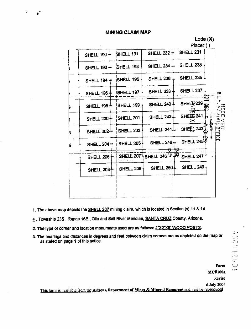
-
MINING CLAIM MAPLode (X)
Placer ( )SHELL 190 ~SHELL 191 SHELL 232 ' SHELL 231
SHELL 192 ~SHELL 193 SHELL 234' SHELL 233
SHELL 194 SHELL 195 SHELL 236 SHELL 235
SHELL 196 ISHELL 197 SHELL 238 i SHELL 237 =.L.M.
AT FFICE
SHELL 198 ISHELL 199 SHELL 240 SHEI*239-CD--m
SHELL 200 1 SHELL 201 SHELL 242~ SHEES 241
%CSET'VEE
SHELL 202 j SHELL 203 SHELL 244 SHEE~ 243
SHELL 204 ~ SHELL 205 SHELL 244 SHELL 2
SHELL 206 ~~HELL.207 SHELL 248 1 1 SHELL 2471
SHELL 208 1 SHELL 209 SHELL 25(~ SHELL 249
1. The above map depicts the SHELL_20Z mining daim, which Is located in Section (s) 11 & 14
6, Township 233, Range 16E, Glla and Salt River Meridian, SANTA_CRUZ County, Arizona.
2. The type of comer and location monuments used are as follows: 2*X2*)(5' WOOD_POSIS.D.
3. The bearings and distances in degrees and feet between claim comets are as depicted on the map oras stated on page 1 of this notice.
, 0-
Form '-UMCF100*
Revised July 2005
Thi f rm is av ' a le from th Arizona De artment of Mines & Mineral Resource and m rru

When*Ted Return To:AZ MINERALS, INC.
4500 S. CHERRY CREEK DR, SUITE 1040
DENVER, CO 80246
LOCATION NOTICE FOR LODE MINING CLAIM
NOTICE IS HEREBY GIVEN that the SHELL-208 lode mining claim BLMDate
has been located Sta m p
PHOENIX. AZ
20 DEC 19
AIO
B.L.M. AZ STATE OFFICER
ECEIVEDBy: AZ MINERALS, INC.
4500 S. CHERRY CREEK DR, SUITE 1040r..,
DENVER, CO 80246 a-
The general course of this claim is EAST TO WEST and it is situated in SANTA CRUZ County, Arizona. This claim is 1500
feet in length and 600 feet in width.
This claim runs from the location monument on which this location notice is posted approximately 2Q feet in a
EASTERLY direction to the EAST end line and 1480 feet in a WESTERLY direction to the WEST end line. This claim is
marked by six monuments, one at each corner and one at the center of each end line of the claim.
The location monument on which this notice is posted is situated within Section 11 Township 23 SOUTH, Range lfL
EAST, from the Gila and Salt River Meridian, and this claim encompasses portions of the following quarter section (s),
section (s), Township (s) and Range (s) NW 1/4 SECTION 14, T. 235, R.16E, from the Gila and Salt River Meridian,
Arizona.
The locality of this claim with reference to some natural object or permanent monument and additional information
(if any) concerning its locality are as follows: THE NORTHEAST CORNER ofthe claim is located 2754 feet EAST and~ ~
13520 feet SOUTH from the SOUTHWEST Corner of Section 35, T. 22S, R. 16E, from the Gila and Salt River Meridizf@
SANTA CRUZ COUNTY, AZ. -
DATED AND POSTED on the ground this 17 day of X104 ,20 1) . csrLJ
Stzy,t /4Er On'ww U -1
Opffl -AG *~PSDarling Environmental & Surveying, Ltd.
9040 South Rita Road, Suite 2350
Tucson, AZ 85747
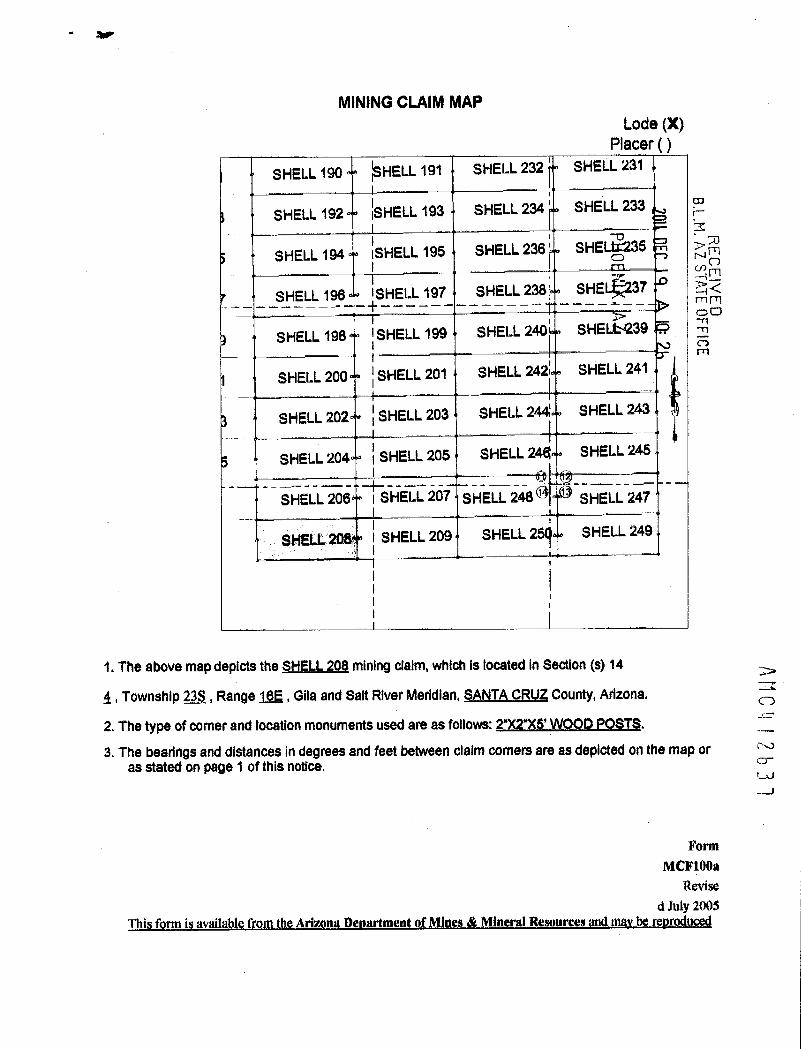
MINING CLAIM MAPLode (X)
Placer ( )
SHELL 190 ~SHELL 191 SHELL 232 ' SHELL 231
SHELL 192 ~SHELL 193 SHELL 234 SHELL 233
B.L.M. A 30
SHELL 194 ISHELL 195 SHELL 236 SHELU:2350 u->0%«U
SHELL 196 1 SHELL 197 SHELL 238' SHEit237 21<mmO0
t -rl
SHELL 198 'SHELL 199 SHELL 240 SHEL6239 -n0m
SHELL 200 1 SHELL 201 SHELL 242; SHELL 241
SHELL 202 ~ SHELL 203 SHELL 244; SHELL 243
SHELL 204 1 SHELL 205 SHELL 24« SHELL 245
SHELL 206 -~S-HELL-207 SH-ELL 248 9 1 SHELL 247L
SHELL 208. 1 SHELL 209 SHELL 25(~ SHELL 249
1. The above map depicts the S*IELL-208 mining dalm, which is located In Section (s) 14
4, Township 235, Range 16E , Gila and Salt River Meridian, SANTA_CRUZ County, Arlzona.
AMC I1
2. The type of comer and location monuments used are as follows: 2*X2*XS_'WQQO_FQSIS.
3. The bearings and distances in degrees and feet between claim corners are as depicted on the map or :-W
as stated on page 1 of this notice. CD-1-U--J
FormMCF100*
Revised July 2005
Ittii.fi'llfromleArimna.DeggLMInlnrerEELi~mmi!Lienmdl!i@d

When.7}!ed Return To:AZ MINERALS, INC.
4500 S. CHERRY CREEK DR, SUITE 1040
DENVER, CO 80246
LOCATION NOTICE FOR LODE MINING CLAIM B.L.M. AZ AT
FFICE
NOTICE IS HEREBY GIVEN that the SHELL-209 lode mining claim BLM -rj -Date C) r)has been located Sta m p Z 69
REC
EIV-0 -33> mmBy: AZ MINERALS, INC. > 00
N 545005. CHERRY CREEK DR, SUITE 1040 r.)
DENVER, CO 80246
The general course of this claim is WEST TO EAST and it is situated in SANTA CRUZ County, Arizona. This claim is 1500
feet in length and 600 feet in width.
This claim runs from the location monument on which this location notice is posted approximately 2Q feet in a
WESTERLY direction to the WEST end line and 1480 feet in a EASTERLY direction to the EAST end line. This claim is
marked by six monuments, one at each corner and one at the center of each end line of the claim.
The location monument on which this notice is posted is situated within Section 136 Township 23 SOUTH, Range 1.6
EAST, from the Gila and Salt River Meridian, and this claim encompasses portions of the following quarter section (s),
section (s), Township (s) and Range (s) NE & NW 1 /4 of SECTION 14. T. 235. R.16E. from the Gila and Salt River
Meridian, Arizona.
The locality of this claim with reference to some natural object or permanent monument and additional information
(if any) concerning its locality are as follows: THE NORTHEAST CORNER of the claim_Ls located_4254 feet-EASTand>
12904_feeLSOUTH.fromthe-SQI,JIBWEST_ComerofSection 35 _T. 22S R. 168_fromthe Gilaand SalLRiver«MeridiS~SANTA_CRIJZ-COUNTLAZ. -5=
DATED AND POSTED on the ground this 17 day of j\JOJ , 20 I ~ .-cr1-0
GDN \AEl0*rM 'CO
A . Darling Environmental & Surveying, Ltd.
9040 South Rita Road, Suite 2350
Tucson, AZ 85747

-
MINING CLAIM MAPLode (X)
Placer ( )SHELL 190 ~SHELL 191 SHELL 232 ' SHELL 231
SHELL 192 ~SHELL 193 SHELL 234' SHELL 233
SHELL 194 SHELL 195 SHELL 236 ' SHELL 23
SHELL 196 1 SHELL 197 SHELL 238 SHEiL 23*6
RECEIVEDSHELL 198 ~SHELL 199 SHELL 240 SH®.L 2lf ,
SHELL 200 ~ SHELL 201 SHELL 2422 SAdLL 24¥
SHELL 202 ~ SHELL 203 SHELL 244 SHELL 243
SHELL 204 ~ SHELL 205 SHELL 244 SHELL 245
SHELL 206 ~HELL 267 SHELL 248 9 1 SHELL 247- -- 1 -
SHELL 208 1 SHEU 209 SHELL 25(~ SHELL 249
1. The above map depicts the SHELL 209 mining claim, which is located in Section (s) 14
4, Township 233, Range 16E, Gila and Salt River Meridian, SANIA CRUZ County, Arizona. --;0
2. The type of comer and location monuments used are as follows: 2")(275' WOOD POSTS.
3. The bearings and distances in degrees and feet between claim comets are as depicted on the map or FJ
as stated on page 1 of this notice. CD-LU00
FormMCF10()a
Revised July 2005
This f rm is vailable from the Arizona De artmen f Min s Miner R source@ and ina rru

1,VI'· -1~led Return To:AZ IVI~RALS, INC.
4500 S. CHERRY CREEK DR, SUITE 1040
DENVER, CO 80246
LOCATION NOTICE FOR LODE MINING CLAIM
NOTICE IS HEREBY GIVEN that the SHELL-210 lode mining claim BLMDate -0
B.L.M.A'
SAT FFICE
has been located Stamp 0 r> Arn
REC
EIVBy: AZ MINERALS, INC.
45005. CHERRY CREEK DR, SUITE 1040 N 25
DENVER, CO 80246 a-
The general course of this claim is EAST TO WEST and it is situated in SANTA CRUZ County, Arizona. This claim is 1500
feet in length and 600 feet in width.
This claim runs from the location monument on which this location notice is posted approximately 2Q feet in a
EASTERLY direction to the EAST end line and 1480 feet in a WESTERLY direction to the WEST end line. This claim is
marked by six monuments, one at each corner and one at the center of each end line of the claim.The location monument on which this notice is posted is situated within Section 2, Township 23 SOUTH, Range 16 EAST,
from the Gila and Salt River Meridian, and this claim encompasses portions of the following quarter section (s), section (s),
Township (s) and Range (s) NE 1/4 of SECTION 2. T. 235, R.16E. from the Gila and Salt River Meridian, Arizona.
The locality of this claim with reference to some natural object or permanent monument and additional information
(if any) concerning its locality are as follows:_THENORTHEASI-CORNER-ofthe-claimislocated_5511-feeLEAST aa*--
289_feeLSOUTH-fromthe SQUIHNEST_Comerof_Section 35 T. 22S R._16E kgmthe-Gilaand Sall-River MeddiSANTA CRUZ COUNTY, AZ.
DATED AND POSTED on the ground this 1 1 day of NOU ,20 11
412639f«/7-5 el-4 Jot
AGENT: Darling Environmental & Surveying, Ltd.
9040 South Rita Road, Suite 2350
Tucson, AZ 85747

MINING CLAIM MAPLode (X)
Placer ( )
SHELL 166 SHELL 167 SHELL 210 SHELL 211 B.L.M. ASHELL 168 SHELL 169 SHELL 212 ' i
SHELL 170 S~ELL 171 SHELL 214 ' ~ 59 '-4 ~Z]634 :dn
SHELL 172 SHELL 216 > 58
Y3'103 SHELL 173 ~65 306 i *T m0
'105 SHELL 174 - SHELL 21 YHELL 175
912 113HS
'107 SHELL 176 ~HELL 177 SHELL 21
109 SHELL 178 ~HELL 179 SHELL 220 SHELL 219
t 111 SHELL 180 SHELL 181 SHELL 222 SHELL 221
1113 ' SHELL 182 SHELL 183 SHELL 224 SHELL 223
'115 SHELL 184 HELL 185 SHELL 226 SHELL 225
1. The above map depicts the SHELL 210 mining dalm, which Is located in Section (s) 2
4, Township 23S, Range 16E, Gita and Salt River Meridian, SANTA CRUZ County, Arizona.
2. The type of comer and location monuments used are as follows: 2"X2"XS' WOOD POSTS.
AMC 7 6 3 c
3. The bearings and distances In degrees and feet between claim corners are as depicted on the map oras stated on page 1 of this notice.
Form IMCF100*
Revised July 2005
Thi f rm is available from the Arizona De artment ofMincs & Mineral Resource m r u

When Filed Return To:AZ M[NtRALS, INC.
4500 S. CHERRY CREEK DR, SUITE 1040
DENVER, CO 80246
LOCATION NOTICE FOR LODE MINING CLAIM
NOTICE IS HEREBY GIVEN that the SHELL-211 lode mining claim BLMDate -13
B.L.M. AZhas been located rr 30Sta m p rn mCD r)rn - 0 0
By: AZ MINERALS, INC. ES<4500 S. CHERRY CREEK DR, SUITE 1040
0DENVER, CO 80246 r-rl
The general course of this claim is WEST TO EAST and it is situated in SANTA CRUZ County, Arizona. This claim is 1500
feet in length and 600 feet in width.This claim runs from the location monument on which this location notice is posted approximately 2.Q feet in a
WESTERLY direction to the WEST end line and 1480 feet in a EASTERLY direction to the EAST end line. This claim is
marked by six monuments, one at each corner and one at the center of each end line of the claim.The location monument on which this notice is posted is situated within Section 2, Township 23 SOUTH, Range 16 EAST,
from the Gila and Salt River Meridian, and this claim encompasses portions of the following quarter section (s), section (s),Township (s) and Range (s) NE--1/4 of SECTEON-2 NYL:La-of SECT[QhLL.T. 238 _8.16E* from the Gila and Salt RiverMeridian, Arizona.
The locality of this claim with reference to some natural object or permanent monument and additional information(if any) concerning its locality are as follows:-THENORTHEASICORNER»oftheclaim is_located_711LfeeLEASTand272_feet SOLJTH_from the SOUTHWFSTCgmer_of.Section 35 T. 22LB._16,Lfromthe-Gilaand Salt River«MeridianSANTA CRUZ COUNTY. AZ.
DATED AND POSTED on the ground this | | day of - No V , 20 1 l
(/\
AMCI, 1 211 4 O
AGENT: Darling Environmental & Surveying, Ltd.
9040 South Rita Road, Suite 2350
Tucson, AZ 85747

MINING CLAIM MAPLode (X)
Placer C )T 23 S
SHELL 166 SHELL 167 SHELL 210 ' SMEU
SHELL 168 SHELL 169 SHELL 212 k
SHELL 170 S~ELL 171 SHELL 214 31 -
SHELL 172 SHELL 216 3 , .1h
#m-D -.f . <'103 SHELL 173 45 *6 .1 25-49
'105 SHELL 174 SHELL 21 N ~ 59 ,HELL 175 El
UJ
'107 SHELL 176 ~HELL 177 SHELL 21 r
~109 SHELL 178 ~HELL 179 SHELL 220 SHELL 219
311 SHELL 180 SHELL 181 SHELL 222 SHELL 221
1113 « SHELL 182 SHELL 183 SHELL 224 SHELL 223
'115 SHELL 184 HELL 185 SHELL 226 SHELL 225 AM C 24
0
1. The above map depicts the SHELL 211 mining claim, which is located in Section (s) 1 & 2
4, Township 228, Range 16E , Gila and Salt River Meridian, SANTA_CRUZ County, Arizona.
2. The type of comer and location monuments used are as follows: 2*)(2*XS' WOOD POSIS.
3. The bearings and distances in degrees and feet between claim corners are as depicted on the map oras stated on page 1 of this notice.
FormMCF100*
Revised July 2005
This f rm is available from the Arizona De artment of Mine & Mineral Re urc and rodu

ZfherAF·iled Return To:AZ MINERALS, INC.
4500 S. CHERRY CREEK DR, SUITE 1040
DENVER, CO 80246
LOCATION NOTICE FOR LODE MINING CLAIM
NOTICE IS HEREBY GIVEN that the SHELL-212 lode mining claim BLMDate 11 omhas been located Sta m p En=By. AZ MINERALS, INC. ~ mil
00
4500 S. CHERRY CREEK DR, SUITE 1040
DENVER, CO 80246
The general course of this claim is EAST TO WEST and it is situated in SANTA CRUZ County, Arizona. This claim is 1500
feet in length and 600 feet in width.
This claim runs from the location monument on which this location notice is posted approximately 2Q feet in a
EASTERLY direction to the EAST end line and 1480 feet in a WESTERLY direction to the WEST end line. This claim is
marked by six monuments, one at each corner and one at the center of each end line of the claim.
The location monument on which this notice is posted is situated within Section 2, Township 23 SOUTH, Range 16 EAST,
from the Gila and Salt River Meridian, and this claim encompasses portions of the following quarter section (s), section (s),
Township (s) and Range (s) NE 1/4 of SECTION 2. T. 235. R.16E, from the Gila and Salt River Meridian, Arizona.
The locality of this claim with reference to some natural object or permanent monument and additional information
(if any) concerning its locality are as follows: THE NORTHEAST CORNlER of the claim is located 5618 feet EAST and
889-feeLSQUTH.ftom the-SQUIHWEST.Comerof.Section 35 _T._228:_R.15E ftom the Gilaand aalt River MeridianSANTA CRUZ COUNTY. AZ.
DATED AND POSTED on the ground this 1 1 day of NO V , 20 1 /
-- 1
A 1 -5€17€ ,-j,E#Ef
AMC 264
AGENT: Darling Environmental & Surveying, Ltd.
9040 South Rita Road, Suite 2350
Tucson, AZ 85747

-
MINING CLAIM MAPLode (X)
Placer ( )-r --il.--- .Il-
T 235
SHELL 166 SHELL 167 SHELL 210 ~ SHELL 211
SHELL 168 SHELL 169 SHELL 212 ~ F S
B.L.11.
SHELL 170 S~ELL 171 SHELL 214 6 !0 ' --LJ4 571
SHELL 216 242SHELL 172 00
4 j'103
I105 SHELL 174 SHELL 21
HELL 175
107 SHELL 176 ~HELL 177 SHELL 21 ~
1109 SHELL 178 ~HELL 179 SHELL 220 SHELL 219
1111 SHELL 180 SHELL 181 SHELL 222 SHEU 221
1113 * SHELL 182 SHELL 183 SHELL 224 SHELL 223
'115 SHELL 184 HELL 185 SHELL 226 SHELL 225
1. The above map depicts the SHELL_212 mining claim, which is located in Section (s) 2
4, Township 238, Range 16E , Glla and Salt River Meridian, SANTA CRUZ County, Arizona.
2. The type of corner and location monuments used are as follows: 2"X2')(5' WOOD POSIS.
3. The bearings and distances in degrees and feet between claim comets are as depicted on the map oras stated on page 1 of this notice.
ANC 4 2 6 4
FormMCIrlooa
Revised July 2005
This form i av 'table from the Ariz n De artment of Mines & Mineral Resources an r rodu

.When filed Return To:AZ MINERALS, INC.
4500 S. CHERRY CREEK DR, SUITE 1040
DENVER, CO 80246
LOCATION NOTICE FOR LODE MINING CLAIM
NOTICE IS HEREBY GIVEN that the SHELL-213 lode mining claim BLM
20 DECDate >E
has been located ~0 -*1~~Sta m p-0 -H El
X d<By: AZ MINERALS, INC.
00
45005. CHERRY CREEK DR, SUITE 1040 r~ to
DENVER, CO 80246
The general course of this claim is NORTH TO SOUTH and it is situated in SANTA CRUZ County, Arizona. This claim is
1500 feet in length and 600 feet in width.
This claim runs from the location monument on which this location notice is posted approximately 2Q feet in a
NORTHERLY direction to the NORTH end line and 1480 feet in a SOUTHERLY direction to the SOUTH end line. This
claim is marked by six monuments, one at each corner and one at the center of each end line of the claim.
The location monument on which this notice is posted is situated within Section 1, Township 23 SOUTH, Range 16 EAST,
from the Gila and Salt River Meridian, and this claim encompasses portions of the following quarter section (s), section (s),
Township (s) and Range (s) NE 1/4 of SECTION 2, NW 1 /4 of SECTION 1. T. 235. R. 16E. from the Gila and Salt River
Meridian, Arizona.
The locality of this claim with reference to some natural object or permanent monument and additional information
(if any) concerning its locality are as follows: THE NORTHEAST CORNER of the claim is located 6218 feet EAST and
882 feet SOUTH from the SOUTHWEST Comer of Section 35, T. 22S, R. 16E, from the Gila and Salt River Meridiam>
SANTA CRUZ_COUNTYAZ. -b
04=-DATED AND POSTED on the ground this i C day of No V , 20 \ E
r\0
' 5 ent Jo,«fAGENT: Darling Environmental & Surveying, Ltd.
9040 South Rita Road, Suite 2350
Tucson, AZ 85747

MINING CLAIM MAPLode (X)
Placer ( )--T
SHELL 166 SHELL 167 SHELL 210 SHELL 211
SHELL 168 SHELL 169 SHELL 212 A
SHELL 170 S~ELL 171 SHELL 214 1 ~
B.L.M.
t. 30SHELL 216 - 5~ 614 g
SHELL 172 Smj >< 42
1103 SHELL 173 # 1 00
:105 SHELL 174 - - - - SHELL 21 S 2 6? AHELL- 175
'107 SHELL 176 ~HELL 177 SHELL 21 ig
109 SHELL 178 ~HELL 179 SHELL 220 SHELL 219
11111 SHELL 180 SHELL 181 SHELL 222 SHELL 221
113 " SHELL 182 SHELL 183 SHELL 224 SHELL 223
'115 SHELL 184 HELL 185 SHELL 226 SHELL 225
1. The above map depicts the SHELL_213 mining daim, which is located in Section (s) 1&2
4, Township 235, Range 16E, Gita and Salt River Meridian, SANTA CRUZ County, Arizona.
2. The type of comer and location monuments used are as follows: 2'X2"XS' WOOD POSTS.
AMC4 2642
3, The bearings and distances in degrees and feet between claim corners are as depicted on the map oras stated on page 1 of this notice.
FormMCF1(}Oa
Revised July 2003
Thi f rm is avalla le from the Arizona De artment of Mines & Mineral R mou an nia be re u

When Filed Return To:AZ MII~RALS, INC.
4500 S. CHERRY CREEK DR, SUITE 1040
DENVER, CO 80246
LOCATION NOTICE FOR LODE MINING CLAIM
NOTICE IS HEREBY GIVEN that the SHELL-214 lode mining claim BLM
20 DEC 19
AIO
B.L.M .RAEZCSrj]EEFFICE
Datehas been located Sta m p
PHOENIX. AZ
By: AZ MINERALS, INC.
45005. CHERRY CREEK DR, SUITE 1040
DENVER, CO 80246
The general course of this claim is EAST TO WEST and it is situated in SANTA CRUZ County, Arizona. This claim is 1500
feet in length and 600 feet in width.
This claim runs from the location monument on which this location notice is posted approximately 2Q feet in a
EASTERLY direction to the EAST end line and 1480 feet in a WESTERLY direction to the WEST end line. This claim is
marked by six monuments, one at each corner and one at the center of each end line of the claim.The location monument on which this notice is posted is situated within Section 2, Township 23 SOUTH, Range 16 EAST,
from the Gila and Salt River Meridian, and this claim encompasses portions of the following quarter section (s), section (s),
Township (s) and Range (s) NE 1/4 of SECTION 2. T. 23S, -R.16E, from the Gila and Salt River Meridian, Arizona.
The locality of this claim with reference to some natural object or permanent monument and additional information(if any) concerning its locality are as follows: THE NORTHEAST CORNER of the claim is located 5624 feet EAST an
-1489_feet SOUTH from the SQUTHWEST_Comer_of_Section 35 _I. 22.S R.-1*E_fromithe-Gilaand aalt River-MeridiablSANTA CRUZ COUNTY, AZ.
DATED AND POSTED on the ground this l I day of NOV , 20 I f
0412643
-1- 1-< Ser«* 3,4(5
AGENT: Darling Environmental & Surveying, Ltd.
9040 South Rita Road, Suite 2350
Tucson, AZ 85747

.
MINING CLAIM MAPLode (X)
Placer ( )
-r
SHELL 166 SHELL 167 SHELL 210 ' SHELL 211
SHELL 168 SHELL 169 SHELL 212 Ad
SHELL 170 S~ELL 171 SHELL 214 W 2011
SHELL 216 -0
B.L.M, ECE~1\TEE°
SHELL 172 CD > 30
'103 SHELL 173 ~es seeny 1
'105 SHELL 174 SHELL 21 51 * iHELL 175
75 ,, OFFICELU
107 SHELL 176 ~HELL 177 SHELL 21 i5
1109 SHELL 178 ~HELL 179 SHELL 220 SHELL 219
1 --1111 SHELL 180 SHELL 181 SHELL 222 SHELL 221
113 « SHELL 182 SHELL 183 SHELL 224 SHELL 223
'115 SHELL 184 HELL 185 SHELL 226 SHELL 225
1. The above map depicts the SHELL_214 mining daim, which is located in Section (s) 2
4, Township 233, Range 162, Gila and Salt River Meridian, SANTA_CRUZ County, Arizona.
AMC
2. The type of corner and location monuments used are as follows: 2")(2"XS' WOOD POSTS.
3. The bearings and distances in degrees and feet between claim corners are as depicted on the map or t..1
as stated on page 1 of this notice. G--.frUJ
FormMCF100*
Revised July 2005
'Illi f rm i vailable from the na De ment of Mines Mineral Re urces be odu

-~ WhdK Filed Return To:AZ MINERALS, INC.
4500 S. CHERRY CREEK DR, SUITE 1040
DENVER, CO 80246
LOCATION NOTICE FOR LODE MINING CLAIM
NOTICE IS HEREBY GIVEN that the SHELL-215 lode mining claim BLMDate
20 DEC
9
has been located Sta m p
PHOEN X AZ
B.L 1. AZ JTATE OFFICEREC~EIVEDBy: AZ MINERALS, INC.
4500 S. CHERRY CREEK DR, SUITE 1040 5
DENVER, CO 80246
The general course of this claim is NQRTH TO SOUTH and it is situated in SANTA_CRUZ County, Arizona. This claim is
1500 feet in length and 600 feet in width.
This claim runs from the location monument on which this location notice is posted approximately 150 feet in a
NORTHERLY direction to the NORTH end line and 1350 feet in a SOUTHERLY direction to the SOUTH end line. This
claim is marked by six monuments, one at each corner and one at the center of each end line of the claim.
The location monument on which this notice is posted is situated within Section 2, Township 23 SOUTH, Range 16 EAST,
from the Gila and Salt River Meridian, and this claim encompasses portions of the following quarter section (s), section (s),
Township (s) and Range (s) NE-1/4 of-SECTION_LNW_1/4_of SECTION 1 _T. 23LE.16E: from the Gila and Salt River
Meridian, Arizona.
The locality of this claim with reference to some natural object or permanent monument and additional information
(if any) concerning its locality are as follows:_THE-NORTHEAST_COENER ofthe claimislocated 5942-feeLEASTan$
3085-feeLSOUTH#omthe-SOIJTHWEST_Comerof-Section 35 -I. 223,_R.-16E:Immthe Gilaand_SalLRiver Meridi
SANIA_CRIZCQUNTLAZ.
MIl 2 b[4
- vt,DATED AND POSTED on the ground this h - _ day of DiC - _,20 /7
=- 1 < - /1/1- L- rzrt Ad (40 L\9 /AGEN*Gailing Environmental & Surveying, Ltd.
9040 South Rita Road, Suite 2350
Tucson, AZ 85747

MINING CLAIM MAPLode (X)
Placer ( )
SHEU 166 SHELL 167 SHELL 210 SHELL 211
SHELL 168 SHELL 169 SHELL 212 ' 11 B.L.M.
SHELL 170 S~ELL 171 SHELL 214 5 ~0 Ma >mCCD NmSHELL 216 rn
SHELL 172 -0 Ne
'103 SHELL 173 # i > jo > Sg
g' 105 SHELL 174 -- -- ~ SHELL 21 Z c-
HELL 175
'107 SHELL 176 ~HELL 177 SHELL 21
;109 SHELL 178 ~HELL 179 SHELL 220 SHELL 219
1 15111 SHELL 180 SHELL 181 SHELL 222 SHELL 221
113 « SHELL 182 SHELL 183 SHELL 224 SHELL 223
'115 SHELL 184 HELL 185 SHELL 226 SHELL 225
1. The above map depicts the SHELL_215 mining dalm, which is located in Section (s) 1&2 --
Arc
264
4, Township 23S, Range 16E, Gita and Salt River Meridian, SANTACBUZ County, Arizona.
2. The type of comer and location monuments used are as follows: 2"XF)(5' WOOD POSTS.
3. The bearings and distances in degrees and feet between claim corners are as depicted on the map oras stated on page 1 of this notice.
FormMCF100*
Revised July 2005
Till fo i av '1 ble from e Arizon De m n f Mines Mineral Resources and r r uce
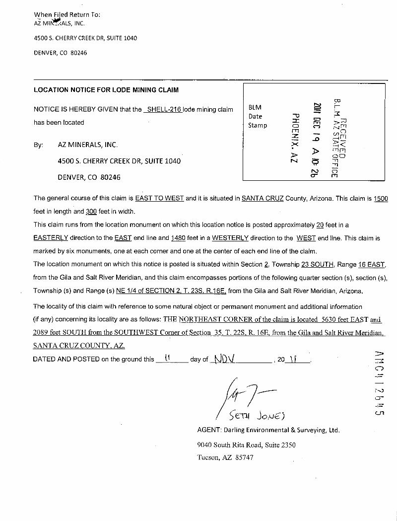
When Filed Return To:AZ MII~ALS, INC.
4500 S. CHERRY CREEK DR, SUITE 1040
DENVER, CO 80246
LOCATION NOTICE FOR LODE MINING CLAIM
NOTICE IS HEREBY GIVEN that the SHELL-216 lode mining claim BLM
B.L.M. FFICE
Date -0has been located I R ~33
Sta m p 0 1-1 N Fi
By: AZ MINERALS, INC. R ki<~ rnFI00
4500 5. CHERRY CREEK DR, SUITE 1040 N 5
DENVER, CO 80246 cr
The general course of this claim is EAST TO WEST and it is situated in SANTA CRUZ County, Arizona. This claim is 1500
feet in length and 300 feet in width.
This claim runs from the location monument on which this location notice is posted approximately 2Q feet in a
EASTERLY direction to the EAST end line and 1480 feet in a WESTERLY direction to the WEST end line. This claim is
marked by six monuments, one at each corner and one at the center of each end line of the claim.
The location monument on which this notice is posted is situated within Section 2, Township 23 SOUTH, Range 16 EAST,
from the Gila and Salt River Meridian, and this claim encompasses portions of the following quarter section (s), section (s),
Township (s) and Range (s) NE 1/4 of SECTION 2. T. 235, R.16E, from the Gila and Salt River Meridian, Arizona.
The locality of this claim with reference to some natural object or permanent monument and additional information
(if any) concerning its locality are as follows:_THE-NORTHEAST-CORNER-oftheclaimislocated_-5630_feeLEASTand2089_feet_SOUTH-fromthe SOUTHWEST.Comer ofSection 35*I. 22S R.16EJmmthe Gilaand Salt River-MeridianSANTA CRUZ COUNTY, AZ.
DATED AND POSTED on the ground this U day of KIDV , 20 1 1 MC 12b45
5€T# 30/J€)AGENT: Darling Environmental & Surveying, Ltd.
9040 South Rita Road, Suite 2350
Tucson, AZ 85747

-
MINING CLAIM MAPLode (X)
Placer ( )
-r ® 0 _- T 23-5
0 DEC
9 AIO
SHELL 166 SHELL 167 SHELL 210 ' SHELL 211
SHELL 168 SHELL 169 SHELL 212 S 3
SHELL 170 ®ELL 171 SHELL 214
113HS
B.L.M. AZ. S.A E OFFICERECETIVTEDSHELE216
SHELL 172
'103 SHELL 173 S# t
HOEN X AZ
SOC 991·f'105 SHELL 174 -SHELL 21HELL 175
CLZ 113HS
'107 SHELL 176 4HELL 177 SHELL 21
~109 SHELL 178 #HELL 179 SHELL 220 SHELL 219
~111 SHELL 180 SHELL 181 SHELL 222 SHELL 221
113 * SHELL 182 SHELL 183 SHELL 224 SHELL 223
'115 SHELL 184 HELL 185 SHELL 226 SHELL 225
1. The above map depicts the SHELL 216 mining daim, which is located In Section (s) 2
4, Township 235, Range 16E, Gita and Salt River Meridian, SANTA CRUZ County, Arizona. ANC2. The type of comer and location monuments used are as follows: 2"X2"XS' WOOD POSTS.
3. The bearings and distances in degrees and feet between claim corners are as depicted on the map oras stated on page 1 of this notice.
7..1CD-
C-11
FormMCF100a
Revised July 2005
Thi f rin i vail le fromthe Arizona De artment of Mines Mineral Re rtem an m rru

When ~3d Return To:AZ MINERALS, INC.
4500 S. CHERRY CREEK DR, SUITE 1040
DENVER, CO 80246
11 DEC 19
B M. A
ATE OFFICE
LOCATION NOTICE FOR LODE MINING CLAIM O 30
0 N 71
NOTICE IS HEREBY GIVEN that the SHELL-217 lode mining claim BLM m .-OZ 94 m
Datehas been located Stamp m0
By: AZ MINERALS, INC. Al
4500 S. CHERRY CREEK DR, SUITE 1040
DENVER, CO 80246
The general course of this claim is EAST TO WEST and it is situated in SANTA CRUZ County, Arizona. This claim is 1500
feet in length and 600 feet in width.
This claim runs from the location monument on which this location notice is posted approximately 22 feet in a
EASTERLY direction to the EAST end line and 1480 feet in a WESTERLY direction to the WEST end line. This claim is
marked by six monuments, one at each corner and one at the center of each end line of the claim.
The location monument on which this notice is posted is situated within Section 2, Township 23 SOUTH, Range 16 EAST,
from the Gila and Salt River Meridian, and this claim encompasses portions of the following quarter section (s), section (s),
Township (s) and Range (s) NE 1/4 of SECTION 2, T. 235, R.16E. from the Gila and Salt River Meridian, Arizona.
The locality of this claim with reference to some natural object or permanent monument and additional information
(if any) concerning its locality are as follows: THE NORTHEAST CORNER of the claim is located 5644 feet EAST and
3288-feeLSQUTH.fromithe.SQUIHWEST_Comer-of_Bection 35_I. 225311*Efromthe-Gilaand_Balt-River_Meridian
SANTA CRUZ COUNTY, AZ.
DATED AND POSTED on the ground this 23 day of NO U , 20 \ ~
IA ENT: Darling Environmental & Surveying, Ltd.
9040 South Rita Road, Suite 2350 1
AMC4 2646Tucson, AZ 85747

t
MINING CLAIM MAPLode (X)
Placer ( )
SHELL 166 SHELL 167 SHELL 210 ' SHELL 211
SHELL 168 SHELL 169 SHELL 212 ;
SHELL 170 S~ELL 171 SHELL 214 ~
SHELL 216SHELL 172 0 33
B.L.b A Z STA
m
903 SHELL 173 14<
7. r17
LD, -60 ;nm'105 SHELL 174 Si~iELL 21 51 ~ 00
HELL 175 d ·· -1-
0
'107 SHELL 176 #HELL 177 SHELL 21 r --J r.rl
1109 SHELL 178 ~HELL 179 SHELL 220 ,' SHELL 219
IPill SHELL 180 SHELL 181 SHELL 222 SHEU 221
1113 " SHELL 182 SHELL 183 SHELL 224 SHELL 223
'1_15 SHELL 184 HELL 185 SHELL 226 SHELL 225
1. The above map depicts the SHELL-217 mining daim, which Is located in Section (s) 2>
4, Township 235 , Range 16E, Gita and Salt River Meridian, SANTA_CRUZ County, Arizona. -*..CD
2. The type of comer and location monuments used are as follows: 25Xr)(5' WOOD_205[8.
3. The bearings and distances in degrees and feet between claim corners are as depicted on the map or r\)as stated on page 1 of this notice. Cr
0-
FormMCF10{)a
Revisedjuly 2003
This f rm is av 'la le fr m the Ariz na De artm nt of Min & Mineral Re urces m rru

2012-08 11When Filed Return To: Page 1 of 2ARIZONA MINERALS, INC. - ·i.j Requested By: r~•na Minerals
3 SUZANNE SAINZ, RECORDER4500 S. CHERRY CREEK DR, SUITE 1040 7 SANTA CRUZ COUNTY, ARIZONADENVER, CO 80246 10-19-2012 03:52 PM Recording Fee $10.00
AMENDED LOCATION NOTICE FOR LODE MINING CLAIM
NOTICE IS HEREBY GIVEN that the SHELL-218 lode mining claim BLMBLM serial number, AMC 412647, having an original location date of Date rn
1 CD.m28 NOVEMBER, 2011, as recorded in the office of the County Recorder Stamp ><
of Santa Cruz County, State of Arizona, at Reception No. 2012-00429 --1 <has been AMENDED -
3 rririi
LAJBy: AZ MINERALS, INC. - cn rn
4500 S. CHERRY CREEK DR, SUITE 1040
DENVER, CO 80246
The general course of this claim is EAST TO WEST and it is situated in SANTA CRUZ County, Arizona. This claim is 1500feet in length and 600 feet in width.
This claim runs from the location monument on which this location notice is posted approximately 2.Q feet in a
EASTERLY direction to the EAST end line and 1480 feet in a WESTERLY direction to the WEST end line. This claim is
marked by six monuments, one at each corner and one at the center of each end line of the claim.The location monument on which this notice is posted is situated within Section 2, Township 23 SOUTH, Range 16 EAST,from the Gila and Salt River Meridian, and this claim encompasses portions of the following quarter section (s), section (s),
Township (s) and Range (s) NE_1/lof SECTION_LNMY_lliof SECTIONLL_T._23S R.16.E from the Gila and Salt RiverMeridian, Arizona.
The locality of this claim with reference to some natural object or permanent monument and additional information(if any) concerning its locality are as follows:_THE_NORTHEAST_CORNER-gftheclaimislocated565QfeeLEAS.Tand1881LfggLSQLEIHImm-lkSQUIHWESI_Cgmg[_Qf_Sggliga_iLL«221-RJ*E~fn=the_flila~nd_SAJLRiM£LMgddj~*-SANTA CRUZ COUNTY. AZ.
DATED AND POSTED on the ground this 1 day of r,_El_~, 20 17/ 2/1
AGENT./Darling Environmental & Surveying, Ltd.a bo laot& 9040 Sduth Rita Road, Suite 2350
ENTERED IN¥0 COMP"TER Tucson, AZ 85747
4/1441

2012-08¥94 1 8-19-2012 03:52 PM Page 2 of 2lilli
MINING CLAIM MAPLode (X)
Placer ( )_ _T 22 S
T 235
SHELL 166 SHELL 167 SHELL 210 SHELL 211
SHELL 168 SHELL 169 SHELL 212 Kid
SHELL 170 S ELL 171 SHELL 214 ICO
SHELL 216SHELL 172
'103 SHELL 173 ~56 sos
90€ 83H
°105 SHELL 174 ~. «SHELL 21HELL 175
GLE 113HS,107 SHELL 176 ~HELL 177 SHELL 21
1109 SHELL 178 ~HELL 179 SHELL 220 . SHELL 219
1111 SHELL 180 SHELL 181 SHELL 222 SH<'rL 2~ 9
1113 ' SHELL 182 SHELL 183 SHELL 224. SH~L 2* 03
'115 SHELL 184 HELL 185 SHELL 226 SH ~1_ 225- ...'7&-r.4 -g
1, ES' jlf E ) FFICE1. The above map depicts the SHELL 218 mining claim, which is located in Section (s) 2 > t.u
cn4, Township 23S, Range 16E , Gila and Salt River Meridian, SANTA CRUZ County, Arizona.
2. The type of corner and location monuments used are as follows: 22235'WOOD POSTS-3. The bearings and distances in degrees and feet between claim corners are as depicted on the map or
as stated on page 1 of this notice.
FormMCF100a
Revised July 2005
Ihisformisavailablettom-the Arizona-Denartmentof.Mines&«MineraLEesgureesandma-bereRroduced

,?When·Filed Return To: - -AZ MINERALS, INC.
4500 S. CHERRY CREEK DR, SUITE 1040
DENVER, CO 80246
LOCATION NOTICE FOR LODE MINING CLAIM
NOTICE IS HEREBY GIVEN that the _SHELL-218 lode mining claim BLMDate = A
B.L.M. AZ 0has been located Sta m p r-10 ri
REC
~IV
By: AZ MINERALS, INC.00
04500 S. CHERRY CREEK DR, SUITE 1040 -rl0
-JDENVER, CO 80246
The general course of this claim is EAST TO WEST and it is situated in SANTA CRUZ County, Arizona. This claim is 1500
feet in length and 600 feet in width.
This claim runs from the location monument on which this location notice is posted approximately 2Q feet in a
EASTERLY direction to the EAST end line and 1480 feet in a WESTERLY direction to the WEST end line. This claim is
marked by six monuments, one at each corner and one at the center of each end line of the claim.
The location monument on which this notice is posted is situated within Section 2, Township 23 SOUTH, Range 16 EAST,
from the Gila and Salt River Meridian, and this claim encompasses portions of the following quarter section (s), section (s),
Township (s) and Range (s) NE 1/4 of SECTION 2. NW 1 /4 of SECTION 1, T. 235, R.162, from the Gila and Salt River
Meridian, Arizona.
The locality of this claim with reference to some natural object or permanent monument and additional information
(if any) concerning its locality are as follows: THE NORTHEAST CORNER of the claim is located 5650 feet EAST and
388ifggLSQLIIH.frgmthg-3.QIJIBWESECQmg_Qf_S~£ijQL31_TUZS,_L10,E~f[gmlb©.Qjla.~d-~1Bjyg[-Mgjdj~-
SANTA CRUZ COUNTY, AZ.
AM C 4 12DATED AND POSTED on the ground this 2-6 day of K)04 , 20 1 |
CD-
--1
AGENT: Darling Environmental & Surveying, Ltd.
9040 South Rita Road, Suite 2350
Tucson, AZ 85747

-MINING CLAIM MAP
Lode (X)Placer ( )
SHELL 166 SHELL 167 SHELL 210 SHELL 211
SHELL 168 SHELL 169 SHELL 212 &=1
SHELL 170 S~ELL 171 SHELL 214 !8
20 DEC
9
B.L.t . , ,- STAi I OFFICE
SHELL 172 SHELL 216 'n
R~CE I\(ED
'103 SHELL 173 # 306
SAELL 21 (U60
'105 SHELL 174 HELL 175
9 12 113HS
107 SHELL 176 ~HELL 177 SHELL 21
1109 SHELL 178 ~HELL 179 SHELL 220 SHELL 219
311 SHELL 180 SHELL 181 SHELL 222 SHELL 221
113 " SHELL 182 SHELL 183 SHELL 224 SHELL 223
115 _ SHELL 184 HELL 185 SHELL 226 SHELL 225
1. The above map depicts the SHELL 218 mining daim, which is located in Section (s) 2
AMC 2641
4, Township 235, Range 16_E, Gila and Salt River Meridian, SANTA CRUZ County, Arizona.
2. The type of comer and location monuments used are as follows: 2"X2"XS' WOOD POSES.
3. The bearings and distances in degrees and feet between claim corners are as depicted on the map oras stated on page 1 of this notice.
FormMCF100*
Revised July 2005
Thi f rm i availabl from the Arizon De artmen of Mines & neral Resources and ber u

1 2 012 -·-- 13 Fr=-2When Filed Return To: · 'I~; j Page 1 of 2 i, A
# kequested By: :15-z:bna MineralsARIZONA MINERALS, INC. SUZANNE SAINZ, RECORDER4500 S. CHERRY CREEK DR, SUITE 1040 SANTA CRUZ COUNTY, ARIZONADENVER, CO 80246 10-19-2012 03:52 PM Recording Fee $10.00
AMENDED LOCATION NOTICE FOR LODE MINING CLAIM
NOTICE IS HEREBY GIVEN that the SHELL-219 lode mining claim BLMBLM serial number, AMC 412648, having an original location date of Date CA ;
28 NOVEMBER, 2011, as recorded in the office of the County Recorder Stamp , , .-':*fr CD
of Santa Cruz County, State of Arizona, at Reception No. 2012-00430 ,« 1 -r.,1
has been AMENDED -1
> -TERiBy: ARIZONA MINERALS, INC. -: 0 -1
0
4500 5. CHERRY CREEK DR, SUITE 1040
DENVER, CO 80246
The general course of this claim is EAST TO WEST and it is situated in SANTA CRUZ County, Arizona. This claim is 1500
feet in length and 600 feet in width.
This claim runs from the location monument on which this location notice is posted approximately 2Q feet in a
EASTERLY direction to the EAST end line and 1480 feet in a WESTERLY direction to the WEST end line. This claim is
marked by six monuments, one at each corner and one at the center of each end line of the claim.The location monument on which this notice is posted is situated within Section 1, Township 23 SOUTH, Range 16 EAST,
from the Gila and Salt River Meridian, and this claim encompasses portions of the following quarter section (s), section (s),
Township (s) and Range (s) NE--1/4 & SE_1/lof-SECTION1_NE_1/ELLSE 1/4 of SECTION_2_I. 238_R.16E* from theGila and Salt River Meridian, Arizona.
The locality of this claim with reference to some natural object or permanent monument and additional information
(if any) concerning its locality are as follows:_THE-NORTHESSLCORNERofthe-claim»islocated_7157 feet EASTand4472-feet SQJJTH from the SOUTHWEST__Cgmerof-Section__11_T._221L15E fromthe Giliand Salt«RiveL.Meridian.SANTA CRUZ COUNTY, AZ
DATED AND POSTED on the ground this Z.6 day of_16 C , 20 12
AGEN]>(Darling, nvironmental & Surveying, Ltd.5/9-6106,3/6 9040 South Rita Road, Suite 2350ENT=,sr ·- - Tucson, AZ 85747li j 0 COMPOYER
A#K- 4/1641

2012-083@4-4-Ar19-2012 03:52 PM Page 2 of 2111111
MINING CLAIM MAPLode (X)
Placer ( )663
65 SHELL 166 SH~LL 167 SHELL 210 | SHELL 211
63 SHELL 168 SHELL 169 SHELL 212 £12 113HS161 SHELL 170 SH~ELL 171 SHELL 214
-C CD
SHELL 216 = r-0 -«.
159 SHELL 172 nl-t*,
r
103 SHELL 173 . * m. --0
2012 NOV - 1 A 10: 3 5
1 no , 1<)-
105 SHELL 174 SHELL 217 2, N DCDS ELLI·75 .-·LU
rf.1 f OFFICE
107 SHELL 176 S~ELL 177 SHELL 218 I
.109 SHELL 178 S ELL 179 SHELL 220 SHELL 219
111 SHELL 180 S~ELL 181 SHELL 222 SHELL 221
113 SHELL 182 S~ELL 183 SHELL 224 SHELL 223
115 SHELL 184 s SHELL 185 SHELL 226 SHELL 225
1. The above map depicts the SHELL 219 mining claim, which is located in Section (s) 1&2
El: , Township 233, Range 16E , Gila and Salt River Meridian, SANTA CRUZ County, Arizona.
2. The type of corner and location monuments used are as follows: 232"XLWOOD POSTS.3. The bearings and distances in degrees and feet between claim corners are as depicted on the map or
as stated on page 1 of this notice.
FormMCF10Oa
Revised July 2005
Thisformisavailableitomthe_Arizona Denartmento£Mines&Mineral.ResollreesandmabereRroduced

*her.filed Return To:AZ MINERALS, INC.
4500 S. CHERRY CREEK DR, SUITE 1040
DENVER, CO 80246
COLOCATION NOTICE FOR LODE MINING CLAIM SM 2
NOTICE IS HEREBY GIVEN that the SHELL-219_lode mining claim BLMDate
PHOEI IX. A
has been located Sta m p 3> 1
00By: AZ MINERALS, INC. 0 -Tl
r., 754500 S. CHERRY CREEK DR, SUITE 1040 -Jm
DENVER, CO 80246
The general course of this claim is EAST TO WEST and it is situated in SANTA CRUZ County, Arizona. This claim is 1500
feet in length and 600 feet in width.
This claim runs from the location monument on which this location notice is posted approximately 2£} feet in a
EASTERLY direction to the EAST end line and 1480 feet in a WESTERLY direction to the WEST end line. This claim is
marked by six monuments, one at each corner and one at the center of each end line of the claim.
The location monument on which this notice is posted is situated within Section 1, Township 23 SOUTH, Range 16 EAST,
from the Gila and Salt River Meridian, and this claim encompasses portions of the following quarter section (s), section (s),
Township (s) and Range (s) NW & SW 1 /4 of SECTION 1, T. 235. R.1 BE. from the Gila and Salt River Meridian, Arizona.
The locality of this claim with reference to some natural object or permanent monument and additional information
(if any) concerning its locality are as follows: THE NORTHEAST CORNER of the claim is located 7157 feet EAST and
4472 feet SOUTH from the SOUTHWEST Corner of Section 35 T. 22S R. 16E from the Gila and Salt River Meridia
SANTA CRUZ COUNTY, AZ.
DATED AND POSTED on the ground this A day of NO\J -, 20 lL_.
MCI 12 61.8B/1-< - ~ S-€X\\ Jt NI~
AGENT: Darling Environmental & Surveying, Ltd.
9040 South Rita Road, Suite 2350
Tucson, AZ 85747

i 4
MINING CLAIM MAPLode (X)
Placer ( )
SHELL 166 SHELL 167 SHELL 210 ' SHELL 211
SHELL 168 SHELL 169 SHELL 212 5
SHELL 170 S~ELL 171 SHELL 214U)
20 DEC 1 9
B.L.M. A Z STr FFICE
SHELL 216
RECEISHELL 172
'103 SHEU 173 ~5306 S i j 4<
ht rn mf 1 AFF C 1/ 00SHELL 174 ~---- -_ SHELL 21 S W : r<8
HELL 175LLI
'107 SHELL 176 ~HELL 177 SHELL 21 i5
5109 SHELL 178 ~HELL 179 SHELL 220 SHELL< 19
t 111 SHELL 180 SHELL 181 SHELL 222 SHELL 221
1113 ' SHELL 182 SHELL 183 SHELL 224 SHELL 223
'115 SHELL 184 HELL 185 SHELL 226 SHELL 225
1. The above map depicts the SHELL219 mining claim, which is located in Section (s) 1
4, Township 235, Range 16E, Gila and Salt River Meridian, SANTA CRUZ County, Arizona.
AMC 2648
2. The type of comer and location monuments used are as follows: 279"XS' WOOD POSTS.
3. The bearings and distances in degrees and feet between claim corners are as depicted on the map oras stated on page 1 of this notice.
FormMCF10()a
Revised July 2005
Thi f rm is avail ble from th Arizon De artment of Mines & Mineral Resources and rru

2012-08 -When Filed Return To:ARIZONA MINERALS, INC. ,»*
-9 - *R Req~e=tpd By: 1]fli] a MineralsW SUZANNE -SAINZ, RECORDER4500 5. CHERRY CREEK DR, SUITE 1040 ~1, » ·- ·,di SANTA CRUZ COUNTY, ARIZONADENVER, CO 80246 B, - .'7 10-19-2012 03:52 PM Recording Fee $10.00. 9.'./
AMENDED LOCATION NOTICE FOR LODE MINING CLAIM
..CDNOTICE IS HEREBY GIVEN that the SHELL-220 lode mining claim BLM -7- cr, r-
BLM serial number, AMC 412649, having an original location date of Date28 NOVEMBER, 2011, as recorded in the office of the County Recorder Stamp
O: 01of Santa Cruz County, State of Arizona, at Reception No. 2012-00431 .- ' /1,7~has been AMENDED -* .Ii.: -I--
00
By: ARIZONA MINERALS, INC. > LU
45005. CHERRY CREEK DR, SUITE 1040
DENVER, CO 80246
The general course of this claim is EAST TO WEST and it is situated in SANTA CRUZ County, Arizona. This claim is 1500feet in length and 600 feet in width.
This claim runs from the location monument on which this location notice is posted approximately 2Q feet in aEASTERLY direction to the EAST end line and 1480 feet in a WESTERLY direction to the WEST end line. This claim ismarked by six monuments, one at each corner and one at the center of each end line of the claim.The location monument on which this notice is posted is situated within Section 2, Township 23 SOUTH, Range 16 EAST,from the Gila and Salt River Meridian, and this claim encompasses portions of the following quarter section (s), section (s),Township (s) and Range (s) NE-&_SE_1/4 of-SECTION 2 I. 23LE.15E: from the Gila and Salt River Meridian, Arizona.
The locality of this claim with reference to some natural object or permanent monument and additional information(if any) concerning its locality are as follows:_THENORTHEAST_CORNER-oftheclain~jilgga[QEL5657-feeLEASTand4488 feet_SQUTHfromthe SOUTHWF.S_T_Cgmer-of_Section_35 _T. 22S R. I6E from the Gilaand Salt«River MeridianSANTACRUZ_COUNTLAZ.DATED AND POSTED on the ground this ~ day of OC r , 20 1 &
AGENT/Darli'ng Er,Vironmental & Surveying, Ltd.9040 S6uth Rita Road, Suite 2350
BK 4/16¥7
Tucson, AZ 85747FAIT:bor *. 0, 40 /ku / 311h. & T -* :L-' 1,(:31 COMPUTFE

2012-083~11*f-19-2012 03:52 PM Page 2 of 2
MINING CLAIM MAPLode (X)
Placer ( )
(®) (f)
SHELL 166 SH~LL 167 SHELL 210 J SHELL 211
63 SHELL 168 SHELL 169 SHELL 212 CLE 773HS561 SHELL 170 SH~ELL 171 SHELL 214 PHOENISHELL 216
159 SHELL 172 -CO ?'-1 33
<,103 SHELL 173 p' « , 3> - - m
105 SHELL 174 SHELL 217 |B 97 10 FeiS ELL 175 IN Z -
11.1 3> Ld
E A
.<.rf-UEOFFICEcn107 SHELL 176 S~ELL 177 SHELL 218
109 SHELL 178 S ELL 179 1 SHELL 220 SHELL 219 o
111 SHELL 180 S~ELL 181 SHELL 222 SHELL 221
113 SHELL 182 ' S~ELL 183 SHELL 224 SHELL 223
115 SHELL 184 SHELL 185 SHELL 226 SHELL 225
1. The above map depicts the SHELL 220 mining claim, which is located in Section (s) 2
4, Township 233, Range 16E , Gila and Salt River Meridian, SANTA CRUZ County, Arizona.
2. The type of corner and location monuments used are as follows: 2"X2"X5' WOOD POSTS.3. The bearings and distances in degrees and feet between claim corners are as depicted on the map oras stated on page 1 of this notice.
FormMCF10Oa
Revised July 2005
This form is available from the Arizona Department of Mines & Mineral Resources and may be reproduced

- IWhen Filed,Return To:AZ MINERALS, INC.
4500 S. CHERRY CREEK DR, SUITE 1040
DENVER, CO 80246
LOCATION NOTICE FOR LODE MINING CLAIM
NOTICE IS HEREBY GIVEN that the SHELL-220 lode mining claim BLMDate
B.L.M. AZ ...T -
FFIC
has been located Sta m p 0rn
PHOENIX, A
REC
By: AZ MINERALS, INC. S ~~i4500 S. CHERRY CREEK DR, SUITE 1040 00
N 5
DENVER, CO 80246 ro
The general course of this claim is EAST TO WEST and it is situated in SANTA CRUZ County, Arizona. This claim is 1500
feet in length and 600 feet in width.
This claim runs from the location monument on which this location notice is posted approximately 2Q feet in a
EASTERLY direction to the EAST end line and 1480 feet in a WESTERLY direction to the WEST end line. This claim is
marked by six monuments, one at each corner and one at the center of each end line of the claim.
The location monument on which this notice is posted is situated within Section 2, Township 23 SOUTH, Range 16 EAST,
from the Gila and Salt River Meridian, and this claim encompasses portions of the following quarter section (s), section (s),
Township (s) and Range (s) NE & SE 1/4 of SECTION 2, NW & SW 1/4 of SECTION 1, T. 235, R.1 BE, from the Gila and
Salt River Meridian, Arizona.
The locality of this claim with reference to some natural object or permanent monument and additional information
(if any) concerning its locality are as follows: THE NORTHEAST CORNER of the claim is located 5657 feet EAST an*
4488 feet SOUTH from the SOUTHWEST Corner of Section 35 T. 22S R. 16E from the Gila and Salt River Meridi
A C!12649
SANTA CRUZ COUNTY, AZ.
DATED AND POSTED on the ground this ~ day of 10 OU , 20 1- 1
5 e#V J ove JAGENT: Darling Environmental & Surveying, Ltd.
9040 South Rita Road, Suite 2350
Tucson, AZ 85747
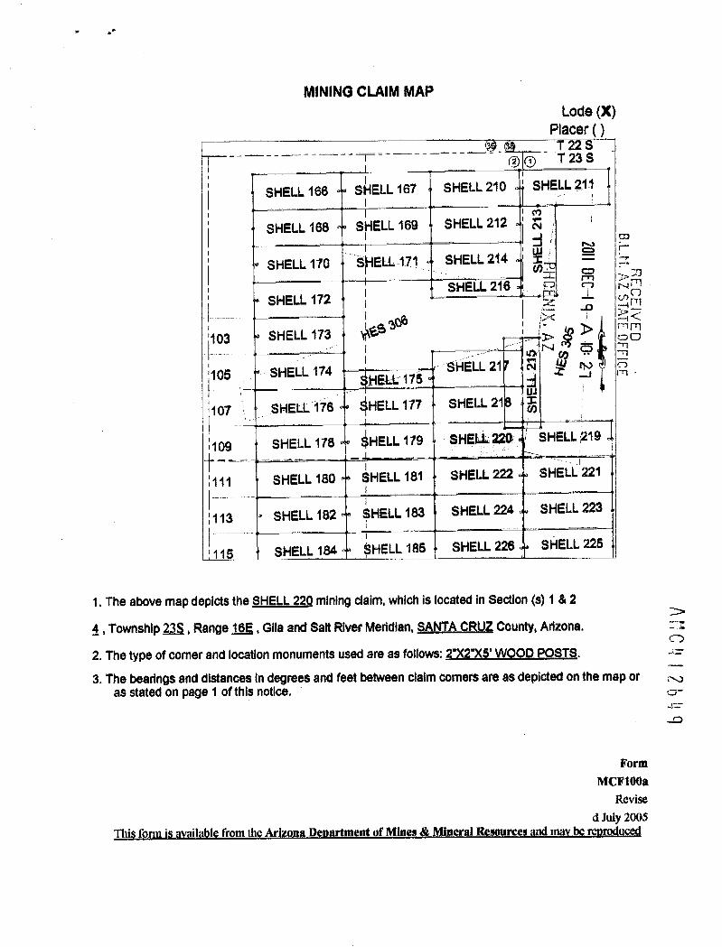
.:
MINING CLAIM MAPLode (X)
Placer ( )
SHELL 166 SHELL 167 SHELL 210 SHELL 211
SHELL 168 SHELL 169 SHELL 212
£51 713HS
J
B.L.ti.SHELL 170 SMELL 171 SHELL 214-r> 30
SHELL 216 CD C-3 AmSHELL 172 c.r) ~
zE .0 r-1 !-224<
'103 SHELL 173 ~65306
'-
0 > py rn
- SHELL 21 A ' -'105 SHELL 174 _ HELL 175 ~ 2 -1 rn
107 SHELL 176 ~HELL 177 SHELL 21 r
1109 SHELL 178 ~HELL 179 SHELL 220 SHELL 219
:111 SHELL 180 SHELL 181 SHELL 222 SHELL'221
113 ' SHELL 182 SHELL 183 SHELL 224 SHELL 223
'115 SHELL 184 HELL 185 SHELL 226 SHELL 225
1. The above map depicts the SHELL_22Q mining daim, which is located in Section (s) 1 & 2
4, Township 23-S, Range 16E, Gita and Salt River Meridian, SANTA_CRUZ County, Arizona.
ANC
2. The type of comer and location monuments used are as follows: 2*X2"XS' WOOD POSTS.
3. The bearings and distances in degrees and feet between claim corners are as depicted on the map or x,as stated on page 1 of this notice. 0-
-0
FormMCF1008
Revised July 2003
Thi form is v ' labl from th Arizona De ment of Mine Mineral Resource an r r

2012 -08 3*:When Filed Return To: .f -r·,v Requested By: |~| ~e~ na MineralsARIZONA MINERALS, INC. ~' . A SUZANNE SAINZ, RECORDER4500 S. CHERRY CREEK DR, SUITE 1040 t - .d SANTA CRUZ COUNTY, ARIZONAi
DENVER, CO 80246 10-19-2012 03:52 PM Recording Fee $10.00~I.: fy
AMENDED LOCATION NOTICE FOR LODE MINING CLAIM
CZZ,
NOTICE IS HEREBY GIVEN that the SHELL-221 lode mining claim BLM '-'- CDBLM serial number, AMC 412650, having an original location date of Date m =3 7-28 NOVEMBER, 2011, as recorded in the office of the County Recorder Sta m p
of Santa Cruz County, State of Arizona, at Reception No. 2012-00432 -has been AMENDED
EC E IVED
2By: ARIZONA MINERALS, INC. > LU
m4500 S. CHERRY CREEK DR, SUITE 1040
DENVER, CO 80246
The general course of this claim is WEST TO EAST and it is situated in SANTA CRUZ County, Arizona. This claim is 1500feet in length and 600 feet in width.
This claim runs from the location monument on which this location notice is posted approximately 2Q feet in a
WESTERLY direction to the WEST end line and 1480 feet in a EASTERLY direction to the EAST end line. This claim ismarked by six monuments, one at each corner and one at the center of each end line of the claim.The location monument on which this notice is posted is situated within Section 2, Township 23 SOUTH, Range 16 EAST,from the Gila and Salt River Meridian, and this claim encompasses portions of the following quarter section (s), section (s),Township (s) and Range (s) SW 1/ELQLSECTION_L_and_the-SE_1/ELS ECTION_LI. 23S R.16.E* from the Gila and SaltRiver Meridian, Arizona.
The locality of this claim with reference to some natural object or permanent monument and additional information(if any) concerning its locality are as follows:_THE-NORTHEAST_CORNER-oftheclaimislocated_7163 feeLEASTand5072_feet-SQUTH_from»the_SQUTHWEST_Cgmer-of_Section_35*I. 221IL-15E fromthe-Gilaand Salt River-MeridianSANTA-CRUZ_CO-UNIYAZ.DATED AND POSTED on the ground this 1 day of 00 r :20 IL .
'16ENTrvr:r' 11, .-'-, Cr,F-801,TFF~ AGENT: [*rling Environmental & Surveying, Ltd.9040 South Rita Road. Suite 2350Tucson, AZ 85747
0 *C 4/1650

2012-OS=5 0-19-2012 03:52 PM Page 2 of 2-
MINING CLAIM MAPLode (X)
Placer ( )
65 SHELL 166 c SH~LL 167 SHELL 210 | SHELL 211
0363 SHELL 168 SHELL 169 SHELL 212 ro -0 f-
---UDJ CD11-1
LU
1~1 Z NOV
161 SHELL 170 SH~ELL 1.71 SHELL 214 I>< 1
SHELL 216 3>
RECEIVED159 SHELL 172 -n-- >N9
.103 SHELL 173 ; If= »
: S ATE OFFICE3> WUl60105 SHELL 174 SHELL 217 W W
S~ELL 175LU
107 SHELL 176 S}{ELL 177 SHELL 218 I
109 SHELL 178 S~-ELi_ 179 SHELL 220 SHELL 219
111 SHELL 180 S~ELL 181 SHELL 222 « SHELL 221-
113 SHELL 182 SI~ELL 183 SHELL 224 SHELL 223
115 SHELL 184 * SHELL 185 SHELL 226 SHELL 225
1. The above map depicts the SHELL 221 mining claim, which is located in Section (s) 1&2
4, Township 23S, Range 16E, Gila and Salt River Meridian, SANTA CRUZ County, Arizona.
2. The type of corner and location monuments used are as follows: ZX235'WOOD POSTS.3. The bearings and distances in degrees and feet between claim corners are as depicted on the map oras stated on page 1 of this notice.
FormMCF100a
Revised July 2005
This form is available from the Arizona Department of Mines & Mineral Resources and may be reproduced

When Fii@d Return To:AZ MINERALS, INC.
4500 S. CHERRY CREEK DR, SUITE 1040
DENVER, CO 80246
LOCATION NOTICE FOR LODE MINING CLAIM
NOTICE IS HEREBY GIVEN that the SHELL-221 lode mining claim BLM SE~Date
Chas been located Sta m p 5 5 18mBy: AZ MINERALS, INC.
4500 S. CHERRY CREEK DR, SUITE 1040 coiN 25 FFIC
DENVER, CO 80246 r.>
The general course of this claim is WEST TO EAST and it is situated in SANTA CRUZ County, Arizona. This claim is 1500
feet in length and 600 feet in width.
This claim runs from the location monument on which this location notice is posted approximately 2Q feet in a
WESTERLY direction to the WEST end line and 1480 feet in a EASTERLY direction to the EAST end line. This claim is
marked by six monuments, one at each corner and one at the center of each end line of the claim.
The location monument on which this notice is posted is situated within Section 1, Township 23 SOUTH, Range 16 EAST,
from the Gila and Salt River Meridian, and this claim encompasses portions of the following quarter section (s), section (s),
Township (s) and Range (s) NWASW- 1/4 of SECTION 1, T. 235, R. 16E, from the Gila and Salt River Meridian, Arizona.
The locality of this claim with reference to some natural object or permanent monument and additional information b
(if any) concerning its locality are as follows: THE NORTHEAST CORNER of the claim is located 7163 feet EAST an' ~
5072 feet SOUTH_from the SOUTHWEST Corner of Section 35, T. 221 R.-16E, from thq_Giltand_Salt_BiverNkddi_ ,
SANTA CRUZ COUNTY, AZ.
1*12 650DATED AND POSTED on the ground this S day of ,!JO\~ _ , 20 ~ ~
A
< / Strs »JOAGENT: Darling Environmental & Surveying, Ltd.
9040 South Rita Road, Suite 2350
Tucson, AZ 85747

. 0MINING CLAIM MAP
Lode (X)Placer ( )
SHELL 166 SHELL 167 SHELL 210 SHELL 211
SHELL 168 SHELL 169 SHELL 212 &
SHELL 170 S~ELL 171 SHELL 214 !8
SHELL 216 -
B.L.M. ASHELL 172 1 - e 2rnf CD N Frli n o , O 035'103 SHELL 173 # 4<
M - GO > Am00
'los SHELL 174 - SHELL 21 -nt®1 175
' 107 SHELL 176 ~HELL 177 SHELL 21 r -3 m
i 109 SHELL 178 ~HELL 179 SHELL 220 SHELL 219
1-111 SHELL 180 SHELL 181 SHELL 222 SHELL 221
1113 ' SHELL 182 SHELL 183 SHELL 224 SHELL 223
'115 SHELL 184 HELL 185 SHELL 226 SHELL 225
1. The above map depicts the SHELL221 mining daim, which is located in Section (s) 1
4, Township 23S , Range 16E, Gila and Salt River Meridian, SANTACRUZ County, Artzona.
2. The type of comer and location monuments used are as follows: 2")(2*XS' WOOD_POSTS.
ANC
3. The hearings and distances in degrees and feet between claim corners are as depicted on the map oras stated on page 1 of this notice.
X)O-C.7CD
FormMCF10(}a
Revised July 2003
Thi form i available from the Arizona De ment of Mines & Mineral Resources and m r r
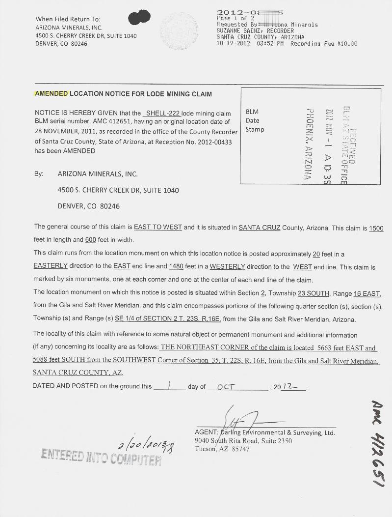
2012·-OF-7--.When Filed Return To: ~ -> Page i of 2 11111
4, Requested By=:MI=~tona MineralsARIZONA MINERALS, INC. · SUZANNE SAINZ, RECORDER4500 S. CHERRY CREEK DR, SUITE 1040 g SANTA CRUZ COUNTY, ARIZONA
10-19-2012 03:52 PM Recording Fee $10.00DENVER, CO 80246
AMENDED LOCATION NOTICE FOR LODE MINING CLAIM
NOTICE IS HEREBY GIVEN that the SHELL-222 lode mining claim BLM -0 N m
BLM serial number, AMC 412651, having an original location date of Date 25 =428 NOVEMBER, 2011, as recorded in the office of the County Recorder Sta m p -C_D
1of Santa Cruz County, State of Arizona, at Reception No. 2012-00433has been AMENDED -#I.
By: ARIZONA MINERALS, INC.1-0 0
4500 S. CHERRY CREEK DR, SUITE 1040
DENVER, CO 80246
The general course of this claim is EAST TO WEST and it is situated in SANTA CRUZ County, Arizona. This claim is 1500
feet in length and 600 feet in width.
This claim runs from the location monument on which this location notice is posted approximately 2Q feet in a
EASTERLY direction to the EAST end line and 1480 feet in a WESTERLY direction to the WEST end line. This claim is
marked by six monuments, one at each corner and one at the center of each end line of the claim.The location monument on which this notice is posted is situated within Section 2, Township 23 SOUTH, Range 16 EAST,from the Gila and Salt River Meridian, and this claim encompasses portions of the following quarter section (s), section (s),
Township (s) and Range (s) SE_114 of SECTION_2 T. 22LE.1@E from the Gila and Salt River Meridian, Arizona.
The locality of this claim with reference to some natural object or permanent monument and additional information(if any) concerning its locality are as follows:_THENORTHEAST_CORNERofthedaimislocated5663_feet-EASTand5088_feet__SOUTHfromthe SOUTHWF.ST__Cgmerof_Section 35 I. 22S R.16E f-omthe_Gilaand SalLRiver«Meridian,_SANTACRUZ_COUNTLAZ.DATED AND POSTED on the ground this / day of-CT , 20 / 2-
4
AGENT:~~rl ng E vironmental & Surveying, Ltd.
>(00 I60/ 3/0 9040 S®th Rita Road. Suite 2350
A- 4
,1(.5
,
ENTTos, w "-= 0- / 6 Tucson, AZ 85747. <...6. L' ill . J cofhpl .ITFI*, d *J +

2012-083~19-2012 03:52 PM Page 2 of 2
MINING CLAIM MAPLode (X)
Placer ( )
-3-- 03(165 SHELL 166 SH~LL 167 SHELL 210 | SHELL 211
CO63 SHELL 168 SHELL 169 SHELL 212 91 n -- =»AS 9
dns161 SHELL 170 SH~ELL.171 SHELL 214 ..<=
-4, f
SHELL 216 >U-1 <159 ' SHELL 172 4 ~~ rn-n00
103 SHELL 173o i ul j rn
.105 SHELL 174 SHELL 217 1,0 i'.#S ELL 175
.107 SHELL 176 S~ELL 177 SHELL 218 r
109 SHELL 178 S ELL 179 SHELL 220 SHELL 219
111 SHELL 180 S~ELL 181 SHELL 222 SHELL 221
- 113 SHELL 182 S~ELL 183 SHELL 224 SHELL 223
115 SHELL 184 SHELL 185 SHELL 226 SHELL 225
1. The above map depicts the SHELL 222 mining claim, which is located in Section (s) 2
4, Township 23S, Range 16E , Gila and Salt River Meridian, SANTA CRUZ County, Arizona.
2. The type of corner and location monuments used are as follows: 2"X2"XS' WOOD POSTS.3. The bearings and distances in degrees and feet between claim corners are as depicted on the map oras stated on page 1 of this notice.
FormMCF10Oa
Revised July 2005
This form is available from the Arizona Department of Mines & Mineral Resources and may be reproduced

- *qWhen Filed Return To:AZ MINERALS, INC.
4500 S. CHERRY CREEK DR, SUITE 1040
DENVER, CO 80246
LOCATION NOTICE FOR LODE MINING CLAIM 2611
B.L.M.
STAT OFFICE
NOTICE IS HEREBY GIVEN that the SHELL-222 lode mining claim BLM -0 0
Date 5 m msrnhas been located Sta m p 0 -
By: AZ MINERALS, INC. 0
4500 S. CHERRY CREEK DR, SUITE 1040
DENVER, CO 80246
The general course of this claim is EAST TO WEST and it is situated in SANTA CRUZ County, Arizona. This claim is 1500
feet in length and 600 feet in width.
This claim runs from the location monument on which this location notice is posted approximately 2Q feet in a
EASTERLY direction to the EAST end line and 1480 feet in a WESTERLY direction to the WEST end line. This claim is
marked by six monuments, one at each corner and one at the center of each end line of the claim.
The location monument on which this notice is posted is situated within Section 2, Township 23 SOUTH, Range 16 EAST,
from the Gila and Salt River Meridian, and this claim encompasses portions of the following quarter section (s), section (s),
Township (s) and Range (s) SE 1/4 of SECTION 2. SW 1/4 of SECTION 1. T. 235. R.16E. from the Gila and Salt River
Meridian, Arizona.
The locality of this claim with reference to some natural object or permanent monument and additional information
(if any) concerning its locality are as follows: THE NORTHEAST CORNER ofthe claim is located 5663 feet EAST and
508*feet_SQUTH_from the SOUTHWEST Corner of Section 35, T. 22S, R. 1613, from the Gila and Salt Biver Meridian,
SANTA CRUZ COUNTY. AZ.
DATED AND POSTED on the ground this 1-% day of NOJ , 20 \1
>/ 5€-Ff 30MfjAGENT: Darling Environmental & Surveying, Ltd. CD
9040 South Rita Road, Suite 2350
Tucson, AZ 85747
265

-.
MINING CLAIM MAPLode (X)
Placer ( )
SHELL 166 SHELL 167 SHELL 210 SHELL 211
SHELL 168 SHELL 169 SHELL 212 ' m
SHELL 170 S~ELL 171 SHELL 214
SHELL 216
912 713HS
REC
EIVEDSHELL 172
1-9 A 10: 21
-
103 SHELL 173
90£ 93H
'105 SHELL 174 SHELL 21HELL 175
'107 SHELL 176 ~HELL 177 SHELL 21
5109 SHELL 178 ~HELL 179 SHELL 220 SHELL 219
3 11 SHELL 180 SHELL 181 SHELL 222 SHELL 221
1113 ' SHELL 182 SHELL 183 SHELL 224 SHELL 223
'115 SHELL 184 HELL 185 SHELL 226 SHELL 225
1. The above map depicts the SHELL 222 mining claim, which is located In Section (s) 1&2
4, Township 23S, Range 16E, Gita and Salt River Meridian, SANIA CBUZ County, Arizona.
2. The type of comer and location monuments used are as follows: 2"XZXS' WOOD_EQSIS.
3. The bearings and distances in degrees and feet between claim corners are as depicted on the map oras stated on page 1 of this notice. A IC 4
71FormMCF100* ,
Revise =C.Jld July 2005
Thi form i v labl from the Arizon De ment of Mine & Mineral Resources and ber r

2012 -0 513 26When Filed Return To: Page lof 2 1~ fl
Requested By: 11:-tkona MineralsARIZONA MINERALS, INC. . SUZANNE SAINZ, RECORDER4500 S. CHERRY CREEK DR, SUITE 1040 SANTA CRUZ COUNTY, ARIZONADENVER, CO 80246 10-19-2012 03:52 PM Recording Fee $10.00
AMENDED LOCATION NOTICE FOR LODE MINING CLAIM
NOTICE IS HEREBY GIVEN that the SHELL-223 lode mining claim BLM
5L
BLM serial number, AMC 412652, having an original location date of Date r·, '
10 1 NO -22 NOVEMBER, 2011, as recorded in the office of the County Recorder Stamp . #crl
of Santa Cruz County, State of Arizona, at Reception No. 2012-00434 -i tv;has been AMENDED -i .47-
i-rlt-6
00O 25 -~-rl
By: ARIZONA MINERALS, INC. *. W ECA 311
4500 S. CHERRY CREEK DR, SUITE 1040
DENVER, CO 80246
The general course of this claim is WEST TO EAST and it is situated in SANTA CRUZ County, Arizona. This claim is 1500
feet in length and 600 feet in width.
This claim runs from the location monument on which this location notice is posted approximately 2Q feet in a
WESTERLY direction to the WEST end line and 1480 feet in a EASTERLY direction to the EAST end line. This claim is
marked by six monuments, one at each corner and one at the center of each end line of the claim.The location monument on which this notice is posted is situated within Section 2, Township 23 SOUTH, Range 16 EAST,
from the Gila and Salt River Meridian, and this claim encompasses portions of the following quarter section (s), section (s),
Township (s) and Range (s) SW 1/4-of SECTIONLL-and_the SE 1/4 of SECTION_2 I.-23S R.16E: from the Gila and SaltRiver Meridian, Arizona.
The locality of this claim with reference to some natural object or permanent monument and additional information
( f any) concerning its locality are as follows:_THE-NORTHEASTCORNER.oflhedaimislocated_7170-feet EASI_and5672_feet-SQUTH-f-omthe_SQUTHWFST_Cgmer_of_Section_15 T. 221«R. LQE _fromthe Q{la and.Salt River MeridianSANTA CRUZ COUNTY. AZ.
DATED AND POSTED on the ground this ~ day of 0 6 7- , 20 i li .
2 120 ~60\3il -ENTERED JKTZ' 20!jiPUTEE AGENT: Drling Environmental-&Surveying,-Ltd.
A#k 4/1652,
9040 South Rita Road, Suite 2350Tucson. AZ 85747

2012-0839~ ~~-19-2012 03:52 PM Page 2 of i
MINING CLAIM MAPLode (X)
Placer ( )
(365 SHELL 166 SH~LL 167 SHELL 210 | SHELL 211
63 SHELL 168 o SHELL 169 SHELL 212 £2173H
S161 SHELL 170 S}*LL.171 SHELL 214
SHELL 216 . CO159 SHELL 172 AZ STATI. OFFICE
103 SHELL 173 rt
REC,
--
.105 SHELL 174 SHELL 217 1 1 mS ELL 175 IV CD
107 SHELL 176 ° S~ELL 177 SHELL 218 Icn 3 04
109 SHELL 178 S ELL 179 SHELL 220 c SHELL 219
111 SHELL 180 SI~ELL 181 ~ SHELL 222 SHELL 221
113 SHELL 182 STELL 183 SHELL 224 SHELL: 223
115 SHELL 184 SHELL 185 SHELL 226 .0 SHELL 225
1. The above map depicts the SHELL 223 mining claim, which is located in Section (s) 1&2
4, Township 23S, Range 16E, Gita and Salt River Meridian, SANTA CRUZ County, Arizona.
2. The type of corner and location monuments used are as follows: ~OOD--POSTS.3. The bearings and distances in degrees and feet between claim corners are as depicted on the map or
as stated on page 1 of this notice.
FormMCF100a
Revised July 2005
Ihisformisavailableftom-theArizonaUenartnientofMines&.MineraIResguircesandmabereroduced

, Wben Filed Return To:AZ MINERALS, INC.
4500 S. CHERRY CREEK DR, SUITE 1040
DENVER, CO 80246
LOCATION NOTICE FOR LODE MINING CLAIM
B.L.M. .AT
FFICE
NOTICE IS HEREBY GIVEN that the _SHELL-223 lode mining claim BLM 3 0
Date 0 ~ iv-rlhas been located m ._O
Sta m p Z -0X <4
By: AZ MINERALS, INC. 00o
45005. CHERRY CREEK DR, SUITE 1040 ro-J
DENVER, CO 80246
The general course of this claim is WEST TO EAST and it is situated in SANTA CRUZ County, Arizona. This claim is 1500
feet in length and 600 feet in width.
This claim runs from the location monument on which this location notice is posted approximately 2Q feet in a
WESTERLY direction to the WEST end line and 1480 feet in a EASTERLY direction to the EAST end line. This claim is
marked by six monuments, one at each corner and one at the center of each end line of the claim.
The location monument on which this notice is posted is situated within Section 1, Township 23 SOUTH, Range 16 EAST,
from the Gila and Salt River Meridian, and this claim encompasses portions of the following quarter section (s), section (sh
Township (s) and Range (s) SW 1/4 of SECTION 1. T. 235. R.16E, from the Gila and Salt River Meridian, Arizona.
The locality of this claim with reference to some natural object or permanent monument and additional information
(if any) concerning its locality are as follows: THE NORTHEAST CORNER of the claim is located 7170 feelEAST and
5672_feet-SQUIH from the-SQUIHWEST.Comer-of Section liI.-223 R.-16E from the Gila and Salt River Meridian
SANIA-CRUZ_COUNIYAZ.
DATED AND POSTED on the ground this Z_1 day of NOV , 20 1~
32[M 40 ve fAGENT: Darling Environmental & Surveying, Ltd.
9040 South Rita Road, Suite 2350
0112552
Tucson, AZ 85747

0 0MINING CLAIM MAP
Lode (X)Placer ( )
-r T 235
SHELL 166 SHELL 167 SHELL 210 SHELL 211
SHELL 168 SHELL 169 SHELL 212 ' n
B.L.M.
TATE OFFICE
O -_mSHELL 170 S~ELL 171 SHELL 214 ' !8 R Am
SHELL 216 -D ZSHELL 172 ), Fl
0
103 SHELL 173 ~58 306
4 # AZ*CegH
'105 SHELL 174 SHELL 21HELL 175
9 KE 778HS
'107 SHELL 176 d HELL 177 SHELL 21
~109 SHELL 178 ~HELL 179 SHELL 220 SHELL 219
311 SHELL 180 SHELL 181 SHELL 222 SHELL 221
113 ' SHELL 182 SHELL 183 SHELL 224 SHELL 223
'115 SHELL 184 HELL 185 SHELL 226 SHELL 225
1. The above map depicts the SHELL 223 mining claim, which is located in Section (s) 1
4, Township 235, Range 16E, Gita and Salt River Meridian, SANTA_CRUZ County, Arizona.
2. The type of comer and location monuments used are as follows: 20)(2"XS' WOOD POSTS.
A 64
3. The beartngs and distances in degrees and feet between claim corners are as depicted on the map oras stated on page 1 of this notice.
Cr
r-4Form
MCF1008Revise
d July 2005Thi f rin is vail ble from the Arizona De artment of Mine & Minerat Resources and rru

2012-083117When Filed Return To: ' °~A, Page 1 of 2
3 Requested By: ~| ~.6 na MineralsARIZONA MINERALS, INC. 9 ') SUZANNE SAINZ, RECORDER4500 S. CHERRY CREEK DR, SUITE 1040 . v 2 SANTA CRUZ COUNTY, ARIZONADENVER, CO 80246 -=-:-* 10·-19-2012 03:52 PM Recording Fee *10.00
AMENDED LOCATION NOTICE FOR LODE MINING CLAIM
NOTICE IS HEREBY GIVEN that the SHELL-224 lode mining claim BLMEn
BLM serial number, AMC 412653, having an original location date of Date22 NOVEMBER, 2011, as recorded in the office of the County Recorder Stamp t71
of Santa Cruz County, State of Arizona, at Reception No. 2012-004350has been AMENDED rn
0 NI ', ARIZ
0By: ARIZONA MINERALS, INC. .1'1-
71'7145005. CHERRY CREEK DR, SUITE 1040
DENVER, CO 80246
The general course of this claim is EAST TO WEST and it is situated in SANTA CRUZ County, Arizona. This claim is 1500
feet in length and 600 feet in width.
This claim runs from the location monument on which this location notice is posted approximately 2Q feet in a
EASTERLY direction to the EAST end line and 1480 feet in a WESTERLY direction to the WEST end line. This claim is
marked by six monuments, one at each corner and one at the center of each end line of the claim.The location monument on which this notice is posted is situated within Section 2, Township 23 SOUTH, Range 16 EAST,
from the Gila and Salt River Meridian, and this claim encompasses portions of the following quarter section (s), section (s),
Township (s) and Range (s) SE_1/4_of-SECTION_2 T. 238*-8.16!L from the Gila and Salt River Meridian, Arizona.
The locality of this claim with reference to some natural object or permanent monument and additional information
(if any) concerning its locality are as follows:_THE-NORTHEASTCORNERoftheclaimis-located_5670 feet EAST_and55.88.-feeLSOLE['H from the SOUTHWFST_Cgmerof_Section_35 I. 22S R.16E from-the_Gila and-Salt«RiperLMeridian.SANIA-CRUZ_COUNIXAZ.DATED AND POSTED on the ground this t day of -,56 F , 20 3 6
J AD (90\3(0 AGENT:,Darling EA'vironmental & Surveying, Ltd .1.<6 9040 Sduth Rita Road, Suite 2350
ENTERED' 1!(: 2 COMPUTE¥f Tucson, AZ 85747
/BL 4/2653

2012-083~_~-19-2012 03:52 PM Page 2 of 2
MINING CLAIM MAPLode (X)
Placer ( )6 *
65 ~ SHELL 166 SH~LL 167 SHELL 210 1 SHELL 211
63 SHELL 168 SHELL 169 SHELL 212 .1 Md - Ce161 9 SHELL 170 SH~ELL 1.71 SHELL 214 'I 521
SHELL 216 ,CD
159 SHELL 172 ..4 ,'
Ii''to
103 SHELL 173
fE.fl-ve
Icld.105 SHELL 174 SHELL 217
S ELL 175
f - VE
FFICECr]illi
107 SHELL 176 S~ELL 177 SHELL 218 r
109 SHELL 178 S ELL 179 SHELL 220 SHELL 219 .
111 SHELL 180 S~ELL 181 SHELL 222 SHELL 221
113 SHELL 182 STELL 183 SHELL 224 SHELL 223
115 SHELL 184 SHELL 185 SHELL 226 SHELL 225
1. The above map depicts the SHELL 224 mining claim, which is located in Section (s) 2
4, Township 23S, Range 16E, Gila and Salt River Meridian, SANTACRUZ County, Arizona.
2. The type of corner and location monuments used are as follows: r*2Z5'WOOD_POSTS.3. The bearings and distances in degrees and feet between claim corners are as depicted on the map or
as stated on page 1 of this notice.
FormMCF10Oa
Revised July 2005
This form is available from the Arizona Department of Mines & Mineral Resources and may be reproduced

When Filed Return To:AZ MINERALS, INC.
4500 S. CHERRY CREEK DR, SUITE 1040
DENVER, CO 80246
LOCATION NOTICE FOR LODE MINING CLAIM
NOTICE IS HEREBY GIVEN that the SHELL-224 lode mining claim BLMDate .-I
has been located Stamp 0
20 DEC
9 A
mZ
REC
EIVEDBy: AZ MINERALS, INC. X
45005. CHERRY CREEK DR, SUITE 1040 N 5
AZ STATE OFFICE
DENVER, CO 80246
The general course of this claim is EAST TO WEST and it is situated in SANTA CRUZ County, Arizona. This claim is 1500
feet in length and 600 feet in width.
This claim runs from the location monument on which this location notice is posted approximately 2Q feet in a
EASTERLY direction to the EAST end line and 1480 feet in a WESTERLY direction to the WEST end line. This claim is
marked by six monuments, one at each corner and one at the center of each end line of the claim.
The location monument on which this notice is posted is situated within Section 2, Township 23 SOUTH, Range 16 EAST,
from the Gila and Salt River Meridian, and this claim encompasses portions of the following quarter section (s), section (s),
Township (s) and Range (s) SE_1/4-of-SECTION 2, SW 1/4 of SECTION 1, T. 235,_ 1116E, from the Gila and Salt River
Meridian, Arizona.
The locality of this claim with reference to some natural object or permanent monument and additional information
(if any) concerning its locality are as follows: THE-NORTHEAST-CORNERoftheclaimislocated-5670 feeLEAST and-
568§_feeLSQUI11*Qmthe_SQUIHWEST-Comer of_Section _313.2283L_16E~[kgm the Gila and Salt«River Meridian
SANTA CRUZ COUNTY, AZ.
DATED AND POSTED on the ground this 'EL day of .AJOV __, 20 4~
5 // //7MJ \ /-*-- D
AGENT: Darling Environmental & Surveying, Ltd. /4{.3-
9040 South Rita Road, Suite 2350 1-uTucson, AZ 85747

MINING CLAIM MAPLode (X)
Placer ( )
® 0 f-23-5SHELL 166 SHELL 167 SHELL 210 ' SHELL 211
SHELL 168 SHELL 169 SHELL 212 &d
B.L.M .~S
INE
OFFIC
E
SHELL 170 S~ELL 171 SHELL 214 ~
ZOII DEC 9SHELL 216
SHELL 172 -*.
'103 SHELL 173 169
105 SHELL 174 - SHELL 21 4/HELL 175 2
9% 713HS
'107 SHELL 176 E~HELL 177 SHELL 21
709 SHELL 178 ~HELL 179 SHELL 220 SHELL 219
1111 SHELL 180 SHELL 181 SHELL 222 SHELL 221
113 « SHELL 182 SHELL 183 SHELL 224 SHELL 223
'115 SHELL 184 HELL 185 SHELL 226 SHELL 225
1. The above map depicts the SHELL_224 mining claim, which is located in Section (s) 1 & 2
4, Township 235, Range leE, Gita and Salt River Meridian, SANTA CBUZ County, Arizona.
2. The type of corner and location monuments used are as follows: 2")(2"XS' WOOD POSTS.
AMC
3. The bearings and distances in degrees and feet between claim corners are as depicted on the map oras stated on page 1 of this notice.
crcnLU
FormMCF100*
Revised July 2005
111i f rm.isavaitablefromthe A[iZona DEUartinentoLMingL& Min ral.Egmourtemand~

2 01 2-08 BEHBWhen Filed Return To: . r F'else 1 of 2 111ARIZONA MINERALS, INC. Requested Bia: Ar-- na Minerals
SUZANNE SAINZ, RECORDER4500 S. CHERRY CREEK DR, SUITE 1040 2 SANTA CRUZ COUNTY, ARIZONADENVER, CO 80246 10-19-2012 03:52 PM Recording Fee *10.Dill
AMENDED LOCATION NOTICE FOR LODE MINING CLAIMu %00
NOTICE IS HEREBY GIVEN that the SHELL-225 lode mining claim BLM r\.
r--IBLM serial number, AMC 412654, having an original location date of Date -„- --r . ~4 -U
22 NOVEMBER, 2011, as recorded in the office of the County Recorder Stamp . _, 0
of Santa Cruz County, State of Arizona, at Reception No. 2012-00436has been AMENDED
By: ARIZONA MINERALS, INC. Cn 61
4500 S. CHERRY CREEK DR, SUITE 1040
DENVER, CO 80246
The general course of this claim js WEST TO EAST and it is situated in SANTA CRUZ County, Arizona. This claim is 1500
feet in length and 600 feet in width.
This claim runs from the location monument on which this location notice is posted approximately 2Q feet in a
WESTERLY direction to the WEST end line and 1480 feet in a EASTERLY direction to the EAST end line. This claim is
marked by six monuments, one at each corner and one at the center of each end line of the claim.
The location monument on which this notice is posted is situated within Section 2, Township 23 SOUTH, Range 16 EAST,
from the Gila and Salt River Meridian, and this claim encompasses portions of the following quarter section (s), section (s),
Township (s) and Range (s) SE--1/4 of_SECTION_L_and the SE 1/4 of SECT[QhLLT._23S RZE* from the Gila and SaltRiver Meridian, Arizona.
The locality of this claim with reference to some natural object or permanent monument and additional information
(if any) concerning its locality are as follows:_THE_NORTHEAST.CORNERoftheclaimislocated Z,lE_feet«EASTand6272 feet_SQUTH fromthe SQUTHWEST Comer_of_Section 35*-I. 221-IL16E_from the-Gila and Salt River MeridianSANTACRUZCOBTILAZ.DATED AND POSTED on the ground this / day of D CT« , 20 1 7_.
f*/-1-
AK 4/1459
AGENT: D,dirling Environmental & Surveying, Ltd.;1450ED 11&:-0 C nikip' 11-FR 9040 South Rita Road, Suite 2350Tucson, AZ 85747

2012-08~~ ~0-19-2012 03:52 PM Page 2 of 2
MINING CLAIM MAPLode (X)
Placer ( )L
ELL 115 SHELL 184 SHELL 185 SHELL 226 or. SHELL 225
ELI_ 117(3~ SHELL 186 S¢ELLI 87 SHELL 228 SHELL 2272 1
ELL 119- SHELL 188 S ELL 189 SHELL 230 -SHELL 2291
EL~121 SHELL 190 S~ELL 191 SHELL 232 SHELL 231
ELL 123 SHELL 192 S ELL 193 SHELL 234 SHELL 233
4-ELL 125 SHELL 194 SHELL 195 SHELL 236 SHELL 235
COE 127 SHELL196_ S~-ELL197_ SHELL 238 SHELL 237 rh--0
r71 -ELL 129 SHELL 198 SHELL 199 SHELL 240 SHELL 239 2 52 .4
U_ >< .3
ELL 131 SHELL 200 S~ELL 201 SHELL 242 SHELL 241 3>
RECEIVED4-ELL 133 SHELL 202 SHELL 203 SHELL 244 cy SHELL 243
L I s
nATE 0 FICE
/-1 A D 35
SHELL 204 S~HELL 205 SHELL 246 SHELL 245
(14 1
1. The above map depicts the SHELL 225 mining claim, which is located in Section (s) 1&2
4, Township 23S, Range 16E, Gila and Salt River Meridian, SANTA CRUZ County, Arizona.
2. The type of corner and location monuments used are as follows: ~51-W-OOD-EQSTS.3. The bearings and distances in degrees and feet between claim corners are as depicted on the map or
as stated on page 1 of this notice.
FormMCFIOOa
Revised July 2005
Ihis form is_available from-the Arizona Department of Mines & Mineral Resources and maybe reproduced

" ~ When Filed Return To:AZ MINERALS, INC.
4500 S. CHERRY CREEK DR, SUITE 1040
DENVER, CO 80246
LOCATION NOTICE FOR LODE MINING CLAIM N L.M. 7 5 ATE OFFICE
NOTICE IS HEREBY GIVEN that the _-SHELL-225 lode mining claim BLM 2 ~ >A0Date Frl
has been located ZSta m p
0By: AZ MINERALS, INC. N 9
4500 S. CHERRY CREEK DR, SUITE 1040 -J
DENVER, CO 80246
The general course of this claim is WEST TO EAST and it is situated in SANTA CRUZ County, Arizona. This claim is 1500
feet in length and 600 feet in width.
This claim runs from the location monument on which this location notice is posted approximately 2Q feet in a
WESTERLY direction to the WEST end line and 1480 feet in a EASTERLY direction to the EAST end line. This claim is
marked by six monuments, one at each corner and one at the center of each end line of the claim.
The location monument on which this notice is posted is situated within Section 1, Township 23 SOUTH, Range 16 EAST,
from the Gila and Salt River Meridian, and this claim encompasses portions of the following quarter section (s), section (s),
Township (s) and Range (s) SW 1 /4 of SECTION 1. T. 235. R.16E, from the Gila and Salt River Meridian, Arizona.
The locality of this claim with reference to some natural object or permanent monument and additional information
(if any) concerning its locality are as follows: THE NORTHEAST CORNER ofthe claim is located 7176 feet EAST and
6272 feet SOUTH from the SOUTHWEST Corner of Section 35, T. 22S, R. 16E, from the Gila and Salt River Meridian,
SANTA CRUZ COUNTY, AZ.
DATED AND POSTED on the ground this Zf_ _ day of ~ --, 201 ~
SE-fv 30 tifAGENT: Darling Environmental & Surveying, Ltd.
9040 South Rita Road, Suite 2350 1Tucson, AZ 85747 ,_3-

MINING CLAIM MAPLode (X)
Placer ( )
SHELL 184 ~HELL 185 SHELL 226 SHELL 225
SHELL 186 ~HELL 187 SHELL 228 SHELL 227
SREEL-ies- - -~HELI-189 SHEtt 2 1 SHEEL11 @ -ri
SHELL 190 ~HELL 191 SHELL 232 SHEL~31
RECEI
--4<mmSHELL 192 ~SHELL 193 SHELL 234 ' SHEL~233 0OFFICE
SHELL 194 iSHELL 195 SHELL 236 ' SHELL 235 N
SHELL 196 ISHELL 197 SHELL 238' SHELL 237
SHELL 198 SHELL 199 SHELL 240' SHELL 239
SHELL 200 1 SHELL 201 SHELL 242' SHELL 241
SHELL 202 j SHELL 203 SHELL 244 SHELL 243
SHELL 204 ~ SHELL 205 SHELL 244 SHELL 245
1. The above map depicts the SHELL_225 mining daim, which is located in Section (s) 1
AMC 265
4, Township 23_S, Range 16E , Glla and Salt River Meridian, SANTA-CRUZ County, Arizona.
2. The type of comer and location monuments used are as follows: 27275' WOOD POSTS.
3. The bearings and distances in degrees and feet between claim corners are as depicted on the map oras stated on page 1 of this notice.
FormMCF100*
Revised July 2005
Thi form i a ailabl from the Arizona De artm nt of MInes & Mineral Resources and ma r

2012-08:31812When Filed Return To: 4 Page 1 of 2 8, 1 4
ARIZONA MINERALS, INC. Requested By: (174*na MineralsSUZANNE SAINZ, RECORDER
4500 S. CHERRY CREEK DR, SUITE 1040 SANTA CRUZ COUNTY, ARIZONADENVER, CO 80246 10-19-2012 03:52 PM Recording Fee *10.00
AMENDED LOCATION NOTICE FOR LODE MINING CLAIM ry·1
NOTICE IS HEREBY GIVEN that the SHELL-226 lode mining claim BLMCDBLM serial number, AMC 412655, having an original location date of Date .I * <: - r /77
22 NOVEMBER, 2011, as recorded in the office of the County Recorder Stamp X
of Santa Cruz County, State of Arizona, at Reception No. 2012-00437 -- vnrihas been AMENDED => ce
0 53 -C
UJ CD0- Fri
By: ARIZONA MINERALS, INC.
45005. CHERRY CREEK DR, SUITE 1040
DENVER, CO 80246
The general course of this claim is EAST TO WEST and it is situated in SANTA CRUZ County, Arizona. This claim is 1500
feet in length and 600 feet in width.
This claim runs from the location monument on which this location notice is posted approximately 2Q feet in a
EASTERLY direction to the EAST end line and 1480 feet in a WESTERLY direction to the WEST end line. This claim is
marked by six monuments, one at each corner and one at the center of each end line of the claim.
The location monument on which this notice is posted is situated within Section 2, Township 23 SOUTH, Range 16 EAST,
from the Gila and Salt River Meridian, and this claim encompasses portions of the following quarter section (s), section (s),
Township (s) and Range (s) SE 1/4 of SECTION 2, T. 235, R.16E, from the Gila and Salt River Meridian, Arizona.
The locality of this claim with reference to some natural object or permanent monument and additional information
(if any) concerning its locality are as follows: THE NORTHEAST CORNER ofthe claim is located 5676 feet EAST and
6288__feet_SOUTH ftomthe SQUTHWEST_Comerof_Sedion_35*I. 2283L15E fromthe Gilaand Salt_RiverMeridianSANTA CRUZ COUNTY. AZ.
DATED AND POSTED on the ground this f day of OCT , 20 12- .
4 -5' 11- 0 190\54
AGENT: Darling Environmental & Surveying, Ltd.9040 South Rita Road. Suite 2350Tucson, AZ 85747ENTERED rD COMPUTER
*#L4/2. 4550

2012-08399 10-19-2012 03:52 PM Page 2 of 2
MINING CLAIM MAPLode (X)
Placer ( )
ELL 115 SHELL 184 SHELL 185 SHELL 226 SHELL 2251 j
EL.p 117«) SHELL 186 S~ELL 187 SHELL 228 SHELL 2272 (1
~119~ SHELL 188 S ELL 189 SHELL 230 © 40-SHELL 229
EL~121 SHELL 190 59ELL 191 SHELL 232 SHELL 231
ELL 123 SHELL 192 S ELL 193 SHELL 234 SHELL 233
4-ELI 125 SHELL 194 shELL 195 SHELL 236 SHELL 235 1 0
-
127 SHELL 196 S~LELL-197 SHELL 238 SHELL 23t)
ELL 129 SHELL 198 SHELL 199 SHELL 240 SHELL 23*< ' erm
53<1. 4-,7
ELL 131 SHELL 200 S~ELL 201 SHELL 242 SHELL 24153 -- -77O 0
4- o 9 77W CD
ELL 133 SHELL 202 SHELL 203 SHELL 244 SHELL 243> cr m
SHELL 204 4HELL 205 SHELL 246 SHELL 245
1. The above map depicts the SHELL 226 mining claim, which is located in Section (s) 1
4, Township 23S, Range 16E , Gila and Salt River Meridian, SANTA CRUZ County, Arizona.
2. The type of corner and location monuments used are as follows: 2"X235'WOOD_POSTS.3. The bearings and distances in degrees and feet between claim corners are as depicted on the map or
as stated on page 1 of this notice.
FormMCF100a
Revised July 2005
Thisformisavailablettomthe-ArizonRIZeartinentof-Mines&-MineraIResgurcesandmaberemoduced

When Filed Return To:AZ MINERALS, INC.
4500 S. CHERRY CREEK DR, SUITE 1040
DENVER, CO 80246
LOCATION NOTICE FOR LODE MINING CLAIM
NOTICE IS HEREBY GIVEN that the SHELL-226_lode mining claim BLM
20 DEC 1 9
B.L.M. A 7 r + FFICE
Date 30has been located Sta m p 0
PHOENIX.By: AZ MINERALS, INC. ~ FIrrt00
4500 S. CHERRY CREEK DR, SUITE 1040 r.4 g
DENVER, CO 80246 -J
The general course of this claim is EAST TO WEST and it is situated in SANTA CRUZ County, Arizona. This claim is 1500
feet in length and 600 feet in width.
This claim runs from the location monument on which this location notice is posted approximately 2Q feet in a
EASTERLY direction to the EAST end line and 1480 feet in a WESTERLY direction to the WEST end line. This claim is
marked by six monuments, one at each corner and one at the center of each end line of the claim.
The location monument on which this notice is posted is situated within Section 2, Township 23 SOUTH, Range 16 EAST,
from the Gila and Salt River Meridian, and this claim encompasses portions of the following quarter section (s), section (s),
Township (s) and Range (s) SE 1/4 of SECTION 2. SW 1/4 of SECTION 1, T. 235, R.16E, from the Gila and Salt River
Meridian, Arizona.
The locality of this claim with reference to some natural object or permanent monument and additional information
(if any) concerning its locality are as follows: THE NORTHEAST CORNER of the claim is located 5676 feet EAST and
6288-feet_SOUTH from_the SOUTHWEST Corner of Section 35, T. 22S, R. 168. from the Gila and Salt River Meridian,
SANTACRUZ_COUNTLAZ.
DATED AND POSTED on the ground this 2,7- day of A*)4 , 20 1 1
beTH J,ver 0
AGENT: Darling Environmental & Surveying, Ltd.
9040 South Rita Road, Suite 2350 crTucson, AZ 85747
--7

MINING CLAIM MAPLode (X)
Placer ( )
SHELL 184 ~HELL 185 SHELL 226 SHELL 225
SHELL 186 ~HELL 187 SHELL 228 SHELL 227
5AmITES - --~ELL-189 SHELL 2 m@ mm o
SHELL 190 ~HELL 191 SHELL 232 SHEL~231 --10
mR
SHELL 192 ~SHELL 193 SHELL 234' SHEI®p33 00FFICE
SHELL 194 ISHELL 195 SHELL 236 ' SHELL 235
SHELL 196 ISHELL 197 SHELL 238' SHELL 237
SHELL 198 1 SHELL 199 SHELL 240 SHELL 239
SHELL 200 SHELL 201 SHELL 242' SHELL 241
SHELL 202 1 SHELL 203 SHELL 244] SHELL 243
SHELL 204 1 SHELL 205 SHELL 24« SHELL 245
1. The above map depicts the SHELL 226 mining daim, which is located in Section (s) 1&2
4, Township 238, Range 16E , Glla and Salt River Meridian, SANTA CRUZ County, Arizona.
AMC 2b55
2. The type of comer and location monuments used are as follows: 272*)(5' WOOD POSTS.
3. The bearlngs and distances in degrees and feet between claim corners are as depicted on the map oras stated on page 1 of this notice.
FormMCF1008
Revised July 2005
Thi f rm i vaila le from the Arizona De ment f Mines & Mineral Resources and m r odu

2012-08 f 05)When Filed Return To: Page 1 of 2 I'll ~~'ARIZONA MINERALS, INC. Requested By: 1 ·tipna Minerals
SUZANNE SAINZ, RECORDER4500 S. CHERRY CREEK DR, SUITE 1040 SANTA CRUZ COUNTY, ARIZONADENVER, CO 80246 10-19-2012 03:52 PM Recording Fee *10.00
AMENDED LOCATION NOTICE FOR LODE MINING CLAIM
NOTICE IS HEREBY GIVEN that the SHELL-227 lode mining claim BLM cBLM serial number, AMC 412656, having an original location date of Date Fl 9 -D.
'% CD 3-4 33---- in22 NOVEMBER, 2011, as recorded in the office of the County Recorder Stamp Xof Santa Cruz County, State of Arizona, at Reception No. 2012-00438 3
-71has been AMENDED Si j, -I; C
LUBy: ARIZONA MINERALS, INC.
4500 S. CHERRY CREEK DR, SUITE 1040
DENVER, CO 80246
The general course of this claim is WEST TO EAST and it is situated in SANTA CRUZ County, Arizona. This claim is 1500
feet in length and 600 feet in width.
This claim runs from the location monument on which this location notice is posted approximately 2.Q feet in a
WESTERLY direction to the WEST end line and 1480 feet in a EASTERLY direction to the EAST end line. This claim is
marked by six monuments, one at each corner and one at the center of each end line of the claim.The location monument on which this notice is posted is situated within Section 2, Township 23 SOUTH, Range 16 EAST,
from the Gila and Salt River Meridian, and this claim encompasses portions of the following quarter section (s), section (s),
Township (s) and Range (s) SW_1/4 of-SECTION_l and the_SE-1/4 QLS ECTION_LI. 231-8.16,E: from the Gila and Salt IRiver Meridian, Arizona.
The locality of this claim with reference to some natural object or permanent monument and additional information(if any) concerning its locality are as follows:_THENORTHEAST_CORNER-ofthe daimis located 7182 feet EAST_and-6872-feet_SQUI-Hfromithe SOUTHWFST-Cgmer of_Section 35 T. 22831-16E._fromthe_Qila and SaltRiyer MeridianSANTA CRUZ COUNTY. AL
DATED AND POSTED on the ground this ~ day of / Cf , 20 / 2--
iNTRR':r AGENT: larling Environmental & Surveying, Ltd.6,• M. -I .6.6 IKTD COMPUTER 9040 South Rita Road, Suite 2350
LI/1 45'Cp
Tucson, AZ 85747

2012-0841-1~ _~-19-2012 03:52 PM Page 2 of 2
MINING CLAIM MAPLode (X)
Placer ( )
ELL 115 SHELL 184 SHELL 185 SHELL 226 SHELL 225
1EL~ 117* SHELL 186 S¢ELL 187 SHELL 228 SHELL 227
SHELL 188 S ELL 189 SHELL 230 L (10-SHELL 229
EL~121 SHELL 190 S~ELL 191 SHELL 232 SHELL 231
ELL 123 SHELL 192 S ELL 193 SHELL 234 : SHELL 233
ELL 125 SHELL 194 S~ELL 195 SHELL 236 0 SHELL 235
E 127 SHELL-196 ~j-ELL197 SHELL 238 SHELL 237
0
ELL 129 SHELL 198 SHELL 199 SHELL 240 SHI* 239 5 ,CD %###
EL~131 SHELL 200 S~ELL 201 SHELL 242 SHEEE. 241 < .,' 1171 -'-.0
ELL 133 SHELL 202 SHELL 203 SHELL 244 SHES- 243~, , rnN 000 -n
SHELL 204 ~HELL 205 SHELL 246 SHEEL 245 - 3O- Fl
1. The above map depicts the SHELL 227 mining claim, which is located in Section (s) 1 &2
4, Township 233, Range 16E , Gila and Salt River Meridian, SANTA CRUZ County, Arizona.
2. The type of corner and location monuments used are as follows: 2"XZXS WOOD POSTS.3. The bearings and distances in degrees and feet between claim corners are as depicted on the map or
as stated on page 1 of this notice.
FormMCF100a
Revised July 2005
This_formisavailable-fromtheArizonal}Euarlmentof-Mines&-MineraIResourgesandmabereRroduced

When Filed Return To:AZ MINERALS, INC.
4500 S. CHERRY CREEK DR, SUITE 1040
DENVER, CO 80246
LOCATION NOTICE FOR LODE MINING CLAIMC¤r
NOTICE IS HEREBY GIVEN that the SHELL-227 lode mining claim BLM >mDate
C) C) N mhas been located Sta m p ;7
By: AZ MINERALS, INC. mm00
4500 S. CHERRY CREEK DR, SUITE 1040
q A 10 21
FFICE
DENVER, CO 80246
The general course of this claim is WEST TO EAST and it is situated in SANTA CRUZ County, Arizona. This claim is 1500
feet in length and 600 feet in width.
This claim runs from the location monument on which this location notice is posted approximately 22 feet in a
WESTERLY direction to the WEST end line and 1480 feet in a EASTERLY direction to the EAST end line. This claim is
marked by six monuments, one at each corner and one at the center of each end line of the claim.
The location monument on which this notice is posted is situated within Section 1, Township 23 SOUTH, Range 16 EAST,
from the Gila and Salt River Meridian, and this claim encompasses portions of the following quarter section (s), section (s),
Township (s) and Range (s) SW 1 /4 of SECTION 1, T. 235, R.16E. from the Gila and Salt River Meridian, Arizona.
The locality of this claim with reference to some natural object or permanent monument and additional information
(if any) concerning its locality are as follows: THE NORTHEAST CORNER ofthe claim is located 7182 feet EAST and
5872-feet_SOIJTH from the SOUTHWEST Corner of Section 35, T. 22S, R. 16E, from the Gila and Salt River Meridian,
SANTA CRUZ COUNTY. AZ.
DATED AND POSTED on the ground this Z 2 day of A)04 , 20 1 1
1 5@1-* 90*-AGENT: Darling Environmental & Surveying, Ltd.
9040 South Rita Road, Suite 2350 -f
CDTucson, AZ 85747
'23-#'_rl=3-

MINING CLAIM MAPLode (X)
Placer
SHELL 184 {3HELL 185 SHELL 226 SHELL 225
SHELL 186 ~HELL 187 SHELL 228 SHELL 227
SHEll- 188 -- - II-189 SHELL 2 2 1 SHEEL-@
SHELL 190 HELL 191 SHELL 232 ' SHELL231
i.. 10
SHELL 192 iSHELL 193 SHELL 234 SHELL 233 r _;-
SHELL 194 SHELL 195 SHELL 236 SHELL 235 ,- s rl-0rq
SHELL 196 ISHELL 197 SHELL 238' SHELL 23 / 1
SHELL 198 1 SHELL 199 SHELL 240 SHELL 239
SHELL 200 1 SHELL 201 SHELL 242; SHELL 241
SHELL 202 ~ SHELL 203 SHELL 244' SHELL 243
SHELL 204 ~ SHELL 205 SHELL 244 SHELL 245
1. The above map depicts the SHELL.221 mining dalm, which is located In Section (s) 1
4, Township 225, Range 16E, Gila and Salt River Meridian, SANTA_QRUZ County, Arizona.
2. The type of comer and location monuments used are as follows: 2")(2*XS' WOOD_POSTS.
3. The bearings and distances in degrees and feet between claim corners are as depicted on the map oras stated on page 1 of this notice.
AMC
t..J
Form 0-c.rtMCF10Oa 0-
Revised July 2005
Ai f rm i vailable from th Arizon De artment of Min & Mineral Remourc and
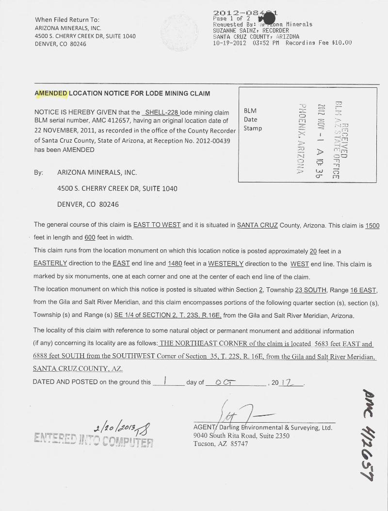
2012--084~-WLWhen Filed Return To: Page 1 of 2 ~ARIZONA MINERALS, INC. Requested By: . irl... ona Minerals
SUZANNE SAINZ, RECORDER45005. CHERRYCREEKDR, SUITE 1040 SANTA CRUZ COUNTY, ARIZONADENVER, CO 80246 10-19-2012 03:52 PM Recording Fee *10.00
AMENDED LOCATION NOTICE FOR LODE MINING CLAIM
NOTICE IS HEREBY GIVEN that the SHELL-228 lode mining claim BLM -%.-- 0 ,-'
BLM serial number, AMC 412657, having an original location date of Date 1-,1~V CD
22 NOVEMBER, 2011, as recorded in the office of the County Recorder Sta m p
of Santa Cruz County, State of Arizona, at Reception No. 2012-00439 --has been AMENDED 33
RECEIVED
- A 10:0
By: ARIZONA MINERALS, INC. :> UJcr
45005. CHERRY CREEK DR, SUITE 1040
DENVER, CO 80246
The general course of this claim is EAST TO WEST and it is situated in SANTA CRUZ County, Arizona. This claim is 1500
feet in length and 600 feet in width.
This claim runs from the location monument on which this location notice is posted approximately ZQ feet in a
EASTERLY direction to the EAST end line and 1480 feet in a WESTERLY direction to the WEST end line. This claim is
marked by six monuments, one at each corner and one at the center of each end line of the claim.The location monument on which this notice is posted is situated within Section 2, Township 23 SOUTH, Range 16 EAST,
from the Gila and Salt River Meridian, and this claim encompasses portions of the following quarter section (s), section (s),
Township (s) and Range (s) SE 1/4 of SECTION 2. T. 235. 8-1.QE, from the Gila and Salt River Meridian, Arizona.
The locality of this claim with reference to some natural object or permanent monument and additional information I
(if any) concerning its locality are as follows:_THENORTHEAST_CORNERofthedaimislocated_5681-feeLEAST_and-68.8.8-f~LSQUTH fromthe SOUTHWE-ST-Cgmer_of_Section 35 _I. 22S R.16E f-om»the Gila andSalLRiper MeridianSANTA CRUZ COUNTY, AZ.
DATED AND POSTED on the ground this ~ day of O CT- , 20 17
,£*O C#6(3/9 AGENT/ Dariing Ehvironmental & Surveying, Ltd ..\/5 9040 Sbuth Rita Road. Suite 2350*KITcomr, 11~-r' COF/IP, ITFF Tucson. AZ 85747
#c 4/1-457

2012-08401 10-19-2012 03:52 PM Page 2 of 2
MINING CLAIM MAPLode (X)
Placer ( )
~ 115 SHELL 184 SHELL 185 SHELL 226 SHELL 225
~ 117® SHELL 186 S~ELL 187 SHELL 228 SHELL 227'2 1
ELk 119- SHELL 188 S ELL 189 SHELL 230 -SHELL 229__L __11)EL~ 121 SHELL 190 S~ELL 191 SHELL 232 SHELL 231
ELL 123 SHELL 192 S~ELL 193 SHELL 234 SHELL 233
Eli 125 SHELL 194 ShELL 195 SHELL 236 SHELL 235
E 127 SHELL 196 *El=!=197 SHELL 238 SHELL 237
,ELL 129 SHELL 198 SHELL 199 SHELL 240 SHEL@39
>:,«10171
ELL 131 SHELL 200 S~ELL 201 SHELL 242 . SHEL>241 1 .11 nri <7 -n
ELL 133 SHELL 202 SHELL 203 SHELL 244 SHE!*43 (1
SHELL 204 S~HELL 205 SHELL 246 SHEGE,245
. :.OFFICE
1(14 1
1. The above map depicts the SHELL 228 mining claim, which is located in Section (s) 2
4, Township 23S, Range 16E , Gila and Salt River Meridian, SANTA CRUZ County, Arizona.
2. The type of corner and location monuments used are as follows: 23235'WOOD POSTS.3. The bearings and distances in degrees and feet between claim corners are as depicted on the map or
as stated on page 1 of this notice.
FormMCF10Oa
Revised July 2005
Thisformisavailabletomthe Arizona Deuartmento£Mines*MineraLResources-and.ma Lberenroduced

When Filed Return To: -
AZ MINERALS, INC.
4500 S. CHERRY CREEK DR, SUITE 1040
DENVER, CO 80246
LOCATION NOTICE FOR LODE MINING CLAIM
NOTICE IS HEREBY GIVEN that the _SHELL-228*de mining claim BLM
B.L.M.Date ./has been located Sta m p CD
9-) k rqbm
71
By: AZ MINERALS, INC.rri m
4500 S. CHERRY CREEK DR, SUITE 1040 CDON C - 1
0
DENVER, CO 80246
The general course of this claim is EAST TO WEST and it is situated in SANTA CRUZ County, Arizona. This claim is 1500
feet in length and 600 feet in width.
This claim runs from the location monument on which this location notice is posted approximately 2Q feet in a
EASTERLY direction to the EAST end line and 1480 feet in a WESTERLY direction to the WEST end line. This claim is
marked by six monuments, one at each corner and one at the center of each end line of the claim.
The location monument on which this notice is posted is situated within Section 2, Township 23 SOUTH, Range 16 EAST,
from the Gila and Salt River Meridian, and this claim encompasses portions of the following quarter section (s), section (s),
Township (s) and Range (s) SE 1/4 of SECTION 2, SW 1/4 of SECTION 1, T. 235, R.16E, from the Gila and Salt River
Meridian, Arizona.
The locality of this claim with reference to some natural object or permanent monument and additional information
(if any) concerning its locality are as follows: THE NORTHEAST CORNER of the claim is located 5683 feet -EAST aud
6888 feet SOUTH from the SOUTHWEST Corner of Section 35, T. 22S, R. 16E, from the Gila and Salt River Meridian,
SANTA_CRUZ-COUNIXAZ.
DATED AND POSTED on the ground this ZZ day of ND J , 20 ~ ~
AMC 4 1 2 b/ OT-11 Jo Xt)AGENT: Darling Environmental & Surveying, Ltd. Col
_-J
9040 South Rita Road, Suite 2350
Tucson, AZ 85747

*.
MINING CLAIM MAPLode (X)
Placer
SHELL 184 ~HELL 185 SHELL 226 SHELL 225
SHELL 186 HELL 187 SHELL 228 SHELL 227
-SHELL- 188 - - Crl 89 SHEU- 2 2 4 SHELL-
SHELL 190 HELL 191 SHELL 232 ' SHELL 231 ,* 50f-
SHELL 192 ~SHELL 193 SHELL 234 SHELLZ33
I iniSHELL 194 ISHELL 195 SHELL 236 SHELL2235 24 2
00
SHELL 196 ISHELL 197 SHELL 238' SHEL~37 9
FFICE
SHELL 198 SHELL 199 SHELL 240 SHELL 239
SHELL 200 1 SHELL 201 SHELL 242' SHELL 241
SHELL 202 ~ SHELL 203 SHELL 244~ SHELL 243
SHELL 204 ~ SHELL 205 SHELL 24« SHELL 245
1. The above map depicts the SHE 228 mining claim, which Is located In Section (s) 1&2
4, Township 23S, Range 16E, Glla and Salt River Meridian, SANTA_CRUZ County, Arizona.
2. The type of comer and location monuments used are as follows: 2 7. ZXBLWOOD-POSIB.
3. The bearings and distances in degrees and feet between claim corners are as depicted on the map or
AMC
as stated on page 1 of this notice.
X)CD-crlForm--J
MCF10{)aRevise
d July 2005This f rmi v 1 from the Arizon De artment f Mine & Mineral Resourt ma rru

2012-08 --When Filed Return To: Page 1 of S iFF
% Requested By: +-dona MineralsARIZONA MINERALS, INC. SUZANNE SAINZ, RECORDER4500 S. CHERRY CREEK DR, SUITE 1040 {1. ... ~5/ SANTA CRUZ COUNTY, ARIZONADENVER, CO 80246 .9 10-19-2012 03:52 PM Recording Fee *10.00
AMENDED LOCATION NOTICE FOR LODE MINING CLAIM
NOTICE IS HEREBY GIVEN that the SHELL-229 lode mining claim BLM ernBLM serial number, AMC 412658, having an original location date of Date 0722 NOVEMBER, 2011, as recorded in the office of the County Recorder Sta m p /% 0
ill
of Santa Cruz County, State of Arizona, at Reception No. 2012-00440 mhas been AMENDED C
nr
- A 10 3b
Z S TATE OFFICE
By: ADRIZONA MINERALS, INC.
45005. CHERRY CREEK DR, SUITE 1040
DENVER, CO 80246
The general course of this claim is WEST TO EAST and it is situated in SANTA CRUZ County, Arizona. This claim is 1500
feet in length and 600 feet in width.
This claim runs from the location monument on which this location notice is posted approximately 2Q feet in a
WESTERLY direction to the WEST end line and 1480 feet in a EASTERLY direction to the EAST end line. This claim is
marked by six monuments, one at each corner and one at the center of each end line of the claim.The location monument on which this notice is posted is situated within Section 11, Township 23 SOUTH, Range 16
EAST, from the Gila and Salt River Meridian, and this claim encompasses portions of the following quarter section (s),
section (s), Township (s) and Range (s) SMY_1/4 of SECTION 1 -NYL1/4 of SECTION 12 SE_1*Lof SECTION-LNE_114_ofSECTION 11 T. 235, R.16E, from the Gila and Salt River Meridian, Arizona.
The locality of this claim with reference to some natural object or permanent monument and additional information
(if any) concerning its locality are as follows:_THE-NORTHEAST-CORNER»ofthedaimislocated_7189_feeLEASTand7472 feet-SOUTHfromthe_SOUTHWESTCgmer_of_Sectioll_liT. 22S R.«15E from-the Gilaand Salt River_MeridianSANTA CRUZ COUNTY, AZ.
DATED AND POSTED on the ground this f day of 6)61 f , 20 / 7
W
41 165%
ENTERED JITO COMPUTER AGENT: [16rling En,vironmental & Surveying, Ltd.9040 Soufh Rita Road, Suite 2350Tucson, AZ 85747
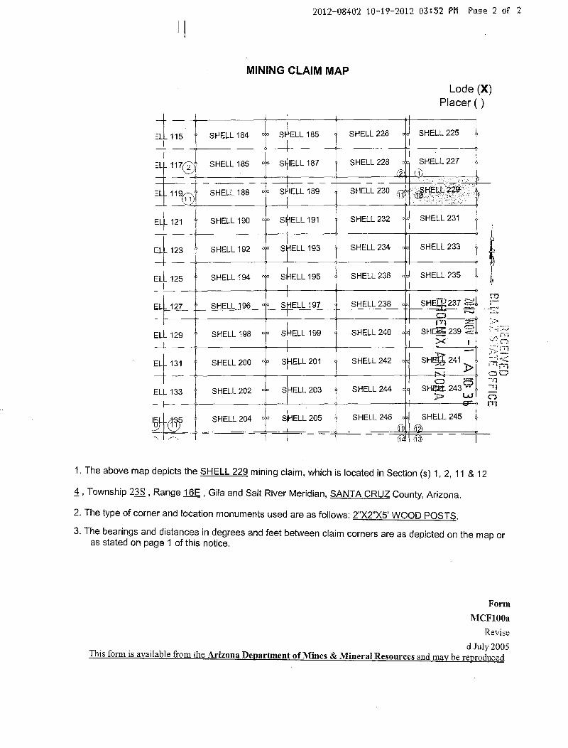
2012-08402 10-19-2012 03:52 PM Page 2 of 2
MINING CLAIM MAPLode (X)
Placer ( )
ELL 115 SHELL 184 SHELL 185 SHELL 226 SHELL 225
ELI_ 117«) SHELL 186 S~ELL 187 SHELL 228 SHELL 227(2 (1
SHELL 188 S ELL 189 SHELL 230 (11, dHELL 229 ' If
EL~121 SHELL 190 S~ELL 191 SHELL 232 SHELL 231
ELL 123 SHELL 192 S ELL 193 SHELL 234 SHELL 233
4-1ELL 125 SHELL 194 SHELL 195 SHELL 236 SHELL 235
E 127 SHELL 196 *El=l:-197 SHELL 238 SH
EL~129 ~ SHELL 198 SHELL 199 SHELL 240 SHFS 239 ~
RECEIYEDELL 131 SHELL 200 S~ELL 201 SHELL 242 SHE~ 241
0 5ELL 133 SHELL 202 SHELL 203 SHELL 244 SH[Za 243 -
W
SHELL 204 dHELL 205 SHELL 246 SHELL 24511 1
1. The above map depicts the SHELL 229 mining claim, which is located in Section (s) 1,2,11 & 12
4, Township 23S, Range 16E , Gila and Salt River Meridian, SANTA CRUZ County, Arizona.
2. The type of corner and location monuments used are as follows: 232"X5'WOOD_POSTS.3. The bearings and distances in degrees and feet between claim corners are as depicted on the map oras stated on page 1 of this notice.
FormMCF100a
Revised July 2005
This form is available from the Arizona Department of Mines & Mineral Resources and maybe reproduced

When Filed Return To:AZ MINERALS, INC.
4500 S. CHERRY CREEK DR, SUITE 1040
DENVER, CO 80246
LOCATION NOTICE FOR LODE MINING CLAIM
NOTICE IS HEREBY GIVEN that the SHELL-229 lode mining claim BLMDate
has been located Sta m p
B.L 1.
By: AZ MINERALS, INC. n N~
RECEI
4500 S. CHERRY CREEK DR, SUITE 1040
DENVER, CO 80246 N 5 -71
N 0rnThe general course of this claim is WEST TO EAST and it is situated in SANTA CRUZ County, Arizona. This claim is 1500
feet in length and 600 feet in width.
This claim runs from the location monument on which this location notice is posted approximately 2[1 feet in a
WESTERLY direction to the WEST end line and 1480 feet in a EASTERLY direction to the EAST end line. This claim is
marked by six monuments, one at each corner and one at the center of each end line of the claim.
The location monument on which this notice is posted is situated within Section 12, Township 23 SOUTH, Range li
EAST, from the Gila and Salt River Meridian, and this claim encompasses portions of the following quarter section (s),
section (s), Township (s) and Range (s) SW 1 /4 of SECTION 1, NW 1 /4 of SECTION 12, T. 235, R.1 BE, from the Gila and
Salt River Meridian, Arizona.
The locality of this claim with reference to some natural object or permanent monument and additional information
(if any) concerning its locality are as follows: THE NORTHEAST CORNER of the claim is located 7189 feet EAST and
7472 feet SOUTH from the SOUTHWEST Corner of Section 35, T. 22S, R. 16E, from the Gila and Salt River Meridian,
SANTA CRUZ COUNTY, AZ.
DATED AND POSTED on the ground this 2.2_ day of UOU , 20 1 f AMC
1 .Df/1,-11/ 1< 50174 1-bBJ N
AGENT: Darling Environmental & Surveying, Ltd. J-{*.rl
9040 South Rita Road, Suite 2350 CO
Tucson, AZ 85747

MINING CLAIM MAPLode (X)
Placer
SHELL 184 ~HELL 185 SHELL 226 SHELL 225
SHELL 186 ~HELL 187 SHELL 228 SHELL 227
-SHELLIT88-- Crl 89 SHELU 2 2 1 SHEte
SHELL 190 ~SHELL 191 SHELL 232 SHELL 231 r., wf-
SHELL 192 ~SHELL 193 SHELL 234 ' SHELL ~3 .> IDNR
SHELL 194 ISHELL 195 SHELL 236' SHELL:135 4<770
f R foSHELL 196 ISHELL 197 SHELL 238' SHELL 237 - -1
C-j1
SHELL 198 SHELL 199 SHELL 240 SHELL 239
SHELL 200 I SHELL 201 SHELL 242~ SHELL 241
SHELL 202 1 SHELL 203 SHELL 24£ SHELL 243
SHELL 204 1 SHELL 205 SHELL 24 SHELL 245
1. The above map depicts the SHELL 229 mining dalm, which is located In Section (s) 1 & 12
4, Township 235, Range 162, Gila and Salt River Meridian, SANTA CRUZ County, Arizona.
AMC
2. The type of comer and location monuments used are as follows: 2D(2151\8/OOD_EQSIS.
3. The bearings and distances in degrees and feet between claim corners are as depicted on the map oras stated on page 1 of this notice. >.0
cr,·'-nCO
FormMCF100*
Revised July 2003
IlliformisavilablfromthLAdzona DenartmentofMInemiMineralltemourgimid«mabemr

2012 -0 03When Filed Return To: Page 1 of 2 1
Requested By: 'Arizona MineralsARIZONA MINERALS, INC. K.SUZANNE SAINZ, RECORDER
4500 S. CHERRY CREEK DR, SUITE 1040 SANTA CRUZ COUNTY, ARIZONADENVER, CO 80246 1 10-19-2012 03:52 PM Recording Fee $10.0044-3?,
AMENDED LOCATION NOTICE FOR LODE MINING CLAIM
NOTICE IS HEREBY GIVEN that the SHELL-230 lode mining claim BLM ~, RE~ 'BLM serial number, AMC 412659, having an original location date of Date ES .*. --22 NOVEMBER, 2011, as recorded in the office of the County Recorder Stamp -s ;Id 33
of Santa Cruz County, State of Arizona, at Reception No. 2012-00441 M 1 38has been AMENDED - *. -«.CSO 1 m
By: ARIZONA MINERALS, INC. .-
,,5. OFFIC-U
4500 S. CHERRY CREEK DR, SUITE 1040
DENVER, CO 80246
The general course of this claim is EAST TO WEST and it is situated in SANTA CRUZ County, Arizona. This claim is 1500
feet in length and 600 feet in width.
This claim runs from the location monument on which this location notice is posted approximately 2Q feet in a
EASTERLY direction to the EAST end line and 1480 feet in a WESTERLY direction to the WEST end line. This claim is
marked by six monuments, one at each corner and one at the center of each end line of the claim.The location monument on which this notice js posted is situated within Section 11, Township 23 SOUTH, Range 16
EAST, from the Gila and Salt River Meridian, and this claim encompasses portions of the following quarter section (s),
section (s), Township (s) and Range (s) SE 1/4 of_SECTION_LNE_1/4 QLS ECTION_11 _I. 238,_R.16E from the Gila andSalt River Meridian, Arizona.
The locality of this claim with reference to some natural object or permanent monument and additional information
(if any) concerning its locality are as follows:_THENORTHEASICORNER_ofthedaimislocated_5589_feet FAST_and7488_feet-SOLEI_Il«from the_SOUTHWEST_Cgmer of-Section_35 _I. 223. R. 16E from the Gita and Salt River Meridian.SANTA-CRUZ-COUNIYAZADATED AND POSTED on the ground this I day of OCT , 20 1 L
01> D I vo\%<S -ENTERED FO' COMPUTER AGENT:parli'ng E~vironmental & Surveying, Ltd.
AB
Ly/1
659
9040 Sol~th Rita Road. Suite 2350Tucson, AZ 85747

2012-08403 10-19-2012 03:52 PM Page 2 of 2
MINING CLAIM MAPLode (X)
Placer ( )
ELL 115 SHELL 184 SHELL 185 SHELL 226 SHELL 225
IEL~ 117® SHELL 186 S~ELL 187 ~ SHELL 228 SHELL 227
1
ELL 119<n SHELL 188 S ELL ]89- 1 SHELL 230 , » ~HELL 229
EL~ 121 SHELL 190 SI~ELL 191 SHELL 232 SHELL 231
ELL 123 SHELL 192 S ELL 193 SHELL 234 SHELL 233
4-ELI- 125 SHELL 194 shELL 195 SHELL 236 SHELL 235
E 127 SHEL!=196 SPELL-197 SHELL 238 SHELL 237
03ELL 129 SHELL 198 SHELL 199 SHELL 240 SHE[{1239 - ,
-r
mELL 131 SHELL 200 S~ELL 201 SHELL 242 SHEEt 241 ~ :»Im1/) T
ELL 133 SHELL 202 SHELL 203 SHELL 244 SHEL 243 «<
00
SHELL 204 dHELL 205 SHELL 246 SHES. 2459 -4g41
1. The above map depicts the SHELL 230 mining claim, which is located in Section (s) 2 & 11
4, Township 23S, Range 16E , Gila and Salt River Meridian, SANTA CRUZ County, Arizona.
2. The type of corner and location monuments used are as follows: ZXZXZYYQQQ--POSTS.3. The bearings and distances in degrees and feet between claim corners are as depicted on the map oras stated on page 1 of this notice.
FormMCF100a
Revised July 2005
This form is available from the Arizona Department of 1Mines & Mineral Resources and may be reproduced
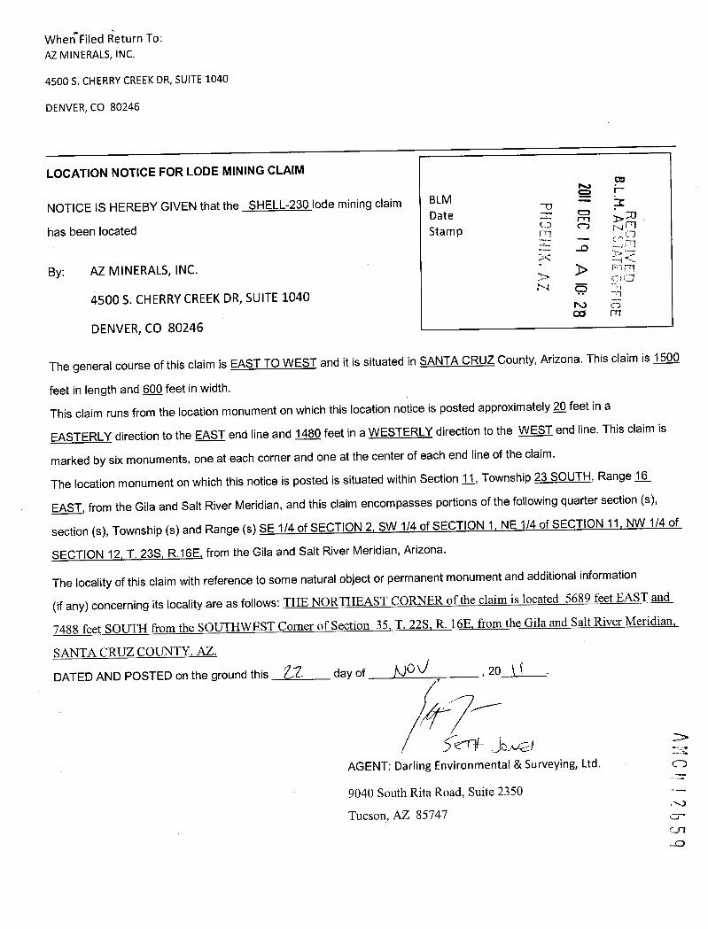
When Filed Return To:AZ MINERALS, INC.
4500 S. CHERRY CREEK DR, SUITE 1040
DENVER, CO 80246
LOCATION NOTICE FOR LODE MINING CLAIM
NOTICE IS HEREBY GIVEN that the SHELL-230 lode mining claim BLMDate 3 0
B.L.M. AZ 5 j 5
1 Flee
has been located Sta m p /·7
REC
-C -O-i ElBy: AZ MINERALS, INC.
00
4500 S. CHERRY CREEK DR, SUITE 1040 N g
DENVER, CO 80246
The general course of this claim is EAST TO WEST and it is situated in SANTA CRUZ County, Arizona. This claim is 1500
feet in length and 600 feet in width.
This claim runs from the location monument on which this location notice is posted approximately 2Q feet in a
EASTERLY direction to the EAST end line and 1480 feet in a WESTERLY direction to the WEST end line. This claim is
marked by six monuments, one at each corner and one at the center of each end line of the claim.
The location monument on which this notice is posted is situated within Section 11, Township 23 SOUTH, Range 16
EAST, from the Gila and Salt River Meridian, and this claim encompasses portions of the following quarter section (s),
section (s), Township (s) and Range (s) SE_1 /4-of SECTION_L SW 1/4 of SECTION 1, NE 1/4 of SECTION_11,_NW_1/4-gf
SECTION 12, T. 235, R.16E, from the Gila and Salt River Meridian, Arizona.
The locality of this claim with reference to some natural object or permanent monument and additional information
(if any) concerning its locality are as follows:_THE NORTHEAST-CORNERoftheclaimis tocated_*89 feet EASTand
7488-feet-SOUTH_f[gmithe-SOUTINEST_Comer-ofSection lt-T. 223*E. 168,Immthe Gilaand Salt.RiverMeridian
SANTA CRUZ COUNTY, AZ.
DATED AND POSTED on the ground this Z,2 day of NO U , 20 ( 1
1 5-' .-*,Ne -)AGENT: Darling Environmental & Surveying, Ltd. CD
9040 South Rita Road, Suite 2350
Tucson, AZ 85747 crUl-0

MINING CLAIM MAPLode (X)
Placer
SHELL 184 ~HELL 185 SHELL 226 SHELL 225
SHELL 186 HELL 187 SHELL 228 SHELL 227 B.L.M.
~*EllI 188 - II-189 SHEW,2 1 SHELL- - rn 370 CD Ai 1 71
SHELL 190 ~HELL 191 SHELL 232 SHELL *1 Y 5§f=Fl
SHELL 192 ~SHELL 193 SHELL 234 ' SHELL 2-33 so
1 0
SHELL 194 ISHELL 195 SHELL 236' SHELL 235 rn
SHELL 196 ISHELL 197 SHELL 238' SHELL 237
SHELL 198 ~ SHELL 199 SHELL 240 SHELL 239
SHELL 200 j SHELL 201 SHELL 242' SHELL 241
SHELL 202 1 SHELL 203 SHELL 244 SHELL 243
SHELL 204 1 SHELL 205 SHELL 244 SHELL 245L
1. The above map depicts the SHELL-239 mining claim, which is located in Section (s) 1,2,11 & 12
4, Township 23S, Range 162, Gila and Salt River Meridian, SANTA CRUZ County, Arizona.
2. The type of comer and location monuments used are as follows: 2»)(275' WOOD POSTS. AMC 2659
3. The bearings and distances in degrees and feet between claim corners are as depicted on the map oras stated on page 1 of this notice.
FormMCF1008
Revised July 2003
This form is available from the Arizona De men of Mines Miner Resources and m r rod

When Filed Return To: -~ « B~]]{f tfll.~na MineralsARIZONA MINERALS, INC. SUZANNE SAINZ, RECORDER4500 S. CHERRY CREEK DR, SUITE 1040 SANTA CRUZ COUNTY, ARIZONADENVER, CO 80246 10-19-2012 03:52 PM Recording Fee $10.00
\t.
AMENDED LOCATION NOTICE FOR LODE MINING CLAIM
NOTICE IS HEREBY GIVEN that the SHELL-231_lode mining claim BLM - - N0mBLM serial number, AMC 412660, having an original location date of Date 92 /4 MV
21 NOVEMBER, 2011, as recorded in the office of the County Recorder Stampof Santa Cruz County, State of Arizona, at Reception No. 2012-00442has been AMENDED
*LU 0BY: ARIZONA MINERALS, INC. 0- O-1
4500 5. CHERRY CREEK DR, SUITE 1040
DENVER, CO 80246
The general course of this claim is WEST TO EAST and it is situated in SANTA CRUZ County Arizona. This claim is 1500feet in length and 600 feet in width.
This claim runs from the location monument on which this location notice is posted approximately 2Q feet in aWESTERLY direction to the WEST end line and 1480 feet in a EASTERLY direction to the EAST end line. This claim ismarked by six monuments, one at each corner and one at the center of each end line of the claim.The location monument on which this notice is posted is situated within Section 11, Township 23 SOUTH, Range 1.6EAST, from the Gila and Salt River Meridian, and this claim encompasses portions of the following quarter section (s),section (s), Township (s) and Range (s) NE 1/4 of SECTION 11, NW 1 /4 of SECTION 12, T. 23Ss R. 165, from the Gila andSalt River Meridian, Arizona.
The locality of this claim with reference to some natural object or permanent monument and additional Information(if any) concerning its locality are as follows: THE NORTHEAST CORNER of the claim is located 7195 feet EAST and8072 feet SOUTH from the SOUTHWEST Corner of Section 35. T. 22S, R. 16E. from the Gila and Salt River Meridian.SANTA CRUZ COUNTY, AZ.
DATED AND POSTED on the ground this - day of OCT- , 20 1 1- .
IX 50 IPO\34 .ENTS.RES #30 COMP"TER AGENT: D*ling Environmental & Surveying, Ltd.
AM 4/2 660
9040 South Rita Road, Suite 2350Tucson, AZ 85747

2012·-1)8I1 0-19-2012 03:52 PM Page 2 of 2
MINING CLAIM MAPLode (X)
Placer ( )
ELL 115 SHELL 184 SHELL 185 SHELL 226 SHELL 2251
EL~_ 117(Eb SHELL 186 S¢ELL 187 SHELL 228 SHELL 2272 1
ELL 119-~ SHELL 188 S ELL 189 SHELL 230 -SHELL 229
EL~121 SHELL 190 S~ELL 191 SHELL 232 0]J SHELL 231
ELL 123 SHELL 192 S ELL 193 SHELL 234 SHELL 2334-EL~125 SHELL 194 c S~ELL 195 SHELL 236 SHELL 235
03E 127 SHELL196 fEL!=-197 SHELL 238 sliE!*37ELL 129 SHELL 198 SHELL 199 SHELL 240 SHELZ239 : „.-.'
U-
EL~131 SHELL 200 S~WELI 201 SHELL 242 e SHEE6241 i n-trin00
CD 71ELL 133 SHELL 202 SHELL 203 SHELL 244 .1 SHEttz243 " -11
0rnSHELL 204 SIHELL 205 SHELL 246 SHELL 245
1. The above map depicts the SHELL 231 mining claim, which is located in Section (s) 11 & 124, Township 233, Range 16E , Gila and Salt River Meridian, SANTA CRUZ County, Arizona.2. The type of corner and location monuments used are as follows: 2")<2")<5' WOOD POSTS.3. The bearings and distances in degrees and feet between claim corners are as depicted on the map oras stated on page 1 of this notice.
FormMCF100a
Revised July 2005This form is available from the Arizona Department of Mines & Mineral Resources and may be reproduced

When Filed Return To:AZ MINERALS, INC.
4500 S. CHERRY CREEK DR, SUITE 1040
DENVER, CO 80246
LOCATION NOTICE FOR LODE MINING CLAIM
NOTICE IS HEREBY GIVEN that the SHELL-231 lode mining claim BLMDate
B.L.M. A-E 5 ~r[ - OFFICE
has been located -4- moSta m p (D CD
-0
By: AZ MINERALS, INC. 3<
4500 S. CHERRY CREEK DR, SUITE 1040 N 5
DENVER, CO 80246 00
The general course of this claim is WEST TO EAST and it is situated in SANTA CRUZ County, Arizona. This claim is 1500
feet in length and 600 feet in width.
This claim runs from the location monument on which this location notice is posted approximately 2Q feet in a
WESTERLY direction to the WEST end line and 1480 feet in a EASTERLY direction to the EAST end line. This claim is
marked by six monuments, one at each corner and one at the center of each end line of the claim.
The location monument on which this notice is posted is situated within Section 12, Township 23 SOUTH, Range 1,6
EAST, from the Gila and Salt River Meridian, and this claim encompasses portions of the following quarter section (s),
section (s), Township (s) and Range (s) NW 1 /4 of SECTION 12, T. 235. R. 16E. from the Gila and Salt River Meridian,
Arizona.
The locality of this claim with reference to some natural object or permanent monument and additional information
(if any) concerning its locality are as follows:_THE-NORTHEAST_CORNERoftheclaimis_logated-7193_feeLEASTand
8072_feeLSQUIH from_the SQUTHWEST_Comer of-Section 35 T. 221.JL-16E fromthe_Gilaand Salt River_Meridian
SANTA CRUZ COUNTY, AZ.
DATED AND POSTED on the ground this ZI day of k)04 , 20 f ~
CD
50-1lf -1/.rf $4AGENT: Darling Environmental & Surveying, Ltd. 0-
9040 South Rita Road, Suite 2350 CO
Tucson, AZ 85747

MINING CLAIM MAPLode (X)
Placer
SHELL 184 ~HELL 185 SHELL 226 SHELL 225
SHELL 186 ~HELL 187 SHELL 228 SHELL 227M
-SHELLI 1138 - -~HELE-189 SHEtl-2 12 * SHELL_
2011 5 DEC l Ag
SHELL 190 HELL 191 SHELL 232 ' SHELI~31 5 -m
SHELL 192 ~SHELL 193 SHELL 234 ' SHELL:233 _ 0 0N 0 ZI]
1 CD
SHELL 194 ISHELL 195 SHELL 236 ' SHELL 235 rn
SHELL 196 ISHELL 197 SHELL 238' SHELL 237
SHELL 198 1 SHELL 199 SHELL 240 SHELL 239
SHELL 200 iSHELL 201 SHELL 242 SHELL 241
SHELL 202 ~ SHELL 203 SHELL 244' SHELL 243
SHELL 204 ~ SHELL 205 SHELL 24« SHELL 245
1. The above map depicts the SHELL_211 mining claim, which is located in Section (s) 12
4, Township 23_S, Range 162 , Glla and Salt River Meridian, SANTA_CBUZ County, Arizona.
2. The type of comer and location monuments used are as follows: 2")(275' WOOD POSTS. I=
3. The bearings and distances in degrees and feet between claim corners are as depicted on the map or CD
as stated on page 1 of this notice.
CD-CD-CD
FormMCF10()a
Revised July 2005
This f rm i available from the Arizona De artment f Mines & Mineral Resource ma r r u

2012-0When Filed Return To: ~ Page 1 of 2 31-111--*
Requested By: ~==ona MineralsARIZONA MINERALS, INC. - SUZANNE SAINZ, RECORDER4500 S. CHERRY CREEK DR, SUITE 1040 {;ANTA CRUZ COUNTY, ARIZONADENVER, CO 80246 - p 10-19-2012 03:52 PM Recording Fee $10.00
AMENDED LOCATION NOTICE FOR LODE MINING CLAIM
NOTICE IS HEREBY GIVEN that the SHELL-232 lode mining claim BLM -0 -2 r-BLM serial number, AMC 412661, having an original location date of Date22 NOVEMBER, 2011, as recorded in the office of the County Recorder Sta m p -- : mrn'
1 0of Santa Cruz County, State of Arizona, at Reception No. 2012-00443 :.71has been AMENDED -- <
0By: ARIZONA MINERALS, INC. -~U.
i. ST/Tr- 1FFIC«LU
4500 S. CHERRY CREEK DR, SUITE 1040
DENVER, CO 80246
The general course of this claim is EAST TO WEST and it is situated in SANTA CRUZ County, Arizona. This claim is 1500feet in length and 600 feet in width.
This claim runs from the location monument on which this location notice is posted approximately 2Q feet in aEASTERLY direction to the EAST end line and 1480 feet in a WESTERLY direction to the WEST end line. This claim ismarked by six monuments, one at each corner and one at the center of each end line of the claim.The location monument on which this notice js posted is situated within Section 11, Township 23 SOUTH, Range 1.6EAST, from the Gila and Salt River Meridian, and this claim encompasses portions of the following quarter section (s),section (s), Township (s) and Range (s) NE_1/4 of-SECTION_11 _T._23S R.16E* from the Gila and Salt River Meridian,Arizona.
The locality of this claim with reference to some natural object or permanent monument and additional information(if any) concerning its locality are as follows:_THENORTHEAST-CORNERof the_claimislocated_5695_feerEAS_Tand50*Efeer SQUTH_from-the_SOUTHWEST_Comerof-Section_35 T._22S R. lif from-the_Gila and Salt River«Meridian~36-NIA-CRIZ_COUNIYaZ.DATED AND POSTED on the ground this ~ day of OCT- , 20 1 L
A,9-<
802 4/2 6
AGENT: Darling Environmental & Surveying, Ltd.9040 South Rita Road. Suite 2350FAI=r.Ter KTO' COMPUTER Tucson: AZ 85747

2012-08~-19-2012 03:52 PM Page 2 of 2
MINING CLAIM MAPLode (X)
Placer ( )
L 115 SHELL 184 SHELL 185 SHELL 226 SHELL 225
EL~ 117(5) SHELL 186 S~ELL 187 SHELL 228 SHELL 227(2 (f)
SHELL 188 S ELL 189 SHELL 230 SHELL 229
EL~ 121 SHELL 190 SI~ELL 191 ~ SHELL 232·. , SHELL 231
EL~ 123 SHELL 192 S ELL 193 SHELL 234 SHELL 233 ~
ELL 125 SHELL 194 SHELL 195 SHELL 236 SHELL 235
E 127 SHELL_196__ St[ELL 197 SHELL 238 SHELL 237
ELL 129 SHELL 198 SHELL 199 SHELL 240 SHELL 239
ELL 131 SHELL 200 S~ELL 201 SHELL 242 SHELL 241
ELL 133 SHELL 202 SHELL 203 SHELL 244 SHELL 2&2 1-
rnSHELL 204 *ELL 205 SHELL 246 SHELL 2%# A:-
1 1 X_ _.14 63 >
i ' irn00
25 711. The above map depicts the SHELL 232 mining claim, which is located in Section (@11 ·· -n3> LU 35
cr m4, Township 23S, Range 16E , Gila and Salt River Meridian, SANTA CRUZ County, Arizona.2. The type of corner and location monuments used are as follows: 2"X2")<5' WOOD POSTS.3. The bearings and distances in degrees and feet between claim corners are as depicted on the map oras stated on page 1 of this notice.
Form ~MCFIOOa
Revised July 2005This form is available from the Arizona Department of Mines & Mineral Resources and may be reproduced

When Filed Return To:AZ MINERALS, INC.
4500 S. CHERRY CREEK DR, SUITE 1040
DENVER, CO 80246
LOCATION NOTICE FOR LODE MINING CLAIM B.L.M.
NOTICE IS HEREBY GIVEN that the SHELL-232 lode mining claim BLM -0
Date T A= > mhas been located Sta m p - 039
n r.:77-0
..4 <By: AZ MINERALS, INC. ~ rn 77
00
4500 S. CHERRY CREEK DR, SUITE 1040 77
AJOco m
DENVER, CO 80246
The general course of this claim is EAST TO WEST and it is situated in SANTA CRUZ County, Arizona. This claim is 1500
feet in length and 600 feet in width.
This claim runs from the location monument on which this location notice is posted approximately 2Q feet in a
EASTERLY direction to the EAST end line and 1480 feet in a WESTERLY direction to the WEST end line. This claim is
marked by six monuments, one at each corner and one at the center of each end line of the claim.
The location monument on which this notice js posted is situated within Section 12, Township 23 SOUTH, Range 16
EAST, from the Gila and Salt River Meridian, and this claim encompasses portions of the following quarter section (s),
section (s), Township (s) and Range (s) NE 1/4 of SECTION 11, NW 1 /4 of SECTION 12, T. 235, R.16E, from the Gila and
Salt River Meridian, Arizona.
The locality of this claim with reference to some natural object or permanent monument and additional information
(if any) concerning its locality are as follows: THE NORTHEAST CORNER of the claim is located 5695 feet EAST and
808£feet.SOL!Ilifvm the_SOUTINEST-Comer-ofSection 35 I. 2211116Ezfmm the Gilaand Salt-River Meridian
SANTA CRUZ COUNTY, AZ.
DATED AND POSTED on the ground this '22 day of NO V , 20 <1
AM C 4 1 bblh 2-Elf 3©vuAL 3-
AGENT: Darling Environmental & Surveying, Ltd.
9040 South Rita Road, Suite 2350
Tucson, AZ 85747

MINING CLAIM MAPLode (X)
Placer
SHELL 184 ~HELL 185 SHELL 226 SHELL 225
SHELL 186 ~HELL 187 SHELL 228 SHELL 227 EK 2-
.-„.33SHELL- 188
fi IdLY
SHELL 190 ~SHELL 191 SHELL 232 ' SHELE'231 4 <rm F700-7
SHELL 192 ~SHELL 193 SHELL 234 ' SHELL 233
SHELL 194 SHELL 195 SHELL 236 SHELL 235
SHELL 196 1 SHELL 197 SHELL 238' SHELL 237
SHELL 198 ~ SHELL 199 SHELL 240 SHELL 239
SHELL 200 ~ SHELL 201 SHELL 242 SHELL 241
SHELL 202 1 SHELL 203 SHELL 244 SHELL 243
SHELL 204 ~ SHELL 205 SHELL 24« SHELL 245L_
1. The above map depicts the SHELL_232 mining claim, which is located in Section (s) 11 & 12
4, Township 23_S, Range 16E , Gila and Salt River Meridian, SANTA CRUZ County, Arizona.
2. The type of comer and location monuments used are as follows: 2")(2»XS' WOOD POSTS.
3, The bearings and distances in degrees and feet between claim corners are as depicted On the map oras stated on page 1 of this notice. -
-I'
CD
Form ' 90-
MCF10()a crRevise-
d July 2003This form is available from the Arizona De artmen of Mines Min ral Resources and m r rodu

2012| i SH== 6When Filed Return To: pase 1 61- 1 11 iii i
Requested By: 111+zona MineralsARIZONA MINERALS, INC. SUZANNE SAINZ, RECORDER4500 5. CHERRY CREEK DR, SUITE 1040 SANTA CRUZ COUNTY, ARIZONADENVER, CO 80246 / 10-19-2012 03:52 PM Recording Fee $10.00
AMENDED LOCATION NOTICE FOR LODE MINING CLAIM
NOTICE IS HEREBY GIVEN that the SHELL-233 lode mining claim BLM ZE sz:82BLM serial number, AMC 412662, having an original location date of Date O SZ -7
22 NOVEMBER, 2011, as recorded in the office of the County Recorder Stampof Santa Cruz County, State of Arizona, at Reception No. 2012-00444has been AMENDED 3> - -em
C 0 nl-rlCD
By: ARIZONA MINERALS, INC.
4500 S. CHERRY CREEK DR, SUITE 1040
DENVER, CO 80246
The general course of this claim is WEST TO EAST and it is situated in SANTA CRUZ County, Arizona. This claim is 1500feet in length and 600 feet in width.
This claim runs from the location monument on which this location notice is posted approximately 2Q feet in aWESTERLY direction to the WEST end line and 1480 feet in a EASTERLY direction to the EAST end line. This claim ismarked by six monuments, one at each corner and one at the center of each end line of the claim.The location monument on which this notice is posted is situated within Section 11, Township 23 SOUTH, Range 16EAST, from the Gila and Salt River Meridian, and this claim encompasses portions of the following quarter section (s),section (s), Township (s) and Range (s) NMY_1/ELQLSECTION_12 @nd NE_1/4-SECTION_11:_I. 23S R.1611 from the Gilaand Salt River Meridian, Arizona.
The locality of this claim with reference to some natural object or permanent monument and additional information(if any) concerning its locality are as follows:_THE-NORTHEAST_CORNER»gf theclaimis-located_7202-feet EASTand8672 feet-SQUIH fromthe-SOUTHWEST__Comer of Section_35 T._225. R. I6E fromithe-Gila and Salt«River MeridianSANTA CRUZ_COUNIYAZ.DATED AND POSTED on the ground this I day of OCI-,20/ -2
1 l.'1
1, 120 -12.51 '5~/0 AGENF Darling Environmental & Surveying, Ltd .
1<5 9040 Youth Rita Road, Suite 2350RET='Der i,·7- C O/Im ITFk Tucson. AZ 85747L-/l. J 9 ....
AM 4 1166 2-

2012-084 1 -012 03:52 PM Page 2 of 2
MINING CLAIM MAPLode (X)
Placer ( )
EL 115 SHELL 184 SHELL 185 SHELL 226 SHELL 2251 1
El.~_ 117® SHELL 186 S¢ELL 187 SHELL 228 SHELL 227(2 .1
ELL 119- SHELL 188 S ELL 189 SHELL 230 -SHELL 229
ELE 121 SHELL 190 S~ELL 191 SHELL 232 SHELL 231
EL-~123 SHELL 192 S ELL 193 SHELL 234 SHELL 233
ELL 125 SHELL 194 shELL 195 SHELL 236 SHELL 235i
E 127_ SHELL_196_~ S~-ELL_197 SHELL238- | SHELL 237
ELL 129 SHELL 198 SHELL 199 SHELL 240 SHELL 239
ELL 131 SHELL 200 S~ELL 201 SHELL 242 n'SHEL!2241 -:71 CD ;
ELL 133 SHELL 202 SHELL 203 SHELL 244 SHEL4=-243 -1
SHELL 204 Sk'ELL 205 SHELL 246 {NSHE*245B .
C.T OFF
E14 1 (3-
1. The above map depicts the SHELL 233 mining claim, which is located in Section (s) 11 & 124, Township 23S, Range 16E, Gila and Salt River Meridian, SANTA CRUZ County, Arizona.
2. The type of corner and location monuments used are as follows: 2"X2"XS' WOOD POSTS.3. The bearings and distances in degrees and feet between claim corners are as depicted on the map oras stated on page 1 of this notice.
FormMCF100a
Revised July 2005This form is available from the Arizona Department of Mines & Mineral Resources and may be reproduced

When Filed Return To: ~ ~
AZ MINERALS, INC.
4500 S. CHERRY CREEK DR, SUITE 1040
DENVER, CO 80246
LOCATION NOTICE FOR LODE MINING CLAIM
B.L.M. Fnny-] tNOTICE IS HEREBY GIVEN that the SHELL-233 lode mining claim BLM =I= mi0 11
Date mhas been located Stamp -0
X
By: AZ MINERALS, INC. N 5
r.1 (-24500 S. CHERRY CREEK DR, SUITE 1040 oom
DENVER, CO 80246
The general course of this claim is WEST TO EAST and it is situated in SANTA CRUZ County, Arizona. This claim is 1500
feet in length and 600 feet in width.
This claim runs from the location monument on which this location notice is posted approximately 2Q feet in a
WESTERLY direction to the WEST end line and 1480 feet in a EASTERLY direction to the EAST end line. This claim is
marked by six monuments, one at each corner and one at the center of each end line of the claim.
The location monument on which this notice is posted is situated within Section 12, Township 23 SOUTH, Range 1,6
EAST, from the Gila and Salt River Meridian, and this claim encompasses portions of the following quarter section (s),
section (s), Township (s) and Range (s) NW 1 /4 of SECTION 12. T. 235. R.16E, from the Gila and Salt River Meridian,
Arizona.
The locality of this claim with reference to some natural object or permanent monument and additional information
(if any) concerning its locality are as follows: THE NORTHEAST CORNER of the claim is located 7202 feet EAST and
8672 feet SOUTH from the SOUTHWEST Corner of Section 35, T. 22S, R. 16E, from the Gila and Salt River Meridian,
SANTA CRUZ COUNTY. AZ.
DATED AND POSTED on the ground this 22 day of NJOV , 20 -ft
SET# Jove-f
AMC412.bbAGENT: Darling Environmental & Surveying, Ltd.
9040 South Rita Road, Suite 2350 2J
Tucson, AZ 85747

40 9.MINING CLAIM MAP
Lode (X)Placer
SHELL 184 ~HELL 185 SHELL 226 Sk®LL 2B 5
0 f>
SHELL 186 ~HELL 187 SHELL 228 SHELL 227
ECEIV -. D31€1- 188- E189 SHEL~-2 2 1 S~L-
SHELL 190 HELL 191 SHELL 232 ' SHELL gl
SHELL 192 ~SHELL 193 SHELL 234 l SHELL 233
SHELL 194 ISHELL 195 SHELL 236' SHELL 235
SHELL 196 ISHELL 197 SHELL 238' SHELL 237
SHELL 198 SHELL 199 SHELL 240 SHELL 239
SHELL 200 r SHELL 201 SHELL 242 SHELL 241
SHELL 202 ~ SHELL 203 SHELL 244 SHELL 243
SHELL 204 ~ SHELL 205 SHELL 244 SHELL 245
1. The above map depicts the SHELL_233 mining daim, which is located in Section (s) 12 AMC 2662
4, Township 23-S, Range 16E , Glla and Salt River Meridian, SANTA CRUZ County, Arizona.
2. The type of comer and location monuments used are as follows: 27215' WOOD POSTS.
3. The bearings and distances in degrees and feet between claim corners are as depicted on the map oras stated on page 1 of this notice.
FormMCF1008
Revised July 2005
Il*fs}mLLs_ayailable_ftom-til©_AdzonalkDartmento[Minea.AMinraLBemourgemandmakmQmdt=51

2012-n-- 7When Filed Return To: A Page l of 2 "~~
&. Requested By tona MineralsAIRZONA MINERALS, INC. . 4 SUZANNE SAINZ, RECORDER4500 5. CHERRY CREEK DR, SUITE 1040 SANTA CRUZ COUNTY, ARIZONADENVER, CO 80246 10-19-2012 03:52 PM Recording Fee $10.00
22&14
AMENDED LOCATION NOTICE FOR LODE MINING CLAIM
NOTICE IS HEREBY GIVEN that the SHELL-234 lode mining claim BLM 25 '-.'BLM serial number, AMC 412663, having an original location date of Date 4-,1 zz bC)
22 NOVEMBER, 2011, as recorded in the office of the County Recorder Stamp Xi 03 Rof Santa Cruz County, State of Arizona, at Reception No. 2012-00445 R>has been AMENDED N > 00By: AIRZONA MINERALS, INC. LU 25
cr rn4500 S. CHERRY CREEK DR, SUITE 1040
DENVER, CO 80246
The general course of this claim is EAST TO WEST and it is situated in SANTA CRUZ County, Arizona. This claim is 1500feet in length and 600 feet in width.
This claim runs from the location monument on which this location notice is posted approximately 2Q feet in aEASTERLY direction to the EAST end line and 1480 feet in a WESTERLY direction to the WEST end line. This claim ismarked by six monuments, one at each corner and one at the center of each end line of the claim.The location monument on which this notice is posted is situated within Section 11, Township 23 SOUTH, Range 16EAST, from the Gila and Salt River Meridian, and this claim encompasses portions of the following quarter section (s),section (s), Township (s) and Range (s) NE_1/4 of SECTION-11*_NZ(_114 Qf SECTION 12-I.-2318.16£: from the Gila andSalt River Meridian, Arizona.
The locality of this claim with reference to some natural object or permanent monument and additional information(if any) concerning its locality are as follows:_THENORTHEAST_CORNER-oftheclaimislocated57Qlfeet«EASTand8688 feet SOUTH from the SOUTHWEST Comer of Section 35, T. 221 R. 16E, from the Gila and Salt River Meridian,SANTA CRUZ COUNTY, AZ.
DATED AND POSTED on the ground this i day of___Blf, 20 i Z-
2 1_ 6 20/3/i AGENT: D rlind Environmental & Surveying, Ltd ,
ANK- 9 <76(.3
9040 Sout Rita Road, Suite 2350Tucson, AZ 85747
ENTEREr ill:0 COMPL'TER

2012-08. 0-19-201 03:52 PM Page 2 of 2
MINING CLAIM MAPLode (X)
Placer ( )
ELL 115 SHELL 184 SHELL 185 SHELL 226 SHELL 225
EL.~ 117® SHELL 186 0 SI~ELL 187 SHELL 228 SHELL 2271
ELL 119<- SHELL 188 S ELL 189 SHELL 230 -SHELL 229
EL~121 SHELL 190 S~ELL 191 SHELL 232 SHELL 231
ELL 123 SHELL 192 S ELL 193 SHELL 234 SHELL 233
ELL 125 SHELL 194 shELL 195 SHELL 236 SHELL 235
E 127 SHELLI 96 FLE'4_197_ SHELL 238 SHELL 237
ELL 129 SHELL 198 SHELL 199 SHELL 240 SHELL 2390.
ELL 131 SHELL 200 S~ELL 201 SHELL 242 SHE#}241 2
ELL 133 SHELL 202 SHELL 203 SHELL 244 SHaL 243 i
SHELL 204 S~HELL 205 SHELL 246 SHES 245_1
:., E OFFICE-J
1. The above map depicts the SHELL 234 mining claim, which is located in Section (s) 114, Township 23S, Range 16E , Gila and Salt River Meridian, SANTA CRUZ County, Arizona.2. The type of corner and location monuments used are as follows: 2")<2"X5' WOOD POSTS.3. The bearings and distances in degrees and feet between claim corners are as depicted on the map oras stated on page 1 of this notice.
FormMCF10Oa
Revised July 2005Thisformisavailablettomthe Arizonal]Ezartmentof-Mines&-MineraLResgureesandmabereroduced

When Filed Return To:AZ MINERALS, INC.
4500 S. CHERRY CREEK DR, SUITE 1040
DENVER, CO 80246
LOCATION NOTICE FOR LODE MINING CLAIMPHOENIX. AZ
201 DEC 19
RAE~CE
NOTICE IS HEREBY GIVEN that the -SHELL-234-lode mining claim BLMDate
has been located Sta m p .1,
By: AZ MINERALS, INC. 5 770
4500 S. CHERRY CREEK DR, SUITE 1040 00 m
DENVER, CO 80246
The general course of this claim is EAST TO WEST and it is situated in SANTA CRUZ County, Arizona. This claim is 1500
feet in length and 600 feet in width.
This claim runs from the location monument on which this location notice is posted approximately 2Q feet in a
EASTERLY direction to the EAST end line and 1480 feet in a WESTERLY direction to the WEST end line. This claim is
marked by six monuments, one at each corner and one at the center of each end line of the claim.
The location monument on which this notice is posted is situated within Section 12, Township 23 SOUTH, Range lfL
EAST, from the Gila and Salt River Meridian, and this claim encompasses portions of the following quarter section (s),
section (s), Township (s) and Range (s) NE 1/4 of SECTION 11. NW 1/4 of SECTION 12, T. 235, B. 16-E, from the Gila and
Salt River Meridian, Arizona.
The locality of this claim with reference to some natural object or permanent monument and additional information
(if any) concerning its locality are as follows: THE NORTHEAST CORNER of the claim is located 5701 feet EAST and
3*88_feet -SOUTH from the SOUTHWEST Corner of Section 35, T. 22S, R. 168, from the Gila and Salt River Meridian.
SANTA CRUZ COUNTY, AZ.
DATED AND POSTED on the ground this 12 day of /0 4 , 20 1 1
AMC 2bb3
AGENT: Darling Environmental & Surveying, Ltd.
9040 South Rita Road, Suite 2350
Tucson, AZ 85747

MINING CLAIM MAPLode (X)
Placer
SHELL 184 ~HELL 185 SHELL 226 SHELL 225
SHELL 186 ~HELL 187 SHELL 228 SHELL 227
SHE11- 188 -- r"189 SHELI- 2 2 1 SHELL-@ 6
20 DEC q ~1~9~-B.L.M.RAEZC~<~~5 OFFICE
SHELL 190 ~SHELL 191 SHELL 232 SHELLI31X
SHELL 192 ~SHELL 193 SHELL 234 ' ' SHELL,33
SHELL 194 SHELL 195 SHELL 236 i SHELL 235
SHELL 196 1,SHELL 197 SHELL 238' SHELL 237
SHELL 198 SHELL 199 SHELL 240 SHELL 239
SHELL 200 1 SHELL 201 SHELL 242 SHELL 241
SHELL 202 1 SHELL 203 SHELL 244] SHELL 243
SHELL 204 ~ SHELL 205 SHELL 244 SHELL 245
1. The above map depicts the SHELL 234 mining daim, which is located in Section (s) 11 & 12
4, Township 23S, Range 16E , Gila and Salt River Meridian, SANTA_CRUZ County, Arizona.
2. The type of comer and location monuments used are as follows: 27275' WOOD POSTS.
3. The bearings and distances in degrees and feet between claim corners are as depicted on the map or -as stated on page 1 of this notice. -=
0
Form
2bb3
MCF1008Revise
d July 2005Thi#_form is available from the Arizona Dvt,#rtment of Mines &_ Mi~¢-ral_Re-sou;Ne-3.and_ma¥_Ardrodu¢ed

2012--0 85=08When Filed Return To: Page 1 of 2 ild
Requested By: NI'lzona MineralsARIZONA MINERALS, INC. SUZANNE SAINZ, RECORDER4500 S. CHERRY CREEK DR, SUITE 1040 SANTA CRUZ COUNTY, ARIZONADENVER, CO 80246 10-19-2012 03:52 PM Recording Fee $10.00
AMENDED LOCATION NOTICE FOR LODE MINING CLAIM t..3
NOTICE IS HEREBY GIVEN that the SHELL-235 lode mining claim BLM O ,-U --Z
BLM serial number, AMC 412664, having an original location date of DateFl
21 NOVEMBER, 2011, as recorded in the office of the County Recorder Stampof Santa Cruz County, State of Arizona, at Reception No. 2012-00446has been AMENDED i\/ 00
W SBy: ARIZONA MINERALS, INC, --1 En
4500 S. CHERRY CREEK DR, SUITE 1040
DENVER, CO 80246
The general course of this claim is WEST TO EAST and it is situated in SANTA CRUZ County, Arizona. This claim is 1500feet in length and 600 feet in width.
This claim runs from the location monument on which this location notice is posted approximately 2Q feet in aWESTERLY direction to the WEST end line and 1480 feet in a EASTERLY direction to the EAST end line. This claim ismarked by six monuments, one at each corner and one at the center of each end line of the claim.The location monument on which this notice is posted is situated within Section 11, Township 23 SOUTH, Range 16EAST, from the Gila and Salt River Meridian, and this claim encompasses portions of the following quarter section (s),section (s), Township (s) and Range (s) NE 1/4 of SECTION 11 and the NW 1/4 of SECTION 12, T. 235, R._16E, from theGila and Salt River Meridian, Arizona.
The locality of this claim with reference to some natural object or permanent monument and additional information(if any) concerning its locality are as follows:_THE-NORTHEASICORNER»ofthedaim_islocated_7208_feeLEASTand9272 feet SOUTH from the SOUTHWEST Corner of Section 35, T. 22S. R. 16E, from the Gila and Salt River Meridian,SANTA CRUZ COUNTY, AZ.
DATED AND POSTED on the ground this ~ day of ocr , 20 1 L
4- 1-2-~6- 0~26(5~ 9040 South Rita Road, Suite 2350
AGEN]0 Darling/Environmental & Surveying, Ltd.
1 'Pa Tucson, AZ 85747ENTEREr ]L:C' C 0,/!P, ?T~ER
44'16646

2012-084 --3-19-2012 03:52 PM Page 2 of 2
MINING CLAIM MAPLode (X)
Placer ( )
ELL 115 SHELL 184 SHELL 185 f SHELL 226 SHELL 2251 1
1 1SHELL 186 SI~ELL 187 SHELL 228 SHELL 227
(2 1
SHELL 188 S ELL 189 SHELL 230 -SHELL 2291/ (10
EL~121 SHELL 190 S¢ELL 191 SHELL 232 SHELL 231
~ 123 SHELL 192 S ELL 193 SHELL 234 SHELL 233
ELL 125 SHELL 194 SHELL 195 SHELL 236 . SHELL 235 1
E 127 SHELL 196 liELL] 97 SHELL 238 SHELL 237
ELL 129 SHELL 198 SHELL 199 SHELL 240 SHELL 239U_
ELL 131 SHELL 200 S~ELL 201 SHELL 242 SHELL 241
ELL 133 SHELL 202 SHELL 203 SHELL 244 ~HELL~43 ;CE;/ I
SHELL 204 ~ELL 205 SHELL 246 35HELI~45 -]f ~81
> TdCD 0 -111. The above map depicts the SHELL 235 mining claim, which is located in SectioBRs) 18 123
0-3 .1-14, Township 23S, Range 16E , Gila and Salt River Meridian, SANTA CRUZ County, Arizona. '
2. The type of corner and location monuments used are as follows: 2"X2"X5' WOOD POSTS.3. The bearings and distances in degrees and feet between claim corners are as depicted on the map oras stated on page 1 of this notice.
FormMCF100a
Revised July 2005Thia.formisavailabletomtheArizona DenartmentoLMines&MineraLResources-andmabermroduced

When Filed Return To:AZ MINERALS, INC.
4500 S. CHERRY CREEK DR, SUITE 1040
DENVER, CO 80246
LOCATION NOTICE FOR LODE MINING CLAIM
NOTICE IS HEREBY GIVEN that the SHELL-235 lode mining claim BLM 71 ...Date
has been located Sta m p r#m
By: AZ MINERALS, INC. ~:, rri;--r~- 00N 0 -7
4500 S. CHERRY CREEK DR, SUITE 1040 -n25
DENVER, CO 80246
The general course of this claim is WEST TO EAST and it is situated in SANTA CRUZ County, Arizona. This claim is 1500
feet in length and 600 feet in width.
This claim runs from the location monument on which this location notice is posted approximately 2Q feet in a
WESTERLY direction to the WEST end line and 1480 feet in a EASTERLY direction to the EAST end line. This claim is
marked by six monuments, one at each corner and one at the center of each end line of the claim.
The location monument on which this notice is posted is situated within Section 12, Township 23 SOUTH, Range 16
EAST, from the Gila and Salt River Meridian, and this claim encompasses portions of the following quarter section (s),
section (s), Township (s) and Range (s) NW 1/4 of SECTION 12. T. 235. R.16E, from the Gila and Salt River Meridian,
Arizona.
The locality of this claim with reference to some natural object or permanent monument and additional information
(if any) concerning its locality are as follows:_THENORTHEAST.CORNER-oftheclaimislocated 7208 feeLEASTand
9272-feeLSQUIliftomthe_SOLITHWESTComer-ofSection 35-I.-22LJL_16E-fmmthe-GilaandSalt_River«MeridianL_
SANTA CRUZ COUNTY. AZ.
DATED AND POSTED on the ground this Zl day of Nk)J , 20 \ f --"
t>471£1 4 0-IAGENT: Darling Environmental & Surveying, Ltd. ,-
9040 South Rita Road, Suite 2350
Tucson, AZ 85747

4 -
MINING CLAIM MAPLode (X)
Placer
SHELL 184 ~HELL 185 SHELL 226 SHELL 226 »
SHELL 186 ~HELL 187 SHELL 228 SH26. 22* 24,
SHELE -188 - - -~HEII-189 SHELL- 2 2 4 S+*LL-2 ,~1C
N 5 71
SHELL 190 HELL 191 SHELL 232 ' SHELL 2*1 -1
SHELL 192 ~SHELL 193 SHELL 234 ' SHELL 233
SHELL 194 SHELL 195 SHELL 236 i SHELL 2354
SHELL 196 ISHELL 197 SHELL 238' SHELL 237
SHELL 198 SHELL 199 SHELL 240 SHELL 239
SHELL 200 ~ SHELL 201 SHELL 242' SHELL 241
SHELL 202 1 SHELL 203 SHELL 244' SHELL 243
SHELL 204 ~ SHELL 205 SHELL 24« SHELL 245
1
1. The above map depicts the SHELL_235 mining claim, which is located in Section (s) 12
4, Township 23S , Range 16E , Gila and Salt River Meridian, SANTA_CRUZ County, Arizona.
2. The type of comer and location monuments used are as follows: 2")(2"XS'_WOOD POSTS.
3. The bearings and distances in degrees and feet between claim comets are as depicted on the map oras stated on page 1 of this notice.
ANC 4 2 5 6 4Form
MCF100aRevise
d July 2005This form is available from the Arizona De artment of Mine Mineral Resources and ma be r rodu

2012-02409When Filed Return To: Page 1 of 211 1
Requested 8 - rizona MineralsARIZONA MINERALS, INC. SUZANNE SAINZ, RECORDER4500 S. CHERRY CREEK DR, SUITE 1040 SANTA CRUZ COUNTY, ARIZONADENVER, CO 80246 10-19-2012 03:52 PM Recording Fee *10.00
AMENDED LOCATION NOTICE FOR LODE MINING CLAIM
NOTICE IS HEREBY GIVEN that the SHELL-236 lode mining claim BLM '0 1- -4BLM serial number, AMC 412665, having an original location date of Date i-7 - >21 NOVEMBER, 2011, as recorded in the office of the County Recorder Sta m p 6. ,
--4of Santa Cruz County, State of Arizona, at Reception No. 2012-00447 ->
ECEl V
has been AMENDED ,·Irn0 5 -rl
By: ARIZONA MINERALS, INC. 5> UJ 35U iT]
45005. CHERRY CREEK DR, SUITE 1040
DENVER, CO 80246
The general course of this claim is EAST TO WEST and it is situated in SANTA CRUZ County, Arizona. This claim is 1500feet in length and 600 feet in width.
This claim runs from the location monument on which this location notice is posted approximately 2Q feet in aEASTERLY direction to the EAST end line and 1480 feet in a WESTERLY direction to the WEST end line. This claim ismarked by six monuments, one at each corner and one at the center of each end line of the claim.The location monument on which this notice is posted is situated within Section 11, Township 23 SOUTH, Range 16EAST, from the Gila and Salt River Meridian, and this claim encompasses portions of the following quarter section (s),section (s), Township (s) and Range (s) NE 1/4 of SECTION 11, T. 235, R.16E, from the Gila and Salt River Meridian,Arizona.
The locality of this claim with reference to some natural object or permanent monument and additional information(if any) concerning its locality are as follows:_THENORTHEAST_CORNER-oftheclaim_islocated 5708 feeLEASTand9288 feet_SOUTH from the SOUTHWEST Corner of Section 35, T. 22S, R. 16E. from the Gila and Salt River Meridian,SANTA CRUZ COUNTY, AZ.
DATED AND POSTED on the ground this / day of OC I , 20 1 -7-
A mi 14\166 5
AGENT:/Darling En'vironmental & Surveying, Ltd.9040 Sduth Rita Road. Suite 2350Tucson, AZ 85747
ENTEf~ f~5« 1-26.£3

2012-08409 -19-2012 03:52 PM Page 2 of 2
MINING CLAIM MAPLode (X)
Placer ( )
ELL 115 SHELL 184 ° SPIELL 185 SHELL 226 SHELL 225
T
EL~ 117(3 SHELL 186 S~ELL 187 SHELL 228 SHELL 227(2 61
SHELL 188 S ELL 189 SHELL 230 SHELL 2291
EL~ 121 SHELL 190 S~ELL 191 SHELL 232 SHELL 231
ELL 123 SHELL 192 S ELL 193 SHELL 234 0 SHELL 233
ELL 125 SHELL 194 SHELL 195 9 - SHELL 236 SHELL 235
E 127 SHELL_196 S~ELL-197 SHELL 238 SHELL 237
ELL 129 SHELL 198 S~ELL 199 ~ SHELL 240 SHELL 239
EL~131 SHELL 200 S~ELL 201 SHELL 242 SHELL 241
ELL 133 SHELL 202 SHELL 203 SHELL 244 SHELL 243
SHELL 204 4HELL 205 SHELL 246 ;*ELL Ss '1
14 (i>< ,.-I :,5./Ii;CDi > ,-,1 A1. The above map depicts the SHELL 236 mining claim, which is located in Sectior(S) 11 CD C
62 ~ IN4, Township 233, Range 16E, Gila and Salt River Meridian, SANTA CRUZ Coun* Arizpa. 52. The type of corner and location monuments used are as follows: 2"X2")(5' WOOD POSTS.3. The bearings and distances in degrees and feet between claim corners are as depicted on the map oras stated on page 1 of this notice.
FormMCF10Oa
Revised July 2005ThisfonnisavailabletomtheArizona_lknartinentof.Mines&MineraiResgurcesandmabereroduced

When Filed Return To:AZ MINERALS, INC.
45005. CHERRY CREEK DR, SUITE 1040
DENVER, CO 80246
LOCATION NOTICE FOR LODE MINING CLAIM
NOTICE IS HEREBY GIVEN that the SHELL-236 lode mining claim BLMDate
20 DEC 19
AIO 28
B.L.M. AZ STATE FFICE
has been located Sta m p
PHOENIX, AZ
REC
EIVE
By: AZ MINERALS, INC. 00
4500 S. CHERRY CREEK DR, SUITE 1040
DENVER, CO 80246
The general course of this claim is EAST TO WEST and it is situated in SANTA CRUZ County, Arizona. This claim is 1500
feet in length and 600 feet in width.
This claim runs from the location monument on which this location notice is posted approximately 22 feet in a
EASTERLY direction to the EAST end line and 1480 feet in a WESTERLY direction to the WEST end line. This claim is
marked by six monuments, one at each corner and one at the center of each end line of the claim.
The location monument on which this notice is posted is situated within Section 12, Township 23 SOUTH, Range lfL
EAST, from the Gila and Salt River Meridian, and this claim encompasses portions of the following quarter section (s),
section (s), Township (s) and Range (s) NE.1/4 of SECTION 11, NW 1 /4 of SECTION 12, T. 235, B.165 from the Gila and
Salt River Meridian, Arizona.
The locality of this claim with reference to some natural object or permanent monument and additional information
(if any) concerning its locality are as follows: THE NORTHEAST CORNER of the claim is located 5708 feet EAST and
9288-feeLSQUTHfromthe SOLITHWEST_Comer-ofSection_35 T. 228,-R. 168,-fmmithe-Gilaand Salt River_Meridian:.
SANTA CRUZ COUNTY, AZ.
DATED AND POSTED on the ground this ZI day of ~09 , 20 1 1
f«1-
AM C <12 6 65/ L 1 :1 I 30 AA= jAGENT: Darling Environmental & Surveying, Ltd.
9040 South Rita Road, Suite 2350
Tucson, AZ 85747

MINING CLAIM MAPLode (X)
Placer
SHELL 184 ~HELL 185 SHELL 226 SHELL 225 r.*
SHELL 186 ~HELL 187 SHELL 228 SHELL #%7
Oil DEC Iqi A D
B.L 1. AZ STATE FFICE
REC
EIVE
2 1-SHELLI 188 - 0189 SHELL 2 SHELL-
00
SHELL 190 HELL 191 SHELL 232 ~ SHELL251
SHELL 192 ~SHELL 193 SHELL 234 ' _ _ - ~SHELL 233
SHELL 194 SHELL 195 SHELL 236' SHELL 235
SHELL 196 ISHELL 197 SHELL 238 SHELL 237
SHELL 198 1 SHELL 199 SHELL 240 SHELL 239
SHELL 200 j SHELL 201 SHELL 242' SHELL 241
SHELL 202 1 SHELL 203 SHELL 244 SHELL 243
SHELL 204 ~ SHELL 205 SHELL 244 SHELL 245
1. The above map depicts the SHELL_236 mining daim, which is located in Section (s) 11 & 12
4, Township 23S, Range 16E , Gila and Salt River Meridian, SANIACRUZ County, Arizona. AMC 2bb5
2. The type of comer and location monuments used are as follows: 23(2151*000_POSTS.3. The bearings and distances in degrees and feet between claim corners are as depicted on the map or
as stated on page 1 of this notice.
FormMCF100a
Revised July 2005
This.form_is-#ya{Jable-fromthe-Arizam«UeldmentQI-Mine#_*Minerd--llesources_and miiykrwrduced

2012-0:J-10When Filed Return To: Page 1 of 29 11"ARIZONA MINERALS, INC. Requested Bmmr rizono. Minerals
SUZANNE SAINZ, RECORDER4500 S. CHERRY CREEK DR, SUITE 1040 SANTA CRUZ COUNTY, ARIZONADENVER, CO 80246 10-19-2012 03:52 PM Recording Fee *10.Oil
AMENDED LOCATION NOTICE FOR LODE MINING CLAIMRS
NOTICE IS HEREBY GIVEN that the SHELL-237 lode mining claim BLM N .-- .
BLM serial number, AMC 412666, having an original location date of Date21 NOVEMBER, 2011, as recorded in the office of the County Recorder Stamp . - ~ ili
J>of Santa Cruz County, State of Arizona, at Reception No. 2012-00448 Fl > /-1,~7has been AMENDED i *-9. DC77
Ld 0-1BY: ARIZONA MINERALS, INC.
4500 S. CHERRY CREEK DR, SUITE 1040
DENVER, CO 80246
The general course of this claim is WEST TO EMI and it is situated in SANTA CRUZ County, Arizona. This claim is 1500feet in length and 600 feet in width.
This claim runs from the location monument on which this location notice is posted approximately 2Q feet in aWESTERLY direction to the WEST end line and 1480 feet in a EASTERLY direction to the EAST end line. This claim ismarked by six monuments, one at each corner and one at the center of each end line of the claim.The location monument on which this notice is posted is situated within Section 11, Township 23 SOUTH, Range 16EAST, from the Gila and Salt River Meridian, and this claim encompasses portions of the following quarter section (s),section (s), Township (s) and Range (s) NYU_SW 1/4 of-SECTION_12_and the NE & SE.1/4 SECTION-11 _T. 235 _8.16Efrom the Gila and Salt River Meridian, Arizona.
The locality of this claim with reference to some natural object or permanent monument and additional information(jf any) concerning its locality are as follows:_ILIENORTHEAST_CORNERofthedaim_islocated_7211feeLEASTand98_72_feerSQUIH-fromthe-SQUTHWES-T_Comerof.SectionliI. 22SR.15Efrom_the_Gilaand_Balt«RivedE[eridian,SANTACRUZ_COUNIYAZ.DATED AND POSTED on the ground this 1 day of O.c <,20 1 2,
401* 4 1 2_664
AGENT: D6rling Environmental & Surveying, Ltd.9040 South Rita Road, Suite 2350Tucson, AZ 85747
9-2 ir i .f~ 038PUTERENTER'1=1,~ W-
R L 2.- 26- 1 3

2012-08410 10-19-2012 03:52 PM Page 2 of 29 .
MINING CLAIM MAPLode (X)
Placer ( )
ELL 115 SHELL 184 SHELL 185 SHELL 226 SHELL 225
ELI- 117(21 SHELL 186 S~ELL 187 SHELL 228 SHELL 227[Y) 1
~ 119- SHELL 188 S ELL 189 SHELL 230 (11 (i#HELL 229
EL~121 SHELL 190 S~ELL 191 SHELL 232 SHELL 231 ,
ELL 123 SHELL 192 S ELL 193 SHELL 234 SHELL 233
ELL 125 SHELL 194 SHELL 195 SHELL 236 SHELL 235
E 127 SHELL_196 liELL 197 SHELL 238 SHELL 237
ELL 129 SHELL 198 SHELL 199 SHELL 240 SHELL 239
EL.~131 SHELL 200 q ®ELL 201 SHELL 242 SHELL 241
C3
ELL 133 SHELL 202 SHELL 203 SHELL 244 51*2-L 2452it T .d-rr rn :--3
SHELL 204 S~HELL 205 SHELL 246 SI*L 24£ ·/ :23(i.4 1
r,-1 0 05 m1. The above map depicts the SHELL 237 mining claim, which is located in Section (s)~1 & 1~ ~-J M4, Township 23S, Range 16E , Gila and Salt River Meridian, SANTA CRUZ County, Arizona.
2. The type of corner and location monuments used are as follows: '*2'X5'WOOD-POSTS.3. The bearings and distances in degrees and feet between claim corners are as depicted on the map oras stated on page 1 of this notice.
FormMCF100a
Revised July 2005
Thtform is available from the Arizona Department of Mines & Mineral Resources and may be repmducqd

When Filed Return To:AZ MINERALS, INC.
4500 S. CHERRY CREEK DR, SUITE 1040
DENVER, CO 80246
LOCATION NOTICE FOR LODE MINING CLAIM
NOTICE IS HEREBY GIVEN that the SHELL-237-lode mining claim BLMDate
has been located Sta m p
PHOENIX. AZ
20 DEC 19
A D
B.L.M. AZ STATE OFFICER
ECEIVED
By: AZ MINERALS, INC.
4500 5. CHERRY CREEK DR, SUITE 1040 A)00
DENVER, CO 80246
The general course of this claim is WEST TO EAST and it is situated in SANTA CRUZ County, Arizona. This claim is 1500
feet in length and 600 feet in width.
This claim runs from the location monument on which this location notice is posted approximately 2Q feet in a
WESTERLY direction to the WEST end line and 1480 feet in a EASTERLY direction to the EAST end line. This claim is
marked by six monuments, one at each corner and one at the center of each end line of the claim.
The location monument on which this notice is posted is situated within Section 12, Township 23 SOUTH, Range 1.6
EAST, from the Gila and Salt River Meridian, and this claim encompasses portions of the following quarter section (s),
section (s), Township (s) and Range (s) NW & SW 1 /4 of SECTION 12, T. 235, R.16E, from the Gila and Salt River
Meridian, Arizona.
The locality of this claim with reference to some natural object or permanent monument and additional information
(if any) concerning its locality are as follows: THE NORTHEAST CORNER of the claim is located 7215 feet EAST and
9872_ket_SQUIH from the SOUTHWEST Corner of Section 35, T. 223, R. 1613, from the Gila and Salt Riyer Meridial»
SANTA CRUZ COUNTY, AZ.
DATED AND POSTED on the ground this ZA day of 100\1 , 20 \ 1
MCI 12bbb
AGENT: Darling Environmental & Surveying, Ltd.
9040 South Rita Road, Suite 2350
Tucson, AZ 85747

I.
MINING CLAIM MAPLode (X)
Placer
SHELL 184 ~HELL 185 SHELL 226 SHELL 225
SHELL 186 HELL 187 SHELL 228 SHELL 227 r.4 2E 1
-0
SHELE 188 - II-189 SHELL-2 2 (~ SHELL~ ~ S
it r smSHELL 190 ~SHELL 191 SHELL 232 ' SHELL991 -~ 24<mm
00
SHELL 192 ~SHELL 193 SHELL 234 ' SHELLr293
FFICE
SHELL 194 ISHELL 195 SHELL 236' SHELL 235
SHELL 196 ISHELL 197 SHELL 238' SHELL 237
SHELL 198 I SHELL 199 SHELL 240 SHELL 239
SHELL 200 1 SHELL 201 SHELL 242 SHELL 241
SHELL 202 1 SHELL 203 SHELL 244 SHELL 243
SHELL 204 ~ SHELL 205 SHELL 244 SHELL 245
1. The above map depicts the SHELL 23.Z mining claim, which is located In Section (s) 12
Arc
4, Township 235, Range 16E, Glla and Salt River Meridian, SANTA CRUZ County, Arizona.
2. The type of comer and location monuments used are as follows: 272*)(5' WOOD POSTS.>J
3. The bearings and distances in degrees and feet between claim corners are as depicted on the map or cras stated on page 1 of this notice.
FormMCF100a
Revised July 2003
This form is a ailable from the Arizona De artment of Mines & Mineral Resources and ma r rodu

2012-·-0 11When Filed Return To: Page 1 of 2ARIZONA MINERALS, INC. Requested By -nrizona Minerals
SUZANNE SAINZ, RECORDER4500 S. CHERRY CREEK DR, SUITE 1040 SANTA CRUZ COUNTY, ARIZONADENVER, CO 80246 10-19-2012 03:52 PM Recording Fee $10.00
AMENDED LOCATION NOTICE FOR LODE MINING CLAIM
- 3NOTICE IS HEREBY GIVEN that the SHELL-238 lode mining claim BLM -2 22BLM serial number, AMC 412667, having an original location date of Date '. - r....
rin :r21 NOVEMBER, 2011, as recorded in the office of the County Recorder Sta m p 7. 52 :i 'r-r:
of Santa Cruz County, State of Arizona, at Reception No. 2012-00449 ./;has been AMENDED
000 5BY: ARIZONA MINERALS, INC, 4-
t«J
FFIC
-J4500 S. CHERRY CREEK DR, SUITE 1040
DENVER, CO 80246
The general course of this claim is EAST TO WEST and it is situated in SANTA CRUZ County, Arizona. This claim is 1500feet in length and 600 feet in width.
This claim runs from the location monument on which this location notice is posted approximately 2,Q feet in aEASTERLY direction to the EAST end line and 1480 feet in a WESTERLY direction to the WEST end line. This claim ismarked by six monuments, one at each corner and one at the center of each end line of the claim.The location monument on which this notice is posted is situated within Section 11, Township 23 SOUTH, Range 16EAST, from the Gila and Salt River Meridian, and this claim encompasses portions of the following quarter section (s),section (s), Township (s) and Range (s) NEASE_1/4_of-SECTION_11 I. 23S E.16E from the Gila and Salt RiverMeridian, Arizona.
The locality of this claim with reference to some natural object or permanent monument and additional information(if any) concerning its locality are as follows:_THENORTHEAST_CORNER.ofthe-glaimis«located_5715 feeLEASTand9888-feet-SOUTH-fl-omthe_SQUIHTN'EST_Egrner-of_Section 35 T. 223311*E fromithe Gilaand Salt Rive[MeridianSANTA CRUZ COUNTY. AZ.
DATED AND POSTED on the ground this 1 day of O CT«- , 20 1 2- Ame 4 i 2 667AGENT: Ddling Envitonmental & Surveying, Ltd.
9040 SoutA Rita Road, Suite 2350Tucson, AZ 85747
ENTER"n ':] !'0~-4PUTORRS_ 1 2-4 - i 3

2012-08411 ~~-19-2012 03:52 PM Page 2 of 2
MINING CLAIM MAPLode (X)
Placer ( )
ELL 115 SHELL 184 SHELL 185 SHELL 226 SHELL 225
EL~ 117(33 SHELL 186 S~ELL 187 SHELL 228 SHELL 227
SHELL 188 ~ S ELL 189 SHELL 230 °HELL 229
EL~121 SHELL 190 S~ELL 191 SHELL 232 SHELL 231
ELL 125 SHELL 194 shELL 195 SHELL 236 SHELL 235
ELL 123 SHELL 192 S ELL 193 SHELL 234 SHELL 233 ~
4-
E 127_ SHELL_196 S{LELL!97 SHELL 238 SHELL 237 er-
ELL 129 SHELL 198 SHELL 199 SHELL 240 SHE 39
EL-~131 SHELL 200 S~ELL 201 SHELL 242 SHEL£241 ~
RECEIV3>
7 S TaT[· OFFICE
j / rr:
ELL 133 SHELL 202 SHELL 203 SHELL 244 SHEL5243 CD0
SHELL 204 S~HELL 205 SHELL 246 SHELt<245
1. The above map depicts the SHELL 238 mining claim, which is located in Section (s) 11
4, Township 23S, Range 16E , Gila and Salt River Meridian, SANTA CRUZ County, Arizona.
2. The type of corner and location monuments used are as follows: 2"X2"X5' WOOD POSTS.3. The bearings and distances in degrees and feet between claim corners are as depicted on the map oras stated on page 1 of this notice.
FormMCF100a
Revised July 2005This form is available from the Arizona Department of Mines & Mineral Resources and may be reproduced

Wfieri Filed Return To:AZ MINERALS, INC.
4500 S. CHERRY CREEK DR, SUITE 1040
DENVER, CO 80246
LOCATION NOTICE FOR LODE MINING CLAIM
NOTICE IS HEREBY GIVEN that the SHELL-238 lode mining claim BLM
B.L.f TATE OFFICE
Date -0has been located Sta m p n
in
By: AZ MINERALS, INC. -% <m0
4500 5. CHERRY CREEK DR, SUITE 1040 0
00DENVER, CO 80246
The general course of this claim is EAST TO WEST and it is situated in SANTA CRUZ County, Arizona. This claim is 1500
feet in length and 600 feet in width.
This claim runs from the location monument on which this location notice is posted approximately 2Q feet in a
EASTERLY direction to the EAST end line and 1480 feet in a WESTERLY direction to the WEST end line. This claim is
marked by six monuments, one at each corner and one at the center of each end line of the claim.
The location monument on which this notice is posted is situated within Section 12, Township 23 SOUTH, Range 1.6
EAST, from the Gila and Salt River Meridian, and this claim encompasses portions of the following quarter section (s),
section (s), Township (s) and Range (s) NEASE-1/4-of SECTION_11,_NE&_SW 1/4 of SECTION-12 T. 23S R.16E* fromthe Gila and Salt River Meridian, Arizona.
The locality of this claim with reference to some natural object or permanent monument and additional information
(if any) concerning its locality are as follows:_THENORTHEAST_CORNER-oftheclaim_islocated__5715 feeLEASTand9888 feet-SOLErlifmmthe-SQUILITNEST_Comer of_Section--332[. 225 _R._15ELfrom the Gila and Salt River MeridianSANTA CRUZ COUNTY, AZ.
DATED AND POSTED on the ground this 2-| day of 004 , 20 ~ 1
)(6ff- A r! C
Ser# 3>.46AGENT: Darling Environmental & Surveying, Ltd.
9040 South Rita Road, Suite 2350 crTucson, AZ 85747 3-
-J

MINING CLAIM MAPLode (X)
Placer
SHELL 184 5HELL 185 SHELL 226 SHELL 225 B.L.M. E ,FFICE
SHELL 186 ~HELL 187 SHELL 228 SHELL*7 ---- 6/4 iss
SHEII 188 - - -~HE Crl 89 SHELL-2 2 4 SHELL~1 - -0 tit~IT'~
SHELL 190 HELL 191 SHELL 232 SHELL *1 > 90
SHELL 192 ~SHELL 193 SHELL 234 ' SHELL 233
SHELL 194 ISHELL 195 SHELL 236' SHELL 235
SHELL 196 ISHELL 197 SHELL 238 SHELL 237
SHELL 198 SHELL 199 SHELL 240 SHELL 239
SHELL 200 1 SHELL 201 SHELL 2421 SHELL 241
SHELL 202 ~ SHELL 203 SHELL 244 SHELL 243
SHELL 204 1 SHELL 205 SHELL 24« SHELL 245
1. The above map depicts the SHELL 238 mining daim, which is located in Section (s) 11 & 12
4, Township 235, Range 16E , Gila and Salt River Meridian, SANTACRUZ County, Arizona.
2. The type of comer and location monuments used are as follows: 2"X2'XS' WOOD_POSTS.
3. The bearings and distances in degrees and feet between claim corners are as depicted on the map oras stated on page 1 of this notice.
AMC 2bblForm
MCF100aRevise
d July 2005This form is available from the Arizona Devartment of Mines & Mineral Resources and ma¥-be reoroduced

2012- 0~*-12' When Filed Return To: Page 1 of 2 ' ~ ~1
ARIZONA MINERALS, INC. Requested 85=s=- i zona MineralsSUZANNE SAINZ, RECORDER
4500 S. CHERRY CREEK DR, SUITE 1040 SANTA CRUZ COUNTY, ARIZONADENVER, CO 80246 10-19-2012 03:52 PM Recording Fee *10.00
AMENDED LOCATION NOTICE FOR LODE MINING CLAIM
NOTICE IS HEREBY GIVEN that the SHELL-239 lode mining claim BLM -32 23BLM serial number, AMC 412668, having an original location date of Date CD
21 NOVEMBER, 2011, as recorded in the office of the County Recorder Stam p 1 0of Santa Cruz County, State of Arizona, at Reception No. 2012-00450has been AMENDED 73»
1 RECEIVED
CDBy: ARIZONA MINERALS, INC. >DJE
-J 1-714500 S. CHERRY CREEK DR, SUITE 1040
DENVER, CO 80246
The general course of this claim is WEST TO EAST and it is situated in SANTA CRUZ County, Arizona. This claim is 1500feet in length and 600 feet in width.
This claim runs from the location monument on which this location notice is posted approximately ZQ feet in aWESTERLY direction to the WEST end line and 1480 feet in a EASTERLY direction to the EAST end line. This claim ismarked by six monuments, one at each corner and one at the center of each end line of the claim.The location monument on which this notice is posted is situated within Section 11, Township 23 SOUTH, Range 16EAST, from the Gila and Salt River Meridian, and this claim encompasses portions of the following quarter section (s),section (s), Township (s) and Range (s) SE 1/4 SECTION 11 and the SW 1/4 of SECTION 12, T. 235, R. 16E, from theGila and Salt River Meridian, Arizona.
The locality of this claim with reference to some natural object or permanent monument and additional information(if any) concerning its locality are as follows: THE_NORTHEAST_CORNER»oftheclaimislogated-722.LfeeLEASTand10472 feet_SOUTH-fromthe_SOUTHLYEST__Comerof_Xection 35 I. 221«R._16E I-omthe-Gilaand Salt River Meridian.SANTA CRUZ COUNTY. AZ.
DATED AND POSTED on the ground this 26 day of SET> , 20 1 &
A 6\0 4 1 2.668
J- I
AGENT: Dapling Envirom'mental & Surveying, Ltd.9040 South Rita Road. Suite 2350Tucson. AZ 85747
ENTERED 7 -/spi ITERKi Z.-26.- 6

2012-08412 10-19-2012 03:52 PM Page 2 of 2
MINING CLAIM MAPLode (X)
Placer ( )
ELL 115 ' SHELL 184 SHELL 185 SHELL 226 SHELL 225
~ 117® SHELL 186 S~ELL 187 SHELL 228 - SHELL 227
ELL 119- SHELL 188 shELL 189 SHELL 230 -SHELL 229_1 _313EL~121 SHELL 190 S¢ELL 191 SHELL 232 SHELL 231
EL~ 123 SHELL 192 S~ELL 193 SHELL 234 SHELL 233 ~
EL~125 SHELL 194 SHELL 195 SHELL 236 SHELL 235
E 127 SHELL_196 ~LE!&197_ SHELL 238 SHELL 237
ELL 129 SHELL 198 SHELL 199 SHELL 240 .4 SHELL 239 -
ELL 131 SHELL 200 S~ELL 201 SHELL 242 . SHELL 241
ELL 133 SHELL 202 SHELL 203 SHELL 244 SHELL 243
SHELL 204 o ~HELL 205 SHELL 246 SHE~ 245 --| co
1. The above map depicts the SHELL 239 mining claim, which is located in Section (s)314 & 1* 3 ni-4*1 -1 2.-V
4, Township 23S, Range 16E , Gila and Salt River Meridian, SANTA CRUZ County, *zonE~ cz> 02. The type of corner and location monuments used are as follows: 2"X2"XS WOOD E!@STau r- D
U fn3. The bearings and distances in degrees and feet between claim corners are as depicted on the map oras stated on page 1 of this notice.
FormYICFIOOa
Revised July 2005This form is available from the Arizona Department of Mines & Mineral Resources and may be reproduced

When Filed Return To:AZ MINERALS, INC.
4500 S. CHERRY CREEK DR, SUITE 1040
DENVER, CO 80246
LOCATION NOTICE FOR LODE MINING CLAIM
NOTICE IS HEREBY GIVEN that the SHELL-239 lode mining claim BLM
20 DEC
9 A 10
B.L.M. AZ FFICE
Date mhas been located Sta m p 1-17 .-0
PHO :XABy: AZ MINERALS, INC. Flm
00
4500 S. CHERRY CREEK DR, SUITE 1040CO
DENVER, CO 80246
The general course of this claim is WEST TO EAST and it is situated in SANTA CRUZ County, Arizona. This claim is 1500
feet in length and 600 feet in width.
This claim runs from the location monument on which this location notice is posted approximately 2Q feet in a
WESTERLY direction to the WEST end line and 1480 feet in a EASTERLY direction to the EAST end line. This claim is
marked by six monuments, one at each corner and one at the center of each end line of the claim.
The location monument on which this notice is posted is situated within Section 12, Township 23 SOUTH, Range 1,6
EAST, from the Gila and Salt River Meridian, and this claim encompasses portions of the following quarter section (s),
section (s), Township (s) and Range (s) SW 1/4 of SECTION 12. T. 235. R. 16E, from the Gila and Salt River Meridian,
Arizona.
The locality of this claim with reference to some natural object or permanent monument and additional information
(if any) concerning its locality are as follows: THE NORTHEAST CORNER ofthe claim is located 7221 feet EAST and
10472-feet SQUIH#omthe_SOLITINEST.Comer_of-Section_25 T. 2283LJ*E-f)~Lihe Gilaand Salt River«MeridianSANTA CRUZ COUNTY, AZ.
DATED AND POSTED on the ground this LI day of ~0 \) , 20 11
>
beTH luej CD
AGE : Darling Environmental & Surveying, Ltd.i\1
9040 South Rita Road, Suite 2350 (=r<.7Tucson, AZ 85747 CO
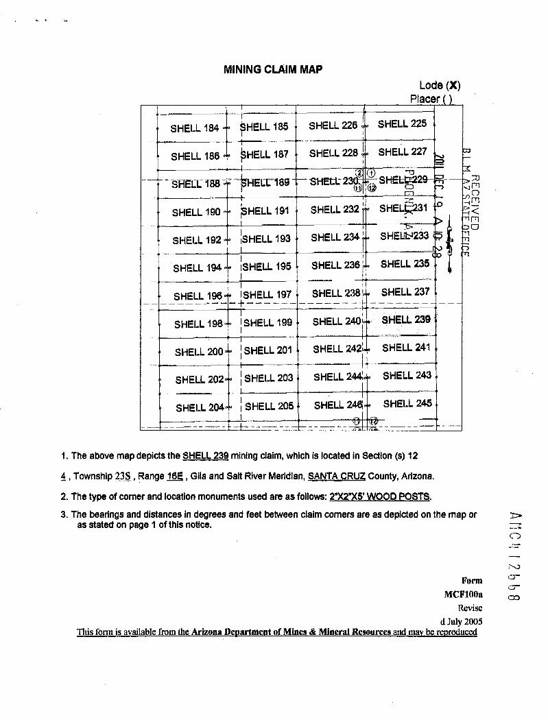
MINING CLAIM MAPLode (X)
Placer
SHELL 184 SHELL 185 SHELL 226 SHELL 225
SHELL 186 ~HELL 187 SHELL 228 SHELL 227
-0SHELL-188 - 0189 SHELL- 2 2 1 SHEI*
REC VEDSHELL 190 ~HELL 191 SHELL 232 ' SHEL~31
SHELL 192 ~SHELL 193 SHELL 234 ' SHELb1233
SHELL 194 SHELL 195 SHELL 236 SHELL 235
SHELL 196 ISHELL 197 SHELL 238' SHELL 237
SHELL 198 I SHELL 199 SHELL 240 SHELL 239
SHELL 200 1 SHELL 201 SHELL 242 SHELL 241
SHELL 202 1 SHELL 203 SHELL 244 SHELL 243
SHELL 204 1 SHELL 205 SHELL 244 SHELL 245
1. The above map depicts the SHELL 239 mining daim, which is located in Section (s) 12
4, Township 235, Range 16E , Gila and Salt River Meridian, SANTA CRUZ County, Arizona.
2. The type of comer and location monuments used are as follows: 2*)(275' WOOD POSTS.3. The bearings and distances in degrees and feet between claim corners are as depicted on the map or
as stated on page 1 of this notice.
AC
XJ
Form 0--cr
MCF10Oa eRevise
d July 2005This form is available from the Arizona Devartment of Mines & Mineral Resources and ma¥ be revroduced

2012-,)9<13\Nher, Filed Return To: Page 1 of 2 r li
Requested Bski-141•izona MineralsARIZONA MINERALS, INC. SUZANNE SAINZ, RECORDER4500 5. CHERRY CREEK DR, SUITE 1040 SANTA CRUZ COUNTY, ARIZONADENVER, CO 80246 10-19-2012 .03:52 PM Recording Fee $10.00
AMENDED LOCATION NOTICE FOR LODE MINING CLAIMr-33
NOTICE IS HEREBY GIVEN that the SHELL-240 lode mining claim C) r·»~ 1BLMBLM serial number, AMC 412669, having an original location date of Date 1-.7 :7= -2.
3 5121 NOVEMBER, 2011, as recorded in the office of the County Recorder Stamp ... ;13
of Santa Cruz County, State of Arizona, at Reception No. 2012-00451 > - =m:13 -/.rshas been AMENDED - ~ ' ' ~---1
17By: ARIZONA MINERALS, INC. 2> LU 35
45005. CHERRY CREEK DR, SUITE 1040
DENVER, CO 80246
The general course of this claim is EAST TO WEST and it is situated in SANTA CRUZ County, Arizona. This claim is 1500feet in length and 600 feet in width.
This claim runs from the location monument on which this location notice is posted approximately 2Q feet in aEASTERLY direction to the EAST end line and 1480 feet in a WESTERLY direction to the WEST end line. This claim ismarked by six monuments, one at each corner and one at the center of each end line of the claim.The location monument on which this notice is posted is situated within Section 11, Township 23 SOUTH, Range 16EAST, from the Gila and Salt River Meridian, and this claim encompasses portions of the following quarter section (s),section (s), Township (s) and Range (s) SE_1/4_ofSECTION_11 _I. 238 8.16E from the Gila and Salt River Meridian,Arizona.
The locality of this claim with reference to some natural object or permanent monument and additional information(if any) concerning its locality are as follows:_THENORTHEAST_CORNER_ofthe-claim.falQglgfL5721®el«EAS-Tand10488_feet-SQUIELImmthe_SQU-THWEST_Cgmerof Section _35 T._22LJL15E _fmmthe Gilaand_Salt-RiverMeridian.SANTACRUZ_COUNTY.-AZADATED AND POSTED on theground this 26 day of J-G-f~,20 /2_
1\Dkl.4 \1669\
AGENT/Darling Environmental & Surveying, Ltd.9040 S6uth Rita Road, Suite 2350Tucson, AZ 85747 *Ci & 6 .01 ruR
*4__ 2- 26- /3

2012-08413-~~ 19-2012 03:52 PM Page 2 of 2
MINING CLAIM MAPLode (X)
Placer ( )
ELL 115 SHELL 184 0 SHELL 185 SHELL 226 SHELL 2251 1
1
~ 117(F) SHELL 186 S~ELL 187 SHELL 228 SHELL 227(2 1
ELL 119r-, SHELL 188 " S ELL 189 SHELL 230 (1 (10-SHELL 229d Ill)ELE 121 SHELL 190 SI~ELL 191 SHELL 232 SHEL1231 r-- /3
ELL 123 SHELL 192 S ELL 193 SHELL 234 SHEX 233 25 ~, _>r Al
ELL 125 SHELL 194 SHELL 195 SHELL 236 SHEL 235- 4/rn0200
E 127 SHELL_196 a~i-ELLI 97 SHELL 238 SHELL-2347 -7
ELL 129 SHELL 198 SHELL 199 f SHELL 240 SHELL 239_L
ELL 131 SHELL 200 S~HELI_ 201 SHELL 242 c SHELL 241
ELL 133 SHELL 202 SHELL 203 SHELL 244 SHELL 243
SHELL 204 SIHELL 205 SHELL 246 SHELL 2451
1. The above map depicts the SHELL 240 mining claim, which is located in Section (s) 11
4, Township 23S, Range 16E , Gila and Salt River Meridian, SANTA CRUZ County, Arizona.
2. The type of corner and location monuments used are as follows: 2"X2"X5' WOOD POSTS.3. The bearings and distances in degrees and feet between claim corners are as depicted on the map oras stated on page 1 of this notice.
FormMCF100a
Revised July 2005This form is available from the Arizona Department of Mines & Mineral Resources and may be reproduced

W-hen Filad Return To:AZ MINERALS, INC.
4500 S. CHERRY CREEK DR, SUITE 1040
DENVER, CO 80246
LOCATION NOTICE FOR LODE MINING CLAIM mr-
NOTICE IS HEREBY GIVEN that the SHELL-240 lode mining claim BLM
mhas been located Sta m p Z - infi1 -0 13
By: AZ MINERALS, INC.NO IR
4500 S. CHERRY CREEK DR, SUITE 1040 A) 2300 m
DENVER, CO 80246
The general course of this claim is EAST TO WEST and it is situated in SANTA CRUZ County, Arizona. This claim is 1500
feet in length and 600 feet in width.
This claim runs from the location monument on which this location notice is posted approximately 2Q feet in a
EASTERLY direction to the EAST end line and 1480 feet in a WESTERLY direction to the WEST end line. This claim is
marked by six monuments, one at each corner and one at the center of egch end line of the claim.
The location monument on which this notice is posted is situated within Section 12, Township 23 SOUTH, Range 11
EAST, from the Gila and Salt River Meridian, and this claim encompasses portions of the following quarter section (s),
section (s), Township (s) and Range (s) SE_1 M_pf SECILQN_11, SW 1 /4 of SECTION 12, T. 235,_R.16E, from the Gila and
Salt River Meridian, Arizona.
The locality of this claim with reference to some natural object or permanent monument and additional information
(if any) concerning its locality are as follows:_THENORTHEAST_CORNER-oflheclaimislocated-5721-feeLEASTand1.0488 feeLSQUTH-fmmithe_SQZJTEIWEST_-Comer-of_Section 35 I. 228 «R..16E f-omthe_Giliand Salt Rive[MeridianSANTA CRUZ COUNTY, AZ.
DATED AND POSTED on the ground this 21 day of ;JOU , 20 W
.-r'1'
-3irctf JO wefAGENT: Darling Environmental & Surveying, Ltd.
9040 South Rita Road, Suite 2350 cr0-Tucson, AZ 85747 12

MINING CLAIM MAPLode (X)
Placer
SHELL 184 ~HELL 185 SHELL 226 SHELL 225lo
SHELL 186 HELL 187 SHELL 228 SHEI* 227
RE-CE VED
2 1 XSFELE 188 - cr189 SHELL 2 SHEtL-2
SHELL 190 ~SHELL 191 SHELL 232 ' SHELL 231
SHELL 192 ~SHELL 193 SHELL 234 ' SHELL 233
SHELL 194 SHELL 195 SHELL 236 SHELL 235
SHELL 196 ISHELL 197 SHELL 238' SHELL 237
SHELL 198 SHELL 199 SHELL 240 SHELL 239
SHELL 200 l SHELL 201 SHELL 242' SHELL 241
SHELL 202 < SHELL 203 SHELL 244 SHELL 243
SHELL 204 ~ SHELL 205 SHELL 244 SHELL 245
1. The above map depicts the SHELL 240 mining claim, which is located In Section (s) 11 & 12
4, Township 23S, Range 162, Gila and Salt River Meridian, SANTA CRUZ County, Arizona.
2. The type of comer and location monuments used are as follows: 27275'WOOD POSTS.
3. The bearings and distances in degrees and feet between claim corners are as depicted on the map oras stated on page 1 of this notice.
ANC' 2bb9
FormMCF10()a
Revised July 2005
Ibis form_is_available from the Arizona Devartment_of Mines.& Mineral Resources and-may be.ret)roduced

2 0 1 2 -g 9*1 4When Filed Return To: Page 1 of 2 11Requested 8-Ilrizona MineralsARIZONA MINERALS, INC. SUZANNE SAINZ, RECORDER4500 S. CHERRY CREEK DR, SUITE 1040 SANTA CRUZ COUNTY, ARIZONA
DENVER, CO 80246 10-19-2012 03:52 PM Recording Fee *10.00
AMENDED LOCATION NOTICE FOR LODE MINING CLAIM r.1U
NOTICE IS HEREBY GIVEN that the SHELL-241 lode mining claim BLM 7/1 --BLM serial number, AMC 412670, having an original location date of Date21 NOVEMBER, 2011, as recorded in the office of the County Recorder Stamp -irrl-0
of Santa Cruz County, State of Arizona, at Reception No. 2012-00452has been AMENDED A: b rm
0 2
By: ARIZONA MINERALS, INC. rn
45005. CHERRY CREEK DR, SUITE 1040
DENVER, CO 80246
The general course of this claim is WEST TO EAST and it is situated in SANTA CRUZ County, Arizona. This claim is 1500feet in length and 600 feet in width.
This claim runs from the location monument on which this location notice is posted approximately 2.Q feet in aWESTERLY direction to the WEST end line and 1480 feet in a EASTERLY direction to the EAST end line. This claim ismarked by six monuments, one at each corner and one at the center of each end line of the claim.The location monument on which this notice is posted is situated within Section 11, Township 23 SOUTH, Range 16EAST, from the Gila and Salt River Meridian, and this claim encompasses portions of the following quarter section (s),section (s), Township (s) and Range (s) SE_1/ELSECTION_11_and the SW 1 /4 of SECTION_1 2 _I. 23S R.161 from theGila and Salt River Meridian, Arizona.
The locality of this claim with reference to some natural object or permanent monument and additional information(if any) concerning its locality are as follows: THE-NORTHEAST_CORNERofthedaimislocated_7228 fedEASTand11072-feeLSOUTHfrom_the_SOUTHWESTComer-of.Section_35 I.-225,_R. I68 fromthe_Gilaand Salt RiverMeridianSANTA_CRUZ-COUNTY_AZ.DATED AND POSTED on the ground this _~-C day of ~99, 20 1 Z .
A (nc-4\ 16-tO1 / 3-AGENT: D,/rling fnvirohmental & Surveying, Ltd.9040 South Rita Road. Suite 2350Tucson, AZ 85747
EN--1-E'35[1 8, Coivipl ITE:RR<€« R- *6 - 0

2012-08414 10-19-2012 03:52 PM Page 2 of 2
MINING CLAIM MAPLode (X)
Placer ( )
EL 115 SHELL 184 SHELL 185 SHELL 226 SHELL 225
EL 117® SHELL 186 S¢ELL 187 SHELL 228 SHELL 227('2) < 1
ELL 119- SHELL 188 S ELL 189 SHELL 230 ,-SHELL 229
EL~121 SHELL 190 SI~ELL 191 SHELL 232 SHELL 231
EL-~ 123 SHELL 192 S ELL 193 SHELL 234 SHELL 233
ELL 125 SHELL 194 SHELL 195 SHELL 236 o SHELL 235
E 127 SHELL 196 MiELL_197 SHELL 238 SHELL 237
ELL 129 SHELL 198 SHELL 199 SHELL 240 SHELL 239
ELL 131 SHELL 200 *ELI 201 SHELL 242 0 SHELL 241
ELL 133 SHELL 202 SHELL 203 SHELL 244 AIHELL &132 CD
SHELL 204 S|HELL 205 SHELL 246 53HELL~Yas ·: ~ *
14 * U<-- > ''im- 009 -,11. The above map depicts the SHELL 241 mining claim, which is located in Sectio!*s) 125 12~u rn4, Township 23S, Range 16E , Gila and Salt River Meridian, SANTA CRUZ County, Arizona.
2. The type of corner and location monuments used are as follows: 2"X2"XS' WOOD POSTS.3. The bearings and distances in degrees and feet between claim corners are as depicted on the map oras stated on page 1 of this notice.
FormMCF10Oa
Revised July 2005This form is available from the Arizona Department of Mines & Mineral Resources and may be reproduced

·When Filed Return To:AZ MINERALS, INC.
4500 S. CHERRY CREEK DR, SUITE 1040
DENVER, CO 80246
LOCATION NOTICE FOR LODE MINING CLAIM
B.L. 1. FFICE
NOTICE IS HEREBY GIVEN that the SHELL-241 lode mining claim BLM I = >mDate 0 (-1 ['-4 r-!10rnhas been located Stamp 7 .0 --~~~
By: AZ MINERALS, INC.NO
4500 S. CHERRY CREEK DR, SUITE 1040 -D
DENVER, CO 80246
The general course of this claim is WEST TO EAST and it is situated in SANTA CRUZ County, Arizona. This claim is 1500
feet in length and 600 feet in width.
This claim runs from the location monument on which this location notice is posted approximately 2Q feet in a
WESTERLY direction to the WEST end line and 1480 feet in a EASTERLY direction to the EAST end line. This claim is
marked by six monuments, one at each corner and one at the center of each end line of the claim.
The location monument on which this notice is posted is situated within Section 12, Township 23 SOUTH, Range 16
EAST, from the Gila and Salt River Meridian, and this claim encompasses portions of the following quarter section (s),
section (s), Township (s) and Range (s) SW 1 /4 of SECTION 12. T. 235. R.16E. from the Gila and Salt River Meridian,
Arizona.
The locality of this claim with reference to some natural object or permanent monument and additional information
(if any) concerning its locality are as follows: THE NORTHEAST CORNER of the claim is located 7228 feet EAST and
11072-feet-SOUTH.fkomthe_SOUTINEST.ComerofSection 3-5~-I._22LL-16,Ezfrgm_ill«iila=51.8~1£*:jyg~Mgidi~-SANTA CRUZ COUNTY. AZ.
DATED AND POSTED on the ground this 2-1 day of Ajov , 20 \1
1/\/- AMC
AGEN : Darling Environmental &~urveying, Ltd.
9040 South Rita Road, Suite 2350
Tucson, AZ 85747 -JCO

MINING CLAIM MAPLode (X)
Placer
SHELL 184 ~HELL 185 SHELL 226 SHELL 225
SHELL 186 ~HELL 187 SHELL 228 SHEL66!27
2 1SHELE 188- ~HE[[3789 SHEIi- 2 © S
RFC
EIVEDn
SHELL 190 ~SHELL 191 SHELL 232 SHELi>231
SHELL 192 ~SHELL 193 SHELL 234 ' SHELL 233
SHELL 194 ISHELL 195 SHELL 236' SHELL 235
SHELL 196 ISHELL 197 SHELL 238' SHELL 237
SHELL 198 SHELL 199 SHELL 240 SHELL 239
SHELL 200 1 SHELL 201 SHELL 242 SHELL 241
SHELL 202 j SHELL 203 SHELL 244 SHELL 243
SHELL 204 ~ SHELL 205 SHELL 24« SHELL 2451_
1. The above map depicts the SHELL 2¢11 mining claim, which is located in Section (s) 12
4, Township 23S, Range 16E , Glla and Salt River Meridian, SANTA CRUZ County, Arlzona.
2. The type of comer and location monuments used are as follows: 2*X2')(5-LWOOD POSTS. AMC 2610
3. The bearings and distances in degrees and feet between claim corners are as depicted on the map oras stated on page 1 of this notice.
FormMCFlooa
Revised July 2005
Ihis form is available from-the_Arizona.Dep.artment-of-Mines &_Mineral«Resolutes.and maybe reploduced

2012 -08 4-15When Filed Return To: PI;32 1 of 2 1
Requested 841 Tizona MineralsARIZONA MINERALS, INC. SUZANNE SAINLI RECORDER45005. CHERRY CREEK DR, SUITE 1040 SANTA CRUZ COUNTY, ARIZONADENVER, CO 80246 10-19-2012 03:52 PM Recording Fee $10.00
AMENDED LOCATION NOTICE FOR LODE MINING CLAIM
NOTICE IS HEREBY GIVEN that the SHELL-242-lode mining claim BLM 0 ,„..BLM serial number, AMC 412671, having an original location date of Date -4 .1
21 NOVEMBER, 2011, as recorded in the office of the County Recorder Stampof Santa Cruz County, State of Arizona, at Reception No. 2012-00453 .
J
has been AMENDED . ;7
V - 1 A 10: 3
I 1. OFFICBY: ARIZONA MINERALS, INC.
i 10 1·{i>
AR ZON~
4500 S. CHERRY CREEK DR, SUITE 1040
DENVER, CO 80246
The general course of this claim is EAST TO WEST and it is situated in SANTA CRUZ County, Arizona. This claim is 1500feet in length and 600 feet in width.
This claim runs from the location monument on which this location notice is posted approximately 2Q feet in aEASTERLY direction to the EAST end line and 1480 feet in a WESTERLY direction to the WEST end line. This claim ismarked by six monuments, one at each corner and one at the center of each end line of the claim.The location monument on which this notice is posted is situated within Section 11, Township 23 SOUTH, Range 16EAST, from the Gila and Salt River Meridian, and this claim encompasses portions of the following quarter section (s),section (s), Township (s) and Range (s) SE 1/4 of SECTION 11. T. 235. R. 16E, from the Gila and Salt River Meridian,Arizona.
The locality of this claim with reference to some natural object or permanent monument and additional information(if any) concerning its locality are as follows:_THENORTHEAST-CORNER_ofthe_claimis_located_5728 feeLEASTand11Q88-feet SQUIH from»the_SQUIHWEST_Comerof_Section_liI. 22S R. 16E fromithe Gila ansl-Salt River Meridian.SANTA-CRUZ_COUNIYAZ.DATED AND POSTED on the ground this 2-lo day of S El= , 20 I 2
Anle L.\ 1 2-67 \AGENT: Darling Environmental & Surveying, Ltd.9040 Sout~ Rita Road, Suite 2350Tucson, AZ 85747
'292- 2- 2_6· 13

2012-08415 ~~-19-2012 03:52 PM Page 2 of 2
MINING CLAIM MAPLode (X)
Placer ( )
EL 115 SHELL 184 SHELL 185 SHELL 226 SHELL 225
ELK 117(5) SHELL 186 S~ELL 187 SHELL 228 SHELL 227(2 1
ELL 119- SHELL 188 S ELL 189 SHELL 230 -SHELL 229
EL~ 121 SHELL 190 S~ELL 191 SHELL 232 SHEL!>/31 - 03:-
EL~123 SHELL 192 S ELL 193 SHELL 234 SHEL~33 « K
1:11EL~125 SHELL 194 SHELL 195 SHELL 236 SHEL>235
SZS} / OUZEDC
E 127_. SHELL-196 S~-ELL-197 SHELL 238 SHEG 237 -
1,161 .,FFICE-JELL 129 SHELL 198 SHELL 199 SHELL 240 SHELL 239
ELL 131 SHELL 200 S~ELL 201 - SHELL 242 SHELL 241
ELL 133 SHELL 202 SHELL 203 SHELL 244 SHELL 243
SHELL 204 S~HELL 205 SHELL 246 SHELL 245
1. The above map depicts the SHELL 242 mining claim, which is located in Section (s) 114, Township 23S, Range 16E , Gila and Salt River Meridian, SANTA CRUZ County, Arizona.
2. The type of corner and location monuments used are as follows: 232"X5'WOOD POSTS.3. The bearings and distances in degrees and feet between claim corners are as depicted on the map oras stated on page 1 of this notice.
FormMCF100a
Revised July 2005This form is available from the Arizona Department of Mines & Mineral Resources and may be rqproduced

*6En Filed Return To:AZ MINERALS, INC.
4500 S. CHERRY CREEK DR, SUITE 1040
DENVER, CO 80246
LOCATION NOTICE FOR LODE MINING CLAIM
NOTICE IS HEREBY GIVEN that the SHELL-242 lode mining claim BLM
FFICE
-0Date I >33
has been located OStamp m1 -0 -
By: AZ MINERALS, INC. w > 38N 25
4500 S. CHERRY CREEK DR, SUITE 1040
DENVER, CO 80246
The general course of this claim is EAST TO WEST and it is situated in SANTA CRUZ County, Arizona. This claim is 1500
feet in length and 600 feet in width.
This claim runs from the location monument on which this location notice is posted approximately 2Q feet in a
EASTERLY direction to the EAST end line and 1480 feet in a WESTERLY direction to the WEST end line. This claim is
marked by six monuments, one at each corner and one at the center of each end line of the claim.
The location monument on which this notice is posted is situated within Section 12, Township 23 SOUTH, Range 16
EAST, from the Gila and Salt River Meridian, and this claim encompasses portions of the following quarter section (s),
section (s), Township (s) and Range (s) SE 1/4 of SECTION 11, SW 1/4 of SECTION 12, T. 235, R. 16E, from the Gila and
Salt River Meridian, Arizona.
The locality of this claim with reference to some natural object or permanent monument and additional information
(if any) concerning its locality are as follows: THE NORTHEAST CORNER of the claim is located 5728 feet EAST and
11088 feet SOUTH from the SOUTHWEST Corner of Section 35, T. 22S, R. 16E, from the Gila and Salt River Meridian. 1
SANTA CRUZ COUNTY. AZ.
DATED AND POSTED on the ground this ~ day of AJO~ , 20 Ir . 1
A IC 2bl
Yellf JotjAGENT: Darling Environmental & Surveying, Ltd.
9040 South Rita Road, Suite 2350
Tucson, AZ 85747

MINING CLAIM MAPLode (X)
Placer
SHELL 184 ~HELL 185 SHELL 226 SHELL 225
SHELL 186 ~HELL 187 SHELL 228 SHELL 227 c
B.L .
OFFICE
2 1
SHELLI 188 --- II-189 SHELL-2 S
4<SHELL 190 ~SHELL 191 SHELL 232 ' SHELt 231 1, mm
0
SHELL 192 ~SHELL 193 SHELL 234 ' SHELL 233
SHELL 194 ISHELL 195 SHELL 236' SHELL 235
SHELL 196 ISHELL 197 SHELL 238' SHELL 237
SHELL 198 ~ SHELL 199 SHELL 240 SHELL 239
SHELL 200 ~ SHELL 201 SHEnt-24 SHELL 241
SHELL 202 I SHELL 203 SHELL 244 SHELL 243
SHELL 204 ~ SHELL 205 SHELL 244 SHELL 245
1. The above map depicts the SHELL 242 mining daim, which is located in Section (s) 11 & 12
4, Township 235, Range 16E , Glla and Salt River Meridian, SANTA CRUZ County, Arizona.
Arc
2 b 1
2. The type of comer and location monuments used are as follows: 2"X2'XS'WOOD POSTS.
3. The bearings and distances in degrees and feet between claim corners are as depicted on the map oras stated on page 1 of this notice.
FormMCF10Oa
Revised July 2003
This form is available from the Arizona De artment of Mines & Mineral Resources d be r rodu

2012 -- /111* 16When Filed Return To: Page 1 of 21111 4
Requested 881 Arizona MineralsARIZONA MINERALS, INC. SUZANNE SAINZ, RECORDER45005. CHERRY CREEK DR, SUITE 1040 {SANTA CRUZ COUNTY, ARIZONADENVER, CO 80246 . 10-19-2012 03:52 PM Recording Fee *10.00
AMENDED LOCATION NOTICE FOR LODE MINING CLAIM A / rn
NOTICE IS HEREBY GIVEN that the SHELL-243_lode mining claim BLM r.· 1BLM serial number, AMC 412672, having an original location date of Date 2 9 51621 NOVEMBER, 2011, as recorded in the office of the County Recorder Stamp -2< _ .~.07of Santa Cruz County, State of Arizona, at Reception No. 2012-00454has been AMENDED R » am
=71
CDBY: ARIZONA MINERALS, INC.
45005. CHERRY CREEK DR, SUITE 1040
DENVER, CO 80246
The general course of this claim is WEST TO EAST and it is situated in SANTA CRUZ County, Arizona. This claim is 1500feet in length and 600 feet in width.
This claim runs from the location monument on which this location notice is posted approximately 2Q feet in aWESTERLY direction to the WEST end line and 1480 feet in a EASTERLY direction to the EAST end line. This claim ismarked by six monuments, one at each corner and one at the center of each end line of the claim. PThe location monument on which this notice is posted is situated within Section 11, Township 23 SOUTH, Range .16. ~EAST, from the Gila and Salt River Meridian, and this claim encompasses portions of the following quarter section (s), ~section (s), Township (s) and Range (s) SE_1/lof SECTION_1_1_and the SW 1/4_of SECTION_12 T. 23S R.16.E from the ~Gila and Salt River Meridian, Arizona. .-1rThe locality of this claim with reference to some natural object or permanent monument and additional information(if any) concerning its locality are as follows:_THE_NORTHEAST_CORNER»of the_glaim-islocated_7234 feerEASI.and11572.feeLSOLITILfromthe-SQUIHIVEST-Comer_of_Section_15 T. 22531._15E from the.Gilaand Salt RiverMeridian.SANTA CRUZ COUNTY, AZ.
DATED AND POSTED on the ground this ~-6 day of 55 f , 20 1 6 .
AGENT: Darjfng 2nvirdAmental & Surveying, Ltd.9040 South,Rita Road. Suite 2350Tucson. AZ 85747
E"frE-'3F- iJ f :1:~Pi IT'=9
~RS- 2- 26. 1 3

2012-08416 10-19-2012 03:52 PM Page 2 of 2
MINING CLAIM MAPLode (X)
Placer ( )
ELL 115 SHELL 184 SHELL 185 SHELL 226 SHELL 225
31] 1Yfj) SHELL 186 S~ELL 187 SHELL 228 SHELL 227(2) c 1 -73 ~ ~9-F-- -a - -- &
ELL 119r-. SHELL 188 S ELL 189 SHELL 230 4 L 229~L ~ 46..a EIS R;%-
EL~121 SHELL 190 SI~ELL 191 SHELL 232 SHELL 231- =frn-1<
~ 123 SHELL 192 S ELL 193 ~ SHELL 234 SHELL 23
ELL 125 SHELL 194 SHELL 195 SHELL 236 SI·TELL 235-1 r:1
E 127_ SHELL_196 S~!ELL 197 SHELL 238 SHELL 237
ELL 129 SHELL 198 SHELL 199 SHELL 240 SHELL 239
E~ 131 SHELL 200 q S~ELL 201 SHELL 242 SHELL 241
ELL 133 SHELL 202 SHELL 203 SHELL 244 4 SHELL.243 '
SHELL 204 c SHELL 205 SHELL 246 SHELL 245B 1d @5
1. The above map depicts the SHELL 243 mining claim, which is located in Section (s) 11 & 124, Township 23S, Range 16E , Gila and Salt River Meridian, SANTA CRUZ County, Arizona.2. The type of corner and location monuments used are as follows: 2"X2")<5' WOOD POSTS.3. The bearings and distances in degrees and feet between claim corners are as depicted on the map oras stated on page 1 of this notice.
FormMCF100a
Revised July 2005This form is available from the Arizona Department of Mines & Mineral Resources and may be reproduced

=-0When Filed Return To:AZ MINERALS, INC.
4500 S. CHERRY CREEK DR, SUITE 1040
DENVER, CO 80246
LOCATION NOTICE FOR LODE MINING CLAIM
NOTICE IS HEREBY GIVEN that the SHELL-243 lode mining claim BLMDate
B.L.M. A
FFIC
has been located Stamp ~ ~ 300rn
By: AZ MINERALS, INC. Z1, f-rlm
4500 S. CHERRY CREEK DR, SUITE 1040N 25
DENVER, CO 80246 r.,
The general course of this claim is WEST TO EAST and it is situated in SANTA CRUZ County, Arizona. This claim is 1500
feet in length and 600 feet in width.
This claim runs from the location monument on which this location notice is posted approximately 2Q feet in a
WESTERLY direction to the WEST end line and 1480 feet in a EASTERLY direction to the EAST end line. This claim is
marked by six monuments, one at each corner and one at the center of each end line of the claim.
The location monument on which this notice is posted is situated within Section 12, Township 23 SOUTH, Range 16
EAST, from the Gila and Salt River Meridian, and this claim encompasses portions of the following quarter section (s),
section (s), Township (s) and Range (s) SW 1/4 of SECTION 12. T. 235. R.16E. from the Gila and Salt River Meridian,
Arizona.
The locality of this claim with reference to some natural object or permanent monument and additional information
(if any) concerning its locality are as follows: THE NORTHEAST CORNER ofthe claim is located 7234 feet EAST and
11672 feet SOUTH from the SOUTHWEST Corner of Section 35, T. 228, R. 168, from the Gila and Salt River Meridian,
SANTA CRUZ COUNTY, AZ.
DATED AND POSTED on the ground this 7-1 day of Ajbu ,20 1~.
AGENT: Darling Environmental & Surveying, Ltd.
9040 South Rita Road, Suite 2350
4 2512
Tucson, AZ 85747

MINING CLAIM MAPLode (X)
Placer
SHELL 184 5HELL 185 SHELL 226 SHELL 225
SHELL 186 ~HELL 187 SHELL 228 SHELL 227 0-
B.L.M.
R >3,N viSHEll- 188 - Crl 89 SHE11 2 2 4 SHELL- L cnnZ -0 :=4 El
SHELL 190 ~SHELL 191 SHELL 232 ' SHELL :51 > ~r~00-7
SHELL 192 ~SHELL 193 SHELL 234 ' SHELL 233 5m
SHELL 194 ISHELL 195 SHELL 236' SHELL 235
SHELL 196 ISHELL 197 SHELL 238' SHELL 237
SHELL 198 1 SHELL 199 SHELL 240 SHELL 239
SHELL 200 I SHELL 201 SHELL 242; SHELL 241
SHELL 202 ~ SHELL 203 SHELL 244 SHELL 243
SHELL 204 I SHELL 205 SHELL 244 SHELL 245J
1. The above map depicts the SHELL 243 mining daim, which is located In Section (s) 12
4, Township 23S, Range 162, Glla and Salt River Meridian, SANTA CRUZ County, Arlzona. ANC 2612
2. The type of corner and location monuments used are as follows: 2')(215' WOOD POSTS.
3. The bearlngs and distances in degrees and feet between claim corners are as depicted on the map oras stated on page 1 of this notice.
FormMCF100a
Revised July 2005
This form is available from the Ariz na De men of Mine & Mineral Reso rees and ma be rodu

2012 -1711*17-When Filed Return To: Page 1 of 2~,1
Requested BJI Ilrizona MineralsARIZONA MINERALS, INC. ,; SUZANNE SAINZ, RECORDER4500 S. CHERRY CREEK DR, SUITE 1040 ' ./ SANTA CRUZ COUNTY, ARIZONADENVER, CO 80246 4' 10-19-2012 03:52 PM Recording Fee $10.00
AMENDED LOCATION NOTICE FOR LODE MINING CLAIM
NOTICE IS HEREBY GIVEN that the SHELL-244 lode mining claim BLM -;J [Rg co-CBLM serial number, AMC 412673, having an original location date of Date 0r' 75
21 NOVEMBER, 2011, as recorded in the office of the County Recorder Sta m p --0 , - * .
CD -~ i -n
of Santa Cruz County, State of Arizona, at Reception No. 2012-00455 2.< 1 -2.1 2has been AMENDED
CDC
By: ARIZONA MINERALS, INC. .-
4500 S. CHERRY CREEK DR, SUITE 1040
DENVER, CO 80246
The general course of this claim is EAST TO WEST and it is situated in SANTA CRUZ County, Arizona. This claim is 1500feet in length and 600 feet in width.
This claim runs from the location monument on which this location notice is posted approximately ZQ feet in aEASTERLY direction to the EAST end line and 1480 feet in a WESTERLY direction to the WEST end line. This claim ismarked by six monuments, one at each corner and one at the center of each end line of the claim.The location monument on which this notice is posted is situated within Section 11, Township 23 SOUTH, Range 16EAST, from the Gila and Salt River Meridian, and this claim encompasses portions of the following quarter section (s),section (s), Township (s) and Range (s) SE_10_of.SECTION_11 I. 23S R.lfiE* from the Gila and Salt River Meridian,
A-h\0 4 \2613
Arizona.
The locality of this claim with reference to some natural object or permanent monument and additional information(if any) concerning its locality are as follows:_THE-NORTHEAST_CORNERof_uiedaim islocated_5734_feeLEASTand11688_feet_SOUTH_from_the_SOUTI[WES T ComerofSection jS T._228 R. 16E _fromthe Gilaand-5alt River«Meridian,-SANIA-CRULCOUNTY.«AZ.DATED AND POSTED on the ground this 26 day of -5-€r , 20 f Z.
AGENT: Dart ng Environ, ental & Surveying, Ltd.9040 South Rita Road, Suite 2350Tucson, AZ 85747
rR<Z. 2-2-6-«)3

2012-08417 ~~219-2012 03:52 PM Page 2 of 2
MINING CLAIM MAPLode (X)
Placer ( )
ELL 115 SHELL 184 0 SHELL 185 SHELL 226 SHELL 225
ELI- 117(Sh SHELL 186 SI~ELL 187 SHELL 228 SHELL 227
ELL 119-> SHELL 188 9 S ELL 189 SHELL 230 -SHELL 229
EL~121 SHELL 190 S~ELL 191 SHELL 232 SHELL 231
ELL 123 SHELL 192 S ELL 193 SHELL 234 *~LL 333 -- ~
4- rri
ELL 125 SHELL 194 shELL 195 SHELL 236 RiELL * n 58
E 127_ SHELL 196 ~EL=L!97_ SHELL 238 7~IELL_»7 ,·-iA:~1
ELL 129 SHELL 198 SHELL 199 ~ SHELL 240 SHELL1239U_
ELL 131 SHELL 200 S~ELL 201 SHELL 242 SHELL 241
ELL 133 SHELL 202 SHELL 203 SHELL 244 SHELL 243
SHELL 204 o ~HELL 205 SHELL 246 SHELL 245f 1(14 (i5
1. The above map depicts the SHELL 244 mining claim, which is located in Section (s) 114, Township 23S, Range 16E, Gila and Salt River Meridian, SANTA CRUZ County, Arizona.2. The type of corner and location monuments used are as follows: 2"X2"X5' WOOD POSTS.3. The bearings and distances in degrees and feet between claim corners are as depicted on the map oras stated on page 1 of this notice.
FormMCF10Oa
Revised July 2005This form is available from the Arizona Department of 1Mines & Mineral Resources and may be reproduced

'-When Filed Return To:AZ MINERALS, INC.
4500 S. CHERRY CREEK DR, SUITE 1040
DENVER, CO 80246
LOCATION NOTICE FOR LODE MINING CLAIM
NOTICE IS HEREBY GIVEN that the SHELL-244 lode mining claim BLM ID
20 DECDate 0has been located Sta m p E -O
m
XBy: AZ MINERALS, INC.
N 2545005. CHERRY CREEK DR, SUITE 1040 r.,
DENVER, CO 80246
The general course of this claim is EAST TO WEST and it is situated in SANTA CRUZ County, Arizona. This claim is 1500
feet in length and 600 feet in width.
This claim runs from the location monument on which this location notice is posted approximately 2Q feet in a
EASTERLY direction to the EAST end line and 1480 feet in a WESTERLY direction to the WEST end line. This claim is
marked by six monuments, one at each corner and one at the center of each end line of the claim.The location monument on which this notice is posted is situated within Section 12, Township 23 SOUTH, Range 1.EL
EAST, from the Gila and Salt River Meridian, and this claim encompasses portions of the following quarter section (s),
section (s), Township (s) and Range (s) SE_1/ELof-SECTION_11 _SYY_1/4 QLSECTION 12 T. 2318.16E: from the Gila andSalt River Meridian, Arizona.
The locality of this claim with reference to some natural object or permanent monument and additional information(if any) concerning its locality are as follows:_THE-NORTHEAST_CORNER-oftheclaimialocated 5734 feet EAST and-11_«ifeeLSOUTH-fromthe-SOUTINEST_Corner-of_Section_35-I. 22SR:-16Eufmmthe Gilaand.Salt.Biver-MeridianSANTA CRUZ COUNTY. AZ.
DATED AND POSTED on the ground this El day of NOV r -,20 1/
!
/ 5€11-, 30.vej 0AGENT: Darling Environmental & Surveying, Ltd.
9040 South Rita Road, Suite 2350 >J0-
Tucson, AZ 85747 --1L.J

..
MINING CLAIM MAPLode (X)
Placer
SHELL 184 ~HELL 185 SHELL 226 SHELL 225
SHELL 186 ~HELL 187 SHELL 228 SHELL 227 20 ~EC
B.L 1. A
SHELE 188 -- --~HEII-189 SHELL- 2 2 1 SHELL m/-0
SHELL 190 ~SHELL 191 SHELL 232 ' SHELL»1 -0 *!~
O0-Tl
SHELL 192 ~SHELL 193 SHELL 234' SHELL£83 -7
CDmSHELL 194 ISHELL 195 SHELL 236' SHELL 235
SHELL 196 ISHELL 197 SHELL 238' SHELL 237
SHELL 198 SHELL 199 SHELL 240 SHELL 239
SHELL 200 I SHELL 201 SHELL 242' SHELL 241
SHELL 202 < SHELL 203 SHELL 244 SHELL 243
SHELL 204 ~ SHELL 205 SHELL 24« SHELL 245
1. The above map depicts the SHELL_244 mining dalm, which is located in Section (s) 11 & 12
4, Township 23S, Range 162, Gila and Salt River Meridian, SANIA_CRUZ County, Arizona.
2. The type of comer and location monuments used are as follows: 2*)(23<5'WOOD POSTS. >
3. The bearings and distances In degrees and feet between claim corners are as depicted on the map oras stated on page 1 of this notice. CD
2513
FormMCF100a
Revised July 2005
Thi form is vailable from the Arizona De artment of Mine Mineral Resource and ma rru

2012 -08418When Filed Return To: Page 1 of 2 1 ~ 1
Requested By,---·izona MineralsARIZONA MINERALS, INC. SUZANNE SAINZ, RECORDER4500 S. CHERRY CREEK DR, SUITE 1040 SANTA CRUZ COUNTY, ARIZONADENVER, CO 80246 10-19-2012 03:52 PM Recording Fee *10.00
AMENDED LOCATION NOTICE FOR LODE MINING CLAIM-Tz/ . r
NOTICE IS HEREBY GIVEN that the SHELL-245 lode mining claim BLM 25 '---'BLM serial number, AMC 412674, having an original location date of Date21 NOVEMBER, 2011, as recorded in the office of the County Recorder Stamp < 1
of Santa Cruz County, State of Arizona, at Reception No. 2012-00456has been AMENDED .... -\ rr;
0 25
16 -E OFF CUJBY: ARIZONA MINERALS, INC. rn
4500 S. CHERRY CREEK DR, SUITE 1040
DENVER, CO 80246
The general course of this claim is WEST TO EAST and it is situated in SANTA CRUZ County, Arizona. This claim is 1500feet in length and 600 feet in width.
This claim runs from the location monument on which this location notice is posted approximately 2Q feet in aWESTERLY direction to the WEST end line and 1480 feet in a EASTERLY direction to the EAST end line. This claim ismarked by six monuments, one at each corner and one at the center of each end line of the claim.The location monument on which this notice is posted is situated within Section 11, Township 23 SOUTH, Range 16EAST, from the Gila and Salt River Meridian, and this claim encompasses portions of the following quarter section (s),
1\ML 4\ 167 H
section (s), Township (s) and Range (s) SE-1/4-of.SECTION 1-1 and the_SW 1/1-of SECTION_12 _I. 23S .R.16E: from theGila and Salt River Meridian, Arizona.
The locality of this claim with reference to some natural object or permanent monument and additional information(if any) concerning its locality are as follows:_THENORTHEAST_CORNER»oftheclaim-islocated 7241feeLEASTand12272_feeLE)_UTH-fromthe SQUIHWEST_-Comerof_Section 35. I. 2253LliE. from_the-,Gila-andSalt_River_Meridian:.SANIA_CRUZ-COUNTY-AZ.DATED AND POSTED on the ground this ~.6 day of --zili-4--- , 20_1
AGENT: arliAg E vironmental & Surveying, Ltd.9040 S ith Rita Road, Suite 2350Tucson, AZ 85747
~' t----r. -r# ,Ai ~r" 651 1-=TRL.i ~ , W. : -». .
4,2 --2.26 -43

2012-08418 ~~-19-2012 03:52 PM Page 2 of. 2
MINING CLAIM MAPLode (X)
Placer ( )
ELL 115 SHELL 184 c SHELL 185 SHELL 226 SHELL 225
EL~ 117* SHELL 186 SI~{ELL 187 SHELL 228 SHELL 227(2)1
ELL 119,-. SHELL 188 S ELL 189 SHELL 230 -SHELL 2291) (10
EL~121 SHELL 190 S~ELL 191 SHELL 232 0 SHELL 231
EL~123 SHELL 192 S ELL 193 SHELL 234 SHELL 233
ELL 125 SHELL 194 * shELL 195 SHELL 236 SHELL 235
E 127-- SHEL!=-196 SELL 197 SHELL 238 SHELL 237
ELL 129 SHELL 198 SHELL 199 SHELL 240 SHELL 239U_
EL~131 SHELL 200 « S~ELL 201 SHELL 242 SHELL 241
ELL 133 SHELL 202 SHELL 203 SHELL 244 SHELL 243
SHELL 204 S|HELL 205 SHELL 246 SHE~ 24~ - -j_
Oil NO01-7-1
1. The above map depicts the SHELL 245 mining claim, which is located in Section (SZ 11 &,12-
4, Township 23S, Range 16E , Gila and Salt River Meridian, SANTA CRUZ County*rizona.
N] CE I VED
1\12. The type of corner and location monuments used are as follows: 2"X2"X5' WOODSES)51*
b
--
3. The bearings and distances in degrees and feet between claim corners are as deBiEted *the;ilap oras stated on page 1 of this notice.
FormMCF100a
Revised July 2005
This form is available from the Arizona Department of Mines & Mineral Resources and may be reproduced

.
When Filed Return To:AZ MINERALS, INC.
4500 S. CHERRY CREEK DR, SUITE 1040
DENVER, CO 80246
LOCATION NOTICE FOR LODE MINING CLAIM
NOTICE IS HEREBY GIVEN that the SHELL-245 lode mining claim BLMDate
20 DEC I q
B.L.M. AZ 0
has been located Sta m p
Pl OE>IX.
RE C,ETI
By: AZ MINERALS, INC. 4<4500 S. CHERRY CREEK DR, SUITE 1040 n S 50
A) CDDENVER, CO 80246 -92 m
The general course of this claim is WEST TO EAST and it is situated in SANTA CRUZ County, Arizona. This claim is 1500
feet in length and 600 feet in width.
This claim runs from the location m6nument on which this location notice is posted approximately 2Q feet in a
WESTERLY direction to the WEST end line and 1480 feet in a EASTERLY direction to the EAST end line. This claim is
marked by six monuments, one at each corner and one at the center of each end line of the claim.The location monument on which this notice is posted is situated within Section 12, Township 23 SOUTH, Range 16
EAST, from the Gila and Salt River Meridian, and this claim encompasses portions of the following quarter section (s),
section (s), Township (s) and Range (s) SW 1/4 of SECTION 12. T. 235. R.16E. from the Gila and Salt River Meridian,
Arizona.
The locality of this claim with reference to some natural object or permanent monument and additional information
(if any) concerning its locality are as follows: THE NORTHEAST CORNER of the claim is located 7241 feet EAST and
12272-feeLSOLE[Hfum the SQUIHWEST_Comer-of-Swtion 35 T. 228*-JL_16E hgmthe Gilaand SaltRiver MeridianSANTA CRUZ COUNTY, AZ.
DATED AND POSTED onthegroundthis Z-\ day of AJOW , 20 U
>--
/ 65217 -1« 0AGENT: Darling Environmental & Surveying, Ltd.
9040 South Rita Road, Suite 2350
7 blt
Tucson, AZ 85747

MINING CLAIM MAPLode (X)
Placer
SHELL 184 ~HELL 185 SHELL 226 SHELL 225
SHELL 186 HELL 187 SHELL 228 SHELL 227
20 DEC *19
>
SHELL--188- -~EII-189 SHEti-2 2 (* SHELL- -~
RE~CEIVEDSHELL 190 ~SHELL 191 SHELL 232 SHELL 331 >
B. .r. - STATE OFFICESHELL 192 ~SHELL 193 SHELL 234 < SHELL 233
SHELL 194 BHELL 195 SHELL 236' SHELL 235
SHELL 196 1 SHELL 197 SHELL 238' SHELL 237
SHELL 198 1 SHELL 199 SHELL 240 SHELL 239
SHELL 200 1 SHELL 201 SHELL 242' SHELL 241
SHELL 202 ~ SHELL 203 SHELL 244 SHELL 243
SHELL 204 ~ SHELL 205 SHELL 244 SHELL 245
1. The above map depicts the SHELL 245 mining daim, which Is located in Section (s) 12
4, Township 23S, Range 16E , Gila and Salt River Meridian, SANTA CRUZ County, Arizona.
2. The type of comer and location monuments used are as follows: 2"X2")(51_WOOD POSTS.
3. The bearings and distances in degrees and feet between claim comem are as depicted on the map or
AMC 2614
as stated on page 1 of this notice.
FormMCF100a
Revised July 2005
This form is available from the Arizona Devartment-of Mines-&_Mineral Resources andma¥ be revroduced

2012-0 #419When Filed Return To: Page 1 of 2 1' 4ARIZONA MINERALS, INC. Requested By+-Al'izona Minerals
SUZANNE SAINZ, RECORDER4500 S. CHERRY CREEK DR, SUITE 1040 SANTA CRUZ COUNTY, ARIZONADENVER, CO 80246 10-19-2012 03:52 PM Recording Fee $10.00
AMENDED LOCATION NOTICE FOR LODE MINING CLAIM
NOTICE IS HEREBY GIVEN that the SHELL-246 lode mining claim BLMBLM serial number, AMC 412675, having an original location date of Date ·ni21 NOVEMBER, 2011, as recorded in the office of the County Recorder Stamp
1of Santa Cruz County, State of Arizona, at Reception No. 2012-00457has been AMENDED l
1 R E CIRI'lE 8
By: ARIZONA MINERALS, INC. ~> U.' E~
4500 S. CHERRY CREEK DR, SUITE 1040
DENVER, CO 80246
The general course of this claim is EAST TO WEST and it is situated in SANTA CRUZ County, Arizona. This claim is 1500
feet in length and 600 feet in width.
This claim runs from the location monument on which this location notice is posted approximately ZQ feet in a
EASTERLY direction to the EAST end line and 1480 feet in a WESTERLY direction to the WEST end line. This claim is
marked by six monuments, one at each corner and one at the center of each end line of the claim.The location monument on which this notice is posted is situated within Section 11, Township 23 SOUTH, Range 16
EAST, from the Gila and Salt River Meridian, and this claim encompasses portions of the following quarter section (s),
ArnoH i 2.-6 7
section (s), Township (s) and Range (s) SE 1/4 of SECTION 11, T. 235, R:1*E, from the Gila and Salt River Meridian,
Arizona.
The locality of this claim with reference to some natural object or permanent monument and additional information Ul(if any) concerning its locality are as follows:_THENORTHEAST_CORNER-ofthedaim-islocated_,5741_feet_EAS-Land12288_feet_SOUTH-fromthe SOUTHWFST_Cgmerof_Section 35 T._22LLI6E from the_Gila and S@1LRiver MeridianSANTA-CRUZCOUNTLAZ.DATED AND POSTED on the ground this ~-6 day of 5 67 '20 / L-
AGENT: D~ling Envyonmental & Surveying, Ltd.9040 South Rita Road, Suite 2350Tucson, AZ 85747
CNTEncn !, i 00" n.1 rr'R
'R 2 2 -16 13

2012-08419 ~~-19-2012 03:52 PM Page # of,°
MINING CLAIM MAPLode (X)
Placer ( )
ELL 115 SHELL 184 SHELL 185 SHELL 226 SHELL 225
EL~ 117® SHELL 186 S~ELL 187 SHELL 228 SHELL 227/ 1
ELL 119- SHELL 188 S ELL 189 SHELL 230 (1 ,~HELL 229
ELE 121 SHELL 190 S¢ELL 191 SHELL 232 SHELL-231 cof-
fl>ELL 123 SHELL 192 S ELL 193 SHELL 234 SHEL.2233 kl~-J
*< 55? RELE 125 SHELL 194 SHELL 195 SHELL 236 SHEE*235 Ge
14irli00
127 SH_ELL 196 liEL!=-197 SHELL 238 o SHE* 237 9.27-77U.1 9
mELL 129 SHELL 198 SHELL 199 SHELL 240 SHELL 239
ELL 131 SHELL 200 S~ELL 201 SHELL 242 o SHELL 241
ELL 133 SHELL 202 SHELL 203 SHELL 244 SHELL 243
SHELL 204 S~HELL 205 SHELL 246 SHELL 2451
(14 (*
1. The above map depicts the SHELL 246 mining claim, which is located in Section (s) 11
4, Township 23S, Range 16E , Gila and Salt River Meridian, SANTA CRUZ County, Arizona.
2. The type of corner and location monuments used are as follows: 2"X2")<5' WOOD POSTS..3. The bearings and distances in degrees and feet between claim corners are as depicted on the map oras stated on page 1 of this notice.
FormMCF100a
Revised July 2005This form is available from the Arizona Department of Mines & Mineral Resources and may be reproduced

When Filed Return To:AZ MINERALS, INC.
4500 S. CHERRY CREEK DR, SUITE 1040
DENVER, CO 80246
LOCATION NOTICE FOR LODE MINING CLAIM
NOTICE IS HEREBY GIVEN that the SHELL-246 lode mining claim BLMDate -rihas been located Sta m p I
20 DEC 1 9
B.L.t AZ o0
r-rl
RECrET
By: AZ MINERALS, INC. X 21<4500 S. CHERRY CREEK DR, SUITE 1040 00
NOm
DENVER, CO 80246 N CD
The general course of this claim is EAST TO WEST and it is situated in SANTA CRUZ County, Arizona. This claim is 1500
feet in length and 600 feet in width.
This claim runs from the location monument on which this location notice is posted approximately 2Q feet in a
EASTERLY direction to the EAST end line and 1480 feet in a WESTERLY direction to the WEST end line. This claim is
marked by six monuments, one at each corner and one at the center of each end line of the claim.
The location monument on which this notice is posted is situated within Section 12, Township 23 SOUTH, Range 1,6
EAST, from the Gila and Salt River Meridian, and this claim encompasses portions of the following quarter section (s),
section (s), Township (s) and Range (s) SE V4 of SECTION 11. SW 1 /4 of SECTION 12, T. 235, R. 1_0-E, from the Gila and
Salt River Meridian, Arizona.
The locality of this claim with reference to some natural object or permanent monument and additional information
(if any) concerning its locality are as follows: THE NORTHEAST CORNER of the claim is located 5741 feet EAST and
12288 feeLSQUILIfromthe-SOUTINEST_Comer-of-.Section_33 -T. 2233L-16ELfrgmthe Gilaand Salt-RiverMeridianSANTA CRUZ COUNTY, AZ.
DATED AND POSTED on the ground this 2-1 day of. /VOU , 20 1 1
-7
0
Yet# Jo,*3AGENT: Darling Environmental & Surveying, Ltd.
2b15
9040 South Rita Road, Suite 2350
Tucson, AZ 85747

MINING CLAIM MAPLode (X)
Placer
SHELL 184 ~HELL 185 SHELL 226 SHELL 225
SHELL 186 ~HELL 187 SHELL 228 SHELL 227 B.L.M. FICE
2 1 --SHELl- 188 - IT'189 SHELL 2 SHELL- -25m > nn N IT!
SHELL 190 HELL 191 SHELL 232 ' SHELL~31 5 ZA32SHELL 192 ~SHELL 193 SHELL 234 ' SHELIA33 ~ *g
SHELL 194 ISHELL 195 SHELL 236 ' SHELL 235
SHELL 196 ISHELL 197 SHELL 238' SHELL 237
SHELL 198 1 SHELL 199 SHELL 240 SHELL 239
SHELL 200 1 SHELL 201 SHELL 242' SHELL 241
SHELL 202 < SHELL 203 SHELL 244 SHELL 243
SHELL 204 ~ SHELL 205 SHELL 24« SHELL 245
1. The above map depicts the SHELL 246 mining daim, which is located in Section (s) 11 & 12
4, Township 23-S, Range 16E , Glla and Salt River Meridian, SANTA-CRUZ County, Arizona.
2. The type of comer and location monuments used are as follows: 2*)(2*)(5' WOOD POSTS. .-----*m
CD3. The bearings and distances in degrees and feet between claim corners are as depicted on the map or
as stated on page 1 of this notice.''~.0 1Cr_Jgl
FormMCF100a
Revised July 2005
This form is available from the Arizona Del,artment of Mines & Mineral Resources and mav be revroduced

2012-n9420When Filed Return To: Page lof 21,1
Requested Bs=s-izona MineralsARIZONA MINERALS, INC. SUZANNE SAINZ, RECORDER4500 5. CHERRY CREEK DR, SUITE 1040 SANTA CRUZ COUNTY, ARIZONADENVER, CO 80246 10-19-2012 03:52 PM Recording Fee $10.00
AMENDED LOCATION NOTICE FOR LODE MINING CLAIM
NOTICE IS HEREBY GIVEN that the SHELL-247 lode mining claim BLM == 52 5BLM serial number, AMC 412676, having an original location date of Date21 NOVEMBER, 2011, as recorded in the office of the County Recorder Stamp - -0- t; 1
X , -30of Santa Cruz County, State of Arizona, at Reception No. 2012-00458 SEhas been AMENDED
- Cio0 3 -,7
By: ARIZONA MINERALS, INC. 3> Le 03co m
4500 S. CHERRY CREEK DR, SUITE 1040
DENVER, CO 80246
The general course of this claim is WEST TO EAST and it is situated in SANTA CRUZ County, Arizona. This claim is 1500feet in length and 600 feet in width.
This claim runs from the location monument on which this location notice is posted approximately ZQ feet in aWESTERLY direction to the WEST end line and 1480 feet in a EASTERLY direction to the EAST end line. This claim ismarked by six monuments, one at each corner and one at the center of each end line of the claim.The location monument on which this notice is posted is situated within Section 1.El, Township 23 SOUTH, Range 16EAST, from the Gila and Salt River Meridian, and this claim encompasses portions of the following quarter section (s),section (s), Township (s) and Range (s) SE_1/4_SECTION_11 _NE_1/ELSECTION_14_SZUELQLSECTION_12 and the NW1/4_QLSECTION_13_T. 23S R.16.E* from the Gila and Salt River Meridian, Arizona.
The locality of this claim with reference to some natural object or permanent monument and additional information
41¥\64\ 7 A-1 6
(if any) concerning its locality are as follows:_THENORTHEAST_CORNERoftheclaimislocated_7242.feeLEASTand12872 feeLSQUIH-fromthe_SQUTHWEST_Comerof..Section 35 _T_. 123*JL-16E. from the Gila and Sal£Riyer Meridian5.ANTA-CRUZ_COUNTLAZ.DATED AND POSTED on the ground this 26 day of S€r , 20 1 2.-
/t -AGEN . Darling Environmental & Surveying, Ltd.9040 South Rita Road. Suite 2350 ,p-, .CH--71 -Tucson, AZ 85747 Lu w __ 6
745- 1 2_6 -1 3

2012-0842~ ~~-19-2012 03:52 PM Page 2 of 2
MINING CLAIM MAPLode (X)
Placer ( )
L 119< , SHELL 188 ° ~UR 189 ' SHELL 230 81 «0-SHELL 229
L~ 121 SHELL 190 « 50ELL 191 SHELL 232 SHELL 231
L~ 123 SHELL 192 S~ELL 193 SHELL 234 SHELL 233
CJ
LL 125 SHELL 194 SHELL 195 SHELL 236 SHELL4351 0
J1.~ 127 -- SHEl=L 196 21iELL 197_ SHELL-238 SHELQ*37 rno
.Li 129 SHELL 198 SHELL 199 SHELL 240 SHELL~9 , <i 1Ft0
~ 131 SHELL 200 SMELL 201 SHELL 242 SHELL~41J
ELI- 133 SHELL 202 S ELL 203 SHELL 244 SHELL 243
SHELL 204 SHELL 205 SHELL 246 SHELL 24512
.L 1-4-8 SHELL 206 S~HELL 207 SHELL 248 ' ' 'SHELL 247 .
EL[~ 149 SHELL 208 dHELL 209 SHELL 250 SHELL 249
1. The above map depicts the SHELL 247 mining claim, which is located in Section (s) 11,12,13 & 144, Township 23S, Range 16E , Gila and Salt River Meridian, SANTA CRUZ County, Arizona.2. The type of corner and location monuments used are as follows: 2"XI')<5' WOOD POSTS.3. The bearings and distances in degrees and feet between claim corners are as depicted on the map oras stated on page 1 of this notice.
FormMCF10Oa
Revised July 2005This form is available from the Arizona Department of Mines & Mineral Resources and may be reproduced

When Filed Return To: 1AZ MINERALS, INC.
4500 S. CHERRY CREEK DR, SUITE 1040
DENVER, CO 80246
LOCATION NOTICE FOR LODE MINING CLAIM 20 DEC
9
B.L.t A
OFFICE
NOTICE IS HEREBY GIVEN that the SHELL-247 lode mining claim BLM -0
Date 0 24 Plhas been located Stamp zm
212By. AZ MINERALS, INC.
N 254500 S. CHERRY CREEK DR, SUITE 1040 A)
DENVER, CO 80246
The general course of this claim is WEST TO EAST and it is situated in SANTA CRUZ County, Arizona. This claim is 1500
feet in length and 600 feet in width.
This claim runs from the location monument on which this location notice is posted approximately 2Q feet in a
WESTERLY direction to the WEST end line and 1480 feet in a EASTERLY direction to the EAST end line. This claim is
marked by six monuments, one at each corner and one at the center of each end line of the claim.
The location monument on which this notice is posted is situated within Section 12, Township 23 SOUTH, Range 1,6
EAST, from the Gila and Salt River Meridian, and this claim encompasses portions of the following quarter section (s),
section (s), Township (s) and Range (s) NW 1/4 of SECTION 13. T. 235. R.16E. from the Gila and Salt River Meridian,
Arizona.
The locality of this claim with reference to some natural object or permanent monument and additional information
(if any) concerning its locality are as follows: THE NORTHEAST CORNER of the claim is located 7254 feet EAST and
1.3472_feeLSQUILL#omthe-SQUIHWEST_Comer_of_Section 352[. 2283L_*E~frgmithe Gilaandaalt_River MeridianSANTA CRUZ COUNTY, AZ.
DATED AND POSTED on the ground this 21 day of A./DU ~ , 20 f I
5«1 --1 - 0.)e·n- 1.42 1AGENT: Darling Environmental & Surveying, Ltd.
9040 South Rita Road, Suite 2350
2blb
Tucson, AZ 85747

.
MINING CLAIM MAPLode (X)
Placer ( )SHELL 190 ~SHELL 191 SHELL 232 SHELL 231
SHELL 192 ~SHELL 193 SHELL 234 ' SHELL 233 B.L.M. FFICE
SHELL 194 SHELL 195 SHELL 236 ' SHELL *}~ ~ DJCD_c-, St-7
g CDSHELL 196 1 SHELL 197 SHELL 238' SHELL 237 -o «m
SHELL 198 'SHELL 199 SHELL 240' SHELL »9 S 00
SHELL 200 ~ SHELL 201 SHELL 240 SHELL 241
SHELL 202 ~ SHELL 203 SHELL 244: SHELL 243
SHELL 204 ~ SHELL 205 SHELL 244 SHELL 245
SHELL 206 4-HELL 20-7 SH-E-~--248 @ sk4ELL 247
SHELL 208 1 SHELL 209 SHELL 25(~ SHELL 249
1. The above map depicts the SHELL 241 mining dalm, which is located in Section (s) 12 & 13>
4, Township 235, Range 16E, Gila and Salt River Meridian, SANTA CRUZ County, Artzona.
2. The type of comer and location monuments used are as follows: 2*)(275' W000 POSTS.
3. The bearings and distances in degrees and feet between claim corners are as depicted on the map oras stated on page 1 of this notice.
TC Zblb
FormMCF10{)a
Revised July 2005
This form is available from the Arizona De artment of Mines & Mineral Resources and ma be u

~12 lioF?112 1' When Filed Return To:Requested 85=€-tzona MineralsARIZONA MINERALS, INC. .1 SUZANNE SAINZ, RECORDER
45005. CHERRY CREEK DR, SUITE 1040 '' SANTA CRUZ COUNTY, ARIZONADENVER, CO 80246 10-19-2012 03:52 PM Recording Fee $10.00
AMENDED LOCATION NOTICE FOR LODE MINING CLAIM
NOTICE IS HEREBY GIVEN that the SHELL-248 lode mining claim BLM ,-- 0BLM serial number, AMC 412677, having an original location date of Date m21 NOVEMBER, 2011, as recorded in the office of the County Recorder Sta m p
of Santa Cruz County, State of Arizona, at Reception No. 2012-00459has been AMENDED 21 i-n
A; U.-0
A 10 3 8By: ARIZONA MINERALS, INC.
E O FICE
45005. CHERRY CREEK DR, SUITE 1040
DENVER, CO 80246
The general course of this claim is EAST TO WEST and it is situated in SANTA CRUZ County, Arizona. This claim is 1500feet in length and 600 feet in width.
This claim runs from the location monument on which this location notice is posted approximately ZQ feet in a
EASTERLY direction to the EAST end line and 1480 feet in a WESTERLY direction to the WEST end line. This claim ismarked by six monuments, one at each corner and one at the center of each end line of the claim.
BA
LV
VZ
The location monument on which this notice is posted is situated within Section ld, Township 23 SOUTH, Range 16EAST, from the Gila and Salt River Meridian, and this claim encompasses portions of the following quarter section (s), rsection (s), Township (s) and Range (s) E-1/4-of-SECTION_1-1 and the NE_1/4-of SECTION_14_I.-23S E.16E from the 4
1Gila and Salt River Meridian, Arizona.
The locality of this claim with reference to some natural object or permanent monument and additional information(if any) concerning its locality are as follows:_THENORTHEAST_CORNERoftheclaimislocated_5747 feeLEAST-and12888 feeLSQUTH-fromthe_SOUTHWEST_Comerof.Bection 35 T. 22S R. 16E from thellila and aalt River.MeridianSANIA_CRUZ_COUNTY-AZ.DATED AND POSTED on the ground this ~6 day of *~, 20-1]~
AGENT: IDdrling Envitonmental & Surveying, Ltd.9040 South Rita Road, Suite 2350Tucson, AZ 85747 -/.-- --
ILL' 4 1-' ._ij i, . - vu ·,4/ U. -'a
9#9- 2-2-6 - 13

2012-08421 10-19-2012 03:52 PM Page 2 of 2
MINING CLAIM MAPLode (X)
Placer ( )
L 1195) SHELL 188 ° SHELL 189 ~ SHER 50 Q- YHEL.1 229 :
L~ 121 SHELL 190 80ELL 191 SHELL 232 SHELL 231
~ 123 SHELL 192 S~ELL 193 SHELL 234 SHELL 233
L~ 125 SHELL 194 SHELL 195 SHELL 236 SHELE 235 AS +-
CD 73-1,~ 127 SHELL_196 « EBEY=-197_ SHELL 238 St!*-57 2- --in;m
-
.LL 129 SHELL 198 ° SHELL 199 SHELL 240 SHEEL 239z> -<{0-/9
3 Z ,.rATE OFFICE~ 131 SHELL 200 S~ELL 201 SHELL 242 SHEEL 241
.LI. 133 SHELL 202 S ELL 203 SHELL 244 SHELL 243
SHELL 204 *ELL 205 SHELL 246 SHELL 2458 1(1 1
-L MB SHELL 206 ~HELL 207 SHELL 248 SHELL 247
-L'f 149 SHELL 208 dHELL 209 SHELL 250 SHELL 249
1. The above map depicts the SHELL 248 m ining claim, which is located in Section (s) 11 & 144, Township 23 S, Range 16E, Gila and Salt River Meridian, SANTA CRUZ County, Arizona.2. The type of corner and location monuments used are as follows: 2"X2"X5' WOOD POSTS.3. The bearings and distances in degrees and feet between claim corners are as depicted on the map oras stated on page 1 of this notice.
FormMCF100a
Revised July 2005Thisformisavailablettomthe ArizonaDeartinent-ofMines&MineralResourcesiandmabereRroduced

When Filed Return To:AZ MINERALS, INC.
4500 S. CHERRY CREEK DR, SUITE 1040
DENVER, CO 80246
LOCATION NOTICE FOR LODE MINING CLAIM B.L.M. /1
FFICE
NOTICE IS HEREBY GIVEN that the SHELL-248 lode mining claim BLM A = EipDate 0 rihas been located m 0
Sta m p Z -0 1; 117
X mmBy: AZ MINERALS, INC.
0
4500 S. CHERRY CREEK DR, SUITE 1040 r.)
DENVER, CO 80246
The general course of this claim is EAST TO WEST and it is situated in SANTA CRUZ County, Arizona. This claim is 1500 1
feet in length and 600 feet in width.
This claim runs from the location monument on which this location notice is posted approximately 2Q feet in a
EASTERLY direction to the EAST end line and 1480 feet in a WESTERLY direction to the WEST end line. This claim is
marked by six monuments, one at each corner and one at the center of each end line of the claim.
The location monument on which this notice is posted is situated within Section 13, Township 23 SOUTH, Range lfL
EAST, from the Gila and Salt River Meridian, and this claim encompasses portions of the following quarter section (s),
section (s), Township (s) and Range (s) SE 1/4 of SECTION 11. SW 1 /4 of SECTION 12, NW 1 /4 of_SECTION_13,_NE_1/4
of SECTION 14, T. 235, R. 16E, from the Gila and Salt River Meridian, Arizona.
The locality of this claim with reference to some natural object or permanent monument and additional information
(if any) concerning its locality are as follows: THE NORTHEAST CORNER of the claim is located 5747 feet EAST and
12888-feet_SOUTH-ftomthe SOL]THWESTComerof_Section 35 I. 228,_R..16,E fvmthe GilaandSalt_River MeridianSANTA_CRUZ_COUNTYAE.DATED AND POSTED on the ground this ~- 1 day of Ah\/ , 20 11
>
0berlf *1 .,«f 1 571
AGENT: Darling Environmental & Surveying, Ltd.
9040 South Rita Road, Suite 2350
Tucson, AZ 85747

MINING CLAIM MAPLode (X)
Placer C )SHELL 190 ~SHELL 191 SHELL 232 SHELL 231 B.L.M.
FFICE
SHELL 192 ~SHELL 193 SHELL 234 SHELe233Am
m --0
SHELL 194 iSHELL 195 SHELL 236 ' SHELt:235 *1)*74<r-nmSHELL 196 ISHELL 197 SHELL 238' SHEL~237 00
SHELL 198 SHELL 199 SHELL 240 SHELL 239
SHELL 200 j SHELL 201 SHELL 242,' SHELL 241
SHELL 202 1 SHELL 203 SHELL 244 SHELL 243
SHELL 204 ~ SHELL 205 SHELL 244 SHELL 245
SHELL 206 -~S-H-ELL-267 SHELL-2~ - 1 SHELL 247e -
SHELL 208 1 SHELL 209 SHELL 25(~ SHELL 249
1. The above map depicts the SHELL 248 mining dalm, which is located in Section (s) 11,12,13 & 14
4, Township 235, Range 16E, Gila and Salt River Meridian, SANTA CRUZ County, Arizona.
2. The type of comer and location monuments used are as follows: 2-W"XS_WQQ[18QSTS.
A IC 2
bll
3. The bearings and distances in degrees and feet between claim comet's are as depicted on the map oras stated on page 1 of this notice.
FormMCF100a
Revised July 2005
This form is available from the Arizona De artment of Mines & Mineral Resources and ma re rodu
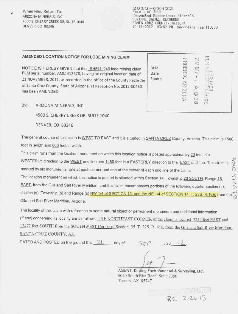
2012-02422When Filed Return To: ~ Page 1 of »-1ARIZONA MINERALS, INC. RA,quested 2--Hrizona Minerals
SUZANNE SAINZ, RECORDER4500 S. CHERRY CREEK DR, SUITE 1040 SANTA CRUZ COUNTY, ARIZONADENVER, CO 80246 10-19-2012 03:52 PM Recording Fee $10.00
AMENDED LOCATION NOTICE FOR LODE MINING CLAIM -0
NOTICE IS HEREBY GIVEN that the SHELL-249 lode mining claim BLM m =rsBLM serial number, AMC 412678, having an original location date of Date21 NOVEMBER, 2011, as recorded in the office of the County Recorder Stamp -
of Santa Cruz County, State of Arizona, at Reception No. 2012-00460 51 h , ' / '710 0has been AMENDED C.
5
In
-Tl
,-nBy: ARIZONA MINERALS, INC.
4500 S. CHERRY CREEK DR, SUITE 1040
DENVER, CO 80246
The general course of this claim is WEST TO EAST and it is situated in SANTA CRUZ County, Arizona. This claim is 1500feet in length and 600 feet jn width.
This claim runs from the location monument on which this location notice is posted approximately 2Q feet in aWESTERLY direction to the WEST end line and 1480 feet in a EASTERLY direction to the EAST end line. This claim ismarked by six monuments, one at each corner and one at the center of each end line of the claim.The location monument on which this notice is posted is situated within Section 1.fl, Township 23 SOUTH, Range 16
AR
CH
) 2679
EAST, from the Gila and Salt River Meridian, and this claim encompasses portions of the following quarter section (s),section (s), Township (s) and Range (s) NYY_114_of SECTION_1-Land_the NE-1/4 of SECTION_14 I.-23S R.16.E: from theGila and Salt River Meridian, Arizona.
The locality of this claim with reference to some natural object or permanent monument and additional information(if any) concerning its locality are as follows:_THENORTHEASICORNERofthedaimislocated_7254 feeLEASTand11472-feeLEZIIIH-fromthe_SOIJTHWFST_Cgmer_of_Section 35. I.-223~116E from_the Gilaand S«Biverilleridian.SANTA CRUZ COUNTY, AZ.
DATED AND POSTED on the ground this 2-6 day of --.-.ij=--4---- ,20 12_<r.0
AGENT: Dagfing Envirohmental & Surveying, Ltd.9040 South Rita Road, Suite 2350Tucson. AZ 85747
9 r.CUT-3E i 2 -26 43

2012-08422 10-19-2012 03:52 PM Page 2 of 2
MINING CLAIM MAPLode (X)
Placer ( )
L 119- SHELL 188 ° SHELL 189 SHELL 230 -SHELL 229
L~ 121 SHELL 190 SI|·IELL 191 SHELL 232 J SHELL 231
~ 123 SHELL 192 » S~ELL 193 SHELL 234 SHELL 233
il 125 SHELL 194 SHELL 195 SHELL 236 SHELL 23503r-
-L.~127 SHELL 196 St!ELL 197 SHELL 238 « SHELL 2€3 ~»-ri'
52.-': ...Al.LL 129 SHELL 198 SHELL 199 SHELL 240 SHELL *6 1 -1 M
-Y. ./- /77*/'H_~131 SHELL 200 SHELL 201 SHELL 242 SHELL ~3 2- 00
71-n
ELI_ 133 SHELL 202 S ELL 203 SHELL 244 SHELL ~43 UJ ncom
SHELL 204 S~HELL 205 SHELL 246 SHELL 245
1 1SHELL 206 S~HELL 207 SHELL 248 SHELL 247
-L~. 149 SHELL 208 S|HELL 209 SHELL 250 «Ll ... SHELL 249
1. The above map depicts the SHELL 249 mining claim, which is located in Section (s) 13 & 14
4. Township 23S , Range 16E, Gila and Salt River Meridian, SANTA CRUZ County, Arizona.
2. The type of corner and location monuments used are as follows: 2"X2"X5' WOOD POSTS.3. The bearings and distances in degrees and feet between claim corners are as depicted on the map oras stated on page 1 of this notice.
FormMCF10Oa
Revised July 2005
This form is available from the Arizona Department of 1Mines & Mineral Resources and maybe reproduced

When Filed Return To:AZ MINERALS, INC.
4500 S. CHERRY CREEK DR, SUITE 1040
DENVER, CO 80246
LOCATION NOTICE FOR LODE MINING CLAIM 20
B.L.f A.Z
TAT
NOTICE IS HEREBY GIVEN that the SHELL-249 lode mining claim BLMDate 0 nhas been located Sta m p m - 01
REC
EIVE -OX
By: AZ MINERALS, INC. ; E %8-11
4500 S. CHERRY CREEK DR, SUITE 1040 N 75-SmDENVER, CO 80246
The general course of this claim is WEST TO EAST and it is situated in SANTA CRUZ County, Arizona. This claim is 1500
feet in length and 600 feet in width.
This claim runs from the location monument on which this location notice is posted approximately 2Q feet in a
WESTERLY direction to the WEST end line and 1480 feet in a EASTERLY direction to the EAST end line. This claim is
marked by six monuments, one at each corner and one at the center of each end line of the claim.The location monument on which this notice is posted is situated within Section 12, Township 23 SOUTH, Range 16
EAST, from the Gila and Salt River Meridian, and this claim encompasses portions of the following quarter section (s),
section (s), Township (s) and Range (s) NW 1/4 of SECTION 13. T. 235. R.16E, from the Gila and Salt River Meridian,
Arizona.
The locality of this claim with reference to some natural object or permanent monument and additional information
(if any) concerning its locality are as follows:_THENORTHEAST_CORNER.oftheclaimislocated 7254 feet-EASTand13472_feet-SOUTH-fromthe-SOUTIMEE[Comerof_Section 352[. 22S_R._16E f-Qmthe Gilaand Salt River_MeridianSANTA CRUZ COUNTY, AZ.
DATED AND POSTED on the ground this ~-~ day of WO U~ , 20 1~
AMC4121,18
1 -1/ St-81 30 verAGENT: Darling Environmental & Surveying, Ltd.
9040 South Rita Road, Suite 2350
Tucson, AZ 85747

... I
MINING CLAIM MAPLode (X)
Placer ( )SHELL 190 ~SHELL 191 SHELL 232 ~ SHELL 231
SHELL 192 ~SHELL 193 SHELL 234 ' SHELL 233 r--
4 mSHELL 194 ISHELL 195 SHELL 236 ' SHEL~235 Ev ~
m ern
SHELL 196 ISHELL 197 SHELL 238' SHELH37 4<O0
SHELL 198 ISHELL 199 SHELL 240' SHEL~2390m
SHELL 200 13 HELL 201 SHELL 2421 SHELL 241
SHELL 202 ~ SHELL 203 SHELL 244 SHELL 243
SHELL 204 i SHELL 205 SHELL 244 SHELL 246
SHELL 206 1 SHELL 207 SHELL 248 @ 1 SHELL 247
SHELL 208 1 SHELL 209 SHELL 25(~ SHELL
1. The above map depicts the SHELL 249 mining claim, which is located in Section (s) 13
4, Township 235, Range 16E , Glla and Salt River Meridian, SANTA CRUZ County, Arizona.
2. The type of comer and location monuments used are as follows: 2"XFXSLWOOD POSTS.
3. The bearings and distances in degrees and feet between claim corners are as depicted on the map oras stated on page 1 of this notice.
AMC4 2b18
FormMCF10Oa
Revised July 2005
111jlfQ[m-iiayailabklkQm~tltsukizg~.lk~lildm£~-g[,Mt[~AMillgritl«HesQ'Reggl=lm8x*~i~nm®g~d

When Filed Return To: ~a~113/951 23
ARIZONA MINERALS, INC. Requested B~-„rizona MineralsSUZANNE SAINZ, RECORDER4500 S. CHERRY CREEK DR, SUITE 1040 SANTA CRUZ COUNTY, ARIZONA
DENVER, CO 80246 10-19-2012 03:52 PM Recording Fee *10.00
AMENDED LOCATION NOTICE FOR LODE MINING CLAIM -rID
NOTICE IS HEREBY GIVEN that the SHELL-250 lode mining claim BLM e 5BLM serial number, AMC 412679, having an original location date of Date 3.
21 NOVEMBER, 2011, as recorded in the office of the County Recorder Stamp -:,
REJRY'JFFICE
of Santa Cruz County, State of Arizona, at Reception No. 2012-00461has been AMENDED CD
A 10: 3 8
By: ARIZONA MINERALS, INC.
45005. CHERRY CREEK DR, SUITE 1040
DENVER, CO 80246
The general course of this claim is EAST TO WEST and it is situated in SANTA CRUZ County, Arizona. This claim is 1500feet in length and 600 feet in width.
This claim runs from the location monument on which this location notice is posted approximately ZQ feet in aEASTERLY direction to the EAST end line and 1480 feet in a WESTERLY direction to the WEST end line. This claim ismarked by six monuments, one at each corner and one at the center of each end line of the claim.The location monument on which this notice is posted is situated within Section ld, Township 23 SOUTH, Range 16EAST, from the Gila and Salt River Meridian, and this claim encompasses portions of the following quarter section (s),
AM
E 4 A.16~-icl
section (s), Township (s) and Range (s) NE_1/4_of SECTIONLl.LI. 23LE.1-QE from the Gila and Salt River Meridian,Arizona.
The locality of this claim with reference to some natural object or permanent monument and additional information(if any) concerning its locality are as follows:_THENORTHEAST_CORNERofthe_claimislocated_5754 feeLEASTand13488 feet_SQUIH fromithe_SOUTHWFST_Cgmerof_Section_-35. T. 22S R._J,5E from-the Gilaand S.alt River-MeridianSANTA CRUZ COUNTY. AZ.
DATED AND POSTED on the ground this 26 day of SE f» , 20 1 2- ,
AGENT: Da/ling Envifonmental & Surveying, Ltd.9040 SoutH Rita Road. Suite 2350Tucson, AZ 85747 . .-. - ---*·.-n
ckS_ 2.2.6-(3 1

-19-2012 03:52 PM Page 2 of ~ ·
MINING CLAIM MAPLode (X)
Placer ( )
L 119- SHELL 188 SHELL 189 SHELL 230 -SHELL 229(11' 11 CO
L~ 121 SHELL 190 ~ S~ELL 191 SHELL 232 SHELL 231
~ 123 SHELL 192 S ELL 193 SHELL 234 SHELL 233
LL 125 SHELL 194 SHELL 195 SHELL 236 J SHELL 235
73 j CO-L~_ 127 SHELL_195_ c FLELL 197 SHELL 238 SHELCG37
5 1,4 -, FFICE
-Ek
.LL 129 SHELL 198 SHELL 199 SHELL 240 4 SHEL~239 1 CD
2,1
_1 - .rn_5 3
~ 131 SHELL 200 S~ELL 201 SHELL 242 SHELZ341 ,=rimN Oe
.LI- 133 SHELL 202 S ELL 203 SHELL 244 SHE©43
SHELL 204 dj.~ELL 205 SHELL 246 SHELL 24512
1 dSHELL 206 ~HELL 207 SHELL 248 SHELL 247
.L[f 149 SHELL 208 dHELL 209 ~ SHELL 250 1 SHELL 249
1. The above map depicts the SHELL 250 mining claim, which is located in Section (s) 144, Township 23S, Range 16E , Gila and Salt River Meridian, SANTA CRUZ County, Arizona.2. The type of corner and location monuments used are as follows: 2"X2"X5' WOOD POSTS.3. The bearings and distances in degrees and feet between claim corners are as depicted on the map oras stated on page 1 of this notice.
FormMCF10Oa
Revised July 2005Thisformisavailablehom-the-Arizona DERarlmento£Mines&Mineralllesoursesandmabereeroduced

When Siled Return To:AZ MINERALS, INC.
4500 S. CHERRY CREEK DR, SUITE 1040
DENVER, CO 80246
LOCATION NOTICE FOR LODE MINING CLAIM
NOTICE IS HEREBY GIVEN that the SHELL-250 lode mining claim BLMDatehas been located Sta m p
ZV
X N3
0Hd
20 DEC
9 A 10 29
L t AZ STATE OFFICE
RECEIVED
By: AZ MINERALS, INC.
4500 S. CHERRY CREEK DR, SUITE 1040
DENVER, CO 80246
The general course of this claim is EAST TO WEST and it is situated in SANTA CRUZ County, Arizona. This claim is 1500
feet in length and 600 feet in width.
This claim runs from the location monument on which this location notice is posted approximately 251 feet in a
EASTERLY direction to the EAST end line and 1480 feet in a WESTERLY direction to the WEST end line. This claim is
marked by six monuments, one at each corner and one at the center of each end line of the claim.The location monument on which this notice is posted is situated within Section 1.3, Township 23 SOUTH, Range lfL
EAST, from the Gila and Salt River Meridian, and this claim encompasses portions of the following quarter section (s),
section (s), Township (s) and Range (s) NW_1/4-of SECTION_13 NE-1/4 of SECTION_14 T. 23S .R.16E from the Gila andSalt River Meridian, Arizona.
The locality of this claim with reference to some natural object or permanent monument and additional information
(if any) concerning its locality are as follows:_THE-NORTHEASTCORNER_oftheclaimislocated_5754_feet EASTand13488 feet SOUTH from the SQUTHWEST_Comer-ofSection--35 -T. 223 _R.16E fFQmthe-Gilaand S.alt Rive[MeridianSANTA CRUZ COUNTY. AZ.
DATED AND POSTED on the ground this Z I day of AlbV -, 20 1 1
>-f-
AMC 2 b 1qAGENT: Darling Environmental & Surveying, Ltd.
9040 South Rita Road, Suite 2350
Tucson, AZ 85747

.
-
MINING CLAIM MAPLode (X)
Placer ( )SHELL 190 ~SHELL 191 SHELL 232 SHELL 231
SHELL 192 ~SHELL 193 SHELL 234' SHELL 2~
B.L 1. A.
SHELL 194 SHELL 195 SHELL 236 i Si-6LL 2:|Smcr
REC
EIVEDSHELL 196 ISHELL 197 SHELL 238 StiELL 2~
N OSHELL 198 1 SHELL 199 SHELL 240 SHELL 2(;g
SHELL 200 j SHELL 201 SHELL 2429 SHELL 241
SHELL 202 ~ SHELL 203 SHELL 244 SHELL 243
SHELL 204 ~ SHELL 205 SHELL 248 SHELL 245
SHELL 206 -~-~4ELE 207 SH-ELE-248 4 SHELL 247
SHELL 208 1 SHELL 209 SHELL 25(~ SHELL 249
1. The above map depicts the SHELL 250 mining daim, which is located In Section (s) 13 & 14
4, Township 23S, Range 16E, Gita and Salt River Meridian, SANTA CRUZ County, Arizona.
AMC 2619
2. The type of comer and location monuments used are as follows: 2U(23(51 WO O 0 POSTS.3. The bearings and distances in degrees and feet between claim corners are as depicted on the map or
as stated on page 1 of this notice.
FormMCF100a
Revised July 2005
IlljiEmnllmiitakktknIt~A[imnalZ£Rammit£Mill~LiMInE[aLm~trEEL2tlELillak!&mzmd=d

RUN TIME: 08:58 AM UNITED STATES DEPARTMENT OF INTERIOR RUN DATE: 12/30/2011BUREAU OF LAND MANAGEMENT
Adm State: AZ Page 1 of 1GEOGRAPHIC REPORT WITH LANDSorted by Meridian Township Range
Serial Number: AZA 035631 PTTotal Case Acres: 27.500
Casetvpe Case Disp 14 023OS 0160E Sect Sur Typ Sur Num St:!If Subdivision Act Pend223013 AUTHORIZED 002 FF POR. HES 306

RUN TIME: 08:58 AM RUN DATE: 12/30/2011DEPARTMENT OF INTERIOR Page 1 of 1
BUREAU OF LAND MANAGEMENT
Input Parameters for Geographic Report with Land
System Id = CR
Admin State = AZGeo State = AZ
Casetype Begins With
Case Disp Txt = AUTHORIZED, CANCELLED, EXPIRED, PENDING, REJECTED, RELINQUISHED, WITHDRAWN
Mer Twp Rng = 14 023OS 0160E
Section = 001, 002, 011, 012, 013, 014, 999
Mtrs
Commodity =
Commodity Txt
Pending Org =
Pend Org Decode
Total Rows Returned: 1
NO WARRANTY IS MADE BY BLM FOR USE OF THE DATAFOR PURPOSES NOT INTENDED BY BLM

1bs T 23 S
SHELL 166 SHELL 167 SHELL 210 . < SHELL 211
4SHELL 168 SHELL 169 SHELL 212 '
CLE 713HSSHELL 170 SHELL 171 - SHELL 214 'li CO
SHELL 216 f-
SHELL 172 -0 --"4
r-urrl103 SHELL 173 r i-1 E Uli (,0-1 r:/i - P 4 ,-0----
--4 -\5,05 SHELL 174 SHELL 21 - 1 0.1 el
HELL 175 r-DO--910 id I -q
'107 SHELL 176 ~HELL 177 SHELL 21 r r<, L ,0 ill
109 r ' SHELL 178 ~HELL 179 SHELL 220 SHELL 219
I111 * *SHELL 180 SHELL 181 SHELL 222 SHELL 221
1113 * SHELL 182 SHELL 183 SHELL 224 SHELL 223
rl 15 SHELL 184 HELL 185 SHELL 226 SHELL 225

SHELL 186 HELL 187 SHELL 228 SHELL 227
2 1
-- 3HEET 188 i - -»[E l tig ~FELL- 2 SHELL-11 ~ 71
-''
SHELL 190 HELL 191 SHELL 232 SHEKU 231 0
SHELL 192 ~SHELL 193 SHELL 234' SHEL> 233- 1
SHELL 194 ~SHELL 195 SHELL 236 4 SHELL 235
SHELL 196 4 SHELL 197 c SHELL 238 i SHELL 237 ~ 7
-------1 -----_.__
SHELL 198 1 SHELL 199 1 »SHELL 240~ -SHELL 239
SHELL 200 1 SHELL 201 SHELL 2421 SHELL 241
SHELL 202 ~ SHELL 203 SHELL 2 ' SHELL 243
SHELL 204 SHELL 205 SHELL 244. SHELL 245

UNSURVEYED TOWNSHIP 23 SOUTH RANGE 16 EAST OF THE GILA AND SALT RIVER MERIDIAN, ARIZONAPROTRACTION DIAGRAM NO 76 OFFICIAI LY FILED 6/23/1960
SANTA CRUZ COUNTY 1R./CSON FIFI~) OFFICE STATUS OF PUBLIC DOMAIN
LAND AND MINERAL TITLES~S 745 T 2PS
),15 368g I.66 - „ 1'E AND ACQUIRED LANDSIS 929. 81 T 235
MS .22 . 4464MS .. 64 29 i HES 30517 . 61 Lot 378 79 , 45 Mt ,43/958
10'11/'A EJEEXTOSEGREGATEDTRACTS
./.15~.0
5 .[..... I ORIGINAL SUR.Y ~
TRACT N. T . SEC S...1.SON
6 5 4 3 1(914) (660) (735) (884) (778) (424)
./C
%.9 IS 500MS 49. , lili . 65 2007...
IN .R ,/ mil. . - '2 i vg1 !1 67 apr:, -FOR ORDERS AFFECTTNG DISPOSAL OR USE OF
UN]DENTlnED LANDS WITHDRAWN iOR CLASSIn CAnON,MIERALS, WATER AND/OR OnVER PUBLIC PURPOSES,
7 8 9 10 11 12 RETR TO /Ag·X Or Ae.SaELLA/Eous OocuvE/TX(637) (612) (1'.) -(34S) ---
All Tp M in Wdl Coronodo NF Pion 1 121 4~17/1911
An Tp Incl in Determinetion Ireo PL 167 AR 020546
MDS 773 NE774 NW725 SW726 SE
SE[ SUPPLEMENTAL FLATN 01
1318 17 16 15 14(638) (557) (A 521) ig.g7
92924/0.9 159.79
-
HES 304~ZA 2125~ 09 . 93
(B 8)
IS 3601 * 4434
I 219329525
no . USCN 122GN .
19 Lct i NE .*
HES p 2320 21 (A 270) 24"7(588) (474) (522) (255)
HES 31511 6..W
D/. ..47../C
(8 64) ~30 29 28 27 26 25
(639) (345)
SEE SUPPLEMENTAL PLATN (] 2
31 32 33 34 - 35 36(345)
~GSR Mer
5-2-2008 aD ! T 23 S..653 R 16 E
....ING .....
SCAL, 1. ch.ins /41.1 1.,hi .i*'. Reco.d of nill. Md .Dul~ '4-.
10 5 0 '0 20 30 ord. )1~20. do .. ill# lilli c~D,~9- /, 1· itii" h:* lilli