National Bureau of Soil Survey and Land Use Planning (ICAR)
200
National Bureau of Soil Survey and Land Use Planning (I.C.A.R.) Nagpur - 440033 National Bureau of Soil Survey and Land Use Planning (I.C.A.R.) Nagpur - 440033 A nnual A nnual Report Report
-
Upload
khangminh22 -
Category
Documents
-
view
2 -
download
0
Transcript of National Bureau of Soil Survey and Land Use Planning (ICAR)

National Bureau of Soil Survey andLand Use Planning (I.C.A.R.)Nagpur - 440033
National Bureau of Soil Survey andLand Use Planning (I.C.A.R.)Nagpur - 440033
AnnualAnnualReportReport


AnnualAnnualReportReport
National Bureau of Soil Survey and Land Use Planning
(Indian Council of Agricultural Research)
Amravati Road, Nagpur - 440033, Maharashtra, India
www.nbsslup.in

For further information and to obtain copies of this reportPlease write to:
National Bureau of Soil Survey and Land Use Planning (NBSS&LUP)Amravati Road, NAGPUR-440 033
Tel. : (0712) 2500386; 2500226; 2500545; 2500664Telefax : +91(0)712-2500534
E-mail : [email protected] ; [email protected] : www.nbsslup.in
ISSN : 0970-9460
June, 2013
DIRECTOR
CITATION
NBSS&LUP. Annual Report (2012-13), National Bureau of Soil Survey and Land Use Planning, Nagpur – 440 033, India
COMPILATION AND EDITING
PRINTING
TECHNICAL ASSISTANCE
LAYOUT AND DESIGN
WORD PROCESSING
Director and ScientistsNational Bureau of Soil Survey and
Land Use Planning
S.K. Arora
A.P. NagarS.S. Nimkhedkar
P.N. DubeyP.S. Butte
Prakash Ambekar
Rohini WatekarVaishali Arbat
Published by the Director, National Bureau of Soil Survey and Land Use Planning, Nagpur 440033. Laser typeset and printed in India at National Printers, New Delhi-110028

HET Bureau can look back with pride on what it has achieved in RD & T programmes undertaken during 2012-2013. Significant R&D achievements have been, among others,
development of Decision Support Systems (DSS) for land use planning of districts of Nadia (West Bengal), Almora (Uttarakhand) and Bundi (Rajasthan), development of a Geoportal each of Indian Soil Information System and District Soil Information System for selected districts of the country, revision of agro-ecological subregion maps of the Indo-Gangetic Plain (IGP) and Black Soil Region(BSR) of the country, development of soil nutrient maps of the state of Assam, prediction of global warming effect on soil organic carbon status and assessment of effect of different nutrient management interventions on total organic carbon in the long-term fertilizer experiment (LTFE) site of Palampur, Himachal Pradesh. The Bureau continued to provide software solutions to a number of research activities, such as, soil correlation and land evaluation. The year has also been remarkable in that we reached out to more number of stakeholders in a more purposeful manner and involved them in planning as well as implementation of our programmes. The number of linkages with national and international organizations grew substantially. The Bureau continued to use new science and emerging technology namely, nano-technology in pedological studies, soft computing techniques in land evaluation and neural network based pedo-transfer functions in estimating hydrological properties of soils. It becomes important for me to mention that the focus in 2012-13 was largely on R&D activities in land use planning and varied aspects of land use planning were addressed at different levels.
Human resource development (capacity building) through education and training continued to be a major activity. The Bureau organized a number of training programmes for its stakeholders in its mandated areas of work. A number of staff underwent national trainings in varied fields. The Bureau brought out a total of 245 publications including 39 research papers in various national and international referred journals. Compared to last year, there has been a marginal increase in the number of research papers published in referred journals. I am confident, with the 2 NAIP projects (one under component-3 and the other under component-4) and 2 of the subprojects under the National Network Project on District Level Land Use Planning expected to be completed by March 2014, we shall see a promising increase in the total number of (quality) research publications in the coming year.
I am thankful to the Chairman and members of Research Advisory Committee (RAC), the Chairman and members of Institute Management Committee (IMC)) and the Member-Secretary of Institute Research Council (IRC) for the guidance and support provided in formulating and pursuing our RD&T programmes.
PrefacePreface

I am highly grateful to Dr. S. Ayyappan, Secretary, DARE and Director General, Dr. A.K. Singh, former Deputy Director General (NRM), Dr. A.K. Sikka, Deputy Director General (NRM) and Dr. P. Minhas, Assistant Director General (Soils), ICAR, New Delhi for their able guidance and continued support and also for encouraging new research initiatives.
I appreciate the sincere and dedicated efforts put in by the scientists in the huge task of compiling and editing the report. I am extremely pleased to place the Annual Report (2012-13) for public scrutiny. I welcome suggestions and feedback from the readers.
(DIPAK SARKAR)DIRECTOR

ContentsContents
Preface
Executive Summary i
1. NBSS&LUP : A Profile 1
2. Research Achievements 7
2.1 Inventorying Natural Resources 9
2.2 Remote Sensing, GIS and Cartography 27
2.3 Basic Pedological Research 43
2.4 Soil Survey Data Interpretations and Applications 58
2.5 Land Evaluation and Land Use Planning 72
3. Education and Training 101
4. Technology Assessed and Transferred 110
5. Sections and Units 111
5.1 Prioritization, Monitoring and Evaluation (PME) Cell 111
5.2 Library and Documentation Unit 112
5.3 Printing Section 114
5.4 Publication Sale Unit 115
5.5 Agricultural Knowledge Management Unit (AKMU) 116
5.6 Cartography Unit 117
5.7 fgUnh vuqHkkx 118
6. Linkages 119
7. Budget: A Comparative Analysis 121
8. Awards and Recognitions 122
9. List of Publications 123
10. Participation of Scientists in Seminars, Symposia, Conferences, Workshops, Trainings and Meetings in India and abroad 142
11. Consultancy, Patents, Commercialization of Technology 153
12. Meetings Organized 154
13. Workshops/Seminars/Summer and Winter Schools/Farmer’s Day 157and Other Events

Appendices
Appendix 1 On-going and completed projects 163
Appendix 2 Distinguished Visitors 170
Appendix 3 Important Committees 174
Appendix 4 Lectures Delivered by Scientists 176
Appendix 5 Personnel (Managerial Position) 180
Appendix 6 Staff-related General Information 181
Appendix 7 RFD-related information 183

Executive Summary
Annual Report 2012-13 i
Executive Summary
THE National Bureau of Soil Survey and LandUse Planning (NBSS&LUP) conducted research
under five broad themes, viz. Inventorying NaturalResources, Remote Sensing, GIS and Cartography,Basic Pedological Research, Soil Survey DataInterpretations and Applications and LandEvaluation and Land Use Planning. Some of thesignificant research achievements have beendevelopment of Decision Support System (DSS) forland use planning for three districts, developmentof a Geoportal each of Indian Soil InformationSystem and /District Soil Information System forselected districts of the country, revision of agro-ecological subregion maps of the Indo-GangeticPlain (IGP) and Black Soil Region(BSR) of thecountry, preparation of soil nutrient maps of Assam,prediction of global warming effect on soil organiccarbon status and assessing effect of differentnutrient management interventions on total organiccarbon in the long-term fertilizer experiment (LTFE)site in Palampur, Himachal Pradesh. The Bureaucontinued its endeavours to use new science andemerging technology namely, nanotechnology inpedological studies and soft computing techniquesin land evaluation. Imparting education to PGstudents, organizing training for stakeholders and
deputing its staff for various trainings (in India andabroad) formed the key components of capacitybuilding activities. The Bureau not only maintainedbut also increased the linkages and collaborationswith a number of national and internationaloganisations. A brief on research project-basedachievements and other important non-projectactivities is given below.
Research Achievements
Inventorying Natural Resources
Soil and land resources inventory was undertakenat different levels namely, village block, panchayatsand districts of different states for identifying soilpotentials and constraints and assessing fertilitystatus (in a few cases). Soil suitability evaluationwas also undertaken for a number of crops in agood number of projects. Soil correlation activitywas taken up in different states. 19 per cent of thearea in Durgada Nagenhalli village in Tumkurdistrict, Karnataka suffered from slight and severeerosion whereas 28 per cent area was moderatelyeroded. In Multala village of Anantpur district,Andhra Pradesh, nearly 52.1 per cent of the areawas severely eroded. 47 per cent variations in apple

Executive Summary
Annual Report 2012-13ii
fruit yield in Shimla district of Himachal Pradeshwere attributed to slope, organic carbon, availablezinc, soil depth AWC and CEC. 52 per cent area inSunderpur village, Lakhan Majra block, Rohtakdistrict of Haryana was affected by sodicity and 25per cent area in Guraohti village (of the same block)was salinity affected whereas 12 per cent of the areawas poorly drained.
Nearly 56.6 per cent was moderately eroded and27.8 per cent was severely eroded in Katonigaonpanchayat of Jorhat district, Assam. Waterharvesting is suggested to improve crop productivity.In East Lahing gram panchayat, Jorhat district, 34.8per cent of the area was suitable for banana andpotato, 29.1 per cent for tea and 25.1 per cent ofthe area was highly suitable for rice. Ten soil serieswere tentatively identified and mapped into 16 soilmapping units (as phases of soil series) in the grampanchayat. Physico-chemical characterization ofsoils of three NICRA villages representing differentagro-ecological systems in northern states of Indiaindicated that the soils of AER 15 in Uttar Pradeshwere mildly to strongly alkaline, low in availableN and P. Soils of AER 14 in Himachal Pradesh wererich in organic carbon, medium in N, high in P, K,S and micronutrients. The moisture status of soilsof Sibsagar district in Assam was estimated duringpost kharif season to explore the possibility ofgrowing a second crop. For growing a second cropin light textured soils, irrigation would be anessential requirement.
Physico-chemical characteristics of soils inHasnabad and Namkhana blocks, 24 Parganas,West Bengal, identified soluble sodium and calciumas the dominant cations and chlorides and sulphatesas the dominant anions in the former and sodiumand magnesium were the dominant cations andchlorides and suphates were the dominant anionsin the latter. In Rohtas district of Bihar, the soils inInceptisol order occupied 54.8 per cent of the areafollowed by the soils in Alfisol order with 19.7per cent area, 9.1 per cent area in soils under Entisol
order and 6 per cent area in Vertisol order. 41.4per cent soils are highly suitable for paddy whereas20.1 per cent soils are moderately suitable. Landevaluation was undertaken in soils of Aurangabaddistrict, Bihar for different crops in differentphysiographic units. In Patnagarh subdivision inOdisha, very deep soils covered 37.04 per cent ofthe area, moderately deep soils covered 33.1 per cent,shallow soils covered an area of 10.9 percent, deepsoils covered 7.8 per cent and slightly deep soilscovered 1.1 per cent area in the subdivision. Soilsof the Bolangir sub-division of Odisha (AESR 12.1)were observed to have medium AWC and a LGP of180-210 days. Thirty-two Benchmark soils ofOdisha state were characterized and classified foragro-technology transfer. Twenty one soils belongedto high lands, 9 soils belonged to coastal plain and2 soils belonged to Dandakarnya region. Soils ofMahanadi basin in Bolangir district, Odisha overpediment and upland were cropped for paddy, maizeand cotton in summer and oilseeds and pulses inwinter. Cropping intensity increased on undulatingdissected plains and gently to very gently slopingriverine plain. 38 soil series in Chittorgarh district,Rajasthan have been mapped as 70 soil seriesassociations. Two soil series were mapped inJhalarapatan block of Jhalawar district, Rajasthan.
Information on soils, socio-economic interpretationand land use indices were integrated to develop asoil quality index in the ten villages of Bhadesartehsil, Chittorgarh district, Rajasthan. Soils ofBhadesar and Gudha had the highest soil qualityindex due to gentle slopes, better soil depth andfine texture. 9 soil series have been finalized forinclusion in the National Register of soil seriesnamely, 2 from West Bengal, 5 from Goa and 2 soilseries from Rajasthan.
Remote Sensing, GIS and Cartography
Multi-criterion analysis was carried out in GIS usingland use, erosion, land capability, Storie Index andRequire productivity index based on ranking to

Executive Summary
Annual Report 2012-13 iii
delineate priority areas to implement soil and waterconservation measures in selected Blocks ofBankura, Puruliya and West Mednipur districts ofWest Bengal. Seven priority classes were delineated.Run-off estimation was done to prioritize area forsoil conservation measures in Badajorenala micro-watershed of Utkal Plain of Odisha. Relativelyhigher run-off was estimated under TypicHaplustepts and Typic Haplustalfs cultivated tokharif paddy with clay loam to silty clay soil. Soilfertility parameters were predicted in soils of WestBengal using visible and near infrared (VNIR) soilreflectance measurements. Relatively goodcalibration models have been obtained for OC,available N, phosphorus (P2O5) and potassium(K2O) with a coefficient of determination (r2) ofmore than 0.60 and RFD values greater than 1.70indicating that these soil properties can reliably bepredicted from soil reflectance data. Best spectralmodel was developed with an r2 value of 0.705,0.816 and 0.611 for sand, silt and clay content,respectively in soils of the Indo-Gangetic Plain (IGP).
A comparative assessment was done of soil mapsprepared using conventional and remote sensingapproach in terms of map accuracy, cost and timesaving in basaltic terrain of Nagpur district. Theoverall accuracy of soil map prepared by remotesensing approach had an accuracy of 59 to 73% at90% probability whereas, the soil map preparedby conventional approach had an accuracy of 67 to85% at 90% probability level. It was observed thatthere was about 23% saving in cost and 32% intime when remote sensing-based soil mapping isdone.
A methodology for preparing detailed soil mapdepicting phases of soil series at cadastral-level inbasaltic terrain has been described using high-resolution digital elevation model (DEM) generatedfrom Cartosat-1 stereo pair and Cartosat-1sharpened IRS-P6 LISS-IV data. Descriptivestatistics of soil properties analyzed from limiteddata sets indicated spatial variability in soil pH (6.2to 8.7), EC (0.06 to 0.62 dS m-1), OC (0.18 to 1.17
per cent) and available K (123 to 762 kg ha-1). Aproto type Geoportal (standalone) for Indian SoilInformation System with soil database on 1: 250000scale was developed. A proto type Geoportal(standalone) for District Soil Information Systemwith soil database on 1: 50000 scale was developed.Land productivity potential map for cotton inWardha district of Maharashtra was generated.Spatio-temporal variability in area, production andproductivity of rice was found to be significant inHaryana (4.2%, 6.3% and 2.0%) followed byKarnataka (1.1%, 2.7%, 1.6%). West Bengal hasthe highest area (56.30 lakh ha) followed by UttarPradesh (51.86 lakh ha). A document on “DataContent Standard-Soils” ver. 3.0 has been generatedand released by NSDI which contains dataspecifications of soil resource database.
Pedo-ecological units were delineated by integratingterrain parameters, soil parameters, rainfall andcropping system to predict land productivitypotential (LPP) for cotton crop in Wardha districtof Maharashtra. Using the integrated information,land productivity potential map for cotton wasgenerated. Spatio-temporal variability of majorcrops in different states of India for land useplanning indicated that the growth in area,production and productivity of rice were found tobe significant in Haryana (4.2%, 6.3% and 2.0%)followed by Karnataka (1.1%, 2.7%, 1.6%). WestBengal has the highest area (56.30 lakh ha) followedby Uttar Pradesh (51.86 lakh ha). Under soilresource database for National Spatial DataInfrastructure, a document on “Data ContentStandard-Soils” ver. 3.0 has been generated andreleased by NSDI which contains data specificationsof soil resource database.
Basic Pedological Research
Relationship of geomorphic processes has beenestablished for major landforms of Karnataka whichhelps in establishing the aggredational /degradational nature of the terrain, nature ofweathering and other superficial characteristics.

Executive Summary
Annual Report 2012-13iv
This knowledge is essential for understanding thespatial variability of soils.
Clay content, depth, bulk density and availablewater were the soil properties identified affectingland use and management in watershed ofChotanagpur plateau, West Bengal. Thus fourfunctional units which are equivalent to soil mapunits were identified that do not differ significantlywith respect to these soil properties. Attempts arebeing made to revise the methods of determinationof available potassium (In NH4OAC) in shrink-swellsoils which are dominated by smectite minerals.Different extractants were tried to get relationshipbetween the forms of K and crop response. Twonew extractants were screened out for thedetermination of available K which showedpromising results which gives optimum valueswithin the range of standards used to indicate soil-test-crop response values. Mineralogicalinvestigations of shrink-swell soils of centralhighlands (Malwa and Bundelkhand) hot subhumiddry eco-region indicate chlorized smectite asdominant mineral along with mica and kaolin. Submicroscopy studies of sand fraction indicatepresence of zeolite and highly weathered feldspars.Multiple regression equation was developed andrelationship between water retention characteristicsand soil properties were established for dominantshrink-swell soils of Yavatmal district, Maharashtra.Geochemical analysis of shrink-swell soils ofYavatmal district shows a curvilinear relationshipof fine clay with Al and Ca plus Mg as Mg and Alare structurally a part of smectite, normalizing thediluents effects of carbonate in these soils. Attemptsare being made to separate nano clays from fineclays of shrink-swell soils from across different agro-ecological subregions of the country by sonificationand centribugation.
Soil Survey Data Interpretations and Applications
Soil fertility assessment and soil health monitoringin traditional rubber growing areas of Kerala,
Karnataka and Tamil Nadu were attempted. Soilswere analysed to find deficiency of Mg++ and Ca++.Research on microbial biomass carbon indicatedits decrease with soil depth in forest, cultivated landand tea garden in north-eastern region. Whileinterpreting soil nutrient database for site specificfertilizer recommendations, available P is reportedhigher in Darjiling, Dinajpur and Kochbihar in WestBengal. Similar exercise in selected districts ofJharkhand showed that acidity, low organic carbonand phosphorous are limiting in soils.
Simulation of Century and Roth C models indicateda good agreement between model and actualobservations in field. The results of Roth C modelshowed that treating soils as different layers willpredict actual effects of global warming inaccelerating decomposition of soil carbon. To helpthe models using Roth C, Century and Info Crop,nearly 100 soil series were completed in an user-friendly manner. Georeferenced soil informationsystem permitted identification of minimumdatasets for monitoring soil quality and landevaluation in the IGP and BSR. These database alsohelped in revising the agro-ecological subregionboundaries to generate modified AESR maps of IGPand BSR.
Land Evaluation and Land Use Planning
Various research activities in land evaluation andland use planning included, among others, land useplanning at district and watershed levels, workingon soil suitability evaluation for crops, contingencyplanning, impact of different policies on land useand participatory methods of land use planning.National network project on land use planning wascontinued in different districts/ watersheds of thecountry and interventions to utilize availableresources, for example, opening of hard crustsbetween surface soil and sub-soil at regular intervals,suggesting land use based on land resource inventory(horticulture, forage, forest etc.) were proposed.Existing land use options in representative areas

Executive Summary
Annual Report 2012-13 v
were evaluated and alternative options weresuggested based on soil mapping units identifiedthrough survey and consultation with the farmers.Similarly, fertilizer management practices incombination with type of seed were evaluated in arepresentative village of Haryana. Based on theanalysis, soil series(s) were identified for optimumcrop production. As a part of inventorization usingmodern tools for integrated watershed development,IRS P6 LISS IV data were analysed in GISenvironment and thematic soil maps were prepared.
A case study was conducted in National CapitalRegion (NCR), New Delhi to analyse the temporalchanges and its impact. It was noted that net sownarea in Haryana NCR is declining faster than thatin the rest of the state. On the other hand, study onnatural resources management issues indicated thatdespite availability of natural resources, povertyprevails in many parts of the country. However,there cannot be a generic approach/solution tomitigate poverty through utilization of naturalresources. Declining per capita land availability isa major concern for the country. Analysis indicatesthat human population in Eastern plains of thecountry must be deployed in activities other thanagriculture, primarily, because carrying capacity ofavailable land has reached saturation level. Centralpart of the country faces a paradoxical situationwhere surface water, ground water goes unutilizeddespite relatively lower population and better percapita land availability.
Efforts to mitigate effects of climate change throughresilient agriculture were continued throughresearch on contingency crop planning. Newchallenges in land resource management wereaddressed through research on land evaluation forrainfed Bt cotton. The interface between soil-basedtechnologies and on-field research was provided bytwo projects viz., Tribal Sub-Plan (TSP) and NAIPC-3. NAIP sub-project on livelihood security.Different modules of technologies implemented inthe project villages were refined and the impact has
been assessed. Implementation of interventionsderived from optimal plan to utilize naturalresources has demonstrated that livelihood securityof agrarian population can be achieved.
Post Graduate Education
• Seven M.Sc. (LRM) and three Ph.D. (LRM)students submitted their thesis during thecurrent academic session, in the Post-GraduateEducation and Research programmeundertaken at the Hqrs. with Dr. PDKV,Akola.
Training Organised
• Seven trainings were organized in the field oflatest techniques of Remote Sensing, GIS,Carbon Modelling, Soil Survey and Mappingand Land Resource Management.
Training Received
• Three officials from the Bureau receivedtraining in various fields. Of these, one officialreceived international training.
Ongoing and completed projects
• Ongoing Institutional projects : 62
• Ongoing Externally funded projects
– DST sponsored : 03
– NAIP projects : 03* As consortium lead institute : 02* As consortium partner : 01
– State Govt. sponsored : 12
– Total : 80
• Completed projects : 32
– Institutional : 10
– Externally funded : 22

Executive Summary
Annual Report 2012-13vi
Linkages
A number of new linkages were developed withvarious organizations in addition to the priorlyexisting ones.
Publications
• Research papers published : 39
• Reports/Bulletins : 41
• Books : 03
• Book chapters : 42
• Popular articles : 10
• Seminar/Symposia papers : 108
• Others : 02
Awards and Recognition
• This year has been a rewarding year for theBureau as its scientists and staff werehonoured with a number of awards andrecognitions.
���

NBSS&LUP : A Profile
Annual Report 2012-13 1
1 NBSS&LUP : A Profile
Genesis
Subsequent to the recognition of Soil Survey as aNational Priority, a need was felt for creating acentralized information warehouse to assimilate,verify and disseminate information on nature, extentand distribution of soils in the country.Consequently, the Indian Council of AgriculturalResearch (ICAR) established National Bureau ofSoil Survey and Land Use Planning (NBSS&LUP)(to be hereafter referred to as Bureau) in 1976, withits Hqrs. at Nagpur. The Hqrs. houses 3 ResearchDivisions, namely, Division of Remote SensingApplications, Division of Soil Resource Studies andDivision of Land Use Planning. Subsequently, fiveregional centres came into existence that are locatedat Bangalore, Delhi, Jorhat, Kolkata and Udaipurand address regional specific issues in the mandatedareas of work. Besides, there are a number of unitsand sections, which provide scientific and technicalsupport to the research divisions and regionalcentres in accomplishing varied tasks.
The Bureau is the country’s only premier nationalinstitute mandated for research, development andtraining (RD&T) in the field of soil survey, landuse planning and allied aspects. Over the years, the
Bureau has excelled as a centre of RD&T in SoilSurvey and Land Use Planning at national andinternational level.
Location
The Hqrs. is located on Amravati Road (Kolkata-Mumbai National Highway 6). It has in its closevicinity the ICAR-affiliated National ResearchCentre for Citrus (NRCC), Ginning Training Centre(GTC) a regional centre of Central Institute forResearch on Cotton Technology (CIRCOT), andRegional Remote Sensing Centre (RRSC) (ISRO).The campus of the Bureau is also quite close toNagpur University. The Hqrs., therefore, haslocational advantage which facilitates multi-disciplinary studies, inter-institutional interactionsand research linkages, etc. A map showing locationof the Hqrs and the five regional centres is shownbelow.
Mandate
� To conduct soil survey and mapping of thesoils of the country to promote scientific andoptimal land use programmes in collaborationwith relevant institutions and agencies.

NBSS&LUP : A Profile
Annual Report 2012-132
� To conduct and promote research in theNational Agricultural Research System in theareas of Pedology, Soil survey, Remote sensingapplications, Land degradation, Landevaluation and Land use planning, incollaboration with other relevant agencies.
� To impart training and education to createawareness on soil and land resources and theirstate of health.
The role of the National Bureau of Soil Survey andLand Use Planning (NBSS&LUP) becomes all themore important in view of the serious challengesthe country faces in terms of shrinking soil and landresource base, soil/land degradation, depletingnutrient stock, deterioration in soil/land quality,changing climate, land use conversion and non-judicious planning of land use.
Major Research Themes
• Inventorying Natural Resources
• Remote Sensing, GIS and Cartography
• Basic Pedological Research
• Soil Survey Data Interpretation andApplications
• Land Evaluation and Land Use Planning
Training Areas
• Soil Survey and Land Evaluation for Land UsePlanning
• Remote Sensing and GIS Applications in SoilResources mapping
Management
A high powered Research Advisory Committee(RAC) comprising eminent professionals, mostlyfrom outside the ICAR system guides the Bureauon formulating its research policies and in planningresearch thrusts and strategies.

NBSS&LUP : A Profile
Annual Report 2012-13 3
The Institute Management Committee (IMC),constituted and mandated by the ICAR, supervisesthe functioning of the Bureau. Internal Committees,such as, Institute Research Council, PurchaseCommittee, Library and Publication Committee,Official Language Committee and a Grievance Cell,to name a few, are operating for decentralizationof management. The Institute Joint Staff Councilpromotes healthy interaction and congenial workenvironment.
Infrastructural Facilities
• Laboratories
The Bureau has various state-of-art laboratories.Some of the modern and sophisticated equipmentsare listed below.
� X-ray diffractogram
� Scanning Electron Microscope
� Inductively coupled Plasma Spectrometre
� Atomic Absorption Spectrophotometer
� Spectroradiometer
� Latest Remote Sensing and GIS softwares
The facilities available in micromorphology and GISlaboratories are the best in the country that matchinternational standards.
• Library
The Bureau houses a fully computerized librarylocated at the Hqrs. that has a comprehensivecollection of books, reports and periodicals. Theregional centres also have computerized libraries.
NBSS&LUP Website
The Bureau posts all important information aboutits activities, particularly about research projects,publications, linkages, educational trainings, staffand infrastructure on its Website (http://www.nbsslup.in). The year 2011-12 has been
particularly a very momentous year for the Bureauas traffic to its website increased significantly.
Major Achievements
� 1975-2010
The Bureau, through its journey over last 4 decades,has every reason to feel proud for its tremendousaccomplishments in the domains of research anddevelopment.
• An outstanding achievement has been ingenerating the Soil Resource Map of theCountry on 1:1 million scale and its differentstates (on 1:500,000 scale).
• A 20-Unit Agro-ecological region and a 60-unit Agro-ecological sub-region map of thecountry were developed for regional planning.
• 273 soil series have been entered into theNational Register*.
• A method has been developed for using remotesensing data, namely IRS-1C PAN mergeddata for large scale mapping of soils at villageand watershed level.
(* 282 soil series have been entered into the NationalRegister upto March 2013)

NBSS&LUP : A Profile
Annual Report 2012-134
• Soil reflectance properties have beensuccessfully used as a potential tool to provideinformation on a wide range of soil properties.
• The Bureau has been an active partner ingenerating harmonized statistics of thedegraded lands/wastelands according to whichthe country has about 121 m ha area underdifferent forms.
• As per estimates made by the Bureau, the totalcarbon stocks in Indian soils at 150 cm depthis up to a 64 pentagrams (pg) (1 Pg = 10 tothe power of 15 g) with considerable amountof inorganic form. This is the first everestimate made on SOC stocks at national level.
• The Bureau developed land use options for 5agro-ecosystems, namely, Rainfed, Irrigated,Arid, Hill and Mountain and Coastal.
� 2010-2012
Software Solutions
The Bureau has developed software solutions forsoil correlation and land evaluation. The softwareshave replaced age old, tedious and time-consumingmanual methods of undertaking the aforesaidactivities.
Development of Farmer’s Advisory Services
A Farmer’s advisory services has been developed toguide growers of vegetables, rice, fruits and pulsesof West Bengal on the soil-fertility management,and has been hosted on www.wbagrisnet.gove.inof the NIC server, and is linked with the mobilecell-phone.
Soil Nutrient Maps
Soil (macro and micro) nutrient mapping has beenundertaken by the respective Regional Centres ofKolkata and Jorhat at different levels of priority –districts, blocks, watersheds, villages and farms ofthe eastern and north-eastern states of the country.
This activity has generated high utility soil-nutrientmaps and revolutionized soil-fertility managementin the states.
New Initiatives
• Decision Support System (DSS) for Land UsePlanning
A DSS each has been developed for land useplanning for the districts of Mysore,Karnataka, Bundi, Rajasthan, Almora,Uttarkhand and Nadia, West Bengal.
• Soil Resource Mapping for farm planning inIndia and development of national portal onsoils
Lack of site specific data, particularly on soilsand situation specific recommendations havebeen the major causes for the failure of mostof the development schemes that operated inthe past in our country. The project is plannedto fill this vital gap by generating site-specificsoil and other land resources data. The projectwill be executed by using modern techniques,tools and facilities in a consortia mode byinvolving State Departments of Agriculture,State Agricultural Universities, State RemoteSensing Applications/Service Centres,National Remote Sensing Centre, Soil andLand Use Survey of India and State Land UseBoards. The National Bureau of Soil Surveyand Land Use Planning (ICAR) will act as anodal agency by providing the requiredscientific/technical back up and NationalInformatics Centre will facilitate theestablishment of National Portal of Soil andother land resources of the country foreffective dissemination of the information.
• Applications of Soft Computing Techniquesin Land Evaluation
Land evaluation, the process of assessing landfor defined uses, is an important prerequisiteto undertaking land use planning. The Bureau,

NBSS&LUP : A Profile
Annual Report 2012-13 5
in keeping with the latest developments in landevaluation, has initiated a research programmeon applications of soft computing toolsnamely, fuzzy logic and artificial neutralnetworks in this field.
• Nanotechnology Applications in Pedology
In keeping with the need of making concertedresearch efforts for development oftechnologies to sustain food security in thecountry, the Bureau has initiated a researchprogramme on applications of nanotech-nology in separating and characterizing soilnano particles (<100 nm) for studying soilformation and soil nutrient dynamics.
Linkages
The Bureau maintains close linkages with manynational organizations like ICAR institutes, StateAgricultural Universities and post-graduate teachingdepartments, and National Remote Sensing Centre(NRSC), Hyderabad for procurement of satellitedata.
It maintains close linkages with internationalorganizations like ICRISAT, Hyderabad, CYMMIT,New Delhi and ISRIC, ITC, The Netherlands .
Thrust Areas for XII Plan
• Development of land resource inventory forfarm planning in India to provide site-specificdatabase and recommendations.
• Development of demand driven soil resourceinventory of disadvantaged districts, commandareas, prioritized watersheds, villages andfarming systems.
• Conducting basic and strategic research inpedology, remote sensing applications usingGIS to soil resource mapping, land evaluationand land use planning using new science andemerging technologies.
• Assessment and monitoring of soil qualityincluding soil carbon stock assessment.
• Assessment of degraded lands in the countryat different levels for updating their status.
• Preparation of blue prints for efficient landuse planning at different levels.
• Implementation of Tribal Sub Plan programmeto provide soil based land use planning andto impart training in the selected tribal areas.
Flagship programmes
• Development of land quality indicators forsustainable land management in dominantland use systems of selected agro-eco sub-regions of India
• Development of Decision Support System(DSS) for land use planning at watershed level.
Platform programmes
• Conservation Agriculture
• Water Platform
• National Initiative on Climate ResilientAgriculture (NICRA)
Plan Budget (2012-13)
Funds Received : Rs. 375.00 lakhsFunds Utilized : Rs. 374.98 lakhs
Staff Strength (as on 31.03.2013)
Sl. No. Name of Post Total
S F V
1. RMP 01 01 00
2. Scientific 99 75 24
3. Technical 188 163 25
4. Administrative 67 58 09
5. Skilled Sup. Staff 76 71 05
Grand Total 431 368 63
S: Sanctioned; F-Filled; V-Vacant

NBSS&LUP : A Profile
Annual Report 2012-136


Inventorying Natural Resources
Annual Report 2012-13 9
2.1
Inventorying Natural Resources
• Soil and Land Resources Inventory
• Issue-based Survey: Soil Nutrients, Degradation
and Desertification
• Soil Correlation and Classification
Land resource inventory of Durgada Nagenahalli
village, Kortagere taluk, Tumkur district, Karnataka
for integrated development
The project was carried out to provide the site-specific Land Resources Inventory (LRI) for
planning and implementing various interventionsunder NICRA project implemented by KrishiVigyan Kendra Hirehalli (IIHR), Bangalore. Themoderate to steep slopes in the hills/rocky lands andgentle slopes in the uplands favour easy detachmentand removal of soil particles from the surface. The
Fig. 1: Soil erosion map, D Nagenahalli, Kortagere Taluk
D NAGENAHALLI
Kortagere Taluk
Soil erosion

Research Achievements
Annual Report 2012-1310
occurrence of sandy surface in upland soilsassociated with stones and gravel on the surface.Gully erosion is very common in the footslope areas.Soils that are slightly eroded cover an area of about73 ha (19%), moderately eroded area covers about106 ha (28%) and severely eroded area covers area72 ha (19%) (Fig. 1).
Overgrazing by small ruminants in these areas isnot allowing natural regeneration of vegetation andhence thus exposing the soils for degradation.Pongamia spp., gooseberry, Azaridacta gravelia,subabul, mulberry and caliandra need to bepromoted in marginal lands. The area receives onaverage rainfall of about 800 mm. Large catchmentfor rainwater is available in the form of rock outcrops and here all the rainfall is available forharvesting through farm ponds (7x7x3 m) toincrease the cropping intensity.
The terraced cultivated fields having multiple/complex slopes. Erosion problem continues in spiteof terracing needs for create additional bunds tobreak the slope into homogenous units.
Land resource inventory for farm planning in
Lakhan Majra block of tehsil and district Rohtak,
Haryana (LRI-FP)
Detailed Soil Resource Inventory was carried outfor seven villeges of Lakhan Majra block on scale1:250,000 for farm level land use planning andidentify the problem / potential areas. The village-wise land use statistics is presented in table 1.
Soil maps were prepared for all the villages. Soilmap with suitability maps for major crops, fertilitymap and suggested land use maps for Tatauli village(model village) were generated (Fig. 2). The landresource information on present land use, soils,
Fig. 2: Soil, nutrient status and suggested land use maps of Tatauli village, Lakhan Majra block for village level planning
NUTRIENT STATUS
Tatauli village,
Lakhan Majra block
Tahsil & District
Rohtak,
Haryana
SUGGESTED LAND USE
Tatauli village,
Lakhan Majra block
Tahsil & District
Rohtak,
Haryana
SOILS
Tatauli village,
Lakhan Majra block
Tahsil & District
Rohtak,
Haryana
SOIL SUITABILITY-RICE
Tatauli village,
Lakhan Majra block
Tahsil & District
Rohtak,
Haryana

Inventorying Natural Resources
Annual Report 2012-13 11
Land resource inventory of East Lahing Gaon
panchayat of east Jorhat development block,
Jorhat district, Assam (LRI-FP)
Detailed soil survey of East Lahing Gaon Panchayatwas carried out to identify the problems andpotentials of mapping units for viable andsustainable land uses.
The land suitability assessment for crops indicatedthat 34.8% area was suitable for banana and potato,14.8% for cabbage, respectively. Nearly 29.1% soilswere highly suitable for tea and 25.1% for rice.Strong soil acidity and low cation exchange capacityare the major constraints towards crop production.Lack of irrigation facilities, poor farm management,scarcity of labours are the major problems of thearea. Short term bund fishery in flood plains,installation of shallow tube well with pump setsfor micro irrigation and construction of suitable rainwater harvesting units, renovation of drainagestreams, (Jagduarjan and Kaliapanijan) mayfacilitate the cultivation of rabi crops. In soils ofSeojipam series, tea is the only potential crop, hence,tea plantation with homestead animal husbandryis proposed. In Changmai series, banana isrecommended as homestead plantation with tea. InJanzi and Panitola series, cultivation of cabbage andpotato is suggested in rice-fallow lands undershallow tube well micro-irrigation in raised bedfurrow method. In Churamoni series, integratedpaddy-cum-backyard poultry/ duckery is suggestedand short term organized bund fishery is proposedduring kharif season.
Land resource inventory for farm planning in
different agro-ecological regions of India sub
project: Bhadesar tehsil (cluster of 10 villages) in
Chittaurgarh district (Rajasthan) (LRI-FP)
The detailed soil survey report of cluster of tenvillages covering an area of 5163 ha of Bhadesartehsil of Chittaurgarh district was prepared.
Besides, for integration of soil related information(slope, soil depth, particle size distribution and
suitability for dominant crops, problems/potentials,socio-economic constraints and management needswere integrated for different land use options.
Table 1: Village-wise land use statistics in Lakhan Majra
block, Haryana
Village name Strong to Salinity/ Poorly
very strongly sodicity drained
alkaline (%) of TGA soils
(%) of TGA (%) of TGA
Sunderpur 52 13 -
Chiri 30 - 11
Tatuli 15 20 -
Guraothi - 25 12
The information generated in the Lakhan Majrablock can be a base line for development/planningof similar areas of the district and thus be helpfulto the farmers, extension workers/officials andplanners.
Land resource inventory of Katonigaon panchayat
of Titabar block of Jorhat district of Assam
(LRI-FP)
Detailed soil survey was carried out with theobjectives (i) characterization and mapping of theexisting land resources of Katonigaon Panchayat,(ii) identification of constraints in crop productionand land utilization and (iii) land evaluation foridentifying promising, viable and sustainable landuses. It is observed that Nagajanka 1, 3 and 4 soilseries were suitable for tea plantation under goodmanagement practices while Nagajanka 2 andBacha series may support short duration paddy andrabi vegetables with irrigation facilities.
Nearly 54.6% of area is moderately eroded and27.8% is severely eroded. Loss of nutrients increasein fallow area, poor water management, and lackof irrigation facilities are the major constraintsidentified. To increase the productivity of the crops.Water harvesting technologies may be adopted onpriority basis. The cultivation of vegetable in padyfallow of Bachabihari soil series may be encouraged.

Research Achievements
Annual Report 2012-1312
surface texture), socio-economic information(literacy rate, workers, irrigability) and land useindices have been carried and described village-wisein all ten villages in Bhadesar tehsil. To see therelationship among these parameters simplecorrelations have been studied. The village-wisepattern of indices has been described. High soilquality index has found to be ranging between3.7-4.2 may be due to lower slope gradient, finesurface texture and PSC and moderately deep todeep soil (Table 2). Highest literacy indexencountered in Bhadsora (1.29) may be due tohigher number of education facilities while inDaulatpura village the index was the lowest due toleast number of education institutes. Higheragricultural labourers index ranges between2.84-2.86 may be due to more number of peopleland less and poor education facilities in thesevillages which forces them to work as farm labourers(Table 3). The cultivator index was the highest(>1.2-1.4) in most of the villages but was theleast (0.75) in Bhadsora village (Table 4). Thismay be due to less per capita agricultural landavailable, high literacy and also because of thelocation on main highways in Bhadsora villagecausing people to go outside to work in differentplaces of country. The trend was reverse for nonagricultural laborers index which was found highestin Bhadsora villages (1.78) and this may be due tohigh education and also low per capita agriculturalland as people prefer to migrate to other place forjobs rather than to work as agricultural labourwithin the villages.
The higher net sown area index may be due togentler slopes and deep fine textured soil.While unculturable waste land area indexand culturable waste land index was foundhighest in most of the villages except Bhadsoraand Gudha. High index of all villages exceptBhadsora and Gudha soils may be due to slopegradient, shallow soils and comparatively loamytexture as compared to Bhadsora and Gudhavillages.
Table 2: Soil quality index of cluster of ten villages
Villages Slope Depth PSC texture Compo-
index index index index site soil
(Surface) Index
Bagund 2.87 2.38 2.81 3.74 2.95
Bhadsora 3.90 3.20 4.00 3.84 3.74
Daulatpura 3.36 2.97 3.66 3.95 3.49
Gudha 4.17 3.80 4.50 4.35 4.21
Madanpura 3.33 3.19 3.79 4.17 3.62
Narbadia 3.74 2.87 3.58 4.15 3.59
Nardhari 3.46 2.65 3.48 4.24 3.46
Parliyawas 3.17 2.83 3.07 4.14 3.30
Sohankhera 3.59 2.02 3.97 3.59 3.29
Surajpura 4.50 2.50 4.21 3.93 3.79
Table 3: Demographic index of cluster of ten villages
Villages Literacy Total Agl. Cultiva- Non-Agr.
index workers Labour tors Workers
index index index index
Bagund 0.91 1.00 0.18 1.19 0.58
Bhadsora 1.29 0.91 0.93 0.75 1.78
Daulatpura 0.37 1.15 1.31 1.20 0.34
Gudha 0.82 0.84 1.94 1.23 0.13
Madanpura 0.55 1.13 2.84 1.17 0.13
Narbadia 0.69 1.14 0.38 1.12 0.75
Nardhari 0.86 0.69 4.05 0.94 0.57
Parliyawas 0.65 1.22 0.00 1.36 0.08
Sohankhera 0.71 1.23 2.86 1.18 0.09
Surajpura 0.74 1.11 0.00 1.36 0.10
Table 4: Land use index of cluster of ten villages
Villages Irrigation Net sown Uncul. Cult.
index index Waste land Waste land
index index
Bagund 0.74 0.80 1.30 1.21
Bhadsora 0.81 1.30 0.59 0.66
Daulatpura 0.89 0.87 1.53 0.94
Gudha 0.74 1.13 0.79 0.89
Madanpura 0.77 0.84 1.15 1.21
Narbadia 1.91 0.67 1.22 1.51
Nardhari 1.05 0.71 1.45 1.29
Parliyawas 1.39 1.09 1.12 0.76
Sohankhera 0.68 0.87 1.00 1.24
Surajpura 1.01 1.02 0.97 1.01

Inventorying Natural Resources
Annual Report 2012-13 13
Land resource inventory and GIS database for
farm planning in the coastal region of West Bengal
Soil resource survey was carried out in Hasnabadblock, 24 Parganas (north) and Namkhana block,24 Parganas (south) by integrating the IRS LISS IVP6 satellite data and cadastral map (base map) on1:12,500 scales. After extensive field work andlaboratory analysis, three soil series in Hasnabadand two soil series in Namkhana block were identified.These were mapped with three phases of salinityviz. slight, moderate and severe. The relevant soil pro-perties of the identified series are shown in table 5.
Soil water extract (1:2) in Hasnabad block indicatedthat sodium and calcium ranged from 0 to 8.0 and1.4 to 7.5 meql-1 respectively. In 25 - 100 cm depth,the concentration of Ca and Mg ranged from 3 to
9.1 and 1.5 to 6.7 meql-1. Chlorides and sulphatesin 0-25 cm depth ranged from 0.5 to 38.0 and 0.1to 5.5 meql-1, whereas in 25- 100 cm depth it was0.55 to 33.0 and 0.2 to 8.0 meql-1.
The soil water extract (1:2) in Namkhana blockindicated that in 0-25 cm depth, sodium andmagnesium were the dominant cations, varyingfrom 4.5 to 39.7 and 0.30 to 12.40 meql-1
respectively. In 25-100 cm depth, the concentrationof cations ranged from 4.4 to 55.2 and 0.20 to 13.2meql-1. Chlorides and sulphates in 0-25 cm depthranged from 2.5 to 43 and 0.7 to 6.1 meql-1,respectively, whereas their content in 25-100 cm depthvaried from 2.5 to 56.0 and 0.9 to 6.5 meql-1.Distribution of cation and anions in representativepedons of Hasnabad and Namkhana series is shownin table 6.
cont...
Table 5: Important morphological and physico-chemical properties of soil series identified in Hasnabad and
Namkhana block
Horizons Depth(cm) Colour pH (1:2) EC(1:2) OC Sand Silt Clay
H2O KCl dSm-1 (%)
Hasnabad-silty clay loam(Coarse-silty Fluventic Haplustepts)
Ap 0-14 DYB 7.1 6.6 1.79 1.03 2.1 64.0 33.9
Bw1 14-54 YB 8.1 7.2 0.65 0.12 1.1 85.0 13.9
Bw2 54-84 OB 8.1 7.4 0.59 0.16 0.1 79.6 20.3
2C1 84-120 OB 8.2 7.4 0.84 0.15 0.2 80.1 19.7
2C2 120-146 OB 7.8 6.9 0.89 0.19 2.4 61.4 36.2
Hasnabad-silty clay (Fine Aquic Haplustepts)
Ap 0-16 VDGB 7.6 7.0 1.1 0.62 0.8 61.4 37.8
Bw1 16-43 DGB 7.7 6.8 0.87 0.36 0.8 55.3 43.9
Bw2 43-69 DB 7.7 6.8 0.89 0.24 0.9 54.7 44.4
Bw3 69-92 LOB 7.9 7.0 0.96 0.15 2.1 63.2 34.7
Bw4 92-120 LOB 7.9 6.7 0.92 0.24 2.5 59.7 47.8
Bw5 120-144 OB 7.8 6.7 0.81 0.15 4.0 39.6 56.4
Hasnabad-clay (Fine Aeric Endoaquepts)
Ap 0-16 DB 4.7 4.2 2.33 1.2 1.2 29.3 69.5
Bw1 16-33 VDGB 7.0 6.2 2.06 0.88 0.9 27.3 71.8
Bw2 33-62 VDGB 4.8 4.3 3.82 1.45 1.9 32.4 65.7

Research Achievements
Annual Report 2012-1314
Land resource inventory for farm planning in
Jhalarapatan block of Jhalawar district of
Rajasthan
The project aims to provide the site-specific databaseneeded for farm planning in Jhalarapatan micro-
watershed. The detailed database generated at microlevel will form the basis for prioritizing, initiatingand executing any land-based developmentalprogramms.
Total area of Jhalarapatan micro-watershed is 1722 ha.
Bw3 62-89 VDG 4.3 3.5 3.06 0.58 5.1 17.5 77.4
Bw4 89-125 VDG 4.9 4.3 3.02 0.41 0.8 23.0 76.2
Namkhana-silty clay (Fine Aeric Endoaquepts)*
Ap 0-14 DGB 6.2 4.3 0.45 0.69 0.3 46.6 53.1
Bw1 14-56 G 6.8 5.7 0.96 0.26 0.2 40.5 59.3
Bw2 56-81 G 6.5 5.6 2.57 0.25 1.4 47.0 51.6
Bw3 81-108 G 5.1 4.2 2.91 0.28 0.2 49.1 50.7
Bwg4 108-130 VDG 4.2 3.4 2.78 0.80 2.2 44.1 53.7
Namkhana-silty clay loam (Fine Aeric Endoaquepts)*
Ap 0-19 DG 6.7 5.8 2.7 0.73 0.6 64.6 34.8
Bw1 19-58 DYB 7.8 6.9 3.16 0.29 0.8 51.0 48.2
Bw2 58-91 VDG 7.1 6.2 3.91 0.26 1.2 48.0 50.8
Bw3 91-124 B 5.6 4.4 5.93 0.43 0.4 50.3 49.3
Bw4 124-165 B 4.8 4.0 1.24 0.46 2.0 52.5 45.5
DYB- dark yellowish brown, YB- yellowish brown, OB- olive brown, VDGB-very dark greyish brown, DG-dark gray, B- brown, G-gray,
VDG- very dark gray, LOB- light olive brown.
* yellow jarosite mottles (hue) have been found in Namkhana soils.
Table 6: Cation and anion composition of soil water extract in meq l-1 (soil 1:2;water 1:2)
Depth (cm) Na+ K+ Ca+2 Mg+2 CO3
- HCO3
- Cl- SO4
-2
Hasnabad-silty clay loam
0-14 3.7 0.01 6.8 1.7 Tr Tr 13.5 0.6
14-54 2.3 0.01 2.1 0.8 Tr 1.5 1.5 0.6
54-84 3.0 0.01 2.1 1.1 Tr 1 3.5 0.6
84-120 3.2 0.01 1.8 1.2 Tr 2 5.5 0.7
120-146 3.5 0.01 2.3 1.7 Tr 0.5 6.5 0.6
Namkhana silty clay
0-14 3.8 0.22 0.5 0.9 Tr 0.5 3.2 1.8
14-56 9.6 0.38 0.8 1.6 Tr 0.5 7.8 2.9
56-81 19.2 1.09 3.6 1.6 Tr 0.5 17.6 5.8
81-108 23.8 1.41 3.5 1.6 Tr 1.0 19.6 5.6
108-130 21.9 1.54 3.3 1.8 Tr Tr 9.6 5.8

Inventorying Natural Resources
Annual Report 2012-13 15
The detailed survey of soils and land resources wascarried out and mapping of 6 villages (Neemoda,Khanpuriya, Salarya, Govardhan Niwas, MundlyaKheri, Chandloi) is over. Overall 70 observationshave been taken including augur, minipits andprofiles. Tentatively two soil series have beenidentified (Table 7).
Neemoda Series (Nmd)
The Neemoda series is a member of fine, smectitic,hyperthermic Typic Haplusterts. The soils ofNeemoda have very dark brown, moderatelyalkaline, silty clay loam surface horizon and darkgreyish brown, strongly alkaline, clayey B horizon.They have developed from alluvium and occur on
nearly level plain lands with 0 to 1 per cent slope.The physico-chemical properties of Neemoda soilseries are presented in table 8.
Khanpuriya Series (Khp)
The Khanpuriya series is a member of the finemixed, hyperthermic Typic Haplustepts. The soilsof Khanpuriya series have very dark greyishbrown, moderately alkaline, silty loam surfacehorizon, and dark greyish brown, strongly alkaline,silt loam B horizon. They have developed fromalluvium and occur on nearly level plain lands with0 to 1 per cent slope. The physico-chemicalproperties of Khanpuriya soil series are presentedin table 9.
Table 7: Soil series identifying characteristics in Jhalarapatan micro-watershed
Soil series Depth (cm) Texture Gravels Horizon colours Reaction with Horizon
(Vol %) dil.HCl Sequence
Neemoda >150 sicl,c, 15-20 10YR 2/2, 10YR 2/2, 10YR 2/2, e, es, ev Ap-Bw-Bss-
sic,scl 10YR 2/2, 10YR 4/2 Ck
Khanpurya 25-50 sil,scl - 10YR 3/2, 10YR 3/2, 10YR 3/2, es, ev Ap-Bw-Ck
10YR 5/2
Table 8: Physico-chemical properties of Neemoda Series
Depth Horizon Sand Silt Clay Texture pH EC OC CaCO3
---------------------%--------------------- (1:2.5 ) (dSm-1) (%) (%)
0-23 Ap 9.42 51.49 39.09 sicl 8.3 0.29 0.76 7.82
23-49 Bw 9.59 39.87 50.54 c 8.7 0.34 0.56 8.71
49-72 Bss1 8.59 41.72 49.69 sic 8.9 0.47 0.43 9.82
72-135 Bss2 8.90 41.68 49.42 sic 8.8 0.81 0.40 12.94
135-165 Ck 48.87 21.39 29.74 scl 8.9 0.57 0.24 23.06
Table 9: Physico-chemical properties Khanpuriya series
Depth Horizon Sand Silt Clay Texture pH EC OC CaCO3
---------------------%--------------------- (1:2.5 ) (dSm-1) (%) (%)
0-9 Ap 9.01 73.19 17.80 sil 8.3 0.38 0.42 4.35
9-26 Bw1 10.17 72.27 17.56 sil 8.4 0.30 0.39 4.61
26-36 Bw2 11.52 64.7 23.78 sil 8.5 0.34 0.40 9.61
36-50 Ck 49.27 22.05 28.68 scl 8.68 0.22 0.11 23.32

Research Achievements
Annual Report 2012-1316
Land resources of Muttala village for integrated
watershed development
This project was taken up to generate site-specificresource database of Muttala village (1,788hectares) in Atmakur mandal of Anantapur district,Andhra Pradesh for integrated watersheddevelopment by using cadastral map of the villageas a base along with high resolution satellite imagery(IRS LISS IV and Cartosat-1). The area is mainlydrained by Pedda Vanka river. The major cropsgrown in the area are groundnut, pigeon pea, castorand horticultural crops (mango and citrus) inrainfed-uplands and vegetables (tomato, chillies andokra) in the irrigated lowlands. The Muttala villagereceives average rainfall of 575 mm and rainfallvaried from 245 mm and 762 mm. Last 10 yearsclimatic data shows that length of growing period is11 weeks which starts from the last week of Augustand continues up to the end of October (Fig. 3).
Fig. 3: Length of growing period of Atmakur mandal,
Anantapur distirct
The detailed soil survey was carried out by usingcadastral map (1: 10,000 scale) as a base in conjunctionIRS LISS IV and Cartosat-1 were used to identifythe landforms and other surface features. Based onvisual interpretation of data, village was broadlydivided into hills/ridges, summits, gently slopinguplands and lowland / valleys. Rocky hills and rocklands cover nearly 150 ha. Very gently to gentlysloping lands cover nearly 71.4 per cent of the TGA.Lowland and valley cover nearly 11.3 per cent.
Seven soil series (41 phases) were tentativelyidentified and area was mapped into five soil series(32 phases) occur in the hills and upland areas andtwo soil series (5 phases) in the lowland area.
Nearly 69.4 per cent area is occupied by shallow(25-50 cm) and slightly deep (50-75 cm) soils andvery shallow (10-25cm) soils occupies only 2%. Theerosion assessment showed that 34.3 per cent ofthe area had soil loss more than 20 tones ha-1 year-1.Severely eroded area covers an area of 931 ha(52.1%), moderately eroded 426 ha (23.9%) andslightly eroded about 185 ha (10.4%). Soils weregrouped under 5 land capability classes (6 sub-classes). Nearly 185 ha (10.4%) area in the villagehad good cultivable lands (Class II) with moderatelimitations of drainage. Soil suitability assessmentindicated that groundnut, horse gram, sorghum, andpearlmillet are suggested uplands.
Fig. 4: Formation of initial gullies due to absence of
conservation structures
The absence of conservation structure has reflect inthe formation of gullies (Fig. 4). The measures likebreaking slopes, contour farming, compartmentalbunds, broad bed and furrows, conservationfurrows, and mulching are to be taken up at theindividual farmer’s field. Inter-bund trenches haveto be created for diverting rainwater into villagetank. Continuous staggered contour trenches, gullyplugging and agro-forestry, silvipasture, stoneenclosures have been suggested for 64.08 ha of the

Inventorying Natural Resources
Annual Report 2012-13 17
watershed where soils are gravelly loam and severelyeroded with 3-5% slope.
Shallow rooted annual crops are suited for 71 percent of uplands having shallow soils (<75 cm depth).Custard apple and jujube are recommended forshallow soils.
Soil Resource Mapping of Shimla District,
Himachal Pradesh for horticulture plantation
Part (70,000 ha) of Shimla district (H.P.) wasselected for soil resource mapping (1:250,000 scale)to assess potentialities for horticulture. Visualinterpretation of LISS IV data on 1:250,000 scalein combination with SOI Toposheets was done forphysiography and land use. Physiographically, thearea was delineated into summits/ridge tops,reposed hill slopes, piedmont and valley which werefurther sub-divided on the basis of land use andslope. Geologically, the area consists of quartzite,phyllites/quartzite and represents humid sub-temperate climate with MAT 15oC and MAR900-1200 mm having LGP >300 days. Theinterpreted data and groundtruth indicated that areais dominantly under forest (53%) followed bycultivation (21%) under pasture and wastelandssoil-physiography relationship was established.Twenty soil series were tentatively identifiedand mapped. Physiographically, 6 series fall occuron moderately sloping summits/ridge tops and12 on steeply to very steeply sloping sides/ reposedslopes and 2 on moderately steeply sloping valleyterraces.
A step-wise regression analysis was performed todetermine dependence of apple fruit yield ondifferent variables. The results revealed that
• 14% variation in yield were accounted byaltitude alone. When it is combined withslope, organic carbon, available Zn, 40%variations could be explained. Inclusion ofother parameters, such as, depth, AWC, CECcould account for 47% variations in yield.
• There are other environmental factors suchas hill storms, spring frost, weather at the timeof flowering and snowfall and site parameterssuch as aspect, drainage, erosion and physicalcondition of soil and timeliness of field operation,length on dry spells generally affect the yield.
• Elevation and slope are the two strongvariables that had significant impact on yield.
Soil resource inventory of IARI Farm, New Delhi
Soil Resource Inventory of IARI farm was carriedout on 1:4000 scale using grid observation. Ten soilseries have been tentatively identified and mappedinto 16 soil mapping units as phases of soil series.Thematic maps viz soil pH, EC, OC, available N,P, K and CEC of the soils, fertility maps have beengenerated and spatial variability has been studied(Fig. 5). The study reveals that pH of the soils variedfrom 6.7 to 9.1, EC from 0.08 to 1.03 dSm-1 , OCfrom 0.06 to 1.11%. Available N from 132 to 514kgha-1, available P from 3.1 to 254 kgha-1 andavailable K from 98 to 1879 kgha-1, respectively.
Count: 288
Min: 6.7
Max: 9.1
Mean: 7.9
SD: 0.57
Spatial
variability of
SOIL pH
in IARI Farm
Count: 288
Min: 0.08
Max: 1.03
Mean: 0.41
SD: 0.18
Spatial
variability of
SOIL EC
in IARI Farm

Research Achievements
Annual Report 2012-1318
Fig. 5: Spatial variability of soil properties, IARI Farm, New Delhi
Study of crop moisture availability of soils during
post – kharif period in Sibsagar district of Assam
The objectives of the project were (i) to quantifythe moisture status of soils during post- kharifperiod, (ii) to explore the possibility of growing a2nd crop (rabi) in the rice-fallows and (iii) to establishthe relationship between various soil properties(organic carbon, particle-size, moisture at 33 and1500 kPa.
In this study, soil samples were collected from 18locations representing active flood plain, recentflood plain, lower flood plain and lowland ofSibsagar district of Assam. Soil moisture wasestimated at different suctions i.e., at 33, 100, 300,500 and 1500 kPa. Correlation study shows thatbulk density had a negative correlation with O.C(-0.277 at 5% level of significance). Soil moisturetension, both at 33 and 1500 kPa were negativelycorrelated with all the sand fractions and positivelycorrelated with clay and O.C. About 75.6%variability in moisture content at 33 kPa and70.9% at 1500 kPa with independent soil variables(B.D., O.C., sand, silt, clay and very fine sand) isexplained by the regression model. At an average,soil moisture removal rate of 5mm day-1. In winter,light soils could hold water for a period of 10 to 13days, medium soils for 29 to 33 days and for heavysoils 28 to 37 days. It is estimated that the actualsoil moisture supplying capacity of light texturedvaries from 46 mm to 62 mm, medium texturedsoils from142 to 166 mm and of fine textured from139 to 183 mm. Irregation for rabi crops in lightsoils is must.
Soil resource inventory and land evaluation of
Rohtas district, Bihar (1:50,000 scale) for land use
planning
Soils resource inventory of Rohtas district, Biharwas carried out on 1:50,000 scale and soils weremapped into 32 soil mapping units as soil seriesassociations of 25 soil series. Inceptisols cover(54.8%), Alfisols (19.7%), Entisols (9.1%), Vertisols
Count: 288
Minimum: 0.055
Maximum: 1.11
Mean: 0.39
SD: 0.16
Spatial
variability of
O.C. (0-15 cm)
in IARI Farm
Count: 288
Minimum: 132
Maximum: 514
Mean: 253
Standard Deviation: 44
Spatial
variability of
AVAILABLE N
(0-15 cm)
in IARI Farm
Spatial
variability of
AVAILABLE P
in IARI Farm
Spatial
variability of
AVAILABLE K
(0-15 cm)
in IARI Farm
Count: 288
Min: 3.1
Max: 254
Mean: 50.1
SD: 36.5
Count: 288
Minimum: 98
Maximum: 1879
Mean: 352
SD: 197

Inventorying Natural Resources
Annual Report 2012-13 19
(6.0%), rock outcrops (4.5%) and miscellaneousarea(5.9%) of total geographical area (TGA) of thedistrict. Among Suborders, Ustepts cover (35.2%),Aquepts (19.6%), Ustalfs (10.9%), Aqualfs (8.8%),Orthents (7.7%), Usterts (6.0%) and Psamments(1.4%) of the TGA. Among great groups, Haplustepts(35.2%), Endoaquepts (19.6%), Haplustalfs(10.9%), Endoaqualfs (8.8%), Ustorthents (7.7%),Haplusterts (6.0%) and Ustipsamments (1.4%) ofthe TGA associated with 19 families.
The soils of the district were grouped into 4 landcapability classes and nine 9 sub-classes. The majorlimiting factors were erosion, texture, gravellinessand shallow soil depth in Kaimur plateau; poordrainage and clayey texture in the alluvial plain.Nearly, 54.6% area of the district falls under landcapability class (LCC-II) with the sub-classes of IIw(19.2%), IIe (28.7%) and IIs (6.7%). The area underLCC-III accounted for 16.7% of the district with
the sub-classes of IIIw (5.9%) and IIIe (10.8%).The LCC-IV covers an area of 8.1% of the districtunder the sub-classes of IVes (6.7%) and IVsw(1.4%), respectively. The LCC VII was mostlymapped on residual hills and Kaimur plateau andaccounted for 11.2% area of the district.
Suitability evaluation indicated that 41.4% and20.1% area of the district were highly andmoderately suitable for paddy cultivationrespectively (Fig. 6), whereas 29.4% area of thedistrict was highly suitable; 23% area moderatelysuitable; and 22.1% area marginally suitable.
Soil resource inventory and land evaluation of
Aurangabad district, Bihar (1:50,000 scale) for
land use planning
Figure 7 presents the soil map of Aurangabaddistrict, Bihar. Soil suitability evaluation was
SOIL EC
Aurangabad District
Bihar
Fig. 6: Soil suitability map for paddy of Rohtas district Fig. 7: Soil map of Aurangabad district, Bihar
SOIL SUITABILITY FOR PADDY
Rohtas district
Bihar

Research Achievements
Annual Report 2012-1320
Soil resource inventory and geodatabase for
developing land use planning in Patnagarh sub-
division, Bolangir district, Odisha
Soil resource inventory was taken on 1:50000 scalefor Patnagarh sub-division, the north western partof Bolangir District covering an area of 186596hectare in Odisha. Four physiographic divisions viz.Hills, pediments, uplands and dissected plains weredelineated on khondalite and granite-gneiss ofArchaean formation.
Soil-Physiography relationship (Fig. 8) showed thatthe soil on the hill side slopes were moderately deepto deep, dark reddish brown to reddish brown, welldrained, sandy clay loam on the surface and sandyclay to clay in the sub-soil. The soils on thepediments were slightly deep to moderately deep,dark brown to dark reddish brown, well drained,sandy loam soils on surface and gravelly sandy loam(gravel 60-70%) in the sub-soil. Moderately slopinguplands had deep, dark yellowish brown to darkbrown, well drained, sandy clay loam on surfaceand sandy clay to gravelly sandy clay in the sub-soil. However, on the lower elevations, the soils weremoderately deep, well drained, brown to darkreddish brown, sandy loam on the surface andgravelly sandy clay in sub-soil. Dissected plains were
undertaken in different soil mapping units of thedistrict of Aurangabad for different crops. Soil mapunit 2 (Table 10) occurring in flood plains weremoderately suitable for wheat, maize, gram, lentil,pigeon pea, mustard, sesame groundnut and pea;marginally suitable for rainfed bunded rice andpotato. Soil map unit 4, 5, 6, 7, 8, 9 in river valleysand old alluvial plains were moderately suitable forwheat and maize; marginally suitable for rainfedbunded rice, gram, lentil, pigeon pea, mustard,sesame groundnut and vegetables. Soil map unit 16,17 and 18 covering undulating uplands weremoderately suitable for wheat, maize, pigeon pea,mustard and sesame; marginally suitable for rainfedbunded rice, gram, lentil, groundnut and potato.Soil map units 19, 20, 23, 24, 25 of undulating plainwere moderately suitable for wheat, maize, pigeonpea, gram, lentil and sesame; marginally suitablefor rainfed bunded rice, mustard, groundnut andvegetables. River terrace associated with soilmapping unit 1 was moderately suitable for maize,lentil, and sesame; marginally suitable for rainfedbunded rice, wheat, gram, mustard and groundnut.Hills and hillocks with rock outcrops undermapping unit 11, 12, 13, 22, 27 were permanentlyunsuitable for agricultural crops and to be keptunder agro-forestry and / or MPT of forest spp.
Table 10: Suggested crop and cropping sequences in
different mapping units of Aurangabad district, Bihar
Soil map unit Recommendation
1 Kharif - Rainfed bunded rice/ maize-gram/lentil
Rabi - Wheat – mustard/ sesame-fallow
2 Kharif – Rainfed bunded rice/ maize-gram/lentil
Rabi – Wheat – mustard/sesame-vegetables
4, 5, 6, 7, 8, 9 Kharif – rainfed bunded rice – vegetables
Rabi – Wheat – potato/onion/tomato/
cabbage/cauliflower
16, 17, 18 Kharif – Rainfed bunded rice- gram
Rabi – Wheat / mustard/ sesame – fallow
19, 20, 23, 24, 25 Kharif – Rainfed bunded rice- gram
Rabi – Wheat / mustard/ sesame – fallow
11, 12, 13, 22, 27 Afforestation with quick growing forest
species/Agro forestryFig. 8: Soil-physiographic relationship in Patnagarh
sub-division of Odisha

Inventorying Natural Resources
Annual Report 2012-13 21
associated with deep dark greyish brown toyellowish brown, moderately well to somewhatpoorly drained, sandy clay (surface) and sandy clayto clay soils in the sub-soils.
During the survey, thirteen soil series were identifiedand soils were mapped in 12 soil series associations.Very deep soils covered 37.04%, moderately deepsoils (33.1%), shallow soils (10.9%), deep soils(7.8%) and slightly deep soils (1.1%).
Soil resource inventory and geo-database for
developing land use planning in Bolangir sub-
division, Bolangir district, Odisha
The Bolangir sub-division of Bolangir district coversan area of 2002.78 km2 and falls under AESR 12.1i.e. hot moist sub-humid ESR with medium AWCand LGP of 180-210 days. During the year, soil-physiographic relationship was studied in 5 blockof the subdivision (Fig. 9). It is observed that thesoils on the elevated undulating upland wereyellowish red, shallow to slightly deep, well drained,sandy clay loam on the surface and gravelly sandyclay in sub-soil. Other soils on dissected plains downthe slope had dark reddish brown to dark yellowishbrown, slightly deep to deep, well drained sandyloam to sandy clay loam on surface and clay/gravelly
clay in the sub-soil. A lowest topographical position,the soils were very dark greyish brown/very darkgrey to dark yellowish brown/dark brown, deep tovery deep, moderately well to somewhat poorlydrained, clay on the surface and clay to silty clay inthe sub-soil.
Characterization and classification of benchmarksoils of Odisha for agro-technology transfer
Benchmark soils represent single soils or suite ofsoils that have the large extent within one or moremajor physiographic regions; hold key position inthe soil classification system; has special importanceto one or more significant land uses, or hassignificant ecological importance. Such kind ofthirty two soils have been identified in the state ofOdisha. Physiographically, twenty one soilsbelonged to highlands, nine soils to coastal plainand two soils to Dandakarnya. Location ofbenchmark soils are shown in figure 10. Land usesand variations in morphological properties ofbenchmark soils of northern Eastern Ghats areshown in figure 10. Morphological and physico-chemical properties of seven benchmark soilsbelonging to seven sub-physiographic regions withinthree dominant physiographic regions are shownin table 11.
Fig. 9: Soil-Physiography relationship in Bolangir sub-division of
Bolangir district, Odisha
Fig. 10: Location of benchmark soils in Odisha
BENCHMARK SOILS SITES
Odisha

Research Achievements
Annual Report 2012-1322
cont...
Table 11: Physical-chemical properties of some Benchmark soils of Odisha
Horizons Depth Colour Structure pHw OC Sand Silt Clay AWC CEC BS
(cm) 1:2.5 cmol(+) (%)
(%) kg-1
BM No.4 Eastern Ghat: village - Dongrepadar, Kalahandi (Fine-loamy, mixed hyperthermic Rhodic Paleustalfs)
Ap 0-17 2.5YR 3/6 m 2 sbk 5.8 0.34 46.4 28.1 25.5 19.3 9.0 64
Bt1 17-48 2.5YR 3/6 m 3 sbk 6.0 0.27 40.2 31.7 28.1 21.7 9.8 69
Bt2 48-79 2.5YR 3/4 m 3 sbk 6.2 0.20 41.6 29.9 28.5 28.7 10.5 72
Bt3 79-110 2.5YR 3/4 m 3 sbk 6.3 0.21 37.6 33.3 29.1 24.9 11.4 74
Bt4 110-152 2.5YR 5/4 m 3 sbk 6.3 0.21 36.6 30.3 33.1 26.1 12.3 75
BM No.15 Dandakaranya: village - Daibota, Nawarangpur (Fine-loamy, mixed hyperthermic Typic Haplustalfs)
Ap 0-14 7.5YR 4/6 m 2 sbk 5.8 1.04 41.8 33.0 25.2 16.7 15.3 63
Bw 14-38 5YR 4/4 m 2 sbk 5.9 0.59 41.6 32.3 26.1 18.4 15.2 66
Bt1 38-71 5YR 3/3 m 2 sbk 5.9 1.0 37.0 29.5 33.5 19.4 15.9 67
Bt2 71-108 5YR 3/4 m 3 sbk 5.8 0.67 35.3 30.6 34.1 13.4 14.9 64
Bt3 108-150+ 5YR 3/4 m 3 sbk 6.0 0.46 34.3 31.0 34.7 12.9 15.3 69
BM No.17 Mahanadi basin: village - Sakoma, Bolangir (Fine, smectitic hyperthermic Typic Haplusterts)
Ap 0-15 10YR 3/2 m 3 abk 7.5 0.62 17.7 43.5 38.8 10.3 19.0 76
Bw1 15-28 10YR 3/2 m 3 abk 7.8 0.35 16.2 40.2 43.6 10.2 20.1 78
Bw2 28-55 10YR 3/1 c 3 abk 7.9 0.27 13.4 46.9 39.7 8.3 19.6 80
Bss 55-98 10YR 3/1 c 3 abk 8.0 0.32 15.8 38.4 45.8 12.9 20.2 81
BC 98-127 10YR 3/1 c 3 abk 8.0 0.32 17.8 37.1 45.1 11.4 20.0 82
Cr 127-140 weathered granite-gneiss
BM No.19 Bengal basin village - Saksai, Baleswar (Fine-loamy, mixed hyperthermic Typic Haplustepts)
Ap 0-14 10YR 4/4 m 1 sbk 4.6 0.49 22.9 56.5 20.6 21.7 13.0 52
Bw1 14-40 10YR 3/6 m 1 sbk 5.4 0.23 20.4 60.8 18.8 22.7 12.8 57
Bw2 40-63 10YR 3/4 m 2 sbk 6.1 0.14 23.2 56 20.8 20 13.2 65
Bw3 63-88 10YR 3/4 m 2 sbk 6.1 0.14 20.3 60.8 18.9 19.9 13.4 67
Bw4 88-139 10YR 4/4 m 2 sbk 5.9 0.15 4.1 56.1 39.8 26.8 16.8 65
C 139+ 7.5YR 4/3 massive
BM No.24 Eastern Ghats: village - Sonabeda, Koraput (Fine-loamy, mixed hyperthermic Typic Rhodustalfs)
Ap 0-15 2.5YR 4/6 m 2 sbk 5.3 0.70 43.5 20.2 36.3 9.7 6.0 65
A2 15-31 2.5Y 3/6 m 2 sbk 5.3 0.64 24.4 38.8 36.8 13.1 7.7 64
Bt1 31-51 2.5YR 3/6 m 2 sbk 5.2 0.55 60.2 11.5 28.3 12.5 7.6 63
2Bt1 51-93 2.5YR 3/4 massive 5.6 0.49 28.5 11.2 60.3 15.5 9.5 69
2Bt2 93-135 2.5YR 3/4 m 2 sbk 6.1 0.18 28.1 19.4 52.5 9.5 8.9 72
2Bt3 135-165 2.5YR 3/4 m 2 sbk 6.1 0.13 34.5 15.9 49.6 10.0 8.6 73

Inventorying Natural Resources
Annual Report 2012-13 23
BM No.27 Utkal plain: village - Dolasahi, Bhadrak (Fine, mixed hyperthermic Typic Haplustepts)
Ap 0-25 10YR 5/4 massive 4.3 0.77 14.4 55.2 30.4 14.1 15.5 50
Bw1 25-50 10YR 5/6 m 2 sbk 6.0 0.21 12.5 34.6 52.9 8.2 20.0 64
Bw2 50-79 10YR 5/6 m 2 sbk 6.0 0.15 17.0 42.5 40.5 11.6 19.0 65
Bw3 79-109 10YR 5/4 m 2 abk 5.9 0.15 26.0 30.6 43.4 13.2 19.2 71
Bw4 109-137 10YR 5/2 m 2 abk 5.9 0.13 45.1 22.4 32.5 10.2 18.2 72
Bw5 137-152+ 2.5YR 5/2 m 2 sbk 5.9 0.12 17.1 52.5 30.4 12.4 19.0 72
BM No30 Mahanadi delta: village - Mangalpur, Puri (Fine-loamy, mixed hyperthermic Typic Haplustepts)
Ap 0-12 10YR 6/6 m 1 sbk 5.7 0.38 26.9 53 20.1 15.7 7.5 61
Bw1 12-33 10YR 4/4 m 2 sbk 7.1 0.25 27.7 47.9 24.4 12.8 9.0 73
Bw2 33-62 10YR 3/4 m 2 sbk 7.1 0.24 10.7 54.9 34.4 11.6 14.1 72
Bw3 62-92 10YR 3/4 m 2 sbk 7.2 0.27 6.9 57.2 35.9 22.3 15.6 72
Bw4 92-119 10YR 3/3 m 1 sbk 7.6 0.13 43.6 38.5 17.9 15 8.5 78
119-140+ Water saturated
uses during the year and soil samples were collectedfrom 0-25 cm depth in Mahanadi basin of Bolangirdistrict (Table 12). The data on land use andmanagement were collected by interacting with thefarmers. Pediments and upland were cropped forpaddy, maize or cotton in summer, oil seeds andpulses in winter at places, whereas croppingintensity increased on undulating dissected plainsand gently to very gently sloping riverine plain wherepaddy-oilseeds/pulses are grown in sequence. Theanalysis of soil samples is in progress.
Soil resource inventory and land evaluation of
Chittaurgarh district for land use planning
The project was undertaken to prepare soil resourceinventory of Chittaurgarh district (10.86 lakh ha)for land use planning on 1: 50,000 scale usinggeo-coded merged data IRS 1D (PAN) andIRS P6 (LISS III). Total 38 soil series have beenidentified and mapped into 70 mapping units in thedistrict.
Land capability and irrigability and the suitabilityof soils for various crops is shown in table 13.
Influence of land use and management on soil
properties in Mahanadi Basin of Bolangir district
in Odisha
The project was conceived to understand theinfluence of land uses and management on soilproperties in the state of Odisha (17°31' and 22°31'N; 81°31' and 87°3°' E) covering an area of1,55,707 km2 area, producing food and livelihoodfor about 36 million of people. The state receives1300 to 1500 mm rainfall in three months. Thestate is divided into three physiographic regions viz.Highlands, Dandakarnya and 440 km long coastalregion opening in Bay of Bengal. The state hasvariety of soils, varying from red laterites to greybrown and black soils, suffering from slight to severeerosion. The irrigation potentiality through majorand minor projects is higher in the coastal areasand highlands than Dandakarnya region. However,the productivity of the cereals and the cash crops isin reliance with availability of moisture.
For assessing the impact of present land use andmanagement on soil organic carbon and silt content,a sampling was done based on landforms-soils-land

Research Achievements
Annual Report 2012-1324
Table 12: Samples sites from the different cropping systems in Bolangir district, Odisha
Landforms Cropping system Samples
collected
Hills Forest cover 4
Att land (Pediment Mono cropping Paddy, Millet, Maize, Cotton 16
and upland with Mixed cropping/ Paddy + pulses, Cotton + pulses, Maize + pulses, Millet + 16
erosional phase) Inter cropping pigeon pea
Mal land (Upland Mono cropping Paddy 4
with depositional Cropping sequence Paddy – gram, Paddy – mustard, Paddy – vegetable - Paddy 12
phase)
Berna land Cropping sequence Paddy – gram, Paddy – mustard, Paddy – sunflower, Paddy– 24
(Undulating and wheat, Paddy–groundnut, Paddy–Vegetables
dissected plain)
Bahal land (Gently to Cropping sequence Paddy – chilckling vetch (Lathyrus sativus), Paddy – field pea, 20
very gently sloping Paddy – mung bean, Paddy – green gram, Paddy – vegetables
riverine plain)
Table 13: Land Capability (LCC), Irrigability (LIC) and suitability of Soils for major crops of Chittaurgarh District, Rajasthan
S. No. Soil series LCC LIC Suitability Class
Maize Wheat Barley Soybean Mustard Sorghum Chickpea
Aravali Landscape
1 Umedpura Vies 6st N N N N N N N
2 Dhokpani Ves 4st N N N N N N N
3 Kakra IVes 4st S3 S3 S3 S3 S3 S3 S3
4 Mawai IIIes 3st S2 S3 S3 S3 S3 S3 S3
5 Aravela IIes 2s S1 S2 S2 S2 S2 S1 S2
6 Jolar IIs 2s S2 S2 S2 S1 S2 S1 S2
Eastern Rajasthan upland
7 Borda VIes 6st N N N N N N N
8 Madanpura Ves 4st N N N N N N N
9 Narsinghpur Ves 4st N N N N N N N
10 Bagund IIIes 3st S3 S3 S3 S3 S3 S3 S3
11 Bhadsora-b IIIes 3st S2 S2 S2 S2 S2 S2 S2
12 Nardhari-a IIs 2s S2 S2 S2 S2 S2 S2 S2
13 Daulatpura-c IIs 2s S1 S2 S1 S1 S1 S1 S2
14 Nardhari-b IIs 2s S2 S2 S2 S2 S2 S2 S2
15 Daulatpura-d IIs 2s S2 S2 S2 S1 S2 S1 S2
16 Sadri series IIs 2s S1 S2 S2 S1 S1 S1 S1
17 Kiratpura IIs 2s S1 S1 S1 S1 S1 S1 S1
18 Parliyawas IIIs 3s S3 S3 S3 S3 S2 S3 S3
19 Arthola IVs 4sd S3 S3 S3 N S3 S3 N
20 Gumanpura IIs 2s S2 S2 S2 S2 S1 S1 S2
cont...

Inventorying Natural Resources
Annual Report 2012-13 25
Pathar and Bundelkhand (Vindhyan landscape)
21 Sajanpura VIes 6st N N N N N N N
22 Ranchhorpura Ves 5st N N N N N N N
23 Pratapura IVes 4st S3 S3 S3 S3 S3 S3 S3
24 Mainagar IIIes 3st S2 S2 S2 S2 S2 S2 S2
25 Chauhankhera IVes 4st S3 S3 S3 S3 S3 S3 S3
26 Arniajosh IIIes 3st S2 S2 S2 S2 S2 S2 S2
27 Besera IIs 2s S2 S1 S1 S1 S1 S1 S1
28 Harmitiya IIs 2s S1 S1 S1 S1 S1 S1 S1
29 Chaprol IVs 4sd S3 S3 S3 N S3 S3 N
30 Bacheri IIIs 3s S3 S3 S3 S3 S3 S3 N
Malwa Plateau
31 Chormagra VIes 6st N N N N N N N
32 Achalpur Ves 5st N N N N N N N
33 Dahvaliya IIIes 3st S3 S3 S2 S2 S2 N S2
34 Unakhod IVes 4st S3 S3 S3 S3 S3 N S3
35 Gopalpura IIIes 3st S2 S2 S2 S2 S2 S2 S2
36 Nayakhera IIs 2s S2 S1 S1 S1 S1 S3 S1
37 Gadela IIs 2s S2 S2 S1 S2 S1 S2 S2
38 Devgarh IIIs 3s S3 S2 S2 S3 S2 S2 S3
Where, S1 highly suitable, S2, moderately suitable, S3- Highly suitable, N- Unsuitable
Correlation of soil series of India (CSSIP)
The objective of the project is to establish new soilseries in states and Union territories of the countryafter correlating the existing series and update theinformation at National level. A series of soilcorrelation meetings were held both at HQ’s andregional centres’ level to finalize the series. The fieldcorrelation trips were also organized at Karnatakaand Goa states wherein personnel from linedepartment participated.
During the year, nine soil series were finalizedthrough field and laboratory correlation (Table 14)and these series were given the status of establishedsoil series for their entry in the National register.These series includes 2 each from West Bengaland Rajasthan and 5 from the State of Goa. Thusthe total number of soil series in the National Registeris 282.
Correlation of soil series of the eastern region
(West Bengal, Bihar, Jharkhand, Odisha, Sikkim
and A&N Islands) (CSSIP)
Sixteen soil series were identified from soil resourcemapping data of Birbhum district, West Bengal andwere correlated for the finalization of soil series atthe national level. Two soil series namely,Motimahal (Fine-loamy Ultic Haplustalfs) andKharbona (Fine-loamy Aeric Endoaqualfs)occurring on gently sloping plateau and moderatelysloping pediment respectively were finalized forentering them subsequently into the NationalRegister.
Correlation of soil series of India and their
placement in the National Register for the western
region (Gujarat & Rajasthan) (CSSIP)
Five soil series viz. Ganglas, Dabla Chanda, Rajyas,Sanwata and Motipura were identified for

Research Achievements
Annual Report 2012-1326
registration in National Soil Register of India. Outof five new soil series four belongs to Bhilwara andone belong to Chittorgarh district of Rajasthan. The
soils series of Bhilwara were sandy loam in texturewhereas soil series from Chittorgarh was clayey. Descrip-tion of the soil series has been given in table 15.
Table 14: Soil series entered into the National register
S. No. State Series No. Name of Series Classification
1. West Bengal 274 Kharbona Aeric Endoaqualfs
2. West Bengal 275 Motimahal Ultic Haptustalfs
3. Goa 276 Arukot Typic Paleustalfs
4. Goa 277 Bandoli Kanhaplic Haplustults
5. Goa 278 Gavane Ultic Haplustalfs
6. Goa 279 Madgaon Kanhaplic Haplustulfs
7. Goa 280 Zuvari Typic Endoaquepts
8. Rajasthan 281 Ganglas Typic Haplustepts
9. Rajasthan 282 Dabla Chanda Typic Haplustepts
Table 15: Description of soil series under process of registration in National Register from western India
Ganglas Dabla Chanda Rajyas Sanawata Motipura
Classification *fine-loamy, fine loamy, mixed fine loamy, fine, smectitic, fine-loamy, mixed
mixed, (calcareous), mixed, hyperthermic (calcareous),
hyperthermic hyperthermic hyperthermic family of Typic hyperthermic
family of Typic family of Typic family of Typic Haplusterts family of Typic
Haplustepts Haplustepts Haplustepts Haplustepts
Location 25044’43" N and 25039’55" N and 25029’29" N and 24053’N and 25043’35" N and
75023’25" E 75001’55" E 74035’56" E 74031’E 75017’09" E
Site address village Kuchalwara, village Dabla village Danta Nilab, Village Sanawata, village Motipura,
tehsil Jahazpur, Chanda, tehsil tehsil Mandal, tehsil Kapasan, tehsil Jahazpur
Bhilwara Shahpura, Bhilwara Bhilwara Chittaurgarh Bhilwara
Distribution and 304246 139993 33224 25892 108887
extent (ha)
Land capability IIIs IIIs IIs IIs IIIs
sub-class
Productivity Medium to high Medium Medium to high Medium to high Medium to high
potential
Average solum 60.4 57.2 82.4 140 118
depth (cm)
pH 7.4 9.0 7.8 7.8 8.5
Soil texture sandy loam sandy loam sandy loam clay sandy loam
* The soil temperature regime is hyperthermic for all the soil series.
���

Remote Sensing, GIS and Cartography
Annual Report 2012-13 27
2.2
Area prioritization for land use planning in some
selected blocks of Bankura, Puruliya and West
Medinipur districts - a remote sensing and GIS
approach
Prioritization of area for implementing soil
conservation measures using multi-criteria
approach
Multi criterion analysis was used for prioritizingthe land to implement soil and water conservationmeasures in part of Bankura, Puruliya and WestMedinipur districts of West Bengal based on landuse, erosion, land capability classification, Storieand Riquier productivity index model. Nine rankingclasses were assigned in ascending order from 1 to9 in order of maximum to minimum priority (Table16). Through multi-criteria analysis in the GISenvironment and merging of classes, seven priorityclasses were identified (Fig. 11, Table 17).
Moderately to severely eroded hills, crests and steeppediments mostly under sparse vegetation forestfringe areas, (11%) was classified under highpriority class. Soils associated with these landformswere shallow to moderately deep, excessivelydrained to moderately well drained associated with
Remote Sensing, GIS and
Cartography
• Remote Sensing and its Applications
• Digital Database and Thematic Mapping
sandy loam to sandy clay loam on the surface andgravelly sandy loam to sandy clay loam texture inthe sub-surface and. Low priority areas (57%),belonged to the lower and upper alluvial plainsassociated with deep to very deep, moderately wellto well drained soils with sandy clay loam to clayloam texture. The remaining area (32 %) falls underthe category of medium priority that needs soil andwater conservation measures.
Fig. 11: Priority area of Bankura, Puruliya and
West Medinipur districts
PRIORITY AREA

Research Achievements
Annual Report 2012-1328
Table 16: Parameters for multi-criteria analysis, their
influence and class ranks
Class [soil loss (t/ha/yr)] % of TGA Rank
Raster - Erosion, Influence – 40%
< 5 11.05 9
5.1 - 10.0 46.16 8
10.1 - 15.0 9.16 6
15.1 - 20.0 12.25 4
20.1 - 30.0 21.39 2
Raster-Soil Productivity Index (Riquier Model ), Influence-20%
< 30 1.51 1
30.0 - 40.0 14.51 2
30.0 - 40.0 17.88 4
50.1 - 60.0 16.16 6
60.1 - 65.0 24.43 8
> 65 25.51 9
Raster - Soil Productivity Index (Storie model), Influence : 20%
< 10 1.51 1
10.1 - 20.0 11.41 2
20.1 - 40.0 13.06 4
40.1 - 60.0 29.16 6
60.1 - 80.0 38.69 8
80.1 - 83.6 6.16 9
Raster - Land Capability Classes Influence – 10%
Class I 18.37 9
Class II 33.27 7
Class III 19.33 6
Class IV 16.11 4
Class V 6.4 3
Class VI 6.51 2
Raster - Land Use Influence - 10%
Kharif 46.90 2
Rabi 3.23 2
Settlement 3.36 3
Plantation 1.28 4
Forest 23.27 4
Forest Fringe 3.36 6
Fallow 17.57 7
Wasteland 0.57 8
Stony 0.46 9
Table 17: Priority classes and their
distribution
Class Area(km2) % TGA
Minimum Priority 839.43 29.48
Low Priority 799.72 28.09
Moderately low priority 304.13 10.68
Medium Priority 262.52 9.22
Moderately high priority 307.04 10.78
High Priority 291.72 10.25
Maximum priority 42.95 1.51
Natural resource assessment using Remote
Sensing and GIS – A case study in Badajorenala
Micro-watershed in Utkal Plain of Odisha
Run-off estimation was done to prioritize the areafor soil conservation measures, following USDAmodified Soil Conservation Service Curve Number(SCN-CN) method. The method provides anempirical rainfall-run-off relationship for run-offestimation as a function of soil type and land use.Prior to the estimation of run-off, hydrologicalgrouping has been done for the watershed basedon infiltration rate. Soil map units 1,2,7 and 8(Table 18) were classified under Hydrological classC characterized by loam to clay loam texture, lowinfiltration rate and low rate of water transmission(0.05-0.15 inch hr-1).The soil map units 5 and 6were grouped under Hydrological class D whichhave high run-off potential and very low rate ofwater transmission (0-0.05 inch hr-1). The map unit3 grouped with Hydrological class B have moderateinfiltration rate and moderate rate of watertransmission (0.15-0.30 inch hr-1). The highest run-off was estimated in the soil map units 4 and 5; thelowest run-off was calculated for soil map units 6and 7. The run-off was estimated 510 to 528thousand m3 for soil map units 1, 2 and 3. Estimatedrunoff for unit 8 was 267.56 thousand m3. Theaverage annual run-off yield of the entire watershedduring the period 2001 to 2009 was estimated to

Remote Sensing, GIS and Cartography
Annual Report 2012-13 29
be 4208.21 thousand metre3 with annual rainfall–runoff coefficient of 0.958. The informationsuggests that the micro watershed was highlyprone to erosion. Therefore suitable soil andwater conservation measures are to be taken onpriority for protecting soil erosion in soil map units4 and 5. The second priority is to be set forprotecting soils of map units 8. The last priority isto be given for the area classified under map units6 and 7.
Prediction of soil fertility parameters through
Visible and Near Infrared (VNIR) soil reflectance
data of West Bengal
The project was undertaken to investigate therelationship between various soil fertility parametersand soil spectral reflectance data (350 - 2500 nm)and to develop soil reflectance spectral model forprediction of soil fertility parameter. Total 2567surface soil samples from Jalpaiguri and 24 Parganadistricts of West Bengal were investigated to observesoil reflectance spectra using a FieldSpec Pro FR
Table 18: Soil hydrological groupings and land use in the watershed
Soil Map Soil Classification Land use AWC Soil Hydrolo- Estimated run-off
Unit (mm-m) texture gical class (thousand m3)
1 Loamy-skeletal Thin forest-cashew 53.0 Loam C 528.27
Lithic Ustorthents plantation
2 Loamy-skeletal Cashew plantation- 92.0 Clay loam C 527.95
Typic Haplustepts upland paddy
3 Loamy Lithic Mixed forest- 49.0 Loam B 510.71
Haplustepts grazing
4 Fine loamy Kharif paddy 144.0 Clay loam C 1284.97
Typic Haplustepts
5 Fine, Typic Haplustalfs Kharif paddy 135.0 Silty clay D 1022.80
6 Fine Typic Endoaqualfs Kharif paddy 145.0 Silty clay D 78.16
7 Loamy Lithic Kharif paddy 42.0 Clay loam C 20.34
Ustorthents
8 Fine Loamy Typic Kharif paddy 152.0 loam C 267.56
Endoaquepts
spectroradiometer (Analytical Spectral DevicesInc., Boulder, Colorado) at wavelengths from 350to 2500 nm with a spectral sampling interval of1 nm. Soil samples were analyzed at RegionalCentre, Kolkata for pH, organic carbon, availableN, P, K, S, Cu, Fe, Mn and Zn using standardmethodology.
Soil reflectance spectra and its correlation with soil
properties
Prior to statistical correlation, the raw spectralreflectance data were averaged at every tenth-nanometer wavelength interval from 360 to 2490nm by integration technique to reduce the volumeof data for analysis and to match it more closely tothe spectral resolution of the instrument (3 to 10nm). The reflectance values were then transformedwith first derivative processing to minimizevariation among samples caused in grinding andoptical set-up. Figure 12 shows the correlation ofdifferent soil fertility related parameters with1st derivative soil reflectance values.

Research Achievements
Annual Report 2012-1330
Development of soil spectral models
For developing spectral models to predict soilfertility parameters, the whole dataset was dividedinto two sets viz. calibration (50%) and validation(50%) sets. Calibration(s) between soil reflectanceand soil parameters were performed using partialleast square regression analysis. The best spectralmodel was chosen which resulted high coefficientof determination of validation (r2), low root meansquare error of prediction (RMSEP) and high RPDvalues.
The statistical parameters of the developed spectralmodels are summarized in table 19. Relatively goodcalibration models (Fig. 13) have been obtained forEC, OC, available nitrogen, phosphorus (P2O5) andpotash (K2O) which showed coefficient ofdetermination (r2) more than 0.60 and RPD valuesgreater than 1.70 in independent validation datasets.This indicates that soil fertility variables viz. EC,OC and available nitrogen, phosphorous and potashcan be reliably predicted from soil reflectance data.However, the spectral models for available sulphurand DTPA- extractable Zn, Cu, Fe and Mn lackedaccuracy (r2 < 0.60).
Fig. 12: Correlation of different soil fertility parameters with
1st derivative soil reflectance data
Table 19: Summary statistics for the spectral models developed by partial least-square (PLS) regression
S. Soil fertility Calibration Validation
No. parameter N No. of Factors r2 RMSE No. of SD r2 RMSEP RPD
samples samples
1 pH 3378 1682 10 0.547 0.592 1696 0.88 0.521 0.592 1.49
2 EC (dS/m) 1087 546 7 0.723 0.194 541 0.37 0.668 0.115 3.19
3 OC (mg/kg) 3377 1697 5 0.649 12.97 1680 22.18 0.659 12.47 1.78
4 N (kg ha-1) 3254 1633 5 0.665 2.00 1621 3.44 0.675 1.86 1.85
5 P2O
5 (kg ha-1) 2715 1363 4 0.831 1.32 1352 3.24 0.831 1.15 2.81
6 K2O (kg ha-1) 3619 1810 10 0.669 4.37 1809 7.70 0.656 4.51 1.70
7 S (mg kg-1) 3301 1651 6 0.486 1.797 1650 2.49 0.475 1.721 1.44
8 Zn (ppb) 2816 1247 9 0.335 0.162 1569 5.61 0.138 0.229 1.15
9 Cu (ppb) 3392 1695 4 0.242 0.768 1697 10.55 0.233 0.781 1.15
10 Fe (ppb) 3392 1695 2 0.029 65.76 1697 66.93 0.004 66.77 1.00
11 Mn (ppb) 3392 1695 4 0.299 59.28 1697 72.40 0.321 59.61 1.21
Note: Square-root transformation were applied on all datasets before calibration except soil pH
Re
fle
cta
nce
Wavelength (nm)
Re
fle
cta
nce
Wavelength (nm)
Re
fle
cta
nce
Wavelength (nm)

Remote Sensing, GIS and Cartography
Annual Report 2012-13 31
Development of soil reflectance methods and low
cost sensors for variable rate inputs in precision
farming
Relationship between soil characteristics of theIndo-Gangetic Plains and laboratory measured soilreflectance data between 350- 2500 nm wasinvestigated and to develop spectral models forprediction of soil properties from soil reflectancedata were developed.
Soil textural properties
The soil samples from four clusters of villageslocated in the districts of Ludhiana, Bhatinda,Gurdaspur and Moga in Punjab state wereanalyzed for sand, silt and clay fractions using
International Pipette method. The statisticalparameters of soil textural properties are given intable 20.
Soil reflectance spectra and its correlation with soil
properties
The statistical correlation of soil textural properties(sand, silt and clay) with first derivative soilreflectance data showed both positive and negativecorrelations at various wavelengths across thespectrum (Fig. 14). Sand showed negativecorrelation with 1st derivative soil reflectancebetween 350 to 800 nm and positive correlationbetween 1000 nm to 2200 nm. On the contrary siltand clay showed just the opposite trend as depictedby sand with soil reflectance.
Fig. 13: Scatterplot of measured and predicted values of different soil fertility parameter in the validation datasets

Research Achievements
Annual Report 2012-1332
Fig. 14: Correlation of sand, silt and clay with 1st derivative soil
reflectance data
Spectral data modelling
Partial least square (PLS) regression technique wasused to develop spectral models for prediction ofsoil textural parameters. PLS regression decomposesboth X and Y variables and finds new components,called latent variables, which are both orthogonaland weighted linear combinations of X variables.These new latent X variables are then used forprediction of Y variables. Unlike multiple linearregression, it can handle data with strongco-linearity in X variables. The best spectralmodel was chosen based on coefficient ofdetermination in (r2), root mean square error ofprediction (RMSEP). The scatter plot of themeasured and predicted values of the sand, silt andclay contents in cross-validation datasets are shownin figure 15.
Table 20: Descriptive statistical parameters of soil textural properties
Property No. of Mean Min Max SD Skewness Kurtosis Percentile
samples 25th 50th 75th
Sand (%) 80 62.3 30.4 80.4 14.7 -0.64 -0.84 53.7 65.4 75.1
Silt (%) 80 21.7 4.7 53.0 12.5 0.87 -0.16 11.3 19.8 27.5
Clay (%) 80 16.0 2.6 25.2 4.8 -0.26 0.27 13.4 16.2 19.0
Fig. 15: Scatterplot of measure and predicted values of Sand, silt
and clay contents in the cross-validation set

Remote Sensing, GIS and Cartography
Annual Report 2012-13 33
Comparative assessment of large scale mapping
through conventional survey and remote
sensing techniques- A case study in Parsori
watershed, Katol tehsil, Nagpur district,
Maharashtra state
The study was undertaken to compare the detailedsoil maps prepared following conventional surveyand using remote sensing techniques in terms of itsaccuracy and cost effectiveness.
Soil mapping
In conventional survey, soil map is prepared basedon intensive field traversing and ground truthchecking using cadastral map as base. Detailed soilmap showing soil series and their phases have beenprepared based on 136 observations spreaduniformly in the watershed. A total of seven soilseries were identified and mapped as phases of soil
series into 26 mapping units (Fig. 16a). Surfacecharacteristics viz. surface texture, slope, degree oferosion and stoniness have been used to delineatethe phases of soil series.
In remote sensing approach, physiographic cumphotomorphic units (comprising landform slope,land use and image characteristics) delineated basedon visual interpretation of IRS-P6 LISS-IV PANmerged data (5.8m resolution) was used as base mapfor field work and developing landform-soilrelationship for soil mapping. In all, 24physiographic cum photomorphic units weredelineated. A total of 75 pedons representingdifferent physiographic cum photmorphic unitswere examined for establishing physiography–soilrelationship. A total of 5 soil series were identifiedand mapped as phases of soil series into 12 soilmapping units (Fig. 16b). In the alluvial plain area,
Fig. 16: Soil map of Parsori watershed prepared by conventional survey (a) and remote sensing (b)
(a) PHASES OF SOIL SERIES
(CONVENTIONAL)
Parsori Watershed
(b) PHASES OF SOIL SERIES
(REMOTE SENSING)
Parsori Watershed

Research Achievements
Annual Report 2012-1334
the two soil series viz. Panjra and Karla could notbe separated and hence mapped as Panja + Karlacomplex. Both Panjra and Karla soil series are deepto very deep, clayey, moderately well drained andmostly under double crop and hence, depictingsimilar image characteristics on the false colourcomposites.
Comparative assessment of soil map accuracy
For assessing the purity of map legend of soilmap, methodology suggested by Forbes et al.(1987) was used. We used seven soil propertiesviz. soil depth, colour, texture, drainage, erosion,stoniness, and calcareousness for comparison.Each property was scored 1 to 4 depending onthe increasing occurrence of a mismatch with theground truth. Score 1 is given when all theobserved characteristics of the ground truthmatches with the reference (Soil map legend),Score 2 when some (i.e <20%) of the observedcharacteristics are in adjacent class, Score 3 whenmore than 20% are in adjacent class and one ofthem is in non-adjacent class and Score 4 isallotted when more than one of the observedcharacteristics is in non-adjacent class. The sumof observations falling in score 1 and 2 is referredto as “map purity” and those falling in score 4are referred to as “strongly contrasting” soils. Amap is rejected having unacceptable ground truthif either, (a) It is 90% certain that more than 15%of the map area has scored in score 4 with respectto reference, or (b) It is 90% certain that lessthan 50% of the map area has scored in Score 1and 2 with respect to the reference. In absence ofthe above conditions the map is accepted.
We tested the acceptability and purity of soil maplegend prepared using remote sensing techniques.One hundred thirty six (136) ground-truthobservations taken during conventional surveywere used. It has been observed that out of 136
observations, only one observation had a scoreof 4, so the map can be accepted. With respect tothe criteria of purity, 90 observations (66%) hada combined score of 1 and 2; hence purity of themap prepared by remote sensing technique canbe accepted.
Similarly, the soil map prepared by conventionaltechnique was also tested for both the criteriausing 75 observations taken during soil mappingusing remote sensing techniques. Two contrastingpedons with a score of 4 were observed inconventional soil map which is less than15 per cent, hence can be accepted. With respectto purity, the pedons having a combined score of1 and 2 were 57 out of total 75 observations,hence purity of the conventional map can alsobe accepted.
The overall accuracy of soil map was determinedusing binomial test of accuracy (Rossitter, 2001).The results revealed that the map prepared byremote sensing technique had an accuracy of 59to 73 per cent at 90% probability, whereas, themap prepared by conventional soil survey hadan accuracy of 67 to 85% at 90% probability.So the maps prepared by both techniques can beconsidered to be reliable and acceptable.
Comparative assessment of cost and time saving
In the comparison of cost and time spent in soilmapping by both conventional and remotesensing technique, it was observed that there wasabout 23% saving in cost and 32% in time (no.of days) when RS based soil mapping was done.
Detailed soil mapping in basaltic terrain for
land resources management using Cartosat-1
data
The project was undertaken to study theapplicability of high resolution Cartosat-1 data

Remote Sensing, GIS and Cartography
Annual Report 2012-13 35
depends on how precisely and accurately thelandform units are delineated. A stereo pair ofCartosat-1 data provides the opportunity forprecise and accurate delineation of landformunits as it can be used to generate digital elevationmodel (DEM) for 3-D viewing of the area fordelineation of landforms, generation ofcontours (10m) and deriving information onslope of land. The methodology for detailed soilmapping using Cartosat-1 data is presented infigure 17.
As a case study, Savli village of Wardha districtwas selected to test the methodology of detailedsoil mapping using Cartosat-1 data. Ortho-rectification of Cartosat-1 was done. DEM wasgenerated from Cartosat-1 stereo pair andcontours at 10 m interval (Fig. 18a) and slopemaps (Fig. 18b) were prepared. Using DEM andortho-rectified Cartosat-1 data, anaglyph wasgenerated for 3-D viewing and delineation ofmajor landform units viz. plateau, escarpment,pediment, alluvial plain and narrow valley(Fig. 18c). The major landforms were furthersubdivided based on elevation. The pedimentswere subdivided in to upper and lower pedimentsand the alluvial plain was divided in to upperand lower alluvial plain. Land use/land cover map(Fig. 18d) of the area was prepared usingCartosat-1 sharpened IRS-P6 LISS-IV data(November, 2008; January 2010), Landform,slope and land use/land cover maps have beenintegrated and 48 PLU (physiography-land use)units were delineated (Fig. 18e). Therepresentative sites on each physiography-landuse unit were selected for detailed profile study.Fifty two profiles proportionate to area of eachunit were studied and soils were grouped into 9soil series (Fig. 18f) and mapped as phases ofsoil series.
Fig. 17: Flow chart of the methodology
in detailed characterization of land resources andto develop the methodology for its applicationin detailed soil mapping.
Methodology for detailed soil mapping using
Cartosat-1 data
Soils are normally mapped based on landform-soil relation. The accuracy of soil map largely

Research Achievements
Annual Report 2012-1336
Fig. 18: Detailed soil mapping using Cartosat-1 data
CONTOURS (10 m)
Savli Village
a
SLOPE
c
PHYSIOGRAPHY-
LAND USE UNIT
e
LAND FORMS
b
LAND USE / LAND COVER
d
PHASES OF SOIL SERIES
Savli Village
f

Remote Sensing, GIS and Cartography
Annual Report 2012-13 37
Assessment and mapping of spatial variability of
soil properties in basaltic terrain for precision
agriculture using VNIR spectroscopy and geo-
statistical techniques
The study was undertaken to quantify the spatialvariation of soil properties in basaltic terrain usingVNIR spectroscopy and geospatial techniques.Nagalvadi micro-watershed (area 460 ha) ofWardha district of Maharashtra located between78o 26' to 78o 27'E longitudes and 21o8' to 21o 10'Nlatitudes was selected for this study. The elevationranges from 460 to 500 m above MSL. The climateis sub-tropical dry sub-humid with well expressedseasons.
Spatial variability of soil properties
Field work was carried to collect soil samples(0-20 cm depth) from 146 grid points at an intervalof 200 m. Soil samples are being analyzed forpH, EC, organic carbon and available K. Theanalyses of 80 soil samples have been completed(Table 21).
Table 21: Descriptive statistics of soil properties
Property No. of Mean Min. Max. SD
samples
analyzed
pH 80 7.6 6.2 8.7 0.72
EC (dS m-1) 80 21.7 0.06 0.62 0.10
OC (%) 80 0.55 0.18 1.17 0.18
Available K (kg ha-1) 80 276 123 762 138
Land use / land cover and physiography maps ofthe village have been prepared using Cartosat-1sharpened IRS-P6 LISS-IV data (January 2008,November, 2008). The land use / land cover map(Fig. 19) indicates three classes viz. single crop,double crop and habitation. Physiographically, thearea has been characterized into five physiographicsub-units (Fig. 20).
Fig.19. Land use/land cover map
LAND USE/
LAND COVER MAP
Nagalvadi micro-watershed
Fig. 20. Physiography map
PHYSIOGRAPHY-
LAND USE UNIT
Nagalvadi micro-watershed

Research Achievements
Annual Report 2012-1338
Development of Indian soil information system
(ISIS) - A GeoPortal
This project was aimed to design and developstandardized seamless Indian Soil InformationSystem (ISIS) on the 1:250,000 scale in GIS usingthe available state wise SRM soil database withmetadata to store, update, manage and query thegeospatial soil database and to develop a GeoPortal(Standalone). During the reporting period, soilresource database at state level has been correctedfor geometric errors and transformed to uniformprojection system to make a seamless mosaic. Thegeometric errors have been corrected during the edgematching and uniform schema for the attributes hasbeen standardized. The seamless mosaic of satellitedatabase for India has been developed by usingabout 370 scenes of IRS-P6 LISS-III satellite data.To develop digital elevation models of India at 30m, 375 scenes of Cartosat and 400 scenes of ASTERGDEM, were used. The climatic database for Indiahas been generated using the available climatic datafor 1600 stations. The 10 km grid point data of soil
loss at state level for about 19,000 grid points hasbeen compiled under ISIS. A proto-type Geoportalhas been developed to assimilate, visualize and querythe standardized soil resource and allied datasetsof India (Fig. 21). The work on integration of soilinformation with soil loss, degraded/wastelands isin progress to enhance the utility of soil resourcedatabase.
Development of district soil information system
(DSIS) on 1:50,000 Scale (50 Districts)
This project was aimed to design and developDistrict Soil Information System (DSIS) on 1:50,000scale (50 districts) in GIS with uniform standardsto store, process, manage the geospatial soildatabase at district level. During the period, the soildatabase of Jorhat, Morigaon, North Sikkim, SouthSikkim, East Sikkim and West Sikkim (North-Eastregion), Bastar, Wardha, Yavatmal, Raisen,Balaghat, and Ahmednagar (Central region), NorthGoa, South Goa, Chitradurga, Tumkur, Medak,Bellary (Southern region), Banswara, Bhilwara,
Fig. 21: Proto-type Indian Soil Information System (ISIS) - Geoportal

Remote Sensing, GIS and Cartography
Annual Report 2012-13 39
Bundi (Western region), Bardhaman and Madhubani(Eastern region), Nawashahar, Fatehgarhsahib,Delhi territory, Hoshiyarpur, Patiala (Northenregion), districts have been digitized and convertedinto LCC projection system with datum WGS 84to develop DSIS. About 30 terrain and soil basedthematic database has been generated for eachdistrict. ASTER and Cartosat digital elevation data(30 m) and LISS III satellite data has been generatedat district level. The input parameters were extractedfrom the reports and standardized with uniformdata schema to generate the spatial and attributedatabase of each district. Soil resource informationof 40 districts has been digitized, standardized andbrought under DSIS (Fig. 22). Further, the developeddistrict soil information systems has been broughtunder proto-type Geoportal of ISIS to visualize andquery the standardized soil resource and allieddatasets of the districts (Fig. 23). The work onfurther integration of District soil informationsystem with soil loss, degraded/wastelands is inprogress to enrich and enhance the utility of soilresource database.
Fig. 23: District Soil Information System (DSIS) on 1:50,000 scale in ISIS Geoportal
Fig. 22: District Soil Information System (DSIS) on
1:50,000 scale (40 districts)
INDIA
District Soil Information
System (DSIS)

Research Achievements
Annual Report 2012-1340
GIS Modeling to Predict Land Productivity
Potential (LPP) for Major Crops in Wardha District
of Sub-Humid (Dry) Region, Eastern Maharashtra
The project was aimed to assess terrain, climate,and soil resource databases to delineate andcharacterize Pedo-Ecological Units (PEU) and tointegrate the thematic parameters in mapping cropbased Land Productivity Potential (LPP). During thereporting period, terrain information (elevation,slope and aspect) were incorporated to improve theaccuracy of the land use land cover classification ofIRS P-6 LISS III data for Wardha district. Majorcropping systems of the district were derivedusing MODIS 16 days composite NDVI time seriesdata for year 2010. Land capability classificationof the district has been revised. Data miningalgorithms were applied for machine learning ofland capability classification through soil attributes.Pedo-ecological units (PEU) of the Wardha districtwere delineated by integrating terrain parameters(slope and topographic wetness index), rainfall data,cropping system and soil parameters (AWC, erosion,soil depth, permeability, texture, and drainage) on1:50,000 scale. Six distinct pedo-ecological unitswere identified ranging from extremely poor to verygood in crop production point of view (Fig. 24).The very poor and poor PEUs are associated withmoderately steep to steep slopes, shallow soil depth,excessive drainage and coarse texture soils. Thegood and very good PEU’s are associated withnearly level to level slopes, deep to very deep soils,well drained and clayey texture soils. Landproductivity potential for soybean, cotton andwheat crops were generated based on integrationof principle components of 4 years MODIS NDVI16 days composites, Terrain parameters (slope,topographic wetness index), and soil attributes(soil depth, drainage, erosion, pH and texture)using weighted overlay analysis technique in GIS.Land productivity potentials of two crops,cotton and soybean were validated with thehelp of georeferenced field data on productivity(Fig. 25).
Fig 24: Pedo-ecological units of Wardha district
PEDO-ECOLOGICAL UNITS
Wardha district
LAND PRODUCTIVITY POTENTIAL
FOR COTTON
Wardha district
Fig. 25: Land productivity potential for Cotton

Remote Sensing, GIS and Cartography
Annual Report 2012-13 41
Assessment of spatio-temporal variability of
major crops in different states of India for land use
planning: A GIS based approach
The present study attempted to analyse the extentof change in area under major crops of India and todevelop the spatial area database of major crops inGIS considering district as a unit. The compoundgrowth rate (CGR) of area, production and yieldof rice during the period from 1975-76 to 2009-10shows an increasing trend in the states like AndhraPradesh, Assam, Gujarat, Haryana, Karnataka,Maharashtra, Odisha, Punjab, Tamil Nadu, UttarPradesh and West Bengal. Highest increase in areaand production was observed in Punjab. The growthin area, production and yield under rice was foundto be significant in Haryana (4.17%, 6.26% and2%) and Karnataka (1.13%, 2.7% and 1.55%).West Bengal (5630.1 thousand ha) and UttarPradesh (5186 thousand ha) have highest area underrice according to 2009-10 statistics (Fig. 26). All
the major producing states of wheat have shownan increase in area, production and yield of wheatfrom 1975-76 to 2009-10. Uttar Pradesh has highestacreage (9668 thousand ha) and production (27.5m ton) of wheat and Punjab gives highest averageyield of 4307 kg/ha in 2009-10. Area under wheatcultivation is highest in Uttar Pradesh (9.67 m ha)followed by Madhya Pradesh (4.28 m ha). Increasein area under wheat cultivation was found to besignificant in Madhya Pradesh with a CGR of 1.2%.
National Spatial Data Infrastructure – Soil
Resource Database
The objectives of NSDI are that the developmentof infrastructures for spatial information in thecountry to ensure proper spatial data storage madeavailable and maintained at the most appropriatelevel. During the reporting period, as a NSDI PartnerInstitute, the nodal officer and Member ExecutiveCouncil of NSDI from NBSS & LUP have
INDIA
Aera Under Rice
(2008-09 & 2009-10)
INDIA
Aera Under Rice
(1975-1976)
Fig. 26: Spatio temporal changes of rice cultivation in India in the year 1975-76 and 2009-2010
a b

Research Achievements
Annual Report 2012-1342
participated in Nodal Officers meetings of NSDI.NBSS&LUP as a Working Group Chairman indeveloping the document on “Data ContentStandard - Soils” ver 2.0 has been revised and “DataContent Standard - Soils” ver 3.0 has been generatedand the same has been released by NSDI in NSDI-12. This document represents a contribution to theData Specification stage of the NSDI. It defines thescope of the spatial data themes and proposesspecifications, which will provide a detaileddefinition of data content by means of applicationschema and feature catalogue.
Documentation and storing maps and
photographs – a concept of Digital Map Library
The project was taken up in 2009 to collect andstore soil maps, reports, photographs and otherrelated images, which have been generated andaccumulated since the inception of the Bureau indigital format to ensure their safety and easyretrieval through indexing. The steps involved inthe development of digital Library, are as follows-
About 396 soil Survey reports 331 maps anddiagrams prepared in digital mode and about 1405photographs showing the soils landscape andlanduse covering mainly western and southern stateshave been processed for documentation.
���

Basic Pedological Research
Annual Report 2012-13 43
2.3
Geomorphological analysis and study on
landform-soils-land use relationships in Karnataka
On a broad level, 10 major landforms are demarcatedby superimposing the geological information andclimate. Using image interpretation of LISS – IIIimages combined with the study of the crenulationsof contour on different lithological settings, 47landform sub units have been identified for theentire state. Window areas selected representingtypifying landforms for detailed geomorphicanalysis showed the variability clearly with referenceto landforms and associated soils as well as thegeneral land use/land cover patterns. For example,Afzalpur Township and environs represented thetypical basalt terrain of northern Karnataka withplateau summits, side slopes including sharp andshort escarpments and entrenched valley floors.Shallow to very deep, somewhat excessively tomoderately well drained cracking clay black soilsat various stages of development found to representthe various landform units. Basically jowar basedland use pattern is observed dominantly with rainfedjowar, bajra and tur on plateau summits, followedby safflower, sunflower and chilies on the side slopesand under irrigated conditions on the valley floorssugarcane, paddy, sunflower, safflower andvegetables are grown.
In contrast, Someshwar area represents the threemajor landforms viz the transitional Malnad
Basic Pedological Research
• Landform-soil Relationship
• Methods of Soil Analysis
• Soil Genesis and Mineral Transformation
(Karnataka plateau), Western Ghat high hill rangesand the southern coastal plains (Fig. 27). Numerousresidual hills, rolling to undulating valley-side slopesand narrow valley floors represent the Malnadplateau region. On the Malnad plateau, forests,pasturelands and rain fed paddy are associated withresidual hills while eucalyptus and other plantationscrops are grown on the side slopes. Paddy, tur andvegetables are common on the valley floors.However, on the Western Ghats structural high hillranges, dense forest cover and pasture lands areobserved. On the lower hills, wash slopes andintermontane valley floors coffee, paddy on benchterraces and cardamom are grown. For all the 47landform units the variability of soils and itsrelationship has been established. The correspondingland use/land cover patterns are collected from theSRM data and from the study of other ongoingprojects as well as from KSRSAC. For the sake of
Fig. 27: Basalt Mesa Complex, Garmpalli area, West of Chincholi,
Gulbarga district

Research Achievements
Annual Report 2012-1344
clarity, only a part of landform information isdescribed (Table 22).
Geomorphic process relationships has beenestablished for all the major landforms of Karnataka.This helps in establishing the aggradational/degradational nature of the terrain, nature of
weathering, regolith cover and other surficialcharacteristics present. Such knowledge is very muchessential for understanding and studying the naturalresources of an area, more so of the spatial variabilityof soils in particular. Such relationships available onthe basalt terrain of northern part of Karnataka areschematically presented in figures 28 and 29.
Table 22: Landforms–soils–land use relationship in Karnataka granite/gneiss landforms
Classification
Clayey-skeletal, mixed, Lithic
Haplustepts Clayey-skeletal,
mixed, Typic Haplustepts
Rock land
Clayey, mixed, Lithic
Rhodustalfs Clayey-skeletal,
mixed, Typic Rhoduslalfs.
Fine, mixed, Typic Ustropepts
Clayey-skeletal, mixed, Typic
Haplustepts
Clayey-skeletal, mixed, Typic
Rhodustalfs Clayey-skeletal,
mixed, Typic Paleustalfs
Clayey-skeletal, mixed,
Rhodic Paleustalfs Clayey-
skeletal, mixed, Typic
Rhodustalfs Very fine, mont.,
Typic Heplusterts Fine, mont.,
Vertic Haplustepts
Very-fine, mont., Typic
Heplusterts Fine, mont.,
Vertic Haplustepts
Very-fine, mont., Typic
Haplusterts Fine, mont.,
Vertic Haplustepts
Fine, mixed, Typic
HaplusteptsClayey over
loamy, mixed, Typic
UstifluventsFine, mixed Typic
HaplusteptsClayey over
sandy, mixed, Vertic
Haplustepts
Soils
Rock out crops associated with shallow,
somewhat excessively drained, gravelly clay soils
with very low AWC, moderately eroded.
Rock out crops
Shallow to moderately deep, well drained,
gravelly clay red soils with low AWC, strongly
gravelly in the subsoil, with slight erosion,
associated with deep, somewhat excessively
drained, clayey red soils, severely eroded.
Moderately deep to very deep, well drained,
gravelly clay red soils with low AWC, strongly
gravelly in the sub soil, with moderate erosion,
associated with shallow, well drained, gravelly
clay red soils with very low AWC, severely eroded.
Deep, well drained, gravelly clay red soils, with
slight erosion, associated with moderately
shallow, well drained, gravelly red soils.Very deep,
moderately well drained, calcareous, cracking clay
black soils, with slight erosion, associated with
deep, well drained, calcareous, clayey black soils.
Deep, well drained, calcareous, cracking clay
black soils, with moderate erosion, associated
with moderately deep, well drained, calcareous,
clayey black soils with slight salinity under
irrigation.
Very deep, moderately well drained, cracking clay
black soils, with moderate erosion, associated with
moderately deep, well drained, clayey black soils.
Very deep, moderately well drained, clayey
brown soils, with slight salinity in patches,
associated with moderately deep, well drained,
loamy black soils. Deep, moderately well drained,
clayey alluvial soils, with problems of drainage
and slight salinity in patches, associated with
deep, imperfectly drained clayey over sandy
alluvial soils.
Landforms
1. Hills and
Ridges
2. Tors, Domes
and Inselbergs
3. Rolling
interfluves
4. Undulating
Interfluves
5. Gently
Sloping
Interfluves
6. Nearly Level
Interfluves
7. Narrow
Valleys
8. Broad valleys
Land Use/Land Cover
Scrub Forest,
Grassland
Scrub forest, Ragi,
Jowar, Groundnut
Groundnut, Ragi,
Jowar, Tur, Maize,
Horsegram
Ragi, jowar, Groundnut,
Mulberry, Sunflower,
Red gram, Cotton,
Horse gram, Tur,
Bajra, Seasame
Ragi, Jowar,
Groundnut, Tur,
Horse gram,
Sugarcane, Bajra,
Eucalyptus,
Mulberry, Mango
Groundnut,
Sunflower, Ragi,
Cotton, Maize,
Jowar, Horse gram,
Eucalyptus
Paddy, Jowar, Ragi,
Groundnut,
Mulberry, Tur, Maize
Paddy, Sugarcane,
Irrigated jowar,
Cotton, Sunflower,
Redgram, Green
gram
Area (%)
162609.4 ha
(0.85%)
161341.2 ha
(0.85%)
363771.7 ha
(1.91%)
2946208 ha
(15.47%)
2272614 ha
(11.93%)
459390.2 ha
(2.41%)
173351.4 ha
(0.91%)
1445896 ha
(7.59%)

Basic Pedological Research
Annual Report 2012-13 45
Fig. 28: Soil-physiography relationship at Hebbal Palya village
Fig. 29: Soil-physiography relationship at Belagumba village
HEBBAL PALYA
BELAGUMBA

Research Achievements
Annual Report 2012-1346
Revising methods for the determination of
available potassium content in shrink-swell soils
of India
Researchers in the recent past have broken the myththat except highly weathered ferruginous soils, soilsof the Indo-Gangetic Plains (IGP) and the blackshrink-swell soils are adequately supplied withavailable K. Experiences from long term fertilizerexperiments under intensive cropping systems withhigh yielding crop varieties indicate that K fromsoils is getting depleted. This is evident from thecrop response to addition of K in various soils ofthe country.
In many fora, slogans have been raised to revisefertilizer K recommendation for different cropsbased on neutral normal ammonium acetate(NH4OAc) solution method for all soils in generaland shrink-swell soils in particular. It is in thisperspective that the present work has been takenfor study.
K is generally adsorbed in small amounts by varioussoils. The exchangeable K values for majority ofthe IGP soils ranges from 3 to 8%, for shrink-swellsoils it ranges from 1 to 2% and for ferruginoussoils it ranges from 3 to 4%. It is quite often reportedin the literature that micas, hydrous micas andvermiculites have high adsorption/fixationproperties whereas smectites and kaolinites havelow capacities. There are some reports that beidellitesoil clays are great fixers for added K followed byvermiculite clays, and fixation is not appreciable inclays consisting of montmorillonite. Inspite of allthese information, the K reserves of shrink-swellsoils do not compensate for the higher amount ofK release and adsorption (by 1N NH4OAc) in thesesoils. Therefore, it is imperative to investigatewhether the speciation of smectites would help toapportion the amount towards adsorption/desorption of K by 1N NH4OAc in the shrink-swellsoils.
Geomorphometric and hydrological evaluation of
a micro-watershed in Chhotanagpur plateau, West
Bengal for sustainable utilization of soil and water
resources
The soil properties which affects land use andmanagement have been identified. The clay content,depth, bulk density and available water content havebeen taken have been identified as soil propertiesgreatly affecting the land use and management. Thesoil map units which do not differ significantly withrespect to these soil properties have been classifiedunder one functional unit. There were fourfunctional units in the watershed as given intable 23 and Fig. 30.
Fig. 30: Functional unit of Dwarkeshwar Microwatershed-1,
Hura Block, Puruliya district
Table 23: Characteristics of mapping units of Dwarkeshwar
micro-watershed
Functional Characteristics
Unit
a Shallow to moderately deep soil (29-97cm) 12 to
15% clay content, bulk density 1.45-1.46g/cc, low
AWC (<50mm/m).
b Deep soil (100m), 13-16% clay content, bulk
density 1.42 g/cc, moderate AWC (96mm/m).
c Moderate deep soil (95-100cm), bulk density
1.34-1.48g/cc, medium AWC (98-122mm/m).
d Moderately deep soil (98-100cm), 16-25% clay
content, bulk density 1.37-1.50g/cc and medium
AWC (97-118mm/m).
FUNCTIONAL UNIT
Dwarkeshwar Microwatershed-1,
Hura Block, Puruliya district
West Bengal
Functional unitReferences

Basic Pedological Research
Annual Report 2012-13 47
Nine benchmark soil series viz. Panjri (Nagpur,Maharashtra), Nimone (Ahmadnagar, Maharashtra),Nabibagh (Bhopal, Madhya Pradesh), Sarol (Indore,Madhya Pradesh), Telgi (Bellary, Karnataka),Sokhda (Rajkot, Gujarat), Kasireddipalli (Medak,Andhra Pradesh), Kovilpatti (Tuticorin, TamilNadu) and Chunchura (Hooghly, West Bengal) fromvarious parts of the country were chosen for thestudy.
X-ray diffractrograms of fine clays of various soilseries show the dominance of smectites with verysmall amounts of vermiculite. The smectites in mostof the soil fine clays are partially hydroxyl-interlayered (Figs. 31 & 32). The semi-quantitative
Fig. 31: XRD graphs of Nimone soil series
Fig. 32: XRD graphs of Chunchura soil series
estimates of montmorillonite and beidellite/nontronite show that (Table 24) the later (61-87%)dominated over montmorillonite (13-39%) not onlyin the Peninsular India, but also in the shrink-swellsoils of the Indo-Gangetic Plains (IGP). Dominanceof beidellite/ nontronite may have implications inK management of these soils.
Table 24: Montmorillonite and beidellite / nontronite ratio
in selected soil series
Soil Montmorillonite Beidellite / Nontronite
Linga 39 61
Loni 19 81
Asra 13 87
Paral 23 77
Nimone 25 75
Chunchura 26 74
The BaCl2 extractable K showed that constancy wasattained after 30 extractions (Figs. 33 and 34). InPanjri soils the extracted K was slightly higher thanNabibagh and Sarol soils. The cumulative extractionof K by BaCl2 varied from about 59-111 kg ha-1 inprofile of Panjri soil series with highest value in thesurface horizons. It is interesting that by BaCl2 about36 to 39% of K is extracted in the first threeextractions. Extraction by some other reagents like1(N) HNO3 method (non-exchangeable) is muchhigher compared to 1(N) NH4OAc method(exchangeable) within the soil profile of each series.The 1(N) HNO3 method extracted about 3 to 9times more K than 1(N) NH4OAc method(Table 25). The non-exchangeable K for Chunchurasoils is much higher compared to other soils of thePeninsular India due to the higher amount of micain Chunchura soils (which is partly composed ofGangetic alluvium rich in mica) of the IGP ascompared to the shrink-swell soils of the Peninsularregion where mica is in traces.
Some other extractants for determination ofavailable K gave interesting results. The 1(N) NH4Clmethod gave closer values, but slightly less than the

Research Achievements
Annual Report 2012-1348
1(N) NH4OAc method. The XmYn and the PmQn
extractants used for the determination of availableK gave values in the medium to high range as perthe recommendation of Muhr et al. (1965) (low - <108 kg ha-1 K; medium – 108-280 kg ha-1 K, high ->280 kg ha-1 K) and other standards followed inIndia (low- < 125 kg ha-1 K; medium-125-250 kgha-1 K; high- >250 kg ha-1 K). The XmYn reagentextracted 31-70% less K than the NH4OAc reagentwhereas the other reagent PmQn extracted about40-64% less K than the NH4OAc extractant. Thedetailed dataset would be provided after furtherstudies with large number of soil samples. Thesetwo extractants showed promising results andindicated optimum values within the range of Muhr
et al. (1965) and other standards used to indicatesoil test crop response values. However, the resultsare subject to vigorous tests with respect to largenumber of soil samples of shrink-swell type acrossvarious agro-ecological regions of India vis-à-visplant response values.
Table 25: Comparative results of 1(N) HNO3 and 1 (N)
NH4OAc methods of K extraction from some major shrink-
swell soils in kg ha-1
Sl. Soil Series 1(N) NH4OAc 1(N) HNO3 NH4OAc :
No. (pH 7.0) (Non- HNO3
(Exchangeable) Exchangeable) ratio
1 Chunchura 426 - 507 3344 - 4752 1:9
2 Nabibagh 507 - 641 1738 - 2354 1:4
3 Panjri 620 - 798 1958 - 2288 1:3
4 Sarol 555 - 652 1738 -2420 1:3
5 Kovilpatti 313 - 647 616 - 1694 1:2
6 Kasireddipalli 345 - 517 1100 - 1738 1:3
7 Teligi 280 - 474 902 - 1408 1:3
8 Nimone 463 - 895 1496 - 2112 1:3
9 Sokhda 367 - 588 1078 - 1804 1:3
Studies on soil minerals and their genesis in
selected Benchmark spots representing different
agroeco-regions of India
The project is undertaken with the objective tocollate available data and develop new datasets inappropriate format, identify and quantify themineral assemblage in different fraction of soils,develop a protocol for quantifying biotitic mica inshrink-swell soils and their K- reserves in varioussize fraction and develop a comprehensive mineralatlas along with a detailed report of minerals inmajor soils of India.
Six soils from AER 10, were selected for detailedstudy of physical, chemical, mineralogical andmicroscopic analysis. The soils are formed fromweathered basalt under subhumid (moist) climatewith annual rainfall of >1000 mm. Majority of thesoils are deep (except Boripani soils) moderatelywell drained and developed on gently to very gently
Fig. 33: Cumulative BaCl2 extraction of K in Panjri series
Fig. 34: Cumulative BaCl2 extraction of K in Nabibagh series
PANJRI
No. of extraction
NABIBAGH
No. of extraction

Basic Pedological Research
Annual Report 2012-13 49
sloping lands of Deccan plateau and Satpura rangesin the state of Maharashtra and Madhya Pradesh.These are Vertisols with clay content varying from45 to 75% of which more than 60% is fine clay.This is a common characteristic of the soilsdeveloped in this part of the country. Soils areneutral to moderately alkaline with pH rangingfrom 7.3 to 8.1 except the soils of Sakka where inpH is acidic. However pH of soils belonging to AER10 is lower than AER 6 due to better averagerainfall. But a slight increasing trend was noticedwith depth in some pedons of AER 10.
CaCO3 has an increasing trend with depth as alsothe clay carbonate. Bulk density of the soils varyfrom 1.4 to 1.8 Mg m-3. CEC of the soils are highand base saturation is >80% in all the soils. Ca+2isthe dominant cation in the exchange complexfollowed by Mg+2 , K+ and Na+. ESP of all the soilsis low and has no detrimental effect on the soilsand crops. EC of the saturation extract (ECe) is<1meq l-1 in all the soils and SAR is <5.
Mineralogy of some of the BM soils of AER 10indicate that silt fraction of Linga soils had 1.4 nmpeak which does not change its position onglycolation and persisted on K saturation andheating at 550°C (Fig. 35a). This indicates that the
smectite in this fraction is chloritized. Otherminerals in this fraction include mica, kaolin, quartzand feldspars. The clay fraction of Linga soils aredominated by 1.4 nm minerals which on glycolationexpands to 1.7 nm region indicating the presenceof smectite (Fig. 35b). The 1.4 nm fraction on Ksaturation at ambient temperature gave a peak at1.1-1.2 nm region which on further heating at 5500Creinforces to 1.0 nm region indicating chloritizationof the smectite interlayer. This is common in theshrink-swell soils developed from the Deccan basalt(Pal et al., 2000, 2003). Here also diffraction patternhas peaks at 1.0 nm, 0.7 nm regions indicating thepresence of mica and kaolin.
The XRD silt fraction of Boripani soils shows apeak at 1.2 nm region on Ca+2 saturation which onglycolation expands to 1.4 nm region indicating thepresence of mixed layer mineral of mica andsmectite. Here also the smectite is chloritized asobserved from the behavior of the peak on Ksaturation and heating up to 550°C. The total clayand fine clay fraction are dominated by smectitemineral with subdominant amount of mica andkaolin (Fig. 35c). The Kaolin in these fractions wasconfirmed by its characteristic peak at 0.7 nm regionand its disappearance on K-saturation and heatingat 550°C.
Fig. 35: Representative XRD patterns of the (a) silt, (b) total clay and (c) fine clay fractions of Linga soils and Boripani soils of sub
humid moist climate, Ca = Ca-saturated, CaEG = Ca-saturated and ethylene glycol vapour treated, K25/110/300/300EG/550ºC = K –
saturated and heated at 25º,110º,300º and 550ºC
Sm = smectite, Cl=chlorite, M = mica, Z = zeolite, Kl = kaolin, Q = quartz, F = feldspars.
a b c
XRD of
silt Linga (3043)
XRD of
Total Clay Linga (3043)
XRD of
Fine Clay (Boripani 3144)

Research Achievements
Annual Report 2012-1350
In the soils of Nabibagh and Sakka, silt and clayfractions contain chloritized smectite along withmica and kaolin. Thus the mineralogy of silt fractionof the soils of the AER 10 are dominated bychloritized smectite along with mica and kaolin insubdominant amount. The clay fractions aredominated by smectites which are less chloritizedthan the silt fraction. The kaolin in the fine fractionindicates that they are formed in the humid climateof the past but their development in the presentclimate due to hydroxyl-interlayering of smectiteand its transformation cannot be ruled out,particularly in soils where pH is acidic to slightlyalkaline.
Scanning electron microscopy studies indicate the
presence of muscovite mica, feldspars and wellcrystallized zeolites in the sand fraction of Nabibaghsoils (Fig. 36). However the silt fraction does notgive a characteristic XRD peak of zeolites. It indicatesthat zeolites are restricted to the coarser fraction ofthe soils. It has been reported that many Vertisolscontains zeolites in their sand fraction and itspresence as Ca-Zeolites is considered as a boon toreplenish calcium in the exchange complex. Highlyweathered feldspars and coarse feldspars grains withinitiation of weathering were also observed in thesand fractions of Kheri soils (Fig. 37).
The sand and clay mineralogical characterizationof soils and semi quantification of minerals fromXRD is in progress.
Fig. 36: Minerals in sand fraction of Nabibagh Soils, Madhya Pradesh (a) muscovite-mica, (b) mica flakes with opening of edges
(c) biotite mica a precurser smectite, (d) elongated well developed zeolite, (e) highly weathered feldspar
a b c
d e

Basic Pedological Research
Annual Report 2012-13 51
Water retention characteristics and saturated
hydraulic conductivity of dominant soil series of
Yavatmal district, Maharashtra
The profile distribution of sand (2 to 0.05 mm), silt(0.05 to 0.002 mm) and clay (less than 0.002 mm)in twenty three soil series of Yavatmal district showsmore clay and silt than sand. The particle size atfamily level is very fine (clay >60%) for Wani,Pandhurna, Arunavati, Nagdhari, Kharbi, Arni,Dhanora and Dhanki series but fine (clay 35 to60%) for Pandharkawada, Chanoda, Wanodi,Penganga, Kalamb, Selodi, Sindola, Jamwadi,Gahuli, Apti and Chikhalgaon series. The Loni,Lakhi, Met and Moho soils have fine-loamy withless than clay 35%. The fine clay is 50.34% in Bw1
horizon of Dhanki series, but decreased to 4.9% inCr horizon of Selodi soil series.
The descriptive statistics of important soilparameters used in regression analysis is presentedin table 26. The mean silt is 37.79% with coefficientof variation (CV) of 42.22 per cent whereas clayhas mean of 46.69 per cent with moderatevariability (CV) of 29.77%. These soils have shownhigh variability of organic carbon and calciumcarbonate content with its mean of 0.5% ±0.31fororganic carbon and 6.82%±7.10 for CaCO3 content.The water retention of these soils showed moderatevariability with it mean of 36.09% ± 8.43 for 33kPa,22.42%±5.89 for 1500kPa and 13.62%±3.18 forplant available water.
Fig. 37: Different types of feldspar (a) highly weathered (part) with edge pits, (b) relatively unweathered and (c) feldspars with strong
weathering features under the subhumid climate
a b c
Table 26: Descriptive statistics for soil parameters used in regression analysis
Statistics Soil parameters
Silt Clay Organic CaCO3
Soil water held PAWC
carbon (kPa)
33 1500
———————————————————— (%)—————————————————————
Mean 37.79 46.69 0.50 6.82 36.09 22.42 13.62
SD(±) 15.74 13.88 0.31 7.1 8.43 5.89 3.18
CV(%) 42.22 29.73 62.2 104.2 23.36 26.25 23.37
Skewness -0.43 -0.82 1.1 2.0 -1.11 -1.01 -0.51
Kurtosis -0.64 0.82 3.59 4.74 2.01 0.83 2.25
Minimum 4.31 7.75 0.02 0.3 3.29 1.64 1.65
Maximum 62.16 68.79 2.03 36.58 56.22 32.33 23.89

Research Achievements
Annual Report 2012-1352
The multiple regression equations were developedto show relation of field capacity (33 kPa) andpermanent wilting point (1500 kPa) with particlesize, organic carbon (OC) and CaCO3 content asgiven below:
Retention of moisture at 33 kPa = 3.95 + 0.292 silt(%) + 0.41 clay (%);R2 = 0.71**(n=75)
Retention of moisture at 33 kPa = 8.31 + 0.32 silt(%) + 0.38 clay (%) – 5.79 OC – 0.23 CaCO3 (%);
R2 = 0.70**(n=75)
Retention of moisture at 1500 kPa = 3.05 + 0.07silt (%) + 0.15 clay (%); R2 = 0.578**(n=75)
Retention of moisture at 1500 kPa = 5.422 + 0.093silt (%) + 0.123 clay (%) – 3.293 OC – 0.085 CaCO3
R2 = 0.63**(n=75)
There is no change in R2 with the inclusion oforganic carbon and CaCO3 in the regressionequations to estimate retention of moisture at 33
kPa, but R2 slightly increases in case of retention ofmoisture at 1500 kPa. The larger the R2 value, themore important is the regression equation incharacterizing the dependent variable
Geochemical characterization for reconstruction
of physical and chemical properties of shrink-
swell soils of Yavatmal district, Maharashtra
Six representative Vertisols in cotton growingYavatmal district were selected for geochemicalcharacterization in relation to parent material andfor reconstruction of physical and chemicalproperties. The schematic geochemical patterns inthese shrink-swell soils were interpreted andpresented in Fig. 38. The strong positive relationshipof total Al with clay is well expressed in 3rd orderpolynominal regression equation as clay(%) = 8E-05 (Al%)3-0.014 (Al%)2 +0.665 (Al%) with R2value of 0.53** (Significant at 1% level). Thisrelationship clearly shows that the high Al contentsin clay soils is due to separation of fine grained clayminerals from quartz and feldspars during
Fig. 38: Schematic flow chart of geochemical characterization of shrink-swell soils

Basic Pedological Research
Annual Report 2012-13 53
transportation. Al is best predictor of total claycontent because Al is concentrated in 2:1phyllosilicate mineral structures.The relation isweakened because carbonate unpredictably dilutesAl in relation to clay. The fine clay is positively andstrongly related with COLE(r=0.49**, significantat 1%Level) and organic carbon(r=0.65**) butnegatively related with pH(r=-0.37*, significant at5% level). The molar ratios of mK, mFe and mSiwith mTi shows strongly negative andsignificant(1%level) relationship with COLEindicating higher values in soils have negative effecton shrink-swell potential of the soils. The Si maybe related to COLE because Si contained inphyllosilicate mineral structure of 2:1. The CaCO3
is positively and strongly related with molar ratiosof mCa and mFe with mTi. This relationship issignificant at 5% level. The Ca content in soils is aproxy for calcium carbonate content hence relatedstrongly with Ca. The saturated hydraulicconductivity is negatively related with ratio of mCaand mMg with mTi. There is a strong positiverelation between molar ratio’s of K, Fe, Al and Siwith Ti. Fine clay content correlates positively andcurvilinear relationship with Al to Ca+Mg for allhorizons. This relation is due to generation ofexchangeable Ca and Mg from fine clay fractionand that of Mg is structurally a part of smectiteconcentrated in fine clay with Al stable constituentnormalizing the diluents effects of carbonate. Itappears that when fine clay is in lower amounts,carbonate tends to be in high amounts withweathering ratio increasing with decalcification.
Elemental composition
The elemental constituents that are relativelyinsoluble in well drained regolithweatheringenvironments include Si, Al, Fe and Ti where assoluble constituents include Ca, Mg, K and Na.Among insoluble elements Si is dominant with meanof 23.9±3.5% with its minimum value of 13.09%in Bss3 horizons of Kharbhi soil (P7) and maximumof 36.01 % in Bss horizons of Dhanki series (P6)
(Table 27). The Si distribution in the profiles showsan irregular trend in Chanoda (P1) and Wani soils(P2) with values varying from 16.63% (Bw, P2) to26.52% in Bss horizons of Chanoda (P1), bimodaldistribution in Nagadhari (P4 from 25.3 to 23.0and then increase of 25.88%), gradationalincreasing trends Selodi (P3, 20.3 to 23.53%) andDhanki (P6, 22.39 to 36.01%), gradationaldecreasing from 27.05 to 13.09% in Kharbhi soil(P7) and slight variations with depth in Loni soil(P5, 22 to 24%). These soils have mean of8.82±1.18% Al, 6.2±1.74% Fe and 0.81±0.31%Ti concentrations with its maximum contents inslickenside zones. The total Al concentratins variedfrom 7.8 to 10.7% with slight variations with depthexcept in Chanoda series (P1) with 4.2% in Bss4horizons (below 1.2 m). These soils showed distinctvariations in Fe contents between the soils and alsowith in the profiles. The Fe content was less than5% in Chanoda series (P1) and Wani series (P2)with depthwise increasing trends but slight decreasein lower layers of Wani soil (P2). The Fe content inSelodi (P3) and Kharbhi (P7) soils is 5 to 6% incontrol section but it is 7 to 10% in case of Nagdhari(P4), Loni (P5) and Dhanki (P6). In general, Ticontent is less than 1 % except in Nagdhari (P4),Loni (P5), Dhanki (P6) and Kharbhi (P7) where Ticontent in some horizons recorded more than 1%.
The soluble elements include Ca, Mg, K andCu.These soils have mean (±SD) concentration of7.55±7.39% of Ca, 2.25±1.51% of Mg,1.94±0.4%K and 0.88±0.13% of Cu. The depthfunctions of Ca, Mg and K is irregular in all soils.The Ca in soils is varied from 2 to 37% withirregular trends in Chanda (P1, 2.49 to 3.87%) andWani (P2, 2.85 to 5.73%). The Ca reachesmaximum in Bss horizons of Selodi series (3.22 to12%), Nagdhari series (P4, 7.85 to 35%), Loniseries (P5, 2.95 to 10.3%), Dhanki series (P6, 3.63to 9.66%) and Kharbi (P7, 7.55 to 36.6%). Thehigh Ca contents are in agreement with thecorresponding CaCO3 contents measured in the soilprofiles. Next to Ca, Mg is dominant with high

Research Achievements
Annual Report 2012-1354
Table 27: Total elemental composition in soils
Soil series Depth(cm) Horizon Total elemental composition(%)
Si Al Fe Ti Ca Mg K Cu
Chanoda 0-18 Ap 23.6 8.27 3.24 0.04 3.87 1.67 2.05 0.91
limestone 18-35 Bw1 25.69 8.35 4.60 0.67 3.36 1.61 1.79 0.97
35-61 Bss1 26.05 8.26 4.67 0.68 3.34 1.61 1.98 0.87
61-97 Bss2 25.73 8.63 4.58 0.63 3.37 1.74 1.86 0.99
97-128 Bss3 26.52 8.90 4.73 0.69 3.80 1.81 1.96 1.06
128-150 Bss4 23.43 4.82 4.87 0.60 2.49 1.65 1.50 0.81
Wani/ sand stone 0-16 Ap 22.02 7.80 4.60 0.64 2.85 1.50 1.68 0.73
16-37 Bw1 23.2 7.93 4.28 0.64 3.18 1.58 2.15 0.93
37-70 Bw2 16.63 8.65 4.44 0.65 3.61 1.71 2.10 1.12
70-100 Bss1 23.69 8.23 4.47 0.54 4.01 1.73 1.98 0.85
100-130 Bss2 21.28 8.61 4.28 0.61 3.96 1.80 2.06 1.09
130-150 Bss3 24.21 8.63 4.27 0.57 5.73 2.00 2.01 1.07
Selodi -Basalt 0-20 Ap 20.3 7.85 5.92 0.71 3.22 1.65 1.37 0.94
20-50 Bw1 21.65 8.36 6.09 0.79 3.81 1.78 1.64 1.13
50-80 Bss1 22.05 8.47 6.23 0.82 4.81 2.06 2.00 1.05
80-110 Bss2 23.53 10.4 5.53 0.76 12.00 2.08 1.10 0.88
110-150 Cr 22.5 7.84 5.48 0.37 3.21 1.20 1.77 0.69
Nagdhari-Basalt 0-12 Ap 25.3 9.46 7.76 0.74 7.85 2.54 1.98 0.69
12-26 Bw1 26.03 10.20 7.45 1.38 4.07 1.33 2.54 0.94
26-45 Bw2 26.69 10.70 7.57 1.17 4.58 1.59 2.60 0.96
45-75 Bw3 23.65 9.88 7.30 0.80 14.1 2.52 2.29 0.75
75-110 C1 24.93 9.73 6.57 1.04 35.00 6.78 2.56 0.97
110-150 C2 25.88 9.06 5.46 0.71 7.60 2.39 2.42 0.72
Loni-Basalt 0-12 Ap 24.05 8.97 7.50 0.41 9.70 2.95 1.61 0.85
12-28 Bw1 23.42 9.17 8.60 0.78 9.68 2.78 1.28 0.70
28-52 Bw2 23.87 9.63 8.36 1.31 10.3 2.80 1.56 0.90
52-84 Bss1 23.08 8.96 8.83 0.54 10.3 2.85 1.41 0.72
84-120 Bss2 22.05 9.00 7.39 1.56 10.3 2.32 1.65 0.95
Dhanki-Basalt 0-20 Ap 22.39 9.01 6.62 0.84 3.63 1.31 1.9 0.80
20-52 Bw1 25.14 10.20 7.98 1.17 9.66 2.65 1.97 0.82
52-83 Bw2 28.53 10.10 10.2 1.24 5.36 1.25 1.97 0.84
83-118 Bss1 36.01 9.66 8.9 1.01 6.06 1.61 2.15 0.89
118-150 Cr 19.4 8.40 9.01 0.89 6.91 1.51 1.60 0.67
Kharbhi -Granite 0-14 Ap 27.05 10.10 5.96 1.35 7.55 2.61 3.00 0.91
14-50 Bw 26.47 9.43 6.55 0.75 9.45 2.07 2.46 0.68
50-78 Bss1 25.16 9.32 5.79 0.96 4.51 2.25 2.41 0.81
78-111 Bss2 24.28 9.12 6.21 0.76 36.6 9.35 1.73 0.74
111-150 Bss3 13.09 5.26 3.3 0.95 3.2 1.01 1.64 0.87

Basic Pedological Research
Annual Report 2012-13 55
concentration in Bss horizons recording 9.35 % inKharbhi (P7). The K distribution in soils is irregularwith more than 2% in Nagdhari soil (P4). The Cucontent is less than 1% but in some horizons ofChanoda (P1), Wani (P2) and Selodi (P3), its contentis recorded more than 1% with irregular depthtrends (Table 27). Based on coefficient of variation,the elements Si, Al and Cu are grouped as leastvariable (<15%), Fe and K as moderately variable(15-35%) and Ti, Ca and Mg as highly variable(>50%).
Transfer functions
The transfer functions between bulk oxides andphysical and chemical properties is constructed asregression equations that offer explanationsgeochemical differences related local rainfall. Herethe data sets of both surface and subsurface horizonswere combined because vertisols are not texturalprofiles that experience minimal hydrolysis and havea physical and chemical framework governed byhigh smectite clay content regardless of horizon.The strong positive relationship of total Al with clayis well expressed in 3rd order polynominal regressionequation as clay (%) = 8E-05(Al%)3-0.014(Al%)2
+0.665(Al%) with R2 value of 0.53** (Significantat 1% level, Fig. 39). This relationship clearly showsthat the high Al contents in clay soils is due to
separation of fine grained clay minerals from quartzand feldspars during transportation. Al is bestpredictor of total clay content because Al is concentratedin 2:1 phyllosilicate mineral structures.The relation isweakened because carbonate unpredictably dilutesAl in relation to clay.
The fine clay is positively and strongly related withCOLE (r=0.49**, significant at 1% Level) andorganic carbon (r=0.65**) but negatively relatedwith pH (r=-0.37*, significant at 5% level.The molar ratios of mK, mFe and mSi with mTishows strongly negative and significant (1% level)relationship with COLE indicating higher values insoils have negative effect on shrink-swell potentialof the soils. The Si may be related to COLE becauseSi contained in phyllosilicate mineral structure of2:1. The CaCO3 is positively and strongly relatedwith molar ratios of mCa and mFe with mTi(Table 28). This relationship is significant at 5%level. The Ca content in soils is a proxy for calciumcarbonate content hence related strongly with Ca.The saturated hydraulic conductivity is negativelyrelated with ratio of mCa and mMg with mTi. Thereis a strong positive relation between molar ratio’sof K, Fe, Al and Si with Ti. Fine clay contentcorrelates positively and curvilinear relationshipwith Al to Ca+Mg for all horizons(Fig. 40). This relation is due to generation of
Fig. 39: 3rd order polynominal relation of total Al (%)
with total clay
Fig. 40: Relation between Al/Ca+Mg to log Fine clay

Research Achievements
Annual Report 2012-1356
exchangeable Ca and Mg from fine clayfraction and that of Mg is structurally a part ofsmectite concentrated in fine claywih Al stableconstituent normalizing the diluents effects ofcarbonate. It appears that when fine clay is inlower amounts, carbonate tends to be in highamounts with weathering ratio increasing withdecalcification.
These soils exhibit important physical andchemical differences reflecting environmentalsettings.These soils have high total clay and fineclay content with increasing depth trends indicatingfine clay translocation(P1 and P2) with deceasingCa/Mg ratio. The greatest abundance of fineclay with highest COLE value indicative of highshrink-swell potential.These soils have accumula-tion of total iron reflected in slickensides andreddish grey colours indicating rainfall is notsufficient enough to decalcify and intermediate
intensities of pedoturbation have been morepronounced.
Nano-clay minerals of typical shrink swell soils:
their separation and Characterization
Soils contain many kinds of naturally occurringinorganic particles having sizes from millimeter tonanoscale (<100 nm). These nano-size particles arehighly reactive portion of clay fractions, which ismore dynamic and can be modified for betteragricultural growth and production. Standardprotocol for separation of naturally occurring nano-particles are yet to be developed. In this processsamples across the AESR of our country has beentaken to have variability. The undisturbed horizonof the pedon has been selected to avoid theadmixtures of soils. The protocol has beendeveloped by taking 3 benchmark soils viz.,Kovilpatti, Linga, Sarol (because of its higher fine
Table 28: Correlation matrix for soil parameters
Soil variables fine bulk COLE organic CaCO3
Saturated pH mCa/ mMg/ mK/ mFe/ mAl/ mSi/
clay density carbon hydraulic mTi mTi mTi mTi mTi mTi
conduc-
tivity
(sHc)
fine clay 1
bulk density 1
COLE .49** .33* 1
orgnic carbon .65** .44** 1
CaCO3 1
Saturated hydraulic
conductivity(sHc) 1
pH -.37* -.37* -.53** 1
mCa/mTi .39* -.41** 1
mMg/mTi -.38* 1
mK/mTi -.57** -.47** 1
mFe/mTi .41* .34* .44** 1
mAl/mTi -.41** -.40* .84** .71** 1®®
mSi/mTi -.44** -.41* .82** .71** .88** 1
**significant at 1%level
*significant at 5% level

Basic Pedological Research
Annual Report 2012-13 57
clay percentage). To have the insight on purity ofminerals at nanoscale the fine clay samples weresubjected to X-ray diffraction with all possibletreatments (Figs. 41, 42 and 43).
The nanoparticles were extracted from alreadyseparated fine clay (200nm) by sonication andcentrifugation. During the process of separation,the finer sized particles got flocculated into larger-sized particles. This problem may be solved byaltering the chemical environment of the colloidparticles which would be reported in due course oftime.
Fig. 41: XRD graphs of patterns of Kovilpatti soil series
Fig. 43: XRD graphs of patterns of Sarol soil seriesFig. 42. XRD graphs of patterns of Linga soil series
���

Research Achievements
Annual Report 2012-1358
Soil fertility assessment and soil health
monitoring in traditional rubber growing areas of
Kerala, Tamil Nadu and Karnataka
The objectives of the project are to document major,secondary and micronutrient status of rubber-growing areas of Kerala, Tamil Nadu and Karnatakathrough systematic soil sampling and analysis, tomap soil fertility, to evolve site specific fertilizerrecommendations and to establish and characterizesoil health monitoring sites representative of thevaried agro-climatic situations in the rubber-growing areas. Soil profile studies proforma hasbeen refined and a separate proforma devised forgathering minimum dataset for each site. Completedsoil morphological studies of Tamil Nadu andKarnataka states with 4 sites from Tamil Nadu, 11soil health monitoring sites from Karnataka andfinished 35 soil health monitoring sites in Kerala.Soil samples have been collected from theaforementioned sites for analysis them for differentparemeters.
Soil based plant nutrient management plan for
agro-ecosystems of Kerala
The overall objective of the project is assessment ofthe fertility of soils of Kerala in terms of its reaction
and the content of plant available macro-, secondaryand micro-nutrients. Frequency distribution of soilreaction and soil macro, secondary andmicronutrients classes in different agro-ecosystemsof Kerala is presented in Fig. 44. Ninety two percent of the samples tested for acid reaction withfifty four per cent strongly to extremely acid (pH<5.5). Little or no attention paid to amelioration ofsoil acidity through regular application of limingmaterials is the prime reason for development ofstrong to extremely acid reaction in the soils. Nearly25 per cent of the samples analysed were deficientin organic matter. Two third of the samples analysedshowed higher levels of available phosphorus. About30 per cent of the samples analysed were founddeficient in potassium. Widespread deficiency ofmagnesium and calcium were noticed. The soilswere adequately supplied with sulphur, iron,manganese, zinc and copper. Widespread deficiencyof boron was recorded.
The adverse soil conditions like the unacceptablelevels of soil acidification, high content of solublephosphorus and deficiencies of calcium, magnesiumand boron needs immediate amelioration to ensuresatisfactory crop production from the highlyweathered low activity clay soils of Kerala.
2.4
Soil Survey Data Interpretations
and Applications• Agro-Ecological Zoning
• Land Resource Management
• Soil Health/Quality and Monitoring
• Soil and Crop Modelling

Soil Survey Data Interpretations and Applications
Annual Report 2012-13 59
Fig. 44: Frequency distribution of classes of soil reaction, macro, secondary and micro-nutrients
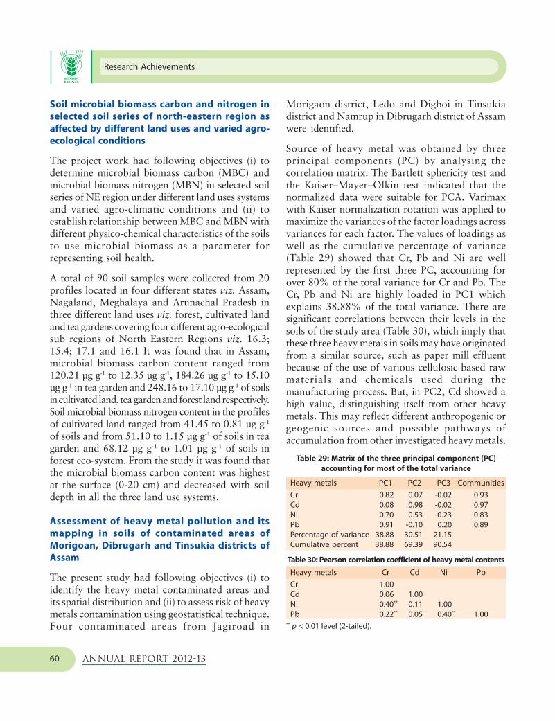
Research Achievements
Annual Report 2012-1360
Soil microbial biomass carbon and nitrogen in
selected soil series of north-eastern region as
affected by different land uses and varied agro-
ecological conditions
The project work had following objectives (i) todetermine microbial biomass carbon (MBC) andmicrobial biomass nitrogen (MBN) in selected soilseries of NE region under different land uses systemsand varied agro-climatic conditions and (ii) toestablish relationship between MBC and MBN withdifferent physico-chemical characteristics of the soilsto use microbial biomass as a parameter forrepresenting soil health.
A total of 90 soil samples were collected from 20profiles located in four different states viz. Assam,Nagaland, Meghalaya and Arunachal Pradesh inthree different land uses viz. forest, cultivated landand tea gardens covering four different agro-ecologicalsub regions of North Eastern Regions viz. 16.3;15.4; 17.1 and 16.1 It was found that in Assam,microbial biomass carbon content ranged from120.21 µg g-1 to 12.35 µg g-1, 184.26 µg g-1 to 15.10µg g-1 in tea garden and 248.16 to 17.10 µg g-1 of soilsin cultivated land, tea garden and forest land respectively.Soil microbial biomass nitrogen content in the profilesof cultivated land ranged from 41.45 to 0.81 µg g-1
of soils and from 51.10 to 1.15 µg g-1 of soils in teagarden and 68.12 µg g-1 to 1.01 µg g-1 of soils inforest eco-system. From the study it was found thatthe microbial biomass carbon content was highestat the surface (0-20 cm) and decreased with soildepth in all the three land use systems.
Assessment of heavy metal pollution and its
mapping in soils of contaminated areas of
Morigoan, Dibrugarh and Tinsukia districts of
Assam
The present study had following objectives (i) toidentify the heavy metal contaminated areas andits spatial distribution and (ii) to assess risk of heavymetals contamination using geostatistical technique.Four contaminated areas from Jagiroad in
Morigaon district, Ledo and Digboi in Tinsukiadistrict and Namrup in Dibrugarh district of Assamwere identified.
Source of heavy metal was obtained by threeprincipal components (PC) by analysing thecorrelation matrix. The Bartlett sphericity test andthe Kaiser–Mayer–Olkin test indicated that thenormalized data were suitable for PCA. Varimaxwith Kaiser normalization rotation was applied tomaximize the variances of the factor loadings acrossvariances for each factor. The values of loadings aswell as the cumulative percentage of variance(Table 29) showed that Cr, Pb and Ni are wellrepresented by the first three PC, accounting forover 80% of the total variance for Cr and Pb. TheCr, Pb and Ni are highly loaded in PC1 whichexplains 38.88% of the total variance. There aresignificant correlations between their levels in thesoils of the study area (Table 30), which imply thatthese three heavy metals in soils may have originatedfrom a similar source, such as paper mill effluentbecause of the use of various cellulosic-based rawmaterials and chemicals used during themanufacturing process. But, in PC2, Cd showed ahigh value, distinguishing itself from other heavymetals. This may reflect different anthropogenic orgeogenic sources and possible pathways ofaccumulation from other investigated heavy metals.
Table 29: Matrix of the three principal component (PC)
accounting for most of the total variance
Heavy metals PC1 PC2 PC3 Communities
Cr 0.82 0.07 -0.02 0.93
Cd 0.08 0.98 -0.02 0.97
Ni 0.70 0.53 -0.23 0.83
Pb 0.91 -0.10 0.20 0.89
Percentage of variance 38.88 30.51 21.15
Cumulative percent 38.88 69.39 90.54
Table 30: Pearson correlation coefficient of heavy metal contents
Heavy metals Cr Cd Ni Pb
Cr 1.00
Cd 0.06 1.00
Ni 0.40** 0.11 1.00
Pb 0.22** 0.05 0.40** 1.00** p < 0.01 level (2-tailed).

Soil Survey Data Interpretations and Applications
Annual Report 2012-13 61
To study the heavy metal contents in paddy inJagiroad paper mill eight sites (Jagibhakatgaon,Donga bill 1&2, Jan bill, Taranga bill 1&2,Bangalbari and Khar bill) were selected and freshsoil and paddy samples were collected and analyzedfor heavy metals content. It showed that high Pbcontent in the soil will increase the plant Cdconcentration, while high soil Cd will reduce thetotal Pb uptake by plant (Table 31). Pb incorporatedinto soils is nearly always tightly bound to organicor colloidal materials, or in a precipitated form; allof which serve to reduce the uptake of Pb into plantroots.
Table 31: Heavy metals (mg kg-1) in soil and different parts
of paddy from polluted areas (mean values of n=8)
Heavy metals Pb Ni Cd Cr
Soil 30.2 39.5 2.6 320.4
Root 13.1 21.2 1.3 48.6
Leaf 9.0 26..3 1.8 29.2
Seed 5.9 9.2 0.2 14.3
Assessment and mapping of some important soil
parameters including macro and micro nutrients
for the thirteen (13) priority districts of Assam
state (1:50,000 scale) towards optimum land use
planning
The project was undertaken with the objectives ofassessing nutrient status of soils of Assam on aspatial mode, creating a GIS-based data of soilparameters including macro and micronutrients andpreparing district wise soil fertility map for 13priority districts of Assam State on 1:50,000 scale.It was observed that extremely, very strongly andstrongly acidic soils together covered 72.9% areaof Tinsukia district, 82.4% of area of Karbi-Anglongdistrict and 62.9% area of Bagsa district. It wasobserved that available phosphorus was low in67.7% area of Karbi-Anglong district. It was alsonoticed that available Zn was deficient in 39.6%area of Tinsukia district and 38.2% area ofBagsa district. From the present study, it becomes
evident that soil acidity together with the low tomedium N & K status as well as deficient zones ofzinc indicates in general the low fertility status ofthe districts and therefore requires attentionregarding soil management practices for optimumagricultural production. Grid wise soil informations(pH, O.C., available N, P and K and availablemicronutrients including Fe, Mn, Zn and Cu) arelinked with corresponding villages and PoliceStations (Thana) for Sonitpur, Darrang, Nalbari,Bangaigaon, Lakhimpur and Dhemaji districts ofAssam.
Assessment and mapping of some important soil
parameters including macro and micronutrients
for the state of Nagaland towards optimum
utilization of land resources for integrated and
sustainable development
The project had the following objectives assessingnutrient status of soils of Nagaland state on a spatialmode, creating a GIS-based data of soil parametersincluding macro and micronutrients and preparingdistrict wise soil fertility map for 11 districts ofNagaland State on 1: 50,000 scale.
Base maps of Kohima, Dimapur, Peren, Mokokchung,Tuensang, Kiphire, Wokha, Zunheboto, Phek, Monand Longleng districts of Nagaland state wereprepared using Survey of India Toposheets at1: 50,000 scale and grid points were demarcated at1.0 m intervals. Grid wise soil samples have beencollected from Kohima, Dimapur, Peren,Mokokchung, Tuensang, Kiphire, and Zunhebotodistricts.
Interpretation of soil nutrient database for site-
specific fertilizer recommendation in different
land use systems of West Bengal.
Soil pH and phosphorus relationship in the state of
West Bengal
Mean available phosphorus was higher in Darjiling,Uttar and Dakshin Dinajpur and Koch Bihar than

Research Achievements
Annual Report 2012-1362
the other districts of West Bengal (Fig. 45). Themean content of available phosphorus in Huglidistrict was at par with that of Dakshin Dinajpur.Inspite of having low pH (Fig. 46) Darjiling,Jalpaiguri, Koch Bihar, Uttar and Dakshin Dinajpurdistricts had higher available phosphorus owing tohigher organic carbon (Fig. 47) than Maldah,Murshidabad and Nadia districts.
Low content of nutrients in West Bengal
The low availability of phosphorus, potassium, boronand zinc have been found in the districts of Jalpaiguri(63.8%), Murshidabad (78%), Birbhum (90.2%),Bankura (86%), Nadia (94.6%) and PaschimMedinipur (69.9%) of TGA. Low contents of availablephosphorus, potassium and zinc was found in thedistricts of Maldah (89.4%), and Haora (96.9%) ofTGA. The low balance of potassium and boron wasobserved in the district of Dakshin Dinajpur (89.8%),whereas Koch Bihar district had inadequate level ofpotassium. The data indicated occurrence of lowavailable phosphorus, potassium and boron in thedistricts of Hugli (92.6% TGA), Barddhaman(96.6% TGA) and Puruliya (73.1 % TGA). Lowcontent of available phosphorus and zinc wasobserved in Purba Medinipur (83.5% TGA), North24 Parganas (43.8% TGA) and South 24 Parganas(84.1% TGA). The low content of potassium andzinc in group was found in Uttar Dinajpur (92.9 %TGA) district whereas the soils of Darjiling aredeficient in Boron in 61.3 percent (Table 32).
Fig. 45: Mean available phosphorus in different districts of
West Bengal
Fig. 46: Mean soil pH in different districts of
West Bengal
Fig. 47: Mean soil organic carbon in different districts of
West Bengal
Table 32. Low balance of multiple nutrients in West Bengal
Districts Particle size class pH range Phosphorus Potassium Zinc Boron
Darjiling Coarse-loamy 4.5-5.5 xx xx xx *
Fine-loamy 4.5-5.5 xx xx xx *
Fine 4.5-5.5 xx xx xx *
Jalpaiguri Coarse-loamy 4.5-5.5 ** ** xx *
Fine-loamy 4.5-5.5 ** * ** *
Fine 4.5-5.5 ** * ** *
Koch Bihar Coarse-loamy 4.5-5.5 xx * **
Fine-loamy 4.5-5.5 xx * **
cont....

Soil Survey Data Interpretations and Applications
Annual Report 2012-13 63
Uttar Dinajpur Coarse-loamy 4.5-5.5 xx * **
Fine-loamy 4.5-5.5 xx * **
Fine 4.5-5.5 xx * **
Dakshin Dinajpur Coarse-loamy 4.5-5.5 xx * ** *
Fine-loamy 4.5-5.5 xx ** ** *
Fine 4.5-5.5 xx ** ** *
Maldah Coarse-loamy 6.5-7.5 * * **
Fine-loamy 6.5-7.5 * * **
Fine 6.5-7.5 * * **
Murshidabad Coarse-loamy 6.5-7.5 ** * ** *
Fine-loamy 6.5-7.5 ** * ** *
Fine 6.5-7.5 ** * ** *
Nadia Coarse-loamy 6.5-7.5 xx ** ** *
Fine-loamy 6.5-7.5 ** ** ** *
Fine 6.5-7.5 ** ** ** *
Barddhaman Coarse-loamy 5.5-6.5 ** * xx *
Fine-loamy 5.5-6.5 ** * xx *
Fine 5.5-6.5 ** * xx *
Birbhum Coarse-loamy 5.5-6.5 * * ** *
Fine-loamy 5.5-6.5 * ** ** *
Fine 5.5-6.5 * * ** *
Puruliya Coarse-loamy 4.5-5.5 * * xx *
Fine-loamy 4.5-5.5 * * xx *
Fine 4.5-5.5 * * xx *
Bankura Coarse-loamy 4.5-5.5 ** ** ** *
Fine-loamy 4.5-5.5 ** ** ** *
Fine 4.5-5.5 ** ** ** *
Paschim Medinapur Coarse-loamy 4.5-5.5 ** ** ** *
Fine loamy 4.5-5.5 ** ** ** *
Fine 4.5-5.5 ** ** ** *
Hugli Coarse-loamy 5.5-6.5 xx ** xx *
Fine-loamy 5.5-6.5 xx ** xx *
Fine 5.5-6.5 xx ** ** *
Haora Coarse-loamy 5.5-6.5 ** ** **
Fine-loamy 5.5-6.5 ** ** **
Fine 5.5-6.5 * ** **
Purba Medinipur Coarse-loamy 5.5-6.5 ** xx **
Fine-loamy 5.5-6.5 ** xx **
Fine 5.5-6.5 ** xx **
North 24 Parganas Coarse-loamy 5.5-6.5 ** xx *
Fine-loamy 5.5-6.5 * xx *
Fine 5.5-6.5 * xx *
South 24 Parganas Coarse-loamy 5.5-6.5 * xx **
Fine-loamy 5.5-6.5 * xx **
Fine 5.5-6.5 * xx **
xx- no problem;* severe problem ** moderate level

Research Achievements
Annual Report 2012-1364
Assessment and mapping of some important soil
parameters including macro & micro nutrients at
block level for Dumka, Jamtara and Hazaribagh
districts towards optimum land use plan
Soil pH, organic carbon, available phosphorus,potassium, sulphur, zinc, copper, iron, manganeseand boron were analyzed for 14787 geo-referencedsamples (0-20 cm) and block-wise nutrient mapswere prepared in GIS environment for Dumkadistrict. Data on soil pH, organic carbon and othernutrients status of Dumka, Masalia, Ramgarh,Gopikandar and Raneswar blocks are presented intable 33 and spatial distribution of pH, organiccarbon, available boron and sulphur these blocks
respectively is shown in figure 48. The dataindicated that soil acidity ( pH <5.5), low content(<0.5%) of organic carbon, available phosphorus(<10 kg ha-1), available boron (< 0.5 mg kg-1),sulphur (<10 mg kg-1) and zinc (<0.5 mg kg-1) werethe major constraints in all the blocks of Dumkadistrict. Low content (<108 kg ha-1) of availablepotassium was also noticed in some blocks. As awhole 57.5, 63.3, 24.4 and 27.5% area of theDumka district were affected with acidity lowcontent of organic carbon, low availablephosphorus, sulphur, boron and zinc were alsoobserved in 38.1 and 21.6% area of the Dumkadistrict respectively.
Table 33: Block-wise nutrient status of Dumka district
Attributes Dumka Masalia Ramgarh Gopikandar Raneswar Dumka
district
Area in sq. km. (%)
pH(<5.5) 261.5 318.0 231.0 77.1 279.8 2158.9
(68.9)* (70.4) (47.4) (33.8) (81.5) (57.5)
OC(<0.5%) 171.3 170.4 437.0 99.6 134.0 2379.3
(45.1) (37.7) (89.6) (43.7) (39.0) (63.3)
Available P 169.6 105.1 96.5 66.6 84.6 915.5
(<10 kg ha-1) (44.7) (23.8) (19.8) (29.3) (24.6) (24.4)
Available K 27.1 101.3 27.7 37.6 56.7 410.7
(<108 kg ha-1) (7.1) (22.4) (5.7) (16.5) (16.5) (10.9)
Available S 78.0 146.8 65.4 81.9 110.4 1034.4
(<10 kg ha-1) (20.5) (32.5) (13.4) (35.9) (32.1) (27.5)
Available Zn 29.8 20.4 47.2 119.9 55.2 812.6
(<0.5 kg ha-1) (7.9) (4.5) (9.7) (52.6) (16.0) (21.6)
Available Cu 21.9 16.9 19.0 32.3 3.0 234.7
(<0.2 kg ha-1) (5.8) (3.8) (3.9) (14.2) (0.9) (6.3)
Available Fe 10.5 3.1 10.5 13.2 — 111.2
(<4.5 kg ha-1) (2.8) (0.7) (2.1) (5.8) (2.9)
Available Mn — — — 5.1 — 61.7
(<2 kg ha-1) (2.3) (0.02)
Available B 109.4 180.2 131.2 134.7 130.1 1430.3
(<0.5 kg ha-1) (28.8) (39.9) (26.9) (59.1) (37.9) (38.1)
( )* Percent area of the block in the parenthesis

Soil Survey Data Interpretations and Applications
Annual Report 2012-13 65
Mapping of nutrient status in soils of Sikkim state
towards land use planning
The project had the objectives assessing nutrientstatus of soils of Sikkim state on a spatial mode,creating a GIS based data of soil parametersincluding macro and micronutrients and preparingdistrict wise soil fertility map for East, West, Southand North districts of Sikkim State on 1:50,000scale. Base maps of South, East, West and Northdistricts of Sikkim were prepared and grid pointswere demarcated at 500 m intervals on cultivatedarea using Survey of India Toposheets at 1:50,000scale. Grid wise soil samples have been collected
SOIL REACTION (pH)
Dumka Block,
Dumka District
Jharkhand
Fig. 48: Spatial distribution of pH, organic carbon, available boron and sulphur
AVAILABLE BORON
Gopikandar Block,
Dumka District
Jharkhand
ORGANIC CARBON
Ramgarh Block,
Dumka District
Jharkhand
AVAILABLE SULPHUR
Masalia Block,
Dumka District
Jharkhand
from cultivated area of South and East districts ofSikkim. Using IRS Resourcesat–1 LISS III imageryof 18th October 2010 major landuse classes likeforest, cultivable land, barren land, pasture landand snow covered area were delineated. Soilsampling (0-25 cm depth) was done based on gridobservations at 500 m interval on the base map of1:50,000 scale (Table 34).
Soil sampling of South District of Sikkim hasbeen completed and soil analyses for few parameterswere completed. Spatial distribution of soil pHclasses of South Sikkim district have been givenin Fig. 49.

Research Achievements
Annual Report 2012-1366
Table 34: Number of grid observations collected from
different districts of Sikkim
District Area Cultivated Area under No. of
( km2) land land uses grids
(km2) ( km2)
West 1166 406.69 759.31 1638
South 750 430.16 319.84 1731
East 954 425.62 528.38 1703
North 4226 123.64 4102.36 488
Fig. 49: Spatial distribution of soil pH classes of South district
Estimating available water content of soils of
selected villages in Aurangabad, Dhule and
Gondia districts of Maharashtra
Horizonwise soil samples were collected from 180profiles located in different clusters of Aurangabad,Dhule and Gondia districts and analysed for
SOIL REACTION (pH)
South Sikkim
District
Sikkim
different parameters. Textural classificationindicated that 192 samples were ‘clay’ in texture.Clay loam and loam texture was observed in 62and 27 samples respectively. Pedotransfer functionswere developed to predict ASWC with varyingdegrees of accuracy indicated by root mean squareerror (RMSE) 0.018 to 0.096 m3m-3 (Table 35). Theerrors were large in magnitude and hence PTFs forclay loam and loam texture were discarded. Thehierarchical neural PTFs for predicting AWC wererecommended for use.
Table 35: Accuracy of neural PTFs to predict AWC as
indicated by RMSE
PTF evaluation
RMSE (m3m3) Training Testing
Clay
H1 Sand silt and clay content 0.0283 0.024
H2 H1 and OC 0.0263 0.0241
Clay loam
H1 Sand silt and clay content 0.0215 0.0332
H2 H1 and OC 0.0189 0.0311
loam
H1 Sand silt and clay content 0.051 0.0431
H2 H1 and OC 0.0967 0.0355
Changes in soil carbon reserve as influenced by
different ecosystem and land use in India
Simulation of total organic carbon in the soils of
Palampur
Two soil carbon models namely, Century and RothCwere used to simulate the total organic carbon(TOC) in the soils of Palampur using the long termfertilizer experiment (LTFE) data. The simulationresults of Century model showed that there was asignificant increase in TOC when organic carbonwas added through farm yard manure incombination with inorganic fertilizers (T5). Anoticeable increase in TOC was also observed in aregular application of 100% NPK (T4), 100% NPK+ Hand weeding (HW) (T7) and 150% NPK (T11)

Soil Survey Data Interpretations and Applications
Annual Report 2012-13 67
within the experimental period (1972-2003) whilea decreasing trend was observed in control treatmentwith no fertilizer and manure application (T 1).Moreover, the results of RothC indicated that therewas rapid increase in TOC in treatment 5 with100% NPK+FYM (T5) as compared to the controltreatment (T 1: no inorganic and organic fertilizerapplication), treatment 4 (T4: 100% NPK),treatment 7 (T7: 100% NPK+HW) and treatment11 (T11: 150% NPK).
Impact of nutrient management interventions on
TOC turnover
RothC model was used to assess the long-termimpact of nutrient management interventions onTOC turnover in the soils of Palampur LTFE site.The primary purpose of this exercise was to testthe ability of a soil carbon model to simulate thelong term dynamics of soil organic matter undervarious nutrient management interventions indifferent bio-climates with varying rainfallpattern. Thereafter, the tested model can be usedfor the future global change impact assessment indifferent environments. The RothC model was runfrom 1990 to 2050 with an interval of 20 years.The simulation results indicated that there wascontinuous decline in TOC in the control treatment(T1: no inorganic and organic fertilizer application)(Table 36).
However, there was significant increase in the TOCin the treatments 5 (100% NPK+FYM) and 7(100% NPK+HW). It means over the years therewould be total organic carbon built up undernutrient management interventions of 100%NPK+FYM and 100% NPK + HW.
Effect of global warming on modelled TOC stocks in
soils of Palampur
RothC carbon model was used to find out therelationship between global warming and modelledTOC stocks. We presumed a subsequent increasein mean temperature of 0.25 0C per decade over100 years (1990 to 2090) and ran RothC. In firstcase, we used eight layers of soil (0-12, 12-32, 32-53, 53-69, 69-87, 87-112, 112-135 and 135-162cm) as separate entity and generated datasets formodelled TOC stock. In the second case, TOC stockwas modelled considering entire soil depth of 162cm as a single unit. The simulation results of boththe cases were compared and illustrated in the Fig.50. There was a marginal difference in the modelledTOC stocks in both the cases. TOC held withintop 162 cm is found to be decreased by 10.86 percent in single layer as compared to a fall of 10.06per cent when the same soil was modelled dividingit into eight equal layers. The results show thattreating soil as different layers will predict actualeffects of global warming in accelerating
Table 36: TOC and its turnover in different treatments over years in Palampur LTFE site
(values in t ha-1)
Year / Treatments 1990 2010 2030 2050
Palampur, Himachal Pradesh, India
T1 (Control, No fertilizer and FYM) 19.08 19.07 (-0.04) 19.01 (-0.34) 18.99 (-0.47)
T4=100% NPK (recommended) 19.08 19.79 (4) 20.41 (7) 20.86 (9)
T5 = 100% NPK + FYM 25.89 31.39 (21) 35.88 (39) 39.14 (51)
T7 = 100% NPK + HW 19.08 20.55 (8) 21.88 (15) 22.82 (20)
T11 = 150% NPK 19.08 19.91 (1) 20.03 (2) 20.14 (2)
aParentheses indicate percentage changes compared to 1990 for Palampur for 0-23cm soil depth.

Research Achievements
Annual Report 2012-1368
decomposition of soil C and the resultant release ofCO2 from soil organic matter.
Fig. 50: Comparison of reduction in modelled carbon per cent
in a 100 year span between single layer and combined 8 layers
in Palampur soils due to the effect of global warming (rise in
2.5°C in a century as predicted by IPCC).
Soil series information for modeling
The physical and chemical data of 100 soil serieswere compiled from five zones of the country (20soil series from each zone). The soil properties werearranged in the required formats specific to RothC,Century and InfoCrop models and will be used bythe different partner institutes under NPCC andNICRA projects.
Georeferenced soil information system for land
use planning and monitoring soil and land quality
for agriculture
Generation of Soil and Terrain (SOTER) Database
Soil and Terrain (SOTER) datasets were finalizedfor 144 soil series in the IGP and 101 soil series inthe BSR. The information on morphological,physical and chemical properties of the soils andclimate and land use were created and linked inSOTER-GIS environment for monitoring soil andland quality.
Identification of minimum datasets for monitoring
soil quality and land evaluation
Principal Component Analysis (PCA) technique wasemployed to identify the minimum soil parametersthat can give interpretable information of soilquality and land evaluation. For the Indo-GangeticPlains, datasets have been grouped into the UpperIGP covering Rajasthan, Punjab, Haryana, UttarPradesh, Delhi and Uttarakhand and Lower IGPconsisting of Bihar and West Bengal. Six PrincipalComponents (PCs) were obtained for the Upper IGP(Hot Spots) and lower IGP surface soils and theminimum datasets (MDS) obtained were – clay,saturated hydraulic conductivity, organic carbon,exchangeable sodium percentage, exchangeablemagnesium percentage, soil solution K. The MDSfor the BSR were saturated hydraulic conductivity,ESP, EMP, BD, OC, pH, WDC and silt. The relativesoil quality index (RSQI) computed for surface(0-30 cm) and subsurface (30-100 cm) soils of theselected hotspots (BM Spots) are presented in boxes1, 2 and 3. SQI maps were also developed for boththe IGP and BSR.
Box 1. Soil data of Upper IGP (Hotspots)
Soil Series : (RSQI surface, RSQI subsurface)
Masitawali : (71.0, 62.5), Nihalkhera : (54.6, 10.3), Hirapur : (59.0,
53.9), Bhanra : (55.1, 100.0), Ghabdan : (75.5, 62.2), Phaguwala :
(100.0, 48.1), Sakit : (59.4, 84.1), Zarifa-Viran : (52.6, 72.5), Dhadde :
(66.2, 57.0), Fatehpur : (48.2, 69.9), Jagjitpur : (59.8, 67.0), Berpura
: (70.3, 81.4), Simri : (43.0,78.0), Haldi : (56.3, 28.0), Jassi-Pauwali
: (88.7, 57.7), Jodhpur-Ramana : (62.5, 83.2)
Box 2. Soil data of Lower IGP (Hotspots)
Soil Series : (RSQI surface, RSQI subsurface)
Sarthua : (100.0, 81.3), Belsar : (63.7, 77.1), Ekchari : (95.4, 95.0),
Nanpur : (61.1, 78.5) Gaupur : (47.8, 78.1) Singhvita : (67.3, 100.0),
Konarpara : (70.9, 82.3) Madhpur : (65.5, 93.9) Sasanga : (88.7,
89.4) Hanrgam : (79.8, 87.3), Seoraguri : (83.4, 84.3), Sagar : (97.2,
78.9), Chunchura : (96.4, 88.3), Mohanpur : (68.3, 93.0)
8 Multiple Layers Vs Single Layer
No
n I
OM
pe
r ce
nt
of
19
90
EQ
Co
nte
nt

Soil Survey Data Interpretations and Applications
Annual Report 2012-13 69
Box 3. Soil data of BSR (Hotspots)
Soil Series : (RSQI surface, RSQI subsurface)*
Kheri : (77.1, 86.6), Sakka : (69.9, 79.1), Nabibagh : (87.8, 100.0),
Pahur : (81.4, 67.8), Loni : 90.1, 72.2), Panjri : (85.8, 95.6), Sarol :
(100.0, 74.6), Nipani : (74.5, 52.4), Linga : (98.0, 93.1), Bhatumbari :
(88.7, 66.7), Asra : (89.7, 66.4), Vasmat I: (71.0, 56.6), Vasmat II :
(76.0, 70.0), Jhalipura : (63.0, 71.3), Paral : (71.1, 66.0), 95.0), Jajapur
: (60.7, 37.9), Kasireddipalli : (77.9, 53.2), Konheri : (98.1, 91.2),
Kalwan : (83.9, 53.4), Kovilpatt : (69.9, 79.1), Semla : (80.3, 64.7),
Teligi : (93.2, 66.7), Sollarpuram : (69.7, 78.0), Sokhda : (54.8, 51.3),
Nimone : (86.2, 69.0)
*RSQI was based on two MDS (PCA derived and selected based
on experts’ opinion). However, RSQI values from PCA derived MDS
closely match with the values of experts’ opinion.
Land Evaluation
Three quantitative land evaluation approaches viz.,parametric, fuzzy modeling and soil property, cropresponse (SPCR) were used for evaluating the soilsof selected benchmark spots of the IGP and the BSR.
Land Evaluation for Rice-Wheat Cropping System in
the IGP
Eleven typical BM sites for rice and wheat belongedto land Class-I (Table 37) through modified Sysmethod. Interestingly, Fuzzy method could evaluate7 and 2 spots as land class I for rice and wheatcrops, respectively. The corresponding figuresobtained as 3 and 7 for rice and wheat, respectivelyin SPCR method. In crop modelling approach 6 and8 BM spots were evaluated as land class I for riceand wheat, respectively.
Land Evaluation for Cotton-based cropping system
in BSR
Total seventeen benchmark spots were evaluatedfollowing three evaluation methods (with someexception in SPCR method). Total eight spots inthe modified Sys, nine in fuzzy and three in SPCRmethods were evaluated as land class I. Soybeancrop were evaluated with two methods, wheremodified Sys method evaluated two BM spots andFuzzy as five BM spots as land class I (Table 38). Inthe crop modelling approach Panjri site showed LCI (land suitability class I) for cotton and LC II forsoybean. A closer look indicated that BM sites suchas Bhola, Sarol, Sokhda, Achmatti, Kasireddipalli,Coimbatore and Panjri are rated as land class I byboth modified Sys and fuzzy methods.
All the aforesaid methods could be used for LE forcotton and soybean in BSR notwithstanding theirlimitations. Barring the method using crop model,the other three methods could be used for LE forrice and wheat in the IGP. Fuzzy modeling-basedmethod was, however, observed to be superior tothe other methods both in land evaluation for thecrops of interest in the BSR and IGP and developingthreshold values of land quality parameters as it isintuitive, based on sound logic and robust in that itovercomes the limitations of the conventionalmethods namely dependence on yield and nonassignment of weightages to the MDS parametersdepending on their relative importance to thecrop(s).
Table 37: Comparison of Land Evaluation methods adopted in rice-wheat system of the Indo-Gangetic Plains (IGP)
Sl. AESR Crop Soil Taxonomy Modified Sys method Fuzzy method SPCP*
No. BM sites Rice Wheat Rice Wheat Rice Wheat
series LQI LC LQI LC LQI LC LQI LC LQI LC LQI LC
Per humid (PH) bioclimatic system
1. 15.3 Singbhita Typic Dystrustepts 85 I 100 I 95 I 100 I 75 II ND ND
2. Seoraguri Typic Haplaquepts 85 I 100 I ND ND 100 I 76 II ND ND
3. Nayanpur Typic Endoaqualfs 95 I 90 I ND ND 72 II 74 II ND ND
cont....

Research Achievements
Annual Report 2012-1370
Humid (H) bioclimatic systems
4. 12.3 Gopalpur Vertic Endoaqualfs 60 II 95 I 56 III 69 II 59 III ND ND**
5. 13.1 Ekchari Vertic Endoaqualfs 85 I 90 I 59 III 55 III 67 II 97 I
6. 13.2 Haldi Typic Hapludolls 95 I 95 I 95 I 72 II 86 I ND ND
7. 15.1 Madhpur Typic Endoaqualfs 95 I 90 I 57 III 54 III 65 II ND ND
8. 18.5 Sagar Typic Haplaquepts 60 II 37 II ND ND 57 III 63 II ND ND
Sub-humid Dry (SHd) bioclimatic systems
9. 9.2 Itwa Aeric Ochraqualfs 90 I 80 I 82 I 63 II 82 I 85 I
Semi-arid Dry (Sad) bioclimatic systems
10. 4.1 Zarifa Viran Typic Natrustalfs 81 I 81 I 91 I 52 III 100 I 90 I
11. 4.3 Sakit Typic Natrustalfs 81 I 90 I 63 II 66 II 78 II 74 II
12. 4.4 Singhpura Typic Haplusepts 81 I 60 II 69 II 61 II ND ND 97 I
13. 9.1 Fatehpur Typic Haplusepts 81 I 85 I 93 I 66 II ND ND 100 I
Arid (A) bioclimatic systems
14. 2.1 Shakhi Typic Torrifluvents 34 IV 72 II 62 II 69 II ND ND 92 I
15. 2.3 Mashitawali Typic Torrifluvents 38 IV 36 IV 61 II 61 II ND ND 86 I
*This method does not permit direct estimates of LQI and LC. We have improvised this method to assess LQIs and LCs on the basis of
statistical parameter such as correlation coefficient (r) discussed earlier. For example, r of 0.86 is LQI of 86. For comparison, LC I
corresponding to 80-100, LC II to 60-80, LC III to 40-60 and LC IV <40 have uniformly been applied for all the three methods.; **ND- Not
done
Table 38: Comparison of Land Evaluation methods used in cotton-based cropping system in the Black Soil Region (BSR)
Sl. AESR Soils Soil Taxonomy Modified Sys’ method Fuzzy method SPCP* Crop modelling approach
No. Cotton Soybean Cotton Soybean Cotton Cotton Soybean
(LQI LC LQI LC LQI LC LQI LC LQI LC RYI LC RYI LC
Sub-humid moist (SHm) bioclimatic systems
1. 7.3 Tenali Halic Hapluserts 72 II 64 II 69 II 44 III ND ND 0.40 III 0.61 II
2. 10.1 Nabibagh Typic Haplusterts 34 IV 62 III 69 II 64 II 87 I 0.46 III 0.89 I
Sub-humid dry (SHd) bioclimatic systems
3. 5.2 Sarol Typic Haplusterts 85 I 36 IV 98 I 63 II ND ND 0.73 II 0.80 I
4. 10.2 Panjari Typic Haplusterts 85 I 58 III 80 I 83 I ND ND 0.80 I 0.71 II
5. 10.3 Ghulghuli Typic Haplusterts 85 I 60 III 76 II 77 II ND ND 0.65 II 0.79 II
Semi-arid dry (SAd) bioclimatic systems
6. 3.2 Teligi Typic Hapluserts 51 III 60 II 57 III 51 III ND ND** 0.39 IV 0.76 II
7. 5.1 Bhola Typic Hapluserts 90 I 38 IV 96 I 70 II 100 I 0.56 III 0.74 II
8. 5.3 Sokhda Calcic Hapluserts 90 I 62 II 100 I 73 II 85 I 0.26 IV 0.52 III
9. 6.1 Nimone Sodic Haplusterts 72 II 57 III 75 II 68 II ND ND 0.07 IV 0.18 IV
cont....

Soil Survey Data Interpretations and Applications
Annual Report 2012-13 71
10. 6.2 Vasmat Sodic Haplusterts 74 II 51 III 99 I 76 II ND ND 0.49 III 0.90 I
11. 6.3 Paral Sodic Haplusterts 72 II 64 II 91 I 85 I 76 II 0.50 III 0.86 I
12. 6.4 Achmati Sodic Hapluserts 81 I 60 II 82 I 72 II ND ND 0.63 II 0.77 II
13. 7.1 Nandyal Chromic Haplusterts 51 III 62 II 59 III 61 II 60 II 0.75 II 0.85 I
14. 7.2 Kassired- Sodic Hapluserts 85 I 60 II 93 I 86 I ND ND 0.73 II 0.78 II
dipalli
15. 8.1 Coimbatore Vertic Haplusepts 85 I 61 II 89 I 76 II ND ND 0.29 IV 0.30 IV
16. 8.2 Sidalghatta Vertic Haplusepts 72 II 85 I 75 II 88 I ND ND 0.34 IV 0.56 III
17. 8.3 Kovilpatti Gypsic Hapluserts 72 II 95 I 74 II 89 I 73 II 0.48 III 0.41 III
*This method does not permit direct estimates of LQI and LC. We have improvised this method to assess LQIs and LCs on the basis of
statistical parameter such as correlation coefficient (r) discussed earlier. For example, r of 0.86 is LQI of 86. For comparison, LC I
corresponding to 80-100, LC II to 60-80, LC III to 40-60 and LC IV <40 have uniformly been applied for all the three methods. **ND- Not
done
Fig. 51: Modified agro-ecological sub regions in Black Soil Region
Revision of Agro-ecological sub-region (AESR)
boundaries
Based on additional set of data for length ofgrowing periods (LGP), quantitative drainage mapand additional soil data, the AESR boundaries havebeen revised for two important food production
zones of India namely, the Indo-Gangetic plain(IGP) and the Black Soil Region (BSR). Initially,at the beginning of the project there were 53AESRs (17 in IGP and 36 in BSR) in the studyarea, but after revision the number hasbeen increased to 83 (29 in IGP and 54 in BSR,Fig. 51).
INDIA
Modified AESRs in
Black Soil Region

Research Achievements
Annual Report 2012-1372
Network project on “Land use planning of Tirumale
sub-watershed in Magadi taluk, Ramanagara
district, Karnataka for integrated development
The project was undertaken in collaboration withKarnataka State Watershed DevelopmentDepartment and aimed at providing the DetailedLand Resources Inventory (LRI) for net planning(the core activity of IWMP) and also to monitor,review and evaluate the Watershed developmentprogrammes. The average annual rainfall is 996mm. Most of it is received between June andSeptember from the southwest monsoon.
The class III lands occupy about 25 per cent of thearea. Moderately sloping lands (5-10%) occupiedthe major parts of the watershed area (54%). Rocklands and denuded hills and hill slopes are the majorland forms. Soils are deep (100-150 cm) (20 percent area) and moderately deep (75-100 cm) (16per cent area). Shallow and very shallow (10 percent area). Loamy sand and sandy loams are thedominant surface soil textural groups found in thewatershed. Sheet erosion is a serious problem inthe very gently to gently sloping uplands. Only 3per cent of the area showed low organic carboncontent. Other areas had high organic matter
content mainly due to the crop rotation followedin the region. Crop and soil suitability evaluationwas carried out for all the major crops like fingermillet, redgram, castor, arecanut, coconut, bananaand mango. They are moderately to highly suitable.Fertility evaluation was carried out for major andmicro nutrients. In the entire study area availablenitrogen status is low. Available phosphorus contentis high in 37 per cent area and in nearly 57 per centarea is medium. In 52 per cent of the area availablepotassium is low and in 41 per cent area it ismedium. Available iron, manganese, copper andzinc are available in sufficient quantities except zinc,which is low in Hebbalapalya and Harthi villages.The available boron status low in the watershedarea. Available sulphur was deficient in 38 per centarea and adequate 20 per cent of area. In 36 percent area sulphur availability is optimum. Majorconstraints in the watershed include considerableis rock out crops and marginal lands, low groundwater level and scarcity of labour.
Farmers identified water as the main limiting factorin achieving higher productivity/diversification ofenterprises. Drilling of deep bore wells is veryrampant and awareness in adoption of water
2.5Land Evaluation and Land Use
Planning
• Farm/Watershed/District/Region/State/Country
• Soil and Land Use Model

Land Evaluation and Land Use Planning
Annual Report 2012-13 73
efficient irrigation technologies and tools like micro-irrigation are not at all adopted in the study area.Large number of bore wells have failed.
Potentials and opportunities observed in the area
The present rainfed cropping system consisting offinger millet, pigeon pea, castor, field bean is veryideal for maintaining soil health and utilizing soilresources from different depths of soil profile. Inmost areas top soil layer consists of lighter soiltexture, which allows easy infiltration of water intothe soil profile. The sub-surface layers are of heavytexture which store /hold good quantity of soilmoisture thus allowing good performance of rainfedcrops. Deep soils occur even below rocky surfacesin certain places allowing the good performance oftree crops like mango, jack fruits etc. Therefore,there is bright scope for tree crops. Nearness toBangalore and suitable climate provides bright scopefor the cultivation of high value fruit and vegetablecrops. Protective cultivation is another good optionto make best use of the resources and the market.Goat and sheep rearing is a most common enterpriseand provides a good source of income.
The interventions suggested are effective use of LRI-Tirumale for Net Planning, opening of hard crustbetween surface soil and subsoil at regular intervals,monitoring silt, surface run-off, and organic carbonat bench mark sites, horticulture, forage & forestryin marginal lands (based on soil-site suitability)&fire protection and addressing nutritionaldeficiency of boron.
Land use planning of Buraka micro watershed in
Mewat district of Haryana under irrigated
ecosystem for integrated watershed development
The geo-coded IRS P6 LISS IV data on 1:12,500scale was integrated to prepare the physiographymap of the study area for detailed soil survey. Onthe basis of RS data and field observations sevenphysiographic units viz. hill tops, side slopes, interhill basin, upper piedmont plain, middle piedmontplain, lower piedmont plain and stream terraces.Eleven soils have been identified and mapped into22 soil mapping units. Soils of different mappingunits have been described in Table 39. Major soilsare Inceptisols followed by Entisols.
cont....
Table 39: Soils of Buraka watershed
Sr. Mapping Description Area % of
No. Unit (ha) surveyed
area
1. Buraka A Soils: Very shallow, excessively drained, brown, gravelly sandy loam soils on slightly 39.9 7.36
undulating hill tops (Loamy skeletal, Lithic Ustorthents)
1 AcC3SR Buraka A gravelly sandy loam, gently sloping, severe erosion with severely stony and 21.2 3.91
moderately rocky.
2 AcC3SR Buraka A gravelly sandy loam, gently sloping, severe erosion with moderately stony 18.7 3.45
and severely rocky.
2. Buraka B Soils: Very shallow, excessively drained, brown to dark yellowish brown, gravelly sandy loam 76.6 14.12
soils on moderately to strongly sloping hill side slopes (Loamy skeletal, Lithic Ustorthents)
3 BcD3SR Buraka B gravelly sandy loam, moderately sloping, severe erosion with moderately 12.5 2.30
stony and rocky.
4 BcD3SR Buraka B gravelly sandy loam, moderately sloping, severe erosion with moderately 19.9 3.67
stony and severely rocky.
5 BcE3SR Buraka B gravelly sandy loam, strongly sloping, severe erosion with moderately stony 27.4 5.05
and severely rocky.

Research Achievements
Annual Report 2012-1374
6 BcE3SR Buraka B gravelly sandy loam, strongly sloping, severe erosion with severely 16.8 3.10
stony and rocky.
3. Buraka C Soils: Very deep, somewhat excessively drained, yellowish brown to dark yellowish brown, 16.8 3.10
loamy sand soils on undulating inter-hill basin (Calcareous, Typic Ustipsamments)
7 CbC2 Buraka C loamy sand, gently sloping with moderate erosion. 16.8 3.10
4. Buraka D: Very deep, somewhat excessively drained, brown to strong brown and dark yellowish 68.4 12.61
brown, loamy sand to sandy loam soils on very gently to gently sloping upper piedmont plain
(Typic Ustipsamments)
8 DbA1 Buraka D loamy sand, nearly level sloping with slight erosion. 23.0 4.24
9 DbB1 Buraka D loamy sand, very gently sloping with slight erosion. 39.8 7.34
10 DbC2 Buraka D loamy sand, gently sloping with moderate erosion. 5.6 1.03
5. Buraka E Soils: Very deep, Well drained, brown to strong brown and dark yellowish brown, sandy 19.3 3.56
loam soils on very gently to gently sloping upper piedmont plain (Coarse loamy, Typic Haplustepts)
11 EcB1 Buraka E sandy loam, very gently sloping with slight erosion. 19.3 3.56
6. Buraka F Soils: Very deep, somewhat excessively drained, yellowish brown to dark yellowish 72.9 13.44
brown, loamy sand to sandy loam soils on nearly level to very gently sloping middle piedmont plain
(Calcareous, Typic Ustipsamments)
12 FbB1
Buraka F loamy sand, very gently sloping with slight erosion. 54.8 10.10
13 FbC2 Buraka F loamy sand, gently sloping with moderate erosion. 18.1 3.34
7. Buraka G Soils: Very deep, Well drained, dark yellowish brown, sandy loam soils on nearly level to 54.8 10.10
very gently sloping middle piedmont plain Coarse loamy (Calc.), Typic Haplustepts]
14 GcA1 Buraka G sandy loam, nearly level sloping with slight erosion. 30.5 5.62
15 GcB1 Buraka G sandy loam, very gently sloping with slight erosion. 24.3 4.48
8. Buraka H Soils: Very deep, Well drained, dark yellowish brown to strong brown, sandy loam soils on 37.4 6.89
nearly level to very gently sloping middle piedmont plain (Coarse loamy, Typic Haplustepts)
16 HcA1 Buraka H sandy loam, nearly level sloping with slight erosion. 37.4 6.89
9. Buraka I Soils: Very deep, somewhat excessively drained, yellowish brown to dark yellowish brown, 61.0 11.25
loamy sand to sandy loam soils on very gently to gently sloping lower piedmont plain
(Calcareous, Typic Ustipsamments)
17 IbB1 Buraka I loamy sand, very gently sloping with slight erosion. 29.3 5.40
18 IbC2 Buraka I loamy sand, gently sloping with moderate erosion. 31.7 5.85
10. Buraka J Soils: Very deep, Well drained, brown to dark yellowish brown and strong brown, sandy 26.8 4.94
loam soils on nearly level to very gently sloping lower piedmont plain [Coarse loamy (Calc.),
Typic Haplustepts]
19 JcB1 Buraka J sandy loam, very gently sloping with slight erosion. 18.1 3.34
20 JcC2 Buraka J loamy sand, gently sloping with moderate erosion. 8.7 1.60
11. Buraka K Soils: Very deep, somewhat excessively drained, brown to dark yellowish brown, loamy 38.6 7.12
sand soils on gently to moderately sloping stream terraces (Calcareous, Typic Ustipsamments).
21 KbC2 Buraka K loamy sand, gently sloping with moderate erosion. 20.5 3.78
22 KbD3 Buraka K loamy sand, moderately sloping with severe erosion. 18.1 3.34
Total 512.5 94.49
Habitation 29.9 5.51
GrandTotal 542.4 100.00

Land Evaluation and Land Use Planning
Annual Report 2012-13 75
Some of the thematic maps developed are presentedin Fig. 52.
Land Use Planning of Diring-Thanglong Micro-
watershed of Karbi-Anglong and Golaghat
Districts of Assam under Hill and Mountain
Ecosystem for Integrated Development
The Project had the objectives of preparing theinventory of natural resources of the micro-watershed, identifying the potentials andconstraints, evaluating land resources to suggeststrategies for soil and water conservation measuresand formulating alternate land use options forintegrated development of the micro watershed.
The watershed occupies 2369.4 ha area fromwhich the operational area for survey was 1088.2ha. In the watershed, nine landform units wererecognized viz., steep hills covering 47.1%, isolatedhillocks covering 0.7%, upper occupying 6.5%,lower piedmonts covering 11.9%, gently to verygently sloping uplands covering 8.9%, inter-hillvalley occupying 5.9%, narrow valley covering2.4%, foot hill plains occupying 4.1% and floodplains occupying 12.5% of area. 10 soil series wereidentified viz., Diring-1, Diring-2, Diring-3,Diring-4, Diring-5, Thanglong-1, Thanglong-2,Thanglong-3, Bochagaon-1 and Bochagaon-2,respectively with 15 mapping units as phases ofseries. In the watershed, slope is categorized intofour classes viz., very gently sloping (1-3%) covering27.9%, gently sloping (3-5%) covering 17.8%,moderately sloping (5-10%) covering 4.0% andmoderately steeply sloping (10-15%) covering 3.2%of TGA. Four soil depth classes are recognized inthe watershed viz., moderately shallow soilscovering 5.9%, moderately deep soils covering3.2%, deep soils covering 18.3% and very deep soilscovering 25.5% of TGA. Six surface textureclasses were recognized in the watershed viz., loam(4.8% of TGA), sandy loam (8.1% of TGA), silt-loam (11.8% of TGA), sandy clay loam (8.5% ofTGA), silty clay loam (15.0% of TGA) and clayloam. Four soil reaction classes were assessed inthe watershed viz., very strongly acid (pH 4.5-5.0)covering 23.3%, strongly acid (pH 5.0-5.5) coveringFig. 52: Thematic maps of Buraka watershed, Haryana
SURFACE TEXTURE
Buraka watershed
Mewat District, Haryana
LAND CAPABILITY
Buraka watershed
Mewat District, Haryana

Research Achievements
Annual Report 2012-1376
7.1%, moderately acid (pH 5.5-6.0) covering10.0% and weakly acid (pH 6.0-6.5) soilscovering 12.5% of TGA. In the watershed, threeproductivity classes viz., ‘poor’, ‘average’ and‘good’ were recognized for field crops andthree productivity classes viz., ‘extremely poor’,‘average’ and ‘good’ were recognized for plantationcrops.
Land use planning of Khuskarni microwatershed,
Birbhum, West Bengal for Integrated
Development
Holistic land use plan (Fig. 53), consisting ofagriculture, animal husbandry and fisheries has beendeveloped in Khuskarni micro-watershed (1209 ha)of Birbhum district, West Bengal, representing hotsub-humid agro-ecological sub-region (AESR 12.3).Soil conservation measures such as construction ofcheck dam (at <10% slope), percolation tank (at 0-3% slope) and renovation of farm ponds forincreasing water productivity and restricting erosionhas been the part of programme. Agro-forestry bycombining oil seeds and pulse crops includingmustard, ridge gourd and maize, with Bastard Teak,Palash along with lemon grass and medicinal plantsin suitable combination is recommended on
Machantoli soil series (slightly deep, fine-loamyTypic Haplustalfs) and on moderately deep, fine-loamy Haplustepts (Dhobna soil series). These soilsoccur on crest and undulating slope (37% TGA)and are prone to severe erosion. Agro-forestry helpsin protecting the soils from erosion, but alsoprovides safe pathways for run-off water to becollected in water harvesting ponds. Other deep,fine-loamy Typic Haplustepts (Tabadumra series)covering 19.01% area of the watershed isspecifically identified for rainfed agriculture.Groundnut and black gram are the preferred crops.Legume-based cropping pattern would be betteroption from soil fertility and price front. Foroptimizing the productivity of the watershed, 32%area belonging to capability class VII and VIII needsto be allocated for animal grazing and agro-horticulture. Other two soil series characterized asdeep, fine, Typic Haplustepts on depressed land(19.57% of TGA) is suggested exclusively for riceand pisciculture. It is expected that by implementingthe suggested land use plan in Khuskaraniwatershed, additional 359.1 hectare area may bebrought under double cropping and croppingintensity of the watershed may be increased from110 to 145 per cent.
Land use planning of Chanavada watershed in
Girwa tehsil, Udaipurdistrict, Rajasthan for
Integrated Development
The Chanavada micro watershed is part ofJhakham, Gomti catchment covering an area of1475 ha in Girwa block of Udaipur district insouthern Rajasthan. Geologically the watershed isdeveloped on argillaceous deposits composed ofslates, phyllites and mica schist along with granitesand quartzite. The climate of the watershed istropical semi-arid characterized by hot summer andintense winter. The average rainfall is 650 mm. Themean summer and winter temperature were 35.7oCand 26.8oC, respectively. The soil temperature andFig. 53: Suggested land use map of Khuskarni Microwatershed,
Birbhum
SUGGESTED LAND USE MAP
Khuskarni Microwatershed,
Birbhum

Land Evaluation and Land Use Planning
Annual Report 2012-13 77
moisture regimes are ‘Hyperthermic’ and ‘Ustic’respectively. Chanavada watershed is a part ofAravalli hills range hence the cultivation of crops isconfined to stream and valley only.
The morphometric analysis of the watershed revealsthat the watershed is 4th order, elongated in shapehaving mixed drainage pattern. The watershedcomprised of two major landform i.e. hills andvalleys. Based on the visual interpretation of satellitedata, other collateral data and local micro featureswhich were further subdivided into six landformunits. These were (1) Steeply sloping hills (2)Moderately steeply sloping hills (3) Moderatelysloping foot slope (4) Inter hill valley (5) Narrowvalley and (6) Broad valley. Eight soil series wereidentified in the watershed and mapped in to 15soil mapping units at the level of phases of soil serieson 1: 4000 scales after establishing soil landformrelationship. The study reveals that the soils of thesteeply sloping hills were very shallow to shallow,dark brown to yellowish brown, gravelly sandyloam to clay loam. However, the soils of themoderately steeply sloping hills were shallow tomoderately shallow, brown to dark yellowishbrown, gravelly sandy loam to silt loam. On theother hand the soils of the moderately sloping footslope were moderately deep to deep, dark brownto dark yellowish brown, sandy clay loam to loamtexture. The soils of the Interhill valley were deep,well drained, dark brown to grayish brown, sandyloam to loam in the surface texture. The soils ofthe narrow valley are very deep, well drained, verydark grayish brown to brown, sandy clay loam toloam in the texture. The soils of the broad valleyare deep to very deep, well drained, brown to darkbrown, loam to silt loam with moderatepermeability. The general slope of the unit rangesfrom 1-3%. These soils are cultivated for single cropof maize in kharif season, however in some patches,with irrigation facilities it is used for wheatcultivation in rabi season.
The soils of the hills are slightly acidic to neutral inreaction whereas the soils of the valley were neutralto moderately alkaline in reaction. All these soilare very high in organic carbon content on thecontrary the content of available nitrogen is low.Most of the soils are medium to high in availablephosphorous and available potassium whereas thecontent of available micronutrients was adequateto high. Taking in to account soil characteristicsand land qualities, the soils were evaluated for LandCapability Classes, Land Irrigability Classes andsuitability for various crops. The soils of the hillsare not suitable for arable field crops and the soilsof foot slope and narrow valley were marginal tomoderately suitable for growing crops. The soils ofthe broad valley were the good cultivable lands withminor soil problem such as gentle slope, fairlysatisfactory texture and slight stoniness. Allclimatically adapted crops can be grown underirrigation.
The major constraints for agricultural productivityin the watershed are steeply sloping land, severeerosion, shallow soil depth, strong stoniness andacute shortage of water for irrigation as well asdrinking purpose. In addition to this lack ofimproved package of practices, improved varieties,irrigation facilities and migration of local peopledue to unemployment are some of the agronomicand socio-economic constraints in the area. To solvethese problems there is a need for scientific approachwith proper land use planning.
For the integrated development of the watershed,the existing land use may be modified for optimalutilization of natural resources to achieve higherproductivity. Keeping this in view the suggestedland use plan for the watershed was prepared(Table 40). This kind of land use options helps toestablish new enterprises like dairy and animalhusbandry and creates ways for self employmentto the local people.

Research Achievements
Annual Report 2012-1378
Assessment of environmental and economic
impact of the New Agricultural Policy of Karnataka
on land use, land productivity and rural livelihood
All attempts were made to study the change in landuse and impact of agricultural polices on land use/land productivity and rural livelihood inKuthanagere micro watershed located in Magadi
taluk of Bangalore rural district for biophysical andsocio-economic assessment by comparing baselineland use (1999) with current situation (2010).Review of literature on Karnataka agriculturalpolicy and its impact on land use and rurallivelihood indicates that the new economic policieshave brought significant changes in rural Karnataka.The Karnataka Land Reforms Amendment Act
Table 40: Suggested land use plan for Chanavada watershed
Series Landform Slope Present Constraints Management need/ Suggested Area
(%) land use soil conservation land use (ha)
measures
Chanavada–1 Steeply >30 Degraded Very shallow, strong Staggered trenching, Afforestation 290.8
sloping hills lands / stoniness, very severe gully controlled
scrub land erosion, steep slope measures with LSCD,
excessively drained, rapid gully treatment
permeability and low
in available water capacity.
Chanavada–2 Moderately 15-30 Degraded Moderately shallow, Trenching, Gully Silvipasture 476.5
steeply lands/ strong stoniness, very controlled measures
sloping hills scrub land severe erosion, with LSCD
moderately steep slope,
available water capacity,
low in excessively drained
and rapid permeability.
Chanavada–3 Moderately 8-15 Cultivated Severe erosion, strong V-ditches, contour Agro forestry 189.3
sloping foot (single crop) stoniness, moderate slope, vegetative bunds and
slope moderate deep and rapid contour vegetative
permeability. hedges
Chanavada – Interhill 3-8 Cultivated Gentle slope, strong Contour vegetative Double 279.5
4 & 5 valley/ (single crop) stoniness, severe erosion bunds, contour cropping
Narrow moderately rapid trenching and field
valley permeability and low in bunding
nutrient status.
Chanavada–6 Broad valley 3-8 Cultivated Strong stoniness, severe Contour trenching, Double 70.8
(single crop) erosion, low nutrient Nala bunds, contour cropping
status, gentle slope and vegetative bunds and
rapid permeability. field bunding
Chanavada– Broad valley 1-3 Double crop Moderately rapid Deep ploughing in Intensive 166.1
7 & 8 permeability, moderate summer, crop rotation, cropping
erosion mixed cropping, filed
bunding and
introduction of seasonal
vegetable crops

Land Evaluation and Land Use Planning
Annual Report 2012-13 79
(1995) giving an extended definition to agriculture,enabled private acquisition of land for aquacultureand facilitated agro-based industries and housingsocieties to acquire agricultural land. In 1991 theaverage land holdings was 1.35 ha and 2.13 ha andit has decreased to 1.04 ha and 1.63 ha in 2006,respectively in Bangalore rural district andKarnataka state.
The total cropped area (top ten crops) was 249thousand ha and it has decreased to 228 thousandha in 2010 in Bangalore rural district. It is clearthat land put to agriculture production is decliningduring this period. There is decline in area underfood crops (finger millet, rice), oilseeds (ground nut)and pulses (tur) and on the other hand the areaunder commercial crops (mango, maize, coconut,areca nut) increased (Fig. 54).
Fig. 54: Change in cropping pattern in Bangalore rural district
There is increase in the cost of human labour by524 per cent in farming operations. The policy ofdecontrol of fertilizers and fuel oils has led toincrease in the cost of hiring farm machinery by71 per cent. The increase in cost of fertilizer varieswith the soil nutrients. Maximum increase in pricewas found in Nitrogen (166%) followed byPhosphorus (64%) and Potassium (55%) (Table 41).Due to the change in economic policy, the increasecost of inputs is more than the increase in minimumsupport prices for finger millet cultivation.
Table 41: Change in cost of inputs and output price in
Bangalore Rural District
Particulars 1999 2012 % Type
Change of Policy
Men Labour (md) 40.0 250.0 524.8 Rural
employment
Women (wd) 25.0 150.0 499.9 Rural
employment
Bullock labour 150.7 300.0 99.0 Rural
(Bpd) employment
Tractor (hr) 350.0 600.0 71.4 Decontrol of
Oil
Manure (q) 50.0 200.0 300.0 Decontrol of
fertilisers
Nitrogen (kg) 8.7 23.2 166.6 Decontrol of
fertilisers
Phosphorus (kg) 16.0 26.3 64.3 Decontrol of
fertilisers
Potassium (kg) 15.8 24.5 55.3 Decontrol of
fertilisers
Main Product 500.4 1200.0 139.8 Minimum
price (Rs./q) support prices
Policy decontrolled fertilizer prices has resulted inhigher cost of production more than the minimumsupport price leading to decline in profitability forfinger millet. The per cent of labour in the totalcost of cultivation increased from 41 to 51 per centrespectively from 1999 to 2012, which indicatesdecline in labor productivity in finger milletcultivation (Table 38). Post agricultural policyreforms, the increase in cost of production is more(250 %) compared to increase in minimum supportprices (140 %) per quintal of finger millet, whichled to decline in profitability in finger milletcultivation (Table 42).
Table 42: Change in profitability of finger millet cultivation
in Kuthanagere micro watershed
Particulars 1999 2012 Change % Change
Cost of Production (Rs/q) 399.6 1397.7 998.1 249.8
Minimum Support 500.4 1200.0 699.6 139.8
price (Rs/q)
Net returns (Rs/ha) 5188.6 8278.7 3090.1 59.6
B:C Ratio 1.6 1.3 -0.3 -20.9

Research Achievements
Annual Report 2012-1380
The detailed soil mapping information prepared bythe NBSS&LUP during 1996 was used as baselinedata for soil resources status. Field soil survey andsocio-economic assessment was undertaken duringmonths of May and June 2012 for documentingthe changes in land use and soil variability. Comparedto the baseline data (Fig. 55), about 84 per cent offarm households have changed the land use fromannual crop finger millet to perennial mangoplantation. Farmers are taking finger millet as intercrop up to 10 years of mango orchards. The Karnatakagovernment is promoting land use change by cropdiversification through implementation of watershedand horticultural development under NationalHorticultural Mission program (NHM). Farmersare utilizing the government development programsfor land use change. The main reasons given forchange of land use from annual finger millet toperennial mango plantation are, assured market,less fertilizer and labour requirement and erraticrainfall pattern.
Fig. 55: Change in land use in Kuthanagere micro watershed
Delineation of potential areas for commercially
important medicinal and aromatic plants in
different agro-ecological zones of Karnataka
using GIS tools
Ten medicinal and aromatic plants (MAPS) selectedfor study namely; Amla (Emblica officinalis), Tulsi(Ocimum sanctum), Sweet flag (Baje)- acoruscalamus, sonamukhi- Cassia angustifolia,
eucalyptus- eucalyptus citriodora, rosemary-Rosmarinus officinalis, and scented geranium-Pelargonium graveolens growing areas werecharacterized in 2011-12. This year, davana-Artemisia pallens, Vetiver- Vetiveria zizanioides,Ashvagandha- Withania somanifera andEucalyptus- Eucalyptus citriodora growing areaswere characterized. Out of 17 Agro-EcologicalZones (AEZ) of Karnataka, 8 AEZs have beeninventorized during 2011-12 and 3 AEZs in2012-13 covering 16 districts.
Soil samples collected were analysed using standardmethods for pH, EC, Organic carbon, available N,P,K, Ca, Mg, S, Zn, Fe, B, Mn. Economic parts ofMAPs collected were analysed for essential oilcontent and its composition. Yields of crops werecorrelated with rainfall, soil depth and chemicalproperties.
Eucalyptus citriodora is predominantly grown inBangalore (AEZ- 7 and 8), Chikkaballapur andKolar (AEZ-7) and Dharwad (AEZ-10). Highest oilcontent (3.2%) was recorded in AEZ-10 followedby AEZ-8 (2.86%). Leaf yield was significantlyinfluenced by soil depth and rainfall. Tulsi is grownin Channapatna taluk of Ramanagaram district(AEZ-8), Bellary (AEZ-1) and Shimoga (AEZ-13).Highest leaf yield (87 t/ha) and oil content (0.7%)is recorded in deep sandy loam soils of Bellary. Tulsileaf yield and oil content is significantly influencedby nitrogen, phosphorus and potash content of soil,rainfall and soil organic carbon. Davana is grownmainly Bangalore (AEZ- 7 and 8), Chikkaballapurand Kolar (AEZ-7) districts. Sandy loam soilsrecorded highest foliage yield (22.9t/ha) followedby clay loam (22t/ha), sandy clay (18t/ha) and sandyclay loam (17.8t/ha). Oil content was highest insandy clay loam (1.02%) soils. Sandy loam soilsrecorded highest davanone content of oil ascompared to sandy clay loam and sandy clay soils.Sandy clay loam and sandy clay soil recorded highestβ davanone 2-ol content than sandy loam soils.

Land Evaluation and Land Use Planning
Annual Report 2012-13 81
Ethayl Cinnamate content was not varied muchbetween different soils (Fig. 56). Ashwagandha ispredominantly grown in Gadag (AEZ-3) district.Root yield of ashwagandh varied from 6q/ha to 9q/ha. Medium deep sandy clay soils recorded highestroot (9q/ha) and stem (10q/ha) as compared to deepsandy clay soils. Based on the relationship betweensoil parameters and rainfall of the site withproductivity and oil/chemical composition of MAPs,soil site suitability criteria was refined for amla(Table 43) and davana (Table 44). Fig. 56: Oil content of davana as influenced by soil texture
Table 43: Soil-site suitability criteria for Amla
Soil-site characteristics Rating
Unit Highly Moderately Marginally Not
suitable suitable suitable suitable
S1 S2 S3 N
Climatic regime Mean temperature in °C 30-34 35-38 39-40
growing season 25-29 15-24
Rainfall mm 750-1000 100-1500 1500-2000 >2000
500-750 300-500 <300
Land quality
Moisture availability Length of growing period Days 90-120 120-150 >150 <90
Oxygen availability Soil drainage Class Well drained Mod.to Poorly drained Very poorly
to roots imperfectly Somewhat drained
excessively Excessively
drained drained
Water logging in Days <4 5-6 7-10 >10
growing season
Nutrient availability Texture Class sl, scl, l, cl sic, sicl, sc cl, s, ls c
pH 5.5-7.5 7.6-8.5 8.6-9.0
Rooting conditions Effective soil depth cm >75 50-75 25-50 <25
Stonnines % 5-15 15-30 30-50 >50
Coarse fragments Vol % Nil 15-35 >35
Soil toxicity Salinity (EC saturation dS/m <1 1-9 >9 <50
extract)
Sodicity (ESP) % Nil
Erosion hazard Slope % <3 3-5 5-10

Research Achievements
Annual Report 2012-1382
Efficient land use based integrated farming
system for rural livelihood security in Aurangabad,
Dhule and Gondia districts of Maharashtra
Interventions for livelihood improvement wereimplemented in participatory mode in Gondiadistrict. Horizontal transfer of technology wasemphasized during the period under report throughdissemination in nearby villages . Site Specificinterventions were implemented for Deori andGoregaon clusters. The major interventionsimplemented to improve the yield of paddy crop
included - community nursery (well watermanagement), site specific suitable variety, fertilizerdoses and other agronomic practices. Residual soilmoisture was utilized to grow rabi crops like linseed,lablab, lathyrus etc. Instead of pounding water, thefarmers were advised to maintain less than 2.5 cmof ponded depth to maintain aeration. It wasobserved that the women from NAIP villages haveturned ambassadors of Best Management Practices(BMP). They advised farmers in nearby villages toadopt line plantation with new spacing, seed rateand water management practices whenever called
Table 44: Soil-site suitability criteria for Davana (irrigated)
Soil-site characteristics Rating
Unit Highly Moderately Marginally Not
suitable suitable suitable suitable
S1 S2 S3 N
Climatic regime Mean temperature in °C 24-28 29-32 15-19 <15
growing season 20-23 33-36 >36
Land quality
Oxygen availability Soil drainage Class Well drained Moderate Imperfect Poorly
to roots drained
& Some what
excessively
drained
Nutrient availability Texture Class sl, l, scl, cl, sil sic, sc, sicl, c(ss) ls, s
c(m/k)
pH 1:2.5 6.5-7.5 6.0-6.5 <6;
7.5-8.5 >8.5
CEC C mol >15 10-15 <10
(P+)/kg
CaCO3 in root zone % Non- Slightly Strong
calcareous calcareous calcareous
Rooting conditions Effective soil depth cm >75 50-75 25-50 <25
Coarse fragments Vol % <15 15-35 >35
Soil toxicity Salinity dS/m Non-saline 1-2 2-3
(EC saturation extract)
Sodicity (ESP) % Non-sodic 10-15 >15
Erosion hazard Slope % 1-3 3-5 5-10 >10

Land Evaluation and Land Use Planning
Annual Report 2012-13 83
Rabi crops
Farmers were guided to grow different rabi cropslike Lab-lab (Dolichos lablab), coriander(coriandrum sativum), lathayrus. During 2012-13,many farmers not only from opted villages but alsofrom surrounding villages have accepteddiversification and came forward to grow rabicrops and oilseed. Average additional yield of0.370 t/ per ha accrued additional income ofRs 16650 to the farmers during (2011-12) rabiseason.
Outcome
Cropping intensity increased by 30%. Income wasraised by Rs. 6264/annum through gram andRs. 16650 through Linseed/ha. The farmers werealso willing to adopt community high pay off cropsto fulfill their household needs and attachmenttowards SHG was strengthened.
High pay off intervention – garlic-community
farming
The farmers were encouraged to grow the high payoff crop (Garlic) cultivated in small area withmanual irrigation on co-operative basis as the soilpreparation is difficult in paddy (Puddled + bunded)field. The group of 41 farmers participated togrow the garlic crop in one hectare area. Amongthem 11 farmers used drip irrigation. Averageadditional yield of 2444 Kg per ha was earnedand additional saving of Rs 98000 occurred in thevillage through garlic crop during (2011-12) rabiseason. Results are awaited for 2012-13.
Management of tank water and land resources
A group of 17 farmers was formed to growwatermelon (Var: Black sugar) in back water space(drying beds of surface water bodies). Fewprogressive farmers used gravity fed drip irrigationfor watermelon in the tank bed. The crop condition
upon as daily paid workers for transplanting. Thusthe technology has created an impact and otherfarmers are also now willing to adopt the newpractices.
Crop-based Interventions
kharif
The improved varieties of Paddy namely Khamang,HMT, Jaisriram and IR-64 were sown during thekharif season . The farmers were encouraged toadopt BMP (best management practices). The yieldof paddy went up by 75 % on an average (Table45) while the input cost was reduced. The farmerswere convinced to use 5 kg/acre under improvedmethod against the usual seed rate (30 kg/acre).Average additional yield of 1220 Kg per ha wasearned additional income of Rs 14640 by farmersduring (2012-13) kharif season.
Table 45: Yield of paddy by adopting improved method
Variety Av. yield Var. No. of Area Av.
(t/ha) Benefi- in ha yield
ciaries t/ha
Local 1.62 Khamang 256 119.4 3.15
(Last HMT 2.82
20 years) Jaysriram 2.43
IR 64* 2.99
Average 2.84
*Early Variety
Saving through community Nursery
Items Traditional Method Community Nursery
Requirement Cost in Requirement Cost in
Kg/ha Rs Kg/ha Rs
Seed 75* 1837 7.5 187.5
Labour 50** 3500 25 1750
Additional expenses for weeding
Additional — — 15 1050
expenses on
weeding
*Seed cost **Labour man-days (female) rate

Research Achievements
Annual Report 2012-1384
is good showing uniform stand. The yield datarecorded for 2011-12 is as below.
Variety : Black SugarGroup of farmers : 17Total yield in tones : 38 kg/haAdditional income : Rs. 1.53 lakhs
Livestock Interventions
Goat intervention
District Gondia is having abundance of naturalresources which is suitable for goat rearing. Therural poor are engaged in goat rearing in this regionas a source of income. Therefore along with poultryintervention a unit of 6 Osmanabadi goats (5 does+1 buck) was provided to 24 landless labourers andfarmers. The number of animals has gone up by171 during 2011-12 in addition to the animalsprovided. A total of 54 male and 28 female kidshave been added in Goregaon cluster with additionalincome of Rs 83000/- and 48 male and 41 femalekids have been added in Deori cluster withadditional income of Rs 81800/- till March,2013.Long term benefits are also achieved likeupgradation of local goats and reduction ininbreeding depression.
Animal Health Check-up, deworming, vaccinationand AI (Artificial Insemination) camps wereorganized in each village of both the clusters ofGondia district in synergy with officials from theState Animal Husbandry Department. In thesecamps near about 1676 number of animals weretreated in project area. On an average Rs 600/- issaved by each livestock owner which were earlierspent towards treatment, vaccination etc. As a resultof this activity there is reduction in incidence offoetal diseases like H.S. and B.Q. and reduction ineconomic and production losses due to disease likeFMD. Reduction in losses due to parasites attackare also reported. Results of A.I. activities are alsovisible as birth of cross breed calves was alsoreported from project area.
Poultry intervention
In Gondia District majority of population arerearing local breeds of poultry .These breeds requireon an average 4-5 months for achieving 1 kg weight.Laying capacity of these birds is very low.. Keepingthese points in mind under backyard poultryintervention, selected 4 SHGs were provided with350 number of one day old chicks ofGiriraja,Vanraja and Swarnadhara breed in theGonditimezari village of Goregaon cluster. Thetechnical support in respect of managementguidance and medication supplements was alsoprovided. An income of Rs 88600/- was accruedthrough sale of meat. Birds aged 14-16th weeks weremarketed after attaining weight above 1.5 kg. withFCR of 3.05-3.15.
Multiple Use of Water-Pisciculture
Deori cluster farmers (18 members SHG) harvested795kg fish (till December, 2011) during 2011-12,from Jodabodi tank. An amount of 63600/- has beenearned by SHG and more than 10 tonnes of(unharvested) fish remains in the tank.
Modeling impact of climate change on soil quality
and land use in arid, semi-arid and sub-humid
regions of Karnataka for agricultural
sustainability
In semi-arid region, Yellampalli, Harpanahalli andAnekalu soils were characterized for rainfall andland use data from 1969 to 2011. Soils ofYellampalli (AESR-3, AEZ-7; rainfall 686 mm/year)are deep, red gravelly clay. Record of soil studiescarried out in 1971 and 1986 were compiled andnew samples were collected for 2012. Analysis ofannual rainfall and soil erosion and extreme rainfallevents (>100 mm/week) from 1969 to 2011indicated that years of below normal rainfall aremore in the first decade of 21st century and extremerainfall events increased from 1986 onwards

Land Evaluation and Land Use Planning
Annual Report 2012-13 85
(Fig. 57). The direct impact of rainfall and extremeevents increase on soil erosion caused aggregate-destruction added to that rapid surface runoff,which decreased infiltration capacity of soil(Table 46).
Fig. 57: Total and average rainfall distribution at Bagepalli
Soils of Harpanahalli and Anekallu (AESR-3,AEZ-4; rainfall is 733 mm/year) are medium deepand deep red soils respectively. Soil data pertainingto 1969 and 2005 were available for these sites.New samplings were made at the same site in 2012.Soil pH and organic carbon content significantlydecreased over the time in Harpanhalli soils.
Livelihood improvement of tribal communities in
selected hamlets of H.D. Kote, Mysore through
integrated land use planning (TSP)
To know the needs of the tribal people, aparticipatory diagnosis exercise was carried out inthe hamlet. In most of the hamlet, maximum
participation was of women and very few menparticipated in Participatory Rural Appraisal (PRA)exercise to identify the problems and prioritize them.The community needs identified are listed asfollows:
� Drinking water is the most important problem
� Protecting crops from elephants
� Lack of irrigation facilities
� Lack of bullocks or tractor for ploughing theland.
� Timely non availability of agricultural inputslike seeds, fertilizers & technical knowhow
� They have showed keen interest in short termbenefit activities
� Women folks are interested in animal husbandryactivities like Dairying, Goat/sheep rearingand Backyard poultry and Value addition offinger millet and home based activities.
Interventions implemented include
(i) Community drinking water supply: Based onthe suggestions mutually agreed upon by allthe stakeholders, mini water supplyprogramme was implemented in Channagudi,Arlahalli, Devanadi and Kere hadi hamlets.This programme helped to provide continuousand good quality drinking water to 170families.
Table 46. Changes in Chemical properties of Yellampalli soils over a period of 4 decades
Horizon Depth (cm) pH (water) OC (%)
1971 1986 2012 1971 1986 2012 1971 1986 2012
Ap 0-18 0-15 0-13 6.0 7.4 8.1 0.84 0.45 0.10
Bt1 18-47 15-42 13-43 6.4 6.9 7.6 0.31 0.25 0.55
Bt2 47-69 42-70 43-69 7.0 7.4 7.1 0.18 0.17 0.40
Bt3 69-89 70-90 69-105 7.0 8.3 7.0 0.15 0.07 0.37

Research Achievements
Annual Report 2012-1386
(ii) Distributed high range torches: To scare awaythe elephants, high range torches wereprovided to cultivators whose fields are infringes of forest. There was no elephantmenace during kharif 2012 and farmers couldtake good crops.
(iii) Seed production of horse gram and cowpea :High yielding varieties of horse gram (PHG-9) and cowpea (PKB-6, PKB-6 and AV-5) seedswere given to innovative tribal farmers forseed production with buy back facilities.
(iv) Skill development : Tribal farm women weretrained for value addition of finger millet andsmall scale bakery at Bangalore. Ragi maltand other value added products beingprepared by the tribal women have beensupplied to Swami Vivekananda YouthMovement Hospital and Tribal student hostel.
Fig. 58: Suitability maps for dominant crops, Jalandhar district
Dynamics of Land Use and its Impact on Soil
properties in Jalandhar District of Punjab
The suitability of major crops of Jalandhar districthas been evaluated on the basis of soil-sitecharacteristics and the suitability criteria for thecrops grown in the district which includesrice, wheat, maize and chick pea (Fig. 58 andTable 47).
Table 47: Area under different crops (%)
Crop Suitable Mod. Marginally Unsuitable
Suitable Suitable
Wheat 60 26 6 5
Rice 40 51 7 -
Maize 29 56 7 -
Chickpea 29 57 6 5
SUITABILITY FOR
WHEAT
Jalandhar district
SUITABILITY FOR
RICE
Jalandhar district
SUITABILITY FOR
MAIZE
Jalandhar district
SUITABILITY FOR
CHICKPEA
Jalandhar district

Land Evaluation and Land Use Planning
Annual Report 2012-13 87
Alternate Land Use options for Chhata tehsil of
Mathura district towards sustainable crop
production and livelihood security.
Socio-economic data of farming households ofChhata tehsils were collected from 14 villages indifferent soil mapping units covering 8 soil series.In total, 140 farmers were interviewed as per thestratified sampling technique. Randomly 14 landlesslabourers were also interviewed to know theirlivelihood in the rural occupational structure/set up.About 80 per cent of the population is engaged inagriculture and allied activities. Secondaryoccupational activities in the area are livestock anddaily wage labourer. Farming (exclusive) is the majoroccupation for males (68.2 per cent) followed byboth farming and agricultural labourer activities(13.3 per cent). Majority of the females (68.9 percent) are housewives and only 22.1 per cent femalesperform both farming and household activities.
Amongst cropping pattern, rice and wheat are thedominant crops in irrigated areas while mustard,sorghum, pearl millet and cluster beans are the mainrainfed crops. Other important crops grown in theregion are sugarcane, cotton and pigeon pea.Cropping pattern of tehsil shows highest area is
Fig. 59: Cropping pattern in Chhata Tehsil
Cropping pattern in Chhata Tehsil
under wheat (52.3 per cent) followed by rice(24.8 per cent) mustard (8.2 per cent) and foddercrops (7.7 per cent). Small percentage of area isunder pearl millet (4.3 per cent) and sugarcane(0.1 per cent) (Fig. 59). At some places vegetablesare also cultivated but on very small area suggestingthat the chances of crop diversification are very wellin the region. Water table in the Chhata area rangesfrom as high as 1 to 1.2 m to as low as 18-21 m.Source of irrigation are canal and tube-wells.17.8 per cent of the irrigated area is irrigated bycanals, 38.3 per cent by tube-wells and 43.8 percent both by canals and tube-wells. Crop yield islow in waterlogged and saline soils and groundwater quality is poor in large area.
Rank wise constraints for agricultural productionare non-availability of water (58.9 per cent), lowprices of produce (12.3 per cent), high cost of inputs(10.9 per cent), insufficient availability of electricity(6.8 per cent), non-availability of seeds (5.4 per cent)and fertilizers(5.4 per cent) in time respectively.
Farmers of the area expressed that crop yield canbe improved by addressing their local problems viz.,non-availability of water, water logging, soil salinityand alkalinity (Table 48).
Table 48: Farmers response to suggestions for
improving crop yield
Suggestion to improve crop yield Farmers response
(Per cent)
Timely water availability for irrigation 50.00
Reclamation of salt affected soils 17.54
Proper Drainage 32.46
Evaluation of management practices for different
sustainable cropping systems in major soil series
of Shikohpur village in Haryana
Six soil series have been identified of which foursoil series namely, series A, B, C and D of Shikohpurvillage were selected to find the soil basedmanagement practices for sustainable croppingsystems in the area. The soils are mostly very deep,

Research Achievements
Annual Report 2012-1388
excessively to well drained with pH 8.2-8.7 andcoarse loamy to loamy sand in texture. The soilsare classified as Inceptisols with area 62.5 per centand Entisols 17.9 per cent. Total forty eight farmers,twelve from each soil series were selected forcollection of data on socio-economic, crops grown,their Kharif season yield and management practices.On the basis of analyzed data four type ofmanagement practices (MP) were observed underpearl millet-wheat cropping system viz.
I) Inorganic fertilizers NPK @ 70:30:0 kg ha-1
with own seed;
II) NPK @ 100 :40: 00 Kg + 5 t FYM ha-1 withhybrid seed;
III) NPK @ 140:70:00 Kg + 10 t FYM ha-1 withhybrid seed and
IV) NPK @ 140: 70: 00 Kg + 15 t FYM ha-1 withhybrid seed during Rabi season.
Management practice I for wheat are:
I) NP K @ 60:40: 30 Kg ha-1 with own seed;
II) NP K @ 100:40: 30 Kg ha-1 with pioneer seed;
III) NP K @ 120: 60:30 Kg ha-1 with pioneer seed
IV) NP K @ 140:70:30 Kg ha-1 with pioneer seed.
The major constraints for crop production in thevillage as reported by the farmers are termites, cowdung beetle and blue bulls (100 per cent), electricity(96.3 per cent), low economic return (95 per cent),Non availability of quality fertilizers (94 per cent),seed (89 per cent) and pesticides (86 per cent) intime. Other components are low price of produceand high cost of inputs, non availability of marketinformation, labour at the time of sowing andharvesting, credit and storage facilities and lowrainfall.
Highest wheat equivalent yield (WEY) 60.0 q ha-1
(Table 49) was reported in management practiceIV in soil series A followed by soil series B and C.Almost similar trend was observed in other
management practices. The lowest yield wasrecorded in management practice I under soil seriesD. Whereas highest nutrient use efficiency wasobserved in management practice I with Soil seriesA, B, C and D followed by management practicesII, III and IV. The increase in nutrient unit reductionin efficiency of production system from 18.39 insoil series A with MP I to 10.02 in soil series Dwith MP IV.
Table 49: Wheat equivalent yield (q ha-1) and nutrient use
efficiency (%) in pearl millet-wheat cropping system
Particulars Manag- Manag- Manag- Manag- Mean
ement ement ement ement
practice practice practice practice
I II III IV
Soil series A 38.63 50.74 56.68 60.00 51.51
Soil series B 36.86 48.39 53.82 55.58 48.66
Soil series C 35.1 43.63 48.15 52.78 44.92
Soil series D 34.34 40.86 45.39 48.39 42.25
Mean 36.23 45.91 51.01 54.19 46.83
Nutrient use efficiency (%)
Soil series A 18.39 15.47 13.63 12.42
Soil series B 17.55 14.75 12.94 11.51
Soil series C 16.71 13.00 11.58 10.93
Soil series D 16.35 12.46 10.91 10.02
Productivity of soil series A was higher wheatequivalent yield (WEY) in all management practicesfollowed by soil series B, C, and D. Managementpractice IV higher results productivity than that ofMP III, II and MP.
Development of district level land use plan for
Almora district, Uttarakhand under Hill and
Mountain ecosystem (NePDiLUP)
Ten production systems have been identified in thedistrict. Wheat-Mustard/Mandua are the majorcropping production system in hill terraces. Whilerice-wheat-potato cropping system in the broadvalleys. On the basis of generalized soil map, agro-ecological units, land use/land cover and production

Land Evaluation and Land Use Planning
Annual Report 2012-13 89
Development of District Level Land Use Planning
for Jorhat District, Assam under Rainfed Eco-
system (NePDiLUP)
The project was undertaken with the followingobjectives: (i) to evaluate land resources and socio-economic conditions in relation to land use, (ii) toexamine the performance of current and future landutilization types and analyze alternate land useoptions, (iii) to develop methodologies for multipledecision-making criteria for evaluating the possibletradeoffs after the suggested land use options areadopted and (iv) to prepare interactive decisionsupport system to assist land managers at districtlevel for land allocation.
Multiple Goal Linear Programming was used to getmaximum net returns and as well as sectoralallocation of lands for various crops. It has beennoticed that cultivation of rabi-vegetables, potatoand mustard in rice-fallows appear to be highlypromising in LMU-1 and 2, whereas, plantation ofcitrus and tea are highly promising in LMU-5, 6and 8. In LMU-3, mustard and potato are viablecrops provided with adequate supply of allagricultural inputs. In LMU-4 and 8, rabi-vegetablescan be grown in raised bedded furrows usingshallow tube well with pump sets as microirrigation. A Decision Support System (DSS) of thedistrict has been prepared through building queryforms using MS Access software, where the landmanagement unit has been recognized as primarykey which has been linked with sub divisions, blocksand village level informations of the district in arelational data base matrix. The suggestedalternative land use options for LMU-1 is describedin Table 51. The strategic measures to be taken inLMU-1 may be depicted as follows:
• Use of flood resistance paddy varieties viz.,Plaban, Jalashri & Jal Kuwari in flood pronezones.
• Use of HYV of Paddy viz., Ranjit, Swarnamasuri,Bahadur, etc. with recommended dosages offertilizers.
systems, land management units (LMU) have beendetermined (Table 50). It contains 10 units. Thefarm household data was collected by interactionwith farmers of various land holding categories andother stake holders covering major soil units andproduction systems in the district. Majority of thefarmers are under marginal to small land holdingcategories (75 per cent). Agricultural practice ismainly confined to terraced side slopes and valleys,major constraints are adverse climate, limitedcultivated land; limited choice of crops, non-availability of quality seeds, fertilizers/chemicals andlack of infrastructure and marketing facilities.
Table 50: Salient Characteristics of Land Management
Units, Almora District
LMU Soil Major Production
System
1 Excessively drained, gravelly loam Mandua-Horti-
soil on steeply sloping summits/ Reetha plantations
Ridge tops + Livestock
2 Excessively drained, gravelly sandy Wheat-Mandua and
loam to gravelly loam soils on mod. Vegetables +
steeply sloping summits/side slopes Livestock
3 Excessively drained, gravelly sandy Wheat-Mandua-
loam to loam soils on mod. sloping Mustard-Potato+
summits/side slopes Livestock
4 Excessively drained, gravelly sandy Wheat-Mustard,
loam soils on steeply sloping ridge Jhungra and
tops/side slopes Pulses+ Livestock
5 Some what excessively to exce. Wheat-Mustard –
drained, gravelly sandy loam soils Horti - spices (Tej
on steeply sloping side slopes Patta) + Livestock
6 Excessively drained, gravelly sandy Wheat-Mustard+
loam soils on steeply sloping side Livestock
slopes
7 Some what excessively drained, Wheat-Mandua+
sandy loam soils on mod. steeply Livestock
sloping valley terraces
8 Some what excessively drained, Wheat-Mandua-/
loamy sand to sandy loam soils on rice- Lentils/
mod. sloping valley terraces vegetables+Livestock
9 Well drained, loam to clay loam soils Rice-Wheat-Potato
on gently sloping valley terraces
10 Excessively drained, gravelly sandy Fodder crops/
loam soil on steeply sloping social forestry-
escarpments/summits/ridge tops pastures+Livestock
* Forest is in inclusion

Research Achievements
Annual Report 2012-1390
• Construction of suitable rain water harvestingstructures for irrigation of early Ahu , Boropaddy and Rabi crops.
• Cultivation of Potato and other rabivegetables in broad bedded furrows.
• Cultivation of Rapeseed & Mustard (M-27,TS-36, TM-4) and Black gram (T-9,PU-31) after rice with recommended fertilizerdosages.
Development of district level land use plan for
Nadia district in West Bengal under irrigated
ecosystem (NePDiLUP)
Nadia district in West Bengal under irrigated agro-eco-system has been selected for the developmentof perspective land use planning. Nine LandManagement Units (LMUs) were identified by thespatial integration of land units, present land useand farming/production systems. Each landmanagement unit was evaluated for their potentialand limitations based on the inherent soilcharacteristic, benefit-cost ratio and net return. Thefarm household data collected from all the landmanagement units have been analyzed foridentifying economically viable and biophysicallysuitable crops and cropping systems and also foridentifying different constraints in each LMU andsuggestions to improve productivity. Poor qualityseeds, high cost of labour and electricity and erraticrainfall are the major farming constraints identifiedin the district (Table 52). Heavy texture with
impeded drainage, moderate flood hazard resultingin loss of fertile surface soils, high cost ofagricultural inputs, low prices of product and non-availability of labour were also the other identifiedconstraints. Arsenic contamination in ground waterand soil is also reported.
Multiple Goal Liner Programme (MGLP) was usedunder a set of given constraints for agriculturaldevelopment in the district to evolve land useoptions. The following were the goals set for areaallocation to different components of agriculturein the district.
1. Maximum net returns without any constraints
2. Maximum net returns with minimum areaunder cereals
3. Maximum net returns with minimum areaunder cereals and pulses
4. Maximum net returns with minimum areaunder cereals, pulses and oilseeds.
The model has allocated area for different crops invarious seasons with respect to each goal. Expectednet returns for the district varied from Rs. 24,578to Rs. 29,053 ha-1 under different goals. Forobtaining such returns the different combinationof crops for different LMUs has been suggested(Table 53). Goal 1 is achievable in the district, if33.1, 28.1, 19.4 and 17.0% of the gross croppedarea is allocated for jute, rice, mustard andvegetables respectively, whereas Goal 2 could be
Table 51: Suggested land use options for LMU-1
Suggested Options Livestock and fishery components (in land holdings)
Landless Marginal Small Medium & large
Integrated Paddy -Livestock-Fishery Small & Backyard Backyard Poultry/ Backyard Poultry/ Backyard Poultry/
Paddy (Sali)-Rabi-vegetables Poultry/ Duckery + Duckery + Goatery Duckery + Goatery Duckery + Goatery +
Paddy (Sali)-Potato Goatery + Cow + Cow + Bullock Cow + Bullock +
Paddy (Ahu)-Paddy (Sali)-Paddy (Boro) + Homestead/ Piggery +Organized
Paddy (Sali)-Black gram-Mustard Backyard Pond Bunded Fisher
Paddy (Sali)-Black gram-Paddy (Boro) Fishery

Land Evaluation and Land Use Planning
Annual Report 2012-13 91
Table 52: Farming constraints affecting the crop yield in Nadia district, West Bengal
LMU (No. of Per cent of farmers (Ranking of problem)
Farm families) Soil Rainfall Seeds Fertilizer Labour Electricity Cost of inputs Prices of
product
LMU 1 60 80 100 70 100 100 70 80
(20) (8) (4) (3) (7) (1) (2) (6) (5)
LMU 2 88 100 100 82 100 100 90 88
(42) (7) (4) (3) (8) (2) (1) (5) (6)
LMU 3 76 100 92 76 88 100 100 80
(25) (7) (2) (4) (8) (5) (1) (3) (6)
LMU 4 77 100 100 74 91 93 72 67
(47) (5) (2) (1) (6) (4) (3) (7) (8)
LMU 5 33 100 100 59 100 100 94 100
(34) (8) (4) (3) (7) (1) (2) (6) (5)
LMU 6 72 93 100 72 96 93 76 86
(29) (8) (4) (1) (7) (2) (3) (6) (5)
LMU 7 67 100 100 78 100 100 100 88
(18) (8) (4) (3) (7) (1) (2) (5) (6)
LMU 8 80 90 100 80 100 90 87 80
(30) (8) (4) (2) (7) (1) (3) (5) (6)
LMU 9 45 95 95 73 100 100 100 82
(22) (8) (4) (5) (7) (2) (1) (3) (6)
Table 53: Goal vs crops and area (ha) allocation of Nadia district
LMU Season Crops Goal 1 Goal 2 Goal 3 Goal 4
1 Kharif Rice 8823 8823 8823 8823
Pre kharif Jute 6016 6016 6016 6016
Rabi lentil - - 6962 6962
Rabi Potato 9274 9274 2312 2312
2 Kharif Rice 31910 31910 31910 31910
Rabi Boro - 16605 - 19031
Pre kharif Jute 52463 35858 52463 33432
Rabi Lentil - - 37080 37080
Rabi Potato 37080 37080 - -
3 Kharif Rice 8521 8521 8521 8521
Rabi Mustard 6627 6627 6627 6627
Annual Banana 15467 15467 15467 15467
4 Kharif Rice 87554 87554 87554 87554
Rabi Boro - 113478 113478 113478
Pre kharif Jute 113478 - - -
Rabi Mustard 78111 78111 78111 78111
5 Kharif Rice 10188 10188 10188 10188
Rabi Mustard 4065 4065 4065
Any season Vegetables 31723 31723 31723 31723
Rabi Wheat - - - 4065
cont...

Research Achievements
Annual Report 2012-1392
achieved if 48.1% of the gross cropped area is putup under kharif paddy followed by mustard(19.4%), vegetables (17.0%) and jute (13.1%).However, attaining goal 3 could be possible if 46.7,18.5 and 15.4% of the gross cropped area is usedfor rice, mustard and jute respectively. The otherobjective could be ascertained if 51.5% of the grosscropped area could be utilized for rice, 16.1% formustard, 13.7% for jute, 9.1% for vegetables and8.1% for lentil.
Considering biophysical, socio-economic andMGLP output, an integrated land use plan for eachLMU is suggested. A Decision Support System (DSS)was developed in MS- ACCESS for suggestingvillage wise recommendation of crops, fertilizers,suitable livestock and fishery with contingencymeasures. DSS also suggests contingency land useplanning under the situation of delay or earlymonsoon withdrawal.
Development of district level land use plan for
Bundi district (Rajasthan) under arid and semi arid
ecosystem (NePDiLUP)
Land management units (LMU) have been generatedby the spatial integration of land units, present land
use, agro-ecology and farming/production systemindentified from the farm household data. Each landmanagement unit was evaluated for its potentialsand limitations based on the inherent soilcharacteristics, benefit cost ratio and net return.Information generated has been analyzed throughmultiple goal linear program (MGLP), developmentof perspective land use plans and Decision SupportSystem (DSS).
Land use option analysis through multiple goal
linear program (MGLP)
The goals set for area allocation to different compo-nents of agriculture in Bundi district are as follows.
1. Maximum net returns (no constraints onminimum area crop allocation).
2. Maximum net returns with minimum areaunder cereals.
3. Maximum net returns with minimum areaunder cereals + pulses.
4. Maximum net returns with minimum areaunder cereals + pulses + oilseeds.
5. Maximum net returns with minimum areaunder cereals + pulses + oilseeds + commercialcrops.
6 Kharif Rice 31252 31252 31252 10888
Pre kharif Jute 20364 20364 20364 20364
Rabi Mustard 33644 33644 33644 11301
Annual Sugarcane - - - 2064
7 Kharif Rice 1346 1346 1364 1364
Rabi Mustard 961 961 961 961
Any season Vegetables 3123 3123 3123 3123
8 Pre kharif Jute 22756 22756 22756 22756
Rabi Brinjal 20179 20179 20179 20179
9 Kharif Rice 2323 4323 11292 11292
Rabi Boro - - 7636 8969
Pre kharif Jute - - 1333 -
Rabi Mustard 2989 2989 - -
Rabi Lentil - - 11958 11958
Any season Vegetables 8969 8969 - -
Net Profit/ha (Rs.) - - 29,053/- 26,745/- 24,578/- 24,780/-

Land Evaluation and Land Use Planning
Annual Report 2012-13 93
The MGLP projected the expected net returnsunder different objectives from Rs. 73614 to 34546which is 6 to 12 times higher than the currentaverage net return Rs. 6284 of the district(Table 54).
Land use option and Decision Support System
The suggested land use options have been finalizedfor the district by integrating MGLP, existing
production system, bio-physical suitability of LMU,socio economic condition (livestock) and farmersexpectation recorded during the house hold surveyof the district. The suggested land use options arepresented in Table 55.
Based on the information generated, collected &compiled from the secondary sources, a DecisionSupport System (DSS) was developed in MS-ACCESS for the district.
Table 54: Area allocation for different crops in each LMU as per goals for the district Bundi
Goals Model-I Model-II Model-III Model-IV Model-V
Net returns (Rs/ha) 73614 66166 61229 58060 34546
LMU1 Black gram (100) Black gram (100) Black gram (28.8) Black gram (28.8) Black gram (28.8)
Barley (100) Barley (100) Sesame (71.2) Barley (100)
Barley (100)
LMU2 Sesame (100) Sesame (100) Sesame (100)
Wheat (100) Wheat (100) Wheat (100) Mustard (100)
LMU3 Sesame (100) Sesame (100) Sesame (100)
Mustard (100) Wheat (100) Wheat (100) Mustard (100) Mustard (100)
LMU4 Sesame (100) Sesame (100) Sesame (100) Sesame (100) Sesame (100)
Gram (100) Wheat (100) Gram (35.64) Gram (35.64) Gram (35.64)
Wheat (64.36) Mustard (64.36)
LMU5 Soybean (100) Soybean (100) Soybean (100) Soybean (100) Soybean (100)
Wheat (100) Wheat (100) Wheat (100) Wheat (100) Wheat (100)
LMU6 Soybean (100) Paddy (96.30) Paddy (96.30) Paddy (96.30) Paddy (96.30)
Wheat (100) Soybean (3.70) Soybean (3.70) Wheat (100) Wheat (58.33)
Wheat (100) Wheat (100)
LMU7 Sorghum (100) Sorghum (100) Sorghum (100) Sorghum (100) Sorghum (100)
Lentil (100) Wheat (82.58) Lentil (100) Lentil (100) Lentil (100)
LMU 8 Soybean (100) Soybean (100) Soybean (100) Mustard (8.83) Mustard (61.88)
Garlic (100) Garlic (44.91) Garlic (5.03) Wheat (91.17) Wheat (38.12)
Wheat (52.62) Wheat (94.97)
LMU9 Sesame (100) Sesame (100) Sesame (100) Mustard (100)
Coriander (100) Wheat (100) Wheat (100)
LMU 10 Sesame (100) Sesame (100) Sesame (100)
Fenugreek (100) Wheat (100) Wheat (100) Wheat (100) Wheat (100)
LMU 11 Soybean (100) Soybean (100) Soybean (100) Soybean (41.66) Soybean (41.66)
Garlic (100) Garlic (100) Garlic (100) Garlic (63.23) Garlic (3.95)
Wheat (36.77) Wheat (9.6)

Research Achievements
Annual Report 2012-1394
Table 55: Suggested Land Use Plan for the District Bundi
LMU Net Return Existing Production System Suggested Land Use Plan
(Rs/ha) Crops/Cropping System Crops/cropping systems Livestock components
Small farmer Medium farmer Large farmer
1 12577 Maize/blackgram/sesame- Black gram/sesame-Barley C/B/+G+BP C/B/+G+BP Dairy+
wheat/mustard/lentil/gram poultry farm
2 11164 Sesame/sorghum-wheat/ Sesame- wheat/mustard C/B/+G C/B/+G Dairy
papaya/other veg.
3 12209 Maize/sorghum/sesame- Sesame- wheat/mustard C/B/+G+BP C/B/+G+BP Dairy+
wheat/lentil/mustard poultry farm
4 14936 Maize/blackgram/sorghum- Maize/Sesame-wheat/ C/B/+G+BP C/B/+G+BP Dairy
wheat/lentil/mustard mustard/gram
5 16149 Maize/soybean/sesame/ Soybean/sorghum/maize/ C/B/+G+BP C/B/+G+BP Dairy
groundnut-wheat/gram/ sesame- wheat/barley/
mustard/taramira/potato/garlic mustard/gram
6 17562 Paddy/soybean-wheat Maize/Sesame/sorghum/ C/B/+G+BP C/B/+G+BP Dairy
Maize-Wheat/mustard/lentil paddy/cotton/soybean-
wheat/barley/mustard/gram
7 19026 Soybean-wheat/mustard Sorghum/maize/soybean/ C/B/+G+BP C/B/+G+BP Dairy
Sesame/sorghum-wheat/gram/ paddy-wheat/lentil/barley
fenugreek/coriandar
8 36983 Soybean/sesame-wheat/ Soybean/garlic-wheat/ C/B/+G+BP C/B/+G+BP Dairy+
corriandar/fenugreek/gram mustard poultry farm
9 14378 Soybean-wheat/garlic Sesame/coriander-wheat/ C/B/+G+BP C/B/+G+BP Dairy+
mustard poultry farm
10 21277 Paddy/soybean-wheat Soybean/Sesame/wheat/ C/B/+G+BP C/B/+G+BP Dairy
Maize-Wheat/mustard/lentil coriander/fenugreek-wheat/
mustard
11 94744 Soybean-wheat/mustard Soybean/Sesame/wheat/ C/B/+G+BP C/B/+G+BP Dairy
Sesame/sorghum-wheat/gram/ coriander/fenugreek-wheat/
fenugreek/coriandar mustard
Development of district level Land Use Plan for
Gondia district, Maharashtra (NePDiLUP)
Tehsil wise distribution of land in all the 8 tehsils(Amgaon, Arjuni Moregaon, Deori, Gondia,Goregaon, Sadak, Salekasa and Tirora) of Gondiadistrict was assessed. Land management units(LMUs) wise soil and various socio-economicparameters were tabulated for multi linear goalprogramming (MGLP) and DSS. It was observedthat of the six LMUs identified, LMU-6 comprises
the highest number of villages (235), followed byLMU-5, (Numbers of villages: 201), LMU-4(Numbers of villages: 174), LMU-1(Numbers ofvillages: 103), LMU-2(Numbers of villages: 73) andLMA-3(Numbers of villages: 19). The interventionsidentified for LMU-1 and LMU-2 are discussedbelow.
LMU1: Adoption of improved technologies withbetter varieties of paddy for increasing productivity,To intensify vegetable production during rabi

Land Evaluation and Land Use Planning
Annual Report 2012-13 95
season, To encourage production of pulse, and feedand fodder for animal in rabi season, To encouragefish production by leasing of ponds to fishermenfor a minimum period of five years with financialassistance for improvement of ponds with highyielding variety of fingerlings to enhance fishproductivity.
LMU2: Adoption of best management practices forpaddy, genetic upgradation of livestock forenhancement of alternative source of income. Tobuild water harvesting structures. To developmechanization for small holdings. Consideringforest based socio-economic activities andcommunity forest rights (CFRs) prevailing in partsof the district, it may be required to review and
revise the land management units already identifiedearlier.
Land use dynamics in rural urban interface of NCR
for regional planning – a case study of NCT-Delhi
and Haryana sub-regions
National Capital Region (NCR) is one of the largestregions of the world and constitutes about 1 per centarea of the country. Haryana NCR sub-region ispart of NCR, developed to accommodate theincreasing population in Delhi agglomeration. In thelast two decades it has experienced dramatic landuse changes with the increasing population. It covers30.4 per cent area of the state while its populationis 43.54 per cent. The land use changes (Fig. 60)
Fig. 60: Temporal Change in land Use other than Agriculture

Research Achievements
Annual Report 2012-1396
reveal that the area under non agricultural uses isincreasing at the higher rate in Haryana NCR sub-region than that of the state as a whole. The highestincrease in area under non-agricultural activitiesduring 1989-90 and 2010-11 is found in Faridabadfollowed by Gurgaon, Sonepat and Panipat.
Net sown area in the Haryana NCR sub-regionhas shown decline at the higher rate than the stateaverage (Fig. 61). The highest decline in the net sownarea is observed in Faridabad followed by Panipat,Sonepat and Gurgaon during 1989-90 to 2010-11.Reduction of net sown area at a significant rate ison account of growing population, industrial andcommercial activities.
Fig. 61: Temporal change in net sown area in Haryana NCR
sub-region
Primary data collected from 10 sample villages ofHaryana NCR sub-region selecting 90 farmersaround Sonepat, Gurgaon, Faridabad andBahadurgarh reveal that land prices have increasedmanifold in the last decade in the NCR which hasresulted sale of land at rapid rate.
Large chunk of land purchased during this periodhave remained out of agriculture for the averageperiod of 5-10 years before it was put to non –agricultural uses. 20 Per cent of the large farmersand 5 per cent of the medium and small farmerswho have sold land either to the Govt. agency or to
the private Land players have purchased agriculturalland within the distance of 40 Kms from their nativeplace. About 90 per cent of the farmers who havepurchased land outside their village have leased outtheir land for agriculture. Live stock population hasdrastically reduced in the sampled villages which isdue to scarcity of fodder with reduction ofagricultural Land. After the sale of land, agriculturaleconomic activity has been reduced. The farmers inthe high age group have gone unemployed as theydo not want to venture into any other activity thanagriculture. On the other hand younger generationengaged earlier as cultivators have engagedthemselves in the property dealing business as asubsidiary economic activity. Only 10% have theregular economic activity as transporters/buildersand about 10% of the work force is engaged in theservice. The agricultural labourers have shifted tothe nearby as factory workers and on daily paidemployment. The major source of regular incometo the city adjoining villages is through house rent.
Soil and land capability map for land use planning
of Dzongu farm, North Sikkim district, Sikkim
Detailed soil survey of Dzongu farm, North Sikkimdistrict, Sikkim was carried out with the objectives(i) to characterize, classify the soils and delineatetheir extent and distribution and (ii) to prepare theland capability maps and also evaluate soil- sitesuitability for different vegetables grown in the farm.Soil survey has been carried out using the availablebase map (1:12,500 scale).
An in-depth study of soils of the farm indicates thatsoil characteristics are more or less suitable for theproduction of a large number of crops. Most of thesoils in the farm are excessively drained due totopographical condition and have very low moistureholding capacity. Severe to moderate soil erosion isthe most serious problems of the farm due to whichboth soil and nutrient loss problems are prevalent.Therefore, artificial barrier is necessary to arrestsoil as well as nutrient loss. Soils under all soil

Land Evaluation and Land Use Planning
Annual Report 2012-13 97
mapping units of the farm are having coarsetextured soils which limit the water holding capacitywith poor storage of plant nutrients.
From this study the following recommendationswere made:
a. The organic matter content of these soilsmedium to high (0.58 to 2.44%). Howeverperiodic monitoring is necessary.
b. It is observed that the surface soils of the farmshowed acidic reaction (pH 4.5 to 5.0). It isrecommended that some ameliorative measureare necessary in the farm to maintain the pHof the surface soils in near neutral range whichwill help to increase the efficiency ofphosphatic fertilizers.
c. The soils of the farm do not show any deficiencyof micronutrients viz. Cu, Fe and Mn, exceptZn. However, periodical monitoring ofmicronutrient status of soils is recommended.
d. The soils may be put under cultivation ofdifferent crops according to the suitabilityrating.
Natural resources and land use issues in backward
districts of India
An inventory of natural resources especially land,water, forest, ground water development,population and cultivated area was prepared andprocessed earlier (activity reported in AR 11-12).The Natural resources index map (Fig. 62) belowshows that most of the districts are well endowed.Thus it is the efficient utilization of natural resourcesthat appears to be a major concern forinvestigations. Characterisation and analysis ofvarious data generated following information.
• Lack of rainwater management is a majorissue in disadvantaged districts. Only ninedistricts receive less than 750 mm rainfall,whereas 17 districts have an annual averagebelow 1000 mm. The spatial distribution
indicates that all districts with < 1000 mmrainfall are located in West, South and Centralparts of India. Interestingly, the groundwaterutilization in districts with more than 1000mm rainfall is 36% as against 66% inrelatively low rainfall districts. Based on theanalysis, NRM strategies suggested to counterrainwater variability are listed in Table 56.
• Only nine of these 150 districts receive lessthan 750 mm rainfall, whereas 17 districtshave an annual average below 1000 mm. Thespatial distribution indicates that all districtswith <1000 mm rainfall are located in West,South and Central parts of India. Interestingly,the groundwater utilization in districts withmore than 1000 mm rainfall is 36% as against66% in relatively low rainfall districts. Thusgroundwater development could be aneffective measure to overcome drought inthese districts. Though there is no compelling
Fig. 62: Natural resource index map of backward
districts of India
NATURAL RESOURCE INDEX (NRI)
Backward Districts of India
Source
Prioritization of Rainfed Areas in India, NRAA, Government of India,
Study Report 4, February - 2012.

Research Achievements
Annual Report 2012-1398
evidence, it is fairly understood thatmanagement of water in small watersheds isan alternative or complementary option to aninvestment in building reservoirs, irrigationprojects, lift irrigation etc.
• Of the 150 poor districts, 54 districts have< 40% area under cultivation. The mean forestarea (45 %) in these districts is well abovenational average (23%) or average forest area(26%) in disadvantaged districts. The nontimber forest produce (NTFP) can be a majorsource of income in these 54 districts.
• 47 districts have more than 60% area undercultivation and thus there is hardly any scopefor increasing area under agriculture in thesedistricts. These districts are home to 120.1million population.
• Some of the districts like Satymev Puram andBidar are completely devoid of forest with<1% TGA under forest. As many as 23districts have less than 5% area under forest.There are no other natural resources thatcould contribute to economy/livelihood. It isapparent that natural resources related toagriculture in these districts in terms ofutilization have almost reached the peak. Itwill be a great challenge to sustain livelihoodin these districts as compared to rest of thedisadvantaged districts.
Per capita cultivated land availability
• Currently (2011), it is 0.26 ha per person. Indisadvantaged d7istricts, it ranges from 0.02to 0.55 ha /person.
• The average availability (0.16 ha/person) iswell below national average.
• all districts with low land availability arelocated in Eastern part of the country. It is infact a cluster of districts cutting across statesof U.P., Bihar, and West Bengal.
• Almost all the 39 districts with poorest of percapita cultivated land availability located inEastern part throw up a complex situationwherein most productive soils, ampleirrigation water availability, no competitionfor land uses (from sectors such as industry,forest etc.), waterlogging, natural disasters likefloods and high population co-exist. Another49 districts have relatively high average percapita cultivated land, although were less thannational average. Thus total 88 districts arecharacterized by a poor man to cultivated landratio signifying need to divert humanpopulation to other vocations.
• Districts like Murshidabad in West Bengalhave shown very high agriculturalproductivity. Though, many districts have not
Table 56: Suggested NRM strategies
Rainfall variability Implications NRM strategies
Delayed onset of monsoon Delayed sowing/nursery Groundwater usage, Short duration crop/varieties, Use of
preparation, shorter crop season Phosphorous fertilizer can be used at the time of planting,
Intercropping
Early season dry spell Poor crop stand, resowing may Rainwater harvesting, groundwater usage, Phosphorous
be required fertilizer can be used at the time of planting
Mid-season dry spell Poor crop development, less number Rainwater harvesting, choosing high tillering variety,
of panicles, less grains per panicles groundwater usage
Late season dry spell Poor grain development, less Rainwater harvesting, groundwater usage, short duration
number of productive tillers variety.
Prolonged wet spell Incidence of pests and diseases Integrated pest management, resistant varieties

Land Evaluation and Land Use Planning
Annual Report 2012-13 99
yet realized the potential productivity despitebetter conditions for agriculture, it is evidentthat increasing population is a bigger dragthan other constraints. Fragmented landholdings are further divided with growth offamily size. Thus 88 districts with more than18 million population (66% of totaldisadvantaged districts population). Thus twothird of the poor in India have to derivelivelihood from a very small piece of landwithout any opportunities such as incomethrough NTFP or crafts using locally availableresources.
• In irrigation development, 48 of the 150districts surpass the national average. Despitegood irrigation development, the populationresiding in these 48 districts (1.28X10⁸)is almost 45% of the total population(2.8X10⁸) living in disadvantaged districts(Fig. 63). Thus the impact of water resourcesdevelopment has been diluted to the extentthat these districts continue to reel underpoverty. Almost 30% of the districts (42) havepoorly developed irrigation resources. Thegroundwater development in these 42 districtsis just 27%. Incidentally all these districts onan average receive 1487 mm rainfall. Thussubstantial potential remains untapped.
Land evaluation for rainfed Bt cotton in soils of
Nagpur district, Maharashtra using soft
computing techniques
The project was undertaken with the objectives ofi) developing land evaluation criteria for rainfed Btcotton, ii) applying two soft computing techniquesnamely, Fuzzy logic and Artificial Neural Networksto evaluate suitability of soils of Nagpur district,Maharashtra and iii) comparing the performanceof the aforesaid techniques in suitability evaluationfor the said land utilization type (LUT) i.e. rainfedBt cotton.
Land evaluation criteria were developed for rainfedBt cotton through identification of MinimumDataset (MDS) and ranking of its constitutingparameters as per expert knowledge and availableliterature (Kadu et al., 2003, Pakhan et al., 2010).Depth of soil, growing period rainfall, saturatedhydraulic conductivity (sHC) and exchangeablesodium percentage (ESP) were the identified landquality parameters of the MDS and were assignedweightages on the basis of their relative importanceto the LUT.
Salient findings
i) Land evaluation using Fuzzy Modelling-basedmethod
Correlation of composite land indices with the LUTyield gave significant (at ρ = 0.05) positive value(r = 0.72), indicating that fuzzy modelling works wellas a soft computing technique for land evaluation.
ii) Land Evaluation using Artificial NeuralNetworks
The algorithm developed for land evaluationunderstood the relationship between yield and MDSconstituents in that the fitting accuracy was 0.63and the error in yield prediction was 1.91 q/ha(through use of higher number of data-16 forvalidation, as against 6 used earlier), reduced from2.5 q/ha obtained in the previous year.
Fig. 63: Net Irrigated Area and Agricultural productivity in
Irrigated districts

Research Achievements
Annual Report 2012-13100
In conclusion, the fuzzy and ANNs could be usedfor land evaluation for the LUT, the former throughdevelopment of membership functions, overcomingthe demerit of arbitrary cut off boundary that onecomes across in conventional land evaluationmethod and assignment of weightages to each landquality parameters and the latter throughestablishment of the technique as a reliable yieldprediction technique.
District level contingency crop plan for
Maharashtra and Madhya Pradesh
The objectives of the project are documentation ofdistrict level natural resource inventory, andpreparation of contingent crop plan (CCP) ondifferent farming systems based mainly on soil depthand textural information. The NBSS&LUP wasentrusted with the job of completion of CCP of 34districts of Maharashtra and 50 districts of MadhyaPradesh in collaboration with agriculturaluniversities of Maharashtra, M.P and CRIDA(ICAR). Contingent crop plan of districts ofMaharashtra published earlier has been refined andpublished. The project exercise identified that theresilient soil area of Maharashtra is 8.4 million hawhich constitutes 28% TGA of Maharashtra
(Table 57). In the advent of climatic change andrainfall aberration, these resilient soils should beprotected for sustainable crop production. Theprecise mapping of the soil area is urgently needed.
Table 57: District-wise resilient soil of Maharashtra
District Area (%) District Area (%)
(‘000 ha) of Total (‘000 ha) of Total
Thane 2.87 0.39 Hingoli 175.22 36.34
Raigarh 0.00 0.03 Nanded 387.43 36.81
Ratnagiri 64.02 7.88 Osmanabad 174.84 23.14
Sindhudurg 58.84 11.34 Latur 254.79 35.70
Nashik 195.68 12.60 Buldhana 341.03 35.37
Dhule 79.86 11.15 Akola & 492.62 46.54
Washim
Nandurbar 0.60 0.10 Amrawati 682.54 55.97
Jalgaon 294.13 25.05 Yeotmal 471.30 34.72
Ahmednagar 492.69 28.96 Wardha 245.42 38.97
Pune 206.49 13.22 Nagpur 428.32 43.40
Solapur 271.09 18.25 Bhandara 734.49 78.83
Satara 209.60 20.01 Chandrapur 731.21 63.97
Sangli 204.87 23.96 Bid 315.44 29.53
Kolhapur 272.05 35.49 Parbhani 333.69 53.79
Aurangabad 201.13 19.91 Gondia 734.49 78.83
Jalna 102.65 13.37
���

Education and Training
Annual Report 2012-13 101
Post Graduate Education in Land Resource
Management (LRM)
A post graduate teaching and research programmeis being conducted by the National Bureau of SoilSurvey and Land Use Planning Nagpur incollaboration with Dr. Panjabrao Deshmukh Krishi
Vidyapeeth (Dr. PDKV), Akola since 1987. Thisprogramme is coordinated by the Division of LandUse Planning. The Regional Centre, Kolkata has beenconducting a similar programme in collaborationwith Bidhan Chandra Krishi Vidyalaya (BCKV),Mohanpur since 1999.
3 Education and Training
3.1a. HQrs. Nagpur
3.1a (i) Post Graduate Teaching
Course No. Title Credit Course Leader & Associates
Courses offered for M.Sc. programme
Soils-516 Introduction to Land Resource Management (1+1) Course Leader : Dr. T.K. Sen
Associates : Dr. Rajiv Srivastava
Dr. S. Chatterji
Dr. P. Chandran
Dr. J.D. Giri
Dr. M.S.S. Nagaraju
Dr. O.B. Reddy
Dr. P. Tiwary
Soils-517 Land Evaluation (2+1) Course Leader : Dr. D.K. Mandal
Associates : Dr. T.K. Sen
Dr. J. Prasad
Dr. S. Chatterji
Dr. J.D. Giri
Dr. K. Kartikeyan

Education and Training
Annual Report 2012-13102
Soils-518 Land resource constraints and their management (1+1) Course Leader : Dr. Jagdish Prasad
Associates : Dr. Rajiv Srivastava
Dr. D.K. Mandal
Dr. S.K. Ray
Dr. B.P. Bhaskar
Dr. T.N. Hajare
Dr. N.G. Patil
Soils-591 Seminar (0+1) Course Leader : Dr. M.S.S. Nagaraju
Associates : Dr. S. K. Ray
Dr. K. Kartikeyan
Courses offered for Ph.D.
Soils-608 Advanced Soil Genesis (2+0) Course Leader : Dr. S.K. Ray
Associates : Dr. Jagdish Prasad
Dr. P. Chandran
Dr. B.P. Bhaskar
Dr. T. Bhattacharyya
Soils-609 Advance Soil Mineralogy (2+1) Course Leader : Dr. S.K. Ray
Associates : Dr. P. Chandran
Dr. Jagdish Prasad
Soils-610 Land Evaluation for Land Use Planning (2+1) Course Leader : Dr. S. Chatterji
Associates : Dr. T.K. Sen
Dr. J. Prasad
Dr. T. Bhattacharyya
Soils-611 Remote Sensing and Geographical Information (2+1) Course Leader : Dr. Rajiv Srivastava
System for Land Resource Management Associates : Dr. J.D. Giri
Dr. M.S.S. Nagaraju
Soils-612 Visual and digital interpretation techniques in (2+1) Course Leader : Dr. Rajiv Srivastava
soil mapping Associates : Dr. J.D. Giri
Dr. M.S.S. Nagaraju
Soils-691 Seminar (0+1) Course Leader : Dr. M.S.S. Nagaraju
Associates : Dr. S.K. Ray
Dr. K. Kartikeyan
3.1a (ii) Research
M.Sc. Programme
7 students were admitted into M.Sc. (LRM)programme in 2009 at Dr. PDKV, Akola and laterjoined NBSS&LUP in September, 2011 for theirspecialized course in LRM and have completed theircourses and have submitted their theses. The titlesof the theses are mentioned below.
• Developing a model of understanding for soilquality parameters in representative black soilregions of Maharashtra.
• Composition of interlayer material of soil claysmectites.
• Assessment of sewage irrigated land usesystem in Nagpur, Maharashtra.
• Appraisal of land resources of Tandulwaniwatershed in Nagpur district, Maharashtrausing Remote Sensing and GIS techniques.
• Spatial variability of soil properties in Savlivillage of Wardha district of Maharashtra.
• Red and Black Soil association in Chandrapurdistrict of Maharashtra.

Education and Training
Annual Report 2012-13 103
• Studies on Soils of Soybean basedcropping system in Risod tahsil of Washimdistrict.
6 students were admitted into M.Sc. (LRM)programme in 2011 at Dr. PDKV, Akola who laterjoined NBSS&LUP in September, 2012 for theirspecialized courses in LRM. They have completedtheir course work and are at present engaged inresearch work for their theses. The titles of the thesesare mentioned below.
• Influence of Micro-Topographyon Vertisolsin Vani Valley, Yavatmal district,Maharashtra.
• Potassium availability for some commoncrops in shrink-swell soils : Evaluation ofexisting methods.
• Diffuse reflectance characteristics of soils ofParsori watershed of Nagpur district,Maharashtra.
• Impact of Industrialization on agriculturalland use in Tirora tahsil, district Gondia,Maharashtra.
• Soil properties influencing rice production insoils developed on granite-schist catena ofChandrapur district, Maharashtra.
• Characterization and mapping of spatialvariability in soil properties of orange growingsoils: A case study near Katol of Nagpurdistrict.
3 students were admitted into Ph.D. (LRM)programme in 2011 at Dr. PDKV, Akola, who laterjoined NBSS in September, 2012 for their specializedcourses in LRM. They are undergoing the coursework and are also engaged in research work. Thetitles of the theses are mentioned below.
• Genesis and quality of black and associatedred soils under Teak and Sandle wood in Sionidistrict of Madhya Pradesh.
• Evaluation of methods of availablePotassium in Vetisols in relation to theirmineralogty.
• Spatial variability of soil properties inNagalwadi micro-watershed for landresources in Wardha district of Maharashtrausing Geospatial technique.
RESEARCH HIGHLIGHTS
The salient findings of the research work carriedout by the M.Sc. (LRM) students of 2010 batch aregiven below.
� Studies on soils of soybean-based cropping
system in Risod tahsil of Washim district
Salient findings
Low yield of soybean-based cropping system ofRisod tahsil has been investigated throughcharacterization of soils, agro-climate, yieldcorrelation with soil properties and yieldeconomics. Cropping system profitabilityeconomics were analysed. It has been found thatsoybean (sole) crop, soybean + pigeon pea (intercrop), soybean-wheat (sequence crop), soybean-chickpea (sequence crop) shows B:C ratio of 2.35,3.29, 2.57, 2.82, respectively for VerticHaplustept. Te highest monetary net returns ofRs. 28130per hactare was obtained from soybean+ pigeon pea intercropping system with highestB :C ratio of 3.29.
The soybean equivalent yield was correlated withsoil properties. The strong correlation coefficientobtained with water retention at 33 kPa (0.91),rainfall (0.90), clay (0.87), sand (0.86), silt(-0.90), water retention at 1500 kPa (0.72),exchangeable K (-0.74), base saturation (-0.84),and Zn (0.0.52), indicating yield influencingfactors of soybean-based cropping system in theRisod tahsil of Washim district.

Education and Training
Annual Report 2012-13104
� Assessment of sewage irrigated land use
systems in Nagpur, Maharashtra
Salient findings
The soils under sewage irrigation were moderatelyalkaline with surface pH ranging from 8.3 to 8.9and in the control it was 7.9. The organic carboncontent of sewage irrigated surface soils ranged from0.65 to 1.52 per cent whereas that of control was0.61 per cent. The micronutrients namely Fe, Cu,Zn and Mn were found to be more in sewageirrigated soils than that of control.
The trend of heavy metal concentration in thesewage irrigated soils was Pb > Ni > Co > Cr > Cd.Non-sewage irrigated soils contained considerablyless amount of heavy metals.
Both sewage and well water were found to containconsiderable amount of total dissolved salt (675 mg/kg). The Nitrate-Nitrogen content of the sewagewater was 5.0 mg/L.
The study revealed that the concentration of heavymetals in the sewage irrigated soils were within thesafe limit but the pH, Na+ and Ec values of thesewage water tend towards moderate restriction forirrigation. Despite low content of heavy metals insewage water, the soils irrigated with sewage waterreceived considerable amount of metallic cationsover time as compared to non sewage irrigated soils.It is, therefore, necessary to monitor sewageirrigated land use system periodically for ensuringthe sustainability of waste water reuse in agriculture.
� Spatial variability of soil properties in Savli
village of Wardha district of Maharashtra
Salient findings
Spatial variability of soil physical, hydraulic,chemical properties and soil fertility was quantifiedthrough semivariogram analysis and interpolatedthrough ordinary kriging. Spherical model wasfound to be the most suitable to describe spatial
variability of all soil properties except for clay, bulkdensity and available Cu, silt, bulk density, organiccarbon and available Zn showed less spatialdependence in relation to range and nugget variancecompared to other soil properties. Kriged soil mapsdepicted variability and the spatial distribution ofrespective soil properties and soil fertility. The soilmaps prepared in site-specific decisions in variablerate fertilizer application and water managementfor increasing the farm productivity.
� Developing a model of understanding for
soil quality parameters in representative
black soil regions of Maharashtra
Salient findings
• Available literature and expert opinion helpedto arrival minimum dataset for soil qualityparameters for Vidarbha region. These arebulk density and saturated hydraulicconductivity (physical parameter) and pH,organic carbon, calcium carbonate (chemicalparameter).
• Threshold limits of these soil qualityparameters can be fixed on the basis of soilproperties vis-à-vis crop performance.
• Soil quality can be assessed through a simplemodel developed in Visual Fox Pro (9.0) usingthe minimum soil quality parameters forshrink-swell soils of Vidarbha region.
� Appraisal of land resources of Tandulwani
watershed in Nagpur district, Maharashtra
using remote sensing and GIS techniques
Salient findings
• Visual interpretation of IRS-P6LISS-IVsatellite data (1:80,000 scale), supported byground truth, revealed that there are fivemajor land use/land cover classes, viz. singlecrop, double crop, notified forest, wastelandand habitation in the watershed.

Education and Training
Annual Report 2012-13 105
• Based on field study physiography-soilrelationship was established and seven soilseries (Tandulwani-1 to 7) were tentativelyidentified in different physiographic units.
• The pH value of the surface soils vary from6.4 to8.4.
• The soils have low organic content and itranges from 0.16to1.19 per cent in differenthorizons and is decreases with depth.
• Calcium is the dominant cation on exchangecomplex followed by magnesium, potassiumand sodium.
• CEC of soils ranges from 20.9 to 75.3cmol(p+)kg-1.
• Base saturation of soils ranges from 72.1 to120.7 per cent.
• The soils, in general, have low availablenitrogen and phosphorus but medium to highavailable potassium.
• According to land capability classification, thesoils were grouped into land capability sub-classes as IIe, Ives and VIes.
• Appraisal of land resources viz. land use/landcover, physiography, soils, can becharacterized quickly and precisely atwatershed land using IRS-P6LISS IV data formanagement and agricultural planning.
� Characterization of red and black soil
association in Chandrapur district of
Maharashtra
Salient findings
• The morphological, physical, chemical andmineralogical properties of the soils developedin at a catenary sequence of Chandrapurdistrict indicate that the red soils are developedat the higher topographic position and the
associated black soils are formed in the valleysat lower elevation.
• Smectite is formed from basalt and cantransform to smectite-kaolinite interstratifiedmineral during the weathering of the tropicalclimate. The smectite is retained in thelower topographic position and valleys dueto non-leaching environment and retentionof bases.
• The smectite is formed from mica which undertopical conditions transformed to smectite andthen smectite-kaolin interstratified mineraldue to its instability under humid and basepoor condition, which is observed in all the3 pedons.
� Composition of interlayer materials of soil
clay smectites
Salient findings
• Fine clays of Nimone and Asra series aredominantly composed of smectite followed byvermiculites and small amount of chlorites.
• Removal of hydrox-interlayering fromsmectite interlayers by various extractingsolutions have been very effective for the fineclays of Asra and Nimone soils.
• Ammonium oxalate and HCl gave very highconcentration of elements extracted (Fe, Al,Mg, Ca and Mn) but in the process theseextractants dissoluted the basic structuralframework of minerals (smectites) as observedby semi-quantitative analysis.
• EDTA and sodium citrate, EDTA appears tobe a better extractant due to superiorchemistry of EDTA chelated compounds.
• EDTA and sodium citrate are found as betterextractants than sodium tantarate, sodiumacetate and sodium oxalate.

Education and Training
Annual Report 2012-13106
• To arrive at this conclusion the followingpoints were considered.
a) The range and various grades of hydrloxy-interlayered smectite,
b) The stability and suitability of hydroxy-interlayered materials,
c) Reaction conditions, and
d) Nature of various extracting solutions.
Based on the above, factors, the 0.25 N EDTA(pH 7.0) is a better option (i) to remove hydrox-interlayering from smectites of peninsular India and(ii) to ascertain its composition.
Achievements and current strength of students
Degree awarded : 116 M.Sc. and 15 Ph.D.(upto 2011-12)
Students on roll : 6 M.Sc. and 9 Ph.D.
TRAININGS IMPARTED
Capacity building in the area of Remote Sensingand GIS applications in natural resourcemanagement through trainings is an importantprogramme undertaken on a collaborative modebetween NBSS&LUP and ISRO. The varioustrainings organized under this programme arediscussed below.
The Division of Remote Sensing Applications (RSA)organized National Natural Resource ManagementSystem (NNRMS), ISRO-sponsored National level21 day training programme on “Remote Sensingand GIS Applications in Natural ResourceManagement” from February 12 to March 4, 2013.Nineteen trainee officers in the field of agriculture,environment, geology, fisheries and animal sciencesrepresenting Andhra Pradesh, Karnataka,Tamil Nadu, Maharashtra, Madhya Pradesh,Chhattisgarh, Uttar Pradesh, Gujarat and Jammu& Kashmir participated in the programme. During
the training programme, the participants wereexposed to various remote sensing techniques,spatial and attribute data generation in GIS and theutility of GPS in collecting the ground truth in thefield of natural resources. The participants were alsogiven the hands-on modules on various remotesensing and GIS data handling softwares. A projectwork was undertaken in Khutamba watershed tocharacterize, classify and map the physiography,land use/land cover, slope and soils using Cartosat-1 DEM and Cartosat-1 sharpened IRS-P6 LISS-IVdata.
Dr. D.K. Das, Chief Guest(centre) and Dr. S.N. Das, Guest of
Honour(2nd from left) at the inaugural function of ISRO-sponsored
training programme seen with Dr. Dipak Sarkar, Director,
NBSS & LUP, Nagpur.
• A 21 days Training Programme on“Application of Remote Sensing and GIS inNatural Resource Management” sponsoredby NNRMS (ISRO) Bangalore was organizedduring 21st November to 11th December 2012at Regional Centre, Kolkata. The trainingmodule was programmed with 37 theories,18 practical classes and a capsule of fieldworkof four days. The training programme coveredthe various aspects of Remote Sensing and GISapplications in natural resource management.25 officers participated in the trainingprogramme of which seven belonged to WestBengal, four from Odisha, one fromJharkhand, two each from Madhya Pradesh

Education and Training
Annual Report 2012-13 107
and Karnataka and one each from ArunachalPradesh, Meghalaya, Jammu and Kashmir,Maharashtra, Gujarat and Tamil Nadu. Dr.J. Krishnamurthy, Member Secretary,NNRMS SC-T, Deputy Director (US&U),EOS, ISRO, GOI inaugurated the trainingprogramme and Dr. V.C. Jha, Director,NATMO was the chief guest in the valedictoryprogramme. Dr. Dipak Sarkar, Director,NBSS&LUP, Nagpur presided over theinaugural programme.
From the left: Dr. A.K. Sahoo, Principal Scientist, Prof. S.K. Sanyal,
Chairman, QRT, NBSS & LUP (ICAR), Dr. J. Krishnamurthy, Member
Secretary, NNRMS SC-T, Dy. Director (US & U), EOS, Indian Space
Research Organisation, Department of Space, Government of
India, Bangalore, Dr. Dipak Sarkar, Director, NBSS&LUP, Nagpur and
Dr. S.K. Singh, Head, NBSS & LUP,RC Kolkata during inaugural
programme of NNRMS-ISRO sponsored programme
• A 21 days Training Programme on“Application of Remote Sensing and GIS inNatural Resource Management” sponsoredby NNRMS (ISRO) was organized during 16th
January to 5th February, 2013 at RegionalCentre, Delhi. 19 officers participated in thetraining programme.
TRAINING IMPARTED UNDER TRIBAL SUB PLAN
(TSP) SCHEME
Regional Centre, Jorhat
• Regional Centre, Jorhat imparted15 days TSPsponsored training programme on “Geo-
referenced Soil Resource Inventory andMapping” at IETC, Medziphema, Nagaland,was imparted to the officials from differentstate departments of Nagaland from 20th
March-3rd April, 2012 at Regional Centre,Jorhat.
• Regional Centre, Jorhat imparted 15 days TSPsponsored “Training Programme on Applicationof Remote Sensing and GeographicalInformation System for Soil ResourceInventory towards Land Use Planning” to theofficials from different state departments ofMizoram held at Aizawl, Mizoram from12-25th February, 2013.
• Regional Centre, Jorhat imparted Training tothe farmers of Bhomoraguri Missing villageof Pub Teok Circle, Jorhat district, Assam onimproved cultivation practices of Rabi cropswith efficient use of irrigation water,fertilizers, manures and pesticides, pig rearingand vermi-composting under Tribal Sub Plan(TSP) programme.
Regional Centre, Kolkata
A TSP sponsored Training Programme on“Application of remote sensing and GIS forwatershed characterization and resource planning”
Shri R. S. Gopalan , Director, Agriculture Govt. of Odisha addressing
the trainee officers at Bhubaneswar during the inauguration of
TSP sponsored training programme

Education and Training
Annual Report 2012-13108
was organized by Regional Centre, Kolkata duringthe period from 25th July to 8th August, 2012 atBhubaneshwar for the officers working in thetribal area of Odisha. 15 Officers from differentdistricts of Odisha participated in the trainingprogramme. The programme was organized incollaboration Directorate of Watershed MissionBhubaneswar, Odisha. Sixteen officers from thedifferent parts of the state have participated.The training module was programmed with23 theory and 31 practical classes with a capsule offieldwork of 3 days. Apart from in house faculty,experts from State and Central Govt. organizationsaddressed the trainees to cover various aspects ofremote sensing and GIS applications in watershedmanagement.
OTHER TRAINING PROGRAMMES
• A training program on ‘Advanced Animalhusbandry’ was conducted in Charbhata ofDeorin cluster in synergy mode with MAFSU(December 4-8 2012). A total of 90beneficiaries participated in the trainingprogram.
• A training programme was conducted for theSHG and farmers of Deori and Goregaonclusters on February 26, 2013 atGondtimezari, Gondia district BY SGGVSS(NGOs). NABARD OFFICIALS were presentto impart the training. A total of 200beneficiaries participated in the trainingprogram.
• A 2 months training was organized duringSeptember-November 2012 for the 6 newlyrecruited scientists of NBSS&LUP at theRegional Centre, Bangalore.
• A 21 days training program on “Soil surveyand land use plan for the state soil survey andsoil conservation dept officials Govt. of Keralawas inaugurated on 26th March 2013. All thescientists and staff of the Regional Centre,
Bangalore attended the function held atRegional Centre, Bangalore. Chief guest DrRamakrishna Parama, Head and Professor,Soil science, UAS, Bangalore gave a lectureon “Indian Farming Scenario”.
• A five days training programme from 24-28th
Sept 2012 was organized by Regional Centre,Bangalore to women Self Help Groupmembers of H.D.Kote on “Value addition andsmall scale Bakery”.
• Dr. S.K. Singh, Principal Scientist & Head,Dr. T. H. Das, Dr. A.K. Sahoo, Dr. S.K.Gangopadhyay, Dr. K. Das, PrincipalScientists, Dr. S. Mukhopadhyay, Dr. (Mrs.)T. Banerjee, Sr. Scientist as Resource Persons,imparted training to the officers of Govt. ofOdisha under the TSP Sponsored trainingprogramme on “Application of RemoteSensing and GIS for Watershed Management”during 25th July to 8th August, 2012 at Odisha,Bhubaneswar. 15 Officers from differentdistricts of Odisha participated in the trainingprogramme.
TRAINING RECEIVED
• Dr. S. Srinivasan, Scientist, NBSS & LUP,Regional Centre, Kolkata, Dr. Shelton PaduaScientist of Jorhat Centre and Dr. Nisha SahuScientist GIS Section, Nagpur underwent twomonths training programme on “Soil Surveyand Mapping” at NBSS & LUP (ICAR),Regional Centre, Bangalore from 10th
September, 2012 to 9th November, 2012
• Dr. V. Ramamurthy attended one day trainingprogramme on “Research methodology andbiostatistics” at PD_ADMS, Bangalore on28-07-12.
• Dr. V. Ramamurthy attended DST sponsoredManagement Development Programme on“Decision support Systems and Technologies”

Education and Training
Annual Report 2012-13 109
from 25th Feb to 1st March at Indian Institutefor Foreign Trade (IIFT), New Delhi.
• Dr. R.S. Meena, Scientist underwent 2weekstraining on “Soil Survey and Mapping” atNBSS&LUP, Regional Centre, Bangaloreduring 24.10.12 to 11.11.12
• Dr. R.P. Sharma, Scientist underwent 2Months “Soil Survey and Mapping” at
NBSS&LUP, Regional Centre, Bangaloreduring 10.09.12 to 10.11.12
• Dr. K. Karthikeyan attended an ICARsponsored short course on “Application ofnanotechnology in Soil Science and PlantNutrition Research” 18-27 Sept., 2012 atIndian Institute of Soil Science, Bhopal,Madhya Pradesh.
���

Technology Assessed and Transferred
Annual Report 2012-13110
• The database developed from the soilnutrient mapping project of West Bengalutilised earlier for developing an userinterface in form of an Advisory for thefarmers of West Bengal was widely used bythe farmers to take decision on managementpractices.
• A Decision Support System has beendeveloped for Land Use Planning of Nadiadistrict, West Bengal, Jorhat district, Assam
4 Technology Assessed and
Transferred
and Bundi district, Rajasthan are beingfinalized that would help the districtauthorities and other stakeholders, includingvery much the farmers, in planning sustainableuse of the land resources.
• Evaluation of soil-site suitability for specificcrops is guiding the farmers in selectingsuitable crops at the levels of watershed, blockand districts in different agro-ecologicalsubregions of the country.
���

Sections / Units / Cell
Annual Report 2012-13 111
The following jobs were undertaken andaccomplished during the period
• Monitoring day-to-day Technical/Scientificwork and achievements of the Bureau.
• Collection, storing and dissemination ofscientific and technical information on soilsto the various institutes as per demand.
• Maintenance of scientific/technical files,consultancy projects and QRT and RAC filesand RPFs
• Necessary action on various technical papers/letters.
• Preparation of Bureau’s reports for DARE,ICAR Annual Report, monthly, quarterlytarget and progress report.
• Monitoring of progress of research projects.
• Compilation of six monthly targets andresearch progress of scientist and timelysubmission to ICAR.
• Organization of IRC, Heads of RegionalCentres / Division meetings, project reviewmeetings and development of proceedings.
• Development of background information forQRT, IMC, IRC and EFC.
• Preparation of scientific papers and slides forpresentation by the Director at National/International seminars and workshopsorganized by the different Scientific Societies/Institutions.
• Preparation of material for Directors’Conference, Regional Committee meetingsand other meetings.
• Providing audio visual support duringseminars/workshops.
• Preparation of tables, charts and other displaymaterials on the activities of the Institute.
• Preparation of ATR on decisions taken duringdifferent meetings and proceedings of sucheetings.
5 Sections / Units / Cell
5.1 Prioritization, Monitoring and Evaluation (PME) Cell

Sections / Units / Cell
Annual Report 2012-13112
• Finalization of Annual Report andbackground information of Annual Plan ofthe Institute.
• Technical inputs for finalization ofpublications of the research bulletins,technical reports.
• Undertaking RFD related activities.
• Preparation of newsletters (half yearly) of theInstitute.
• Preparation of material for ICAR News andReporter.
• Organization of research review and othermeetings at Institute level.
• The targets and the achievements for thescientists were timely uploaded in the HalfYearly Progress Monitoring System for theScientist (HYPM) for the period April –September, 2012 and October, 2012 to March,2013. Summarized institute generalinformation was also uploaded in the format.
• Two newsletters of the institute werepublished during the year 2012-13 for theperiod January-June, 2012 and July-December, 2012. Compilation of material,compilation, editing and finalization was donethrough the PME cell.
• The Quinqunial Review Team for the period2007 to 2012 submitted its report to the
ICAR. PME Cell has arranged the reviewmeetings at the Head Quarter as well as atthe Regional Centres. The Cell has providedall the support to the team mainly infinalization of the report.
• PME Cell collected, compiled and edited thematerial for NBSS Profile published in theICAR News.
• Prepared the material for the Vision 2050document.
• PME cell answered the questions asked underRight to Information Act, 2005 mainly thetechnical part.
• Compiled and prepared Annual Plan for theyear 2013-14.
• Compiled and edited the material forfinalization of the Annual report for the year2011-12.
• Finalization of Technical bulletins and reports.
• The Cell processed the research papers forvarious journals and Seminar /Symposia.
• Reply to the technical letters addressed to theDirector by different organizations.Individuals.
• Finalization of the programme of varioustrainings organized e.g. NNRMS, ISROSponsored, TSP Sponsored and other.
Library Resources Development
The library procured 144 documents including82 books and 62 annual reports. The totalcollection of the library was 15929 including boundjournals. The library subscribed to 15 foreign and
5.2 Library & Documentation Unit
25 Indian journals for Hqrs., besides 16 journalsfor Regional Centre libraries. Collection of boundjournals was 3241. Total 886 readers visited thelibrary. Total of 3649 documents were issued, 3818documents were returned and 5771 documents wereconsulted.

Sections / Units / Cell
Annual Report 2012-13 113
Information Resources Development
The library envisions availability of latestinformation for its users and building a collectionof latest resources is a continuous activity. For activeparticipation of users in collection development,book exhibitions are arranged and selection of best,latest and useful books are made.
Documentation Services
Current information is disseminated to the scientiststhrough inhouse services.
Current Titles Alert (CTA)
It is a monthly inhouse publication based onreceipt of current journals in the library. Thescanned copies of the content pages of journal issuesare taken and distributed to all Centres/Divisions/Sections of the Bureau which keeps scientific andtechnical staff abreast of latest information receivedin the library.
Library Automation Software
Library Automation Software SOUL (Software forUniversity Libraries) developed by INFLIBNET,Ahmedabad is being used for library automationwork. Data input of each book in the software iscompleted. Generation of Barcode labels for eachbook is also completed. Computerised issue – returnservice is in operation. It is a continuous process.Two user terminals installed in the library havefacilitated the library user to access the databasesand OPAC.
CD-ROM Service
International bibliographic database viz. CABI,AGRIS, and AGRICOLA in CD-ROM are availablein the library. Tulsient CD Mirror Server has beeninstalled and under LAN, the CD-ROM databasesare accessed by 10 nodes spread over in twobuildings of the Bureau.
• CABI Database (1972 to present) — CABI,U.K.
• AGRIS Database (1975 to present) — FAO,Rome
• AGRICOLA Database (1970 to present) —USDA, USA
• SOIL CD(1973 to present) — CABI, U.K.
These databases have been extensively used byresearch staff, M.Sc., Ph.D. students and others fromNagpur City. The user agencies in the countrymake use of these databases. CD ROM- basedsearch and retrieval services have been providedwith nominal charges; in print form or throughCDs / Pen drives.
ISBN to NBSSLUP Publications
NBSSLUP publishes wide variety of publications inthe form of annual report; research/technicalbulletins, various scale maps of India and differentStates.
The ISBN/ISSN numbers are allocated to 154 NBSSpublications till this period and copies of eachpublication are sent to concerned agencies forinclusion in their database. The publications are sentto prominent journals, abstracting/indexing servicesfor review purpose in order to achieve widerinformation dissemination.
News Paper Clipping Service
The library is receiving 7 newspapers and twoperiodicals. The relevant cuttings pertainingto topical interest are brought to the notice ofstaff of the Bureau by displaying on library noticeboard.
Centralised Services
The Unit provides centralised services likephotocopying comb/thermal binding andlamination of documents/maps sheets, etc.

Sections / Units / Cell
Annual Report 2012-13114
Photocopying Services were extended to libraryvisitors and cost of charges received was Rs.1610.00.
Library Services through LAN
Local Area Network (LAN) has been established inthe Bureau. Five Computer nodes have beenprovided for access to library information systemfrom where bibliographic searching with variousquery modes is available. E-Mail and Internetfacility has also been provided to two computers.Browsing of international libraries through Internetis in full operation. Subscribed online electronicjournals and down loading was done using Internetfacility. It is planned to go for subscription of morenumber of electronic journals in the coming years.
CD-ROM reading/writing facility has been installedin the library for downloading electronic journals,articles and access to publisher’s catalogues. Onlineagricultural statistics database “Indiastat.com” wassubscribed during the period. The readers have madeextensive use of this database.
On-line Portals/ Journals through CeRA (NAIP)
CeRA (Consortium of e-Resources in Agriculture)is Consortium of e-journals (full text), a project
under NAIP, ICAR and provided access to 123libraries of National Agriculture Research System(NARS). The library is actively participating in theconsortium by responding regularly through e-mails. We are getting access of more than 2000online journals on agriculture. On-line full textjournals of the following publishers are availableon CeRA
i. Springer link
ii. Elsevier
iii. Taylor & Frances
iv. Annual Reviews
v. CSIRO
vi. Indian Journals.com
vii. American Society of Agronomy (ASA)
viii. Oxford University Press
Document Delivery System under CeRA
As per guidelines of CeRA, photocopy of the articlerequested by the participating institutes is beingprovided to the libraries / members. It is acontinuous process. This facility is also extendedto our five Regional Centers. The above e-resourcescan be accessed by visiting URL: http://www.cera.jccc.in through NBSS&LUP LAN.
A. Technical Bulletin
1. Assessment of Soil Loss for prioritization ofsub-watershed – A remote sensing & GISapproach
- Print Order – 200 copies
- Pub. No. 137
- Volume of work – XVI + 56 pages all in4 colours
2. Acid Soils of India- Their Extent and SpatialVariability
- Print Order – 250 copies
- Pub. No. 145
- Volume of work – XIV + 138 pages allin 4 colours
5.3 Printing Section

Sections / Units / Cell
Annual Report 2012-13 115
3. Compendium on Human Resource Develop-ment in Remote Sensing and GIS in NaturalResource Management
- Print Order – 200 copies
- Pub. No. 150
- Volume of work – XII + 88 pages all in4 colours
4. Remote Sensing and GIS in DigitalTerrain Analysis and Soil-LandscapeModelling
- Print Order – 250 copies
- Pub. No. 152
- Volume of work – VIII + 300 DemyQuarto
- 17 forms in 4 colour and 60 form inB/W
5. Training Manual on GIS and Digital ImageProcessing
- Print Order – 300 copies
- Pub. No. 153
- Volume of work – VI + 166 DemyQuarto
- In 4 colours
B. Annual Report
1. NBSS & LUP Annual Report (2011-2012)(English)
- Print Order – 500 copies
- Volume of work XII + 172 pages in 4colour
2. NBSS & LUP Annual Report (2011-2012)(Hindi)
- Print Order – 200 copies
- Volume of work XVI + 160 pages in 4colour
C. Newsletter
1. NBSS&LUP Newsletter (Jan-June 2012)
- Print Order – 500 copies
2. NBSS&LUP Newsletter (July-Dec. 2012)
- Print Order – 500 copies
D. Map
1. Soil Loss Map of Nagaland – 200 copies
2. Soil Loss Map of Meghalaya – 200 copies
3. Soil Loss Map of Uttar Pradesh – 200 copies
E. Stationery items
1. Profile Sheet – 200 copies
2. Log book of Vehicle – 6
5.4 Sale of NBSS Publications from 1.4.2011 to 31.3.2012
Month SRM Research, Total Amount
Maps & Bulletin Tech.Bulletins & District Atlases Rs.
April- 2011 Rs. 1,5000/- Rs. 1,900/- Rs. 16,900/-
May- 2011 Rs. 2,500/- Rs. 150/- Rs. 2,650/-
June- 2011 Rs. 6,600/- Rs. 1,425/- Rs. 8,025/-
July- 2011 Rs. 11,500/- Rs. 175/- Rs. 11,675/-
Aug-2011 Rs. 3000/- Rs. 5,000/- Rs. 8,000/-
Sep- 2011 Rs. 5000/- Rs. 1,900/- Rs. 6,900/-

Sections / Units / Cell
Annual Report 2012-13116
fixed and the cost of old publications was alsoreviewed.
During the period, 01.04.2011 to 31.03.2012, twoSales and Publications Committee meetings wereorganized and the prices of New Publication were
1. Maintenance of LAN Network
Maintenance of LAN Networking includesreplacement of Internet switches of server room andold building i.e. Server Room CISCO Gigabit SX-LC mini-GBIC with SC-LC fiber patch cord andHP ProCurve-1700-24 port Gigabit Switches–3 no.and installation of one Hp ProCurve-1700 switchin RSA division. Laying of UTP Cat-6 cable 305mtrs, Fixing of communication 6U Rack, Laying of100 mtrs. Casing & PVC pipe, network project
Oct- 2011 Rs. 71,100/- Rs. 8,080/- Rs. 79,180/-
Nov-2011 Rs. 2,700/- Rs. 31,785/- Rs. 34,485/-
Dec-2011 Rs. 26,000/- Nil Rs. 26,000/-
Jan-2012 Rs. 11,600/- Rs. 1,725/- Rs. 13,325/-
Feb-2012 Rs. 19,800/- Rs. 7,200/- Rs. 27,000/-
Mar-2012 Rs. 70,600/- Rs. 6,325/- Rs. 76,925/-
Total Rs. 2,45,400/- Rs. 65,665/- Rs. 3,11,065/-
Payment recd by R/C - - Rs. 1,14,595/-
Gross Total - - Rs. 4,25,660/-
(Rupees Four lakh Twenty Five Thousand Six Hundred Sixty only)
List of New Publication received during the year 2011-12
Sr. No Name of the publication Publ. No. Printed copies
1. Planning and Management of Land Resources - 298
2. Soil Erosion of Himachal Pardesh maps 300 maps
3. Agro-Ecological Region of Uttar Pradesh + map 148 300/300
4 Land Resource Atlas Vidarbha Region Maharashtra 147 180
5 Soil Erosion of Haryana publ.no.149 149 200/200
6 Soil Erosion Manipur maps - 200maps
7 Soil Loss of Arunachal Pradesh - 200 maps
9 Soil Loss of Sikkim - 200 maps
5.5 Agricultural Knowledge Management Unit (AKMU)
(communication rack), Cable Identification/ProperSMB, Fixing cable labeling at the front SMB & JackPanel/Cable dressing.
2. New Connection of Internet
Four new internet connections have been providedto the new users during the reporting period.
3. Corporate Client System
Cyberoam [Unified Threat Management] andSymantec-11.0 MR5 antivirus for the server and

Sections / Units / Cell
Annual Report 2012-13 117
50 users. Cyberoam provided support for threeaspect i.e. Antivirus &Antispam, Web &Application filter and Intrusion detection &Prevention (IDP). Symantec-11.0 antivirus for theserver and 50 users to support the virus protectionfor the server as well as end users. Configuration ofServer and 50 users in the Cyberoam. Cyberoamsupport for the access of internet through theCyberoam. Create users of Cyberoam in the serverfor accessing the internet services, creating useraccounts, modification of users account in the server,creating the internet access policies in the server.Monitoring the server and users day to day.
4. Management of Institute website
Staff of GIS Section was involved in workof designing and updating of the institutewebsite, as required. Staff also involved in collection
and compilation of web site material fromthe different Divisions, Sections and RegionalCenters.
5. Maintenance of Video conferencing system
Staff GIS Section involved in maintenance of theVideo Conference Unit with frequent checks on theincoming/outgoing link. Connect Video ConferenceUnit to the network for online communication. TheIP based video conferencing system was installed inthe institute. Under the system signal receiver atARIS cell, Video codec and plasma panel wereinstalled in the committee room. Under this systemtwo locations can be connected to see and hear theother end of the communication site. This installedsystems help in end-to-end interaction during theimportant meetings/conferences. Use 128kbps x 4total 512kbps lease line.
In addition to being engaged in research work(project achievement reported under researchtheme), the unit provided support services for thefollowing activities:
• Land Recourse Atlas of Vidarbha Region.• Agro-ecological region of Uttar Pradesh.• District contingent plan.
As a centralized services centre, the following
work has been undertaken:
Final art work / cover page design of followingdocuments-• Perspective plan 2030• NBSS and LUP publication – catalogue 2011• Acid soils of India• Soil loss of Haryana• Soil of Hayatnagar• Dharti 2010• Annual Report 2010-11
5.6 Cartography Unit
Maps redesigned for offset printing (CMYK)
• Soil loss map of Sikkim, Manipur, Meghalaya,Nagaland and Arunachal Pradesh of northeastern states, were completed.
• Soil loss map of Haryana. Punjab andHimachal Pradesh.
Maps Published
• Soil loss map of Himachal Pradesh, Haryana,Manipur, Arunachal Pradesh and Sikkim.
• Agro-Ecological Region map of Uttar Pradesh.
Atlas Published
• Land Resource Atlas of Vidarbha Region.
Bulletin Published
• Agro-ecological Regions of Uttar Pradesh.

Sections / Units / Cell
Annual Report 2012-13118
5-7 fgUnh vuqHkkx
Digitization Work
• Base map of India showing districtboundaries on 1:4 m scale
• Diagrams of soil scape showing soil-physiographic relationship of Bengal basin,North-eastern Region, Malwa plateau,Vindhyan landscape, Narmada valley.
• Soil depth map at district level of differentdivisions of Madhya Pradesh
Plotting, scanning and other printing jobs
undertaken during the reported period includes-
• Total 53395 colour/monocolour prints (A3and A4 size) were brought out of different
project documents, Annual report, Technicalreport, ppts, maps and diagrams, mediacoverage and research papers.
Document Reproduction
• About 220928 copies were reproduced.
Other Activities
• Maintenance of classified documents andsending their annual safe custody.
• Correspondence with Survey of India andMinistry of Defence regarding securityclearance of published maps.
jktHkk"kk vfËkfu;e] 1963 vkSj mlosG varxZr cus jktHkk"kk fu;e]1976 osG vuqikyu ,oa jktHkk"kk foHkkx (Hkkjr ljdkj)@Hkkjrh;œf"k vuqlaËkku ifj"kn~] ubZ fnYyh }kjk le;≤ ij tkjh fd,tkus okys ^okf"kZd dk;Zÿe* esa fuËkkZfjr y{;ksa dks iw.kZ djus osGmÌs'; ls C;wjks (eq[;ky;)] ukxiqj esa ^fgUnh vuqHkkx* dk;Zjr gSA
fgUnh Ádk'ku% okf"kZd fgUnh œf"k if=dk ^e`nk niZ.k* ,oa okf"kZdfgUnh if=dk ^Ëkjrh* dk Ádk'kuA
fgUnh lIrkg dk vk;kstu% C;wjks (eq[;ky;)] ukxiqj rFkk mlosG 5{ks=h; osGUÊksa (ubZ fnYyh@mn;iqj@cSaxyw:@dksydkrk ,oa tksjgkV) esa^fgUnh lIrkg lekjksg* (fnukad% 14&20 flrEcj] 2012) dk vk;kstufd;k x;k vkSj jktHkk"kk (fgUnh) ls lacafËkr fofHkUu Áfr;ksfxrkvksa dkHkh vk;kstu cM+s mRlkgiw.kZ okrkoj.k esa fd;k x;k] ftlesa laLFkku osGvfËkdka'k vfËkdkfj;ksa@deZpkfj;ksa us lfÿ; :i ls Hkkx fy;kA
la;qDr jktHkk"kk dk;kZUo;u lfefr dh cSBosaG% laLFkku esa jktHkk"kk(fgUnh) dh Áxfr ,oa =Sekfld fjiksVZ dh leh{kk djus gsrq rFkkjktHkk"kk foHkkx (Hkkjr ljdkj)@Hkkjrh; œf"k vuqlaËkku ifj"kn~]ubZ fnYyh }kjk tkjh ^okf"kZd dk;Zÿe* esa ^d*] ^[k* ,oa ^x* {ks=ksagsrq fuËkkZfjr y{;ksa dks iw.kZ djus osG mÌs'; ls le;≤ ij mDrlfefr dh cSBdksa dk vk;kstuA
fgUnh dk;Z'kkyk,a% laLFkku esa jktHkk"kk (fgUnh) osG iz;ksx dks c<+koknsus osG mÌs'; ls o"kZ 2012 esa oqGy rhu fgUnh dk;Z'kkykvksa dkv;kstu fd;k x;k ftldk fooj.k fuEuuqlkj gSaA
1- {ks=h; osGUÊ] cSaxyq: μ fnukad% 29 twu] 20122- {ks=h; osGUÊ] ubZ fnYyh μ fnukad% 29 vxLr] 20123- {ks=h; osGUÊ] ubZ fnYyh μ fnukad% 11 fnlEcj] 2012
fgUnh dk;Z fujh{k.k@ekxZn'kZu% jktHkk"kk (fgUnh) dk;Z fujh{k.k@ekxZn'kZu lfefr }kjk {ks=h; osGUÊ] cSaxyq: dk fnukad% 29 twu]2012 dks fgUnh dk;Z fujh{k.k@ekxZn'kZu gsrq nkSjk fd;k x;kA
ÁksRlkgu ;kstuk% o"kZ 2011 esa viuk ljdkjh dke&dkt ewy :ils fgUnh esa dj jgs vfËkdkfj;ksa@deZpkfj;ksa dks ^ÁksRlkgu ;kstuk* osGvarxZr fuEukuqlkj udn iqjLdkj forfjr fd;s x,A
1- Jherh foey [kjkcs] mPp Js.kh fyfid ÁFke&1 ` 800@&2- Jh ,e-,e- [kku] ih-,- ÁFke&2 ` 800@&3- Jh ,e-,e- Hkxr] {ks=h; lgk;d (Vh&2) f}rh;&1 ` 400@&4- Jh vEckyky HkksbZ] okgu pkyd (Vh&2) f}rh;&2 ` 400@&5- Jh vkj-,e- rksgxk°odj] okgu pkyd (Vh&5) f}rh;&3 ` 400@&6- Jh ,e-Mh- dM+o] okgu pkyd (Vh&3) r`rh;&1 ` 300@&7- Jh vkj-,u- >kacjs] okgu pkyd (Vh&3) r`rh;&2 ` 300@&8- Jh ,-,u- iokj] okgu pkyd (Vh&5) r`rh;&4 ` 300@&
���

Linkages
Annual Report 2012-13 119
6 Linkages
Name of the Institution Area of research
National
• SAUs (MPKV, Rahuri, MAU, Parbhani, Collaboration in implementation of research, teachingDr. PDKVV Akola, MAFSU, Nagpur, and training programmeMaharashtra, BCKV, Mohanpur, Nadia,West Bengal)
• NRSC, Hyderabad/ RRSSC, Nagpur /Department Collaboration in implementation of research projectsof Space, ISRO/SAC, Ahemadabad and for procuring satellite data
• CMMACS, CSIR Collaboration in research project on Suitability ofEvaluation of Aromatic and Medicinal plants
• Indian Institute of Technology (IIT), Kanpur Collaboration in NAIP research project
• IISS, Bhopal, CICR, Nagpur, NRCC, Nagpur and Collaboration in implementation of researchother ICAR crop Institutes programmes on assessment/land reconcilement of
degradation (database of) and crop suitability evaluation
• Odisha Watershed Development Mission Collaboration for developing linkage in Watershed(OWDM), Bhubaneswar Management in Odisha State
• Department of Agriculture, Govt. of West Bengal Collaboration in Soil Survey, Fertility Mapping and SoilCorrelation activities.
• National Informatics Centre (NIC), Govt. of India Collaboration in development of Web based farmersadvisory
• State Agricultural Departments Collaboration in Soil Survey and Correlation activitiesand land use plan development and implementation ofresearch programmes

Linkages
Annual Report 2012-13120
• Department of Agriculture and Cane Collaboration in block level fertility mapping inDevelopment, Govt. of Jharkhand Jharkhand
• NGO [Bhartiya Agro Industries Foundation Collaboration in NAIP(BAIF), SGGVS, Gondia, Yojak, Nandurbar]
• DST, New Delhi Financial assistance for research projects
International
• CIMMYT India, New Delhi Developing soil resource inventory and demonstrationfor Borlaugh Institute of South Asia (BISA) at farms inSamastipur, Bihar and Jabalpur, Madhya Pradesh forBorloug Institute for South Asia (BISA).
• International Plant Nutrition Institute (IPNI), Collaboration in exchange ideas for Integrated NutrientAsia & Africa programme, Gurgaon, Haryana Management Programme in Eastern Region of India.
• ISRIC, ITC, The Netherlands Developing geo-referenced Indian Soil ResourceInformation System
• ICRISAT, Patancheru, Andhra Pradesh Collaboration in soil reflectance studies
���

Budget : A Comparative Analysis
Annual Report 2012-13 121
7 Budget : A Comparative Analysis

Awards and Recognition
Annual Report 2012-13122
8 Awards and Recognition
• Dr. Dipak Sarkar, Director and Dr. S.K. Singh,Principal Scientist and Head were awarded“Shriram Fertilizer Award 2012” by FAI, NewDelhi for the outstanding work for Web andMobile based Farmer’s Advisory for the Stateof West Bengal.
• Dr. Jagdish Prasad has been awarded “SpecialResearch Award, 2012” in recognition of hisoutstanding contribution in the field of soiland water conservation for the benefitof agriculture in the country by SoilConservation Society of India, New Delhi.
• The poster paper presented on “Effect ofClimate Change on Carbon Reserves in Soilsof Palampur, Himachal Pradesh, India” at theNational Seminar on “Managing LandResource for Sustainable Agriculture”, IndianSociety of Soil Survey and Land Use Planning,October, 12-13, 2012 Nagpur, by Dr. (s) S. K.Ray, P. Tiwary, A. M. Nimje, P. Chandran, K.Karthikeyen, T. Bhattacharyya, Dipak Sarkar,Jagdish, Prasad, B.P. Bhaskar, S. M. Sheikhand D.V. Balbuddhe was awarded the bestposter.
• The paper presented on “Microbial DiversityIndices of Agro-ecological Subregions ofBlack Soil Region of India” by Dr. (s) K.Velmourougane, M.V. Venugopalan, A. Sahu,T. Bhattacharyya and Dipak Sarkar inNational Seminar on “Managing LandResource for Sustainable Agriculture”,October 12-13, 2012, Indian Society of SoilSurvey and Land Use Planning, Nagpur wasawarded best poster.
• The paper presented on “Generation of farmspecific land resources database for effectiveimplementation of watershed developmentprograms- a case study of Magadi modelwatershed in Karnataka” by Dr. K.V.Niranjane in National Seminar on Farmers’First held at Bangalore organized by CSWRTI,Dehradun during 14 -16 March 2013 wasawarded the second best poster presentation.
• Mr. Roshan R. Wakode, a Ph.D. (LRM)student working under the guidance of Dr.Jagdish Prasad has been awarded JawaharlalNehru Scholarship for Doctoral Studies(Jawaharlal Nehru Memorial Fund).
���

List of Publications
Annual Report 2012-13 123
9 List of Publications
Research Papers
Bante, Rashmi R., Srivastava, Rajeev, Nagaraju, M.S.S.and Jagdish Prasad (2012). Characterization andevaluation of land resources for watershedmanagement in Vidarbha region of Maharashtrausing RS and GIS. Journal of the Indian Society ofSoil Science 60 : 261-268.
Chattaraj, S., Chakraborty, D., Garg, R.N., Singh, G.P., Gupta,V. K., Singh, S. and Singh, R. (2013). Hyperspectralremote sensing for growth-stage-specific water usein wheat. Field Crops Research 144: 179-191.
Chaturvedi Arun, Kamble, R., Patil, N. G. and Chaturvedi,Alka (2013) City - Forest relationship in Nagpur,one of the greenest city of India. Urban Forestryand Urban Greening. 12 : 79-87. DOI: http://dx.doi.org/10.1016/j.ufug.2012.09.003.
Chaturvedi Arun, Patil, N. G. and Hajare, T. N. (2012)Land and livelihood issues in different stages oftribal resettlement. Indian Forester, 138 : 584-588
Chaturvedi, Arun, Obi. Reddy, G.P., Srivastava, Rajeevand Maji, A.K. (2012). Remote sensing and GISapplications in rainfed agriculture management.J. Soil and water conservation, 11 :174-180.
Dadhich R. K., Sharma, R. P., Kumawat, S. M., Singh,G. and Sahu, M. P. (2013). Use of 59Fe Isotope iniron chlorosis for fodder sorghum bicolor. Noto-are Agriculture, ISSN 1941-2681. http://www.notoare.com/18973108.
Gangopadhyay, S.K., Baruah U. and Sarkar, Dipak(2012). Forest soils of Upper Brahmaputra valleyof Assam – their characteristics and classification.Agropedology, 21 :1-9.
Gangopadhyay, S.K., Sarkar Dipak, Sahoo, A. K. andSingh. S.K. (2012). Soils of rainfed region of WestBengal and their productivity potential appraisal.Journal of the Indian Society of Soils Science60 : 83-91.
Goswami S.N., Chaturvedi, A. and Gawande, R.S.(2012). Economics and resource use efficiency ofrice farming in Gondia district of Maharashtra.Agriculture Situation in India, 68 :521-528.
Jatav, M. K., Manoj Kumar, Trehan, S. P., Dua, V. K.,Lal, S. S. and Sharma, R. P. (2012) Influenceof microorganisms inoculation on nutrienteconomy in Potato-radish crop sequence inNorth Western Himalayas. Vegetable Science 39 :21-25.
Kolhe, A.H., Chandran, P., Ray, S.K., Bhattacharyya, T.,Pal, D.K. and Sarkar, Dipak (2011). Genesis ofassociated red and black shrink-swell soils ofMaharashtra. Clay Research 30 :1-11.
Mahesh Kumar, Singh, S.K., Raina, P. and Sharma, B. K.(2011). Status of available major andmicronutrients in arid soils of Churu district ofWestern Rajasthan. Journal of the Indian Societyof Soil Science 59: 188-192.

List of Publications
Annual Report 2012-13124
Mandal D.K., Goswami S. N., Mandal, C., and SarkarDipak and Jagdish Prasad (2012). Sustainable useof shallow soils in the context of global climatechange, Indian Journal of Fertilizers 8 : 32-44.
Mandal, D.K, Goswami, S. N., Mandal,.C., PrasadJagdish and Sarkar Dipak (2012). Assessment ofdeep soils of India and their utilisation for foodsecurity in the context of climate change, IndianJournal of Fertilizers 8 :110-120.
Maske, S.P., Anil kumar, K.S., Hegde Rajendra, Rameshkumar, S.C., Srinivas, S. and Naidu, L.G.K. (2012).Rainfall probability analysis for crop planning –a case study of Kuttanagere micro-watershed.Mysore Journal of Agric. Sci. 46 : 683-686.
Nirmal Kumar, Obi Reddy, G.P., Chatterjee, S. and Sarkar,Dipak (2013). An application of ID3 decision treealgorithm for land capability classification,Agropedology. 22 : 35-42.
Obi Reddy, G.P., Nagaraju, M.S.S., Ramteke, I.K. andSarkar, Dipak (2012). Terrain characteristics forsoil resource mapping using IRS-P6 data and GIS– A case study from basaltic terrain of central India.Journal of the Indian Society of Remote Sensing41:331-343. (DOI: 10.107/s12524-012-0240-5).
Obi Reddy, G.P., Sarkar Dipak, Jagdish Prasad andRamamurthy, V. (2013). Geospatial modeling inassessment of biophysical resources for sustainableland resource management. Tropical Ecology 54 :227-238.
Pachpor, Swapnil D., Nagaraju, M.S.S., Srivastava,Rajeev, Barthwal, A.K., Nasre, R.A. and Mohekar,D. (2012). Characterization and evaluation of landresources for management of Savli micro-watershed in Wardha district of Maharashtra.Agropedology 22 : 8-17.
Pal, D. K., Bhattacharyya, T., Chandran, P., and Ray, S.K. (2012) Linking minerals to selected soil bulkproperties and climate change: A review, ClayResearch 31 : 38-69.
Pal, D.K., Bhattacharyya, T., Sinha, R., Srivastava, P.,Dasgupta, A.S., Chandran, P., Ray, S.K. and Nimje,A. (2012). Clay minerals record from lateQuaternary drill cores of the Ganga Plains and theirimplications for provenance and climate changein the Himalayan foreland, Palaeogeography,Palaeoclimatology, Palaeoecology 356-357: 27-37.
Patil, N. G. and Chaturvedi, Arun (2011). Surrogateprediction of saturated hydraulic conductivity ofseasonally impounded soils. Journal of Soil Salinityand Water Quality 3 : 30-36.
Patil, N. G., Tiwary, P., Pal, D. K., Bhattacharya, T., Sarkar,D., Mandal, C., Mandal, D., Chandran, P., Ray, S.,Prasad, J., Lokhande, M., and Dongre, V. (2012).Soil water retention characteristics of black soilsof India and pedotransfer functions using differentapproaches. Journal of Irrigation and DrainageEngineering 139 : 313-324. (DOI: http://dx.doi.org/10.1061/(ASCE)IR.1943-4774.0000527)
Patil, N.G. and Rajput, G.S. (2011). Pedotransfer functionsto predict soil moisture constants in shrink–swellsoils of Haveli tract in Jabalpur district of MadhyaPradesh. Hydrology Journal 34 : 135-144.
Reza, S.K., Baruah, U. and Sarkar Dipak (2012).Mapping risk of soil phosphorus deficiency usinggeostatistical approach: A case study ofBrahmaputra plain, Assam, India. Indian Journalof Soil Conservation, 40 : 65-69.
Reza, S.K., Baruah, U. and Sarkar, Dipak (2012). Spatialvariability of soil properties in Brahmaputra plainsof North-Eastern India: A geostatistical approach.Journal of the Indian Society of Soil Science, 60 :108-115.
Reza, S.K., Baruah, U. and Sarkar, Dipak (2013). Hazardassessment of heavy metal contamination by thepaper industry, North-Eastern India. InternationalJournal of Environmental Studies, 70 : 23-32.(DOI:10.1080/00207233.2012.746810).
Reza, S.K., Pal, S. and Singh, S. (2012). Rock phosphate-enriched pressmud compost: Direct effect in pearlmillet (Pennisetum glaucum L.) and residual effect inmustard (Brassica juncea) in a Typic Haplustept. Journalof the Indian Society of Soil Science, 60 : 138-144.
Satyavathi, P. L. A., Raja, P., Ray, S. K., Anantwar, S. G.and Bhaskar B. P. (2012) Elemental compositionand mineralogy of silt and clay fractions of crackingclay soils of semi arid and arid parts of Gujarat,India, Clay Research 31 : 12-26.
Sharma, R. P., Pandey, A. K. and Singh, R. S. (2012).Aggressive action to reduce CO2 emissions: Burningpractice of paddy straw now sequestering carbon.Noto-are Agriculture, ISSN 1941-2681. (http://www.notoare.com/16424734).

List of Publications
Annual Report 2012-13 125
Sidhu, G.S., Surya, Jaya N., Lal, T., Katiyar. D.K. andSharma, J.P. (2012). Soils of lower Siwaliks ofHimalayas – Their degradation status and landmanagement. Journal of Soil and WaterConservation 11 : 18-123.
Singh, D., Bhaskar, B. P., Baruah U., Sarkar, Dipak, andVadivellu, S. (2013). Economic appraisal of ricebased cropping sequences in major soil series ofupper Asom. Indian Journal of AgriculturalSciences 83 : 326–330.
Singh, S.K., Kumar, Mahesh, Pandey, C.B., Sarkar, Dipak,Ghosh, Anupam, Mukhopadhya, S. (2012).Soilproperties between irrigation and croppingsequence in Thar desert of Rajasthan, India.Journal of Arid Land Research and Management.(DOI: 10.1080 /15324982.2012.719577)
Surya, Jaya N, Singh, S.P. and Jat, R.S. (2012). Suitabilityassessment of soil resources for micro level cropplanning – A case study. Journal of Soil and Crops22 : 297-301.
Surya, Jaya N. and Singh, S.P. (2012). Characterization,classification and management needs of Indo-Gangetic Alluvial Plains in Karnal district ofHaryana. Agropedology 22 : 50-55.
Velmourougane, K., Venugopalan, M.V., Bhattacharyya,T., Sarkar, Dipak, Pal, D. K., Sahu Apeksha, Ray,S. K., Nair, K. M., Prasad Jagdish and Singh, R. S.(2013). Soil dehydrogenase activity in agro-ecological sub regions of black soil regions of India.Geoderma 197-198: 186-192.
Velmourougane, K., Venugopalan, M.V., Bhattacharyya,T., Sarkar, Dipak, Pal, D. K., Sahu Apeksha,Chandran, P., Ray, S. K., Mandal, C., Nair, K. M.,Prasad Jagdish, Singh R. S. and Tiwary, P. (2013).Urease activity in various agro-ecological sub-regions of black soil regions of India. ProcedingsNational Academy of Science, India, Section B -Biol. Sci. DOI 10.1007/s40011-013-0162-1.
Verma, T.P., Singh, S.P., Ram Gopal, Dhankar, R.P., Rao,R.V.S. and Tarsem Lal (2012). Characterizationand evaluation of soils of Trans Yamuna area inEtawah district, Uttar Pradesh for sustainable landuse. Agropedology 22 : 26-34.
Vishal, M.K., Aishwath, O.P., Singh., R., Mehta, R.S.,Mishra, B.K., Obi Reddy, G.P. and Nirmal Kumar(2013). Spatial and Temporal assessment of area,
production and productivity of cumin in Rajasthan.International Journal of Seed Spices 3: 70-76.
Reports/Bulletins
Assessment and mapping of some important soilparameters including macro and micro nutrientsfor the thirteen (13) priority districts of Assam state(1:50,000 scale) towards optimum land useplanning: Sonitpur District. NBSS & LUP ReportNo. 1041 (A).
Assessment and mapping of some important soilparameters including macro and micro nutrientsfor the thirteen (13) priority districts of Assam state(1:50,000 scale) towards optimum land useplanning: Darrang District. NBSS & LUP ReportNo. 1041 (B).
Assessment and mapping of some important soilparameters including macro and micro nutrientsfor the thirteen (13) priority districts of Assam state(1:50,000 scale) towards optimum land useplanning: Goalpara District. NBSS & LUP ReportNo. 1041 (C).
Assessment and mapping of some important soilparameters including macro and micro nutrientsfor the thirteen (13) priority districts of Assam state(1:50,000 scale) towards optimum land useplanning: Kokrajhar District. NBSS & LUP ReportNo. 1041 (D).
Assessment and mapping of some important soilparameters including macro and micro nutrientsfor the thirteen (13) priority districts of Assam state(1:50,000 scale) towards optimum land useplanning: Bongaigaon District. NBSS & LUPReport No. 1041 (E).
Assessment and mapping of some important soilparameters including macro and micro nutrientsfor the thirteen (13) priority districts of Assam state(1:50,000 scale) towards optimum land useplanning: Barpeta District. NBSS & LUP ReportNo. 1041 (F).
Assessment and mapping of some important soilparameters including macro and micro nutrientsfor the thirteen (13) priority districts of Assam state(1:50,000 scale) towards optimum land useplanning: Nalbari District. NBSS & LUP ReportNo. 1041 (G).

List of Publications
Annual Report 2012-13126
Assessment and mapping of some important soil parametersincluding macro and micro nutrients for the thirteen(13) priority districts of Assam state (1:50,000 scale)towards optimum land use planning: MarigaonDistrict. NBSS & LUP Report No. 1041 (H).
Assessment and mapping of some important soilparameters including macro and micro nutrientsfor the thirteen (13) priority districts of Assam state(1:50,000 scale) towards optimum land useplanning: Nagaon District. NBSS & LUP ReportNo. 1041 (I).
Assessment and mapping of some important soilparameters including macro and micro nutrientsfor the thirteen (13) priority districts of Assam state(1:50,000 scale) towards optimum land useplanning: Lakhimpur District. NBSS & LUPReport No. 1041 (J).
Assessment and mapping of some important soil parametersincluding macro and micro nutrients for the thirteen(13) priority districts of Assam state (1:50,000 scale)towards optimum land use planning: DhemajiDistrict. NBSS & LUP Report No. 1041 (K).
Assessment and mapping of some important soilparameters including macro and micro nutrientsfor the thirteen (13) priority districts of Assam state(1:50,000 scale) towards optimum land useplanning: Tinsukia District. NBSS & LUP ReportNo. 1041 (L).
Assessment and mapping of some important soilparameters including macro and micro nutrientsfor the thirteen (13) priority districts of Assam state(1:50,000 scale) towards optimum land useplanning: Karbi-Anglong District. NBSS & LUPReport No. 1041 (M).
Assessment and mapping of some important soilparameters including macro and micro nutrientsfor the thirteen (13) priority districts of Assam state(1:50,000 scale) towards optimum land useplanning: Chirang District. NBSS & LUP ReportNo. 1041 (N).
Assessment and mapping of some important soilparameters including macro and micro nutrientsfor the thirteen (13) priority districts of Assam state(1:50,000 scale) towards optimum land useplanning: Bagsa District. NBSS & LUP Report No.1041 (O).
Assessment and mapping of some important soilparameters including macro and micro nutrientsfor the thirteen (13) priority districts of Assam state(1:50,000 scale) towards optimum land useplanning: Udalguri District. NBSS & LUP ReportNo. 1041 (P).
Bhattacharyya, T., Sarkar, D., Ray, S.K., Chandran, P.,Pal, D.K., Mandal, D.K., Prasad, J., Sidhu, G.S.,Nair, K.M., Sahoo, A.K., Das, T.H., Singh, R.S.,Mandal, C., Srivastava, R., Sen, T.K., Chatterji,S., Obi Reddy, G.P., Patil, N.G., Mahapatra, S.K.,Anil Kumar, K.S., Das, K., Singh, A.K., Reza, S.K.,Dutta, D., Srinivas, S., Tiwary, P., Karthikeyan, K.,Venugopalan, M.V.,Velmourougane, K.,Srivastava, A., Raychaudhuri, M., Kundu, D.K.,Mandal, K.G., Kar, G., Durge, S.L., Kamble, G.K.,Gaikwad, M.S., Nimkar, A.M., Bobade, S.V.,Anantwar, S.G., Patil, S., Sahu, V.T., Gaikwad,K.M., Bhondwe, H., Dohtre, S.S., Gharami, S.,Khapekar, S.G., Koyal, A., Sujatha, Reddy, B.M.W.,Sreekumar, P., Dutta, D.P., Gogoi, L., Parhad, V.N.,Halder, A.S., Basu, R., Singh, R., Jat, B.L., Oad,D.L., Ola, N.R., Wadhai, K., Lokhande, M.,Dongare, V.T., Hukare, A., Bansod, N., Kolhe, A.,Khuspure, J., Kuchankar, H., Balbuddhe, D.,Sheikh, S., Sunitha, B.P., Mohanty, B., Hazarika,D., Majumdar, S., Garhwal ,R.S., Sahu, A.,Mahapatra, S., Puspamitra, S., Kumar, A., Gautam,N., Telpande, B.A., Nimje, A.M., Likhar, C. andThakre, S. (2013). Soil datasets of the hot spots Indo-Gangetic Plain (IGP) Working Report No.3, NAIPComponent - 4 Project on “Georeferenced SoilInformation System for Land Use Planning andMonitoring Soil and Land Quality for Agriculture”,Lead Center, NBSS & LUP, Nagpur. p183.
Bhattacharyya, T., Sarkar, D., Ray, S.K., Chandran, P.,Pal, D.K., Mandal, D.K., Prasad, J., Sidhu, G.S.,Nair, K.M., Sahoo, A.K., Das, T.H., Singh, R.S.,Mandal, C., Srivastava, R., Sen, T.K., Chatterji,S., Obi Reddy, G.P., Patil, N.G., Mahapatra, S.K.,Anil Kumar, K.S., Das, K., Singh, A.K., Reza, S.K.,Dutta, D., Srinivas, S., Tiwary, P., Karthikeyan, K.,Venugopalan, M.V.,Velmourougane, K.,Srivastava, A., Raychaudhuri Mausumi, Kundu,D.K., Mandal, K.G., Kar, G., Durge, S.L., Kamble,G.K., Gaikwad, M.S., Nimkar, A.M., Bobade, S.V.,Anantwar, S.G., Patil, S., Sahu, V.T., Gaikwad,

List of Publications
Annual Report 2012-13 127
K.M., Bhondwe, H., Dohtre, S.S., Gharami, S.,Khapekar, S.G., Koyal, A., Sujatha, Reddy, B.M.W.,Sreekumar, P., Dutta, D.P., Gogoi, L., Parhad, V.N.,Halder, A.S., Basu, R., Singh, R., Jat, B.L., Oad,D.L., Ola, N.R., Wadhai, K., Lokhande, M.,Dongare, V.T., Hukare, A., Bansod, N., Kolhe, A.,Khuspure, J., Kuchankar, H., Balbuddhe, D.,Sheikh, S., Sunitha, B.P., Mohanty, B., Hazarika,D., Majumdar, S., Garhwal ,R.S., Sahu, A.,Mahapatra, S., Puspamitra, S., Kumar, A., Gautam,N., Telpande, B.A., Nimje, A.M., Likhar, C. andThakre, S. (2013). Soil datasets of the hot spotsBlack Soil Region (BSR) Working Report No.4,NAIP Component - 4 Project on “GeoreferencedSoil Information System for Land Use Planning andMonitoring Soil and Land Quality forAgriculture”, Lead Center, NBSS & LUP, Nagpur.p. 228.
Chandran, P., Tiwary, P., Bhattacharyya, T., Sarkar, D.,Pal, D.K., Mandal, D.K., Prasad, J., Sidhu, G.S.,Nair, K.M., Sahoo, A.K., Das, T.H., Singh, R.S.,Mandal, C., Srivastava, R., Sen, T.K., Chatterji,S., Ray, S.K., Obi Reddy, G.P., Patil, N.G.,Mahapatra, S., Anil Kumar, K.S., Das, K., Singh,A.K., Reza, S.K., Dutta, D., S.K., Srinivas,Karthikeyan, K.,Venugopalan, M.V.,Velmourougane, K., Srivastava, A., Raychaudhuri,M., Kundu, D.K., Mandal, K.G., Kar,G.,*Dijkshoorn, J.A.,*Batjes, N.H.,*Brindaban,P.S., Durge, S.L., Kamble, G.K.,Gaikwad,M.S.,Nimkar, A.M., Bobade, S.V., Anantwar, S.G.,Patil, S., Gaikwad, M.S., Sahu, V.T., Bhondwe, H.,Dohtre, S.S., Gharami, S., Khapekar, S.G., Koyal,A., Sujatha, Reddy, B.M.W., Sreekumar, P., Dutta,D.P., Gogoi, L., Parhad, V.N., Halder, A.S., Basu,R., Singh, R., Jat, B.L., Oad, D.L., Ola, N.R.,Wadhai, K., Lokhande, M., Dongare, V.T., Hukare,A., Bansod, N., Kolhe, A., Khuspure, J.,Kuchankar, H., Balbuddhe, D., Sheikh, S., Sunitha,B.P., Mohanty, B., Hazarika, D., Majumdar, S.,Garhwal, R.S., Sahu, A., Mahapatra, S.,Puspamitra, S., Kumar, A.Gautam, N., Telpande,B.A., Nimje, A.M., Likhar, C. and Thakre, S.(2013). Soil and terrain database for georeferencedsoil information system (GeoSIS) for Indo-GangeticPlains & Black Soil Region, Working Report No.8,NAIP Component - 4 Project on “GeoreferencedSoil Information System for Land Use Planning and
Monitoring Soil and Land Quality for Agriculture”NBSS&LUP, Nagpur. p.68+ Annexure(*International Soil Resource and InternationalCenter (ISRIC), Wageningen, The Netherlands).
Chatterji, S., Tiwary, P., Sen, T.K., Prasad, J.,Bhattacharyya, T., Sarkar, D., Pal, D.K., Mandal,D.K., Sidhu, G.S., Nair, K.M., Sahoo, A.K., Das,T.H., Singh, R.S., Mandal, C., Srivastava, R.,Chandran, P., Ray, S.K., Obi Reddy, G.P., Patil,N.G., Mahapatra, S.K., Srinivas, S., Das, K., Singh,A.K., Reza, S.K., Dutta, D., Anil Kumar, K.S.,Karthikeyan, K., Venugopalan, M.V.,Velmourougane, K., Srivastava A., Raychaudhuri,Mausumi, Kundu, D.K., Mandal, K.G., Kar, G.,Durge, S.L., Kamble, G.K., Gaikwad, M.S.,Nimkar, A.M., Bobade, S.V., Anantwar, S.G., Patil,S., Gaikwad, M.S., Sahu, V.T., Bhondwe, H.,Dohtre, S.S., Gharami, S., Khapekar, S.G., Koyal,A., Sujatha, Reddy, B.M.W., Sreekumar, P., Dutta,D.P., Gogoi, L., Parhad, V.N., Halder, A.S., Basu,R., Singh, R., Jat, B.L., Oad, D.L., Ola, N.R.,Wadhai, K., Lokhande, M., Dongare, V.T., Hukare,A., Bansod, N., Kolhe, A., Khuspure, J.,Kuchankar, H., Balbuddhe, D., Sheikh, S., Sunitha,B.P., Mohanty, B., Hazarika, D., Majumdar, S.,Garhwal, R.S., Sahu, A., Mahapatra, S.,Puspamitra, S., Kumar, A., Gautam, N., Telpande,B.A., Nimje, A.M., Likhar, C. and Thakre, S.(2013). Land evaluation for agricultural land useplanning for bench mark spots in Indo-GangeticPlain (IGP) and Black Soil Region (BSR), WorkingReport No.10, NAIP Component - 4 Project on“Georeferenced Soil Information System for LandUse Planning and Monitoring Soil and Land Qualityfor Agriculture” NBSS&LUP, Nagpur. p.51.
Mandal, C., Mandal, D.K., Bhattacharyya, T., Sarkar,D., Pal, D.K., Prasad, J., Sidhu, G.S., Nair, K.M.,Sahoo, A.K., Das, T.H., Singh, R.S., Srivastava,R., Sen, T.K., Chatterji, S., Chandran, P., Ray, S.K.,Obi Reddy, G.P., Patil, N.G., Mahapatra, AnilKumar, K.S., Das, K., Singh, A.K., Reza, S.K.,Dutta, D., S.K., Srinivas,S., Tiwary, P.,Karthikeyan, K., Venugopalan, M.V.,Velmourougane, K., Srivastava, A., Raychaudhuri,Mausumi, Kundu, D.K., Mandal, K.G., Kar, G.,Durge, S.L., Kamble, G.K., Gaikwad, M.S.,Nimkar, A.M., Bobade, S.V., Anantwar, S.G., Patil,

List of Publications
Annual Report 2012-13128
S.,Gaikwad, K.M. Sahu, V.T., Bhondwe, H.,Dohtre, S.S., Gharami, S., Khapekar, S.G., Koyal,A., Sujatha, Reddy, B.M.W., Sreekumar, P., Dutta,D.P., Gogoi, L., Parhad, V.N., Halder, A.S., Basu,R., Singh, R., Jat, B.L., Oad, D.L., Ola, N.R.,Wadhai, K., Lokhande, M., Dongare, V.T., Hukare,A., Bansod, N., Kolhe, A., Khuspure, J.,Kuchankar, H., Balbuddhe, D., Sheikh, S., Sunitha,B.P., Mohanty, B., Hazarika, D., Majumdar, S.,Garhwal, R.S., Sahu ,A., Mahapatra, S.,Puspamitra, S., Kumar, A., Gautam, N., Telpande,B.A., Nimje, A.M., Likhar, C. and Thakre, S.(2013). Revised agro-ecological sub region for landuse planning, Working Report No.12, NAIPComponent - 4 Project on “Georeferenced SoilInformation System for Land Use Planning andMonitoring Soil and Land Quality forAgriculture.” NBSS&LUP, Nagpur. p.50.
Mandal, D.K., Mandal, C., Bhattacharyya, T., Sarkar,D., Pal, D.K., Prasad, J., Sidhu, G.S., Nair, K.M.,Sahoo, A.K., Das, T.H., Singh, R.S., Srivastava,R., Sen, T.K., Chatterji, S., Chandran, P., Ray, S.K.,Obi Reddy, G.P., Patil, N.G., Mahapatra, S., AnilKumar, K.S., Das, K., Singh, A.K., Reza, S.K.,Dutta, D., S.K., Srinivas, Tiwary, P., Karthikeyan,K., Venugopalan, M.V., Velmourougane, K.,Srivastva, A., Raychaudhuri, Mausumi, Kundu,D.K., Mandal, K.G., Kar, G., Durge, S.L., Kamble,G.K., Gaikwad, M.S., Nimkar, A.M., Bobade, S.V.,Anantwar, S.G., Patil, S.,Gaikwad, M.S., Sahu,V.T., Bhondwe, H., Dohtre, S.S., Gharami, S.,Khapekar, S.G., Koyal, A., Sujatha, Reddy, B.M.W.,Sreekumar, P., Dutta, D.P., Gogoi, L., Parhad, V.N.,Halder, A.S., Basu, R., Singh, R., Jat, B.L., Oad,D.L., Ola, N.R., Wadhai, K., Lokhande,M.,Dongare, V.T., Hukare, A., Bansod, N., Kolhe,A., Khuspure, J., Kuchankar, H., Balbuddhe, D.,Sheikh, S., Sunitha, B.P., Mohanty, B., Hazarika,D., Majumdar, S., Garhwal, R.S., Sahu, A.,Mahapatra, S., Puspamitra, S., Kumar, A. Gautam,N., Telpande, B.A., Nimje, A.M., Likhar, C. andThakre, S. (2013). Computation of Length ofGrowing Period (LGP): A modified approach,Working Report No.11, NAIP Component - 4Project on “Georeferenced Soil Information Systemfor Land Use Planning and Monitoring Soil andLand Quality for Agriculture” NBSS&LUP,Nagpur. p.40.
Naidu, L.G.K., Ramamuthy, V., Srinivas, S., Natarajan,A. and Thayalan, S. (2012). delineation of agro-ecological zones of Tamil Nadu, NBSS & LUP,Publ. No 1039.
Naitam,R.K., Verma, T.P. and Singh, R.S. (2012). Landuse planning of Chanavada II watershed forintegrated development. NBSS & LUP Publication.(Unpublished)
Natarajan A., Hegde, R., Anil Kumar, K.S., Niranjana,K.V. Naidu, L G K and Sarkar Dipak (2012). Landresource inventory of Durgada Nagenahalli village,Ellerampura Panchyath, Kortagere Taluk, TumkurDistrict, Karnataka for integrated developmentunder NICRA Project. 108p.
Obi Reddy, G.P. and Sarkar, Dipak (2012). compendiumon human resource development in remote sensingand GIS in natural resource management, NBSSPubl. No. 150, NBSS&LUP, Nagpur, 88 p.
Obi Reddy, G.P. and Sarkar, Dipak (2012). Assessmentof soil loss for prioritization of sub watersheds – Aremote sensing and GIS approach, NBSS Publ. No.137, NBSS&LUP, Nagpur, 55 p.
Obi Reddy, G.P., Nirmal Kumar and Sarkar, Dipak(2012). Training manual on GIS and digital imageprocessing, NBSS Publ. No. 153, NBSS&LUP,Nagpur, 166 p.
Ray, S.K., Bhattacharyya, T., * Reddy, K.R., Pal, D. K.,Mandal, D.K., Tiwary, P., Chandran, P., Sarkar,D., Prasad, J., Sidhu, G.S., Nair, K.M., Sahoo, A.K.,Das, T.H., Singh, R.S., Mandal, C., Srivastava, R.,Sen, T.K., Chatterji, S., Obi Reddy, G.P., Patil,N.G., Mahapatra, S.K., Anil Kumar, K.S., Das, K.,Singh, A.K., Reza, S.K., Dutta, D.,Srinivas,S., Karthikeyan, K., Venugopalan, M.V.,Velmourougane, K., Srivastava, A., RaychaudhuriMausumi, Kundu, D.K., Mandal, K.G., Kar,G., Durge, S.L., Kamble, G.K., Gaikwad,M.S., Nimkar, A.M., Bobade, S.V., Anantwar,S.G., Patil, S., Gaikwad, M.S., Sahu, V.T.,Bhondwe, H., Dohtre, S.S., Gharami, S., Khapekar,S.G., Koyal, A., Sujatha, Reddy, B.M.W.,Sreekumar, P., Dutta,D.P., Gogoi, L., Parhad, V.N.,Halder, A.S., Basu, R., Singh, R., Jat, B.L., Oad,D.L., Ola, N.R., Wadhai, K., Lokhande, M.,Dongare, V.T., Hukare, A., Bansod, N., Kolhe, A.,Khuspure, J., Kuchankar, H., Balbuddhe, D.,

List of Publications
Annual Report 2012-13 129
Sheikh, S., Sunitha, B.P., Mohanty, B., Hazarika,D., Majumdar, S., Garhwal, R.S., Sahu, A.,Mahapatra, S., Puspamitra, S., Kumar, A., Gautam,N., Telpande, B.A., Nimje, A.M., Likhar, C. andThakre, S., (2013). soil and land quality indices ofthe Indo-Gangetic Plains(IGP) & Black Soil Region(BSR) of India, Working Report No.9, NAIPComponent - 4 Project on “Georeferenced SoilInformation System for Land Use Planning andMonitoring Soil and Land Quality for Agriculture”NBSS&LUP, Nagpur. p.214 (*Soil and WaterScience Department, Institute of Food andAgricultural Sciences, University of Florida,Gainesville, USA).
Ray, S.K., Bhattacharyya, T., Sarkar, D., Pal, D.K.,Chandran, P., Tiwary, P., Mandal, D.K., Prasad,J., Sidhu, G.S., Nair, K.M., Sahoo, A.K., Das, T.H.,Singh, R.S., Mandal, C., Srivastava, R., Sen, T.K.,Chatterji, S., Obi Reddy, G.P., Patil, N.G.,Mahapatra, S.K., Anil Kumar, K.S., Das, K., Singh,A.K., Reza, S.K., Dutta, D., Srinivas,S., Karthikeyan, K., Venugopalan, M.V.,Velmourougane, K., Srivastava, A., RaychaudhuriMausumi, Kundu, D.K., Mandal, K.G., Kar,G., Durge, S.L., Kamble, G.K., Gaikwad,M.S., Nimkar, A.M., Bobade, S.V., Anantwar,S.G., Patil, S., Sahu, V.T., Bhondwe, H., Dohtre,S.S., Gharami, S., Khapekar, S.G., Koyal, A.,Sujatha, Reddy, B.M.W., Sreekumar, P., Dutta,D.P.,Gogoi, L., Parhad, V.N., Halder, A.S., Basu, R.,Singh, R., Jat, B.L., Oad, D.L., Ola, N.R., Wadhai,K., Lokhande, M., Dongare, V.T., Hukare, A.,Bansod, N., Kolhe, A., Khuspure, J., Kuchankar,H., Balbuddhe, D., Sheikh, S., Sunitha, B.P.,Mohanty, B., Hazarika, D., Majumdar, S.,Garhwal, R.S., Sahu, A., Mahapatra, S.,Puspamitra, S., Kumar, A.Gautam, N., Telpande,B.A., Nimje, A.M., Likhar, C. and Thakre, S.(2013). Baseline data Indo-Gangetic Plains (IGP)Part I, Working Report No.1, NAIP Component -4 Project on “Georeferenced Soil InformationSystem for Land Use Planning and Monitoring Soiland Land Quality for Agriculture”, Lead Center,NBSS & LUP, Nagpur. p 1-686.
Ray, S.K., Bhattacharyya, T., Sarkar, D., Pal, D.K.,Chandran, P., Tiwary, P., Mandal, D.K., Prasad,J., Sidhu, G.S., Nair, K.M., Sahoo, A.K., Das, T.H.,Singh, R.S., Mandal, C., Srivastava, R., Sen, T.K.,
Chatterji, S., Obi Reddy, G.P., Patil, N.G.,Mahapatra, S.K., Anil Kumar, K.S., Das, K., Singh,A.K., Reza, S.K., Dutta, D., Srinivas,S., Karthikeyan, K., Venugopalan, M.V.,Velmourougane, K., Srivastava, A., RaychaudhuriMausumi, Kundu, D.K., Mandal, K.G., Kar,G., Durge, S.L., Kamble, G.K., Gaikwad,M.S., Nimkar, A.M., Bobade, S.V., Anantwar,S.G., Patil, S., Sahu, V.T., Bhondwe, H., Dohtre,S.S., Gharami, S., Khapekar, S.G., Koyal, A.,Sujatha, Reddy, B.M.W., Sreekumar, P., Dutta,D.P.,Gogoi, L., Parhad, V.N., Halder, A.S., Basu, R.,Singh, R., Jat, B.L., Oad, D.L., Ola, N.R., Wadhai,K., Lokhande, M., Dongare, V.T., Hukare, A.,Bansod, N., Kolhe, A., Khuspure, J., Kuchankar,H., Balbuddhe, D., Sheikh, S., Sunitha, B.P.,Mohanty, B., Hazarika, D., Majumdar, S.,Garhwal, R.S., Sahu, A., Mahapatra, S.,Puspamitra, S., Kumar, A.Gautam, N., Telpande,B.A., Nimje, A.M., Likhar, C. and Thakre, S.(2013). Baseline data Indo-Gangetic Plains (IGP)Part II Working Report No.1, NAIP Component -4 Project on “Georeferenced Soil InformationSystem for Land Use Planning and Monitoring Soiland Land Quality for Agriculture”, Lead Center,NBSS & LUP, Nagpur. p 687- 1290.
Ray, S.K., Bhattacharyya, T., Sarkar, D., Pal, D.K.,Chandran, P., Tiwary, P., Mandal, D.K., Prasad,J., Sidhu, G.S., Nair, K.M., Sahoo, A.K., Das, T.H.,Singh, R.S., Mandal, C., Srivastava, R., Sen, T.K.,Chatterji, S., Obi Reddy, G.P., Patil, N.G.,Mahapatra, S.K., Anil Kumar, K.S., Das, K., Singh,A.K., Reza, S.K., Dutta, D., Srinivas,S., Karthikeyan, K., Venugopalan, M.V.,Velmourougane, K., Srivastava, A., RaychaudhuriMausumi, Kundu, D.K., Mandal, K.G., Kar,G., Durge, S.L., Kamble, G.K., Gaikwad,M.S., Nimkar, A.M., Bobade, S.V., Anantwar,S.G., Patil, S., Sahu, V.T., Bhondwe, H., Dohtre,S.S., Gharami, S., Khapekar, S.G., Koyal, A.,Sujatha, Reddy, B.M.W., Sreekumar, P., Dutta,D.P.,Gogoi, L., Parhad, V.N., Halder, A.S., Basu, R.,Singh, R., Jat, B.L., Oad, D.L., Ola, N.R., Wadhai,K., Lokhande, M., Dongare, V.T., Hukare, A.,Bansod, N., Kolhe, A., Khuspure, J., Kuchankar,H., Balbuddhe, D., Sheikh, S., Sunitha, B.P.,Mohanty, B., Hazarika, D., Majumdar, S.,Garhwal, R.S., Sahu, A., Mahapatra, S.,

List of Publications
Annual Report 2012-13130
Puspamitra, S., Kumar, A.Gautam, N., Telpande,B.A., Nimje, A.M., Likhar, C. and Thakre, S.(2013). Baseline data Black Soil Region (BSR) PartI Working Report No.2, NAIP Component - 4Project on “Georeferenced Soil Information Systemfor Land Use Planning and Monitoring Soil andLand Quality for Agriculture”, Lead Center, NBSS& LUP, Nagpur. p.1-498.
Ray, S.K., Bhattacharyya, T., Sarkar, D., Pal, D.K.,Chandran, P., Tiwary, P., Mandal, D.K., Prasad,J., Sidhu, G.S., Nair, K.M., Sahoo, A.K., Das, T.H.,Singh, R.S., Mandal, C., Srivastava, R., Sen, T.K.,Chatterji, S., Obi Reddy, G.P., Patil, N.G.,Mahapatra, S.K., Anil Kumar, K.S., Das, K., Singh,A.K., Reza, S.K., Dutta, D., Srinivas,S., Karthikeyan, K., Venugopalan, M.V.,Velmourougane, K., Srivastava, A., RaychaudhuriMausumi, Kundu, D.K., Mandal, K.G., Kar,G., Durge, S.L., Kamble, G.K., Gaikwad,M.S., Nimkar, A.M., Bobade, S.V., Anantwar,S.G., Patil, S., Sahu, V.T., Bhondwe, H., Dohtre,S.S., Gharami, S., Khapekar, S.G., Koyal, A.,Sujatha, Reddy, B.M.W., Sreekumar, P., Dutta,D.P.,Gogoi, L., Parhad, V.N., Halder, A.S., Basu, R.,Singh, R., Jat, B.L., Oad, D.L., Ola, N.R., Wadhai,K., Lokhande, M., Dongare, V.T., Hukare, A.,Bansod, N., Kolhe, A., Khuspure, J., Kuchankar,H., Balbuddhe, D., Sheikh, S., Sunitha, B.P.,Mohanty, B., Hazarika, D., Majumdar, S.,Garhwal, R.S., Sahu, A., Mahapatra, S.,Puspamitra, S., Kumar, A.Gautam, N., Telpande,B.A., Nimje, A.M., Likhar, C. and Thakre, S.(2013). Baseline data Black Soil Region (BSR) PartII Working Report No.2, NAIP Component - 4Project on “Georeferenced Soil Information Systemfor Land Use Planning and Monitoring Soil andLand Quality for Agriculture”, Lead Center, NBSS& LUP, Nagpur. p 499-903.
Ray, S.K., Maurya, U.K., Anantwar, S.G., Chandran, P.,Bhattacharyya, T., Sarkar, D., Pal, D.K.,Satyavathi, P.L.A., Raja, P., Nimje, A.N.,Balbuddhe, D.V. and Sheikh, S. (2013)Development of protocols for digestion, standardsand methods to determine elements in soil andsediments using Inductively Coupled PlasmaSpectrometry (ICP-AES). Final Project Report,NBSS&LUP, Nagpur, 67 p.
Raychaudhuri, Mausumi, Kundu, D.K., Mandal, K.G.,Kar, G., Ashwani Kumar, Bhattacharyya, T.,Sarkar, D., Pal, D.K., Mandal, D.K., Prasad, J.,Sidhu, G.S., Nair, K.M., Sahoo, A.K., Das, T.H.,Singh, R.S., Mandal, C., Srivastava, R., Sen, T.K.,Chatterji, S., Chandran, P., Ray, S.K., Obi Reddy,G.P., Patil, N.G., Mahapatra, S.K., Anil Kumar,K.S., Das, K.,Singh, A.K., Reza, S.K., Dutta, D.,Srinivas, S., Tiwary, P., Karthikeyan, K.,Venugopalan, M.V., Velmourougane, K.,Srivastava, A., Durge, S.L., Kamble, G.K.,Gaikwad, M.S., Nimkar, A.M., Bobade, S.V.,Anantwar, S.G., Patil, S., Gaikwad, M.S., Sahu,V.T., Bhondwe, H., Dohtre, S.S., Gharami, S.,Khapekar, S.G., Koyal, A., Sujatha, Reddy, B.M.W.,Sreekumar, P., Dutta, D.P., Gogoi, L., Parhad, V.N.,Halder, A.S., Basu, R., Singh, R., Jat, B.L., Oad,D.L., Ola, N.R., Wadhai, K., Lokhande, M.,Dongare, V.T., Hukare, A., Bansod, N., Kolhe, A.,Khuspure, J., Kuchankar, H., Balbuddhe, D.,Sheikh, S., Sunitha, B.P., Mohanty, B., Hazarika,D., Majumdar, S., Garhwal, R.S., Sahu, A.,Mahapatra, S., Puspamitra, S., Kumar, A.Gautam,N., Telpande, B.A., Nimje, A.M., Likhar, C. andThakre, S., (2013). Physical properties of IGP &BSR soils to assess soil and land quality, WorkingReport No.5, NAIP Component - 4 Project on“Georeferenced Soil Information System for LandUse Planning and Monitoring Soil and LandQuality for Agriculture” NBSS&LUP, Nagpur.p.164.
Tiwary, P., Patil, N.G., Bhattacharyya, T., Sarkar, D., Pal,D.K., Mandal, D.K., Prasad, J., Sidhu, G.S., Nair,K.M., Sahoo, A.K., Das, T.H., Singh, R.S., Mandal,C., Srivastava, R., Sen, T.K., Chatterji, S.,Chandran, P., Ray, S.K., Obi Reddy, G.P.,Mahapatra, S.K., Anil Kumar, K.S., Das, K., Singh,A.K., Reza, S.K., Dutta, D.,Srinivas, S.,Karthikeyan, K.,Venugopalan, M.V.,Velmourougane, K., Srivastava, A., Raychaudhuri,Mausumi, Kundu, D.K., Mandal, K.G., Kar, G.,Durge, S.L., Kamble, G.K., Gaikwad, M.S.,Nimkar, A.M., Bobade, S.V., Anantwar, S.G., Patil,S., Gaikwad, M.S., Sahu, V.T., Bhondwe, H.,Dohtre, S.S., Gharami, S., Khapekar, S.G., Koyal,A., Sujatha, Reddy, B.M.W., Sreekumar, P., Dutta,D.P., Gogoi, L., Parhad, V.N., Halder, A.S., Basu,R., Singh, R., Jat, B.L., Oad, D.L., Ola, N.R.,

List of Publications
Annual Report 2012-13 131
Wadhai, K., Lokhande, M., Dongare, V.T., Hukare,A., Bansod, N., Kolhe, A., Khuspure, J.,Kuchankar, H., Balbuddhe, D., Sheikh, S., Sunitha,B.P., Mohanty, B., Hazarika, D., Majumdar, S.,Garhwal, R.S., Sahu, A., Mahapatra, S.,Puspamitra, S., Kumar, A.,Gautam, N., Telpande,B.A., Nimje, A.M., Likhar, C. and Thakre, S.(2013). Development of pedo-transfer functions forIndian soils, Working Report No.7, NAIPComponent - 4 Project on “Georeferenced SoilInformation System for Land Use Planning andMonitoring Soil and Land Quality for Agriculture”NBSS&LUP, Nagpur. p.40.
Velmourougane, K., Srivastava, A., Venugopalan, M.V.,Bhattacharyya, T., Sarkar, D., Ray, S.K., Chandran,P.,Pal, D.K., Mandal, D.K., Prasad, J., Sidhu, G.S.,Nair, K.M., Sahoo, A.K., Anil Kumar, K.S., Das,T.H., Singh, R.S., Mandal, C., Srivastava, R.,Sen,T.K., Chatterji, S., Obi Reddy, G.P., Patil, N.G.,Mahapatra, S.K., Das, K., Singh, A.K., Reza, S.K.,Dutta, D., Srinivas,, S.,Tiwary, P., Karthikeyan, K.,Raychaudhuri, Mausumi, Kundu, D.K., Mandal,K.G., Kar G., Durge, S.L., Kamble, G.K., Gaikwad,M.S., Nimkar, A.M., Bobade, S.V., Anantwar, S.G.,Patil, S.,Gaikwad, M.S., Sahu, V.T., Bhondwe, H.,Dohtre, S.S., Gharami, S., Khapekar, S.G., Koyal,A., Sujatha, Reddy, B.M.W., Sreekumar, P., Dutta,D.P., Gogoi, L., Parhad, V.N., Halder, A.S., Basu,R., Singh, R., Jat, B.L., Oad, D.L., Ola, N.R.,Wadhai, K., Lokhande, M., Dongare, V.T., Hukare,A., Bansod, N., Kolhe, A., Khuspure, J.,Kuchankar, H., Balbuddhe, D., Sheikh, S., Sunitha,B.P., Mohanty, B., Hazarika, D., Majumdar, S.,Garhwal, R.S., Sahu, A., Mahapatra, S., Puspamitra,S. Kumar, A., Gautam, N., Telpande, B.A., Nimje,A.M., Likhar, C. and Thakre, S. (2013). Biologicalproperties of Indo-Gangetic Plains (IGP) and BlackSoil Region (BSR), Working Report No.6, NAIPComponent - 4 Project on “Georeferenced SoilInformation System for Land Use Planning andMonitoring Soil and Land Quality forAgriculture”NBSS&LUP, Nagpur. p.84.
Verma,T.P.,Singh, R.S., Shyampura, R.L., Sharma,S.S.,Tailor, B. L., Singh, R. and Sarkar, D. (2012).Land resources for farm planning in BhadesarTehsil (Cluster of Ten Villages), ChittaurgarhDistrict (Rajasthan). NBSS Publ. 168 p.
Walia, C.S., Surya, Jaya N., Dhankar, R.P., Sharma, J.P.and Sarkar, D. (2013). Generation of soil databasefor Khulgad watershed development in Almoradistrict of Uttrakhand. NBSS Publ. 1043. NBSS &LUP, Nagpur.
Books
Bhattacharyya, T., Pal, D.K., Sarkar Dipak and Wani,S.P. (Eds.) (2013) Climate Change and Agriculture.Studium Press (India) Pvt. Ltd., 328 p.
Chaturvedi Arun, Hilaluddin and Patil, N. G. (2013).Agriculture and Forests: Land Use Synergies forRural Livelihood. Narendra Publishing House,New Delhi. 227 p.
Nirmal Kumar, Sahoo, R.N., Sinha, N.K. (2012).Discriminating Different Tillage Options : ThroughRemote Sensing Approach, Lambert Academicpublishers, Germany, pp 92.
Book Chapters
Banerjee T., Sah K. D. (2012). Door-Sangbedan OBhougolik Tathya Paddhatir MadhyameBhagirathi Nadir Gatiprakiti Parjalochana(Bengali), Ganga:Jal-O-Manush, pp.111-114.
Bhaskar, B.P. (2012). Landscape analysis in soil surveys.Remote sensing and GIS in Digital Terrain analysisand Landscape modeling. (Ed. Obi Reddy, G.P. andDipak Sarkar) NBSS & LUP Publ.No. 152.pp. 39-51.
Bhaskar, B.P., Sarkar Dipak and Baruah, U. (2012).Characterization and Management of Hydric soilsfor Agricultural Use At Majuli River Island, Assam,India.(Ed. Pawan Kumar, B and Avnish, C)Environmental Botechnology and Application.Discovery Publishing House Pvt. Ltd., New Delhi.Chapter 10. pp. 161-177.
Bhattacharyya, T., Kundu, S., Benbi, D.K., Mandal, B.,Mandal, U., Subba Rao, A., Sarkar, D., Ray, S.K.,Chandran, P., Pal, D. K., Mandal, C., Telpande, B.A., Tiwary, P., Lokhande, M.A., Deshmukh, A.S.and Varma, S. (2012). Interpolation of Village LevelDatasets through Krigging in different Agro-EcoSub regions, In: Proceedings of National Seminaron Geospatial Solutions for Resource Conservationand Management (Ed. D.K. Prabhuraj, R. S. Reddy,T. R. Sreedhara Murthy, S. Vadivelu, K. Ashoka

List of Publications
Annual Report 2012-13132
Reddy, B.P. Lakshmikantha, A. S. Rajashekar,Sanjana S Bakre, Prathima K.) J. N. TataAuditorium, Indian Institute of Science, Bengaluru,pp 45-52.
Bhattacharyya, T., Pal, D.K., Chandran, P., Ray, S.K. andMandal, C. (2013) Soil carbon reserves andprioritization for C sequestration in Indian soils,In: Climate change and agriculture (Ed.T.Bhattacharyya, D.K.Pal, Dipak Sarkar, S.P. Wani)Studium Press (India) Pvt. Ltd., New Delhi,pp 113-121.
Chandran, P. (2012). Concepts for developing SoilInformation in SOTER. In : Remote Sensing andGIS in Digital Terrain Analysis and Soil LandscapeModelling (Ed. G.P. Obi Reddy and Dipak Sarkar)NBSS Publ. 152, NBSS&LUP, Nagpur, pp.209-216.
Chandran, P., Mandal, C., Bhattacharyya, T., Sarkar, D.,Pal, D.K., Ray, S.K., Jagdish Prasad, Tiwary, P.,Srivastava, R., Lokhande, M., Wadhai, K.,Dongare, V. and Dijkshoorn, J.A., Batjes, N.M.and Brindaban, P.S. (2012). Soil and TerrainInformation System of the Indo-Gangetic Plains,India for Resource Planning. In : Proceedings ofNational Seminar on Geospatial Solutions forResource Conservation and Management (Ed.D.K. Prabhuraj, R.S. Reddy, T.R. SreedharaMurthy, S. Vadivelu, K. Ashoka Reddy, B.P.Lakshmikantha, A. S. Rajashekar, Sanjana S.Bakre, Prathima, K.), January 18-20, 2012organised by Karnataka State Remote SensingApplication Centre, Bangaluru, pp.25-35.
Chaturvedi, Arun (2012). Remote Sensing and GIS inLand Use Planning (2012). Remote Sensing & GISin Digital Terrain Analysis and Soil LandscapeModelling. NBSS&LUP Pub. No. 152. Nagpur.
Giri, J.D. (2012). Soil survey data interpretation. In :Remote Sensing and GIS in Digital Terrain Analysisand Soil Landscape Modelling (Eds. G.P. ObiReddy and Dipak Sarkar) NBSS Publ. 152,NBSS&LUP, Nagpur, pp.229-240.
Jagdish Prasad., Tiwary, P., Sarkar Dipak, Sidhu, G. S.,Singh, R. S., Sahoo, A. K., Mahapatra, S. K.,Mandal, C., Ray,S.K., Chandran, P., Pal, D. K.,and Bhattacharyya, T. (2012). SuitabilityEvaluation of Major Soils of the Indo- GangeticPlains for Wheat, In: Proceedings of National
Seminar on Geospatial Solutions for ResourceConservation and Management (Ed. D.K.Prabhuraj, R. S. Reddy, T. R. Sreedhara Murthy,S. Vadivelu, K. Ashoka Reddy, B.P. Lakshmikantha,A. S. Rajashekar, Sanjana S Bakre, Prathima K),January 18-20, 2012 organised by Karnataka StateRemote Sensing Application Centre, Bangaluru,pp 62-70.
Jagdish Prasad., Tiwary, P., Sarkar Dipak., Sidhu, G. S.,Singh, R. S., Sahoo, A. K., Mahapatra, S. K.,Mandal, C., Ray, S.K., Chandran, P., Pal, D. K.,and Bhattacharyya, T. (2012). SuitabilityEvaluation of Major Soils of the Indo- GangeticPlains for Wheat, In: Proceedings of NationalSeminar on Geospatial Solutions for ResourceConservation and Management (Ed. D.K.Prabhuraj, R. S. Reddy, T. R. Sreedhara Murthy,S. Vadivelu, K. Ashoka Reddy, B.P. Lakshmikantha,A. S. Rajashekar, Sanjana S Bakre, Prathima K), J.N. Tata Auditorium, Indian Institute of Science,Bengaluru, pp 62-70.
Mandal, C., Mandal, D. K., Jagdish Prasad, Sarkar Dipak,Chandran, P., Tiwary, P., Patil, N.G., Obi Reddy,G.P., Lokhande, M.A., Wadhai, K.N., Dongare,V.T., Sidhu, G. S., Sahoo, A.K., Nair, K. M., Singh,R.S., Pal, D.K. and Ray, S.K. (2012). Revision ofblack soil map of India for sustainable cropproduction, In: Proceedings of National Seminaron Geospatial Solutions for Resource Conservationand Management (Ed. D.K. Prabhuraj, R. S. Reddy,T. R. Sreedhara Murthy, S. Vadivelu, K. AshokaReddy, B.P. Lakshmikantha, A. S. Rajashekar,Sanjana S. Bakre, Prathima, K.), J. N. TataAuditorium, Indian Institute of Science, Bengaluru,pp 36-44.
Nagaraju, M.S.S. (2012). GPS applicatios in resourceinventory. In : Remote Sensing and GIS in DigitalTerrain Analysis and Soil Landscape Modelling(Ed. G.P. Obi Reddy and Dipak Sarkar) NBSS Publ.152, NBSS&LUP, Nagpur, pp.98-105.
Nagaraju, M.S.S. (2012). Remote sensing datacharacteristics. In : Remote Sensing and GIS inDigital Terrain Analysis and Soil LandscapeModelling (Ed. G.P. Obi Reddy and Dipak Sarkar)NBSS Publ. 152, NBSS&LUP, Nagpur, pp.78-105.
Nagaraju, M.S.S. (2012). Soil-landscape in large scalesoil mapping. In : Remote Sensing and GIS in

List of Publications
Annual Report 2012-13 133
Digital Terrain Analysis and Soil LandscapeModelling (Ed. G.P. Obi Reddy and Dipak Sarkar)NBSS Publ. 152, NBSS&LUP, Nagpur, pp.136-139.
Nirmal Kumar (2012). Geostatistics in digital terrainanalysis. In Remote sensing and GIS in digitalterrain analysis and soil-landscape modeling (Ed.G.P. Obi Reddy and Dipak Sarkar), NBSS Publ.No. 152, NBSS&LUP, Nagpur, pp. 147-155.
Nirmal Kumar (2012). Overview of GIS and image processingsoftware’s. In Remote sensing and GIS in digitalterrain analysis and soil-landscape modeling (Ed.G.P. Obi Reddy and Dipak Sarkar), NBSS Publ.No. 152, NBSS&LUP, Nagpur, pp. 113-118.
Nirmal Kumar (2012). Remote sensing and GISapplications in LULC analysis. In Remote sensingand GIS in digital terrain analysis and soil-landscape modeling (Ed. G.P. Obi Reddy andDipak Sarkar), NBSS Publ. No. 152, NBSS&LUP,Nagpur, pp. 254-263.
Obi Reddy, G.P. (2012). Extraction of terrain variablesfrom DEM, In: Remote sensing and GIS in digitalterrain analysis and soil-landscape modeling,NBSS&LUP Publ. No. 152 (Ed. G.P. Obi Reddyand Dipak Sarkar), pp 140-146.
Obi Reddy, G.P. (2012). Advances of GIS and remotesensing in hydro-geomorphology, In: Remote sensingand GIS in digital terrain analysis and soil-landscapemodeling, NBSS&LUP Publ. No. 152 (Ed. G.P. ObiReddy and Dipak Sarkar), pp 184-193.
Obi Reddy, G.P. (2012). Conceptual design of soilinformation system – A Geoportal, In: Remotesensing and GIS in digital terrain analysis and soil-landscape modeling, NBSS&LUP Publ. No. 152(Ed. G.P. Obi Reddy and Dipak Sarkar), pp 217-226.
Obi Reddy, G.P. (2012). Geomorphological processes andevolution of landforms, In: Remote sensing andGIS in digital terrain analysis and soil-landscapemodeling, NBSS&LUP Publ. No. 152 (Ed. G.P. ObiReddy and Dipak Sarkar), pp 26-35.
Obi Reddy, G.P. (2012). GIS and remote sensingapplications in watershed hydrology, In: Remotesensing and GIS in digital terrain analysis and soil-landscape modeling, NBSS&LUP Publ. No. 152(Ed. G.P. Obi Reddy and Dipak Sarkar), pp 159-173.
Obi Reddy, G.P. (2012). Principles and concepts of GIS,In: Remote sensing and GIS in digital terrainanalysis and soil-landscape modeling (Ed. G.P. ObiReddy and Dipak Sarkar), pp 69-77.
Obi Reddy, G.P. (2012). Principles of digital imageprocessing, In: Remote sensing and GIS in digitalterrain analysis and soil-landscape modeling,NBSS&LUP Publ. No. 152 (Ed. G.P. Obi Reddyand Dipak Sarkar), pp 86-97.
Obi Reddy, G.P. (2012).Digital Elevation Models- Sourcesand resolutions, In: Remote sensing and GIS indigital terrain analysis and soil-landscapemodeling, NBSS&LUP Publ. No. 152 (Ed. G.P. ObiReddy and Dipak Sarkar), pp 121-125.
Obi Reddy, G.P. (2012).Principles and applications ofdigital terrain analysis, In: Remote sensing and GISin digital terrain analysis and soil-landscapemodeling, NBSS&LUP Publ. No. 152 (Ed. G.P. ObiReddy and Dipak Sarkar), pp 129-135.
Obi Reddy, G.P. and Sarkar, Dipak (2012). Geospatialtechnologies in characterization of land use systemand analysis of their spatio-temporal dynamics inhot sub-humid ecosystem of central India. In: Agro-informatics and Precision Agriculture 2012, (Ed.P. Krishna Reddy et. al.), pp.205-211.
Obi Reddy, G.P. and Sarkar, Dipak (2013). Remotesensing and GIS for spatial decision support insustainable land resource management, In:Geospastail Technologies for Natural ResourceManagement (Ed: S.K. Soam, P.D. Sreekanth andN.H. Rao), New India Publishing Agency, ISBN:978-93-81450-80-2,pp. 259-277.
Obi Reddy, G.P. and Sarkar, Dipak (Eds) (2012). Remotesensing and GIS in digital terrain analysis and soil-landscape modeling, NBSS Publ. No. 152,NBSS&LUP, Nagpur, pp. 300.
Pal, D.K., Bhattacharyya, T., Datta, S.C., Chandran, P.and Ray, S.K. (2013) Impact of climate change insoils of semi-arid tropics (SAT), In: Climate changeand agriculture (Ed. T.Bhattacharyya, D.K.Pal,Dipak Sarkar, S.P. Wani) Studium Press (India) Pvt.Ltd., New Delhi, pp 123-143.
Patil N.G. (2012). A Note on “Estimating soil physicalproperties to build soil information system”. NBSS& LUP (ICAR) Publication No. 152.

List of Publications
Annual Report 2012-13134
Raja, P., Malpe, D.B., Bhaskar, B.P., Mrghade Deepaliand Tapaswi, P.M. (2012). Hydrogeochemicalcharacterization of groundwater for irrigation inPurna Basin, Maharashtra. Memoir GeologicalSociety of India. pp. 171-188.
Sarkar Dipak, Obi Reddy, G.P. and Naidu, L.G.K. (2012).Genesis and spatial distribution of acid soils inIndia towards sustainable crop production, In: AcidSoils of India- Distribution, Properties andManagement for Sustainable crop Production, (Ed:S. Sudhir et al.,) pp 1-14.
Sharma R P and Behera K. K. (2012) Fertigationtechniques in fruit and vegetable crops. In : GreenAgriculture: Newer Technologies, 2012 ©Kambaska Kumar Behera (ed.). New IndiaPublishing Agency, New Delhi (India) ISBN: 978-93-81450-27-7, pp. 353-389.
Sharma R P and Singh R. S. (2012). Mineralogicalframework of the Aravalli sediments, semiquantification of minerals in soil fractions ofalluvial plains. LAMBERT Academic Publishing,GmbH & Co KG, Saabrucken, Germany. Printedin the USA. ISBN: 978-3-8484-9378-4. pp 1-229.
Sidhu, G. S. (2013). Natural soil resources of northwestern part of the Indo-Gangetic Plains and theirmanagement for rainfed crops. (Chapter 5) In:Impact of Climate Change in soils and rainfedagriculture of tropical ecosystem. Published byStudium Press, LLC, USA. pp 91-100.
Singh, D.S. (2012). Principles of geomorphology. In :Remote Sensing and GIS in Digital Terrain Analysisand Soil Landscape Modelling (Eds. G.P. ObiReddy and Dipak Sarkar) NBSS Publ. 152,NBSS&LUP, Nagpur, pp.13-20.
Srivastava , Rajeev (2012). Principals of remote sensing.In : Remote Sensing and GIS in Digital TerrainAnalysis and Soil Landscape Modelling (Eds. G.P.Obi Reddy and Dipak Sarkar) NBSS Publ. 152,NBSS&LUP, Nagpur, pp.63-68.
Srivastava , Rajeev (2012). Hyperspectral remote sensingapplications in soils. In : Remote Sensing and GISin Digital Terrain Analysis and Soil LandscapeModelling (Eds. G.P. Obi Reddy and Dipak Sarkar)NBSS Publ. 152, NBSS&LUP, Nagpur, pp.194-196.
Srivastava, Rajeev (2012). Remote sensing applicationsin soil resource inventory. In : Remote Sensing and
GIS in Digital Terrain Analysis and Soil LandscapeModelling (Eds. G.P. Obi Reddy and Dipak Sarkar)NBSS Publ. 152, NBSS&LUP, Nagpur, pp.126-128.
Popular Articles/Other Documents
Chaturvedi, A., Hajare, T. N., Patil Nitin (2012)Participatory land use planning for communityresource management & livelihood security. NBSS/NAIP/SLRS Policy Paper No.1.
Hegde Rajendra (2012). A simple and cost effectivetechnology to enhance yields of robusta banana.Vatica. Spring 2012(1):16-18.
Hegde Rajendra (2013). The problems faced by Indianagriculture under new globalization initiatives(Kannada), Sirigowri (Kannada), Specialpublication brought out on the occasion ofGowribidanur Kannada Sahitys sammelana. pp.23-24.
Obi Reddy, G.P. and Sarkar, Dipak (2012). Landdegradation, environment and food security,Geography and You, Vol. 12, Issue 73, July-August,2012 p. 6-9.
Sarkar Dipak, Chatterjee, S., Chandran, P., Sen, T.K. andObi Reddy, G.P. (2013). Profile: National Bureauof Soil Survey and Land Use Planning, Nagpur,ICAR News, 19 (1) : 10-13.
Sen, P., Singh, S.K., Sarkar, D. and Majumdar, A. (2012).Farmer’s advisory services for fertilizer and cropplanning in the state of West Bengal- a novelapproach to reach out to the Farmers. FertilizerMarketing News 43 : 1-7.
Sharma R P, Sharma S S and Singh R S (2012). Krishikonke liye mrida parikshan kyon avashyak? DhartiPatrika, NBSS &LUP Publications.
Sharma S S, Sharma R P and Singh R S (2012) Krishi meparamanu vigyan ke chamatkar. Kheti Hindi MasikPatrika, ICAR Publications.
Sharma, S.S (2012) Bhu pradushan evam niyantran keupay. Mrida Darpan, Sanyuktank 7-8.
Sharma, S.S., and Tailor, B. (2012) Pradushan ke liye hambhi kam jummedar nahi hain. Mrida Darpan,Sanyuktank 7-8.
Sharma, S.S.,Verma,T.P. and Singh,R.S.(2012) JaivUrvarkon ke Prayog se bhi mrida ki utpadakta badhaija sakti hei. Mrida Darpan, Sanyuktank 7-8.

List of Publications
Annual Report 2012-13 135
Seminars/ Symposia
17th Annual Convention and National Symposium on“Application of Clay Science: Agriculture, Environmentand Industry” held at NBSS&LUP, Kolkata during27 to 28th April, 2012.
Bandyopadhyay, S., Dutta, D., Chattopadhyay, T., Reza,S.K. and Dutta, D.P. (2012). Formation of Ultisolson piedmont region of Karbi-Anglong district ofAssam. Abstract p. 48.
Benerjee, T., Singh, S.K., Das, K., Tiwari, P., Sarkar, Dipakand Mukhopadhyay, J. (2012). Runoff estimate bySCS-CN Model in Dwarkeswar Microwatershedof Chhotanagpur Plateau in West Bengal.
Bhattacharya, T., Sarkar, Dipak, Pal, D.K., Venugopalan,M.V., Srivastava, A.K., Raychaudhury, M.,Mandal, D. K., Prasad, Jagdish, Sidhu, G.S.,Sahoo,A.K., Nair, K.M., Singh, R.S., Das, T.H., Mandal,C., Srivastava, Rajeev, Sen, T.K., Chandran, P., Ray,S.K., Tiwary, P., Obireddy, G.P., Patil, N.G.,Mahapatra, S.K., Cheterji, S., Das, K., Srinivas,S., Reza, S.K., Lokhande, Mrunmayee, Wadhai,K., Dongre, Hukare, Ashish, Mohanty, B., Supriya,M., Ganjanna, K.V., Garhwal, R.S., Hazarika, D.,Sahu, Apeksha, Mohapatra, Sucharita, Kumar, A.(2012). Soil and land quality: Use of Georeferencedsoil information system. Abstract p. 20.
Das, K., Singh, S.K., Banerjee, T. and Sarkar, Dipak(2012). Soil-physiographic model for identifyingand delineating the problems and potentialities inrainfed region of Odisha.
Gangopadhyay, S.K., Nayak, D.C., Singh, S.K.,Baruah,U., Das, T.H. and Sarkar Dipak (2012).Impact of land use on soil characteristics – A casestudy on upper Brahmaputra Valley of Assam.
Mandal, D.K., Goswami, S.N., Mandal, C. and SarkarDipak (2012). Assessment of shallow clay soils ofIndia and their use potential.
Mane, Vishal Y., Ray, S. K., Chandran, P., Tiwary, P.,Bhattacharyya, T., Sarkar, D. and Jagdish Prasad(2012). Soil micromorphological investigation toinfer changes in bulk density viv-a-visdetermination of pores.
Nayak, D.C. and Sarkar Dipak (2012). Role of 2:1minerals in rice growing soils of West Bengal.
Sah, K.D., Banerjee Tapati, Sahoo, A.K., Singh, S.K. andSarkar Dipak (2012). Assessment of land qualityin an economically fragile environment ofSundarbans – A case study.
Walia, C.S., Surya, Jaya N., Nayan Ahmed, Harjit Singh,Goyal, Vishal, Khajoori, V and Sharma, J.P. (2012).Profile development and characteristics of soils onquartic and gneiss in Kumaon Himalaya.
National Workshop on “Integrated Land Use Planningfor Sustainable Agriculture and Rural Development”organized by National Institute of Rural Development(NIRD), Hyderabad during June 18-20, 2012 at NIRD,Hyderabad.
Chaturvedi Arun, Patil, N.G. and Hajare, T. N. (2012).Land Use Synergy: An approach for sustainablerural development.
Natarajan, A., Hegde Rajendra, Meena, R.S., Niranjana,K.V., Naidu, L.G.K. and Sarkar, Dipak (2013).Need for cadastral level land resource informationfor sustainable development-a case study inChikkarsinakere Hobli, Mandya district, Karnataka.
Obi Reddy, G.P. (2012). Geospatial technologies insustainable land resource management for land useplanning and food security, pp.119-127.
Ramesh Kumar S.C., Naidu, L.G. K. and Sarkar, Dipak(2012 ). Economic viability of soil resourceinformation use for village level agriculturaldevelopment planning.
Sahoo, A.K., Sarkar, Dipak and Singh, S.K. (2012).Assessment of evaluation of land resources foragricultural land use planning – a case study inNadia District, West Bengal under irrigatedagroecosystem.
National Conference on “Agro-informatics for PrecisionAgriculture” held at IIIT, Hyderabad during August 1-3, 2012.
Obi Reddy, G.P. and Sarkar Dipak (2012). Geospatialtechnologies in characterization of land use systemsand analysis of their spatio-temporal dynamics insub-humid ecosystem of Central India.
Vananchal Samrudhi Workshop held at Jalgaon,Maharashtra during August 28-30, 2012
Chaturvedi, A., Patil, N G and Hajare, T. N. (2012). Landuse planning based integrated farming system forlivelihood security.

List of Publications
Annual Report 2012-13136
National seminar on “Managing Land Resources forSustainable Agriculture” organized by Indian Societyof Soil Survey and Land Use Planning (ISSLUP) atNBSS&LUP, Nagpur during 12-13 October, 2012
Bandyopadhyay, S., Dutta, D., Reza, S.K., Baruah, U.and Sarkar, D. (2012). Landform analysis ofDiring-Thanglong watershed in Assam under hilleco-system. Abstracts p. 41.
Baruah, U., Das, T.H., Reza, S.K., and Sarkar, D. (2012).Land use planning of sand –casted areas ofBrahmaputra valleys. Abstracts p. 145-146.
Bhaskar, B.P., Sarkar Dipak, Bobade, S.V., Gaikwad,M.S., Gaikwad, S.S., Nimkar, A.M., Anantwar,S.G. and Patil, S.V. (2012). Land evaluation forirrigation in cotton growing Yavatmal district,Maharashtra. Abstracts p. 38.
Chandran, P., Karthikeyan, K., Ray, S.K., Tiwary, P.,Jagdish Prasad and Bhattacharyya, T. (2012).Development of soil mineral atlas of India,Abstracts p. 71-72.
Chandran, P., Mandal, C., Tiwary, P., Bhattacharyya, T.,Sarkar, D., Ray, S.K., Jagdish Prasad, Mandal,D.K., Sidhu, G.S., Sahoo, A.K., Nair, K.M., Singh,R.S., Dutta, D., Venugopalan, M.V., Srivastava,A.K., Raychaudhari, M., Srivastava, R., Sen, T.K.,Chatterji, S., Obireddy, G.P., Patil, N.G.,Mahapatra, S.K., Das, K., Srinivas, S.,Karthikeyan, K., Reza, S.K., Hukare, A.H.,Wadhai, K., Dongre, V. and Kumar, A. (2012).Development of SOTER database for major foodgrowing regions of India, Abstracts p. 74-75.
Chattopadhyay, T., Baruah, U., Bandyopadhyay, S., andReza, S.K. (2012). Seasonal variability on soilmicrobial biomass carbon and nitrogen content inJorhat district, Assam. Abstracts p. 108-109.
Chaturvedi Arun, Devendra Prasad, A. G., Patil, N. G.and Hajare, T. N. (2012). Development of cadastrallevel informations system (CLIS) for agriculture.Abstracts p. 84-85.
Das, K., Banerjee, T., Singh, S.K., Tiwari, P. and SarkarDipak (2012). Spatial and temporal estimation ofsurface runoff potential in Badajorenalamicrowatershed of Khurda district, Odisha,Abstracts p. 44.
Das, T.H., Mukhopadhyay, S., Singh, S.K. and SarkarDipak (2012). Land use planning of Khuskaranimicrowatershed, Birbhum district, West Bengal.Abstracts p. 115-116.
Deshmukh, Ankita, Srivastava, Rajeev, Giri,, J.D, NasreR.A, Barthwal A.K. and Mohekar, D.S. (2012).Evaluation of land resources of Tandulwaniwatershed of Nagpur district, Maharashtra usingRemote Sensing and GIS Techniques. Abstracts p.51-52.
Dongare, Vishakha T., Maji, A.K., Obi Reddy G.P. andRamteke, I.K. (2012). Soil survey interpretation forland use planning in Tirora tahsil, Gondia district,Maharashtra: A GIS approach. Abstract p.61.
Dubey P.N., Deshmukh Saroj, Borkar Layant, MokdeMamta, Chaturvedi, A., Hajare, T.N., and Patil,N.G. (2012). Status of available nutrients in soilsof Goregoan and Deori clusters, Gondia district(Maharashtra) under NAIP C-3 Project. Abstractsp. 83-84.
Dutta, D., Patil, N.G., Reza, S.K., Baruah, U. and Sarkar,Dipak (2012). Evaluation of generic Pedo-transferfunction “ROSETTA” in estimating soil waterretention properties of Sibsagar, Assam, India.Abstracts p. 49-50.
Gangopadhyay, S.K., Singh, S.K. and Sarkar Dipak (2012).Nature and characteristics of calcium rich flood plainsoils of North Bihar – A cse study in BISA Farm,Pusa, Samastipur, Bihar. Abstracts p. 102-103.
Ghosal Chaudhuri, S. and Raja R. (2012). Assessmentof runoff and soils loss under different cropcanopies in hill slopes of Andaman and NicobarIslands. Abstracts p. 113.
Giri J.D., Nagaraju, M.S.S., Srivastava, Rajeev, Singh,D.S, Barthwal A.K. and Nasre, R.A. (2012).Comparative assessment of large scale mappingthrough conventional survey and remote sensingtechniques- a case study in Parsori watershed, KatolTehsil, Nagpur District, Maharashtra State.Abstracts p. 96-97.
Gore, Yogita D. Nagaraju, M.S.S., Srivastava, Rajeev,and Nasre R.A. (2012). Assessment of spatialvariability of soil properties in basaltic terrain foragricultural input management using geospatialtechniques: A case study in Savli Village of Wardhadistrict of Maharashtra. Abstracts p. 48-49.

List of Publications
Annual Report 2012-13 137
Goswami. S.N., Mandal.D.K, Mandal.C, Jagdish Prasad,Dipak Sarkar and Khandare N.C (2012).Development of economic compensation model forerosion soil loss in the year of climatic aberrationunder Indian SAT. Abstracts p. 132.
Hajare T. N., Borkar Layant, Mokde Mamta, Patil, N.G. and Chaturvedi, A. (2012). Productionefficiency of rice based cropping system in differentsoils of Vidarbha. Abstracts p. 87.
Hajare T.N., Bhangale, G.N., Borkar L.S., Patil, N.G.and Chaturvedi, A. (2012). Small ruminanthusbandry – a sustainable option for triballivelihood. Abstracts p. 155.
Harne, Shubhangi G.; Mandal, C.; and Gharami S.C.(2012) Eco-tourism potentials, challenges andnatural resource management towards livelihoodsecurity of local communities in Pench NationalPark. Abstracts p. 157.
Jagdish Prasad, Darkar, D., Gupta, R.K., Tiwary, P.,Bhaskar, B.P., Chandran, P., Ray, S.K.,Bhattacharyya, T., Gaikwad, S.S., Nimkar, A.M. andAnantwar, S.G. (2012). Resource inventory ofKhamaria seed farm in Jabalpur, Madhya Pradeshfor site-specific agro management. Abstracts p. 76.
Karthikeyan, K., Pushpanjali, Jagdish Prasad and Dipak,Sarkar (2012). Suitability and productivity ofsoybean (Glycine max L.) growing soils of Dhardistrict, Madhya Pradesh, India. pp.144.
Katkar, R.N., Kharche, V.K., Damre, P.R., Lakhe, S.R.,Chaudari, R.D., Ikhe U.D. and Obi Reddy, G.P.(2012). Georeferenced soil fertility status foroptimized fertilizer use in Washim district ofMaharashtra, Absrtact p.79.
Khuspure, Jayshree A., Ray, S. K., Chandran, P.,Bhattacharyya, T., Tiwary, P., Jagdish Prasad andSarkar, Dipak (2012). Removal of hydroxy-interlayering from soil clay smectites- Animprovised method. Abstracts p. 58-59.
Mahapatra, S.K., Walia, C.S., Lal, T., Ram Gopal andSurya, J.N. (2012). Characterization of Burakamicro watershed in Mewat district of Haryana forintegrated developed, Abstracts p. 40.
Malathi, B., Goswami, S.N., Obi Reddy, G.P. and Sarkar,Dipak (2012). Temporal changes in land use,cropping pattern and diversification in Indian
agriculture: An overview of post independence era,Abstract p.142-143.
Mandal.C, Mandal.D.K, Goswami.S.N and Sarkar Dipak(2012) Development of Crop Specific AESRs forproduction enhancement – A case study for cottongrowing Black Soil Regions of Maharashtra.Abstracts p. 82-83.
Mandal.D.K, Goswami.S.N, Mandal.C, Sen.T.K andSarkar Dipak (2012). Soil resilience under rice insubhumid ecosystem of Wainganga valley ofDeccan Plateau. Abstracts p. 105-106.
Mane, Vishal Y., Ray, S. K., Chandran, P., Tiwary, P.,Bhattacharyya, T., Sarkar, D. and Jagdish Prasad(2012). Soil micromorphological investigation toinfer changes in bulk density viv-a-visdetermination of pores.
Mohekar, D.S. Challa, O., Srivastava, Rajeev, Nagaraju,M.S.S., Nasre, R.A. Barthwal, A.K. and Parhad,V.N. (2012). Distribution of DTPA extractablemicronutrients on some orange growing soils ofNagpur dstrict, Maharashtra. Abstracts p. 95-96.
Mukhopadhyay, S. S. , Srivastava Rajeev , Singh, M.,Mukherjee, J..and Sood, A., (2012). Spectralreflectance from bare soils: coding methodology forsmall farm situation in tropics. Abstracts p. 97-98.
Nair, K. M., Anil Kumar, K. S., Srinivas, S.,Bhattacharyya, T., Sarkar, D., Chandran, P.,Mandal, C., Ray, S. K., Jagdish Prasad, Srivastava,R., Mandal, D. K., Sidhu, G. S., Sahoo, A. K.,Singh, R.S., Dutta, D., Venugopalan, M.V.,Srivastava, A.K. and Raychaudhari, M. (2012).Benchmark soils of Southern India for land useplanning. Abstracts p. 94-95.
Naitam, R. K., Singh, R.S.,Tailor, B.L.,Verma, T.P. andSharma, R.P. (2012). Characterization, classificationand mapping of soils of Chanavada watershed inSouthern Rajasthan, India, Abstracts p. 36-37.
Nasre. R.A., Nagaraju, M.S.S. Maji, A.K. Srivastava,Rajeev and Barthwal, A.K. (2012). Mapping andevaluation of soil fertility status of Karanjiwatershed, Yavatmal District, Maharashtra usinggeostatistical techniques. Abstracts p. 157-158.
Natarajan A., Naidu, L.G.K. and Sarkar, D. (2012). Soilsurvey approach for resource conservation andmanagement and food security, Abstract pp. 5-6

List of Publications
Annual Report 2012-13138
Nayak, D.C., Chattopadhyay, T., Sahoo, A.K., Singh, S.K.and Sarkar Dipak (2012). Occurrence andcharacterization of vertisols and its associated soilsin Rohtas district, Bihar for land use planning.Abstracts p. 35-36.
Nirmal Kumar (2012). Evaluation of decision treealgorithms in land capability classification.Abstract p.152-153.
Obi Reddy, G.P. (2012). Modeling soil erosion in tropicalecosystem using USLE, GIS and Geostatistics,Abstract p.43.
Padekar, D.G., Bhattacharyya, T., Ray, S.K., Tiwary, T.,Jagdish Prasad and Chandran, P. (2012). Influenceof irrigation water on quality of black soil in Amravatidistrict, Maharashtra. Abstracts p. 125-126.
Patil, N. G., Mokde, Mamta, Borkar Layant, DeshmukhSaroj, Chaturvedi A., and Hajare, T. N. (2012).Socio-economic status of marginal farmers inGondia District of Maharashtra and its relationwith sources of livelihood. Abstracts p. 156.
Patil, N. G., Tiwary, P., Ray, S. K., Chandran, P., JagdishPrasad, Nair, K. M. N., Anil Kumar, K.S., Srinivas,S., Sarkar, D., Pal, D. K., Bhattacharyya, T.,Lokhande, M. and Dongre, V. (2012). Estimatingsoil bulk density of BSR using basic properties data.Abstracts p. 69-70.
Pawar, Avinash D., Bhattacharyya, T., Tiwary, P.,Chandran, P. and Ray, S.K. (2012).Modelling ofsome soil quality paramaters for black Soils.
Ramesh Kumar S.C., Naidu, L.G.K., Niranjana, K.V. andSarkar Dipak (2012). New land policy- its Impacton Land Use in Karnataka. Abstract p. 138.
Ramesh. M., Natarajan, A., Thayalan, S., Niranjan, K.V.,Naidu, L.G.K. and Sarkar, Dipak (2012). Advantagesof digital terrain model in landform analysis for microlevel mapping, Abstract p. 160-161.
Ray, S.K., Mandal, C., Bhattacharyya, T., Chandran, P.,Sarkar, D., Tiwary, P., Jagdish Prasad, Mandal,D.K., Patil, N.G., Sahoo, A.K., Das, K., Sidhu, G.S.,Mahapatra, S.K., Nair, K.M., Singh , R.S., Dutta,D., Sen, T.K., Chatterji, S., Venugopalan, M.V.,Raychaudhari, M., Srivastava, Alok, Velmourougane,K., Wadhai, Khushal, Dongre, V. and Pal, D.K.(2012). Spatial distribution of shrink- swell soilsin non-traditional areas of India. Abstracts p. 78.
Ray, S.K., Tiwary, P.,Nimje, A.M., Chandran, P.,Karthikeyan, K., Bhattacharyya, T.,Sarkar, D.,Jagdish Prasad, Bhaskar, B.P.,Sheikh, S.M. andBalbunde, D.V. (2012). Effect of climate changeon carbon reserves in soils of Palampur, HimachalPradesh, India. Abstracts p. 121-122.
Reza, S.K., Baruah, U., Ray, S.K. and Sarkar Dipak(2012). Soil risk assessment of Ni, Cr, Cd and Pbcontamination in Jagiroad paper mill area,Morigaon district, Assam using geostatistics.Abstracts p. 55-56.
Sahoo, A. K., Das, K., Ray, S.K., Bhattacharyya, T.,Sarkar, Dipak, Chandran, P., Singh S. K. andMajumder, S. (2012). Evaluation of somebenchmark soils of middle and lower Indo-Gangetic Plain for rice- wheat cropping system-An NAIP experience. Abstracts p. 67-68.
Sahoo, A.K., Sarkar Dipak, Singh, S.K., Nayak, D.C. andButte, P.S. (2012). Assessment of the soils ofLohardaga district, Jharkhand for Land UsePlanning. Abstracts p. 46-47.
Satyavati, P.L.A., Ray, S.K., Tiwary, P., Bhaskar, B.P. andBhattacharyya, T. (2012). Water retentioncharacteristics of dominant soil series in cottongrowing Yavatmal district, Maharashtra. Abstractsp. 91.
Sharma, R.P., Singh, R.S. and Naitam R.K. (2012).Factors regulating carbon sequestration in semiarid region of Rajasthan. Abstracts p. 140-141.
Sidhu, G.S., Mahapatra, S.K., Bhattacharyya, T. Sarkar,Dipak and Mohanty, B. (2012). Benchmark soilsof North India: Historic aspects, temporal changesof properties of salt-affected soil under differentmanagement levels- A case study of Zarifa Viranbenchmark soil adopting geo-referenced databaseapproach. Abstracts p. 7-8.
Sidhu, G.S..Surya, Jaya N., Lal, T. (2012). Soil resourceinformation in Jalandhar district, Punjab state forland use planning. Abstracts p. 60.
Solanke, Preeti, Srivastava, Rajeev, Nasre, R.A, Nagaraju,M.S.S. Prasad, Jagdish, Patil, N.G. and Barthwal,A.K. (2012). Spectral reflectance characteristics ofVertisols and associated soils in Nagpur district ofMaharashtra. Abstracts p. 85-86.

List of Publications
Annual Report 2012-13 139
Surya, Jaya N, Sidhu, G.S., Lal, T., Walia, C.S.,Mahapatra, S.K. and Katiyar, D.K. (2012).Standardisation of Methdology for farm level soilresource mapping. evaluation of soil resource dataof Khulgad watershed for land use planning.Abstracts p. 63-64.
Thayalan, S., Anilkumar, K.S. , Nair, K.M., Naidu, L.G.K.and Sarkar, Dipak (2012). Variation in land useand soil development in major tropical landformsof Kerala and their Management options (2012).Abstract p. 93-94.
Velmourougane, K., Venugopalan, M.V., Sahu, A,Bhattacharyya, T. and Sarkar, Dipak (2012).Microbial diversity indices of agro-ecologicalsubregions of Black Soil Region of India. Abstractsp. 106-107.
Verma, T.P., Singh, R.S., Shyampura, R.L., Tailor,B.L.,Sharma,S.S.,Singh R and Mahla M.K. (2012).Soil Suitability evaluation for optimizing land useoptions at farm level in Chittaurgarh district,Rajasthan.
Virmani, S.M., Padmavathi, P., Obi Reddy, G.P. and Sarkar,Dipak (2012). Land use planning for sustainablesoybean production and conservation agriculture:Use of high science tools, Absract p.23-25.
Walia, C.S., Ram J., Katiyar D.K., Lal, T. and Sidhu,G.S. (2012). Soil resource for land use planning ofSultanpur district of U.P. Abstracts p. 54.
8th International Symposium on “Plant Soil Interactionsat low pH” held at at Bangalore October 18-22, 2012,
Anil Kumar, K.S., Nair, K.M., Krishnan, P., Naidu, L.G.K.and Sarkar, Dipak, (2012). Deficiencies ofexchangeable calcium and magnesium: Anemerging threat in soils of tropical coffeeplantations of Karnataka, India. Compendium ofAbstracts 26-27p.
National workshop on “Indigenous TraditionalKnowledge for promotion of Sustainable Agriculture”held at NIRD, Hyderabad during October 29 – 31, 2012
Patil, N. G., Hajare, T. N. and Chaturvedi, A. (2012). Indigenous technical knowledge in soil and waterconservation: Documentation, validation,replicability issues.
4th Brainstorming Session on “Land Use Planning forOptimum Utilization of Land Resources in India” heldat Manesar, Delhi during November 5-9, 2012.
Chaturvedi, A., and Patil, N.G. (2012). Land use planningfor optimum utilisation of land resources.
One-week Training Course on “Development of CleanDevelopment Mechanism Projects under Land Use, LandUse Change and Forestry: Theory and Practice and TheirRelevance to Forestry Sector” for Indian Forest Service(IFS) Officers sponsored by Ministry of Environmentand Forests, Government of India at Amity University,Delhi during November. 5-9, 2012
Chaturvedi, A., Patil, N.G. and Hajare, T.N. (2012).Issues related to land use for carbon sequestrationin forested areas.
National Seminar on “Developments of Soil Science-2012” of Indian Society of Soil Science on December 3-6, 2012, PAU, Ludhiana.
Anil Kumar, K.S., Thayalan, S., Nair, K.M., Niranjana,K.V., Hegde Rajendra, Ramesh Kumar, S.C., KoyalArti, Sujata, K., Venkatesh, D.H. and Srinivas, S.(2012). Land resource inventory of malappuramdistrict, Kerala for land use planning.
Mandal.D.K, Goswami.S.N, Mandal.C andKhandare.N.C. (2012). Quantification of naturalresource degradation.
Nayak, D.C., Sahoo, A.K., Singh, S.K. and Sarkar Dipak(2012). Characterization of the soils of Soncommand area, Bihar for crop suitability evaluation.
Nirmal Kumar (2012). Evaluation of data miningalgorithms in land capability classification ofWardha district, Maharashtra.
Sahoo, A.K., Sarkar Dipak, Nayak, D.C and Singh S.K.(2012). Evaluation of the soils of Gondwanalandsacape, Jharkhand for land use planning.
Sahu, Nisha (2012). Influence of acephate on microbialactivitie.
ISRS National Symposium on “Space Technology forFood and Environmental Security” at IARI, New Delhiduring December 4 - 8, 2012Obi Reddy, G.P., Ramamurthy, V., Nagaraju, M.S.S. and
Sarkar, Dipak (2012). “Geospatial technologies formapping, monitoring and management of landresources for enhancing food security: A case studyfrom Vidarbha Region” Abstract p.7.

List of Publications
Annual Report 2012-13140
34th IIG Meet and National Conference on “NaturalResource Management and Decentralized Planning”organized by CESS and Institute of Indian Geographersat Thiruvananthapuram, during December 13 -15, 2012.
Sabesh, M., Ramesh, M. and Baskaran, G. (2012). Geo-referencing of cadastral maps for spatial planning,Abstract 288p.
NSDI-12 Annual Event at JNU New Delhi on 19th Dec,2012.
Obi Reddy, G.P. (2012). Updates on the data contentstandards- soils.
5th Annual Conference of Karnataka Science andTechnology Academy, Bangalore held at Bangaloreduring 19th and 20th December 2012.
Hegde, Rajendra, Natarajan, A., Niranjana, K.V. andNaidu, L.G.K. (2012). Land resources inventoryfor the integrated development of watersheds inKarnataka.
100th Indian Science Congress 2013 organized by IndianScience Congress Association during 3-7th January, 2013held at University of Calcutta
Das, K., Banerjee, T. and Sahoo, A.K. (2013). Soilresource appraisal vis-à-vis their suitability fordifferent crops in Badajorenala microwatershed ofKhurda, Odisha.
Gangopadhyay, S.K., Singh, S.K. and Nayak, D.C.(2013). Influence of carbonates in calcareous soilsof Northern Bihar.
Mahapatra, S.K., Surya, Jaya N., Lal, T. and Sidhu, G.S.(2013). Soil resource based land use planning ofMathura district of Uttar Pradesh for sustainableagriculture production.
Nayak, D.C. and Gangopadhyay, S.K. (2013).Characteristics and crop suitability evaluation ofLohit valley soils, Arunachal Pradesh.
Sahoo, A. K., Sarkar Dipak and Das, K. (2013).Evaluation of soil resources for agriculturaldevelopment in Subarnarekha watershed, Ranchidistrict, Jharkhand.
National seminar on “Production, Productivity andQuality of Spices” during February 2-3, 2013 atNRC for Seed Spices, Ajmer, Rajasthan.
Vishal, M.K., Obi Reddy, G.P., Singh, R., Aishwath, O.P.,Mehta, R.S., Mishra, B.K. and Nirmal Kumar(2013). Spatial and Temporal assessment of area,production and productivity scenarios of cumin inRajasthan
National Seminar on “Save the National Heritage – TheSundarban” organized by Bangiyo Bhugol Mancha,Kolkata held at Bangiyo Bhugol Mancha, Kolkataduring February 16-17, 2013
Banerjee, T., Sah, K.D. and Singh, S.K. (2013). Impact ofclimate change on Sundarbans Delta of BengalCoast.
Workshop on ‘GIS Applications for watershedmanagement’ Organized by NAARM, Hyderabad from20-23 Febraury, 2013
Obi Reddy, G.P. (2013) Remote sensing and GIS forspatial decision support in sustainable landresource management.
Srinivas, S., Natarajan, A., Dharumarajan, S., Lalitha,M., Naidu, L.G.K. and Sarkar Dipak (2013)Application of remote sensing and GIS in farm levelsoil resource mapping.
National Workshop on “Natural Resource Managementin Backward districts in India” at NBSS&LUP, Nagpurduring 21 to 22nd February, 2013.
Chaturvedi, A., Patil, N. G. and Hajare, T. N. (2012).Natural resource management and land use issuesin backward districts of India.
Naidu, L.G.K. and Ramesh Kumar, S.C. (2013)Agricultural potentials and constraints in fourbackward districts of Southern India.
Patil, N. G., Hajare, T. N. and Chaturvedi, A. (2013).NRM issues in central backward districts ofIndia.
National workshop on “Innovations and best practicesin water conservation” organized by Central Groundwater board held on 14-3-2013 at Bangalore.
Hegde, Rajendra, Natarajan, A. Niranjana, K.V. andNaidu, L.G.K. (2013). Rain water harvestingpotential in a watershed- a case study of Tirumalesub-watershed, Magadi. pp 165-173.

List of Publications
Annual Report 2012-13 141
Farmers First National Seminar organized by CSWRTI,Dehradun held at Bangalore, during 14-16th March, 2013.
Niranjana, K.V., Hegde, Rajendra, A. Natarajan, Naidu,L.G.K. and Sarkar, Dipak (2013). Generation offarm specific land resources database for effectiveimplementation of watershed developmentprograms- a case study of Magadi model watershedin Karnataka.
National Seminar on “Recent Trends in GeographicalResearch” organized by Foundation of PractisingGeographers at Foundation of Practising Geographers,Kolkata during March 30–31, 2013.
Banerjee, Tapati, Singh, S.K., Das, K. and Sarkar Dipak(2013). Soil landscape pattern in buffer zones ofdifferent order streams of a microwatershed.
���

Participation of scientists in seminars, symposia, conferences, workshops, trainings and meetings in India and abroad
Annual Report 2012-13142
10
Participation of scientists in
seminars, symposia, conferences,
workshops, trainings and
meetings in India and abroad
Seminars/Symposia/Conferences
- In India
17th Annual Convention and National Symposiumorganized by Clay Mineral Society of India held at NBSS& LUP, Regional Centre, Kolkata during April 27th -28th 2012
Dr. (s) S.K. Singh, T.H. Das, D.C. Nayak, A.K. Sahoo,S.K. Gangopadhyay, K. Das, K.D. Sah, S.Mukhopadhyay, Mrs. T. Banerje, S. Dharamurajan,Ramesh Kumar S.C., M. Ramesh, S. Thayalan andK.M.Nair
The Third National Conference on Agro-Informatics andPrecision Agriculture (AIPA 2012) Conference 1st to 3rd
August, 2012 at IIIT, Hyderabad organized by IndianSociety of Agricultural Information Technology(INSAIT)
Dr. S. Srinivas
One day Seminar on “Nutrient Management in Cropsfor Sustainable Agriculture – Present Status and FutureNeeds” in collaboration with International PlantNutrition Institute (IPNI) – Asia and Africa Programme,Gurgaon at NBSS & LUP, Kolkata on 24th August, 2012
Dr.(s) S.K. Singh, T.H. Das, D.C. Nayak, A.K. Sahoo,S.K. Gangopadhyay, S. Ghoshal Chaudhuri, K.D. Sah,T. Chattopadhyay, S. Mukhopadhyay, Mrs. T. Banerjeeand R. Srinivasan
National Seminar of Indian Society of Soil Survey andLand Use Planning organized by Indian Society of SoilSurvey and Land Use Planning, Nagpur during October12th -13th 2012 held at NBSS & LUP (ICAR), Nagpur
Dr.(s) Dipak Sarkar, G.S.Sidhu, S.K. Singh, R.S.Singh,L.G.K.Naidu, A. Natarajan C.S.Walia K.M.Nair,S.Thayalan, T.H. Das, D.C. Nayak, A.K. Sahoo, Dr. S.K.Gangopadhyay, S. Ghoshal Chaudhuri, K. Das, T.Chattopadhyay, T.P.Verma, R.K.Naitam, R.S. Meena,R.P.Sharma, S.C. Ramesh Kumar, M. Ramesh, (Mrs.)Jaya N. Surya
3rd International Agronomy Congress on “AgricultureDiversification, Climate change management andlivelihoods” at New Delhi during 26th -30th November 2012
Sh. Ashok Kumar
77th Annual Convention & National Symposium of ISSSorganized by Indian Society of the Soil Science held atPunjab Agricultural University, Ludhiana duringDecember 3rd – 6th 2012
Dr.(s) G.S.Sidhu, C.S. Walia, T.K. Sen, Jagdish Prasad,S. Chatterji, D.C. Nayak, Anil Kumar, K.S., S.K.Mahapatra and Mrs. Jaya N. Surya
Karnataka Land Policy and its impact on Land Use atNational Conference on “Approach to National LandUse Policy” held at Heritage Village resort, Menesar,Haryana on 8th December 2012
Dr. S.C. Ramesh Kumar

Participation of scientists in seminars, symposia, conferences, workshops, trainings and meetings in India and abroad
Annual Report 2012-13 143
34th IIG Meet and National Conference on NaturalResource Management and Decentralized Planning heldat Thiruvananthapuram, organized by CESS and Instituteof Indian Geographers during 13th-15th Dec 2012
Sh. M. Ramesh
5th Annual Conference of Karnataka Science andTechnology Academy, Bangalore held at Bangaloreduring 19th and 20th December 2012
Dr.(s) Rajendra Hegde, A. Natarajan, K.V. Niranjanaand L.G.K. Naidu
100th Indian Science Congress 2013 organized by IndianScience Congress Association during 3-7th January, 2013held at University of Calcutta.
Dr.(s) Dipak Sarkar, S.K. Singh, T.K. Sen, D.C. Nayak,A.K. Sahoo, S.K. Gangopadhyay K. Das and S.K.Mahapatra
XIth Agricultural Science Congress on AgriculturalEducation-Shaping India’s Future organized by OrishaUniversity of Agricultural Technology, Bhubaneswar during7th – 9th February, 2013 held at OUAT, Bhubaneswar.
Dr.(s) Dipak Sarkar, S.K. Singh, A.K. Sahoo and K. Das
DST sponsored Management Development Programmeon “Decision support Systems and Technologies” from25th February to 1st March 2012 at Indian Institute forForeign Trade (IIFT), New Delhi.
Dr. V. Ramamurthy
Farmers First national seminar held at Bangalore, organizedby CSWRTI, Dehradun during 14th - 16th March 2013
Dr. K.V. Niranjana
National Seminar on Recent Trends in GeographicalResearch organized by Foundation of PracticingGeographers during March 30th – 31st 2013 held atFoundation of Practicing Geographers, Kolkata.
Dr. (Mrs.) T. Banerjee
Workshops
National Workshop on Integrated Land Use Planningfor Sustainable Agriculture and Rural Developmentorganized by National Institute of Rural Development(NIRD), Hyderabad during June 18th - 20th 2012 atNIRD, Hyderabad
Dr.(s). Rajeev Srivastava, Ramamurthy, A. Natarajan,S.C. Ramesh Kumar, A.K. Sahoo and Rajendra Hegde
Workshop at IIHR, Bangalore for the finalization ofPackage of Practices for Horticultural crops in Karnatakaorganized by University of Horticultural Sciences,Bagalkote during 25th and 26th June 2012
Dr. Rajendra Hegde
Three days workshop on ‘’Preparing winning researchproject proposals” at NAARM during 22nd -24th
November, 2012
Dr. S. Srinivas
National Workshop on Natural Resource Managementin Backward districts in India, on 20th -21st Feb 2013organized by NBSS&LUP, Nagpur.
Dr. L.G.K. Naidu
National workshop on “Geospatial Technique forNatural Resource Management” at NAARM,Hyderabad during 20th -23rd February 2013
Dr.(s) Dharumarajan and S. Srinivas
Workshop on “Preparation of year wise 3 years planwith larger plan outlay in respect of RKVY and its subschemes BGREI for the year from 2013-14 to 2015-16”organized by Department of Agriculture, Govt. of WestBengal at Agriculture Training Centre, R.K. Mission,Narendrapur on 25th March 2013.
Dr.(s) A.K. Sahoo and K. Das
Workshop of NAIP (Component 4) held during 25-26March, 2013 at New Delhi to review the work progressof the subproject on “Georeferenced soil informationsystem for land use planning and monitoring soil andland quality for agriculture”.
Dr. P. Tiwary
A meeting of Regional Committee No. VIII of the IndianCouncil of Agricultural Research (ICAR) was presidedby Dr. S. Ayyappan, Secretary, DARE and DirectorGeneral, ICAR, Shri S. Damodaran, Minister forAgriculture, Government of Tamil Nadu inaugurated themeeting. The following reports of NBSS & LUP, RegionalCentre were released by the Honorable AgriculturalMinister and Hon’ble Director General, ICAR.
a. Detailed land resources inventory of D Nagenahallivillage for integrated development under NICRA,IIHR KVK, Hirehalli.
b. Delineation of Agro-ecological zones of Tamil Nadu,NBSS & LUP, Publ., No 1039

Participation of scientists in seminars, symposia, conferences, workshops, trainings and meetings in India and abroad
Annual Report 2012-13144
Abroad
Second Workshop under Indo-Brazilian Cooperation inBio-energy by Govt. of Brazil
Dr. Dipak Sarkar, Director participated the SecondWorkshop under Indo-Brazilian Cooperation in Bio-energy as a member of Indian Delegation held during18-20 April 2012 at FEQ-UNICAMP auditorium, SaoPaulo, Brazil presented a paper entitled “Land UsePlanning/Modelling Possibilities for Sugarcane in India”.
Dr. Dipak Sarkar, Director, NBSS&LUP presenting his research paper
in the Indo-Brazilian Cooperation Workshop at Sao Paulo, Brazil
International workshop at the Joint Research Centre ofthe European Commission - JRC in Ispra (Varese), Italyduring March 18-22, 2013
Dr. T. Bhattacharyya
Dr. Rajendra Hegde, participated in the followingseminars / conference / symposium / workshop
International seminar on “Agricultural Productivity,sustainability: the future we want: organized by NationalInstitute of Advanced Studies (II Sc), Bangalore during8th and 9th Jan 2013 at Bangalore. He served as theRapporteur of one of the session and presented theproceedings.
National seminar on “The present status, prospects andconstraints in rice production in India” organized by andat National Institute of Advanced studies, Bangalore on3rd August 2012.
Golden Jubilee celebrations of CIFRI, Hessarghatta,Bangalore on 14th April 2012. The Hon’ble DirectorGeneral, (ICAR) and other officials of ICAR participatedin the event.
Session on “International Training capabilities ofNBSSLUP on: Land resources inventorization” for the11 officials of developing countries brought by NIRD,Hyderabad under an International training program (3rd
August 2012).
National workshop on “Innovative policies, programsand projects related to agricultural development in India”organized by and at National Institute of Advancedstudies, IISc, Bangalore on 10th August 2012.
3rd National Research Conference on “Climate Change”organized by Indian Climate Research Network atCentre for Oceanic and Atmospheric studies, IndianInstitute of science, Bangalore on 3rd - 4th November2012.
2nd National Bio-diversity Conference at Indian Instituteof Science organized by Indian Institute of Science during7th and 9th December 2012.
5th Annual Conference of Karnataka Science andTechnology Academy, Bangalore held at Bangaloreduring 19th and 20th December 2012 and presented aresearch paper.
Golden Jubilee celebrations and Krishimela of IISR(ICAR) Cardamom Research centre, Appangala,Kodagu, Karnataka on 20th - 22nd December 2012,Hon’ble Director General, ICAR was the Chief Guest.
National Seminar on “Crop Improvement and adaptivestrategies to meet challenges of Climate change on 22nd
and 23rd February 2013 at UAS, Bangalore.
Radio talk on “Union Budget 2013-14: Analysis ofbudgetary allocation on Agriculture and ruraldevelopment sectors- aspirations and allocations on 28th
February 2013, AIR Bangalore.
Pre-launching workshop on Sujal-3 was held on 30th
November 2012 at Karnataka Watershed DevelopmentDepartment.
Dr.(s) L.G.K. Naidu, A. Natrajan, K.M.Nair, RameshKumar, Anil Kumar, S. Srinivas, V. Ramamurthy andRajendra Hegde, Consortium partners from state ofKarnataka. Commissioner-watershed, Director-watershed, Director-Horticulture, Director-KSRSAC,consortium partners- IISc Bangalore, UAS Dharwad,UAS Bangalore, UAS Dharwad, UHS Bagalkot and otherDistricts officials of watershed department.

Participation of scientists in seminars, symposia, conferences, workshops, trainings and meetings in India and abroad
Annual Report 2012-13 145
Brainstorming session on- Drought mitigation anddrought management-leverage of policy in state andcentral govt. programs” organized by NAAS, UAS(B)GKVK: Dryland research Project and CRIDA on 5th
December 2012.
Dr.(s) L.G.K. Naidu, V. Ramamurthy and RajendraHegde
One day workshop on Sujal-III horticulturalcomponent on 16th November 2012. A presentation on“Need and Utility of detailed soil resources database’by Dr.Natrajan for the effective implementation ofsujala-III.
Dr.(s) Av Natarajan and Rajendra Hegde
KVK-Industry interaction workshop held at ZonalProject Director (ICAR) Zone 8, Bangalore on 25th
January 2013
Dr.(s) L.G.K.Naidu and Rajendra Hegde
Workshop on “Hydrological Monitoring under Sujal-III at I.I.Sc., organized by Dr.Shekar Muddu, Assoc. Prof,I. I. Sc.
Dr.(s) A.Natrajan and Rajendra Hegde
17th Annual Convention and National Symposium onApplication of Clay Science : Agriculture, Environmentand Industry, 27-28 April, 2012 at NBSS&LUP, RegionalCentre, Kolkata. Presented a paper on “Soil and LandQuality – Use of Georeferenced Soil Information System”and also worked as Co-chairman in Technical Session 4:Fertilizers, Ceramics and Pharmaceuticals andRapporteur in the Plenary Session.
T. Bhattacharyya
A User’s interaction meet was organized at Dept. of Soil& Water Conservation, Kohora, Karbi-Anglong districtof Assam on 03rd August, 2012. Dr. U. Baruah, Headand Principal Scientist, Dr. D. Dutta, Principal Scientist,Dr. S.K Reza and Dr. S. Bandyopadhyay, Scientists ofNBSS & LUP, RC, Jorhat participated in the meetingand interacted with the stake-holders.
Dr.U. Baruah, Head and Principal Scientist attended theFoundation Day Celebration of NBSS & LUP held on23th August, 2012 at Nagpur.
Dr. U. Baruah attended the 18th Annual Convocation ofAssam Agricultural University, Jorhat, Assam on12.11.2012.
A Farmers’ Interaction Meet was organized on13.02.2013 at Bhomoraguri Missing Gaon, Pub TeokCircle, Jorhat in conjunction with Ali-Ail-Ligang festivalof Missing Tribals. Dr. K.M. Bujarbaruah, Hon’ble ViceChancellor, Dr. Girin Hazarika, Director of Research,AAU, Jorhat, Dr. Dipak Sarkar, Director, NBSS&LUP(ICAR), Nagpur, Dr. T.H. Das, Principal Scientist,Regional Centre, Kolkata and other dignitariesparticipated in the Meet.
Dr. S. Bandyopadhyay, Scientist of the Centre,participated in one day vetted Workshop on DistrictLevel Contingency Planning of Assam State, held atICAR Complex for NEHR, Barapani, Meghalaya on18.04.2012.
Dr. S. Bandyopadhyay, Scientist of the Centre,participated in the National Symposium on “Applicationof Clay Science: Agriculture, Environment and Industry”by Clay Mineral Society of India, organized by IARIand NBSS & LUP on 27-28th April, 2012.
Dr. U. Baruah, Dr. D. Dutta and Dr. S. Bandyopadhyayparticipated in the National Seminar on Managing LandResources for Sustainable Agriculture, organized byISSLUP, NBSS & LUP (ICAR) on 12-13th October, 2012.
Participated and displayed maps and data products ofthe Regional Centre, Jorhat in the Farmer’s Day on06.11.2012 at Regional Experimental Research Stationof AAU at Titabar, Jorhat.
Nirmal Kumar attended national workshop on“Foresight and Future Pathways of Agricultural Researchthrough involvement of Youth in India” on 1st and 2nd
March, 2013 at NASC complex, New Delhi.
Obi Reddy, G.P. attended NSDI Metadata Workshopfrom 6th to 8th February, 2013 at NSDI, New Delhi.
Nirmal Kumar attended NSDI Metadata Workshop from6th to 8th February, 2013 at NSDI, New Delhi.
Nirmal Kumar and Sunil Meshram attended NKN firstannual workshop at IIT Bombay from 31st October to2nd November, 2012.

Participation of scientists in seminars, symposia, conferences, workshops, trainings and meetings in India and abroad
Annual Report 2012-13146
Meetings attended
Venue and date
NASC complex, Delhi on12th March 2013.
PAU, Ludhiana duringJanuary 16-17, 2013 and1st to 2nd November 2012.
NASC complex, NewDelhi held during August30 to September 1st 2012.
NBSSLUP, Bangalore on19th April 2012.
NBSS&LUP, Nagpur on13th March 2013.
CRIDA. Hyderabad on20th April 2012.
Vidya Bhavan KrishiVigyan Kendra, Udaipuron May 11th 2012
NBSS&LUP, RegionalCentre Udaipur on 6th
June 2012
NBSS&LUP, RegionalCentre Udaipur on 1st
November 2012.
Meeting attended
Meeting of Heads of Division/Regional centers, Project Coordinatorsand Directors with Secretary, DARE and DG, ICAR.
Meeting on NAIP project “Development of soil reflectance methodsand low cost sensors for variable rate inputs in precision farming”
Review meeting of AICRP on Integrated Farming Systems
Karnataka State soil survey co-ordination committee meeting
Meeting of Head of Division/ Regional Center/Section ofNBSS&LUP with Director
Interface meeting of ICAR Institutes with State developmentalDepartments.
The Scientific Advisory Committee meeting
Interactive meeting with Stake holders for preparation of land useplan of Chanavada Watershed (villages Paduna & Jabla) with Er.Madan Chajed, Executive Engineer, Watershed Development, ZilaParishad, Udaipur, Er. Pradip Somani, Asst. Engineer Watersheddevelopment, Zila parishad, Dr. P.K.Singh, Associate professorDept. of soil and water Engineering, College of Technology &Engineering, MPUA&T, Udaipur, local Panchayat Sarpanch & localstake holders.
Stakeholder’s meeting and discussion on land use plan of Chanavadawatershed under the project “Land use planning of Chanavadawatershed in Girwa tehsil, Udaipur district (Raj.) for integrateddevelopment” Stakeholder’s meeting and discussion on land useplan of Chanavada watershed under the project “Land use planningof Chanavada watershed in Girwa tehsil, Udaipur district (Raj.)for integrated development”
Name of the scientist
Dr. Rajeev Srivastava
Dr. (s) L.G.K.Naidu,A.Natrajan andRajendra Hegde
Dr. (s) G.S.Sidhu,L.G.K. Naidu, U.Baruah,T.Bhattacharyya,R.Srivastava, R.S.Singh, S.K. Singh,A.Chaturvedi, P.Chandran, Mrs. C.Mandal and G.P.Obireddy
Dr. (s) L.G.K.Naiduand A.Natarajan
Dr. R.S. Singh,Principal Scientist &Head, RegionalCentre, Udaipur
Dr. R.S. SinghPrincipal Scientist &Head T.P. Verma,Sr.Scientist and Dr.B.L.Tailor, TechnicalOfficer, RegionalCentre, Udaipur

Participation of scientists in seminars, symposia, conferences, workshops, trainings and meetings in India and abroad
Annual Report 2012-13 147
Meeting for working out the modalities of implementing the actionplan and bringing out a comprehensive publication on watersheddevelopment.
Meeting to decide purchase of software for IWMP program ofKarnataka state watershed development department
Meeting for Rubber Research Institute collaborative project.
Mid-term workshop of the project “Soil based plant nutrientmanagement plan for Agro-ecosystems of Kerala project”
Meeting called by Karnataka Development Commissioner: SriKaushik Mukherjee, Commissioner, watershed department,Director, Karnataka state watershed development department,Executive Director(Sujala-3), Special officer, National RainfedAgriculture Authority, New Delhi, Commissioner, Horticulture, forworking out the modalities of implementing Sujala-3 watersheddevelopment Program
Meeting with Commissioner, watershed department, Director,Karnataka state watershed development department, Director ofResearch of all SAU’s of state for preparing plan and implementationof model watershed development program in all the districts onthe models of Motganalli watershed.
25th meeting of Executive Committee of KSRSAC, Bangalore.
Meeting at with Commissioner, Watershed Development, GoK,Executive Director, Sujala-III for finalizing the ToR for Sujala-IIIproject.
Meeting with Dr.Prabhuraj, Director, KSRSAC on the generationof Digitized Cadastral maps and supply of Cartosat imagery forthe sujala-3 watersheds
4th Annual Governing body’s meeting of KSRSAC.
18th Annual Convocation of Assam Agricultural University, Jorhat,Assam 2.
Meeting with Vice Chancellor, UAS, Bangalore, Director ofResearch, UAS Bangalore, Dean UAS, Bangalore, HoD of Soilscience, UAS Bangalore regarding the execution of Sujala-IIIproject.
Dr. (s) A. Natarajanand Rajendra Hegde
Dr. (s) A.Natrajanand Rajendra Hegde
Dr. V. Ramamurthy
Dr. (s) L.G.K. NaiduNatarajan andRajendra Hegde
Dr. (s) L.G.K. Naidu,A.Natarajan andRajendra Hegde
Dr. Rajendra Hegde
Dr. L.G.K. Naidu
Dr. (s) L.G.K. Naiduand Rajendra Hegde
Dr. Rajendra Hegde
Dr. U. Baruah
Dr. (s) L.G.K. Naidu,Natarajan andRajendra Hegde
Director office KarnatakaState WatershedDevelopmentDepartment, Bangaloreon 11th May 2012
Regional Centre,Bangalore on 19th May2012
Rubber ResearchInstitute, Kottayam on23th May 2012
Thiruvanthapuram on24th May 2012.
Karnataka DevelopmentCommissioner officeBangalore on 27th July2012.
Karnataka DevelopmentCommissioner office,Bangalore on 1st August2012.
KSRSAC, Bangalore on22nd August 2012.
Regional CentreBangalore on 8th October2012.
Bangalore on 26th
October 2012.
Chief Secretary office,GoK on 9th November2012
Assam AgriculturalUniversity, Jorhat, on 12th
November 2012
Bangalore on 15th
November 2012

Participation of scientists in seminars, symposia, conferences, workshops, trainings and meetings in India and abroad
Annual Report 2012-13148
23rd meeting of Regional Committee No. VIII of the Indian Councilof Agricultural Research (ICAR) was presided by Dr. S. Ayyappan,Secretary, DARE and Director General, ICAR, Shri S. Damodaran,Minister for Agriculture; Government of Tamil Nadu inauguratedthe meeting
Meeting with Commissioner for Agriculture, GoK regarding theutility of soil resources database for the execution of Bhu-Chethana,strengthening of soil fertility evaluation services, Sujal-III program.
Meeting on the pre-launching workshop on Sujala-3 was held atcentre. Participants: Sri G. Satish, Executive Director and CCF,Karnataka watershed Dept, Dr. Dr. Ramohan Rao, Dr. Laxman,Deputy Director of Agriculture, Training Unit, watershed dept,Mysore, Sri Karibasappa, Asst Directoir of Agriculture, TrainingUnit, watershed dept, Mysore, Sri Ashok Kulkarni KWDD.
Meeting with Dr. Ramakrishna Parama Prof Soil science and otherscientists from UAS (B) on finalization of ToR on Sujala-3 project.The same was finalized and sent to Watershed department.
Meeting with Principal Secretary, Department of Agriculture onuse of Land Resource Information in Planning and implementingAgricultural Developmental Schemes in Andhra Pradesh. Also metCommissionaire of IWMP, Govt, of A.P. and handed over Muttalawatershed, Atmakur mandal, Anatapur District as model reportfor developing watersheds.
Meeting with Dr.G. Satish IFS, Executive Director, and ChiefConservator of Forests, Karnataka watershed DevelopmentDepartment for finalizing the ToR of the Sujala-3 project.
Attended KSRSAC Executive meeting to discuss on-going projectsof KSRSAC and also organizing KGIS one day workshop.
Meeting to finalize the final technical workshop of Sujala-III to beheld soon. The meeting was called by the Executive Director &Chief Conservator of Forests, Karnataka Watershed DevelopmentDepartment
Quinquintial Review Team Interaction meeting
Quinquintial Review Team (QRT) meeting
Heads meeting
Core Group meeting of LRI project
Interactive meeting of NRM Division of ICAR
Dr. (s) L.G.K. Naiduand A.Natarajan
Dr. L.G.K. Naidu,Dr. Natarajan andDr. Rajendra Hegde
Dr. L.G.K. Naidu,Dr. A Natrajan, Dr.Rajendra Hegde
Dr. Natarajan andDr. Rajendra Hegde
Dr. L.G.K. Naiduand Dr. A. Natarajan
Dr. A. Natarajan andDr. Rajendra Hegde
Dr. L.G.K.Naidu
Dr. Natarajan, Dr.Ramamohan Raoand Dr. RajendraHegde
Dr. S.K. Singh
Bangalore on June 15th -16th 2012
Bangalore on 15th
November 2012.
Bangalore on 28th
November 2012.
Bangalore on 10th
December 2012
Bangalore 2nd and 3rd ofJanuary 2013
Bangalore on 11-1-2013
Bangalore on 19th January2013
Regional Centre,Bangalore on 1st -2-2013
NBSS & LUP, Nagpuron 14.10.2012
NBSS & LUP, Kolkata27-28 October, 2012
NBSS & LUP, Nagpur on13.03.2013
NBSS & LUP, Nagpur on19.02.2013
NASC, New Delhi on12.03.2013

Participation of scientists in seminars, symposia, conferences, workshops, trainings and meetings in India and abroad
Annual Report 2012-13 149
Core Group meeting of LRI project
Quinquintial Review Team (QRT) meeting
Core Group meeting of LRI project
Review meetings of Network project on “Land use planning atdistrict level”
9th CIC and 6th CAC meeting of NAIP GeoSIS (C-4)
Meeting with Director, Agriculture Dr. (Mrs.) Yasoda Pradhan andother Joint Directors of Sikkim at Gangtok, Sikkim in connectionwith the collection of soil samples under the project “Mapping ofNutrient Status in Soils of Sikkim State towards Land Use Planning”
Millennium Alliance Meet of FICCI as an Expert invited by theDirector, organized by Technology Development Board, Deptt. ofScience of Technology, Govt. of India
Meeting with Joint Director, West Sikkim on “Mode of collectionof soil samples under the project “Mapping of Nutrient Status inSoils of Sikkim State towards Land Use Planning”
7th Prof. Pran Kumar De Memorial Lecture on “Does the stabilityof soil carbon depend on microbial diversity” by Prof. WilliamHorwath, Department of Land, Air and Water Resources, Universityof California, Davies, USA in collaboration with Indian Society ofCoastal Agricultural Research, Canning Town, Indian Society ofSoil Science, Kolkata Chapter and Indian Society of Soil Survey &Land Use Planning, Kolkata Chapter.
14th Dr. N.S. Randhawa Memorial Lecture organized by IndianSociety of Soil Science, New Delhi
Dr. T.H. Das
Dr. A.K. Sahoo
Dr. S.K.Gangopadhyay
Dr. S. GhoshalChaudhuri
Dr. T. Chattopadhyay
Dr. S.K. SinghDr. T.H. DasDr. D.C.Nayak,Dr. A.K. SahooDr. S.K.GangopadhyayDr. S.GhosalChaudhuryDr. K. Das, Dr. K.D. SahDr. T. ChattopadhyayDr. S. MukhopadhyayDr. (Mrs.) T. BanerjeeDr. R. Srinivasan
Dr. S.K. SinghDr. T.H. DasDr. D.C. NayakDr. A.K. SahooDr. S.K.GangopadhyayDr. S.Ghosal ChaudhuryDr. K. DasDr. K.D. SahDr. T. ChattopadhyayDr. S. MukhopadhyayDr. (Mrs.) T. BanerjeeDr. R. Srinivasan
NBSS & LUP, Nagpuron 19.02.2013
NBSS & LUP, Kolkata27-28 October, 2012
NBSS & LUP, Nagpuron 19.02.2013
NBSS & LUP, Nagpuron 20.02.2013
NBSS & LUP, Nagpur4-5 March, 2013
Gangtok, East Sikkimfrom 28.02.2013 to03.03.2013
Hotel HindusthanInternational, Kolkataon 01.11.2012
Geyzing, West Sikkimfrom 30.10.13 to06.11.2013
NBSS & LUP, Kolkataon 17.09.2012
NBSS & LUP, Kolkataon 28.09.2012

Participation of scientists in seminars, symposia, conferences, workshops, trainings and meetings in India and abroad
Annual Report 2012-13150
Institute Research Council (IRC) meeting
Stakeholder’s Meet “Implementation of Vidarbha IrrigationIntensive Development (VIIDP), a project on “Improving cottonproductivity and breaking yield barriers
Review meeting for Khamaria Farm, Jabalpur
M.S. Swaminathan Research Foundation, Chennai followed by tour(12-13 June, 2012) to Wardha and Amravati with them to twoKVKs, Science for villages for agri-nutrition.
Meeting Science – Sustainable Development and Innovation, IndianScience Congress
3rd IMC meeting of NIASM, Baramati
Field correlation trip to Goa under the project “Soil Correlation ofIndia”
17th Annual Convention and National Symposium on Applicationof Clay Science Agriculture, Environment and Industry, andpresented paper on “Soil micromorpholgoical investigation to inferchanges in bulk density vis-à-vis determination of pores” and alsoacted as rapporteur in a session.
Meeting convened by the Dy. Director General (NRM) with thepresence of Heads of Divisions and Regional Centres of NBSS&LUPin presence of NRM Directors of ICAR Institutes
Compulsory training course on “Development of clean developmentmechanism projects under land use, land use change and forestry :theory and practices and their relevance to forestry sector” forIndian Forest Service (IFS) Officers
Session for the Review meeting of the Programme Advisory &Monitoring Committee (PAMC) of National Programme of CarbonSequestration (NPCS) Research by DST-IS-STAC
IPNI Research Cooperators’ Meet, 2012. Co-chaired Session 2,three papers were delivered from CIMMYT, ILRI
National Organizing Committee meeting
AICRP review meeting on ‘Integrated farming systems’
Institute Management Council (IMC) meeting
All Scientists of theNBSS&LUP (ICAR)
Dr. Jagdish Prasad
Dr. S.K. Ray
Dr. T. Bhattacharyya
Dr. G. P. Obi Reddy
NBSS & LUP, Nagpur14-16 March 2013
CICR on 15th May 2012
Nagpur 28th May 2012
NBSS&LUP, Nagpuron 11th June 2012
Nagpur 24th June 2012
NIASM, Baramati on16th March 2013.
Bangalore RegionalCentre from 23rd to 25th
January 2013.
NBSS&LUP, RegionalCentre, Kolkata27-28 April 2012
12th March 2013.
Amity University, Noida,U.P. on 7th November2012.
Andhra University,Vishakhapatnam, A.P.on 19-20th July 2012
IISS, Bhopal during14-15th May 2012.
NSDI-12 at New Delhi20th November 2012.
PDFSR, Modipuram atNew Delhi on 31st August2012.
Indian Institute of SoilScience, Bhopal on 17th
August 2012.

Participation of scientists in seminars, symposia, conferences, workshops, trainings and meetings in India and abroad
Annual Report 2012-13 151
7th EC meeting of NSDI
GI Policy Roundtable Meeting’
“Human Resource Development in Remote Sensing and GIS inNatural Resource Management”
Geographic Information Committee (LITD 22) Meeting
EFC Meeting chaired by the Director General, ICAR during 27-28April, 2012.
Audit Para Meeting chaired by the Director General, ICAR
Meeting in Ministry of Environment & Forestry chaired byMrs Maharishi, Secretary, MOEF
Meeting on Land Use Planning of Haryana under chairmanship ofDDG (NRM)
Meeting on NAIP
Meeting on NAIP (CIC &CAC)
Meeting of Regional Committee V of ICAR
Executive Committee Meeting of the Indian Society of Soil Science
Meeting of Formulation of Draft Project Proposal on ‘Nitrogen,Phosphorous and carbon budgets with reference to climate changein the Ganga Basin’
QRT Meeting under the Chairmanship of Dr. S.K. Sanyal, ViceChancellor, BCKV, West Bengal
Executive Committee of Clay Mineral Society of India under thechairmanship of Dr. Dipak Sarkar, Director
Meeting in Ministry of Environment & Forestry chaired by MrsMaharishi, Secretary, MOEF,
Dr. G.S.Sidhu
Dr. S.K. Mahapatra
Dr. (s) G.S.Sidhu,Tarsem Lal,C.S.Walia, and S.K.Mahapatra, DharamSingh, Jaya N. Suryaand Sh. Ashok Kumar
Dr. (s) G.S.SidhuC.S.Walia S.K.Mahapatra
Dr. G.S.Sidhu
NRSC, Hyderabad on12th July 2012.
Bangalore from 19th to20th June 2012.
NNRMS StandingCommittee on Trainingand Technology at ISROHQ, Bangalore on 13th
June 2012.
New Delhi on 7th June2012.
on 2nd May 2012.
MOEF, New Delhi on15th May 2012.
ICAR, KAB-II on 28th
May, 2012.
ICAR, KAB-II on 12-13June, 2012.
NBSS&LUP, Nagpur on18-19 July, 2012.
CSSRI, Karnal on 24th
July, 2012.
IARI, New Delhi on 23rd
June, 2012
NASC complex, NewDelhi on 25th March,2013.
Regional Centre Delhi on1st August, 2012.
NBSS&LUP, at RegionalCentre Delhi on 1st
September, 2012
New Delhi on 6thSeptember, 2012.

Participation of scientists in seminars, symposia, conferences, workshops, trainings and meetings in India and abroad
Annual Report 2012-13152
Dr. C.S.Walia
Meeting of NCR Planning Board,
RAC and QRT
Regional Committee V of ICAR at IARI
Meeting with the Director (Extension), YSPHUF, Nauni (H.P.) todiscuss about formulation, implantation and monitoring of tribalsub-plan project
Meeting on NAIP (CIC &CAC) at NBSS&LUP
Meeting of LRI Project at NBSS&LUP
Meeting of the Heads of NRM Division under ICAR at complex
Heads Meeting
Stake holders meeting workshop “National Mission onsustainability Himalayan eco sysem (NMHSE)
New Delhi on 12th & 27th
September, 2012.
NBSS&LUP, Nagpur on14th & 15th October,2012.
New Delhi during 14-15December, 2012
New Delhi on 5th
November, 2012.
Nagpur during 4-5March, 2013.
Nagpur on 19th February,2013.
NASC New Delhi during11th -12th March, 2013.
NBSS&LUP, Nagpur on13th March, 2013.
IHBT, Palampur (H.P.)during 6-7 October,2012.
���

Consultancy, Patents, Commercialisation of Technology
Annual Report 2012-13 153
The Bureau is undertaking characterization of soils formicro and macro-nutrients and their mapping in Sikkim,Kerala, three NICRA villages in northern states of UttarPradesh and Himachal Pradesh and three districts ofJharkhand namely Dumka, Jamtara and Hazaribag on aconsultancy mode. All the samples are geo-referenced.Important soil nutrient maps, such as, organic carbon,available nitrogen, phosphorus and potassium, micronutrients and other thematic maps are being preparedand supplied to the sponsoring agencies. These maps and
11 Consultancy, Patents,
Commercialisation of Technology
reports are used by the concerned agriculturaldepartments for input supply regulations and creatingawareness among the farmers to use the preciousfertilizers according to the soil/crop requirements.Another consultancy project entitled “Land resourceinventory and GIS database for farm planning” wasundertaken. Detailed soil survey of the seven blocks ofcoastal region of West Bengal is under progress. Theinformation generated will be useful for farm levelplanning.
���

Meetings Organized
Annual Report 2012-13154
Institute Research Committee (IRC) Meeting
Institute Research Committee (IRC) meeting of theBureau was held during 14th – 16th March 2013 at Hqrs.,Nagpur to discuss work progress in research projects.
A technical session of IRC in progress
Research Advisory Committee (RAC) Meeting
Research Advisory Committee (RAC) meeting was heldon 15th October 2012 under the Chairmanship ofDr. M. Velayutham, ex-Director, NBSS&LUP to discussthe ongoing research programmes and the future actionplan for the XII plan.
12 Meetings Organized
RAC meeting in progress
Quinquennial Review Team (QRT) Meeting
The QRT team under the Chairmanship of Prof. S.K.Sanyal, Vice-Chancellor, BCKV visited the RegionalCentre Bangalore (7th September 2012), Kolkata (18th
August 2012), Jorhat (21st August 2012) and Udaipur(3rd August 2012) to review the research programmes ofthe centres and the facilitates developed during the lastfive years. The team had interaction with the scientistsand all the staff at these centres. The QRT meeting of theRegional Centre, Jorhat was held on 21st August, 2012.Prof. M.S. Kuhad chaired the meeting. Dr. A.N. Sigh,Dr. C.J. Thampi, Dr. P. Chandran, Dr. U. Baruah,

Meetings Organized
Annual Report 2012-13 155
Dr. D. Dutta, Dr. S.K. Reza, Dr. S. Bandyopadhyay andDr. Shelton Padua participated in the session. Dr. U.Baruah, Head, Regional Centre, Jorhat presented theoverall progress of the centre.
QRT team visits to Research Laboratory at Regional Centre,
Bangalore
Joint RAC – QRT Meeting
A joint meeting of RAC and QRT was conducted,NBSS&LUP attended a joint meeting of RAC and QRTheld on 14th October 2012 at Nagpur to cross-learn fromthe experience of both the committees to give a cleardirection to the Institute for way forward. Dr. M.Velayutham Chairman, RAC, Prof. S.K. Sanyal,Chairman, QRT, other members of RAC includingDirector Dr. Dipak Sarkar and members of QRT attendedthe meeting. Dr. Dipak Sarkar, Director brought out theresearch highlights, mapping programme and micro-watershed plans and also presented flagship and platformprojects and future programmes of the Institute duringthe 12th Plan period.
Joint meeting of RAC and QRT in progress
Institute Management Committee (IMC) Meeting
Institute Management Committee (IMC) Meeting of theBureau was held on 11th December 2012 at Nagpur todiscuss the scientific, technical and administrative mattersfor the period March 2012 to December 2012.
A view of the IMC meeting
Monthly Interaction Meeting
As per the directive from ICAR, a monthly meeting ofScientists and Technical Officers is organized regularlyat the HQrs, Nagpur alongwith presentation by one ofthe scientists of the Institute on a theme based onMandate. One such interaction meeting was held on 23rd
July 2012 in which Dr. Pramod Tiwari, Scientist delivereda talk on “Development and Evaluation of DecisionSupport System for integrated water resourcesmanagement”.
Dr. Pramod Tiwari, Scientist delivering a talk in monthly meeting
of scientists and technical officers at HQrs., Nagpur

Meetings Organized
Annual Report 2012-13156
User Interaction Meeting organized
A User’s Interaction Meet was organized at Dept. of Soil& Water Conservation, Kohora, Karbi-Anglong districtof Assam on 3rd August 2012. Dr. U. Baruah, Head andPrincipal Scientist, Dr. D. Dutta, Principal Scientist, Dr.S.K Reza and Dr. S. Bandyopadhyay, Scientists of NBSS& LUP, RC, Jorhat participated in the meeting andinteracted with the stake-holders.
User’s Interaction Meet organized in Bhomoraguri Missing Gaon
Pub-Teok, Jorhat district
A Farmers’ Interaction Meet was organized at Regionalcentre, Jorhat on 13th February 2013 at Bhomoraguri
Mising Gaon, Pub Teok Circle, Jorhat in conjunction withAli-Ail-Ligang festival of Missing Tribals. Dr. K.M.Bujarbaruah, Hon’ble Vice Chancellor, Dr. GirinHazarika, Director of Research, AAU, Jorhat, Dr. DipakSarkar, Director, NBSS&LUP (ICAR), Nagpur, Dr. T.H.Das, Principal Scientist, Regional Centre, Kolkata andother dignitaries participated in the Meet.
IJSC Meeting
IJSC meeting held at Regional Centre, Bangalore
The Institute Joint Staff Council (IJSC) meeting was organizedat Regional Centre, Bangalore under the Chairmanshipof Dr. Dipak Sarkar, Director on 29th June 2012.
���

Workshops/Seminars/Summer and Winter Schools/Farmer’s Day and Other Events and Activities
Annual Report 2012-13 157
Workshops
CMSI Workshop
Seventeenth annual convention of Clay Mineral Societyof India and National Symposium on Application ofclay science; in Agriculture, environment and industrywas organized at NBSS&LUP Regional Center Kolkataduring 27th - 28th April, 2012. The Clay Mineral Societyof India, New Delhi and International Plant NutritionInstitute, South Asia Programme, Gurgaon were thesponsors of this symposium. A number of researchpapers were presented on the chosen themes in thesymposium.
A view of the inaugural session of symposium at Rabindra Okkura
Bhavan, Salt Lake
13Workshops/Seminars/Summer and
Winter Schools/Farmer’s Day and
Other Events and Activities
A workshop on “Soil fertility Management–ProjectOutputs and Way forward” was conducted on 24th and25th May 2012 at Thiruvananthapuram under the project“Soil based Plant Nutrient Management Plan forAgro-Ecosystems of Kerala”. Sri K.P. Mohanan,Honorable Minister for Agriculture, Govt. of Keralainaugurated the 2 days programme. Dr. Dipak Sarkar,Director, NBSS & LUP delivered the key note addressand Dr. K. M. Nair, Principal Scientist presented anoverview of results of soil analysis project.
A NAIP Workshop was organized on ‘Natural ResourcesManagement in Backward Districts of India’ wasorganized at NBSS&LUP, Nagpur during 21-22 February,2013.
Dr. Dipak Sarkar, Director delivering the key note address during
the workshop

Workshops/Seminars/Summer and Winter Schools/Farmer’s Day and Other Events and Activities
Annual Report 2012-13158
Seminar / Symposium
National Seminar (ISSLUP)
Two days National Seminar on “Managing LandResources for Sustainable Agriculture” was organized byIndian Society of Soil Survey and Land Use Planningduring 12th & 13th October 2012 at Nagpur. Therewere three memorial lectures, three technical sessionsand poster presentations. Dr. A. K. Singh, DeputyDirector General (NRM) was the Chief Guest,Dr. C.D. Mayee, Former Chairman ASRB, NewDelhi presided over the function, Dr. M. Velayutham,Former Director NBSS&LUP, Dr. S.M. Virmani,Former Principal Scientist, ICRISAT (Guest of Honour)and Dr. R.G. Dani, Vice-Chancellor, Dr. PDKV, Akolawere Guest of Honour. About 125 delegates fromdifferent parts of the country were participated in theseminar.
Dr. Dipak Sarkar, Director and President, ISSLUP addressing
the audience in the ISSLUP National Seminar in presence of
(from R to L ) Dr. Raviprakash Dani, VC, Dr. PDKV, Akola,
Dr. A.K. Singh, DDG (NRM), ICAR, N. Delhi, Dr. C.D. Mayee,
Ex Chairman, ASRB, N. Delhi, Dr. M. Velayutham, Ex Director,
NBSS&LUP, Dr. S.M. Virmani, Guest of Honour and Dr. T.K. Sen,
Organizing Secretary ISSLUP
• The Regional Centre, Kolkata organized one daySeminar on “Nutrient Management in Crops forSustainable Agriculture – Present Status and FutureNeeds” in collaboration with International PlantNuturition Institute (IPNI) – Asia and AfricaProgramme, Gurgaon at the Regional Centre,Kolkata on 24th August, 2012.
Krishi Vigyan Mela/Kisan Mela/Farmer’s Day
• Staff of regional centre, Kolkata participated inthe 2nd India Crop Summit 2012 during 17th - 18th
September, 2012 at Netaji Indoor Stadium, Kolkataand displayed research activities based on soils ofEastern States.
• Staff of Regional Centre Delhi participated in“PUSA KRISHI VIGYAN MELA -20013” held atIARI, New Delhi, during March 6-8, 2013 anddisplayed various maps, publications &highlighting activities of the Bureau besidesinteraction with scientists, farmers and othervisitors. Leaflets highlighting the mandate,activities, and achievements of the institute (bothin Hindi and English) were distributed amongstthe visitors Inaugurated by Sh. Sharad Pawar,Hon’ble Minister of Agriculture, Govt. of India.Many Dignitaries, Scientists, Farmers, Students &others visited the stall.
NBSS & LUP participated in Pusa Krishi Vigyan Mela
Science Exhibition
• NBSS&LUP, Nagpur organized an exhibition atRaman Science Centre from 9th to 13th January,2013, National Expo (AGROVISION, 2013) atReshimbagh from 24th to 27th January, 2013 andRashtriya Nimboovargiya Kisan Mela at NRCC,Nagpur from 22nd -23rd February, 2013 under thesupervision of Dr. Jagdish Prasad with activeparticipation of NBSS&LUP staff.
• Workshop on Agro-Vision 2013: Institute’sactivities were explained to the farmers and general

Workshops/Seminars/Summer and Winter Schools/Farmer’s Day and Other Events and Activities
Annual Report 2012-13 159
Release of Hindi version of Soil survey Scientific Terminology
booklet at inaugural function
• First Hindi Karyashala on “Patra Lekhan EvamTippani” was organized on 18th Feb, 2013 for theTechnical and Administrative staff.
• Second Hindi Karyashala on ‘Vartni KaMankikaran” was organized at Regional Centre,Delhi on 5th June, 2012, for Scientists.
• Third Hindi Karyashala on “Anuvad Ki VyaharikKathinaiya” was organized at Regional Centre Delhion 29th August, 2012 for the Technical Officers,Administrative and Technical Assistants staff.
• Fourth Hindi Karyashala on “Rajbhasha MiyaAdhiniyam ki Jankari Evam Tippanih” wasorganized at Regional Centre Delhi on 11th
December, 2012 for the Field & TechnicalAssistants and Administrative staff.
Other Events
The renovated ICAR Guest House located at Krishi Kunj,Nagpur was inaugurated by Dr. S. Ayyappan, SecretaryDARE and DG, ICAR Govt. of India on 24th November2012 in presence of Dr. C.D. Mayee, ex -Chairman,ASRB, New Delhi, Dr. Swapan Kumar Datta, DDG (CS)ICAR, Dr. R.G. Dani, Vice-Chancellor, PDKV, Akola,Dr. Dipak Sarkar, Director, NBSS&LUP (ICAR), Dr. K.R.Kranthi, Director, CICR (ICAR), Dr. V.J. Shivankar,Director, NRCC (ICAR).
Dr. Ayyappan appreciated the efforts made by ICARInstitutes located in the city namely, NBSS&LUP, CICRand NRCC. The facility has been developed forcomfortable stay for all ICAR employees in the country
public at Rashimbagh, Nagpur during 24th to 27th
January 2013.
• Zonal Workshop (East Zone) on Financial,Accounting and Auditing Matters includingFinancial Management System & ManagementInformation System: The workshop wasorganized by Regional Centre, NBSS&LUP,Kolkata on 24th January, 2013 at its campus underthe Chairmanship of Mr. P.K. Pujari, Addl.Secretary & FA, ICAR; Mr. Devendra Kumar,Director (Finance), ICAR; Mr. G.P. Sharma,Dy. Director (Finance), ICAR, Mrs. Rashmi Rao,Dy.Director (Finance), ICAR; Mr. S.K. Pathak,Dy. Director (Finance), ICAR; Dr. Dipak Sarkar,Director, NBSS & LUP (ICAR), Nagpur;Mr. G.C. Prasad, Sr. Finance & AO, NBSS & LUP(ICAR), Nagpur and Dr. S.K. Singh, Pr. Scientist& Head were also present in the workshop.Twenty four FAO, Asst.FAO from ICARInstitutes of Eastern India also participated in theworkshop.
Staff, NBSS & LUP (ICAR), Regional Centre, Kolkata exhibiting
research publications during India Crop Summit 2012
Hindi Workshops
The annual Hindi workshop was organised at RegionalCentre, Bangalore on 29th June 2012. Dr. Dipak Sarkar,Director, NBSS & LUP inaugurated the function.Dr. Baruah, Dr. L.G.K. Naidu, Dr. T.K. Sen,Dr. Jagdish Prasad, Shri.Mahadev, Dr. Sahoo, andSmt. Hayat and staff of the Regional centre participatedin the workshop.

Workshops/Seminars/Summer and Winter Schools/Farmer’s Day and Other Events and Activities
Annual Report 2012-13160
as well as officials from State Agricultural Universities(SAU’s) and State Agricultural Department and otherGovt. organizations.
Inauguration of Guest House at Krishi Kunj, Nagpur by the hands
of Dr. S. Ayyappan, Hon’ble DG, ICAR & Secretary DARE, New Delhi.
From Left Dr. C. D. Mayee, Ex-Chairman, ASRB, New Delhi, Hon’ble
Dr. S. Ayyappan, Secretary DARE and Director General, ICAR, New
Delhi, Dr. R. G. Dani, Hon’ble Vice Chancellor, PDKV, Akola, Dr.
Dipak Sarkar, Director, NBSS & LUP, Nagpur and Dr. V.J. Shivankar,
Director, NRCC
The foundation stone laying ceremony of the TrainingHostel at Regional Centre, NBSS&LUP, Jorhat, Assamwas held on 4th April 2012 by Dr. Bujarbaruah Hon’bleVice-Chancellor, Assam Agricultural University, Jorhat.This facility shall be utilized for conducting training ondifferent needs of the NE Region. It was laid by Dr. K.M.Bujarbaruah, Hon’ble V.C., Assam AgriculturalUniversity (AAU) in presence of Dr. Dipak Sarkar,Director, NBSS&LUP (ICAR). Dr. Girin Hazarika,Director of Research, Heads of different departments ofAAU and other staff members of AAU were also presentin the function.
Hon’ble V. C., AAU, Jorhat inaugurating the Foundation Stone of
the Training Hostel at Regional Centre, NBSS&LUP Jorhat and
Dr. Dipak Sarkar Director, NBSS & LUP look on.
Foundation Day Celebration
The NBSS&LUP celebrated its Foundation Day on 23rd
August 2012 at Hqrs., Nagpur with great fervor andenthusiasm. On this occasion, Dr. Dipak Sarkar, Directorof the Bureau narrated the past, present and future ofthe Bureau with emphasis on its road map, achievementsand projects in pipeline as per pressing demand of thecountry. ex-Directors, Heads of Regional Centres andDivisions and other staff were felicitated on this occasion.Dr. C.D. Mayee, ex -Chairman ASRB (ICAR), New Delhiand Chief Guest of the function delivered FoundationDay Lecture on “Management of Natural Resources forAchieving the Second Green Revolution”. He stressedfor 2nd Green Revolution and self sufficiency in foodproduction and also highlighted the deterioratingecosystem due to faulty packages of practices. He put achallenge to the scientists to combat the threat of climatechange and ways to revert it by developing appropriategenotypes and marker assisted selection. He also stressedupon convergence of knowledge from different facultiesin achieving the livelihood security and nutritional qualityof food. The Guest of Honor Sh. B. Venugopal Reddy,IAS the Divisional Commissioner of Nagpur Divisionpointed out that drought and flooding situation inVidarbha and administrative problems for tackling thesesituations. He stressed upon in-situ conservation ofrainwater and recharging of aquifer so that we canincrease the area under irrigation and/ or to provide livesaving irrigation to crops.
Sh. B. Venugopal Reddy, IAS Divisional Commissioner and Guest
of Honor felicitating one of the ex employees of the Bureau during
Foundation Day Ceremony in presence of Dr. C.D. Mayee, ex -
Chairman, ASRB and Chief Guest of the function and Dr. Dipak
Sarkar, Director, NBSS&LUP, Nagpur

Workshops/Seminars/Summer and Winter Schools/Farmer’s Day and Other Events and Activities
Annual Report 2012-13 161
• The Regional Centre, NBSS&LUP, Kolkataorganized 7th Prof. Pran Kumar De MemorialLecture on “Does the stability of soil carbondepend on microbial diversity” by Prof. WilliamHorwath, Department of Land, Air and WaterResources, University of California, Davies, USAin collaboration with Indian Society of CoastalAgricultural Research, Canning Town, IndianSociety of Soil Science, Kolkata Chapter and IndianSociety of Soil Survey & Land Use Planning,Kolkata Chapter on 17th September, 2012 at theRegional Centre.
Other Important Activities
The following activities were undertaken at BhomoraguriMissing Gaon, Pub Teok Circle” under the TSP programme.
� 47 nos. of farm families under Miching tribe weresurveyed for their socio-economic status covering120 bigha of land.
� Two Shallow Tube Wells (STW) along with pumpsets were installed as micro-irrigation for Rabicrops.
� Around 15 bigha of land was covered forcultivation of Rabi crops (viz., mustard, potato,cabbage and brinjal).
� 15000 seedlings of F1 hybrid of cabbage and 8000seedlings of F1 hybrid of brinjal were planted and3 q of Kufri Jyoti potato were also sown.
� 24 nos. of piglets were supplied to two Self HelpGroups (SHG) for piggery.
� 1 no. of Honey bee hive with 5 No. of bee colonyframes (Mellifera sp.) was supplied for Apiculture.
• Regional Centre, Kolkata conducted ARS/NETExamination 2012 of ASRB on 24.02.2013 atBharatiya Vidya Bhavan, Salt Lake, Kolkata
Scientific services/extension activities
Radio talks
1. Dr. G.S.Sidhu, Principal Scientist & Head, KrishiDarshan, Hindi National News – Importance ofSoil Survey for Land Use Planning, telecasted on14th June, 2012.
2. Dr. Rajendra Hegde gave a radio talk on“Sunflower cultivation” by AIR Bangalore (Farm&Home section) April 2012.
3. Dr. Rajendra Hegde: gave a radio talk on “Waterand nutrient management in paddy cultivation”All India Radio, Bangalore. (28-6-2012).
4. Dr. Rajendra Hegde gave a live radio interview onFM-Rainbow, Bangalore on “Economical,ecological and agricultural importance of sand &specific issues related to sand in Karnataka(2-8-2012).
5. Dr. Rajendra Hegde gave a Radio interview on“Improved method of organic manurepreparation” broadcasted from AIR Gulberga,Karnataka (13-9-2012)
6. Dr. Rajendra Hegde gave a radio talk on “Fertilizertypes and their use in Indian Agriculture” fromAIR, Bangalore (Farm & Home program on 16-11-2012).
7. Dr. Ramamurthy gave radio talk on importanceof soil survey and soil management wasbroadcasted on 2nd Oct. 2012 by FM 90.8
8. Dr.V. Ramamurthy gave radio talk on“Management of soils of H.D. Kote” wasbroadcasted on 1st November 2012 by FM 90.8
9. Rajendra Hegde gave a radio interview on “Soiland water conservation concepts and practices (14-3-2013), AIR Bangalore.
10. Rajendra Hegde gave a radio talk on “UnionBudget 2013-14: Analysis of budgetary allocationon Agriculture and rural development sectors-aspirations and allocations. (28-2-2013), AIRBangalore
Services rendered (Extension)
• NBSS & LUP, Regional Centre, Bangalore sharedthe copy of final report on “Detailed land resourcesinventory of D Nagenahalli village forIntegrated development under NICRA, IIHR KVKHirehalli with the Vice Chancellors of all SAUs ofKarnataka

Workshops/Seminars/Summer and Winter Schools/Farmer’s Day and Other Events and Activities
Annual Report 2012-13162
• Advice given on organic banana cultivation to twofarmers form Kanakapura(23-8-2012).
• Provided the information on various projectshandled to HRC in response to a RTI application
• Submitted a compendium of all the developmentsand documents pertaining to the Sujala-3 projectto Director as per his directions
• Dr. Rajendra Hegde gave a live radio interview onFM-Rainbow, Bangalore on “Economical,ecological and agricultural importance of sand &specific issues related to sand in Karnataka (2-8-2012)
• Dr. Rajendra Hegde served as the externalevaluator of M.Sc. (Agri) thesis of UAS(D) on “Nutrient ratios of N&P on ground nut productivity
• Dr.A. Natarajan visited DDG’s office, New Delhito facilitate the operationalisaion of the LRI projectduring the 12th plan period
• Soil information of Chikkamagalur provided toGKVK, Chikmagalur District
• Soil map of Bangalore (Rural) and Karnataka StateLGP, drought and fertility maps supplied toHorticulture Research Station, GKVK, Bangalore
• 5 maps of Tamil Nadu and Karnataka was suppliedto executive engineer, National Water DevelopmentAgency, Irrigation Division, Bangalore
• Provided Land Resource information of Bangalorerural district to KVK Hadonahalli, UAS, Bangalorefor rendering farm advisory services andTechnology transfer.
• YSR District Land Resources information i.e. Soilmap, fertility maps were given to ADA, YSRDistrict, who accompanied progressive farmers.
• Soil map along with soil texture, Soil depth mapsfor Shimoga, Chikkamagalur, Haveri, DakshinKannada and Hasan Districts were supplied tocollege of Agriculture, Shimoga.
• NAIP workshop on “Natural ResourcesManagement in Backward Districts of India” 21st
& 22nd February, 2013.
• Farmers meet cum Workshop on 19 March 2013and CAC & CIC Members meeting & visit toAurangabad clusters.
• Farmers rally cum agriculture exhibition on 20March2013 at Lagadwal, Sakri cluster, DhuleDistrict attended by 800 farmers and farm womenfrom surrounding villages.
���

Appendix 1
Annual Report 2012-13 163
ONGOING INSTITUTIONAL PROJECTS
Inventorying Natural Resources
1. Soil resource inventory for developing geo-database and land use planning in Patnagarh sub-division of Bolangir district, Orissa.
K.D. Sah, K. Das, Tapati Banerjee and S.K.Singh
2. Soil resource inventory and land evaluation ofRohtas district, Bihar (1:50,000 scale) for land useplanning.
D.C. Nayak and S.K. Singh
3. Soil resource inventory and land evaluation ofAurangabad district, Bihar (1: 50,000 scale) forland use planning
S.K. Gangopadhyay, K. Das and S.K. Singh
4. Influence of land use and management on soilproperties in Mahanadi basin of Bolangir districtin Odisha
Tapati Banerjee, K.Das, K.D.Sah and S.K.Singh
5. Soil Resource Inventory of IARI Farm, New Delhi
S.K. Mahapatra, C.S.Walia, Tarsem Lal and G.S.Sidhu
1Ongoing and Completed
Projects
Appendix
6. Land resource inventory for farm planning inJhalarapatan block of Jhalawar district of Rajasthan
R.S. Meena, T.P.Verma, R.K.Naitam andR.S.Singh
7. Soil Resource Inventorisation for developing geo-database towards land use planning in Bolangirsubdivision in Bolangir district, Odisha
K. Das, D.C. Nayak, S. Chatterji, K.D. Sah, TapatiBanerjee and S.K. Singh
8. Identification and characterization of benchmarksoils of Odisha for agro-technology transfer
S.K. Singh, K.D. Sah, K. Das, A.K. Sahoo and D.C.Nayak
9. Soil resource inventory and land evaluation ofChittaurgarh district for land use planning
T.P. Verma, R.S. Meena and R.K. Naitam
10. Correlation of soil series of India
T. Bhattacharyya, R. Srivastava, J. Prasad, P.Chandran, S.K. Ray, B.P. Bhaskar, J.D.Giri, L.G.K.Naidu, A. Natarajan, K.M. Nair, K.S. Anil Kumar,G.S. Sidhu, C.S.Walia, S.K. Mahapatra, U. Baruah,S.K. Reza, A.K.Sahoo, D.C. Nayak, K. Das, S.K.Singh, T.H. Das, D.Dutta, R.S. Singh, T.P.Vermaand R.K. Naitam

Ongoing and Completed Projects
Annual Report 2012-13164
11. Correlation of soil series of India and theirplacement in the National Register: SouthernStates (Karnataka, Kerala, Tamil Nadu, AndhraPradesh, Goa, Puducherry and Lakshadweep)
L.G.K. Naidu, A. Natarajan, K.M. Nair and K.S.Anil Kumar
12. Correlation of soil series of India and their placementin the National Register – Northern States
G.S. Sidhu, S.K. Mahapatra and C.S. Walia
13. Correlation of soil series of India and theirplacement in the National Register for the Westernregion (Gujarat & Rajasthan)
R.S. Singh, T.P. Verma and R.K. Naitam
14. Correlation of soil series of North-Eastern States(Arunachal Pradesh, Assam, Manipur, Meghalaya,Mizoram, Nagaland and Tripura)
U. Baruah and S.K. Reza
15. Correlation of soil series of Eastern States (Bihar,Jharkhand, Orissa, Sikkim, Andaman & NicobarIslands and West Bengal)
A.K. Sahoo, D.C. Nayak, K.Das, S.K. Singh, T.H.Das, S.K. Gangopadhyay, K.D. Sah, S.Mukhopadhyay and T. Banerjee
16. Soil resource inventory of Shimla district (part) ofHimachal Pradesh for horticulture plantation
C.S. Walia, J.N. Surya, T. Lal and G.S. Sidhu
17. Land resource inventory for farm planning inLakhan Majra block of Rohtak district, Haryana(subproject of main project- Land resourceinventory for farm planning in different agro-eco-regions of India)
Jaya N. Surya, T. Lal, Dharam Singh, S.K.Mahapatra and G.S. Sidhu
18. Land resource inventory of Katonigaon Panchayatof Mariani circle, Jorhat (subproject of mainproject- Land resource inventory for farm planningin different agro-eco-regions of India)
S.K. Reza, S. Bandyopadhyay and Utpal Baruah
19. Land resource inventory of East Lahing Gaonpanchayat of East Jorhat development block,Jorhat district, Assam (subproject of main project-Land resource inventory for farm planning indifferent agro-eco-regions of India)
S. Bandyopadhyay, S.K. Reza and U. Baruah
20. Land resource inventory for farm planning in Gotuand Puinan village clusters, Polba-Dadpur Block,Hugli District, West Bengal (subproject of mainproject- Land resource inventory for farm planningin different agro-eco-regions of India)
S. Dharumarajan, T. Banerjee and S.K. Singh
21. Land resource inventory for farm planning indifferent agro - ecological regions of Indiasub project: Bhadesar Tehsil (cluster of 10villages) in Chittaurgarh district (Rajasthan).(subproject of main project- Land resourceinventory for farm planning in different agro-eco-regions of India)
T.P. Verma and R.S.Singh
22. Land use planning of Chanavada watershed inGirwa tehsil, Udaipur district, Rajasthan forintegrated development
R.K. Naitam and T. P. Verma
23. Study of crop moisture availability of soilsduring post – kharif period in Shibsagar districtof Assam
D. Dutta., S.K. Reza and U. Baruah
24. Land resource inventory of Durgada Nagenahallivillage, Kortagere taluk, Tumkur district,Karnataka for integrated development underNICRA project
A.Natarajan, Rajendra Hegde, S. Srinivas and K.S.Anil Kumar
25. Land resources of Muttala village, Atmakurmandal, Anantpur district for integratedWatershed Management
S. Dharumarajan, M. Lalitha, S. Srinivas,ANatrajan and L.G.K.Naidu

Appendix 1
Annual Report 2012-13 165
Remote Sensing, GIS and Cartography
26. Area prioritisation for land use planning in someselected blocks of Bankura, Puruliya and WestMedinipur districts - a remote sensing and GISapproach
S. Mukhopadhyay and S.K.Singh
27. Development of Indian Soil Information System(ISIS) – A Geoportal
G.P. Obi Reddy, C. Mandal, Rajeev Srivastava,T. Bhattacharyya, L.G.K.Naidu, G.S.Sidhu,Utpal Baruah, S.K. Singh, R.S. Singh andNirmal Kumar
28. Assessment and mapping of spatial variability ofsoil properties in basaltic terrain for precisionagriculture using VNIR spectroscopy and geo-statastical techniques.
M.S.S. Nagaraju, N.G.Patil, Nirmal Kumar andRajeev Srivastava
29. Development of district soil information system(DSIS) on 1:50,000 scale (50 Districts)
G.P. Obi Reddy, C. Mandal, Rajeev Srivastava, T.Bhattacharyya, L.G.K. Naidu, G.S. Sidhu, UtpalBaruah, S.K. Singh, R.S. Singh, Nirmal Kumar andDipak Sarkar
30. Natural resource assessment using RS and GIS –a case study in Badajorenala micro watershed inUtkal plain of Orissa
K. Das, S.K. Singh and Tapati Banerjee
31. GIS modeling to predict land productivitypotential (LPP) for major crops in Wardhadistrict of sub-humid (dry) region, EasternMaharashtra.
Nirmal Kumar, G.P. Obi Reddy and S. Chatterji
32. Assessment of spatio-temporal variability of majorcrops in different states of India for land useplanning: A GIS based approach
Malathi Bommidi, G.P. Obi Reddy, Nirmal Kumarand S.N. Goswami
33. Documentation and storing maps andphotographs – concept of digital map library
C. Mandal, D.K Mandal, Jagdish Prasad,T. Bhattacharyya, R. Srivastava and D. Sarkar
Basic Pedological Research
34. Geomorphological analysis and study onlandform-soils-land use relationships in Karnataka
S. Thayalan, A. Natarajan, K.M. Nair, K.S. AnilKumar, L.G.K. Naidu, S.C. Ramesh Kumar, andV. Ramamurthy
35. Geomorphometric and hydrological evaluation ofmicro watershed in Chhotnagpur plateau, WestBengal for sustainable utilization of soil and waterresources
Tapati Banerjee, S.K. Singh K. Das andS. Dharuamarajan
36. Water retention characteristics and saturatedhydraulic conductivity of dominant soil series ofYavatmal district, Maharashtra
P.L.A. Satyavathi, P. Tiwary, S.K. Ray,P. Chandran, B.P. Bhaskar, Jagdish Prasad andT. Bhattacharyya
37. Geochemical characterization for reconstructionof physical and chemical properties of shrink-swellsoils of Yavatmal district, Maharashtra
B.P. Bhaskar, Dipak Sarkar, T. Bhattacharyya andP.L.A.Satyavathi
38. Studies on soil minerals and their genesis inselected benchmark spots representing differentagro-eco subregions of India
P. Chandran, S.K. Ray, K. Karthikeyan. T.Bhattacharyya, Jagdish Prasad, B.P. Bhaskar ,P.L.A. Satyavathi, P. Tiwary, C. Mandal, L.G.KNaidu, G.S. Sidhu, S.K. Singh, U. Baruah, R.S.Singh, K.S. Anil Kumar, D.C Nayak C.S. Walia,S.K. Reza, R.K. Naitam and D. Sarkar
39. Nano-clay minerals of typical shrink swell soils:their separation and characterization
K. Karthikeyan, S.K. Ray, P.Chandran, T.Bhattacharyya, P. Tiwary and Jagdish Prasad

Ongoing and Completed Projects
Annual Report 2012-13166
40. Revising methods for the determination ofavailable potassium content in shrink-swell soilsof India
S.K. Ray, P. Chandran, K. Karthikeyan,T. Bhattacharyya, J. Prasad and D. Sarkar
Soil Survey Data Interpretation and Applications
41. Soil microbial biomass Carbon and Nitrogen inselected soil series of north-eastern region asaffected by different land uses and varied agro-ecological conditions
T. Chattopadhyay, S.K. Reza and U. Baruah
42. Interpretation of soil nutrient database for site-specific fertilizer recommendation in different landuse systems of West Bengal
S.K. Singh D.C. Nayak, A.K. Sahoo,S. Mukhopadhyay, Tapati Banerjee and K.Das
43. Estimating available water content of soils ofselected villages in Aurangabad, Dhule and Gondiadistricts of Maharashtra
N.G. Patil, T.K. Sen, S. Chatterji and A.Chaturvedi
44. Assessment of heavy metal pollution and itsmapping in soils of contaminated areas ofMorigoan, Dibrugarh and Tinsukia districts ofAssam
S.K. Reza, S.K. Ray and Utpal Baruah
Land Evaluation and Land Use Planning
45. National Network Project on district level landuse planning and policy issues under differentagro-ecosystem of the country
A. Chaturvedi, V. Ramamurthy, S.K. Mahapatra,S. Bandyopadhyay, A.K. Sahoo, T.K. Sen and R.S.Singh
46. Development of district level land use plan forAlmora district, Uttrakhand under Hill andMountain ecosystem
S.K. Mahapatra, Jaya N. Surya and G.S. Sidhu
47. Development of district level land use planningfor Jorhat district, Assam under rainfed eco-system
S. Bandyopadhyay, S.K. Reza and U. Baruah
48. Development of district level land use plan forNadia district in West Bengal under irrigatedecosystem
A.K. Sahoo, D.C. Nayak and T. Banerjee
49. Development of district level Land Use Planfor Gondia district, Maharashtra- A sub projectof network project on district level land useplanning.
T.K. Sen, S. Chatterji, T.N. Hajare, S.N. Goswami,N.G. Patil, P.N. Dubey, A. Chaturvedi and DipakSarkar
50. Development of district level land use plan forBundi district (Rajasthan) under arid and semi aridecosystem.
R.S. Singh and R.K. Naitam
51. Land evaluation for rainfed Bt cotton in soils ofNagpur district, Maharashtra using softcomputing techniques
S. Chatterji, T.K. Sen N.G. Patil, T.N. Hajare andA. Chaturvedi
52. Dynamics of land use and its impact on soilproperties in Jalandhar district, Punjab state
G.S. Sidhu, Jaya N. Surya, Tarsem Lal and DharamSingh
53. Alternate Land Use options for Chhata tehsil ofMathura district towards sustainable cropproduction and livelihood security.
Ashok Kumar, S.K. Mahapatra, Tarsem Lal andG.S. Sidhu
54. Evaluation of management practices for differentsustainable cropping systems in major soil seriesof Shikohpur village in Haryana
Dharam Singh, S.K. Mahapatra, Tarsem Lal andG.S. Sidhu

Appendix 1
Annual Report 2012-13 167
55. Land use planning of Buraka micro watershed inMewat district of Haryana under irrigatedecosystem for integrated watershed development
S.K. Mahapatra, C.S.Walia, Tarsem Lal, Jaya N.Surya and G.S. Sidhu
56. Land use dynamics in rural urban interface ofNCR for regional planning – a case study of NCT-Delhi and Haryana sub-regions
Tarsem Lal, Jaya N. Surya, Ashok Kumar andG.S. Sidhu
57. Land use planning of Khuskarani, Birbhumdistrict, West Bengal for integrated development
T.H. Das, S. Mukhopadhyay and S.K. Singh
58. Land Use Planning of Diring-Thanglong Micro-watershed of Karbi-Anglong and GolaghatDistricts of Assam under Hill and MountainEcosystem for Integrated Development
S. Bandyopadhyay, D. Dutta, S.K. Reza andU. Baruah
59. Land use planning of Tirumale sub-watershed inMagadi taluk, Ramanagara district, Karnataka forintegrated development
Rajendra Hegde and Associates
60. Natural Resources and Land Use Issues inBackward Districts of India
A.Chaturvedi, N. G. Patil and T. N. Hajare
61. Human resource development in post-graduateeducation and research in land resourcemanagement (LRM)
T.K. Sen and Associates
62. Capacity Building in the Area of Remote Sensing& GIS Applications in Natural ResourcesManagement
G. P. Obi Reddy, L.G.K. Naidu, Rajeev Srivastava,G.S. Sidhu, Utpal Baruah, S.K. Singh, R.S. Singhand Dipak Sarkar
Completed Projects (Institutional)
1. Assessment of land and soil resources ofMalappuram district of Kerala at 1;50,000 scalefor land use planning
K.S. Anil Kumar, L.G.K. Naidu, S. Thayalan, K.M.Nair, Rajendra Hegde, S.C. Ramesh Kumar andS. Srinivas
2. Assessment of land resources for growinghorticultural crops in selected districts of TamilNadu under the National Horticultural MissionProject
A Natarajan, V. Ramamurthy, S. Thayalan, S.Srinivas, K.V. Niranjana, M. Ramesh, D.H.Venkatesh and L.G.K.Naidu
3. Land resources inventory and GIS database forfarm planning in 10 blocks of Tamil Nadu
A Natajan and Associates
4. Land resource inventory for farm planning indifferent agro-ecological regions of India
A Natarajan, Jaya N. Surya, R.S. Meena S.K.Reza, S. Bandyopadhyay, S. Dharmarajan,Pushpanjali, K. Karthikeyan, T.P. Verma andDipak Sarkar
5. Land resource inventory for farm planning inChikarsinkere Hobli, Maddur taluk, Mandyadistrict, Karnataka
R.S. Meena, A.Natarajan, S. Thayalan, S.C.Ramesh Kumar, V. Ramamurthy and S. Srinivas
6. Soil resource mapping of Sultanpur district ofUttar Pradesh for perspective land use planning
C.S.Walia, Jagat Ram, Tarsem Lal, G.S. Sidhu,R.P. Dhankar and S.P. Singh
7. Prediction of soil fertility parameters throughVisible and Near Infrared (VNIR) soil reflectancedata of West Bengal
Rajeev Srivastava, M.S.S. Nagaraju, D.C. Nayakand S.K. Mukhopadhyay

Ongoing and Completed Projects
Annual Report 2012-13168
8. Comparative assessment of large scale mappingthrough conventional survey and remote sensingtechniques- A case study in Parsori watershed,Katol tehsil, Nagpur district, Maharashtra state
J.D. Giri, M.S.S. Nagaraju, D.S. Singh and RajeevSrivastava
9. Detailed soil mapping in basaltic terrain for landresources management using Cartosat-1 data
M.S.S. Nagaraju, J.D. Giri, Nirmal Kumar, D.S.Singh, S.N. Das and Rajeev Srivastava
10. Development of district level land use plan forMysore district, Karnataka state
V. Ramamurthy, K.M. Nair, S.C. Ramesh Kumar,S. Srinivas, L.G.K.Naidu and S.Thayalan
EXTERNALLY FUNDED PROJECTS: ONGOING
National Agricultural Innovation Project (NAIP)
1. Georeferenced soil information system for landuse planning and monitoring soil and land qualityfor agriculture
T. Bhattacharyya, Dipak Sarkar, S.K.Ray, PChandran., D.K. Mandal, Jagadish Prasad, CMandal., G.S. Sidhu, A.K. Sahoo, K.M. Nair, R.S.Singh, T.H. Das, M.V. Venugopalan, A.K.Srivastava, Mausumi Raychaudhuri, K.Velmourougane, K.K. Rajeev Srivastava, T.K. Sen,Sushmoy Chatterji, G.P. Obireddy, N.G. Patil, S.K.Mahapatra, K. Das, A.K. Singh, S. Srinivas, S.K.Reza and P. Tiwary
2. Efficient land use based integrated farming systemfor rural livelihood security in Aurangabad, Dhuleand Gondia districts of Maharashtra.
Arun Chaturvedi, T.N. Hajare, N.G. Patil, T.K.Sen, S. Chatterjee, S.N. Goswami, M.S.S.Nagaraju, B.P. Bhaskar and G.P Obireddy
3. Development of soil reflectance methods and lowcost sensors for variable rate inputs in precisionfarming (NAIP-Component 4)
Rajeev Srivastava and Dipak Sarkar
DST Sponsored
4. Delineation of potential areas for commerciallyimportant medicinal and aromatic plants indifferent agro-ecological zones of Karnataka usingGIS tools
V. Ramamurthy, L. G. K. Naidu, K.S. Anil Kumarand S. Srinivas
5. Influence of organic and inorganic carbonsequestration on soil and land quality in selectedbenchmark spots of India (DST-IS-STAC)
T. Bhattacharyya, P. Chandran, P. Tiwary, S.K.Ray, C. Mandal and D. Sarkar
6. Assessment of environmental and economic inputof the new agricultural policy of Karnataka inland use, land productivity and rural livelihood.
S.C. Ramesh Kumar, K.S. Anil Kumar and S.Srinivas
Other Externally Funded Projects (State Agril.
Depts./CSIR/ISRO/NRSC)
7. Assessment and mapping of some important soilparameters including macro and micro nutrientsfor the thirteen (13) priority districts of Assamstate (1:50,000 scale) towards optimum land useplanning.
Utpal Baruah, D. Dutta, T. Chattopadhyay, S.K.Reza and S. Bandyopadhyay
8. Assessment and mapping of some important soilparameters including macro and micro nutrientsfor the state of Nagaland (1: 50,000 scale) towardsoptimizing land use planning.
S. Bandyopadhyay, D. Dutta, T.H. Das, S.K. Reza,S. Padua and Utpal Baruah.
9. Land resource inventory and GIS database forfarm planning in coastal region of West Bengal
S. K. Singh, A. K. Sahoo, K. Das, K. D. Sah, D. C.Nayak, S.K.Gangopadhyay, S. Mukhopadhyayand Tapati. Banerjee

Appendix 1
Annual Report 2012-13 169
10. Assessment and mapping of some important soilparameters including macro and micro nutrientsat block levels of Dumka, Jamtara and Hazaribagdistricts for optimum land use plan
A.K. Sahoo, D.C. Nayak, S. Mukhopadhyay, T.Banerjee and S.K. Singh
11. Mapping of nutrient status in soils of Sikkim statetowards land use planning
T.H. Das, D.C.Nayak, A.K.Sahoo, S.Mukhopadhyay, S.K.Reza, S. Bandyopadhyay,U.Baruah, S.K.Singh and D.Sarkar
12. Soil based plant nutrient management plan foragro-ecosystems of Kerala
K.M. Nair, S. Thayalan, S.C. Ramesh Kumar, V.Ramamurthy, K.S. Anil Kumar, S. Srinivas, P.Chandran, L.G.K. Naidu and Dipak Sarkar
13. Soil fertility assessment and soil health monitoringin traditional Rubber growing areas of Kerala,Tamil Nadu and Karnataka
K. S. Anil Kumar, S. Thayalan, K.M.Nair, V.Ramamurthy, S.C. Ramesh Kumar and SunilMaske
14. Modeling impact of climate change on soil qualityand land use in arid, semi-arid and sub-humidregions of Karnataka for agricultural sustainability(C-MMACS-CSIR)
V. Ramamurthy, K.M. Nair, L.G.K. Naidu and D.Sarkar
15. Preparation of district wise contingency crop planfor Maharashtra and Madhya Pradesh
D.K. Mandal, S.N. Goswami, C. Mandal, JagdishPrasad, M.S.S. Nagaraju and J. D. Giri
16. Assessment of salt-affected soils of Tamil Naduand its impact on crop productivity
A Natarajan, Lalitha, M., S. Dharumarjuan, R.Vasundhara and L.G.K. Naidu
17. Fallow lands of Tamil Nadu - – causes, effects andmeasures to arresting the march of fallows
S. Dharumarajan, M. Lalitha, R.Vasundhara, ANatrajan and L.G.K. Naidu
18. Livelihood improvement of Tribal communities inselected hamlets of H.D. Kote, Mysore throughintegrated land use planning (TSP)
V. Ramamurthy, L.G.K. Naidu, K.M. Nair, S.C.Ramesh Kumar and Chandrakala
Externally Funded Projects: Completed
1. Assessment of quality and resilience of soils indiverse agro-ecosystems (NAIP)
T. Bhattacharyya, D. Sarkar, P. Chandran, S.K.Ray and C. Mandal
2. Nutrient Indexing and soil fertility assessment ofKole lands
K.M. Nair, K.S. Anil Kumar, S. Srinivas, L.G.K.Naidu and Dipak Sarkar
3. Soil and land capability map for land use planningof Dzongu farm, North Sikkim district, Sikkim
S.K. Reza, Utpal Baruah and Dipak Dutta
4. Changes in soil carbon reserves as influenced bydifferent ecosystems and land use in India (ICARNetwork project on Climate Change)
T. Bhattacharyya, P. Chandran, M.V. Venugopalan,S.K. Ray, C. Mandal, D. Sarkar and P. Tiwary
���

Distinguished Visitors
Annual Report 2012-13170
Headquarters, Nagpur
• Dr. H.A. Kwajaffa, Chairman, and Dr. Touba Bediwgar,Member National Cotton Association, Nigeriaalongwith their Team on 2nd November 2012.
Dr. Dipak Sarkar, Director interacting with members of National
Cotton Association, Nigeria
• Prof. S.K. Sanyal, Vice Chancellor, BCKV, Mohanpur,West Bengal and Chairman QRT, NBSS&LUP
• Dr. M. Velayutham, Chairman, RAC, NBSS&LUP
• Prof. M.S. Kuhad, EX Registrar, HAU, Hisar andMember, QRT, NBSS&LUP
• Dr. A.N. Singh, Member, QRT, NBSS&LUP
• Dr. C.J. Thampi, Ex Head, Regional Centre, NBSS&LUP, Kolkata and Member, QRT, NBSS&LUP
2Distinguished Visitors
Appendix
• Dr. S.M. Virmani
• Prof. Sanjay K. Dwivedi, IGKV, Raipur alongwith26 students of B.Sc. (Ag.), final year.
• Library Science students (Post Graduate) ofDepartment of Library & Information Science,RTM Nagpur University, Nagpur visited the libraryfor their project work.
Regional Centre, Jorhat
• Dr. S. Ayyappan, the Hon’ble Director General,ICAR and Secretary, DARE, Govt. of India on 11th
November 2012.
Visit of Dr. S. Ayyappan, Secretary, DARE and Director General,
ICAR interacting with Director Dr. Dipak Sarkar and scientists at
Regional Centre, Jorhat

Appendix 2
Annual Report 2012-13 171
• Dr. A.K. Gogoi, Zonal Project Director, Zone-III,ICAR Research Complex, Barapani
• Prof. M.S. Kuhad, Chairman, QRT team visitedon 21.07.2012.
• Dr. A.N. Singh, Member, QRT team on21.07.2012.
• Dr. C. J. Thampi Member, QRT team on21.07.2012.
• Dr. T. Lotha, Deputy Director, Directorate of SoilConservation, Govt. of Nagaland
• Dr. S. Chetri, Joint Director, Directorate of SoilConservation, Govt. of Nagaland.
• Dr. K.M. Bujarbaruah, the Vice Chancellor, AAUvisited on 04th April 2012.
• Dr. A.K. Gogoi, Zonal Project Director, Zone-III,ICAR Research Complex, Barapani visited on11.11.2012.
Regional Centre, Bangalore
• 35 B. Tech third year students and teachers of UAS,Bangalore on 21st May 2012
• 54 B.Sc (Agri.) students and teachers ofAgricultural College, Kasargod, Kerala on6th March 2012
• Dr. Jay Anand, Scientist, M.S. SwaminathanResearch Foundation, Chennai on June 2012
• 11 Land development officers from differentcountries visited Regional Centre on 3rd August2012
• Visit of NIRD trainees to NBSS&LUP, RegionalCentre, Bangalore on August 2012
• Sujala Project Team comprising 15 scientiststo the regional centre on 21st September2012
ToR (Sujala-3) meeting held at Regional Centre, Bangalore
Students from Sudarshana Vidyamandir School Jayanagar,
Bangalore visited Regional Centre, Bangalore
Visit of NIRD trainees to Regional Centre, Bangalore,
August 2012

Distinguished Visitors
Annual Report 2012-13172
• 45 B.Sc (Agri.) final year students of AgricultureCollege, Ranchi, Birsa Munda University,Ranchi, Jharkhand and three faculty members inSeptember 2012
• Mr. M.S. Goudar, IFS, Commissioner, KarnatakaState watershed Development Department on 8th
October 2012.
• Dr. Shekar Muddu, Associate Professor (CivilEngineering), Indian Institute of Science, Bangaloreon 5th January 2013.
• Mr. Vishvanath Hotagi, IFS, Conservator ofForests, Govt. of Madhya Pradesh on 2nd January2013.
• Mr. R. M. Patil, Ex Minister, Karnataka &Chairman, BIRD KVK, Belgaum on 23rd January2013.
• Dr. H. Venkatesh, Senior Manger (R&D),De-V-Gen, Seed Company Hydrabad on 5th January2013.
• Dr. P. K. Mishra, Director, CSWRTI (ICAR),Dehradun on 23rd January2013.
• 34 Students (M.Sc & Ph.D) and 3 faculty members(Natural Resources Management andEnvironmental Sciences) of Doon University,Dehradun on 22nd January 2013.
• 43 B.Sc. (Agri.) students and 3 teachersfrom Kerala Agricultural University on 5th
March 2013.
• 40 students (10th Std.) and teachers fromSudarshana Vidyamandir School JayanagarBangalore on 21st March 2013.
• Dr S.G. Patil, Dean Education, UAS, Raichur on12th February 2013.
Regional Centre, Kolkata
• Professor William Horwath, Department of Land,Air and Water Resources, University of California,Davies, USA.
• Prof. Sukumar Aditya, (Retd.) Prof. of AppliedChemistry, Calcutta University
• Dr. S.K. Ghosh, Past President of CMSI
• Prof. K.V. Raman, Former President, CMSI andFormer Member, ASRB, New Delhi
• Prof. S.K. Sanyal, Chairman, QRT, NBSS & LUP(ICAR), Dr. M.S. Kuhad. Former Registrar,Haryana Agricultural University, Hisar, Haryanaand Member, QRT, Dr. A.N. Singh, FormerDirector, UPRSAC, Lucknow, Uttar Pradesh andMember, QRT, and Dr. C. J. Thampi, Former Head,NBSS&LUP, Regional Centre Kolkata, FormerCommissioner Land Use Board, Kerala andMember, QRT
• Dr. J. Krishnamurthy, Member Secretary, NNRMSSC-T
• Dy. Director (US & U), EOS, ISRO, Deptt. ofSpace, GOI, Bangalore
• Mr. P.K. Pujari, Addl. Secretary & FA, ICAR, NewDelhi
• Mr. Devendra Kumar, Director (Finance), ICAR;New Delhi
• Mr. G.P. Sharma, Dy. Director (Finance), ICAR,New Delhi
• Mrs. Rashmi Rao, Dy.Director (Finance), ICAR;New Delhi
• Mr. S.K. Pathak, Dy. Director (Finance), ICAR;New Delhi
• Dr. D.K. Pal, Ex-Principal Scientist, NBSS & LUP,Nagpur
• Dr. M.S. Kuhad. Former Registrar, HaryanaAgricultural University, Hissar, Haryana andMember, QRT, NBSS & LUP (ICAR)
• Dr. A.N. Singh, Former Director, UPRSAC,Lucknow, Uttar Pradesh and Member, QRT, NBSS& LUP (ICAR)

Appendix 2
Annual Report 2012-13 173
Regional Centre, Udaipur
• Prof. S.K. Sanyal,Vice Chancellor, BCKV,Kalyani, W.B. and Chairman, QRT, NBSS & LUP(ICAR)
• Dr. M.S. Kuhad. Former Registrar, HaryanaAgricultural University, Hissar, Haryana andMember, QRT, NBSS & LUP (ICAR)
���
• Dr. A.N. Singh, Former Director, UPRSAC,Lucknow, Uttar Pradesh and Member, QRT, NBSS& LUP (ICAR)
• Dr. C. J. Thampi, Former Head, NBSS&LUP,Regional Centre Kolkata, Former CommissionerLand Use Board, Kerala and Member, QRT, NBSS& LUP (ICAR)

Important Committees
Annual Report 2012-13174
Institute Research Committee (IRC)
1. Dr. Dipak Sarkar, Director : Chairman
2. Heads of Divisions/Regional Centres : Members
3. All Principal Investigators : Members
4. Dr. P. Chandran, Principal Scientist & In-charge, PME Cell : Member
5. Dr. T. Bhattacharyya, Pr. Scientist and Head, Div. of SRS : Member Secretary
Research Advisory Committee (RAC)
1. Dr. M. Velayutham : Chairman
2. Prof. S.C. Mukhopadhyay : Member
3. Dr. U.C. Sharma : Member
4. Dr. T. Ravishankar : Member
5. Dr. S.S. Magar : Member
6. Dr. T. Bhattacharyya, Pr. Scientist and Head, Div. of SRS : Member Secretary
Institute Management Committee (IMC)
1. Dr. Dipak Sarkar, Director : Chairman
2. Dr. Rajeev Srivastava, Pr. Scientist & Head, Division of RSA : Member
3. Dr. V. Ramamurthy, Pr. Scientist, Regional Centre, Bangalore : Member
4. Dr. M.V. Venugopalan, Pr. Scientist, CICR, Nagpur : Member
5. Dr. A.K. Biswas, Pr. Scientist & Head, Soil Chemistry, IISS, Bhopal : Member
6. Shri B.D. Phansal, Chief Administrative Officer : Member Secretary
3Important Committees
Appendix

Appendix 3
Annual Report 2012-13 175
Quinquennial Review Team (QRT) (2007-2012)
1. Dr. S.K. Sanyal : Chairman
2. Dr. C.J. Thampi : Member
3. Dr. A.N. Singh : Member
4. Dr. M.S. Kuhad : Member
5. Dr. P. Chandran : Member Secretary
Project Monitoring and Evaluation Committee (PMC)
1. Dr. Dipak Sarkar : Chairman
2. Dr. Rajeev Srivastava : Member
3. Dr. T. Bhattacharyya : Member
4. Dr. Mrs. C. Mandal : Member
5. Dr. T.K. Sen : Member
6. Dr. G.P. Obi Reddy : Member
7. Dr. P. Chandran : Member Secretary
���

Lectures Delivered by Scientists
Annual Report 2012-13176
4Lectures Delivered by Scientists
Appendix
Name and designationof the Scientist
Dr. Dipak Sarkar,Director, NBSS&LUP(ICAR), Nagpur
Dr. R.S. Singh,Principal Scientist &Head, Regional Centre,Udaipur
Topic
“Land Use Planning / Modeling – Possibilities for Sugarcanein India” in connection with Indo – Brazilian CooperationWorkshop in Bio-energy
“Site Specific Nutrient Management (SSNM), – An UniqueApproach towards Managing Soil Fertility” in connectionwith Workshop on Soil Fertility Management
“Land Resource Inventory for Land Use Planning” inconnection with training programme entitled Applicationof Remote Sensing and GIS for Watershed Managementunder TSP Plan
30th Prof. J.N. Mukherjee ISSS - Foundation Lecture on “21st
Century Challenges and Opportunities of PedologicalResearch Towards Land Resource Management ForSustained Agriculture” in connection with 30th Prof. J.N.Mukherjee ISSS - Foundation Lecture
Plenary Lecture on “Managing Degraded Lands in Indiatowards Ensuring Food Security –The Greatest Challenge of21st Century”
High Science tools in watershed plan (introduction to remotesensing and GIS), presented in one day training programmeon Planning and design of engineering structures inwatershed management programme for 25th middle levelofficial engaged in implementing IWMP.
Date and Venue
Sao Paulo, Brazil during 18–21 April 2012
Kerala State Planning Board,at Mascot Hotel,Thiruvananthapuram during24th & 25th May 2012
Bhubaneswar, Odisha during25.07.2012 to 08.08.2012 incollaboration with the OdishaWatershed DevelopmentMission, Bhubaneswar.
77th Annual Convention of theISSS, 5-8 December, 2012 ,PAU, Ludhiana, Punjab.
First International Conferenceon “Bio-resource and StressManagement”. During 6-9th
Feb. 2013, Science City, Kolkata
22nd May 2012, CSWCR&TIResearch Centre, Kota

Appendix 4
Annual Report 2012-13 177
Dr. B.L. Tailor,Technical Officer,Regional Centre,Udaipur
Dr. C.S. Walia,Principal ScientistRegional Centre, Delhi
Dr. V. Ramamurthy,Principal ScientistRegional Centre,Bangalore
Dr. T. BhattacharyyaPrincipal Scientist &Head, Division of SoilResource Studies
Dr. Rajendra HegdePrincipal ScientistRegional Centre,Bangalore
Dr. Jagdish Prasad,Principal Scientist,Division of SoilResource Studies
Watershed characterization and practical on remote sensing&GIS, in One day training programme on Planning anddesign of engineering structures in watershed managementprogramme for 25th middle level official engaged inimplementing IWMP.
Remote Sensing Applications for Soil Mapping, Faculty andstudents of GIS, Centre of Excellence for NRDMI.
‘Soil resource mapping using remote sensing data’ duringshort course training on “Sustainable Management forEcological Agriculture” under CAFT.
Tribal Sub Plan (TSP) activities of the institute.
Project report on “Predicting soil carbon changes underdifferent cropping systems in soils of selected benchmarkspots in different bioclimatic systems in India”
“Carbon stock in Indian soils and its usefulness forprioritisation for carbon sequestration”
“Estimation of Carbon Stock and its Changes in Indian Soils”
“Estimation and measurement soil carbon stock”
Hi-tech intervention in citriculture on “Carbon sequestration,carbon modelling and carbon trading under annual versusperennial crop production”
“Essentiality of detailed land resources database for all theland based rural development programs” during the ICARWinter school on Integrated Farming Systems”
Awareness of Natural Resources for SustainableDevelopment, to officials of Haryana AgriculturalManagement and Extension Training Institute.
“Watershed development for sustainable production ofcitrus”, presented for training programme on IntegratedCrop Production and Post-Harvest Management in Citrusduring 8-15 January, 2013.
Concept and methodology in soil survey” to 4th March,2013), held at NBSS&LUP
22nd May 2012 CSWCR&TI,Research Centre, Kota
5th June 2012 KumaunUniversity, NT Campus,Almora
22nd October 2012, PAU,Ludhiana
23rd August 2013,NBSS&LUP, NagpurFoundation day celebration
19-20th July, 2012 of DST-IS-STAC at Andhra University,Vishakhapatnam, A.P.
13th September, 2012 IISS,Bhopal on the occasion ofModel Training Course(MTC)
20th September, 2012, Dr.PDKV, Akola
7th November, 2012, in AmityUniversity, Noida, UttarPradesh
May 7-27, 2012 NRCC,Nagpur under ICARsponsored summer school
13th December 2012, UAS,Raichur
25th June 2012, HAMETI,Haryana
10th January 2013, NRCC,Nagpur
18th February, 2013 to thetraining officials of Remote
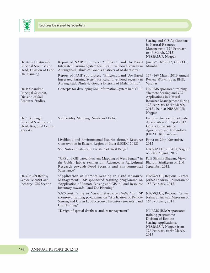
Lectures Delivered by Scientists
Annual Report 2012-13178
Report of NAIP sub-project “Efficient Land Use BasedIntegrated Farming System for Rural Livelihood Security inAurangabad, Dhule & Gondia Districts of Maharashtra”.
Report of NAIP sub-project “Efficient Land Use BasedIntegrated Farming System for Rural Livelihood Security inAurangabad, Dhule & Gondia Districts of Maharashtra”.
Concepts for developing Soil Information System in SOTER
Soil Fertility Mapping: Needs and Utility
Livelihood and Environmental Security through ResourceConservation in Eastern Region of India (LESRC-2012)
Soil Nutrient balance in the state of West Bengal
“GPS and GIS based Nutrient Mapping of West Bengal” inthe Golden Jubilee Seminar on “Advances in AgriculturalResearch towards Food Security and EnvironmentalSustenance”
‘Application of Remote Sensing in Land ResourceManagement’ TSP sponsored training programme on“Application of Remote Sensing and GIS in Land ResourceInventory towards Land Use Planning”
‘GPS and its use in Natural Resource studies’ in TSPsponsored training programme on “Application of RemoteSensing and GIS in Land Resource Inventory towards LandUse Planning”
“Design of spatial database and its management”
Dr. Arun ChaturvediPrincipal Scientist andHead, Division of LandUse Planning
Dr. P. ChandranPrincipal Scientist,Division of SoilResource Studies
Dr. S. K. Singh,Principal Scientist andHead, Regional Centre,Kolkata
Dr. G.P.Obi Reddy,Senior Scientist andIncharge, GIS Section
Sensing and GIS Applicationsin Natural ResourceManagement (12th Februaryto 4th March, 2013)NBSS&LUP, Nagpur
June 5th - 6th 2012, CIRCOT,Mumbai.
15th -16th March 2013 AnnualReview Workshop at BHU,Varanasi
NNRMS sponsored training“Remote Sensing and GISApplications in NaturalResource Management during12th February to 4th March,2013), held at NBSS&LUP,Nagpur
Fertilizer Association of Indiaduring 5th – 7th April 2012,Odisha University ofAgriculture and Technology(OUAT) Bhubaneswar
Patna on 24th November,2012
NBSS & LUP (ICAR), Nagpuron 24th August, 2012.
Palli Shiksha Bhavan, ViswaBharati, Sriniketan on 2ndSeptember 2012.
NBSS&LUP, Regional CenterJorhat at Aizwal, Mizoram on15th February, 2013.
NBSS&LUP, Regional CenterJorhat at Aizwal, Mizoram on16th February, 2013.
NNRMS (ISRO) sponsoredtraining programmeDivision of RemoteSensing Applications,NBSS&LUP, Nagpur from12th February to 4th March,2013

Appendix 4
Annual Report 2012-13 179
Shri Nirmal Kumar,Scientist, GIS Section
Shri Nirmal Kumar andObi Reddy, G.P
“Spatial Interpolation Techniques for Interactive Mapping”
‘Advances in spatial database management in GIS’
“Remote Sensing and GIS in assessment of spatio-temporalvariability of land use systems” in NAIP sponsored trainingprogram on “Forecast modeling in crops using weather andGeoinformatics”
“Geospatial applications in land resource management andland use systems analysis” in ICAR sponsored SummerSchool
‘Introduction to GIS’ in NNRMS (ISRO) sponsored trainingprogramme
‘Introduction to Microwave remote Sensing’ in NNRMS(ISRO) sponsored training programme
‘Remote sensing applications in land use land coverclassification’
‘Digital terrain analysis’
“An introduction to GIS and its applications in naturalresource management”
NNRMS sponsored trainingprogramme on “RS and GISapplications in NaturalResource Management” atRegional Centre, NBSS&LUP,Kolkata on 1st December,2012.
NNRMS sponsored trainingprogramme on “RS and GISapplications in NaturalResource Management” atRegional Centre, NBSS&LUP,Kolkata on 30th November2012.
IASRI, New Delhi on 30th
August, 2012.
IASRI, New Delhi on 26th
July, 2012.
Division of Remote SensingApplications, NBSS&LUP,Nagpur from 12th February to4th March, 2013
NNRMS (ISRO) sponsoredtraining programmeNBSS&LUP, Regional Center,New Delhi on 17th January,2013.
���

Personnel (Managerial Position)(as on 31.03.2013)
Annual Report 2012-13180
5Personnel (Managerial Position)
(as on 31.03.2013)
Appendix
DR. DIPAK SARKARDIRECTOR
Dr. Rajeev Srivastava : Division of Remote Sensing ApplicationsPrincipal Scientist (Pedology) and Head
Dr. T. Bhattacharyya : Division of Soil Resource StudiesPrincipal Scientist (Pedology) and Head
Dr. T.K. Sen : Division of Land Use PlanningPrincipal Scientist (Pedology) and In-charge Head upto 23.11.2012 (F/N)
Dr. A. ChaturvediPrincipal Scientist (Geography) and Head w.e.f. 23.11.2012 (A/N)
Dr. L.G.K. Naidu : Regional Centre, BangalorePrincipal Scientist (Pedology) and Head
Dr. G.S. Sidhu : Regional Centre, DelhiPrincipal Scientist (Pedology) and Head
Dr. Utpal Baruah : Regional Centre, JorhatPrincipal Scientist (Geography) and Head
Dr. S.K. Singh : Regional Centre, KolkataPrincipal Scientist (Pedology) and Head
Dr. R.S. Singh : Regional Centre, UdaipurPrincipal Scientist (Pedology) and Head
Dr. (Mrs) C. Mandal : Cartography UnitPrincipal Scientist (Geography) and In-charge
Dr. G.P. Obi Reddy : Geographical Information System Unit (GIS)Senior Scientist and In-charge
Dr. P. Chandran : Prioritization, Monitoring and Evaluation (PME) CellPrincipal Scientist (Pedology) and In-charge
Dr. (Mrs.) Jiji Cyriac : Library and Documentation UnitTechnical Officer (T-6) and In-charge
Dr. N.C. Khandare : Sale and Publication UnitTechnical Officer (T-9) and In-charge
Sh. S.K. Arora : Printing SectionPrinting Officer (T-9) and In-charge
Sh. Suresh Kumar : AdministrationChief Administrative Officer upto 01.08.2012
Sh. B.D. Phansal :Chief Administrative Officer from 02.08.2012
Sh. O.P. Nagar : Finance and AccountsSenior Finance and Accounts Officer upto 21.08.2012
Sh. G.C. Prasad :Senior Finance and Accounts Officer w.e.f. 21.08.2012 (F/N)
Mrs. Bhanu Narayanan : AdministrationAdministrative Officer

Appendix 6
Annual Report 2012-13 181
6Staff related general information
Appendix
Visits Abroad
Second Workshop under Indo-Brazilian
Cooperation in Bio-energy by Govt. of Brazil
Dr. Dipak Sarkar, Director participated in the SecondWorkshop under Indo-Brazilian Cooperation in Bio-energy as a member of Indian Delegation held during18-20 April 2012 at FEQ-UNICAMP auditorium, SaoPaulo, Brazil presented a paper entitled “Land UsePlanning/Modelling Possibilities for Sugarcane in India”.
International workshop at the Joint Research Centre
of the European Commission - JRC in Ispra (Varese),
Italy during March 18-22, 2013
Dr. T. Bhattacharyya, Principal Scientist and Head,Division of Soil Resource Studies participated inInternational workshop at the Joint Research Centre ofthe European Commission - JRC in Ispra (Varese), Italy
New entrants /Promotions
• Dr. Lalitha, Scientist joined Regional centre,Bangalore on 14th May 2012 after her training atNARM, Hyderabad
• Dr. Shelton Padua, Scientist joined in the RegionalCentre on 1st June 2012.
• Sh. Sumit Sindhu, Assistant joined on 14th
September 2012 at Regional Centre Delhi.
• Ms. Bedantika Dutta joined as Assistant on 6th
October 2012 in NBSS & LUP, Regional Centre,Kolkata .
• Miss Nisha Sahu, Scientist joined at GIS Section,NBSS&LUP, Nagpur on 9th November, 2012.
• Dr. S. Ramachandran, Scientist joined in theRegional Centre on 10th December 2012.
• Dr. Tarsem Lal promoted to Principal Scientist witheffect from 27th July1998.
• Sh. K.M. Pal, promoted to the next higher grade,Technical Officer (T-7-8) with effect from 1st
January 2010.
• Sh. K.K. Bhardwaj, promoted to the next gradeTechnical Officer (T-5) with effect from 3rd
February 2012.
• Sh. D.B. Thombre, Skilled Supporting Staffpromoted to the next financial upgradation Rs.2400/- (MACPS) with effect from 7th April 2012.
• Sh D.B. Thombre, Skilled Supporting Stafftransferred from Regional Centre Delhi toNBSS&LUP, Nagpur with effect from 8th February2013
• Dr. S.K. Reza promoted to Scientist (Senior Scale)on 12th June 2012.
• Sh. Vas Dev promoted to the next grade, Field Asstt(T-1-3) with effect from 19th August 2012.
• Mr. M. Das promoted to PA on 06th December2012.
• Mr. B.V. Gogoi promoted to AAO on 09th
November 2012.

Staff related general information
Annual Report 2012-13182
• Mr. P. K. Das promoted to Assistant on 26th March2013
• Mr. D.P. Dutta promoted to T-6 w.e.f. 31st March2013.
• Dr. T.P. Verma Scientist (Sr. Scale) promoted to Sr.Scientist w.e.f. 6th August 2003
• Dr. S.S. Rao Sr. Scientist promoted to PrincipalScientist w.e.f. 1st January 2009.
• Sh. Devi Lal Oad, T-3 promoted to T-4 w.e.f. 13th
June 2011.
• Sh. Naola Ram Ola, T-4 promoted to T-5 w.e.f.14th June 2011
Transfers
• Dr. R.P. Sharma, Scientist joined Regional Centre,Udaipur on 9th April 2012 on transfer from IndianInstitute of Vegetables Research (IIVR), Varanasi.
• Mr. Bheem Raj Meena Driver (T-I-3) transferredfrom Regional Centre, Udaipur to Regional Centre,Bangalore on 1st June 2012.
• Mr. Sohan Lal Sharma, Field Asstt. (T-1) joinedon 20th June 2012 on transfer from RegionalCentre, Kolkata to Regional Centre, Udaipur.
• Smt. Girija Rangari, AAO was transferred fromRegional Centre NBSS&LUP, Udaipur to HQ,NBSS&LUP, Nagpur on 18th August 2012.
• Mr. Jitendra Singh Rao, T-1 joined on5th September 2012 on transfer from RegionalCentre, NBSS&LUP, Jorhat to Regional Centre,Udaipur.
• Mrs. Malathi Bommidi, Scientist, GIS Section,NBSS&LUP, Nagpur got transferred to ZPD-V,Hyderabad on 6th December, 2012.
Staff Retirement on Superannuation
• Sh. Amarjit Singh, Technical Officer (T-5) retiredon superannuation on 30th April 2012 fromRegional Centre Delhi.
• Sh. Binoy Kumar Saha, Personal Assistant, Sh. B.N.Bag, Driver (T-5) retired on superannuation.
• Sh. Mrinal Naskar, SSS retired on superannuation
Deceased
• Sh. Ramaji Giri, Driver (T-2) expired on29/07/2012 at Regional Centre Delhi
���

Appendix 7
Annual Report 2012-13 183
7
RFD – Related InformationAnnual (April 1, 2012 to March 31, 2013)
Performance Evaluation Report in respect of RFD
2012-2013 of RSCs i.e. Institutes
Appendix
Name of the Division : Natural Resource Management Division
Name of the Institution : National Bureau of Soil Survey and Land Use Planning (ICAR), Nagpur
RFD Nodal Officer : Dr. T. K. Sen, Principal Scientist
Sr. Objective(s) Wei Action(s) Success Target / Criteria Value Achie- Performance Per cent Reasons for
No. ght Indicator(s) Unit Wei Exce- Very Good Fair Poor vem- Raw Weig- achieve- shortfalls or
ght llent Good 80% 70% 60% ents Score hted ments excessive
100% 90% Score against achievements,
Target if applicable
values of
90% Col.
1. Soil resource 25 Soil survey Soil resource No. 25 5 4 3 2 1 5 100 25 125.0 -
inventorisa- and mapping maps at different
tion at levels developed
different
scales
2. Optimization 20 Land use District level No. 20 2 1 - - - 2 100 20 200.0 -
of land use planning land use plans
developed
3. Human 13 Capacity Trainings/ No. 8 4 3 2 1 - 4 100 8 133.3 -
resource building workshops
development conducted
Students 5 4 3 2 1 - 4 100 5 133.3 -
awarded degree
(in a collabora-
tive programme
with Dr. PDKV,
Akola)
4. Identification 12 Soil Benchmark soil No. 12 10 9 8 7 6 9 90 10.8 100.0 The final meeting
and estab- correlation series Identified of the correlation
lishment of and established committee for
Benchmarks identification and
soil series establishment
of the remaining
1 soil seriescould
not be held.
cont....

RFD – Related Information
Annual Report 2012-13184
5. Assessing soil 10 Soil nutrient Soil nutrient No. 10 15 14 12 11 9 15 100 10 107.1 -
fertility mapping maps at different
levels developed
6. Organisation, 8 Georeferen- Georeferenced No. 4 417 375 333 292 250 417 100 4 111.2 -
cataloguing cing of soil soil observation
and creation observation sites (points)
of datasets on sites (points) of Black Soil
soils in GIS Region
environment
Georeferenced No. 4 425 382 340 298 255 425 100 4 111.2 -
soil observation
sites (points) of
Indo-Gangetic
plain
7. Efficient 3% Timely On-time Date 2% Mar. Mar. Mar. - - Feb. 100 2 100.0 -
Functioning submission submission 23 26 27 03,
of the RFD of RFD for 2012 2012 2012 2012
System 2012-13
Timely On-time Date 1% May May May - - April 100 1 100.0 -
submission submission 1 2 3 20,
of Results for 2013 2013 2013 2012
2012-13
8. Administra- 5% Implement Prepare ISO 9001 Date 1% May May May - - May 100 1 100.0 -
tive Reforms ISO 9001 action plan 1 2 3 30,
2013 2013 2013 2012
Implementation Date 2% Mar. Mar. Mar. - - - - - - ISO 9001 could
of ISO 9001 25 26 27 not be
action plan 2013 2013 2013 implemented
due to delayed
initiation in
processing and
subsequent
delay in receiving
quotations from
bidders on exp-
ression of interest.
Implement % of % 2% 100 95 90 - - 109 100 2 114.7 -
mitigating implementation
strategies for
reducing
potential risk
of corruption
9. Improving 4% Implemen- Independent % 2% 100 95 90 - - 100 100 2 105.3 The excess
Internal tation of Audit of achievement
Efficiency / Sevottam Implementation was due to more
responsive- of Citizen’s frequent
ness / service Charter implementation
delivery of of some of the
Ministry / mitigating
Department strategy.
Independent % 2% 100 95 90 - - 100 100 2 105.3 -
Audit of imple-
mentation of
public grievance
redressal system
Total Composite Score: 96.8
Procedure for computing the Weighted and Composite Score
1. Weighted Score of a Success Indicator = Weight of the corresponding Success Indicator x Raw Score / 100
2. Total Composite Score = Sum of Weighted Scores of all the Success Indicators

•
•
•
•
•
•
•
•
•
•
•
•
•
•
•
•
•
•
•
•
•
•
•
•
•
•
•
•
•
•
•
•
•
•
•
•
•
•
•
•
•
•
•
•
•
•
+ Soil Series of Chhatisgarh State, NBSS Publ.85, 2001.
+ Soil Resource Atlas of Betul District (M.P.), NBSS Publ.86, 2001.
+ Soil Based Agro-Technology Transfer in Sukli (Distt. Nagpur), NBSS Publ.87, 2001.
+ Soils of Hugli District for Optimising Land Use, NBSS Publ.88, 2001.
+ Soil Series of West Bengal, NBSS Publ.89, 2001.
+ Soil Resource Atlas of Dhar Dist. (M.P.), NBSS Publ.90, 2001, 100p, ISBN:81-85460-68X.
# Soil Series of Himachal Pradesh, NBSS Publ.91, ISBN: 81-85460-69-8.
+ Soil Series of Goa, NBSS Publ.92, ISBN:81-85460-70-1.
+ Soil Resource Atlas of Ratlam Distt. (M.P.), NBSS Publ.93.
+ Soils of India, ( 1:1 M Scale, 11 Sheets Maps) NBSS Publ.94, ISBN:81-85460-72-8.
+ Soil Resource Atlas of Bilaspur Distt. (Chhattisgarh), NBSS Publ.95. ISBN:81-85460-73-6.
+ Soil Series of Rajasthan, NBSS Publ.96. ISBN:81-85460-75-2.
+ Soil Erosion of Tripura: A model for soil conservation and crop performance, NBSS Publ.97. ISBN:81-85460-76-0.
+ Soil Series of Bihar, NBSS Publ.98. ISBN:81-85460-77-9.
+ Soils of Ajmer district for optimising land use. NBSS Publ.99. ISBN:81-85460-78-7.
+ Soil Resource Atlas of Chhindwara Distt. (M.P.), NBSS Publ.100. ISBN:81-85460-79-5.
+ Soil Series of Assam. NBSS Publ.101.
+ Soil Erosion of Rajasthan. NBSS Publ.102. ISBN:81-85460-80-9
+ Soil Erosion of Chhattisgarh. NBSS Publ.103. ISBN:81-85460-81-7
+ Soil Resource Atlas of Jadgalpur (Baster) Distt. (Chhattisgarh). NBSS Publ.104. ISBN:81-85460-82-5
+ Soil Series of Sikkim. NBSS Publ.105.ISBN:81-85460-83-3
+ Soil Erosion: Madhya Pradesh. NBSS Publ.106.ISBN:81-85460-84-1
+ Soil Resource atlas of Jorhat Distt. (Assam). NBSS Publ.107. ISBN:81-85460-85-x
+ Salt affected soils, Etah Distt. (UP). NBSS Publ.108.ISBN:81-85460-86-8
+ Soil series of Nagaland. NBSS Publ.109.ISBN:81-85460-87-6
# Soil Resource Information & land use planning of Chhattisgarh. NBSS Publ. 110. ISBN:81-85460-88-4
+ Soil Series of Tripura. NBBS Publ. 111.ISBN:81-85460-89-2
+ Soil Series of Delhi. NBSS Publ. 112.ISBN:81-85460-91-4
+ Land use planning of Udaipur distt. Soil resource & agro-ecological assessment. NBSS Publ. 113. ISBN:81-85460-92-2
+ Soil Erosion in Andhra Pradesh. NBSS Publ. 114.ISBN:81-85460-93-0
# Economic land evaluation for sustainable land management of Rajanukunte watershed, Karnataka. NBSS Publ. 115. ISBN:81-85460-94-9
+ Soil resource atlas of Wardha distt. Maharashtra. NBSS Publ. 116. ISBN:81-85460-95-7
+ Soil Erosion of West Bengal. NBSS Publ. 117.ISBN:81-85460-96-5
+ Soil Erosion of Assam. NBSS Publ. 118.ISBN:81-85460-97-3
+ Soil Series of Orrisa. NBSS Publ. 119.ISBN:81-85460-98-1
+ Soil Series of Gujarat. NBSS Publ. 120.ISBN:81-85460-99-X
+ Soil Series of Meghalaya. NBSS Publ. 121.ISBN:81-89043-00-5
+ Soil Resources of Jalna District (Maharashtra) for optimising land use. NBSS Publ. 122. ISBN:81-89043-01-3
# Soil Resource for land use planning, Meerut district (U.P.) NBSS Publ. 123. ISBN:81-89043-02-1
+ Soil Reource for land use planning, Etah district (U.P.) NBSS Publ. 124. ISBN:81-89043-03-X
+ Soil Erosion of Bihar, NBSS Publ. 125. ISBN:81-89043-04-8.
+ Soil Erosion of Orissa, NBSS Publ. 126. ISBN:81-89043-05-6.
+ Soil Series of Medak district, Andhra Pradesh, NBSS Publ. 127. ISBN:81-89043-06-4.
+ Benchmark soils of Andhra Pradesh, NBSS Publ. 128. ISBN:81-89043-07-2.
+ Manual soil-site suitability criteria for major crops. NBSS Publ. 129.ISBN:81-89043-08-0.
+ Optimising land use of Birbhum district (West Bengal) soil resource assessment. NBSS Publ. 130. ISBN:81-89043-09-9.
•
•
•
•
•
•
•
•
•
•
•
•
•
•
•
+ Land use planning of Cherrapunji, Meghalaya : Soil resource and agro-ecological assessment. NBSS Publ. 131.ISBN:81-89043-10-2.
+ Soil erosion in Himchal Pradesh. NBSS Publ. 132.ISBN:81-89043-11-0.
+ Technolgy assessment and refinement : Institute-village linkage prog. (success story). NBSS Publ. 133. ISBN:81-89043-12-9.
+ Soil series of Manipur. NBSS Publ. 134.ISBN:81-89043-13-7.
+ Soils of Bhilwara district for land use planning. NBSS Publ. 135.ISBN:81-89043-14-5.
+ Soil series of Kerala. NBSS Publ. 136. ISBN:81-89043-15-3.
# Assessment of Soil loss for prioritisation fo watersheds: A remote sensing & GIS approach. NBSS Publ. 137. ISBN: 81-89043-16-1.
+ Soil erosion of Manipur. NBSS Publ. 138. ISBN:81-89043-17-X.
+ Mineralogy of Bench Mark Soils of West Bengal. NBSS Publ. 139.ISBN:81-89043-18-8.
# Agroecological zones of Kerala. NBSS Publ. 140. ISBN:81-89043-19-6.
# Agroecological units, Palakkad Dist. NBSS Publ. 141. ISBN:81-89043-20-9.
+ Perspective land use plan 2015 & 2025 for the Union Territory of Pudducherry. NBSS Publ. 142 ISBN: 978-81-89043-21-6 ISBN:81-89043-20-9.
+ Soil taxonomic database of India and the states (1:250,000 scale) NBSS Publ. 143, ISBN: 978-81-89043-22-3
+ Soil Based Agrotecnologies for Livelihood Improvement NBSS Publ. 144, ISBN: 978-81-89043-23-0.
+Soil erosion in Haryana. NBSS Publ.149. ISBN:978-81-89043-28-5.
+Compendium on Human Resource Development in Remote Sensing and GIS applications in Natural Resource Management. NBSS Publ.150.
+Soil erosion in Punjab. NBSS Publ.151. ISBN:978-81-89043-29-2.
+Remote Sensing and GIS in Digital Terrain Analysis and Soil-Landscape Modelling. NBSS Publ.152.
+Training Manual on GIS and Digital Image Processing. NBSS Publ.153.
+Soils of Puruliya Distt. West Bengal for Optimizing Land Use. NBSS Publ.599(SSR)
#Land Resources of Medak Distt. Andhra Pradesh for Land Use Planning. NBSS Publ.791(SSR)
+Soil Resource for Land Use Planning, Balaghat Distt. (M.P.). NBSS Publ.827(SSR)
+Management of Acid Soils in NEH Region. NBSS Publ.909(SSR)
+ Murthy, R.S., Hirekerur, L.R., Deshpande, S.B. and Venkata Rao, B.V. eds. Benchmark Soils of India: Morphology, Characteristics, and Classification for Resource Management, 1982, 374p.
* Soil Survey Staff, USDA. Soil Taxonomy, Indian Reprint, 1978.
+ Sehgal, J., Blum, W.E. and Gajbhiye, K.S. Red and Lateritic Soils, 1998. Vol.1, 453p., Vol.11, Oxford & IBH, New Delhi, 113p
Sehgal, J., Gajbhiye, K.S., Batta, R.K. and Sarma, V.A.K., Eds. Swell-Shrink Soils (Vertisols) of India: Resource Appraisal and Management. Kalyani Publishers, New Delhi, 1999, 202p.
(For order, contact: M/s Kalyani Publishers, 1/1 Rajinder Nagar, Ludhiana-141 008.
(#) In Press; (*) Out of stock (+) Available
($) For copies, contact: M/s Oxford & IBH Publ.Co.,
66, Janpath, New Delhi-110 001, India.
+ Soil Survey Manual NBSS&LUP Publ. No.146, ISBN: 978-81-89043-25-4.
Land Resource Atlas Vidardha Region Maharastra NBSS&LUP Publ. No.147, ISBN: 978-81-89043-26-1
Agro-Ecological Regions of U.P. NBSS&LUP Publ. No.148, ISBN: 978-81-89043-27-8
•
•
•
•
•
•
•
•
•
•
•
BOOKS
•
•
•
•
Note:
For procuring the Bureau’s publications please contact:
The Director, NBSS&LUP, Amravati Road, Nagpur-440 033, India
E-mail: [email protected]

Published by Dr. Dipak Sarkar, Director, NBSS&LUP, Nagpur-440 033 and Printed by Sh. S.K. Arora, In-charge Printing, NBSS&LUP, New Delhi
at National Printers, New Delhi-110 028
NBSS&LUP PUBLICATIONSSOIL RESOURCE MAPS
•
•Soil Resource Maps of:
RESEARCH BULLETINS
•
•
•
•
•
•
•
•
•
•
•
•
•
•
•
•
*Soil Map of India, scale 1:7 million, 1985.
– +West Bengal, Bull.27 (Bull. in Bengali Version)
– +Pondicherry & Karaikal, Bull.28
– +Gujarat, Bull.29
– +Haryana, Bull.44
– +Punjab, Bull.45
– +Tamil Nadu, Bull.46
– +Karnataka, Bull.47
– +Kerala, Bull.48
– +Orissa, Bull.49
– +Bihar, Bull.50
– +Rajasthan, Bull.51
– +Meghalaya, Bull.52
– +Maharashtra, Bull.54 (Bull. in Marathi Version)
– +Arunachal Pradesh, Bull.55
– +Manipur, Bull.56
– +Himachal Pradesh, Bull.57
– +Madhya Pradesh, Bull.59(Bull.in Hindi Version)
– +Sikkim, Bull.60
– #Andaman & Nicobar Islands, Bull.61
– +Jammu & Kashmir, Bull.62
– +Tripura, Bull.65
– +Assam, Bull.66
– +Nagaland, Bull.67
– +Uttar Pradesh, Bull.68
– +Andhra Pradesh, Bull.69
– +Lakshadweep, Bull.70
– +Delhi, Bull. 72
– +Goa, Bull. 74
– +Mizoram, Bull.75
* Glossary of Geomorphological Terms, Bull. No.1, 1980.
* Soils of North Eastern Region, Bull.No.2, 1981.
* Land Use Plan for Development of Bundelkhand Region based on Land and Soil Resources Survey, Bull.No.3, 1981.
* Soils and Suggested Land Use of Maharashtra, Bull.No.4, 1980.
* Soil–Physiographic Relationship in India, Bull. No. 5, 1982.
* Soil–based Agrotechnology Transfer under Lab–to–Land Programme, Bull.No.6, 1982.
* Bioclimatic Analysis of India, Bull.No.7, 1982.
* Soil Survey of ICRISAT Farm and Type Area around Patancheru, Andhra Pradesh, Bull.No.8 (rev.ed.) 1993.
* Geomorphology, Soils and Land Use of Haryana, Bull.No. 9, 1983.
+ Memorandum of Soil Correlation, Bull.No.10, 1984.
* The Soils of Mondha Village (Nagpur) for Agrotechnology Transfer, Bull.No.11, 1986.
+ The Soils of Hassan District (Karnataka) for Land Use Planning, Bull.No.12, 1987.
* Field Manual, Rev. ed. Bull.No.13, 1989.
* Laboratory Methods, Bull.No.14, 1987.
* Benchmark Soils of India: Mondha Series, Bull.No.15, 1987.
* Benchmark Soils of India: Pali Series, Bull.No.16, 1987.
•
•
•
•
•
•
•
•
•
•
•
•
•
•
•
•
•
•
•
•
•
•
•
•
•
•
•
•
•
•
•
•
•
•
•
•
•
•
•
•
•
+ Agroclimatic Environments and Moisture Regimes in North–West India – their application in soils and crop growth, Bull.No.17, 1987.
+ NBSS&LUP Publications: 1976–1988, Bull.No.18, 1988.
+ NBSS&LUP Publications: 1988–1999, Bull.No.18 (Supplement), 2000.
* Benchmark Swell–Shrink Soils of India–their Morphology, Characteristics and Classification, Bull.No.19, 1988.
* The Soils of Kolar District (Karnataka) for Land Use Planning, Bull.No.20, 1988.
+ Agro–ecological Zones of India – 5th Approx. (scale 1:6000,000), NBSS Publ.21, 1989.
* Land Resource Atlas of Nagpur District, Bull.No.22, 1994.
+ Soil Resource Mapping of Different States of India – Why and How?, Bull.No.23, Reprint, 1994.
* Agro–ecological Regions of India, 2nd ed. Bull.No.24, 1992.
* Proceedings, 3rd National Workshop on Soil Resource Mapping of Different States of India, Bull.No.25, 1990.
+ The Soils of Anantnag and Part of Pulwama Districts (Jammu & Kashmir) for Land Use Planning, Bull.No.26, 1991.
* The Suitability of Vertisols and Associated Soils for Improved Cropping Systems in Central India, Bull.No.30, 1991.
+ Soils of Punjab, Bull.No.31, 1992.
* Soil Resource Mapping of Different States for Sustainable Agricultural Production: Proceedings, 4th National Meet, Nov.1–2, 1991, Bull. No.32, 1991.
+ The Soils of Bankura District (West Bengal) for Land Use Planning, Bull.No.33, 1992.
+ Micromorphology of Soils of India. Bull.No.34, 1992.
+ Agro–Ecological Subregions of India, Bull.No.35.
+ Soil Series – Criteria and Norms, Bull.No.36, 1992.
* Red and Lateritic Soils of India: Resource appraisal and Management, Bull. No. 37, 1993.
$ Soil Degradation in India: Status and impact, Bull.No.38, 1994.
+ Growing Period for Crop Planning, Bull.No.39, 1993.
* Soil Series of India, Bull.No.40, 1994.
* Soil Temperature Regimes in India, Bull.No.41, 1994.
* Land Evaluation for Land Use Planning (Papers of Indo-UK Workshop), Bull.No.42, 1993.
* Soil Moisture Regimes of India, Bull. No.43, 1994.
+ Soil Climatic Database for Crop Planning in India, Bull.No.53, 1999.
+ Soil Climatic Environments in India, Bull.No.58, 1995.
+ Soil Based Land Use Planning Series: Udaipur dist. Rajasthan, Bull.No.63, 1995.
+ Soil Monoliths: Their Collection, Preparation and Display. Bull.No.64, 1995.
+ Soil Resources of Goa for Perspective Land Use Planning, NBSS Publ. 71, 1997.
+ Land Resource Management: A Decade of Post-Graduate Research, NBSS Publ.73, 1998.
+ Soils of Madhubani district for optimising land use, NBSS Publ. 76, 1999.
+ Soil Resource Atlas of Bhopal District (M.P.), NBSS Publ.77, 1999.
+ Soil Series of Madhya Pradesh, NBSS Publ.78, 1999.
+ Soil Series of Maharashtra, NBSS Publ.79, 1999.
+ Soil Resource Atlas- Guna District (M.P.), NBSS Publ.80, 2000.
+ Agro-ecological Assessment of Soil Resources of Rajasthan for Land Use Planning, NBSS Publ.81, 2000.
+ Soil Erosion in Maharashtra, NBSS Publ.82, 2000.
+ Significance of Minerals in Soil Environment of India, NBSS Review Series-1, 2000.
+ Climate Change and Polygenesis in Vertisols of the Purna Valley (Maha.) and Their Management, NBSS Publ.83, 2000.
+ A Decade of GIS Aided Research – Highlights, NBSS Publ.84, 2001.