ICA News Nouvelles de I'ACI - International Cartographic ...
20
ICA News Nouvelles de I’ACI Number 43, December 2004 Numéro 43, Dècembre 2004 http://www.icaci.org International Cartographic Association Association Cartographique Internationale
-
Upload
khangminh22 -
Category
Documents
-
view
2 -
download
0
Transcript of ICA News Nouvelles de I'ACI - International Cartographic ...

ICA NewsNouvelles de I’ACI
Number 43, December 2004 Numéro 43, Dècembre 2004 http://www.icaci.org
The following organizations support theInternational Cartographic Association:
Intergraph:www.intergraph.com ESKO Graphics:www.star.be
International Cartographic Association Association Cartographique Internationale
Navigation Technologies Corporation:www.navtech.com ESRI:www.esri.com

ICA NEWS December 2004
ICA Executive Committee
ICA NEWS December 2004
ICA Executive CommitteeMilan Konecny
President
Institute of Geography
Masaryk University
Kotlarska 2, 61137 Brno,
Czech Republic
Telephone: #42 5 42 128 316 or 276
E-mail: [email protected]
Vladimir S.Tikunov
Vice-president
Vorontsovskie Prudi 7-168
Moscow 117630
Russian Federation
Telephone #7-095-9391339
David Fairbairn
Vice-president
School of Civil Engineering and Geosciences,
University of Newcastle upon Tyne,
Newcastle upon Tyne NE1 7RU,
United Kingdom
Tel: #44 191 222 6353
E-mail: [email protected]
Haggai Nyapola
Vice-president
Survey of Kenya
P.O. Box 30046
00100 NAIROBI,
Kenya
Telephone: #254-020-2717553
E-mail: [email protected]
William Cartwright
Vice-president
Department of Geospatial Science
RMIT University
GPO Box 2476V
Melbourne, Victoria 3001
Australia
Telephone: #61 3 9925 2423
E-mail: [email protected]
Ramon Lorenzo Martinez
Vice-president
Centro Nacional de Informacion Geografica
General Ibanez de Ibero 3
28003 MADRID,
SPAIN
E-mail: [email protected];
Kirsi Virrantaus
Vice-president
Institute of Cartography and Geoinformatics
Department of Surveying
Helsinki University of Technology
P.O.Box 1200, FIN-21050 HUT
Finland
Telephone #358 500 463729
Robert B. McMaster
Vice-president
College of Liberal Arts
215 Johnson Hall,
University of Minnesota
Minneapolis, MN 55455,
United States of America
Telephone #1.612.624.2535
Email: [email protected]
Ferjan Ormeling
Secretary-General and Treasurer
Faculty of Geosciences,
Utrecht University
P.O.Box 80115,
3508 TC Utrecht
The Netherlands
Telephone: #31 30 2531373
E-mail: [email protected]
Bengt Rystedt
Past-President
National Land Survey
SE-80182 Gävle, Sweden
Telephone #46 26 63 34 29
E-mail [email protected]
University of Gävle,
SE-80176 Gävle, Sweden
Telephone #46 26 64 88 44
E-mail [email protected]
Graciela Metternicht
Editor ICA News
Department of Spatial Science,
Curtin University of Technology,
GPO Box U 1987,
Perth 6845, Western Australia
Australia
Telephone: #61 8 9266 3935
E-mail: [email protected]
ftp: cage.curtin.edu.au,
directory: graciela/ICA/incoming
"The children and flowers will make a better world", entry to theBarbara Barbara Petchenik Children’s Map Competition of the 21stICC, Durban, South Africa, 2003. Author: Leny VladimirovaMircheva, age 11, Bulgaria
39173-11-04
The following
Organizations support the
International Cartographic
Association:
Centro Argentino de Cartografia
ph +54 1 576 5545
fax +54 1 502 6799
Av. Cabildo 381
1426 BUENOS AIRES
ARGENTINE
Institut Cartografic de Catalunya
ph +34 93 425 29 00
fx +34 93 426 74 42
Parc de Montjuic
E - 08038 BARCELONA
SPAIN
United States Geological Survey
ph +1 703 648 4639
fax +1 703 648 5542
National Mapping Division
519 National Center
PRESTON Virginia 22092
USA
Institut Géographique National
ph +33 1 43 98 82 95
fx +33 1 43 98 84 00
136 bis rue de Grenelle
75700 PARIS 07 SP
FRANCE
National Hydrographic Office
P.O. Box 75
DEHRA DUN - 248001
INDIA
Geographical Survey Institute
ph +81 298 64 1111
fax +81 298 64 1804
Kitasato 1
Tsukuba-shi
IBARAKI-KEN 305
JAPAN
International Institute for
Geo-Information Science and Earth
Observation (ITC)
ph +31 53 487 44 44
fax +31 53 487 44 00
Hengelosestraat 99
P.O. Box 6
7500 AA ENSCHEDE
THE NETHERLANDS
Moscow State University for
Geodesy and Cartography
ph +7 095 261 3152
fax +7 095 267 4681
4 Gorokhovsky by-street
MOSCOW 103064
RUSSIAN FEDERATION
The Union of chambers of Turkish
Engineers and Architects, Chamber
of Survey and Cadastre Engineers
(UCTEA-CSCE)
Summer Sok. No 12/10
06440
Yenisehir – Ankara
TURKEY
Indian National Cartographic
Association
C. G. O. Complex, DF - Block, 7th Floor
Salt Lake, Kolkata - 700064
West Bengal, INDIA
http://www.incaindia.org/membership.htm
The International Cartographic
Association welcomes new affiliate
members.
For further information contact:
The ICA Secretary General:
Ferjan Ormeling,
Faculty of Geographical Sciences,
Utrecht University,
P.O.Box 80115,
3508 TC Utrecht,
The Netherlands.
Email: [email protected]

Dispatches
Disp
atch
es
ICA NEWS December 2004 1
Editorial
Members of the ICA Executive Committee andCommission Chairs have successfullyaccomplished several initiatives over the last six
months. The ICA has now a continuing presence within theaudience of the GIM International Journal (a magazine ofwidespread circulation amongst professionals of the spatialsciences). About six columns have already been publishedby members of the ICA. Likewise, Ferjan Ormeling reportson innovations that are taking place within the EC, as sixportfolios have now been identified, namely Society,Professional Development, Cartography Science,Education, Workshops and GISciences. Each Vice-President is now responsible for a portfolio.
A reminder to all National ICA representatives that thedeadline for the submission of materials for the Children’sMap Competition is on the 1st June 2005. Guidelines forthe competition were announced in the previous issue of theICA Newsletter (June 2004). Likewise, the deadline for theICA Travel Awards is 15th December 2004, and forms canbe downloaded from the ICC 2005 website(www.icc2005.org). This issue provides guidelines for theInternational Map Exhibition, and Ramón Lorenzo, Chairof the LOC reports on the hand over of the ICA Flag to theMayor of A Coruña.
This newsletter contains reports of activities undertakenor planned for the near future by the Commissions onGender and Cartography, Theoretical Cartography,Education, Visualisation and Virtual Environments,Mountain Cartography, Planetary Cartography,Generalisation and Multiple representations, Maps andInternet. Our regular section ‘Special Features’ reports onthe creation of a National Historical GeographicInformation System (NHGIS) in the USA, and theCooperative Research Centre for Spatial Information,established in Australia in 2003.
On a happy note, I am pleased to announce the grantingof the British Cartography Society Medal to our colleague,Dr Christopher Board (former Editor of the ICANewsletter). Sadly, I also report the passing of ProfessorArthur Robinson, well known to the cartographiccommunity for such works as the ‘Elements ofCartography’ textbook widely used in many undergraduateCartography programmes. Arthur’s son has prepared anobituary that reflects on the multiple contributions his fathermade to the discipline of Cartography.
The Festive Season is approaching once again. I hopethat we can all find a quiet time to reflect and celebrate onall the positive achievements of this year, as well as what‘could have been done better’, so that we have the energyand strength for a very successful year 2005 in all aspectsof life.
As usual, I look forward to your continuing support in2005, to make this newsletter a proud representation of ourAssociation.
Happy beginning to 2005
Graciela MetternichtEditor
ObituariesArthur H. Robinson
Arthur H. Robinson, of 7707 N. Brookline Dr Apt 302,
Madison, Wisconsin, died at Meriter Hospital in Madison
on October 10, 2004 after a brief illness. Arthur Robinson
was born in Montréal, Canada on January 5, 1915, the son
of James Howard Robinson and Elizabeth (Peavey)
Robinson. His early education was in the United States and
in England, after which he took the Bachelor of Arts degree at Miami University,
Oxford, Ohio, in 1936, the M.A. at the University of Wisconsin, Madison,
Wisconsin in 1938 and the Ph.D. at Ohio State University in 1947.
From mid-1941 until 1946 he worked in Washington, DC with the Office of
Strategic Services (OSS), the forerunner of the CIA, and for almost all of that time
he was Chief of the Map Division of the OSS. In that position he supervised
numerous types of cartographic work, including the preparation of nearly 5,000
maps, in support of the global war effort. During the war he was commissioned in
the Army with the initial rank of captain, and was later promoted to major. For his
distinguished service in the OSS he received the Legion of Merit.
In 1945 the University of Wisconsin at Madison offered Robinson a faculty
position in the Department of Geography, and he began teaching there in 1946. He
rose rapidly in the ranks of the faculty, becoming Professor of Geography and, in
1967, Lawrence Martin Professor of Cartography. He retired in 1980 with the rank
of Professor Emeritus.
During his long career he produced fifteen books and monographs, one of
which, Elements of Cartography, went through six editions and became the pre-
eminent textbook in cartography. However, the contribution for which he is
probably best known to the public was the creation of the Robinson Projection, a
map projection that he referred to as "a portrait of the earth." In 1988 the National
Geographic Society adopted that projection as its standard for producing world
maps. The Robinson projection was adopted by agencies of the U.S. Government
and many other users.
Robinson’s work was internationally recognized, and among his many honors
were two honorary degrees (from Miami University (Ohio) and from Ohio State
University), the Distinguished Service Award and the Helen Culver Gold Medal
from the Geographic Society of Chicago, the Carl Mannerfelt Medal of the
International Cartographic Association, the Silver Medal of the British
Cartographic Society, and the John Oliver LaGorce Medal of the National
Geographic Society. He served as president of the International Cartographic
Association, and as vice president and president of the Association of American
Geographers.
Robinson’s marriage of more than 50 years to the former Mary Elizabeth
Coffin ended in 1992 with her death. He later remarried, and is survived by his
wife Martha E. Robinson of Madison, son Stephen M. Robinson (Chong-Suk
Robinson) of Madison, daughter Patricia A. Robinson (Leslie Kramer) of Sonoita,
Arizona, stepdaughter Carita Baker (Ron Baker) of Hamilton, Ohio, stepson Carl
James Phillips (Sandie Phillips) of Hamilton, Ohio, stepdaughter Clarissa Lowry
(Miles Lowry) of Wheaton, IL, granddaughter Diana M. Oestreich (Nathan
Oestreich) of Menlo Park, California, grandson James A. Robinson of Palo Alto,
California, and families of the above.
Stephen M. Robinson

Dispatches
ICA NEWS December 20042
Disp
atch
es
The British Cartographic SocietyMedal
The British Cartographic Society is pleased to announce that Dr.Christopher Board was presented with the Society Medal at an AwardCeremony on 11 September 2004 during the 41st Annual BCSSymposium held at the University of Durham. The Citation reads:
"Chris Board has selflessly served the geographic and cartographiccommunities for over four decades. As a tireless leader at national andinternational levels, his academic, organisational and unique personalabilities have combined to help transform ideas in cartographic thinkingand to focus the many diverse cartographic groupings in the UKtowards important global goals.
Following university education and research in England and SouthAfrica, his academic career became centred at the London School ofEconomics where he was an enthusiastic teacher and innovative thinker.Through seminal research papers he helped pioneer the new concepts ofcartographic communication, focus attention on the importance ofgeographical education for effective map use, and led national andinternational research into the history of cartography. Not satisfied withthis full professional life, he expanded his activities as an inspirationaland active organiser within mapping communities. Membership of theinfluential Royal Society sub-Committee for Cartography (from 1972)led to its chairmanship (from 1984) and of its successor, the BritishCartographic Society (BCS) UK Cartography Committee, until 2004.He was a founding member of the Charles Close Society for the Studyof Ordnance Survey Maps, and has been its Chair since 1996. He wasPresident of the UK Society of Cartographers (1985-90), and, after yearsof dedicated Council membership, was elected vice-President andPresident of the British Cartographic Society (1990-94).
From 1964 he became increasingly involved, with leading roles inmany aspects of the International Cartographic Association (ICA) andas holder of the prestigious post of UK national delegate (reporting tothe Royal Society) he has led and represented British cartographers toICA and related international events for over 20 years. The immenserespect he earned from the communities he served led to recognitionssuch as Honorary Fellowships of the Royal Geographical Society(1998) and the ICA (1999). For his many outstanding contributions (astrustworthy background worker, perceptive and influential committeeleader, experienced editor, policy-maker, and simply as someone who‘got things done’!) he is both liked and greatly admired by friends andprofessional peers in Cartography throughout the world.
His influence on the British Cartographic Society and on individualcartographers in the UK and abroad, his enthusiasm for and dedicationto the Society and its aims as well as to cartography itself, and hisdevoted service to the subject make him an ideal recipient of the BritishCartographic Society Medal".
President’s ReportDear Colleagues, friends and readers of the ICA News,
I would like to briefly comment on activities that occurred during2004 where I participated on behalf of the ICA, and had the opportunityto conduct fruitful discussions with colleagues affiliated to differentinternational organisations dealing with in one way or another withCartography.
I begun the year in India, where I flew just after our Prague ExecutiveCommittee meeting. I was very pleased to give two speeches, one at MapIndia 2004 and the second at the GSDI conference held in Bangalore,where I had the opportunity to appreciate activities of Indian colleaguesaround Dr. Narayan and Ravi Gusta and Dr Nag. I used these occasionsfor discussions with representatives of other organisations, as well as forrepresenting ICA at the Global Map project meeting. At the GSDImeeting I challenged our SDI friends by stating that cartography beginswhere SDIs finishes. This statement aimed at pointing out that once SDIovercomes issues related to data availability, access and legislativeconditions, cartography comes in as a discipline prepared to visualize,interpret and deliver visual versions of the data to the users, offering alsocustomized and individua way of this process. Naturally, cartographyalso participates in the creation of SDI.
I was also very glad to accept an invitation of the Pan-AmericanInstitute of Geography and History (PAIGH) to stop in Mexico City onmy way to the Geomatica 2004 event organised in Havana, Cuba(commented in the ICA News 42). I visited the PAIGH and gave a lectureabout the role of cartography and GI in economic development of theregion. I had excellent discussions with the PAIGH’s Secretary General,Dr. Santiago Borrero, where we analysed possibilities of closercooperation between ICA and PAIGH. He offered the PAIGH Office asa place for the next EC meeting (February 2005), offer that was acceptedon the July meeting of the EC. One of the reasons for this decision is torealize one of the Strategic Plan objectives, that is, to develop better linksbetween ICA and the Latin American community of cartographers andGI specialists, so that their participation at the A Coruña ICC 2005 ismaximised.
On April I accepted an invitation by FIG’s president, Prof. Magel, toattend the FIG Working week in Athens. I undertook strategicdiscussions with president Magel, the FIG Director Willuka and thepresident of the IAG, Prof. Beuchtel, about future cooperation amongstour societies and the realistic role of the Joint Board, which was createdon basis of an ICA initiative. I ensured my colleagues that ICA’sintention is not to create a new administrative body, but to exchangeinformation about our activities and to integrate our efforts at a globallevel, as a community dealing with spatial information.
After temperatures fell down to around 15 C, I visited the 225-yearsold, and world famous Moscow University for geodesist andcartographers – MIGAIK. In discussions with its Rector, astronautSavinych, the Dean Kalugin and university cartographers, I invited themto take an active participation in the preparation of the ICC 2007 inMoscow. I had the opportunity to test some of Moscow’s attractions likethe world famous Star City. Related to the ICC 2007 topic was also ameeting of the representatives of the Russian Cartographic Society(Vescerjakova, Tikunov) and Dr. Borodko, newly established director ofthe Federal Agency of Geodesy and Cartography of the Russian State. Iam satisfied with the high level of care devoted by our Russiancolleagues to the organisation of the ICC 2007.
Very important was our Executive Committee meeting in A Coruña,Spain. I was satisfied with the level of preparation of the ICC 2005 led
Chris Board receives the BCS Medal from President Mick Ashworth

ICA Executive Committeeby ICA vice-president Ramon Lorenzo and I believe it will be anattractive, very well organised event and will push all cartographic fieldsahead.
On my way back from A Coruña I met in Amsterdam with ICA SGOrmeling and the representative of GIM, Mr Boesjes. We discussed theidea of a permanent column of ICA within the GIM magazine, as wellas some problems related to the cooperation between ICA, and GIM andElsevier. After several months I want to say that our cooperation withElsevier is improving and I hope any outstanding problem will beresolved soon.
On July, at the ISPRS congress in Istanbul I gave a speech, andjointly with ICA Past President Bengt Rystedt participated in the JointBoard meeting. It was the first time that so many presidents, SecretaryGenerals and/or directors of international organisation met together. Iregret reporting that we did not reach THE expected results but a veryopen, friendly and critical discussion about a closer future cooperationleft doors open for continuing discussions. It was evident that allorganisations have their own traditions and philosophies coming fromtheir members, who are the first to be convinced about the fact that aJoint Board has sense for them. The next Joint Board meeting will beheld in Cairo. John Trinder, who strongly supported the cooperationbetween ICA and ISPRS finished his presidential term, and I hope thatthe incoming president Ian Dowman will continue with this effort. I liketo express my sincere congratulations to Professor Dowman on hisappointment as ISPRS President. One of the most memorable momentsof my visit in Istanbul was a meeting with Turkish cartographersorganised by Necla Ulugtekin. Together with PPs Rystedt and FraserTaylor we had the opportunity to answer many questions raised byTurkish cartographers and share their ideas.
In Beijing I participated in the successful conference Map Asia2004. The joint organization by Indians and Chinese created a veryfriendly atmosphere, that sent a good political and scientific message forthe world. I got a chance to promulgate ICA in several situations, butmainly in the round table panel. I also held discussions with Chinesecartographers Chen Shupeng, Liao Ke, Li Li, Deren Li, Yan Kai and theSecretary General of the Chinese Academy of Science, Guo Huadong.With Professor Guo I discussed the ongoing cooperation between ICAand the International Society on Digital Earth, which was established inChina last year.
In Japan I participated in the first joint meeting of the Commissionon Ubiquitous Mapping chaired by Takashi Morita and MichaelPeterson, chair of the Commission on Maps and Internet. Vice-PresidentWilliam Cartwright participated in this event as well, held together withthe SVG Open meeting. The meeting was complemented by excellentexcursions to Japanese cartographic enterprises and the Tokyo PoliceTraffic Management, where participants had a chance to see theexcellent navigation system supported by information infrastructurescoming from private and public areas. Together with T. Morita, T.Kanakubo, G. Gartner and A. Wolodtschenko I visited the generaldirector of the Geographic Survey Institute, Prof. S. Watanabe and theSecretary General of the Global Map project, H. Maruayama, where weexplained the support of ICA to the Global Map project. While in JapanI also had my first earthquake experience! As GD Watanabe mentioned,Japan moved that day 4 cm South direction. But my personal feeling wasthat ICA moved ahead several kilometres.
I also participated in the Book Trade Fair in Frankfurt a.m. inGermany, and met the IMTA representatives, Peter Joly and J. Whitby. Ihad a fruitful discussion with IMTA’s Ukrainian and Russian
representatives. In the future ICA should devote greater efforts to arepresentation in events like this.
While in Germany I also participated at the "Cartographic Cutting-Edge Technology for Natural Hazard Management" conferenceorganized by Prof. M. Buchroithner at the Technical University ofDresden. It was a very well organized cartographic event, with strongcontribution from the German speaking community. Prof. Buchroithnerorganized a press conference stating the objectives of the meeting.
As a closing end to my report I would like to recommend youreading the paper Mapping Opportunities, published in Nature (Vol.427,January 2004, p.376-7). This article gives a positive view of the futureof mapping. In there, a statement of the US Department of Labouridentifies geotechnology (including mapping) as one of the three mostimportant emerging and evolving fields, after nanotechnology andbiotechnology.
Our nearest targets? To ask all commissions and working groups todemonstrate their results from the last two years activities at the ICC2005 in A Coruña, and as all ICA community to do our best for makingof this an excellent cartographic event.
Milan KonecnyPresident
Report of the A Coruña meeting ofthe ICA Executive Committee
The EC met on July 2-3 2004 at A Coruña and discussedapplications for ICA membership from Benin, Cyprus and Geosud (aSudan organization promoting education and development ofgeographical information technology). The Publications committeereported on new ICA books to be published by Elsevier. The Presidentinformed about the offer from the editors of the GIM journal to providespace for a series of 12 columns on the ICA to be inserted in 12consecutive issues (by the time you read this the series might be alreadyhalfway). Past President Bengt Rystedt reported on meetings of theIndian cartographic association INCA and of the Bulgarian Union ofSurveyors and Land Managers.
Regarding the upcoming international cartographic conference in ACoruña, Ramon Lorenzo reported on the progress made by the localorganising committee. It will be the first ICA conference where bothstudents and pensioners will only have to pay half the registration fee.The A Coruña conference will have two special students' sessions wherePhD students will be able to present their research in front of an ICAcommission chairs forum. For regular participants the registration costsalso cover the lunches, a most useful innovation introduced by ourSouth-African colleagues last year in Durban. A list was presented of thevarious workshops, seminars and commission meetings to be held priorto the conference. A maritime cartography workshop might be organisedin Ferrol, across the bay from A Coruña. The brand new conferencebuilding by the side of the sea was inspected: it is a wonderful location,within walking distance of all the city hotels.
The EC members are now all responsible for different fields, such asSociety, Professional practice, Cartographic science, Education,Workshops and GIScience. The developments in these fields made byICA were reported on as well. Regarding 'Science', Kirsi Virrantaus willdevelop a new research agenda for ICA, to be presented in A Coruña.
The next EC meeting will be held in Mexico, February 6/7, 2005.
Ferjan Ormeling, ICA General Secretary
ICA NEWS December 2004 3
ICA
Execu
tive Com
mittee

The XXII Conference ICC 2005
ICC 2
005
ICA NEWS December 20044
The ICA Flag hand over to theMayor of A Coruña
The official act of handing over the flag of the InternationalCartographic Association to the Town Hall of A Coruña was held last 4thof June. The flag was delivered to the Council for them to keep it until itis hoisted in the new Congress Centre in the inauguration of the XIIInternational Cartographic Conference in the Congress Palace next year,on Monday the 11th of July.
The act of delivery of the flag began with a little speech of theDirector of the Conference and Vice President of the ICA, RamónLorenzo, who explained the meaning of the act and after delivered theflag to the Mayor of A Coruña, Francisco Vázquez who thanked the ICAthe election of A Coruña as the venue for the Conference. He alsopromised all the support from the Council for the success of theorganization of the Conference and showed his satisfaction for receivingthis flag, that is guarded in the office of the Mayor of A Coruña.
"Representation of the Local Organization Committee of the Conferenceand of the different collaborating institutions in the official act ofdelivery the ICA flag to the Town Hall of A Coruña".
"Ramón Lorenzo delivers to Francisco Vázquez,Mayor of A Coruña, theICA Flag".
The XXII Conference ICC 2005:Mapping Approaches into a ChangingWorld
Pre - Congress Schedule: • Call for abstracts: March 1st, 2004. • Deadline for submission of abstracts: Nov. 1st, 2004. • Notification of authors: 15 January 2004. • Deadline for submission of full papers: 30 April 2005. • Deadline guaranteed hotel reservation: 15 June 2005.
You may also find the "Call for Abstracts" application form and the"ICA Travel Award" application form in our website www.icc2005.orgfor downloading (PDF format) and for sending it via internet (online)www.icc2005.org
Registration fees categories. By 30 april 2005 After 30 april 2005
Full participant 460 520
Students/Senior* 230 260
Accompanying person 140 160
*Students must be less than 30 year old by 1 July 2005 and shouldinclude proof of their student status. Seniors must be 65 years or older by1 July 2005 and should include a copy of the related page of theirpassport.
Registration fee of participants, full time students and seniors willinclude:
• Attendance to the Congress. • Congress documents, bag, badge, CD of the Conferences, certificate
of attendance. • Participation in the Opening and Closing Ceremonies and Welcome
Reception. • Participation in the Exhibitors´ Reception. • Lunch from Monday, 11, to Friday, July 15at the Conference venue.
Registration fee of accompanying persons will include:
• Attendance to the Opening and Closing Ceremonies and WelcomeReception.
• Special bag, badge, touristic brochures, city maps. • Participation in the Exhibitors´ Reception. • Meeting room with coffee and tea. • Lunch from Monday, 11, to Friday, July 15 at the Conference venue.
Themes for the Conference:1. Theoretical Cartography.
2. Map Projections.
3. Map Design and Production.
4. Education and Training in Cartography. Internet courses.
5. Digital Cartography and GIS for Sustainable Development ofTerritories
6. Spatial Data Infrastructures (NSDI, GSDI and SDI). Development,Standards, Prices and Copyright.
7. Data Capture and Quality Assessment of Spatial Data.
8. Incremental Updating and Versioning of Spatial Data Bases.

The XXII Conference ICC 2005
ICC 2
005
ICA NEWS December 2004 5
9. Cartographic Generalization and Multiple Representation.
10. Cartography and Satellite Imagery for the Management of NaturalResources and the Environment.
11. Maps and the Internet.
12. Internet Location-Based Services, Mobile Mapping and NavigationSystems.
13. Marine Cartography, Navigation and Ocean Mapping.
14. National and Regional Atlases. Electronic atlases. Thematic andMultimedia Cartography
15. Virtual models, Visualisation, Animation and Cartography.
16. History of Cartography.
17. World and Aeronautical Cartography and Military Mapping.
18. Mountain Cartography.
19. Tourist Cartography
20. Cartography and Children. Educational Products.
21. Gender and under-represented groups and Cartography.
22. Maps for the Blind and Visually Impaired.
23. Planetary Cartography.
24. Research and Development: New products and CartographicSystems.
25. History of Colonial Cartography in the 19th. and 20th. centuries.
26. Other themes: Cartography and Advertising, Maps in the Media,Census Cartography, Cadastral Maps, Three dimensional Mapping,New concepts in Cartographic Symbology, Space and Time in GIS,Toponymy.
WorkshopsProvisional list of workshops, tutorials and courses in preparation bySeptember 2004.
Additional information will be incorporated to www.icc2005.org.
The ICC 2005 International MapExhibition
Among the activities scheduled for the XII International
Cartographic Conference is the International Map Exhibition. One
essential objective of this exhibition is to present the results of the main
cartographic projects in the world and their most recent developments.
All types of cartographic products should be considered. The
exhibition will include regional and national atlases, electronic atlases,
topographical and hydrographical maps, satellite images, urban maps,
relief maps, maps of mountains, tourism, natural parks, geological
maps, globes, education and multi-media material.
ICA National representative bodies should nominate a contact
person or coordinator for the country.The names of the national
coordinators should be made known to the A Coruña LOC for ICC 2005
Technical Secretary, by e-mail: [email protected], preferably
before November 1, 2004. The LOC requires the name of the contact
person who will be in charge of the national coordination of the
participation, as well as the organization to which he belongs, address,
city and country, e-mail address, telephone and fax.
Deadline for receipt of all maps and cartographic materials to be
exhibited is May 10, 2005. However we must receive the input forms
or descriptions of each map and cartographic material to be exhibited no
later than March 1, 2005. The LOC provides the contact person with
detailed instructions on how this is to be prepared, upon receipt of their
names and addresses.
Ramón Lorenzo, Chairman
Local Organizing Committee for ICC 2005
Date Workshop Place
7-8 July Workshop on Generalisation and Multiple Representation A Coruña
7-8 July Galileo and Egnos Maritime Applications Workshop Ferrol
7-8 July ICA Commissions on Cartography and Children, Education and Training, National and Regional
Atlases, Maps and the Internet
Joint Workshop Madrid
8-10 July 6th Joint ICA/ISPRS/EuroGeographics Workshop on Incremental Updating and Versioning of
Spatial Data Bases. A Coruña
10 July Tutorial on Generalisation and Multiple
Representation A Coruña
12 July Standards Workshop. ISO/TC211, ICA
Commission on Spatial Data, OGC, CEN/TC287 A Coruña
Not fixed Interoperability Workshop. Intergraph A Coruña
6-8 July Cartography with ArcGIS. ESRI Course Santiago

Commissions’ Reports
Rep
orts
ICA NEWS December 20046
Visualization and VirtualEnvironments
The Chair reports on three events:
1) The ICA Commission on Visualization and Virtual Environmentshas organized a Pre GIScience 2004 Geovisualization developersworkshop on the 20th October 2004 devoted to demonstrations,presentations, discussion, and sharing focused on recentgeovisualization software developments. For details see:http://kartoweb.itc.nl/icavis/icavis-giscience.htm
2) The Commission on Visualization & Virtual Environments ispleased to announce the forthcoming publication by ElsevierScience of Exploring Geovisualization(Jason Dykes, Alan M.MacEachren, and Menno-Jan Kraak editors) -- due late fall. Thisrefereed book includes collaborative and individual chapters thatderive from an multidisciplinary workshop held at the Departmentof Informatics of the City University in London. Several additionalchapters were solicited after the workshop to provide depth andbreadth. The quote below from the concluding chapter provides apreview of what to expect.
"In the introduction to this book we define geovisualization as aloosely bounded domain that addressesthe visual exploration,analysis, synthesis and presentation of data that contains geographicinformation by integrating approaches from disciplines includingcartography with those from scientific visualization, image analysis,information visualization, exploratory data analysis and GIScience.The chapters that have followed offer individually and collectivelypresented examples of ways in which these disciplines can providetheory, methods and tools for a field that can be considered a newbranch of cartography that results in an increasinglyinterdisciplinary role for the map. As we have seen, this is not the'map' as many readers will know it. While retaining the traditionalroles of information repository and presentation device, the modernmap should also be seen as a flexible, usable and carefully designedinterface to geospatial data. Maps for geovisualization draw uponsophisticated and elegant computational tools to offer interactionwith the data behind the representation. They are instruments thatencourage exploration of the nature of the geospatial data at hand.As such they are used to stimulate (visual) thinking about geospatialpatterns, relationships, and trends and are increasingly employedthroughout the GIScientific process. As many contributions in thisbook have demonstrated, maps for geovisualization often consist ofmultiple transitory linked views, each displaying a specificalternative representation of any number of phenomena. Whendesigned from a user-centred perspective these instruments forinsight can support distributed information access and act as anactive mediator among human collaborators in group work withgeospatial information. Creating maps that support map use of thisform requires geovisualization to be wide in scope, as ourexploration has demonstrated".
For details, see:http://www.elsevier.com/wps/find/bookdescription.cws_home/703524/description#description
3) The ITC in The Netherlands has taken over hosting theCommission's web site: see: http://kartoweb.itc.nl/icavis
4) Two Commission members, Theresa-Marie Rhyne and AlanMacEachren presented a half day course on Geovisualization as part
of the ACM SIGGRAPH 2004 Conference. For details,see:http://www.siggraph.org/s2004/conference/courses/30.php?pageID=conferencehttp://www.geovista.psu.edu/SIGGRAPH04/http://www.siggraph.org/%7erhyne/carto/course04/
Theresa-Marie also hosted the SIGGRAPH Carto BOF, aSIGGRAPH-Commission collaborative information exchangesession that has happened every year since 1998. A summary of thisyear's activity isat:http://www.siggraph.org/%7Erhyne/carto/carto04sum.html
Alan MacEachrenCommission Chair
4th ICA Mountain CartographyWorkshopVall de Núria, Catalonia, Spain30th September – 2nd October 2004
The International Cartographic Association Commission onMountain Cartography held its 4th Mountain Cartography Workshop inSpain in the region of Vall de Núria in the Catalan Pyrenees. Thislocation is situated in the North of Catalonia, Spain, at 2.000 metersaltitude and is surrounded by mountains that reach nearly 3.000 meters.The valley can only be reached by a silent cog railway and has a wealthof history and tradition, documented since 1087. It was a perfectmeeting place to discuss and confer about current issues within the fieldof mountain cartography.
This workshop that is held biannually within the activities of thecommission covered many topics related to mountain cartography suchas avalanche and glacier mapping, relief presentation, tourist mapping,data capture, photogrammetry, remote sensing, geo-visualisation andmultimedia. All in all there were 40 participants from Austria, Canada,France, Germany, Poland, Romania, Slovenia, Spain, Switzerland andthe USA who spent three very interesting and fruitful days together.
The workshop was sponsored and perfectly organised by the ICC(Institut Cartogràfic de Catalunya) – special thanks go to Maria Pla andBlanca Baella - and covered the following six topics.
• Risk and natural hazard mapping, snow avalanches
• Cartography of glacial phenomena
• Visualisation, rendering, animation
• Alpine cartography, cave mapping, mountain tourist mapping
• Topographic mountain cartography: relief representation,hillshading, cliff drawing, remote sensing
Within the session "Risk and natural hazard mapping, snowavalanches" six papers were presented. Three of them dealt with snowavalanches in the areas of the Tyrolean Alps and Catalan Pyrenees. Afurther paper discussed a geo-spatial system for data management,modelling, visualisation, and analysis within an alpine valley thatdisplayed the use of a Hazard Tool environment. One paper introducedan interesting approach to understand the dynamics of an avalanche pathin the Pyrenees using tree damage and tree-ring information andexplained the utilisation of environmental issue to understand avalanchehazards. The last presentation in this session dealt with LIDARapplications to rock fall hazard assessment in the Pyrenees (Vall deNúria) and examined two examples of possible applications related with

Commissions’ Reports
Rep
orts
ICA NEWS December 2004 7
the detection of potential instabilities areas and rock fall hazardassessment.
The session on "Cartography of glacial phenomena" included fourpresentations that primarily considered issues on rock glaciers. Threepapers had their focus in the Austrian Alps using photogrammetricmethods to explain the retreat of a small debris-covered cirque glacier,the change detection of a mountain slope and a report for the years 1995-2004. The final paper introduced geomatic techniques applied to thecartography of rock glaciers in the Sierra Nevada and the Pyrenees.
The third main topic on "Visualisation, rendering, animation"included six very scientifically profound as well as visually appealingpresentations. All contributions focused on special 3D methods and theirutilisation for cartographic communication. Two demonstrations dealtwith the basics of 3D visualisation concentrating on design and graphicvariables as well as new approaches for mountain maps. Onepresentation introduced a very interesting application using True 3Dmethods by means of Lenticular Foil Technology. The concluding threepapers all presented applied implementations of 3D visualisationmethods in mountainous areas around the world – Olympic NationalPark (USA), Catalan Pyrenees (Spain) and Julian Alps (Slovenia).
The session on "Alpine cartography, cave mapping, mountain touristmapping" comprised four presentations mainly focusing on differentways of communicating "mountain mapping". One contributionintroduced a concept of a new tourist map in the Tibles Mountains,Romania of a region that has not yet been intensively covered from acartographic perspective for public purpose. Another presentationdiscussed an interesting approach on evaluating National Park Service3D trailhead maps in order to understand whether 3D maps in generalcan be useful or even better then conventional maps for orientation. Thefinal two papers discussed issues that had some connection to the past.One presentation brought back traditional panorama perspectives fromthe painter's canvas to the digital realm and explained how variousapproaches are associated to modern methods in cartography. Anothercontribution described an approach of designing and producing natural-colour shaded relief maps with satellite land cover data based on thepioneer knowledge of Hal Shelton, a retired USGS (US GeologicalSurvey) cartographer.
The following session on "Topographic mountain cartography: reliefrepresentation, hillshading, cliff drawing" included six presentations thatcovered general topics of topographic mountain cartography. Onecontribution introduced a profound overview of free and low costdatasets for international mountain cartography demonstrating that avariety of data is available; however usability is in some cases restrictedfor quality use within topographic mountain cartography. Twopresentations dealt with special mountain-related issues within the newversion of the Atlas of Switzerland, describing the versatility and highquality of this outstanding product. The final three papers all showedexamples of topographic mountain maps of different regions of the world– Cartography in the Andes: a new version of the topographic databaseand map of the Argentinean Republic at 1:100,000, Cordillera RealBolivia by aero-photogrammetric restitution and "Nevado Ojos delSalado" - a new type of "Alpenverein" map generated for the world'shighest volcano.
The final session on "Topographic mountain cartography: reliefrepresentation, hillshading, remote sensing" that consisted of six papers,described a heterogeneous variety of issues concerning reliefrepresentation within topographic mountain cartography. One paperillustrated the use of hillshading in Canadian mountain cartography,explaining the past as well as the somewhat unsatisfactory currentsituation. Another contribution went into detail on field checking as avital part of mountain mapping, elaborating on interesting details duringthe process of data acquisition. Two papers introduced ways ofrepresenting terrain using direction of slope and lighting as well as usingheight points for generalisation in trail maps. The final two presentationscharacterised the utilisation of aerial photographs as a useful tool forconstructing maps of mountain areas as well as using mountain shadowprofiles for geo-referencing historical documents.
All papers will be published in the publication series of ICC.Abstracts can be accessed on the commissions web-sitewww.karto.ethz.ch/ica-cmc
Dr. Karel KrizVice-Chair, ICA Commission on Mountain Cartography
Participants of the Nuria Workshop (photo courtesy of Martin Gurtner)

Commissions’ Report
Rep
orts
ICA NEWS December 20048
Marine CartographyThe ICA Commission on Marine Cartography has few members
numerically but they interact effectively with a number of otherassociations to bring cartographic and spatial expertise to bear on issuescoming from a marine or maritime perspective. Mostly, the memberswork by correspondence, but hold a working meeting whenever andwherever they can, usually at the regular biennial InternationalCartographic Conferences. Anybody with an interest in marinecartography is welcome to attend. However, membership of theCommission does not make attendance at any meeting mandatory sinceit works best and by design through correspondence.
A meeting of the Commission is planned to take place at the nextICC in A Coruña, Spain, in 2005 during which the future of theCommission will be discussed and a future Chair sought. The presentChair has retired from full-time employment though he remains veryactive within the industry. However, it is time to look ahead and seekideas for the future role of the Commission as well as new ideas. Ideallywe will work towards a newly formed Commission with a brand new setof references to move forward at and after ICC 2007, scheduled to beheld in Moscow during 2007.
The Commission is fairly settled presently and is working on anumber of ongoing initiatives.
One major initiative between this Commission and the InternationalGeographical Union’s Commission on Coastal Systems, over the lastdecade or so, has resulted in the international collaboration known asCoastGIS (see www.coastgis.org). Readers of this Newsletter will recallthat there have been held five biennial conferences that bring togetherprofessional and student researchers and practitioners focussed onspatial issues relating to coastal regions and on the potential ofgeographic information systems. The next two will be held in Aberdeen,Scotland in 2005 (www.coastgis2005.org.uk) and Australia in 2006(www.uow.edu.au/science/eesc/conferences/coastgis06.html). Australiais, in effect, an additional offering to the planned biennial schedule dueto demand.
Spatial information technology offers many exciting opportunitiesfor the rapid and far-reaching dissemination of geographical data. Therehas been extensive development of Geographical Information Systems(GIS) in relation to terrestrial natural resources information, recentlyextended to include socio-economic data, but there has been a sloweruptake in relation to coastal and marine systems. The internationalCoastGIS collaboration seeks to extend an examination of the latest stateof data, modelling and management to examine the requirements forextending the so-called Spatial Data Infrastructure.
The vast majority of humankind lives on or near the coast and bywhatever definition is taken for defining coastal regions, it is generallyagreed that human pressures threaten them all. These threats, togetherwith such issues as hugely different time-scales, varying data sets andinterpretive perspectives, bring unique but exciting challenges to GISand cartographic professionals and practitioners as they seek to use theirskills to bring out the potential of GIS to aid in the management of theworld’s coastal regions.
The significance of the effort required internationally to producehydrographic surveys and nautical charts covering the worlds’ oceansand coastal regions is under-recognised. Collaboration between ICA andthe International Hydrographic Organization (IHO) and the InternationalFederation of Surveyors (FIG) has led to two members from this ICACommission being appointed to and working on the FIG/IHO/ICA
Advisory Board for Standards of Competence for HydrographicSurveyors and Nautical Cartographers. The recent introduction ofinternationally accepted standards of competency for nauticalcartographers has come out of the collaboration and internationally, atthe time of writing, the Chinese Naval Academy at Dalian, PRC, will beawarded the very first recognition by the Advisory Board for its degreecourse in nautical cartography. The Standards can be downloaded fromwww.iho.shom.fr. Approved and recognised Standards of Competencefor Hydrographic Surveyors have been in existence for many years, butonly in 2003 were such standards finally approved and accepted by theparent bodies of the Advisory Board. This has been a significant step fornautical cartography.
A small group in Hungary is working on a multi-lingual gazetter ofmarine names.
Please consider if you are interested in working with or through theCommission on Marine Cartography. We have built up an astonishinglyfine group of professionals around the world who might just be able tohelp you with your issue or problem. If you have been nominated as yournational representative then rest assured that the Chair looks forward tohearing from you about your ideas for contributing to the work andfuture of the Commission. Terms of Reference for the Commission canbe found at www.icaci.org.
Ron Furness, Chair ([email protected])
Planetary CartographyMoscow-Vladivostok (May-July, 2004)
This year the Commission on Planetary Cartography held twomeetings in Russia during two International Cartographic eventsorganized in Moscow and Vladivostok. It was done in such a waybecause of the great distances between these territories. Somecartographers could participate in the Moscow sessions, whereas othersvisited the session in the Far East. It was especially important becausefor the first time specialists from such scientific centers as Irkutsk,Magadan, Petropavlovsk-Kamchatsky and others big Siberian and theFar East cities were brought together with scientists from China.
On May 24-25, 2004 the Jubilee International Scientific andTechnical Conference devoted to the 225th anniversary of the MoscowState University for Geodesy and Cartography (MIIGAiK) took place inMoscow, Russia. The title of this Conference was "Geodesy,Cartography, and Cadastre at the service of Russia". Scientific andtechnical presentations in the following fields were accepted:
• Geodesy and Cartography Development in Russia
• Academic and Methodology Problems of Further Development ofCartography and Geodesy Education
• Modern Methods for Cartographic and Surveying Work
• Earth Aero and Space Remote Sensing Methods and Photogrammetry
• Cartographic and Surveying Support for Land and Property Cadastre,Urban Cadastre
• Geoinformation Systems (GIS) in Surveying, Cartography andCadastre
• Geoecology
• Geoinformatics
• Optical and Optoelectronic Measuring Devices and Complexes
• Humanitarian and Social Problems of Geodetic EducationDevelopment.
Rep
orts
ICA NEWS December 2004 9
Commissions’ ReportThere were also two sessions on Planetary Cartography and a
meeting of the ICA commission on Planetary Cartography, with 17papers related to Maps of Mars, Venus, the Moon and Mercury.
V.V.Shevchenko (Sternberg State Astronomical Institute at MoscowLomonosov State University) spoke about planetary cartography of theinvisible. It was a very informative review about the state in planetaryspectroscopy and its perspectives in connection with thematiccartography. Furthermore, Egon Dorrer (Mars Express HRSC-team,Germany, ECA) spoke about investigations into shape from shading forthe refinement of digital elevation models derived from Mars ExpressHRSC image data. Manfred Buchroithner (Dresden TechnologyUniversity, Germany) demonstrated results in geometric optimization oftrue-3D presentations using lenticular foil with its adaptation to Marsrelief.
Kira Shingareva ( MIIGAiK) presented further steps in theMultilingual Planetary Map Series, namely the preliminary version ofthe Mercury map which was prepared together with TUD (Germany). Inthe development of this theme Henrik Hargitai (Eotvos University,Budapest, Hungary) spoke about planetary maps for the public, especiallyon the new Map of the Moon in the multilingual planetary map seriesprinted in Hungary, and planetary maps in the Topographic World Atlas.Likewise, A. Kurpichev (MIIGAiK) dealt with the compilation of DataOrganization on the Zond Program for access by Internet.
Janna Rodionova of the Sternberg State Astronomical InstituteMoscow, Lomonosov State University presented a compilation ofhypsometric maps of the Moon and a process for automated production ofthe map of Isidis Basin. G.Burba of the Vernadsky Institute ofGeochemistry and Analytical Chemistry (RAN) discussed historical andcurrent status of cartographic aspects of Venus, whereas M. Fleis of theInstitute of Geography, Russian Academy of Science presented a paper onCoordinate System Transformation for Non-spherical Celestial Bodies.
There were several interesting poster presentations from Canada,USA and Germany.
Philip Stooke of the Department of Geography (University ofWestern Ontario, Canada), working for a long time on modern history ofthe Moon explorations, contributed to the meeting with a poster on thetheme "Russia on the Moon: recording space history in The InternationalAtlas of Lunar Exploration". Jim Zimbelman, of the SmithsonienInstitution, in Washington D.C. presented a paper related to the newgeologic mapping of Mars using THEMIS daytime thermal images fromMars Odyssey spacecraft. Another interesting poster was introduced bya team of the Institute of Planetary Research (German Aerospace Center)and the Department Photogrammetry and Cartography of the Technical
University of Berlin. Its theme dealt with "Combining Mars Data in theopen source Geo Information System GRASS for Geological Mapping".
The meeting of the Commission on Planetary Cartography includedsome discussion concerning the main projects of the Commission’sactivity, especially concerning the next version of the Glossary and GISstructure on Planetary Cartography. An excursion to the Star City wasorganised for the conference participants.
On July 2004 the Scientific Conference "INTERCARTO-10" tookplace in Vladivostok (12-15 July 2004) and Chan-Chun, China (16-19July 2004). The title of this Conference was "Sustainable Developmentof Territories: GIS and Practical Experience". The main themes of thisConference focused on:
• GIS and ecological, economical, social and political components ofsustainable development;
• Political and ethnographical aspects of sustainable development ofterritories;
• Sustainable development and tourism;
• New media-technology and education for sustainable development.;
• Planetary Cartography: current state and perspectives.
A session on Planetary Cartography and the Commission’s meetingtook place during the conference. The Program of the session includedthe following presentations:
• Development of the Concept for Electronic Atlas of TerrestrialPlanets and their moons(K.B.Shingareva, S.M.Leonenko,Laboratory of Planetary Cartography and I.P.Karachevtseva, Centreof Thematic Cartography, MIIGAiK, Moscow, Russia)
• GIS Development on the results of the Russian Space Program(Krasnopevtseva B.V., Kurpichev A.V. Moscow State University forGeodesy and Cartography, Moscow, Russia).
• Multilingual Planetary Maps for Non-Professional Audience:Visualisation and Nomenclature(H. I. Hargitai, Eötvös LorándUniversity, Budapest ;
• Morphographic Projection Transformation in Compound Projectionof Triaxial Ellipsoid (L.M.Bugaevsky, K.B.Shingareva, MoscowState University for Geodesy and Cartography(MIIGAIK),M.E.Fleis, Institute of Geography, Russian Academy of Science,Moscow, Russia).
There were many questions concerning the current state anddevelopment of Planetary Cartography. An excursion on a ship alongVladivostok bay was organized as a post-conference event.
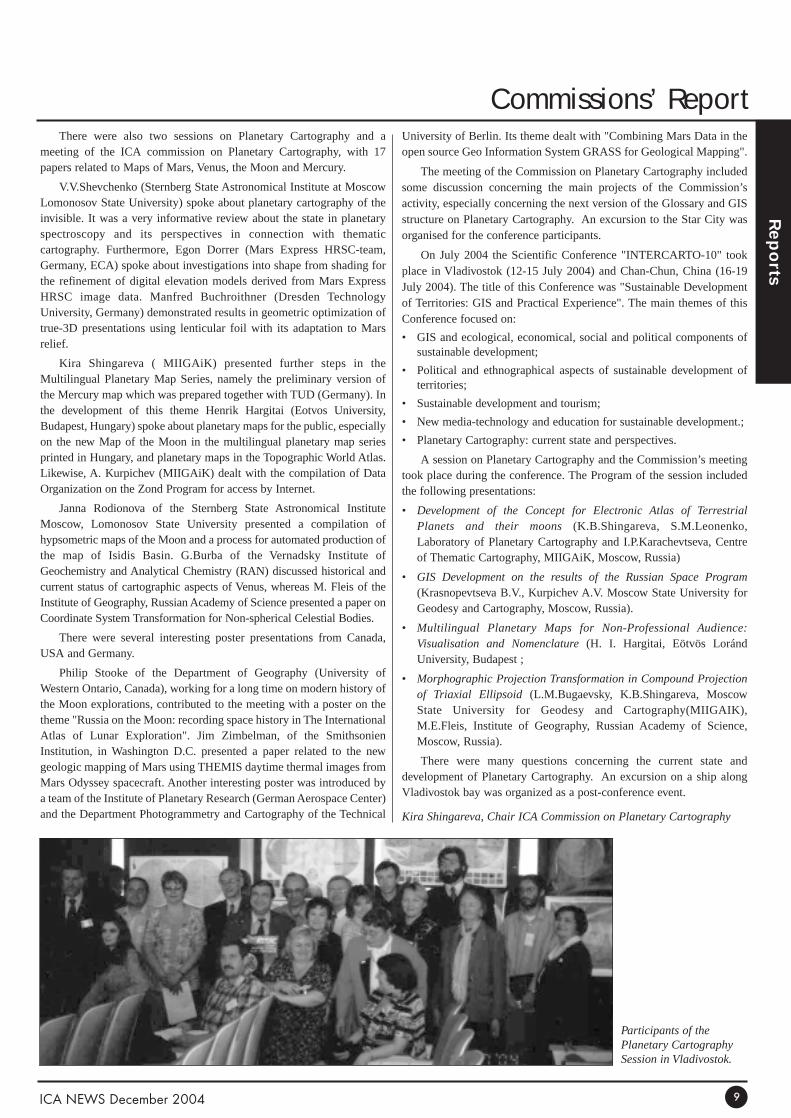
Kira Shingareva, Chair ICA Commission on Planetary Cartography
Participants of thePlanetary CartographySession in Vladivostok.

Commissions’ Report
Rep
orts
ICA NEWS December 200410
Theoretical Cartography andEducation and TrainingJoint Seminar in Vilnius (Lithuania)
The seminar ‘Cartographic Education and Training’ was held on the29th June 2004 at Vilnius University. It was the second joint seminarorganized by the ICA Commissions on Theoretical Cartography (CTC)and Education and Training (CET). The Cartographic Centre of VilniusUniversity was the host of the first joint seminar, held on March 2003.
The agenda of the one-day meeting organised by Giedre Beconyte(which was held the day after the annual meeting of the LithuanianCartographers) included two oral sessions with seven papers, a postersession with five posters, and a closing round table. The organizers planto publish the results of the joint seminar as a collection of papers.
Laszlo Zentai (Chair, ICA Commission on Education and Training)and Alexander Wolodtschenko (Chair, ICA Commission on TheoreticalCartography)
Generalisation and MultipleRepresentation
The Commission is planning two events prior to the ICC 2005 in ACoruña.
• A one day tutorial on the science of map generalisation andmultiple representation.
In essence, the tutorial intends to encourage new membership to ourcommission. The day could have been entitled ‘All you ever wantedto know about generalisation but were afraid to ask’, and it is aimedat those with brief knowledge of the topic, but wanting to know moreabout the theory behind it, and how it might be used. This one daytutorial will take place in A Coruña on Sunday 10th July 2005.
• Workshop:
Following on the series of annual workshops organized by theCommission, our next workshop will be held on the 7-8 July, in ACoruña, Spain. The two days of presentations, brain stormingsessions and discussions will focus on, but not limited to: 3D andtemporal generalisation, mutli-scale databases, categorical andthematic database generalisation, methodologies and algorithms for
The Jubilee International Scientific and Technical Conference.Participants of the Planetary Cartography Session (from left to right):Alex Kurpichev, Eugen Kastorny, Maria Fleis, Janna Rodionova, KiraShingareva, Egon Dorrer, Tantyana Skobeleva, Henrik Hargetai, SultanValeev, Vladislav Shevchenko.
Visit to Star city: (from the left) Ekaterine V.Kastornaya, EugenM.Kastorny, B.V.Krasnopevtseva, Milan Konecny, HenrikHargetai, Egon Dorrer
Jubileum Conference party. Harold Mollering and his wife with KiraShingareva.
Participants of the Vilnius Seminar

Commissions’ Reports
Rep
orts
ICA NEWS December 2004
generalisation, evaluation and quality control techniques forgeneralisation solutions, management of update in the context ofmultiple representation, generalisation in the context of multiplerepresentation databases, interface design and intuitive methods formap specification.
More information about the events and registration is available at:htpp://ica.ign.fr
William A Mackaness and Anne Ruas ICA Commission on Generalisation
Theoretical CartographyUnder the motto ‘The selected problems of Theoretical Cartography’
the commission on Theoretical Cartography held its third seminarbetween the 3–4 August 2004 in Kyiv, the capital of Ukraine.Participants from Canada, Germany, Lithuania, Russia and the hostcountry, Ukraine, met at the Kyiv Production Center ‘Cartografia’ led byDr Rostyslav Sossa. On the first day, two sessions with eight papers andtwo posters, followed by discussions were organised. The followingpapers were presented:
• ‘A contribution to the semantic analysis of map symbolism’, by H.Schlichtmann (Canada);
• ‘Present State of Mapping of the Ukraine Territory’, by R. Sossa(Ukraine);
• ‘Cartosemiotic analysis of the Ecologic Atlas of the DnipropetroskkRegion, by I. Rotanova (Russia) and A. Wolodtschenko (Germany);
• ‘Some aspects of the development of cartosemiotics in Ukraine’, byA/ Gordyeyev and V. Shevchenko (Ukraine);
• ‘Cartosemiotic analysis of the Lithuanian Historical Atlases’, by G.Beconyte, J. Spuraite (Lithuania), and A. Wolodtschenko (Germany);
• ‘Cartosemiotic Features of Symbols construction for charts of theUkraine National Collection’, by O. Maarchenko (Ukraine);
• ‘Comparison of thematic maps for landscape typology using GIS’, byJ. Konstantinova, M. Pileckas, J. Spuraite (Lithuania);
• ‘On cartographic and cartosemiotic research methods’, by A.Wolodtschenko (Germany).
On the second day, the organizers planned a cultural program thatincluded visits to the Kyiv National Museum of Nature (with the oldestpre-historic map of the Ukraine), and the Archeaological Museum inTrypilie (Trypilie Culture).
The results of this seminar will be published as a collection ofpapers. The next Commission meeting is planned in A Coruña,coinciding with the ICC 2005.
Alexander WolodtschenkoChair, ICA Commission on Theoretical Cartography
11
Organizers of the Seminar: A. Wolodtschenko (left) and R. Sossa (right).
Participants of the Kyiv Seminar

Commissions’ Reports
Rep
orts
ICA NEWS December 200412
Spatial Data StandardsSince June 2004, our ICA book, "World Spatial Metadata
Standards" has been in galley proof production at Elsevier. Just now thegalley proof copies are being sent to the approximately 50 chapterauthors of the book. The master manuscript of Parts 1 - 4 were sent toElsevier in April, 2003, and the final manuscript of the version 7.0, Part5 "Spatial Metadata Standards Crosstable" and the front sections or thebook were sent to Elsevier in May of this year.
At the Berlin Plenary meetings a copy of the "ICA Prototype V 6.0Spatial Metadata Standards Crosstable" was presented to TC211 ChairOlaf Østensen as part of the ICA Spatial Data Standards CommissionReport to the TC211 Plenary Meetings. This metadata crosstable isanother tangible contribution that the ICA Standards Commission hasmade to the work of TC211 over the years. The Volume 3 book on"World Spatial Metadata Standards" will come out a bit later.
On July, 2004 the Commission held a meeting at the IHBHeadquarters in Monaco. The Commission continued its work onmodeling the SDI. A major part of its 2003-07 work on the SDI will beto develop a UML model of the SDI. This idea developed out of a basicdiscussion begun in a couple of years ago, and developed in more detailat more recent meetings. This new scientific thrust by the Commissionwas proposed and approved as the major task in the 2003-07 Terms ofReference at the Durban ICA General Assembly the following week.The 2004 Commission meeting held at the International HydrographicBureau headquarters in Monaco was devoted to extend this SDImodeling effort.
We also plan to establish a scientific liaison status with all of themajor SDI groups in the world, similar to our Category A ScientificLiaison we hold with TC211.
Harold Moellering Chair, ICA Commission on Spatial Data Standards
Gender and CartographyThe Commission Chair reports on three issues:
• The "Population and the Environment" Commission of theInternational Geographic Union (IGU) is interested in theCommission’s project associated to the production of guidelinesrelated to preparing interactive maps of population’s structureillustrating complexity of spatial distribution of various groups ofpeople living in the same territory. This problem is of importantpractical meaning for many official bodies and social organizationssteering from the sustainable development of the environment;
• Our proposal of exchanging actual information and developingcloser collaboration between the GaC and FIG’s WG "Women inGeodesy" has been accepted. Potential forms of exchange have beensuggested for further discussion using the FIG’s WG internet page(ICA Newsletter, June 2004);
• Several of GaC members are interested in active participation in22nd ICC. A session devoted to 21st theme: "Gender and otherunder-represented groups and Cartography" will be probablyorganized.
Ewa Krzywicka-BlumChair, ICA Commission on Gender and Cartography
Working meeting in Wroclaw(Poland)
The ICA Commissions on Gender and Cartography and TheoreticalCartography are pleased to announce that initial works connected withthe preparation of a joint working meeting have been successfullycompleted. As such the event will take place in Wroclaw (Poland), onthe 11-12 February 2005.
The meeting will focus on theoretical and practical solutions relatedto new demographic maps namely: subject of modelling, spatio-temporal completeness of data, review of the most comprehensive andusable methods of presentation and choice of the most effective ways ofdisseminating new types of cartographic products.
Discussions will be preceded by an introduction given by a speakerof high authority in the area. The organizers invite all persons interestedin the actual role of cartography in the recognition of rapidly changingspatial distribution of different minority-groups of people, at regional aswell as global scale. Maps presenting gender-oriented groups will beone of the main problems to be considered. All participants will havethe opportunity to present and analyse selected results related to theirown researches and experiments, as well as other solutions well knownand widely applied but not the most effective for interested users.
Wroclaw is a very attractive university city with many oldmonuments, beautiful gothic, renaissance and modernistic architecture(the People Hall), many cultural institutions, theatres, opera, museums,and art galleries.
Preliminary intention of attendance to the meeting should be madebefore the 15th December 2004, because of the need of earlierreservation of sufficient number of university guest rooms as well ascomputer laboratory with suitable number of individual places.
More information will be accessible later at:http://www.geo.ar.wroc.pl/GC/Register your interest in participating on this event by emailing to:[email protected]
Postal address: Prof. Ewa Krzywicka-Blum Agricultural University of WroclawDepartment of Geodesy and PhotogrammetryGrunwaldzka 5350-357 Wroclaw, Poland
Ewa Krzywicka-BlumChair, ICA Commission on Gender and Cartography
Maps and the InternetA workshop on Geo-Hypermedia will be held on April 4-5, 2005 in
Denver, Colorado (USA), immediately prior to the meeting of the
Association of American Geographers (www.aag.org). This workshop
will be closely tied to a publication of a book entitled Geo-Hypermedia.
More details on this workshop and the book will be forthcoming.
Michael PatersonChair, ICA Commission on Maps and the Internet

Special Features
Specia
l Featu
res
The Cooperative Research Centrefor Spatial Information: An Australian example of joint venture betweenuniversities, government organisations andprivate enterprises.
What are the Cooperative Research Centres?The CRC Programme supports research partnerships between the
public sector (universities and government research agencies) and theprivate sector (firms and industry organisations). CRCs turn theirresearch results into commercial products and services or transfer newknow-how to industry or other users. They also train researchers in theskills needed to work in industry and improve private sector researchand development. The CRC Programme was launched in 1990, fundedunder a scheme of the Australian government aimed at backingAustralia’s ability to promote science and innovation (URL 1). From2004, the Cooperative Research Centres (CRC) Programme has astronger commercial focus. The Australian Government will provide anextra $65 million for selection rounds in 2006 and 2008, as well as tofund successful applicants from the 2004 round. This builds on the$62.5 million additional funding provided in the 2003–04 Budget. Atotal of $925.9 million is being provided for administered grantsbetween 2006–07 and 2010–11. At present there are about 70Cooperative Research Centres in Australia covering a wide range ofapplications (e.g. Geotechnologies, Biosecurity, Desert Knowledge,Fire Management, Landscape Environment and Minerals, TropicalSavannas, etc.). Last year, the New Scientist Magazine describedAustralia’s CRCs as ‘the role model for collaboration between business,academic and government the world over’. Since 1990 the CRCprogramme has received over $1 billion from the Commonwealthgovernment and over $4 billion from the industry sector.
The Cooperative Research Centre for SpatialInformation (CRC-SI)
This Centre is a joint venture that begun in July 2003, with an initialduration of seven years, and the purpose of creating new wealth for theparticipants of the CRCSI and for the nation through researchinnovation and commercialisation, educational activities and powerfulcollaboration to build institutional capacity. At present the Centre has 56participants ranging from Universities, government departments andsmall to medium, sized enterprises (SMEs). The Centre’s vision is to‘make the CRCSI a world leader in spatial information applicationsthat are affordable, useful and readily available to all, at any time andin any place’. The application of the vision in Australia leads to theconcept of Virtual Australia, ie the holistic representation of the vastarray of information about our world in three dimensions and at anyuseful scale. In simple terms this means one can remotely access map-based information, combine it with information from other sources,conduct analyses, view the information in three dimensions, conductforecasts (the fourth dimension), analyse historic trends, supplyinformation and analyses to others, and know one’s geographic position.Moreover it provides us with the ability to convey this position to others,at any time. Spatial information and its enabling technologies aretherefore inextricably linked through the vision. The same concept canbe applied anywhere in the world and the CRCSI wishes to develop theapplication of the vision wherever there is a demand. It is implicit in thevision that new or existing spatial information and other informationwill be seamlessly integrated for the benefit of the user at an affordable
price, since it is recognised that for most applications spatialinformation is used with non-spatial information.
The Vision of the CRC will be realised when spatial information ismade useful and available to all – at any time and in any place. Implicitin this vision is that the needs of SI users will be met through thedevelopment of the necessary supporting products and services. Thesewill provide accessibility and knowledgeable use of SI within afavourable environment of regulatory policies and institutionalframeworks. An enhancement of industry and user capabilities isessential if the broad spectrum of SI needs within society is to besatisfied. New developments in the acquisition, analysis, synthesis anddelivery of SI are being continually called for. This in turn requiresactive research and development in the science and technologies ofpositioning, modelling and data processing, integration and archiving,and dissemination and visualisation of SI. The CRCSI research portfoliofocuses upon data collection technologies, including:
• Global navigation satellite systems and integrated multi-sensorpositioning systems (programme 1)
• Space and airborne imaging and ranging systems, and inertialmeasuring units (programme 2)
• Spatial database technology and geographic information systems tosupport a national spatial data infrastructure (programme 3)
• Earth observation technologies for environmental and resourcemonitoring and management (programme 4)
• Visualisation techniques and tools for enhanced decision supportcapability (programme 5).
In formulating its research projects the CRCSI will maintain a focusupon meeting the needs of the user of SI, and be responsive to the futureneeds of the Australian SI industry. This demands early stage planningfor user adoption and utilisation of research outcomes, along withcommercialisation of technological innovations for the benefit ofCRCSI participants, the SI industry and Australia as a whole. In theexternal environment relevant societal and technological trends includeon-line government with greater access to and interchange of SI; thedevolution of many non-policy functions within government to industry;the growing volume and value of technological innovations emergingfrom the SME sector; multi-disciplinary research collaboration toaddress complex national environmental issues; greater sectoralintegration in these same issues and others; a shorter lifecycle for manySI technologies; and the ‘consumerisation’ of formally specialistproducts, systems and procedures afforded by miniaturisation inelectronics, and advances in computing and in information andcommunications technology. The path from adoption of projectoutcomes to realisation of the vision is by no means direct, yet allresearch projects will be designed to produce innovative solutions,through the generation of new intellectual property, to problems thatcurrently impede progress towards "useful spatial information for all atany time and place." Project outputs will enhance capability within theSI industry and user community, which in turn will contribute to theusability of SI and to the knowledge base to support broader SIutilisation.
The emerging research programme is based on 15 projects, namely:
1. Enhancing Australia’s core geodetic infrastructure
2. Quality control issues for real-time positioning
3. Integrated positions and geo-referencing platform
4. Automated mapping and feature extraction from space, aerial andterrestrial imagery
ICA NEWS December 2004 13

Special Features
Specia
l Featu
res
5. Fundamental modelling, analysis and systems development forintegrated imaging and positioning sensors
6. Concepts and principles for Virtual Australia
7. Intelligent geocoding
8. Access to spatial data
9. Near real-time remote sensing products from MODIS based NADIRsurface reflectance and bio-physical models
10. Digital elevation model generation and differential interferometricsynthetic aperture radar (InSAR)
11. A near real time crop and pasture package: integrated remote sensingtechnologies for improved farm management
12. Development of imaging spectrometry (hyperspectral imagery)products for characterising, mapping, monitoring and managingenvironmental stress
13. Support tools for spatial data mining and agent-based modelling
14. Interfacing visualisation with SDI for collaborative decision making
15. Communicating spatial data quality.
More information about these projects and the CRCSI can beaccessed through the Centre’s website www.crcsi.com.au or bycontacting its Chief Executive Officer, Peter Woodgate [email protected]
Graciela Metternicht, Curtin University of Technology
Acknowledgements:This article was compiled by Graciela Metternicht, Leader of the
CRC-SI project ‘A near real time crop and pasture package: integratedremote sensing technologies for improved farm management’, withinformation of the CRCSI Annual Report 2004, kindly provided by MikeRidout, CRCSI Communication’s Director.
URL1: http://backingaus.innovation.gov.au/2004/commercial/crc.htm
The National Historical GeographicInformation System (NHGIS)
The National Historic Geographic Information System (NHGIS) is afive-year NSF-funded project designed to create a comprehensive U.S.census database – at the census tract and county level – for both thegeographical and attribute data. Technological change presents anunprecedented opportunity to make these data readily available forsocial science research; thus bringing the complete census within reachof social scientists will unlock the potential of two centuries of datacollection, and will stimulate research in economics, history, sociology,geography and other fields.
The project consists of three major components: data anddocumentation, mapping, and data access. The data and documentationcomponent gathers all extant machine-readable census summary data;fills holes in the surviving machine-readable data through data entry ofpaper census tabulations; harmonizes the formats and documentation ofall files; and produces standardized electronic documentation accordingto the recently developed Data Documentation Initiative (DDI)specification. The mapping component creates consistent historicalelectronic boundary files for tracts, minor civil divisions, counties andlarger geographic units. The data access component creates a powerfulbut user-friendly web-based browser and extraction system, based on thenew DDI metadata standard. The system provides public access free of
charge to both documentation and data, and presents results in the formof tables or maps.
Over the past twenty years, there has been a rapid growth in the areaof geographic information systems (GISs) – powerful computer-basedmethods for the acquisition, storage, analysis, and display of spatial data– and the related creation of spatially-addressable data sets. Much ofthese spatial data are related to population statistics, including theBureau of the Census’ TIGER files (geocoded street and enumeration-unit files that allow for spatial analysis and mapping). GIS hassignificantly broadened the scope of questions that can be asked withgeospatial data, has enabled a rapid growth in spatial analysis, and haspopularized the use of mapping techniques for the display of spatialinformation. GIS has facilitated the rapid growth of geodemographicanalysis, including geomarketing, and many forms of populationanalysis in general, by integrating together the wealth of population datathat are now spatially-referenced with the powerful spatial-analyticcapabilities of GISs. Examples of these spatial analyses include theassessment of environmental justice/racism at multiple spatial scales(regional, urban, community); the calculation of segregation indices andevaluation of urban poverty, and the indentification of concentratedpoverty; the development of neighborhood indicators, including amultitude of economic and social measures based on population data;and the spatial/temporal analysis of census data.
Increasingly, researchers are attempting to use the census geographicbase files for historical geodemographic analyses. For instance, after the1990 census it was possible to document the changes in geodemographicsbetween 1980 and 1990, using the 1990 TIGER files. A commonapplication was mapping the change in minority populations betweenthe two periods. However, researchers are constrained mostly to two orthree decades of temporal analysis with the availability of only pre-1970digital files. The development of digital geographic base files for theperiod 1940 to 1990 would allow a detailed analysis of populationchange, at much finer levels of resolution (especially tract level), formost urban areas. Many potential research projects/application areaswould benefit from the availability of such boundary files.
To address these needs, the National Historic GeographicInformation System (NHGIS) is a five-year NSF-funded project to builda comprehensive census database, for both boundary files and attributedata, for the entire United States at both the county and census tractlevel. Using both existing digital data, and scanned census maps, atemporal database is being built. At the same time, all available statisticaldata are being digitized so that users will be able to pursue true spatio-temporal analyses. This database will enable researchers to pursue manytypes of geodemographic analysis not possible before. Two researchactivities for the project include areal interpolation and cartographicgeneralization. We are now developing and testing a multitude ofdifferent interpolation algorithms that will allow researchers to makedirect statistical comparisons across decades. For instance, a user mightwish to calculate the percent change in poverty from 1960 to 1990 forLos Angeles. Research on the project is also exploring the creation ofmultiple scale databases at 1:150,000, 1:400,000, and 1:1,000,000through the application of generalization algorithms. All boundary andstatistical data will be delivered through a Web interface, and availablein the summer of 2006.
For further information on the project, please see the Website:http://www.nhgis.org/
Robert B. McMaster, ICA Vice-President (USA)Department of Geography, University of Minnesota
ICA NEWS December 200414

Tail PiecesAffiliates
One of ICA’s affiliates, BARCO GRAPHICS, became ESKOGRAPHICS and the Cartographic Division of ESKO GRAPHICS hasbeen taken over by the STAR Informatic Group. STAR InformaticGroup is the leading European GIS Editor based in Belgium(www.star.be). The Cartographic Division of ESKO Graphics becamethe Publishing Solutions Business Unit of the STAR Informatic Group,headed by Mr Paul Duré.
Forthcoming Events2004 International Symposium on GPS/GNSSDate: 6 - 8 December Venue: Sydney, Australia University of New South Wales http://www.gnss2004.org/
International Conference On SustainableTransportation in Developing Countries"ENVIRONMENT 2005"Date: 30 Jan - 2 Feb 2005Venue: Abu Dhabi, United Arab Emirateswww.ee-uae.com/conference/index.html
Map India 2005Date: February 7 - 9, 2005Venue: Hotal Taj Palace, New Delhi, India Email: [email protected]: www.mapindia.org
Kuwait 1st International GIS Conference & ExhibitionDate: 5-7 Feb 2005Venue: Kuwait, KUWAITwww.gulfgis.com
IMTA (EAME) Conference and Trade ShowDate: 11 –12 February 2005 Venue: London (UK)http://www.maptrade.org/docs/events/43/London%2005.pdf
Auto-Carto2005Date: March 18-23, 2005Venue: Riviera Hotel, Las Vegas, Nevada (USA)http://www.acsm.net/cagis/carto2005/
First International Symposium on Geo-Information forDisaster ManagementDate: 21-23 March, 2005 Venue: Delft, The Netherlands Email : [email protected] : http://www.gdmc.nl/gi4dm
ASPRS Annual ConferenceDate: 7-11 Mar 2005Venue: Baltimore, USAhttp://www.asprs.org/baltimore2005/index.html
4th International Symposium on Digital EarthDate: 28-31 Mar 2005Venue: Tokyo, JAPANhttp://www.isde-j.com
12th ESRI South Asia User Conference 2005Date: 2 – 4 March 2005Venue: Nusa Dua, Balihttp://http://www.esrisa.com/pages/NewsEvents
ASPRS Annual ConferenceDate: March 7-11, 2005Venue: Marriott Waterfront Hotel, Baltimore Marylandhttp://www.asprs.org/baltimore2005/index.html
GITA's Annual Conference 28, Crossing Boundaries, Date: March 6-9, 2005Venue: Colorado Convention Center, Denver, Colorado www.gita.org/events/annual/28/index.html
5th International Symposium Remote Sensing ofUrban Areas (URS 2005)Date: March 14-16, 2005Venue: Arizona State University, USA http://www.urban-remote-sensing.org
GSDI-8 CONFERENCE and FIG Working WeekDate: 16 – 21 April 2005Venue: Semiramis Intercontinental Hotel, Cairo Egypt http://www.fig.net/cairo
International exhibition of geodesy, cartography,geology, geoinformation systemsDate: 27 – 29 April 2005.Venue: Novosibirsk, Russiahttp://www.sibfair.ru
8th International Conference Remote Sensing forMarine and Coastal EnvironmentsDate: 17 – 19 May 2005Venue: Casino Nova Scotia Hotel, Halifax, Nova Scotia, Canadahttp://www.waterobserver.org/event-2005-05/
31st International Symposium on Remote Sensing ofEnvironment "Global Monitoring for Sustainability &Security"Date: 20-24 Jun 2005Venue: Saint Petersburg, RUSSIAN FEDERATIONwww.niersc.spb.ru/isrse/index.shtml
ICA NEWS December 2004 15
For Yo
ur D
iary
Forthcoming Events

Forthcoming Events
For Yo
ur D
iary
GIS PLANET 2005Date: May 30 - June 2, 2005 Location : Lisboa, PortugalEmail : [email protected] : www.gisplanet.org
EARSeL Symposium — GlobalDevelopments in EnvironmentalEarth Observation From SpaceDate: June 6-11, 2005.Venue: Porto, Portugal http://www.fc.up.pt/ earsel2005.
6th JointICA/ISPRS/EuroGeographicsWorkshop on IncrementalUpdating & Versioning of SpatialData BasesDate: 8-10 July 2005Venue: A Coruña, Spaingeo.haifa.ac.il/~icaupdt/meetings/meetings.htm
22nd International CartographicConferenceDate: 9 – 16 July 2005Venue: A Coruña, Spainwww.icc2005.org
4th FIG Regional Conference forLatin America and the Caribbean. Date: 25-29 September 2005Venue: Havana, CubaContact: FIG Office, email: [email protected]
1st Regional Biannual Conference:Africa Chapter of InternationalAssociation of Lands Ecology(Africa-IALE)Date: 19 – 23 July 2005, Venue: Elmina, Ghana. http://calmit.unl.edu/africa-iale/cd/.
21st International Conference onthe History of Cartography.Date: July 17-22, 2005 Venue: Eötvös Loránd University, Budapest,Hungaryhttp://lazarus.elte.hu/~zoltorok/ichc2005.htm
Africa GIS’05Date: 29 August – 2 September 2005Venue: Sandton Convention Centre,Johannesburg, South Africa. http://www.africagis2005.org.za.
The 16th William T. PecoraMemorial Remote SensingSymposiumDate: October 23-27, 2005Venue: Sioux Falls Convention Center SiouxFalls, South Dakota
Gulf Traffic - GIS ZoneDate: 12-14 December, 2005 Venue: Dubai International Exhibition Centre Email : [email protected] : www.gulftraffic.com
6th International Conference onArgumentation of the ISSADate: 27 – 30 June 2006Venue: University of Amsterdamwww.hum.uva.nl/issa
ICA NEWS December 200416
ContributionsPlease send contributions to:
Graciela Metternicht, Editor ICA News
School of Spatial Sciences
Curtin University of Technology
GPO Box U 1987, Perth 6845
Western Australia
Email: [email protected]
Fax: +61-8-9266 2703
Ftp: cage.curtin.edu.au
Login and pwd: engftp
Directory: /graciela/ICA/incoming
© Published by the International Cartographic Association. President: Milan Konecny, Masaryk University, Brno, Czech Republic.Secretary General: Ferjan Ormeling, Faculty of Geographical Sciences, Utrecht University, The Netherlands.Editor: Graciela Metternicht, Department of Spatial Sciences, Curtin University of Technology, Perth, Australia.
CONTENTS
Affiliates 15
British Cartographic Society 2
Conference Themes 4
Cooperative Research Centre 13
Editorial 1
Education and Training 10
Executive Committee 3
Forthcoming Events 15
Gender and Cartography 12
Generalisation and Multiple
Representation 10
ICC 2005 4
ICC 2005 Workshops 5
International Map Exhibition 5
Maps and the Internet 12
Marine Cartography 8
Mountain Cartography 6
National Historical GIS 14
Obituaries 1
Planetary Cartography 8
Pre-Congress Schedule 4
President's Report 2
Registration Fees 4
Spatial Data Standards 12
Theoretical Cartography 11
Visualisation & Virtual
Environments 6
Working meeting Wroclaw 12

ICA NEWS December 2004
ICA Executive Committee
ICA NEWS December 2004
ICA Executive CommitteeMilan Konecny
President
Institute of Geography
Masaryk University
Kotlarska 2, 61137 Brno,
Czech Republic
Telephone: #42 5 42 128 316 or 276
E-mail: [email protected]
Vladimir S.Tikunov
Vice-president
Vorontsovskie Prudi 7-168
Moscow 117630
Russian Federation
Telephone #7-095-9391339
David Fairbairn
Vice-president
School of Civil Engineering and Geosciences,
University of Newcastle upon Tyne,
Newcastle upon Tyne NE1 7RU,
United Kingdom
Tel: #44 191 222 6353
E-mail: [email protected]
Haggai Nyapola
Vice-president
Survey of Kenya
P.O. Box 30046
00100 NAIROBI,
Kenya
Telephone: #254-020-2717553
E-mail: [email protected]
William Cartwright
Vice-president
Department of Geospatial Science
RMIT University
GPO Box 2476V
Melbourne, Victoria 3001
Australia
Telephone: #61 3 9925 2423
E-mail: [email protected]
Ramon Lorenzo Martinez
Vice-president
Centro Nacional de Informacion Geografica
General Ibanez de Ibero 3
28003 MADRID,
SPAIN
E-mail: [email protected];
Kirsi Virrantaus
Vice-president
Institute of Cartography and Geoinformatics
Department of Surveying
Helsinki University of Technology
P.O.Box 1200, FIN-21050 HUT
Finland
Telephone #358 500 463729
Robert B. McMaster
Vice-president
College of Liberal Arts
215 Johnson Hall,
University of Minnesota
Minneapolis, MN 55455,
United States of America
Telephone #1.612.624.2535
Email: [email protected]
Ferjan Ormeling
Secretary-General and Treasurer
Faculty of Geosciences,
Utrecht University
P.O.Box 80115,
3508 TC Utrecht
The Netherlands
Telephone: #31 30 2531373
E-mail: [email protected]
Bengt Rystedt
Past-President
National Land Survey
SE-80182 Gävle, Sweden
Telephone #46 26 63 34 29
E-mail [email protected]
University of Gävle,
SE-80176 Gävle, Sweden
Telephone #46 26 64 88 44
E-mail [email protected]
Graciela Metternicht
Editor ICA News
Department of Spatial Science,
Curtin University of Technology,
GPO Box U 1987,
Perth 6845, Western Australia
Australia
Telephone: #61 8 9266 3935
E-mail: [email protected]
ftp: cage.curtin.edu.au,
directory: graciela/ICA/incoming
"The children and flowers will make a better world", entry to theBarbara Barbara Petchenik Children’s Map Competition of the 21stICC, Durban, South Africa, 2003. Author: Leny VladimirovaMircheva, age 11, Bulgaria
39173-11-04
The following
Organizations support the
International Cartographic
Association:
Centro Argentino de Cartografia
ph +54 1 576 5545
fax +54 1 502 6799
Av. Cabildo 381
1426 BUENOS AIRES
ARGENTINE
Institut Cartografic de Catalunya
ph +34 93 425 29 00
fx +34 93 426 74 42
Parc de Montjuic
E - 08038 BARCELONA
SPAIN
United States Geological Survey
ph +1 703 648 4639
fax +1 703 648 5542
National Mapping Division
519 National Center
PRESTON Virginia 22092
USA
Institut Géographique National
ph +33 1 43 98 82 95
fx +33 1 43 98 84 00
136 bis rue de Grenelle
75700 PARIS 07 SP
FRANCE
National Hydrographic Office
P.O. Box 75
DEHRA DUN - 248001
INDIA
Geographical Survey Institute
ph +81 298 64 1111
fax +81 298 64 1804
Kitasato 1
Tsukuba-shi
IBARAKI-KEN 305
JAPAN
International Institute for
Geo-Information Science and Earth
Observation (ITC)
ph +31 53 487 44 44
fax +31 53 487 44 00
Hengelosestraat 99
P.O. Box 6
7500 AA ENSCHEDE
THE NETHERLANDS
Moscow State University for
Geodesy and Cartography
ph +7 095 261 3152
fax +7 095 267 4681
4 Gorokhovsky by-street
MOSCOW 103064
RUSSIAN FEDERATION
The Union of chambers of Turkish
Engineers and Architects, Chamber
of Survey and Cadastre Engineers
(UCTEA-CSCE)
Summer Sok. No 12/10
06440
Yenisehir – Ankara
TURKEY
Indian National Cartographic
Association
C. G. O. Complex, DF - Block, 7th Floor
Salt Lake, Kolkata - 700064
West Bengal, INDIA
http://www.incaindia.org/membership.htm
The International Cartographic
Association welcomes new affiliate
members.
For further information contact:
The ICA Secretary General:
Ferjan Ormeling,
Faculty of Geographical Sciences,
Utrecht University,
P.O.Box 80115,
3508 TC Utrecht,
The Netherlands.
Email: [email protected]

ICA NewsNouvelles de I’ACI
Number 43, December 2004 Numéro 43, Dècembre 2004 http://www.icaci.org
The following organizations support theInternational Cartographic Association:
Intergraph:www.intergraph.com ESKO Graphics:www.star.be
International Cartographic Association Association Cartographique Internationale
Navigation Technologies Corporation:www.navtech.com ESRI:www.esri.com